Justice Md. Nazrul Islam Talukder I have gone through the ...
Upload
uni-freiburgCategory
view
0download
0
Gone fishing
Preliminary results of a one-man dig within the Roman settlement at Riegel, Krs.
Emmendingen, Southern Germany
Stefan MÄDER
Regierungspräsidium Freiburg, Germany
Abstract: During the Roman imperial period the small town of Riegel am Kaiserstuhl was a centre of
administration, with its heyday during the 2nd and 3rd centuries AD. Hitherto excavated sites include the
remains of a basilica and adjoining forum, a mithraic sanctuary and a vicus in the north-western sector of the
area inhabited from the late 1st to around the middle of the 3rd century AD. Still, the extent and character of
the Roman settlement in the eastern part of the modern town remain largely unknown. Thus one long-term
goal of archaeological research at the site is to reconstruct a plan of the town in Roman times. Owing to the
alertness of Dr. J. Klug-Treppe, the conservator in charge, arose the opportunity to continuously accompany
canalization and road construction works at the site from September 2011 to June 2012. This particular kind
of archaeological field-work bears a certain resemblance to fishing and is often underestimated in its
prospects in comparison to “proper” excavation. The catch from this particular measure ranges from
prehistorical finds and Roman building structures to baroque extravagances. The function of one exceptional
Roman bronze artefact is submitted for discussion.
Settlement-history in slices
Owing to renovation measures in the town centre of Riegel the Regierungspraesidium Freiburg, Abtlg.26
(National Board for the Preservation of Archaeological Monuments) grasped the opportunity to supervise the
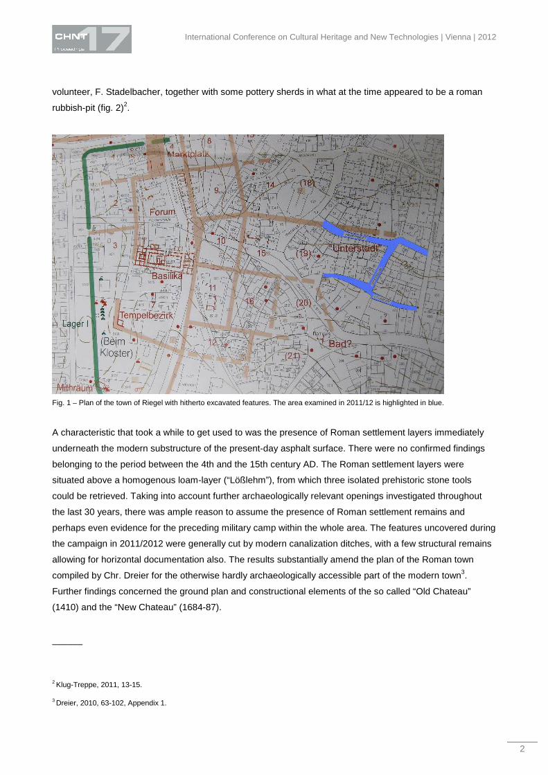
replacement of canalization pipes in Herrengasse, Schulstrasse und Schlossgasse1. Visual documentation of
the unearthed features was carried out by drawing, photography, tachymeter and photogrammetry. The area
in question is located in the eastern part of town with the outline of the road-sections resembling the cross-
section of a T-beam (fig. 1).
It spans distances of about 70 m North-South and of 120 m East-West. At the outset it was not at all certain,
whether the expected punctual findings would provide a feasible basis for more substantial statements about
the appearance and history of the Roman settlement, the late medieval Chateau and its 17th century
successor. The name of the town in Roman times is as yet unknown. In the course of a preliminary
assessment of the subsoil in 2010 a small terracotta-figurine of a squatting dog was found by a local
______
1 The present article is an enhanced version of a preliminary overview to be published in: Klug-Treppe/Mäder, 2011 (in print).
International Conference on Cultural Heritage and New Technologies | Vienna | 2012
2
volunteer, F. Stadelbacher, together with some pottery sherds in what at the time appeared to be a roman
rubbish-pit (fig. 2)2.
Fig. 1 – Plan of the town of Riegel with hitherto excavated features. The area examined in 2011/12 is highlighted in blue.
A characteristic that took a while to get used to was the presence of Roman settlement layers immediately
underneath the modern substructure of the present-day asphalt surface. There were no confirmed findings
belonging to the period between the 4th and the 15th century AD. The Roman settlement layers were
situated above a homogenous loam-layer (“Lößlehm”), from which three isolated prehistoric stone tools
could be retrieved. Taking into account further archaeologically relevant openings investigated throughout
the last 30 years, there was ample reason to assume the presence of Roman settlement remains and
perhaps even evidence for the preceding military camp within the whole area. The features uncovered during
the campaign in 2011/2012 were generally cut by modern canalization ditches, with a few structural remains
allowing for horizontal documentation also. The results substantially amend the plan of the Roman town
compiled by Chr. Dreier for the otherwise hardly archaeologically accessible part of the modern town3.
Further findings concerned the ground plan and constructional elements of the so called “Old Chateau”
(1410) and the “New Chateau” (1684-87).
______
2 Klug-Treppe, 2011, 13-15.
3 Dreier, 2010, 63-102, Appendix 1.

Mäder – Gone fishing
3
Fig. 2 – Terracotta figurine of a squatting dog from the eastern ditch of the 1st century Roman military camp (height: ca. 12 cm).
Topographical situation and prehistoric finds
The oldest Roman settlement structures in the investigated area were built upon a homogenous layer of
loam that forms a flat, fan-shaped cone at the northern slope of the Michaelsberg, a limestone outcrop
extending south of the modern town. This material was transported from the mountain slope by water
erosion via a slight depression in the mountain´s northern flank. Due to its soft consistence, it was not
particularly suited as building-ground, a fact that is supported by a shifted Roman wall, irregularities in the
floor-level of a wooden Roman building and also the necessity for ground replacement during the recent
construction activities in 2011/2012. From this stratum what appears to be a broken and reworked hand axe
(fig. 3), a scraper/knife (fig. 4) and a fist-sized polished granite-pebble (fig. 5) came to light.

International Conference on Cultural Heritage and New Technologies | Vienna | 2012
4
Fig. 3 – Stone-tool, possibly a broken and reworked hand-axe (“Faustkeil”) made of local limestone (“Rogenstein”, size: 104 x 63 x 25
mm). The artefact was dug up in Schlossgasse by the power shovel from the homogenous loam substratum underneath the Roman
settlement.

Mäder – Gone fishing
5
Fig. 4 – Stone-tool, scraper, made of local limestone found in situ in the eastern part of Schulstrasse within the same substratum as fig.
3 (size: 115 x 81 x 23 mm).

International Conference on Cultural Heritage and New Technologies | Vienna | 2012
6
Fig. 5 – Polished granite-pebble, found in situ within the underlying loam substratum underneath the T-crossing between Schlossgasse
and Schulstrasse (size: 78 x 64 x 57 mm).
The first mentioned tool-fragments consist of a very hard local variant of granular limestone (“Rogenstein”).
As the material is harder than workable kinds of silex, they were shaped by powerful, nonetheless precise
percussion. In order to get an impression of the material´s suitability for tool-production the author fashioned
hand-axes with cutting-edges similar to the original finds. The last mentioned object is a rounded pebble of
reddish granite, the narrow side of which was polished resulting in a very smooth surface and approximate
symmetry of the artefact. Its shape and work-traces may indicate a “kitchen-tool”, a polishing device, a semi-
finished head for a club (“Keulenkopf”), or possibly a finished head for a stone-club hafted without a drilled
central hole. There is archaeological evidence for an Early Iron Age settlement on the north-western foothill
of the Michaelsberg and for a variety of Neolithic features within the confines of Riegel. As yet there have
been no pointers towards the presence of paleolithic man. The natural surroundings with wind-sheltered and
loess-covered heights, a wide view over the plain and the river beneath as well as the confirmed presence of
mammoths in the area call to mind similar settings for paleolithic sites in France and Austria. With all due

Mäder – Gone fishing
7
scepticism: viewing the displaced finds of worked local limestone from an otherwise homogenous loam
substratum, the possibility of a largely eroded paleolithic camp site on higher ground north of the Kaiserstuhl
mountains should perhaps not be dismissed too hastily4.
Features and finds from Roman times
Bearing in mind the stratigraphies obtained in 2003 and 2004 within the northern and north-western part of
the roman vicus the absence of the latest roman as well as of all medieval settlement layers was
conspicious5. Explanations by means of large-scale ground-removal in connection with the construction of
the baroque park for the chateau, or by floodings from the adjoining Elz-river remain speculative. Only
towards the end of the building-measures the find-context of the small canine terracotta-statue (fig. 2) could
be elucidated. Underneath the levelled ground-floor of a wooden roman building (“Streifenhaus”) the filled in
remains of an approximately north-south oriented V-shaped ditch (“Spitzgraben”) could be documented in
cross-section. This cross-section was accessible only with difficulty as it was situated in the narrow modern
ditch for the new water-line. Its situation immediately beneath the lowest settlement-layer of the Roman
vicus, as well as the Roman finds from the backfill point to this feature being the eastern ditch of the large
military camp installed after the middle of the 1st century AD. Remains of the inner bank could be
documented as well. In the western part of modern day Riegel the main western gate and the adjoining ditch
of this camp could be confirmed by excavations during the last four decades. The dog-figurine was found in
2010 within the backfill three metres further south in line of the uncovered portion of the eastern ditch. The
hole excavated by the power-shovel at that time rendered the cross-section of the ditch unrecognizable
during the excavation of the broader ditch for the sewage-pipe in 2012.
Concerning the appearance of the civilian Roman settlement underneath the eastern half of the present day
town-centre the following statements can be made: The earliest buildings consisted of timber-frame
constructions with clay-walls erected above deep-seated foundation stones with shallow fundament-ditches
in between. The houses were often constructed only about one metre apart from each other as indicated by
common cullis-ditches during previous and the present excavations in Riegel. As in the previously analyzed
northern and north-western parts of the vicus, the buildings were arranged quite accurately in north-south
direction. Judging by the evidence from the north-western part of the settlement, the distance between the
big foundation stones on the longer sides of some buildings ranged between 2 and 4 metres. Doubtlessly
many of the formerly extant substantial stones have been removed during previous canalization works
throughout the 20th century.
The debris of Roman roof-tiles (tegulae) points out the fact that at least some of the buildings had tiled roofs.
By the burnt debris in the cross-sections obtained from the sides of the modern canalization ditches at least
three phases of destruction by fire and subsequent rebuilding could be confirmed. Whether these phases
______
4 The stone-artefacts will be introduced in more detail in the „Riegeler Almanach“ for 2014.
5 Klug-Treppe/Mäder, 2003, 122-125. - Klug-Treppe/Lissner, 2004, 153-158. - Klug-Treppe, 2004, 38-45.

International Conference on Cultural Heritage and New Technologies | Vienna | 2012
8
correspond to the three major fires postulated by Chr. Dreier6 can as yet not be confirmed with certainty. In a
few cases the charred remains of the wooden flooring could be documented. A preliminary assessment of
the pottery-sherds from the monitored area hints towards a peak level of settlement activity from the late first
to around the middle of the 2nd century AD.
Apart from the cross-sections within the canalization ditches some features could also be bared in a plane.
As a representative example for the single row of stone-, respectively more substantially founded timber-
frame buildings north of a major Roman east-west axis the remains of a large building are discussed here. It
comprised an ambulatory (porticus), the outer northern wall of which could be reconstructed to measure at
least 24 metres (fig. 6).
The eastern part of the inner north-wall was askew and inclined towards the south, a feature which could
only come about by a slip of the loam subsoil in this area. Wether this slip was caused e.g. by an earthquake
or by severe floodings during Roman times cannot yet be determined with certainty. Two foundation stones
between the inner and outer wall of the building with porticus possibly indicate that after the incident which
destroyed at least part of the substantial building, smaller timber-frame structures were erected again in the
same area. The southward expansion of the well-fundamented building could not be determined. However,
during the excavations for a sewage pipe, the bottom-part of an also east-west oriented Roman road-side
ditch came to light 26 metres south of the previously mentioned north-wall (fig. 7).
The ditch accompanied the northern side of a major Roman road that was either wider than the present day
main-road or was situated a few metres further north. It was dug into some earlier Roman settlement layers
typical for the mainly wooden constructions of the earlier vicus-phase. From the filling of the ditch Roman
pottery fragments could be recovered as well as an “enigmatic” bronze-artefact (fig. 8). The 9 cm high object
was shown to several experts. Their interpretations ranged from a component of a Roman musical
instrument or a tap element to a rather recent part of a device for distilling alcoholic beverages. For none of
these interpretations however any convincing corroboration from pictorial or archaeological evidence could
be found up to now. The Roman date of the object is ascertained by the accompanying finds, the
stratigraphy of the ditch itself, as well as by its style and decoration. The surface shows a dark reddish tint
below the green patina, which may indicate its having been burnt prior to its deposition. Although the matter
should perhaps not yet be regarded as settled, the present author would like to put an interpretation of the
piece as a peculiar form of Roman oil-lamp with ultimate roots in Mesopotamia up for discussion7. During
restoration organic remains could be confirmed in what is tentatively interpreted here as the nozzle for the
wick. If viewed from the front, a decorative/symbolic element resembling two crescents and part of a rounded
central disc is situated behind the nozzle. Lunar symbolism is a widespread feature of Roman oil-lamps
______
6 Dreier, 2010, 41-46, fig. 7.
7 Maeder, in preaparation: Ex oriente lux? Ein römischer Bronzegegenstand aus Riegel, Lkr. Emmendingen.

Mäder – Gone fishing
9
whether made of bronze or clay. The approximately J-shaped body of the object is hollow throughout and
soldered on to a conical stand. This stand in is also hollow and contains lead remains, by which it might have
been fastened to a tripod stand often associated with Roman candelabra as well as earlier lighting devices
from Mesopotamia. A sanctuary for Mithras being confirmed and still preserved in Riegel, the figured bronze-
object, as well as characteristic fragments of ceramic incense-burners from the vicinity of the building with
porticus may - or may not - point to its having been a temple. Another factor to be considered for future
interpretation is that this building apparently is only second in size compared to the largest Roman structure
in town: the basilica, the remains of which have been excavated by Chr. Dreier8.
From the Roman settlement phase of Riegel, aside from one baking-oven, several latrines and rubbish-pits,
evidence for at least seven multi-phase timber-frame buildings and at least four stone-buildings was
obtained. Furthermore the incorporation of Roman walled fundaments into modern buildings could be
observed in several instances. Unfortunately the random openings for archaeological monitoring in the
course of canalization works do not as yet allow for the reconstruction of a complete ground plan for any of
the encountered building remains. However the encountered features and their ascertained position are
crucial factors for the evaluation of forthcoming findings during construction measures underneath the
modern town-centre.
Late medieval walls and extravagant features from the baroque era
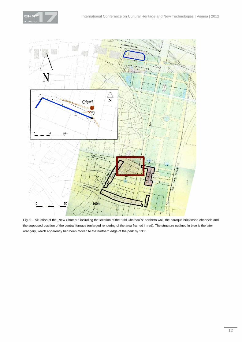
In the area of the “Old” (1410) and “New Chateau” (1684-87) several hitherto assumed constructional
characteristics could be confirmed and others discovered (fig. 9)9.
Among the latter is the exact location of the northern wall of the “Old Chateau”, the course of which turned
out to be mirrored by an alignment of modern allotments apparently following the course of medieval
foundation walls about 12 m south of the northern wall (fig. 10). This parallel alignment marks the southern
extent of buildings within the court of the roughly square site of the “Old Chateau”. Also its northern gateway
could be ascertained by documentation of a large gap in the northern wall, which definitely predates the
construction of the 18th century feature described next. Pointers towards a square western gate-tower could
be uncovered also. In addition the location of the gap corresponds to the situation of the present
Leopoldstrasse, whose precursor can be dated to the 15th century accordingly.
______
8 Dreier, 2010, 109-205.
9 Mäder, 2012, 177-178.

International Conference on Cultural Heritage and New Technologies | Vienna | 2012
10
Fig. 6 – Stonewalled fundament remains of a substantial building with ambulatory (porticus). The outline of the fundaments is
emphasized.

Mäder – Gone fishing
11
Fig. 7 – Bottom part of the Roman road-side ditch, dug into settlement layers of an earlier vicus-phase. The refill of this feature
contained remains of Roman pottery and a well-preserved bronze-object (see fig. 8)
Fig. 8 a-c – Roman bronze-artefact from the road-side ditch (size: 90 x 50 x 16 mm).
International Conference on Cultural Heritage and New Technologies | Vienna | 2012
12
Fig. 9 – Situation of the „New Chateau” including the location of the “Old Chateau´s” northern wall, the baroque brickstone-channels and
the supposed position of the central furnace (enlarged rendering of the area framed in red). The structure outlined in blue is the later
orangery, which apparently had been moved to the northern edge of the park by 1805.

Mäder – Gone fishing
13
Fig. 10 – Opening showing the remains of the “Old Chateau´s” northern wall. The western limit of the northern gateway corresponds to
the position of the shovel.
As an indicator for extravagances of the local nobility the uncovered remains of a brickstone-channel system
have to be mentioned (fig. 10). This floor-heating (“Kanalheizung”) served to heat an orangery where
representative mediterranean plants and trees could be hibernated. As one of the brickstone-channels,
which were covered with well-worked sandstone slabs, runs straight towards the main-building of the new
Chateau, it can be assumed that at least one room benefited from this kind of “central-heating” also.
The original site of the completely vanished orangery building of the “New Chateau” occupied the area of its
late medieval precursor´s northern wall. By the beginning of the 19th century the baroque orangery was no
longer extant and a successor was built on the northern fringe of the spacious park. Due to a concentration
of brickstone channels in the northern part of the crossing between Herrengasse und Leopoldstrasse it can
be assumed that the furnace for the heating-system was located where a modern basement has been built in
the 20th century (fig. 9b). During the excavation of a brickstone-channel the remains of a largely destroyed,
east-west oriented, inhumation came to light (fig. 10). At first the bones of the right foot were visible on the
bottom of the heating-channel. Only the left leg, part of the pelvis and the lower spine were preserved. The
skeleton was “quartered” already in the early seventies, when concrete sewage pipes and a central shaft
were installed. Concerning the age of the inhumation, it appears reasonable to assume a date in medieval
times when keeping in mind the original position of the skull in the east and the complete lack of grave-
goods. In contrast to the two bigger limestones above the skeletal remains the two brickstones visible on the
right side do not belong to the backfill of the grave-pit. They belong to an adjoining brickstone-channel
oriented north-south.
International Conference on Cultural Heritage and New Technologies | Vienna | 2012
14
Fig. 11 – Brickstone-channel covered with a sandstone-slab and remains of a probably medieval inhumation; viewing direction:
northeast.
Summary
Despite the construction-based limitations in comparison to “proper” excavation the recorded features and
findings provide a fruitful spectrum of results for the settlement-history of the modern town-centre: The
location of the eastern ditch of a 1st century Roman encampment immediately preceding the civilian
settlement could be verified. There is evidence for at least three Roman stone-buildings and for at least eight
timber-frame buildings with not less than three phases of destruction and rebuilding. Three big stone-
buildings were aligned along a major east-west axis of the Roman town, roughly corresponding to the course
of the present day main-road. From the northern roadside-ditch what appears to be a special form of bronze-
lamp was uncovered together with fragments of Roman pottery. Three modern houses were partly built on
Roman fundaments implying a continuity of some building lines until the present day. A total of seven roman
coins were recovered in the course of the operations and are being restored and identified at the moment.
The exact position of the „Old Chateau’s“ northern wall from the early 15th century was localized, including
the position of a late medieval northern gateway. The uncovered brickstone-channels in the same area are
indirect evidence for an 18th century orangery building at the site of the “Old Chateau´s” northern wall. They
represent the remains of a hypocaust-like system of „central heating“ not only used for the orangery, but also
for at least one room within the main-building of the “New Chateau” (1684-87).
Ultimately owing to the alertness of F. Stadelbacher, a local voluntary cooperator, and his find of a Roman
terracotta dog figurine, the incorporation of archaeological monitoring into the canalization measures was
initialized. The good cooperation between the town´s administration, the planning committee, the
construction company and the government´s archaeological authorities can be termed exemplary and

Mäder – Gone fishing
15
provides a solid basis for a constructive accomplishment of the renovation operations. No delay in
construction works was caused by archaeological necessities. Of course the standards of single-handed
archaeological field-work had to be adjusted to canalization works which proceeded up to 20 metres per day.
The key to good cooperation between construction teams and archaeologists is a mutual and benevolent
attempt at understanding each other´s professional requirements. An introduction of the workers to the
expected findings and features proved extremely worthwhile. The outlined archaeological measures in
Riegel demonstrate yet again to which extent positive results can be achieved by continuous supervision of
renovation measures in otherwise largely built-up urban areas.
Acknowledgement
Last but not least the author would like to thank O. Sauer, a skilled voluntary helper with a keen interest in
archaeology, and all persons in charge of the planning and carrying out of a profitable excavation by
canalization, respectively a good catch.
All illustrations copyright by Regierungspraesidium Freiburg, Ref. 26.
References Dreier, Chr., 2010: Forumsbasilika und Topographie der römischen Siedlung von Riegel am Kaiserstuhl. Materialhefte zur Archäologie
in Baden-Württemberg 91 (2010).
Klug-Treppe, J., 2004: Neue Ausgrabungen im Nord- und Nordwestvicus von Riegel a.K.. In: Riegel - Römerstadt am Kaiserstuhl. Arch.
Inf. aus Baden-Württemberg 49, 2004, 38-45.
Dto., 2011: Neue Funde aus der Römerstadt am Kaiserstuhl. Eine Tierstatuette aus Terracotta - Spielzeug oder Amulett? Arch. Nachr.
aus Baden 83, 2011, 13-15.
Klug-Treppe, J./Mäder, S., 2003: Neue vorgeschichtliche und römische Siedlungsbefunde im Nordwestbereich des römischen vicus von
Riegel, Kreis Emmendingen. Arch. Ausgr. in Baden-Württemberg 2003, 122-125.
Klug-Treppe, J./Lissner, B., 2004: Abschließende archäologische Untersuchungen im Bereich des Nordwestvicus von Riegel, Kreis
Emmendingen. Archäologische Ausgrabungen in Baden-Württemberg 2004, 153-158.
Klug-Treppe, J./Mäder, S., 2012: Unter Schloss und Riegel – Erste Ergebnisse einer Baubegleitung im Ortskern von Riegel am
Kaiserstuhl. Archäologische Ausgrabungen in Baden-Württemberg 2012 (in print).
Mäder, S., 2012: Einmal über Schloss und Riegel – Archäologische Schlaglichter auf neu entdeckte Baumerkmale des „Alten“ und
„Neuen Schlosses“ in Riegel, Lkr. Emmendingen. Denkmalpfl. in B. – W. Jg. 41, 3/2012, 177 – 178.
Imprint:
Proceedings of the 17th International Conference on Cultural Heritage and New Technologies 2012 (CHNT 17, 2012)
Vienna 2013
http://www.chnt.at/proceedings-chnt-17/
ISBN 978-3-200-03281-1
Editor/Publisher: Museen der Stadt Wien – Stadtarchäologie
Editorial Team: Wolfgang Börner, Susanne Uhlirz
The editor’s office is not responsible for the linguistic correctness of the manuscripts.
Authors are responsible for the contents and copyrights of the illustrations/photographs.
Copyright © 2022 FDOKUMEN