Gondwana dispersion and Asian accretion: Tectonic and palaeogeographic evolution of eastern Tethys
Gondwana Glacial Paleolandscape, DiamictiteRecord of Carboniferous Valley Glaciation,and Preglacial Remnants of an AncientWeathering Front in Northwestern Argentina
Betty Socha, Claudio Carignano, Jorge Rabassa, and Dave Mickelson
Abstract A record of glacier advance and retreat is preserved in Carboniferousstrata exposed in an exhumed glacial paleovalley on the eastern side of thePaganzo basin. Previous investigations have focused on the sandstones in thepaleovalley and inferred a glacial lacustrine history. New observations have demon-strated that remnants of a preglacial, ancient weathering front, developed underwet tropical conditions and composed of corestones, are found underneath theglaciogenic deposits. Delta and alluvial fan deposits were also recognized, but noinferences were made from the diamictites in the paleovalley regarding glacialevents (Andreis et al., Bol Acad Nac Cienc Cordoba 57:3–119, 1986; Buatoisand Mángano, J Paleolimnol 14:1–22, 1995; Sterren and Martínez, El Paleovallede Olta (Carbonífero): Paleoambiente y Paleogeografía. 13º Congreso GeológicoArgentino and 3º Congreso de Exploración de Hidrocarburos, Actas, 2, 89–103,1996). This chapter focuses on the diamictites and provides a link between thesediment infill and the glacial origin of the paleovalley. We describe diamictites andassociated sediments at three main locations: at La Chimenea, near the mouth of thepaleovalley; at Mid-Valley, near the middle of the paleovalley; and at the Campsite,
B. SochaSCS Engineers, 2830 Dairy Drive, Madison, WI, USAe-mail: [email protected]
C. CarignanoCONICET, Córdoba, Argentina
Universidad Nacional de Córdoba, Córdoba, Argentina
J. Rabassa (�)Laboratorio de Geomorfología y Cuaternario, CADIC-CONICET, Ushuaia, Tierra del Fuego,Argentina
Universidad Nacional de Tierra del Fuego, Ushuaia, Tierra del Fuego, Argentinae-mail: [email protected]
D. MickelsonDepartment of Geoscience, University of Wisconsin-Madison, Madison, WI, USA
J. Rabassa and C. Ollier (eds.), Gondwana Landscapes in southern South America,Springer Earth System Sciences, DOI 10.1007/978-94-007-7702-6__12,© Springer ScienceCBusiness Media Dordrecht 2014
331
332 B. Socha et al.
near the head of the valley. We interpret some of the diamictites exposed at LaChimenea and at Mid-Valley to be subglacial tillite. Deformation in the sandstoneunderlying the tillite indicates warm-based conditions as the glacier advanced oversoft deformable sediment. At the Campsite location, a diamictite bed, which is about1.5 m thick, lies within a sequence of alternating sandstone and siltstone beds. Thediamictite bed is interpreted to represent an ice-front readvance during a periodof ice retreat. The diamictite may be a debrite originating off the ice front, or asubglacial deposit, i.e., a tillite, or a combination of both. Two additional diamictitebeds, exposed higher in this sequence of alternating sandstone and siltstone beds,may also record minor ice-front advances into the flooded valley.
Evidence of an ancient, preglacial weathering front (Late Devonian?–EarliestCarboniferous?) has been found in the granitic basement rocks which underlie theglaciogenic deposits, as large corestones included in a weathered regolith. Thisweathering front was developed under wet tropical conditions, before the onset ofCarboniferous glaciations. The tillite and other diamictites overlying the corestonesare composed largely of locally derived granitic basement rock. Features observedin the tillite and other diamictites are attributed to rapid rates of deposition, depo-sitional processes, and the susceptibility of pre-weathered granitic basement rockto glacial and other erosional processes. Processes other than glacial erosion anddeposition, including mass transport (slumping, rafting, sliding, and debris flow),also operated in the steep-sided valley and contributed large amounts of diamictiteand other sediment to the valley fill. Corestones, weathered from the basement rockduring a pre-Carboniferous period of intense weathering, constitute the larger clastsin the diamictite and associated deposits. The glacial paleolandscape is very wellpreserved in detail, after being buried during the Permian and later exhumed inthe Cenozoic. The glacial valley was likely a transitional (fjord) environment, asmicropaleontological material (Gutiérrez and Limarino, Ameghiniana 38:99–118,2001) and clay mineral assemblages (Net et al., Sediment Geol 152:183–199, 2002)indicate a marine transgression into the area during the Middle Carboniferous.
Keywords Gondwana • NW Argentina • Carboniferous glaciation • Glacialsediments • Etchplains
Introduction
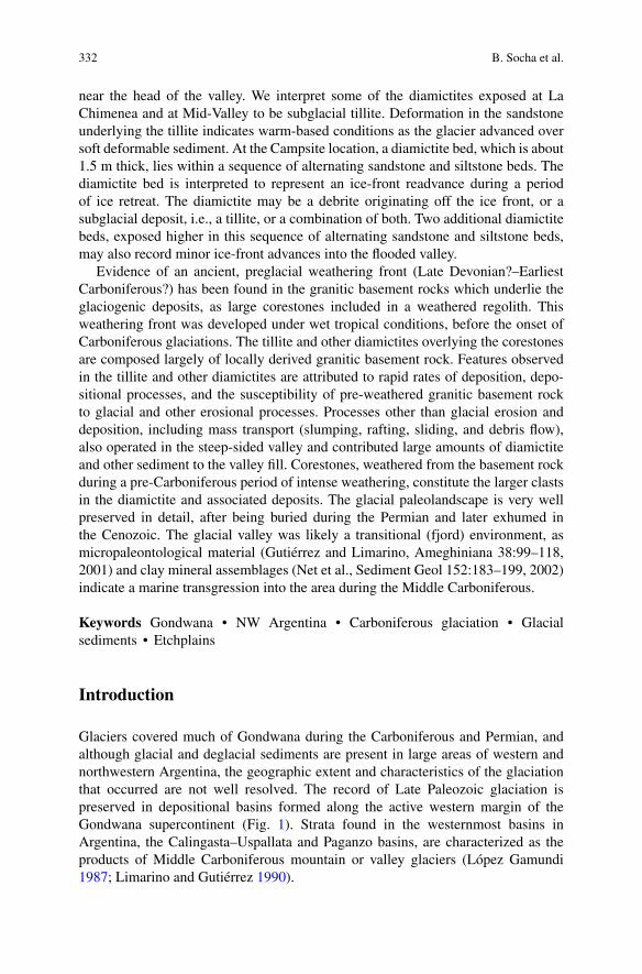
Glaciers covered much of Gondwana during the Carboniferous and Permian, andalthough glacial and deglacial sediments are present in large areas of western andnorthwestern Argentina, the geographic extent and characteristics of the glaciationthat occurred are not well resolved. The record of Late Paleozoic glaciation ispreserved in depositional basins formed along the active western margin of theGondwana supercontinent (Fig. 1). Strata found in the westernmost basins inArgentina, the Calingasta–Uspallata and Paganzo basins, are characterized as theproducts of Middle Carboniferous mountain or valley glaciers (López Gamundi1987; Limarino and Gutiérrez 1990).
Gondwana Glacial Paleolandscape, Diamictite Record of Carboniferous Valley. . . 333
320–310 Ma 300–290 Ma 280–270 Ma
Pole
a b c
SOUTHAMERICA
1
7
69
10
12
11
82
3 4
5
AFRICA
ANTARCTICA
AUSTRALIA
2000 km
1. Tarija 7. Paraná
9. Karoo
10. Falkdand
11. Kalahari
12. Transantarctic Mtris.
8. Sauce Grande
4. Tepuel
5. San Rafael
2. Paganzo
3. Calingasta- Uspallata
6. Chaco- Paraná
60�
60�
60�
PolePole
P A N T H A L A S S A
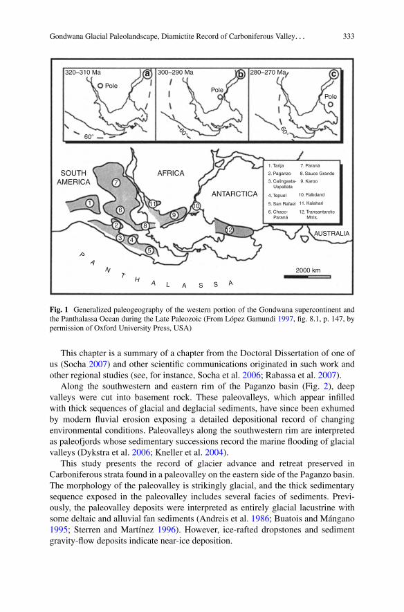
Fig. 1 Generalized paleogeography of the western portion of the Gondwana supercontinent andthe Panthalassa Ocean during the Late Paleozoic (From López Gamundi 1997, fig. 8.1, p. 147, bypermission of Oxford University Press, USA)
This chapter is a summary of a chapter from the Doctoral Dissertation of one ofus (Socha 2007) and other scientific communications originated in such work andother regional studies (see, for instance, Socha et al. 2006; Rabassa et al. 2007).
Along the southwestern and eastern rim of the Paganzo basin (Fig. 2), deepvalleys were cut into basement rock. These paleovalleys, which appear infilledwith thick sequences of glacial and deglacial sediments, have since been exhumedby modern fluvial erosion exposing a detailed depositional record of changingenvironmental conditions. Paleovalleys along the southwestern rim are interpretedas paleofjords whose sedimentary successions record the marine flooding of glacialvalleys (Dykstra et al. 2006; Kneller et al. 2004).
This study presents the record of glacier advance and retreat preserved inCarboniferous strata found in a paleovalley on the eastern side of the Paganzo basin.The morphology of the paleovalley is strikingly glacial, and the thick sedimentarysequence exposed in the paleovalley includes several facies of sediments. Previ-ously, the paleovalley deposits were interpreted as entirely glacial lacustrine withsome deltaic and alluvial fan sediments (Andreis et al. 1986; Buatois and Mángano1995; Sterren and Martínez 1996). However, ice-rafted dropstones and sedimentgravity-flow deposits indicate near-ice deposition.

334 B. Socha et al.
Fig. 2 Paleogeography of the Paganzo and Calingasta–Uspallata basins during the Middle- to LateCarboniferous (From López Gamundi 1997, fig. 9.5, p. 153, by permission of Oxford UniversityPress, USA)
This chapter reports observations of an ancient, preglacial weathering front(Late Devonian?–Earliest Carboniferous?), a Carboniferous glacial paleolandscape,and glacial diamictite and other glaciogenic sediments at three locations in thepaleovalley and intends to reconstruct the depositional environments in the relict
Gondwana Glacial Paleolandscape, Diamictite Record of Carboniferous Valley. . . 335
glacial valley. From the diamictite characteristics, the general conditions at the baseof the ice and the mode of sediment transport and deposition are inferred. Directevidence of warm-based valley glaciation is preserved at the base of a diamictitebed that we interpreted to be subglacial tillite.
Regional Paleogeographic Setting
The Late Paleozoic tectonic setting of the Calingasta–Uspallata and Paganzo basinsof Western Argentina was a back-arc to foreland basin formed in association withthe subduction of the Pacific Plate beneath the western margin of Gondwana (Ramos1988). Early Carboniferous sediments are not found in the Paganzo basin, butbased on the sedimentary and paleontological record from the adjacent Calingasta–Uspallata basin, the Early Carboniferous (Tournaisian–Visean) was a time of humid,temperate climate (López Gamundi et al. 1992). Sedimentation took place mostlyin small intermontane basins. The sediments consist mainly of clast-supportedconglomerates and interfingering sandstones and are interpreted as alluvial fanand fluvial deposits. The paleoecology of plant remains found in these depositsalso indicates a more temperate and humid climate than later when climate wasdominated by glacial events (López Gamundi et al. 1992).
During the Middle Carboniferous (Namurian–Early Westphalian), widespreadglacial deposition occurred in basins along the western margin of Gondwana (LópezGamundi et al. 1992). The Calingasta–Uspallata and Paganzo basins were at apaleolatitude of about 60ı south (Fig. 1), and a combination of high latitude andhigh altitude contributed to the formation of ice centers along the margins of thebasins (López Gamundi 1997). Striations carved in the basement rock and boulderpavements within the Carboniferous strata indicate that ice flow in the Paganzobasin was generally toward the northwest, with local ice-flow directions determinedby the local paleoslopes (López Gamundi 1997; Fig. 2). Glacial modification ofthe topography, following uplift of the region in the Late Devonian and EarlyCarboniferous, produced significant topographic relief (López Gamundi 1997).
Several models of the Carboniferous glaciation suggest that the Paganzo basin,bounded on the west by the paleo-Precordillera, on the east and south by thePampean and Pie de Palo Arches, and the Puna high on the north (Buatois andMángano 1995), was cut off from the marine environment by mountain rangesand that the basin received mainly continental sediments, while to the west theCalingasta–Uspallata basin received mainly marine sediments (López Gamundi1987; López Gamundi et al. 1992).
Local Setting
The Malanzán subbasin (Fig. 3), located in the eastern Paganzo basin, is commonlyreferred to as the Malanzán paleovalley (Andreis and Bossi 1981). The Malanzánpaleovalley trends south–southwest to north–northeast from Malanzán to Solca
336 B. Socha et al.
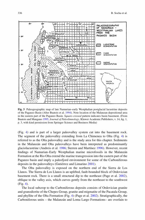
Fig. 3 Paleogeographic map of late Namurian–early Westphalian postglacial lacustrine depositsof the Paganzo Basin (After Buatois et al. 1994). Note location of the Malanzan depositional areain the eastern part of the Paganzo Basin. Square-crossed pattern indicates basin basement. (FromBuatois and Mangano 1995, Journal of Paleolimnology, Kluwer Academic Publishers, v. 14, fig. 1,p. 3, with kind permission from Springer Science and Business Media)
(Fig. 4) and is part of a larger paleovalley system cut into the basement rock.The segment of the paleovalley extending from La Chimenea to Olta (Fig. 4) isreferred to as the Olta paleovalley and is the study area for this chapter. Sedimentsin the Malanzán and Olta paleovalleys have been interpreted as predominantlyglaciolacustrine (Andreis et al. 1986; Sterren and Martínez 1996). However, recentfindings of Namurian–Early Westphalian marine microfossils in the MalanzánFormation at the Rio Olta extend the marine transgression into the eastern part of thePaganzo basin and imply a paleofjord environment for some of the Carboniferousdeposits in the paleovalleys (Gutiérrez and Limarino 2001).
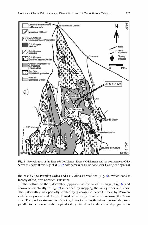
The Olta paleovalley is exposed on the northern end of the Sierra de LosLlanos. The Sierra de Los Llanos is an uplifted, fault-bounded block of Ordovicianbasement rock. There is a small structural dip to the northeast (Page et al. 2002),oblique to the valley axis, which curves gently from the northeast to the southwest(Fig. 4).
The local subcrop to the Carboniferous deposits consists of Ordovician graniteand granodiorite of the Chepes Group, granite and migmatite of the Pacatala Group,and phyllite of the Olta Formation (Fig. 4) (Page et al. 2002). Stratigraphically, theCarboniferous units – the Malanzán and Loma Largo Formations– are overlain to
Gondwana Glacial Paleolandscape, Diamictite Record of Carboniferous Valley. . . 337
Fig. 4 Geologic map of the Sierra de Los Llanos, Sierra de Malanzán, and the northern part of theSierra de Chepes (From Page et al. 2002, with permission by the Asociación Geológica Argentina)
the east by the Permian Solca and La Colina Formations (Fig. 5), which consistlargely of red, cross-bedded sandstone.
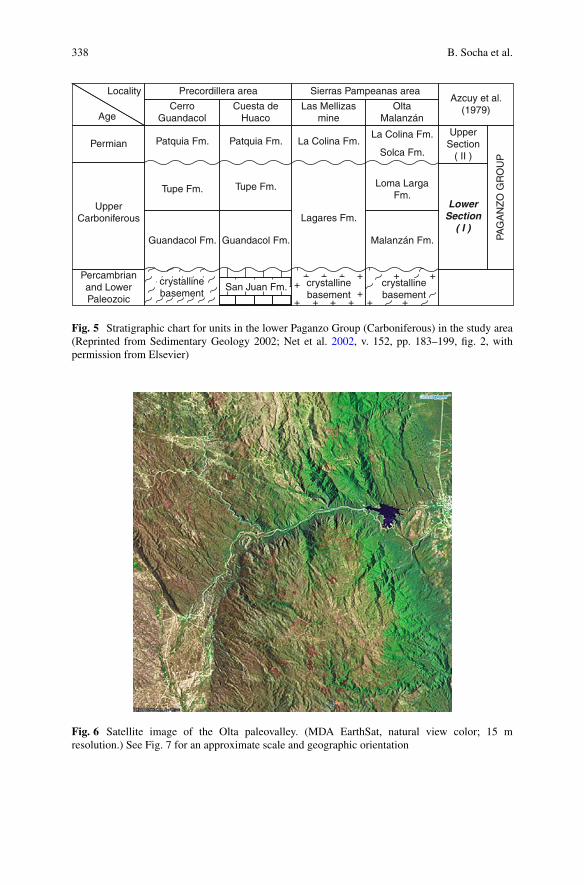
The outline of the paleovalley (apparent on the satellite image, Fig. 6, andshown schematically in Fig. 7) is defined by mapping the valley floor and sides.The paleovalley was partially infilled by glaciogenic deposits, then by Permiansedimentary rocks, and likely exhumed primarily by fluvial erosion during the Ceno-zoic. The modern stream, the Rio Olta, flows to the northeast and presumably runsparallel to the course of the original valley. Based on the direction of progradation
338 B. Socha et al.
Locality
Permian
Precordillera area Sierras Pampeanas area
Las Mellizasmine
OltaMalanzán
Malanzán Fm.
Azcuy et al.(1979)
UpperSection
( II )
PAG
AN
ZO
GR
OU
P
LowerSection
( I )
CerroGuandacol
Patquia Fm. Patquia Fm. La Colina Fm.
Lagares Fm.
Loma LargaFm.
La Colina Fm.
Solca Fm.
Tupe Fm.Tupe Fm.
Guandacol Fm. Guandacol Fm.
San Juan Fm.crystallinebasement
Cuesta deHuaco
UpperCarboniferous
Percambrianand LowerPaleozoic
Age
+
+++++
+ + + + + +
++crystallinebasement
crystallinebasement
Fig. 5 Stratigraphic chart for units in the lower Paganzo Group (Carboniferous) in the study area(Reprinted from Sedimentary Geology 2002; Net et al. 2002, v. 152, pp. 183–199, fig. 2, withpermission from Elsevier)
Fig. 6 Satellite image of the Olta paleovalley. (MDA EarthSat, natural view color; 15 mresolution.) See Fig. 7 for an approximate scale and geographic orientation
Gondwana Glacial Paleolandscape, Diamictite Record of Carboniferous Valley. . . 339
La ChimeneaApproximate Scale
0 2 km
Mid-Valley
Campsite
Olta
N
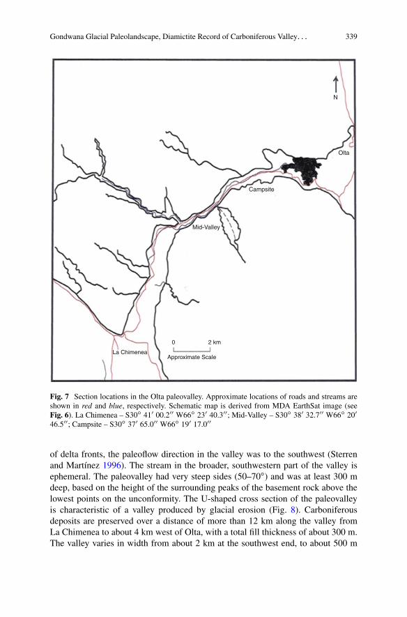
Fig. 7 Section locations in the Olta paleovalley. Approximate locations of roads and streams areshown in red and blue, respectively. Schematic map is derived from MDA EarthSat image (seeFig. 6). La Chimenea – S30ı 410 00.200 W66ı 230 40.300; Mid-Valley – S30ı 380 32.700 W66ı 200
46.500; Campsite – S30ı 370 65.000 W66ı 190 17.000
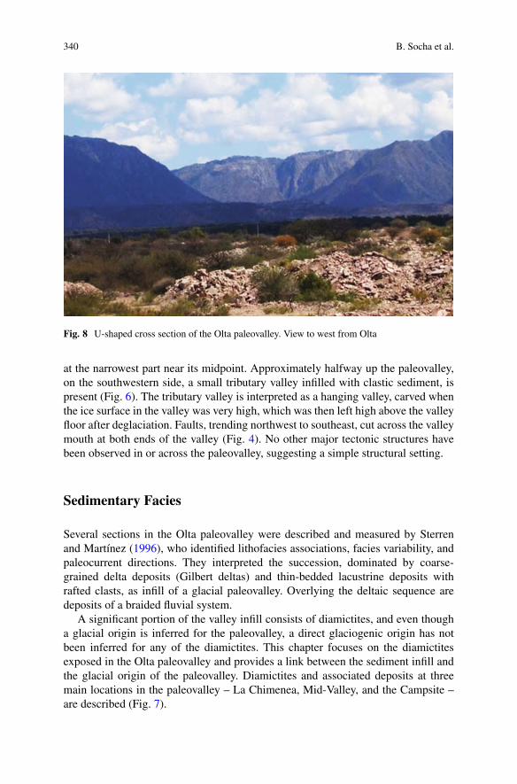
of delta fronts, the paleoflow direction in the valley was to the southwest (Sterrenand Martínez 1996). The stream in the broader, southwestern part of the valley isephemeral. The paleovalley had very steep sides (50–70ı) and was at least 300 mdeep, based on the height of the surrounding peaks of the basement rock above thelowest points on the unconformity. The U-shaped cross section of the paleovalleyis characteristic of a valley produced by glacial erosion (Fig. 8). Carboniferousdeposits are preserved over a distance of more than 12 km along the valley fromLa Chimenea to about 4 km west of Olta, with a total fill thickness of about 300 m.The valley varies in width from about 2 km at the southwest end, to about 500 m
340 B. Socha et al.
Fig. 8 U-shaped cross section of the Olta paleovalley. View to west from Olta
at the narrowest part near its midpoint. Approximately halfway up the paleovalley,on the southwestern side, a small tributary valley infilled with clastic sediment, ispresent (Fig. 6). The tributary valley is interpreted as a hanging valley, carved whenthe ice surface in the valley was very high, which was then left high above the valleyfloor after deglaciation. Faults, trending northwest to southeast, cut across the valleymouth at both ends of the valley (Fig. 4). No other major tectonic structures havebeen observed in or across the paleovalley, suggesting a simple structural setting.
Sedimentary Facies
Several sections in the Olta paleovalley were described and measured by Sterrenand Martínez (1996), who identified lithofacies associations, facies variability, andpaleocurrent directions. They interpreted the succession, dominated by coarse-grained delta deposits (Gilbert deltas) and thin-bedded lacustrine deposits withrafted clasts, as infill of a glacial paleovalley. Overlying the deltaic sequence aredeposits of a braided fluvial system.
A significant portion of the valley infill consists of diamictites, and even thougha glacial origin is inferred for the paleovalley, a direct glaciogenic origin has notbeen inferred for any of the diamictites. This chapter focuses on the diamictitesexposed in the Olta paleovalley and provides a link between the sediment infill andthe glacial origin of the paleovalley. Diamictites and associated deposits at threemain locations in the paleovalley – La Chimenea, Mid-Valley, and the Campsite –are described (Fig. 7).
Gondwana Glacial Paleolandscape, Diamictite Record of Carboniferous Valley. . . 341
The following lithofacies code, adapted from Eyles et al. (1983), is used todescribe the sections. Inferences made from observations of characteristics ofPleistocene and modern glacier deposits regarding depositional environment areused to interpret the sections of Carboniferous diamictites and associated sedimentsexposed at the three locations in the Olta paleovalley.
Lithofacies Code Dmm – Diamictite, matrix-supported,massive Dms – Diamictite, matrix-supported, stratifiedDcm – Diamictite clast-supported, massive Dcs –Diamictite clast-supported, stratified
Gm – Gravel, massive Sm – Sand, massive Sh – Sand,horizontally laminated Sr – Sand, ripple cross-beddedFm – Fines (silt & clay) massive Fl – Fines (silt & clay)laminated
Till and Tillite
Characteristics of till are well documented from Pleistocene and modern glacierenvironments. Presumably soft sedimentary features of till and associated sedimentcan be preserved in the rock record as lithified structures in tillite. Therefore, theinferences made from modern and Pleistocene sediment characteristics regardingdepositional environment also apply to tillite. In the remainder of this chapter, “till”and “diamicton” are used when referring to unlithified (Pleistocene and modern)sediment, and “tillite” and “diamictite” are used when referring to lithified (pre-Pleistocene) deposits.
The general conditions at the base of a glacier or the base of a lobe of glacierice, the mode of sediment transport, and the environment of deposition can oftenbe inferred from till characteristics. It is generally accepted that sediment can retainfeatures it obtained while being transported by moving glacier ice.
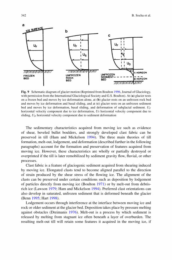
Glacier ice moves by internal deformation in the ice itself, by sliding at the baseof the ice, by deformation in the underlying sediment, or by some combination ofthese mechanisms (Boulton 1996). Ice motion results from permanent strain of theice and the glacier bed in response to stress (Benn and Evans 1996). Stress, or forceper unit area, can be resolved into stress acting at right angles to the surface (normalstress) and stress acting parallel to the surface (shear stress). Strain (the change inshape and size of a material due to stress) may occur as deformation of the ice,deformation of the bed under the ice, or by sliding at the interface between the iceand the glacier bed. The surface motion or surface velocity of a glacier is the sum ofthese processes (Fig. 9). Bed deformation can only be significant when sedimentsare saturated with water at a pressure that is almost as high as the ice overburdenpressure (i.e., effective pressure is low), and basal sliding is only expected whenthe ice is at the pressure melting point (i.e., the glacier is temperate) (Paterson1994).
342 B. Socha et al.
Fig. 9 Schematic diagram of glacier motion (Reprinted from Boulton 1996, Journal of Glaciology,with permission from the International Glaciological Society and G.S. Boulton). At (a) glacier restson a frozen bed and moves by ice deformation alone, at (b) glacier rests on an unfrozen rock bedand moves by ice deformation and basal sliding, and at (c) glacier rests on an unfrozen sedimentbed and moves by ice deformation, basal sliding, and deformation of subglacial sediment. UF
horizontal velocity component due to ice deformation, Us horizontal velocity component due tosliding, UD horizontal velocity component due to sediment deformation
The sedimentary characteristics acquired from moving ice such as evidenceof shear, beveled bullet boulders, and strongly developed clast fabric can bepreserved in till (Ham and Mickelson 1994). The three main theories of tillformation, melt-out, lodgement, and deformation (described further in the followingparagraphs) account for the formation and preservation of features acquired frommoving ice. However, these characteristics are wholly or partially destroyed oroverprinted if the till is later remobilized by sediment gravity flow, fluvial, or otherprocesses.
Clast fabric is a feature of glaciogenic sediment acquired from shearing inducedby moving ice. Elongated clasts tend to become aligned parallel to the directionof strain produced by the shear stress of the flowing ice. The alignment of theclasts can be preserved under certain conditions such as deposition by lodgementof particles directly from moving ice (Boulton 1971) or by melt-out from debris-rich ice (Lawson 1979; Ham and Mickelson 1994). Preferred clast orientations canalso develop in saturated, unfrozen sediment that is deformed beneath the glacier(Benn 1995; Hart 1998).
Lodgement occurs through interference at the interface between moving ice androck or older sediment at the glacier bed. Deposition takes place by pressure meltingagainst obstacles (Dreimanis 1976). Melt-out is a process by which sediment isreleased by melting from stagnant ice often beneath a layer of overburden. Theresulting melt-out till will retain some features it acquired in the moving ice, if
Gondwana Glacial Paleolandscape, Diamictite Record of Carboniferous Valley. . . 343
the meltwater can drain, if the surface slope is low, and if the layer of overburdenis thick enough to prevent slump or flow (Boulton 1971, 1972). If sediment isdeposited from a debris-rich ice layer with high sediment content (Lawson 1981;Ham and Mickelson 1994), the clasts in the sediment may have a strong, or well-developed, preferred orientation that is parallel to the direction of ice flow. A weakerorientation may indicate deposition from a debris-rich ice layer with low sedimentcontent (Lawson 1981; Ham and Mickelson 1994).
Sediment transported as a saturated, unfrozen, deforming bed beneath the glacieralso acquires features resulting from ice flow. Wet sediment is mobilized by theshearing force of the moving glacier, and strain results in change in the geometricrelationship of grains to produce new sediment. Elson (1988), Benn (1995), andHart (1998) suggested that a thin deforming layer would have a strongly developedpreferred orientation of clasts and that a thick deforming layer will have clastswith a weakly developed preferred orientation parallel to the direction of iceflow. As shown by laboratory experiments using a thin layer of sediment in aring shear device, strong clast fabric develops in the direction of shear at smallstrains (1 to 2) and remains strong through higher strains (Hooyer and Iverson2000).
Sediment gravity flow is a common process in a supraglacial or proglacialenvironment. Sediment deposited by sediment gravity flow may have the followingcharacteristics: a basal zone of traction gravel, variable matrix texture, lack of fabricconsistently oriented parallel to the direction of ice flow, dipping of undulating basalcontacts, and a denser clast concentration (Lawson and Kemmis 1983). Flow noses,rafts of fine-textured laminae, silt and clay stringers, rip-up clasts, basal grooves,clast imbrication or clusters, random clast fabric or fabric parallel to bedding, anderosion and inclusion of underlying material are distinctive features of sedimentflows noted by Eyles et al. (1983). Common, prominent distinguishing features ofsediment flow deposits are a weak clast fabric that is not parallel to the directionof ice flow, variable texture, presence of stringers of sorted sediment, and clastconcentrations.
Grain-size distribution is an important factor affecting how sediment respondsto subglacial stress and in determining the processes dominating at the time ofdeposition. For example, saturated clay-rich sediment is expected to shear underlow effective stress; the proportion of large clasts to fine-grained sediment affectsdeformation as boulders can support part of the shear stress and provide instrumentsfor plowing (Paterson 1994).
Roundness, lithology, and surface textures (striations and polish) of clasts arenotable diagnostic features for diamicton formation. Roundness can be an indicationof the degree of wear against other clasts, matrix material, or bedrock or can beproduced by weathering such as is commonly produced by exfoliation of granite.Striations and polish are evidence of wear due to interaction with matrix material,other clasts, or the bedrock surface (Boulton 1978; Benn 1995).
344 B. Socha et al.
Subglacial Processes
Traditionally, classifications of till (Dreimanis 1988) focused on tills as geneticend members, i.e., lodgment till, melt-out till, and deformation till. However,recent research focuses on the recognition that the processes of deformation,sliding, lodgement, and plowing coexist in the subglacial environment and producesedimentary sequences that record a composite signature of transport and deposition(Evans et al. 2006).
The end member classifications do not appear to be adequate genetic desig-nations for till. Observations from Pleistocene sedimentary sequences support amodel wherein the ice moves by a combination of deformation of a thin bedof sediment, plowing, lodgement, and sliding (Clayton et al. 1989; Mickelsonet al. 1992; Piotrowski and Tulaczyk 1999; Piotrowski et al. 2001, 2004, 2006).In Pleistocene sedimentary sequences, generally undisturbed beds interspersedwith highly deformed beds have been observed, and the soft bed of temperateglaciers is envisioned as a mosaic of stable and deforming spots whose distributionvaries through time and space (Piotrowski et al. 2004, 2006). Piotrowski et al.(2006) summarized field indicators of bed deformation (intermixed sediment layers,overturned and attenuated folds, boudinage structures, and strong alignment ofparticles), field indicators of lodgement (grooved surfaces within till layers, plowmarks, and consistently striated clasts), and field indicators of basal decoupling(sand stringers, scours under pebbles that are filled with sand, and partly armored tillpellets). Till formation can occur under high basal water pressure which periodicallycaused decoupling of the ice and till (Piotrowski et al. 2006). High basal waterpressure beneath Pleistocene ice sheets is also inferred by many other workersincluding Brown et al. (1987), Cutler et al. (2000), and Wysota (2007).
Recent observations from modern temperate glaciers also indicate that bothdeformation and sliding occur and that the processes change spatially and tempo-rally (Engelhardt and Kamb 1998; Truffer et al. 1999, 2000; Truffer and Harrison2006; Porter and Murray 2001).
Inferences made from Pleistocene and modern environments are likely alsoapplicable to ancient depositional environments of tillite. The subglacial environ-ment for till formation beneath Carboniferous glaciers is also expected to haveincluded coexisting processes of deformation, sliding, lodgement, and plowing,and the sedimentary sequences produced likely record a composite signature of theprocesses. Because the sedimentary sequences were likely produced by a continuumof subglacial processes, we distinguish the sediment only as subglacial tillite and donot apply the specific genetic classification end member names of lodgement, melt-out, or deformation to the sediment. The most critical distinction to be made inreconstruction of a glacial paleoenvironment is the recognition of subglacial tillite,because the presence of subglacial tillite confirms the presence of glacier ice in theenvironment.
Gondwana Glacial Paleolandscape, Diamictite Record of Carboniferous Valley. . . 345
Deposits in the Paleovalley
Diamictites and associated deposits at three locations in the paleovalley aredescribed in the following sections. At the first location (La Chimenea) nearthe mouth of the paleovalley, and at the second location (Mid-Valley) near themiddle of the paleovalley, predominantly diamictite is exposed. At both locations,the diamictite overlies a few meters of sandstone, which lies on the Ordovicianbasement rock. At the third location (Campsite) near the head of the paleovalley,mostly alternating beds of sandstone and siltstone are exposed. The sequence ofalternating sandstone and siltstone beds contains three thin diamictite beds. Wefocus on these three locations; however, other outcrops of especially sandstone andsiltstone are extensive elsewhere in the paleovalley.
Description of Diamictite at La Chimenea
Diamictite, exposed in the roadcut about 1 km east of the village of La Chimenea(Fig. 7), is mostly clast-supported massive (Dcm) and stratified (Dcs) and iscomposed predominantly of cobbles and boulders of weathered granite. The matrixis fairly well cemented and consists predominantly of feldspar, quartz, biotite, andmuscovite. Individual grains vary from silt and fine sand to granules. A weakpreferential alignment of clast long axes is present in some of the diamictite. Clastshave long axes with an apparent predominant orientation of about 85ı to about 110ıand dip 20ı to 30ı. The axis of this segment of the valley trends about 185ı.
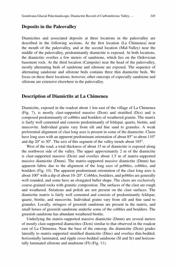
West of the road, a total thickness of about 15 m of diamictite is exposed alongthe northwest side of the valley. The upper approximately 2 m of the diamictiteis clast-supported massive (Dcm) and overlies about 1.5 m of matrix-supportedmassive diamictite (Dmm). The matrix-supported massive diamictite (Dmm) hasapparent fabric due to the alignment of the long axes of pebbles, cobbles, andboulders (Fig. 10). The apparent predominant orientation of the clast long axes isabout 100ı with a dip of about 10–20ı. Cobbles, boulders, and pebbles are generallywell rounded, and some have an elongated bullet shape. The clasts are exclusivelycoarse-grained rocks with granitic composition. The surfaces of the clast are roughand weathered. Striations and polish are not present on the clast surfaces. Thediamictite matrix is fairly well cemented and consists of predominantly feldspar,quartz, biotite, and muscovite. Individual grains vary from silt and fine sand togranules. Locally, stringers of greenish sandstone are present in the matrix, andsmall lenses of greenish sandstone underlie some of the cobbles and boulders. Thegreenish sandstone has abundant weathered biotite.
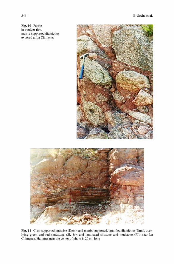
Underlying the matrix-supported massive diamictite (Dmm) are several metersof mostly clast-supported diamictites (Dcm) similar to that observed in the roadcuteast of La Chimenea. Near the base of the outcrop, the diamictite (Dcm) gradeslaterally to matrix-supported stratified diamictite (Dms) and overlies thin-bedded,horizontally laminated, and ripple cross-bedded sandstone (Sl and Sr) and horizon-tally laminated siltstone and mudstone (Fl) (Fig. 11).
346 B. Socha et al.
Fig. 10 Fabricin boulder-rich,matrix-supported diamictiteexposed at La Chimenea
Fig. 11 Clast-supported, massive (Dcm), and matrix-supported, stratified diamictite (Dms), over-lying green and red sandstone (Sl, Sr), and laminated siltstone and mudstone (Fl), near LaChimenea. Hammer near the center of photo is 26 cm long
Gondwana Glacial Paleolandscape, Diamictite Record of Carboniferous Valley. . . 347
Description of Diamictite and Sandstone at Mid-Valley
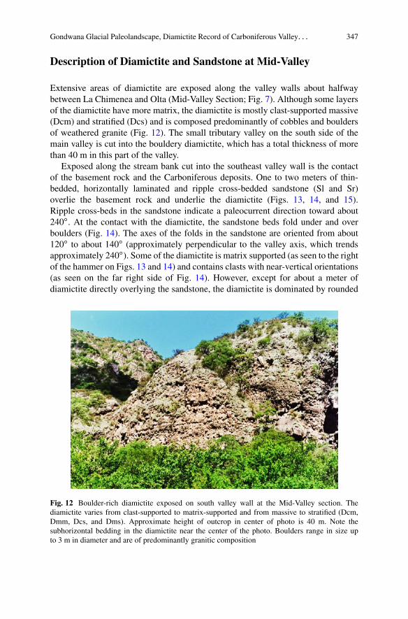
Extensive areas of diamictite are exposed along the valley walls about halfwaybetween La Chimenea and Olta (Mid-Valley Section; Fig. 7). Although some layersof the diamictite have more matrix, the diamictite is mostly clast-supported massive(Dcm) and stratified (Dcs) and is composed predominantly of cobbles and bouldersof weathered granite (Fig. 12). The small tributary valley on the south side of themain valley is cut into the bouldery diamictite, which has a total thickness of morethan 40 m in this part of the valley.
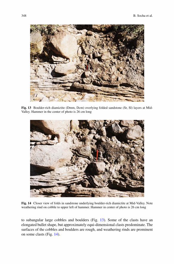
Exposed along the stream bank cut into the southeast valley wall is the contactof the basement rock and the Carboniferous deposits. One to two meters of thin-bedded, horizontally laminated and ripple cross-bedded sandstone (Sl and Sr)overlie the basement rock and underlie the diamictite (Figs. 13, 14, and 15).Ripple cross-beds in the sandstone indicate a paleocurrent direction toward about240ı. At the contact with the diamictite, the sandstone beds fold under and overboulders (Fig. 14). The axes of the folds in the sandstone are oriented from about120ı to about 140ı (approximately perpendicular to the valley axis, which trendsapproximately 240ı). Some of the diamictite is matrix supported (as seen to the rightof the hammer on Figs. 13 and 14) and contains clasts with near-vertical orientations(as seen on the far right side of Fig. 14). However, except for about a meter ofdiamictite directly overlying the sandstone, the diamictite is dominated by rounded
Fig. 12 Boulder-rich diamictite exposed on south valley wall at the Mid-Valley section. Thediamictite varies from clast-supported to matrix-supported and from massive to stratified (Dcm,Dmm, Dcs, and Dms). Approximate height of outcrop in center of photo is 40 m. Note thesubhorizontal bedding in the diamictite near the center of the photo. Boulders range in size upto 3 m in diameter and are of predominantly granitic composition
348 B. Socha et al.
Fig. 13 Boulder-rich diamictite (Dmm, Dcm) overlying folded sandstone (Sr, Sl) layers at Mid-Valley. Hammer in the center of photo is 26 cm long
Fig. 14 Closer view of folds in sandstone underlying boulder-rich diamictite at Mid-Valley. Noteweathering rind on cobble to upper left of hammer. Hammer in center of photo is 26 cm long
to subangular large cobbles and boulders (Fig. 13). Some of the clasts have anelongated bullet shape, but approximately equi-dimensional clasts predominate. Thesurfaces of the cobbles and boulders are rough, and weathering rinds are prominenton some clasts (Fig. 14).
Gondwana Glacial Paleolandscape, Diamictite Record of Carboniferous Valley. . . 349
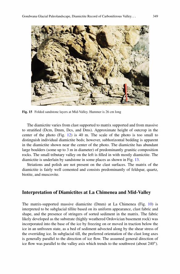
Fig. 15 Folded sandstone layers at Mid-Valley. Hammer is 26 cm long
The diamictite varies from clast supported to matrix supported and from massiveto stratified (Dcm, Dmm, Dcs, and Dms). Approximate height of outcrop in thecenter of the photo (Fig. 12) is 40 m. The scale of the photo is too small todistinguish individual diamictite beds; however, subhorizontal bedding is apparentin the diamictite shown near the center of the photo. The diamictite has abundantlarge boulders (some up to 3 m in diameter) of predominantly granitic compositionrocks. The small tributary valley on the left is filled in with mostly diamictite. Thediamictite is underlain by sandstone in some places as shown in Fig. 13.
Striations and polish are not present on the clast surfaces. The matrix of thediamictite is fairly well cemented and consists predominantly of feldspar, quartz,biotite, and muscovite.
Interpretation of Diamictites at La Chimenea and Mid-Valley
The matrix-supported massive diamictite (Dmm) at La Chimenea (Fig. 10) isinterpreted to be subglacial tillite based on its uniform appearance, clast fabric andshape, and the presence of stringers of sorted sediment in the matrix. The fabriclikely developed as the substrate (highly weathered Ordovician basement rock) wasincorporated into the base of the ice by freezing on or moved in traction below theice in an unfrozen state, as a bed of sediment advected along by the shear stress ofthe overriding ice. In subglacial till, the preferred orientation of the clast long axesis generally parallel to the direction of ice flow. The assumed general direction ofice flow was parallel to the valley axis which trends to the southwest (about 240ı).
350 B. Socha et al.
However, locally ice flow may have been transverse to the axis of the valley as theice flow was likely divergent at the valley mouth. Strong fabric is obvious in thediamictite, but fabric direction is only apparent, as the diamictite is well indurated,and clasts cannot be removed to measure the true orientation of their long axes.
The stringers of greenish sandstone may be proglacial fluvial or lacustrinesediment that was frozen onto the base of the ice, or incorporated, in an unfrozenstate, as an inclusion in a thicker bed of soft sediment advected along as a tractionlayer beneath the moving ice. An alternative interpretation is that the thin layersof sorted sediment resulted when high water pressure separated the ice from thebed, and formed a cavity. Meltwater may have flowed between the ice and the bedand produced washed and sorted sediment, which subsequently infilled the cavity.A similar process may have formed the small lenses of sand found locally beneathsome of the cobbles and boulders. The sand lenses may have resulted from theinfilling of scours that were eroded by meltwater flowing under cobbles and bouldersprotruding from the base of the ice (Munro-Stasiuk 2000) or meltwater flowingaround cobbles and boulders protruding from the bed. Similar sand stringers andsand pockets in Pleistocene sediments have been taken as indicators of pressurizedmeltwater flow at the glacier bed (Piotrowski et al. 2006).
The clasts in the tillite are not striated or polished because the parent material isvery coarse-grained, weathered, somewhat friable, granitic rock. The tillite doesnot overlie striated and polished basement rocks because the basement rock isalso coarse-grained, somewhat friable, weathered granitic rock. The lithology ofthe tillite is dominated by the local basement rock, though nonlocal lithologies arereported for diamictite at other locations in the paleovalley (Sterren and Martínez1996). The predominance of the local lithology in the tillite and other diamictitesis likely due to the overwhelming abundance of easily eroded, pre-weathered,basement rock.
The diamictite at Mid-Valley (Fig. 13) is more variable than the matrix-supportedmassive diamictite (Dmm) at La Chimenea, but based on the folding and otherdeformation in the underlying sandstone, a subglacial origin is also suggested forthis sediment. The fold axes in the sandstone are approximately perpendicular tothe assumed ice-flow direction down the valley. The folds in the sandstone mayindicate that grounded ice advanced over a soft sediment bed and deformed thesoft substrate in the direction of ice flow. Effective pressure was likely low as theice margin advanced into the flooded valley. The plumose form and associated softsediment structures in the fold shown on Fig. 15 may indicate concurrent dewateringand high water pressure in the sediment as it was overridden and deformed bythe advancing ice. The abundance of large boulders in the sedimentary sequenceand the overall coarse texture of the tillite and other diamictites are likely due tothe erosion and incorporation locally of intensely weathered basement rock. Seebelow for discussion of the origin and interpretation of these weathered graniticboulders.
Glacial erosion produced subglacial tillite, and glacial conditions also likelyenhanced the environment for mass wasting, slumping, and avalanching to occur.Most of the diamictite exposed along the valley wall, such as shown on Fig. 12,
Gondwana Glacial Paleolandscape, Diamictite Record of Carboniferous Valley. . . 351
does not have attributes characteristic of glaciogenic sediment. Although crudestratification is apparent in some of the diamictite (Fig. 12), the majority of thediamictite is extremely coarse grained with a seemingly chaotic arrangement oflarge boulders and little matrix material. Some of the diamictite, such as shown inFig. 12, may be sediment originating from mass wasting, slumping, and avalanchingonto the ice surface that was transported as supraglacial sediment and later let downas the ice melted. Some of the diamictite, such as shown in Fig. 12, may have formedduring deglaciation, as the processes of mass wasting, slumping, and avalanchinglikely continued as material slumped, slid, and avalanched off the steep-sided valleyas it was being freed from ice. Catastrophic sedimentation events (debris flowstriggered by rock falls) may also have occurred during deglaciation and contributedlarge amounts of sediment to the sequence as seen in Fig. 12.
Diamictite constitutes a significant portion, probably more than 20 % of the fillin the Olta paleovalley. Additional diamictite units with tillite characteristics may bepresent in the valley, but because much of the diamictite forms steep valley walls, itis largely inaccessible for detailed logging and field description.
Description of Sandstone and Diamictite at the Campsite
Extensive areas of alternating sandstone and siltstone with three prominent interbedsof diamictite are exposed along the south valley wall at the Campsite (Fig. 7). Thin-bedded (10- to 20-cm thick), massive, very fine sandstone (Sm) is interbedded withthin-bedded (10–30-cm thick), ripple cross-bedded, very fine sandstone (Sr) andlaminated siltstone (Fl). The massive sandstone beds are more resistant in outcrop(Figs. 16, 17, and 18). The total thickness of the section is about 16 m. The thicknessof the diamictite layers ranges from about 0.7 m to about 2 m. The uppermostdiamictite layer is about 0.7 m thick, the middle diamictite layer is about 1 mthick, and the lowest diamictite layer in the section is about 1.5 m thick. The lowestdiamictite layer is continuous along the south valley wall in the approximate east–west direction for about 120 m and is described here in detail.
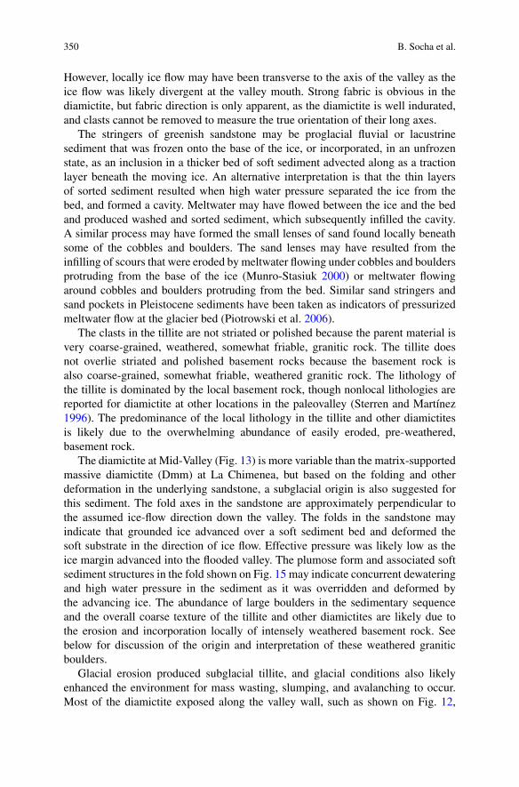
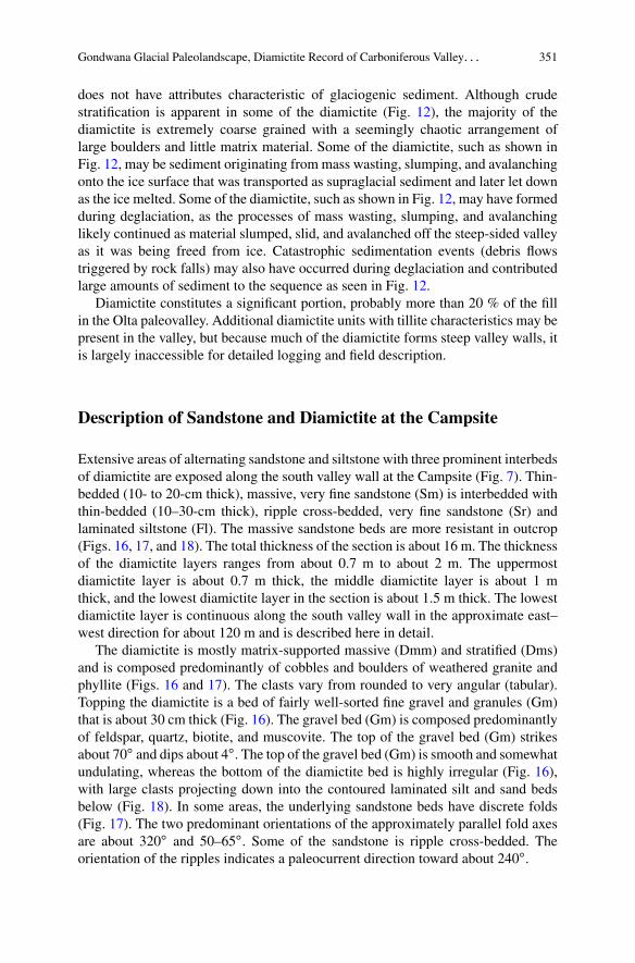
The diamictite is mostly matrix-supported massive (Dmm) and stratified (Dms)and is composed predominantly of cobbles and boulders of weathered granite andphyllite (Figs. 16 and 17). The clasts vary from rounded to very angular (tabular).Topping the diamictite is a bed of fairly well-sorted fine gravel and granules (Gm)that is about 30 cm thick (Fig. 16). The gravel bed (Gm) is composed predominantlyof feldspar, quartz, biotite, and muscovite. The top of the gravel bed (Gm) strikesabout 70ı and dips about 4ı. The top of the gravel bed (Gm) is smooth and somewhatundulating, whereas the bottom of the diamictite bed is highly irregular (Fig. 16),with large clasts projecting down into the contoured laminated silt and sand bedsbelow (Fig. 18). In some areas, the underlying sandstone beds have discrete folds(Fig. 17). The two predominant orientations of the approximately parallel fold axesare about 320ı and 50–65ı. Some of the sandstone is ripple cross-bedded. Theorientation of the ripples indicates a paleocurrent direction toward about 240ı.
352 B. Socha et al.
Fig. 16 Gravel (Gm), boulder-rich diamictite (Dmm), and deformed sandstone and siltstone layers(Sm, Sr, Fl), overlying alternating sandstone and siltstone beds at the Campsite location. Hammerin lower center of photo is 26 cm long
Fig. 17 Boulder-rich diamictite overlying deformed sandstone layers at the Campsite location.Hat for scale
Gondwana Glacial Paleolandscape, Diamictite Record of Carboniferous Valley. . . 353
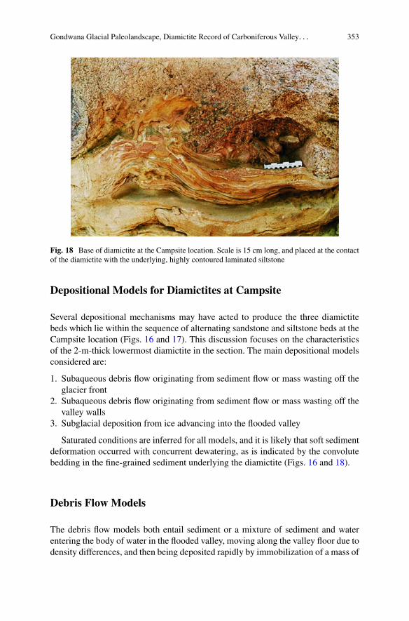
Fig. 18 Base of diamictite at the Campsite location. Scale is 15 cm long, and placed at the contactof the diamictite with the underlying, highly contoured laminated siltstone
Depositional Models for Diamictites at Campsite
Several depositional mechanisms may have acted to produce the three diamictitebeds which lie within the sequence of alternating sandstone and siltstone beds at theCampsite location (Figs. 16 and 17). This discussion focuses on the characteristicsof the 2-m-thick lowermost diamictite in the section. The main depositional modelsconsidered are:
1. Subaqueous debris flow originating from sediment flow or mass wasting off theglacier front
2. Subaqueous debris flow originating from sediment flow or mass wasting off thevalley walls
3. Subglacial deposition from ice advancing into the flooded valley
Saturated conditions are inferred for all models, and it is likely that soft sedimentdeformation occurred with concurrent dewatering, as is indicated by the convolutebedding in the fine-grained sediment underlying the diamictite (Figs. 16 and 18).
Debris Flow Models
The debris flow models both entail sediment or a mixture of sediment and waterentering the body of water in the flooded valley, moving along the valley floor due todensity differences, and then being deposited rapidly by immobilization of a mass of

354 B. Socha et al.
sediment. Debris flows stop moving when the driving force of the flow becomes lessthan the viscosity, shear resistance, and friction (Lowe 1982; Mulder and Alexander2001).
Debris flows can be lacking cohesion, with frictional strength due to interlockinggrains, or cohesive with yield strength due to a cohesive component such as clay(Lowe 1982; Mulder and Alexander 2001). Debrites may be recognized by thefollowing sedimentary features: poor sorting, relatively higher mud content (thanthe associated sandstones), shear fabric at the base and sides, clasts protruding fromthe top of the bed, clasts floating in a matrix, lack of grading and traction structures(such as cross bedding or parallel laminations), fluid-escape structures, and sharpupper contacts (Middleton and Hampton 1976; Lowe 1982; Mulder and Alexander2001).
The diamictite bed at the Campsite location has several sedimentary featuresthat are common to debrites including poor sorting, relatively higher mud contentthan the associated sandstones, shear fabric at the base, clasts floating in a matrix,lack of grading and traction structures, fluid-escape structures, and a sharp uppercontact.
The lowermost diamictite bed may be a debrite, but the distribution of thediamictite is more consistent with origination of the debrite off the ice front ratherthan the valley walls. Debris flow or mass wastage off the valley wall is expectedto produce a fan- or wedge-shaped deposit along the valley wall, rather than abed with fairly uniform thickness over a distance of over 100 m along the valleywall, as is found at the Campsite location. Therefore, the diamictite bed mayrepresent ice advance into the flooded valley. The distribution of the diamictite isalso consistent with a subglacial origin as a bed of sediment deposited from anadvancing glacier.
Some striking features of the diamictite bed, not common to debrites, include asmooth, relatively even, or slightly undulating upper surface (clasts do not protrudefrom the top of the bed) (Figs. 16 and 17) and deformation structures that penetratethe underlying beds to depths similar to the full thickness of the diamictite bed(Fig. 17). The apparent smooth upper surface of the diamictite bed is to some degreedue to the gravel (Gm) capping of the diamictite (Figs. 16 and 17). The gravel(Gm) is fairly well sorted and may serve to drape the underlying very poorly sorteddiamictite, obscuring irregularities in the top of the diamictite. The apparent smoothupper surface of the diamictite may also in part be due to the large clasts settlinginto the underlying sediments following deposition.
Subglacial Model
With either a debris flow or a subglacial origin of the diamictite, it is likely thatsome postdepositional deformation occurred as boulders settled through the matrixand deformed the underlying sediment. But the large-scale folds that penetrate theunderlying strata are not likely entirely due to gravitational settling. The folds,
Gondwana Glacial Paleolandscape, Diamictite Record of Carboniferous Valley. . . 355
whose axes have a predominant orientation transverse to the axis of the valley,and to the presumed ice-flow direction, may be due to the shear stress from theoverriding ice. Sedimentary features observed in the diamictite (including poorsorting, relatively higher mud content than the associated sandstones, shear fabricat the base, clasts floating in a matrix, lack of grading and traction structures, fluid-escape structures, and a sharp upper contact) which are common to debrites arealso common to tillites. The diamictite could have originated as a bed of sedimentmoving in traction with the advancing ice front. The advancing ice and layerof sediment moving in traction with the ice overrode soft layered substrate andproduced folds in the sediment layers. Alternatively, the diamictite could have beena debrite that originated off the advancing ice front, which was overridden as the iceadvanced. Folds in the underlying layered sediment would reflect ice-flow directionin both cases.
The surface of the gravel layer (Gm) topping the diamictite (Fig. 16) dips up-valley. An up-valley dip is also presumably an up-glacier dip, which is consistentwith a subglacial origin. Also the composition of the gravel bed is very similar tothe composition of the tillite matrix.
The gravel (Gm) may have originated from a turbid plume of englacial and/orsubglacial meltwater discharging from the glacier. Turbidites are formed by sedi-ments gradually settling out suspension and progressively aggrading a bed (Lowe1982). Recognition criteria for sandy turbidites include good sorting, relatively lowmud content, normal grading and traction structures, and inverse grading at theirbases (Middleton and Hampton 1976; Lowe 1982). The gravel (Gm) is well sortedand has a low mud content but lacks grading and traction structures. If the gravel(Gm) originated as a turbidite, it is suggested that the sediment concentration waslikely very high but that deposition was still particle by particle in order to drape theunderlying diamictite.
The lower diamictite likely represents an ice-front advance; either it is a debriteoriginating off the ice front, or it is a subglacial deposit, i.e., a tillite, or acombination of both. The three diamictite beds in the section may record three minorice-front advances into the flooded valley.
Paleoenvironmental Setting
The paleoenvironmental setting for the Olta paleovalley is likely similar to thatreported from the southwestern part of the Paganzo basin in the Jejenes subbasinnear the city of San Juan (Kneller et al. 2004). Here a paleovalley, interpreted tobe a paleofjord, contains deposits that record marine flooding and infilling withglacial and associated sediments (Kneller et al. 2004). Diamictites, including tillites,are found locally in the paleovalley, but the majority of the valley fill consists ofmudstone generated by turbid plumes of glacial meltwater and sandy turbiditesincluding mass-transport sediments (Kneller et al. 2004).
356 B. Socha et al.
Deglaciation may also have been concurrent with or was triggered by marinetransgression on the eastern side of the Paganzo basin, as marine transgres-sion into the Malanzán–Olta paleovalley is indicated by marine microplankton(Cymathiosphaera sp., Greinervillites sp., and Navifusa variabilis) of Namurian–Westphalian age, discovered in mudstone and shales of the Malanzán Formation(Limarino et al. 2002). The strictly lacustrine interpretation of the MalanzánFormation (Limarino and Césari 1988; Andreis et al. 1986; Buatois et al. 1994;Sterren and Martínez 1996) is reinterpreted as sedimentation at the inner part of apaleofjord by Limarino et al. (2002).
Clay mineralogy (an illite C chlorite assemblage), in a sequence of mudstones,shale, and fine- and medium-grained sandstones, indicates marine flooding of fluvialvalleys in the Olta–Malanzán area (Net et al. 2002). These marine-flooded valleyswere possibly fjords where turbidites and Gilbert-type delta sedimentation occurred(Net et al. 2002). Marine fossils, found near the bottom of the delta sequenceby Gutiérrez and Limarino (2001), support this interpretation of a marine-floodedvalley. Sedimentology (ripple cross-laminated sandstone with foresets dipping inopposite directions) indicates the influence of tidal currents in the Olta paleovalley(Limarino et al. 2002).
The Preglacial Ancient Weathering Front(Late Devonian?–Earliest Carboniferous?)
The abundance of large boulders and granite sand observed in the sedimentarysequence and the overall coarse texture of the tillite and other diamictites are likelydue to the erosion and local incorporation of intensely weathered basement rock(i.e., Ordovician) (Carignano et al. 2008, 2009). See below for discussion of theorigin of these weathered boulders.
Similar intensely weathered rock underlying glacial deposits has been describedfrom Canada (Ryan et al. 2005) and Europe (Lidmar-Bergstrom et al. 1997; Migónand Lidmar-Bergstrom 2001). The weathering of the Ordovician basement rockoccurred prior to the onset of glaciation in the Paganzo basin, perhaps sometimebetween the Late Devonian and the Earliest Carboniferous, when much warmer–wetter climates dominated. An age previous to the Late Devonian for this deepweathering period could not be ruled out, but there is no evidence yet to suggestan older firm chronology. Deep zones of corestones and saprolites comprised apaleosurface or weathered horizon that may have extended vertically along jointsin the basement rock for tens or hundreds of meters. Within the weathered horizon,pods of relatively unweathered material or corestones, in the central position of theblocks, were surrounded by coarser granitic saprolitic material (basically, a gruss)that was poorly consolidated and easily eroded by fluvial, alluvial, and ultimatelyglacial processes, as the climate changed to wetter and colder conditions. Glacialerosion and other associated erosional processes likely stripped the pre-weatheredrock surfaces and deposited large amounts of sediment locally. See Fig. 19a–e.
Gondwana Glacial Paleolandscape, Diamictite Record of Carboniferous Valley. . . 357
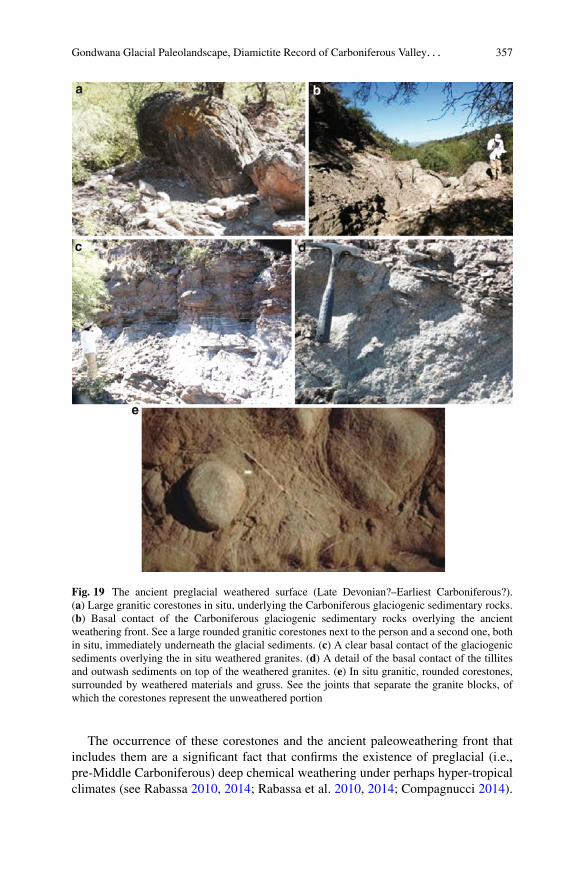
Fig. 19 The ancient preglacial weathered surface (Late Devonian?–Earliest Carboniferous?).(a) Large granitic corestones in situ, underlying the Carboniferous glaciogenic sedimentary rocks.(b) Basal contact of the Carboniferous glaciogenic sedimentary rocks overlying the ancientweathering front. See a large rounded granitic corestones next to the person and a second one, bothin situ, immediately underneath the glacial sediments. (c) A clear basal contact of the glaciogenicsediments overlying the in situ weathered granites. (d) A detail of the basal contact of the tillitesand outwash sediments on top of the weathered granites. (e) In situ granitic, rounded corestones,surrounded by weathered materials and gruss. See the joints that separate the granite blocks, ofwhich the corestones represent the unweathered portion
The occurrence of these corestones and the ancient paleoweathering front thatincludes them are a significant fact that confirms the existence of preglacial (i.e.,pre-Middle Carboniferous) deep chemical weathering under perhaps hyper-tropicalclimates (see Rabassa 2010, 2014; Rabassa et al. 2010, 2014; Compagnucci 2014).
358 B. Socha et al.
These findings describe paleoclimatic and paleoenvironmental conditions that havenot been clearly described before. This part of the Sierras Pampeanas and thePaganzo basin were already a positive (i.e., continental) area in very ancient times,maybe at least since the Late Devonian (?) or even before. In fact, sometimebetween the uplifting of the Ordovician granites and metamorphic rocks, and thelarge-scale climate change (ice house) that installed the Carboniferous glaciations,a hyper-tropical climate was dominant in the region which forced the developmentof very deep chemical weathering conditions. The available information is so farnot enough to define other characteristics of the ancient weathering front, but it mayhave been even several hundred meters thick, considering the irregular topographyfound underneath the glaciogenic deposits and the significant elevation differencebetween unweathered granites and schists located at higher elevations and theweathered gruss and corestones which are found at much lower elevations, in justvery short distances. To our knowledge, this is the first time these paleoclimaticand paleoenvironmental conditions are described for this period, Late Devonian toEarliest Carboniferous, in cratonic areas of Argentina.
Sequence of Events
A major control on the nature of the sedimentary deposits found in the paleovalleyis the weathering of the Ordovician granitic basement rock that perhaps occurredduring the Late Devonian or other pre-Middle Carboniferous period of warmer–wetter climate, as it has been stated above. The deep zones of saprolite andcorestones that were thus formed were easily eroded and partially denudated by theCarboniferous valley glacier that advanced into the area and eroded a characteristicU-shaped valley. Saprolite and corestones are still found in situ in the ancientweathering front or have been eroded and incorporated, mostly as basal glacial load,into the basal till of the Carboniferous sequence.
Locally ice advanced over soft sediment and produced deformation. Deformationand incorporation of local material indicates the ice was in contact with the bed.Grounded ice advanced into a valley which was flooded by marine waters at leastpart of the time. The ice may have readvanced several times during a periodof general ice recession, because the thick sequence of diamictite found in thepaleovalley may include one or more units that were deposited by or from groundedice as subglacial till. The thick sequence of diamictites exposed at La Chimeneamay be the remnant of end moraine(s), marking the farthest extent of ice advance tothe southwest, to the mouth of the Olta paleovalley.
As sea level rose, the ice receded, and deltaic, lacustrine, and marine sediments,fine-grained sandstones and mudstones with dropstones, and fanglomerates infilledthe Olta paleovalley. The thick sequence of diamictites exposing Mid-Valley in
Gondwana Glacial Paleolandscape, Diamictite Record of Carboniferous Valley. . . 359
the paleovalley may be the remnant of recessional moraine(s), marking a stableposition of the ice front, or a minor readvance of ice into the Olta paleovalley. Asthe ice margin retreated farther up the valley to the northeast, alternating beds ofsandstone and siltstone were deposited in the valley filled by glacial meltwaterand marine flooding. The three diamictite beds, lying within the sequence ofalternating sandstone and siltstone, may record three minor ice-front readvancesinto the flooded valley. Eventually the valley was deglaciated. Fluvial processesdominated during the Permian, and deposits exposed in the northeast portion ofthe paleovalley are mostly red, cross-bedded sandstones. Weathering and erosionresulted in lowering of the land surface. Predominantly fluvial processes areexhuming the paleovalley or paleofjord.
Summary and Conclusions
This study presents a record of glacier advance and retreat preserved in Carbonif-erous strata found in the Olta paleovalley on the eastern side of the Paganzo basin.Although a glacial origin was inferred for the paleovalley, a direct glaciogenic originhad not been inferred for any of the diamictites in the paleovalley (Andreis et al.1986; Buatois and Mángano 1995; Sterren and Martínez 1996). Diamictites at LaChimenea, and Mid-Valley, interpreted by this study to be subglacial tillite, providedirect evidence of valley glaciation. Deformation in the sandstone underlyingthe diamictite indicates warm-based conditions as the glacier advanced over softdeformable sediment. The composition of the bouldery diamictite (mostly locallyderived from weathered granitic basement rock and granite corestones of an ancientpaleoweathering front) is attributed to high rates of deposition and the susceptibilityof pre-weathered granitic basement rock to glacial and other erosional processes.Concurrent with and following glaciation, other processes including mass-transport(slumping, rafting, sliding, avalanching, and debris flow) likely operated in thesteep-sided valley and contributed large amounts of diamictite and other sedimentto the valley fill. Corestones, weathered from the basement rock during theLate Devonian or other pre-Middle Carboniferous period of intense weathering,constitute the large clasts in the diamictite and associated deposits.
The lower diamictite bed at the Campsite represents an ice-front advance, eitheras a debrite originating away from the ice front, or as a subglacial deposit, i.e., atillite, or a combination of both. The three diamictite beds within the sequence ofalternating sandstone and siltstone at the Campsite location may record three minorice-front advances into the flooded valley. The valley was likely a transitional (fjord)environment, as micropaleontological material (Gutiérrez and Limarino 2001) andclay mineral assemblages (Net et al. 2002) indicate a marine transgression into thearea during the mid-Carboniferous.

360 B. Socha et al.
References
Andreis R, Bossi G (1981) Algunos ciclos lacustres de la Formación Malanzán (Carbónicosuperior) en la región de Malanzán, Sierra de los Llanos, provincia de La Rioja. 13º CongresoGeológico Argentino, Actas, 4, 639–655
Andreis R, Leguizamón R, Archangelsky S (1986) El paleovalle de Malanzán: nuevos criteriospara estratigrafia del Neopaleozoico de la Sierra de los Llanos, La Rioja, República Argentina.Bol Acad Nac Cienc Cordoba 57:3–119
Benn DI (1995) Fabric signature of subglacial till deformation, Bredamerkurjokull, Iceland.Sedimentology 42:735–747
Benn DI, Evans DJA (1996) The interpretation and classification of subglacially deformedmaterials. Quaternary Sci Rev 15:23–52
Boulton GS (1971) Till genesis and fabric in Svalbard, Spitsbergen. In: Goldthwait RP (ed) Till: asymposium. Ohio State University Press, Columbus, pp 41–72
Boulton GS (1972) Modern arctic glaciers as depositional models for former ice sheets. Q J GeolSoc Lond 128:351–393
Boulton GS (1978) Boulder shapes and grain-size distribution of debris as indicators of transportpaths through a glacier and till genesis. Sedimentology 25:773–799
Boulton GS (1996) Theory of glacial erosion, transport and deposition as a consequence ofsubglacial deformation. J Glaciol 42:43–62
Brown NE, Hallet B, Booth DB (1987) Rapid soft bed sliding of the Puget Glacier lobe. J GeophysRes 92(B9):8985–8997
Buatois LA, Mángano MG (1995) Post glacial lacustrine event sedimentation in an ancientmountain setting: Carboniferous Lake Malanzán (western Argentina). J Paleolimnol 14:1–22
Buatois LA, Limarino CA, Césari SN (1994) Carboniferous lacustrine deposits from the Paganzobasin, Argentina. In: Gierlowski-Kordesch E, Kelts K (eds) Global geological record of lakebasins. Cambridge University Press, Cambridge, pp 135–140
Carignano C, Rabassa J, Socha B, Mickelson D (2008) Nueva Interpretación de la Secuenciasedimentaria del Paleovalle Glacial Exhumado de Olta (Provincia de La Rioja) y Hallazgode perfiles de meteorización indicadores de ambientes previos a la Glaciación de Montañadel Carbonífero Medio en la Cuenca de Paganzo. XII Reunión Argentina de Sedimentología,Abstracts volume, p 48
Carignano C, Cioccale M, Rabassa J, Socha B (2009) Paleogeomorfología de la Sierra deOlta, Sierras Pampeanas, La Rioja: Superficies de planación del Silúrico?-Carbónico Inferior?y paleogeoformas de Glaciación de Montaña del Carbónico. Simposio Paleosuperficies enregiones cratónicas y Evolución del paisaje en el largo plazo. IV Congreso Argentino deCuaternario y Geomorfología, La Plata. Abstracts volume, p 5
Clayton L, Mickelson DM, Attig JW (1989) Evidence against pervasively deformed bed materialbeneath rapidly moving lobes of the southern Laurentide Ice Sheet. Sediment Geol 62:203–208
Compagnucci RH (2014) Modeling the atmospheric circulation and climatic conditions overSouthern South America during the late history of the Gondwana supercontinent. In: Rabassa J,Ollier C (eds) Gondwana landscapes in southern South America. Springer, Dordrecht,pp 113–134
Cutler PM, MacAyeal DR, Mickelson DM, Parizek BR, Colgan PM (2000) A numerical investiga-tion of the ice-lobe-permafrost interaction around the southern Laurentide ice sheet. J Glaciol46:311–325
Dreimanis A (1976) Tills: their origin and properties. In: Leggett RF (ed) Glacial till: aninterdisciplinary study, Special publication 12. Royal Society of Canada, National ResearchCouncil of Canada, Ottawa, pp 11–49
Dreimanis A (1988) Tills, their genetic terminology and classification. In: Goldthwait RP, MatschCL (eds) Genetic classification of glacigenic deposits. Balkema, Rotterdam, pp 17–84
Gondwana Glacial Paleolandscape, Diamictite Record of Carboniferous Valley. . . 361
Dykstra M, Kneller BC, Milana JP (2006) Deglacial and postglacial sedimentary architecturein a deeply incised paleovalley–paleofjord– The Pennsylvanian (Late Carboniferous) JejenesFormation, San Juan, Argentina. Geol Soc Am Bull 118:913–937
Elson JA (1988) Comment on glacitectonite, deformation till, and comminution till. In: GoldthwaitRP, Matsch CL (eds) Genetic classification of glacigenic deposits. Balkema, Rotterdam,pp 85–88
Engelhardt HF, Kamb B (1998) Basal sliding of Ice Stream B, West Antarctica. J Glaciol44:223–230
Evans DJA, Phillips ER, Hiemstra JF, Auton CA (2006) Subglacial till: formation, sedimentarycharacteristics and classification. Earth Sci Rev 78:115–176
Eyles N, Eyles CH, Miall AD (1983) Lithofacies types and vertical profile models; an alternativeapproach to the description and environmental interpretation of glacial diamict and diamictitesequences. Sedimentology 30:393–410
Gutiérrez PR, Limarino CO (2001) Palinología de la Formación Malanzán (Carbonífero Superior)La Rioja, Argentina: nuevos elementos y consideraciones paleoambientales. Ameghiniana38:99–118
Ham NR, Mickelson DM (1994) Basal till fabric and deposition at Burroughs Glacier, Glacier Bay,Alaska. Geol Soc Am Bull 106:1552–1559
Hart JK (1998) The deforming bed/debris-rich ice continuum and its implications for the formationof glacial landforms (flutes) and sediments (meltout till). Quaternary Sci Rev 17:737–754
Hooyer TS, Iverson NR (2000) Diffusive mixing between shearing granular layers: constraints onbed deformation from till contacts. J Glaciol 46:641–651
Kneller BC, Milana JP, Buckee C, Ja’aidi O (2004) A depositional record of deglaciation in apaleofjord (Late Carboniferous [Pennsylvanian] of San Juan Province, Argentina): the role ofcatastrophic sedimentation. Geol Soc Am Bull 116:348–367
Lawson DE (1979) A comparison of the pebble fabric orientation in ice and deposits of theMatanuska Glacier, Alaska. J Geol 87:629–645
Lawson DE (1981) Distinguishing characteristics of diamictons at the margin of the MatanuskaGlacier, Alaska. Ann Glaciol 2:78–84
Lawson DE, Kemmis TJ (1983) Genetic differentiation of Wisconsin age glacigenic diamictonsin north-central Iowa, USA. Abstracts with Program, Geological Society of America, North-Central Section, 15, 223
Lidmar-Bergstrom K, Olsson S, Olvmo M (1997) Paleosurfaces and associated saprolites insouthern Sweden. In: Widdowson M (ed) Paleosurfaces, recognition and reconstruction andpaleoenvironmental interpretation, Geological Society of London special publication 120.Geological Society, London, pp 95–124
Limarino CO, Césari SN (1988) Paleoclimatic significance of the lacustrine Carboniferous depositsin northwestern Argentina. Palaeogeogr Palaeocl Palaeoecol 65:115–131
Limarino CO, Gutiérrez P (1990) Diamictites in the Agua Colorada Formation (northwesternArgentina): new evidences of Carboniferous glaciation in South America. J S Am Earth Sci3:9–20
Limarino CO, Césari SN, Net LI, Marenssi SA, Gutiérrez RP, Tripaldi A (2002) The UpperCarboniferous postglacial transgression in the Paganzo and Rio Blanco basins (northwesternArgentina): facies and stratigraphic significance. J S Am Earth Sci 15:445–460
López Gamundi OR (1987) Depositional models for the glaciomarine sequences of Andean latePaleozoic basins of Argentina. Sediment Geol 52:109–126
López Gamundi OR (1997) Glacial-postglacial transgressions in late Paleozoic basins of southernSouth America. In: Martini IP (ed) Late glacial and post-glacial environmental changes –Quaternary, Carboniferous-Permian, and Proterozoic. Oxford University Press, New York,pp 147–168
López Gamundi OR, Limarino CO, Césari SN (1992) Late Paleozoic paleoclimatology of centralwest Argentina. Palaeogeogr Palaeocl Palaeoecol 91:305–329
362 B. Socha et al.
Lowe DR (1982) Sediment gravity flow: II. Depositional models with special reference to thedeposits of high-density turbidity currents. J Sediment Petrol 52:279–297
Mickelson DM, Ham NR Jr, Ronnert L (1992) Comment on “Striated clast pavements: products ofdeforming subglacial sediment?”. Geology 20:285
Middleton GV, Hampton MA (1976) Subaqueous sediment transport and deposition. In: Stan-ley DJ, Swift PJP (eds) Marine sediment transport and environmental management. Wiley,New York, pp 197–218
Migón P, Lidmar-Bergstrom K (2001) Weathering mantles and their significance for geomorpho-logical evolution of central and northern Europe since the Mesozoic. Earth Sci Rev 56:285–324
Mulder T, Alexander J (2001) The physical character of subaqueous sedimentary density flows andtheir deposits. Sedimentology 48:269–299
Munro-Stasiuk MJ (2000) Rhythmic till sedimentation: evidence for repeated hydraulic lifting ofa stagnant ice mass. J Sediment Res 70:94–106
Net LI, Alonso MS, Limarino CO (2002) Source rock and environmental control on clay mineralassociations, lower section of Paganzo Group (Carboniferous), northwest Argentina. SedimentGeol 152:183–199
Page S, Litvak VD, Limarino CO (2002) Nueva edad en el basamento de la sierra de Los Llanos, LaRioja: Intrusividad pampeana en el arco famatiniano. Revista Asociación Geológica Argentina57:345–348
Paterson WSB (1994) The physics of glaciers, 3rd edn. Pergamon Press, Trowbridge, 480 pPiotrowski JA, Tulaczyk S (1999) Subglacial conditions under the last ice sheet in northwest
Germany: ice-bed separation and enhanced basal sliding? Quaternary Sci Rev 18:737–751Piotrowski JA, Mickelson DM, Tulaczyk S, Krzyszkowski D, Junge FW (2001) Were deforming
subglacial beds beneath past ice sheets really widespread? Quatern Int 86:139–150Piotrowski JA, Larsen NK, Junge FW (2004) Reflections on soft subglacial beds as a mosaic of
deforming and stable spots. Quaternary Sci Rev 23:993–1000Piotrowski JA, Larsen NK, Menzies J, Wysota W (2006) Formation of subglacial till under
transient bed conditions: deposition, deformation, and basal decoupling under a Weichselianice sheet lobe, central Poland. Sedimentology 53:83–106
Porter PR, Murray T (2001) Mechanical and hydrological properties of till beneath Bakaninbreen,Svalbard. J Glaciol 47:167–175
Rabassa J (2010) Gondwana paleolandscapes: long-term landscape evolution, genesis, distribution,and age. Geociências 29(4):541–570. São Paulo, UNESP, Brazil
Rabassa J (2014) Some concepts on Gondwana landscapes: long-term landscape evolution,genesis, distribution and age. In: Rabassa J, Ollier C (eds) Gondwana landscapes in southernSouth America. Springer, Dordrecht, pp 9–46
Rabassa J, Socha BJ, Carignano C, Mickelson D (2007) Sedimentological record of Carboniferousmountain glaciation in an exhumed paleovalley, Eastern Paganzo Basin, La Rioja Province,Argentina. Uruguay National Geological Congress, Abstracts
Rabassa J, Carignano C, Cioccale M (2010) Gondwanic Paleosurfaces in Argentina: an introduc-tion. Geociências 29(4):439–466. São Paulo, UNESP, Brazil
Rabassa J, Carignano C, Cioccale M (2014) A general overview of Gondwana landscapes inArgentina. In: Rabassa J, Ollier C (eds) Gondwana landscapes in southern South America.Springer, Dordrecht, pp 201–245
Ramos VA (1988) The tectonics of central Andes; 30ı–33ıS latitude. In: Clark S, Burchfiel D(eds) Processes in continental lithosphere deformation, Geological Society of America specialpaper 218. Geological Society of America, Boulder, pp 31–54
Ryan RJ, O’Beirne-Ryan AM, Zentilli M (2005) Rounded cobbles that have not traveled far:incorporation of corestones from saprolite in the South Mountain area of southern Nova Scotia,Canada. Sedimentology 52:1109–1121
Socha BJ (2007) Basal till and tillite: sedimentary characteristics and inferred sediment sources,mode of transport, depositional environment and general conditions of the glacier bed.Unpublished Ph.D. dissertation, Department of Geological Sciences, University of Wisconsin-Madison, USA, 247 pp. University Microfilms International Microform 3294146
Gondwana Glacial Paleolandscape, Diamictite Record of Carboniferous Valley. . . 363
Socha BJ, Carignano C, Rabassa J, Mickelson DM (2006) Sedimentological record of Carbonifer-ous mountain glaciation in an exhumed paleovalley, Eastern Paganzo Basin, La Rioja Province,Argentina, paper no. 22–17, Geological Society of America Annual Meeting Abstracts withPrograms, 38, 7, 62
Sterren AF, Martínez M (1996) El Paleovalle de Olta (Carbonífero): Paleoambiente y Paleo-geografía. 13º Congreso Geológico Argentino and 3º Congreso de Exploración de Hidrocar-buros, Actas, 2:89–103
Truffer M, Harrison WD (2006) In situ measurements of till deformation and water pressure.J Glaciol 52:175–182
Truffer M, Moytyka RJ, Harrison WD, Echelmeyer KA, Fisk B, Tulaczyk S (1999) Subglacialdrilling at Black Rapids Glacier, Alaska, U.S.A.: drilling method and sample description.J Glaciol 45:495–505
Truffer M, Harrison WD, Echelmeyer KA (2000) Glacier motion dominated by processes deep inunderlying till. J Glaciol 46:213–221
Wysota W (2007) Successive subglacial depositional processes as interpreted from basal tills inthe Lower Vistula valley (N. Poland). Sediment Geol 193:21–31
Copyright © 2022 FDOKUMEN