
GIS-based back analysis of riverbank instability in the lower River Murray
6
GIS-based Back Analysis of Riverbank Instability in the Lower River Murray C. Liang 1 , M. B. Jaksa 2 and B. Ostendorf 3 1 School of Civil; Environmental and Mining Engineering, University of Adelaide, 5005; PH (618) 3131 575; FAX (618) 8303 4359; email: [email protected] 2 School of Civil; Environmental and Mining Engineering, University of Adelaide, 5005; PH (618) 8313 4317; FAX (618) 8313 4359; email: [email protected] 3 School of Earth and Environmental Sciences, University of Adelaide, 5005; PH (618) 8313 7317; FAX (618) 8313 6717; email: [email protected] ABSTRACT Over the last 4 years or so, unprecedented low river levels, combined with current loading conditions, have adversely contributed to more than 137 riverbank collapse-related incidents and a long term metastable condition along the Lower River Murray, which have recently been considered as the dominating factors inducing bank collapse. With high resolution aerial photographs and digital elevation models (DEMs), this study has established the riverbank geometry prior to collapse of 26 2- dimensional cross sectional models. In order to obtain appropriate soil parameters for the Lower River Murray study area, a series of back analyses have been conducted at 5 locations where failures were documented adjacent to Long Island Marina, Murray Bridge, South Australia. The slope stability analysis software SVSlope was employed in the back-analysis with soil data obtained from two nearby site investigations. Factors of safety were calculated to examine the potential for riverbank collapse with respect to varying river levels. The results indicate that, when the river levels return to 0 to 0.5 m AHD, a portion of the riverbank is close to collapse, whereas a large proportion of the banks remain quasi stable. A raised and maintained high river level will improve the stability but to a limited extent. Several remedial works may need to be conducted when the river level is about to decrease. Keywords: GIS, back analysis, slope stability, riverbank stability, River Murray 1 INTRODUCTION Bank collapse along the Lower River Murray (210 km stretching from Lock 1 at Blanchetown to Wellington, South Australia) has been declared a state hazard (Ramitin et al. 2010). According to the Department for Water’s inventory, during 2008 to 2011, more than 137 riverbank collapse-related incidents occurred which included ground cracking, riparian tree movement and collapse, bank collapse and erosion and destabilisation of infrastructure. In general, bank retreat is the combined result of various influencing factors, such as bank geometry (i.e. topography, slip surface and material boundary locations), bank material, external loads acting on the bank (i.e. vegetation and infrastructure) and pore water pressure (Filz et al. 1992). Back-analysis is an analytical process and model to assess the status of inherent influencing factors on a failed or failing slope (Filz et al. 1992). For the slope stability analyses, at the time of failure, the details of influencing factors and the ways they interacted are often ambiguous (Abramson et al. 2002). On the assumption that the factor of safety (FOS) was equal to 1 at the time of failure, a back-analysis calculation could be conducted and a series of relevant parameters can be obtained for a specific location (Abramson et al. 2002). Geographic information system (GIS) technology has greatly facilitated landslide research by providing various functions for spatial data management. Specifically as data capturing, handling, processing, analysing, integrating, simulating, visualising and modelling (Carrara et al. 1991a 1995b, Guzetti et al. 1999, Wang et al. 2005). GIS-based geotechnical models simplify the process of quantifying the spatially distributed parameters influencing collapse (Xie et al. 2004). By processing and integrating high resolution remotely-sensed data (i.e. satellite imagery, aerial photos and digital elevation models [DEMs]), GIS-based geotechnical models have been used to assess bank stability at relatively large scales (Hong et al. 2007). ANZ 2012 Conference Proceedings 148
-
Upload
independent -
Category
Documents
-
view
0 -
download
0
Transcript of GIS-based back analysis of riverbank instability in the lower River Murray
GIS-based Back Analysis of Riverbank Instability in the Lower River Murray
C. Liang1, M. B. Jaksa 2 and B. Ostendorf3
1School of Civil; Environmental and Mining Engineering, University of Adelaide, 5005; PH (618) 3131 575; FAX (618) 8303 4359; email: [email protected] 2School of Civil; Environmental and Mining Engineering, University of Adelaide, 5005; PH (618) 8313 4317; FAX (618) 8313 4359; email: [email protected] 3School of Earth and Environmental Sciences, University of Adelaide, 5005; PH (618) 8313 7317; FAX (618) 8313 6717; email: [email protected] ABSTRACT Over the last 4 years or so, unprecedented low river levels, combined with current loading conditions, have adversely contributed to more than 137 riverbank collapse-related incidents and a long term metastable condition along the Lower River Murray, which have recently been considered as the dominating factors inducing bank collapse. With high resolution aerial photographs and digital elevation models (DEMs), this study has established the riverbank geometry prior to collapse of 26 2-dimensional cross sectional models. In order to obtain appropriate soil parameters for the Lower River Murray study area, a series of back analyses have been conducted at 5 locations where failures were documented adjacent to Long Island Marina, Murray Bridge, South Australia. The slope stability analysis software SVSlope was employed in the back-analysis with soil data obtained from two nearby site investigations. Factors of safety were calculated to examine the potential for riverbank collapse with respect to varying river levels. The results indicate that, when the river levels return to 0 to 0.5 m AHD, a portion of the riverbank is close to collapse, whereas a large proportion of the banks remain quasi stable. A raised and maintained high river level will improve the stability but to a limited extent. Several remedial works may need to be conducted when the river level is about to decrease. Keywords: GIS, back analysis, slope stability, riverbank stability, River Murray 1 INTRODUCTION Bank collapse along the Lower River Murray (210 km stretching from Lock 1 at Blanchetown to Wellington, South Australia) has been declared a state hazard (Ramitin et al. 2010). According to the Department for Water’s inventory, during 2008 to 2011, more than 137 riverbank collapse-related incidents occurred which included ground cracking, riparian tree movement and collapse, bank collapse and erosion and destabilisation of infrastructure. In general, bank retreat is the combined result of various influencing factors, such as bank geometry (i.e. topography, slip surface and material boundary locations), bank material, external loads acting on the bank (i.e. vegetation and infrastructure) and pore water pressure (Filz et al. 1992). Back-analysis is an analytical process and model to assess the status of inherent influencing factors on a failed or failing slope (Filz et al. 1992). For the slope stability analyses, at the time of failure, the details of influencing factors and the ways they interacted are often ambiguous (Abramson et al. 2002). On the assumption that the factor of safety (FOS) was equal to 1 at the time of failure, a back-analysis calculation could be conducted and a series of relevant parameters can be obtained for a specific location (Abramson et al. 2002). Geographic information system (GIS) technology has greatly facilitated landslide research by providing various functions for spatial data management. Specifically as data capturing, handling, processing, analysing, integrating, simulating, visualising and modelling (Carrara et al. 1991a 1995b, Guzetti et al. 1999, Wang et al. 2005). GIS-based geotechnical models simplify the process of quantifying the spatially distributed parameters influencing collapse (Xie et al. 2004). By processing and integrating high resolution remotely-sensed data (i.e. satellite imagery, aerial photos and digital elevation models [DEMs]), GIS-based geotechnical models have been used to assess bank stability at relatively large scales (Hong et al. 2007).
ANZ 2012 Conference Proceedings 148
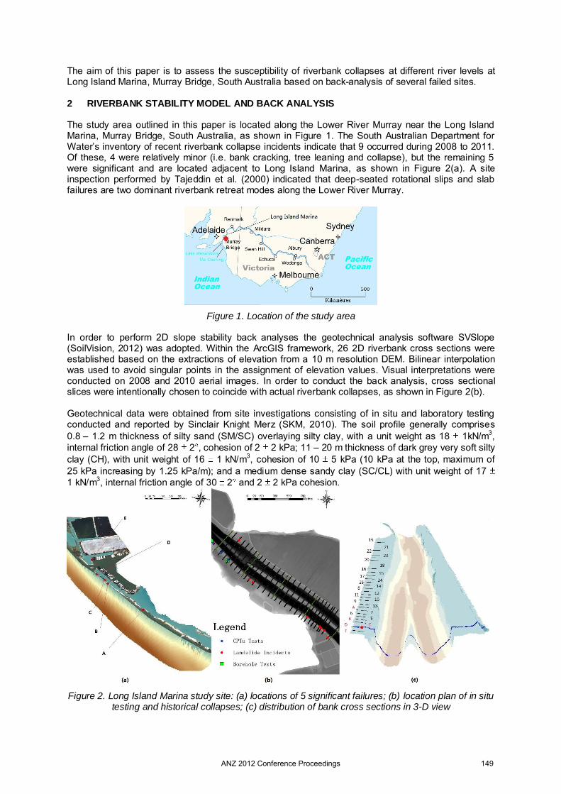
The aim of this paper is to assess the susceptibility of riverbank collapses at different river levels at Long Island Marina, Murray Bridge, South Australia based on back-analysis of several failed sites. 2 RIVERBANK STABILITY MODEL AND BACK ANALYSIS The study area outlined in this paper is located along the Lower River Murray near the Long Island Marina, Murray Bridge, South Australia, as shown in Figure 1. The South Australian Department for Water’s inventory of recent riverbank collapse incidents indicate that 9 occurred during 2008 to 2011. Of these, 4 were relatively minor (i.e. bank cracking, tree leaning and collapse), but the remaining 5 were significant and are located adjacent to Long Island Marina, as shown in Figure 2(a). A site inspection performed by Tajeddin et al. (2000) indicated that deep-seated rotational slips and slab failures are two dominant riverbank retreat modes along the Lower River Murray.
Figure 1. Location of the study area In order to perform 2D slope stability back analyses the geotechnical analysis software SVSlope (SoilVision, 2012) was adopted. Within the ArcGIS framework, 26 2D riverbank cross sections were established based on the extractions of elevation from a 10 m resolution DEM. Bilinear interpolation was used to avoid singular points in the assignment of elevation values. Visual interpretations were conducted on 2008 and 2010 aerial images. In order to conduct the back analysis, cross sectional slices were intentionally chosen to coincide with actual riverbank collapses, as shown in Figure 2(b). Geotechnical data were obtained from site investigations consisting of in situ and laboratory testing conducted and reported by Sinclair Knight Merz (SKM, 2010). The soil profile generally comprises 0.8 – 1.2 m thickness of silty sand (SM/SC) overlaying silty clay, with a unit weight as 18 1kN/m3, internal friction angle of 28 2 , cohesion of 2 2 kPa; 11 – 20 m thickness of dark grey very soft silty clay (CH), with unit weight of 16 1 kN/m3, cohesion of 10 5 kPa (10 kPa at the top, maximum of 25 kPa increasing by 1.25 kPa/m); and a medium dense sandy clay (SC/CL) with unit weight of 17 1 kN/m3, internal friction angle of 30 2 and 2 2 kPa cohesion.
Figure 2. Long Island Marina study site: (a) locations of 5 significant failures; (b) location plan of in situ testing and historical collapses; (c) distribution of bank cross sections in 3-D view
ANZ 2012 Conference Proceedings 149
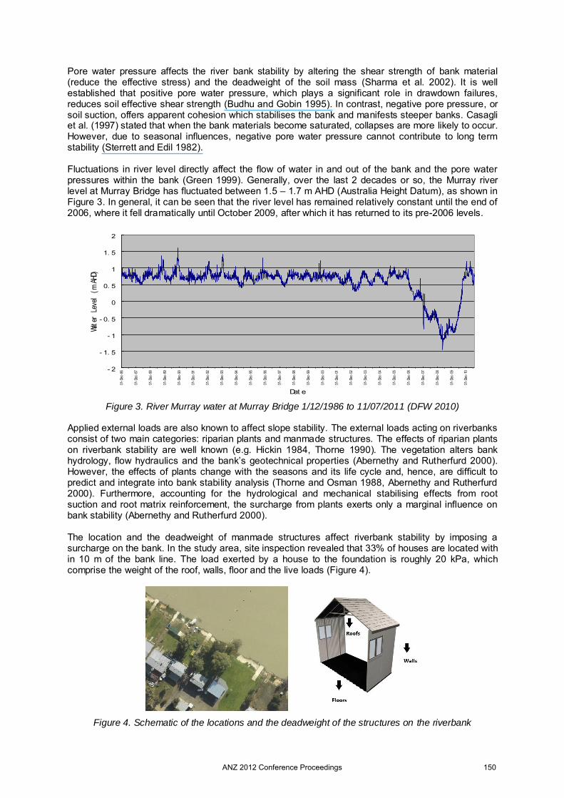
Pore water pressure affects the river bank stability by altering the shear strength of bank material (reduce the effective stress) and the deadweight of the soil mass (Sharma et al. 2002). It is well established that positive pore water pressure, which plays a significant role in drawdown failures, reduces soil effective shear strength (Budhu and Gobin 1995). In contrast, negative pore pressure, or soil suction, offers apparent cohesion which stabilises the bank and manifests steeper banks. Casagli et al. (1997) stated that when the bank materials become saturated, collapses are more likely to occur. However, due to seasonal influences, negative pore water pressure cannot contribute to long term stability (Sterrett and Edil 1982). Fluctuations in river level directly affect the flow of water in and out of the bank and the pore water pressures within the bank (Green 1999). Generally, over the last 2 decades or so, the Murray river level at Murray Bridge has fluctuated between 1.5 – 1.7 m AHD (Australia Height Datum), as shown in Figure 3. In general, it can be seen that the river level has remained relatively constant until the end of 2006, where it fell dramatically until October 2009, after which it has returned to its pre-2006 levels.
- 2
- 1. 5
- 1
- 0. 5
0
0. 5
1
1. 5
2
01-D
ec-8
6
01-D
ec-8
7
01-D
ec-8
8
01-D
ec-8
9
01-D
ec-9
0
01-D
ec-9
1
01-D
ec-9
2
01-D
ec-9
3
01-D
ec-9
4
01-D
ec-9
5
01-D
ec-9
6
01-D
ec-9
7
01-D
ec-9
8
01-D
ec-9
9
01-D
ec-0
0
01-D
ec-0
1
01-D
ec-0
2
01-D
ec-0
3
01-D
ec-0
4
01-D
ec-0
5
01-D
ec-0
6
01-D
ec-0
7
01-D
ec-0
8
01-D
ec-0
9
01-D
ec-1
0
Dat e
Wate
r Le
vel
(m A
HD)
Figure 3. River Murray water at Murray Bridge 1/12/1986 to 11/07/2011 (DFW 2010)
Applied external loads are also known to affect slope stability. The external loads acting on riverbanks consist of two main categories: riparian plants and manmade structures. The effects of riparian plants on riverbank stability are well known (e.g. Hickin 1984, Thorne 1990). The vegetation alters bank hydrology, flow hydraulics and the bank’s geotechnical properties (Abernethy and Rutherfurd 2000). However, the effects of plants change with the seasons and its life cycle and, hence, are difficult to predict and integrate into bank stability analysis (Thorne and Osman 1988, Abernethy and Rutherfurd 2000). Furthermore, accounting for the hydrological and mechanical stabilising effects from root suction and root matrix reinforcement, the surcharge from plants exerts only a marginal influence on bank stability (Abernethy and Rutherfurd 2000). The location and the deadweight of manmade structures affect riverbank stability by imposing a surcharge on the bank. In the study area, site inspection revealed that 33% of houses are located with in 10 m of the bank line. The load exerted by a house to the foundation is roughly 20 kPa, which comprise the weight of the roof, walls, floor and the live loads (Figure 4).
Figure 4. Schematic of the locations and the deadweight of the structures on the riverbank
ANZ 2012 Conference Proceedings 150
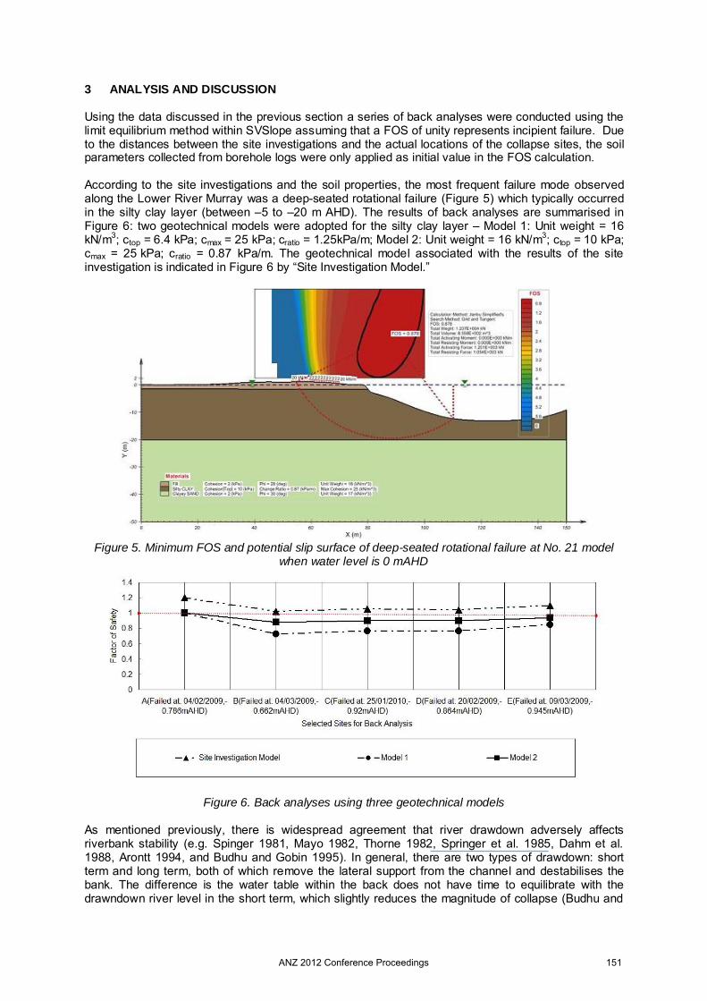
3 ANALYSIS AND DISCUSSION Using the data discussed in the previous section a series of back analyses were conducted using the limit equilibrium method within SVSlope assuming that a FOS of unity represents incipient failure. Due to the distances between the site investigations and the actual locations of the collapse sites, the soil parameters collected from borehole logs were only applied as initial value in the FOS calculation. According to the site investigations and the soil properties, the most frequent failure mode observed along the Lower River Murray was a deep-seated rotational failure (Figure 5) which typically occurred in the silty clay layer (between –5 to –20 m AHD). The results of back analyses are summarised in Figure 6: two geotechnical models were adopted for the silty clay layer – Model 1: Unit weight = 16 kN/m3; ctop = 6.4 kPa; cmax = 25 kPa; cratio = 1.25kPa/m; Model 2: Unit weight = 16 kN/m3; ctop = 10 kPa; cmax = 25 kPa; cratio = 0.87 kPa/m. The geotechnical model associated with the results of the site investigation is indicated in Figure 6 by “Site Investigation Model.”
Figure 5. Minimum FOS and potential slip surface of deep-seated rotational failure at No. 21 model
when water level is 0 mAHD
Figure 6. Back analyses using three geotechnical models As mentioned previously, there is widespread agreement that river drawdown adversely affects riverbank stability (e.g. Spinger 1981, Mayo 1982, Thorne 1982, Springer et al. 1985, Dahm et al. 1988, Arontt 1994, and Budhu and Gobin 1995). In general, there are two types of drawdown: short term and long term, both of which remove the lateral support from the channel and destabilises the bank. The difference is the water table within the back does not have time to equilibrate with the drawndown river level in the short term, which slightly reduces the magnitude of collapse (Budhu and
ANZ 2012 Conference Proceedings 151
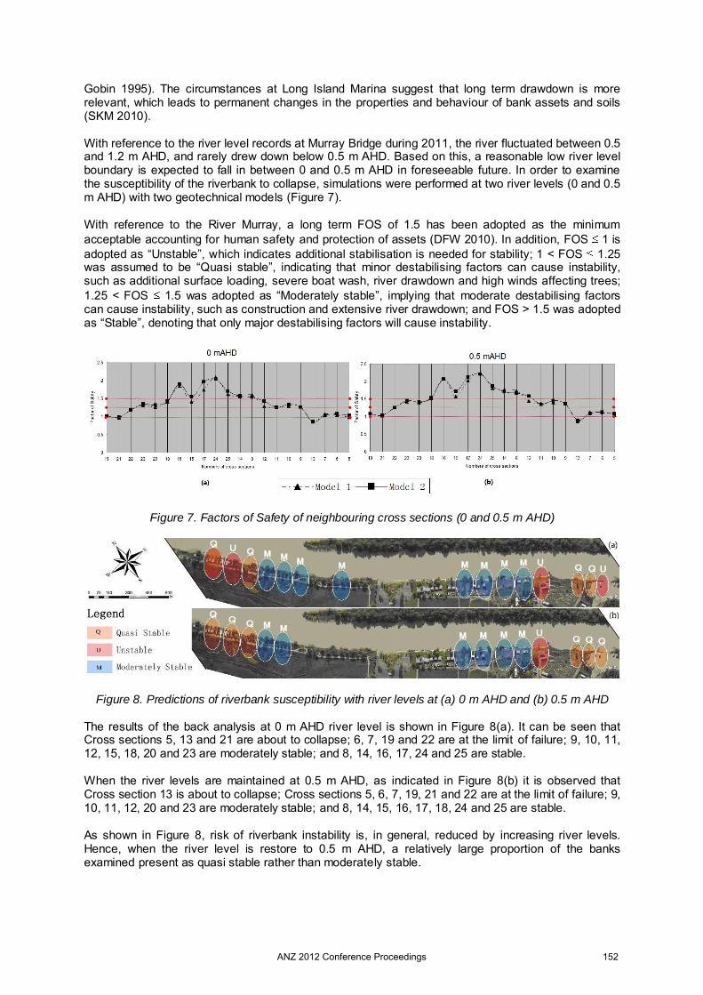
Gobin 1995). The circumstances at Long Island Marina suggest that long term drawdown is more relevant, which leads to permanent changes in the properties and behaviour of bank assets and soils (SKM 2010). With reference to the river level records at Murray Bridge during 2011, the river fluctuated between 0.5 and 1.2 m AHD, and rarely drew down below 0.5 m AHD. Based on this, a reasonable low river level boundary is expected to fall in between 0 and 0.5 m AHD in foreseeable future. In order to examine the susceptibility of the riverbank to collapse, simulations were performed at two river levels (0 and 0.5 m AHD) with two geotechnical models (Figure 7). With reference to the River Murray, a long term FOS of 1.5 has been adopted as the minimum acceptable accounting for human safety and protection of assets (DFW 2010). In addition, FOS 1 is adopted as “Unstable”, which indicates additional stabilisation is needed for stability; 1 < FOS 1.25 was assumed to be “Quasi stable”, indicating that minor destabilising factors can cause instability, such as additional surface loading, severe boat wash, river drawdown and high winds affecting trees; 1.25 < FOS 1.5 was adopted as “Moderately stable”, implying that moderate destabilising factors can cause instability, such as construction and extensive river drawdown; and FOS > 1.5 was adopted as “Stable”, denoting that only major destabilising factors will cause instability.
Figure 7. Factors of Safety of neighbouring cross sections (0 and 0.5 m AHD)
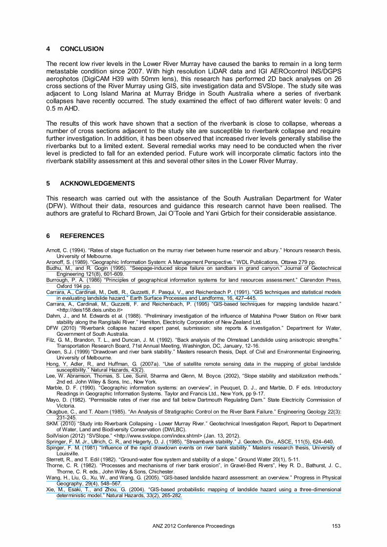
Figure 8. Predictions of riverbank susceptibility with river levels at (a) 0 m AHD and (b) 0.5 m AHD
The results of the back analysis at 0 m AHD river level is shown in Figure 8(a). It can be seen that Cross sections 5, 13 and 21 are about to collapse; 6, 7, 19 and 22 are at the limit of failure; 9, 10, 11, 12, 15, 18, 20 and 23 are moderately stable; and 8, 14, 16, 17, 24 and 25 are stable. When the river levels are maintained at 0.5 m AHD, as indicated in Figure 8(b) it is observed that Cross section 13 is about to collapse; Cross sections 5, 6, 7, 19, 21 and 22 are at the limit of failure; 9, 10, 11, 12, 20 and 23 are moderately stable; and 8, 14, 15, 16, 17, 18, 24 and 25 are stable. As shown in Figure 8, risk of riverbank instability is, in general, reduced by increasing river levels. Hence, when the river level is restore to 0.5 m AHD, a relatively large proportion of the banks examined present as quasi stable rather than moderately stable.
ANZ 2012 Conference Proceedings 152
4 CONCLUSION The recent low river levels in the Lower River Murray have caused the banks to remain in a long term metastable condition since 2007. With high resolution LiDAR data and IGI AEROcontrol INS/DGPS aerophotos (DigiCAM H39 with 50mm lens), this research has performed 2D back analyses on 26 cross sections of the River Murray using GIS, site investigation data and SVSlope. The study site was adjacent to Long Island Marina at Murray Bridge in South Australia where a series of riverbank collapses have recently occurred. The study examined the effect of two different water levels: 0 and 0.5 m AHD. The results of this work have shown that a section of the riverbank is close to collapse, whereas a number of cross sections adjacent to the study site are susceptible to riverbank collapse and require further investigation. In addition, it has been observed that increased river levels generally stabilise the riverbanks but to a limited extent. Several remedial works may need to be conducted when the river level is predicted to fall for an extended period. Future work will incorporate climatic factors into the riverbank stability assessment at this and several other sites in the Lower River Murray. 5 ACKNOWLEDGEMENTS This research was carried out with the assistance of the South Australian Department for Water (DFW). Without their data, resources and guidance this research cannot have been realised. The authors are grateful to Richard Brown, Jai O’Toole and Yani Grbich for their considerable assistance. 6 REFERENCES Arnott, C. (1994). “Rates of stage fluctuation on the murray river between hume reservoir and albury.” Honours research thesis,
University of Melbourne. Aronoff, S. (1989). “Geographic Information System: A Management Perspective.” WDL Publications, Ottawa 279 pp. Budhu, M., and R. Gogin (1995). “Seepage-induced slope failure on sandbars in grand canyon.” Journal of Geotechnical
Engineering 121(8), 601-609. Burrough, P. A. (1986) “Principles of geographical information systems for land resources assessment.” Clarendon Press,
Oxford 194 pp. Carrara, A., Cardinali, M., Detti, R., Guzzetti, F. Pasqui, V., and Reichenbach P. (1991). “GIS techniques and statistical models
in evaluating landslide hazard.” Earth Surface Processes and Landforms, 16, 427–445. Carrara, A., Cardinali, M., Guzzetti, F. and Reichenbach, P. (1995) “GIS-based techniques for mapping landslide hazard.”
<http://deis158.deis.unibo.it> Dahm, J., and M. Edwards et al. (1988). “Preliminary investigation of the influence of Matahina Power Station on River bank
stability along the Rangitaiki River.” Hamilton, Electricity Corporation of New Zealand Ltd. DFW (2010) “Riverbank collapse hazard expert panel, submission: site reports & investigation.” Department for Water,
Government of South Australia. Filz, G. M., Brandon, T. L., and Duncan, J. M. (1992). “Back analysis of the Olmstead Landslide using anisotropic strengths.”
Transportation Research Board, 71st Annual Meeting, Washington, DC, January, 12-16. Green, S.J. (1999) “Drawdown and river bank stability.” Masters research thesis, Dept. of Civil and Environmental Engineering,
University of Melbourne. Hong, Y, Adler, R., and Huffman, G. (2007a). “Use of satellite remote sensing data in the mapping of global landslide
susceptibility.” Natural Hazards, 43(2). Lee, W. Abramson, Thomas, S. Lee, Sunil, Sharma and Glenn, M. Boyce. (2002), “Slope stability and stabilization methods.”
2nd ed. John Wiley & Sons, Inc., Now York. Marble, D. F. (1990). “Geographic information systems: an overview”, in Peuquet, D. J., and Marble, D. F eds. Introductory
Readings in Geographic Information Systems. Taylor and Francis Ltd., New York, pp 9-17. Mayo, D. (1982). “Permissible rates of river rise and fall below Dartmouth Regulating Dam.” State Electricity Commission of
Victoria. Okagbue, C., and T. Abam (1985). “An Analysis of Stratigraphic Control on the River Bank Failure.” Engineering Geology 22(3):
231-245. SKM. (2010) “Study into Riverbank Collapsing - Lower Murray River.” Geotechnical Investigation Report, Report to Department
of Water, Land and Biodiversity Conservation (DWLBC). SoilVision (2012) “SVSlope.” <http://www.svslope.com/index.shtml> (Jan. 13, 2012). Springer, F. M. Jr., Ullrich, C. R., and Hagerty, D. J. (1985). “Streambank stability.” J. Geotech. Div., ASCE, 111(5), 624–640. Spinger, F. M. (1981) “Influence of the rapid drawdown events on river bank stability.” Masters research thesis, University of
Louisville. Sterrett, R., and T. Edil (1982). “Ground-water flow system and stability of a slope.” Ground Water 20(1), 5-11. Thorne, C. R. (1982). “Processes and mechanisms of river bank erosion”, in Gravel-Bed Rivers”, Hey R. D., Bathurst, J. C.,
Thorne, C. R. eds., John Wiley & Sons, Chichester. Wang, H., Liu, G., Xu, W., and Wang, G. (2005). “GIS-based landslide hazard assessment: an overview.” Progress in Physical
Geography, 29(4), 548–567. Xie, M., Esaki, T., and Zhou, G. (2004). “GIS-based probabilistic mapping of landslide hazard using a three-dimensional
deterministic model.” Natural Hazards, 33(2), 265-282.
ANZ 2012 Conference Proceedings 153