Giambattista Nolli and Rome: Mapping the City before and after the Pianta Grande
262
Transcript of Giambattista Nolli and Rome: Mapping the City before and after the Pianta Grande

Mapping the City before and after the Pianta Grande
Edited by Ian Verstegen and Allan Ceen
Studium Urbis
Giambattista Nolli and Rome

Studium Urbis Rome CenterArchitecture & Urban Planning in Italy
Centro ricerca topografica di RomaVia di Montoro 2400186 Rome Italy
http://www.studiumurbis.org
© Studium Urbis 2013
Book Designer: Rachel TornatorePrinted by: Lulu (www.lulu.com)
ISBN 978-1-105-98970-4

To the memory of David Woodward,keynote speaker at the conference
GIAMBATTISTA NOLLI, IMAGO URBIS AND ROME


The idea for a Nolli conference was suggested by architect and architectural historian Michelle LaFoe to Allan Ceen, director of the Studium Urbis. The two organizers agreed that unlike Piranesi, who had had numerous exhibitions and conferences dedicated to his work, Nolli, who produced what is arguably the most important cartographic image of Rome since the Forma Urbis, had not been given the scholarly attention he deserved. As a result, scholars from Europe and the United States were invited to come to Rome in late May of 2003 to deliver papers on Nolli, the cartographic precedents of his Pianta Grande, and Roman urban issues related to his magnum opus.
The opening session took place in the Salone dei Cento Giorni at palazzo della Cancelleria on 31 May. David Woodward, editor of the series History of Cartography, opened the conference with a talk entitled Revealing the City: Issues in the History of Urban Cartography. Two more sessions on 1-2 June were held in the auditorium of John Cabot University in Trastevere, directly behind the church of S. Dorotea which Nolli designed and in which he was buried.
On 3 June the conference participants viewed the original drawing for the Pianta Grande at the library of palazzo Venezia, and the copper plates from which the map was printed at the Calcografia (now Istituto Nazionale della Grafica). Concurrent with the conference, an exhibition entitled Roma Nolliana was held at the Studium Urbis, illustrating the Nolli sites in Rome and the cartography relating to the Pianta Grande.
The conference was sponsored by the Studium Urbis and funded by the Graham Foundation and a generous anonymous donor. The publication of the papers has been delayed and the editors are grateful to the authors for their patience and continued support of the project. All the papers have been revised and the bibliographies updated to reflect the current state of urban cartographic knowledge.
Ian Verstegen, Philadelphia Allan Ceen, Rome
PREFACE


giambattista nolli, rome and mapping: before and after the pianta grande
TABLE OF CONTENTS
Introduction 9 Allan Ceen and Ian Verstegen
part i - nolli’s predecessors
The Forma Urbis Romae before Nolli: Antiquarian Scholarship in the Sixteenth and Seventeenth Centuries 15 William Stenhouse
“Some Semblance or Image of Beauty”: The Bufalini Plan of 1551 and Cartographic Literacy in the Renaissance 27 Jessica Maier
A Study into the Accuracy of the 1551 Rome Plan of Leonardo Bufalini 49 Paul Schlapobersky
Leonardo, Raphael and Painterly Influence on the Development of Ichnography 65 Ian Verstegen
part ii - nolli and 18th century contemporaries
Narrative Structures: The Nolli Plan and the Roman Experience 81 Elsa Lam
The Grande Pianta of G.B. Nolli as an Instrument of Urban Analysis 91 Allan Ceen
Houses without Names 101 Richard Betts
Mapping Jews: Cartography and Topograpy in Rome’s Ghetto 121 Samuel D. Gruber
Theatri Figura Quae Tempore Mutat: An Ichnographic History of Pompey’s Theater 133 Kristin Triff
part iii - the nolli plan: its influence on other cities
Propagandizing Nolli in Naples 147 Robin Thomas
A Baroque City? London after the Great Fire of 1666 161 Lydia M. Soo

part iv - REVISITING PLANS AND VIEWS OF ROME IN THE DIGITAL AGE
The Building of a Symbolic Image: The Juxtaposition of Giambattista Piranesi’s Vedute Di Roma with Photographs Taken 250 Years Later 179 Randolph Langenbach
The Micro-Urbanism of Rome: Paul Marie Letarouilly’s Architectural Drawings in the Context of Giambattista Nolli’s City Plan 199 James Tice
part v - nolli’s influence on 20th century design
Piante Americana: Influences of Nolli’s Plan on Two Contemporary Architects in America 219 Susan Ingham
Nolli, Roma Interrotta and the Monte Celio: A New Proposal Based on Past Lessons 233 Kevin Hinders
Roma ininterrotta 249 Antonino Saggio

9
“La grande pianta del Nolli del 1748 divide come colonna miliare, la serie delle piante di Roma in due lunghi periodi; nell’anteriore prevale il criterio artistico, nel posteriore lo scientifico.1”
(Like a milestone, the great 1748 plan of Rome by Nolli divides the series of maps of the city of Rome into two long periods; in the first the artistic element prevails, while the second is dominated by the scientific method.)
In l748, the middle of the century which historians refer to as the Enlightenment, the Pianta Grande2 or large map of Rome was published by Giambattista
Nolli. The plan was engraved on 12 copper plates which are currently stored in the Calcografia in Rome (along with most of the Piranesi and Vasi plates). From these plates, sets of twelve prints were produced, each measuring 42 by 70 centimeters (16.5 x 27.6 inches), which could be assembled into the Pianta Grande, itself measuring 167 by 206 centimeters (66 x 81 inches). Together with the large map, Nolli published a smaller map reduced “dalla Maggiore” to the size of one of the 12 sheets, as well as a reproduction to the same scale of the 1551 Bufalini plan of the city. The whole set was completed by two indices for the Pianta Grande, one numerical, the other alphabetical. On the Pianta Grande Nolli shows detailed plans of churches, theaters and the courtyards and porticoes of buildings, as well as the entranceways and stairways of major palaces. Thus the white areas on the map represented all the public and semipublic spaces in the city (most of Rome’s courtyards were open to the public until the 1970s), while the hatched areas indicate lesser buildings. Surviving ancient structures are shown in black on the map, with reconstructions of missing parts shown in white. The dotted lines along some of the streets represent the borders of the fourteen Rioni, or administrative regions, of the city. Indeed, the
1 D. Gnoli, Mostra di Topografia Romana, exhibition catalog for the exhibit held in Rome at the Biblioteca Nazionale Vittorio Emanuele II (Rome: 1903), p.10.2 The actual title is NVOVA PIANTA DI ROMA data in luce da GIAMBATTISTA NOLLI L’anno M DCC XLVIII. See A. Ceen, “Profile of a City” in Rome 1748: The Pianta Grande di G.B. Nolli, 2nd edition, revised (Highmount, NY: Aronson, 1991); M. Bevilacqua, Roma nel secolo dei Lumi (Naples, 1998).
redefinition of these borders by count Bernardini in 1744 was actually based on the original drawing of the plan that Nolli was to publish four years later.3 His graphic convention for depicting private and public space, solid and void, has become familiar to us as the Figure/Ground plan; so much so that we often hear architects use Nolli as a verb: to “Nolli” a plan, that is to render it according to the graphic convention of the Pianta Grande. It was to revolutionize the map-making of the Urbs, and became the standard for nearly all subsequent maps of the city for more than a hundred years. With his map, Nolli set the standard for accuracy and wealth of fine detail which has yet to be surpassed. The critical study of mapmaking associated with David Woodward and J. Brian Harley has sensitized us to the myriad ways in which experience can be mapped out and the uses to which conventional western maps can be put.4 The old internal history of cartography, of which Nolli is an exemplary figure, has been rendered problematic. The notion of cartographic exactness, for example, has been questioned as to its overall motivation and susceptibility to ideological motivations. How are we to understand Nolli’s achievement? As the gradual result of work built on his predecessors or as a document relying on essentially unique circumstances? How did Nolli address the ideological demands of civic representation of the greatest city in Christendom? These questions and more are answered in the following essays, devoted to (I) Nolli’s Predecessors, (2) Nolli and 18th Century Contemporaries, (3) The Nolli Plan: Its Influence on Other Cities, (4) Revisiting Plans and Views of Rome in the Digital Age, and (5) Nolli’s Influence on 20th Century Design.
3 B. Bernardini, Descrizione del nuovo ripartimento dei Rioni (Rome: 1744), p.14.4 See J. Brian Harley, The New Nature of Maps: Essays in the History of Cartography, ed. Paul Laxton (Baltimore: Johns Hopkins University Press, 2001); J. Brian Harley and David Woodward, eds. Cartography in Prehistoric, Ancient, and Medieval Europe and the Mediterranean. Volume 1 of The History of Cartography (Chicago and London: University of Chicago Press, 1987).
INTRODUCTION

10
PART I − NOLLI’S PREDECESSORS
I t is remarkable to note that while after 1748 ichnographic plans (i.e.: plan-maps) of Rome prevail, between Bufalini’s plan of 1551 and Nolli’s
plan of 1748 there appeared only four of these:5
Alò Giovannoli 1616. cm. 52 x 39 (Frutaz CXLIV)Matteo Gregorio de Rossi 1668. cm. 169 x 129 (Frutaz CLVII) Antonio Barbey 1697. cm. 53.5 x 58 (Frutaz CLXII) Nicolas de Fer 1700. cm. 24 x 31 (Frutaz CLXIII)
Of these four, only De Rossi’s and Barbey’s plan bear any relationship to Nolli’s work. Giovannoli’s is a reduced, though updated version of Bufalini (showing the scheme of Sixtus V’s urban plan); de Fer’s map is too small and lacking in detail to be considered in this context. De Rossi’s map is really a hybrid: a plan-map with selected monuments depicted in perspective. Part of its importance in relation to Nolli is that it picks up on Bufalini’s device of showing churches in plan. Barbey’s map, which is probably influenced by that of De Rossi, employs the same technique, and extends it to the depiction of major palazzi in plan. Nolli seems to have adopted this technique and combined it with the detailed information on planting and villa gardens which De Rossi was able to show on his large map. Nolli had many antecedents and Part I of the book explores these. As noted, the antique precursor to the Pianta Grande was the Forma Urbis. William Stenhouse returns us to the sixteenth century and its discovery to uncover attitudes about its reception, or better put, misreception. Found in the forum, the fragments of the Forma Urbis were gathered and kept by the Farnese librarian Fulvio Orsini. Their ichnographic form, so obviously useful to our eyes today, were not appreciated immediately for their value. Part of the problem, as Stenhouse explains, was that no scholarly categories existed with which to understand the fragments. Conventions of antiquarian categorization could handle inscriptions but visual material like a carved map was beyond the ken. Therefore, it languished. Nolli’s great predecessor Leonardo Bufalini, whom he honored in the reprinting of his map of Rome, is a natural point of interest for Nolli studies because he produced the first ichnographic map of Rome when the Forma Urbis was still unknown. Jessica Maier reflects on its dual focus: recording Rome as it was in 1550 but
5 The Frutaz reference numbers refer to the principal study of maps of Rome: A.P. Frutaz, Le Piante di Roma, 3 vols. (Rome: 1962).
also looking back in antiquarian fashion to what Rome was in its Roman grandeur. Maier follows the rise of urban cartography, from Leonardo’s plan of Imola to Bartolomeo Marliani’s Urbis Romae topographia (1544) and Bufalini. Noting the uniqueness of Bufalini’s ichnographic map, and general apathy toward such representations, Maier stresses the pictorial literacy that developed only slowly allowing acceptance for Nolli’s innovations. To this picture Paul Schlopobersky adds a detailed technical examination of Bufalini’s plan in comparison to Rome’s actual layout. True to a military focus, Bufalini’s city walls are unusually accurate, suggesting that the architect actually surveyed the whole Aurelian circuit. However, two substantial parts of the map do not match up, suggesting instead that Bufalini sighted these from an elevated position but did not combine these insights with ground surveys. Bufalini’s military prerogatives are partly confirmed and his uncanny accuracy qualified. Ian Verstegen, finally, reflects on the shortcomings of sight as found in the writings of Leonardo da Vinci but also hinted at by Alberti and Raphael, as possible sources for planimetric and ichnographic representational systems. The need to record a building or city “as it is” rather than “as it seems” nominated the exploration of the conventions later used by Bufalini and Nolli in Leonardo’s plan of Imola and Raphael’s ill-fated survey of Rome.
PART II − NOLLI AND 18TH CENTURY CONTEMPORARIES
Part II explores Nolli and his Eighteenth Century Contemporaries. Elsa Lam first of all notes the new sense of experience rendered by Nolli’s
plan. As opposed to older plans that highlight Rome’s principal monuments, Nolli makes the city uniform according to his simple black and white shading conventions. His display of courtyards as open, public space transcends interior and exterior, and reveals the experiential unfolding of 18th century Rome. Allan Ceen instead investigates the Nolli map as an instrument of urban analysis, by using its accuracy to reconstruct the givens faced by planners as they conceived of new projects. The map allows one to see sightlines and allows one to reconstruct the creative choices made by planners to align buildings and spaces to viewing conditions. Using the examples of the Borgo,

11
the Palazzo Farnese-Cancelleria area, and the via Trinitatis, Ceen shows how each quarter was altered according to an adjustment-oriented approach. Turning instead to the Quartiere de’ Banchi, Richard Betts uses Nolli to produce a chronology of vernacular architecture in this densely populated area. Isolating a particular style of doors and window styling, Betts is able to pinpoint a campaign of building and urban reform to the reign of Sixtus IV and the possible influence of the Sienese architect Francesco di Giorgio. In a similar vein, Samuel Gruber uses Nolli’s map to bring to life the Roman ghetto irrevocably lost after the Tiber embankments, demolition of the five synagogues of the city and excavations of the Theater of Marcellus successively erased historical traces of it. By referring to Nolli’s faithful record of the fortified enclosure created by Pope Paul IV in 1555, Gruber is able to bring the area back to life in plan so as to move on to deeper questions about the Jewish Roman community. Kristin Triff examines one of Nolli’s few mistakes, his incorrect orientation of the Theater of Pompey. Contrary to much contemporary opinion, including that of Nolli’s collaborator Giovanni Battista Piranesi, Nolli instead followed the sixteenth century map of Dupérac whose own map of 1574 more satisfactorily placed the façade of the theater along the route of the ancient via Triumphalis. Although aware of Piranesi’s dissension as well as the fragments of the Forma Urbis discussed by Stenhouse, Triff shows that Nolli followed antiquarian logic rather than visual evidence.
PART III − THE NOLLI PLAN: ITS INFLUENCE ON OTHER CITIES
Once the large and small Nolli maps were published, they immediately became the basis for all later ichnographic maps of the city for
the next hundred years. In 1750, just two years after the Nolli publication, John Rocque, who is famous for his own 1746 map of London, copied the small Nolli map almost exactly, and gave Nolli the credit in an inscription at the top of the sheet:
A PLAN OF ROME, survey’d & Published by Mr. G.B. Nolli…and published by J. Rocque at Charing Cross.
Rocque used the exact scale of the small Nolli map and kept Nolli’s numerical index. He even corrected a numerical error to be found on that index. As a map, Rocque’s differed from the small Nolli only in the
slightly different graphics, and in the greater amount of area he depicted outside the walls to the east of the city. For this he must have used information from the Pianta Grande. However, in his version Rocque did away with the Piranesi architectural capriccio below the map, the illusionistic scrolls, and the two putti who seem to be unscrolling the small Nolli map. All in all, Rocque’s is a more austere image. In 1774 Piranesi also copied the small Nolli map (same scale and graphic conventions) for his Pianta di Roma e del Campo Marzio. True to his antiquarian interests, Piranesi emphasized the ancient remains: for example, he indicated the trace of the subterranean Cloaca Maxima, which Nolli did not. Unlike Rocque, Piranesi gave Nolli no credit at all. Perhaps he felt that he had a proprietary interest in the small Nolli map since he had supplied the architectural surrounds for that image. Part III explores the influence of the The Nolli Plan on other cities, and Naples and London in particular. If upon its completion the Pianta Grande set a new standard for city maps, one of the first to imitate it was the map (1775) made for Bourbon Naples by the Duca di Noja, Giovanni Carafa. As Robin Thomas shows, the map was self-conscious of its role in promoting Naples and purposely was crafted larger than Nolli’s. In addition it bears propagandizing elements, like the large expanses of land outside of the city suggesting the ample kingdom of the Two Sicilies. The great fire of London of 1666 provided another opportunity to map a great city, with similar limitations that Nolli would seek to correct. As recounted by Lydia Soo, numerous architects quickly presented new urban designs, many recycling older plans for London’s long-needed reorganization. Progress awaited a definitive plan of London, which was provided by Leake and Hollar. Then, a compromise between existing realities as recorded in the plans, and utopian schemes were combined, leading to wider and straighter streets and new open spaces.
PART IV - REVISITING PLANS AND VIEWS OF ROME IN THE DIGITAL AGE
The status of the Pianta Grane as a document old enough to preserve the layout of Rome before the major urban projects of the nineteenth and
twentieth centuries yet new enough to take advantage of modern surveying techniques makes it a precious historical document. It has long been used as a reference to understanding the previous form of major areas of

12
Rome renovated by Mussolini and others, like the embankments of the Tiber river which obscured the Jewish ghetto. Nolli is not the only source who can not only show the footprints of what existed. Randolph Langenbach investigates Nolli’s colleague and oftentime competitor, Giovanni Battista Piranesi, to show the ways in which views can be used in a similar way. A major difference is that whereas Nolli converts his survey into a readily understandable planimetric form, Piranesi’s liberties with perspective in the interest of making an image the most understandable can require deconstruction. Together with his camera, but thinking away what it is for an early print to be photographic, Langenbach provides a useful comparative study of what it means for an image to be truthful in the eighteenth century. James Tice turns to one of Nolli’s great successors, Paul Marie Letarouilly, to undertake a digital project. Nolli’s Pianta Grande is combined with Letarouilly’s building plans and elevations from his Edifices de Rome moderne (1840s) to give infinite grain to Nolli’s map. By interlocking the overall layout of Rome with its illustrious buildings, Tice seeks to provide a digital tool that can help designers keep their individual projects always in context of the larger urban fabric.
PART V − NOLLI’S INFLUENCE ON 20TH CENTURY DESIGN
NOLLI’S influence on 19th century maps is seen explicitly in images like Ruga’s 1823 plan where the author refers to Nolli by name, and
implicitly in the same map-maker’s 1824 plan, as well as in the 1829 Census plan, and in Letarouilly’s 1841 plan. This is only a small sampling of over fifty such maps before 1870. After that date, when Rome becomes the capital of unified Italy, a new type of map emerges: the Piano Regolatore or master plan5. While this type of plan continues to be based on Nolli’s cartography, which remains in use by the city government until the 1970s, its purpose is now prescriptive rather than descriptive. The invention of lithography allowed the introduction of multiple colors, used in defining different aspects of the city’s planned growth. The result is a type of map with a very different appearance and purpose from the maps before 1870. Nevertheless, Nolli’s map has continued to exert its influence, not the least through its graphic presentation as a way to read public spaces and plan the urban environment. Susan Ingham traces Nolli’s influence
on two American architects, Michael Dennis and Christopher Alexander, and the way in which the Roman cartographer has informed their attempts to improve upon American haphazard planning. Dennis, Ingham shows, attempts to make urban space as well as consume it while Alexander specifically coins the term “positive space,” in order to indicate space that “swells outward,” creating organic living environments. In a related vein, Kevin Hinders uses Nolli as a point of departure for urban design in Rome. Like Colin Rowe and Fred Koetter in Collage City, and Rowe in his intervention to the famous Roma Interrotta project, Hinders uses the model of “vest pocket utopias” for Rome and focuses on the Monte Celio, Michael Graves’ original section of the Nolli map. Unlike Rowe or Graves, Hinders seeks to work more naturally with the Celian Hill (as opposed to the arbitrary separations of Nolli’s copper engraved plates) to conceive of it as an “idealized hill town,” which is then reinserted back in the city. In this way, successful bricollage can be achieved. Antonino Saggio responds to Roma Interrotta in a different vein. Contrasting the fragmentation proposed by the exhibit is the notion of the continuity of Rome’s development based on topography and historic layers. The projects of two contempory architects are selected to illustrate this continuity: Alessandro Anselmi whose work harks back to Pirro Ligorio and Franco Purini who used Piranesi as his inspiration.
13
NOLLI’S PREDECESSORS
part i

14
15
The fate of the fragments of the forma urbis Romae, the marble plan of Rome commissioned between 203 and 211 CE in the reign of the
emperor Septimius Severus, presents an awkward problem for anyone trying to understand early modern antiquarian scholarship.1 Most of the fragments were discovered in excavations in the Roman Forum in 1562, at a time when scholars were increasingly looking towards non-textual evidence in their efforts to understand the ancient world. Agents of Cardinal Alessandro Farnese, then the most distinguished patron of scholarship on classical remains in Rome, removed the fragments to his collection, where some of the most prominent antiquarians of the day recorded them. But then, they more or less disappeared. Little is known of their whereabouts until shortly before 1655, when some were used in the construction of a “giardino segreto” at the back of the Palazzo Farnese at Rome. Giovanni Pietro Bellori printed engravings of some fragments in 1673, but even then it took until 1741 for the government of the city of Rome to persuade the Farnese family to hand them over so that they could be exhibited publicly on the Campidoglio. Only then did Giambattista Nolli arrange the fragments for display, and observe at first hand evidence of the ancient ichnographic plan that he was to study and surpass.2 Why is it that such a puzzling and unusual relic from antiquity was ignored
1 The fundamental starting point for any discussion of the fragments are Gianfilippo Carettoni et al., La pianta marmorea di Roma antica: Forma Urbis Romae, 2 vols (Rome: Ripartizione del Comune di Roma, 1960) and the additions in Emilio Rodríguez Almeida, Forma Urbis Marmorea. Aggiornamento Generale 1980 (Rome: Quasar, 1981). See also the recent electronic publication of the fragments, with photographs and three-dimensional models, by the Stanford Digital Forma Urbis Romae Project (http://formaurbis.stanford.edu). A version of this paper was first presented at the Studium Urbis conference, ‘Giambattista Nolli, Imago Urbis and Rome.’ I am grateful for the comments of the audience there, and especially to M. H. Crawford and Tanya Pollard for their comments on the written version. 2 On Nolli and the plan, see Allan Ceen, “Introductory essay,” in La Pianta Grande di Roma di Giambattista Nolli in Facsimile, ed. J.H. Aronson (Highmount NY: Aronson, 1991), 3-4 and Idem, Roma Nolliana (Rome: Studium Urbis, 2003), 22-31.
and discarded before Bellori? One reason is probably the sheer unwieldiness of the material, comprising well over a hundred large fragments, but only representing just over ten percent of the whole map. But there are other reasons as well. This essay attempts to answer the question by examining the scholarly context of the fragments’ discovery, and argues that practical barriers and intellectual frameworks prevented any widespread investigation of their function or value as evidence for ancient Rome. If they had been displayed more publicly, or if scholars had had more comparative material against which to judge them, perhaps they would not have been forgotten. But they were, and their story presents a salutary reminder of the tenuousness of the survival of material remains, as well as of the distance that separates sixteenth- and seventeenth-century antiquarian scholars from their successors in departments of ancient history or Latin and Greek today.
THE FRAGMENTS’ REDISCOVERY AND
EARLY MODERN FORTUNA
The date and place of the discovery of the fragments, and the early uses to which they were put, are relatively well documented.3 They were
found in May 1562, in excavations behind the church of Santi Cosma e Damiano in the Forum, on the site of the classical Roman templum pacis, which was dedicated by the Roman emperor Vespasian in 75 CE. The map had originally been mounted on the wall of a building added to the temple, probably in the course of repairs after a severe fire of 192 CE. Torquato Conti, a condottiere and Duke of Poli, sponsored the dig. Its circumstances are
3 For the history of the fragments, see Antonio Maria Colini, “Scoperta e vicende dei frammenti della pianta,” in La pianta marmorea, ed. Carettoni et al., i:25-37. For a valuable survey, looking especially at Bellori’s contribution, see Maria Pia Muzzioli, “Bellori e la pubblicazione dei frammenti della pianta marmorea di Roma antica,” in L’Idea del Bello: Viaggio per Roma nel Seicento con Giovan Pietro Bellori, 2 vols (Rome: Edizioni de Luca, 2000), ii:580-3.
The Forma Urbis Romae before Nolli: Antiquarian Scholarship in the Sixteenth and Seventeenth Centuries
William Stenhouse

16
rather murky, but eventually his wife’s uncle, Cardinal Alessandro Farnese, acquired the fragments.4 Some were most likely discarded,5 and Farnese’s men took the others to his palace, so denying any interested scholars the opportunity to work on the pieces in situ, in a typical Renaissance example of plunder-archaeology.6
In the Palazzo Farnese, however, antiquarians got their chance. Onofrio Panvinio, a member of the cardinal’s familia, wrote that he was appointed as their curator,7 and Bernardo Gamucci, a contemporary observer, claimed that Farnese “has not failed to assign to this antiquity learned men, who are looking for the truth.”8 Whatever Gamucci thought that “truth” would be, it did not turn up quickly. Panvinio wrote that he was curator in 1565, when he also claimed that he would shortly use the fragments in his topographia of Rome. But there is no evidence that he did, and in fact the first datable scholarly use of the fragments is Fulvio Orsini’s Imagines et elogia virorum illustrium et eruditorum, of 1570. Panvinio had died in 1568, and Orsini seems to have assumed curatorial responsibilities for the whole Farnese collection. A work on famous and learned men is certainly a surprising place for a fragment of the forma urbis to appear, and Orsini made no real attempt to hide the fact. In his section on Roman doctors, he noted that two doctors were connected in inscriptions with the ludus magnus and ludus matutinus, two gladiatorial schools. One fragment of the forma urbis
4 For a general account of the main sources, see Colini, “Scoperta e vicende,” 25-28; Christina Riebesell, Die Sammlung des Kardinal Alessandro Farnese. Ein ‘Studio’ für Künstler und Gelehrte (Weinheim: VCH, Acta humaniora, 1989), 26-7 discusses Conti’s role, and prints the relevant sections of the letters he wrote to Farnese at 177-8. See also Léon Dorez, “Nouveaux documents sur la découverte de la ‘Forma Urbis Romae’,” Académie des inscriptions & belles-lettres. Comptes-rendus des séances de l’année (1910): 499-508.5 See Riccardo Santangeli Valenzani, “Distruzione e dispersione della Forma Urbis severiana alla luce dei dati archeologici,” in Formae Urbis Romae: Nuovi frammenti di piante marmoree dallo scavo dei fori imperiali, ed. Roberto Meneghini and Riccardo Santangeli Valenzani, Bullettino della Commissione Archeologica comunale di Roma. Supplementi 15 (Rome: L’Erma di Bretschneider, 2006), 53-61 (54), building on Daniele Manacorda, “Un nuovo frammento della Forma Urbis e le calcare romane del Cinquecento nell’area della Crypta Balbi,” Mélanges de l’École française de Rome, Antiquité 114.2 (2002): 693-715 (711-12).6 See the complaints of Rodolfo Lanciani, “I nuovi frammenti della Forma Urbis,” Bullettino della commissione archeologica comunale di Roma s.5, 27 (1899): 7-8.7 Jean-Louis Ferrary, Onofrio Panvinio et les antiquités romaines. Collection de l‘École française de Rome 214 (Rome: École française de Rome, 1996), 51. 8 “...non ha mancato di mettere a questa antichità huomini dotti, i quali cerchino il vero.” Bernardo Gamucci, Le antichità della città di Roma, 2nd ed (Venice: Giovanni Varisco, 1569), fol.32v.
happened to show the ludus magnus. Orsini noted this, and illustrated the fragment beneath (Fig. 1).9
The next datable record is the map of the ancient city that Etienne Dupérac engraved in 1574. In the notes to the map, Dupérac wrote that in creating his reconstruction of classical Rome, he had used the fragments of the forma urbis, and he acknowledged Farnese for allowing him to do so.10 Unlike the forma urbis, an ichnographic plan, Dupérac’s map was a bird’s-eye view of the city, and so he was unable simply to copy fragments of the marble. But it is possible to identify areas where Dupérac used the evidence of the ancient plan to recreate buildings. One is in his reconstruction of the ludus magnus, where he engraved a three-dimensional building closely based on the forma urbis fragment of the structure (Figs. 2 and 3): it is no coincidence, I would suggest, that he used the same piece as Orsini. Here, because of the lack of surviving remains for the building where Dupérac thought it was (modern scholars have placed it in a completely different part of the city, by the Colosseum and south-east from Dupérac’s site), it is clear that Dupérac used the stone fragment. In other cases, the direct connection cannot be proved, but it is likely. For example, Dupérac’s reconstruction of the Theatre of Pompey probably also was based on the fragment of this edifice from the forma urbis. The work of Orsini and Dupérac can be dated because it was printed; in addition, two sets of drawings of the fragments survive, which probably also come from the period soon after the fragments’ discovery.11 One set
9 “Publius Victor and Sextus Rufus mention the Ludus Matutinus and the Ludus Magnus, doctors of which – Eutychus, freedman of Nero, and Calpurnius Hilarus – are named in inscriptions... I have seen the plan of the Ludus Magnus represented thus in the recently discovered remains [of the plan] of ancient Rome.” (“Ludi vero Matutini & Ludi Magni, quorum medici in lapidibus nominantur Eutychus Neronis Libertus, & Calpurnius Hilarus, mentionem faciunt P. Victor, & Sex Rufus... Ludi autem magni ichnographiam in vetustae Romae nuper repertis reliquiis ita notatam animadvertimus.”) Fulvio Orsini, Imagines et elogia virorum illustrium et eruditor[um] ex antiquis lapidibus et nomismatib[us] expressa (Rome: Antonio Lafréry, 1570), 96. On the work, see Giuseppina Alessandra Cellini, Il contributo di Fulvio Orsini alla ricerca antiquaria. Atti della Accademia Nazionale dei Lincei 2004, Classe di scienze morali, storiche e filologiche, Memorie s.IX, v.XVIII, fasc.2 (Rome: Accademia Nazionale dei Lincei, 2004).10 Amato P. Frutaz, Le piante di Roma, 3 vols (Rome: Istituto di studi romani, 1962), i:67-8 (commentary) and ii:tav.45 (illustration of the text). See Ferrary, Onofrio Panvinio, 35 n.99. On Dupérac see Emmanuel Lurin, “Un homme entre deux mondes: Étienne Dupérac, peintre, graveur et architecte, en Italie et en France (c.1535?-1604),” in Renaissance en France, renaissance française, ed. Henri Zerner and Marc Bayard (Rome: Académie de France à Rome, 2009), 37-59.11 For general details of these two sets (and of the third set from the Barberini fondo, which I will argue below probably date from the

17
consists of only three fragments drawn on one folio, now in the Bibliothèque Nationale in Paris. Because this folio is included in a codex (MS français 382) with other material that belonged to Dupérac, it probably represents copies made when he was preparing his map.12 When Gianfilippo Carettoni examined these drawings, he argued that they in fact derived from the other, far more extensive set from this period, contained in a codex in the Biblioteca Apostolica Vaticana (Vat. lat. 3439). This collection of material is known as the Codex Ursinianus, named after Fulvio Orsini, because it was assumed in the seventeenth century he had owned the drawings in the manuscript. In the Codex Ursinianus there are illustrations of ninety-one fragments on eleven folios (Fig. 3).13 If Carrettoni is right to argue that the Dupérac drawings are based on the Codex Ursinianus, and not on the stones themselves, it is likely that both Dupérac’s drawings and those of the Codex Ursinianus predate Dupérac’s map of 1574. Even if that dating is wrong, it is important to note that both these sets of drawings are probably connected with the same two men who used the evidence of the forma urbis in print. Alessandro Farnese died in 1589 and Orsini in 1600. After Orsini’s death the collection lacked a curator competent to work with its contents and to develop its holdings of antiquities. Odoardo Farnese, Alessandro’s successor and Orsini’s pupil, started his tenure by working to maintain the collection (for example by obtaining the Cesarini collection of antiquities in 1593), and reorganized its holdings some time in the 1590s or early seventeenth century. In general, however, he had a narrower interest in antiquities, and less money for their acquisition, than Alessandro, focusing on monumental sculpture and its arrangement alongside the modern art he commissioned.14 When he died, in 1626, the palace
seventeenth century), and an analysis of individual fragments, see Gianfilippo Carettoni, “Frammenti riprodotti nei disegni del Rinascimento,” in La pianta marmorea, ed. Carettoni et al., i:43-52.12 Paris, Bibliothèque nationale, MS français 382, fol. 84r. See Carettoni, “Frammenti riprodotti,” 52 and the illustrations in Caret-toni et al., La pianta marmorea, i:tav.B, fig.6.13 Biblioteca Apostolica Vaticana, MS Vat. lat. 3439, fols. 13r-23r. See Carettoni, “Frammenti riprodotti,” 43 and the illustrations in Carettoni et al., La pianta marmorea, ii:tav.I-XIV. 14 See Christina Riebesell, “Die Antikensammlung Farnese zur Caracci-Zeit,” in Les Carrache et les décors profanes. Actes du Colloque organisé par l’École française de Rome (Rome, 2-4 octobre 1986). Collection de l’École française de Rome 106 (Rome: École française de Rome, 1988), 373-417; Federico Rausa, “Le collezioni farnesiane di sculture antiche: storia e formazione,” in Le sculture farnese: storia e documenti, ed. Carlo Gasparri (Naples: Electa, 2007), 15-80, esp. 30-33; Clare Robertson, The Invention of Annibale Carracci Studi della Biblioteca Hertziana 4 (Milan: Silvana, 2008), 131-32.
was no longer regularly inhabited, and the collection had lost its preeminent position in the city, surpassed in the early seventeenth century by the collections of the Giustiniani, Borghese and Barberini families.15 While the major statues in the collection, like the Farnese bull, remained on the tourist trail for educated visitors, the less accessible material seems to have been forgotten.16 This included the forma urbis fragments. There are a few exceptions: Giacomo Lauro, who included a map of the city in a guide he wrote in 1612, referred to them as a useful topographical aid;17 similarly, when Giangiacomo de Rossi reprinted Etienne Dupérac’s map in the second half of the seventeenth century, he implied that Dupérac had used the fragments, and wrote that he had been helped by Fulvio Orsini
15 See Bertrand Jestaz, “Le collezioni Farnese di Roma,” in I Farnese: Arte e collezionismo, eds Lucia Fornari Schianchi and Nicola Spinosa (Milan: Electa, 1995), 49-67, and esp. 58-61. On other collections, see Beatrice Palma, “Il collezionismo e gli studi antiquari,” in Dopo Sisto V. La transizione al Barocco (1590-1630) (Rome: Istituto nazionale di studi romani, 1997), 267-83.16 It is clear from seventeenth-century accounts that antiquities from the palace’s collection were accessible to visitors, although not necessarily without permission: John Evelyn, an English visitor who came to Rome in 1644-5, saw the Farnese Hercules and Flora on his first visit to the palace, and then returned later, to be accompanied by the majordomo to see other statues, and the guardarobba (John Evelyn, The Diary of John Evelyn, ed. E.S. de Beer, 6 vols (Oxford: Clarendon Press, 1955), ii:214-6 and 308-10). Anne Brookes, “Richard Symonds and the Palazzo Farnese, 1649-50,” Journal of the History of Collections 10 (1998): 139-157, demonstrates that Richard Symonds saw less than Evelyn and did not have such privileged access. See also William Stenhouse, “Visitors, Display, and Reception in the Antiquity Collections of Late-Renaissance Rome,” Renaissance Quarterly 58 (2005), 397-434.17 “... and I have annotated the maps and ruins, for which that marble stone found in the time of Pope Paul III in the Forum, in the temple of Romulus and Remus, was helpful: it was kept by the Illustrious and Reverend Alessandro Farnese, of blessed memory, among the riches of his most illustrious family. It included an inscribed map of the ancient city, which our two antiquarians, Pirro Ligorio and Benardo Gamucci scrutinized and copied down, securely and accurately, their own tracings[?]” (“...plantasque & ruinas annotavimus, quibus adiumento fuit marmor illud repertum Paulo III Pont. Max. apud Forum Romanum, in Romuli, Remique templo per Illust. & Reverendiss. D. fel. mem. Alexandrum Farnesium inter opes Illustriss. eius Familiae conservatum, quod incisam antiquae Urbis plantam continebat, quam Antiquarii diu [sic – for duo?, as translated above] nostri Pirrus Ligorius, & Bernardus Gamutius observantes poligraphias tuto, & accurate suas conscripsere.”) Giacomo Lauro, Antiquae Urbis splendor (Rome: n.p., 1612), fol.5r. See Thomas Ashby, “Un incisore antiquario del Seicento,” La Bibliofilia 28 (1926-7): 454. It is interesting that both Ligorio and Gamucci are invoked here for the first time; it is doubtful that the latter would have made copies and not informed his readers about them, but that Ligorio copied the drawings is not unlikely. If so, they have not survived, unless the copies in the Codex Ursinianus are by him. The codex does contain other Ligorio material; but the hand of the forma urbis copies does not seem to me to be his.

18
when he did so, something Dupérac himself had not explicitly acknowledged in his original map.18
Apart from Lauro, there is only one other indication that scholars might have been using the fragments independently: another set of drawings of the forma urbis from the early modern period, collected in a manuscript in the Barberini fondo (Barb. lat. 4423), now also in the Biblioteca Apostolica Vaticana.19 There are four folios, depicting six fragments. These drawings are hard to date: they were made after the Ursinianus set and seem to be independent of it, as they include two fragments in a more damaged state than the Ursinianus.20 Given this fact, they may be from the seventeenth century. They are collected with material from the Barberini circle of antiquarians. This material can be dated from the 1620s until the 1650s,21 and so it is likely, but not provable, that these drawings were collected or made then. Three have numbers – 16, 17 and 18 – and so they seem to have been part of a series. But without further information, we cannot know when exactly they were drawn. Whatever the origins of the drawings, no one in the Palazzo Farnese in the seventeenth century seems to have recognized the potential value of the fragments. Bertrand Jestaz suggests that they are among the “one hundred and eleven pieces of marble and travertine, large and small,” of one entry in the otherwise very
18 De Rossi reprinted the map some time between 1649 and 1691 (Frutaz, Le piante, i:67). He included a key (Ibid. ii:tav.50) in order that users could find various buildings, and underneath, he wrote, “The Ichnographia of the city of Rome which the architect Etienne Dupérac designed – from the era of the emperor Septimius Severus, under the influence and advide of some great men, and especially Fulvio Orsini – he abandoned in obscurity for a long time by leaving out the title and names of the noble buildings.” (“Urbis Romae Ichnographia, quam Stephanus Duperacus Architectus, ex summorum virorum, ac praecipue Fulvii Ursini sententia, atque auctoritate, Septimii Severi Imperatoris aetate, descripserat, perobscure diu, absque titulis, ac nominibus nobiliorum aedificiorum detulit.”) Dupérac had originally referred to the help he had received from learned antiquarians (“hominibus antiquitatis studiosis,” Frutaz, Le piante, ii:tav.45). See Ferrary, Onofrio Panvinio, 36 n.100. The rather awkward Latin of De Rossi’s key suggests that he had misunderstood Dupérac’s original dedication, or that his engraver had failed to include all the words.19 On Biblioteca Apostolica Vaticana, MS Barb. lat. 4423 see Marco Buonocore, “Miscellanea epigraphica e Codicibus Bibliothecae Vaticanae VI,” Epigraphica 53 (1991): 233-34. 20 Biblioteca Apostolica Vaticana, MS Barb. lat. 4423, fols.45r-48r. See Carettoni, “Frammenti riprodotti,” 51-2, and the illustrations in Carettoni et al., La pianta marmorea, i:tav.A, figs.1-5.21 One drawing is dated to 1656 on fol.29r; material on fols. 9 and 10 was probably sent to Giovanni Battista Doni in the 1620s or 1630s. See William Stenhouse, Ancient Inscriptions, The Paper Museum of Cassiano dal Pozzo series A, part 7 (London: The Royal Collection, 2002), 274.
detailed 1644 inventory of the Farnese collection.22 Soon, probably before 1655, came what one modern scholar of the fragments called the “brutto giorno,” the day on which builders used some of the fragments to make the palace’s hidden garden.23 This meant that when Giovanni Pietro Bellori came to print his edition of the forma urbis, he worked using the drawings and those fragments that were not adapted as construction material: the remainder of the fragments were found only in the late nineteenth century. This account of the fragments’ discovery and conservation shows how they were ignored, and deposited in storage somewhere: in the remainder of the article I will explain why this happened.
SIXTEENTH-CENTURY CONTEXTS AND THE RECEPTION
OF THE FRAGMENTS
Torquato Conti was in no doubt of the significance of his discovery: as he wrote to Farnese shortly after the map was found, he described it as “a
rare and beautiful thing.”24 His enthusiasm is reflected in various antiquarian sources from shortly after 1562. The existence of the fragments was certainly not hushed up. For example, we know some of the details of their discovery thanks to two letters written in May and June 1562 to Pier Vettori, who was in Florence. Bernardo Gamucci wrote about them in his guidebook of 1565, which was printed, and the information was certainly known in 1594 to Flaminio Vacca, who included it in his list of various recent excavations undertaken at Rome. Panvinio included the record of his curatorship in his 1565 essay entitled “De his qui Romanas antiquitates scripto comprehenderunt” (“On those who wrote examined Roman antiquities in writing”): this was never published, but there is no reason to believe that Panvinio would not have tried to gain a wider audience for his work, had he not died in 1568.25 While this is an impressive range of testimony, though, it is not unusual for a notable discovery at Rome from this period.
22 Bertrand Jestaz, Le Palais Farnèse III,3: L’inventaire du Palais et des propriétés Farnèse à Rome en 1644 (Rome: École française de Rome, 1994), 198 no.4826.23 Colini, “Scoperta e vicende,” 28.24 “...cosa rara e bella.” Riebesell, Die Sammlung, 177-78.25 For the letters to Vettori, and details of Gamucci and Vacca, see Dorez, “Nouveaux documents”, and for Panvinio’s involvement Ferrary, Onofrio Panvinio, 51, as in n.6 above.

19
A reasonable, but not unusually large scholarly audience, therefore, would have known about the forma urbis. Once knowledge of the fragments had spread, the next task would have been to arrange for them to be drawn and then printed. The drawings from the Codex Ursinianus and from the Dupérac collection could have been preliminary copies for this process. Both sets seem to be fairly accurate renditions of the fragments, and suitable for copying by an engraver; two hands produced the former, which suggests that some checking may have gone on.26 But the fragments were not printed and published. The primary reason for this is probably cost. Then, as now, the market among private buyers for scholarly, illustrated representations of classical remains was not large. Some types of books did sell, and the genre of portraits of famous men, whether living or dead, was one of them. The reason that Orsini inserted the ludus magnus fragment rather awkwardly in his 1570 Imagines et elogia was almost certainly because that was the only practical way he could get the illustration published. In general, a rich patron was needed for deluxe antiquarian books. Alessandro Farnese had subsidized the publication of the lists of the Capitoline Fasti, which were discovered in Rome in 1546 and 1547, but chose not to do the same for the forma urbis.27 One reason for this could be that he thought it would have been unseemly for a prominent cardinal to promote scholarship on pagan remains as the new Council of Trent decrees for the behaviour of churchmen were coming into effect. As well as the probable lack of funds to support printing, there may be one other practical reason why more information about the fragments did not spread, a reason related to the scholarly ethics of Fulvio Orsini. Orsini was lucky to find an extremely sympathetic biographer at the end of the nineteenth century, in the person of Pierre de Nolhac. De Nolhac could not overlook the various accusations of plagiarism that circulated around his subject, but he resolutely denied them.28 Although standards at
26 For an examination of the accuracy of the drawings, see David West Reynolds, “Forma Urbis Romae: The Severan Marble Plan and the Urban Form of Ancient Rome” (PhD diss., University of Michigan, Ann Arbor 1996), 107-114.27 For Farnese’s support of publishing in the context of his wider patronage of antiquarian scholarship, see Christina Riebesell, “Die Sammlung des Kardinal Alessandro Farnese (1520-1589) als Stellvertreterin für das antike Rom,” in Macrocosmos in Microcosmo: die Welt in der Stube. Zur Geschichte des Sammelns, 1450 bis 1800, ed. Andreas Grote (Opladen: Leske and Budrich, 1994), 397-416, esp. 411-12.28 Pierre de Nolhac, La bibliothèque de Fulvio Orsini (Paris: E.
the end of the sixteenth century should not be compared with those of today, Orsini’s attitude to intellectual property was certainly loose. His one-time friend Girolamo Mercuriale, for example, pointed out quite reasonably that the treatise of Pedro Chacón on the triclinium (De triclinio, 1588), edited by Orsini, bore a close connection to the earlier treatment of the subject in his De arte gymnastica, although with no acknowledgement of that work.29 In this case, the fault may have been Chacón’s – Chacón may have been planning to revise the essay before he died in 1582; Orsini then edited the work for publication – but if so, Orsini as editor should have been aware of the problem. Before the publication of that work, Orsini had been working on his friend Antonio Agustín’s De legibus et senatusconsultis, which was published in 1583. Here, Orsini seems to have passed off the emendations and suggestions of the newly-deceased Chacón as his own.30 Not surprisingly in someone so ready to ignore the provenance of some of his ideas, Orsini was jealous of his own material. A hint of this attitude comes in a letter written by Claude Dupuy to Pierre del Bene, when the latter was planning a visit to Rome. Dupuy informed his correspondent that he should not expect to see all of Orsini’s manuscript collection on any one visit, and that Orsini would be sure to hold his visitor to any promises made in return.31 Given Orsini’s character, therefore, it would not be implausible to assume that in the final years of his life, alone in the Farnese collection, he planned some project involving the fragments of the marble plan, which meant that he was extremely unwilling to allow others access to them. Such an accusation cannot be proved, however. Beyond simple pragmatism – the real cost of publication and Orsini’s possible jealous possessiveness – it is also possible to identify two other reasons why these fragments failed to reach a wider audience. First, and most important, the fragments did not really fit into the categories of evidence that sixteenth-century antiquarians expected the ancient world to provide. They were similar to inscriptions, but not exactly the same; they did not offer easy figures for interpretation like
Bouillon and F. Vieweg, 1887), 54-55.29 Jean-Michel Agasse, “Entre antiquaria et archeologie moderne: le lapis rhamnusianus,” Les Cahiers de l’Humanisme 2 (2001): 29-30.30 Jean-Louis Ferrary, “La genèse du De legibus et senatus consultis,” in Antonio Agustín between Renaissance and Counter-Reform, ed. M.H. Crawford (London: The Warburg Institute, 1993), 43-44.31 Gianvincenzo Pinelli and Claude Dupuy, Une correspondance entre deux humanistes, ed. Anna Maria Raugei. 2 vols (Florence: Olschki, 2001), ii:415.

20
the iconographical representation of deities and other forces on ancient coins. The best parallel, which suggests that the fragments did not really fit in, is the fate of an ichnographic plan that seems to have been discovered in the mid-1540s, during building work undertaken for the Spinelli family.32 This piece shows what is probably a tomb, and the buildings to house the tomb’s caretaker (Fig. 4).33 The text on the plan gives the dedicators of the plan and the monuments, and the numerals indicate the length of the various walls. Pirro Ligorio recorded this monument in notes he made, but did not recopy it, and our only other sixteenth-century representation is one among Panvinio’s epigraphic manuscripts, in which he transcribed only the text, and not the plan.34 This method of representation was by no means unusual for Panvinio – he regularly recorded inscriptions in lower case, and usually only chose to represent the verbal content of decorated funerary monuments – but even so, there is no sense in his work that the plan was intriguing, or worth examining further. Even the words, in fact, were more or less forgotten. The plan was copied once in the seventeenth century from Ligorio’s notes, and not from the original, even though at some point the prominent Florentine collector Niccolo Gaddi acquired it. It was not published until the eighteenth century. This example, now in Perugia, was not the only one of these small-scale plans to be discovered in this period. Another simpler example is recorded in a manuscript dated to 1603 in the Biblioteca Ambrosiana in Milan. Christian Hülsen, although he thought on balance that this plan was probably a forgery, suggested that the architect and antiquarian Giovanni Antonio Dosio might have originally found it in Ameria. Dosio may well also have worked for Conti during the discovery of the forma urbis, and so details of the Ameria plan could well have reached men working at Rome.35 But if that
32 For what follows, I am indebted to the account of Ginette Vagenheim, “Pirro Ligorio et la découverte d’un plan ichnographique gravé sur marbre (CIL VI 9015 = 29847b),” Mélanges de l’École française de Rome, Antiquité 103,2 (1991): 575-587.33 See the analysis of Christian Hülsen, “Piante icnografiche incise in marmo,” Mittheilungen des Kaiserlich Deutschen Archaeologischen Instituts, Roemische Abtheilung/Bullettino dell’imperiale istituto archeologico germanico 5 (1890): 46-52; Carettoni et al., La pianta marmorea, i:207-210; Reynolds, Forma Urbis Romae, 35-6; and Emilio Rodríguez-Almeida, Formae Urbis Antiquae: Le mappe marmoree di Roma tra la Repubblica e Settimio Severo, Collection de l’École française de Rome 305 (Rome: École française de Rome, 2002), 37-41.34 Biblioteca Apostolica Vaticana, MS Vat. lat. 6036, fol.108v.35 For this example, see Hülsen, “Piante icnografiche,” 60; Idem, “Miscellanea epigrafica,” Mittheilungen des Kaiserlich Deutschen Archaeologischen Instituts, Roemische Abtheilung/Bullettino dell’imperiale istituto archeologico germanico 5 (1890): 305; Carettoni et al., La pianta marmorea, i:208-09; Reynolds, ‘Forma Urbis Romae,’ 32-33 (who argues that it is genuine); Rodríguez-Almeida, Formae Urbis Antiquae, 51-56 (who also argues that it is genuine). For Dosio
was the case, there is no proof, and this plan too seems to have remained unexamined until it was published in the nineteenth century. These other plans do not seem to have caught the attention of sixteenth-century scholars, interested primarily in coins and inscriptions. Despite the fact that they include words, Gruterus did not think to include either these plans or the fragments of the forma urbis in his huge collection of inscriptions that he compiled at the turn of the seventeenth century, and so they were easily forgotten. The second reason that sixteenth-century scholars did not explore the forma urbis further is connected to their approach to topographical problems. Identifying classical remains in the city and connecting them with references in literary texts had been a central concern of humanists for nearly one hundred and fifty years before the fragments were found.36 These humanists had done a good job of collating available information. The results of their work included serviceable written guides to the ancient city, such as Bartolomeo Marliani’s Topographia and Georg Fabricius’s Roma. In some editions, guidebooks came with plans that showed the state of the city in different periods, and scholars also produced impressive stand-alone maps, most notably the 1551 ichnographic plan by Leonardo Bufalini, which included many ancient monuments, and Pirro Ligorio’s 1561 bird’s-eye map of the classical city.37 Although the fragments could tell scholars about the structures of individual buildings – and so Dupérac was able to reconstruct the ludus magnus – they could not offer much immediate information about how those buildings fitted together to supplement what had already been discovered. And even though the
and the discovery, see Gamucci, Le antichità della città di Roma, fol.32v. Like Dosio, however, Gamucci came from San Gimignano, so his account of the extent of Dosio’s involvement has to be taken with a pinch of salt. Léon Dorez disputed it: see Dorez, “Nouveaux documents”, 505.36 See Philip Jacks, The Antiquarian and the Myth of Antiquity. The Origins of Rome in Renaissance Thought (Cambridge: Cambridge University Press, 1993).37 See Jessica Maier, “Mapping Past and Present: Leonardo Bufalini’s Plan of Rome (1551),” Imago Mundi 59 (2007), 1-23. On Ligorio’s map, and the range of sources he used to compile it, see Howard Burns, “Pirro Ligorio’s Reconstruction of Ancient Rome: the Anteiqvae Vrbis Imago of 1561,” in Pirro Ligorio: Artist and Antiquarian, ed. Robert Gaston. Villa I Tatti Studies 10 (Milan: Silvana Editoriale, 1988), 19-92. Antiquarian scholars of this period proved to be adept at producing ground plans and bird’s-eye views of particular monuments for which evidence survived: for the work of some Low Countries scholars on the Arx Britannica, see Tine Meganck, “Abraham Ortelius, Hubertus Goltzius en Guido Laurinus en de studie van de Arx Brittanica,” Bulletin Koninklijke Nederlandse Oudheidkundige Bond 98 no.5/6 (1999): 226-236. For the forma urbis in the tradition of urban mapping, see John Pinto, “Forma Urbis Romae: Fragment and Fantasy,” in Architectural Studies in Memory of Richard Krautheimer, ed. Cecil L. Striker (Mainz: von Zabern, 1996), 143-6.

21
fragments showed how to represent the structures of individual buildings, enough of those buildings still stood to provide humanists with more than enough details for another favourite topic of inquiry, Roman building techniques and the evidence of Vitruvius. The concerns of modern scholars who use the fragments, which include building density, or the ideology of this form of representation of the city, were not ones that were shared by their sixteenth-century predecessors.
THE SEVENTEENTH CENTURY
Sixteenth-century scholars were excited by the find, therefore, but didn’t really know what to do with the fragments once they were safely
installed in the Palazzo Farnese. Why did the situation not change for so long in the seventeenth century? If anything, seventeenth-century antiquarians’ interests were even less likely to embrace the forma urbis than their immediate predecessors. The fragments were not ignored quite as completely as some previous accounts have suggested – as I said above, without necessarily having seen them, both Lauro and de Rossi referred to them in maps, and one set of drawings may come from this period – but certainly they were very nearly forgotten. One immediate reason for this, very broadly speaking, was that the scholarly centre of gravity, at least as far as the study of the classical world was concerned, had shifted north from Rome, mainly to Venice and Padua, and to the Low Countries. Scholars still visited the city and examined her monuments, but the spirit of collaborative endeavour that marked the middle of the sixteenth century was absent. Shortly after the election of pope Urban VIII Barberini, however, the position changed. The cardinal-nephew, Francesco Barberini, supported scholars keenly, inviting both Italians and men from beyond the Alps to court. Other cardinals were slow to rediscover the sixteenth-century habit of giving out patronage to antiquarians, but at the same time, Cassiano dal Pozzo started to develop alongside his library a paper museum, which was to be a visual resource for scholars and artists and include images of antiquities and natural historical phenomena.38 Despite a general increase in antiquarian scholarship during the 1630s, 40s and 50s, however, when we look at these scholars we see that their interests took them
38 For a comprehensive overview of this project, see Ingo Herklotz, Cassiano dal Pozzo und die Archäologie des 17. Jahrhunderts. Römische Forschungen der Biblioteca Hertziana 28 (Munich: Hirmer, 1999), and for the lack of support from cardinals other than Barberini see ibid. e.g. 41-2.
further from the forma urbis rather than closer to it. They tried to collect inscriptions, but in general they turned away from the more textual concerns of their predecessors towards the examination of small objects and iconography. Using these objects, they became more interested not in the city of Rome, but in what we would now call the everyday life and structures of ancient Rome, what Ingo Herklotz defines as the Varronian “customs and institutions” (“mores et instituta.”) Lorenzo Pignoria, for example, a scholar from Padua, wrote a work on Roman slaves in 1613; when he realized that the records dal Pozzo was collecting would help his work, he and dal Pozzo corresponded and prepared what would have been a much expanded and illustrated second edition. This did not actually appear, but the titles of the works that were published give some idea of where scholarly interest was headed: Giacomo Filippo Tomasini’s De donariis ac tabellis votivis (1639), Fortunio Liceti’s De anulis antiquorum et eorum admirandis virtutibus (1645) and De lucernis antiquorum reconditis libri quatuor (1621; 2nd ed 1652), or Johann Rhode’s De acia dissertatio (1639), which is really more about needles.39 As well as looking to small objects as sources, scholars also picked up on sixteenth-century interests in the value of relief sculpture and other pictorial representations of classical scenes or people; one project Cassiano dal Pozzo planned with Johann Faber was a third edition of Orsini’s Imagines et elogia.40 At Rome at least, scholars of the period had ready access to published work of the sixteenth century, and so where necessary they usually referred to books for details of topography and architecture. Bird’s-eye maps of the city produced in this period tended also to be heavily derivative from what had come before. It is important to note that had these mid-seventeenth century scholars seen a reference to the forma urbis in published work – when, for example, dal Pozzo and Faber were working on Orsini’s text – and been inspired to follow it up, they would have been able to do so. Most importantly, Orsini had left books and papers to the Vatican Library, including the Codex Ursinianus, which was available for consultation.41 Several of the drawings from this manuscript were copied for the dal Pozzo paper museum, as some of Cassiano’s first commissions, and so it seems highly likely that he would have been
39 Herklotz, Cassiano dal Pozzo, 153-164.40 Francesco Solinas, “Other Sources of Drawings in the Paper Museum,” in The Paper Museum of Cassiano dal Pozzo, Quaderni Puteani 4 (Milan: Olivetti, 1993), 230.41 Herklotz, Herklotz, Cassiano dal Pozzo, 254 n.86.

22
aware of the illustrations of the fragments. Dal Pozzo and his circle also had access to the Farnese collections – they devoted much time to copying material from manuscripts drawn by Pirro Ligorio, which were in the Farnese library – and so had they been interested in seeing the fragments as well as material from the library, at the very least they would probably have had access to whomever had responsibility for the antiquities.42 But the only surviving traces of interest from this period are the drawings of six fragments in a Barberini codex, which I referred to above as the third set. Here a smaller piece, whose fortuna parallels that of the forma urbis fragments, is worth noting, the so-called Fasti Maffeiani. In the second half of the sixteenth century, this inscription was sufficiently famous for Antoine Lafréry to include engravings of it in his Speculum Romanae magnificentiae. Its text was used by scholarly luminaries such as Antonio Agustín and Joseph Scaliger, and was edited by Pedro Chacón in 1574.43 Like the forma urbis fragments, it became part of the Farnese collection, but disappeared from scholarly view until it was rediscovered in 1704; like the fragments, its recondite information, in this case connected with Roman chronology, was not immediately applicable to the work of seventeenth-century scholars.44
Given this apparent lack of interest, the final question, therefore, is what inspired Giovanni Pietro Bellori to produce his edition of the map in 1673. His preface is not very illuminating, and in it he even manages to misdate the discovery of the fragments to the reign of Pope Paul III (1534-49), presumably having muddled the two Alessandro Farneses.45 We can, however, make some guesses. Bellori was engaged in a program to record various antiquities peculiar to Rome in order to supplement the less city-specific “mores et instituta” approach of the Barberini circle; for such a program, he believed that prints had a vital role.46 He was appointed
42 For examples of drawings copied from the Ligorio manuscripts For examples of drawings copied from the Ligorio manuscripts For examples of drawings copied from the Ligorio manuscripts for the dal Pozzo collection, see Stenhouse, Ancient Inscriptions, 49-162.43 Anthony Graft on, Anthony Graft on, Anthony Grafton, Joseph Scaliger: A Study in the History of Classical Scholarship, vol.2, Oxford-Warburg Studies (Oxford: Oxford University Press, 1993), 54-57.44 For an illustration and notes on this antiquity, see Agazio Di Somma, Dell’origine dell’Anno Santo, ed. P. de Leo (Soveria Mannelli: Rubbettino Editore, 2000), no.8 [164-65].45 Bellori may, though, have been relying on the errroneous information in Giacomo Lauro’s Antiquae Urbis splendor: see above, n.16.46 Evelina Borea, “Giovan Pietro Bellori e la ‘commodità delle stampe’,” in Documentary Culture: Florence and Rome from Grand Duke Ferdinand I to Pope Alexander VII, ed. Elizabeth Cropper (Bologna: Nuova Alfa, 1990), 263-85.
commissioner for antiquities in 1670, and as well as publishing the forma urbis fragments, he wrote a guidebook to the city, and collaborated with Pietro Santi Bartoli to produce illustrated accounts of major monuments like Trajan’s column.47 In research on the papers of Camillo Massimi (to whom Bellori’s edition is dedicated) Massimo Pomponi has demonstrated that Massimi was largely responsible for paying for the volume’s production, and Massimi also seems to have arranged for the copying of the fragments.48 This explains how such an expensive publication was practicable. Massimi was Maestro di Camera to Pope Clement X (1670-76), and we know that in the reign of this pope the Codex Ursinianus was rebound; Bellori’s interest in the fragments may have prompted this rebinding, therefore, or the binder may have called Massimi’s or Bellori’s attention to the fragments, and hence spurred them to find out what had happened to the originals with the Farnese. In fact, the damage to the fragments in the Farnese collection forced Bellori to rely on the Ursinianus drawings to supplement what could be seen of the originals. Bellori’s rather lackadaisical attitude to representation has invited criticism of his edition’s accuracy, especially in comparison with the Ursinianus drawings, but the book did at least remind scholars of the existence of these pieces. They were not yet safe though: when the pieces were rescued for the communal government in 1741, the surviving fragments suffered further damage on the way to the Campidoglio, and then even Nolli saw fit to trim some pieces in order that they would fit in his arrangement.49
CONCLUSION
The fate of the fragments of the forma urbis offers an important insight into the state of early modern antiquarianism, and in particular
the variety of scholarly interests, practical problems and patrons’ resources that determined the form that
47 On the programme, see Muzzioli, “Bellori e la pubblicazione dei On the programme, see Muzzioli, “Bellori e la pubblicazione dei frammenti,” 580-1; on Bellori as commissioner, see Ronald T. Ridley, “To Protect the Monuments: The Papal Antiquarian (1534-1870),” Xenia antiqua 1 (1992): 132-33.48 Massimo Pomponi, “La collezione del cardinale Massimo e Massimo Pomponi, “La collezione del cardinale Massimo e l’inventario del 1677,” in Camillo Massimo collezionista di antichità. Fonti e materiali, Xenia antiqua monografie 3 (Rome: “L’Erma” di Bretschneider, 1996), 104 no.70, 145 n.144 and 147 n.211.49 For details of the donation by the Farnese to the pope, see Olivier Michel, “Les péripéties d’une donation. La forma urbis en 1741 et 1742,” Mélanges de l’École française de Rome, Antiquité 95,2 (1983): 997-1019.

23
antiquarianism would take. The plight of the pieces in the Farnese collection demonstrates the importance of individual collectors (and of the curators of their antiquities) to the antiquarian enterprise. More fundamentally, though, early modern antiquarians lacked the intellectual framework to understand and use the fragments. They did not offer much evidence that could helpfully supplement what was already known about the ancient city, and on their own, they were not enough to provoke sixteenth- and seventeenth-century scholars to ask different questions of the evidence. Even after the publication and display of the fragments, they remained a curio, and it was not until the late nineteenth century, that their potential value was really explored. It is tempting to see the cautious and diligent sixteenth- and seventeenth-century antiquarians as the intellectual forebears of the cautious and diligent classical scholars of the twenty-first century. The sidelining of the fragments discussed here is a useful corrective to that view, and proof that the river of scholarship rarely runs straight.

24
Figure 1: Orsini. Imagines et elogia, 96 (Courtesy of the Warburg Institute, University of London)

25
Figure 2 Du Pérac, Map of Rome, 1574, detail (from Frutaz. Le piante, ii.45)

26
Figure 4: Perugia, Museo Archeologico nazionale, Inv. com. 486, Ichnographic plan (drawing from Hülsen. “Piante icnografiche,” pl. III)
Figure 3: Anonymous, Fragments of the forma urbis (BAV Vat. lat. 3439, fol. 13r, detail) (©Biblioteca Apostolica Vaticana. Repoduced by permission of Biblioteca Apostolica Vaticana, All rights reserved.)
27
The map of Rome published in 1551 by Leonardo Bufalini, an otherwise obscure military engineer, was a breakthrough in the
imaging of the Eternal City and the most significant predecessor to the Nolli Plan of two centuries later.1 The Bufalini Plan, like its descendant, assumed monumental proportions: at approximately 200 x 190 cm, it was on the scale of a wall-map (Fig. 1). More important, it paved the way for the Nolli Plan as the first true map of Rome since antiquity: an unadulterated ground plan categorized as “ichnographic,” in which all elements of the urban fabric, including buildings, streets, and walls, are shown to scale. Prior to the publication of the Bufalini Plan, such maps seem to have held little interest for the broader Renaissance audience, which favored the more evocative pictorial language of bird’s-eye views. Ichnographic maps, in fact, had only recently become naturalized to viewers outside the specialized realms of architecture and military engineering. The first half of the sixteenth century experienced a surge in cartographic literacy, a development that was an important precondition for the appearance of Bufalini’s map. This study reconstructs the process by which an audience composed largely of Renaissance humanists became conversant with and then came to appreciate ichnographic representation. Also at issue are the limits of that appreciation, for it was by no means assured that
1 The fundamental monograph on Bufalini’s map remains Francesco Ehrle, Roma al tempo di Giulio III. La pianta di Roma di Leonardo Bufalini del 1551 riprodotta dall’esemplare esistente nella Biblioteca Vaticana (Rome: Danesi, 1911). For recent examinations, see esp. Italo Insolera, Roma. Immagini e realtà dal X al XX secolo (Bari: Laterza, 1980), 112-22; Paul Schlapobersky and David Friedman, “Leonardo Bufalini’s orthogonal Roma (1551),” Thresholds 28 (2005): 10-16; Jessica Maier, “Imago Romae: Renaissance Visions of the Eternal City” (Ph.D. diss., Columbia University, 2006), ch. 3; idem, “Mapping Past and Present: Leonardo Bufalini’s Plan of Rome (1551),” Imago Mundi 59, 1 (2007): 1-23; Ann C. Huppert, “Mapping Ancient Rome in Bufalini’s Plan and in Sixteenth-Century Drawings,” Memoirs of the American Academy in Rome 53 (2008): 79-98; Jessica Maier, “Come se resuscitata dalla tomba: La pianta di Roma di Leonardo Bufalini, 1551,” in Rappresentare la città. Topografie urbane nell’Italia di antico regime, ed. M. Folin (Reggio Emilia: Diabasis, 2009), 158-78.
a map like Bufalini’s—a complete departure from the norm for popular city imagery—would resonate with a general public. The very appearance of the Bufalini Plan in 1551 was predicated on a certain level of cartographic literacy, for he aimed his map at a relatively broad audience of non-specialists. Although Bufalini was a military engineer, the sheer monumentality of the map, the high style of the Latin text appended to it, and the ornament around its margins all indicate that he did not intend it to be a practical tool for the exclusive use of his professional colleagues. In fact, the presumed cost of producing such a large and sumptuous image must have made it prohibitively expensive to the majority of them. Contrary to measured appearances, moreover, the map presents a specifically (and subjectively) antiquarian vision of Rome, one more in line with humanist inquiry than any purely technical endeavor. Bufalini completed the plans of many ancient monuments that survived only as ruins, and he included others that had vanished entirely. His scale, moreover, was sliding rather than fixed, for he often exaggerated the proportions of these landmarks in relation to later structures. In this way Bufalini privileged Roman antiquity even while he was interested in mapping the latest urbanistic changes. Rather than a straightforward record of the sixteenth-century city, therefore, the map speaks to the palpable weight of the past in Renaissance Rome. With its anachronism and unwieldy size, the Bufalini Plan was clearly not intended as a tool for navigating city streets or plotting military strategy, but for prominent display. An educated viewer was meant to admire the map while meditating on the glories of Rome, both ancient and modern. The scale, complexity, encomiastic intent, and commercial ambition of the Bufalini Plan set it apart from previous city maps, but it was hardly unique as an ichnographic city plan. Its earliest known precedent is the early third-century CE marble plan known as the Forma urbis Romae, a monumental map of Rome
“Some Semblance or Image of Beauty: The Bufalini Plan of 1551 and Cartographic Literacy in the Renaissance
Jessica Maier

28
that survives only in shattered fragments.2 The close resemblance between the marble plan and Bufalini’s map is, however, a coincidence, for the first pieces of the Forma urbis were discovered in the Forum of Vespasian in 1562: a decade after Bufalini’s death. The most important Renaissance predecessor to the Bufalini Plan is Leonardo da Vinci’s Imola Plan of 1502, long hailed as the first-known ichnographic city map of the early modern period, made to scale and based on information from surveying (Fig. 2).3 The Imola Plan, like all maps of its type from the early sixteenth century, was not meant for dissemination. Leonardo’s map is relevant here not because it was known to Bufalini, but because it demonstrates that ichnography was a standard representational tool among certain professions long before it became familiar to laymen. Leonardo, like Bufalini, had worked as a military engineer.4 Leonardo’s map also hints at the perceived shortcomings of this sort of representation in his time. The Imola Plan bears witness to Leonardo’s mastery of this technical graphic form, and modern scholars tend to treat the map as his final solution to the problem of topographical imaging. Yet, even assuming some attrition in Leonardo’s corpus of maps, the anomalous status of the Imola Plan in his cartographic work
2 On the marble plan, see Gianfilippo Carettoni et al., La pianta marmorea di Roma antica: Forma urbis Romae, 2 vols. (Rome: Comune di Roma, 1960); Emilio Rodríguez Almeida, Forma urbis marmorea: aggiornamento generale 1980 (Rome: École française de Rome, 1981); David West Reynolds, “Forma Urbis Romae: The Severan Marble Plan and the Urban Form of Ancient Rome” (Ph.D. Diss., University of Michigan, 1996); Emilio Rodríguez Almeida, Formae Urbis Antiquae: le mappe marmoree di Roma tra la Repubblica e Settimio Severo (Rome: École française de Rome, 2002). The most important work in progress is the Stanford University project to digitize the Forma urbis fragments and reconstruct the map. See http://formaurbis.stanford.edu/index.html (as on December 1, 2005).3 On the Imola Plan, see Kenneth Clark and Carlo Pedretti, The Drawings of Leonardo da Vinci in the Collection of Her Majesty the Queen at Windsor Castle (London: Phaidon, 1968-9), vol. 1, 10-11, no. 12284; Carlo Pedretti, ed., Leonardo: il Codice Hammer e la Mappa di Imola presentati da Carlo Pedretti. Arte e scienza a Bologna in Emilia Romagna nel primo cinquecento, exh. cat. (Florence: Giunti Barbèra, 1985).4 On Leonardo’s activity as a military engineer, see Pietro C. Marani, L’architettura fortificata negli studi di Leonardo da Vinci: con il catalogo completo dei disegni (Florence: Olschki, 1984); P. Galluzzi and J. Guillaume, eds., Leonardo da Vinci: Engineer and Architect, exh. cat. (Montreal: Montreal Museum of Fine Arts, 1987); Amelio Fara, “Leonardo da Milano a Piombino,” in Leonardo a Piombino e l'idea della città moderna tra Quattro e Cinquecento, ed. Amelio Fara (Florence: L.S. Olschki, 1999), 1-113. On the history of surveyed city plans, see John Pinto, “Origins and Development of the Ichnographic City Plan,” Journal of the Society of Architectural Historians 35 (1976): 33-50; P.D.A. Harvey, The History of Topographical Maps: Symbols, Pictures and Surveys (London: Thames and Hudson, 1980), 122-85.
suggests that he found it somehow inadequate, and, in fact, the map appears to have been an early experiment that he discarded in favor of a hybrid approach that mixed mapping with pictorialism. In general, Leonardo demonstrated a strong preference for imagery that evoked a visual experience. He was, after all, the artist who left the most eloquent Renaissance declaration of the power of vision, writing famously that the eye is “the window of the soul,” the instrument by which “the brain may most fully and magnificently contemplate the infinite works of nature.”5 To Leonardo, vision was the key to wisdom, and he was reluctant to discard references to optical perception in graphic work of any kind. Leonardo’s representational taste was more in line with the goal of linear perspective, the system developed by Filippo Brunelleschi and formulated by Leon Battista Alberti in the treatise De pictura (1435). Based on the hypothetical experience of a single viewer in a fixed position, linear perspective is, by definition, based on the eye, Leonardo’s “window of the soul.” By contrast, ichnographic plans are not imitations of visual reality but diagrammatic abstractions from it. In such maps, each point is represented as if from directly above, in an infinite number of perpendicular vantage points. Mimetic impulses are sublimated in favor of maintaining measured relationships among interlocking parts and preserving proportional dimensions according to an established scale. Parallel lines are not shown to converge as they would in natural vision, for example, but instead retain their true angles and relative proportions. Maps lack a horizon not because the implied viewpoint is high, but because a horizon is a purely optical phenomenon, and the goal of such measured representations is to rise above ephemeral conditions of visual perception. For this reason, one scholar has asserted that maps “lack any viewer at all, because they are not representations of the world seen, but of the mathematical essence of the world.”6 For precisely this reason, ichnographic plans ultimately left Leonardo dissatisfied, and the graphic mode of the Imola Plan is one from which he simply turned away. In this regard, he was characteristic of the general Renaissance audience circa 1500, which had developed a certain appreciation for diagrams based on what Raphael later termed “true measurement,” but still
5 Martin Kemp, ed., Leonardo on Painting: An Anthology of Writings (New Haven: Yale University Press, 1989), 20.6 Lucia Nuti, “The Perspective Plan in the Sixteenth Century: The Invention of a New Representational Language,” Art Bulletin 76 (1994): 126, n. 71.

29
tended to prefer a picture that was ostensibly founded in vision. Over the course of the fifteenth century, however, a humanist audience had begun to develop a taste for technical graphic language and a familiarity with its conventions. The acceleration of this process in the sixteenth century can be traced to the increasing circulation of printed works on architecture, which, as we shall see, were the primary means by which ichnographic plans of buildings and cities were brought to the attention of a wider audience. City plans of this type were more closely related to architectural rendering than to cartography per se, defined more by buildings and man-made features like streets and walls than natural topography.7 The very term “ichnography” originated with Vitruvius, the ancient authority whose De architectura was much studied in the Renaissance. Vitruvius advocated that architects employ three types of drawings in the representation of a building: a plan or ichnographia, an elevation or orthographia, and a perspective image or scaenographia.8 Both ichnographia and orthographia are forms of orthogonal projection, the only distinction being that the former pertains to a horizontal surface, the latter a vertical. In this kind of representation, as in ichnographic city plans, each point is represented as though from a 90º angle (i.e., as though glimpsed from directly above, or directly across) in order to maintain true angles and proportional dimensions. In this way, orthogonal projection favors the expression of measurable relationships over the effects of optical distortion. The goal of scaenographia, by contrast, is to represent a building as a viewer
7 It is for this reason that Leon Battista Alberti’s treatise on making an orthogonal map of Rome, the Descriptio Urbis Romae, is not included in this discussion. Alberti’s aim was not an ichnographic plan, but instead a map in which architectural forms are reduced to points rather than represented in ground plan. His concern was not to demonstrate their relative forms, scales, and orientations, but to express proportional distances between and among various landmarks by plotting them as points. See Mario Carpo, “La Descriptio Urbis Romae: ecphrasis géographique et culture visuelle à l’aube de la révolution typographique,” in Leon Battista Alberti, Descriptio urbis Romae: Édition Critique, Traduction et Commentaire par Martine Furno et Mario Carpo, translation and commentary by Mario Carpo and Martine Furno (Geneva: Droz, 1999), 65-96.8 “The species of design… are these: ichnography (plan), orthography (elevation), and scenography. Ichnography is the skillful use, to scale, of compass and rule, by means of which the on-site layout of the design is achieved. Next, orthography is a frontal image, one drawn to scale, rendered according to the layout for the future work. As for scenography, it is the shaded rendering of the front and the receding sides as the latter converge on a point.” Vitruvius, Ten Books on Architecture, trans. Ingrid D. Rowland (Cambridge, England: Cambridge University Press, 1999), book 1, chapter 2, 24-5.
might perceive it, and in practice a scenographic representation is indistinguishable from a picture based on linear perspective. Unlike those fundamentally pictorial forms, ichnographia and orthographia might be termed non-visual—in the sense that they were not geared toward simulating a visual experience.
It is crucial to bear in mind that for much of the Renaissance, these diagrammatic forms, like the city plans to which they were so closely related, were not immediately accessible as imagery. Unlike naturalistic pictures, their recondite graphic language required decoding by viewers. Prior to the proliferation of printed architectural treatises, any comprehension of orthogonal drawings—ground plans, elevations, and their like—was the near-exclusive province of practicing architects. It was the ongoing practice of combining pictorial renderings with non-visual forms that eventually naturalized the latter on a broader level, bolstering visual literacy for all forms of orthogonal representation. A ground plan in isolation might have appeared bewildering to the uninitiated viewer, but it began to make sense when accompanied by a pictorial view of the same structure. And as viewers learned to interpret building plans, they also acquired the basic tools to interpret ichnographic city plans.
The origins of this process can be traced to the early Cinquecento, a period of fervent graphic experimentation among architects, the majority of whom were connected to the artist and architect Raphael. Through drawings more than words, these architects tested the utility of various forms of representation for the planning, design, and execution of new buildings, as well as for the graphic preservation and study of ancient ones. While there was increasing sophistication in the use of orthogonal modes, very few architectural draftsmen rejected pictorial forms altogether. Some favored the segregation of pictures from orthogonal forms but still used them in tandem, and there were ingenious attempts to combine the two modes in a single hybrid solution. The persistence of pictorial representation in architectural rendering—although often viewed as a negative sign that architecture was not yet specialized from the other arts—had an unintended and positive consequence: it meant that viewers unfamiliar with the abstract conventions of orthogonal drawings were given accompanying cues to decipher them.
It was critical for the spread of visual literacy that the graphic innovations of this period coincided with the early days of printing, and specifically the appearance of printed treatises on architecture, most of which were

30
geared toward an audience that extended far beyond practitioners—sometimes even to the point of excluding them (as in the case of works published in Latin, which were geared toward classically learned readers rather than craftsmen). The representational experiments centered around the key figure of Raphael might have had little chance at dissemination had they taken place just a few decades before. Now they garnered the attention of a wider, book-buying, largely humanist audience, which could follow the debates about the relative merits of different graphic modes through text and illustration.9 Humanist audiences did not learn to make sense of ichnographic city plans by looking at Ptolemy’s Geography or Renaissance geographical atlases, but by reading Vitruvius and his commentators, Sebastiano Serlio, and others, and especially by studying their illustrations. This period witnessed an expansion in modes of viewing, one that necessarily came about through visual more than textual means.
ARCHITECTURAL DRAWING IN THEORY AND PRACTICE
The role of pictures in architectural rendering was the subject of significant debate in the Renaissance. In the mid-fifteenth century,
Alberti had advocated that they be purged from the graphic repertoire of architecture in his De re aedificatoria:
The difference between the drawings of the painter and those of the architect is this: the former takes pains to emphasize the relief of objects in paintings with shading and diminishing lines and angles; the architect rejects shading, but takes his projections from the ground plan and, without altering the lines and by maintaining the true angles, reveals the extent and shape of each elevation and side — he is one who desires his work to be judged not by deceptive appearances but according to certain calculated standards.10
Raphael also addressed the issue of architectural drawings in his famous Letter to Leo X (ca. 1519), which
9 For a discussion of some of the debates, see Vaughn Hart, “Serlio and the Representation of Architecture,” in Paper Palaces: The Rise of The Renaissance Architectural Treatise, ed. Vaughn Hart and Peter Hicks (New Haven: Yale University Press, 1988), 170-85.10 Leon Battista Alberti, On the Art of Building in Ten Books, trans. J. Rykwert et al. (Cambridge, MA: PUB, 1988), book 2, chapter 1, 34.
exists in several versions that differ in important ways.11 In all versions, Raphael laments the destruction of the ancient buildings of Rome and proposes an ambitious project to preserve them graphically, by means of measured architectural drawings. The Letter has long been of interest to architectural historians, in part because it provides the first definitive statement of the three types of orthogonal drawings—plan, elevation, and section—that eventually became the canonical graphic triad in architectural rendering. In an early redaction, the Mantua manuscript, Raphael echoed Alberti’s dogmatic stance about pictures:
[B]ecause, in my judgment, many make mistakes in the drawing of buildings, proceeding according to the techniques of the painter rather than those of the architect, I will describe the manner that I believe ought to be adopted in order that all of the dimensions might be understood correctly, and in order that the parts of buildings might be ascertained without error. The practice of drawing buildings, therefore, consists of three parts, of which the first is the plan…; the second is the outside wall with its ornaments; and the third is the interior wall, also with its ornaments.
After outlining the three orthogonal forms, Raphael counseled that in all cases “one does not foreshorten the sides of the building,” for such a procedure accords with “the reason of perspective and pertains to the painter rather than the architect, who cannot take any true measurement from the foreshortened line, which is necessary in this artifice that requires all measurements perfect in fact, not those that appear to be but are not.”12 The earlier versions of the Letter end with his
11 There is a vast body of literature on the Letter, much of it focusing on questions of dating and authorship. For the most recent, exhaustive analyses of the various versions of the Letter, along with full bibliography, see Francesco P. Di Teodoro, Raffaello, Baldassar Castiglione e la Lettera a Leone X: “...con lo aiutto tuo mi sforcerò vendicare dalla morte quel poco che resta...” (Bologna: Minerva Edizioni, 1994; revised and expanded 2003); John Shearman, Raphael in Early Modern Sources, 1483-1602 (New Haven: Yale University Press, 2003), 1: 500-45.12 “E perché, secondo il mio giudicio, molti s’ingannano circa “E perché, secondo il mio giudicio, molti s’ingannano circa il disegnare gli edifici, ché in luogo di far quello che appartiene all’architetto, fanno quello che appartiene al pittore, dirò qual modo mi pare che s’abbia a tenere, perché si possano intendere tutte le misure giustamente, e perché si sappiano trovare tutti li membri degli edifici senza errore. Il disegno adunque degli edifici si divide in tre parti, delle quali la prima è la pianta, o vogliam dire il disegno piano; la seconda è la parete di fuori, con li suoi ornamenti; la terza è la parete di dentro, pure con li suoi ornamenti…; e questo tutto si faccia con linee parallele della linea del piano dello edificio, né si diminuisca nella estremità dell’edificio, ancorché fosse tondo, né ancor se fosse quadro per fargli mostrare due faccie, come fanno alcuni, diminuendo quello che si allontana più dall’occhio; perché

31
passage discounting the value of pictures. Yet in an appendix that appears only in the third
and latest redaction, the Munich manuscript, Raphael effected a rhetorical about-face, reinstating perspective drawings in the architectural repertoire:
To satisfy more fully the desire of those who love to see and understand all the things that will be drawn, we have—other than the three architectural modes that have been proposed and described above—also drawn in perspective some buildings that seemed to require it, in order that the eyes might evaluate the grace of that harmony that appears in buildings through beautiful proportion and harmony—qualities that do not appear in drawings of buildings that are measured architecturally… Even though this method of drawing in perspective is proper to the painter, it is, however, also convenient to the architect… because with that exercise he can better imagine the entire building with its ornaments.13
Here, Raphael actually contradicted his earlier statement by reevaluating visual forms of representation in a positive light as the means by which a viewer gauges beauty, grace, proportion, and symmetry. In his estimation, pictures appeal to the imagination, not just the intellect. Although scholars tend to focus on his formulation of orthogonal plan, elevation, and section as a decisive advance in the theory of architectural rendering, Raphael’s appendix shows him to have been far from resolved on this matter.14 The final word,
subito che li disegni diminuiscono sono fatti con intersecare li raggi piramidali dell’occhio, che è ragione di prospettiva, e appartiene al pittore, non all’architetto, il quale dalla linea diminuta non può pigliare alcuna giusta misura, il che è necessario a questo artificio, che ricerca tutte le misure perfette in fatto, non quelle che appaiono, e non sono. Però al disegno dell’architetto s’appartengono le misure tirate sempre con linee paralelle per ogni verso.” Raphael, Letter to Leo X (the “Maffei text”), transcribed in Shearman, Raphael in Early Modern Sources, vol. 1, 515-17. All translations are the author’s.13 “Et per satisfare più compitamente al dessiderio di quelli che “Et per satisfare più compitamente al dessiderio di quelli che amano di vedere et comprendere bene tutte le cose che seranno dissegnate, havemo oltre li tre modi di architectura, proposti et sopra ditti, dissegnato achora in prospectiva alcuni edificii li quali a noi è paruto che cosi ricerchino acciochè gli occhi possino vedere et giudicare la gratia di quella similitudine che se gli appresenta per la bella proportione et simetria delli edificii, il che non apar nel dissegno di quelli, che sono misurate architecticamente… E benché questo modo di dissegno in prespectiva sia proprio del pictore, è però conveniente anchora a l’architecto…” Raphael, Letter to Leo X (Munich MS), in Shearman, Raphael in Early Modern Sources, vol. 1, 526. 14 On the tendency to see the Letter in this light, see for example Wolfgang Lotz, “The Rendering of the Interior in Architectural Drawings of the Renaissance,” in Studies in Renaissance Architecture (Cambridge, MA: MIT Press, 1977), 29; C.L. Frommel, “Reflections on Early Architectural Drawings,” in H.A. Millon and V.M.
in this instance, was not one of decisive adoption of orthogonal forms to the exclusion of all others, but of representational ambivalence. As we shall see, this irresolution—this inclusivity—best characterizes the prevailing approach to architectural drawing in the early sixteenth century.15
The rise of orthogonality did not signal the demise of pictorialism in architecture. Surviving drawings from the mid-fifteenth through the first decades of the sixteenth century—from the time of Alberti through the time of Raphael—show increasing sophistication in orthogonal techniques, but the same drawings usually show an unwillingness to dispense with pictorial modes. The two graphic forms often appear side-by-side on the same sheet, or combined in some inventive composite method of representation. The drawings of Giuliano da Sangallo provide a good instance of this practice, for both tactics are in full evidence in his Codex Barberini. In one drawing, for example, he shows pictorial cut-away views of centralized antique temples surmounting their ground plans (fol. 37r, Fig. 3). In another, he
Lampugnani, eds., The Renaissance from Brunelleschi to Michelangelo. The Representation of Architecture, exh. cat. (Venice: Bompiani, 1994), 117. For an important reconsideration of these notions, see Ann C. Huppert, “Envisioning New St. Peter’s: Perspectival Drawings and the Process of Design,” Journal of the Society of Architectural Historians 68 (2009): 158-77.15 It should be noted that there has been considerable debate on the authorship of the appendix and, in fact, on the various versions of the Letter. It is fairly clear that the manuscript that exists in Mantua, with its numerous cancellations, additions, and marginal notations, represents a preliminary draft. A second version, known from an edition of Castiglione’s Opere published in 1733 and which Shearman has termed the “Maffei text” (after the provenance of the presumed owner of the now-lost original), is a closely related, refined version of the Mantua manuscript. The third and latest recension, the Munich manuscript, differs substantially from the others, for it alone includes the appendix with a discussion of perspective drawings and the architectural orders. Arguments against single authorship of the third version of the Letter, the Munich manuscript, variously posit the appendix as an intervention by some meddler who tainted the theoretical purity of Raphael’s statement, or identify Raphael himself as the meddler, holding him responsible for compromising the rhetorical cohesiveness of a more rigorous collaborator by tacking on a contradictory statement about the value of perspective drawings. Cf. Shearman, Raphael in Early Modern Sources, vol. 1, 537; Christof Thoenes, “Vitruvio, Alberti, Sangallo: la teoria del disegno architettonico nel Rinascimento,” in Sostegno e adornamento: Saggi sull’architettura del Rinascimento: disegni, ordini, magnificenza (Milan: Electa, 1998), 163-4. The assumption here is that the final version of the Letter, the Munich manuscript, is Raphael’s most fully realized and independent—albeit conceptually inconsistent—statement out of the three known exemplars of the Letter. Yet even if opinions against Raphael’s authorship of the Munich manuscript were proved to be correct, the fundamental point would remain unchanged: the contradictory nature of that final redaction—whether penned by a single conflicted author or two (or more) discordant voices—shows that there was no consensus on the place of pictorial representation in the realm of architecture, and certainly no agreement that pictorial forms were irrelevant to the field.

32
reconstructs the Arch of the Argentarii, showing the façade in skillfully rendered orthogonal projection, yet with an inner flanking wall and soffit receding toward a vanishing point in the distance (fol. 33r, Fig. 4). In this way, he supplements a measured elevation with perspectival elements.16 Giuliano, like many of his contemporaries, including Leonardo, Francesco di Giorgio Martini, and Cronaca, resisted the employment of an abstract geometrical rendering in isolation, almost always using it in conjunction with a more visual graphic mode.
While ground plans showing the abstract “footprint” of a structure seem to have been adopted quickly and with relative ease, most draftsmen were slower to adopt elevations and sections in a purely orthographic form. The most common way to represent the interior of a building was not with the orthogonal section that Raphael had advocated (the “interior wall with its ornaments”), but with a perspective section, which is fundamentally pictorial: a form of scaenographia rather than orthographia. In such drawings, the vertical plane at which the building is bisected tends to be treated as coinciding with the picture plane, while all elements beyond recede in depth, as in a classic Albertian perspective scheme or “window.”17 Although the general tendency among architects over the first two decades of the Cinquecento was toward more consistent use of orthogonal projection, therefore, this development was neither linear nor inevitable. During the first decades of the sixteenth century, as graphic experimentation intensified, architects continued to fluctuate in their drawings between superimposition of pictorial and orthogonal modes and clever combinations of them, but they rarely rejected pictures entirely.
Among the architects who worked on St. Peter’s in the circle of Raphael, Baldassare Peruzzi most strongly resisted the employment of orthogonal projection alone for representing a building.18 Many of his early drawings are eloquent testaments to a desire to unite these
16 On Giuliano da Sangallo’s drawings, see Christian Huelsen, On Giuliano da Sangallo’s drawings, see Christian Huelsen, Il libro di Giuliano da Sangallo. Codice Vaticano Barberiniano latino 4424, 2 vols. (Leipzig: O. Harrassowitz, 1910); Stefano Borsi, Giuliano da Sangallo. I disegni di architettura e dell'antico (Rome: Officina Edizioni, 1985).17 The classic study of the varied approaches of Renaissance architects to drawing interior space is Lotz, “The Rendering of the Interior.”18 See Huppert, “Envisioning St. Peter’s.” On Peruzzi, see Heinrich Wurm, Baldassarre Peruzzi: Architekturzeichnungen (Tübingen: Verlag Ernst Wasmuth, 1984); Marcello Fagiolo and Maria Luisa Madonna, eds., Baldassarre Peruzzi. Pittura scena e architettura nel Cinquecento (Rome: Istituto della Enciclopedia italiana, 1987).
modes of representation with pictorial techniques. In a famous rendering of the St. Peter’s project of circa 1531 (Uffizi A2r, Fig. 5), Peruzzi combined graphic modes, synthetically interweaving ground plan, elevation, and section, and harmonizing all forms in an apparently unified perspective. The ground plan is shown receding toward a vanishing point in the distance. From it, three-dimensional elements, namely the columns of the central aisle, are shown in perspective as they climb to increasing heights. Beyond them, the frontal plane of the transept piers, punctuated by pilasters, rises to the level of the springing of the arches in orthogonal elevation, then gives way to the apse and side chapels that can be glimpsed in perspectival renderings beyond. By mixing the successive building stages and representational types, Peruzzi created a visual narrative of the building’s progress from two-dimensional rendering to three-dimensional realization. This drawing is just one particularly inventive solution to the problem of creating a single, totalizing image of a structure, and shows Peruzzi to have espoused an approach entirely unlike that of Raphael, who advocated the dissection of architecture into its component parts.
For this reason, Peruzzi is frequently seen as part of an older tradition, and even as a conservative foil to those who carved out new, more professional standards for orthogonal representation. He is often contrasted with Antonio da Sangallo the Younger, the architect who held most strictly to the principles for drawing outlined by Alberti and by Raphael, perhaps because he was a “pure” architect who had never trained as a painter.19 Sangallo mastered the orthogonal rendering of interior spaces, using subtle shading to convey receding planes while avoiding tactics of linear perspective that would compromise proportional relationships. In the numerous drawings in which he combined ground plan and elevation of a structure, the two are almost invariably shown to scale, and he developed purely orthogonal conventions by which to convey a wealth of complicated information. This approach can be seen, for example, in his drawing of the mausoleum of Piero de’ Medici at Montecassino, in which an elevation surmounts a plan of not one but three stories superimposed (Uffizi A172r, Fig. 6). Such a diagram is an example of the most specialized graphic conventions employed by architects
19 On Antonio da Sangallo the Younger as architect and draftsman, see esp. Christoph Luitpold Frommel and Nicholas Adams, eds., The Architectural Drawings of Antonio da Sangallo the Younger, 2 vols. (New York: Architectural History Foundation; Cambridge, MA: MIT Press, 1994-2000).

33
and would have been all but indecipherable to the layman in absence of a corresponding picture.
In contrast to Sangallo’s command of orthogonal forms, Wolfgang Lotz has written of Peruzzi’s attempts “to cling to the practice of drawing in perspective,” while Christoph Frommel has asserted that “only after considerable time did he arrive at the capacity to observe objectively” in his architectural studies.20 The sophistication of Peruzzi’s graphic experiments, however, is undeniable, and it was not for lack of ability that he favored scenographic means of representation. Indeed, Peruzzi was highly skilled in making measured drawings, but he was disinclined to relinquish the expressive qualities of pictorial forms. In light of this distinction, it is clear that the three orthogonal modes that Raphael formulated in the main body of his Letter signaled not a decisive turning point in architectural practice, but an extreme stance on an issue that many artists and architects were experimenting with in their drawings. Raphael’s rethinking of the relevance of pictorial views to architecture, more than a mere afterthought, shows him to be closer in approach to his colleagues than is suggested by his earlier, rigid stance, and better reflects the predominant, flexible approach to architectural drawing in the Renaissance. There was no real resolution in this period, no definitive progression toward the segregation of pictures from plans, and no rigorous specialization of each form.21
Rather than a retrograde tendency, the persistence of pictorial forms should be reconsidered in a positive light as an important catalyst for the spread of visual literacy, for diagrammatic forms were naturalized through their correspondence to a visually referential graphic mode. Precisely because there was no resolution in architectural rendering in the first half of the Cinquecento, the graphic experiments that appeared first in drawings and then spread to printed treatises resulted in a dramatic increase in literacy for
20 Lotz, “The Rendering of the Interior,” 30; Frommel, “Reflections on Early Architectural Drawings,” 118. Lotz also writes that for architectural purposes, “the perspective construction is too artistic” and “the orthogonal projection is far superior” (30). For a refreshing corrective to the positivistic approach, see Cammy Brothers, “Architecture, History, Archaeology: Drawing Ancient Rome in the Letter to Leo X & in Sixteenth-Century Practice,” in Coming About: A Festschrift for John Shearman, ed. Lars R. Jones and Louisa C. Matthew (Cambridge, MA: Harvard University Art Museums, 2001), 135-40.21 Ann C. Huppert has argued that the use of perspective draw-ings actually rose in the milieu of the New St. Peter’s, for architects increasingly saw them as integral to the design process; thus pictori-alism was in fact part and parcel of the new architectural profes-sionalism, not a compromising factor. See Huppert, “Envisioning St. Peter’s.”
orthogonal forms of representation. Gradually, they were becoming familiar enough in themselves to be comprehensible even in absence of the pictures that initially gave them concrete meaning—an important factor in any consideration of the Bufalini Plan and its intended audience. This independence was still a long way off when Raphael wrote his Letter to Leo X, but the proliferation of printed architectural treatises meant that composite illustrations were gaining much wider circulation. Drawings such as those by architects working in Rome in the early sixteenth century had not been intended for dissemination. Some were meant as presentation drawings for a patron, but in such cases they were supplemented by the architect’s explanation, and frequently by a model or perspective drawing.22 In this way, the individual patron was taught to decode architectural plans. With the advent of printed architectural treatises, the correspondence of plan with perspective picture fulfilled the same function as a three-dimensional model or an architect’s verbal explanation—it taught an audience how to read orthogonal drawings, but that audience was now much larger.
From the time of Alberti’s De re aedificatoria, the appeal of architectural works had hardly been limited to architects and their patrons, and with sixteenth-century advances in printing, their accessibility increased exponentially. The experimentation with graphic modes in the early Cinquecento intersected not only with the proliferation of illustrated, printed books, but with an increasing humanist interest in architecture and, generally, in measurement. Ingrid Rowland’s examination of the prominent Roman humanist Angelo Colocci, for example, reveals a man enthralled by ancient units of measure, by Vitruvius, as well as by the Corpus agrimensorum—the ancient surveyors’ treatises.23 Editions of Virtuvius, like Fra Giocondo’s of 1511 or Cesare Cesariano’s vernacular edition of 1521, appealed to humanists at least as much as architects. Furthermore, the luxurious production values of a book like Giocondo’s Vitruvius, as well as its publication in Latin, meant that it was calculated to attract an elite scholarly audience even to the exclusion of practicing architects, who—like Raphael—were usually illetterati. Humanists also took a keen interest in tools and
22 For a useful discussion of this practice, see Howard Saalman, “Early Renaissance Architectural Theory and Practice in Antonio Filarete’s Trattato di Architettura,” Art Bulletin 41 (1959): 102-6. 23 Ingrid Rowland, The Culture of the High Renaissance: Ancients and Moderns in Sixteenth-Century Rome (Cambridge, England: Cambridge University Press, 1998).

34
instruments, another phenomenon that originated in the fifteenth century and continued into the sixteenth. Architects like Raphael, Peruzzi, and Antonio da Sangallo were adept at using the magnetic compass to measure buildings, for example, but humanists, too, were interested in its use. When Fra Giocondo died before completing his treatise on the subject, it passed into the eager hands of Colocci, who studied it along with his collection of agrimensoria.24 The tools, texts, and graphic modes of architecture, therefore, must have been nearly as familiar to Roman humanists as to practicing architects.
ILLUSTRATED WORKS ON THE ARCHITECTURE OF ANCIENT ROME
The context for this confluence of interest lies in the intensifying study of the physical remains of ancient Rome, an activity to which
both groups—architects and scholars—dedicated themselves with equal zeal. The goal of many architects in their drawings, Raphael in his Letter, humanists like Castiglione and Colocci, commentators of Vitruvius, and countless others was the graphic preservation of vanishing Roman monuments. This shared endeavor soon resulted in a proliferation of printed works on the architecture of ancient Rome, and it was primarily through these that orthogonal representation came to be more widely understood and appreciated, as many of the innovations that characterized drawings in the early sixteenth century reverberated in print.
Sebastiano Serlio’s Terzo libro (1540) was the first published book to focus on the buildings of ancient Rome, demonstrating the intersecting concerns of architects and antiquarians while disseminating the graphic modes of the former. It was also the first printed architectural treatise to employ plan, elevation, and section together, and to subject them to a uniform scale. Equally notable, however, is the fact that Serlio, like architects of previous decades, mixed representational types. The majority of his interior sections make liberal use of perspective, and he frequently used shading to enhance a pictorial effect (Fig. 7). Significantly, several of Serlio’s plates were based on drawings by Peruzzi—who, as we have seen, tended toward the scenographic.25 Much
24 Philip Jacks, The Antiquarian and the Myth of Antiquity: The Origins of Rome in Renaissance Thought (Cambridge, England: Cambridge University Press, 1993), 186.25 See William Bell Dinsmoor, “The Literary Remains of
like Serlio, Antonio Labacco, in his Libro appartenente a l’architettura (1552), favored a combination of orthogonal and pictorial modes, commonly showing a perspective view or cut-away section of a building in conjunction with an equally perspectival rendering of its plan (Fig. 8). It was not until Palladio’s Quattro libri di architettura of 1570 that Raphael’s three orthogonal modes would be used systematically; thus Raphael’s supposed solution was not fully realized in a single project for over half a century.
Perhaps the most compelling evidence for the dissemination of orthogonal representation among humanist circles, and its validation by them, comes from the so-called Vitruvian Academy centered around the figure of the scholar Claudio Tolomei in the 1540s.26 The main project of the society, a definitive version of De architectura, was described by Tolomei in a 1543 letter to Agostino Landi. Although his primary concerns were philological, Tolomei articulated a program that combined history and architecture, placed text and image on equal footing, and espoused a spectrum of graphic modes:
Along with the other books described above, there will be a very beautiful and useful work, presenting drawings of all the antiquities of Rome, and some which are outside of Rome, of which one can still have some idea from their remains. In that book all the plans, profiles, foreshortened views [scorci] and many other parts will be shown according to necessity, along with their correct and true measurements… And next to the figures will be two explanations: one historical, showing what building it was, and by whom and why it was made, and the other architectural, explaining the rationale, and the rules and the orders of that building. This, carried out diligently, aside from being useful to all architects, will in a certain way draw from the grave the already dead Rome, and bring her newly to life, if not as beautiful as before, at least with some semblance or image of beauty.27
Sebastiano Serlio,” Art Bulletin 24 (1942): 62-3.26 Jacks, The Antiquarian and the Myth of Antiquity, 208; Carolyn Valone, “Giovanni Antonio Dosio and His Patrons” (Ph.D. diss., Northwestern University, 1972), 110. There is no single work that provides a sustained examination of this important society. For a brief discussion, see Valone, “Giovanni Antonio Dosio,” 109-114.27 “Cogiugnerassi a libbri sopradetti una vaghissimo, e utilissima “Cogiugnerassi a libbri sopradetti una vaghissimo, e utilissima opera, ponendo in disegno tutte l’antichità di Roma, e alcune ancora, che son fuor di Roma, de le quali s’habbia qualche luce per le reliquie loro. Ove si mostrarano in figura tutte le piante, i profili, e li scorci, e molte altre parti secondo che sarà necessario, aggiugnedovi le misure giuste, e vere secondo la misura del pie Romano, con l’avvertimento de la proporzione, ch’egli ha con le misure de nostri tempi, e appresso

35
Tolomei almost certainly knew of Raphael’s project, for he too had been closely connected to the court of Leo X.28 The scholar explicitly states unity of purpose with architects; after all, he was planning to pick up where one had left off. It should be noted that Tolomei makes one significant diversion when he includes orthogonal drawings along with pictorial views as guides by which a viewer forms an aesthetic judgment. This shift subtly reevaluates their possibilities with respect to Raphael’s formulation, allowing them to share in a function beyond that of efficient graphic documentation, of “true measurement.” While all of these forms admittedly fall short of restoring the ancient city to her former splendor (which, Tolomei implies, is impossible anyway), they do grant her “some semblance or image of beauty.”
Tolomei’s Vitruvius never materialized, but the year after he wrote his letter to Landi, a project with related goals came to completion. In 1544, Bartolomeo Marliani published his Urbis Romae topographia, which was the second edition—now illustrated—of his 1534 guidebook to Roman antiquities, the Antiquae Romae topographia.29 While the first edition had been more in the tradition of previous works such as the topographies of Flavio Biondo and Andrea Fulvio, the second edition, with its imagery, is a significant testament to humanist appreciation of the possibilities of illustration, and, more specifically, the graphic modes of architecture. Like Tolomei, Marliani was not an architect but a noted antiquarian. In addition to several maps, he included engravings of ancient monuments in plan, elevation, and section, many of them taken directly from Serlio’s Terzo libro. Yet ironically, Marliani, the scholar, was much more doctrinaire than his counterpart, the architect, in his insistence on orthogonal projection. In his foreword, referring to the ichnographic maps that follow in the first chapters of the book, he alluded to the advantages of plans over pictorial views:
a le dette figure si faranno due dichiarazioni; l’una per vie d’historie, mostrando che edifizio fosse quello, e da chi, a perche conto fatto. E l’altra per via d’Architettura, isponendo le ragioni, e le regole, e gli ordini di quello edifizio; la qual cosa fatta diligentemente oltre ch’ella sarà utile a tutti li Architettori, ella in un certo modo trarrà del sepolcro de la gia morta Roma, e riduralla in nuova vita, se non come prima bella, con qualche sembianza o imagine di bellezza.” Claudio Tolomei, De le lettere di M. Claudio Tolomei libri sette (Venice, 1548), book 3.28 Roberto Weiss, The Renaissance Rediscovery of Classical Antiquity (Oxford: Basil Blackwell, 1969), 96, n. 3; Valone, “Giovanni Antonio Dosio and His Patrons,” 111.29 On Marliani, see Jacks, The Antiquarian and the Myth of Antiquity, 206-14.
If we had wanted to show this figure and the following ones according to natural perspective, it would have been impossible to locate the buildings on their proper sites, because only one side of the hills is visible [in this kind of representation]. For this reason we thought it better for everyone to reduce the figures to flat planes than to amuse certain people with some worthless picture.30
In his own way, Marliani took on some of the dogmatism that Raphael had expressed in the early versions of his Letter and explicitly disparaged the usefulness of pictures.
It seems a contradiction that the composite illustrations of Serlio’s Terzo libro, which tacitly asserted the continuing relevance of pictorial imagery to architectural rendering, coexisted with the attitude espoused by Marliani (not to mention that they were copied in the latter’s book). Yet this plurality of graphic modes and opinions on them goes far to illuminate the prevailing ambivalence toward images based on “true measurement.” By mid-century, humanist audiences were not only conversant with orthogonal forms, but also appreciated their possibilities. Scholars were active participants in debates about the merits of different types of representation, debates that had once been the exclusive province of architects. That there was a burgeoning appeal for specialization in drawings is suggested by the words of Alberti, Marliani, and, to a certain extent, Raphael. Yet their contradictions, their divergences from each other and from the illustrations of Serlio and Labacco, speak to the fact that there was no clear consensus on the relative merits of plans and pictures. It was not until a later generation, dominated by “pure architects” in the tradition of Antonio da Sangallo the Younger and Andrea Palladio, that architectural works shed their scenographic cast and the representational concerns of artist and architect were more decisively severed. In the meantime, the coexistence of pictures and plans in architectural works continued to stimulate the expansion of visual literacy.
30 “Sic hanc figuram et sequentes secundum naturalem prospectum attollere voluisemus, contigisset ut omnibus partibus montium, una excepta, occultatis, aedificia in suo situ locari not potuissent. Quapropter cum melius putaremus utilitati omnium esse consulendum, quam inani pictura quosdam oblectare, figuras ipsas planas posuimus.” Bartolomeo Marliani, Urbis Romae topographia (Venice, 1544), 2.

36
FROM GROUND PLAN TO CITY PLAN, ARCHITECTURE TO CARTOGRAPHY
With the dissemination of printed architectural treatises to a relatively broad audience, orthogonal forms of
representation came to be comprehensible far beyond the confines of the specialized fields in which they originated. The Vitruvian category of ichnographia, moreover, seems to have been the most familiar and easily grasped among them. Ground plans frequently appeared in isolation in architectural drawings and printed works, and were rarely tinged by perspectival effects or shading. Although it should not necessarily be assumed that audiences were able to make a seamless transition from that level of visual literacy to an understanding of ichnographic representation extended to the scale of a city, viewers were not left to do so without guidance. In fact, the same architectural treatises that familiarized ground plans and other orthogonal forms to wider audiences also introduced them to ichnographic maps. The first printed city plans did not appear in geographical atlases, but in treatises on architecture and/or Roman antiquity. Serlio’s Terzo libro, for example, includes a schematic but unmistakably ichnographic map of the port of Ostia Antica (Fig. 9), as does Labacco’s Libro appartenente a l’architettura.31
Marliani’s Urbis Romae topographia went furthest, for the treatise begins with a sequence of maps to provide a larger urban context, showing Rome as it appeared in successive stages in its ancient history. The first is a small plan showing “Roma Quadrata,” or the Romulan city, the second a full-sheet map showing a composite image of the city as it appeared under various emperors, the third a double-sheet map of the city at the height of the imperial period (Fig. 10).32 The increasing complexity of Marliani’s maps provides an abridged narrative of expanding cartographic literacy, for it culminates in a city plan that includes a number of structures, streets, the Tiber, Aurelian walls, and even the hills in strict ichnography. There is even a scale in Roman stadia at lower left. So close is the conception of this map to the Bufalini Plan that one almost has the sense that the latter might appear on the following page: the next logical step in cartographic sophistication and complexity.
31 See Hubertus Günther, Das Studium der Antiken Architektur in den Zeichnungen der Hochrenaissance (Tübingen: E. Wasmuth Verlag, 1988), 288-94.32 On Marliani’s third map, see Amato Pietro Frutaz, On Marliani’s third map, see Amato Pietro Frutaz, Le piante di Roma (Rome: Istituto di studi romani, 1962), vol. 1, 56-7, no. 12.
THE QUESTION OF RECEPTION
By the mid-sixteenth century, learned audiences knew how to read ichnographic plans and appreciated them on a technical level. If
Tolomei’s words can be taken as an indication, some were even beginning to ascribe them an aesthetic value, for they too could provide a “semblance or image of beauty” in the context of representing ancient Rome. Bufalini must have been banking on these factors when he published his map for an audience of scholars. In a text panel at the lower-left margin of the plan, he addressed this audience directly, speaking proudly of his accomplishment (and struggling to use Latin, the language of the learned elite). To the viewer he offered no less than Rome herself, “the most beautiful of all things, and [her] twin… united and resurrected. The city which today is inhabited, he has placed before your eyes: except that he has added also the old [city], once mistress of the whole world, brought back as if from the grave.” 33 With these words, Bufalini proclaimed his map to be the ultimate humanist accomplishment, and a visual delight. The map, with its anachronism, fits neatly into the category that Thomas Greene has termed “imagery of exhumation,” and Bufalini himself demonstrates the prototypical urge of the antiquarian for whom the “instinct to recreate the original whole out of the fragment seems almost to have been automatic.”34
Bufalini seems to have presumed that by combining an emphasis on measured accuracy with humanist erudition, he would ensure that his plan of Rome would appeal to a relatively broad audience. On the surface, this seems a reasonable assumption. The Bufalini Plan embodied wisdom that was practical, military, and historical. In a sense, the map was a completion of Raphael’s project to document ancient Rome, and a synthesis of several aspects of Marliani’s Topographia—separate building plans, maps—into one composite image. While several commentators did speak admiringly of the map, however, most signs point to the fact that it was not a commercial success.35 Surviving
33 “…omnium rerum pulcherrimam se dare credit Romam scilicet “…omnium rerum pulcherrimam se dare credit Romam scilicet et hanc geminam: neque enim satis tibi factum duxit, redivivam istam unam quae hodie colitur ante oculus posuisse: nisi veterem etiam, totius olim orbis dominam...”34 Thomas M. Greene, “Resurrecting Rome: The Double Task of the Humanist Imagination,” in Rome in the Renaissance: The City and the Myth: Papers of the Thirteenth Annual Conference of the Center for Medieval & Early Renaissance Studies, ed. P. A. Ramsey (Binghamton, NY: Center for Medieval & Early Renaissance Studies, 1982), 41, 43.35 The engineer Francesco De Marchi wrote admiringly of “master Leonardo of Udine, a skilled architect, the one who measured all of

37
documents show that at the time of his death—within a year of the map’s publication—Bufalini was in debt, part of which his widow later repaid not in currency but in maps.36 The fact that there are no known examples of the Bufalini Plan from the first edition of 1551, and only two from the second of 1560, might also suggest later neglect.37 The clearest sign that the Bufalini Plan failed to appeal, however, is that few later images bear evidence of its influence. While it was common for bird’s-eye views to spawn imitations and derivatives, the Bufalini Plan was something of a dead end in this regard.38 It is astonishing to think that this singular image, so replete with technical and scholarly ambition, met with indifference, but its very failure provides a revealing lens onto the intellectual and visual culture of Bufalini’s time.
Perhaps some insight into the fate of the Bufalini Plan can be gleaned from its divergences with contemporary illustrated works on ancient Rome. Like Raphael, Tolomei, and Marliani, Bufalini had the goal of preserving the ancient city on paper, yet unlike them
Rome inside and out, and had it printed with all the hills, theaters, temples, streets and other things indicated” (“maestro Leonardo da Udine valente architetto, il quale misurò tutta Roma dentro e fuori, e la pose in istampa con tutti li monti e Theatri, & Tempii, strade e altre cose segnalate…” De Marchi, Della architettura militare, book 2, chapter 32). The scholar Onofrio Panvinio similarly wrote of “a certain Leonardo Bufalini from Friuli,” who “measured the entire city with the incredible labor and steadfast study of twenty years, and printed his ichnography as a woodcut” (“Leonardus quidam Bufalinus, Foroiulianensis, faber lignarius, incredibili labore et pertinaci XX annorum studio totam urbem commensuravit et ligneis typis eius ichnographiam expressit…” Cod. Vat. 6683, 202, cited in Ehrle, Roma al tempo di Giulio III, 20).36 These documents are Bufalini’s will, dated 18 July 1552; a formal acknowledgment of a debt of 25 scudi that Bufalini owed to one “Josepho q. Leonardi Pasqualuti”; and a record of the payment of that debt by Bufalini’s widow “in plans or maps of Rome” (“in plantis rome seu cartis”) on 2 December 1552. The will was first published by Bertolotti in 1880 (“La Pianta di Roma di Leonardo Bufalini,” 158-60) and then by Ehrle in 1911 (Roma al tempo di Giulio III, 55-6). For the other two documents, see Bertolotti, 160-3.37 That a second edition was made, incidentally, should not be taken as a sign of demand. Antonio Trevisi, the engineer who reissued the map, did so not because he thought it would be intrinsically profitable, but to attract patronage for his scheme to prevent the flooding of the Tiber. On Trevisi, see Paolo Agostino Vetrugno, Antonio Trevisi: architetto pugliese del Rinascimento (Fasano: Schena Editore, 1985).38 One example of the potential impact of a city view is provided by Pirro Ligorio’s Roma Antica of 1561. While Ligorio’s view, like the Bufalini Plan, survives in only one known copy, its profound influence and lasting appeal are signaled by the many subsequent editions and derivatives it inspired: at least fourteen through the late eighteenth century. Most of these versions, moreover, are known in multiple copies and some of them, in turn, inspired their own string of imitations. See Christian Huelsen, Saggio di bibliografia ragionata delle piante icnografiche e prospettiche di Roma dal 1551 al 1748 (Florence: Leo S. Olschki, 1933), 52-7, nos. 31-46.
he depicted Rome as a timeless landscape in which the contemporary and classical intermingle seamlessly. In this regard, Bufalini’s plan might have fallen short of the standards of contemporary Roman humanists, for it went against trends in historical analysis. While many scholars placed increasing emphasis on organization by historical period, Bufalini made no distinction between ancient and modern. He was a military engineer, not a humanist; his training granted him expertise in ichnography, not in historical method. By contrast, Raphael had spent a section of his letter to Leo X defining the characteristics of successive eras in building, and Tolomei had expressed his plan to “consider, and understand well all the ancient remains by way of history” in order to trace “the growth of Rome little by little.”39 Marliani, too, went further than Bufalini in his attempt to sort through the historical stages of building and topography by accompanying his map with textual explication and supplementary illustrations.40
For Raphael, Marliani, and Tolomei, furthermore, orthogonal plans were never meant to stand alone, but to be supplemented by pictures or text. Bufalini alone presented his map as self-sufficient, and he might have been wrong to expect that an ichnographic plan such as his could speak for itself. Two centuries later, Nolli developed sophisticated graphic conventions that, in a sense, supplied the historical commentary that the Bufalini Plan lacked.41 Not only did Nolli avoid recreating any structure for which there was no evidence, but he also perfected a system to distinguish extant ruins from those which had disappeared, as well as modern buildings from ancient ones.42 His refined
39 “considerare, ed intender bene tutte l’anticaglie per via “considerare, ed intender bene tutte l’anticaglie per via d’historie; ove si vedrà distintamente, e la Roma quadrata antica, e gli accrescimenti di Roma di mano in mano.” Claudio Tolomei, cited in Jacks, The Antiquarian and the Myth of Antiquity, 208. 40 See Jacks, The Antiquarian and the Myth of Antiquity, 206-14.41 On the Nolli Plan, see Allan Ceen, “Portrait of a City,” in On the Nolli Plan, see Allan Ceen, “Portrait of a City,” in Rome 1748: The Pianta Grande di Roma of Giambattista Nolli (Highmount, NY: J.H. Aronson, 1984); Mario Bevilacqua, Roma nel secolo dei lumi: architettura erudizione scienza nella pianta di G. B. Nolli “celebre geometra” (Naples: Electa Napoli, 1998). With the assistance of Ceen, the University of Oregon has recently developed an interactive Web site on the Nolli Plan that deserves special mention: http://nolli.uoregon.edu/ (as on 1 December 2005).42 Nolli indicated the plans of contemporary buildings in solid black, while those of ancient buildings which had disappeared—but of which there was some reliable evidence—he did in stipple. When there was no record for vanished buildings, Nolli sometimes completed their plans, but only when they pertained to a clearly recognizable and standardized type. He completed the curve of the Theater of Pompey, for example, part of the which survived. In such cases, however, he indicated the conjectural nature of his rendering by representing the reconstructed parts in outline only. The plans of modern constructions, by contrast, Nolli illustrated with parallel

38
method of sifting through the complicated Roman stratigraphy is absent in the Bufalini Plan. Of course, both maps, and their makers, need to be seen in light of their era. Bufalini’s map was impressively accurate for its time, and he was remarkably resourceful in developing graphic conventions for representing different kinds of information about topography and architecture. If he did not distinguish buildings according to the degree to which they were intact, the range of information that he did communicate is considerable, particularly given the fact that it was much more challenging to convey fine detail in a woodcut than in a copperplate engraving such as Nolli’s.
In a sense, however, the Bufalini Plan was out of sync with its time: an ambitious project that did not fully correspond to contemporary tendencies in archaeo-historical investigation, not to mention popular taste in city imagery—probably the greatest single contributor to the lackluster reception of the map. Among the many images of Rome published for an open market in the sixteenth century, the map was an anomaly, and Bufalini underestimated the tenacity of the preference for pictorial city imagery. No comparable ichnographic map of Rome was published until the Nolli Plan, despite a growing demand for imagery of the city—demand that was answered by an endless stream of pictorial views in varying forms and formats.43 The Bufalini Plan was all but forgotten until 1748, when Nolli himself, in a fitting and poignant tribute to his predecessor, printed a reduced version of it to complement the publication of his own map. Recent expansions in visual literacy meant that Renaissance viewers could make sense of the Bufalini Plan, but it did not mean that they appreciated it on an aesthetic level. For all its acclaim, even the Nolli Plan—the true successor of the Bufalini Plan in size, scope, and intent, as well as graphic type—also failed
hatchings that blend into gray from an average viewing distance.43 In the two centuries between the Bufalini and Nolli maps, two other ichnographic plans of the city did appear. The first was Alò Giovannoli’s much reduced version of the Bufalini Plan (1616, 52 x 39 cm), which shows considerably less detail than the original, but is updated to show the urban improvements of Sixtus V. On that map, see Frutaz, Le piante di Roma, vol. 1, 204, vol. 2, no. 144. The other was Antonio Barbey’s Nuova pianta della città di Roma (1697, 53.5 x 58 cm), which was no longer dependent on the Bufalini Plan, but much smaller in size and reduced in detail (Frutaz, Le piante di Roma, vol. 1, 225, vol. 3, no. 162). Two other maps that were published between Bufalini and Nolli are nearly ichnographic, but show selected structures in perspective. These are Matteo de Rossi’s Nuova pianta di Roma presente (1668, 169 x 129 cm; Frutaz, Le piante di Roma, vol. 1, 219-20, vol. 3, no. 157) and Nicolas de Fer’s diminutive Plan de la ville de Rome (1700, 24 x 31 cm; Frutaz, Le piante di Roma, vol. 1, 227, vol. 3, no. 163).
to become a popular success. The evocation of place, it seems, necessarily involved an appeal to vision.

39
Figure 1:Leonardo Bufalini, Roma, woodcut, 1551 (1560). Copyright © The British Library, Maps S.T.R.(1.).

40
Figure 2: Leonardo da Vinci, the Imola Plan (Windsor 12284), 1502. The Royal Collection © 2006, HerMajesty Queen Elizabeth II.

41
Figure 3: Giuliano da Sangallo, centralized antique temples (Cod. Vat. Barb. Lat. 4424, fol. 37r). ©Biblioteca Apostolica Vaticana.

42
Figure 4: Giuliano da Sangallo, the Arch of the Argentarii (Cod. Vat. Barb. Lat. 4424, fol. 33r). ©Biblioteca Apostolica Vaticana.

43
Figure 5: Baldassare Peruzzi, St. Peter’s project, ca. 1531 (Uffizi A2r). Gabinetto Disegni e Stampe degli Uffizi.

44
Figure 6: Antonio da Sangallo the Younger, tomb of Piero de’ Medici at Montecassino (Uffizi A172r). Gabinetto Disegni e Stampe degli Uffizi.

45
Figure 7: Sebastiano Serlio, temple or tomb outside Rome, from Il terzo libro di Sabastiano Serlio Bolognese, nel qval si figvrano e descrivono le antiqvita di Roma (Venice, 1544). Avery Architectural and Fine Arts Library, Columbia University.

46
Figure 8: Antonio Labacco, Basilica Aemilia, from Libro d’Antonio Labacco appartenente a ’architettura nel qual si figurano alcune notabili antiquita di Roma (Rome, 1552). Avery Architectural and Fine Arts Library, Columbia University

47
Figure 9: Serlio, plan of the port of Ostia Antica (from Il terzo libro). Avery Architectural and Fine ArtsLibrary, Columbia University.

48
Figure 10: Bartolomeo Marliani, map of Imperial Rome, from Urbis Romae topographia (Rome, 1544). Avery Architectural and Fine Arts Library, Columbia University.

49
HIDING IN PLAIN SIGHT
The oldest surviving surveyed planimetric representation of Rome is Leonardo Bufalini’s 1551 plan, which is, additionally, one of the
earliest examples of the use of the science of surveying to create a representation of any large city.1 In addition to using surveying to establish scale and relationships between entities in his plan, Bufalini utilized artistic methods and pictorial conventions that long suggested his map as being a work of art rather than a work of science. These conventions – from the use of relatively rustic woodcut panels as his medium, to the means of representation of topography and the depiction of ancient Roman monuments as being intact –have heretofore concealed the true underlying nature of Bufalini’s map.2 The study forming the basis of this paper reveals Bufalini’s map to be a document that is, for its time, accurate in several instances, and inaccurate in others, for reasons that are not entirely clear, and that can thus only be the subject of speculation at this time. The study indicates that Bufalini’s plan is a complex and sometimes precise Renaissance work of importance to what was the fledgling science of urban surveying. The study has also suggested answers as to how Bufalini created the map, as well as the exact technological limitations of his methodology,3 and has further
1 The terms “planimetric” and “ichnographic” are used herein to describe representations that employ the architectural or engineering technique of representing an entity exclusively two-dimensionally, as viewed from directly above, differing from the “birds-eye views” – depicting a city as a three-dimensionalized entity – that were popular in the mid-sixteenth century.2 Bufalini’s representation is not a true “snapshot of mid-sixteenth century Rome, for reasons discussed here and elsewhere, primarily because of Bufalini’s depiction of Roman monuments as being intact rather than as ruins. But, Bufalini’s plan is contemporary insofar as it conveys the infrastructure of the city, and perhaps even its correct topography. 3 The initial work that formed the basis for this study was research carried out during May of 2001 at the Massachusetts Institute of Technology by the author, who carried out further work presentation at the Giambattista Nolli, Imago Urbis, and Rome Conference in Rome in 2003, at which time versions of the accompanying
established that the Bufalini plan is, first and foremost, a scientific document. The diagrams created as part of the current study are its core, revealing Bufalini’s plan to be a document of shifting accuracy, but never one that is accurate in its entirety.
The Severan Forma Urbis plan of the third century AD4, engraved on stone tablets, is perhaps the only extant document that could be said to be a true ancestor of Bufalini’s work, as relates to the city of Rome. The Forma Urbis predates Bufalini’s plan by about thirteen hundred years, and is related to his map insofar as it is also planimetric, but the Forma Urbis is primarily a property cadastre, created for administrative use, and there is no suggestion that it sought or achieved relational accuracy of the entities it depicted, whereas Bufalini’s plan is primarily a detailed survey that seeks a scaled representation of the relative positions of physical objects, it’s idiosyncratic artistic conventions notwithstanding.
The scant surviving evidence on the life and work of Bufalini was definitively collated and recorded in 1911 by the Italian scholar Francesco Ehrle,5 who assembled a picture of Bufalini as being of modest means, born in Udine at a date that cannot be established; a man whose passions were surveying, military engineering, and woodworking. Bufalini is believed to have spent twenty years working on his map of Rome, from 1531 until its first printing in 1551.6 He died shortly thereafter, in the
diagrams, created by the author – were presented.4 Volume Two of the 1962 compilation of views and plans of Rome by Amato Pietro Frutaz begins with the earliest surviving plan of Rome; engraved tablets executed between AD 203-211, during the reign of Septimius Severus, and known as Forma Urbis Romae. On its discovery and diffusion, see Stenhouse’s chapter in this volume.5 Francesco Ehrle, Roma al Tempo di Giulio III: La Pianta di Roma di Leonardo Bufalini del 1551; Roma: Danesi, 1911). Ehrle notes that his scholarship relies in part on works published in 1880 by the Italian scholars Bertolotti, Beltrani, and Guglielmotti, as well as an additional 1884 work by Bertolotti; Ehrle, p. 13.6 Without replicating the information provided by Ehrle in his paper, it is necessary to note some of the most significant points he brings to light. Ehrle appears to substantiate authoritatively the documentation suggesting that Bufalini labored for twenty years on his Rome plan, putting aside a conflicting account from some years
A Study into the Accuracy of the 1551 Rome Plan of Leonardo Bufalini
Paul Schlapobersky

50
following year of 1552, having just managed to complete his map prior to expiring in what are thought to have been difficult financial circumstances7. That Bufalini devoted much energy and time to the making of a map that had no patron is clear from its size – almost two meters square – its detail, and the amount of surveying work it represents (Fig. 1). Bufalini’s relative obscurity, particularly in the 20th Century, when so many other works relating to Rome were re-examined in detail, may have resulted, in part, from a general belief that Ehrle had so assiduously drawn together all known threads in his 1911 summation of Bufalini’s life. A general belief that Bufalini’s work was entirely what it appeared to be; an artistic map of Rome, may have contributed to its misinterpretation for so long. After Ehrle’s summation, a sense may have existed that there was not much to say about Bufalini’s map other than that it was one representation of Rome amongst many, and that its sole distinguishing characteristic was that it was one of the first surviving maps of Rome since Roman times that utilized a purely planimetric point of view. In Amato Pietro Frutaz’ 1962 chronological compilation of all known representations of Rome from antiquity through the early twentieth century, Bufalini’s plan occurs somewhere in the middle of volume two of the three volume set. Contained within this same volume, and preceding the Bufalini plan, are several Medieval depictions and an assortment of early-Renaissance reconstructions of Ancient Rome, most of which are either bird’s-eye-view compositions, or what Francesco Ehrle referred to as “mezzo volo”, as opposed to “a volo di uccello,”8 without a specific viewpoint. These are followed by increasingly sophisticated bird’s-eye-view representations, as well as a growing number of ichnographic plans, the culmination of which - in terms
after Bufalini’s death that indicates a time period of seven years. To do so, Ehrle documents the written notes of a “celebre” 16th Century engineer named Francesco De Marchi, in which De Marchi recalls a period in 1535 when he assisted “Maestro Leonardo di Udine” for a period of six months on a plan for Rome. De Marchi, Bufalini, and many others had been called to Rome at that time by Paolo III (pope from 1534-1549) to consult on the defensive works for the city. The city had been sacked and extensively damaged only seven years previously, in 1527, by troops of Charles V, and there was undoubtedly much attention focussed on the re-fortification of the city to prevent such further attacks. 7 Bufalini was born in Udine in Veneto, but no mention is made of his date of birth by Ehrle in his thorough text, and it thus appears that this date is unknown. Ehrle documents that Bufalini’s economic situation at the time of his death was sufficiently low as to cause his wife to sell all remaining copies of the first printing of his plan to pay creditors.8 Ehrle, , Roma al Tempo di Giulio III, p. 8.
of technical achievement - is undoubtedly Giovanni Battista Nolli’s famous 1748 Rome plan, in volume three.
In contrast to Bufalini’s rough-hewn, woodcut map, Nolli’s 1748 work, published almost exactly two hundred years after Bufalini’s, is graphically suggestive of the accuracy it contains9. Unlike Bufalini, Nolli used metal plates and rendered mainly surviving structures, creating a much greater suggestion of precision, based on means and appearance alone.10 Bufalini’s printing methods, crude by comparison, may have contributed to a general misperception of his map by scholars. The relatively fragile wood plates used to make the Bufalini map perished long ago. No copies of the first, May 1551 printing survive, and only three copies of the second - and last known - printing of the plan, which likely took place in 1560, still exist; a copy in the British Museum, the Barberiniana Incompleta, and another in the Vatican, bound in a book with other plates of Rome and the Roman Countryside.11 Unlike Nolli’s plan, whose metal plates could stand numerous printings and reprintings, Bufalini’s plan seems to have had its eventual obscurity and extreme rarity embedded in the method of its making. These realities notwithstanding, Bufalini’s surveying work predates Nolli’s by two centuries, and the vast period of time separating these two great achievements is a factor in the extent to which Bufalini’s work was, in reality, hugely flawed from the point of view of surveying accuracy. The very primitiveness of the means Bufalini was using – both for surveying, and for the production of the map, as well as the early date of their implementation, are readily apparent in the inconsistencies and errors of his plan.
FROM THE BORGO TO THE CITY
The research work described herein began with a project that initially sought to test the accuracy of several whole or partial maps of Rome, and
culminated in a more detailed study into the accuracy of Bufalini’s 1551 plan of the entire city. The initial
9 Ehrle documents Bufalini’s love of woodcraft and woodworking. Ehrle finds no evidence that Bufalini carved his plates himself, but these preoccupations could have been instrumental in his decision to create his map using woodcuts; Ehrle, Roma al Tempo di Giulio III, p. 13. 10 The accuracy of Nolli’s plan was tested locally, in the Borgo district of Rome, as a part of the early overlays carried out by the author, and was found to be not significantly less accurate in any substantial way to a late nineteenth century Rome plan also tested as part of the study.11 Ehrle, Ehrle, Roma al Tempo di Giulio III, p. 22.

51
research - a comparison of several late-medieval and early Renaissance planimetric depictions of the Borgo area of Rome and of St. Peter’s Basilica – quickly expanded to become a more specific study focussing solely on Bufalini’s plan. The Borgo and St. Peter’s were initially chosen for a comparison of surveying accuracy in the work of various cartographers and architects, because this was a district of Rome that - as the physical center of the Christian world – had been the subject of detailed study and depiction for many centuries, and thus offered several partial or complete plans for a comparative analysis. Additionally, at the time Bufalini published his map in 1551, numerous architects, engineers, and surveyors were engaged in architectural or fortification works commissioned by the Vatican. These works necessitated the representation of the Borgo area in some detail.12
Bufalini’s plan was included in the current project’s earliest study not because his Rome plan was believed to depict the Borgo area accurately, but rather because it marked the beginning of a period in the Renaissance during which planimetric representations of Rome began to be more common.13 An irony of Bufalini’s depiction of the Borgo is that it emerges, during the later and larger study of the entire city, as one of the zones that is least accurately depicted in his plan, when considered as a part of the whole of Rome. There is, however, enough suggestion of Bufalini’s serious attempt at accuracy contained in this one, generally inaccurate fragment of the city, to have compelled and initiated
12 Th is initial overlaying study focussed on several plans and This initial overlaying study focussed on several plans and drawings -from a localized Borgo study to full maps of Rome - ranging in time from 1542 to 1748; a period of just over two hundred years, and these were as follows: a drawing attributed to Antonio da Sangallo the Younger of the Vatican fortifications, 1542-45; Leonardo Bufalini, Rome plan, 1551; Alo Giovanoli, Rome Plan, 1616; Gianlorenzo Bernini, partial Borgo plan, 1659; Antonio Barbey, Rome plan, 1697; and, Giambattista Nolli, Rome Plan, 1748. The source for all of the plans was Amato Pietro Frutaz’s 1962 Le Piante di Roma, with the exception of the drawing attributed to Antonio da Sangallo the Younger, which is published in Lorenzo Bianchi’s 1999 Roma: Il Monte di Santo Spirito tra Gianicolo e Vaticano. This particular drawing does not appear in Frommel and Adams’ The Architectural Drawings of Antonio da Sangallo The Younger and His Circle (Cambridge[USA]: The MIT Press, 1994). The specific examples were selected simply because they were the sum-total of significant ichnographic representations for that period collected in Frutaz’s volumes.13 Bartolomeo Marliano’s 1544 plan of Roma Antica, as well as a handful of earlier depictions of the “ancient” city, predate Bufalini’s map, but these plans make no attempt to depict the “contemporary” condition of the city in any way (that is, the city as it existed at a physical artifact at the time when their maps were made). Their works are fancifully nostalgic, and although Bufalini’s plan also uses some of these historical “reconstructive” conventions, his map is primarily an attempt to record the contemporary city as it was in the mid sixteenth century. See further Maier’s chapter in this volume.
the larger study that followed. In Bufalini’s depiction of the Borgo, the positions of St. Peter’s basilica and the Castel St. Angelo, in relation to one another, are highly accurate, as is the distance between the two (Fig. 2). This was a completely unexpected correspondence, and indeed, almost everything else in the Borgo area, as depicted by Bufalini, was out of alignment, and out of position. St. Peter’s basilica faces the wrong direction by a not inconsiderable amount when the castle is positioned correctly. The fact, however, that these two monuments, situated quite some distance apart in dense urban fabric, were correctly positioned in relation to one another at all by Bufalini, immediately suggested that a much more comprehensive study was necessary to see how much accuracy Bufalini’s plan contained. From the earliest part of the Borgo study it was clear that Bufalini’s plan was not all accurate in all instances, but it was also clear from the outset that there was a large amount of completely unexpected accuracy in the map.
SCOPE OF THE STUDY
The ongoing larger analysis that followed the Borgo study has thus far limited itself to two areas of focus. The first, and foremost, is an
explanation of the research methodology that led to the discovery of the accuracies contained within Bufalini’s Plan, and the documentation and presentation of this information, largely through diagrams. The second is a brief survey of anomalies of Bufalini’s plan, speculation as to why they exist, whether they support or disprove emerging theories about Bufalini’s methods, and whether they suggest that further information relating to the surveying of the plan may be revealed through additional analysis at a future date. A third potential avenue of exploration - as a partial explanation of the plan’s anomalies and the means of its making - should be a brief elaboration of Bufalini’s surveying methods and instruments. These aspects were, however, recently dealt with elsewhere.14 Focus here is, therefore, on the technological and methodological limitations of Bufalini’s work, with a view to creating an image of how tenuous the science of urban surveying was at the time Bufalini was practicing it, and also as a means of establishing the primacy of his map.
14 A description of the instruments and likely methods utilized by Bufailini is given in: D. Friedman with P. Schlapobersky, “Leonardo Bufalini’s Orthagonal Roma (1551),” in Patrick Haughey, ed., Thresholds 28: Essays in Honor of Henry A. Millon (Cambridge, MA: MIT, 2005), 10-16.

52
HISTORICAL COMPRESSION: TRANSPARENCY AND PALIMPSEST
The direct inspiration for the research explained herein was the late nineteenth century work of Rodolfo Lanciani, who was an early practitioner
of the method of attempting to graphically “compress” the physical evidence of various epochs into a single diagram or map. For his depictions of Rome, Lanciani used ichnographic projection, superimposing layers using color-coding to represent the constructions of different epochs onto each other as a means of attempting to describe the juxtaposition of various physical forms of the city. The current study was directly influenced by Lanciani’s overlay studies of St. Peters, carried out between 1893 and 1901, depicting urban fragments and ruins that underlie the current Basilica, as well as the earlier form of St. Peter’s itself (Fig. 3).
Lanciani’s method can be viewed as an early example of a technique that employs the concept of transparency to depict entities that are, in reality, massive, earthbound, and opaque. Urban quarters and blocks made of brick and stone could, by the end of the 19th Century, be accurately described in purely planimetric representations, as could the relative positions of complex archeological sites and their fragments of buildings, streets, and public infrastructure.15 Lanciani takes this highly developed vertical gaze downward at the world, and compresses plans that had previously stood discretely side-by-side into the same surface. The result is the creation of a scientific document that allows for a multiplication of conjecture as to the various proximities and relationships of past and present elements in a city that had been formed through the accretion of numerous layers. Lanciani’s method inherently invites speculation about the degree to which the physical form of the past impacted upon, and inflected itself onto subsequent urban and architectural works. His cartographic palimpsest allowed for direct comparison through direct superimposition of disparate historical evidence at identical scales and modes of representation. It is the ability to match scale and point of view that set up the possibility of Lanciani’s studies. Prior to the emergence of the purely planimetric – or ichnographic – view, comparison of oblique “vedute” of Rome or other cities allowed for a certain limited amount of detective work; for example, the ability to
15 Indeed, Nolli’s plan, made more than 100 years before Lanciani’s , Nolli’s plan, made more than 100 years before Lanciani’s overlays, exhibits a degree of accuracy high enough to have been suitable for the basis of a study such as Lanciani’s.
note the existence on the “skyline” of a town a given campanile or palace in a certain form by a certain date. Lanciani’s method, utilizing only plan view, serves to further the aims of compressing historical epochs into a single delineated surface by giving each era depicted some weight within the larger composition, as distinct from the convention of the “snapshot” view that freezes a depiction at the moment of its making, with historic layers being subsumed to one degree or another. It is a feature of the “time lapse” technique that the map or plan produced represents a superimposition of its accretive past that is, in any given era, a partly fictional image. Bufalini’s plan contains a sort of transparency of its own, depicting Roman monuments that were, by the 1500s, ruins, as though they are intact. This technique, though different from, and less scientific than Lanciani’s efforts, gives Bufalini’s work some of the surreal historical transparency achieved by Lanciani. It was this quasi-transparent nature of Bufalini’s and, much later, Lanciani’s plans that suggested the exact methodology of the current research, and it was this methodology that ultimately revealed the secrets contained within Bufalini’s plan.
RESEARCH METHODOLOGY
The view downward of the earth’s surface is by now ubiquitous, and in recent years has become increasingly detailed, and accessible. At the time
the comparison study of the whole of Bufalini’s map to the city of Rome was commenced, a 1989 Russian color satellite photograph of the city, taken 240 kilometers above the earth, was used as the absolute, error free and “actual” as-built surface over which Bufalini’s plan was overlaid (Fig. 4).16 The extreme height of the satellite image, taken from orbit around the earth, eliminates all parallax error that would occur in a lower-altitude conventional photograph taken from an airplane. Other plans used for the purposes of the ongoing study have included the Piano Regolatore Generale 2000, issued by the Commune di Roma. High resolution scans of Bufalini’s plan, as reprinted by Frutaz in 1962 (Frutaz, Amato Pietro, Le Piante di Roma, 1962) were superimposed on the satellite imagery and cadastral plans.
16 The satellite photo of Rome was offered on the website of Sovinformsputnik as an example of resolution and accuracy available for various cities. www.sovinformsputnik.com

53
A primary technical issue that needed to be resolved before the superimposition study could be carried out was the determination of a suitable size for Bufalini’s plan. The eventual size used for the overlay was derived by experimentation, and represents a compromise in which the largest number of elements are in correspondence with one another between the plans. The composite Bufalini plan, consisting of twenty four panels, was resized empirically, to find a “best fit” with the satellite photgraph underlay. A secondary issue was the determination of what distance apart, if any, each of Bufalini’s plates should be placed in relation to its neighbors in composing the full map, or whether the plates should abut one another directly. For the purposes of this study, Frutaz’s careful assembly of the plates has been respected, as it appears to be an arrangement of the panels that offers a minimum of distortion in the overall image of the city. Given the size of Bufalini’s map, and the geographical distances depicted in it, the difference to the study is not significant if this gap is varied slightly, or removed altogether, as there is no clear ideal arrangement that eliminates all inconsistencies.17
The earliest Borgo study carried out as a part of this research, established that Bufalini’s plan is not always accurate in all ways. The current study has, therefore, focussed to date on testing the Bufalini plan in two primary alignment scenarios. These two alignments have not exhausted possible alignments for the plan, and focus on some of the most significant physical features of the city of Rome. The first overlay study focussed exclusively on the Aurelian Wall. The second overlay plan arose out of the first, and was an attempt at finding correspondences or alignments other than the Aurelian wall as a means of reconciling several discrepancies in Bufalini’s plan when it was aligned to the Aurelian Wall. The second plan relies on major monuments as its point of reference, ignoring all other considerations. Further possible alignments of Bufalini’s plan have, thus far in the course of the study, been examined partially, including the relationship of the Tiber River as depicted by Bufalini, as compared with the current course of the Tiber. The possibility exists that the river has, in the four and a half centuries since Bufalini made his map, altered its course, but even if that is the case, Bufalini’s plan aligns quite well when a “best average” alignment of the river is studied. Another alignment study already commenced focuses on how accurately the major roads
17 The Bufalini plan is composed of 24 panels, totaling approximately 196 cm height by 188 width.
of the Campo Marzio were depicted by Bufalini. No detailed analysis of a number of secondary monuments has yet been tested. Additionally, the Aurelian wall has thus far been examined as an entity, without localized portions of it being compared to the measurements Bufalini prepared for any given part. The study has also thus far excluded an analysis of the topographical accuracy of Bufalini’s depiction of the hills and valleys of Rome, as well as of the roads beyond the Campo Marzio, and the aqueducts. These are all items worthy of further study, but they do not constitute the core of the current study’s focus, which has been to determine the overall accuracy of the plan, as well as reveal the primary inaccuracies.
RELATIVE ALIGNMENT 1: THE AURELIAN WALL
In the course of his speculation on the similarities between Bufalini’s 1551 plan and Bartolomeo Marliano’s 1544 “archaeological” plan , Ehrle makes
extensive reference to the attention paid to the Aurelian Wall in both plans. Both Marliano and Bufalini show the wall with numerals distributed at intervals along its length, and there is, additionally, in Bufalini’s plan, a precise graphic delineation of the wall, with Ehrle observing that Bufalini has measured even the smallest length of “this immense wall” (Fig. 5).18 As documented by Ehrle, Bufalini was a military engineer, and this information suggested that a logical point of entry into a study of the accuracy of Bufalini’s map should be this gigantic defensive engineering work surrounding Rome.19 Additionally, if twenty years is a probable period of time for Bufalini to have worked on his plan, as suggested by Ehrle, he would have begun work on his plan a very short time after the sacking of Rome by the armies of Charles V in 1527. It has recently been suggested that the climate of fear following this sacking, and a sense of Rome’s vulnerability to future attacks, led Bufalini to focus his attention on the Aurelian Wall, and there is some evidence in Bufalini’s plan – both in the accuracy of representation of the wall, and in the detailed numerals inscribed alongside it – that Bufalini did indeed physically measure much or all of the wall’s entire length during the course of his survey of the city.20
18 “�questo immense recinto:” Ehrle, “�questo immense recinto:” Ehrle, Roma al Tempo di Giulio III, p. 18.19 Ehrle, Ehrle, Roma al Tempo di Giulio III, pp. 13, 18-19.20 D. Friedman with P. Schlapobersky, Leonardo Bufalini’s Orthagonal Roma (1551), in Patrick Haughey, ed.,Thresholds 28:

54
The first overlay tested over the entire city, in which the Aurelian wall was used for alignment revealed several noteworthy conditions (Fig. 6). The first condition related directly to the wall itself, and indicates that Bufalini’s depiction of the wall aligns with the actual wall over a substantial portion of its length, particularly towards the top and right side of Bufalini’s map21. Aside from localized deviations, Bufalini’s drawing of the wall as traced outwards along its path in either direction from a Castro Pretorio “pivot” position, follows a line faithful to the built condition22. Beyond a certain point, however, the line of Bufalini’s wall begins to deviate considerably, until it is significantly out of alignment at either of its ends as it meets the river. Various alignments for the Aurelian Wall were tested (Figs. 7-A, 7-A1, 8-A), and these indicate that the error contained in Bufalini’s measurements is mitigated by applying a “best average” alignment. It appears that Bufalini’s direct measurement technique created a cumulative error, and this could explain the increasing inaccuracy of the wall towards the edges of the map.
A general condition established through the first overlay study was the resultant position of the major monuments, geographic features, and the river; these not having been taken into account as factors that might affect the alignment tests on the wall-alignment diagram. The major Campo Marzio monuments are, without exception, what can only be called wildly out of alignment when the Aurelian wall is aligned. On the Bufalini plan, in this diagram, Piazza del Popolo is, for example, to the west of the actual line of the river, and San Pietro, the Colosseum, Piazza Navona, and several others are all displaced significantly from their real positions. The actual path of the river can be read in relation to the river on Bufalini’s drawing, and it too is significantly out of alignment, as is the position of Tiber Island. In this configuration, there is no correspondence between the true line of the river and its position on Bufalini’s plan. The monuments and landmarks closer to the Aurelian wall are generally less out of alignment, with the exception of Monte Testaccio, which is significantly displaced. The Baths of Caracalla and the Baths of Diocletian, the churches of Santo Stefano Rotondo and San Giovanni in Laterano are less
Essays in Honor of Henry A. Millon (Cambridge, MA: MIT, 2005), 10-16.21 Bufalini’s plan is aligned with east at the top, as was the map of Bartolomeo Marliano, which Ehrle and others have shown was highly influential over Bufalini’s decisions. 22 That is, a point on the wall near the middle of its contiguous length, north of the Tiber.
out of alignment than the Campo Marzio monuments, with San Giovanni being the least so. If Bufalini used the wall as his primary point of reference, the greater accuracy of these elements that are in greater proximity to it could be accounted for by their relative adjacency. Even in that regard, however, as evidenced by Monte Testaccio, the alignment varies, creating anomalies.
RELATIVE ALIGNMENT 2: MONUMENTS
What is significant about the non-alignment of the landmarks selected for this first diagram, in which a correspondence for
the Aurelian Wall was sought, is that they are almost all generally displaced in the same direction and by similar distances. The observation of this pattern led directly to the creation of the second overlay study (Figs. 7-B, 7-B1, 8-B), in which the alignment of the Aurelian wall was not considered, and the monuments and Tiber Island were used as the only reference points. The resulting picture is of the river significantly more aligned with its actual course, deviating - as did the Aurelian Wall in the previous diagram - at its ends, as well as at the bend in front of the Castel Sant’Angelo. In this configuration the monuments are not entirely aligned, but they are more aligned than in the first (Aurelian Wall) alignment study. The monuments nearer the wall that were in closer alignment than the others in the previous diagram, are now much further out of alignment than was seen when the wall’s alignment was the only consideration. San Giovanni, the Baths of Caracalla and Diocletian, and San Stefano in Rotondo are substantially displaced. Monte Testaccio’s relative offset is similar to that of the first diagram, but its position is entirely different. The Aurelian wall now bears no correspondence whatsoever to its real counterpart’s actual line, and is displaced significantly outwards from the center of the city. The Vatican bastions, as drawn by Bufalini, are more closely allied to their real counterparts in this overlay, albeit in a distorted manner, and several of the major roads have some sort of general correspondence, particularly Via Giulia, Via della Lungara, and Via del Corso. In both configurations, however, the Castel Sant’Angelo is out of alignment, as is the Circus Maximus.

55
RECONCILIATION OF THE DIAGRAMS
The findings of the two main superimposition studies, and their resulting diagrams, when looked at together, create an extremely strange
picture. Here is a plan that is - for its time and its scope - exceedingly accurate at two different levels, but not in a coordinated or unified way. Bufalini’s map could almost be said to be two maps that have been superimposed one on top of another. To simply say that only the Aurelian wall was surveyed properly and that the monuments were placed as well as possible in relationship to one another with due consideration of relative size and relative distance would be incorrect. The second diagram reveals systematic accuracy of placement of many Campo Marzio monuments and some of the major roads when the wall is discounted, indicating that these were, with notable exception, surveyed. If the separate accuracies of the two diagrams had been (or could have been) reconciled by Bufalini, his map would be highly accurate indeed. The problems he faced in corroborating separate data were not, however, at all uncommon in the early years of urban surveying.
MONTE GIANICOLO
Others have speculated that Bufalini stood on the Gianicolo during the course of observing the city for his map23. This seems to be borne out
by the observation of two recurrent errors in Bufalini’s plan. The first shows that the further a monument is located from the Gianicolo, the more inaccurately it is generally positioned by Bufalini, with the exception of some landmarks that are so close to the Aurelian Wall as to have likely been located by direct comparison to that entity. Although the view from the Gianicolo is a commanding one, certain landmarks, such as the Forum, are obstructed by topography in the foreground. Additionally, the best view of the Campo Marzio from the Gianicolo is from a contour path that runs from the current location of the statue of Garibaldi roughly to the present-day Ospedale Bambino Gesù. The result of this elongated route is that there are entities that cannot be seen from a given station-point, unlike the complete view of the horizon that standing atop a conical peak
23 Paolo Marconi is one of the contemporary observers who has noted that the Gianicolo was likely Bufalini’s obvervation point (Paolo Marconi, A New Tool For An Improved City, in the Atlas of Rome, Venice & New York: Marsilio Editori, 1992).
would afford. This “blind spot” effect could account for the complete misalignment of elements such as St. Peter’s and Monte Testaccio. The consistency in the misalignment of monuments when the Aurelian Wall is aligned suggests that Bufalini did not vary his station-point on the Gianicolo, or that if he did, he did not reconcile his numerous station points. This further supports the theory that severe misalignments crept into his plan simply because certain landmarks fell outside of his line of sight, and because he did not, for reasons that are unclear, corroborate his various pieces of information.
THE ENIGMA
The two unreconciled accuracies in Bufalini’s map, make it clear that he used at least two systems while surveying the city. The Aurelian Wall was
likely measured directly, its line being followed on foot, all segments being physically measured, whereas the monuments were probably surveyed using a bussola. Recent writing about Bufalini’s likely use of these surveying methods has speculated as to why discrepancy crept into the system of direct measurement of the Aurelian Wall24 and the elements that were surveyed using remote observations are speculated about above. An unanswered question at this time is why Bufalini did not, or could not, corroborate the separate information resulting from his different surveying methods. There are enough monuments and landmarks in Rome – ones surveyed by Bufalini himself - lying in close enough proximity to the Aurelian Wall to have allowed him to coordinate his two sets of data in some way. The wall is not in itself an undifferentiated line. It is punctuated by gates, which are themselves landmarks, and Bufalini, with the means demonstrated to have been at his disposal, could have cross-referenced the position of monuments in relation to two or more of the wall’s gates, once the line of the wall had been firmly established, without needing to carry out tasks any more complex than those he carried out to survey the positions of the monuments from atop Monte Gianicolo. But the fact that this was not done must suggest one of two scenarios. In the first, Bufalini may not have possessed the means to cross-check in the aforementioned way at the time when the map was begun, and the discrepancy may arise simply from the fact that different layers of information were laid down on his wood-block plates at different times,
24 Freedman with Schlapobersky, p. 12. Freedman with Schlapobersky, p. 12.

56
over a very long period of time; the unforgiving nature of the wood blocks denying him the chance to rectify previous inaccuracies. A second possibility is that the positions of landmarks and monuments were reconciled with the wall, but that Bufalini did this without taking a “best average” of his survey of the wall (as this study has done), and instead reconciled his monuments to a point or points where the wall was least accurately depicted, as a result of cumulative error.
THE EXPERT SURVEYOR
In text at the lower left corner of his map, Bufalini claims to be an expert surveyor. This claim is borne out by the results of the study described herein,
and indicated on the accompanying diagrams.25 The study has placed beyond doubt the fact that Bufalini’s plan is a highly detailed survey plan of Rome, the errors and the incorporation of conventions of purely pictorial value notwithstanding. This project has not thus far included a comparison of the relative accuracy of other city plans that were surveyed during the same period, and indeed, very few such plans exist. What is clear is that Leonardo Bufalini was a pioneer, and that his plan set a standard for ones that followed in later centuries. This study, at its current stage, has raised numerous questions. It is possible that, as was the case with so many questions confronting Ehrle in the early 20th Century, these cannot be answered definitively as a result of the relative dearth of information relating to Bufalini’s plan, as well as the amount of time that has passed since it was made. Further in-depth study could well reveal both the reasons for Bufalini’s accuracies and simultaneous inaccuracies. For the time being, the current study has validated whatever prior belief may have existed that Leonardo Bufalini was a dedicated and capable surveyor. The limitations within his beautiful and unprecedented plan of Rome may simply have been a result of technological limitations of the time, as well as the scale at which he was working, and the amount of time involved in the making of the map.
Leonardo Bufalini’s last testament reveals that he was still alive on July 18, 1552, but that he was very close to death26. This was a little more than one year after the first printing of his plan by Antonio Blado in May of 1551. Bufalini died in the Borgo, where the study forming the basis of this paper began, and it is the diagrams produced
25 Ehrle, Ehrle, Roma al Tempo di Giulio III, p. 17.26 Ehrle, Ehrle, Roma al Tempo di Giulio III, p. 14.
through the current study that are the true indicator of Bufalini’s remarkable achievements. Even the most brief examination of the diagrams reveals the diligence and seriousness with which Bufalini approached his task, as well as how close and, frequently, how far away, he was to depicting Rome with scientific certainty. Bufalini’s plan appears to have held the story of its remarkable accuracy as a near total secret for the past four hundred and fifty years, but there is now reason to suggest that his work, although predated by Leonardo da Vinci’s mapping of Imola fifty years earlier, was one of the very first attempts to survey an entire, large city, and to create a complex plan whose underlying structure was formed by scientific means. Even at Imola, tiny in comparison with Rome, da Vinci was not able to entirely avoid problems similar to those that dogged Bufalini.27 The difficulties in urban surveying had not yet been overcome. Bufalini’s map - begun in all probability just after a sacking of Rome in 1527 – still bears the traces of the Middle Ages, placing it a long way from the highly settled efforts of Nolli in both time and methodology. But it is this distance, and the fact that Bufalini applied the fledgling science of urban surveying to a task as vast as that of measuring and depicting Rome that the map must now be reconsidered as being one of the earliest surviving examples of systematic city surveying.
27 Da Vinci’s Imola 1502 Imola plan was subjected to an overlay study similar to the one carried out on Bufalini’s plan, by the author. Although da Vinci’s Imola plan conveys a greater semblance of conformity to built conditions, there are several key urban elements that are misaligned when others are aligned. These misalignments, considerably less serious than those in the Bufalini plan, nevertheless occurred in the surveying of a city a fraction of the size of Rome.
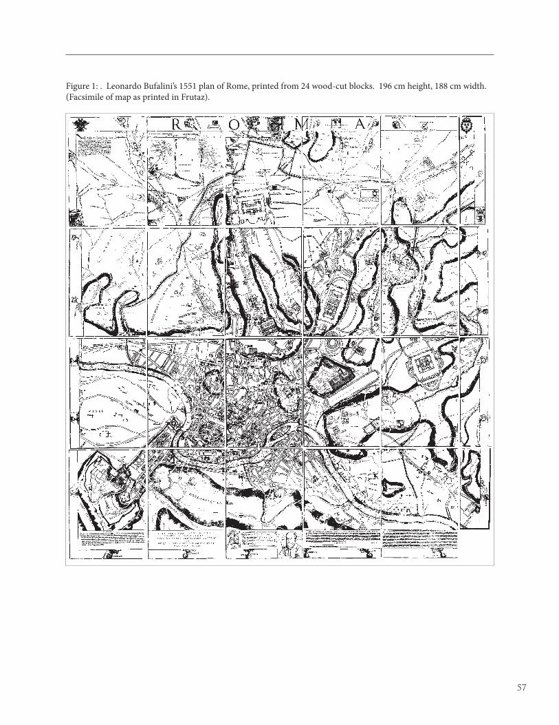
57
Figure 1: . Leonardo Bufalini’s 1551 plan of Rome, printed from 24 wood-cut blocks. 196 cm height, 188 cm width. (Facsimile of map as printed in Frutaz).

58
Figure 2: A portion of Bufalini’s plan superimposed over current-day conditions in the Borgo region of Rome. Although Bufalini’s depiction is inaccurate in several ways, the relative positions and distance apart of St. Peter’s and the Castel St. Angelo are accurate, as is the line of the Santo Spirito Bastion and a portion of the Tiber River. These few accuracies contained in the initial Borgo study suggested the larger comparison of Bufalini’s map in its entirety to the modern footprint of Rome. (Paul Schlapobersky).

59
Figure 3: Detail of Rodolfo Lanciani’s 1893-1901 superimposition study of different historical periods in the Borgo region of Rome. Lanciani’s methodolgoy was the direct inspiration for the diagrams prepared for the current study of the accuracy of Bufalini’s map. (Detail from facsimile of map as printed in Frutaz).

60
Figure 4: A detail of Leonardo Bufalini’s 1551 plan of Rome, showing the Aurelian Wall at the Porta Pinciana. Numerals alongside the wall, indicating segment lengths, suggested the first overlay study, in which the accuracy of Bufalini’s mapping of the wall was tested. (Facsimile of map as printed in Frutaz).

61
Figure 5: Bufalini’s 1551 plan laid over a Russian satellite photograph of Rome taken in 1988 from 240 km above the earth. The satellite photo is aligned with true north towards the top of the page. The rotation of the overlaid Bufalini plan clearly shows that his plan was oriented with east at the top, following the convention of Marliano’s 1544 archaeological plan. (Satellite photo: www.sovinformsputnik.com, Bufalini plan: Frutaz).

62
Figure 6: Four possible alignments of Bufalini’s mapping of the Aurelian Wall (black) in relation to the modern existing condition (red). Top indicates an alignment to the north of the city, with St. Peter’s and the southern part of the wall out of alignment. Second from top indicates an alignment in the southern part of the city, with the north and St. Peter’s out of alignment. Second from bottom indicates an alignment of St. Peters, with all other parts of the wall out of alignment. Bottom represents a “best fit” alignment utilized for the final comparison (i. St. Peter’s, ii. Castro Pretorio, iii. Testaccio, iv. Baths of Caracalla). (Paul Schlapobersky).

63
Figure 7: The two overall alignments of Bufalini (black) and the modern existing condition (red) tested with top, Aurelian wall aligned, and bottom, Monuments aligned. i. Castro Pretorio segment of the Aurelian Wall aligned with inaccuracy increasing to the north and south (towards the edges of Bufalini’s plan); ii. St. Peter’s and the Castel St. Angelo do not align in either scenario A or B, which may have been caused by the fact that neither monument is visible from the part of Monte Gianicolo where Bufalini likely stood while surveying the majority of the city, and thus comprise a “blindspot”, iii. Piazza Navona/Pantheon, iv. Colosseum, v. Tiber Island, and vi. Monte Testaccio as depicted by Bufalini all closely conform to actual existing conditions. vii. Baths of Caracalla nearly aligns in both conditions. viii. Baths of Diocletian are an anomaly, aligning when the best Aurelian Wall average is sought, but not when the best Monuments average is. The near alignment of vii & viii (Caracalla and Diocletian) in A, when all other monuments are grossly misaligned is possibly as a result of their proximity to the Aurelian Wall (and hence its availability for measurement when Bufalini was walking the circumference of the wall). ix Tiber River alignment, x The inexplicable nonalignment of the Piazza del Popolo (Paul Schlapobersky)

64
Figure 8: The two overall alignments of Bufalini (black) and the modern existing condition (red) tested were top left and top right, Aurelian wall aligned, and bottom left and bottom right, Monuments aligned. In the diagrams on the right, the grey hatch indicates the extent to which Bufalini’s depiction of the Aurelian Wall deviates from the known condition in both alignments, and the dark grey bars indicate the extent to which a monument is dislocated from its actual position. The Tiber River is clearly more closely aligned in the scenario that averages the alignment of principal monuments. The grey bars in top right show clearly that the displacement of the monuments from their actual positions, when depicted by Bufalini, is fairly uniform in distance and direction, particularly for monuments closer to Monte Gianicolo, Bufalini’s likely station point. Bottom right shows that monuments located far from Monte Gianicolo deviate more from their actual positions. This could be accounted for by the distance of these monuments from Monte Gianicolo (Paul Schlapobersky).
65
la verità essere il rilievo naturale, e la perspettiva essere la bugia e finzione 1
Giovanni Bertani
A propos of the cultural climate emerging around the year 1500 that we identify with the ‘High’ Renaissance, the town plan of Imola by
Leonardo da Vinci points to a fundamental new phase of knowledge in the Renaissance. In 1502 Leonardo did town surveying for Cesare Borgia and from July to September he traveled through the Romagna with Borgia; at Imola he produced his map of the city marking the emergence of modern ichnographic town mapping (Fig. 1).2 He employed both a surveying instrument to maintain the cardinal points and an odometer that he devised, to record absolute distances. Almost blindly, he assembled absolute distances with their orientation to cardinal directions, building the map piecemeal. For the first time in history, a military commander had an exact plan of a city.
It is customary to downplay the importance of Leonardo’s Imola plan. It is unique in Leonardo’s oeuvre, and no other ichnographic plan of a city appeared until Bufalini’s map of Rome in 1551. Maps were not used for wayfinding as they are today, and maps of this sort were only made occasionally and only for practical purposes, such as planning and defense. This argument for the
1 Giovanni Bertani, in Martino Bassi, Dispareri in material d’architettura et perspettiva con pareri di eccellenti et famosi architetti, che li risoluono, Brescia, 1572; cited in Erwin Panofsky, Perspective as Symbolic Form, trans. by Christopher Wood, (New York: Verso, 1991), p. 148, 147.
2 Royal Castle, Windsor Castle, inv. 12284. On the map, see John Pinto, "Origins and Development of the Ichnographic City Plan," Journal of the Society of Architectural Historians 35 (1976): 34-50, expanded as “The Renaissance City Image,” A. C. Crombie and N. Siraisi, eds., The Rational Arts of Living (Northampton: Smith College Press, 1987); and Carlo Pedretti, A Chronology of Leonardo da Vinci's Architectural Studies after 1500 (Geneva, 1962), 31-33; Leonardo: il Codice Hammer e la Mappa di Imola. Arte e Scienza a Bologna in Emilia Romagna nel primo cinquecento, Florence: Giunti Barbera, 1985, pp. 140-1; Rosaria Campioni, ed., Leonardo, artista delle machine e cartografo (Florence: Giunti, 1994), 77-81.
lack of formality of modern mapmaking can be put next to larger debates in perspective theory that contextualize its unity as a science.
If Leonardo’s map of Imola was not the waystation on the march to modern geometry it has been portrayed to be, it may still be a clear realization of widespread tendencies in the scientific culture of the period. If the geometry of mapping was not a coherent discipline, this does not mean that the skills of manipulating absolute measure were not advanced. Medieval and Renaissance property documents regularly list absolute measure, perspective views of cities contain accurate wall outlines and pseudo-ichnographic plans of cities were regularly produced for military purposes. They were not the pristine examples provided by Leonardo and later Bufalini, but they communicated the idea of gross magnitude and relationship.
Thus, without advancing the naïve notion that Leonardo understood that an ichnographic plan is really a number of perspective scenes viewed from an infinite number of viewing points (or conversely, a single infinitely distant viewing point that approaches the geometry of the former condition asymptotically), mappers understood absolute distance.3 This chapter seeks to conceptualize, or suggest how a contemporary might have conceptualized, the understanding of mapping and distance in sixteenth century terms. For this we have to turn to Leonardo’s notebooks, and his wrangling with perspective science. I want to argue that by 1500 Leonardo had grown disappointed with standard one point perspective and was looking for ways to represent error-free geometry. He seems to have found solutions to it in painting, and Imola represents his solution to the problem in mapping. By maintaining a constant distance from his subject in his representations (but not a modern notion of infinite space), he arrived at similar solutions. In this way, a degree of unity can be
3 On the discovery of our modern isotropic conception of space, see Judith V. Field, The Invention of Infinity: Mathematics and Art in the Renaissance (Oxford: Oxford University Press, 1997).
Leonardo, Raphael and Painterly Influence on the Development of Ichnography
Ian Verstegan
For Marcia Hall

66
established between allied representational problems in mural painting and urban mapping.
HAND-DRAWN AND PRINTED URBAN MAPS
Leonardo’s map differs from Bufalini’s in one important respect, it is hand drawn. It is so well known because Leonardo did it, but when
we affirm that maps did not rely in the main on ichnography we are really talking about printedmaps. Important work has demonstrated the highly charged ideological element that accompanies maps, whereby elements are enhanced, others suppressed. Most influential here has been the work of J. B. Harley on maps as a confluence of power and knowledge and it has brought with it a questioning of the internalistic history of maps as a march toward accuracy.4 What ought to be pointed out, however, is that most of these maps are printed and the profit motive of the map maker in addition to the ideological wishes of the patron created a peculiar climate of myths propped with the trappings of objectivity.5
A return to a discourse of science would seem naïve except for this observation about hand drawn maps, rarely as beautiful as those printed, but made for a military and other practical contexts in which their accuracy was essential. The function was fundamentally different for each. On the one hand drawn military maps focus on walls and fortifications, obstacles and natural waterways; it is a discourse of the conditions of conquest. Printed city maps instead are intended to provide symbolic representations of urban areas, both to represent and say something about those places; it is a discourse of urban identity. For the purposes of this chapter, hand drawn military maps are extremely important because their function places emphasis on the issues I am most interested in, the fallibility of
4 J. B. Harley, "Maps, Knowledge, and Power," The Iconography of Landscape: Essays on the Symbolic Representation, Design and Use of Past Environment. Eds. Denis Cosgrove and Stephen Daniels (Cambridge: Cambridge University Press, 1988), pp. 277-312. A good recent review of printed maps of Venice in this vein can be found in Bronwen Wilson, The World in Venice: Print, the City & Early Modern Identity (Toronto: University of Toronto Press, 2005).5 It is interesting that in Harley’s own “Silences and Secrecy: the Hidden Agenda of Cartography in Early Modern Europe,” Imago Mundi (1988), 57-76 – which contains much relevant material for the culture I am exploring – opposes ‘secrecy’ (intentional silence) and ‘political and social discourse’ (unintentional silence), tend to break on the manuscript and print divide.
sight and the search for representational means to overcome it.
Every ruler or governing body of the sixteenth century had a store of maps of their own and neighboring city walls and fortress complexes; representative here are Giovanni Battista Belluzzi’s sixty plans of cities for Duke Cosimo I de’ Medici in Florence and Jacob van Deventer’s Planenatlas made for Philip II and kept in the Escorial.6 These hand drawn city maps increasingly relied on ichnographic conventions yet conversely were largely the secret domain of their owners and their military advisors. The irony is that print, often considered a spur to expansion of the scientific spirit, is here pitted against private maps. An interesting confluence of prints and entrepreneurship on one side, and military secrecy, nobility and the cognitive skills of an elite on the other, force us to reconsider the survival of information and how representative printed urban maps (which survive in the greatest numbers) really are.
This chapter shall take it for granted that in practical military and engineering contexts there was a continued need to reform the old moralizing mapmaking inherited from the Middle Ages. No less than in land surveying and mapping than in painting could perspective theory be of potential interest. Since perspective disclosed the conditions of visibility of objects its findings would be useful for mappers seeking to provide the most accurate products that they could.
LEONARDO AND THE RATIONALE OF ICHNOGRAPHY
Fifteenth- century humanists knew that ‘ichnographia’ referred at least to plans of individual buildings. Leonardo’s innovation
(which then gave the term its modern meaning) was to see the need for the compounding of ground plans in scale, and find a means to implement it. His work, then, is the culmination of a century of effort to understand Vitruvius’ discussion of alternative modes of representation in the Ten Books of Architecture, where the virtues of plans (ichnografia), elevations (orthografia)
6 Giovanni Battista Belluzzi (under name “De Marchi”), Atlante di piante di città e fortezze, Biblioteca Nazionale di Firenze; Daniela Lamberini, “The Military Architecture of Giovanni Battista Belluzzi,” Fort 14 (1986), pp. 5-16, 10. Jacob van Deventer, Planenatlas, Biblioteca Nacional, Madrid; G. Parker, “Maps and Ministers: The Spanish Hapsburgs,” in B. Buisseret, ed., Monarchs, Ministers and Maps: The Emergence of Maps as a Tool of Government in Early Modern Europe (Chicago: University of Chicago Press, 1987), pp. 124-152.

67
and perspective (scenografia) scenes are discussed.7 This investigation of Vitruvius was undertaken by Alberti, Filarete and especially Francesco di Giorgio, who had gone furthest to plumb the various virtues and limitations of different drawings, and added to the plan, elevation and perspective view triad, the section, cutaway and exploded view.8
Plans and elevations were known since Giotto’s time to aid architectural execution because of their preservation of absolute scale and Alberti remarked on their advantage. In the De re architectura, he wrote that: “Between the drawing of a painter and that of an architect there is the difference that the former seeks to give the appearance of relief through shadow and foreshortened lines and angles. The architect rejects shading and gets projection from the ground plan. The disposition and image of the façade and side elevations he shows on different [sheets] with fixed lines and true angles as one who does not intend to have his plans seen as they appear [to the eye] but in specific and consistent measurements.”9 Nevertheless, there were practical problems that faced any one trying to extend the plan beyond a single building. Even though surveying techniques were fairly sophisticated, as in Alberti’s Descriptio Urbus Romae which fairly accurately sighted landmarks from the Capitoline Hill,10 the complexity of surveying an irregular Medieval city, full of hills, must have been daunting. In fact, the flatness of Imola has been cited as a cause of Leonardo’s success.
There has been no theoretical speculation about how Leonardo could have made such a conceptual leap. Discussion is more easily discerned in debates over the rise of the adoption of the plan as a universal tool of building and the disappearance (or contextualization) of the perspective view. In a famous discussion, the German art historian Wolfgang Lotz argued that
7 Vitruvius, The Ten Books on Architecture, Morris Hicky Morgan, trans. (New York: Dover, 1960 [1914]), chapter I, book 2, p. 14: “A groundplan is made by the proper successive use of compasses and rule, through which we get outlines for the plane surfaces of buildings;” Ingrid Rowland, trans. (New York: Cambridge University Press, 1999), pp. 24-25: “Ichnography is the skillful use, to scale, of compass and rule, by means of which the on-site layout of the design is achieved.”8 Samuel Edgerton, The Heritage of Giotto’s Geometry: Art and Science on the Eve of the Scientific Revolution (Ithaca: Cornell University Press, 1991).9 Leon Battista Alberti, On the Art of Building in Ten Books, New English translation by Joseph Rykwert, N. Leach and Robert Travernor (Cambridge: MIT Press, 1988), book 2, chapter 1, p. 34.10 Leon Battista Alberti, Leon Battista Alberti, Descriptio urbis Romae, (c. 1431-4), eds. Martine Furno and Mario Carpo, (Geneva: Droz, 2000); c.f., Anthony Grafton, Leon Battista Alberti: Master Building of the Italian Renaissance (New York: Hill and Wang, 2000), pp. 241-248.
the painterly training of architects like Leonardo made it difficult to understand the virtues of a plan.11 Thus, he classifies Bramante’s architecture as highly impressionistic and based on single views as found in perspective pictures. It was not until Raphael instituted the corporate design team for St. Peter’s and numerous tasks were delegated to a number of architects, he argued, that the plan presented itself as essential.12
The problem with Lotz’s assessment is that models contained the basis of orthographic projection during the heyday of perspective drawing, even in the absence of drawn plans. To return to ichnography (which is really an extension of the use of plans), there was certainly no advantage gained by delegation of plans to other artists. The way in which everything had to fit together, that is, the aggregate and summative necessity of the work, is shared between St. Peter’s and Leonardo’s work at Imola.13 In this case, the problem is one of removing distortions. This recasting of the problem suggests another influence for the development of ichnography that has not, to my knowledge, been suggested.
This is discussion over the variability of sight within treatise writing on perspective geometry as a possible source for the invention of ichnographic town mapping. What is particularly exciting is the fact that Leonardo was such a prolific author on perspective. In fact, as I shall show, there are compelling reasons that Leonardo would have been keen to adopt the orthographic projection of ichnography to a town map, reasons that go above and beyond attributing his invention to a generic appeal to genius.
Before Leonardo went traveling with Cesare Borgia, he had both mastered traditional linear perspective and applied it in the very significant commission of the
11 Wolfgang Lotz, “The Rendering of the Interior in Architectural Drawings of the Renaissance,” Studies in Renaissance Architecture (Cambridge: MIT Press, 1977), pp. 1-65.12 For more on the conventions of architectural drafting, strongly indebted to Lotz’s example, see Werner Oechslin, “The Vitruvian ‘Science’ of Architectural Drawing,” Daidalos 1 (1981): 20-35; Christoph Frommel, “Reflections on the Early Architectural Drawings,” in Henry Millon and Vittorio Lampugnani (eds.), The Renaissance from Brunelleschi to Michelangelo: The Representation of Architecture (Milan: Bompiani, 1994), pp. 101-120. For a recent review of these issues, see James Ackerman, “The Origins of Architectural Drawing in the Middle Ages and Renaissance,” Origins, Imitation, Conventions: Representation in the Visual Arts (Cambridge: MIT Press, 2001), pp. 27-65.13 This point is compatible with that of Cammy Brothers (“Architecture, History, Archaeology: Drawing Ancient Rome in the Letter to Leo X & in Sixteenth-Century Practice,” Coming About: A Festschrift for John Shearman, Cambridge: Harvard University Press, 2002, pp. 135-140) who similarly argues that Raphael’s experience with antiquities (another aggregate problem) was sufficient to suggest Raphael’s reforms.

68
Last Supper for Santa Maria delle Grazie in Milan (c. 1494-7).14 As everyone knows, one end of the refectory of the monastery was painted with this scene. Significant for this discussion is that Leonardo presumed that one could not utilize infinite viewpoints (as modern mathematical reasoning would suggest). Thus in his Manuscript A, he wrote:
There is a universal custom followed by those who paint on the walls of chapels which is much to be deplored. They depict one scene with its landscape and buildings on one level, then they go up and make another, varying the point of sight, and then on to the third and to the fourth in such a way that one wall is seen to be made with four points of sight, which is the height of stupidity on the part of these masters. We know that the point of sight must correspond to the eye-level of the beholder of the scene.15
Thus at this stage Leonardo could only countenance a number of scenes composed according to one rigid viewpoint, not an infinity of them. But his was mostly an argument for naturalism and an overcoming of Gothic tendencies which failed to relate the space of the viewer to the pictorial space.
By the time of the Last Supper, Leonardo had to face a problem because his painting is high up on the wall. His famous solution was to adjust the viewpoint to someone standing some fifteen feet in the air. Interpretations given for this are varied, but it solved a problem of indecorously showing Jesus as radically foreshortened. Not surprisingly, elsewhere in Manuscript A, Leonardo recommended a viewing distance of at least three, ten or even twenty times the size of the picture.16 Since this was impractical for the Last Supper, he took matters into his hands and simply forewent the viewing point at the viewer’s eye level.
By Leonardo’s time, there was substantial writing
14 Kenneth Clark, Leonardo da Vinci, revised by Martin Kemp (London: Penguin, 1988), pp. 144-154.15 Ashburnham I, 19v; Jean Paul Richter, The Notebooks of Leonardo da Vinci, compiled and edited from the Original Manuscripts, 2 vols., New York: Dover, 1970, vol. I, pp. 270-1, ¶ 542; recopied into the Trattato della pittura, Codex Urbinas 1270, 47r-v; Treatise on Painting, ed. A. Philip McMahon, (Princeton: Princeton University Press, 1956), no. 265. At around the same time in Manuscript A (Richter, p. 272) he similarly says “the plane on which you paint is to be seen by several persons you would need several points of sight which would make it look discordant and wrong.”16 Ms. A, 38r (3:1), 41r (10:1), 40v (20:1); Richter, vol. I, pp. 271-2, ¶ 542. Kim Veltman, Studies on Leonardo da Vinci, vol. I, Linear Perspective and the Visual Dimension of Science and Art (Munich: Deutscher Kunstverlag, 1986), pp. 163-165. Veltman rationalizes in a convincing way the seeming inconsistency between these numbers.
on the limitations of perspective in this manner, and Leonardo went on to adjust his written views too. The main culprit was not high up scenes but rather those seen at the edges of a picture. When the wall was of too great a width, it presented optical distortions at its margins. Piero della Francesca in his De prospective pingendi had already discussed the problem with a physiological solution; it wasn’t so much that perspective was in error but that the limits of visual perception had been reached with a view beyond about 90 degrees (Fig. 2).17 Therefore, the perspectivist must plan for more limited views to avoid such distortion.
It is against this background that we must understand the town plan of Imola (Fig. 1). What Leonardo was searching for was a way to represent error-free geometry even in its instantiation in individual acts of seeing. The closest analogy to what Leonardo was doing would be a drawing like Giuliano da Sangallo’s reconstruction of the Baths of Diocletian (Uffizi A 131). Here Giuliano draws a pre-existing building’s elevation (not a design for a hypothetical one like St. Peter’s) and shows it without distortion. Leonardo goes much farther, however, well beyond Giuliano’s single elevation to show several building plans together.
Theoretically, Leonardo came to propose a reconciliation of ‘simple’ perspective (prospettiva semplice) and ‘artificial’ perspective (prospettiva artificiale). Originally conceived as a strict distinction between pure seeing and linear perspective, the undistorted quality of natural arcs of vision versus the compromise of distorting intersections seems to have given Leonardo the idea of moving the qualities of simple perspective into artificial constructions in a form of ‘compound’ perspective (prospettiva composta).18
Simple perspective was represented for Leonardo by equal distance around an arc surrounding the viewer’s eye, the intersecting plane of complex perspective
17 Piero della Francesca, Piero della Francesca, De prospective pingendi, c. 1474, Giusta Nicco Fasola (ed.), (Florence: G. Nicco-Fasola, 1942); c.f., J. V. Field, “Piero della Francesca's Treatment of Edge Distortion.” Journal of the Warburg and Courtauld Institutes 49 (1986): 66-90 (who notes the errors in Piero’s proof); Lew Andrews, Story and Space in Renaissance Art: the Rebirth of Continuous Narrative, (New York: Cambridge University Press, 1995), pp. 44-47.18 The interpretation of simple perspective as undistorted natural arcs is due to James Elkins and Thomas Frangenburg; James Elkins, “Did Leonardo develop a theory of Curvilinear Perspective? Journal of the Warburg and Courtauld Institutes 51 (1988): 190-196; Thomas Frangenburg, “The Angle of Vision: Problems of Perspectival Representation in the Fifteenth and Sixteenth Centuries,” Renaissance Studies 6 (1992): 1-45; c.f., Claire Farago, “Leonardo's Prospettiva Composta in the History of Pictorial Composition,” I mondi di Leonardo. Arte, scienza e filosofia, ed. Carlo Vecce (Milan: Edizioni Università IULM, 2003), 107-129.

69
insured unequal distances (e.g., Ms. A, 38 recto; Fig. 3). These very passages have always been adduced to support the notion that Leonardo used ‘curvilinear perspective,’ or the use of curved lines to approximate the spherical view of the arc of viewing from a single view point. According to the general opinion voiced by James Elkins, Thomas Frangenburg, and others, however, although Leonardo was well aware of the difference between angular distance and terminal distance and occasionally appeared to overcome it (as suggested by the illustrations of the Codex Huyghens) – he did not ever derive a theory of curvilinear perspective that would somehow erase all distortions from viewing.19 Instead, he seems to have seen angular corrections as precisely useful in those cases of lateral distortion, where one could not remove oneself sufficiently from the scene to view it without distortion.
A couple of years after the Imola map, Leonardo was working in Florence. According to the original commission for the Sala del Gran Consiglio (Grand Council Chamber) added to the Palazzo dei Signori, two republican victories were to be painted by Leonardo and Michelangelo, the Battle of Anghiari (Florentine victory over the Milanese, 1440), and the Battle of Cascina (Florentine victory over Pisa, 1369), respectively. Because of the limitations of viewing in the room, Leonardo’s observations became immediately activated.
Claire Farago has suggested that the very observations just cited from Manuscripts E and G were inspired by Leonardo’s practical problems faced in preparing his fresco and their perplexity actually was responsible for his inability to finish his commission for the Palazzo Vecchio.20 The most trying limitation was the fact that the fresco was to be viewed from no more than one and a half times the width of the wall, well short of Leonardo’s minimum suggested distance of three widths. But since Leonardo’s fresco was never finished (and that which was completed was destroyed or lost), we do not know how far the artist was able to match theory to practice. The only evidence is Leonardo’s original drawings, Rubens’ retouched copy after the central standard (Fig.
19 Elkins, “Did Leonardo develop a theory of Curvilinear Perspective?” Frangenburg, “The Angle of Vision: Problems of Perspectival Representation in the Fifteenth and Sixteenth Centuries.”20 Claire Farago, “Leonardo’s Battle of Anghiari: A Study of the Exchange between Theory and Practice,” Art Bulletin 126 (1994): 301-330 and "The Battle of Anghiari: A Speculative Reconstruction of Leonardo's Design Process." Achademia Leonardi Vinci: Journal of Leonardo Studies and Bibliography of Vinciana 9 (1996), pp. 73–86; c.f. Carlo Pedretti, "Mural Perspective as Cinemascope: Story-board to Production," Achademia Leonardi Vinci 9 (1996): 87-98.
4) and various modern reconstructions.21 The general opinion is that, in spite of this theoretical searching and reflection, Leonardo does not seem to have altered his fresco in any noticeable way away from accepted standards.
Farago, however, has suggested that it is “unlikely that a conventional perspective construction would have met [Leonardo’s] needs.”22 She seems to regard the atmospheric alternative she hypothesizes for Leonardo as somehow antagonistic to central perspective, when color gradients would present the same problems to an off-center viewer (albeit in less obvious fashion) as linear perspective.23 Some alternative to traditional perspective as suggested by Farago is made more likely by the present framework.
In particular, the similarity of the echoes of drawings that have come down to us to the contemporary works of Mantegna is striking. In a smaller antiquarian fashion, Mantegna had been imitating ancient relief but its benefits for mural painting were not lost on Leonardo. Indeed, we can admit that the Windsor drawings and the retouched drawing by Rubens are somewhat relieflike. Much of the evidence adduced by Farago (and Pedretti) does not in fact refer to relief (rilievo) extending into the depth dimension but rather to pop out toward the viewer. Even models and a stage set could be mobilized toward maximizing flat, convincing relief.
21 For a reconstruction of the Windsor drawing, see among others Cecil Gould, "Leonardo's Great Battle-Piece: A Conjectural Reconstruction," The Art Bulletin 36 (1954), 117–29; on the reliability of Rubens’ drawing, see Frank Zöllner, “Rubens Reworks Leonardo: The Fight for the Standard,” Achademia Leonardi Vinci 4 (1991): 177-190.22 Farago, “Leonardo’s Battle of Anghiari,” p. 310.23 Leonardo, she argues, would have utilized a system of gradients of brightness, color and clarity for the room. The advantage is that such aerial perspective has simply bands of a particular distance gradient quality of general color. This leads her to say that this aerial perspective would work for a “viewer positioned almost anywhere in the room,” and she sees aerial perspective as containing many advantages over linear perspective (p. 323) and further “In the case of color recession measured according to planes parallel to the frontal plane within a spherical field of vision…a major cause of distortion (had Leonardo relied on linear perspective) is minimized: facing the centric or ideal viewpoint is the entire line of the horizon, rather than the awkward convergence of orthogonals toward a single point” (pp. 324-325). However, she notes with her discussion of Leonardo’s development of aerial perspective on Albertian terms, and this is the basis of a seeming idiosyncrasy (p. 324). Standing before a long painted landscape, the bands of color gradation must still accurately relay distance so that a view from the center of the mural to the far corner would not accurately represent the illusory distance. Conversely, what is the linear perspective attitude behind the battling horsemen, projecting “toward the viewer in a tightly compressed mass of whirling dust and smoke, gleaming metal, flickering light and color, and violently foreshortened figures that seem to pierce the picture plane” (p. 323) if not relief?

70
I noted that the curvilinear short-cut (not to be confused with true curvilinear perspective) was used by Leonardo in cases of marginal distortion. This mere short cut involves adopting a curved, undistorted view to a flat surface, not providing a perfect illusion from a single view (curvilinear perspective). The difference is significant because it shows how Leonardo takes a curved view without distortion and flattens it to a conventional pictorial surface. These are not curves on flat pictures adjusted for a stationary viewer but the opposite – straight lines on curves surfaces that is flattened for a mobile viewer. Imagine the situation involved in Michelangelo’s cartoons for the prophets and severy scenes along the irregular geometry of the Sistine vault. These cartoons lying flat would be full of curves, but correct when laid flush onto the walls. This is an intuitive transposition between angular and oblique measures that also exchanges the viewer-object relation (not exactly in this example because the drawing if made flat would indeed have curved lines). The drawing only becomes ‘correct’ when changed from its original position, not when in its original state.
Corrado Maltese has investigated the possibility that Leonardo had devised an instrument that is known later in the sixteenth century as being developed by Baldassare Lanci, a military architect most famous for his service to the Medici in Florence (Fig. 5).24 The instrument includes a sighting tube that is rigged also to a pencil that swivels along a curved drawing surface corresponding to the arc of the sight. Maltese suggested that this was proof of Leonardo’s knowledge of curvilinear perspective, but as the foregoing discussion should have shown, this need not be so. What this instrument might show about Leonardo is simply that he understood a way to translate angular to oblique measures. Notice that nothing about the drawing corrects for perspective; it has to be viewed flat and in flattening it effectively displaces the viewpoint to an infinite number of points (as in Michelangelo’s lain-out cartoon or implicitly in Leonardo’s drawings). Distortion has effectively been ‘removed.’25
24 Corrado Maltese, "Prospettiva curvilinea e geometria applicata Corrado Maltese, "Prospettiva curvilinea e geometria applicata fra Leonardo e la cartografia moderna", in Atti del centro di ricerche e documentazione sull'antichità classica (Milan, IX, 1978), pp. 293-307; "La prospettiva curva di Leonardo da Vinci e uno strumento di Baldassare Lanci", in La Prospettiva Rinascimentale. Codificazioni e trasgressioni. Atti del convegno internazionale di studi (Florence: Centro Di, 1980), pp. 30-34. 25 Of course, to the degree that the depicted subject is not at a constant distance from the device, it will be distorted. This was already pointed out by Ignazio Danti, Le due regole della prospettiva di M. Iacopo Barozzi da Vignola (Rome: Zanetti, 1589).
The same principle could be used either in painting or mapping, resulting in a relieflike fresco or ichnographic map. The only difference is that the viewpoint has been changed from laterally to above. In both cases, the knowledge that sufficient distance is necessary to remove distortion has not resulted in the moving of the point to infinity (a modern mathematical conclusion), but rather to understand that a perfectly angular view could be flattened. This marks the common perspectival lesson that Leonardo could take from painting (relief) and apply then to mapping.
To find different representational realms (urban cartography, painting) that share similar solutions is not to ignore their differences. Mapping Imola has attached to it an overwhelming practical aspect of walking walls, taking compass readings, etc. However, if Leonardo conceived of each of these problem areas as moving a viewer equidistant from the action, reversing the curved conditions to appear correct for a fixed viewer, then he hasn’t really grasped the master point (infinite viewing points), merely the more elementary idea to conserve absolute terminal distance.
Thus, perhaps in the case of painting and definitely in the case of map-making, Leonardo took his own advice to see Imola ‘exactly as it is’ and to survey the town ‘equally remote from all its edges.’ It then may be that Leonardo also imagined representing a scene from an equal distance, in the manner of a relief. In any case, to have made these observations does not necessarily mean that Leonardo decided to create a map or picture based on infinite distance. Instead, he may not have made the conceptual leap and merely was thinking of absolute distance rather than consistent angularity.
MICHELANGELO AND RAPHAEL
It may be, however, that Leonardo’s observations were not lost on everybody. In particular his rival in painting in the Sala, Michelangelo, may have
actually taken the challenges of the viewing conditions to heart. Michelangelo was to paint the Battle of Cascina to complement Leonardo’s fresco. While we tend to follow Vasari and his portrayal of the younger painter’s stubborn independence, it is likely that he was keenly aware of his more famous contemporary and what he had to say on the subject of monumental mural painting.
Marcia Hall has argued that Michelangelo’s Battle of Cascina, which is only preserved in Aristotele da Sangallo’s The Bathers (oil on panel, 1542, Norfolk, Collection Viscount Coke and the Trustees of the

71
Holkham Estate; Fig. 6), is the first modal use of the relieflike style, that is, a self-consciously chosen compositional mode (as opposed to an unconsciously chosen composition based on artistic influence).26 Obviously, this is significant because Leonardo’s reflections on mural painting and his sketches may have influenced Michelangelo, and both artists may have crossed paths between September 1504 and February 1505.27
The relieflike style finds its origins in fifteenth century antiquarianism. Craig Hugh Smyth has discussed how the imitation of one kind of ancient monument (the late Roman sarcophagus) led late quattrocento Florentine’s to their particular style.28 Mantegna, for instance, painted famous monochrome banners imitating ancient relief. The combination of secular antique subjects and a way to represent them, in distinction to religious pictures with their own developed history, would be a mainstay of the relieflike style. This antiquarianism continued in the works of Pinturicchio and Jacopo Ripanda, sometimes remaining at the level of antiquarianism as in Ripanda’s frescoes in the Palazzo dei Conservatori (1503-1507) and sometimes using the relieflike style as in his frescoes in the Palazzo Vescovile in Ostia.
This latter commission points to the real viability of antiquarianism for monumental fresco painting. Especially as grotesques developed too, each was a way to cover a lot of wall. The relieflike style, however, is somewhere between traditional perspective and groteschi. They are representational but also serve a monumental wall-covering function. We could go so far as to state that true relieflike style only serves the optical shortcomings of monumental fresco and this seems to have been Michelangelo’s achievement. Could it be that Leonardo’s reflection spurred on Michelangelo? Or might Leonardo have articulated a solution that he could not countenance but that the young Michelangelo might have tried?
Michelangelo went on to use it on the Sistine Ceiling in the Sacrifice of Noah, where the flattened monumentality of the style maintained its visibility from the floor. From there it passed to Raphael. The locus classicus for the relieflike style is the Sala di Costantino, planned by Raphael before his death in 1520 and executed by Giulio Romano and other artists from Raphael’s remaining
26 Marcia Hall, After Raphael: Painting in Central Italy in the Sixteenth Century (New York: Cambridge University Press, 1999).27 Farago, “Leonardo’s Battle of Anghiari,” p. 30. 28 Craig Hugh Smyth, Mannerism and Maniera (Locust Valley, N.Y.: J. J. Augustin, 1962).
workshop. For the Battle of the Milvian Bridge, Raphael does not array his composition in depth put places his figures close to the picture plane in a frieze or relieflike way. Historians have seen in this fresco and others hints of the later maniera and indeed a flattening of compositions has been regarded as a feature of maniera painting. In addition, the link to Roman sarcophagi has been cited as the source for these compositions, which as noted begins in the quattrocento and merely continue with Raphael.
All of these observations are correct, however, Hall’s challenging observation is that this is a compositional mode being employed for its virtues in this particular situation. In fact, she points to the long and narrow shape of the room as one of the mitigating factors for choosing the relieflike style over a central-point perspective. Because the viewing distance is short, one cannot step back sufficiently to take in a single perspective scene. By maintaining objects along the frontal plane we overcome a shortcoming of viewing.
This must have been a part of contemporary shop lore, although there are many possibilities of mutual influences. Raphael was in and out of Florence between 1504-1508, when he was called definitively to Rome. When in Rome, he would have had direct access to Michelangelo. Meanwhile, Leonardo’s influence too may have been felt. We know that Leonardo was in Rome beginning in 1513, under the augury of Florentine Leo X’s election as Pope.29 Raphael could have observed the relieflike style both in Florence (in Michelangelo’s cartoon) and Rome (in the Sistine Chapel) firsthand.
First, however, let us follow Raphael’s architectural career. In Rome his painting in the Stanze developed completely parallel to his assisting with Bramante’s project for St. Peter’s. The workshops’ task of drawing the church and the demands of perspective, elevation and plan, Vitruvius’ scenografia, orthografia, and ichnografia would have alerted them to the various problems of representational drawings. This is especially so in light of Fra Giocondo’s annotated Latin edition of Vitruvius of 1511,30 completed within the Bramante
29 Kenneth Clark, Kenneth Clark, Leonardo da Vinci, pp. 235-251.30 Fra Giocando, Fra Giocando, M. Vitruvius per Iocumdum solito castigatior factus, cum figuris et tabula ut iam et intelligi possit (Venice: Giovanni de Tridino, 1511 and 1513). On Fra Giocondo’s understanding of plan, elevation and perspective view, see Oechslin, “The Vitruvian ‘Science’ of Architectural Drawing,” p. 32, and more decisively, Christof Thoenes, “Vitruv, Alberti, Sangallo,” in A. Beyer et al., eds., Hülle und Fülle: Festschrift fur Tilmann Buddensieg (Alfter, 1993), pp. 565-584, who clarifies that Giocondo (and others like Filarete) understood a scenographic view to be an elevation with a lateral side converging toward a point.

72
circle, and Raphael’s own attempts to translate Vitruvius into Italian with Fabio Calvo.31 In addition, as noted earlier his antiquarian projects as Head of Antiquities and surveyor of Rome would have alerted him to the challenges of reconciling disparate objects under one system.32
At this point we can finally make reference to Raphael’s letter, in which he describes the surveying project. I shall not be concerned with complex issues of the distributed authorship and numerous drafts of the letter. Probably based on Baldassare Castiglione’s early coauthored draft with Raphael, it was then reworked again with Raphael’s participation by Angelo Colocci.33
Now that we have clarified which buildings of ancient Rome are the ones we wish to show and how it is an easy matter to distinguish them from the others, it remains to demonstrate the method that we have adopted for measuring and drawing them, so that whoever wants to turn his attention to Architecture will know how to carry out the one and the other without error.34
Raphael then goes on to describe the use of the magnetic compass for the surveying, which will be discussed below, before going on to continue describing the merits of the new system. With foreshortened lines, an architect cannot derive any measure that would be useful for construction, for the architect requires all measures to be precise and related to parallel lines, not to those lines that appear to but do not actually exist.35
31 This resulted in the unpublished manuscript, complete up to book five, in the Bayerische Staatsbibliothek in Munich; c.f., Ingrid Rowland, “Raphael, Angelo Colocci, and the Genesis of the Architectural Orders,” Art Bulletin 126 (1994): 81-104. Rowland notes the manuscript is in Angelo Colucci’s hand, the same humanist who also helped with Raphael’s letter to Leo X (see below).32 On the project to survey ancient Rome, see “La ricostruzione di Roma antica,” in Christof Frommel, Stefano Ray and Manfredo Tafuri, eds., Raffaello Architetto (Milan: Electa, 1984), pp. 437-450; Philip Jacks, "The Simulachrum of Fabio Calvo," Art Bulletin 122 (1990): 453-81.33 On the letter, see Christof Th oenes, “La ‘lettera’ a Leone X,” in On the letter, see Christof Thoenes, “La ‘lettera’ a Leone X,” in Raffaello a Roma. Il convegno del 1983 (Rome: 1986), pp. 373-38. It is given in English in Pedretti, A Chronology of Leonardo da Vinci's Architectural Studies after 1500, pp. 162-171.34 English: Rowland, p. 101; Camesasca, 1956: “Havendo dunque English: Rowland, p. 101; Camesasca, 1956: “Havendo dunque abastanza dechiarato quali edifici antiqui di Roma sono quelli che noi cogliamo demostrate, et anchora come facil casa sia cognosciere quelli dalli altri, resta ad insegnare el modo che noi havemo tenuto in misurarli et disegnarli, acioché chi vorrà atendere alla Architectura, sappia operare l’uno et l’altro senza errore.”35 English: Rowland, p. 102; Camesasca, 1956: “E questo tutto si English: Rowland, p. 102; Camesasca, 1956: “E questo tutto si faccia con linee paralelle della linea del piano dello edificio. E in tali disegni non si diminuisca nella estremitate, anchora che lo edificio fosse tondo, né anchora se fosse quadro, per farli mostrare due faccie.
Carlo Pedretti has already shown the indebtedness of Raphael in his use of the magnetic compass to Leonardo.36 The way that Raphael divides the plan into eight divisions is already found in Leonardo’s procedures at Imola. So perhaps he had understood other aspects of Leonardo’s practices, including the use of the odometer. As noted, Leonardo was in Rome around 1513 and there is even talk of Leonardo providing an ichnographic map of Rome, to follow on his impressive achievement in Imola.37
More significant, however, is the way in which Raphael has applied theory to a practical application in the way that Leonardo could not. Recall that his distinction between ‘simple’ and ‘complex’ perspective did not find application in painting (the question remains open if it applied in his mind to Imola). Here, however, Raphael specifically writes of lines that appear (paiono) and exist (sono). Thus the move to find a representational mode that can approximate real appearances is underway.
At exactly the same time, Raphael had finished the first three Stanze for the Vatican palace and was planning to paint the Sala di Costantino. Suddenly, however, he was faced with a much differently shaped room, which also possessed a different function as a stateroom. Raphael’s thoughts must have turned immediately to the Sala del Gran Consiglio in Florence, both for its challenging long and narrow dimensions and also because of the function.38 As Hall has pointed out, the situation was worse in the Vatican than in the Palazzo Vecchio; one can only move back about half the width of the fresco to view it.39 In both cases, a relieflike style nominated itself both for its advantages in overcoming marginal
Perché lo architecto, dalla linea diminuita, non può pigliare alcuna giusta misura, El che è necessario a tal artificio, che ricerca tuttle le misure perfette in facto, et tirate con linee paralelle, non con quelle che paiono, e non sono; e, se le misure facte talhor sopra pianta di forma tonda scortano, over diminuiscono, subito si trovano del dissegno della pianta, e quelle che scortano nella pianta, come volte, archi, triangoli, sono poi perfette nelli suoi dritti disegni.”36 Carlo Pedretti, Carlo Pedretti, A Chronology of Leonardo da Vinci's Architectural Studies after 1500, pp. 157-171. On the magnetic compass, see further Howard Burns, "I Disegni," Palladio, catalogo della mostra (Milan: Electa, 1973); and G. Boffitto, Gli strumenti della scienza e la scienza degli strumenti (Florence: Seeber, 1929).37 These are the references by an anonymous poem as well as Pietro Aretino, but neither names Leonardo specifically; see Pinto, p. 42, n. 38. On the first “prospettivo Milanese dipintore, see Ingrid Rowland, The Culture of the High Renaissance in Italy.38 On the relation of the Sala di Costantino to the Sala di Gran Consiglio, see Randolph Starn and Loren Partridge, Arts of Power: Three Halls of State in Italy, 1300-1600 (Berkeley and Los Angeles: University of California Press, 1992).39 Marcia Hall, “Classicism, Mannerism, and the Relieflike Style,” The Cambridge Companion to Raphael (New York: Cambridge University Press, 2005), p. 234.

73
distortion with such a wide view and also for the antique connotations that reliefs would carry in a room announcing papal authority.
In such a space, the single-point perspective of the School of Athens would unmercifully warp at the edges (and there was no question of dividing the scene into two rooms, as was done conveniently on the other side of the room by the windows that pierced the wall). So Raphael resorted to a convention that would relate these figures as they ‘are’ rather than merely ‘appear.’ It was formerly thought that the relieflike appearance of the Battle of the Milvian Bridge was due to Giulio Romano’s intervention. But we know that the scaffolding of the room was in place by October 1519, and the frescoes were finished by Pope Leo’s death in December 1521. So if the actual execution was not by Raphael (and the latest of the Stanze were not), then the plans were certainly by Raphael. Interestingly, the proof of the utility of the relieflike style for the Battle of the Milvian Bridge is shown by the use of traditional perspective for the Vision of the Cross, adjacent to it in a much smaller space.
THE AFTERLIFE OF ICHNOGRAPHY
It is telling to follow the afterlife of both ichnography and the relieflike style in the breakup of Raphael’s workshop. Ichnography was diffused through the
circle of Bramante in the drawing conventions that were passed down after Raphael’s death. Historians have followed the use of the ground plan, which was codified in the drawing conventions of Serlio’s treatises, carried on from his teacher Peruzzi.40 By the end of the century, the plan and elevation was the norm. Palladio’s architectural treatises use this method exclusively, as do the Vitruvian commentaries of Palladio’s friend, Daniele Barbaro (1513-1570).41
However, ichno- and pseudo-ichnographic maps are also being produced, but as noted at the outset of this paper, in manuscript form (unlike Serlio’s and Barbaro’s treatises). Significant is Giuliano da Sangallo’s large plan
40 Sebastiano Serlio Book IV, Sebastiano Serlio Book IV, Regole generali di architettura. . .sopra le cinque maniere degli edifici. . .con gli esempi delle antichità, che per la maggior parte concordano con la dottrina di Vitruvio (Venice: 1537). On Serlio, see Vaughan Hart and Peter Hicks, eds., Paper Palaces: The Rise of the Renaissance Architectural Treatise (New Haven: Yale University Press, 1998).41 Bishop Daniele Barbaro, Bishop Daniele Barbaro, I dieci libri dell'architettura di M. Vitruvio, tradutti et commentati da Monsignor Barbaro (Venice: Francesco Marcolino, 1567); facsimile edition (Milan: Il Polifilo, 1997), p. 30: “ichnografie, cioè descrizzione, & disegno della pianta.”
of Pisa, produced probably shortly after Leonardo’s map of Imola for the successful Florentine assault of the city in 1509.42 We have already discussed Raphael’s plans to make an ichnographic map of Rome. Some of the drawings by Baldassare Peruzzi and Antonio da Sangallo from the workshop for St. Peter’s had to incorporate parts of the Vatican palace and used ichnographic conventions.
Military interests, however, were the primary movers of ichnography. The events leading up to the Sack of Rome in 1527 caused many architects to reconsider fortifications. Sangallo spent more and more time in military defense of the city and had to record the old Aurelian walls, to which he added the Ardeatine bastion.43 Peruzzi recorded the walls of his native Siena and neighboring Florence.44 A hint of his progress can be seen in the evidence that Sangallo and Peruzzi used magnetic compasses, an essential aspect of ichnographic maps, as well as the many quasi-ichnographic plans from the hand of Antonio Labacco and Salustio Peruzzi.45 Contemporary to Sangallo, we have the evidence of the use of the magnetic compass in plans for the defense of Florence during the republican restoration of 1529. Vasari reported that Benvenuto della Volpaia and il Tribolo made a relief map of Florence out of cork and secretly sent it to Clement VII in Rome.46 Immediately after Sangallo’s death, the first ichnographic map of Rome was realized in the famous plan of Leonardo Bufalini at the same time that Jacopo Castriotto projected walls for the old Borgo.47
Echoing Alberti, Leonardo and Raphael, Sebastiano Serlio made the by now familiar comments about perspective and how othographic representation (of plans and elevations) was preferred in architectural
42 Uffizi, inv. 7950A, Greymüller collection.43 Antonio da Sangallo Jr. in Christoff Frommel and Nicholas Adams, eds. The Architectural Drawings of Antonio da Sangallo and His Circle, vol. I, Fortifications, Machines and Festival Architecture (New York: The Architectural History Foundation, 1994); Simon Pepper, “Planning versus Fortification: Sangallo’s Project for the Defense of Rome,” Architectural Review 159 (1976): 162-169.44 For numerous pseudo-ichnographic plans of cities, see Baldassare Peruzzi’s in H. Wurm, Baldassare Peruzzi: Architekturzeichnungen (Tübingen: Wasmuth, 1984), pp. 181-203.45 See Pinto, 1987, and Huppert’s contribution to this volume.46 Vasari-Milanesi, VI, “Vita di Niccolo detto il Tribolo, scultore Vasari-Milanesi, VI, “Vita di Niccolo detto il Tribolo, scultore e architetto,” 61-2; B. Varchi, Storia Fiorentina, Milanesi, 1857/8, p. 39; c.f., Pedretti, A Chronology of Leonardo da Vinci's Architectural Studies after 1500, p. 24, note 10; Pinto, 1987, pp. 245-6.47 On Bufalini, see the contribution of Schlapobersky in this volume; Bufalini significantly showed himself on the map with the bussola. On the continued defense of the borgo, see Luciana Cassanelli, Gabriella Delfini and Daniela Fonti, Le Mura di Roma: l’architettura militare nella storia urbana (Rome: Bulzoni, 1974).

74
representation because, “the measure isn’t lost on account of the foreshortenings” (le misure non si perdano per causa de I scorzi).48 In 1569 Daniele Barbaro published La pratica della prospettiva which devotes the entire second chapter (“Nella quale si tratta della Ichnographis, cioè descrittione delle piante”) to deriving perspective from ground plans.49 He writes that “without ichnography, that is, drawing the bottom and plan of things, one cannot describe a figure, given that everything grows from the plan just as a tree grows form the roots”50 Significantly, it is in this book that the reuse of Piero’s diagram of perspective distortion appears.
THE AFTERLIFE OF THE RELIEFLIKE STYLE
The relieflike style also is diffused through the circle of Raphael. In addition to its use in murals were the famous façade paintings of Polidoro da
Caravaggio and Maturino. Usually painted in grisaille, these frescoes more literally imitated antique relief in the guise of architectural decoration. It is hard to imagine their importance now that they are all almost gone, but in their time the works of Polidoro were recommended to be copied along with ancient sculptures and the nudes of Michelangelo.
From the Sala di Costantino it was spread throughout Italy through the dispersion of the workshop, especially after the Sack of Rome. Giulio Romano is the single personality who preserved the integrity of Raphael’s joint reform of architectural and history painting rendering, since he was both architect and painter. Upon his move to Mantua, he used the relief-like style; Perino del Vaga did the same in Genoa. Then, a second generation learned the lessons and continued them. Rosso took the relief-like style to France, and two young Florentines, Giorgio Vasari and Francesco Salviati, turned it into a maniera convention. Examples are Vasari’s Sala dei Cento Giorni, 1546, in the Palazzo della Cancelleria, Salviati’s Sala dell’Udienze, 1543-6, of the Palazzo Vecchio in Florence,51 the Cappella del Pallio,
48 Serlio, Serlio, Regole generali di architettura, 1540.49 Bishop Daniele Barbaro, Bishop Daniele Barbaro, La Pratica della perspettiva (Venice, 1569); facsimile (Arnaldo Forni, no date).50 Barbaro, Barbaro, La Pratica della perspettiva, p. 27: “senza la Ichnographia, cioè disegno baso e piano delle cose, non si può descrivere alcuna figura, essendo che ogni cosa elevata nasce dalla pianta come l’albero nasce dalla radice.”51 Luisa Mortari, Luisa Mortari, Francesco Salviati (Roma: Leonardo-De Luca,
1548, in the Cancelleria for Chancellor Alessandro Farnese, the Fasti Farnese, 1552-1563, for the Palazzo Farnese, for Ranuccio Farnese,52 the Sala Grande, 1553-4, of the Palazzo Ricci (now Sacchetti) in Rome,53 and finally Vasari’s Palazzo Vecchio frescoes (Apartment of Eleonora, 1559-62; ceiling of the Sala dei Cinquecento, 1563-5; walls of the Sala dei Cinquecento, 1567-1572). As Marcia Hall wrote of the Sala dei Cinquecento, with its length-width ratio of 2.3:1 (174 x 75 feet), “Vasari wisely made the victories over Pisa in relieflike style.”54
Sebastiano Serlio has left us a remarkable passage of his architectural treatise that illustrates the modal use of relief in painting. In discussing “On Decoration in the Form of Painting, both Outside and Inside Buildings,” he leaves the choice of perspective or relief to judgment of decorum.55 Reliefs keep the building solid, perspective is only useful for views for faux windows or vaults, and even there should contain the sky and aerial creatures. This precious comment goes some way toward corroborating Hall’s intuitions about the choice of mode. While he limits reliefs to walls and perspectives to ceilings, he betrays his sensitivity to which surfaces different paintings work best.
Serlio’s was a lone voice. By this time, the practical necessities of ichnography and the imperial associations of the relief-like style cleft them apart from the common perspectival problem that they began as. In any case, a new drawing convention, “military perspective” was emerging to clarify the issue in a satisfactory way by seeking a compromise between perspective and ichnography.56 Yet it is important to understand that for twenty formative years, from about 1500-1520, the conventions necessary to adequately represent natural scenes and architectural renderings could be based on unified principles that attempted to retain absolute measure.
1992), pp. 110-112.52 Mortari, Mortari, Francesco Salviati, pp. 122-123.53 Mortari, Mortari, Francesco Salviati, pp. 124-128. The palace, which lies along the via Giulia, originally belonged to the architect Antonio da Sangallo.54 Hall.55 Sebastiano Serlio, Regole generali di architettura, Book IV, 1537, LXIXv-LXXv; in Vaughan and Hicks, Sebastiano Serlio on Architecture (New Haven: Yale University Press, 1996), p. 378-380.56 Massimo Scolari, Il Disegno Obliquo (Venice: Marsilio, 2005).

75
Figure 1: Leonardo da Vinci, Map of Imola, Windsor Castle, inv. 12284 (Source: Windsor Castle)
Figure 2: Diagram after Piero della Francesca, De prospective pingendi, c. 1474.

76
Figure 3: Diagram after Leonardo da Vinci, Ms. A, Paris, Institut de France, 38 recto.
Figure 4: Rubens over an anonymous sixteenth century artist, copy of the Battle for the Standard (from the Battle of Anghiari), Louvre, France.

77
Figure 5: The Perspective Machine of Baldassare Lanci, 1557, Museo di Scienza, Florence.
Figure 6: Aristotile da Sangallo (after Michelangelo), The Battle of Cascina, oil on panel, 1542, Norfolk, Collection Viscount Coke and the Trustees of the Holkham Estate (photo: Courtauld Institute of Art).

78

79
NOLLI AND 18TH CENTURY CONTEMPORARIES
part ii

80

81
Every map is more than a simple documentary exercise. Rather, it is a representation necessarily based on a narrative understanding of place.
We tend to assume that mapping is a neutral activity, premised on a faithful reproduction of reality. But total correspondence is an illusion: we have but to recall Jorge Luis Borges’ fictional cartographer, whose attempt to produce a perfect map results in a drawing that assumes the dimensions of reality itself, and covers the kingdom in its own depiction. 1 Every map involves a process of choosing what to depict and what to exclude, which is related to the map’s broader context and the motives for its creation.
On one level, the Nolli plan (Fig. 1) provides an inventive and evocative graphic image of Rome. This aspect of the map makes it a familiar touchstone for contemporary architects and planners. To this day, the map is referred to as a figure-ground plan, providing a unique glimpse of the city by emphasizing its continuum of public spaces. The plan thus offers an effective analytic design tool, whether used for studying the configuration of Rome itself, or employed as a model for mapping other project sites.2
On another level, the Nolli plan serves as a important document for cartographic historians and archaeologists. In our modern age, premised on a scientific validation of precision, the history of mapping is often told as a progression towards greater and greater accuracy.3 Prepared through a meticulous surveying process between 1736-1748, Nolli’s map is one of the first to provide a detailed and accurately measured image of the città eterna. Since the nineteenth century, the map
1 Jorge Luis Borges, “On Exactitude in Science,” in Collected Fictions trans. Andrew Hurley (London: Penguin, 1998), 325. 2 For instance, see Allen Jacobs’ elegant project of mapping and comparing city fabrics worldwide, using a figure-ground convention. Allen Jacobs, Great Streets (Cambridge: MIT Press, 1995).3 See John Brian Harley, The New Nature of Maps: Essays in the History of Cartography. (Baltimore: Johns Hopkins University Press, 2001), 150-151.
has therefore been recognized as a key historical record of eighteenth century Rome and its antique remains.4
However, both of these approaches risk reducing the plan, be it as a technique for spatial mapping studies, or as a neutral document of record. This paper attempts to construct a richer understanding of the artifact by situating it more carefully within its historical context. Taking a hermeneutic approach, it proposes that the figure-ground method of depiction and the use of empirical mapping techniques were decisions specifically related to the architectural, political, and social milieus of Rome in the eighteenth century.
The inquiry begins by examining the experience of moving through the city implicit in the plan. I argue that Nolli’s treatment of the city as a social construct framed by architecture shares ties to a democratic vision of space pioneered in Ferdinando Galli Bibiena’s theatre, and furthered in architectural projects by Nolli’s contemporaries. The paper subsequently examines the political context of Rome in the eighteenth century, placing the plan within a papal and scholarly strategy of presenting a coherent image of the city to an international audience.
AN APPROACH: PROCESSION AND THE SPACE OF THRESHOLD
Nolli’s map is more than a neutral, empirical record. Although the “new and exact” plan of the city was officially created under the auspices
of the papal state and facilitated a reorganization of the city’s administrative infrastructures,5 funding for the
4 See for instance, Francesco Ehrle, Introduction to Roma al tempo di Benedetto XIV : la pianta di Roma di Giambattista Nolli del 1748, riprodotta da una copia vaticana. (Città del Vaticano: Biblioteca apostolica vaticana, 1932), 6. 5 The Nolli plan acted as the base document for the 1821 catasto, the land registration map created under Pope Pius VII. Indeed, the plan may be linked to modern conceptions of property - the eighteenth century’s precise surveying and documentation of boundaries, exemplified in Nolli’s plan, allowed property to emerge
Narrative Structures: The Nolli Plan and the Roman Experience
Elsa Lam

82
project was procured independently.6 When evaluating the motives for the map’s making, we must therefore also consider the antiquarian and scholastic interests of Cardinal Alessandro Albani’s circle, which sponsored and possibly conceived the project,7 the touristic interests of the larger European audience, to whom the map was marketed to recover printing costs,8 and the architectural concerns and conventions of the time, to which the map was inextricably related. Had creating an administrative map been Nolli’s principal intention, the final result might have borne a much greater resemblance to the working copy of the Pianta Grande (Fig. 2), which meticulously renders all properties as separately outlined areas, numbering each parcel and subdivision individually. 9 This draft version, with its technical accuracy, recalls Nolli’s experience conducting land registry surveys for the Piedmontese and Milanese governments.
In contrast, the published copy of Nolli’s plan abandons most of this property data in order to render the city as a strong graphic presence. The housing and commercial stock of the city is denoted as hatched urban poché while another series of spaces is denoted as figural void. This includes the city’s exterior spaces – the streets, piazze, and the semi-public courtyards and gardens of palazzi. The interiors of churches, theatres, and civic buildings, which would have been generally accessible to the public, are also rendered as void. In the first instance, Nolli shows how exterior spaces are modeled by the surfaces of surrounding buildings; in the second, he depicts what Michael Graves calls “the enclosive gesture of public rooms within buildings themselves.”10 Furthermore, covered passageways and doorways joining exterior and interior are rendered as void, as are the staircases connecting courtyards to piano nobile within the palazzi.
as a material object over which one could obtain exclusive control. See Ellen Whittemore. “Field Cartography: Representing the Suburban Condition.” Harvard Architectural Review 10 (1998): 86 and Theodore Steinberg. Slide Mountain, or, the Folly of Owning Nature. (University of California Press, 1995): 3-20.6 See Giulia Aurigemma. “Giovan Battista Nolli,” Architectural Design 20 (1979): 27-29.7 Mario Bevilacqua. Roma nel secolo dei lumi : architettura, erudizione, scienza nella Pianta di G.B. Nolli "celebre geometra". (Naples: Electa Napoli, 1998), 25; also cf. Stefano Borsi. Roma di Benedetto XIV : la pianta di Giovan Battista Nolli, 1748 (Rome: Officina, 1993), 10.8 Aurigemma, 22.9 Preserved in the Instituto di Archeologia e di Storia dell’Arte in Rome; reproduced in Bevilacqua, 66-72.10 Michael Graves, “Roman Interventions,” Michael Graves, “Roman Interventions,” Architectural Design 49 n.3-4 (1979): 4-5.
In most maps, a simple distinction is made between buildings and open areas, but Nolli renders this relationship problematic by depicting a network of space which is neither entirely interior nor exterior. Nolli’s emphasis on continuous space rather than on isolated objects resonates with the architectural principles of the Baroque, the period roughly preceding his cartographic work. In contrast to the static geometries of Renaissance buildings, structures from Michelangelo onwards begin to favor dynamic, sinuous forms, created through an extremely involved series of geometric operations. If Renaissance buildings are objectively understood through the intellectual realm as embodiments of a static ideal, Baroque structures court the immediate sensual realm of perception.11 In churches, this reflects a changing notion of religious revelation: here the divine is accessed not through analytic vision, but by engaging the imagination and senses. A visitor’s movement through a Baroque church reactivates its quasi-sacred geometries and becomes integral to its meaning. Through its graphic convention, Nolli’s plan reflects the Baroque ideal of space as a primary material to be actively shaped and engaged, but at the scale of the city fabric.
Nolli’s mapping technique also suggests an unusual engagement with the situation presented at the threshold, another primary concern of the Baroque.12 In our lived experience, the inherent ambivalence of the ‘in-between’ threshold space is resolved by the actual movement of our bodies as they physically bridge from exterior to interior. By a purposeful form of movement or procession, we engage the three spaces of exterior, interior and threshold.
The buildings of the seicento emphasize this fluid, active connection between exterior and interior spaces by an intense layering of plan elements. Entrances are often marked by surface details that are overlapped, repeated, or displaced to create the sense of a moving surface. The play of convex and concave surfaces that occurs at the space of the Baroque threshold gives this zone an ambiguous quality. For example, in San Carlo alle Quattro Fontane (Fig. 3), a rhythm of concave-convex-concave contours on the ground floor façade is answered by a concave-concave-concave surface on the first floor. The undulating walls suggest that the church is in the process of attaining its form, the façade forming an area of spatial ambiguity. Further complicating the
11 Rudolf Wittkower, Architectural Principles in the Age of Humanism. (New York: Random House, 1965), 29.12 Ibid.

83
reading of the façade, the entrance occupies a zone that projects on the ground floor and recedes one story above. Rather than an instant of change from exterior to interior, the entrance becomes a temporally and spatially ‘thick’ experience that is engaged through an extended motion of passage. Nolli’s plan similarly acknowledges that thresholds are not simple moments of change, but are ambiguous zones. He renders them as as continuous areas connecting interior and exterior, suggesting that the purposeful movement of the visitor is key in joining the two.13
MOUNTING THE SETTECENTO SAGE: THE THEATRE AS CITY, THE
CITY AS THEATRE
Moving towards Nolli’s time, the early settecento begins to introduce non-hierarchical, democratic notions of space.
This becomes apparent when considering the changed use of architectural perspective in this period. In the Baroque church, the visitor’s movement ultimately leads to a privileged point of view. For instance, in the quadratura ceiling frescoes of Andrea Pozzo in Sant’Ignazio, a physical point inscribed on the church floor marks the place from which the image above is geometrically constructed. When a visitor stands at this location, the otherwise distorted image becomes perspectivally coherent. The point is thus likened to a locus of religious revelation. Similarly, Pozzo’s quarantore stagesets, placed behind the altar of churches, act as scenic continuations of the nave’s axial progression. When viewed from a frontal, central point, the sets provide a dramatic extension of the church’s length.
In contrast to Pozzo’s quadratura and quarantore perspectives, Ferdinando Galli Bibiena’s vedute per angolo, introduced in 1711, proposes that all points of view are equal in value. 14 Adopted in Italian stage design, the scheme perfected by three generations of the Bibiena family replaces the central one-point perspective – which characterizes the Baroque stage as well as the Baroque church – with a two-point perspective focused on a corner (Fig. 4). Bibiena’s
13 For a comparitive discussion of threshold and staircase in For a comparitive discussion of threshold and staircase in Renaissance and Mannerist palazzi, see Caroline Constantine’s article “Mannerist Rome,” Architectural Design 49 n.3-4 (1979): 22.14 Ferdinando Galli Bibiena, Ferdinando Galli Bibiena, L’architettura Civile Preparata sú la Geometria, e ridotta alla prospettive... &c. (1711; reprint, New York: Benjamin Blom, 1971).
design produces a more genuine impression of reality by displacing the privileged point of view present in the Pozzo frescoes, creating in its place a more convincing perspective image regardless of the viewing angle. This new use of perspective effects a democratization of space by allowing all spectators a better illusion of apparent depth.15
Comparable to Bibiena’s approach, Nolli’s choice of ichnographic plan designates a broad network of space in non-hierarchical terms. This stands in sharp contrast to the popular perspective plans (or ‘view-maps’) of many of his contemporaries, which highlight particular monuments or vantage points. Nolli’s strategy displaces the privileged viewpoint and replaces it with a scheme in which all viewpoints are treated uniformly. In doing so, it suggests an idealized system of space to be enjoyed by all spectators equally.
Within this levelling of spatial hierarchies, Nolli’s plan moreover puts the ordinary Roman ‘on-stage’ by suggesting that movement through Rome’s interior and exterior public spaces is constantly framed by the city itself. In doing so, the plan again functions analogously to the schemes of the Bibiena family, which spatially obscure the threshold between theatrical space and exterior city space by depicting ordinary streets and alleys on stage scenery. Further blurring the boundary between spectator and actor, audience areas in the Bibienas’ built theatres are often designed as visual continuations of the performance space. For instance, in Antonio Galli Bibiena’s Theatro Scientifico in Mantova, three tiers of continuous arcuated openings ring the space, forming box seats in the audience area and urban facades on stage.
This intermingling of performance and audience spaces also occurs in several important public projects built in Nolli’s time. The Spanish Steps, Trevi Fountain and Piazza Sant’Ignazio function as theatrical pieces in the city, putting an urban populace on display by framing piazzas as urban stage sets. As distinguished from public structures meant to serve as infrastructure or be viewed as monumental objects, they present themselves as areas to be inhabited and actively engaged by city-dwellers.
The first two of these projects work with stairways, dignifying the act of vertical procession by providing places of rest and social interaction along their length. The playful curves of the Spanish Steps proffer
15 Alberto Pérez-Gómez and Louise Pelletier, Architectural Representation and the Perspective Hinge, (Cambridge: MIT Press, 1997), 205-207.

84
an invitation to ascend; beyond serving as urban infrastructure, they act as a dignified stage set for those who loiter on the generous steps and landings. The Trevi fountain creates an explicitly scenographic environment sunk from the everyday world that likewise invites entrance and participation. Marble figures are theatrically posed, as if enacting a mythical event on the stage of the fountain, while stairs leading to the fountain invite immersion into the space. While the architectural backdrop, sculpture, and water dominate the central area, the concentric arrangement also directs visitors’ attention to other ‘audience’ members seated on the stairs. The pre-Romantic theatre was not a place of silent spectatorship, but one of active participation – and as a social gathering space, the value of a performance would have been in engagement with other attendees, as much as attention to the spectacle on stage.16 Likewise, the theatrical Trevi fountain would have been a space of urban participation, a scenic frame for the activities occurring on its steps.
As a final example, Filippo Raguzzini’s Piazza Sant’Ignazio draws on a theatrical model, in this case urbanistically inverting the traditional relationship of stage to audience. Typical Roman piazzas provide a space of gathering and dramatic setting for a keynote building. In Raguzzini’s design, the piazza itself – rather than the church of Sant’Ignazio - is the main focus. The domestic structures opposite the church are symmetrically carved into dynamic profiles that form a backdrop to the piazza. The church steps become seating for an audience, and the everyday citizen takes centre stage as an actor in the daily events that unfold against the piazza.
In all of these projects, the ordinary Roman is celebrated, her actions and interactions framed as she engages with these urban set pieces. Nolli’s map suggests that the same action of framing takes place continuously throughout the city. His drawing proposes a profound democratization of city space through its inclusion not only of major piazzas, but also smaller streets and alleys in this spatial continuum (Fig. 5). Just as an actor would be framed within the urban backdrops of Bibiena’s theatre, and the city dweller framed by the Piazza Sant’Ignazio, Nolli’s mapping suggests that she is constantly framed by the space of the city itself as she walks through it. Movement through the city is never simply displacement, but has been dignified to procession in the Nolli plan.
16 Richard Sennett, Richard Sennett, The Fall of Public Man. (New York: Norton, 1974), 206.
The Baroque and settecento interests in movement, thresholds, and spectatorship are implicit in the graphic technique used by Nolli. Moreover, the scale of depiction forces readers to assess the spatial consequences of this way of engaging the city. The inclusion of such urban props as fountains, statues and obelisks enable one to determine the scale of the piazze and adjoining streets.17 It is easy to be seduced into mentally picking a path through the spaces and imagining the urban experience along that route, moving through the city as if through a series of urban stagesets.
THE VIEW FROM WITHOUT: THE MUSEUM OF ROME
In assessing the original intentions of the Nolli plan, its broader political context and viewership must also be considered. The overall image of the city
that the Nolli plan presented to its European audience is key in understanding the map’s formation, since the plan was sold to Grand Tourists and created under the auspices of Papal authorities who aimed to project a certain image of the city to them. Cultural tourism became an important economic and political tool for Rome in the eighteenth century, particularly through the tradition of the Grand Tour, and Rome’s attraction was tied to a mystique it enjoyed in the imagination of Europeans. This mystique was in turn linked to an idealized view that the city presented of itself, which can be read through artefacts such as the Nolli plan. 18
The highlighting of the city’s streets and piazze is a key factor in the Nolli plan’s touristic appeal. In eighteenth century Rome, streets and piazze were focal points of popular life and hosted frequent urban festivals. 19 This presented particular interest to a foreign audience, especially given the recent removal of public life from the streets of London and Paris. Earlier in the century, growing populations and new ideals of order in these cities resulted in prohibitions on street trade and busking, and in new urban places planned as monumental rather than active spaces. As a consequence, public squares in London and Paris lost their character as free zones for gathering, and
17 Graves, 4.4.18 See Christopher Johns. “Th e Entrep�t of Europe: Rome in the See Christopher Johns. “The Entrep�t of Europe: Rome in the Eighteenth Century,” in Art in Rome in the Eighteenth Century, eds. Edgar P. Bowron and Joseph J. Rishel (Philadelphia: Philadelphia Museum of Art, 2000), 36-38.19 Hans Gross. Hans Gross. Gross. . Rome in the Age of Enlightenment. (Cambridge: Cambridge University Press, 1990), 64.

85
crowd life dispersed into cafés, pedestrian parks, and theatres.20 In contrast, Rome had largely resisted the politico-economic changes affecting the rest of Europe, and thus remained a city where streets and piazze still acted as essential venues for public life.21 Travellers to the city frequently commented upon the busy life of the Roman piazze,22 which would have been highlighted by the dense open space network foregrounded in Nolli’s plan.
The appeal of this urban activity aside, Rome was sought out by Grand Tourists interested in exploring the cultural heritage presented by the city. A widespread belief that visiting Rome was a vital educational experience took hold in the seventeenth century, fueling the mania for the Grand Tour. Heads-of-state, high-ranking aristocrats and their entourages flocked to the city, their presence establishing an important international community in Rome and accruing significant cultural, economic, and political benefits to the city. As such the Grand Tourists were actively courted by the papal state, even though the focus of their visits was no longer religious pilgrimage as in the past, but a more general cultural interest.
Throughout the eighteenth century, the papacy promoted Rome’s cultural heritage as a strategic response to political setbacks within their institution. Papal influence was precluded by former Catholic territories’ claims to political autonomy, and the church’s authority was challenged by Enlightenment discourse. In reaction, the papacy turned increasingly to artistic and cultural promotion as a form of political strategy, projecting an idea of itself as custodian to a cultural heritage that was of common international value. In transforming the city of Rome and its artifacts from a religious city to a cultural one, the papacy thus hoped to secure a measure of international respect and political protection.23
Informally conducted under papal patronage, the Nolli plan reflects this conception of Rome as a culturally important destination. The papacy promoted the city first and foremost in its total ensemble as a kind of open-air museum documenting the history of art and architecture.24 In creating a map that highlights the
20 Sennett, 54. Sennett, 54.21 In particular, Rome’s papal focus resisted the formation of a In particular, Rome’s papal focus resisted the formation of a bourgeoisie and the rise of native industry, changes which were important catalysts to the changing public life in London and Paris. Gross, 90; Sennett, 47-49. 22 Johns, 35.23 Johns, 20.24 John Pinto. “Architecture and Urbanism” in John Pinto. “Architecture and Urbanism” in Art in Rome in
network of public space as its primary component, Nolli forges an image of Rome as a decentralized artifact, which moves out into its surrounding field. This depiction of the city as an overall space, rather than a collection of discreet objects, reinforces a reading of the city as a museum in and of itself.
Within the primary attraction of the city as a whole, Nolli systematically details antique remains that validate the historical importance of the city. The map not only denotes antique structures in a darker hatch from the modern urban poché, but completes these remains in plan-view. Reconstructed sections are rendered in outline to differentiate them from existing ruins.
Nolli’s reconstructions of antique structures resonates with another papal program for developing Rome as a museum-city – a massive agenda of antique restorations that began under Pope Clement XI. On a cultural level, this affirmed the value of Roman antiquity amid rising claims for Greek originality in Britain and France.25 For the papacy, the work of antique restoration also had an underlying religious interest. Several restorations centered on buildings with Paleo-Christian associations, such as San Clemente and Santa Maria Maggiore, both early Christian churches. Certain non-religious antique structures were also restored as Christian monuments - the Coliseum, for instance, was requalified as a site of Christian martyrdom. Focusing on the past affirmed the primitive evangelical simplicity of the early Christian church as the ultimate ground for the modern papacy.
Despite its religious undertones, the program of restoration retained a strong rationalistic and scientific thrust, which emphasized the preservation and rendering visible of antique material.26 This approach to restoration reflected the scholastic background of the pontiffs during this period. Seeing modern empiricism as a related endeavor rather than as a threat to Catholicism, they sought to promote Rome as the centre of an international community of scholars, encouraging a relatively free spirit of inquiry.27 With its measured accuracy, the Nolli plan would have reinforced the scientific outlook of the papacy, affirming its secular role as guardian of universally significant monuments.
Nolli’s attention to antique remains is further illuminated by the sponsorship of Cardinal Alessandro
the Eighteenth Century, ed. Edgar P. Bowron and Joseph J. Rishel. (Philadelphia: Philadelphia Museum of Art, 2000), 120.25 John Wilton-Ely. Introduction to Giovanni Battista Piranesi. Observations of the Letter of Monsieur Mariette, trans. Caroline Beamish and David Britt (Los Angeles, Getty Publications, 2002), 16.26 Pinto, 115.27 Ibid.

86
Albani and his circle, an influential group in supporting the scholastic documentation of antiquity. Through connections to the Albani circle, an encyclopedic inventory of Roman architecture was originally envisaged to accompany the Nolli map, in the form of a book describing over 13,000 monuments which would be marked on the plan. Although this project was never completed, the final Nolli plan nonetheless indexes an impressive 1,320 monuments.28
Nolli’s use of a systematic methodology and precise surveying techniques, evidenced in both the depiction of the city as a museum-whole and in its detailed treatment of antique remains, was important for legitimizing the plan in an empiricist age. The papacy and Albani’s circle were embedded within this intellectual milieu, which insisted that systems of knowledge be based on precise, quantitative data. The plan’s measured description of the city thus fulfilled a desire for both groups to present Rome as a scientifically documented, singular museum of antiquity to an international audience of both tourists and scholars.
THE MODERN ROMAN EXPERIENCE: THE EMPIRICAL CITY AND THE
CITY OF FESTIVAL
One might now revisit the modern import of the Pianta Grande in light of its historical roots. When considered as a neutral drawing,
the Nolli plan offers a valuable tool for designers and document of record for historians. But the narrative undercurrent of the Nolli plan extends beyond. Through profound ties to political strategy, the Nolli plan both reflected and participated in the creation of Rome as a touristic city, a view first conscientiously applied in the eighteenth century that has persisted to the present. Moreover, the map was fashioned in a period that recognized the social value of place, as embodied in the architectural projects of Nolli’s contemporaries and in the festivals that animated the streets of Rome. The plan graphically identifies spaces to be engaged by the comings-and-goings of ordinary life, and celebrates everyday movement as a spectacle constantly framed by the city itself. It entices map-readers, to this day, to an imaginative spatial involvement with the city as
28 Originally conceived as a companion volume to the map, the book project was delayed past the publication of Nolli’s plan, and eventually abandoned after the untimely death of a key collaborator in the venture, Gregorio Giacomo Terribilini. See Bevilacqua, 83-94.
a space of procession and of festival. By doing so, the map continues to act as an invitation to the museum that comprises Nolli’s Rome.

87
Figure 1: Giambattista Nolli’s Pianta Grande di Roma, 1748.

88
Figure 2: Autograph version of Giambattista’s 1748 Pianta Grande di Roma (detail). Rome, Instituto di Archeologia e di Storia dell’Arte.

89
Figure 3: (left) Borromini, San Carlo alle Quattro Fontane, Roma (1667).
Figure 4: (right) Ferdinando Galli da Bibiena’s scena per angolo, from Architettura Civile (1711).

90
Figure 4: Giambattista Nolli’s Pianta Grande di Roma, 1748 (detail).

91
We have all stood on one of the little granite disks in Piazza S. Pietro and admired the radial alignment of the columns of the
curved colonnade lining the great oval piazza designed by Gianlorenzo Bernini (Fig. 1). Nolli records the position of these two disks, one for each braccio of the piazza, as tiny dots on the Borgo sheet of his Grande Pianta (Fig. 2). He also includes two more dots, which, with the first two, constitute the determining points of the four-centered oval (not an ellipse as George Hersey would have us believe)1 of the Piazza Ovale. Clearly Nolli was aware of the simple geometry of the oval, and decided to show the spots where Bernini probably planted the four stakes used for laying out the arcs of circles needed to begin the construction of the great colonnades.
Nolli’s remarkably accurate map enables us to examine Bernini’s design in further detail. A line drawn along the central axis of Borgo Nuovo reveals how Alexander VII’s favorite architect used this axis to terminate the right-hand braccio as well as to determine the location of the Portone di Bronzo (the pope’s front door), and the angle of the corridor from this portal to the Scala Regia, in addition to determining the axis of the stair itself (Fig. 2). One of Bernini’s own sketches show how important the Borgo Nuovo axis was to his design (Fig. 3). In it one can almost see the architect thinking on paper about the end bay of the right-hand colonnade, his pencil marks repeatedly tracing lines parallel to the Borgo Nuovo, whose edges are lightly sketched extending into the oval. His eventual decision was to make this bay not radial with respect to the center of the oval’s right-hand circle, unlike the other bays, which are radial. Instead, using acute- and obtuse-angled pilasters, he aligns this bay exactly on the Borgo Nuovo axis (Fig. 2). All this shows up on the Grande Pianta, as well as on Letarouilly’s Vatican details (Fig. 4). Parenthetically it should be noted that in 1842 Letarouilly made a map which is essentially an updated
1 George Hersey, Architecture and Geometry in the Age of the Baroque (Chicago: University of Chicago Press, 2000).
copy of the Nolli map.2 The unbuilt terzo braccio of the Piazza Ovale was planned in such a way as to leave the Borgo Nuovo axis open, so that from Piazza Castel S. Angelo one could have an unimpeded view along Borgo Nuovo all the way to the Portone di Bronzo, the main entry into the Pontifical palace (Fig. 5).
Working back in time from the 1748 plan of Nolli to Bufalini’s 1551 city plan, and using the accuracy of the former to correct the inaccuracy of the latter, we can see how the Borgo Nuovo axis had been previously generated in the year 1500 by connecting two preexisting points: the early Pontifical Palace portal and a gate next to Castel S. Angelo known as Porta Sancti Petri (Figs. 6&7). This produced Via Alessandrina (later renamed Borgo Nuovo), Rome’s first planned Renaissance street: it was both wide and straight, and linked two important urban elements.3 In another context I have tried to show that this street was the completion by pope Alexander VI Borgia of an informal trivium of streets planned but not executed at the time of Nicolas V Parentucelli by Leon Battista Alberti, using the existing Borgo S. Spirito and Borgo Vecchio as the first two elements of the trivium.4
Returning to Bernini’s design for the Piazza Ovale, this pivoted on the location of the obelisk which had been placed there some 70 years earlier by Domenico Fontana, under pope Sixtus V Peretti. Studying the Nolli map, it is clear that Fontana did not place the obelisk exactly on the axis of St. Peter’s basilica, but slightly to the north of it (by about four meters; Fig. 8a).
This must have been intentional on Fontana’s part, probably with an eye to the clearing of spina di Borgo (the blocks between Borgo Nuovo and Borgo Vecchio) even at that early stage. This point is revealed by a careful analysis of a larger detail of the Nolli map: the axis [red] of the basilica passed closer to Borgo Vecchio
2 Cf. James Tice’s chapter in this volume.3 Allan Ceen, The Quartiere De’ Banchi: Urban Planning in Rome in the First Half of the Cinquecento, Ph.D. diss., Outstanding Dissertations in the Fine Arts (New York: Garland, 1985), pp. 40-43. 4 Ibid, pp. 74-80.
The Grande Pianta of G.B. Nolli as an Instrument of Urban Analysis
Allan Ceen
92
than to Borgo Nuovo; the shifted axis [green] through the obelisk split the difference between the two Borghi, passed through their point of convergence and joined the axis of the street leading to Ponte S. Angelo (Fig. 8b). With the demolition of the spina, for a viewer approaching Piazza S. Pietro from Castel S. Angelo, the shifted obelisk would seem to be in line with the center of St. Peter’s façade, while not actually being so. Incidentally the same Nolli detail reveals that Paul V Borghese’s fountain in Piazza Scossacavalli was located on the shifted axis, suggesting that the project for clearing the spina was still in the air in the early 17th century. The spina was not demolished until 1936, at which time the green axis through the obelisk was indeed used as the axis of symmetry of the new, wide Via della Conciliazione (Fig. 9).
Bernini started his design with the obelisk at dead center of his planned oval, drew a perpendicular to the shifted (green) axis, and placed the centers of the two initial circles of a four-centered oval on this perpendicular in such a way that the outer arc of the right colonnade would be tangent to the angled wall of the Pontifical Palace, and fall just short of the medieval or Leonine wall of Borgo (Fig. 10). The oval shape was an ideal one for fitting into the obtuse angle formed by the palace and the medieval urban wall, with a minimum of wasted space. Also kept to a minimum was the amount of demolition needed to make room for Bernini’s vast piazza project. The two buildings the Bufalini plan shows to the left of the obelisk had been demolished before Bernini’s time, so that the only major building that suffered was Palazzo Cesi (Nolli #1261) which had a curved bite taken out of it to allow a space between it and the left-hand colonnade (Figs. 6 &10).
Carlo Fontana, Bernini’s assistant and successor, was aware of the fact that the obelisk was not on the axis of the basilica:
Sopra la linea diametrale che fa mezzo alla Piazza ovale, vi risiede l’Obelisco di Granito Orientale, benchè non corrispoonda la sua situazione col mezzo del Tempio...5
However, Fontana in all of his numerous plans of St. Peter’s and its piazza, places the obelisk exactly on the axis of the church. In this he is followed by later illustrators of the site, including Letarouilly in his
5 Carlo Fontana, Il Tempio Vaticano (Rome: 1694), p. 202.
volume on the Vatican,6 and the 1819-1822 map of the Catasto Pio-Gregoriano.
Besides Nolli, few others have picked up on the asymmetry of Piazza S. Pietro. In recent times Birindelli developed a detailed geometrical analysis of the piazza partly based upon the eccentricity of the obelisk, but expressly asserted his disinterest in the reason for it,7 while Krautheimer mentioned it in a parenthesis as: “… [the obelisk] was to line up with an avenue which was planned even then [1586] to replace the spina and the two borghi…”8 but does not illustrate the point further.
While Bernini was able to keep the symmetry of the Piazza Ovale about the obelisk axis intact, he could not do the same for the Piazza Retta, the “trapezoidal” square directly in front of the church. This was because the façade of St. Peter’s is not perpendicular to the obelisk axis. Thus the angles made by the two lateral sides of the Piazza Retta with the great façade are unequal, the left angle being more acute than the right one (approximately 84º vs 86º respectively; Fig.10). This difference too is directly observable in the Nolli detail. The result is that the Piazza Retta is not even a trapezoid, but an irregular quadrilateral.
From the above analysis, it should be evident that both the physical limitations of the site and the design decisions taken by Domenico Fontana and Bernini can be accurately studied on the Nolli Pianta Grande. The precision of the plan enables the student to work directly upon it, finding axes, angles and alignments that are not evident elsewhere. Careful examination of that plan yields numerous similar examples which prove it to be a principal tool, if not the principal tool, in the study of urban relationships in the city of Rome.
6 Paul Letarouilly, Le Vatican et la basilique de Saint-Pierre (Paris: Morel, 1882).7 Massimo Birindelli, Piazza San Pietro (Rome and Bari: Laterza, 1981), p.12.8 Richard Krautheimer, The Rome of Alexander VII (Princeton: Princeton University Press, 1985), p. 64.
93
Figure 1: Piazza S. Pietro with colonnade columns aligned, as seen from the granite disk (top), one of the four centers of the oval (see Fig. 2).
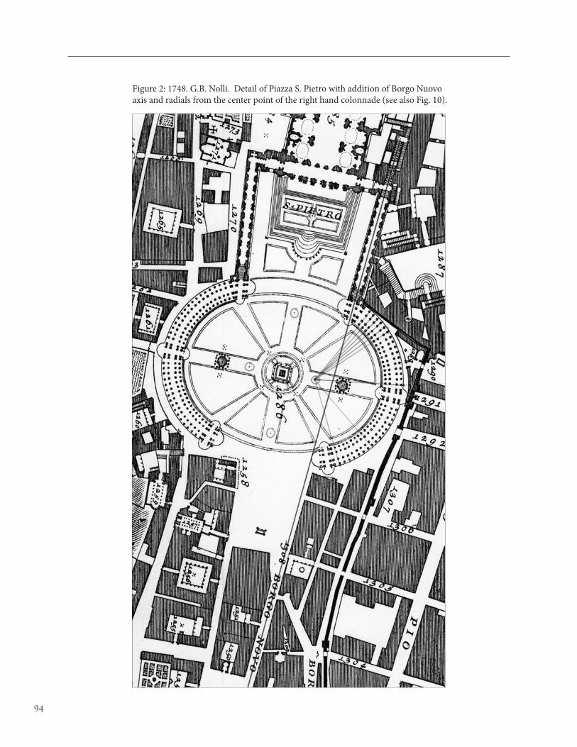
94
Figure 2: 1748. G.B. Nolli. Detail of Piazza S. Pietro with addition of Borgo Nuovo axis and radials from the center point of the right hand colonnade (see also Fig. 10).

95
Figure 3: Gianlorenzo Bernini. Piazza Ovale autograph sketch. Biblioteca Vaticana.
Figure 4: 1882. Paul M. Letarouilly. Le Vatican. Detail of the end bays of the right colonnade of Piazza S. Pietro.

96
Figure 5: Gianlorenzo Bernini. Plan of Piazza S. Pietro. Biblioteca Vaticana. Axis of Borgo Nuovo added in pencil (author)
Figure 6: 1551. Leonardo Bufalini. Detail of Borgo with Borgo Nuovo axis shaded (author).

97
Figure 7: (Top) ca.1492. Codex Excurialensis. Porta S. Petri next to Castel S. Angelo.(Bottom) ca.1534. Marten van Heemskerck. Borgo Nuovo looking toward the Porta Palazzo.

98
Figure 8a: Piazza S. Pietro. Obelisk not on the axis of the Basilica (red). Green is a line joining the obelisk to the center door of the Basilica (author).
Figure 8b: 1748. G.B. Nolli. Basilica axis (red) and obelisk axis (green) at two different scales.

99
Figure 9: View toward St. Peter’s along Via della Conciliazione today.
Figure 10: 1748. G.B. Nolli. Piazza S. Pietro with the addition of the four centered oval (color) used to develop the Piazza Ovale, and the unequal angles shown in the corners of the Piazza Retta.

100

101
The architectural history of Rome is replete with buildings that have names and histories because there are documents describing when and by
whom they were constructed and inhabited. But when visitors trudge from one named building to another, they see a multitude of houses that have no names. (Figs. 1, 2) These houses have no names, and no histories, because their obscure inhabitants were thought to be unworthy of a public record. But if we lack documents to tell us who built the houses without names, and when they were built, the buildings themselves, properly studied, can tell us something of their history. A study of the forms of modest houses affords an interesting insight into a moment of transformation, when a kind of Renaissance vernacular, if one may speak of such a thing, was established in Rome. The argument of this paper depends upon a study of the houses in the Quartiere de’ Banchi, a district that Allan Ceen has identified as the site of origin for Renaissance urbanism in Rome.1 Renaissance developments began here in the 1470s and 80s, when, as its name implies, the Quartiere de’ Banchi was occupied by bankers and others who gathered to participate in the resurgence of the papacy.2
* The research for this paper was conducted in Rome in March-May 2001. It was enabled by a sabbatical leave granted by the University of Illinois at Urbana-Champaign, and by funds from the bequest of Alan K. and Leonarda F. Laing. An earlier version of this paper was presented April 2002 at the Annual Meeting of the Society of Architectural Historians in Richmond, Virginia.1 Cf. Allan Ceen, The Quartiere De’ Banchi: Urban Planning in Rome in the First Half of the Cinquecento, Ph.D. diss., Outstanding Dissertations in the Fine Arts (New York: Garland, 1985). For detailed discussion of urban developments in Rome in the fifteenth century, see now Giorgio Simoncini, “Trasformazione Urbane,” in Roma: Le trasformazione urbane nel Quattrocento. I. Topografia e urbanistica da Bonifacio IX ad Alessandro VI (Florence: Olschki, 2004). This article depends fundamentally upon Allan Ceen’s work on the Quartiere de’ Banchi. The method for making photographic surveys to map historic districts used herein was developed in the mid-1960s by Paul D. Sprague working under contract for the Illinois Historic Preservation Agency. 2 After 1890 drastic changes occurred in the Banchi when the newly established national government of Italy determined to modernize its capitol. Altogether, about a third of the older fabric of the Banchi was sacrificed to modernity. The effected areas are
The Quartiere de’ Banchi lies within the bend of the Tiber River. (Figs. 7-10) Its boundaries form a rough triangle pointing towards the Ponte Sant’ Angelo. Its streets and piazzas are mostly, but not entirely, the products of a long process of inhabitation and construction that occurred during the millennium between the fifth and the fifteenth centuries when the declining population of Rome moved down from the hills and built houses on the flood plain of the Tiber.3 Their houses were constructed of masonry bearing walls and wooden floors. The structural bays are approximately 4-5 meters wide, so that a uniform rhythm of bay spacing prevails throughout the Banchi. This rhythm confers a visual coherence upon the whole district. It is medieval in origin and may be attributed to the limited lengths of chestnut logs that were used to frame floor and roof structures spanning party walls. The Renaissance transformation of the Banchi did not alter the basic structures of the houses, so the rhythm of the medieval bay spacing is evident even today. Renaissance changes in houses that were visible from the streets involved fenestration and ornament.
In the mid-fifteenth century, as the papacy re-established itself in Rome, the city stopped shrinking and began to grow again. The first signs of renewal appeared in the Quartiere de’ Banchi during the reign of Pope Sixtus IV delle Rovere (1471-1484). Sixtus IV was not the first pope who aspired to rebuild Rome, but he was the first who was able to commission new buildings that made large changes in the city. Besides the Sistine Chapel, the buildings of Sixtus IV include three churches, one hospital, a bridge over the Tiber, five palaces for papal nephews, including Palazzi Cancelleria
indicated in shading on the section of the Nolli plan shown in Figs. 7-10. Ceen remarks that about one third of the via Papalis was lost to modernization. Cf. Ceen, “Banchi,” Quartiere De’ Banchi, 170–71 Despite demolition of much older building fabric for the sake of new thoroughfares, and construction of new buildings at a vastly larger scale, enough remains of the houses without names to permit some reconstruction of their history. 3 Cf. Richard Krautheimer, Rome: Profile of a City, 312–1308 (Princeton: Princeton University Press, 1980).
Houses Without Names*
Richard J. Betts

102
and Altemps, and a castle at Ostia for another of his nephews, Cardinal Giuliano della Rovere, later Pope Julius II.4
The named buildings of Sixtus IV established a standard of papal patronage that was influential for generations to come. He had no less influence on the houses without names. His influence was conveyed by a decree issued in 1480 in which he conferred a broad grant of powers upon the Maestri delle Strade.5 They were to force the sale of abandoned houses, enforce the closure of street-level loggias and porticoes, and order householders to remove structures that blocked streets, such as stairs. Having cleared the streets of obstructions, the Maestri delle Strade were to pave them. Pope Nicholas V had issued a similar decree in 1450, apparently to little effect.6 Sixtus IV made it stick, and thereby changed the streets and the houses of Rome forever.
The decrees of Nicholas V and Sixtus IV tell us much about Roman streets before 1480. The houses had street-level loggias, and outside stairs leading to upper stories. Many of the buildings were derelict, presumably in disrepair, their abandoned loggias filled with rubbish and occupied by brigands who preyed on passers-by. A householder who built stairs in the streets had, in effect, stolen space from the public and added it to his house. Indifference to the public right-of way was evidently common, so that communication and commerce along the streets of Rome must have been difficult everywhere, and impossible in many places. The intention of Sixtus IV was to open the streets to make them passable, safer and healthier. He proceeded by applying in Rome planning ideas that had already been used two hundred years earlier in the merchant republics of central Italy.7
It is a testament to the thorough accomplishment of the Sistine reform that there are few traces of street-level
4 For the buildings of Sixtus IV, see Fabio Beauvais, Sisto IV Renovator Urbis: Architettura a Roma 1471–1484 (Rome: Officina Edizioni, 1990); Giorgio Simoncini, ed., “Trasformazione Urbane,” in Roma: Le trasformazione urbane nel Quattrocento. II. fundamentis urbane e tiburio edasapere (Florence: Olschki, 2004). 5 Ceen, “Banchi,” Quartiere De’ Banchi, 29–37.6 Ceen, “Banchi,” Quartiere De’ Banchi, 20-26. See also Torgil Magnuson, “The Project of Nicholas V for Rebuilding the Borgo Leonino in Rome,” Art Bulletin 36 (1954): 89–115. 7 Cf. Michelle Renice LaFoe, “In Search of the Ideal City: Urban Design and the 1279 Constitution in Perugia, Italy” (University Library: University of Illinois at Urbana-Champaign, 1999); Samuel Gruber, “Ordering the Urban Environment: City Statutes and City Planning in Medieval Todi, Italy,” in Ideas of Order in the Middle Ages, ed. Warren Ginsberg (Binghamton, NY: Center for Medieval and Early Renaissance Studies, 1990), 121–35, BHA: 1 5096 (1991).
stairs and loggias in Rome today.8 In the Quartiere de’ Banchi, only one medieval street survives in the vicolo degli Acetari, now a small urban space that opens onto via del Pellegrino. (Fig. 3) In this little alley of the vinegar-makers, the external stairs lend a certain charm to what is now a quiet residential cul-de-sac and they do not obstruct passage to anywhere else. But entire streets full of stairs such as these would not be charming to anyone trying to move about the city.9
Apart from the Vicolo degli Acetari, the only other remnant of medieval architecture visible today in the Quartiere de’ Banchi is a window frame in the facade of a house in via del Pellegrino, at number 169. (Fig. 4) This was evidently uncovered by a recent work of restoration, that also revealed parts of the antique columns that framed a loggia on the ground floor. The contemporary fashion for exposing odd bits of old masonry has revealed something of the history of this house, and others like it. The cusped window frame and bits of antique columns show that part of the building was already standing before 1480. It was at least two stories high and had an open loggia on the street. Sometime after 1480 it was remodeled. The older windows framed by cusped arches were filled with masonry and replaced by larger rectangular windows. The newer windows were placed symmetrically about the vertical axis of the house, and closer to the party walls so that they are aligned with the doors below them. Void stands above void and solid above solid. This regular and symmetrical placement of windows and doors, and vertical alignment of voids and solids were fundamental rules of the new style that had begun to appear in Rome in the named buildings of Sixtus IV.
The change from Gothic to Renaissance in the houses of the Quartiere de’ Banchi was not altogether a change in aesthetic values. Function and structure also played a role. The newer windows were more useful for being larger because they admit more light and air than the Gothic windows they replaced. Their placement closer to the party walls was partly a matter of practical necessity. To comply with the pope’s decree,
8 A few may be found in a far corner of Trastevere, around Piazza in Piscinula. For medieval Rome, see Richard Krautheimer, Rome: Profile of a City, 312–1308 (Princeton: Princeton University Press, 1980). 9 In a sense, modern Rome has returned to the condition of pre-Sistine Rome. The stairs may be gone, but Roman streets are everywhere obstructed by parked motor vehicles and the furniture of bars and restaurants. Just as medieval householders appropriated public good for private gain when they built their stairs in the streets, modern Romans do the much same by using the public right-of-way for storing their vehicles and operating their businesses.

103
householders had to construct stairs within the walls of their houses. The easiest way to do so was to use one of the party walls as bearing structure, so that the stair would require construction of only one new bearing wall, and would occupy the least possible area within the house. A stair needed a door and vestibule, and windows to light the landings. Construction of the interior stair thus produced the vertical row of door and windows at one side of a structural bay. At the same time, closure of the loggias meant that doors had to be constructed to give access to the commercial spaces of houses, separate from their living quarters. The door and stair on one side gave access to the living quarters above, while a door on the other side gave access from the street directly to the shop. It suited function as well as beauty to place the doors on opposite sides of the structural bay. The placement of the doors in turn determined the placement of windows above.
The visible signs of remodeling in the houses of the Quartiere de’ Banchi are the walls, doors, and windows of their facades, and these are the elements of architecture that reveal their history. A systematic photographic survey of the Quartiere de’ Banchi permitted classification by types of all the doors and windows. Classification in turn permitted the creation of symbols for each type. The symbols were plotted on a modern map of Rome, one for each building that has a feature represented by the symbol. Most buildings appear more than once because they have two or more types of doors and windows. The plot of symbols was then transferred to the Nolli map using an overlay, so that the distribution of types could be studied in the context of the city before it was disturbed by modern development. The symbols on the map can be counted, and so the plot yields statistical profiles of door and window types. (Figs. 7-10)
Doors and windows come in three basic types, arches, rectangles, and arches within rectangles. (Figs. 5-6) They can be further classified by how they are framed. The simplest have no frames, or flat architraves without any features whatever. More elaborate doors and windows have molded architraves, and many have ornaments. Rectangular windows and doors may be surmounted by cornices, volutes, or pediments, or flanked by pilasters or columns. Arched doors are often framed by voussoirs. One popular type of door, usually smaller, is framed by posts bearing two voussoirs and a keystone.
The plot for doors in the Quartiere de’ Banchi includes 350 separate items, of which 191 are arched and 159 are rectangular. (Figs. 7-8) Arched doors
outnumber rectangular doors by 55% to 45%, but that is not a great difference. The distribution of the two types is uniform over the whole district. Since the door types cannot be distinguished one from another by usage or distribution, it appears that all may have been in use more-or-less continuously, that none was particularly favored at one time or another.
Windows present a somewhat different picture than doors. (Figs. 9-10) The plot for windows includes 390 separate items of which 348 are rectangles of various kinds and 42 are arches. Rectangular windows outnumber arched windows by 89% to 11%. The distribution of rectangular windows is uniform throughout the Quartiere de’ Banchi, but the distribution of arched windows appears concentrated in the northern part of the district. Most are north of the path along the via del Pellegrino and via de’ Banchi Vecchi, and only two are in the via Giulia. That is useful information, because it means that the arched window was no longer in fashion when the via Giulia was cut through the Quartiere de’ Banchi around 1510 by order of Pope Julius II.10 The popularity of the round-headed window can thus be dated to the interval between the two della Rovere popes, Sixtus IV (1471-84) and his nephew Julius II (1503-13).
Two buildings with arched windows in via Giulia appear to be much older than their neighbors. One of these stands at the northern end of via Giulia, in a block that was apparently untouched by the construction of that street. The irregular little building on this block survived the urban renewals of the early sixteenth as well as of the twentieth century. Another irregular building with similar doors and windows is in via Giulia at via di Sant’ Eligio. This, too, appears to have been a relic from the era before the construction of via Giulia.
The two buildings in via Giulia that I can identify as probably of the late fifteenth century permit us to mark some other relics of the same era within the Quartiere de’ Quartiere de’ Banchi. One is the irregular house at the intersection of via del Pellegrino and via di Monserrato. Others are in via de’ Banchi Vecchi, via dei Cappellari, via del Governo Vecchio, and via Tor di Nona. (Figs. 1-2) These may have originated in the later fifteenth century, though they have obviously been much abused, and most show signs of having been increased in height.
What were the sources of the forms that appeared in the Quartiere de’ Banchi after 1480? Historians have always looked to Florence as fons et origo of Renaissance architecture. But the set of door and window forms that
10 Ceen, “Banchi,” Ceen, “Banchi,” Quartiere De’ Banchi, 45–49.

104
began to appear in Rome at the time of Sixtus IV was not much used in Florence during the fifteenth century. The rectangular window with molded architrave and pediment may have been introduced by Brunelleschi in the facade of the Innocenti, but it seems to have had no other following in Florence in the fifteenth century. In Pienza, in the projects of Pope Pius II of the 1460s, there are a few rectangular windows, but most are the Florentine bifora and the old Roman cross-in-square. However, all of the window and door forms used in the Quartiere de’ Banchi in the 1480s, were used before that time in the Marches, in the old dukedom of Urbino, ruled in the later fifteenth century by the Montefeltri.
The best known examples are in the Palaces of Duke Federico da Montefeltro.11 (Fig. 13) The courtyard of the Ducal Palace in Urbino is usually attributed to Luciano Laurana, which would date it before 1472, when he is known to have left Urbino. Or it may be attributed to Francesco di Giorgio, as Vasari claimed, so that it should be dated to 1476-78. In any case, the window forms used in Rome were in use in Urbino before the decree of Sixtus IV in 1480. These windows appear in the Rocca of Sassocorvaro, a castle and hunting lodge built in the late 1470s by Francesco di Giorgio for Giovanni della Rovere, nephew of Sixtus IV and son-in-law of Federico da Montefeltro.12 (Fig. 14) Francesco di Giorgio used the same forms in secondary ducal palaces in Fossombrone and Gubbio, built in the later 1470s.13 In the streets of these towns, near the palaces, there are houses with similar windows and doors.
The examples cited suggest that the forms introduced into Rome in the early 1480s came from the Marches. The appearance of Marchigian forms in Rome at that time may be explained by the close relationship between Pope Sixtus IV and Federico da Montefeltro and a hostile relationship with Florence.14 Urbino belonged
11 Pasquale Rotondi, Pasquale Rotondi, The Ducal Palace of Urbino (London: Transatlantic Arts, 1969); Maria Luisa Polichetti, ed., Il Palazzo di Federico da Montefeltro: restauri e ricerche (Urbino: Quattro Venti, 1985), RILA, 13:1846. 12 Dino Palloni and Giovanni Rimondini, “Contributi Dino Palloni and Giovanni Rimondini, “Contributi documentali e critici sulla rocca di Sassocorvaro,” Romagna Arte e Storia 11, no. 33 (September-December 1991): 15–32, BHA: 3 2434 (1993); M Stoppini, Le rocche di Sassocorvaro, Cagli, Sassofeltrio, e Mondavio (Milan, 1960).13 Giovanni Venturini, “Il Palazzo Ducale di Gubbio: riscoperta di Giovanni Venturini, “Il Palazzo Ducale di Gubbio: riscoperta di antiche strutture urbane,” Ricerche di storia dell’ arte 11 (1980): 70–74; Giangiacomo Martines and Piero Luigi Menichetti, “Francesco di Giorgio a Gubbio in tre documenti d’archivio rinvenuti e trascritti da Piero Luigi Menichetti,” Ricerche di storia dell’arte 11 (1980): 67–70; 14 Christine Shaw, Julius II, Warrior Pope (Oxford: Blackwell, 1993), 1–50; and Marcello Simonetta, The Montefelto Conspiracy: A Renaissance Mystery Decoded (New York: Doubleday, 2008).
to the Patrimonium Petri, so its signore was the feudal vassal of the pope. In August 1474, Sixtus IV promoted Federico da Montefeltro from Count to Duke of Urbino, made the title hereditary, and married one of his nephews, Giovanni della Rovere, to one of the Duke’s daughters.15 Federico da Montefeltro was given the papal gonfalon and fought and won a war for his pope in 1478-80. The cause of that war was the attempted assassination of Lorenzo de’ Medici during the Pazzi Conspiracy, of which the pope and his gonfaloniere are the likely suspects as instigators. During this period, influence from Florence would have been attenuated by animosities that occasioned murder and war, whereas Rome was open to influence from the Marches, ruled by a duke who was renowned for his knowledge of architecture, and who had recently hired Francesco di Giorgio as his architect.
The Marchigian forms cited here can be associated with Francesco di Giorgio’s tenure as ducal architect in Urbino from 1476 to 1489, and they appear in his treatises as well as in his buildings.16 In his first treatise, completed in about 1475-76, Francesco di Giorgio drew all of the door and window forms that would appear soon thereafter in the buildings of the Quartiere de’ Banchi.17 He included the same forms in his second treatise, completed between 1489 and 1492, where he drew them on facing folios, as a visual catalogue of types.18 (Fig. 15) All but one of these types are in the houses without names in the Quartiere de’ Banchi. The one type catalogued by Francesco di Giorgio that is conspicuously absent from the Quartiere de’ Banchi is the bifora, so popular in Florence. Conversely, the
15 This marriage set up the reversion of Urbino to the della Rovere, who ruled there until the last of them died without male issue in 1629. Giovanni della Rovere was made Prefect of Rome and signore of Sassocorvaro, where he commissioned the aforementioned castle from Francesco di Giorgio. 16 Francesco di Giorgio’s tenure in Urbino is described, with documents in Allen S. Weller, Francesco di Giorgio, 1439–1501 (Chicago: University of Chicago Press, 1943), 134–210. Francesco di Giorgio’s treatises were published in Francesco di Giorgio Martini, Trattati di architettura, ingegneria, e arte militare, Maltese, Corrado, ed. (Milan: Il Polifilo, 1967). 17 For arguments on dating Francesco di Giorgio’s treatises, see Richard J. Betts, “On the Chronology of Francesco di Giorgio’s Treatises: New Evidence from an Unpublished Manuscript,” Journal of the Society of Architectural Historians 36 (1977): 3–14. Francesco di Giorgio’s first treatise is best known from a manuscript copy in the Biblioteca Reale in Turn, Saluzzianus 148. Drawings of house facades with windows are on folios 20v-21r. 18 The one illustrated copy of Francesco di Giorgio’s second treatise is in the Biblioteca Nazionale Centrale in Florence, Magliabecchianus II.I.141. Windows and doors appear on folios 43v-44r.

105
one window type visible in the Quartiere de’ Banchi that is not in Francesco di Giorgio’s catalogue is the window with the eared architrave, which was probably introduced early in the 16th century.
It is not merely coincidence that Francesco di Giorgio drew these doors and windows in his treatises just before they began to appear in the Quartiere de’ Banchi. His catalogue of forms is part of a general theory of architecture and urbanism which prescribes the properties of houses appropriate to all classes of people, from artisans to princes. Francesco di Giorgio shows several plans for each class and describes the architectural features appropriate to them. He does not show any elevations of houses in his second treatise, nor does he assign particular doors and windows to particular classes of people. All of the types in Francesco di Giorgio’s catalogue were thought to be appropriate for all classes of houses, and that is how they were used in the Rome.
Renaissance theory of the fifteenth century embraced a kind of vernacular. It was apparently accepted and put into practice by the people of Rome over whom the popes and their architects had dominion. The use of a common set of door and window forms accounts for the coherence and harmony of the streets of the Quartiere de’ Banchi, where houses without names mingle with pretentious palaces. That harmony was precisely what was intended by the creators of Renaissance architecture, and it has been part of the Quartiere de’ Banchi since the fifteenth century. As time passed, many of the smaller houses were aggregated into larger properties that became palaces.19 The interior structures of the palaces were sometimes rebuilt extensively to accommodate courtyards, grand stairs, and vaulted halls, but the facades, though larger, usually retained the old structural rhythm and the corresponding placement of doors and windows. The pattern of fenestration and window forms were used even in the modern buildings constructed after 1890. Much of what Rome is today may be attributed to the reforms of Sixtus IV and the theory of Francesco di Giorgio.
19 For a recent study of how the process of aggregation worked, see Carla Keyvanian, “Concerted Efforts: The Quarter of the Barberini Casa Grande in Seventeenth-Century Rome,” Journal of the Society of Architectural Historians 64 (2005): 292–311.

106
Figure 1: Rome. Houses in via tor di Nona. (Photo: Author)

107
Figure 2: Rome. House in via del Governo Vecchio.

108
Figure 3: Rome. Vicolo degli Acetari. (Photo: Author)

109
Figure 4: Rome. House at 169 via del Pellegrino. (Photo: Author)

110
Figure 5: Rome. Round doors and windows in the Quartiere de’ Banchi. (Photo: Author)

111
Figure 6: Rome. Rectangular doors and windows in the Quartiere de’ Banchi. (Photo: Author)

112
Figure 7: Plot of arched doors in the Quartiere de’ Banchi on the Nolli Plan. Grayed areas indicate modern development. (Author)

113
Figure 8: Plot of rectangular doors in the Quartiere de’ Banchi on the Nolli Plan. Grayed areas indicate modern development. (Author)

114
Figure 9: Plot of arched windows in the Quartiere de’ Banchi on the Nolli Plan. Grayed areas indicate modern development. (Author)

115
Figure 10: Plot of rectangular windows in the Quartiere de’ Banchi on the Nolli Plan. Grayed areas indicate modern development. (Author)

116
Figure 11: Rome. House in via Giulia, between via di Consolato and via dei Cimatori. (Photo: Author)

117
Figure 12: Rome. House at via del Pellegrino and via di Monserrato. (Photo: Author)

118
Figure 13: Urbino, Palazzo Ducale. Courtyard. (Photo: Author)

119
Figure 14: Sassocorvaro, Rocca. Windows of Cortile. (Photo: Author)

120
Figure 15: Francesco di Giorgio, Trattato di architettura, ingegneria, ed arte militare. Florence, Biblioteca Nazionale Centrale. Magliabecchianus II.I.141, fols. 43v 44r.

121
Pope Paul IV established Rome’s Ghetto on July 14, 1555, with the papal bull “Cum nimis absurdum.”1 All of the city’s Jews were forced to
move to an area defined by the Ponte Quattro Capi and the Portico d’Ottavia on the southeast, and the Piazza Giudea and the Tiber to the northwest.2 Prior to this Jews lived in various parts of the city, on both sides of the Tiber River. The Roman Ghetto3, as it came to be called after the enclosed Jewish quarter established in Venice in 1516, was established in the area with the most historic associations for the Jewish community and its greatest population concentration.4
Echoing the language that established the Ghetto in Venice in 1516, the Roman order called for only two entrances to the Ghetto: “…all Jews should live solely in one and the same location, or if that is not possible, in two or three or as many as are necessary, which are to be contiguous and separated completely from the dwellings
1 On the papal bull see Kenneth R. Stow, Catholic Thought and Papal Jewry Policy 1555-1593 (New York, 1977), chapter 1. The complete Latin text with an English translation of Cum nimis asburdum (Since it is absurd and improper that Jews…) is on pp. 291-298.2 The major documentary source on the physical form of the Ghetto from its conception until its demolition is Carla Benocci and Entrico Guidoni, Il Ghetto (Atlante Storico della Citta di Rome, 2).(Roma, 1993). It mostly supersedes other historical, graphic and documentary sources about the Rome Ghetto including: Viviana Campajola, “Il Ghetto di Roma (Studio urbanistico e ambientale),” Quaderni dell’istituto di storia dell’architettura, serie XII, fasc 67-70 (1965), 67-84; and L. Finelli, I. Insolera, A.F. Marcian, Il Ghetto (Guida Urbanistica di Roma), (Rome, 1986).3 On the name “Ghetto” see Benjamin Ravid, “The Religious, Economic and Social Background and Context of the Establishment of the Ghetti of Venice,” in G. Cozzi, ed., Gli ebrei e Venezia. Milan, 1986), 211-259. The argument is also summarized in ibid, “From Geographical Realia to Historiographic Symbol: The Odyssey of the Word Ghetto,” in D. Ruderman, ed., Essential Papers on Jewish Culture in Renaissance and Baroque Italy, (New York, 1992), 373-384; and Sandra D. Stow, “The Etymology of ‘Ghetto’: The Evidence of 16th and 17th Century Roman Jewish Documentation,” in B. Walfish, ed., Frank Talmage Memorial Volume, (Haifa, 1991), vol II, 79-85.4 On the Jews in Ancient Rome see: H.J. Leon, The Jews of Ancient Rome (Philadelphia, 1960). For the period preceding the Ghetto see: D. Kaufman, "Léon X et les juifs de Rome," Revue des etudes juives 21 (1890), 285-89.
of the Christians. These places are to be designated by us in our city and by our magistrates in the other cities, holdings, and territories. And they should have one entry alone, and so too one exit.”5
Because of the central location of the Ghetto this proved impractical and eventually there were seven entrances in all.
The Ghetto as defined by Paul IV and his surveyors was enlarged twice: once during the pontificate of Sixtus V (1585-90), and then in 1823-4 during the pontificate of Leo XII. With the exception of a brief period of freedom during the Napoleonic rule of Rome, the Jews of the city were confined to the Ghetto until 1848, when the walls and gates were demolished for the last time. The Jews themselves do not appear to have fully understood and accepted the permanency of the new arrangement until 1589, following the expansion by Sixtus V.6
Jews, as well as several prominent Christian families, had lived in this area for centuries. There is a reference to a prayer house named for a certain Joseph at Ponte Quattro Capi (called Ponte Judaeorum) around 1000, and a synagogue existed in 1337 on the Piazza Giudea, the commercial center of what was to become the Ghetto.7
The appearance of both the medieval Jewish district and the post 16th-century Ghetto is only approximate because of massive changes in the area since the Risorgimento. The erection of the Tiber embankments and the subsequent demolition of a substantial part of the Ghetto, carried out from 1885 to 1908 when the Cinque Scole,8 the building that had housed the five
5 Translation from Stow, op. cit. 2956 On the Jewish understanding of the ghetto as a “get,” or divorce, from Christian Rome see Kenneth R. Stow, “The Consciousness of Closure: Roman Jewry and Its Ghet,” in David B. Ruderman, ed., Essential Papers on Jewish Culture in Renaissance and Baroque Italy (New York, 1992), 386-400.7 On rione Sant’Angelo see Carlo Pietrangeli, ed., Guide Rionali di Roma: Rione XI – S. Angelo (Rome, 1971) and Carla Benocci, Il Rione S. Angelo (Rome, 1980).8 On the “Cinque Scuole,” see: Bice Migliau, “Le vicende dell’edificio delle Cinque Scole,” in Roma Capitale. 1870-1911. Architettura e urbanistica. Uso e trasformazioone delle cittá storica,
Mapping Jews: Cartography and Topography in Rome’s Ghetto
Samuel D. Gruber
In memory of Maria Raina Fehl (1920-2009)

122
synagogues of Rome was pulled down, eliminated most of the historic Ghetto area.9
Today, no streets or buildings from the Ghetto defined by Paul IV remain. Only the small section added by Leo XII, known as the “braccio Leonino” survives, extending from the present Via del Portico d’Ottavia, to the Piazza Mattei, set between the narrow and winding Via di Sant’Ambrogio and the Via della Reginalla. The ancient Portico d’Ottavia which Romans and visitors alike now consider at the heart of the Jewish district was actually outside of the Ghetto walls. The reconstruction of the Ghetto requires, then, a good look backwards, utilizing maps, views, property documents, census documents, and every other available historical resource. A number of studies have contributed to this effort, especially those of Viviana Campajola and Carla Benocci10 who have gathered primary source materials to help correlate the existing street network with the earlier layout of the Ghetto.
Fortunately, the establishment of the Ghetto and its three-century existence parallels the peak period of Roman map making. Plans and maps provide us with a wealth of topographic and architectural information about the development of the area.11 Each map or view gives us a different window on the Ghetto, and as is to be expected, these cannot always be correlated. The Nolli map of 1748 (fig. 1) is certainly the most reliable for the location, proper configuration and dimensions of blocks and spaces, and importantly, the correct relationship of the parts. On his map, Nolli was circumspect about identifying the Ghetto (however, his index captions, Nolli 1025 and 1026, clearly refer to the Ghetto). A quick glance at the plan allows the viewer to see the Ghetto as well integrated into the historic fabric of the medieval and Renaissance city. The outlines of the district are visible if one looks hard, and a single black line separates the long block that is partly within the Ghetto and partly without.
Many of the view-maps clearly label the area as the Ghetto (e.g., Falda). They also give a greater sense of the district as three-dimensional space, though these views
(Venice, 1984), 442-447 and Carol Herselle Krinsky, Synagogues of Europe (Cambridge, MA, 1985), 362-369.9 See Alberto M. Racheli, “La demolizione e riconstruzione del quartiere del Ghetto (1885-1911),” in Roma Capitale. 1870-1911. Architettura e urbanistica. Uso e trasformazioone delle cittá storica, (Venice, 1984), 436-441.10 See above, note 3.11 The main source of map images of Rome is Amato P. Frutaz, Le Piante di Roma, 3 vols. (Rome, 1962). For a recent review of some of the main maps see Allan Ceen, Roma Nolliana (Studium Urbis, Rome, 2003).
must be accepted only in a general way, because it is often difficult, and even impossible to confirm details.
The establishment of the Ghetto and the creation of the great Roman views and maps are both attempts to define and control space. The creation of the Ghetto was physically restrictive and humanly degrading. The creation of city-maps, in all their panoramic glory, was spatially liberating. For the first time, all the parts of the whole city could be understood in full physical relation to the others. Despite the varying level of specificity of each example, there is something almost utopian, or at least ideal, in their realizations. Thus, generalization in depiction is permissible. The glory of the city is revealed, but not the human reality – the stench, the garbage, the disease, the vagrancy – and the hardship of the Ghetto.
We should remember that this same period of mapping – especially in the generation of Nolli – saw the placement of the many plaques forbidding the dumping of “mondezza” (trash) on the city streets – sure signs that it was taking place. This was also the period of the Ghetto’s greatest density. Nolli shows a packed district with little open space, while Falda’s oblique view is full, but still airy. In 1676, when Falda made his print approximately 6,000 Jews were confined to an area of about one and half hectares, but Falda presents the densely packed neighborhood, which he clearly labels “Il Ghetto delli Hebrei,” as relatively spacious, especially in comparison to many other areas of the city. The narrow alleys of the Ghetto are here shown as wide passageways seemingly full of light and air.
The 19th century paintings of these same alleys by E. Roselar Franz depicts them as terribly decrepit, but Franz too, opens ups the scenes to more light and air than was probably the case. Artistic license required a wider view to populate these scenes with more activity. Franz’s across-the-street-viewpoint sometimes removes the buildings behind the artist to allow a more panoramic composition.12 In Falda’s map, the two main north-south routes through the Ghetto, the Via Rua and Via Fiumara, have the appearance of major roads, emphasizing their connectedness to the city street network. Only Nolli’s map of 1748 allows us to gauge the actual width – or rather narrowness – of the Ghetto alleys. The size of these streets is comparable to the many medieval streets that were still part of 18th-century Rome, and which in the map are seen in stark contrast to the wider and straighter streets which
12 Many examples of Franz’s paintings of the Ghetto are Many examples of Franz’s paintings of the Ghetto are reproduced in Dal Ghetto alla Città: Il quatiere ebraico di Rome e le sue attività commerciali (Rome: Provincia di Roma/Oltre il Duemila S.r.l, 2003).

123
began to be pushed through the dense urban fabric near the Ponte Sant’Angelo in the late 15th century and in the more open rione of Campo Marzio and Monti in the 16th century. The enclosure of the Ghetto by Paul IV in 1555 represented the antithesis of the urbanism of his predecessor Paul III, during whose reign straight streets were created to link areas, and public piazza were created – such as the one in front of his own Palazzo Farnese - as open spaces for private and public use.
Bufalini’s map was the first to depict with a reasonable amount of accuracy the intricate street network of the city. It was published in 1551, four years before the creation of the Ghetto.13 Bufalini, of course cannot show us the Ghetto, but he does label the Platea Iudea and Via Iudea, long recognized as urban elements deserving of note (fig. 2).
The Platea, or piazza, consisted of two distinct parts, each roughly triangular in shape which met at a single angle, in an hourglass-like form. This spatial arrangement is almost certainly a residual element of the medieval city, and such piazza arrangements where two distinct but related civic spaces meet at a shared angle can be found in many medieval towns, such as Todi and San Gimignano. In 1508 Julius II had the Ruga Iudeorum widened. This stretch of street appears to have run in dog-leg segments, one fairly straight from Piazza Giudea to near the Piazza del Portico D’Ottavia, and then two segments to the Ponte Quattro Capi. According to a (now lost) inscription, at least part of this Piazza was embellished, probably as part of his general public policy of city beautification with special attention to the riverside routes.14 In 1555, an entrance to the new ghetto was set at the junction of the two piazza parts, so that one came to be called the Piazza Giudea fuori del Ghetto, and the other dentro il Ghetto (see Nolli 1025 and 1026 and their index references).
The piazza outside the Ghetto was further improved with a fountain in the 17th century, as seen in prints by
13 On Bufalini see Allan Ceen, “Introductory Essay,” in Rome 1748: The Pianta Grande di Roma of Giambattista Nolli in Facimile (Highmount, NY: J. H. Aronson, 1984) and the essays by Maier and Schlapobersky in this volume. Ceen writes (p, IV): “ With respect to all of its medieval and Renaissance predecessors, Bufalini’s map represents a remarkable change. From odd collections of buildings drawn in elevation or oblique view, with little topographical consistency, and a nearly total absence of indications of streets in plans and views like those of Strozzi and Schedel, we suddenly pass to Bufalini’s meticulously complete plan where every street and city block is clearly drawn….it is the first map since antiquity that enables us to grasp the city in its topographic entirety.” 14 See Carla Benocci, “Storia urbanistica dall’antichita al 1848,” in See Carla Benocci, “Storia urbanistica dall’antichita al 1848,” in Benocci and Guidoni, eds., 7. The inscription, quoted by Benocci was published in V. Forcella, Le iscrizioni delle chiese ed altri edifici di Roma, XIII (Rome, 1879), 86.
G. B. Falda from 1648 and Giuseppe Vasi from 1752. An Aqua Vergine fountain was proposed for the site in 1570 by Giacomo della Porta, but a fountain was put in the Piazza Mattei instead.15 A gate to the Ghetto can be seen in Falda’s print.
A partial plan prepared by Bartolomeo de Rocchi around 1555 and now in the Galleria degli Uffizi,16 clearly indicated what would be the main topographic features during the first generation of the Ghetto (figs. 3 & 4). This plan is extremely important because it shows many features that were subsequently changed, and thus are not part of Nolli’s now-canonical representation.
The De Rocchi plan demonstrates where short stretches of new walls are to be erected, or perhaps have just been erected, for enclosing the Ghetto. This work was contracted by Salustio Peruzzi and carried out in a short period during of 1555. While the de Rocchi plan appears at first glance to be an exact measured representation, a comparison to Nolli, which we must assume is essentially correct, indicates that it is not. Notwithstanding later changes to the area, de Rocchi’s streets and blocks do not line up with Nolli, indicating that the de Rocchi map was probably based on ground measurements and estimation, and as such is probably an extended version of a property map of the type common in the period. Drawn house plans became increasingly common in Rome from this period on, usually accompanying written property descriptions.17
The view-maps of Mario Cartaro, published in 1576 (fig. 5), and of Dupérac, published in 1577 (fig. 6), are the first to show the new Ghetto complete with gates.18 De Rocchi showed three entrances to the Ghetto, but we do not know what they were like as they are only shown in plan. One of these was through the new wall built to cordon off the Piazza delle Tre Cannelle, which was clearly an important entrance space into the Ghetto in the years between 1555 and 1589, when Pius IV first closed the Ghetto and Sixtus V expanded it. Antonio Tempesta’s grand view-map of Rome of 1593 (fig. 7) and the view-map of Maggi of 1625 (fig. 8) show the Ghetto with its Sistine extension of 1589, when two
15 See Katherine Wentworth Rinne, “Fluid precision: Giacomo della Porta and the Acqua Vergine fountains of Rome,” in J. Birksted, ed., Landscapes of Memory and Experience (London, 2000), 183-201.16 Coll. Arch. 4206.17 See Deborah Wilde, Housing and Urban Development in Sixteenth Century Rome: The Properties of the Arciconfraternita della SS.ma ANolliunziata. (Volumes I-III) (Italy). Ph. D. Dissertation, New York Univeristy. (Ann Arbor, 1989).18 Frutaz, Frutaz, Le piante di Roma, Vol II. Cartaro on tav. 238 & 244 (dtl); Duperac on tav. 247 & 249 (dtl).
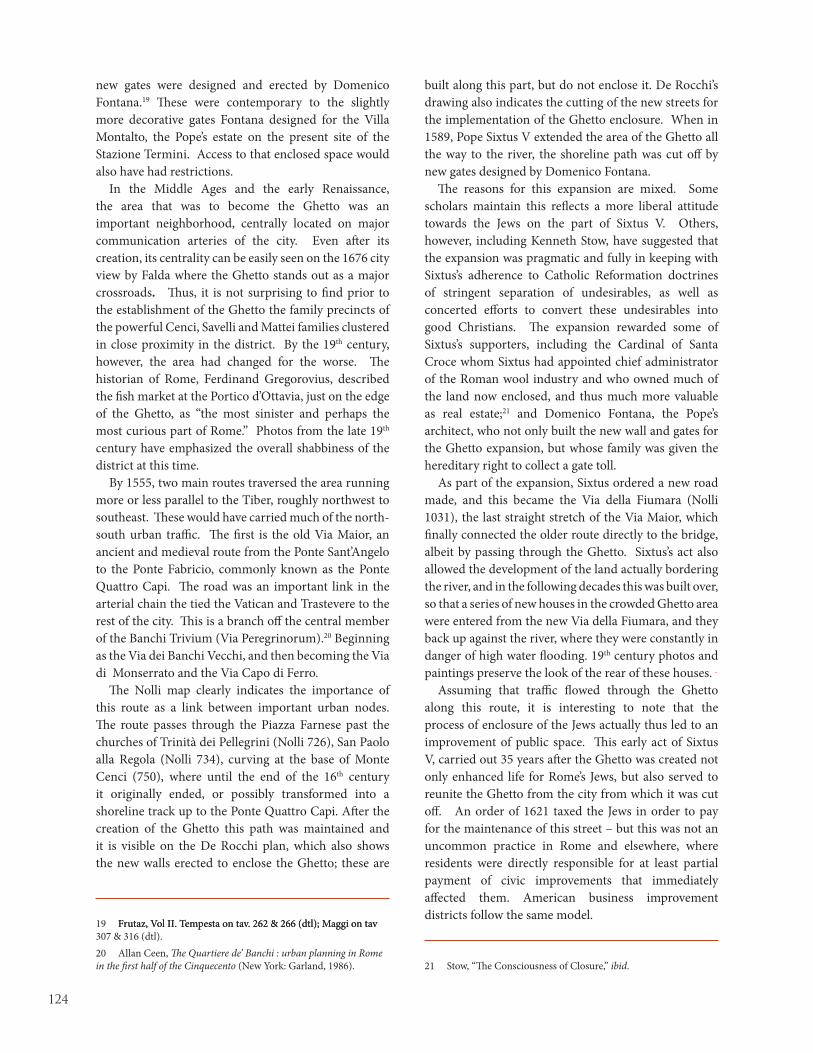
124
new gates were designed and erected by Domenico Fontana.19 These were contemporary to the slightly more decorative gates Fontana designed for the Villa Montalto, the Pope’s estate on the present site of the Stazione Termini. Access to that enclosed space would also have had restrictions.
In the Middle Ages and the early Renaissance, the area that was to become the Ghetto was an important neighborhood, centrally located on major communication arteries of the city. Even after its creation, its centrality can be easily seen on the 1676 city view by Falda where the Ghetto stands out as a major crossroads. Thus, it is not surprising to find prior to the establishment of the Ghetto the family precincts of the powerful Cenci, Savelli and Mattei families clustered in close proximity in the district. By the 19th century, however, the area had changed for the worse. The historian of Rome, Ferdinand Gregorovius, described the fish market at the Portico d’Ottavia, just on the edge of the Ghetto, as “the most sinister and perhaps the most curious part of Rome.” Photos from the late 19th century have emphasized the overall shabbiness of the district at this time.
By 1555, two main routes traversed the area running more or less parallel to the Tiber, roughly northwest to southeast. These would have carried much of the north-south urban traffic. The first is the old Via Maior, an ancient and medieval route from the Ponte Sant’Angelo to the Ponte Fabricio, commonly known as the Ponte Quattro Capi. The road was an important link in the arterial chain the tied the Vatican and Trastevere to the rest of the city. This is a branch off the central member of the Banchi Trivium (Via Peregrinorum).20 Beginning as the Via dei Banchi Vecchi, and then becoming the Via di Monserrato and the Via Capo di Ferro.
The Nolli map clearly indicates the importance of this route as a link between important urban nodes. The route passes through the Piazza Farnese past the churches of Trinità dei Pellegrini (Nolli 726), San Paolo alla Regola (Nolli 734), curving at the base of Monte Cenci (750), where until the end of the 16th century it originally ended, or possibly transformed into a shoreline track up to the Ponte Quattro Capi. After the creation of the Ghetto this path was maintained and it is visible on the De Rocchi plan, which also shows the new walls erected to enclose the Ghetto; these are
19 Frutaz, Vol II. Tempesta on tav. 262 & 266 (dtl); Maggi on tav Frutaz, Vol II. Tempesta on tav. 262 & 266 (dtl); Maggi on tav 307 & 316 (dtl).20 Allan Ceen, The Quartiere de’ Banchi : urban planning in Rome in the first half of the Cinquecento (New York: Garland, 1986).
built along this part, but do not enclose it. De Rocchi’s drawing also indicates the cutting of the new streets for the implementation of the Ghetto enclosure. When in 1589, Pope Sixtus V extended the area of the Ghetto all the way to the river, the shoreline path was cut off by new gates designed by Domenico Fontana.
The reasons for this expansion are mixed. Some scholars maintain this reflects a more liberal attitude towards the Jews on the part of Sixtus V. Others, however, including Kenneth Stow, have suggested that the expansion was pragmatic and fully in keeping with Sixtus’s adherence to Catholic Reformation doctrines of stringent separation of undesirables, as well as concerted efforts to convert these undesirables into good Christians. The expansion rewarded some of Sixtus’s supporters, including the Cardinal of Santa Croce whom Sixtus had appointed chief administrator of the Roman wool industry and who owned much of the land now enclosed, and thus much more valuable as real estate;21 and Domenico Fontana, the Pope’s architect, who not only built the new wall and gates for the Ghetto expansion, but whose family was given the hereditary right to collect a gate toll.
As part of the expansion, Sixtus ordered a new road made, and this became the Via della Fiumara (Nolli 1031), the last straight stretch of the Via Maior, which finally connected the older route directly to the bridge, albeit by passing through the Ghetto. Sixtus’s act also allowed the development of the land actually bordering the river, and in the following decades this was built over, so that a series of new houses in the crowded Ghetto area were entered from the new Via della Fiumara, and they back up against the river, where they were constantly in danger of high water flooding. 19th century photos and paintings preserve the look of the rear of these houses.
Assuming that traffic flowed through the Ghetto along this route, it is interesting to note that the process of enclosure of the Jews actually thus led to an improvement of public space. This early act of Sixtus V, carried out 35 years after the Ghetto was created not only enhanced life for Rome’s Jews, but also served to reunite the Ghetto from the city from which it was cut off. An order of 1621 taxed the Jews in order to pay for the maintenance of this street – but this was not an uncommon practice in Rome and elsewhere, where residents were directly responsible for at least partial payment of civic improvements that immediately affected them. American business improvement districts follow the same model.
21 Stow, “The Consciousness of Closure,” ibid.

125
The Via della Fiumara can be understood in many ways, one of which is certainly as a pivotal piece in the overall street network created by Sixtus V to link the crucial pilgrimage and traffic nodes of Rome into one vast and passable network. Ghetto gates did form a physical barrier after dark, when they were closed. During the day, however, they were not a hindrance to passage. Other gates, such as those on the Via della Lungara into Trastevere, and the Borgo, also allowed regular passage into enclosed urban enclaves, but could also be closed to restrict movement as needed.
A first reading of Nolli suggests that the Ghetto gates on the Via della Fiumara are signs of restricting public access, in the way that reading Nolli today allows us to see how many public spaces, especially small piazze and alleyways, have been appropriated over the centuries for private use. While it is difficult to define the space of the Ghetto as purely public, for Nolli, however, even limited access is enough to allow much of the Ghetto to be represented in white, his color indicating the public realm.
The second important route that connects the Ghetto is the Via del Pellegrino which branches off the Via Maior near the Chiesa Nuova, and then continues through Campo dei Fiori (Nolli 630), past the church of San Carlo ai Catanari, where in the past it branched with the straight right branch leading directly into the Piazza Giudea (Nolli 1025). Here it continued to the Portico d’Ottavia and the church of Sant’Angelo, and then skirted the Teatro Marcello, until it came to the Piazza della Bocca della Verità, eventually leading to the Marmorata across from the Porto di Ripa Grande.
This important route was kept intact until the 19th century. It was not initially interrupted by the institution of the Ghetto, since the Ghetto entrance from the Piazza Giudea was at the far end leading to the connected, but smaller piazza, and another transverse street. This street too, pre-existed the Ghetto and is already labeled on Bufalini’s map as the Via Iudea. It was known subsequently as the Via Rua (Nolli 1027).
These two main routes outside the ghetto were connected by the Vicolo dei Cenci (Nolli 752), which ran outside the Ghetto and along part of the Ghetto wall erected in 1555. This wall divided the Piazza del Mercatello, placing most of the open space within the new Ghetto, where it became known in time as the Piazza delle Cinque Scuole, named after the Ghetto synagogue which contained five separate congregations amd worship spaces (Scuole) within the single building complex.
As with most of the public urban spaces in Rome, Nolli identified the public places in the Ghetto by number on his map, and the names of these places were listed in full in the accompanying numerical index. The numbering for folio 19/20 of the Pianta Grande’s numerical index begins with eleven of the Ghetto sites. The first of these “Piazza Giudea fuori del Ghetto” (Nolli 1025) is actually outside the ghetto, corresponding to its counterpart situated within the Ghetto, which is named “Piazza Giudea dentro del Ghetto” (Nolli 1026). Numbers 1026 to 1035 are situated entirely within the Ghetto. Other sites including the Chiesa di S. Gregorio a Ponte Quattro Capi (Nolli 1036), Piazza di Pescaria (Nolli 1023), the oratorio di S. Maria del Pianto (Nolli 754), the Chiesa di S. Tomaso a’Cenci (Nolli 751) and vicolo de’Cenci (Nolli 752) all border the Ghetto.
The removal of the Piazza del Mercatello into the Ghetto appears to have necessitated the creation of a new piazza on the other side of the boundary wall, where a small open space was made in front of the church of S. Tommaso a Cenci. The new street (Vicolo de’ Cenci) was designated the boundary between the rioni Regola and Sant’Angelo.
Much of the Vicolo de’ Cenci, and its importance, is a result of the Ghetto enclosure. De Rocchi’s map clearly indicates how buildings were cleared from the path of the street to allow a straight connection. But this had not been done when Dupérac published his view plan in 1573. Conversely, after the street is cut and the wall is isolated, Maggi in his 1625 view map prefers to show the space lined with houses. For Paul IV, the importance of providing alternative access routes for Christians outside of and circumventing the Ghetto area was both a practical and moral consideration, and part of his overall restrictive policy limiting all contact between Christians and Jews. Sixtus V, who opened the Via Fiumara, appears not to have had these concerns. While he continued the separation of Jews and Christians (as he also tried to separate the prostitutes of Rome from virtuous Christian ladies), he did attempt to roll back some the most odious regulations controlling the activities of the Jews. His reforms, however, were short-lived. Clement VIII repealed the Sistine reforms with his Bull of February 25, 1593 “Caeca et obdurata,” (Blind and obdurate.) The new bull, did not, however, reverse the Sistine Ghetto expansion. Within the Ghetto proper there was only one direct route between the major cross streets. This is considered a continuation of the Via Rua that runs between the Piazza delle 3 Cannelle (Nolli 1033) and the Piazza di Pescaria (Nolli 1023).
As for other seriously altered parts of Rome, the

126
great Nolli plan of 1748 provides the most precise representation of what is lost. But Nolli’s ichnographic representation presents only the ground plan of what was a rich, diverse and densely populated three-dimensional neighborhood. His representation, though exact, is hardly complete. His delineation of “public” and “private” space is clear, but given the norms of Jewish life, as well as those forced upon Jews in the Ghetto, the separation between public and private space was not so finely drawn. To some extent, this is rectified by consulting the more detailed Gregorian catasto map of 1819-1822 which is based on Nolli, but included the divisions of individually held private properties. This in itself, as a simpler graphic representation, does much to suggest the population density in the Ghetto in the early 19th century. But that is the topic for another article.

127
Figure 1: Giambattista Nolli, detail of Pianta Grande, 1748, detail of rione Sant’Angelo showing Roman Ghetto with boundary.

128
Figure 2: Leonardo Bufalini, Pianta di Roma, 1551, detail of area of future Roman Ghetto showing major streets traversing area.

129
Figure 3: Bartolomeo De Rocchi, plan of the Roman Ghetto, c. 1555, Florence, Galleria degli Uffizi (after Benocci and Guidoni, 1993, p. 8).
Figure 4: Bartolomeo de Rocchi, detail of plan of the Roman Ghetto, c. 1555, Florence, Galleria degli Uffizi (after Benocci and Guidoni, 1993, p. 8).

130
Figure 6: Stefano Du Pérac (Étienne Dupérac) and Antoine Lafrery, Pianta di Roma, 1577, detail of Roman Ghetto.
Figure 5: Mario Cartaro, Pianta di Roma, 1576, detail of Roman Ghetto.

131
Figure 7: Antonio Tempesta, study for Pianta di Roma, 1593, after Finelli et al, 1986, fig. 3), detail of Roman Ghetto.
Figure 8: Giovanni Maggi, Pianta di Roma, 1625, detail of Roman Ghetto.

132

133
The depiction of Pompey’s Theater is one of the most interesting topographic episodes in Giambattista Nolli’s Pianta Grande of 1748. As
Nolli scholar Allan Ceen and others have noted, the Theater is incorrectly rendered on the plan; instead of being depicted according to its true north-south alignment, it is oriented along an approximately east-west axis, parallel to that of the Theater of Marcellus (figure 1).1 This seeming lapse in Nolli’s meticulous rendering of antique structures in the Pianta Grande initially seems even more puzzling given his careful delineation of the in situ remains of the Theater. These graphic remains themselves constitute the earliest known ichnographic plan of this monument since the Forma Urbis Romae, or Severan Marble Plan of Rome of 203-211 AD (hereafter referred to as the Marble Plan).2 Nolli’s apparent oversight, however, was a reasoned critical choice that conflated his own archaeological research with earlier reconstructions of ancient Rome, particularly those of Pirro Ligorio and Etienne Dupérac.
As the engraved plates of the Pianta Grande were nearing completion in the early 1740s, an ambitious project was begun to reassemble and exhibit the known fragments of the Marble Plan. Nolli was deeply involved with this project, which is described in detail in William Stenhouse’s essay in this volume. Although Nolli included numerous plans of antique monuments
1 See Allan Ceen, Roma Nolliana. Catalogue of the exhibition at the Studium Urbis (Rome: Studium Urbis, 2003), 29-31; Ceen, Rome 1748: La Pianta Grande di Roma di Giambattista Nolli (Highmount, New York: J.H. Aronson, 1991), 4, 10, & 11; Ceen, "Piranesi and Nolli: Imago Urbis Romae" in Piranesi: Rome Recorded. Catalogue of the exhibition of Piranesi's Vedute di Roma at the Arthur Ross Gallery (Philadelphia: University of Pennsylvania, 1989), ed. Malcolm Campbell, 19-20; and Susanna Pasquali, "Tra antiquaria, nuova cartografia e nuova architettura: I grandi monumenti romani," in Noli Vasi Piranesi: Immagine di Roma Antica e Moderna, Catalogue of the exhibition at Palazzo Fontana di Trevi, ed. Mario Bevilacqua (Rome: Artemide, 2004), 60-61. 2 On the history and reconstruction of the Marble Plan, see Gianfilippo Carettoni et al., eds., La pianta marmorea di Roma antica. Forma urbis Romae (Rome: Danesi, 1960) and Emilio Rodríguez Almeida, Forma Urbis Marmorea. Aggiornamento Generale 1980 (Rome: Quasar, 1981).
that initially seem to be based on those represented on the fragments of the Marble Plan he was studying at the time, his access to primary documentation of Rome’s antique monuments did not have a profound effect on the location and depiction of ruins in the Pianta Grande.3 In most cases, his rendering of individual antique remains within the figure-ground depiction of contemporary buildings and open space were less a visual record of the Capitoline project than of his own survey-based documentation and speculative reconstruction of in situ remains of ancient buildings.
A comparison of the information on the fragment of the Marble Plan containing the Theater of Pompey with this area on Nolli’s plan reveals some profound differences. Although this fragment is now almost completely lost,4 it was still extant in the mid-eighteenth century, as documented by Piranesi’s inclusion of this piece in his engravings of the Marble Plan published in his Le Antichita Romane of 1756 (Fig. 2). It was also known to Nolli through a drawing made in the years following the discovery of the Marble Plan in 1562 by Giovanni Antonio Dosio in 1673 as well as an engraving published by Giovanni Bellori in 1673.5 Although neither the depictions of the fragment nor the piece itself give an indication of its orientation, the location and orientation of Pompey’s Theater was well known through its survival in two large, curved blocks at the eastern end of Campo de’ Fiori; Palazzo Pio to the south and a similarly curved block immediately to the north (Fig. 3). Nolli rotated the fragment of the theater counterclockwise on axis at an angle of approximately 90 degrees to its actual position, for which he was sharply criticized (and corrected) by Piranesi in an engraving in the latter’s Il Campo Marzio dell’Antica Roma of 1762 (Fig. 4).
3 This point is made in Ceen, Rome 1748, 4.4 Not all of it is lost: Carettoni Tav. XXXII shows some surviving fragments.5 Dosio's drawing is included in the Codex Vaticanus Latinus 3439, folio 23r; Bellori's engraving was published in his Fragmenta vestigii veteris Romae ex lapidibus Farnesianis nunc primum in lucem edita cum notis (Rome, 1673).
Theatri Figura Quae Tempore Mutat: An Ichnographic History of Pompey’s Theater
Kristin Triff
In Memoriam: Henry Dietrich Fernández (1950-2009)

134
Other omissions and errors in Nolli’s depiction of the Theater are similarly perplexing. Not only does Nolli leave out the temple of Venus Victrix at the midpoint of the Theater (documented in the fragment itself), but he omits the outer row of bays in the cavea, as well as the scenae frons and adjoining hexastyle portico. The bays of the cavea itself are depicted as being much shallower and narrower than those on the Marble Plan, whose cavea is shown with 16 bays rather than the 19 included by Nolli.6 Further, Nolli depicts the western half of the outer ring with heavy, infilled plan outlines, while the eastern half is tenuously shown in outline only, suggesting a hypothetical rather than physically documented existence. Is it possible that he was looking at a different fragment, which was identified only as THEATRUM EI? Given a similar set of problems in his depiction of the Theater of Marcellus, was he looking at fragments of the Marble Plan at all when preparing this area of the plan?
The answer appears to lie partly in Nolli’s preference, in the Pianta Grande, for depicting only surveyed, measured, extant building fabric as opposed to reconstruction, and partly in the pre-existing ichnographic and cartographic history of the Theater. The remains of the radial walls of Pompey’s Theater were well known and easily accessible primarily in the southern half of the Theater, which had existed as a separate entity for centuries as the Palazzo Orsini before its acquisition by Carlo Pio di Savoia da Carpi in 1652.7
6 Ceen makes a similar observation in Rome 1748, 4.7 Remarkably, no monographic study of the theater was undertaken in the 20th century. For the history of Pompey’s Theater, see most recently James Packer and Maria Gagliardo, “A New Look at Pompey’s Theater: History, Documentation, and Recent Excavation,” American Journal of Archaeology 110 (2006), 93-122; Frank Sear, Roman Theatres: An Architectural Study (Oxford and New York, 2006), 57-61, 87-88 and 133-35; Kristin Triff, “Patronage and Public Image in Renaissance Rome: Three Orsini Palaces,” Ph.D. Diss. (Brown University, 2000), esp. 21-23, 190-95, 327-337, and 374-399; Pierre Gros, “Theatrum Pompei,” in Eva Margareta Steinby, ed., Lexicon Topographicum Urbis Romae (Rome, 1993-2000), vol. 5, 35-38; Filippo Coarelli, “Curia Pompei,” op. cit., vol. 1, 334-335; Lawrence Richardson Jr., “Theatrum Pompei,” A New Topographical Dictionary of Ancient Rome (Baltimore, 1992), 383-385; idem, “A note on the architecture of the Theatrum Pompei in Rome,” American Journal of Archaeology 91 (1987), 123-126; Aino Katermaa-Ottela, “Le Casetorri Medievali in Roma,” Commentationes Humanarum Litterarum 67 (1981), 45; Anna Maria Capoferro Cencetti, “Variazioni nel tempo dell’identità funzionale di un monumento: il Teatro Pompeo,” Rivista di Archeologia 3 (1979), 72-85; Domenico Faccenna, “Il complesso Pompeiano del Campo Martio,” Atti della Pontificia Accademia romana de archeologia 44 (1971-2), 99-122; Giuseppe Marchetti-Longhi, “Theatrum Lapideum, Curia Pompeia e Trullum Dominae Maraldae: topografia antica e medioevale di Roma,” Rendiconti della Pontificia Accademia Romana di Archeologia XII, (1936), 233-319, esp. 298-319; and Samuel Ball Platner and Thomas Ashby, A Topographical Dictionary
Here, Nolli had access to these foundations and had them verified firsthand, thus leading to their inclusion with heavy, solid lines. These fragments are clearly marked on the preparatory drawing for the Pianta Grande on which no further indication is given of the rest of the Theater. A comparison of Nolli’s documentation of the Theater’s remains with the survey carried out by Rodolfo Lanciani in the late nineteenth century indicates that Nolli’s surveyed plan of this part of the Theater was actually more accurate than that of the Marble Plan, which only included 16 of the Theater’s original 19 bays as documented by Lanciani (Fig. 5).8 Clearly, Nolli was much less secure about the other half of the Theater, as seen in the speculative, open plan outlines. Again, Nolli’s decision to align the Theater along an east-west axis, despite the presence of the suggestively curved block directly to the north of Palazzo Pio visible in figure 3 suggests that his choice was less dependent upon his contact with the Marble Plan than upon other factors, which in this case involve the ichnographic and cartographic history of the Theater.
Although Pompey’s Theater has been documented in written sources from antiquity onward, the only graphic documentation of its plan until the sixteenth century was that of the Marble Plan. The medieval commentaries which informed its early cartographic depictions were extremely vague about its form and appearance. The earliest post-antique reference to the Theater is that of the late eighth-century Einseideln Itinerary, which locates the Theatrum Pompei within the parrocchia or parish of San Lorenzo in Damaso, contiguous with Campo de’ Fiori.9 The author’s explicit use of the word theatrum rather than the term trullum (a mound or tower surrounded by building fabric) commonly used during the later Middle Ages suggests that the Theater was still intact and perhaps even functional at this time. This in turn provides a possible terminus post quem for the physical splitting of the theater, which may have occurred in the wake of the violent earthquake of 847 that caused extensive damage throughout the city.10 The mid-twelfth-century Mirabilia Urbis Romae, however,
of Ancient Rome (London, 1929), 515-17.8 These excavations are documented in Rodolfo Lanciani, Forma Urbis Romae (Rome: 1893-1901, repr. Edizioni Quasar, 1988), pl. 21.9 The anonymous Einseideln Itinerary is reprinted in Rodolfo Lanciani, "L'Itinerario di Einsiedeln e l'Ordine di Benedetto Canonico," Atti delli Accademia dei Lincei 1 (1891): 1-119.10 The earthquake was recorded during the papacy of Leo IV as follows: "Huis beati tempore praesulis terre motus in urbe Roma per indictionem factus est X, ut omnia elementa concussa viderentur ab omnibus." Duchesne, Louis., ed. Le Liber Pontificalis. Paris: 1886-92, v. 105, 12.

135
mentions a templum Pompei, a nonspecific description that could suggest a variety of morphologies.11
Of greater interest is a lease, dated 1150, of one eighth of a trullo “belonging to Gregorii Iohannis Periculi, including the stairs and the area from the ground to the summit, with an eighth part of the courtyard.”12 The lessor is Bobo Bobonis (Boveschi), direct ancestor of the Orsini, who are first identified as the filius Ursi, or the sons of Orso di Bobone di Pietro Boveschi, later that century.13 The fact that the trullo was stepped and large enough to contain eight potentially separate properties suggests an identification with the large, curved area of building fabric comprised of the southern half of the Theater’s cavea (Palazzo Pio Orsini) facing the Via di Grotta Pinta to the east, as seen in figure 3.14 This in turn suggests that by 1150 the Theater had lost its structural and functional integrity. A definite terminus ante quem is provided by Leonardo Bufalini’s map of 1551, the first ichnographic plan of the city, which depicts two distinctly separate halves of the Theater (Fig. 6). Interestingly, no further ichnographic plan-maps of the contemporary city were executed in the sixteenth century. However, Bufalini’s plan appears to have served as a cartographic model for many, if not most, of the plans and and view-maps of ancient Rome from this period, including Ligorio’s so-called “small map” of ancient Rome of 1553 and his “large map” of 1561 (Fig. 7).15 Significantly, the orientation of Pompey’s Theater is correctly shown in both versions, even though the Marble Plan was as yet unknown to Ligorio and his contemporaries. This suggests that Ligorio’s close study of ancient coins, inscriptions, and texts including the
11 For the text of the mid-twelfth century Mirabilia, see Francis Morgan Nichols, The Marvels of Rome/Mirabilia Urbis Romae (New York: Italica Press, 1986). 12 "…trullo quod fuit Gregii Iohannis Periculi cum suis salis et sininis a solo terrae usque ad summum, cum octava parte de claustra sua (sc) cum introitu et exitu." Archivio Orsini, II, A, n.2, reprinted in Cesare de Cupis, "Regesto degli Orsini e dei Conti di Anguillara," Bollettino della Società storica abruzzese A.L. antinori 14 (1902): 233.13 For the history of the Orsini family's occupation of this site For the history of the Orsini family's occupation of this site in the middle ages, see Giuseppe Marchetti-Longhi, “Theatrum Lapideum, Curia Pompeia e Trullum Dominae Maraldae: topografia antica e medioevale di Roma,” Rendiconti della Pontificia Accademia Romana di Archeologia 12 (1936): 233-319, esp. 298-319.14 The present-day Italian term trullo, like its medieval predecessor, denotes a small round tower, mound, or building; its usage suggests that the Theater was no longer intact in the twelfth century.15 This map is discussed in detail in Howard Burns, "Pirro Ligorio's reconstruction of ancient Rome: The Antiquae Urbis Imago of 1561, in Pirro Ligorio: Artist and Antiquarian (Villa I Tatti: The Harvard University Center for Italian Renaissance Studies, 10), ed. Robert W. Gaston (Florence: Silvana, 1988), 19-92.
late antique regional catalogues provided him with the reference points necessary to portray the orientation of the Curia and Theater of Pompey more or less correctly. In this respect, we can trace his graphic depictions of the Theaters of Pompey, Marcellus, and others to his rendering of the Flavian Amphitheater, which he based directly on a Sestertius of Titus.16 However, soon after the publication of Bufalini’s plan, an event occurred that contributed to an intense period of literary and graphic speculation on the Theater’s appearance in antiquity; the discovery in 1562 of numerous fragments of the Marble Plan in a garden behind the church of Saints Cosmas and Damian on the site of the Templum Pacis.17
In 1574, twelve years after the discovery of the Marble Plan, Etienne Dupérac published a similar view-map of the ancient city in which the axis of Pompey’s Theater (Fig. 8) was rotated to align with that of the Theater of Marcellus facing in the opposite direction (i.e.: the way Nolli would face it later, on a broad pathway prominently labeled Via Triumphalis. Itself a subject of intense speculation, the Via Triumphalis was the path followed by triumphant generals and their entourage from the Pons Triumphalis, through the Campus Martius, past the Porticus of Octavia and Theater of Marcellus, through the Porta Triumphalis, and into the city at a point in the Forum Holitorium just below the Capitoline Hill.18 Dupérac’s interest in this sequence is made clear by his prominent inclusion of the Porticus of Octavia, complete with the still-extant large medieval arch facing west, as well as the Theater of Marcellus and the Forum Holitorium.
This ancient pathway, which had been the subject of sixteenth-century commentaries by Flavio Biondo and others, underlay the Renaissance Via Peregrinorum, itself part of the larger ceremonial route known as the Via Papalis followed by papal possesso ceremonies.19
16 Burns, "Antiquae Urbis Imago," 28.17 Saints Cosmas and Damian was built in the early sixth century on the remains of the Templum Pacis, in which the Marble Plan was mounted in the early third century. For an abbreviated chronology of the Marble Plan, see Tina Najbjerg, "The Severan Marble Plan of Rome (Forma Urbis Romae)," Stanford Digital Forma Urbis Romae Project (www.formaurbis.stanford.edu/docs/FURmap.html, 1/21/02).18 The path of the Roman triumph is discussed in detail in Diane Favro, "The Street Triumphant: The Urban Impact of Roman Triumphal Parades," in Streets: Critical Perspectives on Public Space, ed. Zeynep Çelik et al. (Berkeley: University of California Press, 1994), 151-164.19 On the papal possesso route see Pasquale Adinolfi, La Via Sacra o del Papa (Rome: Monaldi, 1865) and Allan Ceen, The Quartiere de' Banchi: urban planning in Rome in the first half of the cinquecento, Ph.D. diss., University of Pennsylvania (Ann Arbor: University Microfilms International, 1977), 104-172.
136
By suggesting that the Theater was both axially aligned with the path of antique triumphs and, as a result, with the buildings that by then completely lined the possesso route along Via Peregrinorum, Dupérac presented a powerful argument for the orientation Nolli ultimate chose for the Pianta Grande.
Looking more closely at Dupérac’s depiction of the Theater, which differs from that of Ligorio in several key aspects, it becomes apparent that the former had studied firsthand the fragment of the Marble Plan containing the Theater and the end bays of the Curia. Comparing the two maps, it is quickly apparent that the alternating semicircular and rectangular niches in Dupérac’s rendition of the scenae frons differ markedly from those of the rather generic structure depicted by Ligorio, and instead closely follow those of the Marble Plan. Further, the orientation of the Theater not only corresponded with the Via Triumphalis/Via Peregrinorum axis, but was also suggested by the presence of the “THEATRUM EI” title engraved tangentially to the curved line of the cavea. The placement of this inscription may have implied, for later viewers, an east-west orientation for the title to be legible. The truncated form of Dupérac’s Curia similarly follows the information available on the Marble Plan fragment (Fig. 2), which includes a rather shallow, L-shaped portico with some adjoining structures to the south, here reinterpreted by Dupérac as located along the eastern edge of the Portico. This presented a solution to the Curia’s close proximity, in Dupérac’s orientation, to the Stadium of Domitian (Piazza Navona) immediately to the north. Thus, Dupérac’s version of the Theater may be seen as a close but ultimately misguided reading of the fragment, one that guided Nolli in his own efforts to integrate the Marble Plan into the Pianta Grande.
During this period, Giovanni Battista Piranesi was also engaged with both the execution of the Pianta Piccola and the analysis of the Marble Plan fragments, and evidently examined this fragment somewhat more closely than his colleague Nolli. The first public indication of this divergence comes in 1756, with the publication of a plan of Rome in the first volume of Piranesi’s Antichità Romane (Fig. 2). Although the fragment of the Marble Plan containing the Theater is included in the east-west orientation presumed by Dupérac on the left side of Piranesi’s plan of Rome, the latter also includes a very specific correction within the outlines of the plan of the city that dominates the image: clearly depicted in the midst of an otherwise fairly barren Campus Martius is a correctly oriented plan of the remains of the Pompey’s Theater, complete with
ruins depicted in the northern (rather than the eastern) quadrant. It seems likely that the east-west alignment of the fragment of the Marble Plan depicting the Theater to the left of the plan of Rome in this image was done at least partly for the sake of consistency; if Piranesi had aligned this fragment correctly, its inscription (unlike all the others on the plan) would have been upside down, breaking the convention Piranesi followed in the orientation of the Marble Plan fragments in this image. Whether his corrected orientation of the Theater on the plan of Rome in the center of his image (center right in Fig. 2) represents a clear-eyed analysis of the extant form of the northern block or an actual archaeological survey is difficult to determine, but Piranesi clearly took great pains to correctly indicate the orientation of the Theater, only eight years after the publication of the Pianta Grande.
In order to make the point more explicitly, Piranesi later devoted an entire plate of his Campus Martius Antiquae Urbis to a pointed correction of Nolli’s plan, depicting Pompey’s Theater and its environs according to the correctly oriented fragments of the Marble Plan This plate includes a revised facsimile detail of the Piante Grande itself (Fig. 3), with a corrected midline and apparently in situ remains of the Theater’s bays in the right, or northern half of the complex. Piranesi pushes his point further with an explicit denunciation of Nolli’s chosen orientation at the bottom of the image. In an observation keyed to this detail Nolli’s plan, he derides the “Excessus Nolli in delineatione ejusdem vestigii,” a phrase that needs little translation.
Piranesi’s conclusive demonstration ostensibly solved the issue of the revolving theater, as the corrected orientation on the innumerable plan-maps of Rome based on Nolli’s Piante Grande attest. However, Nolli’s ichnographic depiction of Pompey’s Theater clearly retained a surprising amount of authority. Throughout the following century, plans of Rome directly based on Nolli’s exemplar, from Ruga’s plan of 1823 (Fig. 9) to Letarouilly’s plan of 1841(Fig. 10) continued to show Nolli’s influence. Ruga’s half-hearted depiction of only the southern quadrant reflects Nolli’s inclusion of documented ruins rather than acknowledging Piranesi’s corrected orientation. Letarouilly, however, includes an updated plan of Palazzo Pio yet duplicates Nolli’s hypothetical, open-outline plan of the “eastern” half of the Theater with a surprising degree of precision. Clearly, Nolli’s incorrect yet uncorrected orientation still carried enough historical weight to remain written, as it were, in stone.

137
Figure 1: Giambattista Nolli, detail of Pianta Grande with Pompey’s Theater, 1748.

138
Figure 2: Giovanni Battista Piranesi, detail of Pianta di Roma… (title page from Le Antichità Romane), 1756.

139
Figure 3: Aerial view of Palazzo Pio-Orsini and Pompey’s Theater, Atlante di Roma, 1996, pl. 26.

140
Figure 4: Giovannni Battista Piranesi, detail from pl. XVI, Il Campo Marzio dell’Antica Roma, 1762.

141
Figure 5: Rodolfo Lanciani, detail of Pompey’s Theater, Forma Urbis Romae, 1988, pl. XXI.

142
Figure 6: Leonardo Bufalini, detail of Pompey’s Theater, Pianta di Roma, 1551.

143
Figure 7: Pirro Ligorio, detail of Pompey’s Theater, Antiquae Urbis Imago, 1561.
Figure 8: Stefano Du Pérac, detail of Pompey’s Theater, Urbis Romæ Sciographia, 1574.

144
Figure 9: Pietro Ruga, detail of Pompey’s Theater, Pianta di Roma, 1824.

145
Figure 10: Paul Letarouilly, detail of Pompey’s Theater from Edifices de Rome Moderne, 1840.

146

147
THE NOLLI PLAN: ITS INFLUENCE ON OTHER CITIES
part iii

148

149
In 1734, Naples reassumed the mantle of royal capital when Charles of Bourbon became King of the Two Sicilies (1734-59). The city, formerly an outpost of
Austrian and Spanish viceroys, needed to play a role it had not practiced for over two hundred years. She was not ready for it. The king therefore embarked upon an ambitious program of urban renewal that would profoundly reshape his capital. He relaxed laws that had strangled the physical expansion of the city;1 he improved water and sewage systems;2 and he had buildings constructed that addressed the civic, social, and cultural needs of the populace.3 At the same time that the king was exercising his urbanistic hand, he was also feeling his way into cartography. In 1742 Charles donated the Farnese fragments of the Forma Urbis Romae to the pope as part of a diplomatic agreement, 4 and in 1748 Charles’s First Secretary of State, Marchese Giovanni Fogliani Sforza d’Aragona (1697-1780), was one of the early recipients of Giambattista Nolli’s Nouva Pianta di Roma.5 Yet in 1750 Naples had no map of her own to display the Caroline urban changes. During this period maps were used for civic display, and played an integral role in publicizing royal building campaigns.6
1 On the growth of Naples during the period see Franco Strazzullo, Edilizia e urbanistica a Napoli dal ‘500 al ‘700 (Napoli: Arturo Berisio Editore, 1968), 235-248.2 Giuseppe Fiengo, L’acquedotto di Carmignano e lo sviluppo di Napoli in età barocca (Firenze: L.S. Olschki, 1990), 130-172. 3 On the Caroline building campaign see Giancarlo Alisio, Urbanistica napoletana del Settecento (Bari: Edizioni Dedalo, 1979), 1-37; Andrea Guerra, “L’albergo dei poveri di Napoli,” in Il Trionfo della miseria (Milano: Electa, 1995), 153-225; Franco Mancini, Il Teatro di San Carlo 1737-1987 (Napoli: Electa Napoli, 1987), 1:9-55; Pietro Manzi, “Carlo di Borbone e Luigi Vanvitelli antesignani delle moderne caserme,” Bollettino dell’Istituto Storico dell’Arma del Genio 35 (1969): 11-60; Robin L. Thomas, Architecture and Statecraft: Charles of Bourbon’s Naples, 1734–59 (University Park, Penn: Penn State Press, 2013).4 Olivier Michel, “Les Péripéties d’une donation. La Forma Urbis en 1741 et 1742,” Mélanges de l’école française de Rome. Antiquité 95 (1983): 1006.5 Mario Bevilacqua, Roma nel secolo dei lumi. Architettura erudizione scienza nella Pianta di G.B. Nolli “celebre geometra”, (Napoli: Electa Napoli, 1998), 51.6 See David Woodward, Maps as Prints in the Italian Renaissance:
The only depiction of Naples that pretended to any degree of accurate measurement was Antoine Lafrèry’s map of 1566.7 Something had to be done.
The cause found its champion in the charismatic and learned Neapolitan nobleman, Giovanni Carafa, Duca di Noja (1715-68). His fascinating career started with a university chair in mathematics, had changed course to a period of military command, and had eventually left him with a deep interest in cartography.8 He sharpened his skill as a map maker when he charted the Aqua Carmignano, marking blockages and breaches.9 His relationship with his sovereign was strengthened when he used his mapping abilities to make wooden models of the kingdom’s fortresses for display at Capodimonte.10 Then in 1750 his attachment to his city and monarch precipitated a published letter calling for an ichnographic map of Naples.11 In the letter the duke articulated the reasons for a map by pointing out the inadequacy of existing ones and highlighting the benefits a new one could have for urban planning and civic pride. In addition he stated that the map would illustrate the, “sumptuous public works of our glorious monarch.”12 Either convinced by the letter, or more
makers, distributors, & consumers (London: The British Library, 1996), 78-87; and Hilary Ballon. The Paris of Henry IV. Architecture and Urbanism (Cambridge, MA and London: The MIT Press, 1991), 212-249.7 This has been convincingly argued by Giulio Pane, “Fidelissimae urbis neapolitanae,” Napoli Nobilissima, 3rd ser., 25 (1986): 28-39.8 On Noja’s career see U. Baldini, “Carafa, Giovanni,” Dizionario biografico degli italiani, 19: 561-562; and Giangiuseppe Origlia. Istoria dello studio di Napoli (Napoli, 1754), 2: 295.9 See Fiengo, L’acquedotto di Carmignano, 135-38.10 Aldo Blessich noted that ten models of the kingdom’s fortresses remained at the turn of the century. Aldo Blessich, “La carta topografica di Napoli di Giovanni Carafa Duca di Noja,” Napoli Nobilissima, 1st ser., 4 (1894): 183.11 The letter was directed to Niccolò Fraggianni according to contemporary sources. See Blessich, “La carta topografica,” 74. In the letter the duke counts among his qualifications a long-standing and deeply held love for the city. The letter has been reprinted in La lettera del Duca di Noja sulla Mappa topografica di Napoli, ed. Franco Strazullo (Napoli: Giannini, 1980).12 Rendere illustri le pubbliche sontuose opera del nostro glorioso Rendere illustri le pubbliche sontuose opera del nostro glorioso Monarca (from Lettera del Duca di Noja, 2).
Propagandizing Nolli in Naples
Robin Thomas

150
likely prompted by the king, the civic tribunal of San Lorenzo agreed to finance the cost of measuring the city and printing the map on 29 April 1750.13
Unfortunately the project was dogged by external circumstances that delayed its final publication until 1775. By that time the duke was dead, and Niccolò Carletti brought the map to completion.14 Yet Mario Bevilacqua has shown that much of the work was probably complete by the mid 1760s. The measurement seems to have glided along quickly, with indications of imminent conclusion in 1753 and a contract with an engraver the following year. These documents also reveal the crucial influence that Giambattista Nolli’s Roman mapping project had on the duke. Like Nolli, the Duca di Noja employed a small team of assistants that helped him measure the city using a Plane Table. Like Nolli, the Duca di Noja requested permission from the pope to enter and measure cloisters. And the duke sealed his bond with Nolli by contracting Pietro Campana, one of the former’s team, to engrave the map of Naples.15
Neapolitan borrowing did not end with technique. The Nolli map presented key representational choices, particularly in the margins, that would be imitated in the Naples map. Yet iconographic elements from the Nolli
13 Royal prompting of civic leaders would not have been unusual. See for example Charles’ enactment of a new law code outlined by Raffaele Ajello, “Legislazione e crisi del diritto commune nel Regno di Napoli. Il tentative di Codificazione Carolino,” in Saggi e ricerche sul Settecento (Napoli: Istituto italiano per gli studi storici, 1968), 178-215. The initial monthly allowance they granted was 52 ducats. Aldo Blessich, “La pianta di Napoli del Duca di Noja,” Napoli Nobilissima, 1st ser., 5 (1895): 74-75. The literature on the map is growing. Important works include Franco Venturi, Settecento riformatore. I. Da Muratori a Beccaria (Torino: Einaudi, 1969), 545-49; Cesare de Seta. Cartografia della città di Napoli: lineamenti dell’evoluzione urbana (Napoli: Edizioni scientifiche italiane, 1969) 1: 216-223; Leonardo di Mauro, “Significati e simboli nella decorazione della Mappa del Duca di Noja,” in Arti e civiltà del settecento a Napoli, ed. Cesare de Seta (Bari: Laterza, 1982), 319-334; Vladimiro Valerio, Società uomini e istituzioni cartografiche nel Mezzogiorno d’Italia (Firenze: Istituto geografico militare, 1993), 75-78; Mario Bevilacqua, “Tra Napoli, Roma e l’Europa: alcune lettere di Giovanni Carafa Duca di Noja,” Napoli Nobilissima, 3rd ser., 34 (1995): 99-116; Leonardo di Mauro, “Giovanni Carafa di Noja” in All’ombra di Vesuvio, 2nd ed. (Napoli: Electa Napoli, 2003), 408-09; Giulio Pane, “Introduzione,” Mappa topografica della città di Napoli e de' suoi contorni (1775; reprint, Napoli: Grimaldi, 2003); and Mario Bevilacqua, “Napoli capitale nell’Europa dei lumi: la formazione di Giovanni Carafa Duca di Noja e la nascita della Mappa topografica della città di Napoli e de’ suoi contorni,” in Ferdinando Sanfelice. Napoli e l’Europa, ed. Alfonso Gambardella (Napoli: Edizioni Scientifiche Italiane, 2004), 343-354.14 Th e contribution of Carletti has been discussed by Giancarlo The contribution of Carletti has been discussed by Giancarlo Alisio, “Le correzioni del Carletti alla Pianta del Duca di Noja,” Napoli Nobilissima, 3rd ser., 8 (1969): 223-226.15 Mario Bevilacqua, “Tra Napoli, Roma e l’Europa,” 99-116. Mario Bevilacqua, “Tra Napoli, Roma e l’Europa,” 99-116.
map would be changed, and by tracing the alterations one uncovers a program of propaganda. The monarchy would be heralded with visual encomia, and the city would be touted for its modernity and its ancient roots.
What were the representational decisions made in Naples? First, the map would measure a grand 5.016 meters by 2.376 meters (Fig. 1). Second, it would encompass large swaths of the surrounding countryside: stretching to Portici in the East and the Island of Nisida in the west. Third, an index would dominate the lower portion the map. Fourth, a perspective view of Naples would be placed above the index and be flanked by allegorical representations of the city. Finally, symbols of the king and the civic government would occupy the upper corners.16
The size and geographic scope are puzzling. Only three of the thirty-five plates actually represent the city, which is scaled smaller than Nolli’s Rome.17 This wide and distant view stands in opposition to the more intimate visual relationship that Nolli’s proximity creates. With Nolli one seems to view Rome from the safe height of a hot-air balloon. With the Duca di Noja map the tether has been cut, allowing the viewer to soar high above Naples. This distant perspective shares characteristics with plans of French chateaux and Piedmontese palaces which incorporate the surrounding countryside. However John Rocque’s 1746 map of London, which the Duca di Noja presumably knew from his trip to the city in 1758-59, seems the more apt precursor.18 The choice is natural when we consider Naples and London could expect to expand into the environs depicted on the maps.
16 Authorship of the map’s decorative scheme has been contested. Giulio Pane proposed that the architect Luigi Vanvitelli originated the program. See Giulio Pane, “Vanvitelli e la grafica,” in Luigi Vanvitelli e il ‘700 europeo. Atti del Congresso internazionale dei studi. Napoli-Caserta 5-10 novembre 1973 (Napoli: Istituto di storia dell’architettura, Universita di Napoli, 1979), 2: 399. Leonardo di Mauro rightly countered that the decoration reflects, through its inclusion of objects from Carafa’s own collection, the influence of the duke. See Leonardo di Mauro, “Significati e simboli nella decorazione della Mappa del Duca di Noja,” 329-30. 17 The scale of the Duca di Noja’s map is approximately one third smaller than Nolli’s.18 Evidence for Noja’s trip to London is based on acknowledgements made by the Royal Society of a gift he made during that year. See Bevilacqua, “Tra Napoli, Roma, e l’Europa,” 112, no. 15. A possible reason for his trip was the marriage in 1758 of the duke’s daughter to the Neapolitan ambassador in London, Albertini. See Bernardo Tanucci, Epistolario (Roma: Edizioni di storia e letteratura, 1980), 5: 735. On the Duca di Noja’s strong ties to European thinkers and scientists see Mario Bevilacqua, “Napoli capitale nell’Europa dei lumi,” 343-354. For an examination of the English cartographic tradition see Lydia Soo’s essay in this volume.

151
Yet this need does not explain the immense size. Instead one must consider an element that continually filters the examples used in Naples: civic and royal propaganda. Naples’s new Bourbon era had to be heralded, and this propagandistic will emboldened the project. The size monumentalizes the map’s ability to describe, proclaiming that its story would be an epic, with the city, its monarch, and its institutions cast in spectacular grandeur.
Naturally the propaganda colored the borrowings from the Nolli map. For example, both maps are illusionistically displayed on parchment placed upon a larger page. Yet while the Nolli map’s jagged lower edge neatly curls up to display views of Roman monuments, the Noja map is being rent open by putti in the upper right corner (Fig. 2). These four mischievous babes then pull through the gash a great drape of bullion-fringed fabric that bears a symbolic representation of the civic tribunal. It is as if the rich satin of the San Lorenzo tribune lay behind the project until it was complete, and then burst through to expose its role as financial backer.
Depicted on the drape is a tree whose trunk rises through the center and sprouts six branches representing the six Seggi that comprised the tribunal. The lowest branch of the “Seggio del Popolo” is stunted when compared to the five noble branches above it. Each of these is weighted with the bounty of their members’ family crests. Like the 1616 guide, Descrittione del Regno di Napoli, which lists the rosters of these Seggi, this tree of the tribunal provided Neapolitan nobility with an opportunity to fan the feathers of their rarified ranks for outsiders.19 Atop this tree sits the royal coat of arms, which is supported by a cupid wearing the hide of Acheloos, one of the ancient Greek mascots of the city.20 The king’s role at the top of society is clear, while his organic relationship with the tree of civic harmony is equally stressed. This symbolic representation would seem to have little in common with the Nolli map. Yet imbedded in the frame of the Pianta Grande are a series of escutcheons bearing the symbols and names of the
19 The Duca di Noja was himself of a family enlisted in a noble Seggio. On the Seggi and their role in civic government see Camillo Tutini, Dell’origine e fundatione de’ seggi di Napoli (Naples, 1641), 111-128. Other works dedicated to the array of Neapolitan noble families included Enrico Bacco. Teatro della nobiltà d’Italia (Napoli, 1607); and Filadelfo Mugnos. Teatro della nobiltà del mondo (Napoli, 1680). On their role in Caroline Naples see Pasquale Villani, “Il dibattito sulla feudalita nel regno di Napoli dal Genovesi al Canosa,” in Saggi e ricerche sul Settecento (Napoli: Istituto italiano per gli studi storici, 1968), 256-263. 20 Acheloos is represented on most coins of ancient Neapolis. N. K. Rutter, Campanian Coinages 475-380 B.C. (Edinburgh: Edinburgh University Press, 1979), 42-59.
city’s rioni.21 The geographic and administrative role of the rioni is analogous to the Neapolitan Seggi, yet the way the Duca di Noja depicts the Seggi reveals how he politically charged Nolli’s incidental detail. More than geographical references in the margins, the duke pulls them into the map and creates an allegorical model for harmonic governance. It is a simple, but significant, rearrangement that heightens the political tone.
Likewise, at the upper left corner of the Duca di Noja map details are used for political significance. There, allegorical figures tumble through the sky bearing the dedication to the king (Fig. 3). A brilliant sun, distinguished by its Bourbon fleur-de-lis, blazes onto the map. Beneath its nimbus the dedication to Charles is unfurled on the hide of an ox. The siren, probably Parthenope the mythical founder of Naples, inquiringly looks toward the light as she directs the viewer’s attention to the inscription with her right hand. On the opposite side Fame delicately pinches the hide between two fingers while turning to sound the trumpet proclaiming Bourbon renown. Below, Mercury flies headlong above the Neapolitan countryside bearing his caduceus and a cornucopia ahead of him. Together these figures create a dramatic ensemble proclaiming Charles’ beneficent rule. The city, symbolized by the siren, looks to the Bourbon sun for direction as bounty is brought to the land through Mercury’s stewardship and Fame heralds the accomplishment. This political allegory again has its roots in the Nolli map. In the lower right corner, a figure of the church sits enthroned with implements of her authority as she directs putti to measure the city. Interestingly, she is devoid of specific reference to the reigning pontiff, since the dedication to Benedict XIV lies beyond her field in the title box. She is simply a symbol of Rome commanding her realm. The symbol of Naples, Parthenope, instead serves as an agent of Bourbon glory. She is uncertain without the guiding light of the monarch.
It is surprising that the Duke presented no assemblage of architectural works like the capriccio behind the figure of the Church on Nolli’s map. A veduta of Naples would be inserted in the lower portion of the map, but Caroline buildings were not excerpted from their urban context the same way they were in the margins of the Nolli map. Charles left his footprint on Naples as a builder-king, so why would Naples not follow Nolli?
21 The map would be used to redefine the boundaries of Rome’s rioni. See Allan Ceen, “Portrait of a City: GB Nolli: Nuova Pianta della Citta di Roma. An Introductory Essay,” in Rome 1748 : the Pianta grande di Roma of Giambattista Nolli, in facsimilie (New York: JH Aronson, 1984), v.

152
Instead the king’s buildings are emphasized through more underhanded means. For example, the colossal Albergo dei Poveri (designed by Ferdinando Fuga in 1751) is shown with five courtyards (Fig. 4). But it is masquerading as something it is not, for by 1752 the king already decided that the building would be a more modest three-court one.22 Evidently the duke regarded Nolli’s scientific ichnography as something that could be toyed with to create a literally outsized image of the impact of Bourbon commissions on the city’s fabric.
This subtle hand also extended to the perspective view of the city inserted in the lower portion of the map. This seemingly accurate presentation of Naples would make one think it shares little with Giovanni Battista Piranesi’s capriccio in the margins of the Pianta Piccola. There, recent papal commissions are staged in a fanciful topographic relationship that pays tribute to recent improvements to the city. The Neapolitans rather opted for a veduta where the buildings lie in their proper place (Fig. 5).23 At first glance the view seems as geographically planted as the ichnography of the map. While previous artists had chosen a bird’s-eye viewpoint or had seemingly drawn the city from the crow’s nest of a ship in the harbor, Antonio Joli depicted Naples viewed from a position on the slopes of Vesuvius. Yet the initial impression of rigor soon yields to several inconsistencies. The Albergo dei Poveri, again in its grander paper incarnation, springs out of the landscape as if it had climbed up the hill from its low-lying location. Likewise the foreground privileges the large Caroline cavalry barracks, designed and completed by Luigi Vanvitelli in the 1760s.24 And on the bald hill near the top of the veduta, the royal hunting lodge of Capodimonte lords over the city in a state of completion it would not reach until the nineteenth century.25 Thus the viewer’s attention moves from one prominent Bourbon structure to another, manipulated into seeing Naples as a city predominated by Caroline markers. The idea of Nolli’s architectural capriccio therefore has been smuggled into a seemingly accurate perspective view as an agent of Bourbon propaganda.
22 Guerra, “L’albergo dei poveri di Napoli,” 193. Guerra, “L’albergo dei poveri di Napoli,” 193.23 Cesare de Seta posited that this view was modeled on a painting by Antonio Joli. Cesare de Seta, Architettura, ambiente e società a Napoli nel ‘700 (Torino: Einaudi, 1981), 143-5. 24 On the barracks see Manzi, “Carlo di Borbone e Luigi Vanvitelli On the barracks see Manzi, “Carlo di Borbone e Luigi Vanvitelli antesignani delle moderne caserme,” 11-25. 25 For a brief history of the construction of Capodimonte see For a brief history of the construction of Capodimonte see Bruno Molajoli, Il Museo di Capodimonte (Cava dei Tirreni: Di Mauro, 1961), 9-13.
Below this view of Naples lies a group of allegorical figures that symbolize the city (Fig. 6). Like Nolli’s depiction of fragmentary ancient sculptures of the Tiber, Roma, and the Lupa Romana in the lower left of the Pianta Grande, the Duca di Noja map presents the river Sebeto accompanied by his goose and the rampant horse that symbolized Naples. Yet the Neapolitan group could not be more different than their predecessors. Nolli shows the symbols of Rome as ancient sculptures more ravaged by time than they actually were. The duke reverses the decay by substituting bits of broken antiquity with lively and alert figures. The dynamism may reflect the continuing growth of Naples in population and importance. But it also challenges Rome.
To demonstrate this challenge, one can look to another depiction of the same group. Vincenzo del Re’s engraved frontispiece to the Narrazione delle solenni reali feste of 1749 also shows the Sebeto and his accompanying animal friends (Fig. 7). Behind him opens a conduit that alludes to the subterranean aqueducts that allowed the waters of the Sebeto to flow into Naples.26 Returning to the Duca di Noja image we see that the Sebeto sits at the head of a commanding above-ground aqueduct that disappears into the distant city.27 Though Charles sponsored the building of a major aqueduct to bring water to Caserta, this crumbling antique aqueduct seems to be a discourteous fiction that confronts Rome’s architectural heritage.
Moving farther to the right the competition with Rome’s ancient pedigree continues through the assemblage of ancient objects scattered around a pedestal bearing a Greek inscription (Fig. 8). Atop the pedestal sit pristinely preserved vases and scrolls. Below, the torso of a sculpture of a youth lies on its side next to coins from Greek Neapolis and three architectural fragments. These elements confront Rome through two clear avenues. First, they represent the well-preserved past that the Bay of Naples inherited after the eruption of Vesuvius in 79 A.D. Charles had begun to unearth these treasures in 1739 when excavations near his palace
26 The interpretation of the canal as alluding to underground conduits feeding the city was advanced by George Hersey. Architecture, Poetry, and Number in the Royal Palace at Caserta (Cambridge, MA: The MIT Press, 1983), 80. 27 Di Mauro argues that this structure is not an aqueduct but rather a fragment of Naples’ ancient theater. While the inclusion of other Neapolitan monuments would support such identification, the representation itself does not. See di Mauro, “Significati e simboli nella decorazione della Mappa del Duca di Noja,” 326.

153
at Portici rediscovered Herculaneum.28 The artifacts the excavation tunnels yielded were enviable even by Roman standards, and their inclusion boasts Neapolitan pride in its cultural patrimony. Nolli’s damaged sculptures thus had no place in Naples, though the Neapolitan focus on preservation is a lesson learned from the idealized decay that Nolli presented.
The second prong of this Neapolitan challenge comes through the emphasis placed on the city’s Greek past. The coins and vases spread over the ground leave little doubt as to the heritage of the bay.29 Writers such as royal historiographer Giambattista Vico argued that Greek Naples was older than Rome,30 and Neapolitan “Greekness” fed a wealth of campanilismo from literature to architecture.31 The Duca di Noja engaged in this sort of national pride by seeking to publish his collection of Southern Italian Greek coinage and his collection of vases and inscriptions.32 Indeed two of the Greek inscriptions featured on the map were drawn from fragments in the duke’s collection, and make explicit reference to Naples’s history.33 Exalting local ancient heritage took aim at Rome’s more renowned past, and cartography was not exempt from the battle.
In fact there is an additional outlet for this struggle in the map’s scale. Rather than relegate mensuration to the legend as Nolli had done, the Duca di Noja trumpets its importance by placing it near the center of the map within an escutcheon borne up from the sea by dolphins (Fig. 9). Within it, the Neapolitan palm is set against the English foot, the Parisian foot, the Roman palm, and the Greek geometric foot. The foreign measurements place Naples in league with the other European capitals, and the inclusion of ancient measurement engages
28 Christopher Charles Parslow, Rediscovering Antiquity. Karl Weber and the Excavation of Herculaneum, Pompeii, and Stabiae (Cambridge: Cambridge University Press, 1998), 19-46. 29 Th is point has also been argued by di Mauro, “Signifi cati e This point has also been argued by di Mauro, “Significati e simboli nella decorazione della Mappa del Duca di Noja,” 326. 30 Giambattista Vico, New Science, 3rd ed., trans. David Marsh (London: Penguin Books, 2001), 58-59. 31 For the best summation of architectural campanilismo in the Renaissance see Andreas Beyer, “Napoli,” in Storia dell’architettura italiana. Il quattrocento, ed. Francesco Paolo Fiore (Milano: Electa, 1998), 439-457. 32 A copy of a manuscript for his Greek coin collection was sent to the Royal Society in London, but has been lost. A few pages of manuscript illustrations survive in the Museo di San Martino in Naples. See Bevilacqua, “Tra Napoli, Roma e l’Europa,” 100. A Swedish traveler attested to the existence of plates illustrating the duke’s vase collection. His account is transcribed in Nino Cortese. “Aspetti e visioni della Napoli del Settecento,” Napoli Nobilissima, 2nd ser., 2 (1921): 157. 33 See di Mauro. “Signifi cati e simboli nella decorazione della See di Mauro. “Significati e simboli nella decorazione della Mappa del Duca di Noja,” 320-21.
the city with its past. This too follows Nolli’s example, since he added the ancient Roman foot to his scale. The Neapolitans, not to be outdone, produced an appropriate counterexample with the Greek foot. Nor was ancient measurement a concern limited to the mapmaker. Ottavio Bayardi (1694-1764) had devoted the first volume of his Prodromo delle antichità di Ercolano (1752) to defining and historically placing the Greek foot.34 And he had his Roman forbearer in Diego Revillas (1690-1746), an important figure in the gestation of the Nolli map, who had written an article on the ancient Roman foot in 1741.35 Measure for measure the Neapolitans answered the Romans, for in the end it was Rome that was the key target of Neapolitan civic propaganda, and Nolli’s map unwittingly set the parameters of the cartographic debate.
Given these similarities it is surprising that of the many maps the duke mentions in his 1750 letter, the Nolli map is not among them. By leaving the most significant model unstated the duke maintained a façade of originality. But more significantly he withheld the model that would unlock his game of civic propaganda. By holding the Nolli up against the Duca di Noja, one exposes a climate where no adaptations were innocent, and where the Roman model was drafted into the service of the Neapolitans.36 As a clever civic advertiser the Duca di Noja saw the potential for promoting his native city through the representations Nolli pioneered, and wisely left his leading competitor unstated.
34 See Ottavio Antonio Bayardi, See Ottavio Antonio Bayardi, Prodromo delle antichità d’Ercolano (Napoli: Stamperia Reale, 1752), 1:249-430. 35 See Diego Revillas, “Dissertazione�Sopra l’antico Piede See Diego Revillas, “Dissertazione�Sopra l’antico Piede Romano, e sopra alcuni stromenti scolpiti in antico Marmo Sepolcrale,” Saggi di Dissertazioni Accademiche pubblicamente lette nella Nobile Accademia Etrusca dell’antichissima città di Cortona 1/2 (1743), 65-92. On Revillas and the Nolli map see Mary Pedley, “Scienza e cartografia. Roma nell’Europa dei Lumi,” in Nolli, Vasi, Piranesi. Immagine di Roma Antica e Moderna, ed. Mario Bevilacqua (Roma: Artemide Edizioni, 2004), 44-47. 36 Nor was the contest limited to maps. The Chinea, celebrated in Rome by the King of Naples, often produced elaborate festival ephemera that were recorded and widely distributed in prints. On the festival and prints see John E. Moore, “Prints, Salami, and Cheese: Savoring the Roman Festival of the Chinea,” Art Bulletin 77 (1995): 584-604.

154
Figure 1: Giovanni Carafa, Duca di Noja, Mappa topografica della città di Napoli e de’ suoi contorni, 1775. Artwork in the public domain.

155
Figure 2: Giovanni Carafa, Duca di Noja, Mappa topografica della città di Napoli e de’ suoi contorni, 1775 (detail)
Figure 3: Giovanni Carafa, Duca di Noja, Mappa topografica della città di Napoli e de’ suoi contorni, 1775 (detail)

156
Figure 4: Giovanni Carafa, Duca di Noja, Mappa topografica della città di Napoli e de’ suoi contorni, 1775 (detail)
Figure 5: Giovanni Carafa, Duca di Noja, Mappa topografica della città di Napoli e de’ suoi contorni, 1775 (detail)
Figure 5

157
Figure 6: Giovanni Carafa, Duca di Noja, Mappa topografica della città di Napoli e de’ suoi contorni, 1775 (detail)

158
Figure 7: Vincenzo del Re, Frontispiece, Narrazione delle solenni reali feste fatte celebrare in Na-poli da sua maestà il Re Delle Due Sicilie Carlo Infante di Spagna Duca di Parma, Piacenza, &c. &c. per la nascita del suo primogenitor Filippo real principe delle due sicilie, Napoli, 1749. Photo: Avery Architectural and Fine Arts Library, Columbia University, New York.

159
Figure 8: Giovanni Carafa, Duca di Noja, Mappa topografica della città di Napoli e de’ suoi contorni, 1775 (detail)
Figure 9: Giovanni Carafa, Duca di Noja, Mappa topografica della città di Napoli e de’ suoi contorni, 1775 (detail)

160

161
The story of the Great Fire of London is well known, but some of the details are worth repeating. On Sunday, 2 September, 1666, at 2
a.m., a fire broke out in the house of the King’s baker on Pudding Lane and over the next four days it spread with shocking swiftness. John Evelyn records in his diary:
The Conflagration was so universal,... it burned both in breadth & length, The Churches, Publique Halls, Exchange, Hospitals, Monuments, & ornaments, leaping after a prodigious manner from house to house & street to street, at greate distance one from the other, for the heate ... had even ignited the aire, & prepared the materials to receive the fire, which devoured after an incredible manner, houses, furniture & everything.1
By the end of four days, the fire had consumed two-thirds of the city, thirteen thousand houses, eighty-seven parish churches, important civic buildings – the Royal Exchange, the Customhouse, and Guildhall – as well as Old St. Paul’s Cathedral. Hollar records the devastating destruction in views as well as maps of the city before and after the fire. (Fig. 1-2) To Evelyn London appeared as “some greate Citty, lay’d wast by an impetuous & cruel Enemy.”2
The fire created a disaster, but also an opportunity. Less than a week after it ended on Thursday, 6 September, designs for a new plan of London began to be made public. But beginning about six months later when the rubble was cleared and rebuilding began, the city was for the most part returned to its original layout. Historians look back on this event as one of the great missed opportunities to begin the creation of a Baroque city comparable to Rome, which is known so well from Nolli’s map.
It is time however for a reexamination of the planning of London in the immediate aftermath of the
1 John Evelyn, The Diary of John Evelyn, ed. E. S. de Beer (Oxford: Clarendon, 1955), 3:452-3 (3 September 1666).2 Evelyn, Diary, 3:460 (7 September 1666).
Great Fire.3 This paper will consider the new plans that were created, the intentions and theoretical ideas behind them, as well as the sources and tools utilized by the designers, including maps. Although no direct reference will be made to Nolli’s Rome, this paper hopes to lead to a broader understanding of the problems involved in creating a Baroque city, and the important role of surveys and maps in enabling this kind of large-scale and radical urban change.
On Monday, 10 September, four days after the fire had been contained, a Council of State was convened by order of the king. Its task was to see to the welfare of the citizens in the aftermath of the fire, and they began with urgent practical matters. For example, streets were to be cleared of debris. Temporary sites were to be established for markets and businesses so that commerce could resume.4
As quickly as efforts were being made to return life in London to the way it had been, plans were being called for and conceived to rebuild the city in a completely new form.5 Christopher Wren went before the king on Tuesday, 11 September, just five days after the fire ended, to present his “Modell for a new Citty,” which, according to Oldenburg, he “had been so pressed to hasten ..., before other Desseins came in.” (Fig. 3) The king received it favorably, as did his council.6 Wren
3 The most notable publications related to this period are Norman Brett-James, The Growth of Stuart London (London: London and Middlesex Archaeological Society with George Allen and Unwin, 1935) and T. F. Reddaway, The Rebuilding of London After the Great Fire (London: Jonathan Cape, 1940). See also Walter G. Bell, The Great Fire of London in 1666 (London: Bodley Head, 1923) and Stephen Porter, The Great Fire of London (Stroud: Sutton, 1996). For the post-fire period see Elizabeth McKellar, The Birth of Modern London: the development and design of the city 1660-1720 (Manchester: Manchester University Press, 1999).4 Peter B. Ellis, The Great Fire of London (London: New English Library, 1976), 81-2.5 See Henry Oldenburg – Robert Boyle, 10 September 1666, in Correspondence of Henry Oldenburg, ed. A. Rupert Hall and Marie Boas Hall (Madison, WI: University of Wisconsin Press, 1965-), 3:226, describing how on 9 September at a meeting of citizens there was discussion of “a survey of London, and a dessein for rebuilding.”6 Oldenburg – Boyle, 18 September 1666, in Correspondence of Henry Oldenburg, 3:230-1. In this letter Oldenburg writes that due to
A Baroque City?: London after the Great Fire of 1666
Lydia M. Soo

162
was already well-known to the king, although it was as an illustrious natural philosopher and professor of astronomy at Oxford. As an architect, Wren had only designed two collegiate buildings, but since 1661, he had given advice to the commission created to oversee the repair of Old St. Paul’s. Just four months before the fire, he presented his so-called “Pre-Fire” design, which would have replaced the old Gothic tower with a classical dome, a design that was rendered obsolete when the cathedral was destroyed.7
In the rush to propose a new plan for London, John Evelyn admitted that “Dr. Wren got a start of me.”8 Two days after Wren, on Thursday, 13 September, Evelyn tells us that he presented a scheme to the king: “a Survey of the ruines and a Plot for a new Citty, with a discourse on it.” Evelyn’s plan is preserved only in an 18th century engraving.9 (Fig. 4, top) Wren’s plan was a hard act to follow, but, Evelyn writes, “both of us did coincide so frequently that his Majesty was not displeased.”10 Evelyn had long been a welcome presence at court. His extensive travels through Europe, his publications on gardening, art, and architecture, and his service on important building commissions, including the one for Old St. Paul’s, made him England’s foremost connoisseur and, as a result, the king’s principal advisor on matters architectural.11
his haste to bring it the king's attention before anyone else, Wren did not present his plan to the Royal Society. Oldenburg reveals that he saw the plan at Wren's home on 17 September, and regretted that the society had not seen it before the king. Wren’s drawing is All Souls I.7. There is a version of his plan with surviving areas cut away, All Souls I.101. Wren’s plan has been redrawn and engraved numerous times by, among others, Henry Hulsberg (1724), George Vertue (1748), John Gwynn (1749), and John Rocque (1758).7 At Oxford University, Wren built Pembroke College, 1663-5, and the Sheldonian Theater, 1664-9. For Wren’s Pre-Fire design, see Kerry Downes, Sir Christopher Wren: the design of St. Paul’s Cathedral (London: Trefoil, 1987).8 John Evelyn - Samuel Tuke, no date, quoted in Bell, 230.9 Evelyn, Diary, 3:463 (13 September 1666). In a letter from Evelyn to Oldenburg of 22 December 1666, Evelyn encloses an imperfect copy of his discourse, written he says two or three days after the fire. Neither the original nor this copy survive. Three versions of Evelyn's plan are known today only from the 1748 engravings by George Vertue. See E. S. De Beer, Introduction, in London revived: considerations for its rebuilding in 1666, ed. E. S. de Beer (Oxford: Clarendon, 1938), 1-2.10 Evelyn – Tuke, no date, quoted in Bell, 230.11 Evelyn’s publications include The French Gardiner, translated from N. de Bonnefons (London, 1658), Sculptura: or the History, and Art of Chalcography and Engraving in Copper (London, 1662), and A Parallel of the Antient Architecture with the Modern, translated from Roland Fréart de Chambray (London, 1664). See Geoffrey Keynes, John Evelyn: a study in bibliophily and a bibliography (Oxford: Clarendon, 1937).
While the king was considering the designs of Wren and Evelyn for a new city, City officials were also soliciting schemes. One, which does not survive, was made by the city surveyor Peter Mills.12 Another was presented on 19 September by Robert Hooke to the Royal Society.13 (Fig. 5) According to the minutes of the meeting, members were “well-pleased” and agreed with the Lord Mayor and Alderman that the design should be presented to the king.14 At the time Hooke was professor of geometry at Gresham College and curator of experiments at the Royal Society. A close friend of Wren, and later his collaborator, this plan for London was his first foray into architecture.
Two other individuals took it upon themselves to devise schemes. Richard Newcourt (d. 1679), a gentleman of Somerset, surveyor, and draftsman, made a plan that is preserved, but nothing is known of the circumstances behind its creation. (Fig. 6) Instead his most notable work was the important map of London produced in 1658 with the engraver William Faithorne, which will be discussed later in this paper.15 Another plan was printed soon after the fire ended by Captain Valentine Knight, not a physical plan per se but as an illustration for a money-making scheme, so outrageous it led to his arrest.16
Therefore, within two weeks after the fire ended, at least six schemes for a new city were drawn up. How could these designers work so quickly? First of all, ideas about reforming London had been proposed since Elizabethan times. For decades there had been great
12 Early Science in Oxford, ed. by R. T. Gunther (Oxford: Oxford University Press, 1920-), 6:281-2. 13 Hooke's plan is described by Richard Waller, “Life of Dr. Robert Hooke,” in The Posthumous Works of Robert Hooke, ed. Richard Waller (London, 1705), xiii. Reprinted in Early Science in Oxford, 6:31. There are two printed plans, both Dutch in origin, that are attributed to Hooke. One, shown in fig. 5, is inset in Platte Grondt der Verbrande Stadt London (Amsterdam: Marcus Willemsz Doornick, 1666), attributed to Hooke by H. W. Robinson, “Robert Hooke as a Surveyor and Architect,” Notes and Records of the Royal Society 6 (December 1948): 49. The other is inset in Grundtriss der Statt London: wie solche vor und nach dem Brand anzusehen sampt dem Newen Model: wie selbige widrum Auffgebauwet werden solle, which originally appeared in Theatri Europaie (Frankfurt, 1677) published by the Merian heirs.14 Thomas Birch, History of the Royal Society of London (London, 1756), 2:115 (19 September 1666). 15 Two drawings at Guildhall Library, MS. 3441. See Howard Colvin, A Biographical Dictionary of British Architects, 3rd edition (New Haven: Yale University Press, 1995), 699. Newcourt appears to have used his own London map of 1658 as the basis for his new plan.16 Valentine Knight, [broadside dated 20 September] Proposals of a new modell for re-building the City of London (London, 1666) (two versions, copies in Guildhall, Bodleian, and Huntington Libraries). See Bell, 41-2 and Porter, 103.

163
concern about the urban conditions there: the rampant growth, crowding, decay, and filth, and concomitantly, the possibility of plague, famine, civil disorder, and fire. Attempts had been made by successive monarchs to prevent the erection of crowded, airless tenements by restricting the construction of new foundations as well as limiting the height of stories, the thickness of walls, and the use of timber in favor of brick and stone.17
By the time of Charles II’s restoration in 1660, the situation had only worsened, and he immediately issued proclamations along the same lines as before his exile. He must have been shocked by what he saw when he first entered London after fourteen years of exile in France, having become accustomed to the splendid new palaces and squares of Paris developed under Henry IV and Louis XIII.18 Since 1600 London had grown from a city of one hundred thousand people packed into an area of just over one square mile into a city twice as large, but with six times the population. In contrast to the new areas developed to the west, life in the City had only worsened: the narrow, twisting streets blocked from the sun by projecting stories of tenements, flowing with raw sewage, infested by rats, and filled with foul smoke from the furnaces of soap-boilers, dyers, brewers, and lime-burners.19
In his call for reform, Charles was undoubtedly influenced by Evelyn who had already been making proposals for improving conditions in London. During the Interregnum Evelyn had spent ten years traveling through Europe where he gained a knowledge of new urban developments, particularly in Rome and Paris, that convinced him of the inadequacy of London as a metropolis. In his 1659 work, A Character of England, he criticized the congested narrow streets, deformed houses, the noise of the traffic, and the pollution from burning coal. In his 1661 work on the effects of air pollution on health, Fumifugium: or the Inconvenience of the Aer and Smoak of London Dissipated, he proposed that trades be removed to the east of London, churchyards and charnel houses be located away from
17 See Brett-James; John Scholfield, The Building of London From the Conquest to the Great Fire (Stroud: Sutton, 1993); and James Robertson, “Stuart London and the idea of a royal capital city,” Renaissance Studies 15 (March 2001): 37-58. 18 Charles resided at the Louvre in Paris (June 1646-1648) and then at the chateau of St. Germain-en-Laye (October 1651-July 1654), where the exiled royal government had settled. See J. R. Jones, Charles II: Royal Politician (London: Allen and Unwin, 1987), 11-32.19 Ralph Hyde, Introduction, in John Ogilby, A Large and Accurate Map of the City of London (Lympne Castle: Harry Margary, 1976). See also Bell, 1-16.
water supplies, and a belt of trees planted around the city. These writings probably led to his appointment, in May 1662, to the royal commission for the improvement of London streets.20 Thus, as the Great Fire began to rage through the city, Evelyn was ready to seize the opportunity to make further proposals. Within two to three days after the fire ended, Evelyn claimed,21 he had written a new discourse, entitled Londinium Redivivum. The text of the original manuscript is lost and known only through later publications. It was this document that was attached to his plan for London, presented to the king on the thirteenth.22 In the discourse Evelyn states that he read it to Wren before seeing his scheme, that is, before 11 September.23
As an outspoken advocate for urban reform, Evelyn had the backing of the most distinguished intellectual institution of the day, the Royal Society for Natural and Experimental Philosophy, which had been founded in 1660 under the sponsorship of Charles II. Evelyn and Wren were founder members of the society; Hooke was curator of experiments. It was at a meeting of the society that Hooke first presented his plan for London. The society’s official history was completed in 1667 by Thomas Sprat but contains passages written before the fire, where he describes the society’s support of the king’s proposals to reform London streets and to initiate other such public works.24 In passages written after the fire, Sprat emphasizes how the society’s activities are now even more critical.
A New City is to be built, ... This therefore is the fittest Season for men to apply their thoughts, to the improving of the materials of building, and to the inventing of better models, for Houses, Roofs, Chimnies, Conduits, Wharfs, and Streets: all of which
20 Evelyn reports that the commission was "about reforming the buildings, wayes, streetes, & incumbrances & regulating the Hackney-Coaches in the Citty of London," Evelyn, Diary, 3:318-19 (14 May 1662). Although Evelyn attended three meetings, little is known of what the commission actually did. De Beer, Introduction, in London Revived, 10-11.21 Evelyn – Oldenburg, 22 December 1666, in Correspondence of Henry Oldenburg, 3:299-300. 22 Londinium Redivivum, or London restored not to its pristine, but to far greater beauty commodiousness and magnificence, posthumously published as John Evelyn, London revived: considerations for its rebuilding in 1666, ed. E. S. de Beer (Oxford: Clarendon, 1938). The discourse exists in two versions, see de Beer, Introduction, in London Revived, 3-4. 23 Evelyn, London Revived, 46, note.24 Thomas Sprat, The History of the Royal-Society of London (London, 1667), 78-9.

164
have been already under the consideration of the Royal Society.25
This concern for London’s urban conditions was not solely for scientific reasons, but reflected the common interests of the upper ranks of English society, who made up the membership of the Royal Society: aristocrats and landed gentlemen, doctors and professional scholars, and, to a lesser extent, politicians, courtiers, diplomats, government officials, and churchmen.26
In this fusion of science and high society, the goal of building a new city, even before the fire, went beyond issues of aesthetics, public health, and economic prosperity. It also concerned creating a new symbol of the restored Stuart monarchy, by means of a parallel between the London of Charles II and the Rome of Augustus. In his Fumifugium Evelyn called for reforms in London, so that “this Glorious and Antient City . . . from Wood might be rendred Brick; and (like another Rome) from Brick made Stone and Marble.”27 In his 1664 English edition of Fréart de Chambray’s treatise on the orders, Evelyn declared that Charles II was a “paragon” to “the great Augustus.”28 According to Sprat in his Observations of 1665, he and Wren agreed that, given a choice, they would both prefer to live in “Rome, in the Reign of Augustus,” although now, with Charles’ restoration, “we need not search into antient History for a reall Idea of happinesse.” The creation of beautiful buildings, Sprat continues, “was the peculiar honour of Augustus, who is said to have found Rome of Brick, and to have left it of Marble,”29 and it was now to be the honor of Charles II. Because of the king’s example, no other nation since Augustus’ Rome, Sprat declares, “has proceeded by swifter degrees, to excell in Convenience and Magnificence.”30
Evelyn, Wren, Sprat, and many others envisioned a Golden Age dawning under the restored Stuarts. In September 1666, in the aftermath of first the twelve-month plague, which dissipated earlier in the year, and then the Great Fire, they were fully prepared to make this vision real by building a new city of London.
25 Sprat, History, 122-3.26 See Michael Hunter, Science and Society in Restoration England (Cambridge: Cambridge University Press, 1981), 70-71.27 John Evelyn, Fumifugium (London, 1661), "To the Reader." The reference is to Suetonius, Augustus, 28. Eileen Harris, British Architectural Books and Writers 1556-1785 (Cambridge: Cambridge University Press, 1990), 196-7.28 Evelyn, Parallel, dedication. 29 Thomas Sprat, Observations on Monsieur de Sorbier's Voyage into England, written to Dr. Wren (London, 1665), 283-93. 30 Sprat, Observations, 293-5.
There was a second reason why the new plans for London were made so quickly. They all were, to varying degrees, ideal designs, giving little or no consideration to existing conditions. This was due to the absence of an accurate ichnographic map. In making his first plan, Evelyn admitted,
The want of a more exact plot, wherein I might have marked what the fire had spared, and accommodated my design to the remaining parts, made me take it as a rasa tabula, and to form mine idea thereof, accordingly.31
A look at Evelyn’s first plan confirms this statement. (Fig. 4, top)
The maps of London that were available were all view-maps, of questionable accuracy. These included the maps of Braun and Hogenberg, dating from 1572, and of John Norden, from 1593 and reissued in 1623 and 1653. It was followed around 1655 by Thomas Porter’s map, which is a composite of earlier productions. Although Newcourt was a surveyor, his map, engraved by Faithorne and published in 1658, is still a derivative plan-view that is not topographically accurate. (Fig. 7) Around the same year, Hollar released the west central London sheet of his gigantic “Great Map,” a view-map of greater quality, accuracy, and detail than its predecessors, but never completed beyond this first sheet.32
It is therefore of no surprise that a survey of London was commissioned by the City Corporation after the fire, in December 1666. Six eminent surveyors, including John Leake, were each made responsible for surveying a sector of the burnt area. Together these surveys formed a complete six-sheet plan-map.33 The manuscript
31 Evelyn – Oldenburg, 22 December 1666, in Correspondence of Henry Oldenburg, 3:299-300.32 See Ida Darlington and James Howgego, “General Introduction,” in Printed Maps of London Circa 1553-1850, (London: George Philip, 1964), 10-22; John Fisher, Introduction, in A Collection of Early Maps of London 1553-1667 (Lympne Castle, Kent: Harry Margary, 1981); and Felix Barker and Peter Jackson, The History of London in Maps (London: Barrie and Jenkins, 1990). Hollar continued to work on his map intermittently for the next ten years, and was particularly encouraged to do so in the aftermath of the Great Fire by the king, in order to create a London version of Gomboust's 1652 map of Paris. See Samuel Pepys, The Diary of Samuel Pepys, ed. R. C. Latham and W. Matthews (London: Bell, 1970-6), 7:379 and notes 1 and 2.33 The other surveyors were John Jennings, William Marr, William Leybourn, Thomas Streete, and Richard Shortgrave. The manuscript survey does not survive, but a single sheet reduction is preserved, British Library MS Additional 5415 E.1. The 1667 printed edition is dedicated to Lord Mayor Sir William Bolton. It is followed by editions in 1669 and 1723, the latter engraved by George Vertue, working from the original six sheets, as two sheets twice the size of

165
survey was completed in early 1667 and because so many copies were needed, the city authorities ordered Nathaniel Brooke, a stationer, to publish it. He hired Hollar who engraved it as a two sheet map that was entered into the Stationer’s Register on 10 April 1667. (Fig. 8) Although entitled “An Exact Surveigh,” the map shows only principal roads, with approximate widths, and only roughly delineates ward boundaries.
But prior to the Leake survey, another plan-map showing the areas burnt by the fire was produced by Hollar. (Fig. 2) Hollar was probably aware of the huge demand for such a map in the weeks after the fire, and was able to move quickly because the survey for the City portion of his “Great Map” had already been completed. His “Ground Plot” map is at a smaller scale than Leake’s “Exact Surveigh,” but covered approximately the same area. It was available by 22 November 1666, when Samuel Pepys records seeing “Hollar’s new print of the City, with a pretty representation of that part which is burnt, very fine indeed.”34 On 22 December Evelyn told Oldenburg that he had obtained a copy and used it to revise his plan:
I have since lighted upon Mr Hollar’s late plan, which looking upon as the most accurate hitherto extant, has caused me something to alter what I had so crudely done, though for the most part I still persist in my former discourse.35
His use of Hollar’s map is confirmed by comparing it with his revised plan. (Fig. 2 and 4, bottom) As for Wren, a comparison shows that he worked off the Newcourt/Faithorne view-map of 1658. (Fig. 3, 7)
Given the similarities that were recognized early on between Wren’s plan and the three versions by Evelyn, it is important to examine them together, using the 1748 engravings by Vertue.36 Evelyn’s discourse helps to give a clearer picture of some of the details. (Figs. 3, 4, 9) The two designers share several common ideas. First they both use wide streets to link the old city gates on the north to existing bays or open spaces along the Thames, and to link the western and eastern gates to one another.
original. See Fisher, Introduction, in Collection.34 Pepys, Diary, 7:378-9 (22 November 1666). Hollar’s “Ground Plot” map was sold by John Overton. A few months later Hollar used it to draw in the buildings adjacent to the burnt area on the Leake “Exact Surveigh” map. See Fisher, Introduction, in Collection.35 Evelyn – Oldenburg, 22 December 1666, in Correspondence of Henry Oldenburg, 3:299-300.36 Evelyn’s first, second, and third plans and Wren’s plan are presented in two plates engraved by George Vertue as Londinvm redivivvm: presented by me to his Majesty, a week after the conflagration, ... (London: Society of Antiquaries, 1748).
According to Evelyn, the width of streets should differ based on “competent breadths for commerce and intercourse, cheerfulness and state.” Principal streets should range from one hundred to thirty feet in width, minor streets much less. The gates themselves should be rebuilt as triumphal arches, “adorned with Statues, Relievos, and ... Inscriptions.”37
Diagonal streets are also used to link gates as well as important buildings and urban spaces. As a result of these diagonal streets, some of these features become the focus of a trivium or a rond-point. Streets should not, Evelyn writes, “pass through the city all in one tenor without varieties, useful breakings, and enlargements into piazzas at competent distances.” These piazzas, he continues, “ought to be built exactly uniform, strong, and with beautiful fronts. Nor should these be all of them square, but some of them oblong, circular, and oval figures, for their better grace and capacity.”38
To the west in all four schemes is a rond-point of new streets that connect to the old city. Moving east through Ludgate, an avenue runs across the city, linking St. Paul’s to Aldergate and/or Tower Hill. Evelyn imagined the view from Fleet Street to Ludgate as “a graceful and just ascent . . . up towards St. Pauls.”39 The cathedral is at the tip of two bifurcating streets in Wren’s plan. In Evelyn’s first plan it is at the end of a trivium, and in his later versions more or less in the center of a rond-point. In all the schemes there is another rond-point, trivium, or major intersection associated with the original location of the Royal Exchange. Both designers create other rond-points by using diagonal streets to link various features to one another and to surviving streets. In Evelyn’s plans, to varying degrees, he creates triviums of streets from the city gates.
Where the avenues come together there are piazzas that contain important existing or new public buildings in the center or along the edges. Except for Evelyn’s first plan (Fig. 4, top) where it is moved to the quay (#18), in all the plans the Royal Exchange remains more or less in its original location and new streets link it to the city gates, Guildhall, or London Bridge. Wren places it within a rond-point, surrounded by other administrative and commercial buildings. Evelyn recommends in his discourse that the Exchange should have “spacious piazzas” around it, with dwellings and warehouses.40 In all the schemes the Customhouse is rebuilt in its
37 Evelyn, London Revived, 37, 50-5138 Evelyn, London Revived, 37.39 Evelyn, London Revived, 34.40 Evelyn, London Revived, 42.

166
original location. Wren makes it the focus of a trivium, which also creates a link to the Tower. Guildhall is also left where it was, more or less. It is given prominence in Wren’s plan by its placement along a wide avenue, and in Evelyn’s plans by making it the terminus of a street vista. He says in his discourse that Guildhall should be rebuilt in one of the eminent parts of the city, and should be “pompous and great.”41
In the plans St. Paul’s remains at its original location, but with a new piazza developed around it. Evelyn writes that alongside this piazza should be the episcopal palace, dean’s house, grammar school, and public library, all with “stately fronts.” Some of the parish churches are also associated with piazzas. They will be, he says,
founded in the centres of spacious areas, piazzas &c. so as to be conspicuous to several steets, crossing upon them, as some of the Roman obelisks are; and others at the abutments and extremities of them.42
The piazzas themselves should be surrounded by shops and mansions. In the plans other churches are located along the avenues. According to Evelyn, they should be “so placed and interspersed, as may have some reference to the adornment of the profile of the city upon all its avenues.” Furthermore they all should be “built after the modern architecture without, and contrivance within, as may best answer their pious designation.”43
Some squares act as new areas for markets, which would have removed these activities from their old locations on the streets. In all four schemes there is a new large market area near the Royal Exchange that coincides with the location of the old stocks market. Another market is located at London Bridge, where the fish market was traditionally located, creating a trivium or quadrivium of streets. Evelyn recommends the creation of piazzas, some devoted to markets but others containing large, public fountains, “left free to play, and show their crystal waters, as in most of the best cities of Europe.”44
Finally all four plans include a new Fleet Canal for barge traffic and a new quay along the Thames that incorporates existing docks.
In his discourse, Evelyn envisaged a variety of private and public buildings erected throughout the new city. The best sorts of shopkeepers should be located on eminent streets and piazzas, while craftsmen should
41 Evelyn, London Revived, 41.42 Evelyn, London Revived, 39.43 Evelyn, London Revived, 38-9.44 Evelyn, London Revived, 40.
have their houses on narrower passages because of their noises. Sprinkled among all of these should be taverns and eating houses. All houses, even the meanest, should be built “substantially” and should “exactly respect uniformity.” There should be “no Bay windows” nor “uncomely jettings, nor even Balconies (unless made of iron).”45 There should be magnificent new houses for gentlemen as well as the Lord Mayor. Halls of ancient companies should be built of stone and adorned with statues and other ornaments. Hospitals should be located on principal streets. The prisons and tribunal should remain at Newgate. Strictly forbidden because of their proven dangers are “necessary evils”: bakehouses, of course, but also brewhouses, the shops of dyers, salt-makers, soap-makers, sugar-boilers, chandlers, and hatmakers as well as slaughterhouses, which are to be removed to the outskirts of the city.46
It has been long recognized that Wren and Evelyn were inspired by “Baroque” Rome, the city reshaped from the 1580’s by Sixtus V and his successors.47 Exactly what they knew about it however is unclear. Wren never traveled to Rome and Evelyn only spent six months there in 1644/45.48 Some of the text of Evelyn’s discourse indicates his experience of the avenues, piazzas, fountains, and obelisks of Baroque Rome. Vedute and maps of Rome, by Tempesta (1593), Maggi (1625), and others, must have been the most important sources for their understanding of the geometrical planning of the city, but there is no clear evidence of how they might have used them.
Wren and Evelyn had better knowledge of French examples of town planning as well as garden design. Evelyn lived in Paris from 1649 to 1652. Wren visited the city and its environs during an eight month period in 1665/66. Both would have known the places created under Henry IV from 1605 to 1610: a triangle, a square, and a semicircle, that is, respectively, the Place Dauphine, the Place Royale (des Vosges), and the Place de France.49
45 Evelyn, London Revived, 49, 53.46 Evelyn, London Revived, 47.47 For example, Eduard F. Sekler, Wren and His Place in European Architecture (New York: Macmillan, 1956), 61 and Kerry Downes, The Architecture of Wren (New York: Universe, 1982), 51.48 De Beer, Introduction, in London Revived, 16 and Kerry Downes, “John Evelyn and Architecture: a First Inquiry,” in Concerning Architecture, ed. John Summerson (London: Allan Lane, 1968), 33. 49 Map-views depicting these spaces include those by Merian (1615) and Gomboust (1652). Views of the Place Dauphine were made by Perelle (c. 1650), of the Place Royale by Perelle and Chastillon (1612), and of the Place de France by Chastillon. See

167
Evelyn had returned home by the time Le Nôtre was creating his gardens in the late 1650s and 1660s, but Wren would have seen them in their pristine state.50 A daily observer of the construction taking place at the Louvre, he would have also seen the planting of Le Notre’s new gardens at the Tuileries (1664-72). Wren went twice to Versailles, where the gardens were well underway (1661-68). At some point he made a visit to Vaux-le-Vicomte (1657-61) and would have seen the gardens in all their glory. Furthermore, the many engravings that Wren purchased, probably by engravers such as Silvestre and Perelle, would have allowed him to make a more careful study of French garden design: the rectilinear parterres, system of axes and cross-axes, the patte d’oise, and the rond-point, many features that can be traced back to Baroque Rome.
It is clear that Wren and Evelyn, once he had Hollar’s map, did not make their designs with a disregard for existing conditions, or with the idea of creating idealized plans demonstrating abstract planning principles. They sought to maintain the location of major streets, joining them into surviving streets and gates. Major monuments, St. Paul’s, the Exchange, the Customhouse, as well as many of the parish churches were kept in their original locations. In fact, in his third plan Evelyn retained twenty-five churches on their original sites. He also made use of the trivium that already existed at the stocks market. One historian has concluded that “Evelyn sought to produce an improved and regularized version of what already existed.”51
The plans that were ideal, imposing geometry with no regard to what had been lost or survived, were those of Hooke and Newcourt. (Fig. 5, 6) Both schemes use a grid of straight streets to create uniform blocks that spread themselves over the destroyed area, and in the case of Newcourt’s plan, beyond it. This regular grid is punctuated by markets and important public buildings. In Hooke’s plan the parish churches are scattered evenly through the blocks; in Newcourt’s they are placed at the center of each block. The relationship of these plans to the ideal cities shown in Italian Renaissance treatises, including those of Cataneo (1567) and Scamozzi (1615), is well known. What must have been equally important were sources closer to home: the designs of
Hilary Ballon, The Paris of Henri IV (Cambridge: MIT Press, 1991).50 For Wren’s trip to Paris, see Lydia M. Soo, Wren’s “Tracts” and Other Writings on Architecture (New York: Cambridge University Press, 1998), 93-106.51 De Beer, Introduction, in London Revived, 25.
port cities by the Dutchman Simon Stevin (1590s) and the construction of new towns like Richelieu, from 1631 to 1642 by Jacques Lemercier.52
Given the evidence that the plans of Wren and Evelyn were sensitive adaptations of continental ideas to the original pattern of a completely destroyed city, the final question is, why were they not implemented? In fact, Wren’s plan was seriously considered at the House of Commons soon after the fire. By 2 October, three different factions had developed there. Oldenburg writes:
Some are for a quite new Model, according to Dr Wren’s draught: some, for the old, yet to build with bricks; others, for a middle way, by building a Key, and enlarging some streets, but keeping ye old foundations and vaults.53
Parliament continued to debate well into November, but the king and city officials were anxious to find a solution quickly before the displaced inhabitants gave up and relocated with their shops and trades to other parts of London, thus abandoning the traditional business center of the metropolis. Probably on 4 October, the king had a meeting with his council, members of the nobility, and City leaders, resulting in the creation of a new commission for the rebuilding, comprised of three architects of his own choice, including Wren, and three surveyors appointed by the city, including Hooke.54 Soon after, the Lord Mayor, in the king’s name, gave the citizens firm orders to clear the debris. In the meantime, the commission over several months formulated regulations concerning the widths of streets, restrictions against projections such as gutters, bay windows, and balconies, and the requirement for brick and stone construction. Its most radical innovation was the regulation of house designs according to their location by means of three types, with varying heights, story heights, and wall thicknesses. By late March 1667, after the passage of the Rebuilding Act and the creation
52 See Porter, 95-6. Pietro Cataneo See Porter, 95-6. Pietro Cataneo, L’ Architettura (1567). Vincenzo Scamozzi, L’ Idea della architettura universale (1615). See Spiro Kostof, The City Shaped (London: Thames and Hudson, 1991), 112-3. Publications by Simon Stevin (1548-1620) include Sterctenbouwing (Fortification) (Leiden, 1594) and Van de Oirdeningh der steden (On Urban Planning) (1649). On Richelieu, see Claude Mignot, “Richelieu (i),” Grove Art Online, Oxford Art Online, Oxford University Press, 28 January 2013, http://www.oxfordartonline.com.proxy.lib.umich.edu/subscriber/article/grove/art/T071988.53 Oldenberg – Robert Boyle, 2 October 1666, in Correspondence of Henry Oldenburg, 3:238.54 The other architects appointed were Hugh May and Roger Pratt, and the other surveyors were Peter Mills and Edward Jerman.

168
of a Fire Court to handle legal disputes created by the fire, all the administrative apparatus was in place and rebuilding could begin.55
By this point the idea of a new plan for London had been abandoned. But as late as February 1667 a proposal was being considered in Commons that would have made it feasible. All the ground would be purchased by the Crown and Corporation of the City of London, placed in trust while the new steets were laid out, and then sites would be sold, giving preference to former owners.56 Although this proposal received considerable support in Parliament, due to the parlous state of government finances, the cumbersome legislative process, the participation of leading citizens who represented the interests of extremely suspicious property owners, and finally, the need for haste to prevent the migration of inhabitants and their businesses, the city was rebuilt as it formerly was.
But not exactly. Ogilby and Morgan’s map of 1676, made based on a survey conducted as rebuilding was being completed, records the important changes that were being made in the city. This included the widening of streets: Ludgate to St. Paul’s, Cheapside, Thames, Threadneedle at the trivium, as well as Gracechurch and Fish to London Bridge. Two new streets were created: King and Queen, linking Guildhall to the river. New, off-street market spaces were also established, for example, at Newgate and Honey Lane.57 Many of these ideas had been initially proposed by Wren and Evelyn. Given that they were executed, it is obvious they were feasible. But this was only possible after completing the enormous task of making an accurate survey of the ruins with all of its properties, and then negotiating with owners on how much to compensate them for “lost ground.” This difficult work took place in the period of five or more years after the Rebuilding Act was passed in late March 1667, and much of it was carried out by Hooke, who was hired as a surveyor under the act.58 If
55 Porter, 105-9.56 Proposed by John Birch, auditor of excise, member of House of Commons. Pepys, Diary, 8:81 (24 February 1667). Porter, 103-4 and Bell, 239.57 A Large and Accurate Map of the City of London (London, 1676). Ralph Hyde, Introduction, in The A to Z of Restoration London (Lympne Castle, Kent: Harry Margary, 1992) x. See also Barker and Jackson, 38-41. 58 See M. A. R. Cooper, “Robert Hooke’s Work as Surveyor for the City of London in the Aftermath of the Great Fire,” Notes and Records of the Royal Society of London 51 (1997): 161-74 and 52 (1998): 25-38, 205-220. See also M. A. R. Cooper, “A more beautiful city”: Robert Hooke and the rebuilding of London after the Great Fire (Stroud: Sutton, 2003).
an accurate and detailed survey and map of the City of London had existed before or soon after the Great Fire, instead of those by Newcourt and Hollar, perhaps Wren, who already had so much support, could have adapted his ideas for a Baroque city more closely to the existing fabric, systematically dealt with the problem of private property, and succeeded in creating a new city as quickly as the old one was ultimately rebuilt.

169
Figure 1: Wenceslaus Hollar, map of London before the Great Fire (London, c. 1667) (City of London, London Metropolitan Archives)
Figure 2: Wenceslaus Hollar, map of London after the Fire (A Map or Ground Plot of the City of London and the Suburbs thereof, 1666) (City of London, London Metropolitan Archives)

170
Figure 3: Christopher Wren, plan for London after the Fire, 1666 (All Souls I. 7) (The Warden and Fellows of All Souls College, Oxford)

171
Figure 4: John Evelyn, first and second plan for London after the Fire (engraved by George Vertue, Londinvm redivivvm: presented by me to his Majesty, a week after the conflagration, . . . Another projection J. E., London, 1748) (facsimile, Ithaca, New York: Historic Urban Plans, 1964) (University of Michigan, Map Library)

172
Figure 5: Robert Hooke, plan for London after the Great Fire (detail from Marcus Willemsz Doornick, Platte Grondt der Verbrande Stadt London, Amsterdam, 1666) (facsimile, University of Michigan, Map Library)

173
Figure 6: Richard Newcourt, plan for London after the Great Fire (CLC/481/MS03441) (City of London, London Metropolitan Archives)

174
Figure 7: Richard Newcourt, map of London, 1658 (engraved by William Faithorne), detail of area corresponding to Wren’s plan for London after the Great Fire (An exact delineation of the cities of London and Westminster and the suburbs thereof, 1658) (facsimile, London: London Topographical Society, 1905) (University of Michigan, Map Library)
Figure 8: Wenceslaus Hollar, map of London, 1667 (engraved by John Leake) (Wenceslaus Hollar, An exact surveigh of the streets, lanes and churches contained within the ruins of the City of London, 1667) (facsimile, London: London Topographical Society, 1908-1909) (University of Michigan, Map Library)

175
Figure 9: John Evelyn, third plan for London after the Great Fire, and Christopher Wren, plan for London based on original drawing at All Souls (Fig. 3) (engraved by George Vertue, A plan of London: containing twenty-five churches . . . described by I. Evelyn; A plan of the city of London after the great Fire in the year of our Lord 1666 according to the design and proposal of Sr. Christopher Wren, London, 1748) (facsimile, Ithaca, New York: Historic Urban Plans, 1964) (University of Michigan, Map Library)

176

177
REVISITING PLANS AND VIEWS OF ROME IN THE DIGITAL AGE
part iv

178

179
The Building of a Symbolic Image: The Juxtaposition of Giambattista Piranesi’s Vedute Di Roma
with Photographs Taken 250 Years Later
Randolph Langenbach
later on by Imperial Rome; it has preserved him from the cold academicism of his successors, with whom he is sometimes confused, and for whom the monuments of Antiquity are no more than scholarly texts. It is to the Baroque that Piranesi, in his Vedute, owes these sudden breakdowns of equilibrium, this very deliberate readjustment of perspective, this analysis of mass which is for its period a conquest as considerable as the Impressionists’ analysis of light later on.3
Piranesi designed his images to capture the entirety of complex environments of architectural ruins, so as to represent the experience of the Roman landscape to people who more than likely would not have had a chance to visit Rome in person. He aimed to capture the visual and symbolic essence of those artifacts, and to accomplish this goal he frequently, as Marguerite Yourcenar said, adjusted his vanishing points with shifts in the viewpoint and angle of view. At times he also combined views from widely separated viewpoints into a single image.
Piranesi shared his first and middle names with another famous engraver – Giovanni Battista Nolli (1701-1756) with whom for a time he worked. While Piranesi became the master of the view, Nolli was Rome’s greatest cartographer. Even though 20 years Nolli’s junior, Piranesi became a colleague of Nolli, reflecting their shared expertise in surveying and topographical detail. Piranesi, the great antiquarian and first generation archaeologist that he became, even took Nolli to task over the placement of the Theater of Pompey in Nolli’s Pianta Grande.4 Piranesi was also a contemporary of the other well known Italian engraver of Vedute di Roma, Giuseppe Vasi (1710—1782), but Piranesi’s work demonstrated his greater scenographic creativity, producing an extraordinarily large body of work that is more evocative than any of
3 Marguerite Yourcenar, The Dark Brain of Piranesi and other Essays, trans. Richard Howard. New York: Farrar Straus Giroux, 1980, p. 97.4 See the chapter by Triff in this volume.
GIAMBATTISTA PIRANESI (1720–1778) AND THE VEDUTE DI ROMA
Giovanni Battista Piranesi was born and raised in Venice, a center of artistic ferment at the end of the Baroque Era. His early work reflects the
influence of the theatrical and scenographic imagery for which Venice was famous. Although trained as an architect, Piranesi is known to have designed only one completed building, Santa Maria del Priorato, the Priory Church of the Knights of Malta, constructed in 1765. As an artist, however, Piranesi was extraordinarily prolific, producing approximately 1,200 engravings over the course of his life.1 Both in his time and since, he has been recognized as “one of the greatest artists in the history of etching and the Vedute genre” and as someone who “would permanently alter how people emotionally perceive the ancient world and the city that, in Piranesi’s opinion, best represented it – Rome.”2 French novelist Marguerite Yourcenar, in her essay “The Dark Brain of Piranesi,” observed:
The genius of the Baroque has given Piranesi the intuition of that pre-Baroque architecture created by Imperial Rome; it has preserved him from the cold academicism of his successors, with whom he is sometimes confused, and for whom the monuments of Antiquity are no more than scholarly texts. It is to the Baroque that Piranesi, in his Vedute, owes these sudden breakdowns of equilibrium, this very deliberate readjustment of perspective, this analysis of mass which is for its period a conquest as considerable as the Impressionists’ analysis of light
1 Luigi Ficacci, 2000, Giovanni Battista Piranesi, The Complete Etchings Taschen, Köln. This number has been arrived at by taking the number reproduced in this volume and adding approximately 10% to account for others lost or not included. Piranesi used both acid etching and direct engraving in the making of his plates, often with both on the same plate, especially in later states. For the sake of simplicity, the use of the term “engraving” will refer to the final product of either etching or engraving.2 Ibid, p 11-12.

180
his contemporaries. Piranesi’s name has even become an adjective in the English language: “Piranesian” – a reference to the kind of heroic but partially torn and ruined spaces that he both documented and, in other instances, invented.
What makes Piranesi’s topographical art so compelling is that he managed in some of his most expressive prints to capture not only the essence of both the buildings and ruins as such, but also included the space that surrounded and enveloped the subjects. No longer are the subjects of his art simply archeological or architectural artifacts on display. The larger visualized spaces have become the subject, inspiring the viewer to seek them out on the ground in order to complete the experience. However, Piranesi was not creating images to serve only as memorabilia. In his writings, Piranesi described a very different and more didactic purpose for his work:
When I first saw the remains of the ancient buildings of Rome lying as they do in cultivated fields or gardens and wasting away under the ravages of time, or being destroyed by greedy owners who sell them as materials for modern buildings, I determined to preserve them forever by means of my engravings.5
Piranesi succeeded in his endeavor to a remarkable extent. When his views became famous throughout Europe, they helped to stimulate the “grand tour,” giving birth to modern-day tourism to Rome and the rest of Italy. As the number of visitors to Rome grew, the systematic pillaging and quarrying of the monuments ceased. The publicity that Piranesi and his contemporaries brought to Rome and its ancient monuments can, therefore, be classified as one of the most successful examples in the history of Europe of preservation activism advanced by the creation and publication of images.
Piranesi’s work continues to be influential, but changes over the passage of time, and, ironically, the influence of photography have tended to separate it from its original subject matter. Tourists are sometimes familiar with his work, but rarely do they take his images into the field to relate them to the actual sites, and the images only rarely show up in guidebooks. A number of modern-day photographers, notably Herschel Levit and Steven Brooke, have undertaken to document the sites of his views photographically, but Piranesi’s compositions do not lend themselves to easy replication with a camera.6 The attempts to capture the Piranesi
5 Giambattista Piranesi, Le Antichita` Romane, 1756.6 Herschel Levit, Views of Rome, Then and Now. New York: Dover,
views with photographs have been frustrated by the inability of a camera – even with the widest of flat-field lenses – to encompass the full scope and breadth of Piranesi’s compositions, many of which encompass a horizontal spread of as much as 180°. Thus, rarely have photographic juxtapositions with Piranesi’s views succeeded in capturing the engraved scenes in their entirety. More importantly, such photographs also rarely possess the kind of taut energy and dramatic impact that characterize Piranesi’s art. This fact may have contributed to the widespread belief that Piranesi somehow radically distorted his views or portrayed the monuments in imaginary settings.
Herschel Levit, an American photographer and art professor who undertook a project to photograph the same views engraved by Piranesi that was published in 1976, admitted in his preface that “it is frequently difficult, and in some cases impossible, to correlate the views. Piranesi sometimes used a complete panoramic sweep approaching 180°. In drawing his sketches, he turned his head to the left and to the right. The camera cannot duplicate this without catastrophic distortions, such as those produced by a fisheye lens.”7 Steven Brooke, who later undertook a similar project with a view camera with swings and tilts8 while on a Rome Prize Fellowship at the American Academy in Rome in 1991 also stated that at the outset he “did not consider fish-eye or ultra-wide panoramic lenses or multiple-image photomontage appropriate for this work… In some cases, no single lens of any kind would encompass what Piranesi included in his image.” 9
PHOTOGRAPHY IN THE FOOTSTEPS OF PIRANESI
The options available to a modern-day photographer working in Piranesi’s footsteps are different than they were for Piranesi. Most
documentary photographers usually avoid the use of super-wide-angle lenses for the representation of normal subjects, because of the visual distortions that result – distortions that have been used to good effect by Diane Arbus and other art photographers who have deliberately departed from the making of classic topographical images of the kind that
1976; and Steven Brooke, Views of Rome, New York: Rizzoli, 1995. 7 Levit, Views of Rome Then and Now.8 Levit used a fixed lens camera for his images.9 Brooke, Views of Rome.

181
Piranesi produced. In addition, standard multi-image photographic panoramas that cover scenes that spread well beyond 90° in width usually look curved or faceted as the camera is revolved around its axis at the station point.10
As photographer Steven Brooke correctly determined for his 1991 Rome Prize project, the use of a fisheye lens or panoramic camera, or the making of photomontages in the darkroom, would not be as likely to produce images from the same sites with the artistic quality that he could achieve with his view camera, which has the swings and tilts necessary to rectify the images. However, with the invention of digital imagery and computer-based editing software, the technical landscape has changed dramatically, and a different art form has become possible.
During the academic year 2002–03, like Steven Brooke, I was on a Rome Prize Fellowship11 and was inspired to follow in the footsteps of both Piranesi and these recent photographers to again photograph the views that Piranesi had etched and engraved on copper in the middle of the eighteenth century. What started as a means to document 250 years of continuity and change in the deeply historic landscapes of Rome also became a voyage of discovery into Piranesi’s compositional methods and his use of perspective, all of which had evolved prior to the invention of photography (see figures 1 and 2).
My prior work as a photographer during the 1960’s and ’70’s had included extensive experience documenting the landscapes of the Industrial Revolution and the architecture of textile mills and cities in New England, Great Britain and India with a large format view camera (see Figures 3 and 4). Just as Piranesi was inspired to draw attention to the value of the ruins of Rome, I undertook the documentary photography of the factory towns as an effort to inspire the preservation of their monumental mills from the wrecking ball. The shift from documentation of early modern industrial archeology to the archeological sites of Classical Rome
10 The first known patent for a panoramic camera is 1843, at the dawn of photography itself, and panoramic cameras, particularly the Kodak “Cirkut” Camera, were popular in the turn of the 20th century. Different types of panoramic cameras have been produced in recent decades, but computer software designed to merge individual images into panoramas, or entire spherical images such as Apple’s Quick Time Virtual Reality (QTVR). (http://www.cirkutpanorama.com/cameras.html http://www.edb.utexas.edu/teachnet/qtvr/) 11 2002-03 National Endowment for the Arts Rome Prize in His-toric Preservation at the American Academy in Rome.
is not as great a difference as one may think, at least not from a visual and artistic point of view.
I arrived in Rome in 2002 without the equipment for large format photography. Instead, I had 35 mm cameras and lenses, and a new five megapixel digital camera with a built-in zoom lens. Despite having purchased a substantial amount of 35mm film for the trip, I found myself only shooting digital images right from the beginning of my fellowship year in Rome. Unbeknownst to me when I purchased the camera plus the larger computer together with Adobe Photoshop software for the trip, I quickly found that the medium was not just a film-less version of film photography, but offered the craft ingredients for potentially a new art form. In the years since this fellowship, I find that I am still exploring the potential of this technology, as both the hardware and software continues to develop to this day. The camera, which was smaller than the 35mm cameras, proved to be flexible and suitable – especially because of the restrictions against the use of tripods and professional cameras at the Italian archeological sites.
Another feature that I discovered as the work unfolded was that the moveable screen on the little digital camera proved invaluable in taking photographs from an elevation well above my head, in sites that had been excavated since Piranesi’s time. This feature alone made the entire Piranesi Project possible, whereas film cameras lack this feature. Back in the studio, the digital medium – with Adobe Photoshop software – enabled an immediate processing of the images which could then be checked against the 18th century engravings. More importantly, this technology provided the opportunity to “build” the images out of combinations of as many as nine wide angle photographs, to overlay onto digital copies of the work of Piranesi and other 18th and 19th century artists. This is what will be described in more detail below.
The “Piranesi Project” was not a preconceived project (my primary project under the grant was on earthquakes and traditional construction), but one that emerged slowly out of the experience of living and working in Rome for the year. In its final form, the slide/video The Piranesi Project, A Stratigraphy of Views of Rome included overlay images not only with Piranesi’s 18th century work but the work other 18th and 19th century artists and early photographers. In 2012, work began to make this into a movie entitled Rome Was! A Piranesian Vision (see www.piranesian.com).
My own decision to abandon the single-point perspective of traditional photography and explore Piranesi’s and the other artists’ art through the use of

182
digital image montages, which embody varying rules of perspective, was neither a single artistic decision nor intended as an academic art-historical analysis. It emerged when it became clear there was no other way to bring the images separated by a quarter of a millennium into visual register. At the same time, I was increasingly fascinated with the aesthetic and documentary results of doing the montages as the project expanded.
TIME AND CHANGE IN THE SYMBOLIC IMAGES
The reason for photographing the vedute in Piranesi’s footsteps was to explore how a quarter of a millennium had changed what was already
an iconic landscape of the ruins of a past civilization. As a photographer, the act of taking Piranesi’s Vedute di Roma to their sites transformed them from disembodied works of art on their own, to pieces that were seamless with the landscapes they illustrate. Suddenly, they appeared to extend beyond their frame – both in time and in space. The 250 years of changes, from the massive archeological diggings to the stripping of the vegetation from the standing remains, became a potent part of the story of the ruins themselves, which gave the ruins new meaning as less static artifacts.
While the usual interpretive information for tourists focuses on the speculative reconstructions of what the archeological sites may have looked like in ancient times, in my experience the viewing of Piranesi’s images at their sites had a far more evocative impact. Between Piranesi’s time and our own, the ruins of classical Rome have been preserved and at the same time, transformed. No longer is the site of the ancient Forum the Campo Vaccino (Cow Pasture) at the edge of the city of Piranesi’s time; it is the “Foro Romano” – an archeological site with gates, guards, and regulations for tourist access at the very center of the modern city. Over the course of the 19th century as much as 12 meters (40 feet) of alluvium and debris have been removed to reveal the plinths of the former civic buildings, markets and temples that made up the complex, exposing some of the only remaining marble cladding.
The only reason this ancient marble had not been burned for lime was because the river had covered it with alluvial clay during frequent floods, at a time when the population of Rome fell from about 2 million to less than 50,000 after the collapse of the western half of the Roman Empire at the beginning of the era of the Byzantine Empire, centered on Constantinople.
The other change that affected all of the monumental ruins, including the Forum, is the stripping of the vegetative overgrowth (Fig. 5). Arriving in Rome as he did at the end of the Baroque era, the manner in which Piranesi captured the sense of time and decay presages the Romantic era. For centuries, except for their use as convenient quarries, the ruins had been largely neglected and allowed to become overgrown. Beginning in the 19th century, this vegetation has been systematically stripped off. The current presentation of archeological remains – denuded of vines, flowers or trees intermingled with the structures – is so accepted today as an inevitable and necessary part of their conservation that many people will be surprised to learn that there was a heated debate over their removal. Indeed, at the time of the first clearing of the vegetation and excavation of the archeological sites, many people shared the view expressed by French novelist Gustave Flaubert (1821-1880), when he wrote in 1846: “I love above all the sight of vegetation resting upon old ruins. This embrace of nature, coming swiftly to bury the work of man the moment his hand is no longer there to defend it, fills me with deep and ample joy.”12
THE PIRANESI PROJECT
As of 2002, digital photography had been widely available for only a few years. It is this more recent invention in the history of the medium
that has provided a remarkable opportunity to reverse the rigid optical geometry inherent in photography, and thus take the imagery created by the camera back into the perspective system used by Piranesi before photography was possible. In so doing, it became clear that what some might identify as “mistakes” in the proper use of perspective, were in fact artifices used by Piranesi to accomplish his mission – that of describing his subjects in single flat rectified images with a visual power that comes from a breadth of coverage, together with enhanced foreshortening that is impossible to capture in single photographs.
Despite its foundation on optical science, a photograph in truth is as much a two-dimensional abstraction of the original three-dimensional environment as is an artist’s handmade image on a copper plate. Ironically, the seeming objectivity of the camera can on occasion be a handicap, as the resulting image can lack much
12 From a letter to a friend quoted in: Christopher Woodward, In Ruins, Pantheon, New York, 2001, p 72.

183
of the sense of reality experienced by a person in the actual space. This is especially true when comparing photographs to the work of the most creative and observant artists in their paintings and engravings before the invention of photo-sensitive materials. One only needs to look at color postcards sold at historic sites to witness some of the limits of photography to fully capture the essence of a subject. Joel Snyder in his paper, “Picturing Vision,” states:
Some critics believe the camera image is not only an independent and scientific corroboration of the schemata developed by realistic painters from, say, the time of Giotto onward but is a correction and fulfillment of those schemata…This is quite simply false…To the extent that we believe cameras automatically give natural images, we have lost the sense of what these tools are and have forgotten that they are instruments at all…Cameras do not provide scientific corroboration of the schemata or rules invented by painters to make realistic pictures. On the contrary, cameras represent the incorporation of those schemata into a tool designed and built, with great difficulty and over a long period of time, to aid painters and draughtsmen in the production of certain kinds of pictures.13
Before the age of photography, painters and engravers were called upon to provide realistic views of the built and natural environment. Artists would compose their images so as to best represent their interpretation of the experience and the meaning of the place within the confines of a single picture frame, even if it meant adjusting the perspective of certain parts of the image. While some artists before the advent of photo-sensitive materials used a “camera obscura” to compose their views, even those who are known to have used the device, such as Gaspare Vanvitelli (Gaspar Van Wittel, 1652-1736), did not necessarily feel entirely bound by the results. 14
Today, the demand for illustrations of the environment is largely fulfilled by photography. While photography can be very effective at documenting a complex site with a series of images taken from different vantage points, the camera can prove to be limiting when called on to
13 Joel Snyder, “Picturing Vision,” Critical Inquiry 6 (1980), republished in W.J.T. Mitchell, ed., The Language of Images, University of Chicago Press, Chicago, 1980 pp219-246. 14 Lia Viviani Cursi, Lia Viviani Cursi, Gaspare Vanvitelli e le origini del vedutismo, Rome, Viviani Arte, 2002; and Lüthy, Christoph, “Hockney’s Secret Knowledge, Vanvitelli’s Camera Obscura,” Early Science and Medicine, Volume 10, Number 2, 2005, pp. 315-339.
illustrate a place with a single image. Nonetheless, the public has come to believe in the “truth” of photographs when compared to artist’s paintings and drawings. This is especially the case where the composition of a painting, particularly in the use of perspective, deviates from that produced by a photographic lens. Yet, as the Piranesi Project progressed, it became clear that departures from single viewpoint linear perspective enabled Piranesi to capture his sweepingly wide-angle views without extreme wide-angle distortion.
As a first example, I turn to Piranesi’s engraving of the Grandi Terme (Large Baths) at Hadrian’s Villa (Fig. 6). This particular image is one of Piranesi’s most powerful and compelling images of the archeological ruins, and it was the first image that inspired me to undertake what later became entitled The Piranesi Project. In their wisdom, the curators of the modern-day archeological site at Hadrian’s Villa had placed a copy of Piranesi’s famous engraving of the ruins of the Grandi Terme on an interpretive sign at the site. This was unusual in that more commonly the interpretive signs include reconstruction views showing the sites in the ancient Roman era of Emperor Hadrian. Piranesi’s engraving proved that the ruined structure had survived the additional quarter of a millennium from his time essentially in the same state of partial collapse as when he saw it, with the exception that it has been stripped of its picturesque cloak of vines, shrubs, and layers of accumulated debris that had formerly raised the level of the ground well above the original floor.
Upon finding the Piranesi view on the sign, I took a picture of it so it would appear on the digital camera screen, and thus I could carry this copy of it to the very spot where Piranesi would have stood to sketch his view 250 years earlier. From that vantage point it was readily apparent that the view that he documented could not be recorded in a single photograph – simply because it encompassed almost a full 180° sweep of vision. Six wide angle photographs15 were necessary to capture with photography the entirety of the Grandi Terme that Piranesi captured in his single engraving (Fig. 7). Piranesi had avoided the “catastrophic distortions” that would have resulted from a single angle of view linear perspective of this scene by compressing the extreme edges of the view so that they would not look stretched and distorted, while avoiding the curvature or warping that is characteristic of the usual photographic panorama.
15 A 19 mm lens (35mm equivalent) was used on the digital camera.

184
With this compression of the sides, Piranesi was able to make the end of the room that forms the center of the image proportionally larger. Had Piranesi followed the rules of linear perspective and used a single vanishing point, his image would have looked like it was viewed through the wrong end of a telescope (Fig. 8). Even then, the arch that frames the image in the foreground would be missing, as, in reality, it is directly overhead from the only station point that Piranesi could have used because of the wall that is right behind his viewpoint. Piranesi’s compression of such a wide field of vision into the frame of his etched image is so subtle and convincing that the viewer is unaware of any more than a modest alteration of the geometric rules of linear perspective when looking at his print. In effect, Piranesi had recomposed a view that a camera can only be covered with a fish-eye lens, into a seemingly undistorted flat image that realistically conveys a visual sense of being in the space.
This photography and the work within digital imaging software on the overlays – mainly Adobe Photoshop – served to expand my perception beyond that gained from years of architectural photography with a large format view camera. For the Piranesi Project, establishing the relative size of elements and setting the angles of perspective recession proved to be more difficult than it would seem at first glance. More than any other experience, this project taught me how what one sees in the field is different from a flat image of the same subject, and how the essence of this art is perceptual, rather than optical.
PERSPECTIVE AND VISUAL PERCEPTION IN THE CREATION
OF FLAT IMAGES
When taking a wide-angle photograph, as demonstrated above, the visual effect of recession can be very extreme – making
most foreground subjects look overly large compared to how they are perceived in space. Interestingly, the limit of the human cone of vision and wide-angle distortion was analyzed in detail as early as 1482 by Piero della Francesca. In his analysis, he noted that “the eye…can only take in ninety degrees at once.” He demonstrated with geometric diagrams that elements on the side will appear to be stretched horizontally if linear perspective
is used for a view that exceeds 90°, but not if the view stays within a 90° cone of vision16 (Elkins 1994, 69).
Moreover, in extreme wide-angle photographs, a subject in the middle distance, such as a building or the space between buildings, is very small in relationship to the foreground which may contain less meaningful objects. This problem results from the geometry of the view independent of the use of lenses or cameras, and thus was evident to artists prior to the invention of photography, just as it was to Piranesi when he laid out the composition for the Grandi Terme. To offset this effect, Piranesi enhanced the foreshortening of the sides, which served to pull the elements at the center of the image closer so they would appear larger despite the wide coverage of the overall view. (This can be seen by comparing Figure 6 with Figure 8.)
In making these artistic manipulations, Piranesi must have recognized that the creation of non-distorted and realistic views in two-dimensional graphic images of topographical subjects does not rely on rigid adherence to the rules of perspective or the optics of a lens in a camera obscura, the film-less camera technology that was available in his time. He had also realized that the relative size of the elements in a two-dimensional composition of a three-dimensional subject can be varied for visual effect without a loss of the sense of realism (Fig. 9). Rudolf Arnheim describes this as a psychological as well as a visual phenomenon in Film as Art.
Physically, the image thrown onto the retina of the eye by any object in the field of vision diminishes in proportion to the square of the distance17... However, we do not in real life get impressions to accord with
16 James Elkins, The Poetics of Perspective, Cornell University Press, Ithaca, 1994, p69. It is interesting to speculate on what method Piero della Francesca used to arrive at 90º. My own findings on these limits comes up with a less geometrically fixed limit, but full binocular coverage is approximately 90º, with the ridge between the eyes setting the inside limit of the eye coverage and thus the limit of binocular vision. The outside limit for the two eyes added together is significantly greater than 90º, with each eye covering a cone of about 90º, which overlap in the center to form the cone of binocular vision described above.. A good example of the limits to the width of human eyesight perception can be demonstrated by the fact that people usually do not find their vision noticeably confined by spectacles, which, depending on their size and position on the face, usually allow slightly more than a 90° cone of vision.17 Euclid (C. 300 BC) in Optics, the earliest surviving work on geometrical optics and perspective, has demonstrated that this statement becomes less accurate the closer that an object is to the viewer, but the truth of his geometric theorem does not refute the psychological point that Arnheim is making. (http://www.cartage.org.lb/en/themes/BookLibrary/books/rarebooks/Authors/E/Euclid/cc/c2/04.html) (J.B.Calvert, 2000: www.du.edu/~etuttle/classics/nugreek/contents.htm#conts)

185
the images on the retina. If a man is standing three feet away and another equally tall six feet away, the area of the image of the second does not appear to be only a quarter of that of the first…This phenomenon is known as the constancy of size. It is impossible for most people – excepting those accustomed to drawing and painting – that is, artificially trained – to see according to the image on the retina.18
Piranesi overcame this inconsistency between the mechanics of human optics and visual perception by consistently compressing his views to bring the distant subjects forward, as if – had he been using a camera – they were viewed from further back through a longer (more telephoto) lens. Unlike photography, however, his perspective shifts were exercised at his discretion rather than by the application of a single geometric rule. In other words, it is not possible to see the views with the same perspective and composition that Piranesi used simply by stepping backwards, even where moving back may be physically possible. While the layouts of his compositions were more consistent with wide-angle views, the perspective applied to the principle elements in the images was consistent with longer focal lengths. Piranesi’s creativity is evident in how he managed to make his subjects look realistic and undistorted, even while expanding his horizontal coverage sometimes close to 180°.
To test the concept of “realistic view” at the psychological level, German psychologist Alf C. Zimmer compared a Piranesi view of the Forum (then the Campo Vaccino) with a modern photograph by Herschel Levit from the same vantage point. He found that when tracings of each of the structures and spaces common to both were shown to 32 different ordinary tourists in Rome who were asked which “depicted most correctly the real scenery,” 23 selected the tracing from the Piranesi print, while only 2 selected the tracing from the photograph (7 were undecided).19
To study this phenomenon, one can analyze how people perceive straight lines in space, and the difference between perfectly vertical and horizontal lines and forms, such as those with most buildings. When the human eye traces its way over a scene, it behaves exactly like a lens of a camera, so the convergence of both vertical and horizontal lines is constantly changing as the center of the image seen moves, so one may ask: Why
18 Arnheim, Film as Art, p 13. 19 Zimmer, A. C., “Multistability – More than just a Freak Phenomenon,” P. Kruse, M. Stadler, Ambiguity in Mind and Nature, Springer-Verlag: Berlin, 1995
do paintings, drawings and photographs of exterior or interior architectural subjects usually look less distorted if vertical lines are parallel (unless the view is acutely up or down)? The image in reality is not rectified by the lens of the eye any more than it would be with a camera lens on a camera without swings and tilts.
The explanation for this lies in how the human mind interprets the visual data that the physical eye records. This mental interpretation process is different for images than it is for the original three-dimensional environmental space. For the 3D space, the mind automatically “rectifies” the scene. Otherwise people would not be able to look at objects or buildings located too far from the viewer for binocular three-dimension discernment and, for example, interpret the difference in shape between a Roman military fortification, with its battered wall, and a structure with precisely vertical sides. On the other hand, if a photograph is taken of this same scene with the camera pointed upwards, it can be difficult for the viewer to distinguish the sloping sides of a battered wall from the converging lines of vertical walls.
Such vertical rectification of the imagery by the artist is, therefore, a manipulation designed to make an optically accurate image look more realistic than it would be if the line of sight were to be placed at the geometric center of the image rather than horizontal. Mathematician Anthony Phillips made the observation: “Far from being natural, perspective is a calculated illusion, giving the brain false clues so it will construct a virtual reality.”20 So fundamental is the rendition of the verticals as parallel lines in architectural views that few question this, but in fact it is part of the “calculated illusion” that allows the visual construction of a virtual reality. In other words, the works of art demonstrate how artists and photographers have attempted to recreate how the eye/mind combination sees and interprets an image, not just how the eye sees it.
The universal acceptance of rectified images with parallel vertical lines in paintings and drawings since the Renaissance may explain why so soon after the invention of photography, cameras were constructed with a rising front that enabled the film plane to be precisely vertical while the lens could be shifted upwards to capture the taller subjects. This continues to be the accepted practice for almost all professional architectural photography,
20 Anthony Phillips, review of J. V. Field, The Invention of Infinity: Mathematics and Art in the Renaissance (Oxford: Oxford Univ. Press, 1997), Notices, Journal of the American Mathematical Society 47 (2000).

186
but it leaves open how horizontal perspective is to be represented.
PIRANESIAN PERSPECTIVE
Like his colleagues, Piranesi also followed the convention of rectified images, but his work demonstrates that, for the horizontal planes, he
departed from the single point perspective that had evolved during the Renaissance. While converging verticals appear to conflict with the human mind’s effort to normalize verticals as parallel lines, the introduction of variations in the vanishing points for the horizontal lines do not trigger the same visual confusion. On the other hand, objects at the perimeter of a wide angle view with a single central vanishing point do appear stretched and distorted, and thus incorrect to the eye. Perhaps from his early experiences growing up in the Venetian tradition of stage scenographic art, Piranesi came to realize that the stretched distortion at the fringes of a wide angle view is perceived as less realistic than are the subtle shifts in viewing angles combined into the same image.
Working with Piranesi’s images by combining them with photographs of the same sites raises many of the crucial issues of recent art historical theory on the “discovery” and use of linear perspective during and since the Renaissance. Intellectual and artistic debates over the correct application of perspective have dominated the discussions of two-dimensional art of Western civilization since the Renaissance. The introduction and proliferation of photography in the 19th and 20th centuries has narrowed that debate by focusing on a new and more limited truth – that of the optical correctness of what the lens can record onto film in a single increasingly short moment in time. This is what has been referred to in scientific and art historical debates as the “snapshot” view. Art historian Sir Ernst Hans Josef Gombrich, (1909-2001), observed that art history “has been written by critics (ancient, Renaissance, and later) who have accepted the snapshot vision as the norm and who could not but notice how rarely it was adopted in the past. The images of great civilizations such as those of Egypt or of China were never constructed on these principles, and so their essentially different approach was seen as a deviation from a natural norm.”21
21 E.H.Gombrich, Standards of Truth: The Arrested Image and the Moving Eye, in W.J.T. Mitchell, Ed., The Language of Images, The University of Chicago Press, Chicago, 1980.
Gombrich goes on to point out that it is only the center of the eye – the “foveal” area – that records and communicates with the mind at the level of perceptual acuity capable, for example, of interpreting readable text. “Things are not just blurred outside of the foveal area, they are indistinct in a much more elusive way.” Thus, while people see and experience a wide field of view, the mind decodes and interprets that view essentially by scanning it with one’s eyes, rather than recording it in its entirety in a single “snapshot” as a camera does. This is true not just beyond the 90 degree width identified by Piero della Francesca described above, but also across the entire human field of vision, down to the level of a single degree. This means that each and every scene looked at by a person is experienced as a composite image “constructed” from information that contains not one, but many different vanishing points and viewing angles. If one also accepts the active and essential contribution of short-term memory, these composite images will also sometimes include different station points seen in a sequence over time (Fig. 10).
This observation is central to the varieties of departures from linear perspective with a fixed single viewpoint of the type undertaken by Piranesi, as well as by a number of other artists from the same era. Piranesi created his engravings based on what he saw by turning his head in a way that a standard camera cannot record in a single shot. He thus managed to compose his images in ways that avoided the signature distorted look of most photographic panoramas. Piranesi’s compositions are, in effect, a product of his understanding that visual experience is an amalgamation of body and eye movement integrated by a complex cerebral synthesis of the perceived visual information. Cameras, even panorama cameras, utterly lack this synthetic capacity.
This simple phenomenon – the fact that we must move our eyes and turn our heads to see the world in front of us – may be the one most important reason why Piranesi’s seeming violations of the fixed geometric rules of linear perspective have resulted in images that appear to people to be more “realistic” than unaltered photographs of the same scenes, as A. C. Zimmer demonstrated.22
For this reason, bringing the modern-day digitally manipulated photographic images together with his eighteenth century views sometimes required as many as nine separate photographs to form a mosaic three
22 Zimmer, Alf. C. op cit. Piranesi was not always fully successful in avoiding visual distortion in his views, as a few of his engravings do look visibly distorted.

187
images high and wide, as for example in Figure 7, and it necessitated an elaborate disassembly and reassembly of the photographic images on the computer.23 Only then could the resulting single image even begin to cover the breadth of Piranesi’s view without “catastrophic” wide-angle distortion or panoramic curvature. In these multi-photograph assemblies, the images on the sides have a different vanishing point from the others, resulting in a perspective recession that is slightly splayed. At the same time, the side elements are foreshortened more than they would be had a single viewpoint and direction of view been used. (See Fig. 6 as compared to Fig. 8) If undertaken in a subtle way, these manipulations of the image data are not usually perceived by the viewer as distortions. The objective is to produce a realistic two-dimensional image of a three-dimensional space.
Piranesi also used other important compositional techniques. In his view of the firewall of the Forum of Augustus in Fig. 10, for example, there are multiple station points, yet the resulting image appears remarkably realistic. This is true. even though most likely the entire length of the firewall has never been visible from a single viewpoint since Roman times simply because, along the narrow lane, buildings on sites occupied since ancient times block the view of the wall where the lane jogs around a corner. Even though one cannot actually see this wall in a single view, individual photographs of it fail to capture the sense of grandeur that it has when one walks along it from one end to the other. This provides a good illustration of another aspect of human perception of importance to artists such as Piranesi – the element of time. At the site, the wall in all of its magnitude can only be perceived as a sequence of vignettes while walking along it, whereas Piranesi has collapsed this into a single flat image.
In my own experience, it took a visit to the site with Piranesi’s image in hand to realize that his image could not be photographed from a single station point, regardless of the angle of view, despite my prior familiarity with the wall. My experience of viewing the wall by walking along its length in the narrow lane had coalesced in my mind into an image of the wall as a single artifact consistent with Piranesi’s illustration which convincingly shows the magnitude and extent of the wall, in a way that no single photograph can convey.
One of the important reasons why a composite image can look more realistic than a simple unmanipulated
23 Piranesi was not always fully successful in avoiding visual distortion in his views, as a few of his engravings do look visibly distorted, but these were avoided when I was making the choices for the photographic overlays.
photograph of the same site is that the three-dimensionality of the actual subject space can only, in fact, be experienced on site by moving one’s eyes and turning one’s head, even if it does not require walking from one viewpoint to another. This simple phenomenon – the fact that we must move our eyes and turn our heads to see the world in front of us – may be the one most important reason why Piranesi’s seeming violations of the fixed geometric rules of linear perspective often have resulted in images that, as A. C. Zimmer demonstrated, appear to people to be more “realistic” than unaltered photographs of the same scenes.
THE MEANING OF “TRUTH” IN ART AND PHOTOGRAPHY
These observations about the making of photographs that are edited to match Piranesi’s compositions with different perspective
systems in the same image raise the question: Are these composite photographs false? Answering such a question, of course, raises the equally troubling inquiry as to what constitutes “truth” in representational art? In fact, when it comes to Piranesi’s art, this is not a new question. Over the past two centuries, as the work and fame of Piranesi spread throughout Europe, some of the people who came to Rome sometimes expressed disappointment when encountering the ruins they first had seen in his images. Johann Wolfgang von Goethe (1749-1832), said in his Italian Journey (1788), “The actual appearance of the ruined baths of…Caracalla, of which Piranesi has given us so many a rich imaginary impression, could hardly satisfy even our artistically trained eye”24 Of course, one can only speculate as to which elements of Piranesi’s images made his views more powerful than the real-life experience for Goethe.
With the advent of photography, what is accepted as truth has shifted primarily because the lens of a camera imprints the three-dimensional scene onto film according to rigid rules of optical geometry. However, this type of objectivity rarely was the primary objective of the pictorial or topographical artist. A more important goal for the pre-photographic era artist when documenting a real landscape or architectural subject is capturing the spirit of the place in a single iconic
24 Johann Wolfgang von Goethe, Italian Journey (1786–1788), trans. Heitner, (New York: Suhrkamp, 1989), p 363.

188
view. Piranesi touched upon this phenomenon when he wrote:
These ruins have filled my spirit with images that accurate [architectural] drawings…could never have succeeded in conveying. …Therefore, having the idea of presenting to the world some of these images, but having little hope that an architect of these times could effectively execute some of them…there seems to be no recourse than for me…to explain [my] ideas through [my] drawings and so to take away from sculpture and painting the advantage…they now have over architecture.25
The experience of working with the multiple photographs to “build” single images itself raises the question of whether the resulting images that are constructed to approximate Piranesi’s views of the same scene are themselves “false” because they no longer conform to the unretouched reality of what was originally exposed through the camera. In response to this question, one must recognize that a photograph is itself an abstraction. The camera’s rendition of the three-dimensional scene into a two-dimensional photograph is no less a transformation of the actual scene than are the results of the further transformations done on the computer to convert them to the pre-photographic perspective system of Piranesi’s era, and bring them into register with the best of Piranesi’s compositions.
Digital photography and computer-based editing software has made it possible to manipulate photographic images in ways that are difficult to detect – placing people together who actually have never been introduced, for example, but the topographical imagery that I was creating out of the photographs of Roman ruins were not intended to combine scenes into imaginary views. These composite images are intended to reproduce real and familiar spaces in ways that would still look familiar. The editing changes were done only with the elements already in the photographs taken at the site, but the perspective, foreshortening, station points, and boundaries of the images were changed.
It was not until the first showing of the Piranesi Project in Rome that I had the chance to validate the difference between literal and perceived truth of the images. This and subsequent showings in Italy did not lead, as I had feared, to questions and criticisms on the veracity of the photographic images. On the contrary,
25 Giambattista Piranesi, Giambattista Piranesi, Prima Parte, Prima Parte di Architetture e Prospettive [First Part of Architecture and Prospect Views] (Fratelli Pagliari: Rome: 1743).
most were startled by how “realistic” the photographs were. In fact, the composite photographs actually served to rehabilitate Piranesi’s reputation in the minds or the Roman viewers as to the accuracy of his views.
Historians, archeologists, and architects at the American Academy and in Rome, as well as the city planners of the City of Rome, repeatedly commented that, until they saw the show, they had believed that Piranesi had manufactured a great deal of what he had drawn in his Vedute di Roma series, but that the photographic overlays dissuaded them from that belief for the first time. In other words, the creation of the photo-mosaic from the multiple sets of images did not make the resulting composite images look unrealistic. It was quite the opposite. Just as A. C. Zimmer had demonstrated, looking “accurate” is as much a subjective as an objective process, and that perception is conditioned by how we perceive three-dimensional space by scanning the view with our eyes rather than remembering it as a “snapshot” view. Joel Snyder commented on the phenomenon of visual memory and interpretation when he said:
Since the Renaissance, artists have had the ability to move ahead of the viewer, to make fresh discoveries about what we really see. This is not an unconditional freedom, but its very possibility implies a paradox. The artist can depict what we see because what we see is pictorial. And yet, in his paintings, the artist can achieve fidelity to his own vision based upon his knowledge of vision and depiction, and we will accept the picture as credible and warranted even though we may insist at the same time that we never quite saw things that way before.26
Art historian James Elkins made a similar observation when he commented: “Any perspectival picture that has more than a single object will suffer from internal inconsistencies because every painter assembles parts that don’t belong together. That is true even of careful, analytically minded paintings.”27 What I came to realize while undertaking this project is that the manner in which Piranesi turned his head and incorporated the shifted perspective into his views comes closer to the reality of how all people perceive an actual view in 3D space than does an image with a single station point and vanishing point. As we scan a view with our eyes, our sense of the perspective is constantly shifting in the
26 Joel Snyder, “Picturing Vision,” Op Cit. p. 234. 27 Elkins, James, “Precision, Misprecision, Misprision,” Critical Inquiry, Volume 25, Number 1, Fall 1998

189
same way that it does when we turn a camera to face in a different direction, but the mind merges all of this information into a rational composite image of the scene. Thus the photo-mosaics in the Piranesi Project looked even less distorted than did many of the unedited photographs before they were assembled into a single image. As E. H. Gombrich observed: “Perspective cannot and need not claim to represent the world as we see it.”28
CONCLUSION
The act of “building” the composite photographic images based on Piranesi’s compositions offered an opportunity to take documentary still
photography in a direction I had never explored before – well beyond the realm of visibly overlapping snapshots, such as those done by David Hockney, or the curved or faceted panorama views that now can be executed automatically with software in a digital camera or on a computer. In the course of this work, I found that when buildings and landscapes are pictorially portrayed on the flat plane of a painting or print, there is no single rule or mathematical formula that can be used to fully explain how they can be most realistically perceived, especially after the artist has made his contribution to the nature of that perception (for an example of an image created using the Piranesian compositional method on a different subject in Rome, see Figure 11).
Working with the Piranesi images provided the opportunity to document more than a quarter of a millennium of changes to an iconic human landscape. It also offered the chance to learn a great deal about the relationship between the imagery of a space and the space itself. Thus, while photography provides us with a documentary tool, the science of what makes both drawings and photographs of landscapes and cityscapes expressive and meaningful representations of the artifacts of human history and culture is a window into how the human eye sees and interprets space, rather than simply how the camera lens dispassionately directs light to form an image on film or an electronic chip.
Piranesi’s gift was his ability to make the subtle adjustments of perspective necessary to gain an all-encompassing view of his subjects in his images without apparent wide-angle distortion. These then became the symbolic images that brought the existence of these disappearing cultural artifacts into the consciousness of all of Europe, and helped to save those artifacts for
28 E.H.Gombrich, E.H.Gombrich, Op Cit, pp. 209-10.
posterity. The experience of working on this project has made me realize that the same subtle adjustments can be integrated into photographs, not only of Rome, but also of other places around the world with the aid of the digital medium.
As a documentary tool, the ability to make such creative manipulations may, in fact, be a powerful gift, as it has the potential to expand documentary photography beyond its previous confines to show sweeping views of a subject that not only can inform, but also stimulate the viewing public to grasp – perhaps for the first time – the full magic of the powerful and deeply historic buildings they see and the landscapes they traverse For information about the movie Rome Was! A Piranesian Vision made from this work, please see www.Piranesian.com.

190
Figure 1: An image from the Piranesi Project showing Piranesi’s engraving of the interior of the Atrio del Portico di Ottavia overlaid onto a composite photograph by the author taken in 2003.

191
Figure 3: Stockport Viaduct, Lancashire, England taken by the author in 1969.
Figure 2: Piranesi’s engraving of the interior of the Anfiteatro Flavio ditto il Colosseo with a single wide-angle photograph that shows a segment of the same view. This provides a comparison between what can be practically shown in a single photograph taken with a wide angle lens (equivalent to 19mm on a 35mm camera) and the breadth of view in some of Piranesi’s compositions.

192
Figure 4: The Amoskeag Millyard, Manchester, New Hampshire, USA before the demolition of the canal buildings on the right and filling of the canal for roads and parking as part of a government “Urban Renewal” project. From the collection of large format photographs taken by the author in 1966-1975.

193
Figure 5: (Top) Giambattista Piranesi, Pronao del Tempio della Concordia. (Bottom) Author’s photo-graph of the same view reformatted to conform to Piranesi’s perspective, 2003.

194
Figure 6: The Grandi Terme in Hadrian’s Villa with Piranesi’s engraving on the top, and the same view in 2003 as a composite photograph by the author below. The fragment of the Piranesi image with the people seem-ingly floating in space shows where the ground plane was in his time prior to the archaeological excavations.

195
Figure 7: The 6 individual photographs taken with a 19 mm lens (35mm equivalent) used to build the composite image of the Grandi Terme shown in Figure 6.
Figure 8: The Grandi Terme photographs used for Figure 6 reformatted to show how the space would look if the view were constructed following the rigorous rules of linear perspective with a single angle of view and single vanishing point. The darker image in the center is one frame of the group of six used for this composite image.
196
Figure 9: (Above) Piranesi, Island Enclosure, Hadrian’s Villa, preliminary sketch. (Below) Same view, 2002, Piranesi’s has enlarged the apparent size of the distant element on the left for dramatic effect. (The colonnade, fallen and buried in Piranesi’s time and therefore missing in his sketch, has been unearthed and re-erected.)

197
Figure 10: The Augustinian Firewall, by Piranesi, together with the three individual photographs taken with a 19 mm lens (35mm equivalent) and the composite image constructed from them by the author. The photo on the left is taken approximately 100 meters from the one in the center, which is 30 meters from the one on the right. The width of the street was the same in Piranesi’s time as it is now.

198
Figure 11: The seven original unaltered photos of the interior of St. Ivo della Sapienza by Borromini showing how the dome can only be seen looking almost straight up together with the composite photo made from them using techniques learned doing the Piranesi Project. The period engraving shows how small the footprint is in relationship to the height of the space. The composite image was probably the most difficult and time consuming to construct into a realistic view that is representative of this complex interior since undertaking the view of the Grandi Terme in the Piranesi Project.

199
Revealing the Micro Urbanism of Rome: A Posthumous Collaboration between G.B. Nolli and P.M. Letarouilly
James Tice
can achieve a more complete understanding of that phenomenon one might call the “micro urbanism” of Rome.3
MICRO URBANISM, THE PIANTA GRANDE, AND ROME
In Rome, both city and building are interdependent to such an extent that considering one without the other leaves one with an incomplete understanding of either. Micro urbanism describes a set of ideas that treat the interface between architecture and urban design. As an urban theory, it favors a dialectic approach that seeks to understand the inevitable contradictions and complex relationships of the city and its architecture. More concretely, this inquiry examines the relationship between a building, or group of buildings, and their immediate setting, including the constructed space of streets, squares, and landscape. Nowhere does this dialogue engage the senses and the intellect as it does in the city of Rome. Eighteenth century Rome, as represented by Nolli’s map, reveals countless examples of this phenomenon. With its exhaustive detail at both the urban and architectural scale, the Pianta Grande is the single best existing document to investigate this aspect of Rome’s urbanism. 4
3 Leon Satkowski suggested this felicitous term to the author in 2000.4 Colin Rowe introduced the author to the Nolli map in the Masters Urban Design Studio at Cornell University in 1968. By many accounts this map was the central design paradigm for the studio during the years of Rowe’s tenure as head of that studio both in terms of Rome’s value as a repository of urban design ideas and as an effective way to represent the formal spatial structure of other cities, both existing and planned. Also cf. Colin Rowe, et al. “Sector VIII” and Steven Peterson, “Urban Design Tactics” both in “Roma Interotta” (special issue), Architectural Design, vol. 49 no. 3-4 (1979): 68-81. For a continuing account of Roma Interotta from an Italian perspective, cf. Antonio Latini. “Nollimap” in Mario Bevilacqua, ed. Nolli Vasi Piranesi (exhibition catalog). (Roma: Artemide Edizoni 2004) 64-71.
This paper proposes a topographic method to investigate the relationship between the urbanism and architecture in Rome. Using Geographic Information Systems (GIS) and advanced digital imaging techniques, it presents a 21st century model to locate and display over one thousand architectural engravings by Paul Marie Letarouilly (1795-1855) in concert with the cartography of Giambattista Nolli (1701-1756).1 The intention is twofold: First to reveal the close city-building relationship that exists in Rome in an accurate, visually engaging, and intellectually stimulating manner. Second, to explore the implications of these revelations for urban design theory and practice.
Nolli’s masterpiece, La Pianta Grande of 1748, is correctly recognized as the definitive urban plan of Rome, while Letarouilly’s celebrated
engravings, the Edifices de Rome Moderne, and Le Vatican et la basilique de Saint-Pierre (the five volumes published from 1840 to 1882), could be seen as the architectural equivalent.2 It is the premise of this paper that by carefully relating Nolli’s cartography to Letarouilly’s exhaustive, detailed architectural engravings, one
1 This effort is part of a long term project, The Interactive Nolli Map Website at nolli.uoregon.edu that uses the Nolli map as a database for geo-referencing historic and contemporary documents. The website currently contains several thousand visual and textual files. This is a collaborative effort between the Department of Architecture and the InfoGraphics Lab in the Department of Geography both at the University of Oregon. The author, from the Department of Architecture, is principal investigator while Erik Steiner, at the InfoGraphics Lab, is the designer and developer for the interactive website. Mark Brenneman, a graduate student in the Department of Architecture oversaw the re-mastering and reweaving of the Nolli map from an original print generously loaned for the project’s use by John Reynolds. Allan Ceen, Director of Studium Urbis in Rome, continues to act as a consultant for this project. The initial phase of this project was funded by the NorthWest Academic Computing Consortium with subsequent phases funded by the Board of Visitors at the School of Architecture and Allied Arts and the Office of Academic Affairs at the UO.2 See the following three works by Paul Marie Letarouilly: Edifices de Rome Moderne ou recueil des palais, maisons, eglises, couvents, et autres monuments publics et particuliers les plus remarquables de la ville de Rome (Paris: Morel, 1868-74), Le Vatican et la basilique de Saint-Pierre (Paris: Morel, 1882) and Notices historiques et critiques sur les edifices de Rome moderne (Paris: Morel, 1868).

200
Nolli’s ichnographic plan of 1748 replaced the then prevalent pictorial map.5 Whatever advantages the ichnographic mode of representing the city may have (and they are considerable), for the purposes of this investigation, it is crucial for it allows one to easily relate and geo-reference (locate using precise geographical coordinates) architectural plans that are represented in an analogous orthographic form. The resulting correspondence between the two, when one is collaged with the other, is a very detailed rendition of the city at a microscopic scale.
By graphically representing both the urban fabric of streets and piazze and hundreds of building plans, the map presents an indispensable tool for understanding the city-building dialectic. The straightforward figure-ground technique whereby buildings are hatched gray and space is rendered white, brings into striking relief the formal spatial quality of the city. For Nolli, both buildings and the space between buildings—both solid and void—are important and deserve to be distinguished so as to best represent their differing contributions to the structure of the city. It is significant that Nolli renders the social space in the city, whether exterior or interior. Therefore even interior spaces with a public dimension such as church interiors, courtyards, passages, and the like are all articulated spatially as developed plans.
This carefully interwoven pattern of architecture and urbanism in Rome and Nolli’s method of representation, is an implicit critique of modernism that posits the ideal building as a free-standing object set in a spatial vacuum. The object fixation associated with this approach also tends to see the architectural-urban interface as a one-way street: building trumps urban setting. The Nolli map reveals a more complex relationship, one that sees the building-urban relationship as a two way street, with each influencing the other but not always in the same way and not necessarily symmetrically. That is, sometimes the urban fabric is ascendant, sometimes the building. The movement of “energy” from inside to outside as being the only legitimate architectural dynamic as promulgated by Le Corbusier,6 is qualified, by the example of Rome, with the notion that energy moves in two directions, from the inside to the outside and also from the outside to the inside.
5 John Pinto. “Origins & Development of the Ichnographic City Plan,” in Journal of the Society of Architectural Historians, XXV (1976): 35-50.6 Cf. Le Corbusier, Towards a New Architecture, trans. by Frederick Etchells. (London: The Architectural Press, 1927), 166
The modernist figure-ground dialectic is predominantly one-sided, solid is figural and void is background. As a study of the Pianta Grande reveals, private solid is typically background while social space is typically figure (Piazza S. Ignazio) although either solid or void has the potential for being the protagonist in a given urban ensemble and can oscillate where now one, now the other, dominates (S. Agnese and Piazza Navona).7
Despite the well-known large scale planning achievements of Sixtus V and others, Nolli highlights the fact that 18th century Rome can be understood, perhaps more accurately, as a series of more or less distinct urban constellations. This can be seen on one end of the spectrum by the diminutive S. Maria della Pace and its immediate piazza and buildings, and on the other, by the large urban complex of Piazza del Popolo which has a discreet local identity yet also acts as an urban foyer for the entire city. By allowing one to focus on the pieces as well as the whole, Nolli suggests that the city can be understood as a series of innumerable events aggregated over time rather than the result of a single, instantaneous masterstroke, perhaps the most salient difference between Rome and Brasilia.
By revealing the urban intricacies of Rome, Nolli shows that the difficult, anomalous, and one-off setting frequently serves as a stimulus for formal and spatial invention. The Piazza and Scala di Spagna is one such highly charged urban event. It resolves a significant change in topography, and a difficult intersection of six streets which tie it to the larger city network, while incorporating a major monument, SS. Trinità dei Monti, the Barcaccia fountain, and an underground water conduit along Via Condotti. It displays the Roman talent for transforming the ad hoc, random events of the city into an urban ensemble that both accommodates context and goes beyond by achieving an idealized vision that grows out of the latent order of place.
Although it should be self evident that the link between building and city is a critical aspect of any viable urban theory and practice, this micro urban scale of concern usually falls between the cracks of established disciplines (for although it can be legitimately viewed as the area of overlap that is mutually engaging to both, it can also be viewed narrowly as the exclusive domain of neither). In terms of urban studies in Rome, there are
7 For a general discussion of contextualism and of this urban ensemble in particular Cf. Thomas Schumacher. “Contextualism: Urban Ideals + Deformations” Casabella, no. 12 (1971), 79-86

201
important exceptions to this tendency,8 but generally this scale of urbanism is in that awkward position of being too small for one or too big for the other.
A study of Rome’s urban achievements at this more modest scale reveals a rich set of examples of the city-building dynamic and so is a logical frame in which to articulate micro urban issues and redress the gap between architectural and urban studies.
PAUL MARIE LETAROUILLY, GIAMBATTISTA NOLLI, AND
SOME OBSERVATIONS
Paul Marie Letarouilly significantly advanced the Pianta Grande’s potential as a useful tool to study the micro urbanism of Rome. He used the
topographical information from the Pianta Grande in two important ways:
First, by constructing his own version of the Nolli map, the Plan Topographique de Rome Moderne of 1841, fig. 1, he creates a companion guide and resource by which to geo-reference over a thousand of his architectural engravings into the context of the city.
Second, by attempting to construct what we might call, a nascent “Micro Urban Nolli Map.” He partially accomplishes this feat by rendering dozens of detailed site plans, and many more fragmentary site plans, both based on Nolli’s cartography, into his five volumes of architecture. These large scale site plans reveal multiple buildings and their urban context in extraordinary detail.
In this way Letarouilly demonstrates the validity of cartography as a means to illuminate aspects of urbanism, architecture, landscape architecture, and interior design. Building on the premise, implicit in Nolli’s Pianta Grande, that city and building in Rome are inextricably linked, he develops this continuum even further with references to plans, sections, elevations, perspectives, details and even carefully rendered furnishings. Because of the comprehensive nature and exquisite graphic clarity of these engravings, Letarouilly was able to enhance Nolli’s map in new ways
8 The most prominent exceptions being: Allan Ceen. The Quartiere de’ Banchi: Urban Planning in Rome in the first half of the Cinquecento. (New York and London: 1986); Joseph Connors. “Alliance and Enmity in Roman Baroque Urbanism.” In Romisches Jahrbuch der Bibliotheca Hertziana. (Tubingen: Ernst Wasmuth Verlag, 1989); L. Salerno, et al. Via Giulia: Un’utopia urbanistica del Cinquecento. (Rome: 1973)
and simultaneously suggest a means to achieve a better understanding of the micro urbanism of Rome.
P. M. LETAROUILLY: BIOGRAPHICAL SKETCH
Letarouilly was born on 8 October 1795. Despite the provincial setting of his birth in Coutances, Normandy, the timing wasdecisive as he grew
up during the Napoleonic age and thus was greatly influenced by the pervasive neo-classicism then prevalent. He arrived in Paris in 1814 with the intention of pursuing a military career at the Ecole Polytechnique. After two years he was accepted into the architectural atelier of his mentor, Charles Percier (1764-1838) and later that same year he was admitted into the Ecole des Beaux Arts, graduating in 1820. As a pensioner at the French Academy in Rome for the next four years, he acted on his belief that ancient Rome had already been sufficiently documented but that post-classical Rome, “Rome Moderne,” had not. For Letarouilly, “modern” signified the Renaissance and Baroque periods. The Rome of Bramante, Michelangelo, Antonio da Sangallo, Pirro Ligorio, Baldassare Peruzzi, Vignola, Bernini, Borromini and other masters of that era—the architects who carried the classical tradition to fruition – were his primary subjects.
He began in earnest to collect engravings, prints, and manuscripts, related to the modern architecture of Rome while documenting numerous examples with measured drawings in his own hand. He conceived the idea of disseminating his work in a series of engraved plates that began with his first publication in 1825, inspired by the work of Percier and Fontaine. This was the beginning of a life-long passion for recording the works of these masters and others from the modern era. Inspired by both a serious academic wish to fathom the principles of the masters and a simultaneous desire to disseminate these works for the benefit of his architectural contemporaries who were in the midst of renewing Paris, his work continued without interruption for the next thirty years.
Upon returning to Paris, he was named inspecteur des travaux at the ministry of Finance. In 1834, after working on the rehabilitation of the Place de la Concorde, he received his only major architectural commission; the renovation and expansion of the College de France on the rue St. Jacques near the Sorbonne. Meanwhile he continued to pursue his long term plans for publication with prolonged stays in Rome in 1831

202
and again in 1844. Both times he was engaged for an extended period collecting prints and documenting the architectural works of the city through careful measurements. He collaborated with Italian architects most notably Francesco Pieroni who, acting on his behalf, sent additional documentation to him in Paris on a regular basis. His celebrated masterpiece: Edifices de Rome moderne, ou Receuil des palais, maisons, eglises, couvents, autres monuments publics et particuleirs les plus remarquables de la ville de Rome (comprising three volumes of 355 elephant sized plates) engaged him for his entire life. His publications continued until his death in Paris in1855 with important works on St. Peter’s and the Vatican published posthumously in 1882 as Le Vatican et la basilique de Saint-Pierre in1882 consisting of two large format volumes and comprising 284 plates. Beyond his graphic output he prepared a 770 page quarto text of exhaustive notes and comments that was intended to accompany his engraved plates; it was published a year after his death as Notices historiques et critiques sur les edifices de Rome moderne.
Early in his labors he saw the need to locate his many documented buildings into their proper urban context. He constructed his celebrated map of Rome in 1838, that reportedly took five years to complete, replicating Nolli’s map of 1748 at about one quarter the size; the second, definitive version appeared in 1841. Although Nolli is credited in the first version, he is not in the second. Because of its extreme accuracy and portability, French troops used his map in 1849 during their siege of the city. Four years later the French government bestowed Letarouilly with the Legion of Honor.
In 1846 a Belgian printer, Avanzo, began pirating his works, turning out lithograph copies of his map and engravings almost as soon as they were printed. A dispirited Letarouilly died in Paris on 25 October 1855. His collected work, constituting several thousand drawings and related documents and manuscripts, are housed in Paris at the Institut de France.9
Letarouilly made a lasting impression on historical studies of Rome. There is hardly a 20th century text that treats Roman Renaissance or Baroque architecture that does not include images from his architectural volumes
9 For additional biographical information Cf: Antonella di Luggo Aversa. Paul Letarouilly, Il Vaticano e la Basilica di San Pietro. (Novara: Istituto Geografico De Agostini S.p.A., 1999) 10-11; John Barrington Bayley. Letarouilly on Renaissance Rome. (New York: Architectural Book Publishing company, 1984) XI-XIV; and Donatella Morozzo della Rocca, P.M. Letarouilly: “Les Edifices de Rome Moderne.” (Rome: Bulzoni Editore, 1981) 7-18
(often with no credit given to their author). 10 Anthony Blunt uses many images from Letarouilly in his Guide to Baroque Rome, but does not use them as a resource to show topographical relationships as the title of his book might otherwise have suggested. But the plates from Edifices are summoned up by Colin Rowe and Fred Koetter in Collage City precisely to provide convincing evidence of contextual principles of architecture and urbanism in Rome.11
Letarouilly significantly influenced the history of architectural design, contributing to the Renaissance Revival both in Europe and America. In the United States, his work became one of the critical sources of inspiration for the Beaux-Arts and the closely related City Beautiful Movements. McKim Mead and White’s 4 volume Monograph so closely follows Letarouilly’s graphic format in Edifices (as do their classicizing designs), that it could be legitimately called an American homage to the French architect.12
THE PLAN TOPOGRAPHIQUE DE ROME OF 1841
Letarouilly’s debt to Nolli’s Pianta Grande is direct. He replicates Nolli’s map (although at a smaller scale, 1:5000, and measuring 56 cm X 78
cm, compared to Nolli’s scale at 1:2900, and measuring 176 cm X 208 cm), using the same graphic format of gray hatching as solids and white as voids. He then proceeds to locate his encyclopedic architectural documentation into the map, point by point. Letarouilly can be credited as the first to realize the Pianta Grande’s potential as a comprehensive database for linking and cross referencing detailed architectural information for hundreds of buildings and monuments (which were all meticulously rendered by Letarouilly). We will see that the depth of information provided by Letarouilly enhances Nolli’s map and invites areas of exploration that show more precisely how the city-building dialectic plays itself out in vivid detail (Fig. 2).
10 Cf. Paolo Portoghesi. Rome of the Renaissance (London,Phaidon Press, 1972) and Roma Barocca (Cambridge, Mass, MIT Press, 1970) by the same author for an especially critical reliance on Letarouilly.11 Cf. Colin Rowe and F. Koetter. Collage City (Cambridge: MIT Press, 1981)12 Charles McKim et. al. Monograph of the Work of McKim, Mead, & White 1879-1915 (New York: The Architectural Book Publishing Company, 1915) in 4 volumes.

203
By comparing the corresponding entourage in the lower left corner of both maps, (Fig. 2), we can see obvious similarities and significant differences that illuminate an important divergence in Letarouilly’s approach from that of Nolli’s.13 Letarouilly displays the same iconographic elements, including the seated figure of Roma, the River God (Tiber), and the She Wolf with Romulus and Remus. The same backdrop of classical Rome frames the tableaux. But whereas Nolli shows these figures in a fragmentary state of decay, Letarouilly shows them complete. It may be he is suggesting that in their reconstructed state they embody the true essence of Rome as a vital force. As a neo-classical architect, it also shows Letarouilly’s tendency to idealize and complete the fragmentary to establish the clarity of a transcendent ideal that he believed, no doubt, lay behind the imperfections of the real world. This latter tendency, we shall see, raises questions about whether Letarouilly intended to record Rome and its buildings as they are, or whether he was interested in portraying them (at least in his architectural engravings) as they should be. This raises the important question: to what extent was Letarouilly interested in constructing an accurate historical document and to what extent was he was determined to articulate architectural ideas that he believed transcended the particulars of time and circumstance.
Letarouilly’s 1841 map closely follows Nolli’s example. The result is the most faithful (some would say the most slavish) reproduction of the Pianta Grande ever produced. Nevertheless, innovations in the map are not insignificant.14 For example Letarouilly shares Nolli’s attempt to provide a workable index (Indice Alfabetico) that cross-references site numbers with the names of monuments and buildings (this indexing system is also used as a key for his architectural plates). It is significant that he chooses to integrate the index by using it as a graphic framing device on either side of the map proper. This facilitates the visual connection between index number and site, a handy device missing in Nolli’s example and a clear improvement for helping locate and identify numerous sites. This feature, coupled with a folding pattern on linen backing that makes the
13 For a complete list and analysis of Nolli’s entourage cf. James Tice, et al. The Interactive Nolli Map Website op. cit. and especially “The Nolli Map as Artifact” by Allan Ceen and J. Tice; additional information is available by referring to the website’s Map Engine layer “Map Icons”14 The author is indebted to Allan Ceen for his insights into Letarouilly’s map and the use of his original in order to make a re-mastered digital version.
map “pocket size” in some editions, suggests that it was designed as a practical reference for navigating through the city as much as an art object for the salon. Following Nolli’s idea of typological categories, the map presents eleven different feature types and 945 entries. 15 These examples range from major palaces to minor houses and from major basilicas to the most intimate chapels. Fountains, hospitals, schools and cemeteries are included as well. By adopting an indexing system that includes Rioni (the Palazzo Farnese is VII.13, indicating that it is in Rione VII, Regola, number 13), rather than the city wide indexing system used by Nolli, he provides a secondary structure that breaks down the scale of the map and gives an approximate spatial address to the item noted (Fig. 3).
Letarouilly updates his map with new buildings and the few but significant urban interventions that were realized during the nearly one hundred-year interval between the appearance of Nolli’s map and his own (Fig. 3). For example the redesign of the Piazza del Popolo and gardens on the Pincio by Valadier are evident; in the center of the city the Palazzo Braschi appears at the southern end of the Piazza Navona and the new Piazza Trajana cleared from the excavations in the forum of Trajan is also in evidence. The water stairs in front of the Palazzo Salviati spill down the banks of the Tiber, and just north of the Porto della Legna, the new public slaughter-house (macello publico) tucks in behind the reconfigured Piazza del Popolo. He also includes new archaeological evidence that contributes to Nolli’s coverage of ancient Rome, the calidarium in the Baths of Caracalla is carefully shown with its distinctive circular form and the demolitions in the zone of the forum and the disengagement of the Arch of Titus are clearly apparent. In the outlying districts, he shows the completed state of the Villa Albani, which is attributed to Nolli.16 With these updates, Letarouilly shows the potential of Nolli’s map to serve as a dynamic instrument for recording the city as it evolves and also as a document to record the city’s past as new archeological information is unearthed.
15 Nolli’s edition of La Pianta Grande features two indices both on separate plates: the numerical index is referenced directly on his map; the alphabetical or typological index is not. 16 Cf. Mario Bevilacqua, ed. Cf. Mario Bevilacqua, ed. Nolli Vasi Piranesi (exhibition catalog) (Roma: Artemide Edizioni, 2004) 100, 101

204
LETAROUILLY’S FIVE VOLUMES OFROMAN ARCHITECTURE (1840-1882)
Letarouilly’s most important contribution to Nolli’s legacy, and to the study of architecture and urbanism in Rome is not his map but
his monumental record of architectural engravings that includes the three volumes of Edifices de Rome Moderne, and the two volumes under the title of Le Vatican et La Basilique de St. Pierre. His published oeuvre in this vein as noted above, comprises over 600 folio plates and approximately 3000 engravings. This does not include his quarto text that in so far as the architectural documentation of Rome is concerned, provides a commentary for the Edifices, plate by plate. This staggering tour de force has never been equaled.
With the publication of these five volumes, the value of Nolli’s cartography enters a new realm, one that might be termed a proto Micro Urban Nolli Map. With his architectural engravings linked to his map and with the inclusion of numerous partial or complete site plans, Letarouilly builds on the premise implicit in Nolli’s Pianta Grande that city and building in Rome are inextricably linked.
The following remarks concentrate on the Edifices Moderne rather than the Vatican volumes as these treat the urbanism of the city more comprehensively. As noted earlier, Letarouilly concentrates on late Renaissance and Baroque architecture but also includes selected 19th century buildings and many early Christian basilicas.17 Although his coverage of the great masters is extensive, it is not complete. Omission of San Carlino and S. Andrea al Quirinale may be attributed to an oversight, or perhaps there were plans to include both in a future unrealized edition. But the decision to show the west side of the Sapienza courtyard and deny the more significant view of S. Ivo by Borromini to the east seems deliberate (Plate 22). Letarouilly demonstrates a keen eye, including many lesser known works of exceptional quality (Palazzo Maccarani in Piazza Margana). However, he was subject to the dictates of taste of his own era, one that preferred a more classicizing approach over what was believed to be the excesses of the Baroque.
17 The general impression that Letarouilly treats only the architecture of the Renaissance and Baroque Rome does not acknowledge his detailed documentation of many churches with earlier foundations such as San Clemente, Santa Prassede, and dozens of others. He also treats the evolution of St. Peter’s with engravings depicting its transformation from antiquity to the 19th century.
The plates of the Edifices, which measure (40 cm X 56 cm), are exquisitely engraved in an elegant, Empire style. They reflect the influence of Maisons, et Autres Edifices Modernes Dessins a Rome, published in 1798 by Charles Percier and Pierre François Léonard Fontaine (1762-1853). The three volumes of the Edifices were published over a seventeen-year period, the first in 1840, the last in 1857, two years after his death. The organization of the volumes groups significant buildings (the Palazzo Farnese spans twenty five plates) but, for the most part, the ordering of the plates ranges freely without any overt typological, topographical, or historical order, underscoring, perhaps, that the collected volumes were intended for the architect’s studio rather than the scholar’s library. In some instances related plates treating a given work are inexplicably separated from one another as is the case with S. Maria del Popolo, its twenty one plates being scattered throughout all three volumes. Another mitigating factor for this seemingly ad hoc organization, may have been due to the vagaries of the documentation process itself which was an ongoing effort, in some cases by others, and difficult to control, especially from afar (Fig. 4).
Despite the loose order of the collected plates as a whole, each individual plate is beautifully presented with one or more architectural engravings that share a thematic unity based on a particular building, building type, or topographical setting. Plate 233, fig. 4, is particularly moving as a graphic presentation. It helps introduce the third volume of Edifices and also introduces the city of Rome as it shows the traditional entry point into the city from the north. The theme is the architecture of the Piazza del Popolo, and although it is one of his most memorable plates, it is typical in its attention to layout and instructive juxtapositions between orthographic views and three dimensional perspectives. Although Letarouilly does not feature a full site plan with this ensemble, he shows a partial site plan for all three structures including S. Maria di Montesanto, S. Maria del Popolo, and S. Maria dei Miracoli (Fig. 5).
Letarouilly relies on the Roman vedutisti tradition for many of his perspectives. In the Edifices alone there are 164 perspectives executed in an austere Empire style, using exquisite line work reminiscent of Percier and Fontaine’s earlier tome. One might say that Letarouilly critiques aspects of 18th century Italian chiaroscuro mystery (especially Piranesi) with French Enlightenment precision based on clarity and reason. In some cases he traces outright the work of Falda, Vasi, and Piranesi, yet interpreting each through his own

205
unique crystalline lens. In most instances, however, Letarouilly’s perspective engravings are original conceptions. When we compare his perspective of Piazza del Popolo with a contemporary photograph, taken from the same station point, fig. 5, we can appreciate the stunning veracity of his representation. Letarouilly may have used the recently invented camera lucida or it may be that he drew his perspectives by eye aided by his extraordinary talent for precise graphic representation. These perspective views, both exterior and interior, are frequently paired with plan engravings in order to better explain a given subject in three dimensions (for example, the Campidoglio, S. Pietro in Montorio, and Palazzo Massimo alle Colonne). By keying in these two types of graphic representation he effectively critiques a purely scenographic approach.
It is Letarouilly’s orthographic engravings—plans, sections, elevations and details that constitute the bulk of his work. As if to advertise their accuracy, many engravings, are furnished with an architectural scale along with prominent measurements using the new scientific metric system rather than the old fashioned Roman Palmi. Of all Letarouilly’s engravings, it is his plans (numbering over two hundred in the Edifices) that have received most widespread dissemination. These vary widely in scale, and, as noted, many feature at least some suggestion of their urban surroundings.
Although Letarouilly is extremely precise in his drawn plans for the overwhelming majority of cases, establishing the graphic standard for buildings in many subsequent publicatons, there are occasions when his idealizing tendencies compromise his otherwise accurate portrayals. Letarouilly’s plan of S. Maria di Loreto (Plate 6) is a good case in point. He shows the sacristy “straightened out” from what is actually the case. This and several other “corrections” by Letarouilly can be deduced from modern surveys and close site inspection aided by the Nolli plan and satellite imaging. Although Letarouilly’s engravings usually represent his subjects in a highly accurate manner, they are not universally accurate, as indicated by the earlier discussion of his map entourage (Fig. 7).
Throughout his plates, Letarouilly uses Nolli’s map as a cartographic base into which he layers detailed building plans, such as the Palazzi Massimi, fig. 7. This “collage” method for graphically uniting different scales of information extends the value of the Nolli map by revealing the urban context and including far greater detail than possible in the Nolli map itself. There are over 20 detailed site engravings in Edifices (and a very extensive series in Le Vatican et La Basilique de St.
Pierre). Each one includes almost microscopic detail about two or more buildings that Letarouilly further explores in even greater depth in subsequent plates. The site plan, more than any of his other orthographic engravings, shows the potential of linking very precisely drawn individual buildings within their larger context using the Pianta Grande as a base. For example, the curve of the Palazzo Massimo along the Via Papale and the inflected layout of its courtyards along the trace of a former street that extends from the Campo dei Fiori to the Piazza Navona demonstrate a deft response to contextual forces that would be difficult to fully appreciate without both building plan and city plan represented at an enlarged scale (Fig. 7).
CONSTRUCTING A DIGITAL MICRO URBAN NOLLI MAP
Despite the considerable value of Letarouilly’s updated plan of Rome, the authors decided to use the original Pianta Grande in the
envisioned project because of its larger size (almost three times that of Letarouilly’s plan) reveals much more detailed information. Although Nolli’s map and Letarouilly’s engravings are intrinsically related, it is difficult to see this relationship fully because of 18th and 19th century printing limitations. Using 21st century digital technology and advanced GIS software, these two masters can be seen in combination with one another (and with other documents as well) in ways not easily rendered possible before. By synthesizing these historic documents, one can construct a detailed Micro Urban Nolli Map that combines Nolli’s cartography with Letarouilly’s precise architectural engravings. The above example of S. Maria dell Pace collaged into its context, fig. 7, demonstrates this method and promises fruitful new ways for investigating the micro urbanism of Rome.
The digital project envisioned in this paper asks the question: “How would Letarouilly have integrated the Nolli map more completely into his own work had the technology been available?” The work to date has resulted in The Interactive Nolli Map Website, and although it treats the Nolli map and other cartographic sources, it does not yet include information about Letarouilly beyond displaying this remastered map in a website essay.18 The first step in attempting to answer the above
18 Cf. Allan Ceen. “Nuova Pianta di Roma Data in Luce da Cf. Allan Ceen. “Nuova Pianta di Roma Data in Luce da Giambattista Nolli l’anno MDCCXLVII” in The Interactive Nolli Map Website, op. cit.

206
question was to create a high resolution digital copy of the original print that carefully preserves the integrity of Nolli’s original engraving. The resulting map eliminates the distracting seams between the original twelve plates and features a navigational tool that allows one to pan in any direction and zoom from the macro scale of the city to the micro scale of the building. With search and link functions one can precisely locate the 1,320 features indexed by Nolli along with dates, authorship and annotations. The overall site is organized into three broad thematic categories (Natural Features, Architecture and Urbanism and Social Factors), with historical notes and commentary about each. This work, to be found at nolli.uoregon.edu serves as the foundation for the Micro Urban Nolli Map.
Using this procedure, Letarouilly’s plans are geo-referenced onto the seamless Nolli map. This method shows the precise location of buildings in great detail. By zooming in and then clicking on a given structure, one can link to a robust database that will include historical commentary, graphics by Letarouilly, contemporary photographs and other features. Using the map as a geo-database in this manner provides a useful mechanism to cross reference thousands of files around the theme of spatial and formal order in the city (Fig. 8).
CASE STUDY: RIONE IX PIGNA
Located in the center of the city, the Rione IX, Pigna, displays a rich array of architectural and urban examples, many of them carefully recorded
by Letarouilly. Using this district as a prototype for the Micro Urban Nolli Map, the composite diagram, fig. 8, illustrates the results of the collage process for integrating Nolli with Letarouilly. By layering cartographic and architectural documents in this manner, it is possible to reveal minute aspects of the urban architectural dialogue that would otherwise be difficult to fathom.
The highlighted architectural plans were gleaned from thirty-six plates dispersed throughout the three volumes of the Edifices. The composite view makes clear how these buildings respond to subtle and not so subtle site pressures: open space, views (prospect and aspect), major and minor entry(s), complex geometric setting, axes, solar orientation, and so on. The composite view also demonstrates opportunities and challenges for extending this method for the entire city.
The following notes treating selected sites within the Rione are meant to be suggestive rather than exhaustive.
PALAZZO ALTIERI AND PIAZZA DEL GESÙ
The main entrance to the Palazzo Altieri by Giovanni Antonio De Rossi (1616-1695) fronts onto the Piazza del Gesù to the south with
secondary entries to the north and east. The stables on the north side (shown by Letarouilly with loving care) clearly correspond to the need for a discreet location removed from the primary entry but still conveniently disposed so as to provide through access. Although this service element appears as an inexplicable addition to the main palazzo in the Edifices, once inserted into the Micro Urban Nolli Plan, one can see how deftly it fits into its context and how skillfully it accommodates the irregular widening of the minor streets nearby.
PALAZZO AND PALAZZETTO VENEZIA
As shown in the Edifices, the “Z” shaped configuration of the Palazzo and Palazzetto Venezia as shown in the Edifices gives no inkling
of its very specific context. It is only when inserted into the Nolli map that one can see the simple logic of an otherwise perplexing plan. The Palazzo dominates the piazza of the same name to the east giving it a secular presence while the embedded church of S. Marco controls the southern piazza fulfilling an ecclesiastic role. The composite map shows how the Palazzetto acts as a means to both separate and unite these two spaces (this structure was relocated to the west at the beginning of the 20th century, completely transforming its original role).
PIAZZA S. IGNAZIO
In Rome it would be hard to find a more explicit relationship between exterior and interior space than that which exists between S. Ignazio and its
charming piazza designed by Filippo Raguzzini (1680-1771). With Letarouilly’s plan engraving of S. Ignazio one can see precisely how the side aisles and nave are accepted by the exterior apse treatment of Raguzzini’s buildings. This piazza is one of the classic cases in Rome where exterior space is the decisive urban factor, clearly animating the buildings that surround it (Fig. 9).

207
THE PALAZZO DORIA PAMFILIVESTIBULE AND THE URBAN
ARCHITECTURAL CONTINUUM
By zooming into the display window for the Piazza del Collegio Romano, perspective views, photographs, sections, elevations and other
details related to the site appear as thumbnails, fig. 9. By clicking on any one of these options a larger format image appears with additional thumbnails in even more detail for further exploration. This method allows one to delve deeply into many different aspects of the building in progressive stages. Although showing only a handful of images in this particular view, the technique is currently being developed into an extensive geo-database with several hundred entries.
By focusing on the vestibule of the Palazzo Doria Pamfili, designed by Antonio del Grande (d. 1671) and Gabriele Valvassori (1683-1761) through the dual lens of Nolli and Letarouilly, one can learn how a strategically positioned and carefully designed room can act as a threshold for uniting both interior and exterior space as well as addressing other architectural and urban needs. This diminutive space promotes an architectural presence and entry from two remote urban spaces, the Piazza del Collegio Romano to the north and the Corso to the east. The solution hinges around the elongated apsidal shape of the vestibule inserted into the body of the Palazzo Panfili. Its short north-south axis accepts carriage access from the piazza just mentioned and is further serviced by a conveniently placed monumental stair designed to accept visitors and facilitate movement to the piano nobile. The vestibule’s long axis accepts east-west movement from the Corso, punctuated midway with a small courtyard and terminated by a prominent stair. The circulation network provided by the palazzo’s cortile to the east ties in to the overall configuration so that two courtyards, one formal, the other less so, are integrated. This brilliant piece of architectural and urban planning achieves an effortless, elegant solution that still satisfies to strict utilitarian needs. Without the aid of both Nolli and Letarouilly, it would be difficult to reveal these facts let alone analyze them in the detail they deserve.
ROME FROM ANTIQUITY TO THE PRESENT: RODOLFO LANCIANI AND
SATELLITE IMAGING
Figure 10 shows that the Micro Urban Nolli Map can be seen as simply one layer of many, and that in conjunction with other historical and
scientific documents it can reveal the history of Rome from antiquity to the present. The reconstructed Nolli map via Letarouilly, is directly analogous to Rudolfo Lanciani’s reconstruction of Rome from antiquity to the end of the 19th century. Lanciani (1847-1929) used the Nolli map as a geo-data base for this monumental work, Forma Urbis Romae, an important cartographic milestone, consisting of forty-six detailed plates at the scale of 1:1000. The city of Rome is represented as a palimpsest of color-coded layers that represent plans from various epochs. Red represents Medieval through Baroque Rome (essentially the Nolli map redrawn), black indicates ancient and early Christian Rome while blue shows contemporary interventions in Rome since 1870 (somewhat confusing, from a graphic symbolization point of view, is that water features are also rendered blue). The map is particularly striking in that many archeological documents are carefully drawn in detail. The Theatre of Pompey, for example, is shown superimposed over the plan of the Palazzo Pio revealing Nolli’s incorrect hypothesis about its orientation in the Pianta Grande. Lanciani also published five companion volumes to Forma Urbis Roma entitled Storia degli Scavi – two more volumes appeared posthumously – that are linked to the map as very small textual notes.19
The satellite image of Rome,20 when layered on top of the Micro Urban Nolli Map and the Lanciani map shows the contemporary state of the city and its changes over a period of two millennia. Especially striking are two major interventions on the periphery of the Pigna Rione. One is the archeological zone of the Area Sacra of Largo Argentina to the southwest. The other is the massive displacement of historical structures around the Piazza Venezia to make way for the monument to Vittorio Emanuele II begun in 1885 and inaugurated in 1911. The shifting of the entire Palazzetto Venezia from its former position at the end of the Corso to a secondary position along the flank of the Palazzo Venezia (referred to above) is revealed in detail.
19 Rodolfo Lanciani, Rodolfo Lanciani, Forma Urbis Romae, 8 vols. (Milan: Hoepli 1893-1901). 20 The 2004 satellite image was generously donated to the project team by Space Imaging.

208
When geo-rectified (by linking longitude and latitude coordinates into real space using GIS software), these historic and scientific documents illustrate the Nolli map’s continuing value as a dynamic cartographic reference. It also suggests how the Pianta Grande’s valuable cartographic documentation can be incorporated into the 21st century world of digital imaging. The value of additional historic cartographic layers is that they can reveal historical continuities and transformations over centuries of change in the Eternal City that give the urban architectural interplay a vivid temporal dimension.
LESSONS AND IMPLICATIONS
The following is a summary of the lessons for urban designers and architects that can be gleaned from Nolli, Letarouilly, and the study of
micro urbanism in Rome.
1. Architecture and urbanism, in Rome, are interdependent; one cannot be fully understood without the other.
2. The genius of Rome is that design at any given scale is part of a seamless continuum with many others. It is difficult to say where urban design ends and where architecture begins and, in the last analysis, to insist that one must locate the precise demarcation line between the two may be a pointless exercise.
3. Solid and void, form and space are both protagonists in the city’s structure and both interact in ways that merit close scrutiny. Object buildings are not the norm.
4. How a city is represented is crucial to its understanding. Figure-ground representations can reveal the inherent formal spatial structure of the city and show the ensuing solid-void dialectic with great clarity. Combining orthographic drawings at a variety of scales along with exterior and interior perspectives, can give a more holistic sense of the urban architectural interface.
5. Context is an important stimulus to design, not a negative limitation. Roman urbanism displays an extraordinary dexterity and ingenuity for resolving site anomalies. This serves as an implicit critique of the “wipe the slate clean approach.”
6. In Rome the recognition of chance circumstance and the randomness of the city can define place
and give character to individual buildings and their related spaces.
7. The idea of localized urban constellations, rather than master planning, is a useful and practical frame of reference evident in Rome’s urban fabric. This method of incremental change can achieve a synthesis that is historically rooted, complex, and deeply engaging,
8. Because of their relative autonomy, localized interventions can be an effective way to design the city over time, as is evident in Rome, without centralized planning that is often ineffective because it is typically difficult to coordinate.
9. Advanced digital imaging can be a valuable method to interactively explore the architectural urban dialectic in detail. Twenty-first century digital design tools can preserve historic documents while overcoming their technical limitations in order to make them even more accessible and useful today than when they were first created.
It has been the premise of this paper that Nolli’s cartography and Letarouilly’s architectural engravings can jointly reveal the interface between architecture and urban structure in Rome. The potential of Letarouilly’s work in continuing Nolli’s legacy can be realized by recording his buildings within the context of the Pianta Grande thereby using it as robust geo-database. Using advanced digital technology and GIS software this “posthumous collaboration” between the two masters demonstrates how their work can be synthesized into a single, accessible, and highly interactive tool for exploring the micro urbanism of Rome.
The theme of micro urbanism can be an effective method for understanding Rome and critiquing contemporary urban and architectural theory and practice. Giambattista Nolli, who focuses on the urban structure of Rome but includes its architecture, and Paul Marie Letarouilly who focuses on the architecture of the city but insists on placing it into its urban context, can, in concert, like opposite sides of the same coin, illuminate a more transparent Rome from which to learn and from which to reinvigorate the twin disciplines of architecture and urban design.

209
Figure 1: Plan Topographique de Rome Moderne 1841, by P.M. Letarouilly (actual scale 1:5000) with architectural plans from Edifices de Rome Moderne and Le Vatican et la basilique de Saint-Pierre shown highlighted by the author.

210
Figure 2: Left to right, detail of entourage from the Pianta Grande and the Plan Topographique.
Figure 3: Left to right, detail of the Piazza del Popolo from the Pianta Grande and from the Plan Topographique.

211
Figure 4: Plate 233, from Edifices de Rome Moderne.

212
Figure 5: Perspective view of Piazza del Popolo by Letarouilly and a recent photograph by the author.
Figure 6: Left to right, detail of the Palazzi Massimi, from the Pianta Grande and detail from Plate 280, from Edifices Moderne.

213
Figure 7: Left to right, plan of S. Maria della Pace Plate 63, from Edifices Moderne and a composite plan with the pre-vious plate collaged into the Pianta Grande (diagram by the author).

214
Figure 8: Detail of the Rione IX Pigna showing a composite plan of the Pianta Grande and architectural plans from Edifices Moderne collaged in place (diagram by the author).

215
Figure 9: Interactive display window of Letarouilly’s engravings and recent photograph of the Collegio Romano, the piazza of the same name, and Palazzo Doria Panfili (by the author).
Figure 10: Left to right, comparative maps of the Rione IX Pigna: Lanciani’s Forma Urbis, 1901, the Micro Urban Nolli Map, and a recent satellite image, 2004.

216
217
NOLLI’S INFLUENCE ON 20TH CENTURY DESIGN
part v

218

219
Piante Americana: Influences of Nolli’s Plan on Two Contemporary Architects in America
Susan Ingham
editor of Roma Interrota, describes Nolli’s possible intentions in creating this reading of figure and ground as follows:
He was interested, it seems, in describing not only the plan /surface relationship of street and square but also the ambiguities held in the ground plane by virtue of one’s passage from the public external enclosure to the enclosive gestures of public rooms within the buildings themselves. Nolli had selected a scale of description which engages us by its sheer visual interest, but more importantly forces us to assess the spatial consequences of his way of seeing the city structure…the understanding of the city as a spatial sequence of successive rooms.1
Nolli’s plan, therefore, may propose a more effective way of representing and understanding the physical structure and space of a city: in looking closely at the plan, one can easily imagine and almost “see” glimpses of the daily life that must have occurred there (Figure 2). Again, Graves comments:
From the degree of detail offered in his plan description, one is able to imagine the life of the city in its various scales, from the sheer size of the open spaces for public assembly to the churches with their chapels measuring the pace of an individual’s occupation and perception.2
Thus, Nolli’s plan illustrates the intricate balance of public and private space at many levels of scale - from the large scale of the city to the scale of the individual room - suggesting an integrated, coherent urban structure that has the potential to support a balanced public and private way of life. It is also this glimpse of daily life, and the paths that can be traced for an individual inhabitant of the city, that contribute to the plan’s longevity and continued fascination to architects today.
1 Michael Graves, “AD Profiles 20 - Roma Interrota,” Architectural Design, Vol. 49, No. 3-4 (1979): 4.2 Ibid.
It is not unusual to walk into an architect’s office in America today and see a copy of Giambattista Nolli’s 1748 Pianta Grande for the city of Rome prominently
displayed on the wall, while a glance out the window reveals an urban condition that is completely different (Figure 1). What relevance, if any, does this 260 year old plan of a large European city have for the American architect practicing in the twenty-first century? This paper addresses this question by analyzing some aspects and features of the Pianta Grande, and then discussing the influences of the plan on the work of two architects practicing in America, Michael Dennis of Boston, Massachusetts, and Christopher Alexander of Berkeley, California. Both of these architects have rejected the modernist city typified by most American cities; each instead has proposed and implemented alternative ways of building cities in the attempt to create a more integrated urban environment. As a representation of a highly coherent urban situation, Nolli’s Pianta Grande has served as an instructive model and source of inspiration for both architects, yet each one applies this knowledge differently in their respective American contexts. The techniques and processes that Dennis and Alexander have developed in their theoretical and practical work may provide some insights for architects and urban designers practicing today.
For many American architects, Nolli’s Pianta Grande is the ultimate representation of a good urban place - a city densely filled with buildings and spaces that complement one another to form a coherent whole. Nolli’s rendering of public and private space (figure/ground) proposes a much richer reading of the physical structure of the city; a reading that adds layers of connection, complexity, and particularity to an otherwise utilitarian document. This rendering technique clearly highlights the integrated structure of 18th century Rome, showing the city as a fabric of “positive space” where every space, whether it is figure or ground, is a positive shape, without any “leftover” or interstitial space remaining. Michael Graves, as guest

220
This intricate balance of public and private, figure and ground, that is so well represented in Nolli’s Pianta Grande, is a primary concern of Michael Dennis’s theoretical and practical work. Michael Dennis is both a practicing architect in Boston, and a professor of architecture at MIT. He is known professionally for his university campus urban design work, and is known academically for his book Court and Garden: From the French Hotel to the City of Modern Architecture. In this book, Dennis traces the evolution of urban environments from the positive space prototype illustrated by Nolli’s Rome, to the modern city as illustrated by Le Corbusier’s Plan Voisin.
In his analysis, Dennis criticizes today’s modernist city as a city made up of mostly private icons, bereft of identifiable public spaces and thus of public life. Yet Dennis does not advocate a complete return to traditional city forms as represented by the city of Rome. Instead, Dennis proposes a combination of the two, a “hybrid architecture for a hybrid city”, that may serve as a more realistic model for the American urban situation today. Specifically, it would incorporate the spatial richness of the traditional city, with the sophistication of interior space (the “plan libre”) that is representative of the modernist city. Dennis further elaborates this idea as follows:
Architecture can never be separated from urbanism, and it is not surprising that the object building and the free plan should be inadequate as sole instruments in the city. However, a return to purely traditional techniques is equally untenable. What might be proposed instead is a hybrid architecture for a hybrid city, an architecture of traditional rooms as well as “modern” space, of facades as well as frames – an architecture that makes urban space as well as consumes it.3
One aspect of Michael Dennis’s professional work attempts to combine the reintroduction of public urban space with the art of the interior plan, creating a new kind of urban space. He uses the American university campus as his testing ground; his significant work at Carnegie-Mellon University in Pittsburgh is one example of his theories being translated into built work.
Traditional university campuses, those with individual buildings placed around a series of quadrangles, represent one of the most tangible traditions of enclosed
3 Michael Dennis, Court and Garden: From the French Hotel to the City of Modern Architecture (Cambridge, MA: The MIT Press, 1986), 215.
urban space in America. Yet the evolution over the past 100 years of the typical American university campus follows that of the evolution of the city in changing from a place of public spaces defined by individual buildings to a place of individual buildings scattered within a larger landscape. Carnegie-Mellon University is no exception to this pattern: the old part of the campus is comprised of a central quadrangle surrounded by buildings designed by architect Henry Hornbostel in 1904 (Figure 3), while the newer buildings, as seen in the campus plan in 1988 (Figure 4, left), are placed rather haphazardly throughout the rest of the campus. In 1987, however, Michael Dennis won a master plan competition that began a series of transformations for the campus that would attempt to tie the campus back to the initial vision of Hornbostel, as well as test Dennis’s model of a hybrid architecture for a hybrid city. This is best illustrated in a series of campus plans showing the different phases of the project. (Figures 4 and 5)
Figure 4 shows a plan of the campus before Dennis’s interventions, and a plan of the first phase of the project. In the first phase of the master plan, the East Campus Project, Dennis creates two sides of a new athletic quadrangle. One side of the quadrangle is defined by the stadium seating and press box, while a new dormitory building defines the opposite edge. Part of a new pedestrian street is created on the opposite side of the dormitory, helping to define this space. The result of these initial moves has already started to create a new series of positive spaces, or outdoor rooms, in the CMU campus. The new athletic quadrangle also relates in orientation and scale to the original Hornbostel quadrangle.
Figure 5 (left) illustrates the second phase of the master plan, the University Center, which continues this creation of outdoor rooms and sequence of urban spaces. It completes the third side of the athletic quadrangle. It extends the pedestrian street created by the new dormitory. A loggia defines the first side of another new quadrangle, and presents its face to Forbes Avenue. The University Center contains a mix of uses, from athletic and conference facilities to dining areas and student offices, a bookstore, a chapel, an auditorium, and a central commons.
The third and final phase of the master plan, the Purnell Center for the Arts, completes the entrance quadrangle with its matching loggia (Figure 5, right). It also terminates the pedestrian street, and helps to define the edge of the ravine to be restored to the south. A new outdoor amphitheatre and bridge would complete the transformation of the campus.

221
In comparing the new campus to the old, it is clear that Michael Dennis’s transformations have indeed given Carnegie-Mellon a new coherence and a balance of figure and ground that were lacking before. While the new plan does successfully relate and connect to the old Hornbostel quadrangle through a series of outdoor rooms, it is interesting to note that the new buildings do not mimic the old in terms of size or shape, but instead respond to their own individual internal requirements, while at the same time define the outdoor spaces that give the campus its new structure.
As for Michael Dennis’s concern for the internal arrangement of the buildings, and how the inside space relates to the outside space, the University Center building serves as an example. It illustrates well Dennis’s juxtaposition of the more formal, symmetrical, spaces such as the commons, the loggia, the swimming pool, the gymnasium, and the auditorium, with the more free plan elements such as the dining area, the athletic corridor, and student offices, that act as poche. Like the defined outdoor spaces, the internal configuration is also composed of a series of connected rooms, yet it is the free plan elements, the interstitial space, that determine the overall shape of the building, which in turn form the positive outdoor spaces of the larger campus plan. This occurs on a smaller scale with the outdoor courtyard of the commons formed mostly by the interstitial space of the dining area, student offices and administration, and circulation space. It is this combination of modern and traditional that makes up Dennis’s hybrid architecture in a hybrid city.
It is interesting now to compare a part of the Pianta Grande with the Carnegie-Mellon plan, and note some similarities and differences (Figure 6). Similarities include the creation of positive space and the sequence of rooms, the regularity of the larger figural shapes, and the connections between these spaces made by narrow streets. Yet there are some significant differences as well. Overall, the CMU plan is much more orthogonal and structured than the Nolli plan; perhaps this is partly a result of the master planning process of CMU versus a more organic evolution of urban space in the case of Rome. Another difference is the disparity in the scale of the two plans; the CMU plan encompasses a much larger area, and is less dense than the Nolli plan. Yet although these differences are significant, the emphasis on figure/ground relationships and on depicting a sequence of rooms is clearly a shared characteristic of both plans.
For Christopher Alexander, Nolli’s Pianta Grande represents an example of a good urban environment; it
possesses certain geometrical properties of space that help to define it as a coherent and identifiable whole. Such coherence and identity in turn help to define the life of the city. Although he is a practicing architect, and an emeritus professor of architecture at the University of California at Berkeley, Christopher Alexander is best known for his theories and writings. He has published a series of books that explore questions of value, structure, and process in the built environment. Specifically, Alexander explores answers to the following questions: What is a good environment? What kind of structure can help to support a good environment? What kind of processes can help to create a good environment? In his most recent series of books, The Nature of Order, Alexander identifies good environments and good structures as possessing certain geometrical properties of space. He identifies fifteen such properties, including “Levels of Scale”, “Positive Space”, “Local Symmetries”, “Interlock and Ambiguity”, “Contrast”, “Roughness”, and “Echoes”. Nolli’s Pianta Grande exhibits many of these fifteen properties, but is most prominently mentioned in Alexander’s discussion of “Positive Space”. He describes “Positive Space” in general terms in volume one, The Phenomenon of Life, as follows:
What I call “Positive Space” occurs when every bit of space swells outward, is substantial in itself, is never the leftover from an adjacent shape. We may see it like ripening corn, each kernel swelling until it meets the others, each one having its own positive shape caused by its growth as a cell from the inside. 4
There are, of course, hundreds of positive spaces in the Pianta Grande. Alexander describes Nolli’s plan as follows:
An almost archetypal example of this positive and coherent state of space may be seen in the Nolli plan of Rome. In this plan each bit of every street is positive; the building masses are positive; the public interiors are positive. There is virtually no part of the whole which does not have definite and positive shape. It is a packing of definite entities, each of which is definite and substantial in its own right.5
Alexander continues, discussing the treatment of space in a modern context:
4 Christopher Alexander, The Nature of Order, volume 1, The Phe-nomenon of Life (Berkeley, CA: Center for Environmental Structure, 2003), 173.5 Ibid. 174.
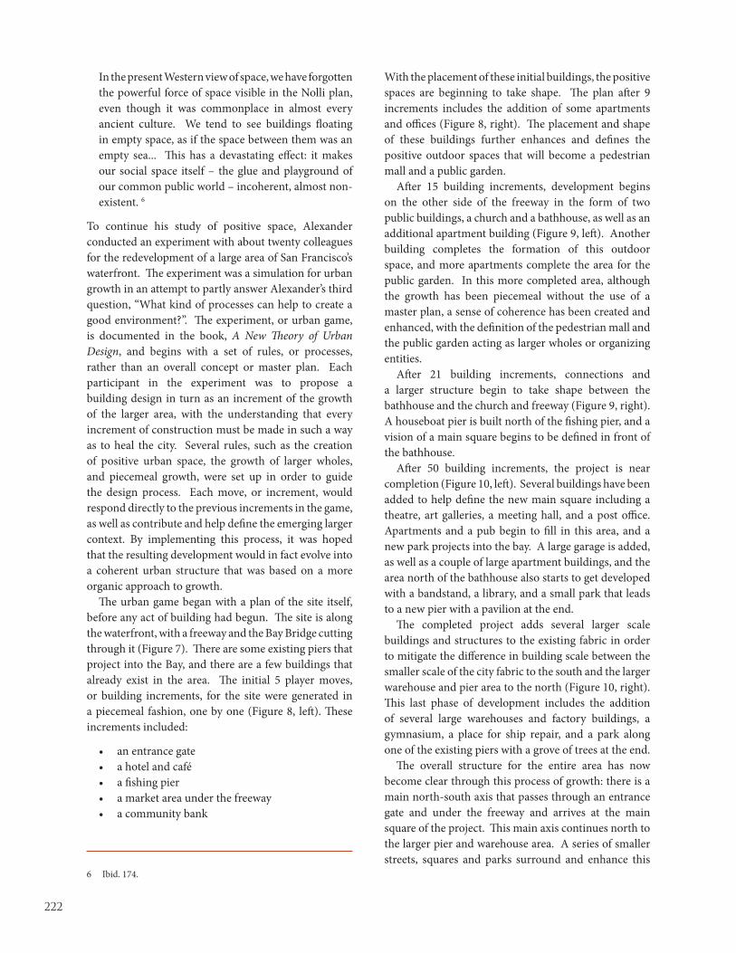
222
In the present Western view of space, we have forgotten the powerful force of space visible in the Nolli plan, even though it was commonplace in almost every ancient culture. We tend to see buildings floating in empty space, as if the space between them was an empty sea... This has a devastating effect: it makes our social space itself – the glue and playground of our common public world – incoherent, almost non-existent. 6
To continue his study of positive space, Alexander conducted an experiment with about twenty colleagues for the redevelopment of a large area of San Francisco’s waterfront. The experiment was a simulation for urban growth in an attempt to partly answer Alexander’s third question, “What kind of processes can help to create a good environment?”. The experiment, or urban game, is documented in the book, A New Theory of Urban Design, and begins with a set of rules, or processes, rather than an overall concept or master plan. Each participant in the experiment was to propose a building design in turn as an increment of the growth of the larger area, with the understanding that every increment of construction must be made in such a way as to heal the city. Several rules, such as the creation of positive urban space, the growth of larger wholes, and piecemeal growth, were set up in order to guide the design process. Each move, or increment, would respond directly to the previous increments in the game, as well as contribute and help define the emerging larger context. By implementing this process, it was hoped that the resulting development would in fact evolve into a coherent urban structure that was based on a more organic approach to growth.
The urban game began with a plan of the site itself, before any act of building had begun. The site is along the waterfront, with a freeway and the Bay Bridge cutting through it (Figure 7). There are some existing piers that project into the Bay, and there are a few buildings that already exist in the area. The initial 5 player moves, or building increments, for the site were generated in a piecemeal fashion, one by one (Figure 8, left). These increments included:
• an entrance gate• a hotel and café• a fishing pier• a market area under the freeway• a community bank
6 Ibid. 174.
With the placement of these initial buildings, the positive spaces are beginning to take shape. The plan after 9 increments includes the addition of some apartments and offices (Figure 8, right). The placement and shape of these buildings further enhances and defines the positive outdoor spaces that will become a pedestrian mall and a public garden.
After 15 building increments, development begins on the other side of the freeway in the form of two public buildings, a church and a bathhouse, as well as an additional apartment building (Figure 9, left). Another building completes the formation of this outdoor space, and more apartments complete the area for the public garden. In this more completed area, although the growth has been piecemeal without the use of a master plan, a sense of coherence has been created and enhanced, with the definition of the pedestrian mall and the public garden acting as larger wholes or organizing entities.
After 21 building increments, connections and a larger structure begin to take shape between the bathhouse and the church and freeway (Figure 9, right). A houseboat pier is built north of the fishing pier, and a vision of a main square begins to be defined in front of the bathhouse.
After 50 building increments, the project is near completion (Figure 10, left). Several buildings have been added to help define the new main square including a theatre, art galleries, a meeting hall, and a post office. Apartments and a pub begin to fill in this area, and a new park projects into the bay. A large garage is added, as well as a couple of large apartment buildings, and the area north of the bathhouse also starts to get developed with a bandstand, a library, and a small park that leads to a new pier with a pavilion at the end.
The completed project adds several larger scale buildings and structures to the existing fabric in order to mitigate the difference in building scale between the smaller scale of the city fabric to the south and the larger warehouse and pier area to the north (Figure 10, right). This last phase of development includes the addition of several large warehouses and factory buildings, a gymnasium, a place for ship repair, and a park along one of the existing piers with a grove of trees at the end.
The overall structure for the entire area has now become clear through this process of growth: there is a main north-south axis that passes through an entrance gate and under the freeway and arrives at the main square of the project. This main axis continues north to the larger pier and warehouse area. A series of smaller streets, squares and parks surround and enhance this

223
main axis and main square, and a group of small and large piers makes a connection from the waterfront area to the larger entity of the San Francisco Bay.
In comparing Alexander’s experiment with a similar area in Nolli’s Piante Grande, a remarkably similar urban structure can be seen with vertical streets parallel to the water, a series of public and private buildings depicted as figure and ground, and even a free-standing figural element that is placed in a similar way to the bathhouse (Figure 11). Other similarities include a relaxed, organic character to both plans, with a mix of irregular and regular shaped buildings and spaces, a mix of uses, and a similar sense of scale. Several of Alexander’s fifteen geometrical properties are present in the San Francisco project, including the properties “Positive Space”, “Levels of Scale” “Interlock and Ambiguity”, and “Local Symmetries”, which indicates an urban environment with a coherent structure. It is even possible to “see” the life of the inhabitant here, although perhaps not quite as clearly as in the Nolli plan example with its slightly finer-grain level of detail, and its more intricate relationship between figure and ground, space and building. Yet the similarities are striking; particularly in the overall character and feeling of the two plans. Alexander’s urban design experiment was at least partially successful in its attempt to create a process that could generate good urban space.
The CMU project and the San Francisco waterfront project are two projects from two architects practicing in America today that have been significantly influenced by Nolli’s Pianta Grande. Each architect has incorporated certain attributes of the Pianta Grande in their work, yet while sharing this common source of inspiration as well as a shared concern for making urban space more coherent, their resulting work and the approaches that they take are quite different. Michael Dennis’s approach is to combine certain characteristics of traditional cities with characteristics of modern building plans into a new hybrid architecture for a the creation of a hybrid city, while Christopher Alexander’s approach focuses on trying to understand what makes a good environment, a good structure, and a good process in order to heal our existing cities. It is interesting to note their differences in process as well as in result: Michael Dennis uses the standard master planning approach, but tries to create a new urban structure that combines the positive space attributes of traditional cities with the “plan libre” of modern buildings to form a new sequence of indoor and outdoor rooms. Christopher Alexander rejects the master planning approach in favor of a new incremental process that has the potential to re-create the intricate
structure and organic growth process of traditional cities. Of course the evolution of the city of Rome over the past twenty-five hundred years has incorporated aspects of both master planning and organic growth, with many de-structions and re-constructions along the way. In studying the Pianta Grande, and the techniques and processes presented by Michael Dennis and Christopher Alexander, architects and urban designers practicing today may gain new insights into the art of city building and the creation of a coherent environment, both on a large urban scale as well as on the small scale of the individual inhabitant.

224
Figure 1: (left) Nolli’s 1748 Pianta Grande for the city of Rome. (Right) A view of late twentieth century Houston, Texas
Figure 2: Two views of Piazza Navona: the amount and choice of detail drawn in Nolli’s plan correlates closely with the perception of the three-dimensional space. It is easy to look at different parts of Nolli’s plan and imagine what that place would look and feel like as one traveled through the city.

225
Figure 3: Carnegie Mellon University: view of the Hornbostel Quadrangle

226
Figure 4: Carnegie Mellon University Campus Plan in 1988 with the Hornbostel quadrangle located in the lower right, and the campus plan showing phase 1 - The East Campus Project in 1990
Campus Plan, 1988 Phase I, The East Campus Project, 1990

227
Figure 5: Carnegie Mellon University Campus Plan Phase 2 – The University Center, 1993, and Phase 3 with the addition of the Purnell Center for the Arts, the proposed amphitheatre, pedestrian bridge, and restoration of the ravine
Phase II, The University Center, 1993 Proposed Campus Plan

228
Figure 6: Comparison of a detail of the Pianta Grande and the Carnegie Mellon University plan
Figure 7: San Francisco Waterfront Project: aerial view and plan of the existing site

229
Figure 8: : San Francisco Waterfront Project: plan after 5 increments and plan after 9 increments

230
Figure 9: San Francisco Waterfront Project: plan after 15 increments and plan after 21 increments

231
Figure 10: San Francisco Waterfront Project: plan after 50 increments and plan of the completed project

232
Figure 11: Comparison of a detail of the Pianta Grande and the San Francisco Waterfront Project final plan

233
Nolli, Roma Interrotta and the Monte Celio: A New Proposal Based on Past Lessons
Kevin Hinders
the Collage City text with a didactic example. However Rowe’s Interrotta project can be read as a total design. It was executed with authoritarian, though benevolent, control similar to perhaps Hadrian’s Villa within a shortened time frame. As a follow up to the Interrotta project, a new design proposal for the Monte Celio has been created and illustrated with similar premises to those used by Rowe’s submission. The project is based upon the ideas formulated in Collage City and illustrated in Roma Interrotta. (The project is for the quadrant executed in 1978 by Michael Graves2 and includes sites adjacent to those of the Sector IX executed by Graves. Just as Rowe’s submission includes both a design submittal and a section written by Peterson called “Urban Design Tactics,” so too does this submission).3 The key difference between the original Interrotta project and the new Monte Celio proposal is that the latter for Monte Celio also includes a transformation series that inserts the proposal into the existing city. The stages of transformation begin to indicate potential modifications to the existing conditions…a methodology of imagination for future consideration. Through this examination the idealized and the real come into a dialogue, which allows for both the planned and the unplanned to be seen.
ROMA INTERROTTA
It has been over 30 years since the publication of Roma Interrotta by Architectural Design. Roma Interrotta was a design exhibition involving twelve
invited proposals based upon interpretation of the 1748 Nolli map of Rome.
2 Michael Graves, guest editor, Roma Interotta A.D. Profile 20, Architectural Design 49 (1979). 3 The original Rowe submittal included a “historical narrative” which sought to reinforce the role of politics and people in the creation of urban design. For the sake of brevity (and the author’s limited desire to indulge in as much, given the focus here is on methodology) the narrative shall be all but eliminated in this paper.
It is here proposed that, rather than hoping and waiting for the withering away of the object (while simultaneously manufacturing versions of it in profusion unparalleled), it might be judicious, in most cases, to allow and encourage the object to become digested in a prevalent texture or matrix. It is further suggested that neither object nor space fixation are, in themselves, any longer representative of valuable attitudes. The one may, indeed, characterize the ‘new’ city and the other the old; but, if these are situations which must be transcended rather than emulated, the situation to be hoped for should be recognized as one in which both buildings and spaces exist in an equality of sustained debate. A debate in which victory consists in each component emerging undefeated, the imagined condition is a type of solid-void dialectic which might allow for the joint existence of the overtly planned and the genuinely unplanned, of the set-piece and the accident, of the public and the private, of the state and the individual. It is a condition of alerted equilibrium which is envisaged… Colin Rowe and Fred Koetter, Collage City
It is easier to design the cities of the future than cities of the past. Rome is an interrupted city because it has stopped being imagined and begun to be (poorly) planned. Giulio Carlo Argan, Mayor of Rome 1978
INTRODUCTION
The Roma Interrotta project submitted by Colin Rowe with Peter Carl, Judith DiMaio, and Steven Peterson was an important event following the
publication of Collage City written with Fred Koetter.1 The exhibition gave Rowe the opportunity to follow up
1 Colin Rowe and Fred Koetter, Collage City (Cambridge : MIT Press, 1979).

234
In describing Roma Interrota, Michael Graves wrote:
…If one were to compare modern Rome with Nolli’s plan of 1748, the development which has occurred since the 18th century is, one might think, crude and without the substance of the urban structure as recorded by Nolli. In speculating about the nature of urban experience, it seemed appropriate to identify the thematic assumptions of the proposed exhibition around the expansion of Nolli’s Rome to accommodate the city’s growth. Since Nolli’s plan was divided into 12 sections, presumably because of the technical limitations of printing, it was felt that the distribution of these sections to individual participation might yield a comparison of urban intentions, especially at their junctures or seams.4
The twelve primary investigators in the exhibition included: Piero Sartogo (Sector I), Constantino Dardi (SectorII), Antoine Grumbach (Sector III), James Stirling (Sector IV), Paolo Portoghesi (Sector V), Romualdo Giurgola (Sector VI), Venturi and Rauch (Sector VII), Colin Rowe (Sector VIII), Michael Graves (Sector IX), Aldo Rossi (Sector X), Rob Krier (Sector XI), and Leon Krier (Sector XII).5
Rowe- Word and Flesh. Rowe is fond of the use of complex oppositions in his writings.6 In his introduction to Five Architects, Rowe states:
We are here, once more, in the area where the physique and the morale of modern architecture, its flesh and its word, are again, not coincident; and it is when we recognize that neither morale nor physique, neither word nor flesh, was ever consistent with each other, that we might reasonably approach the architects whose work is here presented.7
Rowe’s statement refers, in 1972, to a body of work
that is simultaneously within and at odds with the manifestos of modern architecture. Several years later, in 1975 with Fred Koetter, Rowe wrote Collage City,8 most certainly an urban design manifesto. This article
4 Graves, op. cit., p 4. 5 For a review of the importance and worth of these investigations see Alan Chimacoff ’s Roma Interrotta Reviewed, Ibid, p. 7-8.6 George Baird, “Oppositions in the Thought of Colin Rowe,” Assemblage 33 (1997): 22-35. 7 Colin Rowe, introduction to Five Architects: Eisenman, Graves, Gwathmey, Hedjuk, Meier (New York: Wittenborn, 1972), p. 3. 8 Colin Rowe and Fred Koetter, Collage City, special issue, Architectural Review 158 (1975): 66-91.
was later elaborated upon and published in book form in 1979. The exhibition of Rowe’s Section VIII could thus be seen as ‘the word made flesh’. The exhibition project and writings illustrate the statement from Collage City:
It is ... suggested that neither object nor space fixation are, in themselves, any longer representative of valuable attitudes. ... the situation to be hoped for should be recognized as one in which both buildings and spaces exist in an equality of sustained debate. A debate in which victory consists in each component emerging undefeated, the imagined condition is a type of solid-void dialectic which might allow for the joint existence of the overtly planned and the genuinely unplanned, of the set-piece and the accident. of the public and the private, of the state and the individual.9
Rowe and Koetter state what could just as well be a description of their Section VIII submission to Roma Interrotta:
lt is a condition of alerted equilibrium which is envisaged; and it is in order to illuminate the potential of such a contest that we have introduced a rudimentary variety of possible strategies. Cross-breeding, assimilation, distortion, challenge, response, imposition, superimposition, conciliation: these might be given any number of names and, surely, neither can nor should be too closely specified; but if the burden of the present discussion has rested upon the city’s morphology, upon the physical and inanimate, neither ‘people’ nor ‘politics’ are assumed to have been excluded.10
Rowe and Koetter’s statement is illustrated in the exhibition and accompanying texts. In Rowe’s text for Roma Interrotta the physical design proposal is linked with a plausible genesis for the design’s reality. Through the creation of the mythical Father Vincent Mulcahey, S.J., Rowe is able to create a fantasy history for the project, a fantasy that weaves events, real and proposed, into a narrative that imagines how politics and people create settings for realized urban inventions and interventions. But the truth is, as much as it may aspire to “the joint existence of the overtly planned and the genuinely unplanned”, the project could never realize such a condition. The project, because of the design method, was never open to the genuinely unplanned,
9 Colin Rowe and Fred Koetter, Collage City (Cambridge and London, 1979), p 83.10 Ibid., 83.

235
just as it was never completely produced by this fantasy of history. Instead it was a dialogue between the formal tendencies of the designers and the imagination of what could have happened.
In Collage City, a methodology is proposed to replace the antiquated and often brutal utopian models of the platonic and Marxian utopias. This method is an attempt to allow a range of “vest pocket utopias for the here and now, while allowing for the reality of change, motion, action and history.” The major accomplishment of Rowe and Koetter is to replace the paradigm of modern urban design with a more adaptable, less authoritarian vision, a paradigm which allows for both variety and je ne sais quoi. Just as importantly this paradigm re-establishes the possibility of values, giving the designer “a reference according to which they can evaluate facts”. This paradigm empowers the designer by re-establishing a link with the past that the modern urban design paradigm (the composite Hegelian, Marxist, Darwinian) had removed. The paradigm further empowers the designer to create idealizations within the larger context. These idealizations have value within the time frame of the designer.
Proposed here is a method, an experiment, which allows the design gap between the overtly planned and the unplanned to be narrowed. The Monte Celio project contains a series of these vest pocket utopias, based upon the 1748 Nolli map of Rome, using Rowe’s Roma Interrotta example. Upon reinsertion of these idealized pocket utopias back into the existing condition of Rome, a variety of possibilities arise. Through a series of transformation exercises new situations can be imagined.
The text below includes description of the tactics and strategies for the design of this area. The current existing condition of Rome is not largely considered during the Interrotta part of the investigation, except for the phenomenological understandings gained through visitations to the existing sites.
MONTE CELIO - ROME, ITALY
Upon investigation of the current Celio Hill in Rome, an amazing state of disarray and a general lack of quality urban design is
discovered. Although the list of individual buildings is quite substantial (san Giovanni in Laterano, Santo Stefano Rotundo, the Villa Massimo, SS. Giovanni
e Paolo, the Scala Santa, and so on) the urban infrastructure rarely supports these edifices. To facilitate further investigation of this area a portion of Giovanni Battista Nolli’s 1748 Map of Rome was isolated. A new Celian Hill and accompanying valley has been designed. The area is not limited to the engraving divisions as created by Nolli and used in the 1978 Roma Interrotta. Instead the new design seeks to find more natural or at least relevant boundaries to the area. This new design investigates the nature of the field and texture of the city, while introducing a balance between street/square (figural void) and building/object (figural solid) as described by Rowe and Koetter above (Fig. 1).
This new hill town sits on top of the Celian Hill with the south and east bounded by the existing Aurelian Wall. The major focal point of this area, as recognized by Pope Sixtus V, is the church of San Giovanni in Laterano. Using San Giovanni (one of the four major pilgrimage churches in Rome) as a nucleus, the project is made up of a number of divisions to Monti, Rione I, each one separable yet interconnected. Included in this rione is an existing investigation made by Steven Peterson and Colin Rowe for the 1978 Roma Interrotta (Fig. 2).
URBAN DESIGN STRATEGIES
The “Monte Celio” Project can be used to illustrate a number of urban design principles and strategies. The following diagrams show a
variety of useful design tactics to be used when creating urban interventions (Fig. 3). The diagrams in Figure 3 are used to delineate the primary organizing elements of the entire field. They show the major figures, fields, spaces, and connections in the fabric proposed for the Celian Hill.
TOPOGRAPHY
The topography is illustrated in the Nolli Map of 1748 which can be seen clearly when all else is removed from the image. By superimposing the
figures on top of the topographic map the spaces and the buildings correspond to the contour changes in the site and the protected valley inside the Aurelian Wall.

236
CONNECTIONS
A hierarchy of connections and spaces exist within the proposed plan. The primary connections between the major monuments
and figural spaces in the proposed plan derive from studying, reinterpreting and reinforcing the existing site conditions. The secondary connections are created to link these internal areas with the larger urban fields. The tertiary figures make up the texture and the fabric of the individual neighborhoods. This texture is reflected in the aerial perspective showing the Celian Hill as a hill town (Fig. 4).
SUBDIVISIONS WITHIN RIONE I
The area of the Villa Massimo is shown separated from the surrounding context in plan and three dimensionally (Fig. 5). This area focuses
on the villa of the Massimo family, the church of SS. Pietro e Marcellino and the Scala Santa. The Acqua Claudia bounds the region and a distant view to the Colosseum is seen in the perspective. Axonometrics illustrate the relationship with the topography as spaces are interconnected with the building fabric (Fig. 6). Above is a rendering of the spaces as physical solids with respect to topography. Below, the buildings which give form to the spaces are illustrated. By separating this region from the overall design one may see how the fabric and space-to-solid relationship weave at the local level as well as at the larger scale.
The area of the Collegio Salviati is illustrated (Fig. 7) and again shown separated from the larger design context. This figure illustrates the manner in which a series of objects may be used to organize the countryside in an Acropolian manner, each set piece in a prescribed location based upon perspective and overlap. This diagram continues with perspective views as one rounds the lower area of the Celian Hill and begins to see into the distance. A distant Belvedere Villa is seen first, followed by an initial terrace to a proposed villa. Finally, one sees the primary structure of this proposed villa with the Belvadere in the distance as well as the steeples of San Giovanni in Laterano. Also up the hill are the buttressing and the church of Santo Stefano Rotundo. The sequential views begin to reveal how these objects, although seen in plan in a loosely organized fashion, may be used to actually create a very organized scene for the viewer.
MAJOR SET PIECES
A plate from Letarouilly’s Edifice de Rome Moderne (Fig. 8) is enhanced to illustrate San Giovanni in Laterano placed in a proper space so as to allow
the facade to have a surrounding backdrop. This new space uses the Scala Santa as a secondary focal point for the overall piazza. San Giovanni acts as a knot, which is used to tie all the surrounding regions together. San Giovanni in Laterano forms an integral part of all the surrounding areas. The regions are further tied together with another set piece that organizes the composition. The Acqua Claudia, which threads through the entire composition on its way to the Palatine Hill is both an edge to, and link through, the various areas (Fig. 9). Two views illustrate these set pieces as major organizers. The first perspective view from the rooftop of San Giovanni looks out towards the hills surrounding Rome. The view shows the connection made between San Giovanni and Santa Croce in Gerusalemme and the adjacent amphitheater/garden. The second perspective gives an aerial view from above Santa Croce looking back toward San Giovanni. This perspective indicates how the buildings to the north of Santa Croce begin to pull back and the street widens to create a figural space that leads to the major figural piece of the composition - San Giovanni in Laterano – and how the Acqua Claudia occupies the high ground and becomes an edge to the composition.
BRICOLLAGE
Bricollage is a strategy proposed in Collage City, taking known pieces – pieces at hand or in the mind – and finding new uses or manners in which these known entities can be applied. It is a “handyman’s” way of resolving a problem rather than an “engineering” mentality (Fig. 10). This series of illustrations show varying degrees of bricollage and transformation. The first set shows the Villa Medici in Rome in its current location and then shown with this element picked up and moved to another location, with no major modifications other than to the context in which it is placed. The second set shows the composition of the Palazzo della Consulta on top of the Quirinal Hill followed by an illustration of how this palace is used in a much different context and how the building transforms. Rather than having a major face to a piazza, the major façade of the palace is now absorbed into the city fabric. The building becomes a nose to the overall

237
region sitting adjacent to a raised piazza and the Aqua Claudia. The last set shows the Palazzo Borghese in its original context and then this building transformed to fit into a new context. The Borghese building (the harp form) changes dramatically. The surrounding context is very different as the large piazzas that the villa opens up onto are shifted and the adjacent walls of buildings are removed. The building’s external walls begin to adjust to the new site location. These are just a few examples of bricollage. The same method can be used with idealized spaces. Bricollage is a tool that enables the designer to utilize potential memory invoking precedents to assist in the creation of new places in the city.
LESSONS OF TEXTURE
In the following set of illustrations two different types of texture are illustrated (Fig. 11). In the first version one sees the small portion of the historic City Center of Rome in the Nolli Map of 1748. In this plan the intimate relationship between the major buildings and the spaces they sponsor can be observed as well as the connections between those spaces and buildings. The same strategy is used on the Celian Hill. Space is the mediator of the field. The next plan shows the area to the south of the Piazza del Popolo introduced by Leo X and Clement VII Medici and Paul III Farnese. This area, being more recent, shows a textured grid in which the street is the primary space and connector. The grid begins to conform to the trivium. This same strategy is shown applied between Santa Croce in Gerusalemme and the surrounding fabric which then separates to form a space between the buildings and the figural church facade. The street as space is therefore extended.
The insertion of the idealized hill town back into the existing urban fabric is primarily a compositional strategy. Recognizing appropriate locations for cutting away the existing or altering the idealization facilitates the creation of the composite. The next step creates a series of transformations that gradually allow the idealized Monte Celio to become existing Rome, a transformation which can be read in both directions (Fig. 12).11 Digital technology allows for numerous manners of transformation, from simple transparency overlays and fades, to more sophisticated morphing technologies and animations. The in-between transformations create tremendously interesting possibilities. In this proposal
11 This strategy has long been used to teach transformation to beginning architecture students at Cornell and other Universities.
many alternatives have been undertaken to invoke the imagination. Since no single condition along the way is seen as idealized the potential for allowing both “the joint existence of the overtly planned and the genuinely unplanned” becomes enhanced. The method treats the area as a composition while each piece can then be seen as a point of reference for a real urban proposal. Finally, the city becomes once again a part of the imagination.
In closing it is fitting to return to the former Mayor of Rome taken from the original Roma Interrotta:
Before Rome became as flat and shapeless as an unmoulded polenta, the Romans lived, moving in the layers of the stratified centuries, like fish in water, in the depths and at the surface... In contrast to space which is opaque, time is transparent. Swimming under the surface of the water, the monuments are seen as reefs, the ruins as coral. This is the city Bernini and Borrimini had imagined...

238
Figure 1: Monte Celio Plan

239
Figure 2: Aerial Perspective

240
Figure 3: Field organizational Strategies
Mass/Void
Topography
Primary Connections
Secondary Connections
Tertiary Connections

241
Figure 4: Villa Massimo Area

242
Figure 5: Space as Solid/Space as Void

243
Figure 6: Collegio Salviati
Area Plan
Sequential Perspectives1. San Stefano Rotundo 2. Proposed Villa 3. Belvedere 4. San Giocanni in Laterno
Perspective from Villa Terrace

244
Figure 7: San Giovanni in Laterno

245
Figure 8: Aerial Perspectives
View looking from San Giovanni toward Santa Croce in Gerusalemme
View from above Santa Croce in Gerusalemme toward San Giovanni

246
Figure 9: Bricollage
Figure 10: Lessons of Texture
Discreet Space/Piazza
Grid: Street as Space
Palazzo della ConsultaVilla Medici Palazzo Borghese

247
Figure 11: Superimposition and Transformation

248

249
Roma ininterrotta
Antonino Saggio
In defintiva intendo mostrare come la concezione di spazio urbano presente nella Roma del XVIII secolo e che ha in Nolli un alto momento teorico, sia vitale ancora oggi e costituisca un imprinting ineledubile per gli architetti romani più attenti.
1. ROMA PARADIGMA
Un momento significativo del dibattito sull’architettura nel finire degli anni Settanta del Novecento è stato segnato dalla Mostra del 1978 “Roma interrotta.”1 La significatività dell’operazione, oltre che dal rilievo internazionale attribuito all’evento anche nella successiva pubblicazione su Architectural Design,2 è evidente da molteplici aspetti che si intrecciano tra loro. Innanzitutto vi è la qualificazione dei 12 architetti contemporanei di grande notorietà invitati alla mostra. Naturalmente esistono esclusioni, forse la più clamorosa delle quali appare quella dello statunitense Charles Moore che aveva lavorato, sulla scia di Louis Kahn, sulla architettura tardo imperiale romana e sulla permanenza formativa di quella lezione. Ma Piero Sartogo, Costantino Dardi, Antoine Grumbach, James Stirling, Paolo Portoghesi, Romualdo Giurgola, Robert Venturi, Colin Rowe (che ha appena pubblicato con Fred Koetter il volume “Collage City”), Michael Graves, Robert Krier, Aldo Rossi e Leon Krier sono tutti presenti. A ciascuno viene affidato un settore della Pianta grande del Nolli del 1748 che deve essere reinterpretata, agita, occupata secondo la sensibilità e cultura architettonica e urbana di ciascuno.
La mostra si basa un’intuizione di Giulio Carlo Argan e sull’attiva strutturazione degli “Incontri Internazionali d’Arte” molto attivi in quegli anni nella
1 AA. VV, Roma interrotta (mostra organizzata dagli Incontri internazionali d'arte, Mercati di Traiano, maggio-giugno 1978 catalogo a cura di Marisa Cerruti, ) “Premessa” di Giulio Carlo (pp. 11-12), saggio introduttivo "Il Genius Loci di Roma" di Christian Norberg Schulz (pp. 13-27), (Roma: Officina, 1978).2 “Roma interrotta / Michael Graves”, Architectural Design 49 (1979).
ROMA ININTERROTTA
Nel 1978 la mostra “Roma interrotta” ospitata ai Mercati traianei e voluta dal grande storico dell’arte Giulio Carlo Argan allora sindaco
della Capitale, segnò una tappa significativa per la cultura architettonica. La mostra poneva di fronte alla riflessione del pubblico due elementi apparentemente contraddittori. Da una parte la pianta del Nolli, quindi un documento storico, dall’altra delle proposte progettuali di architetti contemporanei localizzate nelle zone inedificate come si presentavano nell’anno MDCCXLVIII. La selezione degli architetti era di primissimo piano, “il gotha” o quasi nel panorama internazionale di allora.
Lo scopo di questo capitolo non è però discutere filologicamente i vari aspetti di quella mostra (anche se gli oltre cinque lustri di distanza potrebbero giustificare l’operazione). Intendo partire da “Roma interrotta” per mostrare al contrario una Roma “non” interrotta. L’intervento vuole dimostrare la vitalità e la permanenza, forse “la lunga durata”, dell’immagine di Roma tardo Barocca. In particolare intendo soffermarmi su dei principi che hanno ispirato il lavoro di alcuni degli architetti che hanno operato a Roma in questi ultimi decenni. Ne possiamo ricordare alcuni. La consapevolezza della “Scena urbana” e cioè una attenzione al ruolo degli spazi pubblici conformati dagli edifici (una ricerca particolarmente cara ad Alessandro Anselmi); la presenza di un “paesaggio” naturale che si travasa dall’orografia vulcanica del Lazio e che articola lo spazio urbano di Roma (un’idea ricorrente nel miglior Paolo Portoghesi e chiaramente enunciata anche nel catalogo della mostra da Christian Norberg Schulz); l’idea della compresenza dei diversi strati storici in una visione multiprospettica e frammentaria (che struttura la ricerca di Franco Purini e richiama le incisioni di Giambattista Piranesi), la presenza di oggetti d’arte come elementi catalizzatori dello spazio pubblico (un’idea che, mutuata dal pensiero di Frank O. Gehry, ha caratterizzato qualche mia modesta proposta).

250
Capitale. Storico dell’arte di enorme e giustificato prestigio, Argan è diventato nel 1976 il primo sindaco di sinistra dopo decenni di potere democristiano e pone al centro del proprio lavoro i temi della cultura e della partecipazione attiva della storia alla costruzione della città. Il patrimonio storico entra in quel periodo a far parte della vita culturale della popolazione con continui innesti tra arte contemporanea e manufatti antichi con una sintesi già presente a Roma sin dai primi anni Settanta ma esplosa a livello di massa nelle manifestazioni della “Estate romana” in una continuità fervida di iniziative. Si ricorderanno per esempio le proiezioni cinematografiche alla basilica di Massenzio o il circo in Piazza Farnese che facevano riappropriare alla popolazione i monumenti e il tessuto storico.
Al centro della riflessione degli architetti invitati alla mostra viene cosi indicata Roma come simbolo vivente di una “città della storia” che si è costruita per frammenti, stratificazioni, compresenze. Il senso generale dell’operazione sul finire degli anni Settanta, quando la parola chiave anche degli architetti era ormai diventata “contesto”, non sfugge a nessuno. L’espansione della città secondo il modello industriale era ormai in crisi (si comincia a parlare di implosione e la prima deflagrante crisi petrolifera è del 1974) e si tendeva ormai a lavorare nel già costruito con operazioni di ricucitura, di saturazione, di contatto tra preesistente e nuovo. Insomma, come dirà Peter Eisenman, anch’egli non invitato anche se nello stesso 1978 creò una pionieristica proposta per Venezia Cannaregio, si opera ormai in between.
La pianta del Nolli è vista quindi dai partecipanti alla mostra in un quadro “operativo”, volto al crescere per strati della città ma anche per alcune sue indubbie peculiarità.
Come si sa, la pianta del 1748 non solo è la prima rappresentazione scientifica della città, ma è anche la prima che mette a fuoco con evidenza alcuni temi che sono “propri” di Roma.
Innanzitutto la pianta mette in rilievo il ruolo dello spazio pubblico a Roma sia nell’articolazione delle strade sia in quello degli slarghi, dei vicoli e delle grandi piazze. Le modalità di raffigurazione sembrano fatte apposta per dimostrare la capacità dell’architettura di creare lo spazio urbano e quindi l’invenzione, tipica della Roma barocca, di uno spazio urbano quale “scena”: gli edifici cospirano tra loro per formare i grandi e i piccoli invasi della città, e cioè i vuoti più pieni di significato che la cultura urbana avesse sino a qual punto della storia creato. Ma l’eccezionalità della raffigurazione si estende ad una sorprendente caratteristica che è quella di
raffigurare gli edifici di maggiore rilevanza (vuoi edifici civici, vuoi religiosi, vuoi in qualche caso palazzi) con lo strumento della pianta delle strutture. Vengono così rivelati gli spazi interni degli edifici e non solo (come è usuale) il perimetro esterno. L’attenzione viene posta di conseguenza verso la sequenza e l’articolazione degli spazi da quelli pubblici delle piazze e delle strade agli spazi di mediazione come i grandi portici dei palazzi o delle chiese sino agli spazi interni degli edifici. Uno scorrere continuo di vita si sente attraversare tutta la pianta sino a permeare le “stanze” diverse della città: quelle a cielo aperto o quelle sotto le volte artificiali delle grandi chiese in cui i cieli stellati o gli affreschi con gli angeli rimandano ai cieli della città, aperti sui grandi spazi pubblici e sui pezzi di campagna oppure ridotti a rigagnoli di cielo tra le strette strade dei quartieri poveri.
L’altro grande tema raffigurato nella pianta (naturalmente a voler sommariamente brutalizzare) appare quello del rapporto tra costruito e natura. Si sente una città che ancora non ha riconquistato la densità costruita della Roma Imperiale e che ancora conserva larghe parti di orti, di giardini e di veri e propri pezzi di campagna che si incuneano dentro la città. E’ una continua combinazione tra architettura e una natura a vario grado antropizzata che rimarrà una costante dell’immagine di Roma anche successivamente e che è ora splendidamente raffigurata da Nolli.
2. PARTECIPAZIONI QUALIFICATE
Alcuni architetti interpretano la grande occasione dell’invito a “Roma interrotta” all’insegna dell’autobiografismo: usano cioè il
proprio quadrante come campo autorappresentativo inserendovi pezzi delle proprie opere già realizzate. E’ un’operazione che marginalizza l’interesse delle esposizioni di Rossi, di Stirling, di Graves di Robert Krier. Vi sono architetti che adoperano l’occasione per mettere in campo alcune personali teorie di taglio utopico. L’italiano Sartogo propone una riedizione dei condensatori sociali di Fourier inseriti con una logica fratturata e dinamica nella zona del Borgo; Dardi disegna una sorta di neo-urbanizzazione rurale che proietta il segno a pochè di Daniel Buren sul territorio; Giurgola densifica l’area dentro le mura aureliana con un tessuto di case a schiera che fanno pensare alla sua città di adozione, Philadelphia. Crea inoltre dei grandi attrattori urbani innestati sulle porte della città che aprono le braccia alla campagna come a volerne risucchiare all’interno la linfa vitale.

251
Leon Krier progetta delle grandi piazze pubbliche parzialmente coperte e disegna delle prospettive immaginarie di nuovi “Centri rionali” che vengono inseriti in diversi punti della città. Indimenticabili rimangono i suoi disegni e la forza di quest’idea.
Colin Rowe usa l’occasione per mettere in atto concretamente alcune idee presentate nel suo fortunato e coevo libro Collage City.3 Sviluppando tecniche di analisi proprie all’urban design (gli isolati, i negativi e i positivi, gli allineamenti) emerge una visione della città come compresenza di parti tra loro significativi. Rowe accetta una logica frammentaria ma con l’idea di una ricomposizione alla fine unitaria e compiuta della città attraverso l’accostamento del collage. Il lavoro compiuto sul Rione Monti è dunque significativo perchè ricompone un pezzo di città contemporanea operando selettivamente nella storia: scegliendo, completando, riallineando, evocando o mimettizzando. Sin’anco viene progettata una nuova toponomastica: abbiamo una Piazza Cesare Cattaneo, e una Piazza Giuseppe Terragni. Tutta l’operazione rivela l’inclusività che è alla base di Collage city e che diviene allo stesso tempo uno degli atteggiamenti costitutivi di quella che si chiamerà architettura post-modern. Rowe educa non solo attraverso i libri e i progetti esemplificativi come questo, ma forma molte centinaia di architteti statunitensi a Cornell che a loro volta prolificheranno negli anni successivi nuovi allievi tanto da formare una compatta e agguerrita scuola che usa filosofia operativa e anche la terminologia del maestro.
Chi si lega ancora più direttamente con i temi “effettivamente” presenti nella pianta del Nolli per rilanciarla all’interno del mondo contemporaneo è il francese Antoine Grumbach che coglie la condizione sezionale dell’architettura di Roma. Condizione che è tale sia nella stratificazione storica dei piani archeologici e storici, sia nello stessa orografia così fortemente ondulata, sia infine, perché coglie il rapporto tra architettura e natura a Roma. Grumbach crea dei bellissimi disegni ad acquerello che assumono particolare pregnanza se interpretati come veri e propr programma-progetto. Ma il caso più forte di congruenza tra la propria ricerca ed il tema di “Roma interrotta” è quello dello storico e architetto romano Paolo Portoghesi su cui è necessario soffermarsi.
3 Colin Rowe and Fred Koetter, Collage City (Cambridge Mass: London: MIT Press, 1978).
3. IL TESSUTO URBANO COME NATURA
Portoghesi negli anni Sessanta è molto vicino alla posizione di Bruno Zevi e firmerà paritariamente la mostra e il catalogo dedicato a Michelangelo
architetto nel 19644. Portoghesi è interessato a una lettura “operativa” della storia. Le pubblicazioni come i progetti che redige e spesso costruisce sono ricchi di riferimenti e citazioni in particolare al repertorio della Roma rinascimentale e barocca cui dedica libri di insuperata bellezza con foto personalmente scattate. Dopo la rottura con il maestro nel 1966, fonda nel 1968 una rivista chiamata ControSpazio con una denominazione che occhieggia alla contestazione giovanile. La rivista presenta al suo interno varie anime: da quella ideologicamente impegnata della sinistra marxista italiana, nella figura del caporedattore Renato Nicolini assessore alla cultura ai tempi della mostra “Roma Interrotta”, a posizioni meno impegnate politicamente ma interessate a recuperare frammenti perduti o censurati di storia.
Nella mostra “Roma interrotta” Paolo Portoghesi crea probabilmente il suo lavoro di ricerca progettuale più utile e tra più intelligenti dell’intera mostra. L’idea di base è quella di leggere alcuni aspetti della forma urbis di Roma sulla falsariga del paesaggio tufaceo ricorrente nel Nord Laziale (cui l’amico e collega Norberg Schulz tratta saggisticamente nell’introduzione al catalogo all’interno della categoria del Genius Loci). Portoghesi accompagna le sue tavole con foto di forre, di masse tufacee inondate dalla vegetazione, di ruscelli e i torrenti che scavano la roccia. Sulla base di queste suggestioni interpreta la formazione dei tessuti della città barocca e soprattutto li rilancia nella formazione di nuove articolazioni e tessuti urbani. E’ un’operazione nuova in quel momento perché mentre era consueto vedere in Italia applicate le regole tipologiche della città storica in particolare di quella borghese del XIX secolo (per esempio nel lavoro teorico e progettuale di Aldo Rossi e prima di Saverio Muratori) rarissimo era quest’approccio volto ad un rapporto con la natura e con le sue leggi di formazione. Certo, le ipotesi di linguaggio architettonico della proposta di Portoghesi si muovevano in un’immagine a metà strada tra una ripresa del futurismo e un linguaggio barocco che lasciavano molti perplessi, ma Portoghesi nella sua proposta e nei bellissimi plastici scavati nel sughero catturava molti aspetti chiave di Roma: la presenza quasi ineluttabile della natura e del paesaggio
4 Paolo Portoghesi and Bruno Zevi, Michelangelo Architetto (Torino: Einaudi 1964).

252
nella conformazione di un nuovo spazio urbano e dei nuovi tessuti, la forza dello spazio cavo, la presenza della sezione come motivo generatore.
4. LA SCENA URBANA
Due architetti romani negli anni successivi daranno una nuova definizione ad temi sollevati da Portoghesi. Si tratta di Alessandro
Anselmi e di Franco Purini5, non invitati alla mostra del 1978, ma che avevano già molte idea sulla questione.
La presenza del già costruito, (i manufatti, i tracciati, i frammenti che si accumulano nel tempo) non può essere posta tra parentesi da chi vive e opera a Roma. Materiali difficili, quando si eliminano i mimetismi e le facili citazioni, ma che Alessandro Anselmi cerca coscientemente di reinterpretare nei suoi progetti. La singolarità della sua figura consiste nel fatto che i termini “Storia e Memoria”, che hanno attraversato l’architettura italiana e che nel post-moderno hanno avuto una cassa di risonanza, diventano nel suo lavoro materiali vivi del progetto e non nostalgici attributi. A Roma, città etrusca prima che romana, (e poi medioevale, rinascimentale, barocca, neoclassica e moderna), la stratificazione, l’accumulo, il riuso delle tracce della civilizzazione precedente è il centro della riflessione per Anselmi anche della ricerca di oggi. Egli diventa così l’antesignano di una sorta di architettura-archeologia con una consapevolezza che ha trasmesso a molti architetti dopo di lui. Il progetto per le case parcheggio al Monte Testaccio - frutto di una iniziativa dell’allora assessore Carlo Aymonino - data il 1984 ed è particolarmente significativo del suo modo di operare.
Il progetto sviluppa un tema distributivo molto in voga in quegli anni: un corpo lineare con due corpi di fabbrica ai lati di una strada centrale. La distribuzione è rivolta all’interno della linea a notevole spessore (come si chiamava) mentre gli affacci sono all’esterno. Ai primi livelli vi sono le attrezzature comuni e a quelli successivi gli appartamenti di diversa dimensione. Sul fronte verso la piazza, l’architetto adopera un motivo del razionalismo italiano. Un telaio gigante racchiude la costruzione consentendo ai diversi episodi formali di essere asimmetricamente disposti. Il retro, invece, vede
5 Per un quadro che tratteggi un profilo dei due progettisti trattati vedi Antonino Saggio, “Franco Purini, fra Futurismo e metafisica,” Costruire 131 (1994): 124-128, e Antonino Saggio, “Alessandro Anselmi L’archeologo del futuro”, Costruire 133 (1994): 120-124. Entrambi gli articoli sono leggibili on line http://architettura.supereva.com/coffeebreak/
l’inserimento di otto volumi in aggetto che ricordano alcune ricerche in chiave metafisica. Ma questa architettura si carica di echi quando se ne scavano più a fondo le ragioni. L’organizzazione distributiva con il percorso interno a cielo aperto, per esempio, rimette in movimento le tracce e i frammenti della sua lettura di Roma. A pochi metri dall’edificio vi è il monte Testaccio creato artificialmente dall’accumulo dei cocci rotti che gli antichi depositavano dai magazzini del vicino porto fluviale. Il monte è solcato da un percorso ascensionale che, trasferito nel nuovo, diventa l’episodio, la citazione, il collegamento che Anselmi ricerca. I due percorsi si chiamano l’uno con l’altro nell’andamento compresso e spezzato e nella tensione verso l’alto: in un caso verso la vetta, nell’altro al tetto giardino.
Mentre a Roma questa opera è bloccata dalla Soprintendenza, l’amministrazione di Rezé-le-Nantes in Francia porta a compimento un importante opera dell’architetto italiano. In questo progetto Anselmi entra nel merito del suo concetto di “scena urbana”. Ragiona cioè sulla modalità scenografica della creazione degli spazi a Roma. Ma questa scenografia, questa caratteristica di pensare all’architettura “insieme” agli Spazi che essa conforma e delimita, non è mai progettata in termini statici, monumentali di parata nostalgica, ma bensì con l’arma della stratificazione, della dissimetria, del frammento vivo e mosso: insomma in una maniera tendedenzialmente astratta e in una logica dinamica e fratturata. Gli episodi preesistenti, i pezzi di natura, le presenze a volte archeologiche e storiche vengono così riammesse in un circuito vivo che si muove, come spesso a Roma succede, sfruttando la sezione, cioè esaltando le varie quote da quelle sottorenrrane a quelle della copertura in un continuo rimando di episodi e di pezzi di grande vitalità. I suoi pezzi architettonici diventano così attori vivi di una coreografia danzante e vibrante di teatro urbano, in una scena urbana contemporanea lontanissima dagli imbalsamati e muti manichini delle Piazze d’Italia.
Questa idea di scena urbana in Anselmi fa rivivere quindi una linea che parte dalla prima intuizione di questo tipo di spazio che si ha nell’esperienza manierista romana con Pirro Ligorio, che si afferma nella grande costruzione della Roma Barocca e che trova nella pianta del Nolli la sua massima rappresentazione e consapevolezza e che riemerge vitale in qualche progetto nascosto della Roma Ottocentesca come quello della villa Torlonia con i disegni paesaggistici e le opere di Giuseppe Jappelli, e che finalmente si realizza anche in un progetto recente costruito in ambito romano da Anselmi. Si tratta del Municipio di Fiumicino.

253
Qui l’idea di Anselmi di lavorare verso una scena urbana frammentaria e per alcuni versi archeologica, si sposa con una nuova idea di suolo. Se spesso le sue facciate si staccavano dai corpi edilizi per parlare dello spazio urbano, qui lo stesso movimento è fatto “anche” per creare una sezione orografica con l’idea della grande piazza inclinata che si piega a fare quinta per i corpi edilizi.
E’ abbastanza straordinario pensare a questo progetto insieme alla mostra “Roma interrotta”. E vedere nel momento di quella mostra voluta da Argan sulla reinterpretazione della pianta del Nolli, la rimessa in campo di temi, motivi accenti della storia urbana della città e rivederli poi, ricontestualizzati, ripensati e fattisi spazio civico in una opera di oggi che si inserisce con forza nella storia urbana della città.
5. FRAMMENTARIETÀ ANTI PROSPETTICA
Se il codice genetico dell’operazione di Anselmi la troviamo nel particolarissimo ed esoterico architetto romano del cinquecento Pirro Ligorio
è difficile non pensare ad una altro grande e difficile architetto romano per discutere del lavoro di Franco Purini. Si tratta naturalmente di Giambattista Piranesi, architetto necessario per fare capire come i temi di “Roma interrotta”, non siano affatto interrotti ma continuano, trasformandosi, nella ricerca contemporanea.
Purini, sin da giovane, non si è lasciato appiattire in scuole di appartenenza ma da esperienze diverse ha costruito la propria specificità. È riuscito a fare tesoro della lezione di rigore classico di Saverio Muratori e, sul fronte opposto, di quella radicata nel moderno di Bruno Zevi come dei temi della dimensione territoriale dell’architettura di Vittorio Gregotti. Anche il momento fondativo della giovane intellighenzia romana degli anni Settanta (la citata rivista Controspazio di Portoghesi) lo ha visto protagonista di spicco.
Il suo nome è conosciuto internazionalmente soprattutto per essere stato il campione della cosiddetta architettura disegnata che, dalla galleria romana “Architettura arte moderna”, ha fatto conoscere il suo lavoro un po’ in tutto il mondo.
I suoi disegni hanno però poco in comune con quelli dei grandi architetti-disegnatori del Novecento. Pochissimo con quelli di Louis Kahn - dove il segno a carboncino viaggia leggero e aereo - o con quelli ondulanti di Le Corbusier o con quelli tutti atmosferici di Frank Llyod Wright. Il referente remoto è appunto
Giambattista Piranesi. Dell’incisore della Roma del Settecento, Purini ha la stessa carica visionaria, lo stesso senso di vertigine, la stessa discesa a vortice nel fondo dell’anima e del pensiero, lo stesso inevitabile misurarsi con lo strato archeologico di Roma. I capisaldi del suo lavoro sono tutti nella rifon dazione del sapere architettonico che si sono costruiti nel Settecento. Ma è una rifondazione che assume immediatamente nel suo lavoro la drammaticità di una tensione tra opposti. Da una parte la visione illuminata e razionale (il filone che parte da Laugier e arriva a Ledoux), dall’altro quella introversa, archeologica e drammatica appunto di Piranesi. Piranesi lotta e combatte la prospettiva pur facendone uso. Insegue una visione discontinua, accelerata, diagonale dello spazio e in questa tensione vive e legge Roma. Purini spesso riflette sul tema del rudere e del detrito, per esempio in un’opera assolutamente sco moda e aspra come la Cappella di Sant’Antonio da Padova nel borgo di Poggioreale nel Belice. Oppure nella idea si spazio urbano come nelle piazze a Gibellina (anch’esse progettate con Laura Thermes) dove riesce a creare urbanità dal nulla. Purini vede alcuni motivi ricorrenti nelle varie regioni e parti d’Italia6. Il prevalere del segno artificiale della pianta al nord in rapporto all’urbanizzazione romana e coloniale, la prevalenza del prospetto al Sud con il segno forte e plastico del prospetto, mentre al centro e a Roma in particolare vince la sezione, nell’idea stessa di stratificazione, di combinazione, di strati frammentari e nei caratteri ricorrenti del paesaggio. La caratteristica fondamentale di Purini progettista, disegnatore o saggista è sempre il suo essere esule da ogni conciliazione di opposti. Ed è proprio il costante interrogarsi, la fiducia nel pen-
6 Franco Purini, “Un Paese Senza Paesaggio,” Casabella 60 (1991), mn. 575-576. Di particolare interesse questo brano in cui l’autore si sofferma su una possibile divisione dell’Italia in tre zone: “La prima, corrispondente alla pianura padana, vede la preminenza della centuriazione, dal cui ordinato reticolo proviene l’attitudine razionale della cultura del nord e, conseguentemente, il primato della pianta come ideale principio ordinatore dello spazio. La seconda, che si identifica nel centro della penisola trova nell’immagine del rudere e quindi nella ‘sezione”’il suo luogo rappresentativo, al quale il contrasdto tra luce ed ombra, il carattere sospeso tra esterno ed interno e l’ambiguità tra aperto e chiuso conferiscono un’avvertibile drammaticità. La terra, coincidente con il sud, costituisce un’area nella quale l’accidentalità orografica, ostacolando in qualche modo il fioire di un costume architettonico figurativamente seriale e traducendo per questo la tipologia in topologia elegge nel prospetto il momento di una mimesi capace di trascorrere in sublimate apparizioni.” (p. 46). Per ulteriori sviluppi di quanto sopra vedi Antonino Saggio, “Architetture di domani. Scenari,” Rassegna di Architettura e Urbanistica, nn. 82-83 "La condizione attuale dell'architettura in Italia", gennaio-agosto 1994 leggibile su Internet: http://www.arc1.uniroma1.it/saggio/Articoli/Bilanci/ScenariFuturi.html.

254
siero critico, l’apertura ai fermenti che ne costituisce la centralità nel dibattito sull’architettura di oggi a partire dalla lezione di Roma.
6. ANCORA PROGETTI
Non intendo qui avvicinare il mio lavoro di docente o d’architetto ai nomi che abbiamo ricordato. Eppure credo sia interessante per
il lettore comprendere come i temi della lezione di Roma continuino e si affermino anche nelle ricerche quotidiane di chi è impegnato anche in questi temi come docente e studioso.
Desidero allora segnalare alcuni lavori compiuti nella mia cattedra di progettazione a La Sapienza in dei concorsi e in una serie di tesi di laurea su Roma.
Il primo caso riguarda un progetto di Concorso per il Borghetto Flaminio e siamo nel 1995. Nel progetto si affermava un’idea di architettura-paesaggio, ancora poco battuta e del tutto minoritaria in quel momento tra gli esiti del concorso7.
L’area del Borghetto Flaminio che doveva ospitare il programma viveva un evidente conflitto. Da una parte fronteggia la scacchiera della città saturata nel Novecento, dall’altra è chiusa dalla collina tufacea che prolunga il paesaggio del Lazio settentrionale. Sotto quest’aspetto il riferimento alle letture di Portoghesi e Schulz fu immediato. Si progettò di conseguenza l’area del Borghetto Flaminio come parte di un disegno verso settentrione che, specularmente al parco archeologico della via Appia a sud, avrebbe contribuito a rafforzare a scala grande la figura della clessidra. Due sistemi territoriali dove ruderi, natura, preesistenze si integrano e fanno filtrare nel centro la linfa del territorio.
Nei disegni di Piranesi veniva riscoperto il principio dell’accelerazione verticale degli spazi. La stratificazione e l’accumulo dei materiali avveniva attraverso un principio a-prospettico, a-monumentale, di schiacciamento sul piano.
Da questa idea deriva la volontà “di inclinare” l’area del borghetto verso la rupe. Per schiacciare e accelerare la percezione: per sancire attraverso il movimento della sezione trasversale, l’appartenenza dell’area bassa e piatta del Borghetto alla collina.
Inclinando, vengono a trovare posto nel progetto i parcheggi sotterranei, ma anche alcune sale multi
7 “Il concorso per il Borghetto Flaminio,” Ricerca e progetto (1998), nn. 11-12.
funzione, ambienti espositivi per reperti archeologici e una sala della musica.
L’insieme di forme del progetto danno vita a degli spazi pubblici fluidi e liberi che attraverso scale e rampe si collegano uno all’altro. E di nuovo la grande lezione della pianta del Nolli e della Roma barocca, da piazza Navona alla scalinata di piazza di Spagna emerge non tanto nell’autonomia del singolo artefatto, ma appunto nel gioco concertato delle parti attorno allo spazio delle persone.
La riflessione sugli spazi di Roma ha condotto ad un ripensamento al ruolo degli oggetti d’arte nella scena urbana, con un accento che non si trova in nessuno degli architetti di cui si è sin qui parlato. Si rifletteva infatti sulla Barcaccia di Pietro Bernini, sulla Fontana dei fiumi del figlio Gianlorenzo, sulla fontana di Trevi di Salvi. I vuoti configurati dalle architetture creano lo spazio urbano anche attraverso la presenza catalizzatrice dell’arte. Su questa scia nel progetto per il Borghetto Flaminio ci doveva essere spazio anche per qualche oggetto d’arte: cioè insicuro. Forse un enorme fuori scala. Il pesce sul lungomare di Barcellona, il cannocchiale dilatato o l’aereo infisso sulla parete del museo dell’aeronautica di Los Angeles che sono genialmente inseriti da Frank Gehry, non a caso un osservatore a dir poco ossessionato dalla Roma barocca come necessario elemento nei cavi creati dalla conformazione dell’architettura.
Non è possibile dilungarsi, ma qui si vogliono segnalare due progetti che rimettono in circolazione alcuni dei temi e argomenti di cui abbiamo parlato entrambi redatti nel corpo delle ricerche della mia cattedra e redatti in occasioni delle tesi di laurea.
Il primo è di Mariella Tesse si chiama “Palinsesti Metropolitani. Percorsi Multidimensionali a Villa Borghese”8 In questo caso il grande parco e’ visto come il centro di desideri e di rappresentazioni da quattro secoli di storia: dalle grandi feste aperte al popolo del Principe Borghese alla Galleria di meraviglie d’arte e d’ingegno dell’’Ottocento, dalle vie di eroi della Patria del Novecento al paesaggio lunare di Luigi Moretti nei sotterranei sopra il Galoppatoio. Il progetto inserisce nuovi percorsi nella Villa modellandoli attraverso le
8 Questo lavoro, come il successivo può essere integralmente esaminato seguendo questo linkhttp://www.arc1.uniroma1.it/saggio/didattica/L’intervento di Saggio su “Roma Ininterrotta” tenutosi il 2 giugno 2003 a Roma nel quadro del Convegno “Giambattista Nolli, Imago Urbis and Rome” indetto e coordinato da Studium Urbis si può seguire in formato integrale video e con una ampia selezione di immagini e ulteriori link a questo indirizzo: http://www.arc1.uniroma1.it/saggio/Conferenze/Roma/Ininterrotta.htm

255
lenti della scienza contemporanea e simulandoli al calcolatore. Il progetto dimostra che gli interventi nella citta’ e nel patrimonio gia’ costruito possono essere leggerissimi nei materiali e nelle forme quanto ricchi nell’uso e negli auspicabili nuovi significati. L’informatica diventa strumento effetto e mezzo di un nuovo modo di operare.
Il secondo progetto è di Silvia La Pergola. “Dalla Trinità dei monti all’ex Porto di Ripetta. Nuovi percorsi tra natura e artificio” presenta un’affascinate rilettura critica di uno dei brani urbani centrali nella costruzione della Roma Barocca. Il progetto propone azioni e riflessioni progettuali in una chiave concettuale, aperta, critica insomma “ininterrotta” facendo sentire in maniera evidente come la storia degli spazi e dell’architettura di Roma non sia affatto finita, ma che continua ancora, è vitale ed è appunto, per noi almeno, mai ininterrotta.

256
Figure 1: Traianei

257
Figure 2: Quandranti

258
Figure 3: Sartogo Dardi
Figure 4: Giuorgola Rowe
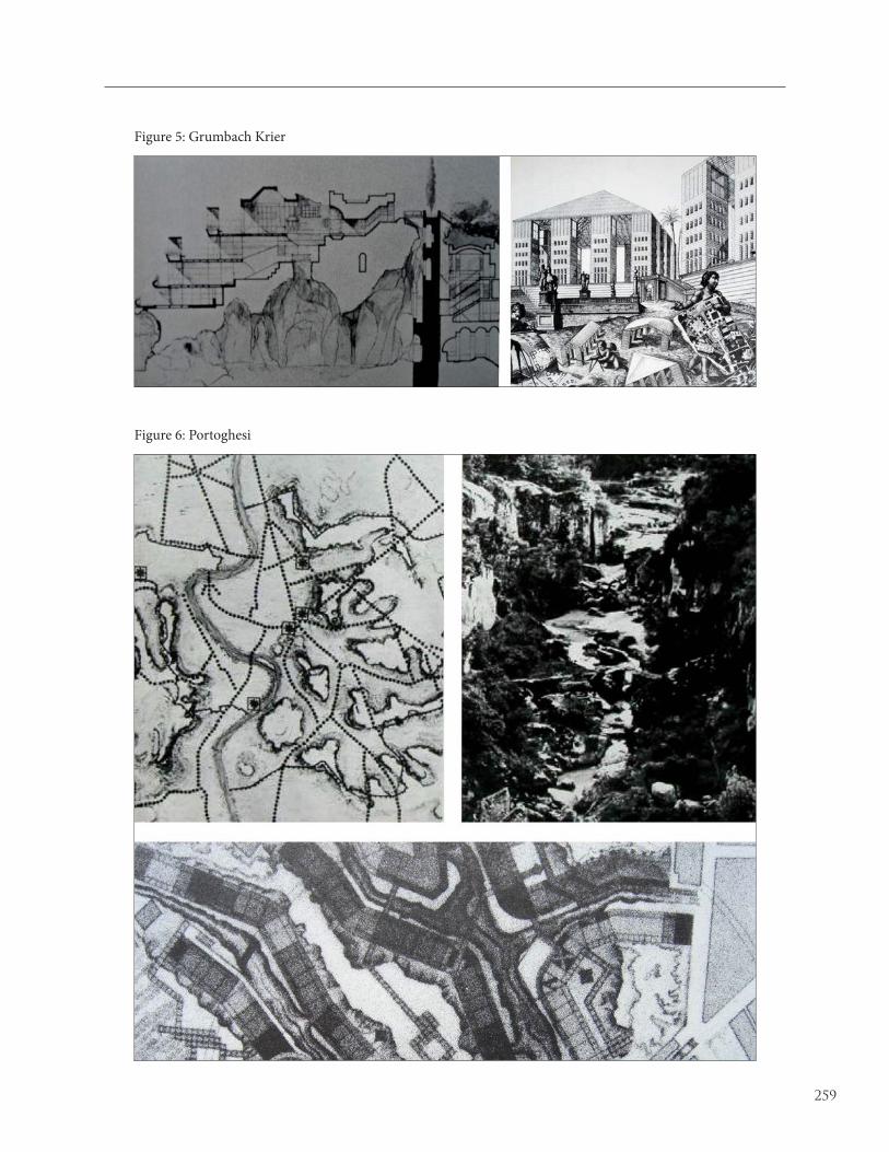
259
Figure 5: Grumbach Krier
Figure 6: Portoghesi

260
Figure 7: Anselmi
Figure 8: Purini Stratificare

261
Figure 9: Tesselapergola
Figure 10: Borghetto