Geology of the Leadore Area and Other Papers - MBMG
166
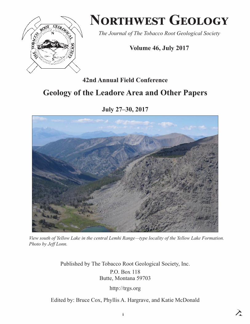
i Nඈඋඍඐൾඌඍ Gൾඈඅඈඒ The Journal of The Tobacco Root Geological Society Volume 46, July 2017 42nd Annual Field Conference Geology of the Leadore Area and Other Papers July 27–30, 2017 Published by The Tobacco Root Geological Society, Inc. P.O. Box 118 Butte, Montana 59703 http://trgs.org Edited by: Bruce Cox, Phyllis A. Hargrave, and Katie McDonald View south of Yellow Lake in the central Lemhi Range—type locality of the Yellow Lake Formation. Photo by Jeff Lonn.
-
Upload
khangminh22 -
Category
Documents
-
view
1 -
download
0
Transcript of Geology of the Leadore Area and Other Papers - MBMG
i
N GThe Journal of The Tobacco Root Geological Society
Volume 46, July 2017
42nd Annual Field Conference
Geology of the Leadore Area and Other Papers
July 27–30, 2017
Published by The Tobacco Root Geological Society, Inc.P.O. Box 118
Butte, Montana 59703
http://trgs.org
Edited by: Bruce Cox, Phyllis A. Hargrave, and Katie McDonald
View south of Yellow Lake in the central Lemhi Range—type locality of the Yellow Lake Formation. Photo by Jeff Lonn.

ii
The Tobacco Root Geological Society, Inc.P.O. Box 118
Butte, Montana 59703
Offi cers, 2017:
President: Jesse Mosolf, Montana Bureau of Mines and Geology, Butte, MT Vice-President: William M. Phillips, Idaho Geological Survey, Moscow, ID
Treasurer: Katie McDonald, Montana Bureau of Mines and Geology, Butte, MT Secretary: Emily Geraghty Ward, Rocky Mountain College, Billings, MT
Corresponding Secretary: Lara Strickland, Columbus, MTWebmasters: Skye Cooley (Missoula, MT) and Petr Yakovlev (Butte, MT)
Board of Directors, 2017:
Ted Antonioli, Geologist, Missoula, MTBruce E. Cox, Geologist (semi-retired), Missoula, MT
Larry Johnson, Consultant, Missoula, MTLarry N. Smith, Dept. of Geological Engineering, Montana Tech, Butte, MT
Mike Stickney, Montana Bureau of Mines and Geology, Butte, MTRobert C. Thomas, Dept. of Environmental Sciences, U. of Montana-Western, Dillon, MT
Emily Geraghty Ward, Geology Dept., Rocky Mountain College, Billings, MT
2017 Conference Organizers:
Bruce Cox, Geologist, Missoula, Montana
Editors: Bruce Cox, Phyllis A. Hargrave (MBMG), and Katie McDonald (MBMG)
Layout and Editing: Susan Barth (MBMG)
Printed by Insty-Prints, Butte, Montana
ISSN: 0096-7769© 2017 The Tobacco Root Geological Society, Inc.
http://trgs.org
iii
N GThe Journal of The Tobacco Root Geological Society
Volume 46, July 2017
Geology of the Leadore Areaand Other Papers
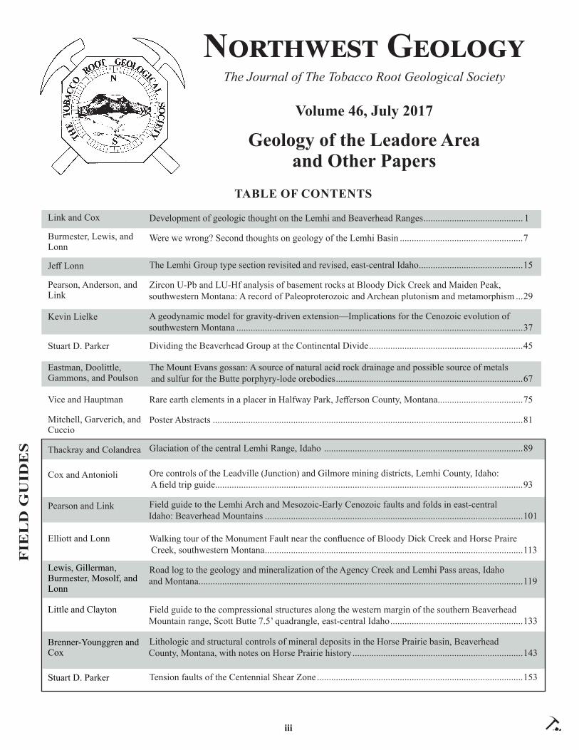
TABLE OF CONTENTS
Development of geologic thought on the Lemhi and Beaverhead Ranges .......................................... 1
Were we wrong? Second thoughts on geology of the Lemhi Basin ....................................................7
The Lemhi Group type section revisited and revised, east-central Idaho ............................................15
Zircon U-Pb and LU-Hf analysis of basement rocks at Bloody Dick Creek and Maiden Peak, southwestern Montana: A record of Paleoproterozoic and Archean plutonism and metamorphism ...29
A geodynamic model for gravity-driven extension—Implications for the Cenozoic evolution of southwestern Montana .........................................................................................................................37
Dividing the Beaverhead Group at the Continental Divide .................................................................45
The Mount Evans gossan: A source of natural acid rock drainage and possible source of metals and sulfur for the Butte porphyry-lode orebodies ...............................................................................67
Rare earth elements in a placer in Halfway Park, Jeff erson County, Montana ....................................75
Poster Abstracts ...................................................................................................................................81
Glaciation of the central Lemhi Range, Idaho ....................................................................................89
Ore controls of the Leadville (Junction) and Gilmore mining districts, Lemhi County, Idaho: A fi eld trip guide..................................................................................................................................93
Field guide to the Lemhi Arch and Mesozoic-Early Cenozoic faults and folds in east-central Idaho: Beaverhead Mountains .............................................................................................................101
Walking tour of the Monument Fault near the confl uence of Bloody Dick Creek and Horse Praire Creek, southwestern Montana .............................................................................................................113
Road log to the geology and mineralization of the Agency Creek and Lemhi Pass areas, Idaho and Montana .........................................................................................................................................119
Field guide to the compressional structures along the western margin of the southern Beaverhead Mountain range, Scott Butte 7.5’ quadrangle, east-central Idaho ........................................................133
Lithologic and structural controls of mineral deposits in the Horse Prairie basin, Beaverhead County, Montana, with notes on Horse Prairie history ........................................................................143
Tension faults of the Centennial Shear Zone .......................................................................................153
Link and Cox
Burmester, Lewis, and Lonn
Jeff Lonn
Pearson, Anderson, and Link
Kevin Lielke
Stuart D. Parker
Eastman, Doolittle, Gammons, and Poulson
Vice and Hauptman
Mitchell, Garverich, and Cuccio
Thackray and Colandrea
Cox and Antonioli
Pearson and Link
Elliott and Lonn
Lewis, Gillerman, Burmester, Mosolf, and Lonn
Little and Clayton
Brenner-Younggren and Cox
Stuart D. Parker
FIE
LD
GU
IDE
S

iv
TRGS 2017 SCHOLARSHIP AWARD WINNERS
• Andrew Canada (TRGS) University of IdahoThe Eocene Elko Formation: A Paleogeographic Record of High-Elevation Lake Basin Formation
and Topographic Evolution in the North American Cordilleran Hinterland
• Philip Dalhof (Foster) Colorado State UniversityMapping of hydrothermal alterations in the Boulder Batholith and related igneous rocks using a pXRF
• Garrett Hill (Harrison) Montana TechUsing fl uid inclusions and C, O, H, and Sr isotopes to understand the genesis of dolomite-hosted talc
mineralization in Montana
• Erin Lathrop (Harrison) Utah State University Capturing changes in the Mesoproterozoic carbon cycle: C-isotope stratigraphy of the 1255 Ma Bass
Formation, Grand Canyon Supergroup, AZ
• Zachary Lettenga (Foster) Montana TechProspecting Placer Gold in Libby Creek
• Jacob McCane (Foster) Colorado State UniversityThe Petrogenesis of Lamprophyric Rocks of the Absaroka Volcanic Province and their Association with
Gold Mineralization
• William Moynihan (TRGS) Idaho State UniversityPaleontology and sequence stratigraphy of the near-shore facies of the Permian Phosphoria Formation
in the Teton, Gros Ventre, and Wind River ranges, Wyoming
• Ashely Provow (Skipp) Utah State UniversityReconstructing paleofl uidrock interactions using electron microprobe dating of authigenic monazite in
Neoproterozoic sandstones
• Jacob Thacker (TRGS) University of New MexicoRegional tectonic analysis of Laramide orogenesis using fi eld studies, apatite fi ssion track, and
(U-Th)/He thermochronology
• Richard Trippe (Harrison) University of MontanaGeology of a structurally inverted graben of possible Cambrian age, southern Pioneer Mountains,
southwestern Montana
• Matthew Wanker (TRGS) Indiana UniversityTracking sediment through a river bifurcation on the Jeff erson River, MT
• Mike Zawaski (TRGS) University of Colorado, BoulderStromatolites as chemical and isotopic probes of paleoenvironmental conditions during the
Permian-Triassic extinction event
v
TRGS CHARTER MEMBERS
Stanley W. AndersonClyde CodyWilliam S. CorduaLanny H. FiskRichard I. Gibson† Thomas HanleyStephen W. HendersonThomas E. HendrixMac R. HootonInda ImmegaSteven W. KoehlerMarian Millen Lankston†Robert W. Lankston†J. David LazorJoe J. Liteheiser, Jr.Judson Mead*Marvin R. MillerVicki M. Miller*Allen H. NelsonAlfred H. PekarekPatricia Price*Donald L. RasmussenRaymond M. Rene
TRGS LIFETIME MEMBERS
John Childs Rob FosterJoan (Mrs. Jack) Harrison*Karen KeeferLayaka MannChris Pool
† = co-founder* = deceased
TRGS HAMMER AWARD
RECIPIENTS
Awarded for distinguished achievement in the study of the geology of the
Northern Rocky Mountains
1993: Ed Ruppel*1994: Dick Berg2003: Don Winston2004: Dean Kleinkopf*2009: Betty Skipp2010: Jim Sears2011: John Childs2012: J. Michael O’Neill2013: Paul Karl Link2014: Reed Lewis2015: Jeff Lonn2016: Bruce Cox
TRGS HONORARY MEMBERS
1980: Charles J. Vitaliano*2008: Elizabeth Younggren (also honorary Board member)
2010: Dick Berg2010: Bruce Cox2010: Dean Kleinkopf*2010: Dave Lageson2011: Marie Marshall Garsjo2011: Paul Link2011: Rob Thomas2012: Jeff Lonn 2012: Mitch Reynolds2013: Reed Lewis2015: Don Winston
vi
DEDICATIONS
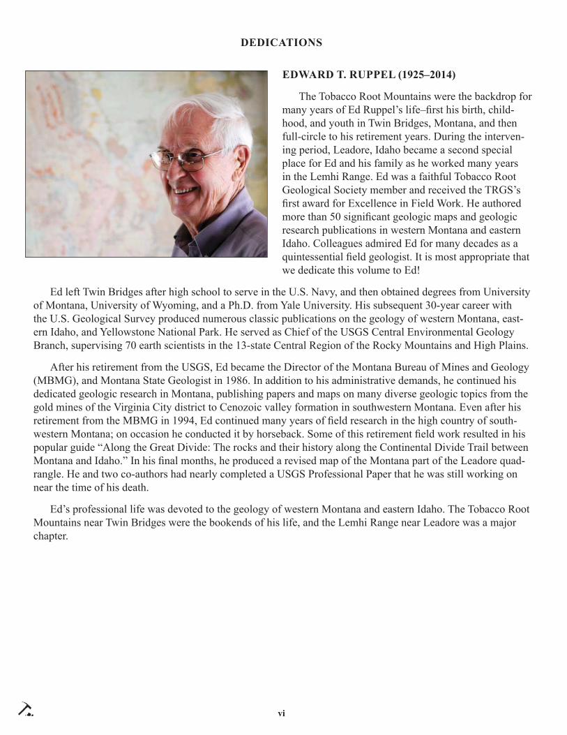
EDWARD T. RUPPEL (1925–2014)
The Tobacco Root Mountains were the backdrop for many years of Ed Ruppel’s life–fi rst his birth, child-hood, and youth in Twin Bridges, Montana, and then full-circle to his retirement years. During the interven-ing period, Leadore, Idaho became a second special place for Ed and his family as he worked many years in the Lemhi Range. Ed was a faithful Tobacco Root Geological Society member and received the TRGS’s fi rst award for Excellence in Field Work. He authored more than 50 signifi cant geologic maps and geologic research publications in western Montana and eastern Idaho. Colleagues admired Ed for many decades as a quintessential fi eld geologist. It is most appropriate that we dedicate this volume to Ed!
Ed left Twin Bridges after high school to serve in the U.S. Navy, and then obtained degrees from University of Montana, University of Wyoming, and a Ph.D. from Yale University. His subsequent 30-year career with the U.S. Geological Survey produced numerous classic publications on the geology of western Montana, east-ern Idaho, and Yellowstone National Park. He served as Chief of the USGS Central Environmental Geology Branch, supervising 70 earth scientists in the 13-state Central Region of the Rocky Mountains and High Plains.
After his retirement from the USGS, Ed became the Director of the Montana Bureau of Mines and Geology (MBMG), and Montana State Geologist in 1986. In addition to his administrative demands, he continued his dedicated geologic research in Montana, publishing papers and maps on many diverse geologic topics from the gold mines of the Virginia City district to Cenozoic valley formation in southwestern Montana. Even after his retirement from the MBMG in 1994, Ed continued many years of fi eld research in the high country of south-western Montana; on occasion he conducted it by horseback. Some of this retirement fi eld work resulted in his popular guide “Along the Great Divide: The rocks and their history along the Continental Divide Trail between Montana and Idaho.” In his fi nal months, he produced a revised map of the Montana part of the Leadore quad-rangle. He and two co-authors had nearly completed a USGS Professional Paper that he was still working on near the time of his death.
Ed’s professional life was devoted to the geology of western Montana and eastern Idaho. The Tobacco Root Mountains near Twin Bridges were the bookends of his life, and the Lemhi Range near Leadore was a major chapter.

vii
VICTORIA E. MITCHELL (1954–2017)
Victoria E. Mitchell passed away in April after over 30 years’ service with the Idaho Bureau of Mines and the Idaho Geological Survey. She assisted with the 250,000-scale geologic map compila-tion project in the late 1970s and later established the IGS Mines and Prospects Database, which contains information on over 8,000 Idaho mines and prospects. Vicki wrote histories for 57 Idaho mines and co-authored numerous site inspection reports for aban-doned and inactive mines. These reports give mine production data and concise descriptions of mineral deposit geology compiled from previous investigators. The reports are available as Staff Reports in the Idaho Geological Survey website. Two of Vicki’s reports are of
particular interest to this years’ TRGS fi eld conference: “History of Mines in the Texas Mining District near Gilmore, Idaho, 1997” and “History of the Leadville, Kimmel and Baby Joe Mines, Lemhi County, Idaho, 2004.” Vicki received an Esto Perpetua award from the Idaho State Historical Society in 2006 for her work on Idaho’s mining history. Esto Pertpetua is the highest award given for historical research in Idaho. In addition to her professional career, Vicki enjoyed, and successfully wrote, science fi ction novels and short stories and participated in science fi ction conventions. According to her obituary, she died peacefully at home surrounded by her dogs.
DEDICATIONS


PAPERS


Northwest Geology, v. 46, 2017, p. 1–6 The Journal of the Tobacco Root Geological Society11
DEVELOPMENT OF GEOLOGIC THOUGHT ON THE LEMHI AND BEAVERHEAD RANGESPaul K. Link1 and Bruce Cox2
1Department of Geosciences, Idaho State University, Pocatello, ID 83209, [email protected]/Consultant, Missoula, Montana, [email protected]
INTRODUCTION
The Beaverhead Range has been historically important for over 200 years, since the fi rst Euro-American exploration of the area. In 1806, Lewis and Clark used Lemhi Pass to get over the Beaverhead Range. In the early 20th century, discovery of silver–lead deposits at Gilmore and Leadore motivated the construction of the Gilmore and Pittsburgh railroad, the last constructed and fi rst dismantled of railroads in the northern Rockies.
Several important geologic relations exist in the Beaverhead and Lemhi Ranges, and these have been documented by important fi gures in the history of Ida-ho and Montana Geology. In the past 40 years, most of these geologists have been active in the Tobacco Root Geological Society.
PALEOZOIC STRATIGRAPHY
Larry Sloss (1953) observed that lower Paleozoic strata thinned from southwest Montana into Idaho over what he called the Lemhi Arch. This observation grew into the recognition of North American cratonic sequences, which are the framework for regional stratigraphic studies (Sloss, 1988). C. Ross (1962) and colleagues established the Paleozoic stratigraphy of east-central Idaho.
Rob Scholten and colleagues (Scholten, 1957a, 1957b; Scholten and Ramspott, 1968) documented the Lemhi Arch as manifested by the Skull Canyon disturbance and developed the concept of a thrust belt in southwest Montana. In the Lemhi Arch, Mesopro-terozoic Belt Supergroup country rock is intruded by alkalic plutons of the Neoproterozoic and Cambrian Big Creek–Beaverhead Belt (Evans and Zartman, 1988, 1990; Lund and others, 2010). Locally, the latest Neoproterozoic Wilbert Formation crops out above the Belt Supergroup (Skipp and Link, 1992), but in most places on the arch the Middle Ordovician Kinnikinic Quartzite unconformably lies on Belt Supergroup strata.
Charlie Sandberg and colleagues (Poole and Sandberg, 1991) studied Mississippian carbonate bank facies in southwest Montana and adjacent Idaho. They used conodonts to establish a framework for both early Mississippian and late Mississippian carbonate banks that can be recognized from the craton on the east across thrust sheets to the Copper Basin Antler fl ysch trough in the Pioneer Mountains on the west (Skipp and others, 1979; Beranek and others, 2016).
Decades of mapping by Glenn Embree and col-leagues (Embree and others, 1975, 1983; Price and others, 1999) has contributed a wealth of stratigraphic data for the southern Beaverhead Mountains.
DETRITAL ZIRCON STUDIES
Deciphering the age and provenance of sandstones of the Beaverhead and Lemhi Ranges was frustrat-ing before the advent of geochronological techniques based around isotopic analysis of individual grains of the mineral zircon (Gehrels and others, 2008). The use of analyses of detrital zircons from these sandstones began with G. Ross and others (1992) and today is essential to understanding the rocks (Link and others, 2007, 2016; Lewis and others, 2010).
Detrital zircon studies have allowed us to answer questions that previously we could not even ask about the age and derivation of quartzose sandstones. Detri-tal zircon studies allow us to determine the maximum possible age for a sandstone, and for tuff aceous rocks, allow us to estimate a depositional age. Further, the comparison of detrital zircon age-populations allows us to make inferences about source areas and continu-ity of depositional basins. Geslin and others (1999) used the presence of 480 Ma detrital zircons to fi nger-print input of sands from Birch Creek, draining plu-tons of the southern Beaverhead Mountains.
BELT SUPERGROUP
Based on sedimentary facies, Don Winston and colleagues (Winston and Link, 1993; Winston and others, 1999) proposed that east-central Idaho Lemhi

2
Link and Cox: Development of Geologic Thought on Lemhi and Beaverhead Ranges
Group quartzites were indeed part of the Belt Super-group, rather than from a separate depositional basin. Work by Tydsal (2003) confi rmed this conclusion. Continuing on this premise, and using detrital zircon data, Burmester and others (2016) defi ned new strati-graphic units of upper Belt Supergroup strata exposed in the Beaverhead Range. The geologic map of Lewis and others (2016) uses this stratigraphic framework.
Detrital zircons from many of these rocks contain the same provenance, with a 1,740 to 1,720 Ma age peak (Link and others, 2016). This provenance is at-tributed to the Big White arc, a huge magmatic arc to the south.
BEAVERHEAD IMPACT
Shattercones found in Belt Supergroup strata in a wide area of the southeastern Beaverhead Mountains indicate that a large meteorite impact, the Beaverhead Impact, occurred at or after 900 Ma (Hargraves and others, 1990; Kellogg and others, 2003).
CORDILLERAN THRUST BELT
Betty Skipp (1987, 1988) also mapped in the southern Beaverheads and defi ned the Cabin thrust as a major compressional structure that includes bits of crystalline basement along its leading edge. On the west side of the Beaverhead Range, the Hawley Creek thrust has been proposed to be part of the Cabin system.
The steep northern Beaverhead Range and much of the Lemhi Range were mapped by Ed Ruppel (1968), who established that Belt Supergroup underlies much of the area (Ruppel, 1975). Ruppel and Lopez (1988) summarized the geology of the Lemhi Range and the mineral deposits of the Gilmore area, related to the Eocene Challis magmatic episode (M’Gonigle and Dalrymple, 1996) and host rock Paleozoic carbonates.
EXTENSIONAL DEFORMATION
Susanne Janecke and students (Janecke, 1992; Ja-necke and others, 1998, 2003) mapped in the Salmon basin and Horse Prairie areas and described the Salm-on Basin detachment, an Eocene to Miocene, pre-Ba-sin and Range detachment system, which preceded the late Miocene to Recent high-angle Basin and Range normal faults (Bennett, 1988) of the area.
SNAKE RIVER PLAIN-YELLOWSTONE PROVINCE
In the last 17 m.y., rhyolite magmatism of the Snake River Plain province has migrated northeast-ward across southern Idaho concomitant with Basin and Range normal faulting (Pierce and Morgan, 1992). Some of the rhyolite ignimbrites reach into the Birch Creek and Lemhi Valleys.
GEOLOGIC MAPS
Early geologic maps of the Lemhi and Beaver-head area include Umpleby (1913) and Anderson (1956, 1961). The U.S. Geological Survey produced a geologic map of the northern Lemhi and Beaver-head Ranges (Evans and Green, 2003) that serves as a starting point for ongoing studies (Lewis and others, 2016).
MINERAL DEPOSITS
From 1880 to the late 20th century, metallic mineral deposits were discovered and developed in Lemhi County and Cassia County, especially along the rangefront foothills adjacent to the Lemhi and Birch Creek Valleys. Chemically and texturally re-ceptive host rocks and long-lived structural features provided favorable sites for deposition of economic concentrations of silver, base metals, and gold. Perm-ian phosphate deposits and thorium/rare earth deposits of Lemhi County have received intense exploration scrutiny in the past 50 years.
With few exceptions, mining and mineral explora-tion have been dormant in southern Lemhi County for several decades. However, the volume of historic and geologic literature on the subject is considerable. Sev-eral previous authors supplemented their fi eld inves-tigation reports with data supplied by the mine opera-tors, most notably Umpleby (1913), Ruppel and Lopez (1988), and Mitchell (2004). Similar eff ort has been made to document industrial minerals occurrences and exploration (Scholten, 1957a; Gillerman and others, 2003). There is probably an equal or greater volume of unpublished mineral exploration and mine production data for these Lemhi County and Clark County mining districts. In aggregate, the data can build 4-dimension-al pictures of ore controls for the deposits that have been historically exploited and help construct models for deposits yet to be discovered.

3
Link and Cox: Development of Geologic Thought on Lemhi and Beaverhead Ranges
Several advancements in exploration theory and technology have occurred since area mines were in their heyday. Foremost is development of the porphyry copper ore deposit model. Porphyry copper deposits commonly exhibit predictable alteration assemblages, metal zoning, structural control, and mid-Tertiary (Eo-cene) age. These features are evident along the eastern margin of the Lemhi Range and provide rationale for continued exploration. The western margins of the Beaverhead Range display similar but more subtle intrusive porphyry features.
REFERENCES CITED
Anderson, A.L., 1956, Geology and mineral resources of the Salmon quadrangle, Lemhi County, Idaho: Idaho Bureau of Mines and Geology Pamphlet 106, 102 p.
Anderson, A.L., 1961, Geology and mineral resources of the Lemhi quadrangle, Lemhi County, Idaho: Idaho Bureau of Mines and Geology Pamphlet 124, 111 p.
Bennett, E.H., 1986, Relationship of the Trans-Challis fault system in central Idaho to Eocene and Basin-and-Range extensions: Geology, v. 14, p. 481–484.
Beranek, L.P., Link, P.K., and Fanning, C.M., 2016, Detrital zircon record of mid-Paleozoic conver-gent margin activity in the northern U.S. Rocky Mountains: Implications for the Antler orogeny and early evolution of the North American Cordil-lera: Lithosphere: doi: 10.1130/L557.
Burmester, R.F., Lonn, J.D., Lewis, R.S., and McFad-dan, M.D., 2016, Stratigraphy of the Lemhi sub-basin of the Belt Supergroup, in MacLean, J.S., and Sears, J.W., Belt Basin: Window to Meso-proterozoic Earth: Geological Society of America Special Paper, v. 522, p. 121–137.
Embree, G.F., Hoggan, R.D., Williams, E.J., and Skipp, Betty, 1975, Stratigraphy of southern Bea-verhead Range, Clark and Lemhi Counties, Idaho: Geological Society of America Abstracts with Programs, v. 7, no. 5, p. 607.
Embree, G.F., Hoggan, R.D., and Williams, E.J., 1983, Preliminary reconnaissance geologic map of the Copper Mountain quadrangle, Lemhi County, Idaho: U.S. Geological Survey Open-File Report 83-599, 1:24,000.
Evans, K.V., and Green, G.G., compilers, 2003, Geologic map of the Salmon National Forest and vicinity, east-central Idaho: U.S. Geological Sur-vey Geologic Investigations Series Map I-2765, 2 sheets, scale 1:100,000.
Evans, K.V., and Zartman, R.E., 1988, Early Paleo-zoic alkalic plutonism in east-central Idaho: Geological Society of America Bulletin 100, p. 1981–1987.
Evans, K.V., and Zartman, R.E., 1990, U-Th-Pb and Rb-Sr geochronology of Middle Proterozoic gran-ite and augen gneiss, Salmon River Mountains, east-central Idaho: Geological Society of America Bulletin, v. 102, p. 63–73.
Gehrels, G.E., Valencia, V.A., and Ruiz, J., 2008, Enhanced precision, accuracy, effi ciency, and spatial resolution of U-Pb ages by laser ablation-multicollector-inductively coupled plasma-mass spectrometry: Geochemistry, Geo-physics, Geosystems, v. 9, no. 3, Z03017, doi: 10.1029/2007GC001805
Geslin, J.K., Link, P.K., and Fanning, C.M., 1999, High-precision provenance determination using detrital-zircon ages and petrography of Quaterna-ry sands on the eastern Snake River Plain, Idaho: Geology, v. 27, p. 295–298.
Gillerman, V.S., Lund, K., and Evans, K.V., 2003, Stratigraphy, structure, and mineral deposits of the Lemhi Pass area, central Beaverhead Moun-tains, eastern Idaho: Northwest Geology, v. 32, p. 134–146.
Hargraves, R.B., Cullicott, C.E., Deff eyes, K.S., Hougen, S.B., Christiansen, P.P., and Fiske, P.S., 1990, Shatter cones and shocked rocks in south-western Montana: The Beaverhead impact struc-ture: Geology, v. 18, p. 832–834.
Janecke, S.U., 1992, Kinematics and timing of three superposed extensional systems, east central Idaho: Evidence for an Eocene tectonic transition: Tectonics, v. 11, p. 1121–1138.
Janecke, S.U., and Blankenau, J.J., 2003, Extensional folds associated with Paleogene detachment faults in SE part of the Salmon Basin: Northwest Geol-ogy, v. 32, p. 51–73.
Janecke, S.U., Vandenburg, C.J., and Blankenau, J.J., 1998, Geometry, mechanisms and signifi cance of extensional folds from examples in the Rocky

4
Link and Cox: Development of Geologic Thought on Lemhi and Beaverhead Ranges
Mountain Basin-and-Range province, U.S.A., Journal of Structural Geology, v. 20, no. 7, p. 841–856.
Kellogg, K.S., Snee, L.W., and Unruh, D.M., 2003, The Mesoproterozoic Beaverhead impact struc-ture and its tectonic setting: 40Ar/39Ar and U/Pb isotopic constraints: Journal of Geology, v. 222, p. 639–652.
Lewis, R.S., Vervoort, J.D., Burmester, R.F., and Oswald, P.J., 2010, Detrital zircon analysis of Mesoproterozoic and Neoproterozoic metasedi-mentary rocks of northcentral Idaho: Implications for development of the Belt-Purcell Basin: Cana-dian Journal of Earth Sciences, v. 47, no. 11, p. 1383–1404, doi:10.1139/E10-049.
Lewis, R.S., Othberg, K.L., Stanford, L.R., and Mc-Fadden, M.D., 2016, Geologic map of the western part of the Salmon 30’ x 60’ quadrangle, Idaho and Montana: Idaho Geological Survey Geologic Map GM-52, scale 1:75,000.
Link, P.K., Fanning, C.M., Lund, K.I., and Aleinikoff , J.N., 2007, Detrital zircons, correlation and prov-enance of Mesoproterozoic Belt Supergroup and correlative strata of east-central Idaho and south-west Montana, in Link, P.K., and Lewis, R.S., eds., SEPM Special Publication 86, Proterozoic geology of western North America and Siberia, p. 101–128.
Link, P.K., Stewart, E.D., Steel, T., Sherwin, J.-A., Hess, L.T., and McDonald, C., 2016, Detrital zircons in the Mesoproterozoic upper Belt Su-pergroup in the Pioneer, Beaverhead and Lemhi Ranges, Montana and Idaho: The Big White arc, in MacLean, J.S, and Sears, J.W., eds., Belt Basin: Window to Mesoproterozoic Earth: Geo-logical Society of America Special Paper 522, p. 163–183, doi:10.1130/2016.2522(03)
Lund, K., Aleinikoff , J.N., Evans, K.V., duBray, E.A., Dewitt, E.H., and Unruh, D.M., 2010, SHRIMP U-Pb dating of recurrent Cryogenian and Late Cambrian-Early Ordovician alkalic magmatism in central Idaho: Implications for Rodinian rift tec-tonics: Geological Society of America Bulletin, v. 122, no. 3/4, p. 430–453.
Mitchell, V.E., 2004, History of the Leadville, Kim-mel, and Baby Joe mines, Lemhi County, Idaho: Idaho Geological Survey Staff Report 04-1, 35 p.
M’Gonigle, J.W., and Dalrymple, G.B., 1996, 40Ar/39Ar ages of Challis volcanic rocks and the initiation of Tertiary sedimentary basins in south-western Montana: U.S. Geological Survey Bul-letin 2132, 17 p.
Pierce, K.L., and Morgan, L.A., 1992, The track of the Yellowstone hot spot: Volcanism, faulting, and uplift, in Link, P.K., Kuntz, M.A., and Platt, L.B., eds., Regional geology of eastern Idaho and west-ern Wyoming: Geological Society of America Memoir 179, p. 1–53.
Poole, F.G., and Sandberg, C.A., 1991, Mississippian paleogeography and conodont biostratigraphy of the Western United States, in Cooper, J.D., and Stevens, C.H., eds., Paleozoic Paleogeography of the Western United States-II: Pacifi c Section Society of Economic Paleontologists and Miner-alogists, Book 67, v. 1, p. 107–136.
Price, K.B., Embree, G., Hoggan, R., and Hansen, S., 1999, Field guide along the northern edge of the eastern Snake River Plain, and the Lemhi and Beaverhead Mountain Ranges bordering Birch Creek Valley, Idaho, in Hughes, S.S., and Thack-ray, G.D., eds., Guidebook to the geology of eastern Idaho: Idaho Museum of Natural History, p. 335–342.
Ross, C.P., 1962, Stratifi ed rocks in south-central Idaho: Idaho Bureau of Mines and Geology Pam-phlet 125, 126 p.
Ross, G.M., Parrish, R.R., and Winston, D., 1992, Provenance and U-Pb geochronology of the Mesoproterozoic Belt Supergroup (northwestern United States): Implications for age of deposition and pre-Panthalassa plate reconstructions: Earth and Planetary Science Letters, v. 113, p. 57–76.
Ruppel, E.T., 1968, Geologic map of the Leadore quadrangle, Lemhi County, Idaho: U.S. Geologi-cal Survey Geological Quadrangle Map GQ-733, scale 1:62,500.
Ruppel, E.T., 1975, Precambrian Y sedimentary rocks in east-central Idaho: U.S. Geological Survey Professional Paper 889-A, 23 p.
Ruppel, E.T., and Lopez, D.A., 1988, Regional geol-ogy and mineral deposits in and near the central part of the Lemhi Range, Lemhi County, Idaho: U.S. Geological Survey Professional Paper 1480, 122 p.

5
Link and Cox: Development of Geologic Thought on Lemhi and Beaverhead Ranges
Scholten, R., 1957a, Paleozoic evolution of the geo-synclinal margin north of the Snake River Plain, Idaho–Montana: Geological Society of America Bulletin, v. 68, p. 151–170.
Scholten, R., 1957b, Preliminary interpretation of Permo-Carboniferous stratigraphy in east-central Idaho–Montana: Geological Society of America Bulletin v. 68, no. 12, p. 1794.
Scholten, R., and Ramspott, L.D., 1968, Tectonic mechanisms indicated by structural framework of central Beaverhead Range, Idaho–Montana: Geological Society of America Special Paper 104, 71 p., map scale 1:62,500.
Skipp, Betty, 1987, Basement thrust sheets in the Clearwater orogenic zone, central Idaho and west-ern Montana: Geology, v. 15, p. 220–224.
Skipp, Betty, 1988, Cordilleran thrust belt and faulted foreland in the Beaverhead Mountains, Idaho and Montana, in Schmidt, C.J., and Perry, W.R, Jr., eds., Interaction of the Rocky Mountain foreland and Cordilleran thrust belt: Geological Soci-ety of America Memoir 171, p. 237–266, scale 1:250,000.
Skipp, Betty, and Link, P.K., 1992, Middle and Late Proterozoic rocks and Later Proterozoic tecton-ics in the southern Beaverhead Mountains, Idaho and Montana: A preliminary report, in Link, P.K., Kuntz, M.A., and Platt, L.B., eds., Regional Geology of Eastern Idaho and Western Wyoming: Geological Society of America Memoir 179, p.141–154.
Skipp, Betty, Sando, W.J., and Hall, W.E., 1979, The Mississippian and Pennsylvanian (Carboniferous) systems in the United States-Idaho: U.S. Geologi-cal Survey Professional Paper 1110-AA, p. AA1–AA42.
Sloss, L.L., 1963, Sequences in the Cratonic Interior of North America: Geological Society of America Bulletin, v. 74, p. 93–114.
Sloss, L.L., 1988, Tectonic evolution of the craton in Phanerozoic time, in Sloss, L.L., ed., Sedimentary Cover–North American Craton, U.S.: Boulder, Colorado, Geological Society of America, The Geology of North America, v. D-2, p. 25–51.
Tysdal, R.G., 2003, Correlation, sedimentology, and structural setting, upper strata of Mesoproterozoic Apple Creek Formation and lower strata of Gun-
sight Formation, Lemhi Range to Salmon River Mountains, east-central Idaho: U.S. Geological Survey Professional Paper 1668-A, p. 1–22.
Umpleby, J.B., 1913, Geology and ore deposits of Lemhi County, Idaho: U.S. Geological Survey Bulletin 528, 182 p.
Winston, Don, and Link, P.K., 1993, Middle Pro-terozoic rocks of Montana, Idaho and Eastern Washington: The Belt Supergroup, in Reed, J.C., Jr., Bickford, M.E., Houston, R.S., Link, P.K., Rankin, D.W., Sims, P.K., and Van Schmus, W.R., eds., Precambrian: Conterminous U.S.: Boulder, Colorado, Geological Society of America, The Geology of North America, v. C-2, p. 487–517.
Winston, Don, Link, P.K., and Hathaway, Nate, 1999, The Yellowjacket is not the Prichard and other heresies: Belt Supergroup Correlations, Struc-ture and Paleogeography, east-central Idaho, in Hughes, S.S., and Thackray, G.D., eds., Guide-book to the Geology of Eastern Idaho: Pocatello, Idaho Museum of Natural History, p. 3–20.


Northwest Geology, v. 46, 2017, p. 7–14 The Journal of the Tobacco Root Geological Society77
WERE WE WRONG? SECOND THOUGHTS ON GEOLOGY OF THE LEMHI SUBBASINRussell F. Burmester,1,3 Reed S. Lewis,1 and Jeff rey D. Lonn2
1Idaho Geological Survey, University of Idaho, Moscow, Idaho 83844-30142Montana Bureau of Mines and Geology, Montana Tech, Butte, Montana 59701, [email protected], Western Washington University, Bellingham, Washington 98225-9080, [email protected]
ABSTRACT
Work on the stratigraphy and structure of the Lem-hi subbasin continues to yield surprises. This is partly because the units are incredibly thick, vary laterally, are faulted, and have non-unique characteristics. Even the Swauger Formation, which we had proposed 2 years ago was a regional marker, seems to vary across the basin, although it is still (so far) the closest to a unique unit in the basin. Where Swauger is not ex-posed, determining whether a section is Lemhi Group below the Swauger or Lawson Creek–Apple Creek Formations above is diffi cult. Compounded by lack of time (is money), our inability to map the whole basin in a short spell spawned a scenario reminiscent of the blind men and elephant parable. When we mapped beyond the Salmon 30' x 60' quadrangle, we saw dif-ferent parts of the Lemhi subbasin elephant than we had before. This led to doubts about some parts of the Salmon map and a pressing need to look both farther and in more detail outside that quadrangle.
INTRODUCTION
TRGS organizers (aka Bruce Cox) suggested that we summarize the state of research into Mesoprotero-zoic quartzites of Idaho and Montana, and discuss in particular (1) the stratigraphic problems, (2) what is known (or suspected) regarding the structural control of the Lemhi subbasin, (3) what fi eld observations and fi eld methods most directly address the problems, and (4) what questions remain. The brief answer to #1 is that some units appear to vary laterally within the mountain ranges in which they are exposed, the many faults within ranges make assembling complete sec-tions challenging, and several units appear to share lithologic and sedimentary structure (sediment type) characteristics. These complications make correlation between ranges diffi cult to support. For instance, see Lonn (this volume) for new ideas about the Lemhi Group type sections. Variation in appearance due to diff erent metamorphism and deformation across the
exposures clouds recognition of sedimentary charac-teristics that might be useful for recognition. For #2, we have no new data or thoughts to revise the current consensus that the Lemhi subbasin got a much later start and then subsided much more rapidly than the main Belt basin. The most recent speculation of how the Lemhi subbasin is related to the main Belt basin is Lonn and others (2016a). For #3, mapping and sam-pling in more detail probably is the only way to go, unless Don Winston could measure a few more sec-tions. For this, we would need to fi nd the fountain of youth, or some youths willing to better their elders. For #4, the main question is where to get the money to support more intensive fi eld work as well as petrogra-phy, geochemistry, and detrital zircon (DZ) analyses. More on some of these below, along with comments on our recently released map of the western part of the Salmon 30' x 60' quadrangle (Burmester and others, 2016a).
Previous TruthsMoney for our work in the Salmon area over the
past decade came mostly from the USGS Statemap program, the Idaho Geological Survey, and the Mon-tana Bureau of Mines and Geology. Statemap is focused on producing quadrangle maps, so we started with the stratigraphy that had been developed in the Lemhi Range. The stratigraphy accepted into the 21st century, built on regional and detailed mapping mostly in the Lemhi Range by earlier geologists (e.g., Anderson, Staatz, Ruppel, Tysdal, Evans, and Lund), consisted of Lemhi Group topped by the Swauger Formation and, in turn, a very thin Lawson Creek Formation. We started applying that stratigraphy to the Beaverhead Mountains as others had done (Evans and Green, 2003). What got the ball rolling for us to revise that stratigraphy (Burmester and others, 2013, 2016b) was recognition that east of the Beaverhead Divide, a thick section of feldspathic quartzite (meta-arkose if you prefer) was stratigraphically above a thick sec-tion of anomalously feldspar-poor and coarse-grained
8
Burmester, Lewis, and Lonn: Second Thoughts on Geology of the Lemhi Basin
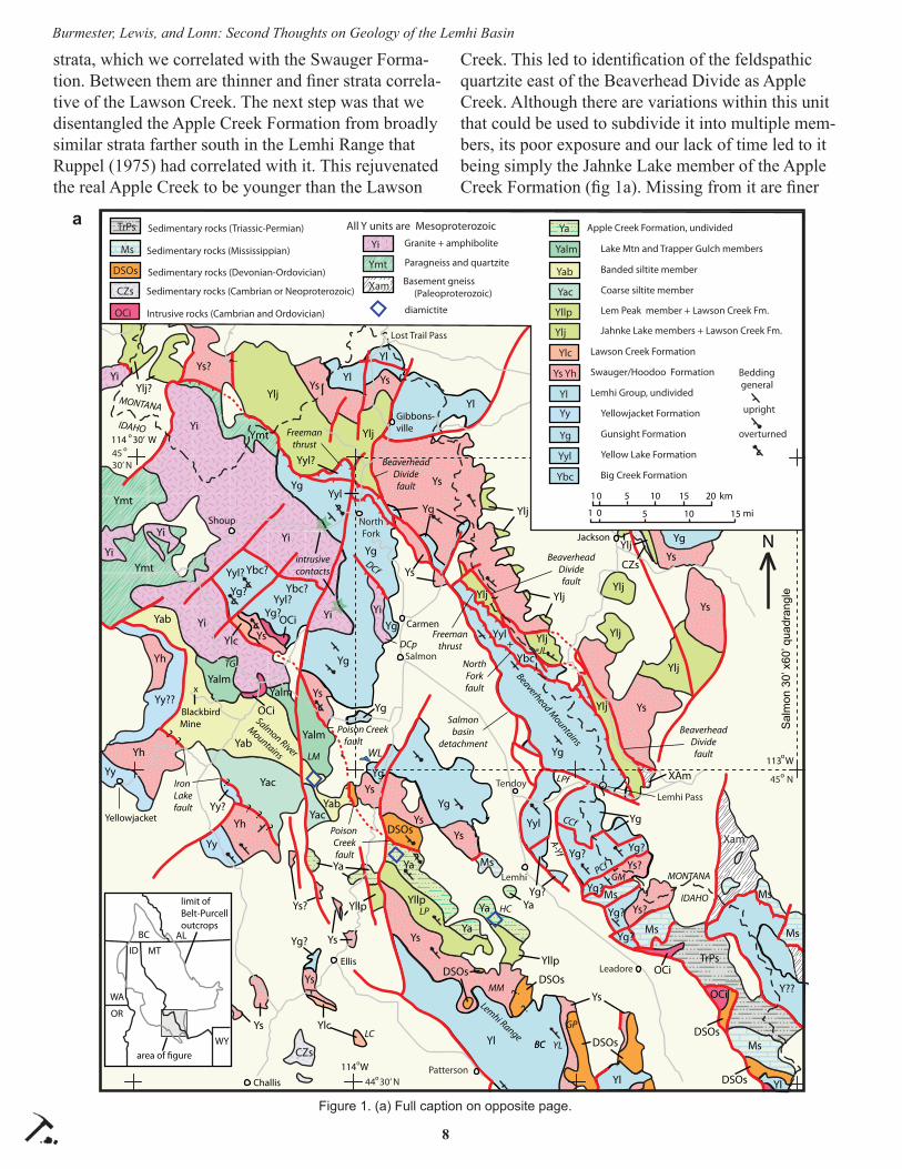
strata, which we correlated with the Swauger Forma-tion. Between them are thinner and fi ner strata correla-tive of the Lawson Creek. The next step was that we disentangled the Apple Creek Formation from broadly similar strata farther south in the Lemhi Range that Ruppel (1975) had correlated with it. This rejuvenated the real Apple Creek to be younger than the Lawson
Creek. This led to identifi cation of the feldspathic quartzite east of the Beaverhead Divide as Apple Creek. Although there are variations within this unit that could be used to subdivide it into multiple mem-bers, its poor exposure and our lack of time led to it being simply the Jahnke Lake member of the Apple Creek Formation (fi g 1a). Missing from it are fi ner
?
?
?
?
?
?
??
?
Yg
YgYyl
+Ybc
Yg?
Yg
Yg?
Yg
Yg?
Yyl? Ybc?
Yg?Yyl?
Ybc?
Yg
Yg
Yyl?
Yl
Yl
Yl
Yl
Yl
Y??
Yg?
Yg?
Yl
Ys
Ys
Ys
Ys?
Ys
Ys?
Yg?
YsYs
Ys
Ys
Ys
Ys
Ys
Ys
YsYsYlj
Ylj
Ylj
Ylj
Ylj
Ylj
Ylj
Ylj
Ylj Ylj
YllpYllp
Ylc
Yg?
YiYi
Yi
Yi
YiYi Yi
Ys?
YaYa
Ya
Ya Ya
Ms
Ms
Ms
Ms
Ms
Ms
DSOsDSOs
CZs
OCi
XAm
OCi
TrPs
DSOs
Yg
Yalm
YalmYalm
Yy
Yy?
Yy
Yy??
Yh
Yh
Yh
Yac
Yac
Yab
Yab
Yi
Ymt
Ymt
Ymt
OCi
OCi
Yg
Yyl
Yyl
Yg
Ys
Ys
Ylj
CZs
Ylj?
DSOs
Xam
Yg
DSOsDSOs
Ys
Ylc
Yab
Ys?
Yg?
Yg
Yllp
WL
Lemhi Range
Beaverhead Mountains
Salmon River
Mountains
Sula
BC
GP
YL
MM
LP
LC
CCf
LPf
A-Yf
HC
JL
BC
Freemanthrust
Freemanthrust
LM
NorthForkfault
Salmonbasin
detachment
BeaverheadDividefault
BeaverheadDividefault
BeaverheadDividefault
Poison Creekfault
Iron Lakefault
Poison Creekfault
TG
i
intrusivecontacts
DCf
PCfGM
DCp
Yellowjacket
Shoup
BlackbirdMine
Salmon
Leadore
Sula
Lost Trail Pass
Carmen
MONTANA
Ellis
Jackson
Challis
IDAHO
MONTANA
IDAHO
Patterson
NorthFork
Gibbons-ville
x
Lemhi Pass
Lemhi
TendoySa
lmon
30’
x60
’ qua
dran
gle
113 W
114 W
45 No
o
o
44 30’ No
N
114 30’ W45 30’ N
o
o
Intrusive rocks (Cambrian and Ordovician)OCi
Granite + amphiboliteYi
Yellowjacket FormationYy
Paragneiss and quartzite
diamictite
Ymt Banded siltite memberYab
Lake Mtn and Trapper Gulch membersYalm
Coarse siltite memberYac
Sedimentary rocks (Mississippian)Ms
Sedimentary rocks (Triassic-Permian)TrPs
Sedimentary rocks (Devonian-Ordovician)DSOs
Sedimentary rocks (Cambrian or Neoproterozoic)CZs
Apple Creek Formation, undividedYa
Lawson Creek FormationYlc
Yllp
Swauger/Hoodoo FormationYs Yh
Big Creek Formation
Yellow Lake Formation
Gunsight Formation
Ybc
Yyl
Yg
Basement gneiss (Paleoproterozoic)
km
mi
10 5 1510
1 0 5 1510
20
All Y units are Mesoproterozoic
Xam
Lem Peak member + Lawson Creek Fm.
Ylj Jahnke Lake members + Lawson Creek Fm.
Yl Lemhi Group, undivided
Bedding general
upright
overturned
limit ofBelt-Purcelloutcrops
OR
WY
MT
WA
ALBC
ID
area of figure
Figure 1. (a) Full caption on opposite page.
a

9
Burmester, Lewis, and Lonn: Second Thoughts on Geology of the Lemhi Basin
Figure 1. Regional geology around Salmon, Idaho. (a) Consensus as of 2015. (b) Alternative interpretation as of 2017. Some Apple Creek Formation member labels on map omit “a” to save space. For type or reference sections, units are in parentheses after loca-tion letter codes: A-Yf—Agency-Yearian fault; BC—Big Creek (Ybc); CCf—Cow Creek fault; DC—Diamond Creek fault; DC—Diamond Creek pluton; GM—Goat Mountain; GP—Gunsight Peak (Yg); HC—Hayden Creek (Ya); JL—Jahnke Lake (Yajl); LC—Lawson Creek (Ylc); LM—Lake Mountain (Yalm); LP—Lem Peak (Yalp); MM—Mogg Mountain (Ys); PCf—Peterson Creek fault; TG—Trapper Gulch (Yatg); YL—Yellow Lake (Yyl). Stars mark known intrusive contacts of Mesoproterozoic granite with Gunsight and possible Apple Creek Formation strata. Diamonds approximate diamictite locations that we have visited.
?
?
?
?
?
?
??
?
Yg
Yg?
Ya or Yl?
Ylc?
Yal ?
Ylc?
Yg
Yg?
Yyl? Ybc?
Yg?Yyl?
Ybc?
Ya?
Ya?Ya?
Yl
Yl
Yl
Yl
Yl
Y??
Yg?
Yg?
Yl
Ys
Ys
Ys
Ys?
Ys
Ys?
Ys?
Ys
Ys
Ys
Ys
Ys
Ys
Ys
YsYs
Ylj
Ylj
Ylj
Ylj
Ylj
Ylj
Ylj
Ylj
Ylj Ylj
Yllp
YllpYllp
Ylc
Yg?
YiYi
Yi
Yi
YiYi Yi
Ys?
YaYa
Ya
Ya Ya
Ms
Ms
Ms
Ms
Ms
Ms
DSOsDSOs
CZs
OCi
XAm
OCi
TrPs
DSOs
Yg
Yalm
YalmYalm
Yy
Yy?
Yy
Yy??
Yh
Yh
Yh
Yac
Yac
Yab
Yab
Yi
Ymt
Ymt
Ymt
OCi
OCi
Yg
Ylc?
Yg
Ys
Ys
Ylj
CZs
Ylj?
DSOs
XamYs?
Yg
DSOsDSOs
Ys
Ylc
Yab
Ylc?
Ylj?
Ylj
WL
Lemhi Range
Beaverhead Mountains
Salmon River
Mountains
Sula
BC
GP
YL
MM
LP
LC
CCf
LPf
A-Yf
HC
JL
BC
Freemanthrust
Freemanthrust
LM
NorthForkfault
BeaverheadDividefault
BeaverheadDividefault
BeaverheadDividefault
Poison Creekfault
Iron Lakefault
Poison Creekfault
TG
i
intrusivecontacts
DCf
PCfGM
DCp
Salmonbasin
detachment
Yellowjacket
Shoup
BlackbirdMine
Salmon
Leadore
Sula
Lost Trail Pass
Carmen
MONTANA
Ellis
Jackson
Challis
IDAHO
MONTANA
IDAHO
Patterson
NorthFork
Gibbons-ville
x
Lemhi Pass
Lemhi
Tendoy
Salm
on 3
0’ x
60’ q
uadr
angl
e
113 W
114 W
45 No
o
o
44 30’ No
N
114 30’ W45 30’ N
o
o
Intrusive rocks (Cambrian and Ordovician)OCi
Granite + amphiboliteYi
Yellowjacket FormationYy
Paragneiss and quartzite
diamictite
Ymt
Banded siltite memberYab
Lake Mtn and Trapper Gulch membersYalm
Coarse siltite memberYac
Sedimentary rocks (Mississippian)Ms
Sedimentary rocks (Triassic-Permian)TrPs
Sedimentary rocks (Devonian-Ordovician)DSOs
Sedimentary rocks (Cambrian or Neoproterozoic)CZs
Apple Creek Formation, undividedYa
Yal
Lawson Creek FormationYlc
Ylj, Yllp
Swauger/Hoodoo FormationYs Yh
Big Creek Formation
Yellow Lake Formation
Gunsight Formation
Ybc
Yyl
Yg
Basement gneiss (Paleoproterozoic)
km
mi
10 5 1510
1 0 5 1510
20
All Y units are Mesoproterozoic
Xam
Coarse and banded siltite, and Lake Mtn members
Jahnke Lake or Lem Peak members + Lawson Creek Formation
Yl Lemhi Group, undivided
Bedding general
upright
overturned
limit ofBelt-Purcelloutcrops
OR
WY
MT
WA
ALBC
ID
area of figure
b

10
Burmester, Lewis, and Lonn: Second Thoughts on Geology of the Lemhi Basin
grained and thinner bedded units of the Apple Creek type section. These are the fi ne siltite, diamictite, coarse siltite, and banded siltite members (Tysdal, 2000). The fi ne siltite and diamictite members don’t continue very far northwest across the Salmon River into the Salmon River Mountains, but the coarse siltite is very thick there, and curiously, diamictite appears in the banded siltite in several places. Above the banded siltite are two other units, the quartzitic Lake Moun-tain member and the fi ner Trapper Gulch member (fi g. 2).
While we were learning the stratigraphy above the Swauger, we continued to think in terms of Lemhi Group stratigraphy for correlation of map units west of the Beaverhead Divide. Thus we extended the Gunsight Formation from the Salmon River Moun-tains across the Salmon River and into the Beaver-
head Mountains despite a change in lithology from type Gunsight in the Lemhi Range, and crossing the Diamond Creek fault (fi g. 1a). This led to the concept that the Beaverhead Divide fault system was within a complete, although folded and faulted, section of Lemhi subbasin strata from the Lemhi Group through the Apple Creek Formation (Lonn and others, 2013a, 2016b).
Alternative FactsThoughts of changing our story from our 2016
map grew when we resumed mapping outside of the Salmon 30' x 60' quadrangle and two major revela-tions that came from looking outside that box. First was recognition of a very thick mixed unit of cracked and uncracked, even and lenticular siltite and argil-lite couplets and quartzite south of the Lemhi Pass
d) southernBeaverhead Mountains
fault
1373 Ma
Peterson Creekfault
c) northernBeaverhead Mountains
b) Lemhi Range
1390 Ma
1429 Ma
a) Shovel and Panther CreeksSalmon River Mountains
1409 Ma45,000
40,000
35,000
30,000
25,000
20,000
15,000
10,000
5,000
50,000
0
feet
0
5,000
10,000
15,000
meters
trough cross-bedded quartzite
quartziteand siltite
calcareoussiltite
dolomiticquartzitequartzite
dolomiticsiltite
diamictitecalcareousquartzite
Yajl
Ylc
Ys
Yyl
Ybc
Yac
Yad
Yaf
Yalp
Ylc
Yg
Ys
YabYatg
Yh
Yyj
Yac
Yqa`
Yab
Appl
e C
reek
For
mat
ion
Yalm
Lem
hi G
roup
Ys
Yajl
Ylc
Trapper Gulch member
Lake Mtn member
Banded siltite member
Coarse siltite member
argillaceous quartzite
Lawson Creek Formation
Swauger Formation
Big Creek Formation
Yellow Lake Formation
Gunsight Formation
Jahnke Lake memberLem
Peak member
Hoodoo Formation
Yellowjacket Formation
Fine siltite memberdiamictite member
Yac
Yab
Yalm
Yalp
Freeman thrust ?Yg
Ya a
nd Y
al o
n m
ap
Figure 2. Stratigraphic columns for (a) Salmon River Mountains, (b) Lemhi Range, (c) Beaverhead Mountains north, and (d) south of the Lemhi Pass fault. For (a), backsliding on the Iron Lake fault is assumed to make net stratigraphic throw negligible. Both (a) and (b) are south of the Poison Creek fault (fi g. 1), so lack of lateral continuity of the Lem Peak, fi ne siltite, and diamictite members of the Apple Creek Formation and the Gunsight Formation may refl ect locally restricted environments of deposition. Mean ages of youngest grains are for banded siltite (Yab) from Aleinikoff and others (2012), for diamictite (Yad) and Swauger (Ys) from Link and others (2016), and for Jahnke Lake (Yajl) from Gillerman (2008).

11
Burmester, Lewis, and Lonn: Second Thoughts on Geology of the Lemhi Basin
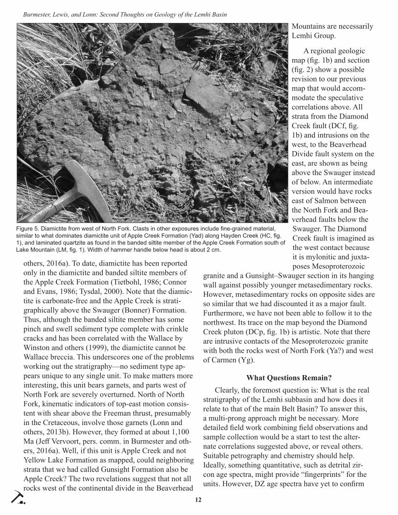
fault in the Agency Creek and Lemhi Pass quadrangles. Most quartzite is fi ne-grained and feldspathic. However, spheri-cal medium quartz grains form lags with mud chips (fi g. 3), small channels, and rare thicker beds. Chert is rare but present in several localities. Elsewhere chert is diagnostic of McNa-mara–Lawson Creek strata, and spherical medium quartz grains are much more common in the Swauger and higher strata than below, making correlation of this unit with the Lawson Creek Formation attractive. One cau-tion is this unit’s great thickness (fi g. 2, column d), which is a bit worrisome. A thick alterna-tive, the coarse siltite member of the Apple Creek Formation in the Salmon River Moun-tains, could have the anoma-lously large quartz grains here if they were sourced from the east, and chert because it is above the Lawson Creek. South of that unit is a crossbedded quartzite unit with spherical, medium to coarse quartz grains (fi g. 4) and more potassium feldspar than plagioclase, consistent with it being Swauger Formation (Burmester and others, 2015). If those correlations are cor-rect, the Peterson Creek fault between those units (PCf, fi g 1a) would have minor throw down to the north.
The second discovery that altered our views was confi rma-tion of Noranda’s observations of diamictite west of North Fork (fi g. 5). This was disturbing be-cause to the east on the Salmon map we had called those rocks Yellow Lake or Gunsight For-mation (fi g. 1a; Burmester and
Figure 3. Example of medium to coarse quartz lenses, and mud chips in siltite and argillite of the unit south of the Lemhi Pass fault (fi g. 1b) that correlates best with the Lawson Creek Formation. Width of letters on pen is about 1 mm.
Figure 4. Blocks of fi ne- to coarse-grained quartzite on Goat Mountain (GM, fi g. 1b). Crossbed-ding is visible near the middle and toward the bottom of the largest block. Darker siltite and argillite encountered on lower western and eastern parts of mountain are absent along the highest part. Nine of 10 samples had potassium feldspar exclusively or in excess of plagioclase. The exception had the lowest quartz content. Width of pencil tip for 0.5 mm lead is about 1 mm.
12
Burmester, Lewis, and Lonn: Second Thoughts on Geology of the Lemhi Basin
others, 2016a). To date, diamictite has been reported only in the diamictite and banded siltite members of the Apple Creek Formation (Tietbohl, 1986; Connor and Evans, 1986; Tysdal, 2000). Note that the diamic-tite is carbonate-free and the Apple Creek is strati-graphically above the Swauger (Bonner) Formation. Thus, although the banded siltite member has some pinch and swell sediment type complete with crinkle cracks and has been correlated with the Wallace by Winston and others (1999), the diamictite cannot be Wallace breccia. This underscores one of the problems working out the stratigraphy—no sediment type ap-pears unique to any single unit. To make matters more interesting, this unit bears garnets, and parts west of North Fork are severely overturned. North of North Fork, kinematic indicators of top-east motion consis-tent with shear above the Freeman thrust, presumably in the Cretaceous, involve those garnets (Lonn and others, 2013b). However, they formed at about 1,100 Ma (Jeff Vervoort, pers. comm. in Burmester and oth-ers, 2016a). Well, if this unit is Apple Creek and not Yellow Lake Formation as mapped, could neighboring strata that we had called Gunsight Formation also be Apple Creek? The two revelations suggest that not all rocks west of the continental divide in the Beaverhead
Mountains are necessarily Lemhi Group.
A regional geologic map (fi g. 1b) and section (fi g. 2) show a possible revision to our previous map that would accom-modate the speculative correlations above. All strata from the Diamond Creek fault (DCf, fi g. 1b) and intrusions on the west, to the Beaverhead Divide fault system on the east, are shown as being above the Swauger instead of below. An intermediate version would have rocks east of Salmon between the North Fork and Bea-verhead faults below the Swauger. The Diamond Creek fault is imagined as the west contact because it is mylonitic and juxta-poses Mesoproterozoic
granite and a Gunsight–Swauger section in its hanging wall against possibly younger metasedimentary rocks. However, metasedimentary rocks on opposite sides are so similar that we had discounted it as a major fault. Furthermore, we have not been able to follow it to the northwest. Its trace on the map beyond the Diamond Creek pluton (DCp, fi g. 1b) is artistic. Note that there are intrusive contacts of the Mesoproterozoic granite with both the rocks west of North Fork (Ya?) and west of Carmen (Yg).
What Questions Remain?Clearly, the foremost question is: What is the real
stratigraphy of the Lemhi subbasin and how does it relate to that of the main Belt Basin? To answer this, a multi-prong approach might be necessary. More detailed fi eld work combining fi eld observations and sample collection would be a start to test the alter-nate correlations suggested above, or reveal others. Suitable petrography and chemistry should help. Ideally, something quantitative, such as detrital zir-con age spectra, might provide “fi ngerprints” for the units. However, DZ age spectra have yet to confi rm
Figure 5. Diamictite from west of North Fork. Clasts in other exposures include fi ne-grained material, similar to what dominates diamictite unit of Apple Creek Formation (Yad) along Hayden Creek (HC, fi g. 1), and laminated quartzite as found in the banded siltite member of the Apple Creek Formation south of Lake Mountain (LM, fi g. 1). Width of hammer handle below head is about 2 cm.
13
Burmester, Lewis, and Lonn: Second Thoughts on Geology of the Lemhi Basin
lithostratigraphic correlations. Kolmogorov–Smirnov (K-S) statistics, which test whether age spectra could have been derived from the same parent population, support close genetic relations among most subbasin samples (Link and others, 2016). However, they also show greater similarity between some diff erent units than within each. Is this because some unit assign-ments are incorrect, or because mixing proportions of sediment from diff erent sources was repeated at diff er-ent times and places? Perhaps DZ ages would be more useful by counting more grains per sample (Gehrels and others, 2012) and more samples per unit at each of more sections to defi ne each unit’s signature better, if any.
A specifi c question to answer is whether diamic-tite is unique to the Apple Creek Formation. If not, and diamictite is found to exist in Yellow Lake For-mation strata, the simple solution is to stay with the 2015 story in the north. However, if rocks south of the Lemhi Pass fault are Swauger and higher strata, the Lemhi Pass fault must have a longer history (Giller-man, 2008) and much greater displacement than 1.0 km heave estimated for Tertiary motion by VanDen-burg and others (1998).
The other broad question is: What is the whole sedimentary, magmatic, and structural history of the subbasin? If the strata on the west fl ank of the Bea-verhead Mountains are Apple Creek and more similar to strata of the Salmon River Mountains than to the Jahnke Lake member east of the Divide, there is a fault with major translation between them. Is that the Freeman thrust, and is the Diamond Creek fault an out-of-sequence thrust with smaller displacement? Is the Lemhi Pass fault a left-lateral ramp of such a major thrust and the strata south of it also allochtho-nous relative to the Swauger–Lawson Creek–Jahnke Lake section east of the Beaverhead Divide fault? Or, does the north to south variation in the Swauger–Law-son Creek–Jahnke Lake stack document rapid lateral change in character? Maybe of wider interest, what deformation accompanied the episodic metamorphism and mineralization of the region? Episodes include Mesoproterozoic magmatism and migmatite genera-tion, the Grenville orogeny (including garnet growth in the unit we thought was Yellow Lake Formation), Neoproterozoic faulting, Paleozoic intrusion (Doughty and Chamberlain, 1996; Gillerman, 2008; Aleinikoff and others, 2012, Saintilan and others, 2017), and Cretaceous–Tertiary faulting, folding, and magmatism.
One specifi c question is whether contractional defor-mation preceded or accompanied Mesoproterozoic in-trusion and accounts for some of the present juxtaposi-tion of diff erent units or their facies. As noted above, eff orts to answer these questions will require contin-ued fi eld work as well as application of petrographic, geochemical, and geochronologic techniques.
ACKNOWLEDGMENTS
As always, we greatly appreciate the discussions with Don Winston, Paul Link, Dave Pearson, and others with an interest in these challenging rocks. We also acknowledge the eff orts of TRGS to disseminate our current research thoughts in a format that provides both a timely release and a fi eld-based forum for dis-cussion.
REFERENCES CITED
Aleinikoff , J.N., Slack, J.F., Lund, Karen, Evans, K.V., Fanning, C.M., Mazdab, F.K., Wooden, J.L., and Pillers, R.M., 2012, Constraints on the timing of Co-Cu ± Au mineralization in the Blackbird Dis-trict, Idaho, using SHRIMP U-Pb ages of mona-zite and xenotime plus zircon ages of related Me-soproterozoic orthogneisses and metasedimentary rocks: Economic Geology, v. 107, p. 1143–1175.
Burmester, R.F., Lonn, J.D., Lewis, R.S., and McFad-dan, M.D., 2013, Toward a grand unifi ed theory for stratigraphy of the Lemhi subbasin of the Belt Supergroup: Northwest Geology, v. 42, p. 73–88.
Burmester, R.F., Lewis, R.S., Lonn, J.D., and McFad-dan, M.D., 2015, The Hoodoo is the Swauger and other heresies: Lemhi subbasin correlations and structures, East-Central Idaho: Northwest Geol-ogy, v. 44, p. 1–19.
Burmester, R.F., Lewis, R.S., Othberg, K.L., Stan-ford, L.R., Lonn, J.D., and McFaddan, M.D., 2016a, Geologic map of the western part of the Salmon 30' x 60' quadrangle, Idaho and Montana: Idaho Geological Survey Geologic Map 52, scale 1:75,000.
Burmester, R.F., Lonn, J.D., Lewis, R.S., and McFad-dan, M.D., 2016b, Stratigraphy of the Lemhi subbasin of the Belt Supergroup, in MacLean, J.S., and Sears, J.W., eds., Belt Basin: Window to Mesoproterozoic Earth: Geological Society of America Special Paper 522, p. 121–137.
Connor, J.J., and Evans, K.V., 1986, Geologic map of

14
Burmester, Lewis, and Lonn: Second Thoughts on Geology of the Lemhi Basin
the Leesburg quadrangle, Idaho: U.S. Geological Survey Miscellaneous Field Studies Map MF-1880, scale 1:62,500.
Doughty, P.T., and Chamberlain, K.R., 1996, Salmon River arch revisited: New evidence for 1370 Ma rifting near the end of deposition in the Middle Proterozoic Belt basin: Canadian Journal of Earth Sciences, v. 33, p. 1037–1052.
Evans, K.V., and Green, G.N., 2003, Geologic map of the Salmon National Forest and vicinity, east-cen-tral Idaho: U.S. Geological Survey Geologic In-vestigations Series Map I-2765, scale 1:100,000, 2 sheets, 19 p. text.
Gehrels, G.E., Giesler, Dominique, and Pecha, Mark, 2012, Detrital zircon geochronology with N=1000: Geological Society of America Abstracts with Programs. v. 44, no. 7, p. 71.
Gillerman, V.S., 2008, Geochronology of iron oxide-copper-thorium-REE mineralization in Proterozo-ic rocks at Lemhi Pass, Idaho, and a comparison to copper-cobalt ores, Blackbird Mining District, Idaho: Final Technical Report to U.S. Geological Survey, Grant Award 06HQGR0170, 66 p.
Link, P.K., Stewart, E.S., Steele, Travis, Sherwin, Jo-Ann, Hess, L.T., and McDonald, Catherine, 2016, Detrital zircons in the Mesoproterozoic up-per Belt Supergroup in the Pioneer, Beaverhead, and Lemhi Ranges, Montana and Idaho: The Big White arc, in MacLean, J.S., and Sears, J.W., eds., Belt Basin: Window to Mesoproterozoic Earth: Geological Society of America Special Paper 522, p. 163–183.
Lonn, J.D., 2017, The Lemhi Group type sections re-visited and revised, east-central Idaho; Northwest Geology, v. 46, p. 15–28.
Lonn, J.D., Lewis, R.S., Burmester, R.F., and Mc-Faddan, M.D., 2013a, The complex structural geology of the northern Beaverhead Mountains, Montana and Idaho: Northwest Geology, v. 42, p. 111–130.
Lonn, J.D., Othberg, K.L., Lewis, R.S., Burmester, R.F., Stanford, L.R., and Stewart, D.E., 2013b, Geologic map of the North Fork quadrangle, Lemhi County, Idaho: Idaho Geological Survey Digital Web Map 160, scale 1:24,000.
Lonn, J.D., Burmester, R.F., Lewis, R.S., and Mc-Faddan, M.D., 2016a, Mesoproterozoic Lemhi
strata represent immense alluvial aprons that prograded northwest into the Belt sea, Idaho and Montana: Geological Society of America Ab-stracts with Programs, v. 48, no. 6, doi: 10.1130/abs/2016RM-276082.
Lonn, J.D., Burmester, R.F., Lewis, R.S., and Mc-Faddan, M.D., 2016b, Giant folds and complex faults in Mesoproterozoic Lemhi strata of the Belt Supergroup, northern Beaverhead Mountains, Montana and Idaho, in MacLean, J.S., and Sears, J.W., eds., Belt Basin: Window to Mesoproterozo-ic Earth: Geological Society of America Special Paper 522, p. 139–162.
Saintilan, N.J., Creaser, R.A., Bookstrom, A.A., 2017, Re-Os systematics and geochemistry of cobaltite (CoAsS) in the Idaho cobalt belt, Belt-Purcell Ba-sin, USA: Evidence for middle Mesoproterozoic sediment-hosted Co-Cu sulfi de mineralization with Grenvillian and Cretaceous remobilization: Ore Geology Reviews, v. 86, p. 509–525.
Tietbohl, D.R., 1986, Middle Proterozoic diamictite beds in the Lemhi Range, east-central Idaho, in Roberts, S.M., ed., Belt Supergroup; A guide to Proterozoic rocks of western Montana and adja-cent areas: Montana Bureau of Mines and Geol-ogy Special Publication 94, p. 197–207.
Tysdal, R.G., 2000, Stratigraphy and depositional en-vironments of Middle Proterozoic rocks, northern part of the Lemhi Range, Lemhi County, Idaho: U.S. Geological Survey Professional Paper 1600, 40 p.
Winston, Don, Link, P.K., and Hathaway, Nathan, 1999, The Yellowjacket is not the Prichard and other heresies–Belt Supergroup correlations, structure, and paleogeography, east-central Idaho, in S.S. Hughes and G.D. Thackray, eds., Guide-book to the Geology of Eastern Idaho: Pocatello, Idaho, Idaho Museum of Natural History, p. 3–20.

Northwest Geology, v. 46, 2017, p. 15–28 The Journal of the Tobacco Root Geological Society1515
THE LEMHI GROUP TYPE SECTION REVISITED AND REVISED, EAST-CENTRAL IDAHO
Jeff LonnMontana Bureau of Mines and Geology, 1300 W. Park Street, Butte, MT 59701, [email protected]
ABSTRACT
New mapping of the area surrounding the type sections of Gunsight, Yellow Lake, Big Creek, West Fork, and Inyo Creek Formations, Lemhi Group, in the central Lemhi Range, suggests that previously un-recognized faults cut across the type section of the Big Creek Formation. These faults separate the Big Creek from the type Inyo Creek and West Fork sections that were originally described as lying stratigraphically be-neath the Big Creek. This study suggests instead that the Inyo Creek and West Fork Formations lie strati-graphically above the Big Creek and are correlative with the Yellow Lake Formation. The Yellow Lake Formation is poorly known due to structural compli-cations and diffi cult access to its type area. It may in-clude thick intervals of calcareous siltite and very fi ne quartzite that have been previously mapped across the region as Big Creek Formation, and it may be much thicker than previously thought. The Big Creek For-mation in its type section is comprised of very thick bedded, fi ne-grained sand that lacks disseminated carbonate, and its exposed thickness is much less than previously described.
INTRODUCTION
More than a century has passed since Mesoproterozoic sedimentary rocks were fi rst recognized in the Leadore, Idaho, area and assigned to the Belt Series (Umpleby, 1913). However, deciphering the stratigra-phy of these 1.4 Ga strata has been especial-ly challenging to geologists, and the rela-tionships between the Belt Supergroup and these Lemhi strata are still debated. Both stratigraphic successions are immensely thick (>15 km), lithologically monotonous, and non-fossiliferous. Identifi cation and cor-relation of individual units is exceedingly diffi cult, often requiring the occurrence of thick (>3,000 m) intact sections where stratigraphic sequences can be viewed. Plu-tonic provinces, faults, and broad valleys fi lled with
Cenozoic sediments isolate these exposures and fur-ther complicate correlation. In addition, many of the best exposures occur in remote and rugged wilderness. The Lemhi Group type sections (Ruppel, 1975) are located in one such isolated area, the roadless central Lemhi Range. This paper describes a recent traverse across the Lemhi Group type section that resulted in new structural, and therefore stratigraphic, interpreta-tions.
HISTORY OF THE LEMHI GROUP
Ross (1947) identifi ed and described the Lemhi and Swauger quartzites on the southwest fl ank of the Lemhi Range (fi g. 1). He included gray and green-ish impure (feldspathic) fi ne-grained quartzite and interbedded argillite in the Lemhi quartzite, and the stratigraphically overlying coarser and purer quartz-ite in the Swauger. Anderson (1961), mapping to the north on the east side of the range, defi ned the Apple Creek Phyllite as having a lower phyllitic quartzite and an upper phyllite. He did not map the Apple Creek in stratigraphic contact with Ross’ (1947) units, but he speculated that it underlay the Lemhi quartzite. Ed
Montana
Idaho
Grasshopper thrust system
Salmon
Leadore
ANACONDA RANGE
PIO
NEER
MOU
NTAI
NS
SALM
ON RIV
ER
MOUNTAIN
S
LEMHI RANGE
Type sectionLemhi Group
BEAVERHEAD
RA
NGE Shaded areas are mountain ranges
containing Mesoproterozoic sedimentary rocks.
Figure 1. Location of the Lemhi Group type section.

16
Jeff Lonn: The Lemhi Group Type Section Revisited and Revised
Ruppel then mapped three 15ꞌ quadrangles (Ruppel, 1968, 1980; Ruppel and Lopez, 1981) that covered the rugged central Lemhi Range between the areas mapped by Ross and Anderson. There, he elevated the Lemhi quartzite to group status, subdivided it into fi ve formations (fi g. 2), and correlated the Apple Creek Phyllite with a fi ne-grained, thin-bedded interval with-in the newly defi ned Lemhi Group (Ruppel, 1975). He delineated reference/type sections for each forma-tion (fi g. 3) in a very remote and rugged part of the Lemhi Range on his Patterson quadrangle map (1980). As a result, only a very few determined geologists have revisited the area. McBean (1983) studied the type Gunsight section in an M.S. thesis. Winston and
others (1999) measured key sections and correlated the Lemhi Group and overlying Swauger and Lawson Creek (Hobbs, 1980) Formations with both the Belt Supergroup strata of western Montana and Mesopro-terozoic rocks of the Salmon River Mountains. Tysdal (2000) made reconnaissance traverses through the type Big Creek, Apple Creek, and Gunsight Formations. He named Ruppel’s (1975) Apple Creek reference sec-tion the Yellow Lake unit of the Apple Creek Forma-tion and perceptively noted that its lithofacies diff ered from those of the type Apple Creek farther northwest. He also pointed out a geochemical study by Conner (1991) that showed diff erent chemical compositions for the Yellow Lake unit and the type Apple Creek.
In 2007, a collaborative Idaho Geological Sur-vey (IGS) and Montana Bureau of Mines and Geol-ogy (MBMG) team comprised of Reed Lewis, Russ Burmester, Mark McFaddan, and Jeff Lonn began 1:24,000-scale mapping in the Beaverhead Mountains along the Idaho–Montana border. Confused by the stratigraphy that was unfolding, they made recon-naissance trips into various parts of the Lemhi Range to view the strata. Surprisingly, they discovered that the type Apple Creek lay stratigraphically above the Lawson Creek and Swauger Formations, and thus well above the Lemhi Group. Therefore, Ruppel’s (1975) Apple Creek reference section within the stratigraphi-cally lower Lemhi Group is not part of the Apple Creek Formation. Following Tysdal’s (2000) lead, the IGS–MBMG team renamed Ruppel’s Apple Creek the Yellow Lake Formation, leaving the Apple Creek name attached to Anderson’s (1961) Apple Creek Phyllite, now interpreted to lie well above the Lemhi Group (fi g. 2). They also determined that the type Apple Creek Formation was as much as 4,500 m thick in the Beaverhead and Lemhi Ranges, and named the entire Idaho Mesoproterozoic stratigraphic column the Lemhi subbasin strata (Burmester and others, 2016a).
With this much stratigraphic confusion within just the Lemhi Range, it is no surprise that regional Belt–Lemhi correlations are still uncertain. Early workers speculated that the Mesoproterozoic rocks of the Lemhi region correlated with the Belt Supergroup, but provided few details (Umpleby, 1913; Ross, 1947; Anderson, 1961). Ruppel (1975) suggested that the lower part of the Lemhi Group might be equivalent to the Ravalli Group, the Apple Creek and Gunsight to the Helena and Wallace (Piegan Group), and the over-lying Swauger to the Missoula Group. However, he
45,000
40,000
35,000
30,000
25,000
20,000
15,000
10,000
5,000
0
feet
0
5,000
10,000
15,000meters
Thickness
medium-coarse-grained quartzite
quartzite and siltite
dolomitic or calcareousquartzite
fine-grainedquartzite
dolomitic or calcareoussiltite and argillite
diamictite
siltite, argillite and quartzite
Gunsight Fm.
Yellow Lake Fm.
Big Creek Fm.
Swauger Fm.
Lawson Cr. Fm.
coarse siltite member
banded siltite member
diamictite member
fine siltite member
Lem Peakmember
Appl
e C
reek
For
mat
ion
Lem
hi G
roup
Lemhi Range
West Fork Fm.
Inyo Creek Fm.
Figure 2. Lemhi Range stratigraphic column showing position of the original Lemhi Group (Ruppel, 1975). Modifi ed from Burmester and others (2016a).

17
Jeff Lonn: The Lemhi Group Type Section Revisited and Revised
did not conclude that these correlatives were deposited in the same basin, and later proposed that the Lemhi and Belt Basins were separated by the Lemhi Arch, which was also the sediment source for both basins (Ruppel, 1978, 1993). Still later, he and Mike O’Neill proposed that the two separate Lemhi and Belt Basins
had been juxtaposed by a long-lived, continental-scale, left lateral fault, the Great Divide megashear (O’Neill and others, 2007), that lay roughly along the Mon-tana–Idaho border. Meanwhile, Don Winston and Paul Link argued for deposition in a single basin and pro-posed direct specifi c correlations between not only the
0
0
1 mi
1 2 km
0.5
N
Big
Cre
ek
Inyo Creek
West Fork
Guns
ight
Yellow
Lake
Figure 3. Location of the Lemhi Group type sections. From Ruppel (1975), superimposed on a caltopo.com topographic base.

18
Jeff Lonn: The Lemhi Group Type Section Revisited and Revised
Belt and Lemhi rocks, but also with the Mesoprotero-zoic rocks of the Salmon River Mountains (Winston and others, 1999). Evans and Green’s (2003) map of Salmon National Forest shows fault zones along the Idaho–Montana border that juxtapose Lemhi and
Belt rocks, but the map’s text does not discuss rela-tionships between the two groups. Tysdal and others (2005) applied Lemhi Group names on both sides of the Idaho–Montana border in the northern Beaverhead Mountains.
0
0
1 mi
1 2 km
0.5
N29
25
35
37
4770
70 80
3550
45152015
30
10
8555
60 50
9055
60
80 4520
57
63
2025
20 35 60
40
25 12
30
45
2020
80
80
80
6470
70
72
65
70
28
20
63
2060
22
85
53
45
60
Big
Cre
ek
Inyo Creek
West Fork
Guns
ight
Yellow
Lake
10,882 fault
10,882 fault
SpringsBasin
fault
Lake
For
k fa
ult
GunsightPeak
InyoPoint
Peak10,882
Yyl
Ygs
Ygs
YylYyl
YbcYbc
Ybc Ybc
YylYyl
Yyl
Ygs
Ygs
Figure 4. Geologic map of the area surrounding the Lemhi Group type sections. Data from this study superimposed on fi gure 3. Note that West Fork and Inyo Creek Fms are reinterpreted as Yellow Lake Fm. Ygs-Gunsight Fm; Yyl-Yellow Lake Fm; Ybc-Big Creek Fm.

19
Jeff Lonn: The Lemhi Group Type Section Revisited and Revised
The IGS–MBMG mapping team concluded that, although signifi cant structures do exist along the Idaho–Montana border in the northern Beaverhead Mountains, they are not terrane-bounding features separating diff erent basins. Instead, the sandier Lemhi strata extend across the Beaverhead Mountains north and northeast into Montana. The cross-border map-ping and examination of the Lemhi Range also gave the IGS–MBMG geologists the courage to propose that most of the Lemhi strata are correlative with, and facies of, the Missoula Group of the upper Belt Su-pergroup (Burmester and others, 2015, 2016a; Lonn, 2014; Lonn and others, 2016a, b). Detrital zircon data (Link and others, 2007, 2013, 2016; Stewart and oth-ers, 2010) support this correlation, as discussed in a later section.
This paper addresses only the type Lemhi Group (Ruppel, 1975), which is the lower part of the Lemhi subbasin section (fi g. 2). Data and interpretations presented here result from three multi-day backpack-ing trips in 2014 and 2015 that traversed the type and reference sections of the Lemhi Group.
RESULTS
Figure 3 shows the locations of the type/reference sections for the Inyo Creek, West Fork, Big Creek, Yellow Lake (formerly Apple Creek), and Gunsight Formations of the Lemhi Group (Ruppel, 1975). Rup-pel (1980) interpreted the Lemhi Group section as a northeast-facing homocline without signifi cant faults, although he does show numerous fl at thrusts atop the thick section.
The map produced by this study is shown on fi gure 4. On it, I eliminate Ruppel’s fl at thrusts and include new faults that cut the type sections. The 10,882 fault is of particular signifi cance because it cuts across the Big Creek type section, disrupting the stratigraphic continuity between the West Fork and Big Creek Formations and calling into question the stratigraphic positions of the West Fork and Inyo Creek. This paper fi rst discusses the Gunsight, Yellow Lake, and Big Creek Formations, which are in stratigraphic continu-ity, then discusses the complex geology southwest of the 10,882 fault.
Gunsight FormationThe type section of the Gunsight Formation is
characterized by decimeter- to meter-thick beds of fi ne-grained feldspathic quartzite that is fl at laminated, crossbedded, or massive. In the lower part, from 1- to 3-m-thick intervals of light gray, trough cross-bedded and fl at-laminated, medium- to fi ne-grained quartzite alternate with darker intervals containing decimeter-thick beds of quartzite and siltite interbedded with silt-ite–argillite couplets (fi g. 5). The lower contact with the Yellow Lake Formation is gradational and placed where the siltite–argillite couplets become dominant. McBean (1983) measured the type section as 1,700 m thick.
a
b
Figure 5. Lower part of the type Gunsight section. (a) Alternating light and dark intervals. “Up” is to the right. (b) Close-up showing thick beds of light-colored, fi ne-grained quartzite alternating with dark intervals of thinner bedded medium-grained quartzite, siltite, and argillite.

20
Jeff Lonn: The Lemhi Group Type Section Revisited and Revised
Yellow Lake FormationI examined the Yellow Lake section on the ridge
north and west of Yellow Lake about 1 km west of Ruppel’s (1975) designated reference section. The up-per part of the Yellow Lake section is characterized by non-dolomitic couplets of light gray, medium-grained quartzite or green siltite below dark purple argillite (fi g. 6a). Lenticular and fl aser bedding are common, and graded beds and mud chips are uncommon. A previously unrecognized curving, but generally north-striking, fault, labeled on fi gure 4 as the Lake Fork fault, cuts the Yellow Lake section approximately 220 m below its upper contact. The fault is marked by breccia, quartz veins, and a pronounced change in bedding attitudes. While magnitude and sense of movement are unknown, a thick interval of very fi ne-
grained quartzite on the west side is not repeated on the east, and so stratigraphic section appears to be omitted rather than duplicated. Ruppel (1980) mapped a down-to-the-east fault to the north and approximate-ly along strike with signifi cant off set (Swauger against Yellow Lake). If this is the same fault, as shown on fi gure 4, it is possible that a large part of the Yellow Lake section has been omitted from the type area.
On the west side of the Lake Fork fault, downsec-tion, are more strongly cleaved green siltite to purple argillite couplets with traces of carbonate. Farther
Figure 6. Type Yellow Lake section. (a) Upper part consists mostly of uncracked, non-dolomitic couplets of light-colored quartzite, darker siltite, and purple argillite. Lower part contains interbedded intervals of: (b) graded siltite–argillite couplets with abundant load structures, (c) decimeters-thick beds of calcareous fi ne-grained quartzite (bed below Brunton) and siltite, and (d) centimeters-thick beds of silty dolomite (darker beds).
a
b
c
d
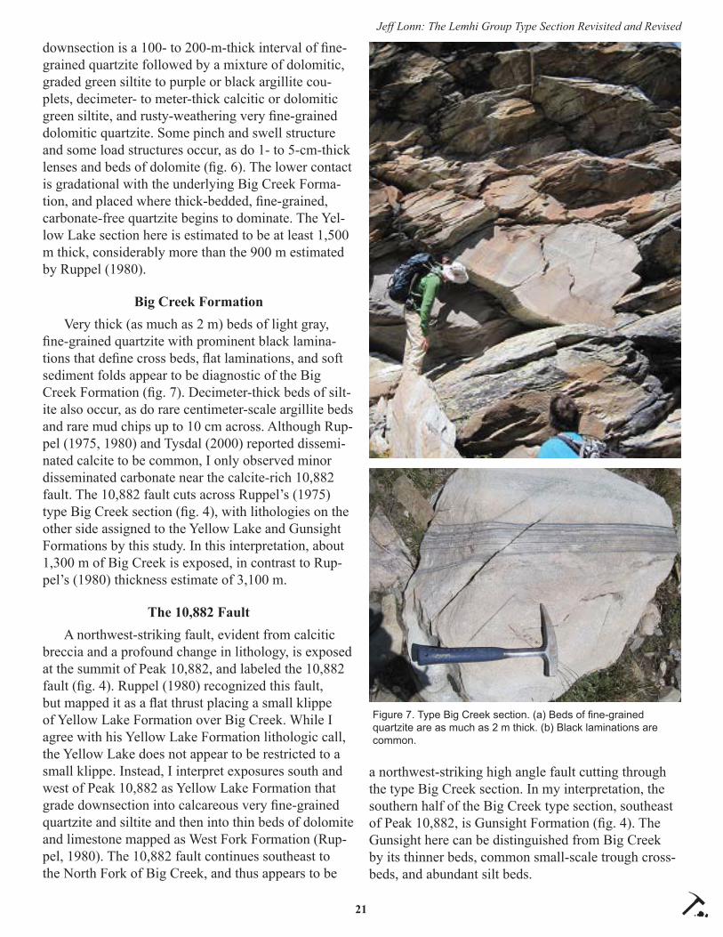
21
Jeff Lonn: The Lemhi Group Type Section Revisited and Revised
downsection is a 100- to 200-m-thick interval of fi ne-grained quartzite followed by a mixture of dolomitic, graded green siltite to purple or black argillite cou-plets, decimeter- to meter-thick calcitic or dolomitic green siltite, and rusty-weathering very fi ne-grained dolomitic quartzite. Some pinch and swell structure and some load structures occur, as do 1- to 5-cm-thick lenses and beds of dolomite (fi g. 6). The lower contact is gradational with the underlying Big Creek Forma-tion, and placed where thick-bedded, fi ne-grained, carbonate-free quartzite begins to dominate. The Yel-low Lake section here is estimated to be at least 1,500 m thick, considerably more than the 900 m estimated by Ruppel (1980).
Big Creek FormationVery thick (as much as 2 m) beds of light gray,
fi ne-grained quartzite with prominent black lamina-tions that defi ne cross beds, fl at laminations, and soft sediment folds appear to be diagnostic of the Big Creek Formation (fi g. 7). Decimeter-thick beds of silt-ite also occur, as do rare centimeter-scale argillite beds and rare mud chips up to 10 cm across. Although Rup-pel (1975, 1980) and Tysdal (2000) reported dissemi-nated calcite to be common, I only observed minor disseminated carbonate near the calcite-rich 10,882 fault. The 10,882 fault cuts across Ruppel’s (1975) type Big Creek section (fi g. 4), with lithologies on the other side assigned to the Yellow Lake and Gunsight Formations by this study. In this interpretation, about 1,300 m of Big Creek is exposed, in contrast to Rup-pel’s (1980) thickness estimate of 3,100 m.
The 10,882 FaultA northwest-striking fault, evident from calcitic
breccia and a profound change in lithology, is exposed at the summit of Peak 10,882, and labeled the 10,882 fault (fi g. 4). Ruppel (1980) recognized this fault, but mapped it as a fl at thrust placing a small klippe of Yellow Lake Formation over Big Creek. While I agree with his Yellow Lake Formation lithologic call, the Yellow Lake does not appear to be restricted to a small klippe. Instead, I interpret exposures south and west of Peak 10,882 as Yellow Lake Formation that grade downsection into calcareous very fi ne-grained quartzite and siltite and then into thin beds of dolomite and limestone mapped as West Fork Formation (Rup-pel, 1980). The 10,882 fault continues southeast to the North Fork of Big Creek, and thus appears to be
a northwest-striking high angle fault cutting through the type Big Creek section. In my interpretation, the southern half of the Big Creek type section, southeast of Peak 10,882, is Gunsight Formation (fi g. 4). The Gunsight here can be distinguished from Big Creek by its thinner beds, common small-scale trough cross-beds, and abundant silt beds.
Figure 7. Type Big Creek section. (a) Beds of fi ne-grained quartzite are as much as 2 m thick. (b) Black laminations are common.

22
Jeff Lonn: The Lemhi Group Type Section Revisited and Revised
The Springs Basin FaultA thrust fault marked by cataclasite, quartz veins,
overturned strata, and a profound change in lithol-ogy occurs in the southwestern part of fi gure 4. Rup-pel (1980) also mapped this thrust, although his trace diverges from mine. This thrust is named the Springs Basin fault after exposures in the unnamed basin with “springs” labeled on the topographic map (fi g. 4). In its hanging wall, outcrop-scale isoclinal folds with gently southwest-dipping axial plane cleavage suggest the fault dips gently west (fi g. 8a), although later high-angle faults appear to cut the thrust and complicate its trace. Northeast-overturned strata in the Springs Basin fault footwall indicate top-to-the-northeast re-verse movement. The fault places hanging wall strata mapped as West Fork and Inyo Creek Formations by Ruppel (1980) over decimeter- to meter-thick beds of trough cross-bedded quartzite that I mapped as Gun-sight and that Ruppel (1975, 1980) interpreted to be the lower part of the type Big Creek.
West Fork FormationThe type West Fork section appears to be charac-
terized by dolomitic and non-dolomitic siltite–argillite couplets and couples (fi g. 8). Mudcracks are com-mon, and diagnostic lenses and beds of limestone and dolomite occur. Upward in the section, toward Peak 10,882, thicker beds of very fi ne-grained quartzite and green siltite with common disseminated calcite occur. Although these were previously assigned to the Big Creek Formation (Ruppel, 1980), this study suggests that they are stratigraphically continuous with both the type West Fork and the Yellow Lake mapped by Rup-pel (1980) in a klippe at the summit of Peak 10,882.
Inyo Creek FormationThe West Fork Formation grades downward from
carbonate-rich siltite–argillite couplets to thicker non-dolomitic siltite–argillite couplets and couples of the Inyo Creek Formation on the west face of Inyo Point (fi g. 4). The lower part of the Inyo Creek Formation becomes coarser and thicker bedded, with decimeters-thick, very fi ne-grained, quartzite beds containing fl at black laminations (fi g. 8) reminiscent of the Big Creek Formation. Winston and others (1999, page 8) describe a similar coarsening-downward stratigraphy, and a lower Inyo Creek “principally composed of 20- to 80-cm-thick, tabular beds of fl at-laminated, well-sort-ed, fi ne-grained feldspathic quartz arenite with climb-
Figure 8. Type West Fork and Inyo Creek sections. (a) View SE of isoclinally folded dark silty dolomite bed within West Fork section above the Springs Basin fault, with gently SW-dipping axial plane cleavage. (b) Graded siltite–argillite couplets with abun-dant load structures within the type West Fork section. (c) In the Inyo Creek type section, siltite–argillite couplets grade downward into (d) fi ne-grained quartzite with black laminations interpreted as Big Creek Fm.
a
b
c
d

23
Jeff Lonn: The Lemhi Group Type Section Revisited and Revised
ing ripples at the tops of some beds.” Although some faults intervene, as shown on Ruppel’s (1980) map, it appears that just off the southwest corner of fi gure 4 the Inyo Creek Formation grades downward into thick bedded, fi ne-grained quartzite with black laminations similar to the lithologies characteristic of type Big Creek Formation. In fact, Ruppel (1980) maps this quartzite as Big Creek Formation, but he shows it in fault contact with his type Inyo Creek Formation.
Stratigraphic Positions of the Inyo Creek and West Fork Formations
Although I confi rmed that the West Fork Forma-tion grades downward into the Inyo Creek Formation, the 10,882 fault and Springs Basin fault separate them from the type Big Creek section. In no place can Big Creek be observed to grade downward into the West Fork. Therefore, the stratigraphic positions of the Inyo Creek and West Fork are uncertain. However, there are clues.
As described above, the Inyo Creek appears to grade downward into Big Creek on the west ridge of Inyo Point. Both the Inyo Creek and West Fork share lithologic similarities with the Yellow Lake: siltite–argillite couplets that are commonly dolomitic, deci-meter- to meter-thick beds of calcareous silt and very fi ne sand, and thin lenses and beds of silty dolomite or limestone. The upper West Fork contact described as gradational into Big Creek (Ruppel, 1975) east of Inyo Point (fi g. 3) is interpreted here as the Springs Ba-sin fault that places West Fork against Gunsight (fi g. 4). Therefore, I propose that the West Fork and Inyo Creek are correlative with the lower part of the Yellow Lake.
In addition, the calcareous silt and fi ne sand for-merly assigned to the lower part of the Big Creek in Springs Basin (Ruppel, 1975, 1980) are interpreted to be part of the Yellow Lake Formation (fi g. 4). At the type section, these lithologies are poorly exposed in the upper cirque of Big Eightmile Creek, west of Yellow Lake, and may be partly omitted by the Lake Fork fault. On a reconnaissance traverse of the ridge between Patterson Creek and its east fork (7 km west of this study), I found that the Big Creek mapped stratigraphically above West Fork (Ruppel, 1980) consists mostly of green siltite with common dissemi-nated calcite – very diff erent than the thick bedded, non-calcareous quartzite of type Big Creek described
above. This Patterson Creek section is topped by green siltite–purple argillite couplets, similar to those of the upper Yellow Lake, that then grade up into Gunsight quartzite. I propose that the mapped Big Creek is really Yellow Lake, and, if this section is unfaulted, the Yellow Lake is more than 3,000 m thick. Other areas in east-central Idaho where geologists mapped calcareous siltite and quartzite as Big Creek may also be Yellow Lake Formation (e.g., in the Beaverhead Mountains: Burmester and others, 2016b; Evans and Green, 2003).
CORRELATIONS WITH THE BELT SUPERGROUP
Winston and others (1999) proposed that the Big Creek correlates with the Revett Formation of the Ra-valli Group, the Yellow Lake with the Piegan Group, the Gunsight with the Snowslip, and the overlying Swauger with the Mt. Shields and possibly the Bon-ner. Lonn and others (2016a, b), observing that fi ne-grained sands directly overlie the Wallace Formation (upper Piegan Group) and grade up to Swauger For-mation in the southern Sapphire Range, made similar correlations. They equated the Piegan Group with most of the Yellow Lake, the upper part of the Yellow Lake and the Gunsight with the Snowslip and Shepa-rd, and the overlying Swauger with the Mount Shields and Bonner (fi g. 9). The correspondence of chert and argillite abundance in the McNamara and Lawson Creek Formations is critical to these correlations. Lonn and others (2016a, b) noted that thick Gunsight–Swauger sands in the southern Sapphire Mountains thin and fi ne northward, with argillite-rich tongues in the Snowslip, Shepard, and Mount Shields Formations becoming prominent near Missoula. This large-scale facies change suggests that immense alluvial aprons or fans prograded north into the main Belt Basin, and that most of the Lemhi subbasin strata are relicts of the southeastern, upstream ends of these alluvial wedges. Finally, citing the thick-bedded but fi ne-grained char-acter of the Revett quartzite in its closest exposures in the Anaconda Range, Lonn and others (2016b) pro-posed that the Big Creek correlates with the Revett of the Ravalli Group.
DETRITAL ZIRCON DATA
Using detrital zircon (DZ) data to support correla-tions is a tool only recently available. Link and oth-ers (2007, 2013, 2016) used DZ data to show that the

24
Jeff Lonn: The Lemhi Group Type Section Revisited and Revised
upper Lemhi subbasin strata, above the Yellow Lake, have the same provenance as the Missoula Group of the upper Belt Supergroup, confi rming at least the broad correlations proposed above. Upper Lemhi and Missoula Group strata lack signifi cant “non-North American” 1510–1625 Ma detrital zircon grains, in contrast to the Prichard Formation and Ravalli Group of the lower Belt that have strong non-North American peaks (Ross and Villeneuve, 2003; Link and others, 2007). Only two samples of the Piegan Group have been analyzed, but they both contain about 20% non-North American grains (Ross and Villeneuve, 2003; Lewis and others, 2007), and so have zircon age distri-
butions transitional between the Ravalli and Missoula Groups.
Only three analyses are available from the type Lemhi Group section. Figure 10 shows these results alongside all three plots available for the Ravalli and Piegan Groups. The Big Creek sample was taken “from lower part of the Big Creek type section” (Stewart and others, 2010) that is reinterpreted here as Gunsight Formation, which may explain its Missoula Group-like DZ signature with only 5% non-North American grains—probably statistically insignifi cant. The samples from the Inyo Creek and West Fork had 5% and less than 2% non-North American grains, respectively, which makes correlation with the Piegan Group–Yellow Lake proposed here uncertain. However, no samples from the type Yellow Lake have ever been collected or analyzed. The lack of non-North American grains in the Inyo Creek and West Fork sam-ples does appear to preclude correlation with the Ravalli Group as previously proposed (Winston and others, 1999). Obviously, the rest of the type Lemhi Group section needs to be sampled and analyzed, and more samples need to be collected from the Ravalli and Piegan Groups in the central Belt Basin for comparison.
CONCLUSIONS
New mapping of the Lemhi Group type section suggests that previously unrecog-
nized faults cut across the type section of the Big Creek Formation. These faults separate the Big Creek from the type Inyo Creek and West Fork sections, which were originally described as lying stratigraphi-cally beneath the Big Creek. This study suggests that the Inyo Creek and West Fork Formations lie strati-graphically above the Big Creek and correlate with the Yellow Lake Formation. The Yellow Lake Formation is poorly known due to structural complications and diffi cult access to its type area. It may include thick intervals of calcareous siltite and very fi ne quartzite previously mapped across the region as Big Creek
45,000
40,000
35,000
30,000
25,000
20,000
15,000
10,000
5,000
0
feet
0
5,000
10,000
15,000meters
Thickness
medium-coarse-grained quartzite
quartzite and siltite
dolomitic or calcareousquartzite
fine-grainedquartzite
dolomitic or calcareoussiltite and argillite
diamictite
siltite, argillite and quartzite
Gunsight Fm.
Yellow Lake Fm., West Fork and Inyo Cr. Fms.
Big Creek Fm.
Swauger Fm.
Lawson Cr. Fm.
coarse siltite member
banded siltite member
diamictite member
fine siltite member
Lem Peakmember
Appl
e C
reek
For
mat
ion
Mis
soul
a G
roup
Garnet Range Fm.
McNamara Fm.
Bonner Fm.
Mt. Shields Fm.
Shepard Fm.
Snowslip Fm.
PieganGroup
RavalliGroup
Lem
hi G
roup
fault
Lemhi Range Missoula areaBelt Supergroup
Figure 9. Revised Lemhi subbasin stratigraphic column and proposed correla-tions with the Belt Supergroup. From Lonn and others, 2016b.
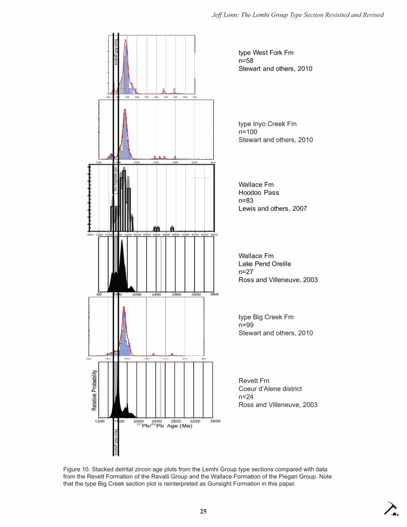
25
Jeff Lonn: The Lemhi Group Type Section Revisited and Revised
Non-N
A grains
Wallace FmHoodoo Passn=83Lewis and others, 2007
type West Fork Fmn=58Stewart and others, 2010
Wallace FmLake Pend Oreillen=27Ross and Villeneuve, 2003
type Inyo Creek Fmn=100Stewart and others, 2010
Revett FmCoeur d’Alene districtn=24Ross and Villeneuve, 2003
type Big Creek Fmn=99Stewart and others, 2010
Non-N
A grains
Figure 10. Stacked detrital zircon age plots from the Lemhi Group type sections compared with data from the Revett Formation of the Ravalli Group and the Wallace Formation of the Piegan Group. Note that the type Big Creek section plot is reinterpreted as Gunsight Formation in this paper.

26
Jeff Lonn: The Lemhi Group Type Section Revisited and Revised
Formation, and may be much thicker than previously thought. The Big Creek Formation in its type section is comprised of very thick bedded, fi ne-grained sand that lacks disseminated carbonate, and its exposed thickness is much less than previously described.
ACKNOWLEDGMENTS
This work would not have been possible without the late Ed Ruppel’s pioneering work. After traversing some of his rugged territory and viewing some of his challenging rocks, I have the utmost respect for Ed. I shall also be forever indebted to him for hiring me at the MBMG 25 years ago. Thanks also to Don Winston for giving me my start mapping in tough rocks, to the MBMG for allowing me the freedom to follow these Belt rocks wherever they lead, even across the Idaho border, and to Reed Lewis, Russ Burmester, and Mark McFaddan for their expert guidance as we navigate the Belt Sea.
REFERENCES CITED
Anderson, A.L., 1961, Geology and mineral resources of the Lemhi quadrangle, Lemhi County, Idaho: Idaho Bureau of Mines and Geology Pamphlet 124, 111 p.
Burmester, R.F., Lewis, R.S., Lonn, J.D., and McFad-dan, M.D., 2015, The Hoodoo is the Swauger and other heresies: Lemhi subbasin correlations and structures, east-central Idaho: Northwest Geology, v. 44, p. 73–88.
Burmester, R.F., Lonn, J.D., Lewis, R.S., and McFad-dan, M.D., 2016a, Stratigraphy of the Lemhi sub-basin of the Belt Supergroup, in MacLean, J.S., and Sears, J.W., eds., Belt Basin: Window to Me-soproterozoic Earth: Geological Society of Amer-ica Special Paper 522, chapter 5, p. 121–138.
Burmester, R.F., Lewis, R.S., Othberg, K.L., Stanford, L.R., Lonn, J.D., and McFaddan, M.D., 2016b, Geologic map of the western part of the Salmon 30’ x 60’ quadrangle, Idaho and Montana, Idaho Geological Survey Geologic Map 52, scale 1:75,000.
Conner, J.J., 1991, Some geochemical features of the Blackbird and Jackass zones of the Yellowjacket Formation (middle Proterozoic) in east-central Idaho: U.S. Geological Survey Open-File Report 91-0259-A, 25 p.
Evans, K.V., and Green, G.N., 2003, Geologic map of
the Salmon National Forest and vicinity, east-central Idaho: U.S. Geological Survey Geologic Investigations Series Map I-2765, 19 p., scale 1:100,000.
Hobbs, S.W., 1980, The Lawson Creek Formation of Middle Proterozoic age in east-central Idaho: U.S. Geological Survey Bulletin 1482-E, 12 p.
Lewis, R.S., Vervoort, J.D., Burmester, R.F., McClel-land, W.C., and Chang, Z., 2007, Geochronologi-cal constraints on Mesoproterozoic and Neopro-terozoic(?) high-grade metasedimentary rocks of north-central Idaho, U.S.A., in Link, P.K., and Lewis, R.S., eds., Proterozoic geology of Western North America and Siberia: Society for Sedimen-tary Geology Special Publication 86, p. 37–53, doi:10.2110/pec.07.86.0037.
Link, P.K., Fanning, C.M., Lund, K.I., and Aleini-koff , J.N., 2007, Detrital zircons, correlation and provenance of Mesoproterozoic Belt Supergroup and correlative strata of east-central Idaho and southwest Montana, in Link, P.K., and Lewis, R.S., eds., Proterozoic Geology of Western North America and Siberia: Society for Sedimentary Geology Special Publication 86, p. 101–128, doi:10.2110/pec.07.86.0101.
Link, P.K., Steele, Travis, Stewart, E.D., Sherwin, J-A., Hess, L.R., and McDonald, Catherine, 2013, Detrital zircons in the Mesoproterozoic upper Belt Supergroup in the Beaverhead and Lemhi Ranges, MT and ID: Northwest Geology, v. 42, p. 39–43.
Link, P.K., Stewart, E.D., Steel, Travis, Sherwin, J-A., Hess, L.T., and McDonald, Catherine, 2016, Detrital zircons in the Mesoproterozoic upper Belt Supergroup in the Pioneer, Beaverhead, and Lemhi Ranges, Montana and Idaho: The Big White arc, in MacLean, J.S., and Sears, J.W., eds., Belt Basin: Window to Mesoproterozoic Earth: Geological Society of America Special Paper 522, p. 163–183, doi:10.1130/2016.2522(07).
Lonn, J.D., 2014, The northern extent of the Mesopro-terozoic Lemhi Group, Idaho and Montana, and stratigraphic and structural relations with Belt Supergroup strata: Geological Society of America Abstracts with Programs, v. 46, no. 5, p. 72.
Lonn, J.D., Burmester, R.F., Lewis, R.S., and Mc-Faddan, M.D., 2016a, Giant folds and complex faults in Mesoproterozoic Lemhi strata of the Belt

27
Jeff Lonn: The Lemhi Group Type Section Revisited and Revised
Supergroup, northern Beaverhead Mountains, Montana and Idaho, in MacLean, J.S., and Sears, J.W., eds., Belt Basin: Window to Mesoproterozo-ic Earth: Geological Society of America Special Paper 522, chapter 6, p. 139–162.
Lonn, J.D., Lewis, R.S., Burmester, R.F., and McFad-dan, M.D., 2016b, Mesoproterozoic Lemhi strata represent immense alluvial aprons that prograded northwest into the Belt Sea, Idaho and Montana: Geological Society of America Rocky Mountain Section Meeting, Moscow, Idaho: https://gsa.con-fex.com/gsa/2016RM/webprogram/Paper276082.html
McBean, A.J., II, 1983, The Proterozoic Gunsight Formation, Idaho-Montana: Stratigraphy, Sedi-mentology, and Paleotectonic Setting: State Col-lege, PA, The Pennsylvania State University, M.S. thesis, 235 p.
O’Neill, J.M., Ruppel, E.T., and Lopez, D.A., 2007, Great Divide megashear, Montana, Idaho, and Washington—An intraplate crustal-scale shear zone recurrently active since the Mesoprotero-zoic: U.S. Geological Survey Open-File Report 2007-1280-A, 10 p.
Ross, C.P., 1947, Geology of the Borah Peak quad-rangle, Idaho: Geological Society of America Bulletin, v. 58, p. 1085–1160.
Ross, G.M., and Villeneuve, Mike, 2003, Provenance of the Mesoproterozoic (1.45 Ga) Belt Basin (western North America): Another piece in the pre-Rodinia paleogeographic puzzle: Geological Society of America Bulletin, v. 115, p. 1191–1217, doi:10.1130/B25209.1.
Ruppel, E.T., 1968, Geologic map of the Leadore quadrangle, Lemhi County, Idaho: U.S. Geologi-cal Survey Geologic Quadrangle Map GQ-733, scale 1:62,500.
Ruppel, E.T., 1975, Precambrian Y sedimentary rocks in east-central Idaho: U.S. Geological Survey Bulletin 889-A, 23 p.
Ruppel, E.T., 1978, Medicine Lodge thrust system, east-central Idaho and southwest Montana: U.S. Geological Survey Professional Paper 1031, 23 p.
Ruppel, E.T., 1980, Geologic map of the Patterson quadrangle, Lemhi County, Idaho: U.S. Geologi-cal Survey Geologic Quadrangle Map GQ-1529, scale 1:62,500.
Ruppel, E.T., 1993, Cenozoic tectonic evolution of southwest Montana and east-central Idaho: Mon-tana Bureau of Mines and Geology Memoir 65, 62 p.
Ruppel, E.T., and Lopez, D.A., 1981, Geologic map of the Gilmore quadrangle, Lemhi County, Idaho: U.S. Geological Survey Geologic Quadrangle Map GQ-1543, scale 1:62,500.
Stewart, E.D., Link, P.K., Fanning, C.M., Frost, C.D., and McCurry, Michael, 2010, Paleogeographic implications of non-North American sediment in the Mesoproterozoic upper Belt Supergroup and Lemhi Group, Idaho and Montana, USA: Geology, v. 38, no. 10, p. 927–930, doi:10.1130/G31194.1. See GSA Data Repository for detailed data.
Tysdal, R.G., 2000, Stratigraphy and depositional en-vironments of middle Proterozoic rocks, northern part of the Lemhi Range, Lemhi County, Idaho: U.S. Geological Survey Professional Paper 1600, 40 p.
Tysdal, R.G., Lindsey, D.A., Lund, K.I., and Winkler, G.R., 2005, Alluvial facies, paleocurrents, and source of the Mesoproterozoic Gunsight Forma-tion, east-central Idaho and southwestern Mon-tana, Chapter B, in J.M. O’Neill and R.G. Tysdal, eds., Stratigraphic studies in southwestern Mon-tana and adjacent Idaho–Lower Tertiary Anacon-da Conglomerate and Mesoproterozoic Gunsight Formation: U.S. Geological Survey Professional Paper 1700-B, p. 21–39.
Umpleby, J.B., 1913, Geology and ore deposits of Lemhi County, Idaho: U.S. Geological Survey Bulletin 528, 182 p.
Winston, Don, Link, P.K., and Hathaway, Nate, 1999, The Yellowjacket is not the Prichard and other heresies–Belt Supergroup correlations, structure, and paleogeography, east-central Idaho, in S.S. Hughes, and G.D. Thackray, eds., Guidebook to the geology of eastern Idaho: Pocatello, Idaho Museum of Natural History, p. 3–20.

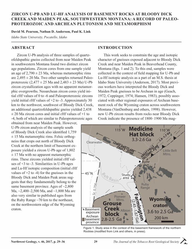
Northwest Geology, v. 46, 2017, p. 29–36 The Journal of the Tobacco Root Geological Society29
ZIRCON U-PB AND LU-HF ANALYSIS OF BASEMENT ROCKS AT BLOODY DICK CREEK AND MAIDEN PEAK, SOUTHWESTERN MONTANA: A RECORD OF PALEO-PROTEROZOIC AND ARCHEAN PLUTONISM AND METAMORPHISM
David M. Pearson, Nathan D. Anderson, Paul K. LinkIdaho State University, Pocatello, Idaho
ABSTRACT
Zircon U-Pb analysis of three samples of quartz-ofeldspathic gneiss collected from near Maiden Peak in southwestern Montana found two distinct zircon age populations. Zircon cores from one sample yield an age of 2,790 ± 23 Ma, whereas metamorphic rims are 2,495 ± 20 Ma. Two other samples returned Paleo-proterozoic (2,477 ± 25 Ma and 2,483 ± 23 Ma) U-Pb zircon crystallization ages with no apparent metamor-phic overgrowths. Neoarchean zircon cores yield ini-tial ɛHf values of 0 to -6 and Paleoproterozoic zircons yield initial ɛHf values of +2 to -3. Approximately 30 km to the northwest, southwest of Bloody Dick Creek, an additional quartzofeldspathic gneiss yielded 2,438 ± 20 Ma zircon cores and initial ɛHf values of +1 to -4, both of which are similar to Paleoproterozoic ages obtained from near Maiden Peak. However, U-Pb zircon analysis of the sample south of Bloody Dick Creek also identifi ed 1,759 ± 15 Ma metamorphic rims. Felsic orthog-neiss that crops out north of Bloody Dick Creek at the northern limit of basement ex-posure yielded a zircon U-Pb age of 1,802 ± 17 Ma with no apparent metamorphic rims. These zircons yielded initial ɛHf val-ues of +3 to -3. Similarities in U-Pb ages and Lu-Hf isotopic composition (initial ɛHf values of +2 to -4) for the gneisses in the Bloody Dick and Maiden Peak areas sug-gests that they fundamentally belong to the same basement province. Ages of ~2,800 Ma, ~2,400–2,500 Ma, and ~1,800 Ma are also very similar to published ages from the Ruby Range ~70 km to the northeast, on the northwestern edge of the Wyoming craton.
INTRODUCTION
This work seeks to constrain the age and isotopic character of gneisses exposed adjacent to Bloody Dick Creek and near Maiden Peak in Beaverhead County, Montana (fi gs. 1 and 2). To this end, samples were collected in the context of fi eld mapping for U-Pb and Lu-Hf isotopic analysis as a part of an M.S. thesis at Idaho State University (Anderson, 2017). Most previ-ous workers have interpreted the Bloody Dick and Maiden Peak gneisses to be Archean in age (Geach, 1972; Coppinger, 1974; Hansen, 1983), possibly asso-ciated with other regional exposures of Archean base-ment rock of the Wyoming craton across southwestern Montana (VanDenburg and others, 1998). However, new U-Pb zircon results from rocks near Bloody Dick Creek indicate the presence of 1800–1900 Ma mag-
45˚N
200 km
2.8-2.5 Ga
Grouse Creek block
115˚W
Sr 0
.706
.
110˚W
Clearwater
Butte
C
But
GREAT FALLS
TECTONIC Z
ONELEWIS AND CLARK
FAULT ZONE
B
elt Ba s in
Little Belt Mtns.
Farmin
gto
n
(2.45 -1.67 Ga)
3.3-2.6 Ga
MedicineHat block
Wyomingcraton
3.6 to 2.5 Ga
PioneerMtns.
Basement exposure
Studyarea
Archeanbasementprovince
1.9 -1.7 Ga
Albion
RubyRange
Figure 1. Study area in the context of the basement framework of the northern Rockies (modifi ed from Link and others, in press).

30
Pearson, Anderson, and Link: Zircon U-Pb and LU-HF Analysis of Basement Rocks
Figure 2. Geologic map of basement outcrop and surrounding area near Bloody Dick Creek in southwestern Montana (modifi ed from Anderson, 2017).
matism and metamorphism (Mueller and others, 2016; Sherwin and others, 2016), which is similar to isotopi-cally juvenile magmatism from ~1,860 to 1,790 Ma within the Great Falls tectonic zone, which culminated with the collision of the Wyoming craton with the Medicine Hat block to the north (Mueller and oth-ers, 2002; Harms and others, 2004; Foster and others, 2006; Mueller and others, 2016). However, the south-western projection of the Great Falls tectonic zone
into southwest Montana and eastern Idaho is limited by rare basement exposures. Thus, gneisses exposed near Bloody Dick Creek and Maiden Peak have the potential to further constrain the spatial distribution of the Great Falls tectonic zone and the greater basement framework of the northern Rocky Mountains.

31
Pearson, Anderson, and Link: Zircon U-Pb and LU-HF Analysis of Basement Rocks
GEOLOGIC SETTING
The Wyoming craton is an Archean crustal block discontinuously exposed in basement uplifts across southwest Montana and much of Wyoming (fi g. 1). Prior high-temperature geo- and thermochronometry constrained several episodes of magmatism and high-grade metamorphism within the northwestern por-tion of the Wyoming craton, including the Beartooth orogeny at ~2,780 Ma (Wooden and Mueller, 1988) and the Tendoy/Beaverhead orogeny at 2,500–2,400 Ma (Kellogg and others, 2003; Jones, 2008; Cramer, 2015). This was followed by 1,860–1,790 Ma mag-matism that defi nes the northeast-trending Great Falls tectonic zone of western Montana (fi g. 1), which was hypothesized to result from arc-related magmatism on the southeastern margin of the Medicine Hat block above a northwest-dipping oceanic slab prior to colli-sion with the northwestern Wyoming craton (Mueller and others, 2002; Harms and others, 2004; Foster and others, 2006; Mueller and others, 2016). Subsequent collision of the Medicine Hat block and Wyoming cra-ton occurred at 1,790–1,720 Ma and resulted in high-grade metamorphism, deformation, and partial melting during the Big Sky orogeny (Harms and others, 2004; Jones, 2008; Cramer, 2015; Condit and others, 2015; Mueller and others, 2016). Though recent results from the Bloody Dick Creek area suggest that Paleoprotero-zoic magmatism and metamorphism is also refl ected by basement rocks within extreme southwestern Mon-tana (Mueller and others, 2016; Sherwin and others, 2016), the age of framework rocks and the relationship of these rocks to the existing basement framework of southwestern Montana are poorly constrained.
METHODS
A total of fi ve samples from southwestern Mon-tana were selected for U-Pb zircon dating and Lu-Hf isotopic analysis in the context of fi eld mapping. Three samples were collected from near Maiden Peak in the northern Tendoy Range, and two others were collected near Bloody Dick Creek in the Beaverhead Mountains.
The separation process was undertaken at Idaho State University using standard crushing techniques. U-Pb analysis was completed at the Arizona LaserChron Center at the University of Arizona by Laser Ablation-Inductively Coupled Plasma-Mass Spectrometry using methods described in Gehrels and others (2009). Lu-Hf analysis of four zircon samples followed pro-cedures described by Cecil and others (2011). Target locations were selected for U-Pb and Lu-Hf analysis based on zoning observed in Back-Scattered Electron (BSE) images. 207Pb/206Pb ratios are reported here. In-dividual analyses that were more than 10% discordant were excluded from the results and not used in subse-quent interpretations of U-Pb ages. Additional mineral separation procedures and analytical details can be found in Anderson (2017).
RESULTS AND DISCUSSION
U-Pb Zircon GeochronologyTextural observations and mineral abundances of
the three samples of gneiss collected for U-Pb and Lu-Hf analysis from near Maiden Peak suggest igneous protoliths of the following compositions: (1) horn-blende granodiorite (04NA16); (2) granite (03NA16); and (3) biotite–hornblende diorite (02NA16). Loca-tions can be found in table 1. At Bloody Dick Creek, samples of two lithologies were collected for U-Pb and Lu-Hf analysis, and on the basis of textural and compositional criteria, both likely had igneous proto-liths: (1) hornblende–biotite tonalite (25NA16; banded gneiss of fi g. 2); and (2) porphyritic biotite tonalite (18NA16; felsic gneiss of fi g. 2). For more detailed sample descriptions and BSE images, see Anderson (2017).
The samples collected from near Maiden Peak display the oldest U-Pb zircon ages obtained here (fi g. 3). Sample 04NA16 displays a spread of U-Pb ages that are mostly concordant. The oldest ages come from zircon cores and are concordant at 2,790 ± 23 Ma (n=8; 2 error including external error and analytical
Table 1. Location information for U-Pb and Lu-Hf samples.
Sample ID UTM Easting (Z12)
UTM Northing (Z12)
Lat (north) Long (West) Elev (ft)
02NA16 32882 49717 44.8786 113.1673 7,885 03NA16 32902 49720 44.8818 113.1648 7,830 04NA16 32861 49754 44.9115 113.1712 8,195 18NA16 31500 49867 45.0102 113.3476 7,185 25NA16 31505 49829 44.9758 113.3456 7,003
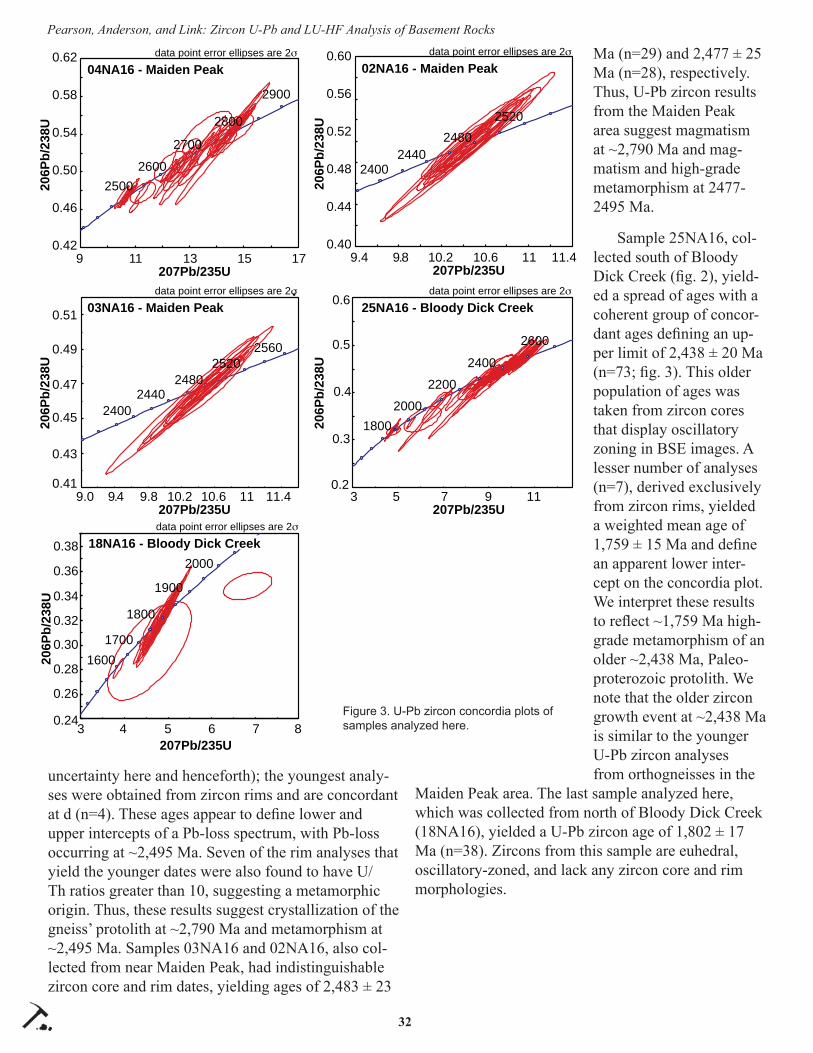
32
Pearson, Anderson, and Link: Zircon U-Pb and LU-HF Analysis of Basement Rocks
uncertainty here and henceforth); the youngest analy-ses were obtained from zircon rims and are concordant at d (n=4). These ages appear to defi ne lower and upper intercepts of a Pb-loss spectrum, with Pb-loss occurring at ~2,495 Ma. Seven of the rim analyses that yield the younger dates were also found to have U/Th ratios greater than 10, suggesting a metamorphic origin. Thus, these results suggest crystallization of the gneiss’ protolith at ~2,790 Ma and metamorphism at ~2,495 Ma. Samples 03NA16 and 02NA16, also col-lected from near Maiden Peak, had indistinguishable zircon core and rim dates, yielding ages of 2,483 ± 23
Ma (n=29) and 2,477 ± 25 Ma (n=28), respectively. Thus, U-Pb zircon results from the Maiden Peak area suggest magmatism at ~2,790 Ma and mag-matism and high-grade metamorphism at 2477-2495 Ma.
Sample 25NA16, col-lected south of Bloody Dick Creek (fi g. 2), yield-ed a spread of ages with a coherent group of concor-dant ages defi ning an up-per limit of 2,438 ± 20 Ma (n=73; fi g. 3). This older population of ages was taken from zircon cores that display oscillatory zoning in BSE images. A lesser number of analyses (n=7), derived exclusively from zircon rims, yielded a weighted mean age of 1,759 ± 15 Ma and defi ne an apparent lower inter-cept on the concordia plot. We interpret these results to refl ect ~1,759 Ma high-grade metamorphism of an older ~2,438 Ma, Paleo-proterozoic protolith. We note that the older zircon growth event at ~2,438 Ma is similar to the younger U-Pb zircon analyses from orthogneisses in the
Maiden Peak area. The last sample analyzed here, which was collected from north of Bloody Dick Creek (18NA16), yielded a U-Pb zircon age of 1,802 ± 17 Ma (n=38). Zircons from this sample are euhedral, oscillatory-zoned, and lack any zircon core and rim morphologies.
0.24
0.36
0.34
0.32
0.30
0.28
0.26
0.38
3 4 5 6 7 8
206P
b/23
8U
data point error ellipses are 2
207Pb/235U
18NA16 - Bloody Dick Creek
16001700
1800
1900
2000
0.40
0.44
0.48
0.52
0.56
0.60
9.4 9.8 10.2 10.6 11 11.4
206P
b/23
8U
data point error ellipses are 2
207Pb/235U
02NA16 - Maiden Peak
24002440
24802520
25002600
2700
2800
2900
0.42
0.46
0.50
0.54
0.58
0.62
9 11 13 15 17
206P
b/23
8Udata point error ellipses are 2
207Pb/235U
04NA16 - Maiden Peak
2560
0.41
0.43
0.45
0.47
0.49
0.51
9.0 9.4 9.8 10.2 10.6 11 11.4
206P
b/23
8U
data point error ellipses are 2
207Pb/235U
03NA16 - Maiden Peak
24002440
24802520
0.2
0.3
0.4
0.5
0.6
3 5 7 9 11
206P
b/23
8U
data point error ellipses are 2
207Pb/235U
25NA16 - Bloody Dick Creek
18002000
2200
2400
2600
Figure 3. U-Pb zircon concordia plots of samples analyzed here.

33
Pearson, Anderson, and Link: Zircon U-Pb and LU-HF Analysis of Basement Rocks
Lu-Hf Isotopic AnalysisLu-Hf analyses of Neoarchean zircons from sam-
ple 04NA16 from near Maiden Peak yield initial ɛHf values of 0 to -6 (fi g. 4). These data yield a model age of ~3,260 Ma. In contrast, Paleoproterozoic zircons (samples 02NA16 and 03NA16) yield initial ɛHf val-ues of +2 to -3 and a younger model age of uncertain signifi cance. Initial ɛHf values of ~2,438 Ma gneisses south of Bloody Dick Creek (25NA16) are +1 to -4. Initial ɛHf values of the 1,802 ± 17 Ma orthogneiss north of Bloody Dick Creek are +3 to -3. Overall, these data are consistent with a model for petrogenesis of the rocks near Maiden Peak and Bloody Dick Creek with contributions of isotopically juvenile material at ~3,260 Ma, ~1,802 Ma, and possibly ~2,475 Ma (fi g. 4).
Regional Implications
Current models of the Greats Falls orogeny constrain the timing of subduction-related arc magma-tism to between ca. 1,860 Ma and 1,790 Ma (Harms and others, 2004; Mueller and others, 2016) and the initiation of continental collision to 1,790–1,780 Ma (Big Sky orogeny) (Cheney and others, 2004; Foster and others, 2006; Condit and others, 2015; Mueller and others, 2016). Given the hypothesized northwest dip to the subduction zone (Gorman and others, 2002; Harms and others, 2004), associated arc magmatism is thought to have been confi ned to the southeastern
margin of the overriding Medicine Hat block (Foster and others, 2006).
Current U-Pb and Lu-Hf results indicate remobi-lization of older (~3,260 Ma) continental lithosphere during magmatism at ~2,790 Ma, as well as magma-tism and metamorphism at ~2,480 Ma, and 1,700–1,800 Ma. Lu-Hf results obtained from one orthog-neiss north of Bloody Dick Creek (sample 18NA16) suggest input of an isotopically juvenile component at ca. 1,802 Ma. Similar results from the Little Belt Mountains of the Great Falls tectonic zone also indi-cate that ca. 1,860 Ma plutons were derived from an isotopically juvenile source. The similarity of the cur-rent results to gneisses from the Little Belt Mountains of the Great Falls tectonic zone suggests that the Great Falls tectonic zone projects into southwest Montana at least as far as the Bloody Dick gneiss, 8 km east of the Idaho state line.
The Maiden Peak and Bloody Dick gneiss units contain U-Pb zircon ages and initial Hf isotopic val-ues that suggest that several samples are part of the Archean Wyoming craton (aff ected by the 2,780 Ma Beartooth orogeny), Farmington zone (aff ected by the 2,550 to 2,455 Ma Tendoy orogeny), and the Great Falls tectonic zone (aff ected by 1,790 to 1,720 Ma Big Sky orogeny). Given these similarities (see Cramer, 2015 for a review), this suggests that if the Little Belt arc was indeed constructed on the southeastern margin
-25
-20
-15
-10
-5
0
5
10
15
20
1400 1600 1800 2000 2200 2400 2600 2800 3000
Epsi
lon
Hf
Age (Ma)
DM
CHUR
average crustal evolution
04NA1603NA16
25NA1618NA16
3200
04NA16Model age 3260 Ma
Bloody Dick Creek
Maiden Peak
Figure 4. εHf values of samples analyzed in this study from near Bloody Dick Creek and Maiden Peak, southwestern Montana. Yellow boxes indicate likely episodes of juvenile isotopic input of material.
34
Pearson, Anderson, and Link: Zircon U-Pb and LU-HF Analysis of Basement Rocks
of the Medicine Hat block (e.g., Foster and others, 2006), this magmatic arc may have formed within a rifted fragment of the Wyoming craton (Harms and others, 2004).
CONCLUSIONS
Within the Tendoy Range of southwest Montana, U-Pb zircon analysis of quartzofeldspathic gneiss near Maiden Peak found two distinct zircon age popula-tions. Within one sample (04NA16), the oldest zircons were dated to 2,790 ± 23 Ma (interpreted to have formed during the Beartooth orogeny), with 2,495 ± 20 Ma metamorphic rims attributed to plutonism and metamorphism during the Tendoy orogeny. Two other samples (02NA16 and 03NA16) of quartzofeldspathic gneiss from Maiden Peak returned unimodal U-Pb zircon crystallization ages of 2,477 ± 25 Ma and 2,483 ± 23 Ma. These two dates are encompassed in the ~2,495 Ma metamorphic age peak (rims) from sample 04NA16, which is interpreted to indicate that magma-tism in samples 02NA16 and 03NA16 was concurrent with metamorphism during the Tendoy orogeny. All three of these gneisses are interpreted as being derived from an igneous protolith.
Several lines of evidence suggest original igneous protoliths for both gneiss samples from the Bloody Dick Creek area, including: unimodal zircon popula-tions with younger, metamorphic overgrowths, the lack of pelitic minerals, and abundance of minerals in-dicative of an originally igneous protolith (e.g., abun-dant feldspar that is up to 1 cm). The oldest unit is the banded gneiss (25NA16), which contains 2,438 ± 20 Ma zircon cores and 1,759 ± 15 Ma metamorphic rims with high U/Th ratios. These rocks thus share similar U-Pb zircon ages of 2,400–2,500 Ma with some rocks studied from the Maiden Peak area. This is interpreted as evidence for correlation between the banded gneiss of the Bloody Dick unit and quartzofeldspathic gneiss in Maiden Peak. An additional sample at Bloody Dick Creek yielded a U-Pb zircon age of 1,802 ± 17 Ma; Lu-Hf isotopic analysis suggests input of isotopically juvenile material at that time.
Similarities in U-Pb and Lu-Hf isotopic values of ~2,400–2,500 Ma gneisses in the Bloody Dick gneiss and quartzofeldspathic gneiss from Maiden Peak sug-gests that they fundamentally belong to the same base-ment province. Younger felsic orthogneisses within the Bloody Dick gneiss are Paleoproterozoic in age and
suggest contribution of isotopically juvenile material at crystallization (initial ɛHf values of +3 to -7), which is similar to rocks from the Little Belt Mountains. Those rocks were interpreted to have formed during arc magmatism above the northwest-dipping subduc-tion of oceanic lithosphere beneath the Medicine Hat block during the 1,860 to 1,790 Ma Great Falls orog-eny. This correlation of arc-related rocks between the Little Belt Mountains and the Bloody Dick gneiss sug-gests that the Great Falls tectonic zone projects into southwest Montana at least as far as the Bloody Dick gneiss. This work also establishes the basement frame-work into which some isotopically juvenile rocks of the Great Falls tectonic zone were intruded, which has strong affi nities to the Wyoming craton.
REFERENCES CITED
Anderson, N.D., 2017, The Bloody Dick and Maiden Peak gneisses, southwest Montana: Implica-tions for Archean and Paleoproterozoic basement framework: Pocatello, Idaho State University, M.S. thesis, 129 p., 1 plate.
Cecil, M.R., Gehrels, G., Ducea, M.N., and Patchett, P.J., 2011, U-Pb-Hf characterization of the cen-tral Coast Mountains batholith: Implications for petrogenesis and crustal architecture: Lithosphere, v. 3, no. 4, p. 247–260.
Cheney, J.T., Webb, A., Coath, C., and McKeegan, K., 2004, In situ ion micro-probe 207 Pb/ 206 Pb dating of monazite from Precambrian metamor-phic rocks, Tobacco Root Mountains, Montana, in Brady, J.B., Burger, H.R., Cheney, J.T., and Harms, T.A., eds., Precambrian Geology of the Tobacco Root Mountains, Montana: Geologi-cal Society of America Special Paper 377, p. 151–179.
Condit, C.B., Mahan, K.H., Ault, A.K., and Flowers, R.M., 2015, Foreland-directed propagation of high-grade tectonism in the deep roots of a Pa-leoproterozoic collisional orogen, SW Montana, USA: Lithosphere, v. 7, p. 625–645.
Coppinger, W., 1974, Stratigraphy and structural study of Belt Supergroup and associated rocks in a por-tion of the Beaverhead Mountains, southwestern Montana and east-central Idaho: Oxford, Ohio, Miami University, Ph.D. dissertation, 224 p.
Cramer, M., 2015, Proterozoic tectonometamorphic evolution of the Ruby Range, SW Montana, USA:
35
Pearson, Anderson, and Link: Zircon U-Pb and LU-HF Analysis of Basement Rocks
Insights from phase equilibria modeling and in situ monazite petrochronology: University of Montana, Missoula, M.S. thesis, 120 p.
Foster, D.A., Mueller, P.A., Mogk, D.W., Wooden, J., and Vogl, J.J., 2006, Proterozoic evolution of the western margin of the Wyoming craton: Implica-tions for the tectonic and magmatic evolution of the northern Rocky Mountains: Canadian Journal of Earth Sciences, v. 43, p. 1601–1619.
Geach, R.D., 1972, Mines and mineral deposits (ex-cept fuels) Beaverhead County, Montana: Mon-tana Bureau of Mines and Geology Bulletin 85, 194 p.
Gehrels, G., Rusmore, M., Woodsworth, G., Craw-ford, M., Andronicos, C., Hollister, L., Patchett, J., Ducea, M., Butler, R., Klepeis, K., David-son, C., Friedman, R., Haggart, J., Mahoney, B., Crawford, W., Pearson, D., and Girardi, J., 2009, U-Th-Pb geochronology of the Coast Mountains batholith in north-coastal British Columbia: Con-straints on age and tectonic evolution: Geological Society of America Bulletin, v. 121, no. 9-10, p. 1341–1361.
Gorman, A.R., Clowes, R.M., Ellis, R.M., Henstock, T.J., Spence, G.D., Keller, G.R., Levander, A., Snelson, C.M., Burianyk, M.J.A., Kanasewich, E.R., Asudeh, I., Hajnal, Z., and Miller, K.C., 2002, Deep probe: Imaging the roots of western North America: Canadian Journal of Earth Sci-ences, v. 39, p. 375–398.
Hansen, P.M., 1983, Structure and stratigraphy of the Lemhi Pass area, Beaverhead Range, southwest Montana and east-central Idaho: University Park, Penn., The Pennsylvania State University, M.S. thesis, 112 p.
Harms, T.A., Brady, J.B., Burger, H.R., and Cheney, J.T., 2004, Advances in the geology of the Tobac-co Root Mountains, Montana, and their implica-tions for the history of the northern Wyoming Province, in Brady, J.B., Burger, H.R., Cheney, J.T., and Harms, T.A., eds., Precambrian geology of the Tobacco Root Mountains, Montana: Geo-logical Society of America Special Paper 377, p. 227–243.
Jones, C., 2008, U-Pb geochronology of monazite and zircon in Precambrian metamorphic rocks from the Ruby Range, SW Montana: Deciphering geological events that shaped the NW Wyoming
province: Kent State University, Ohio, M.S. the-sis, 119 p.
Kellogg, K.S., Snee, L.W., and Unruh, D.M., 2003, The Mesoproterozoic Beaverhead Impact struc-ture and its tectonic setting, Montana-Idaho: 40Ar/39Ar and U/Pb isotopic constraints: Journal of Geology, v. 111, p. 639–652.
Link, P.K., Autenrieth-Durk, K.M., Cameron, A., Fan-ning, C.M., Vogl, J.J., and Foster, D.A., in press, U-Pb zircon ages of Wildhorse Creek, Pioneer Mountains, south-central Idaho, and tectonic im-plications: Geosphere.
Mueller, P.A., Heatherington, A.L., Kelly, D.M., Wooden, J.L., and Mogk, D.W., 2002, Paleo-proterozoic crust within the Great Falls tectonic zone: Implications for the assembly of southern Laurentia: Geology, v. 30, p. 127–130.
Mueller, P.A., Mogk, D.W., Wooden, J., and Spake, D., 2016, U-Pb ages of zircons from the Lower Belt Supergroup and proximal crystalline base-ment: Implications for the early evolution of the Belt Basin, in MacLean, J.S., and Sears, J.W., eds., Belt Basin: Window to Mesoproterozoic Earth: Geological Society of America Special Paper 522, p. 283–303.
Sherwin, J.A., Younggren, E.B., Link, P.K., and Gas-chnig, R.M., 2016, Geologic map of the Coyote Creek 7.5’ quadrangle, southwest Montana: Mon-tana Bureau of Mines and Geology Geologic Map 67, scale 1:24,000.
Wooden, J., and Mueller, P.A, 1988. Pb, Sr, and Nd isotopic compositions of a suite of Late Archean, igneous rocks, eastern Beartooth Mountains: Implications for crust-mantle evolution, Earth and Planetary Sciences Letters, v. 87, p. 59–72.


Northwest Geology, v. 46, 2017, p. 37–44 The Journal of the Tobacco Root Geological Society37
A GEODYNAMIC MODEL FOR GRAVITY-DRIVEN EXTENSION—IMPLICATIONS FOR THE CENOZOIC EVOLUTION OF SOUTHWESTERN MONTANA
Kevin LielkeIndependent Geologist, Ennis, MT 59729
INTRODUCTION
The transition from Cretaceous compression to Cenozoic extension represents the most important tectonic event in the northern Rocky Mountains over the last 60 m.y. However, in southwestern Montana, many of the details of the initiation and evolution of Cenozoic extension remain poorly understood. The oldest theories posited an early Cenozoic beginning of extension within the boundaries of present-day inter-montane basins (Fields and others, 1985; Hanneman, 1989; Hanneman and Wideman, 1991; Pardee, 1950). An alternative theory endorses a tectonically quies-cent, largely featureless Paleogene “Renova basin” which was dissected by extension beginning in the middle Miocene (Sears and others, 1995; Sears and Fritz, 1998; Sears and Thomas, 2007). If this singular Paleogene Renova basin existed, it did so in a regional tectonic framework that included extensive contem-poraneous volcanism and extension outside of its boundaries (Foster and others, 2010; Luedke, 1994). Recently, it has been suggested that relict Cretaceous paleotopography and Paleogene volcanic activity within the Renova basin, along with alterations to the physical properties of the underlying lithosphere, played an important role in the development of Ce-nozoic extension and sedimentation (Lielke, 2008, 2010; Rothfuss and others, 2012). Early Oligocene paleoelevation estimates suggest that the Renova basin may have been a relatively high (1.5–2.5 km) altitude sedimentary depocenter—possibly a remnant of an ex-tensive Cretaceous altiplano (Lielke and others, 2012). The boundaries of this proposed Renova plateau are: in the north, the southwestern Montana transverse zone; to the west, the leading edge of the Sevier fold and thrust belt; the southern edge is obscured by younger volcanics; and the Beartooth plateau may rep-resent its eastern extension. The purpose of this study is twofold: (1) to examine the viability of body forces internal to the lithosphere as the primary driving force of Cenozoic extension, and (2) to test the theory that alterations to the physical properties of the lithosphere are adequate to explain the existence of a stable,
possibly high-elevation, Renova depocenter and its subsequent dismemberment owing to the destabilizing eff ects of the Yellowstone hotspot.
Southwestern Montana is underlain by the north-western corner of the Archean Wyoming province craton. Cratons are generally characterized by stable, thick (>200 km) lithosphere largely undeformed since Precambrian time. However, the Wyoming province has been substantially modifi ed by Cretaceous and Cenozoic aged orogenic and thermal events. From an analysis of passive source seismic data, Dave and Li (2016) calculated an average Wyoming province litho-spheric thickness of only 150 km. Pervasive modifi ca-tion of the Wyoming province lithosphere is linked primarily to Cretaceous subduction and orogenesis and, on a smaller scale, to localized anomalies such as the Yellowstone hotspot currently situated beneath the northwestern corner of Wyoming (Jones and oth-ers, 2015). However, the eff ect of the middle Miocene outbreak of the Yellowstone hotspot on the physical properties of the Wyoming craton, and its tectonic implications, is not well understood. The middle Mio-cene (17–20 Ma) was a period of major tectonic reor-ganization throughout western North America, includ-ing Basin and Range extension, a widespread angular unconformity in western Montana, initiation of the Yellowstone hotspot and Snake River Plain volcanism, outbreak of the Columbia River and Steens Mountain fl ood basalts, emplacement of the Monument and Chief Joseph dike swarms, formation of the Oregon–Nevada lineament, and extension in the Rio Grande rift (Chapin and Cather, 1994; Liu and Shen, 1998; Sears and Thomas, 2007). In southwestern Montana, rapid extension occurred in a series of predominately N–NE-trending half-grabens, forming a prominent an-gular unconformity between Paleogene and Neogene sediments (Sears and Fritz, 1998; Sears and Thomas, 2007). It seems probable that the Yellowstone hotspot infl uenced the physical properties of the portion of the Wyoming province underlying southwestern Montana and that its initial outbreak served as a triggering event for the hypothesized middle Miocene breakup of the

38
Kevin Lielke: A Geodynamic Model for Gravity-Driven Extension
previously stable Renova basin.
Sears and others (2009) attribute middle Miocene tectonism to radial extension across the top of a broad structural dome above the Yellowstone hotspot. How-ever, the 400 to 500 km distance from southwestern Montana to the site of the initial outbreak in south-eastern Oregon would appear to preclude a signifi cant increase in elevation due to dynamic topography (Condie, 2001; Griffi ths and Campbell, 1991). In the scenario expounded below, the driving mechanism for middle Miocene extension is stored gravitational potential energy (GPE) released by alteration of the physical properties of the Wyoming craton, specifi -cally a decrease in the depth of isostatic compensation coupled with an increase in the geotherm. Heating accompanied by thermo-mechanical erosion of the cratonic mantle is an expected consequence of con-vection in the asthenosphere, especially along the boundaries associated with mantle heterogeneities (Davies, 1994; Liu and Shen, 1998; Moore and others, 1999; Wannamaker and others, 2001). Geodynamic analysis of lithosphere models can test the validity of this proposed driving mechanism and make testable predictions concerning the values of crustal thickness, paleoelevation, and geotherm parameters consistent with gravity-driven extension. The model developed below assumes that Cenozoic deformation in the northern Rockies was driven principally by gravita-tional body forces inherent to the lithosphere and at-tempts to replicate the pattern of deformation using the most conservative estimates of alterations to physical parameters.
GEODYNAMIC MODEL
Gravitational potential energy (GPE) can be defi ned as the depth integrated vertical stress from a topographic surface down to a common-depth refer-ence level (Ghosh and others, 2009). Isostatic equi-librium between two lithospheric columns requires that the pressure at this reference level, generally assumed to correspond to the base of the lithosphere, be equal (Sonder and Jones, 1999). The diff erence in gravitational potential energy (∆PE) between a litho-spheric column and a reference column in isostatic equilibrium indicates the state of stress, compression or tension, acting upon the lithosphere (Sonder and Jones, 1999). In this study the asthenosphere geoid, the height the asthenosphere would rise to without an overlying lithosphere, is used for the reference col-
umn (Turcotte and others, 1977; Zoback and Mooney, 2003). This abstract standard was chosen in order to provide a single consistent basis of comparison that is not area or time specifi c. The ∆PE model used in this study consists of a two-layer lithosphere incorporating surface topography (fi g. 1), coupled with a geotherm determined by two inputs: basal heat fl ow (Q) and radiogenic heat production (A). Since radiogenic min-erals are disproportionately concentrated in the crust, mantle heat production is assumed to be zero. The density profi le of this model is therefore the density due to lithology modifi ed by thermal expansion. Given a set of initial parameters for the depth of isostatic compensation and the geotherm, ∆PE is calculated from the equation (modifi ed from Jones, Sonder and Unruh, 1998):
where the crust and mantle components of the geo-therm are determined by (Fowler, 1994):
In the above equations, Ho = 2780 m and ρa = 3150 kg/m3, the coeffi cient of thermal expansion α = 3.28 x 10⁻⁵/°C, the gravitational constant g = 9.81 m/s2, thermal conductivity is k1 = 2.75 W/m°C for the crust and k2 = 3.75 W/m°C for the mantle, and ρc0 and ρm0 are zero pressure average density for the crust (2780 kg/m3) and top of the mantle average rock density (3350 kg/m3), respectively.
The results of a ∆PE analysis can be illustrated by plots showing fi elds of tension and compression for each possible matched pair of crustal thickness and paleoelevation. The positive ∆PE fi eld gives the range of these values for which extensional deformation is theoretically possible. The vertically averaged devia-toric stress (∆σxx) exerted by one lithospheric column upon the other can be calculated by dividing ∆PE by the total lithospheric thickness (Sonder and Jones, 1999). This stress represents the non-lithostatic force available to drive deformation (Turcotte and Schubert, 2002). Extension is predicted to occur if the tensional deviatoric stress exerted upon the lithosphere is of

39
Kevin Lielke: A Geodynamic Model for Gravity-Driven Extension
suffi cient magnitude to overcome the inherent strength of the lithosphere as well as any exter-nal resisting forces; for example, plate tectonic boundary forces. These predications can be tested against the geologic record if proxy data for crustal thickness (restored balanced cross sections, subsurface seismic data) and paleoel-evation (plant fossil and stable isotope esti-mates) are available. Three end member mod-els were used in order to investigate the eff ect of lithosphere properties on tectonic regime: Model A is a thin and hot lithosphere (150 km thick and .035
W/m2 heat fl ow (Q) into base of lithosphere), model B is thin and cool (150 km and .025 W/m2) and model C is thick and cool (180 km and .025 W/m2). Isostatic compensation depth varies, but along the geologically active western margin of North America, a value in the range of 150 to 180 km is a reasonable estimate (Zoback and Mooney, 2003; Zurek and Dueker, 2005). The results of ∆PE analysis are shown in fi gures 2, 3 and 4.
Examination of the plots for models A–C indicates that diff erences in lithospheric properties can lead to diff erences in the predicted tectonic behavior. A thick and cool lithosphere (model C) is capable of support-ing a thicker crust and higher paleoelevations than either of the two thin lithosphere models. Similarly, decreasing the heat fl ux (Q) at the base of the 150-km-thick lithosphere by .01 W/m2 (model B) permits a thicker, higher elevation crust compared to model A. Applying these theoretical results to the question of a stable Renova depocenter shows that if the Wyoming craton underlying Paleogene southwestern Montana was thicker and colder than the neighboring litho-sphere underlying the Sevier fold and thrust belt, then diff erences in tectonic behavior would be expected.
Figure 1. Two-layer lithosphere model incorporat-ing surface elevation (ε) and a geotherm with two inputs—radiogenic heat production (A) and base of lithosphere heat fl ow (Q). Z1 is the base of the crust and Z2 is the isostatic compensation depth.
Figure 2. Plot of ΔPE for model A—a thin and hot (150 km thick and Q =.035 W/m2) lithosphere—showing fi elds of tension and compres-sion as a function of crustal thickness and paleoelevation.

40
Kevin Lielke: A Geodynamic Model for Gravity-Driven Extension
Although accurate pre-extension estimates of crustal properties are diffi cult to obtain, some data are available for comparison purposes. Paleoelevation estimates from late Eocene to early Oligocene paleofl oras indicate the presence of topography 1.5–2.5 km in eleva-tion centered over the northwestern corner of the Wyoming province (Lielke and others, 2012), implying the existence of an intact high-elevation Paleogene plateau. Moreover, Cretaceous orogeny in this area occurred primarily by high-angle, Laramide-style reverse faulting rather than imbricate stack-ing of thrust sheets, which minimized crustal thickening (Schmidt and others, 1988). On the other hand, estimates of crustal thickness for the Sevier fold and thrust belt indicate a pre-extension crustal welt in the 45–60 km range (Constenius, 1996; Feinstein and oth-ers, 2007). Extensional collapse in the Sevier thrust belt preferentially reactivated preexist-ing thrust surfaces and was superposed on large-relief structural features such as thrust ramps, duplex zones, and culminations (Constenius, 1996). Collapse of elevated and thickened crust is a natural consequence of the reduction in lateral diff erences in gravitational potential energy due to juxta-position of lithosphere of diff ering density and thickness (Flesch and Kreemer, 2010). Therefore, extension is predicted for the area of maximum crustal thickness and high elevation within the fold and thrust belt— provided that gravitational forces promot-ing extension exceed both the strength of the lithosphere and any external resisting forces. Thus, diff erences in lithospheric structure between the Sevier hinterland and the area of southwestern Montana south and east of its leading edge can account for the contemporaneous existence of a stable Pa-leogene Renova plateau delineated by zones of active extension.
During middle Miocene time, the stabil-ity of the craton underlying southwestern Montana was upset by a major thermal anomaly associated with the initiation of the Yellowstone hot spot. To test the eff ect of
this event on the stability of the lithosphere,
Figure 3. Plot of ΔPE for model B—a thin and cool (150 km thick and Q =.025 W/m2) lithosphere—showing fi elds of tension and compression as a function of crustal thickness and paleoelevation.
Figure 4. Plot of ΔPE for model C—a thick and cool (170 km thick and Q =.025 W/m2) lithosphere—showing fi elds of tension and compression as a function of crustal thickness and paleoelevation.
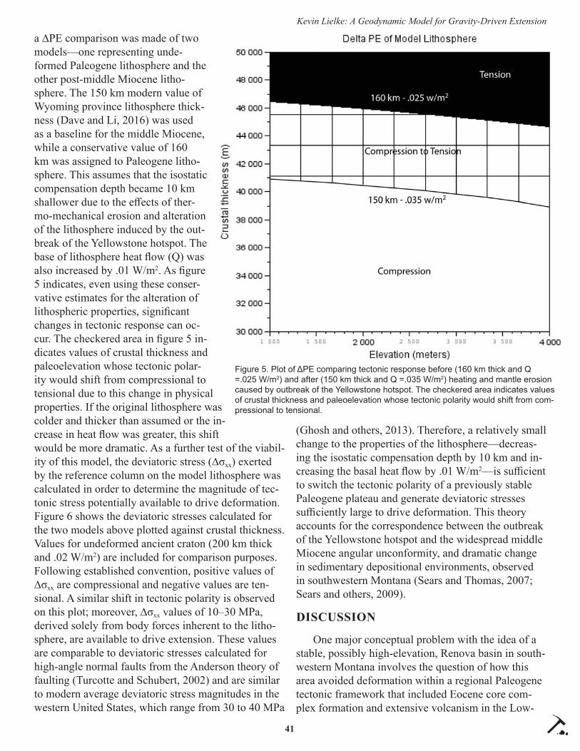
41
Kevin Lielke: A Geodynamic Model for Gravity-Driven Extension
a ∆PE comparison was made of two models—one representing unde-formed Paleogene lithosphere and the other post-middle Miocene litho-sphere. The 150 km modern value of Wyoming province lithosphere thick-ness (Dave and Li, 2016) was used as a baseline for the middle Miocene, while a conservative value of 160 km was assigned to Paleogene litho-sphere. This assumes that the isostatic compensation depth became 10 km shallower due to the eff ects of ther-mo-mechanical erosion and alteration of the lithosphere induced by the out-break of the Yellowstone hotspot. The base of lithosphere heat fl ow (Q) was also increased by .01 W/m2. As fi gure 5 indicates, even using these conser-vative estimates for the alteration of lithospheric properties, signifi cant changes in tectonic response can oc-cur. The checkered area in fi gure 5 in-dicates values of crustal thickness and paleoelevation whose tectonic polar-ity would shift from compressional to tensional due to this change in physical properties. If the original lithosphere was colder and thicker than assumed or the in-crease in heat fl ow was greater, this shift would be more dramatic. As a further test of the viabil-ity of this model, the deviatoric stress (∆σxx) exerted by the reference column on the model lithosphere was calculated in order to determine the magnitude of tec-tonic stress potentially available to drive deformation. Figure 6 shows the deviatoric stresses calculated for the two models above plotted against crustal thickness. Values for undeformed ancient craton (200 km thick and .02 W/m2) are included for comparison purposes. Following established convention, positive values of ∆σxx are compressional and negative values are ten-sional. A similar shift in tectonic polarity is observed on this plot; moreover, ∆σxx values of 10–30 MPa, derived solely from body forces inherent to the litho-sphere, are available to drive extension. These values are comparable to deviatoric stresses calculated for high-angle normal faults from the Anderson theory of faulting (Turcotte and Schubert, 2002) and are similar to modern average deviatoric stress magnitudes in the western United States, which range from 30 to 40 MPa
(Ghosh and others, 2013). Therefore, a relatively small change to the properties of the lithosphere—decreas-ing the isostatic compensation depth by 10 km and in-creasing the basal heat fl ow by .01 W/m2—is suffi cient to switch the tectonic polarity of a previously stable Paleogene plateau and generate deviatoric stresses suffi ciently large to drive deformation. This theory accounts for the correspondence between the outbreak of the Yellowstone hotspot and the widespread middle Miocene angular unconformity, and dramatic change in sedimentary depositional environments, observed in southwestern Montana (Sears and Thomas, 2007; Sears and others, 2009).
DISCUSSION
One major conceptual problem with the idea of a stable, possibly high-elevation, Renova basin in south-western Montana involves the question of how this area avoided deformation within a regional Paleogene tectonic framework that included Eocene core com-plex formation and extensive volcanism in the Low-
Figure 5. Plot of ΔPE comparing tectonic response before (160 km thick and Q =.025 W/m2) and after (150 km thick and Q =.035 W/m2) heating and mantle erosion caused by outbreak of the Yellowstone hotspot. The checkered area indicates values of crustal thickness and paleoelevation whose tectonic polarity would shift from com-pressional to tensional.

42
Kevin Lielke: A Geodynamic Model for Gravity-Driven Extension
land Creek, Absaroka, and Challis volcanic fi elds. One possible explanation is the presence of Archean base-ment underlying the proposed Renova depocenter and its diff ering response to tectonic stress and changes to its thermal structure. Geodynamic modeling results show that, assuming a realistic set of initial parameters for Cenozoic lithosphere, varying the depth of isostatic compensation and the geotherm leads to diff ering tec-tonic responses that closely correspond to the observed spatial and temporal pattern of extension in southwest-ern Montana. The area underlain by the northwestern corner of the Wyoming province, south and east of the Sevier fold and thrust belt, was mechanically strong enough to resist gravitational collapse following the end of Cretaceous compression. Thermomechani-cal erosion and heating of the lithosphere caused by mantle convection associated with the outbreak of the Yellowstone hotspot led to the destabilization of the formerly atectonic Renova plateau, initiating exten-
sion and forming the angular unconformity underlying the Sixmile Creek Formation. It is important to note that gravitational potential energy, already present in the form of thickened crust and high topography, was suffi cient to drive middle Miocene extension once freed by the mechanical weakening of the underlying cratonic lithosphere.
REFERENCES CITED
Chapin, C., and Cather, S., 1994, Tectonic setting of the axial basins of the northern and central Rio Grande rift, in Keller, G. and Cather, S., eds., Basins of the Rio Grande Rift: Structure, stratig-raphy, and tectonic setting: Geological Society of America Special Paper 291, p. 5–25.
Condie, K.C., 2001, Mantle plumes and their record in Earth history: Cambridge, UK, Cambridge Uni-versity Press, 306 p.
Figure 6. Plot of deviatoric (tectonic) stress for three diff erent lithosphere models representing typical undeformed craton and Wyoming province craton before and after outbreak of the Yellowstone hotspot.

43
Kevin Lielke: A Geodynamic Model for Gravity-Driven Extension
Constenius, K., 1996, Late Paleogene extensional col-lapse of the Cordilleran foreland fold and thrust belt: Geological Society of America Bulletin, v. 108, no. 1, p. 20–39.
Dave, R., and Li, A., 2016, Destruction of the Wyo-ming craton: Seismic evidence and geodynamic processes: Geology, v. 44, no. 11, p. 883–886.
Davies, G., 1994, Thermomechanical erosion of the lithosphere by mantle plumes: Journal of Geo-physical Research, v. 99, no. 15, p. 709–722.
Feinstein, S., Kohn, B., Osadetz, K., and Price, R., 2007, Thermochronometric reconstruction of the prethrust paleogeothermal gradient and initial thickness of the Lewis thrust sheet, southeastern Canadian Cordillera foreland belt, in Sears, J., Harms, T., and Evenchick, C., (eds).: Whence the mountains? Inquires into the evolution of oro-genic systems: Geological Society of America Special Paper 433, p. 167–182.
Fields, R., Rasmussen, D., Tabrum, A, and Nichols, R., 1985, Cenozoic rocks of the intermontane basins of western Montana and eastern Idaho: A summary, in Flores, R., and Kaplan, S., Cenozoic paleogeography of west-central United States: SEPM-RMS, p. 9–36.
Flesch, L.M., and Kreemer, C., 2010, Gravitational potential energy and regional stress and strain rate fi elds for continental plateaus: Examples from the central Andes and Colorado Plateau: Tectono-physics, v. 482, p. 182–192.
Foster, D.A., Grice, W.C., and Kalakay, T.J., 2010, Extension of the Anaconda metamorphic core complex: 40Ar/39Ar thermochronology and im-plications for Eocene tectonics of the northern Rocky Mountains and the Boulder Batholith: Lithosphere, v. 2, no. 4, p. 232–246.
Fowler, C.M.R., 1994, The solid Earth—An intro-duction to global geophysics: Cambridge, U.K., Cambridge University Press, 472 p.
Ghosh, A., Holt, W., and Flesch, L.M., 2009, Contri-butions of gravitational potential energy diff er-ences to global stress fi eld: Geophysical Journal International, v. 179, p. 787–812.
Ghosh, A., Becker, T., and Humphreys, E., 2013, Dy-namics of the North American continent: Geo-physical Journal International, v. 194, p. 651–669.
Griffi ths, R., and Campbell, I., 1991, Interaction of
mantle plume heads with the Earth’s surface and onset of small-scale convection: Journal of Geo-physical Research, v. 96, no. 18, p. 295–310.
Hanneman, D., 1989, Cenozoic basin evolution in a part of southwestern Montana: Missoula, Univer-sity of Montana, Ph.D. dissertation, 347 p.
Hanneman, D., and Wideman, C., 1991, Sequence stratigraphy of Cenozoic continental rocks, south-western Montana: Geological Society of America Bulletin., v. 103, no. 10, p. 1335–1345.
Jones, C., Sonder, L., and Unruh, J., 1998, Lithospher-ic gravitational potential energy and past orogen-esis: Implications for conditions of initial Basin and Range and Laramide deformation: Geology, v. 26, no. 7, p. 639–642.
Jones, C., Mahan, K., Butcher, L., Levandowski, W., and Farmer, G., 2015, Continental uplift through crustal hydration: Geology, v. 43, no. 4, p. 355–358.
Lielke, K., 2008, Paleogeographic reconstruction of the Renova Formation in southwestern Montana: American Association of Petroleum Geologists Bulletin, v. 92, no. 11, p. 1605.
Lielke, K., 2010, Paleogene topography, drainage patterns, and climate change in southwestern Montana: American Association of Petroleum Geologists abstracts, 2010 annual convention and exhibition, v. 19, p. 149.
Lielke, K., Manchester, S., and Meyer, H., 2012, Reconstructing the environment of the northern Rocky Mountains during the Eocene/Oligocene transition: Constraints from the palaeobotany and geology of south-western Montana, USA: Acta Palaeobotanica, v. 52, no. 2, p. 339–380.
Liu, M., and Shen, Y., 1998, Crustal collapse, mantle upwelling, and Cenozoic extension in the North American Cordillera: Tectonics, v. 17, no. 2, p. 311–321.
Luedke, R., 1994, Maps showing distribution, com-position and age of early and middle Cenozoic volcanic centers in Idaho, Montana, west-central South Dakota and Wyoming: U.S. Geologic Sur-vey Misc. Investigations Series Map I-2291-C.
Moore, W., Schubert, G., and Tackley, P., 1999, The role of rheology in lithospheric thinning by mantle plumes: Geophysical Research Letters, v. 26, p. 1073–1076.

44
Kevin Lielke: A Geodynamic Model for Gravity-Driven Extension
Pardee, J.T., 1950, Late Cenozoic block faulting in western Montana: Geological Society of America Bulletin, v. 61, no. 4, p. 359–406.
Rothfuss, J.L., Lielke, K., and Weislogel, A.L., 2012, Application of detrital zircon provenance in paleogeographic reconstruction of an intermon-tane basin system, Paleogene Renova Formation, southwest Montana, in Rasbury, E.T., Hemming, S.R., and Riggs, N.R., (eds.): Mineralogical and Geochemical Approaches to Provenance: Geo-logical Society of America Special Paper 487, p. 63–95.
Schmidt, C., O’Neill, J., and Brandon, W., 1988, Infl u-ence of Rocky Mountain foreland uplifts on the development of the frontal fold and thrust belt, southwestern Montana, in Schmidt, C., and Perry, W., eds., Interaction of the Rocky Mountain fore-land and the Cordilleran thrust belt: Geological Society of America Memoir 171, p. 171–201.
Sears, J., Hurlow, H., Fritz, W., and Thomas, R., 1995, Late Cenozoic disruption of Miocene grabens on the shoulder of the Yellowstone hotspot track in southwest Montana: Field guide from Lima to Alder, Montana: Northwest Geology, v. 24, p. 201–219.
Sears, J., and Fritz, W., 1998, Cenozoic tilt domains in southwestern Montana: Interference among three generations of extensional fault systems: Geo-logical Society of America Special Paper 323, p. 241–247.
Sears, J., and Thomas, R., 2007, Extraordinary middle Miocene crustal disturbance in southwest Mon-tana: Birth record of the Yellowstone hot spot?: Northwest Geology, v. 36, p. 133–142.
Sears, J., Hendrix, M., Thomas, R., and Fritz, W., 2009, Stratigraphic record of the Yellowstone hotspot track, Neogene Sixmile Creek Forma-tion grabens, southwest Montana: Journal of Volcanology and Geothermal Research, v. 188, p. 250–259.
Sonder, L., and Jones, C., 1999, Western United States extension: How the west was widened: Annual Review of Earth and Planetary Sciences, v. 27, p. 417–462.
Turcotte, D.L., Haxby, W., and Ockendon, J., 1977, Lithospheric instabilities, in Talwani, M., and Pit-man W., (eds.), Island arcs, deep sea trenches and
back-arc basins: American Geophysical Union, p. 63–69.
Turcotte, D.L., and Schubert, G., 2002, Geodynam-ics, second edition: Cambridge, U.K., Cambridge University Press, 456 p.
Wannamaker, P., Bartley, J., Sheehan, A., Jones, C., Lowry, A., Dumitru, T., Ehlers, T., Holbrook, W., Farmer, G., Unsworth, M., Hall. D., Chapman, D., Okaya, D., John, B., and Wolfe, J., 2001, Great Basin—Colorado Plateau transition in cen-tral Utah: An interface between active extension and stable interior, in Erskine, M., and others, eds., The Geological Transition, High Plateaus to Great Basin—A symposium and fi eld guide: Utah Geological Association, 30, p. 1–38.
Zoback, M., and Mooney, W., 2003, Lithospheric buoyancy and continental intraplate stresses, in Klemperer, S., and Ernst, W., eds., The litho-sphere of western North America and its geo-physical characterization: George A. Thompson International Book Series, v. 7, p. 367–390.
Zurek, B., and Dueker, K., 2005, Lithospheric stra-tigraphy beneath the southern Rocky Mountains, USA, in Karlstrom, K., and Keller, G., eds., The Rocky Mountain region: An evolving lithosphere: Geophysical Monograph Series, v. 154, p. 317–328.

Northwest Geology, v. 46, 2017, p. 45–66 The Journal of the Tobacco Root Geological Society45
DIVIDING THE BEAVERHEAD GROUP AT THE CONTINENTAL DIVIDE
Stuart D. Parker Missoula, MT 59812, [email protected]
ABSTRACT
The Divide unit is an 800-m-thick quartzite con-glomerate of contested age and origin that sits atop the Continental Divide near Monida Pass, Montana/Idaho. The Divide unit was originally assigned to the Late Cretaceous Beaverhead Group despite a lack of con-clusive age dating. Interstratifi ed Kilgore Tuff at 4.5 Ma contests this designation to the Beaverhead Group. This study reports new detrital zircon ages from the Divide unit. Prior results are replicated, showing that Cretaceous age grains ranging from ~85 to 115 Ma dominate the detrital zircon population. Anomalous grains of Late Jurassic (~155 Ma) age were once again observed. Neither of these two characteristic age populations is documented in the Beaverhead Group.
Catalogued detrital zircon ages from 20 samples from a wide range of possible lithosomes, includ-ing three stratigraphic levels of the local Beaverhead Group, were compared using metric, multidimensional scaling (MDS). The Eocene–Miocene Cypress Hills Formation of Alberta is a consistent nearest neigh-bor to the Divide samples. When all age grains are included, a strong dissimilarity to the Beaverhead Group is evident. Filtering age data to include only grains older than the youngest sampled grain at the Divide (~85 Ma) reveals distinct population clusters. The Beaverhead Group samples show similarity to the Renova and Sixmile Creek Formations, but not to the Divide unit. MDS of pre-Cretaceous age grains of the Beaverhead and Divide recreates the local strati-graphic sequence and puts the Divide as an outlier to provenance trends within the Beaverhead Group. The observed detrital zircon age distribution of the Divide can be approximated by combining zircon data of the Cretaceous Vaughn member of the Blackleaf Forma-tion and the Beaverhead Group.
This study corroborates fi eld evidence (Parker and Sears, 2016) in rejecting the designation of the Divide quartzite conglomerate unit as a facies of the Beaver-head Group. Erosion and recycling of the underlying Beaverhead and Vaughn equivalent strata remains a
viable hypothesis regarding zircon populations and ob-served clast compositions. MDS of catalogued detrital zircon data supports a Cenozoic (Miocene–Pliocene) age for the Divide unit and cannot rule out the possi-bility of fl uvial linkage with the Colorado Plateau and the Cypress Hills Formation of Alberta as has been proposed (Sears, 2013). These results highlight a ma-jor fl uvial system of contested origin that may require a new stratigraphic designation and place high priority on remapping this largely ignored deposit.
INTRODUCTION
The Divide unit (or Divide) has long been assigned to the Late Cretaceous Beaverhead Group despite several major discrepancies (Ryder and Scholten, 1973). One of two quartzite conglomerate facies of the Beaverhead Group, the Divide unit straddles the Continental Divide near the southern Montana/Idaho border (Ryder, 1967; Ryder and Scholten, 1973). The 160 km3 deposit consists of predominantly (~70%) quartzite cobbles to boulders recording fl uvial deposi-tion in a major north-fl owing river system (Ryder and Scholten, 1973; Parker and Sears, 2016). Northerly fl ow in the Beaverhead Group is unique to the Di-vide, and is not dominant in any of the 11 other facies of the Beaverhead Group, which are primarily thick packages of alluvial material shed off Laramide thrust sheets in the Late Cretaceous (Ryder and Scholten, 1973). Roughly 1/3 of all clasts in the Divide unit are red/purple quartzites resembling lithologies of the Belt Supergroup, although it’s important to note that argil-lites are rare in the Divide but characterize much of the Belt (Parker and Sears, 2016; Lowell and Klepper, 1953; Ryder and Scholten, 1973). Contradictorily, the Belt Supergroup does not occur to the south (Ryder and Scholten, 1973; Winston and Link, 1993). This discrepancy between paleocurrent and inferred Belt Supergroup source poses an unresolved problem for our accepted interpretation of the Divide. Despite this unresolved and major fl aw and observations that sug-gest otherwise, the Divide unit remains assigned to the Beaverhead Group.

46
Stuart D. Parker: Dividing the Beaverhead Group at the Continental Divide
Continuing the fi eld study of Parker and Sears (2016), this study compares two detrital zircon sam-ples from diff ering stratigraphic levels within the low-er Divide unit to several possible analogues through-out the region in an attempt to correlate the deposit to a formal mappable unit (fi g. 1; table 1). Three repre-sentative Beaverhead Group samples were compared
to test the current stratigraphic designation. While the detrital zircon signature of the Divide unit is not re-quired to be identical to other Beaverhead samples in order to satisfy stratigraphic correlation, it is required to contain local sources from Laramide thrust sheets to the south to southwest. The continuous habit of strati-graphic sequences in the Cordilleran Fold and Thrust
Figure 1. Simplifi ed bedrock geologic map of the study area. Adapted from Parker and Sears (2016). Contentious conglomerates un-derlying the Divide quartzite are not visible at this scale.
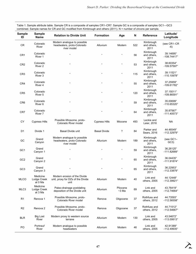
47
Stuart D. Parker: Dividing the Beaverhead Group at the Continental Divide
Table 1. Sample attribute table. Sample CR is a composite of samples CR1–CR7. Sample GC is a composite of samples GC1—GC3 combined. Sample names for CR and GC modified from Kimbrough and others (2011). N = number of zircons per sample. Sample
ID Sample Name Relation to Divide Unit Formation Age N Reference Latitude/
Longitude
CR Colorado River
Modern analogue to possible headwaters, proto-Colorado
river model Alluvium Modern 522
Kimbrough and others,
2011
(see CR1–CR -6)
CR1 Colorado River 1 “ “ “ 56
Kimbrough and others,
2011
39.14695° -108.74417°
CR2 Colorado River 2 “ “ “ 53
Kimbrough and others,
2011
38.60354°-109.57597°
CR3 Colorado River 3 “ “ “ 115
Kimbrough and others,
2011
39.11521°-110.10978°
CR4 Colorado River 4 “ “ “ 55
Kimbrough and others,
2011
37.25959°-109.61782°
CR5 Colorado River 5 “ “ “ 120
Kimbrough and others,
2011
37.15011°-109.86591°
CR6 Colorado River 6 “ “ “ 59
Kimbrough and others,
2011
35.00699°-110.65320°
CR7 Colorado River 7 “ “ “ 64
Kimbrough and others,
2011
35.87567°-111.40573°
CY Cypress Hills Possible lithosome, proto-Colorado River model Cypress Hills Miocene 493 Leckie and
Leier, 2016 NA
D1 Divide 1 Basal Divide unit Basal Divide ? 84 Parker and Sears, 2016
44.46549° -112.32979°
GC Grand Canyon
Modern analogue to possible headwaters, proto-Colorado
river model Alluvium Modern 189
Kimbrough and others,
2011
(see GC1–GC3)
GC1 Grand Canyon 1 “ “ “ 59
Kimbrough and others,
2011
36.26125° -111.82689°
GC2 Grand Canyon 2 “ “ “ 65
Kimbrough and others,
2011
36.04435°-111.91874°
GC3 Grand Canyon 3 “ “ “ 65
Kimbrough and others,
2011
36.22953°-112.33879°
MLCO Medicine
Lodge Creek at 0 Ma
Modern erosion of the Divide unit, proxy for DZs of the Divide
unit Alluvium Modern 40 Link and
others, 2005 44.12448°
-112.39921°
MLC3 Medicine
Lodge Creek at 3 Ma
Paleo-drainage postdating deposition of the Divide unit Alluvium Pliocene
~3 Ma 69 Link and others, 2005
43.76419° -112.74664°
R1 Renova 1 Possible lithosome, proto-Colorado River model Renova Oligocene 37 Rothfuss and
others, 2012 44.73593°
-112.56558°
R2 Renova 2 Possible lithosome, proto-Colorado River model Renova Oligocene 37 Rothfuss and
others, 2012 44.71512°
-112.54667°
BLR Big Lost River
Modern proxy to western source terrane Alluvium Modern 130 Link and
others, 2005 43.54672°
-113.00613°
PO Portneuf River
Modern analogue to possible headwaters Alluvium Modern 46 Link and
others, 2005 42.91389°
-112.49935°

48
Stuart D. Parker: Dividing the Beaverhead Group at the Continental Divide
Belt create a characteristic and consistent provenance in associated foreland sediments (Laskowski and oth-ers, 2013). Samples of the Beaverhead Group included in this study have an internal consistency of 100%, indicating they are all statistically indistinguishable within 95% certainty (Laskowski and others, 2013). Divergence of the Divide detrital zircon signatures from the Beaverhead is most likely to be explained from either exhumation of deeper and older sources or recycling of previous Laramide sediments. Anomalous age populations present in the Divide but absent in the rest of the Beaverhead are not expected if the two are time-equivalents.
The method of multi-dimensional scaling (MDS) was chosen for this assessment. This method eff ec-tively and quantitatively characterizes subtle shifts in provenance, such as highlighting data series with similar populations as well as evolving chains of related data series (Vermeesch, 2013). It also has the capability of comparing large series of varying sizes. We use this method to test hypotheses based on fi eld observations from a previous fi eld study (Parker and Sears, 2016). The primary goal is to test for shared provenance between the Divide unit and the Bea-
verhead Group, with a secondary goal of testing the proto-Colorado River hypothesis of Sears (2013). This hypothesis, which is partially supported by the analysis of Parker and Sears (2016), speculates a Mio-cene–Pliocene age for the deposit and places the early (Oligocene–Miocene) headwaters of the system in the Grand Canyon, with progressive truncation occurring in the Basin and Range of Nevada (Sears, 2013). The primary prediction of this hypothesis is a linkage to strata far to the south, including the Colorado Plateau (Sears, 2013). The Cypress Hills Formation of Alberta, as well as the Renova and Sixmile Creek Formations of Montana, may also be integrated in this drainage (Sears, 2013; Leckie and Leier, 2016; Leier and oth-ers, 2016). Modern sand samples from river systems of the region were also compared. The primary goal of this study is to quantify the relation between detrital zircons in the Divide unit and the Beaverhead Group, thereby investigating whether the current stratigraphic designation is warranted.
Table 1. Sample attribute table. Sample CR is a composite of samples CR1–CR7. Sample GC is a composite of samples GC1—GC3 combined. Sample names for CR and GC modified from Kimbrough and others (2011). N = number of zircons per sample. Sample
ID Sample Name Relation to Divide Unit Formation Age N Reference Latitude/
Longitude
RR Raft River Modern analogue to possible headwaters, constrained by Late Jurassic point source
Alluvium Modern 66 Link and others, 2005
42.06734° -113.44453°
D2 Divide 2 Lower to middle Divide unit Lower-Mid Divide? ? 91 This study 44.44489°
-112.34206°
SC1 Sixmile Creek 1
Possible lithosome, proto-Colorado River model
Sixmile Creek, Anderson
Creek member
Miocene - 6 Ma 64 Stroup and
others, 2008 44.72774°
-112.25985°
SC2 Sixmile Creek 2
Possible lithosome, proto-Colorado River model
Sixmile Creek, Anderson
Creek member
Miocene - 6 Ma 64 Stroup and
others, 2008 45.04609°
-112.25985°
BH1 Beaverhead 1 Mapped lithosome
Red Butte Conglomerate,
Upper Beaverhead
Group
Cretaceous Danian 89
Laskowski and others,
2013
44.76333° -112.63363°
BH2 Beaverhead 2 Mapped lithosome
Upper Beaverhead
Group
Cretaceous Maastricht-
ian 92
Laskowski and others,
2013
45.11174° -112.87203°
BH3 Beaverhead 3 Mapped lithosome
McKnight member, Upper
Beaverhead Group
Cretaceous Campanian 90
Laskowski and others,
2014
44.77060° -112.81545°
V Vaughn Proxy to zircon signature
recycled from the base of the Divide unit
Blackleaf, Vaughn member
Cretaceous 100 Ma 92 Fuentes and
others, 2011 47.62111°
-112.67139°
KA Kootenai Proxy to zircon signature
recycled from the base of the Divide unit
Kootenai, basal conglomerate
Cretaceous 110 Ma 84 Fuentes and
others, 2011 47.61167°
-112.73611°
49
Stuart D. Parker: Dividing the Beaverhead Group at the Continental Divide
STRATIGRAPHIC BACKGROUND
Original Stratigraphic Designation The Beaverhead Formation was fi rst designated by
Lowell and Klepper (1953), although much of what we know about the Divide unit of the Beaverhead Formation stems from later fi eld investigations, most notably Ryder and Scholten (1973). The Beaverhead Formation was later raised to Group status by Nichols and others (1985). The Divide unit was largely over-looked, remaining a formal unit but not a formal for-mation. Various dating methods have revealed a Late Cretaceous age for other facies of the Beaverhead, while limited fossil abundance prevented accurate dating of the Divide unit (Ryder and Scholten, 1973; Nichols and others, 1985).
In both quartzite conglomerate facies of the Bea-verhead (Kidd and Divide), red to purple quartzites and white orthoquartzite clasts dominate (Ryder and Scholten, 1973; Parker and Sears, 2016). Argillite clasts are abundant in the Kidd, but nearly absent in the Divide (Ryder and Scholten, 1973). Several clast lithologies are unique to the Divide, including; white quartzite with red specks, blue-black quartzite, cherty lithic arenite, and dacite porphyry containing bi-pyramidal smoky quartz crystals (Ryder and Schol-ten, 1973). Another quartzite conglomerate ascribed to the Divide unit contains gneiss and granite–syenite clasts (Ryder and Scholten, 1973). Gneiss and gran-ite–syenite clasts are not present in the Divide deposit proper, which is the focus of this study. Transport direction in the Kidd is predominantly SE, while in the Divide it is consistently NNE (Ryder and Scholten, 1973; Parker and Sears, 2016). Transport directions are typically E to SE in the Beaverhead Group, with the exception of local transport to the W/SW off the active western limb of the Blacktail–Snowcrest Arch (Ryder and Scholten, 1973; Nichols and others, 1985). NNE fl ow in the Divide unit is attributed to fl ow off the ESE-striking Medicine Lodge Thrust to the imme-diate south (Ryder and Scholten, 1973).
Divide quartzite conglomerate is typifi ed by channels and over-bank deposits of coarse sandstone with crude bedding at meter scale plus well-sorted, well-rounded clasts. These features suggest an anas-tomosing river environment of a relatively low slope/energy environment achieved near a local base level (Makaske, 2001). The neighboring Divide limestone
conglomerate contains larger and poorly sorted sub-angular to rounded clasts, indicating higher slope/en-ergy environments (Haley and Perry, 1991; Ryder and Scholten, 1973; Nichols and others, 1985). The Divide limestone conglomerate is heavily oxidized and bright red in outcrop, containing numerous paleosols (Haley and Perry, 1991; Ryder and Scholten, 1973). It is im-portant to note that thrust faults and folds are observ-able in nearly all facies of the Beaverhead, the excep-tion being the Divide quartzite conglomerate (Ryder and Scholten, 1973; Nichols and others, 1985; Parker and Sears, 2016) (fi g. 2).
Red/purple quartzites were attributed as fi rst-cycle Belt Supergroup sediments. Absence of the Belt Su-pergroup in the Medicine Lodge Thrust was resolved with a hypothetical Late Cretaceous–Paleocene uplift by Ryder and Scholten (1973) (Targhee uplift of Love, 1956, 1973). In the paleotopographic interpretation of Ryder and Scholten (1973), this sealed the south-ern end of the drainage with high topography without acknowledging the low-slope, fl uvial depositional environment of the Divide quartzite conglomerate (Ryder and Scholten, 1973). It was later proposed that Late Cretaceous–Eocene quartzite conglomer-ates of Wyoming, such as the Harebell, Pinyon, and Pass Peak Formations, were eastern continuations of quartzite conglomerates sourced from Laramide thrust sheets such as the Kidd and Divide units (ex. Schmitt and Steidtmann, 1990). The Targhee uplift hypoth-esis, which was solely constrained by sediments in the undated Divide unit, was rejected on structural, geophysical, and stratigraphic bounds (Love, 1973; Schmitt and Steidtmann, 1990). The Divide quartzite conglomerate remained assigned to the Beaverhead Group despite these advancements in thought and lack of a subsequent test of hypotheses.
Confl icting Field Observations and Revised Interpretation
The discrepancies discussed above and incom-plete interpretations for the Divide unit have led to conjectures of a post-Cretaceous age. An interbedded layer of 4.5 Ma Kilgore Tuff occurs high in the section (Sears, 2014; Parker and Sears, 2016). Sears (2013) infers a Miocene–Pliocene age and correlates the system to the proto-Colorado River and Sixmile Creek Formation. While the proto-Colorado River hypoth-esis uses independent lines of evidence to restore the early drainage from the Grand Canyon to the Labrador

50
Stuart D. Parker: Dividing the Beaverhead Group at the Continental Divide
Sea, it constrains the river through the Divide deposit by correlating the widespread lithic chert arenite and quartz-veined chert clasts in the Divide to bedrock sources in Nevada and Utah (Sears, 2013). These clasts are common in the Mississippian Diamond Peak and Devonian Milligen Formations (Brew and Gor-don, 1971; Sandberg and others, 1975). The Devonian Milligen Formation and the Mississippian Copper Basin Group (correlative to the Diamond Peak) also occur in uplifts of central Idaho, hundreds of kilome-ters to the west of the Divide (Sandberg and others, 1975; Paull and Gruber, 1977; Wust and Link, 1988). Either interpretation requires long-distance transport either by thrust sheets and subsequent fl uvial transport, or fl uvial transport alone, both of which seem unlikely given the large size of the clasts, which approach 10 cm in diameter.
A subsequent fi eld study by Parker and Sears (2016) found a local outcrop of quartz-veined chert. Recent fi eld observations have found lithic chert aren-ite clasts in the basal conglomeratic unit of the early Cretaceous Kootenai Formation near Dillon, MT, con-siderably north. The Kootenai lies beneath the Aspen/Blackleaf shale at the Divide locality that underlies the Divide quartzite conglomerate as well as the neighbor-ing limestone conglomerate (Ruppel, 1978; Parker and Sears, 2016; Ryder and Scholten, 1973). Therefore, lithic chert arenite clasts may be recycled out of the Kootenai Formation, which occurs as far south as the Continental Divide (DeCelles, 1986).
A quartzite clast within the Divide, containing detrital zircons, which do not match typical Belt Su-pergroup signatures, was tentatively attributed to the Brigham Group (Parker and Sears, 2016). This re-
Figure 2. Field photo of basal contact relationships of the Divide quartzite conglomerate. The basal contact is visible as the change in slope and vegetation, projected as solid line. Contact between unknown conglomerate and the Beaverhead Group is visible as sudden change in vegetation (lush grass to sparse cover) and outcrop prominence, projected as a dashed line. Descriptions of corresponding units are in bold. Gently folded strata are labeled.

51
Stuart D. Parker: Dividing the Beaverhead Group at the Continental Divide
quires ~200 km of transportation of cobbles. This idea remains highly speculative, although recent research in Jackson Hole and the Big Horn Basin suggests the quartzite clasts, which dominate the region, were sourced from the Brigham Group after the Laramide (Malone and others, 2017a). The study in part revives the long-dead Targhee uplift hypothesis, claiming that Brigham and non-Belt quartzites occurred in the vicin-ity of the Snake River Plain, thus considerably short-ening the required transport distance to the Divide (Malone and others, 2017a). This hypothesis diff ers from the classic Targhee uplift hypothesis in that evidence of the source is preserved in the Paris Thrust sheet, which lies far south of the local Medicine Lodge Thrust sheet and exposes a diff erent assemblage of strata (Malone and others, 2017a; Ruppel, 1978; Rup-pel and Lopez, 1984). The Medicine Lodge Thrust lacks any evidence of Belt or Brigham quartzites (Ruppel, 1978). These recent results demonstrate that coarse sediment sources can be explained entirely with semi-local sources but require recycling of Beaver-head Group conglomerates because sources are absent within thrust sheets to the immediate south (Parker and Sears, 2016; Ruppel, 1978).
The most recent fi eld study of the Divide quartzite conglomerate and precursor to this study constrains the Divide quartzite conglomerate to the Neogene, proposing a middle Miocene–Pliocene age and cor-relation to the Sixmile Creek Formation of Montana (Parker and Sears, 2016). Parker and Sears (2016) found extensive evidence of west-to-east mass wasting events that entered the channel at a high-angle dur-ing all stratigraphic levels through the middle of the deposit (Parker and Sears, 2016). Two distinct clast assemblages are identifi ed; one dominated by mass wasting events in the west (containing local Paleozoic sedimentary rocks), the other from downstream trans-port containing quartzite, and some intermediate-to-felsic volcanic clasts (Parker and Sears, 2016). Several clast lithologies were shown to decrease in abundance through time, suggesting recycling and winnowing (Parker and Sears, 2016). Early Cretaceous (~100 Ma) felsic to intermediate volcanoclastic sediment domi-nates the Divide and is not contemporaneous with deposition (Parker and Sears, 2016).
Tectonic deformation within the Divide unit is entirely extensional to transtensional in nature with no evidence for shortening (Parker, in review; Parker and Sears, 2016). Deposition ceased between 4.5 and
4.1 Ma, with long-lived recycling of Beaverhead strata occurring within a major fault-bounded north-fl owing river system (Parker and Sears, 2016). While these in-terpretations are supported by extensive fi eld measure-ments and observations, they are limited by a lack of post-Cretaceous age detrital zircons. Without conclu-sive, post-Cretaceous age dates, the question remains —does the Divide quartzite conglomerate belong to the Beaverhead Group?
METHODOLOGY
A sample (D2) of 91 detrital zircons separated out from a sandstone lens within the lower to middle Divide unit (fi g. 1) was analyzed. Laser ablation-inductively coupled plasma-mass spectrometry (LA-ICP-MS) was used along with standard procedures of separation, preparation, and U-Pb dating of detrital zircons. These procedures were carried out by techni-cians at the Boise State University Isotope Geology Laboratory.
Sixteen additional detrital zircon samples were catalogued from selected modern drainages, Late Cretaceous and Neogene strata. Sample descriptions, locations, and justifi cation for collecting the samples are given in table 1. Selected samples were chosen based on possible correlations of Parker and Sears (2016) and Parker (2016). A Kolmogorov–Smirnov (KS) test was used to compare each sample. Dissimi-larity values (D) were used to quantitatively assess the degree of fi t between samples. We do not report prox-imity (P) values as they display a strong negative cor-relation with sample size, making them an ineff ective method for comparison (Vermeesch, 2013). We do use P values of a KS test consisting of the two Divide unit samples. This is appropriate because the two samples are of comparable size. A P value of >0.05 signifi es the two samples are statistically indistinguishable within 95% certainty. We arbitrarily defi ne D values of <0.3 as representing a “good fi t,” thereby refl ecting a cor-relation between the datasets. This value of D <0.3 is a reasonable approximation to P >0.05 (Satkoski and others, 2013). Empirical data of Satkoski and others (2013) suggests that D = 0.25 is a closer approxima-tion of P = 0.05. The D value defi nition of a “good fi t” when D <0.3 is less stringent than that set by the P sta-tistic. For this reason, it should be noted that the “good fi t” parameter used here is close to, but not equal to, statistically indistinguishable as defi ned by P values. While D <0.3 is only an approximation of P >0.05, the

52
Stuart D. Parker: Dividing the Beaverhead Group at the Continental Divide
D parameter is more reliable in assessing likeness as it is not skewed by sample size. Internal consistency is defi ned by the percentage of comparisons that satisfy a “good fi t” (D <0.3).
All reported ages were compared before fi lter-ing the data by removing any grains younger than the minimum observed age in the Divide unit of ~85 Ma. Because the age of the Divide is unknown, we chose to compare both unfi ltered and fi ltered age data in or-der to avoid false assumptions of age. We also fi ltered data from all three Beaverhead Group samples as well as the two samples from the Divide, removing all grains <115 Ma. This removed the major Cretaceous peak that is dominant in the Divide signature. This fi lter was chosen in order to test the hypothesis that the Divide contains a detrital zircon signature of the Beaverhead Group, but with an additional population of Cretaceous-age grains. Using an identity matrix, D values of the 17 samples and 136 KS comparisons were catalogued.
Metric multidimensional scaling (MDS) was performed on identity matrices of D values following methodology of Vermeesch (2013). Three iterations of MDS were performed on (1) unfi ltered age data of all samples, (2) all sample data with <85 Ma ages removed, and (3) Beaverhead and Divide samples with <115 Ma ages removed. Goodness of fi t was assessed using Kruskal stress values (K) and standard conven-tions for goodness of fi t (Kruskal, 1964). All MDS was carried out in Xlstat, an add-on for Microsoft Excel (www.xlstat.com). A nearest neighbor test was performed on the MDS plot. Nearest neighbors (cal-culated from D values, not the graphical model) were connected with solid lines and second nearest neigh-bors were connected with dashed lines to visually aid in interpretation of MDS plots.
RESULTSNew DZ Data
Sample D2 reveals a major unimodal peak at ~90 Ma with a youngest grain of 87 ± 9 Ma (fi g. 3). Early–Mid Cretaceous ages dominate, with 36% of all ages falling between 87 and 115 Ma. A secondary unimodal peak occurs at ~155 Ma with 8% of all grains occur-ring within the Late Jurassic. Six grains (7%) have overlapping ages with a mean of 155 Ma ranging from 152 ± 8 Ma to 158 ± 9 Ma. Another Jurassic age grain of 171 ± 8 also occurs. A broad, dispersed, and sym-
metrical peak centered at ~1,750 Ma encapsulates 36% of all grains ranging from 1,643 ± 70 Ma to 1,952 ± 39 Ma. Additional peaks in order of magnitude occur at 440 Ma (2 grains), 2,600 Ma (5 grains), and 1,395 Ma (4 grains). A KS test between this sample and the basal sample (D1) from Paul Reservoir (Sample PRMX1 of Parker and Sears, 2016) reveals a D value of 0.13 and a P value of 0.43. We therefore classify this compari-son as a “good fi t” and deem the two samples statisti-cally indistinguishable within 95% certainty. All major peaks of sample D1 were reproduced in sample D2, with the exception of a Grenville-age peak at ~1,075 Ma in sample D1.
Unfi ltered Age Data MDSKS results are shown in table 2. Sample MLC0,
of the modern Medicine Lodge Creek drainage, had the highest number of “good fi t” comparisons of any sample. Samples MLC3 (Pliocene Medicine Lodge Creek drainage), BLR (modern Big Lost River), and SC2 (Sixmile Creek Formation) revealed no positive correlations. The basal sample (D1) shows a good fi t with 56% of the investigated samples with the lowest D value when compared to D2. A strong correlation to MLC0 and R2 (Renova Formation) was also observed. The average D value comparing the Divide to the Bea-verhead Group is 0.32 and does not qualify as a good fi t. Sample D2 of the Divide unit shows a good fi t with 44% of all samples. The three strongest correlations in order of ascending D value are D1, CY (Cypress Hills Formation), and MLC0. Comparisons with Beaver-head Group samples have a mean D value of 0.43. There is 100% internal consistency within the two Divide samples as well as within the three Beaverhead samples. No comparison of Divide to Beaverhead revealed a good fi t with the mean D value of 0.38.
Multidimensional scaling reveals a dispersed, irregular polygon containing Divide samples and a sublinear polygon containing Beaverhead samples (fi g. 4). These polygons are each interconnected with 2nd nearest neighbor lines (fi g. 4). Samples D1 and D2 form a line with CY and R2 at opposite ends. The two Colorado Plateau samples (CR, GC) are far away, but in line with this polygon, on the R2 end. MLC0 plots in close proximity to Divide samples. Beaverhead and Divide samples do not plot in close proximity and contain no connections. BLR, MLC3, and SC2 are distant outliers. A stress value of K = 0.146 indicates the two-dimensional model is a fair fi t for the data.

53
Stuart D. Parker: Dividing the Beaverhead Group at the Continental Divide
Figure 3. Stacked Kernal density estimator (KDE) plots for Divide samples (D2 and D1) and Beaverhead Group samples (BH1-3). All ages from samples BH1, BH2, and BH3 are included. Characteristic age populations of the Divide samples are highlighted. Minimum, maximum, and peak ages for corresponding age populations are noted. Dashed lines denote 400 m.y. intervals.

54
Stuart D. Parker: Dividing the Beaverhead Group at the Continental Divide
Table 2. Symmetrical matrix of dissimilarity (D) values of sample comparisons containing all age data. D values multiplied by 100. Values deemed as a “good fi t” are highlighted in orange. Divide samples are highlighted in red.
Figure 4. Two-dimensional, multidimensional scaling plot of detrital zircon samples. All age data are included. Nearest neighbors are connected with solid lines. 2nd nearest neighbors are connected with dashed lines. Axes are unitless.
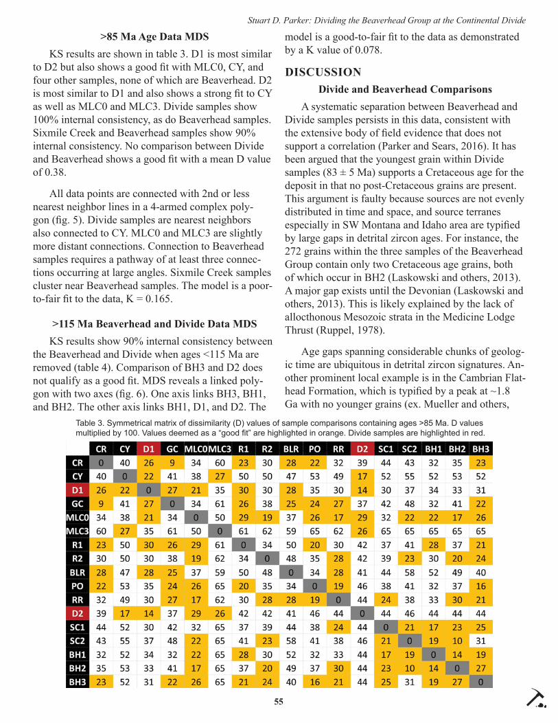
55
Stuart D. Parker: Dividing the Beaverhead Group at the Continental Divide
>85 Ma Age Data MDSKS results are shown in table 3. D1 is most similar
to D2 but also shows a good fi t with MLC0, CY, and four other samples, none of which are Beaverhead. D2 is most similar to D1 and also shows a strong fi t to CY as well as MLC0 and MLC3. Divide samples show 100% internal consistency, as do Beaverhead samples. Sixmile Creek and Beaverhead samples show 90% internal consistency. No comparison between Divide and Beaverhead shows a good fi t with a mean D value of 0.38.
All data points are connected with 2nd or less nearest neighbor lines in a 4-armed complex poly-gon (fi g. 5). Divide samples are nearest neighbors also connected to CY. MLC0 and MLC3 are slightly more distant connections. Connection to Beaverhead samples requires a pathway of at least three connec-tions occurring at large angles. Sixmile Creek samples cluster near Beaverhead samples. The model is a poor-to-fair fi t to the data, K = 0.165.
>115 Ma Beaverhead and Divide Data MDSKS results show 90% internal consistency between
the Beaverhead and Divide when ages <115 Ma are removed (table 4). Comparison of BH3 and D2 does not qualify as a good fi t. MDS reveals a linked poly-gon with two axes (fi g. 6). One axis links BH3, BH1, and BH2. The other axis links BH1, D1, and D2. The
model is a good-to-fair fi t to the data as demonstrated by a K value of 0.078.
DISCUSSIONDivide and Beaverhead Comparisons
A systematic separation between Beaverhead and Divide samples persists in this data, consistent with the extensive body of fi eld evidence that does not support a correlation (Parker and Sears, 2016). It has been argued that the youngest grain within Divide samples (83 ± 5 Ma) supports a Cretaceous age for the deposit in that no post-Cretaceous grains are present. This argument is faulty because sources are not evenly distributed in time and space, and source terranes especially in SW Montana and Idaho area are typifi ed by large gaps in detrital zircon ages. For instance, the 272 grains within the three samples of the Beaverhead Group contain only two Cretaceous age grains, both of which occur in BH2 (Laskowski and others, 2013). A major gap exists until the Devonian (Laskowski and others, 2013). This is likely explained by the lack of allocthonous Mesozoic strata in the Medicine Lodge Thrust (Ruppel, 1978).
Age gaps spanning considerable chunks of geolog-ic time are ubiquitous in detrital zircon signatures. An-other prominent local example is in the Cambrian Flat-head Formation, which is typifi ed by a peak at ~1.8 Ga with no younger grains (ex. Mueller and others,
Table 3. Symmetrical matrix of dissimilarity (D) values of sample comparisons containing ages >85 Ma. D values multiplied by 100. Values deemed as a “good fi t” are highlighted in orange. Divide samples are highlighted in red.

56
Stuart D. Parker: Dividing the Beaverhead Group at the Continental Divide
Figure 5. Two-dimensional, multidimensional scaling plot of detrital zircon samples, standardized for youngest observed grain in the Divide. Age data include only values > 85 Ma. Nearest neigh-bors are connected with solid lines. 2nd nearest neighbors are connected with dashed lines. Axes are unitless.
Table 4. Symmetrical matrix of dissimilarity (D) values of Divide and Beaverhead sample comparisons containing ages >115 Ma. D values multiplied by 100. Values deemed as a “good fi t” are highlighted in orange. Divide samples are highlighted in red.
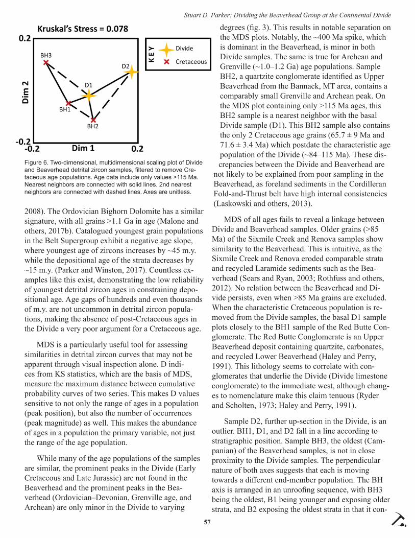
57
Stuart D. Parker: Dividing the Beaverhead Group at the Continental Divide
2008). The Ordovician Bighorn Dolomite has a similar signature, with all grains >1.1 Ga in age (Malone and others, 2017b). Catalogued youngest grain populations in the Belt Supergroup exhibit a negative age slope, where youngest age of zircons increases by ~45 m.y. while the depositional age of the strata decreases by ~15 m.y. (Parker and Winston, 2017). Countless ex-amples like this exist, demonstrating the low reliability of youngest detrital zircon ages in constraining depo-sitional age. Age gaps of hundreds and even thousands of m.y. are not uncommon in detrital zircon popula-tions, making the absence of post-Cretaceous ages in the Divide a very poor argument for a Cretaceous age.
MDS is a particularly useful tool for assessing similarities in detrital zircon curves that may not be apparent through visual inspection alone. D indi-ces from KS statistics, which are the basis of MDS, measure the maximum distance between cumulative probability curves of two series. This makes D values sensitive to not only the range of ages in a population (peak position), but also the number of occurrences (peak magnitude) as well. This makes the abundance of ages in a population the primary variable, not just the range of the age population.
While many of the age populations of the samples are similar, the prominent peaks in the Divide (Early Cretaceous and Late Jurassic) are not found in the Beaverhead and the prominent peaks in the Bea-verhead (Ordovician–Devonian, Grenville age, and Archean) are only minor in the Divide to varying
degrees (fi g. 3). This results in notable separation on the MDS plots. Notably, the ~400 Ma spike, which is dominant in the Beaverhead, is minor in both Divide samples. The same is true for Archean and Grenville (~1.0–1.2 Ga) age populations. Sample BH2, a quartzite conglomerate identifi ed as Upper Beaverhead from the Bannack, MT area, contains a comparably small Grenville and Archean peak. On the MDS plot containing only >115 Ma ages, this BH2 sample is a nearest neighbor with the basal Divide sample (D1). This BH2 sample also contains the only 2 Cretaceous age grains (65.7 ± 9 Ma and 71.6 ± 3.4 Ma) which postdate the characteristic age population of the Divide (~84–115 Ma). These dis-crepancies between the Divide and Beaverhead are
not likely to be explained from poor sampling in the Beaverhead, as foreland sediments in the Cordilleran Fold-and-Thrust belt have high internal consistencies (Laskowski and others, 2013).
MDS of all ages fails to reveal a linkage between Divide and Beaverhead samples. Older grains (>85 Ma) of the Sixmile Creek and Renova samples show similarity to the Beaverhead. This is intuitive, as the Sixmile Creek and Renova eroded comparable strata and recycled Laramide sediments such as the Bea-verhead (Sears and Ryan, 2003; Rothfuss and others, 2012). No relation between the Beaverhead and Di-vide persists, even when >85 Ma grains are excluded. When the characteristic Cretaceous population is re-moved from the Divide samples, the basal D1 sample plots closely to the BH1 sample of the Red Butte Con-glomerate. The Red Butte Conglomerate is an Upper Beaverhead deposit containing quartzite, carbonates, and recycled Lower Beaverhead (Haley and Perry, 1991). This lithology seems to correlate with con-glomerates that underlie the Divide (Divide limestone conglomerate) to the immediate west, although chang-es to nomenclature make this claim tenuous (Ryder and Scholten, 1973; Haley and Perry, 1991).
Sample D2, further up-section in the Divide, is an outlier. BH1, D1, and D2 fall in a line according to stratigraphic position. Sample BH3, the oldest (Cam-panian) of the Beaverhead samples, is not in close proximity to the Divide samples. The perpendicular nature of both axes suggests that each is moving towards a diff erent end-member population. The BH axis is arranged in an unroofi ng sequence, with BH3 being the oldest, B1 being younger and exposing older strata, and B2 exposing the oldest strata in that it con-
Figure 6. Two-dimensional, multidimensional scaling plot of Divide and Beaverhead detrital zircon samples, fi ltered to remove Cre-taceous age populations. Age data include only values >115 Ma. Nearest neighbors are connected with solid lines. 2nd nearest neighbors are connected with dashed lines. Axes are unitless.

58
Stuart D. Parker: Dividing the Beaverhead Group at the Continental Divide
tains Precambrian quartzites. The Divide samples are not a continuation of this progression, highlighting a break in the unroofi ng sequence. These results are in-terpreted as indicative of recycling of the Beaverhead in post-Cretaceous time, consistent with fi eld observa-tions of a perceived unconformity below the Divide and the presence of recycled coarse sandstone clasts resembling the matrix of the neighboring Beaverhead.
Detrital zircon age distributions of the Divide are much longer wavelength than those of the Beaverhead. Long-wavelength signatures are a demonstrated habit of heavily reworked sediment systems (Satkoski and others, 2013). It is important to note that the detrital zircon population of the Divide is not only consis-tently diff erent from the Beaverhead, but also from the Sixmile and Renova. This demonstrates that the characteristic age population of the Divide, with ex-tensive early Cretaceous and Late Jurassic age grains, is very uncommon regionally, at least in these propor-tions, suggesting that the neighboring Medicine Lodge Thrust is not the sole sediment provider.
Exotic Sources and the Proto-Colorado RiverThe Divide was integrated into the proto-Colorado
River hypothesis of Sears (2013), based on evidence regarding coarse clasts (cherty lithic arenite and quartz-veined black chert) found locally and in the Sixmile Creek Formation, which are absent in the lo-cal stratigraphy but have lithosomes (Diamond Peak and Milligen Formation) in the Great Basin. This line of evidence has since been removed in that local sources of these lithologies have been identifi ed (Park-er and Sears, 2016). Cherty lithic arenite clasts occur in the Cretaceous Kootenai Formation. Its presence in the Divide requires recycling of this lower Cretaceous strata. Deposition of the Kootenai occurred in an ac-tive foreland basin during the Sevier orogeny in the early Cretaceous (DeCelles, 1986). The Kootenai was one of the fi rst units to be eroded and deposited during Laramide deposition of the Beaverhead Group (Haley and Perry, 1991; Laskowski and others, 2013). Thus, this lithology is both local and found in the Beaver-head (Lower and Upper). The cherty lithic arenite is likely sourced from the Mississippian Copper Basin Group in central Idaho, which is correlative to the Diamond Peak in the Great Basin, but occurs in much greater thicknesses in central Idaho (Paull and Gruber, 1977; Brew and Gordon, 1971; Ruppel, 1978; Ruppel and Lopez, 1984). Eastward transport off highlands of
the Sevier orogeny during deposition of the Kootenai and reworking of the Kootenai is the simplest explana-tion of source. Coarse sediment within the Divide can therefore be satisfi ed with local sources, but requires recycling of Cretaceous strata.
Investigation of coarse sediment may not be the appropriate method for testing a far southern source, as coarse clasts may only record reworking from local strata. This removes a line of evidence that correlates the Divide to the proto-Colorado River, although it does little to detract from the proto-Colorado River hypothesis as a whole. While the MDS results sug-gest that local thrust sheets are not the only sediment sources, decoupling what is exotic and what is re-cycled locally is a remaining challenge in provenance studies of the Divide unit.
The anomalous populations of Cretaceous and Late Jurassic ages in the Divide highlights this issue of local versus exotic sources. Jurassic ages are com-pletely absent in all Beaverhead samples, as are early Cretaceous ages (~85–115 Ma). These populations are unique to the Divide samples, likely being sourced from the extensive volcanoclastic sediment that con-stitutes much of the coarse, sand size fraction and a considerable (7%) amount of the cobble size fraction. We can confi dently assign the ~100 Ma populations to recycling of local felsic to intermediate volcanic sediment extruded from the Idaho Batholith prior to deposition (Parker and Sears, 2016). Correlative volcanics are absent in local thrust sheets such as the Medicine Lodge Thrust, providing further evidence for a post-Laramide age.
Jurassic-age grains are tightly clustered with a mean of 156.0 ± 5.5 Ma. A total of nine grains (5%) are Jurassic, with all but one falling in the range of 151–158 Ma. This tight clustering of ages implies a single point source, most likely to the south, which provided minor amounts of sediment. This was the original interpretation of Parker and Sears (2016), who speculated point sources in northern Nevada. Field evidence, however, speaks to the dominance of recycled local sources. Jurassic age populations within the modern Salmon Falls Creek of southern Idaho and northern Nevada, which samples local Jurassic intru-sions, have a mean age of 163.3 ± 8.2 Ma (Beranek and others, 2006). Ages of the Salmon Falls Creek overlap with ages within the Divide, although they span a much wider and older range (Beranek and

59
Stuart D. Parker: Dividing the Beaverhead Group at the Continental Divide
others, 2006). Jurassic plutons of northern Nevada, such as those within the modern Salmon Falls Creek, reasonably satisfy a possible fi rst-cycle point source. It is important to note that Miocene-age grains are also abundant in northern Nevada but have not been identi-fi ed in the Divide.
MDS results highlight the uniqueness of the Di-vide signature, and similarities with distant sediment packages. In the unfi ltered MDS plot, Renova, Sixmile Creek, Raft, Portneuf, and Colorado River (Grand Canyon and Upper) samples all lie in closer proximity to the Divide than the Beaverhead. Jurassic-age grains in the Raft River and Colorado River samples give constraint. The Cypress Hills Formation of Alberta is also a close neighbor. These correlations to southern sediment as well as local and northern Neogene strata satisfy predictions of the proto-Colorado River hy-pothesis. It must be acknowledged that this solution supported by MDS is non-unique and merely high-lights correlations in age populations. That being said, the predicted evolution from Colorado Plateau to the Divide to the Cypress Hill can be argued in the MDS data; it has been demonstrated that detrital zircon sig-natures in continental scale drainages are comparable over great distances (Satkoski and others, 2013).
The detrital zircon distribution of Divide samples are statistically indistinguishable from the modern Medicine Lodge Creek (D = 0.15 and 0.16), suggest-ing that rapid erosion of the Divide deposit dominates sediment in the modern Medicine Lodge Creek. All major peaks of the Divide are reproduced in the Medi-cine Lodge Creek signature. An anomalous grain of middle Miocene age is present in this sample. Grains in this age range (15–20 Ma) are restricted in the Yellowstone area to four drainages that are integrated with the Divide deposit (Link and others, 2005). These grains are not interpreted as related to early Yellow-stone volcanism as they are not widespread in distribu-tion. Rather, they seem to suggest a unique population within the Divide.
Extensive ignimbrites of this age occurred in the Great Basin area (Axen and others, 1993; Best and others, 2013). Parker and Sears (2016) and Parker (2016) suggest linkage between the Divide deposit and ignimbrites to the south during deposition in the middle Miocene. The initial detrital zircon sample D1 taken near the base of the deposit did not capture such a peak. To further test this hypothesis, an addi-
tional sample higher in the section, D2, was analyzed. Sample D2 is likely in the middle to lower portion of the deposit, although distributed deformation makes it diffi cult to identify stratigraphic position. Several hundred meters of strata overlie the sample location below the interbedded Kilgore Tuff . Identifi cation of mid-Miocene age grains higher in the section would conclusively identify a far southern source and pro-vide a robust age constraint. Until the mid- and upper- strata are probed, the interpretation of a far southern source is merely speculation. That being said, the anomalous nature of the Divide deposit is evident and the possibility of a distal southern source is diffi cult to discount.
Recreating the DZ Signature Using Local SourcesWith these speculations on southern source in
mind, the Divide signature using only local sources can now be tested. Jurassic grains are sparse in the region, making this limited age population a natural place to start. Reworking of the Jurassic Morrison For-mation is not likely given its minimal volume (Rup-pel, 1978). Recycling of the Cretaceous Kootenai may satisfy this unique age population as 25% of detrital zircons in the Kootenai contain a notable Jurassic age population (Fuentes and others, 2011). Average ages (161.9 ± 10.4 Ma, ranging from ~140 to 175 Ma) overlap with those of the Divide. Nearly 10% of ages in the Kootenai sample fall within the range observed at the Divide, although the Jurassic population of the Kootenai has a much wider range. Tuff layers in the Kootenai have been dated at ~110 Ma, loosely satisfy-ing the major age population of the Divide (Fuentes and others, 2011). While the Kootenai signature satis-fi es these characteristic peaks, it does not correlate well with the Divide, with D values of 0.31 and 0.36.
The Cretaceous Blackleaf Formation (Aspen For-mation equivalent) also contains Jurassic-age grains, with an average age of 162.1 ± 14.2 Ma (Fuentes and others, 2011). This average also overlaps that of the Divide (156.0 ± 5.5 Ma). Ages in the Vaughn member of the Blackleaf range from 150 to 176 Ma, although most are mid- to early-Jurassic (Fuentes and others, 2011). Cretaceous-age grains are also dominant, ac-counting for 51% of the population. They range from ~95 to 115 Ma and average 102 ± 2 Ma, coincident with the average of 97 ± 5 Ma within the Divide. Dis-tal tuff s and ash layers occur within the Vaughn equiv-alent which underlies the Divide deposit, coincident
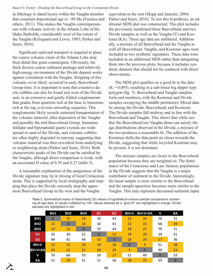
60
Stuart D. Parker: Dividing the Beaverhead Group at the Continental Divide
in lithology to dated layers within the Vaughn member that constrain depositional age to ~98 Ma (Fuentes and others, 2011). This makes the Vaughn contemporane-ous with volcanic activity in the Atlanta Lobe of the Idaho Batholith, considerably west of the extent of the Vaughn (Kiilsgaard and Lewis, 1985; Parker and Sears, 2016).
Signifi cant eastward transport is required to place the coarse volcanic clasts of the Atlanta Lobe atop their distal fi ne grain counterparts. Obviously, the thick diverse coarse sediment package and relatively high-energy environment of the Divide deposit works against correlation with the Vaughn. Stripping of this volcanic cover likely occurred in early Beaverhead Group time. It is important to note that extensive da-cite cobbles can also be found just west of the Divide unit, in an extensive and gently folded conglomerate that grades from quartzite rich at the base to limestone rich at the top, a reverse unroofi ng sequence. This conglomerate likely records eastward transportation of the volcanic material, after deposition of the Vaughn and possibly the mid Beaverhead Group. Immature feldspar and bipyramidal quartz crystals are wide-spread in sand of the Divide, and volcanic cobbles are often highly degraded in outcrop, suggesting that volcanic material was then reworked from underlying or neighboring strata (Parker and Sears, 2016). Both characteristic peaks of the Divide can be satisfi ed by the Vaughn, although direct comparison is weak, with an associated D value of 0.39 and 0.27 (table 5).
A reasonable explanation of the uniqueness of the Divide signature may lie in mixing of local Cretaceous strata. This is supported by local stratigraphy and map-ping that place the Divide curiously atop the upper-most Beaverhead Group in the west and the Vaughn
equivalent in the east (Skipp and Janecke, 2004; Parker and Sears, 2016). To test this hypothesis, an ad-ditional MDS plot was constructed. This plot includes the previously mentioned three Beaverhead and two Divide samples as well as the Vaughn (V) and Koo-tenai (KA). These age data are unfi ltered. Addition-ally, a mixture of all Beaverhead and the Vaughn as well all Beaverhead, Vaughn, and Kootenai ages were included as two synthetic signatures. These data were included as an additional MDS rather than integrating them into the previous plots, because it includes syn-thetic datasets that should not be confused with direct observations.
The MDS plot qualifi es as a good fi t to the data (K = 0.095), resulting in a sub-linear big dipper type polygon (fi g. 7). Beaverhead and Vaughn samples form end members, with the Kootenai and Divide samples occupying the middle perimeters. Mixed data lie among the Divide, Beaverhead, and Kootenai. The Divide samples fall midway and in line with the Beaverhead and Vaughn. This shows that while nei-ther the Beaverhead nor Vaughn alone can satisfy the age distributions observed in the Divide, a mixture of the two produces a reasonable fi t. The addition of the Kootenai shifts the data point no closer towards the Divide, suggesting that while recycled Kootenai may be present, it is not dominant.
The mixture samples are closer to the Beaverhead population because they are weighted so. The domi-nance of the Cretaceous and Late Jurassic populations in the Divide suggests that the Vaughn is a major contributor of sediment to the Divide. Interestingly, the basal sample is more similar to the Beaverhead and the sample upsection becomes more similar to the Vaughn. This may represent decreased sediment input
Table 5. Symmetrical matrix of dissimilarity (D) values of hypothetical mixture sample comparisons contain-ing all age data. D values multiplied by 100. Values deemed as a “good fi t” are highlighted in orange. Divide samples are highlighted in red.

61
Stuart D. Parker: Dividing the Beaverhead Group at the Continental Divide
from the Beaverhead through time, or it may support a southern point source.
The mixture of Beaverhead and Vaughn detrital zircons are a reasonable approximation of the distribu-tion in the Divide unit (D = 0.19 and 0.28, table 5). It is crucial to note that the Vaughn and Kootenai For-mation are absent in the Medicine Lodge Thrust plate but occur locally beyond the leading edge of the thrust (Ruppel, 1978). This explains the lack of Mesozoic ages in the Beaverhead and requires erosion of strata beneath the Medicine Lodge Thrust, thus providing a strong argument for post-Cretaceous deposition of the Divide unit.
Stratigraphic DesignationThe results of this study, along with a recent fi eld
study, do not support correlation of the Divide unit to the Beaverhead Group (Parker and Sears, 2016). Strata of the Beaverhead Group record systematic unroofi ng of local strata, stripped from uplifting thrust sheets during the Laramide Orogeny (Ryder and Schol-ten, 1973; Haley and Perry, 1991). Younger and less diverse sediment in the lower Beaverhead gradually gives rise to older and increasingly diverse sediment (Ryder and Scholten, 1973; Haley and Perry, 1991; Laskowski and others, 2013). In the coarse size frac-tion, recycled Mesozoic sedimentary rocks give way to early Paleozoic quartzites and eventually become
dominated by red, purple, and green quartzites and argillites of the Pre-cambrian Belt Supergroup (Ryder and Scholten, 1973; Haley and Perry, 1991).
The Divide unit and all measured Beaverhead samples occur along the leading edge of the Medicine Lodge Thrust, which locally lacks Meso-zoic strata (Ruppel, 1978). Meso-zoic strata are common ahead of the thrust, including below the Divide, demonstrating that the characteris-tic Mesozoic age populations of the Divide cannot be attributed to erosion of the local Medicine Lodge Thrust plate.
In many locations, high-grade metamorphic basement rocks are pres-ent in the Beaverhead Group (Ryder and
Scholten, 1973). The detrital zircon signature accord-ingly shifts from containing few pronounced unimodal young peaks to encompassing a complex and wide range of various peaks back to Archean (Laskowski and others, 2013). High in the Beaverhead, recycling of Lower Beaverhead occurs as the overriding thrust sheets and compressional stress fi eld of the Laramide migrates eastward, overprinting prior foreland sedi-ments (Haley and Perry, 1991).
The great complexity and diversity in the Divide requires the deposit to be at least upper Beaverhead. Detailed mapping is needed to investigate the basal contact of the Divide, which appears to overlay upper-most Beaverhead in the west and Vaughn equivalent in the east, creating an unconformity. The Vaughn equiv-alent appears to underlay the Beaverhead Group sec-tion to the west, and several mysterious conglomerates occur in the west between the limestone conglomerate of the Beaverhead and the Divide. At present, no break in deposition has been observed between the base of the Divide and the Pliocene Kilgore Tuff .
The abundance of red/purple quartzites belonging to the Belt Supergroup is only possible with reworking of previous Beaverhead, such as the Kidd, that itself is high in the Beaverhead Group. First-cycle sedimenta-tion of red/purple quartzites may be possible in the Cretaceous or later if a Brigham Group source exists
Figure 7. Two-dimensional, multidimensional scaling plot of detrital zircon samples, comparing Divide, Cretaceous, and hypothetical mixtures of Cretaceous strata. Age data are included. Nearest neighbors are connected with solid lines. 2nd nearest neighbors are connected with dashed lines. Axes are unitless.

62
Stuart D. Parker: Dividing the Beaverhead Group at the Continental Divide
and the Neoproterozic basin extended through the Snake River Plain as has been proposed (Malone and others, 2017a; Parker and Sears, 2016).
Results of this study dispel the argument that the Divide is the uppermost Beaverhead Group in the area in that the major peaks of the Divide are not found in Beaverhead samples and the major peaks of the Bea-verhead are sparse in the Divide. Mesozoic strata are absent from the local Medicine Lodge Thrust, arguing against the presence of corresponding zircon ages in local Laramide sediments. This leaves the recycling after the Cretaceous as the most viable hypothesis as supported by extensive fi eld observations.
Recycling of local Cretaceous strata satisfi es all observations regarding the coarse and fi ne sediment load and is thus the preferred model for the Divide. Field relationships near the base of the Divide paint an interesting picture. The great thickness of gravel and infl uence from mass wasting events implies deposi-tion in an active down-dropping graben (Parker and Sears, 2016). However, a signifi cant amount of erosion appears to have taken place, removing the entirety of the Beaverhead package in the eastern area and creating an unconformity on the Vaughn equivalent. This boundary is poorly exposed and requires further investigation. This confl icting evidence for extensive deposition and erosion must be resolved in the future. This question will likely provide valuable tectonic information regarding regional Neogene tectonics.
While these results off er robust support for a post-Cretaceous age for the Divide unit and diff erentiation from the Beaverhead Group, countless questions re-main. This study must draw the somewhat unsatisfying conclusion that local recycling prevailed, although the infl uence and extent of southerly derived sediment is unclear. The timing of early deposition remains poorly constrained. The Sixmile Creek Formation seems a natural correlative for the Divide deposit in that it represents a broad regional trend of recycling of Bea-verhead strata in active normal fault-bounded drain-ages in the Miocene–Pliocene (Sears and Ryan, 2003). While MDS plots show some similarity between the Sixmile and Divide, they do not off er strong support for this correlation. The older age fraction (>85 Ma) of the Sixmile Creek Formation appears consistent and tightly related to Beaverhead strata, but dissimilar from the Divide. This likely records the infl uence from upstream, possibly Neoproterozoic and younger sourc-
es. The younger age fraction (<85 Ma) records high variability between the Sixmile Creek and the Divide. Therefore, the Sixmile seems to recycle relatively homogeneous Laramide sediment in a complex drain-age network, which results in widely diff erent young age populations. The Cypress Hill Formation retains its relationship to the Divide in both MDS plots, show-ing a similarity in both young and old age populations. Southern sources including the Raft, Portneuf, and Colorado River samples are also similar in both young and old age populations, showing slight similarity to the Divide. Further work is needed to assess the spatial variability in the Sixmile Creek in order to determine whether this is a suitable correlation for the Divide, or whether a new stratigraphic distinction is required.
While the Sixmile Creek–Divide relation is vari-able, the southern source–Divide–Cypress Hills relation is consistent. This distinction may speak to a distinct and long-lived drainage similar to that pro-posed by Sears (2013). Alternatively, it may speak to a drainage with more tectonically stable head and tail waters and signifi cant fragmentation in SW Montana. The Bitterroot and Clark Fork Rivers of Montana are modern analogues of such a system, as they have well-established headwaters, but are altered by active normal faulting in the area of the Nine Mile fault be-fore reestablishing a consistent drainage downstream. The model of Sears (2013) also solicits a stable head and tail water segment, with tectonic alteration in the middle. It is important to note that river courses af-fected by tectonic alteration often become dissected in their middle reaches. The case of the Divide is likely a matter of scale. Just how far the drainage extended to the south, just which gravels were hydraulically linked, and for how long remains uncertain.
CONCLUSION
This detrital zircon study of the Divide quartz-ite conglomerate unit in the southern Beaverhead Mountains of Montana/Idaho fi nds no correlation to the Beaverhead Group. The Divide unit is a distinct mappable unit characterized by extensive recycling of coarse quartzite clasts of the Beaverhead Group, northerly fl ow, eastward transport of large blocks of local Paleozoic strata in large mass wasting events, extensive intermediate to felsic volcanic sediment, and characteristic zircon populations of ~100 Ma and ~155 Ma. These results necessitate continued investiga-tion, fi eld mapping, and ultimately a new stratigraphic

63
Stuart D. Parker: Dividing the Beaverhead Group at the Continental Divide
designation.
The detrital zircon signature of the Divide unit can be approximated with recycling of the basal Cretaceous shale of Vaughn equivalence and various stratigraphic levels of the Beaverhead Group. Local stratigraphy reasonably satisfi es all age populations, but requires post-Cretaceous recycling, consistent with fi eld observations. The infl uence of additional sources to the south remains uncertain. A point source of Late Jurassic (~155 Ma) age in northern Nevada is possible. The possibility of a major Miocene–Pliocene drain-age extending as far south as the Grand Canyon and north to the Cypress Hills Formation of Alberta cannot be ruled out and requires further investigation. The presence of Miocene-age grains higher in the section, derived from ignimbrites of the Great Basin, would support this model but at present have yet to be identi-fi ed.
ACKNOWLEDGMENTS
Foremost, I would like to thank Jim Sears, the driving force of the initial fi eld study, for his ongoing encouragement and support. This study comes as a response to suggestions of my thesis committee at the University of Montana who I thank deeply for pushing me towards quantitative methodology. Key fi eld obser-vations from Kyle Hays and other students and staff of the 2016 South Dakota School of Mines summer fi eld camp were pivotal in steering this project towards the Kootenai. I thank Jim Crowley and the staff at the Boise State Isotope Geology Lab for ongoing analyti-cal support. Finally, I extend deep gratitude to Katie McDonald, Jesse Mosolf, Dick Gibson, Paul Link, Don Winston, and all members of the Tobacco Root Geological Society for their ongoing encouragement, support, and collaboration.
REFERENCES CITED
Axen, G.J., Taylor, W.J., and Bartley, J.M., 1993, Space-time patterns and tectonic controls of Ter-tiary extension and magmatism in the Great Basin of the western United States: Geological Society of America Bulletin, v. 105, no. 1, p. 56–76.
Beranek, L.P., Link, P.K., and Fanning, C.M., 2006, Miocene to Holocene landscape evolution of the western Snake River Plain region, Idaho—Using the SHRIMP detrital zircon provenance record to track eastward migration of the Yellowstone
hotspot: Geological Society of America Bulletin, v. 118, no. 9–10, p. 1027–1050.
Best, M.G., Christiansen, E.H., Deino, A.L., Gromme, S., Hart, G.L., and Tingey, D.G., 2013, The 36–18 Ma Indian Peak–Caliente ignimbrite fi eld and calderas, southeastern Great Basin, USA: Multi-cyclic super-eruptions: Geosphere, v. 9, no. 4, p. 864–950.
Brew, D.A., and Gordon Jr., M., 1971, Mississippian stratigraphy of the Diamond Peak area, Eureka County, Nevada, with a section on the biostratig-raphy and age of the Carboniferous formations: Geological Survey Professional Paper 661, 84 p.
DeCelles, P.G., 1986, Sedimentation in a tectonically partitioned, nonmarine foreland basin: the Lower Cretaceous Kootenai Formation, southwestern Montana: Geological Society of America Bulle-tin, v. 97, p. 911–931.
Fuentes, F., DeCelles, P.G., Constenius, K.N., and Gehrels, G.E., 2011, Evolution of the Cordilleran foreland basin system in northwestern Montana, USA: Geological Society of America Bulletin, v. 123, no. 3-4, p. 507–533.
Haley, J.C., and Perry, W.J., Jr., 1991, The Red Butte Conglomerate, a thrust-belt-derived conglomerate of the Beaverhead Group, southwestern Montana: U.S. Geological Survey Bulletin 1945, 19 p.
Kiilsgaard, T.H., and Lewis, R.S., 1985, Plutonic rocks of Cretaceous age and faults in the Atlanta Lobe of the Idaho Batholith, Challis quadrangle, in McIntyre D.H., ed, Symposium on the geology and mineral deposits of the Challis 1° x 2° quad-rangle, Idaho: U.S. Geological Survey Bulletin 1658, p. 29–42.
Kimbrough, D.L., Grove, M., Gehrels, G.E., Mahoney, J.B., Dorsey, R.J., Howard, K.A., House, P.K., Pearthree, P.A., and Flessa, K., 2011, Detrital zircon record of Colorado River integration into the Salton Trough, in CREvolution 2—Origin and Evolution of the Colorado River System, Work-shop Abstracts: U.S. Geological Survey Open-File Report 2011-1210.
Kruskal, J., 1964, Multidimensional scaling by opti-mizing goodness of fi t to a nonmetric hypothesis: Psychometrika, v. 29, no. 1, p. 1–27.
Laskowski, A.K., DeCelles, P.G., and Gehrels, G.E., 2013, Detrital zircon geochronology of Cordil-

64
Stuart D. Parker: Dividing the Beaverhead Group at the Continental Divide
leran retroarc foreland basin strata, western North America: Tectonics, v. 32, no. 5, p. 1027–1048.
Leckie, D.A., and Leier, Andrew, 2016, The geologic setting for new detrital zircon data of Paleogene-Neogene conglomerates of the Canadian plains: Geological Society of America Abstracts with Programs, Rocky Mountain Section, v. 48, no. 6.
Leier, Andrew, Leckie, D.A., Ames, C., and Chesley, J., 2016, Detrital zircon data from Paleogene-Neogene fl uvial conglomerates of the Canadian plains: Geological Society of America Abstracts with Programs, Rocky Mountain Section, v. 48, no. 6.
Link, P.K., Fanning, C.M. and Beranek, L.P., 2005, Reliability and longitudinal change of detrital-zircon age spectra in the Snake River system, Idaho and Wyoming: an example of reproducing the bumpy barcode: Sedimentary Geology, v. 182, no. 1, p. 101–142.
Love, J.D., 1956, New geologic formation names in Jackson Hole, Teton County, northwestern Wyo-ming: American Association of Petroleum Geolo-gists Bulletin, v. 40, p. 1899–1914.
Love, J.D., 1973, Harebell Formation (Upper Cre-taceous) and Pinyon Conglomerate (uppermost Cretaceous and Paleocene), northwestern Wyo-ming: U.S. Geological Survey Professional Paper 734-A, 54 p.
Lowell, W.R., and Klepper, M.R., 1953, Beaverhead formation, a Laramide deposit in Beaverhead County, Montana: Geological Society of America Bulletin, v. 64, no. 2, p. 235–244.
Makaske, B., 2001, Anastomosing rivers: A review of their classifi cation, origin and sedimentary products: Earth-Science Reviews, v. 53, no. 3, p. 149–196.
Malone, D.H., Craddock, J.P., Link, P.K., Foreman, B.Z., Scroggins, M.A., and Rappe, J., 2017a, Detrital zircon geochronology of quartzite clasts, northwest Wyoming: Implications for Cordilleran Neoproterozoic stratigraphy and depositional pat-terns: Precambrian Research, v. 289, p. 116–128.
Malone, D.H., Craddock, J.P., Konstantinou, A., McLaughlin, P.I., and McGillivray, K.M., 2017b, Detrital zircon geochronology of the Bighorn Dolomite, Wyoming, USA: Evidence for Trans-Hudson dust deposition on the western Laurentian
Carbonate Platform: The Journal of Geology, v. 125, no. 2, p. 261–269.
Mueller, P.A., Foster, D.A., Giff ord, J., Wooden, J.L., and Mogk, D.W., 2008, Tectonic and stratigraphic implications of detrital zircon suites in Cambrian and Precambrian sandstones from the eastern margin of the Belt Basin: Northwest Geology, v. 37, p. 61–68.
Nichols, D.J., Perry, W.J., and Johns, J.H., 1985, Reinterpretation of the palynology and age of Laramide syntectonic deposits, southwestern Montana, and revision of the Beaverhead Group: Geology, v. 13, no. 2, p. 149–153.
Parker, S.D., in review, More than one way to shear: Rethinking the kinematics of the eastern Snake River Plain and Yellowstone: Lithosphere.
Parker, S.D., 2016, Tectonic alteration of a major Neo-gene river drainage of the Basin and Range: Mis-soula, University of Montana Graduate Student Theses, Dissertations, and Professional Papers, v. 10637.
Parker, S.D., and Sears, J.W., 2016, Neotectonics and polycyclic quartzite-clast conglomerates of the northern Basin and Range Province: Northwest Geology, v. 45, p. 47-68.
Parker, S.D., and Winston, Don, 2017, Revised in-terpretations of detrital zircon populations in the Mesoproterozoic Belt and Purcell Supergroups of Montana, Idaho and British Columbia: Geological Society of America Abstracts with Programs. v. 49, no. 5.
Paull, R.A., and Gruber, D.P., 1977, Little Copper For-mation; new name for lowest formation of Mis-sissippian Copper Basin Group, Pioneer Moun-tains, south-central Idaho: Geologic Notes, AAPG Bulletin, v. 61, no. 2, p. 256–262.
Rothfuss, J.L., Lielke, K., and Weislogel, A.L., 2012, Application of detrital zircon provenance in paleogeographic reconstruction of an intermon-tane basin system, Paleogene Renova Formation, southwest Montana: Geological Society of Amer-ica Special Papers, v. 487, p. 63–95.
Ruppel, E.T., 1978, Medicine Lodge thrust system, east-central Idaho and southwest Montana: U.S. Geological Survey Professional Paper 1031, 32 p.
Ruppel, E.T., and Lopez, D.A., 1984, The thrust belt in southwest Montana and east-central Idaho: U.S.

65
Stuart D. Parker: Dividing the Beaverhead Group at the Continental Divide
Geological Survey Professional Paper 1278, 41 p.Ryder, R.T., 1967, Lithosomes in the Beaverhead For-
mation, Montana and Idaho: Montana Geologic Society Guidebook, 18th Field Conference, p. 63–70.
Ryder, R.T., and Scholten, R., 1973, Syntectonic conglomerates in southwestern Montana: Their nature, origin, and tectonic signifi cance: Geologi-cal Society of America Bulletin, v. 84, no. 3, p. 773–796.
Sandberg, C.A., Hall, W.E., Batchelder, J.N., and Axelsen, C., 1975, Stratigraphy, conodont dat-ing, and paleotectonic interpretation of the type Milligen Formation (Devonian), Wood River area, Idaho: U.S. Geological Survey Journal of Research, v. 3, no. 6, p. 707–720.
Satkoski, A.M., Wilkinson, B.H., Hietpas, J., and Sam-son, S.D., 2013, Likeness among detrital zircon populations—An approach to the comparison of age frequency data in time and space: Geological Society of America Bulletin, v. 125, no. 11–12, p. 1783–1799.
Schmitt, J.G., and Steidtmann, J.R., 1990, Interior ramp-supported uplifts: Implications for sediment provenance in foreland basins: Geological Society of America Bulletin, v. 102, no. 4, p. 494–501.
Sears, J.W., 2013, Late Oligocene–early Miocene Grand Canyon: A Canadian connection: GSA Today, v. 23, no. 11, p. 4–10.
Sears, J.W., 2014, Tracking a big Miocene river across the Continental Divide at Monida Pass, Montana/Idaho: Exploring the Northern Rocky Mountains, v. 37, p. 89.
Sears, J.W., and Ryan, P.C., 2003, Cenozoic evolution of the Montana Cordillera: Evidence from pa-leovalleys, in Raynolds, R.G., and Flores, R.M., eds., Cenozoic systems of the Rocky Mountain region: Denver, CO, Rocky Mountain Society of Economic Paleontologists and Mineralogists, p. 289–301.
Skipp, Betty, and Janecke, S.U., 2004, Geologic map of the Montana part of the Dubois 30’ × 60’ quad-rangle, southwest Montana: Montana Bureau of Mines and Geology Open-File Report 90, 12 p., scale 1:100,000.
Stroup, C.N., Link, P.K., and Fanning, C.M., 2008, Provenance of late Miocene fl uvial strata of the
Sixmile Creek Formation, southwest Montana: Evidence from detrital zircon: Northwest Geol-ogy, 37, p.69-84.
Vermeesch, P., 2013, Multi-sample comparison of de-trital age distributions: Chemical Geology, v. 341, p. 140–146.
Winston, Don, and Link, P.K., 1993, Middle Pro-terozoic rocks of Montana, Idaho and eastern Washington: The Belt Supergroup, in Reed, J.C., Bickford Jr., M.E., Houston, R.S., Link, P.K., Rankin, R.W., Sims, P.K., Van Schmus, W.R. (eds.), Precambrian: Conterminous U.S., C-2. Geological Society of America, p. 487–517.
Wust, S.L., and Link, P.K., 1988, Field guide to the Pioneer Mountains core complex, south-central Idaho: Guidebook to the geology of central and southern Idaho: Idaho Geological Survey Bulle-tin, v. 27, p. 43–54.


Northwest Geology, v. 46, 2017, p. 67–74 The Journal of the Tobacco Root Geological Society6767
THE MOUNT EVANS GOSSAN: A SOURCE OF NATURAL ACID ROCK DRAINAGE AND POSSIBLE SOURCE OF METALS AND SULFUR FOR THE BUTTE PORPHYRY-LODE OREBODIESK.A. Eastman,1 M.F. Doolittle,1 C.H. Gammons,1 and S.R. Poulson2
1Geological Engineering Department, Montana Tech of The University of Montana, Butte, Montana2Department of Geological Sciences and Engineering, University of Nevada-Reno, Reno, Nevada
ABSTRACT
The bedrock source of naturally occurring acid rock drainage is investigated at Mount Evans in the Ana-conda Range of southwestern Montana. Pyrrhotite-bearing pelitic paragneiss of the Mesoproterozoic Belt Supergroup is identifi ed as the primary acid and sulfur source. A combination of post-glacial colluvial fea-tures, including slumps, talus, and rock glaciers, have increased the surface area available to weathering. These processes, in addition to the rapid oxidation of pyrrhotite, are creating acidic runoff , with pH values as low as 4.3 measured by Doolittle (2017). Red-brown Fe-bearing in-stream precipitates (ISPs), and white Al-bearing ISPs, were observed in and around the streams that drain the Mount Evans gossan. X-ray fl uorescence and scanning electron microscopy are used to determine sulfi de and gangue mineralogy, and to quantify concentrations of metals adsorbed onto secondary iron oxides in the gossan. Secondary iron oxides contain As to 1,800 ppm, REEs (La+Ce) to 3,000 ppm, and base metals (Cu, Zn, Pb, Ni) individu-ally to 100s of ppms. A Tertiary biotite–muscovite granite in contact with the Belt metasediments hosts molybdenite-bearing pegmatites, as well as minor quartz veins containing molybdenite, pyrite, sphal-erite, and chalcopyrite. Sulfur isotope analyses yield δ34S values of +7.9‰ for pyrrhotite, +1.4‰ for mo-lybdenite, and +6.9‰ for pyrite. A comparison to the S-isotope composition of dissolved sulfate in acidic headwater streams indicates that the Precambrian sedi-mentary pyrrhotite is the most likely source of the acid drainage to the watersheds, not the younger magmatic system. Tectonic reconstructions by previous workers (Kalakay and others, 2014), combined with the S-iso-tope study of Field and others (2005), suggest that the Mount Evans area could represent a metasedimentary source of metals and hydrothermal sulfur for the giant porphyry-lode deposit at Butte, Montana.
Keywords: acid rock drainage, gossans, glacial geo-morphology, sulfur isotopes, Belt Supergroup, Butte.
INTRODUCTION
Mount Evans is located along the Continental Divide at an elevation of 3,243 m and is the second highest peak in the Anaconda-Pintler mountains (fi g. 1). Satellite imagery of the area reveals a distinct iron-oxide color anomaly at Mount Evans (fi g. 2), and the presence of orange-red and white, in-stream precipi-tates (ISPs) in the creeks that drain the mountain’s north and south fl anks.
The geology of the Mount Evans area consists pri-marily of metamorphosed Belt Supergroup sediments and late Cretaceous-to-Tertiary intrusions. The Belt Supergroup sediments at Mount Evans were mapped by Elliott and others (1985) and Lonn and others (2009) as the mid-Proterozoic Greyson Formation (Ygg). Kalakay and others (2014) mapped the Belt units in the Mount Evans area as pelitic paragneiss, and did not assign a formation name. These sediments reached amphibolite grade metamorphism (to 700°C), with peak metamorphism coinciding with the intru-sion of the late Cretaceous Storm Lake granodiorite and quartz diorite (Kalakay and others, 2014). Tertiary intrusions in contact with metasediments at Mount Evans have been mapped as biotite–muscovite granite (Tbmg). Porphyritic dikes are common and crosscut all other units at Mount Evans.
Under the provisions of the 1964 Wilderness Act, the USGS conducted a Mineral Resource Potential assessment of the Anaconda-Pintler Wilderness, which included the Mount Evans area as part of the con-tiguous roadless area (Elliott and others, 1985). That assessment noted elevated Mo, Sn, Ag, Cu, As, Zn, W, and Bi concentrations, coincident with a positive magnetic anomaly. They reported the presence of late dikes with trace molybdenite and ferrimolybdite, as well as disseminated sulfi des in quartzite and schist along the contact metamorphosed zone. Elliott and others (1985) hypothesized that this area has moderate potential for Mo and Cu resources in a porphyry-style

68
Eastman and others: The Mount Evans Gossan
Figu
re 1
. Loc
atio
n of
Mt.
Evan
s in
sou
thw
este
rn M
onta
na. R
ed b
ox s
how
s ar
ea w
ith g
ossa
n de
velo
pmen
t and
nat
ural
ly a
cidi
c st
ream
s. S
atel
lite
imag
ery
from
Goo
gle
Earth
(201
4).

69
Eastman and others: The Mount Evans Gossan
and/or mesothermal stockwork system. Felling (1985) identifi ed disseminated sulfi des in metasediments at Mount Evans, and suggested that the bulk of the sul-fi de mineralization could have been syn-sedimentary (Precambrian) in origin. A recent tectonic reconstruc-tion of extensional faulting in southwestern Montana suggests that the porphyry Cu-Mo system at Butte could be allochthonous, with an original location somewhere near the northern part of the Anaconda Range (Kalakay and others, 2014). This raises the interesting possibility that the Mount Evans area could represent the deep roots of the Butte magmatic/hydro-thermal deposit.
The main purpose of the present study was to bet-
ter characterize the bedrock source of acid rock drain-age in streams draining Mount Evans as a comple-ment to the water-quality study of Doolittle (2017). A second objective was to test the idea that Mount Evans could have been a source region for assimilation of metals and sulfur into late Cretaceous magmas such as those that formed the Butte deposit.
METHODS
A Thermo Scientifi c Niton XL3t GOLDD+ porta-ble X-ray fl uorescence (pXRF) spectrometer was used to obtain a semi-quantitative determination of elemen-tal abundances of rock samples and ISPs in the fi eld. Level of detection (LOD) for each element reported
Figure 2. Perspective aerial photo of Mt. Evans (looking south). Points of interest: (1) East Fork Twin Lakes Creek (EFTLC) with white hy-drous aluminum oxide staining; (2) source of the “White Fork” of EFTLC; (3) Rock glacier/slump; (4) Head of the “Red Fork” of EFTLC; (5) Pyrrhotite sample for S-isotope analysis; (6) Molybdenite sample for S-isotope analysis; (7) Pyrite vein for S-isotope analysis and location of rock glacier; (8) Sullivan Creek (drains south to Big Hole River). Bedrock units: Ygg = paragneiss of the mid-Proterozoic Greyson Fm. (?); Kqdf = late Cretaceous quartz diorite; Tbmg = biotite-muscovite granite of Eocene (?) age. Source: Google Earth, circa 2005.

70
Eastman and others: The Mount Evans Gossan
by the Niton pXRF varies between samples, and the instrument only reports concentrations if they are three times the standard deviation of the measurement. Mineral assemblages and textures in polished sections were investigated with refl ected light microscopy, then confi rmed and imaged with the LEO 1430VP Scanning Electron Microscope located in the Center for Advanced Mineral and Metallurgical Processing (CAMP) at Montana Tech. Sulfur isotopic analyses were performed at the University of Nevada–Reno. All S-isotope data in this study are reported in per mil (‰) relative to Vienna Canyon Diablo Troilite (VCDT). Estimated analytical uncertainty based on replicate measurements is ±0.1‰. Refer to Doolittle (2017) for water chemistry analytical techniques.
RESULTSGeochemistry
Doolittle (2017) recently conducted synoptic sampling of the streams that drain to the north (East Fork of Twin Lakes Creek, or EFTLC) and to the south (Sullivan Creek) of Mount Evans. Low-pH (~3.8–4.5) springs were found in the source areas
of these streams; pH increases to ~5.5 in the lower stretches as dilution with non-acidic tributaries occurs. Fe-oxides are abundant in the acidic (pH <4.5), boggy headwaters of the drainages, and the streambeds are coated with white hydrobasaluminite (Al4(SO4)(OH)10·15H2O) farther downstream as pH rises above 5. Aquatic life standards for Zn, Cu, Cd, and Ni are exceeded in the upper reaches of both creeks, and ISPs contain high concentrations of As, Co, Cu, Mn, Pb, Zn, and REEs. Table 1 shows selected data from Doo-little’s study for the upper EFTLC and Sullivan Creek drainages.
Field examination of mineralization in the area concentrated on the glacial valley and cirques imme-diately north of Mount Evans; talus and outcrops were visited throughout the headwaters of the East Fork of Twin Lakes Creek. Investigation of secondary iron oxides in talus with the pXRF revealed As contents to 1,800 ppm, REE (La+Ce) to 3,000 ppm, and base met-als (Cu, Zn, Pb, Ni) to 100s of ppm. Table 2 summa-rizes pXRF data for the iron-stained surfaces on these rocks.
Table 1. Selected water-quality data from Doolittle (2017): locations are shown in Figure 2. Samples were fi ltered to 0.2 μm.
Table 2. Selected pXRF data of secondary iron oxides on pelitic paragneiss of the Greyson Fm, within the EFTLC drainage area (all concentrations in mg/kg). A total of 33 scans were performed, the number of scans with concentrations greater than the level of detec-tion (LOD) are shown, and statistics for each element are calculated for that subset.

71
Eastman and others: The Mount Evans Gossan
Mineralogy
Finding fresh sulfi de minerals in the metasedi-ments on Mount Evans proved to be diffi cult due to the advanced level of weathering. Eventually, pyrrho-tite (Fe(1-x)S) was found in the more quartz-rich lay-ers. SEM-EDS confi rmed the presence of pyrrhotite, as well as quartz, K-feldspar, anorthite, pyroxene, titanite, apatite, zircon, monazite, and allanite-Ce (fi gs. 3A, B). A small amount of pale brown-to-green translucent tourmaline, with pencil-like subhedral crystals to 3 cm length, was found with muscovite in Fe-stained metasediment, and a few zones of iron-cemented, vuggy breccia were found within the most heavily altered gossan boulders. Molybdenite was found at several locations in pegmatites and quartz veins within talus boulders composed of Tertiary
biotite–muscovite granite (Tbmg). Bladed ilmenite up to 2 cm long was identifi ed intergrown with quartz and feldspars in a pegmatite within Tbmg talus. A 10-cm-wide, pyrite-rich vein was observed in talus of Tbmg, east of the contact with metasediments. SEM-EDS analysis of this vein (fi gs. 3C, D) identifi ed pyrite, chalcopyrite, sphalerite, and acanthite, as well as gypsum, carbonates, Fe and Mn oxides, and muscovite (sericite). Molybdenite was not found within this late vein, and molybdenite was never observed to be as-sociated with pyrite or pyrrhotite.
Sulfur IsotopesThe S-isotope composition of sulfi de minerals
from Mount Evans is given in table 3 along with the δ34S of dissolved sulfate in streams draining both sides
Figure 3. SEM imagery of metasediments (A and B), and a vein hosted in Tbmg (C and D). Mineral abbreviations are: ap=apatite, an=anorthite, qtz=quartz, pyx=pyroxene, po=pyrrhotite, K-spar=K-feldspar, musc=muscovite, cpy=chalcopyrite, sph=sphalerite, FeOX=iron oxides, MnOX=manganese oxides, carb=Mn and Ca carbonates, ac=acanthite.

72
Eastman and others: The Mount Evans Gossan
of Mount Evans (the Red and White Forks are tribu-taries to EFTLC; SC = Sullivan Creek). The δ34S of pyrrhotite from the metasedimentary rocks (+7.9‰) is slightly lighter than the δ34S of dissolved sulfate in the acidic streams (+8.2 to +10.3‰). The molybdenite sample from the granite–pegmatite had much lighter S (+1.4‰), whereas the pyrite vein cutting the Tertiary granite had a δ34S value of +6.9‰. It is possible that the vein pyrite inherited some of its S from the sur-rounding metasediments. The isotope data also suggest that the molybdenite and pyrite veins in the granite formed from diff erent hydrothermal fl uids.
Because S isotopes are not fractionated when sul-fi de minerals are oxidized (Seal, 2003), it is likely that oxidation of pyrrhotite is the main source of sulfate and acidity to EFTLC and Sullivan Creek. This inter-pretation is consistent with the observations that the extensive gossan is developed in the metasediments, and that pyrrhotite is the main sulfi de mineral found in this unit. The slightly heavier stream δ34S-sulfate val-ues could be explained by mixing of pyrrhotite-S with an isotopically heavier S source, possibly derived from either: (1) sedimentary sulfate minerals (barite, anhy-drite) in the metamorphosed Greyson Fm., or (2) hy-drothermal sulfate minerals in the intrusions. It is also possible that the average δ34S of sedimentary sulfi de in the metamorphosed Greyson Fm. is closer to +10‰, and that the one sample of pyrrhotite collected in this study was slightly lighter than this average. The value of +1.4‰ for the molybdenite sample is much lighter than the bedded pyrrhotite or the dissolved sulfate in the streams, but is a typical value for sulfi de minerals that have a magmatic origin (Ohmoto and Rye, 1979).
ROCK GLACIERS
The eff ect of glacial geomorphology on the gen-eration of acidic surface fl ow was considered in this study. A post-glacial slump and rock glacier (fi g. 2, location 3) was identifi ed as the source area for the spring that creates the White Fork of EFTLC (fi g. 2, location 2), which was also the most acidic spring
found by Doolittle (2017). The talus upstream of the spring is mainly sulfi de-bearing metasediment with strong iron-oxide staining. The White Fork spring has a year-round temperature near 1ºC, suggesting the presence of permanent ice under the talus. Melt-ing of concealed ice also helps to explain the robust discharge of this spring, even in late summer. A second rock glacier was identifi ed within unit Tbmg (fi g. 2, location 7). Most of the fl oat in this deposit is unmin-eralized with a lack of iron-staining, although sparse molybdenite and pyrite veins were found. The aque-ous chemistry of springs emerging at the base of this feature is currently unknown. A comparison of modern satellite imagery with stereo aerial imagery from 1970 shows no changes at the toe of the rock glaciers, sug-gesting that they are both presently inactive.
DISCUSSION
Post-glacial mass wasting processes have had a signifi cant eff ect on the aqueous chemistry of streams that drain the Mount Evans area. Slump features and rock glaciers increase the eff ective surface area avail-able for weathering to occur, and freeze–thaw process-es work to further comminute the foliated metasedi-ments. Krainer and Mostler (2002) and Williams and others (2006) investigated the hydrology of rock glaciers in the Austrian Alps and the Colorado Front Range, respectively. Both studies attributed elevated total dissolved solids in the rock glacier outfl ows to an accelerated rate of chemical weathering of the crushed rock in the interior of the periglacial deposits. At Mount Evans, the presence of actively weathering sul-fi de minerals within and below the rock glacier serves to further increase the SC, lower the pH, and mobilize metal ions. Pyrrhotite, shown here to be a dissemi-nated component of the pelitic paragneiss, is unstable under oxidizing surface conditions, and breaks down to form ferric hydroxide (Fe(OH)3) and protons as shown below (Belzile and others, 2004).
FeS + 9/4 O2 + 5/2 H2O → Fe(OH)3(s) + SO42- + 2H+.
Table 3. S-isotope data for sulfi de minerals and dissolved sulfate in streams in the Mt. Evans area.

73
Eastman and others: The Mount Evans Gossan
Ferric hydroxide stabilizes over time to produce hematite and/or goethite. Acid produced from the above reactions breaks down feldspars to release Al3+, and REE-bearing minerals (e.g., monazite and alla-nite) to release Ce3+ and other lanthanide elements to solution. Trace metals and REEs released by weather-ing processes then strongly adsorb to secondary iron and aluminum oxides that form on the streambed (Dzombak and Morel, 1990). For example, Doolittle (2017) measured REEs (La+Ce) as high as 1,000 ppm in ferricretes and ISPs in the Mount Evans area. An analogous situation exists at Red Mountain, an un-mined, volcanogenic, massive sulfi de orebody in east-central Alaska where dissolved REE concentrations in naturally acidic springs are as high as 59 mg/L but are rapidly attenuated by adsorption onto ISPs (Eppinger and others, 2007).
Sedimentary sulfi des are abundant in the New-land and Greyson formations of the Belt Supergroup (Strauss and Schieber, 1990; Spry and others, 1996), and these units host at least two sedimentary exhala-tive (SEDEX) orebodies: the Black Butte Cu (Co-Ag) deposit near White Sulphur Springs (Graham and others, 2012; White and others, 2014), and the Soap Gulch Pb-Zn deposit, near Butte. Field and others (2005) investigated sulfur isotopes of sulfi de and sul-fate minerals at Butte, and proposed that most of the hydrothermal sulfur in the orebody was assimilated from the Belt Supergroup. The presence of inherited zircons dated at 1.5–2.5 Ga within quartz porphyry dikes at Butte supports this idea (Field and others, 2005).
As shown by Kalakay and others (2014), the Boul-der Batholith and Butte orebody may once have been located above the Anaconda Range during the Late Cretaceous, prior to Tertiary extension and crustal detachment. If so, it is possible that the disseminated pyrrhotite on Mount Evans represents the remains of a much bigger, pyrite-rich, SEDEX-style deposit that lost most of its sulfur and metals during Cretaceous magmatism. Sulfur released during the desulfi dation conversion of pyrite to pyrrhotite at elevated metamor-phic temperatures (Poulson and Ohmoto, 1989) in the metasediments could have been recycled in a series of telescoping magmatic-hydrothermal events, eventually forming the Butte ores. If so, the isotopic composition of S in the Butte ore body should be similar to that of the sedimentary sulfi des in the Belt metasediments. Field and others (2005) estimated that the isotopic
composition of total S in the Butte porphyry system was near +10‰. Coincidently, this estimate is close to the value for δ34S of dissolved sulfate in the streams draining the Mount Evans area (+8.2 to +10.3‰). Although the pyrrhotite sample analyzed in this study had a slightly lighter δ34S value (+7.9‰), this repre-sents a single hand sample, as opposed to an entire watershed: many more analyses would be needed to compute the average δ34S of the sedimentary sulfi des on Mount Evans.
CONCLUSIONS
The conspicuous Fe-oxide color anomaly on Mount Evans is due to weathering of disseminated pyrrhotite in the metamorphosed Belt sediments. This weathering, accelerated by rapid physical erosion in an alpine, periglacial landscape, is generating acidic and metal-rich runoff in streams that drain both sides of the Continental Divide. High concentrations of REE in the headwaters of one of these streams are explained by the presence of REE minerals, including allanite and monazite, in the metasediments. Dissolved sulfate in the acidic streams has a S-isotope composition that is similar to that of the sedimentary sulfi des, but is dissimilar to molybdenite in Tertiary granitoids and late hydrothermal veins. The isotopic composition of sulfur in the Mount Evans watershed is also similar to the estimated bulk composition of sulfur in the Butte ore body (Field and others, 2005).
Recent workers have suggested that Butte may have been located above the present-day Anaconda Range prior to Tertiary extension and crustal detach-ment. Following this idea, the mineralization at Mount Evans, now uplifted and exposed in the footwall of the detachment, could have been directly below the Butte ore body when it formed. If not the actual source of the sulfur and metals that now reside in Butte, the Mount Evans area may at least have experienced simi-lar metamorphic conditions as the roots of the Butte system. More research is needed to test this idea.
ACKNOWLEDGMENTS
The Tobacco Root Geological Society provided funding for Kyle Eastman to do fi eldwork at Mount Evans. The authors thank Gary Wyss, Alero Gure, Sara Edinberg, Ryan Winters, Zane de la Cruz, and Katharine Kangas for help in the lab and in the fi eld.

74
Eastman and others: The Mount Evans Gossan
REFERENCES CITED
Belzile, N., Chen, Y., Cai, M., and Li, Y., 2004, A review on pyrrhotite oxidation: Journal of Geo-chemical Exploration, v. 84.2, p. 65–76.
Doolittle, M.F., 2017, Naturally occurring acid rock drainage in the Anaconda-Pintler mountain range, Montana: A case study of geochemistry in two streams fl owing from Mount Evans: Butte, Mon-tana Tech of The University of Montana, unpub-lished M.S. research paper.
Dzombak, D.A., and Morel, F.M.M., 1990, Surface complexation modeling: Hydrous ferric oxide: New York, Wiley, 416 p.
Elliott, J.E., Wallace, C.A., O’Neill, J.M., Hanna, W.F., Rowan, L.C., Segal, D.B., Zimbelman, D.R., and Pearson, R.C., 1985, Mineral potential of the Anaconda-Pintlar Wilderness and contigu-ous roadless area, Granite, Deer Lodge, Bea-verhead, and Ravalli Counties, Montana: U.S. Geological Survey Miscellaneous Field Studies Map MF-1633-A Pamphlet, 35 p.
Eppinger, R.G., Briggs, P.H., Dusel-Bacon, C., Giles, S.A., Gough, L.P., Hammarstrom, J.M., and Hub-bard, B.E., 2007, Environmental geochemistry at Red Mountain, an unmined volcanogenic massive sulphide deposit in the Bonnifi eld district, Alaska Range, east-central Alaska: Geochemistry: Explo-ration, Environment, Analysis, v. 7, p. 207–223.
Felling, R.A., 1985, Geology and mineralization of the Mount Evans area, Deer Lodge County, Montana: M.S. thesis, University of Colorado, 159 p.
Field, C.W., Zhang, L., Dilles, J.H., Rye, R.O, and Reed, M.H., 2005, Sulfur and oxygen isotopic re-cord in sulfate and sulfi de minerals of early, deep, pre-Main Stage porphyry Cu-Mo and late Main Stage base-metal mineral deposits, Butte district, Montana: Chemical Geology v. 215, p. 61–93.
Graham, G., Hitzman, M.W., and Zieg, J., 2012, Geo-logic setting, sedimentary architecture, and para-genesis of the mesoproterozoic sediment-hosted sheep creek Cu-Co-Ag deposit, Helena embay-ment, Montana: Economic Geology, v. 107.6, p. 1115–1141.
Kalakay, T.J., Foster, D.A., and Lonn, J.D., 2014, Polyphase collapse of the Cordilleran hinterland: The Anaconda metamorphic core complex of western Montana—The Snoke symposium fi eld
trip: Geological Society of America Field Guides, v. 37, p. 145–159.
Krainer, K., and Mostler, W., 2002, Hydrology of ac-tive rock glaciers: Examples from the Austrian Alps: Arctic, Antarctic, and Alpine Research, v. 34.2, p. 142–149.
Lonn, J.D., McDonald, C., Lewis, R.S., Kalakay, T.J., O’Neill, J.M., Berg, R.B., and Hargrave, P., 2009, Geologic map of the Philipsburg 30’ x 60’ quad-rangle, western Montana: Montana Bureau of Mines and Geology Open-File Report 483, scale 1:100,000.
Ohmoto, H., and Rye, R.O., 1979, Isotopes of sulfur and carbon, in Barnes, H.L. ed., Geochemistry of Hydrothermal Ore Deposits: New York, John Wiley & Sons, p. 509–567.
Poulson, S.R., and Ohmoto, H., 1989, Devolatilization equilibria in graphite-pyrite-pyrrhotite bearing pelites: Contributions to Mineralogy and Petrol-ogy, v. 101, p. 418–425.
Seal, R.R., 2003, Stable-isotope geochemistry of mine waters and related solids: Mineralogical Associa-tion of Canada Short Courses, v. 31, p. 303–334.
Spry, P.G., Paredes, M.M., Foster, F., Truckle, J.S., and Chadwick, T.H., 1996, Evidence for a genetic link between gold-silver telluride and porphyry mo-lybdenum mineralization at the Golden Sunlight deposit, Whitehall, Montana; fl uid inclusion and stable isotope studies: Economic Geology, v. 91, p. 507–526.
Strauss, H., and Schieber, J., 1990, A sulfur isotope study of pyrite genesis: The mid-Proterozoic Newland Formation, Belt Supergroup, Montana: Geochimica et Cosmochimica Acta, v. 54.1, p. 197–204.
White, J., Gammons, C.H., and Zieg, G.A., 2014, Paragenesis of cobalt and nickel in the Black Butte shale-hosted copper deposit, Belt Basin, Montana, USA: Mineralium Deposita, v. 49, p. 335–351.
Williams, M.W., Knauf, M., Caine, N., Liu, F., and Verplanck, P.L., 2006, Geochemistry and source waters of rock glacier outfl ow, Colorado Front Range: Permafrost and Periglacial Processes, v. 17, p. 13–33.
Northwest Geology, v. 46, 2017, p. 75–78 The Journal of the Tobacco Root Geological Society75
RARE EARTH ELEMENTS IN A PLACER IN HALFWAY PARK, JEFFERSON COUNTY, MONTANAD.H. Vice1,* and Charles M. Hauptman2
1Penn State Hazleton, 76 University Dr., Hazleton, Pennyslvania 182022Park Lane, Billings, Montana 59102*Corresponding author
INTRODUCTION
Rare earth elements have become critical for many aspects of modern life and for the operation of many of our modern conveniences (Van Gosen, 2014). For example, cell phones or color TVs would not work without trace amounts of rare earths. Europium is the red phosphor in the liquid crystal displays of computer monitors and televisions (Haxel and others, 2002); there is no known substitute. A more mundane exam-ple of rare earth use is that nearly all glass products, including eyeglasses, car mirrors, precision lenses, etc. are best polished with cerium oxide (Haxel and oth-ers, 2002). Other materials can be used to polish these glass products but will not do as well. Abraham (2015) gives a third example of the importance of the use of rare earth elements. Air conditioners built without the use of a rare earth magnet motor are signifi cantly less effi cient, which could mean a large increase in energy consumption—air conditioning takes about 5 percent of the electricity produced in the U.S.
The 2010 decision by China to restrict exports of rare earths led to a shortage of rare earth metals and caused a temporary, but signifi cant, spike in prices that aff ected many industries because of the widespread use of many of these metals (Van Gosen and others, 2014). This spike has led to concern about resource availability for the future and has resulted in an in-ventory of domestic deposits of rare earths metals (Long and others, 2010). The purpose of this paper is to briefl y describe a placer deposit in Montana that is similar to rare-earth-containing placers in Idaho (Ham-mond, 1967), so that it can be added to this inventory of deposits.
HALFWAY PARK PLACER
The Halfway Park placer occurs on the Boulder Batholith (Smedes and others, 1962; Vuke and oth-ers, 2009) approximately 30 miles northeast of Butte, Montana, in Jeff erson County (secs. 11 and 12, T. 3 N., R. 6 W., fi g. 1). The area is a large meadow tra-
versed by a stream in a Lodgepole pine forest.
A glacial deposit overlies Butte quartz monzo-nite (Smedes and others, 1962). Drilling data from 12 holes on the Halfway Park placer suggest that the glacial deposits are just over 10 ft thick (Hammond, 1967). The younger of two vein systems extends ap-proximately west–northwest just north of Halfway Park. The vein is approximately ½ mile north of and upstream from Halfway Park and consists of brec-ciated quartz latite cemented with minor amounts of quartz, calcite, pyrite, adularia, iron-bearing carbon-ates, argentite, silver, and gold (Smedes and others, 1962).
The placer contains primarily gold as a commodity but also contains titanium, zirconium, and niobium in the black sands. The gold concentrations were approx-imately 8.81 cents per cubic yard based on 1967 prices (Hammond, 1967). At more current prices, (9/14/16 USA Today, p. 5B), the value would be over $2.30 per cubic yard. The titanium, zircon, and niobium are about 1 percent (20 pounds per ton) of the concentrate recovered using a magnetic separator (Hammond, 1967).
The Halfway Park deposit appears to be similar to a number of rare earth element occurrences described by the USGS on the Idaho Batholith (Long and oth-ers, 2010) in that the rare earths occur in other heavy minerals in alluvial material that weathered from the Idaho Batholith.
The Idaho placer deposits occur in alluvial depos-its in Bear and Long Valley on the western fl ank of the Idaho Batholith (Long and others, 2010). These deposits were mined by dredges for monazite in the 1950s. The primary heavy minerals are ilmenite, magnetite, sphene, garnet, monazite, euxenite, zircon, and uranothorite (a uranium-rich thorite) (Long and others, 2010). The euxenite contains tantalum as well as niobium.

76
Vice and Hauptman: Rare Earth Elements in a Placer in Halfway Park
One important reason to have a variety of diff er-ent types of rare earth deposits in an inventory for the United States is that some deposits will take longer to develop than others. Supply lines can take between 10 and 15 years or longer to go from the initial dis-covery to production because of challenging mining regulations, the high costs of opening a new mine, and environmental concerns (Abraham, 2015).
CONCLUSIONS
The Halfway Park placer is signifi cant because deposits similar to those described by Long and others (2010) in Idaho are more widespread than have been reported. These deposits are shallow, near-surface oc-
currences could easily be mined and the valuable min-erals separated, and so deserve more detailed study.
REFERENCES
Abraham, D.S., 2015, The next resource shortage?: The New York Times, November 20, p. A27.
Hammond, R.M., 1967, A report and analysis of the testing program on the Halfway Park placer, Jef-ferson County, Montana: Unpublished report to C.M. Hauptman, 4 p.
Haxel, G.B., Hendrick, J.B., and Orris G.J., 2002, Rare earth elements—Critical resources for high technology: United States Geological Survey Fact Sheet 087-02, 12 p.
Figure 1. General location map of the area surrounding the Halfway Park placer. Base map from Google Maps.

77
Vice and Hauptman: Rare Earth Elements in a Placer in Halfway Park
Long, K.R., Van Gosen, B.S., Foley, N.K., and Cordi-er, Daniel, 2010, The principal rare earth elements deposits of the United States—A summary of do-mestic deposits and a global perspective: United States Geological Survey Scientifi c Investigations Reports 2010-5220, 96 p.
Smedes, H.W., Klepper, M.R., Pinckney, D.M., Be-craft, G.E., and Ruppel, E.T., 1962, Preliminary geologic map of the Elk Park quadrangle, Jeff er-son and Silver Bow Counties, Montana: United States Geological Survey Mineral Investigations Field Studies Map MF-246, scale 1:48,000.
Van Gosen, B.S., Verplanck, P.L., Long, K.R., Gam-bogi, Joseph, and Seal II, R.R., 2014, The rare-earth elements—Vital to modern technologies and lifestyles: United States Geological Survey Fact Sheet 2014-3078, 4 p.
Vuke, S.M., Porter, K.W., Lonn, J.D., and Lopez, D.A., 2009, Geologic map of Montana: Field notebook: Montana Bureau of Mines and Geol-ogy Geologic Map 62-E, 59 p., scale 1:500,000.


POSTER ABSTRACTS

Northwest Geology, v. 46, 2017, p. 81 The Journal of the Tobacco Root Geological Society81
EXPLORING THE LITHOLOGIC INFLUENCE ON BEDROCK RIVER MORPHOLOGY THROUGH THE SALMON RIVER WATERSHED OF CENTRAL IDAHONate MitchellDepartment of Earth and Atmospheric Sciences, Indiana University, Bloomington, Indiana 47405
ABSTRACT
Bedrock river morphologies refl ect both a range of drivers (e.g., climate, tectonics, and their interaction with lithology) and the erosion processes allowed by these drivers (e.g., abrasion and plucking), yet quantitative relationships between morphology and drivers remain elusive. The Salmon River watershed of central Idaho presents an excellent natural experiment through which to quantify the lithologic infl uence on bedrock river morphology. This suitability is due to: (1) an ongoing transient adjustment of the landscape leading to a mor-phological contrast between the relict upper reaches and adjusted lower reaches; (2) the wide range of litholo-gies within the watershed (e.g., basalt, schist, granodiorite, quartzite, and gneiss); (3) the incision of certain tributary streams into only one rock type throughout transient adjustment; and (4) the relatively uniform climate shared by all tributaries due to their proximity.
The poster presents results comparing the morphologies of steady-state and transient streams underlain by diff erent lithologies. The steady-state streams include both relict and adjusted channels eroding at low and high rates, respectively. Channel steepness and concavity from slope-area and the slope-integral methods are con-sidered. Results derived from either of these two methods generally agree. Although steady-state channels with diff erent lithologies do exhibit some statistically signifi cant morphological diff erences, these diff erences are only apparent when considering the entire distribution of morphological metrics; individual metrics of fl uvial morphology are not always representative of substrate properties. The wide range of transient streams do, how-ever, exhibit a wide range of morphologies that refl ect bedrock properties. The poster addresses the implications of these morphological diff erences in the context of diff erent erosion processes. Preliminary results for analyses that utilize transient stream morphologies to constrain the timing of incision across the Salmon watershed are also presented. Quantifying relationships between the channel morphologies and drivers of bedrock rivers re-mains an important challenge in the geomorphological community, and the Salmon River watershed highlights the role of lithology in these systems.

Northwest Geology, v. 46, 2017, p. 82 The Journal of the Tobacco Root Geological Society82
AN INTERPRETATION OF SELECTED INFORMATION CONCERNING THE BOULDER BATHOLITH, THE SAPPHIRE BLOCK, AND THE IDAHO BATHOLITHMichael R. GarverichP.E., Butte, Montana 59701
ABSTRACT
The premise of this poster is that the Boulder Batholith and Elkhorn Mountains Volcanics were a carapace over the Sapphire Block, which in turn was a carapace over the Idaho Batholith during Sevier thrusting. During extension, the Sapphire Block, the Idaho Batholith, and the metamorphic terranes west of the Salmon River su-ture “fl oated” out from under the overlying block(s). In addition, the metamorphic terranes west of the Salmon River suture are obducted island arcs that have been exhumed by extension and the Salmon River suture repre-sents the subduction shear zone that has been exhumed by the same extension.
Felsic magma was introduced into the Sevier Orogeny thrust sheet pile from the subduction zone and fl owed up dip along thrust faults. Mineralizing fl uids were concentrated in the upper parts of the system (Boulder Batholith), thus providing the Boulder Batholith with its abundance of metals deposits and resulting in the rela-tive lack of metals in the Idaho Batholith. The Challis Volcanics magmas were generated during extension by decompression of residual magmas previously held deep in the system.
This interpretation also includes the hypothesis that extension was triggered by tensional failure of the subducting oceanic slab due to buoyancy loads created by the obducting island arc terranes. This interpretation suggests an extension of about 180 miles. This interpretation also implies that the Montana Lineament should be considered the northern boundary of the Basin and Range province.
Northwest Geology, v. 46, 2017, p. 83 The Journal of the Tobacco Root Geological Society83
THE GRAVELLY RANGE CRATER/ASTROBLEME: A RECENTLY RECOGNIZED PROBABLE IMPACT SITEMichael R. GarverichP.E., Butte, Montana 59701
ABSTRACT
In about 2012, the author observed a potential impact crater while examining satellite imagery for the Grav-elly Range, Madison County, Montana. A site visit with Ted Antonioli of Missoula revealed a fl ooded, circular crater with a diameter of about 90 ft at the water surface. Two other circular depressions are located nearby.
The crater is located on the east side of the Gravelly Range crest in the SE¼ SW¼ NE¼ sec. 33, T. 8 S., R. 2 W., about ¼ mi east of the Gravelly Range road on U.S. Forest Service, Beaverhead–Deerlodge National For-est administered land. The most convenient access is from the Ruby River road (Highway 100) by way of the Warm Springs Creek road (FS 163), and then north along the Gravelly Range road (FS 290) for about 2 mi, then take the unimproved two-track eastward to a fence about 200 yd from the crater.
The circular depression is centered on an east-facing, gentle slope with thin soil cover and underlain by thin-to-medium bedded limestone bedrock; limestone outcrops are common. Bedrock is likely Mississippian Mission Canyon limestone that dips gently to the west. The area is contained within the Ennis 1:100,000 scale geologic map (Kellogg and Williams, 2006). The target rock is a light gray weathering limestone that has been pervasively shattered on centimeter scale, but the fragments remain locked together. The margins of debris frag-ments have been etched by weathering but retain an angular shape. Fractures are generally etched to about 1 mm below the weathered surface.
The crater is asymmetric in plan view due to its location on a slope. The eastern side is the low point of the rim and serves as the spillway for runoff that enters the crater. The western side is a steep slope that extends upward about 15 ft to the local surface. The sides of the crater are covered by blocks and rubble of shattered limestone. At the time of our visit, the water surface of the pond was near the elevation of the outfl ow. A cursory examination of the area with metal detectors failed to fi nd any metal fragments.
At sometime in the past, a local drainage was diverted into the crater to form a pond for livestock water. The diverted drainage and trampling by livestock are degrading the crater. Tiger salamander larvae (or axolotls) were noted swimming in the pond.
REFERENCE
Kellogg, K.S., and Williams, V.S., 2006, Geologic map of the Ennis 30’ x 60’ quadrangle, Madison and Gallatin counties, Montana, and Park County, Wyoming: Montana Bureau of Mines and Geology Open-File Report 529, 27 p., 1 sheet, scale 1:100,000.
Northwest Geology, v. 46, 2017, p. 84–86 The Journal of the Tobacco Root Geological Society84
GEOLOGICAL CHARACTERIZATION OF PRECAMBRIAN NONCONFORMITIES: IMPLICATIONS FOR INDUCED SEISMICITY VIA DEEP WASTEWATER INJECTION IN THE MID-CONTINENT UNITED STATESLaura CuccioUtah State University
ABSTRACT
Injection of wastewater into the deep subsurface, near the Precambrian nonconformity, has been linked to an increase in seismic activity over the past 20 years in the mid-continent United States (Walsh and Zoback, 2015; Weingarten and others, 2015; Keranen and others, 2014; Ellsworth, 2013). Deep wastewater injection results in an increase in pore fl uid pressure at depth, which propagates along fl ow conduits, eventually reaching deep basement faults. This changes the stress state of the fault, inducing slip, and ultimately producing seismic activ-ity (Sumy and others, 2014). The Precambrian nonconformity is a viable hydrologic connection between the injection point and the deep basement faults along which earthquakes are occurring (Zhang and others, 2016).
We investigate the geology of Precambrian nonconformities in map, in outcrop, and in core, to examine how this contact may behave as a conduit for fl uid fl ow. Field sites include contact exposures in Cody, WY and Mar-quette, MI, and basement surface exposures in the northeastern Wind River Range, WY. Core study includes one core from northwestern Illinois, and one core from southeastern Michigan. We employ a multi-scale ap-proach to document the geology of the contact zone. Detailed meter-scale mapping of lithologic variations and brittle features captures the geometry of the contact and related features. Petrographic analysis lets us document micro-scale textural and mineralogical variations throughout the contact zone. Geochemical analyses, includ-ing X-ray diff raction, whole-rock geochemistry, and carbon and oxygen stable isotope analysis, let us docu-ment specifi c mineralogical variations in relation to the contact, and allow us to investigate the type, mode, and degree of alteration throughout the contact zone.
We focus on the Wyoming sites for this meeting. The outcrop in Cody, WY exposes the contact between the Cambrian Flathead Sandstone and Precambrian granite and granitic gneiss in the shallow east-dipping limb of Rattlesnake Mountain. Here the contact is undulating and alteration is present solely in the basement rocks. The uppermost basement consists of grus horizons (>1.5 m thick) of varying compositions and textures for the majority of the exposure. Sub-vertical fractures both truncate at and cut through the contact (fi g. 1). Small faults that bisect the contact exhibit clay, iron, and chloritic alteration on slip surfaces, whereas low-permeability deformation-band faults formed in the Flathead Sandstone.
Map-scale study of the Archean basement exposures adjacent to the nonconformity, in the northeastern Wind River Mountains, reveals a high-relief, brittlely deformed basement surface. Epidote ± chloritic oblique-slip shear zones strike east and dip steeply. Fracture transects reveal a primary E–W-oriented fracture set and a secondary NW–SE fracture set. Fracture intensity ranges between 0.2 and 0.9 fractures/m. Alteration horizons that may have once been present have likely been glacially removed.

85
litho
logi
c co
lum
n
Figu
re 1
. The
con
tact
bet
wee
n th
e C
ambr
ian
Flat
head
San
dsto
ne a
nd P
reca
mbr
ian
gran
ite a
nd g
rani
tic g
neis
s is
exp
osed
in a
road
cut a
ppro
xim
atel
y 9
km w
est o
f the
tow
n of
Cod
y, W
yom
ing,
in th
e sh
allo
w e
ast-d
ippi
ng li
mb
of R
attle
snak
e M
ount
ain.
The
ove
rlyin
g Fl
athe
ad S
ands
tone
exh
ibits
littl
e to
no
alte
ratio
n. A
ltera
tion
is c
once
ntra
ted
alon
g th
e co
ntac
t in
the
base
men
t roc
ks, v
aryi
ng la
tera
lly in
deg
ree,
type
, and
thic
knes
s. A
cla
y al
tera
tion
horiz
on (y
ello
w) i
n th
e gr
aniti
c ba
sem
ent r
ocks
ext
ends
up
to 2
m
or m
ore
belo
w th
e co
ntac
t in
the
east
ern
porti
on o
f the
exp
osur
e. In
the
wes
tern
hal
f of t
he e
xpos
ure,
cla
y al
tera
tion
is s
pars
e to
non
-exi
sten
t. A
cohe
sive
, fi n
ely
lam
inat
ed
‘gru
s’ h
oriz
on (t
an) c
onsi
stin
g of
sub
-roun
ded
feld
spar
cla
sts
in a
cla
y-ric
h m
atrix
lies
dire
ctly
bel
ow th
e co
ntac
t. A
sub-
horiz
onta
l, Fe
-rich
, lam
inat
ed a
ltera
tion
horiz
on (r
ed
stre
aks)
cut
s th
roug
h bo
th th
e la
min
ated
‘gru
s’ a
nd u
pper
mos
t por
tion
of th
e ba
sem
ent.
Faul
t sur
face
s ar
e co
mm
only
chl
oriti
c, ir
on- o
r cla
y-ric
h.

86
REFERENCES CITED
Ellsworth, W.L., 2013, Injection-induced earthquakes: Science, v. 341, p. 1225942, doi: 10.1126/sci-ence.1225942.
Keranen, K.M., Weingarten, M., Abers, G.A., Bekins, B.A., and Ge, S., 2014, Sharp increase in central Oklaho-ma seismicity since 2008 induced by massive wastewater injection: Science, v. 345, p. 448–451, doi: http://dx.doi.org.dist.lib.usu.edu/10.1126/science.1255802.
Sumy, D.F., Cochran, E.S., Keranen, K.M., Wei, M., and Abers, G.A., 2014, Observations of static Coulomb stress triggering of the November 2011 M5.7 Oklahoma earthquake sequence: Journal of Geophysical Re-search: Solid Earth, v. 119, p. 1904–1923, doi: 10.1002/2013JB010612.
Walsh, F.R., and Zoback, M.D., 2015, Oklahoma’s recent earthquakes and saltwater disposal: Science Advanc-es, v. 1, doi: 10.1126/sciadv.1500195.
Weingarten, M., Ge, S., Godt, J.W., Bekins, B.A., and Rubinstein, J.L., 2015, High-rate injection is associated with the increase in U.S. mid-continent seismicity: Science, v. 348, p. 1336–1340, doi: 10.1126/science.aab1345.
Zhang, Y., Edel, S.S., Pepin, J., Person, M., Broadhead, R., Ortiz, J.P., Bilek, S.L., Mozley, P., and Evans, J.P., 2016, Exploring the potential linkages between oil-fi eld brine reinjection, crystalline basement permeabil-ity, and triggered seismicity for the Dagger Draw Oil fi eld, southeastern New Mexico, USA, using hydro-logic modeling: Geofl uids, v. 16, p. 971–987, doi: 10.1111/gfl .12199.
FIELD TRIP GUIDES


89Northwest Geology, v. 45, 2016, p. 89–92 The Journal of the Tobacco Root Geological Society
GLACIATION OF THE CENTRAL LEMHI RANGE, IDAHO
Glenn D. Thackray and Harrison Colandrea
Idaho State University
BACKGROUND
The Lemhi Range preserves evidence of multiple Pleistocene glaciations, and of Holocene glacier and rock glacier activity. End moraines and outwash fans mark the mouths of several drainages in the cen-tral portion of the range near Gilmore, refl ecting ice marginal fl uctuations during at least two glaciations. In the upper valleys and cirques, active and fossil rock glaciers refl ect local microclimatic and lithologic conditions.
Colandrea (2016) documented Lemhi Pleistocene glacial landforms and interpreted their paleoclimatic implications. He built upon earlier work by Wakefi eld Dort (e.g., Dort, 1962) and Knoll (1977), through: (a) surfi cial geologic mapping of the Gilmore 7.5-minute quadrangle, (b) glacier mass balance calculations from reconstructed glacier topography, and (c) cosmogenic radionuclide exposure dating of moraine boulders. The map (fi g. 1) documents major end moraines of four distinct ages (Qm1–Qm4, oldest–youngest) and coeval alluvial fan surfaces (Qf1–Qf4). Qm1 through Qm3 are closely spaced on and adjacent to the range front in four major valleys, implying broadly similar glacial conditions during the associated phases, while Qm4 typically lies 3–6 km upvalley. Several smaller valleys contain landforms representing parts of that sequence, restricted to the middle to upper valleys. Younger moraines lying closer to the cirques are as-sumed to represent fi nal, latest Pleistocene deglacial phases. Deglaciation was complete by 14 + 0.5 ka, as represented by radiocarbon dating in a Meadow Lake sediment core (B. Finney, personal commun.). Inferred equilibrium line altitudes associated with the three oldest moraines are ca. 2,700 m, representing an estimated 600 m equilibrium line depression caused by an unknown combination of summer cooling and enhanced snowfall.
A limited suite of cosmogenic radionuclide (CRN) exposure age samples on moraine boulders provides insight into moraine ages. Two samples refl ect gla-ciation during the penultimate (Bull Lake) or earlier events. Six samples refl ect phases of Pinedale glacia-
tion, ranging from ca. 43 ka to 16 ka, and reveal likely infl uence of temperature and precipitation changes in driving regional glaciation.
The modern ice masses in the Lemhi Range take the form of rock glaciers. These are masses of mobile mixes of ice and talus. Johnson (2006) and Johnson and others (2007) documented 48 rock glaciers in 171 alpine valleys in the range. The rock glaciers were cat-egorized within three morphological classes inferred to represent three states of activity. Multivariate statis-tical analysis demonstrated that the dominant factors in the distribution of rock glaciers of all three types are annual insolation and lithology. Annual sun-hour duration, which is strongly infl uenced by slope aspect topography, is naturally inferred to act through reduc-tion of snow and ice melting, while lithology likely infl uences rock glaciers by controlling the dominant size of talus and the valley groundwater hydrology.
FIELD TRIP
The fi eld trip will visit three main sites in the Lemhi Range. The mouths of Deer Creek (ca. 3 km north of Gilmore) and Meadow Lake Creek (northern edge of Gilmore) illustrate the spatial relationships and variable characteristics of the Qm1–Qm3 mo-raine-fan sequences and provide the context for CRN dating. The Meadow Lake rock glacier, occupying a well-shaded portion of the cirque, reveals the domi-nant characteristics of Lemhi Range rock glaciers and the factors that infl uence their distribution. The fi eld trip will involve vehicle travel on gravel roads and dirt tracks, as well as moderate hikes of up to 2 mi.
90
Thackray and Colandrea: Field Guide, Glaciation of the Central Lemhi Range, Idaho
Figure 1A. Surfi cial geologic map of the Gilmore and northeast quadrant of the Big Windy Peak 7.5-minute quad-rangles, superimposed on a 10 m DEM hillshade with major valley names denoted. Portions of the fi gure that lack content are located off of the quadrangle boundaries. Bedrock units (Ruppel and Lopez, 1981) are in muted colors. (Colandrea, 2016).

91
Thackray and Colandrea: Field Guide, Glaciation of the Central Lemhi Range, Idaho
REFERENCES CITED
Colandrea, H.A., 2016, Spatial and temporal pat-terns of Late Pleistocene glaciation in the Lemhi Range, east-central Idaho: Pocatello, Idaho State University, M.S. thesis.
Dort, Wakefi eld, 1962, Multiple glaciation of southern Lemhi Mountains, Idaho: Preliminary reconnais-sance report, Tebiwa, 5.2, p. 2–17.
Johnson, B.G., 2006, The eff ect of topography, lati-tude, and lithology on the distribution of rock glaciers in the Lemhi Range, central Idaho: Po-catello, Idaho State University, M.S. thesis.
Johnson, B.G., Thackray, G.D., and Van Kirk, R., 2007, The eff ect of topography, latitude, and lithology on rock glacier distribution in the Lemhi
Range, central Idaho, USA: Geomorphology, v. 91.1, p. 38–50.
Knoll, K.M., 1977, Chronology of alpine glacier still-stands, east-central Lemhi Range, Idaho, Idaho State University Museum.
Ruppel, E.T., and Lopez, D.A., 1981, Geologic map of the Gilmore quadrangle, Lemhi County, Idaho: U.S. Geological Survey Geologic Quadrangle Map GQ-1543, scale 1:62,500.
Figure 1B. Correlation of surfi cial map units, depicted in fi gure 1A, shows the relationship between the mapped surfi cial features type and relative ages (Colandrea, 2016).


93Northwest Geology, v. 46, 2017, p. 93–100 The Journal of the Tobacco Root Geological Society
ORE CONTROLS OF THE LEADVILLE (JUNCTION) AND GILMORE MINING DISTRICTS, LEMHI COUNTY, IDAHO: A FIELD TRIP GUIDE
Bruce Cox and Ted Antonioli
Geologists, Missoula, Montana
INTRODUCTION
The casual observer driving Idaho Highway 28 in southern Lemhi County and northern Clark County would be struck by the grandeur of the Lemhi and Beaverhead peaks but might not appreciate the area’s rich mining history—until they stop at the roadside historical marker near Gilmore. With few exceptions, mining and mineral exploration have been dormant in southern Lemhi County for several decades. How-ever, the volume of historic and geologic literature on the subject is considerable. Several previous authors supplemented their fi eld investigation reports with data supplied by the mine operators; most notably,
Umpleby (1913), Ruppel and Lopez (1988), and Mitchell (2004). There is probably an equal or greater volume of unpublished mining and mineral explora-tion data for the Lemhi County districts. In aggregate, these data can help build a 4-dimensional picture of ore controls for the deposits that have been historically exploited and help construct models for deposits yet to be discovered.
ACKNOWLEDGMENTS
We express our thanks to Eric Sims and Barry Marcus for permission to visit the Democrat mine, and to Pete Ellsworth for review of the text and assistance with the fi eld guide fi gures.
FIELD GUIDE
Miles traveled:
0.0 Leadore. Junction Idaho Highways 28 and 29 (44.680686°N / 113.358147°W) (fi g. 2).
3.68 Turn left (W) onto dirt road toward Smokey Cub Campground.
3.79 Cross cattle guard.
3.81 Keep straight. Smokey Cub Campground on left.
3.84 Cross Canyon Creek.
3.87 T intersection. Turn right (E) and follow main road which gradually curves uphill to NW.
4.19 Italian Gulch road enters from right; stay straight.
4.67 Road enters from right; stay straight.
3.57 STOP 1
Leadhill mine open cut. (44.706028°N / 113.30755°W). Examine exposures in the mine pit walls. Use caution: loose rock and snakes (?).
Stop 1
Stop 2 Stop 3^Gilmore
0 2 4 6 8 10Miles
Ü
Figure 1. Field trip route and stops.
94
Cox and Antonioli: Field Guide, Ore Controls of the Leadville Junction and Gilmore Mining Districts
Leadville (Junction) Mining DistrictThe following description of Leadville district ge-
ology and mineralization is condensed from reports by Hershey (1920), Ruppel (1968), and Umpleby (1913).
The Beaverhead range front northeast from Leadore is underlain by limestone, quartzite, and gran-ite within a WNW-trending fault zone that dips 35-40° SW; this fault places Quaternary fan gravels against older rocks. Mineralization post-dates the Ordovician (?) granite and pre-dates the latest movement on the range front fault, which movement is marked by a thin but impermeable clay gouge that protects the under-lying mineralized rock from oxidation. Range front faulting likely began during Cenozoic extension and is the probable conduit for the mineralizing hydrother-mal fl uids.
The Leadville mine workings (fi g. 3) provide a typical profi le of the range front geology and mineral-ization. The upper portion of fault zone mineralization has been stoped up-dip (continuously?) for nearly 600 ft from the Union tunnel level. Altered rock has been mined from the open cut at Stop 1 (fi gs. 4 and 5), but
data on tonnage and grade of this material was not found.
Questions that deserve further investigation: (1) Does district mineralization extend below the Lemhi Valley fl oor elevation?, (2) What are the ages of the discordant dikes and larger masses of granite?, and (3) Does district mineralization represent the lead-domi-nant zone of a concealed Cu-Au-Mo porphyry system?
Return to Leadore via the same route and reset odom-eter to 0.0 at junction with Highway 28.
0.0 Junction Highways 28 and 29 (44.680686°N / 113.358147°W). Drive south toward Idaho Falls.
12.14 Turn right (SW) onto gravel road (Texas Creek Rd.) (44.518633°N / 113.283131°W).
12.39 Fork. Follow main track to left (S).
13.93 Main track turns right toward Lemhi Range. This is the base of the Democrat mine road (44.494131°N / 113.283758°W). Return to this junc-tion after visiting STOP 2.
Stop 1
0 5,000 10,000Feet
Ü
To Leadore
Figure 2. Geology of the Leadville mining district (see Ruppel, 1968 for legend).

95
Cox and Antonioli: Field Guide, Ore Controls of the Leadville Junction and Gilmore Mining Districts
Figure 3. Cross-section of Leadville mining district range front deposits; redrawn from Melbye, 1965.
Figure 4. Mineralized shear fault exposed in east wall of the Leadville Mine open cut. Note hanging wall Quaternary fan gravels in the background.

96
Cox and Antonioli: Field Guide, Ore Controls of the Leadville Junction and Gilmore Mining Districts
15.01 Fork. Bear right here and around next curve. Cabin on left is on a millsite claim of Democrat Re-sources, LLC.
15.82 STOP 2
Democrat Mine: 800 Level main adit, shops and dumps (44.485047°N / 113.312058W).
Figure 6 is a geologic map for Stops 2 and 3. If an underground tour is available, visitors will be given site-specifi c mine safety training and will be required to use MSHA-certifi ed personal safety equipment.
Recent DevelopmentUnder the guidance of Sandy Sims (fi g. 7),
Democrat Resources, LLC developed a decline be-low, and three new levels above the historic 800 mine level, respectively. This work confi rmed the continuity of veining for a minimum 400 ft down-dip and reveals several aspects of vein geology that can guide continued development and pro-duction. The most recent mine plan (Lawrence,
1999) proposes narrow vein mining of 29,828 tons of proven and probable reserve containing 0.146 opt gold, 16.9 opt silver and 26% lead; zinc grade was not reported.
Hilltop Vein GeologyThe Democrat (Hilltop) veins are hosted in tightly
folded Jeff erson Formation dolomite and are oriented sub-parallel to the Lemhi range front. The Hilltop veins occupy a shear fault system that generally strikes northwest and dips 60 degrees southwest. Vein thick-ness ranges from a few inches to several feet and aver-ages approximately 1.5 ft (fi g. 8). The principal dis-placement zone/fault structure (“PDZ ”) that the vein occupies can be traced by the presence of brown-to-black clast-supported fault breccia even where veining pinches and ore minerals are absent. The rake of the ore shoots appears to be vertical or steeply inclined to the southeast. Veining locally cuts across the dolomite bedding at low angles. The previous two observations suggest that ore shoots occur as lenses that are more likely to pinch and swell along strike rather than up or down dip.
Figure 5. Close-up from fi gure 4; sheared rock near the top of the range front fault zone.
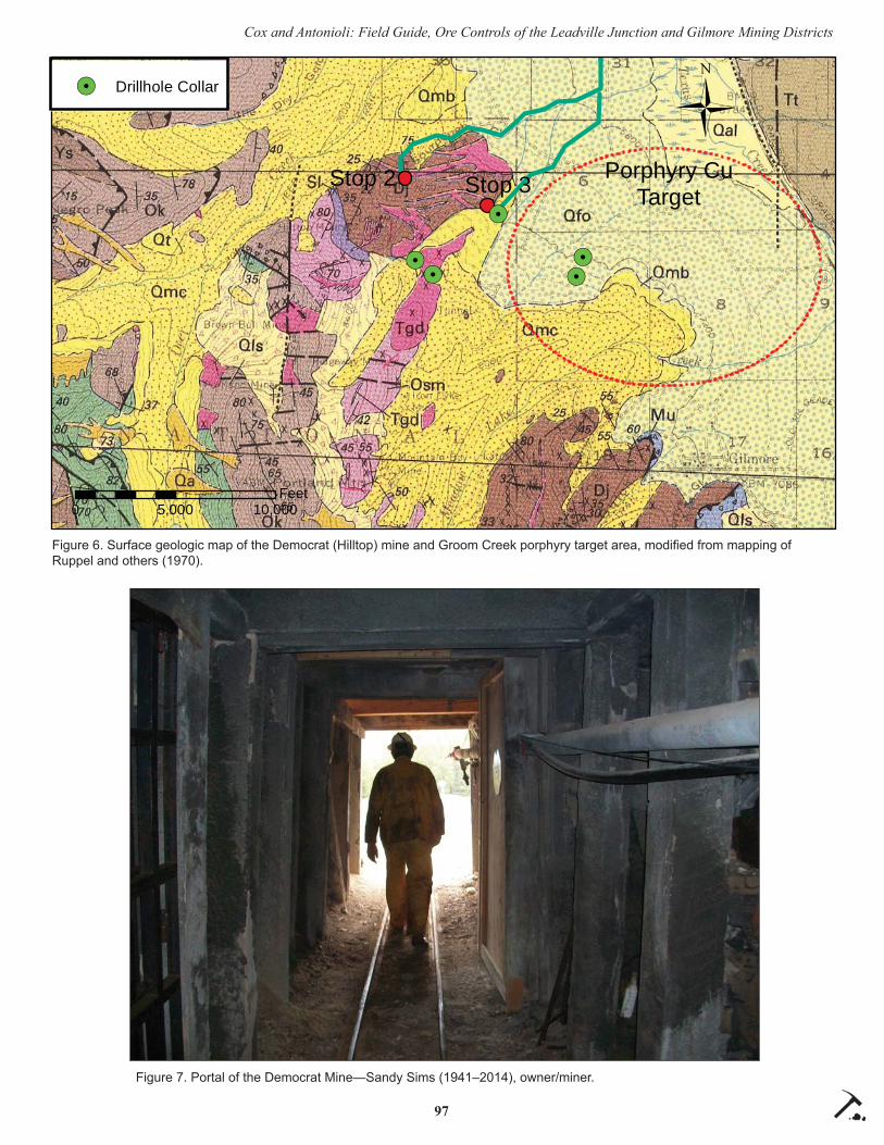
97
Cox and Antonioli: Field Guide, Ore Controls of the Leadville Junction and Gilmore Mining Districts
!.!.
!.
!.!.
0 5,000 10,000Feet
ÜStop 2 Stop 3
!. Drillhole Collar
Porphyry CuTarget
Figure 6. Surface geologic map of the Democrat (Hilltop) mine and Groom Creek porphyry target area, modifi ed from mapping of Ruppel and others (1970).
Figure 7. Portal of the Democrat Mine—Sandy Sims (1941–2014), owner/miner.

98
Cox and Antonioli: Field Guide, Ore Controls of the Leadville Junction and Gilmore Mining Districts
Probable ore-grade veining is exposed at the margins of stopes that have been mined upward from the 800 level and winze and in the fl oor of the 500 level. This observation indicates vein continuity in the reserve blocks described by previous investiga-tors. In addition to the tabular veins, pipe-like masses of ore occur along and fl anking the PDZ and may be controlled by synthetic (splay) faults that merge with the PDZ. Bleached, fi ne-grained concentric layering at the margins of several pipes suggests that ore minerals may have deposited in karst (cave) solution breccias that had opened along the rake of intersecting faults.
Return to valley fl oor (44.494131°N / 113.283758°W) and reset mileage to 0.00.
0.0 Travel south toward mouth of Groom Creek.
0.17 Turn right on road climbing along axis of the Groom Creek fan.
0.65 4-way intersection. Turn right (W).
1.19 STOP 3
Groom Creek intrusive porphyry target (44.483233°N / 113.298644°W) (fi g. 6).
Park in unimproved campsite on the south side of Groom Creek. The camp-site is atop a lateral (?) lobe of the Groom Creek till. Roadcuts in hillside to NW expose a diorite porphyry dike and carbonate exoskarn peripheral to the mineralized porphyry target (fi g. 9).
Groom Creek Exploration
Historic development and production in the Gilmore or Texas mining district concentrated on the numerous lead–sil-ver veins that outcrop in the central part of the district (Mitchell, 1997). Focus on “hidden targets” and “the big pic-
ture” received a major push during and after a USGS program of geochemical and geophysical investigations in the
central Lemhi Range led by Ed Ruppel, who thought it probable that the quartz
diorite stock exposed near Groom Creek was genetically related to the mineral deposits of the greater district (Ruppel
and others, 1970).At about the same time, Vanguard Exploration
conducted regional aeromagnetic and other geological and geophysical work in a broad area generally east of Gilmore (The Greater Gilmore Project). As the project progressed, work focused in on the Groom Creek area (fi g. 10). In 1970–1971, Vanguard drilled at least fi ve holes totaling 7,780 ft through the glacial outwash and into altered and mineralized intrusive bedrock (Hin-man, 1974).
The targets were principally areas showing a high chargeability response in induced polarization surveys. Exploration drilling indeed encountered extensive
Figure 8. Photo of Hilltop vein at west face of main stope above 800 level; clipboard for scale.

99
Cox and Antonioli: Field Guide, Ore Controls of the Leadville Junction and Gilmore Mining Districts
Figure 9. Diorite porphyry dike (under hammer) fl anked by carbonate exoskarn.
Figure 10. View southeast from northern margin of the Groom Creek porphyry target.

100
Cox and Antonioli: Field Guide, Ore Controls of the Leadville Junction and Gilmore Mining Districts
zones of sulfi de mineralization but copper values were generally low. Follow-up work to refi ne targeting was not done, apparently because the copper price began a decade-long major downturn beginning in the early 1970s. As far as is known, the alteration found in the drilling was never placed into the context of a modern porphyry copper model.
End of fi eld trip. If time allows, return to High-way 28, drive south, and visit the town and mines of the central Gilmore mining district.
REFERENCES CITED
Hershey, O.A., 1920, Report on Baby Joe, Kimmel, and Sunset Lead mines: unpublished report in Idaho Geological Survey’s fi les, 8 p.
Hinman, R., 1974, Review and discussion of the geo-physical data on the Groom Creek area, greater Gilmore project. Report to Teton Exploration Drilling Company, Casper, Wyoming, 40 p.
Lawrence, J.C., 1999, Feasibility study of the Democrat Mine, Lemhi County, Idaho: private intracompany report, 21 p.
Melbye, C.E., 1965, Progress report, April, 1965 drill-ing program and ore reserve evaluation, Leadville Property, Junction mining district, Lemhi County, Idaho: Unpublished report in Idaho Geological Survey’s mineral property fi les, 5 p.
Mitchell, V.E., 1997, History of the mines in the Texas Mining District near Gilmore, Idaho: Moscow, Idaho, Idaho Geological Survey.
Mitchell, V.E., 2004, History of the Leadville, Kim-mel, and Baby Joe mines, Lemhi County, Idaho: Idaho Geological Survey Staff Report 04-1, 35 p.
Ruppel, E.T., 1968, Geologic map of the Leadore quadrangle, Lemhi County, Idaho: U.S. Geologi-cal Survey Geologic Quadrangle Map GQ-733, scale 1:62,500.
Ruppel, E.T., and Lopez, D.A., 1988, Regional geol-ogy and mineral deposits in and near the central part of the Lemhi Range, Lemhi County, Idaho: U.S. Geological Survey Professional Paper 1480, 122 p.
Ruppel, E.T, Watts, K.C., and Peterson, D.L., 1970, Geologic, geochemical and geophysical investiga-tions in the northern part of the Gilmore mining district, Lemhi County, Idaho: U.S. Geological
Survey Open-File Report 70-282, 56 p.Umpleby, J.B., 1913, Geology and ore deposits of
Lemhi County, Idaho: U.S. Geological Survey Bulletin 528, 182 p.

101Northwest Geology, v. 46, 2017, p. 101–112 The Journal of the Tobacco Root Geological Society
FIELD GUIDE TO THE LEMHI ARCH AND MESOZOIC-EARLY CENOZOIC FAULTS AND FOLDS IN EAST-CENTRAL IDAHO: BEAVERHEAD MOUNTAINS
David M. Pearson and Paul K. Link
Idaho State University, Pocatello, Idaho
INTRODUCTION
This fi eld trip will focus on a portion of the Rodin-ian rift margin on the western edge of Laurentia where Neoproterozoic to Lower Ordovician syn- and early post-rift clastic sedimentary rocks are absent. This region of missing stratigraphy, called the Lemhi arch, is in east-central Idaho, is roughly northwest-trending, and contains a belt of Cryogenian and Late Cambrian alkalic plutons (e.g., Lund and others, 2010). This region of thin or absent Neoproterozoic and lower Paleozoic strata correlates spatially with the boundary between the northern Wyoming salient and southwest Montana reentrant of the Mesozoic to early Cenozoic Sevier–Laramide fold-thrust belt (Armstrong, 1975) and likely infl uenced the transition from thin- to thick-skinned thrusting.
This fi eld trip will contain two themes: (1) the Lemhi arch and its stratigraphic and magmatic expres-sion in east-central Idaho; and (2) the structural style of the Mesozoic to early Cenozoic Sevier–Laramide fold-thrust belt within the Lemhi arch. The trip will begin with a visit to Skull Canyon in the southern Bea-verhead Mountains, where we will examine the basal angular unconformity of the Lemhi arch between tilted Proterozoic sandstones of the upper Belt Supergroup and overlying Ordovician sandstones. We will then stop in lower Skull Canyon to see prominent folds in middle and upper Paleozoic carbonates; this style of folding seen here is characteristic of the structur-ally shallow levels of deformation within the Sevier fold-thrust belt in the region. This will be followed by a visit to Hawley Creek, east of Leadore, where an alkalic late Cambrian pluton intruded just prior to or during active exhumation of the Lemhi arch. This pluton was thrusted upon middle Paleozoic carbon-ates in Late Cretaceous time along the Hawley Creek thrust. The style of “basement involved” thrusting here is in contrast to the thin-skinned, detachment folding and thrusting in middle Paleozoic carbonate rocks observed in lower Skull Canyon.
GEOLOGIC SETTING
Neoproterozoic to early Paleozoic Stratigraphic Framework
Neoproterozoic to early Paleozoic rifting of the Rodinian supercontinent was fundamental in shaping what is now the western margin of North America. In addition to establishing the fi rst-order geography, the rift geometry imposed the syn- and post-rift strati-graphic framework of western North America, which had a major infl uence on the subsequent geological evolution of the North American Cordillera. For much of the western margin of North America, the record of Neoproterozoic and early Cambrian rifting and the transition to passive margin sedimentation are well established (Stewart, 1972; Christie-Blick, 1982; Link and others, 1993; Yonkee and others, 2014). Early regional-scale studies proposed that syn-rift fi ll and westward thickening passive margin sedimentary rocks continued northward from southeastern Idaho into southeastern British Columbia (e.g., Stewart, 1972). However, the intervening region between the eastern Snake River Plain and southeastern British Co-lumbia along the Idaho–Montana border seemed to not fi t into that framework. There, workers documented Middle Ordovician rocks that unconformably overlie Mesoproterozoic Belt Supergroup rocks, and a com-pletely missing Neoproterozoic to Lower Ordovician stratigraphic record (Ross, 1934, 1947; Sloss, 1954; Scholten, 1957). Neoproterozoic and lower Cambrian rocks are largely missing in southwestern Montana too, where middle Cambrian rocks of the Flathead Formation overlie Archean basement or rocks of the Belt–Purcell Supergroup (Deiss, 1941; Sloss, 1950; Bush and others, 2012), with likely Neoproterozoic to early Cambrian erosion prior to middle Cambrian deposition (Norris and Price, 1966).
A recent regional compilation of the tectonostrati-graphic framework of early Laurentian rifting focused in Utah, southeastern Idaho, and Nevada recognized the major northward change in the character of the rift margin sedimentation pattern by demonstrating a

102
Pearson and Link: Field Guide to the Lemhi Arch
consistent 6- to 7-km-thick clastic section of Neopro-terozoic and Cambrian rocks from SE Idaho south to central Utah (Yonkee and others, 2014). In addition, rocks in northern Utah and SE Idaho established a fi -nal transition to drift from 580 to 540 Ma (Yonkee and others, 2014). This is in stark contrast to the margin in east-central Idaho and southwestern Montana, where alkalic magmatism (Evans and Zartman, 1988; Lund and others, 2010; Todt and Link, 2013) and regional tectonism (Link and others, in review) persisted into late Cambrian and Early Ordovician time (500 to 485 Ma), nearly 50 m.y. later than the transition to drift and passive margin sedimentation documented to the south.
The absence of Neoproterozoic and Cambrian rocks in east-central Idaho and missing Neoproterozo-ic to lower Cambrian rocks in western Montana likely refl ects the presence of a regional paleotopographic high at the rift margin. Because of several diff erent names that have been used to describe this feature, for simplicity, we refer to the region of very thin or missing Neoproterozoic and Cambrian rocks in east-central Idaho (variably called the Lemhi arch, Salmon River arch, or Skull Canyon disturbance) as the Lemhi arch (see McCandless, 1982 for a discussion). For additional discus-sion of Montana, which we consider a separate feature, see Bush and others (2012). This trip will examine the basal unconformity of the Lemhi arch and the Late Cambrian Beaverhead plu-ton intruded just prior to or during its exhumation.
Mesozoic to Early Cenozoic Retroarc Shortening
Southeast of the Montana/Idaho border, thrust traces in the Sevier fold-thrust belt transition northward from north–south trending within the Wyo-ming salient to northwest–southeast trending, defi ning the southwestern Montana reentrant (fi g. 1). Many work-ers have concluded that similar salients and reentrants in thrust belts are con-trolled by the pre-deformational geol-ogy (e.g., Crosby, 1969; Allmendinger and Gubbels, 1996). Hypotheses for
the dominant controls for the abrupt transition from thin- to thick-skinned shortening in the Sevier fold-thrust belt vary widely, including impingement of the thrust system against early basement-involved struc-tures to the east (e.g., Perry and others, 1988) or Pro-terozoic basement (Armstrong, 1975) and thickness variations in the pre-deformational stratal thicknesses (Crosby, 1969).
This fi eld trip will visit two localities that sup-port a correlation between thrust belt geometry and stratigraphic architecture. At shallow stratigraphic levels from central Idaho out to southwestern Mon-tana, thin-skinned décollement horizons occur in thick Devonian and Lower Mississippian fl ysch (Skipp and Hait, 1977; Perry and others, 1989). However, thrusts at deeper structural levels in this part of the fold-thrust belt are rare and appear to have accom-modated shortening in a markedly diff erent structural style. In contrast to much of the Wyoming salient to the south, where décollements exploit weak shales of the Cambrian Gros Ventre Formation (Royse and oth-
Figure 1. Index map of the geologic setting of the fi eld trip localities (modifi ed from Ja-necke and others, 2000). Po-HCrT: Poison-Hawley Creek thrust; IrLF: Iron Lake fault.

103
Pearson and Link: Field Guide to the Lemhi Arch
-
vehicles who prefer not to walk can drive this portion of the trip. Stops 1 and 2 will be followed by a drive back down Skull Canyon toward Highway 28 to Stop 3. Stop 3 within lower Skull Canyon will focus on the style of deformation in structurally shallow, middle Paleozoic carbonates, which involves major detach-ment folding and fault-propagation folding. This is a regional décollement horizon that continues from central Idaho out to southwestern Montana (Skipp and Hait, 1977). In contrast to the thin-skinned style of de-formation within the Paleozoic carbonates, structurally deeper rocks appear to have accommodated low-mag-nitude shortening in a basement-involved structural style. Preliminary geologic mapping of the area was conducted by Embree and others (1983) and Scholten and Garmezy (1980) (fi g. 2).
STOP 1 (44.185995°N, 112.873151°W)
Stop 1 consists of a visit to the fi rst prominent outcrops of Precambrian sandstone exposed in up-per Skull Canyon (fi g. 2). The outcrop we will visit is on the northwestern side of the drainage off USFS Road 837, ~0.2 mi from the parking locality described above. The descriptions provided here are partly
ers, 1975), in the absence of these rocks in east-central Idaho due to the Lemhi arch, thrusts display a structural style reminiscent of thick-skinned, basement-involved fold-thrust belt deformation. This structural style is characterized by inversion of older normal faults (Hansen and Pearson, 2016), large-wavelength folding (Lucchi-tta, 1966; Tysdal, 2002; Lonn and others, 2016), and involvement of crystalline basement rock and Pro-terozoic Belt Supergroup in thrust sheets (Skipp, 1988). This trip will examine the thin-skinned struc-tural style exhibited by middle and upper Paleozoic carbonates as well as the more deeply rooted Hawley Creek thrust, which car-ries Late Cambrian hypabyssal plutons and may correlate along-strike to the northwest with the inverted Poison Creek thrust.
ROAD LOG
The road log begins in Blue Dome, Idaho, which is located along Highway 28 approximately 45 mi southeast of Leadore and 32 mi northwest of Mud Lake. Reset your odometer at the intersection of Skull Canyon Road and Highway 28 (44.159779°N, 112.914156°W) and proceed northeast into Skull Canyon. Near the mouth of Skull Canyon, the road becomes USFS Road 298. Continue on the main road and stay right at the fork at 1.5 mi (44.179871°N, 112.883627°W), proceeding on USFS Road 837. Continue on this road until mile 2.2 at a sign for USFS Road 837 (44.185018°N, 112.876481°W), where a smaller jeep road branches to the right. Park on the northwestern side of the road intersection adjacent to the sign for USFS Road 837.
Skull Canyon OverviewStops 1 and 2 involve a ~0.9 mi walk up USFS
Road 837 to view likely Proterozoic sandstone (Belt Supergroup) and Ordovician sandstone that lies in angular unconformity above it. Rocks near this local-ity have been described by Scholten (1957), Beutner and Scholten (1967), McCandless (1982), and Skipp and Link (1992). Intrepid drivers with high-clearance
Figure 2. Simplifi ed geologic map of the Skull Canyon area showing fi eld trip Stops 1, 2, and 3 (modifi ed from Scholten and Garmezy, 1980; Embree and others, 1983). Unit abbre-viations: Yq-quartzite of likely Mesoproterozoic age; Oks-Ordovician sandstone of the Kin-nikinic Formation and possible Summerhouse Formation; Dj-Devonian Jeff erson Formation; Msh-undivided lower Scott Peak, Middle Canyon, and McGowan Creek formations; Msp-Mississippian Scott Peak Formation; Msc-Mississippian South Creek Formation; Msu-Mis-sissippian Surrett Formation; Mbs-Mississippian Big Snowy Formation; Mbm-Mississippian Bluebird Mountain Formation; IPMsc-Pennsylvanian/Mississippian Snaky Canyon Forma-tion; Q-undiff erentiated Quaternary sediments.

104
Pearson and Link: Field Guide to the Lemhi Arch
from Skipp and Link (1992). Outcrop here consists of dominantly thin-bedded, red, fi ne- to medium-grained arkosic to subarkosic sandstone that dips northward at ~40°. Parallel laminae and small-scale cross-lami-nations of iron oxide are common and there are local intercalated grayish-green mudstone or siltstone beds. Bedding plane concentrations of mudstone rip-up clasts locally are common. Most workers consider these rocks to be equivalent to Mesoproterozoic Belt Supergroup (Beutner and Scholten, 1967; McCand-less, 1982), possibly the Gunsight Formation (Skipp and Link, 1992).
In the middle fork of Skull Canyon in the next drainage to the north of Stop 1, Beutner and Scholten (1967) described ~9 m of thicker-bedded, red, tex-turally immature, very fi ne-grained to very coarse-grained and locally conglomeratic sandstone that may overlie Belt Supergroup-equivalent rocks. Though these rocks match the general description of Neopro-terozoic to Cambrian rocks of the Wilbert Formation (Ruppel, 1975), their similarities with underlying sandstones and their stratigraphic position below a distinctive angular unconformity suggest that they are probably also correlative with the Belt Supergroup (McCandless, 1982). Detrital zircon age-populations from Wilbert Formation exposed at several localities in the southern Beaverhead Mountains have a strong 1,720 to 1,740 Ma age-peak (Link, unpublished) and are statistically indistinguishable (may be reworked) from upper Belt Supergroup quartzites exposed throughout much of east-central Idaho and southwest Montana (Link and others, 2016).
STOP 2 (44.184839°N, 112.862333°W)
Walk back to USFS Road 837 and proceed an additional ~0.7 mi up the road to Stop 2 (total ~0.9 mi from the parking area). Intermittent outcrops and fl oat of the Proterozoic sandstone can be found in and adjacent to the road. At Stop 2, on the northern and southern sides of the road are excellent exposures of the angular unconformity between Mesoproterozoic rocks of the Belt Supergroup and overlying Ordovi-cian sandstones. The best outcrops are in cliff y expo-sures on the northern side of the drainage 10–20 m from the road. Underlying sandstones dip 20–40° to the north and northeast and are overlain by medium-bedded, white, coarse and pebbly quartz sandstone that grades upward into vitreous white, well-sorted, medium-grained sandstone of the Middle Ordovician
Kinnikinic Quartzite (Beutner and Scholten, 1967; McCandless, 1982). McCandless (1982) considers the basal, coarse sandstone to be correlative to the Or-dovician Summerhouse Formation exposed beneath the Middle Ordovician Kinnikinic Formation in the southern Lemhi Range.
The complete absence of Neoproterozoic and Cambrian syn- and early post-rift clastic sedimen-tary rocks in east-central Idaho is in stark contrast to in southeast Idaho and northern Utah, south of the Snake River Plain (Sloss, 1954; Scholten, 1957; Rup-pel, 1986; Link and others, in review). In the central Lemhi Range and southern Beaverhead Mountains, the unconformity consists of Mesoproterozoic Belt Super-group-equivalent sandstone and quartzite, with a very thin (<300 m) overlying section of Middle Ordovician Kinnikinic Formation. In southwestern Montana, Rup-pel (1998) mapped Ordovician Summerhouse Forma-tion (and overlying Kinnikinic) unconformably above Archean and Paleoproterozoic gneisses of Maiden Peak (Anderson, 2017). Overall, the thin region of Neoproterozoic and early Paleozoic strata within the Lemhi arch is northwest-trending and separates a thicker section of equivalent rocks on the southwestern side of the Lemhi arch in central Idaho from a thicker section of lower Paleozoic rocks in southwestern Montana (Sloss, 1950, 1954). In east-central Idaho, the Lemhi arch may represent the exhumed footwall of a Rodinian rift fault (Hansen and Pearson, 2016), with Cambrian and Ordovician carbonate and siliciclastic rocks of the Bayhorse assemblage (Hobbs and Hays, 1990; Krohe, 2016) deposited in the hanging wall of the west-dipping normal fault.
In addition to the thin Neoproterozoic and Paleo-zoic strata, the Lemhi arch contains Neoproterozoic to early Paleozoic alkalic magmatic rocks (Lund, 2008; Lund and others, 2010). The alkalic belt of plutons defi ning this magmatism is called the Big Creek–Bea-verhead belt. In the central and southern Beaverhead Mountains these consist of a northwest-trending, Late Cambrian to Early Ordovician alignment of hypabys-sal plutons that parallels the Lemhi arch (Lund and others, 2010). The overlying Middle Ordovician Kin-nikinic and correlative sandstones that overlie the un-conformity within the Lemhi arch contain far-traveled detritus, likely from the Peace River arch of western Canada, as shown by detrital zircon data (all grains >1,800 Ma) from across Idaho and south to Nevada (Baar, 2009; Linde and others, 2014, 2016; Hansen,

105
Pearson and Link: Field Guide to the Lemhi Arch
2015; Krohe, 2016; Beranek and others, 2016).
The spatial coincidence of the Lemhi arch and the geometry of the Mesozoic and early Cenozoic Sevier–Laramide fold-thrust belt suggests that they are related. Armstrong (1975) hypothesized that the presence of crystalline basement (called the “Salmon River arch” by him) acted as a buttress and hindered propagation of the fold-thrust belt to the east–north-east. Alternatively, an absence of fi ne-grained, Neo-proterozoic and Cambrian shales that were exploited as the basal décollement within much of the Wyo-ming salient (e.g., Royse and others, 1975), may have inhibited propagation of the fold-thrust belt within the region of the southwest Montana reentrant and promoted a thick-skinned style of deformation in east-central Idaho and southwestern Montana (Pearson and Becker, 2015).
After viewing the Skull Canyon unconformity, return to the cars. Quick hikers can continue hiking up Skull Canyon to a prominent shear zone within shales of the McGowan Creek Formation mapped by Embree and others (1983) (fi g. 2), which may represent the tilted basal décollement of detachment folds that we will see at Stop 3. We will revisit the topics of alkalic Cambrian plutonism and the structural style of the Mesozoic and early Cenozoic fold-thrust belt in later stops.
STOP 3 (44.166538°N, 112.902861°W)
Stop 3 can be reached by driving 1.9 mi south-westward from the parking area at Stop 1 to where a small side road parallels USFS Road 298 on its north-western side. This locality was passed on the way into upper Skull Canyon for Stops 1 and 2. From the parking area for Stop 3, walk northward to outcrops of thick-bedded Mississippian Scott Peak Formation. On the northern and southern walls of the canyon, one can view a large (~1 km wavelength), northeast-verging, concentric fold. In addition to the regional-scale fold visible in the bottom of Skull Canyon, smaller wave-length (10–100 m), parasitic folds occur on both fold limbs and verge toward the crest of the major fold (Scholten and Garmezy, 1980). At the outcrop scale, thick-bedded Scott Peak Formation exhibits steeply southwest-dipping, axial planar, pressure solution cleavage. The orientations of fold axes and pressure solution cleavage in the southern Beaverhead Moun-tains suggest a bulk southwest–northeast shortening direction.
Northwest–southeast-trending parallel or kink folds, and upright to moderately overturned folds that are akin to this fold, are common in middle and up-per Paleozoic carbonates in the southern Beaverhead Mountains, and Lemhi and Lost River Ranges (Ross, 1947; Skipp and Hait, 1977; Skipp, 1988; Anastasio and others, 1997). In the central Lost River Range, folds in upper Paleozoic carbonate rocks are demon-strably decoupled from underlying stratigraphy along a bedding plane-parallel décollement in thin-bedded siltstones and argillites of the Lower Mississippian McGowan Creek Formation (Anastasio and oth-ers, 1997). This style of folding is called detachment folding (Jamison, 1987). Some tight folds in the Lost River Range and southern Beaverheads also have apparent fault-propagation folds in their hinge zones (Fisher and Anastasio, 1994). In the Lost River Range, detachment and fault-propagation folding accommo-dated ~22% shortening (Anastasio and others, 1997). Detachment and fault-propagation folding above Devonian and Mississippian décollements is present northeastward into southwestern Montana (Perry and others, 1988; Skipp, 1988; Tysdal, 1988). In contrast to substantial shortening accommodated by folding and bedding-parallel slip that is typical of a thin-skinned structural style, structurally deeper rocks (i.e., Proterozoic to Devonian strata) within these same ranges do not exhibit the same magnitude of folding and instead accommodated shortening along discrete thrusts associated with large-wavelength folding; the latter structural style is similar to basement-involved, thick-skinned thrusting and will be discussed during later stops.
Hawley Creek OverviewFollowing the visit to Skull Canyon (Stops 1, 2,
and 3), the trip will then travel northwestward along Highway 28 to Hawley Creek, Idaho. There, we will view the Late Cambrian Beaverhead pluton of the Big Creek–Beaverhead belt of plutons intruded within the Lemhi arch. We will also view the basement-involved Hawley Creek thrust and folded carbonates in its footwall. These rocks were mapped: as part of a Ph.D. dissertation by Lucchitta (1966); with a focus on phos-phate resources by Oberlindacher and Hovland (1979); and at 100,000-scale by Ruppel (1998) and Evans and Green (2003).
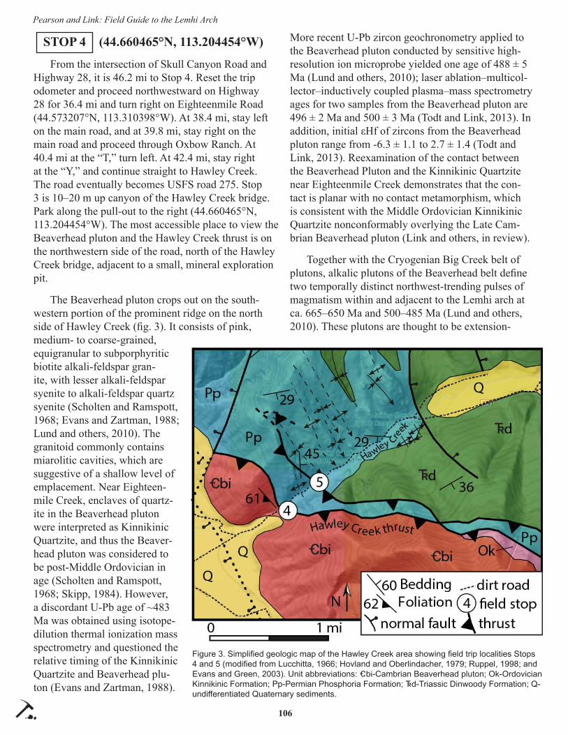
106
Pearson and Link: Field Guide to the Lemhi Arch
STOP 4 (44.660465°N, 113.204454°W)
From the intersection of Skull Canyon Road and Highway 28, it is 46.2 mi to Stop 4. Reset the trip odometer and proceed northwestward on Highway 28 for 36.4 mi and turn right on Eighteenmile Road (44.573207°N, 113.310398°W). At 38.4 mi, stay left on the main road, and at 39.8 mi, stay right on the main road and proceed through Oxbow Ranch. At 40.4 mi at the “T,” turn left. At 42.4 mi, stay right at the “Y,” and continue straight to Hawley Creek. The road eventually becomes USFS road 275. Stop 3 is 10–20 m up canyon of the Hawley Creek bridge. Park along the pull-out to the right (44.660465°N, 113.204454°W). The most accessible place to view the Beaverhead pluton and the Hawley Creek thrust is on the northwestern side of the road, north of the Hawley Creek bridge, adjacent to a small, mineral exploration pit.
The Beaverhead pluton crops out on the south-western portion of the prominent ridge on the north side of Hawley Creek (fi g. 3). It consists of pink, medium- to coarse-grained, equigranular to subporphyritic biotite alkali-feldspar gran-ite, with lesser alkali-feldspar syenite to alkali-feldspar quartz syenite (Scholten and Ramspott, 1968; Evans and Zartman, 1988; Lund and others, 2010). The granitoid commonly contains miarolitic cavities, which are suggestive of a shallow level of emplacement. Near Eighteen-mile Creek, enclaves of quartz-ite in the Beaverhead pluton were interpreted as Kinnikinic Quartzite, and thus the Beaver-head pluton was considered to be post-Middle Ordovician in age (Scholten and Ramspott, 1968; Skipp, 1984). However, a discordant U-Pb age of ~483 Ma was obtained using isotope-dilution thermal ionization mass spectrometry and questioned the relative timing of the Kinnikinic Quartzite and Beaverhead plu-ton (Evans and Zartman, 1988).
More recent U-Pb zircon geochronometry applied to the Beaverhead pluton conducted by sensitive high-resolution ion microprobe yielded one age of 488 ± 5 Ma (Lund and others, 2010); laser ablation–multicol-lector–inductively coupled plasma–mass spectrometry ages for two samples from the Beaverhead pluton are 496 ± 2 Ma and 500 ± 3 Ma (Todt and Link, 2013). In addition, initial εHf of zircons from the Beaverhead pluton range from -6.3 ± 1.1 to 2.7 ± 1.4 (Todt and Link, 2013). Reexamination of the contact between the Beaverhead Pluton and the Kinnikinic Quartzite near Eighteenmile Creek demonstrates that the con-tact is planar with no contact metamorphism, which is consistent with the Middle Ordovician Kinnikinic Quartzite nonconformably overlying the Late Cam-brian Beaverhead pluton (Link and others, in review).
Together with the Cryogenian Big Creek belt of plutons, alkalic plutons of the Beaverhead belt defi ne two temporally distinct northwest-trending pulses of magmatism within and adjacent to the Lemhi arch at ca. 665–650 Ma and 500–485 Ma (Lund and others, 2010). These plutons are thought to be extension-
Figure 3. Simplifi ed geologic map of the Hawley Creek area showing fi eld trip localities Stops 4 and 5 (modifi ed from Lucchitta, 1966; Hovland and Oberlindacher, 1979; Ruppel, 1998; and Evans and Green, 2003). Unit abbreviations: _bi-Cambrian Beaverhead pluton; Ok-Ordovician Kinnikinic Formation; Pp-Permian Phosphoria Formation; ^d-Triassic Dinwoody Formation; Q-undiff erentiated Quaternary sediments.

107
Pearson and Link: Field Guide to the Lemhi Arch
related; together with the thinned Neoproterozoic and early Paleozoic stratigraphy within this portion of the Laurentian rift margin, the results have been used to advocate for a detachment fault model in which along-strike changes in the character of the rift were proposed to result from a changing dip direction of a major, lithospheric detachment fault (Lister and oth-ers, 1986) across a transfer structure in the modern location of the eastern Snake River Plain (Lund, 2008; Lund and others, 2010). Considered in this context, the Lemhi arch and Big Creek–Beaverhead plutonic belt would have intruded into a largely intact hanging wall of a major detachment fault that accommodated rifting of the western Laurentian rift margin (Lund and others, 2010).
Though no volcanic equivalents of the Beaverhead plutons have been recognized, during Late Cambrian time, up to 300 m of feldspathic sandstone was depos-ited into a thick section of carbonate rocks in south-eastern Idaho (Todt and Link, 2013; Link and others, in review). Utilizing U-Pb and Lu-Hf isotopic fi nger-printing of zircons from these sandstones as well as those of the Beaverhead belt of plutons, Todt and Link (2013) showed that following shallow emplacement within and adjacent to the Lemhi arch, Late Cambrian plutons were rapidly exhumed along with their Belt Supergroup-equivalent country rocks and were the source of the anomalous feldspathic sand.
Hansen and Pearson (2016) mapped a likely Neo-proterozoic or early Paleozoic normal fault that was inverted during Mesozoic shortening. This fault may locally bound the southwestern margin of the Lemhi arch and thus may have accommodated a portion of its exhumation (Hansen, 2016). Ongoing magmatism, faulting, and uplift and exhumation within the Lemhi arch attests to active tectonism in Late Cambrian time, ~40 m.y. after the transition to drift and slow, ther-mally driven subsidence in southeastern Idaho and northern Utah (Yonkee and others, 2014).
In its current confi guration, the Beaverhead pluton exposed at Hawley Creek is in the hanging wall of a major Mesozoic thrust fault, the Hawley Creek thrust (Lucchitta, 1966; Skipp, 1988). Here, the thrust fault displaced the late Cambrian pluton against folded Permian and Triassic rocks of the Phosphoria and Din-woody formations and thus has at least 3 km of strati-graphic separation (Lucchitta, 1966; Oberlindacher and Hovland, 1979). The thrust contact between the
Beaverhead pluton and structurally lower Phosphoria Formation in its footwall is not directly exposed here, but a three-point problem yields a fault dip of ~40° to the southwest. Rare quartz stretching lineations in the pluton suggest transitional brittle-ductile deformation. Occasional slivers or phacoids of quartzite are also ex-posed within the fault zone. At Stop 4, a dioritic dike that crops out adjacent to the small mineral explora-tion pit apparently intruded the Hawley Creek fault zone here; it is presumably Eocene, associated with the Challis magmatic pulse. The Hawley Creek thrust exhibits some characteristics of a thick-skinned struc-tural style. In addition to its involvement of crystalline basement of the Beaverhead pluton, the fault appears to have developed concurrently with several-kilome-ter-scale, northeast-vergent fault propagation folds, preserving its fi nal confi guration with an overturned hanging wall anticlinorium and footwall synclinorium (Lucchitta, 1966). This structural style diff ers mark-edly from the detachment folding at shallow structural levels that was seen at Stop 3.
The Hawley Creek thrust has been considered by some to be the along-strike equivalent of the Poison Creek thrust exposed in the northern Lemhi Range south of Salmon (Skipp, 1987, 1988; Janecke and oth-ers, 2000). There, despite the clear observation that the fault is a thrust by the juxtaposition of Mesoproterozo-ic Belt quartzites upon Ordovician Kinnikinic Quartz-ite (Tysdal, 2002), younger Mesoproterozoic Belt Su-pergroup occurs in the hanging wall relative to older Belt Supergroup rocks in the footwall; this is sugges-tive of a normal fault relationship prior to thrusting and suggests that the fault is a reactivated normal fault formed during Rodinian rifting (Hansen and Pearson, 2016). Two samples collected from the hanging wall of the Poison Creek thrust yielded zircon (U-Th)/He cooling ages (closure temperature ~180°C) of 68–57 Ma, which is interpreted as the timing of exhumation during thrusting along the fault (Hansen and Pearson, 2016). The structural style exhibited by the Poison Creek thrust southeast of Poison Peak includes trunca-tion of an anticline-syncline pair of large-wavelength (>10 km), northeast-vergent, overturned folds (Tysdal, 2002) that are reminiscent of fault-propagation folds, and thick-skinned reactivation of an earlier normal fault (Hansen and Pearson, 2016). Thus, the structural style at deeper structural levels within the Lemhi arch is more characteristic of a thick-skinned deformation style rather than shallower Devonian and Lower Mis-
108
Pearson and Link: Field Guide to the Lemhi Arch
sissippian detachment folding, which is similar to the thin-skinned structural style exhibited by much of the Sevier fold-thrust belt. The spatial coincidence of the thick-skinned structural style and the Lemhi arch sug-gests that the arch may have controlled the northern end of the Wyoming salient and southwest Montana reentrant.
STOP 5 (44.662357°N, 113.201839°W)
If there is remaining time, we will walk north-eastward up Hawley Creek road to view a southeast-plunging, northeast-verging fold train and several small, west-dipping imbricate thrusts within footwall rocks of the Phosphoria and Dinwoody formations (Lucchitta, 1966; Oberlindacher and Hovland, 1979). These folds likely developed synchronously with faulting along the structurally overlying Hawley Creek thrust (Lucchitta, 1966).
REFERENCES CITED
Allmendinger, R.W., and Gubbels, T., 1996, Pure and simple shear plateau uplift, Altiplano-Puna, Argentina and Bolivia: Tectonophysics, v. 259, p. 1–13.
Anastasio, D.J., Fisher, D.M., Messina, T.A., and Holl, J.E., 1997, Kinematics of décollement folding in the Lost River Range, Idaho: Journal of Structural Geology, v. 19, p. 355–368.
Anderson, N.D., 2017, The Bloody Dick and Maiden Peak gneisses, southwest Montana: Implica-tions for Archean and Paleoproterozoic basement framework: Pocatello, Idaho State University M.S. thesis, 129 p., 1 plate.
Armstrong, R.L., 1975, Precambrian (1500 my old) rocks of central Idaho—The Salmon River Arch and its role in Cordilleran sedimentation and tectonics: American Journal of Science, v. 275-A, p. 437–467.
Baar, E.E., 2009, Determining the regional-scale detri-tal zircon provenance of the Middle-late Ordovi-cian Kinnikinic (Eureka) quartzite, east-central Idaho, US: Washington State University M.S. thesis, 134 p.
Beranek, L.P., Link, P.K., and Fanning, C.M., 2016, Detrital zircon record of mid-Paleozoic conver-gent margin activity in the northern U.S. Rocky Mountains: Implications for the Antler orogeny and early evolution of the North American Cordil-
lera: Lithosphere. Beutner, E.C., and Scholten, R., 1967, Probable
Cambrian strata in east-central Idaho and their paleotectonic signifi cance: AAPG Bulletin, v. 51, p. 2305–2311.
Bush, J.H., Thomas, R.C., and Pope, M.C., 2012, Sauk megasequence deposition in northeastern Washington, northern Idaho, and western Mon-tana, in J.R. Derby, R.D. Fritz, S.A. Longacre, W.A. Morgan, and C.A. Sternbach, eds., The great American carbonate bank: The geology and economic resources of the Cambrian–Ordovician Sauk megasequence of Laurentia: AAPG Memoir, v. 98, p. 751–768.
Christie-Blick, N., 1982, Upper Proterozoic and Lower Cambrian rocks of the Sheeprock Moun-tains, Utah: Regional correlation and signifi cance: Geological Society of America Bulletin, v. 93, p. 735–750.
Crosby, G., 1969, Radial movements in the western Wyoming salient of the Cordilleran Overthrust Belt: Geological Society of America Bulletin, v. 80, p. 1061–1078.
Deiss, C., 1941, Cambrian geography and sedimenta-tion in the central Cordilleran region: Geological Society of America Bulletin, v. 52, p. 1085–1115.
Embree, G. F., Hoggan, R.D., and William, E.J., 1983, Preliminary reconnaissance geologic map of the Copper Mountain quadrangle, Lemhi County, Idaho, U.S. Geological Survey Open-File Report No. 83-599.
Evans, K.V., Evans, K.V., Zartman, R.E., and Zartman, R.E., 1988, Early Paleozoic alkalic plutonism in east-central Idaho: Geological Society of America Bulletin, v. 100, p. 1981–1987.
Evans, K.V., and Green, G.N., 2003, Geologic map of the Salmon National Forest and vicinity, east-central Idaho: U.S. Geological Survey Geologic Investigations Series, I-2765, scale 1:100,000.
Fisher, D.M., and Anastasio, D.J., 1994, Kinematic analysis of a large-scale leading edge fold, Lost River Range, Idaho: Journal of Structural Geol-ogy, v. 16, p. 337–354.
Hansen, C., 2015, An investigation into the Poison Creek thrust: A Sevier thrust with Proterozoic implications: Idaho State University, M.S. thesis, 79 p., 1 plate.

109
Pearson and Link: Field Guide to the Lemhi Arch
Hansen, C.M., and Pearson, D.M., 2016, Geologic map of the Poison Creek thrust fault and vicinity near Poison Peak and Twin Peaks, Lemhi County, Idaho: Idaho Geological Survey Technical Report, #T-16-1, scale 1:24,000.
Hobbs, S.W., Hays, W.H., and McIntyre, D.H., 1991, Geologic map of the Bayhorse area, central Custer County, Idaho: U.S. Geological Survey Miscellaneous Investigations Series Map I-1882, scale 1:62,500.
Jamison, W.R., 1987, Geometric analysis of fold development in overthrust terranes: Journal of Structural Geology, v. 9, p. 207–219.
Janecke, S.U., Vandenburg, C.J., Blankenau, J.J., and M’gonigle, J.W., 2000, Long-distance longitu-dinal transport of gravel across the Cordilleran thrust belt of Montana and Idaho: Geology, v. 28, p. 439–442.
Krohe, N., 2016, Structural framework and detrital zircon provenance of the southern portion of the Clayton quadrangle, Custer County, Idaho: Idaho State University, M.S. thesis, 107 p., 1 plate.
Kulik, D.M., and Schmidt, C.J., 1988, Region of over-lap and styles of interaction of Cordilleran thrust belt and Rocky Mountain Foreland: Geological Society of America Memoir 171, p. 75–98.
Linde, G.M., Cashman, P.H., Trexler, J.H., and Dick-inson, W.R., 2014, Stratigraphic trends in detrital zircon geochronology of upper Neoproterozoic and Cambrian strata, Osgood Mountains, Nevada, and elsewhere in the Cordilleran miogeocline: Evidence for early Cambrian uplift of the Trans-continental Arch: Geosphere, v. 10, p. 1402–1410.
Linde, G.M., Trexler, J.H., Jr., Cashman, P.H., Geh-rels, G., and Dickinson, W.R., 2016, Detrital zircon U-Pb geochronology and Hf isotope geo-chemistry of the Roberts Mountains allochthon: New insights into the early Paleozoic tectonics of western North America: Geosphere, v. 12, p. 1016–1031.
Link, P.K., Christie-Blick, N., Devlin, W.J., Elston, D.P., Horodyski, R.J., Levy, M., Miller, J.M.G., Pearson, R.C., Prave, A., Stewart, J.H., Winston, D., Wright, L.A., and Wrucke, C.T., 1993, Middle and Late Proterozoic stratifi ed rocks of the west-ern U.S. Cordillera, Colorado Plateau, and Basin and Range province, in Reed, J.C.J., Bickford,
M.E., Houston, R.S., Link, P.K., Rankin, D.W., Sims, P.K., and Van Schmus, W.R., eds., The Geology of North America, Precambrian: Conter-minous U.S, Boulder, CO, Geological Society of America, v. C-2, p. 1–131.
Link, P.K., Stewart, E.D., Steel, T., Sherwin, J.-A., Hess, L., and McDonald, C., 2016, Detrital zircons in the Mesoproterozoic upper Belt Su-pergroup in the Pioneer, Beaverhead, and Lemhi Ranges, Montana and Idaho: The Big White arc, in MacLean, J.S., and Sears, J.W., eds., Belt Ba-sin: Window to Mesoproterozoic Earth: Geologi-cal Society of America Special Paper, v. 522, p. 163–183.
Link, P.K., Todt, M.K., Pearson, D.M., and Thomas, R.C, in review, 500 Ma detrital zircons in Upper Cambrian Worm Creek and correlative sand-stones, ID, MT, and WY: Magmatism and tecto-nism within the passive margin, Lithosphere.
Lister, G.S., Etheridge, M.A., and Symonds, P.A., 1986, Detachment faulting and the evolution of passive continental margins: Geology, v. 14, p. 246–250.
Lonn, J.D., Burmester, R.F., Lewis, R.S., and McFad-dan, M.D., 2016, Giant folds and complex faults in Mesoproterozoic Lemhi strata of the Belt Supergroup, northern Beaverhead Mountains, Montana and Idaho, in MacLean, J.S., and Sears, J.W., eds., Belt Basin: Window to Mesoproterozo-ic Earth: Geological Society of America Special Paper, v. 522, p. 139–162.
Lucchitta, B.K., 1966, Structure of the Hawley Creek area, Idaho-Montana: University Park, Pennsylva-nia State University, Ph.D. dissertation, 235 p.
Lund, K., 2008, Geometry of the Neoproterozoic and Paleozoic rift margin of western Laurentia: Impli-cations for mineral deposit settings: Geosphere, v. 4, p. 429.
Lund, K., Aleinikoff , J.N., Evans, K.V., duBray, E.A., Dewitt, E.H., and Unruh, D.M., 2010, SHRIMP U-Pb dating of recurrent Cryogenian and Late Cambrian-Early Ordovician alkalic magmatism in central Idaho: Implications for Rodinian rift tec-tonics: Geological Society of America Bulletin, v. 122, p. 430–453.
McCandless, D.O., 1982, A reevaluation of Cambrian through Middle Ordovician stratigraphy of the

110
Pearson and Link: Field Guide to the Lemhi Arch
southern Lemhi Range: University Park, Pennsyl-vania State University M.S. thesis, 159 p.
Norris, D.K., and Price, R.A., 1966, Middle Cambrian lithostratigraphy of southeastern Canadian Cordil-lera: Bulletin of Canadian Petroleum Geology, v. 14, p. 384–404.
Oberlindacher, P., and Hovland, R.D., 1979, Geology and phosphate resources of the Hawley Creek area, Lemhi County, Idaho, U.S. Geological Sur-vey Open-File Report 79-1283, 20 p.
Pearson, D.M., and Becker, T.P., 2015, Proterozoic rift systems and their infl uence on the formation of the Late Cretaceous-early Cenozoic Wyoming salient, GSA Rocky Mountain Regional Meeting, Abstracts with Programs.
Perry, W.J., Haley, J.C., Nichols, D.J., Hammons, P.M., and Ponton, J.D., 1988, Interactions of Rocky Mountain foreland and Cordilleran thrust belt in Lima region, southwest Montana, in Schmidt, C.J. and Perry, W.J., eds., Interaction of the Rocky Mountain Foreland and the Cordil-leran Thrust Belt: Geological Society of America Memoirs, v. 171, p. 267–290.
Perry, W.J., Jr., Dyman, T.S., and Sando, W.J., 1989, Southwestern Montana recess of Cordilleran thrust belt, in French, D.E., and Grabb, R.F., eds., Montana Geological Society fi eld conference guidebook, Montana centennial edition, Geologic resources of Montana: v. 1, p. 261–270.
Ross, C.P., 1934, Correlation and interpretation of Paleozoic stratigraphy in south-central Idaho: Geological Society of America Bulletin, v. 45, p. 937–1000.
Ross, C.P., 1947, Geology of the Borah Peak quad-rangle, Idaho: Geological Society of America Bulletin, v. 58, p. 1085–1160.
Royse, F., Jr., Warner, M.A., and Reese, D.L., 1975, Thrust belt structural geometry and related strati-graphic problems Wyoming–Idaho–northern Utah, in Rocky Mountain Association of Geolo-gists—1975 Symposium, Rocky Mountain Asso-ciation of Geologists, p. 41–54.
Ruppel, E.T., 1975, Precambrian Y sedimentary rocks in east-central Idaho: U.S. Geological Survey Professional Paper 889-A, p. 1–42.
Ruppel, E.T., 1986, The Lemhi Arch: A late Proterozo-ic and early Paleozoic landmass in central Idaho:
AAPG Memoir 41, p. 119–130.Ruppel, E.T., 1998, Geologic map of the eastern part
of the Leadore 30’ x 60’ quadrangle, Montana and Idaho: Montana Bureau of Mines and Geology Open-File Report 372, 9 p., scale 1:100,000.
Scholten, Robert, 1957, Paleozoic evolution of the geosynclinal margin north of the Snake River Plain, Idaho–Montana: Geological Society of America Bulletin, v. 68, p. 151–170.
Scholten, Robert, and Garmezy, L., 1980, Unpublished reconnaissance mapping of the Blue Dome quad-rangle, Clark County, Idaho.
Scholten, Robert, and Ramspott, L.D., 1968, Tectonic mechanisms indicated by structural framework of central Beaverhead Range, Idaho–Montana: Geological Society of America Special Paper, v. 104, p. 1–60.
Skipp, B., 1987, Basement thrust sheets in the Clear-water orogenic zone, central Idaho and western Montana: Geology, v. 15, p. 220–224.
Skipp, B., 1988, Cordilleran thrust belt and faulted foreland in the Beaverhead Mountains, Idaho and Montana, in Schmidt, C.J., and Perry, W.J., Jr., eds., Interaction of the Rocky Mountain foreland and the Cordilleran thrust belt: Geological Soci-ety of America Memoir, v. 171, p. 237–266.
Skipp, B., 1984, Geologic map and cross sections of the Italian Peak and Italian Peak middle roadless areas, Beaverhead County, Montana, and Clark and Lemhi Counties, Idaho: U.S. Geological Survey Miscellaneous Field Studies Map 1601-B, scale 1:62,500.
Skipp, B., and Hait, M.H., Jr., 1977, Allochthons along the northeast margin of the Snake River Plain, Idaho: Wyoming Geological Association Guide-book, v. 29, p. 499–515.
Skipp, B., and Link, P.K., 1992, Middle and late Proterozoic rocks and late Proterozoic tectonics in the southern Beaverhead Mountains, Idaho and Montana: A preliminary report, in Link, P.K., Kuntz, M.A., and Platt, L.B., eds., Regional Geology of Eastern Idaho and Western Wyoming: Geological Society of America Memoir 179, p. 141–154.
Sloss, L.L., 1954, Lemhi arch, a mid-Paleozoic posi-tive element in south-central Idaho: Geological Society of America Bulletin, v. 65, p. 365–368.
111
Pearson and Link: Field Guide to the Lemhi Arch
Sloss, L.L., 1950, Paleozoic sedimentation in Montana area: AAPG Bulletin, v. 34, p. 423–451.
Stewart, J.H., 1972, Initial deposits in the Cordilleran Geosyncline: Evidence of a Late Precambrian (<850 m.y.) Continental Separation: Geological Society of America Bulletin, v. 83, p. 1345–1360.
Todt, M.K., 2013, Sedimentary provenance of the upper Cambrian Worm Creek Quartzite, Idaho using U-Pb and Lu-Hf isotopic analysis of zircon grains: Northwest Geology, v. 42, p. 293–298.
Tysdal, R.G., 1988, Deformation along the northeast side of Blacktail Mountains salient, southwestern Montana: Geological Society of America Memoir 171, p. 203–216.
Tysdal, R.G., 2002, Structural geology of western part of Lemhi Range, east-central Idaho: U.S. Geo-logical Survey Professional Paper 1659.
Yonkee, W.A., Dehler, C.D., Link, P.K., Balgord, E.A., Keeley, J.A., Hayes, D.S., Wells, M.L., Fanning, C.M., and Johnston, S.M., 2014, Tectono-strati-graphic framework of Neoproterozoic to Cam-brian strata, west-central U.S.: Protracted rifting, glaciation, and evolution of the North American Cordilleran margin: Earth-Science Reviews, v. 136, p. 59–95.


113Northwest Geology, v. 46, 2017, p. 113–118 The Journal of the Tobacco Root Geological Society
WALKING TOUR OF THE MONUMENT FAULT NEAR THE CONFLUENCE OF BLOODY DICK CREEK AND HORSE PRAIRIE CREEK, SOUTHWESTERN MONTANA
Colleen Elliott and Jeff Lonn
Montana Bureau of Mines and Geology, 1300 W. Park Street, Butte, Montana 59701
INTRODUCTION
The Monument Fault juxtaposes Paleoproterozoic gneiss against Mesoproterozoic quartzite in the lower reaches of Bloody Dick Creek in southwestern Mon-tana (fi g. 1). There are currently at least fi ve interpreta-tions for the fault:
1. Reverse fault dipping south, placing older rocks over younger (Coppinger, 1974; Sherwin and others, 2016),
2. Steeply dipping SW-side-up fault that is part of the complex Beaverhead Divide fault system (Lonn and others, 2016),
3. Vertical left-lateral Great Divide Megashear that juxtaposes the Belt and Lemhi basins (O’Neill and others, 2007),
4. North–northeast-dipping reverse fault that places younger rocks over older rocks (Ruppel and others, 1993), or
5. No fault at all, but an angular unconformity folded into an upright anticline (S. Janecke and C. Elliott, unpublished).
Each of these interpretations has signifi cant impli-cations for regional geologic history. Geologists with diff erent opinions on the nature of the contact will lead this fi eld trip. We will walk the length of the fault and participants will weigh the diff erent interpretations. Maybe we will even reach a consensus.
FIELD GUIDE
Distance from Leadore: 33 mi, 26 mi paved
Driving time: 1 hour
Walking distance: 2.5 mi, 815 ft vertical gain over 1.5 mi. Will require a vehicle shuttle.
We will leave our cars where we cross the fi rst ridge on the Bloody Dick Road (44.9968°, -113.3215°). Volunteers will shuttle vehicles to Big Hollow. From there we will walk up the ridge.
Stops are shown on fi gures 1 and 2.
STOP 1 (45.0004°, -113.3224°)
Shear zones vs gneissosity vs schistosity in the Gneiss of Bloody Dick Creek at the Monument Mine. Colleen thinks we will fi nd that there are multiple fo-liations in the gneiss, some of which are shear fabrics. She thinks we will fi nd at least one generation of axial plane schistosity.
The quartz + plagioclase + biotite + garnet + pyroxene Gneiss of Bloody Dick Creek is interlayered with biotite schist and medium-grained augen gneiss mylonite. Quartz veins occur throughout. Sherwin and others (2016) report that the gneiss contains metamor-phic zircons of about 1,800 Ma, and the youngest non-metamorphic zircons are about 1,830 Ma (fi g. 3).
At the old Monument (Au Ag Cu Pb) Mine, you will mostly see brecciated and sheared quartz that might be vein quartz, altered quartzite, or both. The dominant fabric trends east–southeast and dips steeply north and south. Above and below the mine, gneiss and schist contain isoclinal folds and mylonitic fabrics with no clear orientation.
STOP 2 (45.0030°, -113.3243°)
Metamorphic foliation vs bedding in Swauger For-mation (Mesoproterozoic) quartzites (description after Sherwin and others, 2016). The Swauger Formation here is white to light brownish gray, thick-bedded, pre-dominantly poorly sorted, medium- to coarse-grained, feldspathic quartzite. Beds are from 10 cm to 1 m thick, with planar and trough crossbedding. Ripple marks are present but rare. The unit contains scattered interbeds of very light gray to light greenish gray, fi ne-

114
Elliott and Lonn: Field Guide, Walking Tour of the Monument Fault
2
1
3
4
5
Montana
Idaho
Figure 1. Location of stops described on fi eld trip. Inset shows location of fi eld trip in southwest Montana.
1
2
3
5
4
Bloody D
ick Fault
Ts
Ts
Ys
Yjl
Xgbd
Yjl
Ys
Xgbd
Figure 2. Geology of fi eld trip area overlain on a Google Earth image. The dashed contact between the Swauger Formation (Ys) and the Gneiss of Bloody Dick Creek (Xgbd) is shown where Colleen Elliott and Petr Yakovlev (MBMG) walked it out in spring 2017. The Bloody Dick normal fault separates the Jahnke Lake Member of the Apple Creek Formation (Tjl) from the Swauger Formation, which is stratigraphically lower, and the Gneiss of Bloody Dick Creek (Xgbd). Tertiary sediments (Ts) over-lie all other units.

115
Elliott and Lonn: Field Guide, Walking Tour of the Monument Fault
The Swauger Formation is tentatively correlated with the Bonner Formation of the Missoula Group, Belt Supergroup, on the basis of lithologic similar-ity and stratigraphic position (Burmester and others, 2016; Lonn and others, 2016).
At Stop 2, a vertical foliation is perpendicular to horizontal bedding, indicating the hinge of an an-ticline. The foliation is defi ned by fl attened quartz grains and fi ne-grained white mica. The most promi-nent foliation in the gneiss is also steep, defi ned by
to medium-grained feldspathic quartzite and rare beds of grayish red-purple, coarse-grained, trough-cross-bedded quartzite. Near the contact with the Gneiss of Bloody Dick Creek, the quartzite contains 35–38 percent total feldspar (28–30 percent potassium feld-spar and 7–8 percent plagioclase) (Sherwin and others, 2016). Sherwin and others (2016) U-Pb dated ninety-three detrital zircons and found a strong unimodal age peak at about 1,730 Ma, sparse grains as young as 1,400 Ma, and a few grains as old as 2,650 Ma (fi g. 3).
05
1015202530
800 1000 1200 1400 1600 1800 2000 2200 2400 2600 2800 3000 3200 3400
08RL647, Gneiss of Bloody Dick Creek Xgbd, n=1001878 Ma
a
05
1015202530
800 1000 1200 1400 1600 1800 2000 2200 2400 2600 2800 3000 3200 3400
JS1103, White quartzite of the Swauger Fm. Ysw, n=93
1717 Ma b
0
5
10
15
800 1000 1200 1400 1600 1800 2000 2200 2400 2600 2800 3000 3200 3400
1729 Ma 2PL11, Lower white quartzite of the multi-colored Swauger Fm.
Ysmc, n=93 c
01020304050
800 1000 1200 1400 1600 1800 2000 2200 2400 2600 2800 3000 3200 3400
6PL11, Multi-colored quartzite of the Swauger Formation
Ysmc, n=92
1716 Ma
d
0
5
10
15
800 1000 1200 1400 1600 1800 2000 2200 2400 2600 2800 3000 3200 3400
JS1101, Gray medium-grained quartziteCZYqg, n=93
1728 Ma
1783 Ma1860 Ma
e
Line at 1800 Ma
Age (Ma)Figure 3. Detrital zircon ages from the Gneiss of Bloody Dick Creek (a), the Swauger Formation (b, c, d,), and quartzite west of Big Hollow (e) (Sherwin and others, 2016).

116
Elliott and Lonn: Field Guide, Walking Tour of the Monument Fault
layering and platy minerals, and approximately paral-lel to the contact. The most prominent foliation away from the fault is more variable. Colleen would argue that the steep foliation is an axial plane foliation over-printing the gneissic layering, which is sub-horizontal near the fault. Jeff would argue that layering is parallel to the fault and related to it.
From Stop 2 we will walk the contact between gneiss and quartzite, looking for relationships between foliations, bedding, and contact. Jeff found that the contact between gneiss and quartzite is parallel to a steep shear foliation. Colleen found that the contact meanders from one limb of a large anticline to another, causing the contact to wander between north and south dips.
STOP 3 (45.0153°, -113.3676°)
This stop is a prospect pit that exposes the near-vertical contact. Tom Kalakay (Rocky Mountain Col-lege, Billings) and Jeff observed the following: steeply east-raking lineations and shear sense indicators of oblique displacement, with the southwest side up and northeast.
STOP 4 (45.0117°, -113.3518°)
Overview of contact. Both sides of the contact here exhibit near vertical foliation. Are they shear fabric or an axial plane foliation? Look back over the contact as it has been traced from Stop 2, and look west towards where it is exposed in the hillside west of Big Hollow.
Walk down the gulch into Big Hollow, and then up the south facing shoulder on the west side of Big Hollow north of the “H” in Hollow on fi gure 1. If the contact has a gentle north dip, then gneiss should form the lower half of this slope. Now, traverse west to the saddle near elevation 7,204 ft and walk south, crossing the Bloody Dick fault, interpreted as a down-to-the-southwest normal fault by all (Coppinger, 1974; Rup-pel and others, 1993; Sherwin and others , 2016; Lonn and others, 2016).
STOP 5 (45.0153°, -113.3676°)
At “7204” on fi gure 1, the feldspathic quartzite is diff erent from the Swauger Formation (Ys) we have been viewing. Lonn and others (in preparation) assign the quartzite there to the Jahnke Lake member (Yjl) of the Apple Creek Formation, while Sherwin and others
(2016) call it Cambrian, Neoproterozoic, or Mesopro-terozoic quartzite. It is fi ner grained and better sorted than the Swauger Formation. Figure 4 is a detrital zircon age plot that compares a sample near the mouth of Big Hollow to Swauger Formation quartzite on the north side of the Bloody Dick Fault. Although both units have peaks at about 1,725 Ma, the fi rst has its maximum at 1,780 Ma, a lesser peak at 1,860 Ma, and a signifi cant scattering of Archean grains. Lonn observes that the 1,780 Ma maximum and scattering of Archean grains are characteristic of Jahnke Lake quartzite in this area (see Lonn and others, in prep.).
Walk down to the vehicles from here.
44 22
11
33
44
_h
20 miles
Main map from: Vuke, Susan M., 2015, Geologic Road Map of Montana: Montana Bureau of Mines and Geology Geologic Map 65
Inset from: McDonald, C., Elliott, C.G., Vuke, S.M., Lonn, J.D., and Berg, R.B., 2012, Geologic map of the Butte South 30' x 60' quadrangle,southwestern Montana: Montana Bureau of Mines and GeologyOpen-File Report 622
Figure 4. Locations in southwest Montana where Archean or Paleoproterozoic are in contact with Mesoproterozoic rocks: (1) Monument Fault, (2) Butte Highlands, (3) Ayers Canyon, and (4) Black Lion Mountain. (Main map from Vuke, 2015; inset from McDonald and others, 2012).

117
Elliott and Lonn: Field Guide, Walking Tour of the Monument Fault
DISCUSSION
If the Monument Fault is a northeast-side-up reverse fault (Ruppel and others, 1993), it places younger over older rocks. While this is an uncom-mon relationship, ‘younger over older’ is found at the contact between Proterozoic and Archean rocks in the Butte Highlands (fi g. 4) (O’Neill and others, 1996; McDonald and others, 2012). In the Butte Highlands, the north-dipping Camp Creek Fault with top-south-west motion placed Mesoproterozoic rocks of the Belt Group over crystalline Archean and/or Paleoprotero-zoic rocks. Whether this fault is an out-of-sequence thrust fault or a rotated extensional fault is not clear (McDonald and others, 2012).
If the Monument Fault is a southwest-side-up reverse fault (Coppinger, 1974; O’Neill and oth-ers, 2007; Sherwin and others, 2016; Jeff Lonn, this volume), then the Paleoproterozoic gneiss is a horst caught between this fault and the southwest-side-down Bloody Dick normal fault that we cross near Stop 5.
O’Neill and others (2007) include the fault in their Great Divide Megashear, the long-lived, left-lateral strike-slip fault that they propose juxtaposed the Me-soproterozoic Belt and Lemhi basins.
If the “fault” is an unconformity, it means that the Swauger Formation is the base of the Mesoproterozoic sequence in this location, and that it was a salient or erosional surface during deposition of the older Lemhi Group and Lower Belt Supergroup. Units older than the Swauger Formation are exposed within 3 mi of the Monument Fault where they have been thrust north-ward over rocks younger than Swauger. Two places in the region where Mesoproterozoic rocks are in deposi-tional contact with the basement have unconformities that are more obvious. At Ayers Canyon (fi g. 4), large angular clasts mark the base of the Mesoproterozoic strata (McDonald and Lonn, 2013). At Black Lion Mountain (fi g. 4), pebbly grits overlie the unconfor-mity (McDonald and Lonn, 2013). While the Swauger Formation along the fi eld trip route is poorly sorted and contains some small angular and rounded pebbles, overall it does not look diff erent from Swauger quartz-ite in other locations where it is underlain by more than 17,000 ft (5,200 m) of Mesoproterozoic sedi-ments (Burmester and others, 2015; Lonn, this vol-ume).
ACKNOWLEDGMENTS
Thanks to Petr Yakovlev for walking the contact and creating a story map for this guide. Thanks also to Susan Smith for drafting the fi gures and Katie Mc-Donald for reviewing the manuscript.
REFERENCES CITED
Burmester, R.F., Lewis, R.S., Lonn, J.D., and McFad-dan, M.D., 2015, The Hoodoo is the Swauger and other heresies: Lemhi subbasin correlations and structures, east-central Idaho: Northwest Geology, v. 44, p. 73–88.
Burmester, R.F., Lonn, J.D., Lewis, R.S., and McFad-dan, M.D., 2016, Stratigraphy of the Lemhi sub-basin of the Belt Supergroup, in MacLean, J.S., and Sears, J.W., eds., Belt Basin: Window to Me-soproterozoic Earth: Geological Society of Amer-ica Special Paper 522, chapter 5, p. 121–138.
Coppinger, W., 1974, Stratigraphy and structural study of Belt Supergroup and associated rocks in a por-tion of the Beaverhead Mountains, southwestern Montana, and east-central Idaho: Oxford, Ohio, Miami University, Ph.D. dissertation, 224 p.
Lonn, J.D., 2017, The type Lemhi Group sections re-visited and revised, east-central Idaho: Northwest Geology, v. 46, p. 15–28.
Lonn, J.D., Burmester, R.F., Lewis, R.S., and McFad-dan, M.D., 2016, Giant folds and complex faults in Mesoproterozoic Lemhi strata of the Belt Supergroup, northern Beaverhead Mountains, Montana and Idaho, in MacLean, J.S., and Sears, J.W., eds., Belt Basin: Window to Mesoproterozo-ic Earth: Geological Society of America Special Paper 522, chapter 6, p. 139–162.
Lonn, J.D., Elliott, C.G., Lewis, R.S., Burmester, R.F., Janecke, S., and others, in preparation, Geologic map of the Montana portion of the Salmon 30’ x 60’ quadrangle, southwestern Montana: Montana Bureau of Mines and Geology Open-File Report, 1 sheet, scale 1:100,000.
McDonald, C., Elliott, C.G., Vuke, S.M., Lonn, J.D., and Berg, R.B., 2012, Geologic map of the Butte South 30’ x 60’ quadrangle, southwestern Mon-tana: Montana Bureau of Mines and Geology Open-File Report 622, 1 sheet, scale 1:100,000.
McDonald, C., and Lonn, J.D, 2013, Revisions of Me-soproterozoic and Cambrian stratigraphy in the

118
Elliott and Lonn: Field Guide, Walking Tour of the Monument Fault
Pioneer and Highland Mountains, southwestern Montana, and resulting implications for the paleo-geography of the Belt Basin: Northwest Geology, v. 42, p. 93–102.
O’Neill, J.M., Klepper, M.R., Smedes, H.W., Hanneman, D.L., Fraser, G.D, and Mehnert, H.H., 1996, Geologic map and cross sections of the cen-tral and southern Highland Mountains, southwest-ern Montana: U.S. Geological Survey Miscella-neous Investigations Map I-2525, scale 1:50,000.
O’Neill, J.M., Ruppel, E.T., and Lopez, D.A., 2007, Great Divide megashear, Montana, Idaho, and Washington—An intraplate crustal-scale shear zone recurrently active since the Mesoprotero-zoic: U.S. Geological Survey Open-File Report 2007-1280-A, 10 p.
Ruppel, E.T., O’Neill, J.M., and Lopez, D.A., 1993, Geologic map of the Dillon 1° x 2° quadrangle, Idaho and Montana: U.S. Geological Survey Mis-cellaneous Investigations Series Map I-1803-H, scale 1:250,000.
Sherwin, J.A., Younggren, E.B, Link, P.K., and Gas-chnig, R.M., 2016, Geologic map of the Coyote Creek 7.5’ quadrangle, southwest Montana: Mon-tana Bureau of Mines and Geology Geologic Map 67, 1 sheet, scale 1:24,000.
Vuke, S.M., 2015, Geologic Road Map of Montana: Montana Bureau of Mines and Geology Geologic Map 65, scale 1:1,000,000.
119Northwest Geology, v. 46, 2017, p. 119–132 The Journal of the Tobacco Root Geological Society
ROAD LOG TO THE GEOLOGY AND MINERALIZATION OF THE AGENCY CREEK AND LEMHI PASS AREAS, IDAHO AND MONTANA
Reed S. Lewis,1 Virginia S. Gillerman,2 Russell F. Burmester,1,3 Jesse Mosolf,4 and Jeff rey D. Lonn4
1Idaho Geological Survey, University of Idaho, Moscow, Idaho 83844-30142Idaho Geological Survey, Idaho Water Center, Boise, Idaho 83702-73593Geology, Western Washington University, Bellingham, Washington 98225-90804Montana Bureau of Mines and Geology, Montana Tech, Butte, Montana 59701
INTRODUCTION
This fi eld guide explores the geology of Lemhi Pass along the Idaho–Montana border in the cen-tral Beaverhead Mountains. The oldest strata along the route are Mesoproterozoic-age metasedimentary rocks of the Lemhi subbasin of the Belt Basin (fi g. 1). Related metasedimentary rocks in the Salmon River Mountains were intruded by ~1,380 Ma megacrystic A-type granite. We will see some boulders derived from those intrusions near Lemhi Pass and wonder how they got there. We will also see a Cambrian intru-sion in place and speculate about its relationship with mineralization. Tertiary volcanic and sedimentary rocks of the Challis Volcanic Group, preserved in the hanging walls of younger normal or detachment faults, also warrant stops. Tertiary deposits, which vary from coarse conglomerate to shale, record a wide range of depositional environments in a basin formed during extensional faulting. Thin Quaternary deposits docu-ment erosion by glacial, alluvial, and mass-movement processes primarily during times of Pleistocene glacial climate.
Fieldwork by the Idaho Geological Survey (IGS) in the Lemhi Pass thorium district started in 2000 as part of a hazard inventory of inactive mine sites. The fi eld crew spent 10 days in the area, surveying the Copper Queen mine and several of the larger thorium pits, including the Lucky Horseshoe Mine, Buff alo Mine, and Wonder Lode in Idaho (Gillerman and oth-ers, 2006). This led to the fi rst TRGS trip to the area (Gillerman and others, 2003). This initial work was expanded to the entire district in 2006 with the assis-tance of a USGS mineral resources research grant to the Idaho Geological Survey. By 2008, a small explo-ration company, Thorium Energy, later re-named U.S. Rare Earths, was also conducting exploration work in the region and their assistance was invaluable.
According to Umpleby (1913), early prospectors discovered copper–gold mineralization of the Cop-per Queen Mine in 1883 along a tributary to Agency Creek 2 mi west of Lemhi Pass. Thorium was discov-ered there in 1951 and a prospecting boom followed, along with considerable geologic work (e.g., Ander-son, 1958, 1961; Sharp and Cavender, 1962). Staatz (1972, 1979) produced geologic maps and the most comprehensive description of the numerous mineral deposits. However, his interpretation that the thorium was related to the Eocene-age Challis volcanics was inconsistent with a number of the IGS crew’s fi eld observations. Those suggested the Cu and Th miner-alization was at least pre-Cretaceous, and most likely Proterozoic in age, and had a striking similarity to the Olympic Dam-type Cu-U-Fe oxide-REE class of mineral deposits (Gibson, 1998; Gillerman and others, 2000).
The IGS research project included mapping, sam-pling, and dating of newly rediscovered syenitic and mafi c porphyry intrusives, which constitute a Cam-brian bimodal magmatic assemblage (Gillerman and others, 2008). Ages of the Th-REE-Fe deposits were determined by U-Pb chemical dating of monazite in the Lucky Horseshoe prospect (Gillerman and others, 2010). Although initial attempts suggested mineral-ization events at about 1,000 Ma, fi nal results show the Lucky Horseshoe monazite to be Paleozoic in age (Mississippian) with minor Cretaceous remobiliza-tion (Gillerman and others, 2010, 2013). Whether the age of the Lucky Horseshoe deposit is representa-tive of the whole district is uncertain. The deposit is anomalous in that the Lucky Horseshoe host rocks are strongly mylonitized. However, the Lucky Horse-shoe ores do show the very unusual (and unexplained) “hump” of middle rare earth enrichment that charac-terizes the entire district (Staatz and others, 1972).

120
Lewis and others: Field Guide, Geology and Mineralization of Agency Creek and Lemhi Pass
Though the lack of known intrusives of Mississip-pian age is puzzling, the vein and replacement deposits were classifi ed as “metamorphic” by earlier workers, an acknowledgement of the lack of obvious connec-tion to any intrusives. The late Paleozoic hydrothermal activity does match the approximate timing of the Antler orogeny in Nevada and probably similar, if less known, far-fi eld structural movements in southern Idaho. The syenites are highly enriched in incompat-ible elements and rare earths, and an alternate hypoth-esis is that the undated Th-REE quartz veins may be older than Mississippian and related to the Cambrian bimodal magmatism. 40Ar/39Ar age dating of feldspars in three Th-REE vein envelopes returned oldest ages
stepping up to about 200 Ma, proving a pre-Creta-ceous age, and closer to Mississippian than Cambrian, but not defi nitive of a mineralization age. Their altera-tion mineral assemblage is similar to that at the Lucky Horseshoe. Lead isotopes show that vein feldspars are more radiogenic than the Cambrian intrusives, sug-gestive of a crustal source for the veins. Additional information, geological and geochemical data, and speculations on the origin of the mineral deposits and the geologic setting can be found in the 2008 USGS contract report (Gillerman, 2008) and in the several abstracts and papers listed in the references.
Work in the area resumed in 2016 and 2017 as part
Fault
Surficial deposits (Quaternary)
Upper Challis volcanics (Tcr; Eocene)
Mesoproterozoic Belt Supergroup
Sedimentary rocks (Oligocene-Eocene)
Challis mafic lava flows (Tlm+Tt; Eocene)
Y granite conglomerate (Tcg3; Eocene)
Lower Challis volcanics ( Tcg1+Tqt+Tcg2+Tqs1; Eocene)
Syenite (Cambrian)
Mafic intrusion (Cambrian)
Siltite of Yearian Creek
Quartzite of the Continental Divide
Quartzite of Horseshoe Bend Creek
x Prospect or mine1 mi0
Dacite intrusion (Eocene)
x
x
x
x
x
x
xx
x
xx
x
x
x
xx
x
x
x
CopperQueen
xCago
x
xx
LastChance
x x
x
x
x
x
x
xx
x
x
x
x x
xx
x
x
x x xx
x
x
x
xx
x
x
x
x
x
x
x
x
x
x
HorseshoeLucky
534 Ma
531 Ma
ID MT
ID MT
siltite of Yearian Cr
o113 37.5’o45 00’
o44 55’
o113 30’
qtzite of the
Lemhi Pass fault
qtzite ofHorseshoe Bend Cr
Continental Divide
Salmon basin detachment
Agency Cr road Agency-Yearian fault
syenite
Stop 4
Stop 5
Stop 1b Stop 2
Stop 3Stop 6
Stop 11Stop 10
Stop 7(Lemhi Pass)
Stop 9Stop 8
Stop 1a
Figure 1. Simplifi ed geologic map of the Agency Creek and Lemhi Pass area showing fi eld trip stops.

121
Lewis and others: Field Guide, Geology and Mineralization of Agency Creek and Lemhi Pass
quartz grains in dark-green scour channels a few cm wide and as thick as 1 cm. Some chips and thin layers are chert. Look for those because they provide a good tie with the Lawson Creek Formation, a likely cor-relative to this unit. The Lawson Creek is correlative to the McNamara Formation of the main Belt basin. Common to this unit along Agency Creek are 1 to 3 dm beds of green to white, very fi ne- to fi ne-grained feldspathic quartzite, some with ripple tops and ripple cross lamination. Also common in some intervals are centimeter-scale, intricately interbedded, white and green quartzite with wide variation of grain sizes and feldspar content. Near the Divide to the south, the upper contact appears gradational into quartzite of the unit that hosts the syenite of stop 10 and the Cago mine at stop 11. Lower contact is faulted but appar-ently against an anomalously thin section of Swauger Formation. See Burmester and others (this volume) for more discussion on the stratigraphic conundrum.
4.2 Cow Creek is to the right. For most of its lower reach, it follows closely the basal contact of the Chal-lis section on the Mesoproterozoic rocks of stop 2. As we approach stop 2, observe the fl atirons of mafi c la-vas east of Cow Creek. A simple explanation for their tilt to the east is listric rotation on the Agency-Yearian detachment of its hanging wall, which they occupy.
of a cooperative project between the Idaho Geological Survey and Montana Bureau of Mines and Geology as part of the USGS STATEMAP Program. Geologic mapping of both the Agency Creek and Lemhi Pass quadrangles will eventually be posted to the respective state websites. Regional geology immediately north of the area is now available at 1:75,000 scale (Burmester and others, 2016a) and a discussion of the regional Precambrian stratigraphy is given in Burmester and others (2016b).
ROAD LOG
Travel north from Leadore, Idaho, 25.5 mi to Tendoy. Road log begins in Tendoy. Travel east, following signs to Agency Creek. Latitudes and longitudes listed below use the WGS84 datum.
1.9 Deformed rocks on the left are Mesoprotero-zoic strata in the footwall of the Salmon basin detach-ment. We will be in the same but less mangled unit until stop 3.
2.2 STOP 1a
Siltite of Yearian Creek (possible Lawson Creek For-mation) (44.950°N, 113.605°W).
Or, if parking is insuffi cient, continue up road 0.6 mi farther to wide pullout on left at
2.4 STOP 1b
Siltite of Yearian Creek (44.948°N, 113.594°W).
Because of correlation un-certainties, the 2016–2017 name for this Mesoproterozoic unit is siltite of Yearian Creek. It con-sists of graded siltite and argil-lite couplets with scattered beds and cosets of quartzite. The unit is characterized by undulating, graded, uncracked couplets and rarer couples of medium green siltite and light green to gray argillite (fi g. 2). Cracked couplets are rarer, but look for mud cracks and angular light-colored mud chips. Mud chips are in bases of some beds along with well-rounded fi ne to spherical medium Figure 2. Loose block at Stop 1a of siltite of Yearian Creek. Note uneven dark siltite to light
argillite couplets with lenses of spherical medium quartz grains and mud chips.
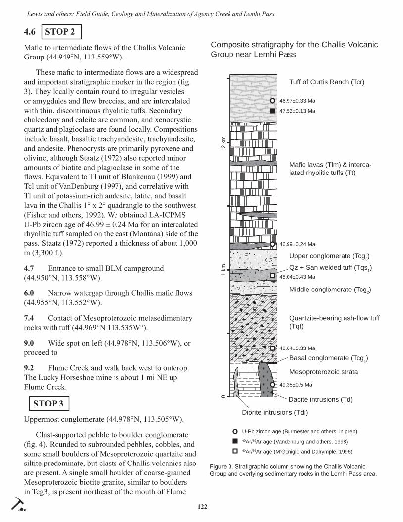
122
Lewis and others: Field Guide, Geology and Mineralization of Agency Creek and Lemhi Pass
4.6 STOP 2
Mafi c to intermediate fl ows of the Challis Volcanic Group (44.949°N, 113.559°W).
These mafi c to intermediate fl ows are a widespread and important stratigraphic marker in the region (fi g. 3). They locally contain round to irregular vesicles or amygdules and fl ow breccias, and are intercalated with thin, discontinuous rhyolitic tuff s. Secondary chalcedony and calcite are common, and xenocrystic quartz and plagioclase are found locally. Compositions include basalt, basaltic trachyandesite, trachyandesite, and andesite. Phenocrysts are primarily pyroxene and olivine, although Staatz (1972) also reported minor amounts of biotite and plagioclase in some of the fl ows. Equivalent to Tl unit of Blankenau (1999) and Tcl unit of VanDenburg (1997), and correlative with Tl unit of potassium-rich andesite, latite, and basalt lava in the Challis 1° x 2° quadrangle to the southwest (Fisher and others, 1992). We obtained LA-ICPMS U-Pb zircon age of 46.99 ± 0.24 Ma for an intercalated rhyolitic tuff sampled on the east (Montana) side of the pass. Staatz (1972) reported a thickness of about 1,000 m (3,300 ft).
4.7 Entrance to small BLM campground (44.950°N, 113.558°W).
6.0 Narrow watergap through Challis mafi c fl ows (44.955°N, 113.552°W).
7.4 Contact of Mesoproterozoic metasedimentary rocks with tuff (44.969°N 113.535W°).
9.0 Wide spot on left (44.978°N, 113.506°W), or proceed to
9.2 Flume Creek and walk back west to outcrop. The Lucky Horseshoe mine is about 1 mi NE up Flume Creek.
STOP 3
Uppermost conglomerate (44.978°N, 113.505°W).
Clast-supported pebble to boulder conglomerate (fi g. 4). Rounded to subrounded pebbles, cobbles, and some small boulders of Mesoproterozoic quartzite and siltite predominate, but clasts of Challis volcanics also are present. A single small boulder of coarse-grained Mesoproterozoic biotite granite, similar to boulders in Tcg3, is present northeast of the mouth of Flume
49.35±0.5 Ma
46.99±0.24 Ma
48.04±0.43 Ma
46.97±0.33 Ma
47.53±0.13 Ma
48.64±0.33 Ma
U-Pb zircon age (Burmester and others, in prep)40Ar/39Ar age (Vandenburg and others, 1998)40Ar/39Ar age (M’Gonigle and Dalrymple, 1996)
Mesoproterozoic strata
Tuff of Curtis Ranch (Tcr)
Mafic lavas (Tlm) & interca-lated rhyolitic tuffs (Tt)
Upper conglomerate (Tcg3)
Quartzite-bearing ash-flow tuff (Tqt)
Qz + San welded tuff (Tqs1)
Middle conglomerate (Tcg2)
Basal conglomerate (Tcg1)
Dacite intrusions (Td)
Diorite intrusions (Tdi)
Composite stratigraphy for the Challis Volcanic Group near Lemhi Pass
2 km
1 km
0
Figure 3. Stratigraphic column showing the Challis Volcanic Group and overlying sedimentary rocks in the Lemhi Pass area.

123
Lewis and others: Field Guide, Geology and Mineralization of Agency Creek and Lemhi Pass
Creek. Unit is equivalent to Blankenau’s (1999) mid-dle conglomerate of the sedimentary rocks of Tendoy (Flume Creek facies of Tcg3 unit) and portions of the conglomerate of Flume Creek of Staatz (1972; 1979).
10.1 STOP 4
Quartzite-bearing ash-fl ow tuff (44.973°N, 113.485°W).
Outcrop is on corner and some parking is available beyond the corner (wide spot at cattle guard = 9.0 mi). Parking also available on shoulders between here and next stop.
Exposure here is a distinctive Challis tuff that contains abundant angular dark gray to black quartzite
lithic fragments, less abundant quartz and plagioclase, and minor sanidine. Equiva-lent to Tcq unit of VanDenburg (1997) and Tqt unit of Blankenau (1999). The latter obtained a 40Ar/39Ar age on single sanidine crystals of 49.51 ± 0.14 Ma on a sample collected along Withington Creek about 30 km (18 mi) to the west–north-west in the Sal Mountain quadrangle. M’Gonigle and Dalrymple (1996) re-ported a 40Ar/39Ar weighted mean age of 48.64 ± 0.12 Ma from a sample collected near Lemhi Pass. Estimated to be as thick as 520 m (1,700 ft) in the area south of Lemhi Pass (Staatz, 1972), but thins to the south and is absent in the southeast part of map.
10.4 STOP 5
Copper Queen Mine fork—Road and creek crossing is rough and steep, so walking is probably better. Walk south-east about 2/3 of a mile to Copper Queen Mine (44.969°N, 113.477°W)
The Copper Queen Mine was the largest of several small copper mines and prospects in the Lemhi Pass region. Located on a small tributary of Agency Creek, the prospect was discovered and staked in 1883 by Mr. F.B. Sharkey and Mr. G. Chamberlain (Schipper, 1955). Mining commenced in 1906 with sink-ing of an inclined shaft, tunnel develop-ment, and erection of a small mill. The
property was worked for several years, with a small tonnage of high-grade copper–gold ore extracted (over 25% Cu and over 1 oz/ton Au, with signifi cant silver credit). Schipper (1955) detailed the mine’s history and noted that in 1954 the property was leased and the workings dewatered to the 250 level, allowing access for geological study.
Several open stopes and caved-in shafts were ob-served by IGS geologists in 2000. Rocks on the waste dumps provided excellent samples of the mineraliza-tion and host rocks. Subsequent safety closures have obscured some of the stopes and outcropping geology, but much should still be available for examination.
The Mesoproterozoic host rock here and at stop 11
Figure 4. Uppermost conglomerate near the mouth of Flume Creek.

124
Lewis and others: Field Guide, Geology and Mineralization of Agency Creek and Lemhi Pass
is currently mapped as “quartzite of the Continental Divide.” Like many Belt Supergroup units, it consists of feldspathic quartzite and siltite with minor argillite. Quartzite beds are as thick as 1 m but more commonly thinner. These are repeated in cosets, or interbedded with thinner beds of siltite. Contacts with siltite are more commonly sharp than graded. Sedimentary struc-tures include trough cross bedding, climbing ripple or ripple drift cross laminations, large loads, convolute bedding, and soft-sediment deformation. Internal lami-nation of quartzite is commonly even, centimeter-thick dark green to light coloration with little macroscopic grain size change, but platy partings have fi ne mus-covite on surfaces. Finer grained material is locally phyllite. Three quartzite samples south of here ranged from 32 to 80 percent quartz with the rest plagioclase. Youngest U-Pb ages of two detrital zircons isolated from samples collected near the Copper Queen Mine are 1,371 and 1,375 Ma (Gillerman, 2008), consis-tent with the unit being above the Swauger Forma-tion. Correlation with the Jahnke Lake member of the Apple Creek Formation currently is favored but not proven.
These metasedimentary rocks host mafi c intrusive rocks including a greenstone dike (or fl ow?) and py-roxene porphyry lamprophyres (fi g. 5). Lamprophyre intrusions occur elsewhere in the district, and are shown as Tertiary dikes on previous maps (e.g., Staatz, 1972, 1979). Phenocrysts include large pyroxenes, amphiboles, and pseudomorphs of olivine replaced by
talc and tremolite assemblages. The dikes are similar to alkaline basalt in chemistry.
Due to the unreactive nature of the quartzite, alter-ation is hard to fi nd, though some chloritic alteration, hornfels, and a weak iron stain are present. Potassium feldspar locally replaces the metamorphic muscovite in the metasedimentary rocks. The copper ores are contained in quartz veins with chalcopyrite, bornite, and sparse molybdenite (fi g. 6). Green secondary cop-per minerals can be found, but unoxidized, primary sulfi de minerals are also common on the dump. Schip-per (1955) described copper mineralization in the greenstone dike, and a sample of a chalcopyrite–cal-cite vein cutting pyroxene porphyry was found on the dump, proving that the base metal deposition was later than the mafi c intrusive event. Schipper also described a radioactive veinlet with copper and thorium that cuts the copper veins. Subhorizontal faults, which off set the quartz–copper veins, are exposed in the outcropping walls of the open stopes, which were partially fi lled by the closure work. These structures presumably formed during Cretaceous crustal shortening in the region (fi g. 7).
One sample of molybdenite from the waste dump at the Copper Queen Mine contained suffi cient Re to obtain a Re-Os date of 1,053 Ma, similar to ages obtained initially for the monazite cores (Gillerman and others, 2002). The Proterozoic age did correspond with literature reports of some type of “Grenville-age” thermal event in the region, but not with any known
geologic events in the Salmon region (Anderson and Davis, 1995). Subsequent work in Idaho has yielded more evi-dence for Grenville-age events in central Idaho. However, dating of the mafi c porphy-ries suggests that copper mineralization is more likely Cambrian in age. An 40Ar/39Ar age on hornblende in the pyroxene porphyry returned a messy “reset” age of about 400 Ma, with another horn-blende sample preserved in a calcite matrix breccia dated at 558 Ma ± 1.6 Ma with a good plateau age (Gillerman, 2008). Zircon isolated from a similar
Figure 5. Pyroxene porphyry from Copper Queen Mine dump. Note large euhedral pyroxene phenocrysts.

125
Lewis and others: Field Guide, Geology and Mineralization of Agency Creek and Lemhi Pass
Figure 6. Bornite in possible pull-aparts of boudinaged quartz–copper vein, Copper Queen Mine. No clear altera-tion envelope present, but diff use hornfels(?) developed in quartzite wall rock.
Figure 7. Gouge and low-angle faults cutting quartz–copper vein at Copper Queen Mine, adit 3, looking N12°E.
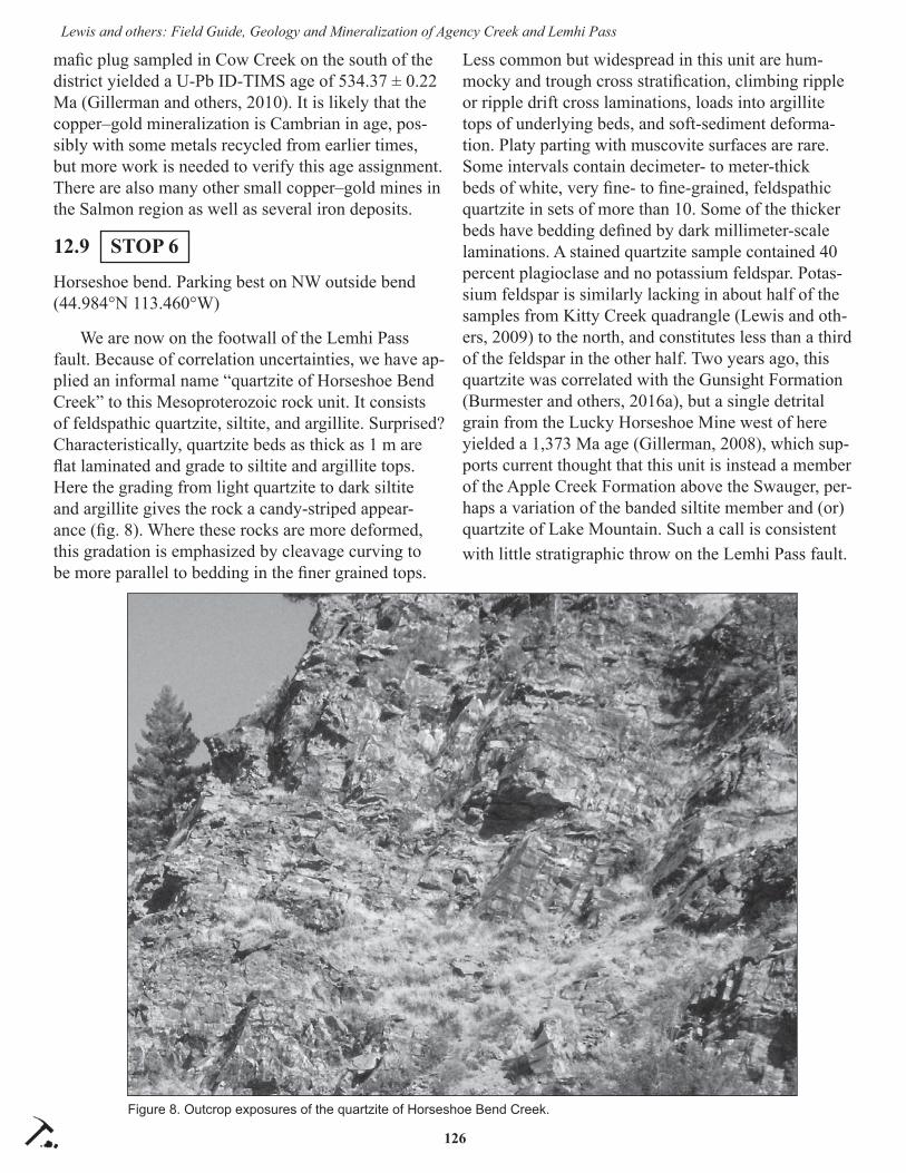
126
Lewis and others: Field Guide, Geology and Mineralization of Agency Creek and Lemhi Pass
mafi c plug sampled in Cow Creek on the south of the district yielded a U-Pb ID-TIMS age of 534.37 ± 0.22 Ma (Gillerman and others, 2010). It is likely that the copper–gold mineralization is Cambrian in age, pos-sibly with some metals recycled from earlier times, but more work is needed to verify this age assignment. There are also many other small copper–gold mines in the Salmon region as well as several iron deposits.
12.9 STOP 6
Horseshoe bend. Parking best on NW outside bend (44.984°N 113.460°W)
We are now on the footwall of the Lemhi Pass fault. Because of correlation uncertainties, we have ap-plied an informal name “quartzite of Horseshoe Bend Creek” to this Mesoproterozoic rock unit. It consists of feldspathic quartzite, siltite, and argillite. Surprised? Characteristically, quartzite beds as thick as 1 m are fl at laminated and grade to siltite and argillite tops. Here the grading from light quartzite to dark siltite and argillite gives the rock a candy-striped appear-ance (fi g. 8). Where these rocks are more deformed, this gradation is emphasized by cleavage curving to be more parallel to bedding in the fi ner grained tops.
Less common but widespread in this unit are hum-mocky and trough cross stratifi cation, climbing ripple or ripple drift cross laminations, loads into argillite tops of underlying beds, and soft-sediment deforma-tion. Platy parting with muscovite surfaces are rare. Some intervals contain decimeter- to meter-thick beds of white, very fi ne- to fi ne-grained, feldspathic quartzite in sets of more than 10. Some of the thicker beds have bedding defi ned by dark millimeter-scale laminations. A stained quartzite sample contained 40 percent plagioclase and no potassium feldspar. Potas-sium feldspar is similarly lacking in about half of the samples from Kitty Creek quadrangle (Lewis and oth-ers, 2009) to the north, and constitutes less than a third of the feldspar in the other half. Two years ago, this quartzite was correlated with the Gunsight Formation (Burmester and others, 2016a), but a single detrital grain from the Lucky Horseshoe Mine west of here yielded a 1,373 Ma age (Gillerman, 2008), which sup-ports current thought that this unit is instead a member of the Apple Creek Formation above the Swauger, per-haps a variation of the banded siltite member and (or) quartzite of Lake Mountain. Such a call is consistent with little stratigraphic throw on the Lemhi Pass fault.
Figure 8. Outcrop exposures of the quartzite of Horseshoe Bend Creek.

127
Lewis and others: Field Guide, Geology and Mineralization of Agency Creek and Lemhi Pass
12.2 STOP 7
Lemhi Pass (44.975°N 113.445°W)
Beware, the last stretch of road is steep and rough. Proceed into Montana 0.1 mi and stop on left near facility.
On August 12, 1805, Meriwether Lewis and three other members of the Lewis and Clark Expedition crossed the Continental Divide at Lemhi Pass. Lewis found a “large and plain Indian road” over the pass. This was the fi rst time that white men had seen pres-ent-day Idaho.
The Lemhi Pass fault strikes east–southeast to west–northwest across Lemhi Pass. It juxtaposes Mesoproterozoic rocks on the north against Tertiary rocks to the south. VanDenburg (1997), VanDenburg and others (1998), and Blankenau (1999) interpreted the structure as a 22° to 24° south-dipping detachment fault that likely formed at a higher angle before rotat-ing to its present dip during the latest phase of exten-sional faulting. Eocene volcanic and volcaniclastic deposits are interpreted to have accumulated in a half-graben formed by the Lemhi Pass fault, and therefore the fault’s minimum heave is roughly equivalent to the stratigraphic thickness of the Chal-lis group in this area, estimated as 1 km (VanDenburg and others, 1998). Gillerman (2008) speculated that the fault might have a prolonged history, however, and that Tertiary extension reactivated older structures including Neoproterozoic faults that contributed to localization of REE mineralization in this district, and possibly Creta-ceous thrust faults.
Walk or drive from Lemhi Pass SE along road toward Sacagawea picnic area. First exposures along the road are light-colored Challis tuff .
STOP 8
Quartz–sanidine tuff (44.973°N, 113.443°W)
Eocene quartz–sanidine welded tuff of the Challis Volcanic Group.
Unit contains sparse, euhedral to subhedral crystals of sanidine and quartz. Our estimate of maximum thick-ness is 60–90 m (200–300 ft). Equivalent to Tqs1 of Blankenau (1999). Locally mapped as vitric tuff of Lemhi Pass by Staatz (1972, 1979). M’Gonigle and Dalrymple (1996) reported an 40Ar/39Ar weighted mean age of 47.95 ± 0.12 Ma for this unit near Lemhi Pass.
Hike up the hill from Stop 8, or south from Lemhi Pass to Stop 9.
STOP 9
Mesoproterozoic boulders (44.973°N, 113.445°W)
Lag deposits of cobbles and boulders from Eo-cene conglomerate. Most are quartzite, but the unit includes distinctive cobbles and boulders of coarse-grained Mesoproterozoic biotite granite (fi g. 9) that are likely derived from exposures 40 km (25 mi) to the northwest (Burmester and others, 2016a). Rare garnet amphibolite cobbles have also been observed north of Agency Creek. Because of the general east dip of the Challis strata, these lag deposits have formed west of the actual surface exposures of the unit. Equivalent to
Figure 9. Small boulder of Mesoproterozoic granite south of Lemhi Pass that formed as a lag deposit. Weathered from Eocene conglomerate unit.

128
Lewis and others: Field Guide, Geology and Mineralization of Agency Creek and Lemhi Pass
the granite clast conglomerate (Tcg2) of Blankenau (1999), but mapped higher in the stratigraphic sec-tion in the area north of Agency Creek. Blankenau (1999), Janecke and others (2000), and Chetel and others (2011) postulated that an Eocene paleoriver fl owed through the Salmon basin and transported the granite clasts across the Beaverhead Range at Lemhi Pass. As thick as 150 m (500 ft), but thins southward and is absent in the southern part of the Lemhi Pass quadrangle.
Drive or walk south along the Continental Divide Trail about 1.4 mi from Lemhi Pass and stop before the trees. Follow the track to the WNW 0.3 to 0.4 mi through trees to exploration pits.
STOP 10
Fine-grained syenite plug 1.9 km (1.2 mi) south-southwest of Lemhi Pass (44.959°N, 113.453°W)
Field mapping in 2006 discovered a series of trenches that exposed an outcrop of syenite, a feld-spar-rich, low-silica intrusive rock. Though not shown on Staatz’s (1979) detailed map of the district, the sy-enite was shown on a thesis map by Hansen (1983). The syenite consists largely of inclusion-rich potas-sium feldspar with few mafi c minerals and local specular hematite alteration. It crops out primarily in dozer cuts and does not exhibit any deformational fabric where seen, but it looks “old.” Check out 44.9586°N, 113.4548°W for pit with non-veined rock, 44.9584°N, 113.4535°W for pit with veining. Prospecting the trench with a Geiger counter failed to fi nd anomalous radioactivity.
The tan-colored syenite intrudes the Proterozoic quartzite and is locally cut by specular hematite veins (fi g. 10). The syenite contains about 64 weight percent SiO2 and 10 percent alkalis. The rock is largely composed of feldspar laths of orthoclase, mantled with albite rims. While a few grains of original biotite are present locally, most of the dark grains in the rock are now specular hematite proba-bly replacing the biotite. A trace amount of interstitial quartz is also present. Zircons from the syenite were dated with U-Pb methods on the SHRIMP at Canberra, Australia, and returned an age of 529.1 ± 4.5 Ma, or earliest Cambrian (fi g. 11; Gillerman and others, 2008, 2010).
The spatial and temporal coincidence of felsic and
mafi c alkaline igneous rocks at Lemhi Pass indicate a bimodal magmatic, possibly rift-related event in the region at about 530 Ma. The Lemhi Pass alkaline rocks are part of a northwest-trending belt of Neopro-terozoic to early Paleozoic age alkaline intrusives that
Figure 10. Hand specimen of syenite from prospect trench showing cross-cutting specular hematite alteration.
Figure 11. Isochron plot of geochronology results for Lemhi Pass syenite sample JA06-01A. Best age of crystallization is 529 Ma ± 4.5 Ma, or lower Cambrian (from Gillerman, 2008; Gillerman and others, 2008).

129
Lewis and others: Field Guide, Geology and Mineralization of Agency Creek and Lemhi Pass
extend from the Beaverhead Mountains into central Idaho. Unfortunately, no detailed geophysical surveys, which could potentially delineate buried intrusive complexes, are available for the region. The bimodal character of the Lemhi Pass Cambrian suite is evident in trace element geochemistry, as shown on a plot of Nb versus Th to demonstrate the highly evolved com-position of the syenite (fi g. 12; Gillerman, 2008).
Proceed about 2.3 mi along the divide trail, then turn off to the northwest for another quarter of a mile to 44.951°N, 113.486°W. No guarantee that the road is drivable. The last part drops about 400 ft.
STOP 11
Cago Th-REE Mine (optional) (44.951°N, 113.486°W)
The Cago Mine is located at the end of a mile-long narrow jeep trail that diverges off the Continental Divide road approximately 2 mi southwest of Lemhi
Pass. Turn-around spots are few but the stop is easily accessible by foot and provides an excellent expo-sure of the thorium-REE-iron oxide veins. The Cago vein trends northwest and dips moderately southwest into the hillside. It is approximately 6 ft thick where exposed in the trench. The Cago vein is on trend with, and likely an extension of, the Last Chance vein, which is located on the Montana side of the district. The Last Chance vein was explored into the 1980s with underground adits, and a small resource of Th-REE ore developed. REE is the abbreviation for “rare earth elements” and defi nes the row of elements on the periodic table from lanthanum with atomic number 57 and the extra row from atomic number 58 (cerium) through atomic number 71 (lutetium). REEs share similar chemical properties and are referred to as the lanthanides. See Gillerman (2011) for a summary of the REE deposits in Idaho. A sample of the vein and adjacent wall rock is shown in fi gure 13.
Figure 12. Plot of Nb versus Th for Lemhi Pass and regional intrusive samples. Circles = Eocene volcanics; dark diamonds = Cambrian syenites; lighter diamonds = Paleozoic granites near Leadore; triangles = Cambrian-age mafi c dikes; solid square = Lucky Horseshoe ultramafi c sill; crosses in squares = regional Precambrian megacrystic granite. The syenite is the most enriched in Th and Nb, as well as alkalis and REE. Syenite labeled A.C. is from north of Agency Creek in the western part of the area.

130
Lewis and others: Field Guide, Geology and Mineralization of Agency Creek and Lemhi Pass
Most of the thorium deposits in the district are quartz veins, and the quartz has a distinctive waxy to greasy luster. The quartz veins are typically fi ne grained and strongly colored in shades of pink to brown due to abundant hematite and thorite in them. The veins are steep to moderately dipping, of vari-able size, and share an assemblage of quartz–hema-tite–thorite with alkali feldspar and lesser but variable amounts of apatite, monazite, biotite, barite, carbon-ate, fl uorite, and allanite. Thin sections from the Cago vein and others show that the muscovite in the host quartzite is converted to potassium feldspar adjacent to the vein though alteration extends only a few feet away from the vein (Gillerman, 2008). Locally, albite twins are visible, but most of the potassium feldspar is untwinned and occurs in patchy masses near the veins. Microprobe analyses also detected albite and rutile in altered zones. Brecciation and crackle veins are com-mon to all the thorium deposits, and multi-generation-al strained quartz is typical.
The major rare-earth-bearing mineral in the district is monazite, a REE-bearing phosphate (Ce, La, Y, Th, U) PO4 that is not visible in hand sample. The major
thorium-bearing mineral is thorite, a silicate with the formula: (Th, U)SiO4. Thorite is typically a reddish brown to brown with resinous luster; it looks very similar to hematite. The thorite is also microscopic in grain size and highly radioactive.
The primary gangue mineral, in addition to quartz, is specular hematite. It is intergrown with the thorite and abundant. Extensive weathering has produced a variety of reddish to brownish earthy hematite- and goethite-coated material in and near the veins. A few of the veins contain traces of copper minerals as well. In the Lemhi Pass area, there is very little uranium or thorium in the monazite. Instead, the deposits and monazites are unusually enriched in the rare earth ele-ment neodymium (Nd). Most monazites contain higher values of the lighter REEs, La and Ce. Monazites from the Lucky Horseshoe deposit contain 35 weight percent Nd oxide in their lattice, approximately double that of other monazites. Globally, Nd is particularly sought after for applications such as magnets.
A special in situ U-Pb electron microprobe chemi-cal age-dating technique developed at the University
Figure 13. Pink quartz–potassium feldspar–specular hematite–thorite vein from the Cago prospect. The white outer envelope contains additional potassium feldspar plus albite and rutile.

131
Lewis and others: Field Guide, Geology and Mineralization of Agency Creek and Lemhi Pass
of Massachusetts was used to date the monazites from the Lucky Horseshoe replacement deposit. That material contains lenses with abundant monazite that is easily visible in thin section. Monazite crystals will typically take in uranium but not much lead due to crystallographic constraints; thus any lead present in the crystal has formed from radiogenic decay. Whole-rock geochemistry confi rms that there was very little lead in the Lemhi Pass hydrothermal system, so if one can measure the trace amounts of uranium and lead in the monazites with electron probe microanalysis, an age can be determined. Chemical mapping of the monazites revealed domains of distinct composition, with cracks and rims that correspond to areas reset in the Cretaceous. Ages of the monazite cores and ages on the thorites overlap with a range from about 400 to 300 Ma. A best estimate of 355 Ma corresponds to late Devonian or earliest Mississippian in age. In addition, the ages on four zircon crystals derived from an ultra-mafi c sill below the Lucky Horseshoe Mine were mea-sured by U-Pb methods using ID-TIMS. The resulting U-Pb age of 315 Ma may represent an igneous crystal-lization age or a hydrothermal age, but it does provide an independent confi rmation of a Mississippian event at Lemhi Pass (Gillerman and others, 2010). Whether some of the Th-REE mineralization elsewhere in the district is older remains an open question. Additional regional mapping and geochronologic study would better confi rm the age and origin of Idaho’s regional-scale REE-Th-Fe mineralization, as many questions remain for discussions and debate (Gillerman, 2011; Gillerman and others, 2013).
END OF TRIP
REFERENCES CITED
Anderson, A.L., 1958, Uranium, thorium, columbium, and rare earth deposits in the Salmon region, Lemhi County, Idaho: Idaho Bureau of Mines and Geology Pamphlet 115, 81 p.
Anderson, A.L., 1961, Thorium mineralization in the Lemhi Pass area, Lemhi County, Idaho: Econom-ic Geology, v. 56, no. 1, p. 177–197.
Anderson, H.E., and Davis, D.W., 1995, U-Pb geo-chronology of the Moyie sills, Purcell Super-group, southeastern British Columbia: Implica-tions for the Mesoproterozoic geological history of the Purcell (Belt) basin: Canadian Journal of Earth Sciences, v. 32, p. 1180–1193.
Blankenau, J.J., 1999, Cenozoic structural and strati-graphic evolution of the southeastern Salmon Basin, east-central Idaho: Logan, Utah State Uni-versity, M.S. thesis, 143 p., 3 plates.
Burmester, R.F., Lewis, R.S., Othberg, K.L., Stanford, L.R., Lonn, J.D., and McFaddan, M.D., 2016a, Geologic map of the western part of the Salmon 30’ x 60’ quadrangle, Idaho and Montana: Idaho Geological Survey Geologic Map 52, scale 1:75,000.
Burmester, R.F., Lonn, J.D., Lewis, R.S., and McFad-dan, M.D., 2016b, Stratigraphy of the Lemhi subbasin of the Belt Supergroup, in MacLean, J.S., and Sears, J.W., eds., Belt Basin: Window to Mesoproterozoic Earth: Geological Society of America Special Paper 522, p. 121–137.
Chetel, L.M., Janecke, S.U., Carroll, A.R., Beard, B.L., Johnson, C.M., and Singer, B.S., 2011, Pa-leogeographic reconstruction of the Eocene Idaho River: Geological Society of America Bulletin, v. 123, no. 1/2, p. 71–88.
Fisher, F.S., McIntyre, D.H., and Johnson, K.M., 1992, Geologic map of the Challis quadrangle, Idaho: U.S. Geological Survey Miscellaneous Investiga-tions Series Map I-1819, scale 1:250,000.
Gibson, P.E., 1998, Origin of the Lemhi Pass REE-Th deposits, Idaho/Montana: Petrology, mineralogy, paragenesis, whole-rock chemistry and isotope evidence: Moscow, University of Idaho, M.S. thesis, 320 p.
Gillerman, V.S., 2008, Geochronology of iron oxide-copper-thorium-REE mineralization in Proterozo-ic rocks at Lemhi Pass, Idaho, and a comparison to copper-cobalt ores, Blackbird mining district, Idaho: Final Technical Report to U.S. Geologi-cal Survey, December, 149 p. MRERP Award #06HQGR0170, https://minerals.usgs.gov/mrerp/reports.html#2006
Gillerman, V.S., 2011, Rare earth elements and other critical metals in Idaho: Idaho Geological Survey GeoNote 44, 4 p.
Gillerman, V.S., Fanning, C.M., Link, P.K., Layer, P., and Burmester, R.F., 2008, Newly discovered intrusives at the Lemhi Pass thorium-REE-iron oxide district, Idaho: Cambrian syenite and mys-tery ultramafi cs: Signatures of a buried alkaline complex or two systems?: Geological Society of
132
Lewis and others: Field Guide, Geology and Mineralization of Agency Creek and Lemhi Pass
America Abstracts with Programs, v. 40, no. 1, p. 51.
Gillerman, V.S., Jercinovic, M.J., and Stein, H.J., 2002, U-Pb and Re-Os geochronology suggest a multistage Precambrian-Mesozoic history for thorium and copper mineralization, Lemhi Pass, Idaho: Geological Society of America Abstracts with Programs, v. 34, no. 6, p. 337.
Gillerman, V.S., Lund, K., and Evans, K.V., 2003, Stratigraphy, structure, and mineral deposits of the Lemhi Pass area, central Beaverhead Moun-tains, eastern Idaho: Northwest Geology, v. 32, p. 134–146.
Gillerman, V.S., Otto, B.R., and Griggs, F., 2000, Lemhi Pass Thorium District: A variant of Pro-terozoic iron oxide (Cu-U-Au-REE) deposits?: Geological Society of America Abstracts with Programs, v. 32, no. 7, p. 83.
Gillerman, V.S., Otto, B., and Griggs, F.S., 2006, Site inspection report for the abandoned and inactive mines in Idaho on U.S. Bureau of Land Manage-ment property in the Lemhi Pass area, Lemhi County, Idaho: Idaho Geological Staff Report S-06-4, 170 p.
Gillerman, V.S., Schmitz, M.D., Jercinovic, M.J., and Reed, R., 2010, Cambrian and Mississippian magmatism associated with neodymium-enriched, rare-earth and thorium mineralization, Lemhi Pass district, Idaho: Geological Society of Ameri-ca Abstracts with Programs, v. 42, no. 5, p. 334.
Gillerman,V.S., Schmitz, M.D., and Jercinovic, M.J., 2013, REE-Th deposits of the Lemhi Pass region, northern Rocky Mountains—Paleozoic magmas and hydrothermal activity along a continental margin: Geological Society of America Abstracts with Programs, v. 45, no. 5, p. 41.
Hansen, P.M., 1983, Structure and stratigraphy of the Lemhi Pass area, Beaverhead Range, southwest Montana and east-central Idaho: University Park, Pennsylvania State University, M.S. thesis, 112 p.
Janecke, S.U., VanDenburg, C.J., Blankenau, J.J., and M’Gonigle, J.W., 2000, Long-distance longitu-dinal transport of gravel across the Cordilleran thrust belt of Montana and Idaho: Geology, v. 28, no. 5, p. 439–442.
Lewis, R.S., Burmester, R.F., Stanford, L.R., Lonn, J.D., McFaddan, M.D., and Othberg, K.L., 2009,
Geologic map of the Kitty Creek quadrangle, Lemhi County, Idaho and Beaverhead County, Montana: Idaho Geological Survey Digital Web Map 112 and Montana Bureau of Mines and Ge-ology Open-File Report 582, scale 1:24,000.
M’Gonigle, J.W., and Dalrymple, G.B., 1996, 40Ar/39Ar ages of some Challis Volcanic Group rocks and the initiation of Tertiary sedimentary basins in southwestern Montana: U.S. Geological Survey Bulletin 2132, 17 p.
Schipper, W.B., 1955, The Tendoy Copper Queen Mine: Moscow, University of Idaho, M.S. thesis, 38 p.
Sharp, W.N., and Cavender, W.S., 1962, Geology and thorium-bearing deposits of the Lemhi Pass area, Lemhi County, Idaho, and Beaverhead County, Montana: U.S. Geological Survey Bulletin 1126, 76 p.
Staatz, M.H., 1972, Geology and description of the thorium-bearing veins, Lemhi Pass quadrangle, Idaho and Montana: U.S. Geological Survey Bul-letin 1351, 94 p., 2 plates.
Staatz, M.H., 1979, Geology and mineral resources of the Lemhi Pass thorium district, Idaho and Mon-tana: U.S. Geological Survey Professional Paper 1049-A, 90 p.
Staatz, M.H., Shaw, V.E., and Wahlberg, J.S., 1972, Occurrence and distribution of rare earths in the Lemhi Pass thorium veins, Idaho and Montana: Economic Geology, v. 67, p. 72–82.
Umpleby, J.B., 1913, Geology and ore deposits of Lemhi County, Idaho: U.S. Geological Survey Bulletin 528, 182 p.
VanDenburg, C.J., 1997, Cenozoic tectonic and paleo-geographic evolution of the Horse Prairie half-graben, southwest Montana: Logan, Utah State University, M.S. thesis, 152 p., 2 plates.
VanDenburg, C.J., Janecke, S.U., and McIntosh, W.C., 1998, Three-dimensional strain produced by >50 My of episodic extension, Horse Prairie basin area, SW Montana, U.S.A.: Journal of Structural Geology, v. 20, issue 12, p. 1747–1767.

133Northwest Geology, v. 46, 2017, p. 133–142 The Journal of the Tobacco Root Geological Society
FIELD GUIDE TO COMPRESSIONAL STRUCTURES ALONG THE WESTERN MARGIN OF THE SOUTHERN BEAVERHEAD MOUNTAIN RANGE, SCOTT BUTTE 7.5’ QUADRANGLE, EAST-CENTRAL IDAHO
William W. Little and Robert W. ClaytonBrigham Young University–Idaho, Rexburg, Idaho 83460
INTRODUCTION
The Brigham Young University–Idaho Advanced Field Methods course (fi eld camp) has conducted bedrock geologic mapping in the southern Beaverhead Mountain Range of east-central Idaho for 13 yr (Clay-ton and Little, 2009, 2014; Roemer and others, 2007; Bagley and Little, 2009; Little and others, 2010). Additional mapping has been and continues to be done by other workers, with signifi cant diff erences among interpretations (Skipp, 1985; Embree, in review; Abplanalp and others, 2008; Pearson, pers. commun., 2017). The primary contribution of our work is iden-tifi cation of previously undescribed compressional structures along the western fl ank of the range, includ-ing: (1) a north-trending thrust fault, referred to here as the Copper Mountain Thrust Fault, that consistently places the Mississippian Scott Peak through Surrett Canyon formations over the interbedded Mississippian Big Snowy/Arco Hills interval, (2) high-angle reverse faults at the core of fault propagation folds, and (3) large-scale overturned and recumbent folds. From outcrop to range scale, folds are asymmetrical, east to northeast vergent, and found in the hanging wall of the Copper Mountain thrust. Footwall strata are relatively undeformed, other than an initial relatively steep dip that fl attens to the west away from the fault. These structural features represent deformation associated with east to northeast compression and displacement in development of the Medicine Lodge thrust sheet during the Cretaceous Sevier orogenic event. The compressional features have subsequently been dis-sected by north- to northwest-trending normal faults related to Late Miocene to Recent Basin-and-Range extension, as well as west-trending normal faults, pos-sibly caused by extension during Late Miocene pas-sage of the area over the Yellowstone Hot Spot.
Stratigraphically, the southern Beaverhead Range consists of a thick succession of Middle Proterozoic through Permian strata dominated by Mississippian and Pennsylvanian carbonates (Sandberg, 1975; Skipp
and others, 1979; Wardlaw and Pecora, 1985; Batt and others, 2007; Billman & Little, 2007; Isaacson and others, 2007), many of which are highly similar in appearance, making some structural interpretations diffi cult as these units are juxtaposed by faulting or repeated in overturned folds. However, subordinate sandstone and mudstone intervals serve as stratigraph-ic markers that, in most cases, allow proper interpre-tation of stratigraphic position. The Paleozoic suc-cession is underlain to great depth by Middle to Late Proterozoic sandstones (Skipp and Link, 1992; Little and Little, 2009).
The purpose of this half-day trip is to visit out-crops that show structural features, primarily the Copper Mountain Thrust Fault, and to follow these structures from south to north to observe changes in character and expression. This trip will focus on fea-tures found on the Scott Butte, Idaho 7.5-minute quad-rangle, beginning at the intersection of Idaho State Highway 28 and a gravel road just south of the south-ern tip of the mountain range and progressing through Petersen, Deadman, Bloom, and Spring Canyons. Stops are shown on a highly preliminary geologic map (fi g. 1) and stratigraphic units are listed and described in table 1.
FIELD TRIP
STOP 1
Highway 28 (Basin and Range overview)
The Beaverhead Mountain Range forms a Basin and Range horst, bordered both to the west and the east by deeply fi lled grabens (fi g. 2). A down to the west bounding normal fault defi nes the western mar-gin of the range at its southern end and steps eastward near Copper Mountain. A second down to the west normal fault, here called the Reno Gulch Fault, is pres-ent within the horst to the east of the range-front fault, where it displaces the base of the Snaky Canyon For-mation by approximately 5,000 ft. Displacement on

134
Little and Clayton: Field Guide, Compressional Structures along the Southern Beaverhead Mountain Range
Figure 1. Preliminary geologic map of the Beaverhead Mountains portion of the Scott Butte, Idaho 7.5-minute quad-rangle showing localities visited during the fi eld trip.
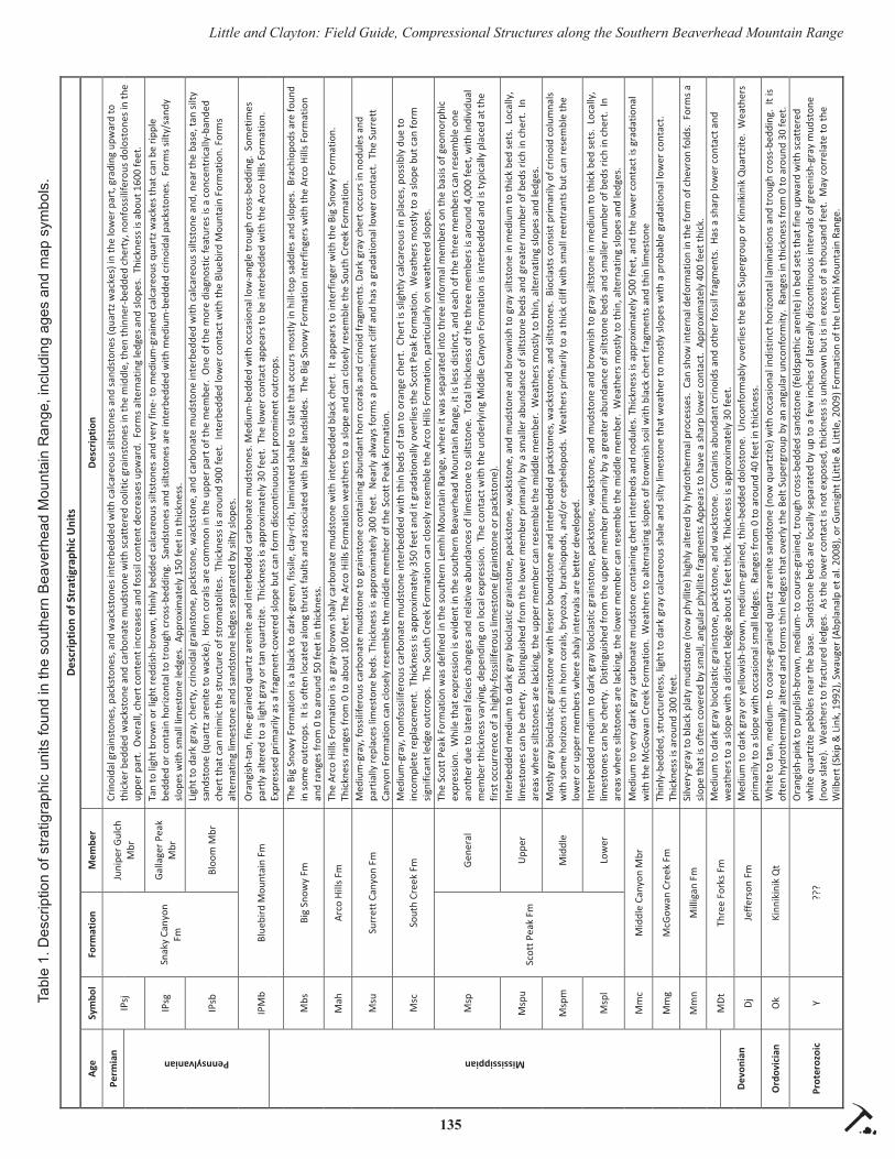
135
Little and Clayton: Field Guide, Compressional Structures along the Southern Beaverhead Mountain RangeTa
ble
1. D
escr
iptio
n of
stra
tigra
phic
uni
ts fo
und
in th
e so
uthe
rn B
eave
rhea
d M
ount
ain
Ran
ge, i
nclu
ding
age
s an
d m
ap s
ymbo
ls.

136
Little and Clayton: Field Guide, Compressional Structures along the Southern Beaverhead Mountain Range
the Reno Gulch Fault decreases over a relatively short distance northward to zero near Copper Mountain.
STOP 2
Petersen Canyon (stratigraphic and structural over-views)
Several brief stops will be made in Petersen Canyon to become familiar with stratigraphic units, including exposures of Proterozoic sandstone and the Milligen, McGowan Creek, Middle Canyon, Scott Peak, Arco Hills, Big Snowy, and Bluebird Mountain Formations. The Kinnikinik Quartzite, Jeff erson For-mation, and Three Forks Formation are not present in Petersen Canyon, presumably because of nondeposi-tion over an early Paleozoic topographic high, as each of these units progressively overlies the Proterozoic sandstone and thickens to the north.
From the hilltop saddle, both the Copper Mountain and Reno Gulch faults are clearly visible (fi g. 3). To the east, the Reno Gulch Fault is expressed as a steep cliff composed primarily of the Scott Peak Formation but capped by the Bloom Member of the Snaky Can-yon Formation. At the base of the cliff , on the down-thrown block, are nearly vertical beds of the Snaky Canyon Formation, most likely the Bloom Member. Immediately to the west, a less distinct ridge is com-posed of Scott Peak limestones, but the topographic expression is very diff erent from that of the eastern cliff .
During the fi rst year we had students mapping the area, our initial interpretation was that a second nor-mal fault was present, in this case down to the east. This would provide a simple explanation to topo-graphically low exposures of Pennsylvanian Snaky Canyon Formation between two topographically high
Figure 2. Google Earth images showing the horst nature of the Beaverhead Mountains block, with an inset showing location of the Cop-per Mountain Thrust and Reno Gulch faults discussed at localities 2 through 6.

137
Little and Clayton: Field Guide, Compressional Structures along the Southern Beaverhead Mountain Range
outcrops of Mississippian Scott Peak Formation, as a simple graben between two horsts. However, con-tinued mapping the next season eliminated that hy-pothesis, as the structure could not be carried to the north. The reason now is quite clear. To the north, it is evident that the Scott Peak and underlying units are highly folded, whereas those of the Snaky Canyon Formation are nearly vertical but otherwise show little deformation. The contact between the Scott Peak and Snaky Canyon Formations makes a marked V pattern dipping to the west. Additionally, along the canyon fl oor, the Scott Peak Formation is in structural contact with the Arco Hills Formation, cutting out the South Creek and Surrett Canyon Formations. A similar relationship is present on this saddle, as we can walk across vertical beds of the Bluebird Mountain and Big Snowy formations into the Scott Peak Formation. Our revised interpretation is that this structure is a thrust fault (Copper Mountain Thrust) dipping to the west, in which the upper plate is highly deformed, and the lower plate is tilted but less deformed, a pattern that persists the entire length of the fault and that is also present in fault propagation folds.
STOP 3
Road between Petersen and Deadman Canyons (large-scale overturned fold)
A large-scale overturned fold that, within some canyons, appears to be nearly recumbent (fi g. 4), is mapped from at least the mouth of Petersen Canyon to the mouth of Long Canyon. The general expression, scale, and extent of this fold can be observed as we drive along a mountain front dirt road. We will make one brief stop for discussion and photographs.
STOP 4
Deadman Canyon (drive through the fold)
Deadman Canyon provides an opportunity to drive along the axis of the overturned fold (fi g. 5) and see diffi culties associated with proper identifi cation of stratigraphic units. On the geologic map (fi g. 1), there is a distinctive west-trending horst bound by two nor-mal faults that cut across the Copper Mountain Thrust Fault. This interpretation is based on the entire horst
Figure 3. Structural relationships looking north from the saddle at the head of Petersen Canyon.
Figure 4. Recumbent fold that forms the mountain front from Deadman Canyon at the south end (right side of photo) to Long Canyon in the north (left side of photo).

138
Little and Clayton: Field Guide, Compressional Structures along the Southern Beaverhead Mountain Range
being composed of Scott Peak Formation limestones at the surface. However, a recent visit to the canyon has suggested that limestones at the eastern end of the block might actually be the Surrett Canyon Formation, forming a normal stratigraphic succession that would either eliminate or move the fault boundaries. This re-lationship needs further analysis before making a fi nal determination. In part, this confl ict refl ects a change in our understanding of area stratigraphy as our map-ping has progressed from south to north and we have become better acquainted with stratigraphic units. We are now revisiting earlier mapped southern localities and making reassessments based on this improved stratigraphic understanding before producing a fi nal geologic map. Other west-trending faults are present along the mountain front and are thought to be the result of passage of the region over the Yellowstone hotspot during latest Miocene.
STOP 5
Bloom Canyon
Bloom Canyon provides the next opportunity to visibly trace the Copper Mountain Thrust and Reno Gulch faults.
STOP 6
Spring Canyon (cross-sectional view of the Copper Mountain Thrust Fault)
The head of Spring Canyon is near the point at which the Reno Gulch Fault terminates to the north and provides the northernmost easily accessible view of the Copper Mountain Thrust Fault before the fault cuts through the range to the eastern side near the base of Copper Mountain. In the distance, a ridge-top sad-dle between Bare Canyon and Long Canyon exposes an excellent cross section of the Copper Mountain
Thrust Fault (fi g. 6A). As at previous localities, the upper plate consists of intensely deformed Upper Scott Peak and South Creek Formations (fi gs. 6B and C), which, once again, override the Arco Hills/Big Snowy interval. Stratigraphic units in the lower plate dip to the west, away from the fault, and fl atten away from the fault to the east. This ridge represents the most clear and dramatic exposure of the Copper Mountain Thrust Fault. Figure 6D shows the same locality but viewed from the north.
Unvisited Localities (Fault Propagation Fold)A well-developed fault propagation fold, and sev-
eral smaller such folds, occur in the highly deformed upper plate of the Copper Mountain Thrust Fault to the west of and structurally above the persistent large-scale overturned fold. It fi rst appears near the mouth of Spring Canyon (fi g. 7A) and becomes well exposed between Long and Skull Canyons (fi gs. 7B and 7C) to the north of the fi eld trip area on the Copper Mountain and Blue Dome, Idaho quadrangles. Because of con-straints of time and outcrop accessibility, these fea-tures will not be visited as part of this trip; however, as they represent a signifi cant part of the compressional-tectonic story, we feel it important to bring them to light and include a few pertinent photographs.
SUMMARY
Compressional and extensional tectonic features formed during the Sevier, and Basin and Range, tec-tonic events, respectively, are well exposed in a highly deformed Proterozoic through Paleozoic stratigraphic succession along the western margin of the southern Beaverhead Mountain Range. Dominant compres-sional structures include the Copper Mountain Thrust Fault, in which the upper plate is highly deformed resulting from overturned and fault-propagated
Figure 5. Recumbent fold as expressed along the north wall of Deadman Canyon.

139
Little and Clayton: Field Guide, Compressional Structures along the Southern Beaverhead Mountain Range
Figure 6. Copper Mountain Thrust Fault as seen from the south in the saddle between Bare and Long Canyons. Extensive upper plate deformation in the middle and upper Scott Peak Formation is shown in fi gures 6B and 6C, respectively, which were taken immediately to the west of 6A. Figure 6D shows the same relationship from the north.

140
Little and Clayton: Field Guide, Compressional Structures along the Southern Beaverhead Mountain Range
Figure 7. Fault propagation folds. Figure 7A was taken a short distance inside the mouth of Spring Canyon and is possibly the southern-most exposure of these features. Figure 7B shows a small fault propagation fold within Goddard Canyon, the next canyon north of Long Canyon, and is one of several such folds within that canyon. Figure 7C represents a completely exhumed, well-developed fault propa-gation fold in an unnamed small canyon just north of Goddard Canyon that continues northward to Skull Canyon, where it appears to pass away from the mountain front and into the valley, where it is cut off by the range-front fault. Displacement along the fault at the core of this fold is probably just a few feet, as intensely folded limestones of the Surrett Canyon Formation on the west (upper plate) are juxtaposed against nearly undeformed Surrett Canyon Formation limestones on the eastern side (lower plate), in similar fashion to the Copper Mountain Thrust Fault. Figure 7D is an enlargement of the upper part of the structure in 7C.

141
Little and Clayton: Field Guide, Compressional Structures along the Southern Beaverhead Mountain Range
folding, and the lower plate is relatively undeformed, demonstrating only a simple fl attening of dip away from the fault. The primary extensional structure is the Reno Gulch Fault, which shows a signifi cant amount of displacement at the southern end of the range but terminates northward. These features are easily viewed and traced through several canyons that dissect the mountain range. Work remains to resolve discrepan-cies in the current map interpretation of this complex region.
ACKNOWLEDGMENTS
We are grateful to Glenn F. Embree for introduc-ing us to the Beaverhead Mountain Range in the early 2000s and for sharing his prior mapping expertise in this area. Well over 100 undergraduate students and their TAs have participated in mapping exercises since 2005 as part of the BYU–Idaho Advanced Field Methods course, better known as “fi eld camp,” pro-viding the basic data for the current map compilation. A few students, including Stefanie Roemer, M. Evan Bagley, and Daniel W. Little, performed early compi-lations of their respective fi eld camp groups as senior research projects. These were subsequently presented at professional meetings and have been referenced in this report. Mark D. Lovell stepped in during years that one or the other of us could not participate, and Blake Rothlisberger assisted in preparation of fi gures. The work could not have been conducted without time and funding provided by Brigham Young University–Idaho.
REFERENCES CITED
Abplanalp, J.M., Pink, C., Pope, M.C., and Watkin-son, J.A., 2008, Geologic map of the southern Beaverhead range (parts of Copper Mountain, Shamrock Gulch, Scott Butte, and Snaky Canyon quadrangles), Clark, Jeff erson, and Lemhi Coun-ties, east-central Idaho: Idaho Geological Survey Technical Report T-08-1.
Bagley, M.E., and Little, W.W., 2009, Preliminary bedrock geologic map of a portion of the Copper Mountain, ID 7.5- minute quadrangle, Beaver-head Mountains, Clark County, Idaho: Abstracts with Programs, Rocky Mountain Section Meeting of the Geological Society of America, Orem, UT, v. 41, no. 6, p. 50.
Batt, L.S., Pope, M.C., Isaacson, P.E., Montañez, I.,
and Abplanalp, J., 2007, Upper Mississippian Antler foreland basin carbonate and siliciclastic rocks, east-central Idaho and southwestern Mon-tana, U.S.A.: Distinguishing tectonic and eustatic controls on deposition, in Lukasik, J., and Simo, J.A., eds., Controls on carbonate platform and reef development: SEPM Special Publication No. 89, p. 147–170.
Billman, G.S., and Little, W.W., 2007, Correlation of Mississippian and Pennsylvanian strata in the southern Beaverhead Mountain Range, Idaho: Rocky Mountain Section Meeting of the Ameri-can Association of Petroleum Geologists, Snow-bird, Utah.
Clayton, R.W., and Little, W.W., 2009, New interpre-tations of Sevier thrust belt structures, southern Beaverhead Mountains, Idaho: Abstracts with Programs, Annual Meeting of the Geological Society of America, Portland, Ore., v. 41, no. 7, p. 294.
Clayton, R.W., and Little, W.W., 2014, Geologic mapping in the southern Beaverhead Mountains, eastern Idaho (west side): New structural interpre-tations: Abstracts with Programs, Rocky Moun-tain and Cordilleran Sections Joint Meeting of the Geological Society of America, Bozeman, MT, v. 46, no. 5, p. 91.
Embree, G.F., in review, Bedrock geologic map of the Copper Mountain quadrangle: Idaho Geological Survey.
Isaacson, P.E., Grader, G.C., Pope, M.C., Montañez, I.P., Butts, S.H., Batt, L.S., and Abplanalp, J.M., 2007, Devonian-Mississippian Antler foreland basin carbonates in Idaho: Signifi cant subsidence and eustasy events: The Mountain Geologist, v. 44, no. 3, p. 119–140.
Little, D.W., and Little, W.W., 2009, Identifi cation and correlation of Precambrian fl uvial units in the southern Beaverhead Mountain Range, Idaho: Abstracts with Programs—Geological Society of America, v. 41, issue 6, 49 p.
Little, D.W., Little, W.W., Lovell, M., and Clayton, R.W., 2010, Newly identifi ed compressional structures along the western margin of the south-ern Beaverhead Mountain Range, Idaho: Ab-stracts with Programs, Annual Meeting of the Geological Society of America, Denver, CO, v. 22, no. 5, p. 266.
142
Little and Clayton: Field Guide, Compressional Structures along the Southern Beaverhead Mountain Range
Roemer, S., Little, W.W., and Clayton, R.W., 2007, Complex deformation of Paleozoic strata due to folding and faulting in the southern Beaverhead Mountains, Clark County, Idaho: Rocky Moun-tain Section Meeting of the American Association of Petroleum Geologists, Snowbird, Utah.
Sandberg, C.A., 1975, McGowan Creek Formation, New name for Lower Mississippian fl ysch se-quence in east-central Idaho: U.S. Geological Survey Bulletin 1405-E, 16 p.
Skipp, B., 1985, Contraction and extension faults in the southern Beaverhead Mountains, Idaho and Montana: U.S. Geological Survey Open File Re-port 85-545, 170 p.
Skipp, B., Hoggan, R.D., Schleicher, D.L., and Doug-lass, R.C., 1979, Upper Paleozoic carbonate bank in east-central Idaho—Snaky Canyon, Bluebird Mountain, and Arco Hills Formations, and their Paleotectonic Signifi cance: U.S. Geological Sur-vey Bulletin 1486, 82 p.
Skipp, B. and Link, P.K., 1992, Middle and Late Proterozoic rocks and Late Proterozoic tecton-ics in the southern Beaverhead Mountains, Idaho and Montana: A preliminary report, in Link, P.K., Kuntz, M.A., and Platt, L.B. (eds.): Regional Geology of Eastern Idaho and Western Wyoming, Geological Society of America Memoir 179, p. 141–154.
Wardlaw, B.R., and Pecora, W.C., 1985, New Mis-sissippian-Pennsylvanian stratigraphic units in southwest Montana and adjacent Idaho, in Sando, W.J. (ed.), Mississippian and Pennsylvanian stratigraphy in southwest Montana and adjacent Idaho: U.S. Geological Survey Bulletin 1656, p. B1–B9.

143Northwest Geology, v. 46, 2017, p. 143–152 The Journal of the Tobacco Root Geological Society
LITHOLOGIC AND STRUCTURAL CONTROLS OF MINERAL DEPOSITS IN THE HORSE PRAIRIE BASIN, BEAVERHEAD COUNTY, MONTANA, WITH NOTES ON HORSE PRAIRIE HISTORY
Elizabeth Brenner-Younggren1 and Bruce E. Cox2
1Geologist and Snowbird, Horse Prairie, Montana and Boulder City, Nevada2Geologist and Snowbird, Missoula, Montana and Truth or Consequences, New Mexico
ABSTRACT
The oldest mining activity in Horse Prairie dates back 11,000 years when Native American people fi rst developed stone tool quarries in silicifi ed Tertiary sediments. The fi rst prospecting and mining devel-opments for gold and other metals were initiated by homesteaders in the 1860s. Modern gold exploration was most intense in the 1980s and 1990s, concurrent with renewed placer gold production. Geologic map-ping since 1980 indicates that gold, base metals, +/- uranium mineralization in Horse Prairie are controlled by a Tertiary structural fabric.
ACKNOWLEDGMENTS
Stops 2 and 5 are on private land; the authors gratefully acknowledge permission granted by the Bar TT Ranch and the White and Kajin families to visit the mines on their properties. Future entry must fi rst be secured from the landowners. Thanks also to Jo-Ann Sherwin for her contribution to mapping at the Monu-ment Mine and to Tony Van der Poel and Bill Neal for contributing exploration data on Chinatown and Pete Ellsworth for help with the fi gures.
HORSE PRAIRIE HISTORY
Horse Prairie, until modern times, was a major east–west route for Native Americans, trappers, and prospectors. Native Americans living in Idaho trav-eled through Horse Prairie to hunt bison, which did not occur west of the Continental Divide. Sacajawea led Lewis and Clark through the valley in 1805. Their route was later followed by fur trappers. In the mid-1900s, George Shoup found an old aspen inscribed with the words “Josh Jones 1810.” Shoup learned (from pictographs) that Josh Jones was a trapper for the Hudson Bay Company and was in Horse Prairie with a small party of Indians.
During the 1860s, Lemhi Pass was the main route
between the gold fi elds around Salmon, Idaho, and Bannack and Virginia City, Montana. In 1884, the Red Rock Stage line was established. It ran from Salmon, Idaho, to Red Rock, Montana, where it connected with the Union Pacifi c Railroad. Heavier freight was routed over Bannock Pass; Lemhi Pass was too steep for freight wagons. Then, in 1906, the Gilmore and Pitts-burg Railroad (aka the “Get Out and Push Railroad”) was built between Armstead, Montana, and Salmon, Idaho. The builders kept the total rail bed length under 100 mi and its stations a mile or so outside of town, conforming to interstate commerce restrictions. The G & P Railroad was dismantled in 1939 and Montana Highway 324 was built on much of the old railroad bed.
The fi rst European settlers in the valley came dur-ing the gold rush to Bannack. They settled and sup-plied meat and dairy products to the miners. In 1877, Chief Joseph and the Nez Perce came through Horse Prairie after the Battle of the Big Hole. The settlers had plenty of warning. Women and children were taken to Bannack. All might have been fi ne, but when the Indians stopped to get fresh horses and bandages, legend has it that the ranch cook panicked and started shooting. The battle was on. Four people were killed, including Montegue, one of the ranch owners. The Nez Perce moved on to cross Bannock Pass, but one miner was killed in Jeff Davis Gulch on their way. He was buried in his sluice box. No serious problems with Indians in the area happened after that. Ranches con-tinued to raise dairy cattle, horses, and beef for miners, and still do to this day.
The oldest mining activity in Horse Prairie dates to 11,000 years BP when Native American people devel-oped stone tool quarries in silicifi ed Tertiary sediments along Everson Creek. Tools and weapons made of material from these sites have been found in Alberta, Canada (Bonnichsen, 1988). Prospecting and mining developments for gold and other metals started in the

144
Brenner-Younggren and Cox: Field Guide, Horse Prairie Basin, Beaverhead County
1860s. Modern gold exploration was most intense in the 1980s and 1990s concurrent with renewed placer gold production. Geologic mapping since 1980 in-dicates that gold, base metals, and uranium mineral-ization in Horse Prairie are controlled by a Tertiary structural fabric.
FIELD GUIDE/ROAD LOG
The fi eld trip will follow a counter-clockwise loop traverse (fi g. 1) starting in Paleozoic rocks of the Leadore mining district, Idaho and ending in Tertiary volcanic strata at the western margin of Horse Prairie, Montana. 4WD vehicles are needed when leaving the highway to visit Stops 2 and 7.
Miles traveled:
0.0 Leadore. Junction Idaho Highway 28 with Idaho Highway 29 (44.680686°N / 113.358147°W). Set odometer to 0.0 and drive eastward toward Rail-road Canyon.
3.0 Mine workings visible along the range front at 9 o’clock are part of the Leadville (Junction) min-ing district which produced silver–lead ore from 1907 to 1954. Mineralization occurs in breccias and shear veins contained within a Tertiary granitic sill (?), which parallels the range front fault zone (Mitchell, 2004 and Cox and Antonioli, this volume). Isolated resistant outcrops on either side of the canyon mouth are augen-like masses enveloped by the range front fault gouge.
4.0 From the mouth of Railroad Canyon to Crui-kshank Road, outcrops and roadcuts expose thrust slices of Paleozoic strata.
8.0 Cruikshank Road #130 enters from the right. Continue on Highway 29. Leaving Paleozoic strata and entering subdued topography underlain by Oligo-cene and Miocene sediments, which are rich in ter-restrial fossils. The bed of the G&P Railroad parallels the right side of the highway; some old ties are still in place.
13.5 STOP 1
Bannock Pass (44.814253°N / 113.272236°W).
Overview of Horse Prairie and surrounding Bea-verhead and Medicine Lodge Ranges. From here northward, most stretches of the highway (now Mon-
tana Highway 324) follow the rail bed of the old G & P Railroad. The railroad tunnel beneath the pass was excavated through Miocene sediments. Take 10 minutes to examine the sandy sediments exposed 100 ft east of the pass. Hills farther east are underlain by unconsolidated gravel: >95% white, green or purple fi ne-grained quartzite; 2–4% porphyritic volcanics, and a trace of vesicular basalt.
20.26 Junction, Jeff Davis Creek Road 946 (44.901603°N / 113.269661°W). Turn eastward on gravel road and set odometer to 0.0.
0.53 Stay straight (next two roads to the right access the Donovan Ranch).
3.22 Road fork. Bear left, uphill eastward.
3.92 Stay straight at intersection. Road left (uphill) leads to the H & S Mine, which produced silver–lead oxide ore hosted by metamorphic rocks in a clippe or range-front-parallel horst (Geach, 1972).
4.35 Road intersecting from north; stay straight.
4.53 Cross middle fork of Jeff Davis Creek (for this area, see fi g. 2 map).
4.40 Cross through gate in fence line.
4.85 Turn right (S), uphill.
4.95 Turn right (W), road curves toward trees on bench.
5.20 STOP 2a
Early ground sluice placer workings (44.881431°N / 113.1784°W).
The cobble and boulder tailing here (fi g. 3) ap-pears to be nearly all Archean metamorphic rocks; quartz–feldspar–biotite gneiss, amphibolite, and quartzite. Scattered angular fragments of rhyolite indicate Tertiary volcanic bedrock was the fl oor of the ground-sluiced area.
5.4 STOP 2b
Jeff Davis Gulch and Chinatown overview (fi g. 2 map and fi g. 4 photo) (44.881494°N / 113.185675°W)
Placer workings northward from this viewpoint are centered in a rhyolitic fl ow dome-caldera measur-ing 1.5 mi east–west, bounded on the east by Archean

145
Brenner-Younggren and Cox: Field Guide, Horse Prairie Basin, Beaverhead County
Stop 2
Stop 1
Stop 3Stop 4
Stop 5
Stop 6
0 2 4 6 8 10Miles
Ü
Figure 1. Geologic map of Horse Prairie Basin showing fi eld trip route and stops. Modifi ed from the Leadore (1:100,000-scale) and Dillon (1:250,000-scale) geologic maps, Ruppel (1998), and Ruppel and others (1993), respectively.

146
Brenner-Younggren and Cox: Field Guide, Horse Prairie Basin, Beaverhead County
Figu
re 2
. Geo
logi
c m
ap o
f the
Chi
nato
wn
area
, Jeff
Dav
is C
reek
, Bea
verh
ead
Cou
nty,
Mon
tana
. Map
mod
ifi ed
from
map
ping
of J
. Pea
rson
and
J. J
ones
(199
1) fo
r Bat
tle M
ount
ain
Expl
orat
ion
Com
pany
with
add
ition
s fro
m m
appi
ng o
f B. C
ox (1
990)
for E
arth
wor
ks, I
nc.,
both
unp
ublis
hed
intra
com
pany
repo
rts.

147
Brenner-Younggren and Cox: Field Guide, Horse Prairie Basin, Beaverhead County
rocks across a north-trending range front normal fault. The caldera contains a variety of felsic volcanic rocks (fi g. 5) including: conglomeratic sediments, rhyolite fl ows and intrusives, vent breccia, and equigranular biotite–feldspar porphyry. Fracture sets within the cal-dera are predominately high-angle NNW and WNW.
Topographic linears within and surrounding the caldera suggest a radial and concentric fracture pattern.
The bedrock source of the placer gold has been widely de-bated and was the focus of sev-eral exploration programs in the 1980s and 1990s, including work by: Hecla Mining Company, Western Energy Company, Battle Mountain Exploration Company, and self-fi nanced trenching and drilling by Liz Brenner-Young-gren. No mineable bedrock gold deposit has yet been defi ned. Small-scale gold placer mining continues to this day.
Return to the junction of Jeff Davis Creek Road 946 and Highway 324 and reset mileage to 0.0.
0.00 Follow paved Highway 324 northward toward Dillon.
4.63 STOP 3
Uranium prospect (report-edly) in Tertiary volcanics (44.965653°N / 113.253203°W).
Pull onto highway shoul-der, walk up spur road 100 yd to southeast. The quarry face exposes felsic tuff grading NE to purple intermediate composi-tion lahar/breccia (fi g. 6). The prevalent trend of FeOx veins and altered tuff is 310°/80°NE. Check exposures for radioactiv-ity.
5.48 STOP 4
Shoshone Ridge Overlook/Interpretive Site and rest stop, i.e., LUNCH (44.977506°N / 113.241631°W).
Geologic discussion: Mesozoic compression and extension, gravity slide/décollement blocks in the Horse Prairie basin. History discussion: Native Ameri-
Figure 3. Cobble and boulder tailings in ground sluiced area at Stop 2a.
Figure 4. Chinatown gold placer workings, view west. Rhyolite outcrops in foreground.

148
Brenner-Younggren and Cox: Field Guide, Horse Prairie Basin, Beaverhead County
can presence, early prospecting and ranching, and the mystery of the Montague and Winters ditch.
Return to Highway 324, reset mileage to 0.0, and cross highway westward onto County Road 181.
0.00 Follow gravel road westward.
0.16 Cross former route of Highway 324.
0.24 Cross trace of Montague and Winters ditch. The M & W ditch was built prior to the formal survey of Horse Prairie in 1878. Early legal descriptions of the ditch suggest it was designed to convey water to the placer gold mines of “Winters Bar.” Today, no one seems to have a clue about the location of Winters Bar, but maybe it is still out there waiting to be (re)found —and rich in gold beyond your wildest dreams!
0.36 Cross Horse Prairie Creek.
0.67 Quaternary alluvial gravels in pit (left) com-monly yield 2–3 gold fl akes per pan.
0.88 Base of Everson Creek Road 1882. Continue straight; return to this junction after visiting STOP 5.
2.13 Y intersection; make dogleg turn right and fol-low Brenner Lane westward (do not follow main road that goes SW toward Lemhi Pass).
3.21 Bar TT Middle Ranch, formerly the Lazy E4 Cattle Company and Brenner family homestead.
4.35 Steinbrecher Ranch.
4.49 Cross Bloody Dick Creek.
4.69 Roadcut exposes popcorn weathering typical of bentonitic alteration of tuff s.
4.84 4-way intersection, Kajin/James Ranch on right; bear left around curve onto Bloody Dick Road.
5.19 STOP 5
Geology of the Monument Mine; park off road to the left (44.996783°N / 113.321392°W).
A short walking traverse uphill from the Bloody Dick Road begins in Tertiary sedimentary rocks and crosses into Archean metamorphic rock across a NNW-trending fault with synthetic orientation relative to the Monument fault (see Lonn and Elliot, this vol-ume). A W–NW line of bold siliceous breccia outcrops defi nes the dominant trend of mineralization (fi g. 7).
Figure 5. Rhyolitic lithologies, alterations, and textures at Stop 2b.
Figure 6. Volcanic lithologies, alteration, and textures at Stop 3.

149
Brenner-Younggren and Cox: Field Guide, Horse Prairie Basin, Beaverhead County
Figu
re 7
. Geo
logi
c m
ap o
f the
Mon
umen
t Min
e ar
ea, B
eave
rhea
d C
ount
y, M
onta
na. M
appi
ng b
y C
ox a
nd S
herw
in, 2
012;
Cox
, 201
5–20
17.

150
Brenner-Younggren and Cox: Field Guide, Horse Prairie Basin, Beaverhead County
High-angle quartz veins and silica fl ooding have re-placed metamorphic rocks (mostly quartzites) parallel to the Monument fault. Cross-fractures and brecciated zones typically strike northerly and dip steeply west. The veins host silver–copper-dominant polymetallic mineralization (fi g. 8), which was exploited sporadi-cally during the early 1900s (Geach, 1972). Although the mineralizing event(s) has not been dated, the ore mineral assemblage and banded microcrystalline silica of the gangue are typical of Challis-age deposits in nearby districts.
One of the best examples of early 20th Century hoist equipment is still intact in the shaft hoist house. Much if not all of this equipment was transported from St. Louis, Missouri up the Missouri River to Fort Ben-ton and then probably freighted by wagon to Horse Prairie.
Retrace traverse to the base of Everson Creek Road 1882 and reset odometer to 0.0.
0.0 Base of Everson Creek Road 1882 (44.979283°N / 113.261608°W). Follow dirt road SW.
0.1 Y intersection, keep right.
2.0 Entering public lands.
4.17 Fork; follow main track southward.
5.90 Cross ridgeline. Near-horizontal tuff beds are exposed below the road and in bold outcrops along hillside to SE.
6.44 T intersection (44.922211°N / 113.344997°W). Turn left downhill to SE following sign toward “Black Canyon.”
7.5 Northernmost (?) evidence of siliceous fl oat in soil and roadcuts (fi g. 9).
7.7 Cross North Fork Everson Creek.
8.5 Cross South Fork Everson Creek. Follow road another 100 yd SE across the meadow, through a cattle guard and onto a gentle north-facing slope; park where road levels.
Figure 8. Liz Brenner-Younggren at siliceous breccia outcrop on Monument Mine vein trend, view W–NW. Note per-vasive malachite coatings on fractures.
151
Brenner-Younggren and Cox: Field Guide, Horse Prairie Basin, Beaverhead County
8.7 STOP 6
Paleolithic quarry (44.892917°N / 113.32495°W).
This reach of Everson Creek and the surrounding hillsides were rigorously examined by the University of Maine in the late 1980s (Bonnichsen, 1989). Their research documents native mining activ-ity as far back as 11,000 years. The quarry consists of numerous shallow pits (fi g. 10) excavated into silicifi ed Tertiary sediments within a 30+ acre area astride the north-plunging ridge. Silicifi ed sediments can be traced for nearly 2 mil along the western margin of the Horse Prairie basin. Some exposures and fl oat contain fossil gastro-pods, presumably originally living in the mud of fresh water lakes; fl oat of petrifi ed wood is also common. One outcrop located 1 mi southwest from the quarry site shows bedded silica with high-angle, steeply west-dipping fractures.
Much of the silicifi ed volcanics is brightly colored, intricately patterned, and has come to the attention of local gemstone enthusiasts. We encourage visitors to not remove any silicifi ed material or siliceous fragments that might be of archaeological signifi cance.
Return to base of Everson Creek Road.
End of fi eld trip.
Figure 9. Map showing location of Stop 6 and trend of silicifi ed volcanics (orange lines). Pits associated with the quarry are shown with x’s.
152
Brenner-Younggren and Cox: Field Guide, Horse Prairie Basin, Beaverhead County
REFERENCES CITED
Bonnichsen, Robson, 1989, Archeological and geo-logical investigations in the vicinity of the South Fork of Everson Creek and Black Canyon Creek, southwestern Montana: unpublished 1987–1988 Interim Report for the University of Maine.
Cox, B.E., and Antonioli, Ted, 2017, Ore controls of the Leadville (Junction) and Gilmore mining districts, Lemhi County, Idaho, a fi eld trip guide: Northwest Geology, v. 46, p. 89–96.
Elliott, C., and Lonn, J.D., 2017, Walking tour of the Monument fault near the confl uence of Bloody Dick Creek and Horse Prairie Creek, south-western Montana: Northwest Geology, v. 46, p. 109–114.
Geach, R.D., 1972, Mines and mineral deposits (ex-cept fuels) Beaverhead County, Montana: Mon-tana Bureau of Mines and Geology Bulletin 85, 194 p.
Lonn, J.D., Skipp, B., Ruppel, E.T., Janecke, S.U., Perry Jr., W.J., Sears, J.W., Bartholomew, M.J., Stickney, M.C., Fritz, W.J., Hurlow, H.A., and Thomas, R.C., 2000, Geologic map of the Lima 30’ x 60’ quadrangle, southwest Montana: Mon-tana Bureau of Mines and Geology Open-File
Report 408, 42 p., 2 sheets, scale 1:100,000.Mitchell, V.E., 2004, History of the Leadville, Kim-
mel, and Baby Joe mines, Lemhi County, Idaho: Idaho Geological Survey Staff Report 04-1, 35 p.
Ruppel, E.T., 1998, Geologic map of the eastern part of the Leadore 30’ x 60’ quadrangle, Montana and Idaho: Montana Bureau of Mines and Geol-ogy Open-File Report 372, 9 p., 1 sheet, scale 1:100,000.
Ruppel, E.T., O’Neill, J.M., and Lopez, D.A., 1993, Geologic map of the Dillon 1° x 2° quadrangle, Montana and Idaho: U. S. Geological Survey Miscellaneous Geologic Investigations Series I-1803-H, scale 1:250.000.
Figure 10. Pits and waste rock debris within paleolithic quarry.

153Northwest Geology, v. 46, 2017, p. 153–156 The Journal of the Tobacco Root Geological Society
TENSION FAULTS OF THE CENTENNIAL SHEAR ZONE
Stuart D. Parker
Missoula, Montana 59812, [email protected]
INTRODUCTION
This article is intended as an informal fi eld guide to accompany an informal fi eld trip following the 2017 TRGS fi eld conference. Accessing this locality requires many miles of driving on rough dirt roads and hiking up steep, unconsolidated slopes. For this rea-son, I have chosen to include this information as an in-formal fi eld trip. I encourage any and all adventurous fi eld geologists to investigate this location. Accessing these features from the bottom is advised, as there is a considerable risk of falling on the fi rm, fault-gouged surfaces that defi ne descents from the top.
The primary goal of this guide is to introduce the impressive shear features of the Centennial shear zone. Discussion of the phenomena will be brief. If inter-ested, join me for an informal fi eld trip following the 2017 fi eld conference. For further reading, consult the thesis of Parker (2016), the original geodetic study of Payne and others (2013) and the upcoming article of Parker (in review, 2017).
ABSTRACT
This fi eld guide documents large transtensional faults within the Centennial shear zone along the northern margin of the eastern Snake River Plain. These excellent exposures are located just below the Continental Divide in the southern Beaverhead Moun-tains, and reveal several meters of pure tension and sinistral off set in a deformed quartzite conglomerate. Cleavage sets occur ~45 degrees counterclockwise to the fault trace, approximately coincident with NE-oriented dextral shear of the Centennial shear zone. Erosion exploits fault-gouged and calcite-cemented zones, forming deeply incised runnels. Linear springs highlight cemented high-angle transtensional fault planes with a variety of orientations. Orientation and slip senses match predicted Riedel shear arrays for a NE-striking right-lateral system. These deformation features document a major transtensional system that borders the eastern Snake River Plain and culminates near the active Yellowstone caldera. Strain is dis-
tributed over a broad area, resulting in subtle surface expressions. Brittle deformation resulting from this dextral shear is ongoing and easily apparent in the landscape. Roughly north/south-oriented tension may play an integral role in both explosive caldera and basaltic eruptions within the Yellowstone/Snake River Plain system. The existence of such a shear zone along the boundary of the eastern Snake River Plain chal-lenges previous interpretations regarding the evolution of the eastern Snake River Plain and the driving forces behind the extensive volcanism occurring along the Yellowstone track.
THE CENTENNIAL SHEAR ZONE
Geodetically derived strain rates of the greater Yellowstone/eastern Snake River Plain (ESRP) area highlight NE-oriented dextral motion along the north-ern boundary of the ESRP at rates of 0.3–1.5 mmyr-1 (Payne and others, 2013). Evidence of faults associ-ated with the Centennial shear zone (CSZ) has only recently been documented and is largely limited to a weakly cemented gravel deposit in the southern Beaverhead Mountains (Parker, 2016). The orienta-tions of pressure-solution pits on cobbles provide data to document the paleo-strain fi eld; horizontal, initially E–W resolving to NE–SW, maximum principal stress orientations (Parker, 2016). Dextral shear is distributed across meter-scale high-angle transtensional faults and accommodated as oblique slip on pre-existing fault planes. Both mechanisms of strain accommodation prevent development of major well-defi ned strike–slip faults (Curren and Bird, 2014). This shear likely ac-commodates diff erential modes of Basin and Range extension: brittle deformation and normal faulting to the north and ductile deformation and possibly dike injection within the ESRP (Payne and others, 2013; Parker, 2016; Parsons and others, 1998). Therefore, the CSZ likely immediately postdates formation of the ESRP, which occurred locally in the Pliocene, and is still active today (Rodgers and others, 2002).

154
Stuart D. Parker: Field Guide, Tension Faults of the Centennial Shear Zone
TENSION FAULTS OF MIDDLE CREEK
The subject tension faults are exposed in the headwaters of the Middle Creek drainage, just below the Continental Divide. Steep hillsides expose the deformation features in areas of rapid erosion. Aerial photos clearly highlight the E- to ENE-striking fea-tures. Linear springs can be seen extending east of the outcrop, tracing a continuation of the faults. These faults display several meters of NNW-oriented tension. Slickensides and deformed and re-cemented cobbles along the fault plane margins record the oblique left-lateral shear sense. ENE orientation and oblique left-
lateral tension are predicted for T (P’) shear planes for a dextral system oriented NE to NNE (Riedel, 1929). A deeply eroded runnel, striking ESE, has formed in an area of fault gouge. This feature likely corresponds to the R’ shear plane. SE-striking linear springs may correspond to X shear planes. Cleavage sets in cobbles bounding the tension fault strike roughly NE, coinci-dent with the orientation of the CSZ. These features likely formed at shallow depths and low pressures in Pliocene or younger time. Faceted spurs and off set topography are common in this drainage, suggesting these features may be active.
Figure 1. Large-scale shear features in the western area. [A] Aerial photo of fault zone with [B] interpreted shear planes and mo-tions. Solid lines represent exposed faults, dashed represent faults inferred from springs or brecciated zones. Yellow line denotes deep erosion. [C] Kinematics inside a map tension fault showing cleavage 45o counter-clockwise of the fault trace and left-lateral tension. [D] Deformed cobbles along the fault plane show left-lateral strain.

155
Stuart D. Parker: Field Guide, Tension Faults of the Centennial Shear Zone
FIELD GUIDE
STOP 1
(44.460950°N, 112.496457°W)
This site is most easily accessed from Dubois, Idaho along I-15. From Dubois, head west along high-way ID-22. Take a right on Medicine Lodge Creek Road. Continue straight on Indian Creek Road before quickly turning left on Middle Creek Road. This road becomes FS 204. Continue up the drainage, before taking the last left on FS 1825 near the headwaters of the drainage. The steep and rough “road” will end at a small aspen grove. Hike directly up the drainage from here, heading towards the two prominent eroded headwalls. The described tension faults (fi gs. 1 and 2) occur in the left zone (44.460950°N, 112.496457°W). Examples of comparable deformation are widespread throughout this area. Accessing the ridgeline pro-vides a good aerial view of linear facets and the linear springs that become prominent in the arid months.
REFERENCES CITED
Curren, I.S., and Bird, P., 2014, Formation and sup-pression of strike–slip fault systems: Pure and Ap-plied Geophysics, v. 171, no. 11, p. 2899–2918.
Parker, S.D., 2016, Tectonic alteration of a major Neo-gene river drainage of the Basin and Range: Mis-soula, University of Montana, M.S. thesis, 114 p.
Parker, S.D., in review, More than one way to shear: Rethinking the kinematics of the eastern Snake River Plain and Yellowstone: Lithosphere.
Parsons, T., Thompson, G.A., and Smith, R.P., 1998, More than one way to stretch: A tectonic model for extension along the plume track of the Yel-lowstone hotspot and adjacent Basin and Range Province: Tectonics, v. 17, no. 2, p. 221–234.
Payne, S.J., McCaff rey, R., and Kattenhorn, S.A., 2013, Extension-driven right-lateral shear in the Centennial shear zone adjacent to the eastern Snake River Plain, Idaho, Lithosphere, v. 5, no. 4, p. 407–419.
Riedel, W., 1929, Zurmechanikgeologischerbruchers-cheinungen: Zentralblattfür Mineralogie, Geolo-gie Und Paläontologie B, 1929, p. 354–368.
Figure 2. Kinematic interpretation of the study area shown on a lower hemisphere projection. Average strike of tension faults interpreted as T (P’) shear planes is shown as yellow dashed line. Average fracture/fault orientation highlighted. Inferred primary de-formation zone (PDZ) orientation and shear sense is represented as black dashed line.
Rodgers, D.W., Ore, H.T., Bobo, R.T., McQuarrie, N., and Zentner, N., 2002, Extension and subsidence of the eastern Snake River Plain, Idaho: Tectonic and Magmatic Evolution of the Snake River Plain Volcanic Province: Idaho Geological Survey Bul-letin, v. 30, p. 121–155.
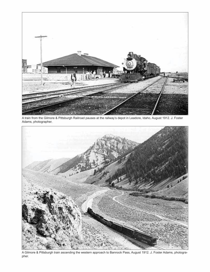
A train from the Gilmore & Pittsburgh Railroad pauses at the railway’s depot in Leadore, Idaho, August 1912. J. Foster Adams, photographer.
A Gilmore & Pittsburgh train ascending the western approach to Bannock Pass, August 1912. J. Foster Adams, photogra-pher.