Geo-Ontology and Geographical Information System Extended by a first-order logic language:...
12
International Journal on Bioinformatics & Biosciences (IJBB) Vol.2, No.3, September 2012 DOI : 10.5121/ijbb.2012.2301 1 Geo-Ontology and Geographical Information System Extended by a first-order logic language: Application to malaria control Guillaume Koum [1] Josiane Etang [2],[3] [1] Département d’Informatique. Ecole Nationale Supérieure Polytechnique. B.P. 8390 Yaoundé, Cameroun [email protected] [2] Organisation de Coordination pour la lutte contre les Endémies en Afrique Centrale B.P. 288 Yaoundé, Cameroun [3] Faculté de Médecine et de Sciences pharmaceutiques. Université de Douala, B.P. 2701 Douala, Cameroun [email protected] Abstract A geo-ontology can be built around a Geographic Information System (GIS) and enriched with a first- order logic language under the closed-world assumption (CWA). This extended system provides knowledge representation formalisms that are aimed to describe general conceptual information. They can also be used in the construction of the knowledge base of a reasoning tool. In this paper an environment is defined where a geo-ontology offers possibilities with a system that allows users to represent and reason about some aspects of the real world. With respect to the added intelligence; knowledge is preserved and enhanced. Knowledge enhancement is performed under the CWA in a subset of the first-order logic language. A geo-reasoning task is undertaken so that a GIS and a geo-ontology are integrated in what can correspond to a natural language processing system. The framework is implemented to demonstrate geo-ontology’s ability to enhance knowledge in malaria control domain. Keywords: geographic information system, geo-ontology; closed-world assumption, geo-reasoning, malaria control. 1. INTRODUCTION In order for the semantic web to function, computers need access to structured information and reasoning mechanisms [1]. Key to this is the use of ontology. Ontology is considered as specification of a conceptualization, which provides the structured vocabulary and semantics which can be used in the markup of web resources to provide machine understanding [2]. When formalized, ontology can be interpreted by computer easily, and the information contained in the ontology can be processed on semantic level effectively. A geo-ontology is ontology with geographic features [3]. When defined, a geo-ontology model must be capable of: 1. Representing relationships between concepts. 2. Representing constraints on relationships. 3. Expressing integrity rules between individuals belonging to different concepts. 4. Representing advanced composition hierarchies. 5. Etc
-
Upload
independent -
Category
Documents
-
view
0 -
download
0
Transcript of Geo-Ontology and Geographical Information System Extended by a first-order logic language:...
International Journal on Bioinformatics & Biosciences (IJBB) Vol.2, No.3, September 2012
DOI : 10.5121/ijbb.2012.2301 1
Geo-Ontology and Geographical InformationSystem Extended by a first-order logic language:
Application to malaria control
Guillaume Koum[1] Josiane Etang [2],[3]
[1] Département d’Informatique. Ecole Nationale Supérieure Polytechnique. B.P. 8390Yaoundé, [email protected]
[2] Organisation de Coordination pour la lutte contre les Endémies en Afrique CentraleB.P. 288 Yaoundé, Cameroun
[3] Faculté de Médecine et de Sciences pharmaceutiques. Université de Douala, B.P.2701 Douala, Cameroun
Abstract
A geo-ontology can be built around a Geographic Information System (GIS) and enriched with a first-order logic language under the closed-world assumption (CWA). This extended system providesknowledge representation formalisms that are aimed to describe general conceptual information. Theycan also be used in the construction of the knowledge base of a reasoning tool. In this paper anenvironment is defined where a geo-ontology offers possibilities with a system that allows users torepresent and reason about some aspects of the real world. With respect to the added intelligence;knowledge is preserved and enhanced. Knowledge enhancement is performed under the CWA in a subsetof the first-order logic language. A geo-reasoning task is undertaken so that a GIS and a geo-ontologyare integrated in what can correspond to a natural language processing system. The framework isimplemented to demonstrate geo-ontology’s ability to enhance knowledge in malaria control domain.
Keywords: geographic information system, geo-ontology; closed-world assumption, geo-reasoning,malaria control.
1. INTRODUCTION
In order for the semantic web to function, computers need access to structured information andreasoning mechanisms [1]. Key to this is the use of ontology. Ontology is considered asspecification of a conceptualization, which provides the structured vocabulary and semanticswhich can be used in the markup of web resources to provide machine understanding [2]. Whenformalized, ontology can be interpreted by computer easily, and the information contained inthe ontology can be processed on semantic level effectively.
A geo-ontology is ontology with geographic features [3]. When defined, a geo-ontology modelmust be capable of:
1. Representing relationships between concepts.2. Representing constraints on relationships.3. Expressing integrity rules between individuals belonging to different concepts.4. Representing advanced composition hierarchies.5. Etc
International Journal on Bioinformatics & Biosciences (IJBB) Vol.2, No.3, September 2012
2
A geo-ontology can be built with capabilities of extending a Geographic Information System(GIS). In malaria control for instance, as far as the geographic distribution and ecologicalrequirements species are concerned, using a geo-ontology approach can be as efficient aspredictive species distribution modeling approach based only on presence records.
Using computer modeling and data on climate and human populations, the complex landscapeof malaria across a country can be revealed through malaria maps. These maps are aimed ateveryone involved in the battle against the disease, particularly those actually doing the diseasecontrol work on the ground. However, accurate maps detail where the disease is most intenseand where the largest concentrations of people at risk are found [4].
This paper is organized as followings. After the introduction in chapter one, the second chaptertalks about ontology. The intelligence meaning and the Closed-World Assumption (CWA) arehighlighted in this part. In chapter three, the construction of the geo-ontology is undertaken andthe corresponding map of Cameroon is extracted from the GIS. The map is generalized througha change not of scale, but of layer. Generalization is one of the most important elements ineffective representation of spatial data, especially for GIS data. A logic-based language isformulated. It extends the geo-ontology and contributes to evaluate predicates occurring in thesystem while complete knowledge is assumed. Chapter four is related to the conclusion wherewe project the work on the future.
2. ONTOLOGY2.1 Geo-ontology
Geo-ontology results from analysis and modeling of ontology in geo-spatial application that isconcepts and the relationships between concepts which is abstracted from real geographicspace. A geo-ontology can be defined as this: Geo-ontology is the formalization of conceptssharing among GIS field. Sharing concepts refers to the concept models of geographicinformation, which are the abstract models generalized from cognition of geographicphenomenon added on the type of concept being used as well as some restrictions Geographicis dedicated to describe the physical structure of reality and ontology the concept explicitly.After formalization, geo-ontology can be readable both to human and computer [5]. Therefore,geo-ontology is used to describe the characteristic of data and resource and data acquiringmode, and thus to provide a uniform expression for data integration and sharing.
2.2 The meaning of intelligence
In the geo-ontology application field, geo-ontology reasoning and the query based on it areessential to GIS data sharing and interoperating. The function of reasoning is to discoverpotential relationship with the known relationship and acquire connotative knowledge withgiven knowledge by certain logic and rule. Ontology reasoning is a typical instance that thecomputer comprehends the ontology knowledge. Computer can interpret the informationdescribed by ontology and complete task intelligently [6]. The capability of ontology’sreasoning proves the fact that ontology is a formal specification of shared concept model.Ontology reasoning is able to judge if certain relation existing among instances.
2.3 Closed-world assumption
2.3.1. Definitions
The Closed-World Assumption (CWA) holds that anything that cannot be shown to be true isfalse; no explicit declaration of falsehood is needed [7]. Consequently, any query (whichterminates) will either return true or false; there is no possibility of "unknown".
International Journal on Bioinformatics & Biosciences (IJBB) Vol.2, No.3, September 2012
3
• Technically, one can ask the system to prove that something is Unknown, or to provethat something is Known, so long as there is a means to represent such a query.
• The real difficulty with the CWA is that one cannot add information. Everything isknown a priori.
Most programming systems which use logic or predicate calculus use the CWA, including:
• Prolog Language• Relational Databases (these can be viewed as predicate systems)
The concept of proof that underlines the Prolog algorithm is relied under the non-monotonicinference rule called Negation as Failure (NAF). For relational databases, the CWA says that allinformation not true in the database is considered as false.
2.3.2. Ontology domains
In the knowledge management arena, the closed world assumption is used in at least twosituations: 1) when the knowledge base is known to be complete ( for instance a mosquitoesdatabase containing records for every vector), and 2) when the knowledge base is known to beincomplete but a "best" definite answer must be derived from incomplete information.
The geo-ontology may suggest more than one domain concerning malaria control (ecologicalcomponent, biological process, resistance function, etc…), each represented by a particularontology. All terms in a domain can trace their parentage to the root term of the domain, but theontology itself has not a root. The root nodes are unrelated and do not have a common parentnode, and hence the geo-ontology is referred to both as ontologies and as a single ontologyconsisting of many sub-ontologies. Some graph-based software may require a single root node;in these cases.
3. ELEMENTS OF PRACTICE3.1. Geographical information system Map.
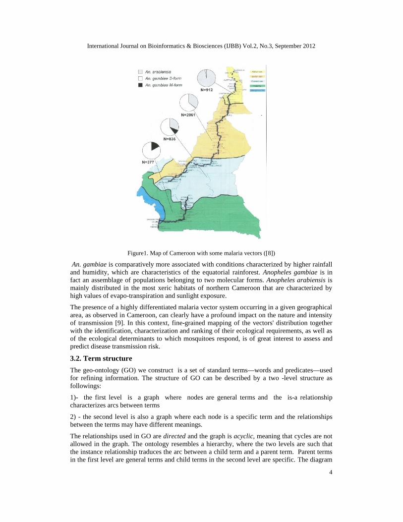
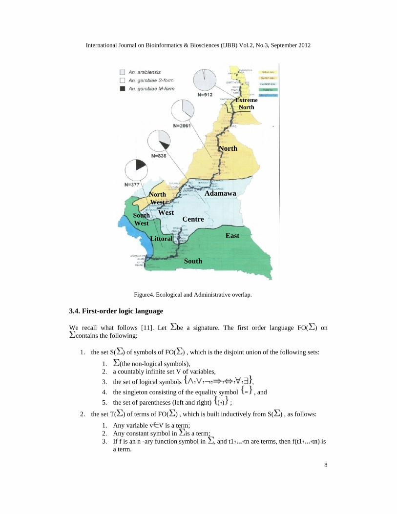
The map in figure1 is a map of Cameroon. Cameroon is a country of Central Africa, locatedbetween 2-12° latitude North and 8-16° longitude East. It is commonly referred to as a“miniature Africa”, owing to the diversity of the geographical and climatic environments itpresents. Three members of the An. gambiae s.l. complex exist in Cameroon and are distributedin five ecological regions from North to South [8].
International Journal on Bioinformatics & Biosciences (IJBB) Vol.2, No.3, September 2012
4
Figure1. Map of Cameroon with some malaria vectors ([8])
An. gambiae is comparatively more associated with conditions characterized by higher rainfalland humidity, which are characteristics of the equatorial rainforest. Anopheles gambiae is infact an assemblage of populations belonging to two molecular forms. Anopheles arabiensis ismainly distributed in the most xeric habitats of northern Cameroon that are characterized byhigh values of evapo-transpiration and sunlight exposure.
The presence of a highly differentiated malaria vector system occurring in a given geographicalarea, as observed in Cameroon, can clearly have a profound impact on the nature and intensityof transmission [9]. In this context, fine-grained mapping of the vectors' distribution togetherwith the identification, characterization and ranking of their ecological requirements, as well asof the ecological determinants to which mosquitoes respond, is of great interest to assess andpredict disease transmission risk.
3.2. Term structure
The geo-ontology (GO) we construct is a set of standard terms—words and predicates—usedfor refining information. The structure of GO can be described by a two -level structure asfollowings:
1)- the first level is a graph where nodes are general terms and the is-a relationshipcharacterizes arcs between terms
2) - the second level is also a graph where each node is a specific term and the relationshipsbetween the terms may have different meanings.
The relationships used in GO are directed and the graph is acyclic, meaning that cycles are notallowed in the graph. The ontology resembles a hierarchy, where the two levels are such thatthe instance relationship traduces the arc between a child term and a parent term. Parent termsin the first level are general terms and child terms in the second level are specific. The diagram
International Journal on Bioinformatics & Biosciences (IJBB) Vol.2, No.3, September 2012
5
presents the pattern of the combination of two graphs, one per level and the duality of is-arelationship and instance relationship is expressed by a virtual and horizontal arc for the is-aassociation and by a physical and vertical arc for the instance association.
3.2.1. Unique identifier and term name
Every term has a term name—e.g. sudana savanna, forest, mangrove, etc…—and a uniqueidentifier (often called the term). The suffix may be used to precise the nature of term. Oneexample is the suffix pop which indicates the population of the locality.
3.2.2. Namespace
Denotes which of the sub-ontologies—ecological component, biological process , resistancefunction, etc…—the term belongs to. The namespaces as in XML schema are nodes and areassociated to a root.
3.2.3. Definition
A textual description of what the term represents, plus reference(s) to the source of theinformation is available in the ontology. The documentation aspect of the system is builtthrough this way. All new terms added to the ontology must have a definition.
3.2.4. Relationships between terms
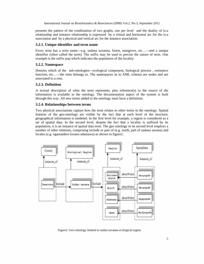
Two physical associations capture how the term relates to other terms in the ontology. Spatialfeatures of the geo-ontology are visible by the fact that at each level of the structure;geographical information is modeled. In the first level for example, a region is considered as aset of spatial data. In the second level, despite the fact that a locality is suffixed by itspopulation, it is an instance of spatial data term. The geo ontology in its second level employs anumber of other relations, comprising include or part of (e.g. north, part of sudana savana) andlocates (e.g. ngaoundere locates adamawa) as shown in figure2.
Figure2. Geo-ontology limited to sudan savanna ecological region
International Journal on Bioinformatics & Biosciences (IJBB) Vol.2, No.3, September 2012
6
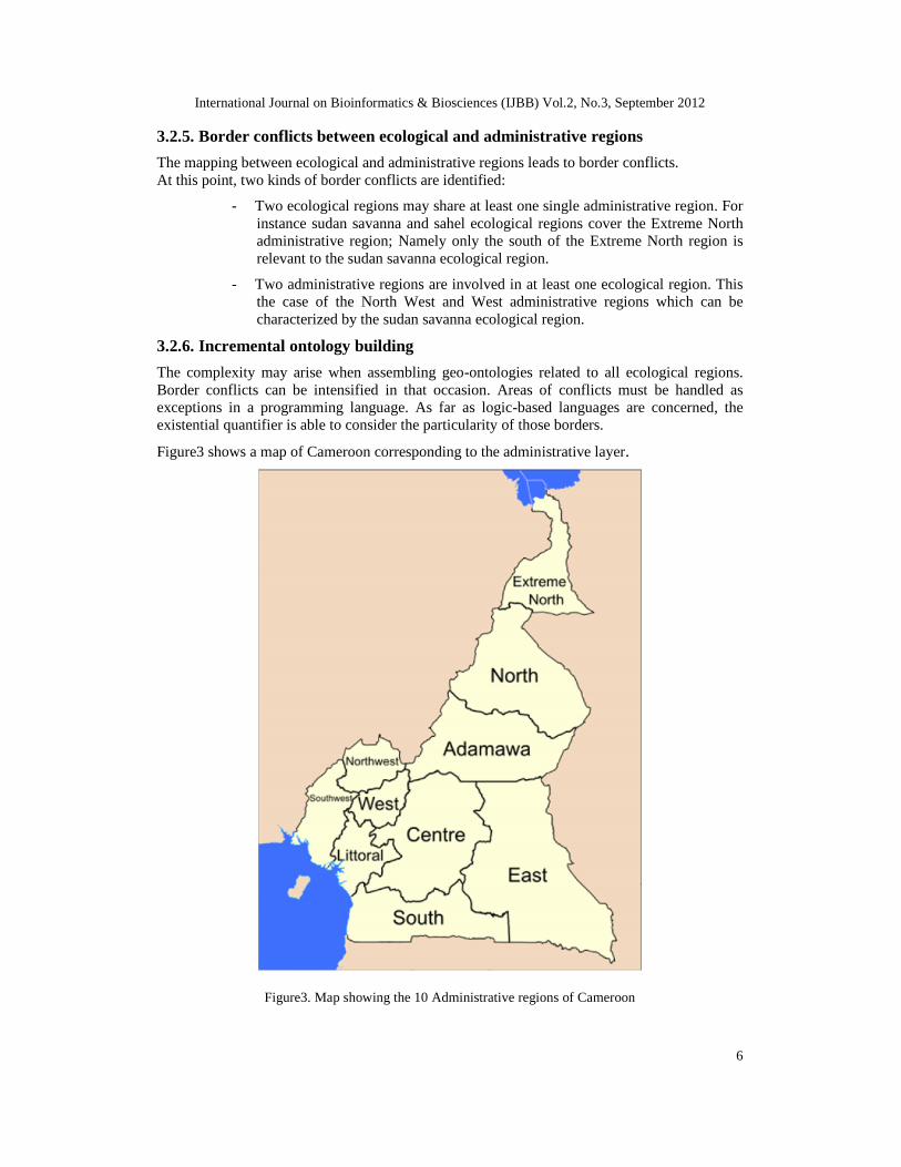
3.2.5. Border conflicts between ecological and administrative regions
The mapping between ecological and administrative regions leads to border conflicts.At this point, two kinds of border conflicts are identified:
- Two ecological regions may share at least one single administrative region. Forinstance sudan savanna and sahel ecological regions cover the Extreme Northadministrative region; Namely only the south of the Extreme North region isrelevant to the sudan savanna ecological region.
- Two administrative regions are involved in at least one ecological region. Thisthe case of the North West and West administrative regions which can becharacterized by the sudan savanna ecological region.
3.2.6. Incremental ontology building
The complexity may arise when assembling geo-ontologies related to all ecological regions.Border conflicts can be intensified in that occasion. Areas of conflicts must be handled asexceptions in a programming language. As far as logic-based languages are concerned, theexistential quantifier is able to consider the particularity of those borders.
Figure3 shows a map of Cameroon corresponding to the administrative layer.
Figure3. Map showing the 10 Administrative regions of Cameroon
International Journal on Bioinformatics & Biosciences (IJBB) Vol.2, No.3, September 2012
7
3.3. Spatial data generalization versus multi-layering
Spatial data generalization in GIS has a close relationship to traditional map generalization, butthe differences exist at the same time. Spatial data generalization in GIS is driven by analysisand query of geographical information [10].
By the analysis and comprehension of map generalization, CWA should entail thegeneralization of spatial data and should determine their effective organization. Realization andestablishment of efficient and seamless geographic database is the foundation of multi-scalespatial data representation and processing. Furthermore, natural language processing can be animportant key of generalization. The close relationships between terms in the ontologyemphasize the conceptual models of spatial data generalization that a natural language is able toexpress.
In general; map generalization aims at creating a map, which is easy to understand and lookspleasing to the eye. Besides, the complexity of spatial terrain features is simplified when thescale changes smaller, in this way the primary and essential terrain features can be reflectedwhile the secondary and nonessential aspects can be abandoned.
Generalization is no longer the precondition of geographical information transmission betweenmulti-scale or multi-resolution data. We promote the multi-layer approach for datageneralization in GIS with the help of the geo-ontology.
A layer is a set of similar features representing a class of features that exists in the world. Heretwo particular layers are concerned:
- an ecological layer sampling some malaria vectors in Cameroon ,- an administrative layer comprising regions of Cameroon.
A layer is not actually a data source, but is an object within the GIS that represents a datasource that may be present on a local or networked drive, or the layer data source may exist onan internet mapping server.
A layer should not simultaneously represent more than one class of features, although it mayrepresent several subclasses.
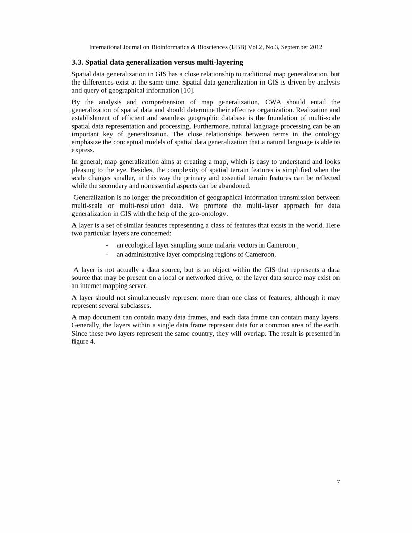
A map document can contain many data frames, and each data frame can contain many layers.Generally, the layers within a single data frame represent data for a common area of the earth.Since these two layers represent the same country, they will overlap. The result is presented infigure 4.
International Journal on Bioinformatics & Biosciences (IJBB) Vol.2, No.3, September 2012
8
Figure4. Ecological and Administrative overlap.
3.4. First-order logic language
We recall what follows [11]. Let be a signature. The first order language FO( ) oncontains the following:
1. the set S( ) of symbols of FO( ) , which is the disjoint union of the following sets:
1. (the non-logical symbols),2. a countably infinite set V of variables,
3. the set of logical symbols ,
4. the singleton consisting of the equality symbol = , and
5. the set of parentheses (left and right) ( ) ;
2. the set T( ) of terms of FO( ) , which is built inductively from S( ) , as follows:
1. Any variable v V is a term;2. Any constant symbol in is a term;3. If f is an n -ary function symbol in , and t1 tn are terms, then f(t1 tn) is
a term.
Centre
North
ExtremeNorth
Adamawa
East
South
Littoral
WestSouthWest
NorthWest
International Journal on Bioinformatics & Biosciences (IJBB) Vol.2, No.3, September 2012
9
3. the set F( ) of formulas of FO( ) , which is built inductively from T( ) , as follows:
1. If t1 and t2 are terms, then (t1=t2) is a formula;2. If R is an n -ary relation symbol and t1 tn are terms, then (R(t1 tn)) is a
formula;3. If is a formula, then so is ( ) ;
4. If and are formulas, then so is ( ) ;5. If is a formula, and x is a variable, then ( x( )) is a formula.
In other words, T( ) and F( ) are the smallest sets, among all sets satisfying the conditionsgiven for terms and formulas, respectively.
Formulas in 3(a) and 3(b), which do not contain any logical connectives, are called the atomicformulas.
In our system, the language extending the geo-ontology contains a first-order logic core withgeneralized quantifiers, and plural reference expressions. It comprises the Geo predicate.
The mosquitoes database indicates that malaria vectors are either An.arabiensis or An.gambiae.We consider that vect1 is a An.gambiae, and vect2 is An.arabiensis. This can be represented inthe language in the following way.
(forall ?x vector (inst: ?x) iffAn.gambiae (inst: ?x))(An.arabiensis (inst: ?x) orAn.gambiae (inst: vect1)
(An.arabiensis (inst: vect2)
Here vect1 and vect2 are constants, vector, An.gambiae, and An.arabiensis are predicatesymbols. In the language, arguments of predicates are identified via keywords, e.g. anyidentifier preceded by a question mark, e.g. ?x, is a variable.
In declaration we use the boolean operators:
iff ( meaning equivalence),and ( meaning conjunction),or ( meaning disjunction),the universal quantifier forall ( ).
The question whether all the vectors are in the Adamawa administrative region can also beformulated in the language. To answer this question we must try to infer from the database:
(forall ?x vectors (inst: ?x) ifAn.arabiensis (inst:?x) andAn.gambiae (inst:?x)isFound (inst: locality, theme: adamawa))
On the basis of the CWA, the answer has to be positive. Although other vectors may be presentin the field, but since they are not recorded in the database the CWA entails a positive response.Users are more familiar to administrative data than ecological data.
At the border of the Adamawa and North administrative regions, the sudan savanna ecologicalregion disappears and another ecological region is observed. The existential quantifier mustbe introduced in queries when there are areas affected by border conflicts.
Now let us assume that the An.gambiae S-form from vect1 is found nationwide. This can berepresented in the following way.
International Journal on Bioinformatics & Biosciences (IJBB) Vol.2, No.3, September 2012
10
Is-a(inst: vect1, theme: locality)Geo (inst: locality)isFound (inst: locality, theme: nationwide)
To answer the question whether all An.gambiae from vect1 are found nationwide we have totry to infer the following language expression.
(forall ?xisFound (inst: ?x, theme: nationwide)
if Is-a (inst: vect1, theme: ?x)and Geo (inst: ?x)).
Under the CWA, the answer to this question is negative.
Geo predicate is what introduce the geo-ontology within the first-order logic framework. Bytaking into consideration all pop-suffixed terms, the aboutWhere association in the geo-ontology brings information at the view of the (administrative) region. As it is virtually definedin the first level of the geo-ontology, an ecological region is a set of (administrative) regions.This operation can be repeated for all localities of a region. By appreciating the presence orabsence of given vectors in different localities, then we can determine a spatial generalizationin the region not directly from the GIS but from the geo-ontology.
This is perhaps not surprising considering that marginality values are related to the extent of thespatial reference set, which in this case was constituted by the whole of Cameroon, a highlydiversified country covering several different bio-geographic domains.
3.5. Related work
3.5.1. Former situation
Simard [12] has studied the biology, ecology, importance in the transmission of humanpathogens, resistance to insecticide and population genetics of the five main human malariavectors, all present in Cameroon. An. arabiensis extends from the dry savannas in the North(southern border of lake Chad) down to the evergreen forest edge (around 5°N) and An.gambiae s.s. is widespread throughout the country. The species, An. gambiae, is found virtuallyeverywhere in Cameroon and transmits malaria to humans in humid, forested environments inthe South as well as in dry savannas and ricefields in the North; in rural, periurban and urbansettings; at low (Douala, 12 m a.s.l.) or high (Dschang, 1400m a.s.l.) altitude.
3.5.2. Comparison
According to Simard’s work, the M-form of An.gambiae was identified in Tibati (6°28’N;12°37’E). For us, it is known that Tibati is a locality of Adamawa administrative region.However Tibati does not belong to the sudana savanna ecological region. If this was true wewould have said that the An.gambiae M-form is not found in Tibati because this locality is a notunder the influence of the sudana savanna ecological region.
Consequently we have to take into consideration the exception raised by the Tibati case as aborder area.
To answer the question whether An.gambiae M- form from vect1 is found in Tibati we musttry to infer the following language expression.
( ?x ifAn.gambiae M-form (inst:?x)isFound (inst: ?x, theme: Tibati)if Is-a (inst: vect1, theme: ?x)and Geo (inst: ?x)).
International Journal on Bioinformatics & Biosciences (IJBB) Vol.2, No.3, September 2012
11
Therefore the CWA proves in our study that the M-form of An.gambiae is found in Tibati. Atthe end, we have a common position with Simard’s work. Nevertheless, the difference betweenus is determined by the fact that our solution is derived from the database. In Simard’s point ofview the presence is recorded in the database.
4. CONCLUSIONAnalysis, query and visualization of GIS always come down to multi-resolution data,representation, multi-scale data integration, and so on, which are all supported by spatial datageneralization. The most common solution is to establish and save different scale database inGIS and set the scale range of different elements and layers in display. When utilize GIS toprocess data sets of different scales, especially from different sources, some conflicts usuallycome forth A geo ontology enriched with the logical proof containing the CWA constitutesanother method of spatial data generalization. Spatial data generalization satisfies not only mapdisplay and information transmission but also spatial analysis and data integration. Thisexercise can be performed in the malaria vectors distribution. An.arabiensis and An.gambiaeare the ones concerned by the ecological partitioning in a geo-ontology and a logical point ofview. Analyses may differ according to eco-geographical variables induced for instance in theEcological Niche Factor Analysis. However as we demonstrated in this paper, the divergencedepends only on the quality of data recorded in the field or derived.In the future, we would call upon a more complex logic language to sustain the geo-ontologyby introducing namely temporal and modal operations. The temporal aspect should permit thedeclaration of data collection time and snapshot issues. The modal operation should be the keyfor the reasoning in the system to be non-monotone.
Bibliography
1. Lee Feigenbaum, Ivan Herman, Tonya Hongsermeier, Eric Neumann, and Susie Stephens(2007). “ The Semantic Web in Action”. Scientific American, 297(6), pp. 90-97. December.
2. Tim Berners-Lee, James Hendler and Ora Lassila (2001). “The Semantic Web” . ScientificAmerican, May.
3. Yandong Wang, Jingjingf Dai, Jizhen Sheng, Kai Zhou, Jianya Gong (2004). “ Geo-ontology design and its logic reasoning”. Proc. Of SPIE Vol. 6753 675309-09
4. Fontenille D, Simard F (2004): “Unravelling complexities in human malaria transmissiondynamics in Africa through a comprehensive knowledge of vector populations”. CompImmunol Microbiol Infect Dis, 27:357-375.
5. Joshua Lieberman, Raj Singh, Chris Goad (2007). “W3C Incubator Group Report”. 23October 2007. http://www.w3.org/2005/Incubator/geo/XGR-geo-ont/
6. T. R. Gruber (1995). “Toward principles for the design of ontologies used for knowledgesharing”. Padua workshop on Formal Ontology, March 1993, later published inInternational Journal of Human-Computer Studies, Vol. 43, Issues 4-5, November, pp.907-928.
7. U. Hustadt (1994): “Do we need the closed-world assumption in knowledgerepresentation?” In J. Kunze and H. Stoyan, editors, KI-94 Workshops: Extended Abstracts,pp. 123--124. Gesellschaft für Informatik.
8. Simard F, Ayala D, Kamdem G, Pombi M, Etouna J, Ose K, Fotsing J-M, Fontenille D,Besansky N, Costantini C (2009): “Ecological niche partitioning between Anopheles
International Journal on Bioinformatics & Biosciences (IJBB) Vol.2, No.3, September 2012
12
gambiae molecular forms in Cameroon: the ecological side of speciation”. BMC Ecology,9:17.
9. Pombi M, Caputo B, Simard F, Di Deco MA, Coluzzi M, Della Torre A, Costantini C,Besansky NJ, Petrarca V (2008): “Chromosomal plasticity and evolutionary potential in themalaria vector Anopheles gambiae sensu stricto: insights from three decades of rareparacentric inversions”. BMC Evol Biol, 8:309.
10. LI Aiqin, DENG Yi, LI Mingfeng, SHI Xinxing (2008). “Conceptual modeling of spatialdata generalization in GIS”. Geoinformatics 2008 and Joint Conference on GIS and BuiltEnvironment: Geo-Simulation and Virtual GIS Environments. Lin Liu, Xia Li, Kai Liu,Xinchang Zhang, Aijun Chen, Eds., Proc. of SPIE Vol. 7143 714336-1. 2008 SPIE DigitalLibrary D.
11. Marker (2002). “Model Theory, an Introduction”. Springer.
12. Frederic Simard (2008). “Bionomics and Genetics of Anopheles gambiae in Cameroon”.www.anobase.org/embo_meeting/.../Simard.pdf 2008.
AUTHORS
Dr. Guillaume KOUM is Associate senior Lecturer at University of Yaoundé 1(Computer Department). His research domains cover a variety of topics relativeto Database Systems, Software engineering, Artificial Intelligence, InformationSystems. He first studied Mathematics in University of Yaoundé (Cameroon),where he obtained a Licence (Bachelor) in 1977. He after obtained a Doctorate inComputer Science from University Claude Bernard, Lyon1 (France) in 1982. Hehas been the Chief of Division in charge of Computer Technologies at theMinistry of Finance in Cameroon, before being appointed as Director of CentreNational de Développement de l’Informatique (CENADI). He is currently aSenior Consultant and an International Expert in Information ManagementSystems. He has published more than forty papers in international conferences,journals and books. He is also a reviewer in some international journals.
Dr. Josiane ETANG is a Senior Malariologist and Medical Entomologist withextensive experience in research and training. She is member of severalprofessional bodies: Central African Roll Back Malaria Network, African Networkon Vector Resistance to insecticides, West and Central African Network onAnopheles Biology and Control, Cameroonian Society of Parasitology,International Society for Health Research and Training. She joined TheOrganisation de Coordination pour la lutte contre les Endémies en Afique Centrale(OCEAC) as a researcher in 2006 and subsequently she received an appointmentas the sub regional Malaria Programme Coordinator in 2011. Furthermore, shehas been appointed in the Faculty of Medecine and Pharmaceutical Sciences(University of Douala) as assistant lecturer in 2007 and after as senior lecturer in2010. She holds PHD and Master’s of Science degrees in Parasitology, from theUniversity of Yaounde1, Cameroon. She has published 27 articles in internationalpeer-reviewed scientific journal.