Information Extraction in a Set of Knowledge Using a Fuzzy Logic Based Intelligent Agent
Upload
independentCategory
view
5download
0
Transactions in GIS
, 2003, 7(1): 123–138
© 2003 Blackwell Publishing Ltd, 9600 Garsington Road, Oxford OX4 2DQ2, UK and 350 Main Street, Malden MA 02148, USA.
Blackwell Publishing LtdOxford, UKTGISTransactions in GIS1361-1682© Blackwell Publishing Ltd 20032003711000
Research Paper
Fuzzy Set Approaches to Spatial Data MiningR. Ladner, F. E. Petry and M. A. Cobb
Fuzzy Set Approaches to Spatial Data Mining of Association Rules
Roy Ladner
Naval Research Laboratory Mapping, Charting and Geodesy Stennis Space Center, Mississippi
Frederick E Petry
Naval Research Laboratory Mapping, Charting and Geodesy Stennis Space Center, Mississippi
Maria A Cobb
Department of Computer Science and Statistics The University of Southern Mississippi
Abstract
This paper presents an approach to the discovery of association rules for fuzzy spa-tial data. Association rules provide information of value in assessing significantcorrelations that can be found in large databases. Here we are interested incorrelations of spatially related data such as soil types, directional or geometricrelationships, etc. We have combined and extended techniques developed in bothspatial and fuzzy data mining in order to deal with the uncertainty found in typicalspatial data.
1 Introduction
Data mining or knowledge discovery generally refers to a variety of techniques that havedeveloped in the fields of databases, machine learning and pattern recognition. Theintent is to uncover useful patterns and associations from large databases. We shalldescribe a new approach that allows the discovery of association rules for fuzzy spatialdata. Association rules provide information of value in assessing significant correlationsthat can be found in large databases. Here we are interested in correlations of spatiallyrelated data such as soil types, directional or geometric relationships, etc. We havecombined and extended techniques developed in both spatial and fuzzy data mining todeal with the uncertainty found in typical spatial data.
Address for Correspondence:
Fred Petry, Electrical Engineering and Computer Science Depart-ment, Tulane University, 310 Stanley Thomas Hall, New Orleans, LA 70118, USA Email:[email protected]
124
R Ladner, F E Petry and M A Cobb
© Blackwell Publishing Ltd. 2003
As an example consider using a spatial database to provide assistance in thelogistical planning for a military operation. Then we might wish to uncover some ofthe important relationships of the data attributes in each area to provide guidance in themission planning. We shall see in detail in the last section of the paper that one possiblerule that might be discovered is of the form:
If C is a small city and has good terrain nearby then there is a road nearby with90% confidence.
Such a rule incorporates fuzzy information in the linguistic terms used such as “small”and “nearby.”
In this paper we first overview the background of data mining and uncertainty inspatial data (including the main research in spatial data mining). Then our approachto extracting spatial association rules for fuzzy data is described and an example isprovided to illustrate the process.
2 Background
2.1 Data Mining
Although we are primarily interested here in some of the specific algorithms of know-ledge discovery, we will first review the overall process of data mining. The initial stepsare concerned with preparation of data, including data cleaning intended to resolveerrors and missing data and integration of data from multiple heterogeneous sources.Next are the steps needed to prepare for actual data mining. These include the selectionof the specific data relevant to the task and the transformation of this data into a formatrequired by the data mining approach. These steps are sometimes considered to be thosein the development of a data warehouse, i.e., an organized format of data available forvarious data mining tools. There are a wide variety of specific knowledge discoveryalgorithms that have been developed (Han and Kamber 2000). These discover patternsthat can then be evaluated based on some interestingness measure used to prune thehuge number of available patterns. Finally as true for any decision aid system, an effect-ive user interface with visualization/alternative representations must be developed forthe presentation of the discovered knowledge.
Specific data mining algorithms can be considered as belonging to two categories –descriptive and predictive data mining. In the descriptive category are class description,association rules and classification. Class description can either provide a characteriza-tion or generalization of the data or comparisons between data classes to provide classdiscriminations. Association rules are the main focus of this paper and correspond tocorrelations among the data items. They are often expressed in rule form showingattribute-value conditions that commonly occur at the same time in some set of data.An association rule of the form
X
→→→→
Y
can be interpreted as meaning that the tuples inthe database that satisfy the condition
X
also are “likely” to satisfy
Y
, so that the“likely” implies this is not a functional dependency in the formal database sense. Finally,a classification approach analyzes the training data (data whose class membership isknown) and constructs a model for each class based on the features in the data. Com-monly, the outputs generated are decision trees or sets of classification rules. These canbe used both for the characterization of the classes of existing data and to allow theclassification of data in the future, and so can also be considered predictive.
Fuzzy Set Approaches to Spatial Data Mining
125
© Blackwell Publishing Ltd. 2003
Predictive analysis is also a very developed area of data mining. One very commonapproach is clustering. Clustering analysis identifies the collections of data objects thatare similar to each other. The similarity metric is often a distance function given byexperts or appropriate users. A good clustering method produces high quality clustersto yield low inter-cluster similarity and high intra-cluster similarity. Prediction tech-niques are used to predict possible missing data values or distributions of values of someattributes in a set of objects. First, one must find the set of attributes relevant to theattribute of interest and then predict a distribution of values based on the set of datasimilar to the selected objects. There are a large variety of techniques used, includingregression analysis, correlation analysis, genetic algorithms and neural networks.
Finally, a particular case of predictive analysis is time-series analysis. This techniqueconsiders a large set of time-based data to discover regularities and interesting charac-teristics. One can search for similar sequences or subsequences, then mine sequentialpatterns, periodicities, trends and deviations.
2.2 Uncertainty in Spatial Data
The need to handle imprecise and uncertain information concerning spatial data hasbeen widely recognized (Goodchild 1990), particularly in the field of geographical informa-tion systems (GIS). The value of GIS as a decision-making tool is dependent on theability of decision-makers to evaluate the reliability of the information on which theirdecisions are based. Users of GIS technology must therefore be able to assess the natureand degree of error in spatial databases, track this error through GIS operations andestimate accuracy for both tabular and graphic output products. There are a variety ofaspects of potential errors in GIS encompassed by the general term “accuracy.” How-ever, here we are only interested in those aspects that lend themselves to modeling byfuzzy set techniques.
Many operations are applied to spatial data under the assumption that features,attributes and their relationships have been specified a priori in a precise and exactmanner. However, inexactness often exists in the positions of features and the assign-ment of attribute values and may be introduced at various stages of data compila-tion and database development. Models of uncertainty have been proposed for spatialinformation that incorporate ideas from natural language processing, the value ofinformation concept, non-monotonic logic and fuzzy sets, and evidential and probabilitytheory (Stoms 1987).
A number of researchers in the GIS and spatial database area have recently con-sidered models of spatial data using fuzzy set approaches, as in the modeling of geographicobjects with indeterminate boundaries (Burrough and Frank 1996) and the Journal ofFuzzy Sets and Systems recently published a special issue on uncertainty in GIS andspatial data (Cobb et al. 2000). Some early work by geographers in the 1970s utilizedfuzzy sets in topics such as behavioral geography and geographical decision-making(Gale 1972, Pipkin 1978, Leung 1979). However, the first consistent approach to theuse of fuzzy set theory as it could be applied in GIS was developed by Robinson(Robinson and Frank 1985, Robinson 1988, 1990). More recently, there have been anumber of efforts utilizing fuzzy sets for spatial databases including some for capturingspatial relationships (Cobb and Petry 1998, Guesgen and Albrecht 2000), queryingspatial information (Morris and Petry 1998, Wang 2000), and object-oriented model-ing (George et al. 1992, Morris et al. 1998, Cross and Firat 2000).
126
R Ladner, F E Petry and M A Cobb
© Blackwell Publishing Ltd. 2003
2.3 Fuzzy Data Mining
An early and continuing significant application of fuzzy sets has been in pattern recogni-tion, especially fuzzy clustering algorithms (Bezdek 1974). Hence, much of the effortin fuzzy data mining has been by the use of fuzzy clustering and fuzzy set approachesin neural networks and genetic algorithms (Hirota and Pedrycz 1999). In fuzzy settheory an important consideration is the treatment of data from a linguistic viewpoint.From this an approach has developed that uses linguistically quantified propositions tosummarize the content of a database, by providing a general characterization of theanalyzed data (Yager 1991, Kacprzyk and Zadrozny 2000). A common organization ofdata for data mining is the multidimensional data cube in data warehouse structures.Treating the data cube as a fuzzy object has provided another approach for knowledgediscovery (Laurent 2002).
Fuzzy data mining for generating association rules has been considered by a numberof researchers. There are approaches using the SETM (Set-oriented mining) algorithm(Shu et al. 2001) and other techniques (Bosc and Pivert 2001) but most have been basedon the important Apriori algorithm. Extensions have included fuzzy set approachesto quantitative data (Zhang 1999, Kuok et al. 1998), hierarchies or taxonomies (Chenet al. 2000, Lee 2001), weighted rules (Gyenesei 2000) and interestingness measures (deGraaf et al. 2001, Gyenesei 2001). For our work here, we focus on a basic extensionof the Apriori algorithm motivated by some of the above developments, but we alsoenvision future work that includes the use of fuzzy taxonomies and fuzzy weights fordiscovering spatial association rules.
3 Spatial Data Mining
There is considerable interest in spatial data mining, but only a few major researchefforts have been developed in this area. A major difference between data mining inordinary relational databases and in spatial databases is that attributes of the neighborsof some object of interest may have an influence on the object and therefore have to beconsidered as well. The explicit location and extension of spatial objects define implicitrelations of spatial neighborhoods (such as topological, distance and direction relations),which are used by spatial data mining algorithms.
A very active and influential data mining research group is that led by Han inVancouver and presently at Illinois. They have investigated several approaches to spatialdata mining and have developed a system called GeoMiner (Han et al. 1997) based onthese techniques. One approach developed a generalization-based knowledge discoverymechanism that integrated attribute-oriented induction on non-spatial data and spatialmerge and generalization on the spatial data (Lu et al. 1993). The CLARANS clusteringalgorithm is a randomized search for an optimal cluster. Another spatial data miningapproach was based on CLARANS and produced high-level non-spatial description ofobjects in every cluster using attribute-oriented induction (Ng and Han 1994).
For this research, the most important work is the development of an approach formining strong association rules in geographic information databases (Koperski and Han1995). This approach uses an SQL-like spatial data mining query interface as developedfor GeoMiner. This provides the subset of the spatial database over which the rulediscovery is performed. From this subset the spatial predicates of interest such as
Fuzzy Set Approaches to Spatial Data Mining
127
© Blackwell Publishing Ltd. 2003
intersect, adjacent, etc. are then explicitly materialized. The Apriori algorithm (to bediscussed in detail in the next section) (Agrawal et al. 1993) is applied over these datato extract the association rules. If there is a concept hierarchy for the data and/or thespatial predicates, a multi-level approach to the Apriori algorithm allows rules to beextracted at any desired level. Another interesting approach uses a hierarchy of thetopological relations of objects with a broad boundary (Clementini and DiFelice 1997)to mine spatial association rules for objects with uncertainty (Clementini et al. 2000).
A research group in Munich (Ester et al. 2000) has developed a set of databaseprimitives for mining in spatial databases that are sufficient to express most of thealgorithms for spatial data mining and that can be efficiently supported by a DBMS.They have found that the use of such database primitives enables the integration ofspatial data mining with existing DBMSs and speeds-up the development of new spatialdata mining algorithms. The database primitives are based on the concepts of neigh-borhood graphs and neighborhood paths. Effective filters allow restriction of the search tosuch neighborhood paths “leading away” from a starting object. Neighborhood indicesmaterialize certain neighborhood graphs to support efficient processing of the databaseprimitives by a DBMS. For spatial characterization it seems important that classmembership of a database object is not only determined by its non-spatial attributes butalso by the attributes of objects in its neighborhood. In spatial trend analysis, patternsof change of some non-spatial attributes in the neighborhood of a database object weredetermined. Spatial trends can be thought of as describing the regular change of non-spatial attributes when moving away from certain start objects for which both globaland local trends can be distinguished.
Another approach has been taken by the use of spatial autocorrelation ratherthan materializing spatial predicates. The system is used to predict locations using mapsimilarity (Chawla et al. 2000). It has four components – map similarity measures,parametric functions for spatial models, a discretized parameter space and the searchalgorithm. The search explores the parameter space to discover the parameter valuetuple maximizing the map similarity measure. These parameter values thus indicate theparametric function to use as the possible spatial model.
4 Fuzzy Spatial Data Mining
4.1 Introduction
In this section we will describe the combination of certain approaches we have surveyedin the past two sections concerning fuzzy data mining and spatial data mining. To dateno efforts have appeared in the literature that have specifically investigated fuzzy spatialdata mining. The setting for which we are developing our approaches for fuzzy spatialdata mining is an environment in which considerable concern about uncertainty in severalrespects arises. The objective is to develop ways of processing large amounts of spatio-temporal data especially of oceanographic and littoral regions and including meteoro-logical information. We are studying spatial data mining in several aspects including thefuzzy techniques in this paper. Our plan is to integrate the data mining techniques into thegeospatial system described below. The ultimate goal is to provide knowledge-enhancedinformation to decision tools that will be used by US Navy and Marine planners.
The Digital Mapping, Charting and Geodesy Analysis Program (DMAP) at theNaval Research Laboratory has been actively involved in the development of a digital
128
R Ladner, F E Petry and M A Cobb
© Blackwell Publishing Ltd. 2003
geospatial mapping and analysis system since 1994. This work started with the GeospatialInformation Database (GIDB™), an object-oriented, CORBA-compliant spatial databasecapable of storing multiple data types from multiple sources. Data is accessible over theInternet via a Java Applet (Chung et al. 2001).
The GIDB includes an object-oriented data model, an object-oriented databasemanagement system (OODBMS) and various analysis tools. While the model providesthe design of classes and hierarchies, the OODBMS provides an effective means ofcontrol and management of objects on disk such as locking, transaction control, etc. TheOODBMS in use is Ozone, an open-source database management system. This has beenbeneficial in several aspects. Among these, access to the source code allows customiza-tion and there are no costly commercial database licensing fees on deployment. Spatialand temporal analysis tools include query interaction, multimedia support and mapsymbology support. Users can query the database by area-of-interest, time-of-interest,distance and attribute. For example, statistics and data plots can be generated to reflectwave height for a given span of time at an ocean sensor. Interfaces are implemented toafford compatibility with Arc/Info, Oracle 8i, Matlab, and others.
The object-oriented approach has been beneficial in dealing with complex spatialdata, and it has also permitted integration of a variety of raster and vector data productsin a common database. Some of the raster data include satellite and motion imagery,Compressed ARC Digitized Raster Graphics (CADRG), Controlled Image Base (CIB),jpeg and video. Vector data includes Vector Product Format (VPF) products from theNational Imagery and Mapping Agency (NIMA), Shape, real-time and in-situ sensordata and Digital Terrain Elevation Data (DTED). The VPF data includes such NIMAproducts as Digital Nautical Chart (DNC), Vector Map (VMAP), Urban Vector Map(UVMAP), Digital Topographic Data Mission Specific Data Sets (DTOP MSDS), andTactical Oceanographic Data (TOD).
Over time the system has been expanded to include a communications gatewayenabling users to obtain data from a variety of data providers distributed over theInternet in addition to the GIDB. These providers include Fleet Numerical Meteorologyand Oceanography Center (FNMOC), USGS, Digital Earth/NASA, and the GeographyNetwork/ESRI. A significant FNMOC product is the Coupled Ocean/AtmosphereMesoscale Prediction System (COAMPS) data. The atmospheric components ofCOAMPS are used operationally by the U.S. Navy for short-term numerical weatherprediction for various regions around the world. Our communications gateway providesa convenient means for users to obtain COAMPS data and incorporate it with othervector and raster data in map form. The gateway establishes a well-defined interfacethat brings together such heterogeneous data for a common geo-referenced presentationto the user. An illustration of the interface for a typical data request is shown in Plate1, See plate section.
4.2 Spatial Data Uncertainty Classes
To investigate the potential complications caused by uncertainty in discovering spatialassociation rules in spatial databases, we have to consider the sorts of data that willoccur. There are two particular classes of spatial data that we shall focus upon whichwe call: type I – spatial or spatially related attributes and type II – spatial relationships.
Type I. For this category we may have “spatially related” attributes such as soiltypes: {sandy, loamy, . . . }. These classes are of course not crisp and here we will use a
Fuzzy Set Approaches to Spatial Data Mining
129
© Blackwell Publishing Ltd. 2003
similarity table approach (Buckles and Petry 1982) to matching values as was done inprevious work on the conflation of VPF data (Cobb et al. 1998). It is also possible toallow numeric as well as scalar values. For example, a fuzzy number such as “about3 cm” of rainfall at a location could be used. A similarity approach to the matching offuzzy numbers that has been previously developed could then be used here (Buckles andPetry 1984).
Type II. The major types of spatial relationships that can be considered are geo-metrical orientation and topological relationships. In particular, we will considerrelationships such as distance and direction with fuzzy membership functions withtopological relationships to be considered for future work. In either of these cases wemay have an ontological concept hierarchy, which may also involve uncertainty relation-ships in the hierarchy that can be modeled with fuzzy sets. Such a hierarchy can be usedto produce multi-level association rules, which have a finer gradation of meaning.
In the data mining process there are three particular aspects to be considered forissues of uncertainty: (1) querying in which the spatially relevant data is obtained forthe data mining; (2) the actual Apriori algorithm which produces the association rules;and (3) relevance evaluation procedures that assess and prune the association rulesproduced. In this paper we focus only on the first two and leave the last as a topic offuture research.
4.3 Fuzzy Querying for Spatial Data Mining
First, we examine the management of uncertainty in the data-mining query, whichdevelops the table on which the Apriori algorithm is applied. We will follow the basicapproach taken in GeoMiner (Koperski and Han 1995, Han et al. 1997) and extend itas necessary. One problem is the form of the resultant relation obtained from the query-ing involving the types of spatial data. Since uncertainty can arise from the similaritydegree of matching of type I data in the query and/or spatial predicates (type II), we arefaced with the choice of maintaining uncertainty measures for the individual attributesor formulating an overall uncertainty/membership value for the resultant tuples in therelation. A number of approaches have been taken to this concern in the fuzzy databaseliterature (Petry 1996), but here our concern is determining the form that will beeffective for data mining.
A crucial aspect of the query for the formulation of the data over which the datamining algorithm will operate is the selection of a spatial predicate that identifies thespecific spatial region or area of interest (AOI). This is closely related to the propertythat causes objects of interest to cluster in space, which is the so-called first law ofgeography: “Everything is related to everything else but nearby things are more relatedthan distant things” (Tobler 1979). A common choice for this is some distance metricsuch as a NEAR predicate; however, other spatial predicates such as CONTAINS orINTERSECTS could also be used.
Let us consider an SQL form of a query:
SELECT Attributes A, BFROM Relation XWHERE(X.A
=
α
and NEAR (X.B,
β
))AT Threshold Levels
=
M, N
130
R Ladner, F E Petry and M A Cobb
© Blackwell Publishing Ltd. 2003
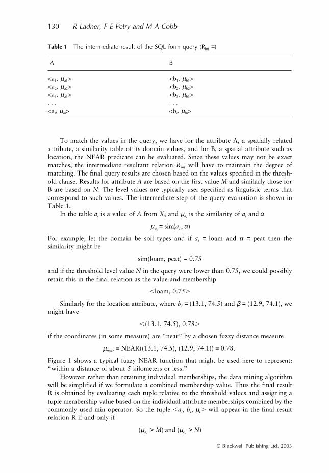
To match the values in the query, we have for the attribute A, a spatially relatedattribute, a similarity table of its domain values, and for B, a spatial attribute such aslocation, the NEAR predicate can be evaluated. Since these values may not be exactmatches, the intermediate resultant relation
R
int
will have to maintain the degree ofmatching. The final query results are chosen based on the values specified in the thresh-old clause. Results for attribute
A
are based on the first value
M
and similarly those forB are based on
N
. The level values are typically user specified as linguistic terms thatcorrespond to such values. The intermediate step of the query evaluation is shown inTable 1.
In the table
a
i
is a value of
A
from
X
, and
µ
a
i
is the similarity of
a
i
and
α
For example, let the domain be soil types and if
a
i
=
loam and
α
=
peat then thesimilarity might be
sim(loam, peat)
=
0.75
and if the threshold level value
N
in the query were lower than 0.75, we could possiblyretain this in the final relation as the value and membership
,
loam, 0.75
.
Similarly for the location attribute, where
b
i
=
(13.1, 74.5) and
β
=
(12.9, 74.1), wemight have
,
(13.1, 74.5), 0.78
.
if the coordinates (in some measure) are “near” by a chosen fuzzy distance measure
µ
near
=
NEAR((13.1, 74.5), (12.9, 74.1))
=
0.78.
Figure 1 shows a typical fuzzy NEAR function that might be used here to represent:“within a distance of about 5 kilometers or less.”
However rather than retaining individual memberships, the data mining algorithmwill be simplified if we formulate a combined membership value. Thus the final resultR is obtained by evaluating each tuple relative to the threshold values and assigning atuple membership value based on the individual attribute memberships combined by thecommonly used min operator. So the tuple
,
a
i
,
b
i
,
µ
t
.
will appear in the final resultrelation R if and only if
Table 1 The intermediate result of the SQL form query (Rint =)
A B
<a1, µa1> <b1, µb1><a2, µa2> <b2, µb2><a3, µa3> <b3, µb3>. . . . . .<ai, µai> <bi, µbi>
µa iia ( , )= sim α
( ) ( )µ µa bi iM N> >and

Fuzzy Set Approaches to Spatial Data Mining 131
© Blackwell Publishing Ltd. 2003
and the tuple membership is
If the rows (tuples) 1 and 3 from Rint are such that the memberships for both columnsare above their respective thresholds, then these are retained. However for tuple 2, letit be the case that µa2 > M, but the second attribute’s membership is µb2 < N. Then thistuple will not appear in the final result relation R as shown in Table 2.
4.4 Association Rules for Spatial Data
4.4.1 Association rulesAssociation rules capture the idea of certain data items commonly occurring together andhave often been considered in the analysis of a “marketbasket” of purchases. For example,a delicatessen retailer might analyze the previous year’s sales and observe that of allpurchases 30% were of both cheese and crackers and, for any of the sales that includedcheese, 75% also included crackers. Then it is possible to conclude a rule of the form:
Cheese →→→→ Crackers
This rule is said to have a 75% degree of confidence and a 30% degree of support. Aretailer could use such rules to aid in the decision process about issues such as placementof items in the store, marketing options such as advertisements and discounts and soforth. In a spatial data context an analysis of various aspects of a certain region mightproduce a rule associating soils and vegetation such as:
Sandy soil →→→→ Scrub cover
that could be used for planning and environmental decision-making.
µ µ µt a bi i ( , )= min
Figure 1 Fuzzy Membership Function for Distance
Table 2 The final result of the SQL form query using threshold values (R)
A B µ t
a1 b1 Min(µ a1, µb1)a3 b3 Min(µ a3, µb3). . . . . .ai bi Min(µ ai, µbi)
132 R Ladner, F E Petry and M A Cobb
© Blackwell Publishing Ltd. 2003
This particular form of data mining is largely based on the Apriori algorithm developedby Agrawal et al. (1993). Let a database of possible data items be:
D = {d1, d2, . . . dn}
and the relevant set of transactions (sales, query results, etc.):
R = {T1, T2, . . . }
where Ti ⊆ D. We are interested in discovering if there is a relationship between two setsof items (called itemsets) Xj, Xk; Xj, Xk ⊆ D. For such a relationship to be determined,the entire set of transactions in R must be examined and a count made of the numberof transactions containing these sets, where a transaction Ti contains Xm if Xm ⊆ Ti. Thiscount, called the support count of Xm, SCR(Xm), will be appropriately modified for fuzzysets.
There are then two measures used in determining rules: the percentage of Ti’s in Rthat:
1. contain both Xj and Xk (i.e. Xj ∪ Xk) – called the support s2. if Ti contains Xj then Ti also contains Xk – called the confidence c.
The support and confidence can be interpreted as probabilities:
1. s – Prob (Xj ∪ Xk) and2. c – Prob (Xk | Xj)
We assume the system user has provided minimum values for these in order to generateonly sufficiently interesting rules. A rule whose support and confidence exceeds theseminimums is called a strong rule.
The overall process for finding strong association rules can be organized as a threestep process:
1. Determine the frequent itemsets – this is most commonly accomplished with vari-ations of the Apriori algorithm,
2. Extract strong association rules from the frequent itemsets, and3. Assess generated rules with interestingness measures.
The first step is to compute the frequent itemsets F which are the subsets of items fromD, such as {d2, d4, d5}. The support count SCR of each such subset must be computedand the frequent itemsets are then only those whose support count exceeds the minimumsupport count specified. This is just the product of the minimum support specified andthe number of transactions or tuples in R. For a large database this generation of allfrequent itemsets can be very computationally expensive. The Apriori algorithm is aninfluential algorithm that makes this more computationally feasible. It basically uses aniterative level-wise search where sets of k items are used to consider sets at the next levelof k + 1 items. The Apriori property is used to prune the search as seen in the discussionbelow.
After the first and more complex step of determining the frequent itemsets, thestrong association rules can easily be generated. The first step is to enumerate all subsetsof each frequent itemset F: f1, f2, . . . fi . . . Then for each fi, calculate the ratio of thesupport count of F and fi, i.e.
SCR(F)/SCR(fi)

Fuzzy Set Approaches to Spatial Data Mining 133
© Blackwell Publishing Ltd. 2003
Note that all subsets of a frequent itemset are frequent (Apriori property) and so thesupport counts of each subset will have been computed in the process of finding allfrequent itemsets. This greatly reduces the amount of computation needed.
If this ratio is greater that the minimum confidence specified then we can output the rule:
fi →→→→ {F − fi}
The set of rules generated may then be further pruned by a number of correlation andheuristic measures.
4.4.2 Fuzzy spatial association rulesWe are now prepared to consider how to extend approaches to generating associationrules to process the form of the fuzzy data we have developed for the spatial data query.A number of previous approaches were discussed in section 2.3 and our extension isbased primarily on Chen et al. (2000). Recall that in order to generate frequent itemsets,we must count the number of transactions Tj that support an itemset Xj. In the ordinaryApriori algorithm one simply counts the occurrence of a value as 1 if in the set, or if notin the set – 0. Here, since we have obtained from the query a membership degree forthe values in the transaction, we must modify the support count SCR. To achievethis we will use the Σ Count operator that extends the ordinary concept of set cardinal-ity to fuzzy sets (Yen and Langari 1999). Let A be a fuzzy set, then the cardinality ofA is obtained by summation of the membership values of the elements of A:
Using this the fuzzy support count for the set Xj becomes:
Note that membership of Ti is included in the count only all of the values of the itemsetXj are included in the transaction, i.e. it is a subset of the transaction.
Finally to produce the association rules from the set of relevant data R retrievedfrom the spatial database, we will provide our extension to deal with the resultingfrequent itemsets. For the purposes of generating a rule such as Xj →→→→ Xk we can nowextend the ideas of fuzzy support and confidence as:
FS = FSCR(Xj ∪ Xk)/ | R |
FC = FSCR(Xj ∪ Xk) /FSCR(Xj)
4.4.3 ExampleWe will consider an example that requires data mining on a spatial database to provideassistance in the logistical planning for a military operation. Assume that an area ofoperational interest has been divided into several zones (1, 2, etc.) and we would like toknow some of the important relationships of relevant attributes in each zone to provideguidance in planning and selection of a zone for the particular mission. From this pointof view small cities are of interest as they would have sufficient infrastructure but wouldnot pose difficulties in which to operate, as would large cities. The major logisticalconcern is with transportation (railroads, highways, airfields) and terrain (soils, groundcover) within about 5 kilometers of the city.
The first step we must then take to discovering rules that may be of interest in agiven zone is to formulate the SQL query as we have described above using the fuzzy
Card A Count A y y Ai A i i( ) ( ( )= ∑ = ∑ ∈) ; µ
FSC X Count X X TR j ji
T j ii( ) ( ) = ∑ = ∑ ⊆ ; µ
134 R Ladner, F E Petry and M A Cobb
© Blackwell Publishing Ltd. 2003
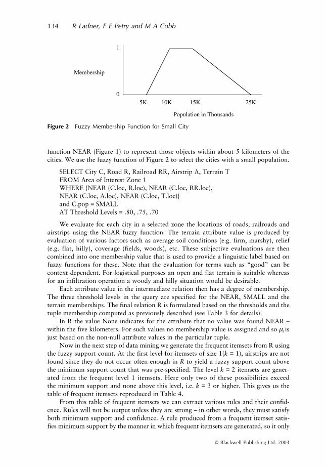
function NEAR (Figure 1) to represent those objects within about 5 kilometers of thecities. We use the fuzzy function of Figure 2 to select the cities with a small population.
SELECT City C, Road R, Railroad RR, Airstrip A, Terrain TFROM Area of Interest Zone 1WHERE {NEAR (C.loc, R.loc), NEAR (C.loc, RR.loc),NEAR (C.loc, A.loc), NEAR (C.loc, T.loc)}and C.pop = SMALLAT Threshold Levels = .80, .75, .70
We evaluate for each city in a selected zone the locations of roads, railroads andairstrips using the NEAR fuzzy function. The terrain attribute value is produced byevaluation of various factors such as average soil conditions (e.g. firm, marshy), relief(e.g. flat, hilly), coverage (fields, woods), etc. These subjective evaluations are thencombined into one membership value that is used to provide a linguistic label based onfuzzy functions for these. Note that the evaluation for terms such as “good” can becontext dependent. For logistical purposes an open and flat terrain is suitable whereasfor an infiltration operation a woody and hilly situation would be desirable.
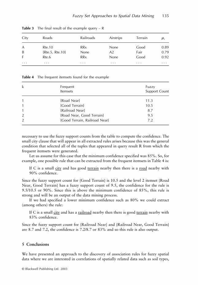
Each attribute value in the intermediate relation then has a degree of membership.The three threshold levels in the query are specified for the NEAR, SMALL and theterrain memberships. The final relation R is formulated based on the thresholds and thetuple membership computed as previously described (see Table 3 for details).
In R the value None indicates for the attribute that no value was found NEAR –within the five kilometers. For such values no membership value is assigned and so µt isjust based on the non-null attribute values in the particular tuple.
Now in the next step of data mining we generate the frequent itemsets from R usingthe fuzzy support count. At the first level for itemsets of size 1(k = 1), airstrips are notfound since they do not occur often enough in R to yield a fuzzy support count abovethe minimum support count that was pre-specified. The level k = 2 itemsets are gener-ated from the frequent level 1 itemsets. Here only two of these possibilities exceedthe minimum support and none above this level, i.e. k = 3 or higher. This gives us thetable of frequent itemsets reproduced in Table 4.
From this table of frequent itemsets we can extract various rules and their confid-ence. Rules will not be output unless they are strong – in other words, they must satisfyboth minimum support and confidence. A rule produced from a frequent itemset satis-fies minimum support by the manner in which frequent itemsets are generated, so it only
Figure 2 Fuzzy Membership Function for Small City
Fuzzy Set Approaches to Spatial Data Mining 135
© Blackwell Publishing Ltd. 2003
necessary to use the fuzzy support counts from the table to compute the confidence. Thesmall city clause that will appear in all extracted rules arises because this was the generalcondition that selected all of the tuples that appeared in query result R from which thefrequent itemsets were generated.
Let us assume for this case that the minimum confidence specified was 85%. So, forexample, one possible rule that can be extracted from the frequent itemsets in Table 4 is:
If C is a small city and has good terrain nearby then there is a road nearby with90% confidence.
Since the fuzzy support count for {Good Terrain} is 10.5 and the level 2 itemset {RoadNear, Good Terrain} has a fuzzy support count of 9.5, the confidence for the rule is9.5/10.5 or 90%. Since this is above the minimum confidence of 85%, this rule isstrong and will be an output of the data mining process.
If we had specified a lower minimum confidence such as 80% we could extract(among others) the rule:
If C is a small city and has a railroad nearby then there is good terrain nearby with83% confidence.
Since the fuzzy support count for {Railroad Near} and {Railroad Near, Good Terrain}are 8.7 and 7.2, the confidence is 7.2/8.7 or 83% and so this rule is also output.
5 Conclusions
We have presented an approach to the discovery of association rules for fuzzy spatialdata where we are interested in correlations of spatially related data such as soil types,
Table 3 The final result of the example query – R
Table 4 The frequent itemsets found for the example
City Roads Railroads Airstrips Terrain µ t
A Rte.10 RRx None Good 0.89B {Rte.5, Rte.10} None A2 Fair 0.79F Rte.6 RRx None Good 0.92. . . . . . . . . . . . . . . . . .
k Frequent Itemsets
Fuzzy Support Count
1 {Road Near} 11.31 {Good Terrain} 10.51 {Railroad Near} 8.72 {Road Near, Good Terrain} 9.52 {Good Terrain, Railroad Near} 7.2
136 R Ladner, F E Petry and M A Cobb
© Blackwell Publishing Ltd. 2003
directional or geometric relationships, etc. We have combined and extended techniquesdeveloped in both spatial and fuzzy data mining in order to deal with the uncertaintyfound in typical spatial data. We plan to also extend our effort to topological relation-ships (Krishnapuram et al. 1993, Zhan 1998, Bloch 1999).
Some areas for future work include hierarchies, weights and interestingness meas-ures. The type II data of spatial relationships have cases that involve hierarchies. Forexample, the NEAR predicate could be organized as a hierarchy of relationships such ascontains, intersects, etc. Each of these might then have a different strength in the hierarchyas well as being defined by fuzzy membership functions. The combination of these valuesis complex and must be worked out in the knowledge discovery context. Another caseis a directional relationship such as NORTH that could be a hierarchy of northeast,north, northwest for which north would have the highest strength in the hierarchy.
Consider from our example in the previous section that airstrips did occur as afrequent itemset because of the low number of airstrips occurring in the spatial data.However, rules involving airstrips might be considered as of great importance to aparticular mission. We would like to provide a fuzzy weighting to such items of import-ance so that they might exceed the minimum support and thus appear in final ruleswithout having to lower minimum support and create a plethora of rules involving otherobjects. In general it is possible that even with a high minimum support and confidencea large number of rules can be generated. Measures of interest are being considered toeither prune or prioritize the final rules that are output.
We are in the process of testing this approach on near-shoreline data that are ofconcern to the Naval operational environment. We are also examining the extensionof the attribute-oriented generalization on spatial data approach (Lu et al. 1993) tofuzzy spatial data. Our overall goal is to be able to integrate the data mining tools andtechniques that prove useful for spatial data into our GIDB geospatial system.
Acknowledgements
We would like to thank the Naval Research Laboratory’s Base Program, Program ElementNo. 0602435N for sponsoring this research.
References
Agrawal R, Imielinski T, and Swami A 1993 Mining association rules between sets of items inlarge databases. In Proceedings of the 1993 ACM-SIGMOD International Conference onManagement of Data. New York, NY, ACM Press: 207–16
Bezdek J 1974 Cluster validity with fuzzy sets. Journal of Cybernetics 3: 58–72Bloch I 1999 Fuzzy relative position between objects in image processing: A morphological
approach. IEEE Transactions on Pattern Analysis and Machine Intelligence 21: 657–64Bosc P and Pivert O 2001 On some fuzzy extensions of association rules. In Proceedings of IFSA-
NAFIPS 2001. Piscataway, NJ, IEEE Press: 1104–9Buckles B and Petry F 1982 A fuzzy representation for relational databases. International Journal
of Fuzzy Sets and Systems 7: 213–26Buckles B and Petry F 1984 Extending the fuzzy database with fuzzy numbers. Information Sciences
34: 45–55Burrough P and Frank A (eds) 1996 Geographic Objects with Indeterminate Boundaries. London,
Taylor and Francis
Fuzzy Set Approaches to Spatial Data Mining 137
© Blackwell Publishing Ltd. 2003
Chawla S, Shekar S, Wu W, and Ozesmi U 2000 Predicting locations using map similarity (Plums):A framework for spatial data mining. In Proceedings of the Sixth ACM-SIGKDD Inter-national Conference on Knowledge Discovery and Data Mining. New York, NY, ACM Press:243–51
Chen G, Wei Q, and Kerre E 2000 Fuzzy data mining: Discovery of fuzzy generalized associationrules. In Bordogna G and Pasi G (eds) Recent Issues on Fuzzy Databases. Heidelberg, Phys-ica-Verlag: 45–66
Chung M, Wilson R, Cobb M A, Petry F E, and Shaw K 2001 Querying multiple data sources viaan object-oriented spatial query interface and framework. Journal of Visual Languages andComputing 12: 37–60
Chung M, Wilson R, Ladner R, Lovitt T, Cobb M A, Abdelguerfi M, and Shaw K 2001 TheGeospatial Information Distribution System (GIDS). In Chaudhri A and Zicari R (eds)Succeeding with Object Databases. New York, John Wiley and Sons: 357–78
Clementini E and DeFelice P 1997 Approximate topological relations. International Journal ofApproximate Reasoning 16: 173–204
Clementini E, DeFelice P, and Koperski K 2000 Mining multiple-level spatial association rules forobjects with a broad boundary. Data and Knowledge Engineering 34: 251–70
Cobb M A and Petry F E 1998 Modeling spatial data within a fuzzy framework. Journal of theAmerican Society for Information Science 49: 253–66
Cobb M A, Chung M, Foley H, Petry F E, and Shaw K 1998 A rule-based approach for theconflation of attributed vector data. GeoInformatica 2: 1–29
Cobb M A, Petry F E, and Robinson V B (eds) 2000 Special issue: Uncertainty in geographicalinformation systems and spatial data. International Journal of Fuzzy Sets and Systems 113:1–159
Cross V and Firat A 2000 Fuzzy objects for geographical information systems. InternationalJournal of Fuzzy Sets and Systems 113: 19–36
de Graaf J, Kosters W, and Witteman J 2001 Interesting fuzzy association rules in quantitativedatabases. In Principles of Data Mining and Knowledge Discovery – LNAI 2168. Berlin,Springer-Verlag: 140–51
Ester M, Fromelt A, Kriegel H, and Sander J 2000 Spatial data mining: Database primitives,algorithms and efficient DBMS support. Data Mining and Knowledge Discovery 4: 89–125
Gale S 1972 Inexactness, fuzzy sets and the foundation of behavioral geography. GeographicalAnalysis 4: 337–49
George R, Buckles B, Petry F, and Yazici A 1992 Uncertainty modeling in object-oriented geo-graphical information systems. In Proceedings of 1992 Conference on Database and ExpertSystem Applications. Berlin, Springer-Verlag: 77–86
Goodchild M and Gopal S (eds) 1990 The Accuracy of Spatial Databases. London, Taylor and FrancisGuesgen H and Albrecht J 2000 Imprecise reasoning in geographic information systems. Inter-
national Journal of Fuzzy Sets and Systems 113: 121–31Gyenesei A 2000 Mining Weighted Association Rules for Fuzzy Quantitative Items. Turku, Turku
Center for Computer Science Technical Report No 346Gyenesei A 2001 Interestingness measures for fuzzy association rules. In Principles of Data Mining
and Knowledge Discovery – LNAI 2168. Berlin, Springer-Verlag: 152–64Han J and Kamber M 2000 Data Mining: Concepts and Techniques. San Diego, CA, Academic PressHan J, Koperski K, and Stefanovic N 1997 GeoMiner: A system prototype for spatial data mining.
In Proceedings of the 1997 ACM-SIGMOD International Conference on Management ofData. New York, ACM Press: 553–6
Hirota K and Pedrycz W 1999 Fuzzy computing for data mining. In Proceedings of the IEEE 87:1575–99
Kacprzyk J and Zadrozny S 2000 On combining intelligent querying and data mining using fuzzylogic concepts. In Bordogna G and Pasi G (eds) Recent Issues on Fuzzy Databases. Heidelberg,Physica-Verlag: 67–81
Krishnapuram R, Keller J, and Ma Y 1993 Quantitative analysis of properties and spatial relationsof fuzzy image regions. IEEE Transactions on Fuzzy Systems 1: 222–33
Koperski K and Han J 1995 Discovery of spatial association rules in geographic informationdatabases. In Proceedings of the Fourth International Symposium on Large Spatial Data-bases. Berlin, Springer-Verlag: 47–66
138 R Ladner, F E Petry and M A Cobb
© Blackwell Publishing Ltd. 2003
Kuok C, Fu A, and Wong H 1998 Mining fuzzy association rules in databases. ACM SIGMODRecord 27: 41–6
Laurent A 2003 Fuzzy multidimensional databases for fuzzy-OLAP mining. IEEE Transactionson Fuzzy Systems 11: in press
Lee K 2001 Mining generalized fuzzy quantitative association rules with fuzzy generalizationhierarchies. In Proceedings of IFSA-NAFIPS 2001. Piscataway, NJ, IEEE Press: 2977–82
Leung Y 1979 Locational choice: A fuzzy set approach. Geographic Bulletin 19: 28–34Lu W, Han J, and Ooi B 1993 Discovery of general knowledge in large spatial databases. In
Proceedings of the Far East Workshop Geographic Information Systems. Singapore, WorldScientific Press: 275–89
Morris A and Petry F E 1998 Design of fuzzy querying in object-oriented spatial data and GIS. InProceedings of NAFIPS 98. Piscataway, NJ, IEEE Press: 211–5
Morris A, Petry F E, and Cobb M A 1998 Fuzzy object-oriented database modeling of spatialdata. In Proceedings of the IPMU Conference. Paris, EDK Press: 604–11
Ng R and Han J 1994 Efficient and effective clustering method for spatial data mining. InProceedings of 1994 International Conference on Very Large Databases. San Francisco, CA,Morgan Kaufmann: 144–55
Petry F E 1996 Fuzzy Databases: Principles and Applications. Norwell, MA, KluwerPipkin J 1978 Fuzzy sets and spatial choice. Annals of the Association of American Geographers
68: 196–204Robinson V B and Frank A 1985 About different kinds of uncertainty in geographic information
systems. In Proceedings of the AUTOCARTO 7 Conference. Falls Church, VA, AmericanSociety for Photogrammetry and Remote Sensing: 440–9
Robinson V B 1988 Implications of fuzzy set theory for geographic databases. Computers,Environment and Urban Systems 12: 89–98
Robinson V B 1990 Interactive machine acquisition of a fuzzy spatial relation. Computers andGeosciences 6: 857–72
Shu J, Tsang E, and Yeung D 2001 Query fuzzy association rules in relational databases. InProceedings of IFSA-NAFIPS 2001. Piscataway, NJ, IEEE Press: 2989–93
Stoms D 1987 Reasoning with uncertainty in intelligent geographic information systems. InProceedings of GIS’87. Falls Church, VA, American Society for Photogrammetry and RemoteSensing: 693–9
Tobler W 1979 Cellular geography. In Gale S and Olsson G (eds) Philosophy in Geography.Dortrecht, Riedel: 379–86
Wang F 2000 A fuzzy grammar and possibility theory-based natural language user interface forspatial queries. International Journal of Fuzzy Sets and Systems 113: 147–59
Yager R 1991 On linguistic summaries of data. In Piatesky-Shapiro G and Frawley (eds) KnowledgeDiscovery in Databases. Boston, MA, MIT Press: 347–63
Yen J and Langari R 1999 Fuzzy Logic: Intelligence, Control and Information. Upper SaddleRiver, NJ, Prentice Hall
Zhan F 1998 Approximate analysis of topological relations between geographic regions withindeterminate boundaries. Soft Computing 2: 28–34
Zhang W 1999 Mining fuzzy quantitative association rules. In Proceedings of IEEE InternationalConference on Tools with Artificial Intelligence. Piscataway, NJ, IEEE Press: 99–102
Copyright © 2022 FDOKUMEN