Further evidence of desert settlement complexity: report on the 2001 excavations at the Iron Age...
24
Arab. arch. epig. 2002: 13: 133–156 C 2002 Blackwell Munksgaard Printed in Denmark. All rights reserved ISSN 0905-7196 Further evidence of desert settlement complexity: report on the 2001 excavations at the Iron Age site of Muweilah, Emirate of Sharjah, United Arab Emirates PETER MAGEE 1 , EMMA THOMPSON 2 , ANNE MACKAY 3 , PAMELA KOTTARAS 2 AND LLOYD WEEKS 4 1 Department of Classical and Near Eastern Archaeology, Bryn Mawr College, USA; 2 School of Archaeology, University of Sydney, Australia; 3 Godden Mackay Logan Heritage Consultants, Sydney, Australia; 4 Department of Anthropology, Harvard University, USA Introduction Archaeological fieldwork in the United Arab Emirates and Sultanate of Oman has increased to the point at which questions relating to settlement dynamics, economic and social complexity and foreign relations can begin to be addressed. This is particu- larly the case in the Iron Age (1300–300 BC), the middle phase of which sees a massive increase in the number of settle- ments in this region (1). Since 1994, The Australian Archaeological Mission (2) has been investigating one aspect of this settle- ment intensification by focussing on the desert settlement of Muweilah (3). The reader is referred to previous publications of the site for explanations of the grid and co-ordinate system used at Muweilah. Ex- cavations have revealed evidence of a large, internally complex, Iron Age II settle- ment and numerous campsites spread over 4–5 hectares (Fig. 1) (4). The settlement rep- resents, therefore, one component of the rapid settlement intensification which de- 133 fines this region during the Iron Age II period. What makes the site of interest, however, for a broader understanding of settlement dynamics and human-environ- mental interaction is that the site is not located in one of the environmental regions which have traditionally been focussed upon when examining the emergence of complexity. Our research, therefore, aims to examine the economic and environmental factors which may have led to the emer- gence of such a large settlement in a setting which would otherwise be considered hos- tile to long-term, sedentary human occu- pation. In so doing we seek to challenge models that characterise human settlement in arid and semi-arid zones as falling into the immutable classes of ‘desert’ and ‘sown’. Here we will detail the results of the 2001 excavation season and several facets of the ongoing, post-excavation analysis to pro- vide some preliminary interpretative frameworks that pertain to this issue. Be-
-
Upload
independent -
Category
Documents
-
view
3 -
download
0
Transcript of Further evidence of desert settlement complexity: report on the 2001 excavations at the Iron Age...

Arab. arch. epig. 2002: 13: 133–156 C 2002 Blackwell MunksgaardPrinted in Denmark. All rights reserved
ISSN 0905-7196
Further evidence of desert settlementcomplexity: report on the 2001 excavationsat the Iron Age site of Muweilah, Emirate ofSharjah, United Arab Emirates
PETER MAGEE1, EMMA THOMPSON2, ANNE MACKAY3, PAMELA KOTTARAS2 ANDLLOYD WEEKS4
1Department of Classical and Near Eastern Archaeology, Bryn Mawr College, USA;2School of Archaeology, University of Sydney, Australia; 3Godden Mackay Logan HeritageConsultants, Sydney, Australia; 4Department of Anthropology, Harvard University, USA
IntroductionArchaeological fieldwork in the UnitedArab Emirates and Sultanate of Oman hasincreased to the point at which questionsrelating to settlement dynamics, economicand social complexity and foreign relationscan begin to be addressed. This is particu-larly the case in the Iron Age (1300–300BC), the middle phase of which sees amassive increase in the number of settle-ments in this region (1). Since 1994, TheAustralian Archaeological Mission (2) hasbeen investigating one aspect of this settle-ment intensification by focussing on thedesert settlement of Muweilah (3). Thereader is referred to previous publicationsof the site for explanations of the grid andco-ordinate system used at Muweilah. Ex-cavations have revealed evidence of alarge, internally complex, Iron Age II settle-ment and numerous campsites spread over4–5 hectares (Fig. 1) (4). The settlement rep-resents, therefore, one component of therapid settlement intensification which de-
133
fines this region during the Iron Age IIperiod. What makes the site of interest,however, for a broader understanding ofsettlement dynamics and human-environ-mental interaction is that the site is notlocated in one of the environmental regionswhich have traditionally been focussedupon when examining the emergence ofcomplexity. Our research, therefore, aims toexamine the economic and environmentalfactors which may have led to the emer-gence of such a large settlement in a settingwhich would otherwise be considered hos-tile to long-term, sedentary human occu-pation. In so doing we seek to challengemodels that characterise human settlementin arid and semi-arid zones as falling intothe immutable classes of ‘desert’ and‘sown’.
Here we will detail the results of the 2001excavation season and several facets of theongoing, post-excavation analysis to pro-vide some preliminary interpretativeframeworks that pertain to this issue. Be-

P. MAGEE ET AL.
Fig. 1.Location of Muweilah.
Fig. 2.Plan of Muweilah. For scale see Fig. 6.
134

THE 2001 EXCAVATIONS AT THE IRON AGE SITE OF MUWEILAH
fore doing so we would like to thank themany friends and government agencieswho have facilitated and supported our re-search since 1994. In particular, the Directorof Sharjah Archaeological Museum, DrSabah Jasim, has assisted our work in nu-merous ways. The resources placed at ourdisposal by the Museum stand as testi-mony to the support and patronage of HisHighness Sheikh Sultan bin Mohammed al-Qassimi, Ruler of Sharjah (5).
Previous research and aimsExcavations and geophysical survey (6) atMuweilah since 1994 have focussed onclarifying the extent of a large buildingcomplex that we have labelled Area C. It isnow clear that this contains several build-ings in which there is evidence of a fierydestruction in the form of a thick layer ofburning. Excavations in Buildings I and IIhave revealed a great quantity of data onthe function and organisation of these twostructures. As detailed in other reports,Building I comprises several multi-roomedunits in which there is evidence of dom-estic activity in the form of storage jars,cooking areas and food processing equip-ment (grinding stones etc.). Building II con-sists of a large central room with a 5¿4 col-umniation and several ancillary rooms. Inaddition to its form, which has parallels inwest and northwest Iranian Iron Age archi-tecture (7), the artefacts found within thisbuilding suggest that it was an elite struc-ture that may have formed the political andeconomic centre of the settlement.
The aim of the 2001 season was to clarifythe extent and internal configuration of theArea C settlement, specifically:
1. to test the geophysical results obtainedin 1998, specifically the existence of asurround wall
135
2. to excavate a possible gateway featurein Building I and
3. to complete the excavation of BuildingII
A further geophysical survey was com-pleted in 2001 using Ground PenetratingRadar and a specific publication on thoseresults is forthcoming.
The surround wallsPrior to 1998, we had excavated an areaof 235 m2 although we had no indicationof the exact nature or size of the Area Ccomplex. The magnetometry survey con-ducted in 1998 mapped a feature that ap-peared to be a wall which enclosed Area
Fig. 3.Excavations in Area C2, 2000. Stone surround wall.
P. MAGEE ET AL.
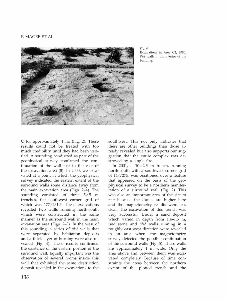
Fig. 4.Excavations in Area C2, 2000.Pise walls in the interior of thebuilding.
C for approximately 1 ha (Fig. 2). Theseresults could not be treated with toomuch credibility until they had been veri-fied. A sounding conducted as part of thegeophysical survey confirmed the con-tinuation of the wall just to the east ofthe excavation area (8). In 2000, we exca-vated at a point at which the geophysicalsurvey indicated the eastern extent of thesurround walls some distance away fromthe main excavation area (Figs. 2–4). Thesounding consisted of three 5¿5 mtrenches, the southwest corner grid ofwhich was 177/231.5. These excavationsrevealed two walls running north-southwhich were constructed in the samemanner as the surround wall in the mainexcavation area (Figs. 2–3). In the west ofthis sounding, a series of pise walls thatwere separated by habitation depositsand a thick layer of burning were also re-vealed (Fig. 4). These results confirmedthe existence of the eastern portion of thesurround wall. Equally important was theobservation of several rooms inside thiswall that exhibited the same destructiondeposit revealed in the excavations to the
136
southwest. This not only indicates thatthere are other buildings than those al-ready revealed but also supports our sug-gestion that the entire complex was de-stroyed by a single fire.
In 2001, a 10¿2.5 m trench, runningnorth-south with a southwest corner gridof 147/275, was positioned over a featurethat appeared on the basis of the geo-physical survey to be a northern manifes-tation of a surround wall (Fig. 2). Thiswas also an important area of the site totest because the dunes are higher hereand the magnetometry results were lessclear. The excavation of this trench wasvery successful. Under a sand depositwhich varied in depth from 1.4–1.5 m,two stone and pise walls running in aroughly east-west direction were revealedin an area where the magnetometrysurvey detected the possible continuationof the surround walls (Fig. 5). These wallsare approximately 1 m wide. Only thearea above and between them was exca-vated completely. Because of time con-straints the areas between the northernextent of the plotted trench and the

THE 2001 EXCAVATIONS AT THE IRON AGE SITE OF MUWEILAH
Fig. 5.Excavations in Area C4, 2001.Stone surround wall (to thesouth) and in the backgroundthe mudbrick surround wall.
northernmost wall and the area to thesouth of the southernmost wall was notexcavated. Nonetheless the limited resultsconfirmed the continuation of the sur-round walls to the north.
Excavations also continued to the westof Building II. Here an area of 200 m2 wasopened to trace the supposed continuationof the surround walls to the west and northand to investigate several distinct featureswhich appeared on the magnetometrysurvey. The first objective was achievedand it soon became evident that the sur-round walls at this point continued to-wards the north (Fig. 2). Once the thick piseinner wall and the stone outer wall wereevident on the surface, excavation focussedon the areas to the west in which a distinctfeature was evident in the magnetometrysurvey (9). Excavations revealed, however,no evidence for structures despite theclearing of nearly 15 m to the west of thesurround wall.
The results obtained in the northern andwestern areas in 2001 and the easternsounding in 2000 provide substantialground-truthing to the magnetometry indi-cation that Area C is encircled by surround
137
walls. There is undoubtedly still much todetermine in reference to structures andthe exact course of these walls, as thesesoundings were quite limited. They do,however, provide a framework in which tofurther investigate the internal configur-ation of this part of the settlement.
Excavations in Building IIExcavations in Building II (Area C) re-sumed on 6 February 2001. The aim was todetermine the plan of this building and tocomplete the removal of the building’s ar-chaeological deposits. Previous excavationshad revealed substantial evidence for for-eign and status goods within this buildingand these have provided a wealth of dataon the manner in which elites within thesettlement legitimised and projected theirauthority (10). It was hoped that thisseason would provide further data on thisissue as well as illuminate the relationshipbetween Buildings II and I.
Excavation concentrated in an area of ap-proximately 100 m2 adjacent to the portionof Building II revealed in 2000. This areawas covered by a layer of yellow-golden

P. MAGEE ET AL.
sand, varying in depth up to 1.5 m, whichhad to be removed before archaeologicaldeposits were reached. In most cases, thefirst deposits of archaeological interestwere composed of pise collapse with areas
Fig. 6.Detail plan of Building II, Area C.
Fig. 7.View towards the southeastshowing Building II in the fore-ground and the stone columnbases covered with sand. Theflat wadi boulders used as an en-trance threshold to Building IIare evident in the centre of thefigure.
138
of concentrated burning, within which pisewalls could be discerned. The pise collapsewas commonly 20–40 cm thick, and insome cases contained numerous ceramicsherds and charcoal (charred date seeds

THE 2001 EXCAVATIONS AT THE IRON AGE SITE OF MUWEILAH
Fig. 8.Ancillary room in the northwestof Building II. Note thesmoothed pise floor.
were common). The base of the collapsewas marked by a transition to a thin butconcentrated layer of burnt material, whichsat on a solid mud floor or, in some areas,a compact pale yellow-grey sandy deposit.All collapse, burnt material and above-floor deposits were removed in order to ex-pose the architectural features of BuildingII, while the floors themselves were left inplace. Excavation of the floors in thenorthern part of Building II will be a pri-ority of future seasons’ work at Muweilah.
The plan of Building II is now clear. It isa multi-roomed structure built of pise (Fig.6). The exterior of the southern half ofBuilding II is covered with a facing of rela-tively small, unworked stones which sur-vives to a height of less than a metre. Itseems likely that this stone facing wasnever much higher than its current pre-served height, as the amount of stonefound in the archaeological deposits out-side Building II was minimal. This is incontrast to the western wall of Building I,the collapse of which indicates stone con-struction to at least 2 m high. In the centreof Building II is a columned room, approxi-mately 10¿12 m, within which were found
139
Fig. 9.Ancillary room in the east of Building II. Note thebench of the eastern wall and traces of burning on thefloor.

P. MAGEE ET AL.
Fig. 10.Ancillary room in the northeastof Building II showing evidenceof burning on the floor.
Fig. 11.See Figure 10. The same roomafter the removal of the habi-tation deposits.
eighteen stone column bases (Fig. 7). Theeighteen bases represent the incomplete re-mains of a grid of 4¿5 columns, the north-ernmost and southernmost rows of whichare engaged. The principal entry into thisroom appears to have been from the north,where a doorway with pise step and athreshold comprising three large flat wadiboulders was located (Fig. 7). This
140
doorway was accessed from a long roomca. 16¿3.5 m, which also has an entry in itsnorthern wall opposite that in the centralroom, and is the likely main entrance to thebuilding. It should be noted that the roomsthat surround the central room all havesolid and relatively smooth pise floors (Fig.8) while the central room apparently had asand floor at a significantly lower level.

THE 2001 EXCAVATIONS AT THE IRON AGE SITE OF MUWEILAH
Fig. 12.Northern section of pit to thenortheast of Building II.
In the 2001 season, excavation concen-trated on exposing the long room in thenorth of the columned hall and two roomsto the east (Figs. 6, 9). The room (6.5¿2.5m) immediately to the east of the columnedhall was partly excavated in 2000 and thencompleted in 2001. One architectural fea-ture worth noting is a low pise bench, ca. 30cm high and 30 cm wide, which runs alongthe eastern wall of this room (Fig. 9). Largeconcentrations of animal bones were re-vealed in the south of this room. A smallerroom (ca. 2.5¿3 m), is reached from thenortheast corner of this room (Figs. 6, 10–11). Like all rooms in Area C, it containedevidence for burning and ash (Fig. 10). Italso contains low pise benches along itsnorthern and southern walls, which dis-play a number of shallow troughs, gener-ally less than 10 cm deep, of uncertainfunction (Fig. 11).
To the northeast outside Building II, alarge irregular pit ca. 4 m in diameter andmore than 1 m deep was partially exca-vated (Fig. 12). It contained the collapse oftwo walls as fill, but as excavation of thepit is incomplete, its function or purposehas not been ascertained. It is interesting to
141
note that the pit sequence appears to indi-cate that collapse from Building II was de-posited before collapse from Building I.Some interesting ceramic vessels were re-covered from this pit, including at leasttwo very small bridge-spouted vessels (Fig.13), a vessel with applique snake motif and
Fig. 13.Miniature bridge spouted vessel from the pit to thenortheast of Building II.

P. MAGEE ET AL.
Fig. 14.Chalice or goblet from the pit to the northeast ofBuilding II.
two small, footed ‘goblets’ (Fig. 14). Itshould be noted that all these vessels aremade in a fine poorly fired, sand-temperedclay such that it is hard to imagine theywere of any great utilitarian use. A largeamount of shell (primarily Terebralia andMarcia) was recovered from the sandy de-
Fig. 15.View towards the south of thearea between Buildings I and II.
142
posits outside the building, in addition tosignificant quantities of pottery and someanimal bone. The material from outside thebuilding was distinguished from the roomdeposits by its generally lower degree ofburning.
To the southeast of Building II, exca-vations focussed on an area that lay be-tween that building and the stone sur-round wall of Building I. This area is ap-proximately 12¿5 m and falls within thecoordinates 92–97/210 and 92–97/220 (Fig.15). The area is roughly rectangular inshape but extends into an ‘L’ shape in thesouthwest corner. It appears to be an out-door area which provided access routesthat wind through the settlement.
The top-sand had been cleared in a pre-vious season so excavations began at thelevel of pise collapse. Although these de-posits were significant, it should be notedthat the level of burning and debris wasmuch less than that found elsewhere in thesettlement. A portion of the outer wall ofBuilding I had collapsed into the trench ataround 99/218–99/220, leaving a smallarea of the trench covered by the remains

THE 2001 EXCAVATIONS AT THE IRON AGE SITE OF MUWEILAH
Fig. 16.Interior of plastered pit.
of the stone and pise wall. Once this depositwas removed two features of particular in-terest were uncovered: an ash-filled pitwith decorated plaster lining and a largeceramic vessel minus the base, also filledwith ash.
The pit was discovered at the northernextent of the trench (Fig. 15) and is con-structed of pise and stone slabs insertedinto the sandy matrix. It was partly filledwith pise collapse, and the collapsed wallof Building II. It is rectangular in shape, itsexternal dimensions measure 0.8¿1.2 mand it is approximately 1 m deep. Whenthe surrounding pise collapse was re-moved, it became evident that a layer ofashy sand surrounded the outer edge ofthe pit. This ashy sand had the appearanceof having been raked out of the pit. Ad-jacent to the pit were two piles of shell,bone and stone: a large pile on the southernside of the pit and a smaller pile on thewestern side.
The upper contents of the pit consistedof ash, charcoal and large fragments of pisecollapse. Small quantities of shell and bonewere also removed from the upper con-
143
tents of the pit. At approximately 50 cm, alayer of solid pise material was removed,below which more ash, charcoal, a smallquantity of bone, shell, ceramic sherds andorganic remains were revealed. The base ofthe pit was lined with flat stones and oneflat sherd from a ceramic lid. The most not-able aspect of the pit is that three of its fourwalls were partially lined with patternedplaster (Fig. 16), measuring 20 cm in width¿ 16 cm in height with their lower edgesbeginning approximately 60 cm from thebase of the pit. The plaster on the southernwall collapsed soon after excavation butthe northern and eastern walls retain theirpatterned lining. Each wall had a differentdesign but all appeared to be the result offinger strokes creating slanting lines anddeep impressions.
Five metres to the south of the plaster-lined pit is a tannour or fireplace con-structed with a large ceramic vessel minusits base (see Fig. 15). The diameter of thevessel is 85 cm and has been dug into theclean sand with sections of the vesselchocked with stones. This feature wasfilled with sand covering ash, charcoal and

P. MAGEE ET AL.
a small quantity of bone, shell and sherds.Adjacent to this feature are two small pitsapproximately 20 cm in diameter, one con-taining ash and the other containing a con-centration of shell and bone and somebronze production refuse.
These two features represent a distinctfunctional area within the settlement. Notonly is their function delineated by theirposition outside, yet close to, two buildingsbut the presence of two unusual featuresis also of note. Of particular interest is theplaster-lined pit in the north of this area.No obvious function for this feature is evi-denced by the artefacts. Inasmuch asplaster was used in the interior of BuildingII (11) and there was a great deal of shellfound in association with the pit, the possi-bility that the pit and the fireplace to thesouth were associated with the productionof lime should be entertained. If this is thecase, it would provide the first evidence forin situ lime-plaster production during theIron Age.
The gateway excavationsDuring the 2001 season excavation also fo-cussed in the east of Area C following
Fig. 17.Stone walls forming ‘S’-shapedgateway.
144
structural features partially revealedduring the 1998 season of excavation. Anarea of ca. 475 m2 was excavated (includingareas partially excavated in 1998) revealingstructural features and archaeological de-posits.
In general, three occupation areas wereidentified during the excavation of thisarea:
1. a possible entrance corridor2. intra-mural areas that lay outside
Building I3. internal areas of Building I
In the area 10 m to the north and 5 mto the east of coordinate 127/180, what hasbeen provisionally interpreted as agateway into the settlement was revealed(Fig. 2). The gateway was entered from thesouth at which point it was necessary tomove through an ‘S’-shaped entrance theeastern extent of which was paved with aseries of flat stones (Figs. 2, 17). After pro-ceeding through this gateway, it was poss-ible to proceed eastwards through a smalldoorway (Fig. 17). Our present under-standing of the exterior wall of Building I

THE 2001 EXCAVATIONS AT THE IRON AGE SITE OF MUWEILAH
Fig. 18.Narrow stone room to the north of the gateway. Viewtowards the north.
suggests, however, that it would not bepossible to enter this building if one usedthis route. Alternatively, one could proceednorthwards after passing through the ‘S’-shaped gateway and proceed along a longnarrow space defined by parallel stonewalls with buttresses (Fig. 18). However, itshould be noted that the identification ofthis area as a corridor leading to a court-yard or the centre of Building I must re-main provisional. Excavations are not com-plete to the north and it is possible that thisfeature may be a long narrow room which,given the thickness of the bastions, wasperhaps the ground storey of a tower anddid not provide entrance to the interior ofBuilding I. Future excavations will clarifythis issue.
145
In the northern extent of this stone rooma feature that further complicates the inter-pretation of this area was revealed. In araised floor surface three deep groovesrunning east-west that intersect one north-south running groove were evident (Figs.19–20). In the lower part of this platform, aplaster-lined pit was revealed (Fig. 21). Inanother context there would be little hesi-tation in assigning to this the function of adate press or madbasa. A madbasa has beenfound on Qala’at al-Bahrain dating to themiddle of the second millennium BC.There is, therefore, no doubting the an-tiquity of this technology (12). Althoughthat example is much larger than the fea-ture at Muweilah and recent examples con-tain a buried vessel to collect the date
Fig. 19.Possible madbasa. View from the east.

P. MAGEE ET AL.
Fig. 20.Possible madbasa. View from the north.
syrup, it is worth noting that modernexamples from Bahrain and Oman can beas small as the Muweilah feature and thatpits rather than vessels are used in the Is-lamic fort at Qala’at al-Bahrain (13). Themajor objection to the identification of thisfeature as a madbasa remains, however, itsposition in a possible gateway. When exca-vations are completed to the north of thisarea the function of this entire area shouldbe resolved.
Regardless of the role of the stone cor-ridor in the gateway structure, it is clearthat this part of Area C contains a distinc-tive gateway structure that provided, insome manner, an entrance to the settle-ment. Despite the relatively common statusof Iron Age II fortified structures, elaborate
146
Fig. 21.Plaster-lined pit.
gateways have never been noted as a fea-ture of this period. It is clear that those thathave been published (eg. Husn Awhala(14)) differ considerably from the elaborategateway entrance at Muweilah. The de-tailed study presented by Breton of pre-first-century AD fortifications in Yemen(15) also contains no contemporary paral-lels. It is interesting to note, however, thatKhor Rori does contain a similar ‘S’-shapedentrance even if recent analysis of thearchitectural phasing and epigraphic evi-dence reconfirms the fact of its foundationmany centuries after Muweilah was de-stroyed (16).
Excavations to the east of the gateway in-dicate that the outer stone wall of BuildingI continues for some distance in that direc-

THE 2001 EXCAVATIONS AT THE IRON AGE SITE OF MUWEILAH
Fig. 22.Stone exterior wall of Building I to the east of thegateway. View towards the east.
Fig. 23.View of the gateway area to-wards the west.
147
tion (Fig. 22). To the south of this wall wereseveral walls and features that were strati-graphically quite distinct from those foundwithin Building I. The 2001 excavated areas(particularly Squares 117–122/190 and 137–185/195) contained concentrations of red-dish brown silty deposits (occupation de-posits) with lenses of silvery grey fine ash(the remains of burning at a high tempera-ture or possibly burning of a very flam-mable material such as grass matting?) andlittle evidence of the collapse of thebuilding. The localisation of these depositsin the external areas indicates a structuraland functional distinction from the interiorof Building I although the exact nature ofthis difference for the moment is as yet un-known. Nonetheless several architecturalspaces were defined in this area (Figs. 23–24), some of which contained concen-trations of burnt organic material, animalbones and shells.
The areas within Building I which wereexcavated during this season conformed tothe usual stratigraphy of the site, as dis-cussed above, although there had been lowpreservation of the walls in this area, espe-cially in the northeast corner of the site.

P. MAGEE ET AL.
Fig. 24.View of the gateway area to-wards the north.
Fig. 25.Mud fireplace/tannour insideBuilding I.
This area also contained two fireplaces ortannours and two clay-lined bins. Onetannour was almost a metre in diameterand constructed in packed clay (Fig. 25)that rested on a flat stone base. The other,further east, was a smaller pise-lined pitthat contained a concentration of charcoaland ash (Fig. 26). The two clay-lined bins,one of which is seen in Figure 27, were
148
located further west (partially within thenorthern section of the trench), and bothcontained charcoal and ash. It is interestingto note that similar clay-lined bins were re-vealed in early seasons in the northern ex-tent of Building I in the rooms that we as-sume were also facing the interior court-yard of the building.
Finally, there is some evidence that this

THE 2001 EXCAVATIONS AT THE IRON AGE SITE OF MUWEILAH
Fig. 26.Stone and pise fireplace/tannourinside Building I.
Fig. 27.Clay-lined bin in the northernbaulk of the gateway area exca-vations.
area of the site has been reconfigured, poss-ibly as the settlement expanded or the needfor defence increased. The alignment ofwalls, and in some cases misalignment,suggests more than one phase of construc-tion. The external corridor in the west ofthis trench (Squares 117–122/190) also con-tained what may be demolition rubble be-neath occupation deposits, further indi-
149
cating reconstruction. An earlier phase ofconstruction was also recorded in this areawith the discovery of a deep wall in one ofthe external corridors (Fig. 28). This wallextended to a depth of ca.1.5 m and ap-pears to be the same as deep walls foundfurther west, also outside Building I. Thesewalls are constructed of stone and pise witha rounded top and only one smooth face.

P. MAGEE ET AL.
Fig. 28.Deep (retaining?) wall running under the last phaseof construction in the gateway area.
They may be some sort of retaining wallwhich surrounded an earlier phase ofbuilding at the site. Such walls may havefunctioned to contain an area of cultivationor to prevent sand accumulation within thesettlement. Further analysis of the layout ofthese walls should clarify this and an in-train programme of AMS dating of ma-terials in adjacent deposits should clarifytheir chronology and relationship to thefinal phase of building.
Off-site surveyThe pace of construction around Muweilahmeans that it is impossible to formulateany systematic off-site survey strategy.
150
Every year, however, we have taken the op-portunity to survey informally the areasaround Muweilah and to observe the im-pact of local building on sub-surface de-posits. From the first season we were awarethat about 2 km to the south of the Area Csettlement there were two features whichwe were informed by a local who hadherded his camels in this area were a falaj.We visited the site in 1994 but took the op-portunity this year to document the siteusing digital photography and GPS. Thereare at least two mounds, several metreswide (eg. Fig. 29) and covered with faroushstone located in a long depression whichmay form the base of a wadi. We were in-formed that these were the access holes orthuqbah of a falaj that ran roughly towardsthe north or northwest. In 1994, one ofthese holes was still accessible but nowthey are covered with sand.
The two features which could be iden-tified this year were aligned towards thegeneral direction of the site. Although, primafacie, this might suggest that the falaj wasIron Age in date it must be noted that thereis no evidence for Iron Age ceramics associ-ated with these features and, in fact, severalsmall pieces of recent period ceramics werepicked up in the area of this feature. Further-more, there is evidence for recent occu-pation around the area of Muweilah and thelarge cemetery which is on the southernborder of the site attests to intensive occu-pation in the not too distant past. Althoughthe existence of an Iron Age falaj, presum-ably tapping sub-surface water deposits in awadi bed, is an attractive hypothesis andwould partly explain the agricultural basefor the settlement, we are for the momentdisinclined to insist on this notion untilfirmer evidence is available (17).
Artefactual recordThe three-dimensional in situ recording ofall artefacts at Muweilah (excluding

THE 2001 EXCAVATIONS AT THE IRON AGE SITE OF MUWEILAH
Fig. 29.Possible falaj or well access holeto the south of Area C.
sherds) has been emphasised as an im-portant component of the project since itsinception. To date, this information hasprovided insights into activity patterningand labour organisation at the settlement.In this report we will not detail all of theartefacts and their distribution, but ratherfocus on several classes of artefacts thatcontinue to provide important informationon lifeways at the settlement.
In previous publications we have notedthat the existence of iron at Muweilah isthe earliest manifestation of this material insoutheastern Arabia (18). The first ironartefacts from secure contexts were dis-covered in the long, ancillary rooms ofBuilding II in 1998. Continued excavationsat Muweilah have revealed nineteen ironobjects and several unidentifiable pieces ofiron. Bronze artefacts also continued to befound throughout the settlement. The dis-tribution of both these classes of artefactsis very instructive as to their importanceand function within the settlement (Fig.30). Iron is concentrated within Building IIand, in fact, most of these objects come
151
from one ancillary room that can only beentered from the main columned room.Finished bronze objects, on the other hand,are equally distributed across the settle-ment in both Buildings I and II (19). Therestricted distribution of iron artefactsserves to reinforce the importance andstatus attached to iron within the settle-ment, thus mirroring studies of the first ap-pearance of iron elsewhere in the ancientNear East (20).
Detailed studies of the distribution ofclasses of bronze objects within the settle-ment provide further insights into the na-ture of the settlement. Already someclasses of bronze objects are providingstriking evidence for possible ‘events’within the history of the settlement. For ex-ample, although arrowheads are found inlimited quantity throughout the settlement,two clusters account for most examples. Asnoted in a previous publication, arrow-heads that have just been cast have beenrevealed in Building II. This combines withthe refuse of smelting to indicate the pro-duction of bronze weapons within this

P. MAGEE ET AL.
Fig. 30.The distribution of iron and bronze objects in Buildings I and II at Muweilah.
building. In 2001, the largest cluster of ar-rowheads was found around the gateway(Fig. 31) (21). When considered in light ofthe evidence for the destruction of thesettlement, it is tempting to see this distri-bution as evidence for the attack whichmay account for this destruction. Althoughsuch data remains somewhat anecdotal, itis interesting to note that the arrowheadsfound around the gateway are of one typecharacterised by relatively straight profile.In contrast, the two found inside the settle-ment are a smaller, lanceolate type. Bothtypes find wide comparanda throughout theUAE in the Iron Age and although it maybe tempting to see the differences in theirdistribution as reflecting functional differ-
152
ences (ie. warfare as opposed to hunting ordefense as opposed to attack) the limiteddistribution for the moment cautionsagainst such an interpretation.
Several isolated artefactual finds weremade in 2001 that complement our under-standing of the material culture of thesettlement. A complete camel figurine wasdiscovered at Muweilah in 1996 and sincethen several fragments of similar figurineshave been discovered. In 2001, a ceramiccamel head was discovered in one of thesmall refuse areas located between the sur-round walls and Building I (Fig. 32). Al-though camel figurines are found else-where during the Iron Age II period (22),this piece joins with the other Muweilah

THE 2001 EXCAVATIONS AT THE IRON AGE SITE OF MUWEILAH
Fig. 31.The distribution of arrowheads in Buildings I and II at Muweilah.
figurine in its realistic and highly decor-ated manner. Unlike the example dis-covered in 1996, the neck of this fragmentis quite elongated, perhaps indicating thatthe representation is that of a camel run-ning. It is, in any case, decorated in asimilar fashion to the examples found pre-viously at Muweilah and taken as a corpusthey are highly suggestive of not only fam-iliarity with the camel but also of their reg-ular use (23).
New chronological dataIn previous publications we have provideddata on the many 14c and AMS determi-
153
nations from the site. In the publicationdealing with the Arabian inscription fromthe site we noted that a number of datessuggest that the site came into existencesometime after 920 BC and was destroyedsometime after 770 but before 600 BC (24).The construction date was based on asample that was recovered from under oneof the walls in Building I while the destruc-tion date was based on an averaged date offive samples from the destruction debrisand the absence of Iron Age III materialculture. In the 2001 season we obtainedtwo conventional 14c dates from largewooden beam fragments in the gatewayarea. The rationale for choosing these

P. MAGEE ET AL.
Fig. 32.Camel figurine from outside Building I at Muweilah.
samples was to try to ascertain the con-struction date for this feature which, asnoted above, may represent a distinctphase of construction at the site. The cali-brated ranges of both samples are seen inTable 1.
Several issues concerning the chronologyof Muweilah are addressed by these twodates. Firstly, the dates confirm that theArea C settlement dates to the Iron Age IIperiod. Secondly, the earlier date (Wk 9243)is close to the date suggested by the samplefrom the sub-wall pit excavated in 1998,possibly reinforcing the argument thatArea C came into existence sometime afterca. 900 BC. On the other hand, the otherbeam date (Wk 9244) is nearly 100 yearslater and we are left therefore with twopossibilities: either the gate was con-structed at the same time or shortly afterthe Area C settlement came into existenceand the more recent sample (WK 9244) rep-resents a rebuilding or maintenance of the
Table 1. New 14c dates from Muweilah. Dates calibrated with Calib 4.3 using the probability method.
Sample Locus Material 14c Age Calibrated 2s
Wk9243 50061 wooden beam 2650∫40 897–788BCWk9244 50109 wooden beam 2530∫50 803–511BC (0.959)
463–419BC (0.040)
154
gateway with a new beam, or the gatewaywas constructed at the end of the ninth cen-tury BC after Area C had been in existencefor some time and the older beam sample(Wk 9243) represents the re-use of oldwood. On the basis of the 14c data aloneeach theory is equally plausible; the exca-vations in the gateway area suggest, how-ever, that there were multiple phases ofconstruction and thus add some weight tothe suggestion that the older date (Wk9243) comes from re-used wood. If furtherresearch confirms this interpretation, the14c dates will have provided an importantinsight into the manner in which the settle-ment became increasingly fortified beforeits destruction.
Concluding remarks and future researchThe 2001 season of excavations atMuweilah furthered our understanding ofthe internal configuration and function ofthe Area C complex. The uncovering of thesurround wall to the north, west and eastof the site confirms the existence of a largewalled settlement of the Iron Age II period.The definition of Building II emphasisesthe unique nature of that structure andheightens our understanding of theinternal dynamics within the settlement.After six seasons of excavation we nowhave a framework in which to investigatefully the material and symbolic resourcesutilised within various parts of a settlementthat formed a coherent polity in the IronAge II period. To achieve these ends ourwork on the ceramic corpus continues witha view to examining the distribution of

THE 2001 EXCAVATIONS AT THE IRON AGE SITE OF MUWEILAH
vessel types and function within the settle-ment. Analysis of the faunal data by M.Uerpmann and others will highlight the di-verse subsistence strategies at the sitewhile material analysis of ceramics, bronzeand other classes of artefacts should pro-vide further light on craft specialisationand activities.
Of equal importance is the evidence forforeign trade and contact. We have notedelsewhere (25) the importance of foreigncontact for legitimising hierarchies duringthe Iron Age and the expansion of foreigntrade and contact that appears to occur atthis time. There are, however, several ques-tions relating to the origin of foreign goods,the means by which they were traded toMuweilah and their distribution withinsoutheastern Arabia, that remain a focusfor research. To this end, compositionalanalysis of ceramics using the PIXE-PIGMEtechnique is continuing while analysis ofthe bronzes from the site using PIXE-PIGME, Scanning Electronic Microscopyand Lead Isotope Analysis will providedata on casting practices, sources of copperand sources and trade routes of alliedproducts such as tin.
Further investigation of these two as-pects of the settlement – its internal organ-isation and external relations – will permitus to focus our attention on what local andregional economic and political conditionsled to the rapid transformation in the useof a desert landscape. In previous publi-cations we have drawn attention to the im-portance of falaj irrigation in the inland, theappearance of camel domestication in thisperiod and changes within the geo-politicalstructure of the Gulf, Iran and Mesopot-amia as all essential to this process. All ofthese are undoubtedly important andwhen Muweilah is contextualised withinour evidence for other Iron Age II settle-ments within southeastern Arabia, a morecomplete understanding of settlement dy-
155
namics within this part of Arabia will, it ishoped, be evident.
References1. Magee P. Settlement patterns, polities and regional
complexity in the southeast Arabian Iron Age.Paleorient 24: 1999: 49–60.
2. From 2002 the project will be based at Bryn MawrCollege, Pennsylvania, USA. Although it willchange its title to the Bryn Mawr Arabian Ex-pedition, the Director remains grateful to themany colleagues and friends at the University ofSydney who were such an important part of theproject.
3. Magee P. Excavations at Muweilah. Preliminaryreport on the first two seasons of excavations.AAE 7: 1996: 195–213; Excavations at Muweilah1997–2000. PSAS 31: in press.
4. It is, in fact, quite difficult to determine the exactsize of the Muweilah settlement since there arerecent dunes to the west that appear to cover theancient surface.
5. Team members of the 2001 season were PeterMagee (Director), Emma Thompson (Field Di-rector), Anne Mackay (Assistant Field Director),Dr. Lloyd Weeks (Archaeologist and Archaeomet-allurgist), Pamela Kottaras (Excavator and Pho-tographer), Kate Fraser (Student Trainee), GuadCincunegui (Student Trainee), Christophe Zutt-erman (Student Trainee), Parsival Delrue (StudentTrainee), Erid Wederpohl (Geophysicist) and RyzEvangelista (Student Geophysicist). We wouldlike to take the opportunity to thank the Univer-sity of Sydney Sesqui Grant Scheme; The EmiratesNatural History Group; Singapore Airlines; ShellMarkets Middle East and Kodak (United ColourFilm Digital Establishment) for their support ofthe project.
6. Blau S, Denham T, Magee P, Biggins A & Jasim S.Seeing through the dunes: Geophysical investi-gations at Muweilah, United Arab Emirates.Journal of Field Archaeology 27: 2000: 117–129.
7. Magee P. The indigenous context of foreign ex-change between southeastern Arabia and Iran inthe Iron Age. JOS 12: in press.
8. Blau et al. Seeing through the dunes: Fig. 10.9. Blau et al. Seeing through the dunes: Fig. 9.
10. Magee, The indigenous context.11. Magee, Excavations at Muweilah 1997–2000, p.
121.12. Højlund F. Date honey production in Dilmun in
the 2nd millennium B.C.: Steps in the techno-

P. MAGEE ET AL.
logical evolution of the Madbasa. Paleorient 16:1990: 77–87.
13. Rougeulle A. Des etuves a dattes a Bahrain et enOman: Le probleme de l’apparition des tech-niques de transformation de la datte. Paleorient 8:1982: 67–71.
14. Petrie C. The Iron Age fortification of HusnAwhala (Fujairah, UAE). AAE 9: 1998: 246–261.
15. Breton J-F. Les fortifications d’Arabie meridionale du7eme au 1er siecle avant notre ere. Mainz: ABADY 8.
16. Avanzini A & Orazi R. The construction phases ofKhor Rori’s monumental gate. AAE: 12: 2001: 249–259.
17. In two upcoming publications, Boucharlat andMouton have discussed a falaj at Muweilah whichwe believe to be the one under discussion here.Boucharlat’s excellent discussion of the tech-nology of water catchment galleries in Iron Agesoutheastern Arabia draws on an electronic publi-cation by Mouton. Boucharlat maintains an evenhand in discussing the Muweilah falaj and notesthat Mouton has argued for an Iron Age date onthe basis of the direction of the access holes andthe absence of anything except Iron Age occu-pation at Muweilah. Although the latter aspect ofhis argument does not tally with the results of ourseven seasons of research at the site, this feature isclearly an important aspect of human occupationaround Muweilah and we would not insist on anexact chronology until substantive evidence isavailable.
18. Magee P. New evidence for the initial appearanceof iron in southeastern Arabia. AAE 9: 1998: 112–117.
19. The distribution of bronze objects in Fig. 30 ex-cludes the cast arrowheads with attached spruefrom Building II which reflect the productionrather than the use of bronze objects.
20. Pigott VC. The adoption of iron in western Iran inthe early first millennium B.C.: An archaeometal-lurgical approach. Philadelphia: Phd thesis sub-mitted to the University of Pennsylvania, 1981:180–182.
21. The arrowheads from Building II that still con-tained their sprues from the mould are excludedin this distribution as they are considered not toreflect the actual use of arrowheads.
156
22. They are found at Tell Abraq (Magee P. The IronAge settlement at Tell Abraq, forthcoming), Rume-ilah (Boucharlat R & Lombard P. The Oasis of al-Ain in the Iron Age: Excavations at Rumeilah,1981–1983, Survey at Hili 14. AUAE 4: 1985: Pl.65–4–7) and Asimah (Vogt B. Asimah. An accountof a two months rescue excavation in the mountains ofRas al-Khaimah, United Arab Emirates. Dubai: ShellMarkets Middle East, 1994: Fig. 62.24).
23. It is worth noting that similar shaped and decor-ated camel figurines have been found at ‘Awamin Yemen dating to the eigth and seventh cen-turies BC. (Gerlach, pers. comm.).
24. Magee P. Writing in the Iron Age: the earliestsouth Arabian inscription from southeastern Ar-abia. AAE 10: 1999: 46–47.
25. Magee, The indigenous context.
Addresses:P. MageeDept. of Classical and Near Eastern ArchaeologyBryn Mawr College101 N. Merion Ave.Bryn Mawr, PA 19010–2899USAe-mail: pmagee/brynmawr.edu
Anne MackayGodden Mackay Logan Heritage Consultants78 George St.Redfern NSW 2016Australia
Pamela Kottaras and Emma ThompsonDept. of ArchaeologyUniversity of SydneyNSW 2006Australiae-mail: thompson/acl.archaeology.usyd.edu.au
Lloyd WeeksDept. of AnthropologyHarvard UniversityCambridge MA 02138USAe-mail: lloydweeks/yahoo.com.au