From museum to original site: a 3d environment for virtual visits to finds recontextualized in their...
12
Transcript of From museum to original site: a 3d environment for virtual visits to finds recontextualized in their...
I
2013 Digital Heritage International Congress
(DigitalHeritage)
federating the
19th
Int’l VSMM, 10th
Eurographics GCH, & 2nd
UNESCO Memory of the World Conferences,
plus special sessions from
CAA, Arqueológica 2.0, Space2Place, ICOMOS ICIP & CIPA, EU projects, et al.
Volume 2
28 Oct – 1 Nov 2013
Marseille, France
Copyright ©2013 by the Institute of Electrical and Electronics Engineers, Inc.
All rights reserved
Copyright and Reprint Permission: Abstracting is permitted with credit to the source. Libraries are permitted to photocopy beyond the
limit of U.S. copyright law for private use of patrons those articles in this volume that carry a code at
the bottom of the first page, provided the per-copy fee indicated in the code is paid through Copyright
Clearance Center, 222 Rosewood Drive, Danvers, MA01923.
For other copying, reprint or republication permission, write to IEEE Copyrights Manager, IEEE
Operations Center, 445 Hoes Lane, Piscataway, NJ 08854. All rights reserved.
IEEE Catalog Number: CFP1308W-USB
ISBN: 978-1-4799-3169-9

III
2013 Digital Heritage International Congress
(DigitalHeritage)
federating the
19th
Int’l VSMM, 10th
Eurographics GCH, & 2nd
UNESCO Memory of the World Conferences,
plus special sessions from
CAA, Arqueológica 2.0, Space2Place, ICOMOS ICIP & CIPA, EU projects, et al.
Volume 2
28 Oct – 1 Nov 2013
Marseille, France
IEEE Catalog Number: CFP1308W-USB
ISBN: 978-1-4799-3169-9
V
2013 Digital Heritage International Congress
(DigitalHeritage)
federating the
19th
Int’l VSMM, 10th
Eurographics GCH, & 2nd
UNESCO Memory of the World Conferences,
plus special sessions from
CAA, Arqueológica 2.0, Space2Place, ICOMOS ICIP & CIPA, EU projects, et al.
Volume 2
28 Oct – 1 Nov 2013
Marseille, France
Editors
Alonzo C. Addison
Livio De Luca
Gabriele Guidi
Sofia Pescarin
Under the patronage of
Sponsors & Partners

From museum to original site: A 3d environment for virtual visits to finds re-
contextualized in their original setting
F. Gabellone, I. Ferrari, M.T. Giannotta IBAM - Istituto per i Beni Archeologici e Monumentali
CNR - Consiglio Nazionale delle Ricerche Lecce, Italy
[email protected]; [email protected]; [email protected]
A. Dell’Aglio Soprintendenza per i Beni Archeologici della Puglia MiBAC - Ministero per i Beni e le Attività Culturali
Taranto, Italy [email protected]
Abstract— With ancient monuments, it often happens that
following their discovery components of them have to be moved, albeit temporarily, to museums in order to carry out restoration work. In the case of funerary contexts, a consequence of this is the de-contextualization of grave goods and furnishings, making it impossible to convey the significance of the archaeological monument as a whole. An effective solution to this problem can be achieved by using technology to provide virtual experiences in which the grave goods, for example, are virtually restored to their original contexts.
This paper presents the “Marta Racconta. Storie Virtuali di Tesori Nascosti” project, co-financed by the Fondazione Cassa di Risparmio di Puglia, undertaken by CNR-IBAM (Lecce, Italy) in order to install a virtual platform in the National Archaeological Museum of Taranto (MARTA). The project aims to make ‘accessible’ ancient monuments from the Greek Taras (the ancient Taranto), such as the Twin Tombs Monumental Complex, the Tomb of the Festoons, and the Hypogeum of the Gorgons, discovered some years ago in Via Otranto. The first two of the these monuments are closed to the public, while the third was filled in and is currently located below a road.
From a technological point of view, a real time 3D platform for immersive stereoscopic visiting was developed, with a navigation system using a ‘natural interface’ and commands executed with simple hand gestures. Using this technology, visitors will be able to follow an integrated knowledge itinerary based on heterogeneous content including historical and archaeological data and the results of archaeometric analyses. This involves spatial navigation within a hyper-realistic environment where it will be possible to interact with the 3D structures, to query the database and to interact with the grave goods.
Keywords: Real time 3D; Contextualisation; Virtual reconstruction; Marta Racconta; Laser scanning.
I. MAIN GOALS OF THE RESEARCH
Unlike movable artefacts, immovable archaeological goods cannot usually be transported to a museum. While movable artefacts, even when not significant enough to be exhibited, are at least restored, classified, studied and stored, immovable artefacts meet a different fate. When not plundered before the excavation, they are separated from the precious objects they held, in the best case roughly restored and often closed to visitors. A similar fate awaits minor and lesser-known sites, inaccessible due to the impossibility of arranging a plan for public visiting. These sites represent the tiles of an unreadable
mosaic of our ancient cities. Their condition is often compromised by neglect, and is frequently hard to monitor. The road map for solving the above-mentioned problems clearly entails intervention designed to enhance the value of ancient structures, disseminate knowledge of their features and above all to enable their enjoyment by the public.
Against this background, 2004 saw the launch of a digital promotion project designed to re-open, even virtually, some hypogeum monuments of the Greek necropolis of Taranto1. The goal was achieved thanks to the financial support of the Fondazione Cassa di Risparmio di Puglia, which funded the project. Known as “Marta Racconta. Storie Virtuali di Tesori Nascosti”, the project sought to make certain hypogeum funerary monuments of the ancient city of Taranto open and accessible, by means of a Virtual Reality installation in the Museo ARcheologico Nazionale di TAranto (MARTA). The visit is based on 3D replicas of Greek monumental tombs in which some of the exhibits on display in MARTA, such as architectural elements, ornamental sculptures and sets of grave goods, had originally been discovered. Very few of these tombs can be visited; the majority are underneath private buildings and are closed to the public. Since there were many monuments in Taranto with the features required by the project2, it was decided to focus on the hypogea. Consequently, in partnership with MARTA’s director, the following monuments were chosen: the Twin Tombs monumental complex in Via Umbria, the Hypogeum of the Gorgons in Via Otranto and the Tomb of the Festoons in Via Crispi.
Since they show architectural and decorative characteristics common to other Hellenistic monuments (4th-3rd centuries BC), these three hypogeum chamber tombs are very interesting,
[1] F. Gabellone, M.T. Giannotta, “Progetto di fruizione a distanza delle
tombe a camera di via Crispi a Taranto”, in L’Archeometria in Italia: la Scienza per i Beni Culturali, Atti del III Congresso Nazionale AIAr, Bressanone 11-12 February 2004, Bologna: Patron Editore, 2005, pp. 407-415.
[2] F. Tinè Bertocchi, “La pittura funeraria apula”, Napoli: Macchiaroli Editore, 1964.G.A. Maruggi, “La tipologia delle tombe, in Taranto la necropoli: aspetti e problemi della documentazione archeologica dal VII al I sec. a.C. (Catalogo del Museo Nazionale Archeologico di Taranto III,1) Scorpione Editore, Taranto: Scorpione Editore, 1994, pp. 68-106; E. Lippolis, A. Dell’Aglio, “Pittura funeraria a Taranto”, in Archeologia Classica”, vol. 54, 2003, pp. 97-158.
978-1-4799-3169-9/13/$31.00 ©2013 IEEE 215
especially with regard to their historical and archaeological aspects. Finally, it should also be considered that the archaeological and archaeometric analyses and studies carried out on them have helped to enhance our knowledge of customs in ancient Taranto, ranging from building techniques to funerary rituals.
The virtual visiting system at the museum includes two different types of visit. The first is based on an active approach, centred on an application developed using VirTools by Dassault Systèmes, a stereoscopic commercial real time engine featuring a library of over 500 reusable “behaviour building blocks” (Fig. 2). Despite the choice of customised scripts, this software does not require any particular programming skill and was chosen for its high quality OpenGl output and reliability. The second visiting option is based on a passive approach, a stereoscopic movie in computer animation where the three monuments are presented with an illustrative and appealing narrative. This choice is motivated by the need to offer the public a diversified product, designed to engage visitors familiar with IT tools via interactive exploration but also to attract visitors who prefer user-friendly communication tools requiring no specific technological skills. In short, it is a complex product in which historical and archaeological knowledge is blended with modern computer animation and edutainment techniques.
II. REALISTIC DIGITAL REPLICA OF THE TOMB OF THE
FESTOONS The active virtual visit is centred on an immersive
stereoscopic platform controlled by natural (or transparent) interfaces, which means it is usable without pointing systems such as mouse, keyboard and joystick. Obviously, the use of an interactive stereoscopic system requires an interactive 3D model, possibly metrically correct. Further content, to be used for virtual visits, documentation or analysing the current condition of the monument, is linked to that model.
The morphological and architectural study of these hypogeum spaces presumes an explorative approach designed to recognise building features. Since architectural elements cannot be simplified into planar and regular shapes beforehand, it also involves a metric survey – as meticulous as possible –avoiding any simplification.
It should be pointed out that the use of indirect surveys, with measurement based on optical, mechanical or computer assisted devices, is extremely useful for resolving the difficulties of traditional direct surveys, enabling researchers to achieve accurate and precise results in short time frames.
The experience with the Tomb in Via Crispi showed that despite its low cost in terms of hardware, photogrammetry (indirect passive survey) can be affected by the user during
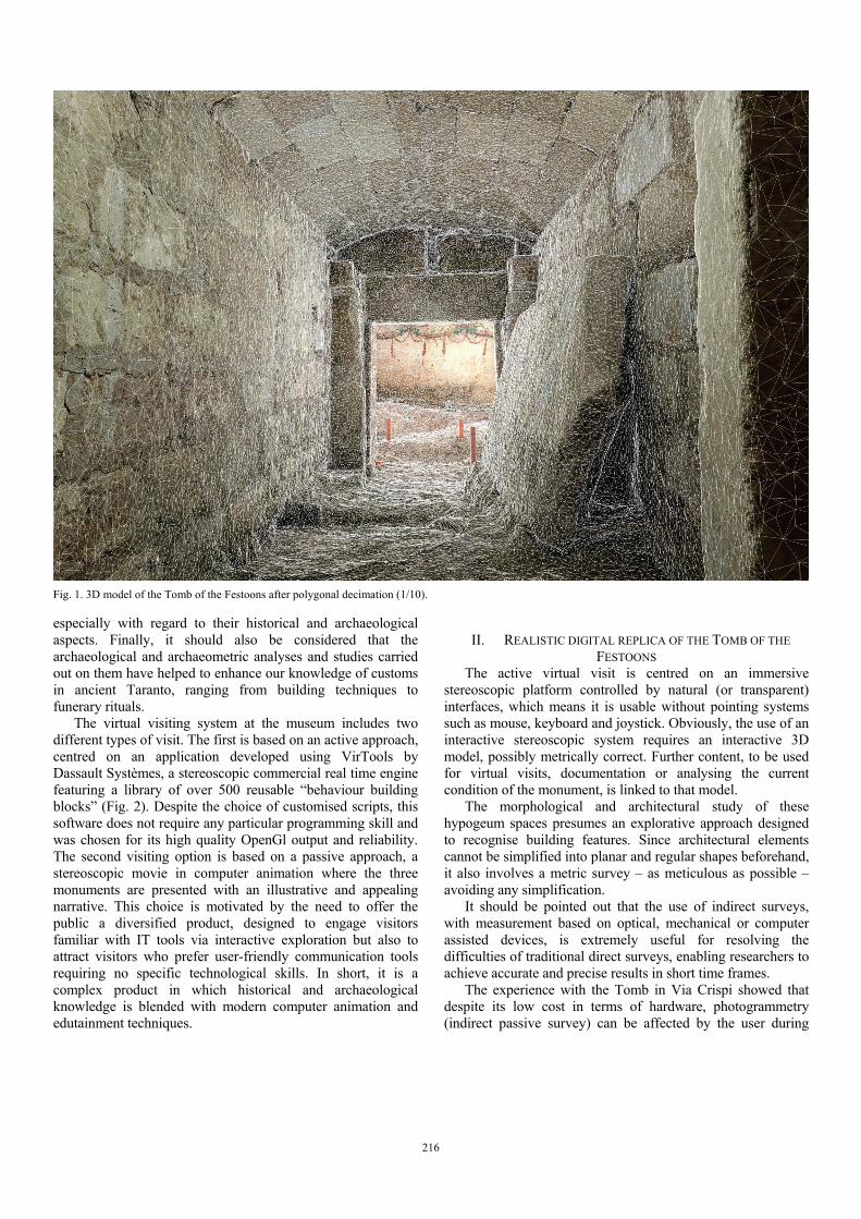
Fig. 1. 3D model of the Tomb of the Festoons after polygonal decimation (1/10).
216

calibration, causing significant residual errors if used without proper attention. This survey technique was used by the author during the previous analysis of 2003-2004, because of its affordability and ease of use in restricted spaces.
The new survey of the chamber Tomb in Via Crispi was carried out by an indirect active method using a Leica ScanStation 2 time-of-flight laser scanner. Due to the morphological features of the monument and the limited working space, during the survey a point-to-point step of 2 mm, which is also the maximum precision tested on this device, was adopted. This parameter made it possible to get a good resolution mesh (approximately 5M polygons), suitable for the goals of the architectural survey. However, it also caused a certain complexity in the 3D model, which required post-processing decimation (1/10 of original resolution) in order to make it compatible with the real time engine (Fig. 7). However, the resulting mesh does not present a constant sampling step, since its resolution is influenced by the application of the curvature algorithm during the triangulation phase. This algorithm is known to cause a differentiated resolution, which is greatest in areas of pronounced curvature and lowest in pseudo-planar areas, which do not require a large quantity of polygons to be described.
The 3D survey was carried out on the entrance corridor, built at the beginning of the last century, and the chamber called α or of the Festoons.
Chamber α has a rectangular plan (3.45m x 2.15m x 1.40m high) and is laid out on a North-South axis with the entrance on
the West side. It is partially carved out of the rock and partially constructed, and covered with six large slabs of “carparo” stone (biocalcarenite). The internal walls of the chamber are plastered and decorated with paintings. The entrance reproduces the monumental entrance of a house, and was closed by a painted and plastered stone door. Inside, placed near the East and South walls, lie the scant remains of two funereal beds (klinai) carved from the rock and blocks of stone covered with a layer of plaster with traces of painted decorations. The white walls bear a motif of festoons of garlands, hung and tied up with ribbons, in red, pink, yellow and green. In the centre of the North wall there are painted figures relating to the spheres of cult and mysticism, including a torch, a crater, a palm leaf and a basket decorated with small human figures, recalling Demeter and Dionysus. From both literary sources and archaeological finds, it is well-established that cults and festivities in honour of Dionysus and Demeter/Persephone held a special importance in Taranto. Although problems of historical interpretation remain, it is certain that the importance of such cults in the area of Taranto is closely linked to the edict of 186 BC by which Rome prohibited the practice of Bacchic cults, considered excessive and dangerous for the political and social order. 186 BC might thus provide a suggestive terminus ante quem for the dating of the monument, which, in any case, archaeological and stylistic considerations indicate as being built some time in the third century BC.
Fig. 2. Screen shot of real time authoring in VirTools. Below: diagram of building blocks workflow
217
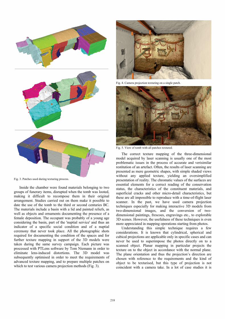
Inside the chamber were found materials belonging to two groups of funerary items, disrupted when the tomb was looted, making it difficult to recompose them in their original arrangement. Studies carried out on them make it possible to date the use of the tomb to the third or second centuries BC. The materials include a basin with a lid and painted reliefs, as well as objects and ornaments documenting the presence of a female deposition. The occupant was probably of a young age considering the basin, part of the 'nuptial service' and thus an indicator of a specific social condition and of a nuptial ceremony that never took place. All the photographic shots required for documenting the condition of the spaces and for further texture mapping in support of the 3D models were taken during the same survey campaign. Each picture was processed with PTLens software by Tom Niemann in order to eliminate lens-induced distortions. The 3D model was subsequently optimised in order to meet the requirements of advanced texture mapping, and to prepare multiple patches on which to test various camera projection methods (Fig. 3).
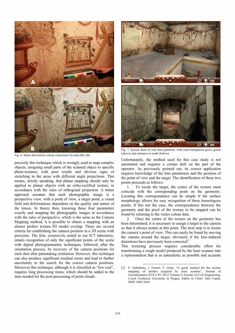
The correct texture mapping of the three-dimensional model acquired by laser scanning is usually one of the most problematic issues in the process of accurate and verisimilar restitution of an artefact. Often, the results of laser scanning are presented as mere geometric shapes, with simple shaded views without any applied texture, yielding an oversimplified presentation of reality. The chromatic values of the surfaces are essential elements for a correct reading of the conservation status, the characteristics of the constituent materials, and superficial cracks and other micro-detail characteristics, but these are all impossible to reproduce with a time-of-flight laser scanner. In the past, we have used camera projection techniques especially for making interactive 3D models from two-dimensional images, and the conversion of two-dimensional paintings, frescoes, engravings etc., to explorable 3D scenes. However, the usefulness of these techniques is even more appreciated in mapping operations starting from photos.
Understanding this simple technique requires a few considerations. It is known that cylindrical, spherical and cubical projections are applicable only in specific cases and can never be used to superimpose the photos directly on to a scanned object. Planar mapping in particular projects the texture on to the object in accordance with the normal plane. The plane orientation and thus the projection’s direction are chosen with reference to the requirements and the kind of object to be texturised, but this type of projection is not coincident with a camera take. In a lot of case studies it is
Fig. 4. Camera projection texturing on a single patch.
Fig. 5. View of tomb with all patches textured.
Fig. 3. Patches used during texturing process.
218
precisely this technique which is wrongly used to map complex objects, assigning small parts of the scanned object to specific photo-textures, with poor results and obvious signs of stretching in the areas with different angle projections. This means, strictly speaking, that planar mapping should only be applied to planar objects with an ortho-rectified texture, in accordance with the rules of orthogonal projection. A better approach assumes that each photographic image is a perspective view, with a point of view, a target point, a visual field and deformations dependent on the quality and nature of the lenses. In theory then, knowing these four parameters exactly and mapping the photographic images in accordance with the rules of perspective, which is the same as the Camera Mapping method, it is possible to obtain a mapping with an almost perfect texture-3D model overlap. There are several criteria for establishing the camera position in a 3D scene with precision. The first, extensively tested in our ICT laboratory, entails recognition of only the significant points of the scene with digital photogrammetric techniques, followed, after the orientation process, by recovery of the camera positions for each shot after painstaking restitution. However, this technique can also produce significant residual errors and lead to further uncertainty in the search for the correct camera positions. Moreover this technique, although it is classified as “low cost”, requires long processing times, which should be added to the time needed for the post-processing of point clouds.
Unfortunately, the method used for this case study is not automated and requires a certain skill on the part of the operator. As previously pointed out, its correct application requires knowledge of the lens parameters and the position of the point of view and the target. The identification of these two points proceeds as follows:
1. To locate the target, the centre of the texture must coincide with the corresponding point on the geometry. Locating this correspondence can be simple if the surface morphology allows for easy recognition of these homologous points. If this not the case, the correspondence between the geometry and the pixel of the texture to be mapped can be found by referring to the vertex colour data.
2. Once the centre of the texture on the geometry has been determined, it is necessary to assign a target to the camera so that it always points at this point. The next step is to locate the camera’s point of view. This can easily be found by moving the camera around the target, obviously if the lens-induced distortions have previously been corrected3. This texturing process requires considerable effort for transforming a rough model produced by the laser scanner into a representation that is as naturalistic as possible and accurate
[3] F. Gabellone, I. Ferrari, F. Giuri, “A quick method for the texture
mapping of meshes acquired by laser scanner”, Journal of Geoinformatics FCE CTU 2012 Volume 9, Faculty of Civil Engineering, Czech Technical University in Prague, Editor in Chief: Aleš Cepek, ISSN 1802-2669
Fig. 7. Screen shots of real time platform: with semi-transparent grave goods (above) and entrance to tomb (below). Fig. 6. Same shot before colour correction (A) and after (B)
219
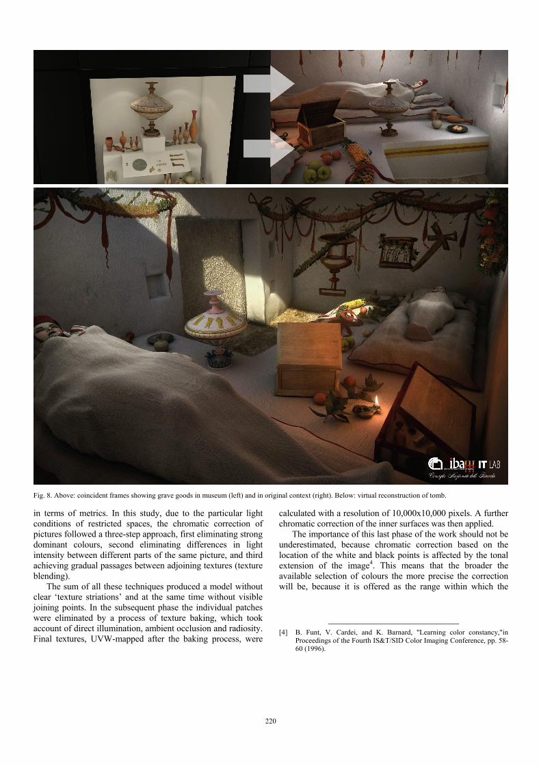
in terms of metrics. In this study, due to the particular light conditions of restricted spaces, the chromatic correction of pictures followed a three-step approach, first eliminating strong dominant colours, second eliminating differences in light intensity between different parts of the same picture, and third achieving gradual passages between adjoining textures (texture blending).
The sum of all these techniques produced a model without clear ‘texture striations’ and at the same time without visible joining points. In the subsequent phase the individual patches were eliminated by a process of texture baking, which took account of direct illumination, ambient occlusion and radiosity. Final textures, UVW-mapped after the baking process, were
calculated with a resolution of 10,000x10,000 pixels. A further chromatic correction of the inner surfaces was then applied.
The importance of this last phase of the work should not be underestimated, because chromatic correction based on the location of the white and black points is affected by the tonal extension of the image4. This means that the broader the available selection of colours the more precise the correction will be, because it is offered as the range within which the
[4] B. Funt, V. Cardei, and K. Barnard, "Learning color constancy,"in
Proceedings of the Fourth IS&T/SID Color Imaging Conference, pp. 58-60 (1996).
Fig. 8. Above: coincident frames showing grave goods in museum (left) and in original context (right). Below: virtual reconstruction of tomb.
220
brightest ‘real’ point and the darkest ‘real’ point of the hypogeum fall5.
First of all, the real-time visiting system of the Tomb in Via Crispi was conceived as the tomb itself appears. To achieve this, during the rendering of the scenes it was necessary to adopt certain expedients so as to get as close as possible to the real perception of an in situ visit. For this goal, a crucial role is played by the illumination of the virtual space and consequently by the establishment of the white point of the textures. Neutral illumination and a white point set to obtain chromatic values in their ‘numeric’ components yield a vision that is correct in colorimetric terms but quite different from the
[5] Hsien-Che Lee, “Introduction to Color Imaging Science”. Cambridge
2005, University Press. p. 450. ISBN 0-521-84388-X.
direct perception of a real visitor. For this reason, the hypogeum space was reproduced with a white point of the textures based on the temperature of an incandescent lamp (3000 oK). This simple expedient, besides making use of area light sources, copied the light conditions used during the shooting. In the following figures it is possible to evaluate the final outcome of the above-mentioned process.
III. RECONSTRUCTION OF THE TOMB IN VIA CRISPI
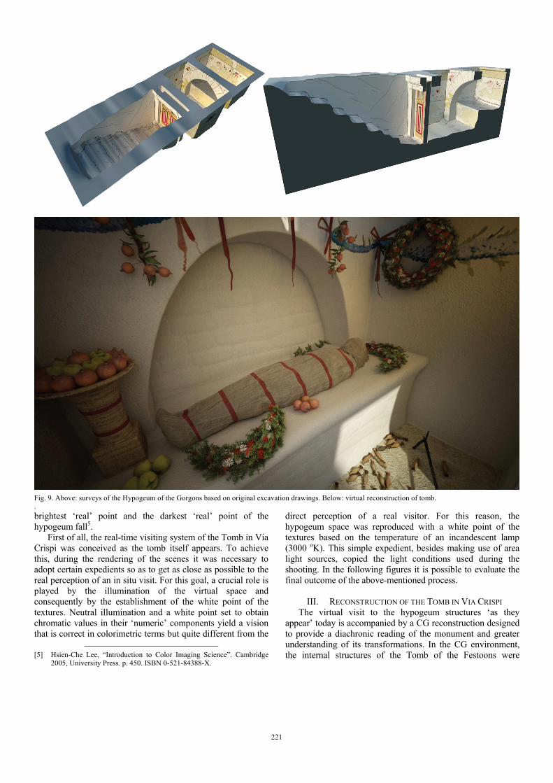
The virtual visit to the hypogeum structures ‘as they appear’ today is accompanied by a CG reconstruction designed to provide a diachronic reading of the monument and greater understanding of its transformations. In the CG environment, the internal structures of the Tomb of the Festoons were
Fig. 9. Above: surveys of the Hypogeum of the Gorgons based on original excavation drawings. Below: virtual reconstruction of tomb. .
221

reconstructed, as were the now-destroyed klinai with the grave goods on top. All the inner surfaces were restored to their original colour and reconstructed based on the analysis of the pigments, already partly carried out in 20046. The entire hypogeum was reconstructed, but the real time visit will be limited to the burial chamber (named α). An overview of the tomb will be presented in a 3D stereoscopic movie, where all the distinctive features of the monument and the funerary ritual of goods deposition will be illustrated in accordance with a narrative approach. This helps the user to reconnect the grave goods with their original context but it also further clarifies the importance of this project as an example of virtual museology (Fig. 8).
IV. INFORMATION MATERIALS ON THE TOMB IN VIA CRISPI
The gathering of information materials is completed by a section on the available documentation for the tombs and the finds retrieved from them. In the visiting platform, archive documents, photographic and graphic data, archaeological notes about the grave goods and archaeometric analyses can all be consulted. To this end, excavation journals (transcribed for easier reading) and entries in the museum’s inventory book were reproduced; the grave goods were photographed; and the official tables for ‘Grave Goods’ and ‘Pigments’ of the paintings were compiled, together with the entries for samples and the results of archaeometric analyses. All this information increases the knowledge of the monument being studied, in addition to its faithful three-dimensional restitution, providing a form of “Enriched Reality” that the visitor can consult in line with their personal interests. Access to the links and the navigation itself in the 3D scenes is controlled by a natural interface managed by the free Camera Mouse software7. In their visiting itinerary, users can read transparent texts on the location of the grave goods, placed on the kline in accordance with the excavation data, and receive information on these objects. They can also compare them to the real display in the museum. Indeed, after the interactive stereoscopic experience, the visitor can watch an animated story (hence the name “Marta Racconta”, MARTA narrates) in which the funerary object is framed in its ancient context but then placed in the museum showcase, with a single camera movement. The grave goods are thus perfectly contextualised, but also understood in terms of their functional and ritual value.
V. 3D MODELLING AND RECONSTRUCTION OF THE
HYPOGEUM OF THE GORGONS The second case study analysed is the Hypogeum of the
Gorgons8. For this tomb, which has been filled in with earth and lies beneath the road surface of Via Otranto, only passive communication methods (3D stereoscopic video) are
[6] A. Calia, M.T. Giannotta, “La tomba dei Festoni di via Crispi a
Taranto:individuazione e riconoscimento dei pigmenti utilizzati nelle pitture”, in Atti del III Congresso Nazionale AIAr (Bressanone 2004), Bologna: Patron Editore, 2005, pp. 271-278.
[7] http://www.cameramouse.org
[8] A. Dell’Aglio, “Taranto: l’Ipogeo delle Gorgoni e le tombe con arco”, in Vetustis novitatem dare. Temi di antichità e archeologia in ricordo di Grazia Angela Maruggi, Taranto: Scorpione Editrice 2013, pp. 511-530.
envisaged. This is due to the restricted dimensions of the hypogeum and the lack of high-resolution photographic data. Nonetheless, this tomb will be the subject of a second animated narrative, where virtual archaeology methods will make it possible to comprehend its architectural features in accordance with an original approach. Indeed, since it is not possible to carry out any metric survey, for this tomb a 3D reproduction based on excavation drawings is presented. In this way, the visitor can consider the personal notes written by the draftsperson on the drawings and at the same time understand the morphology of the hypogeum thanks to a ‘narrative’ reconstruction. This approach to the three-dimensional representation of old excavations contributes to a clearer understanding of forgotten archaeological contexts, known only to researchers who have had the good fortune to have seen them in person or to have studied them in the past. From the 3D representation of old drawings and the reading of excavation journals it was possible to create a three-dimensional model that once more presents to the public a valuable monument of the Taranto necropolis, complete with the grave goods that were discovered in it. This tomb is also characterised by the presence of festoons painted along the walls, but its most evident characteristic is the contrast of the vivid colours of the paintings with the white of the plaster, a characteristic shared by many tombs of this period (Fig. 9).
VI. FINAL REMARKS
The ‘MARTA Racconta’ project is an example of the use of various technologies to enable public enjoyment of neglected and hidden heritage. The proposed techniques make it possible to visit monumental complexes with a high level of realism and simple and transparent interfaces, in both active and passive modes. This enables the consultation of archive, historical, architectural and archaeometric data on a single platform in an interactive, real time 3D environment generated from a high precision model and conceived as a serious ‘container’ of content (Fig. 7). We believe that blending all these informative elements into a single platform could represent the first step in the systematic recovery of the entire necropolis buried underneath the modern city of Taranto and that these technologies could become tools for the dissemination of knowledge of heritage that would otherwise risk remaining unknown.
VII. SOFTWARE USED
- Cloud points processing: Leica Cyclone 6.5 - Optimisation/triangulation of meshes: Inus Rapid Form - 3D Modelling and T. Mapping: Maxon Cinema 4D - Removal of lens distortion: PTLens - Rendering: Chaos Group VRay - Net Render: Cinema4D Net Render - Real time authoring: Dassault Systèmes Vir Tools - Colour correction: Adobe Photoshop - Gesture control: Camera Mouse - Film compositing: Adobe After Effects
222