BreakThroughIntoFaerie.pdf - University of Minnesota Libraries
Upload
khangminh22Category
view
2download
0
Draft November 27, 2019
District 8 Freight Plan
Working Paper 4: Freight System Needs, Issues and Opportunities
Prepared by:
In association with:
Short Elliott Hendrickson Inc.

Working Paper 4 | Freight System Needs, Issues and Opportunities
District 8 Freight Plan | i
Table of Contents
Table of Figures ............................................................................................................................................. ii
Acronyms and Abbreviations ....................................................................................................................... iii
Executive Summary ...................................................................................................................................... iv
1 Future Outlook ....................................................................................................................................... 1
2 Freight System Needs and Issues ............................................................................................................ 5
2.1 Introduction ........................................................................................................................................................... 5
2.2 Roadway Needs and Issues .................................................................................................................................... 6
2.3 Railroad Needs and Issues ................................................................................................................................... 19
2.4 Freight Funding .................................................................................................................................................... 23
3 Freight System Strengths, Weaknesses, Threats, and Opportunities ..................................................... 28
3.1 Strengths, Weaknesses, Opportunities and Threats ............................................................................................ 28
4 Freight System Opportunities ............................................................................................................... 34
4.1 Summary of Freight System Opportunities .......................................................................................................... 34
4.2 Initial Slate of Project Opportunities .................................................................................................................... 34
4.3 Project Concept Prioritization Methodology ....................................................................................................... 42
4.4 Policies, Programs, and Partnerships ................................................................................................................... 42
5 Conclusions and Next Steps .................................................................................................................. 44
5.1 Conclusions .......................................................................................................................................................... 44
5.2 Next Steps ............................................................................................................................................................ 44
Appendix A: Stakeholder-Identified Needs and Issues ............................................................................... A-1
Appendix B: Data-Identified Needs and Issues .......................................................................................... B-1
Appendix C: Identified Projects .................................................................................................................. C-1
Appendix D: Potential Gaps to Address ..................................................................................................... D-1

Working Paper 4 | Freight System Needs, Issues and Opportunities
District 8 Freight Plan | ii
Table of Figures
Figure ES-1: District 8 Project Gaps vi
Figure 1: External Factors and Potential Impact to the Freight System 3
Figure 2: Potential Impacts of STEEP Factors 4
Figure 3: District 8 Intersection Safety Needs and Issues 8
Figure 4: District 8 Road Segment Safety Needs and Issues 10
Figure 5: District 8 Low Clearance Bridges 13
Figure 6: District 8 Ride Quality Index 17
Figure 7: District 8 Bridge Condition Needs and Issues 18
Figure 8: District 8 Passively-Protected Crossings with High Risk Rating 21
Figure 9: District 8 Actively-Protected Crossings with High Risk Ratings 22
Figure 10: Minnesota Highway Investment Need and Forecasted Revenue, 2017-2037 23
Figure 11: Minnesota’s 20-Year Capital Highway Investment Direction 24
Figure 12: MnSHIP Expenditures by Investment Category ($Billions) 24
Figure 13: Overview of MnDOT Freight-Related funding Programs Relevant to District 8 25
Figure 14: Strengths, Weaknesses, Opportunities, and Threats Table 28
Figure 15: District 8 Economy SWOT 30
Figure 16: District 8 Mobility SWOT 31
Figure 17: District 8 Infrastructure SWOT 32
Figure 18: District 8 Safety SWOT 32
Figure 19: District 8 Environment SWOT 33
Figure 20: District 8 STIP Projects 36
Figure 21: District 8 CHIP Projects 37
Figure 22: District 8 County Projects 38
Figure 23: District 8 Projects Combined 39
Figure 24: 2018-2037 MnSHIP Investment Objectives and Categories Aligned with District 8 Freight Needs 40
Figure 25: District 8 Project Gaps 41
Figure 26: Freight Categories and Measures 42
Figure 27: Project Approach 44

Working Paper 4 | Freight System Needs, Issues and Opportunities
District 8 Freight Plan | iii
Acronyms and Abbreviations
Abbreviation Definition
BNSF Burlington Northern Santa Fe Railway
CHIP Capital Highway Improvement Plan
ICWS Intersection Conflict Warning System
FAST Act Fixing America’s Surface Transportation Act
FHWA Federal Highway Administration
HCAADT High Capacity Annual Average Daily Traffic
MnDOT Minnesota Department of Transportation
MPH Miles Per Hour
MRSI Minnesota Rail Service Improvement Program
NHFP National Highway Freight Program
OFCVO Office of Freight and Commercial Vehicle Operations
OSOW Oversize-Overweight
RQI Ride Quality Index
STEEP Social, Technological, Environmental, Economic, and Political
STIP State Transportation Improvement Program
SWOT Strengths, Weaknesses, Opportunities, and Threats
TC&W Twin Cities and Western Railroad

Working Paper 4 | Freight System Needs, Issues and Opportunities
District 8 Freight Plan | iv
Executive Summary
The Minnesota Department of Transportation (MnDOT) District 8 is made up of 12 counties: Chippewa, Kandiyohi, Lac qui Parle, Lincoln, Lyon, McLeod, Meeker, Murray, Pipestone, Redwood, Renville, and Yellow Medicine. Together, these 12 counties account for about 10 percent of Minnesota’s land area and hold about 3.2 percent of its population. The District 8 Freight Plan is being created to provide MnDOT with a clear understanding of District 8’s multimodal freight system, how this system is connected to the District’s economy, and what the transportation needs and issues of the District’s industries are. This understanding will assist MnDOT in making well-informed policy and programming decisions in District 8.
The District 8 Freight Plan will provide MnDOT with information and guidance so MnDOT’s policy and programming decisions can be better informed.
This Working Paper is the fourth of six Working Papers for this project and provides information on preliminary findings of freight transportation needs and issues in District 8. This discussion of needs and issues also includes a Strengths, Weaknesses, Opportunities, and Threats (SWOT) analysis, with preliminary recommendations on potential programs, projects, policies, and partnerships that MnDOT could undertake to improve freight movement in District 8.
Freight Needs and Issues
District 8’s freight network consists primarily of highways and railroads, and both of these networks have their own needs and issues. However, MnDOT can primarily influence the investment and operation of the highway network, so most of the analysis conducted for this project focused on highway-related needs and issues.
In broad terms, District 8’s trunk highway system needs and issues are limited, while needs may be more acute on the local road network. Safety and mobility were key topics for the trunk highway network: intersection safety concerns focused on the intersection of trunk highways and smaller roads, while stakeholders also noted that trunk highways needed improved passing and turning lanes to support safe operations. Other road infrastructure needs and issues included low-clearance railroad bridges (a barrier to truck movements), and some pavement and bridge condition concerns on local roads.
In regards to highway operations, many stakeholders identified statewide oversize-overweight (OSOW) truck regulations that they felt were not relevant to District 8’s operational context, and which prevented efficient movement of OSOW loads like manufactured homes. Stakeholders consulted during previous studies as well as this current project generally felt that snow removal was adequate on trunk highways, but could be improved on local roads. Traffic congestion is generally not an issue for District 8.
One important consideration mentioned by stakeholders as well as MnDOT staff is the fact that many of District 8’s businesses ship goods through the Twin Cities and St. Cloud, and congestion in these areas can have major implications for the overall efficiency of freight movements in District 8. Therefore, findings and recommendations from future Metro and District 3 freight plans could have significant impacts on freight operations in District 8.
In regards to the rail network, stakeholders did not identify any grade crossing needs or issues in the District, but there are some actively- and passively- protected crossings with relatively high levels of assessed risk. Rail mobility needs and issues primarily related to access to rail services, and affordable provision of rail services.

Working Paper 4 | Freight System Needs, Issues and Opportunities
District 8 Freight Plan | v
Rail infrastructure condition was primarily a concern for local Class III railroad operators, but condition has been improving with continued investment in rail and infrastructure upgrades.
Freight Strengths, Weaknesses, Opportunities, and Threats
An inventory of District 8’s freight-relevant Strengths, Weaknesses, Opportunities, and Threats (SWOT) was created based on a combination of identified needs and issues, feedback from stakeholders and the Advisory Committee, and assessment of external factors. This SWOT analysis informed the development of preliminary recommendations for District 8. A key strength for District 8 is a historically strong base of agricultural and manufacturing industry, but a key weakness is the need to continually adequately maintain road and rail assets in the face of increasing funding shortfalls.
Leveraging District 8’s Freight Opportunities
While District 8’s freight transportation system has many needs and issues, the system also has its own advantages and opportunities for future improvement. A key opportunity for MnDOT is to use their role to make changes to District 8’s physical infrastructure and advance projects that ease goods movement. To understand project opportunities, needs and issues were mapped, along with programmed projects from the State Highway Investment Program, Capital Highway Investment Plan, and county investment plans. Based on the overlap between needs and issues and programmed projects, a list of “gaps” – needs and issues not covered by upcoming projects – was identified. The gap analysis identified 167 needs and issues not covered by upcoming projects, and these gaps are shown in Figure ES-1. Notable themes for gaps included:
Safety gaps were the most common gap, making up almost two-thirds of the identified gaps. These were distributed across almost all areas of the District but were particularly focused on higher-traffic areas.
Performance-related gaps included issues related to mobility, and only made up about one-quarter of identified gaps. While these gaps only made up a smaller portion of gaps compared to safety, they include some of the most pressing needs for the District. These included a lack of mobility/maneuverability at low-clearance railroad bridges over highways and areas where additional passing lanes, turn lanes, or four-lane expansion were requested.
Condition gaps made up the remaining 14 percent of identified gaps and included 21 bridges identified as potentially deficient, as well as two issues identified by stakeholders or previous plans. Interestingly, few pavement condition gaps were found, which supports feedback from MnDOT staff who noted that Districts are proactive in programming improvements to address pavement needs.
Finally, a major need and issue for the District, as well as Minnesota as a whole, is a shortfall between expected MnDOT revenue and expected maintenance costs. This shortfall has been growing due to rising maintenance costs, and slowing revenue growth, and could pose a major threat to the good maintenance of District 8’s transportation system in the future.
Next Steps for the District 8 Freight Plan
Freight improvements can also benefit general traffic, and general-purpose funding programs can be leveraged to provide freight benefits, particularly as part of routine maintenance of upgrade work. This Working Paper provides information on major MnDOT funding programs that could be useful for addressing the freight needs and issues identified here. The next step of work will focus on scoring and ranking identified system gaps, with the intention of selecting a number of gaps for advancement to pre-engineering feasibility studies. The goal of this pre-engineering work will be to provide potential solutions to top unaddressed freight needs and issues in the District and create project concepts that can compete for funding in future freight-related solicitations.

Working Paper 4 | Freight System Needs, Issues and Opportunities
District 8 Freight Plan | vi
Figure ES-1: District 8 Project Gaps
Source: CPCS Transcom Inc.

Working Paper 4 | Freight System Needs, Issues and Opportunities
District 8 Freight Plan | 1
1 Future Outlook
The freight transportation system is made up of a variety of actors such as shippers, brokers, and carriers. These actors make choices in response to a variety of external factors, including economic or political changes. Therefore, the operation of freight itself is fundamentally reactive to a variety of factors that lie well outside of the control of MnDOT and other agencies that build and maintain the transportation system. Additionally, the freight system is continually changing. It can be difficult to determine exactly how the freight system will change in the future because the specific factors that influence demand are numerous and difficult to forecast. However, there are a number of “lenses” through which MnDOT can interpret or anticipate future freight changes.
Freight supply chains and industry operations reflect market conditions that are determined by a myriad of potential factors. Understanding major freight
factors can help planners anticipate potential freight changes in the future.
External factors are often categorized using the “STEEP” terminology which tracks potential changes based on Social, Technological, Environmental, Economic, and Political considerations. Each of these factors has a role in influencing freight system operations and provides insight into future freight system needs, issues, and opportunities. The following subsections provide some examples of how historic STEEP trends and current developments may impact the District 8 freight system in the future. Note that these examples are provided for context and are not intended to be exhaustive. Instead, these examples show how the STEEP framework can be applied to understand a variety of potential changes to the freight system.
Social Factors and Trends
Social factors include demographics, income, consumption patterns, and population location and density. An example of a social trend for District 8 is Declining and Aging Population. The population of most counties in District 8 is shrinking, and the population as a whole is growing older as well. Minimal in-migration and aging of the labor force could create labor shortages, which affect labor-intensive industries like agriculture and manufacturing.
Technological Factors and Trends
Technological factors include those advancements that may generate new (alternative) products or services, increase the availability or lower the cost of current products or services, or change the nature of production processes, transportation and distribution activities, and information flows. A good example of technological
Key Findings
While much of District 8’s freight system is publicly-owned, most freight stakeholders are private businesses. The operations of these private firms (and thus their freight movements) are constantly changing and responding to a variety of factors outside of MnDOT’s control. Understanding some of these external factors provides a framework to anticipate potential changes to freight in the future, and sets the stage for further discussion of District 8’s freight transportation needs and issues.

Working Paper 4 | Freight System Needs, Issues and Opportunities
District 8 Freight Plan | 2
trends that could affect District 8’s freight network is the development of larger and more efficient wind turbines. The development of higher-capacity wind turbines has opened up new areas of District 8 to wind development, while simultaneously generating new truck and rail movements of larger components like turbine blades, which can exceed 200’. Accommodating larger wind turbine components could be a future challenge for the District 8 freight network. Other examples of potentially-relevant technological factors and trends could include the adoption of new vehicle technologies like automated trucks, as well as alternative power sources for trucks.
Environmental Factors and Trends
Environmental factors may influence the demand for or the production of goods and services, either positively or negatively, and may also impact how and when goods are shipped. A good example of an environmental factor that will affect District 8’s freight network is climate change. A warmer climate in southwestern Minnesota may create additional opportunities for agricultural production by extending the growing season, but may also make it more difficult to plan optimal planting times. Additionally, severe rainfall and flooding events associated with a warmer climate can also damage crops as well as damage infrastructure.1 A warmer climate, with more freeze-thaw events in fall and spring may also create more stress on pavement and bridges, requiring more frequent maintenance or replacement.
Economic Factors and Trends
Economic factors may influence overall economic growth (global, regional) or the distribution of that growth and the ability of individuals or businesses’ to invest or purchase goods or services. An emerging economic trend in District 8 has been the consolidation of agricultural facilities, including large-scale grain elevators meant to serve unit trains, and the creation of “mega-dairies” in Minnesota and South Dakota. These facilities can operate very profitably thanks to economies of scale, but the very high concentration of freight activity created by these consolidated facilities can place new stress on specific elements of the road and rail network, which may not have been designed to accommodate high volumes of heavy trucks or railcars. Other potential examples of economic factors include re-shoring of manufacturing from overseas.
Political Factors and Trends
Political factors may influence the production, sourcing, flow or trade of goods, or investments in public infrastructure, such as highways. An example of a political factor relevant to District 8 is the United States’ trade conflict with other nations. For example, continued conflict with China has reduced overseas demand for US soybeans, resulting in reduced demand for some of District 8’s agricultural products.2 Other examples of potentially-relevant political factors include funding levels for transportation maintenance and state-level mandates for renewable or zero-carbon energy portfolios.
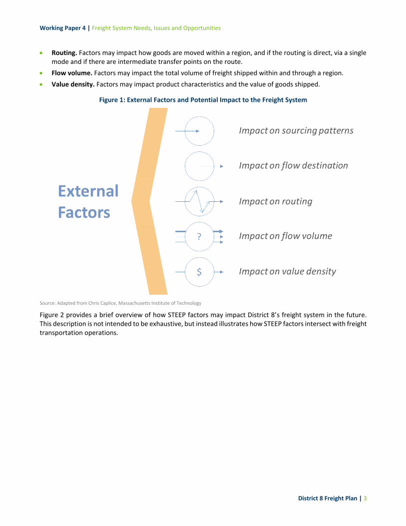
As shown in Figure 1, external STEEP factors like the ones described above can influence the freight system in several ways, including:3
Sourcing patterns. Factors may impact what raw materials and other inputs are sourced and where they are sourced from (i.e. origination).
Flow destination. Factors may impact where materials and other goods are destined for manufacturing, consumption or other uses (i.e. termination).
1 Minnesota Department of Natural Resources State Climatology Office 2 Ferguson, Dana. Ag leaders talk 'casualties of the trade war' at first day of Farmfest. West Central Tribune. August 6, 2019. 3 Chris Caplice, Massachusetts Institute of Technology
Working Paper 4 | Freight System Needs, Issues and Opportunities
District 8 Freight Plan | 3
Routing. Factors may impact how goods are moved within a region, and if the routing is direct, via a single mode and if there are intermediate transfer points on the route.
Flow volume. Factors may impact the total volume of freight shipped within and through a region.
Value density. Factors may impact product characteristics and the value of goods shipped.
Figure 1: External Factors and Potential Impact to the Freight System
Source: Adapted from Chris Caplice, Massachusetts Institute of Technology
Figure 2 provides a brief overview of how STEEP factors may impact District 8’s freight system in the future. This description is not intended to be exhaustive, but instead illustrates how STEEP factors intersect with freight transportation operations.

Working Paper 4 | Freight System Needs, Issues and Opportunities
District 8 Freight Plan | 4
Figure 2: Potential Impacts of STEEP Factors
Potential Impacts Social Factors Technological Factors Environmental Factors Economic Factors Political Factors
Source
Social factors are not expected to have an impact on sourcing patterns.
Additive manufacturing (3D printing) may require different materials than current manufacturing processes, resulting in a shift in sourcing patterns.
If poor planting seasons or flooding disrupt crop productivity, food and biofuel manufacturers may have to source inputs from outside of the District.
As manufacturing on-shores to the US so too will the inputs to District 8’s manufacturing and the origination of products destined to consumers in District 8.
Sourcing patterns for District 8’s manufacturers (like users of steel) may change depending on tariffs relevant to raw materials.
Destination
The aging population and increasing income in the District may be linked to changes in consumer purchasing patterns. Goods may be purchased at brick-and-mortar stores, but more and more goods will be ordered online and delivered directly to residential doorsteps.
Continued development of biofuel production technology could divert agricultural products from export to domestic use.
Fueling/charging infrastructure will need to evolve if electricity or alternate fuels are adopted for passenger vehicles and trucks.
Consolidation of agricultural facilities across the US could result in a changing destination for District 8 agricultural outputs.
Continued trade conflict could reduce overseas demand for District 8’s agricultural products like soybeans.
Route Many consumer goods will be shipped internationally via container and unloaded at distribution centers near intermodal hubs such as those in the Twin Cities.
Smart technology including in-vehicle electronics may help trucks find efficient routes through St. Cloud or the Twin Cities, improving trucking productivity in District 8.
Local severe flooding events may require more frequent closure of District highways, disrupting truck routing.
Decreased or altered demand for agricultural or manufactured products, or altered patterns of manufacturing could result in change of commodity flows or routes.
Disruptions in trade with China may reduce volumes of agricultural products routed out of the District via the BNSF and Canadian Pacific.
Volume District 8’s household income and level of educational achievement has increased but this factor is not expected to affect flow volume substantially in a time of flat population growth.
The development of new wind farms in previously un-utilized areas could create new OSOW freight challenges. Additive manufacturing may reduce the need for shipment of finished manufactured goods, but may result in an increase in the movement of “raw” materials.
A lengthened growing season may increase demand for agricultural inputs like fertilizer or pesticides, or create “peaks” in demand due to uncertain changes in planting times.
Consolidation of agricultural facilities could result in a higher volume of agri-food products originating at select facilities in District 8.
Reduced foreign demand for agricultural products could result in lower production, and lower shipment volume.
Value
Value impacts from social changes are uncertain.
Additive manufacturing technology may reduce the value-per-ton of shipments, as movement of finished manufactured goods is replaced with movement of raw material inputs for additive manufacturing.
The value of goods traveling along the system may increase in the future with changing transportation costs due to new energy sources.
The value of goods transported may increase over time, as District 8 (and the US, generally) works to add value to US products so they may more effectively compete internationally.
The value of goods transported may increase as domestic goods replace foreign goods for US consumption.
Working Paper 4 | Freight System Needs, Issues and Opportunities
District 8 Freight Plan | 5
2 Freight System Needs and Issues
2.1 Introduction
District 8’s freight needs and issues are complex, and many needs and issues have shared causes or solutions. This complexity and “overlap” can make categorization of needs and issues difficult. For example, the need for additional passing lanes on the District’s two-lane freight corridors is related to both the issues of mobility and safety: slower-moving trucks can reduce the free-flowing speed of traffic, and passenger vehicle drivers may attempt to pass on two-lane roads, increasing the potential for collisions.
For simplicity, the needs and issues discussed in this Chapter are described on a mode-by-mode basis. Within each mode, needs and issues are placed in three categories that correspond to the performance analysis completed in Working Paper 3. These categories were adapted from the Minnesota State Freight Investment Plan criteria:
Safety, which is primarily related to crash rates for roads as well as railroad grade crossings, and MnDOT’s previous safety risk factor analyses.
Mobility, which is related to the performance of the system and the speed and ease with which freight can move in the region. This includes topics like congestion, weight limits and bridge clearances.
Condition, which relates to the level of adequate maintenance of roads and bridges.
The information for this summary of needs and issues came from five main sources:
Advisory Committee and Technical Team Meetings: The Advisory Committee is made up of public and private system stakeholders, and was created to provide “big picture” guidance in the development of the District 8 Freight Plan. The Technical Team is smaller, made up of agency staff, and provides guidance on how the plan will be used to inform investment decisions. Meetings with both groups were conducted in June and September 2018, with two more meetings planned for 2019 and 2020.
Key Findings
District 8’s freight needs and issues are widespread throughout the region, and are mostly focused on the road system. Generally speaking, the trunk highway network has fewer needs and issues than county or local roads. Reflecting MnDOT’s own emphasis on safety, the majority of needs and issues identified had some element of safety consideration, which was often related to the fact that trucks move slower, and are slower to accelerate, decelerate, or turn compared to general traffic.
Mobility issues had a great deal of overlap with safety issues, and most frequently related to needs for additional passing lanes and turning lanes on major trunk highways, as well as a strong stakeholder desire for expansion of the four-lane highway system. By comparison, condition concerns for pavement or bridges were relatively less frequent, although local and county road and bridge condition is poorer than the trunk highway network.

Working Paper 4 | Freight System Needs, Issues and Opportunities
District 8 Freight Plan | 6
Stakeholder Consultations: The project team conducted 27 phone and in-person consultations with private and public freight stakeholders between May and November 2018. The results of these consultations were synthesized with other findings on needs and issues.
Online Survey: The project team created and distributed two online surveys to supplement meetings and consultations. One survey was tailored for Advisory Committee members who were unable to attend meetings, and a second was created to solicit feedback from the freight community at large.
Analysis of Data: Evaluations of safety, mobility, and condition were completed using data provided by MnDOT. Working Paper 3 provides further detail on the analytical approach and findings relevant to each data source.
Previous Studies and Plans: The project team completed an in-depth review and synthesis of needs and issues identified in previous plans and studies. A particularly important study was the 2014 Manufacturers’ Perspectives Study, for which MnDOT staff conducted their own in-depth stakeholder consultations.
It is important to note that this chapter is a summary of major needs and issues, and is not a comprehensive inventory of each identified need or issue for District 8’s system. Instead, Appendix A – Stakeholder Identified Needs and Issues, and Appendix B – Data Identified Needs and Issues provide tables listing the geographic location and description of each need or issue that was related to a specific asset of District 8’s freight system.
2.2 Roadway Needs and Issues
Road and trucking-related needs and issues make up the majority of District 8’s freight transportation needs and issues. This majority share reflects the fact that trucking is the most commonly used mode for freight transportation, carrying about 63 percent of Minnesota’s freight tonnage. At the same time, road-related needs and issues are also more easily addressed: MnDOT and its local partners have the most control over road investments and most of their funding is available for road investments. By comparison, MnDOT and its local partners have relatively limited funds for or influence over rail improvements.
Road improvements are the area where MnDOT can exert the greatest effort to address freight needs and issues.
Road and trucking-related needs and issues are organized by the general categories of safety, mobility, and condition. These categories reflect some of the investment categories from the Minnesota State Highway Investment Program (MnSHIP), as well as additional categories created by the project team to reflect other funding streams.

Working Paper 4 | Freight System Needs, Issues and Opportunities
District 8 Freight Plan | 7
Road Safety
Between 2009 and 2013, District 8 was ranked as the fourth-highest region in terms of the highest number of severe crashes, and third highest in number of severe crashes at intersections. 14 percent of severe intersection crashes, 21 percent of severe high-crash location crashes, and 22 percent of severe high-crash intersection crashes of the State have occurred in District 8.4 Despite District 8’s relatively high rate of crashes compared to other Districts in Greater Minnesota, stakeholders did not identify many safety concerns on the District’s freight network, instead, most insights on specific system safety needs and issues came from District 8’s safety plan, and records of truck-involved crashes. Discussion of road safety is broken down into multiple elements: intersection safety and corridor safety.
Intersection Safety
Much of the stakeholder feedback on intersection safety related to the fact that trucks are slower and less maneuverable than passenger vehicle traffic. Therefore, feedback focused on intersections of county or local roads and trunk highways, where slow-moving trucks would be crossing, entering, or exiting faster-moving trunk highway traffic. While stakeholder-identified intersection safety needs and issues were spread across the District, a large cluster was noted around Marshall, and many related to busy intersections in the area. This clustering reflects the fact that the Marshall area is a local hub for truck traffic, thanks to its large manufacturing and agricultural industrial base. These points included:
US-59 and Erie Road, where many trucks had difficulty crossing lanes with high-speed traffic.
CH-33 and MN-68, where an acceleration lane was recommended to allow trucks to reach highway speeds.
Vehicles passing through traffic lights on MN-23 at unsafe speeds.
Outside of Marshall, there were no other intersections that multiple stakeholders identified as problematic. A similar pattern of wide distribution can be seen in data-identified intersections. Analysis of historic truck-involved crash data identified 23 intersections that had more than two truck-involved accidents in the past two years (2017-2018). These intersections were distributed across the district but were focused on the trunk highway network. Figure 3 shows the location of both stakeholder- and data-identified intersection safety needs and issues.
Intersection safety concerns were centered on the intersection of trunk highways and smaller county or local roads.
In addition to identifying specific safety locations of concern, many stakeholders voiced support for additional investment in warning devices at high-risk rural intersections, such as warning lights, flashing stop signs, and intersection conflict warning systems (ICWS). These systems were seen as lower-cost options to improve safety through increased driver awareness of intersections, particularly at night.
4 MnDOT “District Safety Plans Update” (2016).

Working Paper 4 | Freight System Needs, Issues and Opportunities
District 8 Freight Plan | 8
Figure 3: District 8 Intersection Safety Needs and Issues
Source: CPCS Transcom Inc. analysis of MnDOT District 8 Safety Plan Update, and MnDOT traffic incident records.

Working Paper 4 | Freight System Needs, Issues and Opportunities
District 8 Freight Plan | 9
Corridors
There are two major types of needs and issues related to roadway corridors: improved roadway shoulders, and added passing lanes. The comments and concerns about these two infrastructure elements fell into both of the categories of safety and mobility, but safety was a more-commonly mentioned concern overall. Corridor-related safety needs and issues are illustrated in Figure 4.
Shoulders provide truck drivers with additional room to maneuver, helping them to accommodate other road users or avoid collisions. At the same time, wider shoulders can also make over-sized freight movements easier by providing additional room for wide loads. By contrast, unpaved, narrow, or non-existent shoulders were considered a safety issue because they eliminated room for maneuvering, and created a tipping hazard for trucks or trailers that drift off of the roadway. Stakeholders generally noted a need for wider or harder shoulders on less-traveled trunk highways and county highways, including multiple mentions of shoulders needed on MN-40 west of Willmar, and MN-68. However, details provided by stakeholders were often vague: respondents often noted that all or most of a route needed improved shoulders or passing lanes.
New or lengthened passing lanes were a second key safety and mobility consideration. Adequate passing lanes were seen as important safety improvements because they gave general traffic sufficient space to overtake slower trucks, or for trucks to overtake slower vehicles such as farm equipment. At the same time, added or longer passing lanes were also considered mobility improvements because they reduce the amount of time drivers must spend traveling at slower speeds “stuck” behind slower vehicles. The main needs and issues related to passing lanes were (1) a lack of any passing lanes on certain trunk highways, and (2) passing lanes that were too short for trucks to overtake other traffic. Commonly-mentioned areas for potentially improved passing lanes included US-12 from Willmar to the Twin Cities, MN-23 from Marshall to Pipestone, and TH-59 from Marshall to Worthington. A related topic to passing lanes was the expansion of highways from 2 to 4 lanes, a topic that is discussed further in the mobility section of this chapter.
Corridor safety needs are primarily focused on areas where shoulders and passing lanes could be improved.
Weigh Stations and Commercial Vehicle Enforcement
MnDOT administers a Weigh Station and Commercial Vehicle Safety/Enforcement Program and allocates $2 million per year towards maintaining/improving commercial vehicle enforcement and safety. As part of the program’s Weight Enforcement Investment Plan, two needs for improved enforcement in District 8 were identified:
US-71/MN-23 in Kandiyohi County north of Willmar needs increased enforcement due to the shipping of heavy sugar beets and generally heavy truck traffic.
Additional review is needed to upgrade a Weigh In Motion site on US-212 in Renville County, east of Olivia.
District 8 Freight Showcase: MN-23 Four-Lane Expansion
MN-23 is a key route for the District, especially for trucks traveling north to I-94 and St. Cloud. A four-lane expansion to close two-lane gaps between New London and Richmond will be constructed in 2022 and 2023

Working Paper 4 | Freight System Needs, Issues and Opportunities
District 8 Freight Plan | 10
Figure 4: District 8 Road Segment Safety Needs and Issues
Source: CPCS Transcom Inc. analysis of MnDOT District 8 Safety Plan Update, and MnDOT traffic incident records.

Working Paper 4 | Freight System Needs, Issues and Opportunities
District 8 Freight Plan | 11
Grade Crossings
The topic of grade crossing safety is discussed in the railroad section later in this chapter.
Road Mobility
Mobility considerations include topics that affect the ease or efficiency with which trucks can move through District 8. These topics include things like traffic congestion, truck routing, bridge clearances, and weight limits. As noted in the safety section, many of the mobility considerations also have strong relevance to safety. Based on evaluations of truck speeds and travel time reliability (available in Working Paper 3: Freight System Profile), congestion is not an issue for District 8. Therefore, this section focuses on other impediments to mobility, such as geometric constraints for trucks, low bridges, and weight limits.
Traffic congestion is generally not a mobility need or issue for District 8, but truck operations are affected by congestion in the Metro District.
Intersections
Intersection mobility needs and issues related to trucks’ ability to navigate through roundabouts and j-turns. Stakeholders were divided on the topic of roundabouts: some were firmly opposed to the creation of roundabouts, while others commended MnDOT for engagement with oversize-overweight (OSOW) truck operators on the design new roundabouts. Commonly-mentioned mobility problems with roundabouts included:
Shifting or tipping loads when trailers mount curbs on the inside of tight roundabouts.
A lack of clearance on inside curbs for lowboy trailers.
“Tight” turning clearances.
General passenger traffic does not understand how to “share” two-lane roundabouts with long trucks.
Wayfinding signage is not posted far enough in advance of a roundabout, making navigation more difficult.
In response to these concerns, stakeholders noted that MnDOT should consult with trucking operators when creating roundabouts on major freight routes. In particular, roundabout designs should include soft curbs and shoulders, and be large enough to accommodate trucks. Stakeholders cited roundabouts on MN-22 and MN-60 in Worthington as examples.
Intersection mobility concerns are primarily focused on areas where trucks may not be able to turn easily, such as roundabouts and j-turns.
District 8 Freight Showcase: Improved Roundabout Design
In response to stakeholder concern about roundabouts noted in the original Manufacturer’s Perspectives’ study, District 8 staff constructed a roundabout on MN-7 using feedback from OSOW trucking companies.

Working Paper 4 | Freight System Needs, Issues and Opportunities
District 8 Freight Plan | 12
An additional area of concern for intersection mobility was J-turns, particularly on MN-23 in Marshall. Stakeholders had concerns that the truck movements associated with j-turns could be “awkward” due to the need to make sharp turns. There were also concerns about trucks blocking traffic when navigating j-turns.
Regional Connectivity
Many stakeholders consulted for this project and the previous Manufacturer’s Perspectives study noted that District 8 can be heavily affected by traffic operations outside of the region, particularly in the Twin Cities, and to a lesser extent, I-94 near St. Cloud, and I-90. This strong regional interdependency created some mobility needs and issues that are not always within the control of the District.
Congestion in the Twin Cities affects the efficiency of trucking operations in the District. For example, one stakeholder noted that their trucks were capable of making two trips per day to terminals in the cities, but traffic congestion could reduce this to one trip per day, as drivers would spend much of their time in slow-moving traffic. This problem has been exacerbated by the implementation of Electronic Logging Devices (ELDs), which eliminate a driver’s “wiggle room” to keep driving for 15-30 minutes after they have driven for their maximum number of hours.
MN-23 in St. Cloud was noted as another area with congestion that was highly-relevant to District 8, as the many traffic lights in the area reduced the efficient flow of truck traffic.
Truck parking was occasionally mentioned as a problem because there is very little truck parking west of the Metro district, and there are very limited places where OSOW loads can safely stop. Stakeholders suggested exploring ways to expand truck parking options on the southern and western sides of the Twin Cities.
Due to the fact that many of District 8’s businesses trade goods with the Metro District, and points east, congestion and truck parking concerns in the Metro
District are highly-relevant to efficient and safe trucking operations in District 8.
Route Restrictions
In addition to needs and issues that affect the ease or efficiency of truck movements, there are physical constraints that can make it impossible or illegal for trucks to travel through elements of District 8’s freight network. A key barrier is height limits imposed by railroad bridges over roadways, which were identified by both stakeholders and data. Figure 5 shows the location of low-height bridges in District 8. 14’6” is the minimum height recommended by the FHWA for truck clearances, so bridges under this threshold are flagged in red. During consultations, one stakeholder that shipped oversize freighted noted that concerns about low bridges and a maximum height limit of 13’6” on select roadways meant they had to obtain specialized lowboy trailers in order to ship loads from Minnesota to South Dakota. In general, four bridges were commonly mentioned as problematic, due to their location on higher-volume routes:
US-59/MN-7 north of Milan
MN-30 west of MN-23 in Pipestone
US-212/MN-67 on the west side of Granite Falls
US-71 in Sanborn

Working Paper 4 | Freight System Needs, Issues and Opportunities
District 8 Freight Plan | 13
Figure 5: District 8 Low Clearance Bridges
Source: CPCS Transcom Inc. analysis of MnDOT and National Bridge Inventory data.

Working Paper 4 | Freight System Needs, Issues and Opportunities
District 8 Freight Plan | 14
Low-clearance railroad bridges over roads are one of the key truck mobility impediments in District 8, particularly for oversized truck loads.
OSOW Issues
Many stakeholders consulted as part of the development of this freight plan and the previous Manufacturers’ Perspectives study noted that OSOW truck policies were a barrier to freight mobility in the District. In particular, many stakeholders felt that statewide policies did not reflect the operational context of the district, and were unnecessary impediments to OSOW operations in District 8. Common feedback included:
Need for Context-Sensitive Curfew Areas: curfews on OSOW movements on Fridays and Sundays in the summertime, and on select additional weekends such as fishing openers were seen as not relevant to District 8 because the District does not see heavy weekend traffic like the Twin Cities, or more tourism-oriented areas. This curfew was seen as particularly confusing since OSOW movements were allowed to move in the Metro District during rush hour, and respondents asked that OSOW policies be modified by district, or changed to reflect the volume of traffic moving on specific routes. There was also interest in being able to move OSOW loads through construction zones after work hours, which could make trucking operations more efficient by eliminating potentially-lengthy details.
Movement of Manufactured Homes. One of District 8’s unique OSOW exports is finished manufactured homes, which are often exported to other regions including South Dakota and Iowa. Producers and carriers of these homes noted that OSOW truck drivers may choose to encroach the centerline when there is no contraflow or passing traffic, to avoid driving on rumble strips or soft shoulders. They suggested that enforcement of “encroachment of the centerline” regulations be done with this context in mind, especially since there are narrow bridges in the District that require OSOW loads to cross the centerline. Shippers also noted that the requirement for four or more pilot cars between loads is unnecessary when loads of three or more structures travel in close convoys. Respondents noted that it was common for convoys of manufactured structures to travel in close proximity, as drivers assist each other with issues such as tire changes and plastic repairs, making the addition of a fourth pilot car unnecessary.
Ease of Permitting Relative to Other States. Multiple stakeholders noted that MnDOT’s OSOW permit and routing software is inefficient and difficult to use relative to other states. Respondents suggested that MnDOT study permitting at other states in the US to identify potential usability improvements.
District context-sensitive OSOW regulations were a commonly-mentioned freight mobility need, as some statewide OSOW rules were not seen as relevant
to District 8’s operational context.
Snow Removal
Across Minnesota, winter snow and ice can be major impediments to freight mobility and safety. In general, stakeholders noted that plowing operations on trunk highways were adequate, but plowing of county and town
Working Paper 4 | Freight System Needs, Issues and Opportunities
District 8 Freight Plan | 15
roads was often inadequate. No particular areas were identified as needs or issues for snow removal, but some common responses included:
Stakeholders appreciated having operations contacts at MnDOT to get information on plowing operations or obtain plow assistance in emergencies.
Snow removal is also important for staffing: businesses that operate 24/7 need reliable snow removal to provide access for their employees, and a lack of on-time staff can create major production problems.
Some stakeholders suggested that road-maintenance should happen off-hours, with a focus on early morning and frequent snow removal. Another comment was that District 8’s plowing operations shut down more “easily” or earlier than plowing operations in the Twin Cities.
Snow removal is generally adequate on trunk highways, but improvements are needed on local roads.
Construction Coordination
Construction operations can create seasonal barriers to truck mobility, particularly for oversize loads. Some stakeholders noted that MnDOT has been good at communicating with industry about upcoming projects or changes that could affect truck operations. Conversely, stakeholders also urged that MnDOT continue considerations about how construction schedules will affect trucking, especially when long detours are needed, or access to freight facilities may be reduced.
Other Mobility Needs and Issues
In addition to the needs and issues profiled above, some less-common but important mobility topics included:
A lack of truck parking or truck stops in the District, particularly for overnight truck parking.
Occasional flooding events create temporary barriers to truck operations, particularly on more local roads.
The need to increase the speed limit from 55 to 60 MPH on rural roads, since most users are not observing the current 55 MPH speed limits.
Infrastructure Condition
Infrastructure condition is important for two reasons. First, poorly-maintained infrastructure can damage vehicles and cargo, or force trucks to travel at slower speeds, effectively increasing travel costs for District businesses. Second, structurally-deficient infrastructure may necessitate lower weight limits, which could result in longer routes for trucks. This discussion of infrastructure condition is broken down into two parts: pavement condition and bridge condition.
Pavement Condition
Pavement condition is important for freight movements because rough or uneven pavements can damage trucks and trailers, and cause loads to bump or shift. Unlike considerations of safety and mobility, stakeholders did not identify specific elements of District 8’s road network where the condition was particularly poor. Instead, a common comment was that trunk highways were adequate, but last-mile connections on local roads were in relatively poor condition.

Working Paper 4 | Freight System Needs, Issues and Opportunities
District 8 Freight Plan | 16
Generally, trunk highway pavement condition is adequate, while local roads may be in poorer condition.
Figure 6 shows the areas of rough pavement identified by trunk highway Ride Quality Indexes (RQI) from MnDOT pavement condition data. RQI is a measure of pavement roughness, and ranked on a scale of 0 to 5, 0 being “very poor”, and 4.1-5.0 being “very good.”
Based on this mapping work, most of District 8’s trunk highway network is identified as a quality of “good” or better. Notable exceptions include segments of “poor” pavement in Lac Qui Parle County, Murray and Marshall Counties, and around Granite Falls. Areas of poor condition on trunk highways were incorporated into needs and issues mapping, but are unlikely to emerge as projects for further study because MnDOT programs pavement maintenance investments based on condition, and anticipates addressing areas of poor quality in the near future.
Bridge Condition
Bridge condition is important because well-maintained bridges are needed to support heavy truck movements and bridges in poor condition may have low weight limits imposed. In turn, these low-limit, or “posted” bridges may force trucks to take long detours. While stakeholders and data analysis identified bridge clearances as potential needs and issues for freight movement, relatively little feedback was received on bridge condition. This lack of feedback likely reflects Working Paper 3’s finding that the majority of deficient bridges in the District are on county and township routes while the freight-critical trunk highways have relatively well-maintained bridge structures. Figure 7 illustrates the location of relatively-lower condition bridges in the District, which are predominantly located on local, rural roads.
As with pavement condition, bridge condition issues are relatively rare on the trunk highway network, but more problems exist for small local roads.
District 8 Freight Showcase: Ongoing Pavement Improvements
In the original District 8 Manufacturers’ Perspectives study, stakeholders identified some trunk highways where pavement improvements were needed. Since the completion of the survey, two key areas have undergone condition improvements. MN-15 between Dassel and Hutchinson was re-surfaced in 2014, and MN-55 from Eden Valley to Paynesville was also re-surfaced.

Working Paper 4 | Freight System Needs, Issues and Opportunities
District 8 Freight Plan | 17
Figure 6: District 8 Ride Quality Index
Source: CPCS Transcom Inc. analysis of MnDOT data.

Working Paper 4 | Freight System Needs, Issues and Opportunities
District 8 Freight Plan | 18
Figure 7: District 8 Bridge Condition Needs and Issues
Source: CPCS Transcom Inc. analysis of MnDOT Bridge Condition data, and National Bridge Inventory.
Working Paper 4 | Freight System Needs, Issues and Opportunities
District 8 Freight Plan | 19
2.3 Railroad Needs and Issues
Rail Safety
During the stakeholder outreach conducted for this project, stakeholders did not identify grade crossings as areas in need of improvement. This lack of feedback echoes findings from Working Paper 3’s safety analysis, which determined that fatal rail grade crossings were relatively rare and somewhat “random” in their occurrence. Therefore, grade crossing risk ratings were also mapped, as a way of understanding areas where safety improvements may be needed. Figure 8 and Figure 9 illustrate high-risk passively- and actively-protected grade crossings respectively. From a strictly data-driven perspective:
Historic grade crossing incidents were concentrated on the BNSF’s Marshall Subdivision, as well as the TC&W’s line to Redwood Falls.
Most of District 8’s actively-protected crossings have moderate levels of risk or lower.
District 8’s passively-protected grade crossings exhibit higher levels of risk, by virtue of their lack of active protection.
Grade crossings with “high” levels of risk (scores of 7 or 8) were incorporated into needs and issues analysis for further evaluation. The discrepancy in findings between stakeholder feedback (no problems identified) and data analysis (some problems identified) is likely due to the fact that actual grade crossing incidents are relatively rare, and a hazard that can easily be mitigated by attentive truck drivers. Therefore, grade crossings would be less of a concern compared to other topics such as intersections or passing lanes. By comparison, the risk analysis evaluates the risk for all types of vehicles including passenger traffic and seeks to identify areas of high risk, rather than simply looking at previous incident locations.
Stakeholders did not identify any grade crossing needs or issues in the District, but there are some actively- and passively- protected crossings with relatively
high levels of assessed risk.
Rail Mobility
As with grade crossing safety, stakeholders had relatively less feedback on rail mobility relative to road mobility, since not all stakeholder utilized rail shipping. Key feedback was:
The need for competitive access and services: stakeholders served by one rail line, particularly Class I rail lines thought that having additional railroads provide service would be valuable because it would introduce competition and reduce rail service rates. This feedback is not unique to District 8, or Minnesota as a whole.
A lack of sufficient transload connections - some stakeholders noted that much rail freight needs to be brought into the cities before it is offloaded to a truck, creating additional truck congestion when it is shipped into District 8. However, some expanded facilities such as unit train facilities have been constructed in the District.
A lack of grain cars at harvest time was noted in South Dakota counties bordering District 8 but was not specifically mentioned by District 8 stakeholders.

Working Paper 4 | Freight System Needs, Issues and Opportunities
District 8 Freight Plan | 20
The importance of the Federal Short Line Tax Credit, which allows rail service to avoid raising prices too high to fund improvements, and continue to remain competitive with trucks.
Rail mobility needs and issues primarily relate to access to rail services, and affordable provision of rail services.
Rail Condition
Comments and findings in regard to rail condition were limited, and focused on lines in the District not owned by Class I operators, and include:
Unit trains are hard on rail joints and have necessitated upgrades to welded rail on branch lines.
The Minnesota Prairie Line has undergone significant replacement of its original rail laid in 1912, and the section of line between Norwood Young America and Winthrop is now rated for 286,000-pound railcars. However, the remainder of the system requires upgrades in order to support 286,000-pound cars. In particular, Bridge replacement of the Morton Trestle over the Minnesota River will be necessary to support expanded 286,000-pound railcar movements on the Minnesota Prairie Line.
Rail condition is primarily a concern on Class 2 and 3 operators, but condition has been improving with continued investment in rail and infrastructure
upgrades.
District 8 Freight Showcase: The Willmar Wye
MnDOT and BNSF have partnered in the creation of a new wye in Willmar, with MnDOT altering road routes and BNSF constructing new track. The project will improve rail mobility by creating a direct connection for BNSF trains to move between the Morris and Marshall subdivisions.

Working Paper 4 | Freight System Needs, Issues and Opportunities
District 8 Freight Plan | 21
Figure 8: District 8 Passively-Protected Crossings with High Risk Rating
Source: CPCS Transcom Inc. analysis of MnDOT Rail Grade Crossing Safety Project Selection.

Working Paper 4 | Freight System Needs, Issues and Opportunities
District 8 Freight Plan | 22
Figure 9: District 8 Actively-Protected Crossings with High Risk Ratings
Source: CPCS Transcom Inc. analysis of MnDOT Rail Grade Crossing Safety Project Selection.

Working Paper 4 | Freight System Needs, Issues and Opportunities
District 8 Freight Plan | 23
2.4 Freight Funding
The needs and issues identified above can be addressed, but many solutions to these needs and issues require funding. A lack of adequate funding may be the greatest need or issue the District 8 freight system faces, and
this problem is not limited to freight, District 8, or even Minnesota. However, it is also important to consider how freight-related improvements can be made using “non-freight funds, and how freight improvements can benefit all system users. This section provides an overview of funding programs that may be relevant to the freight needs and issues for District 8.
Minnesota State Highway Investment Plan
MnDOT’s fiscally-constrained capital investment program, the 2018-2037 Minnesota State Highway Investment Plan (MnSHIP), estimates that over the next 20 years, $39 billion of investments are needed to support the state highway system, but only $21 billion will be available. As a result, there is an estimated $18 billion funding gap. This lack of funding has two major causes:
Construction costs are growing more quickly than revenue is growing.
Revenue growth is slowing.
The revenue gap is relevant to District 8, which has an extensive transportation system but lacks the population (and thus tax base) to support the level of investment needed to maintain the system.
Figure 10: Minnesota Highway Investment Need and Forecasted Revenue, 2017-2037
Source: Adapted from Minnesota State Highway Investment Plan, 2017
The condition of the District’s freight system will be more difficult to maintain in the future, as revenue will grow more slowly than maintenance cost increases.
The Minnesota State Highway Investment Plan outlines the strategic direction for the state and aims to balance competing investment priorities that include enhancing the condition of the existing system and building new infrastructure. Figure 11 and Figure 12 illustrate this investment direction and highlight that the System Stewardship objective, which is focused on strategically building, managing, maintaining, and operating all transportation assets, receives nearly 70 percent ($14.46 billion) of available funds. The Critical Connections objective ($1.55 billion, 7.4 percent) is focused on maintaining and improving multimodal transportation connections, as well as strategically considering new connections. This objective includes a freight-specific investment category ($610 million, 2.9 percent) that is directly linked to the FAST Act-established National Highway Freight Program (NHFP). MnDOT established the Minnesota Highway Freight Program (MHFP) with these funds.

Working Paper 4 | Freight System Needs, Issues and Opportunities
District 8 Freight Plan | 24
The 2018-2037 MnSHIP marked the first time MnDOT had identified dedicated freight funding for projects.
Figure 11: Minnesota’s 20-Year Capital Highway Investment Direction
Investment Objective Investment Category 2018-2037 $ (B) Percent Share
System Stewardship
Pavement Condition $10.31 69.2%
Bridge Condition $2.38
Roadside Infrastructure $1.60
Jurisdictional Transfer $0.09
Facilities $0.08
Transportation Safety Traveler Safety $0.67 3.2%
Critical Connections
Twin Cities Mobility $0.24 7.4%
Greater Minnesota Mobility $0.03
Freight $0.61
Bicycle Infrastructure $0.14
Accessible Pedestrian Infrastructure $0.53
Healthy Communities Regional and Community Improvement Priorities $0.31 1.5%
Other
Project Delivery $3.27 18.7%
Small Programs $0.63
Total $20.89 100%
Source: Adapted from Minnesota State Highway Investment Plan, 2017
Figure 12: MnSHIP Expenditures by Investment Category ($Billions)
Source: Adapted from Minnesota State Highway Investment Plan, 2017
Pavement Condition, 49%
Bridge Condition, 11%
Roadside Infrastructure, 8%
Jurisdictional Transfer, 0%
Facilities, 0%
Traveler Safety, 3%Twin Cities Mobility, 1%
Greater Minnesota Mobility, 0%
Freight, 3%
Bicycle Infrastructure, 1%
Accessible Pedestrian Infrastructure, 3%
Regional and Community
Improvement Priorities, 2%
Project Delivery, 16%
Small Programs, 3%

Working Paper 4 | Freight System Needs, Issues and Opportunities
District 8 Freight Plan | 25
Freight-Specific Funding
MnDOT has a history of providing grant and loan funding for freight-related projects as shown in Figure 13. These freight-related funding programs have helped the state address critical freight system needs, however a challenge with these programs is that the level of funding is low compared to the need, and not all funding programs are available on regular basis (e.g., yearly), nor guaranteed they will be available in the future. The remainder of this section provides an overview of funding relevant to freight needs and issues in District 8.
Figure 13: Overview of MnDOT Freight-Related funding Programs Relevant to District 8
Source Funding Available Eligible Uses
Minnesota Highway Freight Program (MHFP)
$98 million total programmed through 2022
Program funds are broad and include improvements such as climbing lanes, traffic signal optimization, and railway-highway grade separation, among others.
Railroad At-Grade Crossing Safety Program (Section 130)
~$6 million per year, federal and state match
Closures/consolidations of railroad crossings and railroad crossing safety projects at high-risk locations.
Minnesota Railroad Service Improvement Program (MRSI)
~$900,000 per year, not regular
Projects that improve “fixed assets” such as railroad roadbed, tracks, turnouts, bridges, buildings, and fixed loading/unloading equipment.
Weigh Station and Commercial Vehicle Safety/Enforcement Program
$2 million per year, state funds
Projects that maintain or improve commercial vehicle enforcement and safety.
Source: Adapted from MnDOT Office of Freight and Commercial Vehicle Operations.
MnDOT’s freight and rail funding programs have helped address freight system needs where traditional highway system funds could not.
Minnesota Highway Freight Program
The Minnesota Highway Freight Program (MHFP) is directly linked to the FAST Act-established National Highway Freight Program (NHFP). As part of this Federal program, MnDOT is apportioned approximately $20 million a year and may determine its own process for selecting projects to receive this funding, as long as it is used for freight-related investments. MnDOT elected to select projects through a competitive process and evaluated applicants on criteria that included truck volume, safety, mobility, facility access, and other factors.
In total, 36 applications were received requesting $248 million. Using available funds, $98 million of those requests were programmed through 2022, again indicating that freight transportation system needs far outweighs available resources. During the last MHFP solicitation, no projects from District 8 were submitted. Additionally, this MHFP solicitation program was a one-time opportunity and may not continue in the future, as these funds may not again be authorized at the Federal-level, or MnDOT’s Office of Freight and Commercial Vehicle Operations may elect to use a different process to select projects (e.g., through statewide and District freight system planning efforts).

Working Paper 4 | Freight System Needs, Issues and Opportunities
District 8 Freight Plan | 26
The MHFP was a one-time opportunity for freight funding, and may not continue in the future.
Railroad At-Grade Crossing Safety Program
MnDOT administers the FHWA’s Section 130 grade crossing safety program funds for Minnesota, which, as of 2019 provides about $6 million per year. Given the current cost of grade crossing equipment and design, this allows the funding of about 25 major projects each year. While the cost of new installations has been steadily inflating, the Federal funding has remained relatively static over the last several years, resulting in fewer projects being possible each year.5
In 2016 MnDOT conducted a study6 to examine its processes for evaluating at-grade rail crossings and prioritizing grade crossing improvement projects. The research found that the density of fatal plus injury crashes is very low and that nearly 91 percent of crossings had no crashes of any kind during the study period. This data, combined with the historic use of crash prediction models to prioritize crossing improvements, indicated to MnDOT that too much emphasis has been placed on crash history as a factor in making future investments. MnDOT is now using a risk-based approach for statewide crossing evaluation and using the results to work collaboratively with local jurisdictions to advance projects.
MnDOT’s approach to rail crossing investment relies on partnership with local jurisdictions to advance projects.
MnDOT’s Office of Freight and Commercial Vehicle Operations (OFCVO), Railroad Safety and Coordination Unit solicits projects annually to advance closures/consolidations of railroad crossings and railroad crossing safety projects at high-risk locations, as identified by the statewide crossing evaluation.
Minnesota Railroad Service Improvement Program
The Minnesota Rail Service Improvement Program (MRSI), established in 1976, helps prevent the loss of rail service on lines potentially subject to abandonment by railroads. Today this program provides both loans and grants to railroads, rail users and political subdivisions of Minnesota and the federal government.
The MRSI loan program continually accepts applications. In 2005, the Minnesota Legislature appropriated $1.5 million in bond funds to the MRSI Program, and again appropriated $2.0 million in 2006. With these initial appropriations, the MRSI loan program now is self-funding with quarterly receipts from previous loans used at the discretion of MnDOT. Each loan is capped at $200,000 per project. Loans must be repaid to the State over a period of 10 years. Loans can be used for the following activities:
to pay a portion of the costs of rail capital improvement projects such as side track, connections between existing lines, construction of loading, unloading, storage and transfer facilities,
to acquire, maintain, manage and dispose of railroad right-of-way,
5 Draft Minnesota State Rail Plan, March 2015 6 Rail Grade Crossing Safety Project Selection, June 2016

Working Paper 4 | Freight System Needs, Issues and Opportunities
District 8 Freight Plan | 27
to pay a portion of the costs of acquiring a rail line by a regional railroad authority,
to pay the state matching portion of federal grants for rail-highway grade crossing improvement projects, as well as for other purposes.7
MnDOT is also currently soliciting for the MRSI grant program which does not have a dedicated funding source. The program does not have minimum or maximum funding requirements, other than what is obligated on a semi-regular basis by the Minnesota Legislature. Grant funds can only be used for direct railroad-related “fixed assets” on railroad right of way or at railroad facilities, and cannot be used for regular or recurring maintenance activities. Authorized expenditures include:
Railroad tracks and turnouts (track rehabilitation, new track construction, etc.)
Railroad bridge construction or rehabilitation (286k upgrades or replacement of bridges that have reached the end of their useful life)
Fixed railroad loading and unloading facilities which are used primarily for the shipment of goods by rail
Railroad components of intermodal facilities (i.e. railroad tracks, turnouts and any fixed assets that facilitate the direct loading and unloading of railcars)
Weigh Station and Commercial Vehicle Safety/Enforcement Program
The Weigh Station and Commercial Vehicle Safety/Enforcement Program has approximately $2 million of state funds available each year. This program is focused on making investments that maintain or improve commercial vehicle enforcement and safety. There is currently an estimated $96 million funding gap for weight and safety enforcement needs, of which approximately $48 million are capital needs. The MnSHIP indicates that for facilities (inclusive of weigh stations and general rest areas) there is a $390 million 20-year need, with only $80 million planned investment.
The current MnSHIP indicates that weigh scale and weigh station replacement will not keep up with need, resulting in outdated or inoperable sites in the future.
In District 8, the Weight Enforcement Investment Plan identified two needs: additional weight enforcement on US-71 and MN-23 near Willmar, and updated Weigh-In-Motion equipment on US-212 near Olivia.
7 Minnesota Rail Service Improvement Program Loan Application

Working Paper 4 | Freight System Needs, Issues and Opportunities
District 8 Freight Plan | 28
3 Freight System Strengths, Weaknesses, Threats, and Opportunities
3.1 Strengths, Weaknesses, Opportunities, and Threats
A strengths, weaknesses, threats, and opportunities assessment – referred to as a SWOT assessment and shown Figure 14 – provides a structured means of exploring an issue. To better organize the varied information collected during freight plan development, District 8’s freight system SWOT’s were assessed based on the information presented in this Working Paper (Needs, Issues, and Opportunities), Working Paper 3 (Freight System Profile), Working Paper 2 (Existing Document Synthesis) and feedback from the Advisory Committee and Technical Team.
Figure 14: Strengths, Weaknesses, Opportunities, and Threats Table
Helpful (to achieving goals)
Harmful (to achieving goals)
Inte
rnal
(att
rib
ute
s o
f
syst
em)
Strengths Weaknesses
Exte
rnal
(att
rib
ute
s o
f
envi
ron
men
t)
Opportunities Threats
Specifically, for the District 8 SWOT Assessment, the factors reviewed include:
Strengths – Internal factors that give the District and its communities and businesses an advantage over others. These were broadly presented in Working Paper 3 as part of the District’s economic and freight system profile.
Weaknesses – Internal factors that place the District and its communities and businesses at a disadvantage relative to others. These were broadly described in Chapter 2 of this working paper. District 8’s weakness can be described as its needs and issues.
Key Findings
This chapter provides an overview of the District 8 freight system’s relevant Strengths, Weaknesses, Opportunities, and Threats (SWOT). This assessment is structured based on goals from the Minnesota Statewide Freight Plan. A key strength for District 8 is a historically strong base of agricultural and manufacturing industry, but a key weakness is the need to continually adequately maintain road and rail assets in the face of increasing funding shortfalls.

Working Paper 4 | Freight System Needs, Issues and Opportunities
District 8 Freight Plan | 29
Opportunities – External factors that the District and its communities and businesses could capitalize on to its advantage. These were broadly described in Chapter 1 (Future Outlook) of this working paper.
Threats – External factors that could create challenges for the District and its communities and businesses. These were broadly described in Chapter 1 (Future Outlook) of this working paper.
This SWOT Assessment is organized in line with the Minnesota Statewide Freight System Plan’s five goals, which reflect those aspects of the multimodal freight system that are most important to the public and private sector freight stakeholders in the state. These goal areas are to:
Support Minnesota’s Economy
Improve Minnesota’s Mobility
Preserve Minnesota’s Infrastructure
Safeguard Minnesotans
Protect Minnesota’s Environment and Communities
A separate SWOT Assessment was conducted for each of these five goal areas, which are also the primary goals of the District 8 Freight Plan.
Economy
Broadly defined, the Minnesota Statewide Freight System Plan’s economic goal is to Support Minnesota’s Economy. Specifically, the economic goals for the freight system are to provide a system that:
Operates efficiently.
Connects to the rest of the world.
Responds and adjusts to changing economic conditions.
These elements informed the economic-related SWOT Assessment shown in Figure 15. During the assessment common topics emerged, several of which are applicable to multiple SWOT (freight plan goal) areas:
Strong Agricultural and Manufacturing Industries, which have been long-term elements of District 8’s economy. However, some of these industries, particularly agricultural are also subject to changes in commodity prices and other global trade trends outside of the District’s control.
Difficulty Finding or Retaining Employees. The District has experienced relatively low population growth, which could jeopardize future economic growth if insufficient workers are unavailable to support workforce needs. Some consultees have noted that a lack of employees is becoming a problem in the District.
Industry Consolidation. The consolidation of some industries or facilities such as the creation of large grain shuttle terminals and “mega-dairies” can put stress on select elements of the District’s transportation network.
Opportunities to Improve Backhaul. Some consultees and previous studies noted that District 8’s businesses ship more goods out than they receive. As a result, there may be opportunities to utilize empty trucks traveling to the District to obtain favorable inbound trucking rates.
Continued Improvement of and Investment in Renewable Energy Systems. The development of more efficient wind- and solar-electric (PV) systems may create additional renewable energy investment in the District, which already has a strong history of renewable energy development.
High Taxes Relative to Neighboring States. Some stakeholders noted that Minnesota has higher taxes relative to South Dakota and Iowa, putting some District 8 businesses (particularly trucking firms) at a disadvantage relative to firms based in other states.

Working Paper 4 | Freight System Needs, Issues and Opportunities
District 8 Freight Plan | 30
System Maintenance. While District 8 has an extensive road and rail network, maintenance of this system must be done continuously, and poor condition or performance could have a negative impact on economic competitiveness. This topic of maintenance is discussed in greater detail in the “Infrastructure” SWOT Assessment.
Ample Room to Grow. District 8’s communities generally have ample room to grow while avoiding future freight and residential land use conflicts.
Different Decision-making “Speeds.” Public decision-making takes longer than private sector decision-making, which means that decisions to invest in infrastructure can lag behind business investment decisions. However, MnDOT also has the opportunity to be proactive in working with the private sector, such as with the Manufacturers’ Perspectives Study.
Figure 15: District 8 Economy SWOT
Strengths Weaknesses
A long-standing agricultural and manufacturing sector
Ample room for future growth
Industries vulnerable to economic forces outside of District, Minnesota
Aging population, with low population growth
Opportunities Threats
Continued development of renewable energy resources
Room to grow without major conflicts between land uses
MnDOT can be proactive in working with the private sector to identify improvements and mitigate the impacts of construction projects
Difficulty finding and retaining workforce, including truck drivers
Maintenance and upgrades to freight transportation assets to adequately serve industry needs
Market forces, commodity prices, and tariffs
Public and private sectors move at different paces – private makes decisions more quickly
Mobility
The Minnesota Statewide Freight System Plan seeks to Improve Minnesota’s Mobility because a freight system with impaired mobility (such as congestion), is unattractive for industries, and may place them at a competitive disadvantage. Therefore, the freight plan established two general objectives:
Access for all freight users.
Reliable service with minimal chokepoints.
These elements informed the mobility-related SWOT Assessment shown in Figure 16. During the assessment common topics emerged:
A Lack of Interstates, and Challenges with Two-Lane Roads. Most of District 8’s major trunk highways are two-lane roads. These two-lane highways such as US-12 and US-212 may be in need of improved turning or passing lanes. Improvements like these also present MnDOT and local partners with an opportunity to make smaller-scale improvements such as hardening shoulders or adding passing lanes during reconstruction work.
Low Congestion. There is very little truck congestion in District 8, and the District’s companies can generally expect goods and employees to arrive on time when roads are clear.
A Need for Local Transloading Facilities. Some stakeholders and previous studies have noted that a lack of truck-rail transload facilities in District 8 means that the District’s businesses must send trucks to or from the Twin Cities to move their goods by rail.

Working Paper 4 | Freight System Needs, Issues and Opportunities
District 8 Freight Plan | 31
Impacts of Twin Cities Congestion. Many of the businesses in District 8 ship or receive goods through the Twin Cities, or St. Cloud. Congestion in these areas is a threat because it can negatively impact the efficiency of trucking operations in the District.
“Single Use” Planning Focuses. Public agency stakeholders noted that plans for walkable and bike-able downtowns could conflict with freight operations and that holistic planning for all modes of transportation (rather than just trucks, or just bikes) may be needed.
Snow and Ice Removal. Snow and ice can be a threat to reliable movement of freight and employees for freight-related businesses, but stakeholders also note that MnDOT has managed to adequately maintain trunk highways. This topic also relates to safety.
OSOW Regulations. Many stakeholders noted that statewide OSOW regulations were not well-suited to District 8 and that context-sensitive application or alteration of OSOW regulations such as curfews could provide benefits for the mobility of OSOW in District 8.
Bridge Clearances. As noted in Working Paper 3, the District has a variety of low-clearance bridges which are a mobility weakness because they can be an impediment to the movement of oversized freight.
Truck Driver Shortage. Some stakeholders noted that the growing national truck shortage is a threat to the District’s firms that rely on truck shipments, as firms must pay more to retain drivers, and a lack of drivers could affect the reliability of service. However, connected or autonomous vehicles provide an opportunity to overcome the limits of this shortage.
Figure 16: District 8 Mobility SWOT
Strengths Weaknesses
Very little traffic congestion
Good snow and ice removal on trunk highways
Potential lack of truck-rail transloading facilities
Many freight corridors are two-lane roads
Poorly-optimized OSOW regulations
Low clearance bridges can impede truck movement
Localized flooding during severe rainfall events
Opportunities Threats
Spot mobility improvements during programmed maintenance (addition of turning lanes, passing lanes, traffic signals)
Improve or create district-specific OSOW regulations
Improve 1st/last-mile connections to the Trunk Highway system
“Single Use” plans for infrastructure, such as bike-friendly city plans
Congestion in the Twin Cities affects trucking operations in the District
Current and worsening truck driver shortage
Infrastructure
The Minnesota Statewide Freight System Plan seeks to Preserve Minnesota’s Infrastructure in the face of increasing traffic volumes through two areas for strategic improvements:
Ensure critical segments and connections are available
Ensure these segments and connections are in a good state of repair
These elements informed the infrastructure-related SWOT Assessment shown in Figure 17. During the assessment, the following common topics emerged:
Road Condition. A general strength of the District is the fact that major freight corridor condition is generally favorable. However, many county and local bridges are structurally deficient.
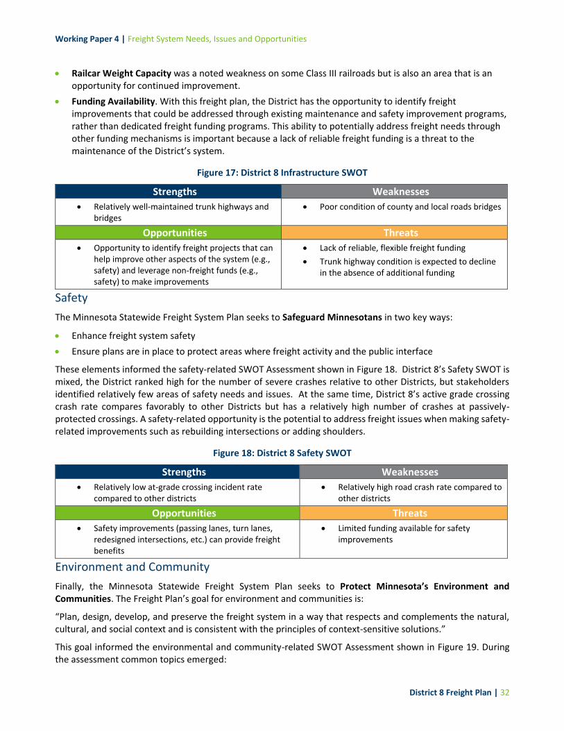
Working Paper 4 | Freight System Needs, Issues and Opportunities
District 8 Freight Plan | 32
Railcar Weight Capacity was a noted weakness on some Class III railroads but is also an area that is an opportunity for continued improvement.
Funding Availability. With this freight plan, the District has the opportunity to identify freight improvements that could be addressed through existing maintenance and safety improvement programs, rather than dedicated freight funding programs. This ability to potentially address freight needs through other funding mechanisms is important because a lack of reliable freight funding is a threat to the maintenance of the District’s system.
Figure 17: District 8 Infrastructure SWOT
Strengths Weaknesses
Relatively well-maintained trunk highways and bridges
Poor condition of county and local roads bridges
Opportunities Threats
Opportunity to identify freight projects that can help improve other aspects of the system (e.g., safety) and leverage non-freight funds (e.g., safety) to make improvements
Lack of reliable, flexible freight funding
Trunk highway condition is expected to decline in the absence of additional funding
Safety
The Minnesota Statewide Freight System Plan seeks to Safeguard Minnesotans in two key ways:
Enhance freight system safety
Ensure plans are in place to protect areas where freight activity and the public interface
These elements informed the safety-related SWOT Assessment shown in Figure 18. District 8’s Safety SWOT is mixed, the District ranked high for the number of severe crashes relative to other Districts, but stakeholders identified relatively few areas of safety needs and issues. At the same time, District 8’s active grade crossing crash rate compares favorably to other Districts but has a relatively high number of crashes at passively-protected crossings. A safety-related opportunity is the potential to address freight issues when making safety-related improvements such as rebuilding intersections or adding shoulders.
Figure 18: District 8 Safety SWOT
Strengths Weaknesses
Relatively low at-grade crossing incident rate compared to other districts
Relatively high road crash rate compared to other districts
Opportunities Threats
Safety improvements (passing lanes, turn lanes, redesigned intersections, etc.) can provide freight benefits
Limited funding available for safety improvements
Environment and Community
Finally, the Minnesota Statewide Freight System Plan seeks to Protect Minnesota’s Environment and Communities. The Freight Plan’s goal for environment and communities is:
“Plan, design, develop, and preserve the freight system in a way that respects and complements the natural, cultural, and social context and is consistent with the principles of context-sensitive solutions.”
This goal informed the environmental and community-related SWOT Assessment shown in Figure 19. During the assessment common topics emerged:

Working Paper 4 | Freight System Needs, Issues and Opportunities
District 8 Freight Plan | 33
Water Quality. A potential weakness of snow and ice removal efforts in the District is their impact on ground and surface water, as the use of salt and other deicing solutions can contaminate water and could be subject to greater regulation in the future. Water quality is particularly important for food manufacturing firms in the District.
Flooding Events. Flooding events are increasingly likely to disrupt road connections, particularly on local roads.
Room to Expand. District 8’s communities generally have plenty of room to expand, which means that new freight-related businesses can be constructed away from residential and commercial areas.
Truck Routes through Towns. District 8’s freight network has many two-lane roads that are routed directly through the downtown of local communities. This truck routing through urban areas can be a threat and a weakness, as trucks may move more slowly, be subject to localized congestion, and potentially at greater risk for a collision
Figure 19: District 8 Environment SWOT
Strengths Weaknesses
Relatively little conflict between land uses Snow and ice control methods have a negative impact on water quality (not freight-specific)
Truck routing through downtowns
Opportunities Threats
Room to expand without conflict between land uses (residential and commercial vs. industrial)
Flooding events may disrupt road connections
Truck routing through downtowns

Working Paper 4 | Freight System Needs, Issues and Opportunities
District 8 Freight Plan | 34
4 Freight System Opportunities
4.1 Summary of Freight System Opportunities
MnDOT and its stakeholders have four types of tools to improve the freight system:
Projects including infrastructure maintenance, improvement, and expansion.
Programs designed to improve information about freight operations in the District.
Policies to govern the development and operation of the freight system.
Partnerships with local stakeholders to better understand needs and issues, and implement or advance strategies to improve the system.
Each of these “4 P’s” has a different role in improving the system. While projects may appear to be the most important because they produce tangible results, proper selection and funding of specific projects would not be possible with partnerships to gather feedback, policies to guide investment, and established programs to allocate funding.
This chapter presents a series of strategic opportunities within each “P” category. Information for each of the categories comes from the analysis of this Working Paper and Working Paper 3, as well as stakeholder feedback, and recommendations from previous studies, including the Manufacturers’ Perspectives study.
This slate of preliminary opportunities is conceptual and will be further explored with the Advisory Committee and Technical Team to understand the completeness of opportunities identified. Opportunities may be added to/deleted from this list prior to formalizing freight plan recommendations.
4.2 Initial Slate of Project Opportunities
State- and County- programmed road projects may overlap with needs and issues identified as part of this Working Paper’s analysis. Where needs and issues, and programmed projects overlap, there may be the opportunity to improve the District’s freight network with non-freight dollars. This section provides an overview of the overlap and gaps between programmed MnDOT and County investments and identified needs and issues. This information on overlaps and gaps will help District 8 and its county partners understand how their currently-programmed investments could affect freight transportation. Furthermore, this examination of gaps will aid in the prioritization and selection of projects for advancement to a pre-engineering feasibility assessment. This prioritization process will be described in Working Paper 5. Information on District 8’s programmed projects came from the following sources:
The State Transportation Improvement Plan (STIP) identifies a schedule and funding amount for transportation projects over the next four years. The detailed project list in the STIP includes all state and local projects with federal highway or transit funding, as well as state-funded highway projects. The STIP
Key Findings
District 8’s freight system has many needs and issues, but it also has many potential advantages and opportunities. This chapter provides a deeper dive on four types of potential opportunities: projects, programs, policies, and partnerships. Particular attention is paid to project opportunities, which were identified by comparing the location of needs and issues against planned investments on the road network.
Working Paper 4 | Freight System Needs, Issues and Opportunities
District 8 Freight Plan | 35
also contains freight and rail investments, for reference. Figure 20 provides an illustration of District 8’s STIP projects.
MnDOT’s Capital Highway Investment Plan (CHIP), which lists 10 years of highway investments for the trunk highway network. The CHIP includes STIP projects, as well as planned investments for additional years after the scope of the 4-year STIP. These longer-term plans for projects are not guaranteed to be constructed but are listed in the CHIP to aid in coordination and planning. Figure 21 provides an illustration of District 8’s CHIP projects.
County Improvement Plans list four to five years of upcoming road and bridge projects on county-managed road networks. Figure 22 illustrates the location of all of these county projects.
Figure 23 shows the locations of STIP, CHIP, and county projects combined, and Figure 25 highlights where there are gaps between listed projects and identified needs and issues. The points on these maps are listed in Appendices C and D, respectively. As shown in Figure 25 notable gaps between programmed projects and needs and issues include:
Safety gaps were the most common gap, making up about two-thirds of the identified gaps. These were distributed across almost all areas of the District but were particularly focused on higher-traffic areas.
Performance-related gaps included issues related to mobility, and only made up about one-quarter of identified gaps. While these were only ¼ of the total count of gaps, they constitute some of the most pressing needs for the District, including lack of mobility/maneuverability at low-clearance bridges, and areas where additional passing lanes, turn lanes, or four-lane expansion was requested.
Condition gaps made up the remaining share of identified gaps and included 25 bridges identified as potentially deficient, as well as four issues identified by stakeholders or previous plans. Interestingly, few pavement condition gaps were found, which supports feedback from MnDOT staff who noted that Districts are proactive in programming improvements to address pavement needs.
Many types of highway transportation projects are in fact freight-benefitting projects.

Working Paper 4 | Freight System Needs, Issues and Opportunities
District 8 Freight Plan | 36
Figure 20: District 8 STIP Projects

Working Paper 4 | Freight System Needs, Issues and Opportunities
District 8 Freight Plan | 37
Figure 21: District 8 CHIP Projects
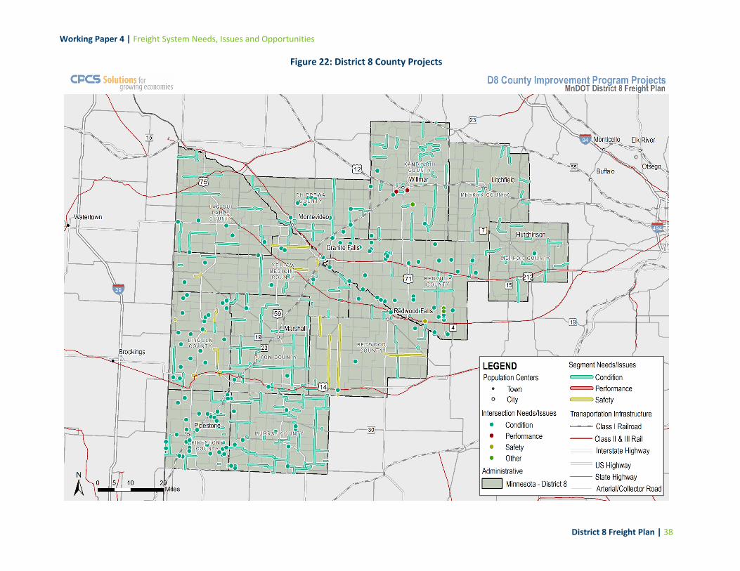
Working Paper 4 | Freight System Needs, Issues and Opportunities
District 8 Freight Plan | 38
Figure 22: District 8 County Projects

Working Paper 4 | Freight System Needs, Issues and Opportunities
District 8 Freight Plan | 39
Figure 23: District 8 Projects Combined

Working Paper 4 | Freight System Needs, Issues and Opportunities
District 8 Freight Plan | 40
Appendix D (Potential Gaps to Address) provides a detailed listing of these gaps shown in Figure 25. This list will be used as a starting point to begin to conceptualize project recommendations, and have been aligned with potential non-freight-specific funding options in Figure 24. It is assumed that these will be the primary funds for roadway related freight projects going forward. Many projects fall into multiple categories, and some projects were assigned to multiple categories in Figure 24. Therefore, the number of projects listed below is higher than the number of gaps.
Figure 24: 2018-2037 MnSHIP Investment Objectives and Categories Aligned with District 8 Freight Needs
Investment Objective
Investment Category Applicable D8 Freight System Need Number of Project Types Identified in Gap Analysis
System Stewardship
Pavement Condition Pavement Condition 4
Bridge Condition Bridge Condition 25
Roadside Infrastructure Signage
Traffic Signals/Controls
Other Technology and Information Management Systems
8
Jurisdictional Transfer N/A N/A
Facilities Weigh Station and Commercial Vehicle Enforcement
2*
Transportation Safety
Traveler Safety Sustained Crash Locations
Rail-Highway Crossings 102
Critical Connections
Twin Cities Mobility N/A N/A
Greater Minnesota Mobility
Intersections
Passing or Turning Lanes
Corridors
Roundabouts
54
Freight N/A N/A
Bicycle Infrastructure N/A N/A
Accessible Pedestrian Infrastructure
N/A N/A
Healthy Communities
Regional and Community Improvement Priorities
First and Last-Mile Connections 1
Other
Project Delivery N/A N/A
Small Programs N/A N/A
Note: This evaluation assumes that a dedicated freight investment category will not be available in the future. *The two weigh stations identified in previous Commercial Vehicle Enforcement/Safety Studies were classified as facilities investments.
It is acknowledged that while freight projects could potentially align with MnSHIP funding categories, this does not mean there will be funding available to advance all projects due to the overall state transportation funding shortfall. However, the information in this Working Paper is intended to be an opening to a broader conversation on freight project funding; specifically that many different types of transportation projects provide freight benefits, and that coordination with freight stakeholders, including MnDOT’s Office of Freight and Commercial Vehicle Operations, should be part of statewide investment planning.

Working Paper 4 | Freight System Needs, Issues and Opportunities
District 8 Freight Plan | 41
Figure 25: District 8 Project Gaps

Working Paper 4 | Freight System Needs, Issues and Opportunities
District 8 Freight Plan | 42
4.3 Project Concept Prioritization Methodology
The gaps identified above will be analyzed further to determine whether or not that need or issue should undergo pre-engineering analysis. The purpose of this exercise is to identify a select number of needs and issues that will receive additional attention to develop proposed solutions. Gaps will be scored and ranked according to 10 criteria, and relative scores will be used to determine which projects advance for pre-engineering analysis. Additional in-depth information on this scoring and ranking process will be provided in Working Paper 5.
Figure 26: Freight Categories and Measures
Category Ranking Score Measure
Truck Activity HCAADT
Truck percent (%) of total vehicles
Safety
Addresses a sustained crash location (Y/N)
A safety issue identified in a district or county safety plan (provide risk rating)
Addresses at-grade crossing safety risk
Freight Mobility
Truck Travel Time Reliability
Addresses a vertical clearance restriction
Addresses a weight limited bridge
Condition Bridge condition rating (one element less than 5)
Stakeholder Need Y/N if this issue overlaps with a stakeholder identified need
4.4 Policies, Programs, and Partnerships
To support the advancement of projects, policies, programs, and partnerships were identified. Generally, policies established to inform project and program investments, and partnerships are required for effective implementation.
Policies
Potential policy opportunities for MnDOT’s Office of Freight and Commercial Vehicle Operations and District 8 include:
Examine potential opportunities to tailor OSOW truck regulations to reflect local operational context, such as allowing OSOW loads at times when loads would be prohibited elsewhere in Minnesota.
Incorporating freight considerations into existing funding programs, or determining the potential freight benefits or impacts of specific CHIP, STIP, and county projects. Including these considerations may help the District address freight needs and issues without the assistance of a dedicated freight funding program.
Management of the road network should focus on maintaining a good condition of existing assets, rather than expanding capacity of the system. The policy reflects the fact that funding shortfalls are expected in the future, and limiting additional maintenance costs for additional infrastructure is in the states’ best interest.
Conduct research to understand how the future implementation of autonomous trucks may be relevant to freight transportation needs in the area, and what engineering facilities may be needed to support autonomous vehicle operations.

Working Paper 4 | Freight System Needs, Issues and Opportunities
District 8 Freight Plan | 43
Programs
Potential programs that MnDOT and local stakeholders could implement include:
Update or “refresh” the Manufacturers’ Perspectives study on a 5- or 10-year basis, to gather relevant feedback and evaluate how freight needs and issues are changing over time.
Partnerships
Since MnDOT only has control over a limited portion of the freight network and has limited resources to support maintenance and improvement, partnership with other public agencies and private stakeholders will be an important element of future work on the freight system. Potential partnership opportunities include:
Encourage state and federal lawmakers to develop stable funding policies and sources for freight, and the transportation system in general.
Offer assistance to county and local governments with long-range planning. As noted above, many freight issues occur off of MnDOT’s trunk highway network, so collaboration with local governments may be necessary to solve first- and last-mile freight movement needs and issues.
Engage with South Dakota DOT to ensure that highways critical to freight in District 8 (US-12, US-212, US-14, etc.) are adequately maintained. Other topics for collaboration include weight limit harmonization and the creation or preservation of oversize-overweight truck corridors.
Partner with local educational institutions to support truck driver training programs, with goal to ensure local businesses have enough drivers.
Public education with local law enforcement and media to help public understand how to drive around trucks.

Working Paper 4 | Freight System Needs, Issues and Opportunities
| 44
5 Conclusions and Next Steps
5.1 Conclusions
District 8’s freight system consists primarily of road and rail assets, which provide an extensive range of freight services and support the continued economic well-being of the district, particularly in agriculture and manufacturing. These assets face needs and issues related to mobility, condition, and performance, and some of the biggest issues for the District include low railroad bridges, a need for more passing and turning lanes on trunk highways, and improved maintenance of county and local roads.
5.2 Next Steps
As shown in the following figure, this Working Paper represents the results of Task 4 and provides input for Task 5. The next step of work will focus on scoring and ranking identified system gaps, with the intention of selecting a number of gaps for advancement to pre-engineering feasibility studies. The goal of this pre-engineering work will be to provide potential solutions to top unaddressed freight needs and issues in the District and create project concepts that can compete for funding in future freight-related solicitations.
Figure 27: Project Approach

Working Paper 4 | Freight System Needs, Issues and Opportunities
District 8 Freight Plan | A-1
Appendix A: Stakeholder-Identified Needs and Issues
This appendix contains a list of the location-specific stakeholder needs and issues identified through consultations, Advisory Committee and Technical Team feedback, and previous work such as the Manufacturers’ Perspectives Study. The fields in the table below are:
ID: This code refers to the need/issue ID printed on maps in this Working Paper. IDs beginning with “S” denote needs or issues identified by stakeholders, while IDs beginning with “D” denote needs or issues identified by analysis of data.
Source: The source of the comment, such as stakeholder feedback, or analysis of a specific dataset.
Type: intersection, or highway corridor
Highway Name or Number
Need/Issue Type: This field corresponds to the primary need or issue associated with the location. Needs and issues were coded in four ways: safety, condition, performance, or mobility.
Additional Information: where available, additional details from stakeholder comments were noted here.

Working Paper 4 | Freight System Needs, Issues and Opportunities
District 8 Freight Plan | A-1
ID Source Type Hwy Location Type Additional Information
S1 Impl. Tracker Intersection MN-23 S. Hiawatha & Hwy 23
Safety Stop bars missing
S2 Impl. Tracker Intersection US-75 Safety Add turn lane at the intersection of 101st St and 75
S3 Impl. Tracker Intersection US-75 1648 Hwy 75 Safety This curve is really hard to see traffic, esp. with a corn crop in fields
S4 Impl. Tracker Intersection US-75 State Hwy 75 and County Hwy 17 (Ivanhoe)
Safety
Grove of trees blocks view if you go East at this intersections. Maybe some flashing lights along with stop signs will help. Have seen people miss that stop sign and cross Hwy 75 Fed Ex
S5 Impl. Tracker Intersection MN 91 Lake Wilson Safety Bad curve on Hwy 91 by bank in Lake Wilson
S6 Impl. Tracker Intersection US 14 US-71 and US-14 Safety Prestop warning sign on 14 and 71 is not timed right--does not give enough time to stop
S7 Impl. Tracker Intersection MN-23 Hwy 23 South & Jct 15
Safety Stop bars missing
S8 2019 Consultations Intersection CR-33 CR-33 intersection MN-68 by Marshall
Safety CH33 toward MN-68- add acceleration lane
S9 2019 Consultations Intersection MN-59 MN-59 and CR-33 by Marshall
Safety
MN-59 and CH-33, Challenge to get across lower the speed limit. Light up sign to announce cars approaching. Trucks need to cross 59 to get to ADM plant. North side of Marshall. 75-100 trucks over intersection.
S10 Impl. Tracker Intersection US-59 US-59 and MN-19 Safety 90 degree angle on 19 E is hard in difficult weather; 59 and 19 intersection?
S11 2019 Consultations Intersection MN-23 US-59 by Marshall Safety 19/MN-23 and 59/MN-23. Busy intersections. Used to be 4 way stops, was safer. vehicles passing through lights at speed. Bypass around Marshall?
S12 2019 Consultations Intersection MN-23 Marshall Safety Marshall J-turns are awkward. See Saratoga and TH-23. Spacing and speed issues make them difficult for trucks to navigate.

Working Paper 4 | Freight System Needs, Issues and Opportunities
District 8 Freight Plan | A-2
ID Source Type Hwy Location Type Additional Information
S13 2019 Consultations Intersection MN-23 CR-19 by Marshall Safety 19/MN-23 and 59/MN-23. Busy intersections. Used to be 4 way stops, was safer vehicles passing through lights at speed. Bypass around Marshall?
S14 Impl. Tracker Intersection MN 19
HWY 19 and Channel Parkway on west of Marshall
Safety Have previously reviewed for a left turn lane but limited space between the bridge and RR tracks. Would need to be done at time of bridge replacement.
S15 Impl. Tracker Intersection MN-4 Hector Safety Want 30 mph expanded on 4 to go further out because forklifts cross road
S16 Impl. Tracker Intersection US 12 Safety Not enough clear time to get through - MN Rubber
S17 2019 Consultations Intersection Mills Street
Downtown Redwood Falls
Safety Weird intersection downtown with crossover on Mills St.
S18 2019 Consultations Segment MN-23 Marshall to Pipestone
Mobility Extend passing lanes
S19 2019 Consultations Segment MN-29 Marshall to Worthington
Mobility Add passing lanes from Marshall down to Worthington - high volume corridor, and currently lacks passing lanes.
S20 2019 Consultations Segment MN-68 West of Marshall Safety Narrow shoulders create hazard for trucks tipping over.
S21 2019 Consultations Segment Kandiyohi CR-9
East of Willmar Mobility Bypass completed and it comes around town, county road 9 is horrible (safety, condition, and performance); there are no lights so things slow down, especially for truckers.
S22 2019 Consultations Segment US-12 Willmar to Twin Cities
Mobility Passing lanes on 12 to cities drivers don’t know how to pass or maintain speed.
S23 2019 Consultations Segment MN-23 Willmar to I-94 Mobility Make 23 full 4-lane to St. Cloud
S24 2019 Consultations Segment CR-17 Prairies Edge Mobility Paving request: County Road 17, 2 mile stretch between County 43 and Highway 23 by Prairies Edge
S25 2019 Consultations Segment CR-12 Redwood Falls Mobility Paving request: County Road 12- Between Highway 71 and County Road 13 near Redwood Falls
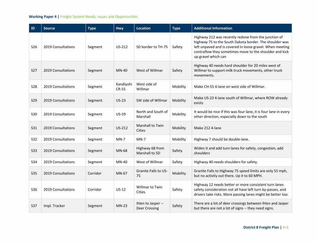
Working Paper 4 | Freight System Needs, Issues and Opportunities
District 8 Freight Plan | A-3
ID Source Type Hwy Location Type Additional Information
S26 2019 Consultations Segment US-212 SD border to TH-75 Safety
Highway 212 was recently redone from the junction of highway 75 to the South Dakota border. The shoulder was left unpaved and is covered in loose gravel. When meeting contraflow they sometimes move to the shoulder and kick up gravel which can
S27 2019 Consultations Segment MN-40 West of Willmar Safety Highway 40 needs hard shoulder for 20 miles west of Willmar to support milk truck movements, other truck movements.
S28 2019 Consultations Segment Kandiyohi CR-55
West side of Willmar
Mobility Make CH-55 4-lane on west side of Willmar.
S29 2019 Consultations Segment US-23 SW side of Willmar Mobility Make US-23 4-lane south of Willmar, where ROW already exists
S30 2019 Consultations Segment US-59 North and South of Marshall
Mobility It would be nice if this was four lane, it is four lane in every other direction, especially down to the south
S31 2019 Consultations Segment US-212 Marshall to Twin Cities
Mobility Make 212 4-lane
S32 2019 Consultations Segment MN-7 MN-7 Mobility Highway 7 should be double-lane.
S33 2019 Consultations Segment MN-68 Highway 68 from Marshall to SD
Safety Widen it and add turn lanes for safety, congestion, add shoulders
S34 2019 Consultations Segment MN-40 West of Willmar Safety Highway 40 needs shoulders for safety.
S35 2019 Consultations Corridor MN-67 Granite Falls to US-75
Mobility Granite Falls to Highway 75 speed limits are only 55 mph, but no activity out there. Up it to 60 MPH.
S36 2019 Consultations Corridor US-12 Willmar to Twin Cities
Safety Highway 12 needs better or more consistent turn lanes safety consideration not all have left turn by-passes, and drivers take risks. More passing lanes might be better too.
S37 Impl. Tracker Segment MN-23 Ihlen to Jasper -- Deer Crossing
Safety There are a lot of deer crossings between Ihlen and Jasper but there are not a lot of signs -- they need signs.

Working Paper 4 | Freight System Needs, Issues and Opportunities
District 8 Freight Plan | A-4
ID Source Type Hwy Location Type Additional Information
S38 Impl. Tracker Segment MN 269 Jasper to SD Safety Wider shoulders on 269 west of Jasper would be useful (road widens in South Dakota) Perhaps narrow shoulders are deterrent to I-90 weigh station run around?
S39 Impl. Tracker Segment MN 269 269 from Jasper to SD Hwy 11
Condition Potholes, cracks, chucks of side road missing. Needs gravel on both sides of Road.
S40 Impl. Tracker Segment MN 30 Hwy 30 between Lake Wilson and Hadley
Condition
Flooding Issues because of snow melt, potentially a plugged culvert. "Heard that MN ditches are shallower than they are in Iowa, and therefore they fill up with snow faster, which leads to increased drifting over the floods" Particularly bad on Hwy 30
S41 Impl. Tracker Segment MN 4 Condition Snow removal on HWY 4 is slow
S42 Impl. Tracker Segment MN 55 Eden Valley to Paynesville
Safety HWY 55 Eden Valley to Paynesville needs shoulder
S43 Impl. Tracker Segment US 14 E. and W. of Tyler Mobility This section of Hwy 14 is prone to flooding in locations east and west of Tyler
S44 Impl. Tracker Segment US 14 Tyler to Balaton Condition Rough Road on HWY 14 from Tyler to Balaton. Would also like wider shoulders, at least 6 feet on each side.
S45 Impl. Tracker Segment US-59 US-59 N. of Marshall
Safety HWY 59 has little or no shoulder, needs to support weight of truck
S46 Impl. Tracker Segment US-75 US-75 Pipestone to Luverne
Condition Very rough road.
S47 Impl. Tracker Segment US-75 Hwy 75 and Co. 25 Safety No Yellow pass line painted
S48 2019 Consultations Segment MN-19 MN-5 to US-169 Mobility Highway 19 (5 to 169) closed.
S49 2019 Consultations Segment MN-33 and US-59
Marshall Mobility Congestion is very minimal; 33 onto 59 for one hour in the morning is bad leading into Marshall and that is it.
S50 2019 Consultations Intersection MN-7 MN-7 at US-71 Mobility Highway 7 roundabouts are very tight.

Working Paper 4 | Freight System Needs, Issues and Opportunities
District 8 Freight Plan | A-5
ID Source Type Hwy Location Type Additional Information
S51 Impl. Tracker Intersection MN 7 Clara City Mobility HWY 7 in Clara City -- make too narrow of a driveway. Would like to work with MnDOT.
S52 Impl. Tracker Intersection MN 7 Hutchinson Mobility Gate or flashing light for road closure on 7 west of Hutch
S53 AC Online Survey Segment MN-22 Glencoe Safety Trunk Highway 7 & 22 - pave all shoulders
S54 AC Online Survey Segment MN-22 Glencoe Mobility TH 22 connectivity to US 212 - Glencoe corridor
S55 AC Online Survey Segment MN-15 Hutchinson Safety Need passing lanes from Hutchinson to I-94
S56 Gen Online Survey Segment
US Highway 71 and MN Highway 19/67
Redwood Falls Safety
US Highway 71 and MN Highway 19/67 Safety improvements and traffic flow through the City of Redwood Falls. Traffic speeds vary along this wide open section of corridor and with the ADT make it difficult for staff to safely turn onto and off of US Highway 71 within the City.
S57 Gen Online Survey Segment US 59 Slayton Condition Hwy 59 from Slayton to Hwy 30 at 'Pete's Corner'.
S58 Gen Online Survey Segment US-152 Willmar to MPLS Safety
US-12 between Willmar & Metro--request 4 lane rather than passing lanes. Non-commercial traffic will travel significantly slower than posted speeds in the 2 lane area and speed up not allowing other vehicles to pass in the passing lanes.
S59 2019 Consultations Segment US-212 TH-75 to South Dakota
Condition
Highway 212 was recently redone from the junction of Highway 75 to the South Dakota border. The shoulder was left unpaved and is covered in loose gravel. When meeting contraflow they sometimes move to the shoulder and kick up gravel which can cause damage to windshields, truck and cargo. Is it possible to oil the shoulders to lessen the impact of loose sediment?
S60 Gen Online Survey Intersection MN-23 Wilmar Safety Would like ramps constructed on the Kandiyohi county 5 & MN highway 23 intersection

Working Paper 4 | Freight System Needs, Issues and Opportunities
District 8 Freight Plan | B-1
Appendix B: Data-Identified Needs and Issues
This appendix contains a list of location-specific needs and issues identified through analysis of data provided by MnDOT. The fields in the table below are:
ID: This code refers to the need/issue ID printed on maps in this Working Paper. IDs beginning with a “D” indicate needs and issues identified from data analysis.
Source: the data source used to identify the need or issue.
Type: Intersection, or Highway Corridor
Need/Issue Type: This field corresponds to the primary need or issue associated with the location. Needs and issues were coded in four ways: safety, condition, performance, or mobility.
Additional Information: where available, additional details on why the corridor or intersection was identified as having a need or issue.

Working Paper 4 | Freight System Needs, Issues and Opportunities
District 8 Freight Plan | B-2
ID Source Type Hwy Type Additional Information
D1 MnDOT Highway Safety Data Intersection MNTH 19 Safety More than 2 crashes at this location between 2017 - 2018
D2 MnDOT Highway Safety Data Intersection SIBLEY AVE Safety More than 2 crashes at this location between 2017 - 2018
D3 MnDOT Highway Safety Data Intersection MNTH 23 Safety More than 2 crashes at this location between 2017 - 2018
D4 MnDOT Highway Safety Data Intersection MNTH 19 Safety More than 2 crashes at this location between 2017 - 2018
D5 MnDOT Highway Safety Data Intersection MNTH 23 Safety More than 2 crashes at this location between 2017 - 2018
D6 MnDOT Highway Safety Data Intersection USTH 12 Safety More than 2 crashes at this location between 2017 - 2018
D7 MnDOT Highway Safety Data Intersection 15TH AVE SW Safety More than 2 crashes at this location between 2017 - 2018
D8 MnDOT Highway Safety Data Intersection USTH 212 Safety More than 2 crashes at this location between 2017 - 2018
D9 MnDOT Highway Safety Data Intersection E COLLEGE DR Safety More than 2 crashes at this location between 2017 - 2018
D10 MnDOT Highway Safety Data Intersection MNTH 15 Safety More than 2 crashes at this location between 2017 - 2018
D11 MnDOT Highway Safety Data Intersection USTH 212 Safety More than 2 crashes at this location between 2017 - 2018
D12 MnDOT Highway Safety Data Intersection USTH 71 Safety More than 2 crashes at this location between 2017 - 2018
D13 MnDOT Highway Safety Data Intersection USTH 12 Safety More than 2 crashes at this location between 2017 - 2018
D14 MnDOT Highway Safety Data Intersection 50TH ST SE Safety More than 2 crashes at this location between 2017 - 2018
D15 MnDOT Highway Safety Data Intersection 45TH ST SW Safety More than 2 crashes at this location between 2017 - 2018
D16 MnDOT Highway Safety Data Intersection CSAH 5 Safety More than 2 crashes at this location between 2017 - 2018
D17 MnDOT Highway Safety Data Intersection MNTH 19 Safety More than 2 crashes at this location between 2017 - 2018
D18 MnDOT Highway Safety Data Intersection ERIE RD Safety More than 2 crashes at this location between 2017 - 2018
D19 MnDOT Highway Safety Data Intersection HWY 212 Safety More than 2 crashes at this location between 2017 - 2018
D20 MnDOT Highway Safety Data Intersection MNTH 23 Safety More than 2 crashes at this location between 2017 - 2018
D21 MnDOT Highway Safety Data Intersection USTH 12 Safety More than 2 crashes at this location between 2017 - 2018

Working Paper 4 | Freight System Needs, Issues and Opportunities
District 8 Freight Plan | B-3
ID Source Type Hwy Type Additional Information
D22 MnDOT Highway Safety Data Intersection MNTH 91 Safety More than 2 crashes at this location between 2017 - 2018
D23 MnDOT Highway Safety Data Intersection MNTH 7 Safety More than 2 crashes at this location between 2017 - 2018
D24 MnDOT Highway Safety Data Segment MNTH 119 Safety Segment with high density crash rates
D25 MnDOT Highway Safety Data Segment MNTH 9 Safety Segment with high density crash rates
D26 MnDOT Highway Safety Data Segment MNTH 9 Safety Segment with high density crash rates
D27 MnDOT Highway Safety Data Segment MNTH 9 Safety Segment with high density crash rates
D28 MnDOT Highway Safety Data Segment MNTH 9 Safety Segment with high density crash rates
D29 MnDOT Highway Safety Data Segment Front Safety Segment with high density crash rates
D30 MnDOT Highway Safety Data Segment Front Safety Segment with high density crash rates
D31 MnDOT Highway Safety Data Segment Front Safety Segment with high density crash rates
D32 MnDOT Highway Safety Data Segment MNTH 7 Safety Segment with high density crash rates
D33 MnDOT Highway Safety Data Segment MNTH 68 Safety Segment with high density crash rates
D34 MnDOT Highway Safety Data Segment Broadway Safety Segment with high density crash rates
D35 MnDOT Highway Safety Data Segment Maple Safety Segment with high density crash rates
D36 MnDOT Highway Safety Data Segment Maple Safety Segment with high density crash rates
D37 MnDOT Highway Safety Data Segment Maple Safety Segment with high density crash rates
D38 MnDOT Highway Safety Data Segment Maple Safety Segment with high density crash rates
D39 MnDOT Highway Safety Data Segment MNTH 23 Safety Segment with high density crash rates
D40 MnDOT Highway Safety Data Segment Maple Safety Segment with high density crash rates
D41 MnDOT Highway Safety Data Segment 13th Safety Segment with high density crash rates
D42 MnDOT Highway Safety Data Segment 13th Safety Segment with high density crash rates

Working Paper 4 | Freight System Needs, Issues and Opportunities
District 8 Freight Plan | B-4
ID Source Type Hwy Type Additional Information
D43 MnDOT Highway Safety Data Segment MNTH 23 Safety Segment with high density crash rates
D44 MnDOT Highway Safety Data Segment MNTH 22 Safety Segment with high density crash rates
D45 MnDOT Highway Safety Data Segment MNTH 22 Safety Segment with high density crash rates
D46 MnDOT Highway Safety Data Segment 280th Safety Segment with high density crash rates
D47 MnDOT Highway Safety Data Segment USTH 75 Safety Segment with high density crash rates
D48 MnDOT Highway Safety Data Segment MNTH 15 Safety Segment with high density crash rates
D49 MnDOT Highway Safety Data Segment MNTH 15 Safety Segment with high density crash rates
D50 MnDOT Highway Safety Data Segment 280th Safety Segment with high density crash rates
D51 MnDOT Highway Safety Data Segment MNTH 23 Safety Segment with high density crash rates
D52 MnDOT Highway Safety Data Segment MNTH 23 Safety Segment with high density crash rates
D53 MnDOT Highway Safety Data Segment 280th Safety Segment with high density crash rates
D54 MnDOT Highway Safety Data Segment Maple Safety Segment with high density crash rates
D55 MnDOT Highway Safety Data Segment MNTH 22 Safety Segment with high density crash rates
D56 D8 Bridge Clearance/Condition Data
Intersection MN-40 Performance Vertical Bridge Clearance is <14.6'
D57 D8 Bridge Clearance/Condition Data
Intersection US-59 Performance Vertical Bridge Clearance is <14.6'
D58 D8 Bridge Clearance/Condition Data
Intersection US-212 Performance Vertical Bridge Clearance is <14.6'
D59 D8 Bridge Clearance/Condition Data
Intersection US-212 Performance Vertical Bridge Clearance is <14.6'
D60 D8 Bridge Clearance/Condition Data
Intersection US-59 Performance Vertical Bridge Clearance is <14.6'

Working Paper 4 | Freight System Needs, Issues and Opportunities
District 8 Freight Plan | B-5
ID Source Type Hwy Type Additional Information
D61 D8 Bridge Clearance/Condition Data
Intersection US-71 Performance Vertical Bridge Clearance is <14.6'
D62 D8 Bridge Clearance/Condition Data
Intersection US-71 Performance Vertical Bridge Clearance is <14.6'
D63 D8 Bridge Clearance/Condition Data
Intersection MN-23 Performance Vertical Bridge Clearance is <14.6'
D64 D8 Bridge Clearance/Condition Data
Intersection MN-22 Performance Vertical Bridge Clearance is <14.6'
D65 D8 Bridge Clearance/Condition Data
Intersection MN-22 Performance Vertical Bridge Clearance is <14.6'
D66 D8 Bridge Clearance/Condition Data
Intersection MN-15 Performance Vertical Bridge Clearance is <14.6'
D67 D8 Bridge Clearance/Condition Data
Intersection US-12 Performance Vertical Bridge Clearance is <14.6'
D68 D8 Bridge Clearance/Condition Data
Intersection US-12 Performance Vertical Bridge Clearance is <14.6'
D69 D8 Bridge Clearance/Condition Data
Intersection US-12 Performance Vertical Bridge Clearance is <14.6'
D70 D8 Bridge Clearance/Condition Data
Intersection MN-55 Performance Vertical Bridge Clearance is <14.6'
D71 D8 Bridge Clearance/Condition Data
Intersection US-12 Performance Vertical Bridge Clearance is <14.6'
D72 D8 Bridge Clearance/Condition Data
Intersection MN-30 Performance Vertical Bridge Clearance is <14.6'
D73 D8 Bridge Clearance/Condition Data
Intersection US-71 Performance Vertical Bridge Clearance is <14.6'

Working Paper 4 | Freight System Needs, Issues and Opportunities
District 8 Freight Plan | B-6
ID Source Type Hwy Type Additional Information
D74 D8 Bridge Clearance/Condition Data
Intersection US-71 Performance Vertical Bridge Clearance is <14.6'
D75 D8 Bridge Clearance/Condition Data
Intersection MN-19 Performance Vertical Bridge Clearance is <14.6'
D76 D8 Bridge Clearance/Condition Data
Intersection US-14 Performance Vertical Bridge Clearance is <14.6'
D77 D8 Bridge Clearance/Condition Data
Intersection US-14 Performance Vertical Bridge Clearance is <14.6'
D78 D8 Bridge Clearance/Condition Data
Intersection MN-23 Performance Vertical Bridge Clearance is <14.6'
D79 D8 Bridge Clearance/Condition Data
Intersection US-212 Performance Vertical Bridge Clearance is <14.6'
D80 D8 Bridge Clearance/Condition Data
Intersection CR-43 Performance Vertical Bridge Clearance is <14.6'
D81 MnDOT At Grade Rail Crossings Intersection LAKELAND DR SE
Safety Rail Risk Rating is >7
D82 MnDOT At Grade Rail Crossings Intersection 7TH ST SW Safety Rail Risk Rating is >7
D83 MnDOT At Grade Rail Crossings Intersection 30TH ST NW Safety Rail Risk Rating is >7
D84 MnDOT At Grade Rail Crossings Intersection WILLMAR AVE SW
Safety Rail Risk Rating is >7
D85 MnDOT At Grade Rail Crossings Intersection 30TH ST SW Safety Rail Risk Rating is >7
D86 MnDOT At Grade Rail Crossings Intersection W COLLEGE DR
Safety Rail Risk Rating is >7
D87 MnDOT At Grade Rail Crossings Intersection 240TH AVE Safety Rail Risk Rating is >7
D88 MnDOT At Grade Rail Crossings Intersection CSAH 1 Safety Rail Risk Rating is >7

Working Paper 4 | Freight System Needs, Issues and Opportunities
District 8 Freight Plan | B-7
ID Source Type Hwy Type Additional Information
D89 MnDOT At Grade Rail Crossings Intersection 8TH AVE NE Safety Rail Risk Rating is >7
D90 MnDOT At Grade Rail Crossings Intersection E MAIN ST Safety Rail Risk Rating is >7
D91 MnDOT At Grade Rail Crossings Intersection 45TH ST NW Safety Rail Risk Rating is >7
D92 MnDOT At Grade Rail Crossings Intersection 45TH AVE SW Safety Rail Risk Rating is >7
D93 MnDOT At Grade Rail Crossings Intersection 75TH AVE SW Safety Rail Risk Rating is >7
D94 MnDOT At Grade Rail Crossings Intersection 220TH AVE Safety Rail Risk Rating is >7
D95 MnDOT At Grade Rail Crossings Intersection 150TH ST Safety Rail Risk Rating is >7
D96 MnDOT At Grade Rail Crossings Intersection BLAINE ST Safety Rail Risk Rating is >7
D97 MnDOT At Grade Rail Crossings Intersection 650TH AVE Safety Rail Risk Rating is >7
D98 MnDOT At Grade Rail Crossings Intersection 540TH ST Safety Rail Risk Rating is >7
D99 MnDOT At Grade Rail Crossings Intersection 290TH AVE Safety Rail Risk Rating is >7
D100 MnDOT At Grade Rail Crossings Intersection DIKE RD Safety Rail Risk Rating is >7
D101 MnDOT At Grade Rail Crossings Intersection WASHINGTON AVE
Safety Rail Risk Rating is >7
D102 MnDOT At Grade Rail Crossings Intersection 121ST ST Safety Rail Risk Rating is >7
D103 MnDOT At Grade Rail Crossings Intersection 9TH ST NE Safety Rail Risk Rating is >7
D104 MnDOT At Grade Rail Crossings Intersection 310TH AVE Safety Rail Risk Rating is >7
D105 MnDOT At Grade Rail Crossings Intersection CSAH 1 Safety Rail Risk Rating is >7
D106 MnDOT At Grade Rail Crossings Intersection 190TH ST NE Safety Rail Risk Rating is >7
D107 MnDOT At Grade Rail Crossings Intersection 160TH ST NE Safety Rail Risk Rating is >7

Working Paper 4 | Freight System Needs, Issues and Opportunities
District 8 Freight Plan | B-8
ID Source Type Hwy Type Additional Information
D108 D8 Bridge Clearance/Condition Data
Intersection MAIN ST (MUN 22)
Condition Bridge Condition Rating is <50%
D109 D8 Bridge Clearance/Condition Data
Intersection MAIN ST (MUN 22)
Condition Bridge Condition Rating is <50%
D110 D8 Bridge Clearance/Condition Data
Intersection CSAH 2 Condition Bridge Condition Rating is <50%
D111 D8 Bridge Clearance/Condition Data
Intersection CSAH 8 Condition Bridge Condition Rating is <50%
D112 D8 Bridge Clearance/Condition Data
Intersection TWP 87 Condition Bridge Condition Rating is <50%
D113 D8 Bridge Clearance/Condition Data
Intersection CSAH 2 Condition Bridge Condition Rating is <50%
D114 D8 Bridge Clearance/Condition Data
Intersection CSAH 38 Condition Bridge Condition Rating is <50%
D115 D8 Bridge Clearance/Condition Data
Intersection TH 40 Condition Bridge Condition Rating is <50%
D116 D8 Bridge Clearance/Condition Data
Intersection 50TH AVE Condition Bridge Condition Rating is <50%
D117 D8 Bridge Clearance/Condition Data
Intersection CSAH 16 Condition Bridge Condition Rating is <50%
D118 D8 Bridge Clearance/Condition Data
Intersection CSAH 2 Condition Bridge Condition Rating is <50%
D119 D8 Bridge Clearance/Condition Data
Intersection CSAH 22 Condition Bridge Condition Rating is <50%
D120 D8 Bridge Clearance/Condition Data
Intersection CSAH 8 Condition Bridge Condition Rating is <50%

Working Paper 4 | Freight System Needs, Issues and Opportunities
District 8 Freight Plan | B-9
ID Source Type Hwy Type Additional Information
D121 D8 Bridge Clearance/Condition Data
Intersection CSAH 20 Condition Bridge Condition Rating is <50%
D122 D8 Bridge Clearance/Condition Data
Intersection 220TH ST Condition Bridge Condition Rating is <50%
D123 D8 Bridge Clearance/Condition Data
Intersection CR 60 Condition Bridge Condition Rating is <50%
D124 D8 Bridge Clearance/Condition Data
Intersection CSAH 8 Condition Bridge Condition Rating is <50%
D125 D8 Bridge Clearance/Condition Data
Intersection TWP 362 Condition Bridge Condition Rating is <50%
D126 D8 Bridge Clearance/Condition Data
Intersection CSAH 12 Condition Bridge Condition Rating is <50%
D127 D8 Bridge Clearance/Condition Data
Intersection CR 64 Condition Bridge Condition Rating is <50%
D128 D8 Bridge Clearance/Condition Data
Intersection CR 81 Condition Bridge Condition Rating is <50%
D129 D8 Bridge Clearance/Condition Data
Intersection CSAH 3 Condition Bridge Condition Rating is <50%
D130 D8 Bridge Clearance/Condition Data
Intersection CSAH 15 Condition Bridge Condition Rating is <50%
D131 D8 Bridge Clearance/Condition Data
Intersection CR 56 Condition Bridge Condition Rating is <50%
D132 D8 Bridge Clearance/Condition Data
Intersection CSAH 3 Condition Bridge Condition Rating is <50%
D133 D8 Bridge Clearance/Condition Data
Intersection 250 AVE (TWP 90)
Condition Bridge Condition Rating is <50%

Working Paper 4 | Freight System Needs, Issues and Opportunities
District 8 Freight Plan | B-10
ID Source Type Hwy Type Additional Information
D134 D8 Bridge Clearance/Condition Data
Intersection 380 ST (TWP 72)
Condition Bridge Condition Rating is <50%
D135 D8 Bridge Clearance/Condition Data
Intersection 190TH ST -TWNS 118
Condition Bridge Condition Rating is <50%
D136 D8 Bridge Clearance/Condition Data
Intersection TWP 26 Condition Bridge Condition Rating is <50%
D137 D8 Bridge Clearance/Condition Data
Intersection 370 ST Condition Bridge Condition Rating is <50%
D138 D8 Bridge Clearance/Condition Data
Intersection TWP 59 Condition Bridge Condition Rating is <50%
D139 D8 Bridge Clearance/Condition Data
Intersection HARVEST (TWNS 73)
Condition Bridge Condition Rating is <50%
D140 D8 Bridge Clearance/Condition Data
Intersection HUNTER (TWNS 196)
Condition Bridge Condition Rating is <50%
D141 D8 Bridge Clearance/Condition Data
Intersection GRANDVIEW -TWNS 96
Condition Bridge Condition Rating is <50%
D142 D8 Bridge Clearance/Condition Data
Intersection TWP 189 Condition Bridge Condition Rating is <50%
D143 D8 Bridge Clearance/Condition Data
Intersection 230TH ST (TWNS 17)
Condition Bridge Condition Rating is <50%
D144 D8 Bridge Clearance/Condition Data
Intersection 200TH ST (TWNS 36)
Condition Bridge Condition Rating is <50%
D145 D8 Bridge Clearance/Condition Data
Intersection 390 St. (TWP 75)
Condition Bridge Condition Rating is <50%
D146 D8 Bridge Clearance/Condition Data
Intersection TWP 95 Condition Bridge Condition Rating is <50%

Working Paper 4 | Freight System Needs, Issues and Opportunities
District 8 Freight Plan | B-11
ID Source Type Hwy Type Additional Information
D147 D8 Bridge Clearance/Condition Data
Intersection TWP 52 Condition Bridge Condition Rating is <50%
D148 D8 Bridge Clearance/Condition Data
Intersection TH 19 ACCESS RD
Condition Bridge Condition Rating is <50%
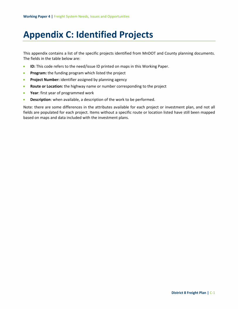
Working Paper 4 | Freight System Needs, Issues and Opportunities
District 8 Freight Plan | C-1
Appendix C: Identified Projects
This appendix contains a list of the specific projects identified from MnDOT and County planning documents. The fields in the table below are:
ID: This code refers to the need/issue ID printed on maps in this Working Paper.
Program: the funding program which listed the project
Project Number: identifier assigned by planning agency
Route or Location: the highway name or number corresponding to the project
Year: first year of programmed work
Description: when available, a description of the work to be performed.
Note: there are some differences in the attributes available for each project or investment plan, and not all fields are populated for each project. Items without a specific route or location listed have still been mapped based on maps and data included with the investment plans.

Working Paper 4 | Freight System Needs, Issues and Opportunities
District 8 Freight Plan | C-2
ID Program Project
Number Route or location
Year Description
P1 CHIP
5904-26 MN30 2020
3.5 MILES W. OF PIPESTONE/MURRAY COUNTY LINE, REPLACE BRIDGES 4566 * 4468 (STREAM X-ING)
P2 CHIP
3701-91 MN40 2020 3.5 MILES S. OF MN 119, REPLACE BRIDGE 6706
P3 CHIP
4701-33 MN4 2020 2.6 MILES N. OF RENVILLE/MEEKER COUNTY LINE, REPLACE BRIDGE 6801
P4 CHIP
1003-38 MN7 2020
1.8 MILES E. OF MCLEOD/CARVER COUNTY LINE, REPLACE BRIDGE 8518 (STREAM X-ING) (METRO ATP)
P5 CHIP
4101-90 US14 2020
1.8 MILES E. OF SOUTH DAKOTA/MINNESOTA STATE LINE, REPLACE BRIDGE 1686 (STREAM X-ING)
P6 CHIP
5902-25 MN23 2020
**AC** US 75 (PIPESTONE) TO 1.8 MILES N. OF MN 91, MEDIUM MILL * OVERLAY * RE-DECK BRIDGE 59002 (INFLATED COST IS $11.1M)
P7 CHIP
4109-30 US75 2020
1.6 MILES S. OF LINCOLN/YELLOW MEDICINE COUNTY LINE, REPLACE BRIDGE 8373 (STREAM X-ING)
P8 CHIP 5101- MN30 2020 4.1 MILES E. OF PIPESTONE/MURRAY COUNTY LINE, REPLACE BRIDGES 8172 * 8716
P9 CHIP 5101- MN30 2020 4.1 MILES E. OF PIPESTONE/MURRAY COUNTY LINE, REPLACE BRIDGES 8172 * 8716
P10 CHIP 3703- US75 2020 3 MILES S OF MN 7, REPLACE BRIDGE 9017
P11 CHIP 8703- US59 2020 5 MILES S OF MN 67, REPLACE BRIDGE 6751
P12 STIP
4203-50 MN23 2020 Replace Bridge
P13 STIP
4203-50 MN23 2020 Replace Bridge
P14 STIP
4203-50 MN23 2020 Replace Bridge
P15 STIP
4203-50 MN23 2020 Replace Bridge
P16 STIP
1206-91 MN29 2020 Replace Bridge
P17 STIP
5906-42 US75 2020 Replace Bridge
P18 STIP
6403-37 MN19 2021 Replace Bridge

Working Paper 4 | Freight System Needs, Issues and Opportunities
District 8 Freight Plan | C-3
ID Program Project
Number Route or location
Year Description
P19 STIP
5103-91 MN30 2022 Replace Bridge
P20 STIP
3409-19 MN40 2021 Replace Bridge
P21 STIP
3409-19 MN40 2021 Replace Bridge
P22 STIP
4210-49 MN68 2021 Replace Bridge
P23 STIP
4210-49 MN68 2021 Replace Bridge
P24 STIP
4210-49 MN68 2021 Replace Bridge
P25 STIP
4210-49 MN68 2021 Replace Bridge
P26 STIP
4209-27 US59 2022 Replace Bridge
P27 STIP
4209-27 US59 2022 Replace Bridge
P28 STIP
4103-11 MN19 2023 Replace Bridge
P29 STIP
4103-11 MN19 2023 Replace Bridge
P30 STIP
4103-11 MN19 2023 Replace Bridge
P31 STIP
4206-23 MN23 2023 Replace Bridge
P32 STIP
6405-68 US71 2021 Replace Bridge
P33 STIP
4208-61 US14 2020 Slope Stabilization
P34 STIP
4208-61 US59 2020 Slope Stabilization

Working Paper 4 | Freight System Needs, Issues and Opportunities
District 8 Freight Plan | C-4
ID Program Project
Number Route or location
Year Description
P35 STIP
4208-61 US14 2020 Slope Stabilization
P36 STIP
4208-61 US59 2020 Slope Stabilization
P37 STIP
4207-59 N/A 2020 Snow Fence
P38 STIP
3407-94 N/A 2021 Mid-block Crossing
P39 STIP
3408-90 N/A 2022 RCI
P40 STIP
6509-30 N/A 2021 Upgrade Railroad Signal
P41 STIP
3412-73 N/A 2021 RCI
P42 STIP
4310-93 N/A 2022 RCI
P43 STIP
8707-95 N/A 2020 Slope Repair
P44 Chippewa N/A
CSAH 39, BNSF RR Crossing Gates 2020 CSAH 39, BNSF RR Crossing Gates
P45 Chippewa N/A
CSAH 7 in Stewart, Install new RR Gates/Signals 2018 CSAH 7 in Stewart, Install new RR Gates/Signals
P46 Chippewa N/A
0.1 MI E OF W JCT TH 23 2019 Bridge 90170, Granite Falls
P47 Chippewa N/A N/A 2019 Bridge 8x8 Box, CR 40
P48 Chippewa N/A
IN CLARA CITY 2019 Bridge 12519, CSAH 2

Working Paper 4 | Freight System Needs, Issues and Opportunities
District 8 Freight Plan | C-5
ID Program Project
Number Route or location
Year Description
P49 Chippewa N/A
0.3 MI E OF JCT CSAH 2 2019 Bridge 12517, CSAH 13
P50 Chippewa N/A
1.8 MI N OF JCT CSAH 15 2020 Bridge L9140, Sparta
P51 Chippewa N/A
0.3 MI E OF JCT CSAH 6 2021 Bridge 92552, CSAH 12
P52 Chippewa N/A
1.1 MI E OF JCT CSAH 7 2021 Bridge 90159, CSAH 12
P53 Chippewa N/A
0.8 MI S OF JCT CSAH 12 2021 Bridge L7711, MANDT
P54 Chippewa N/A N/A 2023 Bridge L9493, Crate
P55 Chippewa N/A N/A 2023 NEW Bridge. Stoneham
P56 Chippewa N/A
1.3 MI N OF JCT CSAH 13 2023 Bridge L9155, Rosewood
P57 Kandiyohi N/A
0.3 MI E OF JCT CSAH 7 2023 Bridge L9151, Rosewood
P58 Kandiyohi N/A
1.4 MI E OF JCT CSAH 3 2023 Bridge 12506, Stoneham
P59 Kandiyohi N/A
0.2 MI W OF JCT CSAH 7 2021 CR 14 Bridge Replacement
P60 Kandiyohi N/A N/A 2021 CR 16 Bridge Replacement
P61 Kandiyohi N/A
3.0 MI W OF JCT TH 71 2022 CR 55 Bridge Overpass Construction
P62 Kandiyohi N/A N/A 2019 CR5/15 Roundabout Construction
P63 Kandiyohi N/A
2.0 MI NE OF S JCT TH 23 2019 CR 23 Bypass Lane Construction
P64 Kandiyohi N/A
0.5 MI W OF JCT CSAH 3 2019 Lake Wakanda Water Control Structures
P65 Lac qui Parle N/A N/A 2019 1 Ave W. Bridge Replacement
P66 Lac qui Parle N/A N/A 2019 120 St NW. Bridge Replacement
P67 Lac qui Parle N/A
0.5 MI S OF JCT TH 212 2019 Bridge 37504, CSAH 21 (Rehabilitation)

Working Paper 4 | Freight System Needs, Issues and Opportunities
District 8 Freight Plan | C-6
ID Program Project
Number Route or location
Year Description
P68 Lac qui Parle N/A
0.9 MI E OF JCT TH 275 2019 Bridge L7812, 140 Street (Replace, New Bridge 37J85)
P69 Lac qui Parle N/A
1.4 MI SE OF JCT CSAH 10 2020 Bridge L9168, 275 Ave. (Replace)
P70 Lincoln N/A
0.1 MI N OF JCT TH 212 2020 Bridge L9600, 111 Ave. (Replace)
P71 Lincoln N/A
0.9 MI N OF JCT TH 212 2020 Bridge 4986, CSAH 13 (Replace)
P72 Lincoln N/A
0.3 MI W OF JCT CSAH 5 2021 Bridge 7245, CSAH 17
P73 Lincoln N/A N/A 2021 Bridge L2094, 170th Ave Diamond/Drammen
P74 Lincoln N/A N/A 2021 Bridge L2040, 220th St Diamond Lake
P75 Lincoln N/A N/A 2021 Bridge L2041, 220th St Diamond Lake
P76 Lincoln N/A N/A 2021 Bridge L2051, 140th Ave Verdi Twp
P77 Lincoln N/A N/A 2020 Bridge L2055, 130th Ave Shaokatan Twp
P78 Lincoln N/A N/A 2021 Bridge L2111, 380th St Alta Vista
P79 Lincoln N/A
0.8 MI E OF JCT CR 101 2023 Bridge 41503, CSAH 20
P80 Lincoln N/A
0.7 MI S OF JCT CSAH 18 2023 Bridge L1993, CR 101
P81 Lincoln N/A N/A 2022 Bridge 92703, CSAH 25
P82 Lincoln N/A N/A 2022 Bridge 92466, CSAH 13
P83 Lincoln N/A
0.9 MI N OF JCT CSAH 15 2022 Bridge 41507, CR 101
P84 Lincoln N/A
0.2 MI E OF JCT CR 101 2020 Bridge 93064, CSAH 12
P85 Lincoln N/A
0.2 MI S OF JCT CR 126 2020 Bridge L1965, CSAH 8
P86 Lincoln N/A
0.2 MI S OF JCT CR 126 2020 Bridge L1966, CSAH 8
P87 Lincoln N/A
0.6 MI N OF JCT CSAH 10 2020 Bridge L1956, CSAH 1

Working Paper 4 | Freight System Needs, Issues and Opportunities
District 8 Freight Plan | C-7
ID Program Project
Number Route or location
Year Description
P88 Lincoln N/A
1.3 MI N OF JCT CSAH 17 2020 Bridge 93062, CSAH 5
P89 Lincoln N/A N/A 2020 Bridge L2013, CSAH 8
P90 Lincoln N/A N/A 2020 Bridge L2011, CSAH 8
P91 Lincoln N/A N/A 2020 Bridge L2010, CSAH 8
P92 Lincoln N/A N/A 2019 Bridge L2098, 270th St Shaokatan Twp
P93 Lincoln N/A N/A 2019 Bridge 191, 380th St Hansonville Twp
P94 Lyon N/A
0.9 MI E OF JCT CSAH 5 2019 Bridge L2105, 330th St Royal Twp
P95 Lyon N/A
1.2 MI W OF JCT CSAH 8 2019 Bridge L1988, CSAH 19
P96 Lyon N/A
0.2 MI N OF JCT CSAH 3 2023 Bridge L4650, Replace Bridge
P97 Lyon N/A
0.9 MI E OF JCT CR 63 2020 Bridge L5810, Replace Bridge with Box Culverts
P98 Lyon N/A
2.0 MI SE OF JCT TH 59 2021 Bridge L1775, Replace Bridge
P99 Lyon N/A
0.7 MI N OF JCT TH 14 2019 Bridge L5743, Replace Bridge with Box Culverts
P100 Lyon N/A
0.5 MI N OF JCT TH 68 2018 Bridge L1687, Replace Bridge
P101 McLeod N/A
0.2 MI W OF JCT CSAH 24 2018 Bridge 43504, CSAH 11 (Bridge Replacement)
P102 McLeod N/A N/A 2018 Bridge 92470, CSAH 24 (Bridge Replacement)
P103 Murray N/A
0.1 MI S OF JCT CSAH 2 2017 Bridge 4742, CSAH 34 S of CSAH 2
P104 Murray N/A
0.5 MI S OF JCT TH 59 2017 Bridge 4743, CSAH 34 S of TH 59
P105 Murray N/A N/A 2017 Bridge 51J52, 81st St Chanarambie, West of CR 84
P106 Murray N/A N/A 2017 Bridge 5J151, 181st St Ellsborough, West of CSAH 25
P107 Murray N/A N/A 2017 Bridge 5J150, 10th Ave Ellsborough, West of CSAH 25
P108 Murray N/A N/A 2017 Bridge L1542, CSAH 24 (Timber Extensions)

Working Paper 4 | Freight System Needs, Issues and Opportunities
District 8 Freight Plan | C-8
ID Program Project
Number Route or location
Year Description
P109 Murray N/A N/A 2017 Bridge L1541, CSAH 24 (Timber Extensions)
P110 Murray N/A N/A 2017 <10, CSAH 1 (Timber Extensions)
P111 Murray N/A N/A 2017 <10, CSAH 1 (Timber Extensions)
P112 Murray N/A N/A 2017 <10, CSAH 1 (Timber Extensions)
P113 Murray N/A N/A 2018 Bridge L1574, CSAH 50 (Timber Extensions)
P114 Murray N/A N/A 2018 <10, CSAH 38 (Timber Extensions)
P115 Murray N/A N/A 2018 <10, CSAH 38 (Timber Extensions)
P116 Murray N/A N/A 2018 <10, CSAH 26, S of TH 30 (Timber Extensions)
P117 Murray N/A
2.4 MI N OF JCT TH 30 2018 Bridge L5933, 140th Ave N of TH 30
P118 Pipestone N/A
0.2 MI S OF JCT CSAH 2 2023 Bridge L3606, CSAH 18 (180th Ave)
P119 Pipestone N/A N/A 2023 Bridge 513, CSAH 18 (180th Ave)
P120 Pipestone N/A N/A 2023 Bridge L3591, CSAH 15 (70th Ave)
P121 Pipestone N/A N/A 2023 Bridge 92719, CSAH 7 (151st Street)
P122 Pipestone N/A
1.9 MI E OF JCT TH 23 2022 Bridge L3680, TWP 289 (221st Street)
P123 Pipestone N/A N/A 2022 Bridge L3678, TWP 288 (231st Street)
P124 Pipestone N/A N/A 2022 Bridge L3636, TWP 264 (51st Street)
P125 Pipestone N/A N/A 2022 Bridge 59J33, TWP 270 (121st Street)
P126 Pipestone N/A N/A 2022 Bridge LT 10', LT 10' Culvert on 60th Ave
P127 Pipestone N/A N/A 2021 Bridge LT 10', TWP Culvert on 170th Ave
P128 Pipestone N/A N/A 2021 Bridge L3660, TWP 276 (60th Ave)
P129 Pipestone N/A N/A 2021 Bridge L3629, TWP 261 (130th Ave)
P130 Pipestone N/A
0.2 MI W OF JCT TH 23 2021 Bridge 59507, CSAH 2 (41st Street)
P131 Pipestone N/A
0.1 MI S OF JCT CSAH 2 2021 Bridge 59515, CSAH 20 (50th Ave)
P132 Pipestone N/A N/A 2021 Bridge 96557, TWP 284 (160th Ave)
P133 Pipestone N/A
0.2 MI E OF JCT CSAH 16 2019 Bidge 5130, CSAH 2 (51st Street)

Working Paper 4 | Freight System Needs, Issues and Opportunities
District 8 Freight Plan | C-9
ID Program Project
Number Route or location
Year Description
P134 Pipestone N/A
0.3 MI S OF JCT TH 23 2019 Bridge 59502, CSAH 16 (140th Ave)
P135 Pipestone N/A
2.3 MI E OF JCT TH 75 2019 Bridge 59514, CSAH 8 (171st Street)
P136 Pipestone N/A
0.2 MI E OF JCT TWP 261 2019 Bridge 7929, CSAH 16 (75th Street)
P137 Pipestone N/A
1.1 MI E OF JCT CSAH 18 2019 Bridge L3553, CSAH 3 (71st Street)
P138 Pipestone N/A
0.5 MI N OF JCT TWP 265 2019 Bridge L3607, CSAH 18 (180th Ave)
P139 Pipestone N/A
1.0 MI W OF JCT CSAH 13 2019 Bridge L3613/920996, TWP 16 (61st Street)
P140 Pipestone N/A
0.3 MI N OF JCT TH 30 2020 Bridge L3617, TWP 253 (40th Ave)
P141 Pipestone N/A
1.0 MI W OF JCT CSAH 15 2020 Bridge L3654, TWP 274 (201st Street)
P142 Pipestone N/A
0.9 MI W OF JCT TWP 284 2020 Bridge L3676, TWP 283 (161st Street)
P143 Pipestone N/A N/A 2020 Bridge L3622, CSAH 56 (80th Ave)
P144 Pipestone N/A N/A 2020 Bridge L3623, CSAH 56 (80th Ave)
P145 Pipestone N/A N/A 2020 Bridge L3624, CSAH 56 (80th Ave)
P146 Pipestone N/A N/A 2019 Bridge LT 10', TWP 23 (81st Street)
P147 Pipestone N/A N/A 2019 Bridge L3570, CSAH 8 (171st Streeet)
P148 Pipestone N/A N/A 2019 Bridge LT 10', Cnty Hwy 107 (151st Street)
P149 Pipestone N/A N/A 2019 Bridge L3644, Hwy 67 (121st Street)
P150 Pipestone N/A N/A 2019 Bridge L3645, Hwy 67 (121st Street)
P151 Pipestone N/A N/A 2019 Bridge 59J32, TWP 74 (190th Ave)
P152 Pipestone N/A N/A 2019 Bridge 97461, TWP 74 (190th Ave)
P153 Redwood N/A
0.5 MI S OF JCT CR 66 2017 Bridge L8551, TWP Rd 73 0.5 Mi S. of JCT CR 66 (Bridge Replacement)
P154 Redwood N/A
1.3 MI S OF JCT CSAH 2 2017 Bridge L9383, TWP Rd 245 1.3 Mi S. of JCT CSAH 2 (Bridge Replacement)

Working Paper 4 | Freight System Needs, Issues and Opportunities
District 8 Freight Plan | C-10
ID Program Project
Number Route or location
Year Description
P155 Redwood N/A N/A 2017 Bridge L6932, TWP Rd 197 0.1 Mi S. of JCT CSAH 29 (Bridge Replacement)
P156 Redwood N/A
0.3 MI S OF JCT TH 14 2020 Bridge 89828, CSAH 10 0.3 Mi S. of JCT MN 14 (Bridge Replacement)
P157 Renville N/A N/A 2020
CSAH 16: Replace Bridge 94130 94131 94132 94133 (TH 19 ― CSAH 2) (6) (box culvert)
P158 Renville N/A N/A 2020
CSAH 16: Replace Bridge 94130 94131 94132 94133 (TH 19 ― CSAH 2) (6) (box culvert)
P159 Yellow Medicine N/A
0.8 MI S OF JCT CSAH3 2018 Bridge 4205, CR A9 (Bridge Project)
P160 Yellow Medicine N/A
0.5 MI E OF JCT CSAH8 2021 Bridge 7102, CSAH 3 (Bridge Project)
P161 Yellow Medicine N/A
0.9 MI N OF JCT CSAH 36 2022 Bridge 90322, CR E4 (Bridge Project)
P162 Yellow Medicine N/A
0.1 MI N OF JCT CSAH 33 2021 Bridge L9006, Hammer Twp (Bridge Project)
P163 Yellow Medicine N/A
0.1 MI E OF JCT CSAH 14 2022 Bridge L9009, Florida Twp (Bridge Project)
P164 Yellow Medicine N/A N/A 2019 Bridge L9007, 360th St Tyro Twp (Bridge Project)
P165 Yellow Medicine N/A N/A 2019 Bridge L9005, 430th St Lisbon Twp (Bridge Project)
P166 Yellow Medicine N/A N/A 2019 Bridge L9010, 440th St Lisbon Twp (Bridge Project)
P167 Yellow Medicine N/A N/A 2020 Bridge L7897, 190th Ave Normania Twp (Bridge Project)
P168 Yellow Medicine N/A N/A 2020 Bridge L7898, 190th Ave Normania Twp (Bridge Project)
P169 Renville N/A N/A 2020
CSAH 16: Replace Bridge 94130 94131 94132 94133 (TH 19 ― CSAH 2) (6) (box culvert)
P170 Renville N/A N/A 2020
CSAH 16: Replace Bridge 94130 94131 94132 94133 (TH 19 ― CSAH 2) (6) (box culvert)
P171 Renville N/A N/A 2020 NOTE: Shown in County Map but not mentioned in County Funding Plan
P172 Renville N/A N/A 2020
CSAH 16: Replace Bridge 94130 94131 94132 94133 (TH 19 ― CSAH 2) (6) (box culvert)
P173 Renville N/A N/A 2020
CSAH 16: Replace Bridge 94130 94131 94132 94133 (TH 19 ― CSAH 2) (6) (box culvert)

Working Paper 4 | Freight System Needs, Issues and Opportunities
District 8 Freight Plan | C-11
ID Program Project
Number Route or location
Year Description
P174 Renville N/A N/A 2020
CSAH 16: Replace Bridge 94130 94131 94132 94133 (TH 19 ― CSAH 2) (6) (box culvert)
P175 Renville N/A N/A 2020 NOTE: Shown in County Map but not mentioned in County Funding Plan
P176 Renville N/A N/A 2019
Bandon Township: Replace Bridge L8643 on 670th Ave over Fort Rigely Creek (box culvert)
P177 Renville N/A N/A 2020
Crooks Township: Replace Bridge 65508 on 870th Ave over Chetamba Creek (beam span)
P178 Renville N/A N/A 2019
CSAH 15: Replace Bridge 94061 over Timms Creek & 94063 over unnamed stream (box culvert)
P179 Renville N/A N/A 2019
CSAH 15: Replace Bridge 94061 over Timms Creek & 94063 over unnamed stream (box culvert)
P180 Renville N/A N/A 2020 CSAH 39: Replace Bridge L8633 over Fort Creek (beam span)
P181 Redwood N/A N/A 2021 CSAH 1: Replace MN River Bridge with RWD County (Begin in 2019) (beam span)
P182 Renville N/A N/A 2019 Melville Township: Replace Bridge L8683 on 440th St over JD 15 (box culvert)
P183 Renville N/A N/A 2019 Hector Township:Replace Bridge L9379 on 490th St over JD 15 (box culvert)
P184 Renville N/A N/A 2019 CR 64: Replace Bridge 94011 over Chetamba Creek (precast beam)
P185 Chippewa N/A N/A 2019 CR 52: Replace Bridge 92569 over unnamed stream (box culvert)
P186 Renville N/A N/A 2019 CR 65: Replace Bridge 94076 CD 63 (box culvert)
P187 Renville N/A N/A 2019 CR 69: Replace Bridge 94002 CD 63 (box culvert)
P188 Renville N/A N/A 2019 CR 63: Replace Bridge 94002 over JD 27 (box culvert)
P189 Renville N/A N/A 2019
CSAH 11: Replace Bridges 94008, 94012 & 94013 (CSAH 21 ― CSAH 1) over CD 31 (box culvert)
P190 Renville N/A N/A 2019
CSAH 11: Replace Bridges 94008, 94012 & 94013 (CSAH 21 ― CSAH 1) over CD 31 (box culvert)
P191 Renville N/A N/A 2019
CSAH 11: Replace Bridges 94008, 94012 & 94013 (CSAH 21 ― CSAH 1) over CD 31 (box culvert)
P192 Renville N/A N/A 2020
Camp/Cairo Township Bridge 92385 over Fort Creek���Tie to CSAH 39 (Road in Leiu)
P193 Renville N/A N/A 2019 CSAH 2: Replace Bridge 94123 over unnamed stream (box culvert)
P194 Renville N/A N/A 2021 CSAH 5: Align Intersection at TH19
P195 Renville N/A N/A 2021 CSAH 8: Replace Bridge 6433 over Buffalo Creek (box culvert)

Working Paper 4 | Freight System Needs, Issues and Opportunities
District 8 Freight Plan | C-12
ID Program Project
Number Route or location
Year Description
P196 Renville N/A N/A 2023
CSAH 15 Replace Bridge 94059 (Steel Arch by Ponderosa Pit)���Move up if possible (box culvert)
P197 Renville N/A N/A 2023
CSAH 15: Replace Bridge 94062 over Middle Creek���Move up if possible (box culvert)
P198 Renville N/A N/A 2021 CR 50: Replace Bridge 94042 over CD 124��Steel Arch (box culvert)
P199 Renville N/A N/A 2021 CR 59: Replace Steel Arch just south of CSAH 11
P200 Renville N/A N/A 2021 CR 59: Replace Bridge 94010 over CD 17A��Timber Bridge (beam span)
P201 Renville N/A N/A 2021 CR 60: Replace Bridge 65518 over Chetamba Creek��Timber Bridge (beam span)
P202 Renville N/A N/A 2021 Crooks Township: Replace Bridge L8614 over CD 17A��Steel Arch (box culvert)
P203 Renville N/A N/A 2021
Norfolk Township: Replace Bridge L8651 on 720th Ave over CD 124��Steel Arch (box culvert)
P204 Renville N/A N/A 2021
Crooks / Erickson Township: Replace Bridge 65507 on 220th St over Chetamba Creek (beam span)
P205 Renville N/A N/A 2023 CSAH 2: Replace Bridge 65517 over Beaver Falls Creek (beam span)
P206 Renville N/A N/A 2022 CSAH 3: Replace MN River Bridge with Brown County (beam span)
P207 Renville N/A N/A 2023 CSAH 3: Replace Bridge 94034 over MN River Overflow (box culvert)
P208 Renville N/A N/A 2023 CSAH 12: Replace Bridge 65504 over Chetamba Creek (beam span)
P209 Renville N/A N/A 2023 CR 81: Replace Bridge 94023 over unnamed stream (box culvert)
P210 Renville N/A N/A 2023 Hector Township: Bridge L8686 on 465th St over JD 15
P211 Renville N/A N/A 2023 Wellington Township: Replace Bridge L8630 on 690th Ave over CD 34A
P212 Renville N/A N/A 2024 CSAH 11: Replace Bridge 65501 over Hawk Creek (beam span)
P213 Renville N/A N/A 2024 CSAH 17: Replace Bridge 92570 over Sacred Heart Creek��Steel Arch (box culvert)
P214 Renville N/A N/A 2022 CR 56: Replace Bridge 94074 over JD 15��Timber Bridge (beam span)
P215 Renville N/A N/A 2022 CR 70: Replace Bridge 94007 over JD 27��Steel Arch (box culvert)
P216 Renville N/A N/A 2022 CR 72: Replace Bridge 94068 over CD 125A��Steel Arch (box culvert)
P217 Renville N/A N/A 2022 CR 78: Replace Bridge 65516 over JD 2��Timber Bridge (box culvert)
P218 Renville N/A N/A 2022
Wang/Ericson Township: Replace Bridge 65503 on 160th St over Chetamba Creek��Timber Bridge
P219 Renville N/A N/A 2022 Bandon Township: Replace Bridge L8645 on 420th St over CD 106A
P220 CHIP
6502-17 MN4 2024
**AC** MN 19 (FAIRFAX) TO US 212 (HECTOR), RECLAIM * OVERLAY (INFLATED COST = $11.2M)

Working Paper 4 | Freight System Needs, Issues and Opportunities
District 8 Freight Plan | C-13
ID Program Project
Number Route or location
Year Description
P221 CHIP
4705-49 US12 2024
0.1 MI. E. OF CSAH 14 (DARWIN) TO 0.1 MI. E. OF PIRRMAN AVE. (COKATO), MAJOR CPR * DIAMOND GRINDING * ADA
P223 CHIP
5904-26 MN30 2024
3.5 MILES W. OF PIPESTONE/MURRAY COUNTY LINE, REPLACE BRIDGES 4566 * 4468 (STREAM X-ING)
P224 CHIP
1209-90 MN40 2024 US 59 (MILAN) TO W. JCT. MN 29, MEDIUM MILL * OVERLAY
P225 CHIP
3701-90 MN40 2025 MN 119 TO US 59/MN 7 (MILAN), MEDIUM M*O
P226 CHIP
3701-91 MN40 2025 3.5 MILES S. OF MN 119, REPLACE BRIDGE 6706
P227 CHIP
8828-226 N/A 2024 DISTRICTWIDE BRIDGE PREVENTIVE MAINTENANCE
P228 CHIP
8828-227 N/A 2024 DISTRICTWIDE HIRE CONTRACTOR TO INSTALL SIGNS
P229 CHIP
8828-228 N/A 2024 DISTRICTWIDE PURCHASE SIGNS
P230 CHIP
8808-AM-24 N/A 2024 DISTRICTWIDE LOCAL PARTNERSHIP PROGRAM
P231 CHIP
8808-CA-24 N/A 2024 DISTRICTWIDE INTERNAL PROJECT DELIVERY/CONSULTANT AGREEMENTS
P232 CHIP
8808-MA-24 N/A 2024 DISTRICTWIDE MISCELLANEOUS AGREEMENTS
P233 CHIP
8808-PM-24 N/A 2024 DISTRICTWIDE PREVENTIVE MAINTENANCE
P234 CHIP
8808-RB-24 N/A 2024 DISTRICTWIDE LANDSCAPE PARTNERSHIP
P235 CHIP
8808-RW-24 N/A 2024 DISTRICTWIDE R/W COSTS
P236 CHIP
8808-RX-24 N/A 2024 DISTRICTWIDE BARC (ROAD REPAIR)
P237 CHIP
8808-SA-24 N/A 2024 DISTRICTWIDE OVERRUNS AND S.A.

Working Paper 4 | Freight System Needs, Issues and Opportunities
District 8 Freight Plan | C-14
ID Program Project
Number Route or location
Year Description
P238 CHIP
8808-SC-24 N/A 2024 DISTRICTWIDE MISCELLANEOUS CONSTRUCTION
P239 CHIP
8808-SH-24 N/A 2024 DISTRICTWIDE HSIP
P240 CHIP
4701-33 MN4 2025 2.6 MILES N. OF RENVILLE/MEEKER COUNTY LINE, REPLACE BRIDGE 6801
P242 CHIP
4101-90 US14 2025
1.8 MILES E. OF SOUTH DAKOTA/MINNESOTA STATE LINE, REPLACE BRIDGE 1686 (STREAM X-ING)
P243 CHIP
4204-40 MN19 2025 **AC** MARSHALL, RECONSTRUCT (INFLATED $10.1M)
P244 CHIP
5902-25 MN23 2024
**AC** US 75 (PIPESTONE) TO 1.8 MILES N. OF MN 91, MEDIUM MILL * OVERLAY * RE-DECK BRIDGE 59002 (INFLATED COST IS $11.1M)
P245 CHIP
4109-30 US75 2025
1.6 MILES S. OF LINCOLN/YELLOW MEDICINE COUNTY LINE, REPLACE BRIDGE 8373 (STREAM X-ING)
P246 CHIP
8828-201 N/A 2025 DISTRICTWIDE CULVERT REPAIRS
P247 CHIP
8828-236 N/A 2025 DISTRICTWIDE BRIDGE PREVENTIVE MAINTENANCE
P248 CHIP
8808-AM-25 N/A 2025 DISTRICTWIDE LOCAL PARTNERSHIP PROGRAM
P249 CHIP
8808-CA-25 N/A 2025 DISTRICTWIDE INTERNAL PROJECT DELIVERY/CONSULTANT AGREEMENTS
P250 CHIP
8808-MA-25 N/A 2025 DISTRICTWIDE MISCELLANEOUS AGREEMENTS
P251 CHIP
8808-PM-25 N/A 2025 DISTRICTWIDE PREVENTIVE MAINTENANCE
P252 CHIP
8808-RB-25 N/A 2025 DISTRICTWIDE LANDSCAPE PARTNERSHIP
P253 CHIP
8808-RW-25 N/A 2025 DISTRICTWIDE R/W COSTS
P254 CHIP
8808-RX-25 N/A 2025 DISTRICTWIDE BARC (ROAD REPAIR)

Working Paper 4 | Freight System Needs, Issues and Opportunities
District 8 Freight Plan | C-15
ID Program Project
Number Route or location
Year Description
P255 CHIP
8808-SA-25 N/A 2025 DISTRICTWIDE OVERRUNS AND S.A.
P256 CHIP
8808-SC-25 N/A 2025 DISTRICTWIDE MISCELLANEOUS CONSTRUCTION
P257 CHIP
8808-SH-25 N/A 2025 DISTRICTWIDE HSIP
P258 CHIP 1202- MN29 2026
MN 7 - 0.3 MILES W. OF S. JCT MN 29 TO 0.3 MILES E. OF 28TH STREET MN 29 - US 212 TO N. JCT MN 7 (MONTEVIDEO), THIN M*O
P259 CHIP 1202- MN7 2026
MN 7 - 0.3 MILES W. OF S. JCT MN 29 TO 0.3 MILES E. OF 28TH STREET MN 29 - US 212 TO N. JCT MN 7 (MONTEVIDEO), THIN M*O
P260 CHIP 1210- MN40 2026 **AC** MN 277 TO WILLMAR, RECLAIM * OVERLAY (INFLATED COST IS $12.6M)
P261 CHIP 5906- US75 2026
PIPESTONE CREEK (BR. 59001) TO S. VALLEY STREET (BEG. OF C*G IN LAKE BENTON), CIR * OVERLAY
P262 CHIP 8828- N/A 2026 DISTRICTWIDE BRIDGE PREVENTIVE MAINTENANCE
P263 CHIP 8828- N/A 2026 DISTRICTWIDE HIRE CONTRACTOR TO INSTALL SIGNS
P264 CHIP 8828- N/A 2026 DISTRICTWIDE PURCHASE SIGNS
P265 CHIP
8808-AM-26 N/A 2026 DISTRICTWIDE LOCAL PARTNERSHIP PROGRAM
P266 CHIP
8808-CA-26 N/A 2026 DISTRICTWIDE INTERNAL PROJECT DELIVERY/CONSULTANT AGREEMENTS
P267 CHIP
8808-MA-26 N/A 2026 DISTRICTWIDE MISCELLANEOUS AGREEMENTS
P268 CHIP
8808-PM-26 N/A 2026 DISTRICTWIDE PREVENTIVE MAINTENANCE
P269 CHIP
8808-RB-26 N/A 2026 DISTRICTWIDE LANDSCAPE PARTNERSHIP
P270 CHIP
8808-RW-26 N/A 2026 DISTRICTWIDE R/W COSTS
P271 CHIP
8808-RX-26 N/A 2026 DISTRICTWIDE BARC (ROAD REPAIR)

Working Paper 4 | Freight System Needs, Issues and Opportunities
District 8 Freight Plan | C-16
ID Program Project
Number Route or location
Year Description
P272 CHIP
8808-SA-26 N/A 2026 DISTRICTWIDE OVERRUNS AND S.A.
P273 CHIP
8808-SC-26 N/A 2026 DISTRICTWIDE MISCELLANEOUS CONSTRUCTION
P274 CHIP
8808-SH-26 N/A 2026 DISTRICTWIDE HSIP
P275 CHIP
3403-78 US12 2027
0.1 MILES W. OF 11TH STREET WEST (WILLMAR) TO 6TH STREET EAST, CPR * MEDIUM MILL * OVERLAY PLUS ADA
P276 CHIP 4102- US14 2027
JESSE STREET (LAKE BENTON) TO 0.2 MILES E. OF LICOLN/LYON COUNTY LINE, CIR PLUS ADA IN TYLER
P277 CHIP 4203- MN23 2027
TIGER DRIVE (MARSHALL) TO 1 MILE N. OF CSAH 33 (END OF 4-LANE), THIN MILL * OVERLAY (BOTH DIRECTIONS)
P278 CHIP 5101- MN30 2027 4.1 MILES E. OF PIPESTONE/MURRAY COUNTY LINE, REPLACE BRIDGES 8172 * 8716
P279 CHIP 6405- US71 2026 0.1 MILES N OF CSAH 115 (SANBORN) TO S. JCT. MN 68, RECLAIM * OVERLAY
P281 CHIP
4107-19 US75 2027
US 75 - NEAR S. VALLEY STREET (BEG. OF C*G IN LAKE BENTON) TO S. JCT US 14, RECONSTRUCT US 14 - 0.05 MILES W. OF S. JCT US 75 (BR 41003) TO JESSE STREET (LAKE BENTON), MEDIUM MILL * OVERLAY PLUS ADA
P282 CHIP 8828- N/A 2027 DISTRICTWIDE CULVERT REPAIRS
P283 CHIP 8828- N/A 2027 DISTRICTWIDE BRIDGE PREVENTIVE MAINTENANCE
P284 CHIP
8808-AM-27 N/A 2027 DISTRICTWIDE LOCAL PARTNERSHIP PROGRAM
P285 CHIP
8808-CA-27 N/A 2027 DISTRICTWIDE INTERNAL PROJECT DELIVERY/CONSULTANT AGREEMENTS
P286 CHIP
8808-MA-27 N/A 2027 DISTRICTWIDE MISCELLANEOUS AGREEMENTS
P287 CHIP
8808-PM-27 N/A 2027 DISTRICTWIDE PREVENTIVE MAINTENANCE
P288 CHIP
8808-RB-27 N/A 2027 DISTRICTWIDE LANDSCAPE PARTNERSHIP
P289 CHIP
8808-RW-27 N/A 2027 DISTRICTWIDE R/W COSTS

Working Paper 4 | Freight System Needs, Issues and Opportunities
District 8 Freight Plan | C-17
ID Program Project
Number Route or location
Year Description
P290 CHIP
8808-RX-27 N/A 2027 DISTRICTWIDE BARC (ROAD REPAIR)
P291 CHIP
8808-SA-27 N/A 2027 DISTRICTWIDE OVERRUNS AND S.A.
P292 CHIP
8808-SC-27 N/A 2027 DISTRICTWIDE MISCELLANEOUS CONSTRUCTION
P293 CHIP
8808-SH-27 N/A 2027 DISTRICTWIDE HSIP
P294 CHIP 4302- MN22 2028
MN 7 - JCT. MN 22 TO 0.15 MILES E. OF GROVE AVE. (SILVER LAKE) * MN 22 - 0.6 MILES S. OF CR 115 TO SHADY RIDGE RD., CPR * DIAMOND GRIND
P295 CHIP 4302- MN7 2028
MN 7 - JCT. MN 22 TO 0.15 MILES E. OF GROVE AVE. (SILVER LAKE) * MN 22 - 0.6 MILES S. OF CR 115 TO SHADY RIDGE RD., CPR * DIAMOND GRIND
P296 CHIP 4201- US14 2027
0.2 MILES E OF LINCOLN/LYON COUNTY LINE TO 4TH ST. E. (TRACY), CIR * MEDIUM OVERLAY PLUS ADA IN TRACY
P297 CHIP 4208- US59 2028 JCT. US 14 TO 0.4 MI. N. OF CSAH 6 (MARSHALL), CIR * MEDIUM OVERLAY
P298 CHIP 8703- US59 2028 5 MILES S OF MN 67, REPLACE BRIDGE 6751
P299 CHIP 8709- MN68 2028
400' SE. OF CUSTER AVE. N. (CANBY) TO N. GRANT ST. (MINNEOTA), RECLAIM * OVERLAY, ADA IN PORTER, TAUNTON, * MINNEOTA, * ALL THE W BOX CULVERT/BRIDGES FROM RP 6+00.091 TO 16+00.587
P300 CHIP 3412- MN23 2028
**AC** US 71 SOUTHBOUND - S. JCT MN 23 TO MN 294 (R.P. 120+00.962 - R.P. 126+00.361), US 71 NORTHBOUND - MN 294 TO N. JCT MN 23 (R.P. 126+00.078 - R.P. 128+00.971) * MN 23 - 0.25 MILES W. OF CSAH 5 TO W. JCT US 71, UNBONDED CONCRETE OVERLA
P301 CHIP 3412- US71 2028
**AC** US 71 SOUTHBOUND - S. JCT MN 23 TO MN 294 (R.P. 120+00.962 - R.P. 126+00.361), US 71 NORTHBOUND - MN 294 TO N. JCT MN 23 (R.P. 126+00.078 - R.P. 128+00.971) * MN 23 - 0.25 MILES W. OF CSAH 5 TO W. JCT US 71, UNBONDED CONCRETE OVERLA
P302 CHIP 5905- US75 2028 COUNTY LINETO MN 30 (PIPESTONE), CIR * OVERLAY
P303 CHIP 3703- US75 2028 3 MILES S OF MN 7, REPLACE BRIDGE 9017
P304 CHIP 8828- N/A 2028 DISTRICTWIDE BRIDGE PREVENTIVE MAINTENANCE

Working Paper 4 | Freight System Needs, Issues and Opportunities
District 8 Freight Plan | C-18
ID Program Project
Number Route or location
Year Description
P305 CHIP
8808-AM-28 N/A 2028 DISTRICTWIDE LOCAL PARTNERSHIP PROGRAM
P306 CHIP
8808-CA-28 N/A 2028 DISTRICTWIDE INTERNAL PROJECT DELIVERY/CONSULTANT AGREEMENTS
P307 CHIP
8808-MA-28 N/A 2028 DISTRICTWIDE MISCELLANEOUS AGREEMENTS
P308 CHIP
8808-PM-28 N/A 2028 DISTRICTWIDE PREVENTIVE MAINTENANCE
P309 CHIP
8808-RB-28 N/A 2028 DISTRICTWIDE LANDSCAPE PARTNERSHIP
P310 CHIP
8808-RW-28 N/A 2028 DISTRICTWIDE R/W COSTS
P311 CHIP
8808-RX-28 N/A 2028 DISTRICTWIDE BARC (ROAD REPAIR)
P312 CHIP
8808-SA-28 N/A 2028 DISTRICTWIDE OVERRUNS AND S.A.
P313 CHIP
8808-SC-28 N/A 2028 DISTRICTWIDE MISCELLANEOUS CONSTRUCTION
P314 CHIP
8808-SH-28 N/A 2028 DISTRICTWIDE HSIP
P316 CHIP
4207-58 MN23 2029
1.8 MILES N. OF MN 91 TO 0.1 MILES N. OF TIGER DRIVE (MARSHALL), MINOR CPR * DIAMOND GRIND (BOTH DIRECTIONS OF 4 LANE SEGMENT)
P318 CHIP 8828- N/A 2029 DISTRICTWIDE BRIDGE PREVENTIVE MAINTENANCE
P319 CHIP
8808-AM-29 N/A 2029 DISTRICTWIDE LOCAL PARTNERSHIP PROGRAM
P320 CHIP
8808-CA-29 N/A 2029 DISTRICTWIDE INTERNAL PROJECT DELIVERY/CONSULTANT AGREEMENTS
P321 CHIP
8808-MA-29 N/A 2029 DISTRICTWIDE MISCELLANEOUS AGREEMENTS
P322 CHIP
8808-PM-29 N/A 2029 DISTRICTWIDE PREVENTIVE MAINTENANCE
P323 CHIP
8808-RB-29 N/A 2029 DISTRICTWIDE LANDSCAPE PARTNERSHIP

Working Paper 4 | Freight System Needs, Issues and Opportunities
District 8 Freight Plan | C-19
ID Program Project
Number Route or location
Year Description
P324 CHIP
8808-RW-29 N/A 2029 DISTRICTWIDE R/W COSTS
P325 CHIP
8808-RX-29 N/A 2029 DISTRICTWIDE BARC (ROAD REPAIR)
P326 CHIP
8808-SA-29 N/A 2029 DISTRICTWIDE OVERRUNS AND S.A.
P327 CHIP
8808-SC-29 N/A 2029 DISTRICTWIDE MISCELLANEOUS CONSTRUCTION
P328 CHIP
8808-SH-29 N/A 2029 DISTRICTWIDE HSIP
P329 CHIP 4204- N/A 2029
**COC** MN 23, NEW LONDON TO PAYNESVILLE, CONSTRUCT 4 LANE ROADWAY (SOUTH GAP)
P330 CHIP 5905- N/A 2028
**MN234 * MN112**ELLA** MN 4, MN 55 TO KANDIYOHI/STEARNS COUNTY LINE, RECLAMATION (DISTRICT 3 IS THE LEAD, DISTRICT 8'S SHARE IS $1,048,412) (ASSOCIATED TO SP 7301-38)
P331 CHIP
1210-91 N/A 2024
**AC** 5TH AVE. SW TO 2ND AVE. NE IN HUTCHINSON (TIED TO SP 4304-96), URBAN RECONSTRUCT (INFLATED = $6.3M)
P332 CHIP
1210-91 N/A 2024
CSAH 115 (ROUNDABOUT) TO 5TH AVE. SE (HUTCHINSON) (TIED TO SP 4304-53), UTBWC * ADA
P333 CHIP 6405- N/A 2029
JCT. OF MN 15 * S GRADE ROAD (HUTCHINSON), SIGNAL LIGHT REPLACEMENT (LPP PROJECT)
P334 STIP
3408-18 MN23 2023
**AC** CSAH 24 (COTTONWOOD) TO JCT. US 212 (GRANITE FALLS), MILL 3" * 7" CONCRETE OVERLAY PLUS REPLACE BRIDGES 91419 (NEW BRIDGE 87X03), 91420 (NEW BRIDGE 87X04), * 91459 (NEW BRIDGE 87X05), ADA, * TURN LANES (INFLATED COST @ $27.8M MINUS $
P335 STIP
3418-12M MN4 2020 MN 23 * LYON CSAH 9, MN 23 * LYON CSAH 10, LEFT TURN LANES
P337 STIP
4304-53 MN15 2020 MN 23 * LYON CSAH 9, MN 23 * LYON CSAH 10, LEFT TURN LANES
P338 STIP
4304-96 MN15 2020 MN 23 * CSAH 7, SNOW FENCE
P339 STIP
4304-97 MN15 2020
0.9 MILES N. OF US 212, REPLACE BRIDGE #9287 WITH BRIDGE 12016 (CITY STREET X-ING)

Working Paper 4 | Freight System Needs, Issues and Opportunities
District 8 Freight Plan | C-20
ID Program Project
Number Route or location
Year Description
P340 STIP
4203-50 MN23 2020 MULTIPLE AREAS/HIGHWAYS, SLIDE AREAS THAT DO REQUIRE RW (ER FUNDED)
P341 STIP
4203-50S MN23 2020 MULTIPLE AREAS, SLIDE AREAS THAT DO NOT REQUIRE RW (ER FUNDED)
P342 STIP
4203-50S MN23 2020
**17 NEW** TWP 127 TO MN 7 (EXEMPT IN MADISON), CIR * OVERLAY PLUS ADA, CULVERT LINERS, RR X-ING, AND GUARDRAIL
P343 STIP
4207-59 MN23 2020
0.1 MILES N. OF N JCT MN 23 (PIPESTONE), REPLACE BRIDGE #6572 WITH NEW BRIDGE #59011
P344 STIP
1206-91 MN29 2020 DISTRICTWIDE STRIPING
P345 STIP
6401-39 US14 2020 DISTRICTWIDE PURCHASE SIGNS
P346 STIP
4208-61 US59 2020 DISTRICTWIDE HIRE CONTRACTOR TO INSTALL SIGNS
P347 STIP
3703-25 US75 2020 DISTRICTWIDE BRIDGE PREVENTIVE MAINTENANCE
P348 STIP
5906-42 US75 2020 DISTRICTWIDE LOCAL PARTNERSHIP PROGRAM
P349 STIP
8828-195 N/A 2020 DISTRICTWIDE CONSULTANT AGREEMENTS
P350 STIP
8828-196 N/A 2020 DISTRICTWIDE CONSULTANT AGREEMENTS ($1.8M OF 17 NEW FUNDING)
P351 STIP
8828-197 N/A 2020 DISTRICTWIDE INTERNAL PROJECT DELIVERY
P352 STIP
8828-203 N/A 2020 DISTRICTWIDE MISCELLANEOUS AGREEMENTS
P353 STIP
8808-AM-20 N/A 2020 DISTRICTWIDE PREVENTIVE MAINTENANCE
P354 STIP
8808-CA-20 N/A 2020 DISTRICTWIDE LANDSCAPE PARTNERSHIP
P355 STIP
8808-CA-20A N/A 2020 DISTRICTWIDE R/W COSTS

Working Paper 4 | Freight System Needs, Issues and Opportunities
District 8 Freight Plan | C-21
ID Program Project
Number Route or location
Year Description
P356 STIP
8808-PD-20 N/A 2020 DISTRICTWIDE BARC (ROAD REPAIR)
P357 STIP
8808-MA-20 N/A 2020 DISTRICTWIDE OVERRUNS AND S.A.
P358 STIP
8808-PM-20 N/A 2020 DISTRICTWIDE HSIP
P359 STIP
8808-RB-20 N/A 2020
0.2 MILES W. OF W. JCT US 71, SCARIFY * LOW SLUMP OVERLAY ON BRIDGE 5133 (REDWOOD RIVER X-ING)
P360 STIP
8808-RW-20 N/A 2020
0.12 MILES E. OF CHIPPEWA/KANDIYOHI COUNTY LINE, REPLACE BRIDGE #91681 WITH BRIDGE 34X08 (DITCH X-ING) * 2.4 MILES E. OF MN 277, REPLACE BRIDGE #6864 WITH BRIDGE 12X03 (COUNTY DITCH X-ING) (INCLUDES WORK ON MN 29 @ RP 12.13, REPLACE CULVERT
P361 STIP
8808-RX-20 N/A 2020
0.12 MILES E. OF CHIPPEWA/KANDIYOHI COUNTY LINE, REPLACE BRIDGE #91681 WITH BRIDGE 34X08 (DITCH X-ING) * 2.4 MILES E. OF MN 277, REPLACE BRIDGE #6864 WITH BRIDGE 12X03 (COUNTY DITCH X-ING) (INCLUDES WORK ON MN 29 @ RP 12.13, REPLACE CULVERT
P362 STIP
8808-SA-20 N/A 2020
0.12 MILES E. OF CHIPPEWA/KANDIYOHI COUNTY LINE, REPLACE BRIDGE #91681 WITH BRIDGE 34X08 (DITCH X-ING) * 2.4 MILES E. OF MN 277, REPLACE BRIDGE #6864 WITH BRIDGE 12X03 (COUNTY DITCH X-ING) (INCLUDES WORK ON MN 29 @ RP 12.13, REPLACE CULVERT
P363 STIP
8808-SH-20 N/A 2020
US 71 * CR 90 (WILLMAR), J-TURN (ALSO INCLUDES WORK ON MN 294 BY THE INTERSECTION OF CSAH 24, SIDEWALK AND LEFT TURN LANE)
P364 STIP
6403-37 MN19 2021
ON US 71, MN 294 TO N. JCT MN 23 * ON MN 294, CSAH 24 TO US 71 - CPR AND DIAMOND GRIND (SBL ONLY)
P365 STIP
3409-19 MN40 2021
2.8 MILES S. OF US 14, REPLACE BRIDGE #5543 WITH BRIDGE #64011 (COTTONWOOD RIVER X-ING)
P366 STIP
3409-19 MN40 2021
US 71, TCWR RR, UPGRADE EXSITING SIGNAL SYSTEM, USTH 71, OLIVIA, RENVILLE COUNTY
P367 STIP
3409-19 MN40 2021
**17 NEW** 2.3 MILES E. OF MN 23 TO CSAH 6 (RENVILLE), UNBONDED CONCRETE OVERLAY PLUS RECONSTRUCT IN SACRED HEART
P368 STIP
3412-73 US71 2021 DISTRICTWIDE PURCHASE SIGNS

Working Paper 4 | Freight System Needs, Issues and Opportunities
District 8 Freight Plan | C-22
ID Program Project
Number Route or location
Year Description
P370 STIP
3412-74 US71 2021 DISTRICTWIDE STRIPING
P371 STIP
6405-68 US71 2021 DISTRICTWIDE ADA
P372 STIP
6509-30 US71 2021 DISTRICTWIDE LOCAL PARTNERSHIP PROGRAM
P373 STIP
6510-67 US212 2021 DISTRICTWIDE CONSULTANT AGREEMENTS
P374 STIP
8828-204 N/A 2021 DISTRICTWIDE CONSULTANT AGREEMENTS ($2.3M FROM 17 NEW FUNDING)
P375 STIP
8828-205 N/A 2021 DISTRICTWIDE INTERNAL PROJECT DELIVERY
P376 STIP
8828-222 N/A 2021 DISTRICTWIDE MISCELLANEOUS AGREEMENTS
P378 STIP
8808-AM-21 N/A 2021 DISTRICTWIDE PREVENTIVE MAINTENANCE
P379 STIP
8808-CA-21 N/A 2021 DISTRICTWIDE LANDSCAPE PARTNERSHIP
P380 STIP
8808-CA-21A N/A 2021 DISTRICTWIDE R/W COSTS
P381 STIP
8808-PD-21 N/A 2021 DISTRICTWIDE BARC (ROAD REPAIR)
P382 STIP
8808-MA-21 N/A 2021 DISTRICTWIDE OVERRUNS AND S.A.
P383 STIP
8808-PM-21 N/A 2021 DISTRICTWIDE HSIP
P384 STIP
8808-RB-21 N/A 2021
0.5 MI E OF CSAH 1 (PENNOCK) TO 1.1 MILES E. OF CSAH 5 (W. END BR #5526), 3" MILL * 3" OVERLAY
P385 STIP
8808-RW-21 N/A 2021
0.5 MI E OF CSAH 1 (PENNOCK) TO 1.1 MILES E. OF CSAH 5 (W. END BR #5526), 3" MILL * 3" OVERLAY
P386 STIP
8808-RX-21 N/A 2021 6TH STREET EAST TO 24TH STREET (WILLMAR), MEDIUM MILL * OVERLAY

Working Paper 4 | Freight System Needs, Issues and Opportunities
District 8 Freight Plan | C-23
ID Program Project
Number Route or location
Year Description
P387 STIP
8808-SA-21 N/A 2021
**AC** 0.1 MILES E. OF US 59 TO MURRAY/COTTONWOOD COUNTY LINE, 2.5" MILL * 2.5" OVERLAY PLUS SCARIFY * LOW SLUMP OVERLAY OF BRIDGE #6782 (DES MOINES RIVER X-ING) (INFLATED $4.3M)
P388 STIP
8808-SH-21 N/A 2021
0.3 MILES N. OF N. JCT MN 30 TO US 14 * 0.3 MILES N. OF CSAH 6 TO MN 23, MAJOR CPR * DIAMOND GRINDING
P389 STIP
3403-70 US12 2022
0.3 MILES N. OF N. JCT MN 30 TO US 14 * 0.3 MILES N. OF CSAH 6 TO MN 23, MAJOR CPR * DIAMOND GRINDING
P390 STIP
3403-70 US12 2022
5.6 MILES N. OF MARSHALL, REPLACE BRIDGES 8886 (STREAM X-ING) * 8887 (DITCH X-ING)
P391 STIP
3403-81 US12 2022
5.6 MILES N. OF MARSHALL, REPLACE BRIDGES 8886 (STREAM X-ING) * 8887 (DITCH X-ING)
P393 STIP
5103-91 MN30 2022 VIKING DRIVE IN OLIVIA TO E. JCT. US 212, MEDIUM MILL * OVERLAY PLUS ADA
P394 STIP
4208-60 US59 2022
0.1 MILES E. OF CSAH 16 TO CSAH 7, UTBWC (THIS PROJECT HAS TO BE AFTER 6512-15. 6512-15 * 4309-33 HAVE TO BE IN THE SAME SEASON)
P395 STIP
4208-60 US59 2022
US 212 - 0.1 MILES E. OF CSAH 16 TO CSAH 7 * MN 68 - N. GRANT ST. IN MINNEOTA TO MARSHALL (EXEMPT IN GHENT), HOT INPLACE RECYCLE (THIS PROJECT HAS TO BE AFTER 4210-49 BUT BEFORE 4210-56 * 4309-33. 6512-15, 4309-33, * 4210-56 HAVE TO BE IN
P396 STIP
4209-27 US59 2022
US 212 - 0.1 MILES E. OF CSAH 16 TO CSAH 7 * MN 68 - N. GRANT ST. IN MINNEOTA TO MARSHALL (EXEMPT IN GHENT), HOT INPLACE RECYCLE (THIS PROJECT HAS TO BE AFTER 4210-49 BUT BEFORE 4210-56 * 4309-33. 6512-15, 4309-33, * 4210-56 HAVE TO BE IN
P397 STIP
4209-27 US59 2022 DISTRICTWIDE CULVERT REPAIRS
P398 STIP
6508-69 US71 2022 DISTRICTWIDE HIRE CONTRACTOR TO INSTALL SIGNS
P399 STIP
4309-33 US212 2022 DISTRICTWIDE PURCHASE SIGNS
P400 STIP
6512-15 MN68 2022 DISTRICTWIDE STRIPING
P401 STIP
6512-15 US212 2022 DISTRICTWIDE BRIDGE PREVENTIVE MAINTENANCE

Working Paper 4 | Freight System Needs, Issues and Opportunities
District 8 Freight Plan | C-24
ID Program Project
Number Route or location
Year Description
P402 STIP
8828-139 N/A 2022 DISTRICTWIDE LOCAL PARTNERSHIP PROGRAM
P403 STIP
8828-213 N/A 2022 DISTRICTWIDE CONSULTANT AGREEMENTS
P404 STIP
8828-214 N/A 2022 DISTRICTWIDE CONSULTANT AGREEMENTS ($0.9M FROM 17 NEW FUNDING)
P405 STIP 8828- N/A 2022 DISTRICTWIDE INTERNAL PROJECT DELIVERY
P406 STIP
8828-224 N/A 2022 DISTRICTWIDE MISCELLANEOUS AGREEMENTS
P407 STIP
8808-AM-22 N/A 2022 DISTRICTWIDE PREVENTIVE MAINTENANCE
P408 STIP
8808-CA-22 N/A 2022 DISTRICTWIDE LANDSCAPE PARTNERSHIP
P409 STIP
8808-CA-22A N/A 2022 DISTRICTWIDE R/W COSTS
P410 STIP
8808-PD-22 N/A 2022 DISTRICTWIDE BARC (ROAD REPAIR)
P411 STIP
8808-MA-22 N/A 2022 DISTRICTWIDE OVERRUNS AND S.A.
P412 STIP
8808-PM-22 N/A 2022 DISTRICTWIDE HSIP
P413 STIP
8808-RB-22 N/A 2022
**17 NEW**FLEX**AC** N. CITY LIMITS OF COSMOS TO 0.5 MILES S. OF CSAH 23, RECLAIM * OVERLAY (INFLATED COST IS $5.3M)
P414 STIP
8808-RW-22 N/A 2022
**ELLA** HOLCOMBE AVE. (LITCHFIELD) TO 0.2 MILES E. OF CSAH 14 (DARWIIN), MEDIUM MILL * OVERLAY, MICRO MILL * UTBWC (R.P. 102+00.360 TO R.P. 106+00.996)
P415 STIP
8808-RX-22 N/A 2022
**AC** JCT. US 12 (DASSEL) TO MEEKER/STEARNS COUNTY LINE, RECLAIM * OVERLAY (INFLATED COST IS $9.4M)
P416 STIP
8808-SA-22 N/A 2022
0.1 TO 0.8 MILES W. OF US 75, REPLACE BRIDGE'S 826, 8736, * 8737 (YELLOW MEDICINE RIVER X-ING)
P417 STIP
8808-SH-22 N/A 2022 **ELLA** US 212 TO CEDAR AVENUE (GLENCOE), MEDIUM MILL * OVERLAY PLUS ADA

Working Paper 4 | Freight System Needs, Issues and Opportunities
District 8 Freight Plan | C-25
ID Program Project
Number Route or location
Year Description
P418 STIP
4701-32 MN4 2023 1.1 MILES E. OF FLORENCE, REPLACE BRIDGE 5746 (REDWOOD RIVER X-ING)
P419 STIP
4705-46 US12 2023
MN 40 - E. JCT US 75 TO WESTERN AVENUE * US 75 - N. JCT MN 40 TO 8TH STREET (MADISON), MEDIUM MILL * OVERLAY PLUS ADA
P420 STIP
4707-26 MN15 2023
MN 40 - E. JCT US 75 TO WESTERN AVENUE * US 75 - N. JCT MN 40 TO 8TH STREET (MADISON), MEDIUM MILL * OVERLAY PLUS ADA
P421 STIP
4103-11 MN19 2023 **AC** CLARKFIELD RECONSTRUCT (LIMITS NOT DEFINED) (INFLATED COST IS $4.5M)
P422 STIP
4307-47 MN22 2023
**FLEX** MN 19 TO RAILROAD STREET (HENDRICKS), RECLAIM * OVERLAY MAPLE STREET (HENDRICKS) TO STATE LINE, THIN M*O
P423 STIP
4206-23 MN23 2023 DISTRICTWIDE BRIDGE PREVENTIVE MAINTENANCE
P424 STIP
3701-92 US75 2023 DISTRICTWIDE LOCAL PARTNERSHIP PROGRAM
P425 STIP
3701-92 MN40 2023 DISTRICTWIDE CONSULTANT AGREEMENTS
P426 STIP
8706-89 MN67 2023 DISTRICTWIDE INTERNAL PROJECT DELIVERY
P427 STIP
4110-14 MN271 2023 DISTRICTWIDE MISCELLANEOUS AGREEMENTS
P428 STIP
8828-225 N/A 2023 DISTRICTWIDE PREVENTIVE MAINTENANCE
P429 STIP
8808-AM-23 N/A 2023 DISTRICTWIDE LANDSCAPE PARTNERSHIP
P430 STIP
8808-CA-23 N/A 2023 DISTRICTWIDE R/W COSTS
P431 STIP
8808-PD-23 N/A 2023 DISTRICTWIDE BARC (ROAD REPAIR)
P432 STIP
8808-MA-23 N/A 2023 DISTRICTWIDE OVERRUNS AND S.A.
P433 STIP
8808-PM-23 N/A 2023 DISTRICTWIDE MISCELLANEOUS CONSTRUCTION

Working Paper 4 | Freight System Needs, Issues and Opportunities
District 8 Freight Plan | C-26
ID Program Project
Number Route or location
Year Description
P434 STIP
8808-RB-23 N/A 2023 DISTRICTWIDE HSIP
P435 STIP
8808-RW-23 N/A 2023
**ELLA** STEARNS/KANDIYOHI COUNTY LINE TO KANDIYOHI/STEARNS COUNTY LINE, RECLAIMATION (DISTRICT 3 IS THE LEAD, DISTRICT 8'S SHARE IS $1.727M) (ASSOCIATED TO SP 7314-39)
P436 STIP
8808-RX-23 N/A 2023
N. GRANT ST. IN MINNEOTA TO JCT. US 59 (MARSHALL), UTBWC & ADA (THIS PROJECT HAS TO BE AFTER 4210-49 AND AFTER 6512-15. 6512-15 & 4210-56 HAVE TO BE IN THE SAME SEASON)
P437 STIP
8808-SA-23 N/A 2023 N/A
P438 STIP
8808-SC-23 N/A 2023 N/A
P439 STIP
8808-SH-23 N/A 2023 N/A
P440 STIP
3410-18M MN55 2020 N/A
P441 STIP
4210-56 MN68 2021 N/A
P442 STIP
1213-90 2020 N/A
P443 Chippewa N/A CSAH 4 2022 CSAH 4, South County Line to TH 23 (Mill/Overlay)
P444 Chippewa N/A CSAH 4 2022 CSAH 4, South County Line to TH 23 (Mill/Overlay)
P445 Chippewa N/A CSAH 4 2022 CSAH 4, TH 23 to North City Limits (Mill/Overlay)
P446 Chippewa N/A CSAH 4 2022 CSAH 4, TH 23 to North City Limits (Mill/Overlay)
P447 Chippewa N/A CSAH 4 2022 CSAH 4, TH 23 to North City Limits (Mill/Overlay)
P448 Chippewa N/A CSAH 4 2022 CSAH 4, TH 23 to North City Limits (Mill/Overlay)
P449 Chippewa N/A CSAH 4 2022 CSAH 4, North City Limits to TH 7 (Mill/Overlay)
P450 Chippewa N/A CSAH 1 2020 CSAH1, TH 23 to CR 13 (Mill/Overlay)
P451 Chippewa N/A CSAH 2 2020 CSAH 2, TH 7 to CR 13 (Mill/Overlay)
P452 Chippewa N/A CSAH 2 2020 CSAH 2, South County Line to TH 7 (Mill/Overlay)
P453 Chippewa N/A CSAH 2 2020 CSAH 2, TH 7 to CR 13 (Mill/Overlay)
P454 Chippewa N/A CSAH 2 2020 CSAH 2, TH 7 to CR 13 (Mill/Overlay)

Working Paper 4 | Freight System Needs, Issues and Opportunities
District 8 Freight Plan | C-27
ID Program Project
Number Route or location
Year Description
P455 Chippewa N/A CSAH 2 2020 CSAH 2, TH 7 to CR 13 (Mill/Overlay)
P456 Chippewa N/A CSAH 2 2020 CSAH 2, TH 7 to CR 13 (Mill/Overlay)
P457 Chippewa N/A CSAH 2 2020 CSAH 2, TH 7 to CR 13 (Mill/Overlay)
P458 Chippewa N/A CSAH 13 2020 CSAH 13, CR 2 to East County Line (Mill/Overlay)
P459 Chippewa N/A CSAH 13 2020 CSAH 13, CR 2 to East County Line (Mill/Overlay)
P460 Chippewa N/A CSAH 6 2020 CSAH 6, CR 15 to TH 7(Mill/Overlay)
P461 Chippewa N/A CSAH 20 2020 CSAH 20, CR 15 to West County Line (Mill/Overlay)
P462 Chippewa N/A CSAH 31 2020 CSAH 31, TH 7/59 to 0.9mi N. of TH 40 (Mill/Overlay)
P463 Chippewa N/A CSAH 30 2020 CSAH 30, TH 7/59 to 0.9mi N. of TH 40 (Mill/Overlay)
P464 Chippewa N/A CSAH 30 2021 CSAH 30, 0.9mi N. of TH 40 to North County Line (Grade)
P465 Chippewa N/A CSAH 30 2022 CSAH 30, 0.9mi N. of TH 40 to North County Line (Pave)
P466 Chippewa N/A CSAH 15 2021 CSAH 15, West County Line to 0.9mi W. of US 59 (Grade)
P467 Chippewa N/A CSAH 15 2022 CSAH 15, West County Line to 0.9mi W. of US 59 (Pave)
P468 Chippewa N/A TH 277 2021 CSAH 4, Old 277 (Grade)
P469 Chippewa N/A TH 277 2021 CSAH 4, Old 277 (Grade)
P470 Chippewa N/A TH 277 2022 CSAH 4, Old 277 (Pave)
P471 Chippewa N/A TH 277 2022 CSAH 4, Old 277 (Pave)
P472 Chippewa N/A CSAH 4 2022 CSAH 4, TH 40 to North County Line (Mill/Overlay)
P473 Chippewa N/A CSAH 15 2022 CSAH 15, TH 7 to 1st Street
P474 Chippewa N/A CSAH 15 2022 CSAH 15, TH 7 to 1st Street
P475 Chippewa N/A CSAH 15 2022 CSAH 15, TH 7 to 1st Street
P476 Chippewa N/A CSAH 16 2022 CSAH 16, CR 15 to CR 5
P477 Chippewa N/A CSAH 16 2022 CSAH 16, CR 15 to CR 5
P478 Chippewa N/A CR 41 2022 CSAH 41, TH 7 to TH 29
P479 Chippewa N/A CR 41 2022 CSAH 41, TH 7 to TH 29
P480 Chippewa N/A CSAH 17 2022 CSAH 17, West City Limits to CR 4
P481 Kandiyohi N/A CSAH 5 2019 CR 5 - Bituminous Overlay
P482 Kandiyohi N/A CSAH 4 2019 CR 4 - Bituminous Trail Construction
P483 Kandiyohi N/A CSAH 8 2019 CR 8 - Full Depth Reclamation, Culverts & Bridge
P484 Kandiyohi N/A CSAH 15 2019 CR 15 - Bituminous Overlay

Working Paper 4 | Freight System Needs, Issues and Opportunities
District 8 Freight Plan | C-28
ID Program Project
Number Route or location
Year Description
P485 Kandiyohi N/A CSAH 29 2019 CR 29 - 4"" New Bituminous Surface with Shoulders
P486 Kandiyohi N/A CSAH 40 2019 CR 40 - Grading & Aggregate Base
P487 Kandiyohi N/A CSAH 5 2019 CR 5 - Bituminous Overlay
P488 Kandiyohi N/A CSAH 2 2020 CR 2 - Bituminous Overlay
P489 Kandiyohi N/A CSAH 10 2020 CR 10 - Bituminous Overlay
P490 Kandiyohi N/A CSAH 8 2020 CR 8 - Grading & Aggregate Base
P491 Kandiyohi N/A CSAH 30 2020 CR 30 - Bituminous Overlay
P492 Kandiyohi N/A CSAH 40 2020 CR 40 - Grading & Aggregate Base
P493 Kandiyohi N/A CR 95 2020 CR 95 - Bituminous Overlay
P494 Kandiyohi N/A CR 131 2020 CR 131 - Bituminous Overlay
P495 Kandiyohi N/A CR 144 2020 CR 144 - Bituminous Overlay
P496 Kandiyohi N/A CSAH 5 2020 CR 5 - Grading & Aggregate Base
P497 Kandiyohi N/A CSAH 1 2021 CR 1 - Grading & Aggregate Base
P498 Kandiyohi N/A CSAH 5 2021 CR 5 - Bituminous Overlay
P499 Kandiyohi N/A CSAH 4 2021 CR 4 - Grading & Aggregate Base
P500 Kandiyohi N/A CSAH 8 2021 CR 8 - Bituminous Overlay
P501 Kandiyohi N/A CSAH 44 2021 CR 44 - Grading & Aggregate Base
P502 Kandiyohi N/A CSAH 44 2023 CR 44 - Grading & Aggregate Base
P503 Kandiyohi N/A CSAH 44 2022 CR 44 - Bituminous Overlay
P504 Kandiyohi N/A CSAH 40 2021 CR 40 - Grading & Aggregate Base
P505 Kandiyohi N/A CSAH 1 2021 CR 1 - Grading, Surfacing & Storm Sewer
P506 Kandiyohi N/A CSAH 2 2022 CR 2 - Bituminous Overlay
P507 Kandiyohi N/A CSAH 2 2022 CR 2 - Bituminous Overlay
P508 Kandiyohi N/A CSAH 41 2022 CR 41 - Bituminous Overlay
P509 Kandiyohi N/A CR 119 2022 CR 119 - Grading & Aggregate Base
P510 Kandiyohi N/A CR 106 2022 CR 2/106 - Grading & Aggregate Base
P511 Kandiyohi N/A CSAH 1 2023 CR 1 - Bituminous Overlay
P512 Kandiyohi N/A CSAH 1 2023 CR 1 - Bituminous Overlay
P513 Kandiyohi N/A CSAH 4 2023 CR 4 - Grading & Aggregate Base
P514 Kandiyohi N/A CSAH 9 2023 CR 9 - Bituminous Overlay

Working Paper 4 | Freight System Needs, Issues and Opportunities
District 8 Freight Plan | C-29
ID Program Project
Number Route or location
Year Description
P515 Kandiyohi N/A CSAH 31 2023 CR 31 - Bituminous Overlay
P516 Kandiyohi N/A CSAH 31 2023 CR 31 - Bituminous Overlay
P517 Kandiyohi N/A CSAH 30 2023 CR 30/4 - Bituminous Trail Rehab
P518 Kandiyohi N/A CSAH 15 2019 CSAH 15, 1.5mi S. of CSAH 40 to North County Line (Grading)
P519 Kandiyohi N/A CSAH 40 2019 CSAH 40, West County Line to CSAH 15 (Overlay)
P520 Lac qui Parle N/A CSAH 20 2020 CSAH 20, TH 40 to 0.3mi E. of CSAH 31 (Overlay)
P521 Lac qui Parle N/A CSAH 24 2021 CSAH 24, CSAH 7 to CSAH 19 (Overlay)
P522 Lac qui Parle N/A CSAH 24 2021 CSAH 24, CSAH 7 to CSAH 19 (Overlay)
P523 Lac qui Parle N/A CSAH 30 2021 CSAH 30, CSAH 7 to TH 75 (Overlay)
P524 Lac qui Parle N/A CSAH 30 2021 CSAH 30, CSAH 7 to TH 75 (Overlay)
P525 Lac qui Parle N/A CSAH 34 2021 CSAH 34, TH 75 to West Jct CSAH 19 (Overlay)
P526 Lac qui Parle N/A CSAH 2 2021 CSAH 2, TH 75 to CSAH 23 (Overlay)
P527 Lac qui Parle N/A CSAH 2 2021 CSAH 2, TH 75 to CSAH 23 (Overlay)
P528 Lac qui Parle N/A CSAH 7 2022 CSAH 7, South County Line to TH 212 (Overlay)
P529 Lac qui Parle N/A CSAH 9 2022 CSAH 9, South County Line to CSAH 12 (Overlay)
P530 Lac qui Parle N/A CSAH 12 2022 CSAH 12, CSAH 9 to TH 75 (Overlay)
P531 Lac qui Parle N/A CSAH 12 2022 CSAH 12, CSAH 9 to TH 75 (Overlay)
P532 Lac qui Parle N/A CSAH 23 2022 CSAH 23, CSAH 10 to TH 212 (Overlay)
P533 Lac qui Parle N/A CSAH 23 2022 CSAH 23, CSAH 10 to TH 212 (Overlay)
P534 Lac qui Parle N/A CSAH 23 2022 CSAH 23, CSAH 10 to TH 212 (Overlay)
P535 Lac qui Parle N/A CSAH 23 2022 CSAH 23, CSAH 10 to TH 212 (Overlay)
P536 Lac qui Parle N/A CSAH 23 2022 CSAH 23, CSAH 10 to TH 212 (Overlay)
P537 Lac qui Parle N/A TH 275 2023 CSAH 29, CSAH 2 to TH 212 (Grading/Paving)
P538 Lincoln N/A CSAH 10 2018 CSAH 10, CSAH 1 to CSAH 2 (Aggregate Base)
P539 Lincoln N/A CSAH 7 2019 CSAH 7, TH 19 to CSAH 17 (Resurface/Widen Shoulder)
P540 Lincoln N/A CSAH 7 2023 CSAH 7, CSAH 17 to CSAH 18 (Widen Shoulder)
P541 Lincoln N/A CSAH 2 2020 CSAH 2, CSAH 9 to TH 14 (Mill/Overlay)
P542 Lincoln N/A CSAH 11 2020 CSAH 11, CSAH 8 to Lyon Co. (Overlay)
P543 Lincoln N/A CSAH 8 2020 CSAH 8, TH 14 to CSAH 7 (Overlay)
P544 Lincoln N/A CSAH 7 2020 CSAH 7 (26 ADA Ped. Ramps in Tyler)

Working Paper 4 | Freight System Needs, Issues and Opportunities
District 8 Freight Plan | C-30
ID Program Project
Number Route or location
Year Description
P545 Lincoln N/A CSAH 7 2020 CSAH 7 (26 ADA Ped. Ramps in Tyler)
P546 Lincoln N/A CSAH 7 2020 CSAH 7 (26 ADA Ped. Ramps in Tyler)
P547 Lincoln N/A CSAH 7 2020 CSAH 7 (26 ADA Ped. Ramps in Tyler)
P548 Lincoln N/A CSAH 7 2020 CSAH 7 (26 ADA Ped. Ramps in Tyler)
P549 Lincoln N/A CSAH 7 2020 CSAH 7 (26 ADA Ped. Ramps in Tyler)
P550 Lincoln N/A CSAH 7 2020 CSAH 7 (26 ADA Ped. Ramps in Tyler)
P551 Lincoln N/A CSAH 7 2021 CSAH 7, Tyler to Arco (Resurface/Widen Shoulder)
P552 Lincoln N/A CSAH 7 2021 CSAH 7, Tyler to Arco (Resurface/Widen Shoulder)
P553 Lincoln N/A CSAH 7 2021 CSAH 7, Tyler to Arco (Resurface/Widen Shoulder)
P554 Lincoln N/A CSAH 7 2021 CSAH 7, Tyler to Arco (Resurface/Widen Shoulder)
P555 Lincoln N/A CSAH 7 2020 CSAH 7, CSAH 8 to NW Limits of Tyler (Mill/Overlay)
P556 Lincoln N/A CSAH 7 2021 CSAH 7, Tyler to Arco (Resurface/Widen Shoulder)
P557 Lincoln N/A CSAH 7 2021 CSAH 7, Tyler to Arco (Resurface/Widen Shoulder)
P558 Lincoln N/A CSAH 21 2021 CSAH 21, 22 in Lake Benton (ADA Ped. Ramps)
P559 Lincoln N/A CSAH 22 2021 CSAH 21, 22 in Lake Benton (ADA Ped. Ramps)
P560 Lincoln N/A CSAH 22 2021 CSAH 21, 22 in Lake Benton (ADA Ped. Ramps)
P561 Lincoln N/A CSAH 21 2021 CSAH 21, 22 in Lake Benton (ADA Ped. Ramps)
P562 Lincoln N/A CSAH 21 2021 CSAH 21, 22 in Lake Benton (ADA Ped. Ramps)
P563 Lincoln N/A CSAH 21 2021 CSAH 21, 22 in Lake Benton (ADA Ped. Ramps)
P564 Lincoln N/A CSAH 21 2021 CSAH 21, 22 in Lake Benton (ADA Ped. Ramps)
P565 Lincoln N/A CSAH 17 2021 CSAH 17, 24 in Hendricks (ADA Ped. Ramps)
P566 Lincoln N/A CSAH 24 2021 CSAH 17, 24 in Hendricks (ADA Ped. Ramps)
P567 Lincoln N/A CSAH 24 2021 CSAH 17, 24 in Hendricks (ADA Ped. Ramps)
P568 Lincoln N/A CSAH 23 2021 CSAH 23 in Ivanhoe (ADA Ped. Ramps)
P569 Lincoln N/A CSAH 5 2021 CSAH 5 in Ivanhoe (ADA Ped. Ramps)
P570 Lincoln N/A CSAH 7 2021 CSAH 7, Tyler to Arco (Resurface/Widen Shoulder)
P571 Lincoln N/A CSAH 25 2023 CSAH 25, Railroad St to TH 75 (Overlay)
P572 Lincoln N/A CSAH 25 2023 CSAH 25, Railroad St to TH 75 (Overlay)
P573 Lincoln N/A CSAH 23 2023 CSAH 23, TH 19 to Railroad St
P574 Lincoln N/A CSAH 24 2021 CSAH 17, 24 in Hendricks (ADA Ped. Ramps)

Working Paper 4 | Freight System Needs, Issues and Opportunities
District 8 Freight Plan | C-31
ID Program Project
Number Route or location
Year Description
P575 Lincoln N/A CSAH 24 2021 CSAH 17, 24 in Hendricks (ADA Ped. Ramps)
P576 Lincoln N/A CSAH 24 2022 CSAH 24, Railroad St to CSAH 17
P577 Lincoln N/A CSAH 24 2022 CSAH 24, Railroad St to CSAH 17
P578 Lincoln N/A CSAH 1 2023 CSAH 1, TH 14 to CSAH 15 (Grading/Overlay)
P579 Lincoln N/A CSAH 7 2022 CSAH 7, TH 14 to CSAH 8 (Mill/Overlay)
P580 Lincoln N/A CSAH 7 2022 CSAH 7, TH 14 to CSAH 8 (Mill/Overlay)
P581 Lincoln N/A CSAH 7 2022 CSAH 7, TH 14 to CSAH 8 (Mill/Overlay)
P582 Lincoln N/A CSAH 7 2022 CSAH 7, TH 14 to CSAH 8 (Mill/Overlay)
P583 Lyon N/A CSAH 5 2023 CSAH 5, MN 68 to CSAH 24 (1.5in Bit Overlay)
P584 Lyon N/A CSAH 5 2023 CSAH 5, MN 68 to CSAH 24 (1.5in Bit Overlay)
P585 Lyon N/A CSAH 13 2024 CSAH 13, CSAH 2 to MN 19 (1.5in Bit Overlay)
P586 Lyon N/A CSAH 13 2024 CSAH 13, CSAH 2 to MN 19 (1.5in Bit Overlay)
P587 Lyon N/A CSAH 9 2024 CSAH 9, US 14 to CSAH 2 (1.5in Bit Overlay)
P588 Lyon N/A CSAH 2 2024 CSAH 2, CSAH 9 to Redwood Co Line (1.5in Bit Overlay)
P589 Lyon N/A CR 64 2024 CSAH 2, CSAH 9 to Redwood Co Line (1.5in Bit Overlay)
P590 Lyon N/A CSAH 24 2023 CSAH 24, CSAH 5 to US 59 (1.5in Bit Overlay)
P591 Lyon N/A CSAH 24 2023 CSAH 24, CSAH 5 to US 59 (1.5in Bit Overlay)
P592 Lyon N/A CSAH 24 2023 CSAH 24, CSAH 5 to US 59 (1.5in Bit Overlay)
P593 Lyon N/A CSAH 5 2023 CSAH 5, MN 19 to MN 68 (4in Bit Overlay)
P594 Lyon N/A CSAH 8 2022 CSAH 8, Lincoln Co Line to CSAH 3 (1.5in Bit Overlay)
P595 Lyon N/A CSAH 4 2022 CSAH 4, Lincoln Co Line to CSAH 5 (1.5in Bit Overlay/Blade Levelling)
P596 Lyon N/A CSAH 30 2022 CSAH 30, Old Hwy 23 in Lynd (1.5in Bit Overlay)
P597 Lyon N/A CSAH 30 2022 CSAH 30, Old Hwy 23 in Lynd (1.5in Bit Overlay)
P598 Lyon N/A CSAH 5 2022 CSAH 5, MN 19 to MN 68 (Grading)
P599 Lyon N/A CSAH 33 2021 CSAH 33, MN 68 to MN 23 (Bit Overlay)
P600 Lyon N/A CSAH 33 2021 CSAH 33, MN 68 to MN 23 (Bit Overlay)
P601 Lyon N/A CSAH 33 2021 CSAH 33, MN 68 to MN 23 (Bit Overlay)
P602 Lyon N/A CSAH 33 2021 CSAH 33, MN 68 to MN 23 (Bit Overlay)
P603 Lyon N/A CSAH 6 2021 CSAH 6, US 56 to CSAH 9 (3in Bit Overlay)
P604 Lyon N/A CSAH 10 2021 CSAH 10, MN 23 to YMed Co Line (1.5in Bit Overlay)

Working Paper 4 | Freight System Needs, Issues and Opportunities
District 8 Freight Plan | C-32
ID Program Project
Number Route or location
Year Description
P605 Lyon N/A CSAH 3 2019 CSAH 3, Minneota to YMed Co Line (4in Bit Surfacing)
P606 Lyon N/A CSAH 9 2020 CSAH 9, CSAH 2 to MN 19 (1.5in Bit Overlay)
P607 Lyon N/A CSAH 9 2020 CSAH 9, CSAH 2 to MN 19 (1.5in Bit Overlay)
P608 Lyon N/A CSAH 29 2020 CSAH 29, CSAH 28 to US 14 (2in Mill and Overlay)
P609 Lyon N/A CSAH 29 2020 CSAH 29, CSAH 28 to US 14 (2in Mill and Overlay)
P610 Lyon N/A CSAH 29 2020 CSAH 29, CSAH 28 to US 14 (2in Mill and Overlay)
P611 Lyon N/A CSAH 16 2020 CSAH 16, Lincoln Co Line to MN 23 (3in Bit Overlay)
P612 Lyon N/A CSAH 14 2020 CSAH 14, Murray Co Line to US 59 (3in Bit Overlay)
P613 Lyon N/A CSAH 14 2020 CSAH 14, Murray Co Line to US 59 (3in Bit Overlay)
P614 Lyon N/A CSAH 14 2020 CSAH 14, Murray Co Line to US 59 (3in Bit Overlay)
P615 Lyon N/A CSAH 7 2020 CSAH 7, CR 54 to US 14 (1.5in Bit Overlay)
P616 Lyon N/A CSAH 14 2020 CSAH 14, US 59 to Co Rd 54 (Reclaim/Stabilize with 3.5in Bit Surfacing)
P617 Lyon N/A CSAH 14 2020 CSAH 14, US 59 to Co Rd 54 (Reclaim/Stabilize with 3.5in Bit Surfacing)
P618 Lyon N/A CSAH 13 2020 CSAH 13, US 14 to CSAH 16 (Reclaim and Stabilize with Flex Steal)
P619 Lyon N/A CSAH 13 2020 CSAH 13, US 14 to CSAH 16 (Reclaim and Stabilize with Flex Steal)
P620 Lyon N/A CSAH 14 2020 CSAH 14, East of Tracy (Reclaim and Stabilize with 3.5in Bit Surfacing)
P621 Lyon N/A CSAH 2 2019 CSAH 2, Lincoln Co Line to US 59 (1.5in Bit Overlay)
P622 Lyon N/A CSAH 2 2019 CSAH 2, Lincoln Co Line to US 59 (1.5in Bit Overlay)
P623 Lyon N/A CSAH 2 2019 CSAH 2, Lincoln Co Line to US 59 (1.5in Bit Overlay)
P624 Lyon N/A CSAH 1 2019 CSAH 1, Taunton to YMed Co Line (1.5in Bit Overlay w/Blade Leveling)
P625 Lyon N/A CSAH 1 2019 CSAH 1, Taunton to YMed Co Line (1.5in Bit Overlay w/Blade Leveling)
P626 Lyon N/A CSAH 1 2019 Csah 1, In Taunton (2in Mill and Overlay)
P627 Lyon N/A CSAH 2 2019 CSAH 2, US 59 to CSAH 9 (1.5in Bit Overlay)
P628 Lyon N/A CSAH 1 2019 CSAH 1, West of Taunton (1.5in Bit Overlay)
P629 Lyon N/A CSAH 25 2018 CSAH 25, In Lynd (2in Mill and Overlay)
P630 Lyon N/A CSAH 25 2018 CSAH 25, In Lynd (2in Mill and Overlay)
P631 Lyon N/A CSAH 31 2018 CSAH 31, In Russell (1.5in Bit Overlay)
P632 Lyon N/A CSAH 28 2018 CSAH 28, In Tracy (2in Mill and Overlay [X-Wide])
P633 Lyon N/A CSAH 28 2018 CSAH 28, In Tracy (2in Mill and Overlay [X-Wide])
P634 Lyon N/A CSAH 28 2018 CSAH 28, In Tracy (2in Mill and Overlay [X-Wide])

Working Paper 4 | Freight System Needs, Issues and Opportunities
District 8 Freight Plan | C-33
ID Program Project
Number Route or location
Year Description
P635 Lyon N/A CR 59 2018 Co Rd 59, MN 23 to 200th Ave (3in Bit Overlay)
P636 Lyon N/A CSAH 3 2018 CSAH 3, Minneota to YMed Co Line (Grading)
P637 Lyon N/A CSAH 15 2018 CSAH 15, In Russell (2in Mill and Overlay)
P638 Lyon N/A CSAH 15 2018 CSAH 15, In Russell (2in Mill and Overlay)
P639 Lyon N/A CSAH 15 2018 CSAH 15, In Russell (2in Mill and Overlay)
P640 Lyon N/A CSAH 15 2018 CSAH 15, In Russell (2in Mill and Overlay)
P641 Lyon N/A CSAH 15 2018 CSAH 15, In Russell (2in Mill and Overlay)
P642 Lyon N/A CSAH 11 2018 CSAH 11, MN 19 to CSAH 22 (3in Bit Overlay)
P643 Lyon N/A CSAH 11 2018 CSAH 11, CSAH 2 to MN 19 (1.5in Bit Overlay)
P644 Lyon N/A CSAH 11 2018 CSAH 11, CSAH 2 to MN 19 (1.5in Bit Overlay)
P645 McLeod N/A CSAH 2 2021 CSAH 2, US 212 Bridge to Sibley Co Line (Concrete Overlay)
P646 McLeod N/A CSAH 2 2021 CSAH 2, US 212 Bridge to Sibley Co Line (Concrete Overlay)
P647 McLeod N/A CSAH 2 2021 CSAH 2, US 212 Bridge to Sibley Co Line (Concrete Overlay)
P648 McLeod N/A CSAH 2 2021 CSAH 2, US 212 Bridge to Sibley Co Line (Concrete Overlay)
P649 McLeod N/A CSAH 13 2020 CSAH 13, US 212 to Sibley Co Line (Rehabilitataion)
P650 McLeod N/A CSAH 13 2020 CSAH 13, US 212 to Sibley Co Line (Rehabilitataion)
P651 McLeod N/A CR 60 2020 CR 60, MN 15 to CSAH 7 (Cement Stabilization & Sealcoat)
P652 McLeod N/A CR 63 2020 CR 63, CSAH 1 to CR 93 (Cement Stabilization & Sealcoat)
P653 McLeod N/A CR 79 2020 CR 79, CSAH 4 to Swan Lake Park (Cement Stabilization & Sealcoat)
P654 McLeod N/A CR 79 2020 CR 79, CSAH 4 to Swan Lake Park (Cement Stabilization & Sealcoat)
P655 McLeod N/A CR 93 2020 CR 93, CSAH 15 to CSAH 1 (Cement Stabilization and Sealcoat)
P656 McLeod N/A CSAH 8 2019 CSAH 8, CSAH 155 to Renville Co Line (Rehabilitataion)
P657 McLeod N/A CSAH 19 2019 CSAH 19, CSAH 12 to North Co Line (Rehabilitation, Possibly tied to Meeker)
P658 McLeod N/A CSAH 19 2019 CSAH 19, CSAH 12 to North Co Line (Rehabilitation, Possibly tied to Meeker)
P659 McLeod N/A CR 60 2019 CR 60, MN 15 to CSAH 7 (Centerline Drain Tile)
P660 McLeod N/A CR 63 2019 CR 63, CSAH 1 to CR 93 (Reclaim/Tile)
P661 McLeod N/A CR 79 2019 CR 79, CSAH 4 to Swan Lake Park (Centerline Drain Tile)
P662 McLeod N/A CR 79 2019 CR 79, CSAH 4 to Swan Lake Park (Centerline Drain Tile)
P663 McLeod N/A CR 93 2019 CR 93, CSAH 15 to CSAH 1 (Centerline Drain Tile)
P664 McLeod N/A CSAH 3 2018 CSAH 3, CSAH 1 to 9 (Reconstruction, Phase 2 - Paving)

Working Paper 4 | Freight System Needs, Issues and Opportunities
District 8 Freight Plan | C-34
ID Program Project
Number Route or location
Year Description
P665 McLeod N/A CSAH 3 2018 CSAH 3, CSAH 1 to 9 (Reconstruction, Phase 2 - Paving)
P666 McLeod N/A CSAH 15 2018 CSAH 15, CSAH 22 to MN 7 (Reconstruction, Phase 2 - Paving)
P667 McLeod N/A CSAH 15 2018 CSAH 15, CSAH 3 to CSAH 22 (Concrete Overlay)
P668 McLeod N/A CSAH 15 2018 CSAH 15, CSAH 3 to CSAH 22 (Concrete Overlay)
P669 McLeod N/A CSAH 15 2018 CSAH 15, CSAH 3 to CSAH 22 (Concrete Overlay)
P670 McLeod N/A CSAH 15 2018 CSAH 15, CSAH 3 to CSAH 22 (Concrete Overlay)
P671 McLeod N/A CR 62 2018 CR 62, CR 70 to CSAH 4 (Cement Stabilization & Sealcoat)
P672 McLeod N/A CR 62 2018 CR 62, CSAH 4 to MN 22 (Cement Stabilization & Sealcoat)
P673 McLeod N/A CR 54 2018 CR 54, 1 mi N. of Sunset Cir to CSAH 7 (Cement Stabilization & Sealcoat)
P674 McLeod N/A CSAH 1 2020 CSAH 1, Renville Co Line to MN 7 (Reclaim/Pave)
P675 Meeker N/A CSAH 1 2021 CSAH 1, MN 7 to W5th St (Micromill & UTBWC)
P676 Meeker N/A CSAH 1 2021 CSAH 1, MN 7 to W5th St (Micromill & UTBWC)
P677 Meeker N/A CSAH 1 2021 CSAH 1, MN 7 to W5th St (Micromill & UTBWC)
P678 Meeker N/A CSAH 1 2021 CSAH 1, MN 7 to W5th St (Micromill & UTBWC)
P679 Meeker N/A CSAH 1 2021 CSAH 1, MN 7 to W5th St (Micromill & UTBWC)
P680 Meeker N/A CSAH 2 2019 CSAH 2, MN 55 to 360th St (Overlay)
P681 Meeker N/A CSAH 4 2021 CSAH 4, 240th St to 237th St Dassel (Re-Grade)
P682 Meeker N/A CSAH 4 2022 CSAH 4, 255th St to 240th St Dassel (Overlay)
P683 Meeker N/A CSAH 9 2020 CSAH 9, CSAH 18 to McLeod Co Line (Reclaim/Pave)
P684 Meeker N/A CSAH 17 2018 CSAH 17, MN 55 to MN 24 (Re-Grade)
P685 Meeker N/A CSAH 17 2018 CSAH 17, MN 55 to MN 24 (Re-Grade)
P686 Meeker N/A CSAH 21 2022 CSAH 21, Wright Co Line to MN 15 (Reclaim/Pave)
P687 Meeker N/A CSAH 31 2023 CSAH 31, CSAH 16 tp CSAH 11 (Reclaim/Pave)
P688 Meeker N/A CSAH 31 2023 CSAH 31, CSAH 16 tp CSAH 11 (Reclaim/Pave)
P689 Meeker N/A CSAH 34 2022 CSAH 34, MN 24 to US 12 (Reclaim/Pave)
P690 Meeker N/A CSAH 6 2020 CSAH 6 (Re-Grade)
P691 Meeker N/A CSAH 17 2019 CSAH 17, MN 55 to MN 24 (Pave)
P692 Meeker N/A CSAH 17 2019 CSAH 17, MN 55 to MN 24 (Pave)
P693 Meeker N/A CSAH 6 2021 CSAH 6 (Pave)
P694 Murray N/A CSAH 4 2017 CSAH 4 (Seal Coat)
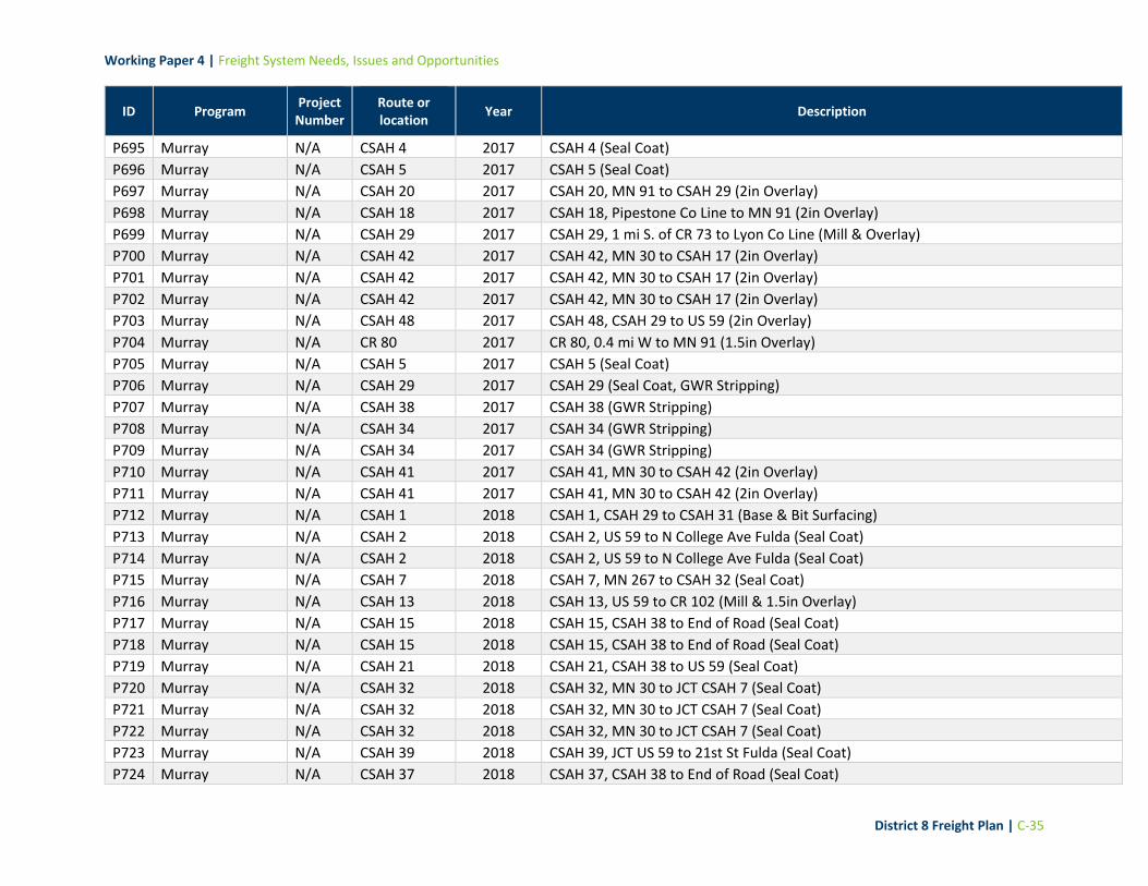
Working Paper 4 | Freight System Needs, Issues and Opportunities
District 8 Freight Plan | C-35
ID Program Project
Number Route or location
Year Description
P695 Murray N/A CSAH 4 2017 CSAH 4 (Seal Coat)
P696 Murray N/A CSAH 5 2017 CSAH 5 (Seal Coat)
P697 Murray N/A CSAH 20 2017 CSAH 20, MN 91 to CSAH 29 (2in Overlay)
P698 Murray N/A CSAH 18 2017 CSAH 18, Pipestone Co Line to MN 91 (2in Overlay)
P699 Murray N/A CSAH 29 2017 CSAH 29, 1 mi S. of CR 73 to Lyon Co Line (Mill & Overlay)
P700 Murray N/A CSAH 42 2017 CSAH 42, MN 30 to CSAH 17 (2in Overlay)
P701 Murray N/A CSAH 42 2017 CSAH 42, MN 30 to CSAH 17 (2in Overlay)
P702 Murray N/A CSAH 42 2017 CSAH 42, MN 30 to CSAH 17 (2in Overlay)
P703 Murray N/A CSAH 48 2017 CSAH 48, CSAH 29 to US 59 (2in Overlay)
P704 Murray N/A CR 80 2017 CR 80, 0.4 mi W to MN 91 (1.5in Overlay)
P705 Murray N/A CSAH 5 2017 CSAH 5 (Seal Coat)
P706 Murray N/A CSAH 29 2017 CSAH 29 (Seal Coat, GWR Stripping)
P707 Murray N/A CSAH 38 2017 CSAH 38 (GWR Stripping)
P708 Murray N/A CSAH 34 2017 CSAH 34 (GWR Stripping)
P709 Murray N/A CSAH 34 2017 CSAH 34 (GWR Stripping)
P710 Murray N/A CSAH 41 2017 CSAH 41, MN 30 to CSAH 42 (2in Overlay)
P711 Murray N/A CSAH 41 2017 CSAH 41, MN 30 to CSAH 42 (2in Overlay)
P712 Murray N/A CSAH 1 2018 CSAH 1, CSAH 29 to CSAH 31 (Base & Bit Surfacing)
P713 Murray N/A CSAH 2 2018 CSAH 2, US 59 to N College Ave Fulda (Seal Coat)
P714 Murray N/A CSAH 2 2018 CSAH 2, US 59 to N College Ave Fulda (Seal Coat)
P715 Murray N/A CSAH 7 2018 CSAH 7, MN 267 to CSAH 32 (Seal Coat)
P716 Murray N/A CSAH 13 2018 CSAH 13, US 59 to CR 102 (Mill & 1.5in Overlay)
P717 Murray N/A CSAH 15 2018 CSAH 15, CSAH 38 to End of Road (Seal Coat)
P718 Murray N/A CSAH 15 2018 CSAH 15, CSAH 38 to End of Road (Seal Coat)
P719 Murray N/A CSAH 21 2018 CSAH 21, CSAH 38 to US 59 (Seal Coat)
P720 Murray N/A CSAH 32 2018 CSAH 32, MN 30 to JCT CSAH 7 (Seal Coat)
P721 Murray N/A CSAH 32 2018 CSAH 32, MN 30 to JCT CSAH 7 (Seal Coat)
P722 Murray N/A CSAH 32 2018 CSAH 32, MN 30 to JCT CSAH 7 (Seal Coat)
P723 Murray N/A CSAH 39 2018 CSAH 39, JCT US 59 to 21st St Fulda (Seal Coat)
P724 Murray N/A CSAH 37 2018 CSAH 37, CSAH 38 to End of Road (Seal Coat)

Working Paper 4 | Freight System Needs, Issues and Opportunities
District 8 Freight Plan | C-36
ID Program Project
Number Route or location
Year Description
P725 Murray N/A CSAH 51 2018 CSAH 51, MN 30 to CSAH 38 (Seal Coat)
P726 Murray N/A CR 104 2018 CR 104, CSAH 13 to End of Road (Mill & 1.5in Overlay)
P727 Murray N/A CSAH 38 2018 CSAH 38, Lyon Co Line to CSAH 17 (Seal Coat)
P728 Murray N/A CR 102 2018 CR 102, CSAH 13 to End of Road (Mill & 1.5in Overlay)
P729 Murray N/A CSAH 8 2019 CSAH 8, CSAH 32 to US 59 (2in Overlay & ADA)
P730 Murray N/A CSAH 8 2019 CSAH 8, CSAH 32 to US 59 (2in Overlay & ADA)
P731 Murray N/A CSAH 8 2019 CSAH 8, CSAH 32 to US 59 (2in Overlay & ADA)
P732 Murray N/A CSAH 8 2019 CSAH 8, CSAH 32 to US 59 (2in Overlay & ADA)
P733 Murray N/A CSAH 8 2019 CSAH 8, US 59 to CSAH 35 (2in Overlay)
P734 Murray N/A CSAH 8 2019 CSAH 8, US 59 to CSAH 35 (2in Overlay)
P735 Murray N/A CSAH 25 2019 CSAH 25, MN 30 to CSAH 10 (2in Overlay)
P736 Murray N/A CSAH 27 2019 CSAH 27, MN 91 to 50th Ave Lake Wilson (2in Overlay)
P737 Murray N/A CSAH 27 2019 CSAH 27, MN 91 to 50th Ave Lake Wilson (2in Overlay)
P738 Murray N/A CSAH 27 2019 CSAH 27, MN 91 to 50th Ave Lake Wilson (2in Overlay)
P739 Murray N/A CSAH 38 2019 CSAH 38, MN 30 o Bridge 51504 Currie (2in Overlay & ADA)
P740 Murray N/A CSAH 52 2019 CSAH 52, from CSAH 4 to CSAH 5 (2in Overlay)
P741 Murray N/A CSAH 52 2018 CSAH 52, from CSAH 4 to CSAH 5 (2in Overlay)
P742 Murray N/A CSAH 29 2022 CSAH 29, US 30 to N. Limits of Hadley (Reconstruction)
P743 Murray N/A CSAH 29 2022 CSAH 29, US 30 to N. Limits of Hadley (Reconstruction)
P744 Murray N/A CSAH 10 2020 CSAH 10, Pipestone Co Line to MN 91 (2in Overlay)
P745 Murray N/A CSAH 2 2020 CSAH 2, CSAH 34 to Fulda (2in Overlay)
P746 Murray N/A CSAH 2 2020 CSAH 2, CSAH 34 to Fulda (2in Overlay)
P747 Murray N/A CSAH 3 2020 CSAH 3, CSAH 42 to CSAH 44 (2in Overlay)
P748 Murray N/A CSAH 3 2020 CSAH 3, CSAH 39 to CSAH 42 (2in Overlay)
P749 Murray N/A CSAH 3 2020 CSAH 3, CSAH 39 to CSAH 42 (2in Overlay)
P750 Murray N/A CSAH 36 2020 CSAH 36, Nobles Co Line to CSAH 2 (2in Overlay)
P751 Murray N/A CSAH 40 2020 CSAH 40, MN 62 to CSAH 3 (2in Overlay)
P752 Murray N/A CSAH 40 2020 CSAH 40, MN 62 to CSAH 3 (2in Overlay)
P753 Murray N/A CSAH 6 2020 CSAH 6, CSAH 42 to Cottonwood Co Line (2in Overlay)
P754 Murray N/A CSAH 17 2021 CSAH 17, CSAH 42 to Cottonwood Co Line (2in Overlay)

Working Paper 4 | Freight System Needs, Issues and Opportunities
District 8 Freight Plan | C-37
ID Program Project
Number Route or location
Year Description
P755 Murray N/A CSAH 22 2021 CSAH 22, CSAH 38 to CSAH 45 (2in Overlay)
P756 Murray N/A CSAH 22 2021 CSAH 22, CSAH 38 to CSAH 45 (2in Overlay)
P757 Murray N/A CSAH 45 2021 CSAH 45, CSAH 17 to Redwood Co Line (2in Overlay)
P758 Murray N/A CSAH 1 2023 CSAH 1, MN 91 to CSAH 29 (2in Overlay)
P759 Murray N/A CSAH 4 2023 CSAH 4, Iona to CSAH 34 (2in Overlay)
P760 Murray N/A CSAH 16 2023 CSAH 16, CSAH 30 to US 59 (2in Overlay)
P761 Murray N/A CSAH 31 2023 CSAH 31, Nobles Co Line to CSAH 4
P762 Murray N/A CSAH 42 2023 CSAH 42, CSAH 3 to MN 30 (2in Overlay)
P763 Murray N/A CSAH 42 2023 CSAH 42, CSAH 3 to MN 30 (2in Overlay)
P764 Murray N/A CSAH 42 2023 CSAH 42, CSAH 3 to MN 30 (2in Overlay)
P765 Murray N/A CSAH 47 2023 CSAH 47, CSAH 44 to Cottonwood Co Line (2in Overlay)
P766 Murray N/A CR 67 2023 CR 67, MN 30 to End of Bit Surf (1.5in Overlay)
P767 Murray N/A CSAH 4 2017 CSAH 4 (Seal Coat)
P768 Pipestone N/A CSAH 25 2023 CSAH 25, Hwy 30 to Hwy 23 (Widening/Paving)
P769 Pipestone N/A CSAH 10 2022 CSAH 20, CSAH 16 to NM 23 (Reconstruction)
P770 Pipestone N/A CSAH 23 2022 CSAH 23, Cleveland St to CSAH 18 (Mill & Overlay)
P771 Pipestone N/A CR 54 2022 Hwy 54, CSAH 2 to MN 23 (Overlay)
P772 Pipestone N/A CSAH 9 2022 CSAH 9, Edgerton to CSAH 18 (Overlay)
P773 Pipestone N/A CSAH 2 2022 CSAH 2, MN 23 to MN 75 (Overlay)
P774 Pipestone N/A CSAH 15 2022 CSAH 15, CSAH 2 to CSAH 1 (Overlay)
P775 Pipestone N/A CSAH 6 2022 CSAH 6, MN 23 to CSAH 18 (Overlay)
P776 Pipestone N/A CSAH 6 2022 CSAH 6, MN 23 to CSAH 18 (Overlay)
P777 Pipestone N/A CSAH 56 2021 CSAH 56, CSAH 2 to Pipestone (Overlay)
P778 Pipestone N/A CSAH 16 2021 CSAH 16, CSAH 10 to Lincoln Co. Line (Overlay)
P779 Pipestone N/A CSAH 5 2021 CSAH 5, CSAH 18 to Murray Co. Line (Overlay)
P780 Pipestone N/A CSAH 13 2020 CSAH 13, CSAH 2 to MN 30 (Widening/Blk Top)
P781 Pipestone N/A CSAH 30 2019 CSAH 30, Tech College to MN 75 (Mill & Overlay)
P782 Pipestone N/A CSAH 2 2019 CSAH 2, SD State Line to MN 23 (Overlay)
P783 Pipestone N/A CSAH 2 2019 CSAH 2, SD State Line to MN 23 (Overlay)
P784 Pipestone N/A CSAH 8 2019 CSAH 8, CSAH 16 to CSAH 18 (Overlay)

Working Paper 4 | Freight System Needs, Issues and Opportunities
District 8 Freight Plan | C-38
ID Program Project
Number Route or location
Year Description
P785 Pipestone N/A CSAH 8 2019 CSAH 8, CSAH 16 to CSAH 18 (Overlay)
P786 Pipestone N/A CR 67 2019 Hwy 267, CSAH 18 to Palmer Street (Overlay)
P787 Pipestone N/A CR 67 2019 Hwy 267, CSAH 18 to Palmer Street (Overlay)
P788 Pipestone N/A 2019 Hwy 67, Cemetry to CSAH 30 (Reconstruct)
P789 Redwood N/A CSAH 25 2017 CSAH 25, JCT CSAH 101 to JCT CSAH 17 (Mill/Resurface & Agg)
P790 Redwood N/A CSAH 25 2017 CSAH 25, JCT CSAH 101 to JCT CSAH 17 (Mill/Resurface & Agg)
P791 Redwood N/A CSAH 17 2017 CSAH 17, CSAH 25 to MN 19 (Mill/Resurface & Agg)
P792 Redwood N/A CSAH 102 2017 CSAH 102, JCT CSAH 2 to CSAH 3 (Reconstruct & Bit. Pavement)
P793 Redwood N/A CSAH 3 2017 CSAH 3, MN 67 to E. Morgan (Reconstruct & Bit. Pavement)
P794 Redwood N/A CSAH 2 2017 CSAH 2, MN 67 to N. & S. Morgan (Reconstruct & Bit. Pavement)
P795 Redwood N/A CSAH 2 2017 CSAH 2, MN 67 to N. & S. Morgan (Reconstruct & Bit. Pavement)
P796 Redwood N/A CSAH 2 2017 CSAH 2, MN 67 to N. & S. Morgan (Reconstruct & Bit. Pavement)
P797 Redwood N/A CSAH 8 2017 CSAH 8, 1.25 Mi N. of JCT MN 14 and CSAH 8 (Agg. Base, Bit. Surfacing, Agg)
P798 Redwood N/A CSAH 11 2018 CSAH 11, CSAH 2 to MN River (Mill & Resurface)
P799 Redwood N/A CSAH 11 2018 CSAH 11, CSAH 2 to MN River (Mill & Resurface)
P800 Redwood N/A CSAH 1 2018 CSAH 1, MN 67 to 1 Mi S. of MN 67 (Intersection Work, Grading)
P801 Redwood N/A CSAH 16 2018 CSAH 16, MN 71 to CSAH 1 (Mill, Resurface, Agg)
P802 Redwood N/A CSAH 101 2018 CSAH 101, MN 19 to Bridge 92194 (Pavement Rehab)
P803 Redwood N/A CSAH 20 2019 CSAH 20 (Pavement Rehab)
P804 Redwood N/A CSAH 20 2019 CSAH 20 (Pavement Rehab)
P805 Redwood N/A CSAH 5 2019 CSAH 5 (6in Wet Reflective Epoxy Edgeline in Grooves)
P806 Redwood N/A CSAH 5 2019 CSAH 5 (6in Wet Reflective Epoxy Edgeline in Grooves)
P807 Redwood N/A CSAH 5 2019 CSAH 5 (6in Wet Reflective Epoxy Edgeline in Grooves)
P808 Redwood N/A CSAH 5 2019 CSAH 5 (6in Wet Reflective Epoxy Edgeline in Grooves)
P809 Redwood N/A CSAH 10 2019 CSAH 10 (6in Wet Reflective Epoxy Edgeline in Grooves)
P810 Redwood N/A CSAH 10 2019 CSAH 10 (6in Wet Reflective Epoxy Edgeline in Grooves)
P811 Redwood N/A CSAH 10 2019 CSAH 10 (6in Wet Reflective Epoxy Edgeline in Grooves)
P812 Redwood N/A CSAH 10 2019 CSAH 10 (6in Wet Reflective Epoxy Edgeline in Grooves)
P813 Redwood N/A CSAH 10 2019 CSAH 10 (6in Wet Reflective Epoxy Edgeline in Grooves)
P814 Redwood N/A CSAH 10 2019 CSAH 10 (6in Wet Reflective Epoxy Edgeline in Grooves)

Working Paper 4 | Freight System Needs, Issues and Opportunities
District 8 Freight Plan | C-39
ID Program Project
Number Route or location
Year Description
P815 Redwood N/A CSAH 8 2019 CSAH 8 (6in Wet Reflective Epoxy Edgeline in Grooves)
P816 Redwood N/A CSAH 8 2019 CSAH 8 (6in Wet Reflective Epoxy Edgeline in Grooves)
P817 Redwood N/A CSAH 16 2019 CSAH 16 (6in Wet Reflective Epoxy Edgeline in Grooves)
P818 Redwood N/A CSAH 16 2019 CSAH 16 (6in Wet Reflective Epoxy Edgeline in Grooves)
P819 Redwood N/A CSAH 16 2019 CSAH 16 (6in Wet Reflective Epoxy Edgeline in Grooves)
P820 Redwood N/A CSAH 16 2019 CSAH 16 (6in Wet Reflective Epoxy Edgeline in Grooves)
P821 Redwood N/A CR 72 2019 CSAH 16 (6in Wet Reflective Epoxy Edgeline in Grooves)
P822 Redwood N/A CSAH 1 2021 CSAH 1, Brown Co Line to MN 67 (Pavement Rehab, Bit. Surf, Agg)
P823 Redwood N/A CSAH 1 2021 CSAH 1, Brown Co Line to MN 67 (Pavement Rehab, Bit. Surf, Agg)
P824 Redwood N/A CSAH 1 2021 CSAH 1, Brown Co Line to MN 67 (Pavement Rehab, Bit. Surf, Agg)
P825 Redwood N/A CSAH 1 2021 CSAH 1, Brown Co Line to MN 67 (Pavement Rehab, Bit. Surf, Agg)
P826 Redwood N/A CSAH 1 2021 CSAH 1, Brown Co Line to MN 67 (Pavement Rehab, Bit. Surf, Agg)
P827 Redwood N/A CSAH 6 2021 CSAH 6, CSAH 9 to MN 19 (Mill, Resurface, Agg)
P828 Redwood N/A CSAH 6 2021 CSAH 6, CSAH 9 to MN 19 (Mill, Resurface, Agg)
P829 Redwood N/A CSAH 101 2021 CSAH 101, MN River to MN 19 (Mill, Bit. Resurface, Agg)
P830 Redwood N/A CSAH 101 2021 CSAH 101, MN River to MN 19 (Mill, Bit. Resurface, Agg)
P831 Redwood N/A CSAH 101 2021 CSAH 101, MN River to MN 19 (Mill, Bit. Resurface, Agg)
P832 Renville N/A N/A 2019 CSAH 8 Surfacing: US 212 to Bridge 65566
P833 Renville N/A N/A 2022 CSAH 3 Mill & 3in OL: CSAH 2 to US 212
P834 Renville N/A N/A 2022 CSAH 8 Mill & 3in OL: Buffalo Lake to CSAH 11
P835 Renville N/A N/A 2019 CSAH 20/36 Full Depth Reclaim & Pave: CSAH 11 to McLeod County
P836 Renville N/A N/A 2019 CSAH 8 Surfacing: US 212 to Bridge 65566
P837 Renville N/A N/A 2021
CSAH 16 Full Depth Reclaim & Pave: CSAH 19 to CSAH 2/CSAH 5: Align Intersection at TH 19
P838 Renville N/A N/A 2019 CSAH 4 Base & Surfacing: CSAH 5 to TH 4
P839 Renville N/A N/A 2019 CSAH 8 Surfacing: US 212 to Bridge 65566
P840 Renville N/A N/A 2019 CSAH 20/36 Full Depth Reclaim & Pave: CSAH 11 to McLeod County
P841 Renville N/A N/A 2022 CSAH 3 Mill & 3in OL: CSAH 2 to US 212
P842 Renville N/A N/A 2022
CSAH 18 Full Depth Reclaim & Pave with Drainage Improvements: Morton to 675th Ave
P843 Renville N/A N/A 2024 CSAH 1 Full Depth Reclaim & Pave: CSAH 17 to US 212

Working Paper 4 | Freight System Needs, Issues and Opportunities
District 8 Freight Plan | C-40
ID Program Project
Number Route or location
Year Description
P844 Renville N/A N/A 2023 CSAH 2: Regrade through Beaver Falls
P845 Renville N/A N/A 2024 CSAH 2: Base & Surfacing through Beaver Falls
P846 Yellow Medicine N/A CR E3 2018 CR E3, CSAH 15 to 130th St Florida Twp (Grade)
P847 Yellow Medicine N/A CSAH 2 2018 CSAH 2, MN 67 to Redwood Co Line (Grade, Widen)
P848 Yellow Medicine N/A CSAH 4 2022 CSAH 4, CSAH 13 to US 75
P849 Yellow Medicine N/A CSAH 8 2022 CSAH 8, CSAH 2 to CSAH 18 (Grade)
P850 Yellow Medicine N/A CSAH 8 2019 CSAH 8/19, CSAH 5 to US 212 (Mill, Overlay)
P851 Yellow Medicine N/A CSAH 9 2021 CSAH 9, CSAH 3 to Lac Qui Parle Co Line (Pave)
P852 Yellow Medicine N/A CSAH 9 2020 CSAH 9, Lyon Co Line to CSAH 3 (Pave)
P853 Yellow Medicine N/A CSAH 20 2019 CSAH 20, Echo (Grade/Pave)
P854 Yellow Medicine N/A CSAH 20 2019 CSAH 20, Echo (Grade/Pave)
P855 Yellow Medicine N/A CSAH 19 2019 CSAH 8/19, CSAH 5 to US 212 (Mill, Overlay)
P856 Yellow Medicine N/A CSAH 17 2019 CSAH 17, CSAH 8 to CSAH 43 (HSIP Striping)
P857 Yellow Medicine N/A CSAH 21 2019 CSAH 21, MN 67 to MN River Bridge (Mill, Overlay)
P858 Yellow Medicine N/A CSAH 30 2019 CSAH 30, 170 St to MN 68 (HSIP Striping)
P859 Yellow Medicine N/A CSAH 30 2019 CSAH 30, 170 St to MN 68 (HSIP Striping)
P860 Yellow Medicine N/A CSAH 30 2019 CSAH 30, 170 St to MN 68 (HSIP Striping)
P861 Yellow Medicine N/A CSAH 30 2019 CSAH 30, 170 St to MN 68 (HSIP Striping)
P862 Yellow Medicine N/A CSAH 39 2019 CSAH 39, CSAH 17 to MN 67/23 (HSIP Striping)
P863 Yellow Medicine N/A CSAH 39 2019 CSAH 39, CSAH 17 to MN 67/23 (HSIP Striping)
P864 Yellow Medicine N/A CSAH 39 2019 CSAH 39, CSAH 17 to MN 67/23 (HSIP Striping)
P865 Yellow Medicine N/A CR A10 2019 CR A10, CSAH 46 ro CR A4 (Grade)
P866 Yellow Medicine N/A CR B2 2022 CR B2, CSAH 3 to CSAH 17 (Grade)
P867 Yellow Medicine N/A CR A9 2020 CR A9, CSAH 18 to CSAH 3 (Grade)
P868 Yellow Medicine N/A CR A1 2021 CR A1, CSAH 21 to 1.5 mi N. of CSAH 2 (Grade)
P869 Yellow Medicine N/A CSAH 17 2019 CSAH 17, CSAH 8 to CSAH 43 (HSIP Striping)
P870 Yellow Medicine N/A CSAH 20 2019 CSAH 20, Echo (Grade/Pave)
P871 Yellow Medicine N/A CSAH 2 2018 CSAH 2, CR A5 to MN 67 (Grade, Widen)
P872 Yellow Medicine N/A CR A8 2018 CR A8, CR 26 to 140th Ave Posen Twp (Grade)
P873 Yellow Medicine N/A CSAH 2 2019 CSAH 2, MN 67 to Redwood Co Line (Mill, Overlay)

Working Paper 4 | Freight System Needs, Issues and Opportunities
District 8 Freight Plan | C-41
ID Program Project
Number Route or location
Year Description
P874 Yellow Medicine N/A CSAH 2 2019 CSAH 2, CR A5 to MN 67 (Mill, Overlay)
P875 Yellow Medicine N/A CSAH 5 2018 CSAH 5, West Co Line to US 212 (HSIP Striping)
P876 Yellow Medicine N/A CSAH 5 2018 CSAH 5, West Co Line to US 212 (HSIP Striping)
P877 Yellow Medicine N/A CSAH 9 2020 CSAH 9, CSAH 3 to MN 67 (Grade)
P878 Yellow Medicine N/A CSAH 30 2022 CSAH 30, 170 St to MN 68 (Mill, Overlay)
P879 Yellow Medicine N/A CSAH 30 2022 CSAH 30, 170 St to MN 68 (Mill, Overlay)
P880 Yellow Medicine N/A CSAH 30 2022 CSAH 30, 170 St to MN 68 (Mill, Overlay)
P881 Yellow Medicine N/A CSAH 30 2022 CSAH 30, 170 St to MN 68 (Mill, Overlay)
P882 Yellow Medicine N/A CSAH 39 2021 CSAH 39, CSAH 17 to MN 67/23 (Widen/Mill, Overlay)
P883 Yellow Medicine N/A CSAH 39 2021 CSAH 39, CSAH 17 to MN 67/23 (Widen/Mill, Overlay)
P884 Yellow Medicine N/A CSAH 39 2021 CSAH 39, CSAH 17 to MN 67/23 (Widen/Mill, Overlay)
P885 Yellow Medicine N/A CSAH 9 2019 CSAH 9, Lyon Co Line to CSAH 3 (Grade)
P886 Yellow Medicine N/A CSAH 9 2021 CSAH 9, CSAH 3 to Lac Qui Parle Co Line (Pave)
P887 Yellow Medicine N/A CSAH 38 2021 CSAH 38 in Hanley Falls (Mill/Overlay)
P888 Yellow Medicine N/A CSAH 38 2021 CSAH 38 in Hanley Falls (Mill/Overlay)

Working Paper 4 | Freight System Needs, Issues and Opportunities
District 8 Freight Plan | D-1
Appendix D: Potential Gaps to Address
This appendix contains a list of the location-specific needs and issues that do not appear to be addressed by any currently-programmed projects. Similar to the lists provided in Appendix A and B, the fields in the table below are:
ID: This code refers to the need/issue ID printed on maps in this Working Paper. Those that begin with an “S” were stakeholder-identified, and those with a “D” were identified via data analysis.
Source: the source used to identify the need or issue.
Type: Intersection or Segment of highway.
Highway Name or Number
Need/Issue Type: this field corresponds to the primary need or issue associated with the location. Needs and issues were coded in one of four ways: safety, condition, performance, or other.
Additional Information: where available, additional details from the stakeholder were noted here

Working Paper 4 | Freight System Needs, Issues and Opportunities
District 8 Freight Plan | D-2
ID Source Type Hwy Location Type Additional Information
D1 MnDOT Highway Safety Data (D8 Commercial Vehicle Crashes)
Intersection MNTH 19 Between Franklin and Fairfax
Camp Safety More than 2 crashes at this location between 2017 - 2018
D2 MnDOT Highway Safety Data (D8 Commercial Vehicle Crashes)
Intersection SIBLEY AVE US12 Downtown Litchfield
Safety More than 2 crashes at this location between 2017 - 2018
D3 MnDOT Highway Safety Data (D8 Commercial Vehicle Crashes)
Intersection MNTH 23 Burbank, by Long Lake boat ramp
Safety More than 2 crashes at this location between 2017 - 2018
D4 MnDOT Highway Safety Data (D8 Commercial Vehicle Crashes)
Intersection MNTH 19 3 miles west of Redwood Falls
Safety More than 2 crashes at this location between 2017 - 2018
D5 MnDOT Highway Safety Data (D8 Commercial Vehicle Crashes)
Intersection MNTH 23 Intersection of Tiger Dr. Marshall
Safety More than 2 crashes at this location between 2017 - 2018
D6 MnDOT Highway Safety Data (D8 Commercial Vehicle Crashes)
Intersection USTH 12 Downtown Pennock
Safety More than 2 crashes at this location between 2017 - 2018
D7 MnDOT Highway Safety Data (D8 Commercial Vehicle Crashes)
Intersection 15TH AVE SW Saint Johns, immediately east of CSAH 1
Safety More than 2 crashes at this location between 2017 - 2018
D8 MnDOT Highway Safety Data (D8 Commercial Vehicle Crashes)
Intersection USTH 212 Near 17th Street, Granite Falls
Safety More than 2 crashes at this location between 2017 - 2018
D9 MnDOT Highway Safety Data (D8 Commercial Vehicle Crashes)
Intersection E COLLEGE DR Marshall, College Dr.
Safety More than 2 crashes at this location between 2017 - 2018
D10 MnDOT Highway Safety Data (D8 Commercial Vehicle Crashes)
Intersection MNTH 15 Hutchinson, Century Ave.
Safety More than 2 crashes at this location between 2017 - 2018
D11 MnDOT Highway Safety Data (D8 Commercial Vehicle Crashes)
Intersection USTH 212 Glencoe, Chandler Ave.
Safety More than 2 crashes at this location between 2017 - 2018
D12 MnDOT Highway Safety Data (D8 Commercial Vehicle Crashes)
Intersection USTH 71 Winfield, CSAH 11 Safety More than 2 crashes at this location between 2017 - 2018

Working Paper 4 | Freight System Needs, Issues and Opportunities
District 8 Freight Plan | D-3
ID Source Type Hwy Location Type Additional Information
D13 MnDOT Highway Safety Data (D8 Commercial Vehicle Crashes)
Intersection USTH 12 Dassel, CSAH 15 Safety More than 2 crashes at this location between 2017 - 2018
D14 MnDOT Highway Safety Data (D8 Commercial Vehicle Crashes)
Intersection 50TH ST SE Montevideo, .2 mi E of CSAH 15
Safety More than 2 crashes at this location between 2017 - 2018
D15 MnDOT Highway Safety Data (D8 Commercial Vehicle Crashes)
Intersection CSAH 7 Roseland Safety More than 2 crashes at this location between 2017 - 2018
D16 MnDOT Highway Safety Data (D8 Commercial Vehicle Crashes)
Intersection CSAH 5 Kingman, CSAH 11 Safety More than 2 crashes at this location between 2017 - 2018
D17 MnDOT Highway Safety Data (D8 Commercial Vehicle Crashes)
Intersection MNTH 19 Hendricks, TH 71 Safety More than 2 crashes at this location between 2017 - 2018
D18 MnDOT Highway Safety Data (D8 Commercial Vehicle Crashes)
Intersection ERIE RD Marshall, CSAH 33 Safety More than 2 crashes at this location between 2017 - 2018
D19 MnDOT Highway Safety Data (D8 Commercial Vehicle Crashes)
Intersection HWY 212 Hector, .7 miles E of downtown.
Safety More than 2 crashes at this location between 2017 - 2018
D20 MnDOT Highway Safety Data (D8 Commercial Vehicle Crashes)
Intersection MNTH 23 Sweet, CSAH 4 Safety More than 2 crashes at this location between 2017 - 2018
D21 MnDOT Highway Safety Data (D8 Commercial Vehicle Crashes)
Intersection USTH 12 Harvey, CSAH 22 Safety More than 2 crashes at this location between 2017 - 2018
D22 MnDOT Highway Safety Data (D8 Commercial Vehicle Crashes)
Intersection MNTH 91 Chandler, CSAH 4 Safety More than 2 crashes at this location between 2017 - 2018
D23 MnDOT Highway Safety Data (D8 Commercial Vehicle Crashes)
Intersection MNTH 7 CSAH 1, by Lester Prairie
Safety More than 2 crashes at this location between 2017 - 2018
D24 CPCS Crash Density Analysis/Crash Factor Score
Segment MN-119 Jct. MN 40 to N. District Boundary
Safety Segment with high density crash rates
D25 CPCS Crash Density Analysis/Crash Factor Score
Segment N. of New London to 0.2Mi N. of CSAH 33
Kandiyohi County Safety Segment with high density crash rates

Working Paper 4 | Freight System Needs, Issues and Opportunities
District 8 Freight Plan | D-4
ID Source Type Hwy Location Type Additional Information
D26 CPCS Crash Density Analysis/Crash Factor Score
Segment MNTH 9 N. of New London to 0.2Mi N. of CSAH 33
Safety Segment with high density crash rates
D27 CPCS Crash Density Analysis/Crash Factor Score
Segment MNTH 9 N. of New London to 0.2Mi N. of CSAH 33
Safety Segment with high density crash rates
D28 CPCS Crash Density Analysis/Crash Factor Score
Segment MNTH 9 N. of New London to 0.2Mi N. of CSAH 33
Safety Segment with high density crash rates
D29 CPCS Crash Density Analysis/Crash Factor Score
Segment MNTH 67 0.7Mi SE TH 23 in Granite Falls to 0.2Mi of CSAH 18
Safety Segment with high density crash rates
D30 CPCS Crash Density Analysis/Crash Factor Score
Segment MNTH 67 0.7Mi SE TH 23 in Granite Falls to 0.2Mi of CSAH 18
Safety Segment with high density crash rates
D31 CPCS Crash Density Analysis/Crash Factor Score
Segment MNTH 67 0.7Mi SE TH 23 in Granite Falls to 0.2Mi of CSAH 18
Safety Segment with high density crash rates
D32 CPCS Crash Density Analysis/Crash Factor Score
Segment MNTH 7 E. Side of Hutchinson to W. of Silver Lake
Safety Segment with high density crash rates
D33 CPCS Crash Density Analysis/Crash Factor Score
Segment MNTH 68 SD/MN State Line to NW of Canby
Safety Segment with high density crash rates
D34 CPCS Crash Density Analysis/Crash Factor Score
Segment .77Mi N. of US 212 to .45Mi S. of MN 7 in Cosmos
.77Mi N. of US 212 to .45Mi S. of MN 7 in Cosmos
Safety Segment with high density crash rates
D35 CPCS Crash Density Analysis/Crash Factor Score
Segment US-212 W OF E JCT CSAH3 Safety Segment with high density crash rates

Working Paper 4 | Freight System Needs, Issues and Opportunities
District 8 Freight Plan | D-5
ID Source Type Hwy Location Type Additional Information
D36 CPCS Crash Density Analysis/Crash Factor Score
Segment US-212 E. side of Dawson to CSAH 39
Safety Segment with high density crash rates
D37 CPCS Crash Density Analysis/Crash Factor Score
Segment US-212 Jct. MN 4 to E. side of Hector
Safety Segment with high density crash rates
D38 CPCS Crash Density Analysis/Crash Factor Score
Segment US-212 W. side of Stewart to E. side of Stewart
Safety Segment with high density crash rates
D39 CPCS Crash Density Analysis/Crash Factor Score
Segment MNTH-23 Jct. US 71 to S. side of Spencer
Safety Segment with high density crash rates
D40 CPCS Crash Density Analysis/Crash Factor Score
Segment US-212 0.1Mi E. of JCT MN 22 to 0.1Mi W. of CR 1
Safety Segment with high density crash rates
D41 CPCS Crash Density Analysis/Crash Factor Score
Segment US-71 0.3Mi. S. MN 23 to MN 23
Safety Segment with high density crash rates
D42 CPCS Crash Density Analysis/Crash Factor Score
Segment US-71 S. of Willmar to 0.3Mi. S. of MN 23
Safety Segment with high density crash rates
D43 CPCS Crash Density Analysis/Crash Factor Score
Segment MNTH-23 0.5Mi S. MN 274 to 0.45Mi S. of US 212
Safety Segment with high density crash rates
D44 CPCS Crash Density Analysis/Crash Factor Score
Segment MNTH-22 W OF E JCT TH22 IN HUTCHINSON
Safety Segment with high density crash rates
D45 CPCS Crash Density Analysis/Crash Factor Score
Segment MNTH-22 W OF E JCT TH22 IN HUTCHINSON
Safety Segment with high density crash rates
D46 CPCS Crash Density Analysis/Crash Factor Score
Segment College Drive 0.5Mi E. of TH 59 to Jct. MN 23
Safety Segment with high density crash rates
D47 CPCS Crash Density Analysis/Crash Factor Score
Segment US-75 Jct. MN 30 to N. side of Pipestone
Safety Segment with high density crash rates

Working Paper 4 | Freight System Needs, Issues and Opportunities
District 8 Freight Plan | D-6
ID Source Type Hwy Location Type Additional Information
D48 CPCS Crash Density Analysis/Crash Factor Score
Segment 1.2Mi S. of Mn 7 to 0.75Mi N. of MN 7
McLeod County Safety Segment with high density crash rates
D49 CPCS Crash Density Analysis/Crash Factor Score
Segment MNTH-15 S. of Baltimore
Ave in Hutchinson Safety
Segment with high density crash rates
D50 CPCS Crash Density Analysis/Crash Factor Score
Segment 280th Downtown
Marshall Safety
Segment with high density crash rates
D51 CPCS Crash Density Analysis/Crash Factor Score
Segment MNTH-23 0.1Mi N. CR 131 south 3.6 Miles
Safety Segment with high density crash rates
D52 CPCS Crash Density Analysis/Crash Factor Score
Segment MN-23 S. side of Spencer to N. side of Spencer
Safety Segment with high density crash rates
D53 CPCS Crash Density Analysis/Crash Factor Score
Segment CSAH-19 E. side of Redwood falls to US 71
Safety Segment with high density crash rates
D54 CPCS Crash Density Analysis/Crash Factor Score
Segment MNTH-23 0.3Mi W. of Jct. MN 23 to 0.65Mi E. of Jct. MN 23
Safety Segment with high density crash rates
D55 CPCS Crash Density Analysis/Crash Factor Score
Segment MNTH-22 Jct. MN 15 Safety Segment with high density crash rates
D57 D8 Bridge Clearance/Condition Data
Intersection US-59 NW of Milan Performance Vertical Bridge Clearance is <14.6'
D58 D8 Bridge Clearance/Condition Data
Intersection CSAH 15- Park Access
Wegdahl Performance Vertical Bridge Clearance is <14.6'
D59 D8 Bridge Clearance/Condition Data
Intersection 115th St Granite Falls Performance Vertical Bridge Clearance is <14.6'
D60 D8 Bridge Clearance/Condition Data
Intersection 160th Ave NW NW of Milan Performance Vertical Bridge Clearance is <14.6'

Working Paper 4 | Freight System Needs, Issues and Opportunities
District 8 Freight Plan | D-7
ID Source Type Hwy Location Type Additional Information
D63 D8 Bridge Clearance/Condition Data
Intersection 190th Ave SW of Lynd Performance Vertical Bridge Clearance is <14.6'
D64* D8 Bridge Clearance/Condition Data
Intersection US-71 Kandiyohi County Performance Vertical Bridge Clearance is <14.6'
D65* D8 Bridge Clearance/Condition
Data Intersection MN-23 Lyon County Performance
Vertical Bridge Clearance is <14.6'
D67 D8 Bridge Clearance/Condition Data
Intersection
735th Ave Adjacent to US 12 east of Dassel
Performance Vertical Bridge Clearance is <14.6'
D68 D8 Bridge Clearance/Condition Data
Intersection
730th Ave Adjacent to US 12 east of Dassel
Performance Vertical Bridge Clearance is <14.6'
D69 D8 Bridge Clearance/Condition Data
Intersection
700th Ave Adjacent to US 12 west of Dassel
Performance Vertical Bridge Clearance is <14.6'
D70 D8 Bridge Clearance/Condition Data
Intersection US-12 Meeker County Performance Vertical Bridge Clearance is <14.6'
D71 D8 Bridge Clearance/Condition Data
Intersection 237th St By US-12, SE of Darwin
Performance Vertical Bridge Clearance is <14.6'
D72 D8 Bridge Clearance/Condition Data
Intersection MN 30 Pipestone Performance Vertical Bridge Clearance is <14.6'
D75 D8 Bridge Clearance/Condition Data
Intersection Kenwood Ave
Crossing Cottonwood River
Performance Vertical Bridge Clearance is <14.6'
D76 D8 Bridge Clearance/Condition Data
Intersection Jade Ave S of US-14, E of Lamberton
Performance Vertical Bridge Clearance is <14.6'

Working Paper 4 | Freight System Needs, Issues and Opportunities
District 8 Freight Plan | D-8
ID Source Type Hwy Location Type Additional Information
D77 D8 Bridge Clearance/Condition Data
Intersection Crown Avenue Adjacent to County 20
Performance Vertical Bridge Clearance is <14.6'
D78 D8 Bridge Clearance/Condition Data
Intersection Hwy A9 W of Hanley Falls Performance Vertical Bridge Clearance is <14.6'
D79 D8 Bridge Clearance/Condition Data
Intersection US-212 W side of Granite Falls
Performance Vertical Bridge Clearance is <14.6'
D80 D8 Bridge Clearance/Condition Data
Intersection 510th St N side of Hanley Falls
Performance Vertical Bridge Clearance is <14.6'
D81 MnDOT At Grade Rail Crossings Intersection LAKELAND DR SE Willmar Safety Rail Risk Rating is >7
D82 MnDOT At Grade Rail Crossings Intersection 7TH ST SW Willmar Safety Rail Risk Rating is >7
D83 MnDOT At Grade Rail Crossings Intersection 30TH ST NW Willmar Safety Rail Risk Rating is >7
D84 MnDOT At Grade Rail Crossings Intersection WILLMAR AVE SW Willmar Safety Rail Risk Rating is >7
D85 MnDOT At Grade Rail Crossings Intersection 30TH ST SW Willmar Safety Rail Risk Rating is >7
D86 MnDOT At Grade Rail Crossings Intersection W COLLEGE DR Marshall Safety Rail Risk Rating is >7
D87 MnDOT At Grade Rail Crossings Intersection 240TH AVE Marshall Safety Rail Risk Rating is >7
D88 MnDOT At Grade Rail Crossings Intersection CSAH 1 Litchfield Safety Rail Risk Rating is >7
D89 MnDOT At Grade Rail Crossings Intersection 8TH AVE NE Pipestone Safety Rail Risk Rating is >7
D90 MnDOT At Grade Rail Crossings Intersection E MAIN ST Pipestone Safety Rail Risk Rating is >7
D91 MnDOT At Grade Rail Crossings Intersection 45TH ST NW W of Willmar Safety Rail Risk Rating is >7
D92 MnDOT At Grade Rail Crossings Intersection 45TH AVE SW SW of Willmar Safety Rail Risk Rating is >7
D93 MnDOT At Grade Rail Crossings Intersection 75TH AVE SW SW of Willmar Safety Rail Risk Rating is >7
D94 MnDOT At Grade Rail Crossings Intersection 220TH AVE E of Balaton Safety Rail Risk Rating is >7

Working Paper 4 | Freight System Needs, Issues and Opportunities
District 8 Freight Plan | D-9
ID Source Type Hwy Location Type Additional Information
D95 MnDOT At Grade Rail Crossings Intersection 150TH ST SW of Russel Safety Rail Risk Rating is >7
D96 MnDOT At Grade Rail Crossings Intersection BLAINE ST Florence Safety Rail Risk Rating is >7
D97 MnDOT At Grade Rail Crossings Intersection 650TH AVE SE of Litchfield Safety Rail Risk Rating is >7
D99 MnDOT At Grade Rail Crossings Intersection 290TH AVE SW of Cottonwood
Safety Rail Risk Rating is >7
D100 MnDOT At Grade Rail Crossings Intersection DIKE RD N side of Granite Falls
Safety Rail Risk Rating is >7
D101 MnDOT At Grade Rail Crossings Intersection WASHINGTON AVE
Holland Safety Rail Risk Rating is >7
D102 MnDOT At Grade Rail Crossings Intersection 121ST ST NW of Pipestone Safety Rail Risk Rating is >7
D103 MnDOT At Grade Rail Crossings Intersection 9TH ST NE NW of Pipestone Safety Rail Risk Rating is >7
D104 MnDOT At Grade Rail Crossings Intersection 310TH AVE Between Tracy and Garvin
Safety Rail Risk Rating is >7
D105 MnDOT At Grade Rail Crossings Intersection CSAH 1 Between Elkton and Verdi
Safety Rail Risk Rating is >7
D106 MnDOT At Grade Rail Crossings Intersection 190TH ST NE NW of Paynesville Safety Rail Risk Rating is >7
D107 MnDOT At Grade Rail Crossings Intersection 160TH ST NE SE of Regal Safety Rail Risk Rating is >7
D109 D8 Bridge Clearance/Condition Data
Intersection MAIN ST (MUN 22)
S of Sanborn Condition Bridge Condition Rating is <50%
D111 D8 Bridge Clearance/Condition Data
Intersection CSAH 8 W of Hanley Falls Condition Bridge Condition Rating is <50%
D112 D8 Bridge Clearance/Condition Data
Intersection TWP 87 Yellow Medicine River
Condition Bridge Condition Rating is <50%
D114 D8 Bridge Clearance/Condition Data
Intersection CSAH 38 Currie Condition Bridge Condition Rating is <50%

Working Paper 4 | Freight System Needs, Issues and Opportunities
District 8 Freight Plan | D-10
ID Source Type Hwy Location Type Additional Information
D115 D8 Bridge Clearance/Condition Data
Intersection TH 40 Lac Qui Parle L Condition Bridge Condition Rating is <50%
D116 D8 Bridge Clearance/Condition Data
Intersection 50TH AVE Split Rock Creek Condition Bridge Condition Rating is <50%
D124 D8 Bridge Clearance/Condition Data
Intersection CSAH 8 S. of Milroy Condition Bridge Condition Rating is <50%
D125 D8 Bridge Clearance/Condition Data
Intersection TWP 362 N Fk Crow River Condition Bridge Condition Rating is <50%
D131 D8 Bridge Clearance/Condition Data
Intersection CR 56 Jud Ditch # 15 Condition Bridge Condition Rating is <50%
D133 D8 Bridge Clearance/Condition Data
Intersection 250 AVE (TWP 90) Stream Condition Bridge Condition Rating is <50%
D135 D8 Bridge Clearance/Condition Data
Intersection 190TH ST -TWNS 118
Jud Ditch # 30 Condition Bridge Condition Rating is <50%
D136 D8 Bridge Clearance/Condition Data
Intersection TWP 26 SW of Willmar Condition Bridge Condition Rating is <50%
D137 D8 Bridge Clearance/Condition Data
Intersection 370 ST W. of Appleton Condition Bridge Condition Rating is <50%
D138 D8 Bridge Clearance/Condition Data
Intersection TWP 59 Lac Qui Parle River, SW Canby
Condition Bridge Condition Rating is <50%
D140 D8 Bridge Clearance/Condition Data
Intersection HUNTER (TWNS 196)
Sleepy Eye Creek, NW Wanda
Condition Bridge Condition Rating is <50%
D141 D8 Bridge Clearance/Condition Data
Intersection GRANDVIEW -TWNS 96
Sleepy Eye Creek, NW Wanda
Condition Bridge Condition Rating is <50%
D142 D8 Bridge Clearance/Condition Data
Intersection TWP 189 Beaver Creek Condition Bridge Condition Rating is <50%

Working Paper 4 | Freight System Needs, Issues and Opportunities
District 8 Freight Plan | D-11
ID Source Type Hwy Location Type Additional Information
D143 D8 Bridge Clearance/Condition Data
Intersection 230TH ST (TWNS 17)
Jud Ditch # 36, SW Wabasso
Condition Bridge Condition Rating is <50%
D144 D8 Bridge Clearance/Condition Data
Intersection 200TH ST (TWNS 36)
Sleepy Eye Creek (Jd #36
Condition Bridge Condition Rating is <50%
D145 D8 Bridge Clearance/Condition Data
Intersection 390 St. (TWP 75) N Br Yellow Medicine R
Condition Bridge Condition Rating is <50%
D148 D8 Bridge Clearance/Condition Data
Intersection TH 19 ACCESS RD Sulphur Lake Condition Bridge Condition Rating is <50%
S1 D8 Manufacturers Perspectives Study Action Items
Intersection MN-23 S. Hiawatha & Hwy 23
Safety Stop bars missing
S2 D8 Manufacturers Perspectives Study Action Items
Intersection US-75 101st St. Safety Add turn lane at the intersection of 101st St and 75
S3 D8 Manufacturers Perspectives Study Action Items
Intersection US-75 1648 Hwy 75 Safety This curve is really hard to see traffic, esp. with a corn crop in fields
S4 D8 Manufacturers Perspectives Study Action Items
Intersection US-75
State Hwy 75 and County Hwy 17 (Ivanhoe) 3 miles N of Ivanhoe
Safety
Grove of trees blocks view if you go East at this intersections. Maybe some flashing lights along with stop signs will help. Have seen people miss that stop sign and cross Hwy 75 Fed Ex
S5 D8 Manufacturers Perspectives Study Action Items
Intersection MN 91 Lake Wilson Safety Bad curve on Hwy 91 by bank in Lake Wilson
S7 D8 Manufacturers Perspectives Study Action Items
Intersection MN-23 Hwy 23 South & Jct 15
Safety Stop bars missing
S8 D8 Manufacturers Perspectives Study Action Items
Intersection CR-33 CR-33 intersection MN-68 by Marshall
Safety CH33 toward MN-68- add acceleration lane

Working Paper 4 | Freight System Needs, Issues and Opportunities
District 8 Freight Plan | D-12
ID Source Type Hwy Location Type Additional Information
S9 D8 Manufacturers Perspectives Study Action Items
Intersection MN-59 MN-59 and CR-33 by Marshall
Safety
MN-59 and CH-33, Challenge to get across lower the speed limit. Light up sign to announce cars approaching. Trucks need to cross 59 to get to ADM plant. North side of Marshall. 75-100 trucks over intersection.
S10 D8 Manufacturers Perspectives Study Action Items
Intersection US-59 US-59 and MN-19 Safety 90 degree angle on 19 E is hard in difficult weather; 59 and 19 intersection?
S11 D8 Manufacturers Perspectives Study Action Items
Intersection MN-23 US-59 by Marshall Safety
19/MN-23 and 59/MN-23. Busy intersections. Used to be 4 way stops, was safer. vehicles passing through lights at speed. Bypass around Marshall?
S12 D8 Manufacturers Perspectives Study Action Items
Intersection MN-23 Marshall Safety
Marshall J-turns are awkward. See Saratoga and TH-23. Spacing and speed issues make them difficult for trucks to navigate.
S13 D8 Manufacturers Perspectives Study Action Items
Intersection MN-23 CR-19 by Marshall Safety
19/MN-23 and 59/MN-23. Busy intersections. Used to be 4 way stops, was safer vehicles passing through lights at speed. Bypass around Marshall?
S14 D8 Manufacturers Perspectives Study Action Items
Intersection MN 19
HWY 19 and Channel Parkway on west side of Marshall
Safety
Have previously reviewed for a left turn lane but limited space between the bridge and RR tracks. Would need to be done at time of bridge replacement.
S15 D8 Manufacturers Perspectives Study Action Items
Intersection MN-4 Hector Safety Want 30 mph expanded on 4 to go further out because forklifts cross road

Working Paper 4 | Freight System Needs, Issues and Opportunities
District 8 Freight Plan | D-13
ID Source Type Hwy Location Type Additional Information
S16 D8 Manufacturers Perspectives Study Action Items
Intersection US 12 Safety Not enough clear time to get through - MN Rubber
S17 D8 Manufacturers Perspectives Study Action Items
Intersection Mills Street Downtown Redwood Falls
Safety Weird intersection downtown with crossover on Mills St.
S18 D8 Manufacturers Perspectives Study Action Items
Segment MN-23 Marshall to Pipestone
Mobility Extend passing lanes
S19 D8 Manufacturers Perspectives Study Action Items
Segment MN-29 Marshall to Worthington
Mobility
Add passing lanes from Marshall down to Worthington - high volume corridor, and currently lacks passing lanes.
S21 D8 Manufacturers Perspectives Study Action Items
Segment Kandiyohi CR-9 East of Willmar Mobility
Bypass completed and it comes around town, county road 9 is horrible (safety, condition, and performance); there are no lights so things slow down, especially for truckers.
S22 D8 Manufacturers Perspectives Study Action Items
Segment US-12 Willmar to Twin Cities
Mobility Passing lanes on 12 to cities' drivers don't know how to pass or maintain speed.
S23 D8 Manufacturers Perspectives Study Action Items
Segment MN-23 Willmar to I-94 Mobility Make 23 full 4-lane to St. Cloud
S24 D8 Manufacturers Perspectives Study Action Items
Segment CR-17 Prairies Edge Mobility
Paving request: County Road 17- 2 mile stretch between County 43 and Highway 23 by Prairies Edge
S25 D8 Manufacturers Perspectives Study Action Items
Segment CR-12 Redwood Falls Mobility
Paving request: County Road 12 Between Highway 71 and County Road 13 near Redwood Falls

Working Paper 4 | Freight System Needs, Issues and Opportunities
District 8 Freight Plan | D-14
ID Source Type Hwy Location Type Additional Information
S28 D8 Manufacturers Perspectives Study Action Items
Segment Kandiyohi CR-55 West side of Willmar
Mobility Make CH-55 4-lane on west side of Willmar.
S29 D8 Manufacturers Perspectives Study Action Items
Segment US-23 SW side of Willmar
Mobility Make US-23 4-lane south of Willmar, where ROW already exists
S30 D8 Manufacturers Perspectives Study Action Items
Segment US-59 North and South of Marshall
Mobility
It would be nice if this was four lane, it is four lane in every other direction, especially down to the south (a lot of ADM products go south)
S31 D8 Manufacturers Perspectives Study Action Items
Segment US-212 Marshall to Twin Cities
Mobility Make 212 4-lane
S32 D8 Manufacturers Perspectives Study Action Items
Segment MN-7 MN-7 Mobility Highway 7 should be double-lane.
S35 D8 Manufacturers Perspectives Study Action Items
Segment MN-67 Granite Falls to US-75
Mobility
Granite Falls to Highway 75- speed limits are only 55 mph, but no activity out there. Up it to 60 MPH.
S39 D8 Manufacturers Perspectives Study Action Items
Segment MN 269 269 from Jasper to SD Hwy 11
Condition Potholes, cracks, chucks of side road missing. Needs gravel on both sides of Road.
S40 D8 Manufacturers Perspectives Study Action Items
Segment MN 30 Hwy 30 between Lake Wilson and Hadley
Condition
Flooding Issues because of snow melt, potentially a plugged culvert. "Heard that MN ditches are shallower than they are in Iowa, and therefore they fill up with snow faster, which leads to increased drifting over the floods" Particularly bad on Hwy 30

Working Paper 4 | Freight System Needs, Issues and Opportunities
District 8 Freight Plan | D-15
ID Source Type Hwy Location Type Additional Information
S43 D8 Manufacturers Perspectives Study Action Items
Segment US 14 E. and W. of Tyler Mobility This section of Hwy 14 is prone to flooding in locations east and west of Tyler
S48 D8 Manufacturers Perspectives Study Action Items
Segment MN-19 MN-5 to US-169 Mobility Highway 19 (5 to 169) closed.
S49 D8 Manufacturers Perspectives Study Action Items
Segment MN-33 and US-59 Marshall Mobility
Congestion is very minimal; 33 onto 59 for one hour in the morning is bad leading into Marshall and that is it.
S50 D8 Manufacturers Perspectives Study Action Items
Intersection MN-7 MN-7 at US-71 Mobility Highway 7 roundabouts are very tight.
S51 D8 Manufacturers Perspectives Study Action Items
Intersection MN 7 Clara City Mobility HWY 7 in Clara City -- make too narrow of a driveway. Would like to work with MnDOT.
S52 D8 Manufacturers Perspectives Study Action Items
Intersection MN 7 Hutchinson Mobility Gate or flashing light for road closure on 7 west of Hutch
S53 D8 Manufacturers Perspectives Study Action Items
Segment MN-22 Glencoe Safety Trunk Highway 7 & 22 - pave all shoulders
S54 D8 Manufacturers Perspectives Study Action Items
Segment MN-22 Glencoe Mobility TH 22 connectivity to US 212 - Glencoe corridor
S55 D8 Manufacturers Perspectives Study Action Items
Segment MN-15 Hutchinson Safety Need passing lanes from Hutchinson to I-94
S56 Gen Online Survey Segment US Highway 71 and MN Highway 19/67
Redwood Falls Safety
US Highway 71 and MN Highway 19/67 Safety improvements and traffic flow through the City of Redwood Falls. Traffic speeds vary along this wide open section of corridor and with the ADT make it difficult for staff to

Working Paper 4 | Freight System Needs, Issues and Opportunities
District 8 Freight Plan | D-16
ID Source Type Hwy Location Type Additional Information
safely turn onto and off of US Highway 71 within the City.
S57 Gen Online Survey Segment US 59 Slayton Condition Hwy 59 from Slayton to Hwy 30 at 'Pete's Corner'.
S58 Gen Online Survey Segment US-152 Willmar to MPLS Safety
US-12 between Willmar & Metro--request 4 lane rather than passing lanes. Non-commercial traffic will travel significantly slower than posted speeds in the 2 lane area and speed up not allowing other vehicles to pass in the passing lanes.
S59 2019 Consultations Segment US-212 TH-75 to South Dakota
S59 2019 Consultations
S60 Gen Online Survey Intersection MN-23 Wilmar S60 Gen Online Survey
* During further evaluation, these sites were not deemed to be freight-related gaps, and should be omitted from MnDOT freight-related consideration in the future.
Copyright © 2022 FDOKUMEN