\\freeli-pc\Call of Duty on Car - CiteSeerX
83
-
Upload
khangminh22 -
Category
Documents
-
view
1 -
download
0
Transcript of \\freeli-pc\Call of Duty on Car - CiteSeerX


Designing and Planning aNetwork of Community-Based
Marine Protected Areas
Anna VarneyPatrick Christie
Rose-Liza Eisma-OsorioGlenn LabradoMalin PinskyAlan White
University of Washington, School of Marine AffairsSeattle, Washington, United States
Coastal Conservation and Education FoundationCebu City, Philippines
2010

Citation:Varney, A., P. Christie, R. L. Eisma-Osorio, G. Labrado, M. Pinsky, and A. White. (2010).Designing and planning a network of community-based marine protected areas. University ofWashington School of Marine Affairs and the Coastal Conservation and EducationFoundation. Cebu City, Philippines.
Cover Photo Credit: Theresa Black and Ethan Lucas
iiiDesigning and Planning a Network of
Community-Based Marine Protected Areas

TABLE OF CONTENTS
LIST OF FIGURES ............................................................................................................................. VPREFACE ...........................................................................................................................................VIHOW TO USE THIS MANUAL .................................................................................................... VIIACKNOWLEDGEMENTS ........................................................................................................... VIIISECTION 1. INTRODUCTION ........................................................................................................ 1
1.1 PHILIPPINE CONTEXT ................................................................................................................... 11.2 ECOSYSTEM-BASED MANAGEMENT ................................................................................................ 21.3 COMMUNITY-BASED MARINE PROTECTED AREAS ............................................................................. 41.4 MPA NETWORKS: THE NEXT STEP FOR IMPROVED MARINE RESOURCES ............................................ 81.5 COMPONENTS OF A NETWORK OF MARINE PROTECTED AREAS ......................................................... 10
SECTION 2. APPLYING ECOLOGICAL PRINCIPLES TO NETWORK DESIGN .................. 112.1 MARINE FISH LIFECYCLE AND MOVEMENT .................................................................................... 142.2 MPA SIZE ............................................................................................................................... 152.3 MPA SPACING .......................................................................................................................... 172.4 HABITAT REPRESENTATION .......................................................................................................... 202.5 RESILIENCY BY REPLICATION ....................................................................................................... 21
SECTION 3. MARINE PROTECTED AREA SOCIAL NETWORKS ........................................ 233.1 SOCIAL LINKAGES ...................................................................................................................... 253.2 LEADERSHIP DEVELOPMENT ........................................................................................................ 273.3 RAISING AWARENESS ................................................................................................................. 28
SECTION 4. COORDINATING A NETWORK OF INSTITUTIONS .......................................... 314.1 INSTITUTIONAL COORDINATION .................................................................................................... 334.2 FORMATION OF AN INTEGRATED NETWORK MANAGEMENT BODY .......................................................... 354.3 COMMUNITY ENGAGEMENT ......................................................................................................... 364.4 CONFLICT RESOLUTION ............................................................................................................... 384.5 CAPACITY DEVELOPMENT ........................................................................................................... 404.6 ALTERNATIVE AND SUPPLEMENTAL LIVELIHOOD .............................................................................. 424.7 SUSTAINABLE FINANCING ............................................................................................................. 444.8 COASTAL LAW ENFORCEMENT ..................................................................................................... 474.9 NETWORK MONITORING ............................................................................................................ 494.10 INFORMATION MANAGEMENT ....................................................................................................... 514.11 ADVANCED PLANNING: EVALUATING & ADAPTING MPA NETWORKS ................................................ 544.12 INDIVIDUAL MARINE PROTECTED AREAS ....................................................................................... 55
SECTION 5. CONCLUSION ...........................................................................................................58SECTION 6. MPA NETWORK PLANNING MODULE ............................................................... 61
6.1 MPA NETWORK MODULE FACILITATION GUIDE: TIPS FOR WORKSHOP FACILITATORS .......................... 626.2 MPA NETWORK PLANNING MODULE: ACTIVITY OVERVIEW ............................................................ 636.3 MPA NETWORK PLANNING MODULE ........................................................................................... 65
REFERENCES ...................................................................................................................................72APPENDIX 1: MPA NETWORK ELEMENTS SUMMARY SCORECARD...............................76APPENDIX 2. MPA NETWORK VISIONING & PLANNING REFERENCE GUIDE ..............77APPENDIX 3: ACTION PLANNING MATRIX ............................................................................. 81APPENDIX 4: MARINE PROTECTED AREA REPORT GUIDE ............................................... 82
ivDesigning and Planning a Network ofCommunity-Based Marine Protected Areas

LIST OF FIGURES
FIGURE NUMBER PAGE
Fig. 1. A fisher in Cebu harvests daily catch ...................................................................................... 1
Fig. 2. Interconnected coastal ecosystem.......................................................................................... 2
Fig. 3. Bantique Island Marine Sanctuary Sign Board ...................................................................... 3
Fig. 4. A community-constructed guardhouse stands watch over a MPA ....................................... 4
Fig. 5. A network of twenty-one MPAs along the Southeast coast of Cebu .................................... 6
Fig. 6. Components of a network of marine protected areas ........................................................... 7
Fig. 7. Principles of an ecological network of MPAs ........................................................................ 8
Fig. 8. Designing an ecological network ............................................................................................ 9
Fig. 9. Marine fish life cycle and movement .................................................................................... 10
Fig. 10. Adult home range may be larger than one sanctuary ........................................................ 11
Fig. 11. Distances traveled by common reef fish............................................................................. 12
Fig. 12. Distances traveled by marine fish and invertebrates ........................................................ 13
Fig. 13. Spacing of MPAs in a network ............................................................................................ 14
Fig. 14. MPAs in a network should protect a diverse range of habitats .......................................15
Fig. 15. A resilient MPA network .................................................................................................... 16
Fig. 16. Elements of a marine protected area social network ........................................................ 18
Fig. 17. A MPA social network..........................................................................................................19
Fig. 18. Leadership development .....................................................................................................21
Fig. 19. Workshop participants .........................................................................................................22
Fig. 20. An institutional network of MPAs....................................................................................... 24
Fig. 21. Institutional coordination.....................................................................................................26
Fig. 22. The network management body engages community members ......................................28
Fig. 23. SE Cebu Cluster’s shared patrol boat ................................................................................ 35
Fig. 24. Community member and fisher prepare to monitor .......................................................... 36
Fig. 25. Information management in the planning process ............................................................. 38
vDesigning and Planning a Network of
Community-Based Marine Protected Areas
DESIGNING AND PLANNING A NETWORK OF COMMUNITY-BASED MARINE PROTECTED AREAS is an educational manualdesigned for coastal resource management practitioners in the Philippines. In order to develop effectivenetworks of marine protected areas, it is critical that such practitioners have access to the guidingprinciples of network governance and related science.
Ecosystem-based management (EBM) has emerged as a new paradigm in marine resource management.Developing networks of marine protected areas to achieve the goals of EBM is becoming a global effort.However, scaling up governance to encompass holistic ecosystems presents challenges to community-based management efforts in the Philippines and other tropical and decentralized contexts.
This manual was informed by and designed to aid the ongoing process of MPA and MPA networkdevelopment in the Philippines. The MPA network design principles in the guidebook have widerapplicability and could be extracted to apply to tropical marine ecosystems and management contextselsewhere in the world.
The content of this manual is based on research findings from the culmination of two years of research bya Filipino and international group of interdisciplinary researchers and graduate students in Bohol andSoutheast Cebu, Philippines where early and advanced stages of developing a MPA network have beencompleted, respectively. The research included field activities such as interviews and workshops withMPA management teams, local government officials, fishers, agencies, NGOs, stakeholders, andenforcement officers. This research has been published (Armada et al. 2009; Christie et al. 2009; Eisma-Osorio et al. 2009; Lowry et al. 2009). The results of this research and learning are being made accessiblethrough this manual to the community of MPA managers.
PREFACE
viDesigning and Planning a Network ofCommunity-Based Marine Protected Areas

HOW TO USE THIS MANUALThe first five sections of this manual provide detailed information on the ecological, social, andinstitutional aspects of marine protected areas networks. These sections examine the key conceptsof marine ecological connectivity, and the essential considerations in institutional coordination and co-management with respect to designing, planning, and governing community-based marine protected area(MPA) networks.
Section 6 provides a framework to conduct an MPA network-planning workshop. The goal of such aworkshop is to (1) bring together practitioners interested in designing and planning an MPA network, (2)facilitate conversations amongst practitioners through prioritization, goal-setting and gap analysis activities,and (3) develop action plans which form the foundation of an MPA network.
In order to solicit meaningful input for the workshop, Sections 2 - 4 include assessment questions andscorecards. Workshop facilitators and participants will jointly use these scorecards to evaluate theprogress and status of each of the ecological, social, and institutional elements of MPA networks. At thestart of each section, a workshop guide is provided. The following schematic provides a visual guideon how to most effectively use this manual. Additional tips for workshop facilitators are located inSection 6.1.
viiDesigning and Planning a Network of
Community-Based Marine Protected Areas

ACKNOWLEDGEMENTSThis manual has been made possible though the collaborations of many individuals and organizations. TheCoastal Conservation and Education Foundation and the Southeast Cebu Coastal Resources ManagementCouncil led the implementation of the MPA network in SE Cebu with support from the David and LucilePackard Foundation. The United States Agency for International Development Fisheries for SustainableHarvest (FISH) Project provided technical support in the development of the manual. A Pew Fellowship inMarine Conservation to Christie and the National Center for Ecological Analysis and Synthesis supportedthe research that informed this manual. The Partnership for the Interdisciplinary Studies of CoastalOceans (PISCO) along with the National Oceanographic Atmospheric Administration contributedphotographs and graphics. Finally, the authors would like to thank Richard Pollnac, Katrina ole-MoiYoi, JillHarris, Theresa Black, Rey Bendijo, Maretes Alenton, Jimmy Paguio, Sheryll Tesch, and Malcolm Hiponiaand all of the staff of the Coastal Conservation and Education Foundation for their significant contributionsto the content of this manual.
viiiDesigning and Planning a Network ofCommunity-Based Marine Protected Areas

SECTION 1. INTRODUCTION1.1 Philippine Context
The coastal ecosystems of the Philippines are regarded as a global hotspot of tropical marine biodiversity(Carpenter and Springer, 2005). Coastal communities are dependent on the high productivity of theseunique coral reef, mangrove, and beach ecosystems. Unfortunately, a significant percentage of the nation’scoral reefs are in a state of decline due to a rapid increase in coastal populations along with an increase infishing pressure (World Bank, 2006). The historic and current open access fishing regime causesoverfishing and encourages fishers to resort to destructive methods utilizing dynamite and cyanide to catchmore fish. Over fishing combined with other human impacts such as coastal development, sedimentation,and pollution, is resulting in the degradation of coastal ecosystems (Wilkinson, 2008). This over-exploitation is threatening the social and economic stability of coastal communities where many artisanalfishers are dependent on the marine resources (World Bank, 2006; Luna et al., 2004).
1.2 Ecosystem-Based Management
Coastal resource management (CRM) is defined as a participatory process of planning, implementing, andmonitoring the sustainable use of the coastal resources through collective action and sound decision-making (DENR et al., 2001a). In use for several decades in the Philippines, such approaches seek tocontrol and mitigate coastal habitat degradation and overfishing. Although coastal resource management isoften initiated by local governments and has wide support in the Philippines – two of the many factorsneeded for success – the productivity of ecosystems continues to decline in many areas (World Bank,2006; White et al., 2006b). Emerging theories posit that such degradation might be attributed to a mismatch
Figure 1. A fisherman in Cebu,Philippines harvests his daily catchfrom his nets. Fine mesh gill netsremove small fish from the reef andexacerbate overfishing. Photo byTheresa Black.
1Designing and Planning a Network of
Community-Based Marine Protected Areas

Ecosystem-based management complements CRM by increasing the emphasis on the function anddynamics of entire ecosystems. EBM is a holistic approach, encouraging management to take action at thewhole ecosystem level. It requires CRM managers to gain knowledge of, and appreciation for ecosystemstructure, function, and key processes (McLeod et al., 2009). The basis of EBM is that ecosystems areplace-based, highly interactive and strongly linked. As such, they are affected by human impacts andnatural forces on multiple scales and through a myriad of iterative feedback loops. For example, coralreefs are one highly valued ecosystem in the Philippines. EBM would consider not only the health of onecoral reef, but also health of the neighboring mangrove and sea grass habitats which provide nursery andfeeding areas for coral reef fish, or the health of distant coral reefs that supply coral larvae. As such, anEBM approach would recommend viewing coral reefs not as a singular entity, but as part of an entireintegrated and connected coastal ecosystem.
While an integrated ecosystem approach has been a part of CRM, EBM tends to further emphasizeecological connections and large scale management. EBM recognizes the interconnectedness of systemsand encourages people to manage at the scale of whole ecosystems, taking into consideration oceancurrents, larval dispersal, the varying habitat needs of key fish species, and the range of human impacts onthe ecosystem.
between ecosystem functions and management approaches. As such, ecosystem-based management(EBM) is becoming an increasingly common approach to management that builds on CRM and considersecosystem function explicitly.
One internationally recognized definition of EBM is:
Ecosystem-based management is an integrated approach to management that considers theentire ecosystem, including humans. The goal of ecosystem-based management is to maintain anecosystem in a healthy, productive and resilient condition so that it can provide the serviceshumans want and need. Ecosystem-based management differs from current approaches thatusually focus on a single species, sector, activity or concern.(McLeod et al., 2009:4)
Figure 2. Interconnectedcoastal ecosystem. Figurecourtesy of US AIDFisheries for SustainableHarvest Project.
1.3 Community-Based Marine Protected Areas
Marine protected areas (MPAs) have been a key instrument of coastal resource management in the
2Designing and Planning a Network ofCommunity-Based Marine Protected Areas

Figure 3. Researchers from theCoastal Conservation andEducation Foundation (CCEF)and officials of a People’sOrganization (PO) of BantigueIsland pose in front of theBantigue Island marine sanctuarysign board, which was erectedwith funds from the USAIDfunded FISH Project and theLocal Government Unit of theMunicipality of Ubay, Bohol.Photo by Malcolm Hiponia.
3Designing and Planning a Network of
Community-Based Marine Protected Areas
Philippines for several decades, and remain a critical tool for ecosystem-based management. MPAs, takemany forms, and include marine reserves, sanctuaries, and parks, all of which are characterized by varyingdegrees of regulations. Used to protect well-defined areas and critical habitat (Agardy, 1997), MPAsglobally serve many purposes and offer different levels of protection. One internationally recognizeddefinition of an MPA is:
Marine Protected Area: a clearly defined geographical space, recognized, dedicated andmanaged, through legal or other effective means, to achieve the long-term conservation ofnature with associated ecosystem services and cultural values. (IUCN-WCPA 2008:3)
In the Philippines, MPAs typically take the form of ‘no-take’ areas with buffers or nearby zones in whichextractive and non-extractive uses are regulated (White et al., 2002). Regulation of coastal resources isdecentralized in the Philippines, setting the stage for small, locally-managed, and community-controlledMPAs (commonly known as community-based MPAs). Community-based MPAs are often establishedthrough the engagement of the local community, with municipal or city government support throughordinances. Local support of MPAs is typically based on (1) the belief that MPAs will eventually lead toincreased fish yields by protecting fish and habitats from overfishing and destructive fishing methods, and(2) the potential for alternative income generation through tourism activities in the MPA (World Bank,2006; Christie, 2002). For the purposes of this manual, the term MPA refers to community-based andlocally managed no-take zones (also known as a ‘marine sanctuaries’ in the Philippines).
Community-based marine protected areas require stakeholder engagement.The current management schemes of most MPAs in the Philippines are rooted in bottom-up approaches,catalyzed by NGO community organizers and led by local government officials with support fromgovernment agencies and local stakeholders (White et al., 2006a). Community-based enforcement,financing, monitoring, and education characterize these bottom-up strategies, and work in concert toimprove management capacity. Enforcement schemes rely mainly on citizen-organized groups, known asbantay dagats (sea wardens) (Eisma-Osorio et al., 2009). Financing mechanisms draw upon user feesand the allocation of municipal funds to support MPAs. Fishermen are frequently trained in biophysicalmonitoring techniques. Educational outreach oftentimes takes the form of training programs and cross-visits, both which raise awareness about coastal environments and explore management options.Cumulatively, all of these efforts serve as the foundation for, and have catalyzed the development of themanagement of community-based MPAs.

Figure 4. A community constructed guardhouse stands watch over the Sagasa Barangay marine sanctuary in the Danajon Bankregion of the Philippines. Photo by USAID Fisheries for Sustainable Harvest Project.
Only 30% of established MPAs in the Philippines are optimally managed.Despite the development of best management practices for MPAs, many communities struggle toconsistently employ them. Challenges to management include conflicting notions over the use of a givenMPA, lack of capacity to rollout trainings for managers and community members, lack of sustainedfunding, and wavering political support (Christie et al., 2007a; World Bank 2006; Milne et al., 2003). Ofthe 1,100 MPAs in the Philippines, a recent management effectiveness and rating system for MPAssuggests that management effectiveness is improving, yet only about 30% of these MPAs are achievingtheir management objectives (Coastal Conservation and Education Foundation MPA Database, 2008). Thispercentage shows that it is an ongoing challenge to effectively manage MPAs in the Philippines.
Small and scattered MPAs may not support bigger populations of fishBeyond the management challenges of community-based MPAs, small MPAs are often unable to meet thegoal of increased fish yields. Although small MPAs maintain fish abundance and diversity within theirboundaries, when heavy fishing pressure exists beyond the boundaries, small and scattered MPAs aloneoften fail to maintain fish abundance (Botsford et al., 2009). Consequently, if MPAs are the only utilizedEBM tool, small MPAs may not support fish and invertebrate populations large enough to sustainthemselves (IUCN-WCPA 2008). In other words, maintaining reproduction rates at levels needed toguarantee replenishment and ensure sustained populations within MPAs requires areas of protection thatare fairly large (IUCN-WCPA 2008). However it is difficult to implement large MPAs in the Philippinesdue to socio-economic constraints and management challenges (World Bank 2006; Christie et al., 2002).
Given the need to increase fish yields and overcome existing management challenges, MPA managers arebecoming increasingly interested in MPA networks. MPA networks link individual MPAs, and aredesigned to optimize ecological and social connections resulting in improved management effectivenessand increased fish yields (Lowry et al., 2009; Palumbi, 2004).
4Designing and Planning a Network ofCommunity-Based Marine Protected Areas

5Designing and Planning a Network of
Community-Based Marine Protected Areas
1.4 MPA Networks: The Next Step for Improved Marine Resources
Marine Protected Area Networks: A collection of individual MPAs operating cooperativelyand synergistically, at various spatial scales, and with a range of protection levels in order tofulfill ecological aims more effectively and comprehensively than individual sites could alone.The network will also display social and economic benefits, though the latter may only becomefully developed over long time frames as ecosystems recover. /IUCN-WCPA 2008:12)
Figure 5. An emerging socio-ecological network of twenty-onecommunity-based marine protected areas along the Southeastcoast of Cebu Island, Philippines. Map made by Theresa Blackin coordination with the Coastal Conservation and EducationFoundation, 2008.
The twenty-one community-based MPAs of Southeast Cebu (shown in red in Figure 6) were individuallyestablished by each of the seven coastal municipalities located in Southeast Cebu Island. The region’sMPA managers are increasingly interested in exploring how these individual MPAs might collectivelyachieve broader fishery goals. Realizing that they share similar issues and a common resource base, themunicipalities are now integrating coastal management efforts through The Southeast Coastal ResourceManagement Council. This has allowed for the expansion of municipal management objectives so thatmunicipalities are now planning at the ecosystem scale (Eisma-Osorio et al., 2009).
Networks operate on an ecosystem scaleMPA networks provide more protection than a set of individual, unconnected MPAs. MPAnetworks are designed based on local ecological processes, such as the location of speciesspawning areas, ocean currents, larval dispersal and recruitment, among others, thus leading to theprotection of a holistic ecosystem (PISCO, 2007). MPA managers should carefully place MPAsbased on size, spacing, replication, and habitat representation in respect to the ecology of the localspecies of interest. Planning a MPA network intended to support holistic ecosystem function andprocesses will help to achieve local fishery goals (IUCN-WCPA, 2008). In summary, networkscan help maintain functional marine ecosystems when designed with consideration for thetemporal and spatial scales of ecological systems (IUCN-WCPA, 2008).

1.5 Components of a Network of Marine Protected Areas
A network of MPAs consists of individual MPAs that share common ecosystem objectives and socialMPA goals (such as increased fish yields). Such networks are reliant upon willingness for institutionalcollaboration, and a recognition that such coordination leads to more effective management. As such, anMPA network has an ecological, social, and institutional component, each consisting of important designand planning elements, as diagrammed in Figure 7.
Figure 6. The three components of a commu-nity-based marine protected area network. Eachcomponent is based on important design andplanning elements. Each of these elements isdiscussed in detail in this manual.
When designing and planning a MPA network, the ecological, social, and institutional components of thenetwork are equally important. The following sections of the manual describe the ecological, social, andinstitutional elements for designing and planning a network of MPAs.
6Designing and Planning a Network ofCommunity-Based Marine Protected Areas
MPA Networks operate socially and institutionallyIn addition to geographic areas, MPA ‘networks’ also consist of groups of people who manage individualMPAs, and who are interested in coordinating management efforts (White et al., 2006a). A group ofpeople with similar interests and goals who communicate with one another constitute a social network. Assuch, a ‘social MPA network’ can be considered the communities, stakeholders, and managers of MPAswho share collective goals and interests for their region. Social MPA networks provide a forum throughwhich individual MPA stakeholders and communities can (1) coordinate efforts, and (2) share experiencesand to enhance one another’s capacity to manage their respective MPAs. Management challenges, suchas limited funding, sporadic enforcement, and resource-user conflicts in individual MPAs may benefit fromthe social and institutional collaboration inherent in an MPA network (Christie et al., 2009a; Lowry et al.,2009; Pietri et al., 2009). Furthermore, coordinated efforts can streamline opportunities to collaborate withlocal and provincial governments, a partnership important for improving enforcement activities, protectinghabitats, and generating increased resources. A social and institutional MPA network can help to facilitateand resolve conflict in the use of natural resources (IUCN-WCPA, 2008).

7Designing and Planning a Network of
Community-Based Marine Protected Areas
SECTION 2.APPLYING ECOLOGICAL PRINCIPLESTO NETWORK DESIGNA network of marine protected areas operates at the ecosystem level. To optimize the ecologicalconnections of MPA networks, the network should be designed to support the basic ecological functions ofthe local species of interest such as the different stages of the lifecycle and corresponding habitat needscoupled with dispersal via ocean currents and adult movement. Four important design principles aredescribed in the next section to assist managers in ensuring MPAs consider the holistic ecosystem. Thesefour design considerations are: (1) Size, (2) Spacing, (3) Habitat Representation, and (4) Replication.
Figure 7. The four key ecological principles in MPA network design.
Section Two Workshop Guide
1. Read all sections.2. Discuss and complete Assessment Questions and Scorecard
Activities for the following sections: 2.2 MPA Size/ 2.3 MPA Spacing 2.4 Habitat Representation/ 2.5 Replication
Size
HabitatRepresentation
Spacing&
Connectivity
Resiliencyby
Replication
EcologicalNetwork

Figure 8. A suggested roadmap for planning and designing a network of MPAs based on ecological information. Step 1. Gatherinformation of the local species of interest, such as the varied life cycle stages, movement patterns, and different habitat needs;local ocean currents; and areas of human impact to the ecosystem such as locations of heavy fishing pressure or major pollutionsources.Step 2. Apply the design principles in relation to the local information collected.
Size
Spacing
HabitatRepresentation
Resiliency byReplication
Is the size of the MPA based on considerations of fish movement andmigration patterns?
Are MPAs within the network spaced according to principles ofmarine connectivity?
Do MPAs in the network include a diversity of habitats?
Are MPAs with similar characteristics replicated throughout thenetwork?
8Designing and Planning a Network ofCommunity-Based Marine Protected Areas
2.1 Marine Fish Life Cycle and Movement
Most fish have distinct life stages, during which they utilize different habitats. This has important implica-tions on management, as will be discussed.

9Designing and Planning a Network of
Community-Based Marine Protected Areas
Figure 9.Life Cycle of a Jack. Jacks (or Caranx spp.) are commonly a species of interest in Filipino coral reef ecosystems. Thelifecycle of the Jack is illustrated in Figure 9. A female Jack might release approximately 1 million fertilized eggs per spawning(Sudekum et al., 1991). Approximately 1,000 of those eggs may survive to become larvae (Bailey & Houde 1989). Only about 100may become juvenile fish. On average, in a stable population only two individuals will reach adulthood out of all the eggs producedby one female. The eggs and larvae will travel on the ocean currents in the open ocean. Juveniles will most likely live in the protec-tion of mangroves and sea grass habitats. Adults will live on coral reefs and travel long distances to feed, spawn, and sleep (Meyer etal., 2007). Photo Credits: NOAA.
Ocean CurrentsMarine fish lifecycles often include a stage during which juveniles are dispersed by ocean currents.(Figure 10). During this stage, dispersal is the predominant means to connect spatially separatedpopulations (Gaines et al., 2003). Larvae will spread out and diffuse into the surrounding waters in uniquemanners depending on the species as well as the speed and direction of local ocean currents. As such, theparticulars of ocean circulation patterns can play a critical role in determining the placement of MPAswithin a network. For example, in areas with strong currents, multiple MPAs can be more important thansingle MPAs of equivalent total size due to movement of species along currents (Gaines et al., 2003). Dueto variation in ocean currents, certain locations may receive more larvae than others and become moreimportant to the fish population. While the details of ocean circulation are complex and infrequentlydocumented in full, it is important to consider the existing knowledge of local ocean currents in MPAnetwork design.
2.2 MPA Size
The size of an MPA is an important consideration. MPA size decisions should be based on the movement

Understanding the migration patterns of highly mobile fish can also inform the size of MPAs. For example,some fish species may travel from the reef drop-off to shallow seagrass areas to feed during the night. Ifspecies of interest need to travel outside the MPA boundaries for feeding, then they will not be protectedby the MPA. In these cases, expanding existing MPAs to become larger or replicating smaller MPAs toprovide additional protection for species are recommended. For species which are highly mobile, smallreserves or reserves that exclude adjacent critical habitats (such as seagrasses and mangroves) will beless effective because the species will only be protected for a small amount of time or during a limited partof their lifetime (Palumbi 2004).
Figure 11. Distances traveled and habitat needs of various coral reef species of interest. (Data from Girolamo et al., 1999; Lester etal., 2004; Meyer et al., 2007; Mumby, 2006) The home range is the distance the adult travels for feeding, sleeping, and spawning.
10Designing and Planning a Network ofCommunity-Based Marine Protected Areas
of adult fish and distances traveled while feeding and spawning as well as dispersal distances of larvae(Palumbi, 2004). The movement of an individual adult fish creates an ocean ‘neighborhood’ or spatial areain which it moves over the course of its life. Adult fish move for feeding, spawning, and sleeping purposes(Figure 11). Studies show that to attain optimal fish populations, an MPA should be at least twice the sizeof the adult’s neighborhood or home range. For some species, which are very mobile, establishing verylarge MPAs in highly populated coastal areas may not be socially feasible. However, for species that havea smaller home range, smaller MPAs placed closer together may result in higher yields (Botsford et al.,2009). Whereas exact size of MPA will differ, MPAs should protect at least 20-30% of critical fish habitatwithin the planning area of the network. (IUCN-WCPA 2008; Lowry et al., 2009; Kaplan et al., 2006).
Figure 10. Adult home range may be largerthan one sanctuary. Figure based on data inMeyer et al., 2007.
Species Days spent as pelagic Home Range Habitatslarvae (distance
traveled by adult)
Parrotfish 30 100 m Coral, Sea grass, MangroveDamselfish 10-30 1-10 m CoralRabbitfish 20 100 m Sea grass, CoralSnapper 40 1 km Mangrove, Coral, Shallows

11Designing and Planning a Network of
Community-Based Marine Protected Areas
2.3 MPA Spacing
Marine ecosystems are based on spatial, temporal and biological connections and therefore the spacingand distance between MPAs is a critical concern in MPA network design. Marine connectivity is illus-trated, in part, by the movement of marine organisms between different habitats and locations along oceancurrents. Marine organisms may travel passively as eggs and larvae carried along an ocean current orthey may actively swim as adults or juveniles in pursuit of various habitats and resources, thus bridging thegap between seemingly separate habitats. Adult and juvenile fish may swim from MPA to MPA in orderto utilize different habitats.Connectivity in a network will be achieved in the following scenarios:
Connections between adjacent or continuous habitats such as coral reefs and sea grass beds areprotected within MPAs.
Larvae move through the water column between and within MPA sites and either settle backinside of the MPA or in a MPA within the dispersal range of the species of interest.
Adult fish move between sites because of habitat needs (Palumbi, 2004).
Figure 12. The figure above illustrates the various distances marine fish and invertebrate can travel during larval stages. Figurecourtesy of the Partnership for Interdisciplinary Study of Coastal Oceans 2008.
Understanding the distance traveled by pelagic larvae based on the speed and direction of local andregional ocean currents will inform the design of connected MPAs in a given network. The MPAs shouldbe spaced close enough together that they act as sources of larvae for one another (Mumby, 2006).Tropical marine fish larvae may travel distances of 5 – 100 kilometers depending on the species andoceanographic conditions (Cowen et al., 2006). While the specific rate of dispersal and distance traveledfor many fish species is currently unknown, placing MPAs in range of 5 – 50 kilometers apart mayincrease the likelihood of larval exchange between MPAs (Cowen et al., 2006; Botsford et al., 2009).Within this range, it follows that for species with shorter distances of larval dispersal (distance traveled bylarvae) smaller MPAs placed closer together may result in higher fish yields (Botsford et al., 2009).

2.4 Habitat Representation
Habitat representation ensures that all regional ecosystems and habitat types are represented within thenetwork of MPAs. Key habitats utilized by the species of interest should be determined when consideringhabitat representation in a network. Key habitats such as rare habitats, high-quality habitats, and areas
Figure 13. MPAs (A, B, C) in a network should be spaced so that larvaeand fish can travel on the shared currents between MPAs.
Size and Spacing Assessment Questions
1. Is the size of each individual MPA in the network based onconsiderations of fish movement and migration?
2. Are the MPAs in the network spaced according the principles ofmarine connectivity? (For example, are the MPAs connected byan ocean current? Are they spaced according to the distancespecies of interest are thought to travel?)
Scorecard 1: MPA Network Size and Spacing
3
21
The size of individual MPAs are based on fish movementand migration needs. MPAs in network have been spacedor re-spaced (if previously established) to meet ecologicalgoals of connectivity based on shared currents, larvaldispersal, and degree of travel of species of interest.
Some but not all of MPAs in network have been spaced andsized based on notions of connectivity and fish movement.
MPA network has not considered the design principlesof MPA size and spacing
12Designing and Planning a Network ofCommunity-Based Marine Protected Areas

Figure 14. MPAs in a network should protect a diverse range ofhabitats, including sea grass, mangroves, and coral reefs as well asspawning grounds and rare habitats. Photos by Theresa Black andAnna Varney.
2.5 Resiliency by Replication
Resiliency is the capacity of social and ecological systems to cope with, adapt to, and shape change, aswell as learn to live with uncertainty and surprise (Brand and Jax, 2007). Resiliency in a network is theability for it to rebound from or withstand environmental fluctuations or unexpected catastrophes (IUCN-WCPA, 2008). It therefore follows that resilient systems can potentially replenish populations reducedelsewhere (IUCN-WCPA, 2008). Replicating MPAs or repeating MPAs with similar characteristicsensures that examples of critical habitats and fish species will persist in the event that areas elsewhere aredamaged by a catastrophic event. In this context, a catastrophe may be a major unexpected event such asa tsunami, crown of thorns sea star population explosion, or a typhoon that disrupts and changes thehabitats and organisms within the MPA. In the case of a catastrophe, coral reef and mangroveecosystems may have to be colonized from larvae and adult organisms from other MPAs, (IUCN-WCPA,2008), a process facilitated by the establishment of a resilient MPA network. An MPA network will bemore resilient if:
Risk is spread by replicating representative habitats within MPAs or MPA networks; Critical areas which might be reliable sources of larvae replenishment enjoy full protection; Biological and ecological connectivity is maintained within and between habitats (IUCN-WCPA,
2008).
13Designing and Planning a Network of
Community-Based Marine Protected Areas
that are used during spawning and at all other stages of the life cycle should be given priority for protectionwithin a network (White et al., 2006a). Each different habitat supports a unique community and mostmarine organisms use more than one habitat during their lives (IUCN-WCPA, 2008). Jacks, for example,feed in coral reef habitat, but travel in the open ocean along ocean currents in larval form. As juvenilesthey spend time within the protection of sea grass and mangroves. Therefore, the life cycle processes ofthe Jack include dependence upon healthy mangrove, coral reef, sea grass, and open ocean habitats.

3
2
1
MPA network has considered the ecological principles ofhabitat representation and size in network design. 10-20%of key habitats in each municipality are protected. Adiversity of habitats including coral, mangroves, and seagrass are represented in network. MPAs sharing similarcharacteristics are replicated to ensure resiliency.
Some but not all of the MPAs in the network have beendesigned to meet the goals of habitat representation andreplication. Some municipalities meet ecological goalswhile others do not.MPA network has not considered design principles ofhabitat representation or replication.
Scorecard 2: Habitat Representation and Replication
Figure 15. A network of MPAs established off the coast of Californiaachieves the goals of replication through the repetition of similarlysized and spaced MPAs. Image courtesy of Partnership of Interdis-ciplinary Studies of Coastal Oceans 2008.
Habitat Representation and Replication Assessment Questions
1. Have the MPAs in your network been designed to include many differenthabitats?
2. Does each municipality protect a diverse collection of habitats?
3. Have the MPAs in your network been designed to meet the goal ofreplication? For example, are MPAs with similar characteristics arerepeated?
14Designing and Planning a Network ofCommunity-Based Marine Protected Areas

15Designing and Planning a Network of
Community-Based Marine Protected Areas
SECTION 3.MARINE PROTECTEDAREA SOCIAL NETWORKSSocial networks encourage MPA stakeholders to share experiences and in the process, enhance eachother’s efforts in managing their respective MPAs (Christie et al. 2009a; Pietri et al. 2009; White et al.,2006a). A social MPA network is a group of MPA managers or citizen supporters who are linked throughthe network, and come together to share ideas, information, and experiences pertaining to MPA manage-ment. The elements of an MPA social network consist of (1) the linkages among and between MPAmanagers and citizens, (2) the opportunity to share information in a collaborative setting, and (3) collabora-tive learning through programs that raise awareness.
Figure 16. The three elements of a marine protected area social network.
Section Three Workshop Guide
1. Read all sections.2. Discuss and complete Assessment Questions and Scorecard
Activities for the following section: 3.3 Raising Awareness

Social Network of Marine Protected Area Stakeholders
Figure 17. An MPA social network. Each node in this figure represents a person in a coastal community with an MPA inSoutheast Cebu. Each line connecting nodes represents a communication link between people regarding the MPA. Influentialactors, represented by the blue nodes with many connecting lines, are essential in diffusing information about MPAs. Theseinfluential actors are critical members in social networking component of an MPA network. (Christie, P. and C. Gonzalez. 2007b.Unpublished data).
3.1 Social Linkages
Communication is the basis of social networking. Communicating with other MPA managers may happenthrough emails, phone conversations, newsletters, or in-person via trainings, workshops, or cross visits to MPAsites. These linkages and relationships encourage the sharing of information, ideas, attitudes, and values regard-ing MPAs. By linking different communities, MPA networks have the ability to promote diverse communica-tions, exchange new ideas, and ultimately change behaviors (Pietri et al., 2009), potentially leading to newinnovations and attitudes regarding MPA management. Linkages can occur locally at the inter-community andinter-municipal level. It is also possible to form vertical linkages by linking municipalities with national MPAnetwork initiatives (Lowry et al., 2009).
Linking disparate MPA management groups can also instill a sense of solidarity over common managementchallenges (Christie et al., 2009a). Shared issues and concerns can motivate different groups to work together totackle issues faced at the individual MPA level. Legal help and other services can be more accessible to larger,coordinated groups at a lower cost than to individual MPA managers (Lowry et al., 2009). These are a few ofthe benefits of creating linkages among MPA managers.
16Designing and Planning a Network ofCommunity-Based Marine Protected Areas

17Designing and Planning a Network of
Community-Based Marine Protected Areas
Different formal and informal MPA networks exist throughout the Philippines (Lowry et al., 2009). Thesenetworks take the form of local, informal information exchange to national, formal organized social networks,such as an the National Alliance of Small Fishers and Communities Managing the Coast and Marine Sanctuariesof the Philippines also known as PAMANA Ka Sa Philippines, Inc. PAMANA Ka Sa is a national alliance ofcommunity based MPA managers. It is composed of local representatives (fisher leaders and community levellocal government units) of 120 municipal marine sanctuaries. This organization aims to strengthen the nationalnetwork of community-based marine protected area managers through capacity-building initiatives, networkingand alliance-building, policy advocacy and participatory action research (Lowry et al., 2009).
3.2 Leadership Development
Strong leaders play a key role in the success of coastal resource management projects, including manage-ment of individual MPAs and formation of MPA networks (Christie et al., 2009a and b; Milne et al., 2003;White et al., 2002). MPA leaders act as opinion leaders and local champions of MPAs within theircommunities (Pietri et al., 2009). They can promote the ecological goals and objectives of a network, aswell as increase community support for the network by spreading positive information about the MPA.MPA leaders are essential in network development because they play central roles in inter-institutionalcollaboration (Christie et al., 2009a). Thus the development of strong leaders through education andtrainings will support the development of a MPA network. Leadership trainings or experiences shouldstress the role of leaders as hubs for information about the MPA, and encourage leaders to continue tospread the word about MPAs and MPA networks throughout the community (Pietri et al., 2009).
Figure 18. Elected officials can play key roles as leaders in the support of a MPA network. Image courtesy of US AIDFisheries Improved for Sustainable Harvest Project.
3.3 Raising Awareness
Formal and informal community environmental education and capacity building trainings play an importantrole in a MPA network. These programs not only provide new information to managers, but can alsoencourage managers to spread this new information throughout their respective communities. Socialnetworks are sustained and increased as MPA leaders and their peer groups gather together to learn new

18Designing and Planning a Network ofCommunity-Based Marine Protected Areas
skills and information and to raise awareness about the MPAs and the network. These educationaltrainings increase capacity and improve MPA management at the individual level, contributing to a strongerMPA network overall (Lowry et al., 2009). For example, ongoing environmental education programscontinue to educate managers and community members on the broad ecological principles of a networkleading to an increased understanding of the large-scale ecosystems processes. A broad ecologicalunderstanding is necessary for network managers and local citizens to appreciate and support a network(White et al., 2006a).
Additionally, MPA leaders and managers who participate in these programs can spread awareness byacting as hubs to transmit information to other community members (Pietri et al., 2009). This process,called ‘information diffusion’ communicates innovations over time to others (Rogers, 1995). This processof raising awareness and information diffusion helps to achieve the goal of a social MPA network bytransferring useful MPA management innovations and information within the social network.
Figure 19. Workshop participants from a municipalityand two state agencies discuss habitats and MPAlocation utilizing local maps during an educationalworkshop. Photo by Anna Varney.
Cross visits are a tool whereby local MPA managers visit other MPAs in the network (or beyond), meet fellowmanagers, and have an opportunity to see and discuss their MPAs (Eisma-Osorio et al., 2009). MPA managershave asserted that cross visits are the best way to convince community members of the potential benefits (Pietri etal., 2009). During these visits, MPA managers can tell stories, share concerns, and learn from one another’smanagement innovations first hand. Various local management innovations such as MPA user fees andenforcement techniques may be easily learned and shared by managers via cross visits. When possible, networksshould find ways to institutionalize cross visits by providing sustainable financing for transportation to other MPAswithin the network at regular intervals. Cross visits provide a means of strengthening communication betweenindividuals in an MPA network, and consequently, strengthening the network itself (Pietri et al., 2009).
Awareness Raising Assessment Questions
1. Do community education programs exist on MPAs and MPAnetworks? If so please describe them.
2. How is information from education programs transferred tocommunities or important people not directly involved in educationprograms?
3. Describe other methods of raising awareness within your network.
4. In what ways are MPAs linked to other MPAs with the network?

19Designing and Planning a Network of
Community-Based Marine Protected Areas
3
2
1
Formal and informal community education programs onecological and social MPA networks are in place atcommunity, municipal, and inter-municipal levels. Crossvisits between MPAs occur. Efforts are made to diffuseinformation learned in education programs to communitiesand within MPA management institutions
Community education programs are infrequent or do notaddress ecological or social principles of MPA networks.Cross visits are uncommon. Information learned ineducation programs is not actively diffused to communitiesor within network institutions.Community education programs are not in place. Crossvisits have not occurred within MPA network.
Scorecard 3: Raising Awareness

SECTION 4.COORDINATING A NETWORKOF INSTITUTIONS
An MPA network commonly involves a large geographical area, multiple sites, and various ecosystems.Given the geographic scale of an MPA network, it is likely that management is beyond the capacity of asingle community, and instead, multiple management bodies will need to coordinate efforts. Thiscollaborative approach is the foundation of an MPA institutional network. The following section discussesa few key considerations for coordinating management to develop and implement a successful network ofMPAs.
Figure 20. The eleven main elements of a MPA institutional network
20Designing and Planning a Network ofCommunity-Based Marine Protected Areas

Section Four Workshop Guide
1. Read all sections.2. Discuss and complete Assessment Questions and Scorecard
Activities for the following sections: 4.1 Institutional Coordination 4.3 Community Engagement 4.4 Conflict Resolution 4.5 Capacity Development 4.6 Alternative Livelihoods 4.7 Sustainable Financing 4.8 Coastal Law Enforcement 4.9 Network Monitoring 4.10 Information Management 4.11 Evaluation and Adaptation 4.12 Individual Marine Protected Areas
4.1 Institutional Coordination
MPA institutional networks require coordination. Partners working in the region on coastal managementand MPAs should be identified, and join efforts to coordinate work and agree upon common objectives andgoals for the MPA network (Lowry et al., 2009). Coordination of an MPA network requires the formationof both vertical and horizontal linkages (i.e. national/municipal government coordination in the first case,inter-municipal government coordination in the second). Coordination should happen at the following levels:inter-community, inter-MPA management committees, inter-municipality, and between with provincialgovernments, state agencies, and NGOs (Christie et al., 2009a).
The Southeast Cebu Coastal Resource Management Council (also known as the “Southeast CebuCluster”), acts as an integration and coordination body for the region. The seven municipalities jointlymanage twenty-one MPAs. The cluster coordinates with institutions such as the Bureau of Fisheries andAquatic Resources, community organizations such as the bantay dagat (sea wardens), and private sectorgroups. They receive technical assistance from agencies such as the Department of Natural Resources,the Philippine National Police, and NGOs such as the Environment Legal Assistance Center (Eisma-Osorio et al., 2009).
While coordination is essential for a network, it is a slow process of building relationships and reachingconsensus. Institutional coordination involves more than formal agreements. Prolonged engagement amongcommunity-level managers and between community managers and agency personnel may be requiredbefore successful institutions for coordination can be developed (Lowry et al., 2009).
21Designing and Planning a Network of
Community-Based Marine Protected Areas
Figure 21. Multiple agencies come together in Bohol,Philippines to discuss and coordinate coastal resourcemanagement projects. Photo courtesy of US AID Project forSustainable Fisheries.
Scorecard 4: Institutional Coordination
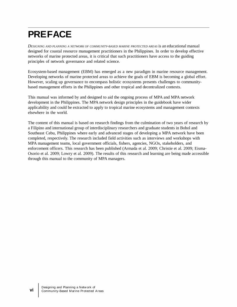
4.2 Formation of an integrated network management body
Actions at the network level will require group deliberation and decision-making involving variousinstitutions. New skills will be required such as the ability to create shared plans, mobilize agreementsbetween disparate groups, and coordinate resource sharing. These necessary actions can be guided andimplemented by the formation of a formal network management body.The following are critical enabling conditions for the formation of a network management body:
Commitment of municipalities and local groups Enabling legal and policy framework Perceived need for collaborative management of a shared resource.
The Southeast Cebu Cluster was formed with a history of municipal collaboration, and anacknowledgement of the need to co-manage shared fishing stocks and other marine resources (Eisma-Osorio et al., 2009). The Cluster meets monthly to discuss joint management concerns of their sharedcoastal ecosystem. The Cluster’s enabling legal framework is outlined in the Philippine Constitution, whichstates that Local Government Unit Alliances may be formed in order to consolidate efforts, services, andresources (Eisma-Osorio et al., 2009). This mandate allows for collaborative agreements between LocalGovernment Units, and interested municipalities can formalize a network management body by signing aMemorandum of Agreement. While commitment and the legal framework are imperative to collaborativeagreements, network management bodies will need to facilitate participatory processes, transparentdecision making, conflict resolution mechanisms, and continued coordination in their creation of a networkmanagement plan in order to lay the groundwork for a successful network (Christie et al., 2009b).
4.3 Community Engagement
In the context of coastal management, community engagement refers to the utilization of participatoryprocesses in decision-making and planning. Participatory processes that engage stakeholders in assessing,planning, and implementing coastal management projects are considered fundamental to overall coastal
Institutional Coordination Assessment Questions
1. List groups that coordinate with one another. Indicate the groupsthat coordinate with one another about MPA network management.
2. List groups that are involved in some way with the MPA networkyet are not integrated with other groups.
3. Describe the current state of coordination activities in your MPAnetwork
22Designing and Planning a Network ofCommunity-Based Marine Protected Areas
3
2
1
Institutions are vertically and horizontally linked, andinclude inter-community, inter-LGU, provincial andexternal group involvement. Coordinated institutionsmeet regularly to discuss the MPA network.
Some institutional coordination exists. Coordination isnot vertical and horizontal and necessary institutionsare not involved. Institutions do not meet regularly.
Little to no coordination exists.

23Designing and Planning a Network of
Community-Based Marine Protected Areas
Figure 22. The network management body is responsible forengaging community members during the planning andimplementation of an MPA network. Figure courtesy of USAID Project Fisheries for Sustainable Harvest.
Community Engagement Assessment Questions
1. Indicate what levels of government are involved in networkmanagement decisions (you may select more than one level)
Community___ Municipal____ Provincial____ Other ______
2. What kinds of network management decisions are made at each levelof government? State one example for each level if possible.
3. What levels of government are most involved in network decisions?Least involved?
4. Describe the steps of a typical decision-making process used tomanage the MPA network. Are community groups consulted?
5. Is the level of engagement within the community adequate? Pleaseexplain.
6. To what extent are participatory processes utilized in the MPAnetwork?
management success (DENR et al., 2001c). MPA network planning and management decisions should bemade transparently with input from all levels of government and community groups. Transparency isachieved when stakeholders are informed and knowledgeable of the decisions impacting their livelihoods.The network management body should strive to engage local communities in ecosystem level managementdecisions.
In the Philippines, it is frequently local communities and peoples’ organizations that ensure not only theeffectiveness of planning and program design, but also the actual implementation of coastal managementstrategies and plans (Eisma-Osorio et al., 2009). High-level governance decisions need to be made afterconsultations with local communities (or smallest political units), in order to maintain community supportand improve implementation. It is the responsibility of the network management body to engagecommunity members in management decisions for shared fisheries ecosystems.

3
2
1
Network management decisions are transparent.Consultations are conducted at all levels, including withcommunity members. Participatory processes are utilizedin network decisions and planning.Network decisions are not always transparent.Community is occasionally, but not always consulted orengaged in decision-making. Participatory processes areutilized occasionally.Network decisions are not transparent. Communityengagement is low, and communities are not consulted orengaged in dialogue. Participatory processes are not usedin planning or decisions.
Scorecard 5: Community Engagement
4.4 Conflict resolution
Conflict between stakeholders while developing and implementing an MPA network is likely to arise due tonew limitations on fishing grounds, new regulations, and increased engagement of disparate groups. MPAmanagers should be prepared to encounter conflict (Christie et al., 2009a; Milne et al., 2003). Forexample, the Southeast Cebu Cluster regularly addresses issues such as banning compressor fishing,reducing fishing effort, and regulating municipal tourism activities. These issues are controversial and thenetwork management body needs conflict resolution skills to resolve ensuing disagreements within thenetwork. The network management body may catalyze conflict resolution by facilitating discussions,collaborations, and participatory processes with relevant parties. For example, the Southeast Cebu Clusterhelped resolve a conflict arising from the restriction of municipal fishers to their own municipal waters.The seven municipalities agreed to allow municipal fishers from cluster member municipalities to fishwithin the shared municipal waters, but agreed to exclude fishers from outside (Eisma-Osorio et al., 2009).Mechanisms to enable conflict resolution should be utilized during participatory processes; if notsuccessful, however, the involvement of external mediators should be considered.
24Designing and Planning a Network ofCommunity-Based Marine Protected Areas
Conflict Resolution Assessment Questions
Scorecard 6: Conflict Resolution
3
2
1
Network management body has a mechanism for conflictresolution in place, such as an external mediator. Existingconflicts are identified and resolved in network decision-making and planning process.Network management body has not considered a conflictidentification or resolution mechanism. Conflicts are oftenleft unaddressed.Conflicts within network exist and are not identified orresolved.
1. What are the main conflicts experienced within the MPA network?
2. What kinds of strategies or methods have worked to resolve conflicts?
3. Is there a conflict resolution mechanism in place at the network level?

25Designing and Planning a Network of
Community-Based Marine Protected Areas
3
2
1
Network management body actively participates in technicaland skill development exercises on such topics asmonitoring, information management, and enforcement.Technical working groups of the network receive technicaltrainings. Leadership development is an aspect of capacitydevelopment.Network management group identifies capacitydevelopment needs, yet few skill development exerciseshave occurred
Network management group has not identified or plannedfor skill or capacity development needs.
Capacity Development Assessment Questions
1. Do human and institutional capacity building activities occur inyour MPA network? If yes, what are they?
2. Has the network collectively agreed upon capacity developmentneeds?
3. Describe a few capacity development needs of the network thatare currently unmet.
Scorecard 7: Capacity Development
4.6 Alternative and Supplemental Livelihood
A MPA network may require the establishment of additional MPAs or the expansion of existing MPAs tomeet overall ecological goals. Fishers may be negatively impacted in the short-term as some fishing
4.5 Capacity Development
The lack of human and institutional capacity continues to be a challenge in planning and implementingcoastal management projects in the Philippines (White et al., 2006a; Milne et al., 2003). Examples ofhuman and institutional capacity development needs include the following:
Environmental education Information management Social and ecological monitoring Leadership Conflict resolution Enforcement procedures.
Developing a management system for a network of MPAs will likely increase the need for human andinstitutional capacity (Lowry et al., 2009). Network management and associated institutions will need to beactively strengthened through technical training and education. For example, technical training inecosystem monitoring, multi-institutional information management, and the facilitation of inter-institutionalcollaboration will smooth the network management and implementation processes (Christie et al., 2009aand b). Outside technical assistance should be sought for monitoring and evaluation efforts, conflictresolution, and continued mentorship of MPA management bodies (Lowry et al., 2009). Additionally, it iscritical that individual MPA management bodies receive continuous support throughout the networkdevelopment process to ensure effective individual marine protected areas (White et al., 2006a). Capacityneeds for the MPA networks will change over time and require continuous reassessment.

26Designing and Planning a Network ofCommunity-Based Marine Protected Areas
grounds become designated no-take zones. Alternative and supplemental livelihood programs aim toprovide additional and diversified income to such fishers, and in doing so, can support the success of no-take zones (Beger et al., 2004). However, alternative livelihoods schemes do not always result in reducedfishing pressure or become successfully adopted by the local communities and fisher folk (Pollnac et al.,2001; Sievanen et al., 2005). Therefore a gradual community-based consultation process with local fisherfolk should form the basis of any alternative livelihood interventions.
In order to increase the likelihood of success of alternative livelihood programs, a multi-sectoral effortjointly managed by community stakeholders, organized groups, and local/provincial governments isrecommended (Kuhlmann, 2002). The network management body can play an important role in thisprocess, as it occupies a sentry position and can relatively easily solicit input from its diverse members(such as local and provincial government officials, fisher folk, local organizations [i.e. people’sorganizations] and NGOs). Alternative livelihood schemes facilitated through the network managementbody can expose community groups to the various options available for alternative sustainable employmentthrough trainings or education programs. Community groups should be able to choose options afterlearning the advantages, work requirements, investment, revenues, and risks involved in each scheme. Thisinformation should be supplied through an expert or a community organizer (Beger et al., 2004).
While alternative livelihood schemes may exist at a local MPA level, a network-wide approach has severalbenefits. More specifically, investigating existing alternative livelihood options, and identifying educationaland funding opportunities at this level will likely mean increased resources and influence.
Alternative and Supplementary Livelihood Assessment Questions
1. Does the MPA network management body implement programsfor alternative or supplementary livelihoods?
2. Do local organizations, such as the people’s organization,implement livelihood programs?
3. Is alternative livelihood development identified as a need by theMPA network management body or the local communities?
Scorecard 8: Alternative and Supplementary Livelihood
3
21
MPA network implements, coordinates, and manages anetwork-wide livelihood development program, and/orsupports mechanism to improve livelihoods such asmarketing assistance, the provision of market informationor financing, etc.People's organizations and/or MPA management bodiesimplement livelihood projects individually.Alternative livelihood projects are not established. Plansfor establishment are absent.
4.7 Sustainable financing
MPAs and MPA networks in the Philippines are constrained by the availability of long-term financing(White et al., 2006a; Milne et al., 2005). Network management incurs costs, as well as createsopportunities for cost-sharing and generating revenue.Recurrent costs in network management may include:
Network management meetings

27Designing and Planning a Network of
Community-Based Marine Protected Areas
Law enforcement/patrolling Enforcement apprehensions Technical trainings (Eisma-Osorio et al., 2009).
Financial support of the network management body will require cost sharing from participatingmunicipalities, and sustainable financing from external sources and the government. The networkmanagement body should pursue funding opportunities through those agencies involved. The networkmanagement body may have more leverage as a collective group in seeking funds from the private sector,such as tourism operators and provincial and national governments (Armada et al., 2009). Coordinatinglocal MPA user fee systems is also a potential source of revenue for a network management body (Whiteet al., 2006a).
For example, each municipality in the Southeast Cebu Cluster contributes funds annually for the operationsof the council; this inter-institutional commitment to cost-sharing presently sustains the monthly meetings ofthe cluster. In addition, external funding sources support the funding needs of the cluster.
32
1
MPA network has a sustainable funding mechanism inplace. Institutions have committed to annual cost sharing.
MPA network institutions identified possible fundingmechanisms, but they are not secured. Institutions haveagreed to but do not contribute to annual cost sharing.
MPA network has neither obtained funding nor identifiedpotential sources of funding. Institutions have not commit-ted to cost sharing.
Sustainable Financing Assessment Questions
4. Describe current financing of the MPA network. Is this fundingallocated annually?
5. Do other sources of funding exist? If so, have they been pursued?6. Are cost-sharing mechanisms involving local and external sources
in place?
Scorecard 9: Sustainable Financing
4.8 Coastal Law Enforcement
MPA networks present coastal law enforcement challenges as well as opportunities. Individual MPAs withinthe network often lack sufficient enforcement within their own boundaries (DENR 2001d). Thereforescaling up enforcement efforts to a broader region presents challenges for effective and efficient enforce-ment. Effective network enforcement depends on institutional collaboration (Christie et al., 2009a). Patrol-ling, prosecution, and apprehensions must be integrated, and coordinated to the full scale of the region(Eisma-Osorio et al., 2009). A network joint enforcement team, based on committed and financially supportedlocal institutions such as the bantay dagat, should be established. The network joint enforcement teamshould have agreed upon fair and strict enforcement protocols standardized throughout the network. Theenforcement team should also be consistently funded and capacitated with necessary trainings. Coordinationefforts of the network joint enforcement team should build upon and support local enforcement of MPAs.

Figure 23. A patrol boat is one of the shared resources of the Southeast Cebu Coastal Resources Management Council. Photo byTheresa Black.
3
2
1
MPA network has a joint enforcement team that iscoordinated and crosses municipal jurisdictions. Patrolling,apprehensions, and prosecution are active and ongoing.Network-level enforcement team has sustainable fundingto support activities. Enforcement has clearly defined andstandardized procedures throughout network.Enforcement exists at individual MPA level only. Little tono network-level coordination of enforcement orprosecution exists. Individual MPAs have various levelsof enforcement, and funding for enforcement variesbetween MPAs.
Individual MPAs are poorly enforced. There isinadequate funding for enforcement. No networkcoordination exists for enforcement.
Coastal Law Enforcement Assessment Questions
1. Does the network have a joint enforcement team that worksacross jurisdictions?
2. Are enforcement teams active? Do enforcement teams usestandardized procedures?
3. Do enforcement bodies receive sustainable funding?
Scorecard 10: Coastal Law Enforcement
28Designing and Planning a Network ofCommunity-Based Marine Protected Areas
4.9 Network Monitoring
Monitoring the biophysical and socioeconomic conditions of coastal management intervention (such asMPAs) is necessary to ensure management responsiveness and improvement (Uiychiaoco et al., 2002).

29Designing and Planning a Network of
Community-Based Marine Protected Areas
Monitoring an MPA network includes assessing the social and biophysical state of individual MPAs as wellas reflecting on how well the MPA network functions as a whole.
Standardization of indicators across multiple MPAs in the network will encourage a more holistic approachto evaluating how such networked sites interact, and determine success in meeting goals and objectives ofthe network overall (Pomeroy et al., 2004).
The MPA Report Guide and the MPA Management Effectiveness Rating System (located inAppendix 3 and described in the Creating and Managing Marine Protected Areas in the Philippines)are established systems for measuring MPA management in the Philippines (White et al 2004; White et al.,2006a). This management effectiveness rating system helps to analyze the degree to which managementactions are achieving the goals and objectives of an MPA (Pomeroy et al., 2004). This system has anestablished history in the Philippines and should be used as the standard when monitoring and evaluatingindividual MPAs and MPAs within a network.
Figure 24. A community member and fisher prepares tomonitor the health of the coral reef. Photo by TheresaBlack.
Network Monitoring Assessment Questions
1. Describe the network monitoring activities in your MPAnetwork. Have biophysical monitoring activities taken place?Socio-economic monitoring activities?
2. Are the monitoring protocols standardized and consistentthroughout the network?
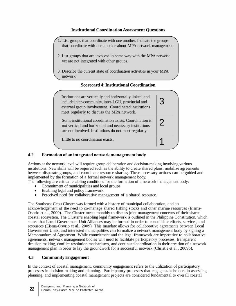
4.10 Information Management
MPA-relevant social, biological and management effectiveness information should be collected throughoutthe network, standardized, synthesized, and maintained in an accessible format for network managers as wellas for each community. Comprehensive information management at the network scale will require commit-ment and coordination from each municipality and the network management body. Well-managed informationthat covers all aspects of the MPA network is valuable to MPA network planning and design, as well as toevaluating and adapting the MPA network. MPA network design and planning should utilize the collectiveinformation when making implementation decisions.
Collective information can be stored, maintained, and represented spatially in a Geographic InformationSystem (GIS). A GIS allows a user to enter various layers of information from multiple communities and sitesinto a database and produce informative and accurate maps displaying the results.
Information management occurs at the individual MPA level as well as at the MPA network level. ManyMPAs have already been documented and corresponding information on the MPA synthesized in the Philip-pines Marine Protected Coast, Reef, and Management Database, which is maintained by the CoastalConservation and Education Foundation located in Cebu City, Philippines. This database contains manage-ment and biophysical information on hundreds of MPAs in the Philippines. It is a tool to store information onMPAs and to observe trends in MPAs over time. More information on the MPA database and the databaseuser guide can be found at www.coast.ph.
While each community would benefit from collecting and managing local information, the network manage-ment body should be responsible for synthesizing all information (and making it accessible) for the benefit ofthe network. This requires a technical capacity within the network management body to accumulate,organize, and present large amounts of information across varying locations and time scales.
The methods used for gathering information are as important as the presentation and organization of theinformation. For example, careful attention should be paid to the audience and to the goals of informationmanagement. Each distinct constituency has different needs and abilities to assimilate information. Variousresources are available to improve MPA information gathering, analysis, and management such as CoralReef Monitoring for Management by Uychiaoco et al., 2002, and How is your MPA doing? by Pomeroyet al., 2004, and the MPA Report Guide (see Appendices). See the References section for more informationon these resources.
30Designing and Planning a Network ofCommunity-Based Marine Protected Areas
3
2
1
MPA network has established standardized protocols forsocial and ecological monitoring throughout network.MPAs are regularly monitoring for biophysical and socio-economic indicators such as fish biomass, coral cover,and human perceptions of the MPA
Individual MPAs are monitored, but monitoring protocolsare not standardized throughout network. Ecological andsocio-economic data is collected inconsistently for eachMPA
Information is not collected or organized for individualMPAs. There is little to no information available tonetwork management body.
Scorecard 11: Network Monitoring

31Designing and Planning a Network of
Community-Based Marine Protected Areas
Figure 25. Information Management and Monitoring & Evaluation play a key role in feeding informationback into MPA network management and planning. As illustrated, planning for the network is a cyclicalprocess. Figure courtesy of US AID Project FISH.
3
2
1
Network information including monitoring data is orga-nized and stored in a network level database. Informationis synthesized and accessible to network management,individual communities, and stakeholders. Networkinformation is organized graphically in a GIS database.
Information on each individual MPA is collected but notstored in a network level database. Information isoccasionally made available to network management andcommunities through presentationsInformation is not collected or organized for individualMPAs. There is no information available to networkmanagement body.
Information Management Assessment Questions
1. Do individual MPA management bodies gather and organizeinformation? Is the Philippine MPA database utilized in thisprocess?
2. Describe the network information management activities.3. Does one database exist that collects information for the whole
network?4. Is the information within the database accessible to the
management body? Is it accessible to other stakeholders andcommunities? If yes, how?
Scorecard 12: Information Management
4.11 Advanced Planning: Evaluating & Adapting MPA Networks
After several years of operations, it may be time to consider evaluating network programs and identifyingopportunities to adapt and improve the network.

32Designing and Planning a Network ofCommunity-Based Marine Protected Areas
3
2
1
Multiple MPA network programs have been evaluated tomeasure progress towards goals and objectives of thenetwork. MPA network management programs adapt andchange based on evaluation results.
Some of the MPA network programs have been evaluated.MPA network programs have been in place for multipleyears and could benefit from an evaluation. Few programshave been adapted or improved over the years of operation.
MPA network programs have been in place for multipleyears, yet have not yet been evaluated or adapted
Evaluating and Adaptation Assessment Questions
1. Have the MPA network programs been established andoperational for a number of years? If yes, complete the questionsand scorecard below.
2. Describe any evaluation activities of the MPA network programs.For example, what specific programs have been evaluated orneed to be, in your opinion? What was the outcome of theevaluation?
3. Describe ways in which the MPA network programs haveadapted or improved over time.
Scorecard 13: Evaluation and Adaptation
4.12 Individual Marine Protected Areas
Well-managed individual MPAs are the foundation of a functional network (Lowry et al., 2009). Without well-managed and community-supported MPAs, a network will be ineffectual. At the initial planning stages of anMPA network, it is necessary to assess the current management effectiveness of each individual MPA. The
Evaluating an MPA network requires reflection on the goals and objectives set forth by the MPA networkmanagement body. This process should occur at the network level, not the individual MPA level. Aninternal or external evaluation team should agree upon and assess biophysical, socio-economic, andgovernance indicators to document progress toward attaining network goals. (Socio-economic andbiophysical information for each MPA and MPA network will be available through network monitoring andinformation management activities discussed earlier in this manual.) Indicators can be based on outcomessuch as increased protection of mangrove habitat, or process indicators such as participatory processesutilized in decision-making. Program evaluations should actively engage relevant stakeholder groups inevaluative processes, as one of the goals of the evaluation is to (1) provide feedback on effectiveness ofmanagement strategies and (2) provide recommendations to improve current practices. Utilizing networkmanagement evaluative criteria (such as the self-assessment scorecards given in this manual) will assistthe network management body in defining areas for future program development.
The results of the evaluation can inform the adaptation of network management programs.Adaptation of network programs depends on the flexibility of those programs (Christie et al., 2009b). Ifprograms have guiding goals and are willing to experiment in methods to reach those goals, networkprograms will have the potential to improve and grow. Evaluating MPA network programs, onceoperational for a number of years, will provide insights to improving and adapting existing programs tobetter meet the overarching goals of the MPA network.

33Designing and Planning a Network of
Community-Based Marine Protected Areas
Individual MPA Assessment Questions
1. Based on the MPA management system contained within theMPA Report Guide (located in the appendix) at what level ratingwould you describe the majority of the individual MPAs withinthe network? (Using the best information available to you).
2. How many MPAs within the network are at rating Level 1?Level 2? Level 3?
Scorecard 14: Individual MPAs
321
Most of the MPAs within the network meet rating level 3,as defined by the MPA Management Rating System.
About half of the MPAs within the network meet ratingLevel 3.
Less than half of the MPAs within the network meet ratingLevel 3.
inclusion of an individual MPA within a network should not discount local efforts to maintain and strengthen theMPA’s management; alternatively both local and inter-municipal management efforts should be maintained.
In the Philippines, a MPA Report Guide and Management Rating System has been established by theCoastal Conservation and Education Foundation to assist in organizing community-based MPA-level informa-tion for hundreds of MPAs. The MPA Report Guide provides information on (1) the status and quality ofmanagement, (2) the status and quality of the environment, and (3) benefits derived from the MPA. Forfurther information on the MPA Report Guide and please see Appendix 3.
The MPA Management Rating System (located within the MPA Report Guide) sets benchmarks and ratinglevels to assess the progress of MPA management. The benchmarks include elements of a successfully runMPA, such as enforcement, community support, education programs, legal status, and infrastructure to name afew. For example, an MPA with a rating of “Level 3” (well established) would have:
An active management body; An allocated budget for the MPA; Structures and outposts that are maintained; Regular patrolling; Community education programs (White et al., 2004).
The benchmarks set through the MPA Management Rating System provide a standard for assessing the currentstate of individual MPAs prior to and during the implementation of a network. Generally, MPAs that meet thebasic management goals as illustrated in a “Level 3 MPA” are considered to have the necessary attributes ofenforcement, management, and infrastructure to contribute to overall network goals. MPAs that do not meet a“Level 3” standard will likely require further capacity building and assistance before they can be considered afunctional part of the network. The utilization of the existing MPA management rating system will assist indetermining the state of each individual MPA and provide valuable information to the network planning process.
In addition to the MPA Report Guide and Management Rating System, various other publications containimportant information and specific planning steps to successfully establish and manage MPAs in the Philippines.For an illustrative list, see Table 1. Useful publications on MPA Management in the Philippines in thepublication Creating and Managing Marine Protected Areas by White et al., 2006. While these tools helpassess MPA management (White et al., 2004; White et al., 2006a), others serve as repositories for collectedinformation. The existing tools and information on MPA establishment and management should be an integralpart to building a network of MPAs.

SECTION 5. CONCLUSION
Community-based MPA networks have ecological, social, and institutional components.
34Designing and Planning a Network ofCommunity-Based Marine Protected Areas
A network can support ecosystem functions through protection of key habitats based on considerations offish life cycle, movement patterns, local ocean currents, and overall ecosystem health. An ecological networkwill be achieved when MPAs within the network are designed based on appropriate size, spacing, habitatrepresentation, and replication principles.
A MPA social network consists of people working together to improve MPA management. Raisingawareness and leadership development established through formal and informal education and capacitybuilding programs will strengthen and sustain a social network of MPAs. Encouraging information exchangeand communication across multiple MPAs and different elements of management are necessary todeveloping a successful social MPA network.
An institutional MPA network requires collaboration and coordination across multiple MPA managementbodies. Horizontal and vertical coordination of all interested parties and stakeholders, from provincial (and insome cases national) to local community groups are necessary to form a MPA network. The inter-institutional network management body should utilize participatory processes to engage stakeholders in thedevelopment of enforcement teams, conflict resolution, information management, network monitoring, and inall other areas of network management. An institutional network of MPAs will result in standardizedmonitoring, information management, and enforcement procedures, among others, to benefit individual MPAmanagement as well as achieve overall network goals.
Planning a community-based MPA network follows the traditional phases of coastal resource management inthe Philippines. Refer to Figure 27 and the MPA Network Visioning & Planning Reference Guide inAppendix 2 for more information. Planning and managing a community-based MPA network should utilizethe established tools and frameworks for managing community-based MPAs. MPA networks can bedeveloped after careful consideration of the key indicators of successful social, institutional, and ecologicalnetworks, as presented in this manual.

35Designing and Planning a Network of
Community-Based Marine Protected Areas
SECTION 6.MPA NETWORKPLANNING MODULEThis manual provides description of the ecological, social, and institutional elements of a MPA network.Sections 1-5 include assessment questions and scorecards in order to evaluate the progress and status ofeach of the ecological, social, and institutional elements of MPA networks. The workshop module in thissection provides activities based on participant responses to the assessment questions and scorecards.
The following module provides as a roadmap for planning improvements to your MPA network. Specifi-cally, this process will entail completing:
An assessment checklist to improve the understanding of how individual elements of thenetwork are functioning,
A goal setting exercise to determine possible future directions of the network; A gap analysis exercise to identify the gaps between your goals and your current state; An action plan to identify the ‘who, what, when, and how’ each of your goals will be
accomplished.
This roadmap strives to be a tool that provides MPA and resource managers the opportunity for reflection,collaboration, and learning.
6.1 MPA Network Module Facilitation Guide: Tips for Workshop Facilitators
Manual ContentEach section of the manual describes an element of an MPA network. The facilitator should readand understand each section before working with group to complete the workshop activities. Thefacilitator should have a working knowledge of each element in order to guide discussion andengage the group participants. In cases where the participants are not familiar with the element,reading the section out loud to the group may be helpful.
Time FrameAll workshop activities can and should be adapted to your unique time constraints and interests.For example, grouping different elements together into similar categories is one way to encouragediscussion of many elements within a limited time frame.
Group DynamicsThe participants in the workshop will represent diverse groups with different interests and holddifferent degrees of power within the communities and government. In order to create asupportive environment where participants feel comfortable sharing an honest assessment ofissues, consider grouping people who share levels of power with one another. For example, ViceMayors grouped with Vice Mayors and fishermen and community leaders together mayencourage a more candid discussion on sensitive topics.
Adapt Activities to Current Stage of NetworkFacilitators should have a general understanding of the current status of the MPA network. Gaugeactivities and questions and plan to avoid elements or topics that are irrelevant based on thecurrent stage of the network. For example, if this workshop serves as the initial introduction to

MPA networks, discussing network evaluation/adaptation would not be appropriate.
Incorporate Local & Existing PlansIf local coastal management or MPA co-management plans already exist, integrate the MPAnetwork goal setting, and action planning activities into the existing plan.
Scoring Elements in the ScorecardsParticipants may struggle with the limited scoring options in the Scorecard Assessment Activity.The scores of 1, 2, and 3 are designed to assist groups in choosing an appropriate and briefdescription of the current state of affairs. The purpose of scoring is to help the participants setgoals and identify issues of concern within the network. Facilitators should request that the groupelect the most appropriate score that best describes the current reality, while also acknowledgingthat the score is limited and not an enduring rating.
6.2 MPA Network Planning Module: Activity OverviewBelow is an overview and flow of activities for the planning module.Specific instructions for each activity are in the following pages.
Introduction: Refresher presentation on the key components of an MPA Network30 minutesPowerPoint presentation on 14 main elements of an MPA network
Activity 1: How is your MPA Network?: Self-Assessment Scorecards1 hourIn this activity, facilitators guide small groups through each of the network elements by reading through thecorresponding sections in the manual. The small groups answer the provided assessment questions in eachsection. They then rate themselves in the scorecards provided at the end of each section. The scoring ofelement sets the stage for future goal setting activities by providing a general assessment of the currentstate of that element.
Activity 2: Prioritizing Elements of Network30 minutesIn this activity small groups present to the larger group a quick recap of their discussions and how theyscored each element. The large group then begins a discussion to prioritize what elements of the networkthey would like to focus on for the remaining planning activities of the workshop. The large group drawson the suggestions from each small group’s discussion in choosing which elements they consider a priorityfor the workshop. Alternatively, if time is not an issue, the large group can choose to address each of theelements in later workshop activities, and prioritizing will not be necessary.
Activity 3: Element Goal Setting1 hour total per element, 30 min in small group, 30 min in large groupSmall groups are assigned one element simultaneously (if only a few elements were prioritized in theprevious activity) or elements are divided up amongst small groups. For example, one small group canwork on goal setting for the elements of coordination, conflict resolution, and capacity building whileanother group works on enforcement and alternative livelihoods OR all groups work on the same elementsat one time. Using various methods, small groups set goals for that element of the MPA network.
Activity 4: Gap Analysis Brainstorm1 hour for five elements or ten minutes per elementIn a large or small group, a facilitator guides participants to identify gaps they anticipate in reaching thegoals that have been set. Suggestions are listed on the board, visible to everyone, so that each small groupmay consider them in the development of their action plans.
36Designing and Planning a Network ofCommunity-Based Marine Protected Areas

Activity 5: Action Planning1.5 hours per elementSmall groups complete the action-planning matrix for one element at a time. Small groups suggest andagree upon strategies, a funding source, a timeline, and a person or group responsible for completing eachaction. When possible, actions should correspond or build upon pre-existing coastal management or MPAplans. Once matrices are completed, the larger group should walk around for a ‘gallery viewing’ of eachaction planning matrix. Each action plan is then presented to the large group and facilitator notes sharedand possible actions. Note taker documents all suggested planning activities for use in writing the actionplan.
Activity 6: Writing Action PlanNote taker and facilitator summarize action planning activity matrices into an official document. A commit-tee, which is tasked with writing the action plan, reviews the notes and suggestions from the workshop andwrites a clear action plan. See Coastal Resource Management Planning, Guidebook 3, by DENR,2001, for instructions on writing an action plan. When possible, integrate action plans into pre-existingcoastal management plans. Written action plan is presented to council and communities at a later meetingfor support and verification.
37Designing and Planning a Network of
Community-Based Marine Protected Areas
6.3 MPA Network Planning Module
Activity 1: Self-Assessment Scorecards: How is your MPA Network?
Self-Assessment Scorecard Activity Instructions:Materials: MPA Network Manual and Appendix 1 to summarize scores.Format: Small group with one discussion facilitator per group.
An MPA network consists of social, institutional, and ecological elements. Throughout the manual eachsection describes one element of the network. Following most sections are Assessment Questions and aScorecard. The scorecards are designed to help small groups assess and score their progress of thatelement. For a complete list of scorecards, see Appendix 1.
Step 1. Read each section of the manual that contains assessment questions and a scorecard to your smallgroup. Sections can be read completely out loud or summarized by the facilitator, but it is important that eachfacilitator comprehend the content of each section in order to facilitate discussion and ideas.
Step 2. Facilitator then reads aloud the assessment questions and the group discusses an answer for eachquestion. Questions are not designed to be tests, but instead should encourage reflection and comments. Thereflection and comments should then guide groups in a discussion on how to score their progress in thescorecard.
In each scorecard, three different stages of implementation are described (for each element) and assigned ascore of 1, 2, or 3. The score of “3” suggests an element under consideration is being implemented and is inan advanced stage of development in the network. A score of “2” suggests that activities may have beeninitiated, but are not consistently implemented. A score of “1” suggests that little or no attention was given
Step 3. Facilitators should guide the group in choosing an appropriate score. Scores are general, and can bebroadly interpreted.
Step 4. Repeat this process, until a score is given for each of the elements in the scorecard summary table(Appendix 1). This scorecard summary will help groups identify priority areas in the network, and inform theremaining workshop activities.

Activity 2: Prioritizing Elements of the Network
Prioritizing Elements of Network30 minutesIn this activity small groups present back to the larger group a quick recap of their discussions and howthey scored each element. The large group then begins a discussion to prioritize what elements of thenetwork they would like to focus on for the remaining planning activities of the workshop. The large groupdraws on the suggestions from each small group’s discussion in choosing which elements they consider apriority for the workshop. Alternatively, if time is not an issue, the large group can choose to address eachof the elements in later workshop activities, and prioritization will not be necessary. In other words, if timepermits, all of the subjects listed on the scorecards could be discussed.
Step 1. Small groups present Summary Scorecards to the larger group. Small groups mention whatelements they consider a priority for planning activities.
Step 2. Facilitator keeps track of the priority elements mentioned by each small group. Facilitator guideslarge group to a consensus on which elements should be the sole focus for the following workshopplanning activities.
38Designing and Planning a Network ofCommunity-Based Marine Protected Areas

39Designing and Planning a Network of
Community-Based Marine Protected Areas
Activity 3: Goal Setting: Where would you like your MPA Network To Go?
The priority elements of the MPA network (identified in the previous activity) are the subject of this goalsetting activity. This activity asks participants: where would you like your MPA network to be? What areyour goals for each element? Refer to the MPA Network Planning Reference Guide in the Appendix forsuggestions on planning steps and achievable goals for each element. This table is a suggested series ofplanning steps and does not need to be followed exactly. Keep in mind that the planning steps in this tablemay happen out of order or simultaneously. The end result of this activity is a list of 1-3 goals for each priorityarea.
Goal Setting Activity Instructions:1 hour total (30 mins for small group exercise, 30 mins for large group exercise)Materials: MPA network planning reference guide (Appendix 2), large blank paper or whiteboardFormat: Small group (30 mins with facilitator); large group (30 mins with facilitator).
Part I: Small group exercise – 30 minutesStep 1: The facilitator announces the element of focus for this visioning activity.Step 2: Each member reflects on how they scored each element and the reasons why. (It will be helpful tohave the Summary Scorecard nearby to refresh memories) Each group member considers the goals theyenvision for each element. Then the member writes down one to two goals on a card. Members areencouraged to be specific in writing their goals.
Step 3: Members tape their goals on a wall or white board. The group spends a few minutes reading all ofthe goals and then begins the process of grouping them into similar categories.
Step 4: The facilitator guides the group to craft a few sentences for each category or main idea.
Step 5: The group further narrows down the suggested goals into a one to three achievable goals on a largepiece of paper for display and presentation to the large group.
Part II: Large group exercise – 30 minutesStep 1: Once the small groups have completed articulating their goals for one element, the large groupreconvenes.
Step 2: The small groups present their goals for one element. A note taker writes the small groups’ goals ontoa whiteboard. At the end of the small group presentations, the large group will have a list of goals from eachgroup on the board.
Step 3: The large group facilitator guides the large group to combine the different goals into one goal that isinclusive of all ideas. By putting it all together, specific goals are crafted for each element of the network.
Documenting GoalsThe note taker of the workshop is responsible for creating a clean copy of the goals for each element of theMPA network. This list will be used to inform the remaining activities of the workshop.

Activity 4: Gap Analysis Brainstorm
A gap analysis helps identify potential problems that may inhibit the attainment of MPA network goals. Thegoals represent future directions, and certain challenges and impediments likely exist in getting there. Agap analysis brings out those gaps in order to helps account for them in the planning process moreeffectively. A gap analysis brainstorm activity engages the large group by drawing out ideas of theanticipated gaps and problems in achieving the goals set in the previous activity. A brainstorm session is afacilitated group discussion where everyone ideas are acknowledged. The end result of this activity will bea list of anticipated gaps in achieving each element’s goals.
Gap Analysis Activity Instructions:30 minutesMaterials: Index cards or whiteboard, vision statements for each elementFormat: Large group with discussion facilitator
Step 1: Facilitator announces the element of concern and reads the goals to the group.
Step 2: Facilitator encourages participants to call out all of the potential problems that may exist inreaching the goals. Lack of funding? Coordination challenges? Lack of travel funding? Or travel time?The facilitator allocates 10 minutes for each element brainstorm.
Step 3: Note taker writes suggestions on a white board or index cards and posts them on the wall.
Step 4: The facilitator then reads out the second list of goals for the next element, and so on. Thesuggested gaps and problems remain on the board or wall for groups to revisit during the action planning.
Step 5: Facilitator reminds group that the purpose of this activity is to identify gaps that may exist inaccomplishing identified goals. The point is to be able to develop action plans in the next activity, whichaddresses these gaps.
40Designing and Planning a Network ofCommunity-Based Marine Protected Areas

Activity 5: Action Planning: Who, What, When, & How?
An action plan uses your goals and gap analysis to generate practical steps to address managementchallenges. It is a designed to be a concrete list of activities that will help attain the goals. An action planindicates the who, what, when, and how of your visioning and gap analysis worksheets. It identifies afunding source to support the actions, establishes a timeline, and assigns a lead person, committee, orgroup to each action. When possible, the action plan should be integrated into action plans that mayalready exist for communities, local governments, or network management bodies.
Action Plan Activity Instructions:1.5 hoursMaterials: Blank action plan matrix (Appendix 3), gap analysis index cards, and goal statementsfor each elementFormat: small groups with one facilitator per group, note taker; large group with main facilitator
The matrix located in Appendix 3 lists the main components of an action plan (goal, gaps, strategy, who,timeline, funding source). Please use the matrix in Appendix 3 to complete this activity.
Small group – 1 hourStep 1: Facilitator announces the element of concern for the activity. The note taker writes the pre-existing goal stated for the element in the matrix, under the heading ‘Goal’
Step 2: The gaps identified in the previous activity (should be posted on the wall) are written into thematrix, under the heading ‘Gaps.’
Step 3: Facilitator encourages group to consider and discuss strategies to achieve the vision statement,while accounting for gaps. Strategies should be specific, concrete actions. The note taker lists andorganizes the strategies in the matrix under the heading ‘Strategy.’
Step 4: Members discuss and agree upon whom will be responsible for the action. Be specific as possible,identifying groups, committees, and individuals. Note taker lists the responsible party under the heading‘Who.’
Step 5: Members discuss and agree upon a clear and realistic timeline for the action. Note taker lists thetimeline under the heading ‘Timeline.’
Step 6: Members discuss and agree upon a funding source for the action. Note taker lists the fundingsource under the header ‘Funding source.’
(Activity 5: Action Planning Activity — Continued)
Large Group – 30 minutes - gallery viewing & action plan presentationsA gallery viewing allows the small groups to walk around the room and view other groups’ action plan matrices.
Step 1: Participants walk around and view each small group action plan matrices during the time allotted for thegallery viewing.
Step 2: Large group reconvenes.
Step 3: One member from each small group presents their action plan matrix to the large group.
Step 4: Main facilitator and note taker document and point out the common and shared actions in each of theaction plans. Shared actions are highlighted in summary of the activity by the facilitator. Facilitator informs thegroup that their ideas and suggested actions will form the basis of an action plan for the MPA network.
41Designing and Planning a Network of
Community-Based Marine Protected Areas

Activity 6: Documenting and Writing an Action Plan
The MPA network-planning module generates goal statements and suggested action plans for eachelement of the network. The ideas generated from the workshop should form the foundation of an actionplan for the MPA Network. When pre-existing coastal management or marine protected area plans are inplace, the MPA network action should be integrated to the greatest extent possible. The main facilitatorand note taker should work with a committee or assigned working group to organize the notes and ideasfrom the workshop into a final action plan. For a complete description of how to write an action plan seeChapter 4, Coastal resource management plan preparation and adoption – Phase 2, in CoastalResource Management Planning, Guidebook No. 3 by DENR 2001. The action plan document should bepresented to the appropriate community or council at a later meeting for verification and support.
42Designing and Planning a Network ofCommunity-Based Marine Protected Areas

REFERENCES
Agardy, T. (1997). Marine Protected Areas and Ocean Conservation. Austin, TX: Landes Companyand Academic Press.
Armada, N., A.T. White and P. Christie. (2009). Managing fisheries resources in Danajon Bank, Bohol,Philippines: an ecosystem-based approach. Coastal Management, 37, 275-299.
Bailey, K.M. and E.D. Houde. (1989). Predation on eggs and larvae of marine fishes and the recruitmentproblem. Advances in Marine Biology, 25, 1-67.
Beger M., AR Harbone, T.P. Dacles, J.L. Solandt, and G.L. Ledesma. (2004). A framework of lessonslearned from community-based marine reserves and its effectiveness in guiding a new coastalmanagement initiative in the Philippines. Environmental Management, 34(6), 786-801.
Botsford, L.W., D. R. Brumbaugh, C. Grimes, J. B. Kellner, J. Largier, M. R. O’Farrell, S. Ralston,E. Soulanille and V. Wespestad. (2009). Connectivity, sustainability, and yield: bridging the gapbetween conventional fisheries management and marine protected areas. Reviews in FishBiology and Fisheries, 19(1), 69-95.
Brand, F.S. and K. Jax (2007). Focusing on the meaning(s) of resilience: resilience as a descriptiveconcept and a boundary object. Ecology and Society, 12(1), 23.
Carpenter, K. and V.G. Springer. (2005). The center of the center of marine shore fish biodiversity: thePhilippine Islands. Environmental Biology of Fishes, 72, 467-80.
Christie P., A.T. White and E. Deguit. (2002). Starting point or solution? Community-based marineprotected areas in the Philippines. Journal of Environmental Management, 66, 441-454.
Christie, P., and A.T. White (2007a). Best practice for improved governance of coral reef marineprotected areas. Coral Reefs, 26, 1047-1056.
Christie, P. and C. Gonzalez. (2007b). Pew Fellowship in Marine Conservation: Human Dimensions ofMarine Protected Area Networks. Unpublished data.
Christie, P., R. Pollnac, E. Oracion, A. Sabonsolin, R. Diaz, and D. Pietri. (2009a). Back to basics: anempirical study demonstrating the importance of local-level dynamics for the success of tropicalmarine ecosystem-based management. Coastal Management, 37(3), 349-373.
Christie P. R. Pollnac, D. Fluharty, M. Hixon, G. Lowry, R. Mahon, D. Pietri, B. Tissot, A. White, N.Armada, R. Eisma-Osorio. (2009b). Tropical marine EBM feasibility: A synthesis of case studiesand comparative analyses. Coastal Management, 37(3), 374-385.
Cowen, R.K., C.B. Paris, and A. Srinivason. (2006). Scaling of connectivity in marine populations.Science, 311(5760), 522-527.
DENR (Department of Environment and Natural Resources), DA-BFAR (Department of Agriculture-Bureau of Fisheries and Aquatic Resources) and DILG (Department of the Interior and LocalGovernment). Philippine Coastal Management Guidebook Series. Coastal Resource ManagementProject of DENR, Cebu City, Philippines.2001a. No. 1: Coastal management orientation and overview.2001b. No. 3: Coastal resource management planning.2001c. No. 4: Involving communities in coastal management.
43Designing and Planning a Network of
Community-Based Marine Protected Areas

2001d. No. 8: Coastal law enforcement
Eisma-Osorio, R.L., R.C. Amolo, A.P. Maypa, A.T. White, and P. Christie. (2009). Scaling-up localgovernment initiatives towards ecosystem-based fisheries management in Southeast Cebu Island,Philippines. Coastal Management, 37(3), 291-307.
Gaines, S.D., B. Gaylord., and J.L. Largier. (2003). Avoiding current oversights in marine reserve design.Ecological Applications, 13, Supplement: Marine Reserves, 32-46.
Girolamo, M., M. Scaggiante, and M.B. Rasotto. (1999). Social organization and sexual pattern in theMediterranean parrotfish Sparisoma cretense (Teleostei: Scaridae) Marine Biology, 135, 353-360.
IUCN World Commission on Protected Areas (IUCN-WCPA) (2008). EstablishingMarine Protected Area Networks—Making It Happen. Washington, D.C.: IUCN-WCPA,National Oceanic and Atmospheric Administration and The Nature Conservancy. 118 p.
Kaplan, D.M., L.W. Botsford, and S. Jorgensen (2006). Dispersal per recruit: an efficient method forassessing sustainability in marine reserve networks. Ecological Applications, 16(6), 2248-2263.
Kuhlmann, K.J. (2002). Evaluations of marine reserves as basis to develop alternative livelihoods incoastal areas of the Philippines. Aquaculture International, 10, 527-549.
Lester, S.E., and B.I. Ruttenberg. (2004). The relationship between pelagic larval duration and range sizein tropical reef fishes: a synthetic analysis. Electronic Appendix. Proceedings of the RoyalSociety of Britain.
Luna, C.Z., G.T. Silvestre, S.J. Green, M.F. Carreon III, and A.T. White. (2004). Profiling the status ofPhilippine marine fisheries: a general introduction and overview. In DA-BFAR (Department ofAgriculture-Bureau of Fisheries and Aquatic Resources). In Turbulent Seas: The Status ofPhilippine Marine Fisheries. Coastal Resource Management Project of the Department ofEnvironment and Natural Resources, Cebu City, Philippines.
Lowry, G.K., A.T White, and P. Christie. (2009). Scaling up to networks of marine protected areas in thePhilippines: biophysical, institutional and social considerations. Coastal Management, 37(3), 274-290.
McLeod, K.L., and H. Leslie. (Eds.). (2009). Ecosystem-Based Management for the Oceans. Washing-ton, D.C.: Island Press.
Meyer, C.G., K.N. Holland, and Y.P. Papastamation (2007). Seasonal and diel movements of giant trevallyCaranx ignobilis at remote Hawaiian atolls: implications for the design of marine protected areas.Marine Ecology Progress Series, 333, 13-25.
Milne, N., P. Christie, R. Oram, R.L. Eisma and A.T. White. (2003). Integrated Coastal ManagementProcess Sustainability Reference Book. University of Washington School of Marine Affairs,Silliman University, and the Coastal Resource Management Project of the Department of Environ-ment and Natural Resources, Cebu City, Philippines.
Milne, N. and Patrick Christie. (2005). Financing integrated coastal management: experiences in Mabiniand Tingloy, Batangas, Philippines. Ocean and Coastal Management, 48,(3), 427-449.
Mumby, P.J. (2006). Connectivity of reef fish between mangroves and coral reefs: algorithms for the
44Designing and Planning a Network ofCommunity-Based Marine Protected Areas

design of marine reserves at seascape scales. Biological Conservation, 128, 215-222.
Palumbi, S.R. (2004). Marine reserves and ocean neighborhoods: the spatial scale of marine populationsand their management. Annual Review of Environment Resources, 29, 31-68.
Partnership for Interdisciplinary Studies of Coastal Oceans. (PISCO). (2007). The Science of MarineReserves. 2nd Edition, International Version. Retrieved from: www.piscoweb.org.
Pietri, D., P. Christie, R. Pollnac, R. Diaz, and A. Sabonsolin. (2009). Information diffusion in two marineprotected area networks in the Philippines. Coastal Management, 37(3), 331-348.
Pollnac, R.B. R. Pomeroy, and I. H. Harkes. (2001). Fishery policy and job satisfaction in three SoutheastAsian fisheries. Ocean and Coastal Management, 44(7-8), 531-544.
Pomeroy, R.S., J.E. Parks and L.M. Watson. (2004). How is your MPA doing? International Union forthe Conservation of Nature and Natural Resources, Gland, Switzerland.
Rogers, E.M. (1995). Diffusion of Innovation, 4th Ed. New York: Simon and Schulster. 519 p.
Sievanen, L., B. Crawford, R. Pollnac, and C. Lowe. (2005). Weeding through assumptions of livelihoodapproaches to ICM: seaweed farming in the Philippines and Indonesia. Ocean and CoastalManagement, 48(3-6), 297-313.
Sudekum, A.E., J.D. Parrish, R.L. Radtke, and S. Ralston. (1991). Life history and ecology of large jacksin undisturbed, shallow, oceanic communities. Fishery Bulletin, 89, 493-513.
Uychiaoco, A.J., S.J.Green, M.T. dela Cruz, P.A. Gaite, H.O. Arceo, P.M. Alnino, and A.T. White. (2002).Coral reef monitoring for management. University of Philippines-Marine Science Institute,United Nations Development Programme Global Environment Facility-Small Grants Program,Guiuan Development Foundation, Inc., Voluntary Service Overseas, University of the PhilippinesCenter for Integration and Development Studies, Coastal Resource Management Project, andFisheries Resource Management Project.
White, A.T., C. Courtney, and A. Salamanca. (2002). Experience with marine protected area planning andmanagement in the Philippines. Coastal Management, 30(1), 1-26.
White, A.T., A.B. Menses and M. Ovenden. (2004). Management rating system for marine protectedareas: an important tool to improve management. In DA-BFAR. In Turbulent Seas: The statusof Philippine marine fisheries. Coastal Resource Management Project, Cebu City, Philippines.
White, A.T., P.M Aliño and A.T. Meneses. (2006a). Creating and managing marine protected areas inthe Philippines. Fisheries Improved for Sustainable Harvest Project, Coastal Conservation andEducation Foundation, Inc. and University of the Philippines Marine Science Institute, Cebu City,Philippines.
White, A.T., E. Deguit, and W. Jatulan. (2006b). Integrated coastal management in Philippine local gover-nance: evolution and benefits. Coastal Management, 34, 287-302.
Wilkinson, C. (2008). Status of coral reefs of the world: 2008. Global Coral Reef Monitoring Network andReef and Rainforest Research Centre, Townsville, Australia, 296 p.
World Bank. (2006). Scaling up management: the role of marine protected areas. Washington DC: WorldBank.
45Designing and Planning a Network of
Community-Based Marine Protected Areas

APPENDIX 1: MPA NETWORK ELEMENTS SUMMARY SCORECARD
ELEMENT OF NETWORK SCORE
Scorecard 1: MPA Size and Spacing
Scorecard 2: Habitat Representation & Replication
Scorecard 3: Awareness Raising
Scorecard 4: Institutional Coordination
Scorecard 5: Community Engagement
Scorecard 6: Conflict Resolution
Scorecard 7: Capacity Development
Scorecard 8: Alternative & Supplemental Livelihoods
Scorecard 9: Sustainable Financing
Scorecard 10: Coastal Law Enforcement
Scorecard 11: Network Monitoring
Scorecard 12: Information Management
Scorecard 13: Advanced Planning: Evaluating & Adapting
Scorecard 14: Individual MPA Management
46Designing and Planning a Network ofCommunity-Based Marine Protected Areas

47Designing and Planning a Network of
Community-Based Marine Protected Areas
APPENDIX 2. MPA NETWORK VISIONING & PLANNING REFERENCE GUIDE
The basic approach to improving the management of MPAs, identifying and planning for new MPAs andeventually forming a network of MPAs for a given planning area will generally follow the coastal resourcemanagement and MPA planning process being implemented in local governments in the Philippines (White etal., 2006) The Coastal Resource Management Guidebooks (DENR 2001) and Creating and managingmarine protected areas by White et al 2006, are essential references to guide communities through theprocess of establishing and managing new individual MPAs and complete the planning process of a MPAnetwork. The five main steps of CRM have been adapted in the table below to include considerations andreferences for each step for planning and implementing a MPA Network.
Planning an MPA Network adapts the five key steps of coastal resource management planning: 1. Issueidentification and baseline assessment; 2. MPA Network Plan Preparation and Adoption; 3. Action Plan andProject Implementation; 4. Monitoring and Evaluation; and 5. Information Management and Education andOutreach. (DENR 2001) The following table has been created as a planning reference and idea generatoronly. Please use this table as a suggested guide only for your own unique planning and visioning process.
Phases of Coastal ResourceManagement Planning
Issue identification and baselineassessment
Program preparation
Field assessment/participatorycoastal resource assessment(PCRA)
Network database and profiledevelopment
Prioritization of issues andanalysis of causes
MPA Network plan preparationand adoption
Establish network managementbody
Define goals and objectives ofthe network
MPA Network Application
Secure local commitment to participate in network Secure funding for network program; potential sources include Local
Government Units, NGOs, provincial government, and external groups, etc. Determine network coverage and what municipalities and MPAs will be
included and involved Recruit network management staff, e.g., network secretariat, chair, LGU
representatives, etc. Develop a work plan with sequence of activities, timeline, and individual
responsibility
Utilize PCRA techniques to gather socio-ecological additional data (Deguit etal., 2004)
Gather network-wide habitat data Gather network-wide socio-economic and management data on individual
MPAs
Compile PCRA data for each municipal into a coastal profile (see Deguit et al.,2004 for further explanation)
Combine municipal ‘profiles’ into a network ‘profile’ or graphic explanation ofhabitat distribution, resource conditions, and socioeconomic conditions.
All information should be stored and organized in one location or database(GIS).
Key issues should be identified and prioritized per municipality Key issues identified collectively as a network Identify root causes of issues
Form a network management body consisting of members of local and nationalgovernment agencies and citizen groups, NGOs, and other communitymembers as necessary
Create goals which are positive statements of issues identified in previoussteps

Develop network strategies and action plan
Action plan and project implementation
Network plan implementation
Legislation and regulation
Coastal Law Enforcement
Revenue generation
Annual program preparation and budgeting
Monitoring and Evaluation
Monitoring and evaluation
Create objectives, which are measurable targets in order to achievethe network’s aims, strategies, and actions.
Example goal: protect key spawning grounds in a marine protectedareas
Identify and evaluate alternative strategies for addressing eachobjective, select best strategy
Explicit description of steps that would be needed to implementeach strategy
Example: To achieve goal: ‘protect key spawning grounds in amarine protected area’ Steps include: 1. use PCRA techniques tomap spawning areas; 2. generate network consensus on need forprotection of these areas; 3. consult communities of respectiveareas; 4. establish MPAs.
Activities identified in action plan are carried out in daily planning,enforcement decisions, and activities by network members: localgovernment officials, enforcement team, resource users, and NGOs
Adequate coordination, funding, and commitment of each activityand stakeholder supports implementation of actions
Legislation and legal framework, governing coordination activities,and enforcement protocols understood and implemented
Network-wide clear and fair enforcement protocols established Funding for network enforcement activities secured Shared resources such as a patrol boat organized and maintained Legal assistance and training for illegal fishing apprehensions made
available to all network members Network-wide bantay dagat and other enforcement capacity
building trainings are scheduled as needed
Member Local Government Units annually allocate funds fornetwork
Network management body seeks grants or outside funding, i.e.,network management body approaches provincial government orexternal sources for funding assistance
Annual levels of investment secured to sustain network plans Network considers establishing a network unit or office with budget
and dedicated staff and equipment Network conducts regular strategic planning workshop with all
partners to articulate network program directions and fundingrequirements
Identify necessary information for network management body toimprove management effectiveness
Develop specific indicators that will measure effects of programs,i.e. individual MPA management effectiveness ratings or apercentage of mangrove habitats protected
Utilize the self-assessment checklist in this manual to assessnetwork development
Develop network-wide consistent monitoring protocols foradministrative, socio-economic, and biophysical data
Assign committee of network management body to completemonitoring
Disseminate results of monitoring to network management bodyand stakeholders
Identify capacity needs that inhibit management plans
48Designing and Planning a Network ofCommunity-Based Marine Protected Areas

Refine management plan
Information Management, Education,and Outreach
Information management
Education and Outreach
Adapt goals and strategies based on monitoring and evaluation data
All network and individual MPA information gathered should be compliedand managed in a database that facilitates information retrieval andanalysis
Consider GIS as one tool that summarizes socio-economic, ecological, andmanagement data graphically
Implement formal and informal community education programs on theecological and social aspects of networks
Implement network-wide trainings on leadership development, conflictresolution, ecosystem dynamics, monitoring techniques, and GIS skillsamong other topics
Assess impacts of education programs and refine programs Institutionalize cross visits as a methods to share learning across MPAs
49Designing and Planning a Network of
Community-Based Marine Protected Areas

APPENDIX 3: ACTION PLANNING MATRIX
Goal Gaps Strategy Who TimelineFundingSource
50Designing and Planning a Network ofCommunity-Based Marine Protected Areas

APPENDIX 4: MARINE PROTECTED AREA REPORT GUIDE
AND THE MARINE PROTECTED COAST, REEF, AND MANAGEMENT DATABASE
The Marine Protected Area Report Guide and the Marine Protected Coast, Reef, and ManagementDatabase were created and are maintained by the Coastal Conservation and Education Foundation(CCEF) along with other partners. Please contact CCEF for the most recent updates to the databaseand for more information at www.coast.ph.
51Designing and Planning a Network of
Community-Based Marine Protected Areas

MPA REPORT GUIDE
This MPA Report Guide can assist in organizing information on individual MPAs and the environment thatthe MPA protects. If completed yearly, it will provide MPA managers, local governments, non-governmentorganizations, academe or other interested parties with information on the status and quality ofmanagement, the status and quality of the environment and benefits being derived from the MPA. It willalso provide feedback on how the MPA is rated compared to other MPAs and on how to improvemanagement of the MPA.
I. MPA DESCRIPTION & STATUS
Items marked with “ * ” should be completely filled-up. Attach MPA legal documents and other relevantsupporting documents (e.g. Ordinance or proclamation document, map).
MPA name*: ________________________________________________________________ Region: ____________________ Province*: _______________________________________ Municipality/City*: _____________________________________________________________ Barangay*: __________________________________________________________________
Date of survey*: ______________________________________________________________
MPA size (hectares)*: _______________________________
Habitat/ecosystem(s) within MPA: [ ] Coral reef [ ] Seagrass bed [ ] Sandy bottom [ ] Rocky intertidal [ ] Mangrove [ ] Macro-algal bed [ ] Soft bottom [ ] Open water
Type of coral reef: [ ] Fringing [ ] Barrier [ ] Pinnacle rock [ ] Patch [ ] Atoll [ ] Offshore reef / Shoal
Boundary coordinates (deg-min-sec)* Point Latitude (e.g. N 9° 41’ 11.4”) Longitude (e.g. E 123° 30’ 25.4”) 1 __________________________ ___________________________ 2 __________________________ ___________________________ 3 __________________________ ___________________________
4 __________________________ ___________________________ 5 __________________________ ___________________________ 6 __________________________ ___________________________ 7 __________________________ ___________________________
8 __________________________ ___________________________ 9 __________________________ ___________________________
10 __________________________ ___________________________
Year legally established*: ___________________________________________________________Basis for legal establishment*: [ ] Municipal/City Ordinance No. ________________________ [ ] NIPAS Act _______________________________________ [ ] Others, specify: ___________________________________
Other laws affecting the area: _______________________________________________________ ___________________________________________________________________________
_______________________________________________________________________________
52Designing and Planning a Network ofCommunity-Based Marine Protected Areas
MPA establishment history (brief chronological order of events): ____________________________
_______________________________________________________________________________
_______________________________________________________________________________
MPA objectives/reasons for establishment*: ____________________________________________
_______________________________________________________________________________
_______________________________________________________________________________
OPERATIONS MANAGEMENT
Indicate classification of group (Select letter to indicate classification) [ a ] People’s organization (PO) [ f ] Non-government organization (NGO) [ b ] Barangay government [ g ] Dive shop/Resort owner [ c ] Municipal government [ h ] Others, specify:________________________ [ d ] Provincial government [ e ] Government agency (e.g. BFAR)
Current managing group* (The main group directly managing the MPA)________________________________________________________________________ _____
Current assisting group/s* (Groups providing technical assistance or support for effective implementation of theMPA)1. ______________________________________________________________________ _____2. ______________________________________________________________________ _____3. ______________________________________________________________________ _____4. ______________________________________________________________________ _____5. ______________________________________________________________________ _____6. ______________________________________________________________________ _____7. ______________________________________________________________________ _____
Presence of marker buoys? [ ] Yes [ ] NoNumber of moorings/anchor buoys? ________________Number of signs posted? ________________Date MPA management plan was approved? ________________
Management zones*: Size (has) Regulations [ ] Core zone ________ _________________________________________________ _________________________________________________ _________________________________________________ _________________________________________________ [ ] Buffer zone ________ _________________________________________________ _________________________________________________ _________________________________________________ [ ] _____________ ________ _________________________________________________
Other zone _________________________________________________
53Designing and Planning a Network of
Community-Based Marine Protected Areas

FINANCIAL MANAGEMENT
Sustainable financing mechanism in place? Policy, guidelines, system*[ ] User/entry fee _________________________________________________________ _________________________________________________________ _________________________________________________________
[ ] Gov’t budget allocation _________________________________________________________ _________________________________________________________
[ ] Trust fund _________________________________________________________ _________________________________________________________[ ] __________________ _________________________________________________________ Others, specify _________________________________________________________
Who manages the funds? [ ] Municipal gov’t [ ] Barangay gov’t [ ] Others, specify: ___________________________________
How much is the estimated annual gross income of the MPA? PhP _____________________How much was spent on annual MPA management/operations? PhP _____________________ Expenditures covered what items? Amount (PhP) [ ] Trainings / seminars / meetings _________________ [ ] Monitoring and evaluation _________________ [ ] Honorarium/salary _________________ [ ] Enforcement support (e.g. buoys, billboard, guardhouse, pumpboat) _________________ [ ] Repairs and maintenance _________________ [ ] Materials and supplies (e.g. office supplies, gasoline) _________________ [ ] Communication equipment _________________ [ ] IEC/Promotions _________________ [ ] Others, specify: ________________________________________ _________________
Supplemental or alternative livelihood created as a result of establishing MPA: _______________________________________________________________________________________________
_______________________________________________________________________________
_______________________________________________________________________________
_______________________________________________________________________________
Sharing scheme: Beneficiary ________________________ : % share _______ ______________________ : _______ ______________________ : _______ ______________________ : _______
54Designing and Planning a Network ofCommunity-Based Marine Protected Areas

ENFORCEMENT
Penalty imposed? [ ] Yes [ ] No
Apprehensions recorded
Final outcome (e.g. Fined,imprisoned, dismissed)
Nature of violation Date committed
Reference/s*: _________________________________________________________________________________________________________________________________________________________________________________________________________________________________
Name of assessor/s, position and affiliation*: ________________________________________________________________________________________________________________________________________________________________________________________________________
Contact information:Phone: ________________________________ Fax: ____________________________________Email: __________________________________________________________________________Address:______________________________________________________________________________________________________________________________________________________________________________________________________________________________________
II. MANAGEMENT RATING
55Designing and Planning a Network of
Community-Based Marine Protected Areas

The MPA rating system is intended to assist local governments and communities to improve the manage-ment of their MPA. This simple rating system is dynamic and is not a definitive statement on the status ofany MPA rated. Put a check mark (?) on the box provided if the criterion is fully satisfied or accomplished.Carefully consider MPA age in assessment.
Date of survey*: __________________________________________________________________
Level 1: MPA is initiated - Passing (Year 1 since legal establishment) (6 points required)
1a
1b
1c
1d
1e
1f
MPA concept accepted(MPA started through local initiative or social acceptance sought through public consultationsby external groups. Consulted members of affected stakeholders: fishers, other resourceusers and social groups, both men and women)
Site surveyed using standard/accepted methods with baseline assessment complete,preferably conducted in a participatory process(Reports completed on fish abundance, coral cover and profile on community and coastalmanagement)
Site selected(Site chosen based on baseline assessment results and public consultations)
Education program raising awareness about MPA functions and benefits started(Conducted a series of public education activities)
Management body membership tentatively determined(Management core group starting to conduct regular meetings with proper documentation)
Preliminary management plan drafted
Level 2: MPA is established - Fair (Year 1 or 2 since legal establishment) (16 pts required)
2a
2b
2c
2d
2e
2f
Community acceptance gained and documented(Documented through public consultation documents e.g. Barangay Resolutions and/orsignature campaigns)
Ordinance passed and approved by the Municipal Council(Ordinance should be well-drafted and enforceable and should be consistent with theconcepts of sustainable use and equitable sharing of resources)
Management body formally organized and recognized(Management group has legal mandate and is recognized by the local government; For POs– registered with Securities and Exchange Commission or Dept. of Labor and Employment)
Management plan adopted by community and LGU or PAMB(Management plan initially implemented and endorsed by LGU/PAMB)
Management activities started(Conducted initial MPA activities such as: installation of enforcement support structures,patrolling and surveillance, apprehension of violators, etc.)
Biophysical monitoring includes local participation(Locals were trained to do biophysical survey using standard/accepted method)
56Designing and Planning a Network ofCommunity-Based Marine Protected Areas

IEC activities conducted to raise understanding on MPA rules and regulations(MPA rules & regulations disseminated using appropriate & practical means to targetall direct users and other stakeholders; initial stakeholder knowledge assessmentconducted)
Anchor buoys, marker buoys and/or boundary markers installed
MPA rules and guidelines posted at strategic locations
MPA outpost or other structures constructed(Guardhouse and/or other MPA-related structures constructed)
2g
2h
2i
2j
3a
3b
3c
3d
3e
3f
3g
3h
Level 3: MPA is enforced - Good (Only applies for 2 years or older) (24 pts required)
Education program sustained public awareness and compliance(A long-term IEC program exists and is currently being implemented in support ofenforcement and the general MPA objectives)
Regular biophysical monitoring measuring habitat condition and changes conducted(Documented surveys conducted at least once annually using standard/accepted method)
Collaborative patrolling and surveillance conducted by mandated enforcement group andlocal community volunteers(Fish wardens on rotation assigned to guard and patrol the MPA, day and night withassistance from local community volunteers)
MPA billboard signs, boundary markers and anchor buoys maintained(Funds allocated for maintenance of enforcement support structures. May be part of themunicipal CRM budget)
Management body active(Implements the management plan; Coordinates enforcement activities; Members attendmeetings regularly; Coordinates and participates in regular monitoring activities)
Budget from local gov’t or from other sources allocated and is accessible for MPA mgmt(There is a legal document by the local government or an agreement with the private sectorallocating budget for MPA mgmt)
Fishing effectively stopped inside of sanctuary zone(No fishing-related violations in the sanctuary reported during the past year)
Illegal and destructive fishing reduced outside of MPA(Violations reported w/in 500m from the MPA boundary was reduced by 50% for the pastyear)
Level 4: MPA is sustained - Very good (Only applies for 3 years or older) (30 points)
MPA management plan updated in a participatory process(Mgmt plan amended with the participation of various stakeholders: fishers, resort anddiveshop operators, local government units, other resource users, both men and women)
Annual biophysical monitoring and feedback of results supervised by the managingbody and implemented for 2 years or more(Documented surveys using standard/accepted method. Reports are available)
4a
4b
57Designing and Planning a Network of
Community-Based Marine Protected Areas

Budget from government or from other sources allocated and was accessed for 2 ormore consecutive years(There is a legal document made by the local government or an agreement with a fundinggroup allocating budget for MPA operations; Financial report available)
Management body trained and capacitated to run the MPA independently(Management body supervises management activities {implementation of plans,enforcement, budgeting, monitoring and evaluation} and coordinates activities withpartners)
Enforcement system fully operational(Enforcement group with mandate and workplan; Enforcement support structuresmaintained and patrolling activities sustained over the years)
Illegal and destructive activities stopped inside and within the vicinity of MPA(No violations reported inside and w/in 500m from the MPA boundary in the past year)
Environment friendly enterprise and/or user fees collected as a sustainable financingstrategy(Sells environment friendly products/goods to tourists; Imposes collection of user-fees; etc.)
4c
4d
4e
4f
4g
Level 5: MPA is institutionalized - Excellent (Only applies for 4 years or older) (40 pts)
Information and education program on MPAs maintained over the years(Information dissemination activities sustained according to long-term IEC program)
Ordinance passed by the Provincial Council giving MPA stronger political support(Gives MPA institutional support to strengthen enforcement and collaboration)
Management plan refined for adaptive management(Incorporates further refinements after gaining much experience and lessons to improvemanagement strategies)
Management plan incorporated in the LGU development plan(MPA incorporated within the long-term LGU area-wide development plan)
Evaluation of impacts on ecology & socio-economy conducted & feedback of resultscompleted(Assessment of resource status and long-term trends conducted. Analysis of change inlocal economy and long-term-trends of user groups conducted. Reports of these studieshave been completed and reported back to stakeholders)
Revenues from enterprise and/or user fees sustained and accounted for(Existing sustainable financing mechanisms are well-managed and well documented;Financial reports easily accessible)
5a
5b
5c
5d
5e
5f
Management body capacitated for financial management and fund sourcing(Management body is well-trained to manage funds effectively {Facilitates proper handling,wise use & proper documentation}; They are also trained to seek for financial assistance{Formulated and submitted proposals})
MPA emphasizes on public education and is being used as a study tour site, residentsadvocate for MPA(After much experience, members are ready to share lessons and impart knowledge.Presence of an identified group that conducts tours & is capable of giving talks on MPA;Paper/s written on their success stories published)
5g
5h
58Designing and Planning a Network ofCommunity-Based Marine Protected Areas

Expansion strategies or enhancement programs initiated(MPA coverage is expanded e.g. from a sanctuary to a park, or; Scope of conservation activitiesis heightened e.g. coral reef restoration, re-seeding of clams, etc.)
5i
Total points accumulated:________
Total possible points: 40 All points are cumulative Points from higher levels can be used to satisfy lower rating levels Adapted from the work of the Coastal Resource Management Project team of Negros Oriental (William
Ablong and Erwin Dolumbal, with assistance from Dr. Alan White, January 2001.)
Priorities for improved management: [ ] Lack of community awareness and support(Choose top 3 answers) [ ] Weak government support
[ ] Weak law enforcement[ ] Lack of a sustainable financing mechanism[ ] Need for management capacity development[ ] Politics[ ] Multiple resource use conflict[ ] Lack of supplemental and alternative livelihood[ ] Others, specify: ________________________
Name of assessor/s, position and affiliation*: ______________________________________________________________________________________________________________________________________________________________________________________________________
Contact information:Phone: _________________________________ Fax: _________________________________Email: ________________________________________________________________________Address:________________________________________________________________________________________________________________________________________________________________________________________________________________________________
III. MPA SITE SURVEY INFORMATION, BIOPHYSICAL STATUS
Data in this section can be generated through the methods described and the forms provided in Coral ReefMonitoring for Management by Uychiaoco et al, 2001 and Reef Check by Hodgson et al, 2003.
3.1. MPA site description
Date of survey*: _______________ Time of survey: Start: ____________ End: ____________
Distance from shore (km): _____________________
Is this site sheltered? _____ Always _____ Sometimes _____ Exposed
Season: _____ Northeast monsoon (Amihan) _____ Southwest monsoon (Habagat)
Water temperature (°C, Depth:0-3 m): ____________
Distance from nearest river (km)*: _______________
River mouth width (km): _____ <10m _____ 11-50m _____ 51-100m _____ 101-500m
59Designing and Planning a Network of
Community-Based Marine Protected Areas

Distance to nearest population center (Municipality/City, km)*: ____________________________Population size (thousand)*:____________ Population density (persons/km2)*:___________
Number of resident fishers w/in 1km*: ____________Presence of mariculture w/in 500m: ______ No ______ Yes% of coast build up with structures: ____________Presence of factories/industries/mining w/in 5km*: _____ No _____ Yes (# observed ________ )
3.2. Human activities and natural disturbances within the vicinity of MPA
Major coral damaging storms No:________ Yes:________ Date of storm: _____________Mass coral bleaching No: ________ Yes: ________ Date of bleaching:_____________Overall anthropogenic impact None: ______ Low: _______ Med: ________ High: ______Is siltation a problem? Never: ______Occasionally: _______ Often: _______ Always: ______Dynamite fishing None: ______ Low: _______ Med: ________ High: ______Poison fishing None: ______ Low: _______ Med: ________ High: ______Aquarium fishing None: ______ Low: _______ Med: ________ High: ______Harvest inverts for food None: ______ Low: _______ Med: ________ High: ______Harvest inverts for curio sales None: ______ Low: _______ Med: ________ High: ______Tourist diving/snorkeling None: ______ Low: _______ Med: ________ High: ______Sewage pollution None: ______ Low: _______ Med: ________ High: ______Industrial pollution None: ______ Low: _______ Med: ________ High: ______Commercial fishing None: ______ Low: _______ Med: ________ High: ______Fish for the live food fishrestaurant trade None: ______ Low: _______ Med: _____ High: ______Artisinal/recreational None: ______ Low: _______ Med: _____ High: ______How many yachts are typicallypresent within 1km of this site? None: ______ Few (1-2): _____ Med (3-5): ____ Many (>5): _____Level of poaching in protected area? None: ______ Low: ________ Med: ________ High: _______
Other impacts: _____________________________________________________________________________Check which activities below are banned: ______ Spear fishing ______ Commercial fishing
______ Recreational fishing ______ Invertebrate or shell collection
______ Anchoring ______ Diving ______ Others, specify ___________________________
60Designing and Planning a Network ofCommunity-Based Marine Protected Areas

INSIDE OUTSIDE Shallow Deep Shallow Deep
Date of survey* Survey method used (e.g. PIT, LIT)* Coordinates*: Lat. (deg-min-sec) Long. (deg-min-sec) Mean depth (m)* No. of transects/quadrats (n)* Length of transect (m)* Reef zone (e.g. flat, slope, crest) Mean slopea (degrees) Mean topographyb (m) Mean horizontal visibility (m)
A. Mean percent of living organisms and non-living components: Corals: % % % % Hard corals Branching coral Massive coral Flat/encrusting coral Foliose/cup coral Subtotal hard: Soft corals Others: Algae Fleshy algae Turf algae Coralline algae Seagrass Sponges Other animals Non-living components: Rubble Rock and block Sand or silt White dead coral Dead coral with algae GRAND TOTAL: 100% 100% 100% 100%
B. Mean invertebrate count (# per 100 m2) [ ] No data available Diadema urchins Pencil urchin Tripneustes urchin Crown-of-thorns starfish Giant clam Triton shell Lobster Sea cucumber (edible) Banded coral shrimp Rare other animals (type/#)
C. Causes of coral damage (Rate the following as: None=0, Low=1, Medium=2, High=3) [ ] No data available Sediment Blasting/dynamite Boat/anchor damage Other breakage Seaweed overgrowth Coral disease (% of population) Trash: Fish nets
3.3. Coral habitat surveys (See Annex 1)
61Designing and Planning a Network of
Community-Based Marine Protected Areas

62Designing and Planning a Network ofCommunity-Based Marine Protected Areas

Reference/Survey team, affiliation/institution*: ______________________________________________________________________________________________________________________________________________________________________________________________________________________________
Contact information:Phone: _________________________________________ Fax: __________________________________Email: ________________________________________________________________________________Address:________________________________________________________________________________________________________________________________________________________________________________________________________________________________________________________
a - Approximate steepness of site (angle of slope)b - Mean distance between lowest and highest point on the horizontal transect linesc - List of fish – all 19 families and target families are listed on Annex 2
63Designing and Planning a Network of
Community-Based Marine Protected Areas

IV. PERCEPTION SURVEY ON MPA MANAGEMENT & BENEFITS
Since a big part of MPA implementation is regulating human activities. It is crucial to understand theperception of the people. Their attitude translates to behaviors. This information could provide valuableinsights for adaptive management (See Annex 3).
64Designing and Planning a Network ofCommunity-Based Marine Protected Areas

You and your community benefi ting from the establ ishment of MPA?
_____Yes _____ No _____ Undecided
How do you gauge the change in fish catch adjacent to the MPA?
_____ Increased _____ Decreased _____ No change _____ Too early to tel l / Undecided
Perceived cause of change
_____ Because of MPA _____ Reasons not related to MPA
Types of tourism-related activities (Check answer/s)
_____ Scuba diving and snorkeling _____ Land-based guided tours _____ Others, specify ______________________ _____ None
Have your family or anybody from the community benefited from tourism?
_____Yes _____ No _____ Undecided
If yes, how?
Aside from fishing, what other income activities exist? (Choose 3 answers)
_____ Farming i.e. crop planting, livestock raising _____ Construc tion work labor _____ Carpentry labor _____ Services e.g. tai loring, parlor _____ Public utility vehicle driving _____ Engaging in small store business _____ Others, specify ______________________
Assessment of how MPA is being managed? _____ 0 – Non-existing _____ 1 – Poor _____ 2 – Average _____ 3 – Good _____ 4 - Excellent
Problems/difficulties in management (short answer)
Suggestions to improve management (short answer)
How is the community involved? (short answer)
65Designing and Planning a Network of
Community-Based Marine Protected Areas

Reference/Survey team, affiliation/institution*: ________________________________________________________________________________________________________________________________________________________________________________________________________
Contact information:Phone: _________________________________ Fax: _________________________________Email: ________________________________________________________________________Address:________________________________________________________________________________________________________________________________________________________________________________________________________________________________
66Designing and Planning a Network ofCommunity-Based Marine Protected Areas

V. REFERENCES
Hodgson G., L. Maun, and C. Shuman. 2003. Reef Check Survey Manual for Coral Reefs of the IndoPacific, Hawaii, Atlantic/Caribbean, Red Sea and Arabian Gulf. Reef Check, Institute of the Environ-ment, University of California, Los Angeles, CA. 33p.
Pomeroy, R.S., J.E. Parks and L.M. Watson. 2004. How is your MPA doing? A Guidebook ofNatural and Social Indicators for Evaluating Marine Protected Area Management effectiveness.IUCN, Gland, Switzerland and Cambridge, UK. Xvi + 216 pp.
Staub, F. and M.E. Hatziolos (Adapted). 2003. Score Card to Assess Progress in AchievingManagement Effectiveness Goals for Marine Protected Areas. The World Bank. Washington,U.S.A., 28 p.
Uychiaoco, A.J., S.J. Green, M.T. dela Cruz, P.A. Gaite, H.O. Arceo, P.M. Aliño, and A.T. White.2001. Coral Reef Monitoring for Management. University of the Philippines Marine Science Insti-tute, United Nations Development Programme Global Environment Facility-Small Grants Program,Guiuan Development Foundation, Inc., Voluntary Service Overseas, University of the PhilippinesCenter for Integrative and Development Studies, Coastal Resource Management Project, andFisheries Resource Management Project. 110 p.
67Designing and Planning a Network of
Community-Based Marine Protected Areas

ANNEX 1 (Adapted from Reef Check Manual 2004)
Impacts: Indicate if the site is sheltered or exposed and if there have been recent coral damaging storms. It isimportant to provide the date of the storm if known. Please estimate the overall anthropogenic impact at your siteand indicate if siltation is a problem.
The following definitions should be used to fill out the Site Description Form.
BLAST FISHINGLow — Known blast fishing in area, but no evidence seen or heard during surveyMed — Blast crater observed anywhere on reef, no blasts heard during surveyHigh — One or more blasts heard during survey and/or dynamite crater on transectPOISON FISHINGLow — Less than one incident per monthMed — More than one incident per month, but less than one per weekHigh — One incident a week or moreAQUARIUM FISHINGLow — Less than once per monthMed — More than once per month, but less than once per weekHigh — Once a week or moreHARVEST INVERTS FOR FOODLow — Harvest less than once per weekMed — Harvest more than once per week, but less than dailyHigh — Daily harvestHARVEST INVERTEBRATES FOR CURIO SALESLow — Harvest less than once per weekMed — Harvest more than once per week, but less than dailyHigh — Daily harvestTOURIST DIVING/SNORKELING (PEAK SEASON AVE. /DAY WITHIN 100m OF TRANSECT AREA)Low — 1-5 individuals per dayMed — 6-20 individuals per dayHigh — More than 20 individuals per daySEWAGE POLLUTION (OUTFALL OR BOAT)Low — Sewage, irregular or rare dischargeMed — Source of discharge > 100 m but < 500m from transectHigh — Source of discharge < 100 m from any point on transectINDUSTRIAL POLLUTIONLow — Source > 0.5 kmMed — Source between 0.1 and 0.5 kmHigh — Source less than 100 mCOMMERCIAL FISHING (FISH CAUGHT FOR FOOD TO SELL NOT INCLUDING LIVE FISHRESTAURANT TRADE)Low — Less than once per monthMed — Less than once a week and more than once a monthHigh — Once a week or lessFISHING FOR THE LIVE FOOD FISH RESTAURANT TRADELow — Less than once per monthMed — Less than once per week and more than once per monthHigh — Once per week or lessARTISANAL/RECREATIONAL FISHING (PERSONAL CONSUMPTION)Low — Less than once per weekMed — More than once per week, but less than dailyHigh — Daily artisanal fishingLIST THE NUMBER OF YACHTS TYPICALLY PRESENT WITHIN 1 KM OF REEFFew — 1-2Med — 3-5Many — More than 5PROTECTIONIndicate if the area has any sort of protection from human usage (legal or otherwise) and if the protection isenforced. Please estimate the level of protection if an area is protected and check the listed activities that arebanned at your site.
68Designing and Planning a Network ofCommunity-Based Marine Protected Areas

69Designing and Planning a Network of
Community-Based Marine Protected Areas

70Designing and Planning a Network ofCommunity-Based Marine Protected Areas

ANNEX 2
Legend: <fishes> = major reef carnivores; [fishes] = major reef herbivores, fishes = fishes which are indicators of hard corals, * = fishery target families
71Designing and Planning a Network of
Community-Based Marine Protected Areas
FISH ABUNDANCE DATA FORM
Site name: Municipality/City & Province: Transect no.: Depth (m): Coordinates: Date (mo/day/yr): Time: Left observer: Right observer: Habitat notes: Horizontal
visibility: Angle of slope: Transect orientation:
FAMILY Species Record number of fishes per size class
1-10 cm 11-20 cm 21-30 cm specify sizes for >30 cm <EPINEPHELINAE>* groupers; lapu-lapu
Barramundi cod; señorita <LUTJANIDAE>* snappers; maya-maya
<HAEMULIDAE>* sweetlips; grunts; lipti
<LETHRINIDAE>* emperors; katambak
CARANGIDAE* jacks; trevallies; talakitok
CAESIONIDAE* fusiliers; dalagang-bukid; solid
NEMIPTERIDAE* coral breams; silay
MULLIDAE* goatfishes; timbongan
BALISTIDAE Triggerfishes; pakol
CHAETODONTIDAE butterflyfishes; alibangbang
POMACANTHIDAE angelfishes; adlo
LABRIDAE Wrasses; labayan
Humphead wrasse; mameng [SCARIDAE]* parrotfishes; molmol
Bumphead parrotfish; taungan [ACANTHURIDAE]* surgeonfish; indangan
[SIGANIDAE]* rabbitfishes; kitong; danggit
[KYPHOSIDAE]* rudderfishes; ilak
POMACENTRIDAE Damselfishes; palata
ANTHIINAE fairy basslets; bilong-bilong
Zanclus cornutus Moorish idol; sanggowanding
Sharks Rays Sea turtles others: e.g. tunas

ANNEX 3
Perception Survey Form
Date: ___________________Respondent no.: __________Barangay, Municipality/City: ________________________________________________
Profile of respondents: Name: ________________________________________________________________________ Sex: Female Male Years living in this community: _________________
Education attainment: ____________________________________________________________ Main occupation: ________________________________________________________________ Other source of income: __________________________________________________________ Combined household income: daily average: ____________ or monthly average: _____________
Organization affiliation Name of organization: ____________________________________________________________
Present position: ________________________________________________________________
KNOWLEDGE ABOUT MARINE SANCTUARY/RESERVE
1. Are you aware of the existence of a marine sanctuary/reserve in your community? YES_____ NO_____
If yes, do you know the location and boundaries of the sanctuary/reserve? ___________________________________________________________________________
What are the rules and regulations to be observed for the marine sanctuary/reserve? _____ No fishing and extractive activities allowed (no take zone) _____ No human activity allowed (e.g. tourism, boat entry) _____ User-fee system imposed
_____ Others, specify _________________________________________________________ _____ _____________________________________________________________________
_____ _____________________________________________________________________
2. What is the primary purpose of the marine sanctuary/reserve? ( Check answers)_____ Breeding place for fish_____ For preservation of organisms_____ For preservation of habitats_____ Protection from fishing_____ Eco-tourism site_____ Others, specify ________________________________________________________
3. How did you know or learn about these things? (Check all answer/s)_____ Attended assembly meetings_____ Attended seminars and trainings_____ IEC materials (e.g. brochures, posters, newsletters)_____ Word of mouth_____ Others, specify ________________________________________________________
4. Are you in favor of having a marine sanctuary/reserve in your community? YES_____ NO_____
72Designing and Planning a Network ofCommunity-Based Marine Protected Areas

PERCEIVED BENEFITS DERIVED FROM MARINE SANCTUARY/ RESERVE ESTABLISHMENT
Do you think that you and your community has benefited from the establishment of the marinesanctuary/reserve? YES______ NO______ If yes, what are these? ______________________________________________________ _________________________________________________________________________
PERCEIVED CHANGES IN FISH CATCH SINCE MARINE SANCTUARY/ RESERVE ESTABLISHMENT
1. In your own observation and experience, do you think that the fish catch adjacent to the MPA has: INCREASED ______ DECREASED______ NO CHANGE/THE SAME _______
Why? ___________________________________________________________________________________________________________________________________________
2. Do you think that the marine reserve/sanctuary has something to do with this increase/decrease? YES ______ NO______
Why? __________________________________________________________________
TOURISM AND OTHER INCOME-GENERATING ACTIVITIES
1. What are the existing tourism related activities in the area? ____________________________________________________________________________ ____________________________________________________________________________
2. Have your family or anybody from your community benefited from these tourism activities? YES ______ NO______ If yes, how ? _______________________________________________________________ __________________________________________________________________________
3. Aside from fishing, what other income – generating activities are engaged in by the residents in yourcommunity?
____________________________________________________________________________ ____________________________________________________________________________ ____________________________________________________________________________
MARINE SANCTUARY/RESERVE MANAGEMENT SYSTEM
1. What is your assessment on how the marine sanctuary/reserve is currently being managed? (Choose one and explain a little) _____ 0 – Non-existing (No management effort observed) _____ 1 – Poor (Management effort is minimal. Damage and exploitation still occurs) _____ 2 – Average _____ 3 – Good (Management is active and protection is achieved) _____ 4 – Excellent (Management activities exceed normal expectations; habitat and marine-life are well-protected)_______________________________________________________________________________
2. What problems /difficulties are encountered in managing the marine reserve/sanctuary?
73Designing and Planning a Network of
Community-Based Marine Protected Areas

______________________________________________________________________________________________________________________________________________________________
3. Do you have any suggestions to improve management of the marine sanctuary/reserve? _______________________________________________________________________________ _______________________________________________________________________________
4. How is the community involved in the management of the marine sanctuary/reserve?______________________________________________________________________________________________________________________________________________________________
External and institutional linkages (For those involved in management only)1. Since the beginning of MPA establishment, what linkages have your organization, barangay
established? Name Time Nature of LinkageAcademe __________________________ ___________ __________________________
__________________________ ___________ __________________________NGOs __________________________ ___________ __________________________
__________________________ ___________ __________________________NGAs __________________________ ___________ __________________________
__________________________ ___________ ____________________________________________________ ___________ __________________________
2. Have you encountered any problem(s), difficulties in sustaining your linkages with theseinstitutions/organizations?
____________________________________________________________________________ ____________________________________________________________________________
COASTAL RESOURCE MANAGEMENT PROBLEMS/ISSUES
1. What problems/issues does your community experience in coastal resource conservation andmanagement? (Choose top 3 answers)_____ Weak law enforcement_____ Lack of institution support_____ Politics_____ Budget_____ Lack of community awareness and support_____ Multiple resource use conflict_____ Waste management_____ Others, specify _______________________________________________________
2. What do you foresee as possible threats to your fishery resources? (Choose top 3 answers)_____ Exploitation of resources_____ Commercial fishing_____ Illegal/destructive fishing (e.g. dynamite, cyanide)_____ Illegal foreshore development_____ Lack of community awareness and support_____ Increasing population _____ Others, specify ________________________________________________________
74Designing and Planning a Network ofCommunity-Based Marine Protected Areas