::Fr: s{4r - ihh poondi reports
45
6r iit a:1 .j d - . ,1.1 ,i I Puurt0l. =1 ::Fr: s{4r ?,e, rv!.....r*--- a-...---.---. Government of Tamilnadu Public Works Department Water Resources drganisation lnstitute of Hydraulics and Hydrology, Poondi 602An Watershdd Management Board REPORT ON WATERSHED STUDIES IN MARUDHANATHI RESERVOIR l.H-H. Report No. t4 /,99 Poondi 602 023 For Oficial tJse Only November 1999
-
Upload
khangminh22 -
Category
Documents
-
view
3 -
download
0
Transcript of ::Fr: s{4r - ihh poondi reports
6r iit a:1 .j d - . ,1.1 ,i IPuurt0l.
=1 ::Fr: s{4r
?,e, rv!.....r*---
a-...---.---.
Government of TamilnaduPublic Works Department
Water Resources drganisation
I
:
l
lnstitute of Hydraulics and Hydrology,Poondi 602An
Watershdd Management Board
REPORT ON WATERSHED STUDIESIN
MARUDHANATHI RESERVOIR
l.H-H. Report No. t4 /,99
Poondi 602 023
For Oficial tJse Only
November 1999
Govemmcnt of TamilnaduPublic Wor*s Deprrlncnt
Water Resources Organisation
lnstitute of Hydraulics and Hydrology,Poondi 602023
Watershed Management Board
REPORT ON WATERS}IED STI.]DIESIN
MARI.]DHANATHI RESERVOIR
I.II-H. Reprt No. I1/'99
For Oficial Ux Only
Foondi 602 0I Novea$er 1999
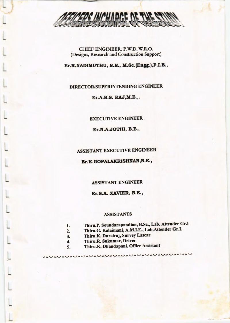
CHIEF ENGINEE& P.\F.D, V.RO.(Desigps, Rcseerch aod Constnrction Support)
ET.R.ilADIilUTIIU, 8.E., U.Sc.(Ettgg.l'F.I.E'
DIRECTOR/SUPERINTENDING ENGIITIEER
E .A-8.S. RA.r"l[.E,.
E)(ECUTTVE ENGINEER
E .I|.A.JOTHI' B.E.'
ASSISTAI\TT E)GCUTTVE ENGINEER
Er.f.G{rPALllXRISEllAf, ,B.E'
ASSISTAIYT ENGINEER
Er.A.A. XAVIER, B.E '
ASSISTAIYTS
l. Thiru.P. Soundarepeadlen, B'Sc', Lab' Attender Gr'I2. Thiru.G. Kataimanir A'M'I'E, Lab'Attender Gr'I'3. Thiru.IC lluniraj, Survey Lrscrr4- Thiru.R Sukumer, Driver5. Thiru.Ii Dhendeprni, Offce Asistrnt
,\/\ ,\ A A /\ A ,\A,/\/\ ,/\A/\./\./\,\ A,\ A /\/\,\/\A /\./\A AAAAA /\/\A/\ }\,\/\/\,\/\ ,\,\,\,\,\A,\
CONTENTS
CEAPTER
O.SYNOPSIS
I.INTRODUCTION
PAGE
I
l.l.1.2.
1.3.
tr. MARI'DEANATIII RESERVOIR
Waterslrcd Manageme,nt BoardSedimentation Studies in TamilnaduObject of Sedimentation SuweY
locationSalieot FeaturesClimateRainfallHydrolorySoil Sampling
2223
4446667
8
I
L
2.t2.t.t.2.22.3.2.42.5
I
I
I
IIL RESI'LTS OFCAPACITY STJRVEY
TVJT,IARUDHANATEI RESERVOIR WATTRSEEI)GeneralSoil ErosionSub Watershed No.lSub Watershed No.2Natural Shola ForestSub Watershed No.3Land Use pattemForest LandBarren LardUncultivable LandWaste IlndCurr€,nt WasteCultivable LandGeology ofSoil
5.0 CONCLUSIONSList of A rexuresList ofFiguresList of PhotograPhs
99910ll12t2l3l3l3l4l4t4t4l5
16l8
I
I
i
l
t
4.14.24.34.44.4.r4.54.6.4.6.14.6.24.6.3.4.6.4.4.6.5.4.6.6.4.7.

MARUD HA N ATH I.\TAT ERSH ED
RES ERVOIRSTUDIES
SYNOPSIS:
Marudhanathi Reservoir constructed &rng 1979 is situated at a distance of
about 15 Kms from Batlagundu Town of Dindigul District in the Southern dope of
Pahni fflls . It is a single purpose reservoir construcrcd for irrigation only' Unda
Vcershed Management Board Scheme Sedimentation smdies have been done. The
first capacity survry has been done io this reservoir in the year 1998 to arsess the
present capacity as well as quentum of silt deposited insi& the reserrtoir' The
capacity of the reservoir dudng 1998 bas been found to be 5.2197 Maam' as against
the original c.pacity of 5.338 lvtcum. in 1979. \\e average annud fting load is
0.@62 Cum.lfear and the average annual silting rate is 0.1163%. Tbese renrhs
have been furnished in tHll Repon No.6/99'
On compleiou of the 6rst capacity suwey, the 
I. IIYIRODUCTIOil
1.1 VATERSHED MANAGEMENT BOARD:
The C-eotral Board of lrrigation and Power after con{ucting sdim€ntation
srudies ii some Nonh Indiao reservoin felt the urgency of taking remedid measures
in the w*ershed ar€as to combat the problem of reservoir sedimentation and
recommended to the C.,errtral and State Governments. Hence the Govemment of
Tamilnadr in G.O-IvIs. No.857 PVD &.. 26.0573 have formed the l7orrshed
lvlanagunent Board"
IJ.SEDIMENTATION STT,]DIES IN TAMILNADU:
The Govemment of Tamilnadu in G.O-MsNo.1704 PlfD drt26'll'74
sanctioned a scheme to do sedirrcnation snrdies in tcu selected reservoirs from
1975 to lgg5. In the secoud phase proramme in G.o.Irls.No.925 dt.8.4.1986
extended the snrdies to eleveo more resenzoirs and tanks The results of the sndies
are reviewed by the Boud in is meetings once in a year and rle remedid rrcasures
,^Le. by the Deparments like Forest and furicuhurd Engineerin& are discusd to
find out the efEcacies of the reuredial rneasures.
h G. O. IvIs . No. 766 PlfD & [email protected] the Govemment have accorded
administrative sanction for ioplemeoation of Tamilnadu wcer Resources
courctidation Prolect at a base cost of Rs. 807.49 crores'
In.G.O.LIS. No. 347 !V(Rl) dt.19.06.97 administrative sanction for
RS.25.OO lakhs was accorded for condrrctiag sedimenation snrdies in rhe following
ten resewoirs /taols.
1. ChinarDam I2. Chiu:rDamtr
3. Marudhonathi Reservoir
4. Parappalar Resewoir
5. Varedhsnrnathi Reservoir
, 6. Pder Porandhaler Reservoir
7. Penrmol Tmt
8. Gomulhi Reservoir
9. Glenmorglrn Reservoir
10. Py'llelr Reservoir
Un&r the control of superintending fugo"*, PEDiWRO nnd llrtctor
Institutc of Hydroulics and Ht'rologr', Poondi md Execttive Engineer
P\\iDi\l'RO. \I'rtershcd Mmegemeot Boatd. Polledi, scfimentetion stu'f,es in
lvlarudhrnethi Reserroir hlce be€n done'
l3. OB'ECTS OF SEDIMENTATION SLIRVEY:
The oblects of the resesoir sedioettltion end w'ercrshed snrdies ue to
1, Detetrniae the preseot capocity of the reservoir'
2. Estimrte dre proSble lbture lifc of rhe reservoir'
3. Correct rhe &pth vernrs clplcity curve of the resewoir md &us to essute mone
cfticiant opention of wetel rclease'
4. Deennine the most economicel md effectiw control mclsulres to redrce the
rlte of silting
5. Prepare regiood sedimmt production indrces tbr dcvelqring desigr &tl
2 JVIARUDHANAT}II RES ERVOIR
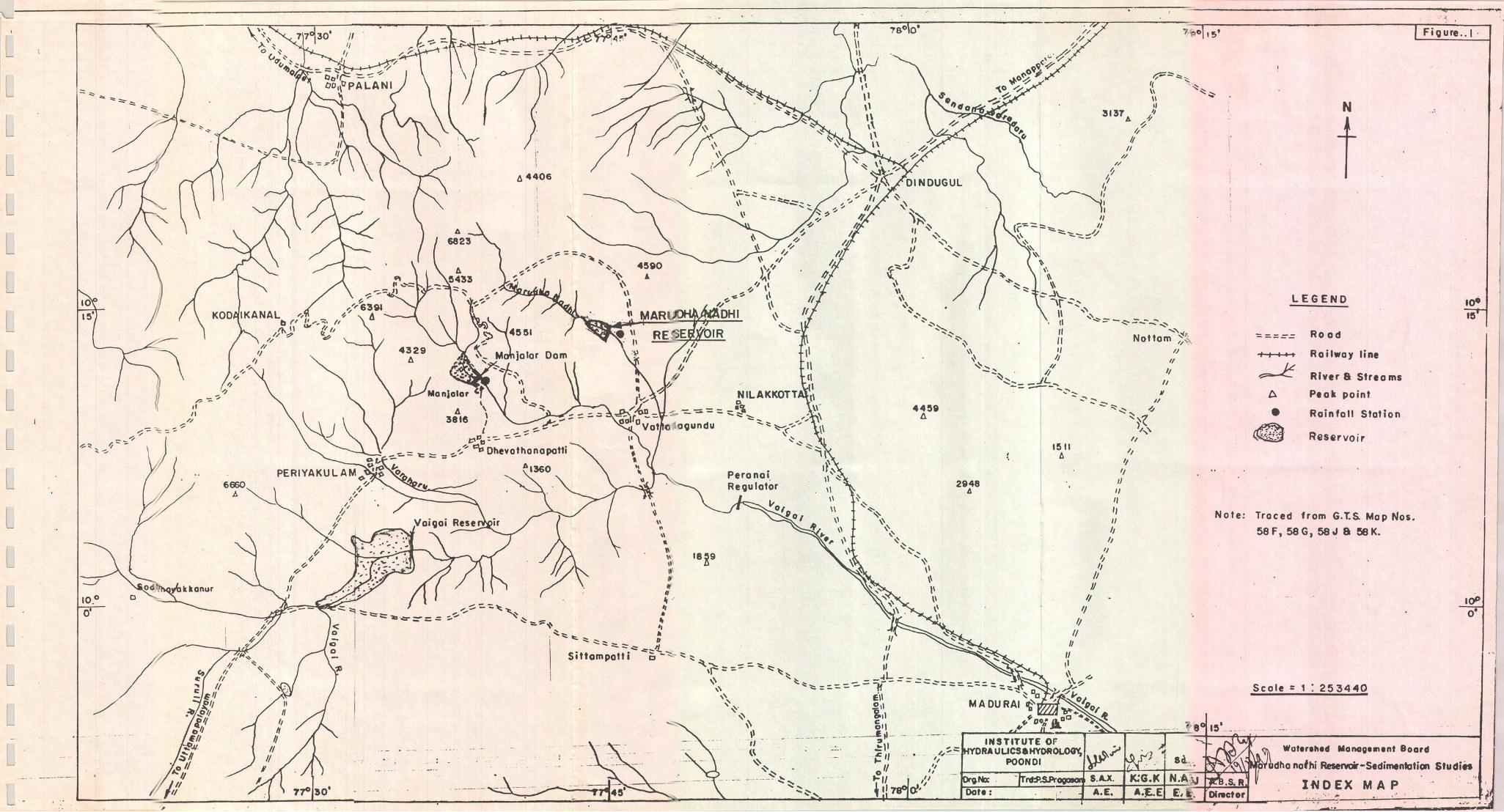
2.1 I.OCATION:
The Manrdhanathi Reservoir across Marudhanathi river, a tribtrtary to vaigai
river is located aroutd v"41, East longtu& and 10"15' North latinrde in the
souniem slope of Palani rfls aud covered by natural boundaries oflocd hills both
in the right 1d tsft flanks' It is situated at a distance of about 15 Kms' from
Batlagundu town in Dindigul districc It was corsrructed in the yar 1979'
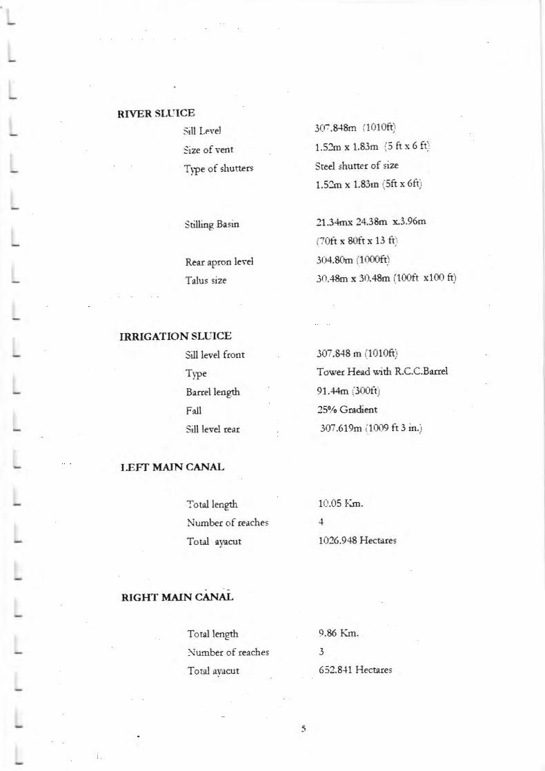
2.1.1. SALIENT FEATURES OF MARI,JDHANATHI RESERVOIR :
DAM
kagrl of Dam S08m (2650 ft)
TopBundl*vel 329.185m (1080ft)
Maxinnrm'lVater kvel 327J55m$07ak)
Full Reservoir lrvel 327 '355m $07aft)
!flatertspread area 0'6596 Sq'KsL (179 Acres)
C*chment area 53'315 Sq'Krrs' (20'80 fu')vfla).c'Value 2000
Maxirnrm Flood Dschatge 420 Cumecs (1a830 cusecs)
C"p..itf 5'335IvLGn (188'50Mcft)
Bed wi&h 5'5 m (18 ft)
SPELITAY CT.JM RTVER SLTIICE
Crestlrvel ' 321'259m (105aft)
No. of Vents 2 Nos'
Size of vents 7'62mx6'l0mQ5 ftx 20 ft)
Discharge 420 Curnecs (14830 cusecs)
Type o{shuaers Steel R'diel Gat€
Topl-evelofShutter !27'355m (L)7aft)
L
L
L
tL
L
L
L
L
L
L
tL
L
L
L
RTVERSLLIICE
Slt tr.vcl 3m'E{&n (1010ft)
Size of vcot l'53m r 1'83o (5 ftx6 ft)
Tvpeofghutters Seel shurtcr of size
1.534 x l.&hr (Sft r 6ft)
stiflingBsia ;##tr;"*Rcrr epron lcvd 304.80m (10mft)
Tdus size j0.'l6m: 30ilEm (100ft 1100 ft)
If,RIGATIONSIffICE
Silt lerd froot 307.848 a (1016i
T]"c Tw'crlladsih R.C.C.Bltrd
B4rrell€dg6 91.{'h (300fti
Fdl 25rlr Gsdint
Sill levd tat 307.619m (1009 ft3 in;
I.EFT MIUNCANAL
Toal lcogd 1t1.05 Ii&Nurnber of cr&cs 4
Totd rput 1O26.948 llccecs
. RIGIIT MNNCAIYALL
I Tot l lcn8th 9.86 lkn.
L Numberoflcechcs 3
I Toal eY*nt 652.8{1 }Iecures
L
tL
2.2. CLIMATE:
The eleve,tion of the catchrnent varies from 419m to 1578m. The highest peak
of the cathmeot is near Thandikudi Vilage. In the hill region the dimate is cool for
about fiye months. In the plain during the summer it is very hot and dry. hgenerally cools down after the monrh of May. During the montls of October to
January the "lit 'rte is cool and pleasant. The average maximum temperature is about
32" C aad average minimum temperature is 26. C in plain and l lo C in rhe hilk.
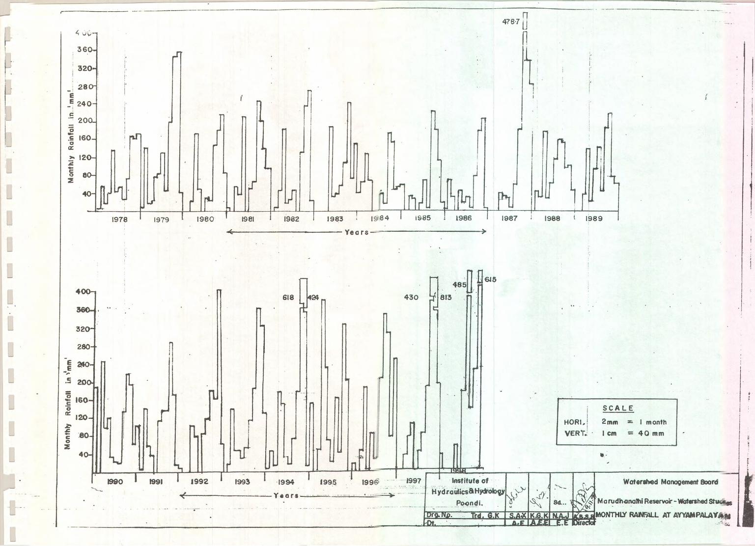
23RAINFALL
The vatenhed lies in the southern slope of Pdani Hills and ea$em slope ofthe !flestem Ghas. Hence during the NonhEaa monsoon the rainfall over the
catchment is heavy, But during the soutlwest moasoon rainfall occurs occasionally.
At the tirre of constnrction of }vlanrdhanathi Dam in 1979, one non-recording rain
guate has b€eo installd and the daily rainfal reading is recorded in Aympalayamsection of P.I7D/!7X-O. From the available data for rh. p.ri"d fuom 1979 to198' it is observed rhat the watenhed of Manrdhanethi p5sv6fu neceives an annual
a'erage minfdl of 1165mm which is much higher than the Tanrlandu state average
of 95088" The Maximrm annual rainfall of 1944mm occtrred during the year 1gZ,Refer annex,re 1 for the mond y totd ninfdl at Manrdhanathi Reservoir and
aancxure 2 for mairn:ru minimum and mean rainfall Refer figure No.3.
2.4.tIYDROIOGY:
The Marudharathi Reservoir is having a smdl catchnrnent area of 53.314
sqJoos. only. The catchruem is draind by two leogthy iungle soeams bcides th€rnain sErlm called lvfartrdhanathi before it is intercepted by the reservoir. This
rescrrroir is the first one across Marudhanathi. As the wrershed is in the souttrera
slope of Palani Hills and eastem slope of lfe*em Ghcs the nra off during
monsoon is very heavy. The reservoir is in rhe foot of the hillc and the cat.hmrt is
hilly dope aud mounainous terrain. Hence whenever rain occurs in the catch"'"nt itis dnhed q*ddy -d the reservoir is filled up very fast. During the Nonh East
rnonsoon, panicular{y during Oaober and November the catchment receives heavy
L
L
L
L
L
L
L
L
L
L
L
tL
L
L
L
L
L
L
L
L
rains From Jamrary to lme the reinfrll is rrri'rirm'mn *e ruaoff bccmes very low,
fre rescrrzcir woer lard @e very fis md &e sorqe mdns rc mcryr€ or
dry. orr of 16 prrs ftom 1982 to 1998 the ct&r'srt rceived Sood rriEs amd
sutplusd 12 d"'"s (Ycar vise nrsrs wifi d*e eodosed ia At,rerue 6).
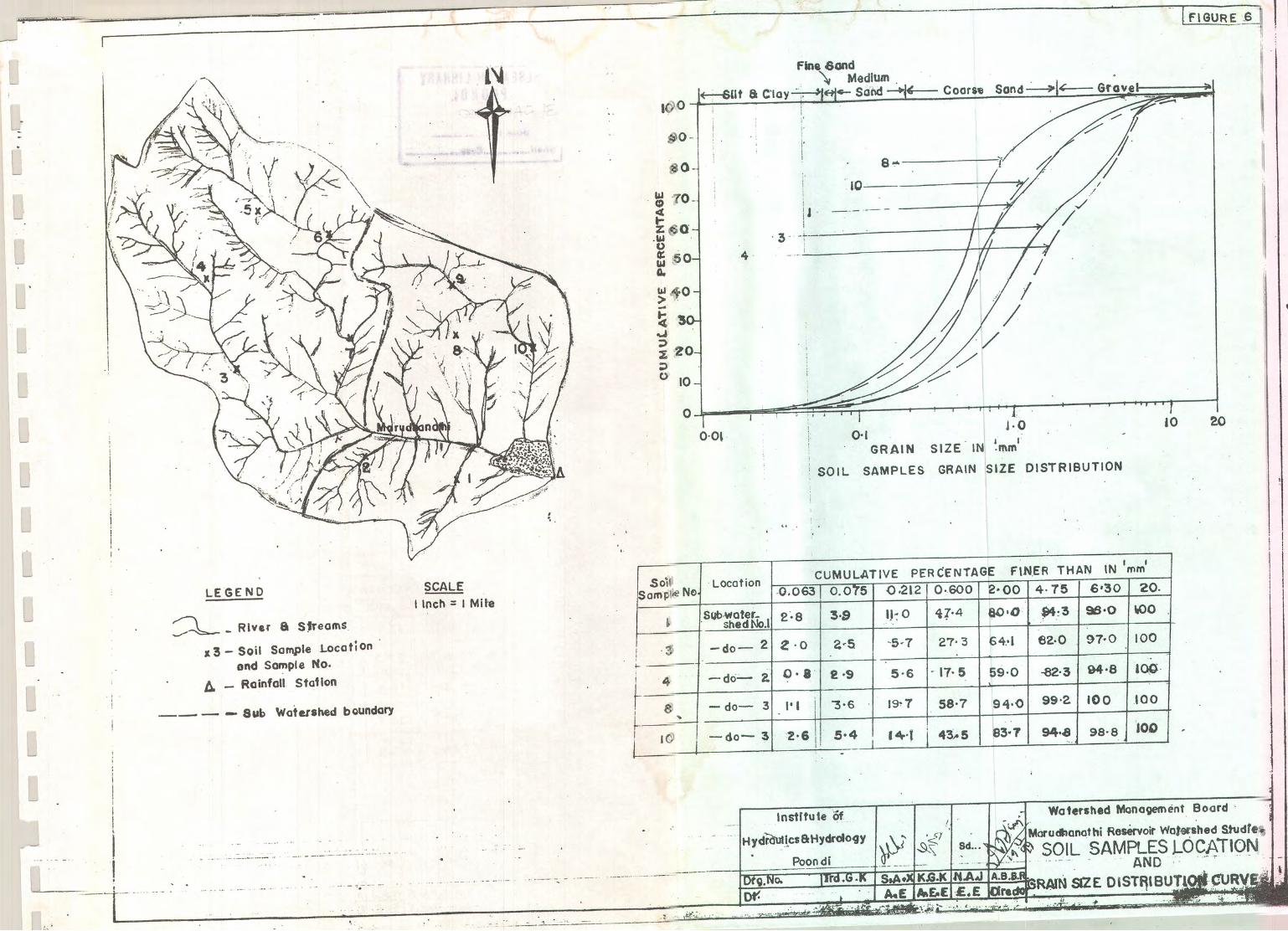
25 SOIL SAT{PLII$G
Surfte rcil sa@iag of scdiocnts wcre dme in a[ pats of &c w*cr:hd
paniarlarly in r[ pcts of the Rcsenrcd fccst sca .!d also fug the bcds of the
river orsc dich dr.r dorm t[e sih* It is ohrcrrrcd 6r thc fieih d4osits dmr
dom are meinb of firc Ur& couoa (2.0296), fine sod (f.89%), one srnd
(39.10%) and gnvdy mil (57.19%). Rder oaesure I,{o{ d Ffutu€ 6).
.L
L
L
tL
L
L
L
L
L
L
L
L
L
L
L
L
L
L
L
L
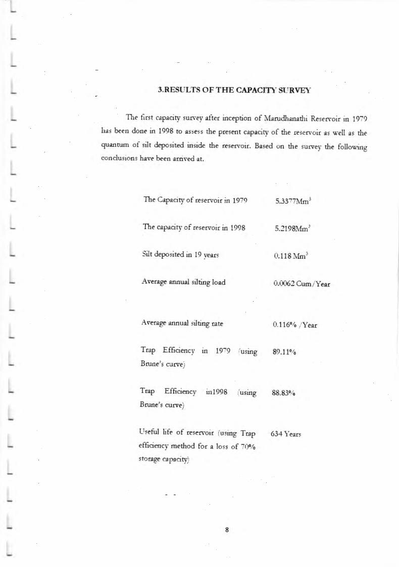
3.NHil,'LTS OF TIIE CAPAC,rI' SLIIYEY
The first crpecity survcy rfur incegtioa of Mrnxlrmrrhi Rcsenroir in 19?9
hes bcco dooe io 1998 to rs$css the ptesmt c*prciry of ttc ressvoit rs lrcn rs rtequ,tte of silt dcpositcd iasilc the !E cryoir Basod m rhc survea rhc follovingcondusioos hrve bcca rrdvcd c
Thc Cryrcity of lesctrrcir in 1979 S33?7Itm3
The crpecity of rcserroir in 1998 5.3199[tlgl!
Silt dcpositad b 19 prrs 0.llg l,frr3
Aveoga rand sihiot l"rd 0.0062 Crm/yelr
Awrrge rnnud siluag ata O.l 16..r. ,ryo"
Top Ef6cicncy in f9:9 iusing 99.lt%Bnrac's curvt)
Tcp Ef6cicncy inf998 ,.frrrog 88.&!/r
Bnnc's orrve)
Ltseirl life of cscrvcir (uriog Ttrp 634 yeers
cfficicocy raethod for e loss of Zf)plo
siongc crp.riql)
4.0 MARUDHANTHI RESERVOIR ITATERSHED
4.1.GENERAL:
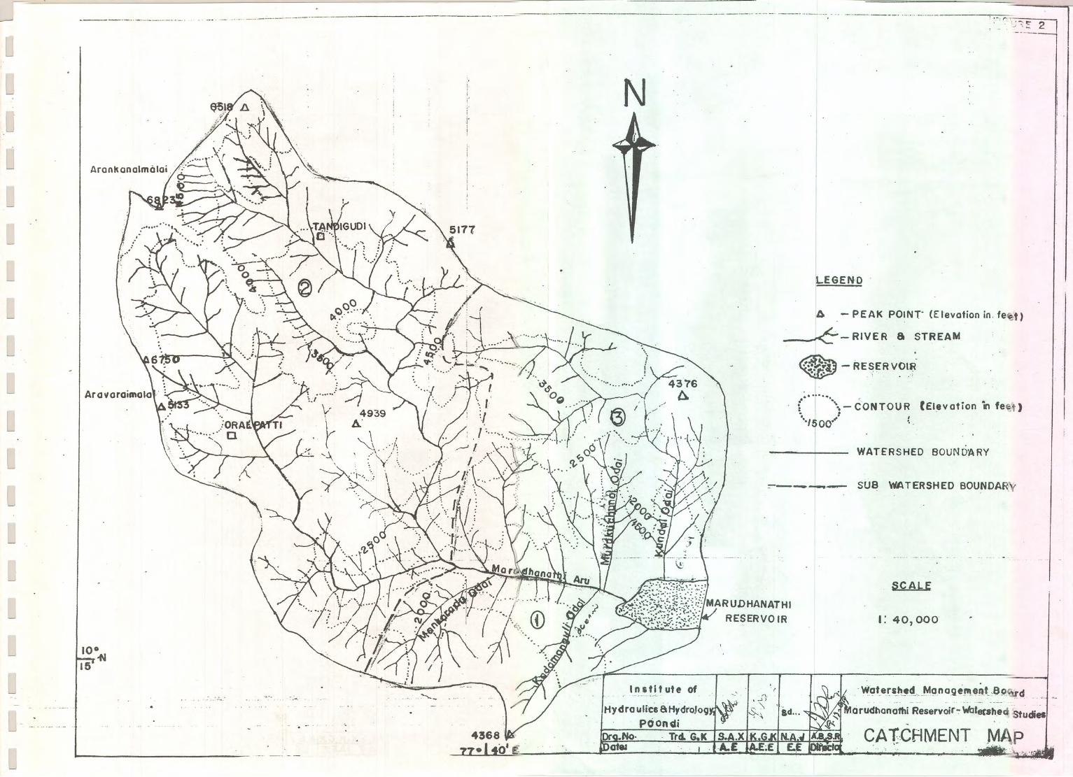
Ite total area of watershed of Marudhanathi Raservoir as per Gfi Map is
53.314 SqJms. It finds place between 7o 30' E elldn " 45' E longinrrde and l0o
15' N and 10" 30' N latitudes. The area comes under mostly forest
wirh few patta lands . For convenience the watershed has been divided into tbrce
sub watenheds. Ihe main stream which is about 12.6 Km in lengttr(utro the
teservoir ) originates at an dtitude of 2080m(6823 ft) at Aradsanal Mdai in the
Annkand Block Reserve forest of Palani llills southern slope. In the same Blo&
another hill stream originates at Karurrarnalai and ioins the main streasr after
running for about 9 Kms. These t'q/o sreams ioined together is calld
Manrdhanathi Aru-
As the main hill strearns originate at about the same elevation and th& place
of origin are just 2.5 Kms apart and the drainage area covered by the two streams is
takeo as one sub-watershed (SMS No.2) and its area is 30.92 Sq.KrD-
On the right side o{ t}re river a few gullies and two str€ ns arc joining and
the same is taken as oue subwatershed$IfS No.l) and it comprises an area of 6.63
Sq.Kms. Similaly on the left side of the river two streams with number of gullies are
joining direcdy and falls in to the reservoir. This is takeu as another zub-wcenhed
(5!(S No.3) and its area is 15.76 Sq.Km
4J.SO[EROSION:
Soil is eroded bywcer (Alhrvid soil), wind (Aeolian soil) and gfazier ( Glsial
soil). Among these the soil eroded and ranspofted by water is predominane The
rain drop which strikes on ground with some terminal velocity impacts the loose soil
panicles and tle soil partides are. detached from tle surface of eani and are
suspended in the rain waer. The suspended soil parides are trausponed by the
rnovement of raitr water. Thus causing erosion of top soil on land and erosion of
stream bqr:Is and be& by flowing water.
I7*er er,osion is further dassifed as sheet erosion, rill erosion, gully erosion ,
channel erosion and uansponadon, The erosion also occurs due to the iatensiry ofnin" erodability of the soil and slope of ttre ground Funher the soil transponed as
suspended material or bed material as rhe case mary be. To mhimise the erosion.,
suiable remedid lneasures suc.h as conrour tillagq terracin6 checldams and other
cross masonry wotkE as well as providing vegeral cover or afforestation have to be
-ko up. For ttris the area is to be studied thoroughly and fre terrair:, nanre oferosioa, tf,e area requires immediate atrention are to be identified rhe studies
cerried out on Marudhanathi reservoir watershed are detailed beloc,
4.3. SI.IBVATERSHEDNO.l.
lvlain sources of waer for this sub basin are from Kada,anguli odai and
lvlaokandu odai coosists of a number of deep aod steep gullies. The m*erialswhich are eroded in deep slopes are dumped as valey fills in the chan rcl bds.These vdlry fills are further being dissected . Hence the silts are supplied by bchfrom the pediments of the deep slopes and also from the loose varlry fills. Nospecific river is flowing iu this zub watershed,other than the jungle $re.ms. Thetopography of this catchment is undulming and often steep. Tte above obserrrrtioa
shows thrt the erosion is basically controlled by foldd sEucrures of hi[s. t16r"o",.as it contains me-imurn 1s6gs1 of gullies ir needs propa. laad use planning and soilconservztrion nreasures like guly plugging, check da$s, dry farming ardafforestation The top soil in this zub watershed is roose block cotton aud easily
erodeble . The geology of ttre watershed is classified mar-in,m as charconite and a
Iitde grenite gpeisses (soil classiGcation map and geologr map of warenhed
endosed in 69.4 and 6g.5).
This w*ershed area consists of maximum of forest area and with some pualands. fl6[6s forest fires are common in this area which affecr ttre forest plantation
and nrrural scrubs. The intensity of gning is very heary in cenain praces where
IO
villages are at the. foot of the hills' Generalb upper reaches are of $eePer sloPes
lying below the ridge level of the watershed'
Natunl tree cover had been subjected to over exploitation in the gast due to
rep€ated i[icit feling, greing ed forest fires during sunmer season' In order to
arrest the soil erosion from the slopes it is sugge$ed to britrg biological upgradation
and resoration of vegetative cover in the forest area of this watershed'
As informations gathered from the Forest Department it is leamt tbat no soil
conservadon work has been caried out so far. only in the Palta latd , some chec.k
dams and cross bunding were provided by the pattadan. To some extent it helps to
prevert the sihation of the reservoir.
4.4 . SI.JB \TATERSHED NO:2
This zub watershed is hilly catchment consisdng of deep and steep gullies as
higher dtitude is 2080m (6823 ft). In this wetershed the river Manrdhanathi is main
source of water whi& is having two mainstreams. The scour in the river is uniform
and soil panides also uniform . As the soil panides progressively finer are
transponed in dowusoeam rmtill it is deposited in the reservoir. The maerid is fine
for considerable depth which is exity eroded by the water being the prinury agent of
the erosion aud transport of eroded materid.
The presence of mosrly detached and coarser soil parrrides on tle soil
surface and soil of a shades lighter than the soil under natural vegetation, are
indications that the organic matter, the colloids and the 6ner soil panides have been
eded on steeper dopes, symptoms of scour from places and deposition of
sediments in the depressions are noticed.
Ttis sub watershed conains maximum number of gullies due its slopy terain
nature and needs chedr dams dry $one contour bunding, guly plqiry. fu this
vraershed is the distant area from the reservoir waterspread ruximum quantity oI
sih could be trapped dong the course of the river naturally.
II
Thxrdikudi villege lies in this aree and human setdements lre scatter rround
this nllagr. Hence top soil disn-rrbance due to hurnen hterterence is very high and in
during reiny seesons, the disorbed soil panicles ere t*ashed off end carried bv tl-re
streams.
4.4.T. NATLIRAL SHOIA FOREST :
The mrural shola forests exist et aldrudes of 1500m end lbove and occupy
the hill slopes. It consists of vast stretches of grass lands and usudlv evergreen trees
*i& height rurving betq,?en 10m to 28rn.
The shola forest is , lugtrly developed peculiar rvoe of vegetarion.
Un&meath the shole iorests, the humidiqv is very high and the evaporetion rlte is
re4: los'. Ground forest does not ocorr inside the shola forests. Ihe humus
content end rrr.ter retrining cepeciw of the soil is vetv high. The naturel shola forest
plalr m important role ia soil rrnd moisure conservltion and prelent erosion.
4.5 SUBWATERSHED NO3:
Broadly spenkilg erees outside the Reserve forest and private pa.tta
os'nership, waste lands under the control oi Revenue depertrneng are due to
contjnuous helvy grezing md entire veget tion has beea destro)'ed. This s,atershed
consists of tno streams Yiz. Fhrrdd odai ard MuruLlrrchunei odai. This catchment
also consists of a number of deep and verv steep gullies. As there is no gullr-
pluggrrg or dreck dams are provided by the Forest Dq>rrrnent most of -,}-re silt
cerried bv fie streems lre directlv deposited into the resersoir sirce the strearns infall
in the w.:terspread arel. Oniy check &ms and cross bunding works rrere done bv
pdvete lrnd oq.'ners ro eschew heaw siltatron in or&r to sdeguard their casher*.
and rnango gr:oves along the,ir fringes oi the rruterspread. In this sub s,etershed also,
it is leamt thet no erosion control measures have been cerried out b,v the Forest
Dqrertrnent.
l2
4.6 T.AND USE PATTERN:
The entire watershed area of Marudhanatii Reservoir is 53.314 sq-kEs is
divided into three convenient sub wser basins. ltis area is funher divided into six
fold "hssification based on laod use as lxr r€r/enrre reconcls and its percenuge are
given belcm,.
1. Forest
2. Barreo land
3. Uncthivable land
4. Cuhivable waste
5, Curot waste
6. Cuhivable land
4.6.1. FOREST I.AND
sL07%
0.n%
0.6%
o.70%
6.4%
40.3ffi
These are not deose forests, es ectually seen in iuogfes, ody hrshes and s-all
trrees gron ing in hilloclrs. In this category there b m6.49 hectares of area occupies
forest areawhich ts 52.07% of totd lend use area- Nearly half of ttre area is shared
by Thandihrdi village. In the forest areas erosion preventing species may be planted
4.62. BARREN I.AND
These lan& comprise of htrlod<s, ro&y orr crops and barren lands and not
suitable for cuhivaioo- In this category an €xtent of 10.45 hectar',es is classified,
w[icl is only 0.20% of the total varershed area- These areas are prone to soil
erosiou because gullies and n'[s form easily, Hence contour trenches, stone walls
and other suitable measures have to be taken-
l3
t.6.3. UNCf I LTTVARI-E L{ND:
- These ere lend occupied bv nser' ch'arulel' txrks' ilhge house sites :nd
road:, etc. Al extent oi 35'01 hecwes i'e' 0'66010 oi the totd eree fall under th:s
cetegorv urd no erosion control me'rsures needed md it cm not be done'
.I.6.4. V'A,STEI-AND:
These ere infertiie land or abgndoned frorn cultiution' c'tlerrrise known rs
mrrgiflal lrmd. ,\n extent of Sl'l5 hectxcs i'e'{'t':L)o6 of the tot'al ere* is:hue by t}i:
tlpe of iurd. Tlis ere* waffrurts immediete soil elosiorr preventing me'esures r's dris
lmd rs ersrly susceptrble to erosion'
4.6.5. CLTRRENT VA-STE:
These ete current cultivable lanrJ, but nos' lbendoned due 1o sc*(cit1' oi
\r'rter or soil iofeailiqv. At anytirne these lmds can be reclai'ned and clo be utilise'l
*s ctltiveble lmd' Arr extent of 3li'52 hecures i'e' 6'0?% falls uader this cetqpry'
Suiteble erosion Prel-etrurrg meesures rre require<i for this cxt€ory of lan<i
immediateh'.
4.6.6. CfrLTrvABI.Ii I-AND:
The erttire l,JId clessGed i rhis cltegory i-. cultis'lted b,r' ursirg dr1' and w'et
crops. An extent of l1-t8.?8 hecteres of lend which is +r'309"0 of the total *retershed
tsllsundfft}riscategory.Theselends*rebundedforretairringwatertbrnrltivation.
ln the sloprng gtound' contorrr bundrng end level terraces s'herever necesse4'' ere
resorted to. The erosion in this ere: is minimum aicePt in the ceses of :loping
Ptround.
In dri: tr,pe lxrd dso' indiscriminatc ploughing opreliots in the sioping
grourrds lre to be evoitlerl AEEonomic pactices and crop totltion nre to lx
introduced in these lands for conserving the feailiw of top :oil and soii moisrure
contents.
l4
L
L
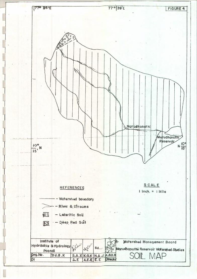
L +7 GEoIoGf,ANDSoIL:
lThcgeologrof&vholeltfuudbaldiRcgvoirv*u*cdorisofL gr.oie and gpeisses of An&€ao Puniod (5oo miltin frs rgo)' DBe drh'nr soil fu 6ud in fiis vrcrshcd. Bleck coaoa sol, cdcucos sotl' srrnd sipg of
L rfuvi.l sorl are fornd r variors fl*es. The ebow coils se c.dy ercdc.
1 Oropc of rocls arc also found in mos of thc rerclu. Tt gcolo6rd soil nryL of the area is shown in figure No.4 & 5'
L
L
L
L
L
L
L
L
L
L
L
L
ttL
'15
5 COIYCLUSIOilS
Based on the above studies ttre fonowing concrusions are arrived at and
suggesrion are given for prwenting soil erosion and to minimise sedimentation oflvlarudhanattri Resenroir.
The main sih bars availaue at places of the river lvlarudhanathi and at theentrance of the Kundd Odai into the Reservoir are periodically removed €very ywduring dry season and utilised in their farms by the rocat ryms, as sit contains mainlybla& coaon (vaadal) sediments. Due to this sediment removal, the annual regularsilt load accumulated inside the reservoir, which affects capacity, and the tife ofreservoir is minimised
The soil in the upstream of the rrlarudhanathi river in the higher ahitudes ofPalaoi Fllls near Thandihdi vilrage area are dim,bed by human interference likedevelopment activities and agricurruml activities. The soil nrrry b. protected bynecessary suiable soil protection mqanres r.ike benchiry so raaining $ruc$resIike stone $ore contour burding in order to reduce the steep sropes and otherhurnan interference on the top soil surface. Suitable vegaative cover zone wise meyplanned taking into coasideration of the avar]able top so and arso the socioeconomical factors of the upstream area local villagen who are mainlydepending upon tf,e forest and also to educate them to use oil cooserv"etion mea:rures.
Frequent fores fues in the reserve forest area are induced in onder to get thefir€srood and it affects very bad} the soil. Necessary f,re watching stations may beset up at the places of occurrences and also planations may be planned so as roavoid neighbourhood forest fires.
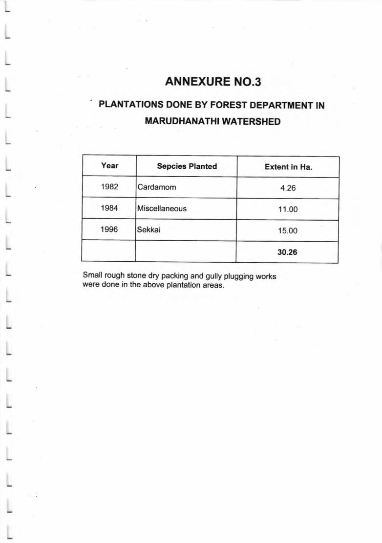
Till &te neitter soil conservation inside Reserve Forestplanution has been taken 6xsepr for an qrent of 30 hectares (see
Hence it is necessary to trlte 5slt 66a""rr"a1on measures earlr.
nor planned
annextre 3).
l6
-L
L
L
L
L
L
L
L
L
L
L
L
L
L
L
L
L
L
L
L
L
Itclc;'ndF.nfr{ila of sol mservnim ?&ildoq ad fu erocdonvill Sfcdl, bcocft ttc vtcrshcd in long temr .rd tb liE of tbc rcserrcir sill hc
pidoopd-
Fc iu&irl urili?dim of rraa rwwoer , 6e my shsdd canl qrdctd hvuogdo' of *u rtro,rs and i"te"sirrc c(forts to bc '"lco for 6c sadyof 6c sr6ce uru rnd l"'d usc pcterrr-
Instituc of ftdrolftr & t!ilrologr,
Pood$402,R,l;lnag,rii1.ll.gg
l7

-L
L
L
L
L LrsToFAr{NHruRES
L. 1. I,ld$yR in6lld*rof AyrupalrlnmRriofrtlk&!,
L2. Annudlrqimo,Itl'mimmand'.e". nin6l
I
L 3. DcrilsofpLmaionsdonebyforrestDcporrmt
L a. Sofsrdcrnrh*rcsubs"
I 5. I +nrl use cletdGcdoo.L
6. Yeer wLc srpftx dct-:ts of Mrrudhrnrfri Rcscntie
L. 7. pLedi6s, Sqgc$d zonewisa
ttL
tL
L
L
L
L
L
r8
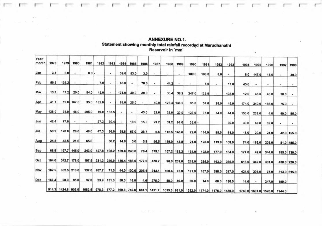
ANNEXURE NO.l.Statomont rhowlng monthly totrl ralnfall Ecored at marudhan.thl
Reletyolr ln 'mm'
Y..r/month t078 I e7e r080 teSl 1982 1e83 re84 rt85 l98G te87 I988 lt80 te90 t09l 1rg2 1093 tota re95 le06 t9et t9e8
J!n 3.1 8.0 6.0 39.0 53.0 3.0 r80.0 100.0 8.0 0.0 147.0 15.0 30.0
Fob 50.5 130.2 7.O G5.0 70.0 4.2 5,0 17.0 4s.0
ir.r 13.7 17.2 20.0 54.0 45.0 t3t.0 30.0 30.0 30.4 38.2 24r.O 139.0 138.0 12.0 45.0 45.0 30.0
Apr 41.1 19.0 't67.0 35.0 182.0 88.0 25.O 40.0 176.a 134.2 95.0 54.0 s8.0 45.0 171.O 340.0 '186.0 75.0
May 126.O 75.0 4E.0 205.0 19.0 183-5 45.0 32.6 28.0 20.0 123.O 37.0 74.O 44.0 150.0 232,0 4.0 99.0 55.0
Jun 42.4 7t.o 27.3 30.4 18.0 15.0 29.2 59.2 91.0 32.0 30.0 30.0 89.0 82.0
Jul n.2 128.0 28.0 /f8.0 47.3 3C.0 38.8 07.0 28.7 6.5 116.5 146.6 22.O 114.0 85.0 51.0 tG.0 20,0 21.O 12.O 155,0
Aur u,5 4).5 21.O 6t.0 5r.2 ta.0 5.0 5.8 5C5 't59.0 at.8 21.0 128,0 t13.0 tm.0 71,O 1c3.0 203.0 8t.0 485.0
S.D 68.9 1r7.7 t45.0 24t.O 1n.8 r08.2 lac.c 2tO.8 7t.1 t7t.l 157.2 183.2 t!t.0 120.0 1ff .o t?t.0 17t.0 a:r.o t44.0 185.0 130.0
Oci I Ga.o u2.7 178.0 1e7.5 231.3 21/,..4 l!to.a r88.0 1ft.2 174.7 9G.0 200.0 218.0 28s.0 I fit.o 360.0 c!8.0 3ail.0 301.0 4:t0.0 220.o
Nov t 6:t-5 352.5 213.0 t37.0 zt't., ,1.0 4.0 100.0 205.4 313.1 l00.tl 75.0 101.0 I tr.o 3e8.0 317.0 tu2a-O 201.0 75.0 813.0 c15.0
Dac 1l,7.1 28.0 8n.0 92,0 23.e 15t.0 !10.0 ti.0 a.c na.o /.8.0 tO.0 60.0 ta.0 co.0 130.0 ta.0 u7.o 180.o
e14.3 11iU.O e03.0 t 082.5 er8.3 8f7.2 7Ce.8 742.t ocl.l l/tl1.7 t015.3 98r.0 1332.0 1,n1.O I176.0 l/80.0 17lo.0 lmt.0 r524,0 l9aa.0
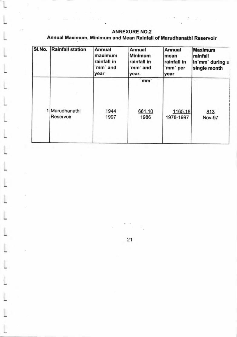
ANNEXURE NO.2Annual ilaxlmum, Mlnimum and Mean Rainfall of Marudhanathl Reservolr
Sl.ilo. Ralnfall Btatlon Annualmaximumrainfali in'mm'andyear
AnnualMinlmumrainfall in'mm'andyear.
Annualtn€anrainfall in'mm'peryear
Marimumralnfallin'mm' during asinole month
1 MarudhanathiReservoir
19441997
mm
661.101986
1165.181978-1997
El_ltNov-97
21
L
ANNEXURE NO.3
I PLAlrtTATK)itS DONE By FOREST DEpARTtElttT tt{L mARUDIIAilATHIwATERsHED
L
L
L
L
L
L
L
L
L
L
L
L
L
L
L
L
Yeer SepclecPLnbd Exicnt ln Ha.
1982 Cardamm 4.26
1984 Miscdlaneous 11.00
19S6 S€ld€i 15.00
3026
Small oqgh sfime dry padring ard gully plugghg tflork8were done in the abwe flanta[im areas.
ttlrlrll,tlllllllll
ANIIIEXURE 4iIARUTHANATHI RESERVOIR WATERSHED RESULTS OF SOIL
SAMPLE ANALYSIS
Gl Na
Locatlon of30ll
Samole
Cumulatlvo Percontage Flner than ln'mm'
0.063 0.075 o.212 0.6 2 4.75 6.3 20
1 Sub Waterched No.l 2.8 1 .'l 7.1 36.4 32.6 14.3 37 2
2 Sub Watorhed lto.l3.9 1'.| 47.4 80 94.3 98 't00
1.6 't.1 6 37.4 46.5 4.3 1.4 1.7
3 Sub Watershed No.22.7 4.7 46.1 92.6 96.9 98.3 100
2 0.5 3.2 21.6 36.8 't7.9 15 3
4 Sub,WateBhod No.22.5 5.7 27.3 64.1 82.3 97 100
0.8 2.1 2.7 11.9 41.5 22.3 12.5 5.2
5 Sub.Wat6rshed No.22.9 5.6 17.5 59 82.3 94.8 100
3 2.4 5.2 38.1 33.9 13.4 1.9 2.1
6 Sub.Watershed No.25.4 10.6 48.7 82.6 96 97.9 100
3.2 1.6 9.7 35.4 34.3 't1.2 3.4 1.2
7 Sub,WatoEhed No.24.8 14.5 49.9 u.2 95.4 98.8 100
0.7 1.9 15.4 32.8 40 6.5 1.4 1.3
8 Sub,WatoEhod ilo.32.6 18 50.8 90.8 97.3 98.7 100
1.1 2.5 16.1 39 35.3 5.2 0.8
I Sub.Weterrhed l{o.33.6 14.7 58.7 94 99.2 100 100
2-4 2.9 11.3 31.6 35.1 10.3 4 2.4
l0 Sub.Watenhed i,lo.35.3 16.6 4A-2 83.3 93.6 97.6 100
2.6 2.8 8.7 29.4 40.2 1 1.1 4 1.25.4 14.1 43.5 83.7 94.8 98.8 100
23
r ! r r I I I M ,.1 I I I ! I I I I-_t
ANNEXURE.sStatement showlng the land use classlflcation in the Watersheds of
Marudhanathl Reservolr.
Sl.No. Name ofvlllage
Totalarea
ForestLand
Barren!and
Uncultivableland
Cultlvableland
Currentwasteland
rcultlvableland
ln Hectrrar
I Thandikudi 'r960.62 1141.21 4.41 7.57 6.34 141.44 659.65
2 Pullathur 1364.58 245.08 4.24 2.05 8.73 133.52 970.96
3 Pannaikadu 2006.20 1390.20 1.80 25.39 22.08 48.56 518.17
Total 5331.'O 2776.4tt 10..15 3s.01 37.'t5 323.52 2148..78
24
ltrllllllllllllllllll
ANNEXURE NO.6YEAR WSE SURPLUS DETAILS OF MARUDHANATHI RESERVOIR
Sl.No. Year Date ofsurplus
Peak Flow Release Totaldischarge
Mcft.
Dischargeirrlgatlon
Mcft
Surplus Let lnRiver Mcft.
Gusecs Date1 1982-83 16.11.82 205 18.11.92 336.772 336.7722 1983-84 14.02.84 't 105 06.03.84 934.329 674.650 259.683 1984-85 374.949 374.9494 1985-86 236.89 236.8905 1986-87 345.1S7 345.1976 1987-88 27.10.97 3620 20.'t1.87 3051.815 614.170 2737.657 1988-89 18.09.88 146 18.12.88 675.686 608.430 67.268 1989-90 12.01.90 90 16.01.90 686.409 583.200 103.219 1990-91 05.11.90 284 12.11.90 550.097 304.992 245.11't0 1991-92 06.11.91 100 07.'t1.91 362.295 362.29511 1992-93 14.11.52 1500 21.11.92 1305.42 324.240 981.18'12 1993-94 06.11.93 3750 09.11.9313 1994-95 12.11.94 1060 12.11.94 102614 199$96'15 1996-97't6 1997-98 10.11.97 800 '10.11.9717 1998-99 8.1 1 .98 1856 8.11.98
25
. ANNEXURENO.TLtsT oF SPECIES FOR PLANTTNG (ZONE WSE) tN WATERSHEO OF
MARUDHANATHI RESERVOIR
NATIVE SPECIES FOR GAP PLANNNG.
il. lllDoLE zoNE (AssET GREAT|NG ZONE)A.FRUIT BEARII{G SPECIES:
Sl.Io. Botanlcal Name Common J{ame Tamil Name1 Foronia elephantum Wood apple Vila2 Anona squamosa Custard apple Seetha3 Ziziphus mauritiana Jujuba Elanthai4 Emblic officinalis Emblic myrabolan Nelli5 Tamarindus indica Tamarind Puli6 Azadirachtra indica Neem Vembu7 Pongamia pinnata Punqam Punqam
B.SMALL TIMBER SPECIES:Sl.No. Botanical l{ame Common Name Tamil Name
1 Albizzia lebbeck East lndian Walnut Vagai2 Dendrocalamus strictus Bamboo Moonoil3 Bassia latifolia Mohawa llluppai4 Wrightia tinctoria lvory wood Veppalai
26

il.LOWER SLOPE (TNTERFACE ZONE)A, FUELWOOD SPECIES:Sl.No. Botanical Name Common Name Tamil Name
1 Albizzia amara Urilella thom Uril2 Acacia leucophelea White acacia Velvel3 Holoptelia inteqrifolia Kaniu.lndian elm Avie4 Acacia holosericia Holosericia Mankathuvel
B. FODDER SPECIESSl.No. Botanical Name Common Name Tamil Name
1 Acacia Leucophloea White acacia Velvel2 Hadwickia binate Anian Achan3 Albizzia lebbeck East lndian Walnut Vaqai4 Gliricidia maculata Gliricidia Gliricidia5 Leucaena leucocephala Subabul Savandalb Pithecolobium dulce Manila tamarind Koddukkapuli7 Libiscus tilliaceous Attupoovarasu8 Morinqa concanesis Kaftumurunqai
C.GREEN iIANURE LEAF SPECIESSl.No. Botanical Name Common Name Tamil ame
Gassisa siamea Poonavarai Manialkonnai2 qcadirachta indica Neem Vembu3 Thespesis DoDUlnea Portia tree Poovarasu4 Gliricidia maculata Gliricidia Gliricidia5 Delonix elata Vademudakki Vadanarayana6 Ponqamia pinata Punqam Punoan
27

IV. SPECIES TO BE PLANTED FOR VEGETATIVE CHECK DAiISAND SO]L COT{SERVANON WORKS
Sl.No. Botanical Name Gommon Name Tamil Name1 Commiphora benyi Kiluvai Mul Kilvai2 Commiohora caudata Kiluvai Pachai Kiluvai3 Delonix elata (cuttinos) Vadamudakki Vadanaravana4 Glircidia maculata (cuttinos) Glircidia Glircidia5 Ficus benoalensis (cuttinos) Banyan Alamaram6 Dendrocalamus strictus
(alono the stream banks) Bamboo Moonqil7 Ficus retusa llchi Kal ltchi
V - SPECIES TO BE RAISED IN FODDER BANKSl.No. Botanical Name Common l{ame Tamil Name
1 Acacia leumphloea White acacia Velvel2 Hardwickia binata Anian Achan3 Albizzia lebbeck East lndian walnut Vaqai4 Glircidia maculata Glircidia Glircidia5 Leucaene leucoceohala Subabul Gavandal6 Pithecolobium dulce Manila tamarind Kodudukka ouli7 Hibiscus tiliaceus Attupoovarasu8 Morinqa oleifera Drum stick MurunoaiI Morinoa concanensis Kattumurunqai10 Sesbania qrandiflora Aqathi Aqathi11 Launaea coromandelica Hinqan Odiyamaram
VI . SPEGIES FOR PLANTING INSIDE THE TRENCHES
28

qI
L
L
L
L
'^L
-L
L
L
L
;Lt
tI
L
L
L
L
LreL
L
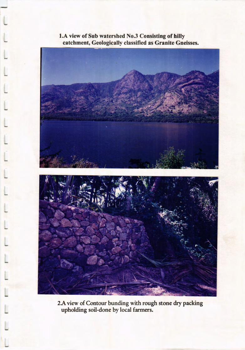
I . A vicn' of Sub mtershcd !{oi Coasisting of hilly et r''r'€ot,
Gcologiolly &ssified rs Gaoitc Gndsses.
3. A rio of Contour bnrnding rtth roug! stone dry pocking upboldrng soil-
donc brv lool tirmcrs,
3. lie&ormguli OrJri crossingr the slopy firrr llodlt tte conflucnce ofMmr&rsuthi dvcr shorring errL Gtriniag shrciscs coastnrcted by
locel ticncn peventiag uphod soil erosioa-
4. .{ vics, of top soil nnd lxd mltcrhls crrtied runy by nr* flood in
GunddO&i.
5. Mrodhrorthi River protccted on both sides I rivct r"dn;'tg $Ell L11
si& ough stoae eod riglt si& RR mrsonry doac bry locd frrmers.
6, A vies. of r ctoss mrsouy dop w.ll io }habtret Odri.
?. .l vrcw of cetdc gazing ia wtershcd- &megiag vegetrdvc covec
L Slopv ufluds lte protccud bv sione vdls ewrting top soil crosioldooe
by locd firmcrs.
9. Vics, showilg tLc hillv crtctmert in thc left llrot of w*ctsgerd.
,,,I
L

l.A view of Sub watershed No3 Consisting of hillycetchment, Geologically classified as Grenite Gneisses.
2.Aview of C.ontour bunding with rough stone dry packingupholding soil-done by locd farmers.
1.A view of Sub watershed No3 Consistlng of htllycetchment, Geologically classified as Grenite Gneisses.
2.A view of C-ontour bunding with rough stone &y packingupholding soil-done by local farmers.
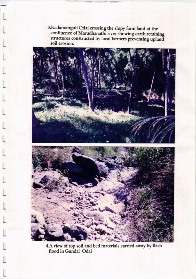
3Jfudamanguli Odai crossing the slopy frm land-at theconflugnce of Marudhan*hi {u." stiiwng earth retainingstructures constructed by local farmers preventing uplaniisoil erosion.
4.Aview of top soil and bed materials carried away by flashflood inGundal Odai

S.Marudhanathi River protected on both sides by rivertraining wall left side rough stone and right side RRmasonry done by local farmers
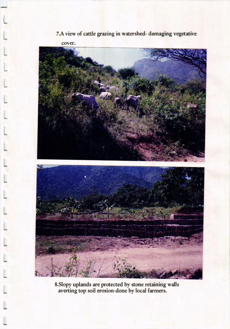
7A view of catde grazing in watershed- damaging vegetative
cover.
8.Slopy uplands are protected by stone retaining wallsaverting top soil erosion-done by local farmers.
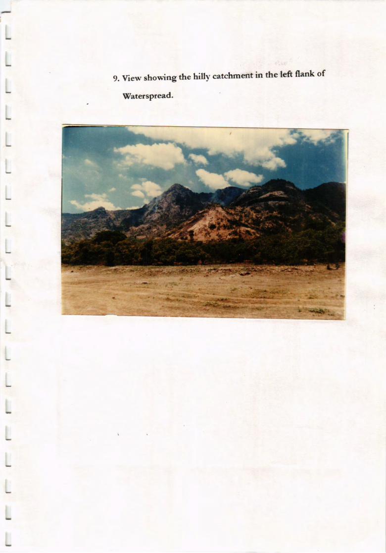
9. Yiew showing the hilly catchment in the left flank of
Waterspread.
4L
L
L . LISTOFFIGTJRES
L Lr.dexlfap
L 2.codmcntlvfep
L 3AainhllcLen
. LsoilMap
Ls.GcologyM.p
t 6soil sa@es Locaim aod C*ain size distribttin orrcg
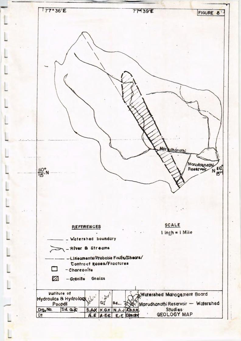
sFEnExc,.t,
- h/olr r. h a6 boundotY
E]@
ts\-'Rlror I 6lr.om.
-Ltti'.dr.ntr/Ptcbou. Fdtk^bo./tonlro cl tc!aalFroctur.r
- Chorconitc
- 6r3ail3 Gnols3
SCALE
I lnch.. I Mile
Xlc(arlhcd lthilogqmenl Boord
Mgrudhonothi R6sewoir - Wotorshed
lrutiluta olB Hydro
Studirs, OEOLOGY MAP