Forager–farmer connections in an 'unoccupied' land: First contact on the western edge of LBK...
12
Forager–farmer connections in an ‘unoccupied’ land: First contact on the western edge of LBK territory Bart Vanmontfort * Faculty of Archaeology (Leiden University), c/o Prehistoric Archaeology Unit (K.U. Leuven), Geo-Institute, Celestijnenlaan 200E – pb 2409, B-3001 Leuven (Heverlee), Belgium article info Article history: Received 12 September 2006 Revision received 18 March 2008 Keywords: Neolithisation process Mesolithic Hunter–gatherer Neolithic Linearbandkeramik Site location choice abstract The interaction between local foragers and incoming farmers is one of the hot topics in the study of Eur- ope’s recent prehistory. In Central and Western Europe’s loam region, occupied by the first farmers of the Linearbandkeramik (LBK), hunter–gatherer remains are scarce and consist mostly of surface finds. Hence, the hunter–gatherer occupation and activity on the loess has never been studied in detail. This paper tackles the problem of the visibility of hunter–gatherer activity on the loess belt. An interregional com- parison of microlith datasets allows identifying behavioural changes and differences in exploitation intensity. With regard to forager–farmer interaction, a mutual influence in the spatial patterning of activ- ity or settlement is demonstrated. Ó 2008 Elsevier Inc. All rights reserved. The loess belt during the Early Holocene: unoccupied land? The interaction between local foragers and incoming farmers is one of the hot topics in the study of Europe’s recent prehistory. It is closely related to the debate on the Neolithic spread over the con- tinent. Traditional models of demic diffusion, in which agriculture was introduced in large parts of Europe by rapid movement of farmer communities, have been put in perspective by the acknowl- edgement of the complexity of the Mesolithic–Neolithic transition. Rather than a single process, this transition can be viewed as a mo- saic of regionally varying and complex interactions between hun- ter–gatherers and immigrant farmers (e.g. Dennell, 1985; Price, 2000; Tringham, 2000; Zvelebil, 2004; Zvelebil and Lillie, 2000). In the mid 6th Millennium cal BC, the loess region of Central and Western Europe was colonised by the first farmers of the Lin- earbandkeramik (LBK). The limits of LBK distribution correspond to one of the major agricultural frontier zones indicated by Zvelebil and Lillie (2000). The strict synchronism and contact between the last hunter–gatherers and first farmers within this frontier zone and thus the existence of a long availability phase (sensu Zvelebil, 1996; Zvelebil and Rowley-Conwy, 1986) is often as- sumed (Kind, 1997, pp. 129–133; Louwe Kooijmans, 2007; Van Gijn and Louwe Kooijmans, 2005; Verhart, 2000). It remains, how- ever, difficult to demonstrate in the archaeological record. This is due to the scarcity of known sites from the Late or Final Mesolithic (Gronenborn, 1999; Jochim, 1990; Kind, 1997, pp. 19–20) and to problems associated with the dating of those sites. The few avail- able dates for Late Mesolithic sites beyond the 5300 cal BC LBK ar- rival date have been contested (see Crombé et al., 2005). Despite some indications of contact and exchange (Amkreutz et al., in press; Verhart, 2000, 2003; Zvelebil, 2000), it remains difficult to identify the nature of the forager–farmer relationship and even more difficult to associate changes in the behaviour of the last hun- ter–gatherers on the Pleistocene coversands with the arrival of the Neolithic. In order to understand the Mesolithic–Neolithic transition a better knowledge of forager–farmer contacts is necessary. These contacts are likely to have affected the nature and rate of the tran- sition (e.g. Zvelebil and Lillie, 2000). The loess belt, as the first re- gion in Central and Western Europe to be occupied by Neolithic settlers, could have been the scene of such contacts. Evidence for hunter–gatherer activity on the loess is, however, scarce. A few sites are known in the floodplains of the rivers cutting through the loess belt (Kind, 2003; Mees et al., 1994; Parent et al., 1987; van der Sloot et al., 2003), but most remains consist only of Meso- lithic points that were found isolated or within Neolithic flint scat- ters. This case holds true for most of the Northwest European loess region (e.g. Koch, 1998; Street et al., 2001, p. 428). No Atlantic hun- ter–gatherer camp sites have been excavated on the loess plateaus and the question arises as to what extent these plateaus were actu- ally occupied. The scarcity of data from the loess region has often been re- garded as a confirmation of the loess plateaus’ unappealing nature for late hunter–gatherers due to its dense Atlantic forest cover and presumed low general biodiversity (e.g. Garnett, 1945; Gronen- 0278-4165/$ - see front matter Ó 2008 Elsevier Inc. All rights reserved. doi:10.1016/j.jaa.2008.03.002 * Fax: +32 16 32 29 80. E-mail address: [email protected] Journal of Anthropological Archaeology 27 (2008) 149–160 Contents lists available at ScienceDirect Journal of Anthropological Archaeology journal homepage: www.elsevier.com/locate/jaa
Transcript of Forager–farmer connections in an 'unoccupied' land: First contact on the western edge of LBK...

Journal of Anthropological Archaeology 27 (2008) 149–160
Contents lists available at ScienceDirect
Journal of Anthropological Archaeology
journal homepage: www.elsevier .com/locate / jaa
Forager–farmer connections in an ‘unoccupied’ land: First contacton the western edge of LBK territory
Bart Vanmontfort *
Faculty of Archaeology (Leiden University), c/o Prehistoric Archaeology Unit (K.U. Leuven), Geo-Institute, Celestijnenlaan 200E – pb 2409, B-3001 Leuven (Heverlee), Belgium
a r t i c l e i n f o a b s t r a c t
Article history:Received 12 September 2006Revision received 18 March 2008
Keywords:Neolithisation processMesolithicHunter–gathererNeolithicLinearbandkeramikSite location choice
0278-4165/$ - see front matter � 2008 Elsevier Inc. Adoi:10.1016/j.jaa.2008.03.002
* Fax: +32 16 32 29 80.E-mail address: [email protected]
The interaction between local foragers and incoming farmers is one of the hot topics in the study of Eur-ope’s recent prehistory. In Central and Western Europe’s loam region, occupied by the first farmers of theLinearbandkeramik (LBK), hunter–gatherer remains are scarce and consist mostly of surface finds. Hence,the hunter–gatherer occupation and activity on the loess has never been studied in detail. This papertackles the problem of the visibility of hunter–gatherer activity on the loess belt. An interregional com-parison of microlith datasets allows identifying behavioural changes and differences in exploitationintensity. With regard to forager–farmer interaction, a mutual influence in the spatial patterning of activ-ity or settlement is demonstrated.
� 2008 Elsevier Inc. All rights reserved.
The loess belt during the Early Holocene: unoccupied land?
The interaction between local foragers and incoming farmers isone of the hot topics in the study of Europe’s recent prehistory. It isclosely related to the debate on the Neolithic spread over the con-tinent. Traditional models of demic diffusion, in which agriculturewas introduced in large parts of Europe by rapid movement offarmer communities, have been put in perspective by the acknowl-edgement of the complexity of the Mesolithic–Neolithic transition.Rather than a single process, this transition can be viewed as a mo-saic of regionally varying and complex interactions between hun-ter–gatherers and immigrant farmers (e.g. Dennell, 1985; Price,2000; Tringham, 2000; Zvelebil, 2004; Zvelebil and Lillie, 2000).
In the mid 6th Millennium cal BC, the loess region of Centraland Western Europe was colonised by the first farmers of the Lin-earbandkeramik (LBK). The limits of LBK distribution correspond toone of the major agricultural frontier zones indicated by Zvelebiland Lillie (2000). The strict synchronism and contact betweenthe last hunter–gatherers and first farmers within this frontierzone and thus the existence of a long availability phase (sensuZvelebil, 1996; Zvelebil and Rowley-Conwy, 1986) is often as-sumed (Kind, 1997, pp. 129–133; Louwe Kooijmans, 2007; VanGijn and Louwe Kooijmans, 2005; Verhart, 2000). It remains, how-ever, difficult to demonstrate in the archaeological record. This isdue to the scarcity of known sites from the Late or Final Mesolithic(Gronenborn, 1999; Jochim, 1990; Kind, 1997, pp. 19–20) and to
ll rights reserved.
problems associated with the dating of those sites. The few avail-able dates for Late Mesolithic sites beyond the 5300 cal BC LBK ar-rival date have been contested (see Crombé et al., 2005). Despitesome indications of contact and exchange (Amkreutz et al., inpress; Verhart, 2000, 2003; Zvelebil, 2000), it remains difficult toidentify the nature of the forager–farmer relationship and evenmore difficult to associate changes in the behaviour of the last hun-ter–gatherers on the Pleistocene coversands with the arrival of theNeolithic.
In order to understand the Mesolithic–Neolithic transition abetter knowledge of forager–farmer contacts is necessary. Thesecontacts are likely to have affected the nature and rate of the tran-sition (e.g. Zvelebil and Lillie, 2000). The loess belt, as the first re-gion in Central and Western Europe to be occupied by Neolithicsettlers, could have been the scene of such contacts. Evidence forhunter–gatherer activity on the loess is, however, scarce. A fewsites are known in the floodplains of the rivers cutting throughthe loess belt (Kind, 2003; Mees et al., 1994; Parent et al., 1987;van der Sloot et al., 2003), but most remains consist only of Meso-lithic points that were found isolated or within Neolithic flint scat-ters. This case holds true for most of the Northwest European loessregion (e.g. Koch, 1998; Street et al., 2001, p. 428). No Atlantic hun-ter–gatherer camp sites have been excavated on the loess plateausand the question arises as to what extent these plateaus were actu-ally occupied.
The scarcity of data from the loess region has often been re-garded as a confirmation of the loess plateaus’ unappealing naturefor late hunter–gatherers due to its dense Atlantic forest cover andpresumed low general biodiversity (e.g. Garnett, 1945; Gronen-

1 In his typology of the Campine Mesolithic, Vermeersch (1984) restricted thechronological implications of his distinguished groups to the 8000 BP boundary oftrapeze presence/absence. The latter distinction is also what Lanting and van derPlicht (1997/1998, p. 136) regard as the only reliable distinction between an Early andLate Mesolithic.
150 B. Vanmontfort / Journal of Anthropological Archaeology 27 (2008) 149–160
born, 1999, p. 137; Modderman, 1988; Verhart, 2003; see alsoGregg, 1988). The general decrease in number of sites during thelater Mesolithic phase would thus represent a shift in the settle-ment pattern (Gronenborn, 1999). Other scholars are convincedthat hunter–gatherers did frequent the loess plateaus, but thattheir remains were destroyed or obscured by post-depositionalprocesses: soil erosion affects plateau slopes and their edges,whereas the eroded sediment is deposited at the footslopes andin floodplains (e.g. Bogucki and Grygiel, 1993; Crombé and Cauwe,2001; Gob, 1990; Kind, 2003; Modderman, 1988; Vermeersch,1990; Zvelebil, 2000). Mesolithic camp remains can therefore bewashed away or covered by sediment. Sites as Rebecq-Le Spinoi(Bosquet and Jadin, 1996) and Bedburg-Köningshoven (Street,1995) are two clear, Early Mesolithic examples of such situations.The hunter–gatherer camp of Rebecq was covered by colluviumand did not leave a single trace at the present-day surface. Themain settlement area of Bedburg was destroyed by lignite quarry-ing, which at the same time caused the discovery of its displacedremains in the calcareous gyttja top fill of a silted-up meander(Street, 1995). An absence of hunter–gatherer activity in the loessregion can thus not be claimed a priori, but traces are more difficultto identify then elsewhere.
In this paper, a method is developed to map hunter–gathereractivity in regions like the loess region, where data on the Meso-lithic occupation is meagre. Available data are, on a microregionalscale, translated into chronological sequences. The interregionalcomparison of these sequences allows identifying changes inexploitation intensity on a regional scale. Mapping hunter–gath-erer activity this way could also shed a light on forager–farmerinteractions and the Mesolithic–Neolithic transition. Existent mod-els of Neolithisation can be verified, for instance with regard to thequestion of whether the first forager–farmer contacts in this regionwere of a cooperative (Bogucki, 1988; Gregg, 1988; Zvelebil andLillie, 2000) or an antagonistic (Keeley, 1992) nature. In this paper,the method is applied to the loess belt region of present-day Bel-gium and the Netherlands, i.e. the northwestern extension of Lin-earbandkeramik colonisation.
Methods
The low number of diagnostic artefacts and the frequentpalimpsests severely hamper the chronological separation of occu-pation remains from different Mesolithic phases and thus the clas-sification of Mesolithic surface scatters or isolated finds. It mayeven prove difficult to distinguish them from Neolithic material.Only Mesolithic points can be attributed to a particular phase witha reasonable degree of certainty, but due to the palimpsest prob-lem they cannot be used to date an entire surface assemblage.Therefore, instead of working with full Mesolithic assemblagesand camp remains, the analysis of the spatial and chronologicaldistribution of individual microliths has been considered as analternative method to gauge regional hunter–gatherer exploitationpatterns and behavioural changes that may be related to an alter-ing natural or socio-economic environment. An advantage of suchan approach is that microliths found isolated as well as in largersurface scatters or excavations can be taken into account, whichconsiderably enlarges the dataset. Moreover, it avoids problemsassociated with the homogeneity and/or site function of artefactscatters.
Assumptions
In the interpretation of microlith inventories several assump-tions play a part. First, the available microlith datasets are takenas representative, random samples for the archaeologically know-able data in the regions under consideration. This representation
depends on the correct identification of particular microliths. Prob-lems can be encountered, for instance, with the distinction be-tween late Mesolithic trapezes and Neolithic transversearrowheads or between LBK arrowheads and ‘developed’ lateMesolithic points with inverse, flat basal retouch. An ongoing scru-tiny of final Mesolithic and LBK points (Robinson, in preparation)should shed a light on the latter aspect. Awaiting the results of thisstudy, the available microlith determinations are regarded as suffi-cient for the elaboration of the methodology. Another factor bias-ing the dataset is the possibility that microliths found in contextsother than surveys focusing on the prehistoric or Mesolithic occu-pation of the areas were not identified or reported as such and arethus not included in the existing datasets. Differences in researchor survey activities are another, evident, biasing factor. However,rather than an obstacle to the correct interpretation of results,these factors are only complicating elements to be kept in mind.Very much like the aforementioned trapeze problem, they playthe same role for all periods or phases in a given region. Ratiosand differences in spatial distribution of the various microlithtypes should still yield significant results with regard to the iden-tification of behavioural changes, either within the region understudy or between different study areas.
The distribution of a particular artefact type offers different andcomplementary information as compared to data obtained by theexcavation of sites (e.g. Ebert, 1992; Leopold and Vita-Finzi,2005). A second assumption therefore pertains to what microlithsrepresent. Generally there is no information available on the spe-cific context of the microliths; it is rarely possible to determinewhether they represent tools lost during their use or were remainsof implement production or retooling within residential sites.Microliths represent, however, in all cases the exploitation of theregion in which they were found.
Third, we assume that the microlith variation mainly reflects achronological variability. This allows us to place the different typeswithin fairly reliable relative and absolute chronological frame-works. Even though the presence/absence of particular microlithtypes has long been an important way to relatively date Mesolithicassemblages (Gob, 1981; Rozoy, 1978; Vermeersch, 1984), Lantingand van der Plicht (1997/1998, pp. 135–136) question the resolu-tion of such framework (see also Crombé, 2002). The appearingand disappearing of microlith types is in their opinion impossibleto date securely. Lacking well-stratified and reliably dated Meso-lithic complexes, the existing typologies and seriations have in-deed often been based on the association of microlith types andtheir abundance in surface assemblage compositions. For the studyregion of this paper, we refer to the examples of the Ourthe RiverBasin (Gob, 1981), the Belgian Campine area (Vermeersch, 1984)and Sandy Flanders (Crombé, 1998).1 Nowadays it has become clearthat most of these sites are palimpsests (e.g. De Bie and Van Gils, inpress; Lanting and van der Plicht, 1997/1998) and that neither theparticular association of types nor related radiocarbon dates can beused to construct seriations. The Mesolithic of the Somme Valley(Ducrocq, 2001), on the other hand, situated to the southwest of thisstudy region, can be regarded as a reliable reference. Based on strat-ified and reliably dated sites, the study of Ducrocq (2001) defines towhat extent particular point types are specific to a certain timerange. Even though the Somme Valley assemblages are not alwaysuncontaminated, it appears possible to identify the most dominantperiods in which particular types were in use. These data in noway allow identifying the age of any single point, but they reveal

2 ‘‘Points with invasive retouch” is a particular group of microlith types of whichthe dorsal and/or ventral surface is partially or fully covered by flat retouch. Thisgroup includes ‘feuille de gui’ points as well as ‘points with rounded base’ and‘invasively retouched triangles’.
B. Vanmontfort / Journal of Anthropological Archaeology 27 (2008) 149–160 151
coarse patterns in the Mesolithic occupation of a particular region.The validity of Ducrocq’s seriation for the middle Scheldt and middleMeuse Basins is supported by the fact that this seriation comprisesdata from a much larger region than only the Somme Basin and thatall these regions were part of the Rhine–Meuse–Scheldt (RMS) ‘Cul-ture’ territory as defined by Gob (1985; see also Heinen, 2006).Within that region, the introduction of particular microlith types willhave differed slightly in time, but the major trends will be similar forthe entire RMS Mesolithic (Gob, 1985; see also Heinen, 2006 and Du-crocq, 2001).
The fourth and final assumption is that of interregional compa-rability. Factors such as chronological variation in technique andtypo-morphology of microliths are assumed to have been uniformwithin certain geographical limits, such as the middle Scheldt andmiddle Meuse Basins. At this scale they should not have signifi-cantly biased patterns in exploitation behaviour. The comparisonof these factors between samples from different regions should al-low the identification of behaviourally significant trends.
Data
The microlith data from the middle Scheldt loess region weregathered in the framework of a Master’s dissertation a quarter ofa century ago (van de Konijnenburg, 1980) and were supplementedwith more recent data, assembled by Van Assche (2005). Despiteseveral clusters of intensive survey activity, e.g. in the southwest-ern part of the province of Brabant Wallon, southwest of Brussels(Fourny and Van Assche, 1987, 1993), only limited additional datawere collected and no recent inventories have been made. Thearchaeological site databases of Flanders (Central ArchaeologicalInventory) and the Walloon region do not yield additional or easilyaccessible data either. Our dataset can be regarded as fairly com-plete and a representative sample (e.g. also Van Assche, 2005)and reveals a low find density of Mesolithic sites or artefacts inthe loam region.
Most of the microliths of which the original context is known,were found isolated or in mixed assemblages dominated by Neo-lithic artefacts. Indications of larger residential hunter–gatherercamps—using Binford’s terminology (Binford, 1982)—are absent.The sites may consequently have been part of a settlement systemthat encompassed exploitation territories extending beyond theloess zone. The possibility of such large exploitation territorieswas also shown for the Mesolithic of Northern England by Dona-hue and Lovis (2006), who claim it fits with the large territoriesexploited by the northern boreal forest hunter–gatherers of NorthAmerica (see e.g. Kelly, 1995; Lovis et al., 2005).
Van de Konijnenburg sampled microliths from a 2650 km2 areathat covers large parts of the present-day provinces of Hainault andBrabant Wallon (Fig. 1). The Hainault LBK settlement cluster is lo-cated in the western part of this region. Two sub-regions have beenselected for the aims of this paper, based on a combination of finddensity, pedology and distance from the nearest LBK village. Thefirst region comprises sites and finds located within a 25 km rangearound the Hainault LBK settlement cluster. The soils of this regionare mainly loamy soils on a substratum with varying permeability.The sites and finds in this region delimit an area of approximately1000 km2 with a find density of 1.5 microlith per 10 km2. A secondregion is located in Southwest Brabant, in between the 25 km radiiaround the LBK settlements in Hainault to the west and those inHesbaye and Kleine Gete to the east. It covers approximately900 km2, with a hilly topography and soils developed on loamand locally Tertiary sand. The find density of 3.3 microliths per10 km2 is higher than in Hainault.
Readily available data from several neighbouring regions werecollected for purposes of interregional comparison. These neigh-bouring regions include the Hageland, Ourthe Basin and four re-
gions in the Meuse Valley, i.e. from south to north Graetheide,Roerstreek, Venray and Grave. The Hageland region is situatednorth of the loess belt region (Fig. 1). Its relief is dominated bysandstone hills, i.e. the remains of Miocene sandbanks (Goossens,1983, pp. 120–121) covered with sandloamy sediments. From earlyon, Hageland is characterized by a fairly high archaeological re-search intensity. The stone age finds were subjected to an exhaus-tive analysis during the late 1960s and early 1970s (Vermeersch,1976) that revealed the importance of the local Mesolithic occupa-tion. Within the Hageland region Vermeersch noted a shift in loca-tion choice around the Middle Mesolithic. In the later phases,wetter loamy soils on levees and in valley locations were progres-sively abandoned in favour of the drier sandy hilltops of the region(Vermeersch, 1976).
The analysis of the Ourthe Basin Mesolithic also dates from the1970s (Gob, 1981; Henrard, 2003). This region is situated to thesoutheast of Liège (Fig. 1). Its dissected relief is covered by loamsoils with stony admixture of psamite, schist and limestone. Basedon an identification of site types, Henrard (2003) noted a shift froman intense residential occupation towards a merely logistic exploi-tation of the Ourthe Basin around 7800 cal BC. This implies, accord-ing to Henrard (2003) , the residential relocation of the populationtowards neighbouring regions and to the loess belt in particular. Itfits perfectly with the disappearance of funerary sites in this region(Vanmontfort, 2007).
A third region of comparison is the Dutch Meuse Valley. Data onthe dense Mesolithic occupation of this region were gathered byWansleeben and Verhart (1998) in the framework of the ‘MeuseValley Project’. One out of four research scales of this project in-cluded the scrutiny of all museum and private collections fromfour ‘core regions’ of approximately 100 km2 (Roerstreek, Venray,Grave and Graetheide; Fig. 1). This approach yielded a dataset freeof inaccuracies that are caused by the non-identification of micro-liths or by the lack of publications. The physiography of these re-gions varies from loess plateaus (Graetheide) and slightly rollingcoversand areas (Venray) to old river clay soils (Grave). MostMesolithic data in this region were derived from small flint surfacescatters, suggesting small groups of hunter–fisher–gatherersmigrating in a yearly cycle (Verhart, 2000, p. 48).
In order to arrive at comparable datasets, the inventories char-acterised by often differing microlith nomenclature were trans-lated to a classification in six types: points with unretouchedbase, points with retouched base, points with invasive or surfaceretouch,2 crescents, triangles and trapezes (Fig. 2).
Phasing of microliths
In the Somme Valley Mesolithic, Ducrocq (2001) distinguishesfour Mesolithic phases, dated between 9800–9200/9100 BP,9200/9100–8500 BP, 8500–7800 BP and 7800–6100 BP (Ducrocq,2001, 211 ff) and in this paper labelled as Pre-boreal, Early Boreal,Late Boreal and Atlantic Mesolithic. The first phase of the region-ally more commonly used Early/Middle/Late Mesolithic division(Crombé and Cauwe, 2001), more or less corresponds with the firsttwo phases of Ducrocq.
Data provided by Ducrocq demonstrate that most microlithtypes are not exclusively connected to one of the distinguishedphases. To arrive at a reliable estimation of the total number ofmicroliths per phase, the microlith counts have to be transformedstatistically. This is done using a fixed ratio that was based on theimportance of the various microlith types in each of the phases and
Fig. 1. Delimitation of sampled regions: 1. Hainaut, 2. SW Brabant, 3. Hageland, 4. Ourthe Basin, 5. Graetheide, 6. Roerstreek, 7. Venray, 8. Grave.
152 B. Vanmontfort / Journal of Anthropological Archaeology 27 (2008) 149–160
the estimated time ranges of these phases. The Somme Valley dataconfirm the commonly accepted North Belgium/Southern Nether-lands relative chronological sequence of crescents older than trian-gles older than invasive retouch older than trapezes, with overlapsin particular in the earlier Mesolithic stages. Points with retouchedand unretouched base occur during a wider time range, but unre-touched bases are mainly associated with the early phases and re-touched bases with the later Mesolithic. In the absence of precisedata, an estimation (E) is used to represent the use of each micro-lith type in each phase (Table 1). Eij for microlith type i in Meso-lithic phase j is expressed on a 0–1 scale, ranging from theabsence (0) to the exclusive presence (1) of that microlith type inthat particular phase (Table 1). The sum of all Ei of microlith typei is 1.
Longer periods are more likely to yield particular microlithsthan shorter periods. Hence, the duration of each phase shouldbe taken into account as well. For a microlith with a homogeneoususe in all four phases, i.e. all Ej equal 0.25, this means that the prob-ability for a particular microlith to date from a period with dura-tion Dt equals:
Pij ¼DtjPnj¼1Dtj
ð1Þ
If not all periods have an equal estimated importance E for a partic-ular microlith, the situation is slightly different. In this case, theprobability Eq. (1) should be multiplied by the individual estima-tions Eij. This brings us to the following formula for the calculationof allocation factor Aij, refining estimation Eij:
Aij ¼ Eij �DtjPn
j¼1ðEij � DtjÞð2Þ
where Dtj is the estimated duration of Mesolithic phase j. The bestpossible estimate of the total number of microliths representing aparticular phase is the sum of all individual microlith type countsmultiplied by their specific allocation factor Aij for that phase, or:
N0j ¼Xn
i¼1
ðNi � AijÞ ð3Þ
There are some aspects that require clarification. First, differencesin hafting or combining microliths in the subsequent phases, mayresult in rather different numbers of microliths produced, usedand—finally—found. In the case of arrow equipment, this predomi-nantly affects trapezes and invasively retouched points compared toother microliths. Trapezes may be regarded as a contraction of pointand barb (e.g. Thévenin, 1992) or as points without barbs. As theAtlantic Mesolithic is almost exclusively represented by this type(Table 1), the number of trapezes is probably an underestimationof actual activity in that period as compared to the other phases;the factor of this underestimation is, however, unknown. This prob-lem is less prominent for the points with invasive retouch, since theLate Boreal period is characterized by a more varied set of microlithtypes.
Second, there are considerable interregional differences in themicrolith ratios (Table 2). Most differences relate to the Late Borealand Atlantic periods. These differences may originate from the useof a fixed allocation factor Aij. As a result of this method, and of thefact that several microlith types can be attributed to different chro-nological phases, incorrect assignments are possible and may blurfluctuations in activity intensities. This is shown by the fairly wellknown Ourthe Basin assemblage. Earlier studies demonstrated thecontrast between the intense habitation and exploitation of this re-gion during the Pre-boreal and Early Boreal periods and the low

Fig. 2. Distinguished microlith types. 1–3: points with unretouched base, 4–5:crescents, 6–7: triangles, 8–9: points with retouched base, 10–12: points withinvasive retouch, 13–15: trapezes. All drawings taken from van de Konijnenburg(1980).
3 96% and 4% are adjustments of the Aij values, based on the allocation of 100% ofthe microliths to the Pre-boreal and Early Boreal periods.
B. Vanmontfort / Journal of Anthropological Archaeology 27 (2008) 149–160 153
activity intensity during Late Boreal and Atlantic times (Gob, 1981;Henrard, 2003). Due to the amplitude of the difference, even asmall percentage of older type microliths attributed to the laterperiods automatically corresponds to a relatively large numbercompared to the later type microliths, i.e. invasively retouchedpoints in the Late Boreal and trapezes in the Atlantic period. Thisexplains the smaller proportion of these microlith types in the totalmicrolith numbers in Late Boreal and Atlantic phases (Table 2).
In order to compensate for this effect in the later Mesolithicphases, one can assume an average proportion of points with inva-sive retouch and trapezes and adjust the N0j values accordingly. Theaverage proportion is calculated by averaging the percentages pro-vided in Table 2. It was chosen to base the average on all availabledata in spite of the clear outlier status of Ourthe Basin and the verysmall number of microliths from Graetheide. The resulting values
are 55% points with invasive retouch in the Late Boreal and 89%trapezes in the Atlantic Mesolithic. The total number of microlithsin those phases (Nj) can then be adjusted according to these aver-ages by dividing the total number of points with invasive retouchand trapezes by the average percentages. For each of the regions,points with invasive retouch and trapezes thus correspond to55% and 89% for their respective phases. If the difference (Dj) be-tween N0j and Nj is positive, it corresponds to ‘older type’ microlithserroneously attributed to these phases and to be redistributed overthe older Mesolithic phases. Negative differences, conversely, cor-respond to ‘older type’ microliths wrongly attributed to the olderphases and to be recovered from those phases. For the Atlantic per-iod, all positive and negative differences are points with unre-touched base of which 96% has to be allocated to or collectedfrom the Pre-boreal period and 4% from the Early Boreal.3 In theLate Boreal, on the other hand, three microlith types are affected:points with unretouched base, triangles and points with retouchedbase. The contribution of each of those microlith types to DLate Boreal
is proportionally the same as their contribution in the calculatednumber of microliths in this phase N0Late Boreal. For triangles, for exam-ple, this proportion is represented by the following formula:
proportiont;LB ¼Nt;LB
ðNr þ Nt þ NuÞLBð4Þ
where r is points with retouched base, t is triangles, u is points withunretouched base and LB is Late Boreal. Consequently, the contribu-tion of the microlith types to DLB can be calculated by multiplyingthe proportions from (4) by the difference DLB:
RLB ¼rLB
rLB þ tLB þ uLB� DLB ð5Þ
TLB ¼tLB
rLB þ tLB þ uLB� DLB ð6Þ
ULB ¼uLB
rLB þ tLB þ uLB� DLB ð7Þ
where capitals R, T and U correspond to the contribution of pointswith retouched base, triangles and points with unretouched base,respectively, to the difference Dj; lower case r, t, u correspond tothe contribution of those types to Nj. RLB, TLB and ULB are allocatedto or collected from the Pre-boreal and Early Boreal period basedon an adjusted allocation factor Aij, this time taking into consider-ation that 100% should be distributed over these two phases only.For points with retouched base, triangles and points with unre-touched base, the adjusted allocation factors are 0.17/0.83, 0.42/0.58 and 0.96/0.04, respectively. The resulting values Nj are pre-sented in Table 3.
In a quantitative diachronic comparison of patterns and fre-quencies, the unequal length of each phase has to be compensated.This is done by dividing the total number of microliths allocated tophase j by the duration of that phase. The result is an estimation ofthe microlith density per millennium or N/kyr (Table 3).
Identifying trends
An interregional comparison of trends in hunter–gatherer exploitationactivity
The result of the calculation is displayed in a table showing theestimated and phased number of microliths per millennium foundin each of the study regions. Diachronic changes in the microlithfrequencies in a particular region are a proxy for the evolution inhunter–gatherer exploitation intensity. Interregional trend differ-ences are most informative on differences in exploitation intensity.
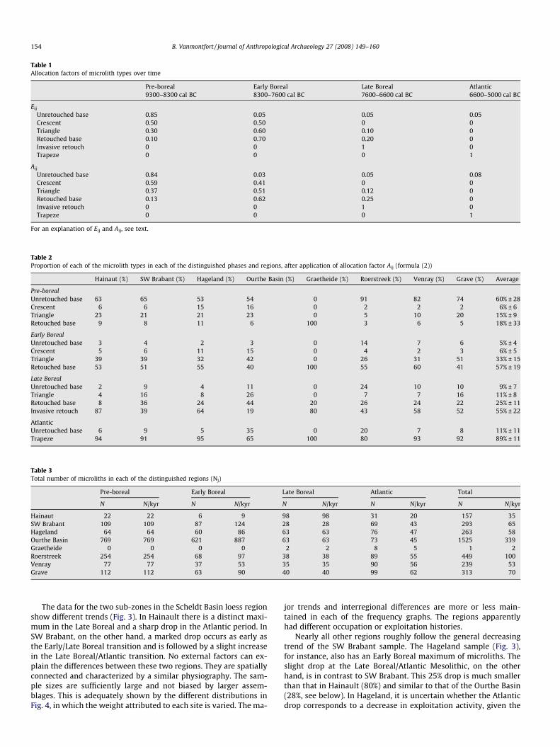
Table 1Allocation factors of microlith types over time
Pre-boreal Early Boreal Late Boreal Atlantic9300–8300 cal BC 8300–7600 cal BC 7600–6600 cal BC 6600–5000 cal BC
Eij
Unretouched base 0.85 0.05 0.05 0.05Crescent 0.50 0.50 0 0Triangle 0.30 0.60 0.10 0Retouched base 0.10 0.70 0.20 0Invasive retouch 0 0 1 0Trapeze 0 0 0 1
Aij
Unretouched base 0.84 0.03 0.05 0.08Crescent 0.59 0.41 0 0Triangle 0.37 0.51 0.12 0Retouched base 0.13 0.62 0.25 0Invasive retouch 0 0 1 0Trapeze 0 0 0 1
For an explanation of Eij and Aij, see text.
Table 2Proportion of each of the microlith types in each of the distinguished phases and regions, after application of allocation factor Aij (formula (2))
Hainaut (%) SW Brabant (%) Hageland (%) Ourthe Basin (%) Graetheide (%) Roerstreek (%) Venray (%) Grave (%) Average
Pre-borealUnretouched base 63 65 53 54 0 91 82 74 60% ± 28Crescent 6 6 15 16 0 2 2 2 6% ± 6Triangle 23 21 21 23 0 5 10 20 15% ± 9Retouched base 9 8 11 6 100 3 6 5 18% ± 33
Early BorealUnretouched base 3 4 2 3 0 14 7 6 5% ± 4Crescent 5 6 11 15 0 4 2 3 6% ± 5Triangle 39 39 32 42 0 26 31 51 33% ± 15Retouched base 53 51 55 40 100 55 60 41 57% ± 19
Late BorealUnretouched base 2 9 4 11 0 24 10 10 9% ± 7Triangle 4 16 8 26 0 7 7 16 11% ± 8Retouched base 8 36 24 44 20 26 24 22 25% ± 11Invasive retouch 87 39 64 19 80 43 58 52 55% ± 22
AtlanticUnretouched base 6 9 5 35 0 20 7 8 11% ± 11Trapeze 94 91 95 65 100 80 93 92 89% ± 11
Table 3Total number of microliths in each of the distinguished regions (Nj)
Pre-boreal Early Boreal Late Boreal Atlantic Total
N N/kyr N N/kyr N N/kyr N N/kyr N N/kyr
Hainaut 22 22 6 9 98 98 31 20 157 35SW Brabant 109 109 87 124 28 28 69 43 293 65Hageland 64 64 60 86 63 63 76 47 263 58Ourthe Basin 769 769 621 887 63 63 73 45 1525 339Graetheide 0 0 0 0 2 2 8 5 1 2Roerstreek 254 254 68 97 38 38 89 55 449 100Venray 77 77 37 53 35 35 90 56 239 53Grave 112 112 63 90 40 40 99 62 313 70
154 B. Vanmontfort / Journal of Anthropological Archaeology 27 (2008) 149–160
The data for the two sub-zones in the Scheldt Basin loess regionshow different trends (Fig. 3). In Hainault there is a distinct maxi-mum in the Late Boreal and a sharp drop in the Atlantic period. InSW Brabant, on the other hand, a marked drop occurs as early asthe Early/Late Boreal transition and is followed by a slight increasein the Late Boreal/Atlantic transition. No external factors can ex-plain the differences between these two regions. They are spatiallyconnected and characterized by a similar physiography. The sam-ple sizes are sufficiently large and not biased by larger assem-blages. This is adequately shown by the different distributions inFig. 4, in which the weight attributed to each site is varied. The ma-
jor trends and interregional differences are more or less main-tained in each of the frequency graphs. The regions apparentlyhad different occupation or exploitation histories.
Nearly all other regions roughly follow the general decreasingtrend of the SW Brabant sample. The Hageland sample (Fig. 3),for instance, also has an Early Boreal maximum of microliths. Theslight drop at the Late Boreal/Atlantic Mesolithic, on the otherhand, is in contrast to SW Brabant. This 25% drop is much smallerthan that in Hainault (80%) and similar to that of the Ourthe Basin(28%, see below). In Hageland, it is uncertain whether the Atlanticdrop corresponds to a decrease in exploitation activity, given the
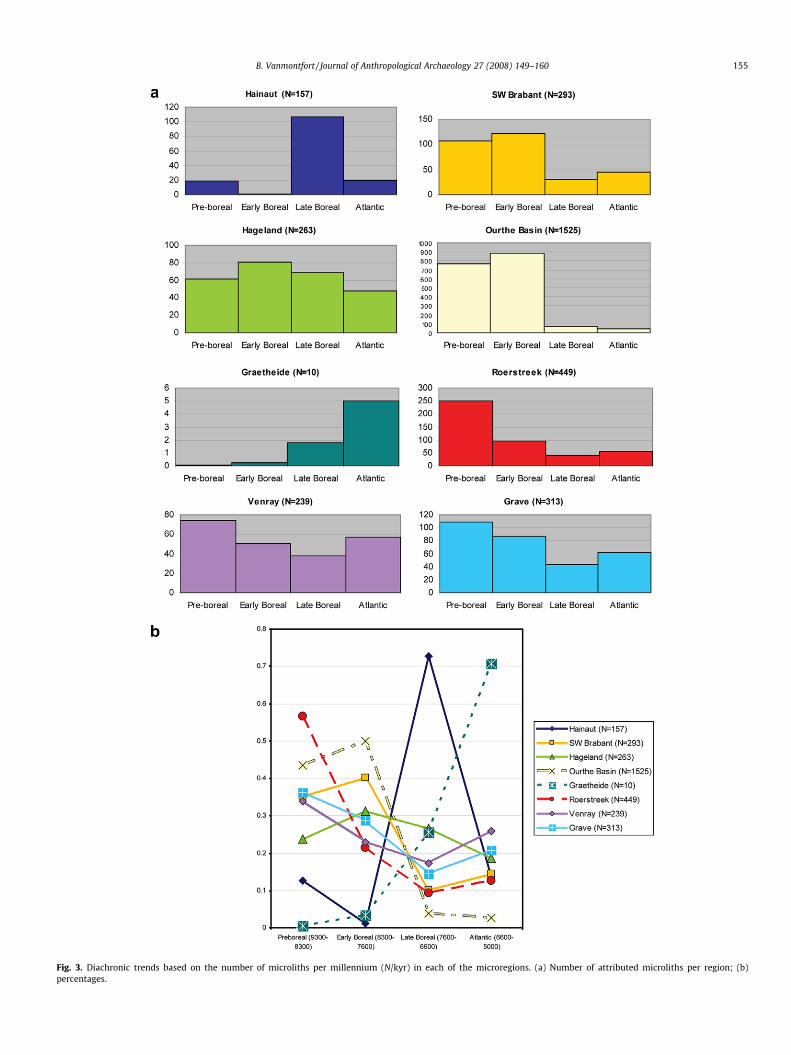
Fig. 3. Diachronic trends based on the number of microliths per millennium (N/kyr) in each of the microregions. (a) Number of attributed microliths per region; (b)percentages.
B. Vanmontfort / Journal of Anthropological Archaeology 27 (2008) 149–160 155

Fig. 4. Trends in the Hainaut and SW Brabant regions (% of number of microlithsover time). (a) N/kyr per phase; (b) N proportionately recalculated per site based onan equalisation of the total number of microliths per site; (c) N, at sites with in totalmore than 5 microliths proportionately reduced to 5; (d) presence/absence of mi-croliths, at each site the frequency of present microlith types is reduced to 1.
156 B. Vanmontfort / Journal of Anthropological Archaeology 27 (2008) 149–160
arguments for a differential representation of trapezes and non-trapezes mentioned above. The spatial distribution of individualmicroliths supports the pattern identified by Vermeersch (1976and see above): Whereas older microlith types mainly occur in val-ley locations, points with invasive retouch and trapezes are moreoften found on hilltop locations (Table 4).
In the Ourthe Basin, the Early/Late Boreal drop is more promi-nent than elsewhere (Fig. 3). This data corresponds to the patternidentified by Henrard (2003, see above). It shows a marked changein the exploitation intensity of the region. At the same time, thiscorrespondence corroborates the idea that behavioural changeson a regional scale can be traced on the basis of individual micro-lith counts.
The trend of microlith frequencies is remarkably homogeneousin the three Meuse Valley regions that are situated north of theloess zone: Roerstreek, Venray and Grave (Fig. 3). Pre-borealmicroliths dominate. After a drop towards the Late Boreal, thenumber of microliths rise again in the Atlantic.
The Graetheide ‘core region’, located in the loess zone, is en-tirely different. It is characterised by an overall scarcity of micro-liths, apart from two exceptions all to be dated in the AtlanticMesolithic (Fig. 3). This scarcity is a primary pattern as the collec-tions of this region were catalogued in exactly the same way as the
Table 4Physiographic context of the microliths in Hageland
Location
Hilltop River floodplain Total
Find locations 63 15 78Unretouched base 14 28 42Crescent 1 16 17Triangle 12 26 38Retouched base 16 36 52Invasive retouch 19 15 34Trapeze 40 23 63
Total 102 144 246
Of 17 microliths no exact find location is known.
other regions (L. Verhart, pers. comm.) and as the total number offind locations is similar to Venray and Grave. Apparently the entireGraetheide region was practically void of hunter–gatherer activity.
Discussion
Trend difference authenticity
Several interacting uncertainties bias the calculated patterns:the allocation factor Aij is based on estimated figures, the chrono-logical resolution is coarse with phases of 1–1.5 millennia, samplesizes and research activity differ between the reference regions andthe particular taphonomy obscures a direct link between microlithdistributions and the activity of which they are the remains. A fine-grained resolution can therefore not be obtained. Larger trends,however, are immune to many of these biasing factors and otherfactors are the same for each of the regions and therefore not bias-ing interregional differences. This is substantiated by the followingarguments.
First, major diachronic changes are preserved if allocation factorAij is modified. Interregional differences are even independent ofthese variations: tempering a drop or rise in number of microlithsin one region enforces contrasting changes in others. The observedcontrasting patterns are therefore authentic.
Second, the coarse resolution obscures the possible complexityin exploitation changes, but is more likely to have blurred actualtrends than to have created false ones. This is especially the caseif major changes do not coincide in time with the common Meso-lithic phase boundaries.
Third, and relating to possible differences in sample size and re-search activity, each of the samples should be regarded as a ran-dom one. The reliability of the proportional composition of thesesamples is demonstrated by that of Hainault. In a recent study,Van Assche (2005) added to the catalogue 15 locations with in total63 microliths or 40% of the entire Hainault sample. Excluding thesedata, however, does not significantly affect the observed patterns.Major interregional differences are thus the result of differentchanges in exploitation intensity during the Early Holocene.
These arguments confirm that the impact of the biasing factorson the major regional trends and interregional differences was lim-ited. The value and authenticity of these trends and differences canthus be claimed.
Interpreting observed differences
Diachronic changes in the number of microliths can represent achange in hunting or hafting techniques, a change in exploitationsystems, a population change either with or without migration,or a combination of these. Interregional trend differences shouldthen be related to these changes and their impact in the respectiveregions. Each of the shifts may have been triggered by environmen-tal or social change. It should be kept in mind that the graphs(Fig. 3) merely represent trends and patterns in microlith numbersand are in se no population curves. The calibration of the graphsinto population curves depends on unknown factors such as dia-chronic differences in microlith use and hunting strategies.
A first major change occurred in several regions around themiddle of the Boreal period. The number of microliths decreasesin SW Brabant and the Ourthe Basin, while in Hainault a prominentrise is visible. As was already proposed by Henrard (2003) for theOurthe Basin, this pattern represents an exploitation change andrelocation of activity spheres. The patterns in SW Brabant andHainault are likely to be related since these regions are closely con-nected spatially. If the residential shift from the Ourthe Basin alsowas directed into the loess region, as is claimed by Henrard (2003),is difficult to determine. Data on the Mesolithic occupation of the

4 A few examples exist of points with invasive retouch found in LBK context andeven in Michelsberg context (cf. Jeunesse, 2000). However, as no other argumentsexist to accept the continued use of such point types during the Late Mesolithic, theseshould rather be regarded as residual (cf. Crombé et al., 2005; Van Assche, 2005).
B. Vanmontfort / Journal of Anthropological Archaeology 27 (2008) 149–160 157
Hesbaye region located near the Ourthe Basin, are unfortunatelylacking. A similar shift in site or activity location choice is also vis-ible, albeit on a smaller spatial scale, within the Hageland region(see above). In the Meuse valley regions, with a continuous dropfrom Pre-boreal to Late Boreal, no particular middle Boreal shiftcan be noted.
A shift in occupation patterns from the Final Palaeolithic andEarly Mesolithic to the Middle and Late Mesolithic has been ob-served elsewhere as well. In Sandy Flanders and the Belgian Cam-pine area, this shift is associated with environmental changes: asLate Glacial lakes disappeared, the occupations shifted towardsthe river valleys and the exploited hinterland was reduced due toan increasing vegetation cover and the associated reduction ofundergrowth and change in fauna (Crombé and Verbruggen,2002; Vanacker et al., 2001). The increasing vegetation covermay also be responsible for the shift in SW Brabant, Hagelandand Ourthe Basin or for the decreasing trend in the other regions.Interpreted this way, these trends fit well with the shift in settle-ment pattern noted for most of Central and Western Europe’sMesolithic and related to the increasing vegetation cover (e.g. Gro-nenborn, 1999, p. 137). The rise of activity in Hainault is remark-able; especially since this region will have experienced a similarvegetation change as in SW Brabant.
In the Ourthe Basin, SW Brabant and Hageland, the Boreal shiftis maintained in the later Mesolithic. In Hainault, on the otherhand, it is reversed and again much lower numbers of microlithsare found. None of the other regions compensate for this drop witha clear rise in the Atlantic period, unless the unknown factor withwhich non-trapeze microliths should be divided for comparisonwith trapezes (see above) is taken into account. Every likely factor,i.e. larger than 1, implies a notable activity rise in SW Brabant andin the Meuse Valley ‘core regions’. Environmental changes can beinvoked as an explanation for the shift in Hainault. The region isdeserted due to a continuing increase of the vegetation cover.The microlith number increase in the Late Boreal period and theLate Boreal to Atlantic moderate rise in SW Brabant, however, donot fit with this explanation. If the patterns are related, it seemsthat there was at least a partial ‘retreat’ of activity from Hainaultinto SW Brabant.
A farmer–forager connection?
The arrival of the LBKAround 5300 cal BC, in the second part of the Atlantic period,
the people of the Linearbandkeramik culture settled in the Scheldtand Meuse Basins loess region (Jadin and Cahen, 2003a,b). A seriesof settlement clusters covered the Aldenhovener Platte, the Graethe-ide and Hesbaye regions, with a small western outlier along theKleine Gete River (Fig. 5). Approximately 100 km further west, asingle, isolated settlement cluster was located in the region ofthe upper Dendre River, in the present-day province Hainault (Ja-din, 2003; fig. 5). It is thought to have been a pioneer extensionof the later LBK, as it only consists of few settlements and is locatedat a large distance to the nearest cluster in Hesbaye. Apparentlythese pioneer communities did not colonize their wider environ-ment, as is the case farther east. Recent data for the Dutch southernLimburg area point in contrast to a growing flexibility in site loca-tion choices of the LBK in the later phases, resulting in the coloni-sation of the wider environment around the traditionally occupiedloess plateaus (Amkreutz, in press; Amkreutz et al., in press).
It has long been debated whether the isolated position of theHainault cluster corresponds to an actual settlement pattern orthat intermediate LBK settlement clusters have been missed andare still awaiting discovery (see also Jadin, 2003, p. 75). The phys-iography of the intermediate area with respect to the main LBKlocation-determining factors, i.e. a combination of soil, topography
and water, does not significantly differ from that of both LBK areas.On the other hand, recent surveys and archaeological investigationof major transects through the middle Belgian loess region for theconstruction of high-speed railroads and gas pipelines did not yieldnew LBK settlement traces beyond the known clusters (see also Ja-din, 2003, p. 75).
The large spatial gap can thus not be explained by researchactivity or by the traditional view on the preferred settlement loca-tion. It may have been socially induced, connected to the region’ssocial geography. Microlith distribution patterns in the regioncan be used as a proxy for the hunter–gatherer occupation. Fig. 5presents a map combining all Mesolithic microliths presented inthe first part of this paper and the LBK settlement clusters. The spa-tial separation of both is remarkable: the LBK cluster regions arestrikingly empty in microliths. As those regions have been inten-sely surveyed in the past, Mesolithic microliths would surely havebeen recognised. Only for the Hesbaye region one can rightly stressthat no data are included in this paper, but the absence of readilyavailable data can also be regarded as an indication of the limitednumber of finds. The scrutiny of all available public and privatearchaeological collections of the Graetheide plateau by M. Wans-leeben and L. Verhart ensures the absence of Mesolithic artefactsthere. The same is true for the area around both Kleine Gete andHezerwater LBK clusters, for which not a single Mesolithic site orartefact is known. Apart from the residual point with invasive re-touch from a pit in Blicquy-Couture du Couvent (Constantinet al., 1991), only two Middle Mesolithic sites have been identifiedin the area of the Hainault LBK cluster (Pleuger et al., 2005; VanAssche and Demarez, 2005).
The microlith deficiency in precisely those parts of the loess beltwhere LBK settled from 5300 cal BC onwards is a primary pattern.Hunter–gatherers apparently avoided these regions in their exploi-tation of the loess zone. This holds for wide stretches, including theGerman Rhineland, while the Scheldt Basin microliths are a strik-ing exception. It is unlikely that the unattractiveness of particularzones for foragers is only due to the particular physiography andrelated vegetation cover; the scarcity of hunter–gatherer remainsis a constant throughout the entire Early Holocene, notwithstand-ing the major environmental changes taking place during that per-iod and the similar soil conditions in and beyond those particularzones. The avoidance of these zones is independent of the LBK ar-rival as well, since sites or microliths from the entire Mesolithicperiod are lacking.
Whatever the reason for this spatial patterning of hunter–gath-erer activity, it seems that it limited the site location choice of theLBK. People of the LBK settled in exactly those areas only margin-ally exploited by hunter–gatherers and not in the intermediate re-gions with similar physiography but more intense hunter–gathererexploitation. This fits the idea of an initially demic diffusion of theLBK at least in the western Rhineland, Dutch southern Limburg andBelgian Hesbaye. Other arguments in its favour are the absence ofmicroliths integrated in early LBK settlements,4 the absence of tran-sitional complexes and the large cultural contrast between LBK andthe late Mesolithic as currently understood (Louwe Kooijmans, inpress). It should be stressed, however, that this principally demicmovement does not a priori exclude the possibility of forager–farmerinteractions including the integration of foragers in the LBK society.
Forager reaction to incoming farmersThe individual microlith distributions allow identifying several
distinctive patterns. First, hunter–gatherers exploited the loess re-

Fig. 5. Spatial distribution of microliths on the loess and beyond. Shaded areas = LBK settlement clusters: 1. Aldenhovener Platte, 2. Graetheide, 3. Hezerwater, 4. Hesbaye, 5.Kleine Gete, 6. Upper Dendre/Hainaut. Small tent symbols indicate locations of microliths other than trapezes. Circles indicate the location of trapezes. For the Ourthe Basinand Grave region, no microliths are plotted due to a lack of spatial information.
158 B. Vanmontfort / Journal of Anthropological Archaeology 27 (2008) 149–160
gion randomly, with the exception of some areas including thoselater to be occupied by the LBK. Second, a shift in exploitation oroccupation locations occurred around the middle of the Boreal per-iod. Third, those regions close to later LBK settlement clusters haveexperienced a different occupation or exploitation history.
In Gregg’s ‘mutualistic interaction’ model for Southern Ger-many, low density, residentially mobile hunter–gatherers were at-tracted to the rich environments of the first farmers’ settlements(Gregg, 1988, p. 234). This paper’s loess belt exploitation changesdo not show such attraction and the presumed related rise inmicroliths. From the Graetheide area more trapezes were recov-ered than older type microliths, but the small absolute numberdoes not allow interpreting them as proof for an attraction to theLBK settlements. The main pattern is that of a marked drop inAtlantic points in Hainault and a moderate increase in SW Brabantand the Meuse Valley regions. If anything, this shows that the pos-sible environmental influence driving the hunter–gatherers awayfrom the loess region was complemented with a factor drivingthe activity back into SW Brabant. Either the LBK communitiesare responsible for the retreat of the remaining hunter–gatherersexploiting Hainault or hunter–gatherer activity lasted longer far-ther away from the LBK settlements, perhaps contemporaneouswith them.
The spatial separation between LBK and the local Mesolithic isone of Keeley’s arguments in favour of an actively hostile relation-ship between LBK and local hunter–gatherers (Golitko and Keeley,2007; Keeley, 1992). Other arguments are the scarcity of reliablecontact finds and signs of acculturation, the absence of wild foodsources in LBK context and domestic food sources in Mesolithic
context and the presence of LBK enclosures at the fringe of LBK set-tlement territory in Hesbaye (Golitko and Keeley, 2007; Keeley,1992). These arguments can, however, be refuted. The movementof goods is difficult to identify in the archaeological record of thearea due to taphonomical reasons (e.g. Zvelebil, 1998). Neverthe-less, many of the LBK adzes found well beyond the LBK settlementzones can be interpreted as prestigious exchange goods (e.g. Ver-hart, 2000). The local LBK use of Phtanite/Lydite but also of Wom-mersom quartzite, two raw materials frequently used during theMesolithic, is a possible but contentious indication for a transferin the opposite direction (Vanmontfort, 2007). The same tapho-nomic factors can be responsible for the absence of evidence for‘Mesolithic’ use of domesticates and the Neolithic exploitation ofwild food resources (see e.g. Modderman, 1988 for the exploitationof wild fauna by the LBK). With respect to the LBK enclosures, theabsence of evidence of actual violence makes it difficult to associ-ate them with hostile local hunter–gatherers (see also Jadin andCahen, 2003a,b). Such a relationship would even be expected tolead to a concentration of Mesolithic arrow implements near LBKsites, which is obviously not the case (see above). A hostile rela-tionship cannot be deduced from the spatial exclusion of LBK set-tlements and hunter–gatherer activity either. The choice of the LBKpeople to settle in regions at most marginally exploited by localpeoples can even be interpreted as a conflict-avoiding attitude.
The observed patterns best fit with an open static or stationaryagricultural frontier zone (a.o. Dennell, 1985; Zvelebil, 1998; Zvele-bil, 2001; Zvelebil, 2004). This encompasses the bi-directionalmovement of goods, among which the LBK adzes, and the longevityof a static frontier. From the arrival of the LBK onwards, the agricul-
B. Vanmontfort / Journal of Anthropological Archaeology 27 (2008) 149–160 159
tural frontier zone apparently developed in a stable or only slowlychanging situation with a long availability phase (cf. Zvelebil, 2004).
To conclude, the following model can be put forward. Duringthe 6th Millennium cal BC, major parts of the loess region areexploited by a low density of hunter–gatherers. The LBK communi-ties settle at arrival in locations fitting their preferred physicalcharacteristics, but void of hunter–gatherer activity. Evidently,multiple processes and contact situations may have occurredsimultaneously, but in general the arrival of the LBK did not attracthunter–gatherer hunting activity. Their presence rather restrainednative activity to regions located farther away from the newly con-structed settlements or triggered fundamental changes in the so-cio-economic organisation and activity of local hunter–gatherers.Evidence for the subsequent step in the transition dates to approx-imately one millennium later (Crombé and Vanmontfort, 2007;Vanmontfort, 2007).
Conclusion
This paper shows that, despite the difficulties associated withtaphonomy and site preservation or identification, some patternsof hunter–gatherer activity in the loess region can be assessed onthe basis of individual microliths rather than on closed and well-dated sites or assemblages. Some of these patterns reveal a mutualinfluence of immigrant Neolithic farmers and local hunter–gather-ers. Apparently, LBK settlement location choice was determined bythe hunter–gatherer activity radii as well as environmental factors.LBK communities avoided those regions more intensely exploitedby hunter–gatherers. Conversely, hunter–gatherer activity re-treated to the regions farther away from the Neolithic villages.The visibility of this influence is an indication in favour of the con-temporaneity of LBK and local hunter–gatherers and the probabil-ity of interaction. Future research should show whether thishypothesis of spatial exclusion between forager and farmer exploi-tation and settlement territories actually corresponds to an archae-ological reality. A more detailed interpretation of patterns can beobtained by applying the method to a wider region, including lar-ger parts of the loess belt of the Scheldt, Meuse and Rhine Basins aswell as the neighbouring regions. More detailed spatial analysisshould allow identifying intraregional shifts in activity, as is al-ready demonstrated for the Hageland region. The application ofthe method to data from the Central European loess region shouldreveal the extent of the identified pattern. The detailed study ofLBK points/trapezes (Robinson, in preparation) should allow animprovement of the chronological resolution of the Late and FinalMesolithic phase and consequently of the appreciation of forager–farmer interaction. In the end all this should lead to a better under-standing of the Mesolithic–Neolithic transition.
Acknowledgments
The research for this paper is part of the ‘‘From Hardinxveld toNoordhoorn: From Forager to Farmer”—project of Leiden Univer-sity, financed by NWO (Netherlands Organisation for Scientific Re-search) in the framework of the ‘‘Malta’s Harvest” programme. L.Verhart and M. Wansleeben kindly allowed the use of their MeuseValley Project-data. We are indebted to L. Amkreutz, M. De Bie, L.P.Louwe Kooijmans, E. Robinson, L. Verhart, M. Van Gils, P.M. Ver-meersch and two anonymous reviewers for their helpful com-ments and related discussions on earlier drafts of this paper andM. Epperson for proof reading the English text.
References
Amkreutz, L.W.S.W., in press. All quiet on the Northwestern front? An overview andpreliminary analysis of the past decade of LBK-research in the Netherlands. In:
Gronenborn, D. (Ed.), Die Neolithisierung Mitteleuropas. Internationale Tagung,Mainz 24.–26. Juni 2005, Mainz.
Amkreutz, L.W.S.W., Vanmontfort, B., Verhart, L.B.M., in press. Divergingtrajectories? Forager–farmer interaction in two adjacent regions. In:Hofmann, D., Bickle, P. (Eds.), New Advances in Central European NeolithicResearch.
Binford, L.R., 1982. The archaeology of place. Journal of AnthropologicalArchaeology 1, 5–31.
Bogucki, P.I., 1988. Forest farmers and stockherders. Early Agriculture and itsConsequences in Northcentral Europe. Cambridge.
Bogucki, P.I., Grygiel, R., 1993. The first farmers of central Europe: a survey article.Journal of Field Archaeology 20, 399–426.
Bosquet, D., Jadin, I., 1996. Rebecq (Bt). Un site mésolithique ancien au lieu-dit ‘‘LeSpinoi. In: Rémy, H., Soumoy, M. (Eds.), Sur la voie de l’histoire: Archéologie etTGV. Namur, pp. 155–158.
Constantin, C., Farruggia, J.-P., Demarez, L. 1991. Le site rubané de Blicquy—laCouture du Couvent (Hainaut). Fouilles 1983-85-88. Les Chercheurs de laWallonie 31, 51–78.
Crombé, P., 1998. The Mesolithic in Northwestern Belgium. Recent excavations andsurveys. Oxford.
Crombé, P., 2002. Quelques réflexions sur la signification de la variabilité desindustries lithiques mésolithiques de Belgique. In: Otte, M., Kozlowski, J.K.(Eds.), Préhistoire de la grande plaine du Nord de l’Europe: Les échanges entrel’Est et l’Ouest dans es sociétés préhistoriques. Actes du Colloque Chaire Franquiinteruniversitaire (Université de Liège, 26 juin 2001). Université de Liège, Liège,pp. 99–114.
Crombé, P., Cauwe, N., 2001. The Mesolithic. Anthropologica et Praehistorica 112,49–62.
Crombé, P., Perdaen, Y., Sergant, J. 2005. La néolithisation de la Belgique: quelquesréflexions. In: Marchand, G., Tresset, A. (Eds.), Unité et diversité des processusde néolithisation sur la fac�ade atlantique de l’Europe (6e–4e millénaires avantJ.-C.), Table ronde de Nantes, 26–27 Avril 2002, Paris, pp. 47–66.
Crombé, P., Vanmontfort, B., 2007. The neolithisation of the Scheldt basin in westernBelgium. In: Whittle, A., Cummings, V. (Eds.), Going Over: The Mesolithic–Neolithic Transition in North-West Europe. Oxford University Press, Oxford, pp.263–285.
Crombé, P., Verbruggen, C. 2002. The late glacial and early post glacial occupation ofnorthern Belgium: the evidence from Sandy Flanders. In: Eriksen, B., Bratlund,B. (Eds.), Recent Studies in the Final Palaeolithic of the European plain,Proceedings of a U.I.S.P.P. Symposium, Stockholm 14–17 October 1999, Arhus,pp. 165–180.
De Bie, M., Van Gils, M., in press. Mesolithic settlement and land use in the Campineregion (Belgium). In: Woodman, P., McCartan, S. (Eds.), Meso 2005. Proceedingsof the 7th International Conference on the Mesolithic in Europe (Belfast,Northern Ireland, August 29–September 2). Oxbow, Oxford.
Dennell, R.W., 1985. The hunter–gatherer/agricultural frontier in prehistorictemperate Europe. In: Green, S.W., Perlman, S.M. (Eds.), The Archaeology ofFrontiers and Boundaries. Academic Press, Orlando, pp. 113–136.
Donahue, R.E., Lovis, W.A., 2006. Regional settlement systems in Mesolithicnorthern England: Scalar issues in mobility and territoriality. Journal ofAnthroplogical Archaeology 25, 248–258.
Ducrocq, T., 2001. Le Mésolithique du bassin de la Somme: Insertion dans un cadremorpho-stratigraphique, environnemental et chronoculturel. Université desSciences et Technologies de Lille, Villeneuve d’Ascq.
Ebert, J.I., 1992. Distributional Archaeology. University of New Mexico Press,Albuquerque.
Fourny, M., Van Assche, M., 1987. Nouveaux sites d’habitat du Neolithique moyenentre Senne et Dyle. Notae Praehistoricae 7, 8–10.
Fourny, M., Van Assche, M., 1993. Le site néolithique Michelsberg de Braine-l’Alleud‘‘Paudure” (Brabant): Sondages et Prospections. Amphora 69.
Garnett, A., 1945. The loess regions of central Europe in prehistoric times. TheGeographical Journal 106, 132–143.
Gob, A., 1981. Le Mésolithique dans le bassin de l’Ourthe. Liège.Gob, A., 1985. Extension géographique et chronologique de la culture Rhein–
Meuse–Schelde (RMS). Helinium 25, 23–36.Gob, A., 1990. Du mésolithique au néolithique en Europe nord-occidentale: un point
de vue du mésolithicien. In: Cahen, D., Otte, M. (Eds.), Rubané et Cardial. Actesdu Colloque de Liège. Université de Liège, Liège, pp. 155–159.
Golitko, M., Keeley, L., 2007. Beating ploughshares back into swords: warfare in theLinearbandkeramik. Antiquity 81, 332–342.
Goossens, D., 1983. Inleiding tot de geologie en geomorfologie van België. Enschede.Gregg, S.A., 1988. Forager and Farmers: Population Interaction and Agricultural
Expansion in Prehistoric Europe. The University of Chicago Press, Chicago.Gronenborn, D., 1999. A variation on a basic theme: the transition to farming in
southern central Europe. Journal of World Prehistory 13, 123–210.Heinen, M., 2006. The Rhine–Meuse–Schelde Culture in Western Europe.
Distribution, Chronology and Development. In: Kind, C.-J. (Ed.), After the IceAge: Settlements, Subsistence and Social Development in the Mesolithic ofCentral Europe. Konrad Theiss Verlag, Stuttgart, pp. 75–86.
Henrard, D., 2003. Le Mésolithique du bassin de l’Ourthe (Belgique): implantationdans le paysage et néolithisation. L’Anthropologie 107, 615–644.
Jadin, I., 2003. Trois petits tours et puis s’en vont. La fin de la présence danubienneen Moyenne Belgique (avec la participation de D. Cahen, I. Deramaix, A.Hauzeur, J. Heim, A. Livingstone Smith, J. Verniers). Université de Liège, Liège.
Jadin, I., Cahen, D., 2003. Datations radiocarbones et Rubané: Pour un mariage deraison, I. Jadin 2003, pp. 523–581.

160 B. Vanmontfort / Journal of Anthropological Archaeology 27 (2008) 149–160
Jadin, I., Cahen, D., 2003. Sites en pagaille sur le haut Geer: Darion, Oleye,Waremme-Longchamp, Hollogne-Douze Bonnier, I. Jadin 2003, pp. 191–315.
Jeunesse, C., 2000. Les composantes autochtone et danubienne en Europe centraleet occidentale entre 5500 et 4000 av. J.-C.: contacts, transferts, acculturations.In: Richard, A., Cupillard, C., Richard, H., Thévenin, A. (Eds.), Les dernierschasseurs-ceuilleurs d’Europe occidentale. Actes du colloque international deBesanc�on (octobre 1998), Besanc�on, pp. 361–378.
Jochim, M.A., 1990. The Late Mesolithic in Southwest Germany: Culture Change orPopulation Decline? In: Vermeersch, P.M., Van Peer, P. (Eds.), Contributions tothe Mesolithic in Europe, pp. 183–191.
Keeley, L.H., 1992. The introduction of agriculture to the western north Europeanplain. In: Gebauer, A.B., Price, T.D. (Eds.), Transitions to Agriculture inPrehistory. Prehistory Press, Madison (Wisconsin), pp. 81–95.
Kelly, R.L., 1995. The Foraging Spectrum. Smithsonian, Washington, DC.Kind, C.-J., 1997. Die letzten Wildbeuter. Henauhof Nord II und das
Endmesolithikum in Baden-Württemberg. mit Beiträgen von Helga Liese-Kleiber, Alfred Pawlik und Richard Vogt. Konrad Theiss Verlag, Stuttgart.
Kind, C.-J., 2003. Das Mesolithikum in der Talaue des Neckars. Die Fundstellen vonRottenburg Siebenlinden 1 und 3. Mit beiträgen von Ann M. Miller und JoachimHahn. Konrad Theiss Verlag, Stuttgart.
Koch, I., 1998. Das Mesolithikum im Trierer land. Archäologische Informationen 21,387–391.
Lanting, J.N., van der Plicht, J., 1997/1998. De C14 chronologie van de NederlandsePre-en Protohistorie, II: Mesolithicum. Palaeohistoria 39/40, 1–162.
Leopold, L.B., Vita-Finzi, C., 2005. Archaeological trash: geomorphology and earlyhuman occupation in Wyoming. Catena 62, 1–13.
Louwe Kooijmans, L.P., 2007. The gradual transition to farming in the Lower RhineBasin. In: Whittle, A., Cummings, V. (Eds.), Going Over: the Mesolithic–NeolithicTransition in North-West Europe. Oxford University Press, Oxford, pp. 287–309.
Louwe Kooijmans, L.P., in press. The gradual transition to farming in the LowerRhine Basin. In: Whittle, A., Cummings, V. (Eds.), Going Over: The Mesolithic–Neolithic Transition in North-West Europe. Cardiff.
Lovis, W.A., Donahue, R.E., Holman, M., 2005. Long distance logistic mobility as anorganizing principle among northern hunter–gatherers: a Great Lakes MiddleHolocene settlement system. American Antiquity 70, 669–693.
Mees, N., Plumier, J., Munaut, A.V., Defgnée, A., Van Neer, W., 1994. Premier état desrecherches sur le néolithique et le mésolithique au Grognon à Namur. NotaePraehistoricae 14, 109–112.
Modderman, P.J.R., 1988. The Linear Pottery Culture: diversity in uniformity.Berichten van de Rijksdienst voor het Oudheidkundig Bodemonderzoek 38, 63–140.
Parent, J.-P., Van Der Plaetsen, P., Vanmoerkerke, J., 1987. Prehistorische jagers enveetelers aan de Donk te Oudenaarde. Vobov-info, 24–25.
Pleuger, E., Paridaens, N., Gillet, E., Van Assche, M., 2005. Une fosse mésolithiquedécouverte à Leuze-en-Hainaut/Blicquy Ville d’Anderlecht” (Hainaut). Amphora83, 19–24.
Price, T.D., 2000. Lessons in the transition to agriculture. In: Price, T.D. (Ed.),Europe’s First Farmers. Cambridge University Press, Cambridge, pp. 301–318.
Robinson, E.N., in preparation. The evolution of trapeze industries and the role ofarmatures in Neolithisation models for northwest Europe: a systematicapproach. In: Crombé, Ph., Van Strydonck, M. (Eds.), Chronology andevolution in the Mesolithic of N(W) Europe.
Rozoy, J.G., 1978. Les derniers chasseurs. L’Epipaleolithique en France et enBelgique. Essai de synthèse. Charleville.
Street, M., 1995. Bedburg-Königshoven. In: Bosinski, G., Street, M., Baales, M. (Eds.),The Palaeolithic and Mesolithic of the Rhineland. In: Schirmer, W. (Ed.),Quaternary Field Trips in Central Europe. Bonn, pp. 962–966.
Street, M., Baales, M., Cziesla, E., Hartz, S., Heinen, M., Jöris, O., Koch, I., Pasda, C.,Terberger, T., Vollbrecht, J., 2001. Final paleolithic and Mesolithic research inreunified Germany. Journal of World Prehistory 15, 365–453.
Thévenin, A., 1992. Mésolithique récent, Mésolithique final, Néolithique anciendans le Nord-Est de la France et régions voisines. Le problème entrevu par lesarmatures. In: Le Roux, C.-T. (Ed.), Paysans et Batisseurs. L’émergence duNéolithique atlantique et les origines du Mégalithisme. Actes du 17ème
colloque interrégional sur le Néolithique, Vannes, 28–31 octobre 1990, pp.101–110.
Tringham, R., 2000. Southeastern Europe in the transition to agriculture in Europe:bridge, buffer or mosaic. In: Price, T.D. (Ed.), Europe’s First Farmers. CambridgeUniversity Press, Cambridge, pp. 19–56.
Van Assche, M., 2005. Aperc�u sur le mésolithique des régions d’Ath et de Mons(Hainaut). Amphora 83, 42–82.
Van Assche, M., Demarez, L., 2005. Le site mésolithique moyen d’Ath/Ormeignies‘‘Autreppe” (Hainaut). Amphora 83, 3–18.
van de Konijnenburg, R., 1980. Het Mesolithicum in Henegouwen en Brabant tenzuiden van de lijn Roosdaal—Brussel—Orp-Jauche, (Unpublished Master’sthesis), Katholieke Universiteit Leuven, Leuven.
van der Sloot, P., Damblon, F., Debenham, N., Fechner, K., Gob, A., Haesaerts, P.,Hauzeur, A., Jadin, I., Léotard, J.-M., Remacle, M., Vanmontfort, B., 2003. LeMésolithique et le Néolithique du site Saint-Lambert à Liège dans leur contextechronologique, géologique et environnemental. Synthèse des données et acquisrécents. Notae Praehistoricae 23, 79–104.
Van Gijn, A., Louwe Kooijmans, L., 2005. The first farmers: synthesis. In: LouweKooijmans, L.P., van den Broeke, P.W., Fokkens, H., van Gijn, A.L. (Eds.), ThePrehistory of the Netherlands. Amsterdam University Press, berlin.
Vanacker, V., Govers, G., Van Peer, P., Verbeek, C., Desmet, J., Reyniers, J., 2001. UsingMonte Carlo simulation for the environmental analysis of small archaeologicdatasets, with the Mesolithic in northeast Belgium as a case study. Journal ofArchaeological Science 28, 661–669.
Vanmontfort, B., 2007. Bridging the gap. The Mesolithic–Neolithic transition in afrontier zone. Documenta Praehistorica XXXIV, 105–118.
Verhart, L.B.M., 2000. Times fade away: The neolithization of the southernNetherlands in an anthropological and geographical perspective. Leiden.
Verhart, L.B.M., 2003. Mesolithic Economic and Social Changes in the SouthernNetherlands. In: Larsson, L., Kindgren, H., Knutsson, K., Loeffler, D., Akerlund, A.(Eds.), Mesolithic on the Move, Papers presented at the Sixth InternationalConference on the Mesolithic in Europe, Stockholm 2000. Oxford, pp. 442–450.
Vermeersch, P.M., 1976. Steentijdmateriaal uit het Noordelijk Hageland. NationaalCentrum voor Oudheidkundige Navorsingen in België, Brussel.
Vermeersch, P.M., 1984. Du Paleolithique final au Mesolithique dans le nord de laBelgique. In: Cahen, D., Haesaerts, P. (Eds.), Peuples chasseurs de la Belgiquepréhistorique dans leur cadre naturel, Bruxelles, pp. 181–193.
Vermeersch, P.M., 1990. La transition du Mésolithique au Néolithique en Basse etMoyenne Belgique. In: Cahen, D., Otte, M. (Eds.), Rubané et Cardial. Actes duColloque de Liège. Université de Liège, Liège, pp. 96–103.
Wansleeben, M., Verhart, L., 1998. Graphical analysis of regional archaeologicaldata. The use of site typology to explore the Dutch neolithization process.Internet Archaeology 4.
Zvelebil, M., 1996. The agricultural frontier and the transition to farming in thecircum-Baltic region. In: Harris, D.R. (Ed.), The Origins and Spread of Agricultureand Pastoralism in Eurasia. London, pp. 323–345.
Zvelebil, M., 1998. Agricultural frontiers, Neolithic origins, and the transition tofarming in the Baltic basin. In: Zvelebil, M., Dennell, R., Domanska, L. (Eds.),Harvesting the Sea, Farming the Forest. Sheffield, pp. 9–27.
Zvelebil, M., 2000. Les derniers chasseurs-collecteurs d’Europe tempérée. In:Richard, A., Cupillard, C., Richard, H., Thévenin, A. (Eds.), Les dernierschasseurs-ceuilleurs d’Europe occidentale. Actes du colloque international deBesanc�on, octobre 1998, Besanc�on, pp. 379–406.
Zvelebil, M., 2001. The agricultural transition and the origins of Neolithic society inEurope. Documenta Praehistorica XXVIII, 1–26.
Zvelebil, M., 2004. The many origins of the LBK. In: Lukes, A., Zvelebil, M. (Eds.), LBKdialogues, Studies in the formation of the Linear Pottery Culture. Archaeopress,Oxford, pp. 183–205.
Zvelebil, M., Lillie, M., 2000. Transition to agriculture in eastern Europe. In: Price,T.D. (Ed.), Europe’s First Farmers. Cambridge University Press, Cambridge, pp.57–92.
Zvelebil, M., Rowley-Conwy, P., 1986. Foragers and farmers in Atlantic Europe. In:Zvelebil, M. (Ed.), Hunters in Transition: Mesolithic Societies of TemperateEurope and their Transition to Farming. Cambridge, pp. 67–93.