
FOR OFFICIAL USE ONLY - World Bank Documents & Reports
132
Document of The World Bank FOR OFFICIAL USE ONLY Report No. T-7100-IN TECHNICAL ANNEX ON A PROPOSED LOAN AND CREDIT TO INDIA FOR AN ANDHRA PRADESH HAZARD MITIGATION AND EMERGENCY CYCLONE RECOVERY PROJECT April 11, 1997 Energy and Infrastructure Operations Division Country Department 11 South Asia Region This document has a restricted distribution and may be used by recipients only in the performance of their official duties. Its contents may not otherwise be disclosed without World Bank authorization. Public Disclosure Authorized Public Disclosure Authorized Public Disclosure Authorized Public Disclosure Authorized Public Disclosure Authorized Public Disclosure Authorized Public Disclosure Authorized Public Disclosure Authorized
-
Upload
khangminh22 -
Category
Documents
-
view
4 -
download
0
Transcript of FOR OFFICIAL USE ONLY - World Bank Documents & Reports

Document of
The World Bank
FOR OFFICIAL USE ONLY
Report No. T-7100-IN
TECHNICAL ANNEX
ON A PROPOSED LOAN AND CREDIT
TO INDIA
FOR AN
ANDHRA PRADESH HAZARD MITIGATION AND EMERGENCY CYCLONERECOVERY PROJECT
April 11, 1997
Energy and Infrastructure Operations DivisionCountry Department 11South Asia Region
This document has a restricted distribution and may be used by recipients only in theperformance of their official duties. Its contents may not otherwise be disclosed withoutWorld Bank authorization.
Pub
lic D
iscl
osur
e A
utho
rized
Pub
lic D
iscl
osur
e A
utho
rized
Pub
lic D
iscl
osur
e A
utho
rized
Pub
lic D
iscl
osur
e A
utho
rized
Pub
lic D
iscl
osur
e A
utho
rized
Pub
lic D
iscl
osur
e A
utho
rized
Pub
lic D
iscl
osur
e A
utho
rized
Pub
lic D
iscl
osur
e A
utho
rized

CURRENCY EQUIVAL[NTS(as of March 1997)
Currency Unit = Indian Rupees (Rs)US$1.00 - Rs35.50
WEIGHTS AND MEAStURES
I meter (m) 3.228 feetI kilometer (km) 0.62 miles
I hectare (ha) 2.47 acres (ac)10 lakhs Rs. I million
I crore Rs. 10 minillion
Fiscal Year of Borrov-er
April 1 - March 31
ABBREVIATIONS AND ACRONYMS
AP = Andhra PradeshAPDMC = AP Disaster Mitigation CouncilAPDMU AP Disaster NManagement UnitAPRSAC = Al' Remote Sensing Applications CenterAPSEB = AP State Electricity BoardCERP = Cyclone Elmergency Reconstruction ProjectDDMC = District Disater Management CommitteeGOAP - Governmieni ef Andhra PradeshGOI - Government ol lndiaICB = International Competitive BiddingICR = Implemenitation Completion ReportIMD = India Meteorological DepartmentNCB - National Competitive BiddingNGO = Non-Governmnental OrganizationO&M = Operation and MaintenianicePMU - Project Management UnitSOE - Statement of ExpendituresTOR = T erms of Re terence
Vice President : Mieko Nishimizu
Director : Robert S. Drysdale
Division Chief : Jean-Francois BauerTask Manager .lelena Pantelic

FOR OFFICIAL USE ONLY
INDIA
ANDHRA PRADESH HAZARD MITIGATION AND EMERGENCY CYCLONE RECOVERYPROJECT
TECHNICAL ANNEXTable of Contents
Page No.Background ........ ........................................................................... I
Area Description .................................................................................... IVulnerability to Natural Hazards .................................................................................... IAP Vulnerability Profile .................................................................................... 2Vulnerability Factors .................................................................................... 3Disaster Management Record .................................................................................... 4Previous Bank Involvement .................................................................................... 5The November 1996 Cyclone Disaster .................................................................................... 6Pre-cyclone Actions and Disaster Relief .................................................................................... 6Needs and Priorities .................................................................................... 7Janmabhoomi - A Vehicle for Community Mobilization .................................................................................... 8
Bank Response and Strategy .................................................................................... 9Rationale for Bank Involvement .................................................................................... 9Project Objectives ................................................................................... 9Recovery Strategy .................................................................................... 9
Project Description .................................................................................... 11Project Components ................................................................................... 11Project Cost and Financing Plan ................................................................................... 18
Hazard Reduction Studies, Other Consultancies, Training and Equipment ........................................................ 19
Institutional Arrangements and Project Implementation ................................................................................... 20Policy Framework ................................................................................... 20Project Implementation Period ................................................................................... 20Environmental and Social Impact ................................................................................... 20Institutional Arrangements ................................................................................... 21Flow of Funds ................................................................................... 24Project Implementation ................................................................................... 25Procurement ................................................................................... 26Disbursements ................................................................................... 28
Financial and Economic Justification ................................................................................... 30Major Project Benefits and Risks ................................................................................... 30
Performance Monitoring Indicators .......................... 32....................................................................................... 32
This document has a restricted distribution and may be used by recipients only in theperformance of their official duties. Its contents may not otherwise be disclosed withoutWorld Bank authorization.

TECHNICAL ANNEXAttachments
1. Summary Project Costs2. Estimated Schedule and Disbursements3. Detailed Project Costs with Phasing4. Vulnerability Reduction FundS. Electric Power Facilities6. Irrigation and Drainage7. Roads and Bridges8. Mitigation Works (Cyclone Shelters, Tree Shelter Belts and Watershed Management)9. Draft GOAP Policy Statement on Long-term Hazard Mitigation10. AP Disaster Management Unit11. Community Involvement and Janmabhoomi Program12. Enhanced Design Standards13. Procurement Responsibilities, Committee of Secretaries and Fund Flow Arrangements14. Performnance Monitoring Indicators15. Outline Terms of Reference for Consultancies16. Economic Analysis17. Environmental Assessments18. Public Buildings19. List of Documents in Project File

INDIA
ANDHRA PRADESH HAZARD MITIGATION AND EMERGENCY CYCLONERECOVERY PROJECT
TECHNICAL ANNEX
Section A: BACKGROUND
AREA DESCRIPTION
I. Andhra Pradesh (AP) covers 274,000 square km on the east coast of India, and it is thecountry's fifth largest state, accounting for 8.4 percent of its total area. It is surrounded byMadhya Pradesh and Orissa to the north, Maharashtra to the north and west, Tamil Nadu andKarnataka to the south, and the Bay of Bengal to the east. AP is also the fourth most populousstate, with a predominantly rural population of over 66 million.' Next to Tamil Nadu, the stateregisters the highest proportion of agricultural labor households, and only one of its 23 districtsis considered non-rural. Its 29,293 villages are grouped into 1,104 mandals, which are basicadministrative units for regulatory, revenue and development functions. Three distinctgeographical regions include: Telengana, formerly part of the princely state of Hyderabad(which includes the capital city), Rayalaseema, a drought-prone area comprising four districts(Chittoor, Kurnool, Cuddapah and Anantapur), and Coastal Andhra, spread along the state's1,030 km of fertile lands along the coastline on the Bay of Bengal. Coastal Andhra is divided innine districts, Srikakulam, Vizianagaram, Visakhapatnam, East Godavari, West Godavari,Krishna, Guntur, Prakasam, and Nellore. Among these primarily agricultural districts, Guntur,Krishna, and East and West Godavari are renowned for their complex and productive irrigationsystems, which take advantage of the deltas of two of India's largest rivers, the Godavari and theKrishna. East and West Godavari by themselves are among the most prosperous areas of AP, aswell as most populous, with densities of 670 and 510 persons per sq km respectively, well overthe state's average of 268 persons per sq km. Sharp social divisions, however, characterize therural communities of the affluent delta and coastal plains, particularly between land-owningupper castes and the landless dalits.
VULNERABILITY TO NATURAL HAZARDS
2. In India, the cyclones develop in the pre-monsoon (April to May) and post-monsoonseasons (October to December), but most of them tend to form in the month of November.Cyclones on the east coast originate in the Bay of Bengal, the Andaman Sea or the South ChinaSea, and usually reach the coastline of Tamil Nadu, Andhra Pradesh, Orissa and West Bengal,which are the most vulnerable to these types of hazards. Two of the deadliest cyclones of thiscentury, with fatalities of about 10,000 people in each case, took place in Orissa and AndhraPradesh during October 1971 and November 1977 respectively. The states bordering the ArabianSea on the west coast are not completely safe either, as Kerala, Gujarat - and to a lesser extentMaharashtra - are also prone to cyclones. With a frequency of four cyclones per year, one ofwhich usually becomes severe, the Bay of Bengal accounts for seven percent of the annual
I According to the 1991 census.

2
tropical cyclone activity worldwide. Despite this relatively low percentage, the level of humanand property loss that cyclones cause around the Bay is very high. Once the cyclones enter themainland, they give way to heavy rains which often translate into floods, as it was the case withthe damaging cyclone-induced floods in the Godavari delta, in August of 1986. Many drought-prone areas adjacent to coastal districts in eastern maritime states are thus vulnerable to flashfloods originated by the torrential rains induced by the cyclonic depression. In addition tocyclones and its related hazards, monsoon depressions over the north and central areas of the Bayof Bengal move until reaching north and central India, including portions of Andhra Pradesh,bringing heavy to very heavy rains and causing floods in the inland rivers between June andSeptember.
AP VULNERABILITY PROFILE
3. Social and economic life of AP's population is characterized by recurring naturaldisasters. The state is exposed to cyclones, storm surges, floods, and droughts. According to theavailable disaster inventories, AP is the state that has suffered the most from the adverse effectsof severe cyclones. It has been estimated that about 44 percent of AP's total territory isvulnerable to tropical storms and related hazards,2 while its coastal belt is likely to be the mostvulnerable region in India to these natural phenomena. Khamman district, in the Telenganaregion, is affected by monsoon floods, along with five districts in Coastal AP. Four districts inRayalaseema and five in Telengana experience drought. Along the coastline, the section betweenNizampatnam and Machilipatnam is the most prone to storm surges. The fertile Delta areas ofthe Godavari and the Krishna rivers, which contribute substantially to the state's economicprosperity, face flood and drainage problems, and more so in the aftermath of cyclones.
4. More than sixty cyclones have affected AP this century. The incidence of cyclonesseems to have increased in the past decades, to the extent that severe cyclones have become acommon event occurring every two to three years, repeatedly and severely affecting the state'seconomy while challenging its financial and institutional resources.3 Almost 29 million peopleare vulnerable to cyclones and their effects in Coastal AP, 3.3 million of whom belong tocommunities located within five km of the seashore. The deadliest cyclone in the last twentyyears took place in November 1977 killing about 10,000 people. More recently, the May 1990cyclone, with a death toll close to 1,000 people, caused about US$1.25 billion in damage in tendistricts, including the entire coast. Between 1977 and 1992, about 13,000 lives and 338,000cattle were lost due to cyclones and floods, and nearly 3.3 million houses damaged.4
5. May cyclones are relatively rare in the region, and only about 13 have affected AP in thismonth this century. However, when they badly hit the Delta areas, as it happened in 1979 in theKrishna district - where 80 percent of the casualties occurred - the population in danger may behigher than usual. May is rice harvesting season, and a good number of itinerant laborers cometo the delta from less fertile areas of AP in search of work. Since they lack awareness of thearea's most prevalent hazards, this migrant population is more vulnerable than the permanentdelta residents. Similarly, entire families have come to the delta districts to engage in activities
2 Naidu, B.R. 1989. Economic Consequences of 1977 Cyclone in Andhra Pradesh. Tiraputi, AP: Sri VenkateswaraUniversity.
3 Ibid.
4 Center for Disaster Management Studies. 1994. Planningfor Alanagement and Mitigation of Cyclone and FloodDisasters in Andhra Pradesh. Hyderabad, AP: National InstitUitC of Rural Dcvelopmcnt.

3
related to shrimp farming, which has taken off recently in the area. They are involved in thecollection of fingerlings, living for several months a year in makeshift shelters along themarshes. The warnings may not reach them on time, and even when they do, their inexperiencerenders them highly vulnerable.
6. The Godavari and the Krishna rivers have well-defined stable courses, and their naturaland man-made banks have usually been capable of carrying flood discharges, with the exceptionof their delta areas. Traditionally, the flood problem in AP had been confined to the spilling ofsmaller rivers and the submersion of marginal areas surrounding Kolleru lake. However, thedrainage problem in the delta zones of the coastal districts has worsened, thereby multiplying thedestructive potential of cyclones and increasing flood hazards. Moreover, when a storm surgedevelops, as it was the case during the severe November 1977, May 1990 and November 1996cyclones, threats to humans and property multiply as the sea water may inundate coastal areaswhich are already being subjected to torrential rains. Finally, a critical additional factor affectingthe flood management and the irrigation systems is the lack of maintenance. On severaloccasions, such as the May 1979 cyclone, most of the deaths were occasioned by breaches to thechains of tanks and canals, and over-flooding due in part to the choking of drains by silting andgrowth of weeds.
VULNERABILITY FACTORS
7. Several factors have combined to compound natural disaster vulnerability in AP: (i) thefact that over 50 percent of cyclones in the region turn into severe storms which often comeaccompanied by storm surges; (ii) the low-lying lands that prevail along most of the Indianeastern shore, particularly in the deltas, are subject to widespread flooding and deep inland seawater incursion that even a few meters high storm surge can create; (iii) limited capacity fordisaster management and integrated planning and (iv) high concentrations of population,infrastructure and economic activities along the shoreline.
8. Simultaneously, flood hazards in the delta areas of the state have been furtherexacerbated by: (i) geomorphologic factors such as soil characteristics in the Krishna delta whichmakes the area poor for the infiltration of flood waters; (ii) interference with the natural deltasystem, for example the construction of canals, channels, drains, etc., that cut across the parallelto subparallel beach ridges, which has changed the area's land cover enormously; and related tothe latter, (iii) lack of maintenance of infrastructure and key elements, i.e., drains, embankments,etc. of the flood pTotection and irrigation systems (as it was made evident during the 1996disasters); and (iv) the lack of coastal zone and delta management. In the absence of such aprogram, mangroves, which naturally mitigate against storm surges and high winds, are beingconverted into aquaculture ponds or depleted for fuel wood. Shrimp farming, for instance, hasbeen intensifying in the region in recent years, without close monitoring of its environmentalimpacts. Over-development and denuding of coastal zones of their protective vegetation beltshave resulted in increased vulnerability, particularly to storm surges, which are perhaps the mostdevastating cyclonic-related hazard as they usually account for the majority of casualties andproperty losses. Experts agree that it was the disappearance of mangrove swamps coupled withsignificant gaps in the tree shelter belts along the coast that allowed the storm surge during the1990 May cyclone to reach up to 20 km inland.

4
DISASTER MANAGEMENT RECORD
9. Cyclone disaster management normally includes storm prediction and tracking,preparedness, prevention, impact assessment and response measures. While the GOAP hasdemonstrated a commitment to addressing short-term relief issues, they are less experienced withlong-term issues involving mitigation and recovery. A relatively efficient warning system, whichis one of the essential measures of cyclone disaster preparedness, has been established in India.Given the existing detection, tracking and forecasting capabilities, it is highly unlikely today thatthe formation of a cyclone in the Bay of Bengal or the Arabian Sea would go undetected.Presently, cyclones in these regions are detected and tracked through conventional observations,using ten cyclone detection radars with 400 km range and various satellites. Warnings areprovided through different cyclone warning centers and coordination centers strategically locatedthroughout the national territory. Additionally, the India Meteorological Department hasinstalled a satellite-based disaster warning system (DWS), with receiving stations at the officesof Collectors and the Police.
10. In 1971 the Cyclone Distress Mitigation Committee of Andhra Pradesh, organized underthe advice of the central government a few years earlier, produced a report on the ways toimprove disaster management in the state. Until 1980s the report's recommendations were notincorporated into policy. The massive death toll that occurred in the 1977 motivated authoritiesat the central and state level to adopt a more active stance regarding disaster preparedness. By1981, AP has finalized its first Cyclone Contingency Plan. The Relief Department has developedmanuals, coordination procedures and training programs which have improved the effectivenessof these types of actions, as made evident by the dramatic reduction in fatalities during the mostrecent cyclones.
11. As the experience of AP helps illustrate, cyclones can be an obstacle to economic andsocial development. The fact that these types of disasters repeatedly affect certain areas of thestate, thereby making them even more vulnerable, makes it imperative to develop and implementa comprehensive disaster management program that can reach district and subdistrict levelseffectively. For example, many of the districts affected by the most recent disaster had sufferedthe ravages of the November 1977 and May 1990 cyclones, the landfalls of which are less than50 km apart. Vulnerability to cyclones has also increased due to rapid development along the APcoastline. Effective steps to minimize damage and losses are slow in implementation, whilesome of the thriving economic activities may be developing on highly exposed sites. In thisrespect, some Indian experts have indicated that the cropping pattern in Coastal AP should bemodified to take into account cyclone occurrence, and that poultry farming may be totallyunsuitable in the vulnerable areas.5
12. In their approach to natural hazards GOAP has been focusing on saving human lives andon restoring infrastructure as soon as possible. However justifiable this approach is, it has tendedto overshadow any concerted effort in long-term disaster mitigation. The relief-focused disastermanagement policy has created amongst the population a "disaster-relief' syndrome which canhardly be maintained today: it is increasingly becoming difficult for the state government tosustain these frequent expenditures.
See for example S.B. Synghal. 1992. "Managing Cyclones Emergencies (Andhra - A Case Study)" in WorldCongress on Natural Hazard Reduction, New Delhi, Jan. 10-1 4, 1992. Pp. 245-255,

5
13. Some neighboring states have attempted to develop more comprehensive cyclonedisaster management schemes. Tamil Nadu, for instance, formulated an "Anti-Disaster Plan,"which includes vulnerability analysis, risk mapping, zoning and building regulation, design andconstruction of anti-cyclone community shelters and cyclone-resistant core units for huts, as wellas programs for improved warning systems. Within AP itself, there are a fair number of institutesand centers committed to the study of disasters, and the development of disaster mitigationstrategies. These resources which can act as repository of and conduit for information, remainlargely untapped. The development history of the irrigation system in the Godavari delta,triggered by the watershed management efforts led by Sir Arthur Cotton in the mid- 19th century,already offers an example of the extent to which foresight and investing for the future may helpin protecting and improving the lives of those living in disaster-prone areas.
PREVIOUS BANK INVOLVEMENT
14. After the May 1990 cyclone, the Bank approved the Andhra Pradesh CycloneEmergency Reconstruction Project (CERP), consisting of Cr. 2179-IN, Loan 3260-IN, and Cr.1665-IN reallocation, totaling US$265 million (the estimated cost of the total project wasUS$380 million). In addition to supporting reconstruction operations in the affected districts,Bank assistance was also intended for the development of a Delta Plan to modernize watermanagement in the Krishna-Godavari delta and in the coastal area. The CERP closed as plannedin March 1993, after having fully disbursed the allocated funds. Infrastructure restoration wassuccessfully completed, incorporating higher design and construction standards. TheImplementation Completion Report (ICR # 14662) commented favorably on the project'sreconstruction component. However, it expressed concern regarding the long-term sustainabilityof the CERP mitigation objectives, since (i) financial allocations for maintenance of projectworks, particularly irrigation and drainage infrastructure, continued to be insufficient; and (ii) thetechnical studies for the delta and other coastal areas, essential for establishment of integratedplanning schemes in AP's most vulnerable areas, were not completed. As the ICR concluded,"the continuing inadequacy of maintenance funding for existing works threatens theirsustainability, and the failure to identify coordinated follow-up programs for development,protection and mitigation in the project area means that a high risk of future disasters continuesto exist" (p. vi). According to the ICR, the original project design was modified duringimplementation, with substantial increases in the physical targets for irrigation and drainage,roads and bridges, municipal services and electricity components. This change was possiblebecause of the savings in local currency and the reallocations from the earmarkings for the slowdisbursing components such as the funds set aside for the delta management studies.
15. The ICR's favorable report on the reconstruction of infrastructure was corroboratedduring the November 1996 cyclone. Given higher design standards, the roads constructed underthe CERP withstood the ravages of this storm with little damage. Similarly, cyclone shelterserected under the project were in good condition and were used extensively during theemergency period. By contrast, emergency shelters built in the aftermath of the November 1977cyclone were in a poor state of repair. The GOAP has not continued construction of additionalimproved infrastructure, including investments into tree shelter belts, nor undertaken programsfor hazard reduction after the completion of the CERP, as was agreed by the ICR mission in1994.

6
THE NOVEMBER, 1996, CYCLONE DISASTER
16. The state experienced a series of heavy rains, floods and smaller intensity cyclonesbetween June and November 1996. Particularly damaging events occurred between June 12 and17, August 25 and September 9, and throughout October. Almost all the Coastal andRayalaseema regions, as well as a few districts in Telengana suffered human losses and damageto their infrastructure and economic assets. The four districts comprising Rayalaseema, alongwith East and West Godavari and Prakasam in Coastal AP, and Khammam and Warangal inTelengana, were especially hard hit by these events. The affected communities were in an earlystage of recovery when the most recent cyclone hit AP during the evening of November 6,reaching wind speeds between 200 to 250 kmh and giving way to a storm surge of up to 2.2meters. It was estimated that 1,057 people died in the cyclone, which brings the total number oflives lost in disasters between June and December to 1,689 . As the cyclone entered the mainlandsouth of the port of Kakinada, it left a track of about 15 km wide, seriously affecting coastal andriverine areas in East and West Godavari, and also causing some damage in the adjoiningKrishna and Khammam districts. The total damage caused by disasters between June andDecember, including the latest cyclone, is estimated at over US$2 billion, with the cyclone aloneexceeding US$1.5 billion. These losses stem from the substantial damage to infrastructure (suchas irrigation, roads and bridges), public buildings, agricultural and cash crops, animal husbandry,fisheries, and housing. Major losses occurred in the agriculture sector, specifically coconut,mango, cashew, banana, and other horticulture crops, as well as paddy, sugar cane, tobacco andcotton. Damage to coconut production in the central delta in East Godavari alone was estimatedat Rs3O billion (US$850 million). Most of the 600,000 housing units lost were located in thissame district. About 1,300 kms of roads were damaged, including 210 kms of the NationalHighway 5, which connects East and West Godavari with Calcutta and Madras. The energysector was also impacted since about 40 of the 220 KV and 15 of the 132 KV line towers eithercollapsed or were damaged. As a result, seventeen substations were out of service. The overallimpact of the latest cyclone on the state's economy was significant, especially considering thatits finances were already precarious following the loss of revenue due to the 1994 introduction ofsubsidized rice prices, and the prohibition of liquor sales.
PRE-CYCLONE ACTIONS AND DISASTER RELIEF
17. Although wind speeds were the highest experienced in recent history, loss of life wasrelatively low, which indicates that the response mechanism has become more effective. Withthe warning system available, it is possible to alert some people three to five days in advance.During the latest cyclone, warnings were timely issued and in the most affected districts about200,000 people were evacuated and 800 relief camps established. Search and rescue were led bythe Army, the Navy and the Air Force authorities, who helped the marooned fishermen andvillagers reach higher grounds and also recovered the bodies of the dead. However, many ofthose who lost their lives, mostly fishermen who remained at sea, did not heed the warnings.
18. Between June and December 1996, the GOAP allocated about Rs2 billion (US$57million) for immediate relief and rehabilitation in the cyclone and flood affected areas. Inresponse to the November 6 cyclone, revenue staff was deputed to deal with the rehabilitationefforts as early as November 9. Few families needed to stay long in the cyclone shelters, as theyquickly reconstructed their thatch houses with financial assistance from the government. TheGOAP also called for the donations to the Andhra Pradesh Chief Minister 's Cyclone ReliefFund, 1996, and requested for outside help to deal with the disaster. The use of ongoing,centrally-sponsored programs was requested to help in the recovery, such as the Indira Awaas

7
Yojana for the reconstruction activities. The World Bank was also approached with a request forassistance. International and national non-governmental organizations (NGOs) started their fieldoperations soon after the disaster, committing to the relief so far about US$0.5 million. Therestoration of essential services such as electrical power supply or the clearance of majorthoroughfares was done promptly, but according to the old low design standards. The GOAPresponded well to the emergency, made an effort to coordinate relief assistance by NGOs andother parties, and disseminated disaster information on the Internet.
NEEDS AND PRIORITIES
19. The warning system - which encompasses a wide variety of communications from themost traditional to the most modern - still has several weak links that can fail under severeweather conditions. Some of the tracking equipment (e.g., radar) requires upgrading and state-of-the-art software for more accurate prediction of the cyclone's landfall is needed. The capacity forreliable high wind speed measurement (in excess of 100 km per hour) is lacking. A fundamentalelement missing in the tracking system in India is a reconnaissance aircraft facility that canprovide valuable information on the location of the cyclone center, as well as details on itsintensity and the spatial distribution of winds. Without an access to meteorological observationsin the upper air in the field of a cyclone at open sea, forecasting, its tracking for 24-36 hours inadvance and the location of landfall are likely to be insufficiently reliable, especially in view ofcyclones frequent change of course. As exact as possible location of the cyclone landfall iscrucial, given that this is the place around which maximum damage would be experienced andwhere pre- and post-disaster management measures would be most needed. Accuracy is alsorequired to avoid unnecessarily alarming and evacuating the population, which may furtherworsen the problems that usually exist with the public's perception and understanding of cyclonethreat. Evacuation is a costly and difficult decision, and frequent and inaccurate warnings tendto create the "cry-wolf' syndrome, whereby people do not take warnings seriously.
20. Key aspects of long-term disaster mitigation continue to demand urgent attention in thestate. This is revealed by the fact that as the death toll of recent cyclones has diminishedconsiderably, damage to infrastructure and other assets has continued to increase.Correspondingly, statistical records for AP indicate that economic losses associated withcyclones have been growing since the late 1 960s. The present strategies for development ofcyclone-prone areas are carried out mostly on an ad hoc basis. Planning at the state level doesnot yet incorporate disaster prevention measures in an integrated manner. The incorporation of astrategy for disaster mitigation within an integrated development framework in the high risk areawould have to bring together the decisions and investment activities of many departments, suchas agriculture, irrigation, forestry, roads and buildings, and so forth. Traditionally, however, thebarrier of compartmentalization has made it difficult to find the common ground required for thegovernmental and managerial innovations needed to bring such an approach to fruition. As aresult, promotion of socio-economic development and restoration of lost assets have rarely beenaccompanied by prevention/mitigation of future disaster impacts. In terms of restoration ofinfrastructure, post-cyclone recovery efforts in AP have been successful. In the absence of acomprehensive and integrated development plan, however, many of the programs andcomponents included in the recovery efforts have been implemented without a clearunderstanding of their interrelationships and without identifying areas of possible conflicts. Inaddition, as the recent cyclone made evident, lack of maintenance due to inadequate maintenancebudgets, along with inappropriate design criteria and construction standards used in the high risk

8
areas, continue to be a central factor influencing the high vulnerability of infrastructure in coastalAP.
21. The experience of recent emergency responses and recovery efforts and the lessonslearned from the implementation of the CERP, indicate the need to address the following keypriority issues in order to bring together disaster management and development planningactivities in the areas vulnerable to cyclones and related hazards in AP: (i) the formulation andimplementation of long-term hazard reduction and mitigation measures as an essential part of thestrategy for dealing with the recurring disasters in an affordable and efficient manner; (ii) thecarrying out of coastal and delta management, watershed management and flood forecastingstudies to develop mitigation strategies (as originally required under the CERP); (iii) theinvolvement of vulnerable communities in the design and implementation of hazard mitigationprograns, and the management and maintenance of hazard reduction structures; (iv) integratedactions and initiatives that have a bearing on the management of the coastal areas and theupstream watersheds; (v) improved design criteria and construction practices in the high riskareas; (vi) community planning of integrated infrastructure restoration through prioritization atthe District level rather than by the sector Departments; and (vii) adequate operation andmaintenance budget appropriations to foster sustainable mitigation activities (infrastructuredamage in the 1996 disasters have occurred primarily due to the poor state of repair of facilities).
JANMABHOOMI - A VEHICLE FOR COMMUNITY MOBILIZATION
22. In the context of an initiative to increase people's self-reliance and ownership ofessential community assets, GOAP has launched in 1995 the Janmabhoomi program (seeAttachment 1 1), the purpose of which is to encourage all communities in the state to take anactive role in the development activities. Janmabhoomi is a three-pronged program, consisting ofPrajala Vaddaku Paalana (or "the government at the doorstep of the people"), wheregovernment officials hold "town hall meetings" in villages and neighborhoods to identifycommunity needs and offer assistance in attaining them. In micro planning the residents areacquainted with the government's programs and assisted in the preparation of their action plansfor the following years. Sramadanam (or "community works") is the central activity of theprogram, as it involves direct community contribution in labor and/or money towards repairs,maintenance and/or construction of community assets. This partnership between the governmentand the people, based on the "matching grant" principle, has to date generated more than 400,000Sramadanam works (valued at about US$13 million) and involved about 2,500,000 people. TheGOAP has volunteered to expand this movement to include community-based hazard reductionactivities. International experience indicates that true natural hazard vulnerability reductionoccurs only if the government and the people jointly take appropriate action to minimize therisks of future losses. This is especially true in regions such as Andhra Pradesh where thedominant hazard (cyclone) has high frequency and where enhancement of quality ofconstruction, operation and maintenance are crucial for loss reduction.

9
Section B: BANK RESPONSE AND STRATEGY
RATIONALE FOR BANK INVOLVEMENT
23. In view of the recurrence and frequency of cyclone and flood disasters, assisting theGOAP to mainstream hazard reduction planning becomes a prerequisite for sustainability ofphysical investments. The rationale for Bank involvement is therefore: (a) the Bank's criteria forproviding emergency recovery assistance (OP 8.50), specifically (i) the frequency of recurringemergencies (such as floods and cyclones), and (ii) the prospects for reducing hazards fromsimilar natural disasters in the future; (b) the findings of the ICR for the previous AndhraPradesh Cyclone Emergency Reconstruction Project, where the sustainability of infrastructureinvestments was questioned because of the project's failure to address long-term mitigationmeasures; and (c) the benefits of long-term disaster management versus the costs of repeatedshort-term post-disaster reconstruction.
PROJECT OBJECTIVES
24. The project objectives are (i) to assist the GOAP in preparing and implementing long-term cyclone and flood hazard management in high risk areas with enhanced communityinvolvement, (ii) enhance the GOIs cyclone early warning capacity; and (iii) to restore lostpublic infrastructure by incorporating improved design criteria, cyclone- and flood-resistantsiting, construction and quality control measures, so that such infrastructure will withstand theintensities of future events.
25. The proposed project sets out to ensure that mitigation is given its proper place inreconstruction activities (short and medium term investment objectives) and the long-termdevelopment planning of vulnerable areas. The acute need for immediate repair andreconstruction of critical infrastructure would be addressed adequately. Building upon theaccomplishments of the CERP, every effort would be made to overcome its shortcomings withregard to the sustainability of mitigation efforts and deficits in maintenance funds. Allreconstruction assistance would thus be conditioned upon the firm commitment of the GOAP toestablish permanent and effective disaster management mechanisms at the state, district andlocal level.
RECOVERY STRATEGY
26. In view of the exorbitant economic and social costs of recurring disasters such as thelatest AP cyclone, the proposed project adopts long-term disaster management as the guidingprinciple of recovery, in order to avoid related damage to restored assets in future disasters.Disaster management mitigates against three types of repeated disaster losses: (i) direct losses(capital stock and inventories), (ii) indirect losses (lost income and productive capacity) and (iii)secondary losses (decreases in economic growth and development). This model is especiallyforceful in the context of Bank's agenda of poverty alleviation and sustainability of investmentsin countries exposed to recurring natural hazards (such as cyclones). Therefore, the recoverystrategy for the proposed project would be based on the premise that any future investment in thecoastal cyclone-and flood-prone regions of AP is non-sustainable in the absence ofcomprehensive cyclone and flood management. The GOAP has already prepared and will

10
publish shortly a policy paper outlining its framework and approach to long-term hazardreduction in Andhra Pradesh.
27. The strategy for Bank assistance would focus on (i) hazard reduction through cycloneforecasting, in addition to flood, watershed, coastal and storm surge management; (ii)sustainability through, inter alia, close attention to operation and maintenance (O&M) needs,alternatives for community management of assets, and the establishment of an adequateinstitutional framework for disaster management; (iii) coordinated recovery and mitigationresponse through restoration of damaged infrastructure, and integrated planning at the districtand/or watershed levels, with special attention to inter-sectoral (i.e., inter-departmental) issues;and (iv) community involvement to ensure ownership of programs and maintenance of assets.

11
Section C: PROJECT DESCRIPIMON
PROJECT COMPONENTS
28. The proposed project, estimated to cost about US$220 million, would finance (a) hazardmanagement program (comprising 22.1 percent of total project cost including the GOIcomponent of 7.2 percent); (b) restoration of damaged public infrastructure (comprising 72.1percent of total project cost); and (c) technical assistance for project implementation andmanagement, and financing for incremental operating costs on a declining scale. Total costs areindicated for each component, in parentheses, in the following paragraphs, which include basecost, design and supervision, and physical and price contingencies.
29. L. HAZARD MANAGEMENTPROGRAM. Given the serious risk of loss of life andproperty, it is of paramount importance to establish a program that can promote and coordinateprevention, mitigation and preparedness activities in AP, and establish the linkages betweenthese activities and development planning of the most vulnerable areas. The program would needto encompass a set of inter-related components that would facilitate (i) risk assessments anddetermination of vulnerability levels; (ii) enhancement of state, district and local institutionalcapacity to prevent and mitigate natural hazards; and (iii) acquisition of tools and setting up ofprograms for better disaster preparedness.
30. Under this project, the selected prevention, mitigation and preparedness activities to befinanced are: (a) By GOAP: comprehensive cyclone and flood management studies, leading toaction plans, institutional and implementation framework; hazard mapping; communications andinformation technology links to facilitate community involvement; and setting up of aVulnerability Reduction Fund; and (b) By GOI: enhancement of the India MeteorologicalDepartment's early cyclone warning capacity on the East coast of India.
(a) GOAP Activities (15 percent of project cost):
(i) Cyclone and Flood Management Studies (Total cost Rs592.8 million;US$16.3 million equivalent) This sub-component includes carrying outof five key studies or activities on long-term hazard reduction,developing action plans, setting up of adequate institutionalarrangements, and the development of an implementation framework.These studies/activities include: (i) coastal management includingrainfall, wind and storm surge modeling, (ii) delta and watershedmanagement including water management and flood modeling, (iii)cyclone warning, communication and response, awareness raising,education and community involvement in hazard reduction activities,(iv) development of enhanced design criteria and construction standardsfor use in high risk zones, (v) hazard mapping (derived from coastalmapping with 0.5 meter contours), (vi) provision of VHFcommunications, computers and other equipment (according to afeasibility study to be completed by May 31, 1997) to the taluka andmandal level to enhance the community involvement. The modelingstudies will require data on floods, rainfall, wind speeds, and so forth.Such data are available from agencies such as the IMD, Central WaterCommission and the state Irrigation Department. It has been agreed that

12
it will be the obligation of the GOAP to secure and supply theinformation to the consultants, no later than one month after thecommencement of the relevant study (at the Inception Report stage).Following public participation and debate, the studies would result in thedevelopment and enforcement of planning regulations for design andconstruction of infrastructure to withstand expected cyclone and flood;integrated coastal zone planning and management, including delta andflood control structure management; preparedness, emergency response,and mitigation and recovery planning; and the mobilization ofcommunities to undertake the planning and implementation of hazardreduction activities integrated into the developmental activities of thedistricts, talukas and mandals; and the provision of improvedcommunications and information technology in the mandals of the State,including training for relevant staff in the use and applications of theimproved communications, facsimile and computer facilities. Majorcivil works for long-term hazard mitigation, however, would not befinanced under the project. They would be prepared in detail and wouldbe available for financing by the GOAP or interested financiers as free-standing projects.
(ii) Coastal Mapping. (Total cost Rs400.1 million; US$11 millionequivalent). Completion of the topographic mapping, commenced underthe CERP, of AP's coastline to 0.5 meter contours, and bathymetricmapping of the near shore areas, would be procured to facilitatepreparation of storm surge analysis, hazard zone mapping, and planningof mitigation activities. Base maps required for developing the hazardmaps are available only from GOI agencies, such as the NationalRemote Sensing Agency, Department of Ocean Development, Survey ofIndia and the Geological Survey of India. Mapping would be done byone or more of the above agencies or other contractors.
(iii) Vulnerability Reduction Fund (Total cost Rs206.4 million; US$5.7million equivalent) shall be created by the GOAP as a trust fund forhazard reduction activities by affected communities. The GOAP shallformulate VRF Charter and define its organization, management andoperating procedures in agreement with the Bank, prior to July 1, 1997.The original endowment of at least US$5 million equivalent shall beprovided by GOAP no later than October 1, 1997. Additionally, theGOAP shall make three more contributions to the fund, each amountingto two percent of annual appropriations for infrastructure restorationunder this project. The additional contributions shall be made by March31 in the years 1998, 1999 and 2000. The fund shall retain itsendowment in perpetuity, investing it in accordance with resourcemanagement principles of the VRF Charter. Only the investmentproceeds, i.e., the income generated, shall be used as matching financingfor hazard reduction activities (see Attachment 4).
This Fund would be administered by a board of trustees outside ofgovernment control. The Board will manage the investments through afund manager in accordance with broad guidelines set by GOAP. The

13
Disaster Management Unit will manage the disbursement of funds tocommunities through the District Disaster Management Committees(DDMC), in accordance with criteria acceptable to the Bank. TheDDMCs will disburse monies to communities on a matching basis, forworks of not more than Rs500,000 value each. The DDMCs will reportmonthly to the DMU, on their operations. A bi-annual review ofoperations by all the DDMCs will be carried out by the DMU.Disbursement of matching financing in excess of Rs500,O00 wouldrequire prior approval of the DMU. The maximum amount of matchingfinancing from the Fund will be limited to Rsl,000,000 for each work.The DDMCs would manage and administer the funds approved by theBoard, develop vulnerability reduction strategies, and mobilizeenhanced community involvement. Works amenable for communityworks include, inter alia, drain and canal clearing, tank desilting,watershed development, reforestation, desilting, clearing sand casting,encouragement of diversified livelihood strategies, relocation ofvulnerable populations, and restoration of livelihoods. Access to theFund will be based on criteria to be agreed with the Bank. Worksfinanced out of the Fund would receive a 50 percent matching grant orloan.
(b) GOI Indian Meteorology Department Activity (7.2 percent of project cost):
(i) Enhancement of Early Warning Systems (Total cost Rs571.4 million;US$15.7 million equivalent). The India Meteorological Department willupgrade six radar facilities on the East coast of India, no later thanDecember 31,1999. Under this project, a portion of the equipmentrequirements, including three Doppler radar systems, ten high capacitywind speed recorders and 100 cyclone warning dissemination centers,would be financed to enhance the early cyclone warning capacity of theIMD. Bids will be invited for the three Doppler radar facilities no laterthan June 1, 1998. The IMD will finance the three remaining radarfacilities with its own funds. The IMD has bids in hand for two Dopplerradar systems, for which the orders will be placed no later than October1, 1997. One other Doppler radar facility being developed by the IndianSpace Research Organization will also be deployed no later thanDecember 31, 1999. The Doppler radars would provide valuableinformation on the velocity structure of tropical cyclones which iscurrently not available and would improve cyclone tracking. TheDoppler radar capacity would become operational at the six radar sites atCalcutta, Paradip, Visakhapatnam, Machilipatnam, Madras, Karaikal.Training of technical IMD staff is also included as a crucial instrumentfor building the scientific and technical skills of IMD's operationalpersonnel working in the cyclone warning system. IMD technicians andscientists will receive training in India and abroad, according to atraining plan agreed with the Bank.
31. II RESTORATION OF INFRASTRUCTURE (72.1 percent of project cost) Thiscomponent includes the following activities:

14
(a) Electric Power Facilities (Total cost Rs1228.4 million; US$33.7 millionequivalent). The component will assist the Andhra Pradesh State ElectricityBoard (APSEB) to complete the repair, upgrade and strengthen the network inorder to mitigate against similar calamities in the future. The componentincludes: strengthening of existing 132 KV and 220 KV transmission lines towithstand cyclonic winds and floods experienced in 1996; construction of new132 KV and 220 KV transmission lines and substations to improve the reliabilityof supply; provision of standby capacity and augmenting total supply;construction of new 33 KV lines with 12.5 meter spun concrete poles to providealternate feed to those 132 KV and 33 KV substations that do not have suchfacility; construction of new 11 KV lines with 9.0 meter spun concrete poles toprovide each village a reliable feeder to supply essential loads such as pumphouses, and hospitals; and provision of additional communications facilities toreduce reliance on PLCC facilities which become unavailable during powerfailures. APSEB will undertake a review of design and construction standards toadopt improved criteria to suit varying hazard vulnerability of the differentdistricts. All new 33 KV and 11 KV lines will be routed along road sides toprovide easier access for repairs during emergencies. A detailed description ofthe component is provided in Attachment 5.
(b) Irrigation Drains and Flood Banks. (Total cost Rs1397.6 million; US$38.4million equivalent). The component would include: (a) drainage workscomprising the completion of improvements to minor drains in the six deltadistricts where the major and medium drains were completed during CERP, sothat drainage of the entire valley and sub-valley is completed under this project;rehabilitation of eight major and 23 medium drains in the delta districts toimprove their capacity; replacement of fourteen masonry structures across maindrains including three outfall structures at the junction of main drains with theGodavari river for effective functioning of the drainage system; and (b) floodembankment works, which would comprise the repair and reconstruction ofdamaged and other vulnerable flood embankments in the districts of East andWest Godavari (Pip, the Gautmi Right and Left banks), Khammam(Bhadrachalam) and Warangal (Ramannagudem). New flood banks that involveland acquisition will not be financed under the project. See Attachment 6 forfurther details on Irrigation and Drainage.
The improvement of the drainage network will be done to Indian StandardGuidelines (IS Code 8835 of 1978) and criteria agreed and adopted for drainageworks under the CERP, based on a maximum three day rainfall of 387millimeters, with a return period of 25 years. The repair and strengthening of theexisting flood embankments in Pip, the Gautmi Right and Left banks will bedone to Indian Standard for River Embankments (IS Code 12094 of 1978) anddesign criteria for flood protection embankment sections as prescribed by theGovernment of India's Central Water Commission. Implementation of the floodembankments on the Godavari would commence following further technicalstudies to assess and quantify the effect on the Right bank of the Godavari, itseffectiveness and suitability in the context of the overall action plan for hazardreduction planning, and Bank's prior approval. If the construction involves landacquisition and resettlement of people, the construction will not be undertaken.
15
(c) State Roads and Bridges. (Total cost Rs1,859.7 million; US$51.1 millionequivalent). The roads and bridges component comprises both short-termrecovery and long-term mitigation. Short-term restoration of damaged roadswould be done through the repair of damaged roads by raising submergedsections, building protective walls, revetments for vulnerable sections andreconstruction of damaged strategic bridges. Long-term mitigation would beaddressed through construction of new bridges to connect areas that were totallycut off during the cyclone periods, replacing frequently submerged causewayswith high level bridges, raising of embankments, increasing of waterways,construction of additional culverts and drains to improve cross drainage andstrengthening foundations and superstructures. Road widening requiring landacquisition and resettlement of people will not be undertaken. Where roadwidening involves resettlement of people, the relevant stretch will be abandonedor the widening will not be done.
(d) The above works comprise: 592 kilometers of roads and 27 bridges having atotal length of 1,834 meters for short-term recovery, and 192 kilometers of roadsand 19 bridges of total length of 2,115 meters for longer-term hazard reduction.Severely damaged road pavements will be strengthened and widened from 3.5meters to 5.5 meters, and a few sections will be widened to provide 7.0 metertwo lane consistent with traffic densities. Hydrology and flood data for designwould be coordinated with the Irrigation Department. In built up areas, raising ofroad formation, construction of longitudinal drains and concrete pavementswould be provided. State roads will be designed for a ten year life to IndianRoad Congress Standards (37: 1984 and 64: 1990) for pavement design, asadopted in the last Bank-financed Cyclone Reconstruction Project. Treatmentproposed will take account of present condition and likely deterioration basedon realistic maintenance interventions. Roads that are in a bad state of disrepairwill be built from subgrade to minimize costly bituminous treatment.Consultants, satisfactory to the Bank will be engaged no later than January 1,1998, to carry out independent design checks and periodic supervision forbridges, to assure design and construction quality. If any of the technical studiesreveal that any displacement will be necessary or that any indigenous people willbe affected, GOAP will ensure that that R&R should be undertaken inaccordance with the properly adapted R&R policy which had been agreed for theproposed AP III Irrigation Project.
(e) Panchayati Raj Roads and Bridges. (Total cost Rs495.9 million; US$13.6million equivalent). A network of key rural access and feeder roads that weredamaged, and where villages were completely cut-off during floods would beupgraded under the project. The works would include strengthening orreconstruction of causeways and bridges to provide all weather access. No roadwidening would be carried out. Any road works that involve land acquisition andresettlement of people will not be financed under this project. Pavementconstruction would comprise waterborne macadam with a 15 mm thick layer ofpremix bitumen. (see Attachment 7).
(f) Public Buildings. (Total cost Rs248.0 million; US$6.8 million equivalent).Works under this component comprise the repair and reconstruction of collapsedor damaged public buildings in fifteen districts. The buildings are mainly
16
primary and secondary schools, health centers and hospitals that fall under theState and the Panchayati Raj administration. Old buildings of stone and mudmortar construction will be reconstructed in the same locations. Buildings ofmore recent construction that primarily suffered roof damage, will be repairedthrough the provision of new roofs of improved design. Roof designs willincorporate measures to reduce lift through the provision of shorter eaves, rooftrusses designed for the appropriate wind loads and suitable anchoring towithstand a wind speeds of at least 200 kilometers per hour. The allocation ofRs248.0 million will be distributed equally between the State Roads andBuildings Department and the Panchayati Raj Department. As school andhospital buildings are mostly of standard design, repair of reconstruction will beundertaken following review and certification of the design solutions by anindependent structural engineer, acceptable to the Bank, engaged no later thanJuly 1, 1997.
(g) Mitigation Works - Watershed Management (Total cost Rs272.9 million;US$7.5 million equivalent). This component addresses long-term hazardreduction in districts that are vulnerable to infrequent cyclones, high winds, flashfloods, and sandcasting. People in these critically water starved districts areunprepared for the infrequent water-related disasters. Apart from awarenessraising and education to prepare them for dealing with such disasters, thiscomponent would promote community watershed management activities forhazard reduction. The activities would include: construction of contour bunds,micro level check dams, percolation tanks and afforestation and pasturedevelopment, comprising construction activities that can be undertaken by thecommunities themselves. The method of implementation would follow the sameapproach adopted in the AP Forestry Project's joint forest management program,where communities undertake the work through watershed associations. Thiswill be part of the vulnerability reduction activities proposed as an integral partof the Janmabhoomi program The districts included for this component areNellore, Anantapur, Chittoor, Karimnagar and Adilabad. Details of thecomponent are provided in Attachment 8.
(h) Mitigation Works - Cyclone Shelters (Total cost Rs9O.2 million; US$2.5million equivalent). The cyclone shelters to be constructed under this projectwill have dual use, doubling as school buildings, or any other public userequested by the community. The project will provide for the construction ofabout 140 cyclone shelters in areas that frequently experience cyclones, windsand storm surge. Though over 800 cyclone shelters have been constructed afterthe 1977 and 1990 cyclones, their utility has been limited where they have beenconstructed primarily as cyclone shelters. These shelters are not maintainedeither by the Panchayats or the community, and they are often in a dilapidatedcondition. Following the 1990 cyclone an L-shaped shelter was constructedwhich was vastly superior to the circular shelters. Construction of the cycloneshelters will be carried out following agreement with the Bank on the design andfunctions for which it will be put at non-emergency times.
(i) Mitigation Works- TreeShelterBelts (Total cost Rsl 12.7 million; US$3.1million equivalent). The project will finance the continuing GOAP program ofshelter belt plantation up to 2 kilometers from the shore line. This would

17
comprise planting of casuarina equestifolia up to 500 meters from the shore lineincluding harvesting plantations that have reached maturity, mangroveplantations in the estuarine and backwater areas, and afforestation in areasbeyond 500 meters, with the aim of providing tree crops for the use of thecommunity. No land acquisition will be required for this activity.
32. IH TECHNICAL ASSISTANCE to be financed under the project includes incrementaloperating costs, consultancies, training and equipment, as detailed below:
(a) Incremental Operating Costs (2.5 percent of project cost: Total cost Rs202.9million; US$5.6 million equivalent). Provision has been made in the projectcosts to finance incremental operating costs of project management andimplementation, on a sliding scale, starting with 80 percent in the first year, 60percent in the second year, and 25 percent in the third year. Expenditures eligiblefor reimbursement out of the proceeds of the Loan/Credit would include fees andsalaries of staff hired for or fully dedicated to project management andimplementation activities, including the costs of the Disaster Management Unit.
(b) Consultancies, Training and Equipment (4.5 percent of project cost: Total costRs329.2 million; US$9.0 million equivalent) component (other than HazardManagement Program) includes:
(i) Consultancies (other than hazard management studies), which entailfinancing of consultants for conducting design checks, quality assuranceand certification, technical audit and other project managementactivities.
(ii) Training includes capacity building of: (i) the GOAP agencies torespond efficiently to cyclone and flood disasters; public educationcampaigns, awareness raising and disaster planning information;cyclone-resistant low-cost housing design development; training ofpopulation at risk in adequate house construction techniques; facilitatingthe involvement of governments, CBOs, NGOs and the public at large indisaster management planning (community participation, e.g. viaJanmabhoomi); a provision of US$200,000 has been made in the projectfor training of GOAP officials in the fields of hazard management (forDMU, R&B Department and SADA), flood modeling (for the IrrigationDepartment), and hazard mapping and other applications (for APSRAC);and (ii) IMD will provide training for its scientists and technicians in thefields of modeling and early warning techniques and in the operation ofthe early warning facilities, in accordance with a training plan to beprepared no later than September 1, 1997 (a provision of US$150,000has been for this purpose). The first overseas training of IMD staff willcommence no later than March 1, 1998.
(iii) Equipment would be provided for (i) setting up of an extensive VHFcommunications network in the flood and cyclone-prone districts, (ii) aninformation network for raising awareness and mobilizing people forhazard reduction activities, (iii) facsimile and computers and associatedsoftware in the mandals of the state, and (iv) vehicles and other officeequipment needs.

18
PROJECT COST AND FINANCING PLAN
33. The total estimated project cost is Rs8,007.9 million (US$220 million equivalent)inclusive of physical and price contingencies, with a foreign exchange component of US$79.5million. Taxes and duties are estimated at about US$33 million (15 percent of total projectcosts). Base costs have been determined on costs estimated at February 1997 prices. Table I -Summary Project Costs, indicates total component cost inclusive of physical and pricecontingencies, in Rupees and US Dollars, and the local and foreign component breakdown.Detailed project costs, including phasing are given in the Attachment 3.
34. The Loan/Credit would finance US$150 million (68 percent) of total project cost net oftaxes and duties. The Loan would be US$50 million and the Credit would be SDR 72.1 million(US$ 100 million equivalent). The GOAP would finance US$66.9 million (30 percent) of projectcost, and GOI, through the budget of IMD, would finance US$3.1 million (2 percent) of projectcost. Parallel financing of about US$30 million has been agreed with NABARD to finance minorirrigation works and rural roads. The AP State Electricity Board has received a loan of aboutUS$30 million to finance immediate restoration works of the electricity facilities. No ProjectPreparation Facility nor trust funds have been used in project preparation.
Table 1: Sunmmary of Project Cost.Rupees Million US$ Million
Local Foreign Total Local Foreign Total1. Hazard Management Program 844.04 926.66 1770.70 23.18 25.46 48.64GOAP Activities
(a) Studies and Other Activities 250.00 342.78 592.78 6.87 9.42 16.28
(b) Coastal Mapping 325.70 74.43 400.12 8.94 2.04 10.99
(c) Vulnerability Fund 206.433 0.00 206.43 5.67 0.00 5.67GOI Activities
(d) Early Warning Systems 61.93 509.45 571.37 1.70 14.00 15.70
II. Infrastructure Restoration 3933.52 1771.54 5705.05 108.02 48.67 156.71
(a) Electric Power Facilities 263.76 964.39 1228.15 7.24 26.50 33.74
(b) Irrigation and Drains 1137.62 259.97 1397.59 32.24 7.14 38.39(c)StateRoadsandBridges 1513.78 345.92 1859.70 41.57 9.50 51.08
(d) Rural Roads and Bridges 403.68 92.25 495.92 11.09 2.53 13.62(e) Public Buildings 201.84 46.12 247.96 5.54 1.27 6.81(f) Mitigation Works 412.84 62.89 475.73 11.34 1.73 13.07
IV. Technical Assistance 337.15 194.98 532.11 9.26 5.36 6.7
(a) Institutional Strengthening 165.13 37.74 202.87 4.54 1.04 5.57(b) Consultancies, Training and 172.02 157.24 329.24 4.72 4.32 9.04EquipmentTOTAL PROJCT COSTS: 5114.72 2893.16 8007.89 140.4 79.49 219.96
Note: Costs include design, supervision and management, physical and price contingencies.

19
Section D: HAZARD REDUCTION STUDIES, OTHER CONSULTANCIES, TRAININGAND EQUIPMENT
35. A range of relevant baseline studies for the development of useful hazard maps todelineate hazard zones indicating frequency and intensity of "design" events would beundertaken by the GOAP, through the proposed Disaster Management Unit (see Section E). Thedisaster management function is necessarily multi-hazard oriented, as it has to be designed toaddress the set of hazards impacting the whole state, particularly cyclones, floods, storm surgesand droughts. The following studies/activities related to hazard reduction would be carried outunder the proposed project: (i) integrated coastal zone management including wind, rainfall andstorm surge modeling; (ii) delta and watershed management, including flood modeling and watermanagement; (iii) coastal (topographic and bathymetric) mapping of land and near shore areas to0.5 meter contours, for preparation of hazard maps; (iv) hazard mapping; (v) development ofenhanced design standards and construction practices in high risk areas; (v) cyclone warning,communication and response, and awareness raising, education and community involvement inhazard reduction activities. The results of these studies and associated technical assistance willaddress the fundamental issues of hazard exposure of AP and will provide the basis for anefficient, comprehensive multi-hazard mitigation and response capacity. Accordingly, threedisaster management products will be developed on the basis of these studies: (i) comprehensivevulnerability assessment; (ii) operational disaster response; and (iii) a statewide disastermitigation strategy.
36. Other project management and implementation related technical assistance to be fundedunder the project include: (i) consultancy for quality assurance and certification; (ii) consultancyfor design checks of bridges and periodic supervision; (iii) consultancy for technical audit ofinterventions at the taluka and mandal levels; (iv) consultancies for design checks and periodicsupervision of large bridges, and for design of public buildings; (v) consultancy for setting upVulnerability Reduction Fund; (vi) specialist consultants for the Disaster Management Unit; (vi)consultancy for developing cyclone-resistant house designs; (vi) training of functionaries at thetaluka and mandal level; (vii) study tours and workshops for training in hazard management;(viii) VHF and other communications systems to link up vulnerable villages; (ix) equipment forupgrading AP Remote Sensing Applications Center; (x) computers, software, and officeequipment for the taluka and mandal centers; and (xi) training, in India and abroad, for IMD'stechnicians and scientists in the maintenance of the early warning systems, and in modeling.

20
SecEton EISITUTIONAL ARRANGEMENTS AND PROJ1ECT IMPLEMENTATION
POLICY FRAMEWORK
37. The GOAP has an Emergency Response and Recovery Plan to deal with evacuation andthe immediate aftermath of annual cyclones, wind, storm surge and floods. The plan has beentested over a number of years, working reasonably well as the reduction in the death toll after themost recent disasters indicates. Short-term relief operations and recovery activities have alsoimproved over the years. However, the property and financial loss due to natural disasterscontinue to grow, while the GOAP has not sufficient capacity to deal effectively with long termmitigation issues. As part of the project formulation, the GOAP has prepared a draft policyframework (to be revised) stating concretely its approach to (i) natural hazard reduction,including short, medium and long-term measures, as the strategy for dealing with the frequentlyoccurring disasters; (ii) community involvement, including strategies for peoples' mobilizationto share capital costs and maintenance of community assets, and possible links to existingcommunity participation schemes such as Janmabhoomi; and (iii) project implementationarrangements.
PROJECT IMPLEMENTATION PERIOD
38. As specified by the Bank's guidelines for emergency recovery assistance, the projectwould be implemented over a three year period. The closing date of the Loan/Credit will be July31, 2000.
ENVIRONMENTAL AND SOCIAL IMPACT
39. The lack of long-term hazard management planning and control has led to a number ofenvironmental problems in the coastal districts. These include: the denudation of forest coveralong the coast due to widespread aquaculture activities; insufficient development controlleading to construction on natural waterways; encroachment on natural water bodies, such as theKolleru Lake, near Wijayawada; the siting of infrastructure without consideration of hazardrisks; and the lack of maintenance of infrastructure assets, such as roads and the irrigation canaland drainage system in the delta areas.
40. The project is classified as a category B project according to the World BankOperational Directive (OD) 4.01 on Environmental Assessment, and it does not require a fullenvironmental assessment. Instead, environmental screening will be undertaken for coreinfrastructure, namely, electric power facilities, roads and bridges, irrigation works, and publicbuildings. Although the project deals with mitigation of future hazards and restoration of existingfacilities, the extent to which the disaster was precipitated and exacerbated by unsuitableenvironmental practices would be taken into account and corrective measures would be built intorestoration of infrastructure. Special provisions would be built into the terms of reference forconsultants engaged for infrastructure restoration, to ensure that environmental screening wouldlead to the implementation of mitigation activities. Where consultants are not used for the bulkof infrastructure restoration, the DMU will ensure that all implementing agencies undertakeenvironmental screening, according to the terms of reference agreed with the Bank, prior to startof implementation of each sub-component. If the environmental screening identifies a potentially

21
negative environmental impact, DMU would require that implementing agency undertakeadditional studies, using consultants, to prepare a mitigation plan for the consideration of theDMU. If approved, the implementing agency would carry out the proposed mitigation measures.In the case of severe negative environmental impacts, the DMU will consult the Department ofEnvironment and Forests for their advice (see Attachment 17).
41. Works that involve land acquisition and resettlement of people will not be undertaken inthis project. The GOAP has standard arrangements to deal with the encroachers of objectionablelands. The arrangements include people voluntarily moving any structures they may have erected(usually associated with seasonal agricultural activities) while drain cleaning or other repairworks go on, and return to their original locations upon completion of the works. If loss of anycrops is involved, it is compensated. In view of the fact that GOAP has a procedure in place todeal with such situations and that these procedures are being implemented when necessary, theBank review found them satisfactory.
42. The construction of new flood banks in the delta region will be undertaken onlyfollowing model studies including land acquisition assessment, which are yet to begin. If it isdetermined that the above or other works involve resettlement of people, such works will not befinanced from the proceeds of the Loan/Credit.
INSTITUTIONAL ARRANGEMENTS
43. Institutional arrangements for a comprehensive, long-term disaster management programin Andhra Pradesh would be developed on three levels: (a) policy: the AP Disaster MitigationCouncil; (b) technical: the AP Disaster Management Unit; and (c) community: District (Talukaand Mandal) Disaster Management Committee. This framework would be put in placeimmediately and operationalized as soon as possible for start of project implementation. TheDMU would also provide a basic structure for implementation of the proposed project andpreparation of the AP hazard management program. The three year project implementation isenvisaged as the period for the development of a fully-fledged state disaster managementprogram.
(a) AP Disaster Mitigation Council (APDMC) would be created, with ChiefMinister as the chairman, and will have key ministers and prominent figuresfrom public life as members. The Council will set the policy agenda for long-term hazard reduction in the State, conduct periodic reviews and approve long-term hazard reduction action plans, respond to any new natural disaster in thestate in a manner consistent with the declared policy, and review reports on theprogress in implementation of the action plans. In conformity with his state-wideJanmabhoomi community participation initiative, Chief Minister canadditionally provide leadership for mobilization of communities to take part inhazard reduction of elements of infrastructure that have a direct impact on theireconomic activities. For example, communal "ownership" of maintenance andcleaning minor and medium canals and drains (either through self-help orthrough the employment of small contractors) lend themselves well to thecommunity participation concept of the proposed project.
(b) AP Disaster Management Unit (DMU) would be created in the Department ofFinance and Planning, under the Secretary of Finance as the head, but would bemanaged by a full-time Project Director. The Unit would be a permanent body,and would be responsible for managing the development of the hazard

22
management program initially, in addition to managing and coordinatingimplementation of the infrastructure restoration program. The DMU would beresponsible for managing: hazard mapping, development of action plans forhazard reduction, development of standards for construction, siting andmonitoring, hazard mitigation, damage assessment, inspection and enforcement,public information and training, and environmental monitoring. The Unit wouldhave the responsibility for the management of the project, inter-departmentalcoordination, management of hazard reduction related consultant studies, and forthe planning and development of long-term hazard reduction action plans for thestate. Initially, the Unit would have a skeletal staff comprising acommunications expert for community outreach activities, a disastermanagement expert, a transport engineer, an irrigation engineer and anenvironmental specialist. Other specialist experts, such as wind experts will beretained on an as needed basis. The Unit would be gradually staffed as itsactivities expand. DMU will use the services of the Shore Area DevelopmentAuthority (SADA) and/or the Environmental Protection Training and ResearchInstitute (EPTRI) in Hyderabad to assess the potential environmental impacts,conduct required environmental analyses, and propose any neededenvironmental mitigation. All technical and administrative sanctions for civilworks shall contain a note indicating that the required environmental screeningand the resultant environmental mitigation requirements have been addressedsatisfactorily and the cost for these works is included in the proposal. Details onthe environmental screening process with an analytical checklist andenvironmental analysis are provided in Attachment 17.
At the end of three years, DMU would become the lead unit for planning andmanagement of long-term hazard mitigation activities in Andhra Pradesh. TheUnit would use the services of the existing PMU in the Department of Financefor procurement and disbursement functions and the AP Remote Sensing andApplications Center for specialized services. It would collaborate with theDisaster Management Center at the Rural Development Academy in Hyderabad,Center for Disaster Management, GOI, and agencies in other states wheresimilar activities are being undertaken, such as YASHADA's DisasterManagement Center in Pune, Maharashtra. All funds for the project activitieswould be appropriated under a separate head in the Ministry of Finance andwould be passed on to the respective sector departments for projectimplementation according to their needs, and on recommendations of the DMU.The DMU would undertake programs to mobilize NGO and private sectorsupport for hazard reduction activities, as well as for special initiatives ininsurance and investment. Hazard reduction action plans would be implementedby the state sector departments and communities themselves, as describedbelow. Further details on the DMU are provided in Attachment 10.
(c) District Disaster Management Committee (DDMC) as well as taluka, mandaland village level committees, would be organized to institutionalize communityinvolvement in hazard reduction. DDMC would be chaired by the Collector, andwould include, inter alia, the Joint Collector, the CEO Zilla Parishad, theAPRSAC district representative and the District Public Relations Officer. Sub-district organization on the mandal and village levels would be structured on asimilar basis, to reflect the importance of public participation and understanding

23
of natural disaster reduction. The DDMCs will be responsible for organizing ant-monitoring community -based hazard reduction activities, as well as administerallocations approved from the Vulnerability Reduction fund.
(d) Community Managed Works in Hazard Reduction. Current cash hand-outs inresponse to losses are one-off events that contribute little to enhance communityresilience against future disasters. Simultaneously, the funds available formaintenance of vital infrastructure have become less adequate, andresponsibility for maintenance of even minor irrigation works has devolved outof the hands of the primary beneficiaries - the communities for which theinfrastructure has been created in the first place. While it has becomeincreasingly difficult for the government to cover routine operations andmaintenance (O&M) costs because of budgetary restrictions, the people, for avariety of reasons, have chosen to surrender their own responsibilities formaintenance to government agencies. A situation of enhanced dependency hasarisen where the people have come to rely on government for all kinds ofassistance. In the end, local users do not perceive these assets as their own anddo not feel committed to their long-term maintenance - a major source ofincreased vulnerability.
The departments responsible for maintaining communal assets have generallyoperated in isolation from the public, relying on their own expertise to providesolutions which citizens are expected to accept with very little questioning.Projects are undertaken for people rather than with people. To foster sustainablemitigation processes at the local level, much more that the simple physicalrehabilitation of damaged infrastructure is required. A concerted effort to linkrehabilitation to long term mitigation plans which involve local communities inmore systematic and effective ways is called for under the project's mitigationobjectives. This objective reinforces the current emphases by the State toincrease citizens' self-reliance and involvement in the decisions that affect theirlives directly. It also implies the development of an integrated approach to theprovision of infrastructure which includes all the stakeholders in the elaborationand development of sustainable options - both public and private, governmentaland non-governmental. Along with coordination of activities at all levels - fromsub-mandal micro-planning to State-wide integrated planning - it is alsonecessary to give a more central involvement to citizens and their organizations,including NGOs, CBOs, and so forth. While it is unlikely that people have theexpertise to execute and maintain large infrastructure investments, they do havea central role to play in the maintenance of local physical assets.
As part of the long-term mitigation objectives of the project, vulnerabilityreduction would become an integral part of community level developmentactivities in AP. The aim should be to associate the execution of physical worksmore closely with the local context in which they are prioritized. The projectwill focus on the incorporation of community in the widest sense (CBOs, NGOs.the private sector) into long-term disaster mitigation planning and to marry suchplanning with the on-going developmental activities at State, district and sub-district levels. The aim would be to enhance local ownership of public assets,build up expertise and strengthen existing institutions in the pursuit of moresustainable development.

24
Where repair and maintenance of canals and drains has been deficient, and whenthis impacts directly their economic activities, agricultural communities in APhave shown a willingness to contribute towards the cost of such repairs andmaintenance. Additionally, recent initiatives led by the Chief Minister of APhave been directed to mobilizing people to undertake various activities in theircommunities either on a 100 percent voluntary basis or on communitycontributions of up to 50 percent, for which matching funds are provided by thegovernment. For one of this initiatives, Sramadanam ("community works")under the Janmabhoomi program (see Attachment 11), Rs2,000 million has beenbudgeted for the FY 97/98. Building upon these programs, communities wouldbe mobilized under the project to carry out hazard reduction activities formaintenance of infrastructure elements that are basic to their social andeconomic activities, and particularly those related to maintenance of minordrains, as well as watershed and joint forest management. The proceeds of theVulnerability Reduction Fund would also be used to finance activities directlylinked to hazard reduction. This would be compatible with the community worksincluded in Sramadanam, which focuses on collective village and ward cleaningand general village cleanliness, including cleaning of drains, dealing with waterstagnation, repairs to drinking water sources, garbage disposal and maintenanceof trees.
Works under the project may be carried out either by the communities or sectordepartments upon receipt of the beneficiary contribution (of up to 50 percent).Provision exists for District Collectors to award piece work or work ordercontracts for small works, such as minor irrigation drain cleaning, valued at lessthan Rs200,000 each contract. This initiative is being used to encouragecommunity involvement by matching half the cost contributed by thecommunity. Additionally, GOAP passes on funds, amounting to RsI00,000 at atime to community cooperatives for activities such as watershed managementand joint forest management under the AP Forestry Project. GOAP wouldsupervise works done by the community through the respective sectordepartments to ensure that sound engineering standards are followed.
(e) The Vulnerability Reduction Fund (VRF) shall be created by the GOAP as atrust fund for hazard reduction activities by affected communities. The GOAPshall formulate VRF Charter and define its organization, management andoperating procedures in agreement with the Bank, prior to July 1, 1997. Theoriginal endowment of at least US$ 5 million equivalent shall be provided byGOAP no later than October 1, 1997. Additionally, the GOAP shall make threemore contributions to the fund, each amounting to two percent of annualappropriations for infrastructure restoration under this project. The additionalcontributions shall be made by March 31 in the years 1998, 1999 and 2000. Thefund shall retain its endowment in perpetuity, investing it in accordance withresource management principles of the VRF Charter. Only the investmentproceeds, i.e., the income generated, shall be used as matching financing forhazard reduction activities.

25
FLOW OF FUNDS
44. One hundred percent of the proceeds of the Loan/Credit will be passed on to theGovernment of Andhra Pradesh, by the Government of India, on the standard terms of assistanceto the states. The GOAP will appropriate funds for the proposed project to a separate head underthe Department of Finance and Planning, which will pass on the project funds to the spendingdepartments on the recommendations of the DMU.
PROJECT IMPLEMENTATION
45. Project Implementing Agencies. The AP Disaster Management Unit will have overallresponsibility for project implementation. It will engage additional specialist assistance tosupervise project implementation, so that there is greater ownership and the Bank inputs toproject supervision could be minimized. The DMU will be responsible for carrying out all hazardmitigation studies, developing action plans, mobilizing community involvement in hazardreduction, and developing the institutional and regulatory framework for long-term hazardreduction. The DMU will also maintain consolidated project accounts, monitor progress andreport to the GOAP and the Bank, as required. Implementation of infrastructure sub-sectorswould be carried out by the respective agencies, namely AP State Electricity Board (APSEB) forelectric power facilities; Irrigation Department for drains and flood banks; Roads and BridgesDepartment for State roads and bridges, and State buildings; Panchayati Raj Department for ruralroads, cyclone shelters and PR buildings; the District Rural Development Agency for watershedmanagement; the AP Forestry Department for tree shelter belts; and the Indian MeteorologyDepartment for early warning systems. On behalf of the GOAP, the DMU will organize thepreparation of coastal mapping, and subsequently zonal hazard mapping. Apart from the DMU,which is a new agency, all other agencies are well experienced in their respective activities, andhave the capacity to undertake the works under the project. The infrastructure departmentsspecifically, have spare capacity due to the downturn in investment activities that have resultedfrom the State's fiscal difficulties over the last two to three years.
46. Project Implementation Plan. The PIP prepared by the GOAP will be further refined toinclude all activities including the hazard reduction studies and training. The PIP at presentconcentrates on infrastructure components and their procur^-ment plans. The revised PIP wouldcontain: project management arrangements including financing; implementation plans of eachsector department including the hazard reduction activities conducted by the DMU;implementation arrangements for the IMD component; training plans for GOAP and IMD staff;and procurement plans for each activity indicating the type of procurement, details of contractpackages and the scheduling of contracts. Final PIP is expected to be ready by the end of April,1997.
47. Enhanced Design Criteria. Convincing evidence exists that all infrastructure that wasconstructed to enhanced design standards under the last Cyclone Reconstruction Project was ableto withstand the intensities of cyclones, wind, and floods that occurred during the past year.Infrastructure repaired or reconstructed under this project will be done to enhanced standardswhich will be subject to be review and approval by the Bank. Such enhanced standards areavailable for electricity services and roads (see Attachment 12). Higher standards of designwould be developed or adopted for roads and bridges, electric power facilities, irrigationfacilities, public buildings, and emergency shelters. Design criteria proposed to be used in therepair and reconstruction of infrastructure under the project have been agreed with GOAP.

26
Enhanced design standards to be used for each infrastructure sub-sector would include anenvironmental screening process, identifying components requiring environmental analysis andpossible mitigation measures. Design, siting and construction of irrigation structures and floodbanks that are dependent on the findings of the technical studies will be undertaken only after theabove mentioned factors have been confirmed and verified.
48. Design and Construction Criteria, Quality Assurance and Certification. Reconstructionof infrastructure would only be done when design features are incorporated to ensure that thestructures can withstand the intensities of expected cyclones and floods. Internationallyexperienced quality assurance consultants would be appointed to undertake random supervisionacross all sub-sectors to assure design and construction quality and to ensure that worksundertaken meet the project objectives. These consultants would certify that the works have beenconstructed to the specified standards. This control effort will not substitute for the normalsuperintendence that is normally provided by the implementing agencies, as quality assurancechecks will be done on no more than about 10 to 15 percent of the total works. Simultaneously,these consultants would assist the GOAP in building their own institutional capacity to enforcedesign and construction standards in the long-term.
49. TechnicalAudit. Substantial effort will be directed towards establishing communicationand technological facilities at the taluka and mandal levels for communities to participate inhazard reduction activities, awareness raising, education, and micro level planning which will befully integrated into everyday community life. These funds have been provided for setting up ofcommunications, computer hardware and software, and for training of functionaries. The GOAPhas agreed that a technical audit will be carried out every six months to assess the use offacilities provided, training of functionaries, the delivery of outputs, such village databases,micro level plans, communities taking over simple infrastructure assets, and communitiescontributing to maintenance of infrastructure that have a direct linkage to their economicactivities. The results of the audit will be used at the mid-term review to introduce appropriatechanges to the program. The project would finance the consultants that would undertake thistechnical audit.
50. Mid-Term Review. A mid-term review will be held in December 1998, to assess (i)whether the project objectives are likely to be achieved; (ii) the commitment and actions of theGOI towards timely enhancement of the early warning system in the jurisdiction of the IndianMeteorological Department; (ii) the commitment and actions of the GOAP towards institutingregulations and enforcement of incentives/disincentives to reduce hazards; (iv) the overallprogress made in the infrastructure restoration program; (v) the robustness of the communityparticipation programs including the involvement of women; and (vi) the need for any changesor restructuring of the project.
51. Performance Indicators. Full list and discussion of project monitoring indicators ispresented in Attachment 14 and it will be used by the implementing agencies for progressmonitoring. A selected list of performance monitoring indicators will be agreed with GOAP andIMD at the time of project launch. Two types of performance monitoring indicators will beutilized for monitoring the progress in implementation of the proposed project: (i) programperformance indicators, which would allow to measure progress made toward the fulfillment ofthe stated short- medium- and long-term mitigation and recovery objectives, as described foreach of the proposed project components; and (ii) project performance indicators, which wouldmonitor procurement procedures, contract preparation and approval, and general disbursementissues.

27
PROCUREMENT
52. ProcurementManagement. Procurement management will be done through threeinstruments: (a) Procurement plan. (b) Fully empowered Committee of Secretaries which hasbeen created with powers to deal with procurement decisions irrespective of their value. ThisCommittee will comprise of the Project Director of the DMU, Secretary (Works and Projects,Department of Finance) and the concerned sector department Secretary. The Committee willmeet as and when necessary, but at least once in ten days, to ensure that decisions on award ofcontracts are taken within the period of initial validity (see Attachment 13 for details on powersand responsibilities of the Committee of Secretaries and Chief Engineers). (c) Chief Engineers,whose financial threshold for procurement decisions would be raised to allow them to acceptbids of up to 40 percent above cost estimates. The GOAP has issued all the necessarygovernment orders, prior to negotiations, for the above arrangements. The sector departmentChief Engineers will be responsible for all procurement activities up to the financial powersprescribed for them. The existing Project Management Unit (PMU) will provide necessarysupport to the DMU for procurement administration. Where procurement decisions exceed theprescribed powers of Chief Engineers, the sector departments will process these matters throughthe Project Director, DMU, who will obtain clearance from the Committee of Secretaries.
53. Procurement Procedures for Works. Procurement of works would be done inaccordance with World Bank Guidelines. The following procedures will be applied: (i) standardbidding documents approved for use in India, will be used without exception; (ii) due to therelatively small size and the wide spatial distribution of civil works, all civil works costing morethan US$25,000 equivalent each, and up to an aggregate value of US$101.3 million, will beprocured using national competitive bidding (NCB) procedures acceptable to the Bank; (iii) civilworks contracts costing less than US$25,000 equivalent each, up to an aggregate value of US$25million, will be procured using other procedures, including direct contracting, through NGOs orcommunities, or on the basis of three price quotations, or under unit rate/piece rate system. Suchworks would include: small works of an emergency nature, or small works carried out bythrough community contributions or through NGOs or using community labor; (iv) force accountprocedures, up to an aggregate value of US$2 million, will be used only in the last resort with theapproval of the Bank.
54. Procurement Procedures for Materials, Equipment and Vehicles. Contracts formaterials, equipment and vehicles costing more than US$200,000 equivalent each, up to anaggregate value of US$ 38 million, will be procured under international competitive biddingprocedures. Contracts for materials, equipment and vehicles, valued less than US$200,000equivalent each and more than US$25,000 in value each, up to an aggregate value of US$11.1million, will be procured following the NCB procedures acceptable to the Bank. Nationalshopping procedures will be used for the procurement of equipment, materials and vehiclescosting less than US$25,000 equivalent each, up to an aggregate value of US$1 millionequivalent.
55. Procurement of Consultant Services. As arrangements for procurement of consultantsfor two studies (i.e., coastal zone management, and delta and watershed management) are welladvanced, and the Bank and GOAP had agreed in December 1996 on the procedures to be used,all consultant services for these two studies will be procured in accordance with Guidelines forthe Use of Consultants by World Bank Borrowers and the World Bank as Executing Agency

28
(August 1981). Procurement of all other consultants services will be undertaken according to theGuidelines: Selection and Employment of Consultants by World Bank Borrowers (January 1997).Consultant contracts valued at less than US$ 50,000 equivalent each for individuals, orUS$100,000 equivalent each for firms, up to an aggregate value of US$2 million equivalent,would be procured using sole source procedures. Coastal mapping, estimated to cost not morethan US$ 10 million and available only through the Government of India's agencies (e.g.,National Remote Sensing Agency, Survey of India, Department of Geological Survey andDepartment of Ocean Development) will be procured through sole source procedures acceptableto the Bank.
56. Prior Review Requirements. The World Bank's prior review and approval will berequired for bid documents, bid evaluations and award decisions for: works estimated to costUS$ 300,000 equivalent or more, and contracts for groups of materials, equipment and vehiclesestimated to cost US$ 200,000 equivalent or more will be required. Consultant contracts valuedat US$ 100,000 for firms and US$ 50,000 for individuals and all sole source consultancies,including terms of reference for all consultancies will be subject to prior review.
57. Estimating of Costs. The use of out of date schedules of rates for preparing costestimates has frequently been cited as the reason for delays in contract awards, because of theneed to justify and obtain approvals from higher authorities. As the FY 97/98 schedule of rateswould not be ready until September 1997, the GOAP has instructed all sector departments toupdate the FY 96/97 schedule by adding the average of the increase in the rates for the past threeyears, for use in preparing cost estimates. In addition, GOAP has agreed to hire consultants toassist in the streamlining of schedule of rates and procedures for their compilation, to suit currentconstruction methodologies and labor output, under the proposed AP III Irrigation Project.GOAP should complete this updating in stages giving priority to the bill items of work taken upin this Project. The GOAP gave assurances that the updating of the schedule of rates will becompleted in one year.
58. Procurement Monitoring. Procurement information will be collected and recorded asfollows: (a) prompt reporting of contract award information by the Borrower; (b)comprehensive quarterly reports to the Bank, by the Borrower, indicating: (i) revised costestimates for individual contracts and the total project; (ii) revised timing of procurementactions, including advertising, bidding, contract award and completion time for individualcontracts; (iii) compliance with aggregate limits on specified methods of procurement; and (iv)a completion report by the Borrower within three months of the loan/credit closing.
59. To the extent practicable, vehicles required for the project will be hired at rates fixed inaccordance with the GOAP procedures acceptable to the Bank. This item of expenditure will beeligible for disbursement under incremental operating costs, on a sliding scale.
DISBURSEMENTS
60. Disbursement Categories and Percentages. The proceeds of the Loan/Credit would bedisbursed against eligible expenditures at the following percentages: 70 percent of expendituresfor civil works, 100 percent of foreign expenditures for materials, equipment and vehicles, 100percent of local ex-factory expenditures for materials, equipment and vehicles, 80 percent oflocal expenditures for other materials, equipment and vehicles procured locally, and 100 percentfor consultant services and training. Expenditures in respect of incremental operating costs forproject management and implementation will be financed on a sliding scale starting at 80 percentin the first year, sliding down to 60 percent in the second year and to 25 percent in the third year.

29
Technical assistance funds earmarked for the hazard management studies and coastal mappingwill not be re-allocated for any other purpose, and any unused funds will be canceled. However,if GOAP receives coastal maps, with 0.5 meter contours, at a lower cost or as a grant, the Bankmay consider re-allocating such funds for other uses.
61. Retroactive Financing. The GOAP has incurred expenditure for over US$40 million forinfrastructure restoration following the cyclone, some of which could be eligible forreimbursement from the proceeds of the Loan/Credit. These works have been procured usingnational competitive bidding procedures acceptable to the Bank. Retroactive financing will beprovided for eligible expenditures, of not more than US$ 15 million equivalent, incurred afterNovember 6, 1996 - the date of the major cyclone.
62. SpecialAccount. To facilitate project implementation, a Special Account would beestablished in US Dollars at the Reserve Bank of India with an initial deposit of US$ 12.5million, equivalent to not more than four months average projected expenditures, from which alleligible project expenditures would be disbursed. The Government of India will advance to theGOAP central assistance every year, for the life of the project and in accordance with theprocedures established between GOI and the states for this purpose. The GOAP will makesimilar advances to the implementing agencies promptly after such releases through setting upletters of credit, release of funds and government orders, in accordance with standard proceduresfor financing state expenditure.
63. Statement of Expenditures. Disbursements against civil works contracts of value lessthan US$300,000 equivalent, contracts for materials, equipment and vehicles of value underUS$200,000 equivalent, and consultant contracts valued at less than US$100,000 each, trainingand incremental operating costs, would be made against Statement of Expenditures (SOEs). Allother disbursements will be made against full documentation.
64. Accounts andAudits. Project accounts would be maintained according to the followingguidelines:
(a) The project accounts would be maintained under a separate heading andappropriate sub-headings by each department or agency. The accounts preparedby each participating department/agency will be consolidated by the DMU toform project accounts. Each department/agency would submitted to the DMUrequired documentation for all non-SOE expenditures, and retain the necessarydocumentation for all SOE expenditures, for inspection by the Bank and foraudit.
(b) The monthly summaries, prepared to support the sub-SOEs, would provide thebasic building block for the project accounts maintained by the DMU withappropriate cross-referencing to allow the paper trail to be followed. Non-SOEexpenditures would be separately incorporated into the accounts, and copies ofthe related documentation will be retained for inspection.
(c) The project accounts would be summarized on an ongoing basis to show: (i)actual versus planned expenditure for each quarter and year to date; (ii) howBank-financed and GOAP-financed expenditures are finalized by componentand category; (iii) actual versus planned expenditures to date: and (iv) appendedto the project account would be a listing of the Withdrawal Applications for theperiod concerned, showing the amounts reimbursed. Unaudited project accounts
30
with this attachment would be submitted by the DMU, as part of the quarterlyreport.
(d) Consolidated project accounts, including SOEs, accompanied by an auditor'sreport, will be submitted annually to the World Bank, no later than six monthsafter the end of the fiscal year.
(e) The auditor's report, accompanied by a Summary Statement of the SpecialAccount would be submitted to the World Bank no later than six months afterend of each fiscal year.
65. Progress Reporting. The DMU will prepare a quarterly progress report indicatingphysical and financial progress, in an agreed format, showing the physical and financial progressof each project component, compared against the agreed plan with an explanation for the reasonsfor deviation, and the remedial action proposed or taken. Progress made on achievement of theagreed performance indicators should be incorporated in the report. The quarterly report willincorporate the quarterly accounts referred to above. The quarterly report will be submitted to theWorld Bank within four weeks after the end of each quarter.

31
Section F: FINANCIAL -ANECONOMIC JI$TMCATION
MAJOR PROJECT BENEFITS AND RISKS
66. Discussion of economic justification is in Attachment 16.
67. Project Benefits. The major benefit of the project would be putting in place long-termncyclone and flood hazard reduction measures that would reduce the loss of life, damage toproperty and impact to productive capacity in future cyclones and floods. In particular, (i) timelyand adequate completion of repair and/or reconstruction of basic infrastructure to higher designand construction standards would help restore economic activity on a more sustainable basis, anddiminish hardship of the affected population; (ii) prevention of salinity intrusions and stormsurges, along with improvement in watershed management, would lead to more stableagricultural production and income in the highly vulnerable districts, which would also bebeneficial to AP as a whole considering that this sector is so central to its economic prosperity;(iii) the involvement of local communities would also result in enhanced sustainability of therestored infrastructure and cyclone and flood hazard mitigation structures, as they would takegreater care of these assets; and (iv) the enhancement of institutional capacity via the newdisaster management framework which would be in place at the end of project implementationwould further ensure that the economic and social impact of future disasters is minimized.
68. The proposed project approaches natural hazard management and long-term mitigationwithin the framework of environmental management. By emphasizing an integrated approach todelta and coastal zone management connected to the flood and cyclone disaster managementplanning, the proposed project would contribute to correct inadequate environmental practicesthat are increasing the vulnerability of the coastal plain. In addition to saving lives and property,the project would have a positive effect on the environment by supporting watershed and coastalmanagement, thereby helping to control natural resource depletion (especially naturally-occurring mitigation elements such as mangroves), reduce vulnerability of irrigation andtransport infrastructure, and increase coastal defense.
69. Project Risks. Two major risks have been identified: (a) GOI may fail to enhance theearly cyclone warning capacity. As a result, the desired benefit for the GOAP of saving livesthrough early warning, timely evacuation and appropriate behavior would be impaired. Tosafeguard against this risk, the Bank has secured assurances that IMD will enhance its earlycyclone warning capacity according to a schedule of agreed dates (See below Paragraph 41 .viiiand Section C of Technical Annex on IMD component). And (b) GOAP may falter oncommitting adequate resources for the maintenance of restored assets. This risk has beenmitigated by a covenant requiring GOAP to fund not less than the maintenance levelsrecommended in the Tenth Finance Commission and in consistency with agreements to bereached for two other currently proposed Bank-financed projects for AP.6
6 AP Irrigation III and AP States Roads Project.

32
.Setion G: PERFORMANCE MONITORNG INDICATORS
70. Two kinds of indicators would be considered for monitoring progress of the proposedproject: (i) program performance indicators, which allow to measure progress made toward thefulfillment of the stated short-, medium- and long-term mitigation and recovery objectives, asdescribed for each of the proposed project components; and (ii) project performance indicators,which measure the flow of the project with respect to procurement procedures, contractpreparation and approval, and general disbursement issues. When necessary, initial values ofsome performance indicators would be established to provide a baseline to evaluate the extent towhich target values for each objective are being met (see Attachment 14).
71. The natural hazard mitigation objectives of the project require specific indicators tomeasure progress toward cyclone and flood vulnerability reduction in the target areas. Thisimplies the need to measure advances in the Hazard Management Program including (i)undertaking of the hazard studies and development of action plans; and (ii) social, environmentaland economic issues such as levels of community involvement, enhancement of institutionalcapacity for disaster management, changes in peoples' disaster perception and in their attitudestoward disaster mitigation, as well as community and government commitment to sustainingmitigation works through the amounts channeled via the Vulnerability Reduction Fund. Therestoration objectives require to measure the extent to which essential assets of the road,drainage and electricity networks that were affected by the recent disaster are being timely andappropriately repaired and/or reconstructed. Simultaneously, an important component of thelong-term mitigation objectives is to facilitate the involvement of CBOs, NGOs and the public atlarge in disaster management planning and to ensure that public campaigns are being undertakento raise people's awareness regarding cyclone and flood hazards. To gather the necessaryinformation to measure progress toward these ends a monitoring plan has been devised. Thelatter includes: (i) changes in peoples' hazard awareness; (ii) levels of community involvementand commitment; (iii) changes in peoples' perceptions; and (iv) degree of commitment to long-term mitigation objectives on the part of government officials at the sub-district level.
72. Proposed indicators to monitor project performance would be: (i) average duration ofprocurement procedures from launching of bids to contract awards (in calendar days) by year;(ii) average duration of preparation, signature and approval of contracts (in calendar days) byyear; (iii) percentage of contracts implemented within the scheduled time frame (by year); (iv)percentage of contracts implemented with no cost overrun (by year); and (v) percentage ofpayments processed or transmitted to IDA within 30 days after receipt of invoice or due date (byyear).

Attachment 1AP HAZARD MITIGATION AND EMERGENCY CYCLONE RECOVERY PROJECT
PROJECT SUMMARY COSTS
(February 1997 Prices)
Rs. Million US$ Million
No Component Local Foreign Total Local Foreign Total
I Hazard Reduction Component.(a) Studies, Action Plans, 207.62 311.43 519.05 5.71 8.56 14.27(b) Coastal Mapping 270.48 67.62 338.10 7.43 1.86 9.29(c) Vulnerability Red. Fund 180.00 0.00 180.00 4.95 0.00 4.95(e)EarlyWauningSystems 49.09 441.82 490.91 1.35 12.14 13.49
Sub-total 707.19 820.87 1528.06 19.44 2.56 42.00
II Infrastructure Restoration(a) Electricity Facilities 209.09 836.36 1(045.45 5.75 22.99 28.73(b) Drains and Floodbanks 901.82 225.45 1127.27 24.79 6.20 30.98(c) Roads & Bridges 1520.00 380.00 1900.00 41.77 10.45 52.22(d) Public Buildings 160.00 40.00 200.00 4.40 1.10 5.50(e) Mitigation Works 327.27 54.55 381.80 9.00 1.50 10.50
Sub-total 2790.91 1481.81 4272.72 76.71 40.74 117.43
III Technical Assistance(a) Incr. Operating CostsStaff& Operating Cost 137.14 34.28 171.42 3.77 0.94 4.71
Sub-total 137.14 3.28 171.42 3.77 0&94 4.n
(b) Consultancies, Training and 136.36 136.36 272.73 3.75 3.75 7.50Equipment
Sub-total 136.36 136.36 272.73 3.75 3.75 7.S0
Base Cost (Incl. DS&M) 4098.87 2527.87 6626.73 112.67 69.49 182.14Physical Contingencies 361.13 232.12 593.25 9.93 6.38 16.30
Price Contingencies 654.73 133.17 787.90 17.89 3.64 21.53
TOTAL PROJECT COST 5114.72 2893.16 8007,89 140.47 79,49 219.96
Note: Costs include design, supervision and management, physical and price contingencies. Domestic and (foreign)inflation for 1997, 1998, 1999, 2000 and 2001 have been assumed at 7.0 (1.7) percent, 6.7 (2.2) percent, 6.5 (2.6)percent, 6.0 (2.8) percent and 6.0 (2.6) percent, respectively. US Dollar - Rupee exchange rates have been assumed at35.5, 36.0, 36.5, 37.0 and 38.0 for the years 1997, 1998, 1999, 2000 and 2001, respectively. The total project costincludes taxes and duties of about 15 percent. Design, supervision and management is assumed at 10 percent for allcomponents, except for technical Assistance, Training and Equipment, Institutional Strengthening Costs, Studies,Action Plans, and Vulnerability Fund, where 5 percent has been assumed. Local /foreign split has been taken as80:20, except for studies, Action Plans (40: 60), Vulnerability Fund (100: 0), Watershed Management (90: 10),Electric Power 20: 80), Early Warning Systems (10: 90), and Technical Assistance, Training (50: 50).

Attachment 2AP HAZARD MITIGATION AND EMERGENCY CYCLONE RECOVERY PROJECT
ESTIMATED SCHEDULEKOF DISBURSEMENTSOF THEIA CREED IDfT:AND) I fl LOAN
(US$ millions)
Quarter Ending Year Bank Fiscal Year Quarter Cumulative Percent Total Loan
Septembr030 1997 FY 9: 63 6.3 4
Deember 31 1997 FY 98 8.0 14.3 10
March31 1998 FY 98 9.0 23.3 16
June 30 1998 FY98 9.0 32.3 22
September30 1998 FY99 1000 42.3 28
Demer301 1998 FY 99 10.0 52.3 35
Marc31 1999 : FY99 13,0 65.3 44
June 30 1999 FY 99 13.7 79,0 53
ptember 30 1999 FY 00 15.0 94.0 *63
Decemberr:31' 1999 FY00 15.0 109.0 :73
March:31 2000 FY00 15.0 124.0 83
June 3:0 2000 FY 00 15.o 139.0 93
September30 2000 FY 01 8.0 147.0 98
Deember0391;0311 2000 FY 01 3.0 150,0 10000
Note: Includes the US$12.5 million Special Account, half of which is assumed to be disbursed initially.

Attachment 3AP HAZARD MITIGATION AND EMERGENCY CYCLONE RECOVERY PROJECT
DETAILED PROJECT COSTS WITH PHASING(February 1997 Prices)
Total (Rupees) Total (US$)
Local Foreign Total Local Foreign Total
1. Hazard ManagementProgramStudies 197.73 296.60 494.33 5.43 8.15 13.59DS&M 9.89 14.83 24.72 0.27 0.41 0.68
Sub-total 207.62 311.43 519.05 5.71 8.56 14.27Physical contingencies 10.38 15.57 25.95 0.29 0.43 0.71Price contingencies 32.00 15.78 47.78 0.87 0.43 1.31
Component sub-total 250,00 342,7B 592,78 6.87 9.42 16.28
2. Coastal Mapping, GOIStudies Maps 257.60 64.40 322.00 7.08 1.77 8.85DS&M 12.88 3.22 16.10 0.35 0.09 0.44
Sub-total 270.48 67.62 338.10 7.43 1.86 9.29Physical contingencies 13.52 3.38 16.91 0.37 0.09 0.46Price contingencies 41.69 3.43 45.12 1.14 0.09 1.23
Ctomponent sub-total 325.70 74.43 400.12 8.94 2.04 10.9
3. Vulnerability Reduction FundFund amount 171.43 0.00 171.43 4.71 0.00 4.71DS&M 8.57 0.00 8.57 0.24 0.00 0.24
Sub-total 180.00 0.00 180.00 4.95 0.00 4.95Physical contingencies 0.00 0.00 0.00 0.00 0.00 0.00Price contingencies 26.42 0.00 26.42 0.72 0.00 0.72
Component sub-total 206,43 0,00 206.43 5.67 0.00 5.67
4. Electric PowerTransmission and distribution 190.08 760.33 950.41 5.22 20.90 26.12DS&M 19.01 76.03 95.04 0.52 2.09 2.61
Sub-total 209.09 836.36 1045.45 5.75 22.99 28.73Physical contingencies 20.91 83.64 104.55 0.57 2.30 2.87Price contingencies 33.76 44.39 78.15 0.92 1.21 2.13
Component sub-total 263,76 964.39 1228.15 7.24 26.50 33.74
5. State Roads and Bridges
Roads &Bridges 1090.91 272.73 1363.64 29.98 7.50 37.48DS&M 109.09 27.27 136.36 3.00 0.75 3.75
Sub-total 1200.00 300.00 1500.00 32.98 8.25 41.23Physical contingencies 120.00 30.00 150.00 3.30 0.82 4.12Price contingencies 193.78 15.92 209.70 5.30 0.43 5.73
Component sub-total 1513.78 345.92 1859.70 41.57 9.50 51.08

2
Total (Rupees) Total (US$)
Local Foreign Total Local Foreign Total6. Rural Roads and BridgesRoads &Bridges 290.91 72.73 363.64 8.00 2.00 9.99DS&M 29.09 7.27 36.36 0.80 0.20 1.00
Sub total 320.00 80.00 400.00 8.79 2.20 10.99Physical contingencies 32.00 8.00 40.00 0.88 0.22 1.10Price contingencies 51.67 4.25 55.92 1.41 0.12 1.53
Component Sub total 403.68 92.25 495.92 11.09 2.53 13.62
7. Irrigation Drains and FloodBanksDrains&floodbanks 819.83 204.96 1024.79 22.53 5.63 28.17DS&M 81.98 20.50 102.48 2.25 0.56 2.82
Sub-total 901.82 225.45 1127.27 24.79 6.20 30.98Physical contingencies 90.18 22.55 112.73 2.48 0.62 3.10Price contingencies 145.63 11.97 157.59 3.98 0.33 4.31
Component sub-total 1137.62 259.97 1397.59 31.24 7.14 38.39
8. Public BuildingsR&B andPR Buildings 145.46 36.36 181.82 4.00 1.00 5.00DS&M 14.55 3.64 18.18 0.40 0.10 0.50
Sub-total 160.00 40.00 200.00 4.40 1.10 5.50Physical contingencies 16.00 4.00 20.00 0.44 0.11 0.55Price contingencies 25.84 2.12 27.96 0.71 0.06 0.76
Component sub-total 201.84 46.12 247.96 5.54 1.27 6.81
9. Shelter BeltsTree plantations 66.11 16.53 82.64 1.82 0.45 2.27DS&M 6.61 1.65 8.26 0.18 0.05 0.23
Sub-total 72.72 18.18 90.90 2.00 0.50 2.50Physical contingencies 7.27 1.82 9.09 0.20 0.05 0.25Price contingencies 11.74 0.96 12.71 0.32 0.03 0.35
Component sub-total 91.74 20.96 112.70 2.52 0.58 3.10
10. Watershed ManagementProgram 178.51 19.83 198.34 4.91 0.55 5.45DS&M 17.85 1.98 19.83 0.49 0.05 0.55
Sub-total 196.36 21.82 218.17 5.40 0.60 6.00Physical contingencies 19.64 2.18 21.82 0.54 0.06 0.60Price contingencies 31.71 1.16 32.87 0.87 0.03 0.90
Component sub-total 247,70 25.16 272.86 6.80 0.69 7.49
11. Cyclone SheltersShelters 52.90 13.22 66.12 1.45 0.36 1.82DS&M 5.29 1.32 6.61 0.15 0.04 0.18
Sub-total 58.19 14.55 72.73 1.60 0.40 2.00Physical contingencies 5.82 1.45 7.27 0.16 0.04 0.20Price contingencies 9.40 0.77 10.17 0.26 0.02 0.28
Component sub-total 73.40 16.77 90.17 2.02 0.46 2.48
AP Hazard Mitigation and Emergency Cyclone Recovery ProjectAttachment 3: Detailed Project Costs with Phasing

3
Total (Rupees) Total (USS)
Local Foreign Total Local Foreign Total12. Institutional StrengtheningOperating costs 130.61 32.65 163.26 3.59 0.90 4.49DS&M 6.53 1.63 8.16 0.18 0.04 0.22
Sub-total 137.14 34.28 171.42 3.77 0.94 4.71Physical contingencies 6.86 1.71 8.57 0.19 0.05 0.24Price contingencies 21.14 1.74 22.88 0.58 0.05 0.63
Component sub-total 165.13 37.74 202.87 4,54 1.04 .5.57
13. GOI Early Warning SystemsEquipment 46.75 420.78 467.53 1.28 11.56 12.85DS&M 2.34 21.04 23.38 0.06 0.58 0.64
Sub-total 49.09 441.82 490.91 1.35 12.14 13.49Physical contingencies 4.91 44.18 49.09 0.13 1.21 1.35Price contingencies 7.93 23.45 31.38 0.22 0.64 0.86
Component sub-total 61.93 509.45 571.37 1,70 140- *5.70i
14. Technical Assistance(Other than Hazard Mitigation)ConsultanciesProject preparation 129.87 129.87 259.74 3.57 3.57 7.14DS&M 6.49 6.49 12.99 0.18 0.18 0.36
Sub-total 136.36 136.36 272.73 3.75 3.75 7.50Physical contingencies 13.64 13.64 27.27 0.37 0.37 0.75Price contingencies 22.02 7.24 29.26 0.60 0.20 0.80
Component sub-total 172.02 157.24 329.26 4.72 4.32 - 04
TOTAL PROJECT COST 5114.72 2893.16 8007.89 140.47 71.49 .
Total Physical contingencies 361.13 232.12 593.25 9,93 6.38 .1&..$30
Total Price contingencies 654.73 133.17 787.90 17.89 3.64- 2153
AP Hazard Mitigation and Emergency Cyclone Recovery ProjectAttachment 3: Detailed Project Costs with Phasing

Attachment 4AP HAZARD MITIGATION AND EMERGENCY CYCLONE RECOVERY PROJECT
VULNERABILITY REDUCTION FUND (VRF) 7(Formation, Operation and Criteria for Access)
PURPOSE OF VRF
1. The purpose of the VRF is to provide a perpetual source of funding for hazard reductionactivities to be undertaken by communities.
ESTABLISHMENT AND FUNDING
2. VRF shall be established by the GOAP no later than October 1, 1997, under the provisionsof the Indian Trusts and Charities Act. The VRF charter, organization, resource management(including selection of an Asset Management Company) and operating procedures (i.e., itsgrant/loan award policies) shall be agreed by IDA no later than July 1, 1997.
3. The initial VRF endowment (capitalization) of at least US$5 million equivalent shall beprovided and paid in by the GOAP no later than October 1, 1997. Subsequent contributions toVRF shall be made by March 31 of the years 1998, 1999 and 2000 from the resources of theGOAP, amounting to the equivalent of the two percent of the annual appropriations forinfrastructure made under the Project in the respective year.
INVESTMENT OF VRF FUNDS AND ELIGIBILITY FOR VRF GRANTS/LOANS
4. VRF Charter shall specify that its endowment shall be retained in perpetuity shall beinvested in accordance with the resource management principles specified therein. Only theinvestment income thus generated shall be used for the purpose of providing matching financing(grants and loans, as appropriate) for hazard reduction activities undertaken by communities.
PROCEDURES FOR VRF GRANT/LOAN APPROVAL AND ADMINISTRATION
5. Individual VRF grant/loan approvals shall be cleared by the District Collectors (for up toRs500,000, and DMU for up to Rs1,000,000).
DMU OPERATING PROCEDURES CONCERNING VRF GRANTS/LOANS
6. Grants/loans of RsS0O, 000 or Less shall be administered by the District Collectors, inconjunction with the District Disaster Management Committee, on condition that the matchingcontributions have been secured from the concerned communities.
7. Grants/loans in excess of Rs500, 000 shall require prior approval of DMU. There shall bea Rs. 1,000,000 maximum for individual grants/loans.
8. Reporting. District Collectors shall submit bi-monthly reports to DMU of disbursementmade (comprising proposal summaries, amounts requested, proof of matching funds and theproposed manner of the execution of works, such as contracting, self-help etc., and the proposedexecution period). DMU shall convene a semi-annual meeting of concerned District Collectors toreview the progress of VRF-supported operations, share experiences and report on issues.

2
9. Audit. VRF disbursements shall be audited by independent external auditors, initially afterthe first six months of VRF operation and thereafter annually.
TARGET AREAS
10. Financial support from VRF shall be made available at the District level only. The DistrictDisaster Management Committees headed by the District Collector would disburse VRF proceedsto communities for district-wide projects for (i) maintenance, relocation or upgrading of criticalinfrastructure; (ii) dissemination of hazard mitigation information; (iii) upgrading of disasterresponse and mitigation related communication; and (iv) the development of district level disasterresponse plans and hazard mitigation strategies. Applications Will be required to provide a one-to-one match in cash, materials, equipment, or services, with a minimum specified cash contributions.Applicants from Talukas and Mandals may seek matching funds for
(i) upgrading of community structures;
(ii) maintenance and renovation of disaster shelters and critical infrastructure;
(iii) programs of hazard awareness, mitigation, and preparedness training; and
(iv) disaster management related communications.
These communities will be required to provide a documented 100 percent match includingbuilding material, equipment, and/or labor.
11. Information on VRF should be distributed throughout the state to all communities withdetailed stipulation of the terms of the grants and the acceptable applications. The DMU will retainproject oversight authority and manage disbursements to projects and agencies. At the conclusionof each project, a standard accounting shall be made for all funds including matching resources,and the accomplishment of each project shall be documented.
12. GOAP will develop the charter including the constitution of the Board of Trustees,capitalization, fund management, disbursement of the proceeds, monitoring and reviewarrangements and audit procedures, for discussions and agreement with the Bank, no later thanJuly 1, 1997.
AP Hazard Mitigation and Emergency Cyclone Recovery ProjectAttachment 4: Vulnerability Reduction Fund (VRF)

Attachment 5AP HAZARD MITIGATION AND EMERGENCY CYCLONE RECOVERY PROJECT
....... ..0 t 0004ElECTRIC POWER FACILITIES
LESSONS LEARNED FROM THE RECENT DISASTER
1. Several lessons have been learned as a consequence of the damages incurred during theOctober and November 1996 floods and cyclone:
(a) A large number of 220 KV and 132 KV towers could not withstand the high windvelocities of 220-250 km/hour. The present system in the coastal region is designed towithstand a maximum wind velocity of 150-180 kmh. Remedial measures to strengthenselected 220 KV and 132 KV towers are necessary.
(b) The prestressed concrete poles used for 33 KV and 11 KV lines have not respondedsatisfactorily to high wind velocities. Nearly 17,000 poles collapsed during the Novembercyclone in West Godavari district alone. Furthermore, the mild steel fabricated structurescould not withstand the cyclone. Conversely, the spun concrete cylindrical poles whichwere used under the Bank's CERP project for constructing 713 km of 1 I KV lines and643 km of 33 KV lines withstood the fury of the cyclone very well. Critical 33 KV and 11KV lines should use round spun concrete poles.
(c) For 11 KV and 33 KV lines using pre-stressed concrete poles, the Board's practice is topour concrete to the foundation of every fifth pole; the other four poles are just buried inthe ground. Such poles have been uprooted from the soil during floods as well as cyclones.This practice needs to be changed.
(d) The design of 11 KV and 33 KV lines with pin insulators has not proven satisfactory forsevere cyclonic conditions as conductors have become loose from the bindings.Suspension insulators with clamps for conductors have proved to be superior.
(e) Distribution transformers are placed by APSEB on concrete or steel platforms withoutanchoring. Many of these have toppled during cyclones. Routine provision of anchorbolts or strapping to hold transformers in place is essential.
(f) Many 33 KV and 11 KV lines pass through fields, several kilometers away from the road.Access to these lines became almost impossible after heavy rains due to flooding andslushy land. It is necessary that routing of critical lines should be alongside roads.
(g) The transmission line towers in the area are designed for a wind pressure of 150 kg/cm(wind velocity of 180 km/hour). It is necessary to adopt a higher standard for the coastalareas in view of the wind velocities in excess of 200 km/hour experienced in the latestdisaster.
(h) APSEB depends primarily on powerline carrier (PLC) for communications in normaltimes. During system collapse, as it happened after the November cyclone, the PLCsystem becomes unavailable, thereby making communication difficult. VHF and UHFcommunications facilities should be made available for the coastal systems.

2
(i) Restoration of supply to essential services such as public health centers, water works,telephone exchanges, etc., took longer than necessary since no special higher reliabilityfeeders are provided for such facilities.
DESIGN AND CONSTRUCTION STANDARDS
2. In light of the experience of the floods and cyclone in October/November, 1996, APSEBwould review and revise the current design and construction standards. After the cyclone of 1990and consequent to the CERP, some distribution facilities were constructed with more stringentdesign standards (e.g., use of spun concrete poles for 1 1 KV and 33 KV lines). These facilitieswere not damaged during the floods and cyclone of 1996. However, APSEB has continued toapply lower standards to save initial capital cost.
3. In order to provide a sound basis for the revision of design and construction standards,APSEB should undertake a detailed study that reviews and recommends appropriate standardstaking into account the different vulnerability levels of the districts. Terms of reference for such astudy are provided in Attachment 15.
OBJECTIVES
4. After the floods and the cyclone, APSEB restored supply to most consumers in the affectedareas by carrying out repairs rapidly. Some of the repairs are of temporary nature, while most ofthe restoration work was undertaken without assessing the need for upgrading the current designand construction standards. The objective of the proposed project regarding the electricity networkis to assist APSEB in taking the necessary measures to complete the repair works while carryingout the upgrading and strengthening of the network to diminish the impact of future disasters.
ACTIVITIES
5. The activities included under this component are: (a) strengthening the existing 132 KVand 220 KV transmission lines so that they can withstand cyclonic winds and floods; (b)constructing some new 132 KV and 220 KV transmission lines and substations to improve thereliability of supply, provide standby capacity and augment total supply capability; (c)constructing new 33 KV lines with 12.5 meter spun concrete poles to provide alternate feed tothose 132 KV and 33 KV substations that do not have such facility; (d) construct new 1 1 KV lineswith 9.0 meter spun concrete poles so that each village has such a reliable feeder available tosupply essential loads such as pump houses, hospitals etc. and (e) provide additionalcommunication facilities to reduce reliance on PLCC facilities which become unavailable duringpower failures. All new 33 KV and 11 KV lines will be routed along the road side for easier repairaccess during emergencies.
AP Hazard Mitigation and Emergency Cyclone Recovery ProjectAttachment 5: Electric Power Facilities

3
PROPOSALS
6. The main elements proposed under this component are:
1. 33KV lines (km) 1151.50(Includes 6 km of 33KV DC line)
2. 1 IKV lines (km) 541.00
3. 33/11KV Substations (nos.) 22
4. River Crossings:
(i) 33KV (nos.) 5
(ii) 11KV (nos.) 19
5. 33KV Bay Extensions (km) 146.00
6. 220 KV D.C. line (km) 8.00
7. 132 KV D.C. line (km) 202.00
8. 132/33 KV Substation (nos.) 2
7. Communication Network 1
7. Table 1 (see end of this attachment) provides details on: the transmission lines consideredin the electricity component (sections Al and A2); the 33 KV transmission lines in East and WestGodavari districts (sections B 1 and B2); and the 11 KV lines in the same districts. In addition,section C presents the works proposed in other districts (e.g.. Cuddapah, Kumool, Prakasam andNellore).
HAZARD REDUCTION MEASURES
8. The following mitigation measures for the distribution system are proposed:
(a) 33 KV lines emanating from a 132 KV or 220 KV substations feeding different 33 KVsubstations in the cyclone-prone districts as alternate source of supply;
(b) 11 KV main lines emanating from a 33 KV or 132 KV sub-stations to cover all en-routevillages only. The proposed line is up to the entrance of the villages in the vulnerable districts;
(c) Lines will be run along the road to facilitate easy erection, maintenance and rectification andquick restoration of power supply in case of breakdowns or damages in the event of a cyclone;
(d) In the coastal districts, the lines will be run on PSCC spun poles with a provision for multi-circuits i.e., 3 to 4 lines, one 33 KV, one 1 1 KV and one or two LT lines; and
(e) A reliable communication system that functions even during emergencies.
9. The following mitigation options for the transmission system are proposed:
(a) Tower strengthening;
(b) Replacement of jointed conductor and earth wire;
(c) Foundation and copings strengthening; and
AP Hazard Mitigation and Emergency Cyclone Recovery ProjectAttachment 5: Electric Power Facilities

4
(d) Erection of additional lines and sub-stations to ensure alternate and reliable supply.
COST ESTIMATES
10. Table 2 and 3 provide the cost estimates for this component. The total base cost of theelectric power sector component amounts to Rs 136.10 crores. The proposals have beencategorized in three priority groups to allow scaling down of the project in case that adequate fundsare not available. The priorities established are:
S.No. Item Priority I Priority 2 Priority 3(Ri. Crores)
1. Strengthening of existing 132 KV and 220 KV lines 12.40 - -2. New 132 KV and 220 KV lines and substations - 32.28 26.463. Augmentation of 33 KV network in East & West 9.38 - -
Godavari4. Augmentation of 11 KV network in East Godavari 834 8.67 -
5. Augmentation of 11 KV network in West Godavari 2.78 10.84 8.096. Augmentation of 11 KV and 33 KV networks in 6.0 6.0 -
Prakasam, Kurnool, Cuddapah & Nellore7. Communications facilities 4.76 -
8. Studies 0.10 - -
TOTAL 43.66 57.79 34.55
IMPLEMENTATION ARRANGEMENTS
LI. APSEB has adequate capability, organization and manpower to implement the proposedactivities. There would be no need for consultants for project design or construction management,except for the study recommended in paragraph 3. During project implementation, there will be acentral cell in the APSE Board's main office in charge of monitoring the progress of works, coordinatingthe supply of materials to the field, completing the accounts from the various districts, monitoring andsubmitting reimbursement claims, and overseeing general project-related activities. The central cell willalso submit to the Bank detailed design reports - for review and comments for all components ofthe project - and monthly progress reports.
O&M ARRANGEMENTS
12. APSEB has adequate and satisfactory O&M arrangements in place for the type offacilities that are being created under the project. The Board operates and maintains over 6,900km of 220 KV lines, 9,900 km of 132 KV lines, 14,000 km of 33 KV lines and 380,000 km of 11KV lines. It will not be necessary to increase O&M budget provisions to any special extent onaccount of the project.
AP Hazard Mitigation and Emergency Cyclone Recovery ProjectAttachment 5: Electric Power Facilities

5
TABLE 1- PROJECT PROPOSALS OF APSEB
A. TRANSMISSION
A-i Strengthening of Existing Lines (Priority)
S.No. Item Details Quantity Cost (Rs. Lakhs)
I. Strengthening of existing towers and replacement of 700 MT 210.0tower parts
2. Replacement of damaged conductors on 220 KV lines 250 KM 325.0
3. Providing G.I. bolts and nuts on 220 KV and 132 KV 30 MT 15.0towers
4. Replacement of damaged conductors on 132 KV lines 200 KM 160.0
5. Replacement of earthwire, accessories, insulators etc. LS 100.0on existing lines
6. Replacement of lightening arresters 83 nos 40.0
7. Rectification of foundations and provision of extra LS 200.0coping for 220 KV and 132 KV towers
8. Replacement and strengthening of carrier LS 90.0communications on EHT lines
9. Labour/Contract charges for works in (1) to (8) LS 100.0
Sub Total 12,40.0
A-2 New Works
S.No. Item Details Cost Rs. Lakhs
1. 220 KV DC line to Kakinada Substation and DC/SC line from 1458.70Godavari GBPS and 220 KV Substation at Kakinada (Priority - 2)
2. 220 KV DC line from Vijjeswaram to Nidadavolu with bay 368.32extension at Nidadavolu (Priority - 2)
3. 132 KV DC/SC lines from Bhimadole to Bhimavaram and 1401.46Nidadavolu to Saggonda (Priority - 2)
4. 132 KV DC/SC line from Narsapuram to Razolu and 132 KV 1443.42Substations at Narsapuram and Razolu (Priority - 3)
5. 132 KV DC/SC line from Amalapuram to Yanam (Priority - 3) 500.73
6. 132 KV DC line from Ramachandrapuram to Kakinada (Priority 3) 702.00
Sub Total 5,874.63
Total Cost for Transmission (A-1 + A-2) 71,14.63
AP Hazard Mitigation and Emergency Cyclone Recovery ProjectAttachment 5: Electric Power Facilities

6
B. DISTRIBUTION
B-1 East Godavari District - 33 KV Lines
S.No. Item Details Length Cost
km Rs. Lakhs
1. R.C. Puram S.S. to Rayavaram 8
2. R. C. Puram S. S. to Gangavaram 15
3. R.C. Puram S.S. to Aryavatam 16
4. Yanam S.S to Tallarevu 8
5. Amalapuram S.S. to Kothapet to Kamalapuram 44
6. Amalapuram S.S. to Nagaram to Razole to Malikipuram 36
7. Amalapuram S.S. to Mummidivaram 15
8. 220 KV Bomur S. S. to Vemagiri to Peravaram 14
Total 156 5,83.44
B-2 West Godavari District - 33 KV Lines
S.No. Item Details Length Cost
Km Rs. Lakhs
1. Narsapura S.S. to Palcol 1
2. Bhimvaram S.S. to Veeravasaram 21
3. Kowada S.S. to Undi 9
4. Tanuku S.S. to Penugonda to Pudur 24
5. Tanuku S.S. to Tetali to Mortha 18
6. Pedatadepalle S.S. to Narayanpuramn 12
Total 95 3,55.30
Notes: 1. Cost estimated at Rs.3.74 lakhs per km.2. All lines on 12.5 meter spun poles with 100 sq mm AAA conductors.
B-3 East Godavari - 11 KV Lines
Item Length Cost
km Rs. Lakhs
11 KV Lines emanating from 132 KV or 33 KV Substations and 612 1701.36covering all enroute villages in 50 KM range from the coast.
Note: Priority I is 300 KM and priority 2 is 312 KM
AP Hazard Mitigation and Emergency Cyclone Recovery ProjectAttachment 5: Electric Power Facilities

7
B-4 West Godavari District - 11 KV Lines
Item Length Cost
km Rs. Lakhs
11 KV lines emanating from 132 KV or 33 KV Substations and 781 2171.18covering all enroute villages in 50 KM range from the coast.
Note: Priority I = 100 KM, Priority 2 = 390 KM, Priority 3 = 291 KM
General Notes: 1. Cost estimated at Rs.2.78 lakhs per km.
2. All lines on 9.0 meter spun poles with 100 sq mm AAA conductors.
C Works in Other Districts
District Item Cost (Rs. Crores)
Cuddapah 3 River crossings and augmentation of 11 KV and 33 KV 1.00network.
Kurnool 2 River crossings (Handri River) and augmentation of 11 KV and 2.0033 KV network.
Prakasam Construction of 33 KV and 11 KV lines to improved standards. 4.00
Nellore Construction of 33 KV and 11 KV lines to improved standards. 5.00
TABLE 2 -COST ESTIMATETFOR ELECTRIC POWER COMPONENT
S.No. Item Cost in Rs. Crores
Local Foreign Taxes & Total
Duties
1. Strengthening existing 132KV and 220KV 1.98 7.94 2.48 12.40lines
2. New 132 KV and 220 KV lines and 9.40 37.59 11.75 58.74substations
3. 33KVlinesinEast Godavaridistrict 0.93 3.73 1.17 5.834. 33 KV lines West Godavari district 0.57 2.27 0.71 3.555. 11 KV lines in East Godavari district 2.72 10.89 3.40 17.016. 11 KVlinesinWestGodavaridistrict 3.47 13.90 4.34 21.717. 33 KV and 11 KV lines in Prakasam, Kumool, 1.92 7.68 2.40 12.00
Cuddapah and Nellore districts8. Communications facilities 0.76 3.05 0.95 4.769. T.A - studies 0.02 0.08 - 0.10
SubtotalBaseCost 21.77 87.13 27.20 136.10
Physical Contingency (5%) 1.09 4.36 1.36 6.81
Price Contingency (10%) (approximate) 2.18 8.71 2.72 13.61
Total Project Cost 25.04 100.20 31.28 156.52
AP Hazard Mitigation and Emergency Cyclone Recovery ProjectAttachment 5. Electric Power Facilities

8
TABLE 3 - BASE COST TOTALS (DISTRIBUTION ELEMENTS)
Rs. in Lakhs US$ in Millions
l(i). 33KV lines SC on 1 IM 1525.70 4.24Spun Poles
(ii) 33KV lines on DC 1 IM 31.80 0.09Spun Poles
2. 33KV lines on 9.1M 1521.00 4.23PSCC Poles
3. llKVlineson llM 750.60 2.09Spun poles
4. 1 lKV lines on 9.1M 199.40 0.55PSCC Poles
5. 33/11KV Substations 1285.00 3.57
6. River Crossings: 33KV 31.00 0.091IKV 9.50 0.03
7. Bay Extensions 170.00 0.47
8. Comnmunication Network 476.00 1.32
TOTAL 6000.00 16.67
AP Hazard Mitigation and Emergency Cyclone Recovery ProjectAttachment 5: Electric Power Facilities
Attachment 6AP HAZARD MITIGATION AND EMERGENCY CYCLONE RECOVERY PROJECT
IRRIGATION AND DRAINAGE
PROJECT SCOPE
1 The GOAP and the Bank have identified the following two critical areas for emergencyrecovery in the irrigation and drainage sector in the areas affected by the cyclone and floods of1996, for funding under the project:
(a) Drainage network: reconstruction and rehabilitation of drainage network.
(b) Flood Embankments: reconstruction and rehabilitation of damaged flood banks.
2. The project would not provide funding for restoration of a very large number of smalltanks. The GOAP has already secured funding of about US$34 million (Rs. 1180 million) fromNABARD for restoration of four large dams and construction of 101 new minor tanks/sources. Inaddition GOAP has sought funding from NABARD for restoration of large number of minorirrigation sources in eleven districts of the state damaged during the 1996 floods.
IRRIGATION AND DRAINAGE PROJECT COMPONENTS
3. The project will provide support for the following sub-components under the Irrigation andDrainage component. Construction of new drains or new flood banks will be undertaken only if nodisplacement of people is involved. If the studies reveal the need to acquire land or displace people,construction of such new flood banks or drains will be deleted from the project:
(a) Improvement to Drainage Network in the delta: US$34.1 million (Rs779.3 million); and
(b) Improvement to Flood Embankments and construction of flood banks to protect one townand four villages: US$11.8 million (Rs413.4 million)
TOTAL of Irrigation and Drainage Component: US$45.9 million (Rs 1192.7 million)
4. Drainage Network (US$34.1 million, Rs779.3million). The major objective ofimprovement to the drainage system is to complete the minor drains in the six delta districts, wherethe improvement of a large number of major and medium drains was executed under the CERP, sothat the drainage of the entire valley/sub-valley is completed under the present project.Improvement to 8 major drains and 23 medium drains in these districts, which have been identifiedas essential to achieve the aforesaid objective is also included in the project. Two of the 8 majordrains proposed for improvement under the project are the leftover work of the CERP 1990project. The project will also include replacement of 14 masonry structures across main drainsincluding three outfall structures at the junction of main drains with the Godavari river, as theseold structures are dilapidated and their replacement is essential for effective functioning of thedrainage system in the delta. The following table gives the district wise picture of the extent ofwork involved under this component.

2
(i) Minor Drains - US$10.3million (Rs360.4 million)
S.No District No. of Total length of Area benefited Cost of ImprovementDrains drains (Kn) (Ha) (is. moltion)
1 EastGodavari 174 519 70,689 31.7
2 West Godavari 547 1181 1,79,766 88.5
3 Krishna 563 1340 2.36,746 100
4 Guntur 317 717 90,294 61.5
5 Prakasam 63 118 11,846 13.1
6 Nellore 79 236 10,116 65.6
TOTAL 1743 4111 5,99,457 360.4
(ii) Medium Drains US$3.57 million (Rs 124.9 million)
S.No District No. of Drains Total length of Area benefited Cost of Improvementdrains (kmn) (Ha) (Ri. miJllon)
1 East Godavari 6 16 550 19.9
2 West Godavari - - - -
3 Krishna - - - -
4 Guntur - - - -
5 Prakasam - - - -
6 Nellore 12434 105.0
TOTAL 23 157 12984 124.9
(iii) Major Drains US$3.92 million (Rs 137.2 million)
S.No District No. of Total length of Area benefited Cost of ImprovementDrains drains (km) (Ha) (Rs. million)
1 East Godavari 1 15.3 17,402 50.0
2 West Godavari - - - -
3 Krishna 1 28.2 n/a 25.6
4 Guntur - -
5 Prakasam 6 47 15,784 61.6
6 Nellore - -
TOTAL 8 90.5 n/a 137.2
AP Hazard Mitigation and Emergency Cyclone Recovery ProjectAttachment 6: Irrigation and Drainage

3
(d) Structures across drains US$4.48 million (Rs156.8 million)
i:S.:No J)0istic0 ;Name of Structure Fitinated cost:(&ts mflwo)
I East Godavari Groyne at Konavaramn 30 (left over from CERP
Regulator at Navarayeru 2.5
Culvert of Gaderu drain 0.8
2 West Godavari Nakkala outfall 30.0 (left over from CERP)
Madhavayapalam outfall 20.0
Darbharevu outfall 10.0
3 Krishna Bodameru Railway Bridge 45.2 (left over from CERP)
4 Guntur Repalle Drain Bridge 4.0
5 Nelore Six bridges on 4 major drains 14.3
TOTAL 14 structures 156.8
5. Flood Embankments (US$11.8 million, Rs413.4 million). Strengthening / construction ofthe following flood embankments is proposed to be funded under the project.
S.N 0isrict: N. of Loations Lengt of Einbankments (km) Cost (R million)
I East Godavari 3 48.68 150
2 West Godavari 3 17 8.4
3 Khammam 3 n/a 130
4 Warangal 1 8.76 125
TOTAL 10 n/a 413.4
DESIGN STANDARDS, STATUS OF DESIGNS AND PLANNING
6. Drainage Network The improvement to the drainage network will follow the IndianStandard Guidelines (IS Code No: 8835 - 1978) and the criteria agreed and adopted for drainageschemes improved under CERP 1990, which was based on a maximum three day rainfall with areturn period of 25 years. The alignments of all drains proposed to be improved under the projectare to follow the existing drain locations on ground. However detailed hydraulic designs based onthe agreed criteria have yet to be done, and therefore the present estimated cost is on prorata costper km of minor drains, based on costs for similar work executed in 1996. The estimated cost of
AP Hazard Mitigation and Emergency Cyclone Recovery ProjectAttachment 6: Irrigation and Drainage

4
medium and major drains is based on cumec/km rate based on actual work executed in the recentpast. It has been agreed that the implementation of this work will be subject to Bank's clearanceafter the technical studies to establish its effectiveness and suitability in the context of the actionplans for hazard reduction planning, which is a main objective of this project are completed.
7. Flood Embankments. Detailed studies will be carried out for the new flood banksrequired to protect villages at risk. However, if any of the works involve displacement of people oracquisition of land, these works will be deleted from the project. The repair and rehabilitation ofthe existing flood banks in PIP, Gautmi Right and Left banks will follow the Indian StandardGuidelines for planning and design of River Embankments (IS Code No. 12094-1987) and thedesign criteria for flood protection embankment sections as prescribed by the Central WaterCommission (CWC) of the GOI. For improvement of existing tidal banks in West Godavari, thestandards agreed and adopted for Krishna Eastern Tidal Banks in Krishna district in the CERP1990 will be followed. The estimation of present cost (1996 prices) is based on the actual length ofthe embankments and finalized principal levels of the embankment based on the afore-mentionedstandards. However the exact cross-section of the embankments has to be designed based on testresults of soil to be used, and detailed cross-sections of the existing embankments. Final estimatesare expected to be ready by May 31,1997, for timely procurement and commencement of work byDecember 1997.
8. For flood protection works to Bhadrachalam town (Khammam district) which is a newwork, detailed field surveys have been carried out and detailed designs have been approved by theCentral Design Organization and are based on the above-mentioned IS code and CWC Guidelines.The present cost, at 1996 prices, is based on detailed estimates. However, further studies to assessand quantify the effect of the proposed embankment on the opposite bank of Godavari River arenecessary. The final design and alignment of the flood embankment to protect Ettapaka andMarakala villages (Khammam district) and Etumagaram and Ramannagudem villages (WarangalDistrict) are yet be worked out, so the current cost estimates are approximate. The conditions forimplementation of these works will be similar to those indicated above for Bhadrachalam. If theconstruction of any of the above embankinents involves displacement of people, the works will bedeleted from the project.
SPECIFICATIONS AND QUALITY CONTROL
9. Construction works under the Irrigation and Drainage Component will be carried out bythe Irrigation Department, GOAP, through its field formations. AP Standard Specificationscurrently applicable to these works and the construction practices recommended in the USBREarth Manual, Concrete Manual and Drainage Manual will be followed for execution of worksunder the project. Suitable Check Lists and O.K. Card system for construction control will bedeveloped by the Chief Engineer Major Irrigation who is in charge of both the sub-components ofthe Irrigation and Drainage Component of the Project and controls six field circles headed bySuperintending Engineers for these works.
10. In view of the fact that a large amount of work, in both physical and financial terms, hasto be executed under this emergency project, it is essential that due attention is paid to ensure highquality of works in the field. An independent Quality Control Unit headed by a SuperintendingEngineer exists in the Irrigation Department, which reports to the Chief Engineer Central DesignsOrganization. He has four Executive Engineers and supporting technical staff to assist him. ThisUnit has designated technical staff for works in each field circle. This independent Quality Control
AP Hazard Mitigation and Emergency Cyclone Recovery ProjectAttachment 6: Irrigation and Drainage

5
Unit will furnish reports on quality of works simultaneously to the Engineer-in-Chief, the ChiefEngineer Designs and the Chief Engineer Major Irrigation.
INSTITUTIONAL ARRANGEMENTS FOR HAZARD REDUCTION
11. Dam Safety Assurance Program. In order to ensure that the dams are continuouslymaintained in good health to withstand the forces of nature, an institutional mechanism toimplement a Dam Safety Assurance Program (DSAP) in the state is essential.
I1. The various steps to implement a Dam Safety Assurance Program are:
(a) Setting up a State Dam Safety Organization (DSO) in the State Irrigation Department,headed by an officer of level not less than a Superintending Engineer, to be designated asDirector DSO. The DSO will be provided with adequate number of Executive Engineersand Assistant Engineers and other technical staff. The Director DSO will be responsiblefor monitoring the implementation of the DSAP in respect of all dams in the state(covering dams maintained by various departments of the state as well as private parties, ifany). He will report to the Chief Engineer Designs and Engineer-in- Chief Irrigation. TheDirector DSO will also be the Member Secretary of the State Dam Safety Committee (seebelow).
(b) A State Dam Safety Committee (SDSC) will be set up under the chairmanship of theSecretary Irrigation Department and all Chief Engineers will be members of thiscommittee. The Director DSO will be the Secretary of the SDSC. The SDSC will meet atleast once in three months to review the implementation of the DSAP, described below.
(c) The various actions required to achieve a satisfactory Dam Safety Assurance Program are:
(i) Bi-annual (pre-monsoon and post monsoon) inspections of all dams by the field officialsin charge of the dam maintenance at the level of designated authority depending on thesize/hazard potential of the dam or dams. These inspections should be carried out andinspection reports on prescribed formats sent by the inspecting officer to the Director DSOand the Chief Engineer concerned.
(ii) Evaluation of the bi-annual report by the DSO to assess the safety condition of the damand reporting to concerned Chief Engineer of action. Annual repairs or special repairs,where found necessary on the basis of this evaluation will be the responsibility of theconcerned Chief Engineer.
(iii) DSO to carry out, independently, Phase I inspections of all large dams (as perdefinition by International Commission of Large Dams) in accordance with "Guidelinesfor Safety Inspection of Dams" issued by the Central Water Commission in the year1987. All dams having a maximum height of more than 15 meters and /or having a grossstorage capacity of more than 60 million cum will fall in this category. All large dams inthe state will go through a Phase I inspection once in a five year cycle. The Director DSOwill prepare evaluation report of Phase I inspections and present the same in the SDSC,pointing out the names of dams requiring detailed Phase II investigations (as per CWCGuidelines of 1987). SDSC will fix priorities and time schedule for such Phase IIinvestigations to be carried out through the Chief Engineer Designs and Chief Engineer incharge, or through consultants.
(iv) Based on the result of Phase II investigations, which will cover both the structural aswell as hydrologic analyses, designs for remedial works to dams will be carried out andthereafter implemented to bring the dam to a safe condition according to the currently
AP Hazard Mitigation and Emergency Cyclone Recovery ProjectAttachment 6: Irrigation and Drainage

6
standards of India. The SDSC will decide on the prioritization for carrying out remedial works andprovide special funds for the purpose.
PROCUREMENT
12. Drainage Network
Itenm Over 10 m 6-10 m 3-6m Less than 3m Force Account TOTAL(Rs Million)
Minor Drainage NIL NIL NIL 290.4 70 360.4
Medium Drainage 40.8 7.0 52.7 24.4 124.9
Major Drainage 137.2 - - - - 137.2
Structures 135.2 - 4.0 17.6 - 156.8
TOTAL 313.2 7.0 56.7 332.4 70 779.3
2. Flood Embankments
Districi Over 10 m 6-10 m: 3-6m Less than 3m Force Account TOTAL
(Rs. Million)
East Godavari 150 - - - - 150
West Godavari - 7.2 - 1.2 - 8.4
Khammam 93.8 6.5 - 1.0 - 101.3
Warangal 104 - 4.5 - - 108.5
TOTAL 347.8 13.7 4.5 2.2 - 367.2
AP Hazard Mitigation and Emergency Cyclone Recovery ProjectAttachment 6: Irrigation and Drainage
Attachment 7AP HAZARD MITIGATION AND EMERGENCY CYCLONE RECOVERY PROJECT
ROADS AND 1I:IDGES
1. This attachment provides details of the project proposals by District for both the StateRoads and Buildings (R&B) Department and the Panchayati Raj Engineering Department.Depending on bid prices received during implementation, the restoration costs of roads and bridgesproposed could exceed the funds allowed under this component. In such an eventuality, theselection of roads and bridges for restoration will follow the prioritization arrived at under the jointconsultations between the Departments and the District authorities.
2. All road works will be carried out to enhanced standards given in Attachment 12.
3. Any road works that require land acquisition or requires the displacement of people, willbe deleted from the project. If it is necessary to displace people for road widening, the relevantsection of the road will be excluded from the project or the widening will not be undertaken.
OBECTIVE AND STRATEGY
4. The main objective of the proposed investments is to create a reliable road network thatconnects vulnerable areas to select nodal centers from where transport, relief and rehabilitationoperations can be coordinated in the event of a natural disaster. To this effect, some importantarterial roads, which serve large populations, are proposed to be improved to standards that canwithstand cyclonic rains and floods. The thrust of the project is on the creation of a dependableroad connections between vulnerable areas and the National Highways which can then act as linksto important centers from where relief operations, like food and medical supplies, can be effectivelychanneled. The development of these roads will also help the vulnerable population salvagewhatever agricultural produce they can and convey them to the market centers. Both StateHighways and Major District Roads have been considered as per the need of the area, asarticulated by the District representatives.
PRIORITIZATION OF PROPOSALS
5. Prioritization has been based on vulnerability and hazard mitigation. Wherever the generalroad condition is found to be bad due to its poor sub-grade or the roads are considered crucial forcyclone mitigation, they have been accorded a higher priority. Wherever link or alternate routesare required for the NH, they have been considered along with linkage to other important corridorsof State Highways. The ERR for most of the roads included in the project vary between 12 percentand 20 percent.
6. Improvement to the selected set of road stretches has been accorded the highest priority ina process of consultation at the District and State levels. Critical damaged road sections wereidentified in various districts and prioritized on the basis of the population they served and theircriticality within the network. The pre- and post-disaster status of such roads were assessed andthe major bottlenecks identified in each of the affected districts. Detailed cost estimates for repairand restoration using both existing and improved specifications were calculated. The implicationof using better specifications on O&M expenses was also estimated. Based on these, the priority I

2
and 2 options were arrived. Some important Panchayati Raj roads connecting (a) vulnerablesettlements to link roads (b) settlements to cyclone shelters are also being proposed.
7. The proposed improvements, in the form of strengthening the existing crust and wideningof the carriageway of the roads, are listed below:
Widening of Carriageway: 3.80M to 5.50M (1/L) or 7.00 M (DIL) with gravel shoulders
Strengthening: Building additional crust with:1) Profile correction course with Bituminous Macadam layer50mm thick
2) Bituminous Macadam/Dense Bituminous Macadam layer of50mm thick
3) Bituminous concrete wearing course 25mm thick
Bridges: Reconstruction of collapsed structures and construction of highlevel bridges at existing bed level/low level causeways whichcause obstruction during floods.
8. Embankments will be raised to a minimum of 0.60 to 1.0 above average ground level andformation is proposed to be widened to 9M to 12M as per standards of IRD. The embankment isproposed to be protected at vulnerable areas such as canal/drain banks with revetment/retainingwalls using geo-textile. Drains are also proposed within village limits in combination with concretepavements in low lying areas.
IMPLEMENTATION9. The R&B and PR departments will implement the project. They have the capabilities andexperience required to execute the task. Under the CERP with World Bank assistance, thesedepartments successfully completed 90 projects and two other projects, executed with assistancefrom the Asian Development Bank, are nearing completion under R&B as per schedule. Thesedepartments also have separate cells to execute extemally aided projects. This functions under thedirect supervision of the Engineers-in-Chief of the respective departments.
DETAILED PROPOSALS10. The list of roads arrived at following the above prioritization is attached. Table 1 providethe list of state roads under the R&B Department. Tables 2a and 2b lists the rural roads under theresponsibility of the Panchayati Raj Engineering Department. Any land acquisition or roadwidening that involves displacement of people will be excluded from the project. If any stretchesof roads scheduled for widening involve displacement of people, the relevant stretch will bedropped from the project or the widening will not be undertaken.
AP Hazard Mitigation and Emergency Cyclone Recovery ProjectAttachment 7. Roads and Bridges

3
Table 1 P- Prposals for Roads Component (R&B Department)SI Description of Work (According to Bid Package) Road Length Base CostNo. Class Km Rs
East Godavari DistrictI Improvements to Jonnada - Mandapeta - Ramachandrapurm-Pcnuguduru road MDR 47.70 907.83
Kakinada - Rajahmnundry road (via) Biccavolu (krn46/6 to 55/0) SH 8.40 108.202 Improvements to Kakinada - Yanam road MDR 20.00 238.423 Improvements to Ananthavaram - Pallamkurru road MDR 19.00 362.21
K-A-N-F road (km 41/0 to 51/6) MDR 10.00 132.974 Construction of bridge at km 3318 of K-A-N-F road MDR 45.00 55.02
Construction of HLB at kn 57/10 of Rajahmundry - Bhadrachalam road SH 25.00 36.685 Rajahunundry-Bhadrachalam road (km2O/0 to 30/0) (Foulxpet to Korukonda) SH 10.00 132.97
TOTAL 115.10 1974.30
West Godavari District6 Improvements to Bhimavaram-Palacole road MDR 22.80 489.687 Improvements to Martair-Prakkilanka rd up to Peravali (kmO/0 to 15/0) MDR 15.00 375.97
Improvements to Tanuku -Bhimavaram road (km 21/0 to 33/0) MDR 12.00 269.608 Construction of Bridge at Km 24/6 of Polavaramn - Koyyalgudem road - 24.00 41.269 Const. Bridge across Gosthani drain km 4/6 of Tanuku-Bhimavaram rd MDR 24.00 41.2610 Narsaraopet - Aswaraopet road (Tadepalligudem to Nallajerla) SH 20.00 313.63
TOTAL 69.80 1531.40
Prakasam DistrictI Reconstruction of bridge in kmn. 49/6 of Ongole - Nandyal road SH 40.00 36.68
Ongole - Nandyal road (upto Podili ) (km 28/0 to 51/0) SH 23.00 410.8212 Reconstruction of Bridge in 1/6 to 3/0 of Besthavaripeta -Tokapalli rd SH 50.00 68.77
Reconstruction of HLB in km. 105/6 of Ongole - Nandyal road SH 40.00 91.7013 Construction of HLC at kml 5/6-10 of Seetharamapuram - Konapalli rd MDR 80.00 73.36
Construction of HLB in km 84 of D-K-D road MDR 90.00 110.04Construction of HLC across Turpu vagu tributary of Manneru in km 34/24 MDR 50.00 36.68Kanigiri - DG petaConstruction of HLB in km 46/4 of Kandukuru - Pamuru road MDR 150.00 206.33
14 Parchur - Inkollu road (km 5/0 to 19/32) MDR 14.00 247.62TOTAL 37.00 1282.00
Nellore District15 Improvements to Nellore - Bellary - Bombay road (km 16/0 to 30/0) SH 14.00 246.67
Nellore-Mulumudi-Tatipatri road (km 8/4 to 16/4) MDR 8.00 143.0616 Reconstruction of HLB at km 14/8 of K-U-S road across Cheekatigavu MDR 100.00 128.38
K-U- S road (km 35/0 - 60/0 Kaligiri - Duttalur)17 Nellorepalem-Atmakur - Somasila rd MDR 20.00 265.9318 Nellore - Mypadu road (km 0.4 to 14/0) SH 30.60 201.74
Construction of bridge across B-canal in km 23 of Nellore- Mypadu rd SH 20.00 36.6819 Construction of bridge across B-canal at Vadapalem in km 3/0 of link road to MDR 20.00 36.67
Armagaon light house from N-D roadTOTAL 72.60 1392.00
Cuddapah District20 Improvements to Mydukur - Tadicherla road (km 35/0 to 65/0) SH 30.00 536.45
Construction of HLC at km. 36/6 of Mydukur - Tadicherla road SH 100.00 137.55Nellore-Bellary-Bombay road (km 193/0 to 197) SH 3.60 63.27
21 Construction of HLB at Km 35/6-10 of Cuddapah - Pulivendula road MDR 320.00 375.9722 Construction of HLB at Km 46/4-6 of R-V road near Gandi MDR 300.00 440.16
TOTAL 33.60 1553.40
AP Hazard Mitigation and Emergency Cyclone Recovery ProjectAttachment 7: Roads and Bridges

4
Table 1 - Proposals for Roads Component (R&B Department)
Si Description of Work (According to Bid Package) Road Length Base CostNo. Class Km Rs
Chitoor District23 Yerpedu - Chennur road (km 0.6 to 25.12) SH 24.50 325.5424 Tada - Kalahasti road (km 1/320 to 13/320) MDR 12.00 159.5625 Chittoor - Puttur road (between km. 32/0 to 65) MDR 28.00 385.1426 Palamner - Krishnagiri road (km 0/0 to 20/0) SH 20.00 412.67
TOTAL 84.50 1282.91Ananthapur District
27 Improvements to Ananthapur - Palamner road (km38.0 to 60/0) SH 31.00 662.0528 Ananthapur - Raichur road (km 52/0 to 64/0) SH 12.00 159.55
TOTAL 43.00 821.60Kurnool District
29 Improvements to Nandyal - Thimmanayanipeta rd (up to koilkuntla) (km 15/0 - SH 20.00 357.6340/0)
30 Construction of HLB in Km 36/6-8 of Kurnool - Bellary rd across Hundri river SH 100.00 137.5531 Improvements to Devanakonda - Pattikonda road MDR 18.00 239.34
improvements to Kodumuru - Yemmniganur road MDR 15.70 280.58
TOTAL 53.70 1015.10Khamman District
32 Improvements to Burgampad - Aswaraopet road (km 0/0 to 37/0) MDR 25.00 229.2433 Construction of HLB at Nagineniprola in Km 3/2 of Gunmmuru - Sarapala - MDR 60.00 82.53
Nellipaka roadConstruction to HLB at Km 1/6 Kukunur - Velairpad across Gundetivagu MDR 50.00 91.70HLB at in Km 7/10 of Gummuru - Sarapala - Nellipaka road MDR 50.00 64.19HLB at Km 13/3 Kukunur - Velairpad MDR 50.00 91.70
34 Construction of Minor Bridges at Nellipaka-Pochavaram road (at km 55/2 MDR 50.00 73.3655/8,57/6,58/2 & 58/4)
35 HLB across Tapavagu at Km 41/224 of Bhadrachalam-Chandrupatla rd SH 25.00 36.68HL Submersible Bridge across Kistapuramvagu at Km 130/8 of Bhadrachalam - SH 100.00 119.21Chandrupatla rdHL Submersible Bridge across at Km 135/68 of Bhadrachalam-Chandrupatla rd SH 15.00 18.34HLSubmersible Bridge across Pavurallavagu at Km 136/10 of Bhadrachalam - SH 70.00 82.53Chandrupatla rdHLSubmersible Bridge across Lottipittagandi vagu at Km 141/6 of SH 25.00 36.68Bhadrachalam - Chandrupatla rd
36 Widening of low level causeway in km 32 of Suryapet - Aswaraopet rd SH 345.00 114.63Formation of lower tank bund road from km 33/0 of Suryapet - Aswaraopet road SH 1.80 183.40Widening of bridge across Palair canal in km 31 of Suryapet - Aswaraopet rd SH 50.00 22.93
37 Improvements to Kothagudem - Muthugudem road (between km 20/0 to 40/0) MDR 10.00 153.14TOTAL 36.80 1400.26
AP Hazard Mitigation and Emergency Cyclone Recovery ProjectAttachment 7: Roads and Bridges

5
Table 1 - Proposals for Roads Component (R&B Department)
SI Description of Work (According to Bid Package) Road Length Base CostNo. Class Km Rs
Warangal District38 Improvements to Hanamkonda - Nagaram road MDR 45.40 573.13
Improvements to Burgampad - Eturunagaram road up to Kamalapur road (Km MDR 90.00 481.4365/0 to 90/0)
39 Improvements to Parkal - Mahadevpur road (km 7/0 to 30/0) MDR 20.00 275.10TOTAL 90.40 1329.66Medak District
40 Construction of bridge at km 71/8 10 of Sangareddy -Nanded-Akola rd SH 60.00 55.02Reconstruction of bridge at km 87/8 10 of Sangareddy-Nanded-Akola rd SH 60.00 55.02
41 Reconstruction of bridge at km. 39/8 - 1O of Medak - Siddipet inlieu of SH 80.00 73.36damaged causeway
42 Improvements to Sangareddy - Nanded - Akola rd (km 52/0 to 70/0 & 10/0 to SH 37.00 642.8240/0)
43 Improvements to Sangareddy - Narsapur - Toopran road SH 15.00 265.93Improvements to Pattancheru - Shankarpalli road (km 2/0 to 12/0) MDR 10.00 221.90TOTAL 62.00 1314.05Adilabad District
44 Reconstruction of bridge at km. 41/4 of Basar - Luxettipet road SH 70.00 73.36Reconstruction of bridge at km. 64/4 of Basar - Luxettipet road SH 100.00 91.70
45 Improvements to Basar - Luxettipet road SH 15.00 268.6846 Improvements to Coal belt road (upto NH 18) MDR 9.00 123.80
Mancherial town limits (H-K-C road) SH 4.00 40.3547 Construction of HLB at km 9/2 of Adilabad - Kerimeri road MDR 75.00 77.95
Boath - Kinwath road (km 10/0 to 16/0) MDR 6.00 46.77Adilabad - Talaiguda road (km 16/0 to 23/0) MDR 8.00 55.02
48 Utnoor - Indanpally road (km 41/0 to 48/0) MDR 7.00 55.01HLB at km 18/7 of Pandavpur - Kalamadugu road MDR 95.00 68.78TOTAL 49.00 901.42Karimnagar District
49 Improvements to Karimnagar - Jagityal road (km 23/0 to 49/0) SH 26.00 531.86Improvements to Karimnagar - Kamareddy road (km 33/0 to 42/0) SH 9.00 161.39
50 Reconstruction of bridge in km 18/4 of Huzurabad -Parkal MDR 150.00 275.10TOTAL 35.00 968.35Rangareddy District
51 Improvements of Vikarabad - Tandur road (km 19/0 to 39/0) MDR 20.00 357.6352 Improvements to Hyderabad - Bijapur road (km 80/0 to 109/0) SH 28.00 504.35
TOTAL 48.00 861.98
GRAND TOTAL 855.50 17628.43
AP Hazard Mitigation and Emergency Cyclone Recovery ProjectAttachment 7: Roads and Bridges

6
Table2a- Proposals for Roads Component (Panchayati Raj Department)
Constituency Description of Work Length AmountKm Rs
AdilabadAdilabad CJO Cause way A/C Bheemsarai Vaguon R/F Adilabad to Bheemsarai 45.00
in km 0/8 to 1/0Asifabad R/F Bela to Sayeedapur via Masala 7.00 40.00Boath C/O Bridge across Koddamvagu on R/F Dheagon to Dignoor via 47.00
BhoosraChennur C/O CD works on R/F Palathittu to Awadem (Mandamarri limits) 45.00
major CD works on Kondanagula VaguKhanapur Tadiphadapnur to Gudamamda via Patnapur 10.00 40.00Laxettipet C/O Cause way on R/F Chandaram to Hanmanthupally 45.00Mudhole CIO Causeway on Bhagyakkavagu on R/F Mategaon to Halda 45.00Nirmal Dharmaram to PWD road (via) Chamanpally 5.00 30.00Nirmal Chityal to Dilwarpur via Kanjar Banspalli 3.00 18.00Sirpur R/F Venkatapur to Girvelli 8.00 45.00TOTAL 33.00 400.00AnantapurAnantapur Anantapur bypass road to Kanaganapalli (via) Gandlaparthy 6.00 28.00Dharmavaram Dharmavaram-Krishnapuram 4.00 28.00Gooty Kasapuram to Gooty via Kanjanapalli, Obulapuram 6.00 30.00Gorantla Gorantla to Kodikonda (via) Singireddipalli 4.00 32.00Hindupur Pulakunta-Cheruvaram road (via) Kondapalli 4.00 28.00Kadiri Talupula to Kolekanuma (via) Peddanmavaripalli 6.00 28.00Kalyandurg Kalyandurg-Kundurpi 4.00 28.00Madakasira Madakasira to Roddam up to state border 5.00 28.00Nallamada Cheekatimanipalli to C.G. Project (via) Kolepalli 4.00 28.00Penukonda Settipalli to Puttaparthi via Peddaballi and CD works 6.20 28.00Rayadurg D. Hirehal to B.K. road (via) Nemakal 5.00 28.00Singanamala Singanamala to Garladinne 4.00 28.00Tadipatri Yadiki to Chintalalayapalli 4.00 28.00Uravakonda Uravakonda to Vidapanakal (via) Chabala 6.00 30.00TOTAL 68.20 400.00ChittoorChandragiri Tondawada Rainapuram road to Pathasanambatla 3.00 15.00Chittoor Chittoor Aranigonda road to meet MCB rd via Katyam, Bommaipally 3.00 15.00Kuppam Kuppam - Palamaneru road to Arimenapeta road via Krishnapuram 6.00 40.00
Nanjampeta, Balla and VeeramanamallaMadanapalle BT to R/F Madanpalli to Panasamakulapally via Ponnutipalem 4.00 20.00Nagari PS road to NN rd (via) MSV Puram, Elakatoor, Melambkam, Arror 3.00 15.00Palamaner PG road to Chettapenta via Vengarakunta Kariomadugu 3.00 15.00Piler Nerabylu to Bhakrapeta via Devarakonda 4.00 20.00Punganur Laddigam - Gundupalli- Boyakonda road 3.00 15.00Puttur INP road to Seetharamnapurarn via Appalayakunta 2.00 10.00Puttur Kodandaramnapuram to Tirumalarjapalem 1.50 5.00Satyavedu Rallakuppam - Aroor road 5.00 20.00Srikalahasti Srikalahasti - Melacheruvu - Muchivolu road 5.00 25.00Thamballapalle Kothakota, Bathalapuram road 3.00 15.00Tirupathi PN road to Krishnapuram via SVU Puram 3.00 15.00Vayalpadu Tarigonda to Sarimadugu via Rampuram 2.50 15.00Vayalpadu Kalakada, Gurrarnkonda road via Papireddipalle and Singannadoddi 4.00 20.00Vepanjeri Chittoor - Tirupathi road to Ramapuram via AL Puram 4.00 20.00TOTAL 59.00 300.00
AP Hazard Mitigation and Emergency Cyclone Recovery ProjectAttachment 7: Roads and Bridges

7
Table2a- Proposals for Roads Component (PanchayatiR j Department)
Constituency Description of Work Length AmountKm Rs
CuddapahBadvel NBB road to CP road via Nandipalli via Balayapalli, Kothacheruvu 5.00 20.00Badvel Kolasapadu to Gopavaramn Palli Chennupalli via Pullareddypalli and 4.00 25.00
RajupalemCuddaph RTC bus stand to Rajampeta road 5.00 25.00Jamnmalamadugu Mylavaram to Vaddimala road 10.00 30.00Kamalapuram Potladurthy to Kamalapuram via Kokadam 5.00 25.00Koduru Chitvel to Garuguppa via Pollepalli 5.00 25.00L.R. Palli L.R. Palli Ramapuram road to Dudekulapalli 5.00 25.00Mydukur Badvel - B. Matham road to Gadlaveedu 5.00 25.00Proddaturu formation of road from NBB road passing via Vivekananda Nagar 5.00 25.00
Colony Bhagat Singh Colony, Viarat Nagar join Jammalamaduguroad
Pulivendula Tallapalli to Giddangivanipalli 4.00 25.00Rajampet V. V. road to Pothapi Gattumeedapalli via Kumpinipuram 5.00 20.00Rayachoti Rayachoti - Sundupall road at Anupalle cross via Anupalle HW to 4.00 30.00
Rajampet-Rayachoti roadTOTAL 62.00 300.00East GodavariAlamuru Dwarapudi to Peraramachandrapuram 3.00 15.00Allavaram Komaragiripatmam to Samanthakurnu Ferry road 3.00 15.00Amalapuramn Amalapuram to Ainavalli (via) Nedunur 3.00 15.00Aneparthi approaches to bridge at Pulagurtha 3.00 15.00Burugupudi C/0 causeway on the RIF Sreerangapatnam to Lkoli 30.00Jaggaznpeta Ring road from Somavaram via Narendrapatnam, Kandregula, 3.50 15.00
JaggampetaKadiam Inpts. R/F Diwancheruvu to Seetharampuram 3.00 15.00Kothapet Kothapeta to Ravulapalem Chithiram Rallagaddi, Vedireswaram 3.00 15.00Mummidivaram FP bridge near Bhiravapalem 55.00Mummidivaram Gatchakayalpora to Kothapalem via Chipyal 5.00 25.00Nagaram Luthukur to K. Pasarlapudilanka 6.00 30.00Peddapuram C/O bridge across Yeleru to Turupupakalu 40.00Pithapuram BT to Pithapuram Garasa road 2.50 20.00Pithapuram RIF Pithapuram - LN Puram - Divili 4.00 20.00Prathipadu C/0 under Vent road dam on Yeluru river on Appanapalem road 30.00Ramachandrapuram Inpts. to RIF KNF road to YD road (via) Bhimacrosupalem 3.00 12.00Razole Kesanapalli to Kesavadasupalem via Sankaraguptam 3.50 12.00Sampara C/0 bridge across Kakinada canal at Adadanirevu of Sehapuram 25.00Tallarevu C/0 bridge on Injaram canal on the R/F Lachipalem to Pallipalem 20.00Tallarevu RIF Tallarevu Bhiravapalem road Prathigondi via Gadimogga 4.00 25.00Tuni Reconstruction of bridge at allipudi 40.00Tuni R/F P.Agraharam to Tetagunta via Timmapuram 4.60 25.00Yellavaram CDR to the R/F Devipatam to Manturu 3.00 11.00Yellavaram R&B road Bhupatipalem to Vadapalli 4.00 25.00TOTAL 61.10 550.00
AP Hazard Mitigation and Emergency Cyclone Recovery ProjectAttachment 7: Roads and Bridges

8
Table2a- Proposals for Roads Component (Panchayati Raj Department)
Constituency Description of Work Length AmountKm Rs
KarimnagarBuggaram R/F Maddunur to Rayapatnam 5.00 18.00Jagityal R/F PWD road to Pegadapalli via Bibirajapalli, Raghavapatnam, 4.00 25.00
Suddapalli & BathikapalliHuzurabad Kothakonda to Sripathipalli cross road via Mallaram, Katkur, 4.00 30.00
KannaramIndurthy BT to RIF Duddenapally to Bommanapalli - Sundaragiri road 4.50 25.00Jagityal C/O Bridge on R/F Pudur to Gourapur 40.00Kamalapur R/F Janunikunta to Karmur via Ankusapur 4.00 20.00Karimnagar R/F Gangipalli to Pachnur via Maddikunta, Kandapalakula 5.00 20.00Maidaram RIF Anthargoan to Cheggam via Murmurkottala 4.00 25.00Manthani R/F Manthani to meet Khammamnpalli PWD road via Suraipalli, 5.00 25.00
Kakarapalli, Ramkistapur & SeetampetMetpalli R/F Ghambirpur (V) to Rajalingampet 4.20 20.00Neralla R/F Padira to Tangellapalli, Ramalachakkapet, Gandilachakkapet 4.00 20.00Peddapalli Kolanur rly. stn. to odela via Haripuram 2.00 10.00Peddapalli Upparapalli Harijana Wada to Kothapalli rly. stn. 2.00 10.00Choppadandi Gollapalli to Muddanur via Venugumatla 5.00 25.00Sircilla RJF Sircilla to Marrimadala via Konaraopet, Nimmapally 5.00 25.00TOTAL 57.70 338.00KhammamBhadrachalam BT R/F Chintoor to V.R. Puram 7.00 35.00Burgarnpahad BT R/F Reddigudem X road to Velairpad 6.00 35.00Khanmmam BT R/F Chintakani to Nagulavancha via Patharlapadu 6.00 35.00Kothagudem BT R/P Abbugudem to Annapureddipally via Marrigudem 6.50 35.00Madhira BT R/F PWD road at Siripuram to Nemali 6.00 35.00Palair BT surface to R/F Nelakondapalli to Chennaram via Mandrajupalli, 7.20 35.00
Kothuru, BodulabandaSathupalli BT RIF Jaggaram to Ootlapalli via Chennuvarigudem, 6.80 35.00
Kodisalagudem, Anakampalem, Kothuru, Parakalagandhi, P.Gollagudem, Malkara, Jainuigudem
Sathupalli BT to R/F Utlapally to Varayanapuram via Nallabadu, 6.00 30.00Vedantapuram, Vadaddugudem, Panduvarigudem, Ananthavaram,Gundlagudem
Sujathanagar BT R/F Pathalingala to Thallagudem 6.00 35.00Yellandu BT R/F Yellandu Kothagudem PWD rd to Bayyaram 'X'rd via 30.00 90.00
Anisettypalli, Sampathnagar, Allapalli, Markodu, Karakagudem &Pinapaka
TOTAL 87.50 400.00
AP Hazard Mitigation and Emergency Cyclone Recovery ProjectAttachment 7: Roads and Bridges

9
:p~~~~~~~~~~~~~~~~~~~~~~~~~~~~~~~~~~~~~~~~~~~~~ : 0 0 Taible2a- Pirofposals for Roads $Compofnent (Pauchayati -ila Deprtuient) ; ; ;
Constituency Description of Work Length AmountKm Rs
KurnoolAdoni Adoni - Yermniganur road to nettekal 3.00 10.00Allagadda R/F old bus stand to NH18(,Allagadda 3.00 10.00Alur CD works for RIF Rarnadurgam to Mallikharjunapalli 4.00 10.00Atmakur Venkatapuram to Siddapuram 4.00 10.00Dhone RIF Katarikonda famine road to Chanugondla 3.00 10.00Kodumuru Chinnatekurm to Nagalapuram via Bastipadu 2.00 10.00Koilakuntla BT to RIF Akumalla to Sunkesula 2.00 10.00Kurnool C/O causeway across Hundri river at Old Kallur 10.00Nandikotkuru Pagidyala to Sankirenipalli via Beeravolu 2.20 10.00Nandyal Jutur to Narayanapur 4.00 10.00Panyam Yaganti to Maddileti Swami road 2.50 10.00Pathikonda Jonnagiri to Pendekal (R.S.) 5.00 10.00Yenmiganur Kosigi - Urukonda road via Jutnaladinne 4.00 10.00TOTAL 38.70 130.00MedakAndole Road from Sangupet PWD road to Pocharam (via) Mudimanikyam 8.00 40.00Dornmat Lingapally to Bhoompally via Rudraram, Mallaipally 7.00 36.00Gaiwel Causeway between Valtoor and Mallapur 40.00Medak Road from PWD road to Edupayalu via Nagasanpaly 6.00 30.00Narayanakhed Reinatalling and BT surface on RIF Masanpally Nallavagu PWD rd 6.50 36.00
to Pochapur via Indranagar Mardi Khanapur, Bibipet and KhajapurNarsapur Road from Reddypally to Govindarajpally 6.50 36.00Ramayampet Road from Siddipet PWD road to Rampur (via) Chelmeda, Naskal 6.00 32.00Sangareddy Metalling & BT R/F NH9 to Mahatabkhanguda via Mallepally, 6.00 36.00
Gollapally, MunidevunpallySiddipet Karinagar District border to Dubbak via Rajiakkapet, Chellapur 8.00 40.00Zaheerabad Digwal to Jeeralapally, via Edulapally 6.00 36.00TOTAL 60.00 362.00NelloreAllur BT to the R/F RL road to Allur via Indupur, Purini and Gogulapalli 4.00 15.00Atinakur BT to the R/F Bodipadu to Podalakursangm vi Navoor 4.00 15.00Guduru BT to the R/F Kondagunta to Nemuru via Vedicherla 3.50 15.00Kavali BT to the R/F KP road to Peddavaram via Chalamcherla 4.00 15.00Kovur BT to the R/F Dandigunta to Veerareddypalem 3.00 15.00Nellore BT to the app. road to Teluguganga rehabilitation colony via 3.00 15.00
Sramikanagar of Kotguru Nellore BITRapur BT to the R/F NPS Road to Kattubadipalli via Malichedu, Kalichedu 4.50 15.00
and DevaravemuruSullurupet BT to the R/F MC road to MC road via Kattuva, Maxnbattu, 4.00 15.00
Vendulurupadu & KadalurSullurupet Providing BT to the RIF N.D. road to Tanamala via Yakasiri and 6.00 35.00
Gannangi DibbaSurvepalli BT to the RIF Dhanalakshmipuram to Chintareddypalein 4.00 15.00Udayagiri BT to the RIF DG Peta road to Zpolamaripalli via Gandhamvaripalli, 5.00 15.00
MaraniredupalliVenkatagiri Kadagunta to Paluru 4.00 15.00TOTAL 49.00 200.00
AP Hazard Mitigation and Emergency Cyclone Recovery ProjectAttachment 7: Roads and Bridges

10
Table2a- Proposals for Roads Componenti(Panchayati Raj Department)Constituency Description of Work Length Amount
Km RsPrakasamAddanki R/E Tallur to Kunkupadu 4.00 20.00Chirala S.R. to R/F Jandrapeta Katarivaripalem via Akkayyapapalem 4.50 25.00Cumbum BT to R/F Chinnamanagundam to Garladinne road via Nagampalli 4.00 20.00
(K.K. Mitta road)Darsi Donakonda to Chandavaram 5.00 25.00Darsi Donakonda to Indlachervu 3.00 15.00Darsi Donakonda to Kurichedu 3.00 15.00Giddalur BT to R/F Idimakal to Reddicherla 4.00 20.00Kandukur BT to RIF KGT road to KPN road via Rallapadu, Darakanipadu, SR. 3.80 25.00
PuramKanigiri R/F Peddalavapadu to Botlagudur 3.50 25.00Kondepi R/F OV road to Juvvigunta via Chennipadu 4.00 25.00Markapur R/F Y. Palem to Ganjivaripalem 4.00 20.00Martur RIF Pasumarru to Nuthalapadu in Pasunarru limits 3.00 25.00Ongole RIP Koppole to Motumala 4.00 25.00Parchur R/F Inkollu to Santamagulur via Gollapalem 4.00 20.00Santanutalapadu BT to RIF Ramachandrapuram to Sivarampuram 3/0 to 9/2 km. 4.00 20.00TOTAL 57.80 325.00RangaReddyChevella C/0 bridge on RIF PWD road to Poddatur 30.00Ibrahimpatnam C/0 bridge on R/F mall to Manthani Gowrelli 20.00Ibrahimpatnamn Remetalling on R/F Mangallapalli to Tukkuguda via Kongarkalan, 8.00 25.00
KongaraviriyalMedchal C/0 Bridge on ZP road from Pratapsingaram to Gowrelli 50.00Medchal RIF Basavapur to T. Bollaram via Munirabad Ravalkole 6.00 18.00Medchal Remetalling & BT on R/F Nagaraoguda PWD road to Marneguda via 20.00 50.00
Regadi, Doswada & Kadmoor (Including C/0 CD works)Tandur C/0 LL causeway on R/F Yalal PWD road to Viswanathapur 50.00Vikarabad R/F Vikarabad to Dharoor rly. stn. 12.00 50.00TOTAL 51.00 313.00WarangalChennur Kachikal to Nemali limits 5.00 15.00Cherial Maddur to Byrnapalli 4.50 25.00Domakal Mogilicherla to Kurvi 4.20 20.00Ghanpur Dharmasagar to Velair via Saipet, Mallikudurla, Sudeshpally 4.80 40.00Hanamkonda Bhairanpalli to Bucherlas via Pegadapalli and Sitanagaram 4.00 20.00Jangaon Nellutla to Nancharimadur 5.00 20.00Mahabubabad R/F Mahabubabad to Tallapusapalli via Annaram 3.00 15.00Mulug Devanagar to Mallareddypally 4.00 20.00Narsampet Pappiahpet to Ayodhyapuram via Boijero Ponugodu 4.50 15.00Parkal Chelpur PWD road to Neredpalli via Kompalli, Gudipalli, 4.00 20.00
GorlaveeduShayampet Kamaram to ESI Hospital via Peddapur, Akkapur, Gorrekota 4.90 25.00Wardhannapet Tirunialayapalli PWD Road to Kolampalli via Kondur 5.00 15.00TOTAL 57.90 15.00
AP Hazard Mit4gation and Emergency Cyclone Recovery ProjectAttachment 7: Roads and Bridges

11
:: Ta'ble2a-oposab for Roads Component 2 ProtiRatj" Detment)
Constituency Description of Work Length AmountKm Rs
West GodavariAchanta Poduru to Gunmnuluru via Pydava 2.00 9.00Attili Causeway across YanamadurTu Drain at Komara 9.00Bhimavaram B.P. road to P.P. road via K. Annavaram 3.00 9.00Chintalapudi Yendalli to Malleswaran up to Telengana border 2.50 15.00Denduluru D.P. road to EGK road via Malakacherla 2.80 9.00Eluru K. Durgapuram to Pydichintapadu via Gudivakalanka & 3.00 9.00
PrathikollankaGopalapuram Reconstruction to Jagannadhapuram via Guddigudem in 3.00 9.00
GopalapurarnKovvuru AGRB Road to Annadevarapeta via Ballipadu 3.80 9.00Narasapuram Kalipatnam to Pathapadu 2.80 9.00Penugonda Mukkamala to Vadala via Malleswarain, Pittalavemavarazn 2.50 9.00Polavararn Dippakayalapadu to V. Bothappagudem 3.00 9.00Palakol Veeravasaram to Matyapuri 3.20 9.00Tadepalligudem Kunchanpally to Madavaran Road 3.00 9.00Tanuku Duvva to Arulla 2.80 9.00Undi Kalavadupi - Ganapavaran R&B road to Kollaparu 2.80 9.00Unguturu D. Tinunala to P. Riavaram 3.00 9.00TOTAL 43.20 150.00
Table 2b - Sum ar ~fP osals (Panchayati)Ra ~Dprt )SI. Name of District Bridges TotalNo Roads (Rs in Lakhs)
No Cost No. Length (kln) Cost No. Cost
I Adilabad 5 227.00 5 33.00 173.00 10 400.00
2 Ananthapur - - 14 68.20 400.00 14 400.00
3 Chittoor - - 17 59.00 300.00 17 300.00
4 Cuddapah - - 12 62.00 300.00 12 300.00
5 East Godavari 7 170.00 17 66.10 380.00 24 550.00
6 Karimnagar 1 40.00 14 57.70 298.00 15 338.00
7 Khammam - - 10 87.50 400.00 10 400.00
8 Kurnool 2 20.00 11 38.70 110.00 13 130.00
9 Medak 1 40.00 9 60.00 322.00 10 362.0010 Nellore - - 12 49.00 200.00 12 200.00
11 Prakasam - - 15 57.80 325.00 15 325.00
12 Rangareddy 4 150.00 5 51.00 163.00 9 313.00
13 Warangal - - 13 57.90 270.00 13 270.00
14 West Godavari 1 9.00 15 43.20 141.00 16 150.00
TOTAL 21 656.00 169 791.10 3781.00 1910 4,43R.0
AP Hazard Mitigation and Emergency Cyclone Recovery ProjectAttachment 7: Roads and Bridges

Attachment 8AP HAZARD MITIGATION AND EMERGENCY CYCLONE RECOVERY PROJECT
MITIGATION WORKS
Sub-Component 1: Tree Shelter Belts
OBJECTIVES
1. The main objectives of this sub-component are to: (i) increase protection of life andproperty from the cyclonic storms, gales and tidal waves; (ii) increase protection from deposition ofsand and salt brought in by the high wind speeds; (iii) stabilize sand dunes from shifting and ofwater course embankments; (iv) prevent floods and consolidate river banks and canal bunds; (v)increase the area under tree cover, thereby creating better environmental conditions along coastalzones; (vi) make fuel, fodder and construction materials available to the people; and (vii) improvethe social and economic conditions of coastal residents.
PLAN OF ACTIVITIES
2. The following strategies are proposed: (i) raising shelter belt plantations in R.F. andgovernment lands; (ii) replanting of Casuarina fields damaged during the November 1996 cyclone;(iii) raising mangrove plantations; (iv) raising seedlings for distribution to the local communities;(v) production of genetically superior clonal seedlings of Casuarina; and (vi) public informationand extension (See Table I below for district-wise targets of each strategy). To ensure thesustainability of this mitigation measure, local communities will be involved and awareness will becreated with respect of the need to manage and protect these plantations. The notion of 'JointForest Management' with the local people will be adopted in the raising and maintenance of shelterbelt plantations.
Table I - District-wise Targets of Proposed StrategiesDistrict Raising of Casuarina Raising of Nurseries Raising of Mangrove
Plantations (ha) for Distribution Plantations (ha)(lakhs)
Srikakulam 750 317.10
Vizianagarain 300 45.50Visakapatnam 300 224.20East Godavari 1000 291.40 120West Godavari _ 45.40
Krishna 250 135.00 300Guntur 750 67.80 100
Prakasam 150 67.80
Nellore 300 314.20
TOTAL 3800 1508.40 520

2
SCOPE
3. Since the maximum mitigative benefits can only be achieved if the shelter belts areextended all along the coast, implementation of this component is proposed for the 74 coastalmandals of Srikakulam, Vizayanagaram, Visakhapatnam, East Godavari, West Godavari,Krishna, Guntur, Prakasam and Nellore.
PROPOSED PROJECT ACTIVITIES
4. Raising shelter belt plantations in R.F and government lands. The Forest Departmenthas been raising plantations of Casuarina equisitifolia since 1977. These plantations are onrevenue lands handed over to the department and on reserved forest lands. There are wide gaps inthe shelter belt plantations, due to segments of government and privately-owned lands without anytree cover. The government lands can easily be planted to diminish the gaps.
5. Some of the existing plantations have matured and are becoming old. To be effective asshelter belts, the trees need to be kept fit and healthy through periodic culling and replanting, whichhelps the shelter belt and increases State revenues. Mature trees also need to be harvested to avoidpilfering. It is proposed to harvest mature plantations in a phased manner and replant the felledareas with Casuarina. The felling of these plantations will be planned in a way that whenever theharvest is taken up, a mature crop (over four-years old) will be left standing to perform thefunction of a shelter belt. Planting will be done at two meters by two meters intervals in all theforest and government lands.
6. Replanting of shelter belt plantations damaged during the November 1996 Cyclone.During the recent cyclone, Casuarina plantations covering about 800 ha and distributed in fourseries of Kandikuppa area planted from 1984 to 1995 in East Godavari were completely damaged.These plantations absorbed the shock of the cyclonic storm and protected the population andinfrastructure in their immediate hinterland, while experiencing damage that resulted in a highnumber of broken crowns and branches, and uprooted trees. Harvesting of these plantations istaking place under the responsibility of the Forest Department. These plantations need to bereplanted immediately to raise the shelter belt again. Replanting will be done with Casuarina, byworking on 400 ha during 1997 and the other 400 ha during the 1998 planting season. For thisactivity, traditional planting techniques used by the Forest Department for this species will befollowed.
7. Raising of mangrove plantations. Mangrove forests form an important, delicate anddynamic ecosystem in the shore area, principally in the inter-tidal zones laying along shelteredshores, estuaries, tidal creeks, back waters, fringing reefs, salt marshes and coastal mud flats.Mangroves are also effective shelter belts against the effects of cyclones. They contain, however, ahighly specialized and sensitive community of plant species and associated fauna which cannotsurvive under different conditions. Mangroves suffer from heavy biotic pressure due to gazing andpilferage of fuel wood and small timber. Consequently, they have been disappearing rapidly. It isintended to plant all the available and suitable areas along the coast with mangrove plantations.
8. Beneficiary oriented nursery programs. To guarantee the sustainability of the activity,people need to be encouraged to grow trees in their own lands. It is proposed to raise anddistribute free of charge a large number of fodder, fuel and small seedlings to the people, so thatthey can increase the tree cover of their farmland and around their houses. High value fruitseedlings such as cashew and coconut (up to 15 plants) will be made available to the farmers living
AP Hazard Mitigation and Emergency Cyclone Recovery ProjectAttachment 8: Mitigation Works

3
within the 500 meters zone, which will also help improve their economic situation. In general,planting of coconut will be encouraged around the field bunds and selected community centers.
9. To take up afforestation on a large scale, a significant number of seedlings will have to beraised. It is proposed to raise nurseries of fodder, small timber, cashew and coconut seedlings withhelp from the beneficiaries. The beneficiary-oriented nursery program will be developed similarlyto the rural employment programs. Each beneficiary will have to raise 25,000 bag plants and100,000 naked seedlings. The beneficiary will be provided by the Forest Department with bags,soil mixture and planting material or seed. For their effort, beneficiaries will be paid Rs 1,000p.m. during the seven-month nursery period (February to August). At the end of the work,beneficiaries will be paid the difference between the estimated cost - according to estimatesprepared for the individual requirements stated above - and the money already paid, plus a bonusof three paise for every bag plant and 0.5 paise for every naked seedling produced. The goal is toraise 100,000 bag plants and 500,000 naked seedlings annually through the beneficiaries in eachcoastal mandal. Fifty thousand coconut seedlings per district will also be raised annually throughbeneficiaries for distribution to the public in coastal mandals.
10. Production of genetically superior clonal seedlings. The Forest Department hasidentified genetically superior clones of Casuarina equisitifolia with higher yield of fuel wood,timber and crown formation. It is proposed to raise these clonal seedlings in large numbers andsupply the farmers for planting in their lands. Given the technical nature of this activity, it will befully undertaken by the department. The goal is to raise 400,000 seedlings annually.
11. Information dissemination and extension. It is of utmost relevance to develop treeplantation as a viable and attractive economic alternative. Efforts will be made to educate peoplethrough information dissemination campaigns, audio-visual aids, seminars, workshops, field visitsand training programs. The supervisory staff will be trained to meet the demands of thischallenging scheme. Circulation of literature and information, visit to successful sites andexchange of experiences among members of different communities will be the cornerstone of theprogram. Extension through schools, adult education centers and voluntary organizations will alsobe taken up. Special efforts will be made to ensure women's participation, using the existingwomen's thrift and credit institutions as entry points.
PROJECT COSTS
12. Project costs are estimated at Rs100 million. The plantations raised under this scheme willhave to be maintained until the year 2001/2002. See Table 2 below for more detailed information.
Table 2 - Summary of Tree Shelter Belt ComponentStrategies Proposed Total Amount Total Cost
(Rs in Lakhs)(a) Raisig of casuarna Plantations 3,800 ha 377.05
.. .. .. ..... ... ......... ............................. I................. ............................... I........................................... .... I...................................... ............ ..................................... :(?asnof Mangrove Plantations 520 ha 105.50(c) Raising of Distribution Nurseries (in lakhs) 1628.46 lakhs 505.45
Bagged Seedlings 160.10Bare Root Causarina Seedlings 1340.00Clonal Seedlings 120.00coconut Seedlinygs ... 8.36
Pd ublicity and Extension 1 12.0TOTAL COST 1,000
AP Hazard Mitigation and Emergency Cyclone Recovery ProjectAttachment 8: Mitigation Works

4
Sub-Component 2: Cyclone Shelters
OBJECTIVES
13. The main objectives proposed are: (i) make an adequate provision through communityshelters and associated spaces/structure to save human lives and livestock, ensure their sustenanceduring a disaster, and safeguard basic assets need by people to survive after the disaster; and (ii)bring deteriorated or damaged shelters to adequate levels of structural safety and functional use byrepairing them to enhanced standards whenever necessary.
STRATEGY
14. The strategies proposed are:
a) to conduct an appraisal of the viability of cyclone shelters as an emergency response measureas opposed to evacuation or strengthening of existing public and/or private buildings.
b) to identify critical settlements based on district wise hazard mapping and focus on the repair,upgrade or new construction of shelters in high risk zones.
c) to construct all new shelters as school buildings to ensure its adequate upkeep.
d) to redesign shelters in storm surge risk zones and appraise the effectiveness of existing sheltersin the event of a storm surge.
e) to appraise the status of other existing public buildings in vulnerable settlements which may bestrengthened to serve as emergency shelters.
f) to appraise the adequacy of shelter location with respect to the settlement pattern andcommunity characteristics of high risk habitations.
PERFORMANCE SPECIFICATIONS
15. In low surge areas, where the tides vary from one to two meters, the shelters will belocated on higher lands and will have a raised plinth. Options for high surge areas are beinginvestigated. In these areas the shelter shall have an RCC framed structure, using concrete ofstrength not less than M20 with increased cover thickness. The building will be designed for aheavy cyclonic wind velocity of 250 kmh, in addition to the dead and live loads recommended bythe National Building Code (NBC). Experiences from other countries prone to storm surges willbe analyzed as part of the process to identify the appropriate structural design for emergencyshelters in areas of AP facing similar vulnerable conditions.
MAINTENANCE
16. The District collectors will be responsible for putting shelters to use as schools or othercommunity purposes during normal times. Under the Janmabhoomi program, local communitieshave assumed the responsibility of maintaining public buildings such as schools, primary healthcenters, dispensaries, etc. Shelters that are also schools will be covered by this program, therebyensuring that they will be properly maintained.
AP Hazard Mitigation and Emergency Cyclone Recovery ProjectAttachment 8: Mitigation Works

5
PROPOSALS
17. Construction of cyclone shelters would be taken up across the nine coastal districts, givingpriority to villages close to the shore with few permanent buildings. Three types of shelter designhave been used in AP: circular, "L" shape and rectangular. The "L" shape design was found tobe the most suitable, and was used during the CERP. New cyclone shelters are proposed to beconstructed in Prakasam, Nellore, Khamman, and East and West Godavari, at an estimated cost ofRs900,000 (see Table 1 below for total cost of the cyclone shelter component). Constructionactivity will be undertaken by the Panchayati Raj Department, while future maintenance will be theresponsibility of the respective district.
Table 1 - Total Cost of Cyclone Shelters Component
District Number of Shelters Cost (in lakhs)
Prakasam 11 99
Nellore 10 90Khamrmam 6 54East Godavari 43 386West Godavari 21 189
TOTAL 91 819
Sub-Component 3: Watershed Management
BACKGROUND
18. The concept of combating drought was initiated by the GOI in 1971. The main objectiveof the program was restoration of ecological balance through an integrated development on awatershed basis. Initially, it was a sectoral program and it had its own shortcomings. However,the Watershed Development Program has undergone many refinements over this period.
19. The Drought Prone Area Program was introduced in Andhra Pradesh in 1975, in 69erstwhile blocks, in 8 districts. The program was extended to I 1I1 blocks covering 12 districts in1995. A major change in the approach of the Watershed Management Program was introduced in1995-96 by focusing the Watershed Program on population participation. Under this approach,total emphasis surrounds organizing the village community of each watershed into a viablesustained unit. The watershed beneficiaries both directly and indirectly dependent on the watershedwill be grouped into the Watershed Associations with one of the members as the President of theAssociation.
20. In addition to the Watershed Association, an executive body called a WatershedCommittee will be formed to implement the day-to-day activities of the Watershed DevelopmentProgram. The members of the Watershed Committee will be nominated by the WatershedAssociation. Each Watershed Committee will consist of 11 to 12 members from different sectionsof beneficiaries, including women.
AP Hazard Mitigation and Emergency Cyclone Recovery ProjectAttachment 8: Mitigation Works

6
21. An intermediate body called a Project Implementing Agency (PIA) will be in charge ofabout 10 Watersheds of 500 ha. each. These PlAs will preferably be selected from Non-Governmental Organizations/Voluntary Organizations with sufficient experience in ruraldevelopment programs. These PIAs will help guide the Watershed Committees and WatershedAssociations. Each PIA will necessarily have a teamn of experts in Agriculture, Forestry, MinorIrrigation and Social Services.
22. At district level, the District Rural Development Agency is the model agency for theimplementation of the programs. It will be assisted by a multi-disciplinary team, consisting ofsubject matter specialists in Agriculture, Forestry and Minor Irrigation Sectors to co-ordinate andoversee the successful implementation of the program at district level.
FUNDING
23. The funds related to the works component will be provided directly to the WatershedCommittees. Funds for administrative expenses will be retained at the DRDA/PIA level.
TRAINING
24. One of the most important aspects of the program will be imparting training to all fieldfunctionaries at the district level, the PIA level and all beneficiaries of watershed villages directlyor indirectly concemed with the program. Participatory rural appraisal will be adopted for theimplementation of the program.
25. The project is proposed to be extended to one district in the Coastal Andhra Region, i.e.Nellore, and two districts in Telangana, i.e. Karimnagar and Adilabad. Anantapur is classified asa desert district by the Government of India and Desert Development Program in operation.Serious water shortages are experienced in both districts for agriculture and drinking. Nellore, oneof the districts in coastal Andhra Pradesh, has maximum area under Wasteland category. TheNorthern part of the district falls adjacent to the Rayalaseema districts and shares similargeography, soil and climatic factors. There are serious limitations regarding the availability ofground water.
26. Chittoor, Karimnagar and Adilabad are covered with degraded forests in a major portionof the region. Deforestation over a period of 3 decades has resulted in loss on catchment areas forthe Godavari basin in Karimnagar and Adilabad districts, hence water shortages are very common.
PROJECT PERIOD
27. The estimated project period is three years, and is proposed to commence in July 1997.Each watershed covers approximately 500 ha., which may be coterminous either to a village or oneor two villages. We anticipate the active participation of not only the state holders but also thevillage community as mentioned above.
PROJECT COST
28. Proposed cost for each watershed is Rs2O.00 lakhs. Per hectare cost is Rs4000/-. In thefirst year it is proposed to spend Rs6.00 lakhs and in the second and third years Rs7.00 lakhs each.
AP Hazard Mitigation and Emergency Cyclone Recovery ProjectAttachment 8: Mitigation Works

7
METHODOLOGY
29. Watersheds will be selected by taking into consideration the water shortage based onNational Remote Sensing Agency/AP State Remote Sensing Agency studies coupled withorientation and enthusiasm of the local people to take up watershed works. Planning, ProjectFormulation, cost implementation, monitoring, and social audit will be taken up by activelyinvolving the local people.
AP Hazard Mitigation and Emergency Cyclone Recovery ProjectAttachment 8: Mitigation Works

Attachment 9AP HAZARD MITIGATION AND EMERGENCY CYCLONE RECOVERY PROJECT
D.AFT GAP PICY STATEMENT ON LONG-TERM HAZARDMITIGAION;
1. The draft policy statement prepared by the GOAP on its long-term hazard reductionstrategy was reviewed during negotiations. Based on these discussions, the Bank and the GOAPagreed on the principles that would be incorporated in the policy statement. It was agreed that therevised policy statement will be published in the official Gazette during April 1997.
2. The GOAP policy statement will incorporate the following:
(i) Objectives. Objectives of the proposed policy would be to: develop action plans, and aplanning and implementation framework for hazard reduction, and to reduce people's dependencyon govermment, and to encourage self sufficiency and responsible use of resources.
(ii) Needfor a new approach. In addition to the debilitating effects of continuousdisasters there are a number of factors that have prompted GOAP to rethink is policy. Among themare: the inability of government to bear the continuing heavy cost of relief and rehabilitation; theexpectation of the public that government should assist them every time; legal and illegal economicactivities that exacerbate the impact from such events ( the denudation of forest cover; the impactof aquaculture activities); inadequate coastal, delta, water and watershed management policies andpractices; inappropriate design criteria and construction practices for public and privateinfrastructure and building construction in the high risk zones, lack of proper planning anddevelopment control that contribute to vulnerability from natural hazards; and the unavailability ofappropriate insurance schemes for individual risk management
(iii) Work plan. In order to develop a long-term hazard reduction program, and achievethe expected goals of such a program, it is necessary to do the following:
(a) Creation of a Disaster Mitigation Council, headed by the Chief Minister, to developpolicy and to oversee the development of long-term hazard reduction programs;
(b) Formation of a permanent Disaster Management Unit to manage the preparation of along-tern hazard reduction program, action plans and policy, planning and implementationframework, and its policy implementation;
(c) Creation of District Disaster Management Committees;
(d) Creation of a Vulnerability Reduction Fund for helping communities to undertakehazard reduction activities on a matching grant basis;
(e) Undertaking of hazard reduction studies: coastal and delta management studies;watershed management studies; enhancing of GOI's early warning capability throughdeployment of state of the art equipment; early waming and community awareness raisingprograms; preparation of hazard maps for high risk zones; and developing design criteriafor high risk zones.
(f) Undertaking hazard mitigation works, such as watershed management in criticallywater-starved areas, planting of tree shelter belts, and provision of emergency cycloneshelters.

2
(iv) Outputs. Expected outcomes of the work plan are:
(a) a revised policy for long-term hazard reduction;
(b) planning and development control of economic activities, siting and construction ofnew infrastructure in hazard-prone zones for reduction of future hazards;
(c) a design and building code for high risk areas;
(d) planning and development control framework for coastal, delta water and watershedmanagement;
(e) measures and incentives for communities to take responsibility for hazard managementin their communities; and
(f) insurance schemes for individuals to protect themselves against natural hazards.
(v) Completion. Schedule for preparation of hazard reduction program require the workon the studies to commence at the end of 1997, with the expected date of completion in December1999.
(vi) Public Participation. Methodology for informiing the public and solicitation of viewson emerging proposals must be developed. Periodic seminars and workshops; statutory mandatedpublic hearings of planning and development control proposals that represent the core frameworkfor participants.
(vii) Implementing Agency. The preparatory studies and the development of actionplans and the framework for hazard management will be carried out by the Disaster ManagementUnit in the Department of Finance and Planning, headed by the Secretary of Finance, GOAP.
AP Hazard Mitigation and Emergency Cyclone Recovery ProjectAttachment 9: Draft GOAP Policy Statement on Hazard Mitigation

Attachment 10AP HAZARD MITIGATION AND EMERGENCY CYCLONE RECOVERY PROJECT
THE AND)HRA PRADESII DISASTER MANAGEMENT UNIT
1. The AP Disaster Management Unit (DMU), envisaged as a permanent nodal unit, will becreated in the Department of Finance and Planning, under the Secretary of Finance (see Figure 1:Organizational Chart on page 5 of this attachment). The Unit will be headed by a full-time ProjectDirector who will be responsible for day-to-day operations. It will be responsible for overallmanagement and coordination of the project, inter-departmental coordination, environmentalscreening and clearance of sub-projects, management of hazard reduction related consultant studiesand for planning and development of long-term hazard reduction action plans for the State. It willalso act as the secretariat for the Disaster Mitigation Council headed by the Chief Minister.Initially, the Unit will have a skeletal staff and will retain specialists for specific tasks. It will bestaffed throughout the implementation period and its capacity built up to enable full managementof the hazard reduction programn, by the end of the project. The small core staff will include adisaster management expert, a communications/public information expert, a transport engineer, anenvironmental engineer and an irrigation engineer. Other experts will be contracted fromappropriate government departments and centers or from the private sector.
RELATIONSHIP WITH OTHER UNITS, AGENCIES, INSTITUTES, AND DEPARTMENTS
2. The DMU will use the services of the existing PMU in the Department of Finance andPlanning for procurement and disbursement functions and other agencies for specialized services.It will collaborate with other centers, institutes and agencies - within the State and beyond -engaging in similar or related activities. Following the principle established for the CERP, theDMU will require each sector department to create disaster mitigation 'cells'. These cells willprovide technical consultation on and review of best loss reduction practices associated withmaintenance of existing infrastructure and qualification of new capital investment. The cells wouldbe specifically responsible for disaster loss reduction activities and will be located in the mainimplementing departments such as the Forest Department, Roads and Building Department, Majorand Minor Irrigation Department, Rural Development, Panchayati Raj and EngineeringDepartment, and the APSEB. Senior specialists serving in the DMU will provide liaison with thekey departments, provide training and tools, and provide oversight for disaster managementprograms initiated in each department. The DMU will also serve to provide accurate, consistentdata on damage in future disasters and to evaluate the effectiveness of loss reduction measures.
3. The DMU will also work closely with other public agencies at the state, district, and locallevels to provide appropriate technical information, professional training, and public informationon disaster loss reduction. The existing relevant agencies of the Government of Andhra Pradesh(GOAP) with which the Unit will have working relationships are:
(a) Andhra Pradesh Remote Sensing and Applications Center
(b) Commissioner for Relief
(c) Shore Area Development Authority
(d) Kolleru Development Authority
(e) Bureau of Economics and Statistics

2
(f) Center for Economic and Social Studies (CES)
(g) Andhra Pradesh Academy for Rural Development
4. Relevant agencies of the Government of India (GOI) with which the DMU will have towork are:
(h) National Center for Disaster Management of the Indian Institute of PublicAdministration
(i) India Meteorological Department
(j) Central Water Commission
(k) Central Water and Power Research Station, Pune
(1) National Remote Sensing Agency (NRSA)
(m) Administrative Staff College of India (ASCI)
SPECIFIC FUNCTIONS
5 The functions of the DMU will include: hazard mapping, development of action plans forhazard reduction, development of standards for siting design construction and maintenance. TheDMU will develop programs for hazard loss reduction including inspection of facilities,certification of compliance with hazard mitigation standards, provide environmental clearances,and create the incentive schemes to encourage appropriate reduction measures. In addition, TheUnit will provide technical and administrative support to the Andhra Pradesh Disaster MitigationCouncil, which is the policy level Cabinet committee headed by the Chief Minister.
6. Furthermore, the DMU will serve as a point of contact with disaster management units inother states (such as the Maharashtra Disaster Management Center at Yashada in Pune) and otherintemational centers of disaster management such as the Asian Disaster Preparedness Center(ADPC) and various centers in the United States disaster response system.
7. At the conclusion of this project, the DMU will become the authoritative source forinformation on all phases and all aspects of disaster mitigation planning and implementation inAndhra Pradesh. It will initiate and coordinate hazard management and vulnerability reductionprograms throughout the state. The DMU will utilize the resources of modern science andengineering for the development of tools which will be useful at the local level in guiding decisionsto reduce future disaster losses of life and property.
8. Job descriptions need to be developed for the key staff of the DMU. Sample jobdescriptions for the Disaster Management Expert and the Communications Expert are given below:
9. Position Description for Key Staff of the DMU:
(a) Hazard Management Specialist
Responsibilities: The Hazard Management Specialist will be principally in charge of thedevelopment and dissemination of hazard maps, contraction standards, and materialsrelevant to the reduction of future losses due to cyclone, wind, coastal flooding, and flashflooding. The specialist will work in close cooperation with the scientists who apply theflood and storm surge models to prepare useful hazard maps at appropriate scale and withappropriate impact intensity scales for the hazard prone areas of Andhra Pradesh.
AP Hazard Mitigation and Emergency Cyclone Recovery ProjectAttachment 10: Andhra Pradesh Disaster Management Unit

3
The Hazard Management Specialist will specifically:
(i) work closely with the community of engineers, architects, builders, and public andprivate developers who are responsible for the siting and design of human settlements andfacilities in the coastal zone and flood plains of Andhra Pradesh.
(ii) initiate and manage useful dialogue between the developers and the users of hazarddata and maps.
(iii) review specific design and construction standards on a regular basis to ensure thatthey represent current scientific and engineering knowledge and to ensure that these aresocially acceptable and cost-effective. These reviews should be based on the advice ofnationally recognized specialists.
(iv) oversee the preparation of policy studies to inform government on key questions ofmitigation policy.
(v) work closely with the Communications and Community Participation Specialist toprepare scientifically correct materials for broad public distribution on hazard awareness,appropriate response to warnings, appropriate post-disaster actions, and most importantlydisaster mitigation measures which can be incorporated into normal day to day activities.
Qualifications: The Hazard Management Specialist requires a technical background in acivil engineering, architecture, or planning field. The candidate should have at least aMaster's degree with some experience with research in the discipline. Ideally, thecandidates will have some experience of public service in an agency with land use planningor construction responsibilities. The candidates should not have only a narrow technicalexperience but must also be familiar with the social, economic, and political constraintswhich influence public policy. Some training in social science or economics would bedesirable. Finally, the candidate will need excellent communication and interpersonalskills as a significant component of this job will involve bringing together diversecommunities of expertise and application.
(b) Communications and Community Participation Specialist
Responsibilities: The Communications Specialist will manage the development ofinformation and training materials on hazard awareness, disaster preparedness andresponse, and disaster mitigation for responsible officials at the local level and the generalpublic in hazard prone areas. This responsibility will include non-technical descriptions ofcyclones, floods, and storm surge phenomena and their relationship to disaster damage.The Communications Specialist in conjunction with the Hazard Management Specialistwill develop a range of training programs on response to disaster warnings, disasterpreparedness and response related to protection of life and property and measure for futuredisaster loss reduction. Training programs will be developed in conjunction with NAID(?), Janrnabhoomi, and the Ministry of Education. The Communications Specialist willfurthermore be primarily responsible for the system of delivery of disaster (cyclone)warnings. This warning function will require interaction with radio broadcasters, police,the military, and other relevant communications resources. The CommunicationsSpecialist will also oversee the establishment and expansion of a disaster communicationssystem consistent with the broader objective of enhanced, two-way communication withthe mandal and village level. Through this system and by any other means at hand, the
AP Hazard Mitigation and Emergency Cyclone Recovery ProjectAttachment 10: Andhra Pradesh Disaster Management Unit

4
Communications Specialist will ensure availability and access to critical informationnecessary for effective disaster loss reduction at the local level.
Qualifications: The Communications Specialist should have experience in both masscommunications media and local community participation in development oriented activity.The candidate should have a Master's degree in a relevant academic field such as:communications, journalism, community development, sociology, anthropology, oreducation. The candidate should have adequate experience and professional stature tointeract effectively with the major organizations of mass communication in AndhraPradesh including radio, television and print media. The candidate should have experienceand understanding of the informal, traditional means of communication prevalent in theeffected populations. Furthermore, the candidate should be prepared to take a leading rolein the advancement and utilization of internet-based communications at the district andmandal level. Finally, the candidate will require outstanding written and oralcommunications skills. There must be facility in the translation of sometimes complextechnical concepts to lay language and an understanding of the social and politicaldimensions of local decisions effecting property and land use.
AP Hazard Mitigation and Emergency Cyclone Recovery ProjectAttachment IO: Andhra Pradesh Disaster Management Unit

5
Figure 1 -Organizational Chart
Special Chief Secretary,Finance and Planning Department &
Development Commissioner
1Secretary, Finance
PROCYA MNAGKEMENT UNIT |
Additional Secretary Additional Project Manager
Procurement Monitoring Communications Expert
Additional ProcurementMonitoring Officer Disaster Management Expert
Deputy Financial Adviser Irrigation Department Engineer r
Section Officer
(Budget ClaimsAccounts Audit)
I Technical Research CellAssistant
Financial Adviser Engineering Staff
i (4)Assistant Accounts
Of ficer
Assistant Secretary l
Note: The PML was established under the CERP. Under the present prajectit wilt render procurement .services invoerdination with the WMU
AP Hazard Mitigation and Emergency Cyclone Recovery ProjectAttachment 10: Andhra Pradesh Disaster Management Unit

Attachment 11AP HAZARD MITIGATION AND EMERGENCY CYCLONE RECOVERY PROJECT
COMMUNITY INVOLVEMENT AND THE JANMABHOOMI PROGRAM
BACKGROUND
1. GOAP's experience has been invaluable in ensuring more effective disaster response, aswas evident in the aftermath of the November 1996 cyclone. Because of the availability of afunctioning relief capacity much loss of life was avoided, and speedy relief provided to the affectedareas. However, most of the resources mobilized to deal with the emergency were in the form ofcash hand outs and temporary measures to 'patch up' the damage and destruction suffered by theinfrastructure. While these relief measures are important, they can only address the effects ratherthan the causes of most of the disaster losses.
2. The November 1996 cyclone served to highlight the limitations of the existing maintenanceand repair capacity to cope with emerging circumstances which have intensified environmentaldegradation and vulnerability to natural hazards. Physical infrastructure built many years ago wasnot designed to cope with the excessive rainfall received in November. Additionally, neglect overthe years has resulted in increased deterioration. As a result many weakened irrigation bunds werebreached, resulting in widespread flooding. Inadequate maintenance over the years has alsoresulted in many roads, drainage systems and irrigation canals which can hardly meet currentdemands.
3. The lack of maintenance is attributed to a variety of factors that would need to be targetedif the effects of cyclones and other natural hazards are to be minimized if long-term sustainabilityis to be enhanced. Failure to maintain the physical infrastructure has been mainly associated with adecline of public funds available for this activity and the limited involvement of the local users inthe design and long-term maintenance of the infrastructure.
FROM DISASTER RELIEF TO LONG TERM SUSTAINABILITY
4. Along with the physical rehabilitation of damaged infrastructure, it is necessary to focuson a concerted effort to link rehabilitation to long-term mitigation plans which involve localcommunities in more systematic way. If investments are intended to be more than short termmeasures the approach to community development needs to be restructured. In particular,rethinking on the following aspects of mitigation planning should be considered: (i) sustainabilityof institutions; (ii) coordination and integration of activities; (iii) community involvement; and (iv)government support.
5. The institutions that underpin the construction of drains, canals, and roads need to bestrengthened; the organizations entrusted with their maintenance need to be rethought, and theprocedures governing citizen participation in their upkeep need to be overhauled. This implies thedevelopment of an integrated approach to the provision of infrastructure which includes all thestakeholders in the elaboration and development of sustainable options - both public and private,governmental and non-governmental.
6. Coordination of activities at a variety of levels is required - from sub-mandal micro-planning and disaster-preparedness activities, to State-wide integrated planning which links the

2
relief operations of the State with longer term sustainable development strategies. This involves alldepartments of government working in a more integrated manner to ensure that individual effortsdo not duplicate or compromise the efforts of others. Integration of activities would also require abroader focus that would include not only the coastal zones and delta regions but also thewatersheds which feed into them. It is evident that environmental degradation upstream andexcessive run-off, coupled with restricted drainage facilities downstream, have exacerbated thenegative effects of excessive rain and cyclone damage to irrigation and drainage facilities and toroads and physical infrastructure more generally.
7. The rhetoric of integrated development, with citizens at the center of decision making, iswidespread. Translating that rhetoric into reality is difficult. There is evidence that indicates thatsuch an integrated approach is being developed in a variety of sectors - as for instance in forestryor watershed management. There is a concerted attempt through the Prajala Vaddaku Paalana(PVP) and Janmabhoomi programs to combine the traditions of self-help with the development of amicro-planning capacity to design and execute small but significant interventions which enhanceself reliance and sustainability. Small check dams and afforestation programs reduce run off inwatersheds, periodic clearing of drains prevents waterlogging. But unless these particular one-offevents are seen as parts of a program which engages citizens in a concerted and sustained way theyare unlikely to succeed. The challenge is to shift the dominant view from one which focuses on theconstruction of physical assets (or products) to one which emphasizes processes of which theseproducts are merely a means to an end.
8. While it is recognized that citizens are unlikely to have the expertise to execute andmaintain large infrastructural investments, it is recognized that they do have a central role to playin the 'grass roots' maintenance of physical assets that directly affect their lives. In a resource-poorenvironment, the ability of government to respond to requests decreases and the responsibilities ofgovernment itself are questioned. The entitlements of citizens are also being rethought as attitudesto subsidies and support are renegotiated. Institutions of civil society (Community-basedorganizations, as well as Non-Governmental Organizations) demand greater involvement indecisions that affect people's lives. There is greater room for private sector involvement. There is asignificant restructuring of the ways in which resources are deployed and priorities negotiated.
TACKLING RISKS AND VULNERABILITY THROUGH STRENGTHENING COMMUNITYPARTICIPATION AT THE LOCAL LEVEL
9. While the present proposal recognizes the importance of restoring assets lost or destroyedas the result of a particular disaster, it also wishes to nurture the development of mechanisms thatcan reduce the risks and vulnerabilities that are exposed by such disasters and thus help in theirlong term mitigation. It will do this by strengthening and reorienting existing institutions at State,District and Community levels.
10. At the community level a program for enhancing the flow of information about the linksbetween disaster mitigation and the reduction of long term vulnerability will be developed forintegrated watershed management and forestry projects in vulnerable areas. A program for thedevelopment of regular maintenance of minor drainage and canal maintenance will be developed tobuild on existing mechanisms and to enhance citizen control over and involvement in water use inthe irrigated areas of the deltas of coastal Andhra and in public health and sanitation systems inurban areas. The objective would be to make the reduction of vulnerability an integral part ofcommunity level development activities. The aim of this component of the project is to associatethe execution of physical works more closely with the local contexts in which they are prioritized.Dissociating them from such contexts ignores the processes associated with their identification as
AP Hazard and Emergency Cyclone Recovery ProjectAttachment 11: Community Involvement and the Janmabhoomi program

3
priorities, and the institutions responsible for their execution. More concerted efforts todecentralize decision-making about investment priorities will be developed and incorporated intodistrict development plans.
11. Focus on priority communities. Disasters invariably strike the most vulnerable in wayswhich diminish their abilities to withstand further losses. The project will thus focus moresystematically on the incorporation of wider elements of civil society (CBOs, NGOs, the privatesector) into longer term disaster mitigation planning, and to marry such planning with the on-goingdevelopmental activities at State, district and sub-district levels. The aim would be to enhance localownership of public assets, build up expertise, and strengthen existing institutions in the pursuit ofmore sustainable development. There is evidence to indicate that some forms of economic activityserve to exacerbate rather than reduce the risks of loss due to natural disasters, through enhancedenvironmental degradation and a focus on unsustainable activities (over-exploitation of naturalresources which increase soil erosion, over-concentration on particular species is frequently at theexpense of bio-diversity).
12. From the immediate to the long term. There is a need to disaggregate by event anddifferentiate more systematically between those subject to particular risks before particular coursesof action can be delineated. First there are those affected by the current cyclone and the inmmediateneed to attend to their losses and reconstruct their livelihoods (those requiring immediate attention).Secondly there are those who are evidently vulnerable to unnatural yet recurring disasters (thoserequiring attention in the medium term, say one to three years). These include those affected byflooding as well as those affected by drought as well as those occupying vulnerable locations - on'objectionable' land for example. It is usually the marginal and poorest populations within thecommunity who are affected most severely and directly - those dry land farmers cultivating themost marginal of lands, as well as those local people engaged in the riskiest forms of employmentin areas where lifeline services are the least adequate - fishermen for example. Thirdly there arethose activities which need to be incorporated as part of a long-term planning and mitigationprogram. While all three are required, in the current project it is likely that only the first two sets ofpriorities can be systematically addressed. However it is through the project that the foundationsfor the third set of long term priorities might be built.
CURRENT ACTWIVTIES AIMED AT STRENGTHENING CITIZEN INVOLVEMENT AT THELOCAL LEVEL IN DEVELOPMENT PROJECTS IN THE STATE.
13. There are a number of current interventions in the state aimed at building sustainabledevelopment at the community level. These have been largely sector-driven with few cross-sectoralsynergies except where the District Administrations have sought to try and build them. There aretwo Bank projects that are likely to provide a basis for strengthening community participation inthe State. They are the Andhra Pradesh Forestry Project, which has a growing focus on JointForest Management, and the District Poverty Initiative Project currently under preparation in sixdistricts in the State (viz. Adilabad, Mahboobnagar, Srikakulam, Visianagram, Anantapur andChitoor).
14. The Joint Forest Management component of the AP Forestry Project has beenstrengthened following the recent mid-term review of the project. It is anticipated that 1600 ForestProtection Committees will be formed under the auspices of the project. Joint Forest Managementis the development of a partnership between villagers and the Forestry Department for thedevelopment of degraded forest land with the fruits of such upgradation shared equally betweenvillagers and the forest department. This is a major effort to involve those who derive theirlivelihoods from forest products and to allow villagers to be centrally involved in the protection of
AP Hazard and Emergency Cyclone Recovery ProjectAttachment I 1. Community Involvement and the Janmabhoomi program

4
forests. It is a major shift in the ways in which the Forestry Department has traditionally viewedthe villagers. Recognizing that they are unable to ensure forest protection without the help ofvillagers, they are changing from being policemen of forests to facilitators in their sustainabledevelopment.
15. The District Poverty Initiative Project aims to identify, with the stakeholders at theDistrict level, the most marginal and vulnerable populations and target interventions towards themin an integrated way. If disaster mitigation is perceived to be an attempt to achieve sustainabilityby reducing vulnerability and risk to natural hazards, then the approach being adopted by theproject is closely allied to that being suggested by the Hazard Mitigation and Emergency CycloneRecovery Project. The District Poverty Initiative Project makes central use of Social Assessmentsas an instrument for the involvement of local communities in defining their priorities. The work isbeing carried out with the help of local NGOs and social sc ence research organizations in theState. These Social Assessments will provide the template on which an integrated developmentstrategy for support of the most vulnerable will be built.
16. Other government programs. Both projects build on more conventional interventions toalleviate poverty and create development opportunities, such as the Integrated Rural DevelopmentProgram, the Drought Prone Areas Program, the Integrated Child Development Services Program,the Employment Guarantee Scheme, the Weaker Section Housing Program, and the DWCRAsavings and credit program.
17. Recent State initiatives. Additionally the current State government has placedconsiderable emphasis on engaging the cooperation of citizens in government programs, inenhancing self reliance and in village or neighborhood micro-planning activities. There is atradition of collective work for community projects (shramdan). The Prajala Vaddaku Paalana(PVP) program ('Government at the doorstep of the People') was launched at the beginning ofNovember in 1995. Its aim was to link people's participation in the decision making process byresponding to people's needs and enhancing the accountability of government agents to the people.Three rounds of the PVP Program were held in November and December of 1995 and in February1996. These involved visits by representatives of the district administration to each settlement witha population of more than 200. The results of the program were mixed but they provided importantopportunities for citizens to criticize government work, and to suggest ways in which they mightcontribute to government efforts through 'shramadanam' activities. Two 'shramadanam' driveswere held in January and July of 1996
18. Building on these efforts government launched the 'Janmabhoomi 'program at thebeginning of January 1997. This involved an intensive village outreach exercise held between 1stand 8th of /January. It aimed to build on the PVP and 'shramadanam' initiatives, and is inspired bythe community development program ('Saemaul Undong') developed in South Korea in the 1970s.The focus of the Janmabhoomi program is on participatory micro-planning as a basis for collectiveprioritizing and for building the capacity of local level administrative capacity through thePanchayati Raj system. Under this system many powers and responsibilities are to be devolved tothe Panchayat level. The government recognizes that:
"for social development to take place effectively and on a sustainable basis, closeinvolvement and participation of the people as well as planning and action at thegrassroots level is essential." I
Finance & Planning Department, GOAP, 'Prajala Vaddaku Paalana, Sramadanam & Micro-LevelPlanning - Guifelines', December 17 1996, p. 2.
AP Hazard and Emergency Cyclone Recovery ProjectAttachment 11: Community involvement and the Janmabhoomi program

5
19. Development is perceived as more than the construction of civil works. Emphasis is placedon strengthening the Panchayati Raj institutions which are seen as the:
"idealframeworkforformulation, planning and execution of the programs ofeconomic development and social justice, as they are ideal institutions for convergence,integration, prioritization and coordination of the programs at the grass-roots levelfor ensuring prompt and efficient delivery of the services to the beneficiaries. Activeparticipation of the people through the institution of Gram Sabhas (village assemblies) inthe set up would ensure transparency and accountability of the system and, therefore, theGram Sabhas should be strengthened " 2
20. The content of the Janmabhoomi program focuses on ten basic minimum needs, theseven defined in the 9th Five Year plan (e.g., safe drinking water, primary health care, primaryeducation, public housing assistance, basic nutrition through the midday meals program,electrification of all settlements, and streanlining the Public Distribution System (PDS)) alongwith growth and growth-related infrastructure, employment and social security. The program hadthree basic components:
(a) PVP - obtaining representations from the people and indicating actions taken followingprevious visits
(b) Shramadanam - with a focus on collective village and ward cleaning with a focus ongeneral cleanliness involving cleaning of drains, tackling water stagnation, repairs todrinking water sources, garbage disposal as well as maintenance of trees
(c) Micro-planning - the collection of basic data about the settlements as sensitization ofvillagers to the availability of government programs, followed by the development of anaction plan for the coming years (what can be immediately achieved and what is requiredover a five year time period). Cooperation with all development agencies such as localNGOs, village committees of one sort or another, in the achievement of these goals issought
21. The January 1997 Janmabhoomi exercise provided a timely forum for initiating systematicVulnerability Assessments and understanding people's livelihood strategies, their priorities indealing with disaster-preparedness and their willingness to join with Government in overcoming thethreats of frequently recurring disasters. From this exercise a more systematic plan for priorityintervention can be drawn up. Priorities for immediate, medium and long term interventions can beassessed with the people themselves. NGOs should be encouraged to be involved wherever they areavailable and willing to link with the systematization of this intervention. The exercise reached56,366 habitations of 200 persons or more and undertook 434,979 'sramadanam works' with anapproximate value of Rs. 49 million. Over 2,500,000 people are estimated to have been involved.The exercise has generated a formidable data base on which future activities for villagedevelopment are to be based and has generated considerable local enthusiasm.
22. Cross-sectoral community involvement. Proposals for physical infrastructuralinvestments under the project can be systematically linked to micro-level plans for rehabilitationand disaster preparedness which can be perceived as continuities of the current direction. Emphasisshould be given to the rehabilitation of community assets and on attempts to obtain the systematicinvolvement of local groups in this work. The focus for such plans will vary from the constructionof flood banks to wasteland development and more effective watershed management. Majorattention needs to be given to the formation of water user groups and to ensuring that they pay
2 op.cit. p. 3.
AP Hazard and Emergency Cyclone Recovery ProjectAttachment 11: Community Involvement and the Janmabhoomi program

6
systematic attention to disaster-preparedness in their on-going work. The aim would be to providecross-sectoral community involvement in a variety of sectorally determined programs whereverpossible. Matrix I (included at the end of this attachment) identifies the sectoral proposals and thepotential areas for greater community participation and cross sectoral interventions. A template fora program for disaster mitigation/sustainable development can thus be developed at the communitylevel.
23. Community involvement in regeneration offorest cover, and coastal zone shelter beltconsolidation. Part of the project proposal relates to the work of the Forestry Department inregenerating denuded forest cover, and in consolidating the coastal zone forest belt. These activitiesare not dealt with under the current AP Forestry Project being undertaken with Bank assistance.There is considerable room in both the regeneration of forest cover, and in the consolidation of thecoastal forest belt for community participation on similar lines to those currently being dealt within the State under Joint Forest Management Schemes. These schemes involve the development ofForest Protection Committees at the village level to jointly manage denuded forest areas around thevillage and share in the products thus derived.
24. Coastal Zone Shelter Belts. At least two of the seven objectives proposed are conduciveto greater community participation (e.g., making fuel, fodder and construction materials availableto the people, and improving the economic status and living conditions of the people.). It is notedthat seedlings will be distributed to the community, and that large numbers of fodder, fuel andsmall seedlings will be raised and distributed to the people free of cost. It is assumed that thebeneficiaries will help in the development of seedling nurseries. Detailed proposals for rewardingbeneficiaries are given in the proposal. Efforts will also be made to educate people through masspublicity, audio visual aids, seminars, workshops, field visits and training programs to get themeaningful support of the people. Special efforts will be made to enlist women's participation andthe existing women's thrift and credit institutions may be used as entry points
25. As noted in the Government's proposal the raising of shelter belts requires a good mix ofstrategic interventions and tools. Rather than merely seeing local people as 'beneficiaries' ofdepartment largesse it is perhaps more in the spirit of self reliance and sustainability to encouragepartnerships with local people to make them guardians of the forest cover in return for access toforest products on a sustainable basis, and with the active support and facilitation of the ForestDepartment. Through partnerships with people the department can build local support for thedevelopment of forest cover and thereby avoid pilferage. Wherever possible, on new plantations aswell as on those being regenerated the active partnership of the local populations will be solicitedand arrangements made for local access to forest products. The principles underpinning the JointForest Management schemes being developed elsewhere in the State should serve as a model forthese activities, and local responsibility for sustainable forest cover encouraged
26. Watershed Management in Critically Water Starved Areas. The project proposal pointsto a long history of excessive land use, through agriculture and animal husbandry which hasresulted in depletion of renewable natural resources (soil, water and forests). The objectives of thispart of the project are to restore degraded forest areas in order to meet the wants of local peopleand with the willing cooperation of neighboring villagers, participatory management of forestresources is envisaged. The following components are envisaged:
(i) raising of fuel, fruit, fibers and NTFPs;
(ii) reforestation and soil and moisture conservation work on barren hills;
(iii) seedling distribution and planting on marginal farm lands, field bunds and homesteads;and
AP Hazard and Emergency Cyclone Recovery ProjectAttachment 11: Community Involvement and the Janmabhoomi program

7
(iv) publicity and extension work.
27. There are multiple opportunities for the development of partnerships between the ForestDepartment and the local people, considering that local users of the forests can become their bestguardians. The work of policing and regenerating degraded forest land can be shared by both setsof stakeholders. Pilferage and smuggling by outsiders can thus be minimized and sustainable forestdevelopment encouraging which will result in a decrease in run-off and of flash floods therebymitigating some of the effects of excessive rainfall.
28. District Disaster Mangement Committtees (DDMC) for Natural Hazard/VulnerabilityReduction. DDMCs will be developed at the District level to link vulnerability reduction/hazardmitigation with environmental protection and wider development efforts proposed through theevolving Janmabhoomi program. The State accepts that one of the aims of the Janmabhoomiprogram is the reduction of vulnerability from natural hazards. The DDMC will consist of the JointCollector, the APSRAC representative, the concemed revenue officers, the CEO of the ZillaParishad and other officers involved in relief operations, in addition to the District RuralDevelopment Officer and Forest Officer. It will act as the nodal agency for: (i) disasterpreparedness; (ii) responding to particular disasters; (iii) recovery from particular disasters; and(iv) mitigating the effects of natural hazards and reducing vulnerability.
THE DEVELOPMENT OF VULNERABILITY ASSESSMENTS/AUDITS FOR INTEGRATEDMICRO-PLANNING FOR DISASTER PREPAREDNESS
29. These will be the first stages in the development and implementation of ahazard/vulnerability reduction strategy. These will provide, inter alia:
(i) a social audit of vulnerability, and the bases for the development of indicators to measuredeclining risk and vulnerability. (This will include a quality audit of existing provision);
(ii) an analysis of the social capital and institutional capacity available in communities formobilizing community support for disaster mitigation;
(iii) an inventory of organizations/institutions available at the localtmandal level to deal withthe 'up-stream' and 'down-stream' issues associated with Disaster-preparedness;
(iv) an inventory of existing and proposed schemes that can be used as bases for short,medium, and long-term rehabilitation;
(v) the identification of 'focal points' in the local communities for disaster preparedness andsustainable development;
(vi) the bases for transforming local relief operations into longer term disaster-preparednessand mitigation efforts;
(vii) an understanding of the immediate human resources required in the District Administrationto address longer term development efforts;
(viii) the basis for the development of educational and training efforts to address longer termenvironmental improvement programs - environmental education linked to particularprioritized sets of activities;
(ix) the basis for commissioning of studies/action programs in particular priority districts withthe help of national and intemational institutions.
AP Hazard and Emergency Cyclone Recovery ProjectAttachment I1: Community Involvement and the Janmabhoomi program

8
OUTLINE TERMS OF REFERENCE FOR PARTICIPATORY VULNERABILITYASSESSMENTS/AUDITS
30. A Participatory Vulnerability Assessment (PVA)is a time-bound integrated set of activitiesaimed at:
(i) analyzing the causes of vulnerability;
(ii) vulnerability mapping - identifying vulnerable groups, activities, areas within thecommunity with the community's own involvement through participatory appraisalmethods;
(iii) contributing to the elaboration of a set of vulnerability priorities (short, medium and longterm) to be addressed;
(iv) engaging all stakeholders in the process of participatory assessment;
(v) reviewing the successes and failures of current programs;
(vi) establishing criteria and methods for identifying vulnerable groups, activities and areas;
(vii) developing reliable indicators for vulnerability reduction which can be used to evaluateprogress over time, and act as benchmarks for achievements;
(viii) identifying the practical boundaries around which realistic activities can be accomplished(e.g. small watersheds and drainage systems;
(ix) identifying extemalities likely to impede vulnerability reduction (upstream effects of flashfloods, upstream silting, soil erosion, forest cover denudation,
(x) advise on institutional mechanisms appropriate for channeling support.
31. The Vulnerability Assessments will be carried out under the auspices of the proposed StateDisaster Mitigation Agency with technical support from appropriate professional institutionsincluding the Academy of Rural Development. Wherever possible local NGOs and associatedresearch capacity will be utilized to facilitate their execution. Work plans, participatory researchmethodologies and participatory approaches cannot be defined in any detail as they will beexpected to reflect particular local realities.
PILOT VULNERABILITY ASSESSMENTS
32. In order to map out the potential ways in which a vulnerability assessment might beapproached, three pilot assessments will be undertaken in three contrasting districts - one where theeffects of the cyclone were most acute, and where flash flooding caused most damage and onerepresenting a drought prone area (West Godavari, Khammam and Anantapur Districts forexample). These pilot assessments would provide important information about the parameters ofvulnerability analysis in the three regions of Andhra Pradesh (The Andhra Coast, Telengana andRayalaseema). Two villages at different level of development will be chosen in each of the Districtsproviding a total of six case studies. These case studies will be used as a base for elaborating thestrategy of the September 1997 Jahnmabhoomi exercise. This latter will act as the launch pad for amore sustained approach to vulnerability assessment. The objectives of the pilot studies invulnerability assessment are to:
(i) to elaborate participatory methodologies for use in scaling up the experiment
(ii) to work through the modalities of implementing such assessments
(iii) to map out the likely costs of the production of vulnerability action plans
AP Hazard and Emergency Cyclone Recovery ProjectAttachment I1: Community Involvement and the Janmabhoomi program

9
(iv) the types of interventions to be chosen in reducing vulnerability from natural hazards
(v) to assess the likely training needs required for scaling up this exercise
The studies will be carried out by a multi-disciplinary team consisting of:
(a) a forest officer
(b) an IAS officer of the rank of Collector
(c) an engineer of the rank of superintending executive engineer
(d) an NGO representative with expertise in Participatory Assessment methods
(e) a Communications expert
(f) local facilitators to be chosen and oriented in advance
33. At least 2 women would be part of this team. The exercise would be conducted over aperiod of three months and would be completed by mid June in time to feed the results into theplanning process for the September round of the Janmabhoomi exercise. These pilot studies willinvolve three stages:
34. The collection, compilation and analysis of all available information about vulnerability ina particular community (including GIS data, data from the last Janmabhoomi exercise, as well asinformation where appropriate and available on the environmental context in which the communityis located, and information available in the Revenue office - to take one month
35. The presentation of this information to the community, and the development, throughparticipatory appraisal methodologies, of a draft action plan. - to take one month. Therepresentation to the community of the results of the vulnerability assessment for comments andamendments, and the development of a costed, time bound development plan for the next fiveyears, indicating sources of finance, proposed community contributions, priority interventions,institutional arrangements. - to take one month. These pilot studies should also provide the basisfor the elaboration of a 'Vulnerability Index' through which interventions might be prioritized asvulnerability assessments and Action Plans are expanded in the State
36. Assessment of Training Needs. Following the pilot studies an assessment of trainingneeds will be undertaken with the assistance of national and international experts. The results ofthe training needs assessment will be the basis for building a State training capacity andstrengthening existing institutions within the State to undertake such training and effectivelysupport District activities in Vulnerability Reduction
AP Hazard and Emergency Cyclone Recovery ProjectAttachment 11: Community Involvement and the Janmabhoomi program

uiZd O wSo. ooqqowoUfr atj pua :uaWaqoauA KpunuwuwoD: l l Juawtpovn VPafodd dla4o03a au0lUOD fua3dawY puv PJ-VH dV
- . 3 =aa = u iat -3 = f
' ' ' ' '' '~~zUuj auuo msuj
. ... . . . . . .. . . . . . . ... U...us
*u uyqd poazau1~~~~~~~~~~~~~~~............... ......... .. ........ ............. ''i':ii............. ..... .....
....................... ......... . .............. . ..... .......... ....... ........ ,,,,,,,,,,,,,,,,,,,,,,C ,,1Oj SaApUa3U1
01

Attachment 12AP HAZARD MITIGATION AND EMERGENCY CYCLONE RECOVERY PROJECT
ENHANCED DESIGN STANDARDS
1. Given the recurring nature of cyclones and floods in AP, and the continuous damages thatthey inflict upon vital infrastructure, enhanced design criteria and cyclone/flood conscious sitingare proposed under the project. All infrastructure restoration financed under the project would bedesigned to the standards indicated below. It would be the responsibility of the DMU to ensure thatthe implementing agencies use these standards without exception. In addition to its rn-houseresources, the DMU will use the services of consultants including the Quality Assurance consultantto ensure compliance and certification.
ELECTRICITY
2. The existing electricity network, namely 33 and 11 KV lines, are designed for a windpressure of 100 kg/m2 and a wind load of 280 kg. The transmission towers are designed for awind pressure of 150 kg/m2. The criteria proposed with regard to electrical installations is tomake the towers and distribution lines capable of withstanding higher wind speeds (e.g., cyclonicvelocities). Respectively, pressure and wind load resistance will be increased to 220 kg/m2 for thelines and to 500 kg for the transmission towers comprising the sections of the network included inthe project. The REC has laid down the specifications which will be adopted. Existing andenhanced criteria for this component are compared in Table I below.
Table 1 - Existing and Enhanced Design Criteria: Electrkity NetworkParticulars Existing Improved Design for Coastal Areas
WP WL Type of Pole / Span WP WL Type of pole / Span(Kg/ (Kg) configuration / mts (Kg/ (Kg) configuration / mtsm2) equipment m2) equipment
1. 33KVline 100 280 9.1mtPSCC80 220 500 11mtSpunPole502. 11 KV line 100 200 8.0 mt PSCC 65 220 500 11 mt Spun Pole 503. 33 / 11 KV 100 200 Triangular configuration 220 - Triangular configuration
line with pin insulators on V- Horizontal cross-arms withcross areas superior insulators
4. 33 / 11 KV SS 100 - (i) 150* 150 mm RSJ for R.S. Joist structures arestructures spaced at short distance of(ii) 5 MVA power 5 mt and mass concreted.transformer Damage to the substations(iii) 11 KV Vaccum Circuit (to both structures andbreaker with C.T.s etc. equipment) on account of(iv) 10 KA LAs higher wind velocities is(v) 11000 / 110 V.P.T. minimal. Hence, existing(vi) 220 V Battery 60 AH designs do not require
change5. Transmission 150 - High - Transmission towers will
Towers wind be strengthened in thezone cyclone affected areas forupgrade High Wind Zone
according to latest IS-802

2
ROADS
3. The Roads and Bridges (R&B) component comprises State and Panchyati (PR) roads,which fall under the responsibility of the R&B Department and the PR Engineering Department,respectively. With regard to roads, the specifications prescribed by MOST and the Indian RoadCongress (IRC) are proposed to be adopted for the project. The specifications for PR roads andR&B roads are indicated in Table 3a and 3b at the end of this attachment.
BUILDINGS
4. Works under this component include the repair and reconstruction of collapsed / damagedpublic buildings such as schools, health centers and hospitals which fall under the R&B and PRadministration in the affected districts. The reconstruction of buildings will generally be doneunder the Indian Standard specifications, namely IS-456, IS-875 and IS-1893. The dead and liveloads and wind loads of all combinations will be computed and the worst case will be assumed forthe design. Wind speeds consistent with the Indian Standard Code, but not less than 200 km/h -the wind speeds experienced in the recent cyclone.
5. In general, the buildings included in this component are proposed with RCC frame withdeeper foundation on elevated grounds as to avoid submergence of the main structure during acyclonic event. A richer concrete mix of M 200 will be used, Building specifications for othercomponents, which are currently in use and specified in the National Building Code (NBC) will beadopted in all the works proposed under the project. Other building practices that would be adoptedare: larger cover to reinforcing bars, better compacting of concrete, improved design of roofcovering with shorter eaves to prevent uplift, appropriate roof slopes and stronger anchoring.
CYCLONE SHELTERS
6. The shelters are designed as RCC frame structures with non-load bearing filler walls.Specific structural details are as follows:
(a) Loads: The shelter is designed for a basic wind pressure of 350 kg/m2 as per IS: 875-11964.However, the reduction in basic wind pressure recommended in clause 4.2.2, Part IV, of theNational Building Code of India is not considered to ensure the extra safety of the building during acyclone. Floor and roof are designed for a live load of 500 kg/m2 as per Is-875-1964.
(b) Foundations: The structure shall be supported by under-reamed pile foundations with the topof the pile cap at 2 feet below ground level to keep the piles free from scouring action. The pilesand pile caps are designed as per IS-2911-1973.
(c) Design Criteria: The RCC members are designed on the basis of ultimate strength (estimatedusing the appropriate load factors recommended in IS-4566-1964). Frames are analyzed by usingthe stiffness matrix method using computer-aided design.
(d) Design Stress Adopted:
(i) concrete - M200 grade with a cube strength of 200 kg per sq.cm.
(ii) steel - TOR steel grade 40 with yield stress of 4250 kg per sq.cm. Under reamed pilesare designed using mild steel.
(e) The designs furnished are for guidance during execution and shall be checked prior to executionand safety ensured with reference to field conditions.
AP Hazard Mitigation and Emergency Cyclone Recovery ProjectAttachment 12: Enhanced Design Standards

3
An independent structural engineer will be employed to check design solutions developedby the Departments.
DRAINAGE AND FLOOD BANKS
7. The Indian Standard Institution specifies the recommended design criteria. The guidelinesprescribed under the relevant IS Codes will be followed. The list of IS codes proposed for use arepresented in Table 2 below. The design standards and criteria for the works included in thiscomponent would be monitored with respect to the outcome of the proposed hazard reductionstudies. The latter would help ensure that through improved design criteria, construction practicesand quality control measures, infrastructure will withstand future disasters better. The Planning,Design and Monitoring Unit (PDMU) and the Quality Control Unit (QCU) of the Irrigation andCAD Department will, in consultation with the required consultants, specify what standards shouldbe finally applied regarding flood control and drainage works.
Table 2: List of IS Codes Considered for Drainage and flood Banks
Title of Publication IS Code Year
1. Guidelines for Planning and Design of Surface Drains IS 3835 19782. Guidelines for Planning and Design of River IS 12094 1987
Embankments (Levees)3. Guidelines for Construction of River Embankments IS 11532 1985
(Levees)4. Structural Design of Cut and Cover Conduits, Code of IS 7563 1985
Practice5. Hydraulic Design of Barrages and Weins, Anitania IS 6966 19736. Other Relevant Publications:
Manual on River Behavior, Control and Training(Control Board of Irrigation and Power PublicationNo.60)Earth Manual (USBR)Drainage Manual (USBR)Concrete Manual (USBR)Road Bridges (IRC or Ministry of Transport, GOIspecification, Guidelines)Andhra Pradesh Standard Specifications (GOAP)
AP Hazard Mitigation and Emergency Cyclone Recovery ProjectAttachment 12: Enhanced Design Standards

4
Table 3a: Enhanced Design, Standards - Roads & Bridges
Design Parameters Existing Condition Proposed Improvement
ROADS
1. Formation width 9 to 12 m 12 m for State highways, 9 m formajor District roads wherever possiblein stretches not involving anyproblems of land acquisition,encroachment removal, tree cutting,etc.
2. Embankment height 0.60 m to 1.0 m Low lying areas are proposed to beraised
3. Embankment Not provided Embankments in vulnerable areas likeprotection canal / drain banks are proposed to be
protected by revetment, retainingwalls with RCC and use of Geotextileswherever conventional methods areunfeasible
4. Camageaway Single lane: During floods and cyclones, some of3.66 to 3.8 m the single lane (SL) roads areIntermediate lane: damaged because of insufficient5.5 m Carriageway and shoulders. Hence theDouble lane: widening of the SL to intermediate or6.0 to 7.0 m double lane is proposed
5. Crust Existing crust varies from 375 to The crust will be designed for the450mm, and includes: CBR value and corresponding trafficGravel base: on the basis of IRC 37 (Design of150 to 225mm Flexible Pavements). The balanceMetalling: crust proposed would be made up in225 mm (3 layers) (i) the profile correction course withSurfacing: BT macadam; (ii) 50-75mm thk dense20mm BT (worn out) BT macadam layers; and (iii) 25mm
thk structural wearing course with BTconcrete on an average of 150mm.Additional crust is being provided(with equivalency factors).In stretches where water stagnation isa permanent feature, CC pavementsare proposed with side drains to drainoff the surface waters. TheDepartment has enough knowledgeand experience in CC pavement
6. Shoulders Not present Gravel shoulders are proposed
AP Hazard Mitigation and Emergency Cyclone Recovery ProjectAttachment 12: Enhanced Design Standards
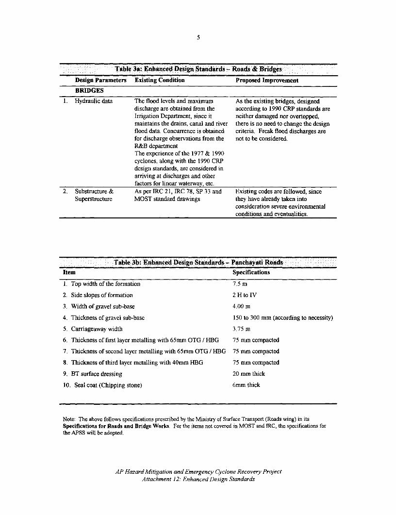
5
Table 3a: Enhanced Design Standards - Roads & Bridges
Design Parameters Existing Condition Proposed Improvement
BRIDGES
1. Hydraulic data The flood levels and maximum As the existing bridges, designeddischarge are obtained from the according to 1990 CRP standards areIrrigation Department, since it neither damaged nor overtopped,maintains the drains, canal and river there is no need to change the designflood data. Concurrence is obtained criteria. Freak flood discharges arefor discharge observations from the not to be considered.R&B departmentThe experience of the 1977 & 1990cyclones, along with the 1990 CRPdesign standards, are considered inarriving at discharges and otherfactors for linear waterway, etc.
2. Substructure & As per IRC 21, IRC 78, SP 33 and Existing codes are followed, sinceSuperstructure MOST standard drawings they have already taken into
consideration severe environmentalconditions and eventualities.
Table 3b: Enhanced Design Standards - Panchayati RoadsItem Specifications
I Top width of the formation 7.5 m
2. Side slopes of formation 2 H to IV
3. Width of gravel sub-base 4.00 m
4. Thickness of gravel sub-base 150 to 300 mm (according to necessity)
5. Carriageaway width 3.75 m
6. Thickness of first layer metalling with 65mm OTG / HBG 75 mm compacted
7. Thickness of second layer metalling with 65mm OTG / HBG 75 mm compacted
8. Thickness of third layer metalling with 40mm HBG 75 mm compacted
9. BT surface dressing 20 mm thick
10. Seal coat (Chipping stone) 6mm thick
Note: The above follows specifications prescribed by the Ministry of Surface Transport (Roads wing) in itsSpecifications for Roads and Bridge Works. For the items not covered in MOST and IRC, the specifications forthe APSS will be adopted.
AP Hazard Mitigation and Emergency Cyclone Recovery ProjectAttachment 12: Enhanced Design Standards

Attachment 13AP HAZARD MITIGATION AND EMERGENCY CYCLONE RECOVERY PROJECT
0 U;pRo EMENTDRESPONSI]ITIEs, imTHE COMMTEE OF SECRETARIES: AND FUNDS L0iLOWI PROCUREMENT RSPONANGEMIEIES
PROCUREMENT RESPONSIBILITIES
1. Infrastructure components will be implemented through the sector departments under theoverall coordination of the DMU. The sector departments will submit tenders decisions above theprescribed limits of the Chief Engineers to the Cofmiittee of Secretaries through the DMU. TheDMU will function as the secretariat for the Committee and arrange for the reviews.
2. The DMU will use the services of the already functioning PMU (with its two procurementengineers) for procurement matters and to process procurement documentation for the Committeeof Secretaries.
3. Flood Control and Drainage: All works within this component will be implemented bythe Irrigation and CAD Department. Implementation activities of the reconstruction program willbe managed by the Chief Engineer (CE), who will report directly to the DMU. The CE will beassisted by Superintending Engineers, Executive Engineers, Supporting Engineers and a QualityControl Unit (QCU). Since this component's activities cover eight districts, a Planning, Designand Monitoring Unit (PDMU) will be established within the Department for (i) coordination withthe DMU; (ii) inter-district coordination; (iii) monitoring of the construction program; (iv)submission of reimbursement applications; (v) preparation of quarterly reports; and (vi)appointment of consultants. The CE will directly supervise the activities of the Quality ControlUnit (QCU) of the Department, created to make recommendations regarding construction standardsand methods, and to ensure their implementation in the field.
4. Electricity (Transmission and Distribution): The APSEB will undertake theimplementation of works under this component. The cost of each estimate for the procurementprogram will, in this case, exceed the powers of sanction of the Chief Engineer, and they willtherefore be approved by the Board. The Board will enhance the powers of the CE and arrange toclear award decisions within a week of their submission to the Board. Alternatively, decisions oncontracts larger than an agreed threshold will be referred to the DMU and the Committee ofSecretaries.
5. Roads and Buildings: A specialized organizational setup, headed by the Chief Engineerwill be established to ensure that the construction program is timely accomplished. Thisorganizational setup will include four circles (each covering a certain number of districts) and 12Executive Divisions with 38 subdivisions. The specialized circles will also attend to the worksincluded under the Buildings component. The Panchayati Raj (PR) Engineering Department willhandle rural roads, PR public buildings and the cyclone shelters.
COMMITTEE OF SECRETARIES
6. Under the project, the Committee of Secretaries, with a similar structure and powers as theCommittee created for the implementation of the CERP, will be established. The competence ofthe Chief Engineers will be limited to the approval of tenders up to 25 percent in excess of theestimated rates. The Committee of Secretaries will have full powers to approve tenders which fall

2
beyond the financial competence of the Chief Engineers. Members of the Committee would beSecretary (Finance), Secretary Works and Projects, and the Secretary of the concerned department.The Committee of Secretaries will met about once ever ten days.
FUNDS FLOW ARRANGEMENTS
7 The schemes included in the project will be clearly listed under the functional budgetaryhead of each department to ensure their identity. The procedure for release of funds to the variousdepartments depends upon the institutions or departments executing the scheme. In the case ofworks departments, such as Irrigation or Roads & Buildings, allocations are made through asystem of Letter of Credit. In this case, the Works and Project Wing of the Finance Departmentwill issue an authorization to the Chief Engineer indicating the amount of funds needed for projectimplementation by the respective Department for a given period. In turn, the Chief Engineer /Head of the Department will distribute the amount - also in the form of an authorization - amongthe various field functionaries, e.g., Executive Engineers, who are the ones directly making thepayments for the work carried out at this level.
8. In the case of the Forest Department, the expenditure is incurred by the Field Officersthrough a system of issue of cheques to the extent of funds placed at their disposal. For theAPSEB, funds are released by way of a loan through a government order.
9. Each of the Departments or Agencies receiving funds under the project will summarizeevery month their project expenses and furnish it to the DMU within five days of the completion ofthe month for submission of reimbursement claims.
AP Hazard Mitigation and Emergency Cyclone Recovery ProjectAttachment 13: Procurement Responsibilities, The Committee of Secs and Fund Flow

Attachment 14AP HAZARD MITIGATION AND EMERGENCY CYCLONE RECOVERY PROJECT
PERFORMANCE MONITORING ICATORS 777:7f
1. Two kinds of indicators would be considered for monitoring progress of the proposedproject: (i) program performance indicators, which allow the evaluation of progress made towardthe fulfillment of the stated short, medium and long-term mitigation and recovery objectives, asdescribed for each of the proposed project components; and (ii) project performance indicators,which measure the flow of the project with respect to procurement procedures, contract preparationand approval, and general disbursement issues. When necessary, initial values of someperformance indicators would be established to provide a baseline to evaluate the extent to whichtarget values for each objective are being met.
PROGRAM PERFORMANCE INDICATORS
2. The natural hazard mitigation objectives of the project require indicators to measureprogress toward cyclone and flood vulnerability reduction in the target areas. This implies the needto measure advances in the Hazard Management Program including (i) undertaking of the hazardstudies and development of action plans; and (ii) social, environmental and economic issues such aslevels of community involvement, enhancement of institutional capacity for disaster management,changes in peoples' disaster perception and in their attitudes toward disaster mitigation, as well ascommunity and government commitment to sustaining mitigation works through the amountschanneled via the Vulnerability Reduction Fund. This type of indicators, illustrated below,requires field work. The restoration objectives require the measurement of the extent to whichessential assets of the road, drainage and electricity networks that were affected by the recentdisaster are being timely and appropriately repaired and/or reconstructed.
ProgramfPerformance Indicators
Component Activity Indicator Unit
Hazard ManagementProgramGOAP Activities Cyclone and Management Cyclone and Flood No. completed
Studies Management StudiesConsultants No. hired
Hazard Reduction Action Hazard Reduction Action No. completedPlans PlansDevelopment of an AP Disaster Management No. of staffImplementation Framework Unit and other agencies involvedLeveraging of individual / Vulnerability Reduction Rs. allocatedcommunity efforts Fund
GOI Activities Cyclone Early Warning Training Abroad No. staffSystem Doppler Radar Systems No. installed

2
Component Activity Indicator Unit
Restoration ofInfrastructureElectric Power Facilities Strengthening of 132/220 KV Lines km strengthened
Transmission LinesConstruction of New Lines 132/220/33/11 KV Lines km built (byConstruction of New Substations category)Substations No. built (by
category)Irrigation Drains and Reconstruction and Drains km reconstructedFlood Banks Rehabilitation of drainage or rehabilitated
networkReconstruction and Flood embankments km reconstructedRehabilitation of Flood Banks or rehabilitated
Roads and Bridges Repair, strengthening and State Roads km repaired orReconstruction Panchayati Raj Roads reconstructed
State Bridges No. repaired orPanchayati Brides reconstructed
Mitigation Works Planting of Tree Shelter Belts Shelter Belts ha plantedEmergency Shelters Shelters No. built and
repairedTechnical Assistance
Disaster Awareness / Workshops/ seminars No. organizedPreparedness Participants No. of attendees
NGOs, CBOs and other No. involvedcommunity groups
Improved Communication and Training Courses No. offeredInformation Technology Officials Trained (by No. of attendees
level)
3. An important component of the long-term mitigation objectives is to facilitate theinvolvement of CBOs, NGOs and the public at large in disaster management planning, and toensure that public campaigns are being undertaken to raise people's awareness regarding cycloneand flood hazards. To gather the necessary information to measure progress toward these ends amonitoring plan has been devised. This plan would include activities to measure:
(i) changes in peoples ' hazard awareness. A survey would be administered at thebeginning of project implementation in a selected area in East Godavari, before anyspecific campaign is initiated, to establish a baseline. Questionnaires would beadministered every year up to the end of the project, for a total of 4 measurements.
(ii) levels of community involvement and commitment A series of workshops would beorganized to engage people at the comnmunity level in disaster management planning. Theseworkshops should include CBOs, local NGOs, and other community groups, with especialemphasis on the most vulnerable population segments The workshops would enable the
AP Hazard Mitigation and Emergency Cyclone Recovery ProjectAttachment 14: Performance Monitoring Indicators

3
creation of a database with the profiles of participants, from which a representative samplecan be interviewed to measure the extent to which they understand the relevance ofcollaborating with government in the disaster mitigation schemes being put in place.
(iii) changes in peoples 'perceptions. A panel study would be designed to follow up aspecific community in two of the most vulnerable districts, and a specialized instrumentwould be administered throughout project implementation. Visits would be done accordingto the schedule for the public campaign and the dissemination of the results of thevulnerability studies.
(iv) degree of commitment to long-term mitigation objectives on the part of govemmentofficials at the sub-district level. Structured interviews with a selected sample of officialsfrom the two most affected districts would be undertaken at the start, middle and end ofproject implementation.
PROJECT PERFORMANCE INDICATORS
4. Proposed indicators to monitor project performance would be:
(i) Average duration of procurement procedures from launching of bids to contract awards(in calendar days) by year
(ii) Average duration of preparation, signature and approval of contracts (in calendar days)by year
(iii) Percentage of contracts implemented within the scheduled time frame (by year)
(iv) Percentage of contracts implemented with no cost overrun (by year)
(v) Percentage of payments processed or transmitted to the Bank within 30 days afterreceipt of invoice or due date (by year)
AP Hazard Mitigation and Emergency Cyclone Recovery ProjectAttachment 14: Performance Monitoring Indicators

Attachment 15AP HAZARD MITIGATION AND EMERGENCY CYCLONE RECOVERY PROJECT
OUTLINE TERMS OF REFERENCE FOR CONSULTANCIES,
Outline Terms of Reference for Consultancy on Hazard Mapping forCyclone, Inland & Coastal Flood Risk
PURPOSE
1. The purpose of this consultancy is to prepare State and District level hazard zonationmaps for cyclone, storm surge and flood risk and classify settlements by priority and type ofintervention.
INPUTS
2. Key inputs will be provided by the cyclone, storm surge and wind speed modelingconsultancy assignments.
3. GOAP/GOI to provide access to necessary digital map information on elevations,administrative boundaries, location and boundaries of settlements, watersheds, land-cover, streamflow, run-off, etc.
4. GOAP departments to provide data on infrastructure network location and alignments,infrastructure provision, house and building types, demographic, revenue and socio-economic dataat settlement, mandal and district level.
ACTVITIES
5. Collection of inputs from cyclone storm surge and wind speed modeling consultancyassignments (i.e. rainfall, cyclone, storm surge characteristics, return periods, variance and datareliability, concentration)
6. Classification of zones by hazard intensity and return period (for cyclone, coastal andinland flood)
7. Classification of zones by topography, land-cover and drainage using elevation, slope,catchment boundaries and soil parameters.
8. Identification of terrain change areas that affect effective basic wind speeds
9. Identification of protected and flood bottleneck areas and areas of concentration on coastand along inland water courses.
10. Identification of infrastructure bottleneck areas, especially bridges, railway lines androads.
11. Identification of historical cyclone and flood affected areas (and damage zones, by life,livestock, infrastructure, agriculture and economic activity, wherever possible) by analysis ofsecondary data on damage and remote sensing data.

2
12. Determination of typical mechanisms and intensity of damage by cyclone and floodhazards on buildings and infrastructure elements (by type)
13. Classification of mandals/settlements by population density, settlement location and type,building types and infrastructure elements.
14. Determination of selected mandals (for State level maps) and settlement (for district levelmaps) types by hazard intensity and risk levels.
15. Identification of hazard modification options for selected mandals and settlement types.
16. Analysis of cyclone and flood hazard and specific risk at mandal level to produce Statelevel hazard and vulnerability maps.
17. Prioritization of mandals/settlements based on hazard modification options and preparationof relevant maps.
OUTPUTS
18. State level digital hazard zonation maps for cyclone, inland and coastal flooding risk (withvillage as lowest level of resolution) in selected high hazard zones within districts.
19. Classification of settlements, by hazard level and potential interventional measures.
Outline Terms of Reference for Technical Audit of CommunityInvolvement in Hazard Reduction Activities
OBJECTIVES
20. The objective of this assignment is to conduct continuous monitoring and audit of theactivities designed to involve communities in hazard reduction activities.
SCOPE OF ACTIVITIES
21. The scope of the consultant's work would include:
(i) review of the extent of interest and mobilization of communities, measured throughthe number of hazard reduction activities undertaken;
(ii) assessment of the adequacy and effectiveness of the awareness raising programs;
(iii) assessment of the interest and use of matching financing from the VRF;
(iv) assessment of the use of VRF funds for community benefit;
(v) effectiveness of the Disaster Management Committees at the district, taluka andmandal levels;
(vi) use and effectiveness of the VHF communications systems provided under theproject:
(vii) deployment and use of the computers and associated equipment;
(viii) activities undertaken using information technology (data base of land ownership,village demography, list of community assets, activities undertaken through the
AP Hazard Mitigation and Emergency Cyclone Recovery ProjectAttachment 15: Outline TOR for Consultancies

3
Janmabhoomi program, including records of cash and in kind contributions fromcommunities, maintenance schedules for community infrastructure);
(ix) extent of training of local officials and community representatives in the use oftechnology; and
(x) extent of misuse of facilities provided.
AUDIT REPORT
22. The consultant should: report in qualitative and quantitative terms to illustrate the extentto which the objectives of community involvement in hazard reduction activities are successful;recommend changes to the program that are required to keep the activities on track to meet theobjectives; reports on misuse of facilities and suggest corrective action to be taken.
FREQUENCY OF REPORTING
23. The consultant will carry out technical audits every for months, visiting various talukasand mandals in rotation, with each taluka visited at least once every six months. The consultantwill produce a report following each visit within two weeks of completion of the visit to the field.The consultant should submit the reports direct to the Director of the DMU.
Outline Terms of Reference for Quality Assurance and Certification
(A) For GOAP
OBJECTIVES
24. To ensure that infrastructure restored under the project conforms to sound engineeringdesign and construction practices, and to certify their compliance with hazard reduction criteriaagreed under the project.
SCOPE OF ACTIVITIES
25. The following activities would be covered under the assignment:
(i) verification that necessary environmental screening and certification has beengranted by the DMU, and any agreed mitigation activities have been incorporatedin the design and included in project costs;
(ii) verification that no displacement of people is planned or has taken place;
(iii) check of design assumptions and adequacy of the criteria to meet the minimumrequirements set by the DMU and the Bank;
(iv) check of field conditions regarding siting, hydrology, land use and other factorsthat contribute to increased vulnerability;
(v) adequacy of construction practice and methodology adopted; and
(vi) quality of workmanship and supervision to meet specifications.
AP Hazard Mitigation and Emergency Cyclone Recovery ProjectAttachment 15: Outline TOR for Consultancies

4
COVERAGE
26. The assignment will cover the core infrastructure sectors of irrigation, roads and bridges,public buildings and electricity facilities.
SAMPLING
27. The consultant and the DMU will agree on the sample of infrastructure to be reviewedunder this assignment. A sample of about ten percent would be considered. The consultant and theDMU will agree on the major infrastructure investments that would be reviewed on a hundredpercent basis for which certification would be required.
FREQUENCY
28. The consultant will have experienced staff for the various disciplines, and would undertakefield visits, in rotation, once in three months.
REPORTING
29. The consultant will not interfere in the field with the supervisory arrangements ofimplementing agencies nor give any instructions to the field staff. The consultant will submit areport following each visit, outlining the findings, the non-compliance and other deficiencies withrecommendations for remedial actions. The reports will be submitted directly to the ProjectDirector of the DMU. Promptly upon receipt of the report of the consultant, the Project Director ofthe DMU will take action to correct any deficiencies or non-compliance.
(B) For IMD
30. A similar assignment to the one described above would be contracted, but with a differentset of disciplines applicable to cyclone early warning systems.
Outline Terms of Reference for Formulation of Design Criteria andConstruction Practices for Infrastructure in High Risk Areas
BROAD OBJECTIVE
31. The broad objective of the study is to review current design criteria and constructionpractice and recommend the respective criteria and practices to be adopted for the construction ofcyclone and flood-resistant infrastructure such as drains and flood banks, etc. in high risk zonesSuch review and recommendations will consider the latest technological advances made in thisfield.
AP Hazard Mitigation and Emergency Cyclone Recovery ProjectAttachment 15: Outline TORfor Consultancies

5
STATEMENT OF OBJECTIVES
32. When completed, the project should broadly have developed the following main results.
(i) design criteria to be adopted for irrigation structures, drains and flood banks etc.,to withstand cyclone, wind, floods and storm surges.
(ii) broad ranges of intensities of hazard factors for application of new design criteria.
(iii) cost-benefit relationships with application of the recommended design criteria.
(iv) feasibility report on varying design criteria within the vulnerable zones.
(v) design criteria and construction practices for high risk areas.
(vi) special provisions, that may be found necessary, for enforcement of the newdesign criteria.
(vii) uniform building code for high risk and coastal area.
33. The existing practices of design of infrastructure relating to:
(i) Irrigation and drainage generally conform to Indian standards on various disciplines, suchas river valley development and civil engineering materials etc. Wind forces, flood frequencies,storm-run-off, hydraulic and structural design of structures, energy dissipation arrangements, soilengineering and foundation design etc. form the core group parameters. A Classified List of IndianStandards on River Valley Development and Civil Engineering published by the Bureau of Indianstandards, New Delhi, can be a good source of standards available on these topics. The designprocedures also refer to standard text books, such as Open Channel Hydraulics and HydrologyHandbook by Vente Chow and various other standard textbooks on hydraulics, soil mechanics,structural engineering, etc. Certain Manuals, e.g., Guidelines for Estimation of Flood Dischargespublished by CWC are good reference sources whenever special problems are encountered fordesign studies undertaken at institutions like CWPRS (in Pune) and APERL (in Hyderabad).
(ii) Buildings being constructed by R&B and Panchayati Raj Departments conform toNational Buildings Code (NBC), Indian Standards codes on Reinforced cement concrete, windforces, seismic forces, foundations etc., and
(iii) The Roads conform to the specifications indicated by the Ministry of Surface Transport(MOST) and Indian Roads Congress (IRC) and standard text books/codes on pavement designs.
34. Sectional Committees of Bureau of Indian Standards periodically review the codes ofpractice and revise if found necessary.
35. Special solutions for design of foundations of structures where soils met with negligibleshear parameters or near nil values in coastal districts drains are often arrived at by indigenousmethods - which require refined solutions.
SCOPE OF WORK
36. Consultant's services will cover: roads and bridges, irrigation and drainage, electricfacilities, water supply and sewerage facilities, and public and private buildings (including multi-story buildings).
37. The Consultant will specifically:
(a) Review and document design criteria and construction practices for eachinfrastructure subsector that would have a linkage to hazards such as cyclone,wind, floods and storm surge;
AP Hazard Mitigation and Emergency Cyclone Recovery ProjectAttachment 15: Outline TOR for Consultancies

6
(b) Document the intensity and frequency of occurrences of each of the hazard factorsand prepare broad ranges of their intensities for application of the new designcriteria, in agreement with the infrastructure construction agencies,regulating agencies (such as the Relief Commissioner) Central and concernedState agencies and in conformity with up-to-date hazard maps available;
(c) Conduct sensitivity analyses to determine the cost and benefit relationship for theenhanced design criteria and construction practices, clearly indicating which of thefactors are essential;
(d) Using available hazard maps determine the high risk areas to each type of hazard,and investigate the feasibility of varying design criteria within the vulnerablezones;
(e) Recommend for each infrastructure sub-sector, the design criteria andconstruction practices suitable for use in clearly demarcated vulnerable high riskareas of Andhra Pradesh;
(f) Specify any special provisions required for enforcement of the new design criteria;and
(h) Prepare a draft Coastal and High Risk Area Uniform Building Code.
38. In co-operation with the Irrigation, R&B, PR and Public Health departmental staff, theconsultants shall design suitable formats for collection of all relevant data for design criteria andconstruction practices. A data base shall be created with all readily available data in such a waythat future data collection, relevant statistical analysis and reporting can be handled through thedata base system.
OUTPUTS
39. The report would include specific recommendations for design and construction practicesfor different type of structures, broad ranges of intensities for application of new design criteria,cost - benefit relationship indicating the factors essential for applying the design criteria, determinehigh risk zones and demarcate them in the maps, specify any special provisions for enforcement ofnew design criteria, and prepare uniform building code in the coastal and high risk area.
40. The Consultant shall prepare a work plan explaining the strategy and process they woulduse to accomplish the assignment. The Consultant should prepare an inception report within onemonth after inception of the contract for review by the client. They should further submit aninterim report within one month after review of the inception by the client. The Draft Final Reportsubmitted by the Consultant will be reviewed the Review Committee constituted for this purposeand the report finalized accordingly.
AP Hazard Mitigation and Emergency Cyclone Recovery ProjectAttachment 15: Outline TOR for Consultancies

7
Outline Terms of Reference for Cyclone, Flood and Storm SurgeModeling and Analysis
OBJECTIVE
41. The objective of this study is to improve the scientific and operational capability of theIndia Meteorological Department (IMD) and to provide timely, complete and accurate predictionsof critical characteristics of cyclonic storms in the Bay of Bengal. The addition of six Dopplerradar stations covering the coastal area of AP will provide new information on the location andintensity of cyclones approaching the coast. These data along with improved satellite monitoringof weather systems in the Bay of Bengal will make possible the improvement of event specificpredictions of landfall, rainfall and wind speed. This improved information will facilitate themodeling of cyclones and their associated impacts and the identification of areas exposed topotentially damaging wind and flooding.
42. Modeling of the cyclone process makes possible the real time estimation of projectedrainfall and storm surge. This information when related to adequate topographic mapping permitsto identify high risk hazard zones. Detailed mapping of high risk hazard zones may be used todirect population and investment to relatively safer areas, thus reducing future disaster losses.
SCOPE
43. This modeling and analysis will include the meteorological and oceanographic aspects ofthe cyclone phenomenon. First priority is given to the application of modeling and analysis tophenomena likely to affect the territory of Andhra Pradesh. This work should lead to a generalenhancement of cyclone prediction and forecasting in the region.
44. The modeling effort will require extensive meteorological, topographical, hydrological andbathymetrical data as input. Access to this material, where it is available, and collection ofrelevant data when unavailable, are critical to the success of the project. IMD's must lead acoordinated effort of key GOI organizations including the Survey of India, the Department ofOcean Development and the Central Water Commission in order to accomplish this task.
TASKS
45. Assessment of availability of existing relevant data resources and analytical capability forcyclone, flood, and storm surge modeling for Andhra Pradesh. Outcome: data acquisition plan.
46. Review and assessment of available models for cyclonic storm path prediction, rainfalldistribution and intensity, coastal flooding and stormn surge. Ouitcome: Recommendations onmodels to be used.
47. Completion of the necessary mapping of the coastal zone and major flood plains at 0.5meter contours. Outcome: Complete topographic and bathymetric mapping for Andhra Pradesh.
48. Cyclone modeling, including: (i) selection and adaptation of appropriate models; (ii) dataacquisition; and (iii) implementation of cyclone related models. Outcome: Improved real timeforecasting of rainfall, wind speed, cyclone land fall, input for development of wind hazard map forAndhra Pradesh.
AP Hazard Mitigation and Emergency Cyclone Recovery ProjectAttachment 15: Outline TORfor Consultancies

8
49. Storm surge and coastal flood modeling, including: (i) selection and adaptation ofappropriate models; (ii) data acquisition (i.e., meteorological, hydrological, topographic, et cetera);and (iii) implementation of storm surge and coastal flood models. Outcome: input for coast zoneflood and storm surge hazard maps for Andhra Pradesh.
Outline Terms of Reference for Comprehensive Coastal Zone, Delta andWatershed Management Plans
OBJECTIVE
50. The long term objective of this study is to achieve sustained and effective floodforecasting, flood control and water management in the coastal zone, the Krishna and GodavariDeltas and upland watersheds subject to flash flooding; thus protecting human lives, crops,property and infrastructure investments.
SCOPE
51. This project includes three-interrelated areas: (i) the coastal zone which includes theroughly 1000 km coast of Andhra Pradesh and ancillary areas inland (including all areas subject tocoastal flooding); (ii) the deltas of the Krishna and Godavari rivers (which include the coastal zoneareas); and (iii) upland watershed subject to flash flooding. These upland watersheds contribute tothe hydrologic systems of the deltas and the coastal zone.
52. The primary focus of the study is to introduce hazard related information into theintegrated, comprehensive programs associated with these three areas. This work will beconducted largely on the basis of data specific to Andhra Pradesh. Leadership will lie with statelevel agencies such as the Irrigation and Drainage Department. Substantial input would beexpected from the India Meteorological Department (IMD) and the Central WaterCommission(CWC).
TASKS
53. Assessment of availability of existing necessary data resources and analytical capabilityfor flood plain and watershed management. Outcome: data acquisition plan.
54. Review and assessment of available models for riverine flood, flash flood and flood plainand watershed management. Outcome: selection of appropriate models.
55. Flood and watershed management modeling, including: (i) data acquisition for models(meteorological, hydrological, topographic, vegetation and land use); (ii) implementation of floodplain models; and (iii) analysis of water management options. Outcome: Input for development offlood and flash flood hazard maps; input for development of flood control strategy; input for realtime operations of control system.
56. Integration of disaster loss reduction considerations into regional development plans.Outcome: Integrated coastal zone management plan; Krishna and Godavari Delta managementplan, integrated flood plain management plans; integrated watershed plans for areas subject to flashflooding.
AP Hazard Mitigation and Emergency Cyclone Recovery ProjectAttachment 15: Outline TOR for Consultancies

9
57. Inclusion of disaster-loss reduction priorities into social and economic development plans.Outcome: Procedure for calculation of disaster risk as a factor in social and economic planning.
Outline Terms of Reference for Study of Electric Power SystemImprovement for Hazard Mitigation
OBJECTIVES
58. The objective of the study would be to evolve appropriate design and constructionstandards for transmission, distribution and substation facilities in the coastal areas of AndhraPradesh to mitigate the impact of cyclones and floods that frequently hit the coast. Specifically,the consultant(s) conducting the study will:
* Review existing design criteria and construction practices
* Review international practices for design and construction of facilities in disaster prone areas.
* Select possible design criteria that may be applicable to Andhra Pradesh.
* Evaluate the cost/benefits of different alternatives.
* Review intensity and frequency of floods and cyclones and classify areas into different riskzones.
* Recommend appropriate design criteria and construction practices for different areas.
* Apply these to existing facilities and future plans.
* Recommend a phased remedial plan with clearly defined priorities.
* Prepare cost estimates and implementation timetables.
Outline Terms of Reference for Community Based Hazard Reduction:Integrated Mitigation, Warning and Response
BACKGROUND
59. To a great extent, the GOAP has assumed the responsibility of replacing the assets andresources lost to the disasters which frequently affect the state, thereby facing a continuous drain ofpublic funds. Vulnerable populations have come to rely heavily on the state government for thesatisfaction of their post-disaster needs. As the levels of dependency on government emergencyand relief assistance have increased, incentives for sharing the responsibility for disasterpreparedness and management have diminished significantly among local communities in thecyclone and flood prone areas. Given current fiscal constraints, however, official programs suchas emergency shelters cannot continue to depend completely on government resources for their
AP Hazard Mitigation and Emergency Cyclone Recovery ProjectAttachment 15: Outline TOR for Consultancies

10
maintenance and/or management. As part of a sound strategy for community development,vulnerable populations should be involved in hazard reduction activities at the local level.
OBJECTIVES OF THE STUDY
60. The long-term objectives of the study are to (i) reduce the financial and psychologicalimpact of disasters on the affected populations and the GOAP; and (ii) increase the levels ofdisaster preparedness among vulnerable populations and industries.
61. The short-term objectives of the study, considering the project implementation period andthe overall hazard activities to be undertaken by the GOAP under the project, are to addressshortfalls and reconunend programs and activities that would improve (i) the accuracy of warnings;(ii) warning effectiveness at the taluka and mandal level, including a degree of warning redundancynecessary to ensure reliable warnings and an adequate response level among the target audience;(iii) individual and community involvement in disaster preparedness and mitigation; (iv)effectiveness of warning response mechanisms at all levels, including district, taluka, mandal,community and individual; and, (v) communications systems at the taluka and mandal level,particularly computer-based systems with Internet links and the capacity to access relevant data onwarning and mitigation issues as well as related community development information.
62. These objectives will be accomplished in two phases:
(a) Phase 1 - Assessment. It will consist of a thorovtgh analysis of (i) state and localcapacity at various levels and different respects, including, inter alia, individual,community, institutional and technical capacity, and (ii) the needs of vulnerablepopulations.
(b) Phase 2 - Design and Implementation. Drawing from the information andrecommendations gathered during Phase I, it will entail the design and undertakingof hazard reduction programs through locally-focused activities supported with localfinancing and in-kind contributions, along with GOAP and international funds.Specific Phase II activities are only suggested in this TOR as an indication of whatcan be done, since a precise and elaborated plan will be the responsibility of theconsultants. The latter should provide the final list and content of activities.
63. The programs addressing the above objectives should be based on a two-way dialoguebetween the government and the target populations in vulnerable areas. Issues to cover shouldinclude local needs, capacities and appropriate disaster preparedness and response mechanisms.
SCOPE OF WORK
64. Overall study outcome Once completed, the study will lead to the following generalresults:
(a) a link with the other sub-components and studies included in the project, to ensurethe overall compatibility and integration of data, paradigms and planningrecommendations being produced, such as data and findings on flood modeling,hazard mapping, demographics, et cetera.
(b) improved forecast precision and reduced time-lag between IMD's landfall predictionand community/individual emergency response.
AP Hazard Mitigation and Emergency Cyclone Recovery ProjectAttachment 15: Outline TOR for Consultancies

11
(c) reduced negative impact of disasters on financial resources of GOAP and affectedpopulations.
65. All studies and assessments shall be made in conjunction with the other studies called forin the Project with full utilization of the data and findings in these studies as they become available.It is expected that the consultants will form a close working relationship with DMU, which willprovide free and easy access/exchange of data between the various studies included in the Project.
66. All activities in the project should be coordinated and worked through and in conjunctionwith the activities being developed in the Janmabhoomi Program. The latter should be used assupport for the many community hazard reduction activities to be implemented under these TOR.
67. The study will be implemented in two phases: Phase 1, which will identify the needs andstrategies for addressing these needs, and in which implementation in high priority projects willbegin where appropriate. All activities listed below will take place during this phase, unlessspecifically designated "phase 2" (in which the studies, designs and recommendations of the firstphase are acted on through program implementation as appropriate). Phase 1 and phase 2 arefurther addressed below.
PROJECT TASKS AND PRODUCTS
68. The following are the major tasks to be undertaken by the consultants in cooperation withthe GOAP, to achieve the immediate objectives of the study. It is, however, left to the professionaljudgment of the consultants to make any necessary supplements in order to achieve the immediateobjective of the study leading to the long-term project objectives. In this respect, the consultantswill make recommendations and design activities that promote the development of one or more ofthree disaster management products: (i) a comprehensive vulnerability assessment; (ii) operationaldisaster response; and, (iii) a state-wide disaster mitigation strategy.
69. The improvement of lines of communication between IMD forecasting and individuals invillages and towns on the AP coast which builds on the improvement in IMD forecasting is anexpected outcome from the acquisition of radar and other equipment by the IMD.
70. The consultants shall assess the suitability and identify problems of current process ofdisseminating warnings from the time a forecast is made by the IMD to the receipt of this warningby the vulnerable populations. Recommendations for additional equipment shall be made if foundappropriate. Alternative means of communicating the warnings will be examined and at least oneredundant mechanism will be recommended. Output: Recommendations for improvements inexisting transmission of waming and additional mechanisms identified to provide redundancy.
EFFECTIVENESS OF WARNING
71. The consultants shall assess the warning system for effectiveness. Constraints to aneffective warning which elicits a reasonable and protective response will be identified, andrecommendations made, if appropriate, which could remove these constraints. The consultantsshall examine particularly the constraints imposed by "waming fatigue" and recommendmechanisms and programs which address this phenomenon As part of this assessment, theconsultants shall also examine elements of the composition of the present warning messages, withconsideration to technical and anthropological issues which affect warning effectiveness andidentify areas where warnings can be made more effective and pervasive, i.e. improvement of AirIndia Radio (AIR) effectiveness for waming.
AP Hazard Mitigation and Emergency Cyclone Recovery ProjectAttachment 15: Outline TOR for Consultancies

12
72. Phase 2. The consultants shall design and assist in the implementation of appropriateprograms which improve warning effectiveness. Outcomes: Recommendations and proposalswhich will result in a more effective warning, and better responses to warnings. Implementation ofprograms which address constraints to an effective warning system.
ALTERNATIVE WARNING MECHANISMS
73. The consultants shall identify, where appropriate, alternative low-cost warningmechanisms, and local informal warning mechanisms which could augment the existing technicalsystems. Among the mechanisms which the consultants should examine are GIS fishing boatlocators, and the utilization of an enhancement of folk warning systems. Outcome: Proposals foraugmenting present systems with alternative and informal warning mechanisms.
COMMUNITY VULNERABILITY ASSESSMENTS
74. In conjunction with the participation of people in vulnerable coastal and nrverinecommunities, the consultants shall conduct participatory vulnerability assessments in 15 per cent ofvillages in the high hazard areas of Andhra Pradesh. The consultants shall help these communitiesidentify priorities for immediate, medium and long term interventions for hazard reduction andidentify ways in which they can address these needs.
75. The consultants shall also identify local lead institutions capable of implementingcommunity hazard awareness programs and providing leadership for preparedness. Theseinstitutions could be, inter alia, fishing cooperatives, marketing networks and organizations andmaritime authorities.
76. It is envisioned that pilot activities begun in these communities will provide the basis forsimilar and improved projects in all villages in vulnerable zones.
77. Phase 2. The consultants shall assist communities in high hazard areas in designing andimplementing mitigation programs. It is envisioned that these programs would have a significantcontribution by the community, but would also receive matching financial assistance from theVulnerability Reduction Fund and/or the GOAP. Outcome: Recommendations for andimplementation of (in phase 2) activities for community designed and administered hazardreduction.
COMMUNITY AWARENESS AND PREPAREDNESS
78. The consultants shall identify ways to increase awareness and preparation for cyclone andfloods in vulnerable communities but not limited to: (i) provision of incentives for community andindividual preparedness; (ii) education on effective responses, evacuation procedures, and formunicipal government's public awareness campaigns as appropriate, and (iii) education on safetyduring disasters. Output: Proposals for increasing hazard awareness and preparation for floodsand cyclones.
EFFECTIVENESS OF CYCLONE AND FLOOD RESPONSE
79. The consultants shall perform an assessment of existing district taluka and mandal levelresponse mechanisms including, but not be limited to, an assessment of systems and equipment.
AP Hazard Mitigation and Emergency Cyclone Recovery ProjectAttachment 15: Outline TOR for Consultancies

13
80. The consultants shall examine the constraints on response to cyclone and floods byindividuals in high hazard areas, and propose programs which will assist individuals in respondingmore effectively to cyclones and floods. Output: Proposals for improving institutional andindividual responses to cyclone and flood warnings.
SHELTER IMPROVEMENT
81. Community Emergency Shelters. The consultants shall examine the shelters available tothe populations of high hazard areas and assess the shelters suitability and capacity to safely houselocal populations which might be expected to use the shelter. In conjunction with the community,the consultants shall identify appropriate uses of the shelter when not required for shelter fromflood or disaster, help the community to identify needs and mechanisms which will improve the off-disaster use and maintenance of the shelter, identify sheltering and relief needs during times offlood and cyclone, and develop plans and design programs to address these needs. The consultantsshall help communities in high risk areas to identify buildings in the community to providesufficient shelter for the population, and work with the GOAP to provide additional emergencyshelter infrastructure if required.
FAMILY HOUSING - SHELTER
82. The consultants shall examine existing programs for housing improvement in vulnerableareas and make recommendations for integration of hazard mitigation elements into theseprograms. The consultants shall examine the economic trade-of of investing in housing upgradeversus participating in a hazard fund or insurance for post-disaster housing replacement orrehabilitation. Where appropriate, the consultants will recommend additional initiatives which willpromote the strengthening of existing housing and building of new housing to standards ofconstruction which will improve the resistance of the housing to wind and inundation. Suchprograms should address, inter alia, placement of openings in houses, roof design and roof/frameconnections, house siting, bracing and other simple and easily implemented engineering techniquesand use of water resistant materials.
83. Recommendations for family housing improvement will be made within the economiccontext of vulnerable families. All recommendations must be able to be implemented by familieswith few monetary resources. Addressing this issue, the consultants recommendations willconsider, inter alia, the use of inexpensive locally available materials, incentive schemes forhousing improvement such as combining material and upgrading requirements with programs forsubsidized improved building materials and training for unskilled and indigent families in bettertechniques for self-constructed cyclone and flood resistant housing.
84. All proposals for housing improvement shall include plans for independent monitoring ofthe programs to insure that funds are used efficiently in improving poorly constructed housingamong the most vulnerable populations.
85. Phase 2. The consultants shall assist the state and community in implementing programsdesigned under phase 1. Outputs: Sufficient community shelter for all vulnerable populations;shelter maintenance programs in place; and improved resistance to wind and water in familyhousing.
AP Hazard Mitigation and Emergency Cyclone Recovery ProjectAttachment 15: Outline TOR for Consultancies

14
DISASTER PREPAREDNESS
86. The consultants shall identify and suggest design for activities which will assistcommunities and institutions in high hazard occupations to prepare for flood, cyclones and for theinevitable losses from disaster. The designs should assure that they will be sustained long term bythe organizations or institutions which they serve, with a minimum of assistance for the GOAP orother donors. The areas to be examined should include: mutual assistance programs (fishermancoops, agricultural co-opts and other local trade organizations, economic improvement viapreparedness, such as subsidized insurance programs, marine safety programs and involvement oflocal business groups (i.e. Lion's clubs) in the development of prograns for mutual assistanceand/or disaster insurance.
87. Phase 2. As directed by the Disaster Management Unit, the consultants shall assist tradeorganizations and other institutions in implementing preparedness programs. Output: Proposalsfor self-standing preparedness programs and institutions which prepare vulnerable groups tomitigate losses due to disasters.
COMMUNITY ACCESS TO INFORMATION - INFORMATION TECHNOLOGY PROGRAMS
88. The Consultants shall assist in the development of a community based Internet accesssystem. The project will provide, under a separate component, the necessary equipment to allowlocal (village level) leaders, organizations and institutions access to a variety of information overthe Internet, especially information which can assist local leadership in developing disastermitigation and preparedness programs. The system will primarily allow a more direct contactbetween the state government and activities at the village level.
89. In the context of their other activities at the community level and in conjunction with localleadership, the consultants shall design a program for use of a local Internet access system whichwill give maximum access to information from the Internet to a broad spectrum of local leaders andorganizations. The programs' design shall anticipate impediments to a free and broad access andwill recommend mechanisms to insure that such impediments are minimized. Theserecommendations shall be developed through dialog with the District Disaster ManagementCommittees, the Disaster Management Unit (DMU) and the Disaster Management Council.Acting on the comments of these groups, the consultants will, afterwards, refine recommendationsfor the organization of the system for approval.
90. The consultants shall provide the necessary oversight to begin real-time operation of thesystem and troubleshoot initial problems in the system for six months after start up of the system.Outputs: Proposal for village level accessible communication links. Installation of the villagelevel system and training for management staff.
IMPLEMENTATION OF HAZARD MITIGATION, WARNING IMPROVEMENT ANDPREPAREDNESS PROJECTS
91. The consultant shall provide general technical oversight for implementation of allprograms, report on a regular basis to the DMU on progress of the implementation and assess theimplementation of the programs in the context of the overall and immediate objectives of theproject outlined above.
92. As directed by DMU, the consultant shall take an active role in assisting communities,organization, mandal leadership and other organizations and groups as appropriate in implementingprograrns designed under this project.
AP Hazard Mitigation and Emergency Cyclone Recovery ProjectAttachment 15: Outline TORfor Consultancies

15
93. While the role of the consultant as implementor will be decided by the DMU afterconsidering the need and appropriateness of the consultant's support, it is envisaged that theconsultant will perform oversight for implementation of the projects designed, outlined aboveduring Phase I and Phase 2. Product: Quality assurance in implementation of the programs forhazard mitigation, preparedness and improved warning and fidelity to the objectives of the project.
PROJECT ORGANIZATION AND RESPONSIBILITIES
94. The consultants shall be responsible for the management of the assignment and also for itsimplementation within the given constraints of time and resources. Consultants are solelyresponsible for, inter alia, the collection and interpretation of data, and for the findings andrecommendations of the project.
95. The consultants shall in cooperation with the staff assigned from the client carry out, interalia, all data collection, studies, and analysis needed to attain the objectives and overall projectoutputs and products as stated above. The consultants are responsible for attaining a fullyprofessional standard of the work.
96. The DMU will provide overall guidance for the study. The client shall further provide thenecessary approval of the reports and documents provided by the consultant within the time frameallocated for such approval/comments.
97. It is envisaged that the study head office shall be established in Hyderabad. A closecooperation with DMU in Hyderabad will be maintained. It is recommended that the consultantmaintain a field office in Kakinada or other suitable location close to the area of study.
TIME SCHEDULE, REPORTING AND REVIEW
98. The entire study consists of two phases. Phase 1 activities will be completed in sixmonths. Phase 2 activities will be a follow-up activity in which the consultants activity will befurther defined based on action taken by the DMC and the DMU on the consultant'srecommendations and proposals, but will be completed in about one year. Activities in Phase 1will include:
a) study of and recommendations for improvement of lines of communication betweenIMD forecasting and individuals in villages and towns on the AP coast;
b) assessment of the waming system for effectiveness;
c) development of alternative warning mechanisms;
d) conduct of participatory vulnerability assessments in 15 percent of villages in thehigh hazard areas;
e) identification of ways to increase awareness and preparation for cyclones and floodsin vulnerable communities;
f) assessment of existing district taluka and mandal level response mechanisms;
g) examination of the shelters available to the populations of high hazard areas andassess the shelters suitability and capacity;
h) recommendations for improving hazard resistance in family housing;
i) identification of programs for community preparedness; and,
j) development of a community based Intemet access system.
AP Hazard Mitigation and Emergency Cyclone Recovery ProjectAttachment 15: Outline TORfor Consultancies

16
99. Activities in Phase 2 will generally be developed from recommendations and proposalsprovided by the consultants in Phase 1. After review of the recommendations by the DMC and asdirected by them, the DMU will mutually agree with the consultants the priorities and schedulingof Phase 2 activities within the overall scope of the study. The consultant will additionally act astechnical auditor for the programs implemented in Phase 2 as explained above. It is expected thatPhase 2 will contain, inter alia, the implementation of:
a) programs which improve warning effectiveness
b) alternative and informal warning mechanisms
c) community based mitigation, preparedness and shelter programs
d) mitigation and preparedness programs designed with and implemented by trade andcommercial organizations
e) continued development and assistance in implementing the community-based Internetaccess program
REPORTING
100. The consultants shall submit the following reports to DMU:
a) Inception report, three weeks after starting date. This report shall, inter alia,contain any updating of the consultants' approach or work plan as deemednecessary. The report shall comprise an account of problems met and proposals forovercoming such problems together with an account of the progress of the project.
b) Interim Report, three months after the starting date. The Interim report shall, interalia, document the progress to date of the project and studies undertaken. Tentativeconclusion, or items which require urgent response will be highlighted in this report.
c) Phase I final report, six months after starting date. The report shall. inter alia,address all tasks listed above and submit draft conclusions, recommendations andproposals, supported by data collected by this project and made available byconcurrent projects and studies under the project. Specific and detailed proposalsfor activities in all task areas will be included.
d) Progress reports shall be submitted at two month intervals. The primary purpose ofthese reports shall be to assess progress in programs and activities then underimplementation vis-a-vis the objectives of the project. The reports shall also containrelevant comments on the project which should be brought to the attention of DMUand DMC.
JOINT REVIEW
101. The consultants work will be subject to review by representatives of the DMU andmembers of the DMC. The review will be made within four months after starting date and bebased on the documentation in the Interim report as well as on the previous submitted documents.
AP Hazard Mitigation and Emergency Cyclone Recovery ProjectAttachment 15: Outline TOR for Consultancies

17
CLIENTS CONTRIBUTION
102. Data. The DMU will provide access for the consultants to all relevant data in thepossession of the GOAP, and be instrumental in locating files, maps and documents which theconsultants deem relevant. The DMU will also coordinate acquisition of data from studies andprograms concurrently running under the project and from IMD. DMU will facilitate access toofficials in other parts of GOAP and GOI as appropriate.
103. Staff The GOAP will provide assistance at the district, taluka and mandal level in orderto facilitate the consultant's access to and examination of the study area and populations, includinga reasonable use of district and mandal personnel to provide liaison between the consultants,communities and organizations and relevant individuals.
AP Hazard Mitigation and Emergency Cyclone Recovery ProjectAttachment 15: Outline TOR for Consultancies

Attachment 16AP HAZARD MITIGATION AND EMERGENCY RECOVERY PROJECT
ECONOMICANALYSIS 7777
1. The econonic rationale for cyclone emergency planning and mitigation is based on the premisethat the better the recuperative capacity of an economy - that is the economy's disaster planningmeasures to minimize damage and the implementation of post-cyclone recovery operations - thelower the immediate and long-term damage inflicted on the economy. The degree of localrecuperative capacity to be built is influenced by the vulnerability specific to the region in question.
2. Vulnerability to natural disasters of a particular region depends both on the frequency andmagnitude of these disasters, and on the economic and social profile of the exposed region. Eventhough a hurricane may be severe, if it occurs in a unpopulated region with little economic activity,the impact may be insignificant. Similarly, if an economically developed and densely populatedregion is subject to earthquakes having occurred as frequent as once in a century, the lowprobability of the incident may not justify investments beyond emergency relief and response. It isthe coexistence of the two aspects of vulnerability - physical and socio-economical - that wouldcall for mitigation measures.
3. From an economic perspective, investments into local recuperative capacity are deemed to bebeneficial provided that the present value of the averted losses through mitigation measuresoutweigh the present value of the cost of mitigation over a specified time period. The costs ofmitigation are defined as the investment costs incurred for the mitigation measures plus the annualcost of maintenance. Averted losses include the direct and indirect damage - that is the costs toreplace lost or damaged assets and inventories (direct), and induced hardship on population andlong-term impacts on macroeconomic variables (indirect), respectively - that could be preventedthrough investment into mitigation. The extent of damage avoided depends on both the physical andsocio-economic vulnerability.
4. Physical Vulnerability. Between 1891 and 1969, about 450 cyclones of various degrees ofintensity - which tended to increase over the years as evidenced by wind velocities - occurred inthe Bay of Bengal, generating damage in the coastal districts of Tamil Nadu, Andhra Pradesh,Orissa, West Bengal and Bangladesh. One or two cyclone storms hit or skirt the 1030 kilometerslong coast of Andhra Pradesh annually. As presented in table 1 below, the coastal districts ofAndhra Pradesh were subjected to 60 cyclone storms during this century, 25 of which were severein terms of impact.
5. In addition to the frequency of occurrence, there is a combination of factors that render thecoast of Andhra Pradesh physically vulnerable to cyclones and related storm surges. The low-lyinglands, typical for the Eastern shore of India, permit storm surges, even of a few meters height, toinundate far into the hinterland, causing widespread flooding and sea water incursion not only inthe coastal region. This natural calamity is exacerbated by man-made physical vulnerability as forinstance the disappearance of mangrove forests due to commercial shrimp farming along the coast.In places with significant gaps in tree shelter, tidal waves have reached into the hinterland furtherthan in places with protective vegetation. Moreover, the low permeability of the soils in the Krishna

2
delta combined with poor maintenance of the drainage, that would - if not clogged - ensure the seawater to flow back to the sea, tend to increase the period and area of submersion.
Table 1 - Cyclones in coastal districts of Andhra Pradesh (1892 - 1984)District Cyclone Storms Severe Cyclone Total
StormsNellore 11 7 18Prakasam (Ongole) 4 3 7Guntur - - -Krishna 7 7 14West Godavari 1 - 1East Godavari 7 1 8Visakhapatnam - 2 2Srikakulam 5 5 10Total 35 25 60
Ref: Naidu, B.R. (1989), Economic Consequences of 1977 Cyclone in Andhra Pradesh, Monograph, SriVenkateswara University, Tirupathi, India.
6. Social and Economic Vulnerability. With over 66 million inhabitants, Andhra Pradesh is thefourth most populous state in India. Much of its population is located in the more prosperous andfertile districts along the coast, where population densities are in many districts more than twice thestate's average. As presented in table 2 below, human lives lost from severe cyclones during thepast two decades amount to almost 17,000, with almost 100 million people having been affectedeither through permanent relocation, temporary loss of shelter or other adversities from cyclones.
Table 2: Damage assessment of major cyclones in Andhra Pradesh (169-1996)Persons Persons Affected % of State GDP Direct Damage inKilled 1990 prices
(Rs. billion)May/November 1969 858 N/A. 13.0 14.7September 1972 100 4,500,000 N/A. N/A.November 1976 48 N/A. 5.1 6.9November 1977 11,316 9,037,400 19.9 29.2May 1979 638 1,700,000 12.8 17.0August-October 1983 155 63,300,000 0.5 11.1November 1984 565 200,000 0.2 3.4May 1990 967 8,000,000 0.8 28.4June-December 1996 1,716 9,000,000 1.3 60.0
Total 16,363 95,737,400 170.7
Ref: Naidu, B.R. (1989), Economic Consequences of 1977 Cyclone in Andhra Pradesh, Monograph, SriVenkateswara University, Tirupathi, India.Implementation Completion Report (1995), India: Andhra Pradesh Cyclone Emergency ReconstructionProject, The World Bank, Washington, DC.Governrnent of Andhra Pradesh (1997), Note on Damages /Relief Operations during 1996-97, Revenue(Relief) Department, GOAP, Hyderabad, India.IMF (1995), International Financial Statistics.
AP Hazard Mitigation and Emergency Cyclone Recovery ProjectAttachment 16: Economic Analysis
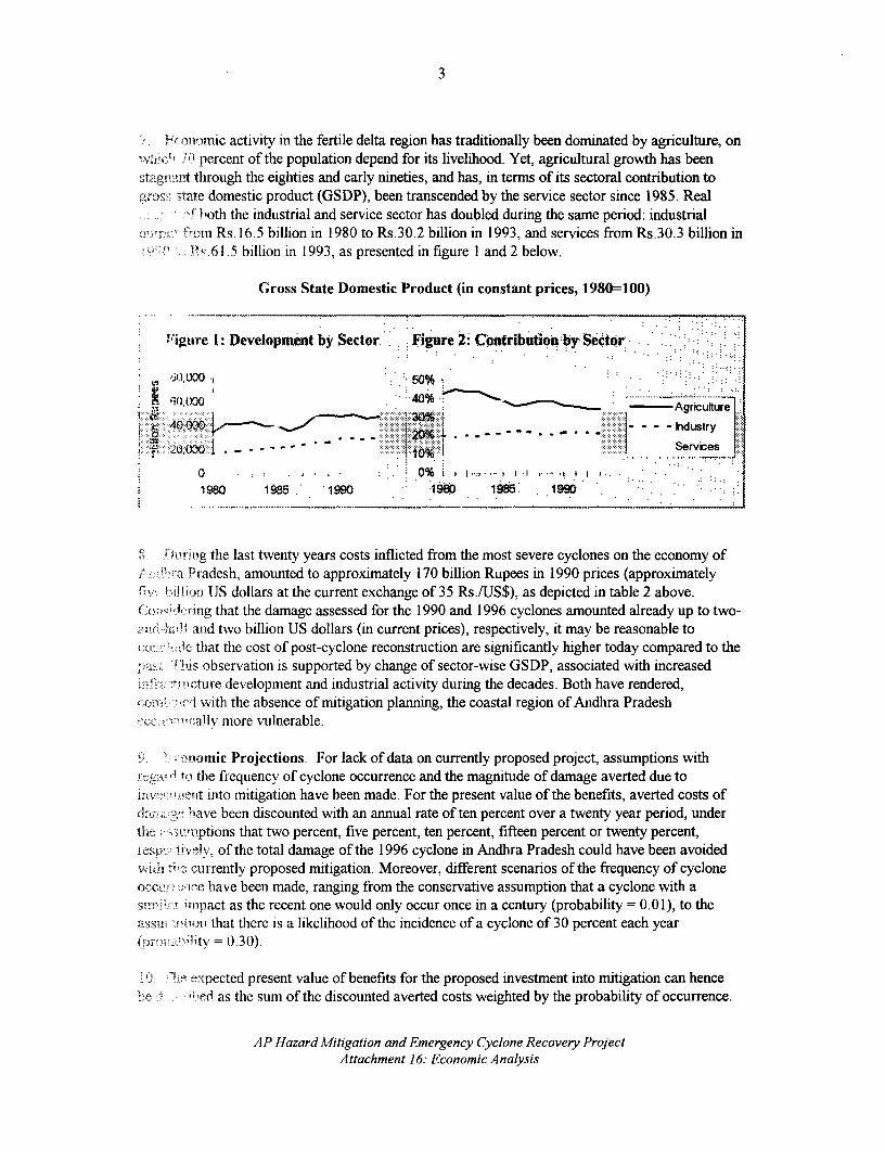
3
' ..ormic activity in the fertile delta region has traditionally been dominated by agriculture, onvvIiicl, iO percent of the population depend for its livelihood. Yet, agricultural growth has beenstagnuarit through the eighties and early nineties, and has, in terms of its sectoral contribution to,Yrosa; -,tte domestic product (GSDP), been transcended by the service sector since 1985. Real
fboth the industrial and service sector has doubled during the samne penrod: industnralt nm Rs. 16.5 billion in 1980 to Rs.30.2 billion in 1993, and services from Rs.30.3 billion in
11 c.61.5 billion in 1993, as presented in figure I and 2 below.
Gross State Domestic Product (in constant prices, 1980=100)
Figure l: Development by Sector. Figre 2: Contribution by Sector
,,it],0 . m0% .. . .;; .2 ,,OO (t00 4096 . Agricuiure
4000 -;- - - - Industry
t;-- ooofioy ; - _ _ _ * --^ - - i .. ..... Services
1980 1980'i - 9 19 O5 19. .. .. ... 0 % ... ............... I .
OurMip the last twenty years costs inflicted from the most severe cyclones on the economy of_;Pradesh, amounted to approximately 170 billion Rupees in 1990 prices (approximately
Flv, . t'Jlitj IJS dollars at the current exchange of 35 Rs./US$), as depicted in table 2 above.( o:-3c%:irmg that the damage assessed for the 1990 and 1996 cyclones amounted already up to two-a7uj {A{if and two billion US dollars (in current prices), respectively, it may be reasonable to
.l that the cost of post-cyclone reconstruction are significantly higher today compared to thepasi hi .s observation is supported by change of sector-wise GSDP, associated with increasedj i:; i "o- tlr.ture development and industrial activity during the decades. Both have rendered,cxOrr'l 'I with the absence of mitigation planning, the coastal region of Andhira PradeshCCO*-,Y, ally more vulnerable.
9 momic Projections. For lack of data on currently proposed project, assumptions with__e__ tn the frequency of cyclone occurrence and the magnitude of damage averted due to
t'it into mitigation have been made. For the present value of the benefits, averted costs ofdaml.: '5 g"ihave been discounted with an annual rate of ten percent over a twenty year period, under
.t. ;i:umptions that two percent, five percent, ten percent, fifteen percent or twenty percent,resvb'p i - tnv. of the total damage of the 1996 cyclone in Andhra Pradesh could have been avoidedVwu '' c'urrently proposed mitigation. Moreover, different scenarios of the frequency of cycloneo c ice have been made, ranging from the conservative assumption that a cyclone with aSnm.11"in. Upact as the recent one would only occur once in a century (probability = 0.01), to theassi ,boni) that there is a likelihood of the incidence of a cyclone of 30 percent each year
= lit 0.30).
10. Y e v,,pected present value of benefits for the proposed investment into mitigation can hencebe c : efd as the sum of the discounted averted costs weighted by the probability of occurrence.
AP Hazard Mitigation and Emergency Cyclone Recovery ProjectAttachment 16: Economic Analysis

4
The costs of mitigation for current proposed project have been defined as the sum of thirty pi- m.rrc rll
of the cost of infrastructure restoration and hundred percent of the cost of mitigation (seeattachment 1). Annual costs of ten percent have been assumed for maintenance, discounted ov,.. theperiod of twenty years and added to the initial investnent costs. The present value of the mitii .oj
cost would then amount to US$200 million.
11. The area shaded in table 3 below, represent the scenarios where the net benefits are negat> .over the twenty year period observed. When the probability of a cyclone is assumed to be tenpercent (p=O. 10), the net benefits start become positive when fifteen percent of damage is assninr;(;1to be prevented by the investmnent. Both assumption are fairly conservative, given that threecyclones with a comparable damage record have hit the coast of Andhra Pradesh during the lasttwenty years, and twenty-five severe cyclones (p=0.25) have affected the coastal districts durinw.this century. In addition, the percentage of damage prevented in the presence of minor and med. nmintense cyclones is likely to exceed the twenty percent margin assumed at the top end of theseprojections.
Table 3 Present Value of future Averted Costs, by Type of Scenario
Averted~- Cost 2% 5% 10% 15% 2: ,
Probability \ (percent of replacement cost)0.01 3.4 8Si 7.0 25.5 '!0.05 l 17. 42f6 as. 1 127.7 17 ;
0.10 I 34.1 85.1 170.3 .":
0.15 51. I 127 ."; I - l
0.30 £ 102.2 255.4 510.8 766.2 1 I,t,} I
12. Figures 3 to 5 below shows the present value of the vanous averted damage scenarios t0 f 6.tEfive, ten and fifteen percent probability options and the present value of the investment andmaintenance cost over time. In comparison to the table above, the graphs also provide infoinal mat.-on the respective present values at each year of the assumed twenty year time period.
AP Hazard Mitigation and Emergency Cyclone Recovery ProjectAttachment 16: Economic Analysis

5
ligure 3: Present Values of Benefits (Averted Costs) and Costsovertime, (p=O.10, five damage scenarios)
350
.. . . ..... :
..........................
:. _ ~~~~~~~~~~~~~20%
. . . , _ _ ~ ~-- ----- 15% ..., .,,_' ..... ..... ......-.-.%...... , , ._ _ --''.. . ,
8 m.,. .-- 5 % -
n . -.. - -. 2%............. . - of hvestment
.....- ….. - - --.
1 3 5 7 9 11 13 15 17 19
Years
13. Taking for instance figure 3 above, one can see as indicated by the vertical lines that, under theprobability that ten cyclones would hit the coastal region of Andha Pradesh (p=O. 10), net benefitswould be materialized in the twenty percent damage avoidance scenario already within five yearsand in the fifteen percent damage avoidance scenario within eight-and-a-half years. With theaverted cost curve being steeper than then investment cost curve, one can also see from figure 3,that net benefits would be realized if a longer time period would be considered. In figure 4 and 5,net benefits would be materialized in the twenty, fifteen and ten percent scenarios, but not in thecase of only two percent of damage being avoided by the mitigation measures.
Figure 4: Present Values ofBeuelits (Averted Coits) and Costswver time, (p=.l5, five damage sceauoi)
,...i , . .i ..........- .. ... --.- ..
.......... .'--:............... .. -2
............. ...
..., , ;.- --1 ----0 ..... ..
- 0 --~.--- -'----152%.
.,,., ...,, ..
..... W . - ' . of Investment
c *.-.. .. , i..i,. ,. i
1 3 5 7 9 11 13 15 17 19
Yeats
AP Hazard Mitigation and Emergency Cyclone Recovery ProjectAttachment 16: EconomicuAnalysis

6
Figumr 5: Present Values of Benefits (Averted Costs) and Costs
over time. (p=0.30, five damage scenarios)
.........20%
- -~~~~~~10%
. -. < - - _ . v 5%
.- of hIvestment
0 o~ 1 _ t S P r- ' - I- -........ ........... ... ... ...... ... ......
: 1 3 5 . 7 9 li 13 1 517 19
Years
14. The consideration of alternative type of investments into mitigation have been omitted from
this analysis, mainly because the project in consideration is an emergency lending operation that
requires speedy and immediate implementation, but also because international experience on
hazard prevention and mitigation was included in the project design. Accordingly, the question that
sought to be answered in this analysis is rather if investment into cyclone hazard mitigation would
pay-off in the short and long-run.
15. The assessed damage on which this analysis is based does not include intangible costs like loss
of life, or indirect costs as loss of employment or long-run macroeconomic impacts. The two billion
US Dollars reflect only the direct damage to infrastructure, agriculture, industry and housing
(replacement cost). Despite having omitted these additional costs and given the very conservative
assumptions of the parameters underlying these projections, the proposed investment into
mitigation shows the potential for significant net benefits.
AP Hazard Mitigation and Emergency Cyclone Recovery Project
Attachment 16: Economic Analysis

Attachment 17AP HAZARD MITIGATION AND EMERGENCY CYCLONE RECOVERY PROJECT
ENVIRONMENTAL ASSESSMENTS
Outline of the Procedures for Environmental Screening and Assessment
1. The GOAP will ensure that sub-project implementing agencies observe systematicprocedures for environmental analysis during project planing and implementation. The DisasterManagement Unit (DMU) will be responsible for providing environmental clearances for each sub-project supported under the project. Detailed evaluation criteria, recommended checklists,questionnaires, and other analytical approaches will be developed jointly between the DMU andother concerned line departments such as Environment and Forests, Irrigation, Roads andBuildings, Panchayati Raj, State Electricity Board, Environmental Protection Research andTraining Institute (EPRTI) and the Shore Area Development Authority (SADA).
INITIAL ENVIRONMENTAL BRIEF
2. Prior to initiation of any disbursement under this project, the concerned implementingagency will prepare an initial environmental brief for submission to the DMU as part of the overallsub-project proposal. The purpose of the environmental brief is to provide sufficient information tothe DMU to determine if a project sub-component can proceed or if more detailed environmentalimpact assessment (ETA) is required before the proposal can be approved.
3. The format of the brief should be simple yet comprehensive. It should describe all aspectsof the project proposal and the environmental benefits and adverse impacts which may beassociated with the proposal. Due to the wide range of possible sub-projects, the format should beflexible. However, the format of the brief should contain certain basic information. At a minimum,the following elements should be included in the environmental brief:
4. Sub-Project description. This section should describe the details of the proposed sub-project(s). It should provide information on the background to the sub-project (i.e., nature andextent of damages), proposed activities to be funded, and the basic justification and rationale forthe proposal.
5. Description of environmental concerns. A brief description of likely environmentalirnpacts associated with the proposed activities should be prepared The description could be in theform of a checklist, impact matrix or other suitable presentation format. The environmentalanalysis should address several types of impacts and, where appropriate, should include descriptionof environmental benefits as well as adverse aspects of the proposal. Potential impacts should bedescribed under major headings such as (a) land use modification; (b) disturbance to aquatic orterrestrial habitats; (c) proximity to protected areas, designated zones, or areas of concern (e.g.,wetland area); (d) air and water pollution; (e) public health; and (f) land acquisition or resettlementrequirements.
6. The environmental brief should include an appropriate scale reference map(s) clearlyillustrating the location specific context of the project. The map should illustrate significantterrestrial and aquatic habitats, protected areas, land use, cultural heritage sites or other locationspecific information which may be needed to evaluate the possible impacts of the proposal.

2
7. Description of environmental mitigation. To the extent possible, the environmental briefshould also describe any mitigation activities or alternative approaches which could be undertakento offset environmental damages. The section would describe responsibility for implementing anymitigation plan and should indicate budget and staff needs where appropriate..
INTER DEPARTMENTAL CONSULTATIONS.
8. Prior to submission of the environmental brief to the DMU, the implementing agency willcarry out inter-departmental consultations with relevant GOAP and GOI agencies that would havean interest in or be impacted by, the proposed sub-project. Following these consultations, theimplementing agency will submit the package to the DMU for final review and clearance.
ENVIRONMENTAL REVIEW AND CLEARANCE
9. Each completed sub-project proposal will be reviewed by the environmental specialist ofthe DMU. Based on this review, the DMU will determine whether the project can proceed asdescribed or whether a more detailed environmental impact assessment (EIA) will be required.. Ifan EIA is required, the DMU will prepare a detailed terms of reference for this assessment. Theimplementing agency will then be required to complete the EIA as defined by the DMU. The ETAwill be subsequently reviewed by the DMU upon its completion. The DMU will rely on the use ofconsultants or other independent experts, such as SADA or EPRTI, to review projects withsignificant environmental impacts.
10. The DMU will, in addition, prepare detailed guidelines and criteria to assist in the reviewof sub-project proposals. Where sub-projects are determined to have significant environmentalimpacts requiring further EIA, an appropriate process for public review and consultation will beinplemented. The DMU will institute a systematic process for monitoring sub-projects whereenvironmental issues are considered significant. The details of the monitoring plan will be projectspecific and developed as part of the EIA process.
AP Hazard Mitigation and Emergency Cyclone Recovery ProjectAttachment 17: Environmental Assessments

Attachment 18AP HAZARD MITIGATION AND EMERGENCY CYCLONE RECOVERY PROJECT
PUBLIC BUILDINGS
OBJECTIVE
1. The primary objective is to repair and strengthen public buildings that house criticalinfrastructure and/or fulfill essential public service functions, in order to (i) enable the continuedfunctioning of critical services during and after a disaster, and (ii) enable them to serve effectivelyas shelters during emergencies.
STRATEGY
2. The strategy proposed consists of: (i) identification of critical public buildings based on thedistrict vulnerability reduction plan, along with the identification of settlements lacking cyclone andstorm surge resistant buildings; (ii) identification and rehabilitation of buildings that can beupgraded at limited additional cost; and (iii) identification and repair of buildings that havesuffered extensive damages. The R&B Department and the Panchayati Raj Department willundertake the implementation of the necessary works. Responsibility for maintenance will fall tothe respective department, in collaboration with the local community through community schemessuch as the Janmabhoomi program.
3. The prioritization of investments is based on (i) location: emphasis is to be given tobuildings located in high risk areas which have few other pucca buildings that can serve as sheltersduring an emergency; (ii) function: focus will be on buildings housing critical functions, such ashospitals, power generation units, etc.; and (iii) extent of damage: focus will be on buildings thatwere badly damaged and whose present state may pose a threat to its users. Restoration of schoolbuildings was given a high priority since they are not only centers for learning, but are often theonly permanent public facility in a settlement and a wide range of social and developmentalactivities tend to revolve around them. Speedy restoration of damaged schools will help inrestoring the normal functioning of these activities.
PROPOSALS
4. The estimated cost of the proposed restoration of damaged buildings maintained by theR&B Department totals Rs 101 million (see Table 1 below). The estimated cost of the proposedrestoration of damaged buildings maintained by the Panchayati Raj Department is also presented inTable 1.
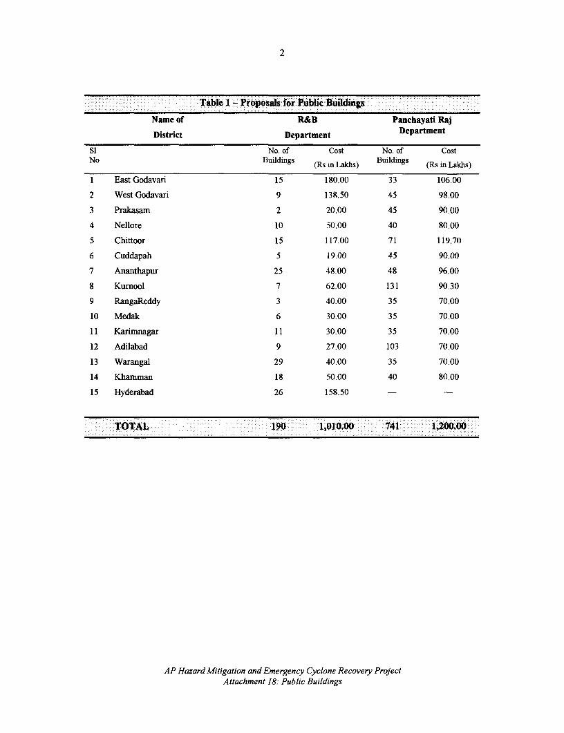
2
Table I - Proposals for Public Buildings
Name of R&B Panchayati Raj
District Department Department
Si No. of Cost No. of CostNo Buildings (Rs in Lakhs) Buildings (Rs in Lakhs)
1 East Godavari 15 180.00 33 106.00
2 West Godavari 9 138.50 45 98.00
3 Prakasam 2 20.00 45 90.00
4 Nellore 10 50.00 40 80.00
5 Chittoor 15 117.00 71 119.70
6 Cuddapah 5 19.00 45 90.00
7 Ananthapur 25 48.00 48 96.00
8 Kurnool 7 62.00 131 90.30
9 RangaReddy 3 40.00 35 70.00
10 Medak 6 30.00 35 70.00
11 Karimnagar 11 30.00 35 70.00
12 Adilabad 9 27.00 103 70.00
13 Warangal 29 40.00 35 70.00
14 Khamman 18 50.00 40 80.00
15 Hyderabad 26 158.50 - -
TOTAL 190 1,010.00 741 11200.00
AP Hazard Mitigation and Emergency Cyclone Recovery ProjectAttachment 18: Public Buildings

Attachment 19AP HAZARD MITIGATION AND EMERGENCY CYCLONE RECOVERY PROJECT
LIST OF MATEIALS TIN PROJECT FLq E7 77]
Federal Emergency Management Agency (FEMA). 1995. Managing Floodplain Development in ApproximateZone A Areas: a Guide for Obtaining and Developing Base (100 Year) Flood Elevations. Washington, DC:FEMA (No. 265).
Federal Emergency Management Agency (FEMA). 1994. Mitigation of Flood and Erosion Damage to ResidentialBuildings in Coastal Areas. Washington, DC: FEMA (No. 257)
Federal Emergency Management Agency (FEMA). 1993. Building Performance: Hurricane Iniki in Hawaii.Washington, DC: FEMA. (FIA-23).
Federal Emergency Management Agency (FEMA). 1992. Building Performance: Hurricane Andrew in Florida.Washington, DC: FEMA and Federal Insurance Administration. (FIA-22)
Federal Emergency Management Agency (FEMA). 1992. Floodplain Management in the United States: anAssessment Report. (Vol. 1: Summary Report & Vol. 2: Full Report) Washington, DC: Federal InteragencyFoodplain Management Task Force. (FIA- 18).
Federal Emergency Management Agency (FEMA). 1989. Conceptual Framework and Basic Strategies forImplementing a Unified National Program for Floodplain Management. Washington, DC: FEMA (No. 168).
Federal Emergency Management Agency (FEMA). 1987. Reducing Losses in High Risk Flood Hazard Areas: aGuidebook for Local Officials. Washington, DC: FEMA (No. 116).
Federal Emergency Management Agency (FEMA). 1986. Coastal Construction Manual. Washington, DC: FEMA(No. 55).
GOAP. n.d. "Project Report on Provision of Investmnent Credit in Areas Affected by Floods / Cyclone during October/ November 1996." Hyderabad, AP: Government of Andhra Pradesh
GOAP. 1997. Hazard Mitigation and Emergency Cyclone Recovery Project - 1996 (Project Proposal, March,1997). Hyderabad, AP: Government of Andhra Pradesh.
GOAP. 1997. Working Plan for Hazard Mitigation and Emergency Recovery Project - 1996 (Draft ProjectImplementation Plan, March, 1997). Hyderabad, AP: Government of Andhra Pradesh.
GOAP, Revenue Department. 1997. "Notes on Damages / Relief Operations During 1996-97" (February 15, 1997).Hyderabad, AP: Government of Andhra Pradesh.
GOAP, Finance and Planning Department. 1996. Prajala Vaddaku Paalana, Sramadanam and MicrolevelPlanning: Guidelines. (December 17, 1996). Hyderabad, AP: Government of Andhra Pradesh.
GOAP, Irrigation and Command Area Development Department. n.d. "Proposals for the Restoration of DamagedMinor Irrigation Sources Due to Floods and Cyclones from 6/96 - 11/96 for World Bank Aid." Hyderabad:Government of Andhra Pradesh.
GOAP, Revenue Department. 1987. Cyclone Contingency Plan of Action. Hyderabad, AP: Government of AndhraPradesh.
Subrahmanyan, S. and P. Padmanabha Rao. 1996. Impact of Investment under the Andhra Pradesh CycloneEmergency Reconstruction Project. Hyderabad, AP: Center for Economic and Social Studies.
TARU. 1996. "Andhra Cyclone Identification Mission: Final Report (Nov. 28/96)." New Delhi, India: TARUResearch and Information Network.


IMAGING
Report No.' - - 7100 INType: w -, A 1t


![sequential.ppt [Read-Only]](https://static.fdokumen.com/doc/165x107/6319ca5fc51d6b41aa04902b/sequentialppt-read-only.jpg)


![Bles.ppt [Read-Only]](https://static.fdokumen.com/doc/165x107/633bffc7197a6737f10ceddf/blesppt-read-only.jpg)

