Footprints of the red men. Indian geographical names in the ...
512
-
Upload
khangminh22 -
Category
Documents
-
view
3 -
download
0
Transcript of Footprints of the red men. Indian geographical names in the ...


\5 *^J*f'|[)T*' A <» '"o,*
-"^
° n!^
A^^"^-^-v ^
.0 ^^ * O « ° -^

^"•'t.
JS * AT "^ otOCnF * V ^ • Oils * 4X V» ''^J^V


PROCEEDINGS OF THE
New York State Historical
Association
THE SEVENTH ANNUAL MEETING,
WITH CONSTITUTION, BY-LAWS
AND LIST OF MEMBERS.
PUBLISHED BY THE
new'york state historical association
1906
N

NEWBURGH JOURNAL PRINT.
DEC 20 \m

NEW YORK STATE HISTORICAL
ASSOCIATION.
President,
Hon. JAMES A. ROBERTS, New York.
First Vice-President,
Hon. GRENVILLE M. INGALSBE, Sandy Hill.
Second Vice-President,
Dr. SHERMAN WILLIAMS, Glens Falls.
Third Vice-President,
JOHN BOULTON SIMPSON, Bolton.
Treasurer,
JAMES A. HOLDEN, Glens Falls.
Secretary,
ROBERT O. BASCOM, Fort Edward.
Assistant Secretary,
FREDERICK B. RICHARDS. Ticonderoga.

TRUSTEES.
Mr. Asahel R. Wing, Fort Edward Tenn Expires 1906
Mr. Elmer J. West, Glens Falls"
1906
Rev. John H. Brandow, Schoharie"
1906
Hon. Grenvil'le M. Ingalsbe, Sandy Hill"
1906
Col. William L. Stone, Mt. Vernon "1906
Mr. Alorris Patterson Ferris, New York "1906
Hon. George G. Benedict, Burlington, Vt "1906
Hon. James A. Roberts, New York "1907
Col. John L. Cunningliam, Glens Falls"
1907
Mr. James A. Holden, Glens Falls"
1907
Mr. John Boitlton Simpson, Bdlton "1907
Rev. Dr. C. Ellis Stevens, New York "1907
Dr. Everett R. Sawyer, Sandy Hill"
1907
]\Ir. Elwyn Sedye, Lake George "1907
Mr. Frederick B. Richards, Ticonderoga " igoy
Mr. Howland Pell, New York "1907
Gen. Henry E. Tremain, New York "1908
Mr. William Wait, Kinderhook "1908
Dr. Sherman Williams, Glens Falls"
1908
Mr. Robert O. Bascom, Fort Edward "1908
Mr. Francis W. Halsey, New York "1908
Mr. Harry W. Watrous, Hague "1908
Com. John W. Moore, Bolton Landing "1908
Rev. Dr. Joseph E. King, Fort Edward "1908
Hon. Hugh Hastings, Albany "1908

PROCEEDINGSOF THE
Seventh Annual Meeting of the New York State Historical
Association, held August 22d, 1905, at the
Court House, Lake George, N. Y.
At the Seventh Annual Meeting of the New York State His-
toricail Association, held at Lake George on the 22d day of August,
1905, a quorum being present, the President, James A. Roberts,
called the meeting to order, whereupon it was duly moved, second-
ed and carried, that the reading of the minutes be dispensed with.
The report of the Treasurer, James A. Holden, was read and
adopted after having been approved by the auditors, Dr. Joseph E.
King and the Hon. Grenville M. Ingalsbe.
It was further moved, seconded and carried, that the annual
publication of the society be not sent to those members who are
two or more years in arrears in their dues.
Dr. Sherman Williams, chairman of the committee on historic
spots, reported orally that arrangements had been made for the
erection of a boulder with a bronze tablet at Half-Way Brook, and
that arrangements were in progress for marking other spots in tlie
vicinity of Lake George. The report was accepted and the com-
mi'ttee continued, an-d the committee were requested to make a
written report with a historic sketch relating to the spots marked
and proposed to be marked, which report together with a cut of
the tablets erected and to be erected shall be published in the pro-
ceedings of the Association.
Mr. Harry W. Watrous, chairman of the committee on Fort
Ticonderoga, by Mr. Grenville M. Ingalsbe reported progress.

6 NEW YORK STATE HISTORICAL ASSOCIATION.
Upon the suggestion of the chairman the following committee
on Fort Ticonderoga was appointed for the ensuing year:
Mrs. Elizabeth Watrous, Mr. John Boulton Simpson, Mr. Geo.
O. Knapp.
The committee on program made an oral report, which was
adopted.
A vote of thanks was extended to Gen. Tremain for his very
liberal gift to the Association reported by the treasurer.
A vote of thanks was extended to the committee on program.
The following new members were elected
:
Alice Brooks Wyckoff, Elmira, N. Y.
Hon. F. W. Hatch, N. Y. City.
Hon. Albert Haight, Albany, N. Y.
Hon. John Woodward, Brooklyn, N. Y.
Mr. E. B. Hill, 49 Wall Street, N. Y. City.
Rev. Dr. Thos. B. Sheer, N. Y. City.
Mr. G. C. Lewis, Albany, N. Y.
Dr. George S. Eveleth, Little Falls, N. Y.
George C. Rowell, 8i Chapel Street, Albany, N. Y.
Mr. James F. Smith, So. Hartford, N. Y.
Mr, George Foster Peabody, Lake George, N. Y.
Mr. Grenville H. Ingalsbe,' Sandy Hill, N. Y.
Mr. A. N. Richards, Sandy Hill," N. Y.
Mr. Irwin W. Near, Hornellsville, N. Y.
Mr. Archibald Stewart, Derby, Sandy Hill, N. Y.
Mr. Alvaro D. Arnold, Sandy Hill, N. Y.
Mr. Richard C. Tefft, Sandy Hill, N. Y.
Mr. F. D. Howland, Sandy Hill, N. Y.
Mr. A. W. Abrams.
Mr. D. M. Alexander, Buffalo, N. Y.
Mr. Philip ]\L Hull, Clinton, N. Y.
Addie E. Hatfield, 17 Linwood Place, Utica, N. Y.George K. Hawkins, Pkttsburgli, N. Y.
Dr. Claude A. Horton, Glens Falls, N. Y.

ANNUAL MEETING. 7
Dr. E. T. Horton, Whitehall, N. Y.
Gen. T. S. Peck, Burlington, Vt.
Myron F. Westover, Schenectady, N. Y.
Dr. Wm C. Sebring, Kingston, N. Y.
Mr. Neil M. Ladd, 646 Fulton Street, Brooklyn, N. Y.
Mr. J. Hervey Cook, Fishkill-on-the-Hudson, N. Y.
Mr. H. L. Broughton, Sandy Hill, N. Y.
Daniel L. Van Hee, Rochester, N. Y.
Edmund Wetmore, 34 Pine Street, N. Y. City.
Mrs. Lydia F. Upson, Glens Falls, N. Y.
Mr. Daniel F. Imrie, Lake George, N. Y.
Mr. James Green, Lake George, N. Y.
Mr. Edwin J, Worden, Lake George, N, Y.
Dr. Sherman Williams moved that the chair appoint a commit-
tee of two to take into consideration an amendment to the consti-
tution relating to the payment of dues.
Carried.
Whereupon the chair appointed as such committee Robert O.
Bascom and James A. Holden.
Hon. Grenville M. Ingalsbe offered the following resolution.
Resolved, That the President be authorized to appoint a com-
mittee of three to investigate and report to the next annual meeting
as to the feasibility of co-operation and of the establishment of a
community of action between this association and the various other
historical societies in the State, which resolution was unanimously
adopted.
After some discussion, participated in by various members of
the Association, it was regularly moved, seconded and carried, that
a committee of three be appointed by the president upon member-
ship, whereupon the president appointed the following committee:
Dr. Ellis C. Stevens, with power to name his associates.
The following trustees were unanimously elected by ballot for
the term of three years
:

8 NEW YORK STATE HISTORICAL ASSOCIATION.
Gen. Henry E. Tremain, N. Y. City ; William Wait, Kinderhook,
N. Y.; Dr. Sherman Williams, Glens Vails, N. Y. ; Robert O. Bas-
com. Fort Edward, N. Y. ; Francis W. Halsey, New York ; Harry
W. Watrous, Hague, N. Y. ; Rev. Dr. Joseph E. King, Fort Ed-
ward, N. Y. ; Hon. Hugh Hastings, Albany, N. Y. ; Com. John W.Moore, Bolton Landing, N. Y.
Rev. Mr. Hatch and Rev. Mr. Black presented for the consid-
eration of the Association the subject of the erection of a museumbuilding. After some discussion it was moved, seconded and car-
ried, that the thanks of the Association be tendered to the gentlemen
for bringing the matter to the attention of the Association, after
which the meeting was adjourned until two o'clock in the afternoon.
August 220, 1905.
—
Afternoon Session.
Symposium—The SitUhmi Expedition.
At the adjourne'd session held in the afternoon August 22d,
1905, Dr. W. C Sebring, of I^ingston, read a paper entitled, " TheCharacter of Gen. Sullivan."
A paper entitled " The Primary Cause of the Border Wars,"
by Francis W. Halsey, of New York, was read by the Hon. Gren-
ville M. Ingalsb^ in the absence of Mr. Halsey.
Dr. Sherman Williams, of Glens Falls, read a monograph en-
titled, " The Organization of Sullivan's Expedition."
Hon. Grenvil'le M. Ingalsibe read by title only a paper entitled,
" A Bibliography of Sullivan's Expedition."
A paper entitled, " An Indian Civilization and its Destruction,"
by Col. S. W. Moulthrop, was read by the Rev. W. H. P. Hatch in
the absence of Col. Moulthrop.
A paper entitled, " The Campaign," was read by William Wait,of Kinderhook, when the meeting adjourned until August 23d, at
10 o'clock A. M., at the same place.
ROBERT O. BASCOM,Secretary.

ANNUAL MEETING. 9
TRUSTEES' MEETING.
August 23d, 1905.
At a meeting- of the Trustees of the New York State Historical
Association held at Lake George on the 22d day of August, 1905,
a quorum being present, the following officers were elected
:
President, Hon. Jas. A. Roberts, Buffalo, N. Y.
First Vice-President, Hon. G. M. Ingalsbe, Sandy Hill, N. Y.
Second Vice-President, Dr. Sherman Williams, Glens Falls, N.Y.
Third Vice-President, John Boulton Simpson, Bolton, N. Y.
Treasurer, James A. Holden, Glens Falls, N. Y,
Secretary, Robert O. Bascom, Fort Edward, N. Y.
Asst. Secretary, Frederick B. Richards, Ticonderoga, N. Y.
The printing bill of E. H. Lisk was presented to the Trustees
and after discussion the same was referred to the Treasurer and
Secretary with power to settle the same.
The following committees were appointed
:
Standing Committee on Legislation
:
Hon. James A. Roberts,
Gen. Henry E. Tremain,
Dr. Sherman Williams,
Morris Patterson Ferris,
Hon. Hugh Hastings,
On Marking Historic Spots:
Dr. Sherman Williams.
Frederick B. Richards,
James A. Holden,
Asahel R. Wing,
Hon. Grenville M. Ingalsbe.
On Fort Ticonderoga:
Mrs. Elizabeth Watrous.
Joihn Boulton Simpson,
George O. Knapp.

TO NEW YORK STATE HISTORICAL ASSOCIATION.
On Program :
Hon. Grenville M. Ingalsbe,
Dr. Sherman Williams,
Dr. C. Ellis Stevens.
On Membership
:
Dr. C. Ellis Stevens.
Bill of the Secretary for postage, express and sundries v^^as
thereupon audited and ordered paid, w^hereupon the meeting ad-
journed.
At a meeting of the Trustees it was moved, seconded and car-
ried, that E. M. Ruttenber, of Newburgh, N, Y., be made an hon-
orary member of the Association.
ROBERT O. BASCOM,Secretary.
ASSOCIATION MEETING.
August 23d, 1905.
At the adjourned session held August 22d, a paper entitled,
" Concerning the Mohawks," was read by W. Max Reid, of Am-sterdam, N. Y., after w'hich the Hon. Grenville M. Ingalsbe read
certain hitherto unpublished letters from Gen. George Washingtonrelating to the " Sullivan Expedition," after which a resolution wasadopted requesting that Mr, Ingalsbe furnish (the same for publi-
cation in the ensuing volume of the proceedings of the Association.
An address entitled, " Robert R. Livingston, the Author of the
Louisiana Purchase," by Hon. D. S. Alexander, of Bufifalo, N. Y.,
concluded the session, and after a vote of thanks to the various
speakers, the meeting adjourned until two o'clock in the afternoon
of the same day, at which session a paper entitled, " The Birth at
Moreau of the Temperance Reformation," by Dr. Charles A. In-
graham, of Cambridge, was read.

ANNUAL MEETING. II
The annual address, " The Democratic Ideal in History," byHon. Milton Reed, of Fall River, Massadhusetts, concluded the
literary exercises of this meeting, and after a vote of thanks to the
speakers of the afternoon the meeting adjourned sine die.
ROBERT O. BASCOM,Secretary.
TRUSTEES' MEETING.
At a meeting of the Trustees of the New York State Historical
Association, held at the Hotel Ten Eyck on the 19th day of January,
1906, in the City of Albany,
Present, Hon. James A. Roberts, President ; Hon. Grenville M.Ingalsbe, First Vice-President ; Dr. Sherman WilHams, Second Vice-
President; Hon. Hugh Hastings, Trustee; Hon. Robert O. Bas-
com. Secretary.
The meeting being duly called to order by the President, the
semi-annual report of Jumes A. Holden, Treasurer, was read and
adopted.
The report is as follows
:
SEMI-ANNUAL REPORTOF
J, A. Holden, Treasurer New York State Historical Association,
From July i, 1905, to Jan. iS, 1906.
RECEIPTS.July I, 1905— Cash on hand $ 194 73
Received from dues, etc 390 10
$ 5S4 83•
DISBURSEMENTS.Aug. 5, E. H. Lisk, printing $ 200 00
5, R. O. Bascom, postage and sundries. 27 50
Sep. S, E. H. Lisk; printing 62 25
Sep. 7, R. O. Bascom, postage 23 28
" 7, Milton Reid, expenses 15 31
Nov. 8, E. H. Lisk, printing 31 75

12 NEW YORK STATE HISTORICAL ASSOCIATION.
Dec. 4, R. O. Bascom, stamps lo oo
" II, R. O. Bascom, " lo oo
Jan. 9, Postage 5 oo
385 09
Cash on hand $ 199 74
ASSETS.'
Cash on hand $199 74Life Membership Fund 271 40
Respectfully submitted,
JAMES A. HOLDEN,Treasurer.
The report of the commiittee on amendments to the Constitution
was read and laid upon the table.
The report of Committee on Marking Historic Spo'ts was read
and adopted. The report is as follows
:
Glens Falls, N. Y., Jan. 18, 1906.
To the Trustees of the Nezv York State Historical Association,
Gentlemen:—I beg to report progress in regard to the work
of the committee on marking Historic Spots. A good number of
persons have made corutributions ranging from five to fifty doliars
each. A marker has been erected at Half-Way Brook and another
planned for at Bloody Pond. The tablet at Half-Way Brook was
made under the direction of W. J. Scales, who is also to prepare
the design for the one at Bloody Pond. The marker at Half-WayBrook is a large boulder resting upon another large boulder nearly
buried in the ground. The boulders are large and very hard, and
the cost of cutting them to fit was unexpectedly great. Both boul-
ders were drawn from a long distance. The cost of drawing and
erecting them, and getting them ready for the tablet was about one
hundred and ten dollars. This work was supervised by Mr. HenryCrandall, who had subscribed fifty dollars toward the work. Whenit was finished he said that if I would cancel his subscription he
would meet all the expense of getting the stones in place. As this
was more than twice the amount of his subscription his offer was
gladly accepted. The other expenses to date have been as follows
:
ANNUAL MEETING. 13
For cutting a smooth face on the boulder and
fitting tablet to it $ 25 25
For photographing the monument i 00
Paid Mr. Scales on account 45 00
Total $ 71 25
In the Spring it will be necessary to meet a small expense to
grade the ground and seed it. We hope to have tjhe marker at
Bloody Pond in place before our next annual meeting.
Respectfully submitted,
SHERMAN WILLIAMS,Chairman of Committee for Marking Historic Spots.
The following new members were duly elected
:
Applegate, Rev. Dr. Octavius, Newburgh, N. Y.
Atkins, Hon. T. Astley, 73 Nassau Street, N. Y.
Benjamin, Rev. Dr. William H., Irvington-on-Hudson, N. Y.
Bunten, Roland, Garden City, N. Y.
Brooks, James B., 1013 East Adams Street, Syracuse, N. Y.
Bockus, Dr. Truman J., Packer Institute, Brooklyn, N. Y.
Banker, Dr. Silas J., Fort Edward, N. Y.
Cooke, Rev. Jere K., Hempstead, N. Y.
Coon, Hon. Stephen Mortimer, Oswego, N. Y.
Clark, Rev. Joseph B., Fourth Ave. and 22d St., N. Y. City.
Clark, Walter A., 755 Main Street, Geneva, N. Y.
Donnell, Rev. Dr. William Nichold, 292 Henrv St., N. Y.
Davis, William Gilbert, 32 Nassau Street, N. Y.
Davis, Dr. Booth C, Alfred, N. Y.
de Peyster, Mrs. Beekman, 2345 Broadway, N. Y. (winter),
Johnstown, N. Y. (summer).
Draper, Hon. A. S., Albany, N. Y.
Gunnison, Hon, Royal A., Janeau, Alaska.
Hopson, Rev. Dr. George B., Annandale, N. Y.
Horton, Mrs. John Miller, 736 Main St., Bufifalo, N. V.
Ingalsbe, Franc Groesbeck, Sandy Hill, N. Y.
Jessup, Rev, Chas, A., Greenport, N. Y.

14 NEW YORK STATE HISTORICAL ASSOCIATION.
Jessup, Morris K., 195 Madison Avenue, N. Y,
Joline, Dr. Adrien H., 54 Wall Street, N. Y.
Jackson, Rev. Dr. T. G., 6851 Paul's Place, Brooklyn, N. Y.
Kirby, Dr. R. M., Potsdam, N. Y.
Krotel, Rev. Dr., 65 Convent Avenue, N. Y.
Leavey, Russell H., 147 W. 21st Street, N. Y.
Leflferts, Marshall C, 30 Washing:ton Place. N. Y.
Lewis, George C., Albany, N. Y.
Mace, Dr. William H., Syracuse, N. Y.
Martin, John, Plattsburgh, N. Y.
Morton, Hon. Levi Parsons, 681 Fifth Avenue, N. Y.
Mills, D. O., 634 Fifth Avenue, N. Y.
Munger, Rev. Dr. R. D., 105 Delaware Street, Syracuse, N. Y.
Morgan, Rev. Dr. D. Parker, 3 East 45th Street, N. Y.
Nottingham, William, 701 Walnut Avenue, Syracuse, N. Y.
Nelson, Ven, George F., 29 Lafayette Place, N. Y.
Olmsted, Rt. Rev. Chas. Tyler, 159 Park Avenue, Utica, N. Y.
O'Brien, M. J., 195 Broadway, N. Y.
Paige, Edward Winslow, 44 Cedar Street, New York.
Pierce, Rev. Dr. Walter Franklin, 16 S. Elliott Place, Brooklyn,
Rogers, Howard J., Albany, N. Y.
Rhoades, W. C. P., 400 Putnam Avenue, Brooklyn, N. Y.
Sill, Dr. Frederick S., 169 Mohawk Street, Cohoes, N. Y.
Schell, F. Robert, 280 Broadway, N. Y.
Smith, William Alex., 412 Madison Avenue, N. Y.
Samson, William H., 420 Oxford Street, Rochester, N. Y.
Sillo, Dr. Chas. Morton, Geneva, N. Y.
Seabury, Rev. Dr. Wilham Jones, 8 Chelsea Square, N. Y.
Stackpole, George F., Riverhead, N. Y.
Sims, Charles N., Liberty, Indiana.
Steele, Mrs. Esther B., 532 W. Clinton Street, Elmira, N. Y.
Stilwell, Giles H., 1906 West Genesee St., Syracuse, N. Y.
Sheddon, Hon. Lucian L., Plattsburgh, N. Y.
Silver, Dr. John Archer, Geneva, N. Y.
Spencer, Dr. Charles W., Princeton, N. J.
Vanderveer, Dr. A., 28 Eagle Street, Albany, N. Y.
Waller, Rev. Henry D., Flushing, N. Y. \
Watson, Col. Jas. f ., Clinton, M. Y."*"

ANNUAL MEETING. 1
5
Welch, Miss J. M., 'j(i Johnston Park, Buffalo, N. Y.
Willey, Rev. John H., 466 East i8th Street, N. Y.
Willis, James D., 40 East 39th Street, N. Y.
The thanks of the Trustees were extended to Dr. Stevens for
"his services as chairman of the Committee on Membership. TheSecretary and Mr. William Wait, of Kinderhook, were by motion
duly carried appointed a committee on the publication of the Pro-
ceedings of the Association. The edition was fixed at 750 copies
and the Secretary instructed not to send proceedings to persons
who were more than four years in arrears, after which the meeting
;adjourned,
ROBERT O. BASCOM,
Secretary.

CHARACTER OF GEN. SULLIVAN.
By Dr. W. C. Seeking.
How the mists do gather. With the exception of Greene and
Benedict Arnold, George Washington trusted SulUvan b&yond any
other general of the Continental army. Sullivan acquitted himself
well on diverse battlefields and, though defeated, the real worth of
the man shows in this, that defeat added as much prestige to his
reputation as his victories. His greatness like that of Washington
throve on defeat, for it can be fairly said that Washington never
won a battle. And yet if you ask even those who have given time
to our history as to General Sullivan, they will convey to you but
the most vague impression of some minor general who sometime
in the revolution made a foray on some Indians somewhere in this
State.
The last scene of a drama is best remembered. The picture as
the curtain falls is stamped most clearly on the memory. Sullivan
v/as not to be an actor in the war's closing scenes, and the valor
that gleams the name of Marion, the splendor of Greene's military
intelligence, and the glory that is linked with the name of Wash-ington at YorktO'wn were not his. Neither had he the methodical
madness of Wayne, the pusillanimity of the self-seeking Gates, the
recklessness of Putnam, nor the aestheistic fatalism of Ethan Allan
;
none of these things had Sullivan to carve his picture on men's
memory.
It may not be out of place here to give a short chronology of
this man's life.
He was born in Summerworth, N. H., in 1740. His parents
were well-to-do emigrants from Ireland. He studied law and was
a member of the first Congress, 1774. Was made Brigadier Gen-
eral 1775. In 1776 he superseded Arnold in Canada. Then he
succeeded General Greene and was taken prisoner. He was ex-

CHARACTER OF GEN. SULLIVAN. 17
changed in November. In 1777 he took part in the battle of
Brandywine, Germantown, and 1778 he commanded in RhodeIsland. In 1779 he led the expedition against the Indians. Hethen resigned from the army and took up again the practice of
law. He was a member of the State constiitutional convention, then
he was elected a member of Congress, and in '86, '87, '89 was pres-
ident of his State. Later, in 1789, he was appointed District Judge,
and died in 1795 at the age of 54 years.
His personal characteristics are said to be that he was a dig-
nified, genial and amiable man. He displayed a fine courtesy to
those about him, both to his soldiers and compatriot generals.
I quote the following paragraph from A. Tififany Norton, whoI believe to be the one who has written the best account of the
Indian campaign, and it is a wonder to me that one who shows so
broad a grasp of history and its essential principles and the elements
that make for historical research, has never written more than he
has.
Norton, in his general description of Sullivan, says :" His
eyes were keen and dark, his hair curly black, his form erect, his
movements full of energy and grace." His height was five feet
nine inches, and a slight corpulency when in his prime gave but an
added grace. General Sullivan was a man of undoubted courage,
warmth of temperament and independent spirit equalled only by
his patriotic devotion to his country's cause and his zeal in all pub-
lic affairs." Doubtless he was too impatient and outspoken and
may have been deserving of some measure of blame, stil'l his faults
should not have detracted from that meed of praise to which he
was justly entitled. Neither should the jealousies of his brothers in
arms, which prompted them to ridicule his achievements, question
his reports and detract from his hard-earned laurels, have weight
with the historian. Yet such has been, in great degree, the case,
and the name of Sullivan occupies a lesser space in the history of the
Revolutionary struggle, than those of many others whose achieve-
ments fell far s'hort of his in magnitude and importance. Sullivan
has been made the victim of the intrigues and petty jealousies of
his times, and while for this his own indiscretions may justly be
blamed, the duty is none the less incumbent on the present genera-
tion to render due homage to one who is a brave soldier and a de-

1
8
NEW YORK STATE HISTORICAL ASSOCIATION.
voted, disinterested, self-sacrificing patriot. As Amory has justlj
said :" A friend of Washington, Greene, Lafayette, and all the
noiilest statesmen and generals of the war, whose esteem for him
was universally known, to whom his own attachment never waiv-
ered, he will be valued for his high integrity and steadfast faith,
his loyal and generous character, his enterprise and vigor in com-
mand, his readiness to assume responsibility, his courage and cool-
ness in emergencies, his foresight for providing for all possible con-
tingencies of campaign or battle-field, and his calmness when the
results became adverse."
Could the character of Sullivan be fairly said to be that of a
great man? Does he measure up to "bigness?" Remember a
little man seldom does big things. Briefly, what did he do in this
Indian campaign? At the beginning of the Revolution there was
a democracy of six confederate states within the present boundaries
of our own municipality. So strong had this democracy grov/n
that it dominated the inhabitants of a territory of more than a mil-
lion square miles. Their battle-cry was heard from the Kennebec
to Lake Superior, and under the very fortifications of Quebec they
annihilated the Huron.
Their orators were fit to rank with any that we have to-day.
Their legends are the legends of a people whose souls were filled
with poetry. Their military tactics were those of a people trained
for war—successful war. Man to man, they were what no other
barbarians have been, a match for the white man. They held the
gateway to the West and their position made them mnpires be-
tween the mighty nations of the Old World who were struggling
for the possession of the New. Civilized in a sense they were, but
they were barbarians too, and savages to their very heart of hearts.
Rapacious, treacherous, cruel beyond belief, they were dreaded
alike by friend and foe. Their home was a terra incognita. Nocolonist had trodden it. From no peak had trapper looked across
the profile of their land. Their numbers were unknown and could
only be guessed at by their achievements—and these were terrible.
How silly of Gordon to criticise Sullivan for over-manning his
expedition. Darkest Africa is better known to-day than was then
the land of the Iroquois. They were re-enforced by British regu-
lars, by fanatical tories ; thev were led bv white men, and one of

CHARACTER OF GEN. SULLIVAN. 1
9
their leaders was a thorough Indian and thoroughly educated in the
white man's lore.
Among this people and into this terra i'dcognita came Sullivan
and smote them hip and thigh. He conquered them to the utter-
most. He broke down the gateway to the mighty West. With a
miserable commissariat, he invaded an unknown country and for-
ever destroyed a democracy that had ruled for five hundred years.
The Indians conquered by Wayne were but a frazzle of the Six
Nations united with Indians farther West.
Little men do little things, big men do big things, and great
men do great things. Before Sullivan vanished" that savage senate at the Lake," By the salt marshes, yonder in the north,
" Dull-visaged butchers, coarsely blanketed" Squatted in a ring by their dark Council House" And with strange mumery O'f pipes and belts
" Decreeing, coldly, death—forever death."
The strongest are the gentlest. It is related that having found
an Indian woman too old and feeble to retreat with her people, that
Sullivan left her with a plentiful supply of provisions, though, as
one of the party writes, " we only had half a ration every other day
ourselves."
It is not my province to put forth a brief for General Sullivan,
yet that one incident cast a side-light on his character that impress-
ed me more as to the true lovely heartiness of the man than any-
thing I have found. Constancy to a friend is an attribute to those
who approach greatness. After the Indian war Sullivan was re-
viled unmercifully for the devastation wrought by him in the Indian
country. Out of his love for General Washington he suffered in
silence, while he had in his possession General Washington's writ-
ten instructions to do exactly as he had done.
Perchance for a good man some would even dare to die. But
what of a man whose friendship holds so strong that he may see
that which is dearer to him than life—^his character—filched from
him, and lest he should harm a friend, allow his enemies to do with
that character as they wished.
Probably no historian ever lived who could write more wrong
history than Benjamin Lossing, who accuses Sullivan of careless-

20 NEW YORK STATE HISTORICAL ASSOCIATION.
ness and want of vigilance as a commanding officer and mentions
Bedford and Brand^-wine. Nothing could be farther from the
truth. At Bedford he withdrew his forces because the French
Navy would not support him, and it was out of the question to re-
main in the position he had taken up. We have John Fiske's word
for it that Brandywine was a drawn battle.
Of energy he had a plenty. It is on record that after he and
General Clinton united (and Clinton was no sluggard) his Division
time and again outmarched that of Clinton. At one time he broke
road across nine miles of swamp while Clinton following him had
to camp in the middle of the morass. 'So difficult was the morass
that the Indian spies who had been watching his advance never
dreamed that he would attempt the passage of the swamp, and
withdrew to their camps. So confident were the Tories and In-
dians, that when he emerged from the swamp their campfires were
still burning.
Right here is a place to say a word about General Sullivan's
veracity. After his return from conquering the Six Nations he
reported that he had destroyed forty villages, and his detractors
could not find but eighteen. It at last developed that when his
subordinates had reported destroying a group of buildings he most
naturally supposed that it was an Indian village, and so put it downin his report.
It has been said of him that he resigned from the army out of
spite. Well, if he did, he was perhaps blamable. But we should
remember that he was dealing with a Continental Congress of the
latter years of the war, and if you search history for a thousand
years you will not be able to find an aggregation of political castros
equal to this same Continental Congress. The men who had madethe primal congresses great had set themselves to serve the nation
in other ways, and Congress had fallen to those who had some
money without brains or brains without principle, or lacking both,
were like our modern ones in that they loved " graft " and knew howto get it,
Sullivan was not a liar, and he himself says that his health wasfailing. If we care to plow through the many diaries kept by of-
ficers under him we can well believe that he told the truth, for with
the spoiling of the provisions sent to the expedition most of the

CHARACTER OF GEN. SULLIVAN. 21
soldiers did suffer from chronic intestinal troubles, and it would
be strange if the commander who takes the same fare as his sub-
ordinates should not suffer in the same manner.
And to back up this we must remember that even after he re-
tired he never lost the confidence or the love of the greatest of them
all, General Washington, Much has been written of General Sul-
livan's fallibilities, and fallibilities the greatest have.
We should remember that Sullivan was a Ke'lt. And through
the centuries the Kelts have given us the lordhest orators and gold-
en artists, hvk for tenacity of purpose no one has celebrated them.
General Sullivan when he was taken prisoner and fell under
the influence of the British military power, and contrasting them
with the meagerness that he had been accustomed to, for once his
heart failed him and his soul sank within him, and it is no sorrow
to his name to say that for the moment he thought the liberty of
mankind in the Western continent was doomed.
He came from the British to us seeking peace, but after he
was exchanged and in his old environment his true native Keltic
courage returned and his after life was the life of an ardent pa-
triot.
I do not think we give enough credit to the perceptions of the
ignorant.
Suppose to ten thousand ignorant people this entirely hypo-
thetical question should be stated: Around the globe is a people
who for three hundred years had been fighting a tyranical power
and well nigh achieved success. Would it be right for a republic
to step in and take them away from the power they were in rebel-
lion against, and then tlhis republic by force of arms prevent them
from becoming an independent republic? State to ten thousand
ignorant people this question, and they will shout with one voice
" that it is not right." State this question to ten thousand college
professors, and they will back and fill, debate and re-debate, and
finally be fogged by their very knowledge and at last come to no
conclusion ait all.
It has never been sufficiently made clear that the classes fought
the Revolutionary war,' The educated, the elegant, the conserv-
ative, the well-to-do, in short the " better elements," were practically
all with the British. While the broken, the ignorant, the d'iscour-

22 NEW YORK STATE HISTORICAL ASSOCIATION.
aged, " the rabble," were the ones that won our liberty. Every
single Tory that was expatriated could read and write, while I be-
lieve if the muster rolls of my own county, inhabited at that time
by the educated Dutch, not one-third of those who enlisted could
sign their names. So coldly did the wealthy Dutchman look upon
the war that it was a common trick for him to send a slave to serve
in the ranks instead of himself.
Sullivan by birth and position belonged among the former class,
and yet in spite of position, broke with his own class and gladly
took up the sword with the ignorant because he saw clearly that
all social progress must from very necessity spring from the dis-
content of the Hoi Polloi. He was a true patriot for he lost his
all by giving his attention to public rather than private affairs, and
though respected by all and honored by his State, his last years
were the years of gloom and the gathering clouds, for his life wasbeset by heartless creditors. The last scene is the saddest of all,
for at his funeral his creditors tried to seize his body and wouldhave done so, except that an old army general drew his pistols anddrove off the bailiffs of the law. So was buried one of America's
greatest patriots, a constant friend, a brave and good soldier, anda man who, take him all in all, it is not an exaggeration to call
" Great."

THE PRIMARY CAUSES OF THEBORDER WARS
By Francis W. Halsey.
General Sullivan's expedition of 1779 was an immediate out-
come of the massacres of Wyoming and Cherry Valley in the sum-
mer and autumn of 1778—not to mention those minor incidents of
the Border Wars, which, beginning in the summer of 1777, had
converted the valley of the upper Susquehanna into a land of deso-
lation. It was a most drastic punishment that Sullivan inflicted,
and such it was intended by Congress that his work should be.
" The immediate objects," said Washington, in his letter of instruc-
tion to Sullivan, " are the total destruction and devastation of the
Indian settlements." He added that the Indian country was " not
to be merely overrun, but destroyed." If we have regard for pro-
portions, greater losses were inflicted upon the Indians by Sullivan
than were ever inflicted upon the settlements of New York by the
Indians.
The expedition, however, failed completely in achieving its
main purpose, which was to suppress the Indian raids. Sullivan
and his army had scarcely left the Western country, when the In-
dian attacks were renewed and for three years were continued with
a savage energy before unknown. The Indians' thirst for revenge
having been thoroughly aroused, nothing could afterwards restrain
their hands. Aside from the burning of German Flats and the
battle of Oriskany (the latter not properly an incident of the Border
Wars, since it was an integral part of the Burgoyne campaign), the
injury done by the Indians to the Mohawk Valley was done subse-
quent to the Sullivan expedition.
In their entirety, the Border Wars constitute a phase of the Rev-
olution of which far too little has been remembered. We may seek

24 NEW YORK STATE HISTORICAL ASSOCIATION.
in vain for a territory elsewhere in the United States where so
much des'truction was done to non-comhatants. In Tryon county
alone, 12,000 farms went out of cultivation ; fully two-thirds of the
population either died or fled, While of the one-third who remained
300 were widows and 2,000 orphans. And yet, as I have said, the
losses of the Iroquois were greater still.
But it is with the causes which led to this savage work that I amhere to deal. For quite 100 years, Joseph Brant and the Tories of
the Mohawk Valley, with Col. Guy and Sir John Johnson, and John
and Walter Butler, at their head, were generally accepted as the
original and inspiring forces in all the barbarities committed. The
greater oiifenders, however, were men of much higher station and
more aimple powers—men who had never seen the valleys of the
Susquehanna and the Mohawk, but who lived in London, and as
members of the King's Cabinet were in direct charge of the war in
America. One of them was the Earl of Dartmouth, the other Lord
George Germaine ; but it is to Germaine that we must ascribe the
chief odium.
The administration of the Province of New York, when the
Revolution began, was completely in the hands of Loyalists. NewYork was still a Crown colony, officials holding their appointments
directly from London. Outside the official class, however, there
were patriots in plenty ; none of the colonies possessed more ; but
as New York City was conupletely dominated by Tory influences, so
was the M^ohawk Valley dominated by the Johnsons and their armyof followers, in whom loyalty to England was a deep-seated senti-
ment and a fixed principle of conduct. Sir William Johnson had
died just as the Revolution was about to begin. H'is successors
became not only as great Loyalists as ever he had been, but, being
men of smaller minds and fewer talents. They added to the senti-
m^ent of loyalty an expression of it w^hich took the form of satanic
bitterness and brute savagery. It was these men who, with their
followers, became the hated Tories of the frontier of New York
—
men of whom in some instances, Joseph Brant said, they had been
more savage than the savages themselves.
The attitude of the Indians can be best understood if we re-
member that they had been practically in alliance with the English
of New York for a hundred years. When war began between the

THE PRIMARY CAUSES OF THE BORDER WARS. 25
mother country and the colonies, or between what the Indians called*' two brother nations," they were lost in amazement and tried in
vain to understand it. Their own history for three hundred years
had been one of peace between brother nations. " No taxation
without representation " was a principle beyond their comprehen-
sion. The men who defied Britisih soldiers in the streets of NewYork and Boston seemed to them exactly like the French of Canada
who in the older wars had stormed Englisih forts on the Northern
Frontier, since they were engaged in war with the King of Eng-land, and the King was the Indians' powerful friend.
When the Border Wars reached their height, the frontier of
New York should have been in a state of tranquility. With Bur-
goyne's surrender, the center of conflict was to pass away from
New York and New England, and was soon to be transferred to
"Virginia, Georgia, and South Carolina. Why then, these Border
Wars in New York? In one short sentence, the w^hole truth mayl)e disclosed. The ministry of George III, after long and laborious
€fiForts, now at last had won the Indians of New York into active
sympathy with their cause. For three years they had tried in vain
to gain their support, and again and again had held counsels with
them, but the net results had been an essentially neutral stand by
the Indians.
But let us recapitulate. Soon after the battle of Lexington, Col.
Guy Johnson, the official successor of Sir William, convened at his
home near Amsterdam, a conference with the Indians, mostly Mo-Tiawks, and later, after the result at Bunker Hill had alarmed himanew, fled to Oswego and thence to Canada. Nearly all the Mo-hawk Indians went with him, as well as a domestic force of about
500 white men, mainly Scotdh Highlanders, over whom he had
placed in command. Col. John Butler. In July Col. Johnson reached
Montreal, vv*here he had an interview with Sir Frederick Halde-
mand, who said to the Indians
:
" Now is the time for you to help the King. The war has be-
gun. Assist him now, and you will find it to your advantage.
Whatever you lose during the war, the King will make up to you
when peace returns."
Later in the same month, the Earl of Dartmouth, then a mem-ber of the British Cabinet, wrote from London to Col. Johnson, that

26 NEW YORK STATE HISTORICAL ASSOCIATION.
it was the King's pleasure " That you lose no time in taking such
steps as may induce the Indians to take up the hatchet against his
Majesty's rebellious subjects in America." This letter was accom-
panied by a large assortment of presents for the Indians, and Col.
Johnson was urged not to fail to use " the utmost diligence and
activity " in accomplishing the purpose. Col. Johnson was joined
in Canada in the spring of the following year by his brother-in-law,
Sir John Johnson, the son and heir of Sir William. Sir John had
organized a force known as the Royal Greens, composed of loyalists
from the New York frontier, and mainly former tenants and de-
pendents of his father's estate.
The Moihawks, who alone of all the Six Nations had gone to
Canada, were slow to yield to the importunities of the English, in
so far as taking an active part in the war was concerned. A topic
of far deeper interest to them was their title to certain lands in the
Mohawk and upper Susquehanna Valleys, concerning which they
had failed to secure adjustments for many years. In November,
1775, Joseph Brant with other Indian chiefs, sailed for England
with a view to accomplishing a settlement of this dispute. An in-
terview took place with the Colonial Secretary, who subsequently
was in direct charge of the war in America, Lord George Ger-
maine. Brant made two speeches before Germaine, outlining the
grievances of his people, and it is clear from one of them that Ger-
maine then secured the adhesion of Brant to the English cause by
promising to redress the Indian grievances after the war, and to
keep for the Indians the favor and protection of the King. Thence-
forth the responsibility for Indian activity in the Revolution rests
mainly on Germaine. It was to him that Lord Chatham referred
in a memorable speech on the American War
:
" But, my lord, who is the man, that, in addition to the disgrace
and mischiefs of the war, has dared to authorize and associate to
our arms the tomahawk and scalping knife of the savage? To call
into civilized alliance the wild and inhuman inhabitants of the
woods ? To delegate to the merciless Indian the defense of disputed
right, and to wage the horrors of his barbarous war against our
brethren? My lords, t^ese enormities cry aloud for redress and
punishment."

THE PRIMARY CAUSES OF THE BORDER WARS. 27
When the Burgoyne campaign began, Brant had arrived home.
New efforts were now actively put forth to enb'st the Indians in
British service. A considerable company of them started south
wifh Burgoyne, but they subsequently deserted him before a battle
had been foug'ht, or even the American army was discovered. WithSt. Leger a much larger force started for a descent upon the Mo-hawk Valley. These were in direct charge of Joseph Brant, and
comprised the greater part of the efficient Mohawk force. At Os-
wego a counsel had been held a few weeks before, in order to enlist
in British service the other " nations " of the Iroquois, who were
assured that the King was a man of great power and that they
should never want for food and clothing if they adhered to him.
Rum, it was said, would be " as plentiful as water in Lake On-
tario." Presents were made, and a bounty offered on every white
man's scalp that they might take. The Senecas notably, and to
some extent Che Onondagas and Cayugas, thus became fired with
ambition to see something of the war.
By the time St. Leger arrived at Oswego, about 700 warriors
had been secured. Some of them still remained lukewarm as to
fighting, but they were at last drawn into the campaign under an
assurance that they need not fight themselves, but might sit by
during the battle smoking their pipes, while they saw the redcoats'' whip the rebels." The result was, that when a battle was im-
minent at Oriskany, the Indian's love of war was uppermost, and
they became the most active participants in the conflict. They also
became proportionately the heaviest losers and returned to their
homes, not only with doleful shrieks and yells over their losses, but
with a determined purpose to revenge themselves on tthe defense-
less frontier. At what frightful cost to the Mohawk Valley they
secured that revenge, the story of the ensuing four years bears
ample witness.
But, as I have said, the Indians lost more. When the war was
over, they 'had practically lost everything. Their homes were de-
stroyed and their altars obliterated. England virtually abandoned
them to the men whom they had fought as rebels, but who were
now victorious patriots, the masters of imperial possessions. Noth-
ing whatever was exacted for them in the treaty of peace. Not
even their names were mentioned. Suoh, at the close of the war,
28 NEW YORK STATE HISTORICAL ASSOCIATION.
was their pitiful state. Everything in the world that they had, had
been given io a cause, not their own—the cause of an ally across
the great waters, with whom they were keeping an ancient cove-
nant chain. When at last their wide domain, among whose streams
and forests for ages their race had found a home, passed forever
from .their control, they might have said, with a pride more just
than that of Francis L, after the battle of Pavia, " All is lost save
honor."

THE ORGANIZATION OF SULLIVAN'S
EXPEDITION.
By Dr. Sherman Williams.
History has not done justice to the subject in telling tlie story
of Sullivan's expedition. There are few if any equally important
events in our history of which the great majority of our people
know so little. It was the most important military event of 1779,
fully one-third of the Continental army being engaged in it. The
campaign was carried on under great difificulties, was brilliantly
successful, and executed with but small loss of life. It is possible
that the movement would have received more attention from the
historians had the loss of life been much greater, even if the results
had been of less importance.
The chief result was the practical destruction of the Iroquois
Confederacy. Wbile the Six Nations were very active on the
frontier the following year, the Confederacy as an organization had
received its death blow.
The massacres at Wyoming, along the New York frontier,
especially in the Mohawk, Sdhoharie and Susquehanna valleys, had
so aroused the people th'at the Continental Congress felt called up-
on to take action and on the 27th of February, 1779, passed a reso-
dution directing Washington to take effective measures to protect
the frontier.
It was decided to send a strong expedition against the Iroquois
settlements, and utterly destroy their towns and crops, more espe-
cially in the territory of the Senecas and Cayugas. It was no small
task to equip a large force and traverse an almost unknown, and
altogether unmapped, wilderness whidh was wholly without roads,
in the face of an active and vigilant as well as relentless foe.
The command of the expedition was tendered to General Gates
because of his rank. In reply to the tender of the command Gen-

30 NEW YORK STATE HISTORICAL ASSOCIATION.
era] Gates wrote to Washington as follows :" Last night I had
the honor of your Excellency's letter. The man who undertakes
the Indian service should enjoy health and strength, requisites 1
do not possess. It therefore grieves me that your Excellency
should offer me the only command to which I am entirely unequal.
In obedience to your command I have forwarded your letter to
General Sullivan."
Washington had evidently anticipated that Gates would not ac-
cept the command as he had enclosed in his letter to him a com-
munication that was to be forwarded to Sullivan in case Gates
declined the service. It was this letter to which Gates referred in
his reply to Was'hington. No doubt it was fortunate for the coun-
try that the command of the expedition devolved upon some other
person than Gates
Washington felt somewhat hurt at the tone of the letter he re-
ceived from Gates, and in a communication to the President of
Congress he said, " My letter to him on the occasion I believe you
will think was conceived in very candid and polite terms, and merit-
ed a different answer from the one given to it."
In his instructions to Sullivan Washington wrote as follows
:
" Sir :—The expedition you are appointed to command is to be
directed against the hostile tribes of the Six Nations of Indians,
with their associates and adherents. The immediate object is their
total destruction and devastation, and the capture of as many per-
sons of every age and sex as possible. It will be essential to ruin
their crops now in the ground and prevent their planting more."
At this time it was supposed that the expedition would reach the
Indian country in the early summer, but it was not until August
that the work of destruction began. Writing again of the expe-
dition Washington said the purpose was " to cut off their settle-
ments, destroy their crops, and inflict upon them every other mis-
chief which time and circumstances would permit."
The purpose of the expedition was primarily to destroy the
crops and villages of the Indians, after which Sullivan was to moveforward and capture Niagara, if such action should prove to be
practicable.
The expedition was to be made up of three divisions. The first
was directly under the command of Sullivan ; and the forces of

THE ORGANIZATION OF SULLIVAN's EXPEDITION. 3
1
which it was composed assembled at Easton, Pa., from whidh point
they marched to Wyoming on the Susquehanna, and from there
to Tioga Point. Here they waited for the second division under
the command of General Clinton, who had sent an expedition into
the Onondaga country, after which he was to assemble his forces
at Canajoharie and march across the country to the head of Otsego
Lake and then come down the Susquehanna River to join Sullivan
at Tioga. The third division was under the command of Colonel
Daniel Brodhead, who started from Pittsburgh, Pa. He never
directly co-operated with Sullivan, but no doubt aided him by his
movement. He left Pittsburgh on the nth of August with a force
of six hundred and fifty men. He followed the Allegany river and
passed up into the seneca country, where he destroyed more than
one hundred and fifty houses and about five hundred acres of corn.
His presence in the southern portion of the Seneca country kept
some of the Senecas from joining in the movement to oppose Sul-
livan and so lessened the Indian force at the battle of Newtownand possibly somewhat affected the expedition. The original in-
tention was to have Brodhead join SulMvan at Genesee and aid in
the movement against Niagara, but as for some reason no move-ment was made against Niagara there was no occasion for him
to do more than he did, and no further attention need be given his
movement as a part of the Sullivan expedition. Brodhead marched
three hundred and eighty miles, destroyed houses, cornfields, and
gardens, and did his part in destroying the Indian civilization.
Aside from the force of Brodhead, Sullivan's expedition was
made up of four brigades. The first consisted of the First NewJersey regiment under the command of Colonel Matthias Ogden
;
the Second New Jersey commanded by Colonel Israel Shreve ; the
Third New Jersey under Colonel EHas Dayton, and Spencer's NewJersey regiment commanded by Colonel Oliver Spencer. The bri-
gade was under the command of Brigadier-General William Max-well.
Brigadier-General Enoch Poor commanded the second brigade,
which was made up of the First New Hampshire regiment under
Colonel Joseph Cilley ; the Second New Hampshire commandedby Lieutenant-Colonel George Reid ; the Third New Hampshire
commanded by Lieutenant^Colonel Henry Dearborn ; the Sixth

32 NEW YORK STATE HISTORICAL ASSOCIATION.
Massachusetts under the command of Major Daniel Whiting. TheSixth Massachusetts was at the outset a part of the fourth brigade,,
and the Second New York was a part of the second brigade, but
the two regiments exchanged brigades in August, and from that
time till the close of the expeditions were in the brigades as given
in this sketch.
The third brigade was commanded by Brigadier-General Ed-
ward Hand and was composed of the Fourth Pennsylvania regi-
ment under the command of Lieutenant-Colonel William Butler;
the Eleventh Pennsylvania under Lieutenant-'Colonel Hubley ; the
German Battalion under Major Daniel Burchardt; an artillery regi-
ment under Colonel Thomas Proctor ; Morgan's riflemen under
Major James Parr; an independent rifle company under Captain
Anthony Selin ; the Wyoming militia under Captain Jdhn FrankHn
;
and an independent Wyoming company under Captain Simon Spald-
ing.
The fourth brigade, commander by Brigadier-General JamesClinton, was made up of the Second New York regiment under Col-
onel Philip Van Cortlandt ; the Third New York under Colonel Peter
Gansevoort; the Fourth New York under Colonel Frederic Weis-
senfels ; the Fifth New York under Colonel Lewis Dubois ; and the
New York artillery detachment under Captain Isaac Wool.
It would be exceedingly interesting to trace the movement of
each of the regiments engaged in the expedition from their place
of starting to the various rallying places, but in many instances the
writer has been unable to ascertain the facts after consulting all the
works relating to Sullivan's expedition to be found in the State
library, and other libraries, and after writing to the secretary of
some of the state historical societies. Therefore the assembling of
the forces constituting Sullivan's expedition will have to be treated
in rather a general way.
The New Hampshire regiments apparently wintered at Soldier's
Fortune, about six miles above Peekskill, as diaries of various NewHamps'hire officers eng^aged in the expedition mention marchingfrom that point and I find no reference to any place occupied earlier.
From Soldier's Fortune the New Hampshire troops, certainly the
Second and Third regiments, and presumably the whole force,
marched to Fishkill, a distance of seventeen miles. At this point
THE ORGANIZATION OF SULLIVAN S EXPEDITION. 33
they crossed the Hudson river to Newburgh. From that place
they marched to the New Jersey Hne passing through Orange
county. They took a route leading through New Windsor, Bethle-
hem, Bloomgrove Church, Chester, Warwick, and Hardiston. Thedistance was thirty-eight miles. From Hardiston the force marched
to Easton on the Pennsylvania side of the Delaware river. It
passed through Sussex State House, Moravian Mills, Cara's Tav-
ern, all these places being in the state of New Jersey. The dis-
tance from Hardiston to Easton was fifty-eight miles.
On the first of May, 1779, the Second and Four'th New Yorkregiments left their camp near the Hudson and marched to War-warsing in the southwestern part of Uls'ter county, thence to Ellen-
ville, a few miles south of Warwarsing, then to Mamacotting (now
Wurtsboro) in Su'llivan county. The next day was spent in rest
at Bashesland (now West Brookville) near the Sullivan and Orange
county line ; from this point they marched to Port Jervis. On the
9th of May they crossed the Delaware at Decker's Ferry, and from
there marched to Easton.
The New Jersey brigade had spent the previous winter at Eliza-
bethtown, New Jersey, from which point they marched to Easton,
passing through Bound Brook.
The forces which gathered at Easton marched from there to
Wyoming on the Susquehanna, a distance of six't3''-five mile's. Near-
ly forty days were required to cover that distance. The way lay
through thick woods and almost impassable swamps. The route
took them through Hillier's Tavern, Brinker's Mills, Wind Gap,
Learn's Tavern, Dogon Point, and the Great Swamp. They reach-
ed Wyoming on the 24th of June.
General Sullivan was much blamed but most unjustly so for
his tardy movement. Pennsylvania had been relied upon to fur-
nish not only a considerable body of troops but mosit of the sup-
plies, but that commonwealth did not give the expedition a hearty
support. The Quakers were most decidedly opposed to inflicting
any punishment whatever upon the Indians. Other Pennsylvanians
were offended because a New Englander had been chosen for the
command instead of a Pennsylvanian. Troops were slow in coming
forward. Supplies were furnished tardily and reluctantly. They
were insufficient in quantity and poor in quality. The commis-

34 NEW YORK STATE HISTORICAL ASSOCIATION.
saries were careless and inefficient. The contractors were unscru-
pulous and dishonest. The authorities complained saying that Sul-
livan's demands were excessive and unreasonable and they threat-
ened to prefer charges against him. However, all the testimony
goes to show that the commissary department was in charge of
men who were either utterly incompetent or grossly negligent of
their duty. On the 23rd of June Sullivan wrote Washington say-
ing, " more than one-third of my soldiers have not a sh'irt to their
backs." On the 30th of July Colonel Hubbard wrote to President
Reed saying, " My regiment I fear will be almost totally naked
before we can possibly return. I have scarcely a coat or a blanket
for every seventh man."
On the 31st of July Sullivan's army left Wyoming for Tioga
Point. A fleet of more than two hundred boats and a train of
nearly fifteen hundred pack horses were required to transfer the
army and its equipment. Tioga Poinit at the junction of the Tioga
and the Susquehanna rivers was reached on the nth of August.
The army had been eleven days in making sixty-five miles. Theroute from W^yoming led through Lackawanna (now Coxton) in
Luzerne county;
Quialutimuck, near Ransom Station, Luzerne
county; Hunkhannock ; Vanderlip's Farm (now Black Walnut)
Wyoming county; Wyalusing, Standing Stone, Bradford county;
Sheshhequin, Bradford county.
While waiting for Clinton Sullivan built a fort which was
named in his honor, between the Tioga and Susquehanna rivers
about a mile and a quarter above their junction at a point where
the two streams were within a few hundred yards of each other.
The center of the present village of Athens, Pa., is almost exactly
at this point.
Early in the spring CHniton with the First and Third New Yorkregiments passed up the Mohawk to Canajoharie. From this point
an expedition was sent out against the Onondagas. About fifty
houses were burned and nearly thirty Indians were killed and a
somewhat larger number taken prisoners.
After this expedition Clinton passed from Canajoharie to the
head of Otsego Lake. This was a laborious enterprise as, for a
portion of the distance, roads had to be cut through an unbroken
forest and there was not a good road any part of the distance.
THE ORGANIZATION OF SULLIVAN S EXPEDITION. 35
More than two hundred heavy batteaux had to be drawn across
fiom Canajoharie, a distance of twenty miles, by oxen.
Otsego Lake, the source of the Susquehanna, is about twelve
hundred feet above tide water, nine miles long with an average
width of a mile. The outlet is narrow with high banks. Here
Clinton built a dam and raised the water of the lake several feet,
sufficient to furnish water to float his boats when the time came
for a forward movement.
On the 9th of August Clinton's forces embarked and the damwas cut. The opening of the dam made very high water, flooding
the flats down the river and frightening the Indians, who thought
the Greait Spirit was angry with them to cause the river to be
flooded in August without a rain.
During his passage down the Susquehanna, Clinton destroyed
Albout, a Scotch Tory settlement on the east side of the Susque-
hanna, about five miles above the present village of Unadilla ; Coni-
hunto, an Indian town about fourteen miles below Unadilla, on the
west side of the river ; Unadilla, at the junction of the Unadilla
with the Susquehanna ; Onoquaga, an Indian town situated on both
sides of the river about twenty miles below Unadilla ; ShaWhiangto,
a Tuscarora village near the present village of Windsor, in Broome
county ; Ingaren, a Tuscarora hamlet where is now the village of
Great Bend ; Otsiningo, sometimes called Zeringe, near the site of
the present village of Chenango, on the Chenango river, four miles
north of Binghamton ; Cboconut, on the south side of the Susque-
hanna at the site of the present village of Vestal, in the town of
Vestal, Broome County; Ovvegy or Owagea, on the Owego Creek
about a mile above its mouth ; and Mauckatawaugum, near Barton.
On the 28th of August Clinton met a force sent out by Sullivan
at a place that has since been called Union because of this meeting.
It is about ten miles from Binghamton.
The two forces having joined, all was in readiness for a forward
movement. The expedition which at this time had its real begin-
ning, all the previous movements having been in the nature of or-
ganization and preparation, was a remarkable one in that it was
to pass over hundreds of miles of territory of which no reliable
map had ever been made, through forests where no roads had ever
been cut, across swamps that were almost impassable to a single in-

36 KEW YORK STATE HISTORICAL ASSOCIATION.
dividual, with no opportunity to communicate with the rest of the
world from the time they set out on their forward movement till
their return, no chance to secure additional supplies, no hope of re-
inforcements in case of disaster, no suitable provision for the care
of the sick and wounded, no chance of great glory in case of suc-
cess, no hope of being excused in case of failure. It was a brave,
daring, almost reckless movement. It was successful beyond all
expectation, yet its story is almost unknown.
Note.—The New Hampshire troops marched from Soldier's
Fortune, six miles above Peekskill, to Fishkill, crossed the Hudsonto Newburgh, then across Orange County, N, Y., and northern
New Jersey, to Easton on the Delaware, Some New York troops
who wintered at VVarwarsing in Ulster County, N. Y., passed to
Easton also, going through Chester, in Orange County, and downthe Delaware River The New Jersey troops who had wintered at
Elizabethtown, marched to Easton From this point the united
forces marched to Wyoming, on the Susquehanna River. Herethey were joined by some of the Pennsylvania troops and the whole
force passed up the river to Tioga Point, where they awaited the
arrival of Clinton, who had gone up the Mohawk and after de-
stroying some of the Onondaga towns crossed from Canajoharie to
the head of Otsego Lake and down the Susquehanna to join Sul-
livan. The united forces then marched into the Indian country,
going to the foot of Seneca Lake, down its east shore, thence to the
foot of Canandaigua Lake, then to the foot of Honeoye Lake and
across the country to head of Conesus Lake, and from there to Lit-
tle Beard's Town on the Genesee. From this point the army re-
traced its steps. From the foot of Seneca Lake a detachment wassent up the west shore a few miles to the Indian town of Kershong.
Another detachment under Colonel Dearborn went up the west side
of Cayuga Lake and joined the main body at Catherine's Town,at the head of Seneca Lake. A third detachment under Colonel
William Butler went up the east side of Cayuga Lake and joined
the main army at Kanawaholla, not far from the present city of
Corning. All these movements are indicated on the accompanying
map.

ROUTE OF SULLIVAN'S FORCES.


A BIBLIOGRAPHY OF SULLIVAN'S
INDIAN EXPEDITION.
By Grenville M. Ingalsbe, A. M., LL. B.
(Introductory Note: It is with many misgivings that this paper
is submitted to the Association. When its preparation was assign-
ed, I assumed that previous compilations had been made, and that
my labors would be confined simply to their continuation. Uponinvestigation, however, I found that while Justin Winsor in his
Hand Book of the Revolution, and in his invaluable Narrative and
Critical History, and others in various works, had enumerated manytitles which, though largely incomplete, would aid in the work, no
definitive Bibliography of Sullivan's Expedition had ever been pub-
lished.
Unfortunately, when these pages shall have been printed, this
condition will still exist. I have not been able to command from
the duties of an exacting profession, the time required for the
preparation of a Bibliography at all satisfactory, even to myself.
Moreover, the attention I have been able to bestow upon it has
been that of an amateur, which in these days of highly developed
scholastic specialization, is very inadequate in results. It is pre-
sented, however, with some confidence that it contains material
which will aid some historicail specialist of the future in the prep-
aration of a complete Bibliography of Sullivan's Expedition.
I have made no attempt to include manuscripts, leaving that
for a supplementary monograj^h, or to some more competent stu-
dent. The location, however, of all known manuscripts relating
to the Expedition is given in the various volumes to which refer-
ence is made. Neither have I included references to the general
or school histories of the United States. Sullivan's Expedition is
mentioned in them as an incident of more or less significance in

36 NEW YORK STATE HISTORICAL ASSOCIATION.
the struggle for independence. In none of them is it given the
attention to which its importance entitles it. Indeed, it is a ne-
glected chapter of ovir revolutionary history. The Public Library
of Boston possesses only fourteen titles referring directly to this
great march into the Indian country, and that is a larger number
than is reported either in the New York Public Library or in the
State Library at Albany.
I desire to tender my thanks to Horace G. Wadlin, Librarian
of the Boston Library, to Victor H. Paltsits, Assistant Librarian
of the New York Public Library, and to Mary Childs Nerney and
others of the History Division of the State Library, for many cour-
tesies which they have extended to me.)
Adams, Warren D.
:
Sullivan's Expedition and the Cayugas.
Cayuga County Historical Society Collections. No. 7.
23pp. 8 vo. Auburn. 1889.
Adler, Simon L.
:
Sullivan's Campaign in Western New York, 1779.
Read before the Rochester Historical Society, January
14th, 1898. 8 pp. 8 vo. New York. i'898.
Allen, Paul
:
A History of the American Revolution.
2 vols. Vol. 2. pp. 276 et seq. 8 vo. Baltimore. 1822.
Amory, Thomas Coffin
:
Life of James Sullivan with selections from his writings.
2 vols, pp. 426 and 419. Portrait. Phillips, Sampson& Co., Boston. 1859.
The Military Services and Public Life of Major General
John Sullivan of the American Revolutionary Army.
324 pp. Portr. 8 vo. Wiggin & Lunt, Boston. J.
Munsell, Albanv. 1868.

A BIBLIOGRAPHY OF SULLIVAN 's EXPEDITION. 39
The Military Services of John SulHvan in the AmericanRevolution, vindicated from recent historical criticism.
Read at a meeting of the Massachusetts Historical Society,
December, 1866. With additions and documents.
64 pp. 8 vo. John Wilson & Son, Cambridge. 1868.
Centennial Memoir of Major General John Sullivan, 1740-
1795-
Presented at Independence Hall, Philadelphia, July 2d,
1876. 17 pp. 8 vo. Philadelphia. 1879.
Same.
The Pennsylvania Magazine of History and Biography.
Vol. 2. pp. 196-210.
General John Sullivan. A vindication of his Character
as a Soldier and a Patriot. 56 pp. 8 vo. Morri-
sania, N. Y. 1867.
Memory of General John Sullivan vindicated.
Proceedings, Massachusetts Historical Society. Series I.
Vol. 9. pp. 379-436.
Sullivan's Expedition against the Six Nations, 1779.
Magazine American History. Vol. 4. pp. 420-427.
A Vindication of the Character of General Sullivan as a
.Soldier and a Patriot.
Historical Magazine. Vol. 10. Supplement VI. pp. 161
Same.
Morrisania, N. Y. 1866.
General Sullivan's Expedition in 1779.
Proceedings, Massachusetts Historical Society. Vol. 20.
pp. 88-94.

40 NEW YORK STATE HISTORICAL ASSOCIATION.
Anonymous
:
An Historical Journal of the American War.Collections, Massachusetts Historical Society.
First Series. Vol. 2. pp. 175-178.
Master Sullivan of Berwick, his Ancestors and Descen-
dants.
New England Historical and Genealogical Register. Vol.
I 19. pp. 289-306.
The Old Sullivan Road.
Pennsylvania Magazine. Vol. 11. p. 123.
The Old Caneadea Council House and its Last Council
Fire.
Publications, Buffalo Historical Society. Vol. 6. pp. 97-
123. 8 vo. Buffalo, New York.
Extracts from letters to a gentleman in Boston, dated at
General Sullivan's Headquarters.
The Remembrancer or Impartial Repository of Public
Events for the year 1780. Vol. 9. pp. 23-24. J.
Almon, London. 1780.
The Story of Fantine Kill.
Olde Ulster, '''ol. 2. pp. 106-107.
Baker, William S.
:
Itinery of General Washington, with notes.
Pennsylvania Magazine. Vol. 15. pp. 49-50.
Bard, Thomas R.
:
Note to Lieutenant Parker's Journal.
Pennsylvania Magazine of History and Biography. Vol.
27. p. 404.
Barton, William (Lieutenant in General Maxwell's New JerseyBrigade) :
Journal.
New York Centennial Volume, pp. 3-14.
A BIBLIOGRAPHY OF SULLIVAN S EXPEDITION, 41
Same.
New Jersey Historical Society Proceedings. Vol. 2. pp.
22-43.
Beatty, Erkuries (Lieutenant Fourth Pennsylvania Regiment).
Journal of an Expedition to the Indian Towns, June li,
1779.
New York Centennial Volume, pp. 18-37.
Same.
Cayuga County Historical Society Collections.
No. I. p. 61-68.
Sr.mc.
Pennsylvania Archives. Second Series. Vol. 15. Portr.
pp. 219-253.
Blake, Thomas (Lieutenant First New Hampshire Regiment) :
Journal.
New York Centennial Volume, pp. 38-41.
Same.
History of the First New Hampshire Regiment in the
War of the Revolution by Frederick Kidder.
Joel Munsell. Albany. 1868.
Bleeker, Captain Leonard
:
The Order Book of Captain Leonard Bleeker in the Early
Part of the Expedition against the Indian Settlements
of Western New York in the Campaign of 1779.
p. 138. 4 to. Joseph Sabin. New York. 1865.
Board of War:Letter to President Reed.
September 9th.
(Report as to progress.)
Pennsylvania Archives. First Series. Vol. 7. p. 709.

42 NEW YORK STATE HISTORICAL ASSOCIATION.
Brod'head, Daniel (Colonel Commanding Western Expedition) :
Letter to Major General Sullivan, August 6th, 1779.
New York Centennial Volume, p. 307.
Report of the Expedition.
Pennsylvania Packet or the General Advertiser. Phila-
delphia, October 19, 1779.
Same.
Magazine of American Histor}^, Vol. 3. pp. 671-673.
Same.
New York Centennial Volume, pp. 307-309.
Brooks, Erastus
:
Address.
American History and American Indian Wars.
New York Centennial Volume, pp. 410-423.
Bruce, Dwight H.
:
Onondaga Centennial.
2 Vols. Vol. I. p. 142. 4 to. Boston, 1896.
Bryant, William Clement:
Captain Brant and the Old King. The Tragedy of Wyom-ing-
Publications, Buffalo Historical Society.
Vol. 4. pp. 15-34. 8 vo. Buffalo, New York.
Burrowes, John (Major Fifth New Jersey Regiment) :
Journal.
New York Centennial Volume, pp. 43-51.
Campbell, Douglass
:
Address.
The Iroquois or Six Nations and New York's Indian
Policy.
New York Centennial Volume, pp. 457-470.

A BIBLIOGRAPHY OF SULLIVAN S EXPEDITION. 43
Campbell, William W.
:
Annals of Tryon County or the Border Warfare of NewYork during the Revolution, pp. 269. p. 121 et seq.
12 mo. J. & J. Harper, New York. 183 1.
The Border Warfare of New York during the Revolution,
or The Annals of Tryon County.
Republication of above, pp. 396. p. 149 et seq. Baker
& Scribner, New York. 1849.
Lecture on the Life and Military Services of General
James Clinton,
Read before the New York Historical Society, February,
1839.
Campfield, Jabez (Surgeon Fifth New Jersey Regiment) :
Diary of Dr. Jabez Campfield, Surgeon in Spencer's Regi-
ment while attached to Sullivan's Expedition against
the Indians.
New York Centennial Volume, pp. 52-61.
Same.
New Jersey Historical Society Proceedings.
Second Series. Vol. HL pp. 115-136,
Same.
Wyoming County (Penn.) Democrat. December 31st,
1873 to January 28th, 1874. (Five issues.)
Chapman, Isaac A.
:
Wyoming Valley. A Sketch of its Early Annals.
Pittston Gazette Centennial Handbook. 1878. p. 25.
Chase, Franklin H.
:
Onondaga's Soldiers of the Revolution.
8 vo. p. 48. Syracuse. 1895.
Childs, A. L.
:
Poem, John Sullivan's March.
New York Centennial Volume, pp. 549-552.

44 NEW YORK STATE HISTORICAL ASSOCIATION.
Clark, John S.
:
Sketc^h of Lieutenant Colonel Henry Dearborn, Command-ing Third New Hampshire Regiment, and Notes up-
on his Journal,
New York Centennial Volume, pp. 62-78.
Notes and Maps accompanying the Journal of Lieutenant
John L. Hardenhurgh.
New York Centennial Volume, pp. 1 16-136.
Notes upon the Journal of Thomas Grant.
New York Centennial Volume, pp. 142-144.
Same.
Publications, Cayuga County Historical Society.
No. I. Auburn. 1879. pp. 71-72.
Note upon the Journal of Lieutenant Charles Nukerck.
New York Centennial Volume, pp. 213-214.
Notes upon the Journal of Sergeant Major George Grant.
New York Centennial Volume, p. 113.
Clinton, George:
Papers. Sparks. MSS. No. XH. Harvard College
Collections.
Congress, Journals of American, from 1774-1788. 4 vols. 8 vo.
Vol. HL pp. 212, 241, 242, 346, 347, 351, 375, 389, 390,
406.
Washington, Way & Gideon, 1823.
Cook, Frederick (Secretary of State) :
New York Centennial Volume.
Conover, George S. (Compiler) :
Journals of the Military Expedition of Major General
John Sullivan against the Six Nations of Indians in
1779, with records of Centennial Celebrations, pre-

A BIBLIOGRAPHY OF SULLIVAN's EXPEDITION. 45
pared pursuant to Chapter 361, Laws of the State ofNew York, 1885. pp. 581. 8 vo. Maps. Portraits.
Auburn, New York. 1887.
(Herein designated as New York Centennial Volume.)
Early History of Geneva.
60 pp. p. 17 et seq. 12 mo. Geneva, New York. 1879.
Craft, David
:
List of Journals, Narratives, &c., of the Western Expe-dition, 1779.
Magazine of American History. Vol, H. pp. 673-675.
Sullivan's Centennial Historical Addresses at Elmira,Waterloo and Geneseo.
Centennial Proceedings, Waterloo Library and Historical
Society, Waterloo, 1879.
Journals of the Sullivan Expedition, 1779.
Pennsylvania Magazine, p. 348.
Biographical Sketch of Major General John Sullivan.
New York Centennial Volume, pp. 333-334.
Address.
A full and complete History of the Expedition against
the Iroquois or Six Nations of New York in 1779,commanded by Major General John Sullivan, withAppendix, giving Loss of Men, Towns Destroyed,
Washington's Instructions, and Biographical Sketches.
New York Centennial Volume, pp. 336-386.
Same.
The Sullivan Campaign of 1779.
Seneca County Sullivan's Centennial, p. 90.
Biographical Sketch, Major Nicholas Fish.
New York Centennial Volume, p. 383.

46 NEW YORK STATE HISTORICAL ASSOCIATION.
Biographical Sketch, Colonel Lewis Dubois.
New York Centennial Volume, p. 384.
Biographical Sketch, Lieutenant Colonel Frederick Weis-
senfels.
New York Centennial Volume, p. 384.
Biographical Sketch, Rev. Samuel Kirkland,
New York Centennial Volume, p. 385.
Biographical Sketch, Rev. John Gano.
New York Centennial Volume, p. 385.
Biographical Sketch, Colonel John Harper.
New York Centennial Volume, p. 386.
Biographical Sketch, Brigadier General James Clinton.
New York Centennial Volume, p. 387.
Biographical Sketch, Colonel Peter Gansevoort.
New York Centennial Volume, pp. 479-480.
Biographical Sketch, Colonel Philip Van Cortlandt.
New York Centennial Volume, pp. 537-538.
Craig, Neville B.
:
The Olden Time,
Vol. 2. pp. 308-317. Pittsburgh. 1848.
Same.
Vol, I, p, 308 et seq. 8 vo. Robert Clark & Co., Cin-
cinnati. 1876.
Dana, E. L.
:
Address.
New York Centennial Volume, pp. 445-449.
Davis, Andrew McFarland:
Sullivan's Expedition against the Indians of New York,
1779. A letter to Justin Winsor. With the Journal
of William McKendry,
45 pp. 8 vo, John Wilson & Son, Cambridge, 1886.

A BIBLIOGRAPHY OF SULLIVAN S EXPEDITION. 47
Same.
Proceedings, Massachusetts Historical Society.
Second Series. Vol. 2. pp. 436-478. Boston. 1886.
List of Diaries relating- to General Sullivan's Campaign.
Proceedings, Massachusetts Historical Society.
Second Series. Vol. 2. p. 436-438.
Davis, Nathan (Private First New Hampshire Regiment) :
History of the Expedition against the Five Nations com-manded by General Sullivan in 1779.
Historical ]\Iagazine. Second Series. Vol, 3. pp. 198-
205.
Dawson, Henry B.
;
Battles of the United States.
2 \^ols. Vol. I. p. 533. 4 to. New York. 1858.
Dearborn, Henry (Lieutenant Colonel Commanding Third NewHampshire Regiment) :
Journal.
New York Centennial Volume, pp. 63-79.
Same.
Cayuga County Historical Collections. No. i. 1879.
Same.
Publications, Buffalo Historical Society.
Vol. 7. p. 96. 8 vo. Buffalo, New York.
Depe}'?ter, T. ^^''atts
:
Sullivan Centennial.
New York Mail, August 26th, 1879.
Celebrating the Anniversary of the Battle of Newtown.
New York I\Iail, August 29th, 1879.
The Sullivan Campaign.
New York Mail, September 15th, 1879.

48 MEW YORK STATE HISTORICAL ASSOCIATION.
Doty, Lockwood L.
:
History of Livingston County.
Illustrated, p. 685. pp. 113 and 151 et seq. EdwardE. Doty, Geneseo.
Dwight, Timothy, S. T. D., LL. D.
:
Travels in New England and New York.
4 vols. Vol. 4. p. 211. New Haven. 1822.
Edson, Obed:Brodhead's Expedition against the Indians of the Upper
Allegheny. (Contains reference to Sullivan's Expe-
dition.)
Magazine American History. Vol. III. pp. 647-670.
Elmer, Dr. Ebenezer (Surgeon Second New Jersey Regiment) :
Memoirs of an Expedition undertaken against the Sav-
ages to the westward commenced by the Hon. Major
General John Sullivan, began at Easton on the Dela-
ware (by Lieutenant Ebenezer Elmer).
New York Centennial Volume, pp. 80-85.
Same.
New Jersey Historical Society Proceedings. Vol. 2. pp.
43-50.
Elwood, Mary Cheney:
An Episode of the Sullivan Campaign and its Sequel.
(The Post-Express Printing Co.) 39 pp. 8 vo. Plates.
Maps. Rochester, New York. 1904.
Farmer & Moore's Collections, Historical and Miscellaneous and
Monthly Literary Journal. Vol. 2. p. 308.
Fellows, Moses (Orderly Sergeant Captain Gray's Company Third
New Hampshire Regiment) :
Journal.
New York Centennial Volume, pp. 86-91.

A BIBLIOGRAPHY OF SULLIVAn's EXPEDITION. 49
Fogg, Jeremiah (Paymaster and Captain (on roster) Second NewHampshire Regiment) :
Journal of Major Jeremiah Fogg of Col. Poor's Regiment,New Hampshire, during the Expedition of General
Sullivan in 1779 against the Western Indians.
New York Centennial Volume, pp. 92-101.
Same.
News Letter Press, 1879. P- 26. Exeter, New Hamp-shire.
Gano, John (Brigade Chaplain General Clinton's Brigade) :
A Chaplain of the Revolution.
Historical Magazine. First Series. Vol. 5. pp. 330-335
Gansevoort, Peter (Colonel Third New York Regiment) :
Letter to General Sullivan.
New York Centennial Volume, pp. 372-373.
Gookin, Daniel (Ensign Second New Hampshire Regiment) :
Journal of March from North Hampton, N. Hampshire,
in the year 1779.
New York Centennial Volume, pp. 102-106.
Same.
New England Historical and Genealogical Register.
Vol. XVL pp. 27-34.
Gould, Jay
:
Delaware County and the Border Wars of New York.
pp. 426. p. 90 et seq. 12 mo. Roxbury. 1856.
Gordon, William, D. D.
:
The History of the Rise, Progress and Establishment of
the Independence of the United States.
4 Vols. Vol. 3. pp. 307-313. 8 vo. London, 1788.
Goodwin, H. C.
:
Pioneer History of Cortland County, p. 456. p. 56 et
seq. 12 mo. A. B. Burdick, New York. 1859.

50 NEW YORK STATE HISTORICAL ASSOCIATION.
Grant, George (Sergeant Major Third New Jersey Regiment) :
A journey of the Marches, &c., completed by the Third
Jersey Regiment and the rest of the Troops under
the command of Major Sullivan in the Western Ex-
pedition,
New York Centennial Volume, pp. 107-114.
Same.
Hazard's Register of Pennsylvania. Vol. 14. pp. 'j2'-j^.
Same.
Cayuga County Historical Collections. No. i. 1879.
Same.
Wyoming Republican. July 16, 1834. Wilkes-Barre.
1868.
Giant, Thomas (Surveyor) :
Journal.
General Sullivan's Expedition to the Genesee Country
—
A Journal of Janaral Sullivan's Army after they left
Wyoming.New York Centennial Volume, pp. 137-144.
Same.
Historical Magazine. First Series. Vol 6. pp. 233-273
Same.
Cavuga Count}'- Historical Collections. No. i. Auburn.
1879.
Statement of Distances.
Historical Magazine. Vol. 6. pp. 233-273.
Gray, Captain William:
Letter of Captain William Gray of the Fourth Pennsyl-
vania Regiment, with a map of the Sullivan Expedi-
tion (against The Six Nations).
Pennsylvania Ardhives. Second Series. Vol. 15. pp.
286-290.

A BIBLIOGRAPHY OF SULLIVAN's EXPEDITION. 51
Greene, General Nathaniel:
Letter to Colonel Jeremiah Wadsworth.
Pennsylvania Magazine. Vol. 22. p. 211.
Greenough, Charles P.
:
Roster of Officers in Sullivan's Expedition, 1779.
New York Centennial Volume, pp. 315-329.
Gridley, A. D.
:
History of the Town of Kirkland, New York.
New York. 1874.
Griffis, William Elliot, L. H. D.
:
Address.
The History and Mythology of Sullivan's Expedition.
Proceedings Wyoming Commemorative Association, pp.
9-38. Wilkes-Barre. 1903.
New Hampshire's Part in Sullivan's Expedition of 1779.
New England Magazine. Vol. 23. pp. 355-373.
The Pathfinders of the Revolution. A Story of the Great
March into the Wilderness and Lake Region of NewYork in 1779. Illustrated, pp. 316. 12 mo. W. A.
Wilde Co., Boston.
Sullivan's Great March into the Indian Country.
The Magazine of History. Vol. II. pp. 295-311, 365-
378. Vol. III. pp. i-io.
Griffith, J. H.:
William Maxwell of New Jersey, Brigadier General in
t*he Revolution.
New Jersey Historical Society Proceedings. Vol. 23. pp.
111-126.
Halsey, Francis W.
:
Pennsylvania and New York in the Border Wars of the
Revolution,

52 NEW YORK STATE HISTORICAL ASSOCIATION.
Proceedings, Wyoming Commemorative Association for
the year 1898. Wilkes-Barre. 1898.
The Old New York Frontier.
Illustrated, pp. 432. p. 220 et seq. 8 vo. Chas. Scrib-
ner's Sons, New York, 1901.
Hamilton, John C.
:
History of the Republic of the United States of America.
2 Vols. Vol. I. pp. 543-544. 8 vo. D. Appleton & Co.,
New York, 1857.
Hammond, Isaac W.
:
Rolls of the Soldiers of the Revolutionary War from NewHampshire.
New Hampshire State Papers. Vol. 15, (War Rolls,
Vol. 2.) Concord, N. H., 1886.
Hand, General Edward
:
Letter to Reed.
September 25th, 1779.
(Reports return of Sullivan's command.)
Pennsylvania Archives. First Series. V^ol. 7. p. 715.
Hardenburgh, John L. (Lieutenant Second New York Regiment) :
Journal.
New York Centennial Volume, pp. 1 16-136.
Same, with introductory notes and maps by John S. Clark
and Biographical Sketch by Charles Hawley.
Cayuga County Historical Society Collections. No. i. 8
vo. Auburn, New York, 1879.
Harding, Garrick M.
:
The Sullivan Road.
Historical Record. Vol. 9. p. loi.
Hawley, Charles
:
Address, Sullivan's Campaign.
New York Centennial Volume, pp. 571-578.

A BIBLIOGRAPHY OF SULLIVAN S EXPEDITION. 53
Biographical Sketch of Lieutenant John L. Hardenburgh.
Cayuga County Historical Society Collections. No. i. 8
vo. Auburn, New York, 1879.
Hazard, Eben
:
Letter to Jeremy Belknap.
Proceedings, Massachusetts Historical Society.
Fifth Series. Vol. 2. pp. 23-36.
Holmes, Abiel D. D.
:
Annals of America.
2 Vols. Vol. 2. p. 301 et seq. Cambridge, Mass. 1829.
Hoops, Adam (Major. Third Aide-de-Camp to General Sullivan) :
Letter to John Greig.
New York Centennial Volume, pp. 310-31 1.
Hubbard, John N.
:
Sketches of Border Adventures in the Life and Times of
Major Moses Van Campen. Bath, New York, 1842.
Hubley, Colonel Adam (Lieutenant Colonel commanding Eleventh
Pennsylvania Regiment) :
Journal.
New York Centennial Volume, pp. 145-167.
Same.
Pennsylvania Archives. Second Series. VjI. XL (Vol.
2 of the Revolution.) pp. ii-44-
Same.
Miner's History of Wyoming. Appendix, pp. 82-104.
Philadelphia. 1845.
Letter to President Reed.
Pennsylvania Archives. Second Series. Vol. VH. p. 553
Same.
Pennsvlvania Archives. Second Series. Vol. 3. p. 319-

54 NEW YORK STATE HISTORICAL ASSOCIATION.
Same.
Miner's History of Wyoming. Appendix, p. 97.
Same.
Wyoming, July 14th, 1779.
As to Expedition.
Pennsylvania Archives. First Series. Vol. 7. p. 553.
Same.
October ist, 1779.
(Report of Expedition for August 30th.)
Pennsylvania Archives. First Series. Vol. 7. p. 721.
Same.
Easton, October i8th, 1779.
(Announcing arrival and complaining as to want of teams)
Pennsylvania Archives. First Series. Vol. 7. p. 755.
Hubley, John:
Letter to Reed.
August 24th, 1779.
(Report as to Expedition.)
Pennsylvania Archives. First Series. Vol. 7. p. 667.
Hunter, Colonel Samuel
:
Letter to Reed.
August 4th, 1779.
(Reports Sullivan started for Wyoming.)Pennsylvania Archives. First Series. Vol. 7. p. 620.
Hurd, D. Hamilton:
History of Tioga, Chemung, Tompkins and Schuyler
Counties.
pp. 687. p. 13 et seq. 4 to. Philadelphia. 1879.
Jenkins, John (Lieutenant. Guide) :
Journal of Lieutenant John Jenkins connected with the
Compaign of General Sullivan against the Six Na-tions, 1779.
New York Centennial Volume, pp. 169-177.

A BIBLIOGRAPHY OF SULLIVAn's EXPEDITION. 55
Jenkins, Steuben:
Address.
New York Centennial Volume, pp. 451-457.
Jones, Thomas
:
History of New York during the Revolutionary War.2 Vols. Vol. 2. pp. 332 and 613. 8 vo. New York.
1879.
Johnson, Crisfield
:
Centennial History of Erie County, New York,
pp. 512. p. 62 et seq. 8 vo. Buffalo, 1876.
Keiffer, Rev. Henry M.
:
The Old Sullivan Road.
Proceedings, Wyoming Commemorative Association for
the year 1897. Wilkes-Barre. 1898.
Kidder, Frederick:
History of the First New Hampshire Regiment in the
War of the Revolution.
Joel Munsell, Albany. 1868.
Kirkland, Rev. Samuel (Chaplain Sullivan's Expedition) :
Life of Rev. Samuel Kirkland, by S. K. Lothrop.
Sparks Library of American Biography. Vol. XV. p.
246 et seq.
Livermore, Daniel (Captain Third New Hampshire Regiment) :
A Journal of the March of General Poor's Brigade from
Soldier's Fortune on the Western Expedition, MayT7th, 1779.
New York Centennial Volume, pp. 178-191.
Same.
Collections, New Hampshire Historical Society. Vol. 6.
pp. 308-335.

S6 NEW YORK STATE HISTORICAL ASSOCIATION.
Lossing', B. J.
:
Field Book of the American Revolution.
Vol. I. p. 271. 8 vo. Harper & Bros., New York.
Lothrop, S. K.
:
Life of Rev. Samuel Kirkland.
Sparks Library of American Biography. Vol. 15. p. 246
et seq.
Mackin, Thomas (Captain Second Regiment New York Artillery) :
Journal of March from Fort Schuyler—Expedition against
the Onondagas, 1779.
New York Centennial V^olume. pp. 192-194.
Distance of places from Eastown to Chenesee Castle, taken
in 1779.
New York Centennial Volume, p. 194.
Maclay, William:
Letter to Reed.
July 26th, 1779.
(Prospects of Northern Expedition.)
Pennsylvania Archives. First Series. Vol. 7. p. 586.
Letter to Council.
July 30th, 1779.
(As to fall of Ft. Freeland.)
Pennsylvania Archives. First Series. Vol. 7. p. 597.
Marshall, John:
Life of Washington.
Vol, 4. p. 105 et seq. 8 vo. Philadelphia. 1805.
Marsfhall, Orasamus H.
:
The Niagara Frontier.
Publications, Buffalo Historical Society.
Vol. 2. pp. 395-425. 8 vo. Buffalo, New York,

A BIBLIOGRAPHY OF SULLIVAN S EXPEDITION. 57
Historical Writings relating to the Early History of the
West. 500 p. pp. 455-457. 8 vo. Joel Munsell's
Sons, Albany, 1887.
Maxwell, Thompson
:
The Narrative of Major Thompson Maxwell.
Historical Collections of Essex Institute. Vol. 7. No. 3.
Miner, Charles
:
History of Wyoming.Illustrated, pp. 450. Appendix p. 104. Appendix p.
82 et seq. p. 97 et seq. J, Crissy, Philadelphia.
Moore, Frank:
Correspondence of Henry Laurens.
2 Vols. 4 to. Vol. I. pp. 132-141. Vol. 2. p. 216.
New York. 1861.
Diary of the American Revolution.
2 Vols. 8 vo. Vol, 2. p. 216 et seq. Charles Scribners,
New York. i860.
Moore, Jacob B.
:
A List of Manuscript Surveys by Robert Erskine, Geog-
rapher to the American Army, and Simeon DeWitt,
in the Library of the New York Historical Society.
New York Centennial V^olume. pp. 291-292.
Morgan, Lewis H.
:
League of the Ho-de-no-sau-nee or Iroquois.
8 vo. Rochester. 185 1.
Mcintosh, W. H.
:
History of Ontario County.
276 pp. p. 9 et seq. Folio. Philadelphia.
McKendry, William (Lieutenant and Quartermaster Sixth Massa-
chusetts Regiment) :
Journal.
New York Centennial Volume, pp. 198-212.

58 NEW YORK STATE HISTORICAL ASSOCIATION.
Same.
Edited by Andrew McFarland Davis. 45 pp. 8 vo. J.
Wilson & Son, Cambridge. 1886.^
Same.
Proceedings, Massachusetts Historical Society. Series 2.
Vol. 2. pp. 442-478. Boston. 1886.
Same.
Historical Record. Vol. i. pp. 37-56.
McMaster, Guy H.
:
Poem. The Commanders: Sullivan Thay-en-da-ne-gea.
New York Centennial Volume, pp. 402-409.
McNeill, Samuel
:
Journal of Samuel McNeill, B. Q. M. "His Orderly
Book," 1779.
Pennsylvania Archives. Second Series. Vol. 15. pp.
753-759- Harrisburg. 1893.
Nead, Benjamin M.
:
A Sketch of General Thomas Proctor.
Pennsylvania Magazine. Vol. 4. p. 454.
Nesmith, George W.
:
Services of General Sullivan.
Granite Monthly. Vol. i. pp. 325-330.
New Hampshire, State of
Rolls of the Soldiers of the Revolutionary War from NewHampshire. Compiled by Isaac W. Hammond.
New Hampshire State Papers. Vol. 15. (War Rolls Vol.
2.) Concord, N. H. 1886.
New Jersey, State of
Official Register of the Officers and Men of New Jersey
in the Revolutionary War. pp. 49-57. 8 vo. Tren-
ton. 1872.

A BIBLIOGRAPHY OF SULLIVAn's EXPEDITION. 59
New York, State of
New York Centennial Volume.
New York in the Revolution as Colony and State. Rec-ords discovered, arranged and classified in 1895, 1896,
1897 and 1898, by James A. Roberts, Comptroller.
Second Edition. 4 to. pp. 534. pp. 29-59. PP- 63-
65. Portraits. Albany. 1898.
Norris, James (Captain Third New Hampshire Regiment) :
A Journal of the West Expedition commanded by the
Hon.ble Major General Sullivan, begun at Easton,
June 18, 1879.
New York Centennial Volume, pp. 223-239.
Same.
Publications, Buffalo Historical Society. Vol. i. pp. 217-
252. 8 vo. Buffalo, New York. 1879.
Same.
Jones' History of New York. Vol. 2. p. 613.
Sam 2.
Hill's New Hampshire Patriot. September i6th, 1843.
Portsmouth, New Hampshire.
Norton, A. Tiffany:
History of Sullivan's Campaign against the Iroquois.
Being a full account of that epoch of the Revolution.
200 pp. Portraits. Map. 8 vo. A. T. Norton. Lima,
New York. 1879.
Nourse, Joseph
:
Letter to General Lee.
Collections, New York Historical Society. Vol. 6. pp.
383-385.
Nukerck, Charles (Captain Second New York Regiment) :
Journal.
New York Centennial Volume, pp. 214-222.

6o NEW YORK STATE HISTORICAL ASSOCIATION.
O'Reilly, Henry:
Notices of Sullivan's Campaign, or the Revolutionary
Warfare in Western New York ; embodied in the Ad-dresses and Documents connected with the funeral
honors rendered to those who fell with the gallant
Boyd in the Genesee Valley, including- the remarks of
Gov. Seward at Mt. Hope. Rochester. 1842.
Sullivan's Expedition against the Six Nations as far as
the Genesee in 1779.
Sketches of Rochester, p. 393 et seq. 8 vo. Rochester,
New York.
Parker, General Ely S. (Do-ne-ho-geh-weh) :
Autobiography.
Publications, Buffalo Historical Society. Vol. 8. p. 527.
8 vo. Buft'alo, New York.
Parker, Jennie Marsh
:
A Story Historical, pp. 412. p. 20. p. 235. 8 vo.
Rochester. 1884.
Parker, Robert (Lieutenant) :
Journal.
Pennsylvania Magazine of History and Biography. Vol.
27, pp. 404-420. Vol. 28. pp. 12-25.
Peabody, Oliver W. B.
:
John Sullivan.
Sparks Library of American Biography. Series 2. Vol. 3
Peck, George, LL. D.
:
Wyoming, its History, Stirring Incidents and Romantic
Adventures. Illustrated, p. 432. 12 mo. Harper
Brothers, New York. 1858.
Peck, William F.
:
Semi-Centennial History of the City of Rochester.
pp. 736. p. 70 et seq. and p. 134. 4 to. Syracuse. 1884.

A BIP.LIOGRAPPIY OF SULLIVAN 's EXPEDITION. 6
1
Landmarks of Monroe County, pp. 339. p. 29 et seq.
4 to. Boston, Mass. 1895.
Pettitt, Charles O. M. G.
:
Letter to Reed.
May 2ist, 1779.
(As to impressing, &c.)
Pennsylvania Archives. First Series. Vol. 7. p. 433.
Pickering, Timothy (for Board of War) :
Letter to Joseph Reed.
May 19th, 1779.
(As to stores.)
Pennsylvania Archives. First Series. Vol. 7. p. 418.
Porter, William A.
:
A Sketch of the Life of General Andrew Porter.
Pennsylvania Magazine. Vol. 4. p. 264.
Reed, Joseph (President State of Pennsylvania) :
Letter to Sullivan.
May 2 1 St, 1779.
(Ans. Sullivan of nth.)
Pennsylvania Archives. First Series, Vol. 7. pp. 427-
430.
Same.
June 3d, 1779.
(As to Pennsylvania Troops guarding stores to Wyoming.
Ans. May 26th and 31st, 1779.)
Pennsylvania Archives. First Series. Vol. 7. pp. 457-8.
Letter to Colonel Sam. Hunter.
(As to guarding stores by Ranging Cos.)
Pennsylvania Archives. First Series. Vol. 7. p. 455.
Letter to Board of War.
May 20th, 1779.

62 NEW YORK STATE HISTORICAL ASSOCIATION".
(As to Sullivan's misapprehension as to what Pennsyl-
vania would do.)
Pennsylvania Archives. First Series. Vol. 7, p. 424.
Same.
August 1 2th, 1779.
(Progress of Expedition.)
Pennsylvania Archives. First Series. Vol, 7, p. 640.
Letter to Washington.
July nth, 1779.
Pennsylvania Archives. First Series. Vol. 7. p. 555.
Same.
September 7th, 1779.
(As to furnishing Sullivan with supplies.)
Pennsylvania Archives. First Series. Vol. 7. p. 684.
Letter to Council.
November 13th, 1779.
Pennsylvania Archives. Fourth Series. Vol. 3. pp. 739-
740.
Rider, Sidney S.
:
Notes to the Journal of Rev. William Rogers, D. D., RhodeIsland Tracts. No. 7.
Same.
Manufacturers and Farmers Journal of Providence, R. 1.
1823.
Same.
American Universal Magazine. Vol. i. pp. 390-399. Vol.
2. pp. 86-91.
Roberts, Ellis H.
:
Address. Sullivan's Expedition and its Fruits.
New York Centennial Volume, pp. 425-438,

A BIBLIOGRAPHY OF SULLIVAn's EXPEDITION. (>:S
Roberts, James A. (Comptroller State of New York) :
New York in the Revolution as Colony and State. Rec-
ords discovered, arranged and classified in 1895, 1896,
1897 and 1898.
Second Edition. 4 to. p. 534. pp. 29-59. pp. 63-65.
Portraits. Albany. 1898.
Roberts, Thomas (Sergeant Capt. John Burrowes' Company Fifth
New Jersey Regiment.)
A Journal of the March from Eleazabeth Town to the
Back Woods.
New York Centennial Volume, pp. 240-245.
Rochester
:
A Story His-torical, Jennie Marsh Parker, pp. 412. p.
20. p. 235. 8 vo. Rochester. 1884.
Rogers, Rev. William, D. D. (Brigade Chaplain Pennsylvania
Line) :
Journal.
New York Centennial Volume, pp. 246-265.
Same.
Rhode Island Tracts. No. 7. With an introduction and
Notes by Sidney S. Rider,
Same.
Manufacturers and Farmers Journal of Providence, 1823.
Same.
American Universal Magazine. Vol. i. pp. 390-399. Vol.
2. pp. 86-91, 200-206.
Same.
Pennsylvania Archives. Second Series. Vol. 15. Portr.
pp. 255-288. Harrisburg. 1893.
Rogers, William (Sergeant Second New York Regiment) :
Journal.
New York Centennial Volume, p. 266.

64 NEW YORK STATE HISTORICAL ASSOCIATION,
Ryerson, Egertoii, D. D., LL. D.
:
Loyalists of America.
2 Vols. Vol. 2. p. io8. 8 vo. Toronto and Montreal,
i88o.
SaliTJon, John
:
Journal.
A Narrative of the Life of Mary Jemison, otherwise called
the White Woman, by James E. Seaver.
Third Edition. Batavia, New York. 1844.
Sanborn, Frank B.
:
General John Sullivan and the Rebellion in New Hamp-shire
New England Magazine. Vol. 23. p. 323.
(Contains an interesting study of General Sullivan's Char-
acter.)
Schreve, John (Lieutenant Second New Jersey Regiment) :
Journal.
Magazine of American History. Vol. 3. pp. 571-572.
Seaver, James E.
:
Deh-he-wa-mis or A Narrative of the Life of Mary Jemi-
son, otlierwise called the White Woman.Third Edition. 16 mo. Batavia, New York. 1844.
Journal of John Salmon.
In above.
General Sullivan's Expedition to Western New York.
In above. Appendix p. 182 et seq.
Removal of the remains of Boyd.
In above. Appendix p. 192 et seq.
Sherman, William T.
:
Addresses.
New York Centennial Volume, pp. 439-442.
A BIBLIOGRAPHY OF SULLIVAN's EXPEDITION. 65
Shute, Samuel M. (Lieutenant Second New Jersey Regiment) :
Journal and Notes made contemporaneously.New York Centennial Volume, pp. 267-274.
Simms, Jeptha R.
:
History of Schoharie County and Border Wars of NewYork. pp. 672. 8 vo. Illustrated, p. 291 et seq.
Munsell & Tanner, Albany. 1845.
Frontiersmen of New York (Revision of the History of
Schoharie County and Border Wars of New York).2 Vols. Vol. 2. pp. 239-276. 8 vo. Albany. 1882.
Stone, William L.
:
Life of Joseph Brant (Tha-gen-dan-e-g-ea), including the
Border Wars of the American Revolution.
Illustrated. 2 Vols. 8 vo. Albany. 1838. 1864. (Dif-ferent editions.)
The Poetry and History of Wyoming.Illustrated, pp. 324. 8 vo. Wiley & Putnam, New York
and London. 1841.
Same.
pp. 406. p. 277 et seq. 12 mo. J. Munsell, Albany, 1864.
Border Wars of the American Revolution.
2 Vols. V^l. I, p. I et seq. 16 mo. Harper Brothers,
New York. 1846.
Stryker, William S.
:
Official Register of the Officers and Men of New Jersey in
the Revolutionary War. C vo. pp. 49-57- Trenton.
1872.
Sullivan, John (Major General) :
Report of the Battle of Newtown.The Military Services and Public Life of Major General
John Sullivan, by Thomas C. Amory. p. 121.

66 NEW YORK STATE HISTORICAL ASSOCIATION.
Same.
New York Centennial Volume, pp. 473-476.
The Chronicle of his Expedition against the Iroquois in
1779—The devastation of the Genesee Country.
Maryland Journal and Baltimore Advertiser, October 19th,
1779. Baltimore, Maryland.
Same.
The Military Services and Puiblic Life of Major General
John Sullivan, by Thomas C. Amory. p. 130.
Same.
New York Centennial Volume, pp. 296-305.
Same.
The Remembrancer or Impartial Repository of Public
Events for the year 1780. Vol. 9. p. 158.
Letter to John Langdon and some comments by George
W. Nesmith.
Granite Monthly. Vol. 3. pp. 153- 161.
Letter to Reed.
Easton, May nth, 1779.
(Requesting order empovv^ering Quartermasters to Impress
Waggons, Horses, &c.)
Pennsylvania Archives. First Series. Vol. 7. p. 388.
Same.
Easton, Pa., May 26th, 1779.
(Ans. rec'd of 21st inst.)
Pennsylvania Archives. First Series. Vol. 7. p. 439.
Same.
Easton, Pa., May 31st, 1779.
Pennsylvania Archives. First Series. Vol. 7. p. 450.
Same.
Easton, June 7th, 1779.
.: (Lamenting obstructions in Quartermaster's Department.)
Pennsylvania Archives. First Series. Vol. 7. p. 473.

A BIBLIOGRAPHY OF SULLIVAN's EXPEDITION. 67
Same.
Wyoming, July 2ist, 1779.
(Complaining that Pennsylvania Rangers and Riflemen
had not joined.)
Pennsylvania Archives. First Series. Vol. 7. p. 568.
Letter to Colonel John Cook.
Headquarters, July 30th, 1779.
(Answering requisition.)
Pennsylvania Archives. First Series. Vol. 7. p. 593.
Letter to Colonel Sam. Hunter.
Wyoming, July 30th, 1779.
(Acknowledging news of loss of Ft. Freeland.)
Pennsylvania Archives. First Series. Vol. 7. p. 594.
Letter to Reed.
Easton. October i8th, 1779.
(Requisition for 100 Waggons.)
Pennsylvania Archives. First Series. Vol. 7. p. 756.
Same.
Easton, October 23d, 1779.
(Acknowledging action of Executive Council and declining
as too late.)
Pennsylvania Archives. First Series. Vol. 7. p. 768.
Letter to the Warriors of the Oneida Nation, &c.
The Remembrancer or Impartial Repository of Public
Events for the year 1780. Vol. 9. pp. 25-28. J. AI-
mon, London. 1780.
Address to Troops.
Same. pp. 24-25.
Leiter to the Congress containing his acct. of his Expe-
dition against the Indians.
Same. pp. 158-166.
Address to the Inhabitants of Northhampton County.
Same. p. 166.

68 NEW YORK STATE HISTORICAL ASSOCIATION.
Address to the Officers of the Artillery.
Same. pp. 166-167.
Address to the Corps of Light Infantry.
Same. p. 167.
Thacher, Dr.
:
Military Journal. Biographical Sketch of Major General
Sullivan,
Farmer and Moore's Collection Historical and Miscellan-
eous and Monthly Literary Journal. Vol. 2. p. 201.
Tre?.t, Samuel
:
Oration at interment of Lieutenant Boyd of General Sul-
livan's Army,
History of Buffalo and the Senecas, by Ketcham. Vol. 2.
pp. 318-340.
Trist, Elizabeth
:
Letters to General Lee.
Collections, New York Historical Society. Vol. 6. pp.
381-382.
Turner, O.
:
Pioneer History of the Holland Purchase of Western NewYork. pp. 666. p. 2'j'j et seq. 8 vo. Jewett,.
Thomas & Co., Buffalo. 1849.
History of the Pioneer Settlement of Phelps and Gorhams
Purchase and Morris Reserve, pp. 588. p. 80 et seq.
William Ailing, Rochester. 1852.
Van Campen, Moses
:
Memorial to Congress. Pritt's Mirror of Olden Time
Border Life. pp. 697. pp. 481-491. Abington, Va.
Narrative.
Same.

A BIBLIOGRAPHY OF SULLIVAN's EXPEDITION. 69
Van Cortlandt, Philip (Colonel commanding Second New YorkRegiment) :
Autobiography, with Notes by Pierre C. Van Wyck.Magazine of American History. Vol. 2. p. 278 et seq.
Same.
Elmira Daily Advertiser, February 17th, 1879.
Van Hovenburgh, Rudolphus (Lieutenant Fourth New York Regi-
ment) :
Journal.
New York Centennial Volume, pp. 275-284.
Table of Distances.
New York Centennial Volume, p. 284.
Van Wyck, Pierre C.
:
Notes to Autobiography, Philip Van Cortlandt.
Magazine of American History. Vol. 2. p. 278.
Washington, General George
:
Instructions to General Sullivan.
Historical Magazine. Second Series. Vol. 2. pp. 139-
141.
Letter to John Jay, President of Congress.
Magazine of American History. Vol. 3. p. 142.
Letter to War Council.
July 5th, 1779.
(As to Sullivan's disappointment as to Pennsylvania's
assistance.)
Pennsylvania Archives. First Series. Vol. 7. p. 535.
Webb, Nathaniel (Sergeant Major Second New York Regiment) :
Journal.
New York Centennial Volume, pp. 285-287.
Same.
Elmira Republican, September nth and 12th, 1855. El-
mira, New York.

70 NEW YORK STATE HISTORICAL ASSOCIATION.
Welles, S. R. (M. D.) :
Paper read before the Waterloo Library and Historical
Society, November 27th, 1877.
New York Centennial Volume, pp. 527-535.
White, Pliny T.
:
Note to History of the Expedition against the Five Na-
tions commanded by General Sullivan in 1779.
Historical Magazine, Second Series. Vol. 3. p. 198.
Wilkinson, J. B.
:
Annals of Binghamton and of the Country connected
with it from the early settlement, p. 256. 12 mo.
Binghamton, New York. 1840.
Willers, Diedrich, Jr.
:
The Centennial Celebration of General SulHvan's Cam-paign against the Iroquois in 1779. Held at Water-
loo, September 3d, 1879. pp. 356. 8 vo. Plates,
Portraits. Waterloo, New York. 1880.
Willett, William M.
:
A Narrative of the Military Actions of Colonel Marinus
Willett. 8 vo. New York. 183 1.
Williams, Rev. Dwight
:
Poem, Sullivan's Centennial.
New York Centennial Volume, pp. 506-510.
Winsor, Justin
:
Narrative and Critical History of America.
8 Vols. Houghton, Mifflin &'Co., Boston. 1889.
Vol. VI. pp. 637, 642, 653, 667, 669, 671 and 681.
Vol. VIII. pp. 439.
Handbook of the American Revolution, pp. 206-208. 12
mo. Boston. 1880.

AN INDIAN CIVILIZATION AND ITS
DESTRUCTION.
By Colonel S. P. Moulthrop.
No nearer approach to what may be called civihzation, if the
term may be appHed to a people who left no record, other than the
legendary lore transmitted from father to son, may be found than
the Troquoian Confederacy, whose form of government was main-
tained for a greater length of time than that of any republic which
'had previously or has since existed.
Their location, according to their claim, was upon the highest
part of the Continent, from whence flowed the Mohawk, Hudson,
Genesee, Delaware, Susquehanna, Ohio and the St. Lawrence riv-
ers, going in all directions to the sea. The intersection of lakes
and streams, separated only by sihort portages, the continuous val-
leys being divided by no mountain barriers, ofifered unequalled
facilities for intercommunication.
Their custom of settling on both sides of a river or encircling a
lake made the tribal boundaries well defined.
One of the most interesting features of aboriginal geography
was the location of their principal trails. If we travel either of
the great railways extending through our State, we are upon one
of the leading trails that Lewis H. Morgan stated were used in
1732. They followed the lines of the least resistance.
The central trail, extending from east to west, intersedted by
cross trails w'hic'h passed along the shores of lakes or banks of the
rivers, commenced at the point where Albany now is, touched the
Mohawk at Schenectady, following the river to the carrying place
at Rome, from thence west, crossing the Onondaga Valley, along
the foot of Cayuga and Seneca Lakes, terminating at Buffalo Creek,
the present site of the city of Buffalo.

72 NEW YORK STATE HISTORICAL ASSOCIATION.
This trail was later the route taken by early settlers, because
it connected the principal villages and established a line of travel
into Canada on the west and over the Hudson on the east.
Upon the banks of the Susquehanna and its tributaries, which
have their source near the Mohawk, and the banks of the Chemung,
which has its source near the Genesee river, were other trails, all
of which converged at the junction of these two rivers, forming
the southern route, into Pennsylvania and Virginia. On these foot-
paths the Iroquois conducted war parties and became well versed
in the topography of the country.
Lakes, hills and streams had significant names, many of w^hich
the Anglicized orthography and pronunciation have robbed of their
euphony and force of accent.
Mary Jemison says that " No people can live more happily than
the Indians in times of peace." Their life was one round of simple
sport and pleasure, in keeping with their free life ; their simple
wants were supplied with but little exertion. Following the chase
gave them amusement and served to keep them in good physical
condition, as well as to rettain their skill with weapons that were
their dependence in time of war.
The growing youth were taught Indian warfare, becoming ex-
perts with the tomahawk and scalping knife. At such times tihe
squaws were employed with their simple domestic duties, or indus-
triously tilling the soil. Apple and peach trees were planted and
cultivated about the villages. To the Jesuit Fathers they were
indebted for instruction in the art of cultivating fruit trees, as well
as many of the vegetables which they raised in abund'ance ; also
producing a fine quality of tobacco whence their original name,
IREOKWA.The reports of Sullivan's officers speak of cornfields exceeding
in quality and quantity anything they had been accustomed to in
their eastern homes. They wrote of ears of corn measuring twenty-
two inches in length, and grass as high as the backs of the horses
on which they rode.
Not only in war and diplomacy did the Iroquois show superior-
ity, but in their cultivation of crops and housebuilding some were
so good as to be called by General Sullivan elegant Indian homes.
The weight of evidence goes to show that many of them were

AN INDIAN CIVILIZATION AND ITS DESTRUCTION. 73
framed, and of such a creditable order of architecture as to surprise
those who accompanied SuMivan's expedition. Some of the officers
writing home said that the houses were large and beautifully paint-
ed. Many of those who have considered the Indian as a forest
roamer will be incredulous of the above statement, and yet there
is no people who in their primitive state more religiously respected,
or distinctly defined the family ties and relationship. There is a
bright and pleasing side to Indian character.
The ordinary picture of the Indian represents him with war
club and tomahawk. They do not deserve the appellation of sav-
ages any more than kindred terms might be applied to their white
successors.
" Bury me with my fathers " was the last plea of the red man.
Not until they had listened to the teaching of the whites did they
view death with terror, or life as anything but a blessing.
In ancient times they had a beautiful custom of freeing a cap-
tured bird over the grave on the evening of burial, to bear awaythe spirit to the happy home beyond the setting sun.
The following motto shows that hospitality was the prevailing
characteristic
:
" If a stranger wanders about your abode, welcome him to your
home, be hospitable toward him, speak to him with kind words,
and forget not to always mention the Great Spirit."
From a speculative point of view the institutions of the Iro-
quois assume an interesting aspect. Would they natura/lly have
emancipated the people from their strange infaltuation for a hunter
life? It can not be denied that there are some grounds for belief
that their institutions would have eventually improved into an ad-
vanced form of civilization. The Iroquois manifested sufficient
intelligence to promise a high degree of improvement had it been
directed into right pursuits, although centuries of time might have
been required to effect the change.
But these institutions have a present value irrespective of what
they might have become. Let us render ^-ardy justice by preserv-
ing, as far as possible"", their names, deeds and customs, and their
institutions.
"We should not tread ignorantly upon those extinguished coun-
cil fires, whose Hght in the days of original occupation was visible

74 NEW YORK STATE HISTORICAL ASSOCIATION.
over half this Continent. They had planned a mighty nation and
without doubt had the coming of the Europeans been delayed but
a century, the League would have included all the tribes between
the Great Lakes and the Gulf of Mexico.
The first stage in the development of this confederacy was the
union of several tribes into one nation. They mingled by inter-
marriage. The Chief ceased to be alone in his power and the gov-
ernment became a Pure Democracy. Several nations, thus being
formed into a confederacy or league, more perfect, systematic and
liberal fhan those of antiquity, there was in it more of fixedness,
more of dependence upon the people, and more of vigor and strength.
Their original congress was composed of fifty sachems and it
generally met at the Onondaga Council House. The business of
the congress was conducted in a grave and dignified manner, the
reason and judgment of the Chiefs being appealed to, rather than
their passions. It was considered a breach of decorum for a
sachem to reply to a speech on the day of its delivery, and no ques-
tion could be decided without unanimous concurrence. T'he sach-
ems served without badge o'f office, their sole reward being the
veneration of their people in whose interest they were meeting.
Public opinion exercised a powerful influence among the Iro-
quois, the ablest among them having a dread of an adverse criticism
from the common people.
Subordinate to the Congress of Sac'hems were the noted chiefs,
such as Red Jacket, Big Kettle, Corn Planter and others who in-
fluenced the councils with their oratory.
Women were recognized by them as having rights in the gov-
ernment of the nation, being represented in council by chiefs, knownas their champions. Thus they became factors in war or peace,
and were granted special rights in the concurrence or interference
in the sale of lands, claiming that the land belonged equally to the
tillers of the soil, and its defenders. The equality of rig^hts granted
women was one of the principal factors of strength in their con-
federacy, or union.
Their orators studied euphony in the arrangement of their
words. Their graceful attitudes and gestures made their discourse
deeply impressive. A straight, commanding figure, with blanket
thrown over the shoulder, the naked arm raised in gesture, would,

AN INDIAN CIVILIZATION AND ITS DESTRUCTION. 75
to use the words of an early historian, " give no faint picture of
Rome in her early days."
A difference existed between the Irocjuois and other tribes with
respect to oratory. No others have left records of models of elo-
quence except in single instances on rare occasions.
Red Jacket, Logan and Corn Planter were orators, who have
by their eloquence perpetuated their names on the pages of history.
In the happy constitution of the ruling body and the effective
security of the people from misgovernment, the confederacy stands
unrivalled. The prevailing spirit was freedom.
They were secured all the liberty necessary for the united state
and fully appreciated its value.
The red man was always free from political bondage. Hewas convinced that man was born free ; that no person had any
right to deprive him of that liberty. Undoubtedly the reason for
this was the absence from the Indian mind of a desire for gain
—
that great passion of the white man—" His blessing and his curse
in its use and abuse."
The hunter wants of the Indian, absence of property in a com-
parative sense, and the infrequency of crime, dispensed with a vast
amount of legislation and machinery incident to the protection of
civilized society.
The system upon which the League was founded, as before
stated, was a singularly well chosen one, and is highly illustrative
of the intellectual character of this people. " It was wisely con-
ceived by the untaught statesman of the forest, who had no prece-
dents to consult, no written lore of ages to refer to, no failures or
triumphs of systems of human governments to use as models or
comparisons, nothing to prompt them but necessity and emergency."
President Dwight said, " Had they enjoyed the advantages pos-
sessed by the Greeks and Romans, there is no reason to believe they
would have been at all inferior to these celebrated nations." Their
minds appear to have been equal to any effort within the reacli of
man. Their conquests, if we consider their numbers and circum-
stances, were little inferior to Rome itself. In their harmony, the
unity of their operations, the energy of their character, tlie vast-
ness, vigor and success of t'heir enterprises, and the strength and

76 NEW YORK STATE HISTORICAL ASSOCIATION.
sublimity of their eloquence, they may be fairly compared to the
Greeks.
Both the Greeks and Romans, before they began to rise into
distinction, had already reached the state of society in which they
were able to improve. The Iroquois had not. The Greeks and
Romans had ample means for improvement. The Iroquois had
none.
The destruction of the confederacy was necessary to the well
being of the colonists. During the Revolutionary war, harassed
as they were by roving bands instigated by the tribes to massacre
and burn, the Colonial government authorized the Commander-in-
Chief to administer punishment for the horrible atrocities commit-
ted at Wyoming and Cherry Valley. To obtain a complete, de-
tailed account of the manner in which it was done, one has but to
read the record of Sullivan's Expedition in 1779, compiled by the
Hon. George S. Conover for the Secretary of State, 1886.
This remarkable undertaking by General Sullivan has been aptly
compared to some of the most famous expeditions in the world's
history. The boldness of its conception, the bravery of the officers
and men, were equaled on but few occasions during the great Rev-
olutionary struggle.
The writings and researches of historians of the present day
attach greater importance to this expedition than formerly. Tlie
collection of materials during the last centennial celebrations has
resulted in shedding much light upon the pages of Our Country's
history, that was formerly but little known.
In this respect General John S. Clark, Rev. David Craft, Lock-
wood L. Doty, Hon. George S. Conover and others have performed
a great service that should receive recognition.
The colonists were particularly concerned regarding the attitude
of the Iroquois, who were considered more dangerous than three
times the number of civilized foes. The strong influence exerted
by fhe Johnsons with their allies, the Mohawks, was dreaded. Sub-
sequently these fears were proved well grounded.
When the General Council was held by the Iroquois to consider
the question of joining the British in the war against the colonies,
a division occurred—the Oneidas opposing the alliance, while the
Mohawks were anxious for an alliance with the British.

AN INDIAN CIVILIZATION AND ITS DESTRUCTION. 77
As unanimity could not be secured, each tribe was by law of
the League free to engage in the war or remain at peace with the
Americans. The sequel shows that the British agents, with pres-
ents of gunpowder and lead, also promises of a bounty to be paid
for scalps taken from the colonists, were successful with ail but
the Oneidas, w'ho remained true to their first declaration.
To friendship alone could the colonists appeal. They were not
able to assure the Indians that the rum of the Americans was as
plenty as the water of the lake, as the British had done.
The majority of the Indians concluded that the colonists were
too poor or too mean to make them any gifts. Had the influences
been less powerful the Indians might still have remained the friend
of the settlers as he had been during long years of peace.
The indignation of Pitt in denunciation of the wrong done by
the employment of Indians has made his name immortal. How dif-
ferent t>he policy of the American ! The offers of the Oneidas were
courteously yet firmly refused. They only shared in the struggle as
guides or scouts.
Wyoming in July—Cherry Valley in November, were only on
a larger scale the repetition of recurring events along the entire
frontier. The blood-curdling yell, accompanied by the tomahawk
and scalping knife, were a constant menace to the settler. Thedemand for decided measures was imperative. The Wyoming mas-
sacre sent a thrill of horror tihrough the country, and renewed the
demand for retaliatory measures.
General Washington was directed to take such measures as he
deemed advisable, for the protection of the frontiers. Realizing
the country's condition and the great need of economy in public
expenditures, Washington's policy for 1779 was to remain on the
defensive, except as might be found necessary to hold the Indians
in check.
England's affairs in Europe at this time were such tbat she
would not be apt to push her operations in America. Washington
himself was an experienced Indian fighter—^knew how they could
be punished—early favored an expedition into the heart of the In-
dian country—having but little faith in the plan of establishing
forts. He wished to carry the war to their own homes, destroy

7
8
NEW YORK STATE HISTORICAL ASSOCIATION.
villages and crops and compel them to accept peace or depend on
the British for sustenance.
The country to be traversed on such an expedition was but
little known, so Washington during the winter and spring devoted
a great deal of time to obtaining information needed and planning
for the campaign, which was subsequently shown to be the most
important event of that year, and furnished a lasting lesson to the
hostile tribes of the North.
After the declination of the command by General Gates, Wash-ington tendered the command, which was promptly accepted by
General Sullivan, whose patriotism and bravery were well known.
Preparations were immediately commenced for the great under-
taking. Hamilton under Washington's direction, drew up a letter
of instructions, which was signed by Washington. The first para-
graph is interesting:
"May 31, 1779. Sir:—The expedition you are appointed to
•command is to be directed against the hostile tribes of the Six Na-
tions of Indians with their associates and adherents. The imme-
diate object is their total destruction and devastation and the cap-
ture of as many persons of every age and sex as possible. It will
be essential to ruin their crops, now on the ground, and prevent their
planting more."
Then followed instructions more in detail, showing that Wash-ington had acquired an almost accurate knowledge of the country
not only, but the people as well. His instructions were carried out
almost to the letter as far as the army proceeded.
Sullivan 'concluded when he had driven them from the valley
of the Genesee that his mission was fulfilled.
Sensitiveness that is unreasoning may have been shocked at
Washington's policy, carried out by Sullivan, The destruction of
forty villages, some of them extensive, as reported by Sullivan,
sixty thousand bushels of corn, three thousand bushels of beans
—
in one orchard fifteen hundred peach trees—seemed harsh treat-
ment, but when we consider that a major portion of this would havefurnished the Tories witih sustenance, another view must be taken.
Humanity, however, dictated the firing of cannon every morn-ing, giving the Indians an opportunity to retreat, which was in

AN INDIAN CIVILIZATION AND ITS DESTRUCTION. 79
Strong contrast with tlie savage, cruel manner of Brant and Butler
in their attacks upon peaceful settlers.
When the Senecas returned after peace was declared, their re-
spect for Ha-na-de-ga-na-ars (destroyer of villages), as Washing-ton was called by them, was greatly strengthened.
When Horatio Jones, Major Van Campen and others movedinto their territory, they were kindly treated, and gave kind treat-
ment in return.
The record of the Iroquois has been one of unbroken peace andfriendship since then, for their last treaty made with General Wash-ington has been kept inviolate.

SULLIVAN'S CAMPAIGN.
By William Wait.
In the campaign of 1779 it was evident that the British intend-
ed to confine their operations to pillaging expeditions on the fron-
tiers in the north, and an effort to cripple the Union in the south.
In July of the previous year, Butler and Brant with a force of
1600 Indians and Tories had entered the Wyoming Valley and
spread death and destruction in their path, and in November raid-
ed the inhabitants of Cherry Valley.
Two years before, St. Leger had made his unsuccessful attempt
on Fort Stanwix and the Mohawk Valley, while Burgoyne was
attempting to force his way through our northern frontier.
Nor were these raids upon the valleys of the Mohawk and the
Wyoming, and the inhabitants of Cherry Valley, the only calam-
ities visited upon the frontiers. By reason of the location and
small size of the border settlements and the great distance between
detached dwellings, the inhabitants, from the very beginning of
the Revolutionary struggle, were subject to constant attack by
small bands of Indians, and Tories disguised as such, who mur-
dered those who fell into their hands and burned and piillaged
their dwellings until none but the most intrepid dared remain in
their homes. The supplicating tears of women and children, and
the wail of helpless babes, were unheeded. The tomahawk and
war-club fell without pity upon the defenceless heads of all alike,
and the scalps of women and children and the silvered locks of the
aged mingled with those of manhood to adorn the belt of the sav-
age, and be bartered for British gold. Here and there a heap
of ashes and a few putrefying bodies remained to show the location
of some unfortunate settler's cabin or frontier hamlet. Desolation
was spread from one end of the border to the other, and the wail
of despair was not to be resisted by the Congress. That body had

SULLIVAN S CAMPAIGN. 8
1
received a constant stream of appeals for aid from the sufferers
at the front since the very beg-inning of the war. A large part of
the documentary remains of that period consist of such letters to
Washington, Governor CHnton, and others in authority.
On the first of April, 1779, Congress, in response to a letter of
March 13th, from the Legislature of New York, passed a resolu-
tion authorizing an expedition against these marauders. The cam-paign was planned by the Commander-in-chief. Its execution wasfirst offered to General Gates because of his seniority, but the offer
was made in such a way that it could not be accepted, and Gates
was obliged to decline in favor of Major-General John Sullivan,
whom Washington intended from the first should be its comman-der.
General Washington's orders to Sullivan for the conduct of
the campaign were very explicit, and were in part as follows
:
' The immediate objects are the total destruction and devasta-
tion of their settlements, and the capture of as many prisoners of
every age and sex as possible. It will be essential to ruin their
crops now in the ground and prevent their planting more * * *
parties should be detached to lay waste all the settlements around,
with instructions to do it in the most eft'ectual manner, that the
country may not be merely overrun, but destroyed. Make rather
than receive attacks, attend with as much impetuosity, shouting,
and noise, as possible ; and make the troops act in as loose and dis-
persed a way as is consistent with a proper degree of government,
concert, and mutual support. It should be previously impressed
upon the minds of the men, whenever they have an opportunity, to
rush on with the war-whoop and fixed bayonet. Nothing will dis-
concert and terrify the Indians more than this."
The forces were gathered in three divisions ; the principal and
central one, rendezvouing at Wyoming, was composed of the three
brigades of Maxwell, Poor, and Hand, and proceeded up the valley
of the Susquehanna to Tioga, where it was joined by the right di-
vision under Gen. James Clinton, whose force, consisting of 1,600
men, was gathered at Canajoharie, and proceeded down the head-
waters of the Susquehanna. The left division, consisting of 600
men, under Col. Daniel Brodihead. marched up Che Allegheny
from Pittsburgh, leaving that place the nth of August, burned ii

82 NEW YORK STATE HISTORICAL ASSOCIATION.
towns, containing about 165 houses, which were for the most part
constructed of logs and framed timber ; destroyed more than 500
acres of cultivated land then in full crop, and took loot estimated
as worth $30,000. This division returned to Pittsburgh the 14th
of September, having been too late to join the main body, and never
having come under the direct command of Gen. Sullivan.
The main division began to assemble at Wyoming early in April,
but it was not until the last day of July, in the afternoon, that they
finally began their advance. The artillery, ammunition and pro-
visions were loaded on 214 boats (this is the number stated by Col.
Proctor, who was in charge of the fleet; most accounts say 120),
while 1,200 pack horses carried the baggage and camp utensils,
and 700 beef cattle were driven along for food. Gordon, and some
other British writers, have claimed that Sullivan demanded much
more than he should in the way of supplies. Some of Sullivan's
enemies at home made the same charge ; but it is a notorious fact
that the commander had great difficulty in procuring the amount
that he had and that it fell far short of what prudence required.
As it was, some of the pork was packed in barrels made of green
staves, and spoiled. Much of the time the army subsisted on short
rations, eked out by green corn and other supplies taken from the
fields of the Indians which they were destroying.
Tioga was the Iroquois name for the point of land lying be-
tween the Chemung River and the north branch of the Susque-
hanna. Every name that an Indian gave to a place or a person
was descriptive, and had a meaning. Most of these as we find
them written are corruptions of the names as they sounded whenspoken by an Indian, and therefore we find the same word in dif-
ferent documents spelled in as many ways as it could be spelled
by illiterate English, Dutch and French settlers, with a few extra
letters thrown in. Tioga is said to mean anything between any
other two things, a gate, the forks of a river, etc. (from Teyaogen,
or Teiohogen). Van Curler in his Journal of 1634 speaks of the
Mohawk's name of their great river as Vyoge. Father Jogues gave
Oiogue as the Mohawk name for the Hudson, in 1646, Ohio is
another corrupted form of the same word, and all seem to be cor-
rupted from the same Iroquois word, meaning a large stream.
Many other Indian place-names occur in the various journals of the

Sullivan's campaign. 83
officers engaged in this expedition, and it would be interesting to
take them up and consider their meaning if it were possible. Butin the above case it seems fair to suppose that Indians coming downthe trail from the Chemung Valley should speak of this spot as
Vyoge, or Oiogue, the great or principal river, as distinguished
from the smaller branch above.
However that may be, the time between the 31st of July and the
nth of August was consumed by the main body of the army in
reaching this spot, selected as the meeting place of the divisions.
On their march for this place after leaving Wyoming, the first
night they encamped at a place called by the Delaware Indians,
Lechan-Hanncck, or Lackawanna, also said to mean the forks of
a stream, and by the Iroquois called Hazirok, with something of
the same meaning. The following night they encamped at a place
the Indians called Quailutimack, meaning, " We came upon them
unawares." On the 4th, it is related, they crossed a small creek,
called where it joins the Susquehanna, Massasppi (missisipu),
great river, this being a Delaware word meaning about the same
as the Iroquois Oiogue.
On the 5th the detachment lost three of its men, one soldier
dying of the so called " falling sickness," one of Proctor's artillery-
men being drowned, and Sergt. Martin Johnson dying from heat.
Dr. Elmer informs us in his journal that Johnson was^ a hard drink-
er and " his vitals were decayed by spirituous liquors." On the
Sth, Col. Proctor destroyed the first of the Indian settlements, a
place called Newtychanning, consisting of about twenty houses.
The army arrived at Tioga on the 13th. Here they remained
until the 25th, awaiting the arrival of General Clinton's detach-
ment. In the meantime Fort Sullivan was erected, and a detach-
ment sent up the Chemung River to destroy an Indian town of the
sam.e name, consisting of about fifty houses, with more than 100
acres of cultivated fields of grain and other Indian produce. Some
of the troops under General Hand, as they pursued the Indians
who were fleeing from the village, fell into an ambush, whereby
six were killed and nine wounded, with slight loss to the enemy.
While destroying the crops, one other man was killed and three
more wounded by some of the enemy who were concealed across
the river. The houses here destroyed were built of split and hewed

84 NEW YORK STATE HISTORICAL ASSOCIATION.
limber, covered with bark, and in the center of the town were two
large buildings, presumably council houses. None of the buildings
had chimneys or floors. While herding the stock in the camp at
Tioga, the Indians succeeded in killing and scalping several of the
pack-horse men and wounding some others.
Meantime a detachment under Generals Hand and Poor were
sent up the Susquehanna to meet General Clinton.
Gen. Sullivan had written Clinton from Wyoming on July 30th,
" I wish you to set out on the 9th of next month (marching moder-
ately), as some allowance is to be made for bad weather, which
will probably detain us some time. On my arrival at Tioga, I will
immediately detach a considerable body of light troops to favor
and secure your march."
Previous to this date Clinton had gathered his forces at Cana-
joharie and transported them to the shore of Otsego Lake, the level
of which he had raised about two feet by erecting a dam, for the
purpose of causing a flood which would float his expedition in
boats over the shallows of the Susquehanna head-waters.
Breaking the dam, he left Otsego Lake, according to Sullivan's
instructions, on the 9th of August, and proceeding down the river
with little difficulty, destroyed such Indian dwellings and crops as
came in his path.
Lieut.-Colonel Pawling, with a detachment, was marching from
Kingston z'ia Shandakin. under orders to join CHnton on August
i6th, at Annaquaga, which, before it was destroyed by Col. William
Butler, in the fall of 1778, was quite a large Jndian settlement, oc-
cupying an island and both sides of the river, where the little vil-
lage of Onaquaga now stands. Clinton arrived at this place on
the 15th, and remained there until the 17th, awaiting the arrival
of Pawling. In the center of the island he found the cellars and
wells of about sixty houses, also fine orchards. Most of these
buildings had been log houses, with stone chimneys and glass win-
dows.
Pawling did not arrive, but returned to Kingston on September
1st and reported his inability to join Clinton, owing to the swollen
streams and bad roads. Proceeding on their way, the Right Di-
vision passed several Tuscarora villages, which they destroyed,
with the crops. Arriving at the mouth of the Chenango Creek,

Sullivan's campaign. 85
a small detacliment was sent four miles up that stream to destroy
the village of Chenango, consisting of about twenty houses.
On the 19th they joined the detachment of General Poor, burn-
ing the villages of Chukkanut and Owagea, and three days later
arrived at the encampment of the main division at Tioga. On the
23d of August, by the accidental disharge of a musket. Captain
Kimball was killed and a Lieutenant wounded.
Leaving a garrison to defend Fort Sullivan, at Tioga, the whole
army proceeded, on the 26th, taking the route up the Tioga branch
of the Susquehanna. About sixteen miles up this stream was a
village called Newtown, which they reached on the 29th. Herethe light troops, which were marching ahead, discovered a breast-
works, artfully masked by green bushes, extending for about half
a mile, in an advantageous place, protected by a high mountain on
one side, the river on the other, and a large creek in front, behind
which the enemy were entrenched. Here occurred the most im-
portant fight of the campaign. The design of the enemy appears
to have been primarily, an ambuscade. His force of British reg-
ulars, consisting of two battalions of Royal Greens and Tories, was
led by Col. John Butler, with Captains Walter Butler and Mac-
donald as subordinates. The Indian forces were commanded by
the great Mohawk chief, Joseph Brant. All the cunning of the
Indians, combined with the trained tactics of the British regulars,
were here exerted to check the advance of Sullivan's invading"
army. Had the Americans not discovered the trap in time to avoid
it, the story of this campaign would have ended here in a tale of
butchery hardly equalled in the annals of v/ar. But three com-
panies of Morgan's riflemen, the pride of Washington, were in ad-
vance ; veterans of a hundred battles, and in no way inferior to
the enemy in Indian craft ; and the ingenious device for drawing
our forces into an ambush was thwarted. For hours the battle
waged fiercely. By skillfully maneuvering his troops Sullivan had
nearly succeeded in surrounding the enemy, when, admirably com-
manded, and wisely discreet, the signal for retreat was sounded
just in time to escape. The entire loss to the Americans was three
killed and thirty-nine wounded. Twelve Indians were found dead
on the field, but the number of their wounded is unknown.
The events of the succeeding days during which the expedition

86 NEW YORK STATE HISTORICAL ASSOCIATION.
was prosecuting its errand of destruction, were a constant repeti-
tion of each other. The army was almost constantly on the move,
searching out and destroying such settlements as could be found.
The Indians skulked away like a pack of wolves at the approach
of the hunter, turning now and then to snap at their pursuers, and
then vanishing. Where once had stood their pleasant villages sur-
rounded by fruitful fields, was only left heaps of smouldering
ashes and masses of trampled grain and prostrate fruit trees. Theyneeded no spies to keep them informed of the progress of the in-
vaders. A trail of smoke by day and a ruddy glow on the sky at
night told it too plainly. The scourge had fallen. Not only were
the frontiers cleared but the doom of the Iroquoian Confederacy
was sealed, and its dominion over the vast territory which it had
so long ruled was destroyed forever. From the mountains of
northern Pennsylvania, through the beautiful valley of the Susque-
hanna and the lake region of central New York to the fruitful val-
ley of the Genesee, no Indian settlement of importance was left.
Said Sullivan in his official report :
*' The number of towns de-
stroyed by this army amounted to 40, beside scattering houses.
The quantity of corn destroyed, at a moderate computation, must
amount to 160,000 bushels, with a vast quantity of vegetables of
every kind. Every creek and river has been traced, and the whole
country explored in search of Indian settlements, and I am well
persuaded that, except one town situated near the Alleghany, about
50 miles from Genesee, there is not a single town left in the coun-
try of the Five Nations.
" It is with pleasure I inform Congress that this army has not
suffered the loss of forty men, in action or otherwise, since mytaking the command, though perhaps few troops have experienced
a more fatiguing campaign. I flatter myself that the orders with
which I was entrusted are fully executed, as we have not left a
single settlement or field of corn in the country of the Five Nations,
nor is there even the appearance of an Indian on this side of Niag-
ara.

CONTINUATION OF NATHANIEL WEBB'S JOURNAL
As Published in the Elmira Republican of Sept.
11th and 12th, 1855.
Note—In the volume containing the " Journals of the Mili-
tary Expedition of Major General John Sullivan against the Six
Nations of Indians in 1/79," prepared by Frederick Cook, Secre-
tary of State, and published by the State in 1887, o'^ P^ge 285 et
seq, is published part of the Journal of Nathaniel Webb, and a note
says that a portion of the Journal cannot be found.
In a scrap-book originally kept by Thos. Maxwell, Esq., which
was recently bought in an old book shop in New York, I find the
missing Journal, and give herewith the portion supposed to be lost.
WILLIAM WAIT.
Note—In Col. Gansevoort's Journal of the same expedition,
the entry is as follows
:
"31st.—Decamped at 8 o'clock,—marched over mountainous
ground until we arrived at the forks of Newtown—there entered
on a low bottom, (Tuttle's flats), crossed the Kayuga branch, (New-
town creek), and encamped on a pine plain. Much good land about
Newtown. 'Here we left the Tioga branch to our left."
September i.—The army moved at 8 A. M. Several defiles and
a large swamp occasioned C-'.r Brigade to encamp about three miles
in the rear of the army. The army encamped that night at Cath-
arine's town. The enemy had all fled from this town the night be-
fore and left an old squaw.
2.—Our brigade joined the army at Catharine's town. Lay the
remaining part of the day for refreshment, &c.
3.—We destroyed some five fields of corn and decamped at 8
A. M. Marched this day about 11 miles. Encamped that night
near the banks of the Seneca Lake. Marched this day through a
remarkable country for timber.
4.—Decamped at 9 A. M. Burnt a small town on this day's
march. Encamped at 7 P. M. The country still remains well tim-
bered.

06 NEW YORK STATE HISTORICAL ASSOCIATION.
5.—Decamped at 10 A. M. Marched this day about six miles.
Encamped that night at Conoyah, a beautiful town situated be-
tween the Seneca and Kengah lakes—distance between those lakes
8 miles. (Gansevoort writes it Kaodaiah.)
6—Lay in encampment. This town is beautifully situated in
several respects—a fine level country—some fine fields of corn, a
fine apple orchard, about twenty houses—situaited about twenty
miles from Seneca lake. One white man deserted from the enemy
that had been taken prisoner last summer from Wyoming. Several
horses were captured at this town. Decamped at 4 P. M., movedabout 4 miles. Encamped in a beautiful piece of woods near the
Lake. Col. Gansevoort, of our Brigade, was sent to des-troy Ken-
gah town joining Kengah lake, where they burnt several houses,
got about twenty horses, &c.
7.—Decamped. Marched to Kanadesago, a town situated about
three miles from the west end of the lake, the capital of the Sen-
ecas. (This was what is called the old Castle near Geneva.) Cross-
ing the Seneca creek (or outlet) and several large defiles occa-
sioned our not arriving in town till some time in the evening. This
town consists of about 60 houses. Several large fields of corn.
We found a white male child the enemy had left behind.
8.—The army was employed in destroying corn, beans, fruit
trees, &c. A detachmient sent to destroy a town about 12 miles
from this town. (This was Cashong, Kashonguash, on the west
• side of the Seneca.)
9.—All the sick and lame sent to Tioga. At 11 A. M. wemarched, following the road that leads to Niagara. Marched
about 13 miles. Encamped near a brook that night.
10.—Decamped at 6 A. M. Marched this day about 13 miles
—
part of the day through a swampy country, abounding chiefly in
beech and maple, some remarkably large white ash trees—latter
part of the day through a grassy country. Passed the end of Con-
nandockque lake. Encamped near some fine fields of corn. This
town contains about 20 houses.
SULLIVAN S CAMPAIGN. 89
II.—Decamped at 4 A. M., after destroying the town and veg-
etables, &c. Marched this day to Hannayouya (Honeoye). This
town is situated at the end of a small Lake of the same name—con-
tains about 15 houses—a large flat of excellent land.
12.—The provisions and superfluous baggage of the army were
left at this town, with a guard of about 200 men and two field
pieces. The army decamped at 11 A. M. and marched towards
the Genesee Hats. Marched about 10 miles and encamped in the
woods—passed this day a small lake called Konyoughojoh.
13.—Decamped at 6 A. M. Marched about two miles and halt-
ed at Adjustah. This town contains about 26 houses. While wehalted at this town, Lieut. Boyd, with 20 men of the Rifle Corps,
was sent to the next town to reconnoitre the enemy. On his return
about 700 of the enemy ambushed him, killed and took 18 of the
party. After the corn, &c., was destroyed and the town set in
flames, we moved ofif to the next town. Our brigade marched
some miles around to gain the rear of the enemy, but as usual they
had fled before us. This town contains about 18 houses, situated
at the southern end of the Genesee flats, on the banks of a small
river that leads into the Genesee river.
14.—9 A. M. the army decamped, passed the river, entered the
Genesee flats. This flat is judged to contain near 6,000 acres. Wepassed the Genesee river. This river runs with a strong current
out of a hilly country. Three miles below where we forded, is
navigable to lake Ontario. We burnt a small town on the bank of
the river and marched that night to Genesee castle. There the body
of Lieut. Boyd and one man was found murdered in a barbarous
manner, too horrid to mention. This town is the metropolis of that
nation ; contains about 140 houses. Some fine buildings in it ; sit-
uated about 40 miles from Niagara, on the south side of the Gene-
see river. The soil is exceedingly rich for 10 or 12 miles along
the river. In and about this town, it was judged there were 800
acres of corn, beans, and vegetables of every kind.
15.—The whole army was employed in destroying the corn, &c.
Now the general having completed and fulfilled his orders, after
destroying the corn and setting the town in flames, the army passed

90 NEW YORK STATE HISTORICAL ASSOCIATION.
the river and encamped upon the flats. One woman and one child
made their escape from the savages and came to us that evening.
i6.—Lay by to destroy corn along the flats. Decamped at lo
A. M. Encamped at Aojuhtah.
17.—Decamped at gun firing. Encamped at Honeoye.
18.—Decamped at 10 A. M. that day to Canandaigua. En-
camped on the east side of the Lake.
19.—Marched to Connadasago.
20.—A party of 900 men was detached under command of Col.
Butler, to destroy the Kengah tribe, and a party of 100 men under
command of Col. Gansevoort to destroy part of the Mohawk tribe.
Decamped at 3 P. M. and encamped on the east side of Seneca Lake.
21.—A party of 100 men was detached under Col. Dearborn to
destroy the towns on the west side of Kenkah lake. Decamped at
8 A. M., passed Candiah about three miles and encamped at 4 P. M.
22.—Decamped at 7 A. M. Encamped that night within seven
miles of Catharine town.
24.— (23d. ?) Decamped at 7 A. M., passed Catharine town and
encamped near the Big Swamp that night.
24.—Decamped at 5 A. M., passed the swamp and halted some
time for refreshment. Encamped that night at Fort Reed, where
we met provisions and stores for the reception of the Army. Uponour arrival at this place, (now Elmira), 13 cannon were discharged
from the fort and was returned from one of our pieces 15 times.
The latter was discharged in the space of one minute and a half.
Dried provisions, &c.
(Colonel Gansevoort's Journal notes the proceedings of this
day as follows :" Passed the swamp so much dreaded from its
" badness, without any difficulty and arrived at the forks of New-" town, where Capt. Reed with a detachment of 200 men had thrown" up a breastwork to guard some stores and cattle brought forward" from Tioga for the army in case of necessity. Saluted by 15

SULLIVAN S CAMPAIGN. 9
1
" rounds of cannon from the breast-work, which number we re-
" turned from our artillery.'^)
Fort Reed was on the west side of the Newtown creek and on
the north bank of the Tioga, where the creek falls into the river.
It was a breast-work and was surrounded by palisades including
some three or four acres. The western line of palisades can be
traced on the west side of the junction canal and on the east side of
Water St., a little ^outh of the Fair grounds. The Journal con-
tinues.
25.—All the loaded muskets in the army were discharged at 5
A. M. The army was drawn up in one line and fired three rounds
per man. After the discharge of 13 cannon, for our new ally the
King of Spain, several oxen were killed for the ofificers and men.
(Col. Gansevoort's Journal thus describes this affair: "25.
—
" This morning the small arms of the whole army were discharged" at 5 o'clock. The whole were drawn up in one line, with a field
" piece on the right of each brigade, to fire a feti de joie— ist. thir-
" teen rounds of cannon ; 2d, a running fire of musketry, from right
" to left—repeated twice. Fifty oxen were killed on this joyous" occasion, one delivered to each Brigade and one to the Artillery
" and staff. This was done in consequence of Spain having de-
" clared war against Britain.")
26.—At 12 A. M., the party under command of Col. Dearborn
came in after destroying a fine country on the west side of the
Kengah Lake. They brought in two squaws with them.
2y.—400 men under the command of Col. Courtland, was em-
ployed in destroying corn up the river. 30 boats arrived from
Tioga.
28.—^All the sick were sent to Tioga. The party under the
command of Col. Butler, returned from destroying the Kengah
tribe. They found a most beautiful country abounding in vast
quantities of corn and vegetables of all kinds ; the same party under
command of Col. Courtland, was employed up the river; also, 500
men were employed down the river, towards Tioga, destroying
corn and vesretables on the flats.

92 NEW YORK STATE HISTORICAL ASSOCIATION.
29.—Decamped 6 A. M. Encamped that night 3 miles below
Chemung and within 3 miles of Tioga.
30.—Decamped at 6 A, M., arrived at Fort Sullivan at i P. M.Upon our arrival the garrison discharged 13 cannon and we re-
turned the same. Pitched tents on the ground we occupied before.
October 3.—A party of 500 m'en turned out to load the boats
and demolish Fort Sullivan. The army drew 6 days' flour to carry
them to Wyoming.
4.—Decamped at 6 A. M. Passed the river and encamped that
night within 5 miles of Standing Stone, near the river.
5.—^All the cattle, stores and horses were sent down to Wyom-ing. The whole went on board the boats. The fleet got under
way at 6 A. M.
6.—The fleet got under way at 9 A. M. Arrived at evening at
Shawney Flats.
7.—The whole fleet got under way at 9 A. M., and arrived at
Wyoming at 2 P. M. When it hove in sight 13 cannon were fired
by the garrison and returned by the fleet. The army encamped
near the garrison.
8.—Two hundred men were detached to repair the road from
this post to Easton and to remain there until the army arrives.
10.—Gen. Sullivan set out for Easton, leaving the command to
Gen. Clinton. Decamped at ii A. M. Encamped that night at
Bullock's tavern.
II.—The rear of the army came up to camp at 9 A. M. March-
ed this day and encamped between the Shades of Death and the Big
Swamp.
12.—Decamped at 7 A. M. Encamped that night at the White
Oak Run.
13.—Decamped at 8 o'clock in the morning. The army movedthat dav to Brink's Mills.

SULLIVAN S CAMPAIGN. 93
14-—Decamped at lO A. M. Passed the Wind Gap and en-
camped that night within 12 miles of Easton.
15.—Decamped at 6 o'clock in the morning and arrived at
Easton at 2 P. M. Encamped in the Forks of the Delaware on
the bank of the Lehigh.
17.—Our Brigade mustered. The Rev. Parson Evans delivered
a discourse to the army in the German church.
In the same volume is given a table of distances as traveled by
the army from Easton to Genesee Castle, as surveyed by Mr. Lodge,
Surveyor to the Western army
:
From Easton to Wyoming 65 miles
Lackawanna 75"
Quelutinack 82
Tunkhannock Creek 93"
Mesupin 102"
"Vanderlip's Farm 107
"
Wyalusing 115*' Wysaching Creek 129M) "
Tioga 145" Chemung 157
"
"Forks at Newtown 165
"
"French Catharines, or Evoquagah. . . . 183^/^-
"
"Condiah, or Appleton 211
"
"Outlet of Seneca Lake 222^ "
Canadesaco, or Seneca Lake 226"
"Canandaigua 241^'^'
"
" Honeoye 255"
Adjustah 267^/i-"
"Gasagularah 274^5
"
"Genesee Castle 280 "

CONCERNING THE MOHAWKS.
By W. Max Reid.
I am somewhat at a loss to select a name for the subject of this
paper. I dare not dignify it by the title of a history of the Mo-hawks, because a true history of that notable people never has been
or never can be written. It is true that " Colden's Five Nations,"
" Morgan's League of the Iroquois," and Schoolcraft's notes are
looked upon as authority on this subject, but Morgan's work is in
a great measure legendary and altogether unsatisfying, and the
same may be said of Colden and Schoolcraft, although the little
that Colden has to say about the Mohawks is accepted as authority
as far as it goes.
As to the origin of the Mohawks, it will always remain a mys-
tery. Conjecture may or may not approach the truth, but from the
fact that they had no written language, no records on stone or parch-
ment from which we can obtain knowledge of their origin or early
history, it is evident that our only sources of information are the
vague traditions that have been transmitted orally from parent to
child or from Sachem to Sachem.
How unreliable and unsatisfactory these oral traditions are, maybe noted in what is called the " Iroquoian Cosmology," or the " Cre-
ation," as translated by J. N. B, Hewitt, of the Bureau of Ethnology.
Mr. Hewitt gives three versions of the " Creation," the Onondaga,
Mohawk and the Seneca. They are practically alike, differing only
in minor statements. The Onondaga is the longest and the Seneca
the shortest version. I will give you, however, a condensed render-
ing of the Mohawk tradition. It says
:
" In the sky above were man-beings, both male and female, whodwelt in villages, and in one of the lodges was a man and woman,
who were down-fended, that is, they were secluded, and their lodge
was surrounded by the down of the cat-tail, whidi was a sign that

CONCERNING THE MOHAWKS. 95
no one should approach them, nor were they allowed to leave this
precinct. The man became ill and stated that he would not get well
until a dogwood tree standing in his dooryard had been uprooted.
So when his people had uprooted the tree he said to his wife, ' Dothou spread for me something there beside the place where stood
the tree.' Thereupon she spread something for him there and he
then lay down on what she had spread for him, and he said to his
wife :* Here sit thou, beside my body.' Now at that time she did
sit beside him as he lay there. Then he said to her :' Do thou
hang thy legs down into the abyss.' For where they had uprooted
the tree there came to be a deep hole, which went through the sky,
and the earth was upturned about it.
" And while he lay there he recovered from his illness and turn-
ing on his side he looked into the hole. After a while he said to
his wife :* Do thou look thither into the hole to see what things
are occurring there in yonder place.' And as she bent her body to
look into the hole he took her by the nape of the neck and pushed
her and she fell into the hole and kept falling into the darkness
thereof. After a while she passed through and as she looked about
her, as she slowly fell, she saw that all about her was blue in color
and soon discovered that what she observed was a vast expanse of
water, on which floated all kinds of water fowls in great numbers." Thereupon, Loon, looking into the water and seeing her re-
flection, shouted, ' A man-being, a female is coming up from the
depths of the waters.' The Bittern, answering, said, ' She is not
indeed coming up out of the depths of the water, she is falling from
above.' Thereupon they held a council to decide what they should
do to provide for her welfare.
" They finally invited Great Turtle to come. Loon, thereupon,
said to him, ' Thou should float thy body above the place where
thou art in the depths of the water.' And then as Great Turtle
arose to the surface, a large body of ducks of various kinds arose
from the face of the water, elevated themselves in a very compact
body, and went up to meet her. And on their backs did she alight,
and they slowly descended, bearing her body on their backs, and
on the back of Great Turtle they placed her.
" Then Loon said, ' Come, you deep divers, dive and bring up
earth.' Many dived into the water, and Beaver was a long time
gone. When his back appeared he was dead, and when they ex-

96 NEW YORK STATE HISTORICAL ASSOCIATION,
arnined his paws, they found no earth. Then Otter said, * It is myturn.' Whereupon he dived, and after a longer time he also cameup dead. Neither did he bring up any earth. It was then that
Muskrat said, ' I also will make the desperate attempt.' It was a
still longer time that he was under water, but after a while he also
floated to the surface, dead. In his paws was mud and his mouthwas full of mud. And they took this mud and coated the edge of
Great Turtle's shell all around, and other muskrats dived and floated
dead, but brought up mud, which was placed on Great Turtle's back.
And the female man-being sat on the back of Great Turtle and slept.
And v/hen she awoke the earth had increased in size, and she slept
again, and when she awoke, willows were growing along the edge
of the water. And then, also, when she again awoke, the carcass of
a deer recently killed, lay there, and a fire was burning, and a sharp
stone. And she dressed, cooked, and ate her till. And after a
tvhile a rivulet appeared and rapidly the earth increased to great
size, and grass and herbs sprung from the earth and grew to ma-
turity.
" And after a while the female man-being gave birth to a girl
child, who grew rapidly to maturity, and not long after gave birth
to two male man-beings, but the daughter died in giving birth to
the twins. And the grandmother cut off the head of her dead
daughter and hung her body in a high place and it became the sun,
and the head she placed in another place and it became the moon." And when she examined one of the infants she found his flesh
was nothing but flint and there was a sharp comb of flint over the
top of his bead, but the flesh of the other was in every respect like
a man-being." It seems that these two were antagonistic from their birth, the
grandmother clinging to the flint child and driving the other into
the wilderness ; and in his wanderings he came to the shore of a
lake and saw a lodge standing there. Looking in the doorway he
saw a man sitting there, who said to him, ' Enter thou here. This
man was Great Turtle, who gave him a bow and arrow, and also
gave him two ears of corn, one in the milky state, which he told
him to roast and eat as food, and the other, which was mature, he
should use for seed corn.
" He also endowed him with preternatural powers. And when

CONCERNING THE MOHAWKS. 97
he was about to depart, he said to the young man, ' I am Great
Turtle, I am thy parent.'
" SapHng, which was the name of the young man-being, created
animals out of earth, and birds by casting handfuls of earth_into
the air. He also formed the body of a man and the body of a
woman, and gave them life and placed them together. Returning
shortly after he found them sleeping. Again and again he returned
and still they slept. ' Thereupon he took a rib from each and sub-
stituted the one for the other and replaced each one in the other's
body. It was not long before the woman awoke and sat up. Atonce she toudhed the breast of the man lying at her side, just where
Sapling had placed her rib, and, of course, that tickled him. There-
upon he awoke. Awoke to life and understanding.'"
As in the Biblical story of Cain and Abel, the two brothers
fought and in the end one was slain. But is was the unrighteous
one, the one with the flint body, who lost his life.
Nearly tihree hundred years ago, the Jesuits recorded traditions
of the Algonquins and Huron-Iroquois of Canada, which were prac-
tically the same in their main features as the above. (See Jesuit
Rel. vol. lo, pages 127-129.)
The Montagnais and Adirondacks of Canada, and in fact all the
Algonquin nations, seem to have some tradition of the deluge, which
in some way is mixed with the Huron-Iroquois tradition of the
creation. In fact, it deals with a re-creation of the earth.
They say that one Messou restored the world when it was lost
in the waters. Their story of the deluge is practically as follows
:
This ]\Iessou went a hunting with lynxes, instead of dogs, and
was warned that it would be dangerous for his 1\tix€s in a certain
lake near the place where he was. One day as he was hunting an
elk his lynxes gave it chase even into the lake ; and when tJhey reach-
ed the middle of it, they were submerged in an instant. When Mes-
sou arrived there and sought his lynxes, who were indeed his
brothers, a bird told him that it had seen them in the bottom of the
lake, and that certain animals or monsters held them there. He at
once leaped into the water to rescue them, but immediately the lake
overflowed, and increased so prodigiously that it inundated and
drowned the whole earth. Astonished, he gave up all thought of
his lynxes and turned his attention to creating the world anew.
First he sent a raven to find a small piece of earth with which to

98 NEW VORK STATE HISTORICAL ASSOCIATION.
build a new world. The raven returned unsuccessful. He made an
otter dive down, but he could not reach the bottom. At last a musk-rat descended and brought back some earth. With this bit of earth
Messou restored every thing to its former condition.
But it is among the Iroquois that Great Turtle plays the prin-
cipal part in the creation. In fact it is said that he upholds the earth
to this day. In one of the cases of the " Richmond collection"
in the museum of the Montgomery County Historical Society, is an
old rattle which can be traced back more than a hundred years. Wehave looked upon it as an interesting relic of the Senecas, a rude
musical instrument. It is made from a turtle shell and skin, and in
the enclosed space has been placed pebbles for rattles.
But this instrument is interesting beyond all that. Father Le-
June, in his Relation of 1639, makes the following statement in
describing a dance at a feast given for a sick woman :" At the
head of tihe procession marched two masters of ceremonies, singing
and holding the tortoise, on which they did not cease to play. This
tortoise is not a real tortoise, but only the shell and skin, so arranged
as to make a sort of drum or rattle. Having thrown certain peb-
bles into it they make from it an instrument like that the children in
France used to play with. There is a mysterious something, I knownot what, in this semblance of a tortoise, to Which these people at-
tribute their origin. We shall know in time what there is to it."
It is said that in no Amerind (the word Amerind is a new word
coined by the Bureau of Ethnology to take the place of the three
words " North American Indian." You will notice that it is com-
posed or formed from the first four letters of American and the
first three letters of Indian) language, could the Jesuit Priests find
a word to express the idea of God or His attributes. Although the
most charitable of people and showing the utmost affection for
their children, the Jesuits were unable, in the Amerind language,
to impress upon them or to communicate to them, the idea of an
all-loving and charitable Supreme Being. They had their Manitou,
but they feared them and gave them the character of the devil, one
who should be propitiated by presents, by penances, or by scourges
and feasts.
In the Amerind's mind, each animal had a king, as the Great
Turtle, the Great Bear, etc. The fathers said to them if the animals
have eech a Supreme Being, why should not man have a great chief

CONCERNING THE MOHAWKS. 99
of men, who lives in the sky ; a Great Spirit. This idea they ac-
cepted, and althougih they did not or could not give him tlie at-
tributes of the Christian's God, the Great Spirit became *' a distinct
existence, a pervading power in the universe, and a dispencer of jus-
tice."
This idea the Jesuits had to accept, although in exceptional
cases, they seemed to impress their idea of God upon some of their
converts while they had them at the missions, but they were sure to
become apostates when they returned to their people in the wilder-
ness. So you will see that " The Great Spirit " of the Indians is
a modern idea received from the whites and not, as some think,
a Supreme Being evolved ages ago from the Amerind mind.
Parkman says :" The primative Indian believed in the immor-
tality of the soul, and that skilful hunters, brave warriors, and men•of influence went, after death, to the happy hunting-grounds, while
the slothful, the cowardly, the woak were doomed to eat serpents
and ashes in dreary and misty regions, but there was no belief that
the good were to be rewarded for moral good, or the evil punished
for a moral evil."
So you vv'ill see that the writing of a history of the Mohawkswould be an arduous task, a history filled with mystery and super-
stition together with kindly deeds and warJike acts, a history of
a people endowed with minds that were able to conceive a union
•of tribes, states or nations, call them what you may, and to per-
petuate that union for centuries, the success of which suggested
to our forefathers the union of states, the government under which
we now live.
" HOLLANDER."
ROBERT R. LIVINGSTON,
The Author of the Louisiana Purchase.
Hon. D. S. Alexander.
After signing the treaty ceding Louisiana to the United States,
Robert R. Livingston declared it the noblest work of his life. If
one may not assent to this enthusiastic statement of the speaket,
who had been a member of the committee to draft the immortal
Declaration of Independence, it is easy to admit tJhat his workstands next in historical importance to the treaty of 1783, which
recognized American independence. It added half an empire to
our domain, and, a century later, gave Edward Everett Hale op-
portunity to speak of Livingston as " the wisest American of his
time," since " Franklin had died in 1780."
When Livingston signed the Louisiana treaty he was fifty-six
years of age, tall and handsome, with an abundance of hair already
turning gray, which fell in ringlets over a square, high forehead,
lending a certain dignity that made him appear as great off the
bench as he did when gowned and throned as Chancellor. In the
estimation of his contemporaries he was one of the most gifted
men of 'his time, and the judgment of a later age has not reversed
their decision. He added learning to great natural abi'lity, and
brilliancy to profound thought, and although so deaf as to makecommunication with him difficult, he came very near concealing the
defect by his remarkable eloquence and conversational gifts. Ben-
jamin Franklin called him " the Cicero of America." His love for
the beautiful attracted Edmund Burke. It is doubtful if he had a
superior in the State in the knowledge of history and the dassics,
and in the study of science Samuel L. Mitchell alone stood above
him. He lacked the creative genius of Hamilton, the prescient
gifts of Jay, and the skill of Aaron Burr to marshal men for selfish
purposes; but he was rt home in debate with the ablest men of

ROBERT R. LIVINGSTON. lOI
his time, a master of sarcasm, of trenchant wit, and of fehcitous
rhetoric. It is likely that he lacked Kent's application. But of
ninety-three bills passed by the legislature from 1778 to 1801, a
period that spans his life as Chancellor, and which were afterward
vetoed by the Council of Revision, Livingston wrote opinions in
twenty-three, several of them elaborate, and all revealing capacity
for legislation. In these vetoes he stood with Hamilton in resist-
ing forfeitures and confiscations ; he held with Richard Morris
that loyal citizens could not be deprived of lands, though bought
of an a/lien enemy ; he agreed with Jay in upholding common law
rig^hts and limiting the death penalty ; and he had the support of
George Clinton and John Sloss Hobart in disapproving a measure
for the gradual abolition of slavery, because the legislature thought
it politically expedient to deprive colored men of the right to vote
who had before enjoyed such a privilege.
In the field of politics, Livingston's search for ofhce did not
result in a happy career. So long as he stood for a broader and
stronger national life his intellectual rays flashed far beyond the
horizon of most of his contemporaries, but the joy of public life
was clouded when he entered the domain of partisan politics. His
mortification that someone other than himself was appointed Chief
Justice of the United States Supreme Court, made Hamilton's
funding system, especially the proposed assumption of State debts,
sufficient excuse for becoming an anti-federalist, and had he pos-
sessed those qualities of leadership that bind party and friends by
ties of unflinching service, he might have reaped the re^vard that
his ambition so ardently craved ; but his peculiar temper unfitted
him for such a career. Jealous, fretful, sensitive, and suspicious,
he was as restless as his eloquence was dazzling, and when, at last,
he became the anti-federalist candidate for governor in 1798, in
opposition to John Jay, the campaign ended in deep humiliation.
His candidacy was clearly a dash for the Presidency. He reason-
ed, as every ambitious New York statesman has reasoned from
that day to this, that if he could carry the State in an ofif year, he
would be needed, as the candidate of his whole party, in a Presi-
dential year. This reasoning reduces the governorship to a sort
of springboard from which to vault into the White House, and
although only one man in a century has performed the feat, it has
always figured as a popular and potent factor in the settlement of

I02 MEW YORK STATE HISTORICAL ASSOCIATION,
political nominations. George Clinton t'houglit the Presidency
would come to him, and Hamilton inspired Jay with a similar no-
tion ; but Livingston, sanguine of better treatment, was willing,
for the sake of undertaking it, voluntarily to withdraw from the
professional path along which he had moved to great distinction.
The personal qualities which seemed to unfit Livingston for
political leadership in New York did not strengthen his usefulness
in France. It was the breadth of view wihic'h distinguished him
in the formation of the Union that brought him success as a diplo-
mat. With the map of America spread out before him he handled
the Louisiana problem as patriotically as he had argued for a
stronger national life, and when, at last, he signed the treaty, he
had forever enlarged the geography of his country.
As the American minister to the court of Napoleon, Livingston
reached France in November, 1801. President Jefferson had al-
ready heard a rumor of the retrocession of Louisiana by Spain to
France, and had given it little heed. He had cheerfully acquiesced
in Spain's occupation of New Orleans, and after its retrocession
to France he talked pleasantly of securing West Florida through
French influence. " Such proof on the part of France of good
will toward the United States," he wrote Livingston, in Septem-
ber, 1801, '* would contribute to reconcile the latter to France's
possession of New Orleans." But when, a year later, a French
army, commanded by Leclerc, Napoleon's brother-in-law, had dev-
astated St. Domingo and aroused the hostility of American mer-
chants and shipmasters by his arbitrary treatment, JefiPerson sensed
the danger of having Napoleon for a next-door neiglibor on the
Mississippi. In a moment his tone changed from one of peace to
a threat of war. " The cession of Louisanan to France," he de-
clared, in a letter to Livingston, April 16, 1802, " works most
sorely on the United States. There is on the globe one single spot,
the possessor of which is our natural and habitual enemy. It is
New Orleans. France, placing herself- in that door, assumes to us
the attitude of defiance. The day that France takes possession of
New Orleans fixes the sentence which is to restrain her forever
within her low-water mark. It seals the union of two nations,
who in conjunction can maintain exclusive possession of the ocean.
From that moment we must marry ourselves to the British fleet
and nation."
i

ROBERT R. LIVINGSTON. 103
In his anxiety the President also instructed Madison, his Secre-
tary of State, to write Pinckney, the American minister at Madrid,
to guarantee to Spain, if it had not already parted with its title,
peaceable possession of Louisiana beyond the Mississippi, on con-
dition of its ceding to the United States the territory, including
New Orleans, on the east side. As the year wore on, however,
and Leclerc's death followed his report of his losses, Jefferson be-
came much easier, advising Livingston that French possession of
Louisiana v/ould not be " important enough to risk a breach of
the peace." But before the ink had time to dry, almost simultan-
eously with the death of Leclerc, came the news, through Governor
Claiborne of the Territory of Mississippi, that the Spanish In-
tendent had forbidden Americans the right to deposit their mer-
chandise at New Orleans. This was a stunning blow to the Presi-
dent. The treaty of 1795 stipulated that the King of Spain would" permit the citizens of the United States, for the space of three
years from this time, to deposit their merchandise and effects in
the Port of New Orleans, and to export them from thence, with-
out paying any other duty than a fair price for the hire of the stores,
and his majesty promises either to continue this permission if he
find during that time it is not prejudicial to the interests of Spain,
or, if he should not agree to continue it thus, he will assign to them
on another part of the banks of the Mississippi an equivalent es-
tablishment." That the three years' limitation had expired during
President Adams' administration without the right being extended
or its equivalent established, did not help Jefferson out of his diffi-
culty, since the Kentucky and Tennessee settlers were already
cleaning their flintlocks on the theory that it was easier to drive
out a few Spaniards than to dislodge a French army after it had
fortified. This was good reasoning if Louisiana was to be taken
by force. But Jefferson, even when writing threatening letters,
had no thought of war. " Peace is our passion," he wrote Sir John
Sinclair, and in the presence of threatening hostilities he did noth-
ing to prepare for war. His message to Congress, which opened
a few days after the reception of Claiborne's dispatch, made no
mention of the New Orleans trouble. He talked about everything
else, but of what everybody else was talking about the President
said nothing. The western settlers, vitally interested in a depot
of deposit at New Orleans, resented such apparent apathy, and by

I04 NEW YORK STATE HISTORICAL ASSOCIATION.
resolutions and legislative action encouraged the federalists to talk
so loudly for war that the President, alarmed at the condition of
the public mind, sent James Monroe's name to the Senate as min-
ister extraordinary to France and Spain. On January 13, 1803,
the day of Monroe's confirmation, Jefferson hastened to write him,
explaining what he had done and why he had acted. " The agi-
tation of the public mind on occasion of the late suspension of our
right of deposit at New Orleans,'' said he, " is extreme. In the
western country it is natural and grounded on honest motives ; in
the seaports it proceeds from a desire for war, which increases
the mercantile lottery ; among federalists generally, and especially
those of Congress, the object is to force us into war if possible, in
order to derange our finances ; or, if this cannot be done, to attach
the western country to them as to their best friends, and thus get
again into power. Remonstrances, memorials, etc., are now circu-
lating through the whole of the western country, and signed by the
body of the people. The measures we have been pursuing, being
invisible, do not satisfy their minds. Something sensible, there-
fore, is necessary."
This " sensiWe something " was Monroe's appointment, which" has already silenced the federalists," continued the President.
" Congress will no longer be agitated by them ; and the country
will become calm as fast as the information extends over it."
The better to support Monroe, Madison explained to Pichon,
the French minister in Washington, the necessity for the undivided
possession of New Orleans, claiming that it had no sort of interest
for France, while the United States had no interest in extending its
population to the right bank, since such emigration would tend to
weaken the state and to slacken the concentration of its forces.
" In spite of affinities in manners and languages," said the Secre-
tary of State, " no cdony beyond the river could exist under the
same government, but would infallibly give birth to a separate
state, having in its bosom germs of collision with the east, the
easier to develop in proportion to the very affinities between the
two empires."
This explained the true attitude of Jefferson and Madison.
They did not seek territory west of the Mississippi. Their thought
centered in the purchase of New Orleans ; it was the " one spot on
the globe, the possessor of which is our natural and habitual en-

ROBERT R. LIVINGSTON, 1 05
emy ;" France's possession of it " must marry us to the British
fleet and nation ;" upon it " every eye in the United States is nowfixed ;" to gain it Pinckney v^^as charged " to guarantee to Spain
the peaceable possession of the territory beyond the Mississippi;"
in Madison's opinion " the boundary Hne between the United States
and Louisiana should be the Mississippi ;" according to his theory'' no colony beyond the Mississippi could exist under the samegovernment with that on the east side ;" nor did the United States
have any interest in building up a colony beyond the Mississippi.
In other words, Jefferson saw only New Orleans ; he wanted only
New Orleans and peace ; and to get the one and keep the other,
Monroe was sent to Paris to secure " our rights and interests in the
river Mississippi and in the territories eastward thereof."
In the meantime Livingston had taken a different view. It is
not clear that he appreciated the future value of the great north-
west more than did Jefferson or Madison, but in his argument for
the purchase of New Orleans he had included in his request nine-
tenths of the territory now known as the Louisiana Purchase.
Singularly enough Livingston's letter happened to be addressed
to Talleyrand, Napoleon's Minister of Foreign Affairs, on the very
day Monroe's name went to the L'nited States Senate for con-
firmation, and although the latter's instructions limited negotiations
to the east bank of the Mississippi, Livingston's argument included
the west bank. " Presuming," he writes Talleyrand, " that the
Floridas are in the hands of France, I shall predicate what I have
to offer upon that presumption. France can have but three objects
in the possession of Louisiana and Florida : The first is the com-
mand of the Gulf; second, the supply of her islands; third, an
outlet for the people, if her European population should be too
great for her territory."
" Having treated this subject more at large in a paper which
you have had the goodness to read," Livingston continued, " I will
not dwell upon it here ; but propose what it appears to be the true
policy of France to adopt, as aft'ecting all her objects, and at the
same time conciliating the affections of the United States, giving
a permanency to her establishments, which she can in no other wayliope for. First, let France cede to the United States so much of
Louisiana as lays above the mouth of the river Arkansas. By this
a barrier will be placed between the colony of France and Canada,

I06 NEW YORK STATE HISTORICAL ASSOCIATION,
from which she may, otherwise, be attacked with the greatest
facility, and driven out before she can derive any aid from Europe.
Let her possess Florida as far as the river Perdito, with all the
ports on the gulf, and cede West Florida, New Orleans, and the
territory on the west bank of the Mississippi to the United States.
This cession will only be valuable to the latter from its giving
them the mouths of the river Mobile and other small rivers which
penetrate their territory, and in calming their apprehensions re-
lative to the Mississippi. It may be supposed that New Orleans
is a place of some moment ; it will be so to the United States, but
not to France. The right of depot which the United States claims
and will never relinquish, must be the source of continued disputes
and animosities between the two nations, and ultimately lead the
United States to aid any foreign power in the expulsion of France
from that colony. Independent of this, as the present commercial
capital of New Orleans is mostly American, it will be instantly
removed to Natchez, to which the United States can give such ad-
vantages as to render New Orleans of little importance. Upon any
other plan. Sir, it needs but little foresight to predict that the whole
of this establishment must pass into the hands of Great Britain,
which has, at the same time, the command of the sea, and a martial
colony containing every means of attack. While the fleets block
up the seaports, she can, without the smallest difficulty, attack NewOrleans from Canada with 15,000 or 20,000 men and a host of
savages. France, by grasping at a desert and an insignificant town,
and thereby throwing the weight of the United States into the scale
of Britain, will render her mistress of the new world. By the
possession of Louisiana and Trinidad the colonies of Spain will
lie at her mercy. By expelling France from Florida and possess-
ing the ports on the Gulf, she will command the Islands. TheEast and West Indies will pour their commodities into her ports ;
and the precious metals of Mexico, combined with the treasures
of Hindostan, enable her to purchase nations whose aid she mayrequire in confirming her power. Though it would comport with
the true policy and magnanimity of France gratuitously to offer
these terms to the United States, yet they are not unwilling to
purchase them at a price suited to their value and to their owncircumstances, in the hope that France will at the same time satisfy

ROBERT R. LIVINGSTON. 107
their distressed citizens the debts which they have a right by so
many titles to demand."
These arguments do not read Hke the letters of Jefferson or the
instructions of Madison. There is no suggestion that the United
States is without interest in the right bank of the Mississippi for
fear of a divided government, or because germs of collision will
develop in spite of affinities in manners and language. New Or-
leans is minimized, the great west is magnified. A glance at the
map shows that he offered to purchase half an empire, leaving to
France only a small corner in the southwest bordering on Texas.
His argument fixed its limitation. " First, let France cede to the
United States so much of Louisiana as lay above the mouth of the
river Arkansas, West Florida, NewOrleans, and the territory on the
west bank of the Mississippi." Talleyrand thought the rest would
be of little value. " I will give you a certificate," he said, in the
course of the discussion, *' that you are the most importunate ne-
gotiator I have yet met with." For this and his aid to Robert
Fulton, Edward Everett Hale called Livingston " the wisest Amer-ican of his time."
Napoleon received Livingston's argument three days after he
heard of Leclerc's death. To a soldier who had entered Italy over
the Alps, the suggestion of an attack from Canada would strongly
appeal ; with Nelson on the ocean, he could understand the help-
lessness of a French army in New Orleans ; and after the failure
of Leclerc in St. Domingo, the presence of yellow fever and other
obstacles to success in Louisiana would not seem improbable. Such
a discussion at such a time, therefore, was certain to have the most
profound influence, and from January 10 to April 10, 1803, Liv-
ingston kept his reasons constantly before the First Consul and his
ministers as the only policy to conserve the true interest of France,
to impair the strength of England, and to win the affection of the
United States.
" I have never yet had any specific instructions from you howto act or what to offer," he wrote Madison on February 18, 1803,
eighteen days before Monroe left the United States ;" but I have
put into Napoleon's hands some notes containing plain truths
mixed with that species of personal attention which I know to be
most pleasing. The only basis on which I think it possible to do
anything here is to connect our claims with offers to purchase the

Io8 NEW YORK STATE HISTORICAL ASSOCIATION.
Floridas. Upon this subject my notes turn. I have first en-
deavored to show how Httle advantage France is Hkely to makefrom these colonies ; the temptation they offer to Britain to attack
them by sea and from Canada; the effect a conquest of them byBritain would have on the islands ; and the monopoly which that
conquest would give to a rival power to the trade of the West as
well as of the East Indies. I have dwelt upon the importance of
a friendly intercourse between them and us, both as it respects their
commerce and the security of their islands; and I have proposed to
them the relinquishment of New Orleans and West Florida as far
as the River Perdito, together with all the territory lying to the
north of the Arkansas, under an idea that it was necessary to in-
terpose us between them and Canada, as the only means of pre-
venting an attack from that quarter. For this I proposed an in-
definite sum, not wishing to mention any till I should receive your
instructions. These propositions with certain accompaniments
were well received, and were some days under the First Consul's
consideration. I am now lying on my oars in hopes of something
explicit from you. I consider the object of immense importance;
and this perhaps the favorable moment to press it."
While Livingston's letter was being read in Washington, con-
veying to Jefferson the first suggestion of a purchase other than
that of New Or'leans, the First Consul was making up his mind to
accede to Livingston's request. When the decision did come, it
came with Napoleonic suddenness. For three months he had con-
sidered it ; but not until Sunday, April lO, did he make known his
intention ; then, in a moment, without warning, he let his desire be
known to Talleyrand and Marbois. " I can scarcely say that I cede
it," said Napoleon, " for it is not yet in our possession. If, how-ever, I leave the least time to our enemies, I shall only transmit
an empty title." Marbois agreed, Talleyrand dissented, and the
trio parted ; but at daybreak, on Monday, Napoleon sent for Mar-
bois, declaring that " irresolution and deliberation are no longer in
season ; I renounce Louisiana. It is not only New Orleans that I
cede ; it is the whole colony, without reserve. I know the price of
what I abandon. I renounce it with the greatest regret ; to attempt
obstinately to retain it would be folly. I direct you to regulate the
affairs. Have an interview this very day with Mr. Livingston."
Whatever occurred after this belongs simply to the making of

ROBERT R. LIVINGSTON, 109
a bargain. The mind of Napoleon had acted. It is not easy, per-
haps, to differentiate the influences that led to such action, but it
is not difficult to measure them. In writing the Minister of Marine,
Talleyrand explained that " the empire of circumstances, foresight
of the future, and the intention to compensate by an advantageous
arrangement for the inevitable loss of a country which was going
to be put at the mercy of another nation—all these motives have
determined the Government to pass to the United States the right
it had acquired from Spain over the sovereignty and property of
Louisiana." In brief, Napoleon's sale of Louisiana, as explained
by the Minister of Foreign Affairs, disposed of a country which
he would inevitably lose whenever war occurred with England.
This was the argument Livingston had been urging for three
months, with evident effect. Had he been less earnest or dramatic.
Napoleon's purpose might not then have exploded into an order
to sell. The American Minister knew he was dealing with a manguided by such an implacable hatred of England, that when he was
not fighting her openly, he was plotting against her secretly ; that
his one purpose, his one hope, his great ambition, was her con-
quest. In his argument, therefore, Livingston dangled before him
a picture to feed his hatred—a picture of Trinidad and Louisiana
forming a base from which England might drive Spain from Flor-
ida, command the islands of the Gulf, and receive into its ports the
riches of the West Indies and the treasures of M'exico. Thus, Liv-
ingston's presence becomes a great factor in the sale. It took six
months to communicate with the United States, but only six days
to do business with the man who was pressing the sale upon him.
If more time had elapsed, the sudden decision might have been
changed with equal suddenness, for Napoleon, aside from his in-
constancy, had cause to shrink from his intended action. It meant
the violation of a sacred pledge to Spain, the death of Talleyrand's
pet colonial policy, the certain disgust, sooner or later, of the French
people, and a hot quarrel with Lucien and Joseph Bonaparte, his
brothers.
In the negotiations that followed Livingston ventured to offer
twenty million francs, and Marbois finally suggested sixty millions,
with payment of the American claim to the amount of tnventy mil-
lions more. Thus ended the historic midnight conference during
which the bargain was practically made, " It is so very important,"

XIO NEW YORK STATE HISTORICAL ASSOCIATION.
wrote Livingston, " that you should be apprised that a negotiation
is actually opened, even before Mr. Monroe is presented, in order
to calm the tumult which the news of war will renew, that I have
lost no time in communicating it. We shall do all we can to cheap-
en the purchase, but my present sentiment is that we shall buy."
Considering the extent of the purchase and the danger of de-
lay, Livingston would have been justified in closing the bargain
then and there. Had he known the action of Lucien Bonaparte,
who had secured the recession from Spain, and of Joseph's insin-
cerity, upon whom he even depended to help along the negotiation,
he might well have taken counsel of his fears ; but the great real
estate dealer enjoyed driving a good bargain, and so he argued and
held aloof, professing that the United States " had no disposition to
extend across the river ;" that they " would be perfectly satisfied
with New Orleans and the Floridas ;" that they '" could not give
any great sum for the purchase ;" that " it was vain tO' ask anything
so greatly beyond our means ;" that " true policy would dictate to
the First Consul not to press such a demand," since " he must knowthe payment of such a sum would render the present government
unpopular." He minimized the importance of the deal, describing
West Florida as " barren sands and sunken marshes," and NewOrleans as " a small town built of wood, of about seven thousand
souls," a territory " only valuable to the United States because it
contained the mouths of some of their rivers," going so far as to
venture a prophecy that " an emigrant would not cross the Missis-
sippi in a hundred years ;" yet, throughout weeks of dickering, he
never surrendered his purpose to buy whether the price be cheap-
ened or not.
His anxiety was greatly increased by the disclosure of Monroe's
commission, since it contained power only to treat for lands on the
east side of the Mississippi. " It may, if things should take a turn
favorable to France," he wrote Madison, April 17, " defeat all wemay do, even at the moment of signing You will recollect
that I have been long preparing this government to yield us the
country above the Arkansas, and I am therefore surprised
that our commission should have entirely lost sight of the object."
Livingston's fears proved groundless, and the dickering went
on until April 29, when Marbois' original figures were accepted
—
sixty million francs to France, and twenty million francs to Amer-

ROBERT R. LIVINGSTON. Ill
ican claimants ; in all, fifteen million dollars. Three days later, onMay 2, 1803, the treaty was signed.
It is not surprising that Livingston felt proud and liappy. Othertreaties of consequence had been negotiated by Americans—the
treaty of alliance with France, the treaty of peace with England,
and Jay's treaty of 1795 ; but none was more important than Liv-
ingston's. Besides, it was unparalleled in the field of diplomacy,
since Louisiana cost, comparatively, almost nothing.
Perhaps Livingston's pride was only equalled by Jefferson's
surprise. A mother is usually prepared for the coming of the baby
that is to enlarge and illuminate her home. Its clothes are ready,
the nursery is furnished, and everything is waiting its advent
;
but President Jefferson was unprepared for the Louisiana Pur-
chase. It was so entirely unsought on his part that he had given
the subject no consideration until half an empire came tumbling
upon him like a great meteor out of the midnight sky. At first, he
thought he would cede a part of it to the Indians in exchange for
their holdings on the east side of the Miseissippi, and " shut up all
the rest from settlement for a long time to come." "I have indulged
myself in these details," he writes James Dickinson, August 9,
1803, " because the subject being new it is advantageous to inter-
change ideas on it and to get our notions all corrected before weare obliged to act upon them." Then he raised the question of a
constitutional amendment. " I suppose Congress must appeal to
the nation for an additional article to the constitution approving
and confirming an act which the nation had not previously author-
ized," he wrote Senator Breckenridge of Kentucky. " The consti-
tution has made no provision for our holding foreign territory, still
less for incorporating foreign nations into our Union. The Execu-
tive in seizing the fugitive occurrence which so much advances the
good of their country have done an act beyond the constitution."
When such views reached France, Livingston hurried off several
letters to Jefferson, assuring him " that were the business to do
over again it would never be done. They think we have obtained
an immense advantage over them. Though the appearance of war
had some influence, it had much less than is ascribed to it. I knowfrom a faithful source that the Spanish government has made the
most serious remonstrances against the cession of Louisiana, and
that it is now well understood that, if any additional clause of

112 NEW YORK STATE HISTORICAL ASSOCIATION.
ratification should be introduced by the United States, this govern-
ment would profit of the circumstance to annul the whole work."
Jefiferson did not need a further hint. " I wrote you on the
12th inst. on the subject of Louisiana and the constitutional pro-
vision which might be necessary for it," he says to Senator Breck-
enridge. " A letter just received yesterday shows that nothing
must be said on that subject which may give a pretext for retreat-
ing, but that we should do sub silentio w'hat shall be found neces-
sary. Be so good, therefore, as to consider that part of my letter
confidential. It strengthens the reason for desiring the presence
of every friend of the treaty on the first day of the session. Per-
haps you can impress this necessity on the Senators from the west-
em States by private letter."
President Jefferson was a strict constructionist. He did not
believe the constitution gave Congress power to acquire additional
territory ; he dreaded the concentration of power in tlie executive,
and perhaps his teachings did more than all other men to inspire
the popular mind with that dread ; but when he discovered that the
time required to secure a constitutional amendment, exciting, as it
would, a long debate in Congress, might defeat the Louisiana Pur-
chase by arousing French feeling against its sale, he did not hesi-
tate to bury his constitutional convictions, and to force through
Congress the necessary ratification. Nor did he ever attempt any
defense of his inconsistency save that the welfare of the nation
demanded such action. Thomas Jefferson was not afraid of being
inconsistent. To a great soul this is not weakness. There are
ages that are creative. At such times two classes of men are
prominent and needed—^one shackled to traditions, the other guided
by visions. Thomas Jefferson belonged to the latter. In 1776 the
American people not only broke the bonds binding them to old Eng-
land, but forged other bonds which would bind them to a newpolitical, social and industrial order, and of those who hammeredthese new ties into harmony with the longing and aspirations of
men, Thomas Jefferson stands among the foremost Fathers. Hegot his light from within. He believed in the people, in the gov-
ernment which they had accepted, and with Gladstonian enthusiasm
he sought to lead the one and mould the other along lines of stabil-
ity ; but when theory and idealism ran counter to practice and ex-
perience, he did not hesitate to adopt the practical and let theory

ROBERT R. LIVINGSTON. II3
wait. This is the secret of his action in 1803. To cling to an
abstract principle would lose an appreciable blessing to his country,
and so he let go the abstract principle. This is the inconsistency
of a great statesman, the contradictoriness of genius.
But commendable as was the part of Thomas Jefferson in that
great transaction, it must not conceal the truth of history. He was
not even the promotor, much less the author of the Purchase. His
mind was intent upon a present need, a single spot, instant relief,
made necessary by the fierce demand of a frontier people claiming
a depot of deposit. It was Robert R. Livingston who had the
vision.
The distinguished Chancellor, however, did not prove as care-
ful and painstaking a lawyer as he was bold and successful as a
diplomatist, for in drawing the claims convention, he neglected
to include all claims, estimated their total much too low, omitted
a rule of apportionment, and, most grievous of all, left the final
decision as to what claims should be selected for payment to the
French government. This was the rock that wrecked him. The
legitimate claims of American citizens amounted to many millions,
but Livingston fixed the limit at three and three-quarters millions,
and compelled claimants to secure settlement through the corrupt
Talleyrand and his rascally agents, who took one-half for their
services. Livingston thought he had drafted the convention " with
particular attention," and Monroe, who thoug'ht differently, tried
his hand with no better success ; then Marbois turned it to the ad-
vantage of the Frenchmen. The Americans needed a careful law-
yer.
The scandal growing out of this convention deepened and can-
kered until Livingston quarreled with the American Claims Com-missioners, excited remonstrances from the British government,
and nagged the United States consul at Paris into charging him
not only with blind and insatiable vanity, with hints of corrupt and
criminal motives, but with ^' imbecility of mind."" I considered the claims convention as a trifle compared with
the other great object," he explained to Madison, " and as it had
already delayed us many days, I was ready to take it under any
form." He was clearly right in the comparative importance of
the treaty and the convention, but after Marbois had reserved to

114 NEW YORK STATE HISTORICAL ASSOCIATION.
the French government the right of final decision in each case, Liv-
ingston was inexcusable in omitting a rule of apportionment, since
it excluded all claimants except the favored Few Whom the corrupt
Frenchman selected because of their willingness to divide.
But the poisoned arrow that entered deepest into Livingston's
soul was the robbery of his laurels. His successful negotiation
of the treaty, putting him into the class from which Presidents
were then drawn, won him the dislike of JefTerson, the distrust of
Madison, and the jealousy of Monroe, who, considering him a
rival, carefully concealed whatever would reflect credit upon him.
His dispatches to Madison became a sealed book in the Department
of State ; his letters to Jefferson were not suffered to shadow the
President's halo ; his work, practically completed before Monroe's
arrival in Paris, did not reach the eye or the ear of the American
people. The great achievement filled the air, rejoicing the country
as no other event since the treaty of peace with England, but little
praise came to Livingston. The public gave Monroe credit for the
treaty, and Livingston discredit for the claims convention. When,finally, Monroe admitted that his part in the negotiation amounted
to nothing, he also encouraged tihe belief that Livingston did as
little. It is impossible to say, of course, just what influenced Na-
poleon to give Marbois the order of April ii. It was not war, for
war did not come until a year later ; it was not money, for the Prince
of Peace would have given more ; it was not anger at Spain, for
no real cause then existed ; it was not fear of England, for Bona-
parte did not fear an enemy he expected to crush ; it was not St,
Domingo, for Leclerc's failure already belonged to the past, with
Corsica and Egypt. Perhaps Napoleon himself could not have
given the real reason. But. however this may be, the fact is deeply
imbedded in history that Livingston was the first American to sug-
gest the acquisition of that then vast and dimly outlined country
which has been known for over a hundred years as the Louisiana
Purchase—stretching west and northwest of the Mississippi, above
the winding Arkansas, beyond the waters of the Missouri, across
plains and flower-covered prairies to the far-away Rockies, where
the Yellowstone leaps from its hiding, and snow-clad summits pierce
a summer's skv.


..•^^. "^
THE FOUNDERS OF TEMPERANCE.
(From an Old Print.)

THE BIRTH AT MOREAU OF THETEMPERANCE REFORMATION.
By Dr. Charles A. Ingraham.
History concerns itself chiefly with the fiats of kings, the coun-
cils of cabinets, the enactments of legislatures, the processes and
results of diplomacy and the issues of war. Upon the pages of
the world's annals appears the magnificent pageantry of the past,
as with silken banners and silver trumpets dominion proudly passes
in perpetual review. Thus, as the historian animates his chapters
with those dramatic, intellectual and heroic elements wTiic'h abound
in the court, the statehouse and upon the field of battle, the high
spirit of chivalry is encouraged and an intelligent patriotism is
promoted. But how fares it with that company of men and womenwho, frequently in obscure places and by unpretentious methods,
have in the realms of discovery, invention and ethics, also advanced
the prosperity and happiness of society? It must be admitted that
they are too often neglected and that the fruitful lessons which
their lives have to communicate remain too generally unappropri-
ated. This paper, diverging somewhat from the beaten highway
of history, has for its purpose, to rescue from threatened oblivion
the memory of a noble man and the record of his monumental work.
A few months since, while attending a convention held in one of
the churches of Easton, the discussion having turned to the subject
of temperance, I remarked that it might be proper to state that wewere congregated not far from the place where the world's first
temperance society had its birth. I was afterward surprised and
gratified to learn that in that very neighborhood Dr. Clark, its
founder, had dwelt when a young man engaged in the study of
medicine. Not being of a superstitious turn, I have dismissed from
my mind the notion that his shade was at my elbow prompting meto introduce him to the audience. My interest having been revived,

Il6 NEW YORK STATE HISTORICAL ASSOCIATION.
I consulted the leading reference books with the result of discov-
ering that, while they all were in substantial agreement as to Dr.
Clark having established the initial temperance association at Mo-reau in 1808, there were no biographical accounts of him, nor de-
tails concerning the history of the organization. This, for so great
an event and institution, struck me as being a very remarkable omis-
sion. My curiosity to learn more was now stronger than ever, and
the centennial anniversary of the formation of the association being
near, I resolved to unearth, if possible, the full history of the so-
ciety and the life of its founder. Being utterly in the dark as to
any authority upon the subject, I made known my desire for in-
formation through the medium of newspapers circulating in the
historic townships, and with gratifying results.
My principal materials have been these :" The History of the
Temperance Reformation," 1853, by Rev. Lebbeus Armstrong, a
member of the society and intimately associated with Dr. Clark in
the establishment of the same ;" A History of Temperance in Sara-
toga County," 1855, by Judge William Hay ; and an obituary by the
late Dr. A. W. Holden, of Glens Falls, which appeared in the Mes-
senger of that place in 1866. The last is an admirable elucidation
of the life and character, to the closmg day, of the great champion
of temperance. The two physicians had been fellow townsmen, and
evidently friends, if we may judge by the sympathetically appre-
ciative manner with which Dr. Holden writes. Of the 408 pages
of Armstrong's and of the 153 pages of Hay's book, but compar-
atively few are devoted to Dr. Clark and his work. The authors
boast of him and his achievement, but, living yet in the dim light
of his day, they were evidently unable to perceive fully the grandeur
of the moral movement which he had inaugurated. Hence, their
works are taken up mainly with discussions of the Maine liquor
law, which then agitated much of the country. Armstrong's and
Hay's books have become very rare, but copies of both may be
found in the New York State library.
Among every people, in every age, intemperance has been rec-
ognized as an evil, and from ancient times a variety of means have
been adopted to prevent or diminish its desolating influences. Royal
decrees have gone forth commanding the rooting up of vineyards,
and parliaments have legislated against it. The code of Draco even

BIRTH AT MOREAU OF THE TEMPERANCE REFORMATION. Il7
went SO far as to visit the penalty of death upon the drunkard. Themilder methods of moral suasion have, since the earliest recorded
days, been with loving constancy declaimed in the ears of the peo-
ple, 'but so imperative is the demand for strong drink that the cup
continues in spite of all hindrances to hold dominion over multi-
tudes of men.
But beyond all other peoples of the world in love of intoxicating
beverages stand the Teutonic races, among whom it is said distilled
liquors were first substituted for fermented drinks. The classic
pages of Tacitus tell us of the unbridled license which the northern
tribes of Europe gave to their appetites and of the scenes of drunken
riot which characterized their social events. The chase, the battle
aind the feast were their delights, and when done with life, their
ambition was to reside in the immortal hall of Valhalla. There,
each day having fought before the palace, and with efvery trace of
their wounds duly obliterated, they hoped to sit down daily to re-
gale themselves with mead and meat. The convivial propensities
of the Teuton have been inherited by the Anglo-Saxon race, and it
cannot be denied that the English speaking people are among the
heaviest drinking populations of the earth. Yet, the Germanic
family of nations has done more for the advancement of civiliza-
tion than perhaps any other race in history. It has emancipated
and exalted woman, and hallowed the home, and fostered patriotism
and religion. It has produced the greatest scholars, the most bril-
liant scientists and the profoundest philosophers. But among na-
tions as among individuals, it is against the intellectually highly
organized that the genius of alcohol particularly directs its malev-
olent arts.
The latter half of the i8th century saw England almost over-
whelmed with drunkenness and its associated vices. In a sermon
entitled, " On Dissipation," by John Wesley, published in 1788, he
opens his discourse with this statement:
" Almost in every part of our nation, more especially in the large
and populous towns, we hear a general complaint among sensible
persons of the still increasing dissipation. It is observed to diffuse
itself more and more in the court, the city and the country."
During the close of the same period this country was given over
body and soul to the alluring power of inebriation. Intemperance

Il8 NEW YORK STATE HISTORICAL ASSOCIATION.
was the rule rather than the exception, as it has bcome in our day.
Occasions of birth, marriage and death were ahke considered ap-
propriate to the free indulgence in liquor, and all classes participated
in the drinking, even clergymen joining in the convivialities with
little or no forfeiture of dignity.
Social distempers, like those of the body, are accompanied by
the agency of restoration. The sick man, debilitated and suffering
from the violence of his symptoms, seeks bis bed and calls his phy-
sician, thus placing himself in the most favorable attitude for re-
covery. Were it not for the realization of his distress, he might,
in default of rest and medicine, hurry himself into the grave. So,
within some of the more morally sensitive souls of the country,
commenced to be experienced an unhappy sense of our degradation
and depth of misery. Cries of warning and expostulation began
to be heard in the land. One of these rose higher than the others,
even echoing down through the years to our own time. It was
that of Dr. Benjamin Rush, of Philadelphia. Standing in relation
to Dr. Clark as of a voice crying in the wilderness, his work in
the field of temperance merits more than a casual remark. It
consists of but a small, thirty-two page pamphlet, but condensed
in its limited proportions is a world of moral dynamite.
It bears the title :" An Inquiry Into the Effects of Ardent
Spirits Upon the Human Body and Mind, With an Account of the
Means of Preventing and of the Remedies for Curing Them," and
was published in 1785. So great had been the salutary influence of
this little treatise, that the centennial anniversary of its issue was
duly celebrated at Philadelphia. It is not a profound essay ; indeed,
the wayfaring man, though a fool, may easily grasp its lucid ideas.
Neither is it calculated to be very offensive to any class of readers,
for it takes issue only with distilled liquors, recommending fer-
mented beverages as substitutes. Moreover, the confirmed toper
can read the pamphlet, not only without umbrage, but with interest
;
for there is an intensity, a directness ol statement in its style which
hold the reader, even to this day, with fhe simple art of its literary
merit. Besides, there appears running through its pages a quaint
humor, which no doubt had much to do with gaining its popularity
throughout the length and breadth of the land.
A unique and ingenious feature of the essay is the author's


BIRTH AT MOREAU OF THE TEMPERANCE REFORMATION. Il9
' Moral and Physical Thermometer," which forms its frontispiece.
On the ascending scale, " Strong Beer "'is placed in the lowest and
'' Water " at the highest degree, with remarks indicating improving
mental and physical conditions in the rising course. On the de-
scending scale, " Punch " occupies the highest while ** Rum day
and night " is found at the lowest place, accompanied between points
by a fearfully intensifying array of vices, diseases and penalties.
In this connection might be quoted the author's interpretation
of a familiar myth
:
" The fable of Prometheus, on whose liver a vulture was said
to prey constantly, as a punishment for his stealing fire from heaven,
was intended to illustrate the painful effects of ardent spirits upon
that organ of the body."
Here is a curious anticipation of the modern gold cure, as it
took form in the fertile intellect of Dr. Rush
:
" The association of the idea of ardent spirits, with a painful
or disagreeable impression upon some part of the body, has some-
times cured the love of strong drink. * * * This appeal to
that operation of the human mind, which obliges it to associate
ideas, accidentally or otherwise combined, for the cure of vice, is
very ancient. It was resorted to by Moses when he compelled the
Children of Israel to drink the solution of the golden calf (which
they had iddized) in water. This solution if made, as it most
probably was, by means of what is called hepar sulphuris, was ex-
tremely bitter, and nauseous, and could never be recollected after-
wards, without bringing into equal detestation, the sin which sub-
jected them to the necessity of drinking it."
In this pamphlet was sounded the first effective call for a com-
bined movement against the evil of intemperance
—
a. trumpet call
which reverberated' in the soul of Dr. Clark until, nobly responding,
he stood forth alone before the world, having inscribed, upon his
banner the word, Organization. For Dr. Rush had said
:
" Let good men of every class unite and besiege the general
and state governments, with petitions to limit the number of tav-
erns, to impose heavy duties upon ardent spirits, to inflict a markof disgrace, or a temporary abridgement of some civil right upon
every man convicted of drunkenness. * * * To aid the opera-
tion of these laws, would it not be extremely useful for the rulers

I20 NEW YORK STATE HISTORICAL ASSOCIATION.
of the different denominations of Christian churches to unite and
render the sale and consumption of ardent spirits a subject of ec-
clesiastical jurisdiction?"
Such are a few of the characteristic portions of Dr. Rush's fa-
mous essay, a work which revived, not only the moral sense of this
country, but also of Eng-land, where it was republished in the fol-
lowing year. But the giant of intemperance exhibited no signs of
weakness, though he had been undoubtedly pierced in a vital part.
The weapon of Dr. Rush had been slim, but keen—a highly tem-
pered rapier, more effective than in after years was the broad sword
of Lyman Beecher's " Sermons on Temperance." With an amiable
exterior, the skillful reforming fencer had managed to keep his
antagonist off his guard while he transfixed and permanently crip-
pled him. But another mode of attack was necessary in order to
bring him under control. To indulge yet further in figurative
speech : Dr. Rush had manufactured the ammunition but who was
to fire the gun?
It is always a pleasure to visit the homes of eminent persons
who long since have died. To look upon the scenes that they once
beheld ; to walk in the paths that they once trod, is like coming into
familiar intercourse with the intimate friend of the honored dead,
and we go from the places hallowed by such associations with a
sense of having gained almost a personal acquaintance with the
great who there have had a habitation. The native town of Dr.
Billy James Clark was beautiful old Northampton, in Massachusetts.
Primitively Nonotuck of the Indians, it was venerable even on his
birthday, January 4, 1778, and then, as now, it was foremost in
culture and intelligence. Here, Jonathan Edwards had lived and
labored, leaving upon the town an ineradicable impress of his saintly
character and heavenly doctrines. Here, David Brainerd^ the zeal-
ous missionary to the Indians, broken in health, had died under the
roof of Edwards, who had extended to him the loving hand of hos-
pitality. It was eminently fitting that a life destined to exercise
so profoundly beneficial an influence in promoting the higher estate
of the race should have its beginning in a town so distinguished
for its enlightenment and piety.
Ithamar Clark, when his little son Billy was about six years
old, left Northampton and took up his residence in Williamstown,

BIRTH AT MOREAU OF THE TEMPERANCE REFORMATION. 121
Massachusetts, where also was the home of Mrs. Clark's father.
Por a period of four years the boy attended the school which after-
wards developed into Williams College, at the end of which time
the family changed its home to Pownal, Vermont. Of the details
of the domestic life of the Clarks, we have no record. Nothing is
known of the wife of Ithamar Clark, except that her maiden name
was Sarah Simonds, and that she was a daughter of Benjamin
Simonds, who had been a colonel in the Continental army, serving
in the campaign against Burgoyne. It is probable that the moral
and religious leanings of Dr. Clark were inherited from or instilled
by his mother. His father seems not to have been much interested
in the ideas that his son did so much to advance. Previous to his
settling at Pownal, he had followed agriculture and shoemaking,
but now, in the capacity of tavernkeeper, he began selling liquor.
In Dr. Holden's article it is stated that the tavern was located
upon a farm that Mr. Clark had purchased, one and a half miles
from Pownal on the Bennington road.
Young Billy Clark, standing behind his father's bar and dealing
out intoxicating drinks, was in a position to observe thoroughly
the pernicious effects of dallying with alcohol. His daily occupa-
tion was an open book, as thrilling as lurid chapters of fiction, and
the letters of it remained upon his soul in characters of unquench-
able fire. Abraham Lincoln, when a young man, having gone downthe Mississippi as a flat-boatman, visited the slave market of NewOrleans. He was deeply affected by the harrowing scenes he there
beheld, and he registered a vow that should ever the opportunity
present itself, he would strike with all his power the institution
that encouraged such iniquities. Thus was planted the germ that
budded, blossomed and bore fruit in the Proclamation of Emanci-
pation. No doubt it was the memory of his father's bar-room,
with the evils radiating from it, that urged forward Dr. Clark to
the culmination of his great destiny.
Some writers give the name of Dr. Clark as William J. or W.
J. Clark, but he himself signed it, B. J. Clark, while the best au-
thorities refer to him as Dr. Billy J. Clark. It is probable that Dr.
Clark, becoming widely known by the more famiUar title, found
it convenient to substitute the same for William.
When about fifteen years of age, his father having died, young

122 NEW YORK STATE HISTORICAL ASSOCIATION.
Clark returned to Northampton to attend school there for a term
of one year. This experience was probably of great benefit to the
youth, not only in improving his education, but by introducing him
to one of the most refined and intelligent communities in New Eng-
land. The inspiration of the life of Edwards was dominant in the
society of the old town, and his books were still treasured and read.
It is interesting to reflect that the living spirit of the great divine
may have been a quickening influence in the heart of this thoughtful
youth ; that the story of the heroic life of Brainerd may have ap-
pealed to his rehgious and enterprising nature ; that the memory of
one or both of these devoted men may have contributed to the
molding of his mind into the worthy fashion in which it subsequent-
ly displayed itself to the world. Be this as it may, not long after
his return to the farm, he abandoned the bar and began the study of
medicine under Dr. Caleb Gibbs, of Pownal. Still making his home
at the farm, he pursued his studies for the space of two years, re-
munerating his preceptor by assuming the care of his horses. Wefind him at the end of that period, in 1797, entering as a student
the office of Dr. Lemuel Wicker, of Easton, Washington County, N.
Y., with whom he remained until March 21, 1799, w!hen he began
the practice of medicine in the town of Moreau. He opened his
office not far from what afterwards became known as Clark's Cor-
ners. This historic neighborhood is situated about three miles in
a westerly direction from Fort Edward, and five miles south of
Glens Falls. Here, having married Joanna Payn, of Fort Miller,
and purchased a farm, he made his permanent residence. The rise
of Dr. Clark had been phenomenal ; from a bartender to the dignity
of a profession, and all in the space of four or five years! Dr.
Clark was but twenty-one when he came to Moreau. Having pre-
viously satisfied the preliminary requirements, he was advanced to
the full privileges of a physician in a license granted by the judge
of the court of common pleas for Washington County, in the month
of June following his settlement in Saratoga County.
From his home in Moreau, Dr. Clark for thirty-four years went
up and down the long stretches of his rides, ministering faithfully
to the sick. The region was in a primitive condition, with poor
roads, and was but thinly inhabited. Exhausting to body and mind,
as must necessarily have been his labors, he yet had a disposition

BIRTH AT MOREAU OF THE TEMPERANCE REFORMATION. 1 23
to employ himself in the sphere of agriculture and to inform him-
self upon the political issues of the day. In 1820 he represented
his county as Member of Assembly. Through his daily visits to
the sick, Dr. Clark was afforded exceptional advantages for observ-
ing and studying the eflfects upon the people of the prevailing in-
temperance, which had taken a particularly strong grasp upon the
population among which he had come to dwell.
Armstrong seems to attribute the heavy drinking in Moreau
to the leading industry, stating that " all the towns and counties in
the vicinity of the ever-rolling Hudson were teeming with lumber."
Whatever may have been the predisposing cause of the general
and excessive use of intoxicants in England, it is not difficult to
point out the conditions which contributed to the growth of tihe same
practice in this countr}'. The lives of the people were laborious,
monotonous, and unmitigated by those social relaxations which in
modern times so greatly lighten the burdens and alleviate the sor-
rows of life. Books and periodicals were not plentiful, and the
character of the prevailing literature was not such as to invite the
attention of the average reader. Transportation being by horse-
power along the country roads, public houses, each with its bar,
were encountered at every turn, while the little stores to be found
at the cross-roads, also dispensed liquor to all comers. Add to this
the fact that the materials from which intoxicating beverages are
manufactured were abundantly grown within our borders, and near
to our shores, and it will be appreciated how naturally the people
fell into intemperate habits.
For a period of nine years, while Dr. Clark, in all extremities
of weather, rode on horseback to the bedsides of his widely sep-
arated patients, the burden of the drink-evil weighed heavily upon
his mind. . He was a man of energy ; one who was not easily
thwarted in the carrying out of his plans. But here was a task that
seemed too hard for him. What could one man accomplish in the
presence of such indifference and overwhelming opposition?
The mode of action that Dr. Clark finally adopted was that of
organization—a working together of the friends of temperance for
a common purpose. This now seems like a very natural solution
of the problem of finding his best means of procedure ; but Dr.
Clark was the first man to announce and to give the idea practical

124 NEW YORK STATE HISTORICAL ASSOCIATION.
demonstration, though it is not probable that he possessed any clear-
ly defined conception of the lines along which it was to operate, nor
of the vast proportions which the movement was destined to attain.
Like a prophet under the guiding influence of inspiration, scarcely
knowing what he did, he was yet availing himself of a fundamental
principle of all nature. For, investigate wherever one may, from
the vilest atom of earth to the court of high heaven, organization is
the law of every upward step. The ancients, dimly apprehending
this sublime truth, conceived of the universe, as a gigantic animal,
a cosmic leviathan, w^hole, complete and harmonious in all its parts,
while philosophy has ever striven, though in vain, to demonstrate
by processes of reason what the higher authority of intuition has
proclaimed in all generations.
Dr. Rush, by reason of a liberal education, supplemented by
medical study in the capitals of Europe, and on account of his high
social, professional and Hterary standing, greatly outshone his co-
worker, the struggling country doctor on the frontier of Northern
New York. But these two greatest factors in the advent of the
temperance reformation, and who, it should be said, were acquaint-
ances through the medium of correspondence, each performed his
peculiar part, and who can determine which is entitled to the greater
honor. Dr. Rush manufactured the ammunition, but Dr. Clark
fired the gun, his match being organization.
The idea of forming a temperance society had perhaps been
suggested to Dr. Clark by his connection with the Saratoga County
Medical Society, the first institution of its kind in this state, and of
which he was the founder. He had attempted early in April, 1808,
to interest prominent men, whom he had met at Ballston Springs
at a session of court, in his projected temperance enterprise. His
plan may have been to estaiblish a central society at the county seat
and to encourage the organization of branches in the surrounding
towns ; but, to use Dr. Clark's own words, " they with one accord
began to make excuses and brand our scheme as Utopian and vision-
ary." Previous to this, however, he had taken the initiative in the
work among his neighbors, for he says :" I returned to Moreau
like a bow well bent that had not lost its elasticity, and resumed
the labor there." The determination he exhibited was remarkable,
and one cannot dwell upon the difficulties with which he contended

BIRTH AT MOREAU OF THE TEMPERANCE REFORMATION. 1 25
and meditate upon the unselfish, devoted and humanitarian spirit
by which he was actuated without expressing admiration.
The first successful step in the sublime drama of the temperance
reformation took place in the same month of April, referred to a
moment ago, when Dr. Clark made his memorable visit to his min-
ister. I quote from Armstrong
:
" After having projected a plan of a temperance organization,
the doctor determined on a visit to his minister, the author of these
memoirs, who was then the pastor of the flouri.-' ing Congregational
church in the town of Moreau. The visit was made on a dark even-
ing, no moon and cloudy. After riding on horseback about three
miles, through deep mud of clay road, in the breaking-up of winter,
the doctor knocked at his minister's door, and on entrance, before
taking seat in the house, he earnestly uttered the following words
:
' Mr. Armstrong, I have come to see you on important business.'
Then, lifting up both hands, he continued :' We shall all become a
community of drunkards in this town un'less something is done to
arrest the progress of intemperance.'"
The poet has sung in soul-stirring numbers of the midnight
ride of Paul Revere. There are, indeed, certain resemblances be-
tween it and Dr. Clark's historic adventure. It was night ; there
was national peril ; heroes were in the saddle, and the voices of
their fervent appeals were destined to reverberate down the aisles
of time—' words that shall echo forevermore."
Due notice having been given to the people of the toW\ns of
Moreau and Northumberland, a meeting for the purpose .of forming
a temperance society was held at the pubHc house of Captain Peter
L. Mawney, at Clark's Corners, on April 13, 1808. Resolutions
were adopted, the chief of which was that " in the opinion of this
meeting it is proper, practicable and necessary to form a temperance
society in this place; and that the great and leading object of this
society is wholly to abstain from ardent spirits." A committee, of
which Dr. Clark was chairman, was appointed to prepare the By-
laws for the organization, and twenty-three persons enrolled them-
selves as members.
The following is the Hst of the signers : Isaac B. Pav-n, Ichabod
Hawley, David Parsons, James Mott, Alvaro Hawley, Thomas Cot-
ton, David Tillotson, Billy J. Qark, Charles Kellogg, jr., Elnathan

126 NEW YORK STATE HISTORICAL ASSOCIATION.
Spencer, Asaph Putnam, Hawley St. John, Nicholas W. Angle,
Dan Kellogg, Ephraim Ross, John M. Berry, John T. Sealy, Cyrus
Wood, James Rogers, Tlenry Martin, Sidney Berry, Joseph Sill,
Solomon St. John.
The meeting having adjourned one week, to April 20, at the
Mawney house, a long and comprehensive system of By-laws was
then adopted. Article I stated that " This society shall be knownby the appellation of Union Temperance Society of Moreau and
Northumberland." Like Dr. Rush's essay, the Constitution of the
society took grounds only against spirituous liquors, making ex-
ceptions regarding the use of them in circumstances of religious
ordinances, sickness and public dinners.
It was not until 1843 that the society " after a long season of
declension," on a motion put by Dr. Clark, adopted a resolution of
total abstinence.
Col. Sidney Berry, ex-judge of Saratoga county, was chosen
president and Dr. Clark secretary of the new society. As there
exists an apparent contradiction as to the particular roof under
which this historic meeting was held, one account stating that it
occurred at the Mawney house and another at the neighboring school
house, it is proper to say here that this discrepancy is removed by
the statement made in Judge Hay's book, page 22, that the session
opened in the Mawney house, but that " the society completed its
organization " in the school house. In the association, as a coherent
institution, coming into existence within the walls of suOh a build-
ing, may be found a prophecy of what the temperance movement in
the future was to lay particular stress upon—that is, upon tem-
perance teaching in the public schools. Indeed, it should be said
that the Moreau society itself was an educative organization as
well as a moral one, having a circulating library and maintaining a
lyceum.
But, although it had at its head intelHgent, hig^-minded and
enterprising men, its career was hard and discouraging to its mem-bers. " That little, feeble band of temperance brethren," says Arm-strong, ' holding their quarterly and annual meetings in a country
district school house from April, 1808, onward for several years,
without the presence of a single female at their temperance meet-
ings ; who were made the song of the drunkard ; who were ridiculed

BIRTH AT MOREAU OF THE TEMPERANCE REFORMATION. ^2^
by the scoffs of the intemperate world ; und'isciplined in arms of
even moral suasive tactics for warfare, and unable of themselves
to encounter the Prince of Hell, with his legions of instrumental-
ities * * * were, nevertheless, the seed of the great temper-
ance reformation."
That Armstrong deplored the narrow ideas which prevailed to
the discouraging of women from fraternizing with the society, is
more explicitly shown in tjhe words which express his gratification
in the great numbers of women who, by their presence and co-
operation, subsequently aided so much in the promotion of tfhe work.
Dr. Clark also protested against the exclusion of women from mem-bership in the temperance societies. These statements are intro-
duced that it may be known that the two leading men in the Moreau
society would have hailed with delight the advent of the Woman'sChristian Temperance Union. That great institution, not reckoning
many others devoted to the same cause, is of itself alone a glorious
monument to the pioneers of Moreau who, in a tempest of scorn
and ridicule, laid its foundations. Wisely the Woman's Christian
Temperance Union, as the name implies, built up its sublime edifice
of the same material—the granite of organization. From towns,
through counties, states, nations and the civilized world, it carries
on systematically its vast and beneficent enterprises. Words cannot
express, nor the mind conceive, the power of the prodigious en-
ginery which, distributed in a diversity of directions, is being ex-
erted daily, hourly and momentarily by this great association of
consecrated women. And here let me say that not only did the
temperance reformation come into existence within the borders of
our commonwealth, but tjhat the late Frances Elizabeth Willard,
the great light in the organization of which I have been speaking,
was a daughter of the state of New York.
Dr. Clark continued in the practice of medicine for a quarter
of a century after the formation of the Moreau temperance society,
making his residence on the farm of his original purchase. Ofthis long period of professional labor there remains no memorial,
though in common with the routine duties of medical men, it un-
doubtedly abounded in elements which, interesting of themselves,
would be all the more so as belonging to the life of one so distin-
guished in the annals of reform. Beginning to experience the phy-

128 CONCERNING THE MOHAWKS.
sical effects of his protracted devotion to his profession, and hav-ing accumulated considerable property, Dr. Clark in 1833 purchasedreal estate in Glens Falls and emibarked there in the retail drugbusiness. This successful enterprise engaged his attention until
1849, when he retired from trade. Two years later, longing for
the quiet life on the farm, he returned to reside at the old homeat Clark's Corners. He was now at the age of seventy-three, but
enjoyed, with the exception of a gradual failing of the sense of
sight, an almost unimpaired mental and physical vitality. But the
gloom before his eyes grew remorselessly thicker and thicker until
every familiar scene and tihe faces of family and friends faded fromhis view. In the custody of this great affliction, the spirit of DnClark was not crushed, but rather purified and exalted, so that hewho in earlier years had been conspicuous as the heroic leader,
was now none the less remarkable for his Christian humiTity, hopeand love. A few years longer he tarried upon the eartfh, in order
that there might be registered upon the hearts of men the beauty
and nobility of the character that was his. And then, at Glens
Falls, in the home of his son, James C. Clark, the spirit of the
great reformer went to its long home. His death occurred onWednesday morning, September 20, 1866. Dr. Hoiden says
:
" The intelligence of his departure was swiftly borne through the
place ; his name was on every lip as all, with hushed reverence,
bore testimony to his virtues, and to the usefulness of a life lumin-
ous with the light of a Christ-born principle."
Notwithstanding his portrait, in its severe lines, gives evidence
of his decisivie mind and undeviating purpose, he yet possessed
elements of character that endeared him to all. While in terms
of affectionate banter, alluding to his spirit of determination andhis practice of proposing to formulate the mind of public meetings
in resolutions, he was sometimes spoken of as " Resolution Billy,"^
the people knew that beneath the crust of self-reliant earnestness
dwelt the loving humanitarian and the undying fires of a moral'
volcano.
Unlike the experience of the most of those wlho entertain pro-
nounced ideas and proclaim them in the face of established custom,
Dr. Clark seems to have retained his popularity. Evidently he
was a very tactful man. In 1809, the year following the forma-

BIRTH AT MOREAU OF THE TEMPERANCE REFORMATION. 1 29
tion of the temperance society, he was made supervisor of the
town of Moreau, and although his activity, constant, wide and
diversified, was being powerfully directed against the intemperate
habits of the people, he seems to have maintained their confidence
and friendship. He was again chosen supervisor in 1821. Wemay derive a hint of his high standing in the public estimation
from the fact that he was chosen in 1848 for the New York Elec-
toral college, whose choice was Taylor and Filmore.
The funeral address of Rev. A. J. Fennel, of the Glens Falls
Presbyterian Church, has been preserved and appears as a supple-
ment to Dr. Plolden's obituary article. Rev. Mr. Fennel having
been Dr. Clark's pastor, his discourse is of great biographical value.
His opening remarks were particularly well chosen and impressive.
He said
:
" I feel, my friends, that Providence calls us to perform no
mean office to-day. We are to convey to their final resting place
the mortal remains of one who has been a power in the world for
great good to the children of men—whose name will enter into
history as that of a benefactor of the community ; and whose in-
fluence, as an element in the temperance reformation, will run on
into future generations. It cannot do us any hurt, it ought to do
us good, to pause a few moments in this habitation now made
sacred as the spot whence the earnest spirit of so devoted and use-
ful a man took its departure to the heavenly rest, and reflect on his
life of activity and toil, and observe how Providence used him for
our good and the good of our children."
With appropriate public demonstrations, the remains of Dr.
Clark were borne to the burying ground of the Union Meeting
House, in Moreau, and placed to rest beside the grave of his wife.
There, two miles froin the historic spot where he unfurled the ban-
ner of a world-wide moral movement, his aslies mingled with the
soil that his devotion has made of honorable distinction.
Thus, have I attempted to disentangle, gather up and lead in
continuous discourse the scattered threads which I have found in
my study of this neglected subject. If I have rendered more co-
herent and tangible the life and achievement of a universally in-
fluential philanthropist, I shall 'be pleased ; but I hope, besides that
good result, the consideration of the memoirs of a man who had

13° NEW YORK STATE HISTORICAL ASSOCIATION,
a great mission in the world and who ably and conscientiously dis-
charged it, will serve to impress upon us a sense of the power of
elevated ideas when duly championed by even one consecrated soul.
Acknozi'ledgement.
In expressing my appreciation of the assistance which has been
rendered me in the collection of materials for the preparation of
this paper, I would particularly mention Mr. James A. Holden, of
Glens Falls, who has furnished me, from the library of his father,
the late Dr. A. W. Holden, with most valuable matter, some of
w^hich could have been obtained from no other source. I also duly
acknowledge my indebtedness to Hon. Grenville M. Ingalsbe, of
Sandy Hill, wiho interested himself in my search for data, and
feel myself under obligations to the SchuylennUe Standard and to
the Glen Falls Times for gratuitously publishing my request for
information.
Communications.
From the letters relating to the subject in hand which I have
received, I glean the following. I might say that the discrepancy
which appears in the descriptions of Dr. Clark's person may be
accounted for by the different ages and conditions of healtih in
which he is best remembered by the several observers
:
From Dr. Albert Mott, Cohoes :" The location of the Union
Meeting House was -d Reynold's Corners, about four or five hun-
dred feet from the corner, directly east. The burying ground was
north and across the road from the meeting house."
From Rev. Dr. Jos. E. King, Fort Edward: "In 1858 tlie
old church (Union Meeting House) was filled, to enjoy tihe com-
memorative exercises of the 50th year since the origin of the tem-
perance cause, and I heard Hon, Judge McKean, of Saratoga, ad-
dress the congregation. There was singing, prayer, a poem by
Lura Boies, &c."
Statement of Judge Lyman H, Northrup, of Sandy Hill, v^Hho
remembers Dr. Clark :" He always carried upon his countenance
a mild, genial, pleasant expression ; dressed v^^ith neatness, and
appeared to be a good sort of a fellow, and exhibited not; at all that
asperity which we associate in our minds with the active reformer."

BIRTH AT MOREAU OF THE TEMPERANCE REFORMATION. I31
From William Gary, of Gansevoort, who was intimate with Dr.
Clark :" He had rather small, black eyes, which would be gen-
erally considered rather piercing. His hair was black and very
profuse ; eye-brows very shaggy. His height I should put at 5 ft.
10 in., and weight about 170 lbs."
From B. F. Lapham, of Glens Falls :" I was well acquainted
with Dr. B. J. Glark. He lived on the same street we did for
many years, and when he died 1 helped prepare his body for burial.
He was rather eccentric in many tJhings and very resolute. There
never was a meeting held but he wou'ld suggest some resolution,
so they nicknamed him ' Resolution Billy.' Dr. Clark's name will
be famous through all time as the originator of the first temperance
organization that ever existed. He was an ardent and efficient
laborer all his life."
From Miss Anna Mott, of Glens Falls. Miss Mott is a daugh-
ter of James Mott, who was a co-laborer in the temperance cause
with Dr. Clark, and his neighbor at Clark's Corners :" As I re-
member Dr. B. J. Clark, he was a cultured, refined man, with fine
sensibility. He ihad a kind word and look for every one that was
worthy of it. He was of medium height and size. His hair and
eyes were black; his fordhead high and broad. His mouth and
chin bespoke firmness. His complexion was dar'k. As I saw Dr.
Clark, he was a very kind, gentlemanly old man, and appreciated
every kindness he received."
From x\ustin L. Reynolds, of South Glens Falls. Mr. Rey-
nolds knew Dr. Clark for many years, and assisted him in the
temperance work :" Dr. Clark's name was Billy, instead of
William. He was stocky in form, and weighed about 175 lbs.
His height was about 5 ft. 6 in. ; complexion fair ; dark hair and
eyes, and very heavy eyebrows. He was pecuniarily successful as
a physician and as a business man. Was the owner of several
farms and was interested in a paper mill, situated on w'hat is known
as Snoot Kill Creek. Later, he moved to Glens Falls and was
proprietor of a drug store for a number of years in that village.
Then he returned to Clark's Corners wit^h his daughter, Mrs.
Alfred C. Farlin (widow), as housekeeper, and remained at his
132 NEW YORK STATE HISTORICAL ASSOCIATION.
homestead for several years. He lost his eyesight and was en-
tirely blind. Then he returned to Glens Falls, and died in 1866.
He left one son and three daughters, all of wboin are now dead."
A Visit to Clark's Corners.
In order that I might obtain a better understanding of the
topography of the neighborhood, I visited Clark's Corners on a
day in August, 1905. Driving west from Fort Edward, at a dis-
tance of three miles I came to Reynolds' (four) Corners. I was
very courteously received by Mr. Austin L. Reynolds, who gave
me full information as to all the historic spots connected with the
Moreau society. Mr. Reynolds is at an advanced age, more than
eighty, but he promptly and clearly communicated to me the facts
herewith set forth.
The roads at Reynolds' Corners run toward the cardinal points,
and the burying ground of the Union Meeting House is at a short
distance east of the corners, as already has been stated by Dr. Mott.
The remains of Dr. Clark were removed from this, the place of
their first burial, and were re-interred at Glens Falls. The site of
the Union Meeting House is unoccupied, the present chapel stand-
ing on other ground, some distance to the west. The Union
Meeting House was Dr. Clark's place of worship, and his pastor.
Rev. Lebbeus Armstrong, resided at the parsonage, one-half mile
south of the church and on the west side of the hig^hway. The
cottage which stands on the site of Armstrong's home is now the
residence of Mr. Halsey Chambers. It was here tJhat Dr. Clark
came in the night upon his historic errand.
Clark's (four) Corners are directly south of Reynolds' Corners
and two miles distant. The north and south road is crossed at
right angles by the other. Both of these locatities are open coun-
try, that of Clark's Corners having the appearance of fertility and
thrift;pleasant homes and commodious buildings being numerous.
Clark's Corners may be conveniently reached from the village of
Gansevoort, on the Delaware and Hudson Railroad, two miles
south.
The site of the Mawney house is at Clark's Corners. It stood
on the northwest corner. Another building has since been erected
upon this ground. Dr. Clark's home stood across the road, on

BIRTH AT MOREAU OF THE TEMPERANCE REFORMATION. 133
the southwest corner. The house has disappeared, but the cellar
walls stand almost intact. About forty rods south of the corners
and on the east side of the road is the site of the school-house in
which the Moreau society held its meetings. A dwelling house,
the home of Mr. George Haviland, now occupies that plot of
ground.
The sites of the Union Meeting House, parsonage, Mawneyhouse. Dr. Clark's house, and the school house, should be ap-
propriately marked.

THE DEMOCRATIC IDEAL.
By Hon. Milton Reed.
The shrewd saying of the Swedish lOhiancellor Oxenstiern,
'An nescis, mi iili, quantilla prndentia regitur orhis?
"
—"Dost
thou not know, my son, with how little wisdom the world is gov-
erned ? " Oias been substantially true in every epoch in the world's
history. Everything human must needs be imperfect, and in noth-
ing is imperfection more plainly exhibited than in the successive
sdhemes of government which men have attempted. Some have
been broad-based and have lasted for what we, in our ordinary
reckoning, call a long period of time. But most of them have been
built on the sand ; a few storms, shocks, convulsions, and they have
fallen. Men have generally made but sorry work in trying to
govern each other. The individual may govern himself after a
fashion ; but to govern wisely another man, or, still harder, great
masses of men, even where there has been community of public
interests, of language, religion and custom—aye, there has been
the rub! Human history has often been called a great tragedy;
but no tragic element is more ghastly or more overwhelming than
the catastrophes in which most governments have collapsed. Am-bitious attempts at world-power, the most splendid combinations
to group nations into a civic unity, have tottered to their fall, as
surely as the little systems which have had their day and ceased to
be,—shifting, fleeting, impotent.
It is not diflicult to see why this has been so. Social life is
only one plhase of the great organic life of the species; one scene
of the human drama of which the earth has been " the wide and
universal theatre." Change, transition, development, birth, growth,
death, are universal elements in the cosmic order. Of the slow
but inevitable changes in the physical history of the earth, Tenny-
son savs
:

THE DEMOCRATIC IDEAL. 135
" There rolls the deep, where stood the tree
;
O earth, what changes hast thou seen
;
There where the long street roars, has been
The stillness of the central sea.
" The hills are shadows, and they flow
From form to form ; and nothing stands
;
They melt like mists, the solid lands
;
Like clouds they shape themselves and go."
If this mutation be true of organic changes in the physical
earth, working through immeasurable aeons, it is even as dramat-
ically true of organized social life.
We are learning to take a new view of history. It is no longer
regarded as a collection of isolated facts. Veracious history is a
record of the orderly progression of events, developed by evolu-
tionary processes. There is in it no break, no hiatus, excepting
such temporary interruptions as come from what Emerson calls
" the famous might that lurks in reaction recoil." Thus we learn
the rationale of the events transcribed to the historical page. Un-til science lifted the curtain on " the eternal landscape of the past,"
man knew little of himself or of his kind. It is only with the en-
larged vision that has come to us from the researdhes of the eth-
inologist, biologist, anthropologist, sociologist, that we have begun
to learn what a creature man really is ; to study his inner nature
;
to get at the deeper meanings of the history of the race.
Once the study of history was thought to be hardly more than
learning a catalogue of royal dynasties ; lihe names of famous gen-
erals and statesmen ; of battles lost and won ; of court intrigues
;
of the vicissitudes of kingdoms ; of the prowess of pioneers and
adventurers ; of " hair-breadth 'scapes i' the imminent deadly
breach ;" of the pride, pomp and circumstance of glorious war
!
Such incidents have not lost, and never can lose, their interest.
They are an integral part of the human document and must always
be studied. When draped with myth and legend they minister to
" the vision and faculty divine " of the poet ; they visualize the pos-
sibilities of human courage ; stimulate the affections ; answer to
the eternal cravings of the imagination. But they are only the
phenomena of the real history of the race. Life is broader, larger,
deeper, richer, fuller, than a mere transcript of happenings—ex-

136 NEW YORK STATE HISTORICAL ASSOCIATION.
ternals, results—important as they are. We must get at the causes,
motives, inter-relations, the hidden causes from which events flow,
before we can unravel the web in which they are woven, and thus
interpret them.
The core of history is the element which the Greeks called to-
anthropeion; called by a modern poet " the bases of life ;" called
by us average folk. Human Nature. It is as constant a quality as
anything can be in our moving life. We may not be able to agree
with Middleton, who says in his life of Cicero, " Human nature
has ever been the same in all ages and nations ;" but it is probably
true that nothing has changed less in primal qualities than the
bases of life. Empires have perished, civilizations vanished, gov-
ernments have rotted, languages, territorial lines, seeming sit-fast
institutions, have passed into nothingness ; but the human element
has stood the sihock of ages. " The one remains ; the many change
and pass," said Shelley. Man-character, man-life, is the one ele-
ment, the colors of which seem fast. It is, like all other things,
subject to evolutionary changes; it may be differentiated into a
thousand forms ; but the bases of life have never shifted.
Human history is a great tragedy indeed. But, like all trage-
dies, it has its spiritualizing, sanctifying, ennobling side. Whenthe drama of the ages is unrolled we see much to make us weep
;
but we also see immeasurably more to make us glory that we are
a part of the race. While its history reeks with blood, carnage,
oppression, injustice, cruelty, in which sad facts the pessimist hears
'• the eternal note of sadness," and unwisely rushes into a denial
of the moral order—it has its sun-bright triumphs of rectitude, and
the illuminating picture of the steady and glorious advance of
mankind from brutishness into an orderly, moralized life.
Readers of Matthew Arnold—an author whose intellectual vi-
sion was great, and whose style is one of the hterary ornaments of
the last century—will recall how he was taken with what he called
" Mr. Darwin's famous proposition " that " our ancestor was a
hairy quadruped, furnisihed with a tail and pointed ears, probably
arboreal in his habits." Mr. Arnold, the apostle of culture, played
again and again around this sonorous phrase. Far be it from me
to enter upon any discussion of the Darwinian hypothesis of the
genesis of the human race. On this large theme the last word has

THE DEMOCRATIC IDEAL. 137
not been said. Knowledge must grow from more to more before
we can posit anything definite on a subject veiled at present in
inscrutable mystery. But, in its essence, the evolutionary theory
has soaked into our modern thought. The literature and the pro-
gressive teaching of our latter day are drenched with it. It cer-
tainly can be said of it, that it explains many things which have
heretofore seemed inexplicable, and marks a great advance in pop-
ular intelligence. But the most ambitious generalization is only
a temporary expedient. Fact will merge in fact ; law will melt
into a larger law ; one deep of knowledge will call unto another
deep ; much that the proudest scientist of our day calls knowledge
will vanish away ; many theories now popular will be dissected
and pruned and will be found to be " such stuff as dreams arc
made on," before the most enlightened humanity of a future age
catches any one phase of nature in its snare and compresses it into
rigid laws.
Nevertheless, the ancestor of man was brutish, and his descend-
ants are where they are. Whether or not primeval man was the
rather unpicturesque creature described by Mr. Arnold, he was the
norm from which has come " t?he heir of all the ages."
From the cave-dweller, the aboriginal savage, have been evolved
Homer, Plato, Aristotle, Shakspeare, Spinoza, Milton, Dante, New-ton, Gladstone, Pascal, La Place, Lincoln, Emerson, Ohanning,
Martineau, Thomas a Kempis, Phillips Brooks, Darwin and Her-
bert Spencer. How magnificent the ascent! How glorious the
progression
!
Man, once the companion of the
Dragons of the prime
That tare each other in their slime,
has flowered into an intellectual, reasoning, moral being—
" howinfinite in faculty ; in form and moving how express and admirable
;
in action how like an angel ; in apprehension how like a god."
All this progress, however, has cost its price. Step by step
has the race advanced from primeval animalism to its present status.
It has walked with bleeding feet. The Divine economy works in
many ways. One of its ways is to educate, stimulate and spirit-
ualize through antagonism and pain. All faculties, functions and
potencies must be worked in order that they may grow. Atrophy,

138 NEW YORK STATE HISTORICAL ASSOCIATION.
decay, death, are the resultant of non-use. The sullen earth was
to be fertilized by man's sweat and blood before it would yield any
increase beyond its spontaneous productions. Conflict with the
elements, conquest over the lower organisms ; ages of toilsome ef-
fort, were to come before man was able " to dress the earth and
keep it." Out of the iron necessities of his being came initial prog-
ress ; and progress once begun has never ceased.
The great factor in progress was co-operation. One man alone
can do little. The moment human necessities were recognized, the
law of association applied. Man needed man. The family group,
the clan, the tribe, the town, the city, t!he state, the nation, have
been stages in the process of closer and closer co-operation.
Confederation, association, combination, require adjustment,
compromise, regulation. Hence the genn of government. Tolive together each man must give way in something to the other.
Man is gregarious ; he is naturally social ; instinctively he availed
himself of the companionship of other men. The social status, the
foedera generis humani, were slowly evolved from the increasing
demands of man upon man ; they were not the result of bargaining.
What a magnificent drama ; the world the theatre ; all mankind,
emerging from primitive ignorance, the actors. How many or howlong the acts were, we know not ; but through " that duration
which maketh pyramids pillars of snow, and all that's past a mo-
ment," the wonderful scenes moved on. Out of the strong came
forth sweetness. From brute selfishness, from animal passion,
came love. Slowly the central idea was reached, and, in the sub-
lime language of the Scripture, man became a living soul ! and his
body became the temple of the Holy Spirit; his consciousness a
part of the infinite consciousness ; his personality a world-copy of
a divine universe. Reason, conscious, love, were his dower.
The curtain has not yet fallen, and will never fall, upon the last
act. We live in a world which is always in process. Nature's
genesis is unceasing. " Without haste, witfhout rest," her creative
and re-creative processes are always operating.
When one undertakes to talk about government he is drawn in-
stinctively to some historic models. As thinking persons realized
in every age the insufficiency of contemporaneous governments,
there has scarcely been a time when the academic reformer was

THE DEMOCRATIC IDEAL. 139
wanting. Certain ages may have lacked poets—ours is said to be
unpoetic and prosaic, and to await its poet-prophet—^but the aca-
demic ideaHst who could say, Go to, let us build a government, has
been generally at hand. The dreams of t'he illuminated ones whohave sought, by rule and theory, to make the crooked straight, to
convert mankind into angels by legal enactment, are among the
most pleasing, if abortive, works of genius. Some of the noblest
spirits of the race have made this illusory effort,
Plato, that splendid genius, in whose brain was wrapped the
subtle essence which gave to Hellenic art and literature their in-
comparable dharm, found a congenial theme in painting his ideal
Republic. It was a beautiful attempt to develop a state based uponSocratic thought. He had sat at the feet of the great master of
dialectic, and, with the hot enthusiasm of a reformer, painted a
picture of the idealized man, living in a community where the su-
premacy of the intellect was to be recognized as authoritative,
where the individual and family were to be absorbed in the state,
and where a lofty communism was to be establis'hed, and in which
Virtue, Truth, Beauty and Goodness were to be sovereign entities.
But the Platonic Communism was one where equality and humanity
were left out. Plato could not escape the Time-Spirit. The Pla-
tonic Republic was his Athens idealized. " The very age and body
of the time " gave to the philosopher's dream its form and pressure.
The actual Hellenic Republics were not based upon the rights of
man ; a few ruled over a nation of protelariats and slaves. Whenttiey came into rough contact with the vigorous Roman civilization,
they were shattered like iridescent bubbles. Even so wise-browed
a philosopher as Plato failed to recognize sufficiently the humanelement. His imaginary republic was air-drawn, fantastic ; a phil-
osophic dream, with little grasp on life's realities. It was not
broad-based. It did not recognize sufficiently the law of growth.
It had no place in our work-a-day world. It interests us now chieflx
from the superb literary skill with which it was constructed ; a
prodigy of intellect and art. But it was not the Democratic Ideal.
Aristotle—that other imperial Greek genius, whom Dante called
" the master of those that know ;" who had less imaginative mys-
ticism than Plato, but a stronger hold on realities ; whose fertile
genius touched almost every subject that came within ancient

140 NEW YORK STATE HISTORICAL ASSOCIATION.
thought—tried his hand also in political science. As a forerunner
of modern science, as a profound thinker, he has been a tremendous
factor in t^he intellectual life of the world. But the Time-Spirit
held him in its grasp even more firmly than it did Plato. His
theory of the state avoided, indeed, the absurdity of communism,
but recognized slavery and the subjection of women. Like manyof the modern Socialists, he denounced the taking of interest for
the use of money. Such political theories must needs be ineffective.
They ignore the equitable basis of society and indicate a s'hort-
sightedness that is amazing, in any era when thrift, industry and
property rights are elements in the life of a state—as they were then
and are now. Among the school-men of the middle ages, Aristotle
was regnant. His hand has not yet been lifted from our university
life. Vast literatures had their birth in his philosophic system.
His political theories have become only academic. The world had
no use for them. He was far from the Democratic Ideal. No one
will deny that Plato and Aristotle are among those
Dead but sceptered sovereigns who still rule
Our spirits from their urns.
Their sovereignty does not come, however, from their contri-
butions to political science
I wish we might dwell longer on these dreams of philosophers.
They offer a field for delightful study. We linger lovingly with
them. How tenderly we read of the pious dream of St. Augustine
for the Civitas Dei, the City of God ; of a new civic order rising on
the crumbling ruins of the Roman Empire. The advent of Chris-
tianity had brought into the world the auroral flush of a new moral
order, a quickened sense of social duty ; a warmth of human brother-
hood ; a heightened conscience. The church was rising like a
splendid mausoleum over the sepulchre pf its founder. The world
thrilled with an emotion never felt before. What more natural
than that a new social order should arise, into which should be
gathered all classes of men, glorified, purified, ready for the Advent
of the conquering Galilean, which was then almost universally an-
ticipated. But alas, the Augustine City of God has never come.
It will never come, as a political organization. Its home is in the
human heart. It is not Lo here or Lo there ; and cometh not with
observation. The City of God, the City of Light, will come when

THE DEMOCRATIC IDEAL. 141
ethical conscience is so quickened that law become love, and love,
law.
We might go on and say more of the exalted dreamers whofrom age to age have attempted the impossible task of idealizing the
State by geometric rules or fantastic theories. Perhaps the twomost notable—at least until the recent expansion of Socialistic
propaganda—were the "Utopia" of Sir Thomas More and the "NewAtlantis " of Lord Bacon. We must dismiss them by naming them.
They lacked the Democratic Ideal, Yet, among the many gemswhich Lord Bacon has given to our language, the short terse
phrases, which make him one of the most quotable of authors, is
one memorable line in his " New Atlantis." He said of the Father
of Solomon's house, " He had an aspect as though he pitied men."
Benignant and blessed thought.
One, however, of the world's intellectual sovereigns, who lived
in the uplands of the imagination, who traversed the gamut of
human experience, and of whom we may say, if of any man, " Hesaw life steadily and saw it whole ;" in dealing with the relation
of man to the civic order, never indulged in illusion—William
Shakspeare. It has often been said to his reproach that his dramas
are not instinct with the spirit of liberty ; that he believed in the
right of the strongest to rule ; that he deified strength and power
;
that he showed contempt for the mob and " rabblement." We can-
not go into a discussion of this interesting matter. We must re-
member, however—a fact that is often overlooked—that Shak-
speare was not only most extraordinary as a poet, but that he was
one of the profoundest moralists that the world has known. His
genius was supremely sane, calm, judicial, healthy. He painted
men and women as they are. His nobly poised intellect and acute
vision saw the realities of life. He knew the exalted possibilities
of spiritual excellence to which humanity can rise, and the abysmal
depths into which it can sink. He recognized the fact that society
is swayed by selfish interests ofteuer than by a devotion to high
ideals. He read history with a microscopic eye. Dowden, one of
his most acute interpreters, says, " Shakspeare studied and repre-
sented in his art the world which lay before him. If he prophesied
the future it was not in the ordinary manner of prophets, but only
by completely embodying the present, in which the future was con-
142 NEW YORK STATE HISTORICAL ASSOCIATION.
cerned." In his day the mot) had not learned self-control, moral
dignity, a discrimination between the transient and permanent in
politics. Has it learned this lesson yet? His immortal works ex-
hibit no world-weariness, no hlase pessimism. He saw the eternal
relations of cause and effect. He admired the intellectual powers
and tremendous personalities of great historical characters like
Julius Caesar, Coriolanus and Richard HI, but he also saw their
limitations, moral delinquencies and weaknesses which led inev-
itably to the snares into which they fell. He had a profound sym-
pathy with human life ; he was a lover of rectitude, nobility of
character, self-sacrifice, manliness, womanliness. Above all, he
'taught the everlasting and all embracing equity with which the
universe throbs. In the end, no cheat, no lie, no injustice prospers.
The sinner is a self-punisher. At last, by action of the inexorable,
inescapable moral order, " the wheel is come full circle ;" evil is
strangled.
To such an equitable intellect, the idea of a Platonic Republic
or Bacon's "New Atlantis" would be as impossible as impracticable.
He knew too well the plasticity of human adjustments, the shifting,
fleeting, rising and sinking of the social order, the possibilities of
disturbance and recoil that ever lie at the core of a placid and smugorder of things, to attempt any speculative panacea for the evils of
s-ociety. He laid open the tap-root of a41 institutions and happen-
ings—the human heart.
All this is a digression, but a strange fascination invests the
name of Shakspeare. Thackeray said of the insanity of Dean
Swift, " So great a man he seems to me, that thinking of him is
like thinking of an empire falling." So when we talk of Shak-
speare, it almost seems that we are talking of collective humanity.
He was no economic idealist; he built no systems of philosophy of
law. He understood humanity. In spite of all criticisms, his view
of life followed more closely than the pretentious systems of closet
philosophers, the gleam of the Democratic Ideal—progression and
growth.
We may consider government, or rather the social organism, as
a working basis on which men manage to live together, receiving
from and giving to each other protection for life and property.
There is a noble phrase of Edmund Burke—he was a master of

THE DEMOCRATIC IDEAL. I43
noble phrases—
" moulding together the great mysterious incorpora-
tion of the human race.'* In order -to have any basis on whichhuman beings- could live together, there must have been a moulding
together of immense diversities. Human nature and human society
are tremendously complex. No two persons are just alike; and
each personality is a bundle of contradictory qualities. Govern-
ment rests upon two forces, sovereignty and obedience. Some^body
must command ; somebody must obey. Each of these forces is
powerfully operative in most men. The love of authority, domin-
ion, power, the will to make another to do our bidding, is deeply
planted in the human nature. Nothing is more intoxicating, moreenjoyable, than power. On the other hand, the principle of sub-
mission, compliance, dbedience, is a stronger force than most of us
imagine.
We need not analyze the genesis of the force that has kept menunder government. There are almost as many theories as there are
inquirers. It has been said to be compulsion, physical force by
one school of writers ; by another school, agreement, a contractual
relation. For many generations a popular theory was that author-
ity is given to rulers by God, or the eternal reason ; this theory cost
King Charles I his head. Another school contends that it rests up-
on some psychological principle inherent in human character. There
may be a vast practical difference in results, if some of these theories
are puslied to the limit ; but that there must be sovereignty in the
state, however derived, and obedience to such sovereignty by the
citizen, is plain, if anarchy is to be escaped.
If we may use the phrase which Herbert Spencer coined and
popularized, men naturally follow " the line of the least resistance;"
and to obey, except where obedience is counter to self-interest, or
where, in the more highly specialized civilizations, it would violate
rights, honor, duty, is generally the easy course. The Castle of
Indolence seldom has any vacant rooms. The exceptionally strong
will, the " monarch mind," is rare. The principle of obedience to
authority is strongly developed in the race, especially among na-
tions where the supreme power is supposed to rest upon some re-
ligious sanction, as was the case with European governments until
recent tears, and as is the case with most Oriental nations to-day.
We live in an age of intense specialization. A few generations

144 NEW YORK STATE HISTORICAL ASSOCIATION.
ago we heard of men of universal knowledge. Not so now. Thevolume of knowledge has become so vast that no man, even the
wisest, can do more than to touch its skirts. In no department of
study is the trend of specialization more active than in the inter-
pretation of history. In the hunt after the subtle causes that have
lurked in the bosom of society and have flamed into consuming
fire, from time to time, the patient historian, the student of soci-
ology, has grouped tendencies, impulses, transitional waves of pop-
ular feeling, into generalizations. Especially is this statement true
of German scholars, with whom specialization has often been re-
duced to infinitesmal analysis. Thus one school of writers dwells
upon the economic interpretation of history. In their view, most
popular upheavals have been synchronous with the poverty of the
masses. It is when the people have been ground into hunger by
excessive taxation and public extravagance that they have risen,
like the blind giant pulling down the temple of Gaza, and swept
away dynasties and royal pageantry. Such, it is said, was the
mainspring of the French Revolution—one of the most dramatic
events in history. Undoubtedly the economic problem has always
been, and always will be, a powerful agent in the genesis of history.
Others give us the religious interpretation of history. Theytell us of those epochs when great masses of men, impelled by a
wave of religious enthusiasm, moved to fiery zeal, their imaginations
touched, their moral sense deeply stirred, have become knights of
the faith, missionaries armed with fire and sword ; the scourges of
God. Such causes impelled the Saracenic invasion of Africa and
Europe, and the Crusades.
Other historians have studied the great migratory movements
that have swept vast bodies of men away from their native environ-
ments, and precipitated new elements into history. Such were the
migrations of the tribes of Northern Europe, and of the Asiatic
hordes, which were a powerful element in the overturn of the
Roman Empire.
In late years there has been an increasing interest in the biog-
raphies of the great men who have moved the world. No view of
history is more interesting than this study of personalities. It has
sometimes been pushed to an absurd extent, in the attempt to re-
verse historical verdicts, to rehabilitate tarnished reputations, and

THE DEMOCRATIC IDEAL. 145
in the exaggeration of hero-worship. The relation of great mento their times has been a fascinating theme for the historian to
dwell upon in every age.
All these, and many more inquiries, are worthy of the mostpainstaking study. We cannot know too much about them. Theyare all a part of " the moulding together the great mysterious in-
corporation of the human race." But the moral lesson of history
is larger than any exceptional episodes.
Whatever way governments began, they have been, they are,
and they will be, until human nature and human needs undergo a
tremendous transformation. As has been said, stable governments
have been rare. Some of the forces of modem civilization maymake the crystallization of society into localized governments pos-
sibly more un'-tcble than ever. In favor of the permanence of any
existing order however, there has always been one conserving fac-
tor—habit. Prof. J. M. Baldwin in his instructive work, " Mutual
Development,'' calls authority " that most tremendous thing in our
moral environment," and obedience " that most magnificent thing in
our moral equipment." Psychologists also tell us that habit, one
of the phenomena of consolidation, indicates downward growtfi.
With the race, as with the individual, habit, or what Bagehot calls
" the solid cake of custom," has been one of the impediments to
progress. Yet, governments have progressed from generation to
generation. There has always been enough of the vis viva to leaven
social heredity. Little by little, that part of the race, whose prog-
ress has not been arrested, has outgrown the superstition of a di-
vinity that "doth hedge a king." More and more the functions once
held by kingcraft have been grasped by the people ; the race steadily
moving toward the ideal self-government. Every agency that made
for enlightenment and uplift led to this goal. The great social
heritage of the past has been the evolution of law and order. There
has been through the ages a sweep of collective forces that has
taught men self-control, and has constantly raised the ethical stand-
ard. A dawnosa hereditas of ferocity, selfishness, and brutality,
has been a part of the heritage ; but there has been enough of salt
in the general character to rescue liberty and justice even in the
most reactionary times.
The Democratic Ideal is based upon the three great principles

146 NEW YORK STATE HISTORICAL ASSOCIATION.
of liberty, equality of rigfhts and opportunities, and justice. In
spite of indolence, apathy, inveterate conservatism, superstition,
ignorance, out of these principles has flashed the day-star which
the path of civilization has followed.
Liberty is no longer a vagrant. " The love of liberty is simply
the instinct in man for expansion," says Matthew Arnold. That
instinct is always operative.
Yet liberty is not an entity ; it is only a state. Unregulated, dis-
charged from the ethical obligations which we owe to each other,
liberty is lost in anarchy, which is only consummate egoism." The most aggravated forms of tyranny and slavery arise out
of the most extreme form of liberty," says Plato.
" If you enthrone it (liberty) alone as means and end, it will
lead society first to anarchy, afterward to the despotism which you
fear," says Mazzini, one of the shining liberators of the last cen-
tury.
" If every man has all the liberty he wants, no man has any lib-
erty," says Goethe.
In other words, the rights of man must be articulat^^d with the
duties of man. Freedom cannot exist without order. They are
concentric. Without the recognition of the sanctity of obligation
to others, the age-long aspiration of the race for liberty is an im-
potent endeavor. It would have plunged eyeless through the cycles
in which it has worked its way into civilization, had it not been that
reciprocity, mutual ihelp, is a basis of its being. Mankind can never
be absolved from this eternal law.
We are now told that a reaction has set in against democracy
;
that the results of the democratic ideal, so far as attained, are a
failure ; that the tyranny of the mob has succeeded to that of the
single despot ; that in the most liberal governments of the world,
even in the United States and England, where the problem of self-
government has been most thoroughly worked out, the people are
forgetting their high ideals and are using their collective power for
base and ignoble purposes ; that the moral tone of the government
is lowered ; that an insane greed for wealth has infected the nations
:
that there is a blunting of moral responsibility and a cheapening of
national aims.

THE DEMOCRATIC IDEAL. 147
This great indictment comes from intense lovers of liberty andthe truest friends of democracy.
Herbert Spencer put himself on record, in his last years, as
fearing that the insolent imperialism of the times and the power of
reactionary forces would lead to the re-barbarization of society.
John Stuart Mill said, " The natural tendency of representative
government, as of modern civilization generally, is towards col-
lective mediocrity."
John Morley tells us that " outside natural science and the ma-terial arts, the lamp burns low ;" he complains that nations are
listening to " the siren song of ambition ;" that while there is an
.immense increase in material prosperity, there is an immense de-
cline of sincerity of spiritual interest. He also speaks of " the high
and dry optimism which presents the existing order of things as
the noblest possible, and the undisturbed sway of the majority as
the way of salvation."
If you care to read the summing up of the tremendous indict-
ment against modern democracy, you will find it in Hobhouse's
striking work, " Democracy and Reaction." This thoughtful au-
thor claims that the new imperialism, which has become an obses-
sion among the great powers of the world within a few years,
" stands not for widened and ennobled sense of national responsi-
bility, but for a hard assertion of racial supremacy and national
force ;" and pleads for " the unfolding of an order of ideas by which
life is stimulated and guided," and for " a reasoned conception of
social justice."
Unfortunately there is too much truth in all these utterances.
These are not " wild and whirling words." We need not to be
told of the evils of our times. We hardly dare turn the searchlight
upon our own civilization, for we know how much of shame it re-
veals. We need no candid, sympathetic, and enlightened critic like
James Br>Te, to tell us where our republic is weak, in spite of our
Titanic power, immense prosperity, roaring trade, restless energy,
chartered freedom. We know that, in many respects, " the times
are out of joint." The sordid and incapable governments of many
of our large cities ; the venality among those to whom great public
trusts have been committed ; the recrudescence of race prejudice
;
the colossal fortunes heaped up by shrewd manipulations of laws.

148 NEW YORK STATE HISTORICAL ASSOCIATION.
which have been twisted from their original intent, and by un-eth-
ical methods ; mob-violence, lynch law, the ever-widening hostility
between the employers of labor and the wage-earner ; so much of
what Jeremy Taylor called " prosperous iniquity ;" the blare of
jingoism, the coarser and grosser forms which athletics have as-
sumed, even among young men who are students at our universi-
ties—in the sublime words of Milton, " beholding the bright coun-
tenance of truth in the quiet and still air of delightful studies ;" the
hatred felt by the poor towards the rich, and the disdain felt by the
rich for the poor ; all these and many other evils, indeed, exist.
Yes, the times are out of joint. But they have always been out of
joint.
These evils are not the result of popular government ; they are
incident to our transitional civilization. They have always existed,
probably in a grosser form than to-day. Would a return to mon-
archical government better things?
Possibly we have anticipated too much of organized democracy.
It is still aiming for its ideal. As we have said of liberty, democ-
racy is not a finality ; it is only a status by which public opinion for
the time being can be most effectively expressed in government.
The reaction, if there be one, is moral and spirttual, rather than
political. The American people have been densely absorbed in the
material development of our wonderful country. The task has
been a huge one. So far as it has been completed, it has been mag-nificently done. If we have seemed to worship the Golden Calf,
we may find in due time how unsatisfying wealth-gathering is. If
at present the consumer seems to be throttled by the trust-magnate,
on one hand, and the labor-trust on the other, each monopoly work-
ing to the common purpose of keeping up prices to be paid by the
consumer, the remedy is in his own hands. It is not in riot, revolu-
tion, anarchy, by frenzied declamations against those who are doing
only what nine-tenths of the human kind would do for themselves,
if opportunity were afforded ; but by using the power which free
government gives to the people, and correcting the evils by what
Gladstone called " the resources of civilization." Out of the roar
and brawl of the times will come a sharp examination into the sys-
tem of laws which permit the accumulation of stupendous fortunes
by the " cornering " of a commodity which human necessities re-

THE DEMOCRATIC IDEAL. 1 49
quire ; by shrewd manipulations of tariff, patent, corporation andtransportation laws, and by other anti-social agencies. The people,
the consumers, create all the legislatures, appoint all the judges,
execute all the laws. The fortunes of the rich exist because the
people so alk>w. " A breath can make them, and a breath has
made." All the creature-comforts, all culture-conquests have been
evolved by the people. It is not by a reversion to Asiatic paternal-
ism, or by the assumption of all industrial agenices by the State,
which is the present aim of Socialism, or by a retreat into aborig-
inal lawlessness and intense selfishness—which Anarchism would
result in—that social relief will come.
The American people will work these problems out and will
work them out right. " Tlie glory of the sum of things " does not
come with a flash. There are always remedial agencies actively
at work. They have saved civilization again and again, when the
economic order seemed about to break down, when effete govern-
ments have fallen in cataclysms which have almost wrecked the
social fabric ; when mankind seemed to be wandering in a wilder-
ness of ignorance, doubt and despair. Human nature is a tough,
elastic, expansive article. If common sense is a product of the
ages, so is what is termed " the corporate morality " of the race.
Everything makes for what Burke said he loved, " a manly, moral,
regulated liberty."
It is hard for us to learn the imperative lesson that everything,
except moral and spiritual elements, is only transitional. We are
too much inclined to think that any existing status has come to
stay. Not so. While evils do not cure themselves, evil is only the
negative of the good. The human agent, with his enormous plas-
ticity, constantly widening intelligence and marvelous capacity for
growth, is always the instrument, guided by the unseen powers,
that make for rectitude, to strike at wrong. There is always more
good than evil ; otherwise rociety could not hold together. If prog-
ress has been slow, it is because it ought to be slow.
In our economic order, the trust, the trade-unions—often in
our day instruments of danger—are factors that in the end will
tend to good. They are a part of the great synthetic movement
which is unifying the race. They will lead to a greater coherency
in our industrial life. They are educational in their tendency.

ISO NEW YORK STATE HISTORICAL ASSOCIATION.
Great fortunes, dizzying wealth, have their evil side ; they are mon-strous creations which have been created by a union of constructive
talent with the mechanical inventions of the age. By-and-by, their
possessors may see that they are but ashes ; intolerable burdens
;
gilded rubbish. But in our present stage, there is need of wealthy
men. They ihave important uses. Business has heretofore been
too largely directed to the acquisition of wealth. This grossness
will be succeeded by an era of equitable distribution.
We must remember that the very idea of property implies more
or less of selfishness. An ideally altruistic man could not acquire
property beyond his immediate needs. What view of it may be
taken in remote future ages we know not. At present, however,
it is absolutely necessary. To protect life and liberty, government
must protect property. Undoubtedly the possession of enormous
wealth, thereby generating sharp distinctions between classes, is
inimical to the Democratic Ideal. Democracy pre-supposes a tol-
erable measure of equality in possessions, and an absence of class
privilege. The people must perhaps re-cast much of their legis-
lation, to make sure that their public franchises and natural monop-
olies are not exploited by the few at the expense of the many. In
a country where the press is allowed unlimited freedom, and where
every man has a share in the government, where laws are flexible
and easily modified, there should be little difficulty in curbing the
pretensions of insolent wealth and protecting the people from law-
lessness.
Possibly in the Socialistic movement, which is now academic,
crude and unscientific, and which, in its present stage, ofifers as
a healing balm for industrial evils only the paralysis of state des-
potism, there may be a curative germ. Certainly, at its base, is
the principle of human brotherhood, co-operation and a lofty altru-
ism. It is now in antagonism with the Democratic Ideal ; ultimate-
ly it may be resolved into an auxiliary in purging society from
some of the evils with which it is infected.
If w€ live in an era of greed and graft, we also live in an era
of enormous goodness, unparalleled philanthropy, increasing intelli-
gence and advancing ethical standards. Can there be any doubt
which forces will win?
The Democratic Ideal, towards which all nations are drifting

THE DEMOCRATIC IDEAL. 151
by the inexorable sweep of ethical forces, still shines before the
American people. Whatever is rotten, vulgar, base, corrupt, in
our body politic will be eliminated by the same law of progress,
moral, physical, social, spiritual, which has brought the race to its
present transitional status. Lincoln's ideal of a government of the
people, for the people, by the people, will not perish from the earth.
Up from the scum and reek of corruption—unless the -ancient power
of conscience and intellect are dead ; and they are not dead, but
live in deathless vigor—will spring a new growth of justice, lib-
erty, love.
But the nation must not lose it vision ; that incommunicable
quality that leads to the light. " Where there is no vision, the
people perish."
The past is behind us, with all its solemn monitions. The fu-
ture beckons us to the shining uplands of limitless progress. The
ascent is not ea5.y, but it must and will be made.
LETTERS FROM GEORGE WASHINGTON.
Head Quarters, West Point, July 29th, 1779.
Dr. Sir,
I have been duly favored with your letter of the loth, the con-
tents of whidi are of so ferious a nature, with respect to the Quar-ter Masters and Commifsary's department, that I though it myduty to communicate them to General Greene and Col. Wadsworth.
....If there has been neglect in either department, the delin-
quents must be responsible to the public and these Gentlemen ought
to be acquainted with what has been alledged
I casinot but repeat my intreaties, that you will hasten your
operation with all pofsible dispatch ; and that you will disencumber
yourself of every article of baggage and ftores which is not necef-
sary to the expedition. Not only its fuccefs but its execution at
all depends on this. 'Tis a kind of fervice in which both officers
and men must expect to dispense with conveniences and endure
hardfhips. . . . They must not and I trust will not expect to carry
the fame appatus which is customary in other operations. I ampersuaded that if you do not lighten yourfelf to the greatest pofsi-
ble degree, you will not only iminently hazard a defeat, but you
will never be able to penetrate any distance into the Indian Coun-
try. .. . The greater part of your provisions will be consumed in
preparation, and the remainder in the first ftages of a tedious and
laborious march.
General Clinton in a letter to the Governor of the 6th instant
mentioned his arrival at the south end of Otfego Lake where he
was waiting your orders
Inclosed I transmit you extracts of two letters of the 7th and
27th instant from Major-General Schuyler with interesting intelli-
gence.
I am with great regard
Dr. Sir
Yr. Most Obet. fervant
Go. Washington

LETTERS FROM GEORGE WASHINGTON. 1 53
This will be accompanied
by Commissions for the four
New York Regiments and
the 4'th Pennsylvania ....
in three packages
Col. Broadhead has informed me that he h. s a prospect of un-
dertaking an expedition against the Mingoes with the aid of fomeof the friendly Indians ; I have encouraged him by all means to
do it, if practicable ; fhould it take place, it will be an useful diver-
sion in your favor as he will approach pretty near to your left
flank......
Head Quarters WestPoint August 1st, 1779.
Dr. Sir,
Brandt at the head of a party of whites & Indians said to have
amounted to eighty or ninety men has lately made an incursion in-
to the Minisinks and cut off a party of fifty or sixty of our militia.
It is reported that Brandt himself was either killed or wounded in
the action. ... By a fellow belonging to this party, who has fallen
into our hands, as he pretends voluntarily (but is suspected to
have mistaken his way) I am informed that the party came from
Chemung in quest of provisions of which the lavages are in great
want. He fays their deficiency in this respect is so great that they
are obliged to keep themselves in a desperate ftate ; and when they
collect will not be able to remain long together. He gives the fol-
lowing account of their ftrength, movements & designs.... That
the whole force they will be able to afsem'ble will not exceed fifteen
hundred fighting men whites and Indians, which they themselves
conceive will be eqjal to double the number of our men in the
woods. . . . That Butler with a party of botih sorts was at Conofa-
dago in number 3 or 400. . . . That at Chemung and the adjacent
towns were two or three hundred warriors .... That Chemungwas appointed as the place of rendezvous where or in the neighbor-
hood the Indians intended to giv^e you battle, after which if they
were unfuccefsful they intended to retire towards Niagara haraf-
sing your march as much as possible with small parties and by

154 NEW YORK STATE HISTORICAL ASSOCIATION.
ambuscades That fome of the towns had fent off their old
men & women, others more confident and discrediting that there
was an army coming against them, had ftill kept them at home ....
That no reinforcement had yet come from Canada ; but that Brandt
who was lately arrived from thence afsured the Indians there wasone coming after him.... The principal ftrength of the Indians
is in the Genefee towns ....
' You will give as much credit to this account as you think proper
and in proportion to its conformity to your other intelligence. Theinformant is a deserter from Cortlandts Regiment who fays he was
carried off by force to the Indians and took the present opportunity
of leaving them.... He appears not to be destitute of fhrewd-
ness and as his apprehensions were pretty strong I am inclined to
think as far as his knowledge extended he was sincere. . . .
In my last I forgot to inform you that on the 15th instant at
night Brigadier Gen. Wayne with the Light Infantry took ftony
point by assault. The whole garrison consisting of about 600 menwith Col. Johnson commanding officer, fifteen pieces of cannon of
different fizes & quantity of ftores fell into our hands. Our lofs
in killed & wounded was lefs than an hundred, of which not above
thirty will be finally lost to the fervice. . . General Wayne received
a wound in the head . . . This affair does great honor to our troops
who entered the works at the pont of the bayonet, fcarcely firing
a gun. The post you may recollect was extremely formidable by
nature and ftrongly fortified .... The enemy, it is faid, fupposed
it capable of defying our whole force. The opposite point had it
not been for fome unavoidable accidents would probably also fallen
into our hands.... The enemy from these had time to come to
its relief and have fince repofsed ftony point, which we evacuated
and destroyed.
I am with great regard
Dr. Sr.
(Duplicate) Yr. Obet. servt
G Washington
ps. Inclosed is a duplicate of mine of the 29th with its in-
closures lest there fhould be a miscarriage.

LETTERS FROM GEORGE WASHINGTON. 1 55
Head Quarters West Point 3d Sept. 1779.
Dear Sir
I was made very happy to find, by yours of the 20th ulto that
your junction with General Clinton would take place on the next
day, and that no opposition had been given him on the pafsage
down the River. Colonel Pauling, not having been able to reach
Anagarga at the appointed time, and upon his arrival there, finding
that General Clinton had pafsed by, has returned to the Settlements
with the men under his command—who were about 200. But as
your junction has been effected with fcarce any lofs, I hope this
fmall demonstration of force will not be felt in your operations.
I yesterday rec a letter of the 31st July from Colo. Broadhead
at Fort Pitt, from which the inclosed is an extract. By this youwill perceive, that he intended to begin his march towards the
Seneca Country on the 7th or 8th of last month, and will also fee
his reasons for fetting out fo early.
On the receipt of your letter of the 13th ulto. I immediately de-
sired the Commissary General to form a magazine for your future
supply at fome fafe and convenient place in your Rear, and on re-
ceiving that of the 20th I repeated the order, and directed him to
make Wyoming the place of deposit. By the inclosed extracts from
Colo. Wadsworth and Mr. Blaine you will find that matters are in
forwardness for that purpose.
I have the pleasure to inform you that Spain has at length taken
a decisive part. In the inclosed paper, you will find his Manifesto
delivered to the Court of Great Britain on the i6th June last, with
the message of the King to Parliament thereupon.
It is to be hoped this formidable junction of the House of Bour-
bon will not fail of establishing the Independence of America in
a short time ....
I am Dear Sir
Your most obt. Sert.
Go. Washington

LETTER OF PH. SCHUYLER.
Albany, April 29th, 1779.
Dear Sir:
—
Your Excellancy's Favor of the 24th Instant, I had the Honor
to receive on the 27th.
Yesterday I had a conference with General Clinton and General
Ten Broeck on the subject matter of your letter. The latter has
promised to make use of every exertion to raise the quota his Bri-
gade is to furnish. He will advise you of the difficulties he has
to encounter and I really fear if he should be able to procure the
whole number at least (which I have not much reason to believe
he will) so much time will elapse that the troops now to the North-
ward, will be drawn away before any part are sent to take the
posts they now occupy, except Captain Stockwell's Company.
General Clinton proposes to send such men of the corps now in
this Quarter, as may be unfit for the active service intended to be
prosecut&d, to the Block House he has built at Sacandaga, and if
there should be more such men than what are necessary for that
post, he will order them to the Northward.
If General Washington prosecutes the operations he at present
meditates against the savages, the Western Frontiers will be in per-
fect security. I conceive it will therefore only be necessary to
employ what Force you may have for the Defense of the Northern
Frontiers of this County and that of Tryon.
Part of Warner's Regiment is now at Rutland. About one
hundred men will be sufficient at Skenesborough ; twenty-five men
at Fort Edward and the Remainder I should advise to be stationed
at the Junction of the North Branch of Hudson's River with the
Western one or a little to the Westward of it, where the Road cut
by the Tories in 1776 from Crown point comes to the River. Those
would at once cover the North Western parts of this County and
the Northern parts of Tryon.
I shall direct Capt. Stockwell to march to Skenesborough, hav-

LETTER FROM PH. SCHUYLER. 157
ing a small Detachment at Fort Edward. Copy of his orders I
shall transmit your Excellancy by a future Conveyance.
Last night I received a Resolution of Congress accepting of myResignation. I feel myself happy in the prospect of that Ease and
Satisfaction which my Retirement will afford me. Impressed how-ever with a lively sense of the Duty I owe my Country, I must en-
treat you never to hesitate honoring me with your Commands on
any occasion in which as a private Citizen I may be serviceable.
As General Clinton will transmit you the Account of our sweep
against the Onondagas, it supercedes the Necessity of my doing it.
I have the Honor to be Dear Sir with great respect and esteem,
Your Excellancy's most obedient humble servant,
Ph. Schuyler.
(To Geo. Clinton.)

LETTER OF GOUV. MORRIS.
Phila. 26th Jany., 1778.
Sir,
Permit me to recommend to your Excellency's favorable atten-
tion and thro you in such manner as you may think most proper
to the Legislature an application of the Bearer of this letter. Fromthe conversation I have had with him on the subject his design
appears to me well calculated for the purpose of serving in some
Degree our Western Frontier and consequently enriching the in-
termediate country. It hath also the immediate effect of procuring
a number of good industrious subjects. Perhaps I should not go
too far in saying that every man so acquired would be worth two.
To state or enlarge on his plan would be absurd as he will person-
ally have the honor of conferring with you. I have only to say
that the honorable stars he gained at Bemis' Heights will be a bet-
ter recommendation than I can give. As a Representative of the
State of New York I think I do my Duty in forwarding the Views
of one who is so much its Friend.
I have the Honor to be most respectfully
Your Excellency's
most obedient
and
humble servant,
GOUV. MORRIS.

LETTER OF ROBT. MORRIS.
Office of Finance, 5 June 1783.
Sir
Congress having directed a very considerable part of the Armyto be sent home on Furlough, I am pressed exceedingly to makea payment of three months wages, and I am very desirous to ac-
complish it, but the want of money compells me to an Anticipation
on the Taxes by making this payment in notes ; to render this modetolerably just or useful, the notes must be punctually discharged
when they fall due, and my dependence must be on the money to
be received of the several States, on the Requisitions for the last
and present year. I hope the urgency of the case will produce the
desired exertions and finally enable me to preserve the credit and
honor of the Federal Government.
I have the honor to
Remain Your Excellency's
Most obedient &Very humble Servt.
His Excellency Robt. Morris.
The Governor of New York.

LETTER OF JOHN JAY.
Paris loth May 1783,
Dear Sir
I think it probable that every dutch Gentleman who goes to
Philadelphia, will also visit New York, which was first settled by
his own nation.
Mr. Boers, who has been deputed by Holland to transact cer-
tain affairs here, recommends Mr, de Hogendorp to me in the
wannest Terms. This gentleman is a Lieutenant in the dutch
guards, & of a respectable family. He expects to go to America
with Mr. Van Berkel. The confidence I have in the Recommenda-tion of Mr. Boers and my Desire of rendering our Country agree-
able to Mr. Hogendorp, leads me to take the Liberty of introducing
him to your Excellency and to request that in case he should visit
New York, he may be favored with your friendly attentions.
I have the Honor to be with great esteem and Regard,
Your Excellency's
most ob't & most hiDle Servant,
John Jay.
His Excellency Geo. Clinton, Esq.
Governor of New York.

LETTER OF JAMES DUANE.
Manor Livingston, 28th June 1778.
Sir
I returned from Albany the middle of this month and intended
in the course of the present week to pay a visit to your Excellency
principally to give you a more minute detail than can well be done
by letter, of the state of our western frontier and the temper of the
six nations. My intentions are frustrated by a summons to attend
the Commission of Indian Affairs at Albany on an agreeable oc-
casion. I firmly believe that if we do not take vigorous and de-
cisive measures with the six nations they will in the course of this
summer drive in a great part of the inhabitants and do us injuries
which it will take years to retrive. I have strongly inculcated this
idea upon Congress in every letter since I became thoroughly ac-
quainted with Indian Affairs, and they have now come to suitable
resolutions on the subject. God grant' that they may be shown
proper exertions and crowned with success.
The dispatches which accompany this render it needless to be
particular.
Mrs. Duane joins me in respectful Compliments to Mrs. Clin-
ton. She continues very feeble, tho I flatter myself the malady
has not yet reached her vitals and that by exercise and the course
of medicine she is now in, her health may yet be re-established.
I am with highest respect
Sir,
Your Excellency's most obed.
and very humble servant,
JAMES DUANE.His Excellency Governor Clinton.

LETTER OF ISRAEL PUTNAM.
Hartford, April 8th, 1778.
Dear Sir,
I herewith send you Mr. Treland and Lieut. Griffith, both in-
habitants of your State, the latter is an officer in the new Levies,
was taken some time in August last, and since then has been ex-
ceeding busy, in poisoning the minds of the inhabitants where he
has been stationed. The character of the former, I dare say your
Excellancy is sufficiently acquainted with. I have Lieut. Griffith in
consequence of a Resolution of Congress, making the Inhabitants
of the States subject to tryal by the Civil Law and for his bad be-
havior since he has been Indulged with a Parole.
I arrived here yesterday and to-morrow proceed as to Gov.
Trumball.
I am. Dear Sir,
Your most Obed. Serv't,
Israel Putnam.
His Excellency, Gov. Clinton.
P. S. The three pieces of heavy cannon which I mentioned to
your Excellency has arrived here, one of them went on three or
four Days since, the crthers will go in about two days.

Clinton Papers Furnished by Geo. Clinton Andrews, Esq.
of Tarrytown, N. Y.
LETTER OF GEORGE CLINTON.
Fort Montgomery, 2d May 1777.
Sir,
I wrote to Convention this morning inclosing the Proceedings
of a General Court Martial held at this place for the Tryal of sun-
dry prisoners for Treason against the States. Since which so
many others have been sent to this Post charged with the same of-
fense that the Guard House can't contain them. I have therefore
thought it advisable to send those already tried to be confined in
Livingston Goal, together with Cadwallader Coldon Esquire, wflio
stands charged with the like offense as will appear by the Examina-
tion of Jacob Davis taken before the Chairman of the Committee
of Shawangonk and now transmitted to you by Lieutenant Rose,
who has the care of the Prisoners. One of the Prisoners tells that
Doctor Ansson and one Low was left behind their party in the
Clove near Pysoryck at a little house there on Account of Low's
being lame and the Doctor to take care of him. They ought in myopinion to be hunted up immediately. The Prisoners except Mr.
Coldon, who are not yet tried, I mean to keep confined at this Place
for Tryal. Mr. Coldon I have thought best to send forward as it
might not be prudent to keep him confined at this Post for many
Reasons.
I am your
Most Obed. Serv't,
GEO. CLINTON.To the President of the Convention of
the State of New York.

LETTER OF JAMES CLINTON.
Albany, May 28th, 1779.
Sir,
I have received yours of the 23rd Inst, General Tenbroeck
hath ascertained the Quota which each Regiment is to furnish for
the Continental and State Regiments, and Issued Orders for them
to join in one week after the Orders were issued. I believe the
General has endeavored to take every necessary step to supply the
Deficiencies which yet remain, Tho from the unavoidable delays
of the officers of his Brigade he hath met with much trouble, as I
have seen I believe, every letter he has received on the subject.
I have ordered Capt, McKean to command all the drafts of
Tryon County, as I knew it was agreeable to all the Inhabitants
of that part of the Country, tho I did not know at the time I ap-
pointed him for this service that you intended him to Commandthose drafts out of General Tenbroecks Brigade. I conceived
Lieut. Smith was to be his Lieutenant.
I have disposed of them in the following manner, to wit— Capt.
McKean and Lieut. Smith with all the drafts from Colonels Clock,
Bellinger and Gambles Regiments at Fort Dayton and a small
Port, eight miles higher up the River.
Lieut. Vrooman with those from Colonel Vesichus' Regiment
at the Block House at Sacandaga, where there are a Captain and
and sixty men of Colonel Dubois' Regiment. Those Drafts serve
as Pilots.
The drafts from Colonel Vrooman's Regiment at Schohary with
an officer from the same Regiment, I have ordered to a Block
House and Picqueted Fort, which I ordered to be built last Winter
at Cobus Kill.
Those under Capt. Stockwell and a certain Lieut. Putnam, ap-
pointed by Colonel McCrea, are ordered to take Post at Skeenes-
borough and Fort Edwards.
I should be glad to see Major Van Burnschooten with the drafts

LETTER OF JAMES CLINTON. 165
you mention at this place. They might be disposed of to great ad-
vantage at Schoharie, where they will be much wanted when the
Continental troops are ordered to March.
Inclosed I send you a Copy of a Letter from Colonel VanSchaick which contains all the news in this quarter.
I am your
very humble servant,
James Clinton.
Gov. Clinton.

THE WILL OF CHARLES CLINTON.
IN THE NAME OF GOD, AMEN. I, CHARLES CLIN-TON, of Little Brittain, in the County of Ulster and Province of
New York in America, being of sound mind and memory, blessed
be God, do this twenty-sixth day of March, in the year of OurLord One thousand seven hundred and Seventy one, make and
publish this my last Will and Testament in manner following (viz)
First I give and bequeath to my Eldest son Charles, my Negro
Boys Robin and Dublin, and I give and bequeath to him the sumof two hundred and Thirty seven pounds. Current money of NewYork, to be paid to him out of the money I have out at Interest,
and I hereby authorize, impower and appoint my Executors here-
inafter named to divide a lott of land of mine, Containing five hun-
dred acres, lying on the West side of the Wallkill (being part of
a tract of land granted by letters Patent to Frederick Morris and
Samuel Heath) into two or three Lotts, as it may suit best for
Sale, and to sell the same and give a good Sufficient deed for it,
and I give and bequeath to my son Charles, four hundred and
thirty-three pounds New York Currency of the money arising by
the sale of the said land and I give and bequeath to my Son George
the sum of two hundred pounds, and to my son James the sum of
Seventy pounds of the Price of the said lands and if it shall or can
be sold for any more, it is my Will my son George shall have the
over surplus it brings. Also I give and Devise to my son James, his
heirs and assigns forever, my farm whereon I now dwell in Little
Brittain in Ulster County, Containing two hundred and fifteen acres,
being part of a tract of two thousand acres Granted by letters
patent to Andrew Johnson, lying in the Southwesterly Corner
thereof. To have and to hold the said farm with all and singular
the Rights, members and appurtenances thereof to my said Son
James, his heirs and assigns forever, which farm I valued only at
Seven hundred pounds, to him, and I give to my said Son, my Ne-
gro boys David and Isaac. And I give and bequeath to my Son
George the sum of five hundred and Seventy pounds of the money I
have at Interest and whatever money there shall be due to me at the

WILL OF CHARLES CLINTON. 167
time of my decease, either Interest or principle, more than the Leg-acies above mentioned and what will pay the quit Rent due for myLands and my Just debts, I order it to be Equally Divided between
my said three sons and I give my Son George, my Negro boys Wil-
liam and Samuel, my Negro Wench Lettice, I Intended to give to
my Daughter Catherine but she being then very Sickly and having
no Children, she Desired if she died before me, I should Leave
her free which I promised to do and a promise made at the Request
of so dutiful & affectionate a Child, who is now dead and Cannot
Release me from it, I think my Self sacredly obliged to perform.
Therefore it is my Will She shall be free and I hereby manumit
her & make her free from Slavery but so as to Exclude and utterly
to Debar all and every person and persons whatsoever from making
any Covenant Bargain or agreement with her to enslave or bind
her for life or for any Number of years or to use any other way or
means to prevent or Defraud her of her time, liberty or wages that
she may honestly earn for her maintainance and support. And I
give and bequeath to my said three sons, Charles, James and George,
all my Stock of Cows, Sheep, Oxen and horses, my negro Peter
and my Wench Pegg or Margaret, and all my Crop of Grain on
my farm and all my Books and household furniture, except the
furniture hereafter mentioned, which I give to my Wife for her
Room, and I leave my farming utensils on my farm for my son
James, to whom I have Given my farm and it is my Will that mySaid three Sons, Charles, James and George, their Executors &administrators, Shall out of my Estate hereby Given to them at
their Equal Expense Decently Cloath, keep, maintain and find fit
attendance for my Wife Elizabeth, according to her Rank and Sta-
tion in life, and I leave her a good bed Curtains, bed-cloaths.
Sheets, Pillows and one of my small looking glasses, teatable and
Some Chairs for her Room, as she is now about Seventy four years
of age and is or Soon will be uncapable to take Care of her Self,
therefore It is my Earnest Request that her sons may behave as
they have always done in a kind and dutiful and aflfectionate man-
ner to her While She lives. I give to my Grandson Charles Clin-
ton Junior, my plate handled sword and I give my Grandson Alex-
ander Clinton my fusee or small gun I carried when I was in the
army, and I give to mv Grandaughter Catherine Clinton, (my Son

l68 NEW YORK STATE HISTORICAL ASSOCIATION.
George's daughter) my Largest looking glass. I give to my son
James all my mathematical Instruments. I give to my son James,
my Clock and I give to my son George, my wa-tch, and I give
to my Son Charles, my Long Gun and my Desk as I have Given
to each of my sons James and George one hundred pounds by this
will more than I have to my Son Charles * * * * it is not
done out of Partiality but for the following Reasons—When his
Brother Alexander died he was Seized in fee of a Good Improved
farm, Containing two hundred Acres ; as he died Intestate, having
no issue. It fell to my Son Charles, he being his Eldest Brother
and my Son Charles' Education being more Expensive to me I
thought it but Justice to Make that Small amendment To their
portions, which is far from making them Exjual to their Brother
Charles. It is my Will I be buryed in the Graveyard in my ownfarm, beside my Daughter Catherine and it is my Will the said
Graveyard be made four Rods Square and An open free Road to
it at all times, when it Shall be necessary and I nominate and ap-
point my said three sons Charles, James and George, Executors of
this my last will, to see the same Executed accordingly and I order
that my said Executors- procure a suitable stone to lay over myGrave, whereon I would have the time of my death, my age and
Coat of Arms cut. I hope they will Indulge in this Last piece of
vanity.
Signed, Sealed, Published and
Declared in the presence of us, by
the said Charles Clinton, the tes-
tator and for his last will, whowere present at the Signing and
Sealing there of.
(The words " George the sum of CHAS. CLINTON (L. S.)
two hundred pounds and to my son"
being first Interlined, the
words " Devise to my Son James
his heirs " being wrote on an
erasure and a small erasure
made between the words " Charles"
and "It".)
SAM'L SANDS. JEREMIAH WHITE. ARTHUR SMITH.


MEMORIAL MARKER AT HALF-WAY BROOK,QUEENSBURY, N. Y.

THE HALF-WAY BROOK IN HISTORY.
By James Austin Holden^ A. B.
In choosing as its first subject for a memorial marker " TheHalf-Way Brook," the New York State Historical Association
has made a dignified and wise selection, for it may be truly said
that no stream in the Adirondack Wilderness is more noted in his-
tory and the Annals of the Border, than this, whose appellation
" Half-Way " comes from the fact that it was nearly equidistant
from Fort Edward on the south and Fort William Henry on the
north. Rising in the branch of the Palmertown range known as
the Luzerne Mountains, west of Glens Falls, running a crooked
but generally easterly and northerly course, now expanding into
small lakes or basins, now receiving the waters of numerous small
tributaries, ponds and rivulets, it divides the town of Queensbury
into two parts, passes the Kingsbury line, turns in a northerly di-
rection, and empties into Wood Creek at a point about three-quar-
ters of a mile south from Battle Hill, at Fort Ann, in Washington
County.
In the days before American history began, the region traversed
by this stream was a favorite hunting ground for the Red Man,
and this water course, even to-day famous for its speckled trout,
was one of his chosen pleasuring places.
For more than two hundred years the great deep-worn war-
paths or traveling trails of the Indian Nations ran to and from its
banks. And whether the fleet, moccasined warriors went west-
ward over the Sacandaga trail to the big bend of the Hudson and
so on to the Iroquois strongholds, or whether they came to the
" Great Carrying Place," at what is now Fort Edward, through
Lake Champlain and Wood Creek, or chose the trip through Lake
St. Sacrament past the site of the future Glens Falls, down to
Albany, or the west, all must cross this stream, which thus became
as familiar to the Adirondack and Iroquois Confederacies, as the

170 NEW YORK STATE HISTORICAL ASSOCIATION.
alphabet to us of to-day. This knowledge so gained was madeample use of in later times in many a bloody ambush, surprise or
savage foray. After the defeat of Dieskau in 1755, and the build-
ing of Fort William Henry at Lake George and Fort Edward at
the "Great Carrying Place/' the "Half-Way Brook" became apoint of strategic importance, and as a halting place and rendez-
vous for the passing troops, and the convoys of supplies betweenthe two forts, it was noted throughout the northern colonies, as
long as the French and Indian war lasted.
It was variously denominated by the military authorities dur-
ing that time. On an old manuscript map without date in the
New York State Library, it is noted as " Sdhoone Creek," while
the Earl of Louden's map in 1757 has it marked as " Fork's
Creek." ' Rogers, the famous scout and ranger, called it " BloodyBrook." In Col. James Montresor's Journals, in 1757, it is styled
" Half-Way Run." On the Robert Harpur map, in the Secretary
of State's office at Albany, it is called " Scoune Creek,"^ while
Knox's Military Journal designated it as " Seven Mile Creek,"
because it was seven miles from the head of the lake. In Wilson's
Orderly Book of Am'herst's Expedition, in 1759, it is laid downas " Shone Creek."
"
On a " powder 'horn map " made by one John Taylor of" Swago " in 1765, there is a block house clearly defined at " Helf
Br " between Forts Edward and George.' On later maps such as
the Sauthier map, published about 1778, and reproduced in the
Seventh Volume of the Governor Clinton Papers,* it bears the
^ The name of " Fork Creek " was probably derived from the name givenit by Major General Fitz John Winthrop, w^ho headed an unsuccessful ex-pedition against the Canadians and their Indian allies in the summer of 1690.On August 6th, he states that " he encamped at a branch of Wood Creek,called the fork." This is the place wrhere the "Half-Way" enters WoodCreek near Fort Ann. Here, while his command was in camp, smallpoxbroke out, and a Lieut. Hubbell died from this disease and was buried atthat spot. Our Secretary, R. O. Bascom, in his " Fort Edward Book," p. 15,states " this was the first recorded burial in the country."
IPossibly a corruption of " Skene," from the founder of Skenesborough.
^ The New York World of February 2d, 1896, had a sketch of this powderhorn, which, at that time, was in the museum of Major Frank A. Betts,
Washington, D. C. This rudely engraved map shows the various forts andsettlements along the Mohawk and Hudson valleys, and depicts the trails
to Lakes George and Champlain on the one side and to Lake Ontario on theother.
* Letter Hon. Hugh Hastings, State Historian. .

THE HALF-WAY BROOK IN HISTORY. 171
popular name of " Half-Way Brook," bestowed upon it we knownot by whom nor when, but which appearing in contemporary di-
aries, documents, letters and official despatches of " The Seven
Years War," has ever since clung to it, and will while its waters
run to the sea.'
It will be remembered that in the Campaign of 1755, Sir Wil-
liam Johnson had constructed a corduroy road from Fort Edwardto Lake George, following substantially the present highway be-
tween the two points. Cut through the dark and gloomy virgin
forest, with its overhang of interlaced pine and evergreen boughs,
lits thickets of dense underbrush, the road led through swamps,
over rivulets, over sandy knolls, and primal rocky hills to the head
of the lake. On every side was leafy covert or rugged eminence,
suitable for ambuscade or hiding-place of savage foe, or hardly
less savage Canadian or French regular. Every rod of ground on
this road is stained with the blood of the English, the Colonists,
and their Indian allies, or that of their fierce, implacable enemies.
Hardly a mile but what has its story of massacre, surprise, mur-
der, deeds of daring and heroism, or of duty performed under
liorrible and heartrending circumstances.
In order to protect the road, as well as aflFord a resting place for
soldiers and teamsters, and to supply a needed depot for military
stores and provisions, the late Dr. A. W. Holden* in his History
of Queensbury, says :*' At an early period in the French War, a
block house and stockaded enclosure, in which were also several
store houses, had been erected at the Half-Way Brook. The date
of its construction would seem to have been in 1755' ^^^ ^^ ^^^^
year the French scouts and runners, reported to their chief that
the English had erected posts every two leagues from the head
of Lake George to Albany. It was situated on the north side of
the brook, and to the west of the plank road leading to the head of
Lake George. The old military road led across the brook about
four rods above the present crossing. A part of the old abut-
'C. Johnson's History of Washington County (pub. Phila., 1878) states
that the " Half-Way Brook " was also known as " Clear River "—p. 301.
The U. S. Geological Survey, in its map of this section of New York State,
.published about 1895, has labeled the brook as " Half-Way Creek," which,
while it may be technically correct, will never be recognized in local usage•or by faithful historians.
'The Historian of the Town of Queensbury, N. Y.

172 NEW YORK STATE HISTORICAL ASSOCIATION.
mente, timbers and causeway were visible up to the late seventies.
It was capable of accommodating upwards of eight hundred men,and was protected by redoubts, rifle pits, earthworks, and a pali-
sade of hewn timbers."
The walls of the fort were pierced for cannon as well as for
rifles, or muskets. In passing it may be said that from time to
time, this, like all similar frontier forts of the time, was enlarged,
strengthened, abandoned, destroyed, rebuilt, as the exigencies of
military service made it necessary, but the site remained the same.
This was near the rear, and to the westward of the brick residence
now occupied by William H. Parker. Continuing Dr. Holden says
:
" During the summer of 1756, a force of six hundred Cana-
dians and Indians attacked a baggage and provision train at the
Half-Way Brook, while on its way from Fort Edward to the gar-
rison at Fort William Henry." The oxen were slaughtered, the convoy mostly killed and
scalped, and the wagons plundered of their goods and stores.
Heavily laden with booty, the marauding party commenced its
retreat towards South Bay on Lake Champlain. lEmbarking in
batteaux they were proceeding leisurely down the lake when they
were overtaken by a party of one hundred rangers under the com-
mand of Captains Putnam and Rogers. These latter had with
them two small pieces of artillery, and two blunderbusses, and at
the narrows, aibout eight miles north of Whitehall, they crossed
over from Lake George, and succeeded in sinking several of the
enemy's boats, and killing several of the oarsmen. A heavy south
wind favored the escape of the remainder."
'
During this summer several bloody affrays took place between
Fort Edward and Lake George, and the French accounts are full
of successful raids and surprises.
In 1757 Col. James Montresor* was sent to America as head
of the Engineer corps of His Majesty's forces. He drew the
plans for and constructed several fortifications in New York Prov-
ince. In his journal under date of Monday, July 25th, he says
:
" Set out from Ft. Edward at 6 o'clock in the morning and ar-
rived in the afternoon. Stop't at the Half Way Run, agreed on
' Wm. Cutter's Life of Israel Putnam, p. 60 ; Dr. Asa Fitch in Trans N.Y. S. Agri. Soc'y, 1848, pp. 916-917; Spark's Am. Biog., Vol. 8, p. 119.

THE HALF-WAY BROOK IN HISTORY. 1 73
a post there on the south side of the Run on the east of the Roadabout 50 Yards." Under date of Friday, July 29th, he writes:*' Set out for Fort Wm. Henry at 12 o'clock with Gen'l Webb &c,
arrived at the Half-Way at 3, met the carpenter going up that I
had sent for, to carry on the work there." It does not appear,
however, that anything was done with this fortification on account
of Montcalm's victory a few weeks later.
The Campaign of 1757 teemed with scenes of bloodshed along
the frontier, and the history of the Fort Edward and Lake Georgetrail abounds with sad tales of atrocity and savagery, culminating
in the successful attack of Montcalm on Fort William Henry, and
followed by the terrible massacre which, whether rightfully or
wrongfully, tarnished forever the reputation of that noted and able
commander. Of the few who escaped it is on record that Col.
(afterwards General) Jacob Bayley of New Hampshire, ran the
gauntlet and escaped by fleeing bare-footed for seven miles through
the woods to the " Half-Way BrocJc."
" Six days afterwards," Dr. Holden says, " Captain de Poul-
haries of the Royal Rousillon regiment, with an escort of two hun-
dred and fifty soldiers, accompanied the survivors of the massacre,
upwards of four hundred, with the one piece of cannon, a six
pounder, granted by the ninth article of capitulation, as a token
of the Marquis de Montcalm's esteem for Lieutenant Colonel
Monro and his garrison, on account of their honorable defense, to
the post at the Half-Way Brook, where they m-et a like detach-
ment from the garrison at Fort Edward, sent by General Webbto receive them."
From records kept by officers and other documents, we learn
that the " Half-Way "' was usually designated through this war
as the meeting place for wliite flag parties and exchange of pris-
oners.
After the fall of Fort William Henry, the northern outposts
of the British were abandoned, and the frontier left open to the
ravages and raids of the savages and the Canadians.'
March loth, 1758, Major Robert Rogers, the Ranger, with
' Col. Montresor, who served in America ftom 1757 until 1760, makesseveral allusions to the "Half-Way" in his Journals covering that period.
• This is the generally accepted local usage of the name.

174 NEW YORK STATE HISTORICAL ASSOCIATION.
about one hundred and eighty rangers, officers and privates, campedat the " Half-Way," the first considerable body of men to occupyit in the campaign of that year. From here he proceeded downLake George, meeting with disaster and defeat at the hands of
seven hundred of the enemy, three days afterward.
June 8th, 1758, Lord Howe, the pride and idol of the armyand his nation, a nobleman by birth and nature, took command of
the forces, which for weeks 'had been gathering at Ford Edward.On June 20th we find him at the " Half-Way Brook " with three
thousand men. It is supposed that this body of soldiers campedon what is still known as the " Garrison Grounds," situated on the
south bank of the " Half-Way Brook," and about midway between
the old Champlin place and DeLong's brickyard. A branch road
led from the " Garrison Grounds " to the block house (back of
the Parker residence) and crossed the brook a little way below
the present highway bridge. This was the spot selected for a" post " by Col. Montresor the year before, and partially laid out
at that time. Here for two days Lord Howe remained, until he
received reports from Major Rogers and his scouts of the disposi-
tion of the enemy's forces. We can imagine him as usual engaged
in the rough frontier sports of wrestling, jumping, shoo«ting at a
mark, and the like ; instructing the regulars in ranger and NewWorld tactics, and proving himself in every way the leading spirit
and good genius of the camp. Here no doubt he met Stark, Put-
nam and other Colonials who later were to be leaders in the war for
liberty. On the 22nd this part of the army moved to the lake, and
was shortly joined by General Abercrombie and the rest of the
troops, making a grand army of fifteen thousand, which was soon
to go to disaster and defeat before the rude earth breastworks and
felled trees at Ticonderoga. Abercrombie's defeat occurred July
8th, 1758, and he quickly returned to the head of the lake and
strongly entrenched his forces for the balance of the season.
A number of diaries and journals of the New Englanders" in
the Campaign have been preserved and published, and from these,
although brief and illiterate in form, we gain an excellent idea of
the events of that period. The Colonial soldiery, looked downupon by the British officers, were forced to perform the drudgery
and manual labor necessary in building and fortifying the camp.

THE HALF-WAY BROOK IN HISTORY. 1 75
constructing its ditches and breastworks, and throwing up its de-
fenses. Incidentally it may be said, it was the contemptuous treat-
ment accorded the New England troops in this and succeeding
campaigns, which made the people of that section so ready to throwoff the British yoke later on. When not doing this work they
were compelled to act as wagoners, drivers, carpenters, road mak-ers, and the like. These various diaries speak in many places of
work of this menial character (for which these men had not en-
listed, and apparently did not care for), at and about " Half-WayBrook." General Putnam in his Journal says, " During our stay
at the lake, after our return from Ticonderoga, we were employedin almost everything." The Journal of an unknown Provincial
Officer (see note), says, under date of July 15th, " Nothing worth
notice this day but working and duty came on harder by orders from
head-quarters." Both these journals mention a " Sunday off " from
work as a great treat and a rarity.
From the 25th of May until the 22nd of October, when the
fortifications were dismantled and abandoned by General Aber-
crombie at the head of the lake, Lieut. Thompson, according to
his diary, was on constant duty, either at the " Half-Way Brook "
with a picquet guard, or at the lake. The daily life and work of
the soldiers is given in his diary in detail. It also gives the names
of a number of people who died from disease and were buried at
the " Half-Way Brook." He describes the leturn of the EngHshand Colonials from Ticonderoga, and under date of July 8th, be-
ing at the head of the lake that day, there is the following entry
in his book
:
" Saturday, Post came from the Narrows ; and they brought
Lord How to ye Font, who was slain at their landing; and in ye
afternoon there came in 100 and odd men, French prisoners into
the Fort." These were Langy's men captured at the fatal Trout
Brook skirmish.
This testimony by an eye witness would go far to disprove the
"Among these may be mentioned the Journals of Rufus Putnam, cousinof Israel Putnam, and afterwards a Revolutionary General; the " Diary ofLieut. Samuel Thompson, of Woburn, Mass." (for which I am indebted to
Dr. Sherman Williams, of Glens Falls) ; the Journal of an Unknown Pro-vincial Officer in Col. Preble's Regiment of Massachusetts; "The Memoirsof John Stark," and " Rogers* Journals."

176 NEW YORK STATE HISTORICAL ASSOCIATION.
theory of recent times, that Lord Howe's remains had been discov-
ered at Trout Brook ; and it tends to confirm the statements of old-
er historians, that his remains were probably taken to Albany for
burial.
On July 20th occurred one of the many skirmishes for which
the " Half-Way Brook " is noted. One of the several scouting
parties sent out by Montcalm to attack and harass the soldiers and
convoys on the " Lidius " (Fort Edward) road and to take scalps
and provisions, made one of their usual hawk-like descents, falling
upon Col. Nichol's regiment, then quartered at the " Half-WayBrook " block house. Pouchet says, the detachment, five hundred
in number, was made up of Canadians and Indians, commanded by
M. de Courte-Manche, and that it succeeded in taking twenty-four
scalps and making ten prisoners. Only the Indians' impatience
prevented a complete massacre of the troops in the block house.
Regarding this affray I quote the following in full from the Thomp-son Diary, as it gives the names of the officers and men killed in
this skirmish.
" 20—Thursday, in the morning, 10 men in a scout waylaid by
the Indians and shot at and larmed the Fort, and a number of our
men went out to assist them, and the enemy followed our men downto our Fort, and in their retreat, Capt. Jones and Lieut. Godfrey
were killed, and Capt. Lawrence and Capt. Dakin, and Lieut. Cur-
tis and Ensn Davis, and two or three non-commissioned officers
and privates, to the number of fourteen men, who were brought
into the Fort, all scalped but Ensn Davis, who was killed within
20 or 30 rods from the Fort ; and there was one grave dug, and all
of them were buried together, the officers by themselves at one
end, and the rest at the other end of the grave ; and Mr. Morrill
made a prayer at the grave, and it was a solemn funeral ; and Nath
Eaton died in the Fort and was buried ; and we kept a very strong
guard that night of 100 men. Haggit (and) William Coggin
wounded.
A List of Men's Names that were killed in this fight:
Capt. Ebenezer Jones of Washington (of diarist's company).Capt. (Samuell) Dakin of Sudbury.Lieut. Samuel Curtice of Ditto (Curtis).
Private (William) Grout of do.
Lieut. Simon Godfrey of Billerica (of diarists Company).


THE HALF-WAY BROOK IN HISTORY. 177
Capt. (Thomas) Lawrence of Groton.Corp. Gould of Groton Gore.Private Abel Satle (Sawtell) of Groton.Private Eleazer Eames of Groton.Do Stephen Foster Do.Serg. Oliver Wright, Westford.Private Simon Wheeler Do.Ensn. Davis of Metheun.Sergt. Russell of Concord.Private Abraham Harden (Harnden?) of Pembroke.Private Payson, of Rowley.Private (Jonathan) Patterson, of Sudbury.
We have also an account that there are seven of our men car-
ried into Ticonderoga, which make up the number of those that
were missing."
" 21—Friday, in ye afternoon, a party of about 150 went out
to find more men that were missing, and we found 4 men whowere scalped, and we buried them, and so returned ; and at prayer
this evening we were laromed by a false outcry. Nicholas Browndied and was hurried ; and Moses Haggit died."
This account thus corroborates in detail the French official dis-
patches and Pouchet's description of the attack.
Under date of Friday, July 28th, Lieut. Thompson, who that
day had been down towards the Narrows, " to peal bark for to
make camp," returned to Lake George and says :" In the evening
there came news that the Indians had killed a number of teams and
their guard below ye Halfway Brook, and there was a scout fitting
to go after them."
As this massacre to which the Thompson Diary so briefly re-
fers, is probably the most important event which took place at the
" Half-Way Brook," we quote fully from Holden's History of
Queensbury, concerning it
:
" On Thursday the twenty-seventh of July, a detachment of
four hundred men, consisting of Canadians and Indians, under the
command of M. St. de Luc la Corne, a French-'Colonial officer,
attacked an English force of one hundred and fifty men consisting
of teamsters and an escort of soldiers, while on their way from the
station at the Half-Way Brook, to the Camp at the head of the
lake. The account here given is as nearly as can be remembered
in the language of a Mr. Jones of Connecticut, who was a member
of Putnam's company which arrived on the ground soon after the
affray took place. In the year 1822 he related the circumstances

lyS NEW YORK STATE HISTORICAL ASSOCIATION.
as here recorded, to the late Herman Peck of Glens Falls, while
on a visit to Connecticut. It is from Mr. Peck that I obtained the
narrative, which corresponds so completely with the French ver-
sion of the affair that there can be no question whatever as to its
general accuracy and reliability.
" A baggage train of sixty carts, loaded with flour, pork, wine,
rum, etc., each cart drawn by two to three yoke of oxen, accom-
panied by an unusually large escort of troops, was despatched from
Fort Edward to the head of Lake George to supply the troops of
General Abercrombie, who lay encamped at that point. This
party halted for the night at the stockade post at the Half-WayBrook. As they resumed their march in the morning, and before
the escort had fairly cleared the picketed enclosure, they were sud-
denly attacked by a large party of French and Indians which laid
concealed in the thick bushes and reeds that bordered the stream,
and lined the road on both sides, along the low lands between the
block house and the Blind rock.
" The night previously to this ambuscade and slaughter, Put-
nam's Company of rangers having been to the lake to secure sup-
plies, encamped at the flats near the southern spur of the French
mountain. In the early morning they were aroused from their
slumbers by the sound of heavy firing in a southerly direction, and
rolling up their blankets they sprang to their arms and hastened
rapidly forward to the scene of action, a distance of about four
miles. They arrived only in time to find the slaughtered car-
casses of some two hundred and fifty oxen, the mangled remains
of the soldiers, women and teamsters, and the broken fragments
of the two wheeled carts, which constituted in that primitive age
the sole mode of inland transportation.
" The provisions and stores had been plundered and destroyed.
Among the supplies was a large number of boxes of chocolate
whidi had been broken open and their contents strewed upon the
ground, which dissolving in the fervid heat of the summer sun,
mingled with the pools and rivulets of blood forming a sickening
and revolting spectacle. The convoy had been ambushed and at-
tacked immediately after leaving the protection of the stockade
post, and the massacre took place upon the flats, between the Half-

THE HALF-WAY BROOK IN HISTORY. 179
Way Brook, and the Blind rock, or what is more commonly knownat the present day as the Miller place.
" Putnam with his command, took the trail of the marauders,
which soon became strewed with fragments of plunder dropped by
the rapidly retreating- savages, who succeeded in making their es-
cape, with but little loss of life. The Provincials unable to catch
up with the savages, returned immediately to the scene of the
butchery, where they found a company from Fort Edward en-
gaged in preparing a trench for the interment of the dead." Over one hundred of the soldiers composing the escort were
slain, many of whom were recognized as officers, from their uni-
forms, consisting in part of red velvet breeches. The corpses of
twelve females were mingled with the dead bodies of the soldiery.
All the teamsters were supposed to have been killed. While the
work of burial was going forward the rangers occupied themselves
in searching the trails leading through the dense underbrush and
tangled briars which covered the swampy plains. Several of the
dead were by this means added to the already large number of the
slain. On the side of one of these trails, the narrator of these
events found the corpse of a woman which had been exposed to
the most barbarous indignities and mutilations, and fastened in an
upright position to a sapling which had been bent over for the
purpose. All of the bodies had been scalped, and most of them
mangled in a horrible manner." One of the oxen had no other injury, than to have one of its
horns cut off. This they were obliged to kill. Another ox had
been regularly scalped. This animal was afterwards driven to the
lake, where it immediately became an object of sympathy and at-
tention of the whole army. By careful attendance and nursing, the
wound healed in the course of the season. In the fall the animal
was driven down to the farm of Col. Schuyler, near Albany, and
the following year was shipped to England as a curioeity. Far
and wide it was known as ' the scalped ox.' The bodies of the
dead were buried in a trench near the scene of the massacre, a few
rods east of the picketed enclosure.
" The French version of the affair, states the oxen were killed,
the carts burned, the property pillaged by the Indians, the barrels
of liquor destroyed, one hundred and ten scalps secured, and eighty-

l8o NEW YORK STATE HISTORICAL ASSOCIATION.
four prisoners taken ; of these twelve were women and girls. Theescort which was defeated consisted of forty men commanded bya lieutenant who was taken. The remainder of the men who were
killed or taken prisoners consisted of wagoners, sutlers, traders,
women and children."
The loss of this convoy was keenly felt by the English. Gen-eral Abercrombie lost some baggage and effects, and, according to
the French reports, his music as well. He, as soon as possible,
sent Rogers and his body of Rangers across country to try and
intercept the marauders before they reached Lake Champlain,
Rogers was too late to accomplish his purpose, and on his wayback he fell into an ambush near Fort Ann, about a mile from** Clear River" (or the Half-Way), on August 8th, and was badly
-defeated by M. Marin and his force of three hundred Regulars,
Canadians and Indians. In this fight, Israel Putnam was taken
prisoner, but was later released from captivity through the inter-
cession of Col. Schuyler."
This massacre was the cause of a permanent guard of about
eight hundred men being stationed at the " Half-Way Brook,"
which is referred to in the Thompson Diary under date of August
1st, he being one of the eighty out of Col. Nichol's regiment whowere ordered on duty at that spot. And from that time until the
close of the campaign late in the fall, the road between Lake George
and the " Half-Way Brook," and Fort Edward and the same point,
was constantly patrolled by detachments from the two forts, prac-
tically putting an end to further assaults and surprises.
The diaries of those days show that, as yet, the temperance
idea half a century or so afterward to arise in this locality, had no
place among the hard drinking, hard swearing, and hard fighting
men of that period, as these extracts from the Thompson Journal
prove
:
"August 28, Monday : Certified that Cape Breton was taken, and
63 cannon shot at Fort Edward and small arms. In joy we made
" For other and corroboratory original accounts of the attacks of July20th and 27th see French despatches in Col. Doc. N. Y., Vol. X, pp. 750, 816,
817,849,850, and English reports in Watson's Essex, pp. 96, 97; Pouchot'sMemoirs, Vol. i, p. 123; Rogers' Journals, p. 117; Putnam's Journals, pp. 72-
yz; Sewall's Woburn, Mass., pp. 550, 551, 552, 553; Dawson's Hist. Mag,Aug., 1871, pp. 117, 118; Cutter's Putnam, pp. 96, 97; Stark's Memoirs, pp.
26, 436. These accounts differ some in details but are alike in essentials.

THE HALF-WAY BROOK IN HISTORY. l8l
a great fire, and every soldier had a jill of Rum at the Half WayBrook ; and it was a very rainy night.
" August 29, Tuesday : 140 of us went and made a breastwork
;
and we had a jill of rum; and we had a remarkable drink of flip
this evening ; a very cold night.
"Sept. 5, Tuesday: I on guard; and we earned half a jill of
rum by making great many bonfires."
This diary tells of one more attack, which seems to have escaped
the notice of other historians, and is therefore inserted at this point.
Under date of Sept. 9th, it says
:
" Saturday : the picquet guard went to meet the teams ; a Sar-
geant and four men went forward to tell Half W^-"' Brook guard
that the picquet was coming ; and the Indians shot the Sergeant
and scalped him before one man got to him ; and then the Indians
ran away."""
With the close of the Abercrombie Campaign, and the abandon-
ment of headquarters at Lake George, Fort Edward became once
more the northern outpost of Colonial civilization."
In 1759, Sir Geoffrey Amherst was made Commander-in-Chief
of the English forces in America. He was a brave, able, but per-
haps over-conservative general, since after his easy victory over
Montcalm's forces, he occupied himself more in fort building than
in active operations of warfare, and in following up advantages
gained. During this campaign the " Half-Way Brook " post was
first occupied in March, 1759, by Rogers, the Ranger (with his
scouting party of three hundred and fifty-eight men, including of-
ficers), who was starting out to go down Lake George on the ice
on one of his usual disastrous spying expeditions. In the month
of May, troops and new levies were beginning to assemble at Al-
bany, under General Amherst's supervision. While they were
^" In passing we may say that Lieut. Thompson returned home safely,
served at Concord and Lexington, and, his biographer says, finally " becameone of the most useful men in the Town of Woburn." To him is attributed
the discovery of the " Baldwin Apple," and a monument commemorating this
gift to mankind, has been erected to his memory, making applicable in pecu-
liar fashion Milton's lines, " Peace hath her victories no less renowned thanwar."
" General Abercrombie, according to documents in William L. Stone's
possession, also spelled his name " Abercromby." Montresor spells it with
a " y," but leading American historians use the termination " ie."
1 82 NEW YORK STATE HISTORICAL ASSOCIATION.
being drilled, detachments of the regular forces were being sent
forward to Fort Edward. Meanwhile, Colonel James Montresor,
Engineer-in-Chief, had been charged with the duty of drawing upplans for fortifications at Lake George, and along the line of march.
Accordingly Major West, of his Majesty's troops, with laborers
and mechanics, was sent forward to construct an intermediate post
between Fort Edward and the lake. A site was chosen near the
iormer " Garrison Grounds," on the south bank of the " Half Way,"and a few rods east of the old military road. A stockaded fortress
was erected, surrounded on three of its sides by a ditch and coun-
terscarp ; while the rear was protected by an imipassable swamp(now covered by the Brick Kiln Pond), which at that period ex-
isted at that point. This fortification was given the name of Fort
Amherst, in honor of the then Commander.
Major West was placed in charge of the small garrison, and the
post was equipped with artillery and the necessary supplies and
ammunition. A number of huts, barracks and log structures were
also built here at this time (whose sites were easily traceable in the
early thirties), some of which were in existence at the beginning
of the Revolutionary War, and were used by the pioneers of Queens-
bury, as well as the American forces later on.
Local tradition also has it that the block house on the opposite
side of the brook, was then rebuilt, enlarged and strengthened. Onsome old maps Fort Amherst is laid down as on the site of the old
block house, but this is incorrect.
Tn passing the writer wishes to state that the committee in charge
of the erection of the memorial tablets, have chosen to give the
block house, back of the Parker residence, the name of " The Seven
Mile Post," applied to it in Knox's Military Journal under date
of June 28, 1759, and to the fort on the " brickyard road," nowcalled Glenwood Avenue, the name of " Fort Amherst." The re-
mains of the ditches on this road were in evidence up to the early
seventies, but in building up and remaking the highway at that
point, they were covered over and no vestiges of them now remain.
General Rufus Putnam, ^at that time orderly sergeant, during
the month of June, 1759, describes in his Journal the forwarding
of the troops and supplies from Albany, as far as Fort Edward,
where he encamped until the i8th, when the regiment with which

THE HALF-WAY BROOK IN HISTORY. 183
he was connected, was marched to the " Half-Way Brook," wherethey were occupied in making roads and keeping the highway se-
cure for the passage of troops and supphes. Under the dates of July1st and 4th he writes the following, which is an epitome of the events
going on at that time
:
" From the time that we came to this place till now, nothing re-
markable ; but bateaux, cannon and all kinds of stores carrying up,
forces marching daily to the Lake and duty exceeding hard."" The Artillery was carried from Fort Edward to Lake George
and was guarded by Col. Willard's Regiment of the Massachu-
setts. There was carried up 1062 barrels of powder. Col. Mont-gomery's Regiment marched up as a guard for the Artillery."
Towards the close of June the army, amounting to six thou-
sand men, came up to the " Half-Way," and headed by Rogers'
Rangers, marched northward, " formed in two columns," to the
head of Lake George, where they pitched their camp, near the
ground occupied by Abercrombie the year before. The captures
of Forts Ticonderoga and Crown Point, late in July, and the sub-
sequent surrender of Quebec, brought in a great degree, a peace,
quiet and safety to the northern frontier to which it had long been
a stranger."
Some time between 1759 and 1762, at the period following the
conquest of Canada, General Amherst granted a permit to ona
Geoffrey " Cooper," or Cowper, as his name is spelled in Colonel
Montresor's Journal, to whom he was a sort of messenger or ser-
vant, to occupy the small post at " Half-Way Brook," between
Fort Edward and Lake George, for the preservation of the bar-
racks, etc., that had been erected there, and for the convenience
of travelers. General Amherst, according to his despatches,
deemed it unnecessary after the reduction of Canada, to leave a
garrison at that post. This Cowper was probably the first white
inhabitant of the town of Queensbury. According to tradition, he
was originally a seafaring man. He resided here several years,
and, in the town records, his name appears as having been elected
to the office of Assessor at the first town meeting held 1766.
" According to the Montresor Journals, the " Half-Way Post was occu-
pied by small detachments of guards as late as November, 1759, when the
various northern outposts were abandoned as usual, and troops withdrawnfor the winter."

184 NEW YORK STATE HISTORICAL ASSOCIATION.
Hardly had the sounds of warfare died away, than the pioneer's
ax and saw were heard resounding among the yellow pines in this
vicinity, as clearings were made and homesteads started.
In September, 1759, James DeLancey, Governor of the Colonyof New York, issued a proclamation calling attention to the avail-
ability for settlers of " three Several Spotts of cleared Ground,two of them capable of containing half a dozen Families each andthe other not less than twelve." These clearings were located onthe s-ite of the picket forts at Green's Bridge, where the Imperial
Wall Paper Mill now stands, at the " Half-Way Brook," which
was the largest one, and near the Half-Way House, French Moun-tain (site of old Fort Williams).
In response to this invitation to settle in the northern wilder-
ness, on May 20, 1762, the Patent of Queensbury was granted
to Daniel Prindle and others, consisting of a township of twenty-
three thousand acres of land lying on the Hudson River and tak-
ing in the three clearings heretofore mentioned. Part of this
property was acquired by certain Quakers or Friends, living at
the Oblong, in Dutchess County, New York.
On August 28, 1762, Abraham Wing, the founder of the town
of Queensbury, accompanied by a surveyor, Zaccheus Towner,
made his first visit to the place which was thereafter to become
the scene of his life work. He stopped at the " Half-Way Brook "
post with Jeffrey Cowper. At this time " The Town Plot," in
the center of which the memorial marker now stands, was sur-
veyed and laid out. This consisted of a plot of forty-four ten
acre lots, six lots deep from north to south, and eight lots deep
from east to west, forming an oblong square, intersected by cen-
tral highways and necessary roads. The center lots being re-
served for public buildings. Here, the village was to have been
located, but it had been ordained otherwise. The settlement was
made at " The Falls," and nothing but the name in legal papers now
survives to show that this was once intended to be the center of local
population.
In 1763 the first attempt was made towards the permanent set-
tlement of the Town of Queensbury; later on the first religious
structure in the town, the original Friends' church, was erected
of logs on the lot standing on the southwesterly side of the " Half-

THE HALF-WAY BROOK IN HISTORY. 1 85
Way Brook," on the Bay road, and here, also, was located the first
burial place in Queensbury. iHere the founders and earliest set-
tlers of the town were laid to rest, their place of sepulture being
to-day unmarked and unknown.
During the Revolution the name of the " Half-Way Brook "
appears in the lime-light of history but a few times, although the
buildings still standing there were doubtless used by the troops
passing to and fro between Lake George and Fort Edward, till the
time of the Burgo>Tie Campaign. There, too, was located a ford
for watering horses and cattle, which was in use up to the present
century.
According to William L. Stone, the well-known historical
writer and authority. General Burgoyne detached Baron Riedesel
with three battalions to '* John's Farm between Forts George and
Edward," in order to keep open the roadway between the twoplaces, and also to look after and progress the provisions, stores
and supplies from Lake George to Fort Edward, preparatory to
Burgoyne's advance south. In Baron Riedesel's Memoirs, he
states that " in that place he was completely cut off from the army,
so he entrenched himself in a strongly fortified camp so that he
might be able to defend himself to the last man."
The place of his encampment has been quite definitely fixed by
Dr. Holden, Mr. Stone and the late Judge William Hay, one of
the best of authorities on local matters, as having been on the site
of the old " Half-Way " block house, heretofore spoken of, on the
north of the brook and the fortified camp at the " Garrison
Grounds " on the opposite or south side of the stream. Here they
remained until the nth of September, when the camp was broken
up and the march southward begun.
After the seizure of Fort Edward by General Stark and his
command, a fortified camp commanding the Lake George road
was constructed by the Americans in the vicinity of Glens Falls,
cutting off the possibility of a retreat by Burgoyne to the north-
ward. William L. Stone, in his " Burgoyne's Campaign," says
:
" This was located on the site of Fort Amherst." The Marquis
de Chastelleux in his travels also speaks of this camp as follows:
" On leaving the valley and pursuing the road to Lake George is
a tolerable military position which was occupied in the war before

1 86 NEW YORK STATE HISTORICAL ASSOCIATION.
last. It is a sort of an entrenched camp, adapted to abatis, guard-
ing the passage from the woods and commanding the valleys."^
Assuming that this was the spot in question, the " Half-WayBrook " post was a factor in bringing on the surrender at Saratoga,
for Burgoyne's Council of War, held Oct. 13, 1777, on being in-
formed " that the enemy was entrenched at the fords of Fort Ed-
ward and likewise occupied the strong position on the Pine Plains
between Fort George and Fort Edward," decided a retreat was im-
possible and an honorable capitulation should be considered.
According to Art. IX of the Saratoga " Convention," " All Ca-
nadians and persons connected with the Canadian Establishment,"
"Independent Companies" (which included the Tories) and mis-
cellaneous followers of the army were to be conducted by the short-
est route to the first British post on Lake George, under the same
conditions of surrender as the regular troops. Pursuant to this
agreement, soon after the capitulation on the morning of October
17th, the defeated Royalists, under escort of a guard of American
soldiers, were marched to the " Half-Way Brook " on their way to
Canada, and from there allowed to pursue their journey to their
homes unmolested.'^
During 1780, the old military road was infested with roving
bands of Tories and Indians. The last massacre of which history
has record occurred in June or July of this year, when a man by
the name of Koon, from Kingsbury, and three laborers, on their
way to Fort George, were found dead and scalped on the highway
near the " Half-Way Brook."''
In the fall of 1780, Major Christopher Carleton of the 29fch
Regiment, with about twelve hundred men, regulars, Tories and
Indians, made his historic raid through Kingsbury and Queens-
bury, capturing Fort Ann on the loth of October, and Fort George
on the following day. At this time, all the buildings and struc-
tures in Kingsbury and Queensbury, in the path of the raid, were
destroyed by fire by the enemy, causing 1780 to go down in local
annals as " the year of the great burning."
In order to speedily reach Fort George, Major Carleton led
" Stone's Burgoyne, pp. 92, 343, 344.^^ Public Papers Gov. George Clinton, Vol. IX, pp. 421, 422.
'' Holden's Queensbury, p. 477.

THE HALF-WAY BROOK IN HISTORY. 1 87
his forces from Kingsbury Street directly across country, through
the then existing road'* entering the Lake George highway near
the " Half-Way Brook " post. Thus intimately connecting this
spot once more with the stirring events of that time.
Holden's History of Queensbury states that lohabod Merritt,
son-in-law of Abraham Wing, the founder, and father of Joseph,
the first white child born in' this town, erected the first frame house
in Queensbury, on one of the sections of the Town Plot, near the*' Half-Way Brook," which was burned at this time.
Connected in a way with tihe history of the " Half-Way Brook,"
is the battle which took place at Fort Ann July 8, 1777, between
the Americans under Colonel Long and the 9th British Regiment
of Burgoyne's army. The scene of this affair is located only
three-quarters of a mile from the point where the " Half-WayBrook " enters Wood Creek at Fort Ann village, and the semi-suc-
cessful fight put up by Long's forces, was one of the first serious
interferences which Burgoyne received in his plan of campaign.^®
After this period the name of the " Half-Way Brook " prac-
tically disappears from the domain of national history and enters
the field occupied by the local historian." In August, 1783, while
" See Gov. Tryon's Map Vol. , Doc. Hist. N. Y., also Holden's Hist.
Queensbury, page 479." One of the Trustees of this Association, E. J. West, informs me that
in 1858 William Welles erected a marble monument on the south end ofBattle Hill to commemorate this battle. This was destroyed by an act ofvandalism about 1870. Lately the Fort Ann "Grange" has set on foot aproject to erect another monument in place of the former marker. It wouldseem to be proper and fitting for this Association to encourage and forwardthis movement in every possible way.
° Topographically, the " Half-Way Brook " in any State but New York,with its abundant streams and superior water power, would be entitled to
and receive the name of river. Owing to its size and the large territory
which it traverses, it was in the early days of the country, of great service
comm_ercially in building up this section of the State. Among the more im-
portant of the older enterprises on its banks was Forbes and Johnson's Forgein 181 1, for making plough-shares, situated on the Forge Pond, an expansionof the "Half-Way." one and a half miles west of Glens Falls; JeremiahBriggs' Grist and Saw Mills, at what is now the Brickyard, frequented fromfar and near, in the early part of the century; Champlin's Tannery near the
south bank on the Lake George road, and various saw mills, a woolen mill,
and other manufacturies which were scattered all along the course of the
brook and its tributaries, viz., Rocky Brook, the Meadow Run, what wasthen called "the Outlet" to the "Big Pond" (now Glen Lake), etc. It wasof even greater commercial importance in the towns of Kingsbury and Fort
Ann, Washington Countv, than in Warren County. Here, sixty years ago,
were located at Patten's Mills, grist and saw mills ; at Tripoli, grist and saw

1 88 NEW YORK STATE HISTORICAL ASSOCIATION.
on a journey of inspection of the northern battlefields and fortifica-
tions at Saratoga, Fort Edward, Lake George, Ticonderoga and
Crown Point,^^ General Washington, accompanied by Governor Clin-
ton, General Alexander Hamilton, Colonels Humphreys and Fish,
halted for rest and refreshment at the " Butler Brook," one of the
branches of the " Half-Way," near the entrance to Crandall Park,
and were waited on by one Briggs at w'ork in a neighboring field,
who brought a cup and pail and supplied water from the brook to
satisfy their thirst. Two other future Presidents of our country,
Jefferson and Madison, likewise passed through the town in 1791
to visit the many scenes of historic interest at the north.
And so we leave this famous brook, connected with which are
the names of many of those brave men who afterward became cele-
brated in national fields of glory ; and bid adieu to the places madenoted by the exploits of the two Putnams, Stark, Schuyler, Warner,
Stevens, Waterbury, and a host of lesser military Colonial officers,
whose experience, beginning on the shores of this inland stream,
was to serve their country in good stead in the days which were
to save our land from British thralldom. To-day, no longer red-
dened by the life-blood of English and Colonial of French and
mills, a carding machine and trip hammer for making anchors and sleigh
shoes ; and at Kanes Falls, near Fort Ann, with a descent of seventy-five feet,
saw and grist mills, a machine shop and carding machine. On the Podunkbranch of the " Half-Way " was located Anchorville, where there was a sawmill, plaster mill, clover seed mill, some carding machines, a large tannery,three forges and anchor shops. In later times there was situated at KanesFalls a silex mill, also a woolen mill. The abundant water power at this
place has in these latter days, been made use of by the Kanes Falls PulpCompany, for the manufacture of that commodity. At the present time theprincipal business enterprises on the " Half-Way " in Warren County, areextensive brickyards, about a mile from the site of the old fort, three sawmills and two cider mills. In Washington County at Patten's Mills, there
is a grist mill, and at Griswold's Mills, a saw mill and a grist mill. On the" branch " at West Fort Ann, is located a planer and cider mills. Owingto its width and the overflow of its banks in spring and fall, it is necessarythat the brook be spanned by substantial bridges. In both Warren andWashington Counties strong iron structures have replaced the old-fashionedwooden bridges, which were so common in road-making but a few yearsago. In Washington County, there is a bridge about seventy feet long nearKanes Falls, and at Fort Ann one in the neighborhood of fifty feet long.
(Acknowledgments are due to Geo. M. Mead, Glens Falls, for informationcontained in this note. See Trans. N. Y. S. Agri. Socy. 1849, p. 942, for
further facts.)
^'W. L. Stone's Reminiscences of Saratoga, p. 14; Irving's Washington,Holly Ed., pp. 17, 18.

THE HALF-WAY BROOK IN HISTORY. 1 89
Indian, the " Half-Way " runs a clear and peaceful stream through
copse and thicket, field and meadow, swamp and swale ; turning,
as it goes, the wheels of industrial progress in many a village and
hamlet, and doing its appointed work in the upbuilding of our
national prosperity. At last, merged in the yellow waters of WoodCreek, it flows into the green depths of Lake Champlain, and then
into the broad reaches of the St. Lawrence ; but before losing its
identity in the surging waters of the North Atlantic, it laves the
frowning cliffs of Quebec, thus forming a shimmering and living
band, which unites for all time the valley of the Holy Lake and
the Plains of Abraham ; those two eventful spots where the French
dominion received its first check and final overthrow, thus placing,
in the end, the North American Continent forever under the pro-
gressive control of the Anglo-Saxon race.
REPORT OF COMMITTEE ON MARKINGHISTORICAL SPOTS.
To the Members of the New York State Historical Association
:
At a meeting of the Committee on Marking Historical Spots,
held September 9th, 1904, Dr. Williams was made Chairman and
Mr. Holden Secretary of the Committee. After discussion of the
matter, it was voted to mark during 1905, or as soon as possible
thereafter, the following spots of the greatest historical interest,
viz., " Half-Way Brook, including Fort Amherst," '' Bloody
Pond," " the Burgoyne Headquarters at Sandy Hill," and the " Old
Fort at Fort Edward." Judge Ingalsbe was made a committee on
the old " Burgoyne House," Mr. Wing a committee on old " Fort
Edward," and the matter of providing suitable inscriptions for
" Half-W^ay Brook " and " Bloody Pond " was left to Dr. Williams
and Mr. Holden with power.
A site for the marker at Half-Way Brook having been decided
on at the intersection of Glen Street and Glenwood Avenue, on
the road to Lake George, a glacial bowlder as a base for the tablet
was placed in position there through the kindness and generosity
of Henry Crandall, Glens Falls. A legal title to the spot was ob-
tained, and the tablet ordered from W. J. Scales, Glens Falls. In
October, 1905, the tablet was erected. It consists of a dull, nat-
ural finish plate of bronze, and bears the following inscription:
HALF-WAY BROOK.So called b ecause midway between Forts Edward and
William Henry. From 1755 to 1780 it was the scene of manybloody skirmishes, surprises and ambushes. Here the Frenchand Indians inflicted two horrible massacres upon the Englishand Colonials. One in the summer of 1756 and the other in
July, 1758.
FORT AMHERST.A noted military post, was midway between this marker and
the brickyard. Its site was known locally as ' The GarrisonGrounds." The location was used as a fortified camp in 1757-58.
The fort was erected in 1759. It was occupied by the forces of
Baron Riedesel in the Burgoyne Campaign of 1777. It wasburned in 1780 in the Carleton Raid at the time of the "NorthernInvasion."

REPORT OF COMMITTEE ON MARKING HISTORICAL SPOTS. I9I
THE SEVEN MILE POST.
Was a block house with a stockaded enclosure which occu-pied the rise of ground north of the brook and west of the road,near the residence of W. H. Parker, from 1755 to Revolutionarytimes. During that period it was one of the most importanthalting places in north America.
—Erected 1905 By
—
NEW YORK STATE HISTORICAL ASSOCIATION.
In this connection it is only proper to add to this report that
a tablet for Bloody Pond is under way and will be erected during
the coming year. The expense of providing for these tablets was
taken care of by the following subscriptions
:
The Contributors to the Fund for Marking Historic Spots,
Henry Crandall, F. B. Richards,
William McEchron, B. B. Fowler,
Jonathan Coolidge, M. Ames,
R. A. Little, W. M. Haskell,
J. L. Cunningham, S. B. Goodman,E. W. West, A. W. Sherman,
Wm. H. Robbins, George F. Bayle,
Sherman Williams, S. T. Birdsall,
Samuel Pruyn, W. K. Bixby.
J. A. Holden,
At the annual meeting of this Association, held in August, 1905,
J. A. Holden was selected to prepare a historical sketch concerning
Half-Way Brook, which is herewith appended.
For the Committee,
SHERMAN WILLIAMS, Chairman.
J. A. HOLDEN, Secretary.

PUBLICATIONS RECEIVEX).
Tourists' Handbook.
Rept. of Trustees, Pa. Soldiers' & Sailors' Home.Rept. of the Gettysburg National Park Gommission.
Regulations for the Government of the Gettysburg National Park.
Officers of the State Society of Cincinnati of Georgia, 1790.
Celebration Address of the 25'th Anniversary of the Loyal Legion.
Military Order of the Loyal Legion.
Experience Table of the Independent Order of Odd Fellows.
Odd Fellowship, an Oration, 40th Anniversary of L O. of O. F.
40th Anniversary of Opening of Present Union League House.
Report of Valley Forge Park Commission.
Commandery of the State of Penn.
Rutherford Birchard Hayes.
Gregg's Cavalry Fight at Gettysburg.
The Story of '65.
Brown University Catalogue, 1904 and 1905.
The Century Association Report, 1901.
Bulletin of Brown University, 1904 and 1905.
The Connecticut Magazine—No. 2.
Annual Report of the Connecticut Historical Society, 1905.
Proceedings of the New Hampshire Historical Society, Part 3, Vol.
4.
A History of Battery A, of St. Louis—Missouri Historical Society.
Personal Recollections of Gen. Grant—Missouri Historical Society.
The Public Archives of New Jersey, January 31st, 1905.
Annual Report of Vineland Historical Society.
The New Haven Historical Society, Nov. 1904.
Chicago Historical Society, 1904 and 1905.
99th Anniversary Celebration, New England Society, 1904.
The West Virginia Historical Magazine, Vol. 5, No. 2.
Transactions of Huguenot Society of South Carolina, No. 12.
Third Series, Vol. VH, No. i, Annals of Iowa.
Third Series, Vol. VII, No. 2, Annals of Iowa.

PUBLICATIONS RECEIVED. 1 93
The Essex Institute Historical Collection, 1905. (Two Numbers.)
Ohio Archaeolog-ical & Historical Quarterly, Vol. XIV, Jan. 1905,
No. I.
Ohio Archaeological & Historical Quarterly, Vol. XIV, Apr. 1905,
No. 2.
The Iowa Journal of History and Politics, Vol. 3, July, 1905, No. 2.
Public Papers of George Clinton, ist Governor of New York, Vols.
7 and 8.
Massachusetts Soldiers & Sailors of Revolutionary War, Vols, i
& 2.
1st, 3d, 7th, 8th, 9th, loth, nth, 12th, 13th, 14th Biennial Reports
of Kansas State Historical Society.
Membership List Chicago Historical So., 1905 & 1906.
Proceedings of Vermont Historical So., 1903 & 1904.
Essex Institute Historical Collections, October, 1905.
Want List 1905, Library of Congress.
History 20th Kansas Regiment.
Directory Kansas Historical Exhibit.
Kansas Souvenir.
Annals of Iowa.
Pennsylvania Society Year Book, 1905.
99th Anniversary New England Society.
Report of the Librarian of Congress, 1905.
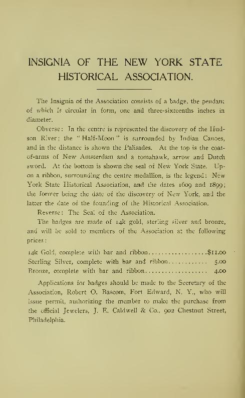
INSIGNIA OF THE NEW YORK STATE
HISTORICAL ASSOCIATION.
The Insignia of the Association consists of a badge, the pendant
of which is circular in form, one and three-sixteenths inches in
diameter.
Obverse : In the centre is represented the discovery of the Hud-
son River ; the " Half-Moon " is surrounded by Indian Canoes,
and in the distance is shown the Palisades. At the top is the coat-
of-arms of New Amsterdam and a tomahawk, arrow and Dutch
sword. At the bottom is shown the seal of New York State. Up-
on a ribbon, surrounding the centre medallion, is the legend : NewYork State Historical Association, and the dates 1609 and 1899;
the form.er being the date of the discovery of New York, and the
latter the date of the founding of the Historical Association.
Reverse : The Seal of the Association.
The badges are made of 14k gold, sterling silver and bronze,
and will be sold to members of the Association at the following
prices
:
14k Gold, complete with bar and ribbon $11.00
Sterling Silver, complete with bar and ribbon 5.00
Bronze, complete with bar and ribbon 4.00
Applications for badges should be made to the Secretary of the
Association, Robert O. Bascom, Fort Edward, N. Y., who will
issue permit, authorizing the member to make the purchase from
the official Jewelers, J. E. Caldwell & Co., 902 Chestnut Street,
Philadelphia.

ARTICLES OF INCORPORATION.
We, Daniel C. Farr, James A. Holden, and Elmer J. West, of Glens
Falls; Grenville M. Ingalsbe, of Sandy Hill, and Morris P. Ferris, of DobbsFerry, all in the State of New York, and all of us citizens of the UnitedStates, have associated ourselves together in a membership corporation, anddo hereby make this our certificate under the laws of the State of NewYork.
The name of such corporation is the " New York State Historical Asso-ciation."
The principal objects for which said corporation is formed are:
First. To promote and encourage original historical research.
Second. To disseminate a greater knowledge of the early history of the
State, by means of lectures, and the publication and distribution of literature
on historical subjects.
Third. To gather books, manuscripts, pictures, and relics relating to the
early history of the State, and to establish a museum at Caldwell, Lake
George, for their preservation.
Fourth. To suitably mark places of historic interest.
Fifth. To acquire by purchase, gift, devise, or otherwise, the title to, or
custody and control of, historic spots and places.
The territory in which the operations of this corporation are to be prin-
cipally conducted is Warren, Washington, Essex, Clinton, Saratoga, and
Hamilton counties, in the State of oNew York.
The principal office of said corporation is to be located at Caldwell, on
Lake George, county of Warren, in the State of New York.
The number of directors of said corporation, to be known as the Board
of Trustees, is twenty-five.
The names and residences of the directors of said corporation, to hold
office until the first annual meeting, and who shall be known as the Board
C'f Trustees, are
:
James A. Roberts, Buffalo.
Timothy L. Woodrufif, Brooklyn.
Daniel C. Farr, Glens Falls,
Everett R. Sawyer, Sandy Hill.
James A. Holden, Glens Falls.
Robert O. Bascom, Fort Edward.
Morris Patterson Ferris, Dobbs Ferry.
Elwyn Seelye, Lake George.
Grenville M. Ingalsbe, Sandy Hill.

7 96 NEW YORK STATE HISTORICAL ASSOCIATION.
Frederick B. Richards,
Anson Judd Upson,
Asahel R. Wing,
William O. Stearns,
Robert C. Alexander,
Elmer J. West,
Hugh Hastings,
Pliny T. Sexton,
William S. Ostrander,
Sherman Williams,
William L. Stone,
Henry E. Tremain,
William H. Tippetts,
John Boulton Simpson,
Harry W. \vatrous,
Abraham B. Valentine,
Ticonderoga.
Glens Falls.
Fort Edward.
Glens Falls.
New York.
Glens Falls.
Albany.
Palmyra,
bchuylerville.
Glens Falls.
Mt. Vernon.
New York.
Lake George.
Bolton.
Hague.
New York.
The first meeting of the corporation, for the purpose of organization,
will be held on the 21st day of March, 1899.
The time for holding the annual meeting of the said corporation will be
the last Tuesday in July of each year.
In Witness Whereof, We have hereunto severally subscribed our names
and affixed our seals this 21st day of March, in the year one thousand eight
hundred and ninety-nine.
DANIEL C. FARR. (l. s.)
JAMES A. HOLDEN, (l. s.)
ELMER J. WE^r, (l. s.)
GRENVILLE M. INGALSBE, (l. s.)
MORRIS P. FERRIS. (l. s.)
State of New York.
County of Warren.
On this 2ist day of March, in the year one thousand eight hundred and
ninety-nine, before me personally appeared Daniel C. Farr, James A. Holden,
Elmer J. West, Grenville M. Ingalsbe, and Morris Patterson Ferris, to meknown to be the individuals described in and who executed the foregoing
articles of incorporation, and they duly severally acknowledged to me that
they executed the same.
E. T. JOHNSON,[seal.] Notary Public.
i

CHARTER OF NEW YORK STATE
HISTORICAL ASSOCIATION.
Whereas, A petition for incorporation by the University has been duly
received, containing satisfactory statements made under oath as to the ob-
jects and plans of the proposed corporation, and as to the provision madefor needed buildings, furniture, equipment, and for maintenance.
Therefore, Being satisfied that all requirements prescribed by law or
University ordinance for such an association have been fully met, and thatpublic interests justify such action, the Regents by virtue of the authority
conferred on them by law, hereby incorporate James A. Roberts, Daniel C.
Farr, James A. Holden, Morris Patterson Ferris, Grenville M. Ingalsbe,
Anson Judd Upson, Robert C. Alexander, Hugh Hastings, William S.
Ostrander, William L. Stone, William H. Tippetts, Harry W. Watrous,
William O. Stearns. Timothy L. Woodruff, Everett R. Sawyer, Robert O.
Bascom. Elwyn Seelye, Frederick B. Richards, Asahel R. Wing, Elmer J.
West, Pliny T. Sexton, Sherman Williams, Henry E. Tremain, John Boul-
ton Simpson, Abraham B. Valentine, and their successors in office under the
corporate name of
NEW YORK STATE HISTORICAL ASSOCIATION.
Th's corporation shall be located at Caldwell, Warren county, NewYork.
Its first trustees shall be the twenty-five above-named incorporators.
Its object shall be to promote historical research, to disseminate knowl-
edge of the history of the State by lectures and publications, to establish alibrary and museum at Caldwell, to mark places of historic interest, and to
acquire custody or control of historic places.
In Witness Whereof, The Regents grant this charter, No. 1,245,
under seal of the University, at the Capitol at Albany, April 24,
[seal.] 1899.
ANSON JUDD UPSON, Chancellor.
Melvil Dewey, Secretary.

CONSTITUTION.
ARTICLE I.
Name.
This Society shall be known as " New York State Historical Asso-
ciation."
ARTICLE IL
Objects.Its objects shall be:
First. To promote and encourage original historical research.
Second. To disseminte a greater knowledge of the early history of the
State, by means of lectures and the publication and distribution of literature
on historical subjects.
Third. To gather books, manuscripts, pictures, and relics relating to the
early history of the State, and to establish a museum at Caldwell, LakeGeorge, for their preservation.
Fourth. To suitably mark places of historic interest.
Fifth. To acquire by purchase, gift, devise, or otherwise, the title to, or
custody and control of, historic spots and places.
ARTICLE III.
Members.
Section i. Members shall be of three classes—Active, Corresponding,
and Honorary. Active members only shall have a voice in the manage-
ment of the Society.
Section 2. All persons interested in American history shall be eligible
for Active membership.
Section 3. Persons residing outside the State of New York, interested
in historical investigation, may be made Corresponding members.
Section 4. Persons who have attained distinguished eminence as his-
torians may be made Honorary members.
ARTICLE IV.
Management.
Section i. The property of the Association shall be vested in, and the
affairs of the Association conducted by, a Board of Trustees to be elected

CONSTITUTION. 1 99
by the Association. Vacancies in the Board of Trustees shall be filled by
the remaining members of the Board, the appointee to hold office until the
next annual meeting of the Association.
Section 2. i he Board of Trustees shall have power to suspend or expel
members of the Association for cause, and to restore them to membershipafter a suspension or expulsion. No member shall be suspended or ex-
pelled without first having been given ample opportunity to be heard in his
or her own defense.
Section 3. The first Board of Trustees shall consist of those designated
in the Articles of Incorporation, who shall meet as soon as may be after
the adoption of this Constitution and divide themselves into three classes
of, as nearly as may be, eight members each, such classes to serve respect-
ively, one until the first annual meeting, another until the second annual
meeting, and the third until the third annual meeting of the Association.
At each annual meeting the Association shall elect eight or nine members
(as the case may be) to serve as Trustees for the ensuing three years, to
fill the places of the class whose term then expires.
Section 4. The Board of Trustees shall have no power to bind the
Association to any expenditure of money beyond the actual resources of
the Association except by the consent of the Board of Trustees, expressed
in writing and signed by every member thereof.
ARTICLE V.
Officers.
Section i. The officers of the Association shall be a President, three
Vice-Presidents, a Treasurer, a Secretary, and an Assistant Secretary, all
of whom shall be elected by the Board of Trustees from its own number,
at its first meeting after the annual meeting of the Association, and shall
hold office for one year, or until their successors are chosen. Temporary
officers shall be chosen by the Incorporators to act until an election as afore-
said, by the Board of Trustees.
Section 2. The Board of Trustees may appoint such other officers, com-mittees, or agents, and delegate to them such powers as it sees fit, for the
prosecution of its work.
Section 3. Vacancies in any office or committee may be filled by the
Board of Trustees.
ARTICLE VL
Fees and Dues.
Section i. Each person on being elected to Active Membership shall
pay into the Treasury of the Association the sum of two dollars, and there-
after on the first day of January in each year a like sum, for his or her
annual dues.

200 NEW YORK STATE HISTORICAL ASSOCIATION.
Section 2. Any member of the Association may commute his or her
annual dues by the payment of twenty-five dollars at one time, and thereby
become a life member exempt from further payments.
Section 3. Any member may secure membership which shall descend to
a member of his or her family qualified under the Constitution and By-Laws
of the Association for membership therein, in perpetuity, bj' the payment
at one time of two hundred and fifty dollars. The person to hold the mem-bership may be designated in writing by the creator of such membership, or
by the subsequent holder thereof subject to the approval of the Board of
Trustees.
Section 4. All receipts from life and perpetual memberships shall be
set aside and invested as a special fund, the income only to be used for
current expenses.
Section 5. Honorary and Corresponding Members and persons whohold perpetual memberships shall be exempt from the payment of dues.
Section 6. The Board of Trustees shall have power to excuse the non-
payment of dues, and to suspend or expel members for non-payment when
their dues remain unpaid for more than six months.
ARTICLE VIL
Meetings.
Section i. The annual meeting of the Association shall be held on the
last Tuesday of July in each year. Notice thereof shall be sent to each
member at least ten days prior thereto.
Section 2. Special meetings of the Association may be called at any
time by the Board of Trustees, and must be called upon the written request
of ten members. The notice of such meeting shall specify the object there-
of, and no business shall be transacted thereat excepting that designated in
the notice.
Section 3. Ten members shall constitute a quorum at any meeting of
the Association.
Section 4. The Board of Trustees shall arrange for the holding of a
series of meetings at Lake George during the summer months, for the read-
ings of original papers on history and kindred subjects, and for social inter-
course between the members and their guests.
ARTICLE Vin.
Seal.
The seal of the Association shall be a group of statuary representing
the Mohawk Chief, King Hendrick, in the act of proving to Gen. William
Johnson the unwisdom of dividing his forces on the eve of the battle of

CONSTITUTION. 20I
Lake George. Around this a circular band bearing the legend, New York
State Historical Association, 1899.
ARTICLE IX.
Amendments.
Amendments to the Constitution may be made at any annual meeting, or
at a special meeting called for that purpose. Notice of a proposed amend-
ment with a copy thereof must have been mailed to each member at least
thirty days before the day upon which action is taken thereon.
The adoption of an amendment shall require the favorable vote of two-
thirds of those present at a duly-constituted meeting of the Association.

BY-LAWS.
ARTICLE I.
Members.
Candidates for membership in the Association shall be proposed by onemember and seconded by another, and shall be elected by the Board of Trus-tees. Three adverse votes shall defeat an election.
ARTICLE IL
Board of Trustees.
Section i. The Board of Trustees may make such rules for its owngovernment as it may deem wise, and which shall not be inconsistent withthe Constitution and By-Laws of the Association. Five members of the
Board shall constitute a quorum for the transaction of business.
Section 2. The Board of Trustees shall elect one of their own numberto preside at the meetings of the Board in the absence of the President.
Section 3. The Board of Trustees shall at each annual meeting of the
Association render a full report of its proceedings during the year last past.
Section 4. The Board of Trustees shall hold at least four meetings in
each year. At each of such meetings it shall consider and act upon the
names of candidates proposed for membership.
Section 5. The Board of Managers shall each year appoint committees
to take charge of the annual gathering of the Association at Lake George.
ARTICLE III.
President.
The President shall preside at all meetings of the Association and of the
Board of Trustees, and perform such other duties as may be delegated to
him by the Association or the Board of Trustees. He shall be ex-officio a
member of all committees.
ARTICLE IV.
Vice-Presidents.
The Vice-Presidents shall be denominated First, Second, and Third
Vice-Presidents. In the absence of the President his duties shall devolve
upon the senior Vice-President present.

BY-LAWS. 203
ARTICLE V.
Treasurer.
Section i. The Treasurer shall have charge of all the funds of the
Association. He shall keep accurate books of account, which shall at all
times be open to the inspection of the Board of Trustees. He shall present
a full and comprehensive statement of the Association's financial condition,
its receipts and expenditures, at each annual meeting, and shall present a
brief statement to the Board of Trustees at each meeting. He shall pay
out money only on the approval of the majority of the Executive Commit-
tee, or on the resolution of the Board of Trustees.
Section 2. Before assuming the duties of his office, the Treasurer-elect
shall with a surety to be approved by the Board execute to the Association
his bond m the sum of one thousand dollars, conditioned for the faithful
performance of his duties as Treasurer.
Section 3. The President shall, thirty days prior to the annual meeting
of the Association, appoint two members of the Association who shall ex-
amine the books and vouchers of the Treasurer and audit his accounts, and
present their report to the Association at its annual meeting.
ARTICLE VL
Secretary.
The Secretary shall preserve accurate minutes of the transactions of the
Association and of the Board of Trustees, and shall conduct the correspon-
dence of the Association. He shall notify the members of meetings, and
perform such other duties as he may be directed to perform by the Asso-
ciation or by the Board of Trustees. He may delegate any portion of his
duties to the Assistant Secretary.
ARTICLE VIL
Executive Committee.
The officers of the Association shall constitute an Executive Committee.
Such Committee shall direct the business of the Association between meet-
ings of the Board of Trustees, but shall have no power to establish or
declare a policy for the Association, or to bind it in any way except in rela-
tion to routine work. The Committee shall have no power to direct a
greater expenditure than fifty dollars without the authority of the Board of
Trustees.
ARTICLE VIII.
Procedure.
Section i. The following, except when otherwise ordered by the Asso-ciation, shall be the order of business at the annual meetings of the
Association
:

204 NEW YORK STATE HISTORICAL ASSOCIATION.
Call to order.
Reading of minutes of previous annual, and of any special meeting, andacting thereon.
Reports of Officers and Board of Trustees.
Reports of Standing Committees.
Reports of Special Committees.
Unfinished business.
Election.
New business.
Adjournment.
Section 2. The procedure at all meetings of the Association and of the
BoaJ-d of Trustees, where not provided for in this Constitution and By-
Laws, shall be governed by Roberts' Rules of Order.
Section 3. The previous question shall not be put to vote at any meet-
ing unless seconded by at least three members.
Section 4. All elections shall be by ballot, except where only one can-
didate is nominated for an oflfice.
Section 5. All notices shall be sent personally or by mail to the address
designated in writing by the member to the Secretary.
ARTICLE IX.
Nominating Committee.
A committee of three shall be chosen by the Association at its annual
meeting, to nominate Trustees to be voted for at the next annual meeting.
Such Committee shall file its report with the Secretary of this Association
at least thirty days prior to the next annual meeting. The Secretary shall
mail a copy of such report to every member of the Association with the
notice of the annual meeting at which the report is to be acted upon. The
,
action of such Committee shall, however, in no wise interfere with the powerof the Association to make its own nominations, but all such independent
nominations shall be sent to the Secretary at least twenty days prior to the
annual meeting. A copy thereof shall be sent to each member by the Secre-
tary with the notice of meeting, and shall be headed " Independent Nomina-tions." If the Nominating Committee fails for any reason to make its report
so that it may be sent out with the notice of the annual meeting, the Society
may make its own nominations at such annual meeting.
ARTICLE X.
Amendments.
These By-Laws may be amended at any duly-constituted meeting of the
Association by a two-thirds vote of the members present. Notice of the
proposed amendment with a copy thereof must have been mailed to each
member at least twenty days before the day upon which action thereon is
taken.

MEMBERS NEW YORK STATEHISTORICAL ASSOCIATION.
HONORARY MEMBERS.*Dr. Edward Eggleston,
E. M. Ruttenber,
Joshua's Rock, N. Y.
Newburg-h, N. Y.
CORRESPONDING MEMBER.Berthold Fernow, Trenton, N. J.
LIFE MEMBERS.W. K. Bixby,
Mrs. Marcellus Hartley,
Mrs. Oliver Livingston Jones,
Mrs. Horace See,
Gen. Henry E. Tremain,
Dr. W. .Seward Webb,
*Samuel P. Avery,
F. D. Howland,
Frank S. Witherbee,
Cortland de Peyster Field,
*Deceased.
Bolton, N. Y.
232 Madison Ave., N. Y. City.
116 W. 72d St., N. Y. City.
50 W. 9th St., N. Y. City.
105 E. i8th St., N. Y. City.
51 E. 44th St., N. Y. City.
4 E. 38th St., N. Y. City.
Sandy Hill, N. Y.
Port Henry, N. Y.
Peekskill, N. Y.
MEMBERS.Abbott, Rev. Dr. Lyman
Abrams, A. W.Alexander, Hon. D. S.
Allen, HiramAmes, Edgar M.Applegate, Rev. Dr. OctaviusArnold, Hon, Alvaro D.Arthur, Miss L. LouiseAtkins, Hon. T. Astley,
" The Outlook," 287 Fourth Ave.,New York.
Illion.
Buffalo.
Sandy Hill.
Fort Edward.Newburgh.Sandy Hill.
Woodside.
73 Nassau St., N. Y.

2o6 NEW YORK STATE HISTORICAL ASSOCIATION.
Backus, Dr. Truman J.
Baker, Frederick I.
Ballard, W. J.
Banker, Dr. Silas J.
Bascom, Robert O.Bassinger, George Jrl.
Batcheller, George Clinton,
Benedict, George Grenville
Benjamin, Rev. Dr. Wm. H.Bishop, Charles F.
Blake, Rev. Chas. W.Bloodgood, Clarence E,
Brackett, Hon. Edgar TrumanBrandow, Rev. John H.Brown, Ernest C.
Brook, James B.
Broughton, H. L.
BuUard, Dr. T. E.
Bunten, RolandBurdge, FranklinBurnham, George,
Bushnell, Nathan Piatt
Cady, S. RiderCarter, Robert C.
Chenev, Dr. Francis L.
Clark,' Walter A.Clark, Rev. Joseph B.
Clowe, Chas. Waldron
Cole, N'ormanConway, John B.
Cook, Dr. Joseph TottenhamCook, Joseph Mrs.
Cook, J. HerveyCooke, Rev. Jere K.Cooley, Dr. James S.
Coolidge, Thomas S.
Coon, Hon. Stephen MortimerCornell, S. DouglasCunningham, Col. J. L.
Columbia University Library,
Davis, William Gilbert
Davis, Dr. Booth C.
Day, Benjamin
Packer Institute, Brooklyn,Fort Ann.Jamaica.Fort Edward.Fort Edward.Glens Falls.
237 W. 72d St., N. Y.Burlington, Vt.
Irvington-on-Hudson.
67 Wall St., N. Y.Lake George.Catskill.
Saratoga Springs.
Schoharie.
280 Broadway, N. Y.1013 East Adams St., Syracuse.
Sandy Hill.
Schuylerville,
Garden City.
325 W. 57th St.N. Y.
3401 Powelton Ave., Philadelphia,
Pa.
Peekskill.
Hudson.Glens Falls.
Cortland.
755 Main St., Geneva.4th Ave. and 22nd St., N. Y.280 Broadway, N. Y.
Glens Falls.
Argyle.
636 Delaware Ave., Buffalo.
Ticonderoga.Fishkill-on-Hudson.HeniDstead.Glen Cove.Glens Falls.
Oswego.Cobourg, Ont.
Glens Falls.
1 1 6th St., New York.
32 Nassau St., N. Y.Alfred.
Hasfue.

MEMBERS. 207
Dehotig, C. J.
Demuth, WilliamDenham, EdwardDenton, Mrs. Elizabeth B.
de Peyster, Mrs. Beekman
Derby, Hon. John H.Derby, Archibald StewartDigney, John M.Doane, Rt. Rev. C. W.Doolittle, C. M.Draper, Hon. A. S.
Dunnell, Rev. Dr. Wm. NicholsDurkee, James H.Dwyer, Major John
Elting, Philip
Eveleth, Dr. George S.
Fairley, WilliamF-^rree, BarrFerris, Morris Patterson
Fowler, Albert N. C.
Gillespie, NelsonGilman, Hon. Theodore P.
Green, JamesGriffith, Prof. E. W.Gunnison, Hon. Royal A.
Hatch, Hon. Edward W.Haight, Hon. Albert
Hall, Fred J.
Halsey, Frances W.Hasting"s, Hon. Hug-hHatch, Rev. W. H. P.
Hatfield, Addie E.
Hawkins, George H.Hayden, Henry W.Hewitt, Fred W.Higg-ins, Hon. Frank W.Hill, E. B.
Holden, Mrs. J. A.Holden, James A.Hopson, Rev. Dr. George B.
Glens Falls.
507 Broadway, N. Y.New Bedford, Mass.Sandy Hill.
2345 Broadway, N. Y. (winter),Johnstown (summer).
Sandv Hill.
Sandy Hill.
White Plains.
Albany.Schuylerville.
Albany.
292 Henrv St., N. Y.Sandy Hi'll.
Sandy Hill.
278 Wall St., Kingston.Little Falls.
195 Kingston Ave., Brooklyn.
7 Warren Street, N. Y.676 West End Ave., N. Y.Glens Falls.
Hoosick Falls.
425 West End Ave., N. Y.Lake George.Glens Falls.
Juneau, Alaska.
Appellate Division, New York.Albany (Court of Appeals).Tarrytown.146 W. 119th St., N. Y.Albany.South Hartford.
17 Linwood Place, Utica.
Plattsburgh.
120 Broadway, N. YGranville.
Olean.
49 Wall St., N. Y.Glens Falls.
Glens Falls.
Annandale.

208 NEW YORK STATE HISTORICAL ASSOCIATION.
Horton, Mrs. John Miller
Horton, Dr. Everest T.
Horton, Dr. Claude A.Howard, Hon. Harry A.Hull, Frank S.
Hull, Philip M.Heilner, Samuel
Imrie, Daniel F.
Ingalsbe, Miss Myra L.
Ingalsbe, Grenville H.Ingalsbe, Franc GroesbeckIngalsbe, Hon. Grenville M.Ingalls, George A.Ingraham, Dr. Charles A.
James, D. Willis
Jackson, Rev. Dr. T. G.
Jessup, Morris K.
Jessup, Rev. Charles A.Joline, Dr. Adrien H.Jordan, Warren S.
Kellogg, Rev. Dr. Charles D.Kellogg, J. AugustusKing, Rev. Dr. Joseph E.
King, Charles T.
Kirb- Dr. R. M.Knapp, George P.
Kniel, T. R.
Krotel, Rev. Dr. G. F.
Ladd, Neil M.Lansing. Mrs. AbrahamLange, GustaveLapham, ByronLaw, Robert R.Leary, Russell W.Lefferts, Marshall C.
Lewis, George C.
Little, Dr. George W.Little, Russell A.Lyttle, Dr. E. W.
Mace, Dr. William H.Mann, William D.
736 Main St., Buffalo.
Whitehall.
Glens Falls.
Glens Falls. •
Newburgh.Clinton.
Broad and Chestnut St., Phila, Pa.
Lake George.Hartford.
Sandy Hill.
Sandv Hill.
Sand^ Hill.
Sandy Hill.
Cambridge.
40 East 39th St., N. Y.68 St. Paul's Place, Brooklyn.
195 Madison Ave., N. Y.Greenport.
54 Wall St., N. Y.
984 Main St., Peekskill.
Sandy Hill.
Glens Falls.
Fort Edward.Glens Falls.
Potsdam.Lake George.Saratoga Springs.
65 Convent Ave., N. Y.
646 Fulton St., Brooklyn.
115 Washmgton Ave., Albany.
257 Broadway, N. Y.Glens Falls.
Cambridge.
147 W. 91st St., N. Y.
30 Washington Place, N. Y.Albany.Glens Falls.
Glens Falls.
Albany.
127 College Place, Syracuse.
Hague.

MEMBERS. 209
Marsh, Wallace T.
Martin, JohnMartine, Dr. G. R.
Matthews, George E.
McAneny, GeorgeMcCarthy, JamesMcLean,' Mrs. DonaldMeredith, ]\Irs. Louise Harden-
bnrghMesser, L. FranklinMichael, EdwardMills, D. O.Mills, Col. Stephen C. (U. S. A.)Moore, Commoclore John W.Morgan, Rev. Dr. D. ParkerMorton, Hon. Levi ParsonsMott, Dr. O. H.Munger, Rev. Dr. R. D.
Glens Falls.
Plattsburgh.
Glens Falls.
Buffalo.
19 E. 47th St., N. Y.
Sandv Hill.
186 Lenox Ave., N. Y.
San Luis Obispo, Cal.
403 Main St., Buffalo.
741 Delaware Ave., Buffalo.
634 Fifth Ave., N. Y.Governor's Island, N. Y. Harbor.Bolton Landing.
3 E. 45th St., N. Y.681 Fifth Ave., N. Y.Fort Edward.105 Delaware St., Syracuse.
Near, Irwin W.Nelson, V'enerable Dr. Geo. F.
Newcomb, Alvah S.
Nottino-ham. William
Hornellsville.
29 Lafayette Place, N. Y.
33 Washington Ave., Albany,
701 Walnut St., Syracuse.
O'Brien, M. J. 19.S Broadway, N. Y.
Olmstead, Rt. Rev. Chas. Tyler 159 Park Ave., Utica.
Paige, Edward WinslowParry, Mrs. J. E.
Payne, Silas H.Peabody, George Foster
Peck, Gen. T. S.
Peck, Reuben N.Pell, HowlandPrince, Rev .Dr. W^alter Franklin
Potter, Delcour S.
Pryer, Charles
Ransom, Frank H.Ransom, Hon. Rastus S.
Ravmond, Rev. Dr. A. V. V.Reid, W. MaxReid, Hon. WhitelawRhoades, W. C. P.
Richards, Frederick B.
44 Cedar St., N, Y.
Glens Falls.
Silver Bay.
54 William St., New York.Burlington, Vt.
Glens Falls.
7 Pine St., N. Y.16 S. Elliott Place, Brooklyn.
Glens Falls.
New Rochelle.
137 Main St., Buffalo.
128 Broadway, N. Y.
Schenectady.Amsterdam.New York.
400 Putnam Ave., Brooklyn.
Ticonderoga.
NEW YORK STATE HISTORICAL ASSOCIATION.
Richardson, Rev. George L.
Richards, A. N.Roberts, Joseph BanksRoberts, Mrs. James A.Roberts, Hon. James A.Rogers, Howard J.
Rowell, George C.
Sivmson, Wilham H.Sanford, Clarence T.
Sawyer, W. L.
Sawyer, Dr. Edward R.Schuyler, Miss Fanny
Glens Falls.
Sandy Hill.
141 Broadway, N. Y.
256 Broadway, N. Y.
256 Broadway, N. Y.Education Dept., Albany.
81 Ohapel St., Albany.
420 Oxford St., Rochester,
Lake George.Sandy Hill.
Sandy Hill.
New Rochelle.
Schuyler, Rev. Dr.Livingston Rowei7 Lexington Ave., N. Y.
Schell, F. RobertSeabury, Rev. Dr. Wm. JonesSebring-, William C.
Seelye, ElwynSexton, Mrs. Pliny T.
Sexton, Hon. Pliny T.
Sidway, Mrs. Frank St. JohnSills, Dr. Qiarles MortonSill, Dr. Frederick S.
Silver, Dr. John ArcherSimpson, John BoultonSims, Charles N.Shedden, Hon. Lucian L.
Shephard, Dr. Edward M.Sheer, Rev. Thomas R.Smith, Wm. Alex.
Smith, T. Guilford
Smith, James F.
Spencer, Dr. Chas. W.Stackpole, George F.
State Normal and Training School
Stearns, Rev. W. O.Steele, Mrs. Esther B.
Stevens, Rev. Dr. C. Ellis,
Stevens, Benjamin F.
Stieglitz, EdwardStilwell, Giles H.Stillman, Dr. William Olin
Stone, Col. William L.
Tefft, Richard C.
Temple, Truman R.
280 Broadway, N. Y.8 Chelsea Sq., N. Y.Kingston, N. Y.Lake George.Palmyra.Palmyra.
37 Oakland Place, Buffalo.
Geneva.169 M'ohawk St., Cohoes.
Geneva.1170 Broadway, N. Y.Liberty, Indiana.
Plattsburg'h.
Lake George.
New York City.
412 Madison Ave., N. Y.Buffalo.
South Hartford.
Princeton, N. J.
Riverhead.Plattsburgh.
Glens Falls.
352 W. Clinton St., Elmira.
Ill Montague St., Brooklyn.
Bbston, Mass.Bolton.
1906 W. Genesee St., Syracuse.
287 State St., Albany.Mt. Vernon.
Sandy Hill.
Granville.


55.
S3'
i
J'
'<}•
^
3
/?
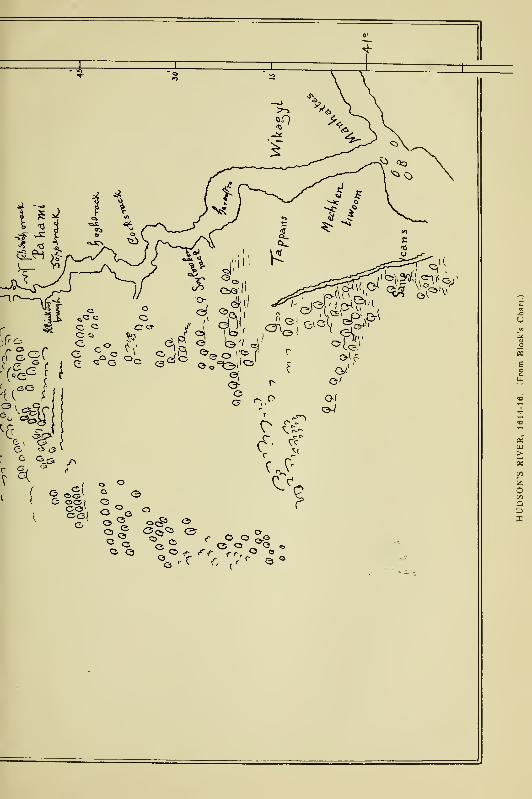


FOOTPRINTS OF THE RED MEN.
Indian Geographical NamesIN THE VALLEY OF HUDSON'S RIVER.
THE VALLEY OF THE MOHAWK,AND ON THE DELAWARE:
THEIR LOCATION AND THE PROBABLEMEANING OF SOME OF THEM.
E. M. RUTTENBER,Author of " History of the Indian Tribes of Hudson's River."
" Indian place-names are not proper names, that is unmeaning words,
but significant appellatives each conveying a description of the locality to
which it belongs."— Trz^w^z^//.
PUBLISHED UNDER THE AUSPICES
OF THE
1Rew IPcrl? State Ibietoiical Hssociation.

Copyrighted by the
NEW YORK STATE HISTORICAL ASSOCIATION.
1906.
Primary Explanations.
The locatives of the Indian geographical names which have been
handed down as the names of boundmarks or of places or tribes, are
properly a subject of study on the part of all who would be familiar
with the aboriginal geography of a district or a state. In manycases these names were quite as designative of geographical cen-
ters as are the names of the towns, villages and cities which have
been substituted for them. In some cases they have been wisely
retained, while the specific places to which they belonged have been
lost. In this work special effort has been made, first, to ascertain
the places to which the names belonged as given in ofiicial records,
to ascertain the physical features of those places, and carry back the
thought to the poetic period of our territorial history, " when the
original drapery in which nature was enveloped under the dominion
of the laws of vegetation, spread out in one vast, continuous interm-
inable forest," broken here and there by the opened patches of corn-
lands and the wigwams and villages of the redmen ; secondly, to
ascertain the meanings of the aboriginal names, recognizing fully
that, as Dr. Trumbull wrote, " They were not proper names or mere
unmeaning marks, but significant appellatives conveying a descrip-
tion of the locatives to which they were given." Coming down to
us in the crude orthographies of traders and unlettered men, they
are not readily recognized in the orthographies of the educated mis-
sionaries, and especially are they disguised by the varying powers
of the German, the French, and the English alphabets in which they
were written by educated as well as by uneducated scribes, and by
traders who were certainly not very familiar with the science of
representing spoken sounds by letters. In one instance the same
name appears in forty-nine forms by different writers. Manynames, however, 'have been recognized under missionary standards
and their meanings satisfactorily ascertained, aided by the features
of the localities to which they were applied ; the latter, indeed, con-
4 INDIAN GEOGRAPHICAL NAMES.
tributing very largely to their interpretation. Probably the reader
will find geographical descriptions that do not apply to the places
where the name is now met. The early settlers made manytransfers as well as extensions of names from a specific place to a
large district of country. It must be remembered that original ap-
plications were specific to the places which they described even
though they were generic and applicable to any place where the
same features were referred to. The locatives in Indian deeds and
in original patents are the only guide to places of original applica-
tion, coupled with descriptive features where they are know;i.
No vocabularies of the dialects spoken in the lower valley of the
Hudson having been preserved, the vocabularies of the Upper-
Unami and the Minsi-Lenape, or Delaware tongues on the south and
west, and the Natick, or Massachusetts, on the north and east, have
been consulted for explanations by comparative inductive methods,
and also orthographies in other places, the interpretations of which
have been establisihed by competent linguists. In all cases where
the meaning of terms has been particularly questioned, the best
expert authority has been consulted. While positive accuracy is
not asserted in any case, it is believed t?hat in most cases the inter-
pretations which have been given may be accepted as substantially
correct. There is no poetry in them—no " glittering waterfalls,
'
no " beautiful rivers," no '' smile of the Great Spirit," no " Holy
place of sacred feasts and dances," but plain terms thit have their
equivalents in our own language for a small hill, a hig'li hili, a moun-
tain, a brook, a creek, a kill, a river, a pond, a lake, a swamp, a large
stone, a place of small stones, a split rock, a meadow, or whatever
the objective feature may have been as recognized by the Indian.
Many of them were particular names in the form of verbals indi-
cating a place wiiere the action of the verb was performed ; occasion-
ally the name of a sachem is given as that of his place of residence
or the stream on whidh he resided, but all are from generic roots.
To the Algonquian dialects spoken in the valle}" of Hudson's
River at the time of the discovery, was added later the Mohawk-Iroquorian, to some extent, more particularly on the north, where
it appears about 1621-6, as indicated in the blanket deed given by
the Five Nations to King George in 1726. Territorially, in the
primary era of European invasion, the Eastern Algonquian pre-

PRIMARY EXPLANATIONS. 5
vailed, in varying idioms, on both sides of the river, from a northern
point to the Katskills, and from thence south to the Highlands a
type of the Unami-Minsi-Lenape or Delaware. That spoken around
New York on both sides of the river, was classed by the early Dutch
writers as Manhattan, as distinguished from dialects in the High-
lands and from fhe Savano or dialects of the East New England
coast. North of the Highlands on both sides of the river, they
classed the dialect as Wapping, and from the Katskills north as
Mahican or IMohegan, preserved in part in what is known as the
Stockbridge. Presumably the dialects were more or less mixed and
formed as a whole what may be termed " The Hudson's River Dia-
lect," radically Lenape or Delaware, as noted by Governor Tryon
in 1774. In local names we seem to meet the Upper-Unami and
the Minsi of New Jersey, and the Mohegan and the Natick of the
north and east, the Oniripi of tlie Sound, and the dialect of the
Connecticut \'alley. In the belt of country south of the Katskills
they were soft and vocalic, the lingual mute t frequently appearing
and r taking the place of the Eastern / and n. In the Minsi (Del.)
Zeisberger wrote / invariably, as distinguished from r, which ap-
pears in the earliest local names in the valley of the Hudson. Other
dialectic peculiarities seem to appear in the exchange of the sonant
g for the hard sound of the surd mute k, and of p for g, s for g,
and / for d, st for gk, etc. Initials are badly mixed, presumably
due in part at least, to the habit of Indian speakers in throwing the
sound of the word forward to the penult ; in some cases to the lack
of an " Indian ear " on the part of the hearer.
In structure all Algonquian dialects are Polysynthetic, i. e., words
composed wholly or in part ofother words or generic roots. Pro-
nunciations and inflections dififer as do the words in meaning in
many cases. In all dialects the most simple combinations appear in
geographical names, whidh the late Dr. J. H. Trumbull resolved
into three classes, viz. :" I. Those formed by the union of two
elements, which we will call adjectwal and substantival, or ground-
word, with or without a locative suffix, or post-position word mean-
ing 'at,' "'in,' 'on,' 'near,' etc. [I use the terms 'adjectival' and' iuibstantival,' because no true adjectives or substantives enter into
the composition of Algonquian names. The adjectival may be an
adverb or a preposition ; the substantival elem'ent is often a verbal,

O INDIAN GEOGRAPHICAL NAMES.
which serves in composition as a generic name, but whidi cannot
be used as an independent word—the synthesis always retains the
verbal form.] II. Those which have a single element, the substan-
tival, or ground-word, with locative suffix. III. Those formed
from verbs as participials or verbal nouns, denoting a place where
the action of the verb is performed. Most of these latter, however,"
he adds, " may be shoAvn by strict analysis to belong to one of the
two preceding classes, which compri.se at least nine-tenths of all
Algonquian local names which have been preserved." For example,
in Class 1, Wapan-aki is a combination of Wapan, " the Orient,"" the East," and oiki, " Land, place or country," unlimited; with
locative suffix {-ng, Del., -it, Mass.), "In the East Land or Coun-
try." Kit-ann-ing, Del., is a composition from Kitschi, '" Chief,
principal, greatest," hanne, '' river," and ing locative, and reads, " Aplace at or on the largest river." The suffix -aki, -acki, -hacki, Del.,
meaning " Land, place, or country, unlimited," in Eastern orthog-
raphies -oJike, -anke -ague, -ke, -ki, etc., is changed to -kamik, or
-kamike, Del., -kamnk or -komuk, Mass., in describing " Land or
place limited," or enclosed, a particular place, as a field, garden,
and also used for house, thicket, etc. The Eastern post-position
locatives are -it, -et, -at, -iit; the Delaware, -ng, -nk, with connecting
vowel -ing -ink, -ong, -onk, -ung, -unk, etc. The meaning of this
class of suffixes is the same ; they locate a place or object that is at,
in, or on some other place or object, the name of Which is prefixed,
as in Delaware Hitgunk, " On or to a tree ;" Utenink, " In the
town ;" Wachtschunk, " On the mountain." In some cases the loca-
tive takes the verbal form indicating place or country. Williams
wrote " Sachimauonck, a Kingdom or Monarchy." Dr. School-
craft wrote: "From Ojihwai (Chippeway) is formed Ojih-wain-
ong, ' Place of the Chippeways ; Monominikaun-ing' ' In the place
of wild rice.' " Dr. Brinton wrote " Walum-ink, ' The place of
paint.' " The letter s, preceding the locative, changes the meaning
of the latter to near, or something less than at or on. The suffixes
-is, -it, -OS, -es mean " Small," as in Menates or Menatit, " Small
island." The locative affix cannot be applied to an animal in the
sense of at, in, on, to. There are many formative inflections and
suffixes indicating the plural, etc.
Mohawk or Iroquoian names, while polysynthetic, differ from

PRIMARY EXPLANATIONS. 7
Alg'onquian in construction. " The adjective," wrote Horatio Hale,
" when employed in an isolated form, follows the substantive, as
Kanoiisa, ' house ;' Kanonsa-kowa, ' large house ;' but in general the
substantive and adjective coalesce." In some cases the adjective is
split in two, and the substantive inserted, as in Tiogen, a composition
of Te, " two," and ogen, " to separate," which is split and the word
ononte, " mountain," or hill, inserted, forming Te-ononte-ogen, " Be-
tween two mountains." " The local relations of nouns are expressed
by affixed particles, such as ke, ne, kon, akon, akta. Thus from
Ononta, mountain, we have Onontdkc, at (or to) the mountain; from
Akchrat dish, Akehrdtne, in or on the dish," etc. From the variety
of its forms and combinations it is a more difficult language than
the Algonquian. No European has fully mastered it.
No attempt has been made to correct record orthographies fur-
ther than to give their probable missionary equivalents where they
can be recognized. In many cases crude orthographies have con-
verted them into unknown tongues. Imperfect as many of them
are and without standing in aboriginal glossaries, they have become
place names that may not be disturbed. No two of the early scribes
expressed the sound of the same name in precisely the same letters,
and even the missionaries who gave attention to the study of tbe
aboriginal tongues, did not always write twice alike. Original
sounds cannot now be restored. The diacritical marks employed
by Williams and Eliot in the English alphabet, and by Zeisberger
and Heckewelder in the German alphabet, are helpful in pronun-
ciations, but as a rule the corrupt local record orthographies are
a law unto themselves. In quoting diacritical marks the forms of
the learned linguists who gave their idea of how the word was pro-
nounced, have been followed. It is not, however, in the power of
diacritical marks or of any European alphabet to express correctly
the sound of an Algonquian or of an Iroquoian word as it was orig-
inally spoken, or write it in European characters. Practically, every
essential element in pronunciation is secured by separating lihe forms
into words or parts of words, or particles, of which it is composed,
(where the original elements of the composition cannot be detected)
by syllabalizing on the vowel sounds. An anglicized vocalism of
any name may be readily established and an original name formed
in American nomenclature, as many names in current use amply il-

8 INDIAN GEOGRAPHICAL NAMES.
lustrates. Few would suspect uliat Ochsechraga (Mohawk) was the
original of Saratoga, or that P'tuk-sepo (Lenape) was the original
of Tuxedo.
A considerable number of record names have been included that
are not living. They serve to illustrate the dialect spoken in the
valley as handed down by European scribes of different languages,
as well as the local geography of the Indians. The earlier forms
are mainly Dutch notations. A few Dutch names that are regard-
ed by some as Indian, have been noticed, and also some Indian
names on the Delaware River which, from the associations of that
river with the history of the State, as in part one of its boundary
streams, as well as the intimate associations of the names with the
history of the valley of Hudson's River, become of especial interest,
In the arrangement of names geographical association has been
adopted in preference to the alphabetical, the latter being supplied
by index. This arrangement seems to bring together dialectic
groups more satisfactorily. That there were many variations in
the dialects spoken in the valle}- of Hudson's River no one will deny,
but it may be asserted with confidence that the difference between
the German and the English alphabets in renderings is more marked
than differences in dialects. In so far as the names have been
brought together they form the only key to the dialects which were
spoken in the valley. Their grammatical treatment is the work of
skilled philologists.
Credit has been given for interpretations where the authors
were known, and especially to the late eminent Algonquian authority,
J. Hammond Trumbull. Special acknowledgment of valuable as-
sistance is made to the late Dr. D. G. Brinton, of Philadelphia ; to
the late Horatio Hale, M. A., of Clinton, Ontario, Canada ; to the
late Prof. J. W. Powell, of the Bureau of Ethnology, Washington,
D. C, and his successor, William H. Holmes, and their co-laborers,
Dr. Albert S. Gatschet and J. B. N. Hewitt, and to Mr. William
R. Gerard, of New York.
The compilation of names and the ascertaining of their locatives
and probable meanings has interested me. Where those names
have been preserved in place they are certain descriptive landmarks
above all others. The results of my amateur labors may be useful
to others in the same field of inquiry as well as to professional

PRIMARY EXPLANATIONS. 9
linguists. Primarily the work was not undertaken with a view to
publication. Gentlemen of the New York Historical Association,
with a view to preserve what has been done, and which may never
be again undertaken, have asked the manuscript for publication,
and it has been given to them for that purpose.
E. M. RUTTENBER.Newburgh, January, 1906.


INDIAN GEOGRAPHICAL NAMES.
Hudson's River and Its Islands.
Muhheakun'nuk, " The great waters or sea, which are constant-
ly in motion, either ebbing or flowing," was written by Chief Hen-drick Aupaumut, in his history of the Muhheakun'nuk nation, as
the name of Hudson's River, in the Stockbridge diailect, and its
meaning. The first word, Muhheakun, was the national name of
the people occupying both banks of the river from Roelof Jansen's
Kill, a few miles south of Catskill, on the east side of the river, north
and east with limit not known, and the second -mik, the equivalent
of Massachusetts -ink, Lenape -ittuk, " Tidal river, or estuary," or" Waters driven by waves or tides," with the accessory meaning of" great." Literally, in application, " The great tidal river of the
Muhheakan'neuw nation." The Dutch wrote the national nameMahikan, Maikan, etc., and the English of Connecticut wrote Mo-hegan, which was claimed by Drs. Schoolcraft and Trumbull to be
derived from Maingan (Cree Maheggun), " Wolf "—" an enchanted
wolf, or a wolf of supernatural powers." From their prevailing
totem or prevailing coat-of-arms, the Wolf, the French called
them Loups, " wolves," and also Manhingans, including under the
names " The nine nations gathered between Manhattan and Quebec."
WTiile the name is generic its application to Hudson's River was
probably confined to the vicinity of Albany, where Chief Aupaumutlocated their ancient capital under the name of Pem-po-tow-wut-hut
Muh-hea-kan-neiiw, " The fire-place of the Muh-hea-kan-nuk na-
tion." ^ The Dutch found them on both sides of the river north of
Catskill, with extended northern and eastern alliances, and south
of that point, on the east side of the river, in alliance with a tribe
known as Wappans or Wappings, Wappani, or " East-side people,"
the two nations forming the Mahikan nation of Hudson's River as
known in history. (See Wahamensing.)
^ Presumed to have been at what is now known as Schodac, which see

12 INDIAN GEOGRAPHICAL NAMES.
Father Jogues, the French-Jesuit martyr-missionary, wrote in
1646, Oi-o-gne as the Huron-Iroquoian name of the river, given to
him at Sarachtoga, with the connection " At the river." " Ohioge,
river ; Ohioge-son, at the long river," wrote Bruyas. Arent van
Curler wrote the same name, in 1634, Vyoge, and gave it as that
of the Mohawk River, correcting the orthography, in his vocabulary,
to " Oyoghi, a kill " or channel. It is an Iroquoian generic applica-
ble to any principal stream or current river, with the ancient related
meaning of " beautiful river."
It is said that the M'Ohawks called the river Cohohataton. I
have not met that name in records. It was quoted by Dr. School-
craft as traditional, and of course doubtful. He wrote it Kohatatea,
and in another connection wrote " -atea, a valley or landscape," It
is suspected that he coined the name, as he did many others. Shate-
muck is quoted as a Mohegan^ name, but on very obscure evidence,
although it may have been the name of an eel fishing-place, or a
great fis'hing-place {-amaug). Hudson called the stream "TheRiver of the Mountains." On some ancient maps it is called " Man-hattans River." The Dutch authorities christened it " Mauritus'
River " in honor of their Staat-holder, Prince Maurice. The Eng-
lis'h recognized the work of the explorer by conferring the title
'* Hudson's River." It is a fact established that Verrazano visited
New York harbor in 1524, and gave to the river the name " Riviere
Grande," or Great River ; that Estevan Gomez, a Spanish navigator
who followed Verrazano in 1525, called it " St. Anthony's River,"
a name now preserved as that of one of the hills of the Highlands,
and it is claimed tihat French traders visited the river, in 1540, and
established a chateau on Castle- Island, at Albany," and called the
^" Mohegavis is an anglicism primarily applied to the small band of Pe-
quots under Uncas.'"' (Trumbull.) While of the same linguistic stock,
neither the name or the history of Uncas's clan should be confused withthat of the Mahicani of Hudson's River.
^ Introduced by the Dutch
—
Kasteel. The Indians had no such word.The Delawares called a house or hut or a town that was palisaded, Moenach,and Zeisberger used the same word for " fence "—an inclosure palisaded
around. Eliot wrote Wonkonous, " fort."
^ It is claimed that the walls of this fort were found by Hendrick Chris-
tiansen, in 1614; that they were measured by him and found to cover an areaof 58 feet ; that the fort was restored by the Dutch and occupied by themuntil they were driven out by a freshet, occasioned by the breaking up of the
ice in the river in the spring of 1617; that the Dutch then built what was


HUDSON'S RIVER, 1609. (From Hudson's Chart.)
/

HUDSON S RIVER AND ITS ISLANDS. 13
river " Norumbega." It may be conceded that possibly French
traders did have a post on Castle Island, but " Norumbega " wasobviously conferred on a wide district of country. It is an Abnakiterm and belonged to the dialect spoken in Maine, where it becamemore or less familiar to French traders as early as 1535. Thatthose traders did locate trading posts on the Penobscot, and that
Champlain searched for their remains in 1604, ^^e facts of record.
The name means " Quiet " or " Still Water." It would probably
be applicable to that section of Hudson's River known as " Still-
water," north of Albany, but the evidence is wanted that it was so
applied. Had it been applied by the tribes to any place on Hudson's
River, it would have remained as certainly as Menate remained at
New York.
Manhattan, now so written, does not appear in the Journal of
Hudson's exploration of the river in 1609. On a Spanish-English
map of 1610, " Made for James I," and sent to Philip III by Velasco
in letter of March 22, 1611,^ Mannahafin is written as the name of
the east side of the river, and Mannahata as that of the west side.
From the former Manhattan, and from it also the name of the In-
dians " among whom " the Dutch made settlement in 1623-4, other-
Avise known by the general name of Wickqnaskecks, as well as the
name of the entire Dutch possessions.* Presumably the entries on
the Spanish-English map were copied from Hudson's chart, for
which there was ample time after his return to England. Possibly
they may have been copied by Hudson, who wrote that his voyage"' had been suggested " by some " letters and maps " which " had
been sent to him " by Capt. Smith from Virginia. Evidently the no-
tations are English, and evidently, also, Hudson, or his mate, Juet,
subsequently known as Fort Orange, at the mouth of the Tawalsentha, or
Norman's Kill, about two miles south of the present State street, Albany,
and that Castle Island took that name from the French chateau—all of whichis possible, but for conclusive reasons why it should not be credited, the
student may consult "Norumbega" in Winsor's "Narrative and Critical
History of America." Wrote Dr. Trumbull :" Theuet, in La Cosmographte
Universella, gives an account of his visit, in 1656, to ' one of the finest rivers
in the whole world, which we call Norumbeque, and the aboriginees Agoncy,'
now Penobscot Bay."
* Brown's " Genesis of the United States," 327, 457, 459, ii, 80.
' Colonial History of New York.

14 .NDIAN GEOGRAPHICAL NAMES.
had a chart from his own tracing or from that of a previous ex-
plorer, which he forwarded to his employers, or of which they had
a copy, when he wrote in his Journal :" On that side of the river
called MannaJiata," as a reference by which his employers could
identify the side of the river on which the Half-Moon anchored,^
Presumably the chart was drawn by Hudson and forwarded with
his report, and that to him belongs the honor of reducing to an
orthographic form the first aboriginal name of record on the river
which now bears his name. Five years after Hudson's advent
Adriaen Block wrote Manhates as the name of what is now NewYork Island, and later, De Vries wrote Manates as the name of
Staten Island, both forms having the same meaning, i e., " Small
island." There have been several interpretations of Mannahatin,
the most analytical and most generally accepted being by the late
Dr. J. H. Trumbull: "From Menatey (Del.), 'Island'
—
Mannah-
ata * The Island,' the reference being to the main land or to LongIsland as the large island. Menatan (Hudson's Mannah-atin, -an or
-in^ the indefinite or diminutive form), 'The small island,' or the
smaller of the two principal islands, the Manhates of Adriaen Block.*
Mandhtans. ' People of the Island,' Mandhatanesen, ' People of the
small islands.' " ^ The Eastern-Algonquian word for " Island"
(English notation), is written Munnoh, with formative -an (Mun-
nohan). It appears of record, occasionally, in the viciniity of NewYork, presumably introduced by interpreters or English scribes.
The usual form is the Lenape Menate. Chippeway Minnis, " Small
island," classed also as Old Algonquian, or generic, may be met in
the valley of the Hudson, but the instances are not clear. It is
simply a dialectic equivalent of Del. Menates. (See Monadi'nong.)
Van Curler wrote in his Mohawk vocabulary (1635), " Kanon-
newaga, Manhattan Island." The late J. W. Powell, Director of
the Bureau of Ethnology, wrote me :" In the alphabet of this of-
^ Hudson anchored in the bay near Hoboken. Near by his anchorage henoticed that " there was a cliff that looked of the color of white green." Thiscliff is near Elysian Fields at Hoboken. (Broadhead.) The cliff is nowknown as Castle Point.
' The reference to Adriaen Block is presumably to the "Carte Figurative"of 1614-16, now regarded as from Block's chart.
•" Composition of Indian Geographical Names," p. 22.
HUDSON S RIVER AND ITS ISLANDS. 1
5
fice the name may be transliterated Kanonnb'ge. It signifies ' Place
of Reeds,' " Perhaps what was known as the " Reed Valley " wasreferred to, near which Van Twiiller had a tobacco plantation where
the Indians of all nations came to trade. (See Saponickan.) Thelower part of the island was probably more or less a district of reed
swamps.
Pagganck, so written in Indian deed of 1637, as the name of
Governor's Island—Peconuc, Denton/ is an equivalent of Pagdn'nak,
meaning literally " Nut Island." Also written Pachgan, as in Pach-
ganunschi, "White walnut trees." (Zeisb.) Denton explained,
" Because excellent nut trees grew there." ^ The Dutch called it
" der Nooten Eilandt," literally " The Walnut Island," from whence
the modern name, " Nutten Island." The island was purchased
from the Indian owners by Director Wouter van Twiller, from
whose occupation, and its subsequent use as a demense of the
governors of the Province, its present name.
Minnisais is not a record name. It was conferred on Bedloe's
Island by Dr. Schoolcraft from the Ojibwe or Chippeway dialect,*
in which it means " Small island."
Kiosh, or *•' Gull Island," was conferred on Ellis Island by Dr.
Schoolcraft from the Ojibwe dialect. The interpretation is correct
presumably.
Tenkenas is of record as the Indian name of what is now
^ Denton's " Description of New York," p. 29. Ward's and Blackwell's
islands were sold to the Dutch by the Marechawicks, of Long Island, in
1636-7. Governor's Island was sold in the same year by the Tappans, Hack-insacks and Nyacks, the grantors signing themselves as " hereditary owners."
Later deeds were signed by chiefs of the Raritans and Hackinsacks.
^The Objibwe (Objibwai) were a nation of three tribes living northwest
of the great lakes, of which the Ojibwai or Chippeway represented the
Eagle totem. It is claimed by some writers that their language stands at
the head of the Algonquian tongues. This claim is disputed on behalf of
the Cree, the Shawanoe, and the Lenape or Delaware. It is not assumedthat Ojibwe (Chippeway) terms are not Algonquian, but that they do not
strictly belong to the dialects of the Hudson's river families. Rev. Hecke-welder saw no particular difference between the Ojibwe and the Lenapeexcept in the French and the English forms. Ojibwe terms may always be
quoted in explanations of the Lenape.

l6 INDIAN GEOGRAPHICAL NAMES.
known as Ward's Island/ It appears in deed of 1636-7. It
means "Small island," from Tenke (Len.), "little."
Monatun was conferred by Dr. Schoolcraft on the whirlpool off
Hallet's Cove, with the explanation, " A word conveying in its
multiplied forms the various meanings of violent, forcible, danger-
ous, etc." Dr. Schoolcraft introduced the word as the derivative of
Manhatan, Which, however, is very far from being explained by
it. Hell-gate, a. vulgar orthography of Dutch Hellegat, has long
been the popular name of the place. It was conferred by Adriaen
Block, in 1614-16, to the dangerous strait known as the East River,
from a strait in Zealand, which, presumably, was so called from
Greek Helle, as heard in Hellespont
—
" Sea of Helle "—now known
as the Dardanelles—which received its Greek name from Helle,
daugliter of Athamas, King of Thebes, who, the fable tells us, was
drovred in passing oyer it. Probably the Dutch sailors regarded
the strnit as the " Gate of Hell," but that is not the meaning of
the name—" a dangerous strait or passage." In some records the
strait is called Hurlgate, from Dutdi Warrcl, " Whirl," and gat,
" Hole, gap, mouth "—substantially, '' a whirlpool."
Monachnong, deed to De Vries, 1636; Mediates, De Vries's
Journal; Ehquaons (Eghquaous, Brodhead, by mistake in the letter
n), deed of 1655, and Aquehonge-Monachnong, deed to Governor
Lovelace, 1670, are forms of the names given as that of Staten
Island, and are all from Lenape equivalents. Meimtes means" Small island " as a whole ; Monach'nong means a " Place on the
island," or less than the whole, as shown by the claims of the In-
dians in 1670, that they had not previously sold all the island. (Col.
Hist. N. Y., xiii, 453.) It is the equivalent of Menach'hen, Minsi
;
Menach'n, Abn., " Island," and ong, locative ; in Mass. Munnoh-han-
auke. (See Mannhonake.) Eghquaons and Aquehonga are equiv-
alents, and also equivalents of Achquoanikan-ong, " Bushnet fishing-
place," of which Acquenonga is an alternate in New Jersey. (Nel-
son's " Indians of New Jersey," 122.) In other words, the Indians
^ The Dutch called the island Onvruchtbaar, " Unfruitful, barren." TheEnglish adopted the signification, " Barren," which soon became corruptedto " Barrent's," to which was added " Great " to distinguish it from Randal'sIsland, which was called " Little Barrent's Island." Barn Island is anothercorruption. Both islands were " barren " no doubt.

HUDSON S RIVER AND ITS ISLANDS. 1
7
conveyed places on the island, including specifically their " bushnet
fishing--place," and by the later deed to Lovelace, conveyed all un-
sold places. The island was owned by the Raritans who resided
" behind the Kol," and the adjoining Hackensacks. (Deed of 1655.)
Its last Indian occupants were the Nyacks, who removed to it after
selling their lands at New Utrecht. (See Paganck note.)
Minnahanock, given as the name of Blackwell's Island, was in-
terpreted by Dr. Trumbull from Munnohan,, Mass., the indefinite
form of Munnoh, " Island," and auke, Mass., " Land " or place.
Dr. O'Callaghan's "Island home," is not in the composition. (See
Mannhonake.)
On Manhattan Island.
Kapsee, Kapsick, etc., the name of what was the extreme point
of land between Hudson's River and the East River, and still knownas Copsie Point, was claimed by Dr. Schoolcraft to be Algonquian,
and to mean, " Safe place of landing," which it may have been.
The name, however, is pretty certainly a corruption of Dutch Kaap-hoekje, " A little cape or promontory."
Saponickan and Sapohanican are the earliest forms of a namewhich appears later Sappokanican, Sappokanikke, Saponican, Shaw-
backanica, Taponkanico, etc. " A piece of land bounded on the
north by the strand road, called Saponickan "( 1629) ;
" Tobacco
plantation near Sapohanican" (1639) ; "Plantation situate against
the Reed Valley beyond Sappokanican" (1640). Wouter van
Twiller purchased the tract, in 1629, for the use of the Dutch gov-
ernment and established thereon a tobacco plantation, with build-
ings enclosed in palisade, which subsequently became known as
" the little village of Sapokanican—Sappokanican, Van der Donck
—
and later (1721) as Greenwich Village. It occupied very nearly
the site of the present Gansevort market. The " Strand road " is
now Greenwich Street. It was primarily, an Indian path along
the shore of the river north, with branches to Harlem and other
points, the main path continuing the trunk-path through Raritan
Valley, but locally beginning at the " crossing-place," or, as the

i8 INDIAN GEOGRAPHICAL NAMES.
record reads, " Where the Indians cross [the Hudson] to bring
t!heir pelteries." '" South of Van Twiller's plantation was a marsh
much affected by wild-fowl, and a bright, quick brook, called by the
Dutch ' Bestavar's Kil,' and by the English ' Manetta Water.'" '
(Half-Moon Series.) Saponickan was in place here when VanTwiller made his purchase (1629), as the record shows, and wasadopted by him as the name of his settlement. To what feature
it referred cannot be positively stated, but apparently to the ReedValley or marsh. It has had several interpretations, but none that
are satisfactory. The syllable pon may denote a bulbous root whichwas found there. (See Passapenoc.) The same name is probably
met in Saphorakan, or Saphonakan, given as the name of a tract
described as " Marsh and canebrake," lying near or on the shore
of Gowanus Bay, Brooklyn. (See Kanonne'wage, in connection
with Manhattan.)
Nahtonk, Recktauck, forms of the name, or of two different
names, of Corlear's Hook, may signify, abstractively, " SandyPoint," as has been interpreted; but apparently, Nahtonk^ is from
Nd-i, "a. point or corner," and Rechtauck from Lekau (Requa),
*" Through this valley pass large numbers of all sorts of tribes on their
waj'^ north and east." (Van Tienhoven, 1650.) "Where the Indians crossto bring their pelteries.'" (De Laet, 1635.) The crossing-place is now known.as Pavonia. The path crossed the Spuyten Duyvil at Harlem and extendedalong the coast east. To and from it ran many " paths and roads " on Man-hattan, which, under the grant to Van Twiller, were to " forever remain for
the use of the inhabitants." The evidence of an Indian village at or nearthe landing is not tangible. The only village or settlement of which thereis any evidence was that which gathered around Van Twiller's plantation,
which was a noted trading post for " all sorts of tribes."
^ Bestevaar (Dutch) means "Dear Father," and Manetta (Manittoo, Al-gonquian), means, " That which surpasses, or is more than ordinary." Water•of more than ordinary excellence. (See Manette.)
' Naghtonk (Benson); Nahtonk (Schoolcraft); Rechtauck (record). It
Avas to the' huts which were located here to which a clan of Long Island In-
dians fled for protection, in February, 1643, and were inhumanly murderedby the Dutch. The record reads :
" Where a few Rockaway Indians fromLong Island, with their chief, Niande Nummerus, had built their wigwams."(Brodhead.) "And a party of freemen behind Corlear's plantation, on the
Manhattans, who slew a large number and afterwards burned their huts.''
The name of the Chief, Niande Nummcms, is corrupted from the Latin Ni-
canda Numcicus. the name of a Roman gens- De Vries wrote, " Hummerus,a Rockaway chief, who I knew."
* See Rechqua-hackie. " The old Harlem creek, on Manhattan Island, wascalled Rechawanes, or ' Small, sandy river.' " (Gerard.)

ON MANHATTAN ISLAND. 1
9
' Sand gravel'"—a " sandy place." It was a sandy point with a
beach, entered, on English maps, " Crown Point."
Warpoes is given as the name of " a small hill " on the east
side and " near ye fresh water " lake or pond called the Kolk (Dutch"p'it-hole "), which occupied several acres in the neighborhood of
Centre Street.' The Indian name is that of the narrow pass be-
tween the Jiill and the pond, which it described as " small " or nar-
row. (See Raphoos.)
In the absence of record names, the late Dr. Schoolcraft con-
ferred, on several points, terms from the Ojibwe or Chippeway,
which may be repeated as descriptive merely. A hill at the corner
of Charlton and Varick streets was called by him Ishpatinau, '"A badhill." ^ A ridge or cliff north of Beekman Street, was called Ishibic,
" A bad rock ;" the high land on Broadway, Acitoc ; a rock rising upin the Battery, Abie, and Mount Washington, Penabic, " The combmountain." The descriptions are presumably correct, but the fea-
tures no longer exist.
Muscota is given as the name of the " plain or meadow " knownlater as Montague's Flat, between io8th and 124th streets. (Col.
Hist. N. Y., xiv.) It also appears as the name of a hill, and in
Muskuta as that of the great fiat on the north side of the Spuyten
Duivel. " The first point of the main land to the east of the island
Papirinimen, there where the hill Muskuta is." The hill takes the
name from the meadows which it describes. " Moskehtu, a meadow."
(Eliot.)
Papinemen (1646), Pahparinnamen (1693), Papirinimen
(modern), are forms of the Indian name used interchangeably by
the Dutch with Spuyten Duivel to designate a place where the tide-
overflow of the Harlem River is turned aside by a ridge and unites
with Tibbet's Brook, constituting what is known as the Spuyten
Duivel Kill, correctly described by Riker in his " History of Har-
lem ": " The narrow kill called by the Indians Pahparinamen,
' ' By ye edge of ye hill by ye fresh water." (Cal. N. Y. Land Papers,
17.) The Dutch name ran mto'Kalch, Kolack and Collect, and in early rec-
ords " Kalch-hock." from its peculiar shape, resembling a fish-hook.
'"At ye sand Hills near the Bowery." (Cal. N. Y. Land Papers, 17.)
Ishpctong'a was given by the same writer to Brooklyn Heights, with the ex-
planation '•' High, sandy banks." but the term does not describe ^he character
of the elevation. (See Espating.)

20 INDIAN GEOGRAPHICAL NAMES.
which, winding around the northerly end of JManhattan, connected
the Spuyten Duyvil with the Great Kill or Harlem River, gave its
name to the land contiguous to it on either side." The locative of
the name is clearly shown in the boundaries of the Indian deed to
Van der Donck, in 1646, and in the subsequent Philipse Patent of
1693, the former describing the south line of the lands conveyed as
extending from the Hudson " to Papinemen, called by our people
Spuyten Duivel," and the latter as extending to and including " the
neck, island or hummock, Pahparinnamen," on the north side of
the passage, at which point, in the early years of Dutch occupancy^
a crossing place or '' wading place " was found which had been
utilized by the Indians for ages, and of which Jasper Bankers and
Peter Sluyter wrote, in 1679-80, " They can go over this creek, at
dead or low water, upon the rocks a"id reefs, at a place called Spuyt
ten Duyvel." From this place the name was extended to the
" island or hummock " and to what was called " the Papirinameno
Patent," at the same point on the south side of the stream, to which
it was claimed to belong in 1701. Mr. Riker's assignment of the
name to the Spuyten Duivel passage is probably correct. The" neck, island or hummock " was a low elevation in a salt marsh
or meadow. It was utilized as a landing place by the Indians whose
path ran from thence across the marsh " to the main." Later, the
path was converted to a causeway or road-approach to what is still
known as King's Bridge, A ferry was established here in 1669
and known as " The Spuyten Duyvil passage or road to and from
the island to the main." In 1692 Governor Andros gave power to
the city of New York to build a bridge " over the Spiken devil
ferry," and the cit}^, with the consent of the Governor, transferred
the grant to Frederick Philipse. In giving his consent the Gover-
nor made the condition that the bridge " should thenceforth be
known and called King's Bridge," It was made a free bridge in
1758-9. The " island or hummock " came to be the site of the
noted Macomb mansion.
The name has not been satisfactorily translated. Mr. Riker
wrote, "Where the stream closes," or is broken ofif, recognizing
the locative of the name. Ziesberger wrote, Papinanien, " Di-
verting," turning aside, to go different ways ; accessorily, that which
diverts or turns aside, and place where the action of the verb is


ON MANHATTAN ISLAND. 2 1
performed. Where the Harlem is turned aside or diverted, wouldbe a literal description.
Spuyten Duyvil, now so written, was the early Dutch nicknameof the Papirinimen ford or passage, later known as King's Bridge."' By our people called," wrote Van der Donck in 1652, indicating
conference by the Dutch prior to that date. It simply described
the passage as evil, vicious, dangerous. Its derivatives are Spui,*' sluice ;" Spidt, " spout ;" Spiiiten, " to spout, to squirt, to dis-
charge with force," as a waterspout, or water forced through a nar-
row passage. Duyvil is a colloquial expression of viciousness.
The same name is met on the Mohawk in application to the passage
of the stream between two islands near Schenectady. The gen-
erally quoted translation, ''Spiiyt den Duyvil, In spite of the Devil,"
quoted by Brodhead as having been written by Van der Donck, has
no standing except in Irving's " Knickerbocker History of NewYork." Van der Donck never wrote the sentence. He knew, andBrodhead knew, that Spnyt was not Spijt, nor Spuiten stand for
Spnitten. The Dutch for "In spite of the Devil," is In Spijt van
Duivel. The sentence may have been quoted by Brodhead without
examination. It was a popular story that Irving told about one
Antony Corlear's declaration that he would swim across the ford
at flood tide in a violent storm, " In spite of the devil," but obvious-
ly coined in Irving's brain. It may, however, 'had for its founda-
tion the antics of a very black and muscular African who was em-ployed to guard the passage and prevent hostile Indians as well as
indiscrete Dutchmen from crossing, and wh'o, for the better dis-
charge of his duty, 'built fires at night, armed himself with sword
and firebrands, vociforated loudly, and acted the character of a devil
very well. At all events the African is the only historical devil that
had an existence at the ford, and he finally ran away and became
merged with the Indians. Spiting Devil, an English corruption,
ran naturally into Spitting Devil, and some there are who think that
that is a reasonably fair rendering of Dutch Spuiten. They are
generally of the class that take in a cant reading with a relish.
Shorakkapoch and Shorackappock are orthographies of the
name of record as that of the cove into which the Papirinemen dis-
charges its waters at a point on the Hudson known as Tubby Hook.
It is specifically located in the Philipse charter of 1693 :" A creek

22 INDIAN GEOGRAPHICAL NAMES.
called Papparinnemeno which divides New York Island from the
main land, so along said creek as it runs to Hudson's River, which
part is called by the Indians Shorackhappok," /. e. that part of the
stream on Hudson's River. In the patent to Hugh O'Neil (1666) :
" To the Kill Shorakapoch, and then to Papirinimen," /. e., to the
cove and thence east to the Spuyten Duyvil passage. " The beau-
tiful inlet called Schorakapok." (Riker.) Dr. Trumbull wrote" Showaukuppock (Mohegan), a cove." William R. Gerard sug-
gests " P'skurikuppog (Lenape), 'forked, fine harbor,' so called be-
cause it was safely shut in by Tubby Hook,^ and another Hook at
the north, the current taking a bend around the curved point of
rock (covered at high tide) that forked or divided the harbor at
the back." Dr. Brinton wrote :" W'shakuppek, ' Smooth still
water ;' pek, a lake, cove or any body of still water ; kup, from kiippi,
' cove.' " Bolton, in his " History of Westchester County," located
at the mouth of the stream, on the north side, an Indian fort or
castle under the name of Nipinichen, but that name belongs on the
west side of the Hudson at Konstable's Hook,- and the narrative of
the attack on Hudson's ship in 1609, noted in Juet's Journal, does
not warrant the conclusion that there was an Indian fort or castle
in the vicinity. A fishing village there may have been. At a later
date (1675) the authorities permitted a remnant of the Weckquas-
gecks to occupy lands " On the north point of Manhattan Island"
(Col. Hist. N. Y., xiii, 494), and the place designated may have
been in previous occupation.
Names on the East from Manhattan North.
Keskeskick, " a pi -ce of land, situated opposite to the flat on
the island of Manhattan, called Keskeskick, stretching lengthwise
along the Kil which runs behind the island of Manhattan, begin-
ning at the head of said Kil and running to opposite of the high
hill by the flat, namely by the great hill." (Deed of 1638.) Kax-
' Tubby Hook, Dutch Tobbe Hoeck, from its resemblance to a washtub.
^ Called Konstabelshe's Hoek from a grant of land to one Jacobtis Roy.the Konstabel or gunner at Fort Amsterdam, in 1646.


Courtesy of the Four Track News.
THE PALISADES FROM YONKERS.

NAMES ON THE EAST FROM MANHATTAN NORTH. 23
keek is the orthography of Riker (Hist, of Harlem) ; and Kekesick
that of Brodhead (Hist. New York), in addition to which may be
quoted Keesick and Keakates, given as the names of what is nowknown as Long Pond, which formed the southeast boundary of the
tract, where was also a salt marsh or meadow. In general terms,
the name means a " meadow," and may have been that of this salt
marsh (a portion of the name dropped) or of the flat. The root
is Kak, " sharp ;"Kdkdkes, " sharp grass," or sedge-marsh ; Sik-
kdkaskeg, "salt sedge-marsh." (Gerard.) Miciickaskeete, "ameadow." (Williams.) Muscota, now in use, is another word for
meadow.
Mannepies is quoted by Riker (Hist. Harlem) as the name of
the hilly tract or district of Keskeskick, described as lying " over
against the flats of the island of Manhattan." It is now preserved
as the name of Cromwell Lake and creek, and seems to have been
the name of the former. The original was probably an equivalent
of Menuppek, " Any enclosed body of water great or small." (An-
thony.)•
'
\\ \'\i
Neperah, Nippiroha, Niperan, Nepeehen, Napperhaem, Ar=
mepperahin, the latter of date 1642 (Col. Hist. N. Y., xiii, 9),
forms of record as the name of Sawmill Creek, and also quoted as
the name of the site of the present city of Yonkers, has been trans-
lated by Wm. R. Gerard, from the form of 1642 :" A corruption of
Ana-nepeheren, that is, ' fishing stream,' or ' fishing rapids.' " Ap-
pehan (Eliot), "a. trap, a snare." There was an Indian village on
the north side of the stream in 1642. (Col. Hist. N. Y., xiii, 9.)
Nepahkomuk, Nappikomack, etc., quoted as the name of a place
on Sawmill Creek, and also as the name of an Indian village at Yon-
kers, may have been the name of the latter by extension. It has been
translated with apparent correctness from Nepe-komuk (Mass.),
" An enclosed or occu],ied water-place.' " ^
^This translations is from Nepe (Ncpa, Nape, Nippe, etc.), meaning"water," generallj^, and Komuk, "place enclosed, occupied, limited," a par-
ticular body of water. " The radical of Nipe is pe or pa, which, with the
demonstrative and definitive ne prefixed, formed the noun nippe, water."
(Trumbull.) Nape-ake i-aukc, -aki) means "Water-land," or water-place.
Nape-ek, Del., Nepeauk, Mass., means " Standing water," a lake or pond or
a stretch of still water in a river. Menuppek, " Lake, sea, any enclosed body-of water, great or small." (Anthony.) Nebi, nabe, m'bi, be, are dialectic

24 INDIAN GEOGRAPHICAL NAMES.
Meghkeekassin, the name of a large rock in an obscure nook onthe west side of the Neperah, near the Hudson, is written Macackas-
sin in deed of 1661. It is from Mechek, Del., " great," and assin'
"stone." " Meechek-assin-ik, At the big rock." (Heckewelder.)
The name is also of record Amack-assin, a Delaware term of the
same general meaning
—
" Amangi, great, big (in composition Aman-gach), with the accessory notion of terrible, frightful." (Dr. Brin-
ton.) Presumably, in application here, " a monster," i. e. a stone
not of the native formation usually found in the locality.^
Wickquaskeck is entered on Van der Donck's map as the nameof an Indian village or castle the location of which is claimed by
Bolton to have been at Dobb's Ferry, where the name is of record.
It was, however, the name of a place from which it was extended
by the early Dutch to a very considerable representative clan or
family of Indians whose jurisdiction extended from the Hudsonto or beyond the Armonck or Byram's River, with principal seat on
the head waters of that stream, or on one of its tributaries, whoconstituted the tribe more especially known to the Dutch settlers
as the Manhattans. Cornelius Tienhoven, Secretary of New Am-sterdam, wrote, in 1654, " Wicqnaeskeck on the North River, five
miles above New Amsterdam, is very good and suitable land for
agriculture. * * This land lies between the Sintsinck and Ar-
monck streams, situate between the East and North rivers." (Doc.
Hist. N. Y., iv, 29.) "Five miles," Dutch, was then usually counted
forms. The Delaware M'hi (Zeisb.) is occasionally met in the valley, butthe Massachusetts Nepe is more frequent. Garni is another noun-genericmeaning "Water" (Cree, Kume). Komuk (Mass.), Kamick (Del.), is fre-
quently met in varying orthographies. In general terms it means " Place,"limited or enclosed," a particular place as a field, garden, house, etc., as dis-
tinguished from auke, "Land, earth, unlimited, unenclosed."
° The Indians are traditionally represented as regarding boulders of this
class, as monuments of a great battle which was fought between their hero-myth Micabo and Kasbun his twin brother, the former representing theEast or Orient, and the latter the West, the imagery being a description ofthe primary contest between Light and Darkness—Light teaming from theEast and Darkness retreating to the West before it- Says the story :
" Thefeud between the brothers was bitter and the contest long and doubtful. It
began on the mountains of the East. The face of the land was seamed andtorn by the wrestling of the mighty combatants, and the huge boulders thatare scattered about were the weapons hurled at each other by the enragedbrothers." The story is told in its several forms by Dr. Brinton in his" American Hero Myths."

NAMES ON THE EAST FROM MANHATTAN NORTH, 25
as twenty miles (Eng"lish). Standard Dutch miles would be about
eighteen. The Armonck is now called Byram River ; it flows to the
Sound on the boundary line between New York and Connecticut,
A part of the territory of this tribe is loosely described in a deed
of 1682, as extending " from the rock Sighes, on Hudson's River,
to the Neperah, and thence north until you come to the eastward
of the head of the creek, called by the Indians Wiequaskeck,^ stretch-
ing through the woods to a kill called Seweruc," including " a piece
of land about \A'ighqueskeck," i. e. about the 'head of the creek,
which was certainly at the end of a swamp. The historic seat of
the clan was in this vicinity. In the narrative of tbe war of 1643-5,
it is written, " He of Witquesch'-eek, living N. E, of Manhattans."
* * " The old Indian (a captive) promised to lead us to Wet-
quescheck." He did so, but the castles, three in number, strongly
palisaded, were found empty. Two of them were burned. The in-
mates, it was learned, had gathered at a large castle or village on
Patucquapaug, now known as Dumpling Pond, in Greenwich, Ct.,
to celebrate a festival. They were attacked there and slaughtered
in great numbers. (Doc. Hist. N. Y.. iv, 29.) Bolton's claim that
the clan had a castle at or near Dobb's Ferry, may have been true
at some date. The name appears in many orthographies ; in 1621,
Wyeck; in treaty of 1645, Wiquaeshex; in other connections, Wit-
queschreek, IVcaquassick, and Van der Dotnck's Wickqua^keek.
Bolton translated it from the form, Weicqiiasguck, " Place of the
bark kettle," which is obviously erroneous. Dr. Trumbull wrote:
" From Moh. Weegasoegiick, ' the end of the mars'h or wet mea-
dow.' " Van der Donck's Wickquaskeck has the same meaning.
It is from Lenape Wicqua-askek—ivicqua. "end of," askek,
'' swamp," marsh, etc. : -ek, -eck, formative.
Pocanteco, Pecantico, Puegkandico and Perghanduck, a
stream so called- in Westchester County, was translated by Dr. C-Callaghan from Pohkiiniii, "Dark." "The dark river," and by Bolton
' The creek now bearing the name flows to the Hudson through the village
of Dobb's Ferry. Its local name, " Wicker's creek," is a corruption of Wick-quaskeck. It was never the name of an individual.
* December ist, 1680, Frederick Phillips petitioned for liberty to purchase" a parcel of land on each side of the creek called by the Indians Pocanteco,* * adjoining the land he hath already purchased; there to build and erect
a saw-mill." (Col. Hist. N. Y.. xiii. 546.)

26 IXDIAN GEOGRAPHICAL NAMES.
from Pockawachne, " A stream between hills," which is certainly
erroneous. The first word is probably Pohk or Pdk, root Paken(Pdkenum, "Dark," Zeisb. ; Pohken-ahtii, "In darkness," Eliot).
The second may stand for antakeu, " Woods," " Forest," and the
combination read " The Dark Woods." The stream rises in NewCastle township and flows across the town of Alt. Pleasant to the
Hudson at Tarrytown, where it is associated with Irving's story of
Sleepy Hollow. The Dutch called it " Sleeper's-haven Kil," from
the name which they gave to the reach on the Hudson, " Verdrietig"
Hoek," or " Tedious Point," because the hook or point was so long
in sight of their slow-sailing vessels, and in calms their crews slept
away the hours under its shadows. " Over against the Verdrietig
Hoek, commonly called by the name of Sleeper's Haven," is the
record. Pocanteco was a heavily wooded valley, and suggested to
the early mothers stories of ghosts to keep their children from wan-
dering in its depths. From the woods or the valley the name wasextended to the stream.^ (See Alipkonck.)
Alipkonck is entered on Van der Donck's map of 1656, and
located with the sign of an Indian village south of Sing Sing. Bol-
ton (Hist. West. Co.) claimed it as the name of Tarrytown, and
translated it, " The place of elms," which it certainly does not mean.
Its derivative, however, is disguised in its orthography, and its
locative is not certain. Conjecturally, Alipk is from Wdlagk (surd
mutes g and p exchanged), "An open place, a hollow or excava-
tion." The locative may have been Sleepy Hollow. Tarrytown,
which some writers have derived from Tarwe (Dutch), "Wheat"—^Wheat town—proves to be from an early settler whose name wasTerry, pronounced Tarry, as written in early records. The Dutch
name for Wheait town would be Tarwe-stadt, which was never writ-
ten here.
Oscawanna, an island so called, lying a short distance south of
Cruger's Station on N. Y. Central R. R., Hudson River Division,
is of record, in 1690, Wuscawamts. (Doc. Hist. N. Y., ii, 237.)
It seems to have been from the name of a sachem, otherwise known
*" Far in the foldings of the hills winds this wizard stream—sometimes
silently and darkly through solemn woodlands. * * In the neighborhoodof the acqueduct is a deep ravine which forms the dreamy region of SleepyHollow." (Sketch Book.)


NAMES ON THE EAST FROM MANHATTAN NORTH. 27
as Weskora, Weskheun, Weskomen, in 1685. IVaski, Len., " New,young- ;" Wuske'ene Williams, " A youth."
Shildrake, or Sheldrake, given as the name of Furnace Brook,
takes that name from an extended forest known in local records as
" The Furnace Woods." By exchange of / and n, it is probably
from Schind, "Spruce-pine" (Zeisb.) ; aki, "Land" or place.
Schindikeu, "Spruce forest ("Hemlock woods," Anthony). (See
Shinnec'ock.) Furnace Brook takes that name from an ancient
furnace on its bank. In 1734 it was known as " The old-mill
stream." Jamawissa, quoted as its Indian name, seems to be an
aspirated form of Tamaquese, "Small beaver." (See Jamaica.)
Sing=Sing—Sinsing, Van der Donck ; Sintsing, treaty of 1645
—
usually translated, " At the standing stone," and " Stone upon stone,"
means " At the small stones," or " Place of small stones "—from
assin " stone ;" is, diminutive, and ing, locative. Ossin'sing, the
name of the town, has the same meaning ; also, Sink-sink, L. I.,
and Assinising, Chemung County. The interpretation is literally
sustained in the locative on the Hudson.
Tuckahoe, town of East Chester, is from Ptiickzceod, " It is
round." It was the name of a bulbous root which was used by the
Indians for food anc for making bread, or round loaves. (See
Tuckahoe, L. I.)
Kitchiwan, modern form ; Kitchawanc, treaty of 1643 ; Kich-
tazvanghs, treaty of 1645 ; Kitchkvan, deed of 1645 ; Kitchawan,
treaty of 1664 ; the name of a stream in Westchester County from
which extended to an Indian clan, " Is," writes Dr. Albert S. GaJts-
chet of the Bureau of Ethnology, " an equivalent of Wabenaki-ke'dshwan, -kidshuan, suffixed verbal stem, meaning ' Runningswiftly,' ' Rushing water,' or current, whether over rapids or not.
Sas-kafchczvan, Canada, ' The roiley, rushing stream; assisku, 'Mud,
dirt.' (Cree.) The prefix ki or ke, is nothing else than an abbre-
viation of kitchi, ' great,' ' large,' and here ' strong.' Examples are
frequent as -kitchuan, -kitchawan, Mass. ; kesi-tsooa"n or ta"n, Abn.,
Kussi-tchuan, Mass., ' It swift flows.' The prefix is usually applied
to streams which rise in the highlands and flow down rapidly de-
scending slopes." The final k in some of the early forms, indicates
pronunciation with the gutural aspirate, as met in zvank and

28 INDIAN GEOGRAPHICAL NAMES.
wangh in other local names/ The final ^ is a foreign plural usually
employed to express " people," or tribe. The stream is now knownas the Croten from Cnoten, the name of a resident sachem, which
by exchange of n and r, becomes Croten, an equivalent, wrote Dr.
Schoolcraft of Noten, Chip., " The wind." " Bounded on the
south by Scroton's River " (deed of 1703) ;
"' Called by the Indians
Kig-htawank, and by the English Knotrus River." (Cal. N. Y.
Land Papers, 79.)
Titicus, given as the name of a branch of the Croton flowing
from Connecticut, is of record Mutighticos and Matightekonks,
translated by Dr. Trumbull from Mat'uhtugh-ohke, " Place without
wood," from which extended to the stream. (See Mattituck and
Sackonck.)
Navish is claimed as the name of Teller's (now Croton) Point,
on a reading of the Indian deed of 1683 :" All that parcel, neck
or point of land, with the meadow ground or valley adjoining, situ-
ate, lying and being on the east side of the river over against Ver-
drietig's Hooke, commonly called and known by tlie name ,of
Slauper's Haven and by the Indians Navish, the meadow being
called by the Indians Senasqua." Clearly, Navish refers to Ver-
drietig Hook, on the west side of the river, where it is of record.
It is an equivalent of Nczvds (Len.), "promontory." (See Nyack-
on-the-Hudson.
)
Nannakans, given as the name of a clan residing on Croton
River, is an equivalent of Narragans {s foreign plural), meaning" People of the point," the locative being Croton Point. ( See
Nyack.) This clan, crushed by the war of 1643-5, removed to the
Raritan countr}'-, where, by dialectic exchange of n and r, they were
krov/n as Raritanoos, or Narritans. They were represented, in
1649, ^y Pprmekeck, " The chief behind tl:e Kul, having no chief
of their ovm." (Col. Hist. N. Y., xiii.) The interpretation given
to their removal, by some writers, viz., " That the Wappingers
^ Dr. Trumbull wrote in the Natick (Mass.) dialect, " Knssitchuan, -uwan,impersonal verb, 'It flows in a rapid stream,' a current; it continues flowing;
as a noun, 'a rapid stream.'" In Cree, Kussehtanne, "Flowing as a stream"
In Delaware, -tanne has its equivalent in -hanne. " The impersonal verbtermination -awan, -uan, etc., is sometimes written with the participial andsubjunctive k (ka or gh.) (Gerard.) The k or gh appears in some formsof Kitchawan. (See Waronawanka.)

NAMES ON THE EAST FROM MANHATTAN NORTH. 29
removed to New Jersey," is only correct in a limited sense. Theremoval was of a single clan or family. The Indians on both sides
of the Hudson here were of kindred stock and were largely inter-
married. (See Raritans and Pomptons.)
Senasqua, quoted as the name of Teller's Point (now Croton
Point), ami also as the name of Teller's Neck, is described as "Ameadow," presumably on the neck or point. It is an equivalent of
Del. Lenaskqual, "Original grass," (Zeisb.), i. e. grass which wassupposed to have grown on the land from the beginning. (Heck.)
Called "Imlian grass" to distinguish it from "Whitemen's grass." ^
Peppeneghek is a record form of the name quoted as that of
what is no\i' known as Cross-river.
Kewighecack, the name of a boundniark of Van Cortlandt's
Manor, is written on the map of the Manor Keweghteuack as the
name of a bend in the Croton west of Pine Bridge. It is from
Koua, Ko7va, Cnzve, "Pine"— Cinve-uchac, "Pine wood, pine logs."
(Zeisb.)
Kestaubniuk is entered on Van der Donck's map as the nameof an Indian place or village north of Sing Sing. On Vischer's
map the orthography is Kestaiibo click. Dr. Schoolcraft wrote Kes-
toniuck, "Great Point," and claimed that the last word had been
borrowed and applied to Nyack on the opposite side of the river,
but this is a mistake as Nyack is generic and of local record where
it now is as early as 1660, and is there correctly applied. No one
seems to know where Kestaubniuk was, but the name is obviously
from Kitschi-bonak, "Great ground-nut place." Ketche-piinak and
Ketcha-honac, L. I., K'schobhoiak, Del.
Menagh, entered in Indian deed to Van Cortlandt, 1683, as the
name of what is now known as Verplanck's Point, is probably from
Menach'en (Del.), the indefinite form of Mendtes, diminutive, mean-
mg "Small island." The point was an island in its separation from
the main land by a water course. Monack, Monadh, Menach, are
other orthographies of the name.
Tammoesis is of record as the name of a small stream north of
Peekskill.
^ Askquall, or Askqua, is an inanimate plural in the termination -all, -al,
or -a. All grass was not described by Maskik, in which the termination -ik
is the animate plural.

3° INDIAN GEOGRAPHICAL NAMES.
Appamaghpogh, now Amawalk, seems to have been extended
to a tract of land without specific location. It is presumed to have
been the name of a fishing- place on what is now known as MoheganLake Appch-ama~paug, "Trap fishing place," or pond. Amawalk,is from Nam'e-auke, "Fishing-place." (Trumbull.) In the Mas-sachusetts dialect -pogh stands for "pond," or water-place.
Keskistkonck, Pasquasheck, and Nochpeem are noted on Vander Donck's map in the Highlands. In Colonial History is the entry
(1644), "Mongochkonnome and Papenaharrow, chiefs of Wiqusesk-
kack and Nochpeems." On the east side of the river, apparently
about opposite the Donderberg, is located, on early maps, the
Fachimi, who, in turn, are associated in records with the Tankitekes.
I'acham is given as the name of a noted chief of the early period.
His clan was probably the Pachimi. Keskistkonck was a living'
name as late as 1663, but disappears after that date. "The Kis-
kigfhtkoncks, who have no chief now, but are counted among the
foregoing savages." (Col. Hist. N. Y., xiii, 303.)
Sachus, Sachoes and Sackonck are quoted as names of Peeks-
kill, and Magrigaries as the name of the stream. The latter is an
orthography of MacGregorie's, from Hugh MacGregorie, an owner
of lands on the stream.^ Though quoted as the name of Peak's
Kill, it was the name given to a small creek south of that stream,
as per map of 1776, Sachus and Sachoes are equivalents, and
probably refer to the mouth or outlet of the small or MacGregorie's
Creek
—
Sakoes or Saukoes. Sackonck has substantially the same
meaning
—
Sakimk, "At the mouth or outlet of a creek or river."
There was, however, a resident sachem who was called Sachoes,
probably from his place of residence, but which can be read "Black
Kettle," from Siickeii, "black," and oos, "kettle." Peekskill is
modern from Peak's Kill, so called from Jan Peak,* the founder
^ Hugh MacGregorie was son of Major Patrick MacGregorie, the first
settler in the present county of Orange. He was killed in the Leisler rebel-
lion in New York in i6gi. The son, Hugh, and his mother, were granted1500 acres of land " At a place called John Peaches creek." No fees werecharged for the patent out of respect for the memory of Major MacGregorie,as he then had " lately died in His Majesty's service in defence of the Prov-ince."' (Doc. Hist. N. Y-, ii, 364.) MacGregories sold to Van Cortlandt in
1696.
' Peake, an orthography of Peak, English; Dutch, Piek; pronounced Pek(e as e in wet) ; English, Pek or Peck.

NAMES ON THE EAST FROM MANHATTAN NORTH. 3
1
of the settlement. The Indiaoj name of the stream is noted, in deedof 1695, "Called by the Indians Faquintuk," probably an equivalent
of Pokqueuntitk, "A broad, open place in a tidal river or estuary."
Peekskill Bay was probably referred to. (See Sackonck.)
Kittatinny, erroneously claimed to mean " Endless hills," andto describe the Highlands as a continuation of the Alleghany range,
belongs to Anthony's Nose/ to which, however, it has no very early
record application. It is from Kitschi, "Principal, greatest," and-atinny, "Hiil, mountain," applicable to any principal mountain peak
compared with others in its vicinity.*
Sacrahung, or Mill River, "takes its name from Sacra, 'rain.'
Its liability to freshets after heavy rains, may have given origin to
the name." (O'Callaghan.) Evidently, however, the name is a
corruption of Sakzi'ihnng (Zeisb.), "At the mouth of the river."
The record reads, "A small brook or run called Wigwam brook,
but by some falsely called Sackwrahung." (Deed of 1740.)
Quinnehiing, a neck of land at the mouth and west side of BronxRiver, is presumed to have been the name of Hunter's Point. Theadjectival Quinneh, is very plainly an equivalent of Quinnih (Eliot),
"long," and -ung or -ongh may stand for place—"A long place, or
neck of land." (See Aqu^hung.)
Sackonck and Matightekonck, record names of places petitioned
for by Van Cortlandt in 1697, are located in general terms, in the
petition, in the neighborhood of John Peak's Creek and Anthony's
Nose. (Cal. N. Y. Land Papers, 49.) The first probably referred
^ The origin of the name is uncertain. Estevan Gomez, a Spanish navi-gator, wrote "St. Anthony's River" as the name of the Hudson, in 1525.
The current explanation, "Antonius Neus, so called from fancied resemblanceto the nose of one Anthony de Hoages," is a myth. The name as the early
Dutch understood it, is no doubt more correctly explained by Jasper Bankersand Peter Sluyter in their Journal of 1679-80: "A headland and high hill
in the Highlands, so called because it has a sharp ridge running up and downin the form of a nose," but fails to explain St. Anthony, or Latin Antonius,The name appears also on the Mohawk river and on Lake George, presum-ably from resemblance to the Highland peak.
' The Indians had no names for mountain ranges, but frequently desig-
nated certain peaks by specific names. " Among these aboriginal people,"
wrote Heckewelder, "every tree was not the tree, and every mountain the
mountain ; but, on the contrary, everything is distinguished by its specific
name." Kitatinny was and is the most conspicuous or greatest hill of the
particular group of hills in its proximity and was spoken of as such in desig-
nating the boundmark.

32 INDIAN GEOGRAPHICAL NAMES.
to the mouth of Peak's Creek (Peekskill). Sakunk (Heck.), "Atthe mouth or outlet of a creek or river." Saukunk (onck) is an-
other form. (See Titicus.)
Aquehung, Acqueahounck, etc., was translated by Dr. O'Cal-
laghan, "The place of peace/' from Aqitenc, Nar., "peace," and
unk, locative. Dr. Trumbull wrote, "A place on this side of some
other place," from the generic Acq. The descr'iption in N. Y. LandPapers reads, "Bounded on tlie east by the river called by the In-
dians Aquehung," the river taking its name from its position as a
boundary "on this side" of which was the land. The contemporary
name, Ran-ahqua-ung, means "A place on the other side," corre-
sponding with the description, "On the other side of the Great Kil."
Bolton assigns Acqueahounck to Hutchinson's Creek, the west
boundary of the town of Pelham. The " Great Kil " is now the
Bronx,
Kakeout, the name of the highest hill in Westchester County,
is from Dutch Kijk-uit, " Look-out—a place of observation, as a
tower, hill," etc. It appears also in Rockland and in Ulster Coun-
ty and on the Mohawk. (See Kakiate.)
Shappequa, a name now applied to the Shappequa Hills an-d
to a mineral spring east of Sing-Sing, and destined to be remem-
bered as that of the home of Horace Greeley, was primarily given
to locate a tract now embraced in the towns of New Castle and Bed-
ford, and, as in all such cases, was a specific place by which the lo-
cation could be identified, but wbich in turn has never been identi-
fied. The name is apparently a form of Chepi written also Chappa,
signifying, "Separated, apart from, a distinct place." ^ (See Kap-
hack.)
Aspetong, a bold eminence in Bedford, is an equivalent of Ash-
pohtag, Mass., "A high place," "A height." (Trumbull.) See
Ishpatinau.
^The word Chippe or Shappa, means not only separate, "The separate
place," but was employed to describe a future condition
—
Chepeck, the dead.
As an adjective, Chippe (El.) signilies separated, set apart. Chepiohkomuk,
the place of separation. The same word was used for ' ghost,' ' spectre,'
'evil spirit' (Trumbull.) The corresponding Delaware word was Tschipey.
It is not presumed that the word was made use of here in any other sense
than its literal application, "A separate place." Bolton assigns the name to
a Laurel Swamp, but with doubtful correctness.

NAMES ON THE EAST FROM MANHATTAN NORTH, 33
Quarepos, of record as the name of the district of country called
by the English "White Plains," from the primary prevalence there
of white balsam (Dr. O'Callaghan), seems to have been the nameof the lake now known as St. Mary's. Quar is a form of Quin,
Qiian, etc., meaning "Long," and pos stands for pog or patt,g, mean-
ing "Pond." The name is m<et in Quin'e-paug, "Long Pond." Thepond lies along the east border of the town of White Plains,
Peningo, the point or neck of land forming the southeasitern ex-
tremity of the town of Rye,' was interpreted by Dr. Bolton, with
doubtful correctness : "From Ponus, an Indian chief." The neck
is some nine miles long by about two miles broad and seems to
have been primarily a region of ridge^s pr\<l swamps.
Apanammis, Cal. N. Y. Land Papers ; Apauamis and Apauamin,
Col. Hist. N. Y. ; Apawammeis, Apawamis, Apawqunamis, Epaw-ames, local and Conn, Records, is given as the name of Budd's Neck,
between Mamaroneck River and Blind Brook, Westchester County,
Dr. Trumbull passed the name without explanation. It is written
as the name of a boundmark.
Mochquams and Moagunanes are record forms of the name of
Blind Brook, one of the boundary streams of the tract called Pen-
ningo, which is described as lying "between Blind Brook and
Byram River." (See Armonck,)
Magopson and Mcngopson are orthographies of the name given
as that of De Lancey's Neck, described as "The great neck." (See
Waumaniuck,) The dialect spoken in eastern Westchester seems
to have been Quiripi (or Quininipiac) , which prevailed near the
Sound from New Haven west,
Armonck, claimed as the name of Byram's River, was probably
that of a fishing place. In 1649 the name of the stream is of record,
"Called by the Indians Sezveyruck." In the same record the land
is called Haseco and a meadow Misosehasakey, interpreted by Dr.
Trumbull, "Great fresh meadow," or low wet lands. Hasseco has
no meaning; it is now assigned to Port Chester (Saw-Pits), and
Misosehasakey to Horse Neck. Armonck has lost some of its let-
ters. What is left of it indicates Amaug, "fisihing place." (Trum-
bull's Indian Names.)
^ Rye is from Rye, England. The derivative is Ripe (Latin), meaning," The bank of a river." In French, " The sea-shore."
34 INDIAN GEOGRAPHICAL NAMES.
Eauketaupucason, the name written as that of the feature in the
village of Rye known by the unpleasant English title of " Hog-pen
Ridge," is, writes Air. William R. Gerard, "Probably an equivalent
of Lenape gid-apuchk-essen, meaning, 'There is rock upon rock/
or one rock on another rock." Topography not ascertained.
Manussing—in will of Joseph Sherwood, Alejiassiiik—an island
so called in the jurisdiction of Rye, may be an equivalent of Min-
assin-ink, "At a place of small stones." Minneweis, now City Is'land,
is in the same jurisdiction.
Mamaroneck, now so written as the name of a town in West-
chester County, is of record, in 1644, Mamarrack and Mamarranack
;
later, Mammaranock, Mamorinack, Mammarinickes (1662), pri-
marily as that of a "Neck or parcel of land," but claimed to be from
the name of an early sachem of the Kitchtawanks w'hose territory
was called Kitchtawanuck.^ Wm. R. Gerard explains : "The dis-
syllabic root, mamal, or maiitar, means ' To stripe ;' Mamar-a-nak,' striped arms,' or eyebrows, as the name of an Indian chief whopainted his arms in stripes or radiated his eyebrows," a custom
noted by several early writers. There is no evidence that the Kitch-
tawanuck sachem had either residence or jurisdiction here, nor is
his name signed to any deed in this district. The reading in one
record, "Three stripes or strips of land," seems to indicate that
the name was descriptive of the necks or strips of land. (See
Waumaniuck.)
Waumaniuck and Maumaniuck, forms of the name of record
as that of the eastern part of De Lancey's Neck, or Seaman's Point,
Westchester County, as stated in the Indian deed of 1661, which con-
veyed to one John Richbeil "three necks of land," described as
"Biounded on the east by Mamaroneck River, and on the west yGravelly or Stony Brook" ICal. N. Y. Land Papers, 5), the lat-
ter by the Indians called Pockotesse-wacke, came to be known as
Mamaraneck Neck, otherwise described as "The great neck of land
at Mamaroneck."
Pockotessewacke, given as the name of what came to be known
*" Mamarranack and Waupaurin, chiefs of Kitchawanuck." (Col. Hist.
N. Y., xiii, 17.) The Kitchawan is now known as Croton river. It has naconnection whatever with Mamaroneck.


NAMES ON THE EAST FROM MANHATTAN NORTH. 35
as "Gravelly or Stony Brook," and "Beaver-meadow Brook," ^
'has been translated by Wm. R. Gerard, from "Petuk-assin-icke,
'where there are numerous round stones' "; a place from which
the name was extended to the stream, or the name of a place in the
stream where there were numerous round stones, i. e. paving stones
or "hard-heads." Esse (esseui) from assin, "stone," means "stony,
flinty."
Manuketesuck, quoted by Bolton (Hist. West. Co.) as the nameof Long Island Sound and interpreted, "Broad flowing river," was
more correctly explained by Dr. Trumbull : "Apparently a dimin-
utive of Maniinkatesiick, 'Menhaden country,' from Mtmongutteau,
'that which fertalizes or manures land,' the Indian name for white
fish or bony fish, which were taken in great numbers by the Indians,
on the shores of the Sound, for manuring their corn lands."
Moharsic is said to have been the name of what is now knownas Crom-pond, in the town of Yorktown. The pond is in two parts,
and the imme may mean, "Where two ponds meet," or come to-
gether. Crom-pond is corrupt Dutch from Krom-pocl, " Crooked
pond."
Maharness, the name of a stream rising in Westchester County
and flowing east to the Sound, is also written Mianus and Mahanus,
in Dutch records Mayane, correctly Mayanno. It was the name of
"a sachem residing on it between Greenwich and Stamford, Ct.,
who was killed by Gapt, Patrick, in 1643, and his head cut off and
sent to Fort Amsterdam." (Brodhead, i, 386.) Dr. Trumbull in-
terpreted, "He who gathers together." Kechkazves is written as
the name of the stream in 1640.
Nanichiestawack, given as the name of an Indian village on the
southern spur of Indian Hill (so called) in the town of Bedford,
rests on tradition.
Petuckquapaug, a pond in Greenwich, Ct., but originally under
the jurisdiction of the Dutch at Fort Amsterdam, sig-nifies "Round
Pond." It is now called "Dumpling Pond." The Dutch changed
the sufifix to paen, "soft land," and in that form described an adja-
cent district of low land. (See Tappan.)
Katonah, the name of a sachem, is preserved in that of a village
* Pockotessewacke and Beaver-meadow Brook. (Cal. N. Y. Land Papers.)

3^ INDIAN GEOGRAPHICAL NAMES.
in the town of Bedford. The district was known as "Kato^nah's
land." In deed of 1680, the orthography is Katoonah—^00 as in
food.
Succabonk, a place-name in the town of Bedford, stands for
Sagabonak-ong, "Place of ground nuts," or wild potatoes. (See
Sagabonock.)
Wequehackhe is written by Reichel ("Mem. Moravian Church")
as the name of the Higfhlands, with the interpretation, "The hill
country"—
"People of the hill country." The name has no such
meaning. Weque or Weqna, means "The end," and -hackhe (hacki)
means "Land," not up-land. In other words, the boundary was
the end of the Highlands.^
Mahopack, the modern form of the name of a lake in PutnamCounty, is of record Makoohpeck in 1765, and Macookpack on Sau-
thier's map of 1774, which seem to stand for M'achkookpeek (Ukh-okpcck, Mah.), meaning "Smake Lake," or "Water where snakes
are abtmdant." (See Copake.) In early years snakes were abun-
dant in the region about the lake, and are not scarce in present times.*
The lake is ten miles in circumference and lies sixteen hundred feet
above the level of Hudson's River. It contains two or three small
islands, on the largest of w'hich is the traditionally famous "Chief-
tain's Rock."
Canopus, claimed to have been the name of an Indian sachem
and now preserved in Canopus Hollow, Putnam County, is not In-
dian ; it is Latin from the Greek name of a town in Egypt. "Ca-
n'pus, the Egyptian god of water." (Webster.)
Wiccopee is of record as the name of the highest peak in the
Fishkill Mountains on the south border of East Fishkill. It is also
assigned to the pass or clove in the range through which ran the In-
dian path, now the present as well as the ancient highway between
Fishkill Village and Peekskill, which was fortified in the war of the
Revolution. An Indian village is traditionally located in the pass,
^" Hacki, land; Len-hacki, up-land." (Zeisberger.) "When they speak ofhighlands they say Lcnnihacke, original lands ; but they do not apply thesame name to low lands, which, being generally formed by the overflowingor washing of streams, cannot be called original." (Heckewelder.)
* A wild, wet region among the hills, where the rattlesnake abounded.They were formerly found in all parts of the Highlands, and are still metfrequently.

NAMES ON THE EAST FROM MANHATTAN NORTH. 37
•of which "one Wikopy" is named as chief on the same authority.
The name, however, has no reference to a pass, path, village or
chief; it is a pronunciation of Wcciippe, "The place of basswoods
or linden trees," from the inner bark of which {wikopi) "the In-
dians made ropes and mats—their tying , bark par excellence."
(Trumbuli. ) "IVikbi, bast, the inner bark of trees." (Zeisberger.)
In Webster and The Century the name is applied to the Leather-
wood, a willowy shrub with a tough, leathery bark.
Matteawan, now so written, has retained that orthography since
its first appearance in 1685 in the Rombout Patent, which reads
:
"Beginning on tiie south side of a creek called Matteawan," the
exact boundmark being the north side or foot of the hill knownas Breakneck (Matomps'k). It has been interpreted in various
ways, that most frequently quoted appearing in Spofford's Gazetteer
:
"Priom Matai, a magician, and Wian, a skin ; freely rendered, 'Place
of good furs,' " which never could have been the meaning ; nor does
the name refer to mountains to which it has been extended. Wm.R. Gerard writes : ''Matdwan, an impersonal Algonquian verb,
meaning, 'It debouches 'into,' i. e. 'a. creek or river into an-
other body of water,' substantially, 'a. confluence.' " This render-
ing is confirmed by Albert S. Gatscbet, of the Bureau of Ethnology,
who writes : "Mr. Gerard is certainly right when he explains the
radix mat—mata—by confluence, junction, debouching, and form-
ing verbs as well as roots and nouns." -A'wan, -wan -itan, etc., is
an impersonal verb termination ; it appears only in connection with
impersonal verbs. (See Waronawanka. ) Matteawan is met in
several forms—Matawa and Mattawan, Ontario, Canada ; Matta-
wan, Maine ; Matawan, Monmouth County, N. J. ; Mattawanna, Pa.
;
Mattawoman, Maryland.
Fishkill, the English name of the stream of which Matteawan
is the estuary, is from Dutch Vischer's Kil. It was probably applied
by the Dutch to the estuary from Vischer's Rak which the Dutch
applied to a reach or sailing course on the Hudson at this point.
De Laet wrote : "A place which our countrymen call Vischer's
Rack,' that is Fisherman's Bend." (See Woranecks.) On the earlier
maps the stream, or its estuary, is named Vresch Kil, or "Fresh-
^ Rack is obsolete; the present word is Rccht. It describes an almoststraight part of the river.

3^ INDIAN GEOGRAPHICAL NAMES.
waiter Kil," to distinguisih it from the bra'ckish water of the Hudson.
From the estuary extended to the entire stream.
Woranecks, Carte Figurative 1614-16; IVaoranecks, 1621-25:
Warcnccker, Wassenaer ; Waoranekye, De Laet, 1633-40 ; IVaoran-
ecks, Van der Donck's map, 1656—is located on the Carte Figurative
north of latitude 42-15, on the east side of the river. De Laet and
Van der Donck place it between what are now known as Wappin-
gers' Creek and Fishkill Creek. De Laet wrote: "Where projects
a sandy point and the river becomes narrower, there is a place called
Esopus, where the Waoranekys, another barbarous nation, have
their abode." Later, Esopus became permanent on the west side of
the river at Kingston. It is a Dutch corruption of Algonquian
Sepus, meaning brook, creek, etc., applicable to any small stream.
From De Laet's description,^ there is little room for doubt that the
"sandy point'' to which he referred is now known as Low Point,
opposite the Dans Kamer, at the head of Newburgh Bay, where the
river narrows, or that Esopus was applied to Casper's Creek. OnVan der Donck's map the "barbarous nation" is given three castles
on the south side of the stream, which became known later (1643)
as the Wappingers, who certainly held jurisdiction on the east side
of Newburgh Bay. The adjectival of the namie is no doubt from
Wdro, or Waloh, meaning "Concave, hollowing," a depression in
land, low land, the latter expressed in ock (ohke), "land" or place.
The same adjectival appears in Waronawanka at Kingston, and the
same word in Woronake on the Sound at Milford, Ct., wliere the
topography is similar. The foreign plural ^ extends the meaningto "Dwellers on," or inhabitants of. (See Wahamenesing and
Waronawanka.
)
Mawenawasigh, so written in the Rombout Patent of 1684, cov-
ering lands extending from Wappingers' Creek to the foot of the
hills on the north side of Matteawan Creek, was the name of the north
boundmark of the patent and not that of Wappingers' Creek. The In-
i * * " ^j^(j ^j^jjg ^jj.j^ various windings it reaches a place which ourcountrymen call Vischer's Rack, that is the Fisherman's Bend. And herethe eastern bank is inhabited by the Pachimi. A little beyond where projectsa sandy point and the river becomes narrower, there is a place called Esopus,where the Waoranekys, another barbarous nation, have their abode. Tothese succeed, after a short interval, the Waranawankconghs, on the oppositeside of the river." (De Laet.)
"At the Fisher's Hook are the Pachany, Wareneckers," etc. (Wassenaer.)

NAMES ON THE EAST FROM MANHATTAN NORTH. 39
dian deed reads : "Beginning on the south side of a creek called Mat-
teawan, from thence northwardly along Hudson's river five hundred
yards beyond the Great Wappingers creek or kill, called Mawena-wasigh." The stream was given the name of the boundmark and
was introduced to identify the place that was five hundred yards
north of it, i. e. the rocky point or promontory through which passes
the tunnel of the Hudson River R. R. at New Hamburgh. The
name is from Mazve, "To meet," and Nezvdsek,^ "A point or prom-
ontory"—literally, "The promontory where another boundary is
met." The assignment of the name to Wappingers' Falls is as er-
roneous as its assignment to the creek.
Wahamanesing is noted by Brodhead (Hist. N. Y.) as the nameof Wappingers' Creek—authority not cited and place wliere. the
stream was so called not ascertained. The initial W was probably
exchanged for M by mishearing, as it was in many cases of record.
Mah means "To meet," Anihanncs means "A small river," and the
suffix -ing is locative. The composition reads : "A place where
streams come together," which may have been on the Hudson at
the mouth of the creek. In Philadelphia Moyamansing was the
name of a marsh bounded by four small streams. (N. Y. Land
Papers, 646.) Dr. Trumbull in his " Indian Names on the Connec-
ticut," quoted Mahmaiistick (Moh.), in Connecticut, with the ex-
planation, "Where two streams come together." The name was
extended to the creek as customary in such cases. The Wahaman-esing flows from Stissing Pond, in northern Duchess County, and
follows the center of a narrow belt of limestone its entire length
of about thirty-five miles southwest to the Hudson, which it readhes
in a curve and passes over a picturesque fall of seventy-five feet to
an estuary. From early Dutch occupation it has been known or
called Wappinck (1645), Wappinges and Wappingers' Kill or creek,
taking that name presumably from the clan which was seated upon
it of record as "Wappings, Wappinges, Wapans, or Highland In-
dians." 2 On Van der Donck's map three castles or villages of the
' Nawaas, on the Connecticut, noted on the Carte Figurative of 1614-16, is
very distinctly located at a point on the head-waters of that river.
Neversink is a corruption of Newas-ink, "At the point or promontory."
' "Highland Indians" was a designation employed by the Dutch as well
as by the English. (Col. Hist. N. Y., viii, 440.)

4° INDIAN GEOGRAPHICAL NAMES.
clan are located on the south side or south of the creek, indicating
the inclusion in the tribal jurisdiction of the lands as far south as
the Hig-hiands. From Kregier's Journal of the "Second Esopus
War" (1663), it is 'learned that they had a principal castle in the
vicinity of Low Point and that they maintained a crossing-place
to Dans Kamer Point. Their name is presumed to have been
derived from generic Wapan, "East"
—
Wapani, "Eastern peo-
ple" ^—which could have been properly applied to them
as residents on the east side of the river, not "Eastern peo-
ple" as that term is applied to residents of the more Eastern
States, but locally so called by residents on the west side of the
Hudson, or by the Delawares as the most eastern nation of their
own stock. They were no doubt more or less mixed by association
and marriage with their eastern as well as their western neighbors,
but were primarily of Lenape or Delaware origin, and related to the
Minsi, Monsey or Minisink clans on the west side of the river,
though not associated with them in tribal government.- Their tribal
jurisdiction, aside from that which was immediately local, extended
on the east side of the river from Roelof Jansen's Kill (south of
opposite to the Catskill) to the sea. At their northern bound they
met the tribe known to the Dutch as the Mahicans, a people of east-
ern origin and dialect, whose eastern limit included the valley of
the Hbusiatonic at least, and with them in alliance formed the "Ma-hican nation" of Dutch history, as stated by King Ninham of the
^ The familiar historic name Wappingers seems to have been introducedby the Dutch from their word Wapendragers, " Armed men." The tribe is
first met of record in 1643, when they attacked boats coming down from FortOrange. (Doc. Hist. N. Y., iv, 12-) A map of 1690 gives them a large set-
tlement on the south side of the creek. There is no Opossum in the name,as some writers read it, although some blundering clerk wrote Oping for
Waping.
° The relations between the Esopus Indians and the Wappingers werealways intimate and friendly, so much so that when the Mohawks madepeace with the Esopus Indians, in 1669, and refused to include the Wappin-gers, it was feared by the government that further trouble would ensue fromthe "great correspondence and afifinity between them." (Col. Hist. N. Y.,
xiii, 427.) "Affinity," relationship by marriage, kinship generally.
Gov. Tryon, in his report in 1774, no doubt stated the facts correctly
when he wrote that the " Montauks and others of Long Island, Wappingersof Duchess County, Esopus, Papagoncks, &c., of Ulster Covmty, generally de-
nominated River Indians, spoke a language radically the same," and were"understood by the Delawares, being originally of the same race." (DocHist. N. Y., i. 765.)

NAMES ON THE EAST FROM MANHATTAN NORTH. 41
Wappingers, in an affidavit in 1757, and who also stated that the
language of the Mahicans was not the same as that of the Wappin-gers, although he understood the Mahicani. Reduced by early wars
with the Dutch around New Amsterdam and by contact with Euro-
pean civilization, they melted away rapidly, many of them finding
homes in New Jersey and Pennsylvania, others at Stockbridge, and
a remnant living at Fishkill removing thence to Otsiningo, in 1737,
as wards of the Senecas. (Col. Hist. N. Y., vii, 153, 158.)
Poughquag, the name of a village in the town of Beekman,
Duchess County, and primarily the name of what is now known as
Silver Lake, in the southeast part of the town, is from Apoquague,
(Mass.), meaning, "A flaggy meadow," which is presumed to have
adjoined the lake. It is from Uppuqui, "Lodge covering," and
-auke, "Land" or pla.ce. (Trumbull.)
Pietawickquassick, a brook so called which formed a bound-
mark of a tract of land conveyed by Peter Schuyler in 1699, de-
scribed as "On the east side of Hudson's River, over against Juff-
rou's Hook, at a place called by the Christians Jan Casper's Creek."'
The creek is now knovvu as Casper's Creek. It is the first creek
north of Wappingers' Kill. Schuyler called the place Rust Plaest
(Dutch, Rust-plaats), meaning "Resting place, or place of peace."
The Indian name has not been located. It is probably a form or
equivalent of P'tnkqu-suk, "A bend in a brook or outlet."
Wassaic, a village and a creek so called in the town of Amenia,
Duchess County, appears in N. Y. records in 1702, Wiesasack, as
the name of a tract of land "lying to the southward of Wayanag-lanock, to the westward of Westenhoek creek." (Cal. N. Y. LandPapers, 58) ; later, "Near a place called Weshiack" (lb. 65), and
thence northerly to a place called Wishshiag, and so on about a
mile northwest of ye Allum rocks." ^ (lb. 75.) The name seems
to have been applied to the north end of West Mountain, where is
located the ravine known as the Dover Stone Church, about half a
mile west of the village of Dover Plains. The ravine is 20 to 25
feet wide at the bottom, i to 3 feet at the top, 30 to 40 feet long,
^ Wallam—the initial W dropped—literally, " Paint rocks," a formationof igneous rock which, by exposure, becomes disintegrated into soft earthy
masses. There are several varieties. The Indians used the disintegrated
masses for paint. The name is met in some forms in all Algonquian dia-
lects. (See Wallomschack.)

42 INDIAN GEOGRAPHICAL NAMES.
and 40 to 50 feet high, hence called a church. The Webotuck, a
tributary of Ten Mile River, flows throug'h the ravine. Dr. Trum-bull ("Indian Names in Connecticut") wrote: "Wassiog, (Moh.),
alternate Washiack, a west bound of the Mohegan country claimed
by Uncas ; 'the south end of a very high hill' very near the line be-
tween Glastonbury and Hebron," a place near Hartford, Conn., but
failed to g'ive explanation of the name.
Weputing, Weepitung, Webotuck, Weepatuck (N, Y, and
Conn. Rec), given as the name of a "high mountain," in the Sac-
kett Patent, was translated by Dr. Trumbull, from Conn. Records:
"Weepatuck, 'Place of the narrow pass,' or 'strait.'" (See Was-saic.)
Querapogatt, a toundmark of the Sackett Patent, is, apparent-
ly, a compound of Quenne, "long," pog (paug), "pond," and att
locative—
"Beginning at the (a) long pond." The name is met in
Qidne-baug, without locative suffix, signifying "Long Pond" sim-
ply.
She'kora'eko, preserved as the name of a small stream whidh
rises near Federal Square, Duchess County, and flows thence north
to Roelof Jansen's Kill, was primarily the name of an Indian vil-
lage conspicuous in the history of the labors of the Moravian mis-
sionaries.^ It was located about two miles south of Pine Plains in
the valley of the stream. Dr. Trumbull translated: "She'coni'eko,
modern Chic'omi'co, from -she, -che (from mishe or k'che), 'great,'
^ The field of the labors of the Moravian missionaries extended to Wech-quadnach, Pachquadnach, Potatik, Westenhoek and Wehtak, on the Housa-tenuc. Wechquadnach ( Wechquetank, Loskiel) was at the end of what is
now known as Indian Pond, lying partly in the town of North East, DuchessCounty, and partly in Sharon, Conn. It was the Gnadensee, or " Lake of
Grace," of the missionaries. Wequadn'ach means "At the end of the moun-tain " between which and the lake the Indian village stood. Pachquadn'achwas on the opposite side of the pond; it means "Clear bare mountain land."
Wehtak means "Wigwam place." Pishgachtigok ( Pach-gat-gock, Germannotation), was about twenty miles south of Shekomeko, at the junction of
Ten Mile River and the Housatenuc. It means, " Where the river divides,"
or branches. (See Schaghticoke.) Westenhoek, noted above, is explained
in another connection. Housatonuc, in N. Y. Land Papers Owassitanuc,
stands for A-wass-adene-uc, Abn. ; in Delaware, Awossi, "Over, over there,
beyond," -actenne, "hill or mountain," with locative -uk, "place," "land";
literally, "A place beyond the hill." (Trumbull.) It is not the name of
either the hill or the river, to which it was extended, but a verbal direction.
An Indian village called Potatik by the Moravian missionaries, was also on
the Housatenuc, and is written in one form, Pateook.

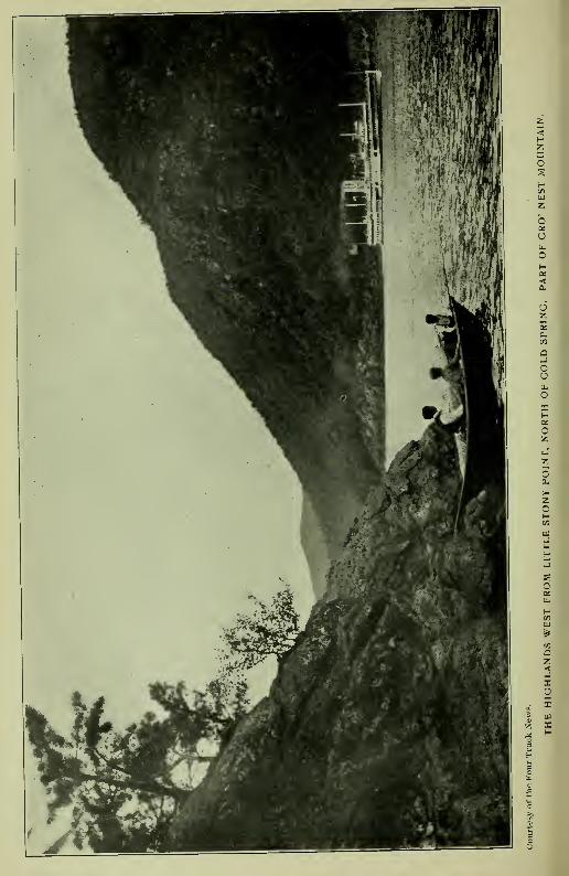
)k
'€
km

NAMES ON THE EAST FROM MANHATTAN NORTH. 43
and comaco, 'house,' or 'enclosed place'—
'the great lodge/ or 'the
great village.' " ^ We have the testimony of Loskiel that the occu-
pants of the village were "Mahicander Indians."
Shenandoah (Shenandoah Corners, East Fishkill) is an Iro-
quoian name of modern introduction here. It is met in place in
Saratoga County and at Wyoming, Pa. (See Shannondhoi.)
Stissing, now the name of a hill and of a lake one mile west of
the village of Pine Plains, Duchess County, is probaibly an apheresis
of Mistissing, a "Great rock," and belongs to the hill, whidh rises
400 or 500 feet above the valley and is crowned with a mass of
naked rock, described by one writer as "resembling a huge boulder
transported there."
Poughkeepsie, now so written, is of record in many forms of
which Pooghkeepesingh, 1683 ; Pogkeepke, 1702 ; Pokeapsinck,
1703; Pacaksing, 1704; Poghkeepsie, 1766; Poughkeepsie, 1767,
are the earlier. The locative of the name and the key to its ex-
planation are clearly determined by the description in a gift deed
to Peter Lansing and Jan Smedes, in 1683 : "A waterfall near the
bank of the river called Pooghkeepesingh ;" ^ in p-^tition of Peter
Lansing and Arnout Viele, in 1704: "Beginning at a creek called
Pakaksing, by ye river side." ^ There are other record applications,
but are probably extensions, as Poghkeepke (1702), given as the
.name of a "muddy pond" in the vicinity. Schoolcraft's interpre-
tation, "Safe harbor," from Apokeepsing, is questioned by W. R.
Gerard, who, from a personal acquaintance with the locative, "Awater-fall," writes : "The name refers not to the fall, but to the
basin of water worn out in the rocks at the foot df the fall. Zeis-
^A translation from the Delaware Scha-gach-we-u, "straight," and meek" fish "—an eel—eel place—has been widely quoted. The translation by Dr.Trumbull is no doubt correct.
' "This fifth day of May, 1683, appeared before me * * a HighlandIndian called Massang, who declared herewith that he has given as a free
gift, a bouwery (farm) to Pieter Lansingh, and a bouwery to Jan Smeedes.a young glazier, also a waterfall near the bank of the river, to build a mill
thereon. The waterfall is called Pooghkeepesingh and the land Minnisingh,
situated on the east side of the river." (Col. Hist. N. Y., xiii, 571.)
' Cal. N. Y. Land Papers, 71. There are forty-nine record orthographies
of the term, from which a selection could be made as a basis of interpretation.
Poghkeepke, for example, might be accepted as meaning, "Muddy Pond,"
although there is neither a word or particle in it that would warrant the
conclusion.

44 INDIAN GEOGRAPHICAL NAMES.
berger would have written the word Apuchklpisink, that is, ' At the
rock-pool (or basin) of water.' A-puchk-lpis-ink is a composition of
•piichk, 'rock' ; ipis, in composition, 'little water,' 'pool of water,*
'pond,' 'little lake,' etc. Pooghk is no doubt from dpiighk (apuchk),
"rock." The stream has long been known as the Fall Kill. Pri-
marily there seems to have been three falls upon it, of which Mata-
pan will be referred to later.
Wynogkee, Wynachkee, and Winnakee are record forms of
the name of a district of country or place from which it was ex-
tended to the stream known as the Fall Kill. "Through which a
kill called Wynachkee runs, * * including the kill to the sec-
ond fall called Mattapan," is the description in a gift deed to AmoutVelie, in 1680, for three flats of land, one on the north and two
on the south side of the kill. "A flat on the west side of the kil,
called Wynachkee" (Col. Hist. N. Y., xiii, 545, 572), does not
mean that the kill was called Wynachkee, but the flat of land, to
which the name itself shows that it belonged. The derivaitives
are Winne, "good, fine, pleasant," and -aki (auke, ohke), "land"
or place ; literally, " land."*
Mattapan, " the second fall," so called in the deed to AmoutVelie (1680), was the name of a "carrying place," "the end of
a portage, where the canoe was launched again and its bearers re-
embarked." (Trumbull.) A landing place.- "At a place called
Matapan, to the south side thereof, bounded on the west by John
Casperses Creek." (Cal. Land Papers, 108.) (See Pietawick-
quasick.)
* From the root WuHt, Del. From the same root Winne, Willi, Wirri,.
Waure, Wule, etc. The name is met in equivalent forms in several places.
Wenaque and Wynackie are forms of the name of a beautiful valley in Pas-
saic county, N. J. (Nelson.) Winakaki, " Sassifras land—rich, fat land."
Winak-aki-ng, "At the Sassifras place," was the Lenape name of Eastern
Pennsylvania. (See Wanaksink.) Eliot wrote in the Natick (Mass.) dia-
lect, " Wunohke, good land." The general meaning of the root is pleasurable
sensation.
' Mattappan, a participle of Mattappu, " he sits down," denotes " a sitting
down place," or as generally employed in local names, the end of a portage
between two rivers, or from one arm of the sea to another—where the canoe
was launched again and its bearers re-embarked. (Trumbull.) In LenapeAan is a radical meaning, "To move; to go." Paan, "To come; to get to";
Wiket-pann, "To get home"; Paaneep, "Arrived"; Mattalan, "To come up-
to some body"; logically, Mattappan, "To stop," to sit down, to land, a
landing place.
NAMES ON THE EAST FROM MANHATTAN NORTH. 45
Minnissingh is written as the name of a tract conveyed to Peter
La-nsing- and Jan Smedes b}' gift deed in 1683. (See Poughkeep-sie.) Minnissingh is, apparently, the same word that is met in
Minnisink, Orange County. The locative of the tract has not been
ascertained, but it was pretty certainly on the ''back'' or upper
lands. There was no island there. (See Minnisink.)
Eaquorisink is of record as the name of Crom Elbow Creek, and
Eaquaquanessinck as that of lands on the Hudson, in patent to
Henry Beekman, the boundary of wlhich ran from the Hudson"east by the side of a fresh meadow called Mansakin^ and a small
run of water called Mancapawimick." In patent to Peter Falconier
the land is called Eaquaquaannessdnck, the meadow Mansakin, the
small creek Nanacopaoonick, and Crom Elbow (Krom Elleboog,
Dutch, ''crooked elbow") Creek. Eaquarysink is a compression
of Eaquaquaannessinck. It was not the name of the creek, but
located the boundmark "as far as the small creek." The compo-
sition is the equivalent of IVequa," "end of" ; annes, "small stream,"
and ink, "at," "to," etc.
Wawyachtanock, Indian deed to Robert Livingston, 1685
;
Wawyachtanock , Wawijachtanock, Waztngachtanock in Livingston
Patent and IVaw^ijachtonocks in association with "The Indians of
the Long Reach" (Doc. Hist. N. Y., 93, 97), is given as the name
of a place—
" The path that leads to Wawyachtenock." In a petition
for permission to purchase, in 1702 (Col, Land Papers, 58), the
description reads : "A tract of land lying to the westward of Wes-tenhoeks Creek^ and to ye eastwaid of Poghkeepsie, called by ye
Indians Wayanghtanock." It is presumed that the locative of the
^" A meadow or marsh land called Manjakan," is an equivalent record
in Ulster County. (Cal. N. Y. Land Papers, 133.) "A fresh meadow," i. e.
a fresh water meadow, or low lands by the side of the creek.
' Enaughqua, L. I.; Yd anuck quaque, Williams; Wequa, Weqiie, Aqua,Ukwe, Echqu, etc., " end of." The word is met in many forms. IVehque," as far as." (Eliot.)
'Westenhoek is Dutch. It means "West corner." It was given by the
Dutch to a tract of land lying in a bend of Housatonuk river, long in dispute
between New York and Massachusetts, called by the Indians W-na_gh-tak-ook,
for many years the name of the capital town of the Mahican nation. (Los-
kiel.) Rev. Dr. Edwards wrote it Wnoghquetookoke, and translated it, froman intimate acquaintance with the Stockbridge dialect, "A bend-of-the-river
place." Mr. Gerard writes it, Wanunketukok, "At the winding of the river."
Now Stockbridge, Mass.

46 INDIAN GEOGRAPHICAL NAMES.
name is now known as Union Corners, Duchess County, where
Krom EUeboog Creek, after flowing southwesterly, turns at nearly
a right angle and flows west to the Hudson, which it reaches in a
narrow channel between blufl:s, a little south of Krom Elbow Point,
where a bend in the Hudson forms the north end of the Long Reach.
The first word of the name is from Wawai, "Round about," "Wind-
ing around," "eddying," as a current in a bend of a river. The
second, -tan, -ten, -ton means "current," by metonymie, "river," and
ock, means "land" or place—"A bend-of-the-river place." The
same name is met in Wawiachtanos, in the Ohio country,^ and the
prefix in many places. (See Wawayanda.)
Metambeson, a creek so called in Duchess County, is now knownas Sawkill. It is the outlet of a lake called Long Pond. The In-
dian name is from Matt, negative and depreciatory, " Small, un-
favorable," etc., and M'beson, " Strong water," a word used in
describing brandy, spirits, physic, etc. The rapidity o>f the water
was probably referred to.
Waraughkaraeck—Waraukameck—a small lalce in the same
county, is now known as "Fever Cot or Pine Swamp." The In-
dian namie is probably an equivalent of Len. Wdlagh-kamik, an en-
closed hole or den, a hollow or excavaition.
Aquassing—"At a creek called by the Indians Aquassing, and
by the Christians Fish Creek"—has not been located. Aquassing
was the end of the boundary line, and may be from Enaughqnasink,
"As far as."
Tauquashqueick, given as the name of a meadow lying between
Magdalen Island- and the main land, now known as "Radcliflf's
^ "Tjughsaghrondie, alias Wawayachtenok." (Col. Hist. N. Y., iv, 900;La Trobe's Translation of Loskiel, i, 23.) The first name, Tjughsaghrondie,is also written Taghsaghrondie, and in other forms. It is claimed to befrom the Wyandot or Huron-Iroquoian dialect. In History of Detroit theAlgonquin is quoted Waweatunong, interpreted " Circuitous approach," andthe claim made that the reference was to the bend in the Strait at Detroit atan elevation " from which a view of the whole broad river " could be had.In Shawano, Wawia'tan describes bending or eddying water—with locative,
"Where the current winds about." The name is applicable at any placewhere the features exist.
' Magdalen Island is between Upper and Lower Red-hook. The originalDutch, Maagdelijn, supposed to mean "A dissolute woman," here means,simply, "Maiden," i. e. shad or any fish of the herring family. (See MagaatRamis.) The name appears on Van der Donck's map of 1656.

NAME3 ON THE EAST FROM MANHATTAN NORTH. 47
Vly," is probably an equivalent of Pauqna-ask-ek, "Open or clear
wet meadaw or vly."
Sankhenak and Saukhenak are record forms of the name given
as that of Roelof Jansen's Kil (Doc. Hist. N. Y., iii, 612; French's
Gazetteer.) Sauk-hannck would describe the mouth or outlet of
the stream, and Sank-hannek would read "Flint-stone creek." Saukis probably correct. The purchase included land on both sides of
the creek from "A small kil opposite the Katskil," on the north,
called IVacIihanekassik, "to a place opposite Sagertyes Kil, called
Saaskahampka." The stream is now known as Livingston's Creek.^
Wachanekassik, Indian deed to Livingston, 1683 ; Waghank-asick, patent to Van Rensselaer, 1649, ^^'^^ other orthographies, is
written as the name of a small creek which marked the place of be-
ginning of the northwest boundmark of the Livingston Patent and
the place of ending of the southwest boundmark Oif the prior VanRensselaer Patent of Ciaverack. The latter reads :
" * * Andso along the said Hudson River southward to the south side of Vas-
trix Island, by a creek called Waghankasick, tlience easterly to
Wawanaquasik," etc. The deed to Livingston conveyed lands "Onboth sides of Roelo'f Jansen's Kill,- called by the Indians Sauk-
henak," including lands "along the river's bank from said Roeloff
Jansen's Kill, northwards up, to a small stream opposite Catskill
named Wachanekasseck, and southwards down the river to opposite
the Sagertjes Kill, called by the Indians Saaskahampka." In the
Livingston Patent of 1684: "Eighteen hundred acres of woodland
lying between a small creek or kill lying over against Catskill called
Wachanakasseck and a place called Suaskahampka," and in patent
of 1686: "On the north by a line to be drawn from a certain creek
or kill over against the south side of Vastrix Island in Hudson's
River, called Wachankasigh," to which Surveyor John Beatty add-
ed more precisely on his map of survey in 1715 : "Beginning on
the east side of Hudson's River southward from Vastrix Island, at
a place where a certain run of water watereth out into Hudson's
River, called in }-e Indian tongue, VVachankassik." The "run of
^The creek was the boundmark between the Wappingers and the Ma-hicans. (See Wahamanessing.)
' Named from Roeliff Jansen, Overseer of the Orphan Court under the
Dutch Government. (French.)

48 INDIAN GEOGRAPHICAL NAMES.
water" is not marked on Beatty's map, nor on the map of survey
of the patetiit in 179S, but it is marked, from existence or presumed
existence, on a mrtp of tlie boundary line between New York and
Massachusetts and seems to have been one of the several small
streams that flow down the bluff from the surface, apparently about
two miles and a half north of Roelof Jansen's Kill, in the vicinity
of the old Oak Hill station' on the H. R. R., later known as Catskill
station. While referred to in connection with the boundmark to
identify its location, its precise location seems to have been lost.
In early days boundmarks were frequently designated in general
terms by some well known place. Hence we find Catskill spoken of
and particularly "the south end of Vastrix Island," a point that
every voyager on the Hudson knew to be the commencement of
a certain "rak" or sailing course.- Hence it was that Van Rens-
selaer's first purchase (1630) was botuidecl on the south by the south
end of Beercn or Mahican Island, and the second purchase by the
south end of Vastrix Island, which became the objective of the north-
west bound of Living'ston's Patent. While the name is repeatedly
given as that of the stream, it was probably that of a place or point
on the limestone bluff which here bounds the Hudson on the east
for several miles. Surve^yor Beatty's description, "Beginning at a
place where," and the omission of the stream on his map, and its
omission on subsequent maps of the manor, and the specific entry
in the amended patent of 1715, "Beginning at a certain place called
by the Indians Wahankassek," admit of no other conclusion, and
the conclusion is, apparently, sustained by the name itself, which
seems to be from Moh. Wakhunuhkoosek, "A high point," as a hill,
mountain, peak, bluff, etc., from IVakJm, "hill, mountain," nhk,
"end, point," and oosic, "peak, pinnacle," etc. The reference mayhave been to a point formed by the channel of the little stream
flowing down from the bluff above, or to some projection, but cer-
* Oak Hill station on the Hudson River R. R., about five miles south ofthe city of Hudson, was so called from a hill in the interior just north of theline of the town of Livingston, from which the land slopes west towards theHudson and south to Roelof Jansen's Kill.
* Vastrix is a compression of Dutch t'l'aste Rak as written on Van derDonck's map of 1656, meaning, "The fast or steady reach or sailing course,"which began here. The island is the first island lying north of the mouth ofthe Katskill. It is now known as Roger's Island.

NAMES ON THE EAST FROM MANHATTAN NORTH. 49
tainly to the blnft" as the only permanenit objective on the Hudson.The conntction of the "small run of water" with the boundmarkshould entitle it to more particular description than has been givento it by local writers.
Nickankook, Kickua and Weckqashake are given as the namesof "three flats" whic'h, with "some small flats," were included in
the first purchase by Livingston, and described as "Situate on both
sides" of the kill called Saukhenak (Roelof Jansen's Kill). TheIndian deed also included all land "Extending along the bank of
the river northwards from Roelof Jansen's Kill to a small stream
opposite Catskill named Wachanekassik." The names of the three
flats are variously spelled—^Nickankooke, Nickankook, etc. Thefirst has been transla'ted by Mr. Wm. R. Gerard from Nichdnhkuk,
'"At the bend in front." Kickua, the second, is untranslatable.
Wickquaskaka, Wequakake, etc., is the equivalent of Wequaohke,
"End land" or place. The kill flows through a valley of broad
and fertile flats, but near the Hudson it breaks through the lime-
stone blufif which forms the east line of the Hudson, and its banks
are steep and rocky.
Saaskahampka, Indian deed ; Suaskahainpka patent of 1684
—
the southv^rest boundmark of the Livingston Patent, is described as
^'A dry guily at Hudson's River." It is located about opposite
Sawyer's Creek, north of the present Saugerties or Esopus Creek.
Sasco, or as written Saaska, means "A swamp;" Assisku (Del,),
"Mud, clay" ; Asuskdkamika, "Muddy place," a gully in w*hich
no water was flowing. (Gerard.)
Mananosick—" Along the foot of a high mountain to the path
that goes to Wawyactanock to a hill called by the Indians Manan-
osick." Also written Nanosick. Eliot wrote, in the Natick dialect,
Nahoosick, "Pinnacle," or high peak. The indefinite and imper-
sonal M' or Ma, prefixed, would add "a" or "the" high peak. The
hill has not been located except in a general way as near the Massa-
chusetts line.
Nanapenahakan and Nanipanihekan are orthographies of the
name of a "creek or brook" described as "coming out of a marsh
lying near unto the hills where the heaps of stones lye." The
stream flows to Claverack Creek. The outlet waters of Achkook-

5° INDIAN GEOGRAPHICAL NAMES.
peek Lake unite with it, from which it is now called Copake Creek.
It unites with Kinderhook Creek north of the city of Hudson.
Wawanaquasik, Claverack Patent, 1649; Wawanaquassick, Liv-
ingston Patent of 1686 ; Wawanaquassick and Mawanapquasseky
patent of 1715; Mawanagzvassik, surveyor's notation, 1715; nowwritten Mawanaquassick—a boundmark of the Claverack Patent of
1649, and also of the Livingston Patent, is described in the Claver-
ack Patent, "To the high woodland called Wawanaquasik," and
in the Livingston Patent, "To a place called by the Indians Wa-wanaqussek, where the heapes of stone lye, near to the head of a
creek called Nanapenahaken, which comes out of a marsh lying
near unto the hills of the said heapes of stones, upon which the
Indians throw another as they pass by, from an ancient custom
among them." The heap of stones here was "on the south side
of the path leading to Wayachtanok," and other paths diverged,
showing that the place was a place of meeting. "To the high
woodland," in the description of 1649, is marked on the map of
survey of 1715, "Foot of the hill," apparently a particular point,
the place of which was identified by the head of the creek, the
marsh and the heap of stones. The name may have described this
poinlt or promontory, or it may have referred to the place of meet-
ing near the head of the creek, or to the end of the marsih, but it
is claimed that it was the name of the heap of stones, and thait it
is from Mide, or Miyde, "Together"
—
Mawena, "Meeting," "As-
sembly"—frequently met in local names and accepted as meaning," Where paths or streams or boundaries come together ;" and Qus-
suk^ "stone"—"Where the stones are assembled or brought to-
gether," "A stone heap." This reading is of doubtful correctness.
Dr. Trumbull wrote that Qnssiik,^ meaning "stone," is "rarely,
perhaps never" met as a substantival in local names, and an in-
stance is yet to be cited where it is so used. It is a legitimate
word in some connections, however, Eliot writing it as a noun in
Mohshe-qussuk, "A flinty rock," in the singular number. If used
here it did not describe "a heap of stones," but a certain rock. On
' Williams wrote in the Narraganset dialect Qussuck, stone;Qussuck-
anash, stones;Qusstickquon, heavy. Zeisberger wrote in the Minsi-Lenape,
Ksiicquon, heavy; Achsnn, stone; Apuchk, rock. Chippeway, Assin, stone;
Aubik, rock. Old Algonquian, Assin, stone. Eliot wrote in the Natick(Mass.) dialect, Qussuk, a rock; Qussukquanash, rocks; Hussunash, stones;

NAMES ON THE EAST FROM MANHATTAN NORTH. 51
the map of survey of the patent, in 1798, the second station is
marked "Manor Rock," and the third, "Wawanaquassick," is lo-
cated 123 chains and 34 hnks (a fraction over one and one-half
miles) north of Manor Rock, as the corner of an angle. In the
survey of 171 5, the first station is "the foot of the hill"—
"the
high woodland"—which seems to have been the Mawan-uhqu-oosik^ of the text. To avoid all question the heap of stones seems
to have been included in the boundary. It now lies in an angle
in the line between the townships of Claverack and Taghkanic,
Columbia County, and is by far the most interesting feature of the
locative—a veritable footprint of a perished race. Similar heaps
were met by early European travelers in other parts of the country.
Rev. Gideon Hawley, writing in 1758, described one which he metin Schohare Valley, and adds that the largest one that he ever saw
was "on the mountain between Stockbridge and Great Barrington.'^
Mass. (Doc. Hist. N. Y., iii, 1039.) The significance of the "an-
cient custom" of casting a stone to these heaps has not been handed
down. Rev. Mr. Sergeant wrote, in 1734, that though the Indians
"each threw a stone" as they passed, they had entirely lost the
knowledge of the reason for doing so," and an inquiry by Rev.
Hawley, in 1758, was not attended by a better result.^ The heaps
were usually met at resting places on the path and the custom of
throwing the stone a sign-language indicating that one of the tribe
had passed and which way he was going, but further than the ex-
planation that the casting of the stone was "an ancient custom,"
nothing may be claimed with any authority. A very ancient cus-
tom, indeed, when its signification had been forgotten.
Ahashewaghick and Ahashewaghkameck, the latter in correct-
ed patent of 1715, is given as the name of the northeast bound-
Hussunek, lodge or ledge of rocks, and for Hussunek Dr. Trumbull wrote
Assinek as an equivalent, and Hussun or Hussunash, stones, as identical
with Qiissukqun, heavy. Eliot also wrote -pick or -p'sk, in compound words,
meaning "Rock," or "stone," as qualified by the adjectival prefix, Omp'sk," Standing rock."
' Literally, "A meeting point," or sharp extremity of a hill.
' Doc. Hist. N. Y., iii, 1039. The heap referred to by Rev. Hawley was
on the path leading to Schohare. It gave name to what was long known as
the "Stoneheap Patent." The heap is now in the town of Esperance and
near Sloansville, Schohare County. It is four rods long, one or two wide,
and ten to fifteen feet high. (French.)
52 INDIAN GEOGRAPHICAL NAMES.
mark of the Manor of Livingston, and described as "the northern-
most end of the hills that are to the north of Tac'hkanick "—specifi-
cally by the surveyor, "To a heap of stones laid together on a
certain hill called by the Indians Ahas'hawagfhkik, by the north end
of Taghanick hill or mountain "—^has been ti^nslated from Nash-
aue-komuk (Eliot), "A place between." Dr. Trumbull noted
Ashounigh-commocke, from the derivatives quoted
—
Nashaue, " be-
tween" ; -komuk, "place," limited, enclosed, occupied, i. e. by "a
heap of stones laid together," probably by the surveyor of the prior
Van Rensselaer Patent, of which it was also a boundmark. Thehill is now the noftheast corner of the Massachusetts boundary
line, or the north end of Taghkanick hills.
Taghkanick, the name of a town in Columbia County and pri-
marily of a tract of land included in the Livingston Patent and
located "behind Potkoke," is written Tachkanick in the Indian deed
of 1685 ; Tachkanick in the Indian deed of 1687-8 ; "Land called
Tachhanick which the owners reserved to plant upon when they
sold him Tachhanick, with the land called Quissichkook ;" Tach-
kanick, "having the kill on one side and the hill on the other"
;
Tahkanick (Surveyor's notation) 1715—is positively located by
the surveyor on the east side of the kill called by the Indians Sauk-
henak, and by the purchasers Roelof Jansen's Kill. Of the meaning
of the name Dr. E. B. O'Callaghan wrote : "Tachaniik, 'Woodplace,' literally, 'the woods,' from Takone, 'forest,' and uk,
^pl'ace' "; which Dr. Trumbull regarded as "the least objectionable"
of any of the interpretations that had fallen under his notice, and
to which he added : "Literally, 'wild lands,' 'forest.' " It would
seem to be more probable that Tachk, Taghk, Tachh, Tahk, etc,
represents Tak (Taghk), with formative an, Taghkan, meianing
"wood ;" and ek, animate plural added, "Woods," "trees," "for-
-est." Dr. O'Cariaghan's ilk (00k), "Land or place," is not in any
of the orthographies. The deed-sentence, "When they sold him
'Tachianick," reads literally, from the name, "When they sold him
the woods." The name was extended to the reserved field, to the
stream and to the mountain.' The latter is familiar to geologists
* The purchasers claimed but the Indians denied having sold the moun-tain. It was heavily wooded no doubt. Livingston claimed it from havingbought "the woods.'" The Moravian missionaries wrote, in 1744, JV'takan-
tschan, which Dr. Trumbull converted to Ket-takone-wadchu, "Great woodymountain."

NAMES ON THE EAST FROM MANHATTAN NORTH. 53
in what is known as the Taconic rocks. Translations of the namefrom Del. Tuphannc, "Cold stream," and Tankkanne, "Little
river," are without merit, althoug'h Tankhanne would describe the
branch of Roelof Jansen's Kill on which the plantation was located.
Wichquapakat, Wichquapuchat, Wickquapubon, the latter bythe surveyor, given as the name of the southeast boundmark of the
Livingston Patent and therein described as "the south end of the
h:lls," of which Ahashawagh-kameck was the north. Wichquais surely an equivalent of Wequa {IVehqua, Eliot), "As far as;
ending at ; the end or extreme, point." ' Now the southwest cor-
ner on the Massachusetts line.
Mahaskakook, a boundmark in the Livingston Patent, is de-
scribed, in one entry, as "A copse," /. e. "A thicket of under-
brush," and in another entry, "A cripple bush," i. e. "A patch
of low timber growth "—Ehitch, Kreupelbosch, " Underwood."Probably the Indian name has, substantially, the same meaning.
Manask (Del.), "Second crop"; -ask, "Green, raw, immature";
~ak, "wood"; -ook (ilk), locative. The location has not been ascer-
tained.
Nachawawakkano, given as the name of a creek described as a
"creek which comes into another creek," is an equivalent of Lechau-
ivakhanne (Lenape), "The fork of a river," a stream that forks
another stream. Aupaumut, the Stockbridge Historian, wrote,
with locative suffix, Naukhmvzvhnauk , "At the fork of the streams."
Mawichnauk—" the place where the two streams meet being
called Mawichnauk"—^means "The fork place, or place where the
Nachawawakkano and the Tawastaweka came together, or where
the streams meet or flow together. In the Bayard Patent the name
is wr'itten Mawighanuck and Wawieghanuck. (See Wawigh-anuck.)
Shaupook and Skaukook are forms of the name assigned to
the eastern division of a stream, "w*hich, a little lower down," was
"called Twastawekah." known later as Claverack Creek. It maybe translated from Sohk, Mass., "outlet," and uk, locative, "At the
outle't" or mouth of the sream.
* Robert Livingston, who wrote most of the Indian names in his patent,
was a Scotchman. He learned to " talk Dutch " in Rotterdam, and picked
up an acquaintance with the Indian tongues at Fort Orange (Albany). Someof his orthographies are singular combinations.

54 INDIAN GEOGRAPHICAL NAMES.
Twastawekah and Tawastawekah, given, in the Livingston
Patent, as the name of Claverack Creek, is described as a place that
was below Shaukook. The root is Tawa, an "open space," and
the name apparently an equivalent of Lenape Tawatawikunk, "At
an open place," or an uninhabited place, a wilderness. Tauwata-
wique-ak, "A place in the wilderness." (Gerard.)
Sahkaqua, " the south end of a small piece of land called Sahk-
aqua and Nakawaewick" ; "to a run of water on ye east end of a
certain flat or piece of land called in ye Indian tongue, Sahkahka;
then south * * one hundred and forty rods to * * where
two run-s of water come to'gether on the south side of the said flat;
then west * * to a rock or great stone on the south corner of
another flat or piece of low land called by the Indians Nakaowas-
ick." (Doc. Hist., iii, 697.) On the surveyor's may Nakaowasick,
the place last named, is changed to Acawanuk. From the text,
Sahkaqua described "Land or place at the outlet or mouth O'f a
stream," from Sohk, "outlet," and -ohke, "land" or place. The
second name Nakawaewick ( Nakaouaewik, Nakawasick, Acawasik)
is probably from Nashauewasiick, "At (or on) a place between,"
i. e. between the streams spoken of.
Minnischtanock, in the Indian deed to Livingston, 1685, located
the end of a course described as "Beginning on the northwest side
of Roelof Jansen's Kill," and in the patent, "Beginning on the other
side of the creek that runs along the flat or plain land over against
Minnisichtanock, and from thence along a small hill to a valley,"
etc. The name has been interpreted "Huckleberry-hill place," from
Min, "Small fruit or grain of any kind" ; -achtenne, "hill" ; -uk, loca-
tive.
Kackkawanick, written also Kachtawagick, Kachkawyick, and
Kachtawayick, is described in the deed, as "A high place to the
westward of a high mountain." Location has not been ascertained.
From the map it seems to have been a long, narrow piece of land
between the hills.
Quissichkook, Quassighkook, etc., one of the two places re-
served by the Indians "to plant upon" when they sold Tachkanik,
is described in the deed as a place "lying upon this {i. e. the west)
side of Roelof Jansen's Kill" and "near Tachanik," the course run-
ning "thence along a small hill to a valley that leads to a small

NAMES ON THE EAST FROM MANHATTAN NORTH. 55
creek called by the Indians Quissichkook, and over the creek to a
high place to the westward of a high mountain called by the natives
Kachtawagick." In a petition by Philip Schuyler, 1686, the de-
scription reads : "Ouassichkook, * * lying on the east side of
Roelof Jansen's Kill," and the place as a tract of woodland. The
name was probably that of a wooded bluff on the east side of the
creek. It seems to be from Kussuhkoe (Moh.), "high," and -00k,
locative—
"At, to or on a high place"—from which the stream and
fhe plantation was located. (See Ouassaick.)
Pattkoke, a place so called, also written Pot-koke, gave name to
a large tract of land patented to Johannes Van Rensselaer in 1649.
In general terms the tract was described as lying "South of Kinder-
hook,^ east of Claverack,- and west of Taghkanick" (Doc. Hist. N.
Y., iii, 617), and also as "Lying to the east of Major Abraham's'
patent of Claverack." ^ Specifically, in a caveat filed by John Van
^Kinderhook is an anglicism of Dutch Kinder-hoek, meaning, literally,
" Children's point, angle or corner." It dates from the Carte Figurative of
1614-16, and hence is one of the oldest names on Hudson's River. It -is sup-
posed to have been applied from a gathering of Indian children on a point
of land to gaze upon the ship of the early navigator. It could not have been
a Dutch substitute for an Indian name. It is pure Dutch. It was not an
inland name. The navigator of 1614-16 did not explore the country.
^ Claverack—Dutch, Claverrak—literally, "Clover reach—a sailing course
or reach, so called from three bare or open fields which appear on the land,
a fancied resemblance to trefoil or three-leaved clover," wrote Jasper Dan-kers and Peter Sluyter in their Journal in 1679-80. Presumably the places
are specifically located in the patent to Jan Frans van Heusen, May, 1667,
on which the' city of Hudson now stands, which is described as "A tract of
land which takes in three of the Clavers on the south." From the locative
the reach extended some miles north and south and to lands which it bound-
ed. It is still preserved as the name of a creek, a town and a village. Ofrecord it dates back to De Laet's map of 1625-6, and is obviously much older.
It is possible that the " three bare places " were fields of white clover, as has
been claimed by one writer, but there is no record stating that fact. Dan-kers and Sluyter, who wrote only fifty-four years after the application of the
name, no doubt gave correctly the account of its origin as it was related to
them by living witnesses. If Interpreted as were the names of other
reaches, the reference would be to actual clover fields.
* " Major Abraham " was Major Abraham Staats, who located on a neck
of land on the north side of "Major Staats' Creek," now Stockport Creek.
(See Ciskhakainck.) "West of Taghkanick," probably refers to the moun-tains now so known. It means, literally, however, "The woods." (See Tagh-kanick.) There was a heated controversy between the patroon of Rensse-
laerswyck and Governor Stuyvesant in regard to the purchase of the tract.
It was decided in 1652 in favor of the former, who had, in the meantime,
granted several small leaseholds. (See Brodhead's Hist. N. Y., i.) Thefirst settlement by the patroon was in 1705 at Claverack village.

56 INDIAN GEOGRAPHICAL NAMES.
Rensselaer, in 1761, "From the mouth of Major Staats, or Kinder-
hiQok Kill, south along the river to a point opposite the south end
of Vastrix Island, thence easterly twenity-four English miles," etc.
(Cai. N. Y. Land Papers, 307. See also, Wachanekassiik. ) It
was an immense tract, covering aibout eigtit miles on the Hudson
by twenty-four miles deep, and became known as "The Lower
Manor of Rensselaerswyck," but locally as Claverack, from its front-
age on the river-reach so called. The name was that of a particular
place which was well known from which it was extended to the tract.
In "History of Columbia County" this particular place is claimed
to have been the site of an Indian village situate "about three
(Dutch, or nine Englisih) miles inland from Clavefack." (Doc,
Hist. N. Y., iv, 84.) The record does not give the name, nor does
it say "village," but place. The local story is, therefore, largely
conjectural. The orthographies of the name are imperfect. Pre-
sumably, they may be read from Mass. Pautuckoke, meaning "Land
or country around the falls of a stream," and the reference to some
one of the several falls on Claverack Creek, or on Eastern Creek, its
principal tributary. Both streams were included in the patent, and
both are marked by falls and rifts, but on the latter there are sev-
eral "cataracts and falls of great height and surpassing beauty."
^'Nothing but a greater volume of water is required to distinguish
them as being among the grandest in the world," adds the local
historian. The special reference by the writer was to the falls at
the manufacturing village known as Philmont, nine miles east of
the Hudson, corresponding with the record of the "place" wliere
the Indians assembled in 1663-4. Pautuck is met in many forms.
It means, "The falls of a stream." With the suffix, -oke (Mass.
-auke), "Land, ground, place, unlimited"—
"the country around
the falls," or the falls country. (See Potick.)
Ciskhekainck and Cicklekawick are forms of the name of a
place granted by patent to Major Abraham Staats, March 25, 1667,
and to his son in 171 5, described as "Lying north of Claverack
[Hudson], on the east side of the river, along the Great Kill [Kin-
derhook Creek], to the first fall of water; then to the fishing place,
containing two hundred acres, more or less, bounded by the river
on one side and by the Great Kill on the oth-er." Major Staats had
made previous settlement on the tract under lease from Van Rens-

NAMES ON THE EAST FROM MANHATTAN NORTH. 57
selaer. His hoiise and barn were burned by the Indians in the
Esopus war of 1663. In 1715, he being then dead, his son, Abra-
ham, petitioned for an additional tract described as "Four hundred
acres adjoining the north line of the nedc of land containing two
hundred acres now in his possession, called Ciskhekainck, on the
north side of Claverack, on ye east side of Hudson's River." (Cal.
N. Y. Land Papers, 118.) The petition was granted and the two
parcels consolidated. The particular fall referred to is probably
that now known as Chittenden's, on Kinderhook (now Stockport)
Creek, a short distance west of Stockport Station. It may be called
a series of falls as the water primarily descended on shelves or
steps. It was noted as rem'arkable by Bankers and Slu^-ter in 1679-
80.^ Claverack Creek unites with Stockport Creek just Vv^est of the
falls. In other connections both streams are called mill streams.
In the Stephen Bayard patent of 1741, the name of the fall on Stock-
port Creek is noted as "A certain fall * * called by the Indians
Kascsjexvack." The several names are perhaps from Cochik'nack
(Moh.), "A wild, dashing" stream. Cochik'nack, by the way, is
one of the most corrupted names of record.
Kesieway's Kil, described in an Indian deed to Garritt van
Slichterihorst, 1667-8, "A certain piece of land at Claverack be-
tween the bouwery of Jan Roother and Major Abraham Staats,
beginning at a fall at the kil called Kesieway's Kil." (Col. Hist.
N. Y., xiii, 51, 57.) The tract seems to have been on Claverack
Creek south of Stockport. "Jan Roothers" is otherwise written,
"Jan Hendricksen, alias Jan Roothaer." Roth (German) means
"red," -aer is from German Haar (hair). He was known locally
as "Jan, the red-head." The location of the fall has not been ascer-
tained. Kashazvay Creek is a living form of the name in the town
of Greenport, Columbia County. On the opposite side o-f the Hud-
son the same name apparently, appears in Keesieway, Kesewey, etc.,
as that oi a "chief or sachem" of the Katskill Indians. (See
Keessienwey's Hoeck.)
1
«
" We came to a creek, where, near the river, Hves a man whom they call
the Child of Luxury (fkinder van walde). He had a sawmill on the
creek or waterfall, which is a singular one. The water falls quite steep mone body, but it comes down in steps, with a broad rest sometimes between
them. These steps were sixty feet or more high, and were formed out of a
single rock."

i8 INDIAN GEOGRAPHICAL NAMES.
Pomponick, Columbia County. (N. Y. Land Papers.) Pom-poenik, a fort to be erected at "about the barn of Lawrence van
Alen." (Doc. Hist. N. Y., ii, 90.) Pompoen is Dutch for pump-kin. The name is also written as that of an Indian owner—" the
land bought by Jan Bruyn of Pompoen." (Col. Hist. N. Y., xiii,
545-) Pompoeneck is the form of the signature to deed.
Mawighanuck, Mawighunk, Waweighanuck, Wawighnuck,forms of the name preserved as that of the Bayard Patent, Colum-
bia County, described as a place "Lying to the northwest of Kin-
derhook, about fifteen miles from Hudson's River, upon Kinder-
hook River and some branches thereof, part of which tract is knownby the Indian name of Mawig'hanuck." The particular "part"
noted has not been located, but it seems to have been where one
of the branches of Kinderhook Creek united with that stream. (See
Mawichnauk.)
Mogongh=kamigh, a boundmark of the Bayard Patent (Land
Papers, 245), is located therein, "From a fall on said river called
by the Indians Kasesjewack to a certain place called by the natives
Mogongh-kamigli, then up the southeast branch," etc. The namemeans, probably, "Place of a great tree."
Kenaghtiquak, " a small stream " so called, was the name of a
boundmark oif the Peter Schuyler Patent, described, "Beginning
where three oak trees are marked, lying upon a small creek, to lihe
south of Pomponick, called by the Indians Kenaghtiquak, and run-
ning thence," etc. It probably standi for Enaughtiqna-iik, " Thebeginning place."
Machachoesk, a place so called in Columbia County, has not
heen located. It is described of record as a place "lying on both
sides of Kinderhook Creek," and may have taken its name from an
adjacent feature.
Wapemwatsjo, the name of a hill in Columbia County, is a
Dutch orthography of Wapiin-zvadchu, "Chestnut Hill." The in-
terpretation is correctly given in the accompanying alternate, "or
Karstengeberg" (Kastanjeberg, Dutch), "Chestnut Hill."
Kaunaumeek, an Indian village sixteen miles east of Albany,
in the town of Nassau, Rensselaer County, was the scene of the
labors of Moravian missionaries, and especially of Missionary Brain-
erd. It was long known as Brainerd's Bridge, and is now called

NAMES ON THE EAST FROM MANHATTAN NORTH. 59
Brainerds. The name is Lenape (German notation) and the equiva-
lent of Onannammig, Nan, Gunemeek, Len., ''Long-fish place," a
"Fis'hing-place for lampreys." The form, Kaunaumeek, was in-
troduced here by the Moravian missionaries.
Scompamuck is said to have been the name of the locality nowcovered by the village of Ghent, Columbia County, perhaps more
strictly the head of the outlet of Copake Lake where an Indian set-
tlement is located on early maps. The suffix, -amuck, is the equiv-
alent of -amaug, "fishing place." Ouschank-amaug, from Ousch-
acheu, "smooth, slippery," hence eel or lampery—
"a fishing-place
for eels."
Copake, the modern form of the name of a lake in Columbia
County, is of record Achkookpeek (Doc. Hist. N. Y., iii. 628),
meaning, literally, "Snake water," from Achkook, "Snake," and
-peek, "Water place," pool or pond. Hendrick Aupaumut, the
Historian of the Stockbridge-Mahicans, wrote: "Ukhkokpeck; it
signifies snake-w^ater, or water where snakes are abundant." Ona map of the boundary line between Massachusetts and New Yorlc
an Indian village is located at the outlet of the lake, presumably
that known as Scompamuck.
Kaphack, on Westenhook River, a place described as " Begin-
ning at an Indian burying-place hard by Kaphack," probaibly means
"A separate place"—
"land not occupied." The tract began at
"an Indian burying-place," and presumably took its name there-
from. Chepeck, "The dead;" Chepeack, "Place of the dead." (See
Shapequa.)
Valatie, the name of a village in Columbia County, is Dutch.
It means "Vale, valley, dale, dell," and not "Little Falls," as ren-
dered in French's Gazetteer. Waterval is Dutch for " Waterfall."
Vallate, Low Latin for "valley," is the derivative of Valatie, as
now written.
Schodac, now covered by the village of Castleton (Schotax,
1677; Schotack, 1768), was the place of residence of Aepjin, sach-
em, or "peace chief," of the Mahicans.^ It has been translated
^Aepjin's name appears of record first in 1645 as the representative of the
Westchester County clans in negotiating a treaty of peace with the Dutch.
In the same capacity he was at Esopus in 1660. He could hardly have beenthe "old man" whom Hudson met in 1609. In one entry his name is writ-
ten "Eskuvius, alias Aepjin (Little Ape)," and in another "Called by the

6o INDIAN GEOGRAPHICAL NAMES.
from Skootay, Old Algonquian {Sqiita, Williams), "fire," and-ack, "place," literally, "Fire Place," or place of council. It wasextended to Smack's Island, opposite Albany, whioh was knownto the early Dutch as "Schotack, or Aepjen's Island." It is prob-
able, however, that the correct derivative is to be found in Esquatak,
or Eskwatak, the record name of the ridge of land east of Castle-
ton, near which the Mahican fort or palisaded village was located^
from which Castleton takes its name. Esquatak is pretty certainly
an equivalent of Ashpohtag (Mass.), meaning "A hig'h place."
Dropping the initial A, and also the letter p and the second h,
leaves ScJhotack or Shotag; by pronunciation Schodac. Eshodac,
of which Meshodack* is another form, the name of a high peak in
the town of Nassau, Rensselaer County, has become Schodac by
pronunciation. It has been claimed that the landing which Hud-sion made and so particularly described in Juet's Journal, was at
Schodac'^ The Journal relates that the "Master's mate" first
"went on land with an old savage, the governor of the country,
who carried him to his 'house and made him good oheere." Thenext day Hudson himself "Sailed to the shore, in one of their
canoes, with an old man who was chief of a tribe consisting of
forty men and seventeen women," and it is added, "These I saw
there in a house well constructed of oak bark and circular in shape,
so that it 'had the appearance of being l^uilt with an arched roof."
Presumably the house was near the shore of the river and in occu-
pation during the fishing and planting season. The winter castle
Dutch Apeje's (Little Ape's) Island." He may have been given that namefrom his personal appearance, or it may have been a substitute for a namevi^hich the Dutch had heard spoken. Eliot wrote, "Appit. He sits ; he rests,
remains, abides; Ken Apean, Those that sittest," descriptive of the rank of
a resident ruler or peace chief, one of a class of sachems whose business it
was to maintain the covenants between his own and other tribes, and nego-tiate treaties of peace on their behalf or for other tribes when called upon.From his totemic signature he was of the Wolf tribe of the Mahicans. (SeeKeessienway's Hoeck.)
^ The prefixed M, sometimes followed by a short vowel or an apostrophe(M'), has no definite or determinate force. (Trumbull.)
^The Journal locates the place at Lat. 42 deg. 18 min. This would beabout five miles (statute) north of the present city of Hudson. " But," wroteBrodhead, ' Latitudes were not as easily determined in those days as they
are now; and a careful computation of the distances run by the Half-Moon,as recorded in Juet's day-book, shows that on the i8th of September, 1609,
when the landing occurred, she must have been ' up six leagues higher ' than
Hudson, in the neighborhood of Schodac and Castleton."

NAMES ON THE EAST FROM MANHATTAN NORTH. 6
1
was further inland. The "arched roof" indicates that it was one
of the "long" houses so frequently described, not a cone-like cabin.
The "tribe" was the sachem's family.
Sickenekas, given as the name of a tract of land on the east
side of the river, "opposite Fort Orange (Albany), above and be-
low," dates from a deed to Van Rensselaer, 1637, the name of one
of the grantors of which is written Paepsickenekomtas. The nameis now written Papskanee and applied to an island.
Sicajoock, (Wickagjock, Wassenaer), is given as the name of
a tract on the east side of the river extending from Smack's Island
to Castle Island where it joined lands "called Semesseeck," Ges-
messecks, etc., which extended north to Negagonse, " being about
twelve mile's (Dutch), large measure." The northern limit seems
to have been Unuwat's Castle on the north side of a stream flow-
ing to the Hudson north of "opposite to Rensselaer's Kil and water-
fall." Sicajoock (Dutch notation), "Black, or dark colored earth,"
from Sucki "Dark colored, inclining to black," and -ock, "land."
The same name is written Suckiage {alike) in application to the
Hartford meadows, Conn.
Gesraesseeck, a tract of land so called, otherwise entered of
record "Nawanemit's particular land called Semesseerse, lying on
the east bank, opposite Castle Island, off unto Fort Orange."
"Item—from Petanoc, the mill stream, away north to Negagonse."
In addition Van Rensselaer then purchased lands held in commonby several owners, "extending up the river, south and north*^'
from Fort Orange, "unto a little south of Moeneminnes castle,"
"being about twelve miles, large measure." Moeneminne's castle was
on Haver Island at Kahoes. Semesseerse is the form of the name
in deed as printed in Col. Hist. N. Y., vol. i, p. 44, and Gesmes-
seecks p. i, v. iv. Kesmesick is another form and perhaps also
Taescameasick. (See Patuckquapaen.) The several forms of the
name illustrate the effort on the part of the early Dutch, who were
then limitedly acquainted with the Indian tongue, to give orthog-
raphies to the names which they heard spoken.
Passapenoc, Pahpapaenpenock and Sapanakock, forms of
the name of Beeren Island, lying opposite Coeymans, is from an

62 ' INDIAN GEOGRAPHICAL NAMES.
edible tuber which was indigenous on it/ The Dutch name Beeren
or Beerin, means, Hterally, "She bear," usually called Bear's Island.
De Laet wrote "Beeren" in 1640.
Patuckquapaen and Tuscumcatick are noted in French's Gazet-
teer as names of record in what is now the town of Greenbush,
Rensselaer County, without particular location. The first is in
part Algonquian and in part Dutch., The original was, no doubt,
Patuckquapaug, as in Greenwich, Ct., meaning "Round pond."
The Dutch changed paug to paen descriptive of the land—low
land—so we have, as it stands, "Round land," "elevated hassocks
of earth, roots," etc. (See Patuckquapaug.) The second nameis written in several forms—Taescameatuck, Taescameesick, and
Gessmesseecks. Greenbush is an anglicism of Green Bosch, Dutch,
meaning, literally, "Green forest." The river bank was fringed
by a long stretch of spruce-pine woods. Dutch settlement began
here about 1631. In 1641 a ferry was established at the mouth
of the Tamisquestick or Beaver Creek, and has since been main-
tained. About the same year a small fort, known as Fort Cralo,
was constructed by Van Rensselaer's superintendent.
Poesten Kill, the name of a stream and of a town in Rensselaer
County, is entered in deed to Van Rensselaer in 1630, "Petanac,
the mill stream" ; in other records, "Petanac, the Molen Kil," and
"De Laet's Marlen Kil and Waterval." Petanac, the Indian name,
is an equivalent of Stockbridge Patternac, which King Ninham, in
an affidavit, in 1762, declared meant "A fall of water, and nothing
more." "Molen Kil" (Dutch), means "mill water." De Laet's
Marlen Kil ende Waterval," locates the name as that of a well-
known waterfall on the stream of eighty feet. Weise, in his " His-
tory of Troy," wrote : "Having erected a saw-mill upon the kill
for sawing posts and timber, wihich was known thereafter as Poesten
^ "The Indians frequently designated places by the names of esculent or
medicinal roots which were there produced. In the Algonquin language thegeneric names for tubers was pen, varying in some dialects to pin, pena, pon,
or hun. This name seems originally to have belonged to the commonground nut : Apias tuberosa. Abnaki, pen, plural, penak. Other species weredesignated by prefixes to this generic, and, in the compositions of place
names, was employed to denote locality (auk, auki, ock, etc.), or by anabundance verb (kanti-kadi) . Thus p'sai-pen, 'wild onions,' with the suffix
for place, ock, gave p'sai-pen-auk, or as written by the Dutch, Passapenock,the Indian name for Beeren Island." (J. H. Trumbull, Mag. of Am. Hist. I,
387.)

NAMES ON THE EAST FROM MANHATTAN NORTH. 6^
mill, the name became extended to the stream," an explanation
that seems to bear the marks of having been coined. From the
character of the stream the name is probably a corruption of the
Dutch Boosen, "An angry stream," because of its rapid descent.
The stream reaches the Hudson on the north line of Troy. (See
Gesmessecks.)
Paanpaach is quoted by Brodhead (Hist. N, Y.) as the nameof the site of the city of Troy. It appears in 1659 '"^^ application
to bottom lands known as "The Great Meadows," ^ lying under
the hills on the east side of the Hudson. At the date of settlement
by Van der Huyden (1720), it is said there were stripes or patches
within the limits of the present city which were known as "The
corn-lands of the Indians," * from which the interpretation in
French's Gazetteer, "Fields of corn," which the name never meant
in any language. The name may have had an Indian antecedent,
but as it stands it is Dutch from Paan-pacht, meaning "Low, soft
land," or farm of leased land. The same name appears in Paan-
pack. Orange county, which see.
Piskawn, of record as the name of a stream on the north line
of Troy, describes a branch or division of a river. Rale wrote in
Abnaki, "Peskakoon, branche," of which Piskaivn is an equivalent.
Sheepshack and Pogquassick are record names in the vicinity
of Lansingburgh. The first has not been located. It seems to
stand for Tsheepenak, a place where the bulbous roots of the yel-
low lily were obtained—^modern Abnaki, Sheep'nak. Pogquassick
appears as the name of a "piece of woodland on the east side of
the river, near an island commonly called Whale-fishing Island,"
correctly, Whalefish Island.^ This island is now overflowed by the
raising of the water by the State dam at Lansingt)urgh. The In-
dian name does not belong to the woodland; it locates the tract
near the island, in which connection it is probably an equivalent
1 Weise's Hist, of Troy.
* Woodward's Reminiscences of Troy.
' "Whale-fishing Island" is a mistranslation of "Walvish Eiland"
, (Dutch), meaning simply "Whale Island." It is related by Van der Donck(1656) that during the great freshet of 1647, a number of whales ascendedthe river, one of which was stranded and killed on this island. Hence thename.

64 INDIAN GEOGRAPHICAL NAMES.
of Paugasuck, "A place at which a strait widens or opens out"
(Truntbull), or where the narrow passage between the island andthe main land begins to widen. In the same district Pogsquam-
pacak is written as the name of a small creek flowing into Hoosick
River.
Wallumschack, so written in return of survey of patent grant-
ed to Cornelius van Ness and others, in 1738, for lands now in
Washington County ; Walloomscook, and other forms ; now pre-
served in Walloomsac, as the name of a place, a district of country^
and a stream flowing from a pond on the Green Mountains, in the
town of Woodford, near Bennington, Vermont.^ It has not been
specifically located, but apparently described a place on the adja-
cent hills where material was obtained for making paints with
which the Indians daubed their bodies. (See Washiack.) It is
from a generic root written in different dialects, Walla, Wara etc.,
meaning " Fine, handsome, good," etc., from which in the Dela-
ware, Dr. Brinton derived VVdldm, "Painted, from the sense to be
fine in appearance, to dress, w'hich the Indians accomplished by
painting their bodies," and -ompsk (Natick), with the related mean-
ing of standing or upright, the combination expressing " Place of
the paint rocks." ^ The ridges of many of the hills as well as of
the mountains in the district are composed of slate, quartz, sand-
stone and limestone, which compose the Takonic system. By ex-
posure the slate becomes disintegrated and forms an ochery clay
of several colors, which the Indians used as paint. The washing
away of the rock left the quartz exposed in the form of sharp
points, which were largely used by the Indians for making axes,
lance-heads, arrow points, etc. Some O'f the ochre beds have been
extensively worked, and plumbago has also been obtained. White
Creek, in the same county, takes that name from its white clay
banks.
^Vermont is from Verd Montague (French), meaning "Green Moun-tains," presumably from their verdure, but actually from the appearance of
the hills at a distance from the color of the rocks reflected in the atmos-
phere. To the Indian they were Wal'ompskeck, " fine, handsome rocks."
^ An interpretation of the name from the form Wallumschaik, in Thomp-son's Hist. Vermont, states that "The termination 'chaik' signifies ir i:he
Dutch language, 'scrip.' or 'patent.' " This is erroneous. There ia no such
word as chaik in the Dutch language. The ch in the name here stands for kand belongs to 'ompsk.

NAMES ON THE EAST FROM MANHATTAN NORTH. 65
Tomhenack, Tomhenuk, forms of the name given as that of
a small stream flowing into the Hoosick from the north," takes that
name, apparently, from an equivalent of Tomheganic, Mass., Tan-ganiic, Del, a stone axe or tomahawk, referring to a place wheresuitable stones were obtained for making those implements. (Trum-bull.) (See Wallumschack.)
Tyoshoke, now the name of a church at San Coick, Rensselaer
County, is probably from an equivalent of Toyusk, Nar., "a bridge,"
and ohkc, "Place"—a place where the stream was crossed by a
log forming a bridge. It was a well-known fording place for
many years, and later became the site of Buskirk's Bridge.
Sanckhaick, now San Coick, a place in North Hoosick, Rens-
selaer County, appears of record in petition of John de Peyster in
1730, and in Indian deed to Cornelius van Ness and others, in 1732,
for a certain tract of land "near a place called Sanckhaick." Theplace, as now known, is near the junction of White Creek and the
Wallompskack, where one Van Schaick made settlement and built
a mill at an early date. In 1754 his buildings were burned by In-
dian allies of the French. After the war of that period the mill
was rebuilt and became conspicuous in the battle of Bennington,
Aug. 16, 1777. It is claimed that the name is a corruption of VanSchaick. Col. Baume, commandant of the Hessians in the battle
of Bennington (1777) wrote it Sancoik, which is very nearly VanSchaick.
Schaghticoke, now so written as the name of a town in the
northeast corner of Rensselaer County, and in other connections, is
from Pishgachtigok Mohegan, meaning "Land on the branch or
division of a stream." The locative of the name was at the mouth
of Hoosick River on the Hudson, in Washington County. The
earliest record (1685) reads, "Land at Schautecoguc" (-ohke).
It is a generic name and appears in several forms and at several
places. Pishgachtigok is a form on the west side of the Housatonic
at and near the mouth of Ten-Mile River. It was the site of an
Indian village and the scene of labor by the Moravian mission-
^ "At a creek called Tomheenecks, beginning at the southerly bounds of
Hoosick, and so running up southerly, on both sides of said creek, over the
path which goes to Sanckhaick." (Cal. N. Y. Land Papers, 194; petition of
John de Peyster, 1730.)

66 INDIAN GEOGRAPHICAL NAMES.
aries. In some cases the name' is written with locative, "at," etc.,
in others, with substantive meaning land or place, and in others
without suffix. Writes Mr. Gerard, "The name would probably
be correctly written P'skaghtuk-uk," when with locative "at." ^
Although first of record in 1685, its application was probably as
early as 1675, when the Pennacooks of Connecticut, fleeing from
the disasterous results of King Phillip's War in which they were
allies, found refuge among their kindred Mahicans, and later were
assigned lands at Schaghticoke by Governor Andms, where they
were to serve as allies of the Mohawks. They seem to have spread
widely over the district and to have left their footprints as far
south as the Katskill. It is a tradition that conferences were held
with them on a plain subsequently owned by Johannes Knicker-
bocker, some six miles east of the Hudson, and that a veritable
treaty tree was planted there by Governor Andros in 1676-7, al-
though "planting a tree" was a figurative expression. In later
years the seat of the settlement seems to have been around Schagh-
ticoke hill and point, where Mashakoes, their sachem, resided.
(Annals of Albany, v, 149.) In the French and Indian war of
1756, the remnant of the tribe was carried away to Canada by the
St. Francis Indians, an organization of kindred elements in the
French service. At one time they are said to have numbered six
hundred warriors. (See Shekomeko.)
Quequick and Quequicke are orthographies of the name of a
certain fall on Hoosick River, in Rensselaer County. In petition
of Maria van Rensselaer, in 1684, the lands applied for were de-
scribed as "Lying on both sides of a certain creek called Hoosock,
beginning at ye bounds of Schaakook, and so to a fall called Que-
quick, and thence upward to a place called Nachacqikquat." (Cal.
Land Papers, 27.) The name may stand for Cochik'uack (Moh.),
*The root of the name is Peske or Piske (Paske, Zeisb.), meaning, pri-
marily, "To split," "To divide forcibly or abruptly." (Trumbull.) InAbnaki, Pesketekwa, a "divided tidal or broad river or estuary"
—
Peska-hakan (Rale), "branche." In the Delaware, Zeisberger wrote Pasketiwi," The division or branch of a stream." Pascataway, Md., is an equivalentform. Pasgatikook, Greene County, is from the Mohegan form. Paghata-ghan and Pachkataken, on the east branch of the Delaware, and Paghatagkanon the Otterkill, Vt., are equivalent forms of Peskahakan, Abnaki. TheHoosick is not only a principal branch, but it is divided at its mouth and at
times presents the appearance of running north in the morning and south at
night. (Fitch's Surv.)

NAMES ON THE EAST FROM MANHATTAN NORTH. 67
"WiM, dashing" waters, but I cannot make anything out of it.
The first fall east of Schaakook (Schagticoke) Patent is now knownas Valley Falls, in the town of Pittstown (Pittstown Station).
Pahhaoke, a local name in Hoosick Valley, is probably an equiv-
alent of Panqna-ohke, "Clear land," "open country." It is fre-
quently met in Connecticut in different forms, as in Pahqui-oke,
Paquiag, etc., the name of Danbury Plains. The form here is said
to be from the Stockbridge dialect, but it is simply an orthographyof an English scribe. It has no relation whatever to the familiar
Sdhaghticoke or Scat'acook.
Panhoosick, so written in Indian deed to Van Rensselaer in
1652, for a tract of land lying north and east of the present city of
Troy, extending north to nearly opposite Kahoes Falls and east in-
cluding a considerable section of Hoosick River, appears in later
records as an apheresis in Hoosick, Hoosack, and Hoosuck, in
application to Hoosick River, Hoosick Mountains, Hoosick Valley,
Hoosick Falls, and in "Dutch Hossuck," an early settlement de-
scribed in petition of Hendrick van Ness and others, in 1704, as
"land granted to them by Governor Dongan in 1688, known by the
Indian name of Hoosack." (Cal. N. Y. Land Papers, 2y, 74.)
The head of the stream appears to have been the outlet of a lake
now called Pontoosuc from the name of a certain fall on its outlet
called Pontoosuck, "A corruption," wrote Dr. Trumbull, "of Pown-tucksuck, 'falls of a brook,' or outlet. "Powntuck, a general namefor all falls," according to Indian testimony quoted by the samewriter. "Pantuck, falls of a stream." (Zeisb.) Several inter-
pretations of the name have been suggested, of which the most
probably correct is from Massachusetts Pontoosuck, which would'
readily be converted to Hoosick or Panhoosick (Pontoosuck). It
was applicable to any falls, and may have had locative at Hoosick
Falls as well as on the outlet of Pontoosuck Lake. Without exam-
ination or warrant from the local dialect, Heckewelder. wrote in
his Lenape tradition, "The Hairless or Naked Bear": "Hoosink,
which means the basin, or more properly, the kettle." The Lenape
or Delaware Hods, "certainly means, in that dialect, 'a pot or ket-
tle.' Figuratively, it might be applied to a kettle-shaped depres-
sion in land or to a particular valley. Hoosink means 'in' or 'at'
the pot or kettle. Hoosack might be read ' round valley land,' or

68 INDIAN GEOGRAPHICAL NAMES.
land with steep sides." (Brinton.) Of course this does not ex-
plain the prefix Pari, nor does it prove that Hods was in the local
dialect, which, in 1652, was certainly Maihican or Mohegan. Still,
it cannot be said that the tradition was not familiar to all Algon-
quians in their mythical lore.
Heckewelder's tradition, "The Naked or Hairless Bear," has
its culmination at a place "lying east >of the Hudson," where the
last one of those fabulous animals was killed. "The story," writes
Dr. Brinton, "was that the bear was immense in size and the most
vicious of animals. Its skin was bare except a tuft of white hair
on the back. It attacked and ate the natives and the only means
of escape from it was to take to the waters. Its sense of smell
was remarkably keen, but its sight was defective. As its heart
was very small, it could not be easily killed. The surest plan was
to break its back-bone ; but so dangerous was it that those hunters
who went in pursuit of it bade families and friends farewell, as if
they never expected to return. The last one was tracked to Hoos-
ink, and a number of hunters went there and mounted a rock with
precipitous sides. They then made a noise and attracted the beast's
attention, who rushed to the attack with great fury. As he could
not climb the rock, he tore at it with his teeth, while the hunters
above shot him with arrows and threw upon him great stones, and
thus killed him."'
The Hoosick River flows from its head, near Pittsfield, Berk-
shire County, in Massachusetts, through the Petersburgh Mountains
between precipitous 'hills, and carries its name its entire length.
Fort Massachusetts, in the present towm of Adams, Mass., was on
its borders and in some records was called Fort Hoosick. It was
captured by the French and their Indians in 1746. The general
course of the stream is north, west, and south to the Hudson in
the northwest corner of Rensselaer County, directly opposite the
village of Stillwater, Saratoga County. There are no less than three
falls on its eastern division, of which the most considerable are
Hoosick Falls, where the stream descends, in rapids and cascades,
forty feet in a distance of twelve rods. Dr. Timothy Dwight, whovisited it in the early part of the 19th century, described it as " One
" The Lenape and their Legends."

NAMES ON THE EAST FROM MANHATTAN NORTH. 69
of the most beautiful rivers in the world." "At different points,"
•he wrote, "The mountains extend their precipitous declivities so
as to form the banks of the river. Up t!hese precipitous summits
rise a most elegant succession of forest trees, chiefly maple, beech
and evergreens. There are also large spots and streaks of ever-
greens, chiefly hemlock and spruce." Though, with a single ex-
ception, entered in English records by the name of "Hoosick or
Schaahkook's Creek," it was, from the feature which especially at-
tracted Dr. Dwight's attention, known to the Iroquois as the Ti-
oneenda-howe, or " The river at the hemlocks."^
Cossayuna, said to be from the Mohawk dialect and to signify
"Lake of the pines," is quoted as the name of a lake in the town
of Argyle, Wasliington County. The translation is correct, sub-
stantially, but the name is Algonquian—a corruption of Coassa,
"Pine," ^ and Gnmmee. "Lake," or standing water. The terms
are from the Ojibway dialect, and were probaibly introduced by Dr.
Schoolcraft.
Anaquassacook, the name of a patent in Washington County,
and also of a village and of a stream of water, was, primarily, the
name of a boundmark. The locative has not been ascertained.
Anakaiisitk-ook, "At the end of a course," or as far the brook.
Podunk, a brook so called in the town of Fort Ann, Washing-
ton County, is met in several other places. (See Potunk, L. L)
Its meaning has not been ascertained.
Quatackquaohe, entered on Pownal's map as the name of a
tract of land on the south side of a stream, has explanation in the
accompanying entry, "Waterquechey, or Quatackquaohe." Water-
* See Saratoga. Ti-oneenda-howe was applied by the Mohawks to the
Hoosick, and Ti-ononda-hotve to the Batten Kill as positive boundmarks, the
former from its hemlock-clad hills (onenda), and the latter from its conical
hills (ononda). The late Horatio Hale wrote me: "Ti-ononda-hozve is evi-
dently a compound term involving the word ononda (or ononta), 'hill ormountain.' Ti-oneenda-howe, in like manner, includes the word onenda (oronenta), 'hemlock.' There may have been certain notable hills or hemlockswhich as landmarks gave names to the streams or located them. The final
syllables hozve, are uncertain." (See Di-ononda-howe.)' It is of record that "the borders of Hudson's River above Albany, and
the Mohawk River at Schenectady," were known, in 1710, as " the best places
for pines of all sorts, both for numbers and largeness of trees." (Doc. Hist.
N. Y., iii, 656.) Mass. Kozvas-'htngh, "pine tree." The name is met in manyorthographies.
7° INDIAN GEOGRAPHICAL NAMES.
quechey (English) means "M'oist boggy ground," indicating that
Quatackqiiaohe is an equivalent of Petuckquiohke, Mass., "Round-land place," /. e. elevated hassocks of earth, roots, etc. The ex-
planation by Gov. Pownal may supply a key to the translation of
other names now interpreted indefinitely.
Di=ononda=howe, a name now assigned to the falls on the Bat-
ten Kill below Galeville, Washington County, is Iroquoian and oforiginal application to the stream itself as written in the Schuyler
Patent. It is a compound descriptive of the locality of the creek,
the reference being to the conical hills on the south side of the
stream near the Hudson, on one of which was erected old ForfSaratoga. The sense is, "Where a hill interposes," between the
object spoken of and the speaker. The late Superintendent of the
Bureau of Ethnology, Prof. J. W. Powell, wrote me: "From the
best expert information in this office, it may be said that the pho-
netic value of the final two syllable's howe is far from definite; but
assuming that they are equivalent to huwi (with the Europeanvowel values), the word-sentence Di-ononda-howe means, 'There
it has interposed (a) mountain.' Written in the Bureau alphabet,
the word-sentence would be spelled Ty-ononde-huwi. It is de-
scriptive of the situation of the creek, but not of the creek itself,
and is applicable to any mountain or high hill which appears be-
tween a speaker and some other object." (See Hoosick.)
Caniade^rioit is given as the name of Lake George, and " Thetail of the lake" as the definition, "on account of its connection
wlith Lake Champlain." (Spofford's Gazetteer.) Father Jogues,
who gave to the lake the name "Lac de Saint Sacrament" (Lake
of the Holy Sacrament), in 1645, Avrote the Mohawk name, Andiato-
rocte (French notation), with the definition, "There wlhere the
lake shuts itself in," the reference being to the north end of the lake
at the outlet. This definition is not far from a correct reading of
the suffix octe (okte, Bruyas), meaning "end," or, in this connec-
tion, "Where the lake ends." Caniade, a form of Kaniatare, is an
Iroquoian generic, meaning "lake." The lake never had a specific
name. Horicon, which some writers have endeavored to attach to
it, does not belong to it. It is not Iroquoian, does not mean

NAMES ON THE EAST FROM MANHATTAN NORTH. 7
1
"north," nor does it mean "lake" or "silver water." ^ The pres-
ent name was conferred by Sir William Johnson, in honor of KingGeorge III, of England.
Ticonderoga, familiar as the name of the historic fortress at
Lake George, was written by Sir William Johnson, in 1756, Tion-
derogue and Ticonderoro, and in grant of lands in 1760, "near the
fort at Ticonderoga." Gov. Golden wrote Ticontarogen, and an
Iroquoian sachem is credited with Decariaderoga. Interpretations
are almost as numerous as orthographies. The most generally
quoted is from Spofford's Gazetteer: ''Ticonderoga, from Tsindro-
sie, or Cheonderoga, signifying 'brawling water,' and the Frendh
n'ame, Carillon, signifying 'a chime of bells,' were both suggested
by the rapids upon the outlet of Lake George." The French name
may have been so suggested, but neither Tsindrosie or Cheonderoga
means "brawling water." The latter is probably an orthography
of Teonderoga. Ticonderoga as now written, is from Te or Ti,
"dual," two ; Kaniatare, "lake," and -ogen, "intervallum, divis-
ionem" (Bruyas), the combination meaning, literally, "Between
two lakes." Horatio Hale wrote me of one of the forms : "Dekaria-
derage, in modern orthography, Tekaniataroken, from which Ticon-
deroga, means, simply, 'Between two lakes.' It is derived from
Tioken, 'between,' and Kaniatara, 'lake.' Its composition illus-
trates a peculiar idiom of the Iroquoian language. Tioken when
combined with a noun, is split in two, so to speak, and the noun
inserted. Thus in combining Tioken with Ononte, ' mountain,' we
have Ti-ononte-oken, 'Between two mountains,' which was the
name of one of the Mohawk castles—^sometimes written Theonon-
diogo. In like manner, Kaniatare, 'lake,' thus compounded, yields
Te-kaniatare-oken, 'Between two lakes.' In the Huron dialect
Kaniatare is contracted to Yontare or Ontare, from which, with io
^ Horikans was written by De Laet, in 1624, as the name of an Indian
tribe living at the head waters of the Connecticut. On an ancient mapHoricans is written in Lat. 41, east of the Narragansetts on the coast of NewEngland. In the same latitude Moricans is written west of the Connecticut,
and Horikans on the upper Connecticut in latitude 42. Morhicans is the
form on Carte Figurative of 1614-16, and Mahicans by the Dutch on the
Hudson. The several forms indicate that the tribe was the Moricans orMoungans of the French, the Maikans or Mahikans of the Dutch and the
Mohegans of the English. It is certain that that tribe held the headwatersof the Connecticut as well as of the Hudson. The novelist, Cooper, gavelife to De Laet's orthography in his " Last of the Mohegans."

72 INDIAN GEOGRAPHICAL NAMES.
or iyo, 'great,' we get Ontario (pronounced Ontareeyo), 'Great
lake/ whic'h, combined with Tioken, becomes Ti-onteroken, which
would seem to be the original of Colden's Tieronderoga."
There is rarely an expression of humor in the use of Indian place-
names, but we seem to have it in connection with Dekariaderoga,
one of the forms of Ticonderoga quoted above, which is of record
as having been applied to Joseph Chew, Secretary of Indian Affairs,
at a conference with chiefs of the Six Nations, (Col. Hist. N. Y.,
viii, 501.) Said the sachem who addressed Secretary Chew, "Wecall you Dekariaderoga, the junction of two lakes of different qual-
ities of water," presumably expressing thereby, in keeping with
the entertainment usually served on such occasions, that the Secre-
tary was in a condition between "water and firewater." Neither
"junction" or "quality of water" are expressed in the composition,
however ; but perhaps are related meanings.
Caniade=riguarunte is given by Governor Pownal as the Iro-
quoian name of Lake Champlain, with the legend, "The Lake that
is the gate of the country." (Doc. Hist. N. Y., iii, 1190.) Thelake was the route taken by the Algonquians of Canada in their
forays against the Mohawks. Later, it became a link in the great
highway of travel and commerce between New York and Quebeck,
via. Hudson's River, in which connection it was literally "The gate
of the country." The legend is not an interpretation of the Iro-
quoian name, however. In the French missionary spelling the
generic word for "lake" is Kaniatare of which Caniaderi is an
English notation. The suffix -guarunte, in connection with Cani-
aderi, gives to the combination the meaning, "A lake that is part
of another lake."- (J. B. N. Hewitt.) The suffix is readily confused
with Karonta, or -garonta (Mohawk), meaning " tree," from which,
probably, Fennimore Cooper's "Lake of the Woods." "Lake of
the Iroquois," entered on early maps, does not mean that whenChamplain visited it in 1609 it was owned by the Iroquois, but that
it was the route from Quebeck to the Iroquoi country.

0:r LONG ISLAND. 73
On Long Island.
Matouwackey, Sewanhackey and Paumanackey, in varying
orthographies, are names of record for Long Island, derived from
Meitauazvack {Metaiihock, Nar.), the name of the shell-fish from
which the Indians made the shell-money in use among them,' called
by English Peag, from Wau-paaeek,-' (Moh.), "white," and by the
Dti'tch Sczifan or Zeczvan,^ from Seivaiin (Moh.), Siicki (Nar.),
"black." This money was both white and black (so called), the
latter the most rare and valuable. It was in use by the Europeans
as a medium of trade with the Indians, as well as among themselves,
by the Indians especially for the manufacture of their historic peace,
tribute, treaty and war belts, called Panmanack {Pau-pau-me-
numwe, Mass.), "an offering."* Meitouawack, the material, Wau-
paaeek and Sewaun, the colors; Paiunanack, the use, "an offering."
The suffix of either term {hock, hagki, hackee) is generic for shell
—^correctly, "An ear-shaped shell." (Trumbull.) Substantially,
by the corruption of the suffix to hacki (Del), "land" or place,
the several terms, as applied to the island, have the meaning, " The
shell island," or "Place of shells." De Laet wrote, in 1624: "At
^" Meteauhock, the Periwinkle of which they made their wampum."
(Williams.) "Perhaps derived from Mehtauog, 'Ear-shaped,' with the gen-
eric suffix hock (hogki, hackee), 'shell.'" (Trumbull.)
^ Wompompeag is another form quoted as Mohegan, from which Wompiim." Wompom, which signifies white." (Roger Williams.)
^ Seahu'hoog, 'they are scattered.' (Eliot.) From this word the Dutchtraders gave the name of Sczvan, or Zeawand, to all shell money; just as the
English called all Peag, or strung beads, by the name of the white, Wam-pum." (Trumbull.)
*An interpretation of Paiunanack as indicating a people especially under
tribute, is erroneous. The belts which they made were in universal use
among the nations as an offering, the white belts denoting good, as peace,
friendship, etc., the black, the reverse. The ruling sachem, or peace-chief,
was the keeper and interpreter of the belts of his nation, and his place some-
times took its name from that fact. That several of the sachems did sign
their names, or that their names were signed by some one for them, " Sachemof Pammananuck," proves nothing in regard to the application of that nameto the island.

74 INDIAN GEOGRAPHICAL NAMES.
the entrance of this bay are situated several islands, or broken land,
on which a nation of savages have their abode, who are called
Matouwacks ; they obtain a livelihood by fishing within the bay,
whence the most easterly point of the land received the name of
Fisher's Hook and also Cape de Bay." Van der Donck entered onhis map, "f' Lange Eyiand, alias, Matouwacks." "Situate on the
island called by the Indians Sewanhacky." (Deed of 1636.) "Call-
ed in ye Indian tongue Suanhackey." (Deed of 1639.) Than these
entries there is no claim that the island ever had a specific name,
and that those quoted were from shells and their uses is clear. Gen-erically the island was probably known to the Minsi and neighboring
tribes as Menatey, "The island," as stated by Dr. Trumbull ; smaller
islands being known as Menatan, from which Mmmthan and Man-hatan. The occupants of the island were a distinct group of Al-
gonquian stock, speaking on the east a dialect more or less of the
Massachusetts type, and on the west that known as Monsey-Lenape,
both types, however, being largely controlled by the Dutch and the
English orthographies in which local notings appear. They were
almost constantly at war with the Pequods and Narragansetts, but
there is no evidence that they were ever conquered, and much less
that they were conquered by the Iroquoi, to whom they paid tribute
for protection in later years, as they had to the Pequods and to the
English ; nor is there evidence that their intercourse with the river
tribes immediately around them was other than friendly.
Wompenanit is of record as the name of " the utmost end east-
ward" of the Montauk Peninsula. The description reads : "Fromthe utmost end of the neck eastward, called Wompenanit, to our
utmost bound westward, called Napeake." (Deed of July 11, 1661.)
In other papers Wompenonot and Wompenomon, corrupted orthog-
raphies. The meaning is "The utmost end eastward," i. e. from
the east side of Napeake to the extreme end. The derivatives
are Nar. Wornpan (from Wompi, white, bright), "It is full day-
light, bright day," hence the Orient, the East, the place of light,
and -anit, "To be more than," extending beyond the ordinary limit.
The same word appears in Wompandnd, "The Eastern God" (Wil-
liams), the deity of light. From Wompi, also Wapan in Wapan-achkik, "Those of the eastern region," now written Abannqui and
'Abnaki, and confined to the remnant of a tribe in Maine. (See
ON LONG ISLAND. 75
.Wahamianesing.) Dr. Trumbull wrote: "Anit, the subjunctive
participle of a verb which signifies 'To be more than,' 'to surpass' "
;
with impersonal M prefixed, Manit, as in Manitou, a name given bythe Indians, writes Lahontan, "To all that passes their understand-
ing"; hence interpreted by Europeans, "God." It has no such
meaning in Wompenanit, but defined a limit that was " more than,"
or the extreme limits of the island. No doubt, however, the Indians
saw, as do visitors of to-day, at the utmost end of the Montauk Pen-
insula, in its breast of rock against which the ocean-waves dash
with fearful force; its glittering sun-light and in its general fea-
tures, a Wompandnd, or Eastern God, that which was " more than
ordinary, wonderful, surpassing," but those features are not re-
ferred to in Wompendnit, except, perhaps, as represented by the
glittering sun-light, the material emblem of the mystery of light
—
"where day-light appears."
Montauk, now so written—in early orthographies Meantacut,
Meantacquit, etc.—was not the name of the peninsula to which it
is now applied, but was extended to it by modern Europeans from
a specific place. The extreme end was called by the Indians Worn-penanit, and the point, Naiag, " Corner, point or angle," from
which Adriaen Block wrote, in 1614, Nahicans, " People around the
point," a later Dutch navigator adding (War Dep. Map) the topo-
graphical description, Nartong, "A barren, ghastly tongue." Thename has had several interpretations by Algonquian students, but
without entire satisfaction even to themselves. Indeed, it may be
said with truth, "It has been too much translated" to invite further
study with the hope of a better result. The orthography usually
quoted for interpretation appears first in South Hampton Records in
an Indian deed of 1640, "Manatacut, his X mark," the grantor be-
ing given the name of the place which he represented, as appears
from the same records (1662), "Wyandanch, Meantacut sachem,"
or sachem of Meantac. The Indian deed reads: "The neck of
land commonly known by the name of Meantacquit," * * " Un-
to the east side of Napeak, next unto Meantacut high lands." In
other words the high lands bounded the place called Meantacqu,
the suffix -it or -ut meaning "at" that place. The precise place
referred to was then and is now a marsh on which is a growth of
shrub pines, and cedars. Obviously, therefore, Meantac or Mean-

76 INDIAN GEOGRAPHICAL NAMES.
tacqu, is an equivalent of Mass. Manantac, "Spruce swamp," andof Del. Mendntac, "Spruce, cedar or pine swamp." (Zeis'b.) TheAbn. word Manna'^dakoo, "cedar" (Mass. -u^tugh; Nar. dwtuck),
seems to establish conclusively that -dntak was the general generic
suffix for all kinds of coniferous trees, and with the prefix Men,Man, Me, etc., described small or dwarf coniferous trees usually
found growing in swamps, and from which swamps took the name.^
There is nothing in the name or in its corruptions that means"point," "high lands," "place of observation," "fort," "fence," or
"confluence" ; it simply describes dwarf coniferous trees and the
place which they marked. The swamp still exists, and the dwarf
trees also at the specific east bound of the lands conveyed. (See
Napeak.)
Napeak, East Hampton deed of 1648, generally written Napeaka
Neppeage and Napeagne, and applied by Mather (Geological Sur-
vey) to a beach and a marsh, and in local records to the neck con-
necting Montauk Point with the main island, means "Water land,"
or "Land overflowed by water." The beach extends some five
miles on the southeast coast of Long Island. The marsh spreads
inland from the beach nearly across the neck where it meets Napeak
Harbor on the north coast. It is supposed to have been, in prehis-
toric times, a water-course which separated the island from the
point. Near the eastern limit are patches of stunted pines and
cedars, and on its east side at the end of what are called the " Nom-inick hills," where was obviously located the boundmark of the
East Hampton deed, "Stunted pines and cedars are a feature,"
wrote Dr. Tooker in answer to inquiry. (See Montauk.)
^ The Indians had specific names for different kinds of trees. The generic
general word was Me'hittuk or M'hittiigk, Del., M'tugh, Mass., which, as asuffix, was reduced to -ittiik, -iitugh, -tagh, -tack, -tacque, etc., frequently ak,
which is the radical. Howden writes in Cree: "Atik is the termination for
the names of trees, articles made of wood," etc. Mash-antack-uk, Moh.,was translated by Dr. Trumbull from Mish-untugh-et, Mass., " Place of muchwood." Manna"dakdd is quoted as the Abn. word for "cedar;" Mishqti-dwtuck, Nar., "Red cedar." Menantachk. "Swamp" (Len. Eng. Die), is
explained by Rev. Anthony, " with trees meeting above." Menantac, '"'Spruce,
cedar or pine swamp" (Zeisb.), from the kind of trees growing in the swamp,but obviously antac never descrijjed a swamp, or trees growing in swamps,without the prefix Men, Man, Me, etc. Keht-antak means a particularly
large tree which probably served as a boundmark. It may be a question if
the initial a in antak was not nasal, as in Abn., but there can be none in re-
gard to the meaning of the suffix.

ON LONG ISLAND. 77
Quawnotiwock, is quoted in French's Gazetteer as the name of
Great Pond; authority not cited. Prime (Hist. L. I.) wrote: "TheIndian name of the pond is unknown." The pond is two miles long.
It is situate where the Montauk Peninsula attains its greatest width,
and is the largest body of fresh water on the island. It would be
correctly described by Quinne or Quawnopaug, " Long pond," but
certainly not by^ Qiiazvnotiwock, the animate plural suffix -wock,
shmving that it belonged to the people—
" People living- on the LongRiver." ^ (See Quantuck and Connecticut.)
Assup, given as the name of a neck of land—
" A tree marked Xhard by the northward side of a cove of meadow"—means "Acove." It is an equivalent of Aucup (Williams), "A little cove
or creek." "x4spatuck river" is also of record here, and probably
takes that name from a hill or height in proximity. "Aspatuck
hill," New Millford, Conn.
Shinnecock, now preserved as the name of an Indian village
in the town of Southampton, on the east side of Shinnec'ock Bay,
for many years in occupation by a remnant of the so called Shin-
nec'ock Indians who had taken on the habits and customs of Euro-
pean life, appears in its present form in Plymouth Records in 1637,
in treaty association with the Massachusetts government. They
claimed to be the "true owners of the eastern end of Long Island,"
but acknowledged the primacy of Wyandanch, sachem of the Mon-
tauks, who had been elected by other sachems as chief sachem or
the "sac^hem of sachem" of the many clans. The name is probably
from the root Shin, or Schind, "Spruce-pine" (Zeisb.) ; Schindikeu,
"Spruce-pine forest"; Shinak-ing, "At the land of spruce-pines."
(Brinton) ; Schindak-ock, "Land or place of spruce-pines." There
was an extended spruce-pine forest on that part of the island, a con-
siderable portion of which remains in the district south of Peconic
The suffix -og, -ock, -uck, is, in the dialect here, a plural sign. Williams
wrote -oock, -uock, -wock, and Zeisberger wrote -ak, -ivak. Quinnch-tuk-
wock, " People living on the Long River "—" a particular name amongstthemselves." Kutch-innii-zvock, "Middle-aged men;" Miss-innu-tvock, "Themany." Lenno, "Man"; Lemw-zvak, "Men." (Zeisberger.) Kiiive, "Pine";
Cuweuch-ak, "pine wood, pine logs." Strictly, an animate plural. In the
Chippeway dialect, Schoolcraft gives eight forms of the animate and eight
forms of the inanimate plural. The Indians regarded many things as ani-
mates that Europeans do not.

78 INDIAN GEOGRAPHICAL NAMES.
River in the town of Southampton. The present form of the nameis pronounced Shinnec'ock.
Mochgonnekonck is written, in 1643, as the name of a place
unlocated except in a general way. The record reads : "Whiteney-
men, sachem of Mochgonnekonck, situate on Long Island." (Col.
Hist. N. Y., xiv, 60.) Whiteneymen, whose name is written May-awetinnemin in treaty of 1645, ^.nd "Meantinnemen, alias Tapou-
sagh, chief of Marsepinck and Rechawyck," in 1660 (Col. Hist. N.
Y., xiii, 58), was son of Mechowodt, sachem of Marsepingh, and
probably succeeded his father as sachem of that clan. (Col. Hist.
N. Y., xiv, 540.) His last possession was Cow Neck, in the present
town of North Hampton, which was given to him by his father
;
it may have been the Mochgonnekonk of 1643. De Vries met
him in conference in 1645, and notes him as a speaker of force, and
as having only one eye. Brjdhead wrote of him : "Kieft, there-
fore, by the advice of his council determined to engage some of the
friendly Indians in the interest of the Dutdh, and Whiteneymen, the
sachem of Mochgonnecocks, on Long Island, was dispatched, with
several of his warriors, 'to beat and destroy the hostile tribes.' Thesachem's diplomacy, however, was better than his violence. In a
few days he returned to Fort Amsterdam bearing friendly messages
from the sachems along the Sound and Near Rockaway," and a
formal treaty of peace soon followed. He was elected "sachem of
sachems " by the sachems of the western clans on the island, about
the time the jurisdiction of the island was divided between the
English at New Haven arid the Dutch at Manhattan, the former
taking the eastern clans under Wyandanch, and as such appears in
the treaties with the Dutch in 1645, '5^- His record name is vari-
ously written—Tapousagh, Tackapousha, etc. It is frequently met
in Long Island Records. Mochgonneck-onck the name of his sa-
chemdom in 1643, has not been identified further than that be was
the owner of Cow Neck, now called Manhasset (Manhas'et),
Queens County, the largest neck or point of land on the coast.
Quaunontowunk, Quannotowonk, Konkhonganik and Kongh"onganoc, are forms of two distinct names applied respectively to
the north and south ends of Fort Pond, as per deed for the tract
known as "the Hither Woods purchase," which reads : "The nameof the pond is Quaunontowunk on the nortih and Konkhonganik on

ON LONG ISLAND. 79
the south." Dr. Tooker translated the former from Quaneunteow-unk, (EHot), "Where the fence is," the reference being to a cer-
tain fence of lopped trees which existed on the north end of the
pond/ and the latter from Kithkunhungaiiash (EHot), "bounds,"
"At the boundary place." The present name of the pond is fromtwo Indian forts, one known as the Old Fort, on the west, and oneknown as the New Fort, on the east, the latter remaining in 1661,
the former destroyed, the deed reading, "Where the Old Fortstood." Wyandanoh,2 "the sachem of Manatacut,"—later called
''The great sachem of Montauk"—had his residence in the OldFort. He was the first ruler of the Montauks known to the Dutch,
his name appearing in 1637. (See Montauk.)
Mastic, preserved as the name of a river and also as that of a
village in Brookhaven, is of uncertain meaning. Wampmissic, the
name of another village, is supposed to have been the name of a
swamp—Mass. Wompaskit, "At or in the swamp, or marsh."
Poosepatuck, a place so called and now known as the Indian
Reservation, back of Forge River at Mastick, probably means "Onthe other side," or "Beyond the river," from Awossi, "Over, over
there, on the other side, beyond," and -tuck, "Tidal river."
Speonk, the name of a village in Southampton near East Bay,
on an inlet of the ocean, to which flows through the village a small
brook, has lost some of its letters. Mas-sepe-onk would describe a
place on a broad tidal river or estuary. In the same vicinity Setuck
is of record as the name of a place. It may also be from Mas-sepe-
tuck. (See Southampton Records.) While the English settlers
on eastern Long Island were careful to preserve Indian names, they
were very careless in orthographies.
Poquatuck is quoted by Thompson (Hist. L. I.) as the nameof Oyster Pond in the town of Southold. It is now claimed as the
name of Orient, a village, peninsula or neck of land and harbor on
the east side of the pond. Probably from Pohqu'unantak, "Cleared
^ The deed reads : "The north fence from the pond to the sea, shall bekept by the town; the south fence, to the sea, by the Indians." Presumablythe fences were there when the land was sold.
* Wyandach, or Wyandance, is said to have been the brother of Paggata-cut, sachem of Manhas'set or Shelter Island, the chief sachem of fifteen
sachemdoms. On the death of the latter, in 165 1, Wyandanch became, byelection, the successor of his brother and held the oflfice until his death bypoison in 1659.

8o ' INDIAN GEOGRAPHICAL NAMES.
of trees," a marshy neck which had been cleared or was naturally
open. The same name is met in Brookhaven.
Cataconoche, given as the name of the Great Neck bounding
Smithtown on the east, has been translated by Dr. Tooker from
Kehte-komnk, "Greatest field," later known as the Old Man's Field,
or Old Field.
Yaphank, Yamphank, etc., a village in Brookhaven, is from
Niantic dialect in which Y is used for an initial letter where other
dialects employ L, N or R. Putting the lost vowel e back in the
word, we have Yapehdnck, in Lenape Rapehdnek, "Where the
stream ebbs and flows." The name is written Yampkanke in In-
dian deed. (Gerard.) The name is now applied to a small trib-
utary of the Connecticut, but no doubt belongs to a place on the
•Connecticut where the current is affected by the tide. (See Con-
necticut.)
Monowautuck is quoted as the Indian name of Mount Sinai, a
village in the town of Brookhaven, a rough and stony district on
what is known as Old Man's Bay, a small estuary surrounded by a
'salt-marsh meadow. The name seems to be an equivalent of
Nunnawauguck, "At the dry land." Old Man's Bay takes that
name from the Great Neck called Cataconche, otherwise known as
the Old Man's Meadow, and as the Old Field. "The two neckes
or hoeces (hooks) of meadow that lieth next beyond the Old Man's
Meadow"—"with all ye privileges and appurtenances whatsoever,
unto the Old Field." Presumably Man's was originally Manse(English), pronounced Mans, "the dwelling of a landholder with
the land attached," and called Old because it was the first land or
field purchased, (See Cataconche.)
Connecticut, now so written and of record Connetquoit, etc,
is not the name of the stream to which it is applied, but of the land
on both sides of it. It is an equivalent of Qiiirmittickqtiet, "Long-
river land," as in Connecticut. (Trumbull.) Quinnituk, "Longriver" ; Avith locative -ct or -it, "Land or place on the long-river."
The stream is the outlet of Ronkonkoma Lake, and flows south to
Fire-place Bay, where the name is of primary record. There were
two streams to which it was applied ; one is a small stream in IsHp,
and the other, the largest stream on the island, as described above.
In old deeds it is called East Conneoticutt. Fire-place is now re-

ON LONG ISLAND. 8
1
tained as the name of a village on Bellport Bay, and its ancient loca-
tive on the Connecticut is now called South Haven/
Minasseroke, quoted as the name of Little Neck, town of Brook-
haven, probably means "Smali-stone land" or place
—
Min-assin-
ohke, r and n exchanged.
Patchogue, Pochough, Pachough, the name of a village in the
town of Brookhaven, Suffolk County, on Patchough Bay, is probably
met in Pochaug, Conn., which Dr. Trumbull read from Pohshdog,
where two streams form one river, signifying, "Where they divide
in two." The name was early extended to a clan known as the
Pochoughs, later Patchoogues, who seem to have been a family of
the Onchechaugs, a name probably the equivalent of Ongkoue
(Moh.), "beyond," with -ogne (ohke), "land beyond," i. e. beyond
the bay." (See Moriches.)
Cumsequcgue is given in will of William Tangier Smith as the
name of w^hat is now known as Carman's River, flowing to Bell-
port Bay. It is probably a pronunciation of Accomb-suck-ohke,
"Land or place at the outlet beyond." The record name of Bellport
is Occombomeck, Accobamuck, etc., meaning, "Fishing-place be-
yond," w'hich, as the deeds show, was a fis'hing-place at a fresh-
water pond, now dried up. The name is readily confused with
Aquebogue.
Moriches, a neck of land "lying at Unquetague, on the south
side of Long Island, being two necks called by ye names of Mariges
and Namanock" (Cal. N. Y. Land Papers, 45), is now in the town
of Brookhaven. Namanock seems, from the locative, to be a cor-
ruption of Nam'e-ohke, "Fish-place"—Namanock or Namecock.
(Trumbull.) 3 Moriches, or Manges, is a corruption of Dutch
* There were two places bearing the name of Fire-place, one on the
north side of the island on Gardiner's Bay, and one on the south side. Thelatter is referred to here.
* Otherwise written Unquetauge—"\a.nd lying at Unquetauge, on the south
side of Long Island, in the county of Suffolk." Literally, "Land beyond;"
"on the further side of; in the same direction as, and further on or away?
than." Onckeway, a place beyond Stamford, on Connecticut river. (Col.
Hist. N. Y.) " Ongkoue, beyond Pequannuc river." (Trumbull.)
^Namaus, generic, "a fish"
—
Namohs, Eliot; Names, Abn., Namaes,
Heck.; Namees, Zeisb. ; with suffix -aki, -ohke, etc., "fish-land," place or
country. Anieessak, Zeisb.; Anmesooak, Abn., Aumsuog, Mass., "small
fishes." As a generic suffix, -ama'ug, Mass., -ama'uk, Del., "fishing-place."

82 INDIAN GEOGRAPHICAL NAMES.
Maritches (Morichi, Maridhe), from Moriche Palmita (Latin),
meaning, in popular use, any plant thoug'ht to resemble a palm.
Mauritia a species of Mauriticse, or South-American palm, so called
in honor of Prince Maurice of Nassau. (See Palmagat)
Kitchaminchoke, given as the name of a boundmark, said to
be Moriches Island, is interpreted by Dr. Tooker, "The beginning
place." The description (1630) reads, "Beginning at" a place
called, i. e. an object or feature which would definitely locate a
boundmark—apparently an equivalent of Schiechi-kiminschi-aki,
Lenape, "Place of a soft-maple tree," The territory conveyed ex-
tended to Etmughquamuck, which Dr. Tooker rendered correctly,,
"As far as the fishing-place."
Niamug and Niamuck are forms of the name of what is now
known as Canoe Place, on the south side of Long Island, near
Southampton. "Niamug, the place w'here the Indians haul over
their canoes out of the North Bay to the South Bay." (Deed of
1640.) Dr. Trumbull translated from Nde-amuck, "Between the
fishing places." Local tradition affirms that centuries ago the In-
dians made a canal here for the purpose of passing their canoes from
Mecox Bay to Paconic Bay. Mongotucksee, the hero of the story,
was a chieftain who reigned over the Montauks in the days of their
pride and power. The tradition has no other merit than the fact
that Niamug was a place at which canoes were hauled across the
island.
Sicktew^hacky (deed of 1638) ; Sicketewackey (Van der Donck,
1656) : "All the lands from Rockaway eastward to Sicktew-hackey,
or Fire Island Bay" ; "On the south coast of Long Island, at a
place called Sicktewacky, or Secontague, near Fire Island Inlet"
(Brodhead) ; Seaquetauke, 1659; Setauck Neck, the south bound
of St. George's Manor, now Manorville; of record as the name of
an Indian clan and village near Fire Island Inlet, with the Mar-
sapinks and Nyacks for neighbors ; now preserved in several forms
of which Setauket probably locates a place near Secontague. Sick-
eteuhacky, writes Mr. Gerard, " is the Lenape equivalent of Secor
" Atna'ug is only used at the end of a compound name, where it is equiva-lent to Nameaug, at the beginning." (Trumbull.) The final syllable, -ug,.
-uk, etc., is an animate plural. On Long Island, -Ama'ug is frequently metin -amuck; in other places, -amwack, -amwook, -ameock, etc.

ON LONG ISLAND. 83
togue, meaning 'Burned-over land.' Whether the mainland or Fire
Island was the 'Burned-over land,' history does not tell us." Landswere burned over by the Indians to destroy the bushes and coarse
grasses, and probably some field of this character was referred to
by the Indian grantors, from which the name was extended to the
Neck and to Fire Island, although it is said that fires were kindled
on the island for the guidance of fishermen.
Saghtekoos—"called by the native Indians Saghtekoos ; by the
Christians Appletree Neck"—the name of the Thompson estate in
Islip—^probably means, "Where the stream branches or divides,"
or "At the branch," referring to Thompson's brook. The suffix -oos
evidently stands for "small." (See Schaghticoke.) "Apple-tree
Neck " is not in the composition, but may indicate that the Indian
owners had planted apple trees there.
Amagansett, the Indian name of what is now East Hampton,
was translated by Dr. Trumbull, "At or near the fishing place"
;
root Am, "to take by the mouth" ; Amau, "he fishes" ; Abn.,
Ama'^ga'^, "ou peche Id." "'he fishes there," (Rasles) ; s, diminutive
or derogatory; ett, "Near or about," that is, the tract was near a
small or inferior fishing-place, which is precisely what the compo-
sition describes.
,Peconic, now so written and applied to Pecoriic Bay and Peconic
River, but primarily to a place "at the head of the river," or as
otherwise described, "Land from ye head of ye bay or Peaconnack,
was Shinnecock Indians' Land" (Col. Hist. N. Y., xiv, 600), is not
the equivalent of Peqan'nuc, "a name common to all cleared land,"
as translated by Dr. Trumbull, but the name given as that of a small
creek tributary to Peconic River, in which connection it is of record
Pehick-konuk, which, writes Mr. Gerard, "plainly stands for K'pe-
hickonuk, or more properly Kepehikanik, 'At the barrier,' or weir.
Kepehikan from Kepehike, 'he closes up,' or obstructs, i. e. 'dams.'
"
The bounds of the Shinnec'ock Indians extended east to this stream
;
or, as the record reads, "To a river where they did use to catch the
fish commonly called alewives, the name of which creek was Pehick-
konuk, or Peconic." (Town Records.)
Agwam, Agawam, is quoted by French as the name of South-
ampton, L. 1. Dr. Trumbull wrote : "Acawan, Agawan or Auqu-
an, a name given to several localities in New England Where there

§4 INDIAN GEOGRAPHICAL NAMES.
are low meadows—a low meadow or marsh." Presumably from
Agwu, "Underneath, below." Another authority writes : "Aga-
zvam from Magawamuk, "A great fishing place." (See Mach-
awameck.)
Sunquams is given by French as the Indian name of Mellville
in SoutK^mpton, L. I., with the interpretation, "Sweet Hollow."
The interpretation is mere guess-work.
Massaback, a hill so called in Huntington, Suffolk County—in
English "Half hill," and in survey (1703) "Half-hollow hill"
—
probably does not belong to the hill which the English described
as "half-hollow," but to a stream in proximity to it
—
Massabeset,
"At a (relatively) great brook." (Trumbull.)
Mattituck, the name of a village in Southold, near the west end
of the town, was primarily written as that of a tract of land includ-
ing the present town of Riverhead, from which it was extended to
a large pond between Peconic Bay and the Sound. Presumably the
•same name is met in Mattatuck, Ct., written Matetacoke, 1637,
Matitacoocke, 1673, which was translated by Dr. Trumbull from
Eliot's Mat-uh'tugh-auke, "A place without wood," or badly wood-
ed. (See Titicus.)
Cutchogue, Plymouth Records, 1637 ;" Curchaug, or Fort
!Neck;" Corch'aki, deed of 1648; now Cutchogue, a village in South-
old, in the vicinity of which was an Indian fort, the remains of
which and of an Indian burial ground are objects of interest, is
probably a corruption of Maskutchoung, which see. Dr. Tooker
translated from Kchti-avke, "The principal place," the appositeness
of which is not strikingly apparent. The clan bearing the name
was party to the treaty with the Massachusetts people in 1637, and
to the sale of the East Hampton lands. Their earliest sachem was
Momoweta, who acknowledged the primacy of Wyandanch.
Tuckahoe, a level tract of land near Southampton village, takes
that name from one or the other of the larger "round" roots (Mass.
P'tuckzveoo), possibly the Golden Club, or Floating Arum, a root
described "as much of the bigness and taste of potatoes." (Trum-
bull.) * The same name is met in Westchester County.
^ Dr. Brinton writes :" They also roasted and ate the acrid cormus of
the Indian turnip, in Delaware taw-ho, taw-hin or tuck-ah, and collected the
seeds of the Golden Club, common in the pools along the creeks and rivers.

ON LONG ISLAND. 85
Sagabonock has left only the remnant of its name to Sag-pond
and Sag-harbor. It is from Sagabonak, "Ground nuts, or Indian
potatoes." (Trumbull.) The name is of record as that of a
boundmark "two miles from the east side of a Great Pond," and
is described as a "pond or swamp" to which the name of the tuber
was extended from its product.
Ketchepunak, quoted as the name of Westhampton, describes
"The greatest ground-nut place," or "The greatest ground-nuts."
(See Kestaubniuk.)
Wequaganuck is given as the name of that part of Sag-harbor
within the town of East Hampton. It is an equivalent of Wequai-
adn-anke, "Place at the end of the hill," or "extending to the hill."
(Trumbull.) The hill is now known as Turkey Hill, on the north
side of which the settlement of Sag-hafbor was commenced.
Namke, from Nauiaa, "fish," and ke, "place"—fish-place—was
the name of a place on the creek near Riverhead. (O'Gallaghan.)
More exactly, Nameauke, probably.
Hoppogues, in Smithtown, Suffolk County, is pretty certainly
from Wingau-hoppague, meaning, literally, "Standing water of
good and pleasant tast€." The name was that of a spring and
pond. In a deed of 1703, the explanation is, "Or ye pleasant
springs." Supposed to have been the springs which make the head-
waters of Nissequogue river at the locality now bearing the name
of Hauppauge, a hamlet.
Massapeage
—
Massapeag, 1636; Massapeague, Rassapeage—a place-name from which extended to an Indian clan whose prin-
cipal seat is said to have been on Fort Neck, in the town of Oyster
Bay, was translated by Dr. Trumbull from Massa, "great";pe, the
radical of water, and atike, "land," or "Land on the great cove."
Thompson (Hist. L. I.) assigns the name to "a swamp on the south
side of Oyster Bay," now South Oyster Bay, and it is so applied in
Indian deeds. There were two Indian forts or palisaded towns on
Its native name was iaw-kee." ("The Lenape and their Legends.") Thename of another place on Long Island, written Hogonock, is probably anequivalent of Delaware Hobbenac (Zeisb.), "Potatoes," or "Ground-nuts";
Hobbenis, "Turnips." (See Passapenoc.)

B6 INDIAN GEOGRAPHICAL NAMES.
the Neck. Of one the name is not given ; it was the smallest of
the two; its site is said to be now submerged by water. The sec-
ond, or largest, is called in Dutch records Matsepe, " Great river."
It is described as having been situated on the most southerly point
of land adjoining the salt meadows. Both forts were attacked by
Dutch forces under Capt. Pieter Cock and Capt. John Underhill,
in the summer of 1644 (a local record says August) and totally
destroyed with heavy loss to the Indians. (Doc. Hist. N. Y., iv,
15, 16.) In Prime's and other local histories the date is given as
1653, on the authority of " Hubbard's Indian Wars," and Capt.
Underhill is assigned to the command in the attack on the largest
fort. The official Dutch record, however, assigns that honor to
Capt. Pieter Cock. The year was surely 1644. (Brodhead's Hist.
N. Y., i, 91.) The prefix Mass, appears in many forms—Massa,
Marsa, Marsha, Rassa, Mesa, Missi, Mas, Mes, etc., and also Mat,
an equivalent of Mas.
Massepe, quoted in Dutch records as the name of the Indian
fort on Fort Neck, where it seems to have been the name of Stony
Brook, is also-met in Jamaica Records (Col. Hist. N. Y., xiv, 505)
as the name of a creek forming a mowing boundary or division line
extending from a certain place " Eastward to ye great creek called
Massepe." The name is fully explained by the description, " Great
creek." Massepe-auke means " Great creek (or river) land," or
place ; Mas-sepe-ink, " At or on the great creek." The Indian resi-
dents came to be known as the Marsepincks.
Maskutchoung, a neck of land so called forming one of the
boundaries of Hempstead Patent as entered in confirmatory deed
of "Takapousha, sachem of Marsapeage," and "Wantagh, the
Montauke sachem," July 4th, 1657: "Beginning at a marked tree
standing at the east side of the Great Plain, and from thence run-
ning on a due south line, and at the South Sea by a marked tree in
a neck called Maskutchoung, and thence upon the same line to the
South Sea." (Col. Hist. N. Y., xiv, 38, 416.) "By a marked
tree in a neck called Maskachoung." (Thompson's Hist. L. I.,
9, 15, 47.) It is probably an equivalent of Mask-ek-ong, "A grassy
swamp or marsh." A local interpretation reads: "Grass-drowned
brook," a small stream flowing through the long marsh-grass, to
which the name was extended.

ON LONG ISLAND. 87
Maskahnong, so written by Dr. O'Callaghan in his translation
of the treaty between the Western Long Island clans, in 1656, is
noted in "North and South Hempstead Records," p. 60, "A neck
of land called Maskahnong." It disappears after 1656, but prob-
ably reappears as Maskachoung in 1658, and later as Maskutchoung,,
which see.
Merick, the name of a village in Hempstead, Queens County,
is said to have been the site of an Indian village called Merick-oke.
It has been interpreted as an apheresis of a form of Namanock,
written Namerick, *Tish place." (See Moriches.) Curiously
enough, Merrick was a proper name for man among the ancient
Brittons, and the corruption would seem to have been introduced
here by the early English settlers from resemblance to the Indian
name in sound. The place is on the south side of the island. The
Indian clan was known as the Merickokes.
Quantuck, a bay so called in Southampton, is of record, in 1659,
Quaqnanantuck, and applied to a meadow or neck of land. "The
meadow called Ouaquunantuck"—
"the neck of land called Qua-
quanantuck"—
"all the meadows lying west of the river, commonly
called or known by the name of Quantuck." One of the bound-
marks is described as "a stumpy marsh," indicating that it had been
a marsh from which the trees had been removed. The name seems
to correspond with this. It is probably from Pohqu'im-antack,
"cleared or open marsh" or meadow. (See Montauk.)
Quogue, the name of a village near Quantuck Bay, and located,
in Hist. Suffolk County, as "the first point east of Rockaway where
access can be had to the ocean without crossing the bay," has been
read as a oonitraction of Quaquaunantuck, but seems to be from
Poque-ogne, "Clear, open space," an equivalent of Poque-auke,
Mass.
Rechqua=akie, De Vries ; Reckkouwhacky, deed of 1639; now
applied to a neck on the south side of Long Island and preserved
in Rockaway, was interpreted by the late Dr. E. B. O'Callaghan:
"Reck 'sand'; qua, 'flat'; akie, 'land'—the long, narrow sand-bar
now known as Rockaway Beach," but is more correctly rendered
with dialectic exchange of R and L, Lekau. (Rekau), "sand or
gravel," hacki, " land " or place. (Zeisb.) " Flats " is inferred.

•38 INDIAN GEOGRAPHICAL NAMES.
A considerable division of the Long Island Indians was located in
the vicinity, or, as described by De Vries, who visitefd them in 1643,
"near the sea-shore." He found thirty wigwams and three hundred
Indians, who were known in the treaty of 1645, as Marechkawicks,
and in the treaty of 1656 as Rockaways/
Jamaica, now applied to a town, a village and a bay, was pri-
marily given to the latter by the English colonists. "Near unto
ye beaver pond called Jamaica," and "the beaver path," are of rec-
ord, the latter presumably correct. The name is a pronunciation of
Tomaque, or K'tamaque, Del., Amique, Moh., "beaver." "Amique,
when aspirated, is written Jamaique, hence Yameco, Jamico, and
modern Jamaica." (O'Cailaghan.) The bay has no claim to the
name as a beaver resort, but beavers were abundant in the stream
flowing into it.
Kestateuw, "the westernmost," Castuteeuw, "the middlemost,"
and Casteteinv, "the eastermost," names of "three flats on the
island Sewanhackey, between the bay of North river and the East
river." The tracts came to be known as Flatlands ; "the eastern-
most," as "the Bay," or Amesfort.
Sacut, now known as Success Pond, lying on a high ridge in
Flushing, is a corruption of Sakiiwit (Sdquik), "Mouth O'f a river"
(Zeisb.), or "where the water flows out." The pond has an out-
let, but it rarely overflows. It is a very deep and a very clear body
of water.
Canarsie, now so written and applied to a hamlet in the town of
Flatlands, Kings County, is of record Canari See, Canarisse, Cana-
rise, Canorise (treaty of 1655), Kanarisingh (Dutch), and in other
forms, as the name of a place or feature from which it was extended
to an Indian sub-tribe or family occupying the southwest coast of
Long Island, and to their village, primarily called Keshaechquereren
(1636). On the Lower Potomac and Chesapeake Bay the name is
^The names in the treaty of 1645, as written by Dr. O'Cailaghan, are" Marechkawicks, Nayecks, and their neighbors" ; in the treaty of 1656," Rockaway and Canorise." The latter name appears to have been intro-
duced after 1645 in exchange for Marechkawick. (See Canarise.) Rechquais met on the Hudson in Reckgawaw-onck, the Haverstraw flats. It is notan apheresis of Marechkawick, nor from the same root.

ON LONG ISLAND. 89
written Canais, Conoys, Ganazvese, etc. (Heck, xlii), and applied to
a sub-tribe of Nanticokes residing there who were known as "The
tide-water people," or "Sea-s'hore settlers." On DelaJware Bay it
is written Canaresse (1651, not 1656 as stated by Dr. Tooker), and
applied to a specific place, described in exact terms : "To the mouth,
of the bay or river called Bomptjes Hoeck, in the Indian language
Canaresse." (Col. Hist. N. Y. xii, 166.) "Bomptjes Hoeck" is
Dutch and in that language describes a low island, neck or point of
land covered with small trees, lying at the mouth of a bay or stream,
and is met in several connections. The point or place described on
the Delaware (now Bombay Hook) was the end of the island, knownon old maps as "Deep Point," and the "Hook" was the bend in the
currents around it forming the marshy inlet-bay on the southwest
connecting with a marshy channel or stream, and the latter on the
north with a small stream by which the island was constituted. Con-
sidered from the standpoint of an Algonquian generic term, the rule
is undisputed that the name must have described a feature which
existed in common at the time of its application, on the Delaware
and on Long Island, and it only remains to determine what that
feature was. Obviously the name itself solves the problem. In
whatever form it is met it is the East Indian Canarese (English
Can'a-rese) pure and simple, and obviously employed as a substi-
tute for the Algonquian term written Ganazvese, etc., of the same
meaning. In the "History of New Sweden" (Proc. N. Y. Hist.
Soc, 2d Ser. v. i.), the locative on the Delaware is described: "From
Christina Creek to Canarose or Bamho Hook." In "Century Dic-
tionary" Bambo is explained: "From the native East Indian name,
Malay and Java bambu, Canarese banbu or honzvu." Dr. Brinton
translated Ganazvese from Guneu (Del.), "Long," but did not add
that the suffix
—
zvese, or as Roger Williams wrote it, quese, means
"Little, small," the combination describing Bambo grasses, i. e.
"long, small" grasses, which, in some cases reach the growth of
trees, but on Long Island and on the Delaware only from long marsh
grasses to reeds, as primarily in and around Jamaica Bay and
Gouwanus Bay, on Reed Island, etc. True, Ganawese would de-
scribe anything that was " long, small," but obviously here the ob-
jective product. Canarese, Canarose, Kanarische, Ganawese, repre-

9© INDIAN GEOGRAPHICAL NAMES.
sent the same sound—
"in (East) Indian, Canaresse," as represented
in the first Long Island form, Canari See, now Jamaica Bay.
Keschaechquereren, (1636), Keschaechquerem (1637), the
name of the settlement that preceded Canarese, disappears of record
with the advent of the English on Barren Island and at Gravesend
soon after 1637-8. It seems to describe a "Great bush-net fishing-
place," from K'sch-achquonican, "Great bush-net." (Zeisb.), the last
word from Achewen, "Thicket"; from which also t' Vlact Bosch
(Dutch), modern Flatbush. The Indian village was between the
Stroome (tidewater) Kil and the Vresch Kil, near Jamaica.
Narrioch was given by the chief who confirmed the title to it in
1643, as the name of what is now known as Coney Island, and Man-nahaning as that of Gravesend Neck. (Thompson's Hist. L. I., ii,
175- ) The Dutch called the former Conynen, and the latter
Conyne Hoeck
—
"f Conijen Conine." Jasper Dankers wrote in
1679: "On the south (of Staten Island) is the great bay, which
is endO'Sed by Najaq, t' Conijen Island, Neversink," etc. Conijen
(modern Dutch, Konijn), signifies "Rabbit"—Cony, Coney—in-
ferentially "Small"—literally, "Rabbit, or Coney Island," in Dutch.
The Indian names have been transposed, apparently. Mannahaning
means "At the island," and Narrioch is the equivalent of Nayaug,
"A point or corner," as in Nyack. The latter was the Dutch
"Conyne Hoeck." Judge Benson claimed Conyn as "A Dutch sur-
name, from which came the name of Coney, or Conyn's Island," but
if so, the surname was from "Rabbit" surely.
Gowanus—Gowanus, 1639; Gozvanes, 1641 ; Gonwanes, 1672
—
the name of one of the boundmarks of a tract of land in Brooklyn,
is probably from Koua (Koivaw, Williams; Cuwe, Zeisb.), "Pine";
Kowazvese (Williams), "A young pine," or small pine. It was
that of a place on a small stream, the description in the Indian deed
of 1639, reading: "Stretching southward to a certain kil or little
low bushes." The land conveyed is described as being "over-
flowed at every tide, and covered with salt-meadow grass." The
latter gave to it its value. The claim that the name was that of an
Indian owner is not well sustained. The evidence of the Dutch
description of the bay as Boompje Hoek, meaning, literally, "Small

ON LONG ISLAND. 9
1
tree cape, corner or angle," and the fact that small pines did aboundthere, seems to establish Koua as the derivative of the name.
Marechkawick, treaty of 164$—Mereckawack, Breeden RaSdt,
1649 ; Mareckawick and Marechkawieck, Rapelie deed, 1630
;
Marechkourick, O'Callaghan ; Marechkawick, Brodhead—forms of
the name primarily given as that of Wallabout Bay,^ "The bought
or bend of Marechkawick"—"in the bend of Maredhkawick," 1630—^has been translated by Dr. Tooker from Men'achk {Mcenachk,
Zeisb.), "fence, fort," and -wik, "house" (Zeisb.), the reference
being to a fenced or palisaded cabin presumably occupied by a
sachem and his family of the clan known in Dutch history as the
Mareckawicks. The existence of a palisaded cabin in the vicinity
of "the bought or bend" is possible, but the name has the appear-
ance of an orthography (Dutdh) of Mereca, the South-American
name of a teal, (Mereca 'Americani) the Widgeon, and -wick
{Wijk, M. L. G.), "Bay, cove, inlet, retreat," etc., literally "Widg-
eon Bay." "Situate on the bay of Merechkawick," is entered on
map of 1646 in Stiles' "History of Brooklyn." Merica was the
Mayan name of the American Continent. It is spread all over
South America and was applied to many objects as in the Latinized
Mereca Americani. The early Dutch navigators were no doubt
familiar with it in application to the Widgeon, a species of wild
duck, and employed it in connection with the word -wijk. Until
between 1645 ^"^cl 1656, the Indians residing on the west end of
Long Island were known as Marechkawicks ; after 1656 they were
called Canorise. (See Canar'sie.) Brooklyn is from Dutch
Breiikelen, the name of a village about eighteen miles from Am-sterdam. It means "Broken land." (Breuk.) On Van der
Donck's map the name is written correctly. A record description
i"«ads: "There is much broken land here."
Manette, so written of record—
"near Mannato hill," about
thirty miles from Brooklyn and midway between the north and
south sides of tfhe island—has been interpreted from its equivalent,
* Wallabout Bay takes its first name from Dutch Waal, "gulf, abyss,"'
etc., and Bocht, "bend." It was spoken of colloquially by the early Dutchas " The bay of the foreigners," referring to the Walloons who had settled
on the north side of the bay in 1625. The first white child, Sarah Rapelie,
born in New Netherland, now the State of New York, was born here June17th, 1625.

92 INDIAN GEOGRAPHICAL NAMES.
Manitou, "Hill of the Great Spirit," but means strictly, "That which
surpasses;, or is more than ordinary." (Trumbull.) It was a
word in common use by the Indians in rpplication to everything
that was more than ordinary or tfhat they could not understand.
In this instance it seems to have been applied to the water of a
spring or well on the rising ground whicli they regarded as of sur-
passing excellence ; from the spring transferred to the hill. Thetradition is that some ages ago the Indians residing in the vicinity
of the 'hill were suffering for water. They prayed to the Great
Spirit for relief, and were directed to shoot an arrow in the air
and where it fell to dig and they would find water. They did so
and dug the well now on the rising ground, the wfater of which
was of surpassing excellence, or Manitou. The story was probably
invented to account for the name. It is harmless fiction.
Rennaqiiakonck, Rinnegahonck, a landmark so called in the
boundaries of a tract on Wallabout Bay, described in deed as "Acertain swamp where the water runs over the stones," and, in a
subsequent deed, "At the sweet marsh" (Hist, of Brooklyn), is
an orthography of Winnegackonck, meaning "At the sweet place,"^
so called fnom some plant wWich was found there, or to distinguish
the marsh as fresh or sweet, not a salt marsh. The exchange of
R and W md,y be again noted.
Comae, the name of a village in Suffolk County, is an apheresis
of Winne-comac, as appears oi record. The combination expresses,
"Good enclosed place," from Winne, "Good, fine, sweet, beautiful,
pleasant," etc., and -komuck, "Place enclosed," or having definite
boundaries, limited in size.
Nyack, the name of the site of Fort Hamilton, is a generic verbal
from Nai, "A point or corner." (Naiag, Mass., Neiak, Len.) The
orthographies vary—Naywayack, Narrack, Nanak, Narrag, Najack,
Niuck, Narrioch, etc. Witli the suffix -ak, the name means "Land
or place at the point." (See Nyack-on-the-Hudson.) Dankers
and Sluyter wrote in their Journal (1679-80) : "We went part of
the way through the wOods and fine, new-made land, and so along
the shore to the west end of the island called Najack. * * Con-
tinuing onward from there, we came to the plantation of the Najack
Indians, w'hidh was planted with maize, or Turkish' Wheat." The
ON LONG ISLAND. 93
Nayacks removed to Staten Island after the sale of their lands at
New Utrecht. (See Narrioch.)
Nissequague, now so written, the name of a hamlet in Smith-
town, and of record as flhe name of a river and of a neck of land
stili so known, is of primary record Nisinckqueg-hackey (Dutch no-
tation), as the name of a place to which the Matinnecock clan re-
moved after the war of 1643. (Col. Hist. N. Y., xiv, 60.) TheEng-lish scribes wrote Nesequake (1650), Nesaquake (1665), Nes-
sequack (1686), Wissiquack (1704), (Cal, N. Y. Land Papers),
and other forniis. The Indian deed of 1650 (Smithtown Records)
recites the sale by "N'asseoonseke, sachem of Nesequake," of a tract
"Beginning at a river called and commonly known by the nam'e of
Nesaquake River, and from that river eastward to a river called
Memanusack." "Nesaquauke River" is tihe entry in patent to
Richard Smith, 1665. The stream' has its source in a number of
springs in the southern part of Smithtown, the flow of whicli forms
a considerable river. (Thompson.) The theory that "The tribe
and river derived their name from Nesequake, an Indian sagamore,
the father of Nassaconset (Hist. Suf. Co.), is not well sustained.
The suffix -set, cannot be applied to an animate object; it is a loca-
tive meaning "Les's tihan at." In addition to this objection, Nas-
saconset is olilierwise written Nessaquauke-iacoompt-set, showing
that the name belonged to a place tlhat was "On the other side" of
Nessaquauke." Neesaquauke stands for Neese-saqu-auke, from
Nisse, "two," Sauk, "Outlet," and -aukc, "Land" or place, and de-
scribes a place at "the second outlet," or as the text reads, "At a river
called and commonly known by the name of Nesaquake River."
The sagamore may have been given the name from, the place, but
the place could not have taken the name from the sagamore. The
estuary, now known as Nissequage Harbor into which the stream
flows, extends far inland and forms the west boundary of Nisse-
quage Neck.
Marsepinck, a stream so called in Queens County, from whidh
extended to the land which was sold, in 1639, by "Mechowout, chief
sachem of Marossepinck, Sint-Sink and dependencies," and also
extended to an Indian clan known as Marsepings, is no doubt an
orthography of Massepe and -ing, locative. It means "At, to or on

94 INDIAN GEOGRAPHICAL NAMES.
Hhe great river." Mas is an abbreviation of Massa, Missi, etc.^
"great," and Sepe, means "river." It was probably used compara-
tively—the largest compared with some other stream. (See Mass-
epe.)
Unsheamuck, otherwise written Unthemamuk, given as the nameof Fresh Pond, on tihe boundary line between Huntington and
Smithtown, means "Eel-fislhing place." (Tooker.)
Suggamuck, the name of what is now known as Birch Creek,
in Southampton, means "Bass fishing-place." (Tooker.)
Rapahamuck, a neck or point of land so called, is from Appe-
aniiick, "Trap fishing-place." (Tooker.) The name is assigned to
itlie mouth of Birdh Creek. (See Suggamuck.)
Memanusack and Memanusuk, given as the name of Stony
Brook, probably has its locative "At the head of the middle branch
of Stony Brook," wfhich formed the boundmark noted in the Indian
deed. The same name is probably met in Mayomansuk, from Mawe,meaning "To bring together," "To meet" ; and -suck, "Outlet," i. e.
of a pond, marsh or river. The brook was "stony" no doubt, but
that description is English.
Cussqunsuck is noted as the name of Stony Brook referred to
in Memanusack. The stream is probably the outlet of the waters
of a swamp. In his will Richard Smith wrote : "I give to mydaugthter Sarah, 130 acres of land at the tivo swamps called Cutts-
cunsiick." The first word seems to stand for Ksucqon, "Heavy"(Zeisb.), by metonymie, "Stone," -es, "Small," and -uck, locative,
"Place of small stone." Ksucqon may be employed as an adjectival
prefix. Eliot wrote, "Qussukquemin, Stone fruit," the cherry.
Mespaechtes, deed to Governor Keift, 1638, from which Mes-path (Brodhead), Mespat (Riker), Mashpeth and Mashpett (CoLHi'st. N. Y., xiv, 602), now Maspeth, a village in Newtown, QueensCounty, and met in application to Newtown Creek (Col. Hist. N. Y.,
xiii, 25), has been translated by Dr. Tooker, "From Mech-pe-is-it,
Bad-water place," and by Wm. R. Gerard, "From Massapichtit, a
verbal describing scattered settlements, as though the Indians whosold the lands had said, 'We include the lands of those living here

ON LONG ISLAND. 95
and there.' "^ Flint, in his "Early History of Long Island," wrote:
"Mespat Kills, now Maspe'th, from the Indian Matsepe, written by
the Dutch, Maespaatches Kiletje"—long known as "Dutcli Kills."
In patent of 1642, for lands described as lying "on the east side of
MespatChes Kil," the boundary is stated : "Beginning at the kil and
the tree standing upon the point towards the small kil." Obviously
there were two streams here, the largest called Mespatdlies, which
seems to be, as Flint states, a Dutch rendering of Matsepe-es, ivova
Mas (Del. Mech), a comparative term—
"great," as distinguished
from "small," tbe largest of two, and Sepees {Sepous, Sepuus),
"a brook." Sepe, Sipo, Sipii, etc., is generally applied to a long
stream. The west branch of Mespatt Kill has the record name of
Quandoequareits. Flint wrote: "The Canapauke, or Dutch Kills,
sluggislhly winding its way through the meadows of bronzed
grasses." Canapauke stands for Qnana-pe-anke, "Long water-
land," or "Land on the long water." The stream is a tidal current
receiving several small streams. (See Massepe.) Mespatches
seems to belong to the stream noted in patent of 1642.
Sint=Sink, of record as the name of Schout's Bay, "also, "Form-
erly called Cow Neck, and by the Indians Sint-Sink," was the name
of a place now known as Man'hasset. (Col. Hist. N. Y.) It means
"Place of small stones," as in Sint-Sink, modern Sing-Sing, on the
Hudson.
Manhasset, correctly Manhanset, means, "Near the Island," or
something less than at the island. The locative was long known
as "Head of Cow Neck."
Matinnecock is noted in a survey for Lewis Morris, in 1685
:
"A tract of land lying upon the north side of Long Island, within
the townstiip of Oyster Bay, in Queens County, and known by the
name of Matinicock," and in another survey : "A certain small neck
of land at a place called Mattinicock." Extended also to an island
and to an Indian clan. Cornelius van Tienhoven wrote in 1650:
^" Missiachpitschik, those who are or live scattered." (Zeisberger's
Onond. Die.)
^. Known also as " Martin Garretson's bay." Garretson was Schout(Sheriff), hence "Schout's bay." The neck of land "called by the Indians
Sint-Sink," was fenced for the pasturage of cows, and became known as" Cow Neck," hence " Cow bay " and " Cow harbor," now Manhasset bay.
(See Matinnec'ock and Mochgonneck-onck.)

96 IND[AN GEOGRAPHICAL NAMES.
"Martin Garritson's Bay, or Martinnehouck/ is mudli deeper andwider than Oyster Bay ; it runs westward in and divides into three
rivers, two of which are navigable. The smallest stream runs up in
front of the Indian village called Martinnehouck, where they havetheir plantations. The tribe is not strong, and consists of about
thirty famihes. In and about this bay were formerly great numbersof Indian plantations which now lie waste. On the rivers are
numerous valleys of sweet and salt meadows." The name has,
with probable correctness, been interpreted from Metanak-ok(Lenape, Metanak-onk; Abn., Metanak-ook), meaning, "Along the
edge of the island," or, as Van Tienhoven wrote, "About this bay."
The same name appears on the Delaware as that of what is nowknown as Burlington Island.^ It is corrupted in New Jersey to
Tinnicum, and is preserved on Long Island as the name of a village
in the town of Oyster Bay.
Hog's Island, so called by the early settlers, now known as
Center Island, has the record description: "A piece of land onMartin Garretson's Bay, in the Indian tongue called Matinnecong,
alias Hog's Neck, or Hog''s Island, being an island at high tide,"
(Col. Hist. N. Y., xiv, 435.) "Matinneckock, a neck on the Soundeast of Mudhito Cove." (See Muchito.) The island is connected
with the main land by a neck or beach which was overflowed at
high tide.
Caumsett is recorded as the name of "The neck of land Which
makes the west side of Cow Harbor and the east side of Oyster
Bay" (Ind. Deed of 1654), known later as Horse Neck and Loyd's
Neck. Apparently a corruption of Ketumpset, "Near the great
standing rock." The reference may have been to whac was knownas Bluff Point.
Muchito, the name of vVhat is now Glen Cove, near HempsteadHarbor, is otherwise written Muschedo, Mosquito and Muscota.
* A corruption from " Martin."
2 Mattinacunk, Matinneconke, Matinnekonck—" having been formerlyknown by the name of Kipp's Island, and by ye Indian name of Koomenak-anok-onck." (Col. Hist. N. Y.) Koo-menakanok-onck was the largest oftwo islands in the Delaware and was particularly identified by the Indianname, which means " Pine-tree-Islands place." The name by which theIsland came to be known was transferred to it apparently.

ON LONG ISLAND. 97
It was primarily written as the name of Muchito Neck. It means"Meadow"
—
Moskehtu (Eliot), "grass;" Mnskuta, "A grassy plain
or meadow." (See Muscota.)
Katawomoke, "or, as called by the Englisli, Huntington," is
written in the Indian deed of 1653, Ketanomake; in deed of 1646,
Ketanomocke, and assigned to a neck of land "Bounded upon the
west side with a river comtt-noirly called by the Indians Nachaque-tuck, and on the east by a river called Opcutkontycke," the latter
now known as Northfield-Harbor Brook. The name is preserved
in several orthographies. In deed to Lion Gardiner (1638), Ar-
hata-amunt; in deed to Richard Smith (1664), Catazvaunuck and
Cafazi'ainuck, and in another entry "Cattawamnuck land," i. e. land
about Catawamuck; in Huntington Records, Ketezvomoke ; in Cal.
N. Y.- Land Papers, p. 60 : "To the eastward of the town of Hunt-
ington and to the westward of Nesaquack, comtmonly called by the
Indians Katazvaniake and in English by the name of Crope Mea-dow ;" in another entry, "Crab Meadow," by which last name the
particular tract was known for many years. "Crope" and "Crab"
are English equivalents for a species of grass called "finger-grass
or wire-grass," and were obviously employed by the English to
describe the kind of grass that distinguished the meadow—^cer-
tainly not as an equivalent of the Indian name, which was clearly
that of a place at or near the head of Huntington Harbor, from
which it was extended to the lands as a general locative. Theseveral forms of the name may probably be correctly read from
Kehti, or its equivalent, Kehchi, "Chief, principal, greatest," and
-amaug, "Fishing-place" {-anmck, L. I.), literally "The greatest
fishing-place." The orthography of 1638 is espeicially corrupt, and
Ketazvamnck, apparently the most nearly correct, the rule holding
good in this, as in othc" cases, that the very early forms are especial-
ly imperfect.
Nachaquatuck, the western boundary stream of Eaton's Neck^
quoted as the name of Cold Spring, is translated by Dr. Tooker
from Wa'nashqne-tuck, "The ending creek, because it was the end
or boundary of the tract." "Called by the Indians Nackaquatok,
and by the English Cold Spring." (Huntington Patent, 1666.)
Wanashque, "The tip or extremity of anything."

9^ INDIAN GEOGRAPHICAL NAMES.
Opcutkontycke, now assigned to a brook entering Northfield
Harbor, and primarily given as tihe name of a boundary stream
_(see Katawamake), seems to be a corruption of Ogkome (Acoom-),
"On the other side," and -tuck, "A tidal stream or estuary." It
was a place on the other side of the estuary.
Aupauquack, the nanie of a creek in West Hampton, is entered,
in 1665, Anpaucock and described as a boundary stream between
the Shinnecock and the Uncheichauge lands, "Either nation maycutt flags for their use on either side of the river w'ithout molesta-
tion." Also given as the name of a "Lily Pond" in East Hampton.Written Appauquauk and Appoquague, and now Paucuck. Thename describes a place "Wihere flags grow," and nothing else.^
(See Apoquague.)
Wading River, now so called, was also called "The Iron or
Red Creek," "Red Creek" and "Wading Place," and by the Indians
Pauquacumsuck and Pequaockeon, the latter, wrote Dr. Trumbull,
"Because Pequaocks. a little thick shell-fish was found there, w'hich
the Indians waded for; hence the name 'Wading River.' Quahaugis from this term, and Pequaock, Oyster Bay." "Iron or RedCreek" explains itself. Wading River is preserved in the nameof a village in tihe town of Riverhead.
Assawanama—"a tract of land near the town of Huntingtoncalled by the natives Anendesak, in English Eaderneck's Beach, andso along the Sound four miles, or thereabouts, until [to] the fresh
pond called by the natives Assatvanama, where a creek runs into
the Sound"—describes "A creek beyond," /. e. beyond Anendesak;from Assawa-amhames.
Aquefeogue, Aquebauke—"on the nonh side of Aquebauke or
Piaconnock River" (Col. Hist. N. Y., xiv, 600)—means, "Landor place on this side," i. e. on the side towards the speaker, as is
obvious from flie description, "On the north side," and from the
deed of 1648, which reads : "The whole tract of land called Ocqueb-auck, together with the lands and meadows lying on the other side
of the water as far as the creek," the latter called "The Iron or
* Rev. Thomas James, in a deposition made Oct. 18, 1667, said that twoold Indian women mformed him they " gathered flags for mats within thattract." (East Hampton Town Records, 156.)

ON LONG ISLAND. 99
Red Creek," now "Wading River." The name is preserved in two
villages in the town of Riverhead, on the orig'inal tract.
Wopowag, more correctly IVepozvage, given as Hhe name of.
Stony Brook, town of Brookhaven, describes a place "At the nar-
rows," i. e. of a brook or cove, and usually "The crossing place,"
(Trumbull.)
So'was'set, correctly Cozvas'sctt (Moh.), the name of what is
now Port Jefferson, signifies, "Neiar a place of small pine trees."
(Trumbull.) The name was applied to wihat was long known as
the "Drowned Meadow," but not the less a "Place of small pine
trees" which was at or near the mea'dow.
Wickaposset, now given as the name of Fisher's Island, ap-
pears to be from Wequa, "End of," -pang (-peauke), "Water4and,"
and -et, locative—near the end of the water-land, marsh or pond.
The island is on the north side of the Sound opposite Stonington,
Ot., but is included in the jurisdiction of Southampton.
Hashamomuck, "being a neck of land." (Southold Records.)
Hasihamomock or Nashayousuck. (lb.) The adjectivals Hash
and Nash seem to be from Nashanc. "Between," and -suck, "The
mouth or outlet of a brook." The suffix -nioniuck, in the first form,
may stand for -komiik, "Place"—^^a place between. The orthogra-
phies are very uncertain.
Minnepaug, "'being a little pond w*ith trees standing by it."
(Southold Records.) The name is explained in the description,
"A little pond." In Southampton Records 'the same pond is called
Monabaugs, another orthography of Minnepaug.
Masspootupaug (1662), describes a boggy meadow or miry
land. The substantival is Pootapaug, Mass., "A bog." The adjec-
tival may stand for Mass, "Great," or Matt, derogative.
Manowtassquott, or Manowtatassquott, is assigned to Blue
Point, in Great South Bay, town of Brookhaven. The record
reads r "Bounded easterly by a brook or river to tJhe westward of
a point called the Blue Point, known by the Indian name of Manow-
tatassquott." The name belongs to a place where Menhaden
abounded—Manowka-tuck-ut—from w'hich extended to the point.

lOO INDIAN GEOGRAPHICAL NAMES.
Ochabacowesuck, g-iven as the name of what is now called
Pine Neck, stands for Acqnehacoives-uck, meaning, "On this side
of the small pines." Narraganset. Cozvawes-uck, "At the youngpine place," or "Smiall-pine place." Koowa, Elidt; -es, diminutive;
-lick, locative. Tlie name of the tree was from its pointed leaves
;
Koiis, a thorn or briar, or "having a siharp point." (Trumbull.)
Acqneh, "This side."
Ronkonkoma, Raconkamuck, IVonkonkoainaug, Wonkongam-uck, Wonkkecomaug, Raconkcamake, ""A fresh pond, about the
middle of Long Island." (Smith'town Records.) "Wonkkecomaugsignifying crooked pond." (Indian deed of 1720.) Obviously
from Wonkun, "Bent," and -komuk, "Place, limited or enclosed."
Interpretation from Wonkon'ous, "Fence," and -amaug, "Fishing-
place" (Tooker), has no other standing than that there was a fence
of lopped trees terminating at the pond. The namie, however, wasin place before the fence was made. The explanat^ion in the Indian
deed of 1720 cannot be disputed. The pond divides the towns of
Islip, Smithtown, Se'tauket, and Patchoug.
Potunk, a neck of land on S'hinnecock Bay, is written Potuncke
in Smithtown Records, in 1662. "A swamp at Potunk," is another
entry. Dr. Trumbull quoted it as a form of Po'dunk, Conn., which
is of primary record, "Called Potaecke'' and given as the name of
a "brook or river." In Brookfield, Mass., a brook bearing the
name is said to have been so called "from a tract of meadow ad-
joining." In Washington County, N. Y., is recorded "PodunkBrook." (Cal. Land Papers.) The meaning of the name is un-
certain, but from its wide distribution it is obviously from a generic
—presumably a corruption of P'tuk-ohke, a neck or corner of land.
"The neck next east of Onuck is known by the Indian name of
Potunk." (Local History.)
Mannhonake, the name of Gardiner's Island-—
"called by the
Indians Mannhonake,^ and by us the Isle of Wight"—means, "Is-
land place or country," from Munnohhan, "Island," and -auke,
"Land, ground, place (not limited or enclosed), country," etc.
(Trumbull.) In common with other islands in Gardiner's Bay,
^ Manchonackc is the orthography in patent to Lion Gardiner, 1639. (Doc.Hist. N. Y., i, 685.) Dr. Trumbull quotes Manchonat, Narragansett.
ON LONG ISLAND. lOI
it was recommended, in 1650, as offering rare inducements for
sieftlement, "Since therein lie the cockles whereof wampum is
made." "The greatest part of the wampum for which the furs are
traded is made there.'' (Col. Hist. N, Y., xii, 360.) The island
v/as claimed in the deed as the property of the Narragansetts. Dr.
Dwight's interpretation of the name, "A place where a number of
Indians had died," is a pure invention.
Manah=ackaquasu=U'anock, given as the name of Shelter
Island, is a composition of two names, as shown by the record en-
try, "All that their island of Ahaquasu-wamuck, otherwise called
Manhansack." Ahaqua.zu-zvamtick is no doubt the equivalent of
Auhaqnassii. (Nar.), "Sheltered," and -amuck is an equivalent of
-amaiig, "Fis'hing-place,'" literally, "Sheltered fishing-place." Men-hansack is Manhansick in deed of 1652, and Munhassett and Man-hasett in prior deed of 1640. (East-Hampton Records.) It is a
composition from Mannohan, "Island ;" es, "small," and et, "at"
and describes a small island as "at" or "near" some other island.
The compound Manah-ahaquasu-zvanock, means, therefore, simply,
"S'heltered-fishing-place island," identifying the island by the fish-
ing-place, while Manhasett identifies it in generic tenns as a small
island near some other island or place.^ The island now bears the
generic terms Manhasett. Pogatacutt, sachem of the island, is sup-
posed to have lived on what is now known as "Sachem's Neck."
(See Montauk.)
Manises, or Menasscs, as written by Dr. Trumbull, the name of
Block Island, means, literally, "Small island," just as an English-
man would describe it. The Narragansetts were its owners. Its
earliest European occupant was Capt. Adriaen Block, who, having
lost his vessel by burning at Manhattan, constructed here another
which he called the "Onrust" or "Restless," in 1614. It was the
first vessel constructed by Europeans in New York waters. In
this vessel Block made extended surveys of Hudson's River, the
Connecticut, the Sound, etc. Acquiring from his residence among
them a knowledge of the Connecticut coast dialects, he wrote the
names of tribes on the Hudson in that dialect. Reference is made
' Perhaps explained by the entry, " Roberts' Island, situate near IManhan-
sack. (Records, Town of East-Hampton.)

I02 INDIAN GEOGRAPHICAL NAMES.
to what is better known as the "Carte Figurative of 1614-16."
There is no better evidence that this Figurative was from Block's
diart than its presumed date and the orthographies of the names
written on it.
Hudson's River on the West.
Neversink, now so written as the name of the hills on the south
side of the lower or Raritan Bay, is written Neuversin by Van der
Donck, Neyswesinck by Van Tienhoven, Neivasons by Ogilby, 1671,
and more generally in early records Naver, Neuver, Newe, and
Naoshink. The original was no doubt the Lenape Ncwas-ink, "At
the point, corner, or promontory." The root Ne (Enghsh Nai),
means, "To come to a point," "To form a point," or, as rendered by
Dr. Trumbull, "A corner, angle or point," Naiag. Dr. School-
craft's translation, "Between waters," and Dr. O'Ca'llaghan's "Astream between hills," are incorrect, as can be abundantly proved.
(See Nyack.)
Perth Amboy, at the mouth of Raritan River, is in part, from
James, Earl of Perth, Lord High Chancellor of Scotland, Whofounded a se'ttlement there, and part from Amboy (English Amho),meaning any rising or stage, a hill or any elevation. A writer in
1684 notes : "Where the town of Perth is now building is on a
shelf of land rising twenty, thirty and forty feet." Smith (Hist,
of New Jersey) wrote: "Ainbo, in Indian, 'A point;'" but there
is no such word as Ambo, meaning "A point," in any Indian dia-
lect. Heckewelder's interpretation : "Ompogc, from which Amboyis derived, and also Emboli, means 'A bottle,' or a place resembling
a bottle," is equally erroneous, althoug'h Emboli may easily have
been an Indian pronunciation of Amboy. The Indian deed of 165
1
reads, "From the Raritan Point, called Ornpoge," which may be
read from Ompae, Alg. generic, "Standing or upright," of which
Amboy, English, is a fair interpretation.
Raritangs (Van Tienhoven), Rariton (Van der Donck), Rare-
tans, Raritanoos, Nanakans, etc., a stream flowing to tide-water
west of Staten Island, extended to the Indian sub-tribal organization

HUDSON S RIVER ON THE WEST. 103
which occupied the Raritan Valley, is from the radical Nai, "Kpoint," as in Naragan, Naraticon, Narrangansett, Nanakan, Nah-ican, etc., fairly traced by Dr. Trumbull in an analysis of Narra-
gansett, and apparently conclusively estabhshed in Nanakan and
Narratechoen on the Hudson, the Verdrietig Hoek, or "Tedious
Point," of Dutch notation, w^hdre, after several forms it culminates
in Navish. Lindstrom's Naratic-on, on the lower Delaware, wasprobably Cape May, and an equivalent substantially of the Neiw
England Nayantukq-ut, "A point on a tidal river," and Raritan wasthe point of the peninsulla which the clan occupied terminating on
Raritan Bay, where, probably, the name was first met by Dutchnavigators. The dialectic exchange of N and R, and of the surd
ttnutes k and t are clear in comparing Nanakan on the Hudson,
Naratic-on on the Delaware, and Raritan on the Raritan. Vander Donck's map locates the clan bearing the name in four villages
at and above the junction of a branch of the stream at New Bruns-
wick, N. ]., where there is a certain point as well as on Raritan
Bay. The clan was conspicuous in the early days of Dutch NewNetherland. Van Tienhoven wrote that it had been compelled to
remove further inland on account of freshets, but mainly from its
inability to resist the raids of the southern Indians ; that the lands
whic'h they left unoccupied was between "two high mountains far
distant from one to the other ;" that it was "the handsomest and
pleasantest country that man can beihold." The great southern
trunk-line Indian path led throug'h this valley, and was then, as it
is now, the great route of travel between the northern arid the
southern coast. (See Nanakan, Nyack-on-the-Hudson, and Orange.)
Orange, a familiar name in eastern New Jersey and supposed
to refer to the two mountains that bound the Raritan Valley, mayhave been from the name of a sachem or place or both. In Breeden
Raedt it is written : "The delegates from all the savage tribes, such
as the Raritans, w'hose chiefs called themselves Oringkes from
Orange." Oringkes seems to be a form of Ozuinickes, from Owini,
N. J. {Inini, Chip., Lenni, Del), meaning "Original, pure," etc.,
and -ke, "country"—literally, "First or original people of the coun-
try," an interpretation which agrees with the claim of the Indians
generally when speaking of themselves.^ Orange is Oranje, Dutch,
^ Dr. D. G. Brinton wrote me "I believe you are right in identifying
'Oringkes with Ozvine—possibly with locative k."

I04 INDIAN GEOGRAPHICAL NAMES.
pure and simple, but evidently introduced to represent the soundof an Indian word. Whait that word was may, probably, be traced
from the name given as that of the sachem, Auronge (Treaty of
1645), which seems to be an apheresis of Wscha-jd-won-ge, "Onthe 'hill side," or "On the side of a hill." (Zeisb.) Awonge, Aur-onge, Oranje, Orange, is an intelligible progression, and, in con-
nection with "from Orange," indicates the location of a village or
the side of a hill, which the chiefs represented.
Succasunna, Alorris County, N. J., is probably from Sukeu,,
"Black," and -achsiin, "Stone," with substantive verbal affix -ni. It
seems to describe a place where there were black stones, but whether
there are black stones there or not has not been ascertained.
Aquackanonck, Aquenonga, Aquainnuck, etc., is probably from
Achquani'kan-ong, "Bushnet fishing place." Zeisberger wrote
"Achquanican, a fi&h dam." The locative was a point of land form-
ed by a bend in Pasaeck River on the east side, now included in the
City of Paterson. Jasper Bankers and Peter Sluyter wrote, in
1679-80 : "Acquakenon : on one side is the kil, on the other is a
small stream by which it (the point) is almost surrounded." TheDutch wrote here, Slooterdam, i. e. a dam with a gate or sluiceway
in it, probably constructed of stone, the sluiceway being left open
to enable shad to run up the stream, and closed by bushes to pre-
vent their return to the sea. (Nelson.)
Watchung (Wacht-unk, Del.) is from Wachtschu (Zeisb.),
"Hill or mountain," and -unk, locative, "at" or "on." Wachtshunk,
On the mountain" (Zeisb.) ; otherwise written Wakhunk. Theoriginal application was to a hill some twelve miles west of the
Hudson. The first deed (1667) placed the boundmark of the tract
"At the foot of the great mountain," and the second deed (1677)
extended the limit "To the top of the mountain called Watchung.'^
Achkinckeshacky; Hackinkeshacky, 1645 5 Hackinghsackin,
Hackinkesack (1660); Hackensack (1685); Ackinsack, Hockquin-
dachque; Hackquinsack, are early record forms of the name of
primary application to the stream now known as the Hackensack,
from which it was extended to the adjacent district, to an Indian
settlement, and to an In'dian sachem, or, as Van Tienhoven wrote,
"A certain savage chief, named Hackquinsacq." (Breeden Raedt.)

HUDSON S RIVER ON THE WEST. I05
The most satisfactory interpretation of the name is that suggested
.'by tihe late Dr. Trumbull: "From Huckquan, Mass., Hocquaan,
Len., 'Hook/ and sank, 'mouth of a river'—^literally, 'Hook-shaped
mouth,' descriptive of the course of the stream around Bergen
Poinit, by the Kil van Kull,^ to New York Bay." Campanus wrote
Hockitng, "Hook," and Zeisberger, Hocquaan} The GermanHackcn, now Hackensack, means "Hook," as in German Riissel
Hacken, "Pot-hook," a hook incurved at both ends, as the letter
S; in Lenape Hocqnoan (Zeisb.). Probably simply a substitution.
Commoenapa, written in several forms, was the name of the
most southern of the six early Dutch settlements on the west side
of Hudson's River, known in their order as Commoenapa, Ares-
Sieck, Bergen, Ahasimus, Hoboken-Hackingh, and Awiehacken.
Commoenapa is now preserved as the name of the upland between
Communipaw Avenue and Walnut Street, Jersey City, but wasprimarily applied to the arm of the main land beginning at Kon-
stabel's Hoek, and later to the site of the ancient Dutch village of
Gamoenapa, as written by De Vries in 1640, and by the local scribes,
Gamoenapaen..^ (Col. Hist. N. Y. xiii, 36, 37.) Dunlap (Hist. N.
^ Before entering New York Harbor, Hudson anchored his ship below theNarrows and sent out an exploring party in a boat, who entered the Nar-rows and ascended as far as Bergen Point, where they encountered a secondchannel which the}^ explored as far as Newark Bay. The place where the
second channel was met they called " The Kils," or channels, and so it hasremained—incorrectly " Kills." The Narrows they called Col, a pass ordefile, or mountain-pass, hence Kil van Col, channel of the Narrow Pass,
and hence Achter Col, a place behind the narrow channel. "Those [In-
dians] of Hackingsack, otherwise called Achter Col." (Journal of NewNeth., T641-47, Doc. Hist. N. Y., iv, 9.) * * "Whether the Indians wouldsell us the hook of land behind the Kil van Col." (Col. Hist. N. Y., xiii,
280.) Achter Col became a general name for all that section of New Jersey.
Kill and Kull are corruptions of Col. Arthur Kull is now applied to New-ark Bay.
^Heckewelder wrote " Okliiicguan, Woakhucquoan, or short Hucqiianfor the modern Occoquan, the name of a river in Virginia, and remarked,'All these names signify a hook.'" (Trumbull.) Rev. Thomas Campanus(Holm), who was chaplain to the Swedish settlements on the Delaware,1642-9, and who collected a vocabulary, wrote Hockung (ucng), "Hook."This sound of the word may have led the Dutch to adopt Hackingh as anorthography—modern Haking, " Hooking," incurved as a hook.
^ Jasper Dankers and Peter Sluyter wrote in their Journal : "Gamaenapaenis an arm of the main land on the west side of the North River, beginning
at Constable's Hook, directly opposite to Staten Island, from which it is
separated by the Kil van Kol. It is almost an hour broad, but has large salt
meadows or marshes on the Kil van Kol. It is everywhere accessible bywater from the city."

Io6 INDIAN GEOGRAPHICAL NAMES.
Y., i, 50) claimed the name as Dutch from Gemeente, "Commons^public property," and Faen, "Soft land," or in combination, 'Tillable
land and marsh belonging to the community," a relation which the
lands certainly sustained. (Col. Hist. N. Y., xiii, 234.) The lands
were purchased by Michael Pauw in 1630, and sold by him to the
Dutch government in 1638. Although clearly a Dutch name it has
been claimed as Indian, from Lenape Gamenowinink (Zeisb.),
"England, on the other side of the sea." Gamoenapaug, one of the
forms of the name, is quoted as the basis of this claim; also, Acom-unipag, ''On the other side of the bay." The Dutch did substitute
paen for pang in some cases, but it is very doubtful if they did here.
Ahasimus—Achassemus in deed to Michae'l Pauw, 1630—nowpreserv'ed in Harsimus, was a place lying west of the "Little Island,
Ares'sick ;" later described as "The corn-land of the Indians," indi-
cating that the name was from Lenape Chasqummes (Zeisb.),
"Small corn." Ashki'muis, "Sea maize." ^ (See Arisheck.)
Bergen, the name of the third settlement, is met in Scandana-
vian and in German dialects. "Bergen, the Flemish for Mons(Latin), 'a hill,' a town of Belgium." (Lippincott.) "Bergen,
op. Zoom, 18 miles north of Antwerp, 'a hill at (or near) the bank,'
or border." The original settlement was on what is now knownas Jersey City Heights.
Arisheck—"The Little Island Aressick" (See Ahasimus), call-
ed by the Dutch Aresseck Houck, Hoeren Houck, and Paulus
Houck—now the eastern point of Jersey City—was purchased from
the Indians by Michael Pauw, Nov. 22, 1630, with "the land called
Ahasimus," and, with the "Island Hobokan-Hackingh," purchased
by him in July of the same year, was included in his plantation
under the general name of Pavonia, a Latinized form of his ownname, from Pavo, "Peacock" (Dutch Pauw), which is retained in
the name of the Erie R. R. Ferry. Primarily, Arisseck was a low
neck of land divided by a marsh, the eastern end forming what was
^ "The aforesaid land Ahasimus and Aressick, by us called the Whore'sCorner, extending along the river Maurites and the Island Manhates on theeast side, and the Island Hobokan-Hackingh on the north side, surroundedby swamps, which are sufficiently distinct for boundaries." (Pauw Deed,Nov. 22, 1630; Col. Hist. N. Y., xiii, 3.) Mr. Winfield located Ahasimus "Atthat portion of Jersey City which lies east of Union Hill, excepting Paulus*Hoeck (Areisheck), * * generally from Warren to near Grove Street."

HUDSON S RIVER ON THE WEST. 107
called an island. The West India Company -had a trading post
there conducted by one Michael Paulis, from whom it was called
Paulus' Hook, which it retains. Pauw also esta;blished a trading
post there which, as it lay directly in the line of the great Indian
trunk-path (see Saponickan), so seriously interfered with the trade
of the Dutch post that the Company purchased the land from himin 1638, and in the same year sold the island to one AbrahamPlanck. In the deed to Planck the description reads : "A certain
parcel of land called Pauwels Hoek, situated westward of the Isiland
Manhates and eastward of Ahasimus, extending from the North
River into the valley which runs around it there." (Col. Hist. N.
Y., xiii, 3.) The Indian name, Arisheck or Aresseck, is so badly
corrupted that the original cannot be satisfactorily detected, but, by
exchanging n for r, and adding the initial K, we would have Kanis-
keck, "A long grassy marsh or meadow."
Hoboken, now so written
—
Hobocan-Hacking, July, 1630;
Hobokan-Hacking, Nov. 1630; Hobokina, 1635; Hobocken, 1643;
Hoboken, 1647 > Hobuck and Harboken, 1655-6—^appears of record
first in the Indian deed to Michael Pauw, July 12, 1630, negotiated
by the Director-general and Council of New Netherland, and there-
in by them stated, "By us called Hobocan-Hacking." Primarily it
was applied to the low promontory^ below Castle Point, ^ bounded,
recites the deed, on the south by the "land Ahasimus and Aressick."
On ancient charts Aressick and Hoboken-Hacking are represented
as two long necks of land or points separated by a cove on the river
front now filled in, both points being called hooks. In records
it was called an island, and later as "A neck of land
almost an island, called Hobuk," * * * "extending on the
south side to Ahasimus ; eastward to the river Mauritus,
and on the west side surrounded by a valley or morass through
which the boundary can be seen with sufficient clearness." (Win-
field's Hist. Hudson Co. ; Col. Hist. N. Y., xiii, 2, 3, 4.) In "Free-
* An ancient view of the shore-line represents it as a considerable eleva-
tion—a hill.
' Castle Point is just below Wehawken Cove in which Hudson is sup-
posed to have anchored his ship in 1609. In Juet's Journal this land is de-
scribed as "beautiful" and the cliff as of "the color of white green, as thoughit was either a copper or silver mine." It has long been a noted resort for
mineralogists.

Io8 INDIAN GEOGRAPHICAL NAMES.
doms and Exemptionis," 1635 '• "But every one is notified that the
Company reserves unto itself the Island Manhates ; Fott Orange,
wi'th the lands and islands appertaining thereto; Staten Island;
the land of Achassemes, Arassick and Hohokina," The WestIndia Company purchased the latter lands from Michael Pauw in
1638-9, and leased and sold in three parcels as stated in the Pauwdeeds. The first settlement of the parcel called by the Dutch Hobo-can-Hacking is located by Whitehead (Hist. East N. J.) immedi-
ately north of Hobokan Kill and called Hohuk. Smith, in his
"History of New Jersey," wrote Hohiick, and stated that it was a
plantation "owned by a Dutch merchant who in the Indian wars,
had his wife, children and servants murdered by the Indians." In
a narrative of events occurring in 1655, it is written: "Presently
we saw the house on Harboken in flames. This done the whole
Pavonia was immediately in flames." ^ (Col. Hist. N. Y., xii, 98.)
The deed statement, "By us named," is explicit, and obviously
impilies that the terms in the name were Dutch and not Indian,
and Dutch they surely were. Dr. A. S. Gatschet, of the Bureau of
Ethnology, wrote me : "Hoboken, called after a village on the river
Scheldt, a few miles below Antwerp," and after a high elevation
on its north side. Ho— , hoh—, is the radical of 'high' in all Ger-
man dialects, and Buck is 'elevation' in most of them. Bucket
(Germ.), Bochel (Dutch), means 'hump,' 'hump-back.' Hump(Low Gennan) is 'heap,' 'hill.' Ho-hok-an locates a place that is
distinguished by a hill, or by a hill in some way associated with it."
Presumably from the ancient village of Hoboken came to Man-hattan, about 1655, one Harmon van Hoboccon, a schoolmaster,
who evidently was given his family name from the village from
whence he came. He certainly did not give his family name to
Hoboken twenty years prior to his landing at Manhattan.
^ Teunissed van Putten was the first white resident of Hoboken. Heleased the land for twelve years from Jan. i, 1647. The West India Com-pany was to erect a small house for him. Presumably this house is referred
to in the narrative. It was north of Hoboken Kill.
' Now a commercial village of Belgium. The prevailing dialect spokenthere was Flemish, usually classed as Low German. The Low German dia-
lects of three centuries ago are imperfectly represented in modern orthogra-phies. In and around Manhattan eighteen different European dialects werespoken, as noted of record—Dutch, Flemish, German, Scandanavian, Walloon,etc.

HUDSON S RIVER ON THE WEST. 1 09
Hacking and Hakcn are unquestionably Dutch from the radical
Hank, "hook." The first is a participle, meaning' Hooking, ''in-
curved as a hook,'' by metonymie, "a hook." It was used in that
sense by the early Dutch as a substitute for Lenape Hocquan,
"hook," in Hackingsack, and Zeisberger used it in "Rcssel Hacken,
pot-hook." No doubt Stuyvesant used it in the same sense in
writing Hobokan-Hacking, describing thereby both a hill and a
'hook, corresponding with the topography, to distinguish it from
its twin-hook Arisheck. Had there been an Indian name given
him for it, he would have written it as surely as he wrote Arisheck.
When he wrote, "By us called," he meant just What he said and
Avhat he understood the terms to mean. To assume that he wrote
the terms as a substitute for Lenape Hopodkan-Jiacki-ng, "At (or
on) the smoking-pipe land," or place where materials were ob-
tained for making smoking-pipes, has no warrant in the record
narrative. Hacking was dropped from the- name in 1635.
Wehawken and Weehawken, as now written, is written Azvie-
haken in deed by Director Stuyvesant, 1658-9. Other orthogra-
phies are Wiehacken, Whehockan, Weehacken, Wehauk, obvious
corruptions of the original, but all retaining a resemblance in sound.
The name is preserved as that of a village, a ferry, and a railroad
station about three miles north of Jersey City, and is historicalh'
noted for its association with the ancient custom oi dueling, the
particular resort for that purpose being a rough shelf of the cliff
about two and one-half miles north of Hoboken and about opposite
28th Street, Manhattan. The locative of the name is described in
a grant by Director Stuyvesant, in 1647, to one Maryn Adrijensen,
of "A piece of land called Awiehaken, situate on the west side of
the North River, bounded on the south by Hoboken Kil, and run-
ning thence noffh to the next kil, and towards the woods with the
same breadth, altogether fifty morgens of land." ^ (Col. Hist. N.
Y., xiii, 22.) The "next kil" is presumed to have been that flowing
to the Hudson in a wild ravine just south of the dueling ground,
now called the Awiehackan. A later description (1710) reads:
"Between the s'outhernmost cliffs of Tappaen and Ahasimus, at a
place called Wiehake." (Cal. N. Y. Land Papers, 98.) The pe-
' A Dutch "morgen" was about two English acres.

no INDIAN GEOGRAPHICAL NAMES.
tition was b}^ Samuel Bayard, wh'o then owned the land on bc^th
sides of Wiehacken Creek, for a ferry charter covering the passage
"Between the southernmost cHffs of Tappaen arid New York Island,
at a place called Wiehake," the landing-place of which was estab-
lisihed at or near the mouth of Awiehacken Creek just beilow whatis now known as King's Point. Of the location generally Wirifield
(Hist. Hudson Co., N. J.) wrote: "Before the iconoclastic hand
of enterprise had touched it the whole region about was charming
beyond description. Just south of the dueling ground was the wild
ravine adown which leaped and laughed the Awiehacken. Imme-diatelly above the dueling ground was King's Point looking boldly
down upon the Hudson. From this height still opens as fair, as
varied, as beautiful a scene as one could wish to see. The rocks
rise almost perpindicularly to one hundred and fifty feet above the
river. Under these heights, about twenty feet above the water,
on a shelf about six feet wide and eleven paces long, reached by an
almost inaccessible flight of steps, was the dueling ground." South
of King's Point were the famed Elysian Fields, at the southern
extremity of which, under Castle Point, was Sibyl's Cave, a rocky
cavern containing a fine spring of water.
The place to which 'the name was applied in the deed of 1658
seems to have been an open tract between the streams named, pre-
sumably a field lying along the Hudson, from the description, "run-
ning back towards the woods," suggesting that it was from the
Lenape radical Tauiva, as vv^ritten by Zeisberger in Taiiwi-echen,
"Open ;" as a noun, "Open or unobstructed space, clear land, with-
out trees." Dropping the initial we have Atizvi, Awie, of the early
orthograph}' ; dropping A we have Wie and Wee, and from -echen
we have -dkan, -haken, -hawking, etc. As the name stands now it
has no meaning in itself, although a Hollander might read Wieas Wei, "A meadow," and Hacken as "Hooking," incurved as a
hook, which would fairly describe Weehawking Cove as it was.
Submitted to him in one of its modern forms, the late Dr. Trum-bull wrote that Wehawing "Seemed" to him as "most probably
from Wehoak, Mohegan, and -ing, Lenape, locative, 'At the end
(of the Palisades)' " and in his interpretation violated his own rules
of interpretation which require that translation of Indian names
must be sought in the dialect spoken in the district where the name

HUDSON S RIVER ON THE WpST. Ill
appears. The word for "End," in the dialect spoken here, wasWiqui. Zeisberger wrote Wiquicchung, "End, point," which cer-
tainly does not appear in any form of the naime. The Dr.'s trans-
lation is simply worthless, as are several others that have been sug-
gested. It is surprising that the Dr. should quote a Moheganadjectival and attach to it a Lenape locative suffix.
Espating (Hespating, Staten Island deed) is claimed to have
been the Indian name of what is now known as Union Hill, in
Jersey City, where, it is presumed, there was an Indian village.
The name is from the root Ashp (Usp, Mass.; Esp, Lenape; Ishp,
Chip.), "High," and -ink, locative, "At or on a high place." Fromthe same root Ishpat-ink, Hespating. (O'Callaghan.) See Ashp-etong.
Siskakes, now Secaucus, is written as the name of a tract onHaickensack meadows, from which it was extended to Snake Hill.
It is from Sikkakaskeg, meaning "Salt sedge marsh." (Gerard.)
The Dutch found snakes on Snake Hill and called it Slangberg,
literally, "Snake Hill."
Passaic is a modern orthography of Pasaeck (Unami-Lenape),
German notation, signifying "Vale or valley." Zeisberger wrote
Pachsajcck in the Minsi dialect. The valley gave name to the
stream. In Rockland County it has been corrupted to Paskack,
Pasqueck, etc.
Paquapick is entered on Pownal's map as the name of Passaic
Falls. It is from Poqui, "Divided, broken," and -dpuchk, "Rock."
Jasper Dankers and Peter Sluyter, who visited the falls in 1679-80,
wrote in their Journal that the falls were "formed by a rock stretch-
ing obliquely across the river, the top dry, with a dhasm in the
center about ten feet w^de into w'hich the water rushed and fell
about eighty feet." It is this rock and chasm to which the namerefers
—"Divided rock," or an open place in a rock.
Pequannock, now so written, is the name of a stream flowing
across the Highlands from Hamburgh, N. J. to Pomfpton. written
Pachquak'onck by Van der Donck (1656) ; Paquan-nock or Pasq-
ueck, in 1694; Paqunneck, Indian deed of 1709, and in other forms,
was the name of a certain field, from which it was extended to the

112 INDIAN GEOGRAPHICAL NAMES,
stream. Dr. Trumbull recognized it as the equivalent of Mass.
Paquan'noc, Pequan'nuc, Pohqii'un-auke, etc., "A name common to
all cleared land, i. e. land from which the trees and busihes had been
removed to fit it for cultivation." Zeisberger wrote Pachqu
(Paghqtt), as in Pachqii-echen, "Meadow;" Pachquak'onck, "At
(or on) the open land."
Peram=sepus, Paramp=seapus, record forms of the name of
Saddle River,^ Bergen County, N. ]., and adopted in Paramus as
the name of an early Dutch village, of which one reads in Revolu-
tionary history as the headquarters of General George Clinton's
Brigade, appears in deed for a tract of land the survey of which
reads : "Beginning at a spring called Assinmayk-apahaka, being
the northeasternmost head-spring of a river called by the Indians
Peram-sepus, and by the Christians Saddle River." Nelson (Hist.
Ind. of New Jersey) quoted from a deed of 1671 : "Warepeake,
a run of water so called by the Indians, but the right name is
Rerakanes, by the English called Saddle River. Peram-sepus also
appears as Wieramius, suggesting that Pera, Para, Wara, and Wiera
were written as equivalent sounds, from the root Wil {Willi, Winne,
Wirri, Waiire), meaning, "Good, fine, pleasant," etc. The suffix
varies, Sepus meaning "Brook"; Peake (-Z*^^^),"Water-place," and
Anes, "Small stieam," or, substantially, Sepus, which, by the prefix
Ware, was pronounced "A fine stream," or place of water.
Monsey, a village in Rockland County, takes that name from
an Indian resident who was known by his tribal name, Monsey—"the Monseys, Minsis, or Minisinks."
Mahway, Mawayway, Mawawier, etc., a stream and place nowMahway, N. J., was primarily applied to a place described : "AnIndian field called Maywayway, just over the north side of a small
red hill called Mainatanung." The stream, on an old survey, is
marked as flowing soath to the Ramapo from a point west of
Cheesek-ook Mountain, The name is probably from Mawhvi(Zeisb.), "Assembly," where streams or paths, or boundaries, meet
or come together. (See Mahequa.)
* Called "Saddle River," probably, from Richard Saddler, a purchaser oflands from the Indians in 1674. (Col. Hist. N. Y., xiii, 478.)

HUDSON S RIVER ON THE WEST. II3
Mainaitanung, Cal. N. Y. Land Papers, and Mainafing in N. J.
Records, given as the name of "A small red hill" (see Mahway),does not describe a "Red hill," but a place "at" a small hill
—
Min-
attinney-iink. The suffixed locative, -nnk, seems to have been gen-
erally used in connection with the names of hills.
Pompton
—
Ponton, East N. J. Records, 1695 ; Pompeton, Pump-ton, Ponipeton, N. Y. Records—now preserved in Pompton as the
name of a village at the junction of the Pequannock, the Wynokie,
and the Ramapo, and continued as the name of the united stream
south of Pompton Village to its junction with the Passaic, and also
as the name of a town in Passaic County, N. J., as well as in Pomp-
ton Falls, Pompton Plains, etc., and historically as the name of an
Indian clan, appears primarily as the name of the Ramapo River
as now known. It is not met in early New York Records, but in
English Records, in 1694, a tract of land is described as being "On
a river called Paquannock, or Pasqueck, near the falls of Pampe-
ton," and in 1695, in application to lands described as lying "On
Pompton Creek, about twenty miles above ye mouth of said creek
where it falls into Paquanneck River," the particular place referred
to being known as Ramopuch, and now as Ramapo. (See Ramapo.)
Rev. Heckewelder located the name at the mouth of the Pompton
(as now known) where it falls into the Passaic, and interpreted
it from Pihm (root Pime), "Crooked mouth," an interpretation now
rejected by Algonquian students from the fact that the mouth of
the stream is nOt crooked. A reasonable suggestion is that the
original was Poniofcii, a representative town, or a combination of
towns,^ which would readily be converted to Pompton. In 1710,
"Memerescum, 'sole sachem of all the nations (towns or families)
of Indians on Remopuck River, and on the east and west branches
thereof, on Saddle River, Pasqueck River, Narranshunk River and
Tappan,' gave title to all the lands in upper or northwestern Bergen
and Passaic counties." (Nelson, "Indians of New Jersey," iii),
indicating a combination of clans. Fifty years later the tribal title
is entered in the treaty of Easton (1758) as the "Wappings, Opings
or Pomptons," - as claimants of an interest in lands in northern New
'Pomoteneyu, "There are towns." (Zeisb.) Pompotowwiit-Muhheakan-
neau, was the "name of the capital town of the Mahicans.
' So recognized in the treaty of Easton.

114 INDIAN GEOGRAPHICAL NAMES.
Jersey/ subordinatively to the "Minsis, Monseys or Minisinks,"
with whom the treaty was made. The clan was then living at
Otsiningo as ward's of the Senecas, and seems to have been com-posed of representatives of several historic northern New Jersey
families. It has been inferred that their designation as "Wap-pings" classed them as immigrants from the clans on the east side
of the Hudson. Obviously, however, the term described them as
of the most eastern family of the Minsis or Minisinks, which they
were.
Ramapo, now so written and applied to a village and a town in
Rockland Count}', and also to a valley, a stream of water and ad-
jacent hills, is written Ramepog in N. Y. Records, 1695 ; Ramepogh,
1711, and Ramapog in 1775. In New Jersey Records the orthog-
raphies are Ramopock, Romopock and Remopuck, and on Smith's
map Ramopough. The earliest description of the locative of the
name appears in N. Y. Records, 1695 : "A certain tract of land in
Orange Comity called Ramepogh, being upon Pompton Creek, about
twenty miles above ye mouth of said creek where it falls into Pe-
quanneck River, being a piece of low land lying at ye forks on ye
west side of ye creek, and going down the said creek for ye space
of six or seven miles to a small run running into said creek out of
a small lake, several pieces of land lying on both sides of said creek,
computed in all about ninety or one hundred acres, with upland ad-
Joining thereto to ye quantity of twelve hundred acres." In other
words : "A piece of low land lying at the forks of said river, about
twenty miles above the mouth of the stream where it falls into the
Pequannock, with upland adjoining." The Pompton, so called then,
is now the Ramapo, and the place desciibed in the deed has been
known as Remapuck, Romapuck, Ramopuck, Ramapock, Pemer-
puck, and Ramapo, since the era of first settlement. The somewhat
poetic interpretation of the name, "Many ponds," is without war-
rant, nor does the name belong to a "Round pond," or to the stream,
now the Ramapo except by extension to it. Apparently, by dia-
^ The territory in which the Pomptons claimed an interest included north-ern New Jersey as bounded on the north by a line drawn from Cochecton,Sullivan County, to the mouth of Tappan Creek on the Hudson, thence southto Sandy Hook, thence west to the Delaware, and thence north to Cochecton,lat. 41 deg. 40 min., as appears by treaty deed in Smith's Hist, of New Jersey.

HUDSON S RIVER ON THE WEST. II5
lectic exchange of initials L and R, Rente, Raum, or Ronio becomes
Lamo from Lainozvo (Zeisb.), "Downward, slanting, oblique," and-pogJi, -puck, etc., is a compression of -apughk {-piichk, German no-
tation), meaning "Rock." Lanwiv-dpuchk, by contraction and pro-
nunciation, Ramdpuck, meaning "Slanting rock," an equivalent of
Pimdpuchk, met in the district in Pemerpock, in 1674, denoting
"Place or country of the slanting rock." ^ Ramapo River is sup-' posed to have its head in Round Pond, in the northwest part of the
town of Monroe, Orange County. It also received the overflow
of eight other ponds. Ramapo Pass, beginning about a mile below
Pierson's, is fourteen miles long. (See Pompton.)
Wynokie, now so written as the name of a stream flowing to the
Pequannock at Pompton, takes that name from a beautiful valley
through which it passes, about thirteen miles northwest of Pater-
son. The stream is the outlet of Greenwood Lake and is entered
on old maps as the Ringwood. The name is in several orthogra-
phies—Wanaque, Wynogkee, Wynachkee, etc. It is from the root
Win, "Good, fine, pleasant," and -aki, land or place. (See Wynog-kee.)
Pamerpock, 1674, now preserved in Pamrepo as the narnie of a
village in the northwest part of the city of Bayonne, N. J., is proba-
bly another form of Peme-apnchk, "Slanting rock." ^ (See Ram-apo.) The n'ame seems to have been widely distributed.
The name seems to have been widely distributed.
Hohokus, the name of a village and of a railroad station, is prob-
ably from Mehokhokus (Zeisb.), "Red cedar." It was, presumably,
primarily at least, a place where red cedar abounded. The Indian
name of the stream here is written Raighkazvack, an orthography of
^ Dr. John C. Smock, late State Geologist of New Jersey, wrote me of the
location of the name at Suffern : "There is the name of the stream and the
name of the settlement (in Rockland Comity, near the New Jersey line),
and the land is low-lying, and along the creek, and above a forks, /. e. abovethe forks at Suffern. On the 1774 map in my possession, Romapock is
certainly the present Ramapo. The term 'Slanting rock' is eminently ap-
plicable to that vicinity." The Ramapock Patent of 1704 covered 42,500
acres, and, with the name, followed the mountains as its western boundary.
^ Peine is Pemi in the Massachusetts dialect. "It may generally be trans-
lated by 'sloping' or 'aslant.' In Abnaki Pemadene (Pemi-adene) denotes a
sloping mountain side," wrote Dr. Trumbull. The affix, -dpuchk, changesthe meaning to sloping rock, or "slanting rock," as Zeisberger wrote.

Il6 INDIAN GEOGRAPHICAL NAMES.
Lcchaiii^kiak, "Fork" (Zeisb.), which, by the way, is also the nameof a place.
Tuxedo, now a familiar name, is a corruption of P'tuck-sepo,
meaning, "A crooked river or creek." Its equivalent is P'tuck-
hanne (Len. Eng. Die), "A bend in the river"—''Winding in the
creek or river"—"A bend in a river." The earliest form of the
original appears in 1754—'TuxcitO', 1768; Tuxetough, Tugseto,
Duckcedar, Ducksider, etc., are later. Zeisberger wrote Pdiik,
from which probably Duckcedar. The name seems to have been
that of a bend in the river at some point in the vicinity of Tuxedo
Pond to which it was extended from a certain bend or bends in the
stream. A modern interpretation from F'tiiksit, "Round foot," is
of no merit except in its first word. It was the metaphorical name,
among the Delawares, of the v^^olf. It would be a misnomer ap-
plied to either a river or a pond. Sepo is generic for a long river.
(See Esopus.)
Mombasha, Mombashes, etc., the name of a small lake in South-
field, Orange County, is presumed to be a corruption of M'biisses
(Zeisb.), "Small lake or pond," "Small water-place." The apos-
trophe indicates a sound produced with the lips closed, readily pro-
nouncing (Mom). Charles Clinton, in his survey of the Cheesec-
ook Patent in 1735, wrote Mount-Basha. Mombasa is an Arabic
name for a coral island on the east coast of Africa. It may have
been introduced here as the sound of the Indian name.
Wesegrorap, Wesegroraep, Wassagroras, given as the nameof "A barren plain," in the Kakiate Patent, is probably from Wis-
ac'hgan, "Bitter," sad, distressing, pitiable. Ziesberger wrote,
"Wisachgak, Black oak," the bark of which is bitter and astringent.
A black oak tree on "the west-southwxst side" of the plain may have
given name to the plain.
Narranshaw, NanaschuKck, etc., a place so called in the Kakiate
Patent boundary, is probably a corruption of Van der Donck's
Narratschocn, "A promontory" or high point. (See Nyack-on-the-
Hudson.)
Kakiate, the name of patented lands in Rockland County, is from
Dutch Kijknit, meaning "Look out," or "Place of observation, as a.

HUDSON S RIVER ON THE WEST. XlJ
tower, hill," etc. The highest hill in Westchester County bears the
same name in Kakeont, and Kaykuit is the name of a hill in King-
ston, Ulster County. The tract to which the name was extended in
Rockland County is described, "Commonly called by the Indians
Kackyachtcvi'eke, on a neck of land which runs under a great hill,
bounded on the north by a creek called Sheamaweck or Peasqua."
Hackyackawack is ano'ther orthogra^. -iy. The name seems to be
from Schach-achgeu-ackey, meaning ' v3;;raight land," "Straight
along," (Zeisb.) ; /. c. direct, as "A neck of land"—"A pass between
mountains," or, as the description reads, "A neck of land which
runs under a great hill." Compare Cal. N. Y. Land Papers, 48,
183, etc.
Torne, the name of a high hill which forms a conspicuous ob-
ject in the Ramapo Valley, is from Dutch Torenherg, "A tower or
turret, a high pointed hill, a pinnacle." (Prov. Eng.) The hill is
claimed to have been the nortliwest boundmark of the Haverstraw
Patent. In recent times it has been applied to two elevations, the
Little Torne, west of the Hudson, and the Great Torne, near the
Hudson, south of Haverstraw. (Cal. N. Y. Land Papers, 46.)
Cheesek=ook, Cheesek=okes, Cheesec=oks, Cheesquahi, are
forms of the name given as that of a tract of "Upland and meadow,"
so described in Indian deed, 1702, and included in the Cheesek-ook
Patent, covering parts of the present counties of Rockland and
Orange. It is novv^ preserved as the name of a hill, to which it
was assigned at an early date, and is also quoted as the name of ad-
jacent lands in New Jersey. The suffix -00k, -oke, -aki, etc., shows
that it was the name of land or place (N. J., -alike; Len. -aki). It
is probably met in Chcshck-ohke, Ct., translated by Dr. Trumbidl
from Kussukoe, Moh., "High," and -ohke, "Land or place"—literal-
ly, high land or upland. The final .? in some forms, is an English
plural; it does not belong to the root. (See Coxackie.) In pro-
nunciation the accent should not be thrown on the letter k ; that let-
ter belongs to the first v/ord. There is no Kook about it.
Tappans, Carte Figurative of date (presumed) 1614-16, is en-
tered thereon as the name of an Indian village in Lat. 41° 15', claim-
ed, traditionally, to have been at or near the site of the later Dutch
Il8 INDIAN GEOGRAPHICAL NAMES.
village known as Tappan, in Rockland County. In the triangula-
tion of the locative on the ancient map is inscribed, "En effen veldt"
(a flat field), the general character of which probably gave name
to the Indian village. Primarily, it was a district of low, soft land,
abounding in marshes and long grasses, with little variation from
level, extending along the Hudson from Tappan to Bergen Point,
a distance of twenty-seven miles. Wassenaer wrote, in 1621-25,
Tapanis; DeLaet wrote, in 1624, Tappaans; in Breeden Raedt, Tap-
panders; Tappaen, De Vries, 1639; Tappaen, Van der Horst deed,
165 1 ; Tappacns, official Dutch; "Savages of Tappaen"; Tappaans,
Van der Donck, are the early orthographies of the name and es-
tablish it as having been written by the Dutch with the long sound
of a in the last word
—
paan (-paen)—which may be read pan, as
a pan of any kind, natural or artificial—a stratum of earth lying be-
low the soil—the pan of a tap into which water flows—a mortar pit.^
The compound word Tap-pan is not found in modern Dutch dic-
tionaries, but it evidently existed in some of the German dialects, as
it is certainly met in Tappan-ooli (uli) on the west coast of Summa-tra, in application, to a low district lying between the mountains and
the sea, opposite a fine bay, in Dutch possession as early as 1618,
and also in Tappan-huacanga, a Dutch possession in Brazil of con-
temporary date. It is difficult to believe that Tappan was trans-
ferred to those distant parts from an Indian name on Hudson's
River ; on the contrary its presence in those parts forces the con-
clusion that it was conferred by the Dutch from their own, or from
some dialect with which they were familiar, precisely as it was on
Hudson's River and was descriptive of a district of country the
features of which supply the meaning. DeLaet wrote in his "NewWorld" (Leyden Edition, 1625-6) of the general locative of the
name on the Hudson : "Within the first reach, on the west side of
the river, where the land is low, dwells a nation of savages named
Tappaans," presumably so named by the Dutch from the place where
they had jurisdiction, i. e. the low lands. Specifically, De Vries
wrote in 1639, Tappaen as the name of a place where he found and
purchased, "A beautiful valley of clay land, some three or four feet
^ Paen, old French, meaning Pagan, a heathen or resident of a heath, fromPagus, Latin, a heath, a district of waste land.

HUDSON S RIVER ON THE WEST. HQ
above the water, lying under the mountains, along the river," pre-
sumed to have been in the meadows south of Piermont, into which
flows from the mountains Tappan Creek, now called Spar Kill,^ as
well as the overflow of Tappan Zee, of which he wrote without
other name than "bay" : "There flows here a strong flood and ebb,
but the ebb is not more than four feet on account of the great quan-
tity of water that flows from above, overflowing the low lands in
the spring," converting them into veritable soft lands. Gamoena-
paen, now a district in Jersey City, was interpreted by the late Judge
Benson, "Tillable land and marsh." Dr. Trumbull wrote : "Petuck-
quapaugh, Dumpling Pond (round pond) gave name to part of the
township of Greenwich, Ct. The Dutch called this tract Petiick-
quapaen." The tract is now known as Strickland Plain,^ and is de-
scribed as "Plain and water-land"—"A valley but Httle above tide-
water ; on the southwest an extended marsh now reclaimed in part."
Tbe same general features were met in Petuckquapaen, riow Grcci:-
ba^h, opposite Albany, N. Y. Dr. Trumbull also wrote, "The Dutch
met on Long Island the word Seaump as the name of coin bcnled
to a prtp. The root is Saupde (Eliot), 'soft,' i. e. 'made soft by-
water,' as Saupde manoosh, 'mortar,' literally 'softened clay.' Hence
the Dutch word Sappaen—adopted by Webster Se-pawn." Other
examples could be quoted but are not necessary to establish the
meaning of Dutch Tappaan, or Tappaen. An interpretation by Rev.
Heckewelder, quoted by Yates & Moulton, and adopted by Brod-
head presumably without examination: "From Thuhanne (Del.),
cold stream," is worthless. No Delaware Indian would have given
' Tappan Creek is now known as the Spar Kill, and ancient Tappan Land-ing as Tappan Slote. Slote is from Dutch Sloot. "Dutch, trench, moat."
"Sloops could enter the mouth of the creek, if lightl}^ laden, at high tide,
through what, from its resemblance to a ditch, was called the Slote." (Hist.
Rockl. Co.) The man or men who changed the name of the creek to SparKill cannot be credited with a very large volume of appreciation for the his-
toric. The cove and mouth of the creek was no doubt the landing-place fromwhich the Indian village was approached, and the latter was accepted for
many years as the boundmark on the Hudson of the jurisdiction of NewJersey.
' Strickland Plain was the site of the terrible massacre of Indians by Eng-lish and Dutch troops under Capt. Underbill, in March, 1645. (Broadhead,Hist. N. Y., i, 390.) About eight hundred Indians were killed by fire andsword, and a considerable number of prisoners taken and sold into slavery.
The Indian fort here was in a retreat of difficult access.

I20 INDIAN GEOGRAPHICAL NAMES.
it as the name of Tappan Creek, and no Hollander would have con-
verted it into Tappaan or Tappaen.
The Palisade Range, which enters the State from New Jersey^
and borders the Hudson on the west, terminates abruptly at Pier-
mont. Classed by geologists as Trap Rock, or rock of volcanic
origin, adds interest to their general appearance as calumnar masses.
The aboriginal owners were not versed in geologic terms. To themthe Palisades were simply -ompsk, "Standing or upright rock."
Mattasink, Mattaconga and Mattaconck, forms of names given
to certain boundmarks "of the land or island called Mattasink, or
Welch's Island," Rockland County, describe two different features.
Mattaconck was "a swampy or hassocky meadow," lying on the west
side of Quaspeck Pond, from whence the line ran north, 72° east,
"to the south side of the rock on the top of the hill," called Mat-
tasinck. In the surveyor's notes the rock is described as "a certain
rock in the form of a sugar loaf." The name is probably an equiv-
alent of Mat-assin-ink, "At (or to) a bad rock," or a rock of un-
usual form. Mattac-onck seems to be an orthography of Maskek-
onck, "At a swamp or hassocky meadow." Surd mutes and Un-
guals are so frequently exchanged in this district that locatives
must be relied upon to identify names. Mattac has no meaning
in itself. The sound is that of Maskek.
Nyack, Rockland County, does not take that name from Kestauh-
nink, a place-name on the east side of the Hudson, as stated by
Schoolcraft, nor was the name imported from Long Island, as stated
by a local historian ; on the contrary, it is a generic Algonquian
term applicable to any point. It was met in place here at the earli-
est period of settlement in application to the south end of Verdrietig
Hoek Mountain, as noted in "The Cove or Nyack Patent," near or
on which the present village of Nyack has its habitations. It means
"Land or place at the angle, point or corner," from Neiak (Del.),
"Where there is a point." (See Nyack, L. I.) The root appears
in many forms in record orthographies, due largely to the efforts
of European scribes to express the sound in either the German or
the English alphabet. Adriaen Block wrote, in 1614-16, Nahicans
as the name of the people on Montauk Point ; Eliot wrote Naiyag
{-ag formative) ; Roger Williams wrote Nanhigan and Narragan;

HUDSON S RIVER OX THE WEST, 121
Van der Donck wrote Narratschoan on the Verdrietig Hoek Moun-tain on the Hudson; Narraticon appears on the lower Delaware,and Narraoch and Njack (Nyack) are met on Long Island. Theroot is the same in all cases, Van der Donck's Narratschoan on the
Hudson, and Narraticon on the Delaware, meaning "The point of
a mountain which has the character of a promontory," kindred to
Neivds (Del.), "A promontory," or a high point.^ The Indianname of Verdrietig Hoek, or Tedious Point, is of record Newas-inkin the DeHart Patent, and in several other forms of record—-Navish,
Navoash-ink, Naurasonk, Navisonk, Newasons, etc., and Neiaktakes the forms of Narratsch, Narrich, Narrock, Nyack, etc. Ver-drietig Hoek, the northeastern promontory of Hook Mountain, is
a rocky precipitous bluff forming the angle of the range. It rises
six hundred and sixty-eight feet above the level of the Hudsoninto which it projects like a buttress. Its Dutch-English name"Tedious Point," has been spoken of in connection with Pocantico,
W'hich see.
Essawatene—"North by the top of a certain hill called Essa-
watene," so described in deed to Hermanus Dow, in 1677—means
"A hill beyond," or on the other side of the speaker. It is fromAzi'ossi (Len.). "Beyond," and -achtenne, "Hill," or mountain.
Oosadenighc (Abn.), "Above, beyond, the mountain," or "Overthe mountain." We have the same derivative in Housaten-uk, nowHousatonic.
Quaspeck, Quaspeek, Quaspeach, "Ouaspeach or Pond Pa-
tent"— "A tract of land called in the Indian language Ouaspeach,
being bounded by the brook Kill-the-Beast, running out of a great
pond." (Cal. N. Y. Land Papers, 53, 56, 70, 82.) The land in-
cluded in the patent was described as "A hassocky meadow on the
west side of the lake." (See Mattasink.) The full meaning of
^ Dr. Trumbull wrote: "Nai, 'Having corners'; Nd'iyag, 'A corner orangle' ; 'Naig-an-eag, 'The people about the point.' " William R. Gerardwrote: "The Algonquian root A'^^ (written by the English Ndi) means 'Tocome to a point,' or 'To form a point' From this came Ojibwe Naia'shi,
'Point of land in a body of water.' The Lenape Newds, with the locative
affix, makes Nezvas-ing, 'At the promontory.' The Lenape had another wordfor 'Point of land.' This was Neiak (corrupted to Nyack). It is the par-ticipial form of Ncian, 'It is a point' The participle means, 'Where there is
a point,' or literally, 'There being a point'
"

122 INDIAN GEOGRAPHICAL NAMES.
the name is uncertain. The substantival -peck, or -peach, means"Lake, pond or body of still water." ^ As the word stands its ad-
jectival does not mean anything. The local interpretation "Black,"
is entirely without merit. The pond is now known as Rockland
Lake. It lies west of the Verdrietig Hoek range, which intervenes
between it and the Hudson. It is sheltered on its northeast shore
by the range. The ridge intervening between it and the Hudsonrises 640 feet. It is a beautiful lake of clear water reposing on a
sandy bottom, 160 feet above the level of the Hudson.
Men{sak=cungue, so written in Indian deed to De Hart in 1666,
and also in deed from De Hart to Johannes Minnie in 1695, is writ-
ten Amisconge on Pownal's map, as the name of a stream in the
town of Haverstraw. As De Hart was the first purchaser of lands at
Haverstraw, the name could not have been from that of a later own-er, as locally supposed. Pownal's orthography suggests that the
original was Ommissak-kontu, Mass., "Where Alewives or small
fishes are abundant." The locative was at the mouth of the stream
at Grassy Point.- Minnie's Falls, a creek so known, no doubt, took
that name from Johannes Minnie. On some maps it is called Florus'
Falls, from Florus Crom, an early settler. An unlocated place on
the stream was called " The Devil's Horse Race."
Mahequa and Mawewier are forms of the name of a small
stream which constitutes one of the boundaries of what is known as
Welch's Island. They are from the root Mawe, "Meeting," Mawewi,"Assembly" (Zeisb.), i. e. "Brought together," as "Where paths or
streams or boundaries come together." The reference may have'
been to the place where the stream unites with Demarest's Kill, as
shown on a map of survey in "History of Rockland County."
Welch's Island was so called from its enclosure by streams and a
marsh. (See Mattaconga and Mahway.)— I
^ The equivalent Mass. word is paug, "Where water is," or "Place ofwater." (Trumbull.) Quassa-paug or Quas-paug. is the largest lake in
Woodbury, Ct. Dr. Trumbull failed to detect the derivative of Quas, butsuggested, Kiche, "Great." Probably a satisfactory interpretation will befound in Kiissilk, "High." (See Quassaick.)
^ Kontii, an abundance verb, is sometimes written contce, easily corruptedto cungue. Dutch Conge means "Discharge," the tail-race of a mill, or astrong, swift current. Minnie's Conge, the tail-race of Minnie's mill.

HUDSON S RIVER ON THE WEST. 1 23
Skoonnenoghky is written as the name of a hill which formed
the southwest boundmark of a district of country purchased from
the Indians by Governor Dongan in 1685, and patented to Capt.
John Evans by him in 1694, described in the Indian deed as begin-
ning on the Hudson, "At about the place called the Dancing Cham-ber, thence south to the north side of the land called Haverstraw,
thence northwest along the hill called Skoonnenoghky" to the boundof a previous purchase made by Dongan "Called Meretange pond."
(See Pitkiskaker.) The hill was specifically located in a survey of
part of the line of the Evans Patent, by Cadwallader Colden, in
1722, noted as "Beginning at Stony Point and running over a high
hill, part of which makes the Stony Point, and is called Kunnoghkyor Kunnoghkin." (Cal. N. Y. Land Papers, 162.) The south side
of Stony Point was then accepted as the "North side of the land
called Haverstraw." The hills in immediate proximity, at varying
points of compass, are the Bochberg (Dutch, Bochelberg, "Hump-back hill"), and the Donderberg, neither of which, however, have
connection with Stony Point, leaving the conclusion certain that
from the fact that the line had its beginning at the extreme south-
eastern limit of the Point on the Hudson, the hill referred to in the
survey must have been that on which the Stony Point fort of the
Revolution was erected, "Part of which hill" certainly "makes the
Stony Point." Colden's form of the name, "Kunnoghky or Kun-
noghkin," is obviously an equivalent of Dongan's Schoonnenoghky.
Both forms are from the generic root Gun, Lenape (Qiin, Mass.),
meaning "Long"
—
Gitnaqnot, Lenape, "Long, tall, high, extending
upwards"; Qunnuhqui (Mass.), "Tall, high, extending upwards";
Qunnuhqid-ohke or Kunn'oghky, "Land extending upwards," high
land, gradual ascent. The name being generic was easily shifted
about and so it was that in adjusting the northwest line of the Evans
Patent it came to have permanent abode as that of the hill nowknown as Schunnemunk in the town of Cornwall, Orange County,
to the advantage of the proprietors of the Minisink Patent.^ Refer-
ence to the old patent line will be met in other connections.
^The patent to Capt. John Evans was granted by Gov. Dongan in 1694,
and vacated by act of the Colonial Assembly in 1798, approved by the Queenin 1708. It included Gov. Dongan's two purchases of 1784-85. It was not
surveyed; its southeast, or properly its northwest line was never satisfactorily

124 INDIAN GEOGRAPHICAL NAMES.
Reckgawank, of record in 1645 3-s the name of Haverstraw, ap-
pears in several later forms. Dr. O'Callaghan (Hist. New Neth.)
noted: "Sessegehout, chief of Rewechnong of Haverstraw." In
Col. Hist. N. Y., "Keseshout/ chief of Rewechnough, or Haver-
straw," "Curruppin, brother, and representative of the chief of
Rumachnanck, alias Haverstraw." In the treaty of 1645 • "Sese-
kemick and Willem, chiefs of Tappans and Reckgawank," which
Brodhead found converted to "Kumachenack, or Haverstraw."^
The original is no doubt from Rckau, "Sand, gravel," with verb
substantive zvi, and locative -ng, or -ink ; written by Zeisberger,
Lekauzvi. The same word appears in Rechqua-akie, now Rockaway,
L. I. The general meaning, with the locative -nk or -ink, is "At the
sandy place," and the reference to the sandy flats, at Haverstraw,
where Sesegehout presumably resided. There is no reason for
placing this clan on Long Island.
Nawasink, Yan Dakah, Caquaney and Aquamack, are entered
in the Indian deed to DeHart as names for lands purchased by him
at Haverstraw in 1666. The deed reads : "A piece of land and
meadow lying upon Hudson's River in several parcels, called by the
Indians Nawasink, Yan Dakah, Caquaney, and Aquamack, wi'thin
determined, but was supposed to run from Stony Point to a certain pondcalled Maretanze in the present town of Greenville, Orange Count}-. Follow-ing the vacation of the patent in 1708, several small patents were grantedwhich were described in general terms as a part of the lands which it covered.
In order to locate them the Surveyor-General of the Province in 1722, pro-pounded an inquiry as to the bounds of the original grant; hence the surveyby Cadwallader Golden. The line then established was called "The NewNorthwest Line." It was substantially the old line from Stony Point to
Maretanze Pond (now Binnenwater), in Greenville, and cut off a portionof the territory which was supposed to have been included in the WawayandaPatent. Another line was projected in 1765-6, by the proprietors of the Mini-sink Patent, running further northeast and the boimdmark shifted to a pondnorth of Sam's Point, the name going with it. The transaction formed thewell-known Minisink Angle, and netted the Minisink proprietors 56,000 acresof unoccupied lands. (Doc. Hist. N. Y., iii, 986.) Gompare Gal. N. Y. LandPapers, 164, 16B, 171, 172, and Map of Patents in Hist. Orange Go., quartoedition.
^Scseliout seems to have been written to convey an idea of the rank of
the sachem from the Dutch word Sellout, '"Sheriff." K'schi-sakima, ''Ghief,
principal," or "greatest sachem." In Duchess Gounty the latter is writtent'see-saghamaugh.
Haverstraw is from Dutch Haz'crsiroo, " Oat straw," presumably so nam-ed from the wild oats which grew abundantly on the flats.

HUDSON S RIVER ON THE WEST. 125
the limits of Averstraw, bounded on tiie east and north by Hudson's
River, on the west by a creek called Menisakcungue, and on the
south by the mountain." The mountain on the south could have
been no other than Verdrietig Hoek, and the limit on the north the
mouth of the creek in the cove formed by Grassy Point, which waslong known as "The further neck." Further than is revealed bythe names the places cannot be certainly identified. Taken in the
order in the deed, Nazvasink located a place that was "At (or on) a
point or promontory." It is a pure Lenape name. Yan Dakah is
probably from Fw Undach, "On this side," i. e. on the side towards
the speaker. Caqiianey is so badly corrupted that its derivative is
not recognizable. Aquamack seems to be the same word that wehave in Accomack, Va.. meaning, "On the other side," or "Other
side lands." In deed to Florus Crom is mentioned "Another parcel
of upland and meadow known by the name of Ahequerenoy, lying
north of the brook called Florus Falls and extending to Stony
Point," the south line of which was the north line of the Haver-
straw lands as later understood. The tract was known for years as
"The end place."
Sankapogh, Indian deed to Van Cortlandt, 1683—Sinkapogh,
Songepogh, Tongapogh—is given as the name of a small stream
flowing to the Hudson south of the stream called Assinapink, local-
ly now known as Swamp Kill and Snake-hole Creek. The stream
is the outlet of a pool or spring which forms a marsh at or near
the foot of precipitous rocks. Probably an equivalent of Natick
Sonkippog, "Cool water."
Poplopen's Creek, now so written, the name of the stream
flowing to the Hudson between the sites of the Revolutionary forts
Clinton and Montgomery, south of West Point, and also the nameof one of the ponds of which the stream is the outlet, seems to be
from English Pop-looping (Dutch Loopen), and to describe the
stream as flowing out quickly
—
Pop, "To issue forth with a quick,
sudden movement" ; Looping, "To run," to flow, to stream. Theflow of the stream was controlled by the rise and fall of the waters
in the ponds on the hills, seven in number. The outlet of Poplopen
Pond is now dammed back to retain a head of water for milling

126 INDIAN GEOGRAPHICAL NAMES.
purposes. It is a curious name. The possessive 's does not belong
to the original—Pop-looping Creek.
Assinapink, the name of a small stream of water flowing to the
Hudson from a lake bearing the same name—colloquially Sinsapink
—known in Revolutionary history as Bloody Pond—is of record,
"A small rivulet of water called Assin-tiapa-ink" (Cal. N. Y. LandPapers, 99), from Assin, "stone"; Napa, "lake, pond," or place of
water, and -ink, locative, literally, "Place of water at or on the
stone." The current interpretation, "Water from the solid rock,"
is not specially inappropriate, as the lake is at the foot of the rocks
of Bare Mountain. At a certain place in the course of the stream
a legal description reads : "A whitewood tree standing near the
southerly side of a ridge of rocks, lying on the south side of a brook
there called by the Indians Sickbosten Kill, and by the Christians
Stony Brook." ^ The Indians never called the stream Sickbosten,
unless they learned that word from the Dutch, for corrupted Dutch
it is. The derivative is Boos, "Wicked, evil, angry" ; Zich Boos
Maken, "To grow angry," referring particularly to the character of
the stream in freshets.
Prince's Falls, so called in description of survey of patent to
Samuel Staats, 1712: "Beginning at ye mouth of a small rivulet
called by the Indians Assin-napa-ink, then up the river (Hudson)
as it runs, two hundred chains, which is about four chains north of
Prince's Falls, including a small rocky isle and a small piece of
boggy meadow called John Cantton Huck ; also a small slip of land
on each side of a fall of water just below ye meadow at ye said John
Cantonhuck." (Cal. N. Y. Land Papers, 99.) Long known as
Buttermilk Falls and more recently as Highland Falls. In early
days the falls were one of the most noted features on the lower
Hudson. They were formed by the discharge over a precipice of
the outlet waters of Bog-meadow Brook. They were called Prince's
Falls in honor of Prince Maurice of Holland. The name was ex-
tended to the creek in the Staats survey—Prince's Kill.
Manahawaghin is of record as the name of what is now^ known
as lona Island, in connection with "A certain tract of land on the
^Adv. in Newburgh Mirror, June 18, 1798.


Hudson's river on the west. 127
west side of Hudson's River, beginning on the south side of a creekcalled Assinapink, together with a certain island and parcel of mea-dow called Manahawaghin, and by the Christians Salisbury Island."
The island lies about one mile south of directly opposite Anthony'sNose, and is divided from the main land by a narrow channel or
marshy water-course. The tract of land lies immediately north of
the Donderberg; it was the site of the settlement known as Doodk-town in Revolutionary history. The name is probably from Manna-hatin, the indefinite or diminutive form of Mannahata, "The Island"—^literally, "Small island." The last word of the record form is
badly mangled. (See Manhattan.)
Manahan, meaning "Island"—indefinite -an—is a record name of
what is now known as Constitution Island, the latter title from Fort
Constitution which was erected thereon during the war of the Revo-
lution. The early Dutch navigators called it Martelaer's RackEiland, from ]\Iartelaer, "Martyr," and Rack, a reach or sailing
course—
"the Martyr's Reach"—from the baffling winds and cur-
rents encountered in passing West Point. The efifort of Judge
Benson to convert "Martelaer's" to "Murderer's," and "Rack" to
"Rock"—"the Murderer's Rock"—was unfortunate.
Pollepel Eiland, a small rocky island in the Hudson at the
northern entrance to the Highlands, was given that name by an
early Dutch navigator. It means, literally, "Pot-ladle Island," so
called, presumably, from its fancied resemblance to a Dutch pot-
ladle. Jasper Dankers and Peter Sluyter v/rote the name in their
Journal in 1679-80, indicating that the island was then well known
by that title. On Van der Donck's map of 1656 the island is named
Kaes Eiland, Dutch Kaas (cheese) Eiland. Dankers and Sluyter
also wrote, "Bofer-berg (Butter-hill), because it is like the rolls of
butter which the farmers of Holland take to market." Read in con-
nection the names are Butter Hill and Cheese Island. The same
writers wrote, "Hays-berg (Hay-hill), because it is like a hay-stack
in Holland," arid "Donder-berg (Thunder-hill), so called from the
echoes of thunder peals which culminated there." The latter re-
tains its ancient Dutch title. It is eminently the Echo Hill of the
Highlands. The oldest record name of any of the hills is Klinker-
bcrg, which is written on the Carte Figurative of 1614-16 directly

128 INDIAN GEOGRAPHICAL NAMES.
opposite a small island and apparently referred to Butter Hill. It
means literally, "Stone Mountain." The passage between Butter
Hill and Break Neck, on the east side of the river, was called "Wey-gat, or Wind-gate, because the wind often blowed through it with
great force," wrote Dr. Dwight. The surviving name, however^
is IVarragat, from Dutch Warrelgat, "Wind-gate." It was at the
northern entrance to this troublesome passage that Hudson anchored
the Half-Moon, September 29th, i6og. Brodhead suggested (Note
K, Vol. i) that Pollepel Island was that known in early Dutch
history as Prince's Island, or Murderer's Creek Island, and that
thereon was erected Fort Wilhelmus, referred to by Wassenaer in
1626. (Doc. Hist. N. Y., iii, 35.) The evidence is quite clear,
however, that the island to which Wassenaer referred was in the
vicinity of Schodac, where there was also a Murderer's Creek.
Hudson, on his exploration of the river which now bears his
name, sailed into the bay immediately north of Butter Hill, nowknown as Newburgh Bay, on the morning of the 15th of Septem-
ber, 1709. After spending several days in the northern part of the
river, he reached Newburgh Bay on his return voyage in the after-
noon of September 29th, and cast anchor, or as stated in Juet's
Journal, "Turned down to the edge of the mountains, or the north-
ernmost of the mountains, and anchored, because the high lands
hath many points, and a narrow channel, and hath many eddie winds.
So we rode quietly all night." The hill or mountain long knownas Breakneck, on the east side of the river, may be claimed as the
northernmost, which would place his anchorage about midway be-
tween Newburgh and Pollepel Island.
Quassaick, now so written, is of record, Qiiasek, 1709; "Near
to a place called Quasaik" 1709-10; Quasseck, 1713; "Quassaick
Creek upon Hudson's River," 17 14. It was employed to locate the
place of settlement of the Palatine immigrants in 1709—"The Parish
of Quassaick," later, "The Parish of Newburgh." It is now pre-
served as the name of the creek which bounds (in part) the city of
Newburgh on the south. "Near to a place called Quasek," indi-
cates that the place of settlement was located by the name of someother place which was near to it and generally known by the name.
The late Dr. E. B, O'Callaghan read it, in 1856: "From Qiissuk,
'Stone,' and -ick, 'Place where,' literally, 'A place of stone,' " the

HUDSON S RIVER ON THE WEST. 129
presumed reference being to the district through which the stream
flows, which is remarkable for its deposit of glacial bowlders. Thecorrectness of this interpretation has been questioned on very tenable
groun/ds. Qusuk is not in the plural number and -uk does not
stand for -ick. Eliot wrote : "Qtissuk, a rock," and "Qussitkquan-
ash, rocks." Qussuk, as a substantive simply, would be accepted
as the name of a place called "A rock," by metonymie, "A s'tone."
N'o other meaning can be drawn from it. It does not belong to the
dialect of the district, the local terms being -dpuch, "Rock," and
-assin, or -achsiln, '"Stone." Dr. O'Callaghan's interpretation maysafely be rejected. William R. Gerard writes : "The worst cor-
rupted name that I know of is Weqnaskeg or Wequaskeek, meaning,
'At the end of the marsh.' It appears in innumerable forms
—
Weaxashuk, Wickerschriek, Weaquassic, etc. I think that Quas-
saick, changed from Quasek (1709), is one of these corruptions.
The original word probably referred to some place at the end of a
swamp. The word would easily become Quasekek, Quasek, and
Quassaick. The formative -ek, in words meaning swamp, marsh,
etc., was often dropped by both Dutch and English scribes." This
conjecture would seem to locate the name as that of the end of Big
Swamp, nearly five miles distant from the place of settlement. Myconjecture is that the name is from Moh. Kussiihkoe, meaning
"High;" with substantive Kussuhkohke, "High lands," the place of
settlement being described as "Near the Highlands," which became
the official designation of "The Precinct of the Highlands." Kus-
suhk is pretty certainly met in Cheesek-ook, the name of patented
land's in the Highlands, described as "Uplands and meadows ;" also
in Qtiasigh-ook, Columbia County, which is described as "A high
place on a high hill." The Palatine settlers at Quasek, wrote, in
1714, that their place was "all uplands," a description which will
not be disputed at the present day. (See Cheesekook, Quissichkook,
etc.)
Much=Hattoos, a hill so called in petition of William Chambers
and William Sutherland, in 1709, for a tract of land in what is now
the town of New Windsor, and in patent to them in 171 2, a bound-
mark described as "West by the hill called Much-Hattoes," is ap-
parently from Match, "Evil, bad ;" -adchu, "Hill" or mountain, and
-es, "Small"—"A small hill bad," or a small hill that for somo

130 INDIAN GEOGRAPHICAL NAMES.
reason was not regarded with favor.^ The eastern face of the hilt
is a rugged wall of gneiss ; the western face slopes gradually to a
swamp not far from its base and to a small lake, the latter nowutilized for supplying the city of Newburgh with water, with a
primary outlet through a passage under a spur of the hill, which
the Indians may have regarded as a mysterious or bad place. In
local nomenclature the hill has long been known as Snake Hill,
from the traditionary abundance of rattle-snakes on it, though few
have been seen there in later years.
Cronomer's Hill and Cronomer's Valley, about three miles west
of the city of Newburgh, take their names from a traditionary In-
dian called Cronomer, the location of whose wigwam is said to be
still known as "The hut lot." The name is probably a corruption
of the original, which may have been Dutch Jeronimo.
Murderer's Creek, so called in English records for many years,
and by the Dutch "den Moordenaars' Kil," is entered on map of
1666, "R. Tans Kamer," or River of the Dance Chamber, and the
point immediately south of its mouth, "de Bedrieghlyke Hoek"
(Dutch, Bedrieglijk), meaning "a deceitful, fraudulent hook," or
corner, cape, or angle. Presumably the Dutch navigator was de-
ceived by the pleasant appearance of the bay, sailed inlto it and
found bis vessel in the mouth of the Warrelgat. Tradition affirms
in explanation of the Dutch Moordenaars that an early company
of traders entered their vessel in the mouth of the stream ; that
they were enticed on shore at' Sloop Hill and there murdered.
Paulding, in his beautiful story, "Naoman," related the massacre
of a pioneer family at the same place. The event, however, which
probably gave the name to the stream occurred in August, 1643,
when boats passing down the river from Fort Orange, laden with
' I think your reading of Muchattoos as an orthography of original Mat-chatchu's, is very plausible. I think Massachusetts is the same word, plus a
locative suffix and English sign of the plural. It v/as formerly spelled in
many ways: Mattachusetts. Massutchet, Matetusses. etc. Dr. Trumbull read
it as standing for Mass-adchu-sct, "At the big hills" ; but I learn from history
that Massachusetts was originally the name of a hillock situated in the midstof a salt marsh. It was a locality selected by the sachem of his tribe as oneof his places of residence. He stood in fear of his enemies, the Penobscotts,
and this hillock, from its situation was a 'bad,' or difficult place to reach. SoMassachsat for Matsadchuset or Mat-adchu-set plainly means. 'On the badhillock.'" fWm. R. Gerard.)

HUDSON S RIVER ON THE WEST. 131
furs, were attacked by the Indians "above the Highlands" and"nine Christians, including two women were murdered, and onewoman and two children carried away prisoners," (Doc. Hist. N.Y., iv, 12), the narrative locating the occurence by the name "denMoordenaars' Kil," i. e. the kill from which the attacking party is-
sued forth or on which the murderers resided. The firsit appear-
ance of the name in English records is in a deed to Governor Don-gan, in 1685, in which the lands purchased by him included "the
lands of the Murderers' Creek Indians," the stream being then well
known by the name. The present name, Moodna, was converted to
that form, by N. P. Willis from the Dutch "Moordenaar," by
dropping letters, an inexcusable emasculation from a historic stand-
point, but made poetical by his interpretation, "Meeting of the
waters."
Schunnemunk, now so written, the name of a detached hill in
the town of Cornwall, Orange County, appears of record in that
connection, first, in the Wilson and Aske Patent of 1709, in which
the tract granted is described as lying "Between the hills at Scoo-
nemoke." Skoonnemoghky, Skonanaky, Schunnemock, Sohonmack
Clove, Schunnemock Hill, are other forms. In 1750 Schunnamunkappears, and in 1774, on Sauthier's map (1776) Schunnamank is
applied to the range of hills which have been described as "The
High Hills to the west of the Highlands." In a legal brief in the
controversy to determine finally the northwest line of the Evans
Patent, the name is written Skonanake, and the claim made that it
was the hill named Skoonnemoghky in the deed from the Indians
to Governor Dongan, in 1685, and therein given as the sfoutheast
boundmark of the lands of "The Murderer's Creek Indians," and,
later, the hill along which the northwest line of the Evans Patent
ran, which it certainly was not, although the name is probably from
the same generic. (See Schoonnenoghky.) The hill forms the
west shoulder of Woodbury Valley. It is a somewhat remarkable
elevation in geological formation and bears on its summit manyglacial scratches. On its north spur stood the castle of Maringo-
man, one of the grantors of the deed to Governor Dongan, and
iVho later removed to the north side of the Otter Kill Where his

132 INDIAN GEOGRAPHICAL NAMES.
wigwam became a boundmark in two patents.^ The traditionary
word "castle," in early days of Indian history, was employed as the
equivalent of town, whether palisaded or not. In this case we mayread the name, "Maringoman's Town," which m'ay or may not have
been palisaded. It seems to have been the seat of the "Murderer's
Creek Indians." The burial ground of the clan is marked on a mapof the Wilson and Aske Patent, and has been located by Surveyor
Fred J. McKnight (1898) on the north side of the Cornwall and
Monroe line and very near the present road past the Houghtonfarm, near which the castle stood. The later "cabin" of the early
sachem is plainly located.
Winegtekonck, 1709
—
Wenighkonck, 1726; Wienackonck, 1739
—is quoted as the name of what is now known as Woodcock Moun-tain, in the town of Blooming-Grove. It is not so connected, how-ever, in the record of 1709, which reads: "A certain tract of land
by the Indians called Wineghtek-onck and parts adjacent, lying on
both sides of Murderers' Kill" (Cal. N. Y. Land Papers, 91), in
which connection it seems to be another form of Mahican Wanim-ketnkok, "At the winding of the river"
—"A bend-of-the-river-
place." Presumably the reference is to a place where the stream
bends in the vicinity of the hill. The name appears in an abstract
of an Indian deed to Sir Henry Ashurst, in 1709, for a tract of land
of about sixteen square miles. The purchase was not patented, the
place being included in the Governor Dongan purchase of 1685,
and in the Evans Patent.
Sugar Loaf, the name of a conical hill in the town of Chester,
^Van Dam Patent (1709) and Mompesson Patent (1709-12). The late
Hon. George W. Tuthill wrote me in 1858: "On the northwestern bank ofMurderers' Creek, about half a mile below Washingtonville, stands the dwell-ing-house of Henry Page (a colored man), said to be the site of Maringo-man's wigman, referred to in the Van Dam Patent of 1709. The southwest-erly corner of that patent is in a southwesterly direction from said Page'shouse."
In the controversy in regard to the northwest line of the Evans Patent,one of the counsel said: "It is also remarkable that the Murderers' Creekextends to the hill Skonanaky, and that the Indian, Maringoman, who soldthe lands, did live on the south side of Murderers' Creek, opposite the housewhere John McLean now (1756) dwells, near the said hill, and also lived onthe north bank of Murderers' Creek, where Colonel Mathews lives. The Urststation of his boundaries is a stone set in the ground at Maringoman's cas-

HUDSON S RIVER ON THE WEST. 133
Orange County, is not an Indian name of course, but it enters into
an enumeration of Indian places, as in its vicinity were found by
Charles Clinton, in his survey of the Cheesec-ock Patent in 1738,
the unmistakable evidences of the site of an Indian village, then
probably not long abandoned, and Mr. Eager (Hist. Orange Co.)
quoted evidences showing that on a farm then (1846) owned by
Jonathan Archer, was an Indian burying ground, the marks of
which were still distinct prior to the Revolution.
Runbolt's Run, a spring and creek in the town of Goshen, are
said to have taken that name from Rombout, one of the Indian
grantors of the Wawayanda tract. It is probable, however, that
the name is a corruption of Dutch Rondbocht, meaning, "A tortuous
pool, puddle, marsh," at or near which the chief may have resided.
RomboHt (Dutch) means "Bull-fly." It could hardly have been the
name of a run of water.
Mistucky, the name of a small stream in the town of Warwick,
has lost some of its letters. Mishqudwtucke (Nar.), would read,
"Place of red cedars."
Pochuck, given as the name of "A wild, rugged and romantic
region" in Sussex County, N. J., to a creek near Goshen, and, mod-
ernly, to a place in Newburgh lying under the shadow of Mudh-
hattoes Hill, is no doubt from Piitscheck (Len.), "A corner or re-
cess," a retired or "out-of-the-way place." EHot wrote Poochag,
in the Natick dialect, and Zeisberger, in the Minsi-Lenape, Puts-
cheek, which is certainly heard in Pochuck.
Chouckhass, one of the Indian grantors of the Wawayanda
tract, left his name to what is now called Chouck's Hill, in the town
of Warwick. The land on which he lived and in which he was
buried came into possession of Daniel Burt, an early settler, who
gave decent sepulture to the bones of the chief.^
' The traditional places of residence of several of the sachems who signed
the Wawayanda deed is stated by a writer in "Magazine of American His-
tory," and may be repeated on that authority, viz: "Oshaquememus, chief
of a village, near the point where the Beaver-dam Brook empties into Mur-derers' Creek near Campbell Hall; Moshopuck, on the flats now known as
Haverstraw; Ariwimack, chief, on the Wallkill, extending from Goshen to
Shawongunk; Guliapaw, chief of a clan residing near Long Pond (Green-
wood Lake), within fifty rods of the north end of the pond; Rapingonick

134 IxNTDIAN GEOGRAPHICAL NAMES.
Jogee Hill, in the town of Minisink, takes its name from and'
preserves the place of residence of Keghekapowell, aHas Jokhem(Dutch Jockem for Joachim), one of the grantors of lands to Gov-ernor Dongan in 1684. The first word of his Indian name, Keghe,
stands for Kechc, "Chief, principal, greatest," and defined his rank
as principal sachem. The canton which he ruled was of consider-
able number. He remained in occupation of the hill long after
his associates had departed.
Wawayanda, 1702
—
Wawayanda or Woeranin, 1702; Wazvay-
unda, 1722-23 ; JVizvanda, Wozvando, Index Col. Hist. N. Y.—the
first form, one of the most familiar names in Orange County, is pre-
served as that of a town, a stream of water, and of a large district
of country known as the Wawayanda Patent, in which latter con-
nection it appears of record, first, in 1702, in a petition of Dr.
Samuel Staats, of A.lbany, and others, for license to purchase "Atract of land called Wawayanda, in the county of Ulster, containing
by estimation about five thousand acres, more or less, lying about
thirty miles backward in the woods from Hudson's River." (Land
Papers, 56.) In February of the same year the parties filed a sec-
ond petition for license to ''purchase five thousand acres adjoining
thereto, as the petitioners had learned that their first purchase,
'called Wawayanda' was 'altogether a swamp and not worth any-
thing.' " In November of the same year, having made the addi-
tional purchase, the parties asked for a patent for ten thousand
acres "Lying at Wawayanda or Woerawin." Meanwhile Dr. John
Bridges and Company, of New York, purchased under license and
later received patent for "certain tracts and parcels of vacant lands
in the county of Orange, called Wawayanda, and some other small
tracts and parcels of lands," and succeeded in including in their
patent the lands which had previously been purchased by Dr. Staats.
Specifically the tract called Wawayanda or Woerawin was never
located, nor were the several "certain tracts of land called Waway-anda" purchased by Dr. Bridges. The former learned in a short
died about 1730 at the Delaware Water-Gap."' The names given by the writerdo not include all the signers of the deed. One of the unnamed grantors wa.s
Claus, so called from Klaas (Dutch), "A tall ninnj'"' ; an impertinent, silly
fellow; a ninny-jack. The name may have accurately described the person-ality of the Indian.

HUDSON S RIVER ON THE WEST. 135
time, however, that his purchase was not "altogether a swamp," al-
though it may have included or adjoined one, and the latter found
that his purchase included a number of pieces of very fine lands and
a number of swamps, and especially the district known as the
Drowned Lands, covering some 50,000 acres, in which were several
elevations called islands, now mainly obliterated by drainage and
traversed by turnpikes and railroads. Several water-courses were
there also, notably the stream now known as the Wallkill, and that
known as the Wawayanda or Warwick Creek, a stream remarkable
for its tortuous course.
What and where was Wawayanda? The early settlers on the
patent seem to have been able to answer. Mr. Samuel Vantz, whothen had been on the patent for fifty-five years, gave testimony in
1785, that Wawayanda was "Within a musket-shot of where DeKaylived." The reference was to the homestead house of Col. ThomasDeKay, who was then dead since 1758. The foundation of the
house remains and its site is well known. In adjusting the boun-
dary line between New York and New Jersey it was cut oft" from
Orange County and is now in Vernon, New Jersey, where it is still
known as the "Wawayanda Homestead." Within a musket-shot
of the site of the ancient dwelling flows Wawayanda Creek, and
with the exception of the meadows through which it flows in a
remarkably sinuous course, is the only object in proximity to the
place where DeKay lived, except the meadow and the valley in
wlhich it flows. The locative of the name at that point seems to
be establis'hed with reasonable certainty as well as the object to
which it was applied—the creek.
The meaning of the name remains to be considered. Its first two
syllables are surely from the root Wai or JVae ; iterative and fre-
quentive Wawai, or Waway, meaning "Winding around many
times." It is a generic combination met in several forms
—
Waivaii,
Lenape ; Wohzmyeu, Moh.^ ; Wazvai, Shawano ; Wazvy, IVawi,
Waivei, etc., on the North-central-Hudson, as in Wazveiante-pek-
00k. Greene County, and Wazvayachteii-ock, Dutchess County. Dr.
Albert S. Gats'chet, of the Bureau of Ethnology, wrote me : "JVa-
^"IVolnvayeii (Mob.), where the brock 'winds about.' turning to the westand then to the east." (Trumbull.) PVoweaushin, "It winds about." (El'ot.)
Wfliveeyonchuan, "Tt flows circuitonsly, winds about." (lb.)

136 INDIAN GEOGRAPHICAL NAMES.
zuayanda, as a name formed by syllabic reduplication, presupposes
a simple form, Wayanda, 'Winding around.' The reduplication is
Wawai, or Waway-anda, 'many' or 'several' windings, as a complex
of river bends." As the name stands it is a participial or verbal
noun. Waway, "Winding around many times"; -anda, "action,
motion" (radical -an, "to move, to go"), and, inferentially, the place
where the action of the verb is performed, as in Guttanda, "Taste
it," the action of the throat in tasting being referred to, and in
Popachdndamen, "To beat; to strike." As the verb termination of
Waway, "Round about many times," it is entirely proper. The uni-
formity of the orthography leaves little room for presuming that
any other word was used by the grantors, or that any letters were
lost or dropped by the scribe in recording. It stands simply as the
name of an object without telling what that object was, but what
was it that could have had action, motion—^^that had many windings
—except Wawayanda Creek?
Mr. Ralph Wisner, of Florida, Orange County, recently repro-
duced in the Warwick Advertiser, an affidavit made by Adam Wis-
ner, May 19th, 1785, at a hearing in Chester, in the contention to
determine the boundary line of the Cheesec-ock Patent, in which he
stated that he was 86 years old on the 15th of April past; that he
had lived on the Wawayanda Patent since 1715; that he "learned
the Indian language" when he was a young man ; that the Indians
"had told him that Wawayanda signified 'the egg-shape,' or shape
of an ^ggy Adam Wisner was an interpreter of the local Indian
dialect; he is met as such in records. His interpretations, as were
those of other interpreters, were mainly based on signs, motions,
objects. Wazvay, "Winding about many times," would describe
the lines of an eg'g, but it is doubtful if the suffix, -anda, had the
meaning of "shape."
The familiar reading of Wawayanda, "Away-over-yonder," is
a word-play, like Irving's "Manhattan, Man-with-a-hat-on." Dr.
Schoolcraft's interpretation, "Our homes or places of dwelling,"
quoted in "History of Orange County," is pronounced by competent
authority to be "Dialectically and grammatically untenable." It
has poetic merit, but nothing more. Schoolcraft borrowed it from
Gallatin.

HUDSON S RIVER ON THE WEST. 137
Woerawin, given by Dr. Staats as the name of his second pur-
chase, is also a verbal noun. By dialectic exchange of / for r and
giving to the Dutch a: its English equivalent il as in bull, it is proba-
bly from the root Wul, "Good, fine, handsome," etc., w^ith the verbal
termination -ivi (Chippeway -ivin) , indicating "objective existence,"
hence "place," a most appropriate description for many places in
the Wawayanda or Warwick Valley.
Monhagen, the name of a stream in the town of Wallkill, is, if
Indian as claimed, an equivalent of Monheagan, from Maingan, "Awolf," the totem of the Mohegans of Connecticut. The name, how-
ever, has the sound of Monagan—correctly, Monaghan, the name of
a county in Ireland, and quite an extensive family name in Orange
County.
Long=house, Wawayanda, and Pochuck are local names for
what may be regarded as one and the same stream. It rises in the
Drowned Lands, in New Jersey, where it is known as Long-house
Creek ; flows north until it receives the outlet of Wickham's Pond,
in Warwick, Orange County, and from thence the united streams
form the Wawayanda or Warwick Creek, which flows southwest-
erly for some miles into New Jersey and falls into Pochuck Creek,
which approaches from the northwest, and from thence the flow
is northwest into Orange County again to a junction with the Wall-
kill, which, rising in Pine Swamp, Sparta, N. J., flows north and
forms the main drainage channel of the Drowned Lands. In ad-
dition to its general course Wawayanda Creek is especially sinuous
in the New Milford and Sandfordville districts of Warwick, the
bends multiplying at short distances, and also in the vicinity of the
DeKay homestead in Vernon. In Warwick the stream has been
known as "Wandering River" for many years. The patented lands
are on this stream. Its name. Long-house Creek, was, no doubt,
from one of the peculiar dwellings constructed by the Indians known
as a Long Hoiise,^ which probably stood on or near the stream, and
^The Indian Long House was from fifty to six hundred and fifty feet in
length by twenty feet in width, the length depending upon the number of
persons or families to be accommodated, each family having its own fire.
They were formed by saplings set in the ground, the tops bent together and
the whole covered with bark. The Five Nations compared their confeder-
acy to a long house reaching, figuratively, from Hudson's River to Lake Erie.

«38 INDIAN GEOGRAPHICAL NAMES.
was occupied by the clan Who sold the lands. Pochuck is from a
generic meaning "A recess or corner." It is met in several places.
(See Wawayanda and Poohuck.)
Gentge=kamike, "A field appropriated for holding- dance's," mayreasonably have been the Indian name of the plateau adjoining
the rocky point, at the head of Newburgh Bay, whidh, from very
early times, has been known as The Dans Kamer (Dance Cham-ber), a designation Wihich appears of record first in a Journal by
David Pietersen de Vries of a trip made by him in his sloop from
Fort Amsterdam to Fort Orange, in 1639, who wrote, under date
of April 15: "At nig*ht came by the Dans Kamer, where there was
a party of Indians, who were very riotous, seeking only mischief
;
so we were on our guard." Obviously the place was then as well
known as a landmark as was Esopus (Kingston), and may safely
be claimed as having received its Dutch name from the earliest
Dutc'h navigators, from whom it has been handed down not only
as "The Dans Kamer," but as "f Duivel's Dans Kamer," the latter
presumably designative of the fearful orgies which were held there
familiarly known as "Devil worship." During t'lie Esopus Warof 1663, Lieut. Couwenhoven, who was lying with his sloop oppo-
site the Dans Kamer, wrote, under date of August 14th, that "the
Indians thereabout on the river side" made "a great uproar every
nig'ht, firing guns and Kintecaying, so that the woods rang again."
There can be no doubt from the records that the plateau was an
established place for holding the many dances of the Indians. The
word Kinte is a form of Gentge (Zeisb.), meaning "dance." Its
root is Kanti, a verbal, meaning "To sing." Gcntgeen, "To dance"
(Zeisb.), Gent' Keh'n (Heck.), comes down in the local Dutch rec-
ords Kinticka, Kinte-Kaye, Kintecaw, Kintekaying (dancing), and
has found a resting place in the English word Canticoy, "A social
dance." Dancing was eminently a feature among the Indians.
They had their war dances, their festival dances, their social dances,
etc. As a rule, their social dances were pleasant affairs. Rev.
Heckewelder wrote that he would prefer being present at a social
Kintecoy for a full hour, ithan a few minutes only at such dances
as he had witnessed in country taverns among white people. "Feast
days," wrote Van der Donck in 1656, "are concluded by old and
middle aged men with smoking; by the young with a Kimecaw,

HUDSON S RIVER ON' THE WEST. 139
singing and dancing." Every Indian captive doomed to death,
asked and was granted the privilege of singing and dancing his
Kintekaye, or death song. War dances were riotous ; the scenes
of actual battle were enacted. The religious dances and rites were
so wonderful 'that even the missionaries shrank from them, and the
English government forbade their being held within one hundreid
miles of European settlements. The holding of a war dance wasequivalent to opening a recruiting station, men only attending and
if participating in the dance expressed thereby their readiness to
enter upon the war. It was probably one of these Kantecoys that
Couwenhoven witnessed in 1663.
There were two dancing fields here—so specified In deed—'the
"Large Dans Kamer" and the "Little Dans Kamer," the latter a
limited plateau on the point and the former the large plateau nowoccupied in part by the site of the Armstrong House. The Little
Dans Kamer is now practically destroyed by the cut on the West-shore Railroad. Sufiicient of the Large Dans Kamer remains to
evidence its natural adaptation for the purposes to which the In-
dians assigned it. Paths lead to the place from all directions.
Negotiations for the exchange of prisoners held by the E^opus In-
dians were conducted there, and there the Esopus Indians had
direct connection with the castle of the Wappingers on the east
side of the Hudson. There are few places on the Hudson moredirectly associated with Indian customs and history than the DansKamer.
Arackook, Kachawaweek, and Oghgotacton are record but
unl'ocated names of places on the east side of the Wallkill, by some
presumed to have been in the vicinity of WaMen, Orange County,
from the description : "Beginning at a fall called iVrackook and
running thenoe northwesterly on the east side of Paltz Creek until
it comes to Kachawaweek." The petitioner for the tract was Robert
Sanders, a noted interpreter, who renewed his petition in 1702,
calling the tract Oghgotacton, and presented a claim to title from
a chief called Corporwin, as the representative of his brother Pung-
nanis, "Who had been ten years gone to the Ottovvaw^as." Heagain gave the description, "Beginning at the fall called Arackook,"
but there is no trace of the location of the patent in the vicinity of
Walden.

I40 INDIAN GEOGRAPHICAL NAMES.
Hashdisch was quoted by the late John W. Hasbrouck, of
Kingston, as the name of what has long been known as "The HighFalls of the Wallkill" at Walden. Authority not stated, but pre-
sumably met by Mr. Hasbrouck in local records. It may be from
Ashp, Hesp, etc., "High," and -ish, derogative. The falls descend
in cascades and rapids about eighty feet at an angle of forty-five
degrees. Though their primary appearance has been marred by
dams and mills, they are still impressive in freshet seasons.
Twischsawkin is quoted as the name of the Wallkill at someplace in New Jersey. On Sauthier's map it stands where twosmall ponds are represented and seems to have reference to the
outlet. Twisch may be an equivalent of Tisch, "Strong," and
'
Sawkin may be an equivalent of Heckewelder's Saucon, "Outlet," or
mouth of a river, pond, etc. Wallkill, the name of the stream as
now written, is an anghcism of Dutch Waal, "Haven, gulf, depth,"
etc., and Kil, "Channel" or water-course. It is the name of an
arm of the Rhine in the Netherlands, and was transferred here by
the Huguenots w'ho located in New Paltz. (See Wawayanda.)
Shawangunk, the name of a town, a stream of water, and a
range of hills in Ulster County, was that of a specific place from
which it was extended. It is of record in many orthographies,
the first in 1684, of a place called Chanzvanghungh ;^ in deed from
the Indians to Governor Dongan, in the same year, Chawangon,^
and Chauzvangtmg in 1686,^ later forms running to variants of
Shawangunk. The locative is made specific in a grant to ThomasLloyd in 1687;* in a grant to Severeign Tenhout in 1702,^ and in
^ "Land lying about six or seven miles beyond ye Town where ye Wall-oons dwell, upon ye same creek; ye name of ye place is Chauwanghungh andNescotack, two small parcels of land lying together." (N. Y. Land Papers,
29, 30.)
* "Comprehending all those lands, meadows and woods called Nescotack,Chawangon, Memorasink, Kakogh, Getawanuck and Ghittatawah." (Deedto Gov. Dongan.)
'"Beginning on the east side of the river (now Wallkill), and at the southend of a small island in the river, at the mouth of the river Chauwangung,in the County of Ulster, laid out for James Graham and John Delaval." (N.Y. Land Papers, 38.)
* "Description of a survey of 410 acres of land, called by the Indian nameChauwangung, laid out for Thomas Lloyd." (N. Y. Land Papers, 44.)
" N. Y. Land Papers, 60.

HUDSON S RIVER ON THE WEST. 141
a description in 1709, "Adjoining Shawang-ung, Nescotack and the
Palze." ^ In several other patent descriptions the locative is further
identified by ''near to" or "adjoining," and finally (1723) by "near
the village of Showangunck," at which time the "village" consisted
of the dwellings of Thomas Lloyd, on the north side of Shawan-gunk Kill ; Severeign Tenhout on the south side, and Jacobus Bruyn,
Benjamin Smedes, and others, with a mill, at and around what was
known later as the village of Tuthiltown. In 1744, Jacobus Bruynwas the owner of the Lloyd tract.^ The distribution of the nameover the district as a general locative is distinctly traceable from
this center. It was never the name of the mountain, nor of the
stream, and it should be distinctly understood that it does not ap-
pear in Kregier's Journal of the Second Esopus War, nor in any
record prior to 1684, and could not have been that of any place
other than that distinctly named in Governor Dongan's deed and in
Lloyd's Patent.
Topographically, the tract was at and on the side of a hill run-
ning north from the flats on the stream to a point of which Nesco-
tack was the summit, the Lloyd grant lying in part on the hill-side
and in part on the low lands on the stream. The mountain is eight
miles distant. Without knowledge of the precise location of the
name several interpretations of it have been made, generally from
Shawan, "South"—South Mountain, South Water, South Place.^
The latter is possible, i. e. a place lying south of Nescotack, as in
the sentence: "Schawangung, Nescotack, and the Paltz." Fromthe topography of the locative, however, Mr. William R. Gerard
suggests that the derivatives are Scha (or Shazv), "Side," -ong,
^ lb. 169. Other early forms are Shawongunk (1685), Shawongonck1709), Shawongunge (1712).
^ From Jacobus Bruyn came the ancient hamlet still known as Bruyns-wick. He erected a stone mansion on the tract, in the front wall of whichwas cut on a marble tablet, "Jacobus Bruyn,_ 1724." The house was destroyedby fire in 1870 (about), and a frame dwelling erected on its old foundation.
It is about half-way between Bruynswick and Tuthilltown; owned later byJohn V. McKinstry. The location is certain from the will of Jacobus Bruynin 1744.
^ The most worthless interpretation is that in Spofford's Gazeteer andcopied by Mather in his Geological Survey: "Shawen, in the Mohegan lan-
guage, means 'White,' also 'Salt,' and Gunk, 'A large pile of rocks,' hence'White Rocks' or mountain." The trouble with it is that there is no suchword as Shawen, meaning "White" in any Algonquian dialect, and no suchword as Gunk, meaning "Rocks."
142 INDIAN GEOGRAPHICAL NAMES.
"hill," and -link, locative, the combination reading, "At (or on) the
hill-side."^ This reading is literally sustained by the locative.
The name is of especial interest from its association with the
Dutch and Indian War of 1663, althoug'h not mentioned in Kregier's
narrative of the destruction of the Indian palisaded village called
"New Fort,"' and later Shawongunk Fort. The narrative is very
complete in colonial records.^ The village or fort was not as large
as that called Kahanksan, which had previously been destroyed.
It was composed of ten huts, probably capable of accommodating
•two or three hundred people. The palisade around them formed
"a. perfect square," on the brow of a tract of table-land on tlie bank
of S'hawongunk Kill. Since first settlement the location has bee;i
known as "New Fort." It is on the east siide of the stream about
three miles west of the village of Wallkill." In the treaty of 1664
the site and the fields around it were conceded, with other lands,
to the Dutch, by the Indians, as having been "conquered by the
sword," but were subsequently included (1684) in the purchase
by Governor Dongan. Later were included in the patent to Capt.
John Evans, and was later covered by one of the smaller patents
into which the Evans Patent was divided. When the Dutch troops
left it it was a terrible picture of desolation. The huts bad been
burned, the bodies of the Indians who had been killed and thrown
into the corn-pits had been unearthed by wolves and their skeletons
left to bleach on the plain, with here and there the half eaten body
of a child. For years it was a fable told to children that the place
was haunted by the ghosts of the slain, and even now the timid
feel a peculiar sensation, when visiting the site, whenever a strange
cry breaks on the ear, and the assurance that it is real comes with
gratefulness in the shouts of the harvesters in the nearby fields.
It is a place full of history, full of poetry, full of the footprints of
' The monosyllable Shaiv or Schaiv. radical Scha, means "Side, edge,
border, shore," etc. Schaiiivimuppequc, "On the shore of the lake." Enda-tacht-schazvungc, '"At the narrows where the hill comes close to the river."
(Heck.) Schajazvonge, "Hill-side" (Zeisb.), from which Schaivong-unk,"On the hill-side," or at the side of the hill, the precise bound of the namecannot be stated.
'Doc. Hist. N. Y., iv, 71, 72, ct. scq. Col. Hist. N. Y., xiii, 272, 326.
* Authorities quoted and paper by Rev. Charles Scott, D. D., in "Pro-ceedings Ulster Co. Hist. Soc."

HUDSON S RIVER ON THE WEST. 1 43
the aboriginal lords. "Further clown the creek," says the narra-
tive, "several large wigwams stood, Which we also burned, and
divers maize fields which we also destroyed." On the sites of
some of these wigwams fine specimens of Indian pottery and stone
vessels and implements have been found, as well as many arrow-
points of flint.
Meraorasink, Kahogh, Gatawanuk, and Ghittatawagh, names
handed down in the Indian deed to Governor Dongan in 1684, have
no other record, nor were they ever specifically located. The lands
conveyed to him extended from the Shawangunk range to the Hud-son, bounded on the north by the line of the Paltz Patent, and south
by a line drawn from about the Dans Kamer. Ghittatazvagh is
probably from KitcJii, "Great, strong," etc., and Taivatazvik, "Wil-
derness"—the great wilderness, or uninhabited district. Gata-
wanuk seems to be from Kitchi, "Strong," -aivan, impersonal verb
termination, and -uk, locative, and to describe a place on a strong
current or flowing stream. The same name seems to appear in
Kitchawan, now Croton River. It may have located lands on the
Wallkill.
Nescotack, a certain place so called in the Dongan deed of 1684,
is referred to in connection with Shawongunk. It was granted by
patent to Jacob Rutsen and described as "A tract of land by the In-
dians called Nescotack and by the Christians Guilford." (N. Y.
Land Papers, 29, 30.) Guilford was known for many years as
Guilford Church, immediately west of Shawongunk. The actual
location of the name, however, is claimed for a hamlet now called
Libertyville, further north, which was long known as Nescotack.
The district is an extended ridge which rises gradually from the
Shawongunk River-bottoms on the east and falls off on the west
more abruptly. The name, probably, describes this ridge as "High
lands," an equivalent of Esquatak and Eskzvatack on the Uppef
Hudson ; Ashpotag. Mass., and Westchester Co. Esp, Hesp, Ishp,
Hesko, Nesco, etc., are record orthographies. (See Schodac and
Shawongunk.)
Wisbauwemis, a place-name in Shawongunk, was translated
by Rev. Dr. Scott, "The place of beeches," from Schautvemi, "Beech
v;ood" ; but seems to be an equivalent of Moh. Wesanzvcmisk, a

144 INDIAN GEOGRAPHICAL NAMES.
species of oak with yellow bark used for dyeing. Wisaminschi,
"Yellow-wood tree." (Zeisb.)
Wickquatennhonck, a place so called in patent to Jacobus Bruyn
and Benj. Smedes, 1709, is described as "Land lying near a small
hill called, in ye Indian tongue, Wickqutenhonck," in another paper
Wickquatennhonjck, "Land lying near the end of the hill." Thename means, "At the end of the hill," from IVequa, "End of" ; -atenne
(-achtenne, Zeisb.), "hill," and -tink, "at." The location was near
the end of what is still known as the Hoogte-berg (Hooge-berg,
Dutch), a range of 'hills, where the proprietors located dwellings
which remained many years.
Wanaksink, a region of meadow and maize land in the Shawon-
gunk district, was translated by Dr. Scott from Winachk, "Sassi-
fras" (Zeisb.) ; but Wanachk may and probably does stand for
Woimchk, "The tip or extremity of anything," and -sing mean
"Near," or less than. A piece of land that was near the end of a
certain place or piece of land. It is not the word that is met in
Wynogkee.
Maschabeneer, Masseks, Maskack, Massekex, a certain tract
or tracts of land in the present town of Shawongunk, appear in a
description of survey, Dec. 10, 1701, of seven hundred and ten acres
"at a place called Maschabeneer Shawengonck, laid out for Mathias
Mott, accompanied by an affidavit by Jacob Rutsen concerning the
purchase of the same from the Indians. At a previous date (Sept.
22) Mott asked for a patent for four hundred acres "at a place
called Shawungunk," which was "given him when a child by the
Indians." Whether the two tracts were the same or not does not
appear; but in 1702, June 10, Severeyn Tenlhout remonstrated
against granting to Mott the land which he had petitioned for, and
accompanied his remonstrance by an extract from the minutes of
the Court at Kingston, in 1693, granting the land to himself. Heasked for a patent and gave the name of the tract "Called by the
Indians Masseecks, near S'hawengonck," i. e. near the certain tract
called Shawongunk which bad been granted to Thomas Lloyd. Hereceived a patent. In 1709, Mott petitioned "in relation to a cer-
tain tract of land upon Showangonck River" which had been grant-
ed to Tenhout, asking that the "same be so divided" that he (Mott)

HUDSON S RIVER ON THE WEST. 1 45
should "have a proportion of the good land upon the said river"
—
obviously a section of low land or meadow, described by the nameof a place thereon called Maskeek (Zeisb.), meaning "Swamp, bog" ;
Maskeht (Eliot), "Grass." The radical is ask, "green," raw, im-
mature." The sufhx -cghs represents an intensive form of the gut-
tural formative, which the German missionaries softened to -ech
and -ek, and the English to -sh, and is frequently met in X. Hecke-
welder wrote that the original sound was that of the Greek X,
hence Maskex and x in Coxsackie. Maschaheneer, the name given
by Mott, is not satisfactorily translatable.
Pitkiskaker and Aioskawasting appear in deed from the Esopus
Indians to Governor Dongan, in 1684, as the names of divisions
of what are now known as the Shawongunk Mountains south of
Mohunk or Paltz Point. The deed description reads : "Extending
from the Paltz," i. e. from the southeast boundmark of the Paltz
Patent on the Hudson, now known as Blue Point (see Magaat-
Raim'is), south "along the river to the lands of the Indians at Mur-
derers' Kill, thence west to 'the foot of the high hills called Pit-
kiskaker and Aioskawasting, thence southwesterly all along the said
hills and the river called Peakadasink to a water-pond lying upon
said hills called Meretange." ^ Apparently the general boundaries
were the line of the Paltz Patent on the north, the Hudson on the
east, a line from "about the Dancing Chamber" on the Hudson to
Sam's Point on the Shawongunk range on the southwest, and on
the west by that range and the river Peakadasank. The Peaka-
^ Meretange, Maretange, or Maratanza, is from Old English Mere, "Apond or pool," and Tanse, "Sharp" or offensive to the taste. The name wastransferred to this pond from the pond first bearing it in the town of Green-ville, Orange County, in changing the northwest line of the Evans Patent.
(See Peakadasank.) The pond is about a mile in circumference and is lined
with cranberry bushes and other shrubbery, but the water is clear and sweet.
It lies about three-quarters of a mile west of Sam's Point. Long Pond,lying about four miles north of Maratanza, is now called Awosting Lake.
It is about two miles long by possibly one-quarter of a mile wide and lies in
a clove or cleft of the hills. Its outlet was called by the Dutch Verkerde Kil,
now changed to Awosting. About one mile further north lies "The GreatSalt Pond," so called in records of the town of Shawongunk. It is nowcalled Lake Minnewaska, a name introduced from the Chippeway dialect,
said to mean "Colored water," which has been changed to "Frozen water."The lake is particularly described as being "Set into the hills like a bowl."It has an altitude of 1,600 feet and a depth of seventy to ninety feet of waterof crystal clearness through which the pebbly bottom can be seen. Thefourth pond is that known as Lake Mohonk.

146 INDIAN GEOGRAPHICAL NAMES.
dasank is now known as Sbawangunk Kill. The pond "called
Meretange," is claimed by some aut'horities, as that now known as
Binnen-water in the town of Mount Hope, Orange County. OnSauthier's map it is located on the southern division of the range
noted as "Alaskayering Mts.," and represented as the head of Sha-
wongunk Kill. The same distinction is cl'aimed for Meretange or
Peakadasank Swamp in the town O'f Greenville, Orange County.
A third Maratanza Pond is located a short distance west of Sam's
Point. The name of the hill has been changed from Aioskawasting
to Azvosting as the name of a lake and a waterfall about four miles
north of Sam's Point, and translated from Awoss (Lenape), "Be-
yond," "On the other side," and claimed to have been originally ap-
plied to a crossing-place in the depression north of Sam's Point,,
neither of which interpretations is tenable. The prefix, Aioska,
cannot be dropped and the name have a meaning, and the adjectival,
Awoss, cannot be used as a substantive and followed by the locative
-iiig, "at, on," etc. Awoss means "Beyond," surely, but must be
followed by a substantive telling what it is that is "beyond." Theparticular features of the Sdiawongunk range covered by the bound-
ary line of the deed are "The Tfaps," a cleft which divides the
range a short distance south of Mohunk, and Sam's Point,^ about
nine miles south of Mohunk. The latter stands out very conspicu-
ously, its general surface covered by perpendicular rocks from, one
hundred to two hundred and fifty feet high, the point itself crowned
by a wall of rock which rises 2200 feet above the valley below.
Peakadasank, so written in Indian deed to Governor Donganin 1684
—
Pachanasinck in patent to Jacob Bruyn, 1719; Peckanas-
iitck, Pachanassmck, etc.—is given as the name of a stream bound-
ing a tract of land, the Dongan deed description reading : "Thence
southwesterly all a'long said hills and the river Peakadasank to a
^ Sam's Point is in the town of Wawarsing, about seven miles south ofthe village of Ellenville and about nine miles south of Mohunk or PaltzPoint. It is the highest point on the Shawongunk range in New York State.
Its name is from Samuel Gonsaulus, who owned the tract. Gertruyd's Nose,the name of another point, was so called from the fancied resemblance of its
shadow to the nose of Mrs. Gertrude, wife of Jacobus Bruyn, who owned thetract. The pass, cleft or clove known as "The Traps," was so called fromthe supposed character of the rock which it divides. The rock, however, is
not Trappean. The pass is 650 feet wide and runs through the entire range.Its sides present the appearance of the hill having slipped apart.

HUDSON S RIVER ON THE WEST. 1 47
water-pond lying on said hills called Meretange." The name is
preserved in two streams known as the Big and the Little Pachanas-
ink, in Orange County, and in Ulster County as the "Pachanasink
District," covering the south part of the town of Shawongunk. TheBig Pachanasink is now known as Shawongunk Kill. In 1719,
Nov. 26, a certain tract of land "called Pachanasink" was granted
to Jacobus Bruyn and described in survey as "on the north side of
Shawongunck Creek, beginning where the Verkerde KilF flows in-
to said river,'' indicating locative of the name a't the Verkerde
Branch. In a brief submitted in the boundary contention, it is said
that the line of the Dongan purchase ran "along the foot of the
hills from a place called Pachanasink, where the Indians who sold
the land had a large village and place," and from thence "to the
head of the saiid river, and no where else the said river is called
by that name." The evidence is cumulative that the name was
that of the dominant feature of the district, from which it was trans-
ferred to the stream. It is a district strewn wtith masses of con-
glomerate rocks thrown ofif from the hills and precipitous clififs.
The two forms of the name, Peakadasank (1684) and Pachanass-
ink (1717), were no doubt employed as equivalents. They dififer
in meaning, however. Wm. R. Gerard writes : "Peakadasank, or
Pakadassin, means, 'It is laid out through the efifects of a blow,'
or some other action. The participial form is Pakadasing, mean-
ing, 'Where it is laid out,' or 'Where it lies fallen.' The refer-
ence in this case would seem to be to the stone which had fallen
off or been thrown down from the hills." Pachariasink means, "At
the split rocks" ; Pachassin, "Split stone." In either form the name
is from the split rocks.
^ The Verkerde Kill falls over a precipice of about seventy feet. The ex-
posed surface of the precipice is marked by strata in the conglomerate as
primarily laid down. The entire district is a region of split rocks. VerkerdeKill takes that name from Dutch Verkeerd. meaning "Wrong, bad, angry,
turbulent," etc. It is the outlet of Meretange Pond near Sam's Point. It
flows from the pond to the falls and from the falls at nearly a right angleover a series of cascades aggregating in all a fall of two hundred and forty
feet. The falls are in the town of Gardiner, Ulster County. (See Aioskaw-asting.)
The lands granted to Bruyn included the tract "Known by the Indianname of Pacanasink," now in the town of Shawongunk, and also a tract
"Known by the Indian name of Shensechonck," now in the town of Craw-ford, Orange County. The latter seems to have been a parcel of level up-land. It was about one mile to the southward of the stream.

I4<5 INDIAN GEOGRAPHICAL NAMES.
Alaskayering, entered on Sauthier's map of 1774, as the nameof the south part of the S'hawongunk range, was conferred by the
English, possibly as a substitute for Aioskawasting. The first
word is heard in Alaska, which is said, on competent authority, to
mean, "The high bald rocks"; with locative -ing, "At (or on) the
high bald rocks." This interpretation is a literal description of
the hill, and Aioskawasting may have the same meaning, although
those who wrote the former may not have had a thought about the
latter.^ (See Pitkiskaker.)
Aclisinink, quoted by the late Rev. Charles Scott, D. D., from
local records probabh', as the name of Shawongunk Kill, is an
apheresis apparently of Pach-achsnn-ink, "Ki (or on) a place of
split stones." Many of the split rocks thrown off frcwn the moun-
tain lie in the bed of the stream, in places utilized for crossing.
"There are rocks in it, so that it is easy to get across." (Col. Hist.
N. Y., viii, 272.) Achsiin, as a substantive, cannot be used as an
independent word with a locative. An adjectival prefix is neces-
sary. (See Pakadasink.)
Palmagat, the name of the bend in the mountain north of Sam's
Point, regarded by some as Indian, is a Dutch term descriptive of
the growth there of palm or holly {Ilex opaca), possibly of s'hrub
oaks the leaf of which resembles the iiolly. Gat is Dutch for open-
ing, gap, etc.
Moggonck, Maggonck, Moggonick, Moggoneck, Mohonk, etc.,
are forms of the name given as that of the "high hill" which forms
the southwest boundmark of the Paltz Patent, so known, now gen-
erally called locally, Paltz Point, and widely known as Mohunk. Thehill is a point of rock formation on the Shawongunk range. It rises
.about 1,000 feet above the plain below and is crowned by an apex
• which rises as a battlement about 400 feet above the brow of the hill,
now called Sky Top. Moggonck and Maggonck are interchange-
able orthographies. The former appears in the Indian deed from
Matseyay, and other owners, to Louis DuBois, and others. May 26,
1677, and is carried forward in the patent issued to them in Septem-
^ High Point, the highest elevation in the southern division of the range,
is in New Jerse3^ It is said to be higher than Sam's Point, and to bear the
same general description.

HUDSON S RIVER ON THE WEST. 149
ber of the same year. Moggoncck appears in Mr. Berthold Fer-
now's translation of the Indian deed in Colonial History of N. Y.,
xiii, 506. Moggonick was written by Surveyor Aug. Graham on
his map of survey in 1709, and Mohunk is a modern pronunciation.
The boundary description of the tract, as translated by the late Dr.
E. B. O'Callag-han, from the Dutch deed (N. Y. Land Papers, 15),
reads: "Beginning at the high hill called Moggonck, then south-
east to Juffrouw's Hook in the Long Reach, on the Great River
(called in Indian Magaat Ramis), thence north to the island called
Raphoos, lying in the Kromme Elbow at the commencement of the
Long Reach, thence west to the high hill to a place [called] Wara-
chaes and Tawarataque, along the high hill to Moggonck." The
translation in Colonial History is substantially the same except in
the forms of the names. "Beginning from the high hill, at a place
called Moggonck," is a translation of the deed by Rev. Ame Vane-
me, in "History of New Paltz." It seems to be based on a recogni-
tion of the locative of the name as established by Surveyor Graham
in 1709, rather than on the original manuscript. In the patent the
reading is: "Beginning at the high mountain called Moggonck,"
and the southwest line is described as extending from Tawarataque
"To Moggonck, formerly so called," indicating that the patentees
had not located the name as they would like to have it located ; cer-
tainly, that they had discovered that a line drawn from the apex
of the hill on a southeast course to Juffrouw's Hook, would divide
a certain fine piece of land, which they called the Groot Stuk (great
piece), lying between the hill and the Wallkill and fertilized by that
stream, which they wished to have included in the grant as a whole.
So it came about that they hurried to Governor Andros and secured
an amended wording in the patent of the deed description, and Sur-
veyor-General Graham, when he came upon the scene in 1709, to run
the patent lines, found the locatives "fixed," and wrote in his descrip-
tion, "Beginning at a certain point on the hill called Moggonick,
* * thence south, thirty-six degrees easterly, to a certain small
creek called Moggonck, at the south end of the great piece of land,
and from thence south, fifty-five degrees easterly, to the south side
of Ufifroe's Hook." Thereafter "The south end of the great piece,"
and the "certain small creek," became the "First station," as it was
called. Graham marked the place by a stone which was found stand-

15° INDIAN GEOGRAPHICAL NAMES.
ing by Cadwallader Golden in a survey by him in 1729, and noted as
at "The west end of a small gully which falls into Paltz River, * *
from the said stone down the said gully two chains and forty-six
hnks to the Paltz River." The "west end" of the gully was the
east end of the "Certain small creek" noted in Graham's survey.
The precise point is over three miles from the hill. In the course
of the years by the action of frost or flood, the stone was carried
away. In 1892, from actual survey by Abram LeFever, Surveyor,
assisted by Gapt. W. H. D. Blake, to whom I am indebted for the
facts stated, it was replaced by another bearing the original inscrip-
tion. By deepening the gully the swamp of which the stream is the
drainage channel, has been mainly reclaimed, but the stream and the
gully remain, as does also the Groot Stuk. This record narrative is
more fully explained by the following certificate which is on file in
the ofifice of the Glerk of Ulster Gounty
:
"These are to certify, that the inhabitants of the town of NewPaltz, being desirous that the first station of their patent, namedMoggonck, might be kept in remembrance, did desire us, Joseph
Horsbrouck, John Hardenburgh, and Roelofif Elting, Esqs., Justices
of the Peace, to accompany them, and there being Ancrop, the In-
dian, then brought us to the High Mountain, which he named Mag-geanapogh, at or near the foot of which hill is a small run of water
and a swamp, which he called Maggonck, and the said Ancrop af-
firmed it to be the right Indian names of the said places, as witness
our hands the nineteenth day of December, 1722."
Ancrop, or Ankerop as otherwise written, was a sachem of the
Esopus Indians in 1677, and was still serving in that office in 1722.
He was obviously an old man at the latter date. He had, however^
no jurisdiction over or part in the sale of the lands to the New Paltz
Company in 1677. His testimony, given forty-five years after the
sale by the Indians, was simply confirmatory in general terms of a
location which had been made in 1677, and the interpretation of
what he said was obviously given by the Justices in terms to corre-
spond with what his employers wished him to say. In the days of
the locations of boundmarks of patents, his testimony would have
been regarded with suspicion. Locations of boundmarks were then
frequently changed by patentees who desired to increase their hold-
ings, by "Taking some Indians in a public manner to show such-

HUDSON S RIVER ON THE WEST. 151
places as they might name to them," wrote Sir WilHam Johnson,
for many years Superintendent of Indian Affairs, adding that it was"Well known" that an Indian " Would shew any place by any nameyou please to give him, for a small blanket or a bottle of rum." Pre-
sumably Ankerop received either "A small blanket or a bottle of
rum" for his services, but it is not to be inferred that the location of
the boundniarks in 1677 was tainted by the "sharp practice" whichprevailed later. It is reasonable to presume, however, that the namewould never have been removed from the foot of the hill had not
the Groot Stuk been situated as it was with reference to a southeast
line drawn from its apex to Juffrouw's Hook.
Algonquian students who have been consulted, regard the nameas it stands as without meaning ; that some part of the original was
lost by mishearing or dropped in pronunciation ; that in the dialect
which is supposed to have been spoken here the suffix -onck is class-
ed as a locative and the adjectival Mogg is not complete. Several
restorations of presumed lost letters have been suggested to give
the name a meaning, none of which, however, are satisfactory. Ap-parently the most satisfactory reading is from Magonck, or Magiink
(Mohegan), "A great tree," explained by Dr. Trumbull: "FromMogki, 'Great,' and -unk, 'A tree while standing.' " It is met as the
name of a boundmark on the Connecticut, and on the east side of
the Hudson, within forty miles of the locative here, Moghongh-kamig'li, "Place of a great tree," is met as the name of a boundmark.
Mogkunk is also in the Natick dialect, and there is no good reason
for saying that it was not in the local dialect here. There may have
been a certain great tree at the foot of the hill, from which the name
was extended to the hill, and there may have been one on the Wall-
kill, which Ankerop said "Was the right Indian name of the place."
It will be remembered that the deed boundmark was "The foot of
the hill." It is safe to say that the name never could have described
"A small run of water and a swamp," nor did it mean "Sky-Top."
The former features were introduced by the Justices to identify the
place where the boundary-stone was located and have no other
value ; the latter is a fanciful creation, "Not consistent with fact or
reason," but very good as an advertisement.
Maggeanapogh, the name which Ankerop gave as that of the

152 INDIAN GEOGRAPHICAL NAMES.
hill called Moggonck, bears every evidence of correctness. It is
reasonably pure Lenape or Delaware, to which stock Ankerop prob-
ably belonged. The first word, Maggean, is an orthography of
Machen {Meechin, Zeisb. ; Mashkan, Chippeway), meaning "Great,"
big, large, strong, hard, occupying chief position, etc., and the sec-
ond, -apogh, written in other local names -apiigh, -apick, etc., is
from -dpughk {-dpuchk, Zeisb.), meaning "Rock," the combination
reading, literally, "A great rock." In the related Chippeway dialect
the formative word for rock is -hik, and the radical is -ic or -ick, of
which Dr. Schoolcraft wrote, "Rock, or solid formation of rock."
No particular part of the hill was referred to, the text reading,
"There being Ankerop, the Indian, then brought us to the High
Mountain which he named Maggeanapogh." The time has passed
when the name could have been made permanent. For all coming
time the hill will bear the familiar name of Mohonk, the Moggonckof 1677, the Paltz Point and the High Point of local history, from
the foot of which the place of beginning of the boundary Hne was
never removed, although the course from it was changed.
Magaat=Raniis, the record name of the southeast boundmark of
the Paltz Patent, is located in the boundary description at "Jufifrou's
Hook, in the Long Reach, on the Great River (called in Indian
Magaat-Ramis)." (Cal. N. Y. Land Papers, 15.) Jufifrouw's
Hook is now known as Blue Point. It is about two miles north of
Milton-on-the-Hudson, and takes its modern name from the color of
the rock which projects from a blue-stone promontory and runs for
some distance under the water of the river, deflecting the current
to the northwest. The primal appearance of the promontory has
been changed by the cut for the West Shore Railroad, but the sub-
merged point remains. The Dutch name, Juifromv's Hook, wns
obviously employed by the purchasers to locate the boundmark by
terms which were then generally understood. Juffrouw, the first
word, means "Maiden," one of the meanings of which is "Haai-rog"
;
"I'og" means "skate," or Angel-fish, of special application to a species
of shark, but in English shad, or any fish of the herring family,
especially the female. Hook means "Corner, cape, angle, incurved
as a hook" ; hence "Maiden Hook," an angle or corner noted as a
resort for shad, alewives, etc. ; by meton}-mie, "A noted or well-

HUDSON S RIVER ON THE WEST. 153
known fishing-place." The first word of the Indian name, Magaat,
stands for Maghaak (Moh.), Machak (Zeisb., the hard surd mutes
k and t exchanged), meaning "Great," large, extended, occupying
chief position. The second word, Raniis is obscure. It has the ap-
pearance of a mishearing of the native word. What that word
was, however, may be inferred from the description, "Juffrou's
Hook, in the Long Reach, on the Great River (called in Indian
Magaat-Ramis)," or as written in the patent, "To a certain Point or
Hooke called the Jeuffrou's Hooke, lying in the Long Reach, named
by the Indians Magaat-Ramis." That the name was that of the
river at that place—the Long Reach—is made clear by the sentence
which follows : "Thence north along the river to the island called
Rappoos, at the commencement of the Long Reach," in which con-
nection Ramis would stand for Kamis or Gamis, from Garni, an
Algonquian noun-generic meaning "Water," frequently met in vary-
ing forms in Abnaki and Chippeway—less frequently in the Dela-
ware. In Cree the orthography is Kume. The final .y is the equiva-
lent of k, locative, as in Abnaki Ganii-k, a particular place of water.
"On the Great Water," is probably the meaning of Ramis. In
Chippeway Keeche-gummee, "The greatest water," was the name
of Lake Superior. As the name of the "Great Water," Magaat-
Ramis is worthy of preservation.
Rappoos, which formed the northeast boundmark of the Paltz
Patent, is specifically located in the Indian deed "Thence north
[from Juffrou's Hook] along the river to the island called Rappoos,
lying in the Kromme Elbow, at the commencement of the Long
Reach." The island is now known as Little Esopus Island, taking
that name from Little Esopus Creek, which flows to the Hudson at
that point. It lies near the main land on the east side of the river,
and divides the current in two channels, the most narrow of which
is on the east. Kromme Elleboog (Crooked elbow), is the abrupt
bend in the river at the island, and the Long Reach extends from the
island south to Pollepel's Island. The name is of record Rappoos,
Raphoes, Raphes and Whaphoos, an equivalent, apparently, of
Wabnsc and IVarposc, the latter met on Manhattan Island. It is
not the name of the island, but of the small channel on the east side
of it from which it was extended to the island. It means, "The

154 INDIAN GEOGRAPHICAL NAMES.
narrows," in a general sense, and specifically, "The small passage,"
or strait. The root is Wab, or Wap, meaning, "A light or open
place between two shores." (Brinton.)
Tawarataque, now written and pronounced Tower-a-tauch, the
name of the northwestern boundmark of the Paltz Patent, is de-
scribed in the Indian deed already quoted : "Thence [from Rappoos]
west to the high hills to a place called Warachoes and Tawarataque,"
which may refer to one and the same place, or two different places.
Surveyor Graham held that two different places were referred to
and marked the first on the east side of the Wallkill at a place not
now known, from whence by a sharp angle he located the second
"On the point of a small ridge of hills," where he marked a flat
rock, which, by the way, is not referred to in the name. The pre-
cise place was at the south end of a clove between the hills, access
to which is by a small opening in the hills at a place now known as
Mud Hook. Probably Warachoes referred to this opening. Bydialectic exchange of / and r the word is Walachoes—Walak, "Hole,"
"A hollow or excavation" ; -oes, "Small," as a small or limited hol-
low or open place. "Through this opening," referring to the open-
ing in the side of the hill at Mud Hook, "A road now runs leading
to the clove between the ridges of the mountain," wrote Mr. Ralph
LeFever, editor of the "New Paltz Independent," from personal
knowledge. Tazvarataque was the name of this clove. It embodies
the root Walak prefixed by the radical Tau or Taw, meaning "Open,"
as an open space, a hollow, a clove, an open field, etc., suffixed by the
verb termination -ague, meaning "Place," or -dke as Zeisberger
wrote in Wochitdke, "Upon the house." The reading in Tawarat-
aque is, "Where there is an open space" ; i. c, the clove.^ The late
Hon. Edward Elting, of New Paltz, wrote me : "The flat rock which
Surveyor Graham marked as the bound, lies on the east side of the
depression of the Shawongunk Mountain Range leading northwest-
erly from ]\lohunk, at the south end of the clove known as MudHook, near the boundary line between New Paltz and Rosendale, say
' The adjectival formative -alagat, or -aragat, enters into the compositionof several words denoting "Hole," or "Open space," as Taw-dlachg-at, "Openspace," Sag-alachg-at, "So deep the hole." The verb substantive suffix -ague,
or -akc (qii the sound of k), meaning "Place,'' is entirely proper as a sub-stitute for the verbal termination -at.


HUDSON'S RIVER FROM BUTTER HILL TO MAGDALEN ISLAND.
(From Map of 16*56 i

Hudson's river on the west. 155
about half a mile west of the Wallkill Valley R. R. station at Rosen-
dale. I think, but am not certain, that the rock can be seen as you
pass on the railroad. It is of the character known as Esopus Mill-
stone, a white or gray conglomerate. I cannot say that it bears the
Surveyor's inscription."
It is not often that four boundmarks are met that stand out with
the distinctness of those of the Paltz Patent, or that are clothed with
deeper interest as geological features, or that preserve more dis-
tinctly the geographical landmarks of the aboriginal people.
Ossangwak is written on Pownars map as the name of what is
known as the Great Binnenwater (Dutch, "Inland water") in the
town of Lloyd. The ortihography disguises the original, which
may have been a pronunciation of Achsiin (Minsi), "Stone," as in
Otstomvakin, read by Reichel, "A high rock," or rocky hill. Per-
haps the name referred to the rocky bluff which bounds the Hudson
there, immediately west of which die lake is situated.
Esopus—so written on Carte Figurative of 1614-16, and also by
De Laet in 1624-5 ; Sopiis, contemporaneously ; Sypoiis, Rev. Meg-
apolensis, 1657, is from Sepnus (Natick), "A brook"; in Delaware,
Sipoes (Zeisberger). It is from Sepu, "River," and -es, "small."
On the Carte Figurative it is written on the east side of the river
.near a stream north of Wappingers' Creek, as it may have been
legitimately, but in 1623 it came to be located permanently at what
is now Rondout Creek, from which it was extended to several
stream?,^ to the Dutch settlement now Kingston, to the resident
Indians, and to a large district of country. The chirographer of
1614-16 seems to have added the initial E from the uncertain sound
of the initial S, and later scribes further corrupted it to the Greek
and Latin 7E. (See Waronawanka.)
Waronawanka, Carte Figuarative 1614-16
—
Warrazvannan-
koncks, Wassenaer, 1621-5 ; Warranawankongs, De Laet, 1621-5,
and Waranaivankcongys, 1633 ; IVaranazvankongs, Van der Donck,
1656; Waerinncivongh, local, 1677—is located on the Carte Fig-
^ The streams entering the Hudson in proximitj' came to be known as the
Kleine Esopus, south of Rondout; the Groot Esopus, now the Rondout, and
the Esopus, now the Saugerties. In the valley west of old Kingston was a
T)rook, called in records the "Mill Stream."

156 INDIAN GEOGRAPHICAL NAMES.
urative on the west side of the Hudson a few miles north of latitude
42. On Van der Donck's map it is placed on the west side betweenPollepel's Island and the Dans Kamer. De Laet wrote in his "NewWorld" (Leyden edition) : "This reach [Visther's, covering New-burgfh Bay] extends to another narrow pass, where, on the west
side of the river, there is a point of land juts out covered with sand,
opposite a bend in the river on which another nation of savages
called the Waoranecks, have their abode at a place called Esopus.
A little beyond, on the west side of the river, where there is a creek,
and the river becomes more shallow, the Waranaivankongs reside.
Here are several small islands." In his French and Latin edition,
1633-40, the reading is: "A little beyond where projects a sandy
point and the river becomes narrower, there is a place called Esopus,
v/here the Waoranekys have their abode. To them succeed, after
a short interval, the Waranawancougys, on the opposite side of the
river." Read together there would seem to be no doubt that the
14' aoranecks were seated on or around the cove or bay at Low Point
and the estuary of Wappingers' Creek, and that the Waratmwan-kongs were seated at and around the cove or bay at Kingston Point,
"Where a creek comes in and the river becomes more shallow."
Of the meaning of the name Dr. A. S. Gatschet, of the Bureau
of Ethnology, wrote me : "If the Warana-wan-ka lived on a bay or
cove of Hudson's River, their name is certainly from Walina, which
means ' hollowing, concave site,' and 'cove, bay,' in several eastern
languages. A good parallel are the Wawenocks of S. W. Maine,
now living at St. Francis, who call themselves Walinaki, or those
living on a cove—
'cove dwellers'—in referring to their old home on
the Atlantic coast near Portland. In the Micmac (N. S.) dialect
Walini is ' bay, cove,' and even the large Bay of Fundy is called
so. The meaning of k or ka is not clear, but ong, in the later forms,
is the locative 'at, on, upon.'
"
It is safe to say that at either the Dans Kamer, Low Point, or
Kingston Point, the clan would have been seated on a bay, cove,
recess or indentation shaped like a bay, and it is also safe to say
that Warona and Walina may be read as equivalents, the former
in the local dialect, and the latter in the Eastern, and that its general
meaning is "Concave, hollowing site.'' Zeisberger wrote / instead
of r in the Minsi-Lenape, hence Woalac, "A hollow or excavation"
;

HUDSON S RIVER ON THE WEST. 157
Waloh, "A cove"; Walpecat, "Very deep water." The dialectic r
prevails pretty generally on the Hudson and on the Upper Dela-
ware. On the latter, near Port Jervis, is met of record Warin-sags-kameck, which is surely the equivalent of Walina-ask-kameck,
"A hollowing or concave site, a meadow or field." It was written
by Arent Schuyler, the noted interpreter, as the name of a field
which he described as "A meadow or vly." Vly is a contraction
of Dutch Vallei, meaning "A hollow or depression in which water
stands in the rainy season and is dry at other times," hence "hol-
lowing." Ask (generic), meaning "Green, raw," is the radical of
words meaning "meadow," "marsh," etc., and -kameck stands for
an enclosed field, or place having definite boundaries as a hollow.
Azvan (-awan, -zvan, -nan, etc.), as Dr. Gatschet probably read the
orthography, is an impersonal verb termination met on the Hudsonin Matteawan, Kitchiwan, etc. Mr. Gerard writes that k wassometimes followed by the participial and subjunctive k. It mayhave been so written here, but it seems to be a form of the guttural
aspirate gli, for which it is exchanged in many cases, here and in
Kitchiwangh. In Connecticut on the Sound apparently the same
name is met in Waranaivankek, indicating that whoever wrote it
on the Figurative of 1614-16 was familiar with the dialect of the
coast Indians. As it stands the name is one of the oldest and most
sonorous in the valley of Hudson's River.
Ponkhockis is the familiar form of the name of the point, cove
or landing-place on the south side of Kingston Point. It is from
Dutch Punthoekjc, meaning, "Point of a small hook, or angle."
The local interpretation, "Canoe harbor," is not in the name, ex-
cept inferentially from the fact that the cove was a favorite landing
place for canoes.^ After the erection of a stockaded redoubt there,
the Dutch called the place Rondhout, meaning, "Standing timber,"
and the English followed with Redoubt, and extended the name
to the creek, as of record in 1670. The present form is substantial-
* In early times there were two principal landing places : One at Punt-hoekjc and one north of the present steamboat landing, or Columbus Pointas it is called. The Point is a low formation on the Hudson and was pri-
marily divided from the main land by a marsh. It was literally "a concave,
hollowing site." The marsh was later crossed by a corduroyed turnpike
connecting with the old Strand Road, now Union Avenue. A ferry was es-
tablished here in 1752 and is still operated under its original charter. ThePoint is now traversed by rail and trolley roads.

158 INDIAN GEOGRAPHICAL NAMES.
iy a restoration of the early Dutch Rondhout. The stockade was
erected by Director Stuyvesant, at the suggestion of the AmsterdamOhamber of the West India Company, about 1660. There were
Dutch traders here certainly as early as 1622, and presumably as
early as 1614, but no permanent settlement appears of record prior
to 1652-3, nor is there evidence that there was a Rondhout here
prior to 1657-8. Compare Stuyvesant's letter of September, 1657,
and Kreg'ier's Journal of the "Second Esopus War" (Col. Hist.
N. Y., xiii, 'j'}^, 314, also page 189), showing that the Rondhout
was not completed until the fall and winter of 1660. De Vries
wrote in 1639-40, referring to Kingston Point probably : "SomeIndians live here and have some corn-lands, but -the lands are poor
and stony." When Stuyvesant visited the place, in 1658, he an-
chored his barge "opposite to the two little houses of the savages
standing near the bank of the kil." (Col. Hist. N. Y., xiii, 82.)
In the vicinity the war of 1658 had its initiative in an unwise at-
tack by some settlers on a party of Indians who had been made
crazy drunk on brandy furnished them by Captain Thomas Cham-bers. Two houses were burned belonging to settlers, and hos-
tilities continued for eight or nine days. "At the tennis-court near
the Strand," a company of eleven Dutch soldiers "allowed them-
selves to be taken prisoners," by the Indians, in 1659. It does not
seem probable that the Dutch had a Tennis Court here at that early
date, but the record so reads.- The hook or cove, was the most
desirable place for landing on the south side of the Point. It has
since been the commercial centre of the town and city. Punthoekje
is certainly not without interesting history.
Atkarkarton, claimed by some local authorities as the Indian
name of Kingston, comes down to us from Rev. Megapolensis, whowrote, in 1657: "About eighteen miles [Dutch] up the North River
lies a place called by the Dutch Esopus or Sypous, by the Indians
' Perhaps an Indian Football Court, resembling a Tennis Court. A writerin 1609 says of the Virginia natives : "They use, beside, football play, which•women and boys do much play at. They have their goals as ours, onlythey never fight and pull each other down." There was a famous TennisCourt (Dutch Kaatsbaan) in the town of Saugerties, which seems to havebeen there long before the Dutch settlement. The Tennis Court referred
to in the text is said to have been near the site of the present City Hall in.
Kingston, but would that place be strictly "near the Strand"? "Strand"means "shore, beach." It was probably on the beach.

HUDSON S RIVER ON THE WEST, 1 59
Atkarkarton. It is an exceedingly beautiful land." (Doc. Hist.
N. Y., iii, 103.) The Reverend writer obviously quoted the nameas of general application, although it would seem to have been that
of a particular place. As stated in another connection, Esopus,
Sypous, and Sopus were at first (1623) applied to a trading-post
on the Hudson, from which it was extended inland as a general
name and later became specific as that of the first palisaded Dutch
village named Wildwijk, which was founded a year after Megapo-lensis wrote. At the date of his writing the territory called Sopus
included the river front, the plateau on which Kingston stands, and
the flats on the Esopus immediately west, particularly the flat knownas the Groot Plat, and later (1662) as the Nieuw Dorp or NewVillage,^ as distinguished from Sopus or Wildwijk, or the Old Vil-
lage, the specific site of which could not have been referred to. Ofthe site of the Old Village, Director Stuyvesant wrote in 1658:
"The spot marked out for the settlement has a circuni:ference of
about two hundred and ten rods^ and is well adapted for defensive
purposes. When necessity requires it, it can be surrounded by
water on three sides, and it may be enlarged according to the con-
venience and requirements of the present and of future inhabitants."
The palisaded enclosure was enlarged by Stuyvesant, in 1661, to
over three times its original size. The precise spot was on the
northwest corner of the plateau. It was separated from the low
lands of the Esopus Valley by a ridge of moderate height extending
on the north, east, and west, and had on the south "a. swampish
morass" which was required to be drained, in 1669, for the health
of the town "and the improvement of so much ground." The
Groot Plat in the Esopus Valley was a garden spot ready for the
ploug^h and was regarded as of size sufficient for "fifty bouweries"
^ The land or place on the Esopus flat on which the New Village wasfounded, is now known as Old Hurley Village. It is repeatedly and specifi-
cally designated as "The Groot Plat"—"The large tract of land called the
New Village"—"The burnt village called the Groot Plat." (Col. Hist. N. Y.,
xiii, 275, et. seq.) Hurley was given to it by Governor Lovelace in 1669,
from his family, who were Barons Hurley of Ireland.
*A Dutch rod is twelve feet, which would give this circumference at less
than an English half mile. Schoonmaker writes in "History of Kingston":
"The average length of the stockade was about thirteen hundred feet, and the
•width about twelve hundred feet." Substantially, it enclosed a square of
about one-quarter of a mile.

i6o INDIAN GEOGRAPHICAL NAMES.
(farms). PVom the description quoted, and present conditions, it
may be said with certainty that the site of the Old Village of Wild-
wijk was a knoll in an area of prairie and marsh. Neither of the
village sites seem to have been occupied by the Indians except by
temporary huts and corn-lands. The Wildwijk site was given to
Director Stuyvesant by the Indians, in 1658, "to grease his feet
with" after his "long journey" from Manhattan. Of the Groot
Plat one-half was given by the Indians to Jacob Jansen Stoll in
compensation for damages. A commission appointed at that time
to examine the tract, and to ascertain what part of it the Indians
wished to retain, reported that the Indians had "some plantations"
there, "but of little value" ; that it was "only a question of one or
two pieces of cloth, then they would remove and surrender the
whole piece." (Col. Hist. N. Y., xiii, 86, 89.) Instead of paying
the Indians for the lands, however, the settlers commenced occu-
pation, with the result that the Indians burned the New Village,
June 7, 1663, attacked the Old Village, killed eighteen persons and
carried away thirty captives, women and children. The war of
1663 followed, the results of which are accessible in several publi-
cations, but especially in Colonial History of New York, Vol. xiii.
It is sufficient to say here that the Indians lost the lands in con-
troversy and a much larger territory. Interpretation of the namecan only be made conjecturally. William R. Gerard wrote me: "I
think Atkarkarton simply disguises Atuk-ak-aten, meaning 'Deerhill,'
from Atiik, 'Deer' ; ak, plural, and aten, 'hill.' The r's in the namedo not mean anything ; they simply indicate that the a's which pre-
cede them were nasal." The Delaware word for "deer" is Achtuch.
Dr. Schoolcraft wrote the tradition that the first deers were the
hunters of men.
Wildwijk, Dutch
—
Wiltwyck, modern—the name given by Gov-
ernor Stuyvesant, in 1650, to the palisaded village which later be-
came Kingston, and then and later called Sopus, is a composition of
Dutch Wild, meaning "Wild, savage," and Wijk, "Retreat, refuge,
quarter" ; constructively, "A village, fort or refuge from the sav-
ages." The claim that the place was so called by Stuyvesant as an
acknowledgment of the fact that the land was a gift from the In-
dians, is a figment. The English came in i>ossession, in 1664, and.

Hudson's river on the west, i6i
in 1669/ changed the early name to Kingston. The Dutch recov-
ered possession in 1673, and changed the name to Swanendale, and
the English restored Kingston in 1674. (See Atkarkarton.)
Nanoseck, Manoseck, forms of the name of a small island in
Rondout Creek, so "called by the Indians" says the record, may be
from Natick Nohousik, "Pointed or tapering." The Dutch called
it "Little Cupper's Island." Cupper, "One who applies a cupping
glass." Another island in the same stream, was "called by the In-
dians Assinke," that is "Stony land" or place. (See Mattassink.)
Another island was called by the Dutch Slypsten Eiland, that is,
"Whetstone Island";probably from the quality of the stone found
on it. It lies in the Hudson next to Magdalen Island.
Wildmeet, an Indian "house" so called by the Dutch, means, in
the Dutch language, "A place of meeting of savages." It was not
a palisaded village. It was burned by the Dutch forces in the war
of 1660, at which time, the narrative states, some sixty Indians had
assembled at or were living in it. Its location, by the late John W.Hasbrouck, at the junction of the Vernoy and Rondout kills, is of
doubtful correctness, as is also his statement that it was "The
council-house of all the Esopus Indians." Its location was about
two (Dutch) miles from Wikhvyck, or about six or seven English
miles. Judge Sohoonmaker wrote : "Supposed to have been located
in Marbletown."
Preumaker's Land, a tract described as "Lying upon Esopus Kil,
within the bounds of Hurley," granted to Venike Rosen, April i,
1686, was the place of residence of Preumaker, "The oldest and
best" of the Esopus sachems, whose life was tragically ended by
Dutch soldiers in the war of 1660. The location of his "house" is
described as having been "At the second fall of Kit Davits Kil." ^
* "On this day (vizt 2Sth) the towne formerly called Sopez was namedKingston." Date Sept. 25th. 1669. (Col. Hist N. Y., xiii. 4.1=;.)
^ "Kit Davits' Kil" or the Rondout was so called from Christopher Davids,
an Englishman, who was first at Fort Orange, and was an interpreter. Heobtained, in 1656, a patent for about sixty-five acres, described as "Situate
about a league (about three miles) inlnnd from the North River in the
Esopus. on the west side of the Great Kil. opposite to the land of ThomasChambers, running west and northeast halfway to a small pond on the borderof a valley which divides this parcel and the land of John de Hulter, de-
ceased." Ensign Smith wrote: "I came with my men to the second valley
on Kit Davietsen's River. * * Further up in said valley I crossed the
stream and found their house." (Col. Hist N. Y.. xiii.) Supposed to have
been at LeFever's Falls in Rosendale. (Schoonmaker.)

1^2 INDIAN GEOGRAPHICAL NAMES.
A creek now bears the name of the sachem, who was a hero if he
was a savage.
TTudyachkamik, so written in treaty-deed of 1677 ^s the nameof a place on the Hudson at the mouth of Esopus (now Saugerties)
Creek, is written Tintiagquanneck in deed of 1767 (Cal. LandPapers, 454), and by the late John W. Hasbrouck, Tendeyachameck.The deed orthography of 1677 is certainly wrong as there is nosound of F in Algonquian. (See Kerhonksen.)
Kerhonkson, now so written as the name of a stream of water
and of a village in the town of Wawarsing, Ulster County, is of
record in several forms—Kahanksen, Kahanghsen, Kahanksnix,Kahanckasink, etc. It takes interest from its connection with the
'history and location of what is known, in records of the EsopusIndian War of 1663, as the Old Fort as distinguished from the NewFort. In the treaty of peace with the Dutch in 1664, the fort is
-Saugerties is probably a corruption of Dutch Zager's Kiltje, meaning inEnglish, "Sawyer's little Kill." The original appears first of record inKregier's Journal of the Second Esopus War (1663), "They were at Zager'sKiletje"; "To Sager's little Kill"; "To the Sager's Killetje." Col. Hist. N.Y., xiii, 342, 344.) The first corruption of record also belongs to that period.It was by a Mohawk sachem who visited Esopus and at a conference con-verted Zager's Kiltje to Sagertjen. Some of the local Dutch followed with"de Zaagertje's." Other corruptions were numerous until the Englishbrought in Saugerties. The original Zager, however, seems to have heldlegal place for many years. In 1683, in a survey of the Meals Patent, cov-ering lands now included in Saugerties, it is written : "Being part of theland called Sagers," and in another, ''Between Cattskill and Sager's Kill."
It is also of record that a man known by the surname of Zager located onthe stream prior to 1663, obtained a cession of the lands on the kill fromKaelcop, an Esopus sachem, and later disappeared without perfecting his title
by patent. Zagrr is now converted to Soger, and in English to Sawyer.The claim that Zager had a sawmill at the mouth of the stream seems to rest
entirely upon his presumed occupation from the meaning of his name. Asawmill here, in 1663, would seem to have been a useless venture. In 1750,ninety years later, one Burregan had a mill at the mouth of the kill. "Burre-gan" stands for Burhans.
^ "To Freudeyachkamik on the Groote River." (Col. Hist. N. Y., xiii,
505.) It was probably the peninsular now known as Flatbush, Glasco, etc.,
at the mouth of the creek. The orthographies of the name are uncertain.
An island south of the mouth of the creek was called Qnsieries. Three orfour miles north is Wanton Island, the site of a traditionary battle betweenthe Mohawks and the Katskill Indians. It is now the northeast boundmarkof Ulster County. Neither of these islands could have been the boundmarkof the lands granted by the Indians. Wanton seems to be from Wanquon{Wankon, Del.), "Heel"—resembling a human heel in shape—pertuberant.
The letter t in the name is simply an exchange of the surd mutes k and t.
Modern changes have destroyed the original appearance of the island.

Hudson's river on the west. 163
spoken of without name in connection with a district of country
admitted by the Indians to have been "conquered by the sword,"
including the "two captured forts." In the subsequent treaty (1665)with Governor Nicolls the ceded district is described as "A certain
parcel of land lying and being to the west or southwest of a certain
creek or river called by the name of Kaihanksen, and so up to the
head thereof where the Old Fort was ; and so with a direct line from
thence through the woods and crosse the meadows to the Great Hill
lying to the west or southwest, which Great Hill is to be the true
v^'est or southwest bounds, and the said creek called Kalhanksen the
north or northeast bounds of the said lands." In a treaty deed with
Governor Andros twelve years later (April 27, 1677), the boundary
lines "as they zvere to he thereafter," are described : "Beginning at
the Rondouyt Kill, thence to a kill called Kahanksnix, thence north
along the hills to a kill called Maggowasinghingh, thence to the
Second Fall, easterly to Freudyachkamick on the Groot River, south
to Rondouyt Kill." In other words the district conceded to have
been "conquered by the sword" lay between the Esopus and the
Rondout on the Hudson, and extended west to the stream called
Kahanksen, thence north to a stream called Maggowasinghingh,
thence north, etc. The only stream that has been certainly identi-
fied as the Maggowasinghingh is the Rondout, where it flows from
the west to its junction with the Sandberg Kill, east of Honk Falls,
and this identification certainly places Kahanksen south of that
stream. And in this connection it may be stated that the conquered
lands did not extend west of the Rondout. The Beekman and the
Beake patents were held primarily by Indian deeds. After the con-
quest the Indians did n'ot sell lands east of the boundary line, but
did sell lands zvest of that line. The deed from Beekman to Lowedistinctly states that the lands conveyed were "within the bounds
belonging to the Indians." As the lands on the west of the kill
were not conquered and ceded to the Dutch, the Old Fort could
not have been on that side of the stream. In reaching conclusions
respect must be had to Indian laws, treaties, and boundary descrip-
tions. In the records of the town of Rochester, of which town
Wawarsing was a part, is the entry, under date of July 22, 1709,
"Marynus van Aken desired the conveyance of about one hundred
acres of land lying over against the land of Colonel Jacob Rutsen

164 INDIAN GEOGRAPHICAL NAMES.
called Kahankasinck, known as Masseecs," that is the land asked
for by Van Aken took the name of Masseecs from a swamp which
the name means. Colonel Rutsen's land has not been located ; he
held several tracts at different times, and one especially on the west
line of Marbletown known as Rosindale. Whatever its location it
shows that its name of Kahankasinck was extended to it or from it
from some g-eneral feature. Obviously from the ancient treaty and
deed boundaries the site of the Old Fort has not been ascertained,
nor has the Great Hill been located. 'Presumably both must be
looked for on Shawongunk Mountain.
The fort, as described by Kregier ni his "Jc>ur"^l of the Second
Esopus War," was a palisaded village and the largest settlement of
the Esopus Indians. He made no reference to a stream or to a
ravine, but did note that he was obliged to pass over swamps, fre-
quent kills, and "divers mountains" that were so steep that it wasnecessary to "haul the wagons and cannon up and down with ropes."
His course was "mostly southwest" from Wildwijk, and the fort
"about ten miles (Dutch), or from thirty to thirty-five miles Eng-
lish. It was not so far southwest from Wildwijk (Kingston) as
the New Fort by "about four hours," a time measure equal to nine
or ten English miles. The Indians did not defend the fort ; they
abandoned it "two days before" the Dutch troops arrived. No par-
ticular description of it has been handed down. Under date of
July 31, 1663, Kregier wrote: "In the morning at dawn of day set
fire to the fort and all the houses, and while they were in full blaze
marched out in good order." And so disappeared forever the his-
toric Indian settlement, not even the name by which it was knowncertainly translatable in the absence of knowledge of the topography
of its precise location.^
Magowasinghinck, so written in its earliest form in treaty deed
of 1677 (Col. Hist. N. Y., xiii) as the name of an Indian family,
and also as the name of a certain kill, or river—"Land lying on
both sides of Rondout Kill, or river, and known by the name of
Moggewarsinck," in survey for Henry Beekman, 1685—"Land on
^The name has the appearance of derivation from Gahan (Del.), "Shal-low, low water"; spoken with the guttural aspirate -gks (Gahaks), andindefinite formative -an. As a generic it would be applicable to the head-waters of any small .stream, or place of low water, and may be met in severalplaces.
Hudson's river on the west. 165
this side of Rondout Kill named Ragoivasinck, from the limits of
P'rederick Hussay. to a kill that runs in the Ronduyt Kill, or where
a large rock lies in the kill," grant to George Davis, 1677. TheBeekman grant was on both sides of Rondout Creek west ^md im-
mediately above Honk Falls, where a large rock lying in the kill
was the boundmark to which the name referred and from which it
was extended to the stream and place. The George Davis grant
has not been located, and may never have been taken up. Beekmansold to Peter Lowe in 1708, and the survey of the latter, in 1722,
described his boundary as running west from "the great fall called
Heneck." In Mr. Lindsay's History of Ulster County it is said
that the grant was half a mile wide on the southeast side of the
stream and a mile wide on the northwest side. Hon. Th. E. Bene-
dict writes me : "The Rondout is eminently a river of rocks. It
rises on the east side of Peekamoose, Table, and Lone mountains,
and west side of Hanover Mountain of the Catskills, and flows
through chasms of giant rocks. All the way down there are notable
rocks reared in midstream. The rock above Honk Falls is hogback
shape, a hundred or more feet long. It lies entirely in the stream
and divides it into two swift channels which join together just above
the falls. Here, amid the roar, the swirl and dash of waters break-
ing through rocky barriers, with the rapids at the falls, the Great
Rock was an object to be remembered as a boundmark."
Without knowledge of the locative of the name or of the facts
of record concerning it, the late Dr. D. G. Brinton, replying to in-
quiry, wrote me : "I take Magozv or Moggew-assing-ink to be
from Macheu (Del.), 'It is great, large'; achsiln, 'stone', and ink
locative ; literally 'at the place of the large stone'." The name does
not describe the place where the rock lies. The Davis grant in
terms other than the Indian name located one as lying "in the kill,"
and the other is described in the survey of the patent to Beekman
:
"Land situate, lying and being upon both sides of Rondout Kill
or river, and known by the name of Moggewarsinck, beginning at
a great rock stone in the middle of the river and opposite to a
marked tree on the south side of the river, between two great rock
stones, which is the bounds betwixt it and the purchase of Mr.
William Fisher," etz. ; both records confirm Dr. Brinton's interpre-
tation. As a generic the name may, like Kahanksan, be found in

1 66 INDIAN GEOGRAPHICAL NAMES.
several places, but the particularly certain place in the Beekmangrant was at the falls called Honneck, now Honk.
Wawarasinke, so written by the surveyor as the name of a tract
of land granted to Anna Beake and her children in 1685, ^^s been
retained as the name of a village situate in part on that tract, about
four miles north of Ellenville. The precise location of the southern
boundmark of the patent was on the west bank of the Rondout,
south of the mouth of Wawarsing Creek, or Vernooy Kill as nowcalled, which flows to the Rondout in a deep rocl<y channel, the south-
ern bank forming a very steep, high hill or point. It is claimed
that the Old Fort was on this hill, and that to and from it an Indian
path led east across the Shawongunk Mountain to the New Fort
and is still distinctly marked by the later travel of the pioneers.
That there was an Indian path will not be questioned, nor will it
be questioned that there may have been at least a modem Indian
village on the hill, but the Old Fort v/as not there. At the point
where the boundmark of the patent wr.s placed the Rondout turns
at nearly a right angle from an east and west course to nearly
north, winding around a very considerable point or promontory.
The orthography of the name is imperfect. By dialectic exchange
of n and r, it may be read Wa-wa-nawas-ink, "At a place where the
stream winds, bends, twists, or eddies around a point or promon-
tor}^" This explanation is fully sustained by the topography. Hon.
Th. E. Benedict writes me: "The Rondout at that point (the corner
df the Anna Beake Patent) winds around at almost a right angle.
At the bend is a deep pool with an eddying current, caused by a
rock in the bank below the bend. The bend is caused by a point
of high land. It is a promontory seventy-five feet high." The in-
quiry as to the meaning of the name need not be pursued further.
The frequently quoted interpretation, "Blackbird's Nest," is puerile.
(See Wawayanda.)
Honk, now so written as the name of the falls on Rondout Creek
at Napanock, appears first in Rochester town records, in 1704,
Hoonck, as the name of the stream. In the Lowe Patent (1722),
the reading is : "Beginning by a Great Fall called Honeck." The
Rochester record is probably correct in the designation of the name
as that of the creek, indicating that the original was Hannek (Del.),

Hudson's river on the west. 167
meaning, "A rapid stream," or a stream flowing down descending
slopes." As now written the name means nothing unless read from
Dutdh Honck, "Home, a standing post or place of beginning," but
that could not have been the derivative for the name was in place
before the falls became the boundmark. The familiar interpreta-
tion: "From Honck (Nan), 'Goose'—
'Wild-goose Falls,' " is worth-
less. The local word for Goose was Kaak. The falls descend two
hundred feet, of which sixty is in a single cataract—tpr'imarily a
wild, dashing water-fall.
Lackawack appears of record as the name of a stream in Sulli-
van County, otherwise known as the West Branch of Rondout
Creek, and also as the name of the valley through which it passes.
The valley passes into the town of Wawarsing, Ulster County, where
the name is met in the Beekman and in the Lowe patents, with special
application to the valley above Honk Falls, and is retained as the
name of a modern village. In the Lowe Patent it is written Rag-
awack, the initials L and R exchanged ; in the Hardenberg Patent
it is Laughawake. The German missionary orthography is Lech-
auwak (Zeisb.), "F'ork, division, separation," that which forks or
divides, or oomes together in the form of a fork; literally, "The
Fork." Lechauwak, "Fork" ; Lechau-hanne, "Fork of a river,"
from which Lackawanna ; Lechau-wiechen, "Fork of a road," from
which Lackawaxen—"abbreviated by the Germans to Lecha, and
by the English to Lehigh." (Reichel.)
Napanoch, on the Rondout below Honk Falls, is probably the
same word that is met in 'Nepeak, translated by Dr. Trumbull,
"Water-land, or land overflowed by water." At or near Port Jer-
vis, Napeneck, Napenack, etc. The adjectival is Nepe, Nape,
"Water."
Wassahawassing, in the Lowe Patent and also in the deed to
Lowe from Henry Beekman, is probably from Azvossi-neiuds-ing
(Del.), "At the point or promontory beyond," or on the other side
of a certain place.
Mopochock—"A certain Great Kil called Mopochock," in patent
to Joachim Staats, 1688, is said to have been the name of what is
now known as Sandberg Kill, but was not, as that stream was in no
wav connected with the Staats Patent.

i68 INDIAN GEOGRAPHICAL NAMES.
Naversing is entered on Pownal's map between Rosendale and
Fountain creeks, in the old town of Pochester. The map location
may not be correct. The name is from Newds-ing, (Del.), "At a
point or promontory." The familiar form is Neversink.
Mattachonts, a modern orthography, preserves the name of a
place in the town of Rochester, Ulster County, and not that of an
]ndian maiden as locally stated. The boundary description refers
to a creek and to a swamp. The record orthographies are Magtig-
kenighonk and Maghkenighonk, in Calendar of Land Papers, and
"Mattekah-onk Kill," local.
Amangag=arickan, given as the name of an Indian family in
western Ulster (Col. Hist. N. Y., xiii, 505), is probably from
Amangak, "Large," with the related meaning of terrible, and Ana-kakan, "Rushes," or sharp rushes. Amangak is from Aniangi,
"Big, large, powerful, dire," etc., and -ak, animate plural.
Ochmoachk=ing, an unlocated place, is described as "Above the
village called Mombackus, extending from the north bound of the
land of Anna Beake southerly on both sides of the creek or rivei*
to a certain place called Ochmoachking." (Patent to Staats, 1688.)
Shokan, the name of a village on Esopus Creek, in the town of
Olive, has been interpreted as a pronunciation of Schokkan (Dutch),
"To jolt, to shake," etc., by metonymie, "A rough country." Thedistrict is mountainous and a considerable portion of it is too rough
for successful cultivation, but no Hollander ever used the wordSchokken to describe rough land. At or near the village bearing
the name a small creek flows from the west to the Esopus, indi-
cating that Shokan is a corruption of Sohkan, "Outlet or mouth of
a stream." Sohk is an eastern form and ati is an indefinite or
diminutive formative. Heckewelder wrote in the Delaware, Saucon,
"The outlet of a small stream into a larger one." Ashokan is a
pronunciation. The same name is met at the mouth of the East
or Paghatagan Branch of the Delaware. Shokan Point is an ele-
vation rising 3100 feet.
Koxing Kil, a stream so called in Rosendale, is of record Cocks-
ing and Cucksink—"A piece of land ; it lyeth almost behind Marble-
town." It is not the name of the stream but of a place that was at

Hudson's river on the west. . 169
or near some other place; probably from Koghksuhksing, "Near a
high place." (See Coxackie.) On map of U. S. Geological Sur-
vey the name is given to the outlet of Minnewaska Lake, which
lies in a basin of 'hills on Shawongunk Mountain, 1650 feet above
sea level.
Shandaken, the name of a town in Ulster County, is not from
any word meaning "Rapid water," as has been suggested, but is
probably from Schindak, "Hemlock woods"
—
Schindak-ing, "At the
hemlock woods," or pUce of hemlocks. The region has been noted
for hemlocks from early times.
Mombackus, accepted as the name of a place in the present townof Rochester, Ulster County, is first met in 1676, in application to
three grants of land described as "At ye Esopus at ye Mumbackers,
lying at ye Round Doubt River." In a grant to Tjerck Classen
de Witt, in 1685, the orthography is Mombackhouse—"Lying upon
toth sides of the Mumbackehous Kill or brook." The stream is
now known as Rochester Creek flowing from a small lake in the
town of Olive. The late John W. Hasbrouck wrote, "Mombakkusis a Dutch term, literally meaning 'Silent head,' from Mom, 'silent/
and Bak or Bakkus, 'head.' It originated from the figure of a
man's face cut in a sycamore tree which stood near the confluence
of the Mombakkus and Rondout kills on the patent to Tjerck Clas-
sen de Witt, and was carved, tradition says, to commemorate a
battle fought near the spot," that "for this information" he was
"indebted to the late Dr. Westbrook, who said the stump of the tree
yet stood in his youthful days," Although the evidence of the
existence of a tree marked as described is not entirely positive, the
fact that trees similarly marked were frequently met by Europeans
in the ancient forests gives to Its existence reasonable probability.
In his treatment of the name Mr. Hasbrouck made several mistakes.
"Place of death" is not in the word, and Dutch Mom or Mum does
not mean "Silent" ; it means "Mask," or covering, and Bak or Bak-
kes, does not mean "head," it is a cant term for "Face, chops, vis-
sage." Mombakkes is plainly a vulgar Dutch word for "Mask."
It describes a grotesque face as seen on a Mascaron in architecture,
or a rude painting. Usually trees marked in the manner described
included other figures commemorative of the deeds of a warrior de-

17° INDIAN GEOGRAPHICAL NAMES.
signed to be honored. Sometimes the paintings were drawn by amember of the clan or family to which the subject belonged, andsometimes by the hero himself, who was flattered by the expectation
that his memory would thereby be preserved, or his importance or
prowess impressed upon his associates, or on those of other clans,
and perhaps handed down to later generations.
Wieskottine, located on Van der Donck's map (1656), north
of Esopus Creek and apparently in the territory of the Catskill In-
dians, is a Dutch notation of Wishqiiot-attiny, meaning, literally,
"Walnut Hill." A hill and trees are figured on the map. Thedialect of the Catskill Indians was Mahican or Mohegan. It seems
to have influenced very considerably the adjoining Lenape dialect.
On a map of 1666, the orthography is Wichkotteine, and the loca-
tion placed more immediately north of the stream. The settlement
represented can be no other than that of the ancient Wildwijk, nowKingston. The name has disappeared of record, as has also Naminkon the Groot Esopus.
Catskill, now so written, primarily Dutch Kat's Kil, presumably
from Kdtcrdkts, or "Kil of the Katarakts," has come down from a
very early date in Katskil. On Van der Donck's map of 1656 it is
written Kats Kill, but he never wrote Kil with two I's. Older than
Van der Donck's map it evidently was from the frequent reference
to the "Kats Kil Indians" in Fort Orange records. Its origin is,
of course, uncertain. Reasonably and presumably it was a colloquial
form of Katerakts Kil—reasonably, because the falls on that stream
would have naturally attracted the attention of the early Dutch
navigators, as they have attracted the attention of many thousands
of modern travelers. It was the absence of an authoritative explana-
tion that led Judge Benson to inflict upon the innocent streams which
now bear them the distinguishing names of Kat's and Kaute/s,
and to relate that as catamounts were probably very abundant in the
mountains there and were naturally of the male and female species,
the former called by the Dutch Kauter, or "He cat," and the latter
Kat, "She cat," the streams were called by those names. His hy-
pothesis is absurd, but is firmly believed by most of modern resi-
dents, w'ho do not hesitate to write Kauter, "He cat," on their cards
and on their steamboats, although it is no older than Judge Benson's


HUDSON S RIVER ON THE WEST. 171.
application. He might have found a better basis for his conjecture
in the fact that in 1650, on the north side of the Kat's Kil reigned
in royal majesty, Nipapoa, a squaw sachem, wliile on the other side
Machak-niinano, "The great man of his people," held sway ; that,
as they painted on their cabins a rude figure of a wolf, their totemic
emblem, easily mistaken for a catamount, the name of "He cat"
was given to one stream, and "She cat" to the other.
Katarakts Kil, as it is met of record—^now Judge Benson's Kauterl
Kil—is formed by the outlets of two small lakes lying west of the
well-known Mountain House. A little below the lakes the united
streams leap over a ledge and fall 175 feet to a shelf of rock, and
a few rod's below fall 85 feet to a ravine from w'hich they find their
way to the Kat's Kil. Beautiful are the falls and appropriate is
the ancient name "The Kil of the Kataracts." Compare it, please,,
with Judge Benson's "He cat kil."
The Kat's Kil Indians have an interesting history. They are
supposed to have been the "loving people" spoken of in Juet's Jour-
nal of Hudson's voyage in 1609. They were Mahicans and always
friendly in their intercourse with the Dutch. In the wars with the
Esopus Indians they took no part. Their hereditary enemies were
the Mohawks who adjoined them on the west side of the moun-tains, their respective territories following the line of the water-
sheds. They came to be more or less mixed with fugitives from
the eastern provinces, after the overthrow o^f King Philip. A pali-
saded village they had north of the Esopus, and fierce traditional
battles with the Mohawks. They disappeared gradually by the sale
of their lands, and gave place to the Rip van Winkles of modern
history.
Quatawichnack and Katawichnack, record forms of the namegiven as that of a fall on Kauter's Kill, now so written, supposed
to be the fall near the bridge on the road to High Falls, has been
interpreted "Place of the greatest overflow," from the overflow of
the stream which forms a marsh, which, however, the name de-
scribes as a "Moist, boggy meadow," or boggy land. (See Qua-
tackuaohe.)
Mawignack, Mawichnack, Machawanick, Machwehenoc,
forms of the name given as that of the meadow at the junction of

172 INDIAN GEOGRAPHICAL NAMES.
the Kauter Kil and the Kat's Kil, locally interpreted, "Place where
two streams meet," means, "At the fork of the river." (See
Mawichnauk.)
Pasgatikook is another record name of the Katskill, varied in
Pascakook and Pistakook. It is an orthography of Pishgachtiguk
(Moh.), meaning, "Where the river divides, or branches." (See
Schaghticoke.) In patent to John Bronck, 1705, the name is given
to "A small piece of land called Pascak-ook, lying on the north side
of Katskil creek." The locative is claimed by the village of Leeds.
Teteachkie, the name of a tract granted to Francis Salisibury
and described as "A place lying upon Katskill Creek," has not been
located. Teke, from Teke-ne, may stand for "Wood," and -achkie
stand for land—a piece of woodland.
Quachanock, modern Quajack, the name of a place described
as the west boundary of a tract sold to Jacob Lockerman, does not
mean "Christian corn-lands," as locally interpreted, although the
Indians may have called "the five great plains" the "Christian corn-
land" after their occupation by the purchasers. The original word
was probably Pahquioke, or Pohqii'un-auke (-ock), "Cleared, open-
ed land," or land from which the trees and bushes had been re-
moved to fit it for cultivation.
Wachachkeek, of record as the name of the first of "five great
flats, with the woodland around them," w'hidh were included in the
Catskill Patent of 35,000 acres, is otherwise written Machachkeek.
It is described as "lying on both sides of Catskil Creek," and is
claimed to be known as a place west of the village of Leeds. Dr.
O'Callaghan interpreted the name from Wacheu, "bill," and -keag,
"land" or place—"Hill country," and Dr. Trumbull gave the same
meaning from Wadchuauke. The orthography of the second form,
however, is probably the most correct
—
Machachkeek—^which pretty
surely, from the locative, stands for Maskekeck, meaning, "Marsh
or wet meadow."
Wichquanachtekok, the name of the second flat, is no doubt
an equivalent of Wequan-achten-uk, "At the end of the hill," from
Wequa, "the end" ; -achtene, "hill" or mountain, and -iik, locative.

HUDSON s rive:r on the west. 173
Pachquyak, Pachquyak, Paquiage, etc., forms of the name of
the third flat {Pachqiiayack, 1678), given also as the name of
a flat "in the Great Imibocht,'' ^ is the equivalent of Pauqua-auke,
Mass., "Clear land, open country." Brodhead wrote Paquiage as
the name of the place on the west side of the Hudson to which the
followers of King Philip retreated in 1675, but the name may have
been that of any other open or unoccupied land west of the Hudson.
(See Potik.)
Paskaecq—"a certain piece of land at Katskill, on the north
side of the kill, called by the Indians Paskaecq, lying under a hill
to the west of it." Conveyed to Jan Bronk in 1674-5. Tlie namedescribes a vale, cleft or valley. It is widely distributed. (See
Paskack.)
Assiskowachok or Assiskowacheck, the name of record as that
of the fourth flat, is no doubt from Assiskeu, "Mud"— Assiskew-
aughk-iik, "At (or on) a muddy place."
Potic, the name of the fifth flat, is also of record Potick, Potatik,
and Potateuck, probably an equivalent of Pozi'iifuckuk (Mass.), de-
noting, "Country about fclie falls." (Trumbull.) P>om the flat the
name was extended to a hill and to a creek in the town of Athens.
Hubbard, in 'his "History of Indian Wars," assigns the same name
to a place on the east side of Hudson's River. (See Pachquyak
and Schaghticoke.)
Ganasnix and Ganasenix, given as the name of a creek consti-
tuting the southern boundary of the Lockerman Patent (1686),
seems to be an orthography of Kaniskek, which see.
Waweiantepakook, Waweantepakoak, Wawantepekoak, are
forms of a name given as tliat of "a hig'h round hill" near Catskill.
The description reads: "A place on the northeast side of a brook
called Kiskatam.enakook, on the west side of a hill called Wawean-
tepakoak." (Land Papers, 242.) The location has not been ascer-
tained. Antpech (Antpek, Zeisb.), means "Head." In Mass.
(Eliot), Piihkuk—Mitppukiik, "A head." Wawei is a reduplicative
of Wai or Way; it means, "Many windings around," or deviations
'Dutch Inbocht, "In the bend," "bay," etc. "Great" was added as an
identification of the particular bend spoken off.
174 INDIAN GEOGRAPHICAL NAMES.
from a direct line. The name is sufficiently explained by the de-
scription, "On the west side of a hill," or a hill-side, but descriptive
of a hill resembling a head—
"high, erect"—with the accessory
meaning of superiority. "Indian Head" is now applied to one of
the peaks of the Catskills. The parts of the body were sometimes
applied by the Indians to inanimate objects just as we apply them
in English—head of a cove, leg of a table, etc. (See Wawayanda.)
Kiskatom, a village and a stream of water so called in Greene
County, appears in two forms in original records, Kiskatammeeche
and Kiskatamenakoak. The abbreviated form, Kiskatom, appears
in 1708, more particularly describing "A certain tract by a place
called Kiskatammeeche, beginning at a turn of Catrick's Kill ten
chains below where Kiskatammeeche Kill watereth into Catrick's
Kill," and "Under the great mountain called Kiskatameck." Dr.
Trumbull wrote : "Kiskato-minak-auke, 'Place of thin-shelled nuts,'
or shag-bark hickory nuts." He explained : "Shag-bark hickory
nuts," 'nuts to be cracked by the teeth,' are the 'Kiskatominies' and
'Kisky Thomas nuts' of the descendants of the Dutch colonists of
New Jersey and New York." (Comp. Ind. Geographical Names.)
Kaniskek, or Caniskek, of record as the name of Athens, is
described in orignal deeds : "A certain tract of land on the west
side of North River opposite Claverack, called Caniskek, which
stretdhes along the river from the lands of Peter Bronck down to
the valley lying near the point of the main land behind the Barren
Island, called Mackawameck," now known as Black Rock, at the
south part of Athens. The description covers the long marshy flat
in front of Athens, or between Athens and Hudson. The nameseems to be from Quana {Quinnih, Eliot), "Long"; -ask, the radical
of all names meaning grass, marsh, meadow, etc., and -ek, forma-
tive—literally, "Long marsh or meadow." The early settlement at
Athens was called Loonenburgh, from one Jan van Loon, who lo-
cated there in 1706. Esperanza succeeded this name and was fol-
lowed by Athens. The particular place of first settlement is de-
scribed as running "from the corner called Mackawameck west into
the woodland to the Kattskill road or path, which land is called
Loonenburgh." Athens is from the capital of the ancient Greek
State of Attica.

HUDSON S RIVER ON THE WEST. 175-
Keessienwey's Hoeck, a place so called/ has not been located.
It is presumed to have been in the vicinity of Kaniskek and to have
taken its name from the noted "chief or sachem" of the Katskill
Indians called Keessienwey, Keesiewey, Kesewig, Keeseway, etc.
On the east side of the river, south of Stockport, Kesieway's Kil
is of record. Mr. Bernard Fernow, in his translation of the Dutch
text wrote, "Keessiemveyshoeck (Mallows Meadow Hook)^," but
no meadow of that character is of local record. Kessiewey was a
peace chief, or resident ruler, whose office it was to negotiate treaties
of peace for his own people, or for other clans when requested, and
in this capacity, with associates, announced himself at Fort Orange,
in 1660, as coming, "in the name of the Esopus sachems, to ask
for peace" with them.^ He was engaged in similar work in nego-
tiating the Esopus treaty of 1664 ; signed the deed for Kaniskek
in 1665, and disappears of record after that date. In "History of
Greene County," he is confused with Aepjen, a peace chief of the
Ma'hicans, and in some records is classed as a Mahican, which he
no doubt was tribally, but not the. less "a Katskil Indian." Beyond
his footprints of record, nothing is known of the noted diplomat.
His name is probably from Keeche, "Chief, principal, greatest."
Keecheivae, "He is chief." (See Schodac.)
Machawameck, the south boundmark of Kaniskek, was not the
name of Barrent's Island, as stated in French's Gazetteer. It was
the name of a noted fishing place, now known as Black Rock, in
the south part of Athens. The prefix Macha, is the equivalent of
Massa (Natick Mogge), meaning "Great," and -ameck is an equiv-
alent of -ameek {-amuk, Del), "Fishing-place." As the root, -am,
means "To take by the mouth," the place would seem to have been
noted for fish of the smaller sort. The Dutch called the place
1" * * \^g have, therefore, gathered information from the Mahican-
ders, who thought we knew of it, that more than fifteen days ago someEsopus [Indians] had been at Keessienwey's Hoeck who wanted to come up[to Fort Orange], but had been prevented until this time, and in order to
get at the truth of the matter, we have concluded to send for two or three
sachems of the Katskil Indians^ especially Macsachneminanau and Safpagood,also Keesienwey, to come hither." (Col. Hist. N. Y., xiii, 309.)
' "May 24, 1660. To-day appeared [at Fort Orange] three Mahicanchiefs, namely, Eskuvius, alias Aepjen (Little Ape), Aupaumut, and Keess-ienway, alias Tennis, who answered that they came in the name of the Esopussachems to ask for peace."

176 INDIAN GEOGRAPHICAL NAMES,
Vlugt Hoek, "Flying corner," it is so entered in deed. Qr. "Fly-
ing," fishing with a hook in the form of a fly.
Koghkehaeje, Kachhachinge, Coghsacky, now Coxsackie, a
very early place name w'here it is still retained, was translated by
Dr. Schoolcraft from Kuxakee (Ohip.), "The place of the cut
banks," and by Dr. O'Callaghan, "A corruption of Algonquin
Kaakaki, from Kaak, 'goose,' and -aki, 'place.' " In his translation
of the Journal of Jasper Dankers and Peter Sluyter, in which the
name is written Koch-ackie ( German notation ; Dutch, Kok,
"cook"), the late Hon. Henry C. Murphy wrote: "The true orthog-
raphy is probably Koek's-rackie (the Cook's Little Reach), to dis-
tinguish it from the Koek's Reach below the Highlands, near NewYork." Unfortunately there is no evidence tliat there was a reach
called the Cook's north of the Highlands, while it is certain that
the name is Algonquian. Dankers and Sluyter gave no description
of the place in 1679-80, but their notice of it indicates that it was
familiar at that date. In 17 18 it was given as the name of a bound-
mark of a tract described as "'having on the east the land called
Vlackte and Coxsackie." (Cal. N. Y. Land Papers, 124.) Vlackte
(Vlakte) is Dutch for "Plain or flat," and no doubt described the
Great Nutten Hoek Flat w'hich lies fronting Coxsackie Landing,
and Coxackie described the clay bluff which skirts the river rising
about one hundred feet. The bluff and flat bounded the tract on
the east. From the locative the name may be translated from Mass.
Koghksuhk-ohke, meaning "High land." The guttural ghks had
the sound of Greek x, hence Kox or Cox.
Stighcook, a tract of land so called, now in Greene County,
granted to Casparus Brunk and others in 1743, is located in patent
as lying "to the westward of Koghsacky." In Indian deed to Ed-
ward Collins, in 1734, the description reads, "Westerly by the high
woods known and called by the Indian name Sticktakook." Ap-
parently from Mass. Mishimtugkook, "At a place of much wood."
The district seems to have been famed for nut trees. It is noted
on Van der Donck's map "Noten Hocck," from which it was ex-
tended to Great Nutten Hook Island and Little Nutten Hook Island,
on which there were nut trees. (See Wieskottine, Kiskatom, etc.)
Siesk'^assin, a boundmark of the Coeymans Patent, is described

HUDSON S RIVER ON THE WEST. 1 77
as a point on the west side of the Hudson, "opposite the middle of
the island called Sapanakock and by the Dutch called Barrent's
Island." The suffix -assin, probably stands for Assin, "Stone," but
the prefix is unintelligible. Sapanak-ock means, "Place of wild
potatoes," or bulbous roots. (See Passapenoc.)' Barrent's is from
Barrent Coeymans, the founder of the village of Coeymans. Theearlier Dutch name was Beerin Island, or "She-bear's Island,"
usually read Bear's Island.
Achquetuck is given as the name of the flat at Coeyman's Hol-
low. The suffix -tuck probably stands for "A tidal river or estu-
ary," and Achque means "On this side," or before. The reference
seems to have been to land before or on this side of the estuary, or
the side toward the speaker.
Oniskethau, quoted as the name of Coeymans' Creek, is said to
have been the name of a Sunk-squa, or sachem's wife. Authority
not given. The stream descends in two falls at Coeymans' Village,
covering seventy-five feet. The same name is met in Onisquathaw,
now Niskata, of record as the name of a place in the town of NewScotland, Albany County.
Hahnakrois, or Haanakrois, the name of a small stream some-
times called Coeymans' Creek, which enters the Hudson in the
northeast corner of Greene County, is Dutch corrupted. The orig-
inal was Haan-Kraait, meaning "Cock-crowing" Kill, perhaps from
the sound of the waterfall.
Sankagag, otherwise written Sanckhagag, is given, in deed to
Van Rensselaer, 1630, as the name of a tract of land described as
"Situated on the west side of the North River, stretching in length
from a little above Beeren Island along the river upward to Smack's
Island, and in width two days' journey inland." Beeren Island is
about twelve miles south of Albany, and Smack's Island is near or
at that city. The western limit of the tract included the Helder-
berg^ hills.
Nepestekoak, a tract of land described, "Beginning at the north-
"Helder (Dutch) means "Clear, bright, light, clearly, brightly." and Bergmeans "hill" or mountain. It was probably employed to express the appear-
ance of the hills in the landscape. Some of the peaks of the range afiford
fine view of the valley of Hudson's River.

178 INDI-'7 GEOGRAPHICAL NAMES.
ernmost fall of water in a certain brook, called by the Indians Nepes-
tekoak" ; in another paper, Nepeesteegtock. The name was that
of the place. It is now assigned to a pond in the town of Cairo,
Greene County. (See Neweskeke.)
Neweskeke, ="keek, about ten miles south of Albany, is de-
scribed as "The corner of a neck of land having a fresh water river
running to the east of it." In another paper the neck is located
"near a pool of water called Nepeesteek," and "a brook called Napee-
steegtock." The name of the brook and that of the pool is from
Nepe, "Water," the first describing "Water at rest," a pool or lake,
and the second a place adjoining extending to the stream. Newesk-
eke means "Promontory, point or corner," ^
Pachonahellick and Pachonakellick are record forms of the
name of Long or Mahikander's Island, otherwise known historically
as Castle Island. It is the first island south of Albany, and lies on
the west side of the river, near the main land opposite the mouth
of Norman's Kill. On .ome maps it is called Patroon's Island and
Martin Garretson's Island. The first Dutch traders were permitted
to occupy it, and they are said to have erected on it, in 1614, a fort
or "castle," wihich they called Fort Nassau. In the spring of 1617
this fort was almost wholly destroyed by freshet. The traders then
erected a fort on the west bank of the river, on the north side of
Norman's Kill, which they called Fort Orange. This fort was suc-
ceeded, in 1623, by one on or near the present steamboat landing
in Albany, to which the name was transferred and which was known
as Fort Orange until the English obtained possession (1664), when
the name was changed to Fort Albany, from which the present name
of the capital of the State.- In addition feo the early history of the
island the claim is made by Weise, in his "History of Albany," that
it was occupied by French traders in 1540; that they erected a fort
^ This name appears to be a contraction of Ncivas-askeg, "Marshy prom-ontory,' or a promontory or point near a marsh." (Gerard.)
* Fort Albany was succeeded by a quadrangular fort called Fort Frederick,
built by the English (1742-3) on what is now State Street, between St. Peter's
Church and Geological Hall. It was demolished soon after the Revolution.Wassenaer wrote, under date of 1625 : "Right opposite [Fort Orange] is
the fort of the Maykans which they built against their enemies the Maquas"[Mohawks]. "Right opposite" means "directly opposite," i. e. directly op-posite the present steamboat landing at Albany, presumably on the bluff atGreenbush,

HUDSON S RIVER ON THE WEST. 1 79
or castle thereon, which they were forced to leave by a freshet in
the spring of 1542, and that they called the river, and also their
trading post, "Norumbega." These facts are also stated in another
connection. There is some evidence that French traders visited
the river, and that they constructed a fort on Castle Island, but
none that they called the river "Norumbega." (See Muhheak-unuk.) 'By the construction of an enibankni'ent and the filling of
the passage between the island and the main land, the island has
nearly disappeared.^
Norman's Kill, so well known locally, took that name from one
Albert Andriessen, Brat de Noordman (the Northman), who leased
the privilege and erected a mill for grinding corn, sometime about
1638. On Van Rensselaer's map of 1630 it is entered "Godyn's
Kil and Water Val," a mill stream, not a cataract. Brat de Noord-
man's mill was in the town of Bethlehem, adjoining the city of
Albany. The stream rises in Schenectady County and flows south-
east about twenty-eight miles to the Hudson. The Mohawks called
it Tawalsontha. In a petition for a grant of land near Schenectady,
in 1713, is the entry, "By ye Indian name Tawalsontha, otherwise
ye Norman's Kill"—"A creek called D'Wasontha" (1726)—from
the generic Toozuawsuntha (Gallatin), meaning, "The falls of a
stream"; Twascnta (Bruyas), "Sault d'eau," applied by the French
to rapids in a stream—a leaping, jumping, tumbling waterfall.
Aside from the names of the stream it has especial historic in-
terest in connection with early Dutch settlement and the location
of Fort Orange where Indians of all nations and tongues assembled
for intercourse with the government. (See Pachonahellick.) Dr.
Schoolcraft wrote, without any authority that I have been able to
find, Tawasentha as the name of the mound on which Fort Orange
was erected, with the meaning, "Place of the many dead," adding
that the Mohawks had a village near and buried their dead on this
hill ; a pure fiction certainly in connection with the period to which
he referred. The Mohawks never had a village here, nor owned
a foot of land east of the Helderberg range. The Mahicans were
'The name seems to have been that of the mouth of Norman's Kill im-mediately west of the island, and to be from Sacona-hillak, "An out-pour of
water," the mouth of the stream serving to locate the island. "Patroon's
Island" and "Patroon's Creek" were local Dutch names. (See Norman'sKill.)

l8o INDIAN GEOGRAPHICAL NAMES.
the owners and occupants, but neither Mahicans or Mohawks would
have permitted the Dutch to build a fort on (their burial ground.
Heckewelder wrote, in his "Indian Nations," "Gaaschtinick, since
called by the name of Norman's Kill," and recited a Delaware tra-
dition, with the coloring of truth, that that nation consented there,
under advisement of the Dutch, to take the rank of women, i. e.
a nation without authority to make war or sell lands. The tradi-
tion is worthless. The Dutch did make "covenants of friendship"
'here with several tribes as early as 1625 (Doc. Hist. N. Y. iii, 51),
but none of the character stated. All the tribes were treated as
equals in trade and friendship. Whatever of special favor there
was was with the Mahicans among whom they located. The first
treaty, "offensive aid defensive," which was made was by the Eng-
lish with the Five Nations in 1664-5. The Mahicans had then
sold their lands and retired to the Housatenuk, and the Mohawksand their alliant nations had become the dominant power at Albany.
Nachtenak is quoted as the Mahican name of Waterford, or
rather as the name of the point of land now occupied by that city,
lying between the Mohawk and the Hudson. Probably the same
as the following:
Mathahenaak, "being a part of a parcel of land called the fore-
land of the Half-Moon, and by the Indians Mathahenaack, being
on the north of the fourth branch or fork of the Mohawk." Matha
is an orthography of Macha (Stockbridge, Nankhn; Del. Lechau),
with locative- uk, "At the fork"—now or otherwise known as Half-
Moon Point, Waterford.
Quahemiscos is a record form of the name of what is nowknown as Long Island, near Waterford.
Monemius Island, otherwise Cohoes Island and Haver Island,
just below Cohoes Falls, the site of Monemius's Castle, or residence
of Monemius or Moenemines, a sachem of the Mahicans in 1630,
so entered on Van Rensselaer's map. Haver is Dutch, "Oat straw."
(See Haverstraw.)
Saratoga, now so written, was, primarily, the name of a specific
place extended to a district of country lying on both sides of the
Hudson, described, in a deed from the Indian owners to Cornells

Hudson's river on the west. i8i
van Dyk, Peter Schuyler, and others, July 26, 1683, as "A tract of
land called Saraclitogoe" (by the Dutch), "or by the MaquasOchseratongiie or Ochsechrage, and by the Machicanders Amis-sohaendiek, situated to the north of Albany, beginning at the utmostlimits of the land bought from the Indians by Goose Gerritse andPhilip Pieterse Schuyler deceased, there being" {i. e. the bound-
mark) "a kil called Tioneendehouwe, and reaching northward onboth sides of the river to the end of the lands of Sarachtoge, bor-
dering on a kil, on the east side of the river, called Dioncsndogeha
and having the same length on the west side to opposite the kil
(Tioneendehouwe), and reaching westward through the woods as
far as the Indian proprietors will show, and the same distance
through the woods on the east side." The boundary streams of
this tract are now known as the Hoosick (Tioneendehowe), and
the Batten Kill (Dionondehowe), as written on the map of the
patent. The boundaries included, specifically, the section of the
Hudson known as "The Still Water,"^ noted from the earliest Dutch
occupation as the Great Fishing Place and Beaver Country, twoelements the most dear to the Indian heart and the most contrib-
utive to his support, inciting wars for possession. Specifically,
too, the locative of the name, from the language of the deed and
contemporary evidence, would seem to have been on the east side
of the river—
"the end of the lands of Sarachtoge, bordering on a
kil on the east side of the river, called," etc., a place which Gov-
ernor Dongan selected, in 1685, on which to settle the MohawkCatholic converts, who had been induced to remove to Canada, as
a condition of their return, and which he described as a tract of
land "called Serachtogue, lying upon Hudson's River, about forty
miles above Albany," and for the protection of which Fort Saratoga
was erected in 1709 ; noted by Governor Cornbury in 1703, as "Aplace called Saractoga, which is the northernmost settlement wehave" ; topographically described, in later years, as "a broad in-
terval on the east side of the river, south of Batten Kill," and as
including the mouth of the kill and lake Cossayuna. (Col. Hist.
N. Y. ; Fitch's Survey; Kalm's Travels.) On the destruction of
' "At a place called the Still Water, so named for that the water passeth
so slowly as not to be discovered, yet at a little distance both above and be-
low is disturbed and rageth as in a sea, occasioned by great rocks and greatfalls therein." (Col. Hist. N. Y., x, 194.)

l82 INDIAN GEOGRAPHICAL NAMES.
the fort, in the war of 1746, the settlement was removed to the
opposite side of the river and the name went with it, but to which
it had no legitimate title. (See Kayauderossa.)
Apparently the Mahican name, Amissohacndiek, is the oldest.
It carries with it a history in connection with the wars between
the Mohawks and the Mahicans. At the sale of the lands, the
Mahicans who were present renounced claim to compensation "be-
cause in olden time the lands belonged to them, before the Maquas
took it from them." ^(Col. Hist. N. Y., xiii, 537.) It is this section
of Hudson's River that the only claim was ever made and conceded
of Mohawk possession by conquest.
The Mohawk name, Ochseratongue or Ochsechrage, became, in
the course of its transmission, Osarague and Saratoga, and in the
latter form, without reference to its antecedents, was translated by
the late Henry R. Schoolcraft "From Assarat, 'Sparkling water,'
and Oga, 'place,' 'the place of the sparkling water,' " the reference
being to the mineral springs, one of which, "High Rock," was,
traditionally, known to the Indians, who, it is said, conveyed Sir
William Johnson thither, in 1767, to test the medicinal virtues of
the water ; but, while the tradition may recite a fact the translation
is worthless.
With a view to obtain a satisfactory explanation of the record
names, the writer submitted them to the late eminent Iroquoian
philologist, Horatio Hale, M. A., of Clinton, Ontario, Canada, and
to the eminent Algonquian linguist, the late Dr. D. G. Brinton, of
Philadelphia. In reply, Mr. Hale wrote: * * "Your letter has
proved very acceptable, as the facts you present have thrown light
on an interesting question which has heretofore perplexed me. I
have vainly sought to discover the origin and meaning of the name
Saratoga. My late distinguished friend, L. H. Morgan, was, it seems,
equally unsuccessful. In the appendix of local names added to his
admirable 'League of the Iroquois,' Saratoga is given in the Indian
form as Sharlatoga, with the addition, 'signification lost.' There
can be no doubt that the word, as we have it, and indeed as Morgan
heard it, is, as you suggest, much abbreviated and corrupted. One
^ The war in which the Mahicans lost and the Mohawks gained possession
of the lands here occurred in 1627, as stated in Dutch records (Doc. Hist.
N. Y., iii, 48), sustained by the deed to King George in 1701. (Doc. Hist. N.Y., i, 773.) There was no conquest on the Hudson south of Cohoes Falls.

Hudson's river on the west. 183
of the ancient forms, however, which you give from the old Dutch
authorities, seems to put us at once on the right track. This form
is Ochsechrage. The 'digraph' ch in this word evidently represents
the hard guttural aspirate, common to both the Dutch and the Ger-
man languages. This aspirate is of frequent occurrence in the Iro-
quois dialects, but it is not a radical element. As I have elsewhere
said, it appears and disappears as capriciously as the common h in
the speech of the south of England. In etymologies it may always
be disregarded. Omitting it, we have the well-known word Oserage
—in modern Iroquois orthography Oserake, meaning 'At the beaver-
dam.' It is derived from osera, 'beaver-dam,' with the locative
particle ge or ke affixed.
"In Iroquois r and / are interchangeable, and s frequently sounds
like sh. Thus we can understand how in Cartier's orthography
Oserake (pronounced with an aspirate) becaJme Hochelaga, the
well-known aboriginal name of what is now Montreal. That this
name meant simply 'At the beaver-dam' is not questioned. It is
rather curious, though not surprising, that two such noted Indian
names as Saratoga and Hochelaga s'hould have the same origin.
In Ochseratongue the name is lengthened by an addition which is
so evidently corrupted that I hesitate to explain it. I may say, how-
ever, that I suspect it to be a 'verbalized' form. It may possibly
be derived from the verb atona, 'to become' (in its perfect tense
atonk), added to osera, in which case the word would mean, 'where
a beaver-dam has been forming,' or, as we should express it in
English, 'where the beavers have been making a dam.'
"With regard to the Mahican name Amissohaendiek or Amisso-
haendick (whichever it is) I cannot say much, my knowledge of
the Algonquin dialects not being sufficient to warrant me in ven-
turing on etymologies. I remark, however, that 'beaver' in Ma-
hican, as in several other Algonquin dialects, is Amisk or some
variant of that word. This would apparently account for the first
two syllables of the name. In Iroquois the word for 'beaver-dam'
'has no connection with the word 'beaver,' but it may be otherwise
in Mahican." * * *
Dr. Brinton wrote
:
* * "I have iittle doubt but that the Mahican term is^ prac-
tically a translation of the Iroquois name. It certainly begins with

184 INDIAN GEOGRAPHICAL NAMES,
the element Amik, Amisk or Amisque, 'Beaver/ and terminates
with the locative ck or k. The intermediate portion I am not clear
about. There is probably considerable garbling of the middle sylla-
bles, and this obscures their forms. In a general way, however, it
means 'Place where beavers live,' or 'are found.'
"
Father Le June wrote Amisc-ou, "Beaver," an equivalent of
Amis-so in the text. Dr. Trumbull wrote : "Amisk, a generic namefor beaver-kind, has been retained in the principal Algonquian dia-
lects." The district was a part of Ochsaraga, "The beaver-hunting
country of the Confederate Indians," conquered by them about 1624.
The evolution from Ochsera-tongue (deed of 1683) appears in
Serachtogue (Dongan, 1685} ; Serasteau (contemporary French);
Saractoga (Cornbury, 1703) ; Saratoga (modern). Tbe Ossarague,
noted by Father Jogues, in 1646, as a famous fishing-place, is nowassigned to Schuylerville.
Aside from its linguistic associations, the Batten Kill is an in-
teresting stream. It has two falls, one of which, near the Hudson^
is seventy-five feet and preserves in its modern name, Dionoendoghe,.
its Mohawk name, Ti-oneenda-houwe, for the meaning of which
see Hoosick.
Sacondaga, quoted as the name of the west branch of the Hud-son, is not the name of the stream but of its mouth or outlet at
Warrensburgh, Warren County. It is from Mohawk generic Swe'-
ken, the equivalent of Lenape Sacon (Zeisb.), meaning "Outlet,'^
or "Mouth of a river," "Pouring out," and -daga, a softened form
of -take, "At the," the composition meaning, literally, "At the out-
let" or mouth of a river. (Hale.) Ti-osar-onda, met in connec-
tion with the stream, means "Brandh" or "Tributory stream."
(Hewitt.) The reference may have been to the stream as a branch
of the Hudson, or to some other stream. The stream comes down
from small lakes and streams in Lewis and Hamilton counties, and
is the principal northwestern affluent of the Hudson.
Scharon, Scarron, Schroon, orthographies of the name nowconferred on a lake and its outlet, and on a mountain range and a
town in Essex County, is said to have been originally given to the
lake by French officers in honor of the widow Scarron, the cele-
brated Madam Maintenon of the reign of Louis XVI. (Watson.)

Hudson's river on the west. 185
The present form, Schroon, is quite modern. On Sauthier's mapthe orthography is Scaron. The lake is about ten miles long and
forms a reservoir of waters flowing from a number of lakes and
springs in the Adirondacks. Its outlet unites with the Hudson on
the east side at Warrensburgh, Warren County, and has been knownfor many years as the East Branch of Hudson's River. The Mo-liawk-Iroquoian name of the stream at one place is of record At-a-
te'ton, from Ganawate^ton (Bruyas), meaning "Rapid river,"
"Swift current." (J. B. N. Hewitt.) A little valley at the junc-
tion of the stream with the Hudson at Warrensburgh, dignified by
the name of "Indian Pass," bears the record name of Teohoken,
from Iroquois generic De-ya-oken, meaning "Where it forks," or
"Where the stream forks or enters the Hudson." (J. B. N. Hewitt.)
The little valley is described as "a picture of beauty and repose in
strong contrast with the rugged hills around." (Lossing.)
Oi»o=gue, the name given by the Mohawks to Father Jogues
in 1646, at Lake George, to what we now fondly call Hudson's
River, is fully explained in another connection. The stream has
its sources among the highest peaks of the Adirondacks, the most
quoted springlet being that in what is known as "Adirondack or
Indian Pass," a deep and rugged gorge between the steep slopes of
Mt, Mclntyre and the cliffs of Wallface Mountain, in Essex County.
The level of this gorge is 2,937 feet above tide.^ The highest
lakelet-head sources, however, are noted in Verplanck Colvin's sur-
vey of the Adirondack region as Lake Moss and Lake Tear-of-the-
clouds on Mount Marcy,^ the former having an elevation of 4,312
feet above sea-level and the latter 4,326 feet, "the loftiest water-
mirror of the stars" in the State. The little streams descending
from these lakes, gathering strength from other small lakes and
springlets, flow rapidly into Warren County, where they receive
the Sacondaga and Schroon. Between Warrensburgh and Glen's
'This famous Pass is partly in the town of Newcomb and partly in the
town of North Elba, Essex County. Wall-face, on the west side, is a per-
pendicular precipice 800 to 1,000 feet high, and Mt. Mclntyre rises over 3 000
feet. The gorge is seldom traversed, even adventurous tourists are repelled
by its ruggedness.
'By Colvin's survev 'Mount Marcy has an elevation of 5.344.41 1 feet
"above mean-tide level' in the Hudson." It is the highest mountain in the
State. Put four Butter Hills on the top of each other and the elevation
would be only a few hundred feet higher.

l86 INDIAN GEOGRAPHICAL NAMES.
Falls the stream sweeps, in tortuous course with a wealth-
of rapids, eastward among- the lofty hills of the Luzerne^ range
of mountains, and at Glen's Falls descends about sixty feet, passing
over a precipice, in cataract, in flood seasons, about nine hundred
feet long, and then separates into three channels by rocks piled in
confusion. In times of low water there is, on the south side of the
gorge, a perpendicular descent of about forty feet. Below, the
channels unite and in one deep stream flow on gently between the
grained cHfTs of fine black marble, which rises in some places from
thirty to seventy feet. At the foot of the fall the current is divided
by a small island which is said to bear on its flat rock surface a petri-
faction having the appearance of a big snake, which may have been
regarded by the Mohawks with awe as the personification of the
spirit of evil, according to the Huron legend, "Onniare jotohatienn
notkon, The demon takes the figure of a snake." (Bruyas.) Un-der the rock is a cave over which the serpent lies as a keeper, ex-
tending from one channel to the other and which, as well as the
snake, comes down to us embalmed in Cooper's "Last of the Mo-hegans," though some visitors with clear heads have failed to dis-
cover the snake. In times of flood the cave is filled with water
and all the dividing rocks below the fall are covered, presenting one
vast foaming sheet,
At Sandy Hill the river-channel curves to the south and pur-
sues a broken course to what are known as Baker's Falls, where
the descent is between seventy and eighty feet—primarily nearly
as picturesque as at Glen's Falls, untouched by Cooper's pen. Thebend to the south at Sandy Hill is substantially the head of the val-
ley of Hudson's River. Throughout the mountainous region above
that point several Indian names are quoted by writers in obscure
orthographies and very doubtful interpretations, the most tangible,
aside from those which have been noticed, being that whidh is said
to have been the name of Glen's Falls, but was actually the nameof the very large district known as Kay-au-do-ros-sa. In Mohawk,Sandy Hill would probably be called Gea-di-go, "Beautiful plain,"
but it has no Indian name of record. The village stands upon a
^ French, "Spanish Trefoil." "Having a three-lobed extremity or ex-tremities, as a cross." Botanically, plants having three leaves, as -white
clover, etc. Topographically, a mountain having three points or extremities.


GLENS FALLS: ABOVE LEATH ERSTOCKING COVE.

Hudson's river on the west. 187
hig"h sandy plain. It has its traditionary Indian story, of course
;
in this section of country it is easy to coin traditions of tjhe wars
of the Mo'hawks, the Hurons, and the Algonquians ; they interest
but do not 'harm any one.
Kay-au=do=ros=sa (modern), Kancader-osseras, Kanicader-
oseras (primary), the name given as that of a s'treani of water, of
a district of country, and of a range of mountains, was originally
the name of the stream now known as Fis'h Greek,^ the outlet of
Saratoga Lake, and signifies, literally, "Where the lake mouths
itself out." Horatio Hale wrote me : "Lake, in Iroquois, is, in fh^
French missionary spelling, Kaniatare, the word being sounded as
in Italian. Mouth is Osa, whence (writes the Rev. J. A. Cuoq in
'his Lexique de la langue Iroquois), Qsara, mouth of a river, 'bouche
d'un fleure, embouchure d'une riviere.' This word combined would
give either Kanicatarosa or Kaniatarossa, with the meaning of
'Lake mouth,' applicable to the mouth of a lake, or rather, accord-
ing to the verbalizing habit of the language, 'the place where the
lake disembog-ues,' literally, 'mouths itself out.' " To wliich J. B.
N. Hewitt added the explanation, "Or flood-lands of the lake—^the
overflow of the lake;"
Adirondacks, or Ratirontaks, a name now improperly applied
to the mountainous district of northern New York, is said to have
been primarily bestowed by the Iroquois on a tribe occupying the
left bank of the St. Lawrence above the present site of Quebec, whowere called by the French Algonquins specifically, as representatives
of a title w*hich had come to be of general application to a group
of tribes speaking radically the same language.^ The term is under-
^ "About Kayaderossres Creek and the lakes in that quarter." "The chief
tract of hunting land we have left, called Kayaderossres, with a great quan-tity of land about it." (Doc. Hist. N. Y., ii, no.) The stream drains an ex-tensive district of country, flows into and becomes the outlet of SaratogaLake, and is now known as Fish Creek and Fish Kill, a very cheap substitute
for the expressive Mohawk term.
'The specific tribe called Algonquins by the French, were seated, in I7>S,
near A^ontreal, and described as a remnant of "A nation the most warlike,the most polished, and the most attached to the French." Their armorialbearing, or totem, was an evergreen oak. (Doc. Hist. N. Y., i, 16.) Tt is
claimed that they were principally Ottawas, residing on the Ottawa River.(Schoolcraft.) The primary location of the language is only measurably in-
volved in the first application of the name, the honor being claimed for theChippewa, the Cree, and the Lenni-Lenape. The Eastern Algonquins sub-stituted for the Iroquois Adirondacks, Mihtiikmechaick (Williams) with thesame meaning.

1 88 INDIAN GEOGRAPHICAL NAMES.
Stood to mean, "They eat trees," i. e. people w^ho eat the bark of cer-
tain trees for food, presumably from the climatic difficulty in raising
corn in the latitude in which they lived.^ Horatio Hale analyzed
the name : "From Adi, 'they' ; aronda, 'tree,' and ikeks, 'eat.' " Thename was not that of the district,nor is it conyertMew'ith Algonquin.
The later is a French rendering of Algoumquin, from A'goumak,"On the other side of the river," i. e. opposite their neighbors lower
down. (Trumbull.) Schoolcraft gave substantially the same inter-
pretation from the Chippewa, "Odis-qiia-guma, 'People at the end of
the waters,' " making its application specific to the Chippewas as the
original Algonquins, instead of the Ottawas. The accepted inter-
pretation, "Country of mountains and forests," is correct only in
that that it is descriptive of the country. The record names of the
district are Cough-sagh-raga and Carmgariarchio, the former en-
tered on Pownal's map with the addition "Or the beaver-'hunting
country of the Confederate Indians," and the latter entered in the
deed from the Five Nations to the King in 1701. (Col. Hist. N. Y.,
iv, 909.) Cough-sagh-raga is now written Koghsarage (Elliot)
and Kohscrake (modern), and signifies "Winter" or "Winter land";
but the older name, Cana-gariarc-hio, means, "The beaver-hunting
country." ^ It is not expected that this explanation will affect the
^ The bark of the chestnut, the walnut, and of other trees was dried, ma-cerated, and rolled in the fat of bears or other animals, and probably formeda palatable and a healthful diet. Presumably the eating of the bark of trees
was not confined to a particular tribe.
"Coughsaghrage, or the Beaver-Hunting Country of the Confederate In-
dians. The Confederates, called by the French Iroquois, surrendered this
country to the English at Albany, on the 19th day of July, 1701 ; and their
action was confirmed the 14th of September, 1724. It belongs to New York,and is full of Swamps, Lakes, Rivers, Drowned Lands ; a Long Chain ofSnowy Mountains which are seen. Lake Champlain runs thro' the wholetract, North and South. This country is not only uninhabited, but even un-known except towards the South where several grants have been made sincethe Peace."
So wrote Governor Pownal on his map of 1775. There is no questionthat Coughsaghraga means "Winter." It may also mean "At the Beaver-dam," or "In 'the country of Beaver-dams." Kohseraka may be a form ofHochelaga or Ochseraga. Osera means "Beaver-dam" as well as "Winter,"wrote Horatio Hale. (See Saratoga.) In explanation of CanagariachioMr. Hale wrote : "Kanagariarchio is a slightly corrupted form of the Iro-quois word Kanna'kari-kario , which means simply 'Beaver.' It is a descrip-tive term compounded of Kannagare, 'Stick' or club, Kakarien, 'To bite,' andKario, 'Wild animal.' It is not the most common Iroquois word for Beaver,which, in the Mohawk dialect is Tsionnito, or Djonnito. That the wordshould be understood to mean 'The Beaver-Hunting Country,' is in accord-ance with Indian usage."

Hudson's river on the west. 189
continuance, by conference, of Adirondacks as the name of the dis-
trict ; but it may lead to the replanting of the much more expressive
Iroquoian title, Kohsarake, on some hill-top in the ancient wilder-
ness.
On the Mohawk.
Mohawk, the river so called—'properly "the Mohawk's River,"
or river of the Mohawks—rises near the centre of the State and
reaches the Hudson at Cohoes Falls. Its name preserves that by
which the most eastern nation of the Iroquoian confederacy, the
Six Nations, is generally known in history—the Maquaas of the
early Dutch. The nation, however, did not give that name to the
stream except in the sense of occupation as the seat of their posses-
sions ; to them it was the 0-hyo'^hi-yo'ge, "Large, chief or principal
river" (Hewitt) ; written by Van Curler in 1635, Vyoge and Oyoghi,
and by Bruyas "Ohioge, a la riviere," now written Ohio as the
name of one of the rivers of the west, nor did they apply the word
Mohawk to themselves ; that title was conferred upon tihem by their
Algonquian enemies, as explained by Roger Williams, who wrote
in 1646, "Mo'hozvaug-suck, or Mauquazuog, from Moho, 'to eat,' the
cannibals or men-eaters," the reference being to the custom of the
nation in eating the bodies of enemies who might fall into its hands,
a custom of which the Huron nations, of which it was a branch,
seem to have been especially guilty. To themselves they gave the
much more pleasant name Canniengas, from Kannia, "Flint," wliich
they adopted as their national emblem and delineated it in their
official signatures, signifying, in that connection, "People of the
Flint." When and why they adopted this national emblem is a
matter of conjecture. Presumably it was generations prior to the
incoming of Europeans and from the discovery of the fire-pro-
ducing qualities of the flint, which was certainly known to them
and to other Indian nations^ in pre-historic times. When the flint
^ Arent Van Curler, in 1635, in his "Journal of a Visit to the Seneca Coun-tr3^" wrote : "I was shown a parcel of flint-stones with which they make a
fire when in the forest. These stones would do very well for flint-lock guns."

^9° INDIAN GEOGRAPHICAL NAMES.
and steel were introduced to them they added the latter to their
emhlem, generally delineated it on all papers of national im-
portance, and called it Kannien, "batte-feu," as written by Bruyas,
a verbal form of Kannia, "a flint," or fire-stone, the verb describing
a new method of "striking fire out of a flint," or a new instrument
for striking fire, and a new emblem of their own superiority spring-
ing from their ancient emblem. The Delawares called them Sank-hikani,- or "The fire-sitriking people," from Del. Sank or San,
"stone" (from Assin), and -hikan, "an implement," obviously a
flint-stone implement for striking fire, or, as interpreted by Hecke-
welder, "A fire-lock," and by Zeisberger, "A fire-steel."
The French called them Agnie and Agnicrs, presumably de-
rived from Canicnga (Huron, Yanyenge). The Dutch called themMahakuas, by contraction Maqnaas, from Old Algonquian Magk-wah (Stockbridge, Mquoh), Bear, "He devours, he eats." As a
nation they were Bears, tearing, devouring, eating, enemies whofell into their hands. Bruyas wrote in the Huron dialect, "Okwari,
ourse (that is Bear) ; Ganniagwari, grand ourse" (grand, glorious,
superb, Bear), and in another connection, "It is the name of the
Agniers," the characteristic t>^e of the nation. They were divided
In three ruling totemic tribes, the Tortoise (Anozvara), the Bear
{Ochqiiari), and the Wolf (Okzvaho), and several sub-tribes, as
the Beaver, the Elk, the Serpent, the Porcupine, and the Fox, as
shown by deeds of record, of w^hich the most frequently met is that
•of the Beaver. On Van der Donck's map of 1656, the names of
four tribal castles are entered : Carenay, Ganagero, Schanntisse, and/' Jonnontego. In the recently recovered Journal of a trip to the
Roger Williams wrote of the Narraganset Indians in 1643: "I have seen a
native go into the woods with his hatchet, carrying a basket of corn withhim, and stones to strike a tire." Father Le June wrote, in 1634: "Theystrike together two metalic stones, just as we do with a piece of flint andiron or steel. * * That is how they light their fire."" The "Metalic stones"
spoken o'f are presumed, by some writers, to have been iron pyrites, as theymay have been m some cases, but the national emblem was the flint.
' "Sanklticani, the Mohawk's, from Sankhican, a gun-lock." ( Heckeweld-er.) The name appears first on the Carte Figurative of 1614-16, in applica-
tion to the Indians of northern New Jersey (Delawares), who were, by somewriters, called "The Fire-workers." They seem to have manufactured stone
implements by the application of fire. Presumably they were "Fire-strikers"
as well as the Mohawks. Certainly they were not Mohawks. Were the Mo-hawks the discoverers of the fire-striking properties of the flint?

ON THE MOHAWK. 191
Mohawk country, hy Arent van Curler, in the winter of 1634-5, the
names are Onekagoncka, Ganagere, Sohanidisse, and Tenotoge or
Tenotogehoogc. In 1643, Father Isaac Jogues, in French notation,
wrote the name of the first, Osseruehon, and that of the last, Te-
ononte-ogen. Rev.Megapolensis, the Dutch minister at Fort Orange,wrote, in 1644. t?he name of the first Assarue, the second Banigiro,
and the last Thcnondiago. On a map republished in the Third
Annual Report of the State Historian, copied from a map published
in Holland in 1666, the first is called Cancray (Van der Donck's
Carenay), and the second, Canagera} The several names refer in
all cases to the same castles tribally, in some cases, apparently, by
the name of a specific topographical feature near which the castles
were located, and in some cases, apparently, by the name of the
tribe. Cramoisy, in his Relation of 1645-6, referring to the visit
of Father Jogues to the Moihawks, wrote : "They arrived at their
first small village, called Oneugionre, formerly Osserrion." (Rela-
tions, 29: 51), showing very clearly that those two names referred
to one and the same castle. What Oneugioure stands for certainly,
cannot be stated, though it seems tO' read easily from Ohnaivay
(Cuoq), "Current, swift river," indicating that it may have re-
ferred to the long rapids.- Chief W. H. Holmes, of the Bureau
of Ethnology, wrote me: "According to our best expert authority,
an Iroquoian; Onekagoncka signifies 'At the junction of the waters,'
and Ossenieilon, Osserrion, Assarue, etc., signifies 'At the beaver-
dam.' " Accepting these interpretations, the particular place where
the two names seem to come together is at the mouth of Aurie's
^ State Historian Hastings writes me : "The map of which you inquire,
appeared originally in a pamphlet published at Middleburgh, Holland, at the
Hague, 1666. It was first reproduced by the late Hon. Henry C. Murphy in
his translation of the 'Vertoogh van Nieu Nederland,' etc. His reproduc-
tion gives Canagerc, as the name of the second castle, and Caneray as the
name of the first, precisely as they appear in order in our reproduction in
our Third Report."
^ Oncongoure is a form of the name in Colonial History. In the standard
translation' of Jesuit Relations it is Oneugioure. Oncon is a clerical error.
The letters u and ou represent a sound produced by the Indian in the throat
without motion of the lips. Bruyas wrote it 8; it is now read w—Onew.Adding an a, we have very nearly M. Cuoq's Ohnawah, "current," "swift
river"; with suffix goiva, "great," the reference being to the great rapids near
which the castle was located. The omission of the locative participal showsthat it was not "at" or "on" the great rapids.

192 INDIAN GEOGRAPHICAL NAMES.
Creek "where it falls into Mohawk's river." (See Oghracke.)
As generic terms, howe'ver, they would be applicable at any place
where the features were met and would only become specific here
from other locative testimony, which we seem to have.
The first castle or town was that of the Tortoise tribe ; the sec-
ond, that of fhe Bear tribe; the third, that of the Beaver (probably),
and the fourth, that of the Wolf tribe. On Van der Donck's mapthere are four, and Greenhalgh, in 1677, noted four. In a Schenec-
tady paper of the same year the names of two sachems are sub-
scribed who acted "for themselves" and as "the representatives of
yie four Mohock's castles." The French invaded the valley in 1666,
and burned all the castles of the early period, and the tribes retreat-
ed to the north side of river and established themselves, the first at
Caughnawaga ; the second about one and one-half miles west of the
first ; the third, west of the second, and the fourth beyond the tliird,
in their ancient order as Greenhalgh found them in 1677. TheFrench destroyed them again in 1693,^ and the tribes returned to
and rebuilt on the south side of the river in proximity to their an-
cient seats. After the changes which had swept over the nation,
three castles are noted in later records—the "Upper" at Canajohare,
the "Lower" at the mouth of Schohare Creek, and the "Third" on
the Schohare some sixteen miles inland.
While the early castles were known to the Dutch traders prior
to 1635, and their locations marked, approximately, on their rude
charts which formed the basis of Van der Donck's and other early
maps, it was not until the recovery and publication in 1895, of VanCurler's Journal- that much was known concerning them prior to
1642-44, when the Jesuit missionaries and the Dutch minister at
^ "Their three castles destroyed and themselves dispersed." (Col. Hist.
N. Y., iv, 20, 22.) The castles referred to Caughnawaga, Canagora, andTiononteogen. A castle on the south side of the Mohawk, said to havebeen about two miles inland, escaped. Presumably it was the village of theBeaver family, but we have nothing further concerning it. The attack wasmade on the night of Feb. 16, 1693. The warriors of the first two castles
were absent, and the few old men and the women made little resistance. Atthe third, the warriors fought bravely but unsuccessfully. The three castles
were burned ; that at Caughnawaga was given to the flames on the morningof February 20, 1693.
" Journal of Arent van Curler, of a visit to the Seneca country, 1634-5O. S., translated by General James Grant Wilson, printed in "The Independ-ent," N. Y., Oct. 5, 1895. Republished by National Historical Society.

ON THE MOHAWK. 1 93
F^ort Orange, Rev. Megapolensis, went into the field. Van Cur-ler's Journal, supplemented by the Relations of the Jesuit Fathersand Rev. Megapolensis's notes, enables us now to almost look in
upon the early homes of the ''barbarians," as they were called.
The Mohawks were the most important factor in the ''Five
[Six] Nations Confederacy," particularly from the standpoint of
their proximity to and relations with the Dutch and the Englishgovernments, primarily in trade and later as alliants offensive anddefensive under treaty of 1664 and more definitely under treaty of
1683. (Doc. Hist. N. Y., i, 576.) Their written history is graven
in no uncertain colors on the valley W'hich still bears their name,
as well as on northeastern New York, marred though it may be byclaims to pre-historical supremacy which cannot be maintained.
When Van Curler visited them the nation was at peace, and the
occupants of the towns and villages engaged in t'he duties of homelife. He wrote that "Most of the people were out 'hunting for deer
and bear" ; that "the houses were full of corn and beans" ; that he
"saw maize—yes, in some of the houses more than three hundred
bushels." He added that he was hospitably entertained, was fed
on "pumpkins cooked and baked, roasted turkeys, venison and bear's
meat," and altogether seems to have fared sumptuously. Rev.
Megapolensis wrote of them, that though they were cruel to their
enemies, they were very friendly to the Dutch. "We go with them
into the woods ; we meet with each other, sometimes at an hour's
walk from any house, and think no more of it than if we met with
Christians." The dark side of their character may be seen in a
single quotation from Father Jogues's narrative, as related by
Father Lalemant : "Happily for the Father the very time wben he
was entering the gates, a messenger arrived who broug-ht news that
a warrior and his comrades were returning victorious, bringing
twenty Abanaqois prisoners. Bdhold them all joyful ; they leave
the poor Father; they burn, they flay, they roast, they eat those
poor victims with public rejoicings." Gentle and affable in peace,
with many evidences of a rude civilization, they were indeed "De-
mons in war."
Faithful in their labors among them were the Jesuit Fathers.
They were men who were ready to suffer torture and death in the
propagation of their faith, as se^^eral of them did. The conflict of

194 INDIAN GEOGRAPHICAL NAMES.
those heroes of the Cross in the valley of the Mohawk, inaugurated
by the capture and martyrdom of Father Jogues and his companion,
Rene Goupil, in 1646, did not deter them ; the wars of the nation
with the French aided them. So successful were they that many
of the nation were drawn oft" to Canada and became zealous parti-
zans of the French and a scourge to English settlements, especially
emphasized in the massacre at Schenectady in February, 1689-90.
Those who remained true to the English became no longer "bar-
barians" in the full sense of that word, but "Praying Maquas." Thesubsequent story of the nation may be gleaned from the pages of
history. At the close of the Revolution the integrity of the Six
Nations had been eft'ectually broken, and the castles of the Mohawks
swept from the valley proper. The history, of the latter nation
especially, needs to be studied, not in the wild glamour of fiction,
but in the realm of fact, as that of an original people, native to the
soil of the New World, clasping hands with the era of the origin
of man ; a people who, when they were first met, had borrowed
nothing, absolutely nothing, from the civilizations or the languages
of the Old World—tlie Ongu'e-hozve, the "real men" of the Mo-
hawk A^alley.
The locations of the castles or principal towns of the nation, as
noted in Van Curler's Journal, has given rise to considerable dis-
cussion, particularly in regard to the location of the first of the
series and its identity under the different names by which it was
called. Van Curler was not an "ignorant Hollander wandering
around in the woods," as one writer states ; on the contrary, he was
an educated man and one of the best equipped men then in the coun-
try for the trip he had undertaken, and instead of "wandering
around in the woods," he was conducted by Mohawk guides. Hewrote that he left Fort Orange in company with Jeronimus la
Crock, William Thomasson, and five Mohawks as guides and bear-
ers, "between nine and ten o'clock in the morning," December 12,
1634, and after walking "mostly northwest about eight miles"
(Dutch), stopped "at half-past twelve in the evening'' (p. m.) "at
a little hunters' cabin near the stream that runs into their land, of
the name of Vyoge." His hours' travel and his miles' travel to
this point were either loosely stated in his manuscript or were mis-


ON THE MOHAWK. 195
read by the translator.^ A Dutch mile is one and one-quarter hours'
walk and the equivalent of three and one-half English miles and a
fraction over. Van Curler no doubt estimated his miles by this
standard and not as correct measurements of rough Indian paths.
He certainly did not walk eight Dutch miles in three hours. Twen-ty-four English miles would have taken him to a point northwest
of the later Schenectady stockade, which, in 1690, was counted as
twenty-four English miles from Fort Orange by the road as then
traveled. The "little hunters' cabin" at which he stopped and which
he located "near the Vyoge," he explained in his notes of his second
day's travel, as "one hour's walk" from the place where he crossed
the stream, which would have taken him to a crossing-glace west
of Schenectady, noted in a French Itinerary of 1757 as about one
and one-quarter leagues west of the then fort at that settlement,
and, presumably, by the canal survey of 1792, as at the first rift west
of the beginning of deep water one and one-half miles (English) east
of the rift referred to, from which point the survey gave the dis-
tance "to the deep water at or above the mouth of Schohare creek"
as twenty-five miles. In going to, or from, the crossing-place he
"passed Mohawk villages" where "the ice drifted fast," and gave
his later travel as "mostly along the kill that ran swiftly," indi-
cating very clearly that he passed along the rapids. Why he cross-
ed the Mohawk when there was a path on the south side, is ex-
plained by Pearson's statement (Hist. Schenectady) that the path
on the north side "was the best and most frequently traveled path
to the Mdhawk castles," and held that reputation for many years.
It was a trunk line from the Hudson with many connecting paths.
In considering his miles' travel the survey of 1792 may be safely
referred to.- His miles' travel, which he wrote as "eleven" (Dutch)
'he wrote on his return as "ten," which, counted as standard Dutcli,
would have been about thirty-five English miles; if counted by
^ General Wilson wrote me that the Journal was translated for him by a
Hollander, now (1905) dead, and that the manuscript had passed out of his
hands. The question of hours and miles is not important here. On his re-
turn travel he gave the distance from the little hunters' cabin (which in the
meantime had been burned), as "A long walk," which will not be disputed.
It may be added that it is not justifiable to count his two days' travel as one,
and count the two as thirty-two English miles from Fort Orange. The two
days' travel are very distinct in the Journal.
'Doc. Hist. N. Y., iii, 1087.

196 INDIAN GEOGRAPHICAL NAMES.
General John S. Clark's average of shrinkage, about thirty, which
would have taken him from the hunters" cabin to a point two or
three miles west of the mouth of Schohare Creek.
Referring particularly to his Journal : On the morning of the
13th, at three o'clock, he left the "little hunters' cabin" where he
passed the night, spent one hour in walking to the crossing-place,
crossed "in the dark," resumed his march on the north side "mostly
along the aforesaid kill that ran swiftly," and after marching ten
miles arrived, "at one o'clock in the evening" (p. m.) "at a little
house half a mile" (Dutch) "from their First Castle." When he
stopped he was so exhausted by the roug'h road that he could scarce-
ly move his feet, and hence remained at the "little house" until the
next morning, when he recrossed the Mohawk to the south side
"on the ice which had frozen over the kill during the night," and
"after going half-a-mile" (Dutch), or say one and one-half Eng-lish, arrived "at their First Castle," which he found "built on a
high mountain." It contained "thirty-six houses in rows like
streets." The houses were "one hundred, ninety or eighty paces
long," and were no doubt palisaded as he called the castle a "fort."
The name of the castle, he wrote later, was Onekagoncka. Thecrossing was the only one which he miade to the south side of the
Mohawk in going west. JVherc, aside from a fair computation of
his miles' travel, did he cross? Certainly he did not cross on the
ice which had frozen over the rapids east of the mouth of Schohare
Creek, for they were never known to freeze over in one night, if
at all. Certainly 'he did not cross east of the rapids, for they ex-
tended three and one-half miles east of the mouth of the creek.
Obviously, if he crossed Schohare Creek on the ice and "did not
know it," as one writer suggests, he n.ust have crossed it in going
to the castle, which would surely locate the castle zvest of the
stream. There is not the slightest notice of the stream in his Jour-
nal, nor is there any place for it in the harmony of his narrative.
The tenable conclusion, from the comparison of his miles and from
the natural facts, is that be crossed "on the ice" which had frozen
over the deep water "at or above the mouth of Schohare Creek"
;
that his march took him to the vicinity of Aurie's Creek, or sub-
stantially to the castle which Father Jogues called Osseruefion, the
site of which is now marked by the Society of Jesus with the Shrine,

ON THE MOHAV.K, 197
^'Our Lady of Martyrs," whether that castle was east or west of
Aurie's Creek, evidences of Indian occupation having been found on a
ihill on the west side of the creek as well as on a hill on the east
side.^ These evidences, however, prove very little in determining
the location of a particular castle three hundred years ago; they
only become important when sustained by distances from given
points or by natural features of record.
The locative conclusion stated above is more positively empha-
sized by counting Va.n Curler's miles' travel and his landmarks in
going west from Onekagoncka, and by the natural features which
he noted in his Journal. Leaving Onekagoncka, he wrote that he
walked "half a mile" (Dutch) "on the ice" which had frozen over
the kill, or say one and one-half English miles, and in that distance
passed "a village of six houses of the name of Canozvarode." It
was near the river obviously. Walking on the ice "another half
mile" (Dutch), he passed "a village of twelve houses named Senat-
sycrossy." After walking "another mile or mile and a half" on
the ice, he passed "great stretches of flat lands" and came to a castle
which he first called Medatshet, and later Canagere, v/hich he de-
nominated "The Second Castle." His distances traveling west "on
the ice" vv.er-e evidently more correctly computed than they were
on his march on the rough path "along the kill that 'ran swiftly."
His miles from Onekagoncka to Canagere are given as two and a
half (Dutc'h) or about nine miles English. The actual distance
is supposed to have been about eight. He found the castle "built
on a hill without any palisades or any defence." He located it east
of Canajohare Creek, a stream which has never lost its identity.
When Van Curler visited the castle it contained "sixteen houses,
fifty, sixty, seventy or eighty paces long."
Detained in this castle by a heavy fall of rain which broke up
the streams—the "January thaw" of 1635 in the Mohawk Valley
—
Van Curler resumed his iournev on the 20th, and "after marching
^ Father Jogues noted in his narrative a "torrent" which passed "At the
foot of their village"—a brook or creek which was swollen by rains into a
torrent, and from which, on the later recedence of the water, he recovered
the remains of the body of his companion, Rene Goupil, who had been mur-
dered and his body thrown into it, probably with the expectation that it would
Tie carried down into the Mohawk, "At the foot of their village," or at the
foot of the hill on which the village stood.

19^ INDIAN GEOGRAPHICAL NAMES.
a mile" (Dutch), came to Oanajohare Creek which he was obliged
to ford. After crossing and walking "half a mile" (Dutch), hecame to what he called the "Third Castle of the name af Sohani-
disse," later written by him Rohanadissc, and by Van der DonckSchanatisse, suggesting the name of the hill on w'hich it stood,
which Van Curler described a.s "very high." It contained "thirty-
two houses like the others" ; was not palisaded. The very high
hill, and the flat lands which he referred to, remain.
On the 2 1st, before reaching the second stream which he noted
later as having crossed, he wrote that "half a mile" west of Canajo-
hare Creek he came to a village of "nine houses of the name of
Osqiiage," which gave name to the stream now known as the
Otsquage, which he also called Okquage and Okzvahohage,
"Wolves"—a village of the Wolf tribe. On the 23d he forded the
Otsquage, and after going "half a mile" (Dutch) west of that
stream, came "to a village named Cmvaoge:' It had fourteen
houses and stood "on a very high hill." On his return trip he
wrote the name Nazvaoga; on old maps it is Canawadage, and has
since 1635 been known as the Nozvadage or Fort Plain Creek. Hedid not cross this stream, but after stopping at the village for a short
time moved on "by land," presumably inland either north or south,
and "going another mile" came to the "Fourth Castle," w'hich he
called Tenotoge and Tenotohage, and Father Jogues called Te-
ononte-ogen, and also "the furthest castle." It was no doubt the
principal castle of the Wolf tribe, strongly palisaded to defend the
western approach to the seat of the nation, as was Onekagoncka
to guard the east. It was, he wrote, composed of fifty^five houses
like the others. It stood in a valley evidently, probably on the
bank of the creek, as he wrote that the stream (Otsquaga) which
'he had crossed in the morning "ran past" the castle ; that he saw on
the opposite (east) "bank" of the stream "a good many houses
filled with com and beans," and also extensive flat lands. Further
than this topographical description the location of the castle cannot
be determined.^ Van Curler's miles to the castle from Onekagonka,
^ In the town of Minden, four miles south of Fort Plain, on a tonp^ue of
land formed by the Otsquaga Creek and one of its tributaries, are the re-
mains of an ancient fortification, showing a curved line two hundred andforty feet in length, inclosing an area of about^ seven acres. The remainsare, of course, claimed as belonging to the age of the mound-builders, but
with equal probability are the remains of the ancient fort which Van Curler
visited.

ON THE MOHAWK. 1 99
as nearly as can be counted from his Journal, were about six Dutchor about twenty-one English, or as General Clark counted Dutchmiles, about eighteen English. As Van Curler traveled "on the
ice" for the most considerable part of the way from Onekagoncka,
and followed necessarily the bend in the river and diverged at times
from the shore line, exact computation of his miles cannot be made.
General Clark located the castle at Spraker's Basin, thirteen miles
by rail west of Aurie's Creek. Van Curler located it oil the zvest
side of Qtsqiiagc Creek. On Simeon DeWitt's map of survey of
patents in 1790 (Doc. Hist. N. Y., i, 420), the direct line from the
west side of the mouth of Otsquage Creek to the west side of the
mouth of Aurie's Creek is fifteen and three-tenths miles ; following
the bend in the Mohaw'k, as Van Curler did, it is seventeen and
one-half miles. Granting that the lithographic reprodudtion of the
map may vary from the original, it nevertheless shows conclusively
that Onekagoncka must have been located at or near Aurie's Creek.
The suggestion that it was located on a hill on the east side of
Schohare Creek is untenable, as is also the suggestion that it was
at Klein, eight miles east of Schohare Creek, There may have
been villages at a later date at the places suggested, but never one
of the ancient castles. Counted from the east or from the west
there is no location that meets Van Curler's miles, or Father Jogues's
"leagues," so certainly as does Aurie's Creek. (See Oghracke.)
In addition to the locations of the ancient castles. Van Curler's
notes supply interesting evidence of the strength of the Mohawkswhen the Dutch first met them, which was then at its highest knownpoint in number and in the number of their settlements, namely:
Two hundred and twenty-five "long houses" in castles and villages,
without including villages on the lower Mohawk "where the ice
drifted fast," which he passed without particular note, and those
in villages or settlements which he did not see. Two hundred and
twenty-five hous-es were capable of holding and no doubt did hold
a very large number of people, packed as they were packed. Father
Pierron reported, in 1669, after the French invasion of 1666, that
he visited every week "six large villages, covering seven and one-
half leagues distance," around Caughnawaga w'here he was sta-
tioned. In almost constant wars with the French, and with the
Hurons and other Indian tribes as allies of the French, their num-

200 INDIAN GEOGRAPHICAL NAMES.
ber had dwindled to an estimate of eighty warriors in 1735. Thestory of their greatness and of their decay is of the deepest interest.
No student of American history can dispense with its perusal and
be well-informed in the events of the pioneer era.
Kahoos, Kahoes, Cohoes, Co'os, forms of the familiar name of
the falls of the Mohawk River at the junction of that stream with
Hudson's River, has had several interpretations based on the pre-
sumption that it is from the Mohawk-Iroquoian dialect, but none
that have been satisfactory to students of that dialect, nor any that
have not been purely conjectural. One writer has read it: "FromKaho, a boat or ship," commemorative of Hudson's advent at Half-
Moon Point in 1609. Beauchamp repeated from Morgan: "A ship-
wrecked canoe," and, in another connection : "From Kaho, a torrent."
Another writer has read it: "Cahoes, 'the parting of the waters,'
the reference being to the separation of the stream into three chan-
nels at its junction with the Hudson." The late Horatio Hale wrote
me : "Morgan gives, as the Iroquois form of the name, Gd-ho-oose
(in which a represents the Italian a as in father), with the significa-
tion of 'ship-wrecked canoe.' This, I presume, is correct, though I
cannot analize the word to my satisfaction." The obvious reason
for this uncertainty is that the name is not Mohawk-Iroquoian, but
an early Dutch orthography of the Algonquian generic Koozva,
"Pine" ; Koaaes, "Small pine," or "Small pine trees" ; written with
locative it, "Place of small pine trees" ; now applied to a small island.
On the Connecticut River this generic is met in Co'os and Co'hos.
The "Upper Co-hos Interval" on that stream (Sauthier's map)^ was
a tract of low small pine trees, between the hills and the river, cor-
responding with the topography at the falls on the Hudson. TheDutch termination -hoos, meaning in that language, "Water-spout,"
may have given rise to the interpretation "The Great Falls," but if
so the reading was simply descriptive. The presumption that the
name was Mohawk-Iroquoian was no doubt from the general im-
pression that the falls were primarily in a Mohav/k district, but the
fact is precisely the reverse. The Hudson, on both sides, was held
"by Algonquian-Mahicans when the Dutch located at Albany, and
for some years later, and the Dutch no doubt received the name
^ "L. Intervale-Cowass or Kohas (Coas) meadows." (Pownal's Map.)

ON THE MOHAWK. 201
from them, as they did others. What few Mohawk names are metin this district are of later introduction. It may be noted that there
is no element in the name in any dialect which refers to falls,^
When the falls were first known they were regarded as the most
wonderful in the world, and even as late as 1680 they were so called
by visitors. In early days the stream poured a flood nine-hundred
feet wide and eight feet deep over a rocky declivity of seventy-eight
feet, of which forty feet was perpendicular, in addition to which are
the rapids above and below. The roar of the falling waters, and in
the breaking up and precipitation of ice, was very distinctly heard
at Fort Orange, nine miles distant, and the hills on which Albany
now stands trembled under the impact. Primarily the falls were
much higher than they are now, the stream 'having cut its waythrough one hundred feet of rock which rises on either side in mas-
sive wall. Below the falls the water separates in four branches or
"Sprouts," the northerly and the southerly one reaching the Hudsonfive miles apart, at Waterford and West Troy respectively.
Wathoiack, of record as the name of "The Great Rift above
Kahoes Falls" (Cal. Land Papers, 134, etc.) is also written Watho-
jax, D'JVathoiack, and DcWathojaaks, means, substantially, what it
describes, a rift or rapid. The cis-locative De locates a place "Onthis side of the rapid," or the side toward the speaker. The flow
of water is between walls of rock over a rocky bed, and the rapids
extend for a distance of thirty-five or forty feet. (See Kahoes.)
Niskayune, now so written as the name of a town and of a vil-
lage in Schenectady County, is from Kanistagionne, primarily locat-
ed on the north side of the Mohawk, Canastagiozvane (1667) being
the oldest form of record. The locative description reads : "Ly-
ing at a place called Neastegaione, * * known by the name of
Kanistegaione." West of Schenectady the Mohawk is a succession
of rapids. At or below Schenectady it makes a bend to the north-
east in the form of a crescent, around which the water flows in a
sluggish current. At the north point of the crescent was, and prob-
^ The name having been submitted to the Bureau of Ethnology for inter-
pretation, the late Prof. J. W. Powell, Chief, wrote me, as the oponion of
himself and his colaborers : "The name is unquestionably from the Algon-
quian Koowa."

202 INDIAN GEOGRAPHICAL NAMES.
ably is a place called by the Dutch the x\al-plaat (Eel-place), mark-
ed on maps by a small stream from the north which still bears the
name, and which formed the eastern boundmark of the Schenectady
Patent. In Barber's collection it is stated that there was an Indian
village here called Canastagaones, or "People of the Eel-place."
Naturally there would be fishing villages in the vicinity. The loca-
tion of the Aal-plaat is particularly identified in the Mohawk deed
for five small islands lying at Kanastagiowne, in 1667, and by the
abstract of title filed by one Evart van Ness in 171 5. (Cal. Land
Papers.) The name is from Keantsica, "Fish," of the larger kind,
and -gioimi, "Long"—tsi, "Very long"—constructively, "The Long-
fish place," the Aal-plaat, or Eel-place, of the Dutch. The sug-
gestion by Pearson (Hist. Schenectady) that the name "was prop-
erly that of the flat on the north side of the river," is untenable
from the name itself. The reading by the late Dr. E. B. O'Callag-
han: "From Oneasti, 'Maize,' and Couanc, 'Great'—
'Great maize
field'"—is also erroneous. The generic name for the field or flat
was Shenondohaii'ah, compressed by the Dutch to Skonozva. In the
vicinity of the Aal-plaat was the ancient crossing-place of the path
from Fort Orange to the Mohawk castles, in early days regarded
as the "Best" as it was the "Most traveled." The path continued
north from the crossing as well as west to the castles.
Schenectady, now so written, is claimed by some authorities to
be an anglicism of a Mohawk-Iroquoian verbal primarily applied
by them to Fort Orange (Albany), with the interpretations, "The
place we arrive at by passing through the pine trees" (Bleecker);
"Beyond the opening" (L. H. Morgan) ; "Beyond (or on the other
side) of the door" (O'Callaghan), and by Horatio Hale: "The name
means simply, 'beyond the pines,' from oneghta (or skaneghet),
'pine,' and adi or ati, a prepositional sufiix (if such an expression
may be allowed), meaning 'beyond,' or 'on the other side of.' The
sufiix is derived from skati, side. It was equally applicable to Al-
bany or Schenectady, both being reached from the Mohawk castles
by passing through openings in the pine forest." Mr. Hale's inter-
pretation, from the standpoint of a Mohawk term, is exhaustive
and no doubt correct, and the correctness of the preceding inter-
pretations may be admitted from the combinations which may have

ON THE MOHAWK. 203
been employed to determine the object of which askati was "one
sid(i," as in "Skanndtati, de un coste du village," or the end of, as in
"Skannhahati, a I'autre bout de la cabane" (Bruyas). The worddoes not appear to mean "beyond," but one side or one end of any-
thing. Aside from a critical rendering, it would seem to be evident
that all the interpretations are in error, not in the translation of the
name as a Mohawk word-sentence, but in the assumption that Sche-
nectady was primarily a Mohawk phrase, instead of a confusion of
the Mohawk Skannatati with the original Dutch Schaenhecstede,
the primary application of which is amply sustained by official
record, while the Mohawk term is without standing in that connec-
tion, or later except as a corrupt Mohawk-Dutch^ substitution. Thefacts of primary application may be briefly stated. The deed from
the Mohawk owners of the Schenectady flats, in 1661, reads: "Acertain parcel of land called in Dutch the Groote Vlachte, lying he-
hind Fort Orange, betiveen the same and the Mohawk country called
in Indian Skonowe." Skonowe is the equivalent of the Dutch
"great flat," and notiliing more. Its Mohawk equivalent is written
on the section Shenondohazvah, which the Dutch reduced to Skon-
owe. (See Shannondhoi.) Van der Donck wrote on his map(1656), in pure Dutch, Schoon Vlaack Land, or "Fine flat land."
It was not continued in application to the Dutch settlement, the
proprietors of which immediately ( 1661 ) gave to it the Dutch name
Schaenechstede, "as the town came to be called." (Munsell's An-
nals of Albany, ii, 49, 52; Brod'head's Hist. N. Y., i, 691.) Under
that name the tract was surveyed (1664), and it has remained ap-
parent in the sjiithesis of the many corrupt forms in which it is of
record. Schaenechstede is a clear orthographic pronunciation of
the Dutch Schoonehetstede, signifying, literally, "The beautiful
town." The syllable het is properly hek, "fence, rail, gate," etc.,
and in this connection indicates an enclosed or palisaded town. In
1680, Schaenschentendcel appears—a pronunciation of Schoonehet-
' A considerable number of the earlj^ settlers had Indian wives. (Dominie
Megapolensis wrote : "The Dutch are continually running after the Mohawkwomen.") The children, growing up with Indian relatives, among the
tribes and with men speaking so great a variety of tongues, built up a patois
of their own, the "Mohawk-Dutch,"' many words in it defying the diction-
aries of the schools. Many words are untranslatable save by the context.
(Hist. Schenectady Patent, 388.)

2 04 INDIAN GEOGRAPHICAL NAMES.
tendal, "Beautiful valley," or the equivalent of the German Schoone-seckthal, "Beautiful corner or turn of a valley." The GermanLabadists, Jasper Bankers and Peter Sluyter, made no mistake in
their recognition of the name when they wrote Schoon-echten-deel
in their Journal in 1679-80, describing the town as a square set off
by palisades.^ Unfortunately for the Dutch name it was conferred
and came into use during the period of the transition of the prov-
ince from the Dutch to the English, with the probability of its con-
version to Mohawk-Dutch, as already noted. Certain it is that the
name is not met in any form until after its introduction by the
Dutch, and is not of record in any connection except at Scfhenectady^
the statement by Brodhead, on the authority of Schoolcraft, that
it was applied in one form, by the Mohawks, to a place some two
miles above Albany, as "the end of a portage path of the Mohawkscoming from the west," being without anterior or subsequent rec-
ord, though possibly traditional, and it may be added that it was
never the name of Albany, nor is there record that there ever was
a Mohawk village "on the site of the present city of Albany," nor
anywhere near it. The Mohawks did go there to trade and on
business with the government and occupied temporary encamp-
ments probably. The occupants primarily were Mahicans. The
evolution of the name from the original Dutch to its present form
may be readily traced in the channels through which it has passed.
Even though clouded by traditional and theoretical rendering, the
tiuth of history will ever rest in Schoonehetstede (Schaenechstede)
and in the interpretation which it was designed to express by the in-
telligent men who conferred it. It is not expected that the correction
will be adopted, now that the term has passed to the domain of a
"proper name." With the aroma of assumed Mohawk origin and
the negative "beyond" clinging to it, it will remain at least as a
harmless fiction, although the honor due to a Dutch ancestry would
seem to warrant a different result. By ancient measurements
Schenectady is "about nine miles (English) above the falls called
Cahoes" (1792).
Shannondhoi and Shenondohawah are record forms of the
name of a section of Saratoga County now embraced in Clifton
* Memoirs Long Island Hist. Soc, i, 315.

ON THE MOHAWK. 205
Park, Ha]f-^loon, etc. It is a sandy plain running west from the
clay bluffs on the Hudson to the foot of the mountain, and extends
across the Mohawk into Schenectady County. The name is generic
Iroquoi, signifying "Great plain," and as such was their name for
Wyoming. Pa., where it is written Schahandoanah (Col. Hist. N.
Y., vi, 48), and Skchandowana (Reichel). Scanandanani, Schenon-
dehowe, Skenandoah, and Shanandoah, are among other forms metin application. Skonovve is followed on Van der Donck's map of
1656, by the Dutch legend Schoon Vlaack Land, literally, "Fine,
flat land," and for all these years the name has been accepted as
meaning, "Great meadow," or "Great plain." The late Horatio
Hale wrote : "The name is readily accounted for by the wordKahenta (or Kahenda), meaning 'plain'—frequently abridged to
Kenta (or Kenda)—wibh the nominal prefix S and the augment-
ative suffix ozva (or owana).'' "The great flat or plain in Penn-
sylvania was called, in the Minsi dialect, 'M'chewomink, at (or on)
the great plain.' From this word we have the modern nameWyoming. The Irocjuois word for this flat was Skahentowane,
'Great meadow (or plain),' a term which was applied also to exten-
sive meadows in other localities and became corrupted to Shenan-
doah." (Gerard.)
Quaquarionu, of record, Calendar Land Papers, p. 6: "Bounds
of a tract of land above Schenectady purchased of the MohawkIndians, extending from Schenectady three miles westward, along
both sides of the river, ending at Quaquarionu, zvhere the last Mo-hawk castle stands." The deed of same date (1672) reads: "The
lands lying near the town of Schenhectady within three Dutch miles
in compass on both sides of the river westward, which ends at Kina-
quariones, where the last battle was between the Mohawks and the
North Indians." (Col. Hist, N. Y., xiii, 465.) Canaqtiarioeny is
the orthography in another deed. In Pearson's History of Schenec-
tady: "Lands lying near the town of Schonnhectade within three
Dutch miles [about twelve English miles] on both sides of the river
westward, which ends at Hinquariones [Towareoune], where the
last battle was between the Mohoax and North Indians." The last
battle in that section of country explains the text. Father Pierron,
in 1669, located the battle "In a place that was precipitous, '-^ *
about eight leagues [French] east of Gandauague" (Caughnawaga),

2o6 INDIAN GEOGRAPHICAL NAMES.
or about sixteen miles English, and modern authorities have added,
"A steep rocky hill on the north side of the Mohawk, just west of
Hoffman's Ferry, now called Towareoune Hill, east of Chuckta-
nimda Creek, a stream which is supposed to have taken its namefrom the overhanging rocks of the hill/ Dr. Beauchamp, on the
authority of Albert Cusick, an educated Tuscarorian, translated
:
"Kinaquarioiine, 'She arrow-maker,' the name of a person who re-
sided there." Rev. Isaac Bearfoot, an educated Onondagian, es-
pecially instructed in the Mohawk dialect, and an educator on the
Canada Reservation, supplied to W. Max Reid of Amsterdam, N.
Y., the reading: "Ki-na-qjia-ri-one, 'He killed the Bear,' or, the
place where the Bears die, or any place of death. It seems to have
been used to denote the place of the last great battle with the Ma-hicans." The battle referred to occurred on the i8th of August,
1669. An account of it is given in Jesuit Relations, liii, 137, by
Father Pierron, the Jesuit missionary, who was then stationed at
Caug'hnavv'aga. The war which was then raging was continued
until 1673, when the Governor of New York succeeded in nego-
tiating peace and by treaty "linked together" the opposing nations
as allies of the English government, a relation which they subse-
quently sustained until the war of the Revolution, when the Ma-Ihicans united with the revolutionists.
Onekee=dsi=enos is of record in a deed of land purchased by
one Abraham Cuyler of Albany, in 1714, "from the native owners
of the land at Schohere, on the west side of Schohare creek, be-
ginning on the north by a stone mountain called by the Indians
Onekeedsienos." (Cal. N. Y. Land Papers, no.) The name is
probably an equivalent of Bruyas' Onneja-tsi-entos, a composition
from Onne'ja, "Stone" ; tsi or dsi, augmentative, "Very hard," such
as stones used for making hatchets, axes, etc., and entos, plural
inflection—
"very hard stones," or "where there are hard stones."
The location has been claimed for Flint Hill at Klein, Montgomery
County, which, it is said, the name correctly describes. Positive
identification, however, can only be made from the lines of the sur-
vey of Cuyler's purchase. It has also been claimed that the Mo-
^ In a deed of 1685 is the entry : "Opposite a place called Jucktununda,that is ye stone houses, being a hollow rock on ye river bank where ye In-
dians generally lie under when they travel."

ON THE MOHAWK. 207
hawk castle called Onekagoncka by Van Curler In 1635, '^^'^ ^^e
Osseriienon of 1642, was located at Klein, about eight miles east
of Schohare Creek. This claim is based on what is certainly an
erroneous computation of Van Curler's miles' travel, but particu-
larly on the location on Van der Donck's map of Carcnay directly
north of a small lake now in the town of Duane, Schenectady
County. Van der Donck's map locations are merely approxima-
tive, however, and of no other value than as showing that the places
existed. On an .ancient map reprinted by the War Department at
Washington, the lake and the castle are both located east of Schen-
ectady. The old maps are from traders' descriptions in general
terms.
Onuntadass, Onuntasasha, etc., "six miles west from Schoharie
between the mountains of Schoharie and the hill called by the In-
dians Onuntadass" (Cal. N. Y. Land Papers), describes a hill or
mountain
—
Ononte—with adjective termination cs or ese, meaning
"long" or "high." Jonondese, "It is a high hill." The hill has not
been located. The name could be applied to any long or high hill.
Schoharie, now so written as the name of a creek and of a county
and town, would properly be written without the i. The stream
came into notice particularly after 1693-4, when the Tortoise tribe
retreated from Caughnawaga and located their principal town on
the west side of the stream a short distance south of its junction
with the Mohawk, taking with them their ancient title of "The First
Mohawk Castle," and where its location became known by the name
of Ti-onondar-aga andTi-onoiita-ogen; but later from the location on
the creek about sixteen miles above its mouth of what was known
in modern times as "The Third Mohawk Castle," more frequently
called "The Schohare Castle," a mixed aggregation of Mohawks
and Tuscaroras who had been converted by the Jesuit missionaries
and persuaded to remove to Canada, but subsequently induced to
return. "A few emigrants at Schohare," wrote Sir William John-
son in 1763. In the same district was also gathered a settlement
of Mahicans and other Algonquian emigrants. From the elements
which were gathered in both settlements came what were, long
known as the Schohare Indians. The early record name of the creek,
To-ivas-sho'hare, was rendered for me by Mr. J. B. N. Hewitt, of

2o8 INDIAN GEOGRAPHICAL NAMES.
the Bureau of Ethnology, T-yo'^-sko^'-hd-re, "An obstruction by
drift wood." ^ In Colonial History, "Skohere, the Bear," means
that the chief so called was of the Bear tribe. He was otherwise
known by the title, "He is the great wood-drift."
Ti-onondar=aga and Tiononta-ogen are forms of the name by
which the "First Mohawk Castle" was located after the Tortoise
tribe was driven by the French from Caughnawaga in 1693. Thecastle was located on the zi'est side and near the mouth of Scho-
hare Creek, as shown by a rough map in Doc. Hist. N. Y., iii, 902,
and also by a French Itinerary in 1757, in the same work, Vol. i,.
526.- For the protection of the settlement, the government erected,
in 1 7 10, what was known as Fort Hunter, by w'hich name the place
is still known. The settlement was ruled over for a number of
years by "Little Abraham," brother of the Great King Hendrick
of the "Upper Mohawk Castle," at Canajohare. Its occupants
were especially classed as "Praying Maquas," and had a chapel and
a bell and a priest of the Church of England. In the war of the
Revolution they professed to be neutral but came to be regarded
by the settlers as being composed of spies and informers. So it
came about that General Clinton sent out, in 1779, a detachment,
captured all the inmates, and seized their stock and property.^
There were only four houses—very good frame buildings—^then
standing, and on the soHcitation of settlers, who had been made
houseless in the Brant and Johnson raids, they were given to them.
It was the last Mohawk castle to disappear from the valley proper,
' "Schoharie, according to Brant, is an Indian word signifying drift or
flood-wood, the creek of that name running at the foot of a steep precipice
for many miles, from which it collected great quantities of wood." (Spof-ford's Gazetteer.)
'The settlement included "Some thirty cabins of Mohawk Indians" in
1757, as stated in the French Itinerary referred to. Rev. Gideon Hawleydescribed it, in 1753, as on the southwest side of the creek "Not far from the
place where it discharges its waters into Mohawk River." The place is still
known as "Fort Hunter," although the fort and the Indian settlement dis-
appeared years ago.
^ A detachment of one hundred men, sent out for that purpose, surprised
the castle on the 29th of October, 1779, making prisoners of "Every Indianinmate." The houseless settlers took possession of the four houses and ofall the stock, grain and furniture of the tribe. The tribe made claim for
restitution on the ground of neutrality, which the settlers denied. They hadcome to hate the verv name of Mohawk.

ON THE MOHAWK. 209
Ti-onondar-dga and Te-ononte-ogen are related tenns but are
not precisely of the same meaning. The first has the locative par-
ticle ke, or acu, as Zeisberg-er wrote it, and the second, oge^t, means"A space between," or "between two mountains," an mtervale, or
valley, a very proper name for Schohare Valley. It is a generic
composition and was also employed in connection with the '"Upper
(Third) Mohawk Castle" (i635-'66).
Kadarode, of record in 1693 as the name of a tract of land "Ly-
ing upon Trinderogues (Schohare) creek, on both sides, made over
to John Petersen Mabie by Roode, the Indian, in his life time,^
principal sachem, by and with the consent of the rest of the Praying
Indian Castle in the Mohawk country" (Land Papers, 61), is fur-
ther referred to in grant of permission to Mabie, in 1715, to pur-
chase additional land "known as Kadarode," on the east side of the
creek, and also lands "adjoining" his lands on the zvest side of the
stream. (lb. 118.) By the DeWitt map of survey of 1790, Ma-
tie's entire purchase extended east from the mouth of Aurie's
Creek to a point on the east side of Schohare Creek, a distance of
about four miles, the territory covering the presumed site of the
early Mohawk castle called by different writers from names which
they had heard spoken, Onekagoncka, Caneray, Osseruenon, and
Oneugioure, now the site of the Shrine, "Our Lady of Martyrs."
The Mohawk River, west of the long rapids, above and including
the mouth of Schohare Creek, flows "in a broad, dark stream, with
no apparent current," giving it the appearance of a lake—
"a long
stretch of still water in a river." The section was much favored
by the Tortoise tribe, whose castle in 1635 and again in 1693-4 was
seated upon it. The record name. Kadarode, has obviously lost
some letters. Its locative suggests its derivation from Kanitare,
"'Lake," and -oktc, "End, side, edge," etc. Van Curler wrote here,
in 1635, Canozvarode, the name of a village which he passed while
walking on the ice which had frozen over the Mohawk ;it was evi-
dently on the side of the stream. Carenay or Kaneray, Van der
Donck's name of the castle, may easily have been from Kanitare.
» Roode was living in 1683. An additional name was given to him in a
Schenectady patent of that vear. indicating that the name by \yhich he was
generally known was from his place of residence. He could easily have been
a sachem in 1635.

2IO INDIAN GEOGRAPHICAL NAMES.
The letters d and t are equivalent sounds in the Mohawk tongue.
The aspirate k was frequently dropped by European scribes ; it does
not represent a radical element. The several record names which
are met here is a point of interest to students.
Oghrackee, Orachkee, Oghrackie, orthographies of the record
name of what is now known as Auric's Creek, appear in connec-
tion with land patented to John. Scott, 1722, In the survey of the
patent by Cadwallade'r Colden, in the same year, the description
reads : "On the south side of MohaAvk's river, about two miles
above Fort Hunter, * * beginning at a certain brook called by
the Indians Oghrackie, otherwise known as Arie's creek, where it
falls into Maquas river." (N. Y. Land Papers, 164.) In other
words the name was that of a place at the mouth of the brook.
Near the brook at Auriesville, which takes its name from that of
the stream, has been located the S'hrine, "Our Lady of Martyrs,'*
marking the presumed rite of the Mohawk castle called by Father
Jogues Osseruenon, in which he suffered martyrdom in 1646.^
The Indian name, Oghrackie, has no meaning as it stands ; some
part of it was probably lost by mis-hearing. "The digraph gh is
not a radical element in Mohawk speech ; it is frequently dropped,,
as in Orachkee, one of the forms of the name here. Omitting it
from Colden's Oghrackie, and inserting the particle se or sa, yields
Osarake, "At the beaver dam," from Osara, "Beaver dam," and
locative participle ke, "At." (Hale.) This interpretation is con-
firmed, substantially, by the Bureau of Ethnology in an interpre-
tation of Osseruenon which Father Jogues gave as that of the cas-
tle. W. H. Holmes, Chief of the Bureau, wrote me, under date
of March 8, 1906, as has been above stated, "The term Osseruenon
(or Ossernenon, Asserua, Osserion, Osserrinon) appears to be from
the Mohawk dialect of the Iroquoian stock of languages. It signi-
fies, if its English dress gives any approximation to the sound of
the original expression, 'At the beaver dam.' " This expert testi-
mony has its value in the force which it gives to the conclusion that
^ The site of the Shrine was approved by the Society of Jesus mainly onexaminations and measurements made by General John S. Clark, the locally
eminent antiquarian of Auburn, N. Y., who gave the most conscientious at-
tention to the work of investigation. The data supplied by Van Curler's
Journal, which he did not have before him, may suggest corrections in someof his locations.

ON THE MOHAWK. 211
the castle in which Father Jogues suffered was at or near Aurie's
'Creek. The relation between Megapolensis's Assarue and Jogues'sOsseru is readily seen by changing the initial A in the former to 0.
Aurie's, the present name of the stream, otherwise written Arie's,
is Dutch for Adrian or Adrianus (Latin) "Of or pertaining to the
sea." lit is suggestive of the name Adriochten, written by VanCurler as that of the ruling sachem of the castle which he visited
and called Onekagoncka in 1635. -The only tangible fact, however,
is that the stream took its present name from Aurie, a ruling sachemWho resided on or near it.
In this connection the several names by w'hich the castle was
called, viz : Onekagoncka, Carenay or Caneray, Osserucfion, Assa-
rue, and Onengionre, may be again referred to. As already stated,
the "best expert authority" of the Bureau of Ethnology reads Oneka-
goncka as signifying, "At the junction of the waters," and Osser-
uehon, in any of its forms, as signifying "At the beaver-dam." Pos-
sibly the names might be read differently by a less expert author-
ity, but Gncka certainly means "Water," and Ossera means "Beaver-
dam." Add the reading by the late Horatio Hale of Oghracke,
"At the beaver-dam," and the locative chain is complete at the
mouth of Aurie's Creek (Oghracke). Trihally, the names referred
to one and the same castle, as has been noted, and the evidence
seems to be clear that the location was the same. There is no
evidence whatever that any other than one and the same place was
occupied by the "first castle" between the years 1635 and 1667. It
is not strictly correct to say that "castles were frequently removed."
Villages that were not palisaded may have been frequently changed
to new sites, but the evidence is that palisaded towns remained in
one place for a number of years unless the tribe occupying was
driven out by an enemy or by continued unhealth fulness, as the
known history of all the old castles shows ; nor were they ever re-
moved to any considerable distance from their original sites.
Van Curler's description of the castle has been quoted. He
did not say that it was palisaded, but he did call it a "fort," which
means the same thing. Rev. Megapolensis wrote, in 1644: "These
[the Tortoise tribe] have built a fort of palisades and call their
castle Assarue." It was not an old castle when Van Curler visited
it in 1635, or when Father Jogues was a prisoner in it in 1642, but

212 INDIAN GEOGRAPHICAL NAMES.
in its then short existence it had had an incident in the Wars be-
tween the Mohawks and the Mahicans of which there is no mentionin our written histories. On his return trip Van Curler wrote
that after leaving Onekagoncka and walking about "two miles," or
about six English miles, his guide pointed to a high hill on whichthe immediately preceding castle of the tribe had stood and fromwhich it had been driven by the Mahicans "nine years" previously,
i. e. in 1627, when the war was raging between the Mohawks andthe Mahicans of which Wassenaer wrote. It was obviously about
that time that the tribe, retreating from its enemies, rallied west of
Schdiare Creek and founded the castle of which we are speaking,
and there it remained until it was driven out by the French under
De Tracey in 1666, when its occupants gathered together at Caugh-
nawaga on the north side of the Mohawk, where they remained
until 1693 when their castle was again destroyed by the French,
and the tribe found a resting place on the west side of the mouthof Schohare Creek. The remarkable episode in the early history
of the castle, the torture and murder of Father Jogues in 1646, is
available in many publications. The location in Brodhead's and
other histories of the castle in which he suffered as at Caughnawaga,
is now known to be erroneous. Caughnawaga was not occupied
by the tribal castle until over twenty years later.
Senatsycrossy, written by Van Curler, in 1635, as the name of
a Mohawk Village west of Canoivarode, seems to have been in the
vicinity of Fultonville, where tradition has always located one, but
where General John S. Clark asserts that there never was one. It
may not have remained at the place named for a number of years.
Villages that were not palisaded were sometimes removed in a single
night. Van Curler described it as a village of twelve houses. It
was, presumably, the seat di a sub-tribe or gens of the Tortoise
tribe. Its precise location is not important. A gens or sub-tribe
was a family of the original stock more or less numerous from
natural increase and intermarriages, and always springing from a
single pair—-the old, old story of Adam and Eve, the founders of
the Hebrews. The sachem or first man of these gens was never
a ruler of the tribe proper. They did sign deeds for possessions
which were admitted to be their own, but never a treaty on the part
of the nation.
ON THE MOHAWK. 213
Caughnawaga, probably the best known of the Mohawk castles
of what may be called the middle era (1667-93), ^"^1 the imme-
diate successor of Onekagoncka of 1635, was located on the north
side of the Mohawk, on the edge of a hill, near the river, half a
mile west of the mouth of Cayuadutta Creek, in the present village
of Fonda, The hill on which it was built is now known as Kane-
agah, writes Mr. W. Max Read of Amsterdam. Its name appears
first in French notation, in Jesuit Relations (1667), Gandaouagiie}
Contemporaneous Dutch scribes wrote it Kaghnuzvaga and Caugh-
nazvaga, and Greenhalgh, an English trader, Who visited the castle
in 1677, wrote it Cahaniaga, and described it as "about a bow-shot from the river, doubly stockaded around, with four ports, andtwenty-four houses." The most salient points in its history are in
connection with its wars with the French and with the laibors of the
Jesuit missionaries, who, after the murder of Father Jogues and
the destruction of the castle in which he suffered and the peace of
1667, were very successful, so much so that in 1671 the occupants
of the castle erected in its public square a Cross, and a year later
a very large number of the tribe under the lead of the famous war-
rior Krin, removed to Canada and became allies of the French.
The members of the tribe who remained occupied the castle until
the winter of 1693, when it was captured and burned by the French,
and the tribe returned to the south side of the river and located on
the fiats on the west side of Schohare Creek, where they were
especially known as "The Praying Maquaas," and where they re-
mained until 1779, when they were dispersed by the Revolutionary
forces under General Clinton. Catighnazvaga is accepted as mean-
ing "At the rapids," more correctly "At the rapid current." It is
from the Huron radical Gannazva (Bruyas), for which M. Cuoq
wrote in his Lexicon Ohnazvagh, "Swift current," or very nearly
the Dutch Kaghnazva; with locative particle -ge or -ga, "At the
rapids." It is a generic term and is met of record in several places.
As has been noted elsewhere, the rapids of the Mohawk extend at
intervals fifteen in number from Schenectady to Little Falls, the
'The letters ou, in Gatidaouaga and in other names, represents a soundproduced by the Mohawks in the throat without motion of the lips. Bruyaswrote it 8. It is now generally written w—Gandawaga.
.214 INDIAN GEOGRAPHICAL NAMES.
longest being east of the mouth of Schohare Creek. The rapid orrift at Caughnawaga extends about half a mile.
Cayudutta, modem orthography; Caniadutta and Caniahdutta,
1752. "Beginning at a great rock, lying on the west side of a
creek, called by the Indians Caniadutta." (Cal, Land Papers, 270.)
The name was that of the rock, from which it was extended to the
stream. It was probably a rock of the calciferous sandstone type
containing garnets, quartz and flint, which are met in the vicinity.
"The name is from Onenhia, or Onenya, 'stone,' and Kaniote, 'to be
elevated,' or standing" (Hale).^ Dr. Beauchamp translated the
name, "Stone standing out of the water." The meaning, however,
seems to be simply, "Standing stone," or an elevated rock. Its lo-
cation is stated in the patent description as "lying on the west side
of the creek." The place is claimed for Fulton County. (See
Caughnawaga.)
Canagere, written by Van Curler, in 1635, as the name of the
"Second Castle" or tribal town, was written Gandagiro by Father
jogues, in 1643 JBanigiro by Rev. Megapolensis ; Gandagora in
Jesuit Relations in 1669, and Canagora by Green'halgh in. 1677,
The several orthographies are claimed to stand for Canajohare,
from the fact that the castle was "built on a high hill" east of Cana-
johare Creek. It was, however, the castle of the Bear tribe, the
Ganniagzvari, or Grand Bear of the nation, and carried its namewith it to the north side of the Mohawk in 1667. Ganniagwari and
Canajohare are easily confused. The creek called Canajohare gave
a general locative name to a considerable district of country around
it. It took the name from a pot-hole in a mass of limestone in its
bed at the falls on the stream about one mile from its mouth. Bruyas
wrote "Ganna-tsi-ohare, laver de chaudiere" (to wash the cauldron
or large kettle). Rev. Samuel Kirkland, the noted missionary to
the Oneidas, wrote the same word "Kanaohare, or Great Boiling
Pot, as it is called by the Six Nations." (Dr. Dwight.) The let-
ter j stands for tsi, augmentative, and the radical ohare means "Towash." (Bruyas.) The hole was obviously worn by a round stone
or by pebbles, w'hich, moved by the action of the current, literally
^ The same word is now written as the name of the Oneida nation. VanCurler's trip, in 1635, extended to the castle of the Oneidas, which he calledEnneyuttehage, "The standing-stone town." (Hale.)

ON THE MOHAWK. 215
washed the kettle. Van Curler described the castle as containing
"sixteen houses, fifty, sixty, seventy, or eighty paces long, and one
of five paces containg a bear," which he presumed was "to be fat-
tened." No matter what may be said in regard to precise location,
this castle was cast of Canajohare Creek.
Sohanidisse, a castle so called by Van Curler, and denominated
by him as the "Third Castle," is marked on Van der Donck's mapSchanatisse. It is described by Van Curler as "on a very high hill,"
west of Canajohare Creek, was composed of thirty-two long houses,
and was not enclosed by palisades. "Near this castle was plenty
of flat land and the woods were full of oak trees." The "very high
hill" west of Canajohare Creek and the flat lands remain to verify
its position. It is supposed to have been the castle of the Beaver
tribe—a sub-gens.
Osquage, Ohquage, Otsquage, etc., was written by Van Curler
as the name of a village of nine 'houses situated east of what has
been known since 1635 as Osquage or Otsquage Creek. The chief
of the village was called "Ognoho, that is Wolf." Megapolensis
wrote the same term Okzuaho; Van Curler later wrote it Ohquage,
and in vocabulary "Okivahohage, wolves," accessorily, "Place of
wolves." From the form Osquage we no doubt have Otsquage or
Okquage.
Cawaoge, a village so called by Van Curler, was described by
'him as on a "very high hill" west of Osquage. On his return trip
he wrote the name Nazvaoga; on old maps it is Canazvadoga, of
which Cazvaoge is a compression, apparently from Gannazcake. For
centuries the name has been preserved in Nozvadaga as that of
Fort Plain Creek,
Tenotoge and Tenotehage, Van Curler; t' Jonontego, Van der
Donck; Te-onont-ogen, Jogues ; Thenondigo, Megapolensis—called
by Van Curler the "Fourth Castle" and known later as the castle
of the Wolf tribe, and as the "Upper Mohawk Castle," was de-
scribed by Van Curler as composed of fifty-five houses "surrounded
by three rows of palisades." It stood in a valley evidently, as Van
Curler wrote that the stream called the Osquaga "ran past this
castle." On the opposite (east) side of the stream he saw "a

^l6 INDIAN GEOGRAPHICAL NAMES.
good many houses filled with corn and beans," and extensive flat
lands. It was undoubtedly strongly palisaded to defend the western
door of the nation as was Onekagoncka on the east. Te-onont-ogen,
which is probably the most corredt form of the name, means "Be-
tween two mountains," an intervale or space between, from Te,
"two" ; -onontc, "mountain," and -ogcn, "between." The samename is me't later at the mouth of Schohare Creek. General JohnS. Clark located this castle at Spraker's Basin, thirteen miles (rail-
road) zvest of Auriesville and three miles east of Nowedaga Creek.
The correctness of this location must be determined by the topo-
graphical features stated by Van Curler and not otherwise. Gen-eral Clark did an excellent work in searching for the sites of an-
cient castles from remaining evidences of Indian occupation, but
the remaining evidence of names and topographical features w'here
they are met of record must govern. In this case the creek that
"ran past the door of this castle," is an indisputable mark. TheFrench destroyed the castle in October, 1666. In the account of
the occurrence (Doc. Hist. N. Y., ii, 70) it is described as being
surrounded by "A triple palisade, twenty feet in height and flanked
by four bastions." The tribe did not defend their possession, only
a few old persons remaining who were too feeble to follow the
retreat of the warriors and kindred. The tribe rebuilt the castle
on the north side of the Mohawk under the name of Onondagowa,"A Great Hill." The French destroyed it again in 1693, and the
tribe returned to the south side of the river and located on the flat
at the mouth of the Nowadaga or Fort Plain Creek, wliere the
government built, in 1710, Fort Hendrick for its protection, and
where it became known as the Upper or Canajohare Castle.
Aschalege, Oschalage, Otsgarege, etc., are record forms of
the name given as that of the stream now known as Cobel's Kill,
a branch of Schohare Creek in Schohare County. Morgan trans-
lated it from Askwa or Oskwa, a scaflfolding or platform of any
kind, and ge, locative, the comibination yielding "At or on a bridge."
Bruyas wrote Otserage, "A causeway," a way or road raised above
the natural level of the ground, serving as a passage over wet or
marshy grounds. Otsgarage is now applied to a noted cavern near
the stream in the town of Cobel's Kill.

OS THE MOHAWK. 217
Oneyagine, "called by the Indians Oneyaginc, and by the Chris-
tians Stone Kill/' is the record name of a creek in Schohare County.
J. B. N. Hewitt read it from Onchya (Onne'ja, Bruyas), "stone"';
Oneyagine, "At the broken stone," from which transferred to the
stream.
Kanendenra, "a hill called by the Indians Kanendenra, other-
wise by the Christians Anthony's Nose"—"to a point on MohawkRiver near a hill called by the Indians Kanandenra, and by the
Christians Anthony's Nose"—"to a certain hill called Anthony's
Nose, whose point comes into the said river"—
"Kanendahhere, a
hill on the south side of the Mohawk, by the Christians lately called
Anthony's Nose"—now known as "The Noses" and applied to a
range of hills that rises abruptly from the banks of the Mohawk just
below Spraker's. The name is an abstract noun, possessing a spe-
cialized sense. The nose is the terminal peak of the Au Sable range.
The rock formation is gneiss, covered by heavy masses of calciferous
limestone containing garnets. "Anthony's Nose," probably so call-
ed from resemblance to Anthony's Nose on the Hudson.
Etagragon, now so written, the name of a boundmark on the
Mohawk, is of record "Estaragoha, a certain rock." The locative
is on the south side of the river about twenty-four miles above
Schenectady. (Cal. N. Y. Land Papers, 121.) The name is an
equivalent of Astenra-kowa, "A large rock." ]\Iodern Otsteara-
koziv, Elliot.
Astenrogen, of record as the name of "the first carrying place,"
now Little Falls, is from Ostcnra, "rock," and ogen, "divisionem"
(Bruyas), literally, "Divided or separated rock." The east end of
the gorge was the eastern boundmark of what is known as the
"German Flats," which was purchased and settled by a part of the
Palatine immigrants who had been located on the Livingston Patent
in 1710. The patent to the Germans here was granted in 1723.
The description in it reads : "Beginning at the first carrying place,
being the easternmost bounds, called by the natives Astenrogen-, run-
ning along on both sides of said river westerly unto Ganendagaren,
or the upper end [/. e. of the flats, a fine alluvial plain on both sides
of the river] ,^ being about twenty-four miles." (Cal. N. Y. Land
^ Ganendagraen is probably from Gahenta (Gahenda), "Prairie."

^l8 INDIAN GEOGRAPHICAL NAMES.
Papers, 182.) The passage between the rocks, now Little Falls,
covered a distance of "about three-quarters of a mile" and the rapids
"the height of thirty-nine feet," according to the survey of 1792.
The Mohawk here breaks through the Alleghany ridge which pri-
marily divided the waters of the Ontario Basin from the Hudson.
The overflow from the basin 'here formed a waterfall that probably
rivalled Niagara and gradually wore away the rock. The channel
of the stream was very deep and on the subsidence of the ice sheet,
which spread over the northern part of the continent, became filled
v.ith drift. The opening in the ridge and the formation of the val-
ley of the Mohawk as now known are studies in the work of creation.
The settlements known as the German Flats were on both sides of
the river. The one that was on the north side was burned by the
French in the war of 1756-7. It was then composed of sixty houses.
The one on the south side was known as Fort Kouari and later as
Fort Herkimer. The district shared largely in the historic events
in the Mohawk Valley during the Revolution. There are very few
districts of country in the nation in which so many subjects for
consideration are centered.
On the Delaw^are.
Keht-hanne, Heckewelder
—
Kittan, Zeisberger—"The principal
or greatest stream," i. e. of the country through which it passes, was
the generic name of the Delaware River, and Lenapeivihittuck, "The
river or stream of the Lenape." its specific name, more especially
referring to the stream where its waters are affected by tidal cur-
rents. In the Minisink country it was known as Minisinks River,
or "River of the Minisinks." At the Lehigh junction the main
stream was called the East Branch and the Lehigh the West Branch
(Sauthier's map), but above that point the main stream was known
as the West Branch to its head in Utsyantha^ Lake, on the north-
' Also written Oteseontio and claimed as the name of a spring. The lake
is a small body of water lying 1,800 feet above tide level, in the town of Jef-
ferson. Schohare County. It is usually quoted as the head of the WestBranch of Delaware River.

ON THE DELAWARE. 219
east line of Delaware County, N. Y., where it was known as the
Mohawk's Branch. It forms the southwestern boundary of the
State from nearly its head to Port Jervis, Orange County, Wliere it
enters or becomes the western boundary of New Jersey. At Han-
cock, Delaware County, it receives the waters of what was called
by the Indians the Paghkataghan, and by the English the East
Branch. The West Branch was here known to the Indians as the
Namaes-sipu and its equivalent Lamas-scpos, or "Fish River," by
Europeans, Fish-Kill, "Because," says an affidavit of 1785, "There
was great numbers of Maskunamack (that is Bass) and Guwam(that is Shad)^ went up that branch at Shokan, and but few or none
went up the East [Paghkataghan] Branch." ^ In the course of
time the East or Paghkataghan'^ Branch became known as the
Papagonck from a place so called. The lower part of the stream
was called by the Dutch the "Zuiden River," or South River. In
early days the main or West Branch was navigable by flat-boats
from Cochecton Falls to Philadelphia and Wilmington. Smith, in
his "History of New Jersey," wrote: "From Cochecton to Tren-
ton are fourteen considerable rifts, yet ail passable in the long flat
boats used in the navigation of these parts, some carrying 500 or
600 bushels of wheat." Meggeckcsson (Col. Hist. N. Y., xii, 225)
was the name of what are now known as Trenton Falls, or rapids.
It means, briefly, "Strong water." Heckewelder's Maskek-it-ong
and his interpretation of it, "Strong falls at," are wrong, the name
which he quoted being that of a swamp in the vicinity of the falls,
as noted in Col. Hist. N. Y., and as shown by the name itself.
The Delaware was the seat of the Lenni-Lenape (a as a in father,
e as a in mate
—
Lenahpa), or "Original people," or people born of
the earth on which they lived, who were recognized, at the time of
' "Guwam; modifications, Choam, Schazvan. The stem appears to be
Shawano, '.South,' 'Coming from the south,' or from salt water." (Brinton.)
^A.ffidavit of Johannes Decker, Hist. Or. Co. (quarto) p. 699: "Called by
the Indians Lamas-Sepos, or Fish Kill, because they caught the shad there."
(Cal. N. Y. Land Papers, 698, et. seq.)
' Paghkataghan means 'The division or branch of a stream"—"Where the
stream divides or separates." The Moravian missionaries wrote the namePacligahgoch, from which, by corruption, Papagonck. The Papagoncks seem
to have been, primarily, Esopus Indians, and to have retreated to that point
after yielding up their Esopus lands. (See Schaghticoke.)

220 INDIAN GEOGRAPHICAL NAMES.
the discovery, as the head or "Grandfather" of the Algonquian.
nations. From their principal seat on the tide-waters of the Dela-
ware, and their jurisdiction on that stream, they became known andare generally met in history as the Delawares. In tribal and sub-
tribal organizations they extended over Pennsylvania, Delaware,
Maryland, Virginia, New Jersey, and New York as far north as
the Katskills, speaking dialects radically the same as that of the
parent stock.^ They were composed of three primary totemic
tribes, the Minsi or Wolf, the Unulachtigo or Turkey, and the
Unami or Turtle, of whom the Turtle held the primacy. They were
a milder and less barbaric people than the Iroquoian tribes, with
whom they had little affinity and with whom they were almost con-
stantly in conflict until they were broken up by the incoming tide of
Europeans, the earliest and the succeeding waves of which fell upontheir shores, and the later alliance of the English with their ancient
enemies, the confederated Six Nations of New York, who, from
their geographical position and greater strength from their remote-
ness from the demoralization of early European contact, offered the
most substantial advantages for repelling the advances of the French
in Canada. Ultimately conquered by the Six Nations, and made"Women," in their figurative language, i. e. a people without power
to make war or enter into treaties except with the consent of their
rulers, they nevertheless maintained their integrity and won the title
of "Men" as the outcome of the war of 1754-6. Their history has
been fully—perhaps too favorably—written by Heckewelder and
others. The geographical names which they gave to the hills and
streams of their native land are their most remindful memorial.
While western New York was Iroquoian, southern New York was
Lenni-Lenape or Algonquian.
Minisink, now so written and preserved as the name of a townin Orange County, appears primarily, in 1656, on Van der Donck's
map, "Minnessinck ofte t' Landt van Bacham," which may be read,
^Two slightly different dialects prevailed among the Delawares, the onespoken by the Unami and the Unulachtigo, the other the Minsi. The dialect
which the missionaries learned, and in which they composed their works, hasthat of the Lehigh Valley. We may fairly consider it to have been the up-
per or inland Unami. It stood between the Unulachto and Southern Unamiand the true Minsi. (Dr. Brinton.) The dialects spoken in the valley ofHudson's River have been referred to in another connection.

ON THE DELAWARE. 22 1
constructively, "Indians inhabiting the back or upper lands," or the
highlands/ Heckewelder wrote : "The Minsi, which we have cor-
rupted to Moyisey, extended their settlements from the Minisink, a
place named after them, where they had their council seat and fire,"
and Reichel added, "The Minisinks, i. e. the habitation of the Mon-
seys or Minsis." The application was both general and specific to
the district of country occupied by the Minsi tribe and to the place
where its council fire was held. The former embraced the moun-
tainous country of the Delaware River above the Forks or junction
of the Lehigh Branch ; the latter was on Minnisink Plains in NewJersey, about eight miles south of Port Jervis, Orange County. It
was obviously known to the Dutch long before Van der Donck
wrote the name. It was visited, in 1694, by Arent Schuyler, a
credited interpreter, who wrote, in his Journal, Minissink and
Menissink as the name of the tribal seat. Although it is claimed
that there was another council-seat on the East Branch of the Dela-
ware, that on ?>Iinisink Plains was no doubt the principal seat of the
tribe, as records show that it was there that all official intercourse
with the tribe was conducted for many years. Schuyler met
sachems and members of the tribe there and the place was later made
a point for missionary labor. Their village was palisaded. Onone of the early maps it is represented as a circular enclosure. In
August, 1663, they asked the Dutch authorities at New Amsterdam,
through Oratoiny, sachem of the Hackinsacks, "For a small piece
of ordnance to use in their fort against the Sinnakas and protect
their corn." (Col. Hist. N. Y., xiii. 290.) In the blanket deed
which the tribe gave in 1758, to their territory in New Jersey they
were styled "Minsis, Monseys, or Minnisinks." Minsis and Mon-
seys are convertible terms of which the late Dr. D. G. Brinton wrote
:
"From investigation among living Delawares, Minsi. properly
Minsiii, formerly Min-assin-itt, means 'People of the stony coun-
^ "Minnessinck ofte t' Landt Van Bacham." apparently received some of its
letters from the engraver of the map. Ofte—Dutch and Old Saxon, av—English of—was probably used in the sense of identity or equivalency. Bach-
am—Dutch, bak: Old High-German. Bahhoham—describes "An extended up-
per part, as of a mountain or ridge." In application to a tribe, "Ridge-land-
ers,'' "Highlanders," or "Mountaineers." On the Hudson the tribe was gen-
erally known as Highlanders. The double n and the double J-. in many of
the forms, show that e was pronounced short, or i.
222 INDIAN GEOGRAPHICAL NAMES.
try,' or brieiiy, 'Mountaineers.' It is the synthesis of Minthiu, 'To
be scattered,' and Achsin, 'Stone.' according to the best native au-
thority." Apparently from Min-assin we have Van der Donck's
Minn-cssin; with locative -k, -ck, -g, -gh, Minn-essin-ks, "People of
the stony country," back-landers or highlanders. Interpretations of
less merit have been made. One that is widely quoted is from Old
Algonquian and Chippeway Minnis, '"Island," and -ink, locative;
but there is no evidence that Minnis was in the dialect spoken here
;
on the contrary the record name of Great Minnisink Island, which
is supposed to have been referred to, was Menag'nock, by the Ger-
man notation Menach'hen-ak. Aside from this Minnissingh is of
record at Poughkeepsie, in 1683, where no island is known to have
existed, and in Westchester County the same term is met in Men-assink (Min-assin-ink) , "At a place of small stones." The deed
description at Poughkeepsie located the tract conveyed "On the
bank of the river," i. e. on the back or ridge lands. (See Minnis-
ingh.) The final .s which appears in many of the forms of the
name, and especially in Minsis, is a foreign plural.
Menagnock, the record name of what has long been known as
"The Great Mennirsincks Island"—"The Great Island of the
Mennisinks"—is probably an equivalent of Menach'henak (Minsi)
meaning "Islands." The island, so called, is a flat cut up by water
courses, forming several small islands.
Namenock, an island so called by Rev. Casparus Freymout in
1737, is probably an equivalent of Naman-ock and Namec-ock, L.
I., which was translated by Dr. Trumbull from Mass. Namau-ohke,
"Fishing place," or "Fish country"
—
Namauk, Del., "Fishing place."
Perhaps it was the site of a weir or dam for impounding fish.
Such dams or fishing places became boundmarks in some cases.
The name was corrupted to Nomin-ack, as the name of a church
and of a fort three or four miles below what is now Montague, N. J.
On Long Island the name is corrupted to Noinin-ick. (See Mor-iches.)
Magatsoot—A tract of land "Called and known by the name of
Magockomack and Magatsoot"—so entered in petition of Philip
French for Minisink Patent in 1703, is noted in petition of Ebenezer
Wilson (same patent), in 1702, "Beginning on the northwest side

ON THE DELAWARE. 223
of the mouth of Weachackamack Creek where it enters Minisink
River." The creek was then given the name of the field called
Maghaghkamieck ; it is now called Neversink. Magatsoot was the
name of the mouth of the stream, "Where it enters Minisink River,"
or the Delaware. It is an equivalent of Machaak-sok,^ meaning,
"The great outlet," or mouth of a river. Although specific in ap-
plication to the mouth of the river, it is more strictly the name of
the stream than that which it now bears. (See M^gaat^Ramis.)
Maghagh=kaniieck, so written in patent to Arent Schuyler in
1694, and described therein as "A certain tract of land at a place
called Maghaghkamieck," which "Place" was granted, in 1697, to
Swartwout, Coddebeck, and others, has been handed down in manyorthographies. The precise location of the "Place" was never as-
certained by survey, but by occupation it consisted of some portion
of a very fine section of bottom-land extending along the north-
east side of Neversink River from near or in the vicinity of the
junction of that stream and the Delaware at Carpenter's Point to
the junction of Basha's Kill- and the Neversink, in the present
county of Sullivan, a distance of about eleven miles. In general
terms its boundaries are described in the patent as extending from
"The western bounds of the lands called Nepeneck to a small run
of water called by the Indian name Assawaghkemek, and so along
the same and the lands of Mansjoor, the Indian." It matters not
that in later years it was reported by a commission that the patent
"Contained no particular boundaries, but appeared rather to be a
description of a certain tract of country in which 1,200 acres were
to be taken up," the name nevertheless was that of a certain field or
place so distinct in character as to become a general locative of the
whole, as in the Schuyler grant of 1694. It may reasonably be pre-
sumed that the district to which it was extended began at Carpen-
ter's Point (Nepeneck) and ended on the north side of Basha's Kill.
(See Assawaghkemek.) The same name is met in New Jersey on
the Peaquaneck River, where it is of record in 1649, "Mechgacham-
ik, or Indian field" (Col. Hist. N. Y., xiii, 25) ; noted as an In-
^Machaak, Moh., Mechek, Len. ; "Great, large"; soot, sok, sohk, sauk,
"Pouring out," hence mouth or outlet of a river.
^Basha's Kill, so called from a place called Basha's land, which see.

2 24 INDIAN GEOGRAPHICAL NAMES.
dian settlement in the Journal of Arent Schuyler, in 1694, giving
an account of his visit to the Minissinck country, in February of
that year, in which the orthography is Maghagh-kamieck , indicat-
ing very clearly that the original was Maghk-aghk-kamighk, a com-
bination of Maghaghk, "Pumpkin," and -kamik, "Field," or place
limited, where those vegetables were cultivated, and a place that was
widely known evidently.^ The German missionaries wrote Machg-ack, "Pumpkin," and Captain John Smith, in his Virginia notes of
1620, wrote the same sound in Mahcaivq. No mention is made of
an Indian village here. If there was one it certainly was not visited
by Arent Schuyler in 1694, as is shown by the general direction of
his route, as well as by maps of Indian paths. To have visited
Maghaghkaniik in Orange County would have taken him manymiles out of his way. Maghaghkamik Fork and MaghaghkamikChurch lost those names many years ago, but the ancient name is
still in use in some connections in Port Jervis, and most wretched-
ly spelled.
Nepeneck, a boundmark so called in the Swartwout-Coddebeck
Patent of 1697—Napenock, Napenack, Napenough, later forms
—
given as the name of the western or southwestern bound of the
Maghaghkamick tract, is described : "Beginning at the western
bounds of the lands called Nepeneck." The place is presumed to
have been at or near Carpenter's Point, on the Delaware, which at
times is overflowed by water. It disappears here after 1697, but
reappears in a similar situation some twenty miles north at the
junction of the Sandberg and Rondout kills. It is probably a gen-
eric as in Ncpeak, L. I., meaning, "Water land," or land overflowed
"by water. "Nepenit Tn a place of water.' " (Trumbull.) Car-
penter's Point or ancient Nepeneck, is the site of the famous Tri-
States Rock, the boundmark of three states.
Assawaghkemek, the name entered as that of the northeast
boundmark of the Swartwout-'Coddebeck Patent, and described there-
^ Kamik, Del., Komuk, Mass., in varying orthographies, means "Place"
in the sense of a limited enclosed, or occupied space ; "Generally," wrote Dr.Trumbull, "An enclosure, natural or artificial, such as a house or other build-
ing, a village, or planted field, a thicket or place surrounded by trees"; brief-
ly, a place having definite boundaries. Maghkaghk is an intense expression
of quality—perfection.


ON THE DELAWARE. 225
in, "To a small run of water called Assawaghkemek * * andso along the same and the lands of Mansjoor, the Indian," is knownby settlement, to have been at and belozv the junction of Basha's
Kill and the Neversink, from which the inference seems to be well
sustained that "the lands of Mansjoor, the Indian" were the lands
or valley of Basha's Kill, which the name describes as an enclosed
or occupied place "beyond," or "on the other side" of the small run
of water. The prefix Assaiv, otherwise written Accazv, Agaw, etc.,
means "Beyond," "On the other side." The termination agh, or
aug, indicates that the name is formed as a verb. Kemek (Kamik)means an enclosed, or occupied place, as already stated. The trans-
lation in "History of Orange County," from Waseleu, "Light,
bright, foaming," is erroneous, as is also the application of the namwto Fall Brook, near the modern village of Huguenot. In no case
was the name that of a stream, except by extension to it.
Peenpack, (Paan, Paen, Pien, Penn) is given, traditionally, as
the name of a "Small knoll or rise of ground, some fifty or sixty
rods long, ten wide, and about twenty feet high above the level of"
Neversink River, "on and around which the settlers of the Magh-aghkamik Patent first located their cabins." It has been preserved
for many generations as the name of what is known as the Peen-
pach Valley, the long narrow flats on the Neversink. Apparently
it is corrupt Dutch from Paan-pacht, "Low, soft land," or leased
land. The same name is met in Paan-paach, Troy, N. Y., and in
Penpack, Somerset County, N. J. The places bearing it were
primary Dutch settlements on low lands. (See Paanpaach.) Doubt-
fully a substitution for Algonquian from a root meaning, "To fall
from a height" (Abn., Pa"na; Len. Pange), as in Abn. Pana'^k'i,
"Fall of land," the downward slope of a mountain, suggested by
the slope of the Shawongunk Mountain range, which here runs
southwest to northeast and falls ofif on the west until it meets the
narrow flats spoken of. The same feature is met at Troy.
Tehannek, traditionally the name of a small stream on the east
side of the Peenpack Knoll, probably means "Cold stream," from
Ta or Te, "cold," and -hannek, "stream." It is a mountain brook.
Sokapach, traditionally the name of a spring in Deerpark, means,
"A spring." It is an equivalent of Sokapeek, "A spring or pool."
2 26 INDIAN GEOGRAPHICAL NAMES.
Neversink, the name quoted as that of the stream flowing to the
Delaware at Carpenter's Point, is not a river name. It is a cor-
ruption of Lenape Netvds, "A promontory," and -ink, locative, mean-
ing "At the promontory," The particular promontory referred to
seems to have been what is now known as Neversink Point, in
Sullivan County, which rises 3,300 feet. The name is generic and
is met in several places, notably in Neversink, N. J. (See Magh-aghkameck.)
Seneyaughquan, given as the name of an Indian bridge which
crossed the Neversink, may have its equivalent in "Tayachquano,
bridge—a dry passage over a stream." (Heckewelder.) The
bridge was a log and the location said to have been above the junc-
tion of the stream with the Mamacottin.
^aukhekemeck, otherwise Maghawcem, so entered in the Schuy-
ler Patent, 1697, apparently refer to one and the same place. The
locative has not been ascertained. The patent covered lands nowin New Jersey. The tract is described in the patent : "Situated
upon a river called Mennissincks, before a certain island called
Menagnock, which is adjacent to or near a tract of land called by
the natives Maghaghkamek." (See Menagnock.)
Warensagskemeck, a tract also conveyed to Arent Schuyler in
1697, described as "A parcel of meadow or vly, adjacent to or near
a tract called Maghaghkamek," is probably, by exchange of ;' and /
and transpositions, Walenaskameck; Walen, "hollowing, concave";
Walak, hole ; Walcck, a hollow or excavation ; -ask, "Grass"
;
-kavieck, an enclosed or limited field ; substantially, "a meadow or
vly," ^ as described in the deed.
Schakaeckemick, given as the name of a parcel of land on the
Delaware described as "lying in an elbow," seems to be an equiva-
lent of Schaghach, meaning "Straight," level, flat, and -kamick, a
limited field. The tract was given to one William Tietsort, a black-
smith, who had escaped from the massacre at Schenectady (Feb.
1689-90), and was induced by the gift to settle among the Minisinks
to repair their fire-arms. He was the first European settler on the
^ Vly is a Dutch contraction of Vallei, with the accepted signification, "Aswamp or morass ; a depression with water in it in rainy seasons, but dry at
other times." A low meadow. Walini, (Eastern), hollowing, concave site.

ON IHE DELAWARE. 227
Delaware witfhin the limits of the old county of Orange. He sold
the land to one John Decker, and removed to Duchess County. Noabstract of title from Decker has been made, and. probably cannot
be. Decker's name, however, appears in records as one of the first
settlers, in company with William Cole and Solomon Davis, in whatwas long known as "The Lower Neighborhood" ; in New Jersey
annals, "Cole's Fort." The precise location is uncertain. In His-
tory of Orange Co. (Ed. 1881, p. 701), it is said: "It is believed
that further investigation will show that Tietsort's land was the
later Benj. van Vleet place, near Port Jervis." In Eager's "His-
tory of Orange County" (p. 396), Stephen St. John is given as the
later owner of the original farm of John Decker. Decker's house
was certainly in the "Lower Neighborhood." It was palisaded and
called a fort.
Wihlahoosa, given, locally, as the name of a cavern in the rocks
on the side of the mountain, about three miles from Port Jervis, on
the east side of Neversink River, is probably from IVihl (Zeisb.),
^'Head," and -hods, "Pot or kettle." The reference may have been
to its shape, or its position. In the vicinity of the cavern was an
Indian burial ground covering six acres. Skeletons have been un-
earthed there and found invariably in a sitting posture. In one
grave was found a sheet-iron tobacco-box containing a handker-
chief covered with hieroglyphics probably reciting the owner's
jachievements. Tomafewks, arrow-heads and other implements
have also been found in graves. The place was long known as
"Penhausen's Land," from one of the grantors of the deed. The
cavern may have had some connection with the burial ground.
Walpack, N. J., is probably a corruption of Walpeck, from
Walak {JVoalac, Zeisb.), "A hollow or excavation," and -peek,
^'Lake," or body of still water. The idea expressed is probably
"Deep water." It was the name of a lake.
Mamakating, now so written and preserved in the name of a
town in Sullivan County, is written on Sautbier's map Mamecatink
as the name of a settlement and Mamacotton as the name of a
stream. Other forms are Mamacoting and Mamacocking. The
stream bearing the name is now called Basha's Kill, the waters of
which find their way to the Delaware, and Mamakating is assigned

228 INDIAN GEOGRAPHICAL NAMES.
to a hollow. The settlement was primarily a trading" post which
gathered in the neighborhood of the Groot Yaugh Hiiys (Dutch,
"Great Hunting House"), a large cabin constructed by the Indians
for their accommodation when on hunting expeditions,^ and sub-
sequently maintained by Europeans for the accommodation of hun-
ters and travelers passing over what was known as the "Mamacottin
path," a trunk line road connecting the Hudson and Delaware rivers,
more modernly known as the "Old Mine Road," which was opened
as a highway in 1756. The Hunting House is located on Sauthier's
map immediately south of the Sandberg, in the town of Mamak-ating, and more recently, by local authority, at or near what is
known as the "Manarse Smith Spring," otherwise as tHe "Great
Yaugh Huys Fontaine," or Great Hunting House Spring.^ Themeaning of the name is largely involved in the orthography of the
sufifix. If the word was -oten it would refer to the trading post or
town, as in "Otcnink, in the town" (Heckewelder), and, with the
pre'fix Mamak (Mamach, German notation), root Mach, "evil, bad,,
naughty" {Mamak, iterative), would describe something that was
very bad in the town ; but, if the word was -atin, "Hill or mountain,"
the name would refer to a place that was at or on a very bad hill.
Presumably the hill was the objective feature, the settlement being
at or near the Sandberg. There is nothing in the name meaning
plain or valley, nor anything "wonderful" about it. Among other
features on the ancient path was the wigwam of Tautapan, "a medi-
cine man," so entered in a patent to Jacob Rutzen in 1713. Taut-
apau (Taupowaw, Powaw), "A priest or medicine man," literally,
"A wise speaker."
Kau=na=oiig=ga, "Two wings," is said to have been the name of
White Lake, Sullivan County, the form of the lake being that of a
pair of wings expanded, according to the late Alfred B. Street, the
poet-historian, who embalmed the lake in verse years before it be-
came noted as a fashionable resort. (See Kong-hong-amok.)
^ Indian Hunting-houses were met in all parts of the country. They weregenerally temporary huts, but in some cases became permanent. (See Co-checton.
)
* Fontaine is French—"A spring of water issuing from the earth." Thestream flowing from the spring is met in local history as Fantine Kill.

ON THE DELAWARE. 229
"Where the twin branches of the Delaware
GHde into one, and in their language call'd
Chihocken, or "the meeting of the floods" ;^
the "Willemoc," - and "The Falls of the Mongaup," are also amongStreet's poetical productions,
Shawanoesberg was conferred on a hill in the present town of
Mamakating, commemorative of a village of the S'hawanoes whosettled here in 1694 on invitation of the Minisinks. (Council Min-utes, Sept. 14, 1692.) Their council-house is said to have been on
the summit of the hill.
Basha's Land and Basha's Kill, familiar local terms in Sullivan
Count}', are claimed to have been so called from a squaw-sachem
known as Elizabeth who lived near Westbrookville. "Basha's Land"was one of the boundmarks of the Minisink Patent and Basha's Kill
the northeast bound of the Maghaghkemik Patent. Derivation of
the name from Elizabeth is not well-sustained.^ The original was
probably an equivalent of Bashaba, an Eastern-Algonquian term for
"Sagamore of Sagamores," or ruling sachem or king of a nation.
It is met of record Bashaba, Betsebe, Bessabe, Bashebe, etc. Hub-
bard wrote : "They called the chief rulers, who commanded the
^"Formerly Shohakin or Chehocton." (French's Gaz.) In N. Y. LandPapers, Schohakana is the orthography. Street's translation is a poetical
fancy. The name probably refers to a place at the mouth of the northwestor Mohawk Branch of the Delaware, and the northeast or PaghkataghanBranch, at Hancock, Del. Co.
' V/illemoc probably stands for Wilainaiik , "Good fishing-place." Therewere two streams in the town, one known as the Beaver Kill and the other
as the Willnvemack. In Cal. N. Y. Land Papers, 699, occurs the entry: "TheBeaver Kill or Whitenaughwemack." The date is 1785. The orthographybears evidence of many years' corruption. It may have been shortened tO'
Willewemock and Willemoc, and stand for IVilamochk, "Good, rich, beaver."
It was, presumably, a superior resort for beavers.
' Basha's Kill was applied to Mamcotten Kill north of the village of
Wurtzboro, south of which it retained the name of Mamacotten, as written
on Sauthier's map. Quinlan, in his "History of Sullivan County," wrote:"The head-waters of Mamakating River subsequently became known as
Elizabeth's Kill, in compliment to Elizabeth Gonsaulus. We could imaginethat she was the original Basha, Betje, or Betsey, who owned the land south
of the Yaugh House Spring, and gave to the Mamakating stream its present
name; but unfortunately she was not born soon enough. Twenty-five years
before her family came to Mamakating, 'Basha's land' was mentioned in.
official documents.'' It appears in the Minisink Patent in 1704.

230 INDIAN GEOGRAPHICAL NAMES.
rest, Bashabeas. Bashaba is a title." "Chiefs bearing this title,
and exercising the prerogatives of their rank, are frequently spw^ken
of by the early voyagers." ^ (Hist. Mag., Second Series, 3, 49.)
The lands spoken of were the recognized territorial possession of
the chief ruler of the nation or tribe. The "squaw-sachem" ^ may'have held the title by succession or as the wife of the Bas'haba.
Mongaup, given as the name of a stream which constitutes in
part the western boundary of Orange County, is entered on Sau-
thier's map, "Mangawping or Mangaup." Quinlan (Hist. Sulli-
van County) claimed for it also Mingapochka and Mingwing, in-
dicating that the stream carried the names of two distinct places.
Mongaup is a compression of Dutch Mondgauwpink, meanino^, sub-
stantially, "At the mouth of a small, rapid river," for which a local
writer has substituted "Dancing feather," which is not in the com-
position in any language. Mingapochka (Alg.), appears to be
from Mih'n {Mih'nall plural; Zeisb.), "Huckleberry," and -pohoka,
"Cleft, clove or valley"—literally, "Huckleberry Valley." Street,
writing half a century ago, described the northern approach of the
stream as a valley wreathed (poetically) in whortle berries
—
"In large tempting clusters of light misty blue."
The stream rises in the center of Sullivan County and flows to
the Delaware. The falls are said to be from sixty to eighty feet in
four cascades. (Hist. Sul. Co.) Another writer says: "Three
miles above Forestburgh village, the stream falls into a chasm sev-
enty feet deep, and the banks above the falls are over one hundred
feet high."
Meenahga, a modern place-name, is a somewhat remarkable
orthography of Mih'n-acki (aghki), "Huckleberry land" or place.
Callicoon, the name of a town in Sullivan County, and of a
stream, is an anglicism of Kalkcen (Dutch), "Turkey"
—
"Wilde Kal-
kcen, "Wild turkey"—in application, "Place of turkeys." The
' A. S. Gatschet, of the Bureau of Ethnology, wrote me : "The Bashas,Bashebas and Betsebas of old explorers of the coast of Maine, I explain bype'sks, 'one,' and a'pi, 'man,' or person
—'First man in the land.'
"
' Squaw, "Woman," means, literally, "Female animal." Saunk-squd standsfor "Sochem's squaw." "The squa-sachem, for so they call the Sachem'swife." (Winslow.)

ON THE DELAWARE, 23
1
<iistrict bearing the name is locally described as extending from Calli-
coon Creek to the mouth of Ten Mile River, on the Delaware. Wildturkeys were abundant in the vicinage of the stream no doubt, from
which perhaps the name, but as there is record evidence that a clan
of the Turkey tribe of Delawares located in the vicinity, it is quite
probable that the name is from them. The stream is a dashing
mountain brook, embalmed poetically by the pen of Street. (See
Cochecton.)
Keshethton, written by Colonel Hathorn in 1779, as the name•of an Indian path, is no doubt an orthography of Casheghton. In
early years a trunk-line path ran up the Delaware to Cochecton
Falls, where, with other paths, it connected with the main path lead-
ing to Wyoming Valley,^ the importance of the latter path suggest-
ing, in 1756, the erection of a fort and the establishment of a base
of supplies at Cochecton from which to attack the Indians under
Tedyuscung and Shingask in what was then known as "The Great
Swamp," from which those noted warriors and their followers
made their forays. (Doc. Hist. N. Y., ii, 715; lb. Map, i, 586.)
Colonel Hathorn passed over part of this path in 1779, in pursuit of
Brant, and was disastrously defeated in what is called "The Battle
of Minnisink."
Cochecton, the name of a town and of a village in Sullivan
County, extended on early maps to an island, to a range of hills,
and to a fall or rift in the Delaware River, is written Cashieghtunk
and in other forms on Sauthier's map of 1774; Cushieton on a map
of 1768; Keshecton, Col. Cortlandt, 1778; Cashccton, N. Y. Land
Papers, 699 ; Cushietunk in the proceedings of the Treaty of Easton,
1758, and in other New Jersey records : Cashighton in 1744 ; Kish-
igton in N. Y. records in 1737, and Cashiektunk by Cadwallader
Colden in 1737, as the name of a place near the boundmark claimed
by the Province of New Jersey, latitude 41° 40' "On the most
northerly branch of Delaware River, which point falls near Cashiek-
' "The first well-beaten path that connected the Delaware and Susque-
hanna Rivers, and subsequently the first rude wagon road leading from Co-checton through Little Meadows, in Salem township, and across MoosicMountains." (Hist. Penn.) It was with a view to connect the commercefrom this section with the Hudson that the Newburgh and Cochecton Turn-pike was constructed in the early years of 1800.

232 INDIAN GEOGRAPHICAL NAMES.
tunk, an Indian village, on a branch of that river called the Fish
Kill." (Doc. Hist. N. Y., iv, 177.) In the Treaty of Easton, 1758,
the Indian title to land conveyed to New Jersey is described : "Be-
ginning at the Station Point between the Province of New Jersey
and New York, at the most northerly end of an Indian settlement onthe Delaware, known by the name of Casheitong." Station Point,
called also Station Rock, is about three miles southeast of the pres-
ent village of Cochecton, on a flat at a bend in the river, by old sur-
vey twenty-two miles in a straight line from the mouth of Magh-aghkamik Creek, now Carpenter's Point, in the town of Deerpark,
Orange County. Cochecton Falls, so called, are a rocky rapid in
a narrow gorge covering a fall of two or three hundred feet, the
obstruction throwing the water and the deposits brought downback upon the low lands. The Callicoon flow^s to the Delaware a
few miles northeast of the falls. Between the latter and the mouthof the Callicoon lies the Cochecton Flats or valley. The precise
location of "Station Point or Rock," described as "At the most
northerly end" of the Indian village, has not been ascertained, but
can be readily found. The late Hon. John C. Curtis, of Cochecton,
wrote: "Our beautiful valley, from Cochecton Falls to the mouthof the Callicoon, was called, by the Indians, Cushetunk, or low
lands," the locative of the name having been handed down from
generation to generation, and an interpretation of the name which
is inferentially correct. There is no such word as Cash or Cushin the Delaware dialect, however ; it stands here obviously as a
form of K'sch, intensive
—
K'schiccton (Len. Eng. Die.) ; Geschiech-
ton, Zeisberger, verbal noun, "To wash," "The act of washing," as
by the "overflow of the water of a sea or river. * * The river
washed a valley in the plain"; with suffix -unk {K'schiechton-unk—compressed to Cushetunk), denoting a place where the action of the
verb was performed, i. e. a place where at times the land is washed
or overflowed by water, from which the traditionary interpretation,
"Low land." ^
The Indian town spoken of was established in 1744, although
its site was previously occupied by Indian hunting houses or huts
^ Probably the same name is met in Sheshecun-ung, the broad flats op-posite and above the old Indian meadows, Wyoming Valley, where the topog-raphy is substantially the same.

ON THE DELAWARE. 233
for residences while on hunting expeditions, in Col. Mss. v, 75, p.
10, is preserved a paper in which it is stated that the Indians resid-
ing at Goshen, Orange County, having "Removed to their hunting
houses at Cashigton," were there visited, in December, 1744, by
a delegation of residents of Goshen, consisting of Col. Thomas De-
Kay, William Coleman, Benj. Thompson, Major Swartwout, AdamWisner, interpreter, and two Indians as pilots, for the purpose of as-
certaining the cause of the removal ; that the delegation found the
residents composed of two totemic families. Wolves and Turkeys
;
that, having lost their sachem, they were debating ''Out of which
tribe a successor should be chosen" ; that they had removed fromGoshen through fear of the hostile intention on the part of the
settlers there, who "Were always carrying guns." Later, a delega-
tion from the Indian town visited Goshen, and was there "Linked
together" with Colonel DeKay, as the representative of the Gover-
nor of the province, in their peculiar form of locking arms, for
three hours, as a test of enduring friendship.^ It was the only
treaty with the Indians in Orange County of which there is record.
Aside from its Indian occupants the town is historic as the point
forming the old northwest boundmark of New Jersey (Lat, 41° 40'),
as recognized in the Treaty of Easton. (See Pompton.) Fromits association with the history of three provinces, the story of the
town is of more than local interest. The lands were ultimately in-
cluded in the Hardenberg Patent, and most of the Indian descend-
ants of its founders of 1744 followed the lead of Brant in the Revolu-
tion. They probably deserved a better fate than that which came
to them. They are gone. The long night with its starless robe
"has enveloped them in its folds—the ceaseless wash of the waters of
the Delaware upon the beautiful valley of Cochecton, hymns their
requiem.
Here we close our survey of the only monuments which remain
of races which for ages hunted the deer, chanted songs of love, and
raised fierce war cries—the names which they gave and which re-
main of record of the hills and valleys, the lakes and waterfalls,
^ A belt was presented by the Indians to Col. De Kay, but what became of
it neither the records or tradition relates.

234 INDIAN GEOGRAPHICAL NAMES.
amid which they had their abiding places. Wonderfully suggestive
and full of inferential deductions are those monuments ; volumes
of history and romance are linked with them ; the most controlling
influences in making our nation what it is is graven in their crude
orthographies. Their further reclamation and restoration to the
geographical locations to which they belonged is a duty devolving
on coming generations.
THE DUTCH RACKS OF 1625-6.
[From De Laet's " Neiv World," Leyden Edition.]
" Within the first reach, where the land is low, there dwells a na-
tion of savages named Tappaans. * * The second reach extends
upward to a narrow pass named by our people Haverstroo; then
comes Seyl-maker's (Zeil-maker's, sail-maker's) reach, as they call
it ; and next, a crooked reach, in the form of a crescent, called Koch's
reach (Cook's reach). Next is Hooge-rack (High reach) ; and
then follows Vossen reach (Foxes reach), which extends to Klinck-
ersberg (Stone mountain). This is succeeded by Fisher's (Visch-
er's) reach, where, on the east bank of the river, dwells a nation of
savages called Pachamy. This reach extends to another narrow
pass, where, on the west side of the river, there is a point of land
that juts out covered with sand, opposite a bend in the river, on
which another nation of savages, called the Waoranecks, have their
abode, at a place called Esopus. A little beyond, on the west side,
where there is a creek, and the river becomes more shallow, the
Waronawankongs reside; here are several small islands. Next
comes another reach called Klaver-rack, where the water is deeper
on the west side, while the eastern side is sandy. Then follow
Backer-rack, John Playser's rack and Vaster rack as far as Hinnen-
hock. Finally, the Herten-rack (Deer-rack) succeeds as far as
Kinderhoek. Beyond Kinderhoek there are several small islands,
one of which is called Beeren Island (Bear's Island). After this
we come to a sheltered retreat named Onwee KeeiOmaereen, to ih\in~
der, Ree, quick, sudden thunder storms), and farther on are Stur-
geon's Hoek, over against which, on the east side of the river, dwell
the Mohicans."

TO THE READER.
A work of the character of that which is herewith presented to
you would be eminently remarkable if it was found to be entirely free
from typographical and clerical errors. No apology is made for
such as you may find, the rule being regarded as a good one that
the discoverer of an error is competent to make the necessary cor-
rection. Whatever you may find that is erroneous, especially in the
topographical features of places, please have the kindness to forwaivl
to the compiler and enable him to correct.
Respectfully,
E. M. RdTTENRER,
Newburgh, N, Y,


ESTDEX.Achquetuck 177Achsinink 148Ackinckes-hacky 104Adirondacks 187
Aepjin (Sachem) 59Agwam ( Agawam) 83Ahashewaghick 51
Ahasimus 106
Aioskawasting 146Alaskayering 148Albany 178
Alipkonck 26Amagansett 83Amangag-arickan 168
Anaquassacook 69Anthony's Nose 31, 217Apanammis 33Appamaghpogh 30Aquackan-onck 104
Aquassing 46Aquebogue 98Aquehung 32
Arackook I39
Arisheck 106
Armonck 33Assawagh-kemek 224
Assawanama 98Assiskowackok I73
Assinapink 126
Assup (Accup) 77Aschalege 216
Aspetong 32
Astenrogan 217
Athens I74
Atkarkarton 158
Aupaumut, Hendrick 11
Aupauquack qS
Aurie's Creek 210
Basha's Land 229
Bergen 106
Gallicx^on 230
Canagere 214
Canajohare 214Canarsie 88
Cancray (Oarenay) 191
Caniade-rioit 70Caniade-riguarunte 7^
Canniengas 189
Canopus 3^
Casperses Creek 44Cataconoche 80Catskill 170Caughnawaga 213Caumset 96Cawaoge 215Cayudutta 214Cheesek-ook 117Chihocken 229Chouckhass 133Ciskhekainck 56Claverack 55Cobel's Kill 216Cochecton 231Comae 92Commoenapa 105Connecticut 80Copake 59Cronomer's Hill 130Cumsequ-ogue 81
Cussqunsuck 94Cutchogue 84
Dans Kamer 183
DeKay, Colonel Thomas 232Delaware River 219Delawares, or Lenni-Lenape 219Di-ononda-howe 70Dutch Racks (Rechts) 234
Eaquoris-ink 45Eauketaupucason 34Esopus ISS
Espating ill
Essawatene 121
Etagragon 217
Fall-kill 44Fish-kill 37Fort Albany 178
Fort Frederick 178
Fort Orange 178
Frudyach-kamik 162
Ganasnix 173
Gentge-kamike 183
German Flats 217
Gesmesseecks 61
Glens Falls 136
Gowanus 90Greenwich Village 17

238 INDEX.
Hackingsack 104Hahnakrois 177Hashamamuck 99Hashdisch 140Haverstraw 124Hoboken 107Hog's Island 96Hohokus .115
Honk Falls 166Hoosick River 67Hopcogues 85Horikans 71Hudson's River 12
Jamaica 88Togee Hill 134Jogues (Father) 12, 185, 193
Kackkawanick 54Kadarode 209Kahoes (Kahoos) 200Kakeout j^z
Kakiate 116Kanendenra 217Kaniskek 174Kapsee (Kapsick) 17Katawamoke 97Katonah (Sachem) 35Kaphack 59Kaunaumeek qSKau-na-ong-ga 228Kay-au-do-rps-sa 187Keessienwey's Hoeck 175Keht-hanne 218Kenagtiquak 58Kerhonkson 162Keschaechquereren 90Keshethton 231Kesieway's Kill 57Keskeskick 212
Keskistk-onck 30Kestateuw 88Ketchepunak 85Kewighec-ack 29Kinderhook 54Kingston 155Kiosh 15Kiskatom 174Kitchaminch-oke 82Kitchiwan 27Kit Davit's Kil (Rondout) 161Kittatinny 31Koghkehseje (Coxackie) 176Koghsaraga 188Koxing Kil 168
Lackawack 167
Lake Champlain 72Lake George 71Lake Tear-of-the-clouds 185Little Falls 217Longhouse Creek 137
Machackoesk 58Machawameck 175Magaat-Ramis 152MagPtsoot 2t22
Magdalen Island 46Maggeanapogh 151
Maghagh-kamieck 223Magopson 33Masrow-asingh-inck 164Maharness 35Mahask-ak-ook 52Mahequa 122Mahopack 36Mahway 112Mainaitaniing 113Mamakating 227Mamaroneck 34Manah-ackaquasu-wanock loi
Manahan 127Manahawaghin 126Manhaset 95Manhattan 13Mananosick 49Manette onManiFes loi
Mannhon-ake looMannepies 23Manowtassqnoitt 90Manuketesnck 35Manussing 34Marechkawick 91Maretans:e Pond 145Marsep-inck 93Maschabeneer 144Maskahn-ong 87Maskutch-otmg 84Massaback 85Massape-aee 85iMasseks (Maskeks) 144Mas-seps 86Masspootapaug 99Mastic 79Matha'henaak 180Matinnec-ock t 95'Matouwackey (L. I.) 73Mattachonts i68Mattapan 44Matteawan 37'Mattituck 84Mawe-nawas-igh u . 38Mawichnauk 53

INDEX. 239
Mawighanuck 58Mawignack 171
Mattasink 120Meenahga 230Meghkak-assin 24iMenagnock 222Menagh 29Menisak-congue 122
Memanusack 94Memorasink 143Merick 87Mespsechtes 94Metambeson 46Minasser-oke 81
Mingapochka 230Minnahan-ock 17
'Mirmepaug 99Minnischtan-ock 54Minnissingh 45Minnisais 15
Minisink 220
Mistucky .,I33
Mochgonneck-onck 78Mochquams 33Mogongh-kaniigh 58Moggonck ( iVlaggonck) 148
Moharsic 35Mohawk River 189
Mohawk Castles 191, 211
'Mombackus 169
Mombasha 1 16
Monachnong 16
Monatun 16
Monemius Island 180
Mongaup 230
M'onhagen "137
Mono'wautuck _.80
Monsey '. 112
Montauk 75Mopochock 169
Moriches 81
iMuchito 96
Muhheakun'nuk 1
1
Murderer's Creek 130
Muscota 19
Much-Hiattoes 129
Nachaquatuck 97Nachawakkano 53
Nachtenack 180
Nahtonk (Recktauck) 18
Namaus 81
Namenock . .» 222
Namke 85
Nanichiestawack 35
Nannakans 28Nanapenahaken 49
Nanoseck 161
Napanoch 167
Napeak 76Narranshaw 1 16
Narratschoan ErrataNarrioch 90Navers-ing 165
Navish : 28Nawas-ink 124
Nepeneck 224Nepah-komuk 23
Neperah (Nipproha) 23Nepestek-oak I77
Nescotack I43
Neversink 102, 226
Neweskake 178
Newburgh 128
New Fort 142
Niamug (Niamuck) 82
Nickankook 49Niskayune 201
Nissequague 93Norman's Kill I79
Norumbega I79
Nowadaga 215
Nyack 92, 120
Ochabacowesuck 100
Ochmoach-ing 165
Oghrackee 210
Oi-o-gue 12, 189
Old Fort 164
Onekee-dsi-enos 206
Onekagoncka ^91
Oneyagine . 217
Oniskethau ^77
Onuntadass 207
Orange ^03
Oscawanna 26
OSquage (Ohquage) 215
Ossangwack I55
Osserrion 191
Osseruenon ^9^
Pachonahellick 178
Pachquyak 173
Pagganck ^5
Pahhaoke 67
Palmagat 14°
Pamerpock I^S
Panhoosick 67
Paanpaach (Troy) 63
Papinemen I9
Paquapick mPasgatikook 172
Pasksecq ^73
Passaic i^^.

240 INDEX.
PassapenO'C 61
Patchogue 81
Pattkoke 55Peakadasank 146Peconic 83Peekskill 30Peenpack 225Peningo 33Peppeneghek 29Pequaock (Oyster Btay) 98Pequannock iii
Peram-sepus 112
Perth Amiboy 102
Petuckqua-paug 35Petuckqua-paen 62Pietawickqu-assick 41Pishgachtigok • 42Piskawn 63Pitkiskaker 145Pocanteco 25Pochuck 133Pocko'tessewtacke 34Podunk 69Poesten Kill 62Pollepel Eiland 127Pompoenick 58Pompton 113Ponkhockie 157Poosepatuck 79Poplopen's Creek 125
Poquatuck 79Potic 173Potunk (L. I.) 100
Poughkeepsie 43Poughquag 41Preumaker's Land 161
Primary Explanations 3
Prince's Falls 126
Quachanock 172Quahemiscos 180
Quantuck 87Quaquarion 205Quarepogat 42Quarepos 33Quaspeck 121
Quassaick 128
Quatackqua-ohe 69Quatawichnack 171
Quauntowunk 78Quequick 65Quinnehung 31
Quissichkook 54Quogue 87
Ramapo 114Rapahamuck 94
Rappoos .^ . 153Raritangs 102
Reckgawank 124Rechqua-akie 87Rennaquak-onck 92Rockaway 87Roelof Jansen's Kill 47Ronkonkoma 100
Runboldt's Run 133
Sach'us (Sachoes) 30Sacondaga > 184Sacrahung 31
Sa€ut 88
Sagabon-ock 85Sag-Harbor 85Saghtekoos 83Sahkaqua 54Sam's Point 146
Sanckhaick 65Sankagag 177
Sankapogh 125
Saponickan 17
Saratoga 180
Saaskahampka 49Saugerties 162
Saukhenak 47Schagbticoke ; 65Schakaec-kemrck 226
Scharon (Schroon) 184
Schenectady 202
Scho'dac 59Schoharie 207
Schunnemunk 131
Scompamuck 59Senasqua 29Senatsycrossy 212
Seneyaughquan 2126
Shannondhoi 204Shandaken 169
Shappequa 32
Shaupook 53Shawainoesberg 229
S'hawangunk 140
She'kom'eko 42
Shenandoah 43Sheepshack 63
Shildrake 27Shinnec'ock 77Shokan 165
Shorakkapoch 21
Sickajoock .,.,_. 61
Sickenekas 61
Sicktew-'hacky ,82
Siesk-assin 176
Sing-Sing 27Siskakes m

INDEX. 24*
Sint-Sink 95
Skoonnenoghky 123
Skepy Hollow 26
Sohanidisse 215
Sokapach 225
So'was'set 99
Speonk 79Spuyten Duyvil 21
Stigh'cook 176
Stissing 43
Stoney Point 123
Succabonk 3"
Succasunna 104
Sugar-Loaf ^32
Suggamuck 94Sunquams o4
Taghkanick 52
Tammcesis 29
Tauquashqueick 46
Tappans ^^7
Tawalsentha 13. ^79
Tawarataque I54
Tehannek 225
Tenotoge (Tenotebage) 215
Tenkenas 15
Tete-achkie ^7^
Ticonderoga 7^
Ti-oneenda-hoAye 69Tionondar-aga 208
Titicus 28
Tomhenack 65
Torne ^ ^7
Tri-States Rock 224
Tuckahoe 27, 84
Tuxedo 1 16
Twastawekah 54
Twischsawkin 140
Tyoshoke 65
Unsheamuck 94
Valatie 59
Van Curler's Journal I93, I94
Vastrix Island 4^
Verkerde Kill I47
Wachanekassick 47Waichachkeekok 172
Wading River 98
Wahanianesing 39Wallabout Bay 91
Wallam 41
Wallumsch-ack 64Walpack 228
Wanaksink 144Wapemwatsjo 5^Wappingers' Creek 39Waragh-kameck 4^Waranawonkongs 155
Waranecks v • 3^Waronawanka 155
Warpoes 19
Wassahawassing 167
Wassaic 41
Watchunk 104
Wathoiack .201
Waumaniuck 34Wawanaquasik 50Wawarasinke 166
Wawayanda I34
Waweiantepakook I73
Wawyach.tanock 45Wechquadnach 42
Wehawken 109
Wehtak 42
Weputing 42
Weque-hackhe 36
Wesegrorap 116
Whalefish Island 63
Wiocopee 36
Wickaposset 99Wichquapakat 52
Wichquaskeck 24Wickqu-atenn-honck I44
Wieskottine 17°
Wildmeet 161
Wihlahoosa 227
Wildwijk (Wiltwyck) 160
Winegtekonck ^3^
Wishauwemis I43
Woerawin ^37
Wompenanit 74
Wopowag 99Wyandanch (Sachem) 79
Wynokie 1 15
Wynogkee 4^
Yaphank 80
Yonkers 23


ERRATA.
Through an oversight in revising manuscript written several
years ago, Narratschoan (page 121) was assigned to the Verdrietig
Hoek Mountain. It should have been assigned to Butter Hill, and
Klinkersberg should have been assigned to the Donderberg. Klink-
ers is from Dutch Klinken, "To sound, to resound." It describes,
with the suffic -berg, a hard stone mountain or hill that resounds or
echoes—Echo Hill. Narratschoan, the name of Butter Hill, is from
Nat, "It is angular, it corners"—"having corners or angles." (Trum-
bull.) The letters -atscho stand for -achtschu, Zeisb., -adchu, Natick,
"Hill or mountain," and -an is the formative. The combination may-
be read, "A hill that forms an angle or corner." To recover the In-
dian name of Butter Hill compensates in some degree for oversight
referred to.
Brodhead (Hist. N. Y., i, 757, note), it will be seen by those who
will examine, made the same mistake in locating Klinkersberg that
is referred to above. The "Vischer's Rack" or "Fisherman's Bend"
was clearly the bend around West Point. The Donderberg, or
Klinkersberg is the elevation immediately north of Stony Point.


.'*' ^^ ^3^f^* -ay % y^
.0 %
.^^
^°-*^.
° " " « ^^
-4. c>

' *<i.*^-\/ %''^-/ *<>^-\«*'« "°^--
*^,.«* /Jfe'; %„./ .'isSi^'. ^-^,>* Z^-- ^*-vp<;
'^oK '^o^
^Mjk^ "^.^ ^j
V.Q^ 'oK
• <^