Florida Caverns State Park
191
Florida Caverns State Park Advisory Group Draft Unit Management Plan STATE OF FLORIDA DEPARTMENT OF ENVIRONMENTAL PROTECTION Division of Recreation and Parks February 3, 2017
-
Upload
khangminh22 -
Category
Documents
-
view
0 -
download
0
Transcript of Florida Caverns State Park

Florida Caverns State Park
Advisory Group Draft Unit Management Plan
STATE OF FLORIDA DEPARTMENT OF ENVIRONMENTAL PROTECTION
Division of Recreation and Parks February 3, 2017

i
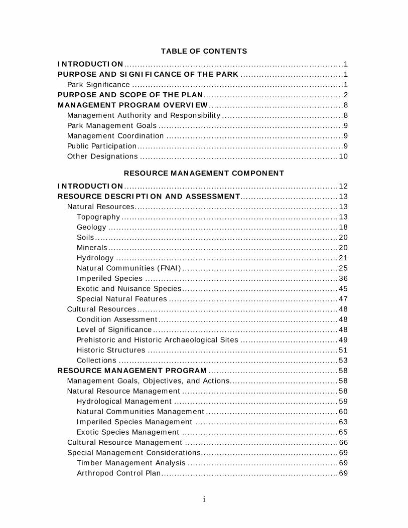
TABLE OF CONTENTS
INTRODUCTION ................................................................................... 1 PURPOSE AND SIGNIFICANCE OF THE PARK ....................................... 1
Park Significance ................................................................................ 1 PURPOSE AND SCOPE OF THE PLAN..................................................... 2 MANAGEMENT PROGRAM OVERVIEW ................................................... 8
Management Authority and Responsibility .............................................. 8 Park Management Goals ...................................................................... 9 Management Coordination ................................................................... 9 Public Participation .............................................................................. 9 Other Designations ........................................................................... 10
RESOURCE MANAGEMENT COMPONENT
INTRODUCTION ................................................................................. 12 RESOURCE DESCRIPTION AND ASSESSMENT..................................... 13
Natural Resources ............................................................................. 13 Topography .................................................................................. 13 Geology ....................................................................................... 18 Soils ............................................................................................ 20 Minerals ....................................................................................... 20 Hydrology .................................................................................... 21 Natural Communities (FNAI) ........................................................... 25 Imperiled Species ......................................................................... 36 Exotic and Nuisance Species ........................................................... 45 Special Natural Features ................................................................ 47
Cultural Resources ............................................................................ 48 Condition Assessment .................................................................... 48 Level of Significance ...................................................................... 48 Prehistoric and Historic Archaeological Sites ..................................... 49 Historic Structures ........................................................................ 51 Collections ................................................................................... 53
RESOURCE MANAGEMENT PROGRAM ................................................. 58 Management Goals, Objectives, and Actions ......................................... 58 Natural Resource Management ........................................................... 58
Hydrological Management .............................................................. 59 Natural Communities Management .................................................. 60 Imperiled Species Management ...................................................... 63 Exotic Species Management ........................................................... 65
Cultural Resource Management .......................................................... 66 Special Management Considerations .................................................... 69
Timber Management Analysis ......................................................... 69 Arthropod Control Plan ................................................................... 69

ii
Resource Management Schedule ......................................................... 70 Land Management Review ................................................................. 70
LAND USE COMPONENT
INTRODUCTION ................................................................................. 72 EXTERNAL CONDITIONS .................................................................... 72
Existing Use of Adjacent Lands ........................................................... 74Planned Use of Adjacent Lands ........................................................... 74 Florida Greenways and Trails System .................................................. 75
PROPERTY ANALYSIS ........................................................................ 75 Recreation Resource Elements ............................................................ 76
Land Area .................................................................................... 76 Water Area ................................................................................... 76 Shoreline ..................................................................................... 76 Natural Scenery ............................................................................ 77 Significant Habitat ......................................................................... 77 Natural Features ........................................................................... 77 Archaeological and Historic Features ................................................ 77
Assessment of Use ............................................................................ 78 Past Uses ..................................................................................... 78 Future Land Use and Zoning ........................................................... 78 Current Recreation Use and Visitor Programs .................................... 79 Protected Zones ............................................................................ 82
Existing Facilities .............................................................................. 82 Recreation Facilities ....................................................................... 82 Support Facilities .......................................................................... 83
CONCEPTUAL LAND USE PLAN ........................................................... 84 Potential Uses .................................................................................. 84
Public Access and Recreational Opportunities .................................... 84 Proposed Facilities ............................................................................ 88
Capital Facilities and Infrastructure ................................................. 88 Facilities Development ....................................................................... 90 Recreational Carrying Capacity ........................................................... 91 Optimum Boundary ........................................................................... 92
IMPLEMENTATION COMPONENT
MANAGEMENT PROGRESS .................................................................. 97 Acquisition ....................................................................................... 97 Park Administration and Operations .................................................... 97Resource Management ...................................................................... 98
Natural Resources ......................................................................... 98 Cultural Resources ........................................................................ 99
Recreation and Visitor Services ......................................................... 100 Park Facilities ................................................................................. 101
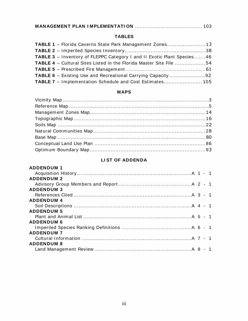
iii
MANAGEMENT PLAN IMPLEMENTATION .......................................... 103
TABLES
TABLE 1 – Florida Caverns State Park Management Zones ........................ 13 TABLE 2 – Imperiled Species Inventory .................................................. 38 TABLE 3 – Inventory of FLEPPC Category I and II Exotic Plant Species ....... 46 TABLE 4 – Cultural Sites Listed in the Florida Master Site File ................... 54 TABLE 5 – Prescribed Fire Management .................................................. 61 TABLE 6 – Existing Use and Recreational Carrying Capacity ...................... 92 TABLE 7 – Implementation Schedule and Cost Estimates........................ 105
MAPS
Vicinity Map ........................................................................................... 3 Reference Map ....................................................................................... 5 Management Zones Map........................................................................ 14 Topographic Map .................................................................................. 16 Soils Map ............................................................................................ 22 Natural Communities Map ...................................................................... 28 Base Map ............................................................................................ 80 Conceptual Land Use Plan ..................................................................... 86 Optimum Boundary Map ........................................................................ 93
LIST OF ADDENDA
ADDENDUM 1 Acquisition History ....................................................................... A 1 - 1
ADDENDUM 2 Advisory Group Members and Report ............................................. A 2 - 1
ADDENDUM 3 References Cited ......................................................................... A 3 - 1
ADDENDUM 4 Soil Descriptions ......................................................................... A 4 - 1
ADDENDUM 5 Plant and Animal List ................................................................... A 5 - 1
ADDENDUM 6 Imperiled Species Ranking Definitions ........................................... A 6 - 1
ADDENDUM 7 Cultural Information .................................................................... A 7 - 1
ADDENDUM 8 Land Management Review ............................................................ A 8 - 1
1
INTRODUCTION
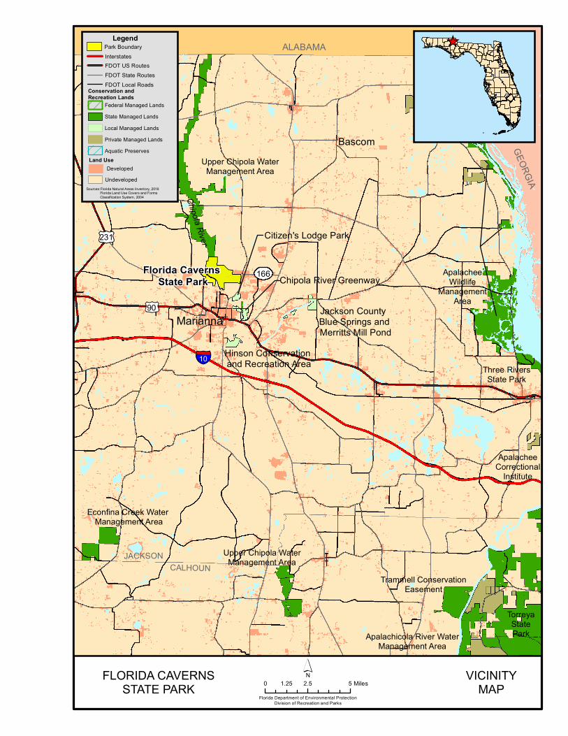
Florida Caverns State Park is located in central Jackson County (see Vicinity Map). Access to the park is from U.S. Highway 90 to State Road 166 (see Reference Map). The Vicinity Map also reflects significant land and water resources near the park. Florida Caverns State Park was initially acquired on October 11, 1935 by the Florida Board of Forestry. Currently, the park comprises 1,449.56 acres. The Board of Trustees of the Internal Improvement Trust Fund (Trustees) hold fee simple title to the park and on January 23, 1968, the Trustees leased (Lease Number 2324) the property to DRP under a 50-year lease. The current lease will expire on October 3, 2033. In 1988, a new lease number (Lease Number 3619) was assigned to Florida Caverns State Park without changing any of the terms and conditions of Lease Number 2324. At Florida Caverns State Park, public outdoor recreation and conservation is the designated single use of the property. There are no legislative or executive directives that constrain the use of this property (see Addendum 1).
Purpose and Significance of the Park The purpose of Florida Caverns State Park is to provide for the preservation and interpretation of irreplaceable natural, historic, and cultural resources found within the park for the enjoyment of Florida’s residents and visitors, and to provide compatible resource-based outdoor recreation opportunities along the Chipola River. Park Significance
• The park is one of Florida’s 9 original New Deal-era parks developed by the Civilian Conservation Corps (CCC) and the Works Progress Administration (WPA). The park contains remnants of a federal fish hatchery constructed in the 1930s-1940s and serves as an excellent example of early 20th century recreation planning.
• The park is Florida’s only state park to offer interpretive cave tours. Florida Caverns is one of the few state parks with dry, terrestrial caves and one of only 2 with both terrestrial and aquatic caves. The park’s caves feature an array of impressive and fragile geologic formations, and they are home to numerous species adapted to subterranean environments.
• The park protects extensive, exceptional, and rare natural communities along the Chipola River, including three upland glades (one of Florida’s most imperiled community types, and the only upland glades found in the Florida Park Service system). Due to the park’s geological history and topography, the property supports numerous rare plants associated with the southern Appalachian Mountains.

2
• Florida Caverns State Park has a rich cultural history. The park protects Native American cultural sites along the Chipola River and a natural land bridge used by Andrew Jackson’s troops during the First Seminole War in 1818.
• The park’s high-quality outdoor recreational activities include boating, camping, cycling, fishing, geo-seeking, golf, hiking, horseback riding, paddling, nature study, and wildlife viewing.
Florida Caverns State Park is classified as a State Park in the DRP’s unit classification system. In the management of a State Park, a balance is sought between the goals of maintaining and enhancing natural conditions and providing various recreational opportunities. Natural resource management activities are aimed at management of natural systems. Development in the park is directed toward providing public access to and within the park, and to providing recreational facilities, in a reasonable balance, that are both convenient and safe. Program emphasis is on interpretation on the park's natural, aesthetic, and educational attributes.
Purpose and Scope of the Plan This plan serves as the basic statement of policy and direction for the management of Florida Caverns State Park State Park as a unit of Florida's state park system. It identifies the goals, objectives, actions, and criteria or standards that guide each aspect of park administration, and sets forth the specific measures that will be implemented to meet management objectives and provide balanced public utilization. The plan is intended to meet the requirements of Sections 253.034 and 259.032, Florida Statutes, Chapter 18-2, Florida Administrative Code, and is intended to be consistent with the State Lands Management Plan. With approval, this management plan will replace the 2006 approved plan. The plan consists of three interrelated components: the Resource Management Component, the Land Use Component, and the Implementation Component. The Resource Management Component provides a detailed inventory and assessment of the natural and cultural resources of the park. Resource management needs and issues are identified, and measurable management objectives are established for each of the park’s management goals and resource types. This component provides guidance on the application of such measures as prescribed burning, exotic species removal, imperiled species management, cultural resource management, and restoration of natural conditions. The Land Use Component is the recreational resource allocation plan for the park. Based on considerations such as access, population, adjacent land uses, the natural and cultural resources of the park, and current public uses, and existing
§̈¦
Florida Caverns State Park
£¤
£¤231
90
10
Econfina Creek Water Management Area
Upper Chipola WaterManagement Area
Marianna
ApalacheeWildlife
ManagementArea
Chipola River
166
GEORGIA
Upper Chipola WaterManagement Area
TorreyaStateParkApalachicola River Water
Management Area
Trammell ConservationEasement
Three RiversState Park
JACKSONCALHOUN
ApalacheeCorrectional
Institute
ALABAMA
Bascom
Hinson Conservation and Recreation Area
Jackson County Blue Springs and Merritts Mill Pond
Chipola River Greenway
Citizen's Lodge Park
_̂
FLORIDA CAVERNSSTATE PARK
Florida Department of Environmental ProtectionDivision of Recreation and Parks
VICINITYMAP0 2.5 51.25 Miles
´
Sources:Florida Natural Areas Inventory, 2016 Florida Land Use Covers and Forms Classification System, 2004
LegendPark Boundary
Land Use
Conservation and Recreation Lands
InterstatesFDOT US RoutesFDOT State RoutesFDOT Local Roads
Federal Managed LandsState Managed LandsLocal Managed LandsPrivate Managed LandsAquatic Preserves
UndevelopedDeveloped

4

FLORIDA CAVERNS STATE PARKFlorida Department of Environmental Protection
Division of Recreation and ParksDate of aerial; 2011
0 0.2 0.40.1 Miles´ REFERENCE MAP
Legend
Paddling Trail
[· Airport
Managed Conservation Lands
water bodies
Park_Boundary
TIGER 2010 Cities (Areas)

7
development, measurable objectives are set to achieve the desired allocation of the physical space of the park. These objectives identify use areas and propose the types of facilities and programs as well as the volume of public use to be provided. The Implementation Component consolidates the measurable objectives and actions for each of the park’s management goals. An implementation schedule and cost estimates are included for each objective and action. Included in this table are (1) measures that will be used to evaluate the DRP’s implementation progress, (2) timeframes for completing actions and objectives, and (3) estimated costs to complete each action and objective. All development and resource alteration proposed in this plan is subject to the granting of appropriate permits, easements, licenses, and other required legal instruments. Approval of the management plan does not constitute an exemption from complying with the appropriate local, state, or federal agencies. In the development of this plan, the potential of the park to accommodate secondary management purposes was analyzed. These secondary purposes were considered within the context of DRP’s statutory responsibilities and the resource needs and values of the park. This analysis considered the park’s natural and cultural resources, management needs, aesthetic values, visitation, and visitor experiences. For this park, it was determined that timber management could be accommodated in a manner that would be compatible and not interfere with the primary purpose of resource-based outdoor recreation and conservation. These compatible secondary management purposes are addressed in the Resource Management Component of the plan. Uses such as water resource development projects, water supply projects, stormwater management projects, linear facilities, and sustainable agriculture and forestry (other than those forest management activities specifically identified in this plan) are not consistent with this plan or the management purposes of the park. The potential for generating revenue to enhance management was also analyzed. Visitor fees and charges are the principal source of revenue generated by the park. It was determined that timber management would be appropriate at this park as an additional source of revenue for land management since they are compatible with the park’s primary purpose of resource-based outdoor recreation and conservation. DRP may provide the services and facilities outlined in this plan either with its own funds and staff or through an outsourcing contract. Private contractors may provide assistance with natural resource management and restoration activities or a concessionaire may provide services to park visitors in order to enhance the visitor experience. For example, a concessionaire could be authorized to sell merchandise and food and to rent recreational equipment for use in the park. A concessionaire may also be authorized to provide specialized services, such as interpretive tours, or overnight accommodations when the required capital investment exceeds that which DRP can elect to incur. Decisions regarding outsourcing, contracting with the
8
private sector, the use of concessionaires, etc. are made on a case-by-case basis in accordance with the policies set forth in DRP’s Operations Manual (OM).
Management Program Overview Management Authority and Responsibility In accordance with Chapter 258, Florida Statutes and Chapter 62D-2, Florida Administrative Code, the Division of Recreation and Parks (DRP) is charged with the responsibility of developing and operating Florida's recreation and parks system. These are administered in accordance with the following policy:
It shall be the policy of the Division of Recreation and Parks to promote the state park system for the use, enjoyment, and benefit of the people of Florida and visitors; to acquire typical portions of the original domain of the state which will be accessible to all of the people, and of such character as to emblemize the state's natural values; conserve these natural values for all time; administer the development, use, and maintenance of these lands and render such public service in so doing, in such a manner as to enable the people of Florida and visitors to enjoy these values without depleting them; to contribute materially to the development of a strong mental, moral, and physical fiber in the people; to provide for perpetual preservation of historic sites and memorials of statewide significance and interpretation of their history to the people; to contribute to the tourist appeal of Florida.
The Board of Trustees of the Internal Improvement Trust Fund (Trustees) has granted management authority of certain sovereign submerged lands to the DRP under Management Agreement MA 68-086 (as amended January 19, 1988). The management area includes a 400-foot zone from the edge of mean high water where a park boundary borders sovereign submerged lands fronting beaches, bays, estuarine areas, rivers, or streams. Where emergent wetland vegetation exists, the zone extends waterward 400 feet beyond the vegetation. The agreement is intended to provide additional protection to resources of the park and nearshore areas and to provide authority to manage activities that could adversely affect public recreational uses. Many operating procedures are standardized system-wide and are set by internal direction. These procedures are outlined in the OM that covers such areas as personnel management, uniforms and personal appearance, training, signs, communications, fiscal procedures, interpretation, concessions, public use regulations, resource management, law enforcement, protection, safety, and maintenance.
9
Park Management Goals The following park goals express DRP’s long-term intent in managing the state park: • Provide administrative support for all park functions. • Protect water quality and quantity in the park, restore hydrology to the extent
feasible, and maintain the restored condition. • Restore and maintain the natural communities/habitats of the park. • Maintain, improve, or restore imperiled species populations and habitats in the
park. • Remove exotic and invasive plants and animals from the park and conduct
needed maintenance-control. • Protect, preserve, and maintain the cultural resources of the park. • Provide public access and recreational opportunities in the park. • Develop and maintain the capital facilities and infrastructure necessary to meet
the goals and objectives of this management plan. Management Coordination The park is managed in accordance with all applicable laws and administrative rules. Agencies having a major or direct role in the management of the park are discussed in this plan. The Florida Department of Agriculture and Consumer Services (FDACS), Florida Forest Service (FFS), assists DRP staff in the development of wildfire emergency plans and provides the authorization required for prescribed burning. The Florida Fish and Wildlife Conservation Commission (FWC) assists staff in the enforcement of state laws pertaining to wildlife, freshwater fish, and other aquatic life existing within the park. In addition, the FWC aids DRP with wildlife management programs, including imperiled species management. The Florida Department of State (FDOS), Division of Historical Resources (DHR) assists staff to ensure protection of archaeological and historical sites. Public Participation DRP provided an opportunity for public input by conducting a public workshop and an Advisory Group meeting to present the draft management plan to the public. These meetings were held on [INSERT Dates], respectively. Meeting notices were published in the Florida Administrative Register, [INSERT publication date, VOL/ISSUE], included on the Department Internet Calendar, posted in clear view at the park, and promoted locally. The purpose of the Advisory Group meeting is to provide the Advisory Group members an opportunity to discuss the draft management plan (see Addendum 2).
10
Other Designations
Florida Caverns State Park is not within an Area of Critical State Concern as defined in Section 380.05, Florida Statutes, and it is not presently under study for such designation. The park is a component of the Florida Greenways and Trails System, administered by the Department’s Office of Greenways and Trails. All waters within the park have been designated as Outstanding Florida Waters, pursuant to Chapter 62-302, Florida Administrative Code. Surface waters in this park are also classified as Class III waters by the Department. This park is not within or adjacent to an aquatic preserve as designated under the Florida Aquatic Preserve Act of 1975 (Section 258.35, Florida Statutes).

11
12
RESOURCE MANAGEMENT COMPONENT
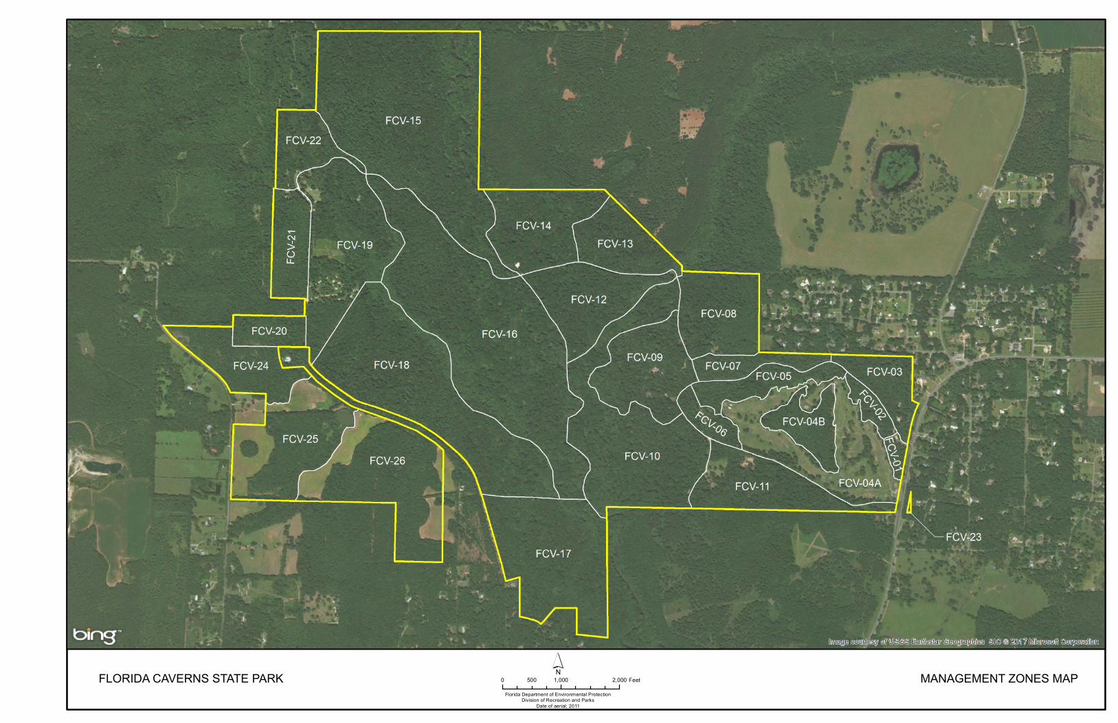
Introduction The Florida Department of Environmental Protection (DEP), Division of Recreation and Parks (DRP) in accordance with Chapter 258, Florida Statutes, has implemented resource management programs for preserving for all time the representative examples of natural and cultural resources of statewide significance under its administration. This component of the unit plan describes the natural and cultural resources of the park and identifies the methods that will be used to manage them. Management measures expressed in this plan are consistent with the DRP’s overall mission in natural systems management. Cited references are contained in Addendum 3. The DRP’s philosophy of resource management is natural systems management. Primary emphasis is placed on restoring and maintaining, to the degree possible, the natural processes that shaped the structure, function, and species composition of Florida’s diverse natural communities as they occurred in the original domain. Single species management for imperiled species is appropriate in state parks when the maintenance, recovery, or restoration of a species or population is complicated due to constraints associated with long-term restoration efforts, unnaturally high mortality, or insufficient habitat. Single species management should be compatible with the maintenance and restoration of natural processes and should not imperil other native species or seriously compromise the park values. The DRP’s management goal for cultural resources is to preserve sites and objects that represent Florida’s cultural periods, significant historic events, or persons. This goal often entails active measures to stabilize, reconstruct, or restore resources, or to rehabilitate them for appropriate public use. Because park units are often components of larger ecosystems, their proper management can be affected by conditions and events that occur beyond park boundaries. Ecosystem management is implemented through a resource management evaluation program that assesses resource conditions, evaluates management activities and refines management actions, and reviews local comprehensive plans and development permit applications for park/ecosystem impacts. The entire park is divided into management zones that delineate areas on the ground that are used to reference management activities (see Management Zones Map). The shape and size of each zone may be based on natural community type, burn zone, and the location of existing roads and natural fire breaks. It is important to note that all burn zones are management zones; however, not all management zones include fire-dependent natural communities, or are completely inclusive of fire dependent activities within the entire zone unless that portion of the zone has natural communities which are fire dependent. Table 1 reflects the management zones with the acres of each zone.
13
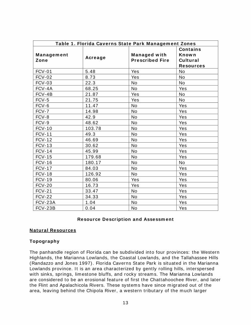
Table 1. Florida Caverns State Park Management Zones
Management Zone Acreage Managed with
Prescribed Fire
Contains Known Cultural Resources
FCV-01 5.48 Yes No FCV-02 8.73 Yes No FCV-03 22.3 No No FCV-4A 68.25 No Yes FCV-4B 21.87 Yes No FCV-5 21.75 Yes No FCV-6 11.47 No Yes FCV-7 14.98 No Yes FCV-8 42.9 No Yes FCV-9 48.62 No Yes FCV-10 103.78 No Yes FCV-11 49.3 No Yes FCV-12 46.69 No Yes FCV-13 30.62 No Yes FCV-14 45.99 No Yes FCV-15 179.68 No Yes FCV-16 180.17 No No FCV-17 84.03 No Yes FCV-18 126.92 No Yes FCV-19 80.06 Yes Yes FCV-20 16.73 Yes Yes FCV-21 33.47 No Yes FCV-22 34.33 No Yes FCV-23A 1.04 No Yes FCV-23B 0.04 No Yes
Resource Description and Assessment
Natural Resources
Topography
The panhandle region of Florida can be subdivided into four provinces: the Western Highlands, the Marianna Lowlands, the Coastal Lowlands, and the Tallahassee Hills (Randazzo and Jones 1997). Florida Caverns State Park is situated in the Marianna Lowlands province. It is an area characterized by gently rolling hills, interspersed with sinks, springs, limestone bluffs, and rocky streams. The Marianna Lowlands are considered to be an erosional feature of first the Chattahoochee River, and later the Flint and Apalachicola Rivers. These systems have since migrated out of the area, leaving behind the Chipola River, a western tributary of the much larger
FLORIDA CAVERNS STATE PARKFlorida Department of Environmental Protection
Division of Recreation and ParksDate of aerial; 2011
0 1,000 2,000500 Feet´ MANAGEMENT ZONES MAP

FLORIDA CAVERNS STATE PARKFlorida Department of Environmental Protection
Division of Recreation and ParksDate of aerial; 2011
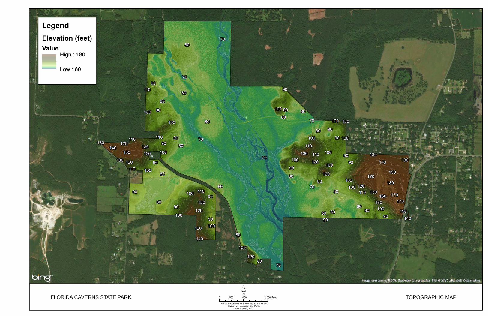
0 1,000 2,000500 Feet´ TOPOGRAPHIC MAP
LegendElevation (feet)Value
High : 180
Low : 60

18
Apalachicola. Natural erosion and dissolution of the soft limestone in the Marianna Lowlands has created an irregular, pot-holed landscape, termed karst. Some of the most striking examples of karst topography in Florida are found in Jackson County and particularly at Florida Caverns State Park. The park is situated in roughly the center of the Marianna Lowlands and is bisected from north to south by the Chipola River. The majority of the park occurs in the river floodplain, at elevations of 65 to 75 feet above sea level (see Topographic Map). Most of the higher elevations are located on the eastern edge of the park, and range from 120 feet at the Visitor Center to 180 feet on the eastern edge of the Caverns golf course. A prominent feature, quite conspicuous in winter, is the limestone bluff at Old Indian Cave, which rises abruptly from the Chipola River swamp. Other limestone outcroppings and cliffs are confined primarily to the eastern side of the Chipola basin along the Floodplain Nature Trail, which offers dramatic views of an undisturbed bottomland hardwood forest. Topographic alterations which have been made at the park include filling for the park drive, enlarging the Blue Hole and construction of the retaining wall, construction of a ditch from the Sugar Mill Run to the Blue Hole, excavation of the log run prior to state acquisition, and various grading and contouring made for the golf course. Geology The Marianna Lowlands of Florida Caverns can be subdivided into Remnant Highlands, Calcareous Slopes and Bluffs, and Chipola River Floodplain components. These units are closely correlated with the distribution of the underlying limestone formations. The remnant hills occur where un-eroded Miocene clays and Plio-Pleistocene sands remain over the limestone. In the western portions of the park, these hills slope gently down to the floodplain, but on the east side of the Chipola and on the park’s southern boundary, erosion has left outcrops exposed, creating slopes and bluffs. These limestone bluffs are among the oldest surface formations found in Florida. As the Chipola meanders across the river valley, it actively deposits mud and silt, constantly changing the characteristics of the floodplain. Throughout most of its geologic history, the region now known as Florida Caverns State Park has been under the sea. During the Late Eocene's Jackson Stage, about 38 million years before present, when Ocala Limestone was being deposited as coral and shell, the sea was probably less than 600 feet deep. The Ocala Limestone contains abundant large foraminifera, mollusks, bryozoans, corals, and other marine fossils. It was probably deposited on a warm continental shelf or in a carbonate bank-lagoonal setting. Fluctuating sea levels periodically flooded the park throughout much of the Miocene, depositing deltaic and marine clays and carbonates of the Chattahoochee Formation and Alum Bluff Group of the Marianna and Suwannee Limestones. Subsequent erosion of these clays began in the late Miocene and continued through the Pliocene and Pleistocene epochs, erasing much of their geologic record.
19
Concurrent with the erosion of the Marianna Lowlands was the continuous lowering of sea levels during the Plio-Pleistocene. As in the preceding epochs, the lowering occurred in stages and left erosion slopes and sandy terraces, still visible in present topography. In the park, the Okefenokee (Sunderland) terrace occurs above 100 feet, the Wicomico terrace occurs between 70 and 100 feet, and the Penholoway terrace extends up to about 70 feet. Associated with fluctuating sea levels were fluctuating water tables. When high, the ground water followed fissures and cracks along the bedding planes and joints of the Ocala Limestone, where they were capped by the harder Marianna Limestone. The fissures and cracks were slowly enlarged by the acidic groundwater, forming caverns through which underground rivers flowed. When the seas and water tables dropped, these underground passages drained and the development of typical cave drip formations began. Thus, the dry caves at the park, although occurring in Eocene limestones, have developed much more recently. Caves below the present water table continue to develop today, as ground water acidified by percolating rainfall, dissolves the limestone. This kind of solution activity is greater throughout the Marianna Lowlands because the erosion has exposed the bedrock limestones to the elements. The present-day Chipola River is now actively eroding the Ocala Limestone along its course. Typical karst features such as springs, depressions, and sinks are evident within the floodplain. A prominent feature in the park is the River Sink and Natural Bridge, a one-half mile section of the Chipola south of the park drive that originally flowed underground. The various dry caves in the park, including the tour cave, occur adjacent to the Chipola floodplain in Ocala Limestone, where their elevation is (usually) above the river level. The caves of Florida Caverns provide a unique opportunity to examine the fossilized remains of marine creatures that existed here millions of years ago. Below is a list of both aquatic and terrestrial species which have been found in park caves.
Fossils from Florida Caverns Caves
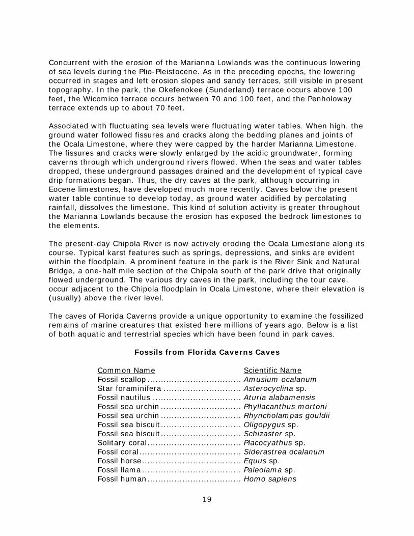
Common Name Scientific Name Fossil scallop ................................... Amusium ocalanum Star foraminifera ............................. Asterocyclina sp. Fossil nautilus ................................. Aturia alabamensis Fossil sea urchin .............................. Phyllacanthus mortoni Fossil sea urchin .............................. Rhyncholampas gouldii Fossil sea biscuit .............................. Oligopygus sp. Fossil sea biscuit .............................. Schizaster sp. Solitary coral ................................... Placocyathus sp. Fossil coral ...................................... Siderastrea ocalanum Fossil horse ..................................... Equus sp. Fossil llama ..................................... Paleolama sp. Fossil human ................................... Homo sapiens
20
Soils Twelve soil types have been identified in the park (see Soils Map) by the U.S. Natural Resources Conservation Service (formerly Soil Conservation Service). The most prevalent soil type is the Yonges-Herod group associated with the Chipola River floodplain. The Red Bay Fine Sandy Loam is another common soil type that occurs on adjacent higher elevation (Duffee et al. 1979). Addendum 4 provides a detailed description of the soil types that occur in this unit. Florida Caverns State Park has 2 problems associated with soil erosion. The first is natural dissolution of poorly consolidated substrates under roads and parking lots as a result of high water tables and karst topography. Major voids that develop under roads are filled with fast-drying concrete that is pumped into the crevice. This problem occurs primarily in the river basin and repairs do not impact the park’s dry caves. The second erosion problem occurs during the annual spring flooding in the Chipola basin. During these periods, the river may flow across 2,000 feet or more of the park drive, and erode the downstream road shoulder. The problem is exacerbated by past soil disturbance for a sewer line, and shading of ground cover vegetation by hardwood saplings that are encroaching onto the road shoulder. This problem is being addressed by selective thinning to reduce the shading effect, replacing the fill, and stabilizing it with appropriate ground cover and mulch. Minerals Naturally-occurring surface rocks found in Florida are all sedimentary, having been formed by the deposition of material derived from the fragmentation of pre-existing rocks or from biological or chemical precipitation. In the park, the exposed and subsurface limestones are composed principally of the mineral calcite and varying amounts of impurities depending on their geologic history. Calcite is more striking in the profusion of stalactites and stalagmites which decorate many of the park’s dry caves. In this form, the calcite has been purified through the solution and precipitation process. Dolomite typically is associated with limestone in Jackson County, but has not been reported in surface formations in the park. Clay and quartz sand are other minerals found in the park. Clays were originally deposited as mud in shallow marine seas and estuaries, or as the result of erosion of older geologic units. Those at Florida Caverns are Miocene-Pleistocene undifferentiated sand and clay. The sands in the park today were derived from the erosion of the ancient Appalachian Mountains, with transport southward by streams of the durable quartz component, and subsequent seashore deposition. Chert (low-grade flint) occurs in pockets in limestone where groundwater replaced calcium carbonate with silica. Although no prehistoric quarry sites are known within the park, Native Americans probably obtained some chert for tool making from the park's exposed limestone. Several historic-period limestone quarries occur in the park, including at Ellis Cave and on the western end of the park (SE Sect. 20 T5N, R10 W). “Minerals” in the form of marine fossils (see below) are conspicuous both on the surface and in cave interior limestones. At least two fossil mammals from the Pleistocene have also been found in the park's Boyer's Discovery Cave, where they had wandered or were dragged by an ancient predator. These animals were Paleolama sp. (a
21
llama-like relative of the camel) and Equus sp. (a primitive horse). These remains were uncovered accidentally, suggesting that perhaps more paleontological or archeological materials may remain in park caves, buried by mud washed in by rainfall and flooding. In 1976, a partly mineralized human femur was discovered in Ranger Cave, and now resides in the collections of the Florida Department of State. Its age and cultural affinity are not known. These various minerals are either not of commercial value or, in the case of cave formations, are protected by law (62D, 810.13). Limestone from the park was used in building construction by the Civilian Conservation Corps, and in construction of the Equestrian Area restroom. Such consumptive use of park resources is now avoided. Hydrology The most important hydrological feature of this unit is the Chipola River and its associated springs and tributaries. Although of tremendous significance to the natural processes of the region, the typical park visitor sees only its densely-wooded floodplain and the pool where its waters partly disappear at the River Sink. The Chipola is itself a small tributary of the much larger Apalachicola River. The Chipola River originates at the union of Marshall and Cowart’s Creeks in Houston County Alabama, and flows almost due south to join the Apalachicola via the Dead Lakes system in Gulf County. During spring flooding, the Chipola may rise 10 feet or more above its banks and inundate over half of the park. During these periods the Florida Cavern is often partly flooded, and elevations below 80 feet (above sea level) may be submerged. In a severe flood during March of 1998, 2 feet of water covered the park’s shop area, which is at about +85 feet MSL elevation. During these flood periods, one can launch a small boat just north of the Visitor Center and motor over the park drive to the Blue Hole swimming area. The U.S. Geological Survey maintains a gauging station on the Chipola, 20 miles south of the park at the Highway 274 bridge near the town of Altha. According to USGS data, the river drains a basin of 781 square miles and has an average daily flow of 980 million gallons (1913-1996 figures). During a summer drought, the river may drop to as low as 238 million gallons daily. In 1997, the National Weather Service installed a flow meter at the Highway 90 bridge in Marianna. It is used in conjunction with the Southeastern River Forecast system to track flooding events. The park also maintains a staff gauge at the River Sink. The gauge was installed in March of 1997. The River Sink is located just upstream of the park drive bridge. In July of 1999, the depth of the sink measured 96.5 feet with a river reading of 3.65 at the park bridge. Within Florida Caverns State Park, the Chipola River is about 80 feet wide along its 1.9-mile course, except for the section that is subterranean. During the pre-settlement period, a half-mile long natural bridge existed where the Chipola disappeared into a sinkhole. Evidently in the early 1800s, a “log run” was created across the natural land bridge for the purpose of floating felled timber downstream to a nearby sawmill. For practical purposes the swift, narrow log run is not considered navigable by motorboats or canoes.

FLORIDA CAVERNS STATE PARKFlorida Department of Environmental Protection
Division of Recreation and ParksDate of aerial; 2011
0 1,000 2,000500 Feet´ SOILS MAP
Legend2 - Albany sand, 0 to 5 percent slopes
5 - Bibb soils
20 - Duplin fine sandy loam, 0 to 2 percent slopes
27 - Faceville-Esto complex, 5 to 15 percent slopes, severely eroded
32 - Grady fine sand loam
33 - Greenville fine sandy loam, 2 to 5 percent slopes
34 - Greenville fine sandy loam, 5 to 8 percent slopes
43 - Oktibbeha variant-Rock outcrop complex, 2 to 5 percent slopes
44 - Oktibbeha variant-Rock outcrop complex, 5 to 12 percent slopes
46 - Orangeburg loamy sand, 2 to 5 percent slopes
47 - Orangeburg loamy sand, 5 to 8 percent slopes
54 - Red Bay fine sandy loam, 2 to 5 percent slopes
55 - Red Bay fine sandy loam, 5 to 8 percent slopes
57 - Tifton loamy sand, 2 to 5 percent slopes
64 - Yonges-Herod association
99 - Water


24
A second significant hydrologic feature of the park is Blue Hole Spring and the resultant Carter's Mill Branch, which courses southeasterly about 1.6 miles before joining the Chipola just outside the south boundary. The Blue Hole Spring is a second magnitude artesian spring which was discharging 56.8 cubic feet/second in August 1973. The spring is oval with a small pool connected to the northwest. The main pool is about 100 feet in diameter with a maximum depth of 39 feet. Immediately adjacent to the north, the “Little Blue Hole” spring was measured at 97.6 feet of depth in July 1999. The west side of the swimming area is improved with a retaining wall and a swimming platform. The spring water is clear in periods of low rainfall, but usually is colored to some degree. Carter's Mill Branch averages about 40 feet wide and one to 4 feet deep. A third water course in the park is Sugar Mill Run, which is part of a subterranean branch of the Chipola River; it is represented on the surface by a 3,000-foot series of sinkholes and short lengths of stream. This run originates from a vent just north of the park boundary. It crosses under the park drive and eventually reconnects with the Chipola River. A fourth stream, known as Spring Branch or Muddy Branch, originates at Pearl Spring outside the park to the west of the Marianna Municipal Airport, and flows southwesterly into the park. The run is also crossed by the park drive in the northeastern section. The run continues in the park for about 3,000 feet before joining with the Chipola River within the park. A fifth stream originates in a small spring 40 feet in diameter, just north of the confluence of Carter's Mill Branch and the river. The spring run courses southeasterly for about 300 feet before joining the Chipola. This and Blue Hole Spring are the only artesian springs in the park. The clays and sands in the park contain the surficial aquifer, while the lower and upper sections of the Floridan Aquifer system are carried in the Ocala, Marianna, and Suwannee Limestone beds respectively. The upper Floridan Aquifer system’s potentiometric surface is at about 110 feet above sea level. There are currently six wells in the park. Well 1320271 at the Visitor Center, like many wells in Jackson County, required the use of an ethyl dibromide (EDB) filter due to groundwater contamination. The Visitor Center is now connected to Marianna city water. Well 103 at the Park Manager’s residence (Bldg. BLO25003) serves the old Fish Hatchery residence area on the west end of the park. Well 1320122 is located on the hilltop south of the Ranger Station and is used for golf course irrigation. A shallow well (no. 1324077) on the east side of the Blue Hole serves the park’s campground. The 1995 acquisition of the park’s Ellis Cave tract also included a well that serves most of Tara Estates’ residents. The well located is on an easement on the western side of the parcel. Because of local recharge through the karst features in the floodplain, sources of pollution and groundwater withdrawal outside the park are of concern. At this time, use of well water is being phased out. Most of the eastern half of the park is being connected to Marianna city water. In 1996, the Caverns golf course installed an 8-inch irrigation well (no. 1362). At that time, baseline water level data were collected in Salamander Pond and China Caves. Between May 1996 and June 1998, water levels were found to fluctuate up to 77 inches in Salamander Pond Cave and least 72 inches (cave sometimes entirely flooded) in China Cave. No gross effect from the well has been noted, nor was predicted by Northwest Florida Water Management District (NWFWMD)
25
hydrologists. Periodic monitoring of water levels should continue in order to ensure adequate habitat for cave biota. Cave water temperatures were also recorded. Mean annual temperature in Salamander Pond Cave was 67.5 degrees F (range 64-70, n=38 records), whereas China Cave water averaged 58.4 degrees F (range 46-63, n=38 records). Temperatures in these two cave pools differed greatly from each other, and were also not coincident with the river temperature, which suggests no direct conduit exist between the cave pools and the Chipola River. In 1980, members of the Fort Rucker-Ozark Grotto (F.R.O.G.) caving club discovered a new cavern partly underneath the park’s Visitor Center. Named for the late Dr. Paul Boyer, the cave is now known as Boyer’s Discovery Cave. Sometime prior to 1991, cavers noticed sewage stains on the cave ceiling. Dye tracing revealed the contamination was coming from the building’s septic system. This problem was ultimately resolved by connecting the building to Marianna city sewage in 1995. Natural Communities This section of the management plan describes and assesses each of the natural communities found in the state park. It also describes the desired future condition (DFC) of each natural community and identifies the actions that will be required to bring the community to its desired future condition. Specific management objectives and actions for natural community management, exotic species management, imperiled species management, and population restoration are discussed in the Resource Management Program section of this component. The system of classifying natural communities employed in this plan was developed by the Florida Natural Areas Inventory (FNAI). The premise of this system is that physical factors such as climate, geology, soil, hydrology, and fire frequency generally determine the species composition of an area, and that areas that are similar with respect to those factors will tend to have natural communities with similar species compositions. Obvious differences in species composition can occur, however, despite similar physical conditions. In other instances, physical factors are substantially different, yet the species compositions are quite similar. For example, coastal strand and scrub--two communities with similar species compositions--generally have quite different climatic environments, and these necessitate different management programs. Some physical influences, such as fire frequency, may vary from FNAI’s descriptions for certain natural communities in this plan. When a natural community within a park reaches the desired future condition, it is considered to be in a “maintenance condition.” Required actions for sustaining a community’s maintenance condition may include; maintaining optimal fire return intervals for fire dependent communities, ongoing control of non-native plant and animal species, maintaining natural hydrological functions (including historic water flows and water quality), preserving a community’s biodiversity and vegetative structure, protecting viable populations of plant and animal species (including those that are imperiled or endemic), and preserving intact ecotones that link natural communities across the landscape.

26
The park contains 10 distinct natural communities as well as human-altered landscape types (see Natural Communities Map). A list of known plants and animals occurring in the park is contained in Addendum 5. Limestone Outcrop Desired Future Condition: The limestone outcrop community at Florida Caverns is in good condition. Maintaining minimal exotic plant presence will require perpetual searching and treatment due to continual re-infestation via flood waters and seed dispersal birds and small mammals. Most of the outcrop habitat should be minimally impacted by park visitors. Description and Assessment: This community was formerly included in “Bluff.” The limestone outcrop community consists of an abrupt transitional zone between floodplain lowlands and the higher, hardwood forest habitats of the park. At the Caverns, it is exceptional (in Florida) in being characterized by steep, rocky limestone cliffs, rock outcroppings, and caves. A large section of this community is accessible via the floodplain nature trail. Other important outcrops include Old Indian Cave and another on the Tera Estates tract. Vegetation typical of the park’s bluffs includes black walnut (Juglans nigra), white ash (Fraxinus americana), oakleaf hydrangea (Hydrangea quercifolia), columbine (Aquilegia canadensis var. australis), and false rue-anemone (Isopyrum biternatum) as well as many species of mosses, liverworts, and spleenworts. Prior to the 1990s, this community had been significantly degraded by invasive exotic plants, primarily nandina (Nandina domestica) and Chinese privet (Ligustrum sinense). Since that time, the park has an effective maintenance control program for exotic plants. General Management Measures: The outcrop community is not adapted to prescribed fire and will not be impacted by the park’s burn program. Ongoing searching and herbicide treatment of invasive exotic plants will be necessary to maintain this community in good condition. Interpretation and rule enforcement is essential to control visitor foot traffic and unauthorized exploration of the park’s undeveloped caves. Upland Glade Desired Future Condition: A natural upland glade tract should be characterized an open stand of native grasses and unique forb species. Tree species and individuals are few. Exotic grasses and other plants are not present. Encroachment by native overstory species such a loblolly pine, laurel oak, water oak (Quercus nigra), and sweetgum should be lacking. Visitor impacts from trampling should be minimal. Description and Assessment: The park contains 3 individual glades (1.5 acres total) in close proximity on the far southwestern edge of the park; this prairie-like habitat is surrounded by upland hardwood forest. An adjacent tract of glade habitat on private land to the west is being destroyed by limestone mining. Upland glades are characterized by chalky, calcareous soil perched on a limestone subsurface. Plant species present include black rush (Schoenus nigricans), little bluestem (Schizacherium scoparium), Mulenbergia sp., pinnate prairie coneflower (Ratibida
27
pinnata), black-eyed susan (Rudbeckia sp.), lanceleaf blanketflower (Gaillardi aestivalis), rattlesnake master (Polianthes virginicus), azure blue sage (Salvia azurea), eastern redbud (Cercis canadensis), and scattered individuals of stunted southern red cedars (Juniperus silicicola). Upland glades are unique species-rich meadows occurring on small islands of chalky limestone outcrops, usually less than 5 acres in size. The few remaining examples in Florida support a unique mix of species, a significant portion being rare and found nowhere else in the state. The needed interfire interval for this community is unknown, but without periodic fire most (probably all) Florida upland glades are eventually degraded or eliminated by encroaching tree species - e.g., southern red cedar and eastern redbud. Upland glade is one of only 3 Critically Globally Imperiled (G1) terrestrial natural communities in Florida (out of 40+ terrestrial community types), and is arguably Florida’s most endangered upland habitat. Presently only ~40 acres of the community are known to remain in Florida. Due to fire exclusion, limerock mining and impacts associated with logging, it is highly threatened with near-elimination from the state. It is also probably Florida public land’s most under-represented natural community (less than 2 acres are protected in the entire state). General Management Measures: The park’s original glade (Moranz glade) is in relatively good condition. It is in an area of the park rarely seen by park visitors and is little impacted by exotic plants. The two newly acquired glades on the Bennett tract are in poor but likely restorable condition. Based on previous prescribed burns of the Moranz glade, the needed interfire interval for this community is 5-10 years, as without periodic fire most (probably all) Florida upland glades are eventually degraded or eliminated by encroaching tree species - e.g., southern red cedar and eastern redbud. Thus the glades are included in the park’s prescribed burn program. Upland Hardwood Forest Desired Future Condition: An intact upland hardwood forest consists of a variety of native hardwoods and a suite of spring ephemeral forb species. Fire in this community is virtually unknown due to mesic conditions and lack of pyrogenic groundcover (e.g. wiregrass). Invasive exotic plant species should be minimal, and in maintenance condition. Rooting impacts from feral hogs should also be absent or under maintenance control. Trampling by park visitors should be controlled by use of nature trails and rule enforcement. Description and Assessment: Upland hardwood forests occur in the park up-slope of the bluff community beginning at elevations of approximately +80 feet MSL. In the park, the original boundary between this and the upland mixed forest communities has been blurred by past human activities. A 1948 NRCS aerial photo shows nearly all of the northeastern section as cleared, evidently for a formerly larger golf course. Typical plants of the park’s upland hardwood forest include American beech (Fagus grandifolia), southern magnolia (Magnolia grandiflora), red

FLORIDA CAVERNS STATE PARKFlorida Department of Environmental Protection
Division of Recreation and ParksDate of aerial; 2011
0 1,000 2,000500 Feet´ NATURAL COMMUNITIES MAP
LegendAF - Alluvial Forest - 257.43 ac.
AP - Artificial Pond - 2.06 ac.
AST - Alluvial Stream - 22.52 ac.
BF - Bottomland Forest - 313.63 ac.
CD - Canal/ditch - 1.49 ac.
DV - Developed - 126.74 ac.
LO - Limestone Outcrop - 123.39 ac.
SRST - Spring-Run Stream - 8.40 ac.
UG - Upland Glade - 0.99 ac.
UHF - Upland Hardwood Forest - 111.98 ac.
UMW - Upland Mixed Woodland - 444.34 ac.
UP - Upland Pine - 36.64 ac.

30
buckeye (Aesculus pavia), basswood (Tilia heterophylla), white ash, black walnut (Juglans nigra), Florida elm (Ulmus americana), swamp chestnut oak (Quercus michauxii), spruce pine (Pinus glabra), and needle palm (Rhapidophyllum hystrix). At Florida Caverns, the upland hardwood community also boasts a very unusual collection of Appalachian relic plants that have managed to persist near the limestone outcrop areas of the park (Mitchell 1963). Among these are trilliums (Trillium maculatum and T. decipiens), mayapple (Podophyllum peltatum), bloodroot (Sanguinaria canadensis), Allegheny spurge (Pachysandra procumbens), and fenn rue (Thalictrum polygamum). In Florida, the high elevations and rich soils of the upland hardwood community made these areas highly valued for agriculture and residential development. For this reason, only 16 percent has survived to the present in Florida, and only 3 percent of the original community is in conservation land ownership, making it one of the least-protected vegetation types in the state (Cox et al. 1997). For this reason, as well as the presence of numerous rare plant species, the Caverns upland hardwood community is designated a protected zone. General Management Measures: The upland hardwood forest of the park is a climax community and is not adapted to fire. This community is moist and shady and generally does not carry fire. It is not included in the park prescribed fire program. Management actions consist primarily of exotic plant removal, feral hog control, and minimizing park visitor impacting via use of existing nature trails. Upland Mixed Woodland Desired Future Condition: Invasive exotic plant species should be minimal, and in maintenance condition. Rooting impacts from feral hogs should also be absent or under maintenance control. Trampling by park visitors should be controlled by use of nature trails and rule enforcement. The mixed woodland community grades into an upland pine community, currently being restored at the park. Low-intensity prescribed fire will be allowed to creep into this habitat from upslope. This will tend to maintain a diversity of native groundcover while maintaining the hardwood component. Description and Assessment: The upland areas on the eastern and western edges of the park support an upland mixed woodland community. This habitat has many species in common with, and grades into, upland hardwood forest at lower elevations. In the park, much of the upland mixed areas were formerly cleared and probably cultivated as well. The area is now characterized by loblolly pine (Pinus taeda), spruce pine (Pinus glabra), southern red cedar (Juniperus silicicola), laurel oak (Quercus hemisphaerica), water oak, live oak (Quercus virginiana), sweetgum (Liquidambar styraciflua), southern magnolia (Magnolia grandiflora), dogwood (Cornus florida), hop-hornbeam (Ostrya virginiana), and laurel cherry (Prunus caroliniana). Upland hardwood and upland mixed communities are densely shaded, have relatively sparse groundcover, and have a heavy accumulation of moist leaf litter. The boundary between this community and upland pine forest (see below) has been blurred by pre-park land use practices and early FPS fire suppression. General Management Measures: Management actions consist primarily of exotic plant removal, feral hog control, and minimizing park visitor impacts via use of
31
existing nature trails. Periodic prescribed fire from adjacent upland pine forest will be allowed creep into the upland mixed habitat in the park. Upland Pine Forest Desired Future Condition: This community type (FNAI-ranked S2, State Imperiled) is currently being restored at Florida Caverns. It once dominated the highest elevations within the park boundaries, but the total acreage in the park that can be restored to upland pine is relatively small. Prior to state acquisition, much of the upland pine was converted to intensive row-crop agriculture (or improved pasture) and later allowed to revert to secondary woods. A significant portion of such lands - and probably some intact upland pine - was then converted to the Florida Caverns golf course during CCC-era park development. From the 1930s to the 1980s, both longleaf pine and wiregrass have apparently disappeared. In the 1960s, areas of relatively intact pyrogenic groundcover were still present. Several relevant comments from Mitchell (1963) follow: • Wire grass (Aristida beyrichianna) was found in “upland fields and
woods, [and was] locally abundant”. • “This upland region [is] … the most disturbed area of the park …
[but] four species [found here are]: Baptisia alba, Thaspium barbinode …, Cirsium altissimum and Marshallia obovata …, each of which is at the southern extremity of its range.”
• “The red hills of the eastern portion of the park are covered by a second growth oak-hickory forest and plum thickets except for a golf course and a few old fields. Fire protection has resulted in the development of a practically impenetrable understory of mixed hardwood species and a notable infrequency of pines.”
The Optimal Fire Return interval for the upland pine forest is 2 to 5 years. Description and Assessment: At the present time, the upland pine habitat is in a degraded condition and is being actively restored. Today, dominant tree species include loblolly pine, spruce pine, shortleaf pine (Pinus echinata), live oak, southern red oak (Quercus falcata), mockernut hickory (Carya tomentosa), as well as off-site laurel oak, water oak, sweetgum, and other invasive hardwoods. Wiregrass and many other native groundcover species are rare or absent. Invasive exotic species are less evident than more mesic areas of the park, but include nandina and Chinese privet. General Management Measures: Due to past fire exclusion, the original upland pine habitat has been heavily invaded by off-site hardwoods species and groundcover is in poor condition (successful efforts to restore pyrogenic groundcover are underway in several Florida State Parks). Canopy species at Florida Caverns are still largely dominated by onsite upland pine species including southern red oak, mockernut hickory, post oak (Quercus stellata), and shortleaf pine. Restoration now consists of protection of the onsite tree species, selective removal of off-site hardwoods, reintroduction of fire, and broadcasting of native groundcover seed. In 2014,
32
longleaf pine seedlings were planted in this community. Three Rivers State Park (and possibly Falling Waters State Park) is a potential source for missing groundcover components. Between 2013 and 2015, Flyr’s brickell-bush (Brickellia cordifolia) seeds were collected and distributed in management zones 1 and 3, expanding the known populations from around 20 plants to more than 200. It is also notable that the population of Desmodium ochroleucum in management zone 1 expanded from 10 plants during 1996-2012 to more than 1,000 during 2013-2015 after prescribed fire was reintroduced. In the park, several vertebrates associated with fire-maintained habitats could benefit from reintroduction of fire. These include fox squirrel (Sciurus niger), northern bobwhite (Colinus virginianus), brown-headed nuthatch (Sitta pusilla), fence lizard (Sceloporus undulatus), and six-lined racerunner (Cnemidophorus sexlineatus). At least 70 species on the park’s plant list are normally associated with upland pine forest, sandhill, mesic flatwoods, or other fire-maintained communities and require habitat that is relatively open and sunlit, without a closed canopy, and without a dense woody understory. As with all park habitats, exotic plant species will be maintained at minimal levels. Bottomland Forest Desired Future Condition: The park’s hardwood bottomlands should consist of a mature stand of native bald cypress (Taxodium distichum), spruce pine and hardwood species, with minimal presence of invasive exotic plants such as Japanese climbing fern (Lygodium japonicum) and Chinese tallow (Triadica sebiferum). Rooting damage from feral hogs should be minimal to absent. Description and Assessment: The lowland regions in the north end of the park, between 70 to 80 feet in elevation, consist of a relatively intact floodplain forest. This area is subjected to periods of annual inundation, which may last for a week or more. Although the lowland forests of the park have been logged during historic times, several large bald cypresses have survived along the Chipola River and the lower reach of the Blue Hole run. In the southeastern U.S., lowland hardwood forests now comprise only about one-fifth of their original acreage (Harris et al. 1984). In the Florida Panhandle, this community is being subjected to aggressive clearcutting for its valuable timber resources. Florida Caverns provides a valuable opportunity to observe and study an intact and functional river swamp environment. On-park disturbances are few, and include fill for the park drive, the log run across the Natural Bridge, and a non-functioning ditch from the Sugar Mill Run to the Blue Hole. Plants typical of this area of the park are: bald cypress, Ogeechee tupelo (Nyssa ogeche), water tupelo (N. aquatica), black gum (N. biflora), loblolly bay (Gordonia lasianthus), ironwood (Carpinus caroliniana), red maple (Acer rubrum), water hickory (Carya aquatica), green ash (Fraxinus pennsylvanica), water locust (Gleditsia aquatica), bluestem palmetto (Sabal minor), and spider lily (Hymenocallis caroliniana). General Management Measures: Fire is lacking from this community type. Resource management of the floodplain forest will consist of control of exotic plants and removal of feral hogs.
33
Alluvial Forest Desired Future Condition: The alluvial forest at Florida Caverns should consist of a mature stand of native bottomland hardwood species, with minimal presence of invasive exotic plants such as Japanese climbing fern and Chinese tallow. Rooting damage from feral hogs should be minimal to absent.
Description and Assessment: At Florida Caverns, the alluvial forest community occurs primarily south of the park drive, west of the Chipola bridge. This low, flat, one-half mile wide area has many pools, sloughs, and typically remains wet throughout the year. Ground cover plants are few; areas of slightly higher vegetation supporting bluestem (Sabal minor), wax myrtle (Myrica cerifera), and greenbrier (Smilax sp.) and butterweed (Senecio glabellus). Overstory species of the alluvial forest share many trees in common with the bottomland forest community, and include: water oak, overcup oak (Quercus lyrata), sweetbay (Magnolia virginiana), ironwood, black gum, loblolly bay, water hickory, green ash, and yellow poplar (Liriodendron tulipifera).
General Management Measures: Fire is absent from this community type. Resource management in the floodplain swamp will consist of control of exotic plants and removal of feral hogs.
Alluvial Stream Desired Future Condition: Since lands in the riparian corridor of the Chipola River north of the park have been acquired by the NWFWMD, continued high water quality and consistent flow levels are anticipated in the park. Minimal contamination from agricultural runoff, septic systems, and sediment from unpaved roads are also issues potentially impacting the river at Florida Caverns.
Description and Assessment: The Chipola River represents an excellent example of an alluvial stream, a Florida community type largely confined to the panhandle region. The stream itself contains very few plant species due to the strong current and annual scouring effect of spring flooding. The most common plant species, particularly adjacent to spring boils is spatterdock (Nuphar luteum ulvaceum). Above the park, the Chipola flows through sparsely settled farmlands and bottomland hardwoods subject to periodic logging. A large percentage of the land in the riparian corridor from the north park boundary to the Alabama line has been purchased by the NWFWMD, which will help to maintain a relatively high-quality natural system.
General Management Measures: The park maintains a staff gauge along the park drive to monitor the river level. Park employees are also capable of detecting a significant turbidity change or fish kill which might occur from upstream of the park.
Spring Run Stream Desired Future Condition: As with the Chipola River, continued historic flows and good water quality are anticipated for the park’s spring runs. The Muddy Branch
34
spring originates off the park to the east, so could be impacted by off-site siltation or contaminants.
Description and Assessment: Three significant spring-run streams occur on Florida Caverns State Park. In the 1960s, Carter’s Mill Branch was transformed into a relatively natural swimming area, the Blue Hole, with a sandy beach and retaining wall. Impacts of this action to the natural environment are fairly minor, and consist of increased turbidity during heavy use and run-off from the adjacent mowed area. At times the swimming area is impacted by a proliferation of two native plant species; variable-leaf milfoil (Myriophyllum heterophyllum) and water primrose (Ludwigia repens). They may be controlled as needed under permit from the Florida Fish and Wildlife Conservation Commission’s (FFWCC) Bureau of Invasive Plant Management, by hand removal. Of greater potential concern is contaminated run-off from the horse corral area, located immediately up-slope from the swimming area. Heavy use of this facility by visitors corralling horses could result in diminished water quality in the swimming area and run. A second run known as Spring Branch or Muddy Branch enters the park on its northwest corner. It passes by both residential and industrial areas of Marianna and reportedly has at times shown sub-standard water quality. However, it exhibits no overtly objectionable qualities and is a productive area to observe wading birds and other wildlife. A third spring run, the Sugar Mill Run, emerges at the surface just north of the park boundary and flows southeast on to the park and into the Chipola River.
General Management Measures: The park formerly offered a man-made beach at the Blue Hole, which is still managed as a public swimming area. Sand was periodically brought in and dumped at the artificial “beach.” Due to constant erosion problems and silting up of the spring run, the beach was recently eliminated and revegetated. Efforts should continue to be made to protect the Blue Hole’s water quality from siltation and contaminants.
Aquatic Cave (Not shown - sensitive data) Desired Future Condition: Aquatic caves are dependent upon both quality and quantity of groundwater in the region. Cave openings represent a natural nutrient entry point for aquifer-dwelling cave life. Groundwater withdrawal for urban and agricultural purposes could affect water levels in aquatic caves. In karst terrain, herbicides and pesticides can be “directly injected” into groundwater via natural conduits. For these reasons, the park’s aquatic caves represent an important ecological indicator of Jackson County groundwater quality.
Description and Assessment: The most important example of an aquatic cave in the park is Salamander Pond Cave, located on the extreme southern edge of the park. Several other park caves, notably China, Ellis, Boyer’s, and Bennett have relatively permanent pools or “blue holes” in them. However, only Salamander Pond could be accurately called an aquatic cave. It provides important habitat for two cave-endemic organisms, the Dougherty plain cave crayfish (Cambarus cryptodytes) and the Georgia blind salamander (Eurycea wallacei; see Franz et al. 1994). The caves at Florida Caverns State Park, together with FWC’s Judge’s Cave (also in Jackson County) represent the only protected localities in Florida for the rare blind cave

35
salamander. Also notable is the presence of isopods, copepods, and amphipods; a new species of copepod from Pond Cave is currently being described.
The underground lake inside Salamander Pond Cave is approximately 183 feet in length and averages about 13 feet wide. Its mean depth in July of 1996 was 8.5 feet (see Hydrology). This cave is a “window” into the Floridan aquifer and the water level in the cave pulses up and down with changes in groundwater level. Rarely, the south entrance is flooded by the Chipola River. The cave has 3 dry entrances; the lowest and southernmost is located just 37 feet from the park’s south boundary. This makes Salamander Pond Cave highly vulnerable to adjacent off-site contamination and residential development.
General Management Measures: The entrances to Salamander Pond Cave and Ellis Cave are gated and not accessible to the public. Entry to these caves are available only for management purposes or to permitted researchers. Bennett Cave will likely need to be gated in the future.
Terrestrial Cave (Not shown - sensitive data) Desired Future Condition: Geologic formations in caves are interesting, often beautiful, and typically quite fragile. Unlike plants and animals, they are essentially a non-renewable resource. For this reason, the caves of Florida Caverns State Park merit the highest level of attention and protection possible by the Division of Recreation and Parks.
Description and Assessment: Florida Caverns State Park contains more than 30 named caves (Ludlow 1997). Of those, 24 are significant enough to have been mapped by caving groups. They vary greatly in condition; some being severely damaged and others remaining in a near-pristine state. Regrettably, Miller’s Cave serves as an example of a severely vandalized cave. It contains more than 2,000 broken formations, which resulted from 50 years of unrestricted public access. A number of the most significant caves have been gated or fenced to protect geological formations and rare cave biota. Overall the terrestrial cave resources of the park are diverse, well protected by existing statutes and management practices, and represent a unique asset to the Florida State Park system. The Florida Cavern remains an outstanding example of a lighted tour cave, comparable to other major cave attractions throughout the country. Tunnel Cave on the floodplain nature trail is open to the public for self-guided exploration.
General Management Measures: The Florida Cavern is managed as a public tour cave, with guided tours provided by park staff. Unnatural algal and moss growth resulting from the tour cave’s lighting system requires periodic treatment in accordance with the cave management plan (Ludlow 1997). Other protection measures for the park’s subterranean resources are also outlined in the cave management plan.
Other than Tunnel Cave, wild caves in the park are closed to public use to protect fragile cave speleothems and rare cave biota. Special access to wild caves is managed under the FPS District 1 Research and Collecting permit process.
36
Continuing the entry restrictions for the park’s wild caves is recommended. The provision of opportunities for the public to experience Florida’s underground environment via the tour cave and Tunnel Cave strikes a good balance regarding recreational access for visitors. More information can be found in the approved Florida Caverns Cave Management plan (Ludlow 1997).
Developed Desired Future Condition: Developed areas will be managed to minimize their impacts upon adjacent natural areas. EPPC category I and II exotic plant species will be removed from all developed areas. They will also be kept clear of litter and woody debris and maintained in a neat and orderly condition.
Description and Assessment: Developed areas of the park include the tour cave, roads, the golf course, mowed picnic grounds at the Blue Hole, the campground, and staff residence areas. These areas are necessary to support the recreational and management operations of the park. In addition to public recreation, the golf course provides an unusual open habitat type that is attractive for certain wildlife species such as northern bobwhite, white-tailed deer (Odocoileus virginianus), fox squirrel, and exotic armadillo, which is attracted by regular watering bringing insects to the top of ground. Several species of invasive exotic plants occur in developed areas of the park, including chinaberry (Melia azedarach), privet (Ligustrum sinense and L. lucidum), nandina, silverthorn (Elaeagnus pungens), Japanese climbing fern, and elephant ear (Alocasia sp.).
General Management Measures: Developed areas in the park are kept mostly mowed and cleared of woody debris, litter, and exotic plant species. Although not pristine, they provide habitat for many “edge” wildlife species. Developed lands in the park will be managed to minimize their impacts upon adjacent natural areas. Management actions proposed by the Caverns golf course will be consistent with policies and procedures approved by the Florida Division of Recreation and Parks. All EPPC category I and II exotic plant species will be removed from developed areas. Any new or altered developed areas of the park will include proper storm water management and be designed under guidelines that are compatible with existing natural and cultural resources in the park.
Imperiled Species
Imperiled species are those that are (1) tracked by FNAI as critically imperiled (G1, S1) or imperiled (G2, S2); or (2) listed by the U.S. Fish and Wildlife Service (USFWS), Florida Fish and Wildlife Conservation Commission (FFWCC), or the Florida Department of Agriculture and Consumer Services (FDACS) as endangered, threatened, or of special concern.
Florida Caverns is a hotspot of rare and imperiled plant species in the state. Some of these species are known from several localities in Florida. However, there are several rare plants that are virtually unique to Florida Caverns. The Florida Natural Areas Inventory has identified numerous plant species from the park, which are
37
critically imperiled in the state, and are known from five or fewer locations. Examples include false rue-anemone (Enemion biternatum), mayapple (Podophyllum peltatum), Tennessee leafcup (Polymnia laevigata), and the pinnate-lobed coneflower (Ratibida pinnata). Several of these plants are fairly common in the upland hardwood forest community of the park and will benefit simply by the perpetuation of this natural community. In recent years, park staff have located new sites of Flyr’s brickell bush in upland forest areas, expanding its distribution in the park (see page 31).
Several species of imperiled animals are known from Florida Caverns State Park. Both the Dougherty plain cave crayfish and the Georgia blind cave salamander are highly dependent on maintaining the aquatic cave natural community in good condition. These organisms are vulnerable to off-site disturbance and contaminants that could reach the park’s caves from adjacent private property or via contaminated groundwater (see Species Action Plan for Georgia Blind Salamander, FWC 2013). The USFWS has recently completed a survey and listing of several now-endangered freshwater mussel species. At least 2 and perhaps 4 of these rare bivalves occur in the section of the Chipola River and Sugar Mill Run within the park. The Barbour’s map turtle (Graptemys barbouri) and Suwannee cooter (Pseudemys cocinna suwanniensis) are known occur in the park. They will benefit from prohibiting removal of submerged logs (dead heading) from the river, and control of feral hogs that may raid their nests. The beautifully marked fox squirrel is a common sight on the Florida Caverns golf course. Jackson County is located within the transition zone between the ranges of the Sherman’s fox squirrel (S. n. shermani) and its western relatives (S. n. niger; see Humphrey 1992). The Sherman’s fox squirrel is a Species of Special Concern under the FWC’s endangered species designation (FGFWFC 1997; FWC 2016). It is unclear to which race of the fox squirrel the Caverns population belongs (J. Gore pers. comm.).
Four species of colonial, cave-roosting bats in the genus Myotis have been recorded from the park. The northern long-eared bat (M. septentrionalis) and Indiana bat (M. sodalis) were both collected from Old Indian Cave in the 1950s (Rice 1955; Jennings and Layne 1957). These bats were at the extreme southern limit of their ranges, and have not been observed in recent years. The southeastern bat or Mississippi myotis (M. austroriparius) is the most common colonial, cave-roosting species in Florida. Typical winter counts of M. austroriparius in Old Indian Cave are 3,000 individuals, whereas up to 13,000 have been recorded emerging from this cave in the fall. Conversely, one of the most imperiled mammals in the state is the gray bat (M. grisescens). It is known to hibernate in only two caves in Florida: Old Indian Cave and Dugong Cave (Ludlow and Gore 2000). The latter is located about 200 feet to the south of the park boundary on private property. In recent decades, the winter population of gray bats has cycled up and down for unknown reasons. During the period 2002-2011, an annual average of less than 10 gray bats were observed in Old Indian Cave; none have been documented since 2011 (Gore et al. 2012). The cause of the decline in the gray bat population is unknown. It is unlikely it can be attributed to human disturbance at Florida Caverns.
White-nose syndrome (WNS) is a fungal disease epidemic which has proven
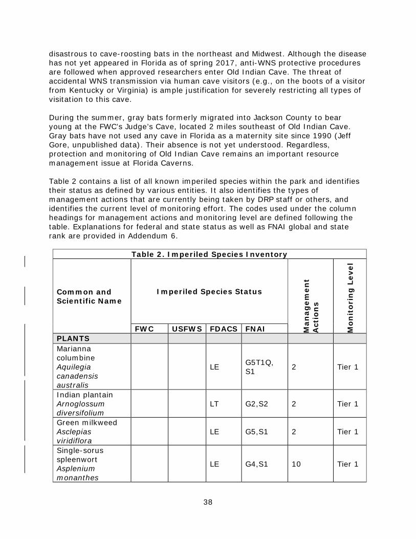
38
disastrous to cave-roosting bats in the northeast and Midwest. Although the disease has not yet appeared in Florida as of spring 2017, anti-WNS protective procedures are followed when approved researchers enter Old Indian Cave. The threat of accidental WNS transmission via human cave visitors (e.g., on the boots of a visitor from Kentucky or Virginia) is ample justification for severely restricting all types of visitation to this cave.
During the summer, gray bats formerly migrated into Jackson County to bear young at the FWC’s Judge’s Cave, located 2 miles southeast of Old Indian Cave. Gray bats have not used any cave in Florida as a maternity site since 1990 (Jeff Gore, unpublished data). Their absence is not yet understood. Regardless, protection and monitoring of Old Indian Cave remains an important resource management issue at Florida Caverns.
Table 2 contains a list of all known imperiled species within the park and identifies their status as defined by various entities. It also identifies the types of management actions that are currently being taken by DRP staff or others, and identifies the current level of monitoring effort. The codes used under the column headings for management actions and monitoring level are defined following the table. Explanations for federal and state status as well as FNAI global and state rank are provided in Addendum 6.
Table 2. Imperiled Species Inventory
Common and Scientific Name
Imperiled Species Status
Man
agem
ent
Act
ion
s
Mon
itor
ing
Lev
el
FWC USFWS FDACS FNAI PLANTS Marianna columbine Aquilegia canadensis australis
LE G5T1Q, S1 2 Tier 1
Indian plantain Arnoglossum diversifolium
LT G2,S2 2 Tier 1
Green milkweed Asclepias viridiflora
LE G5,S1 2 Tier 1
Single-sorus spleenwort Asplenium monanthes
LE G4,S1 10 Tier 1

39
Table 2. Imperiled Species Inventory
Common and Scientific Name
Imperiled Species Status
Man
agem
ent
Act
ion
s
Mon
itor
ing
Lev
el
FWC USFWS FDACS FNAI Southern lady fern Athyrium felix-femina asplenioides
LT 2 Tier 1
Flyr’s brickell-bush Brickellia cordifolia
LE G2G3,S2 1,2 Tier 1
Sweet shrub Calycanthus floridus
LE G5,S2 2 Tier 1
Catesby’s false bindweed Calystegia catesbiana
LE G3,S1 2 Tier 1
Wild comfrey Cynoglossum virginianum
LE G5,S2 2 Tier 1
Cream ticktrefoil Desmodium ochroleucum
LE G1G2,S1 2 Tier 1
Eastern false rue-anemone Enemion biternatum
LE G5,S1 2 Tier 1
Green fly orchid Epidendrum conopseum
CE 2 Tier 1
Wood spurge Euphorbia commutata
LE G5,S2 2 Tier 1
Godfrey’s swampprivet Forestiera godfreyi
LE G2,S2 2 Tier 1
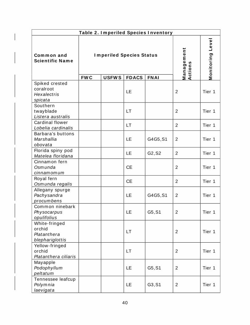
40
Table 2. Imperiled Species Inventory
Common and Scientific Name
Imperiled Species Status
Man
agem
ent
Act
ion
s
Mon
itor
ing
Lev
el
FWC USFWS FDACS FNAI Spiked crested coralroot Hexalectris spicata
LE 2 Tier 1
Southern twayblade Listera australis
LT 2 Tier 1
Cardinal flower Lobelia cardinalis LT 2 Tier 1
Barbara’s buttons Marshallia obovata
LE G4G5,S1 2 Tier 1
Florida spiny pod Matelea floridana LE G2,S2 2 Tier 1
Cinnamon fern Osmunda cinnamomum
CE 2 Tier 1
Royal fern Osmunda regalis CE 2 Tier 1
Allegany spurge Pachysandra procumbens
LE G4G5,S1 2 Tier 1
Common ninebark Physocarpus opulifolius
LE G5,S1 2 Tier 1
White-fringed orchid Platanthera blephariglottis
LT 2 Tier 1
Yellow-fringed orchid Platanthera ciliaris
LT 2 Tier 1
Mayapple Podophyllum peltatum
LE G5,S1 2 Tier 1
Tennessee leafcup Polymnia laevigata
LE G3,S1 2 Tier 1
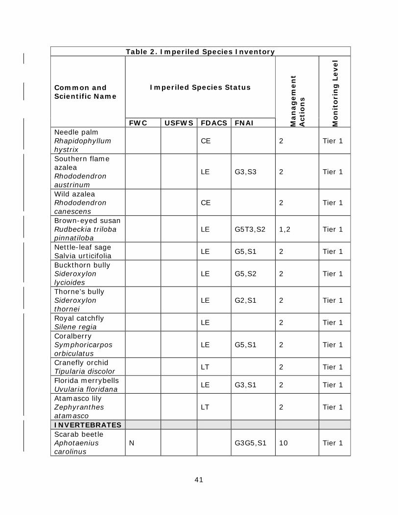
41
Table 2. Imperiled Species Inventory
Common and Scientific Name
Imperiled Species Status
Man
agem
ent
Act
ion
s
Mon
itor
ing
Lev
el
FWC USFWS FDACS FNAI Needle palm Rhapidophyllum hystrix
CE 2 Tier 1
Southern flame azalea Rhododendron austrinum
LE G3,S3 2 Tier 1
Wild azalea Rhododendron canescens
CE 2 Tier 1
Brown-eyed susan Rudbeckia triloba pinnatiloba
LE G5T3,S2 1,2 Tier 1
Nettle-leaf sage Salvia urticifolia LE G5,S1 2 Tier 1
Buckthorn bully Sideroxylon lycioides
LE G5,S2 2 Tier 1
Thorne’s bully Sideroxylon thornei
LE G2,S1 2 Tier 1
Royal catchfly Silene regia LE 2 Tier 1
Coralberry Symphoricarpos orbiculatus
LE G5,S1 2 Tier 1
Cranefly orchid Tipularia discolor LT 2 Tier 1
Florida merrybells Uvularia floridana LE G3,S1 2 Tier 1
Atamasco lily Zephyranthes atamasco
LT 2 Tier 1
INVERTEBRATES Scarab beetle Aphotaenius carolinus
N G3G5,S1 10 Tier 1
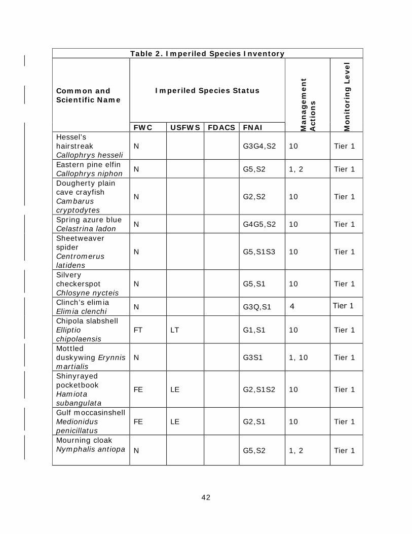
42
Table 2. Imperiled Species Inventory
Common and Scientific Name
Imperiled Species Status
Man
agem
ent
Act
ion
s
Mon
itor
ing
Lev
el
FWC USFWS FDACS FNAI Hessel’s hairstreak Callophrys hesseli
N G3G4,S2 10 Tier 1
Eastern pine elfin Callophrys niphon N G5,S2 1, 2 Tier 1
Dougherty plain cave crayfish Cambarus cryptodytes
N G2,S2 10 Tier 1
Spring azure blue Celastrina ladon N G4G5,S2 10 Tier 1
Sheetweaver spider Centromerus latidens
N G5,S1S3 10 Tier 1
Silvery checkerspot Chlosyne nycteis
N G5,S1 10 Tier 1
Clinch’s elimia Elimia clenchi N G3Q,S1
Chipola slabshell Elliptio chipolaensis
FT LT G1,S1 10 Tier 1
Mottled duskywing Erynnis martialis
N G3S1 1, 10 Tier 1
Shinyrayed pocketbook Hamiota subangulata
FE LE G2,S1S2 10 Tier 1
Gulf moccasinshell Medionidus penicillatus
FE LE G2,S1 10 Tier 1
Mourning cloak Nymphalis antiopa N G5,S2 1, 2 Tier 1
44 Tier 1
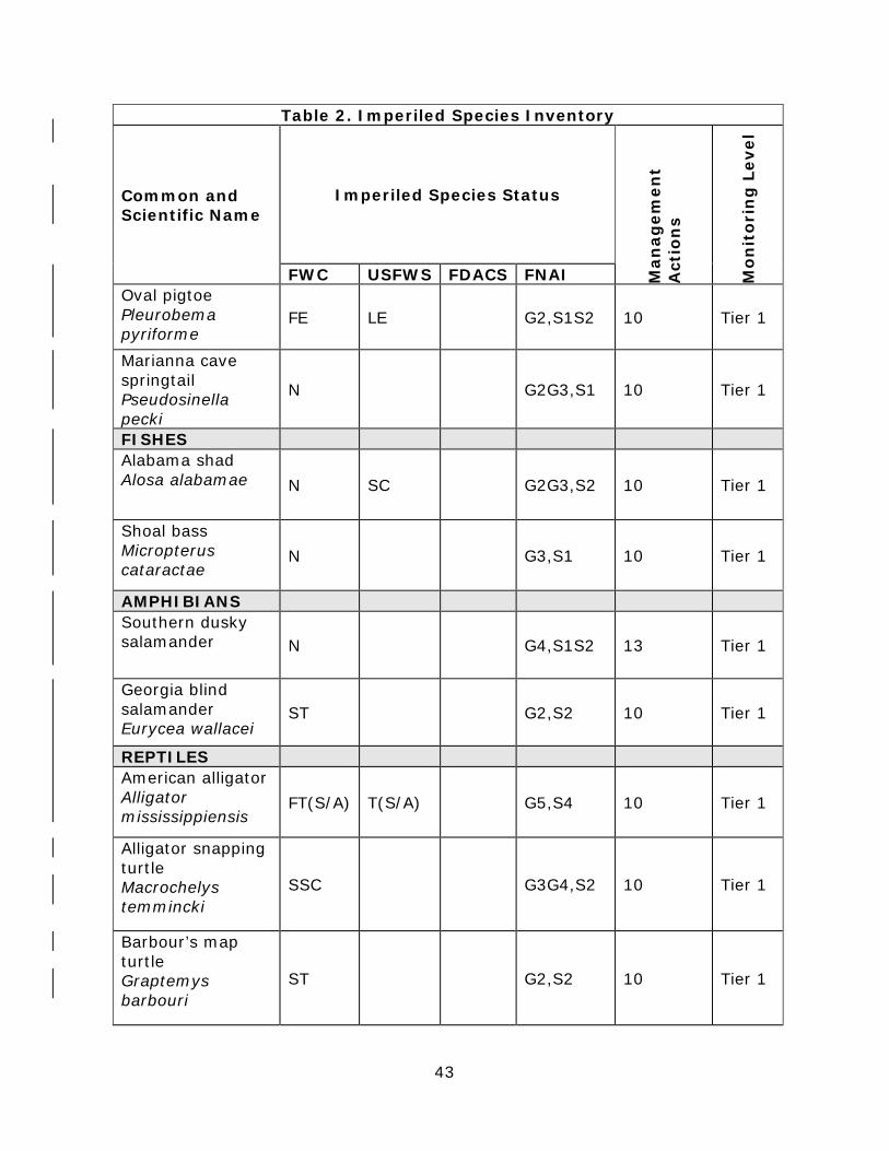
43
Table 2. Imperiled Species Inventory
Common and Scientific Name
Imperiled Species Status
Man
agem
ent
Act
ion
s
Mon
itor
ing
Lev
el
FWC USFWS FDACS FNAI Oval pigtoe Pleurobema pyriforme
FE LE G2,S1S2 10 Tier 1
Marianna cave springtail Pseudosinella pecki
N G2G3,S1 10 Tier 1
FISHES Alabama shad Alosa alabamae N SC G2G3,S2 10 Tier 1
Shoal bass Micropterus cataractae
N G3,S1 10 Tier 1
AMPHIBIANS Southern dusky salamander N G4,S1S2 13 Tier 1
Georgia blind salamander Eurycea wallacei
ST G2,S2 10 Tier 1
REPTILES American alligator Alligator mississippiensis
FT(S/A) T(S/A) G5,S4 10 Tier 1
Alligator snapping turtle Macrochelys temmincki
SSC G3G4,S2 10 Tier 1
Barbour’s map turtle Graptemys barbouri
ST G2,S2 10 Tier 1
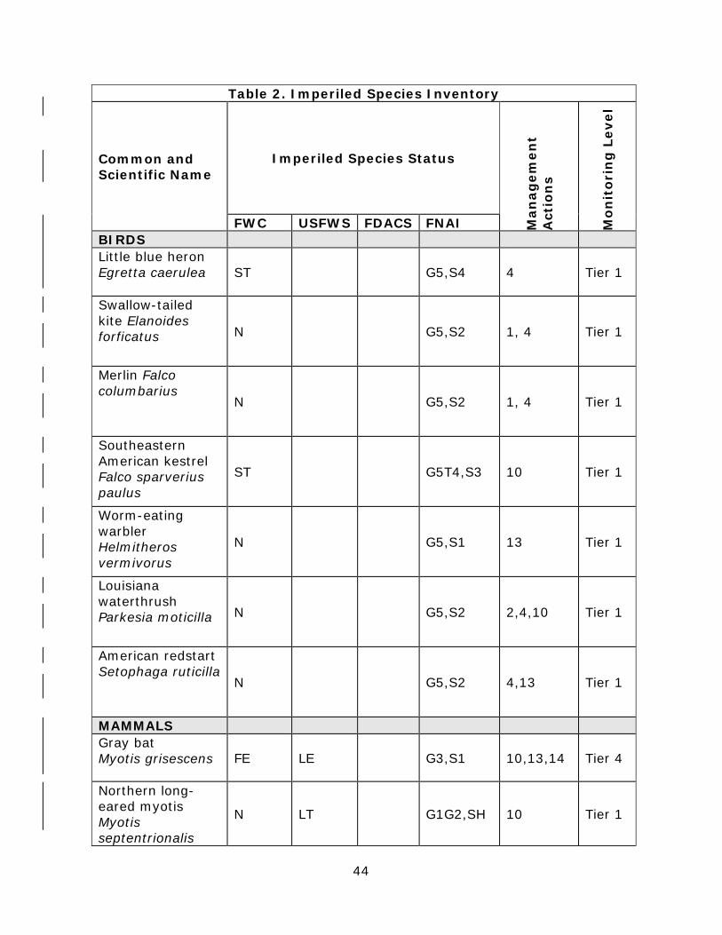
44
Table 2. Imperiled Species Inventory
Common and Scientific Name
Imperiled Species Status
Man
agem
ent
Act
ion
s
Mon
itor
ing
Lev
el
FWC USFWS FDACS FNAI BIRDS Little blue heron Egretta caerulea ST G5,S4 4 Tier 1
Swallow-tailed kite Elanoides forficatus N G5,S2 1, 4 Tier 1
Merlin Falco columbarius
N G5,S2 1, 4 Tier 1
Southeastern American kestrel Falco sparverius paulus
ST G5T4,S3 10 Tier 1
Worm-eating warbler Helmitheros vermivorus
N G5,S1 13 Tier 1
Louisiana waterthrush Parkesia moticilla N G5,S2 2,4,10 Tier 1
American redstart Setophaga ruticilla
N G5,S2 4,13 Tier 1
MAMMALS Gray bat Myotis grisescens FE LE G3,S1 10,13,14 Tier 4
Northern long-eared myotis Myotis septentrionalis
N LT G1G2,SH 10 Tier 1

45
Management Actions 1. Prescribed Fire 2. Exotic Plant Removal 3. Population Translocation/Augmentation/Restocking 4. Hydrological Maintenance/Restoration 5. Nest Boxes/Artificial Cavities 6. Hardwood Removal 7. Mechanical Treatment 8. Predator Control 9. Erosion Control 10. Protection from Visitor Impacts (establish buffers)/Law Enforcement 11. Decoys (Shorebirds) 12. Vegetation Planting 13. Outreach and Education 14. Other [If referenced in table, provide discussion in narrative] Monitoring Level Tier 1. Non-Targeted Observation/Documentation: includes documentation of species presence through casual/passive observation during routine park activities (i.e. not conducting species-specific searches). Documentation may be in the form of Wildlife Observation Forms, or other district specific methods used to communicate observations. Tier 2. Targeted Presence/Absence: includes monitoring methods/activities that are specifically intended to document presence/absence of a particular species or suite of species. Tier 3. Population Estimate/Index: an approximation of the true population size or population index based on a widely accepted method of sampling. Tier 4. Population Census: A complete count of an entire population with demographic analysis, including mortality, reproduction, emigration, and immigration. Tier 5. Other: may include habitat assessments for a particular species or suite of species or any other specific methods used as indicators to gather information about a particular species. Detailed management goals, objectives, and actions for imperiled species in this park are discussed in the Resource Management Program section of this component and the Implementation Component of this plan. Exotic and Nuisance Species Exotic species are plants or animals not native to Florida. Invasive exotic species are able to out-compete, displace, or destroy native species and their habitats, often because they have been released from the natural controls of their native range, such as diseases, predatory insects, etc. If left unchecked, invasive exotic plants and animals alter the character, productivity, and conservation values of the natural areas they invade. Exotic animal species include non-native wildlife species, free ranging domesticated pets or livestock, and feral animals. Because of the negative impacts to natural systems attributed to exotic animals, the DRP actively removes exotic animals from state parks, with priority being given to those species causing the greatest ecological damage. Exotic animals in the park include feral hogs, feral cats, brown anoles, Mediterranean geckos, armadillos, and coyotes. In some cases, native wildlife may also pose management problems or nuisances within state parks. A nuisance animal is an individual native animal whose presence or activities create special management problems. Examples of animal species from which nuisance cases may arise include venomous snakes or raccoons and alligators that are in public areas. Nuisance animals are dealt with on a case-by-

46
case basis in accordance with the DRP’s Nuisance and Exotic Animal Removal Standard. Detailed management goals, objectives, and actions for management of invasive exotic plants and exotic and nuisance animals are discussed in the Resource Management Program section of this component. Florida Caverns State Park is now bounded by suburban backyards in several locations. Unfortunately, many current and former exotic landscaping species are both well-adapted to the north Florida environment and are prolific. Their seeds are spread by birds, small mammals, and flood waters and the plants become established in the park. Exotic plants compete (may out-compete) for space, nutrients, and sunlight with rare native plant species. Maintaining minimal (maintenance control) levels of infestation in the park requires constant searching and herbicide treatment. This task will be on-going into the foreseeable future. Some of the most problematic species at Florida Caverns include Chinese privet, nandina, Chinese tallow, and Japanese climbing fern. Florida Caverns has and will continue to use park staff, OPS employees, Americorps volunteers, and private contractors to locate and treat exotic plant infestations in the park. Table 3 contains a list of the Florida Exotic Pest Plant Council (FLEPPC) Category I and II invasive, exotic plant species found within the park (FLEPPC 2015). The table also identifies relative distribution for each species and the management zones in which they are known to occur. An explanation of the codes is provided following the table. For an inventory of all exotic species found within the park, see Addendum 5.
Table 3. Inventory of FLEPPC Category I and II Exotic Plant Species Common and
Scientific Name FLEPPC
Category Distribution Management Zone (s)
PLANTS Mimosa Albizia julibrissin I 1 1,2,3,4A,5,11,
19,20,21
Coral ardisia Ardisia crenata I 2 19
Japanese ardesia Ardisia japonica II 2 2,3,5,7
Wild taro Colocasia esculenta I 1 8,19
Silverthorn Eleagnus pungens II 1 8,9,11,17,18,19
,20,21,22
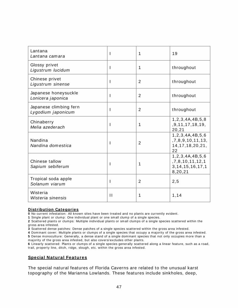
47
Distribution Categories 0 No current infestation: All known sites have been treated and no plants are currently evident. 1 Single plant or clump: One individual plant or one small clump of a single species. 2 Scattered plants or clumps: Multiple individual plants or small clumps of a single species scattered within the gross area infested. 3 Scattered dense patches: Dense patches of a single species scattered within the gross area infested. 4 Dominant cover: Multiple plants or clumps of a single species that occupy a majority of the gross area infested. 5 Dense monoculture: Generally, a dense stand of a single dominant species that not only occupies more than a majority of the gross area infested, but also covers/excludes other plants. 6 Linearly scattered: Plants or clumps of a single species generally scattered along a linear feature, such as a road, trail, property line, ditch, ridge, slough, etc. within the gross area infested. Special Natural Features The special natural features of Florida Caverns are related to the unusual karst topography of the Marianna Lowlands. These features include sinkholes, deep,
Lantana Lantana camara I 1 19
Glossy privet Ligustrum lucidum I 1 throughout
Chinese privet Ligustrum sinense I 2 throughout
Japanese honeysuckle Lonicera japonica I 2 throughout
Japanese climbing fern Lygodium japonicum I 2 throughout
Chinaberry Melia azederach I 1
1,2,3,4A,4B,5,8,9,11,17,18,19, 20,21
Nandina Nandina domestica I 2
1,2,3,4A,4B,5,6,7,8,9,10,11,13, 14,17,18,20,21,22
Chinese tallow Sapium sebiferum I 1
1,2,3,4A,4B,5,6,7,8,10,11,12,13,14,15,16,17,18,20,21
Tropical soda apple Solanum viarum I 2 2,5
Wisteria Wisteria sinensis II 1 1,14

48
beautiful blue springs, cliffs, limestone bluffs, rock outcroppings, and a unique assemblage of spectacularly decorated limestone caves, of which the Florida Cavern is an outstanding example. Cultural Resources This section addresses the cultural resources present in the park that may include archaeological sites, historic buildings and structures, cultural landscapes, and collections. The Florida Department of State (FDOS) maintains the master inventory of such resources through the Florida Master Site File (FMSF). State law requires that all state agencies locate, inventory, and evaluate cultural resources that appear to be eligible for listing in the National Register of Historic Places. Addendum 7 contains the FDOS, Division of Historical Resources (DHR) management procedures for archaeological and historical sites and properties on state-owned or controlled properties; the criteria used for evaluating eligibility for listing in the National Register of Historic Places, and the Secretary of Interior’s definitions for the various preservation treatments (restoration, rehabilitation, stabilization, and preservation). For the purposes of this plan, significant archaeological site, significant structure, and significant landscape means those cultural resources listed or eligible for listing in the National Register of Historic Places. The terms archaeological site, historic structure, or historic landscape refer to all resources that will become 50 years old during the term of this plan. Condition Assessment Evaluating the condition of cultural resources is accomplished using a three-part evaluation scale, expressed as good, fair, and poor. These terms describe the present condition, rather than comparing what exists to the ideal condition. Good describes a condition of structural stability and physical wholeness, where no obvious deterioration other than normal occurs. Fair describes a condition in which there is a discernible decline in condition between inspections, and the wholeness or physical integrity is and continues to be threatened by factors other than normal wear. A fair assessment is usually a cause for concern. Poor describes an unstable condition where there is palpable, accelerating decline, and physical integrity is being compromised quickly. A resource in poor condition suffers obvious declines in physical integrity from year to year. A poor condition suggests immediate action is needed to reestablish physical stability. Level of Significance Applying the criteria for listing in the National Register of Historic Places involves the use of contexts as well as an evaluation of integrity of the site. A cultural resource’s significance derives from its historical, architectural, ethnographic, or archaeological context. Evaluation of cultural resources will result in a designation of NRL (National Register or National Landmark Listed or located in an NR district), NR (National Register eligible), NE (not evaluated), or NS (not significant) as indicated in the table at the end of this section.
49
There are no criteria for determining the significance of collections or archival material. Usually, significance of a collection is based on what or whom it may represent. For instance, a collection of furniture from a single family and a particular era in connection with a significant historic site would be considered highly significant. In the same way, a high-quality collection of artifacts from a significant archaeological site would be of important significance. A large herbarium collected from a specific park over many decades could be valuable to resource management efforts. Archival records are most significant as a research source. Any records depicting critical events in the park’s history, including construction and resource management efforts, would all be significant. The following is a summary of the FMSF inventory. In addition, this inventory contains the evaluation of significance. Prehistoric and Historic Archaeological Sites Desired Future Condition: All significant archaeological sites within the park that represent Florida’s cultural periods or significant historic events or persons are preserved in good condition in perpetuity, protected from physical threats and interpreted to the public. Description: Human beings are known to have used portions of what is now Florida Caverns State Park for at least 5,000 years. Many upland areas of the Panhandle once supported Native American village life, and two village sites have been recorded within the park. Twenty-four archaeological sites located in the park are recorded in the FMSF; however, the park has not yet been systematically surveyed. Such a survey would likely result in an expansion of the current total, and aid in better characterizing the extent of aboriginal occupation in the park. Cultural resource information in the FMSF, maintained by the Division of Historical Resources, ranges from pre-Contact (prior to 1500 AD) Native American habitation sites through extensive Works Progress Administration (WPA) and Civilian Conservation Corps (CCC) projects of the 1930s and early 1940s. In addition, a cultural resources sensitivity model was developed for the park (Collins et al. 2012), which captured nearly 85% of the park’s recorded locations for archaeological sites in the defined high or medium sensitivity areas. Most of the aboriginal sites at Florida Caverns are located in upland areas near cave entrances. This is probably due to an understandable tendency to locate campsites near a natural shelter. As recently as the 1940s, archaeologists working during the initial park development period discovered barefoot tracks in “New Cave,” which they believed may have been those of Native Americans (Fairbanks 1941). Several site locations are difficult to pinpoint with any accuracy. These include 8JA110 (Sugar Mill Hole Spring) and 8JA112 (Blue Hole). Four other sites: 8JA54 (Parking Area), 8JA55 (Cave #10), 8JA56 (Rock Shelter), and 8JA57 (New Cave) were combined into 8JA3 as the result of insights into their common Fort Walton cultural affiliation. This information was collected during Visitor Center parking lot construction in the 1940s (Bullen 1949). Similar resources were found at 8JA58 and 8JA59, located nearby. A second apparent village site is located near the Blue Hole Swimming Area and is recorded as 8JA82. A habitation site of unidentified cultural
50
affiliation, 8JA92, was identified in 1961 as: “located 3/8 mile north, north east of the Negro Picnic Area” (see below). Two cave sites, 8JA1545 (Ranger Cave) and 8JA1555, the latter an apparent shelter site, have also been recorded. Amongst several 19th century sites listed in the FMSF is Carter’s Mill, site 8JA1073. Remnants of the mill foundation and dam are still visible along the Blue Hole run adjacent to the Federal Fish Hatchery site. Other 19th century sites would likely be revealed during a cultural resource survey. The largest cultural resource, both in term of acreage and number of components, is the park itself, which has been open for public recreation and enjoyment since 1942. Florida Caverns State Park is significant in the twentieth century history of Florida as one of nine elements of the New Deal-inspired Florida state park system and as one of the physical expressions of early 20th century recreation planning. Until the 1930s, the State of Florida sponsored, owned, or operated parks as monuments or memorial facilities. The components of this early, first system of state parks were the physical expression of the idea that Floridians, increasingly members of an urban population, needed and indeed possessed a right to communion with nature. That idea, one of the intellectual underpinnings of the conservation movement of the Progressive Era (1890-1920) realized its most widespread expression during the peacetime administrations of Franklin Delano Roosevelt (1933-1941). The ideas of conservationists were made real as the Great Depression (1929-1941), brought widespread unemployment and near economic collapse. Floridians had already suffered nearly five years of unrelieved economic disasters, with Mediterranean fruit fly infestations, hurricanes, and the collapse of the land boom bubble. The Wall Street Crash of 1929 only confirmed that the whole nation faced hard times. The resulting Depression seemed to overwhelm Americans. Ending it seemed beyond the abilities of ordinary people, and programs to aid persons in serious want took the place of economic development in many areas of the country, Florida among them. Problem-solving programs in which people could play a part while contributing to the end of hard times gained popularity. Among those problems were two of particular importance; lack of employment opportunities for young men who were of an age to enter the job market, and the degradation of the land. Although the problem of unemployed young men was often described in terms of their inability to contribute to the support of their families, another aspect of the problem was what to do with an army of unskilled young men who had left school due to economic hardship and whose existence as unemployed persons would surely slow or even halt economic recovery. The land, too, had fallen upon hard times. Although a Dust Bowl like that of the Great Plains never afflicted most of the rest of the country, almost all sections had experienced massive land and topsoil degradation. The South was particularly beset with the consequences of strip mining, timber exploitation, single crop agriculture, and poor farming practices; sterilized landscapes, river floods, enormous erosion gullies, and farm families forced to abandon a treasured way of life. Among the New Deal programs organized to address aspects of the problems of
51
youth unemployment, the Civilian Conservation Corps, or CCC, may have had the most emotionally profound effect. This agency hired the unskilled and unemployable young, put them to work under military administration, and employed skilled local men--also hitherto unemployed--to transmit the rudimentary skills required to do a job. The CCC took on two jobs, usually at the same time. The first was improving or restoring the degraded landscape (some of those actions are now frequently viewed as inappropriate land management actions), and the second, developing public recreation facilities according to professionally drawn plans. An impressive collection of facilities was constructed throughout Florida, and a considerable portion of them survives in daily use. Their builders, the young men of the 1930s, visit and revisit their creations regularly. They and many other park visitors consider the rustic appearance of CCC buildings as “real” park architecture. Condition Assessment: The recorded Native American resources at Florida Caverns State Park, including 8JA3 and -1555 generally are in fair condition; they are little affected by natural forces. However, instances of illegal soil screening (“pot hunting”) in front of cave entrances have occurred in the park. A few sites, 8JA58, -59, -110, -112, -1073, and -1545 have not been visited recently. Their recorded locations in FMSF documents are vague and should be revisited for confirmation. They are considered in fair condition, and 8JA92 is also in fair condition, based on lack of surface disturbance. General Management Measures: The park’s archaeological sites will be managed using preservation as the treatment standard. Preservation includes protection from damage from resource management, natural causes, construction or human damage including looting. Historic Structures Desired Future Condition: All significant historic structures and landscapes that represent historic events or persons are preserved in good condition in perpetuity, protected from physical threats and interpreted to the public. Description: Among the earliest recognized 20th century cultural elements in the park was the Federal Fish Hatchery located on the west end of the property. The site features earthworks, floodgates, stone walls, and stone posts, which are incompletely documented in the FMSF. The Survey of New Deal Era Resources described several individual structures, but the hatchery complex itself remains an unrecorded multiple resource area. It was developed at approximately the same time as the Visitor Center and Florida Cavern tour cave, though it opened slightly earlier, in the late 1930s. It was apparently constructed by local contractors for the U.S. Department of Commerce under WPA funding. Extant hatchery structures include: 8JA77 (an office), 8JA74, -76, and -78 (three residential structures), 8JA75 and -79 (two outbuildings), and 8JA80 (the pump/control house). All CCC structures are seated on masonry foundations; exterior wall fabric is generally limestone veneer trimmed in stucco and painted wood. Hatchery area roads are bordered by an extensive system of low, limestone masonry walls that terminate in large, impressive gateposts. The hatchery was designed to have up to
52
17 ponds, and many of these are still visible, although they are dry. The ponds were served by a substantial water control and pumping system, clear evidences of which remain quite apparent. The pump house or control house is recorded in the FMSF as 8JA80. The hatchery complex presents a virtually complete time capsule within a time capsule, both contemporary with and stylistically separate from the rustic park structures of CCC origin. The Federal Fish Hatchery was abandoned not long after it was established. This was evidently because the highly porous (“Swiss cheese”) nature of the limestone below the ponds made it impossible to keep water in them. The two CCC structures that remain in use in the park are a small pump house (8JA67), and the large Visitor Center (8JA68). Both structures are of stone masonry on concrete foundations. The Visitor Center, originally constructed as “the Combination Building,” is a split-level structure whose southern elevation has two full floors or levels. The lower level contains rest rooms and a gift shop; the upper story is a single large room with a southern terrace, which forms the roof of much of the lower level. The single large room was originally constructed as an open-sided rustic pavilion with masonry gable ends, each with a large interior fireplace. Many of the park day use facilities date from after 1950 and are in the process of being recorded to the FMSF by Bureau of Natural Resources (BNCR) staff. The Hickory Picnic Shelter (building 12), appears to be a post-World War II execution of the classic state park rustic picnic pavilion. It is similar to massive shelters in the other CCC parks, and the design might be considered a mark distinguishing the CCC parks from those developed by other New Deal era agencies. In addition, undocumented is the original SP-12 CCC camp location. It was located northwest of the Yancy Bridge, just off River Forest road in Marianna. The original camp location is now apparently occupied by a private residence. As with much of the South, Florida public facilities were racially segregated until the late 1960s, and state parks like Florida Caverns had separate facilities for African Americans. When segregation ended, the historic “Negro Picnic Area” at Florida Caverns was re-designated as “Beech” picnic shelter. The Negro Picnic Area can be identified on 1950s park base maps and should be thoroughly documented. Additional park infrastructure, i.e. the east-west park drive, boat ramp, camping area, Blue Hole swimming area, and equestrian camping area were built by the Florida Park Service from the 1960s through the 1980s. Condition Assessment: Resources of the Federal Fish Hatchery are in fair condition, with the exception of the pump house/water control structure, which is in need of stabilization, and the stone masonry walls and gateposts, which are in poor condition. Foundations for these elements appear to be minimal, and ordinary stresses have caused some areas of the wall to separate from their foundations. The appearance and condition of the gateposts have declined markedly in recent years. Ponds and water control structures have remained in fair condition; the dams that fed the pump system have been little affected by seasonal flooding. Both CCC structures remain in day-to-day use and are in fair condition. The pump
53
house, a service structure, is also used for short-term storage of various materials and has suffered for it. The Visitor Center is perhaps the most visited public structure in the park. Consistent maintenance, as well as major repairs during the past decade to address leaks through the terrace and to resurface the roof has enabled the structure to retain its fair condition despite its numbers of visitors. The Hickory Picnic Shelter is in fair condition. Collection objects in the Visitor Center are in fair condition. The restroom constructed in 1956 across from the Beech Picnic Pavilion is in poor condition and is being considered for removal. Consultation with DHR and documentation of the building will be completed prior to its removal. General Management Measures: Preservation is the general treatment standard applied to historic buildings, structures, and landscapes in the park. Collections Desired Future Condition: All historic, natural history, and archaeological objects within the park that represent Florida’s cultural periods, significant historic events or persons, or natural history specimens are preserved in good condition in perpetuity, protected from physical threats and interpreted to the public. Description: A collection of archaeological artifacts (chert knives, scrapers, and pottery fragments) is displayed at the Visitor Center, on loan from the Division of Historical Resources. The park houses some CCC-era blueprints from the early development period. However, the majority of CCC correspondence and design documents are archived at the Division of Historical Resources and the Florida Park Service Historic Collections Facility and Archives in Tallahassee. In reviewing early correspondence, it appears a number of historical, archaeological, and fossil materials have been collected over the years and removed from the park. This material is believed to be housed in a variety of institutions throughout the U.S. Condition Assessment: The park’s collections located in the Visitor Center are generally in good condition. Any issues or threats related to the condition of the park’s collections that require management action including repairs or conservation, improved storage, improved climate control or relocation of collections, will be conducted in consultation with BNCR cultural resources staff. General Management Measures: The park has developed a Scope of Collections Statement for the historical materials housed at the Visitor Center. Climate, humidity, and pest control measures need to be periodically evaluated for their adequacy in conserving collection objects, and recommendations for subsequent monitoring activities need to occur in order to ensure their conservation. It would be useful to compile data on materials believed to be collected from the park, which now may be archived elsewhere. Possible locations may include the Smithsonian, National CCC archives, the Florida Museum of Natural History, and the
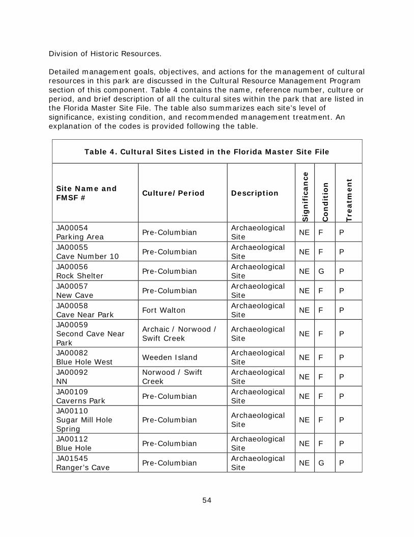
54
Division of Historic Resources. Detailed management goals, objectives, and actions for the management of cultural resources in this park are discussed in the Cultural Resource Management Program section of this component. Table 4 contains the name, reference number, culture or period, and brief description of all the cultural sites within the park that are listed in the Florida Master Site File. The table also summarizes each site’s level of significance, existing condition, and recommended management treatment. An explanation of the codes is provided following the table.
Table 4. Cultural Sites Listed in the Florida Master Site File
Site Name and FMSF # Culture/Period Description
Sig
nif
ican
ce
Con
dit
ion
Trea
tmen
t
JA00054 Parking Area Pre-Columbian Archaeological
Site NE F P
JA00055 Cave Number 10 Pre-Columbian Archaeological
Site NE F P
JA00056 Rock Shelter Pre-Columbian Archaeological
Site NE G P
JA00057 New Cave Pre-Columbian Archaeological
Site NE F P
JA00058 Cave Near Park Fort Walton Archaeological
Site NE F P
JA00059 Second Cave Near Park
Archaic / Norwood / Swift Creek
Archaeological Site NE F P
JA00082 Blue Hole West Weeden Island Archaeological
Site NE F P
JA00092 NN
Norwood / Swift Creek
Archaeological Site NE F P
JA00109 Caverns Park Pre-Columbian Archaeological
Site NE F P
JA00110 Sugar Mill Hole Spring
Pre-Columbian Archaeological Site NE F P
JA00112 Blue Hole Pre-Columbian Archaeological
Site NE F P
JA01545 Ranger’s Cave Pre-Columbian Archaeological
Site NE G P
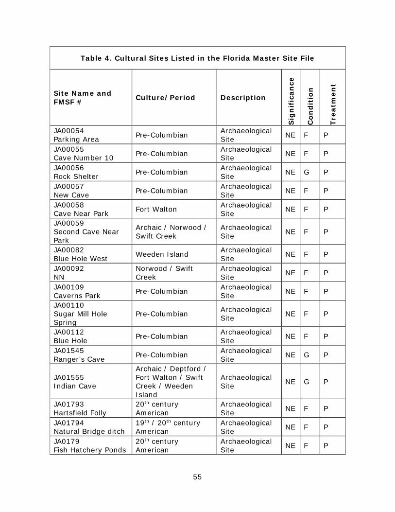
55
Table 4. Cultural Sites Listed in the Florida Master Site File
Site Name and FMSF # Culture/Period Description
Sig
nif
ican
ce
Con
dit
ion
Trea
tmen
t
JA00054 Parking Area Pre-Columbian Archaeological
Site NE F P
JA00055 Cave Number 10 Pre-Columbian Archaeological
Site NE F P
JA00056 Rock Shelter Pre-Columbian Archaeological
Site NE G P
JA00057 New Cave Pre-Columbian Archaeological
Site NE F P
JA00058 Cave Near Park Fort Walton Archaeological
Site NE F P
JA00059 Second Cave Near Park
Archaic / Norwood / Swift Creek
Archaeological Site NE F P
JA00082 Blue Hole West Weeden Island Archaeological
Site NE F P
JA00092 NN
Norwood / Swift Creek
Archaeological Site NE F P
JA00109 Caverns Park Pre-Columbian Archaeological
Site NE F P
JA00110 Sugar Mill Hole Spring
Pre-Columbian Archaeological Site NE F P
JA00112 Blue Hole Pre-Columbian Archaeological
Site NE F P
JA01545 Ranger’s Cave Pre-Columbian Archaeological
Site NE G P
JA01555 Indian Cave
Archaic / Deptford / Fort Walton / Swift Creek / Weeden Island
Archaeological Site NE G P
JA01793 Hartsfield Folly
20th century American
Archaeological Site NE F P
JA01794 Natural Bridge ditch
19th / 20th century American
Archaeological Site NE F P
JA0179 Fish Hatchery Ponds
20th century American
Archaeological Site NE F P
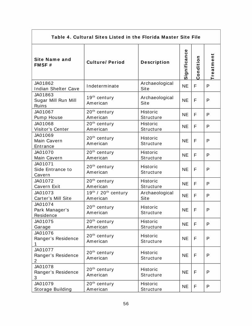
56
Table 4. Cultural Sites Listed in the Florida Master Site File
Site Name and FMSF # Culture/Period Description
Sig
nif
ican
ce
Con
dit
ion
Trea
tmen
t
JA01862 Indian Shelter Cave Indeterminate Archaeological
Site NE F P
JA01863 Sugar Mill Run Mill Ruins
19th century American
Archaeological Site NE F P
JA01067 Pump House
20th century American
Historic Structure NE F P
JA01068 Visitor’s Center
20th century American
Historic Structure NE F P
JA01069 Main Cavern Entrance
20th century American
Historic Structure NE F P
JA01070 Main Cavern
20th century American
Historic Structure NE F P
JA01071 Side Entrance to Cavern
20th century American
Historic Structure NE F P
JA01072 Cavern Exit
20th century American
Historic Structure NE F P
JA01073 Carter’s Mill Site
19th / 20th century American
Archaeological Site NE F P
JA01074 Park Manager’s Residence
20th century American
Historic Structure NE F P
JA01075 Garage
20th century American
Historic Structure NE F P
JA01076 Ranger’s Residence 1
20th century American
Historic Structure NE F P
JA01077 Ranger’s Residence 2
20th century American
Historic Structure NE F P
JA01078 Ranger’s Residence 3
20th century American
Historic Structure NE F P
JA01079 Storage Building
20th century American
Historic Structure NE F P
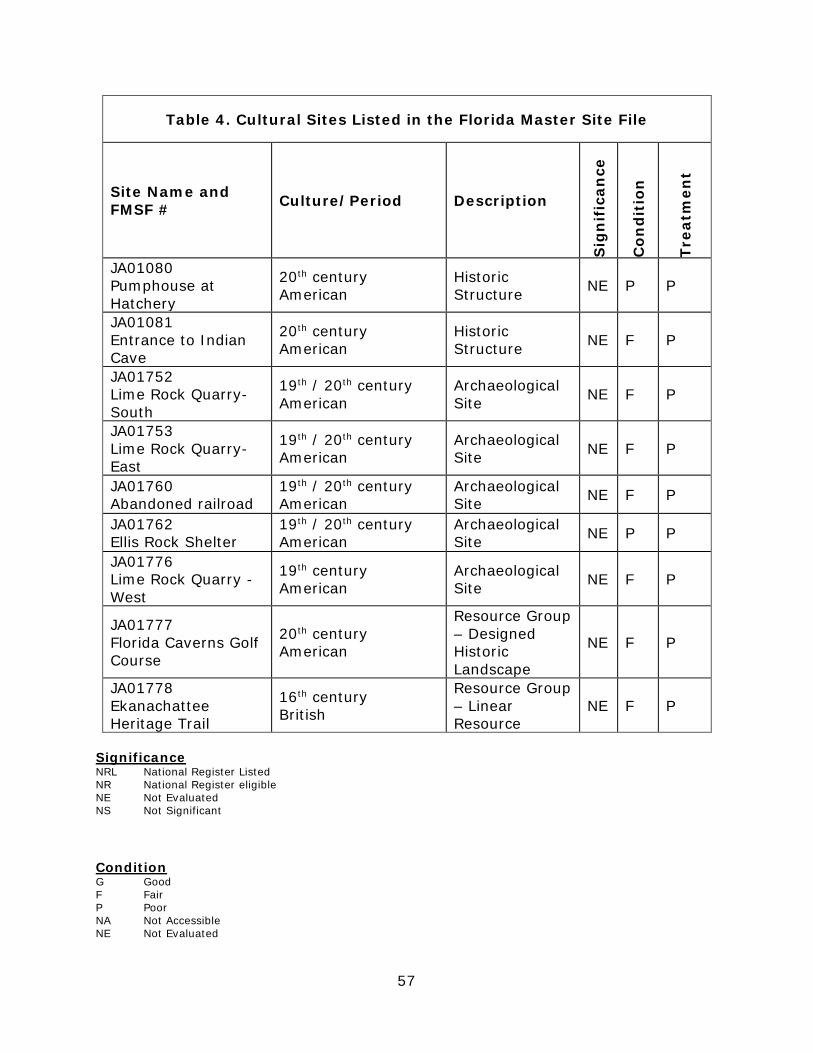
57
Table 4. Cultural Sites Listed in the Florida Master Site File
Site Name and FMSF # Culture/Period Description
Sig
nif
ican
ce
Con
dit
ion
Trea
tmen
t
JA01080 Pumphouse at Hatchery
20th century American
Historic Structure NE P P
JA01081 Entrance to Indian Cave
20th century American
Historic Structure NE F P
JA01752 Lime Rock Quarry-South
19th / 20th century American
Archaeological Site NE F P
JA01753 Lime Rock Quarry-East
19th / 20th century American
Archaeological Site NE F P
JA01760 Abandoned railroad
19th / 20th century American
Archaeological Site NE F P
JA01762 Ellis Rock Shelter
19th / 20th century American
Archaeological Site NE P P
JA01776 Lime Rock Quarry - West
19th century American
Archaeological Site NE F P
JA01777 Florida Caverns Golf Course
20th century American
Resource Group – Designed Historic Landscape
NE F P
JA01778 Ekanachattee Heritage Trail
16th century British
Resource Group – Linear Resource
NE F P
Significance NRL National Register Listed NR National Register eligible NE Not Evaluated NS Not Significant Condition G Good F Fair P Poor NA Not Accessible NE Not Evaluated
58
Recommended Treatment RS Restoration RH Rehabilitation ST Stabilization P Preservation R Removal N/A Not Applicable
Resource Management Program Management Goals, Objectives and Actions Measurable objectives and actions have been identified for each of the DRP’s management goals for Florida Caverns State Park. Please refer to the Implementation Schedule and Cost Estimates in the Implementation Component of this plan for a consolidated spreadsheet of the recommended actions, measures of progress, target year for completion, and estimated costs to fulfill the management goals and objectives of this park. While the DRP utilizes the 10-year management plan to serve as the basic statement of policy and future direction for each park, a number of annual work plans provide more specific guidance for DRP staff to accomplish many of the resource management goals and objectives of the park. Where such detailed planning is appropriate to the character and scale of the park’s natural resources, annual work plans are developed for prescribed fire management, exotic plant management, and imperiled species management. Annual or longer-term work plans are developed for natural community restoration and hydrological restoration. The work plans provide the DRP with crucial flexibility in its efforts to generate and implement adaptive resource management practices in the state park system. The work plans are reviewed and updated annually. Through this process, the DRP’s resource management strategies are systematically evaluated to determine their effectiveness. The process and the information collected is used to refine techniques, methodologies, and strategies, and ensures that each park’s prescribed management actions are monitored and reported as required by Sections 253.034 and 259.037, Florida Statutes. The goals, objectives, and actions identified in this management plan will serve as the basis for developing annual work plans for the park. The 10-year management plan is based on conditions that exist at the time the plan is developed. The annual work plans provide the flexibility needed to adapt to future conditions as they change during the 10-year management planning cycle. As the park’s annual work plans are implemented through the 10-year cycle, it may become necessary to adjust the management plan’s priority schedules and cost estimates to reflect these changing conditions. Natural Resource Management
59
Hydrological Management Goal: Protect water quality and quantity in the park, restore hydrology to the extent feasible, and maintain the restored condition. The natural hydrology of most state parks has been impaired prior to acquisition to one degree or another. Florida’s native habitats are precisely adapted to natural drainage patterns and seasonal water level fluctuations, and variations in these factors frequently determine the types of natural communities that occur on a particular site. Even minor changes to natural hydrology can result in the loss of plant and animal species from a landscape. Restoring state park lands to original natural conditions often depends on returning natural hydrological processes and conditions to the park. This is done primarily by filling or plugging ditches, removing obstructions to surface water “sheet flow,” installing culverts or low-water crossings on roads, and installing water control structures to manage water levels. Objective A: Conduct/obtain an assessment of the park’s hydrological restoration needs.
Action 1 Continue assessing the impacts of seasonal flooding to the park drive and campground.
Action 2 Following the recommendations of the recent engineering study at the park, evaluate the feasibility of building an elevated causeway (e.g., determine impacts to natural resources).
Action 3 If determined feasible, develop a hydrological restoration plan. The primary hydrological issue at Florida Caverns State Park is the damming effect the park drive periodically has across the Chipola River floodplain. Most of the year, the Chipola River remains within its banks and passes under the bridge on the park drive. However, during frequent winter-spring flooding periods, the river can rise 10 feet or more and fill up most of the park’s floodplain. When this occurs, the park drive can be submerged for several hundred yards and the campground must be evacuated. A recent engineering study of this issue concluded that adding culverts under the park drive would not solve the problem. The only measure that was deemed effective would be to change the park drive within the Chipola floodplain into an elevated causeway. For reasons of expense and resource impacts, this measure is not currently considered a feasible approach to a seasonal flooding problem. A second hydrological issue pertains to agricultural activities outside the park, which may be impacting the park’s water quality. Due in part to the park’s karst topography, its water resources are extremely susceptible to the effects of agricultural activities taking place directly to the north. Within the park there are 6 sinks and rises, 2 springs, a spring-fed river, 3 spring-fed streams, many sinkholes, more than 30 dry caves, and numerous aquatic caves, many that connect to dry cave layers. Above the park there are also sinks, rises and springs, caves,
60
sinkholes, and spring-fed streams. These karst features serve as vectors to transport pollutants into the Floridan Aquifer and into the surface and ground water within the park. Dangers above the park include cattle farming, hay farming, dairy farming, and row-crop farming. The runoff from the operations involving cattle undoubtable influence the water quality as does the runoff from fertilizer used in row-crop and hay farming. Above the park, on the west side of the Chipola River on the floodplain is preserved under Northwest Florida Water Management District continuously for about three miles. The east bank above the park however for one mile is cattle farming and the cattle roam all the way to the Baltzell Spring and along the Chipola River. After that one-mile stretch the property is under the preservation of the NWFWMD for the next couple of miles. To the northeast of the park, cattle farming is a large industry and has been for many years, currently under the operation of Southern Cattleman’s Association that holds more than 10,000 acres. The spring-fed stream on the east side of the park called Muddy Branch originates a couple of miles to the northeast of the park in a dairy farm. This stream flows into the park and joins into the Chipola River within park boundaries. Also noteworthy is that there is a water-bottling company to the northeast of the park. As of this writing, they were drawing the water for that operation from the aquifer at a location southwest of the park several miles away. This will be important to monitor, as there are many springs to the north of the park that would be a viable source for them if obtained. Objective B: Monitor and analyze water resources in the park.
Action 1 Monitor water quality at Muddy Branch, Chipola River, and elsewhere in the park as needed.
Park management proposes to initiate water quality monitoring by periodically collecting data at sites including Muddy Branch, the Chipola River, and aquatic natural communities. Natural Communities Management Goal: Restore and maintain the natural communities/habitats of the park. The DRP practices natural systems management. In most cases, this entails returning fire to its natural role in fire-dependent natural communities. Other methods to implement this goal include large-scale restoration projects as well as smaller scale natural communities improvements. Following are the natural community management objectives and actions recommended for the state park. Prescribed Fire Management Prescribed fire is used to mimic natural lightning-set fires, which are one of the primary natural forces that shaped Florida’s ecosystems. Prescribed burning increases the abundance and health of many wildlife species. A large number of
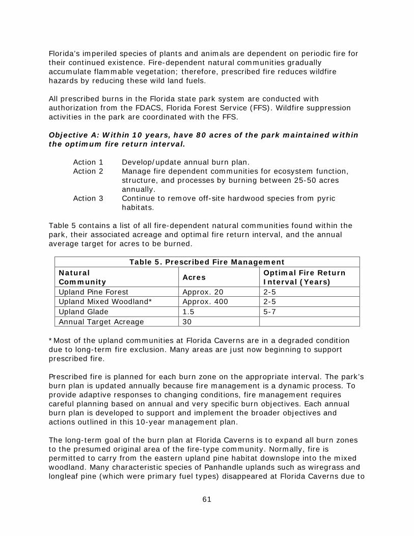
61
Florida’s imperiled species of plants and animals are dependent on periodic fire for their continued existence. Fire-dependent natural communities gradually accumulate flammable vegetation; therefore, prescribed fire reduces wildfire hazards by reducing these wild land fuels.
All prescribed burns in the Florida state park system are conducted with authorization from the FDACS, Florida Forest Service (FFS). Wildfire suppression activities in the park are coordinated with the FFS.
Objective A: Within 10 years, have 80 acres of the park maintained within the optimum fire return interval.
Action 1 Develop/update annual burn plan. Action 2 Manage fire dependent communities for ecosystem function,
structure, and processes by burning between 25-50 acres annually.
Action 3 Continue to remove off-site hardwood species from pyric habitats.
Table 5 contains a list of all fire-dependent natural communities found within the park, their associated acreage and optimal fire return interval, and the annual average target for acres to be burned.
Table 5. Prescribed Fire Management Natural Community Acres Optimal Fire Return
Interval (Years) Upland Pine Forest Approx. 20 2-5Upland Mixed Woodland* Approx. 400 2-5Upland Glade 1.5 5-7Annual Target Acreage 30
*Most of the upland communities at Florida Caverns are in a degraded conditiondue to long-term fire exclusion. Many areas are just now beginning to supportprescribed fire.
Prescribed fire is planned for each burn zone on the appropriate interval. The park’s burn plan is updated annually because fire management is a dynamic process. To provide adaptive responses to changing conditions, fire management requires careful planning based on annual and very specific burn objectives. Each annual burn plan is developed to support and implement the broader objectives and actions outlined in this 10-year management plan.
The long-term goal of the burn plan at Florida Caverns is to expand all burn zones to the presumed original area of the fire-type community. Normally, fire is permitted to carry from the eastern upland pine habitat downslope into the mixed woodland. Many characteristic species of Panhandle uplands such as wiregrass and longleaf pine (which were primary fuel types) disappeared at Florida Caverns due to

62
past fire suppression. Upland hardwood species such as laurel oak, water oak, sweetgum, dogwood, and loblolly pines have invaded these long-unburned uplands. These off-site species changed the makeup of these fire-type communities and put them on their way to succession from an upland pine to an upland hardwood community. With succession, the characteristics of the open, longleaf dominated habitat with its lush, vegetative ground cover has been degraded. This loss of low-stature grasses and forbs made these areas less attractive to the wildlife of the upland pine community. Deer, wild turkey, and northern bobwhite had less cover for protection. Similarly, gopher tortoise and Sherman’s fox squirrel had less open areas to move from site to site. The upland habitat restoration and burn program at Florida Caverns has been in place now since 2010. Since that time burning and hardwood removal in the uplands near the ranger station has been very successful. The habitat between the park drive and Caverns golf course is now much more open and sunny. In 2014, several hundred longleaf pine tubelings were planted in this zone. In order to track fire management activities, the DRP maintains a statewide burn database. The database allows staff to track various aspects of each park’s fire management program, including individual burn zone histories and fire return intervals, staff training and experience, backlog, etc. The database is also used for annual burn planning which allows the DRP to document fire management goals and objectives on an annual basis. Each quarter the database is updated and reports are produced that track progress towards meeting annual burn objectives. Natural Community Restoration In some cases, the reintroduction and maintenance of natural processes is not enough to reach the desired future conditions for natural communities in the park, and active restoration programs are required. Restoration of altered natural communities to healthy, fully functioning natural landscapes often requires substantial efforts that may include mechanical treatment of vegetation or soils and reintroduction or augmentation of native plants and animals. For the purposes of this management plan, restoration is defined as the process of assisting the recovery and natural functioning of degraded natural communities to desired future condition, including the re-establishment of biodiversity, ecological processes, vegetation structure and physical characters. Examples that would qualify as natural community restoration, requiring annual restoration plans, include large mitigation projects, large-scale hardwood removal and timbering activities, roller-chopping and other large-scale vegetative modifications. The key concept is that restoration projects will go beyond management activities routinely done as standard operating procedures such as routine mowing, the reintroduction of fire as a natural process, spot treatments of exotic plants, and small-scale vegetation management. The park contains no natural communities that are in such poor condition as to warrant true restoration needs. Rather the areas that are not currently in the

63
desired future condition are proposed for natural community improvement and are addressed in the next section below objective B). Natural Communities Improvement Improvements are similar to restoration but on a smaller, less intense scale. This typically includes small-scale vegetative management activities or minor habitat manipulation. Following are the natural community/habitat improvement actions recommended at the park. Following are the natural community/habitat restoration and maintenance actions recommended to create the desired future conditions in the upland pine community. Objective B: Conduct natural community/habitat improvement activities on 30 acres of upland pine community on the eastern edge of the park.
Action 1 Develop/update site-specific improvement plan. Action 2 Implement improvement plan.
Action 3 Conduct off-site hardwood removal and prescribed burning on 30 acres.
The most important habitat improvement activity at Florida Caverns is the improvement of a portion of the original upland pine community on the eastern side of the park. An improvement plan has been created for this task. The park will continue to implement this important work by periodic prescribed fire, off-site hardwood removal, planting native groundcover species, and planting of longleaf pine tubelings. Imperiled Species Management Goal: Maintain, improve, or restore imperiled species populations and habitats in the park. The DRP strives to maintain and restore viable populations of imperiled plant and animal species primarily by implementing effective management of natural systems. Single species management is appropriate in state parks when the maintenance, recovery or restoration of a species or population is complicated due to constraints associated with long-term restoration efforts, unnaturally high mortality, or insufficient habitat. Single species management should be compatible with the maintenance and restoration of natural processes, and should not imperil other native species or seriously compromise park values. In the preparation of this management plan, DRP staff consulted with staff of the FFWCC’s Imperiled Species Management or that agency’s regional biologist and other appropriate federal, state, and local agencies for assistance in developing imperiled animal species management objectives and actions. Likewise, for imperiled plant species, DRP staff consulted with FDACS. Data collected by the USFWS, FFWCC, FDACS, and FNAI as part of their ongoing research and monitoring
64
programs will be reviewed by park staff periodically to inform management of decisions that may have an impact on imperiled species at the park. Ongoing inventory and monitoring of imperiled species in the state park system is necessary to meet the DRP’s mission. Long-term monitoring is also essential to ensure the effectiveness of resource management programs. Monitoring efforts must be prioritized so that the data collected provides information that can be used to improve or confirm the effectiveness of management actions on conservation priorities. Monitoring intensity must at least be at a level that provides the minimum data needed to make informed decisions to meet conservation goals. Not all imperiled species require intensive monitoring efforts on a regular interval. Priority must be given to those species that can provide valuable data to guide adaptive management practices. Those species selected for specific management action and those that will provide management guidance through regular monitoring are addressed in the objectives below. Objective A: Continue to compile and update baseline imperiled species occurrence inventory lists for plants and animals. Action 1 Collect data on new species from the park. Action 2 Collect historic data on species recorded from the park. Continue to work with botanists and cave biota specialists to document new species and new populations in the park. Continue to collect data from various universities and institutions which may have historic records of imperiled species obtained from Florida Caverns State Park. Objective B: Annually monitor and document 2 selected imperiled animal species in the park. Action 1 Conduct bat surveys in the park. Action 2 Conduct surveys for blind cave salamanders in the park. Park Service and FWC staff conduct annual winter surveys of bat populations in Old Indian Cave, consistent with procedures listed in the USFWS gray bat recovery plan (USFWS 1982). Monitor all bats for the appearance of white-nose syndrome (WNS). Bat monitoring is conducted in cooperation with FWC specialists. Park and FWC biologists also conduct periodic surveys for Georgia blind salamanders in Pond Cave and other caves in and around the park, consistent with objectives listed in the 2013 FWC Species Action Plan for the Georgia blind salamander.
Objective C: Monitor and document 3 selected imperiled plant species in the park. Action 1 Develop monitoring protocols for 3 imperiled plant species. Action 2 Implement monitoring protocols.
Action 3 Search for surviving populations of historic populations of rare plant species.
65
The Park Service will develop and implement monitoring protocols for 3 selected imperiled plant species; Flyr’s brickell-bush, Florida spiny pod, and creamflower tick-trefoil. Working with specialists in the field, the agency will develop and implement propagation or transplanting procedures for Flyr’s brickell-bush and possibly other imperiled plant species and also attempt to locate surviving populations of Barbara’s buttons and nettle-leaved sage. Many imperiled plant species at Florida Caverns will also benefit from prescribed burning and exotic plant control through improved habitat conditions and landscape connectivity. Rare groundcover species in Upland Pine habitats will benefit from prescribed burning via opening up of the canopy as off-site invaders such as laurel oak and sweetgum are reduced and more sunlight reaches the forest floor. In Upland Hardwood and calcareous bluff habitats, exotic plants compete for sunlight, nutrients and space with rare natives such as false rue-anemone, columbine, Allegheny spurge and oak-leaf hydrangea. Exotic plant control is essential for the survival of these unique plant species. Objective D: Revise Florida Caverns Cave Management Plan.
Action 1 Obtain updated information and procedures for protection and management of cave resources.
Action 2 Consult with recognized experts in the field of cave management and cave protection.
Action 3 Revise and update Cave Management Plan document.
The first Florida Caverns cave management plan was written in 1997. Since that time, there have been changes in some conditions and procedures pertaining to park caves and cave resource protection. Undoubtedly, there also have been advances made in tour cave management and cave protection elsewhere in the U.S. Therefore, it is desirable to acquire the most up-to-date information available and incorporate it into an updated Florida Caverns Cave Management Plan. Exotic Species Management Goal: Remove exotic and invasive plants and animals from the park and conduct needed maintenance control. The DRP actively removes invasive exotic species from state parks, with priority being given to those causing the most ecological damage. Removal techniques may include mechanical treatment, herbicides, biocontrol agents, and trapping. Objective A: Annually treat 250 acres of exotic plant species in the park. Action 1 Annually develop/update exotic plant management work plan. Action 2 Implement annual exotic plant work plan by treating 250 acres
in the park annually.

66
The park will develop and update an exotic plant management work plan each fiscal year. This annual work plan will be implemented by treating 250 infested acres in the park and continuing maintenance and follow-up treatments as needed. Park staff, volunteers, or contractors will continue to search and monitor the entire park for areas of new infestations or re-growth in existing infested areas. Park staff will also work with park neighbors and the park Citizen Support Organization to promote the use of non-invasive landscaping species bordering the park. Objective B: Implement control measures on 3 exotic animal species in the park.
Action 1 Trap and remove feral hogs from the park. Action 2 Remove armadillos from the park. Action 3 Remove feral cats from the park .
Armadillos, feral hogs, and feral cats are the primary exotic animal species requiring control measures at Florida Caverns. Due to the sensitive nature of spring run streams and upland hardwood forests, feral hogs and armadillos present the greatest invasive animal threat to the park. These 2 mammals eat invertebrates, salamanders, and other small ground-dwelling species, and their rooting and digging activities can create a seed bed for invasive plants to colonize. Both armadillos and feral hogs are removed by trained, authorized staff via shooting. The presence of feral hogs in the park varies seasonally and is influenced by Chipola River flooding. When new or concentrated hog rooting is detected, a portable trap is often used to target multiple animals. A concerted and persistent effort by staff is needed to combat feral hogs, as they are largely nocturnal and also may become trap-shy. Feral cats are opportunistically captured and removed from the park as the need arises. Since the previous unit management plan was written (FDEP 2006), at least 5 new exotic vertebrates have appeared in the park. These are the flathead catfish (Pylodictis olivaris), green sunfish (Lepomis cyanellus), red-eared slider (Trachemys scripta), brown anole (Norops sagrei), and the Mediterranean gecko (Hemidactylus turcicus). It is speculated that this last species arrived by “hitchhiking” on a visiting camping vehicle. Control methods for these new species are being investigated and park staff will continue to monitor for new invasive species and take appropriate action where possible. Cultural Resource Management Cultural resources are individually unique, and collectively, very challenging for the public land manager whose goal is to preserve and protect them in perpetuity. The DRP will implement the following goals, objectives, and actions, as funding becomes available, to preserve the cultural resources found in Florida Caverns State Park. Goal: Protect, preserve, and maintain the cultural resources of the park. The management of cultural resources is often complicated because these resources are irreplaceable and extremely vulnerable to disturbances. The advice of
67
historical and archaeological experts is required in this effort. All activities related to land clearing, ground disturbing activities, major repairs or additions to historic structures listed or eligible for listing in the National Register of Historic Places must be submitted to the FDOS, Division of Historical Resources (DHR) for review and comment prior to undertaking the proposed project. Recommendations may include, but are not limited to concurrence with the project as submitted, pre-testing of the project site by a certified archaeological monitor, cultural resource assessment survey by a qualified professional archaeologist, and modifications to the proposed project to avoid or mitigate potential adverse effects. In addition, any demolition or substantial alteration to any historic structure or resource must be submitted to the DHR for consultation, and the DRP must demonstrate that there is no feasible alternative to removal and must provide a strategy for documentation or salvage of the resource. Florida law further requires that DRP consider the reuse of historic buildings in the park in lieu of new construction and must undertake a cost comparison of new development versus rehabilitation of a building before electing to construct a new or replacement building. This comparison must be accomplished with the assistance of the DHR. Objective A: Assess and evaluate 40 of 40 recorded cultural resources in the park.
Action 1 Complete 26 assessments/evaluations of archaeological sites and resource groups.
Action 2 Complete 14 Historic Structures Reports (HSRs) for historic buildings and cultural landscape. Prioritize stabilization,
restoration, and rehabilitation projects. All known archaeological sites located within Florida Caverns State Park will be assessed and evaluated within the 10-year period of this management plan. Whereas the CCC resource survey (Historic Property Associates, Inc. 1989) provided sufficient documentation for evaluation of the New Deal Era resources, there is a need for updated historic structure reports and an evaluation of the historic landscapes within the park. The historic structures reports should review in detail the condition, changes to the original buildings, identify, and prioritize repair, restoration, and rehabilitation projects. Objective B: Compile reliable documentation for all recorded historic and archaeological sites. Action 1 Ensure all known sites are recorded or updated in the Florida Master Site File.
Action 2 Conduct a Level 1 archaeological survey for priority areas identified by predictive model or other previous study.
Action 3 Develop a comprehensive list of materials collected in the park in years past, which exist outside of the Florida Park Service. Many archaeological and CCC materials relating to the Caverns exist in archives and museums around the USA.
68
Many of the park day use facilities date from after 1950 and are in the process of being recorded to the FMSF by Bureau of Natural Resources (BNCR) staff. Park staff will continue to work with BNCR staff to see that all known archaeological sites and historic structures are recorded to the FMSF. In addition, prior to its removal, thorough documentation of the 1956 restroom located across from the Beech Picnic Pavilion will be conducted by BNCR and park staff, in consultation with DHR Compliance Review staff. A predictive model for the park was completed in 2011, documenting areas of high, medium, and low probability of locating archaeological sites. With this information, sites at the park would benefit from a Level 1 archaeological survey. The park needs to develop and implement a monitoring plan to prepare yearly condition assessments of the park’s cultural resources. Consequently, the FMSF should be updated as needed. From the 1990s to the present, the park has added many new and previously undocumented cultural and archaeological sites to the FMSF. A history of the development and administration of Florida Caverns State Park from the 1930s through 1940s has been compiled from archives located at the University of Florida. The park has developed a Scope of Collections statement for Florida DEP-owned materials. Park staff will follow a cyclical maintenance program for all New Deal Era structures. While that program is being developed, park staff will continue to repair physical damage to framing and roofing, and to re-establish building envelopes, whenever necessary. Staff will routinely trim closely growing foliage away from roofs and siding and will grade foundation areas to reestablish the water resistance of structures. Regular professional inspections of the historic structures and bridge in the park will be conducted. The condition of recorded and unrecorded cultural resources should be regularly patrolled and assessed. The park has an established schedule of regular inspections, and will establish photo points for all cultural resources. Comparison of periodic inspection reports and photographs will be used to determine general maintenance priorities and develop requests for larger project funding. Park staff should maintain a set of files for each established site. Any activities such as maintenance, unauthorized use, or other impacts and new findings that occur should be documented. All archival records associated with Florida Caverns State Park should continue to be organized and inventoried. Funding should be pursued to digitize and make available on the internet all significant archival records. In addition, a safe alternative location for storing records should be sought. Efforts should continue to preserve culturally significant items or character defining features on historic structures. The structural integrity of the Visitor Center (windows, interior walls and roof) and Fish Hatchery residences need to be re-established in order to maintain the structures’ weather tight integrity. In addition,

69
the Visitor Center furniture, displays and other artifacts related to the history of the park should be preserved and interpreted. Objective C: Bring 20 of 40 recorded cultural resources into good condition.
Action 1 Continue to implement regular monitoring programs for 40
cultural sites. Action 2 Create and implement a cyclical maintenance program for each cultural resource as needed.
There are 40 cultural resources in the park that consist of archaeological sites, historic structures, ruins, or features that require monitoring, upkeep, maintenance, and/or repair. Examples would be the Visitor Center, the Park Shop, Beech and Hickory Shelters, and the Fish Hatchery ponds and residences. These resources will be regularly monitored for degradation or vandalism, and necessary repairs or restoration will be made in a timely manner. If major repairs such as re-roofing becomes necessary, grants will be sought to fund these tasks. Minor maintenance, such as removal of vines and other vegetation degrading stone walls, will be handled directly by park staff. Special Management Considerations Timber Management Analysis Chapters 253 and 259, Florida Statutes, require an assessment of the feasibility of managing timber in land management plans for parcels greater than 1,000 acres if the lead agency determines that timber management is not in conflict with the primary management objectives of the land. The feasibility of harvesting timber at this park during the period covered by this plan was considered in context of the DRP’s statutory responsibilities and an analysis of the park’s resource needs and values. The long-term management goal for forest communities in the state park system is to maintain or re-establish old-growth characteristics to the degree practicable, with the exception of those communities specifically managed as early successional. During the development of this plan, an analysis was made regarding the feasibility of timber management activities in the park. It was determined that the primary management objectives of the unit could be met without conducting timber management activities for this management plan cycle. Timber management will be re-evaluated during the next revision of the management plan. Arthropod Control Plan All DRP lands are designated as “environmentally sensitive and biologically highly productive” in accordance with Ch. 388 and Ch. 388.4111 Florida Statutes. If a local mosquito control district proposes a treatment plan, the DRP works with the local mosquito control district to achieve consensus. By policy of DEP since 1987, aerial adulticiding is not allowed, but larviciding and ground adulticiding (truck
70
spraying in public use areas) is typically allowed. The DRP does not authorize new physical alterations of marshes through ditching or water control structures. Mosquito control plans temporarily may be set aside under declared threats to public or animal health, or during a Governor’s Emergency Proclamation. There is no written arthropod control program for Jackson County or Florida Caverns State Park. The Park Manager, at his/her discretion can request a county spray truck for pesticide application in the residence area and/or campground area only. Due to issues with non-target mortality, broadcast pesticide spraying across the park is not acceptable.
Resource Management Schedule A priority schedule for conducting all management activities that is based on the purposes for which these lands were acquired, and to enhance the resource values, is located in the Implementation Component of this management plan.
Land Management Review Section 259.036, Florida Statutes, established land management review teams to determine whether conservation, preservation, and recreation lands titled in the name of the Board of Trustees are being managed for the purposes for which they were acquired and in accordance with their approved land management plans. DRP considered recommendations of the land management review team and updated this plan accordingly. Florida Caverns State Park was subject to a land management review on September 24, 2015. The review team made the following determinations: • The land is being managed for the purpose for which it was acquired. • The actual management practices, including public access, complied with the
management plan for this site.

71
72
LAND USE COMPONENT
Introduction Land use planning and park development decisions for the state park system are based on the dual responsibilities of the Florida Department of Environmental Protection (DEP), Division of Recreation and Parks (DRP). These responsibilities are to preserve representative examples of original natural Florida and its cultural resources, and to provide outdoor recreation opportunities for Florida's citizens and visitors. The general planning and design process begins with an analysis of the natural and cultural resources of the unit, and then proceeds through the creation of a conceptual land use plan that culminates in the actual design and construction of park facilities. Input to the plan is provided by experts in environmental sciences, cultural resources, park operation, and management. Additional input is received through public workshops, and through environmental and recreational-user groups. With this approach, the DRP objective is to provide quality development for resource-based recreation throughout the state with a high level of sensitivity to the natural and cultural resources at each park. This component of the unit plan includes a brief inventory of the external conditions and the recreational potential of the unit. Existing uses, facilities, special conditions on use, and specific areas within the park that will be given special protection, are identified. The land use component then summarizes the current conceptual land use plan for the park, identifying the existing or proposed activities suited to the resource base of the park. Any new facilities needed to support the proposed activities are expressed in general terms.
External Conditions An assessment of the conditions that exist beyond the boundaries of the unit can identify any special development problems or opportunities that exist because of the unit's unique setting or environment. This also provides an opportunity to deal systematically with various planning issues such as location, regional demographics, adjacent land uses and park interaction with other facilities. Florida Caverns State Park is located within Jackson County, about 2.5 miles north of downtown Marianna in the northwestern part of the state. More than 135,000 people live within 30 miles of the park, which includes the cities of Marianna, Chipley, Chattahoochee, and Blountstown, Florida, as well as Dothan, Alabama (BEBR 2015; Suburban Stats 2015). The park is easily accessible to motorists traveling on Interstate 10.

73
According to U.S. Census data for 2014, approximately 32 percent of residents in Jackson County identify as black, Hispanic or Latino, or another minority group. Approximately 38 percent of residents can be described as youth or seniors (U.S. Census 2015). Per capita income in the county is $28,459 as compared to the statewide average of $26,582 (OEDR 2016). The park is located in Visit Florida’s Northwest vacation region, which includes Escambia, Santa Rosa, Okaloosa, Walton, Holmes, Washington, Bay, Jackson, Calhoun, Gulf, Liberty, and Franklin counties (Visit Florida 2014). According to the 2014 Florida Visitor Survey, 10.1 percent of domestic visitors to Florida traveled to this region. Of the 8.4 million domestic visitors who came to this region in 2014, approximately 90 percent traveled for leisure. Visiting the beach/waterfront was the most popular activity, followed by dining and shopping. Summer was the most popular season for visitors. Most visitors traveled by ground transportation (94 percent), reporting an average stay of 4.2 nights and spending an average of $131 per person per day (Visit Florida 2014). There are many resource-based recreation areas within 15 miles of the park. Adjacent to the park’s northern boundary, the Upper Chipola River Water Management Area (also known as the Chipola River Wildlife Management Area) consists of 9,094 acres in Jackson and Calhoun Counties. This Northwest Florida Water Management District (NWFWMD) property offers tent and RV camping, picnicking, restrooms, boating, fishing, canoeing, hiking, hunting, and wildlife viewing. Multi-use trails known as the Upper Chipola Recreational Trail System connect to the state park; hiking, biking, jogging, and horseback riding are allowed, thanks to this cooperative effort between the 2 agencies. The Upper Chipola River Paddling Trail starts here and ends within the state park. Less than one mile south of the park, the county’s Citizen’s Lodge Park has 6 walking trails (paved and unpaved) and a fitness trail. Also, less than one mile south of the park is the beginning of the Chipola River Paddling Trail, which starts at a small roadside park on the southwest side of the Yancey Bridge on SR 166. There is an improved boat ramp, but no other amenities. This portion of the state-designated paddling trail runs south for 51 miles to Scott’s Ferry in Calhoun County. The City of Marianna’s Chipola River Greenway is also nearby, and consists of five parcels totaling 291 acres. One mile south of the state park, the greenway’s Butler Tract features hiking, birding, wildlife viewing, and nature study. Three miles south of the park is the largest of the greenway’s tracts, the Hinson Conservation and Recreation Area. This tract includes activities such as camping, hiking, paddling, horseback riding, birding, wildlife viewing, and picnicking. The 4 miles of trails running through this tract are part of the National Recreational Trail system. The Jackson County Blue Springs Recreation Area and Merritt’s Mill Pond is a popular site located approximately 5 miles east of the park. The park is accessible

74
by car and by boat, and features boating, paddling, fishing, SCUBA diving, swimming, wildlife viewing, and picnicking. Amenities include a freshwater beach, playground, volleyball and basketball courts, plus tube and paddleboat rentals. The FWC’s 8,000-acre Apalachee Wildlife Management Area, located about 14 miles east of park, offers hunting, paddling, boating, hiking, birding, wildlife viewing, and nature study. Florida’s Statewide Comprehensive Outdoor Recreation Plan (SCORP) indicates that participation rates in this region for freshwater beach activities, saltwater non-boat fishing, freshwater boat fishing, freshwater boat-ramp use, hiking, RV/trailer camping, and hunting are higher than the state average, with demand for additional facilities increasing through 2020 (FDEP 2013). Existing Use of Adjacent Lands Properties surrounding the park are primarily conservation and recreation lands, including the Upper Chipola Water Management Area to the north. The park itself lies within the incorporated area of the City of Marianna, and Fish Hatchery Road forms much of the park’s western boundary. Residential housing is present east and south of the park, and one commercial business is located on the park’s southeastern corner, adjacent to the golf course. Agricultural lands are located to the north, northeast, and west of the park; some of these lands are alongside the Chipola River. Given the area’s hydrology and karst topography, the park’s water quality is extremely susceptible to the effects of these nearby agricultural activities. Within the park there are sinks and rises, 2 springs, a spring-fed river, 3 spring-fed streams, many sinkholes, more than 30 dry caves, and numerous aquatic caves, many of which connect to dry cave layers. North of the park there are also sinks, rises and springs, caves, sinkholes, and spring-fed streams. These karst features serve as vectors to transport pollutants into the Floridan Aquifer and into the surface and ground waters within the park. Fertilizers, pesticides, and animal waste runoff from the cattle ranching and farming operations all have the potential to negatively impact the park’s waters. One concern is the spring-fed stream on the east side of the park called Muddy Branch, which originates several miles to the northeast of the park within a dairy farm. This stream flows into the park and joins the Chipola River in the center of the park. Also, worth noting is the presence of a water-bottling company to the northeast of the park. Currently, water for this operation is drawn from the aquifer southwest of the park at a location several miles away. There are many springs to the north of the park that would be a viable source for this operation, if acquired. Planned Use of Adjacent Lands

75
In terms of population, Jackson County is a relatively small county in northwest Florida. In 2015, Jackson County had a population of 50,458 (BEBR 2015). Medium projections for Jackson County forecast a population of 52,700 in 2040 (Rayer and Wang 2016). The county experienced slight population growth (1.4%) between 2010 and 2015 (BEBR 2015). According to the county’s comprehensive plan and 2030 Future Land Use Map (FLUM), lands adjacent to the state park are designated primarily as conservation, with small amounts of recreation, residential, and agricultural lands (Jackson County 2010). Residential lands allow a maximum of 4 dwelling units per acre. One parcel on the park’s southeastern boundary is zoned as Mixed Use. The park itself lies within the City of Marianna’s incorporated area. One addition to the Chipola River Greenway has been proposed by the City of Marianna, which would connect to the park’s southeast corner. Florida Greenways and Trails System (FGTS) The Florida Greenways and Trails System (FGTS) is made up of existing, planned and conceptual non-motorized trails and ecological greenways that form a connected, integrated statewide network. The FGTS serves as a green infrastructure plan for Florida, tying together the greenways and trails plans and planning activities of communities, agencies and non-profit organizations throughout Florida. Trails include paddling, hiking, biking, multi-use, and equestrian trails. The Office of Greenways and Trails maintains a priority trails map and gap analysis for the FGTS to focus attention and resources on closing key gaps in the system. In some cases, existing or planned priority trails run through or are adjacent to state parks, or they may be in close proximity and can be connected by a spur trail. State parks can often serve as trailheads, points-of-interest, and offer amenities such as camping, showers and laundry, providing valuable services for trail users. The spring-fed Chipola River, which flows through the central portion of the park, is part of the priority paddling trail network through the FGTS. The river was designated a state paddling trail as part of the FGTS in December 1981.
Property Analysis Effective planning requires a thorough understanding of the unit's natural and cultural resources. This section describes the resource characteristics and existing uses of the property. The unit's recreation resource elements are examined to identify the opportunities and constraints they present for recreational development. Past and present uses are assessed for their effects on the property, compatibility with the site, and relation to the unit's classification.
76
Recreational Resource Elements This section assesses the park’s recreational resource elements, those physical qualities that, either singly or in certain combinations, can support various resource-based recreation activities. Breaking down the property into such elements provides a means for measuring the property's capability to support potential recreational activities. This process also analyzes the existing spatial factors that either favor or limit the provision of each activity. Land Area The land comprising Florida Caverns State Park represents a cross-section of the Marianna Lowlands region and contains 1,449 acres of natural landscapes, of which approximately 1,000 acres are uplands. The forested uplands of the park show evidence of continual human occupation. The upland natural communities of this park include bluffs, upland hardwood forest, upland mixed forest, and terrestrial caves. The wetland communities include floodplain swamp, floodplain forest, alluvial stream, spring-run stream, and aquatic cave. The rolling topography provides scenic views of the wooded areas and of the numerous rock outcroppings. The park also contains highly decorated terrestrial caves that are the primary public attraction. Park uplands provide significant areas for many additional recreational activities, including hiking, biking, geo-seeking, horseback riding, picnicking, and camping (developed and primitive). Water Area The park contains 40 acres of submerged lands. A second magnitude spring, Blue Hole, has been developed as a swimming area by the shaping of a pool just below the springhead. The spring and pool provide almost 2 acres of water area. Other water areas within the park include the Chipola River, Carter’s Mill Branch, Sugar Mill Run, Spring Branch, a pond, and the log canal. Only the Chipola River is accessible for recreational boating. Maintaining a navigable channel in the river from the boat ramp to the park’s northern boundary is required to facilitate boating and canoeing/kayaking as part of the Upper Chipola River Paddling Trail. Shoreline Within the park boundary the shoreline of the Chipola River, totaling some 8,200 linear feet, is only accessible at the boat ramp/canoe launch because of the extensive floodplain. Carter’s Mill Branch extends 8,400 linear feet, Sugar Mill Run is approximately 1,600 linear feet and the log run contributes another 1,400 linear feet of shoreline. These three features may be approached along high banks, which could provide interesting hiking areas for nature study
77
and scenery appreciation. Erosion control and protection of the bluff edges will be important factors in the layout of any new trails along these shorelines.
Natural Scenery
The park’s karst features, rock outcrops, and hilly terrain offer scenic viewscapes and challenging hiking, biking, and horseback riding. Paddling or boating on the picturesque Chipola River provides an excellent means to explore the lush, bottomland forest. Below the surface, the tour cave’s spectacular limestone formations are a primary reason for the park’s popularity.
Significant Habitat
The park protects multiple natural communities that are uncommon, rare, or imperiled in Florida, including numerous caves. These underground environments are home to listed cave-dwelling species such as the gray bat, Dougherty plain cave crayfish, and the Georgia blind salamander. Several of the park’s caves currently off-limits to the public are potentially suitable for “wild” spelunking tours.
The park contains three upland glades, one of the rarest natural communities in the state; few are in public ownership. Other rare communities protected by the park include upland pine, upland mixed woodland, upland hardwood forest, bottomland forest, limestone outcrop, alluvial stream, and spring-run stream. The false rue-anemone, May apple, bear’s foot, and pinnate-lobed coneflower are among the most significant listed plant species in the park.
All listed species will be protected under established Division management policies, and visitor impacts to listed species carefully monitored to identify potential impacts in advance. Portions of the park’s uplands are ideal for additional hiking trails and camping areas.
Natural Features
Florida Caverns State Park’s best-known features are the numerous limestone caverns that honeycomb the center of the park. These caves are unique natural landmarks registered by both federal and state agencies. The guided cave tour is the park’s primary visitor attraction, drawing tens of thousands of visitors annually. The tour provides access to a seemingly endless variety of fantastic limestone formations. Other significant natural features include limestone outcrops, spring run streams, and the Blue Hole sink.
78
Archaeological and Historical Features
Florida Caverns State Park has many important historical and archaeological sites within its boundaries, with good potential for additional discoveries. As noted previously, relatively little is known about the archaeological resources of the park, and the park has not been the subject of a comprehensive cultural resources survey. Despite this, 40 distinct cultural sites are known at the park, ranging from pre-historic habitation sites to the extensive WPA and CCC projects of the 1930s and early 1940s. More information about these cultural sites is discussed in the Resource Management Component. Currently, the Visitor Center is the only CCC structure used by park visitors. The interpretive exhibits in the visitor center focus on the cave ecosystem and CCC history. However, the park has considerable opportunities for interpretation of Florida’s Native American cultures. The fish hatchery buildings also have potential to serve interpretive functions as little information is currently shared about the role of the WPA at the park.
Assessment of Use
All legal boundaries, significant natural features, structures, facilities, roads, and trails existing in the unit are delineated on the base map (see Base Map). Specific uses made of the unit are briefly described in the following sections.
Past Uses
Past commercial logging activities are evident through features such as the log canal that connects the river sink to the river rise. Prior to public acquisition of this property, Blue Hole Spring was already a local swimming hole for many years. Remnants of a dam on Carter’s Mill Branch indicate previous attempts to divert water into the Blue Hole. The CCC and WPA were instrumental in the initial development of the tour cave, golf course, fish hatchery, and other recreational facilities of the park.
Future Land Use and Zoning
The DRP works with local governments to establish designations that provide both consistency between comprehensive plans and zoning codes and permit typical state park uses and facilities necessary for the provision of resource-based recreation.
The future land use and zoning districts are consistent within the City of Marianna. The purpose of the Conservation district is to provide an indicator that physical or environmental features may exist which will require limitations on development, special permit requirements, or special construction. Residential density is limited to one dwelling unit per acre. The purpose of the Recreation district is to provide
79
areas for public recreation, and private recreation open to the public. Existing land use and zoning designations are consistent with current and projected future uses of the park.
Current Recreational Use and Visitor Programs
Resource-based outdoor recreation in Florida continually increases in popularity. The growth of Florida’s resident and tourist populations brings increasing pressure for access that is more widespread and for denser levels of public use in the natural areas available to the public. Consequently, one of the greatest challenges for public land management today is the balancing of reasonable levels of public access with the need to preserve and enhance the natural and cultural resources of the protected landscapes.
Hiking, bicycling, and horseback riding are popular on the park’s trail system. Swimming, picnicking, camping, fishing, boating, paddling, wildlife viewing, nature study, and cave tours are additional recreational activities provided by this park. A 9-hole golf course, constructed by the WPA in the park’s southeastern corner, is managed through an agreement with a private operator. Visitation to the park is consistently high throughout the year, but is highest during spring, summer, and fall. Florida Caverns State Park has been designated by the Florida Fish and Wildlife Conservation Commission as part of the Great Florida Birding and Wildlife Trail.
The park offers interpretive programming to educate the public on the park’s resources. Multiple exhibits in the visitor center and interpretive kiosks throughout the park provide information and education. Nature walks are offered on occasion, either by volunteers or by staff.
Visitation to the park has increased by more than 56% since 2005. Due to their popularity, cave tours are reaching the maximum capacity of 750 visitors per day set forth in the cave management plan (Ludlow 1997). Tours often sell out quickly, sometimes before noon. An online reservation system may help alleviate some problems. Increasing the cave tour maximum limit to 1,000 visitors/day may be necessary; an increase in cave tour fees may also be required.
Florida Caverns State Park recorded 142,644 visitors in FY 2015/2016. By DRP estimates, the FY 2015/2016 visitors contributed $12.8 million in direct economic impact, the equivalent of adding 206 jobs to the local economy (FDEP 2016).

FLORIDA CAVERNS STATE PARKFlorida Department of Environmental Protection
Division of Recreation and ParksDate of aerial; 2011
0 1,000 2,000500 Feet´ BASE MAP
LegendCamping SitesHiking TrailHiking/Biking/Equestrian TrailNature TrailWalkwaysCounty RoadPark Road PavedPark Road Stabilized
Park Road UnstabilizedState RoadStructuresParking_LotsPark_BoundaryPark_Boundaries (update)Cave Systems

82
Protected Zones
A protected zone is an area of high sensitivity or outstanding character from which most types of development are excluded as a protective measure. Generally, facilities requiring extensive land alteration or resulting in intensive resource use, such as parking lots, camping areas, shops, or maintenance areas, are not permitted in protected zones. Facilities with minimal resource impacts, such as trails, interpretive signs and boardwalks are generally allowed. All decisions involving the use of protected zones are made on a case-by-case basis after careful site planning and analysis.
At Florida Caverns State Park, all wetlands, floodplains, upland glades, caves, and known imperiled species habitat have been designated as protected zones. The park’s current protected zones are delineated on the Conceptual Land Use Plan.
Existing Facilities
Picnicking facilities are provided at the Blue Hole, Sweetgum, Hickory, and Beech Picnic Areas. Camping is available in the Blue Hole Campground, Caverns Primitive Group Camp, and Equestrian Camp. The Caverns Visitor Center provides cave interpretation and tours. Approximately 15 miles of nature, hiking, and shared-use trails are provided in the park. Golfing is available at the Caverns Golf Course. A boat ramp is available for boat launching on the Chipola River. Support Facilities include the ranger station, shop area, and staff residences (see Base Map). An inventory of the park’s recreational and support facilities is included below.
Recreation Facilities
Blue Hole Picnic and Swimming Area Picnic shelter Bathhouse Stabilized parking (25 vehicles)
Blue Hole Camping Area Campsites (32) Bathhouse
Trailhead and Equestrian Camp Horse stable Shelter w/ grill Primitive campsites (3) RV campsites (3) Bathhouse
Caverns Primitive Group Camp Tables and grills Restroom Outdoor shower Dump station
Sweetgum Picnic Area Picnic shelter Restroom Paved parking (30 vehicles)
83
Hickory Picnic Area Picnic shelter Playground Restroom Paved parking (50 vehicles) Event shelter Portable event shelters
Beech Picnic Area Picnic shelter Restroom Stabilized parking (7 vehicles)
Caverns Visitor Center Visitor center with restrooms Tour Cave Concession Information kiosk Historic pump house Paved parking (60 vehicles
Caverns Golf Course 9-hole golf courseRain sheltersConcession/restroom
Boating access Area Paved boat ramp Canoe/kayak launch Stabilized parking (10 spaces) Canoe/kayak rack Fishing dock
Fish Hatchery Interpretive Area Interpretive kiosk (1)
Trails Nature Trails (1.4 mi.): Bluff Nature Trail (0.8 mi.) Beech Magnolia Trail (0.6 mi.) Shared-Use Trails (7 mi.): Pine Island Loop Trail (3.9 mi.) Fish Hatchery Loop Trail (3.1 mi.)
Support Facilities
Entrance Area Ranger station Residences (2) Canoe equipment shed Wood shed Air monitoring station
Visitor Center Area Breakroom Storage building
Roads Hickory Drive (1.52 mi.) Blue Hole Drive (1.92 mi.
Shop Area Shop building Equipment shelters (2) Pole barn Flammable materials shed
Volunteer Host Camping Area Campsites Pine Picnic Pavilion
Residence Areas Residences (4) Garages (3) Storage buildings (2) Cottage

84
Golf Course Area Pumphouse w/well Equipment building Pro shop
Conceptual Land Use Plan
The following narrative represents the current conceptual land use proposal for this park. The conceptual land use plan is the long-term, optimal development plan for the park, based on current conditions and knowledge of the park’s resources, landscape and social setting (see Conceptual Land Use Plan). The conceptual land use plan is modified or amended, as new information becomes available regarding the park’s natural and cultural resources or trends in recreational uses, in order to adapt to changing conditions. Additionally, the acquisition of new parkland may provide opportunities for alternative or expanded land uses. The DRP develops a detailed development plan for the park and a site plan for specific facilities based on this conceptual land use plan, as funding becomes available.
During the development of the conceptual land use plan, the DRP assessed the potential impact of proposed uses or development on the park resources and applied that analysis to determine the future physical plan of the park as well as the scale and character of proposed development. Potential resource impacts are also identified and assessed as part of the site planning process once funding is available for facility development. At that stage, design elements (such as existing topography and vegetation, sewage disposal and stormwater management) and design constraints (such as imperiled species or cultural site locations) are investigated in greater detail. Municipal sewer connections, advanced wastewater treatment or best available technology systems are applied for on-site sewage disposal. Creation of impervious surfaces is minimized to the greatest extent feasible to limit the need for stormwater management systems, and all facilities are designed and constructed using best management practices to limit and avoid resource impacts. Federal, state and local permit and regulatory requirements are addressed during facility development. This includes the design of all new park facilities consistent with the universal access requirements of the Americans with Disabilities Act (ADA). After new facilities are constructed, park staff monitors conditions to ensure that impacts remain within acceptable levels.
Potential Uses
Public Access and Recreational Opportunities
Goal: Provide public access and recreational opportunities in the park.
85
The existing recreational activities and programs of this state park are appropriate to the natural and cultural resources contained in the park and should be continued. New and improved activities and programs are also recommended and discussed below.
Objective: Maintain the park’s current recreational carrying capacity of 3,788 users per day.
The park will continue to provide the current range of recreational day use opportunities and overnight camping. Interpretive cave tours, hiking, bicycling, horseback riding, camping (tent/RV, primitive, and equestrian), picnicking, swimming, boating, paddling, fishing, nature study, and wildlife viewing are popular activities for park patrons.
Objective: Expand the park’s recreational carrying capacity by 490 users per day.
Several new opportunities will increase the park’s carrying capacity. A new, 30-site, full-facility camping area is proposed, which will provide expanded overnight accommodations in the park. A revision to the park’s cave management plan, allowing one additional tour group in the main cavern each hour, will allow up to 250 additional visitors to enjoy the caverns daily.
Objective: Continue to provide the current repertoire of 8 interpretive, educational, and recreational programs on a regular basis.
The park’s signature interpretive program is the guided caverns tour. This 45-minute tour is offered 5 days per week; an average of 70 tours per week (3,640 tours per year) are given. An interpretive program regarding the park’s wildlife is offered to school groups who have reserved a group cave tour and to other groups by request. This program takes place in the museum; typically, 6 are offered each week (312 per year). The park also provides a suite of theater programs (including an audiovisual cavern tour, a nature walk, and a park tour) that are offered daily.
Park staff currently provide one recreational program, in partnership with the Jackson County Library. Called “Story on the Trail,” a storybook for children is placed on signs along the Beech-Magnolia Trail. Families read the storybook as they walk the trail. This program is offered every weekend. Multiple educational programs are offered by the park staff. Each semester at Chipola College, a ranger speaks to the Elementary Education Methodology class regarding how to bring nature exhibits and programs into the classroom. A park ranger also works with the students of the Environmental Science class at Chipola College
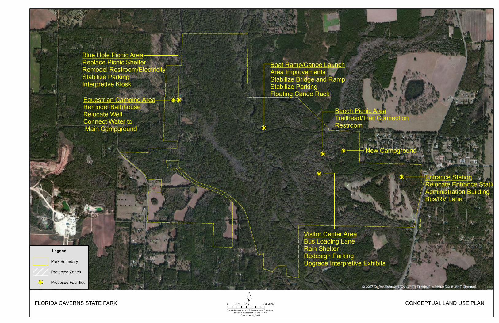
FLORIDA CAVERNS STATE PARKFlorida Department of Environmental Protection
Division of Recreation and ParksDate of aerial; 2011
0 0.15 0.30.075 Miles´ CONCEPTUAL LAND USE PLAN
Legend
Park Boundary
Protected Zones
kj Proposed Facilities

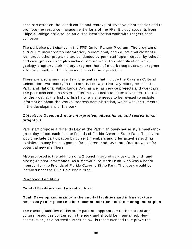
88
each semester on the identification and removal of invasive plant species and to promote the resource management efforts of the FPS. Biology students from Chipola College are also led on a tree identification walk with rangers each semester.
The park also participates in the FPS’ Junior Ranger Program. The program’s curriculum incorporates interpretive, recreational, and educational elements. Numerous other programs are conducted by park staff upon request by school and civic groups. Examples include: nature walk, tree identification walk, geology program, park history program, hats of a park ranger, snake program, wildflower walk, and first-person character interpretation.
There are also annual events and activities that include the Caverns Cultural Celebration, Astronomy in the Park, Earth Day, First Day Hikes, Birds in the Park, and National Public Lands Day, as well as service projects and workdays. The park also contains several interpretive kiosks to educate visitors. The text for the kiosk at the historic fish hatchery site needs to be revised to include information about the Works Progress Administration, which was instrumental in the development of the park.
Objective: Develop 2 new interpretive, educational, and recreational programs.
Park staff propose a “Friends Day at the Park,” an open-house style meet-and-greet day of outreach for the Friends of Florida Caverns State Park. This event would include participation by current members and offer activities such as exhibits, bouncy houses/games for children, and cave tours/nature walks for potential new members.
Also proposed is the addition of a 2-panel interpretive kiosk with bird- and birding-related information, as a memorial to Mark Hebb, who was a board member for the Friends of Florida Caverns State Park. The kiosk would be installed near the Blue Hole Picnic Area.
Proposed Facilities
Capital Facilities and Infrastructure
Goal: Develop and maintain the capital facilities and infrastructure necessary to implement the recommendations of the management plan.
The existing facilities of this state park are appropriate to the natural and cultural resources contained in the park and should be maintained. New construction, as discussed further below, is recommended to improve the
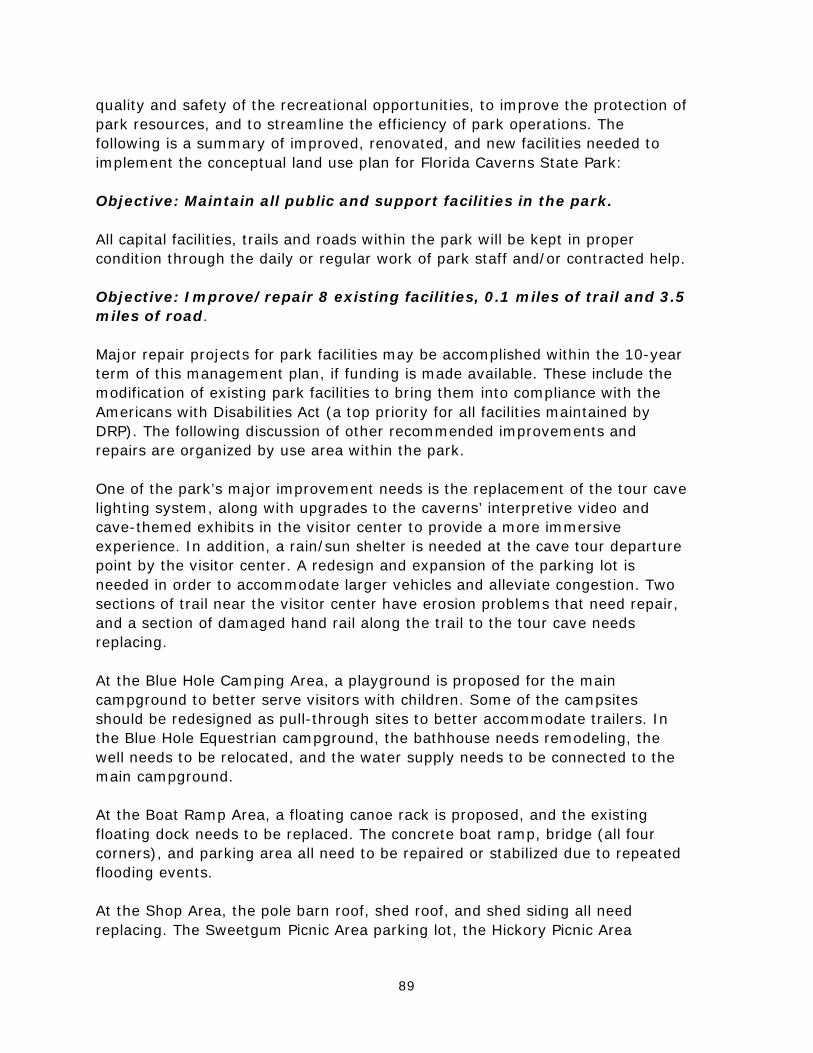
89
quality and safety of the recreational opportunities, to improve the protection of park resources, and to streamline the efficiency of park operations. The following is a summary of improved, renovated, and new facilities needed to implement the conceptual land use plan for Florida Caverns State Park:
Objective: Maintain all public and support facilities in the park.
All capital facilities, trails and roads within the park will be kept in proper condition through the daily or regular work of park staff and/or contracted help.
Objective: Improve/repair 8 existing facilities, 0.1 miles of trail and 3.5 miles of road.
Major repair projects for park facilities may be accomplished within the 10-year term of this management plan, if funding is made available. These include the modification of existing park facilities to bring them into compliance with the Americans with Disabilities Act (a top priority for all facilities maintained by DRP). The following discussion of other recommended improvements and repairs are organized by use area within the park.
One of the park’s major improvement needs is the replacement of the tour cave lighting system, along with upgrades to the caverns’ interpretive video and cave-themed exhibits in the visitor center to provide a more immersive experience. In addition, a rain/sun shelter is needed at the cave tour departure point by the visitor center. A redesign and expansion of the parking lot is needed in order to accommodate larger vehicles and alleviate congestion. Two sections of trail near the visitor center have erosion problems that need repair, and a section of damaged hand rail along the trail to the tour cave needs replacing.
At the Blue Hole Camping Area, a playground is proposed for the main campground to better serve visitors with children. Some of the campsites should be redesigned as pull-through sites to better accommodate trailers. In the Blue Hole Equestrian campground, the bathhouse needs remodeling, the well needs to be relocated, and the water supply needs to be connected to the main campground.
At the Boat Ramp Area, a floating canoe rack is proposed, and the existing floating dock needs to be replaced. The concrete boat ramp, bridge (all four corners), and parking area all need to be repaired or stabilized due to repeated flooding events.
At the Shop Area, the pole barn roof, shed roof, and shed siding all need replacing. The Sweetgum Picnic Area parking lot, the Hickory Picnic Area

90
parking lot, entrance area parking lot, and Hickory Nut Drive need to be repaved, as these surfaces are in poor condition. Hickory Nut Drive is currently in the process of completing its repaving. The 0.6-mile section of Fish Hatchery Road from the Blue Hole bathhouse to the southern park gate also needs paving, as this area often floods, and the present dirt road becomes unsafe when muddy. Objective: Construct 5 new facilities.
Recommended new construction in this plan includes the creation of a new full-facility campground with 30 sites and a bathhouse. The campground would be located at the current site of the primitive youth camp. A new primitive youth camp would be constructed on the west side of the park, potentially on the newly-acquired Bennett property.
At the Beech Picnic Area, a new restroom is proposed beside the picnic shelter, along with a new trailhead and 350-foot trail connection to the nearby Beech Magnolia Trail. The current restroom across from the picnic shelter will be removed due to its poor condition.
In addition, a new administration building is needed near the entrance, along with a new entrance station approximately 500 to 750 feet northwest of the present location. This will help avoid vehicle stacking problems on Caverns Rd., as will the addition of a new bus/RV lane at the park entrance.
Facilities Development
Preliminary cost estimates for these recommended facilities and improvements are provided in the 10-Year Implementation Schedule and Cost Estimates (Table 7) located in the Implementation Component of this plan. These cost estimates are based on the most cost-effective construction standards available at this time. The preliminary estimates are provided to assist DRP in budgeting future park improvements, and may be revised as more information is collected through the planning and design processes. New facilities and improvements to existing facilities recommended by the plan include:
Entrance AreaEntrance station Administration building Bus/RV lane
Blue Hole Picnic Area Picnic shelter Remodel restroom/add electricity Interpretive kiosk Stabilize parking
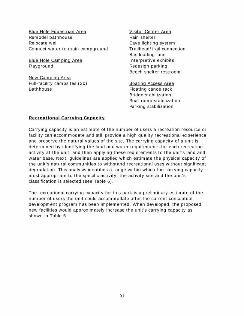
91
Blue Hole Equestrian Area Remodel bathhouse Relocate well Connect water to main campground
Blue Hole Camping Area Playground
New Camping Area Full-facility campsites (30) Bathhouse
Visitor Center Area Rain shelter Cave lighting system Trailhead/trail connection Bus loading lane Interpretive exhibits Redesign parking Beech shelter restroom
Boating Access Area Floating canoe rack Bridge stabilization Boat ramp stabilization Parking stabilization
Recreational Carrying Capacity
Carrying capacity is an estimate of the number of users a recreation resource or facility can accommodate and still provide a high quality recreational experience and preserve the natural values of the site. The carrying capacity of a unit is determined by identifying the land and water requirements for each recreation activity at the unit, and then applying these requirements to the unit's land and water base. Next, guidelines are applied which estimate the physical capacity of the unit's natural communities to withstand recreational uses without significant degradation. This analysis identifies a range within which the carrying capacity most appropriate to the specific activity, the activity site and the unit's classification is selected (see Table 6).
The recreational carrying capacity for this park is a preliminary estimate of the number of users the unit could accommodate after the current conceptual development program has been implemented. When developed, the proposed new facilities would approximately increase the unit's carrying capacity as shown in Table 6.
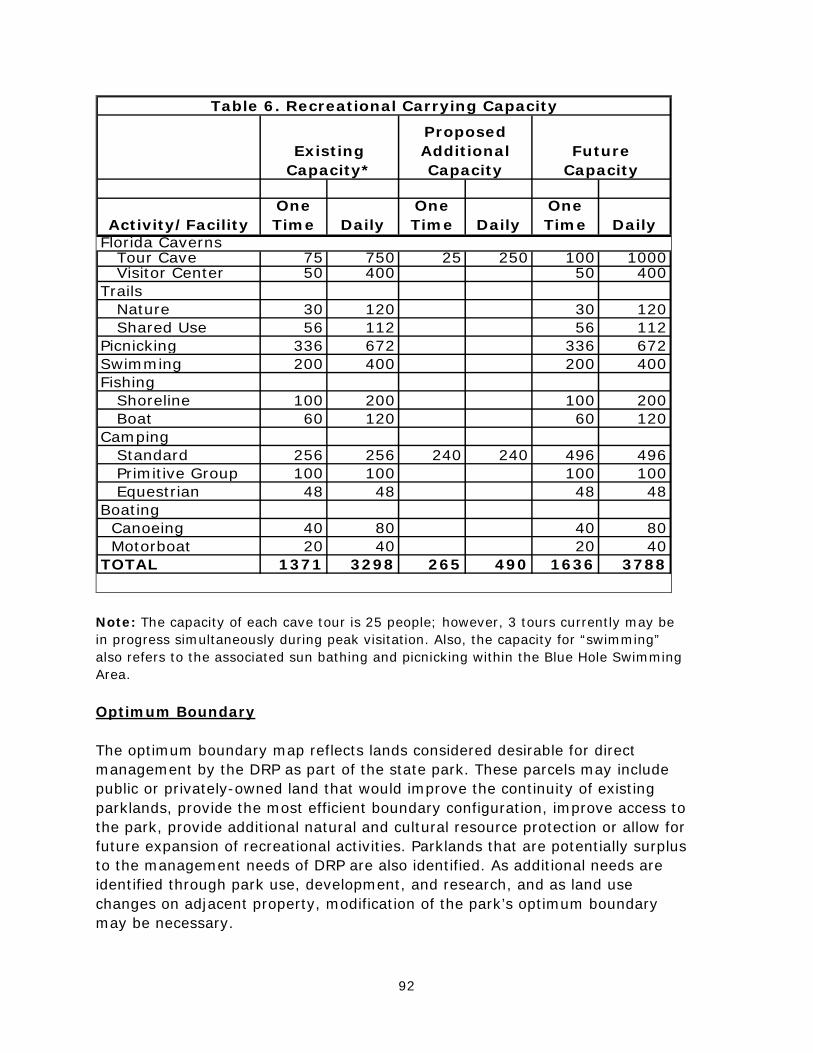
92
Activity/FacilityOne Time Daily
One Time Daily
One Time Daily
Florida Caverns Tour Cave 75 750 25 250 100 1000 Visitor Center 50 400 50 400Trails Nature 30 120 30 120 Shared Use 56 112 56 112Picnicking 336 672 336 672Swimming 200 400 200 400Fishing Shoreline 100 200 100 200 Boat 60 120 60 120Camping Standard 256 256 240 240 496 496 Primitive Group 100 100 100 100 Equestrian 48 48 48 48Boating Canoeing 40 80 40 80 Motorboat 20 40 20 40TOTAL 1371 3298 265 490 1636 3788
Table 6. Recreational Carrying Capacity
Proposed Additional Capacity
Existing Capacity*
Future Capacity
Note: The capacity of each cave tour is 25 people; however, 3 tours currently may be in progress simultaneously during peak visitation. Also, the capacity for “swimming” also refers to the associated sun bathing and picnicking within the Blue Hole Swimming Area.
Optimum Boundary
The optimum boundary map reflects lands considered desirable for direct management by the DRP as part of the state park. These parcels may include public or privately-owned land that would improve the continuity of existing parklands, provide the most efficient boundary configuration, improve access to the park, provide additional natural and cultural resource protection or allow for future expansion of recreational activities. Parklands that are potentially surplus to the management needs of DRP are also identified. As additional needs are identified through park use, development, and research, and as land use changes on adjacent property, modification of the park’s optimum boundary may be necessary.
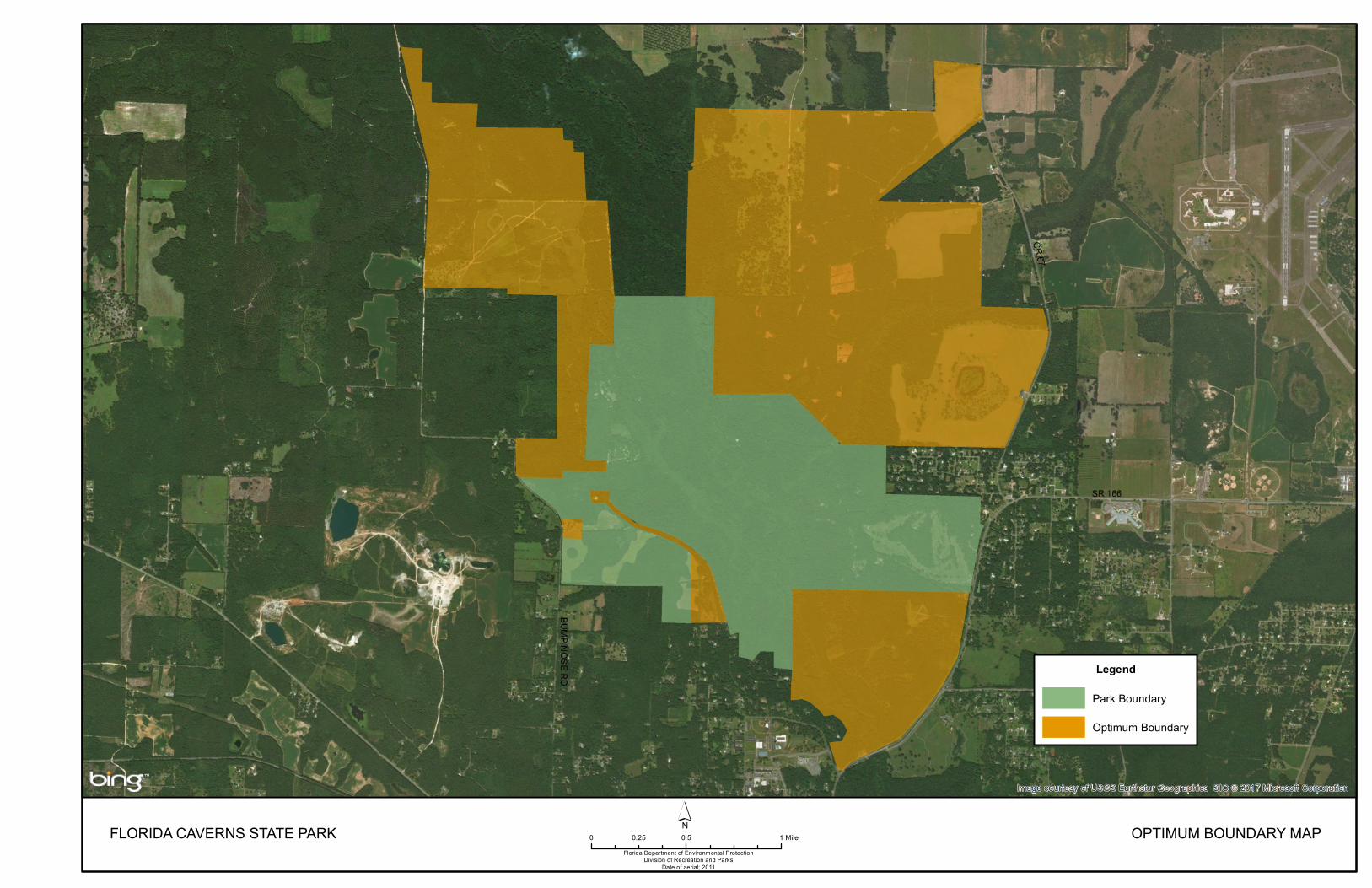
FLORIDA CAVERNS STATE PARKFlorida Department of Environmental Protection
Division of Recreation and ParksDate of aerial; 2011
0 0.5 10.25 Mile´ OPTIMUM BOUNDARY MAP
Legend
Park Boundary
Optimum Boundary

95
Identification of parcels on the optimum boundary map is intended solely for planning purposes. It is not to be used in connection with any regulatory purposes. Any party or governmental entity should not use a property’s identification on the optimum boundary map to reduce or restrict the lawful rights of private landowners. Identification on the map does not empower or suggest that any government entity should impose additional or more restrictive environmental land use or zoning regulations. Identification should not be used as the basis for permit denial or the imposition of permit conditions. Given the park’s sensitive species and natural communities, and in particular its vulnerable subterranean and water resources, the optimum boundary for this park is extensive, not only to conserve habitat and hydrological connections, but also to enhance recreation opportunities. More than 2,800 acres of lands surrounding the park have been identified for acquisition; these include multiple parcels along most of the park’s boundaries. Approximately 718 acres on the park’s western and northwestern boundary are desired, including the 160-acre Gerome’s Cave Site. This is an important component of the Florida Forever program’s Southeastern Bat Maternity Caves project, and would be a significant addition to the park. The site is one of 6 priority southeastern myotis maternity caves, and contains an outstanding example of an upland hardwood forest. This property consists of 5 parcels with 4 owners; ARC has placed this project in the Critical Natural Lands project category. On the park’s southeast boundary lies a 393-acre tract identified in the Florida Forever program as part of the Middle Chipola River project. This parcel lies between the park and the SR 167 bridge down river; it would complement the park in its resource and management goals. Northwest of the park, a block of parcels totaling more than 1,660 acres also have been identified for acquisition. These include forested uplands, open agricultural areas, and a riparian corridor; the addition of these parcels would help improve and safeguard the park’s water quality. At this time, only one parcel is considered surplus to the needs of the park. It is a small, discontiguous parcel on the east side of Caverns Rd., located across from the golf course. It is less than 1 acre in size.

96
97
IMPLEMENTATION COMPONENT
The resource management and land use components of this management plan provide a thorough inventory of the park’s natural, cultural, and recreational resources. They outline the park’s management needs and problems, and recommend both short and long-term objectives and actions to meet those needs. The implementation component addresses the administrative goal for the park and reports on the Division of Recreation and Parks’ (DRP) progress toward achieving resource management, operational, and capital improvement goals and objectives since approval of the previous management plan for this park. This component also compiles the management goals, objectives, and actions expressed in the separate parts of this management plan for easy review. Estimated costs for the 10-year period of this plan are provided for each action and objective, and the costs are summarized under standard categories of land management activities.
MANAGEMENT PROGRESS
Since the approval of the last management plan for Florida Caverns State Park in 2006, significant work has been accomplished and progress made towards meeting the DRP’s management objectives for the park. These accomplishments fall within 4 of the 5 general categories that encompass the mission of the park and the DRP.
Acquisition
• Since the last Unit Management Plan (UMP) update, the park has acquiredone parcel as part of the optimum boundary. A 181-acre parcel on the park’ssouthwest boundary known as the Bennett property was purchased in May2017. This property contains 0.99 acres of upland glade (FNAI rank G1/S1)and several caverns (one of which shelters listed species including theGeorgia Blind Salamander and the Dougherty Plain Cave Crayfish), andserves as an emergency egress route during times of flooding.
Park Administration and Operations
• The park’s volunteer support has increased by 150 percent since fiscal year2005/2006; more than 130,200 volunteer hours have contributed to thepark’s success in providing outstanding visitor services, natural and culturalresource management activities, maintenance of facilities and grounds, andprotection of park resources. The park has conducted significant volunteerrecruitment efforts throughout the local community via newspapers, ChipolaCollege, community civic groups, dual enrollment students, and Bright FutureScholarship participants. Service projects and work days are used to developvolunteer teams to accomplish significant park goals.
• The park is supported by the Friends of Florida Caverns State Park CitizenSupport Organization (CSO), which assists the park through fund-raisingactivities. These activities in turn provide visitors services such as firewoodpurchase and resale, a coin-operated washer and dryer for the campground,special events, a penny-press in the museum, and flashlight cave tours. TheFriends group uses these funds according to state CSO Bylaws, FOFCSPBylaws, and at the direction of the Park Manager. Recent funding has

98
provided for purchases and repairs of a variety of outdoor power equipment, plus a golf cart for camp hosts and a Jon boat for river rescue. The Friends group has also funded facility upgrades such as grills for day-use areas, replacement campground fire rings, repairs of the tour cave lighting system, conversion of the tour cave and museum to LED lighting, installation of security systems in the ranger station and shop, trail signage upgrades, and installation of an interpretive kiosk at the Blue Hole. The park’s CSO provides an increased level of visitor service by providing interpretive training materials, supplies, and class A uniforms for the volunteers, and the CSO has also worked with the park in hosting numerous events and activities such as the Caverns Cultural Celebration, Earth Day, Jazz in the Park, Public Lands Day, and Astronomy in the Park. The Friends group has also contributed many skills and in-kind services to the park, including website development and management, nature programs, event planning, wildlife presentations, IRS and DOS reporting, photography, and interpretive signage development.
Resource Management
Natural Resources
• Mechanical removal: FCV 1: 5.48 acres; FCV 21: 4 acres • Burning: Implementation of prescribed burning program, 8 new
management zones burned: FCV 1, 5.48 acres, 3 burns FCV 2, 8.73 acres, 4 burns FCV 3, APM block, 2 burns FCV 4B, 21.87 acres, 3 burns
FCV 5, 21.75 acres, 3 burns FCV 6, 11.47 acres, 3 burns FCV 19, 90.06 acres, 5 burns FCV 20, 1 acre, 4 burns
• Invasive plant removal:
o Identified 6 new invasive species: Ardisia japonica (CAT 2), Lantana camara (CAT 1), Parthenium hysterphorus, Senna obtusifolia, Hedera helix, and Cinnamomum camphora (CAT 1).
o FLEPPC added Ardisia japonica as a CAT2 species due to park’s population.
o Treatment of all 1,267 acres of park for invasive plant species at least once; total treatment from 2006-2016 was approx. 3,900 gross acres.
o Added an herbicide storage and mixing area to the park shop compound.
o Developed an invasive plant brochure to create awareness. o Developed training materials for invasive plant identification and
treatment. o Partnered with Chipola College’s Environmental Science Department to
incorporate invasive plant/animal removal and prescribed burning into the curriculum. Park staff offered educational programs on these topics to students and provided training via invasive plant removal workdays.
o Participated on the ARSA CISMA steering committee. o Hosted FLCC district training for invasive plant identification and
removal.
99
• Invasive animal removal:
o Identified 2 new invasive lizards: Mediterranean gecko (Hemidactylus turcicus) and Brown anole (Anolis sagrei).
o From 2006-2016, 408 armadillos, 18 feral hogs, 40 feral cats, 33 feral dogs, 64 Mediterranean geckos, 17 green sunfish, 1 red-eared pond slider, and 1 hermit crab were removed.
o Nuisance alligators were also removed. o Participated with USDA to install and monitor early detection traps for
the emerald ash borer.
• Listed plants: o Added Calliphysalis carpenteri, Coreopsis bakerii, Corralorhiza
wisteriana, Cynoglossum virginianum, Gonolobus suberosus, Matelea floridana, Listera australis, Plantago rugelii, Polygonatum biflorum, Sideroxylon lyciodes, Sideroxylon thornei, Symphoricarpos orbiculatus, Symphotrichium racemosum, and Thelypteris augescens to the park’s rare species list.
o Discovered a population of approx. 50 Brickellia cordifolia in FCV 8, then gathered seeds and reintroduced the plant into FCV 1 and FCV 2. As of 11-1-2016, the park’s populations total more than 300 plants.
o Recovered Desmodium ochroleucum in FCV 1. Population was less than 12 plants and now totals more than 1,000 plants.
• Listed animals:
o Discovery of a new species of blind cave millipede (not yet described as of 11-1-2016) from Ellis Cave.
• Other:
o Added >50 species to park’s plant list with assistance from Dr. Loran Anderson and the FSU Godfrey Herbarium.
o Added >50 species to the park’s vertebrate list, >20 species to park’s bird list, and >20 species to park’s butterfly list.
o Developed a Sugar Mill Run invertebrate list, and a glade plant species list.
Cultural Resources
● Repaired pillars on the Hickory Pavilion. ● Added 7 cultural sites to the FMSF:
JA1752, Tera Estates quarry JA1753, Sweetgum pavilion quarry JA1760, Abandoned railroad JA1762, Ellis Cave JA1793, Hartsfield Folly JA1862, Indian Shelter Cave JA1863, Sugar Mill ruins
● Inventoried park artifacts and implemented a catalog system. ● Conducted FMSF assessments of all 38 on-park sites.
100
● Resurfaced patio on museum terrace. ● Installed interpretive kiosk at fish hatchery ponds. ● Updated historical interpretive panels in museum.
Recreation and Visitor Services
• Since 2006, park attendance increased 56%, and annual visitation during fiscal year 2014-2015 exceeded 142,000 visitors for the first time.
• In May 2008, the park issued a Special Use Permit to Robert A. DeGroot for a Florida Caverns Gift Shop to increase visitor services to the public and free up staff for other essential park operations. New services include refreshments, collection of cavern tour fees, merchandise sales, and equipment rental.
• The park runs the only dry cavern tour operation in the State of Florida and is recognized as a National Natural Landmark of the United States.
• The park provides significant interpretive programming to the public on a daily, weekly, and monthly basis. Each year >2,000 interpretive cavern tours are offered, allowing >70,000 visitors to experience Florida’s underground environment.
• Interpretive handouts are available in the ranger station including park and trail maps; bird, vertebrate, and plant lists; and geology and bat brochures.
• The park has 3 interpretive kiosks: 1) Visitor Center - interprets native fauna and supporting natural communities; 2) Blue Hole swimming area - interprets karst topography and water quality; and 3) Marianna Federal Hatchery - interprets the New Deal program in the park.
• The park’s museum offers interpretive exhibits on the park’s history, flora, fauna, geology, and resource management.
• The museum’s theater offers videos including a virtual cavern tour, nature walk, and park tour.
• Interpretive signage on the Bluff and Beech/Magnolia trail interprets flora, fauna, geology, invasive plants, natural communities, and Native American history.
• The park hosts at least 12 special events annually, including Caverns Cultural Celebration (CCC Days), First Day Hikes, Earth Day, National Public Lands Day, multiple 5-K runs, Story on the Trail, and Astronomy in the park.
• Park staff conducts guided nature walks, bird walks, tree identification walks, history programs, nature programs, prescribed burning, geology programs, interpretive training, first-person programs, and demonstrations. Programs are offered on a regular basis and are often requested by schools, civic groups, churches, and scout groups.
• Some of the park’s public outreach activities include reading to children at local schools, educating park neighbors on park resource

101
management, Summer Enrichment Program, Junior Ranger Program, and local events.
• The park has a partnership with Chipola College offering interpretive exhibits, walks, and programs to students in departments including Elementary Education, Biology, Environmental Science, and History. The park educates students about natural and cultural resource management.
• The park has undertaken major efforts to enhance the experience for visitors with disabilities by transitioning facilities towards universal accessibility. The park has installed paved parking and accessible walkways at the Visitor Center. The park has also acquired a pneumatic tire wheelchair and an all-terrain powered wheelchair for visitor use. The park has increased accessible programming by offering accommodated tours where the guest is taken in the ramped exit of the cave and guided as far into the cave as far as that individual can go.
• Since the last UMP update, the park has developed new brochures and park literature including a revised park brochure, new campground map, and a completely revised website layout and text.
Park Facilities
Since the last Unit Management Plan update, significant infrastructure improvements have been made throughout the park including: Ranger Station
• Radio frequency upgrade/repeater storage room/new antenna • Installed new park entrance sign • Installed electric gate at entrance • Reroofed entrance station
Hickory Picnic Shelter
• Replaced pillars underneath pavilion • Installed shower/laundry facilities for volunteers
Shop
• Installed new alarm system
Volunteer Village • Upgraded campsites to 50-amp service and added sewer
Visitor Center parking area • Upgraded kiosk with wildflower information • Added new ADA-compliant parking spaces and sidewalk
Visitor Center • Added new roof • Added hand rails to stairs • Purchased electric mobility chair for accommodated tours • Purchased pneumatic tire wheelchair for accommodated tours

102
• Updated tour script, cavern video, and museum displays • Installed Bats/White-Nose Syndrome interpretation signs • Installed interpretative panel at tour departure site • Installed LED lighting in museum • Added penny press in museum • Upgraded ADA door opener in museum • Resurfaced terrace patio • Installed bat house
Tour Cave • Replaced bulbs with LEDs • Installed new light switches • Placed air-tight first aid kits with flashlights throughout cave • Initiated cave clean-up and photo monitoring
Natural Caves • Conducted surface impact study on Boyer’s Cave • Conducted climate and hydrology research on Dragon’ Tooth Cave • Conducted 3D mapping project and updated maps of Dragon’s Tooth Cave • Conducted photo monitoring impact study on Dragon’s Tooth Cave
Blue Hole Drive • Resurfaced road
Beech pavilion • Reroofed and updated lift station
Boat ramp • Improved boat dock and resurfaced parking area
Blue Hole Swimming Area • Blue Hole restoration project • Replaced roof on restroom • Added floating dock • Added springs interpretive kiosk • Spring restored to original shorelines • Boardwalk extended, floating dock added, previous diving platform removed • Installed bat houses • Added interpretive kiosk at hatchery ponds
Horse Camp • Re-roofed horse stalls • Re-roofed pavilion and bathrooms • Added community fire ring
Campground • Added cement slabs for dumpsters • Added gravel to sites • Resurfaced loop road
103
• Upgraded electric service to 20/30/50 amp • Installed sewer hook-up to campsites • Installed bat house • Added coin-operated washers and dryers •
MANAGEMENT PLAN IMPLEMENTATION
This management plan is written for a timeframe of 10 years, as required by Section 253.034 Florida Statutes. The 10-Year Implementation Schedule and Cost Estimates (Table 7) summarizes the management goals, objectives, and actions that are recommended for implementation over this period, and beyond. Measures are identified for assessing progress toward completing each objective and action. A time frame for completing each objective and action is provided. Preliminary cost estimates for each action are provided and the estimated total costs to complete each objective are computed. Finally, all costs are consolidated under the following 5 standard land management categories: Resource Management, Administration and Support, Capital Improvements, Recreation Visitor Services, and Law Enforcement. Many of the actions identified in the plan can be implemented using existing staff and funding. However, a number of continuing activities and new activities with measurable quantity targets and projected completion dates are identified that cannot be completed during the life of this plan unless additional resources for these purposes are provided. The plan’s recommended actions, time frames, and cost estimates will guide the DRP’s planning and budgeting activities over the period of this plan. It must be noted that these recommendations are based on the information that exists at the time the plan was prepared. A high degree of adaptability and flexibility must be built into this process to ensure that the DRP can adjust to changes in the availability of funds, improved understanding of the park’s natural and cultural resources, and changes in statewide land management issues, priorities, and policies. Statewide priorities for all aspects of land management are evaluated each year as part of the process for developing the DRP’s annual legislative budget requests. When preparing these annual requests, the DRP considers the needs and priorities of the entire state park system and the projected availability of funding from all sources during the upcoming fiscal year. In addition to annual legislative appropriations, the DRP pursues supplemental sources of funds and staff resources wherever possible, including grants, volunteers, and partnerships with other entities. The DRP’s ability to accomplish the specific actions identified in the plan will be determined largely by the availability of funds and staff for these purposes, which may vary from year to year. Consequently, the target schedules and estimated costs identified in Table 7 may need to be adjusted during the 10-year management planning cycle.

104
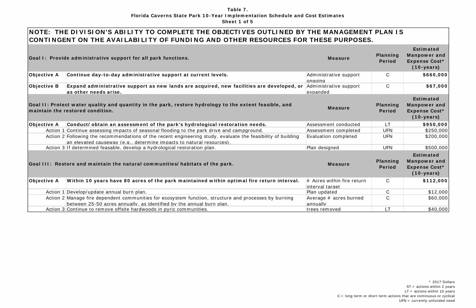
Table 7.Florida Caverns State Park 10-Year Implementation Schedule and Cost Estimates
Sheet 1 of 5
Measure Planning Period
Estimated Manpower and Expense Cost*
(10-years)Objective A Continue day-to-day administrative support at current levels. Administrative support
ongoingC $660,000
Objective B Expand administrative support as new lands are acquired, new facilities are developed, or as other needs arise.
Administrative support expanded
C $67,000
Measure Planning Period
Estimated Manpower and Expense Cost*
(10-years)Objective A Conduct/obtain an assessment of the park's hydrological restoration needs. Assessment conducted LT $950,000
Action 1 Continue assessing impacts of seasonal flooding to the park drive and campground. Assessment completed UFN $250,000Action 2 Following the recommendations of the recent engineering study, evaluate the feasibility of building
an elevated causeway (e.g., determine impacts to natural resources).Evaluation completed UFN $200,000
Action 3 If determined feasable, develop a hydrological restoration plan. Plan designed UFN $500,000
Measure Planning Period
Estimated Manpower and Expense Cost*
(10-years)Objective A Within 10 years have 80 acres of the park maintained within optimal fire return interval. # Acres within fire return
interval targetC $112,000
Action 1 Develop/update annual burn plan. Plan updated C $12,000Action 2 Manage fire dependent communities for ecosystem function, structure and processes by burning
between 25-50 acres annually, as identified by the annual burn plan.Average # acres burned annually
C $60,000
Action 3 Continue to remove offsite hardwoods in pyric communities. trees removed LT $40,000
Goal II: Protect water quality and quantity in the park, restore hydrology to the extent feasible, and maintain the restored condition.
Goal III: Restore and maintain the natural communities/habitats of the park.
Goal I: Provide administrative support for all park functions.
NOTE: THE DIVISION'S ABILITY TO COMPLETE THE OBJECTIVES OUTLINED BY THE MANAGEMENT PLAN IS CONTINGENT ON THE AVAILABILITY OF FUNDING AND OTHER RESOURCES FOR THESE PURPOSES.
* 2017 DollarsST = actions within 2 years
LT = actions within 10 yearsC = long term or short term actions that are continuous or cyclical
UFN = currently unfunded need
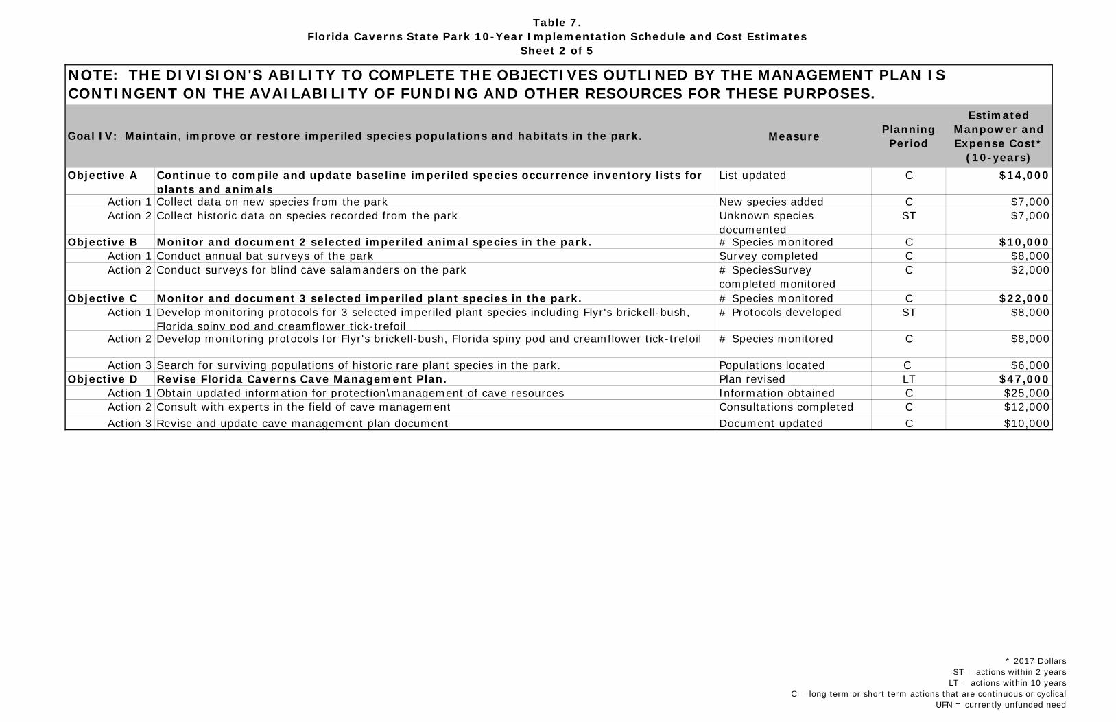
Table 7.Florida Caverns State Park 10-Year Implementation Schedule and Cost Estimates
Sheet 2 of 5
NOTE: THE DIVISION'S ABILITY TO COMPLETE THE OBJECTIVES OUTLINED BY THE MANAGEMENT PLAN IS CONTINGENT ON THE AVAILABILITY OF FUNDING AND OTHER RESOURCES FOR THESE PURPOSES.
Measure Planning Period
Estimated Manpower and Expense Cost*
(10-years)Objective A Continue to compile and update baseline imperiled species occurrence inventory lists for
plants and animalsList updated C $14,000
Action 1 Collect data on new species from the park New species added C $7,000Action 2 Collect historic data on species recorded from the park Unknown species
documentedST $7,000
Objective B Monitor and document 2 selected imperiled animal species in the park. # Species monitored C $10,000Action 1 Conduct annual bat surveys of the park Survey completed C $8,000Action 2 Conduct surveys for blind cave salamanders on the park # SpeciesSurvey
completed monitoredC $2,000
Objective C Monitor and document 3 selected imperiled plant species in the park. # Species monitored C $22,000Action 1 Develop monitoring protocols for 3 selected imperiled plant species including Flyr's brickell-bush,
Florida spiny pod and creamflower tick-trefoil# Protocols developed ST $8,000
Action 2 Develop monitoring protocols for Flyr's brickell-bush, Florida spiny pod and creamflower tick-trefoil # Species monitored C $8,000
Action 3 Search for surviving populations of historic rare plant species in the park. Populations located C $6,000Objective D Revise Florida Caverns Cave Management Plan. Plan revised LT $47,000
Action 1 Obtain updated information for protection\management of cave resources Information obtained C $25,000Action 2 Consult with experts in the field of cave management Consultations completed C $12,000Action 3 Revise and update cave management plan document Document updated C $10,000
Goal IV: Maintain, improve or restore imperiled species populations and habitats in the park.
* 2017 DollarsST = actions within 2 years
LT = actions within 10 yearsC = long term or short term actions that are continuous or cyclical
UFN = currently unfunded need
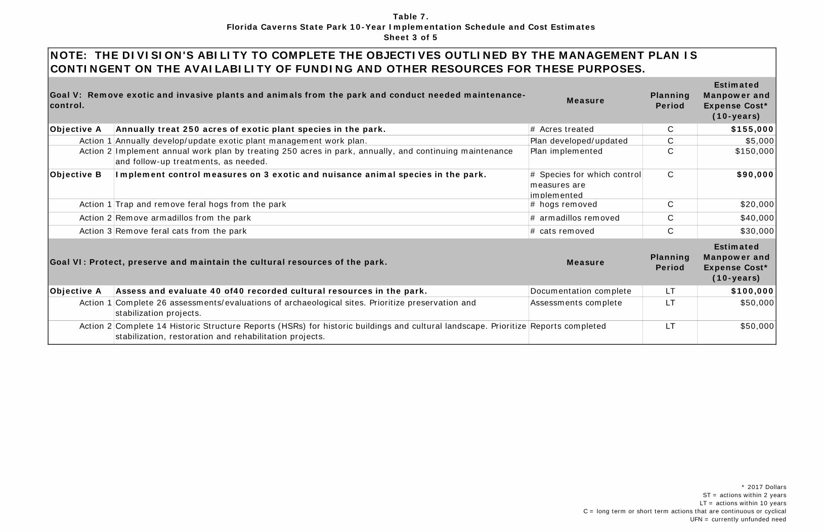
Table 7.Florida Caverns State Park 10-Year Implementation Schedule and Cost Estimates
Sheet 3 of 5
NOTE: THE DIVISION'S ABILITY TO COMPLETE THE OBJECTIVES OUTLINED BY THE MANAGEMENT PLAN IS CONTINGENT ON THE AVAILABILITY OF FUNDING AND OTHER RESOURCES FOR THESE PURPOSES.
Measure Planning Period
Estimated Manpower and Expense Cost*
(10-years)Objective A Annually treat 250 acres of exotic plant species in the park. # Acres treated C $155,000
Action 1 Annually develop/update exotic plant management work plan. Plan developed/updated C $5,000Action 2 Implement annual work plan by treating 250 acres in park, annually, and continuing maintenance
and follow-up treatments, as needed.Plan implemented C $150,000
Objective B Implement control measures on 3 exotic and nuisance animal species in the park. # Species for which control measures are implemented
C $90,000
Action 1 Trap and remove feral hogs from the park # hogs removed C $20,000Action 2 Remove armadillos from the park # armadillos removed C $40,000Action 3 Remove feral cats from the park # cats removed C $30,000
Measure Planning Period
Estimated Manpower and Expense Cost*
(10-years)Objective A Assess and evaluate 40 of40 recorded cultural resources in the park. Documentation complete LT $100,000
Action 1 Complete 26 assessments/evaluations of archaeological sites. Prioritize preservation and stabilization projects.
Assessments complete LT $50,000
Action 2 Complete 14 Historic Structure Reports (HSRs) for historic buildings and cultural landscape. Prioritize stabilization, restoration and rehabilitation projects.
Reports completed LT $50,000
Goal V: Remove exotic and invasive plants and animals from the park and conduct needed maintenance-control.
Goal VI: Protect, preserve and maintain the cultural resources of the park.
* 2017 DollarsST = actions within 2 years
LT = actions within 10 yearsC = long term or short term actions that are continuous or cyclical
UFN = currently unfunded need
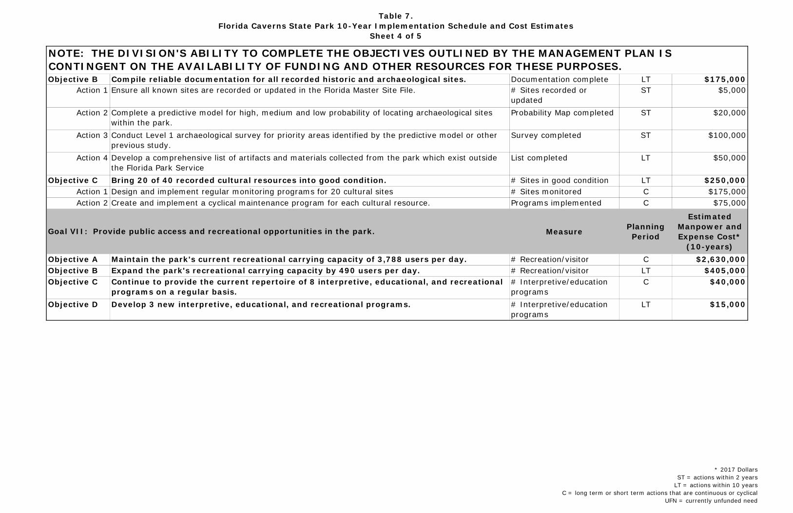
Table 7.Florida Caverns State Park 10-Year Implementation Schedule and Cost Estimates
Sheet 4 of 5
NOTE: THE DIVISION'S ABILITY TO COMPLETE THE OBJECTIVES OUTLINED BY THE MANAGEMENT PLAN IS CONTINGENT ON THE AVAILABILITY OF FUNDING AND OTHER RESOURCES FOR THESE PURPOSES.Objective B Compile reliable documentation for all recorded historic and archaeological sites. Documentation complete LT $175,000
Action 1 Ensure all known sites are recorded or updated in the Florida Master Site File. # Sites recorded or updated
ST $5,000
Action 2 Complete a predictive model for high, medium and low probability of locating archaeological sites within the park.
Probability Map completed ST $20,000
Action 3 Conduct Level 1 archaeological survey for priority areas identified by the predictive model or other previous study.
Survey completed ST $100,000
Action 4 Develop a comprehensive list of artifacts and materials collected from the park which exist outside the Florida Park Service
List completed LT $50,000
Objective C Bring 20 of 40 recorded cultural resources into good condition. # Sites in good condition LT $250,000Action 1 Design and implement regular monitoring programs for 20 cultural sites # Sites monitored C $175,000Action 2 Create and implement a cyclical maintenance program for each cultural resource. Programs implemented C $75,000
Measure Planning Period
Estimated Manpower and Expense Cost*
(10-years)Objective A Maintain the park's current recreational carrying capacity of 3,788 users per day. # Recreation/visitor
C $2,630,000
Objective B Expand the park's recreational carrying capacity by 490 users per day. # Recreation/visitor
LT $405,000Objective C Continue to provide the current repertoire of 8 interpretive, educational, and recreational
programs on a regular basis.# Interpretive/education programs
C $40,000
Objective D Develop 3 new interpretive, educational, and recreational programs. # Interpretive/education programs
LT $15,000
Goal VII: Provide public access and recreational opportunities in the park.
* 2017 DollarsST = actions within 2 years
LT = actions within 10 yearsC = long term or short term actions that are continuous or cyclical
UFN = currently unfunded need
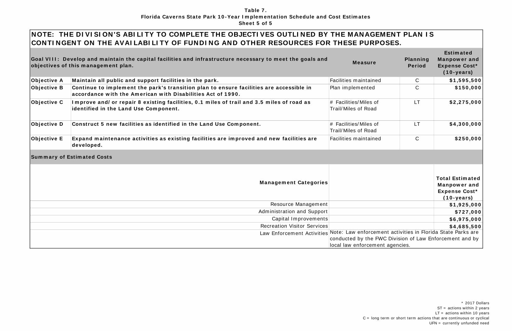
Table 7.Florida Caverns State Park 10-Year Implementation Schedule and Cost Estimates
Sheet 5 of 5
NOTE: THE DIVISION'S ABILITY TO COMPLETE THE OBJECTIVES OUTLINED BY THE MANAGEMENT PLAN IS CONTINGENT ON THE AVAILABILITY OF FUNDING AND OTHER RESOURCES FOR THESE PURPOSES.
Measure Planning Period
Estimated Manpower and Expense Cost*
(10-years)Objective A Maintain all public and support facilities in the park. Facilities maintained C $1,595,500Objective B Continue to implement the park's transition plan to ensure facilities are accessible in
accordance with the American with Disabilities Act of 1990.Plan implemented C $150,000
Objective C Improve and/or repair 8 existing facilities, 0.1 miles of trail and 3.5 miles of road as identified in the Land Use Component.
# Facilities/Miles of Trail/Miles of Road
LT $2,275,000
Objective D Construct 5 new facilities as identified in the Land Use Component. # Facilities/Miles of Trail/Miles of Road
LT $4,300,000
Objective E Expand maintenance activities as existing facilities are improved and new facilities are developed.
Facilities maintained C $250,000
Total Estimated Manpower and Expense Cost*
(10-years)$1,925,000
$727,000$6,975,000$4,685,500
Capital ImprovementsRecreation Visitor Services
Summary of Estimated Costs
Administration and Support
Goal VIII: Develop and maintain the capital facilities and infrastructure necessary to meet the goals and objectives of this management plan.
Note: Law enforcement activities in Florida State Parks are conducted by the FWC Division of Law Enforcement and by local law enforcement agencies.
Resource Management
Management Categories
Law Enforcement Activities
* 2017 DollarsST = actions within 2 years
LT = actions within 10 yearsC = long term or short term actions that are continuous or cyclical
UFN = currently unfunded need

Addendum 1—Acquisition History

A 1 - 1
Purpose of Acquisition:
The Board of Trustees of the Internal Improvement Fund (Trustees) of the State of Florida purchased the initial area of Florida Caverns State Park to use the property as a state park.
Sequence of Acquisition:
On October 11, 1935, the Florida Board of Forestry purchased the approximately 307.47-acre property constituting the initial area of Florida Caverns State Park. The Florida Board of Forestry purchased the property from Florida Caverns, Inc.
Since the 1935 initial purchase, the Trustees have purchased additional parcels, adding these acquisitions to Florida Caverns State Park. These parcels were added to Florida Caverns State Park to manage as part of the park. Presently the park is 1,449.56 acres.
Title Interest:
The Trustees hold fee simple title to portions of Florida Caverns State Park.
Lease Agreement:
At present, DRP manages Florida Caverns State Park under a lease from the Trustees, Lease No. 3619 (formerly No. 2324) to the Florida Board of Parks and Historic Memorials. This lease is for a period of fifty (50) years, which will expire on October 3, 2033.
Special Conditions on Use:
Florida Caverns State Park is designated single-use to provide resource-based public outdoor recreation and other park related uses. Uses such as water resource development projects, water supply projects, storm-water management projects, linear facilities, sustainable agriculture, and forestry (other than those forest management activities specifically identified in this plan) are not consistent with this plan or the management purposes of the park.
Outstanding Reservations:
Following is a list of outstanding rights, reservations, and encumbrances that apply to Florida Caverns State Park.
Instrument: .................................... Deed (No. 11734) Grantor: ......................................... Trustees of the Internal Improvement Fund Grantee: ......................................... Florida Board of Parks and Historic Memorials
Beginning Date: ............................... October 11, 1935 Ending Date: ................................... October 3, 2033 Outstanding Rights, Uses, Etc.:.......... There are no known deed restrictions or Reservations that apply to this park.

A 1 - 2

Addendum 2—Advisory Group Members and Report


Florida Caverns State Park Advisory Group Members and Report
A 2 - 1
List

Florida Caverns State Park Advisory Group Members and Report
A 2 - 2
Report

Addendum 3—References Cited

Florida Caverns State Park—References Cited
A 3 - 1
Bullen, R. P. 1949. Indian sites at Florida Caverns State Park. The Florida Anthropologist. 2(1-2): 1-9.
Bureau of Economic and Business Research (BEBR), University of Florida. 2015. Florida Estimates of Population 2015. Gainesville, Florida. 61 pp.
City of Marianna. 2016. City of Marianna Zoning map. http://www.cityofmarianna.com/254/Maps
Collins, L., S. Fernandez, J. DuVernay, K. Driscoll, and T. Doering. 2012. Archaeological Resource Sensitivity Modeling in Florida State Parks District 1: the
Northwest Florida Region. Prepared by the Alliance for Integrated Spatial Technologies, University of South Florida, Tampa. Ms. #19224, Florida Division of Historical Resources, Tallahassee, pp. 170-187.
Cox, J., R. Kautz, M. MacLaughlin, and T. Hoehn. 1997. Preservation 2000 Act Study, Biodiversity Conservation Analysis. 35 pp.
Duffee, E. M., W. J. Allen, and H. C. Ammons. 1979. Soil Survey of Jackson County. USDA Soil Conservation Service and University of Florida IFAS. 157 pp.
Fairbanks, C. H. 1941. Report of collections from Florida Caverns State Park. Unpublished manuscript.
Florida Department of Environmental Protection. 2006. Florida Caverns State Park Unit Management Plan. Division of Recreation and Parks, Tallahassee, FL. 49 pp.
Florida Department of Environmental Protection. 2015. Florida State Park System Economic Impact Assessment for Fiscal Year 2014/2015. Tallahassee, Florida.
Florida Department of Environmental Protection. 2013. Outdoor Recreation in Florida 2013; Florida’s Statewide Comprehensive Outdoor Recreation Plan. Division of Recreation and Parks. Tallahassee, Florida.
Florida Game and Fresh Water Fish Commission. 1997. Florida’s Endangered Species, Threatened Species, And Species of Special Concern, Official Lists. 1 August 1997. Tallahassee, Florida.
Florida Fish and Wildlife Conservation Commission. 2016. Florida’s Imperiled Species Action Plan. Tallahassee, Florida. 195 pp.
Florida Fish and Wildlife Conservation Commission. 2013. A Species Action Plan for the Georgia Blind Salamander (Euryeca wallacei). Tallahassee, FL. 32 pp.
Franz, R., J. Bauer, and T. Morris. 1994. Review of biologically significant caves and their faunas in Florida and South Georgia. Brimleyana 20:1-109.
Florida Caverns State Park—References Cited
A 3 - 2
Gore, J. A, L. Lazure, and M. E. Ludlow. 2012. Decline in the Winter Population of Gray Bats (Myotis grisescens) in Florida. Southeastern Naturalist 11(1): 89-98.
Harris, L. D., R. Sullivan, and L. Badger. 1984. Bottomland Hardwoods, Valuable, Vanishing, Vulnerable. UF IFAS and U.S. Fish and Wildlife Service. 16 pp.
Historic Property Associates, Inc. 1989. Cultural Resource Survey: New Deal Era Resources in Nine Florida State Parks. DNR: 276-88/89. St. Augustine, Florida.
Humphrey, S. R. (Ed.) 1992. Rare and Endangered Biota of Florida. Volume 1. Mammals. University of Florida Press, Gainesville.
Jackson County. 2016. Jackson County Comprehensive Plan. Jackson County, Florida. 100 pp.
Jennings, W. L. and J. N. Lane. 1957. Myotis sodalis in Florida. Journal of Mammalogy 38:259.
Ludlow, M. E. 1997. Florida Caverns State Park Cave Management Plan. Department of Environmental Protection, Division of Recreation and Parks. 71 pp.
Ludlow, M. E. and J. A. Gore. 2000. Effects of a cave gate on emergence patterns of colonial bats. Wildlife Society Bulletin 28:(1) 192-196.
Mitchell, R. S. 1963. Phytogeography and Floristic Survey of a Relic Area in the Marianna Lowlands, Florida. The American Midland Naturalist 69 (2), 328-366.
Municode. 2016. Code of the City of Marianna, Florida - Code of Ordinances. https://www.municode.com/library/fl/marianna/codes/code_of_ordinances
Office of Economic and Demographic Research. 2016. Tallahassee, Florida. http://edr.state.fl.us/content/area-profiles/county/jackson.pdf
Randazzo, A. F. and D. S. Jones. 1997. The Geology of Florida. University Presses of Florida.
Rayer, S. and Y. Wang. 2016. Projections of Florida Population by County, 2020-2045, with Estimates for 2015. Bureau of Economic and Business Research (BEBR), University of Florida. Gainesville, Florida. 8 pp.
Rice, D. W. 1955. Myotis keeni in Florida. Journal of Mammalogy 36:567.
Simpson, J. C. 1941. A Report of an Archaeological Investigation at Florida Caverns
Florida Caverns State Park—References Cited
A 3 - 3
State Park, Marianna, Florida. Florida Bureau of Archives, Tallahassee.
Suburban Stats, Inc. 2015. https://suburbanstats.org/
U. S. Fish and Wildlife Service. 1982. Gray bat recovery plan. Minneapolis, MN. 26 pp. + appendices.
Wenner, A. S. 1984. Current status and management of gray bat caves in Jackson County, Florida. Florida Field Naturalist. 12:1-6.

Florida Caverns State Park—References Cited
A 3 - 4

Addendum 4—Soil Descriptions

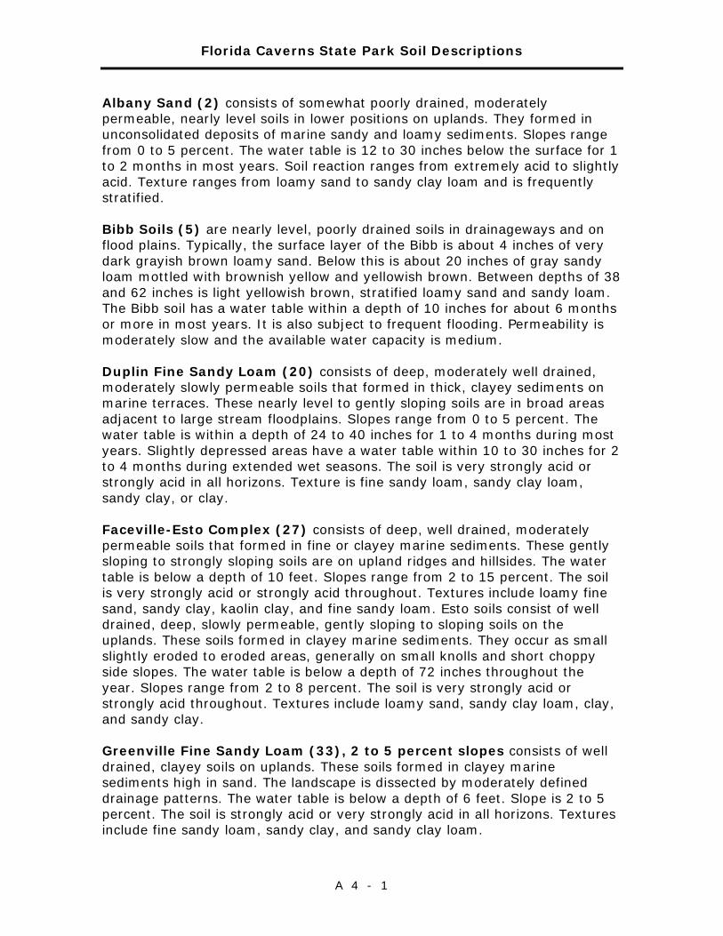
Florida Caverns State Park Soil Descriptions
A 4 - 1
Albany Sand (2) consists of somewhat poorly drained, moderately permeable, nearly level soils in lower positions on uplands. They formed in unconsolidated deposits of marine sandy and loamy sediments. Slopes range from 0 to 5 percent. The water table is 12 to 30 inches below the surface for 1 to 2 months in most years. Soil reaction ranges from extremely acid to slightly acid. Texture ranges from loamy sand to sandy clay loam and is frequently stratified.
Bibb Soils (5) are nearly level, poorly drained soils in drainageways and on flood plains. Typically, the surface layer of the Bibb is about 4 inches of very dark grayish brown loamy sand. Below this is about 20 inches of gray sandy loam mottled with brownish yellow and yellowish brown. Between depths of 38 and 62 inches is light yellowish brown, stratified loamy sand and sandy loam. The Bibb soil has a water table within a depth of 10 inches for about 6 months or more in most years. It is also subject to frequent flooding. Permeability is moderately slow and the available water capacity is medium.
Duplin Fine Sandy Loam (20) consists of deep, moderately well drained, moderately slowly permeable soils that formed in thick, clayey sediments on marine terraces. These nearly level to gently sloping soils are in broad areas adjacent to large stream floodplains. Slopes range from 0 to 5 percent. The water table is within a depth of 24 to 40 inches for 1 to 4 months during most years. Slightly depressed areas have a water table within 10 to 30 inches for 2 to 4 months during extended wet seasons. The soil is very strongly acid or strongly acid in all horizons. Texture is fine sandy loam, sandy clay loam, sandy clay, or clay.
Faceville-Esto Complex (27) consists of deep, well drained, moderately permeable soils that formed in fine or clayey marine sediments. These gently sloping to strongly sloping soils are on upland ridges and hillsides. The water table is below a depth of 10 feet. Slopes range from 2 to 15 percent. The soil is very strongly acid or strongly acid throughout. Textures include loamy fine sand, sandy clay, kaolin clay, and fine sandy loam. Esto soils consist of well drained, deep, slowly permeable, gently sloping to sloping soils on the uplands. These soils formed in clayey marine sediments. They occur as small slightly eroded to eroded areas, generally on small knolls and short choppy side slopes. The water table is below a depth of 72 inches throughout the year. Slopes range from 2 to 8 percent. The soil is very strongly acid or strongly acid throughout. Textures include loamy sand, sandy clay loam, clay, and sandy clay.
Greenville Fine Sandy Loam (33), 2 to 5 percent slopes consists of well drained, clayey soils on uplands. These soils formed in clayey marine sediments high in sand. The landscape is dissected by moderately defined drainage patterns. The water table is below a depth of 6 feet. Slope is 2 to 5 percent. The soil is strongly acid or very strongly acid in all horizons. Textures include fine sandy loam, sandy clay, and sandy clay loam.
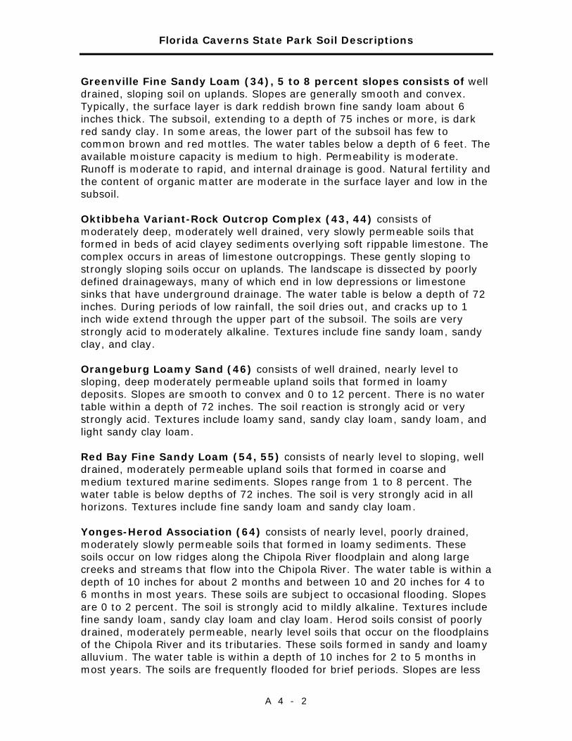
Florida Caverns State Park Soil Descriptions
A 4 - 2
Greenville Fine Sandy Loam (34), 5 to 8 percent slopes consists of well drained, sloping soil on uplands. Slopes are generally smooth and convex. Typically, the surface layer is dark reddish brown fine sandy loam about 6 inches thick. The subsoil, extending to a depth of 75 inches or more, is dark red sandy clay. In some areas, the lower part of the subsoil has few to common brown and red mottles. The water tables below a depth of 6 feet. The available moisture capacity is medium to high. Permeability is moderate. Runoff is moderate to rapid, and internal drainage is good. Natural fertility and the content of organic matter are moderate in the surface layer and low in the subsoil.
Oktibbeha Variant-Rock Outcrop Complex (43, 44) consists of moderately deep, moderately well drained, very slowly permeable soils that formed in beds of acid clayey sediments overlying soft rippable limestone. The complex occurs in areas of limestone outcroppings. These gently sloping to strongly sloping soils occur on uplands. The landscape is dissected by poorly defined drainageways, many of which end in low depressions or limestone sinks that have underground drainage. The water table is below a depth of 72 inches. During periods of low rainfall, the soil dries out, and cracks up to 1 inch wide extend through the upper part of the subsoil. The soils are very strongly acid to moderately alkaline. Textures include fine sandy loam, sandy clay, and clay.
Orangeburg Loamy Sand (46) consists of well drained, nearly level to sloping, deep moderately permeable upland soils that formed in loamy deposits. Slopes are smooth to convex and 0 to 12 percent. There is no water table within a depth of 72 inches. The soil reaction is strongly acid or very strongly acid. Textures include loamy sand, sandy clay loam, sandy loam, and light sandy clay loam.
Red Bay Fine Sandy Loam (54, 55) consists of nearly level to sloping, well drained, moderately permeable upland soils that formed in coarse and medium textured marine sediments. Slopes range from 1 to 8 percent. The water table is below depths of 72 inches. The soil is very strongly acid in all horizons. Textures include fine sandy loam and sandy clay loam.
Yonges-Herod Association (64) consists of nearly level, poorly drained, moderately slowly permeable soils that formed in loamy sediments. These soils occur on low ridges along the Chipola River floodplain and along large creeks and streams that flow into the Chipola River. The water table is within a depth of 10 inches for about 2 months and between 10 and 20 inches for 4 to 6 months in most years. These soils are subject to occasional flooding. Slopes are 0 to 2 percent. The soil is strongly acid to mildly alkaline. Textures include fine sandy loam, sandy clay loam and clay loam. Herod soils consist of poorly drained, moderately permeable, nearly level soils that occur on the floodplains of the Chipola River and its tributaries. These soils formed in sandy and loamy alluvium. The water table is within a depth of 10 inches for 2 to 5 months in most years. The soils are frequently flooded for brief periods. Slopes are less
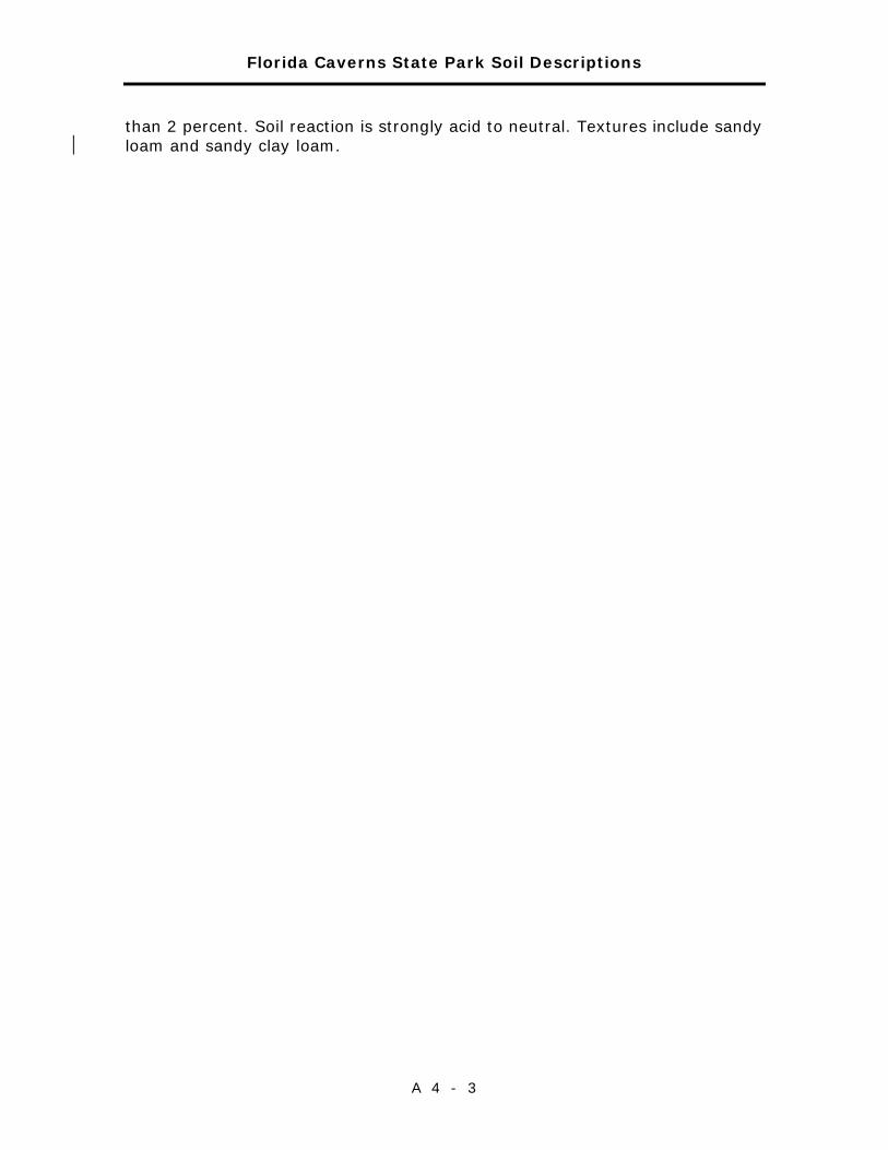
Florida Caverns State Park Soil Descriptions
A 4 - 3
than 2 percent. Soil reaction is strongly acid to neutral. Textures include sandy loam and sandy clay loam.

Florida Caverns State Park Soil Descriptions
A 4 - 4

Addendum 5—Plant and Animal List

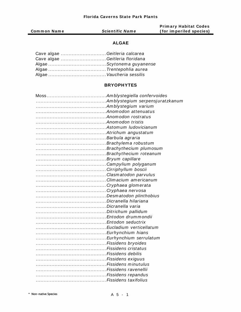
Florida Caverns State Park Plants
Primary Habitat Codes Common Name Scientific Name (for imperiled species)
* Non-native Species A 5 - 1
ALGAE
Cave algae ............................. Geitleria calcarea Cave algae ............................. Geitleria floridana Algae ..................................... Scytonema guyanense Algae ..................................... Trentepohlia aurea Algae ..................................... Vaucheria sessilis
BRYOPHYTES
Moss ...................................... Amblystegiella confervoides ............................................. Amblystegium serpensjuratzkanum ............................................. Amblystegium varium ............................................. Anomodon attenuatus ............................................. Anomodon rostratus ............................................. Anomodon tristis ............................................. Astomum ludovicianum ............................................. Atrichum angustatum ............................................. Barbula agraria ............................................. Brachylema robustum ............................................. Brachythecium plumosum ............................................. Brachythecium roteanum ............................................. Bryum capillare ............................................. Campylium polyganum ............................................. Cirriphyllum boscii ............................................. Clasmatodon parvulus ............................................. Climacium americanum ............................................. Cryphaea glomerata ............................................. Cryphaea nervosa ............................................. Desmatodon plinthobius ............................................. Dicranella hilariana ............................................. Dicranella varia ............................................. Ditrichum pallidum ............................................. Entodon drummondii ............................................. Entodon seductrix ............................................. Eucladium verticellatum ............................................. Eurhynchium hians ............................................. Eurhynchium serrulatum ............................................. Fissidens bryoides ............................................. Fissidens cristatus ............................................. Fissidens debilis ............................................. Fissidens exiguus ............................................. Fissidens minutulus ............................................. Fissidens ravenellii ............................................. Fissidens repandus ............................................. Fissidens taxifolius
Florida Caverns State Park Plants
Primary Habitat Codes Common Name Scientific Name (for imperiled species)
* Non-native Species A 5 - 2
Moss ...................................... Fissidens viridulus ............................................. Forestroemia trichomitria ............................................. Funaria hygrometrica ............................................. Groutiella mucronifolia ............................................. Gymnostomiella orcuttii ............................................. Gymnostomum calcarium ............................................. Leptodictyum riparium ............................................. Leskea australis ............................................. Leucobryum albidum ............................................. Leucondontopsis floridana ............................................. Leudodon julaceus ............................................. Luisierella barbula ............................................. Mnium cuspidatum ............................................. Mnium orthorhynchum ............................................. Mnium rostratum ............................................. Molendoa sendtneriana ............................................. Physcomitrium pyriforme ............................................. Plagiomnium cuspidatum ............................................. Plagiothecium geophilum ............................................. Plagiothecium mariannae ............................................. Plagiothecium micans ............................................. Pogonatum pensilvanicum ............................................. Polytrichum commune ............................................. Schwetschkeopsis denticulata ............................................. Sematophyllum adnatum ............................................. Syrrhopodon incompletus ............................................. Syrrhopodon parasiticus ............................................. Tetraplodon pennsylvanicus ............................................. Thelia hirtella ............................................. Thuidium delicatulum ............................................. Thuidium microphyllum ............................................. Thuidium minutulum ............................................. Thuidium pygmaeum ............................................. Tortella humilis ............................................. Weissia viridula Liverwort ................................ Cephalozia sp. ............................................. Conocephalum conicum ............................................. Dumortiera hirsuta ............................................. Euosmolejeunea duriuscula ............................................. Frullania inflata ............................................. Lejeunea calcicola ............................................. Lepidozia sylvatica ............................................. Leucolejeunea unciloba ............................................. Mastigolejeunea auriculata ............................................. Plagiochila floridana ............................................. Porella pinnata
Florida Caverns State Park Plants
Primary Habitat Codes Common Name Scientific Name (for imperiled species)
* Non-native Species A 5 - 3
Liverwort ............................... Porella platyphylla ............................................ Radula langloisii ............................................ Stylolejeunea spiniloba .. .......................................... Taxilejeunea obtusangula
PTERIDOPHYTES
Venus-hair fern………………………….Adiantum capillus-veneris Wagner's spleenwort ............... Asplenium x heteroresiliens Bicolored spleenwort ............... Asplenium heterochroum Single-sorus spleenwort… ........ Asplenium monanthes LO Ebony spleenwort .................... Asplenium platyneuron Blackstem spleenwort .............. Asplenium resiliens Southern lady fern .................. Athyrium filix-femina asplenioides MTC Mosquito fern ......................... Azolla caroliniana Southern grape fern ................ Botrychium biternatum Grape fern ............................. Botrychium dissectum Rattlesnake fern ..................... Botrychium virginianum Southern wood fern ................. Dryopteris ludoviciana Japanese climbing fern* ........... Lygodium japonicum Mariana maiden fern* .............. Macrothelypteris torresiana Sensitive fern ......................... Onoclea sensibilis Cinnamon fern ........................ Osmunda cinnamomea LO,UMW,UHF Royal fern .............................. Osmunda regalis LO,UMW,UHF Broad-beech fern .................... Phegopteris hexagonoptera Resurrection fern .................... Pleopeltis polypodioides Christmas fern ........................ Polystichum acrostichoides Bracken fern........................... Pteridium aquilinum pseudocaudatum Cretan brake fern*...................Pteris cretica Spider brake fern* .................. Pteris multifida Widespread maiden fern .......... Thelypteris kunthii Ovate marsh fern .................... Thelypteris ovata Netted chain-fern .................... Woodwardia areolata Virginia chain-fern ................... Woodwardia virginica Coontie* ................................ Zamia floridana
GYMNOSPERMS
Red cedar .............................. Juniperus silicicola Shortleaf pine ......................... Pinus echinata Slash pine .............................. Pinus elliottii Spruce pine ............................ Pinus glabra Longleaf pine .......................... Pinus palustris Loblolly pine ........................... Pinus taeda Yew plum pine* ...................... Podocarpus macrophyllus American baldcypress .............. Taxodium distichum
Florida Caverns State Park Plants
Primary Habitat Codes Common Name Scientific Name (for imperiled species)
* Non-native Species A 5 - 4
Torreya .................................. Torreya taxifolia (1 planted)
ANGIOSPERMS - MONOCOTS
Spring bentgrass ..................... Agrostis hiemalis Big blue-stem ......................... Andropogon gerardii Bushy beardgrass ................... Andropogon glomeratus pumilus Silver bluestem ....................... Andropogon ternarius Broomsedge ........................... Andropogon virginicus Green dragon ......................... Arisaema dracontium Jack-in-the-pulpit .................... Arisaema triphyllum Arrowfeather .......................... Aristida purpurascens Switchcane ............................. Arundinaria gigantea Rescue grass .......................... Bromus unioloides Watergrass* ........................... Bulbostylis barbata Capillary hairsedge .................. Bulbostylis ciliatifolia Thicket sedge ......................... Carex abscondita Sedge .................................... Carex amphibola rigida Eastern woodland sedge .......... Carex blanda Ovalleaf sedge ........................ Carex cephalophora Cherokee sedge ...................... Carex cherokeenis Blue sedge ............................. Carex complanata Raven foot sedge .................... Carex crus-corvi Slender woodland sedge .......... Carex digitalis Greater bladder sedge ............. Carex intumescens Sedge .................................... Carex laxiculmis Sharpscale sedge .................... Carex oxylepis Reflexed sedge ....................... Carex retroflexa Lined sedge ............................ Carex striatula Sandspur ............................... Cenchrus echinatus Spikegrass ............................. Chasmanthium latifolium Spikegrass ............................. Chasmanthium nitidum Spikegrass ............................. Chasmanthium sessiliflorum Dayflower .............................. Commelina erecta Dayflower .............................. Commelina virginica Bermuda grass*...................... Cynodon dactylon Baldwin’s flatsedge .................. Cyperus croceus Yellow nut grass* .................... Cyperus esculentus Pinebarren flatsedge ................ Cyperus ovatus Plukenet’s flatsedge ................ Cyperus plukenetii Rough flatsedge ...................... Cyperus retrofractus Nut grass* ............................. Cyperus rotundus Strawcolored flatsedge ............ Cyperus strigosus Green flatsedge ...................... Cyperus virens Bosc’s witchgrass .................... Dichanthelium boscii Deertongue witchgrass ............ Dichanthelium clandestinum

Florida Caverns State Park Plants
Primary Habitat Codes Common Name Scientific Name (for imperiled species)
* Non-native Species A 5 - 5
Variable witchgrass ................. Dichanthelium commutatum Cypress witchgrass ................. Dichanthelium dichotomum Openflower witchgrass ............. Dichanthelium laxiflorum Eggleaf witchgrass .................. Dichanthelium ovale Roundseed witchgrass ............. Dichanthelium sphaerocarpon Crab grass* ............................ Digitaria ciliaris Crab grass* ............................ Digitaria violescens Florida yam ............................ Dioscorea floridana Yam ...................................... Dioscorea villosa Spike rush.............................. Eleocharis obtusa Indian goosegrass* ................. Eleusine indica Greenfly orchid ....................... Epidendrum conopseum MTC Feather lovegrass* .................. Eragrostis amabilis Lace grass .............................. Eragrostis capillaris Nodding fescue ....................... Festuca subverticillata Spiked crested coralroot .......... Hexalectris spicata LO Little barley ............................ Hordeum pusillum Spider lily .............................. Hymenocallis choctawensis Common yellow stargrass ........ Hypoxis curtissii Savannah iris ......................... Iris tridentata Leathery rush ......................... Juncus coriaceus Forked rush ............................ Juncus dichotomus Soft rush ................................ Juncus effusus Path rush ............................... Juncus tenuis Japanese lily* ......................... Lilium japonicum Philippine lily* ........................ Lilium philippinense Border grass* ......................... Lirope spicata Southern twayblade ................ Listera australis UMW,UHF Italian rye grass* .................... Lolium perenne Twoflower melic grass ............. Melica mutica White sweet-clover* ................ Melilotus alba Crow poison ........................... Nothoscordum bivalve Fragrant false garlic* ............... Nothoscordum borbonicum Woods grass ........................... Oplismenus setarius Beaked panicum ..................... Panicum anceps Maidencane ............................ Panicum hemitomon Bahiagrass* ........................... Paspalum notatum Vasey grass* .......................... Paspalum urvillei Blackseed needlegrass ............. Piptochaetium avenaceum White-fringed orchid ................ Platanthera blephariglottis AF Yellow-fringed orchid ............... Platanthera ciliaris AF Jug orchid .............................. Platythelys latifolia Rattlesnake master ................. Polianthes virginica Solomon's seal ....................... Polygonatum biflorum Hairy shadow witch ................. Ponthieva racemosa Needle palm ........................... Rhapidophyllum hystrix AF,UMW,UHF
Florida Caverns State Park Plants
Primary Habitat Codes Common Name Scientific Name (for imperiled species)
* Non-native Species A 5 - 6
Shortbristle horned beaksedge . Rhynchospora corniculata Mingled beaksedge .................. Rhynchospora mixta Dwarf palmetto ....................... Sabal minor Cabbage palm ........................ Sabal palmetto Sugarcane plumegrass ............ Saccharum giganteum Arrowhead ............................. Sagittaria graminea Little bluestem ........................ Schizachyrium scoparium Drooping bulrush .................... Scirpus lineatus Littlehead nutrush ................... Scleria oligantha Knotroot foxtail ....................... Setaria parviflora Yellow foxtail* ........................ Setaria pumila Narrowleaf blue-eyed grass ...... Sisyrinchium angustifolium Annual blue-eyed grass* .......... Sisyrinchium rosulatum Earleaf greenbrier ................... Smilax auriculata Saw greenbrier ....................... Smilax bona-nox Blueridge carrionflower ............ Smilax lasioneuron Laurel greenbrier .................... Smilax laurifolia Sarsaparilla vine ..................... Smilax pumila Roundleaf greenbrier ............... Smilax rotundifolia Jackson vine ........................... Smilax smallii Coral greenbrier ...................... Smilax walteri Johnson grass* ....................... Sorghum halepense Bur-reed ................................ Sparganium americanum Prairie wedgescale .................. Sphenopholis obtusata Nodding ladiestresses .............. Spiranthes cernua Smutgrass* ............................ Sporobolus indicus Spanish moss ......................... Tillandsia usneoides Cranefly orchid ....................... Tipularia discolor AF,UMW,UHF Ohio spiderwort ...................... Tradescantia ohiensis Tall redtop ............................. Tridens flavus Chapman's purpletop tridens .... Tridens flavus chapmanii Chattahoochee River wakerobin Trillium decipiens Spotted wakerobin .................. Trillium maculatum Longbract wakerobin ............... Trillium underwoodii Signal grass ........................... Urochloa sp. Florida merrybells ................... Uvularia floridana AF,AF Perfoliate bellwort ................... Uvularia perfoliata Weak-leaf yucca ..................... Yucca flaccida Atamasco lily .......................... Zephyranthes atamasca LO,UMW,UHF
ANGIOSPERMS - DICOTS
Slender three-seeded mercury .. Acalypha gracilens Pineland three-seeded mercury . Acalypha ostryifolia Box elder ............................... Acer negundo Red maple.............................. Acer rubrum
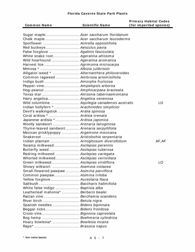
Florida Caverns State Park Plants
Primary Habitat Codes Common Name Scientific Name (for imperiled species)
* Non-native Species A 5 - 7
Sugar maple ........................... Acer saccharum floridanum Chalk maple ........................... Acer saccharum leucoderme Spotflower ............................. Acmella oppositifolia Red buckeye........................... Aesculus pavia False foxglove ........................ Agalinis fasciculata White snake root ..................... Ageratina altissima Wild hoarhound ...................... Ageratina aromatica Harvest lice ............................ Agrimonia microcarpa Mimosa * ............................... Albizia julibrissin Alligator-weed * ..................... Alternanthera philoxeroides Common ragweed ................... Ambrosia artemisiifolia Indigo bush ............................ Amorpha fruticosa Pepper-vine ............................ Ampelopsis arborea Hog-peanut ............................ Amphicarpaea bracteata Texas star .............................. Amsonia tabernaemontana Hairy angelica ......................... Angelica venenosa Wild columbine ....................... Aquilegia canadensis australis LO Indian hollyfern * .................... Arachniodes simplicior Devil's walkingstick ................. Aralia spinosa Coral ardisia * ........................ Ardisia crenata Japanese ardisia * ................... Ardisia japonica Woolly sandwort ..................... Arenaria lanuginosa Thyme-leaved sandwort ........... Arenaria serpyllifolia Mexican pricklypoppy .............. Argemone mexicana Snakeroot .............................. Aristolochia serpentaria Indian plantain ....................... Arnoglossum diversifolium AF,AF Swamp milkweed .................... Asclepias perennis Butterfly weed ........................ Asclepias tuberosa Redring milkweed ................... Asclepias variegata Whorled milkweed ................... Asclepias verticillata Green milkweed ...................... Asclepias viridiflora LO Showy wilkwort ...................... Asemeia violacea Small-flowered pawpaw ........... Asimina parviflora Common pawpaw .................... Asimina triloba Yellow foxglove ....................... Aureolaria flava Saltbush ................................ Baccharis halimifolia White false indigo ................... Baptisia alba Leatherleaf mahonia* .............. Berberis bealei Rattan vine ............................ Berchemia scandens River birch ............................. Betula nigra Spanish needles ...................... Bidens bipinnata Beggar-ticks ........................... Bidens frondosa Cross-vine .............................. Bignonia capreolata Bog hemp .............................. Boehmeria cylindrica Hoary bowlesia* ..................... Bowlesia incana Rape* .................................... Brassica napus
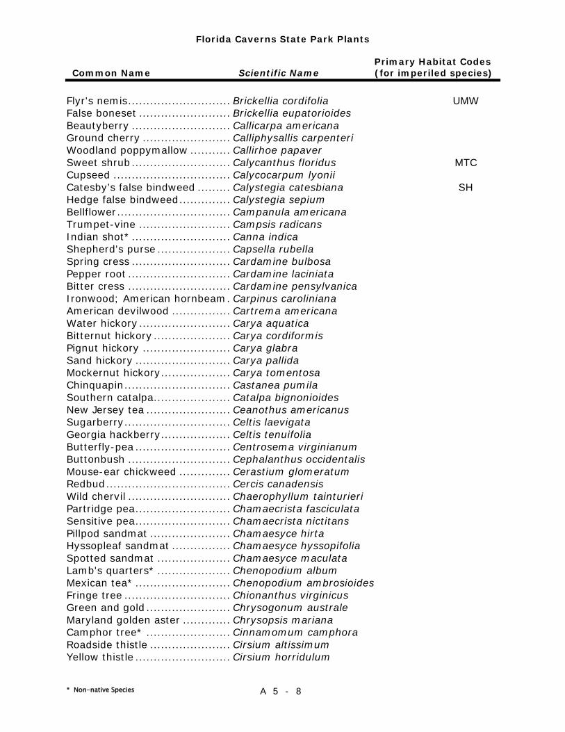
Florida Caverns State Park Plants
Primary Habitat Codes Common Name Scientific Name (for imperiled species)
* Non-native Species A 5 - 8
Flyr's nemis ............................ Brickellia cordifolia UMW False boneset ......................... Brickellia eupatorioides Beautyberry ........................... Callicarpa americana Ground cherry ........................ Calliphysallis carpenteri Woodland poppymallow ........... Callirhoe papaver Sweet shrub ........................... Calycanthus floridus MTC Cupseed ................................ Calycocarpum lyonii Catesby’s false bindweed ......... Calystegia catesbiana SH Hedge false bindweed .............. Calystegia sepium Bellflower ............................... Campanula americana Trumpet-vine ......................... Campsis radicans Indian shot* ........................... Canna indica Shepherd's purse .................... Capsella rubella Spring cress ........................... Cardamine bulbosa Pepper root ............................ Cardamine laciniata Bitter cress ............................ Cardamine pensylvanica Ironwood; American hornbeam . Carpinus caroliniana American devilwood ................ Cartrema americana Water hickory ......................... Carya aquatica Bitternut hickory ..................... Carya cordiformis Pignut hickory ........................ Carya glabra Sand hickory .......................... Carya pallida Mockernut hickory ................... Carya tomentosa Chinquapin ............................. Castanea pumila Southern catalpa..................... Catalpa bignonioides New Jersey tea ....................... Ceanothus americanus Sugarberry ............................. Celtis laevigata Georgia hackberry ................... Celtis tenuifolia Butterfly-pea .......................... Centrosema virginianum Buttonbush ............................ Cephalanthus occidentalis Mouse-ear chickweed .............. Cerastium glomeratum Redbud .................................. Cercis canadensis Wild chervil ............................ Chaerophyllum tainturieri Partridge pea .......................... Chamaecrista fasciculata Sensitive pea .......................... Chamaecrista nictitans Pillpod sandmat ...................... Chamaesyce hirta Hyssopleaf sandmat ................ Chamaesyce hyssopifolia Spotted sandmat .................... Chamaesyce maculata Lamb's quarters* .................... Chenopodium album Mexican tea* .......................... Chenopodium ambrosioides Fringe tree ............................. Chionanthus virginicus Green and gold ....................... Chrysogonum australe Maryland golden aster ............. Chrysopsis mariana Camphor tree* ....................... Cinnamomum camphora Roadside thistle ...................... Cirsium altissimum Yellow thistle .......................... Cirsium horridulum
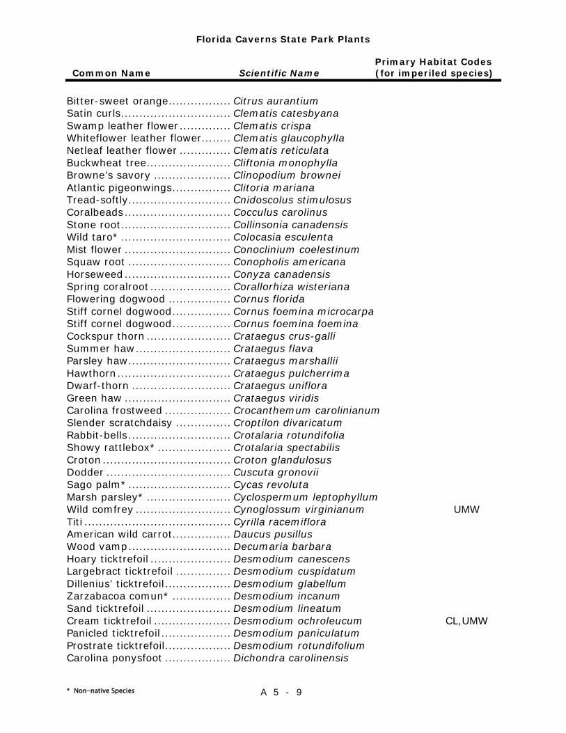
Florida Caverns State Park Plants
Primary Habitat Codes Common Name Scientific Name (for imperiled species)
* Non-native Species A 5 - 9
Bitter-sweet orange ................. Citrus aurantium Satin curls .............................. Clematis catesbyana Swamp leather flower .............. Clematis crispa Whiteflower leather flower........ Clematis glaucophylla Netleaf leather flower .............. Clematis reticulata Buckwheat tree ....................... Cliftonia monophylla Browne’s savory ..................... Clinopodium brownei Atlantic pigeonwings ................ Clitoria mariana Tread-softly............................ Cnidoscolus stimulosus Coralbeads ............................. Cocculus carolinus Stone root .............................. Collinsonia canadensis Wild taro* .............................. Colocasia esculenta Mist flower ............................. Conoclinium coelestinum Squaw root ............................ Conopholis americana Horseweed ............................. Conyza canadensis Spring coralroot ...................... Corallorhiza wisteriana Flowering dogwood ................. Cornus florida Stiff cornel dogwood ................ Cornus foemina microcarpa Stiff cornel dogwood ................ Cornus foemina foemina Cockspur thorn ....................... Crataegus crus-galli Summer haw .......................... Crataegus flava Parsley haw ............................ Crataegus marshallii Hawthorn ............................... Crataegus pulcherrima Dwarf-thorn ........................... Crataegus uniflora Green haw ............................. Crataegus viridis Carolina frostweed .................. Crocanthemum carolinianum Slender scratchdaisy ............... Croptilon divaricatum Rabbit-bells ............................ Crotalaria rotundifolia Showy rattlebox* .................... Crotalaria spectabilis Croton ................................... Croton glandulosus Dodder .................................. Cuscuta gronovii Sago palm* ............................ Cycas revoluta Marsh parsley* ....................... Cyclospermum leptophyllum Wild comfrey .......................... Cynoglossum virginianum UMW Titi ........................................ Cyrilla racemiflora American wild carrot................ Daucus pusillus Wood vamp ............................ Decumaria barbara Hoary ticktrefoil ...................... Desmodium canescens Largebract ticktrefoil ............... Desmodium cuspidatum Dillenius’ ticktrefoil .................. Desmodium glabellum Zarzabacoa comun* ................ Desmodium incanum Sand ticktrefoil ....................... Desmodium lineatum Cream ticktrefoil ..................... Desmodium ochroleucum CL,UMW Panicled ticktrefoil ................... Desmodium paniculatum Prostrate ticktrefoil .................. Desmodium rotundifolium Carolina ponysfoot .................. Dichondra carolinensis
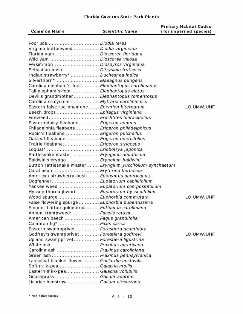
Florida Caverns State Park Plants
Primary Habitat Codes Common Name Scientific Name (for imperiled species)
* Non-native Species A 5 - 10
Poor Joe................................. Diodia teres Virginia buttonweed ................ Diodia virginiana Florida yam ............................ Dioscorea floridana Wild yam ............................... Dioscorea villosa Persimmon ............................. Diospyros virginiana Sebastian bush ....................... Ditrysinia fruticosa Indian strawberry* .................. Duchesnea indica Silverthorn* ........................... Elaeagnus pungens Carolina elephant's-foot ........... Elephantopus carolinianus Tall elephant's-foot ................. Elephantopus elatus Devil’s grandmother ................ Elephantopus tomentosus Carolina scalystem .................. Elytraria caroliniensis Eastern false rue-anemone ....... Enemion biternatum LO,UMW,UHF Beech drops ........................... Epifagus virginiana Fireweed ................................ Erechtites hieraciifolius Eastern daisy fleabane ............. Erigeron annuus Philadelphia fleabane ............... Erigeron philadelphicus Robin’s fleabane ..................... Erigeron pulchellus Oakleaf fleabane ..................... Erigeron quercifolius Prairie fleabane ....................... Erigeron strigosus Loquat* ................................. Eriobotrya japonica Rattlesnake master ................. Eryngium aquaticum Baldwin’s eryngo ..................... Eryngium baldwini Button rattlesnake master ........ Eryngium yuccifolium synchaetum Coral bean ............................. Erythrina herbacea American strawberry-bush ....... Euonymus americanus Dogfennel .............................. Eupatorium capillifolium Yankee weed .......................... Eupatorium compositifolium Hyssop thoroughwort .............. Eupatorium hyssopifolium Wood spurge .......................... Euphorbia commutata LO,UMW,UHF False flowering spurge ............. Euphorbia pubentissima Slender flattop goldenrod ......... Euthamia caroliniana Annual trampweed* ................ Facelis retusa American beech ...................... Fagus grandifolia Common fig* .......................... Ficus carica Eastern swampprivet ............... Forestiera acuminata Godfrey’s swampprivet ............ Forestiera godfreyi LO,UMW,UHF Upland swampprivet ................ Forestiera ligustrina White ash .............................. Fraxinus americana Carolina ash ........................... Fraxinus caroliniana Green ash .............................. Fraxinus pennsylvanica Lanceleaf blanket flower .......... Gaillardia aestivalis Soft milk-pea.......................... Galactia mollis Eastern milk-pea ..................... Galactia volubilis Goosegrass ............................ Galium aparine Licorice bedstraw .................... Galium circaezans
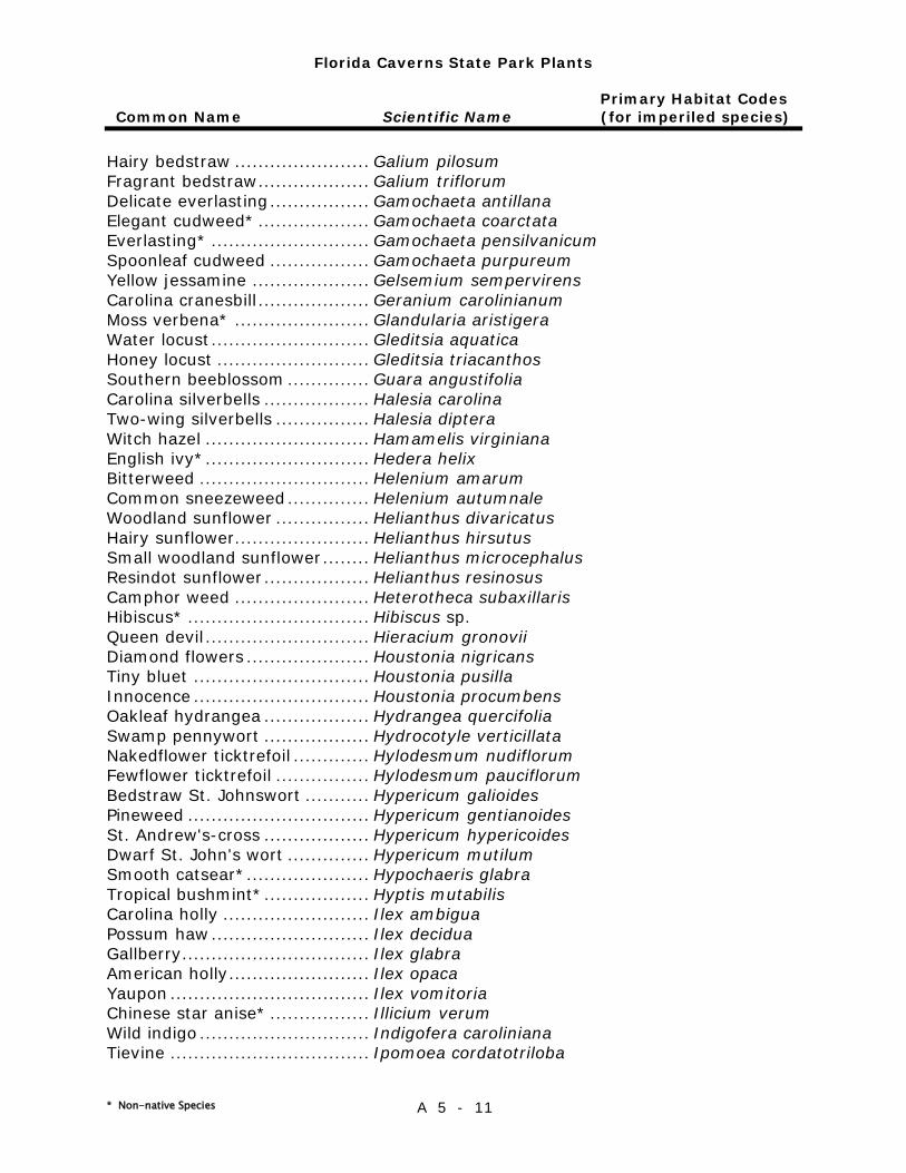
Florida Caverns State Park Plants
Primary Habitat Codes Common Name Scientific Name (for imperiled species)
* Non-native Species A 5 - 11
Hairy bedstraw ....................... Galium pilosum Fragrant bedstraw ................... Galium triflorum Delicate everlasting ................. Gamochaeta antillana Elegant cudweed* ................... Gamochaeta coarctata Everlasting* ........................... Gamochaeta pensilvanicum Spoonleaf cudweed ................. Gamochaeta purpureum Yellow jessamine .................... Gelsemium sempervirens Carolina cranesbill ................... Geranium carolinianum Moss verbena* ....................... Glandularia aristigera Water locust ........................... Gleditsia aquatica Honey locust .......................... Gleditsia triacanthos Southern beeblossom .............. Guara angustifolia Carolina silverbells .................. Halesia carolina Two-wing silverbells ................ Halesia diptera Witch hazel ............................ Hamamelis virginiana English ivy* ............................ Hedera helix Bitterweed ............................. Helenium amarum Common sneezeweed .............. Helenium autumnale Woodland sunflower ................ Helianthus divaricatus Hairy sunflower....................... Helianthus hirsutus Small woodland sunflower ........ Helianthus microcephalus Resindot sunflower .................. Helianthus resinosus Camphor weed ....................... Heterotheca subaxillaris Hibiscus* ............................... Hibiscus sp. Queen devil ............................ Hieracium gronovii Diamond flowers ..................... Houstonia nigricans Tiny bluet .............................. Houstonia pusilla Innocence .............................. Houstonia procumbens Oakleaf hydrangea .................. Hydrangea quercifolia Swamp pennywort .................. Hydrocotyle verticillata Nakedflower ticktrefoil ............. Hylodesmum nudiflorum Fewflower ticktrefoil ................ Hylodesmum pauciflorum Bedstraw St. Johnswort ........... Hypericum galioides Pineweed ............................... Hypericum gentianoides St. Andrew's-cross .................. Hypericum hypericoides Dwarf St. John's wort .............. Hypericum mutilum Smooth catsear* ..................... Hypochaeris glabra Tropical bushmint* .................. Hyptis mutabilis Carolina holly ......................... Ilex ambigua Possum haw ........................... Ilex decidua Gallberry ................................ Ilex glabra American holly ........................ Ilex opaca Yaupon .................................. Ilex vomitoria Chinese star anise* ................. Illicium verum Wild indigo ............................. Indigofera caroliniana Tievine .................................. Ipomoea cordatotriloba
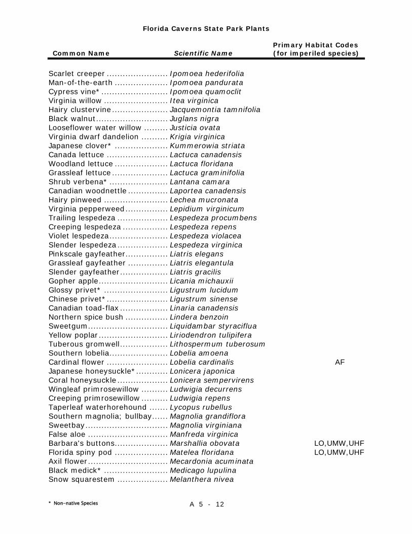
Florida Caverns State Park Plants
Primary Habitat Codes Common Name Scientific Name (for imperiled species)
* Non-native Species A 5 - 12
Scarlet creeper ....................... Ipomoea hederifolia Man-of-the-earth .................... Ipomoea pandurata Cypress vine* ......................... Ipomoea quamoclit Virginia willow ........................ Itea virginica Hairy clustervine ..................... Jacquemontia tamnifolia Black walnut ........................... Juglans nigra Looseflower water willow ......... Justicia ovata Virginia dwarf dandelion .......... Krigia virginica Japanese clover* .................... Kummerowia striata Canada lettuce ....................... Lactuca canadensis Woodland lettuce .................... Lactuca floridana Grassleaf lettuce ..................... Lactuca graminifolia Shrub verbena* ...................... Lantana camara Canadian woodnettle ............... Laportea canadensis Hairy pinweed ........................ Lechea mucronata Virginia pepperweed ................ Lepidium virginicum Trailing lespedeza ................... Lespedeza procumbens Creeping lespedeza ................. Lespedeza repens Violet lespedeza ...................... Lespedeza violacea Slender lespedeza ................... Lespedeza virginica Pinkscale gayfeather................ Liatris elegans Grassleaf gayfeather ............... Liatris elegantula Slender gayfeather .................. Liatris gracilis Gopher apple .......................... Licania michauxii Glossy privet* ........................ Ligustrum lucidum Chinese privet* ....................... Ligustrum sinense Canadian toad-flax .................. Linaria canadensis Northern spice bush ................ Lindera benzoin Sweetgum .............................. Liquidambar styraciflua Yellow poplar .......................... Liriodendron tulipifera Tuberous gromwell .................. Lithospermum tuberosum Southern lobelia ...................... Lobelia amoena Cardinal flower ....................... Lobelia cardinalis AF Japanese honeysuckle*............ Lonicera japonica Coral honeysuckle ................... Lonicera sempervirens Wingleaf primrosewillow .......... Ludwigia decurrens Creeping primrosewillow .......... Ludwigia repens Taperleaf waterhorehound ....... Lycopus rubellus Southern magnolia; bullbay...... Magnolia grandiflora Sweetbay ............................... Magnolia virginiana False aloe .............................. Manfreda virginica Barbara's buttons .................... Marshallia obovata LO,UMW,UHF Florida spiny pod .................... Matelea floridana LO,UMW,UHF Axil flower .............................. Mecardonia acuminata Black medick* ........................ Medicago lupulina Snow squarestem ................... Melanthera nivea
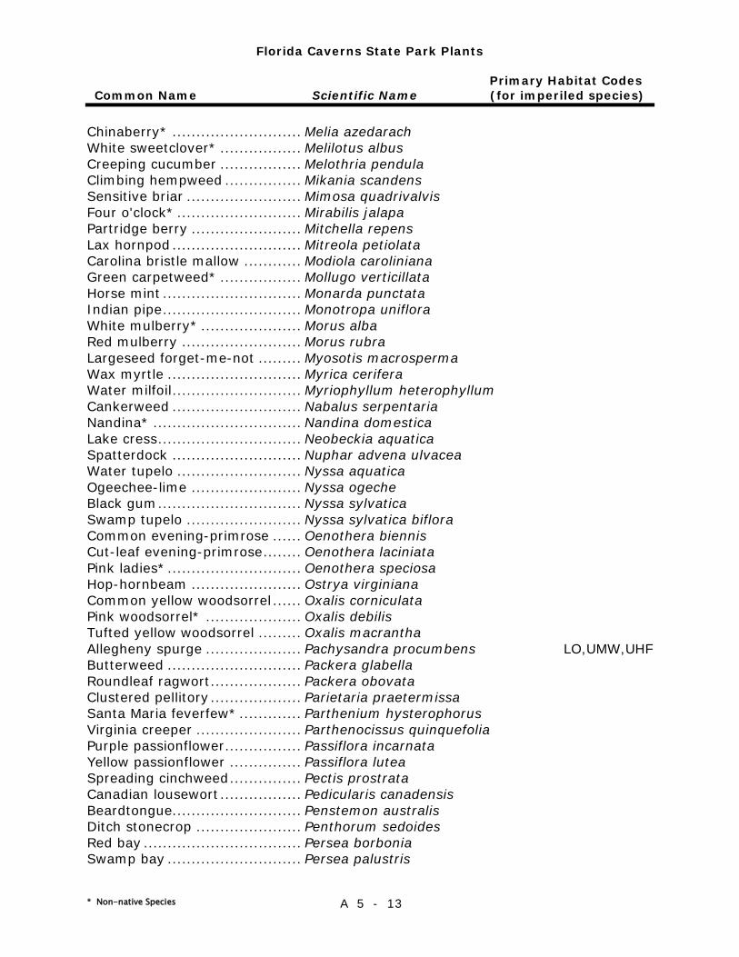
Florida Caverns State Park Plants
Primary Habitat Codes Common Name Scientific Name (for imperiled species)
* Non-native Species A 5 - 13
Chinaberry* ........................... Melia azedarach White sweetclover* ................. Melilotus albus Creeping cucumber ................. Melothria pendula Climbing hempweed ................ Mikania scandens Sensitive briar ........................ Mimosa quadrivalvis Four o'clock* .......................... Mirabilis jalapa Partridge berry ....................... Mitchella repens Lax hornpod ........................... Mitreola petiolata Carolina bristle mallow ............ Modiola caroliniana Green carpetweed* ................. Mollugo verticillata Horse mint ............................. Monarda punctata Indian pipe ............................. Monotropa uniflora White mulberry* ..................... Morus alba Red mulberry ......................... Morus rubra Largeseed forget-me-not ......... Myosotis macrosperma Wax myrtle ............................ Myrica cerifera Water milfoil ........................... Myriophyllum heterophyllum Cankerweed ........................... Nabalus serpentaria Nandina* ............................... Nandina domestica Lake cress .............................. Neobeckia aquatica Spatterdock ........................... Nuphar advena ulvacea Water tupelo .......................... Nyssa aquatica Ogeechee-lime ....................... Nyssa ogeche Black gum .............................. Nyssa sylvatica Swamp tupelo ........................ Nyssa sylvatica biflora Common evening-primrose ...... Oenothera biennis Cut-leaf evening-primrose ........ Oenothera laciniata Pink ladies* ............................ Oenothera speciosa Hop-hornbeam ....................... Ostrya virginiana Common yellow woodsorrel ...... Oxalis corniculata Pink woodsorrel* .................... Oxalis debilis Tufted yellow woodsorrel ......... Oxalis macrantha Allegheny spurge .................... Pachysandra procumbens LO,UMW,UHF Butterweed ............................ Packera glabella Roundleaf ragwort ................... Packera obovata Clustered pellitory ................... Parietaria praetermissa Santa Maria feverfew* ............. Parthenium hysterophorus Virginia creeper ...................... Parthenocissus quinquefolia Purple passionflower ................ Passiflora incarnata Yellow passionflower ............... Passiflora lutea Spreading cinchweed ............... Pectis prostrata Canadian lousewort ................. Pedicularis canadensis Beardtongue........................... Penstemon australis Ditch stonecrop ...................... Penthorum sedoides Red bay ................................. Persea borbonia Swamp bay ............................ Persea palustris
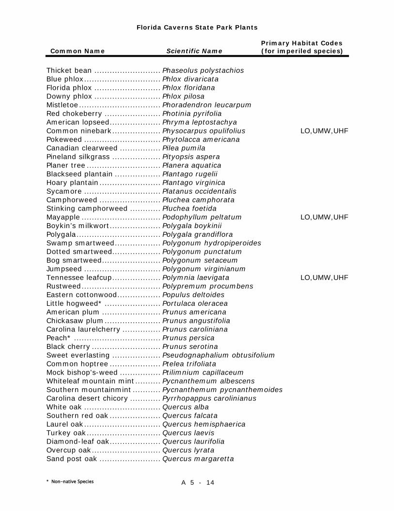
Florida Caverns State Park Plants
Primary Habitat Codes Common Name Scientific Name (for imperiled species)
* Non-native Species A 5 - 14
Thicket bean .......................... Phaseolus polystachios Blue phlox .............................. Phlox divaricata Florida phlox .......................... Phlox floridana Downy phlox .......................... Phlox pilosa Mistletoe ................................ Phoradendron leucarpum Red chokeberry ...................... Photinia pyrifolia American lopseed .................... Phryma leptostachya Common ninebark ................... Physocarpus opulifolius LO,UMW,UHF Pokeweed .............................. Phytolacca americana Canadian clearweed ................ Pilea pumila Pineland silkgrass ................... Pityopsis aspera Planer tree ............................. Planera aquatica Blackseed plantain .................. Plantago rugelii Hoary plantain ........................ Plantago virginica Sycamore .............................. Platanus occidentalis Camphorweed ........................ Pluchea camphorata Stinking camphorweed ............ Pluchea foetida Mayapple ............................... Podophyllum peltatum LO,UMW,UHF Boykin’s milkwort .................... Polygala boykinii Polygala ................................. Polygala grandiflora Swamp smartweed .................. Polygonum hydropiperoides Dotted smartweed ................... Polygonum punctatum Bog smartweed ....................... Polygonum setaceum Jumpseed .............................. Polygonum virginianum Tennessee leafcup ................... Polymnia laevigata LO,UMW,UHF Rustweed ............................... Polypremum procumbens Eastern cottonwood ................. Populus deltoides Little hogweed* ...................... Portulaca oleracea American plum ....................... Prunus americana Chickasaw plum ...................... Prunus angustifolia Carolina laurelcherry ............... Prunus caroliniana Peach* .................................. Prunus persica Black cherry ........................... Prunus serotina Sweet everlasting ................... Pseudognaphalium obtusifolium Common hoptree .................... Ptelea trifoliata Mock bishop's-weed ................ Ptilimnium capillaceum Whiteleaf mountain mint .......... Pycnanthemum albescens Southern mountainmint ........... Pycnanthemum pycnanthemoides Carolina desert chicory ............ Pyrrhopappus carolinianus White oak .............................. Quercus alba Southern red oak .................... Quercus falcata Laurel oak .............................. Quercus hemisphaerica Turkey oak ............................. Quercus laevis Diamond-leaf oak .................... Quercus laurifolia Overcup oak ........................... Quercus lyrata Sand post oak ........................ Quercus margaretta

Florida Caverns State Park Plants
Primary Habitat Codes Common Name Scientific Name (for imperiled species)
* Non-native Species A 5 - 15
Blackjack oak ......................... Quercus marilandica Basket oak ............................. Quercus michauxii Chinquapin oak ....................... Quercus muhlenbergii Water oak .............................. Quercus nigra Running oak ........................... Quercus pumila Shumard oak .......................... Quercus shumardii Black oak ............................... Quercus velutina Live oak ................................. Quercus virginiana Marsh buttercup...................... Ranunculus hispidus nitidus Hooked buttercup ................... Ranunculus recurvatus Carolina buckthorn .................. Rhamnus caroliniana Southern flame azalea ............. Rhododendron austrinum AF,UMW,UHF Wild azalea ............................ Rhododendron canescens MTC Fragrant sumac ...................... Rhus aromatica Winged sumac ........................ Rhus copallina Doubleform snoutbean............. Rhynchosia difformis Dollarleaf ............................... Rhynchosia reniformis So. American Mexican clover* .. Richardia humistrata Rough Mexican clover* ............ Richardia scabra Castorbean* ........................... Ricinus communis Carolina rose .......................... Rosa carolina Swamp rose ........................... Rosa palustris Sand blackberry ...................... Rubus cuneifolius Sawtooth blackberry ................ Rubus pensilvanicus Dewberry ............................... Rubus trivialis Orange coneflower .................. Rudbeckia fulgida Black-eyed susan .................... Rudbeckia hirta Brown eyed susan ................... Rudbeckia triloba pinnatiloba CL Carolina wild petunia ............... Ruellia caroliniensis Heartwing dock ....................... Rumex hastatulus Swamp dock ........................... Rumex verticillatus Rosepink ................................ Sabatia angularis Coastal rosegentian ................. Sabatia calycina Slender rosegentian ................ Sabatia campanulata Bartram’s rosegentian ............. Sabatia decandra Smallflower mock buckthorn..... Sageretia minutiflora Coastal plain willow ................. Salix caroliniana Black willow ........................... Salix nigra Azure blue sage ...................... Salvia azurea Blood sage ............................. Salvia coccinea Lyre-leaved sage .................... Salvia lyrata Nettleleaf sage ....................... Salvia urticifolia LO,UMW,UHF Elderberry .............................. Sambucus nigra canadensis Pineland pimpernel .................. Samolus alerandi parviflorus Bloodroot ............................... Sanguinaria canadensis Canadian black snakeroot ........ Sanicula canadensis
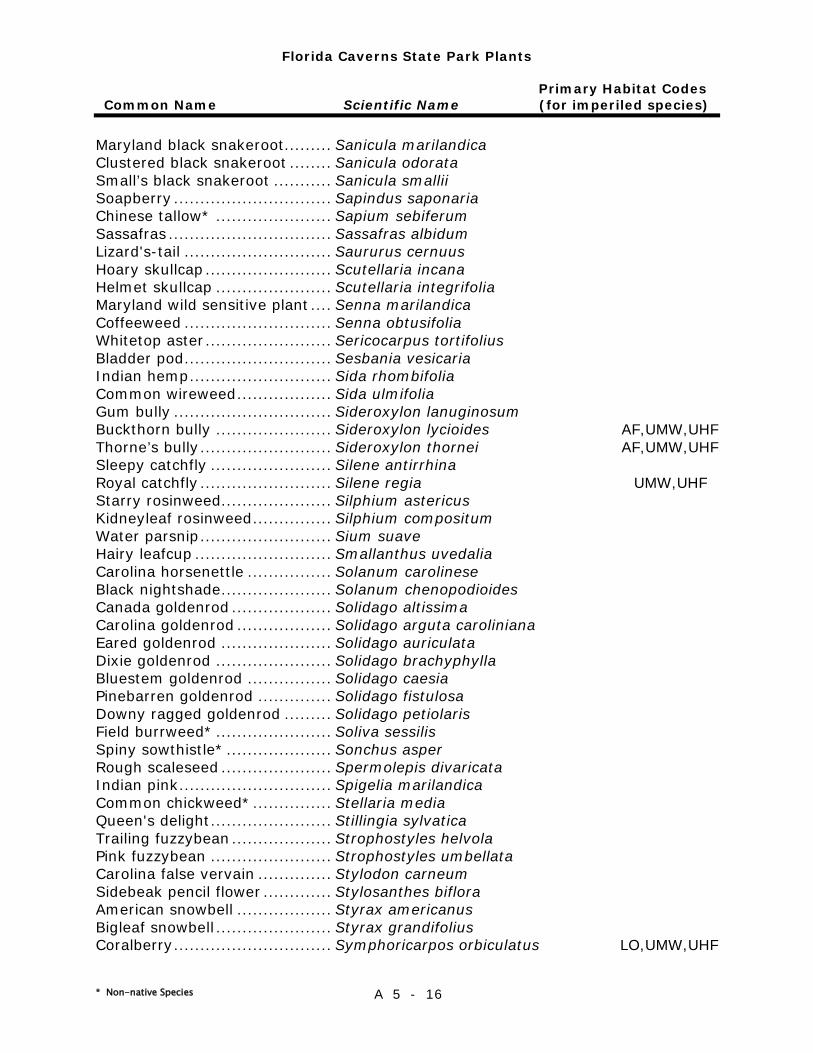
Florida Caverns State Park Plants
Primary Habitat Codes Common Name Scientific Name (for imperiled species)
* Non-native Species A 5 - 16
Maryland black snakeroot......... Sanicula marilandica Clustered black snakeroot ........ Sanicula odorata Small’s black snakeroot ........... Sanicula smallii Soapberry .............................. Sapindus saponaria Chinese tallow* ...................... Sapium sebiferum Sassafras ............................... Sassafras albidum Lizard's-tail ............................ Saururus cernuus Hoary skullcap ........................ Scutellaria incana Helmet skullcap ...................... Scutellaria integrifolia Maryland wild sensitive plant .... Senna marilandica Coffeeweed ............................ Senna obtusifolia Whitetop aster ........................ Sericocarpus tortifolius Bladder pod ............................ Sesbania vesicaria Indian hemp ........................... Sida rhombifolia Common wireweed .................. Sida ulmifolia Gum bully .............................. Sideroxylon lanuginosum Buckthorn bully ...................... Sideroxylon lycioides AF,UMW,UHF Thorne’s bully ......................... Sideroxylon thornei AF,UMW,UHF Sleepy catchfly ....................... Silene antirrhina Royal catchfly ......................... Silene regia UMW,UHF Starry rosinweed..................... Silphium astericus Kidneyleaf rosinweed ............... Silphium compositum Water parsnip ......................... Sium suave Hairy leafcup .......................... Smallanthus uvedalia Carolina horsenettle ................ Solanum carolinese Black nightshade ..................... Solanum chenopodioides Canada goldenrod ................... Solidago altissima Carolina goldenrod .................. Solidago arguta caroliniana Eared goldenrod ..................... Solidago auriculata Dixie goldenrod ...................... Solidago brachyphylla Bluestem goldenrod ................ Solidago caesia Pinebarren goldenrod .............. Solidago fistulosa Downy ragged goldenrod ......... Solidago petiolaris Field burrweed* ...................... Soliva sessilis Spiny sowthistle* .................... Sonchus asper Rough scaleseed ..................... Spermolepis divaricata Indian pink ............................. Spigelia marilandica Common chickweed* ............... Stellaria media Queen's delight ....................... Stillingia sylvatica Trailing fuzzybean ................... Strophostyles helvola Pink fuzzybean ....................... Strophostyles umbellata Carolina false vervain .............. Stylodon carneum Sidebeak pencil flower ............. Stylosanthes biflora American snowbell .................. Styrax americanus Bigleaf snowbell ...................... Styrax grandifolius Coralberry .............................. Symphoricarpos orbiculatus LO,UMW,UHF
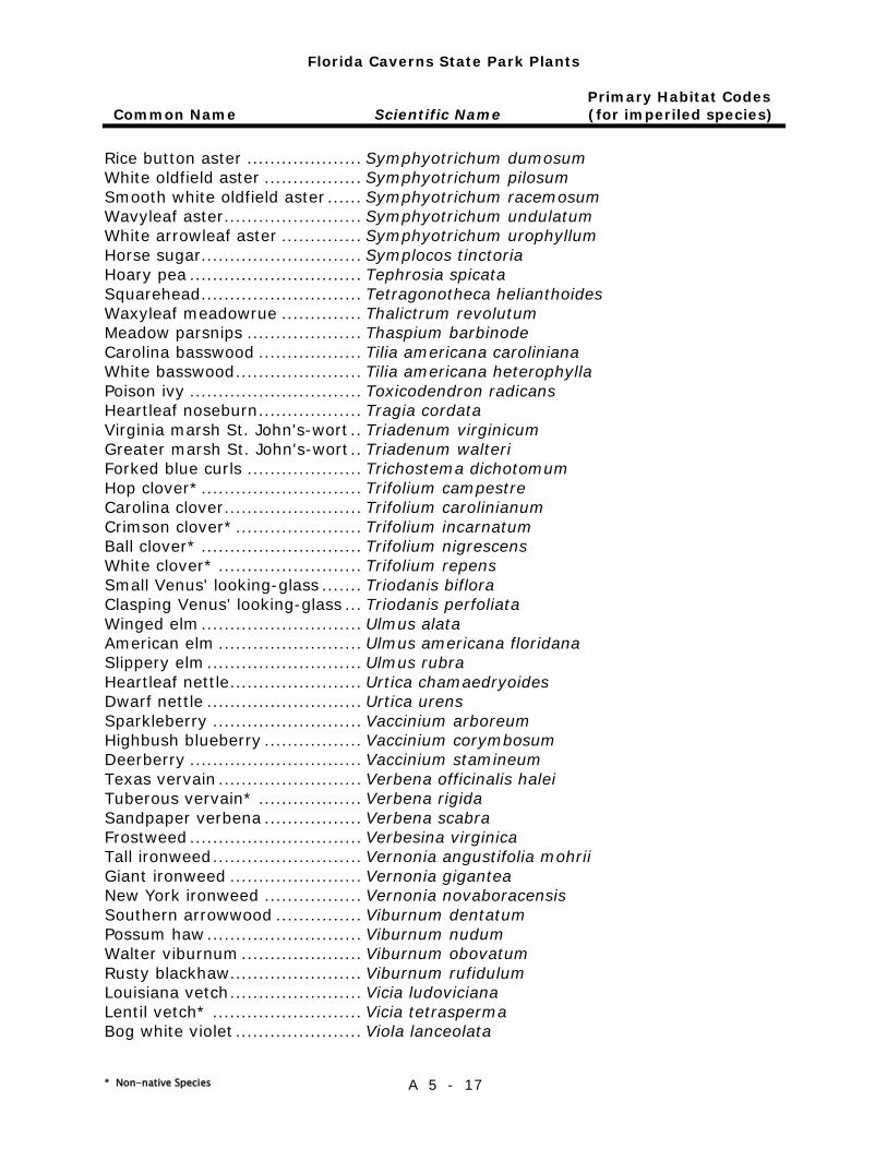
Florida Caverns State Park Plants
Primary Habitat Codes Common Name Scientific Name (for imperiled species)
* Non-native Species A 5 - 17
Rice button aster .................... Symphyotrichum dumosum White oldfield aster ................. Symphyotrichum pilosum Smooth white oldfield aster ...... Symphyotrichum racemosum Wavyleaf aster ........................ Symphyotrichum undulatum White arrowleaf aster .............. Symphyotrichum urophyllum Horse sugar............................ Symplocos tinctoria Hoary pea .............................. Tephrosia spicata Squarehead ............................ Tetragonotheca helianthoides Waxyleaf meadowrue .............. Thalictrum revolutum Meadow parsnips .................... Thaspium barbinode Carolina basswood .................. Tilia americana caroliniana White basswood ...................... Tilia americana heterophylla Poison ivy .............................. Toxicodendron radicans Heartleaf noseburn .................. Tragia cordata Virginia marsh St. John's-wort .. Triadenum virginicum Greater marsh St. John's-wort .. Triadenum walteri Forked blue curls .................... Trichostema dichotomum Hop clover* ............................ Trifolium campestre Carolina clover ........................ Trifolium carolinianum Crimson clover* ...................... Trifolium incarnatum Ball clover* ............................ Trifolium nigrescens White clover* ......................... Trifolium repens Small Venus' looking-glass ....... Triodanis biflora Clasping Venus' looking-glass ... Triodanis perfoliata Winged elm ............................ Ulmus alata American elm ......................... Ulmus americana floridana Slippery elm ........................... Ulmus rubra Heartleaf nettle ....................... Urtica chamaedryoides Dwarf nettle ........................... Urtica urens Sparkleberry .......................... Vaccinium arboreum Highbush blueberry ................. Vaccinium corymbosum Deerberry .............................. Vaccinium stamineum Texas vervain ......................... Verbena officinalis halei Tuberous vervain* .................. Verbena rigida Sandpaper verbena ................. Verbena scabra Frostweed .............................. Verbesina virginica Tall ironweed .......................... Vernonia angustifolia mohrii Giant ironweed ....................... Vernonia gigantea New York ironweed ................. Vernonia novaboracensis Southern arrowwood ............... Viburnum dentatum Possum haw ........................... Viburnum nudum Walter viburnum ..................... Viburnum obovatum Rusty blackhaw....................... Viburnum rufidulum Louisiana vetch ....................... Vicia ludoviciana Lentil vetch* .......................... Vicia tetrasperma Bog white violet ...................... Viola lanceolata
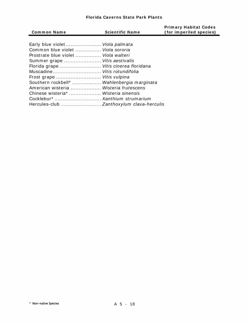
Florida Caverns State Park Plants
Primary Habitat Codes Common Name Scientific Name (for imperiled species)
* Non-native Species A 5 - 18
Early blue violet ...................... Viola palmata Common blue violet ................ Viola sororia Prostrate blue violet ................ Viola walteri Summer grape ....................... Vitis aestivalis Florida grape .......................... Vitis cinerea floridana Muscadine .............................. Vitis rotundifolia Frost grape ............................ Vitis vulpina Southern rockbell* .................. Wahlenbergia marginata American wisteria ................... Wisteria frutescens Chinese wisteria* .................... Wisteria sinensis Cocklebur* ............................. Xanthium strumarium Hercules-club ......................... Zanthoxylum clava-herculis
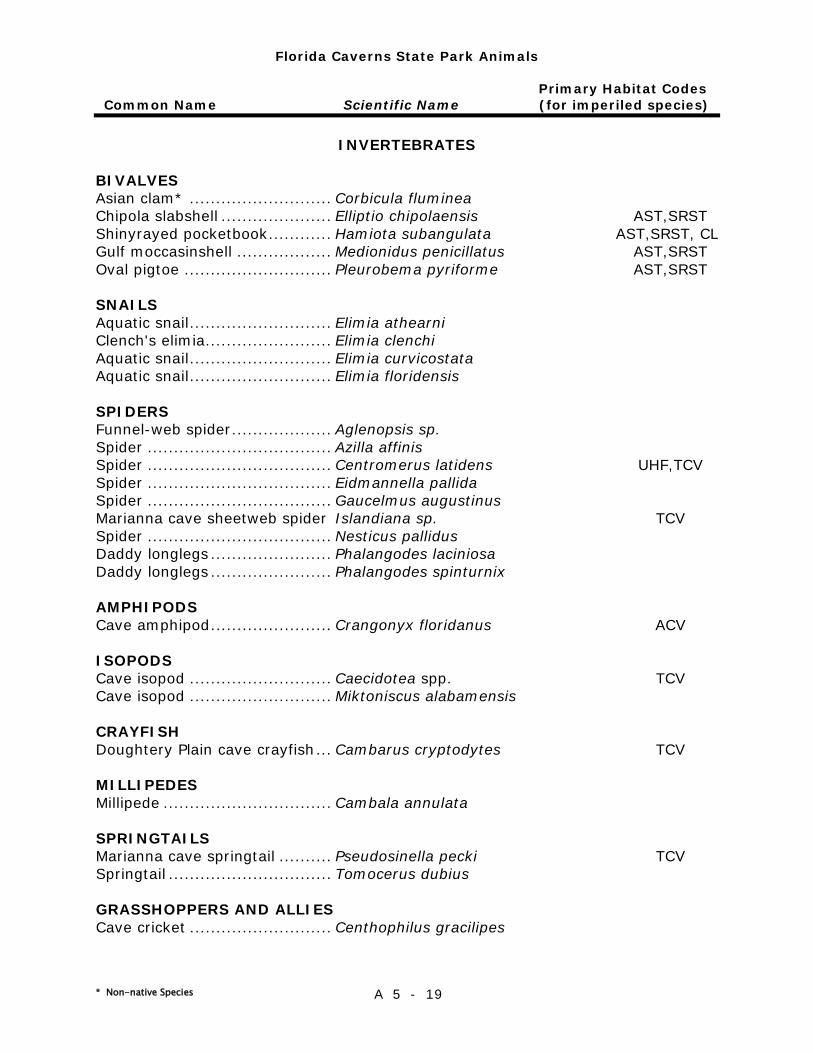
Florida Caverns State Park Animals
Primary Habitat Codes Common Name Scientific Name (for imperiled species)
* Non-native Species A 5 - 19
INVERTEBRATES
BIVALVES Asian clam* ........................... Corbicula fluminea Chipola slabshell ..................... Elliptio chipolaensis AST,SRST Shinyrayed pocketbook ............ Hamiota subangulata AST,SRST, CL Gulf moccasinshell .................. Medionidus penicillatus AST,SRST Oval pigtoe ............................ Pleurobema pyriforme AST,SRST
SNAILS Aquatic snail ........................... Elimia athearni Clench's elimia ........................ Elimia clenchi Aquatic snail ........................... Elimia curvicostata Aquatic snail ........................... Elimia floridensis
SPIDERS Funnel-web spider ................... Aglenopsis sp. Spider ................................... Azilla affinis Spider ................................... Centromerus latidens UHF,TCV Spider ................................... Eidmannella pallida Spider ................................... Gaucelmus augustinus Marianna cave sheetweb spider Islandiana sp. TCV Spider ................................... Nesticus pallidus Daddy longlegs ....................... Phalangodes laciniosa Daddy longlegs ....................... Phalangodes spinturnix
AMPHIPODS Cave amphipod ....................... Crangonyx floridanus ACV
ISOPODS Cave isopod ........................... Caecidotea spp. TCV Cave isopod ........................... Miktoniscus alabamensis
CRAYFISH Doughtery Plain cave crayfish ... Cambarus cryptodytes TCV
MILLIPEDES Millipede ................................ Cambala annulata
SPRINGTAILS Marianna cave springtail .......... Pseudosinella pecki TCV Springtail ............................... Tomocerus dubius
GRASSHOPPERS AND ALLIES Cave cricket ........................... Centhophilus gracilipes
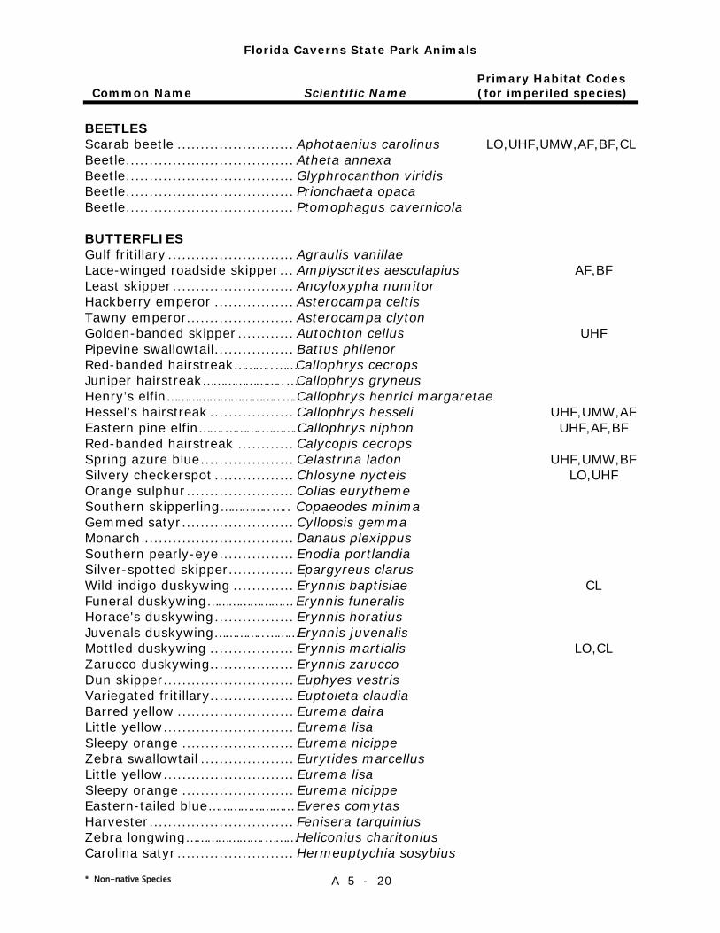
Florida Caverns State Park Animals
Primary Habitat Codes Common Name Scientific Name (for imperiled species)
* Non-native Species A 5 - 20
BEETLES Scarab beetle ......................... Aphotaenius carolinus LO,UHF,UMW,AF,BF,CL Beetle .................................... Atheta annexa Beetle .................................... Glyphrocanthon viridis Beetle .................................... Prionchaeta opaca Beetle .................................... Ptomophagus cavernicola
BUTTERFLIES Gulf fritillary ........................... Agraulis vanillae Lace-winged roadside skipper ... Amplyscrites aesculapius AF,BF Least skipper .......................... Ancyloxypha numitor Hackberry emperor ................. Asterocampa celtis Tawny emperor....................... Asterocampa clyton Golden-banded skipper ............ Autochton cellus UHF Pipevine swallowtail ................. Battus philenor Red-banded hairstreak………..……Callophrys cecrops Juniper hairstreak…………………..…Callophrys gryneus Henry’s elfin…………………………..….Callophrys henrici margaretae Hessel’s hairstreak .................. Callophrys hesseli UHF,UMW,AF Eastern pine elfin…….……….……….Callophrys niphon UHF,AF,BF Red-banded hairstreak ............ Calycopis cecrops Spring azure blue .................... Celastrina ladon UHF,UMW,BF Silvery checkerspot ................. Chlosyne nycteis LO,UHF Orange sulphur ....................... Colias eurytheme Southern skipperling…………..….. Copaeodes minima Gemmed satyr ........................ Cyllopsis gemma Monarch ................................ Danaus plexippus Southern pearly-eye ................ Enodia portlandia Silver-spotted skipper .............. Epargyreus clarus Wild indigo duskywing ............. Erynnis baptisiae CL Funeral duskywing…………………… Erynnis funeralis Horace's duskywing ................. Erynnis horatius Juvenals duskywing…………..………Erynnis juvenalis Mottled duskywing .................. Erynnis martialis LO,CL Zarucco duskywing.................. Erynnis zarucco Dun skipper ............................ Euphyes vestris Variegated fritillary.................. Euptoieta claudia Barred yellow ......................... Eurema daira Little yellow ............................ Eurema lisa Sleepy orange ........................ Eurema nicippe Zebra swallowtail .................... Eurytides marcellus Little yellow ............................ Eurema lisa Sleepy orange ........................ Eurema nicippe Eastern-tailed blue…………………… Everes comytas Harvester ............................... Fenisera tarquinius Zebra longwing………………….………Heliconius charitonius Carolina satyr ......................... Hermeuptychia sosybius
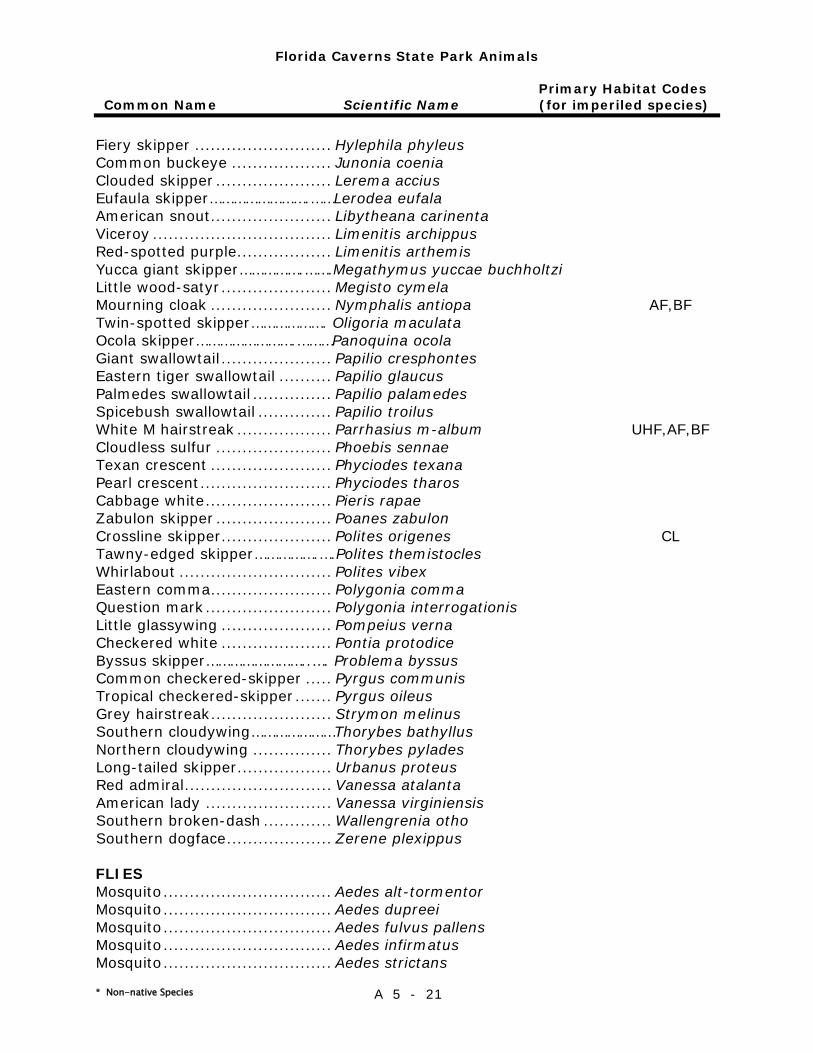
Florida Caverns State Park Animals
Primary Habitat Codes Common Name Scientific Name (for imperiled species)
* Non-native Species A 5 - 21
Fiery skipper .......................... Hylephila phyleus Common buckeye ................... Junonia coenia Clouded skipper ...................... Lerema accius Eufaula skipper…………………….……Lerodea eufala American snout ....................... Libytheana carinenta Viceroy .................................. Limenitis archippus Red-spotted purple.................. Limenitis arthemis Yucca giant skipper…………….…….Megathymus yuccae buchholtzi Little wood-satyr ..................... Megisto cymela Mourning cloak ....................... Nymphalis antiopa AF,BF Twin-spotted skipper………………. Oligoria maculata Ocola skipper…………………….………Panoquina ocola Giant swallowtail ..................... Papilio cresphontes Eastern tiger swallowtail .......... Papilio glaucus Palmedes swallowtail ............... Papilio palamedes Spicebush swallowtail .............. Papilio troilus White M hairstreak .................. Parrhasius m-album UHF,AF,BF Cloudless sulfur ...................... Phoebis sennae Texan crescent ....................... Phyciodes texana Pearl crescent ......................... Phyciodes tharos Cabbage white ........................ Pieris rapae Zabulon skipper ...................... Poanes zabulon Crossline skipper ..................... Polites origenes CL Tawny-edged skipper…………….….Polites themistocles Whirlabout ............................. Polites vibex Eastern comma ....................... Polygonia comma Question mark ........................ Polygonia interrogationis Little glassywing ..................... Pompeius verna Checkered white ..................... Pontia protodice Byssus skipper……………………..…. Problema byssus Common checkered-skipper ..... Pyrgus communis Tropical checkered-skipper ....... Pyrgus oileus Grey hairstreak ....................... Strymon melinus Southern cloudywing…………………Thorybes bathyllus Northern cloudywing ............... Thorybes pylades Long-tailed skipper .................. Urbanus proteus Red admiral ............................ Vanessa atalanta American lady ........................ Vanessa virginiensis Southern broken-dash ............. Wallengrenia otho Southern dogface .................... Zerene plexippus
FLIES Mosquito ................................ Aedes alt-tormentor Mosquito ................................ Aedes dupreei Mosquito ................................ Aedes fulvus pallens Mosquito ................................ Aedes infirmatus Mosquito ................................ Aedes strictans
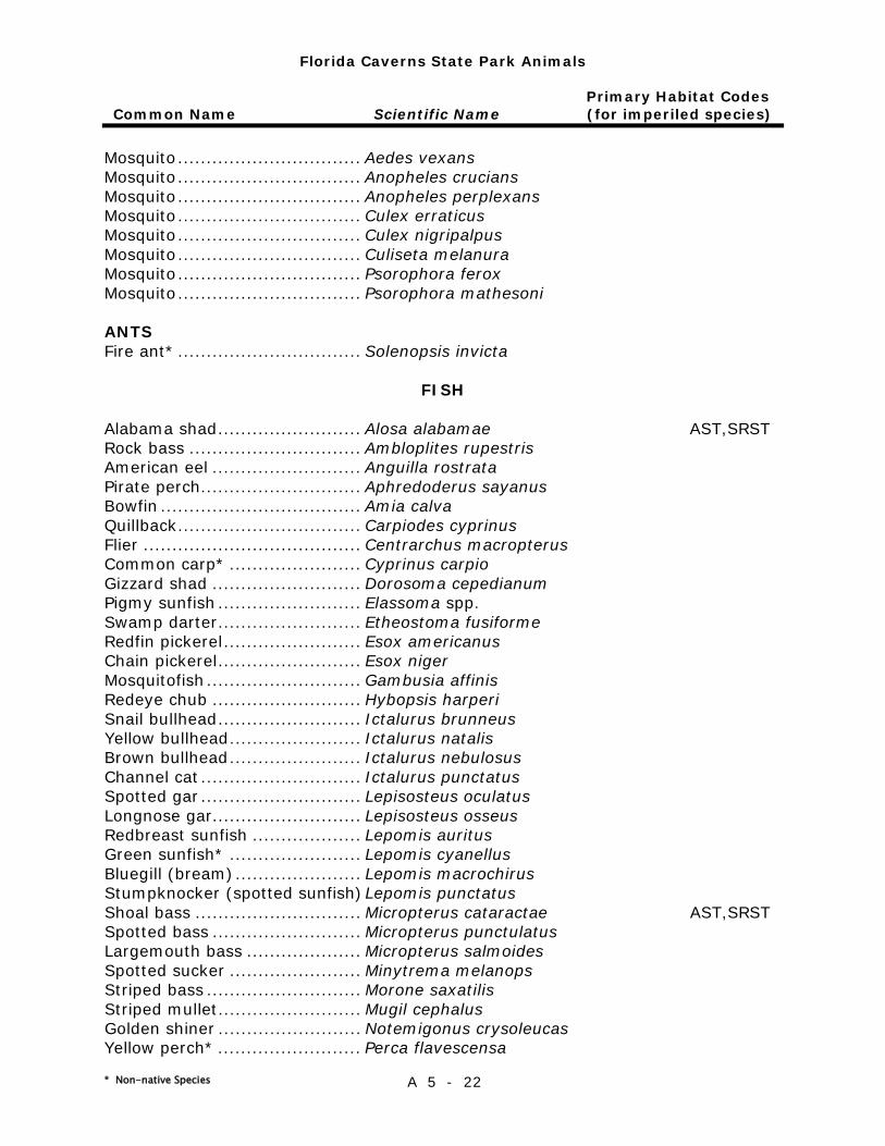
Florida Caverns State Park Animals
Primary Habitat Codes Common Name Scientific Name (for imperiled species)
* Non-native Species A 5 - 22
Mosquito ................................ Aedes vexans Mosquito ................................ Anopheles crucians Mosquito ................................ Anopheles perplexans Mosquito ................................ Culex erraticus Mosquito ................................ Culex nigripalpus Mosquito ................................ Culiseta melanura Mosquito ................................ Psorophora ferox Mosquito ................................ Psorophora mathesoni
ANTS Fire ant* ................................ Solenopsis invicta
FISH
Alabama shad ......................... Alosa alabamae AST,SRST Rock bass .............................. Ambloplites rupestris American eel .......................... Anguilla rostrata Pirate perch ............................ Aphredoderus sayanus Bowfin ................................... Amia calva Quillback ................................ Carpiodes cyprinus Flier ...................................... Centrarchus macropterus Common carp* ....................... Cyprinus carpio Gizzard shad .......................... Dorosoma cepedianum Pigmy sunfish ......................... Elassoma spp. Swamp darter ......................... Etheostoma fusiforme Redfin pickerel ........................ Esox americanus Chain pickerel ......................... Esox niger Mosquitofish ........................... Gambusia affinis Redeye chub .......................... Hybopsis harperi Snail bullhead ......................... Ictalurus brunneus Yellow bullhead ....................... Ictalurus natalis Brown bullhead ....................... Ictalurus nebulosus Channel cat ............................ Ictalurus punctatus Spotted gar ............................ Lepisosteus oculatus Longnose gar.......................... Lepisosteus osseus Redbreast sunfish ................... Lepomis auritus Green sunfish* ....................... Lepomis cyanellus Bluegill (bream) ...................... Lepomis macrochirus Stumpknocker (spotted sunfish) Lepomis punctatus Shoal bass ............................. Micropterus cataractae AST,SRST Spotted bass .......................... Micropterus punctulatus Largemouth bass .................... Micropterus salmoides Spotted sucker ....................... Minytrema melanops Striped bass ........................... Morone saxatilis Striped mullet ......................... Mugil cephalus Golden shiner ......................... Notemigonus crysoleucas Yellow perch* ......................... Perca flavescensa
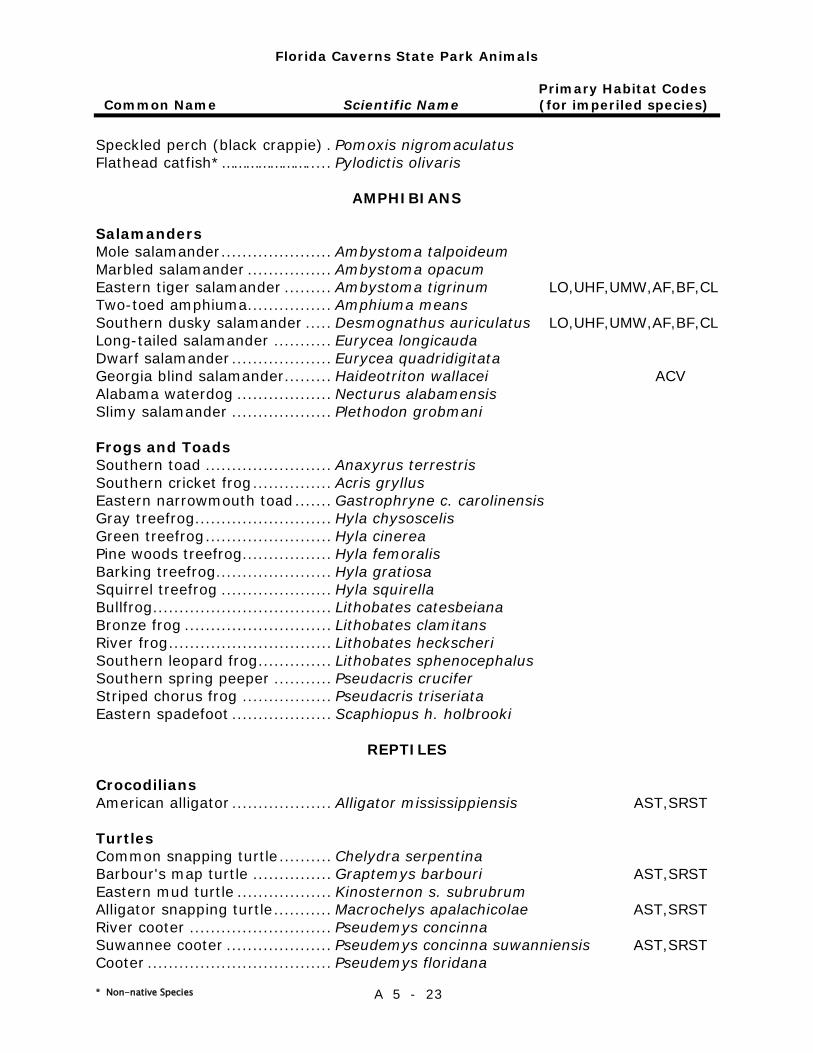
Florida Caverns State Park Animals
Primary Habitat Codes Common Name Scientific Name (for imperiled species)
* Non-native Species A 5 - 23
Speckled perch (black crappie) . Pomoxis nigromaculatus Flathead catfish*………………… ..... Pylodictis olivaris
AMPHIBIANS
Salamanders Mole salamander ..................... Ambystoma talpoideum Marbled salamander ................ Ambystoma opacum Eastern tiger salamander ......... Ambystoma tigrinum LO,UHF,UMW,AF,BF,CL Two-toed amphiuma................ Amphiuma means Southern dusky salamander ..... Desmognathus auriculatus LO,UHF,UMW,AF,BF,CL Long-tailed salamander ........... Eurycea longicauda Dwarf salamander ................... Eurycea quadridigitata Georgia blind salamander ......... Haideotriton wallacei ACV Alabama waterdog .................. Necturus alabamensis Slimy salamander ................... Plethodon grobmani
Frogs and Toads Southern toad ........................ Anaxyrus terrestris Southern cricket frog ............... Acris gryllus Eastern narrowmouth toad ....... Gastrophryne c. carolinensis Gray treefrog .......................... Hyla chysoscelis Green treefrog ........................ Hyla cinerea Pine woods treefrog ................. Hyla femoralis Barking treefrog ...................... Hyla gratiosa Squirrel treefrog ..................... Hyla squirella Bullfrog .................................. Lithobates catesbeiana Bronze frog ............................ Lithobates clamitans River frog ............................... Lithobates heckscheri Southern leopard frog .............. Lithobates sphenocephalus Southern spring peeper ........... Pseudacris crucifer Striped chorus frog ................. Pseudacris triseriata Eastern spadefoot ................... Scaphiopus h. holbrooki
REPTILES
Crocodilians American alligator ................... Alligator mississippiensis AST,SRST
Turtles Common snapping turtle .......... Chelydra serpentina Barbour's map turtle ............... Graptemys barbouri AST,SRST Eastern mud turtle .................. Kinosternon s. subrubrum Alligator snapping turtle ........... Macrochelys apalachicolae AST,SRST River cooter ........................... Pseudemys concinna Suwannee cooter .................... Pseudemys concinna suwanniensis AST,SRST Cooter ................................... Pseudemys floridana
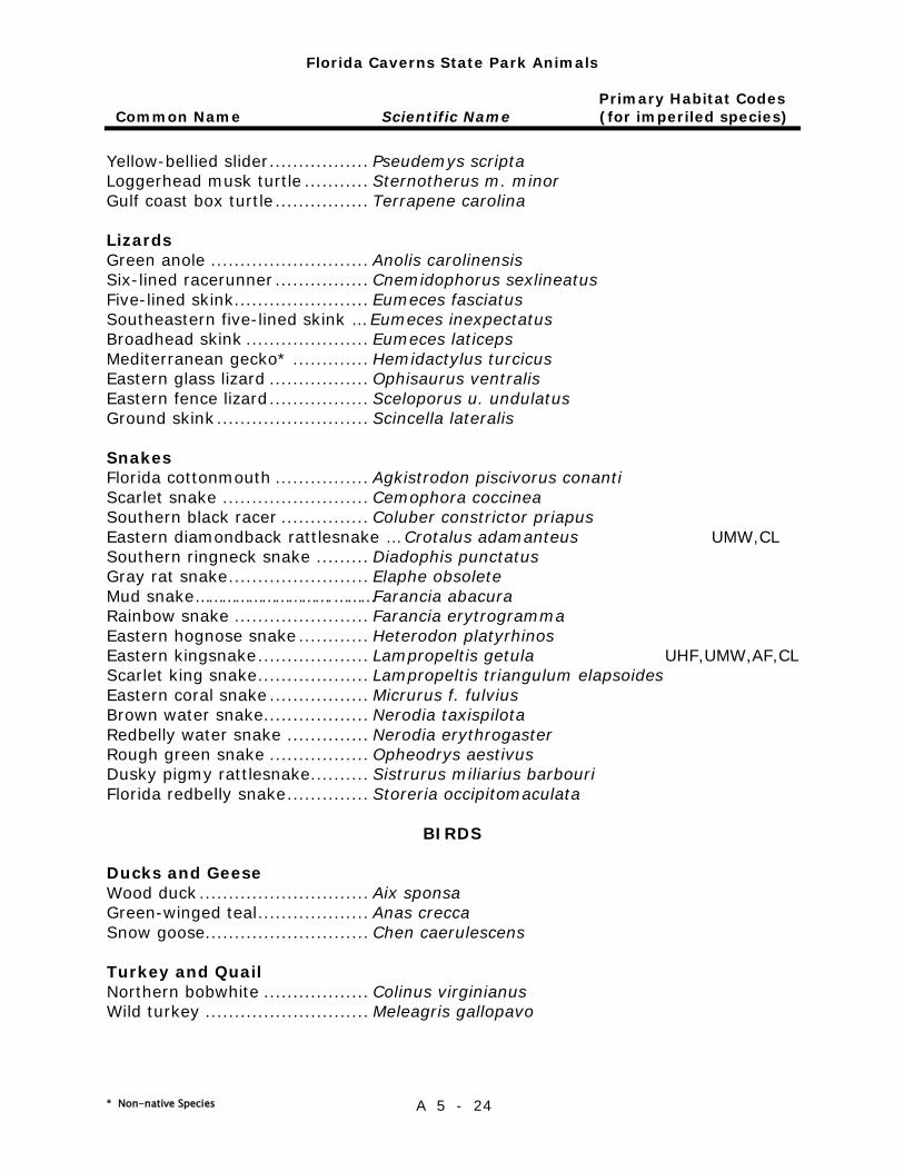
Florida Caverns State Park Animals
Primary Habitat Codes Common Name Scientific Name (for imperiled species)
* Non-native Species A 5 - 24
Yellow-bellied slider ................. Pseudemys scripta Loggerhead musk turtle ........... Sternotherus m. minor Gulf coast box turtle ................ Terrapene carolina
Lizards Green anole ........................... Anolis carolinensis Six-lined racerunner ................ Cnemidophorus sexlineatus Five-lined skink....................... Eumeces fasciatus Southeastern five-lined skink … Eumeces inexpectatus Broadhead skink ..................... Eumeces laticeps Mediterranean gecko* ............. Hemidactylus turcicus Eastern glass lizard ................. Ophisaurus ventralis Eastern fence lizard ................. Sceloporus u. undulatus Ground skink .......................... Scincella lateralis
Snakes Florida cottonmouth ................ Agkistrodon piscivorus conanti Scarlet snake ......................... Cemophora coccinea Southern black racer ............... Coluber constrictor priapus Eastern diamondback rattlesnake … Crotalus adamanteus UMW,CL Southern ringneck snake ......... Diadophis punctatus Gray rat snake ........................ Elaphe obsolete Mud snake………………………….………Farancia abacura Rainbow snake ....................... Farancia erytrogramma Eastern hognose snake ............ Heterodon platyrhinos Eastern kingsnake ................... Lampropeltis getula UHF,UMW,AF,CL Scarlet king snake ................... Lampropeltis triangulum elapsoides Eastern coral snake ................. Micrurus f. fulvius Brown water snake.................. Nerodia taxispilota Redbelly water snake .............. Nerodia erythrogaster Rough green snake ................. Opheodrys aestivus Dusky pigmy rattlesnake .......... Sistrurus miliarius barbouri Florida redbelly snake .............. Storeria occipitomaculata
BIRDS
Ducks and Geese Wood duck ............................. Aix sponsa Green-winged teal ................... Anas crecca Snow goose ............................ Chen caerulescens
Turkey and Quail Northern bobwhite .................. Colinus virginianus Wild turkey ............................ Meleagris gallopavo
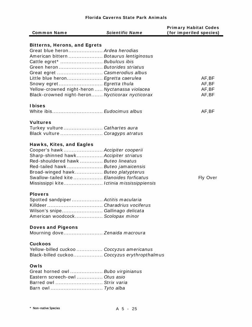
Florida Caverns State Park Animals
Primary Habitat Codes Common Name Scientific Name (for imperiled species)
* Non-native Species A 5 - 25
Bitterns, Herons, and Egrets Great blue heron ..................... Ardea herodias American bittern ..................... Botaurus lentiginosus Cattle egret* .......................... Bubulcus ibis Green heron ........................... Butorides striatus Great egret ............................ Casmerodius albus Little blue heron...................... Egretta caerulea AF,BF Snowy egret ........................... Egretta thula AF,BF Yellow-crowned night-heron ..... Nyctanassa violacea AF,BF Black-crowned night-heron ....... Nycticorax nycticorax AF,BF
Ibises White ibis ............................... Eudocimus albus AF,BF
Vultures Turkey vulture ........................ Cathartes aura Black vulture .......................... Coragyps atratus
Hawks, Kites, and Eagles Cooper's hawk ........................ Accipiter cooperii Sharp-shinned hawk ................ Accipiter striatus Red-shouldered hawk .............. Buteo lineatus Red-tailed hawk ...................... Buteo jamaicensis Broad-winged hawk ................. Buteo platypterus Swallow-tailed kite .................. Elanoides forficatus Fly Over Mississippi kite ........................ Ictinia mississippiensis
Plovers Spotted sandpiper ................... Actitis macularia Killdeer .................................. Charadrius vociferus Wilson’s snipe ......................... Gallinago delicata American woodcock ................. Scolopax minor
Doves and Pigeons Mourning dove ........................ Zenaida macroura
Cuckoos Yellow-billed cuckoo ................ Coccyzus americanus Black-billed cuckoo .................. Coccyzus erythropthalmus
Owls Great horned owl .................... Bubo virginianus Eastern screech-owl ................ Otus asio Barred owl ............................. Strix varia Barn owl ................................ Tyto alba
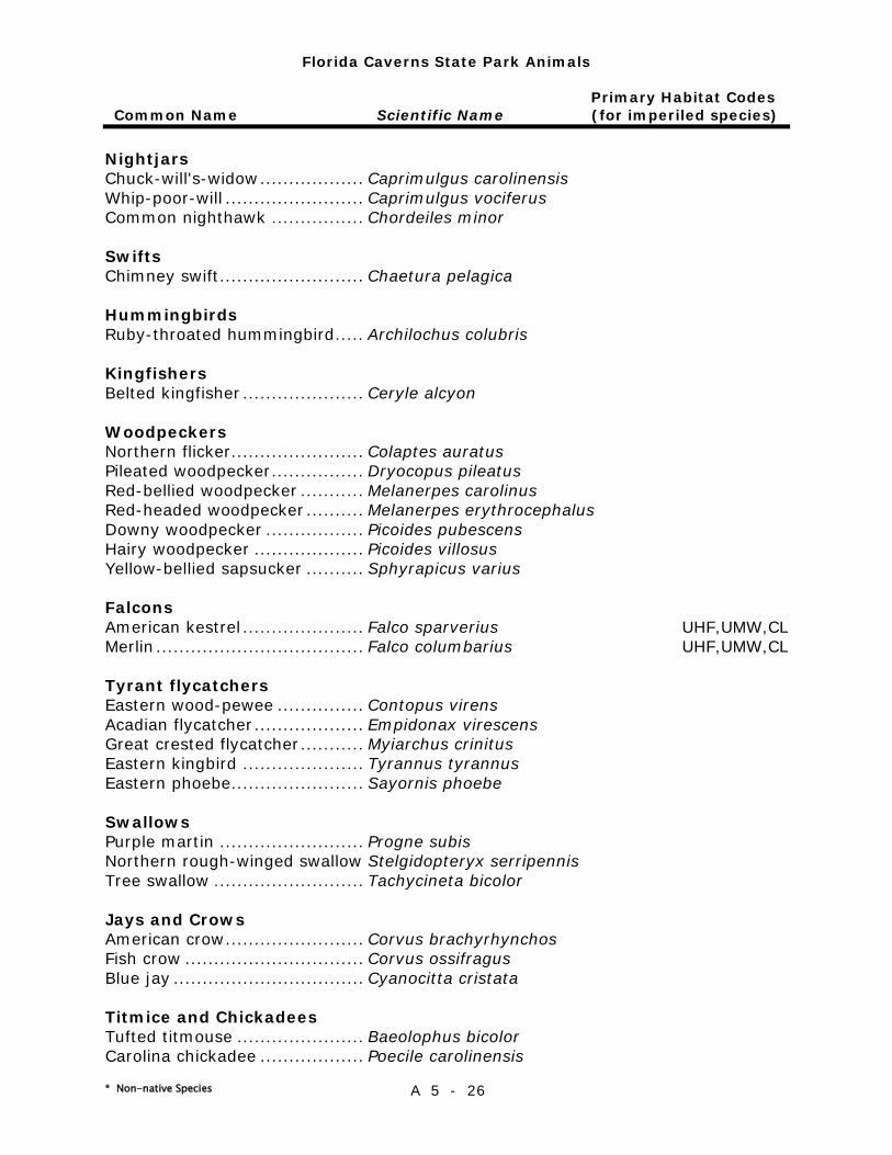
Florida Caverns State Park Animals
Primary Habitat Codes Common Name Scientific Name (for imperiled species)
* Non-native Species A 5 - 26
Nightjars Chuck-will's-widow .................. Caprimulgus carolinensis Whip-poor-will ........................ Caprimulgus vociferus Common nighthawk ................ Chordeiles minor
Swifts Chimney swift ......................... Chaetura pelagica
Hummingbirds Ruby-throated hummingbird ..... Archilochus colubris
Kingfishers Belted kingfisher ..................... Ceryle alcyon
Woodpeckers Northern flicker....................... Colaptes auratus Pileated woodpecker ................ Dryocopus pileatus Red-bellied woodpecker ........... Melanerpes carolinus Red-headed woodpecker .......... Melanerpes erythrocephalus Downy woodpecker ................. Picoides pubescens Hairy woodpecker ................... Picoides villosus Yellow-bellied sapsucker .......... Sphyrapicus varius
Falcons American kestrel ..................... Falco sparverius UHF,UMW,CL Merlin .................................... Falco columbarius UHF,UMW,CL
Tyrant flycatchers Eastern wood-pewee ............... Contopus virens Acadian flycatcher ................... Empidonax virescens Great crested flycatcher ........... Myiarchus crinitus Eastern kingbird ..................... Tyrannus tyrannus Eastern phoebe ....................... Sayornis phoebe
Swallows Purple martin ......................... Progne subis Northern rough-winged swallow Stelgidopteryx serripennis Tree swallow .......................... Tachycineta bicolor
Jays and Crows American crow ........................ Corvus brachyrhynchos Fish crow ............................... Corvus ossifragus Blue jay ................................. Cyanocitta cristata
Titmice and Chickadees Tufted titmouse ...................... Baeolophus bicolor Carolina chickadee .................. Poecile carolinensis
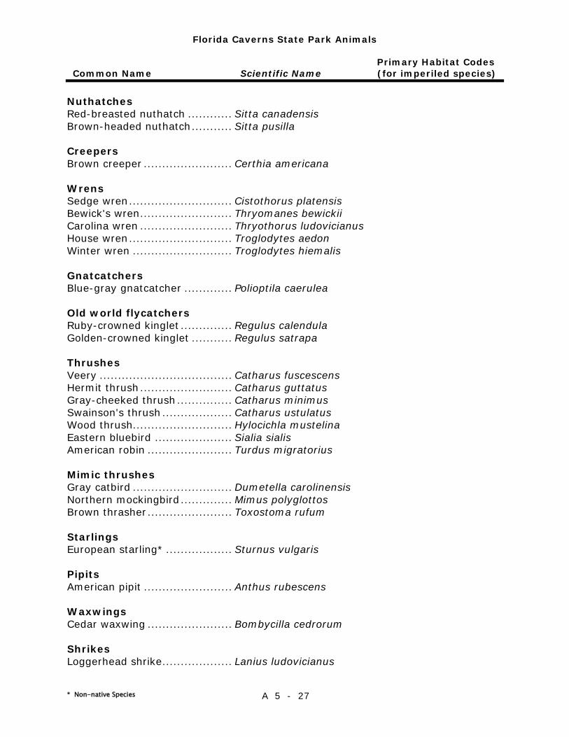
Florida Caverns State Park Animals
Primary Habitat Codes Common Name Scientific Name (for imperiled species)
* Non-native Species A 5 - 27
Nuthatches Red-breasted nuthatch ............ Sitta canadensis Brown-headed nuthatch ........... Sitta pusilla
Creepers Brown creeper ........................ Certhia americana
Wrens Sedge wren ............................ Cistothorus platensis Bewick's wren ......................... Thryomanes bewickii Carolina wren ......................... Thryothorus ludovicianus House wren ............................ Troglodytes aedon Winter wren ........................... Troglodytes hiemalis
Gnatcatchers Blue-gray gnatcatcher ............. Polioptila caerulea
Old world flycatchers Ruby-crowned kinglet .............. Regulus calendula Golden-crowned kinglet ........... Regulus satrapa
Thrushes Veery .................................... Catharus fuscescens Hermit thrush ......................... Catharus guttatus Gray-cheeked thrush ............... Catharus minimus Swainson's thrush ................... Catharus ustulatus Wood thrush........................... Hylocichla mustelina Eastern bluebird ..................... Sialia sialis American robin ....................... Turdus migratorius
Mimic thrushes Gray catbird ........................... Dumetella carolinensis Northern mockingbird .............. Mimus polyglottos Brown thrasher ....................... Toxostoma rufum
Starlings European starling* .................. Sturnus vulgaris
Pipits American pipit ........................ Anthus rubescens
Waxwings Cedar waxwing ....................... Bombycilla cedrorum
Shrikes Loggerhead shrike ................... Lanius ludovicianus

Florida Caverns State Park Animals
Primary Habitat Codes Common Name Scientific Name (for imperiled species)
* Non-native Species A 5 - 28
Vireos Yellow-throated vireo .............. Vireo flavifrons White-eyed vireo .................... Vireo griseus Red-eyed vireo ....................... Vireo olivaceus Blue-headed vireo ................... Vireo solitarius
Wood-warblers Kentucky warbler .................... Geothlypis formosus Common yellowthroat .............. Geothlypis trichas Worm-eating warbler ............... Helmitheros vermivorus UMW,AF Yellow-breasted chat ............... Icteria virens Swainson's warbler ................. Limnothlypis swainsonii Black-and-white warbler .......... Mniotilta varia Orange-crowned warbler .......... Oreothlypis celata Tennessee warbler .................. Oreothlypis peregrina Louisiana waterthrush ............. Parkesia motacilla AF,BF Northern waterthrush .............. Parkesia noveboracensis Prothonotary warbler ............... Protonotaria citrea Ovenbird ................................ Seiurus aurocapillus Northern parula ...................... Setophaga americana Black-throated blue warbler ..... Setophaga caerulescens Cerulean warbler..................... Setophaga cerulea Hooded warbler ...................... Setophaga citrina Yellow-rumped warbler ............ Setophaga coronata Prairie warbler ........................ Setophaga discolor Yellow-throated warbler ........... Setophaga dominica Blackburnian warbler ............... Setophaga fusca Magnolia warbler..................... Setophaga magnolia Palm warbler .......................... Setophaga palmarum Chestnut-sided warbler ............ Setophaga pensylvanica Yellow warbler ........................ Setophaga petechia Pine warbler ........................... Setophaga pinus American redstart ................... Setophaga ruticilla UHF,UMW Blackpoll warbler..................... Setophaga striata Black-throated green warbler ... Setophaga virens Blue-winged warbler ................ Vermivora cyanoptera Golden-winged warbler ............ Vermivora chrysoptera
Towhees and Sparrows Grasshopper sparrow ............... Ammodramus savannarum Dark-eyed junco ..................... Junco hyemalis Song sparrow ......................... Melospiza melodia Savannah sparrow .................. Passerculus sandwichensis Fox sparrow ........................... Passerella iliaca Bachman's sparrow ................. Peucaea aestivalis UMW Eastern towhee ....................... Pipilo erythrophthalmus Vesper sparrow ....................... Pooecetes gramineus
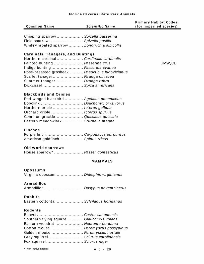
Florida Caverns State Park Animals
Primary Habitat Codes Common Name Scientific Name (for imperiled species)
* Non-native Species A 5 - 29
Chipping sparrow .................... Spizella passerina Field sparrow .......................... Spizella pusilla White-throated sparrow ........... Zonotrichia albicollis
Cardinals, Tanagers, and Buntings Northern cardinal .................... Cardinalis cardinalis Painted bunting ...................... Passerina ciris UMW,CL Indigo bunting ........................ Passerina cyanea Rose-breasted grosbeak .......... Pheucticus ludovicianus Scarlet tanager ....................... Piranga olivacea Summer tanager ..................... Piranga rubra Dickcissel ............................... Spiza americana
Blackbirds and Orioles Red-winged blackbird .............. Agelaius phoeniceus Bobolink ................................ Dolichonyx oryzivorus Northern oriole ....................... Icterus galbula Orchard oriole ........................ Icterus spurius Common grackle ..................... Quiscalus quiscula Eastern meadowlark ................ Sturnella magna
Finches Purple finch ............................ Carpodacus purpureus American goldfinch .................. Spinus tristis
Old world sparrows House sparrow* ...................... Passer domesticus
MAMMALS
Opossums Virginia opossum .................... Didelphis virginianus
Armadillos Armadillo* ............................. Dasypus novemcinctus
Rabbits Eastern cottontail .................... Sylvilagus floridanus
Rodents Beaver ................................... Castor canadensis Southern flying squirrel ........... Glaucomys volans Eastern woodrat ..................... Neotoma floridana Cotton mouse ......................... Peromyscus gossypinus Golden mouse ........................ Peromyscus nuttalli Gray squirrel .......................... Sciurus carolinensis Fox squirrel ............................ Sciurus niger
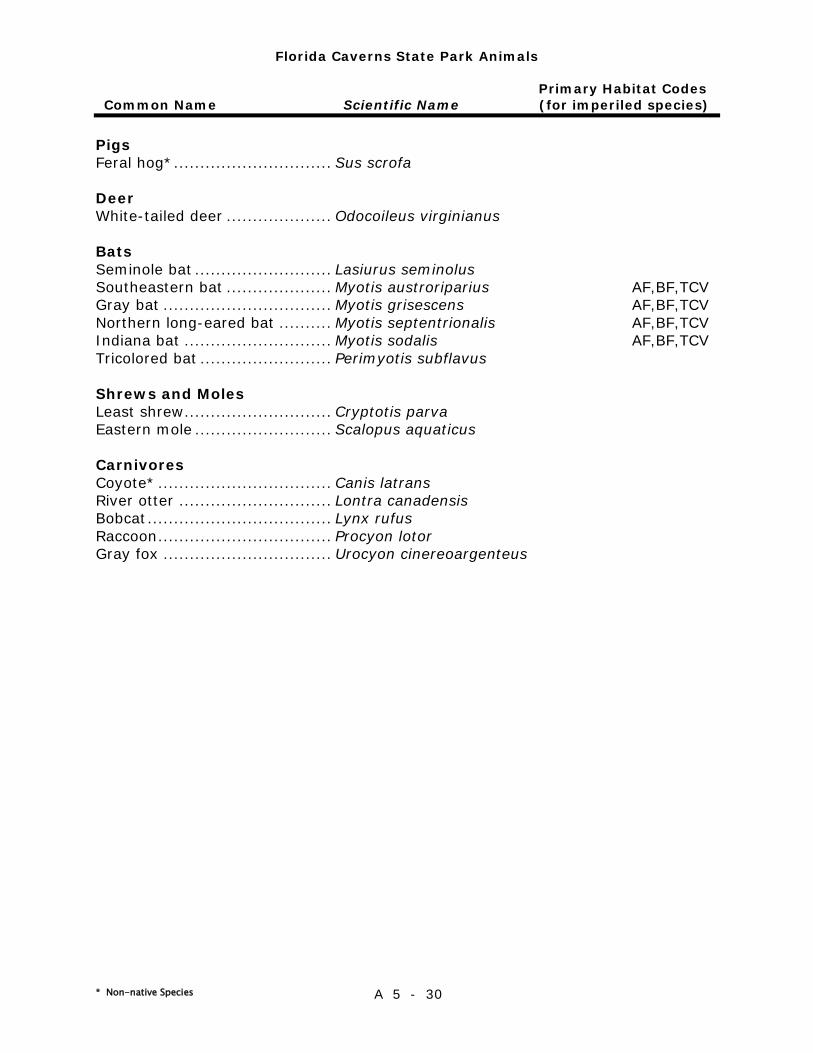
Florida Caverns State Park Animals
Primary Habitat Codes Common Name Scientific Name (for imperiled species)
* Non-native Species A 5 - 30
Pigs Feral hog* .............................. Sus scrofa
Deer White-tailed deer .................... Odocoileus virginianus
Bats Seminole bat .......................... Lasiurus seminolus Southeastern bat .................... Myotis austroriparius AF,BF,TCV Gray bat ................................ Myotis grisescens AF,BF,TCV Northern long-eared bat .......... Myotis septentrionalis AF,BF,TCV Indiana bat ............................ Myotis sodalis AF,BF,TCV Tricolored bat ......................... Perimyotis subflavus
Shrews and Moles Least shrew ............................ Cryptotis parva Eastern mole .......................... Scalopus aquaticus
Carnivores Coyote* ................................. Canis latrans River otter ............................. Lontra canadensis Bobcat ................................... Lynx rufus Raccoon ................................. Procyon lotor Gray fox ................................ Urocyon cinereoargenteus

Primary Habitat Codes
A 5 - 31
TERRESTRIAL Dune ..................................... BD Coastal Berm .......................... CB Coastal Grassland ................... CG Coastal Strand ........................ CS Dry Prairie ............................. DP Keys Cactus Barren ................. KCB Limestone Outcrop .................. LO Maritime Hammock ................. MAH Mesic Flatwoods ...................... MF Mesic Hammock ...................... MEH Pine Rockland ......................... PR Rockland Hammock ................. RH Sandhill ................................. SH Scrub .................................... SC Scrubby Flatwoods .................. SCF Shell Mound ........................... SHM Sinkhole ................................ SK Slope Forest .......................... SPF Upland Glade .......................... UG Upland Hardwood Forest .......... UHF Upland Mixed Woodland ........... UMW Upland Pine ............................ UP Wet Flatwoods ........................ WF Xeric Hammock ...................... XH
PALUSTRINE Alluvial Forest ......................... AF Basin Marsh ........................... BM Basin Swamp .......................... BS Baygall .................................. BG Bottomland Forest ................... BF Coastal Interdunal Swale ......... CIS Depression Marsh ................... DM Dome Swamp ......................... DS Floodplain Marsh ..................... AF Floodplain Swamp ................... AF Glades Marsh .......................... GM Hydric Hammock ..................... HH Keys Tidal Rock Barren ............ KTRB Mangrove Swamp ................... MS Marl Prairie............................. MP Salt Marsh .............................. SAM Seepage Slope ........................ SSL Shrub Bog .............................. SHB Slough ................................... SLO Slough Marsh ......................... SLM Strand Swamp ........................ STS
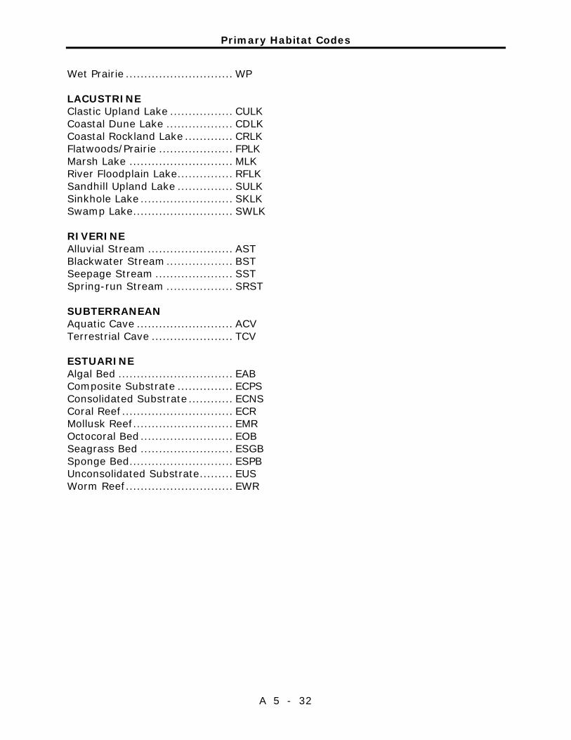
Primary Habitat Codes
A 5 - 32
Wet Prairie ............................. WP
LACUSTRINE Clastic Upland Lake ................. CULK Coastal Dune Lake .................. CDLK Coastal Rockland Lake ............. CRLK Flatwoods/Prairie .................... FPLK Marsh Lake ............................ MLK River Floodplain Lake ............... RFLK Sandhill Upland Lake ............... SULK Sinkhole Lake ......................... SKLK Swamp Lake ........................... SWLK RIVERINE Alluvial Stream ....................... AST Blackwater Stream .................. BST Seepage Stream ..................... SST Spring-run Stream .................. SRST
SUBTERRANEAN Aquatic Cave .......................... ACV Terrestrial Cave ...................... TCV ESTUARINE Algal Bed ............................... EAB Composite Substrate ............... ECPS Consolidated Substrate ............ ECNS Coral Reef .............................. ECR Mollusk Reef ........................... EMR Octocoral Bed ......................... EOB Seagrass Bed ......................... ESGB Sponge Bed ............................ ESPB Unconsolidated Substrate ......... EUS Worm Reef ............................. EWR
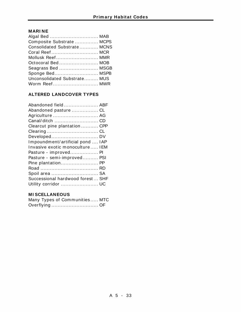
Primary Habitat Codes
A 5 - 33
MARINE Algal Bed ............................... MAB Composite Substrate ............... MCPS Consolidated Substrate ............ MCNS Coral Reef .............................. MCR Mollusk Reef ........................... MMR Octocoral Bed ......................... MOB Seagrass Bed ......................... MSGB Sponge Bed ............................ MSPB Unconsolidated Substrate ......... MUS Worm Reef ............................. MWR
ALTERED LANDCOVER TYPES Abandoned field ...................... ABF Abandoned pasture ................. CL Agriculture ............................. AG Canal/ditch ............................ CD Clearcut pine plantation ........... CPP Clearing ................................. CL Developed .............................. DV Impoundment/artificial pond .... IAP Invasive exotic monoculture ..... IEM Pasture - improved .................. PI Pasture - semi-improved .......... PSI Pine plantation........................ PP Road ..................................... RD Spoil area .............................. SA Successional hardwood forest ... SHF Utility corridor ........................ UC MISCELLANEOUS Many Types of Communities ..... MTC Overflying .............................. OF

Primary Habitat Codes
A 5 - 34

Addendum 6—Imperiled Species Ranking Definitions

Imperiled Species Ranking Definitions
A 6 - 1
The Nature Conservancy and the Natural Heritage Program Network (of which FNAI is a part) define an element as any exemplary or rare component of the natural environment, such as a species, natural community, bird rookery, spring, sinkhole, cave or other ecological feature. An element occurrence (EO) is a single extant habitat that sustains or otherwise contributes to the survival of a population or a distinct, self-sustaining example of a particular element. Using a ranking system developed by The Nature Conservancy and the Natural Heritage Program Network, the Florida Natural Areas Inventory assigns two ranks to each element. The global rank is based on an element's worldwide status; the state rank is based on the status of the element in Florida. Element ranks are based on many factors, the most important ones being estimated number of Element occurrences, estimated abundance (number of individuals for species; area for natural communities), range, estimated adequately protected EOs, relative threat of destruction, and ecological fragility. Federal and State status information is from the U.S. Fish and Wildlife Service; and the Florida Fish and Wildlife Conservation Commission (animals), and the Florida Department of Agriculture and Consumer Services (plants), respectively.
FNAI GLOBAL RANK DEFINITIONS
G1 ............. Critically imperiled globally because of extreme rarity (5 or fewer
occurrences or less than 1000 individuals) or because of extreme vulnerability to extinction due to some natural or fabricated factor.
G2 ............. Imperiled globally because of rarity (6 to 20 occurrences or less than 3000 individuals) or because of vulnerability to extinction due to some natural or man-made factor.
G3 ............. Either very rare or local throughout its range (21-100 occurrences or less than 10,000 individuals) or found locally in a restricted range or vulnerable to extinction of other factors.
G4 ............. apparently secure globally (may be rare in parts of range) G5 ............. demonstrably secure globally GH ............. of historical occurrence throughout its range may be rediscovered
(e.g., ivory-billed woodpecker) GX ............. believed to be extinct throughout range GXC ........... extirpated from the wild but still known from captivity or cultivation G#? ........... Tentative rank (e.g.,G2?) G#G# ........ range of rank; insufficient data to assign specific global rank (e.g.,
G2G3) G#T# ......... rank of a taxonomic subgroup such as a subspecies or variety; the G
portion of the rank refers to the entire species and the T portion refers to the specific subgroup; numbers have same definition as above (e.g., G3T1)
Imperiled Species Ranking Definitions
A 6 - 2
G#Q ........... rank of questionable species - ranked as species but questionable whether it is species or subspecies; numbers have same definition as above (e.g., G2Q)
G#T#Q ....... same as above, but validity as subspecies or variety is questioned. GU ............. due to lack of information, no rank or range can be assigned (e.g.,
GUT2). G? .............. Not yet ranked (temporary) S1 .............. Critically imperiled in Florida because of extreme rarity (5 or fewer
occurrences or less than 1000 individuals) or because of extreme vulnerability to extinction due to some natural or man-made factor.
S2 .............. Imperiled in Florida because of rarity (6 to 20 occurrences or less than 3000 individuals) or because of vulnerability to extinction due to some natural or man-made factor.
S3 .............. Either very rare or local throughout its range (21-100 occurrences or less than 10,000 individuals) or found locally in a restricted range or vulnerable to extinction of other factors.
S4 .............. apparently secure in Florida (may be rare in parts of range) S5 .............. demonstrably secure in Florida SH ............. of historical occurrence throughout its range, may be rediscovered
(e.g., ivory-billed woodpecker) SX.............. believed to be extinct throughout range SA.............. accidental in Florida, i.e., not part of the established biota SE .............. an exotic species established in Florida may be native elsewhere in
North America SN ............. regularly occurring but widely and unreliably distributed; sites for
conservation hard to determine SU ............. due to lack of information, no rank or range can be assigned (e.g.,
SUT2). S? .............. Not yet ranked (temporary) N .............. Not currently listed, nor currently being considered for listing, by state
or federal agencies.

Imperiled Species Ranking Definitions
A 6 - 3
LEGAL STATUS
FEDERAL
(Listed by the U. S. Fish and Wildlife Service - USFWS) LE .............. Listed as Endangered Species in the List of Endangered and
Threatened Wildlife and Plants under the provisions of the Endangered Species Act. Defined as any species that is in danger of extinction throughout all or a significant portion of its range.
PE .............. Proposed for addition to the List of Endangered and Threatened Wildlife and Plants as Endangered Species.
LT .............. Listed as Threatened Species. Defined as any species that is likely to become an endangered species within the near future throughout all or a significant portion of its range.
PT .............. Proposed for listing as Threatened Species. C ............. Candidate Species for addition to the list of Endangered and
Threatened Wildlife and Plants. Defined as those species for which the USFWS currently has on file sufficient information on biological vulnerability and threats to support proposing to list the species as endangered or threatened.
E(S/A) ........ Endangered due to similarity of appearance. T(S/A) ........ Threatened due to similarity of appearance. EXPE, XE ..... Experimental essential population. A species listed as experimental and ................. essential. EXPN, XN .... Experimental non-essential population. A species listed as ................. experimental and non-essential. Experimental, nonessential ................. populations of endangered species are treated as threatened species ................. on public land, for consultation purposes.
STATE
ANIMALS .. (Listed by the Florida Fish and Wildlife Conservation
Commission - FWC) FE .............. Federally-designated Endangered FT .............. Federally-designated Threatened FXN ............ Federally-designated Threatened Nonessential Experimental Population FT(S/A) ...... Federally-designated Threatened species due to similarity of
appearance
Imperiled Species Ranking Definitions
A 6 - 4
ST .............. Listed as Threatened Species by the FWC. Defined as a species, subspecies, or isolated population, which is acutely vulnerable to environmental alteration, declining in number at a rapid rate, or whose range or habitat, is decreasing in area at a rapid rate and therefore is destined or very likely to become an endangered species within the near future.
SSC ............ Listed as Species of Special Concern by the FWC. Defined as a population which warrants special protection, recognition or consideration because it has an inherent significant vulnerability to habitat modification, environmental alteration, human disturbance or substantial human exploitation that, in the near future, may result in its becoming a threatened species.
PLANTS .... (Listed by the Florida Department of Agriculture and Consumer
Services - FDACS) LE .............. Listed as Endangered Plants in the Preservation of Native Flora of
Florida Act. Defined as species of plants native to the state that are in imminent danger of extinction within the state, the survival of which is unlikely if the causes of a decline in the number of plants continue, and includes all species determined to be endangered or threatened pursuant to the Federal Endangered Species Act of 1973,as amended.
LT .............. Listed as Threatened Plants in the Preservation of Native Flora of Florida Act. Defined as species native to the state that are in rapid decline in the number of plants within the state, but which have not so decreased in such number as to cause them to be endangered.

Imperiled Species Ranking Definitions
A 6 - 5

Addendum 7—Cultural Information

Management Procedures for Archaeological and Historical Sites and Properties on State-Owned or Controlled Properties (revised March 2013)
These procedures apply to state agencies, local governments, and non-profits that manage state-owned properties.
A. General Discussion
Historic resources are both archaeological sites and historic structures. Per Chapter 267, Florida Statutes, ‘Historic property’ or ‘historic resource’ means any prehistoric district, site, building, object, or other real or personal property of historical, architectural, or archaeological value, and folklife resources. These properties or resources may include, but are not limited to, monuments, memorials, Indian habitations, ceremonial sites, abandoned settlements, sunken or abandoned ships, engineering works, treasure trove, artifacts, or other objects with intrinsic historical or archaeological value, or any part thereof, relating to the history, government, and culture of the state.”
B. Agency Responsibilities
Per State Policy relative to historic properties, state agencies of the executive branch must allow the Division of Historical Resources (Division) the opportunity to comment on any undertakings, whether these undertakings directly involve the state agency, i.e., land management responsibilities, or the state agency has indirect jurisdiction, i.e. permitting authority, grants, etc. No state funds should be expended on the undertaking until the Division has the opportunity to review and comment on the project, permit, grant, etc.
State agencies shall preserve the historic resources which are owned or controlled by the agency.
Regarding proposed demolition or substantial alterations of historic properties, consultation with the Division must occur, and alternatives to demolition must be considered.
State agencies must consult with Division to establish a program to location, inventory and evaluate all historic properties under ownership or controlled by the agency.
C. Statutory Authority
Statutory Authority and more in-depth nformation can be found at: http://www.flheritage.com/preservation/compliance/guidelines.cfm
D. Management Implementation
Even though the Division sits on the Acquisition and Restoration Council and approves land management plans, these plans are conceptual. Specific information regarding individual projects must be submitted to the Division for review and recommendations.
A 7 - 1
Management Procedures for Archaeological and Historical Sites and Properties on State-Owned or Controlled Properties (revised March 2013)
A 7 - 2
Managers of state lands must coordinate any land clearing or ground disturbing activities with the Division to allow for review and comment on the proposed project. Recommendations may include, but are not limited to: approval of the project as submitted, cultural resource assessment survey by a qualified professional archaeologist, modifications to the proposed project to avoid or mitigate potential adverse effects.
Projects such as additions, exterior alteration, or related new construction regarding historic structures must also be submitted to the Division of Historical Resources for review and comment by the Division’s architects. Projects involving structures fifty years of age or older, must be submitted to this agency for a significance determination. In rare cases, structures under fifty years of age may be deemed historically significant. These must be evaluated on a case by case basis.
Adverse impacts to significant sites, either archaeological sites or historic buildings, must be avoided. Furthermore, managers of state property should make preparations for locating and evaluating historic resources, both archaeological sites and historic structures.
E. Minimum Review Documentation Requirements
In order to have a proposed project reviewed by the Division, certain information must be submitted for comments and recommendations. The minimum review documentation requirements can be found at: http://www.flheritage.com/preservation/compliance/docs/minimum_review_documentation_requirements.pdf.
* * *
Questions relating to the treatment of archaeological and historic resources on state lands should be directed to:
Deena S. Woodward Division of Historical Resources Bureau of Historic Preservation Compliance and Review Section R. A. Gray Building 500 South Bronough Street Tallahassee, FL 32399-0250
Phone: (850) 245-6425
Toll Free: (800) 847-7278 Fax: (850) 245-6435

Eligibility Criteria for National Register of Historic Places
A 7 - 3
The criteria to be used for evaluating eligibility for listing in the National Register of Historic Places are as follows:
1) Districts, sites, buildings, structures, and objects may be considered to havesignificance in American history, architecture, archaeology, engineering,and/or culture if they possess integrity of location, design, setting, materials,workmanship, feeling, and association, and:
a) are associated with events that have made a significant contribution tothe broad patterns of our history; and/or
b) are associated with the lives of persons significant in our past; and/orc) embody the distinctive characteristics of type, period, or method of
construction, or that represent the work of a master, or that possesshigh artistic values, or that represent a significant and distinguishableentity whose components may lack individual distinction; and/or
d) have yielded, or may be likely to yield, information important inprehistory or history.
2) Ordinarily cemeteries, birthplaces, or graves of historical figures; propertiesowned by religious institutions or used for religious purposes; structures thathave been moved from their original locations; reconstructed historicbuildings; properties primarily commemorative in nature; and properties thathave achieved significance within the past 50 years shall not be consideredeligible for the National Register. However, such properties will qualify if theyare integral parts of districts that do meet the criteria or if they fall within thefollowing categories:
a) a religious property deriving its primary significance from architecturalor artistic distinction or historical importance; or
b) a building or structure removed from its original location but which issignificant primarily for architectural value, or which is the survivingstructure most importantly associated with a historic person or event;or
c) a birthplace or grave of an historical figure of outstanding importanceif there is no appropriate site or building directly associated with hisproductive life; or
d) a cemetery which derives its primary significance from graves ofpersons of transcendent importance, from age, distinctive designfeatures, or association with historic events; or

Eligibility Criteria for National Register of Historic Places
A 7 - 4
e) a reconstructed building, when it is accurately executed in a suitableenvironment and presented in a dignified manner as part of arestoration master plan, and no other building or structure with thesame association has survived; or a property primarilycommemorative in intent, if design, age, tradition, or symbolic valuehas invested it with its own exceptional significance; or
f) a property achieving significance within the past 50 years, if it is ofexceptional importance.
Preservation Treatments as Defined by Secretary of Interior’s Standards and Guidelines
A 7 - 5
Restoration is defined as the act or process of accurately depicting the form, features, and character of a property as it appeared at a particular period of time by means of the removal of features from other periods in its history and reconstruction of missing features from the restoration period. The limited and sensitive upgrading of mechanical, electrical and plumbing systems, and other code-required work to make properties functional is appropriate within a restoration project.
Rehabilitation is defined as the act or process of making possible a compatible use for a property through repair, alterations and additions while preserving those portions or features that convey its historical, cultural, or architectural values.
Stabilization is defined as the act or process of applying measures designed to reestablish a weather resistant enclosure and the structural stability of an unsafe or deteriorated property while maintaining the essential form as it exists at present.
Preservation is defined as the act or process of applying measures necessary to sustain the existing form, integrity and materials of an historic property. Work, including preliminary measures to protect and stabilize the property, generally focuses upon the ongoing maintenance and repair of historic materials and features rather than extensive replacement and new construction. New exterior additions are not within the scope of this treatment; however, the limited and sensitive upgrading of mechanical, electrical and plumbing systems, and other code-required work to make properties functional is appropriate within a preservation project.

Preservation Treatments as Defined by Secretary of Interior’s Standards and Guidelines
A 7 - 6

Addendum 8—Land Management Review

Land Management Review
A 8 - 1
Land Management Review
A 8 - 2

Land Management Review
A 8 - 3

Land Management Review
A 8 - 4