Final-ESIA-of-Ha-Tinh-phase-2-Subproject-EN-FOR ...
271
HA TINH PROVINCIAL PEOPLE’S COMMITTEE HA TINH PROJECT MANAGEMENT UNIT OF CONSTRUCTION INVESTMENT WORKS FOR AGRICULTURE AND RURAL DEVELOPMENT ---------------o0o---------------- ENVIRONMENTAL AND SOCIAL IMPACT ASESSMENT (ESIA) Subproject 1: Dam Rehabilitation and Safety Improvement Project - Ha Tinh province Dam Rehabilitation and Safety Improvement Project (WB8) Ha Tinh, September 2018 Public Disclosure Authorized Public Disclosure Authorized Public Disclosure Authorized Public Disclosure Authorized
-
Upload
khangminh22 -
Category
Documents
-
view
5 -
download
0
Transcript of Final-ESIA-of-Ha-Tinh-phase-2-Subproject-EN-FOR ...
HA TINH PROVINCIAL PEOPLE’S COMMITTEE
HA TINH PROJECT MANAGEMENT UNIT OF CONSTRUCTION
INVESTMENT WORKS FOR AGRICULTURE AND RURAL DEVELOPMENT
---------------o0o----------------
ENVIRONMENTAL AND SOCIAL
IMPACT ASESSMENT (ESIA)
Subproject 1: Dam Rehabilitation and Safety Improvement Project -
Ha Tinh province
Dam Rehabilitation and Safety Improvement Project (WB8)
Ha Tinh, September 2018
Pub
lic D
iscl
osur
e A
utho
rized
Pub
lic D
iscl
osur
e A
utho
rized
Pub
lic D
iscl
osur
e A
utho
rized
Pub
lic D
iscl
osur
e A
utho
rized
ii
HA TINH PROVINCIAL PEOPLE’S COMMITTEE
HA TINH PROJECT MANAGEMENT UNIT OF CONSTRUCTION
INVESTMENT WORKS FOR AGRICULTURE AND RURAL DEVELOPMENT
---------------o0o----------------
ENVIRONMENTAL AND SOCIAL
IMPACT ASESSMENT (ESIA)
Subproject 1: Dam Rehabilitation and Safety Improvement Project -
Ha Tinh province
Dam Rehabilitation and Safety Improvement Project (WB8)
PROJECT OWNER
Ha Tinh Agriculture and Rural
Development Investment and Construction
Project Management Unit
CONSULTANT AGENCY
Joint-venture of Institute for Water and
Environment and Ha Tinh Center for
Environmental Monitoring and
Engineering
Ha Tinh, September 2018
iii
TABLE OF CONTENTS
LIST OF TABLES ................................................................................................................... vi
LIST OF FIGURES ................................................................................................................ vii
ABBREVIATIONS ................................................................................................................ viii
EXECUTIVE SUMMARY ...................................................................................................... 1
CHAPTER I. INTRODUCTION ............................................................................................ 5
1.1. Background of the project ............................................................................................ 5
1.2. Background of the Sub-project .................................................................................... 6
1.3. Objectives and evaluation methods for environmental and social impact assessment 7
1.4. The subproject owner and investment capital .............................................................. 8
1.5. Consultant agency ........................................................................................................ 9
CHAPTER II. SUB-PROJECT DESCRIPTION ................................................................ 11
2.1. Overview of the sub-project .......................................................................................... 11
2.2. Key items of the Sub-project ......................................................................................... 14
2.3. The need for construction materials of the Sub-project ................................................ 24
2.4. Auxiliary works ............................................................................................................. 27
2.5. Construction organization measures .............................................................................. 32
2.5.1. Pre-construction phase ............................................................................................ 32
2.5.2. Construction phase ................................................................................................. 33
2.6. Construction progress .................................................................................................... 35
2.7. Operation and maintenance activities ............................................................................ 36
2.8. Dam safety plan ............................................................................................................. 37
CHAPTER III. POLICY, LEGAL, AND ADMINISTRATIVE FRAMEWORKS ......... 39
3.1. Government Regulations ............................................................................................... 39
3.2. Applicable the World Bank Safeguard Policies ............................................................ 43
3.2.1. Project level ............................................................................................................ 43
3.2.2. Subproject level ..................................................................................................... 44
CHAPTER IV. ENVIRONMENTAL, NATURAL AND SOCIO-ECONOMIC
CONDITIONS OF THE SUB-PROJECT AREA ............................................................... 53
4.1. Geological and geographical conditions ....................................................................... 53
4.2. Climate and meteorology ............................................................................................. 55
4.3. Hydrological conditions ................................................................................................ 55
4.4. Status and quality of soil, water, air environments........................................................ 56
4.4.1. Surface water environment ..................................................................................... 56
4.4.2. Status of groundwater environment ........................................................................ 58
4.4.3. Air environment ...................................................................................................... 58
4.4.4. Soil environment .................................................................................................... 59
4.4.5. Sedimentation quality ............................................................................................. 59
4.5. Biological resources ...................................................................................................... 59
4.6. Socio-Economic Profile of the communes in the subproject Area ................................ 62
4.7. Socio-economic data of the project area........................................................................ 66
4.7.1. Access to public services ........................................................................................ 66
iv
4.7.2. Culture – Society .................................................................................................... 68
4.7.3. Characteristics of works management .................................................................... 69
CHAPTER V. ENVIRONMENT AND SOCIAL IMPACT ASSESSMENT ................... 71
5.1. Types and scope of the impacts ..................................................................................... 71
5.2. Potential positive impacts of the sub-project (eight reservors) ..................................... 72
5.3. Potential negative impacts of the sub-project (8 reservoirs) ......................................... 73
5.3.1. Impacts during the preparation phase ..................................................................... 73
5.3.2. Impact during construction phase ........................................................................... 78
5.3.3. Site-specific impacts on sensitive receptors during construction ........................... 92
5.3.4. Impact during operational phase............................................................................. 97
5.4. Analysis of impact types................................................................................................ 99
5.4.1. Cumulative impacts ................................................................................................ 99
5.4.2. Direct impacts ......................................................................................................... 99
5.4.3. Indirect impacts ...................................................................................................... 99
5.4.4. Temporary impacts ............................................................................................... 100
5.4.5. Long-term impacts ................................................................................................ 100
5.5. Summary of potential negative impacts caused by the subproject .............................. 101
CHAPTER VI. ANALYSIS OF ALTERNATIVES .......................................................... 105
6.1. Without the Sub-project............................................................................................... 105
6.2. With the Sub-project .................................................................................................... 106
6.2.1. Alternations during the construction of works under the full water supply ......... 106
6.2.2. Alternative measures for the selection of auxiliary works (borrow pit, dumpsite)
........................................................................................................................................ 107
6.2.3. Alternative selection of material and waste transport route ................................. 108
CHAPTER VII. ENVIRONMENTAL AND SOCIAL MANAGEMENT PLAN (ESMP)
................................................................................................................................................ 111
7.1. Mitigation measures .................................................................................................... 111
7.1.1. Measures for pre-construction phase .................................................................... 111
7.1.2. Mitigation measures during construction phase ................................................... 113
7.1.3. Mitigation measures for site-specific impacts on sensitive receptors during
construction .................................................................................................................... 131
7.1.4. Mitigation Measures for Impacts during Operation Phase ................................... 140
7.2. Implementation organization ....................................................................................... 141
7.2.1. Project management ............................................................................................. 141
7.2.2. Roles and responsibilities for environmental and social safety management ...... 143
7.3. Environmental Compliance Framework ...................................................................... 147
7.3.1. Environmental Duties of the Contractor .............................................................. 147
7.3.2. Contractor’s Safety, Social and Environmental Officer (SEO) ............................ 148
7.3.3. Environmental and Social Supervision during Construction (CSC) .................... 149
7.3.4. Compliance with Legal and Contractual Requirements ....................................... 149
7.3.5. Reporting Arrangements ...................................................................................... 150
7.4. Grievance Redress Mechanism ................................................................................... 151
7.4.1. Grievance Redress Mechanism ........................................................................ 151
7.4.2. Contractor and Construction Supervision Consultant: ..................................... 152
7.4.3. World Bank Grievance Redress Mechanism .................................................... 153
v
7.5. ESMP implementation plan ......................................................................................... 153
7.5.1.. ESMP implementation plan of the Contractor .................................................... 153
7.5.2. Start of the subproject and personnel ................................................................... 154
7.6. Training and capacity building .................................................................................... 154
7.6.1. Training on safeguard policy ................................................................................ 154
7.6.2. Training on safety and occupational health .......................................................... 155
7.6.3. Visitor Orientation ................................................................................................ 156
7.6.4. Training for contractors and new workers ............................................................ 156
7.6.5. Training on basic health and occupational safety ................................................. 156
7.7. Environmental and social monitoring plan .................................................................. 156
7.7.1. Compliance Monitoring: ...................................................................................... 157
7.7.2. Ambient Environmental quality monitoring: ...................................................... 157
7.7.3. Dam safety monitoring ......................................................................................... 160
7.8. Cost estimates .............................................................................................................. 160
CHAPTER VIII. COMMUNITY CONSULTATION AND INFORMATION
DISCLOSURE ...................................................................................................................... 179
8.1. Objectives of community consultation ........................................................................ 179
8.2. Summary of the organization of community consultations ......................................... 179
8.2.1. Summary of consultations with Commune People's Committees and organizations
directly affected by the sub-project ................................................................................ 179
8.2.2. A summary of community-based consultation meetings for directly affected
communities ................................................................................................................... 181
8.3. Community consultation results .................................................................................. 182
8.3.1. Feedbacks of the CPCs and directly affected organizations................................. 182
8.3.2. Feedback of local communities who are directly affected by the Sub-project .... 186
8.3.3 Responses and commitments of the subproject owner to recommendations and
suggestions of consulted agencies, organizations and communities .............................. 189
8.4. Information Disclosure ................................................................................................ 192
REFERENCES ..................................................................................................................... 194
Appendix 1- Maps of sampling and monitoring environment .......................................... 196
Appendix 2 - Analysis results of environmental samples ................................................. 229
Appendix 3- Integrated pest management plan (IPM) ...................................................... 240
Appendix 4- Emergency preparedness plan (EPP) ........................................................... 245
Appendix 5 – Technical parameters of the works ............................................................ 254
Appendix 6: List of participants preparing ESIA report ................................................... 263
vi
LIST OF TABLES
Table 1 - 1: Total investment capital of the subproject .............................................................. 9
Table 1 - 2: Implementation budget of each work in the Sub-project 1 ..................................... 9
Table 2 – 1: Locations and Technical parameters of works under Sub-project 1 .................... 11
Table 2 - 2: Information summary of current condition and construction categories of the
reservoir in the subproject ........................................................................................................ 16
Table 2 - 3: Summary of material quantity during the construction of the Sub-project........... 24
Table 2 - 4: Summary of volume and transporting distance of construction materials of the
works ........................................................................................................................................ 24
Table 2 - 5: Locations of dumping sites, borrow pits ............................................................... 28
Table 2 - 6: Status of transportation roads ................................................................................ 30
Table 2 - 7: Summary of activities during pre-construction phase........................................... 33
Table 2 - 8: Summary of debris and wastes management during pre-construction phase ....... 33
Table 2 - 9: Summary of activities during construction phase ................................................. 34
Table 3 - 1: A summary of the WB and GOV regulations on environmental assessment ....... 45
Table 3 - 2: Summary of ESIA method and process ................................................................ 51
Table 4 - 1: Socio-Economic conditions in the subproject communes .................................... 64
Table 4 - 2: Types of road in project communes ...................................................................... 66
Table 4 - 3: Current condition of water supply facilities .......................................................... 66
Table 4 - 4: Statistic of cultural works, historicals relics in the subproject area ...................... 68
Table 4 - 5: Management of the Subproject’s Reservoirs ........................................................ 69
Table 5 - 1. Criteria for classification of negative impacts ...................................................... 71
Table 5 - 2: Summary of affected HH due to land acquisition and affected crops .................. 74
Table 5 - 3: Summary of affected lands in the Sub-project ...................................................... 75
Table 5 - 4: Summary about number of households affected with structures .......................... 75
Table 5 - 5: Amount of dust generated during pre-construction phase .................................... 76
Table 5 - 6: The volume of smoke and emission generated during pre-construction phase .... 76
Table 5 - 7: Amount of dust generated by excavation, filling, transportation during
construction period ................................................................................................................... 78
Table 5 - 8: Amount of smoke and exhausted emission generated due to excavating and filling
soil ............................................................................................................................................ 79
Table 5 - 9: Amount of dust generated due to material transport during construction-phase .. 80
Table 5 - 10: Amount of smoke and exhausted emission generated due to material transport
during construction-phase......................................................................................................... 80
Table 5 - 11: Amount of smoke and exhausted emission generated due to waste soil transport
during construction-phase......................................................................................................... 81
Table 5 - 12: Volume of pollutants in domestic wastewater in subproject area ....................... 82
Table 5 - 13: Concentration of pollutants in runoff .................................................................. 83
Table 5 - 14: Estimated waste oil volume during construction phase ...................................... 85
Table 5 - 15: Site-specific impacts on sensitive receptors during construction ....................... 92
Table 5 - 16: Irrigated areas before and after the works completion ........................................ 97
Table 5 - 17: Matrix of potential negative impacts caused by the subproject ........................ 101
Table 6 - 1: Impacts in case of dam incidents (without the project) ...................................... 105
vii
Table 6 - 2: Options of borrow pits, dumpsites and transport routes for material and waste
transport .................................................................................................................................. 108
Table 7 - 1: Cost estimate for compensation for affected items ............................................. 111
Table 7 - 2: Environmental Codes of Practice (ECOP) for Addressing Generic Construction-
Related Impacts ...................................................................................................................... 114
Table 7 - 3: Mitigation measures for site-specific impacts on sensitive receptors ................. 131
Table 7 - 4: Roles and responsibilities of key parties ............................................................. 144
Table 7 - 5: Regular reporting requirement ............................................................................ 150
Table 7 - 6: Capacity building training program on environmental management.................. 155
Table 7 - 7: Environmental quality monitoring during the construction and operation of the
Sub-project ............................................................................................................................. 158
Table 7 - 8: Estimated costs for ambient environmental quality monitoring ......................... 159
Table 7 - 9: Estimated costs of mitigation measures .............................................................. 160
Table 7 - 10: Matrix of mitigation measures .......................................................................... 162
Table 7 - 11: Monitoring plan................................................................................................. 175
Table 8 - 1: Summary of consultations with CPCs and affected organizations in the subproject
area.......................................................................................................................................... 180
Table 8 - 2: Summary of consultations with affected households .......................................... 182
Table 8 - 3: Feedbacks of CPCs of affected communes and affected organizations .............. 182
Table 8 - 4: Feedbacks of local communities who are directly affected by the Sub-project .. 186
Table 8 - 5: The subproject owner’s feedbacks and and commitments of the subproject owner
................................................................................................................................................ 189
Table 8 - 6: Plan for information disclosure ........................................................................... 193
LIST OF FIGURES
Figure 2 – 1: Diagram of Reservoirs in Sub-project 1 ............................................................. 14
Figure 2 - 2: Current status of some transporation routes ........................................................ 30
Figure 7 - 1: The project implementation organization…………………………………….143
Figure 7 - 2: Organizational chart for ESMP Implementation ............................................... 144
Figure 8 - 1: Pictures from community consultation meeting………………………………179
viii
ABBREVIATIONS
AH Affected Household
CPC People’s committee of Commune
CPO Central Project Office (MARD)
CSC Construction Supervision Consultant
DARD Department of Agriculture and Rural Development (province level)
DoNRE Department Of Natural Resources and Environment (province level)
DPC District People’s Committees
DRSIP Dam rehabilitation and safety improvement project
DSR Dam Safety Report
ECOP Environmental codes of practice
EPP Emergency Preparedness Plan
ESIA Environmental and Social Impact Assessment
ESMP Environmental and Social Management Plan
ESMF Environmental and Social Management Framework
IMC Irrigation Management Company
IPM Integrated Pest management
LEP Law on Environmental Protection of Vietnam
LURCs Land User right committe
MARD Ministry of Agriculture and Rural Development
MONRE Ministry of Natural Resources and Environment
ODA Official Development Assistance
OP/BP Operational Policy/Bank Procedures
PMU Project management Unit
PPMU Provincial Project Management Unit
RAP Resettlement Action Plan
SA Social assessment
SS Suspended solid
UXO Unexploded Ordnance
VND Vietnam currency (dong)
WB World Bank
1
EXECUTIVE SUMMARY
1. Background: The Subproject 1 "Dam Rehabilitation and Safety Improvement Project -
Ha Tinh province" is one of the proposed subprojects under the World Bank's DRSIP Project.
The objectives of the subproject: (i) rehabilitating and improving safety of 08 reservoirs in the
Subproject 1 including: Loi Dong, Da Den, Nuoc Xanh, Khe De, Khe Co, Khe Nhay, Ba Khe
and Dap Buom; (ii) ensuring the safety and stability of headworks to protect the downstream
population areas as well as their properties (iii) in accordance with objectives of the National
dam safety program. The Environmental and Social Impact Assessment (ESIA) was prepared
for the subproject in compliance with the World Bank's Environmental Safeguard Policy
(OP/BP4.01) requirements and the Law on Environmental Protection of Vietnam (LEP-2014)
and relevant provisions, legal frameworks. Total estimated cost of the Subproject 1 is VND
227,011,822,000.
2. Location of Subproject 1- Repair and improvement for safety of dams in Ha Tinh
province has 8 works which are distributed in following communes and districts: Ky Trinh,
Ky Phong, Ky Bac commune in Ky Anh district (3 works); Son Le, Son Tien, Son Mai
commune in Huong Son district (3 works), Huong Tho commune in Vu Quang district (1
work) and Ngoc Son commune in Thach Ha district (1 work).
3. Current status of the subproject: All reservoirs had been built for long time ago, i.e.
during 1966 - 1978. Over many years of use, these earthen dams have been severely
degraded: dam seepage flows through the dam body and foundation, upstream slopes eroded,
downstream slope is covered by bushes and permeated causing swamps; valves of the outlet
works have been damaged with many leaks; the spillways became narrower and are
significantly eroded. These works are not safe anymore and cannot ensure flood drainage
capacity.
4. Description of the subproject activities: The proposed activities in the subproject: (i)
Reinforcing dam crest (main and auxiliary dams) with concrete; expanding dam surface,
upgrading upstream and downstream slopes and lining dam surface; building downstream
drain trench; installing permeability monitoring equipment system; (ii) Constructing 7 new
outlet works, excepting for the outlet of Khe Co reservoir, to ensure irrigation water supply
for the downstream areas; (iii) Repairing/building new spillways and expanding spillway
surface; (iv) Repairing and upgrading 4 construction routes and management roads with the
total length of 4,220.36 m; (v) building ancillary works: a diversion canal after the new outlet
of Dap Buom reservoir.
5. Environmental and social screening: Based on the social and environmental screening
results, the subproject is classified as Category B as per OP 4.01 policy (Environmental
Assessment). The subproject includes both large and small dams and therefore as per OP 4.37
(Dams Safety) the subproject has prepared a Dam Safety Report (DSR) and which have been
submitted to the PoE for review and monitoring. In addition, safeguard instruments such as
Resettlement Action Plan, Social Impact Assessment, Environmental and Social Impact
Assessment/ Environmental and Social Management Plan have been prepared.
6. Policy, legal and administrative framework
2
National laws and regulations applied in the subproject: Environmental Protection Law No.
55/2014/QH13 dated June 23, 2014, Decree No. 18/2015/ND-CP issued on Feb 14, 2015 on
Environmental Protection Planning, SEA, EIA and Environmental Protection Plans (EPP),
Circular No. 27/2015/TT-BTNMT dated May 29, 2015 on SEA, EIA and EPP, and other
relevant laws, regulations and standards.
The following World Bank's safeguard policies have been followed: Environmental
Assessment (OP/BP 4.01), Pest management (OP 4.09), Physical Cultural Resources (OP/BP
4.11), Involuntary Resettlement (OP/BP 4.12), and Safety of Dams (OP/BP 4.37).
7. Potential Environmental and Social Impacts:
Positive impacts: Generally, the project will bring in significant long-term benefits to the
community, particularly a stable irrigation supply to cultivation areas. Dam and reservoir
safety will be improved as a result of dam and spillway rehabilitation and safety of
downstream population will be ensured. Dam management will be more convenient since
management roads are upgraded.
Negative impacts:
Pre-construction phase: Loss of lands and crops - The subproject implementation will
directly affect 71,917m2 of all kinds of lands of 67 households and 9 CPCs, including 2
housess in Ky Thinh ward who are affected and relocated in the sub-project of Loi Dong
reservoir. Besides, subproject implementation process will also affect plants of 21 households
who are growing crops on land of CPCs; temporarily affects are also found on 18,500m2 of
public land managed by the 9 CPCs.
Construction phase: General impacts due to construction activities such as dust, noise,
vibration, waste, waste water, increased traffic and social impacts due to the influx of labours,
impacts relating to risks and accidents may affect health of local population, workers and
environment. Besides, site-specific impacts can be disruption of irrigation water supply due to
lowering of water level in reservoirs for construction activities (low level impacts), risks of
incidents as construction activities take place under the corridor of 500KV transmission line
(moderate level), dust, noise can affect Ky Bac primary school and Huu Lac pagoda.
The subproject is expected not to cause significant adverse impacts given its location, type
and scale. Negative impacts are considered as low to moderate levels.
Negative impacts during the operation phase of the subproject will be long-term ones such as
risk of emergency flood discharge in flood season without timely prior-notice to the
downstream area; disruption of irrigation water supply due to lowering water level for repair
and maintenance (low level). Environmental pollution due to production development – the
stably irrigated agricultural production area will increase by 69 ha of winter-spring crop (from
1,115 ha to 1,184 ha) and 109 ha of summer-autumn crop (from 1,055 ha to 1,164 ha). As the
irrigation area is expanded, the amount of agricultural chemicals will increase and risks of soil
and water pollution in the area will rise accordingly;
8. Mitigation measures: Pre-construction phase and construction phase: Land acquisition
impacts will be mitigated through RAP while construction-related impacts will be mitigated
through application of ECOP, ESMP and site-specific mitigation measures. The total
3
compensation and resettlement support cost is VND 2,275,354,800 (equivalent to
$100,235.89). Operation phase: Emergency preparedness plan (EPP) has been prepared for
emergency flood discharge risks. Monitoring and supervision should be regularly carried out
by the management unit to ensure that all of structural damages will be timely detected and
repaired. Integrated pest management program will be prepared to provide mitigation tools for
pesticide management;
9. Institutional arrangements: Ha Tinh PPMU under the Ha Tinh DARD will be responsible
for implementation and monitoring of the ESIA. The PPMU shall ensure that bidding
documents and contracts duly include environmental covenants for contractors’ compliance.
The contractors shall undertake construction activities and comply with agreed environmental
covenants in the contract. Particularly, the contractor will prepare contractor’s ESMP for
review and approval by PPMU before commencing construction. The PPMU and its
consultants will closely supervise contractor’s compliance with agreed mitigation measures.
In addition, contractor’s compliance will be closely supervised by Ha Tinh DONRE, local
authorities and people.
Capacity building: During implementation process, PPMU will receive support from CPMU
on environmental safeguard policy compliance of the WB. PPMU safeguard staffs
participated in training courses held by CPMU in coordination with WB experts to provide
guidance on compliance with environmental safeguard requirements of the project, including
OP4.01 (Environmental Assessment), Environmental, Health, and Safety Guidelines (EHS) of
IFC, OP4.04 (Natural Habitats), OP4.10 (Indigenous peoples) and OP4.12 (Involuntary
Resettlement), etc. During the project implementation, training and capacity building on
environmental safeguard policy for Construction supervision consultant (CSC) and EHS staff
of the contractor will be regularly carried out to update the latest requirements on compliance
of environmental safeguard policy. During the subproject implementation process, the PPMU
will be regularly supported by independent consultants and technical assistance consultant of
CPMU on the Bank’s policies on dam safety risks management and ESMP monitoring.
Various stakeholders of the Subproject, including environmental safeguard staff of PPMU,
construction supervision consultant, safeguard staff of contractors, local community shall take
part in short training courses (1-2 days) to improve their capacity for the implementation of
environmental and social management plan and dam safety skills. Estimated cost for training
program is of VND 480,000,000.
10. Cost estimates for ESMP implementation: The total implementation cost of
Environmental and Social Management Plan is VND 1,870,279,200.
11. Grievance Redress Mechanism (GRM): Complaints relating to any subproject's
problems will be solved through negotiations to achieve the consensus. A complaint will go
through three stages before being transferred to the court. The enforcement unit will pay all
administrative and legal fees relating to the acceptance of complaints. This cost is included in
the subproject budget.
12. Public consultation: The Consultant and subproject owner organized two community
consultation rounds; the 1st round was conducted during 4-8 September 2017 in CPCs in the
subproject area. Participants are representatives of local authorities, social unions and mass
organizations and representatives of affected households in the sub-project area. The
4
consultations were to share information on the subproject and potential environmental and
social impacts. Total number of participants was 218 people, including 20% as female. The
second consultation round relating to the mitigation measures took place during 18-20
September 2017 at the headquarters of CPCs and total participants were 214 (21% of
participants are female). Participants are CPCs staff, village party secretary, village heads/vice
heads and all affected households. Consultation meetings were held to get consensus on the
implementation of the Sub-project and to inform negative impacts of the subproject and
mitigation measures to communities.
13. Information Disclosure: In compliance with OP/BP 4.01 and the Bank policy on access
to information, for the meaningful consultation, the subproject owner sent the subproject
description, objectives, and potential impacts and draft ESIA to the affected groups and social
organizations prior to public consultations. The final ESIA will be disclosed on the project’s
website and subproject sites accessible to locally-affected people and local NGOs in
Vietnamese language and on the Bank’s external website in English before subproject
appraisal.
5
CHAPTER I. INTRODUCTION
1.1. Background of the project
The Vietnam Dam Rehabilitation and Safety Improvement Project (DRSIP) is a World Bank
assisted project which aims to support implementation of Vietnam’s National Dam Safety
Program. The project development objective is to improve the safety of targeted irrigation
dams under the Government’s Dam Safety Program to protect downstream communities and
economic activities through priority investments and capacity building. The project provides
an optimal mix of structural and non-structural measures designed to improve safety of dams
and auxiliary works. Structural measures include repair and improvement of safety of existing
dams and appurtenant structures, including safety monitoring equipment. Non-structural
interventions have been proposed to support a range of institutional and regulatory measures,
as well as pilot specific basin level measures.
The preliminary list of 450 irrigation dams of 34 provinces have been identified through an
iterative and consultative prioritization process with national and provincial authorities.
The project consists of 3 components, as follows:
Component 1- Dam safety rehabilitation:
This component will be implemented through MARD and the Provinces with the aim of
improving the safety of irrigation dams through physical rehabilitation of existing
infrastructure. The implementation includes two different approaches required for the
rehabilitation of small community-managed and large dams. The difference between the two
approaches relates not only to the types of works and the regulatory framework involved, but
also the institutional and implementation arrangements required to undertake such works and
ensure their sustainable operations and maintenance. The activities would include: (i) detailed
engineering design, safeguards policies documents, supervision and quality control of
rehabilitation works and associated safeguards compliance for prioritized dams and associated
infrastructure; (ii) rehabilitation works, including civil works, hydro-mechanical works and
installation of hydrological and safety monitoring equipment and devices; (iii) preparation of
Operation and Maintenance Plans, Instrumentation Plans and Emergency Preparedness Plans;
(iv) flood discharge assessments for large dams to confirm the adequacy of spillway discharge
capacity; and (v) monitoring and evaluation. Financing under this component would be used
for consulting services, works, goods and non-consulting services.
Component 2 - Dam safety management and planning
This component will be implemented through MARD, MOIT and MONRE with the aim of
improving the planning and operational framework for dam management to safeguard the
downstream communities and socio-economic infrastructure. Three common and mutually
reinforcing sub-components are envisaged, involving all three participating Ministries
including: (i) technical services and strategic studies; (ii) institutional, legal and regulatory
improvements; and (iii) capacity enhancement and professional development. Financing
under this component will support consultant services, works and goods, equipment and non-
consulting services.
6
Activities under MOIT: (i) hydropower dam and reservoir database for safety operations; (ii)
the development and piloting of hydropower dam safety methodology with internationally-
accepted safety indicators; (iii) the development of legal and institutional standards norms and
regulations for hydropower dams; (iv) the provision of technical assistance to support the
Project activities carried out by MOIT; and, (v) improvement of the monitoring capacity of
MOIT’s safety management department.
MONRE’s activities : (i) the installation and rehabilitation of hydromet stations the Vu Gia-
Thu Bon river and Ca river basins; (ii) the provision of equipment for the operation of cascade
dams in, and disaster forecasting and early warning for, the Vu Gia-Thu Bon and Ca river
basins; (iii) the development of an information database for monitoring dam operations; and,
(iv) the provision of technical assistance to support the Project activities carried out by
MONRE; and, (v) improvement of MONREs capacity to monitor implementation of the joint
operating rules for cascade dams.
MARD’s activities: (i) the provision of monitoring and support equipment for disaster risk
management by the Department of Water Resources Directorate; (ii) the development of a
dam/reservoir database; (iii) the preparation of provincial disaster risk management plans for
selected provinces; (iv) the development of legal, institutional and financial models for
sustainable dam safety management; (v) the adoption of a standardized operational procedures
for small community-managed dams; (vi) the provision of technical assistance to support the
Project activities carried out by MARD; (vii) training, capacity building and information
dissemination and awareness activities on dam safety; (viii) the study of new dam
rehabilitation and safety management technologies; and, (ix) improvement of the monitoring
capacity within MARD; and, monitoring and evaluation.
Component 3- Project management support
This component will provide the necessary enabling environment to support project
implementation. This will include support for the following: (i)High Level Working
Group(HLWG) composed of MARD, MoIT and MoNRE, along with other relevant
Government agencies, to coordinate and oversee all project interventions; (ii) Project
Management Units (PMU) within MARDand the Provinces to provide the necessary
supporting services for timely and effective project implementation, including monitoring and
evaluation, procurement, financial management, safeguard monitoring, etc.; (iii)a Project
Implementation Consultant to provide Technical Assistance for Engineering and Quality
Assurance; (iv) a Project Implementation Consultant to provide Environmental and Social
support; (v) an independent international Panel of Experts (POE); (vi)establishment and
operations of a National Dam Safety Review Panel; (vii) Technical Assistance for beneficiary
departments within MARD, MoIT and MoNRE to provide supporting services for timely and
effective project implementation; and (viii) an Independent Supervision Consultant, or Third
Party Monitor, for monitoring and quality control. Financing under this component willbe
used for consulting services, goods, equipment, non-consulting services, and incremental
operating costs associated with project implementation, management and monitoring.
1.2. Background of the Sub-project
7
The “Dam Rehabilitation and Safety Improvement Subproject - Ha Tinh province” is one of
the subprojects of the Dam Rehabilitation and Safety Improvement Project financed by the
World Bank in phase 2. The six-year DRSIP project aims to support the National Dam Safety
Program. There are 8 reservoirs under Sub-project 1 "Dam Rehabilitation and Safety
Improvement Project - Ha Tinh province" which will be built from the WB loan and a part
from the Vietnam Government's counterpart fund. Environmental and Social Impact
Assessment is a part of the World Bank's request for approval of project supports, including
Subproject 1.
Eight (8) reservoirs to be repaired and upgraded to improve dam's safety in Sub-project 1 are:
Loi Dong Reservoir (Ky Trinh ward, Ky Anh district), Nuoc Xanh Reservoir (Ky Phong
commune, Ky Anh district), Ba Khe Reservoir (Ky Bac commune, Ky Anh district), Dap
Buom Reservoir (Huong Tho commune, Vu Quang district), Khe Co Reservoir (Son Le
commune, Huong Son district), Khe Nhay Reservoir Son district, Son Mai commune, Huong
Son district, Khe De Reservoir (Son Mai commune, Huong Son district) and Da Den
Reservoir (Ngoc Son commune, Thach Ha district).
The Environmental and Social Impact Assessment was prepared in accordance with the
guidelines and requirements of the World Bank's Policy on Environmental Assessment
(OP/BP 4.01) and complied with provisions of the current Law on Environmental Protection
of Vietnam (LEP).
1.3. Objectives and evaluation methods for environmental and social impact
assessment
Objectives
● As prescribed in approved ESMF, ESIA is a safety instrument required for the subproject.
The ESIA for the subproject 01 has been prepared based on guidelines from approved
ESMF for the whole project. The overall objective is to carry out the Environmental and
Social assessments of a specific subproject, including the preparation of necessary tools
for improving dam safety to meet requirements of the GoV and the World Bank.
● The specific objectives of the Environmental and Social Impact Assessment Report
include: (i) assess Environmental and Social Impacts caused by rehabilitation of
headworks of 8 reservoirs in the Subproject; (ii) Develop an Environmental and Social
Management Plan (ESMP) including compliance monitoring and reporting mechanism;
(iii) Create communication channels that allow local communities to participate in
decision-making process.
Scope of environmental and social impact assessment: The area affected by the Sub-
project consists of 2 sub-areas:
(i) Construction and repairs of headwork including upgrading of dams, spillway, outlet works,
management road, borrow pits, stockpiles, machineries, dumpsites, tents and camps, including
the borders affected by water level of reservoirs and downstream canals.
(ii) Beneficiary and/or affected areas by the subproject, including Ky Trinh, Ky Phong, Ky
Bac communes (Ky Anh district) and Huong Tho commune (Vu Quang district), Son Le, Son
Tien and Son Mai communes (Huong Son district and Ngoc Son (Thach Ha district).
8
Environmental and Social Impact Assessment Method: Data and information were
collected by combining secondary data and data from field surveys, including field surveys,
data collection and analysis of environmental samples.
● Field surveying method: Prepare questionnaire forms; organize survey groups and carry
out surveys of current natural and socio-economic development conditions of the Sub-
project area, locations of major works, auxiliary works; environmental status, affected
targets, the scope of impacts for the environmental and social impact assessment
● Sociological survey Method: The household socio-economic survey was conducted in 9
communes in the sub-project area with a total of 195 households or 817 people (who are
directly, indirectly affected and beneficiaries in the Sub-project area) in Ky Trinh, Ky
Phong, Ky Bac (Ky Anh district) and Huong Tho commune (Vu Quang district), Son Le,
Son Tien, Son Mai, (Huong Son district), Ngoc Son commune (Thach Ha) district.
● Statistical methods: collecting, processing and analyzing: (i) meteorological, hydrological
and environmental data in many years in the project area; (ii) Socio-economic and gender
data and reports in 3 consecutive years in Ky Trinh, Ky Phong, Ky Bac communes (Ky
Anh district) and Huong Tho commune (Vu Quang district), Son Le, Son communes Tien,
Son Mai (Huong Son district), Ngoc Son (Thach Ha district).
● Reference method: Use the results of relevant projects/researches
● Expert Method: The Consultant held meetings and participatied in meetings and
consultations to get feedbacks on proposed measures for mitigating negative
environmental impacts among such experts as Agriculture, Water Resources, Irrigation,
Sociology, Resettlement, Dam Safety and Gender Development.
● Synthesizing, analyzing data and formulating reports: Analyzing and synthesizing the
project impacts on components of natural and socio-economic environment in the project
area.
● Rapid assessment method: Use pollution coefficients of World Health Organization
(WHO) in the estimation of emissions and prediction of pollution.
● Comparison method: Assess impacts by comparing against land, air, noise, environmental
and water quality criteria and standards.
During the preparation of the Environmental and Social Impact Assessment Report (ESIA),
community and stakeholder consultations were conducted. Consultations provided additional
contents which will be addressed in the Environmental and Social Impact Assessment Report.
1.4. The subproject owner and investment capital
The subproject owner: Ha Tinh Agriculture and Rural Development Investment and
Construction Project Management Unit (PMU)
Address: Floor 5, Building of DARD, No. 04 Xo Viet Nghe Tinh street, Ha Tinh city, Ha
Tinh province
Tel: 0239.3891859 Fax: 0239.3891859
Email: [email protected]
9
Director: Nguyen Ba Duc.
Total investment capital:
Total investment capital for the implementation of Sub-project 1: VND 227,011,822,000
including Environmental and Social Management Plan: VND 1,870,270,200 and mentioned
in other cost as per Table 1.1
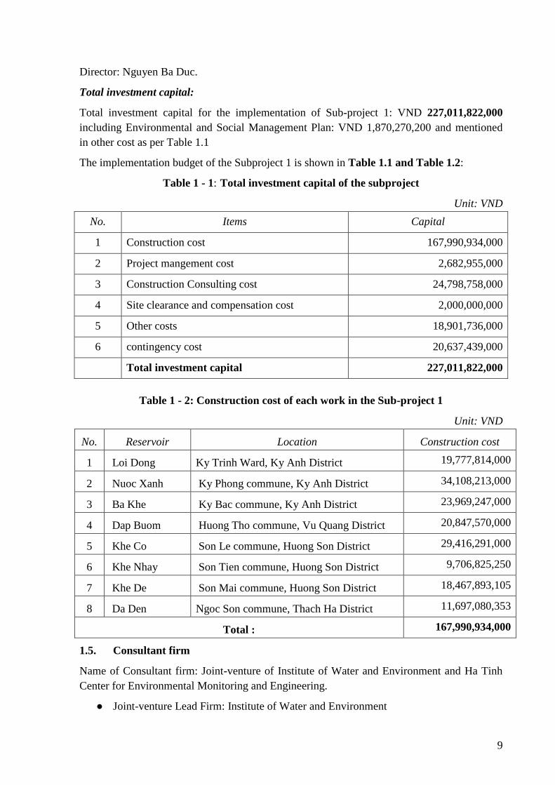
The implementation budget of the Subproject 1 is shown in Table 1.1 and Table 1.2:
Table 1 - 1: Total investment capital of the subproject
Unit: VND
No. Items Capital
1 Construction cost 167,990,934,000
2 Project mangement cost 2,682,955,000
3 Construction Consulting cost 24,798,758,000
4 Site clearance and compensation cost 2,000,000,000
5 Other costs 18,901,736,000
6 contingency cost 20,637,439,000
Total investment capital 227,011,822,000
Table 1 - 2: Construction cost of each work in the Sub-project 1
Unit: VND
No. Reservoir Location Construction cost
1 Loi Dong Ky Trinh Ward, Ky Anh District 19,777,814,000
2 Nuoc Xanh Ky Phong commune, Ky Anh District 34,108,213,000
3 Ba Khe Ky Bac commune, Ky Anh District 23,969,247,000
4 Dap Buom Huong Tho commune, Vu Quang District 20,847,570,000
5 Khe Co Son Le commune, Huong Son District 29,416,291,000
6 Khe Nhay Son Tien commune, Huong Son District 9,706,825,250
7 Khe De Son Mai commune, Huong Son District 18,467,893,105
8 Da Den Ngoc Son commune, Thach Ha District 11,697,080,353
Total : 167,990,934,000
1.5. Consultant firm
Name of Consultant firm: Joint-venture of Institute of Water and Environment and Ha Tinh
Center for Environmental Monitoring and Engineering.
● Joint-venture Lead Firm: Institute of Water and Environment
10
- Address: No. 2, Alley 165 - Chua Boc District
- Representative: Assoc.Prof.Dr. Nguyen Tung Phong
- Title: Director
- Tel: 043.5634809; Fax: 043.5634809
- Email: [email protected]
● Joint-venture Firm: Ha Tinh Center for Environmental Monitoring and Engineering
- Address: No. 01, Vo Liem Son, Ha Tinh city, Ha Tinh Province
- Representative: Le Anh Duc
- Title: Director
- Tel: 0239.3690809-3690677 Fax: 0239.3690677
- Email: [email protected]
List of Consultant members involving in the preparation of Environmental and Social Impact
Assessment reports is presented in Appendix 6.
11
CHAPTER II. SUB-PROJECT DESCRIPTION
2.1. Overview of the sub-project
Name of the Sub-project 01: Repair and improvement for safety of dams in Ha Tinh province
Subproject 1- Repair and improvement for safety of dams in Ha Tinh province consist of 8
works and distributed in following districts: Ky Anh, 03 works; Huong Son 03 works; Vu
Quang: 01 work and Thach Ha 01 work.
According to its investment report, the objectives of rehabilitation and improvement of the
safety of 8 reservoirs in the Subproject 1 are as follows: (1) Ensure reservoir safety and
protect residential areas and infrastructure in downstream; (2) Ensure irrigation water supply
for cultivated lands; (3) Ensure flood safety in the downstream and contribute to forest fire
prevention and control; and (4) Restore ecological landscape in the subproject area.
Sub-project location:
Locations of hydraulic works in the Sub-project 1 are listed in Table 2.1 and Fig. 2.1.
Table 2 – 1: Locations and Technical parameters of works under Sub-project 1
No. Reservoir Locations Type of
dam
Technical parameter
F catchment
(km2)
W
(million
m3)
F
irrigation
(ha)
Main dam
Hmax
(m) L (m)
1 Loi Dong
Reservoir
Ky Trinh Ward, Ky
Anh District
Earthen
dam 1.15 0.421 49 12 793
2 Nuoc Xanh
Reservoir
Ky Phong
Commune, Ky Anh
District
Earthen
dam 1.9 1.61 144 11 1800
3 Ba Khe
Reservoir
Ky Bac commune,
Ky Anh District
Earthen
dam 4.17 1.017 131 12 805
4 Dap Buom
Reservoir
Huong Tho
Commune, Vu
Quang District
Earthen
dam 4.25 0.301 60 9 88
5 Khe Co
Reservoir
Son Le commune,
Huong Son District
Earthen
dam 8.04 4.605 560 22 90.7
6 Khe Nhay
Reservoir
Son Tien commune,
Huong Son district
Earthen
dam 0.6 0.408 59 8 222
7 Khe De
Reservoir
Son Mai commune,
Huong Son
Earthen
dam 2.5 2.158 180 12.5 237
8 Da Den
Reservoir
Ngoc Son commune,
Thach Ha district
Earthen
dam 0.75 0.64 54 11.0 153
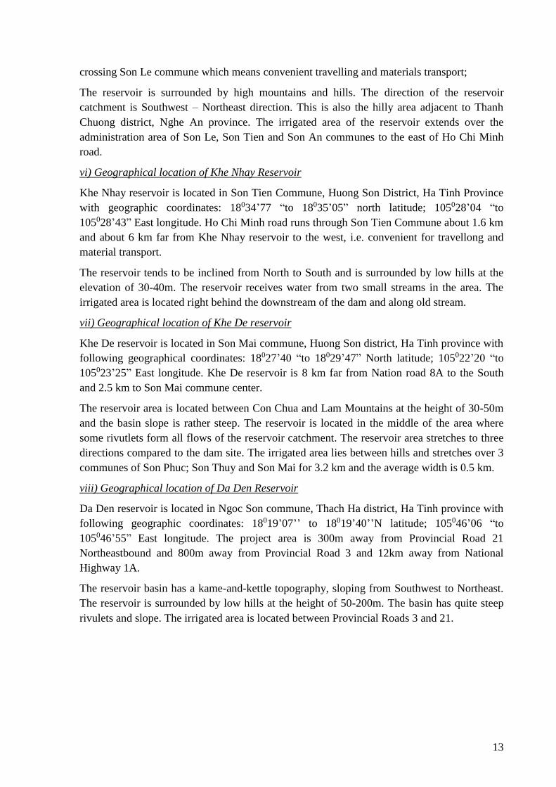
i) Geographical location of Loi Dong Reservoir
The Loi Dong Reservoir is located in Ky Trinh Ward, Ky Anh Town, Ha Tinh Province. Loi
Dong reservoir is located on the road to thermal power plant, 2.5 km to the south from Hoa
12
Loc Bridge. The catchment of the reservoir is located in the following geographic
coordinates: 18005’23 “to 18006’38” North latitude; 105044’48” to 105045’53” East
Longitude.
The entire reservoir catchment is located in the South of Cao Vong Mountain at the elevation
of 344m. The area lowers from North to South. The reservoir has a relatively round shape.
There are two streams flowing into the reservoir and the streams cutting across the reservoir
contours are often short and steep. The irrigation area is located to the west of the reservoir
and between Quyen River and Cao Vong mountain foot.
ii) Geographical location of Nuoc Xanh Reservoir
Nuoc Xanh Reservoir is located in Ky Phong commune, Ky Anh district, Ha Tinh province.
The reservoir catchment is located in following geographic coordinates: 18005’23 “to
18006’38” North latitude; 105010 ‘to 105020’ East Longitude.
The reservoir is located in the middle of the area where there are some springs collecting
water of the whole catchment area. The reservoir is stretched widely and the dam route covers
three sides of the reservoir with a total length of 1,800m. The irrigation area is located to the
south of the reservoir downstream of the dam and mainly irrigates the elevated lands near the
National Highway 1A.
iii) Geographical location of Ba Khe reservoir
Ba Khe reservoir is located in Ky Bac commune, Ky Anh district, Ha Tinh province. The
catchment of the reservoir is located in following geographic coordinates: 18012’58 “to
18013’34” north latitude; 105008’35 “to 105009’14” East longitude.
Around the reservoir are high and continuous hills; the catchment of the reservoir is located in
the Northwest – Southeast direction, the length along the reservoir centerline from the dam to
the upstream is approximately 1,500m and the maximum width of the reservoir is 750m. The
irrigated area is located in the downstream of the dam and stretches along the old stream.
iv) Geographical location of Dap Buom reservoir
Dap Buom Dam is located in Huong Tho commune, Vu Quang district, Ha Tinh province.
Dap Buom reservoir is 300m - 500m away from Dap Buom bridge and Ho Chi Minh Road to
the East. The reservoir is located in following geographical coordinates: 18019’41 “to
18019’42” north latitude; 105034’58”to 105035’00” East longitude.
The entire catchment is located in the south of the Dong Chua mountain range within the
Ngan Sau river basin. The catchment is shaped like a fan which is lowered from South to
North and is located in southwest – northeast direction. The reservoir is surrounded by high
hills. The irrigated area extends along the East of Ho Chi Minh Road acrossing Huong Tho
Commune
v) Geographical location of Khe Co Reservoir
Khe Co reservoir is located in Son Le commune, Huong Son district, Ha Tinh province with
following geographical coordinates: 18034’77 “to 18035’05” North Latitude; 105028’04 “to
105028’43” East longitude. Khe Co reservoir is 1 km far from Ho Chi Minh Road to the east
and 1 km from Thanh Nhan Brick Co., Ltd to the west. Ho Chi Minh road has 5.6 km
13
crossing Son Le commune which means convenient travelling and materials transport;
The reservoir is surrounded by high mountains and hills. The direction of the reservoir
catchment is Southwest – Northeast direction. This is also the hilly area adjacent to Thanh
Chuong district, Nghe An province. The irrigated area of the reservoir extends over the
administration area of Son Le, Son Tien and Son An communes to the east of Ho Chi Minh
road.
vi) Geographical location of Khe Nhay Reservoir
Khe Nhay reservoir is located in Son Tien Commune, Huong Son District, Ha Tinh Province
with geographic coordinates: 18034’77 “to 18035’05” north latitude; 105028’04 “to
105028’43” East longitude. Ho Chi Minh road runs through Son Tien Commune about 1.6 km
and about 6 km far from Khe Nhay reservoir to the west, i.e. convenient for travellong and
material transport.
The reservoir tends to be inclined from North to South and is surrounded by low hills at the
elevation of 30-40m. The reservoir receives water from two small streams in the area. The
irrigated area is located right behind the downstream of the dam and along old stream.
vii) Geographical location of Khe De reservoir
Khe De reservoir is located in Son Mai commune, Huong Son district, Ha Tinh province with
following geographical coordinates: 18027’40 “to 18029’47” North latitude; 105022’20 “to
105023’25” East longitude. Khe De reservoir is 8 km far from Nation road 8A to the South
and 2.5 km to Son Mai commune center.
The reservoir area is located between Con Chua and Lam Mountains at the height of 30-50m
and the basin slope is rather steep. The reservoir is located in the middle of the area where
some rivutlets form all flows of the reservoir catchment. The reservoir area stretches to three
directions compared to the dam site. The irrigated area lies between hills and stretches over 3
communes of Son Phuc; Son Thuy and Son Mai for 3.2 km and the average width is 0.5 km.
viii) Geographical location of Da Den Reservoir
Da Den reservoir is located in Ngoc Son commune, Thach Ha district, Ha Tinh province with
following geographic coordinates: 18019’07’’ to 18019’40’’N latitude; 105046’06 “to
105046’55” East longitude. The project area is 300m away from Provincial Road 21
Northeastbound and 800m away from Provincial Road 3 and 12km away from National
Highway 1A.
The reservoir basin has a kame-and-kettle topography, sloping from Southwest to Northeast.
The reservoir is surrounded by low hills at the height of 50-200m. The basin has quite steep
rivulets and slope. The irrigated area is located between Provincial Roads 3 and 21.
14
Figure 2 – 1: Diagram of Reservoirs in Sub-project 1
2.2. Status of the work and key items of the Sub-project
Summary of the subproject activities:
Dam safety is presenting quite urgent problems. In the context of climate change, abnormal
floods and rains, given low safety level of dams, dam failure risk is quite high. 8 reservoirs of
the subproject 01 had been built for a long time and have not been upgraded due to limited
funding to meet specifications per Vietnam Standard QCVN 04-05: 2012/BNNPTNT and the
Dam Safety Manual of the World bank. Spillways of all 8 reservoirs have been degraded and
are not able to drain flood and is presenting high risk of dam failure. Downstream area of the
reservoirs is populated areas, production areas and infrastructure etc. In case of dam failure,
the consequences are quite serious. To ensure the safety of works, safety of residential areas
as well as economic infrastructure, flood prevention and reduced flooding for downstream
areas, adequate multi-purposes water supply and to limit possible damages caused by the
reservoirs, components of these 8 reservoirs of Subproject 1 should be urgently upgraded to
ensure safety. Repairing and rehabilitating activities of 8 reservoirs do not change their
storage capacity, instead the design irrigation area will be restored.
The proposed activities of the subproject:
Earthen dam:
(i) Increase dam crest of 8 reservoirs to a stable elevation to enhance flood prevention
and absorption capacity;
Loi Dong
Nuoc Xanh
Reservoir
Ba Khe
Dap Buom
Khe Co
Khe Nhay
Khe De
Da Den
15
(ii) Lining dam surface of 8 main dams and 6 auxiliary dams of 8 works with total length
of 5,345.7m;
(iii) Expanding dam surface of 8 reservoirs for enhanced stability of dam body structure;
(iv) Repairing and lining upstream and downstream slopes to enhance safety of slope
system;
(v) Planting grass on the downstream slope to protect dams and as an environmental
friendly measure;
(vi) Building downstream drain trenches to reduce impact of runoff and flood water on
dam structure;
(vii) Installing permeability, water level and transposition monitoring equipment system;
(viii) Building retaining wall for reservoirs: Loi Dong, Khe Co and Khe Nhay to
limit wave run-up and storm surge;
Outlet works: Constructing 7 new sluices for reservoirs, except for Khe Co reservoir, to
ensure stable irrigation water for the downstream areas;
Spillway: Repair and rehabilitate spillways of reservoirs: Nuoc Xanh, Khe Nhay, Khe De and
Khe Co and build new spillway and expand spillway surface of reservoirs: Loi Dong, Ba Khe
and Da Den in order to ensure flood drainage capacity and avoid flooding impact on
downstream areas;
Auxiliary works
(i) Repair and upgrade 4 construction routes and management roads with the total length
of 4,220.36 m;
(ii) Build a diversion canal after the new intake with total length of 224.2m for Dap Buom
reservoir.
16
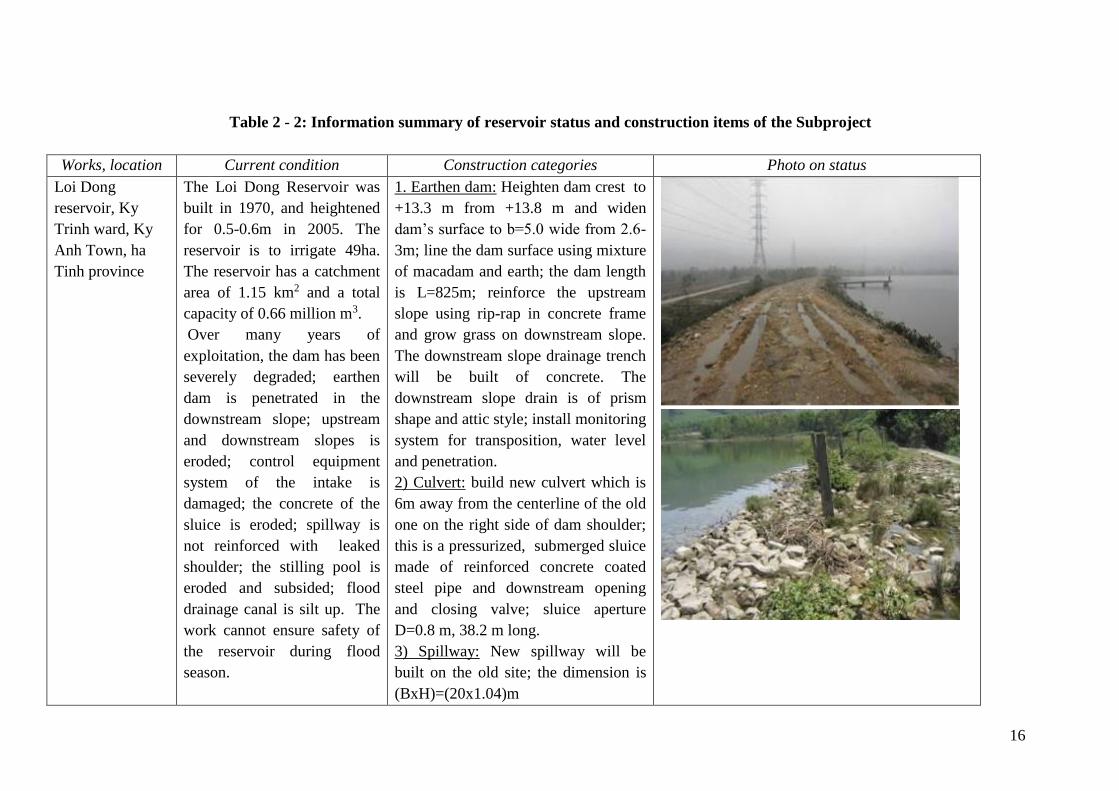
Table 2 - 2: Information summary of reservoir status and construction items of the Subproject
Works, location Current condition Construction categories Photo on status
Loi Dong
reservoir, Ky
Trinh ward, Ky
Anh Town, ha
Tinh province
The Loi Dong Reservoir was
built in 1970, and heightened
for 0.5-0.6m in 2005. The
reservoir is to irrigate 49ha.
The reservoir has a catchment
area of 1.15 km2 and a total
capacity of 0.66 million m3.
Over many years of
exploitation, the dam has been
severely degraded; earthen
dam is penetrated in the
downstream slope; upstream
and downstream slopes is
eroded; control equipment
system of the intake is
damaged; the concrete of the
sluice is eroded; spillway is
not reinforced with leaked
shoulder; the stilling pool is
eroded and subsided; flood
drainage canal is silt up. The
work cannot ensure safety of
the reservoir during flood
season.
1. Earthen dam: Heighten dam crest to
+13.3 m from +13.8 m and widen
dam’s surface to b=5.0 wide from 2.6-
3m; line the dam surface using mixture
of macadam and earth; the dam length
is L=825m; reinforce the upstream
slope using rip-rap in concrete frame
and grow grass on downstream slope.
The downstream slope drainage trench
will be built of concrete. The
downstream slope drain is of prism
shape and attic style; install monitoring
system for transposition, water level
and penetration.
2) Culvert: build new culvert which is
6m away from the centerline of the old
one on the right side of dam shoulder;
this is a pressurized, submerged sluice
made of reinforced concrete coated
steel pipe and downstream opening
and closing valve; sluice aperture
D=0.8 m, 38.2 m long.
3) Spillway: New spillway will be
built on the old site; the dimension is
(BxH)=(20x1.04)m
17
Nuoc Xanh
reservoir, Ky
Phong commune,
Ky Anh district,
Ha Tinh province
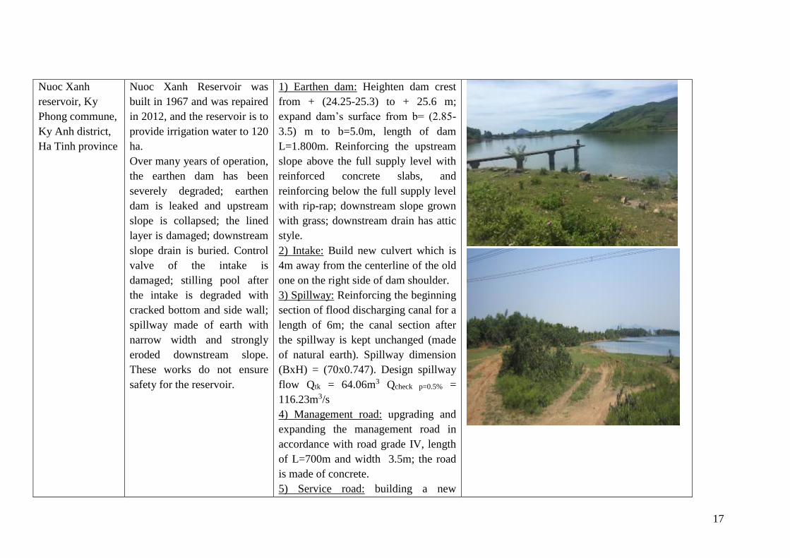
Nuoc Xanh Reservoir was
built in 1967 and was repaired
in 2012, and the reservoir is to
provide irrigation water to 120
ha.
Over many years of operation,
the earthen dam has been
severely degraded; earthen
dam is leaked and upstream
slope is collapsed; the lined
layer is damaged; downstream
slope drain is buried. Control
valve of the intake is
damaged; stilling pool after
the intake is degraded with
cracked bottom and side wall;
spillway made of earth with
narrow width and strongly
eroded downstream slope.
These works do not ensure
safety for the reservoir.
1) Earthen dam: Heighten dam crest
from + (24.25-25.3) to + 25.6 m;
expand dam’s surface from b= (2.85-
3.5) m to b=5.0m, length of dam
L=1.800m. Reinforcing the upstream
slope above the full supply level with
reinforced concrete slabs, and
reinforcing below the full supply level
with rip-rap; downstream slope grown
with grass; downstream drain has attic
style.
2) Intake: Build new culvert which is
4m away from the centerline of the old
one on the right side of dam shoulder.
3) Spillway: Reinforcing the beginning
section of flood discharging canal for a
length of 6m; the canal section after
the spillway is kept unchanged (made
of natural earth). Spillway dimension
(BxH) = (70x0.747). Design spillway
flow Qtk = 64.06m3 Qcheck p=0.5% =
116.23m3/s
4) Management road: upgrading and
expanding the management road in
accordance with road grade IV, length
of L=700m and width 3.5m; the road
is made of concrete.
5) Service road: building a new
18
construction road in accordance with
road grade IV, road length is 604.66m
and width 4.0m wide. The road is
made of earthfill.
Ba Khe reservoir,
Ky bac
commune, Ky
Anh district, Ha
Tinh province
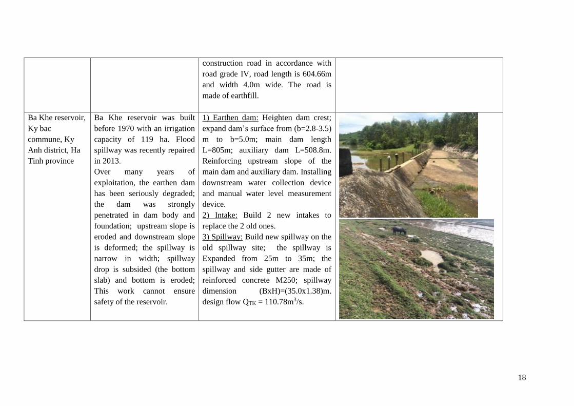
Ba Khe reservoir was built
before 1970 with an irrigation
capacity of 119 ha. Flood
spillway was recently repaired
in 2013.
Over many years of
exploitation, the earthen dam
has been seriously degraded;
the dam was strongly
penetrated in dam body and
foundation; upstream slope is
eroded and downstream slope
is deformed; the spillway is
narrow in width; spillway
drop is subsided (the bottom
slab) and bottom is eroded;
This work cannot ensure
safety of the reservoir.
1) Earthen dam: Heighten dam crest;
expand dam’s surface from (b=2.8-3.5)
m to b=5.0m; main dam length
L=805m; auxiliary dam L=508.8m.
Reinforcing upstream slope of the
main dam and auxiliary dam. Installing
downstream water collection device
and manual water level measurement
device.
2) Intake: Build 2 new intakes to
replace the 2 old ones.
3) Spillway: Build new spillway on the
old spillway site; the spillway is
Expanded from 25m to 35m; the
spillway and side gutter are made of
reinforced concrete M250; spillway
dimension (BxH)=(35.0x1.38)m.
design flow QTK = 110.78m3/s.
19
Dap Buom
reservoir, Huong
Tho commune,
Vu Quang
district, Ha Tinh
province
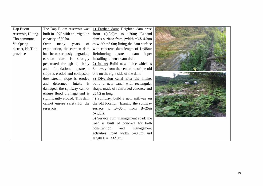
The Dap Buom reservoir was
built in 1978 with an irrigation
capacity of 60 ha.
Over many years of
exploitation, the earthen dam
has been seriously degraded;
earthen dam is strongly
penetrated through its body
and foundation; upstream
slope is eroded and collapsed;
downstream slope is eroded
and deformed; intake is
damaged; the spillway cannot
ensure flood drainage and is
significantly eroded; This dam
cannot ensure safety for the
reservoir.
1) Earthen dam: Heighten dam crest
from +(18.9)m to +20m; Expand
dam’s surface from (width =3.8-4.0)m
to width =5.0m; lining the dam surface
with concrete; dam length of L=88m;
Reinforcing upstream dam slope;
installing downstream drain;
2) Intake: Build new sluice which is
3m away from the centerline of the old
one on the right side of the dam.
3) Diversion canal after the intake:
build a new canal with rectangular
shape, made of reinforced concrete and
224.2 m long.
4) Spillway: build a new spillway on
the old location; Expand the spillway
surface to B=35m from B=25m
(width).
5) Service cum management road: the
road is built of concrete for both
construction and management
activities; road width b=3.5m and
length L = 332.9m;
20
Khe Co reservoir,
Son Le
commune, Huong
Son district, Ha
Tinh province
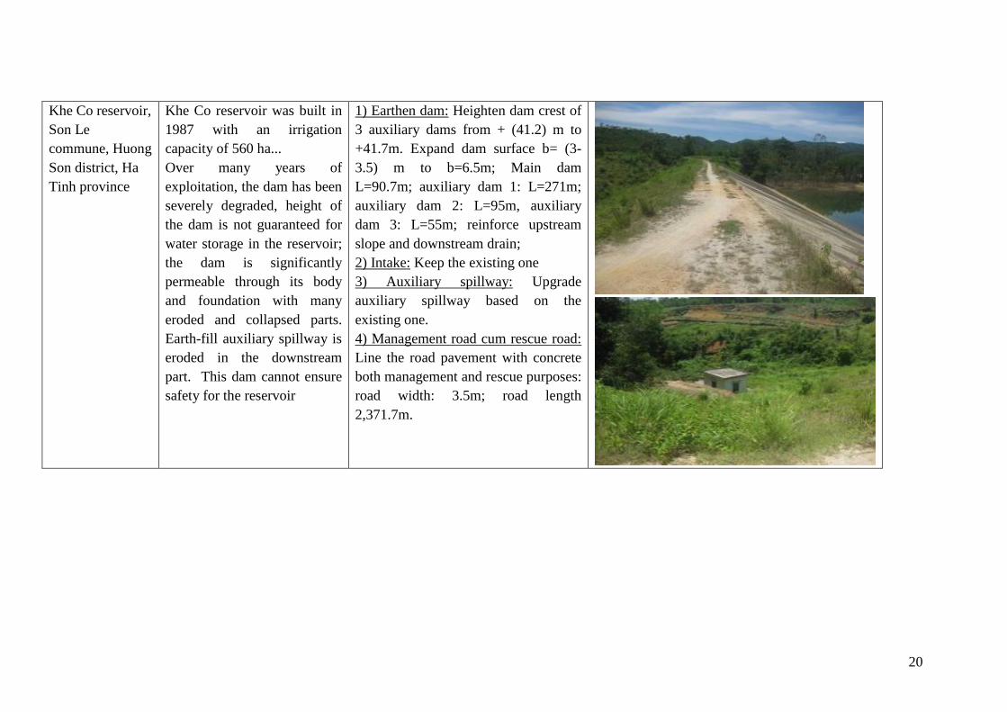
Khe Co reservoir was built in
1987 with an irrigation
capacity of 560 ha...
Over many years of
exploitation, the dam has been
severely degraded, height of
the dam is not guaranteed for
water storage in the reservoir;
the dam is significantly
permeable through its body
and foundation with many
eroded and collapsed parts.
Earth-fill auxiliary spillway is
eroded in the downstream
part. This dam cannot ensure
safety for the reservoir
1) Earthen dam: Heighten dam crest of
3 auxiliary dams from + (41.2) m to
+41.7m. Expand dam surface b= (3-
3.5) m to b=6.5m; Main dam
L=90.7m; auxiliary dam 1: L=271m;
auxiliary dam 2: L=95m, auxiliary
dam 3: L=55m; reinforce upstream
slope and downstream drain;
2) Intake: Keep the existing one
3) Auxiliary spillway: Upgrade
auxiliary spillway based on the
existing one.
4) Management road cum rescue road:
Line the road pavement with concrete
both management and rescue purposes:
road width: 3.5m; road length
2,371.7m.
21
Khe Nhay
reservoir, Son
Tien commune,
Huong Son
district, Ha Tinh
province
Khe Nhay Water Reservoir
was built in 1966 and with an
irrigation capacity of 50 ha.
Over many years of
exploitation, the earthen dam
has been seriously degraded,
the dam has been penetrated
through its body and
foundation and some parts of
upstream slope have been
collapsed. Valve gate of the
intake is damaged. Deep
discharge valve of the
spillway is broken. The work
cannot ensure safety and
drainage capacity during flood
season.
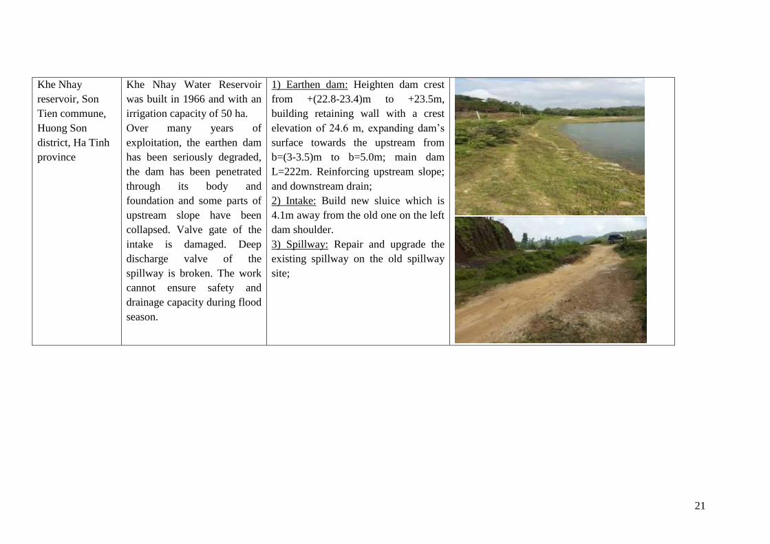
1) Earthen dam: Heighten dam crest
from +(22.8-23.4)m to +23.5m,
building retaining wall with a crest
elevation of 24.6 m, expanding dam’s
surface towards the upstream from
b=(3-3.5)m to b=5.0m; main dam
L=222m. Reinforcing upstream slope;
and downstream drain;
2) Intake: Build new sluice which is
4.1m away from the old one on the left
dam shoulder.
3) Spillway: Repair and upgrade the
existing spillway on the old spillway
site;
22
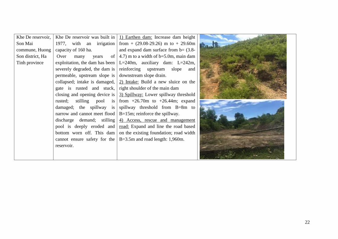
Khe De reservoir,
Son Mai
commune, Huong
Son district, Ha
Tinh province
Khe De reservoir was built in
1977, with an irrigation
capacity of 160 ha.
Over many years of
exploitation, the dam has been
severely degraded, the dam is
permeable, upstream slope is
collapsed; intake is damaged,
gate is rusted and stuck,
closing and opening device is
rusted; stilling pool is
damaged; the spillway is
narrow and cannot meet flood
discharge demand; stilling
pool is deeply eroded and
bottom worn off. This dam
cannot ensure safety for the
reservoir.
1) Earthen dam: Increase dam height
from + (29.08-29.26) m to + 29.60m
and expand dam surface from b= (3.8-
4.7) m to a width of b=5.0m, main dam
L=240m, auxiliary dam: L=242m,
reinforcing upstream slope and
downstream slope drain.
2) Intake: Build a new sluice on the
right shoulder of the main dam
3) Spillway: Lower spillway threshold
from +26.70m to +26.44m; expand
spillway threshold from B=8m to
B=15m; reinforce the spillway.
4) Access, rescue and management
road: Expand and line the road based
on the existing foundation; road width
B=3.5m and road length: 1,960m.
23
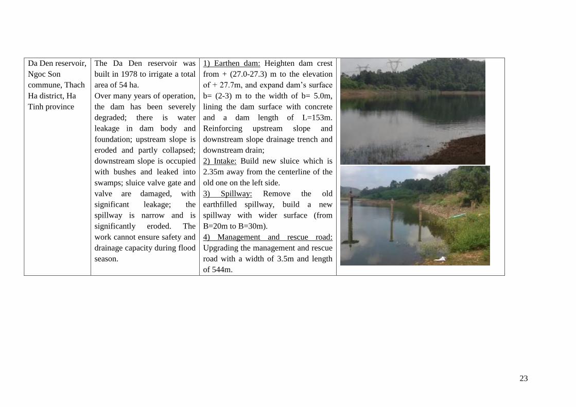
Da Den reservoir,
Ngoc Son
commune, Thach
Ha district, Ha
Tinh province
The Da Den reservoir was
built in 1978 to irrigate a total
area of 54 ha.
Over many years of operation,
the dam has been severely
degraded; there is water
leakage in dam body and
foundation; upstream slope is
eroded and partly collapsed;
downstream slope is occupied
with bushes and leaked into
swamps; sluice valve gate and
valve are damaged, with
significant leakage; the
spillway is narrow and is
significantly eroded. The
work cannot ensure safety and
drainage capacity during flood
season.
1) Earthen dam: Heighten dam crest
from + (27.0-27.3) m to the elevation
of + 27.7m, and expand dam’s surface
b= (2-3) m to the width of b= 5.0m,
lining the dam surface with concrete
and a dam length of L=153m.
Reinforcing upstream slope and
downstream slope drainage trench and
downstream drain;
2) Intake: Build new sluice which is
2.35m away from the centerline of the
old one on the left side.
3) Spillway: Remove the old
earthfilled spillway, build a new
spillway with wider surface (from
B=20m to B=30m).
4) Management and rescue road:
Upgrading the management and rescue
road with a width of 3.5m and length
of 544m.
24
2.3. Construction materials of the Sub-project and auxiliary works;
Table 2 - 3: Summary of material quantity needed for civil works in the Sub-project
No. Construction material Unit Quantity
1 Excavation soil m3 397,040
2 Backfill soil m3 291,093
3 Waste soil m3 134,284
4 Sand m3 20,120
5 Stone m3 68,437
6 Brick Brick 27,811
7 Wood m3 1,246
8 Steel ton 1,000.5
9 Cement ton 9,912.5
Transporting distance and material quantity for each work are described in the following
table:
Table 2 - 4: Summary of material quantity and transporting distance
No. Reservoir/structure Unit Quantity Mode of supply Transport
distance
1 Loi Dong
Reservoir
Excavation soil m3 29,537
Backfill soil m3 28,298 Purchased from other areas
Sand m3 1,795 Purchased from Ky Anh town 9.5km
Stones m3 7,884 Purchased from Stone quarry
Com Tria, Ky Tan Commune,
Ky Anh District
19.2km
Brick piece 4,850 Purchased from Ky Anh town
9.5km
Formwork m3 49
Steels kg 155,457
Cement kg 894,516
2 Nuoc Xanh
Reservoir
Excavation soil m3 103,793 In-situ
Backfill soil m3 65,305 Purchased from 666 Company,
Ky Phong commune, Ky Anh
district
2km
Sand m3 4,742 Purchased in Ky Phuong
commune, Ky Anh district
20km
Stone m3 12,186 Purchased in Cam Thinh
commune, cam Xuyen district
8km
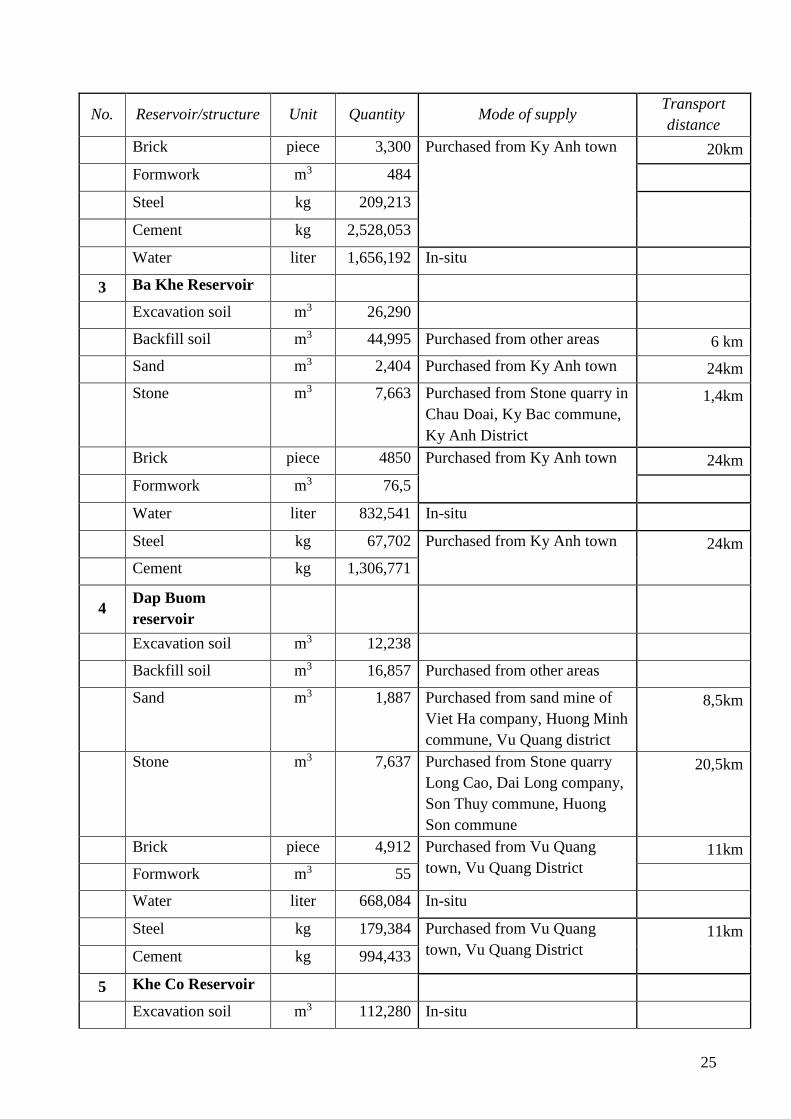
25
No. Reservoir/structure Unit Quantity Mode of supply Transport
distance
Brick piece 3,300 Purchased from Ky Anh town 20km
Formwork m3 484
Steel kg 209,213
Cement kg 2,528,053
Water liter 1,656,192 In-situ
3 Ba Khe Reservoir
Excavation soil m3 26,290
Backfill soil m3 44,995 Purchased from other areas 6 km
Sand m3 2,404 Purchased from Ky Anh town 24km
Stone m3 7,663 Purchased from Stone quarry in
Chau Doai, Ky Bac commune,
Ky Anh District
1,4km
Brick piece 4850 Purchased from Ky Anh town 24km
Formwork m3 76,5
Water liter 832,541 In-situ
Steel kg 67,702 Purchased from Ky Anh town 24km
Cement kg 1,306,771
4 Dap Buom
reservoir
Excavation soil m3 12,238
Backfill soil m3 16,857 Purchased from other areas
Sand m3 1,887 Purchased from sand mine of
Viet Ha company, Huong Minh
commune, Vu Quang district
8,5km
Stone m3 7,637 Purchased from Stone quarry
Long Cao, Dai Long company,
Son Thuy commune, Huong
Son commune
20,5km
Brick piece 4,912 Purchased from Vu Quang
town, Vu Quang District
11km
Formwork m3 55
Water liter 668,084 In-situ
Steel kg 179,384 Purchased from Vu Quang
town, Vu Quang District
11km
Cement kg 994,433
5 Khe Co Reservoir
Excavation soil m3 112,280 In-situ
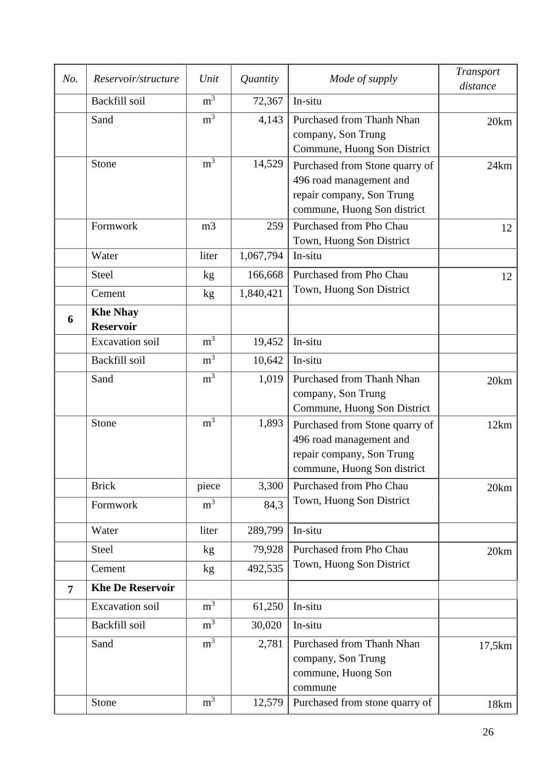
26
No. Reservoir/structure Unit Quantity Mode of supply Transport
distance
Backfill soil m3 72,367 In-situ
Sand m3 4,143 Purchased from Thanh Nhan
company, Son Trung
Commune, Huong Son District
20km
Stone m3 14,529 Purchased from Stone quarry of
496 road management and
repair company, Son Trung
commune, Huong Son district
24km
Formwork m3 259 Purchased from Pho Chau
Town, Huong Son District
12
Water liter 1,067,794 In-situ
Steel kg 166,668 Purchased from Pho Chau
Town, Huong Son District
12
Cement kg 1,840,421
6 Khe Nhay
Reservoir
Excavation soil m3 19,452 In-situ
Backfill soil m3 10,642 In-situ
Sand m3 1,019 Purchased from Thanh Nhan
company, Son Trung
Commune, Huong Son District
20km
Stone m3 1,893 Purchased from Stone quarry of
496 road management and
repair company, Son Trung
commune, Huong Son district
12km
Brick piece 3,300 Purchased from Pho Chau
Town, Huong Son District
20km
Formwork m3 84,3
Water liter 289,799 In-situ
Steel kg 79,928 Purchased from Pho Chau
Town, Huong Son District
20km
Cement kg 492,535
7 Khe De Reservoir
Excavation soil m3 61,250 In-situ
Backfill soil m3 30,020 In-situ
Sand m3 2,781 Purchased from Thanh Nhan
company, Son Trung
commune, Huong Son
commune
17,5km
Stone m3 12,579 Purchased from stone quarry of 18km
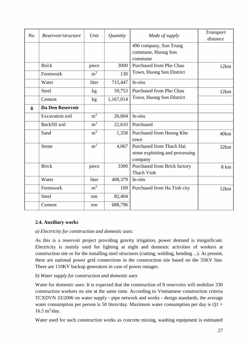
27
No. Reservoir/structure Unit Quantity Mode of supply Transport
distance
496 company, Son Trung
commune, Huong Son
commune
Brick piece 3000 Purchased from Pho Chau
Town, Huong Son District
12km
Formwork m3 130
Water liter 715,447 In-situ
Steel kg 59,753 Purchased from Pho Chau
Town, Huong Son District
12km
Cement kg 1,167,014
8 Da Den Reservoir
Excavation soil m3 26,804 In-situ
Backfill soil m3 22,610 Purchased
Sand m3 1,358 Purchased from Huong Khe
town
40km
Stone m3 4,067 Purchased from Thach Hai
stone exploiting and processing
company
32km
Brick piece 3300 Purchased from Brick factory
Thach Vinh
8 km
Water liter 408,379 In-situ
Formwork m3 109 Purchased from Ha Tinh city 12km
Steel ton 82,404
Cement ton 688,796
2.4. Auxiliary works
a) Electricity for construction and domestic uses:
As this is a reservoir project providing gravity irrigation, power demand is insignificant.
Electricity is mainly used for lighting at night and domestic activities of workers at
construction site or for the installing steel structures (cutting, welding, bending ...). At present,
there are national power grid connections in the construction site based on the 35KV line.
There are 110KV backup generators in case of power outages.
b) Water supply for construction and domestic uses
Water for domestic uses: It is expected that the construction of 8 reservoirs will mobilize 330
construction workers on site at the same time. According to Vietnamese construction criteria
TCXDVN 33/2006 on water supply - pipe network and works - design standards, the average
water consumption per person is 50 liters/day. Maximum water consumption per day is Q1 =
16.5 m3/day.
Water used for such construction works as concrete mixing, washing equipment is estimated
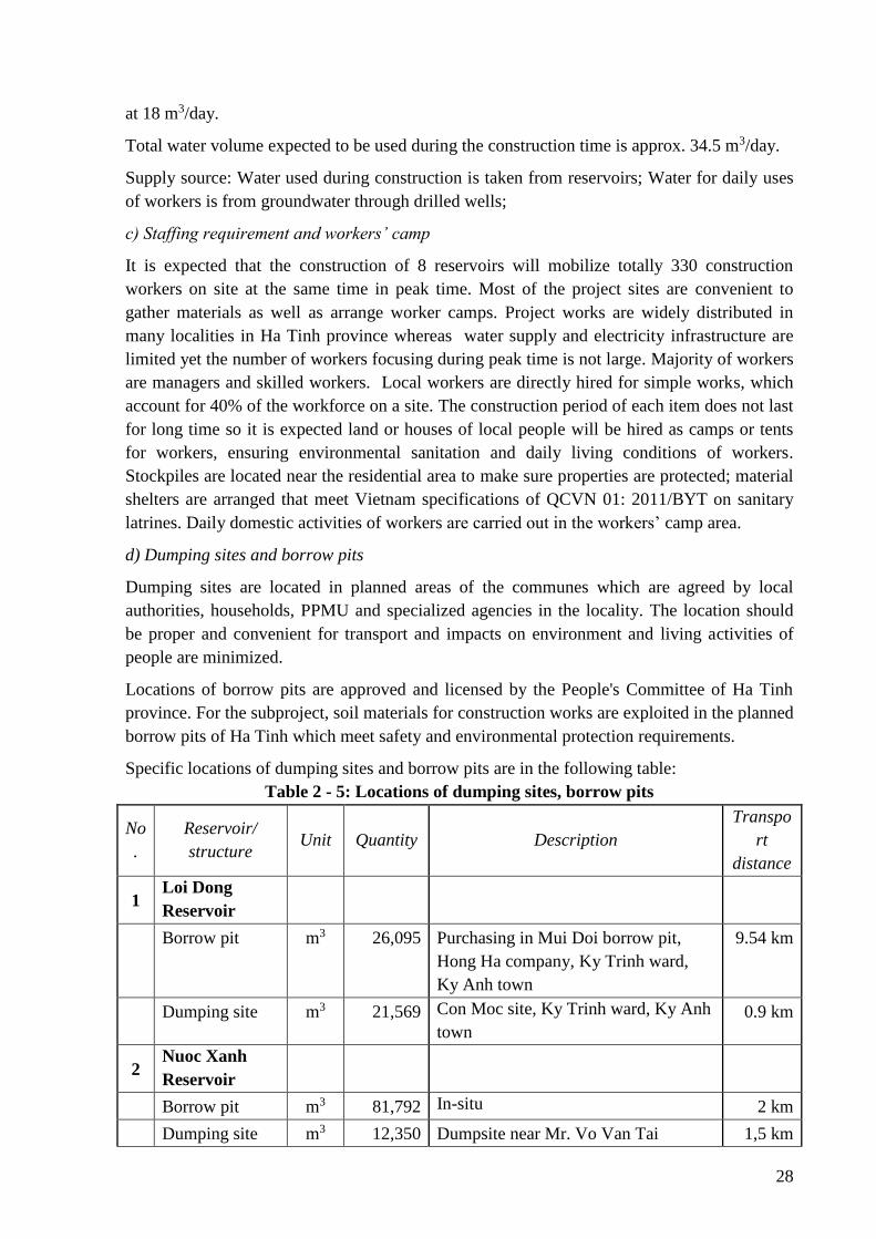
28
at 18 m3/day.
Total water volume expected to be used during the construction time is approx. 34.5 m3/day.
Supply source: Water used during construction is taken from reservoirs; Water for daily uses
of workers is from groundwater through drilled wells;
c) Staffing requirement and workers’ camp
It is expected that the construction of 8 reservoirs will mobilize totally 330 construction
workers on site at the same time in peak time. Most of the project sites are convenient to
gather materials as well as arrange worker camps. Project works are widely distributed in
many localities in Ha Tinh province whereas water supply and electricity infrastructure are
limited yet the number of workers focusing during peak time is not large. Majority of workers
are managers and skilled workers. Local workers are directly hired for simple works, which
account for 40% of the workforce on a site. The construction period of each item does not last
for long time so it is expected land or houses of local people will be hired as camps or tents
for workers, ensuring environmental sanitation and daily living conditions of workers.
Stockpiles are located near the residential area to make sure properties are protected; material
shelters are arranged that meet Vietnam specifications of QCVN 01: 2011/BYT on sanitary
latrines. Daily domestic activities of workers are carried out in the workers’ camp area.
d) Dumping sites and borrow pits
Dumping sites are located in planned areas of the communes which are agreed by local
authorities, households, PPMU and specialized agencies in the locality. The location should
be proper and convenient for transport and impacts on environment and living activities of
people are minimized.
Locations of borrow pits are approved and licensed by the People's Committee of Ha Tinh
province. For the subproject, soil materials for construction works are exploited in the planned
borrow pits of Ha Tinh which meet safety and environmental protection requirements.
Specific locations of dumping sites and borrow pits are in the following table:
Table 2 - 5: Locations of dumping sites, borrow pits
No
.
Reservoir/
structure Unit Quantity Description
Transpo
rt
distance
1 Loi Dong
Reservoir
Borrow pit m3 26,095 Purchasing in Mui Doi borrow pit,
Hong Ha company, Ky Trinh ward,
Ky Anh town
9.54 km
Dumping site m3 21,569 Con Moc site, Ky Trinh ward, Ky Anh
town
0.9 km
2 Nuoc Xanh
Reservoir
Borrow pit m3 81,792 In-situ 2 km
Dumping site m3 12,350 Dumpsite near Mr. Vo Van Tai 1,5 km
29
No
.
Reservoir/
structure Unit Quantity Description
Transpo
rt
distance
household, Lang Con village, Ky
Phong commune, Ky Anh District
3 Ba Khe
Reservoir
Borrow pit m3 41,694 Purchase from Borrow pit Ngoc Thao,
Cam Trung commune, Cam Xuyen
District
6 km
Dumping site m3 10,581 Vacant lowland Gieng Cho, Hop Tien
village, Ky Bac commune, Ky Anh
district
2.6 km
4 Dap Buom
Reservoir
Borrow pit m3 24,456 Purchase from borrow pit of Minh
Huong company, Duc An commune,
Duc Tho district
32 km
Dumping site m3 9,508 Vacant, low land in Huong Tho
Commune
0.9 km
5 Khe Co
Reservoir
Borrow pit m3 83,115 In-situ
Purchasing clay in Son Binh commune
0.3km
Dumping site m3 7,024.5 Vacant land A1, in Son Tien
Commune, Huong Son District
6.5 km
6 Khe Nhay
Reservoir
Borrow pit m3 12,451 Backfill soil exploited in Son Le
commune, Huong Son District
0.3km
Dumping site m3 4,228.5 Vacant land A1, in Son Tien
Commune, Huong Son District
5.5km
7 Khe De
Reservoir
Borrow pit m3 32,107 Borrow pit on left and right shoulder
of the main dam in Son Mai commune,
Huong Son district
Purchasing clay in Son Binh commune
0.3km
11 km
Dumping site m3 12,191.7 Vacant site in Son Mai commune 1.2km
8 Da Den
Reservoir
Borrow pit m3 24,974 Purchasing from Vinaco company, in
Ngoc Son commune, Thach Ha district
2 km
30
No
.
Reservoir/
structure Unit Quantity Description
Transpo
rt
distance
Dumping site m3 3,491 Dumpsite in Ngoc Ha village, Ngoc
Son commune
4.3km
e) Construction roads
Construction conditions are relatively good with convenient transportation; Accesses to all
reservoirs have been made available. These access roads serve the transport of construction
materials.
Construction road of Khe Nhay reservoir Construction road of Ba Khe reservoir
Figure 2 - 2: Status of some transportation routes
The status of roads for transporting materials during construction of subproject works is
presented in the following table
Table 2 - 6: Status of transportation roads
Works Material Description of the road Distance
Loi Dong
Reservoir
Filling soil Crossing following roads: Highway IA for 1.6 km, asphalt
road of 6.0 m wide and 2.8 km long, asphalt road of 4.0 to
5.0 m wide and 2.3 km long; concrete road of 4.0 m wide
and 0.4 km long and the remaining road is the aggregate
road width of 3.0 to 5.0 m.
9.54 km
Stones Crossing National Highway I of 3.2 km, National road 12C
of 3.9 km, 5.1 km of asphalt road of 4-6.0 m wide
19.2 km
Sand Crossing following roads: National Highway I of 3.6 km
and 5.1km of an asphalt road of 4 - 6.0 m wide
9.5 km
Other
materials
Crossing following roads: a Highway I of 3.6 km long, an
Asphalt road of 4 - 6.0 m wide and 5.1 km long
9.5 km
Nuoc
Xanh
Reservoir
Filling soil Concrete road and 3.5-5m wide gravel road in Ky Phong
commune
2 km
Stones Crossing following roads: 15 km of highway 1A, asphalt
road and internal concrete road with 5-6m wide of road
pavement from stone quarry to highway 1A, length of
5.4km; 4-5m wide asphalt road with length of 2.7 km and
4m wide gravel road with length of 0.9km. The transport
24 km
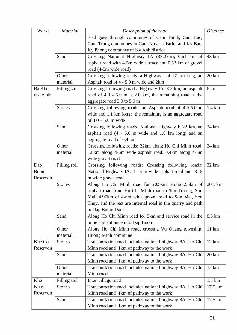
31
Works Material Description of the road Distance
road goes through communes of Cam Thinh, Cam Lac,
Cam Trung communes in Cam Xuyen district and Ky Bac,
Ky Phong communes of Ky Anh district
Sand Crossing National Highway 1A (38.2km); 0.61 km of
asphalt road with 4-5m wide surface and 0.53 km of gravel
road (4-5m wide road)
43 km
Other
material
Crossing following roads: a Highway I of 17 km long, an
Asphalt road of 4 - 5.0 m wide and 2km
20 km
Ba Khe
reservoir
Filling soil Crossing following roads: Highway IA: 3.2 km, an asphalt
road of 4.0 - 5.0 m is 2.0 km, the remaining road is the
aggregate road 3.0 to 5.0 m
6 km
Stones Crossing following roads: an Asphalt road of 4.0-5.0 m
wide and 1.1 km long; the remaining is an aggregate road
of 4.0 – 5.0 m wide
1.4 km
Sand Crossing following roads: National Highway I: 22 km, an
asphalt road (4 - 6.0 m wide and 1.8 km long) and an
aggregate road of 0,4 km
24 km
Other
material
Crossing following roads: 22km along Ho Chi Minh road,
1.8km along 4-6m wide asphalt road, 0.4km along 4-5m
wide gravel road
24 km
Dap
Buom
Reservoir
Filling soil Crossing following roads: Crossing following roads:
National Highway IA, 4 - 5 m wide asphalt road and 3 -5
m wide gravel road
32 km
Stones Along Ho Chi Minh road for 20.5km, along 2.5km of
asphalt road from Ho Chi Minh road to Son Truong, Son
Mai; 4.97km of 4-6m wide gravel road to Son Mai, Son
Thuy, and the rest are internal road in the quarry and path
to Dap Buom Dam
20.5 km
Sand Along Ho Chi Minh road for 5km and service road in the
mine and entrance into Dap Buom
8.5 km
Other
material
Along Ho Chi Minh road, crossing Vu Quang township,
Huong Minh commune
11 km
Khe Co
Reservoir
Stones Transportation road includes national highway 8A, Ho Chi
Minh road and 1km of pathway to the work
12 km
Sand Transportation road includes national highway 8A, Ho Chi
Minh road and 1km of pathway to the work
20 km
Other
material
Transportation road includes national highway 8A, Ho Chi
Minh road
12 km
Khe
Nhay
Reservoir
Filling soil Inter-village road 1.5 km
Stones Transportation road includes national highway 8A, Ho Chi
Minh road and 1km of pathway to the work
17.5 km
Sand Transportation road includes national highway 8A, Ho Chi
Minh road and 1km of pathway to the work
17.5 km
32
Works Material Description of the road Distance
Other
material
Transportation road includes national highway 8A, Ho Chi
Minh road and inter-commune road
20 km
Khe De
Reservoir
Stones Transportation road includes national highway 8A, Ho Chi
Minh road and 1km of pathway to the work
18 km
Sand Transportation road includes national highway 8A, Ho Chi
Minh road and 1km of pathway to the work
17,5 km
Other
material
Transportation road includes national highway 8A, Ho Chi
Minh road and inter-commune road
12 km
Da Den
Reservoir
Filling soil Transportation road includes: 1 km of provincial road 21;
0.5km of provincial road and 0.5km of gravel rural
transportation road with width of 3-5m
2 km
Stones Crossing following roads: 4-6m wide asphalt road to
National highway 1A: 18.5 km, provincial road 21: 5 km;
concrete road to the stone quarry: 2km; 4 - 6m wide
concrete road to the dam heel: 0.5km long
32 km
Sand Crossing following roads: National highway 15, provincial
road 550 and 1km of gravel road
40 km
Other
material
Crossing following roads: Provincial road 21, Provincial
road 3 and rural road in Nam Son village
12 km
2.5. Construction organization measures
2.5.1. Pre-construction phase
The subproject design proposed alternatives taking into account different scenarios and
climate change impact risks on functions of construction items. The design also studied
climate factors in recent years as presented in the subproject status section to select optimal
design option. Climate change impacts in the subproject area in recent years mainly related to
changing rainfalls which caused flooding, erosion and drought.
Site clearance in pre-construction phase will relate to the demolition of existing structures,
tree cutting down and removal of weathered layers:
- Demolishing existing structures: 10 households with their houses and properties on
lands will be affected, including 2 households with affected houses and 8 households
with archictecture on land affected. In particular, a total of 234 m2 of fence, 185m2 of
yard and 476 m2 of breeding facilities will be affected. However these affected
properties are within the dam protection corridor which have been encroached by
households. No household is relocated.
- Cutting down plants: A total of 1,259 fruit trees, 8,016 trees for timber, and 2,702m2 of
subdidary crops will be cut down for construction activities. Households may collect cut
down trees for firewood. Other parts of plants, vegetable will be collected and moved to
dumping site by the subproject owner.
- Removing weathered layer will be carried out at selected stockpiles, workers’ camps
area and existing dam foundation.
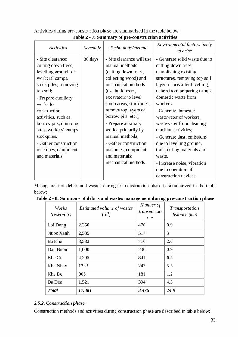
33
Activities during pre-construction phase are summarized in the table below:
Table 2 - 7: Summary of pre-construction activities
Activities Schedule Technology/method Environmental factors likely
to arise
- Site clearance:
cutting down trees,
levelling ground for
workers’ camps,
stock piles; removing
top soil;
- Prepare auxiliary
works for
construction
activities, such as:
borrow pits, dumping
sites, workers’ camps,
stockpiles.
- Gather construction
machines, equipment
and materials
30 days - Site clearance will use
manual methods
(cutting down trees,
collecting wood) and
mechanical methods
(use bulldozers,
excavators to level
camp areas, stockpiles,
remove top layers of
borrow pits, etc.);
- Prepare auxiliary
works: primarily by
manual methods;
- Gather construction
machines, equipment
and materials:
mechanical methods
- Generate solid waste due to
cutting down trees,
demolishing existing
structures, removing top soil
layer, debris after levelling,
debris from preparing camps,
domestic waste from
workers;
- Generate domestic
wastewater of workers,
wastewater from cleaning
machine activities;
- Generate dust, emissions
due to levelling ground,
transporting materials and
waste.
- Increase noise, vibration
due to operation of
construction devices
Management of debris and wastes during pre-construction phase is summarized in the table
below:
Table 2 - 8: Summary of debris and wastes management during pre-construction phase
Works
(reservoir)
Estimated volume of wastes
(m3)
Number of
transportati
ons
Transportation
distance (km)
Loi Dong 2,350 470 0.9
Nuoc Xanh 2,585 517 3
Ba Khe 3,582 716 2.6
Dap Buom 1,000 200 0.9
Khe Co 4,205 841 6.5
Khe Nhay 1233 247 5.5
Khe De 905 181 1.2
Da Den 1,521 304 4.3
Total 17,381 3,476 24.9
2.5.2. Construction phase
Construction methods and activities during construction phase are described in table below:
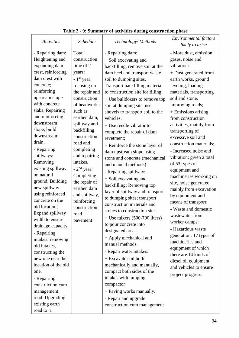
34
Table 2 - 9: Summary of activities during construction phase
Activities Schedule Technology/ Methods Environmental factors
likely to arise
- Repairing dam:
Heightening and
expanding dam
crest, reinforcing
dam crest with
concrete;
reinforcing
upstream slope
with concrete
slabs; Repairing
and reinforcing
downstream
slope; build
downstream
drain.
- Repairing
spillways:
Removing
existing spillway
on natural
ground; Building
new spillway
using reinforced
concrete on the
old location;
Expand spillway
width to ensure
drainage capacity.
- Repairing
intakes: removing
old intakes,
constructing the
new one near the
location of the old
one.
- Repairing
construction cum
management
road: Upgrading
existing earth
road to a
Total
construction
time of 2
years:
- 1st year:
focusing on
the repair and
construction
of headworks
such as
earthen dam,
spillway and
backfilling
construction
road and
completing
and repairing
intakes.
- 2nd year:
Completing
the repair of
earthen dam
and spillway,
reinforcing
construction
road
pavement
- Repairing dam:
+ Soil excavating and
backfilling: remove soil at the
dam heel and transport waste
soil to dumping sites.
Transport backfilling material
to construction site for filling.
+ Use bulldozers to remove top
soil at dumping sits; use
shovels to transport soil to the
vehicles.
+ Use reedle vibrator to
complete the repair of dam
revetment;
+ Reinforce the stone layer of
dam upstream slope using
stone and concrete (mechanical
and manual methods)
- Repairing spillway:
+ Soil excavating and
backfilling: Removing top
layer of spillway and transport
to dumping sites; transport
construction materials and
stones to construction site.
+ Use mixers (500-700 liters)
to pour concrete into
designated areas.
+ Apply mechanical and
manual methods.
- Repair water intakes:
+ Excavate soil both
mechanically and manually,
compact both sides of the
intakes with jumping
compactor
+ Paving works manually.
- Repair and upgrade
construction cum management
- More dust, emission
gases, noise and
vibration:
+ Dust generated from
earth works, ground
leveling, loading
materials, transporting
soil and stone,
improving roads;
+ Emissions arising
from construction
activities, mainly from
transporting of
excessive soil and
construction materials;
- Increased noise and
vibration: given a total
of 53 types of
equipment and
machineries working on
site, noise generated
mainly from excavation
by equipment and
means of transport;
- Waste and domestic
wastewater from
worker camps:
- Hazardous waste
generation: 17 types of
machineries and
equipment of which
there are 14 kinds of
diesel oil equipment
and vehicles to ensure
project progress.
35
Activities Schedule Technology/ Methods Environmental factors
likely to arise
concrete road of
3.5 m wide.
road:
+ Backfilling soil and sand
using compactor to level road
pavement
+ Concreting the road
pavement
Materials transportation plan
Construction materials will be gathered at site one week prior to the construction
commencement. Construction materials will be transported to the site using local routes
during low peak time to minimize negative impacts on agricultural production and living
activities of local people. Quantity of workers, machines and materials are shown in above
mentioned sections.
Flow diversion and cofferdam embankment for construction:
During the construction and repair of earthen dam and construction of new intakes, it is
necessary to divert flow to ensure water demand of the downstream area. Flow diversion for
construction is through the existing intake. Suitable time to lower water level in reservoirs for
construction is at the end of summer-autumn crop, i.e. July – August which is also dry season
and water demand for irrigation is the lowest. The embankment of cofferdam for water
pumping is only necessary for the construction of dam heel at low position and new intakes.
Once the pre-casting and construction of new intakes is finished, the existing intakes will be
removed, creating a diversion canal at the location of the old intake to continue diverting
water to downstream area. As soon as the new intakes ensure water drainage, flow will
diverted through the new intake and cofferdam of the drainage canal gate will be built to
block the dam section of the diversion canal (where the old intake exists) and the dam section
on the new intake in accordance with design cross section.
The construction time of the dam heel and intake is short, i.e. 2-3 months. At the same time,
there is a plan to find other water sources to support the downstream area. Moreover, duration
of July - August is the end of summer-autumn crop and irrigation demand of the downstream
area is quite low. Thus impact of construction on downstream water supply is minimal.
Among 8 works under the subproject 01, 7 works (Loi Dong, Nuoc Xanh, Ba Khe, Dap
Buom, Khe Nhay, Khe De, Da Den) required the construction of new intakes and needed dam
slope to be improved including the dam heels at the downstream side and downstream drains.
Therefore cofferdam embankment is necessary for the construction of above mentioned items
in all 8 works.
2.6. Construction progress
a) Site clearance progress: expected 1 month (30 days) in the 1st year and in rainy season
b) Construction progress:
Construction will take place during dry season (from January to August). It is estimated that
36
construction time of all items including earthen dam, spillway, intake, management and
rescue roads is 11 months for each of the reservoirs. Water cut for construction of intake and
dams will take place in the most convenient time so not to interrupt irrigation supply to
cultivation areas in the downstream of reservoirs.
(i) 1st Year:
- Construction period is during dry season (from January to August)
- Construction of auxiliary works for construction: dumpsites, houses of construction
management board, tents for workers, stockpiles, site for machineries, equipment and
construction materials
- Filling soil on construction cum management roads;
- Scrubbing, demolishing existing works, transporting disposal soil and stones;
- Repairing dams: removing the rip-rap at the dam heel and old dam slope; reinforcing
the upstream slope to the full supply level; heightening and expanding dam crest;
reinforcing downstream slope and constructing downstream drains;
- Building new/upgrading spillways: removing old spillways and building new ones on
the location of the old ones.
- The construction of intakes and repairing dam body under the full water level will be
undertaken during 20/6 to 30/8 which is the end of summer-autumn crop when water
level in reservoirs is lowered and water demand is the lowest.
- Especially, due to water shortage, summer-autumn crop of in Loi Dong reservoir has
ceased since 2000. Thus the construction of intake can take place as late as May (after
the harvest of winter-spring crop) until August.
2nd year:
- Continue to complete spillway and earthen dam above the full supply level;
- Continue to build concrete road pavement of the management cum rescue roads;
2.7. Operation and maintenance activities
Periodic monitoring of dam safety: Once reservoirs complete their storage and dams are
operated, dam owners will carry out dam monitoring activities which are executed by a
qualified independent expert who have not involved in the investigation, design, construction
or operation of dams. After normal operation, regular inspections of dams will take place,
including pre- and after flood season inspections in accordance with Government Decree (No.
72/2007/ND-CP) on Dam Safety Management.
After completion of works, the dam owner will be responsible for dam operation and PMU’
role will then be terminated.
Reservoir and valve gate operation: The dam owners must set up water regulation procedure
of the reservoir, regulations on water storage and discharge under normal conditions and in
emergency situations, then submit them to the competent State management bodies for
approval and organize the implementation thereof. The dam owners must formulate and
submit to competent authorities for promulgation or promulgate according to their
competence documents on the operation and procedures of the valve of each project
37
(hereinafter referred to as operation of the works). Other issues should be addressed under the
Decree 72/2007/ND-CP of Government on dam safety management.
2.8. Dam safety plan
A dam safety report (DSR) will be prepared for the subproject. The objective of the Dam
Safety Report (DSR) is to present, analyze and make recommendations on: a) All conditions
can affect the safety of dams and auxiliary structures; b) Damages caused by the failure or
non-operation of dams or other structures due to harsh natural conditions or human faults or
structural faults; and c) institutional framework (at the present time and) in the future which
is needed to be in place to avoid or to minimize adverse conditions for dam safety.
After completion of the review at the subproject screening stage, the CPMU under MARD
should provide a DSR for each subproject which was identified during the project
implementation phase and send to the PoE (international dam safety consultant team) and the
World Bank for review. Reports must include findings and recommendations for any related
safety issues, necessary actions to be taken. Dam safety measures should be integrated into
the design, construction and operation of the reservoir.
Review and analysis of dam structure safety: The review and evaluation of dams and related
works will include, but is not limited to, the following:
- Review survey documents on foundation geology and materials. Pay attention to
potential adverse effects that may occur by known geological features. Assessment of
unforeseen conditions and handling measures to address dam safety and operation
issues of the dam and related works.
- Assess the suitability of type of dams and spillways, response of the dam design,
including proposed measures for foundation treatment, embankment, load parameters
of selected foundation, permeability and floating head pressure control. Pay attention
to any abnormalities or faults and propose measures to be taken.
- Evaluate the stability, analyse strength and safety factors in normal, abnormal and
extreme load conditions for earthen dams and concrete dams, spillway structure and
discharge works, including the determination of geological impact criteria.
- Evaluate factors impacting reservoir stability, causes to landslide, wave and their
effects on dam stability;
- Evaluate the hydrological calculation methods to determine design flood of the
project, reservoir site and spillway dimension. Review designs of spillway structures
including flow conditions, and stilling basins. Assess the spillway discharge capacity
for all design floods without damaging dams.
- Assess water intake and discharge facilities, including hydraulic designs, emergency
water discharge capacity of reservoirs, and sedimentation processes.
- Assess design of spillways and intake control facilities, including the selection of the
number and type of main gates and valves, lifting equipment and other control
mechanisms. Pay particular attention to the back-up system for operating gated
spillways and water discharge facilities in case of operational and power failure.
38
- Assess designs of flow diversion structures, construction progress, hydrological and
risks aspects related to flow diversion during construction and flow blocking at the
beginning stage of reservoir impounding;
- Assess the suitability of measurement instruments, especially marking instruments or
markers which are required for the forecast of serious risks or dam failure.
- Assess O&M procedures and emergency response plan of dam owners, including the
assessment of sub-project operation and maintenance factors related to dam safety and
assessment of the operator capacity relating to how they cay perform regular
maintenance and inspections of dam safety.
Assess dam safety risks: In addition to ensuring dam safety, the project should assess the
potential risks of the dam to population and environment in the downstream area, including
related structures. Dam failure may not occur but once happens, it will result in serious
damages. Dam safety risks to downstream residential areas should be carried out by the
Client. For large and high-risk dams, comprehensive data should be collected during
preparation phase, including topographic document and land uses in downstream, to simulate
dam failure and flood in downstream under different conditions/scenarios serving the
formulation of the Emergency Preparedness Plan. Data collection from upstream dams and/or
activities relating to watershed can be necessary for some dams. Planning and implementation
of capacity building programs for subprojects through pilot activities to promote active
participation of local communities should be considered. Communities around the dam site
can participate in daily dam monitoring activities to protect dams from external destructive
activities, and take part in simple maintenance tasks. A participatory and community based
model for dam safety protection should also be considered. Sedimentation and contamination
of upstream water can be a serious problem to some river basins. The dam owner must
commit to the allocation of funds to appropriate dam operation and management activities and
to periodical dam safety checks.
39
CHAPTER III. POLICY, LEGAL, AND ADMINISTRATIVE
FRAMEWORKS
This chapter provides the briefing of relevant environmental and social policies of the GoV
and the World Bank.
3.1. Government Regulations
The following national laws and regulations are applied for the subproject:
- Environmental Protection Law No. 55/2014/QH13 of the National Assembly of Vietnam
dated June 23, 2014. This law stipulates environmental protection activities; policies,
measures and resources for environmental protection; right and obligations of
organizations, households and individuals in environmental protection. Article 7 of
Chapter 1 prescribes prohibited actions such as destroying and illegal exploiting natural
resources; transportation and dumping of toxic product, radioactive substance, waste and
hazardous waste not following technical regulations on environmental protection; disposal
of untreated wastes, toxic product, radioactive substance, and other hazardous materials
into land, water and air; generating noise and vibration that exceeds national technical
regulation on noise and vibration; emitting dust, smoke and gases containing toxic
chemicals and offensive smell into air; emitting radiation and radioactivity and ionization
substances that exceeds national technical regulations. Article 18 of Chapter 2 stipulates
Environmental Impacts Assessment (EIA) for investment projects.
- Land Law No. 45/2013/QH13 of the National Assembly of Vietnam dated November 29,
2013 prescribes the regime of land ownership, powers and responsibilities of the State in
representing the entire-people owner of land and uniformly managing land, the regime of
land management and use, the rights and obligations of land users involving land in the
territory of the Socialist Republic of Vietnam. Article 12 of Chapter 1 prescribes
prohibited actions such as encroaching and destroying of land; violating of land planning
that was publicly disclosed; improper land use; not providing or providing incorrect land
information as per legal regulation. Article 16 of Chapter 2 stipulates land acquisition.
Chapter 5 stipulates land acquisition, compensation, support and resettlement.
- Law on Water Resources No. 17/2012/QH13 of the National Assembly of Vietnam dated
June 21, 2012 provides on management, protection, exploitation and use of water
resources, as well as the prevention of, combat against and overcoming of harmful effects
caused by water in the territory of the Socialist Republic of Vietnam. Chapter 3 of this law
stipulates Protection of Water Resources. Extraction and use of water resources must
comply with the water resources planning. Article 9 of Chapter 1 describes prohibited
actions, such as discharge of wastes and illegal exploitation of sand and gravel in stream,
river, channel, and reservoir.
- Law on Biodiversity No. 20/2008/QH12 of the National Assembly of Vietnam dated
November 13, 2008 provides for the conservation and sustainable development of
biodiversity; rights and obligations of organizations, households and individuals in the
conservation and sustainable development of biodiversity. Article 7 of Chapter 1
40
prescribes prohibited actions such as hunting, poaching and exploiting wildlife in strictly
protected sub region of protected areas, except for scientific research purposes;
encroaching land, destroying landscape, degrading natural ecological systems and raising
and growing alien species in protected areas; constructing works and houses in in strictly
protected sub region of protected areas, except for works for defense and security
purposes; illegal construction of works and houses in ecological recovery sub region of
protected areas.
- The Law on Construction No. 50/2014/QH13 approved on 18th June 2014 by 7th
National Assembly of the Socialist Republic of Vietnam. Article 12 of Chapter 1
prescribes prohibited actions such as use of materials to cause harm to the public health
and environment. Article 16 of Chapter 2 stipulates environmental protection in
construction. During construction, contractors are responsible for (i) establishing and
implementing environmental protection measures, including air and water environment,
solid wastes, noise and other requirements in accordance with Law on Environmental
Protection, and (ii) compensating for damages caused by contractors.
- The Law on Roadway Traffic No. 23/2008/QH12 dated on 13/11/2008. Articles 8 of
Chapter 1 prescribes prohibited actions such as driving vehicles without licenses; driving
vehicles with speed exceeding allowed speed; sounding horn between 10 p.m. and 5 a.m.;
driving vehicles while the body is positive with drug. Article 55 of Chapter 4 stipulates
ensuring technical safety quality and environmental protection for vehicles moving on
roadways.
- The Law on Complaint No. 02/2011/QH13 dated 11 November 201.This law stipulates
complaint and handling complaint; management and monitoring of complaint handling.
Article 6 of Chapter 1 prescribes prohibited actions such as limited responsibility for
handling complaint; creating wrong information and documents of compliant cases;
intentionally handling complaint not following legal regulation; impeding and causing
inconvenience for people who conduct complaint right; threatening, revenging, and
victimizing complainant. Article 7 of Chapter 2 stipulates complaint procedures; Article 8
of Chapter 2 stipulates complaint form; Article 9 of Chapter 2 stipulates complaint
prescription.
- Labor Law No.10/2012/QH13. This law stipulates labor standard; right and obligation of
employee, employer, representative organization of employee, representative organization
of employer in labor relations and other relations directly related to labor relations; state
management of labor. Article 8 of Chapter 1 prescribes prohibited actions such as
discrimination of gender, ethnicity, skin color, social status, belief, religion, disability;
labor forcing; use of untrained employee; use of employee with age not following legal
regulation.
- The Law on Culture Heritage No. 28/2001/QH10. This law aims to (i) reinforce the state
management effectiveness and (ii) raise responsibility of people for participation,
protection and promotion of the value of cultural heritages. Article 13 of Chapter 1
prescribes prohibited actions such as destroying and causing potential destruction of
cultural heritage; illegal excavation of archaeological sites; illegal construction and
encroaching land of historical relics and famous landscape; appropriating of cultural
41
heritage and making of untrue cultural heritage. Article 37 of Chapter 4 stipulates chance
find procedures.
- The Law on Safety, Labor Sanitation No. 84/2015/QH13 dated June 25, 2015. This law
stipulates ensuring safety and labor sanitation; policy and regulation for labor accident and
occupational diseases; responsibility and right of organizations and individuals in safety
and labor sanitation and state management of safety and labor sanitation. Article 12 of
Chapter 1 prescribes prohibited actions such as cheating at verification, safety training,
labor sanitation, monitoring labor environment; discrimination of gender in safety
insurance, labor sanitation; hiding or reporting untrue labor accidents; not implementing
requirements and measures for safety insurance, labor sanitation to cause harm or
potential harm to human, assets and environment; use of equipment and machinery
requiring strictly requirements on safety and labor sanitation but not verified or verified
results not satisfying requirements. Article 14 of Chapter 2 stipulates training in safety and
labor sanitation for employee. Article 16 of Chapter 2 stipulates employer’s obligation in
ensuring safety and labor safety at workplace.
- Law on Fire Prevention and Fighting No.27/2001/QH10 dated June 29, 2001. This law
stipulates fire prevention and fighting; establishing human resources, equipment and
machineries and policy on fire prevention and fighting. Article 13 of Chapter 1 prescribes
prohibited actions such as construction of works which the design for fire prevention and
fighting has not been reviewed and approved; approval and put into operation of works
which have not yet satisfied conditions of fire prevention and fighting. Article 4 of
Chapter 1 prescribes principles of fire prevention and fighting.
- Law on Electricity No.28/2004/QH11dated December 14, 2004. This law stipulates
planning and investment in electricity; electricity saving; electricity market; right and
obligation of organizations and individuals in electricity use; protection of electricity
equipment and works; electricity safety. Article 7 of Chapter 1 prescribes prohibited
actions such as destroying electricity equipment and works; violating safety regulations on
electricity generation, transmission and distribution; violating regulations on protection of
electricity network safety corridor, and safety distance between transmission line and
substation.
- Decree no.72/ND-CP on date 07/05/2007 of the government of Vietnam regarding on dam
safety management. According to the decree, a big dam is the dam with the height calculating
from the floor face to the top of the dam equal to or greater than 15 meters or dam of water
reservoirs with the scale of capacity equal to or greater than 3,000,000 m3 (three million cubic
meters). Small dam is the dam with the height calculating from the floor face to the top of the
dam smaller than 15 meters. Dam owners are organizations and individuals owning dams to
harness the benefits of water reservoirs or assigned to manage, operate and harness water
reservoirs by the competent state agencies. Ministry of Agriculture and Rural Development
takes responsibility before the Government for the implementation of state management of
dam safety. The Ministry of Industry and Trade presides over and coordinates with ministries,
branches and relative localities to appraise, approve or submit to the Prime Minister for
approval of the process of operating hydropower reservoirs. The provincial-level People's
Committees implement its state management on dam safety in the areas.
42
- Decree No.14/2014/ND-CP on Electricity Safety dated 26 February 2014.
- Decree No.59/2007/ND-CP dated 9 April 2008 on solid waste management.
- Decree 174/2007/ND-CP dated 29 November 2007 of GOV on environmental protection
charges for solid wastes.
- Decree 155/2016/ND-CP dated 18 November 2016 on punishment on administrative
violation in environmental protection.
- Decree No.98/2010/ND-CP of the Government dated 21 September 2010 on detailing
the implementation of some articles of the Law on Cultural Heritage and the Law
amending and supplementing some articles of Law on cultural heritage.
- Decree No. 59/2015/ND-CP of Vietnam Government issued on 18 June 2015 on
Construction Investment Project Management.
- Decree No. 46/2015/ND-CP of Vietnam Government issued on 12 May 2015 on
Construction Work Maintenance and Quality Management.
- Decree No. 18/2015/ND-CP of Vietnam Government issued on 14 Feb 2015 on
Environmental Protection Planning, SEA, EIA and Environmental Protection Plans.
- Decree No. 19/2015/ND-CP of Vietnam Government issued on 14 Feb 2015 on detailing
some articles of Law of Environmental Protection.
- Circular No. 27/2015/TT-BTNMT dated 29 May 2015 on SEA, EIA and EPP.
- Circular No. 36/2015/TT-BTNMT dated 30 June 2015 on Hazardous Waste
Management.
The applicable National Technical Regulations and Standards include:
- QCVN 14:2008/BTNMT- National technical regulation on domestic wastewater.
- QCVN 01:2009/BYT- National technical regulation on drinking water quality.
- QCVN 02:2009/BYT- National technical regulation on domestic water quality.
- QCVN 06:2009/BTNMT-Air quality -specified maximum allowable concentrations of
certain hazardous substances in ambient air.
- QCVN 07:2009/BTNMT - National Technical Regulation on Hazardous Waste
Thresholds.
- QCVN26:2010/BTNMT- National technical regulation on maximum noise limit in
public and residential areas.
- QCVN 27:2010/BTNMT- National technical regulation on vibration.
- QCVN 40:2011/BTNMT- National technical regulations on industrial wastewater.
- QCVN 05:2013/BTNMT- National technical regulation on ambient air quality.
- QCVN 08-MT: 2015/BTNMT - National technical regulation on surface water.
- QCVN 09-MT: 2015/BTNMT - National technical regulation on groundwater.
- QCVN 03-MT: 2015/BTNMT - National technical regulation on the allowable limits of
43
heavy metals in the soils.
- QCVN 43:2012/BTNMT - National technical regulation on sediment quality.
- QCVN 18:2014/BXD - National technical regulation on Safety in Construction.
- TCVN 9902:2016: Irrigation Works – Specifications for Design of River Dikes.
- TCVN 4118:2012: Irrigation Works – Specifications for Design of Irrigation Canal
Systems.
- Decision No. 3733/2002/QD-BYT dated Oct 10, 2002 of Ministry of Health on
publishing 21 occupational sanitation standards, 05 principles and 07 parameters of
occupational sanitation.
- Other relevant sector technical regulations and standards.
Compliance with environmental and social impacts assessment implementation
The subproject environmental and social impacts assessment will be carried out in line
with environmental and social impacts assessment procedure of the WB and GoV. In
particular, environmental and social impacts assessment of the subproject will comply
with project environmental and social management framework which have been reviewd
and approved by the WB. Environmental and social screening shall be carried out for each
subproject to identify scope and proper type of environmental and social impacts
assessment. Based on that, the TOR will be prepared for environmental and social impact
assessments in accordance with subproject scale and potential forecasted impacts from
subproject implementation. Environmental and social screening will be conducted by
World Bank safety policy experts. The Environmental and Social Impact Assessment
TOR will also be reviewed and approved by the World Bank Safety Policy Specialists
prior to the implementation of the Environmental and Social Impact Assessment. In the
process of environmental and social impact assessment, consultations with affected people
and local NGOs should be conducted. The environmental and social impact assessment
report will be disclosed at the sub-project site in Vietnamese so that affected people and
local NGOs can access and the English version will be published on the World Bank's
website prior to the appraisal of the subproject.
3.2. World Bank Safeguard Policies
3.2.1. Project level
An environmental and social screening of the Project was undertaken in line with the OP 4.01
and it showed that the following World Bank's safeguard policies have been triggered:
Environmental Assessment (OP/BP 4.01), Natural Habitats (OP/BP 4.04), Pest management
(OP 4.09), Indigenous peoples (OP/BP 4.10), Physical Cultural Resources (OP/BP 4.11),
Involuntary Resettlement (OP/BP 4.12), Safety of Dams (OP/BP 4.37) and Projects on
International Waterways (OP/BP 7.50). The Project has been classified as Category A. In
addition, the Bank’s requirements for public consultation and information disclosure will be
met.
44
3.2.2. Subproject level
This ESIA is based on the approved ESMF for the whole project, thus the following policies
triggered respectively:
Environmental Assessment (OP/BP 4.01) Environmental Assessment (EA) is an umbrella
policy for the Bank’s safeguard policies. The overarching objective is to ensure that Bank-
financed projects are environmentally sound and sustainable, and that decision-making is
improved through appropriate analysis of actions and of their likely environmental impacts.
The EA process is intended to identify, avoid and mitigate potential impacts of Bank
operations. EA takes into account the natural environment (air, water, and land); human
health and safety; social aspects (involuntary resettlement, indigenous peoples, and physical
cultural resources); and trans-boundary and global environmental aspects. EA considers
natural and social aspects in an integrated way.
This subproject triggers OP 4.01 because it involves the repair of dams, intakes, spillways,
etc. which would likely cause potentially negative environmental and social impacts. Based
on the social and environmental screening activities undertaken, the subproject is classified as
Category B as per OP 4.01 (Environmental Assessment). As required by OP 4.01, the
subproject has prepared an ESIA that meet the GoV’s regulations and the World Bank’s
safeguard policy requirements. The subproject draft ESIA will be disclosed locally at the
subproject areas and through the Bank’s Portal as required by OP 4.01 and the Bank’s policy
on access to information. The final subproject ESIA will be disclosed locally at the subproject
sites and through the Bank’s information system.
Pest management (OP 4.09): Rehabilitation of the dam will result in stabilized agricultural
land which is irrigated by the upgraded works, i.e. irrigated agriculture land will increase.
Thus more amount of fertilizer can also be applied. The OP/ BP 4.09 – Pest management
policy has been triggered to manage and promote the application of Integrated Pest
Management (IPM) and guidance to this issue will be incorporated into the ESIA.
Physical Cultural Resources (OP/BP 4.11): This policy is triggered because the subproject
construction activities may affect the pagoda, belief and religious utilities by construction
traffic. In addition, since the subproject involves excavation that may encounter PCRs under
the ground. Mitigation measures for impacts on the pagoda have been proposed in the section
of site-specific mitigation measures while ESMP included measures to address chance finds.
Involuntary Resettlement (OP/BP 4.12): The Involuntary Resettlement policy seeks to prevent
severe long-term hardship, impoverishment, and environmental damage to the affected
peoples during involuntary resettlement. OP 4.12 applies whether or not affected persons
must move to another location. The Bank describes all these processes and outcomes as
“involuntary resettlement,” or simply resettlement, even when people are not forced to move.
Resettlement is involuntary when the government has the right to expropriate land or other
assets and when affected people do not have the option to retain the livelihood situation that
they have.
This policy is triggered because the subproject would have impacts involving the temporary
and permanent involuntary taking of land and the loss of structures and assets associated with
the land for the construction of project items. The Resettlement Policy Framework (RFP) was
45
prepared and included in the ESMF. It was assessed that the subproject has prepared
Resettlement Action Plan (RAP) based on this RFP. Mitigation measures have been included
in the RAP to ensure that displaced people are: (i) informed of options relating to their
resettlement; (ii) consulted and offered alternative resettlement options; and (iii) compensated
effectively and their livelihood is restored.
Safety of Dams (OP/BP 4.37): The project will not finance construction of any new dam or
significant change to dam structure. This policy is triggered as the project will finance
rehabilitation and improvement of existing dams including large dams (15 meters or more in
height). Thus, it requires to arrange for one or more independent dam specialists to (a) inspect
and evaluate the safety status of existing dams, its appurtenances, and performance history;
(b) review and evaluate the owner's procedures for operations and maintenance; and (c)
provide written report of findings and recommendations for any repair work or safety-related
measures necessary to upgrade existing dams to an acceptable standard of safety. Policy and
practice relating to dam safety need to meet international benchmarks, such as World Bank
regulatory frameworks for dam safety. These measures are designed into the project, which
includes the establishment of a national dam safety review panel (DSRP). Also the project
will establish an independent Panel of dam safety Experts (PoE) who will carry out
independent review of dam safety reports and proposed mitigation measures. This PoE will be
working closely with the established DSRP to ensure the technical integrity of investment
interventions. Each subproject will have separate Dam Safety Plan (DSP) in addition to the
ESMPs.
World Bank Group Environmental, Health, and Safety Guidelines
World Bank-financed projects should also take into account the World Bank Group
Environmental, Health, and Safety Guidelines1 (known as the "EHS Guidelines"). The EHS
Guidelines are technical reference documents with general and industry-specific examples of
Good International Industry Practice. The EHS Guidelines contain the performance levels and
measures that are normally acceptable to the World Bank Group and are generally considered
to be achievable in new facilities at reasonable costs by existing technology. The
environmental assessment process may recommend alternative (higher or lower) levels or
measures, which, if acceptable to the World Bank, become project-or site-specific
requirements. This subproject should conform to the General EHS Guidelines.
Table 3 - 1: A summary of the WB and GOV regulations on environmental assessment
Environmental
assessment stages
WB
(Regulation on OP/BP 4.01 on
environmental assessment)
Vietnam
(Decree 18/2015/ND-CP,
Circular 27/2015/TT-
BTNMT)
Screening - Category (A, B, C, FI)
- Not required for each specific
case in order to classify, apply
safeguard policies and identify
- Category: I, II, III and IV of
Decree 18/2015/ND-CP.
- Rules, fixed in Annexes I, II and
III - List of projects requiring
1 1The EHS Guidelines can be consulted at IFC website
www.ifc.org/ifcext/enviro.nsf/Content/EnvironmentalGuidelines.
46
Environmental
assessment stages
WB
(Regulation on OP/BP 4.01 on
environmental assessment)
Vietnam
(Decree 18/2015/ND-CP,
Circular 27/2015/TT-
BTNMT)
environmental assessment tool
(EA).
- The World Bank will classify a
proposed project into one of four
categories including A, B, C, or
FI depending on the type,
location, sensitivity and scale of
the project and the nature, the
importance of its potential
environmental impacts.
- Category A: Request for full
Environmental Impact
Assessment. In some cases,
ESMF is also required.
- Category B: ESIA, ESMF or
ESMP is required. In most cases,
it requires ESMF and/or ESMP.
- Category C: without EA.
- Category FI: ESMF is the most
popular used tool. In the case of a
number of subprojects that have
been identified before the
appraisal, the FI will prepare
specific tools based on the
framework, e.g. ESIA or ESMP.
SEA and EIA reports submitted
and approved.
- All of the projects which are not
listed.
- Generally, the project owner
examines the project based on
the classification as stated in
Decree 18/2015/ND-CP and
consults with the Department of
Natural Resources and
Environment (DONRE) or
Vietnam Environment
Administration (DONRE - VEA)
to categorize and required EA
report of the project, such as:
• The project is in list of
Annex I, II, III: SEA or EIA is
required
• The project is in list of
Annex IV: EIA and
Environmental protection plan
is not required
• The project is not in list of
Annex I, II, III and IV: EPP is
required
Environmental
assessment tool
- Depending on project impacts, a
range of tools will be used to
meet the World Bank's
requirements, including: ESMF;
specific environmental
assessment; ESMP, Regional and
sectoral EA; Risk or hazard
assessment; Environmental audit.
The World Bank provides general
guidelines for implementing each
tool.
- EA tools such as SEA, EIA or
EPP are identified based on
Annexes I, II, III and IV of
Decree 18/2015/ND-CP.
Scope of
environmental
assessment
- The World Bank supports
borrower in the drafting TOR for
the EA and determines the EA
- TOR for EA is not required.
- Normally, after consultation with
the local DoNRE or VEA about
47
Environmental
assessment stages
WB
(Regulation on OP/BP 4.01 on
environmental assessment)
Vietnam
(Decree 18/2015/ND-CP,
Circular 27/2015/TT-
BTNMT)
scope, procedures, timeline and
draft EA report...
- For Category A projects, an
ESIA TOR is required,
identification of scope and
consultations will take place in
preparation for EIA TORs.
the type of EA, the project owner
will prepare an EA report.
Community
consultation
- During the EA process, the
borrower must consult with
affected groups and local NGOs
on the environmental aspects of
the project, focusing on their
views.
- For Category A projects, the
Borrower shall consult these
groups at least twice: (a)
immediately after the
environmental inspection and
before the EA TOR is completed;
and (b) when a draft EA report
has been prepared. In addition,
borrowers consult with these
groups throughout the project
implementation process as
needed to address issues relating
to EA that affect them...
- For Category B projects, there
should be at least one public
consultation.
- For meaningful consultations, the
borrower provided relevant
project documents in a timely
manner prior to consultation in a
form and language that the group
could understand and be
accessible to by them.
- The minutes of the public
meeting are included in the
report.
- The project owner is responsible
for consulting with the People's
Committee of the commune,
ward or township (hereinafter
referred to as the commune)
where the project is being
implemented, with organizations
or communities under direct
impact of the project; Research
and receive objective opinions
and reasonable requests from
relevant agencies to minimize
the negative impacts of the
project on the natural
environment, biodiversity and
public health.
- Commune People's Committees
where the project is implemented
and organized under the direct
impact of the project will be
consulted. The project owner is
responsible for submitting the
EIA report to the people's
committee of the commune
where the project was
implemented and have direct
impacts on the locality,
enclosing a written request for
comments. Within 15 working
days from the date on which the
EIA reports are received, CPCs
and organizations subject to
48
Environmental
assessment stages
WB
(Regulation on OP/BP 4.01 on
environmental assessment)
Vietnam
(Decree 18/2015/ND-CP,
Circular 27/2015/TT-
BTNMT)
project direct impacts are
obliged to submit their feedbacks
if they do not approve the
project.
- The community consultation on
direct impacts of the project is
carried out in the form of
community meetings co-chaired
by the Clients and CPCs where
the project is implemented and
with the participation of Vietnam
Fatherland Front, Socio-Political
organizations, Socio-
Professional organizations,
relevant residential quarters,
villages/hamlets. All opinions of
participants in the meeting must
be fully and truthfully presented
in the minutes of meeting.
Disclosure of
information
- Before the World Bank appraise
the project, the EA report must
be disclosed in public in a way
that is easily accessible by
project-affected groups and local
NGOs. Once the World Bank has
officially received the report, the
World Bank will publish the
report in English to the public via
its website.
- After the EIA report is approved,
the project owner is responsible
for preparing, approving and
publicly disclosing their EMP at
the local CPC headquarter and
consulting local communities so
that local people can be informed
and carry out their inspection
and monitoring rights (Article 16
of Decree 18/2015/ND-CP).
Independent
environmental
expert
- For Category A projects, the
independent EA experts who
have no relation with the project
will be hired by the Borrower for
the implementation of the EA.
- For category A projects with high
risks or multi-dimensional
environmental concerns, the
Borrower will also hire a
consultation team of independent
- Not regulated in Vietnam policy.
- The Project owner shall
implement or hire a consulting
unit which satisfies conditions
specified in Clause 1, Article 13
of Decree No.18/2015 for the
preparation of the EIA report.
Project owners or consultancy
service providers must fully
meet the following conditions:
49
Environmental
assessment stages
WB
(Regulation on OP/BP 4.01 on
environmental assessment)
Vietnam
(Decree 18/2015/ND-CP,
Circular 27/2015/TT-
BTNMT)
qualified environmental experts
of international experience for
Consultancy on project aspects
relating to the EA
- Experts/consultation firms will
be selected through a bidding
process under the close
supervision of the World Bank.
(i) The staff responsible for EIA
must have at least BA degree
and EIA consultancy certificate;
(ii) There are staff with relevant
specializations with a university
degree or above involving in the
project; (iii) Having certified and
qualified laboratories and testing
equipment for measurement,
sampling, sample processing and
analysis of environmental
samples for environmental
impact assessment of the project;
In the absence of a certified and
qualified laboratory and
calibrating equipment, a
qualified laboratory must be
contracted for testing items.
EA
review/Approval
Process
- The Bank reviews findings and
recommendations of EA to
determine whether they provide
sufficient grounds to process the
funding to the project by the
Bank. In case the Borrower has
fully completed or completed
part of the environmental
assessment before the Bank
participates in a project, the Bank
will review this environmental
assessment to ensure its
consistency with this policy. The
Bank may, where appropriate,
request additional environmental
assessments, including public
consultation and disclosure.
- The MONRE shall appraise and
approve EIA reports of projects
as specified in Appendix III to
this Decree, except for projects
relating to defense and security
activities and locations.
- Ministries and ministerial-level
agencies shall appraise and
approve EIA reports of projects
under their competence for
investment approval, except for
projects included in Appendix III
to this Decree;
- PPC shall carry out appraisal and
approval of EIA reports of
projects in the province, except
for projects as mentioned above.
- The appraisal will take place at
least 45 working days at
MONRE level and 30 working
days at DoNRE level and 5
50
Environmental
assessment stages
WB
(Regulation on OP/BP 4.01 on
environmental assessment)
Vietnam
(Decree 18/2015/ND-CP,
Circular 27/2015/TT-
BTNMT)
working days at district level
after EIA or full EPP is received.
The number and
language of the
EA/EIA needed
to be evaluated
- Number of copies is not
specified.
- Language requirements: English
and Vietnamese. EA reports in
Vietnamese are required for the
information disclosure in the
country and must be in English
for publication on the World
Bank website.
- The project owner must submit
at least seven copies of EIA
reports (depending on the
number of members of the
appraisal council) and one
feasibility study or a technical-
economic report of the proposed
project.
Content of the
EA report
- For Category A projects, the
contents of the EA report are in
Appendix B of OP4.01.
- The scope of EA for Category B
projects may vary by project, but
EA's scope is narrower than that
of Category A projects. ESMP is
an integral part of type A
projects’ EAs (regardless of other
tools used). EA for Category B
projects may also be an
Environmental and Social
Management Plan (EMP) with
contents as set out in Annex C of
OP 4.01.
- The contents of the EA report
must be in line with Circular
27/2015/TT-BTNMT.
Monitoring EA - During the implementation of the
project, the World Bank
supervises the implementation of
the environmental aspects against
environmental regulations and
the project borrower prepare
report as agreed in the loan
agreement and as described in
other project documents, to
determine the satisfactory
compliance of the borrower's to
Environmental Procedures
(mainly with EMP). If the
- The local DoNRE is entrusted
with the supervision of
environmental compliance of the
project.
- At the end of the project
construction phase, the
Environmental Management
Agencies will coordinate with
the Construction Management
Agencies to monitor the
compliance of environmental
management activities as
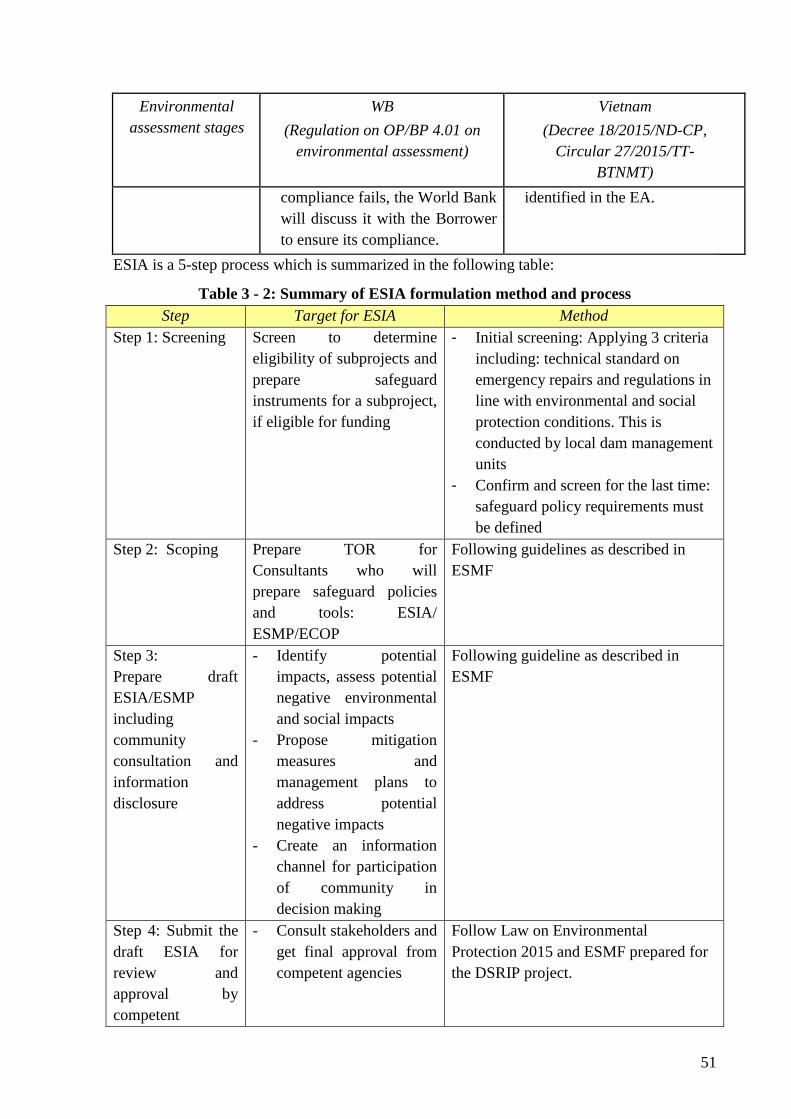
51
Environmental
assessment stages
WB
(Regulation on OP/BP 4.01 on
environmental assessment)
Vietnam
(Decree 18/2015/ND-CP,
Circular 27/2015/TT-
BTNMT)
compliance fails, the World Bank
will discuss it with the Borrower
to ensure its compliance.
identified in the EA.
ESIA is a 5-step process which is summarized in the following table:
Table 3 - 2: Summary of ESIA formulation method and process
Step Target for ESIA Method
Step 1: Screening Screen to determine
eligibility of subprojects and
prepare safeguard
instruments for a subproject,
if eligible for funding
- Initial screening: Applying 3 criteria
including: technical standard on
emergency repairs and regulations in
line with environmental and social
protection conditions. This is
conducted by local dam management
units
- Confirm and screen for the last time:
safeguard policy requirements must
be defined
Step 2: Scoping Prepare TOR for
Consultants who will
prepare safeguard policies
and tools: ESIA/
ESMP/ECOP
Following guidelines as described in
ESMF
Step 3:
Prepare draft
ESIA/ESMP
including
community
consultation and
information
disclosure
- Identify potential
impacts, assess potential
negative environmental
and social impacts
- Propose mitigation
measures and
management plans to
address potential
negative impacts
- Create an information
channel for participation
of community in
decision making
Following guideline as described in
ESMF
Step 4: Submit the
draft ESIA for
review and
approval by
competent
- Consult stakeholders and
get final approval from
competent agencies
Follow Law on Environmental
Protection 2015 and ESMF prepared for
the DSRIP project.
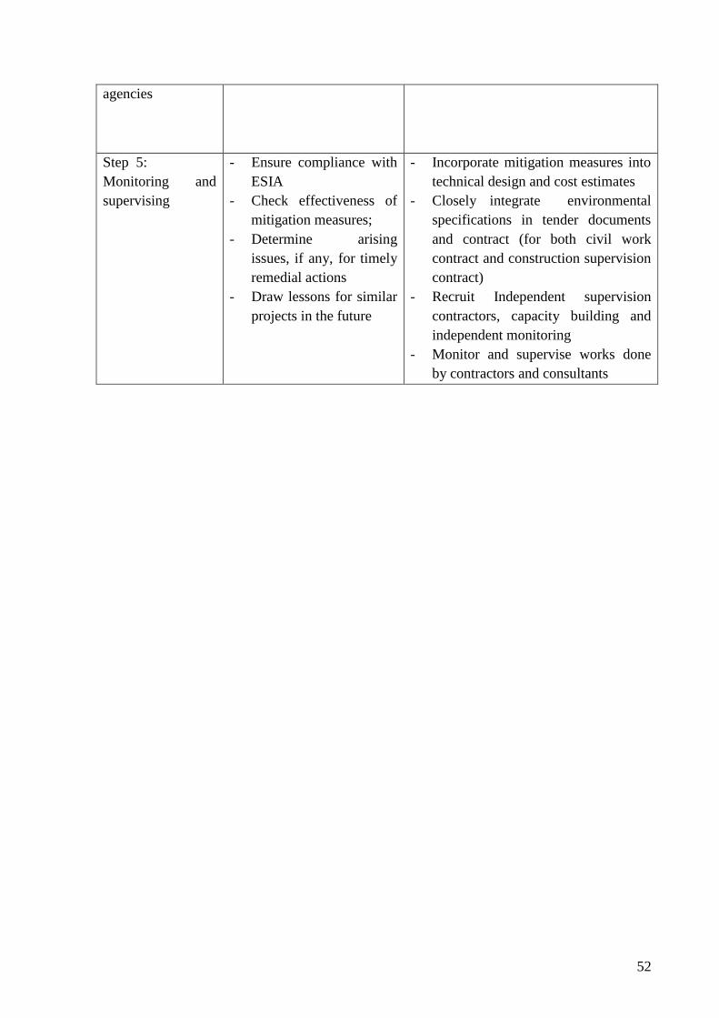
52
agencies
Step 5:
Monitoring and
supervising
- Ensure compliance with
ESIA
- Check effectiveness of
mitigation measures;
- Determine arising
issues, if any, for timely
remedial actions
- Draw lessons for similar
projects in the future
- Incorporate mitigation measures into
technical design and cost estimates
- Closely integrate environmental
specifications in tender documents
and contract (for both civil work
contract and construction supervision
contract)
- Recruit Independent supervision
contractors, capacity building and
independent monitoring
- Monitor and supervise works done
by contractors and consultants
53
CHAPTER IV. ENVIRONMENTAL, NATURAL AND SOCIO-
ECONOMIC CONDITIONS OF THE SUB-PROJECT AREA
4.1. Geological and geographical conditions
a) Geographical and geological conditions of Loi Dong Reservoir
i) Topographical conditions: Loi Dong Reservoir has a catchment area of 1.15 km2 and is
shaped like a bamboo fan. The vegetation cover in the basin is mainly pines, eucalyptus and
jungle. The surrounding areas are high hills, small, steep and short streams and rivulets. The
Reservoir has North - South direction which is also the coastal mountain in the North of
Ngang Pass.
ii) Geological features: The headwork of Loi Dong Reservoir is located on a good geological
background. Upstream foundation and stilling pool are shallowly allocated. This explains for
the water leakage at the foot of the spillway which should be fixed (including stilling pool).
The survey of the sub-project area and collected data do not reflect any serious slides or
erosion.
b) Geographical and geological conditions of Nuoc Xanh Reservoir
i) Topography conditions: The Nuoc Xanh Green Reservoir has a catchment area of 1.90 km2.
The area has some streams focusing their flows into the entire basin. The Reservoir is wide
with low mountains in the South at the elevation ranges of 100-350m. The main slope of the
catchment is South-North bound and the average gradient of the basin is 245 ‰.
ii) Geological features: The old dam is filled mainly with sandy clay, siltstone and unevenly
weathered. The dam runs across the main channel where geological structure is complex,
threatening stability of hydraulic works.
c) Geographical and geological conditions of Ba Khe Reservoir
i) Topography conditions: The Ba Khe Reservoir has a catchment area of 4.17 km2 and is
shaped like a bamboo fan. The Reservoir is surrounded by high and continuous mountains
without saddles at the average elevations of 100-200m. The main slope of the catchment is
Northwest – Southeast. The length from the centerline of the Reservoir to the upstream is
1,500m and the largest width of the Reservoir is 750m and average gradient of the basin is
128‰.
ii) Geological features: The backfill soil of the old dam foundation is relatively complicated.
The dam foundation and body need to be treated. The geological feature of the spillway is half
hard to hard. The sluice foundation on layer 1e is heavy sandy clay with good waterproofing
capacity (K = 9.3-10-6cm/s).
d) Geographical and geological conditions of Dap Buom Reservoir
i) Topography conditions: The Dap Buom Reservoir Dam has a catchment area of 4.25 km2
and is shaped like a bamboo fan and is lowered from South to North. The main features of the
basin are as follows: average gradient 309 ‰; mainstream length 2.3km; main slope 48 ‰;
the impoundment is shallow and relatively flat. Reservoir bottom is at the elevations of 20.0 ÷
54
8.0m.
ii) Geological characteristics: The main dam consists of many layers with different weathered
status.
e) Geographical and geological conditions of Khe Co Reservoir
i) Topography conditions:
Khe Co Reservoir has a catchment area of 8.04 km2. Surrounded by high mountains and hills,
the reservoir basin is in southwest - Northeast. The characteristics of the basin: average
gradient is 467 ‰, length of the mainstream is 4.76 km and slope of the mainstream is 78 ‰.
The project area has relatively flat terrain with small difference in elevations and tends to lean
southeast bound.
ii) Geological characteristics: The main dam and auxiliary dam 1 and 2 from top to toe has
following layers: The clay and grit (filled soil), semi-solid to soft plastic; clay and grit layers,
soft plastic to half solid; Strong weathered shale of grayish blue; strongly weathered and
cracked stone of medium solid.
f) Geographical and geological conditions of Khe Nhay Reservoir
i) Topography conditions: Khe Nhay Reservoir has a catchment area of 0.6 km2. The
reservoir basin tends to be inclined from North to South which is surrounded by low hills at
the elevation of 30-40m. The general characteristics of the basin are: average gradient 188 ‰,
length of the mainstream is 1.0 km, slope of the mainstream is 16 ‰, total length of the
rivulet branches 0.65 km. The irrigation area has relatively flat terrain.
ii) Geological features: The dam and sluice site consist of 3 layers: dams is filled with clay
and grit; gray clay, purple gray, vermilion brown which is not evenly weathered, the rock is
cracked, loosened and mixed with hard rock seams.
The spillway consists of layers: strongly weathered shale, purple gray, and russet. The
weather is uneven, rocky cracked cascade between hard rock and hard.
g) Geographical and geological conditions of Khe De Reservoir
i) Topography conditions:
Khe De Reservoir has a catchment of 2.5 km2. The reservoir is sandwiched between Con
Chua and Lam Mountains at the elevations of 30-50m. The average gradient of the basin is
365 ‰, the height of the mountain slope varies greatly from 50 m high to 15- 16 m high in the
reservoir; length of the mainstream: 1.5 km; average gradient of the stream: 67 ‰. The high
mountain slope consists of mainly strongly weathered sedimentary rocks and relatively thin
vegetation. The low hills has gentle slope, elevations ranging 20-30m and thicker vegetation
of mainly forestry plantations.
ii) Geological characteristics: The main dam and culverts sites are composed of 5 layers: clay
mixed with macadam; clay layer; clay mixed with gravel layer; shale mixed with silty
sandstone and Granite rocks which all are strongly stable. The spillway site consists of:
clayey soil and gravel; clay soil and gravel and shale and silty sandstone, which are all stable.
h) Geographical and geological conditions of Da Den Reservoir
i) Topography conditions: The Da Den Reservoir has a basin area of 0.75 km2. The basin is
55
hollow shaped with sloping direction from Southwest to Northeast and surrounded by low
hills at the elevations of 50-200m. The basin has steep streams and slopes. The length of
mainstream is 0.45 km; gradient of the mainstream 167 ‰; average basin slope 317 ‰; total
length of mainstream 0.65 km. The dam shoulder leans on a hillside with an average slope of
100 ÷ 300. The spillway is located at the saddle on the right shoulder of the dam. The
downstream area is a delta with terrain lowering from West to East and from North to South.
ii) Geological features: Dams and intakes sites consist of 4 layers: loam; loam containing
grits, yellowish-gray, solid; loam containing grits, dark brown, yellow gray, solid plastic to
half-solid; layers of loam mixed with grits; silty sand layer. Spillway site has clay soils,
remnants, brown gray loam, strongly weathered siltstone and claystone, strongly to medium
weathered shale containing charcoal.
4.2. Climate and meteorology
Ky Anh is a relatively large precipitation center in the North Central region and this is
explained by the influence of Hoanh Son, Truong Son mountain ranges and wind directions.
The rainy season in the region starts in September and ends in December. Rainfall distribution
is not even both spatial and temporal. Over the three months of September, October and
November, the precipitation accounted for nearly 70% of the total rainfall. Only in September
and October the precipitation accounted for almost 70% of the total rainfall in the three
months. Rainfall tends to increase from North to South.
The subproject area is annually affected by the North East and Southwest monsoons and
tropical cyclones. The average wind speed in many years is 2.3 m/s. The maximum wind
speed in Ky Anh occurs in rainy months reaches over 45 m/s. The Northeast winds usually
start from October to March. There are strong coastal winds of grade 5 and 6 bringing rainfall
and cold winds. Southwest wind usually starts in late April and ends in July with wind speed
grade 4 and 5 bringing dry and heat weather.
In Ha Tinh province, typhoons usually occur in late June and end in late October, also in
August, September and October with heavy and concentrated rainfall of the year and
maximum wind speed can reach above 45 m/s. On average, there are one or two storms
hitting Ha Tinh province annually. Only in 2005 alone, there were 3 storms directly hitting
the region (storms 6, 7, 8) causing great damages to people and properties in the area.
4.3. Hydrological conditions
The hydrological regime in the region is influenced by annual rainfall. The annual flow is
observed in two major seasons: flood season and dry season: flood season from September to
November and dry season from December to early August. The May flood often appears in
annual April and May. Annual flows are not evenly distributed in a year, mainly in flood
months with over 70% of the annual flow. The dry season lasts for 9 months yet only
producing 30% of the annual flow. This is very unfavorable to the exploitation and utilization
of water resources in the region.
- Loi Dong Reservoir: The Loi Dong Reservoir has Quyen river system and Cau Quen
river system. As the Loi Dong sub-basin is located in the basin of these two rivers, the
Quyen and Cau Quen rivers are to drain water from Loi Dong reservoir basin during
56
flood season. The survey of sub-project area and collected documents did not reflect
any serious risk due to unfavorable weather or climate.
- Nuoc Xanh Reservoir: Nuoc Xanh Reservoir is located in Ky Phong Commune, Ky
Anh District with a catchment area of 1.9 km2. The reservoir is adjacent to part of the
Rac River reservoir basin. There are no big river and streams in the basin except for
few small streams. The flow in the basin entirely depends on annual rainfall in Ky
Anh district.
- Ba Khe Reservoir: Ba Khe Reservoir is located in Ky Bac commune, close to Nuoc
Xanh reservoir (Ky Phong commune). The hydrological and flow characteristics of the
two basins of Ba Khe reservoir are similar to those of Nuoc Xanh Reservoir. The flow
of Ba Khe Reservoir entirely depends on the annual rainfall in the region.
- Dap Buom Reservoir: Dap Buom Reservoir is located in the Ngan Sau road basin with
small streams that form the inflow of the Reservoir.
- Khe Co Reservoir: The Khe Co Reservoir is located in Son Le commune, Huong Son
district, with a catchment area of 8.04km2 and is the largest reservoir in the Sub-
project area. The mainstream of the reservoir is 4.76 km long and flow is available
throughout the year.
- Khe Nhay Reservoir: Hydrological conditions of Khe Nhay Reservoir are similar to
that of Khe Co reservoir. Khe Nhay Reservoir has a catchment area of 0.6 km2. The
hydrological regime of Khe Nhay Reservoir basin is influenced by annual rainfall in
the region.
- Khe De Reservoir: The Khe De Reservoir has a catchment area of 2.5 km2 and the
hydrographic regime in the Khe Dien reservoir basin is also influenced by the annual
rainfall in the region.
- Da Den Reservoir: Da Den Reservoir has a catchment area of 0.75 km2. There are
only some small rivulets flowing from acacia forests in the West. The inflow in the
area entirely depends on the rainfall regime in the year. In the rainy season, the water
level in the reservoir will rise and overflow the spillway into to the drainage canal to
fields in Nam Son village.
4.4. Status and quality of soil, water, air environments
4.4.1. Surface water environment
Pursuant to QCVN 08-MT: 2015/BTNMT and impacting factors on the surface water
resource environment in the project area, suggesting analysis and evaluation criteria for
surface water quality:
● Chemical and physical parameters: pH, DO, SS, COD, BOD5, NO2-, NO3
-, NH4+,
PO43-, Cl-, Total Fe, total grease.
● Microbiological parameter: Coliform
● Parameters for heavy metals: As, Pb, Cd
Assessment of surface water quality in the subproject areas where can be affected by the
57
construction and repairs of dams, spillway, sluices and by water in canals after the spillway in
the upstream and downstream area. Five (5) samples are taken from each reservoir as shown
in Appendix 1:
Assessment results of surface water quality of the subproject area in Table 1, Appendix 2.
Comments:
i) Evaluation of water quality in Khe Co and Khe De Reservoirs (NM26, NM27, NM28,
NM36, NM37, MN40 comparing at column A2 - QCVN 08-MT: 2015/BTNMT) showed that:
most of Chemical and physical criteria, and micro-organism are within the QCVN. Only 2
criteria exceed the QCVN at one sampling location, as follows:
- At Khe Co Reservoir: Sample NM27: Criterion COD exceeding by 1.07 times; BOD5
exceeding by 1.25 times.
Based on survey data at reservoirs, farmer infrastructure, environmental factors, etc., it is
predicted causes of COD, COD and BOD5 exceeding the limit value due to grazing livestock
activities in the sampling area.
ii) Assessment of water quality of remaining reservoirs compared to Column B1 - QCVN 08-
MT: 2015/BTNMT: Most of the analysis criteria are within the permitted limits; surface water
has not been impacted by hazardous criteria such are total fat, heavy metals and
microorganisms. However, some indicators still exceed the limit values in some positions, as
follows:
- At Loi Dong Reservoir:
• Sample NM3: TSS exceeding the allowable limit by 1,56 times; NH4+ exceeding the
allowable limit by 1.2 times; NO2- exceeding the allowable limit by 2 times; PO4
3-
exceeding the allowable limit by 1.2
• Sample NM4: NH4+ exceeding the allowable limit by 1.35 times
- At Khe Nhay Reservoir:
• Sample NM34: Total Fe exceeding the allowable limit by 1.75 times
• Sample NM35: BOD5 exceeding the allowable limit by 1.07 times; total Fe exceeding
the allowable limit by 2.8 times.
- At Khe De Reservoir:
• Sample NM38: Total Fe exceeding the allowable limit by 1.2 times.
• Sample NM39: Total Fe exceeding the allowable limit by 2.27 times.
- At Da Den Reservoir: Sample NM49: NO2- exceeding the allowable limit by 10.4
times.
Based on survey data in the field, there are no industrial parks or craft villages in the
surrounding area of the Reservoir. Some analysis indicators exceeded the limit value due to
livestock grazing activities in the areas near the sampling sites.
58
4.4.2. Status of groundwater environment
Based on QCVN 09 -MT: 2015/BTNMT and factors impacting groundwater quality, the
suggested groundwater quality analysis and assessment criteria are as follow:
● Chemical and physical parameters: pH, TDS, CODKMnO4, total hardness (CaCO3),
NO2-, NO3
-, NH4+, Mn, SO4
2-, Cl-, Total Fe.
● Microorganism: Coliform; E. Coli
● Heavy metals: As, Pb, Cd
Assess the groundwater quality of the project site at sites that may be affected by the
construction of dams, spillways, sewers, and management road. Each reservoir takes three
samples as in Appendix 1.
Assessment results of groundwater water quality in the sub-project area in Table 2 in
Appendix 2.
Comment:
Groundwater in the subproject area is of good quality, most of the indicators are within the
allowable limits. Only Coliform indicator at some sampling sites exceeds QCVN 09-MT:
2015/BTNMT - National Technical Regulation on groundwater water quality, as follows:
- Nuoc Xanh Reservoir: sample NN1 with Coliform exceeding as much as 1.33 times
compared to the allowable limit.
- Nuoc Xanh Reservoir: sample NN5 with Coliform and NN6 exceeding as much as
1.67 times compared to the allowable limit.
- Ba Khe reservoir: sample NN7 with Coliform exceeding 1.67 times compared to the
allowable limit.
- Dap Buom reservoir: sample NN11 with Coliform exceeding 2 times compared to the
allowable limit.
- Khe Co reservoir: sample NN16 with Coliform exceeding more than 2 times; The
NN17 is 3.67 times and the NN18 is 2.67 times compared to the allowable limit.
- Khe Nhay reservoir: sample NN19 with Coliform exceeding 4.33 times and the NN21
sample exceeding 1.67 times compared to the allowable limit.
- Khe Dien reservoir: The NN22 sample with Coliform exceeding 1.67 times, the NN23
sample exceeding 2.67 and the NN24 sample exceeding 3.67 times compared to the
allowable limit.
The field survey result showed that in the Sub-project area not affected by waste from
industries or craft villages. Coliform indicator in some samples exceed the allowable limit due
of livestock and poultry grazing activities and domestic activities of people in the area.
4.4.3. Air environment
Based on QCVN 05:2013/BTNMT; QCVN 26:2010/BTNMT; QCVN 27:2010/BTNMT and
factors affecting air environment, parameters for analysis and assessment of air quality: total
dust, SO2, NO2, CO.
Assess air quality in the subproject area at locations that may be affected by the construction
59
of dam, spillway, intake, and management road. Three samples are taken from each work as
shown in Appendix 1.
Assessment results of air quality in the subproject area in table 3, Appendix 2.
Based on the air quality assessment in the area, indicators are within the allowable limits
under the current regulations. Air environment in the Sub-project has no signs of pollution.
4.4.4. Soil environment
Based on QCVN 03 -MT: 2015/BTNMT and factors affecting the growth of crops, following
soil sample analysis criteria are suggested:
● Chemical and physical parameters: pH, total organism, density, specific weight,
blistering, mechanical texture (sand, limon, clay)
● Heavy metal parameters: Cu, Zn, As, Pb, Cd,
Evaluate the soil environment quality in the Subproject area at locations that may be affected
by such construction activities as dam, spillway, intake, management road and auxiliary
facilities such as dumpsite, borrow pits. Three samples are taken from each work as shown in
Appendix 1:
Assessment results of soil environment quality in the Subproject area in Table 4, Appendix
2.
Based on the analysis data of soil quality in the Sub-project, there are no signs of being
contaminated by heavy metals. The analysis criteria are within the allowable limits i.e. QCVN
03-MT: 2015/BTNMT – for agricultural land.
4.4.5. Sedimentation quality
Based on QCVN 43 -MT: 2015/BTNMT and impacting factors on sedimentation quality,
following sedimentation sample analysis criteria are suggested:
● Chemical and physical parameters: pH, total organic substances, mechanical texture
(sand, limon, set)
● Heavy metal parameters: Cr, As, Pb, Cd, Cu, Zn,
Assessment results of sedimentation quality in the Sub-project area in Table 5, Appendix 2.
The sedimentation quality in Reservoir areas has no signs of being contaminated by heavy
metals, analytical parameters are within the allowable limit of QCVN 43-MT: 2015/BTNMT
on freshwater sediment.
4.5. Biological resources
a) Plant and animal resources of Loi Dong Reservoir
Ky Trinh Ward has 1,754.18 ha of secondary forests which are scattered in hills and in the
Southwest and West of the irrigation area. The main vegetation here is vines and vegetation
coverage is strongly degraded due to wood logging for firewood and other purposes for a long
time. Plantation forests are mainly eucalyptus, acacia, pine, casuarinas. Most of them are
newly planted so they are small and low (<4m) and of low economic value. The natural
60
vegetation only has grass coverage or herbaceous plants along roadside and shrubs. The
vegetation is poor and do not have economic value.
Animals are mainly cattle and poultry which are raised or grazed by households such as
buffaloes, cows and poultry. There are no rare and precious species of animals and plants
which need to be preserved or protected.
b) Plant and animal resources of Nuoc Xanh Reservoir
Ky Phong commune, Ky Anh district has 814.46 ha (2016) of protection forests and
production forests. The forest area is mainly concentrated in Song Rac Reservoir and Nuoc
Xanh Reservoir basins to the South and Southwest of the commune. Part of the forest lands is
located to the North and borders on Ky Bac commune. In addition, some forest lands are
scattered and intermingled in irrigation and residential areas. Vegetation cover is mainly
planted with eucalyptus, acacia, pine and these trees are of good economic value and at the
same time can help cover the surface, keep moisture, prevent flood flow and control erosion.
The remaining area is secondary forest with mixed trees and vines of almost no economic
value. The surface cover is low grass cover, herbaceous and shrub species. Out of a total of
1,214.42 ha of cultivated land, paddy rice fields and some vegetable crops, fruit trees and
short-term cash trees are predominant.
Animals in the area are mainly cattle and poultry which are raised or grazed by households
such as buffaloes, cows, pigs, chickens and ducks. There are no rare species of animals and
plants which need to be preserved or protected.
c) Plant and animal resources of Ba Khe
Ky Bac commune has a total forest area of 1,125.48 ha (2016), of which production forests
account for the majority of about 830 ha and the remaining are protection forests. Forest area
is concentrated in the north and west of the commune, covering the entire basin area of Ba
Khe reservoir. The trees are grown mainly of eucalyptus, acacia and pine. Some areas of
protection forest are secondary forests of mixed species and vines which are of little economic
value but are still valuable in soil protection and erosion control. Natural surface cover is low
grass cover, herbaceous and shrub species. On the total area of 537.63 ha of cultivated land,
agricultural plantation covers mainly wet rice fields and some vegetable crops, fruit trees
(oranges, lemons, guava, guavas ...), short-term cash crops (peanuts, beans), though not high
yield but meaning the main income for farmers in the commune.
Animals in the area are mainly cattle and poultry which are raised or grazed by households
such as buffaloes, cows, pigs, chickens and ducks. There are no rare species of animals and
plants which need to be preserved or protected.
d) Plant and animal resources of Dap Buom Reservoir
Flora in the reservoir area is mainly Eucalyptus, Acacia, Pine and Casuarina. Most of them
are newly planted so they are small and do not have much economic value. The natural
vegetation covers are only low grass or herbaceous plants along roadside and shrubs. Poor
vegetation cover does not have economic value.
e) Plant and animal resources of Khe Co
61
Son Le commune has a total forest area of 1,323.01 ha which is distributed over most of the
commune. Its three sides are Northwest, West and South of the commune, including the
majority of Khe Co reservoir (the rest of the basin is located in Son Tien commune). Forests
in the commune also consist of two types of production forests and protection forests with
plantation forests as the dominant forests and a small part of secondary forests with good
coverage. Plantation forests grow acacia, eucalyptus and pine; secondary forests have mixed
trees and vines. Natural surface cover consists of grass cover, herbaceous and shrub species.
The total area of 965.02 ha of agricultural land is mainly rice fields and some vegetables and
fruit trees (oranges, lemons, guava, custards etc.), short-term cash crops (peanuts, beans) with
average yield.
Animals in the area are mainly cattle and poultry raised or grazed by households and some
species of birds and small wild animals. There are no rare species of plants and animals that
need to be preserved or protected.
f) Plant and animal resources of Khe Nhay Reservoir
Son Tien Commune has a total forest area of 1,360.23 ha which are widely distributed
throughout the commune, including the entire Khe Nhay Reservoir Basin and part of Khe Co
Reservoir Basin (Son Le Commune). Forests here are mainly plantation forests, with a small
proportion of secondary forests of moderate coverage. Plantation forests are both production
forests and protection forests with main trees as acacia, eucalyptus and pine. The natural
surface coverage is low grass cover, herbaceous and shrub species. Out of a total of 1,613.45
ha of cultivated land, agricultural lands are mainly occupied by wet rice fields and some
vegetables and fruit trees (oranges, lemons, guava, custards...), short-term cash crops
(peanuts, beans). Yield of these crops is medium.
Animals in the area are mainly cattle and poultry raised or grazed by households and some
species of birds and small wild animals. There are no rare species of plants and animals that
need to be preserved or protected.
g) Plant and animal resources of Khe De Reservoir
Khe De reservoir is located in Son Mai commune, Huong Son district, Ha Tinh province. The
Reservoir was built in 1977. The Khe De reservoir catchment area is 2.5 km2. Both sides are
hills, thin grass coverage, pine forest and regenerated eucalyptus. The surrounding area has
sparse and poor vegetation which mean the failure to keep surface water and low reserves for
the reservoir. About 800 m downstream of Khe De Reservoir, the vegetation cover is covered
with such trees as eucalyptus and pine close to being harvested.
Animals in the area are mainly cattle and poultry raised or grazed by households such as
buffaloes, cows and chickens/ducks. There are no rare and precious species which need to be
preserved or protected in the area.
h) Plant and animal resources of Da Den Reservoir
The vegetation coverage in Ngoc Son commune is mainly plantation forests. The agricultural
plantation coverage is mainly rice fields and some vegetables (sweet potato, gourd, pumpkin,
spinach, morning glory, wild onion), fruit trees (orange, lemons, tangerines, guavas, custard,
etc.) for stable harvest but small quantity; short-term cash crops (peanut, bean) and long-term
62
cash crops (acacia, eucalyptus) for low yields.
The characteristics of the vertebrate fauna are monotonous and less abundant. They are
mainly small animals such as rodents like rat and animals such as buffalo, cow, pig, etc.
Among vertebrate territorial animals, there are no protected or precious animals in the region.
4.6. Socio-Economic Profile of the communes in the subproject Area
The total area of subproject communes is 28,863 ha. Of which, there are 9.4 thousand ha of
forest land and 6.9 thousand ha of paddy field. The area of Ky Trinh Ward is the largest (over
4.7 thousand ha) and the areas of Son Mai Commune in Huong Son District and Ky Bac
commune, Ky Anh District are the smallest (about 1.9 thousand ha). The paddy and forestry
areas in Ky Trinh Ward are the largest out of the 9 communes in the commune area (1.6
thousand ha and 1.4 thousand ha respectively).
Total population of the communes is approximately 49 thousand people in equivalent of
14,345 households. In which, male makes up 50.7% of total population (25,349 people).
Population in Ky Thinh ward is the largest with over 11 thousand people. Following are Ky
Phong and Son Tien communes with over 7 thousand people. For other communes, this
number ranges from 2 thousand to 6 thousand. Ky Thinh commune has 3,428 households (the
highest out of all subproject communes), while Son Mai commune has only 652 households.
The labor force of subproject communes is approximately 29,392 people (58.9% of total
population). Population density in subproject communes is unevenly distributed, i.e. Ky Bac
commune has the highest population density (283 persons/km2) and the lowest population
density is found in Huong Tho commune (55 persons/km2).
Income per capita of subproject communes is approximately 30 million VND/person/year. In
which, income per capita in Ky Trinh ward is the highest (about 42 million
VND/person/year). The main occupations of households in subproject areas are agriculture
(growing rice, maize), forestry (growing acacia, eucalyptus, melaleuca etc.); in some
communes in Ky Anh district, households engaged in aquaculture activities. In addition, as
Ha Tinh has many industrial parks and manufacturing factories, the number of local people
worked in industrial zones is relatively high. In leisure time, people will work as hired
laborers (women) and men will work as bricklayers and masons to increase household’s
income.
Total number of poor households in subproject communes is 2,396, accounting for 16.7% of
total households in 9 communes. In which, Ky Thinh ward has the highest poverty rate i.e.
26.9% (924 households), Ngoc Son has the lowest poverty rate 3.6% (33 households). Other
communes have poverty rates ragining from 8% to 20%. There are 1,492 near-poor
households in 9 subproject communes. In particular, Ky Thinh ward has the largest number of
near-poor houses, i.e. 484 households (14.1%) among 8 communes. Proportion of near-poor
households is low in the following communes: Ngoc Son commune, Ky Trinh ward, Huong
Tho commune (4-55).
Ethnic minority: 100% of the population in subproject area are Kinh people and there is no
ethnic minority.
Rural infrastructure: In the subproject area, all communes and wards have commune health
clinics. 100% of households use electricity in their daily activities.
Main water sources in these communes are from drilled wells and dug wells. Water quality is
relatively good for domestic and production usage. However, in the dry season, the
63
groundwater level is low so some wells do not supply enough water for domestic use and
livestock farming needs. Some localities have concentrated water supply works, i.e. Huong
Tho commune and Ngoc Son commune have been invested in concentrated water supply
facilities which only meet demands of 80-90% of the population and the rest use drilled or
dug well water. Some areas have access tap water (some communes where industrial parks are
located, like Ky Thinh ward, are using tap water supplied by the industrial parks), yet tap
water using ratio is quite low. Some communes use reservoir water for domestic and
production uses, i.e. Son Le commune with 10% of the population using water from Khe Co
reservoir, Son Tien commune with 10% of the population using water from Khe Nhay
reservoir. The percentage of households having hygienic toilets is over 67%. In which, Ngoc
Son commune, Ky Phong commune have the highest percentage of hygienic toilets (100%)
and the lowest rate is Quynh Trinh ward (67%).
Utility services in the area meet the domestic needs in the commune (market, network,
internet ...). In 9 communes and wards, there are 14 markets under the management of
Commune/Ward PC. The people in subproject communes do not have difficulty in buying and
selling goods. For postal services, only Huong Tho commune does not have postal services.
Specific information on subproject communes is in the below table.
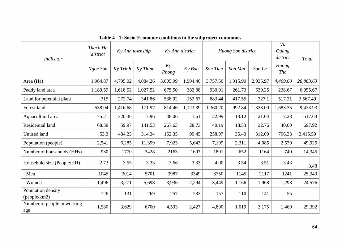
64
Table 4 - 1: Socio-Economic conditions in the subproject communes
Indicator
Thach Ha
district Ky Anh township Ky Anh district Huong Son district
Vu
Quang
district Total
Ngoc Son Ky Trinh Ky Thinh Ky
Phong Ky Bac Son Tien Son Mai Son Le
Huong
Tho
Area (Ha) 1,964.87 4,795.02 4,084.26 3,005.99 1,994.46 3,757.56 1,915.90 2,935.97 4,409.60 28,863.63
Paddy land area 1,189.59 1,618.52 1,027.52 675.50 383.88 930.01 261.73 630.25 238.67 6,955.67
Land for perennial plant 315 272.74 341.86 538.92 153.67 683.44 417.55 327.1 517.21 3,567.49
Forest land 538.04 1,416.68 171.97 814.46 1,123.39 1,360.20 992.84 1,323.00 1,683.35 9,423.93
Aquacultural area 75.21 320.36 7.96 48.06 1.61 22.99 13.12 21.04 7.28 517.63
Residential land 68.58 59.97 141.53 267.63 28.73 40.19 18.53 32.76 40.00 697.92
Unused land 53.3 484.23 314.34 152.35 99.45 258.07 35.43 312.09 706.33 2,415.59
Population (people) 2,541 6,285 11,399 7,923 5,643 7,199 2,311 4,085 2,539 49,925
Number of households (HHs) 930 1770 3428 2163 1697 1801 652 1164 740 14,345
Household size (People/HH) 2.73 3.55 3.33 3.66 3.33 4.00 3.54 3.51 3.43
3.48
- Men 1045 3014 5701 3987 3349 3750 1145 2117 1241 25,349
- Women 1,496 3,271 5,698 3,936 2,294 3,449 1,166 1,968 1,298 24,576
Population density
(people/km2) 126 131 269 257 283 157 110 141 55
Number of people in working
age 1,580 3,629 6700 4,593 2,427 4,800 1,019 3,175 1,469 29,392

65
Income per capita (million
VND/year) 30.19 42.00 20.00 31.00 30.52 26.50 32.00 27.06 30.70 30.00
Poor households (HHs) 33 358 924 338 213 243 55 115 117 2,396
Rate of poor households (%) 3.55 20.23 26.95 15.63 12.55 13.49 8.44 9.88 15.81 16.70
Near poor households (HHs) 39 79 484 220 202 210 54 160 44 1,492
Rate of near poor households
(%) 4.19 4.46 14.12 10.17 11.90 11.66 8.28 13.75 5.95 10.40
Economic structure
- Agriculture-forestry-
fishery (%) 82.5 64.07 60.00 70.04 65.30 93.50 78.83 84.45 65.00
- Industry-handicraft and
construction (%) 3.3 5.42 25.00 5.18 27.50 0.01 1.23 1.63 4.19
- Trading-services (%) 14.2 30.51 35.00 24.78 7.20 6.49 19.94 13.92 30.81
% households using hygienic
toilets 100.00 67.00 90.00 100.00 73.07 70.00 75.00 93.47 89.00
Source: Statistical Year Book, Collected information at commune level and interviews results with local officials.
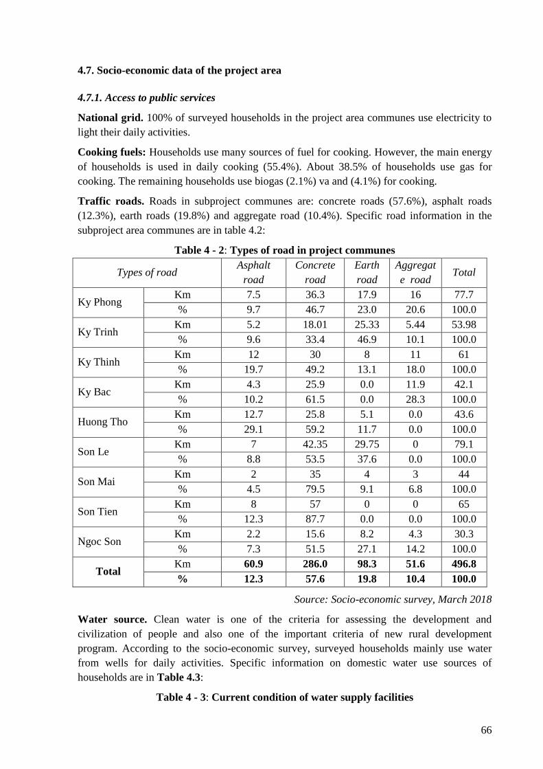
66
4.7. Socio-economic data of the project area
4.7.1. Access to public services
National grid. 100% of surveyed households in the project area communes use electricity to
light their daily activities.
Cooking fuels: Households use many sources of fuel for cooking. However, the main energy
of households is used in daily cooking (55.4%). About 38.5% of households use gas for
cooking. The remaining households use biogas (2.1%) va and (4.1%) for cooking.
Traffic roads. Roads in subproject communes are: concrete roads (57.6%), asphalt roads
(12.3%), earth roads (19.8%) and aggregate road (10.4%). Specific road information in the
subproject area communes are in table 4.2:
Table 4 - 2: Types of road in project communes
Types of road Asphalt
road
Concrete
road
Earth
road
Aggregat
e road Total
Ky Phong Km 7.5 36.3 17.9 16 77.7
% 9.7 46.7 23.0 20.6 100.0
Ky Trinh Km 5.2 18.01 25.33 5.44 53.98
% 9.6 33.4 46.9 10.1 100.0
Ky Thinh Km 12 30 8 11 61
% 19.7 49.2 13.1 18.0 100.0
Ky Bac Km 4.3 25.9 0.0 11.9 42.1
% 10.2 61.5 0.0 28.3 100.0
Huong Tho Km 12.7 25.8 5.1 0.0 43.6
% 29.1 59.2 11.7 0.0 100.0
Son Le Km 7 42.35 29.75 0 79.1
% 8.8 53.5 37.6 0.0 100.0
Son Mai Km 2 35 4 3 44
% 4.5 79.5 9.1 6.8 100.0
Son Tien Km 8 57 0 0 65
% 12.3 87.7 0.0 0.0 100.0
Ngoc Son Km 2.2 15.6 8.2 4.3 30.3
% 7.3 51.5 27.1 14.2 100.0
Total Km 60.9 286.0 98.3 51.6 496.8
% 12.3 57.6 19.8 10.4 100.0
Source: Socio-economic survey, March 2018
Water source. Clean water is one of the criteria for assessing the development and
civilization of people and also one of the important criteria of new rural development
program. According to the socio-economic survey, surveyed households mainly use water
from wells for daily activities. Specific information on domestic water use sources of
households are in Table 4.3:
Table 4 - 3: Current condition of water supply facilities
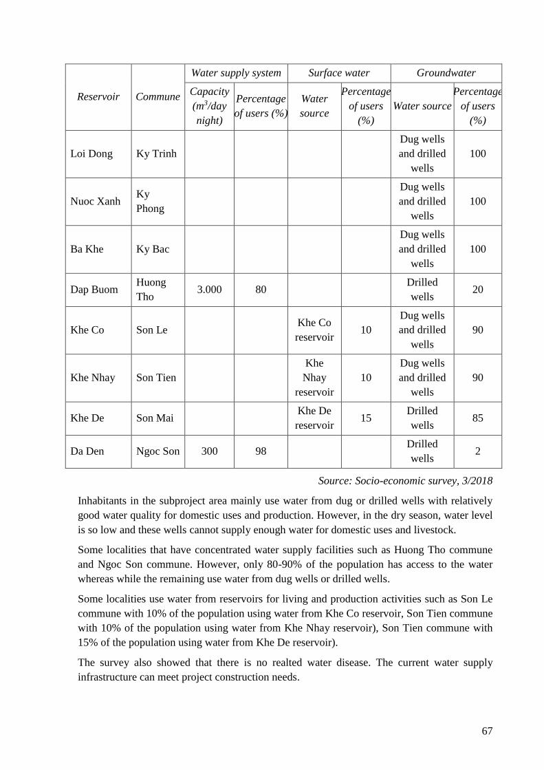
67
Reservoir Commune
Water supply system Surface water Groundwater
Capacity
(m3/day
night)
Percentage
of users (%)
Water
source
Percentage
of users
(%)
Water source
Percentage
of users
(%)
Loi Dong Ky Trinh
Dug wells
and drilled
wells
100
Nuoc Xanh Ky
Phong
Dug wells
and drilled
wells
100
Ba Khe Ky Bac
Dug wells
and drilled
wells
100
Dap Buom Huong
Tho 3.000 80
Drilled
wells 20
Khe Co Son Le Khe Co
reservoir 10
Dug wells
and drilled
wells
90
Khe Nhay Son Tien
Khe
Nhay
reservoir
10
Dug wells
and drilled
wells
90
Khe De Son Mai Khe De
reservoir 15
Drilled
wells 85
Da Den Ngoc Son 300 98 Drilled
wells 2
Source: Socio-economic survey, 3/2018
Inhabitants in the subproject area mainly use water from dug or drilled wells with relatively
good water quality for domestic uses and production. However, in the dry season, water level
is so low and these wells cannot supply enough water for domestic uses and livestock.
Some localities that have concentrated water supply facilities such as Huong Tho commune
and Ngoc Son commune. However, only 80-90% of the population has access to the water
whereas while the remaining use water from dug wells or drilled wells.
Some localities use water from reservoirs for living and production activities such as Son Le
commune with 10% of the population using water from Khe Co reservoir, Son Tien commune
with 10% of the population using water from Khe Nhay reservoir), Son Tien commune with
15% of the population using water from Khe De reservoir).
The survey also showed that there is no realted water disease. The current water supply
infrastructure can meet project construction needs.
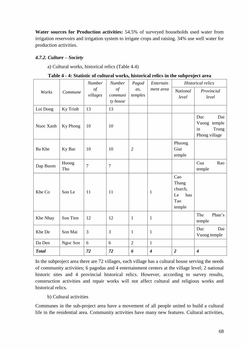
68
Water sources for Production activities: 54.5% of surveyed households used water from
irrigation reservoirs and irrigation system to irrigate crops and raising. 34% use well water for
production activities.
4.7.2. Culture – Society
a) Cultural works, historical relics (Table 4.4)
Table 4 - 4: Statistic of cultural works, historical relics in the subproject area
Works Commune
Number
of
villages
Number
of
communi
ty house
Pagod
as,
temples
Entertain
ment area
Historical relics
National
level
Provincial
level
Loi Dong Ky Trinh 13 13
Nuoc Xanh Ky Phong 10 10
Duc Dai
Vuong temple
in Trung
Phong village
Ba Khe Ky Bac 10 10 2
Phuong
Giai
temple
Dap Buom Huong
Tho 7 7
Cua Rao
temple
Khe Co Son Le 11 11 1
Cao
Thang
church,
Le hau
Tao
temple
Khe Nhay Son Tien 12 12 1 1 The Phan’s
temple
Khe De Son Mai 3 3 1 1 Duc Dai
Vuong temple
Da Den Ngoc Son 6 6 2 1
Total 72 72 6 4 2 4
In the subproject area there are 72 villages, each village has a cultural house serving the needs
of community activities; 6 pagodas and 4 entertainment centers at the village level; 2 national
historic sites and 4 provincial historical relics. However, according to survey results,
construction activities and repair works will not affect cultural and religious works and
historical relics.
b) Cultural activities
Communes in the sub-project area have a movement of all people united to build a cultural
life in the residential area. Community activities have many new features. Cultural activities,
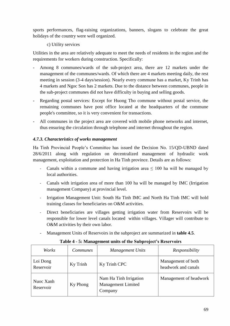
69
sports performances, flag-raising organizations, banners, slogans to celebrate the great
holidays of the country were well organized.
c) Utility services
Utilities in the area are relatively adequate to meet the needs of residents in the region and the
requirements for workers during construction. Specifically:
- Among 8 communes/wards of the sub-project area, there are 12 markets under the
management of the communes/wards. Of which there are 4 markets meeting daily, the rest
meeting in session (3-4 days/session). Nearly every commune has a market, Ky Trinh has
4 markets and Ngoc Son has 2 markets. Due to the distance between communes, people in
the sub-project communes did not have difficulty in buying and selling goods.
- Regarding postal services: Except for Huong Tho commune without postal service, the
remaining communes have post office located at the headquarters of the commune
people's committee, so it is very convenient for transactions.
- All communes in the project area are covered with mobile phone networks and internet,
thus ensuring the circulation through telephone and internet throughout the region.
4.7.3. Characteristics of works management
Ha Tinh Provincial People’s Committee has issued the Decision No. 15/QD-UBND dated
28/6/2011 along with regulation on decentralized management of hydraulic work
management, exploitation and protection in Ha Tinh province. Details are as follows:
- Canals within a commune and having irrigation area ≤ 100 ha will be managed by
local authorities.
- Canals with irrigation area of more than 100 ha will be managed by IMC (Irrigation
management Company) at provincial level.
- Irrigation Management Unit: South Ha Tinh IMC and North Ha Tinh IMC will hold
training classes for beneficiaries on O&M activities.
- Direct beneficiaries are villages getting irrigation water from Reservoirs will be
responsible for lower level canals located within villages. Villager will contribute to
O&M activities by their own labor.
- Management Units of Reservoirs in the subproject are summarized in table 4.5.
Table 4 - 5: Management units of the Subproject’s Reservoirs
Works Communes Management Units Responsibility
Loi Dong
Reservoir Ky Trinh Ky Trinh CPC
Management of both
headwork and canals
Nuoc Xanh
Reservoir Ky Phong
Nam Ha Tinh Irrigation
Management Limited
Company
Management of headwork
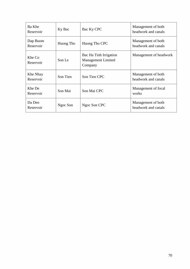
70
Ba Khe
Reservoir Ky Bac Bac Ky CPC
Management of both
headwork and canals
Dap Buom
Reservoir Huong Tho Huong Tho CPC
Management of both
headwork and canals
Khe Co
Reservoir Son Le
Bac Ha Tinh Irrigation
Management Limited
Company
Management of headwork
Khe Nhay
Reservoir Son Tien Son Tien CPC
Management of both
headwork and canals
Khe De
Reservoir Son Mai Son Mai CPC
Management of focal
works
Da Den
Reservoir Ngoc Son Ngoc Son CPC
Management of both
headwork and canals
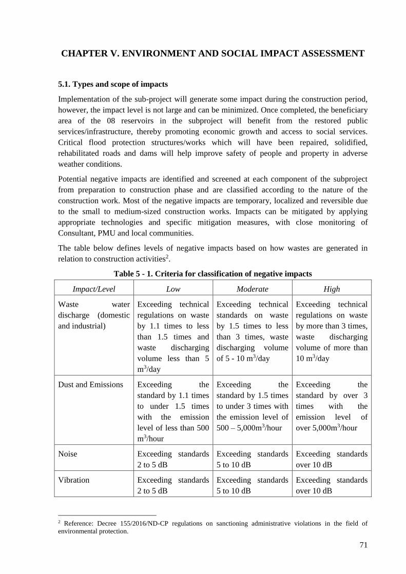
71
CHAPTER V. ENVIRONMENT AND SOCIAL IMPACT ASSESSMENT
5.1. Types and scope of impacts
Implementation of the sub-project will generate some impact during the construction period,
however, the impact level is not large and can be minimized. Once completed, the beneficiary
area of the 08 reservoirs in the subproject will benefit from the restored public
services/infrastructure, thereby promoting economic growth and access to social services.
Critical flood protection structures/works which will have been repaired, solidified,
rehabilitated roads and dams will help improve safety of people and property in adverse
weather conditions.
Potential negative impacts are identified and screened at each component of the subproject
from preparation to construction phase and are classified according to the nature of the
construction work. Most of the negative impacts are temporary, localized and reversible due
to the small to medium-sized construction works. Impacts can be mitigated by applying
appropriate technologies and specific mitigation measures, with close monitoring of
Consultant, PMU and local communities.
The table below defines levels of negative impacts based on how wastes are generated in
relation to construction activities2.
Table 5 - 1. Criteria for classification of negative impacts
Impact/Level Low Moderate High
Waste water
discharge (domestic
and industrial)
Exceeding technical
regulations on waste
by 1.1 times to less
than 1.5 times and
waste discharging
volume less than 5
m3/day
Exceeding technical
standards on waste
by 1.5 times to less
than 3 times, waste
discharging volume
of 5 - 10 m3/day
Exceeding technical
regulations on waste
by more than 3 times,
waste discharging
volume of more than
10 m3/day
Dust and Emissions Exceeding the
standard by 1.1 times
to under 1.5 times
with the emission
level of less than 500
m3/hour
Exceeding the
standard by 1.5 times
to under 3 times with
the emission level of
500 – 5,000m3/hour
Exceeding the
standard by over 3
times with the
emission level of
over 5,000m3/hour
Noise Exceeding standards
2 to 5 dB
Exceeding standards
5 to 10 dB
Exceeding standards
over 10 dB
Vibration Exceeding standards
2 to 5 dB
Exceeding standards
5 to 10 dB
Exceeding standards
over 10 dB
2 Reference: Decree 155/2016/ND-CP regulations on sanctioning administrative violations in the field of
environmental protection.
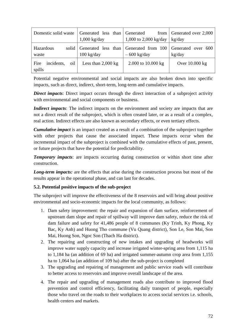
72
Domestic solid waste Generated less than
1,000 kg/day
Generated from
1,000 to 2,000 kg/day
Generated over 2,000
kg/day
Hazardous solid
waste
Generated less than
100 kg/day
Generated from 100
– 600 kg/day
Generated over 600
kg/day
Fire incidents, oil
spills
Less than 2,000 kg 2.000 to 10.000 kg Over 10.000 kg
Potential negative environmental and social impacts are also broken down into specific
impacts, such as direct, indirect, short-term, long-term and cumulative impacts.
Direct impacts: Direct impact occurs through the direct interaction of a subproject activity
with environmental and social components or business.
Indirect impacts: The indirect impacts on the environment and society are impacts that are
not a direct result of the subproject, which is often created later, or as a result of a complex,
real action. Indirect effects are also known as secondary effects, or even tertiary effects.
Cumulative impact is an impact created as a result of a combination of the subproject together
with other projects that cause the associated impact. These impacts occur when the
incremental impact of the subproject is combined with the cumulative effects of past, present,
or future projects that have the potential for predictability.
Temporary impacts: are impacts occurring during construction or within short time after
construction.
Long-term impacts: are the effects that arise during the construction process but most of the
results appear in the operational phase, and can last for decades.
5.2. Potential positive impacts of the sub-project
The subproject will improve the effectiveness of the 8 reservoirs and will bring about positive
environmental and socio-economic impacts for the local community, as follows:
1. Dam safety improvement: the repair and expansion of dam surface, reinforcement of
upstream dam slope and repair of spillway will improve dam safety, reduce the risk of
dam failure and safety for 41,486 people of 8 communes (Ky Trinh, Ky Phong, Ky
Bac, Ky Anh) and Huong Tho commune (Vu Quang district), Son Le, Son Mai, Son
Mai, Huong Son, Ngoc Son (Thach Ha district).
2. The repairing and constructing of new intakes and upgrading of headworks will
improve water supply capacity and increase irrigated winter-spring area from 1,115 ha
to 1,184 ha (an addition of 69 ha) and irrigated summer-autumn crop area from 1,155
ha to 1,064 ha (an addition of 109 ha) after the sub-project is completed
3. The upgrading and repairing of management and public service roads will contribute
to better access to reservoirs and improve overall landscape of the area.
4. The repair and upgrading of management roads also contribute to improved flood
prevention and control efficiency, facilitating daily transport of people, especially
those who travel on the roads to their workplaces to access social services i.e. schools,
health centers and markets.
73
5. Improving flow regulation capacity during flood season and dry season; maintaining
air humidity and soil humidity which will have an impact on the development of
organisms. Reservoirs will continue to be habitats of aquatic life. These contribute to
multiple effects on improved biodiversity.
6. Impacts on income: In the construction phase, the population density in the sub-
project area would increase due to the present of project staff and workers at
construction site. During the highest time, there are 330 workers in all of 8
construction sites with local workers accounting for about 40%. In addition to
economic benefits due to increased demands for food and food service, and improved
income from food and foodstuffs provision, job opportunities may be available
because the Client has policies to encourage the use of local workers and some
households can significant earn from their business.
7. Impacts on the ecological environment: repairing and improving dam safety will help
regulate the flow during flood season and increase water supply during the dry season,
increasing the humidity, and groundwater reserves, ensuring improved habitat of
vegetation and other living species, balancing ecological system in the area. Moreover
as the sub-project area always suffer prolonged drought and the sub-project will help
improve ecological environment of area. At the same time, favorable environments for
downstream production activities will be created. Environmental incidents or risks
will be minimized as the reservoirs are safe. In the context of climate change with
abnormal floods and other extreme weather phenomena, improvement works will
enhance the resilience of hydraulic works to climate change impacts (i.e. flood
drainage capacity is improved as spillway is upgraded; dam stability is improved when
dam surface is expanded and dam crest is heightened and dam slopes reinforced and
monitoring equipment system for early warning is installed etc.
5.3. Potential negative impacts of the sub-project (8 reservoirs)
5.3.1. Impacts during the pre-construction phase
Activities in the pre-construction phase: Land acquisition, tree cutting, preparation of dump
site, stockpile, borrow pits, camp installing, removal of vegetations, transport of wastes soil,
etc. Details of activities during pre-construction phase are described in Chapter 2.
Construction activities mainly relate to the repair of existing headworks so excavating work is
in-significant. In addition, the construction sites do not have unexploded ordinance (UXO)
left over after wars and without existing production activities. Thus, mine clearance will not
be required prior to construction commencement.
During the pre-construction stage, the following negative environmental and social impacts
will happen:
➢ Impacts due to land and crop acquisition:
Existing hydraulic works are mainly repaired and upgraded so impacts due to land and crops
acquisition are insignificant as follows:
- The number of households affected by land acquisition: 88 households or a total of 320
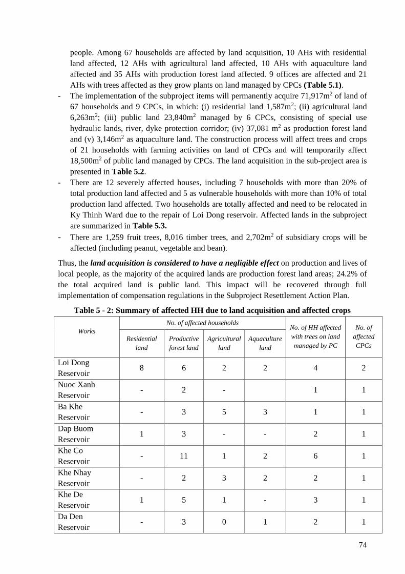
74
people. Among 67 households are affected by land acquisition, 10 AHs with residential
land affected, 12 AHs with agricultural land affected, 10 AHs with aquaculture land
affected and 35 AHs with production forest land affected. 9 offices are affected and 21
AHs with trees affected as they grow plants on land managed by CPCs (Table 5.1).
- The implementation of the subproject items will permanently acquire 71,917m2 of land of
67 households and 9 CPCs, in which: (i) residential land 1,587m2; (ii) agricultural land
6,263m2; (iii) public land 23,840m2 managed by 6 CPCs, consisting of special use
hydraulic lands, river, dyke protection corridor; (iv) 37,081 m2 as production forest land
and (v) 3,146m2 as aquaculture land. The construction process will affect trees and crops
of 21 households with farming activities on land of CPCs and will temporarily affect
18,500m2 of public land managed by CPCs. The land acquisition in the sub-project area is
presented in Table 5.2.
- There are 12 severely affected houses, including 7 households with more than 20% of
total production land affected and 5 as vulnerable households with more than 10% of total
production land affected. Two households are totally affected and need to be relocated in
Ky Thinh Ward due to the repair of Loi Dong reservoir. Affected lands in the subproject
are summarized in Table 5.3.
- There are 1,259 fruit trees, 8,016 timber trees, and 2,702m2 of subsidiary crops will be
affected (including peanut, vegetable and bean).
Thus, the land acquisition is considered to have a negligible effect on production and lives of
local people, as the majority of the acquired lands are production forest land areas; 24.2% of
the total acquired land is public land. This impact will be recovered through full
implementation of compensation regulations in the Subproject Resettlement Action Plan.
Table 5 - 2: Summary of affected HH due to land acquisition and affected crops
Works
No. of affected households No. of HH affected
with trees on land
managed by PC
No. of
affected
CPCs Residential
land
Productive
forest land
Agricultural
land
Aquaculture
land
Loi Dong
Reservoir 8 6 2 2 4 2
Nuoc Xanh
Reservoir - 2 - 1 1
Ba Khe
Reservoir - 3 5 3 1 1
Dap Buom
Reservoir 1 3 - - 2 1
Khe Co
Reservoir - 11 1 2 6 1
Khe Nhay
Reservoir - 2 3 2 2 1
Khe De
Reservoir 1 5 1 - 3 1
Da Den
Reservoir - 3 0 1 2 1
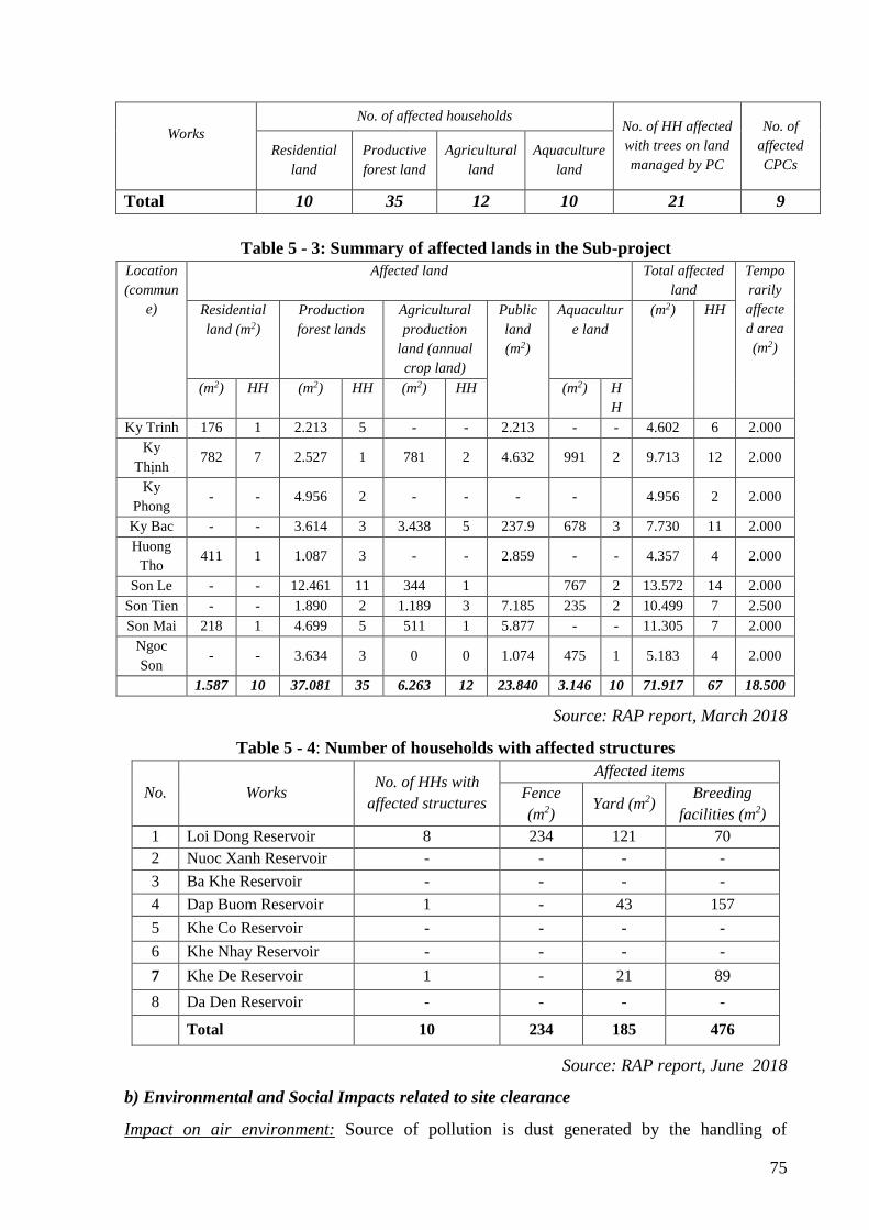
75
Works
No. of affected households No. of HH affected
with trees on land
managed by PC
No. of
affected
CPCs Residential
land
Productive
forest land
Agricultural
land
Aquaculture
land
Total 10 35 12 10 21 9
Table 5 - 3: Summary of affected lands in the Sub-project
Location
(commun
e)
Affected land Total affected
land
Tempo
rarily
affecte
d area
(m2)
Residential
land (m2)
Production
forest lands
Agricultural
production
land (annual
crop land)
Public
land
(m2)
Aquacultur
e land
(m2) HH
(m2) HH (m2) HH (m2) HH (m2) H
H
Ky Trinh 176 1 2.213 5 - - 2.213 - - 4.602 6 2.000
Ky
Thịnh 782 7 2.527 1 781 2 4.632 991 2 9.713 12 2.000
Ky
Phong - - 4.956 2 - - - - 4.956 2 2.000
Ky Bac - - 3.614 3 3.438 5 237.9 678 3 7.730 11 2.000
Huong
Tho 411 1 1.087 3 - - 2.859 - - 4.357 4 2.000
Son Le - - 12.461 11 344 1 767 2 13.572 14 2.000
Son Tien - - 1.890 2 1.189 3 7.185 235 2 10.499 7 2.500
Son Mai 218 1 4.699 5 511 1 5.877 - - 11.305 7 2.000
Ngoc
Son - - 3.634 3 0 0 1.074 475 1 5.183 4 2.000
1.587 10 37.081 35 6.263 12 23.840 3.146 10 71.917 67 18.500
Source: RAP report, March 2018
Table 5 - 4: Number of households with affected structures
No. Works No. of HHs with
affected structures
Affected items
Fence
(m2) Yard (m2)
Breeding
facilities (m2)
1 Loi Dong Reservoir 8 234 121 70
2 Nuoc Xanh Reservoir - - - -
3 Ba Khe Reservoir - - - -
4 Dap Buom Reservoir 1 - 43 157
5 Khe Co Reservoir - - - -
6 Khe Nhay Reservoir - - - -
7 Khe De Reservoir 1 - 21 89
8 Da Den Reservoir - - - -
Total 10 234 185 476
Source: RAP report, June 2018
b) Environmental and Social Impacts related to site clearance
Impact on air environment: Source of pollution is dust generated by the handling of
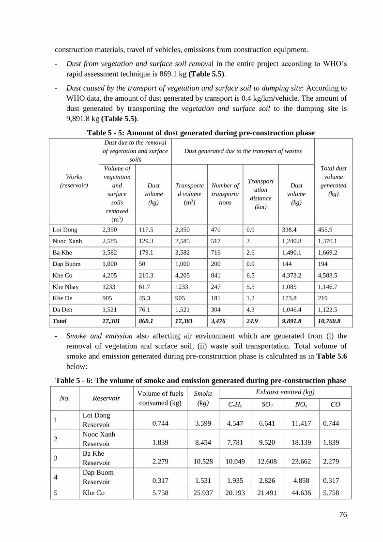
76
construction materials, travel of vehicles, emissions from construction equipment.
- Dust from vegetation and surface soil removal in the entire project according to WHO’s
rapid assessment technique is 869.1 kg (Table 5.5).
- Dust caused by the transport of vegetation and surface soil to dumping site: According to
WHO data, the amount of dust generated by transport is 0.4 kg/km/vehicle. The amount of
dust generated by transporting the vegetation and surface soil to the dumping site is
9,891.8 kg (Table 5.5).
Table 5 - 5: Amount of dust generated during pre-construction phase
Works
(reservoir)
Dust due to the removal
of vegetation and surface
soils
Dust generated due to the transport of wastes
Total dust
volume
generated
(kg)
Volume of
vegetation
and
surface
soils
removed
(m3)
Dust
volume
(kg)
Transporte
d volume
(m3)
Number of
transporta
tions
Transport
ation
distance
(km)
Dust
volume
(kg)
Loi Dong 2,350 117.5 2,350 470 0.9 338.4 455.9
Nuoc Xanh 2,585 129.3 2,585 517 3 1,240.8 1,370.1
Ba Khe 3,582 179.1 3,582 716 2.6 1,490.1 1,669.2
Dap Buom 1,000 50 1,000 200 0.9 144 194
Khe Co 4,205 210.3 4,205 841 6.5 4,373.2 4,583.5
Khe Nhay 1233 61.7 1233 247 5.5 1,085 1,146.7
Khe De 905 45.3 905 181 1.2 173.8 219
Da Den 1,521 76.1 1,521 304 4.3 1,046.4 1,122.5
Total 17,381 869.1 17,381 3,476 24.9 9,891.8 10,760.8
- Smoke and emission also affecting air environment which are generated from (i) the
removal of vegetation and surface soil, (ii) waste soil transportation. Total volume of
smoke and emission generated during pre-construction phase is calculated as in Table 5.6
below:
Table 5 - 6: The volume of smoke and emission generated during pre-construction phase
No. Reservoir Volume of fuels
consumed (kg)
Smoke
(kg)
Exhaust emitted (kg)
CxHy SO2 NOx CO
1 Loi Dong
Reservoir 0.744 3.599 4.547 6.641 11.417 0.744
2 Nuoc Xanh
Reservoir 1.839 8.454 7.781 9.520 18.139 1.839
3 Ba Khe
Reservoir 2.279 10.528 10.049 12.608 23.662 2.279
4 Dap Buom
Reservoir 0.317 1.531 1.935 2.826 4.858 0.317
5 Khe Co 5.758 25.937 20.193 21.491 44.636 5.758

77
Reservoir
6 Khe Nhay
Reservoir 1.457 6.585 5.290 5.799 11.821 1.457
7 Khe De
Reservoir 0.338 1.611 1.890 2.668 4.676 0.338
8 Da Den
Reservoir 1.454 6.611 5.591 6.408 12.706 1.454
Total 14.185 64.855 57.277 67.962 131.916 14.185
However, as the location of construction works is far away from residential areas and
surrounded by hills and mountains, the affect is only on 330 workers working on the site and
some households living near the construction site. In addition, inspection of construction
equipment is carried out regularly and the duration of the impact is short, thus the impacts are
assessed at moderate.
Impacts on soil environment:
During the pre-construction time, surface leveling, vegetation and surface soil tak place in all
8 construction sites. These activities can cause erosion, soil deposition, soil degradation,
infertility and bad effects on the soil of dam’s protection corridor.
Waste oil from machinery and equipment during site leveling is minimal yet without disposal
it can pollute soil and water environment due to great volume of toxic substances. Waste oil is
black, viscous, insoluble in water, stable and contains such heavy metal as lead, zinc, and
other toxic chemicals produced by the carbonation process of engine operation. Although the
volume of waste oil is minimal, yet without proper collection and processing and if it is
poured into reservoirs and canals, soil environment will be polluted as oil prevents the
respiration and destroy food environment of microorganisms in contaminated soil. This
impact is assessed as low level as routine equipment maintenance is carried out in workshops
and waste oil is collected by workshop owner for reuse.
Impact on soil environment is considered negligible as most of the acquired land area is
within the dam protection corridor. Borrow pit and dumping site are abandon lands or are
being used.
Impacts on water environment:
The concentration of workers in the camp site near the construction site will affect the water
environment due to their daily domestic waste; especially domestic wastewater if not properly
treated will penetrate into surface water together with rain water and increase pollutant load in
water environment in the area. It is estimated that volume of domestic waste water generated
during site clearance phase of the project is 10.64 m3/day i.e. each work will generate 0.8 m3
to 2.4 m3 of waste water per day. Each work has only 10 -30 workers which mean
insignificant waste and can be controlled;
Wastewater from cleaning equipment contains grease, soil, sand and has a high content of
suspensions. Given 22 vehicles transporting waste soil during the preparation phase, the
wastewater volume is estimated at 11 m3/day according to Vietnam standard TCVN
4513:1988.
78
Run-off in the leveled area or where materials are gathered or from equipment cleaning will
bring with it surface soil and increase turbidity of reservoir water and affect downstream’s
water sources. These impacts on water environment are assessed as moderate as the Client
arranged site clearance activities in dry season with fewer workers and more local labors
working in the construction site.
Impacts due to risks and incidents
Traffic accidents are caused by increased vehicles, machinery and equipment operating in the
construction sites and access roads. Labor accidents are due to the appearance of holes or
bumpy surfaces in the construction sites.
During the preconstruction process, electrical incidents may affect construction workers and
local population. However, during the pre-construction phase, the volume of work using
electricity is not large and only during a short time, thus this impact is assessed as low level.
Impacts on biological environment
The removal of trees, weathered soil and dumping waste may affect ecosystems in the soil
due to loss of eggs, larvae, and habitat of some insects and plants in the area.
A total of 1,259 fruit trees, 8,016 trees for timber, and 2,702m2 of vegetable area (including
peanut, bean, vegetables) will be affected. The project implementation will permanently
acquire 37,081 m2 of production forest land of 35 households. Cutting down trees will affect
environmental landscape and coverage of reservoir area. Loss of coverage may result in
erosion and landslides. However, most of affected production forest land area are newly
planted acacia and eucalyptus of 2-3 years. The affected and acquired area is not large and flat
so erosion and landslide risks are not high. Due to short preparation time (estimated for 1
month), and there is no rare and endangered flora and fauna species for protection in the
subproject area, the impact is considered as low.
5.3.2. Impacts during construction phase
This is the stage with most impacts on the subproject’s environment. The construction phase
involves the construction and repair of main items (dams, spillway, intake, construction roads,
management houses etc.), exploitation and transport of materials from borrow pits to the
construction sites and transport wastes to dumping sites. Details of activities during
construction phase are described in Chapter 2.
➢ Impact on air environment:
i) Dust generated from earth works:
During construction phase, amount of dust increases by 620,779 tons (in which dust generated
from earth works and soil transportation is 293,621 tons and dust generated due to material
transportation is 327,159 tons) which is shown in Table 5.7 and 5.8 below:
Table 5 - 7: Amount of dust generated by excavation, filling, soil transportation during
construction period
Work
(reservoir)
Dust generated due to
earthworks
Dust due to transporting
backfilling soil
Dust due to transporting
wastes soil
Total dust
amount
generated Volume of Dust Distance Vehicle Dust Distance Vehicle Dust
79
filling and
excavating
soil (m3)
amount
generated
(kg)
(km) routes amount
generated
(kg)
(km) routes amount
generated
(kg)
(ton)
Loi Dong 33,927 1,696 9.5 4,661 35,422 0.9 1,564 1,126 38,245
Nuoc Xanh 66,693 3,335 2 9,001 14,401 3.0 2,912 6,990 24,725
Ba Khe 80,861 4,043 6 10,566 50,715 2.6 3,128 6,507 61,265
Dap Buom 37,985 1,899 32 4,357 111,544 0.9 2,476 1,782 115,226
Khe Co 142,086 7,104 0.3 11,952 2,869 6.5 2,182 11,347 21,320
Khe Nhay 39,263 1,963 0.3 2,951 708 5.5 911 4,010 6,682
Khe De 82,065 4,103 0.3 8,186 1,965 1.2 2,405 2,309 8,377
Da Den 39,555 1,978 2 3,292 5,268 4.3 3,063 10,536 17,781
Total 522,435 26,122 52.4 54,966 222,891 24.9 18,642 44,608 293,621
Table 5 - 8: Amount of smoke and exhausted emission generated due to earthworks
No Work
(reservoir)
Amount of fuels
consumed (kg)
Smoke
(kg)
Exhausted emission (kg)
CxHy SO2 NOx CO
1 Loi Dong 6,412 5.002 26.675 50.015 83.423 133.438
2 Nuoc Xanh 12,605 9.832 52.437 98.319 163.991 262.310
3 Ba Khe 15,283 11.921 63.576 119.205 198.828 318.034
4 Dap Buom 7,179 5.600 29.865 55.997 93.401 149.398
5 Khe Co 26,854 20.946 111.714 209.463 349.374 558.837
6 Khe Nhay 7,421 5.788 30.870 57.882 96.543 154.425
7 Khe De 15,510 12.098 64.523 120.980 201.789 322.769
8 Da Den 7,476 5.831 31.100 58.312 97.261 155.573
Total 98,740 77.017 410.759 770.174 1,284.610 2,054.784
Effects of dust on air environment are as follows: Under normal weather conditions, dust
generated from the transportation of soil and stones only dispersed within an area of 30 m
from dust generating point. With the wind dust can be diffused to the height of more than 10m
and travel with wind as far as 100m. Cement dust from wind will be released into the air at
the site, storage facilities. Cement dust is dense at the loading area. Dust from the transporting
of steel, cement, sand and rocks in construction area has wide range of dispersion and may
impact on many objects i.e. trees, people living along roads and travelers. During
construction, suspended dust concentrations in the construction site and in stockpiles and
dumpsites are usually higher than the allowable value of QCVN 05:2013/BTNMT. The most
affected are workers working in the construction site. However, given the large construction
sites and far away from residential areas and with high density of trees and high dust
dispersion ability, the impact is considered as moderate.
ii) Impact on air environment due to the material transportation (soil, stone, cement, steel,
80
etc.):
Amounts of smoke and emissions generated from the transportation of construction materials
are calculated in table 5.9 and 5.10 below:
Table 5 - 9: Amount of dust generated due to material transport during construction-
phase
Work
(reservoir)
Dust generated due to sand
transport
Dust generated due to stone
transport
Dust generated due to cement,
steel transport
Total
(tons) Distance
(km)
Number
of
transport
ations
Amount
of dust
(kg)
Distance
(km)
Number
of
transpor
tations
Amount of
dust (kg)
Distanc
e (km)
Number
of
transport
ations
Amount
of dust
(kg)
Loi Dong 9.5 359 2,728 19.2 1,746 26,819 9.5 150 1,140 30,687
Nuoc
Xanh 20 948 15,168 24 2,698 51,802 20 391 6,256 73,226
Ba Khe 24 481 9,235 1.4 1,697 1,901 24 196 3,770 14,906
Dap Buom 8.5 377 2,564 30 1,691 40,584 11 168 1,476 44,624
Khe Co 12 827 7,939 24 3,217 61,766 12 287 2,753 72,459
Khe Nhay 20 204 3,264 12 419 4,022 20 82 1,308 8,594
Khe De 17.5 556 7,784 18 2,785 40,104 12 175 1,682 49,570
Da Den 40 272 8,704 32 901 23,066 15 110 1,322 33,092
Total 151.5 4,024 57,386 160.6 15,154 250,063 123.5 1,559 19,707 327,157
Table 5 - 10: Amount of smoke and exhausted emission generated due to material
transport during construction-phase
TT Work
(reservoir)
Number
of
transpor
tations
Distanc
e (km)
Smoke
(kg)
Exhausted emission (kg)
CxHy SO2 NOx CO
1 Loi Dong 150 9.5 1.340 5.900 3.648 2.907 7.325
2 Nuoc Xanh 391 20 7.351 32.377 20.021 15.954 40.198
3 Ba Khe 196 24 4.430 19.510 12.064 9.614 24.223
4 Dap Buom 168 11 1.734 7.636 4.722 3.763 9.481
5 Khe Co 287 12 3.234 14.245 8.808 7.019 17.685
6 Khe Nhay 82 20 1.537 6.771 4.187 3.336 8.406
7 Khe De 175 12 1.977 8.706 5.383 4.290 10.809
8 Da Den 110 12 1.243 5.473 3.384 2.697 6.795
Total 1,559 120.5 22.846 100.618 62.218 49.580 124.922
Smoke and emissions generated from the transportation of materials (sand, soil, cement, steel,
etc.) may affect population living along roads. However, as most of transportation roads are
national roads, the amount of dust is not high. Access roads to the construction site are earth
81
road and aggregate road, yet not many households are living along these roads, excepting for
few i.e. Dap Buom (6 households), Khe De reservoir (6 households), Ba Khe reservoir (Huu
Lac pagoda and Ky Bac primary school (2km away from the reservoir). This impact is
assessed as moderate and can be minimized through mitigation measures.
iii) Dust and exhausted emsisson due to the transport of waste soil
Amount of dust and exhausted emission due to the transport of waste soil is calculated in
Table 5.7 and 5.11:
Table 5 - 11: Amount of smoke and exhausted emission generated due to the transport
of waste soil during construction-phase
TT Work
(reservoir)
Waste
soil (m3)
Distance
(km)
Smoke
(kg)
Exhausted emission (kg)
CxHy SO2 NOx CO
1 Loi Dong 7,820 0.9 1.323 5.827 3.603 2.872 7.235
2 Nuoc Xanh 14,562 3 8.213 36.172 22.367 17.824 44.909
3 Ba Khe 15,641 2.6 7.645 33.672 20.821 16.592 41.805
4 Dap Buom 12,378 0.9 2.094 9.224 5.704 4.545 11.452
5 Khe Co 10,911 6.5 13.333 58.723 36.312 28.936 72.907
6 Khe Nhay 4,557 5.5 4.712 20.753 12.833 10.226 25.765
7 Khe De 12,027 1.2 2.713 11.950 7.389 5.888 14.837
8 Da Den 15,314 4.3 12.380 54.524 33.715 26.867 67.694
Total 93,210 24.9 52.414 230.845 142.745 113.750 286.605
All dump sites are allocated in the commune lands which are near construction site within a
short distance. However, there are still roads for transporting waste soil passing through the
residential areas. Thus, the affected objects are people living along these roads and near
dumpsites. Details of the affected will be described in section on sub-project impact. This
impact is assessed as moderate.
➢ Impacts of noise and vibration on the environment
Noise and vibration are generated from such machinery and devices as trucks, excavators,
bulldozers, concrete mixers, generators, pumps, etc. Noise and vibration are not frequently
generated during this stage. Among 123 mechinaries expected to operate full time in the
construction site, only some vehicles can cause excessive noise of over 90 dBA (i.e.
exceeding the Vietnam standard TCVN) including bulldozers, excavators and trucks. Noise
and vibration caused by construction activities mainly relate to the operation of equipment
and will have very little impacts on local people as the construction sites are far away from
residential areas i.e. the nearest residential area is as far as 400-500m from the construction
sites. The impact is considered as moderate and can be minimized if contractors fully
perform all inspection and maintenance regulations.
General assessments of the level of air pollution: a large of amount of dust and exhausted
emission is generated, mainly in the construction sites of headwork and in stockpiles, borrow
82
pits and dumpsites. The direct affected objects are workers working on site. However, given
the wide and airy space and away from residential area, these impacts will not affect the
surrounding residential areas. Dust and exhausted emission generated from the transport of
materials will affect many objects, yet they can be minimized through strict compliance with
mitigation measures by contractors.
➢ Impact on water environment:
i) Impacts of domestic waste water of workers on water environment :
With the presence of 330 workers in the subproject, the estimated amount of domestic
wastewater generated is 330 persons x 80 liters/person/day = 26.4 m3/day. The amount of
pollutants in a day in the construction site is as follows:
Table 5 - 12: Pollutant loads in daily domestic wastewater in the subproject area
No. Parameter Load
(g/day)
Concentration
(mg/l)
QCVN 14:2008/BTNMT
Column B, K = 1.2; Cmax
1 BOD5 14,850 17,820 562.5 - 675 60
2 COD 23,760 33,660 900 – 1,275 -
3 Suspended solid 23,100 47,850 875 - 1.812,5 120
4 Grease 3,300 9,900 125 - 375 24
5 Total N 1,980 3,960 75 - 150 -
6 Ammonium 792 1,584 30 - 60 12
7 Total P 264 1,320 10 - 50 12
The results in Table 5.12 show that the concentration of pollutants in domestic effluent
exceeds regulation (QCVN 14: 2008/BTNMT) for many times. Without proper measures the
wastewater will contaminate surface water, ground water and soil environment. Domestic
wastewater generated from camp site located in the reservoir area (70-300m away from
dams). There are 41 workers in each work on average. The domestic wastewater generated on
daily basis is 26.4 m3/day, i.e. 3.3 m3/day on average is generated from each work. The waste
water has bad ordor and contains organic substances (BOD5, COD), nutrients (N, P, NH4+,
NO2, PO43-) and pathogenic microorganisms. Without proper collection and treatment
methods, the wastewater may penetrate into the soil or flow into reservoirs and cause
pollutions to surface and groundwater. This impact is assessed as moderate and can be
controlled by appropriate collection and treatment measures
ii) Impacts of runoff on water environment
Rainwater runoff can be polluted as it passes through areas containing pollutants such as
stockpile, open air construction areas etc. Rainwater runoff then can be mechanically
contaminated (with soil, sand, rubbish), or polluted with organism and grease. Rainwater
runoff at this stage has high turbididty as it bring with it mud and soil from site leveling,
excavation, backfilling, construction of main dam, spillway, and management house and
management road. The maximum rainwater runoff in the subproject area is calculated as
follows:
83
Qmax = 0.278.K.I.A = 0.278 x 0.12 x 56.95 x 50 = 0.2797 (m3/s),
In which:
+ Q: The maximum flow of rainwater runoff (m3/s).
+ K: Runoff coefficient, depending on ground surface feature. For disturbed
construction site, K = 0.12.
+ I: Average rainfall intensity during highest rainfall time (mm/h), I = 56.95 mm/h.
+ A: Average area of each construction site is 50 ha.
The concentration of pollutants in rainwater runoff is estimated as follows:
Table 5 - 13: Concentration of pollutants in runoff
No. Pollutants Concentration, mg/l
1 Total N 0.5 1.5
2 Total P 0.004 0.03
3 COD 10 20
4 SS 10 20
If no treatment measure is applied, the runoff will flow into the reservoirs and downstream
streams and cause increased residue amount in the receiving water source and reduced
dissolved oxygen. Rainwater will be polluted when it passes through the dam construction site
and stockpiles in the reservoir and downstream areas. Rainwater runoff will carry such dirts as
cattle manure, waste material, soil, sand, waste, domestic waste water when it flows through
construction sites and pollute water soucre, cause reservoir sedimentation and water bodies
(canals, ditches) around stockpiles and dump sites. However, as construction activities only
take place during dry season (January to August), the impacts are evaluated as low and can
be minimized by such measures as shedding stockpiles and regular collecting and cleaning
excessive material, wastes and domestic wastewater from activities of workers or digging
trenches to collect rainwater.
iii) Impact of construction wastewater on the water environment
Construction wastewater is mainly generated from concrete and mortar mixing, equipment
washing and stone screeing. This type of wastewater has high concentration of SS, pH
content, but low flow, impact on the surrounding environment is low. Wastewater from
washing equipment contains high levels of grease and dirt. However, with revolving
construction method, number of machines used for construction is not many and they are
scattered in many locations, water volume need for washing vehicles is not frequent and
negligible. Volume of construction wastewater and equipment washing water at each site is
estimated at 3-5m3/day. Total wastewater generated at 8 sites of the subproject is 5 x 8 = 40
m3/day.
Wastewater from construction activities, concrete curing, repairing and cleaning machinaries
and equipment containing hazardous substances such as cement, oil and grease will present
toxicity to aquatic environment. However, quantity of these two types of wastewater is in-
significant and thus minial impacts on water environment.
84
Construction of spillways and intakes will inundate part of concrete work and water will wash
away some impurities in concrete and contaminate water in the reservoirs. If the water level in
reservoirs is low, concentration of these impurities may affect aquatic species.
As construction activities are mainly carried out in dry season when water level in reservoirs
is low and as the construction time is short, impacts of wastewater on hydrological regime and
water quality in reservoirs are low. The impact is evaluated as low.
iv) Impacts of solid waste on water environment in reservoirs and canals
Such construction solid wastes as soil and rocks in dumpsites, if not properly handled and
managed and without proper fencing and management, can result in high turbidity in water
when there is a rain causing soil and stone to fall into canals.
The excavation of foundations as part of dam and intake repairing activities or backfilling in
reservoirs (e.g. Khe De, Khe Co, Khe Nhay) may cause increased turbidity in water as soil,
rocks, mud and sand will flow downstream with water.
Dead plants in the reservoir area and in the construction site if not collected, will decompose
and cause bad smell. They can be also swept away with rainwater into streams and cause
water pollution. Water contaminated by decomposed vegetation has green color and bad odor.
Dead plants decomposing in anaerobic environment will produce such toxic substances as
NH4+, H2S, PO3
-, etc., which will result in turbidly in reservoir water and bad odor, affecting
lives of aquatic organisms as fish, shrimp, snails, etc. The decomposition of organic
compounds consuming oxygen in water will reduce dissolved oxygen amount in water. This
will harm the natural organisms living in reservoirs, such as the respiratory effects of some
local fish, shrimps, snails ... and reduce the photosynthetic capacity of aquatic plants. It is
surveyed that local people in the project area do not use water in reservoirs for drinking.
However, as many as 630 households are using water from Khe Co, Khe and Khe Nhay
reservoirs for bathing, washing and livestock raising. The contaminated water from reservoir
may increase skin diseases, gynecological diseases of women and diarrhea for cattle.
However, as the amount of tree cutting is not large which is mainly for fuel by local people
and the unused part is transported to dumpsites, so the impact is evaluated as low if the
contractor will fully performs mitigation measures.
➢ Impacts on soil environment
i) Impact on soil environment due to domestic wastes
During the construction stage, the number of workers working regularly at site is about 330
people, i.e. 41 people in each construction site. Khe Co Reservoir has the largest number of
workers i.e. 60. The estimated amount of daily solid waste generated will be 330 people x 0.5
kg/day = 165 kg/day.
Domestic wastes of about 330 workers on sites are biodegradable waste, containing many
organic substances and pathogenic microorganisms. Without proper treatment and collection,
these wastes will pollute once discharged into environment. However, domestic waste
generated from worker camp area is minimal and can be controlled. As a result, the impact is
considered as low.
ii) Impacts of excavating and backfilling activities at borrow pits and dumpsites on soil
85
environment
Soil excavation and backfilling (earthwork) and material exploitation at borrow pits (in Khe
Co, Khe Nhay and Khe De reservoir) and dumpsites will disturb surface soil layer and affect
soil physical properties i.e. soil texture and porosity. Some borrow pits and dumpsites are
only temporarily acquired and if they are not returned to its original condition in accordance
with regulations after the removal of surface soil layer, production activities and growth of
crops will be affected once these sites are returned to local people. The dumping of wastes can
cause landslide and erosion which pollute neighboring areas. The impacts may include:
- The dumping of waste may cause landslide and erosion which pollute the neighboring
areas. However, as dumpsites are empty, depressed and abandoned and isolated from
residential areas, erosion and landslides will not likely to happen and affect the production
activities and lives of people. In addition, the contractor will carry out leveling and
compacting sites by layer during the dumping and at the same time embank the
surrounding of the dumpsites to avoid erosion and landslide. The allowed height of the
dumps should be equal to the natural ground, thus this impact is assessed at low.
- Backfilling soil of 03 reservoirs of Khe Co, Khe De and Khe Nhay will be exploited from
low hills and vacant land in the impounding area which is far away from residential area.
The exploitation depth is only 1- 2 m and will not cause landslide. The impact is evaluated
as low and the contractor must comply with all regulations on soil exploitation and waste
dumping to minimize soil erosion and landslides. The exploitation of borrow pits in the
impounding area will not affect storage capacity of reservoirs as the pit is only as low as
freeboard and the contractors will return the site using waste soil generated from the
removal of coffer dam.
iii) Impacts of hazardous wastes on soil environment
During construction phase, equipment using DO oil such as excavators, bulldozers,
compactors, drilling machines, trucks transporting excavating and backfilling soil etc. will
operate in the site. The construction time will be 6 – 12 months. Given the amount of waste
oil generated into the environment of each work as 18 liters of DO oil/month/equipment, the
total amount of waste oil generated will be 21,600 liters. Waste oil is hazardous, black,
unsaturated waste which is insoluble in water, stable and contains such heavy metals as lead,
zinc and other toxic chemicals caused by carbonization during engine operation. If not
collected, heavy metals and toxic substances in waste oil will pollute soil and penetrate into
and pollute groundwater. Humans and living organisms contaminated with heavy metals or
toxic waste in waste oils can suffer metabolic disorders or even cancer. This impact is
assessed as low as routine equipment maintenance will be carried out in workshops and waste
oil is collected by workshop for reuse. There will no no waste oil discharged into the
environment.
Table 5 - 14: Estimated waste oil generated during construction phase
Work Number of
equipment
Construction duration
(Month) Waste oil (liters)
Loi Dong 14 12 3024
86
Nuoc Xanh 17 12 3672
Ba Khe 15 12 3240
Dap Buom 11 12 2376
Khe Co 20 12 4320
Khe Nhay 13 6 1404
Khe De 17 6 1836
Da Den 16 6 1728
Total 123 21,600
Solid wastes containing grease and oil are hazardous substances. Althought they exist in small
quantity, they are non-degradable in soil environment. Wihout proper collection and treatment
measures, solid wastes can seriously affect soil environment.
iii) Impacts of heavy construction equipment on soil compaction
Operation of heavy construction equipment may affect soil surface and break the granular
structure and cause compression and sealing effects to holes on the ground. Compacted soil
may reduce cultivation capacity or limit the growth of plants. However, heavy construction
machinaries (bulldozers, shovels, compactors, trucks, etc.) only operate within a certain area
where vegetation coverage does not exist. As construction time is short and environmental
recovery measures will be carried out by the contractors, the impact will be mitigated or
avoided. The impact is assessed as low.
➢ Impacts on biological environment
The excavation, filling and disposing wastes will cause to the loss of habitats and hatching
ground of some species in the soil such as insects and cave-dwelling animals as snakes and
frogs. However, there is no special species that need special protection in the sub-project area,
and the impact is considered as moderate.
Dust and exhausted emission from construction activities affect the growth of fauna and flora
in the subproject area and surrounding areas as follows: Dust on tree leaves reduces
photosynthesis process; SO2, CO, NOx both cause leaf diseases and affect the growth of
trees. The scope of impact on the trees is 20m from the site and along 10m of transportation
route. The impact is in-significant as rainwater will wash away dust on trees. The impact is
visiable yet localized and short-term so impact on ecological environment is considered as
low.
Impacts on the upstream aquatic ecosystems: it is provided that it is not allowed to practice
aquaculture in irrigation reservoirs so there are only natural species such as shrimp, fish,
weed, etc. Impacts on aquatic plants may occur if water is turbid and when such hazardous
wastes as waste oil, construction waste containing oil, grease, cement are released into the
reservoirs which cause obstruction to respiration of aqutic species and reduce the
photosynthetic capacity of aquatic plants. Hazardous substances and heavy metals can
accumulate in fish and shrimp and affect humans when they are used as food.
There is 0.3 ha of aquaculture ponds of households in the downstream area. However, as
87
aquaculture ponds are located far away from the construction site, construction activities do
not affect aquatic ecosystems of these ponds. Impact on the aquatic ecosystem is considered
as low as the amount of wastewater generated by aquaculture aqc is quite small compared to
water quantity in reservoirs and construction contractors will take measures to manage wastes
during construction.
➢ Impact on landscape:
The collection of a great volume of construction materials and equipment may cause changes
to the ground surface, reducing vegetation cover and creating unevenness on the ground due
to excavation and backfilling activities in borrow pits and dumpsites. These may affect natural
landscape of the area. These impacts are not serious and will be restored after the subproject
complete.
➢ Impacts on local infrastructure
i) Damaging roads and rural infrastructure:
It is calculated that up to 54,966 transportations using 7 tons trucks will carry backfilling soil
and 19,756 transportations of waste soil to dumpsites and 18,642 transportations of
construction materials including sand, rocks, steel, cement, steel to all construction sites
during construction phase.
In all 8 construction sites, materials transportation will use gravel road routes (road to the
reservoirs) which are 3-5m wide road pavement without being reinforced. The transportation
of construction materials and wastes using a large number of vehicles in short time may cause
erosion, soil subsidence and damages to surface of roads, bridges, culverts, canals etc. The
impacts are assessed as moderate.
ii) Impacts on houses and structures
Construction activities in 3 reservoirs of Loi Dong, Dap Buom and Khe Co will affect (the
demolish of structures) houses and structures including: 56m2 of fences, 234m2 of yard and
476 m2 of breeding farms. Detail is in Table 5.4.
In additional, some livestock farms (Loi Dong, ba Khe, Nuoc Xanh and Da Den) and 2
forestry farms (Da Den), 1 primary school (Ba Khe) can be affected by the transportation of
construction materials. However, due to the short transport distance through less traffic areas
(mainly limited to the construction sites) so the impact is assessed as moderate.
iii) Impacts on 500KV transmission line
Construction sites of Loi Dong, Nuoc Xanh and Da Den reservoirs are adjacent to 500KV
transmission line. Construction site of Nuoc Xanh reservoir is nearest to the line i.e. about 3-
8m and this does not meet safety requirements for freeboard (> 10m). Where the dam surface
is expected to be heightened, the dam will intersect ultility poles of 830 – 831 500KV
transmission line and the line will be inundated in the reservoir. The construction activities
taking place in the national grid safety corridor will lead to such risks as accidents due to short
circuit and explosion that damage propertyies and lives of local people. Impacts on the 500
KV high voltage power system of repair works in Nuoc Xanh reservoir are evaluated as high
and with serious consequences. Thus consultation from Ha Tinh Electricity Transmission
88
Agency is required. At the same time, safety regulations for construction activities under 500
KV high voltage system should be strictly complied with.
The construction sites of Loi Dong and Da Den reservoirs are beyond the safety corridor of
national grid. So the impacts on the 500 KV high voltage transmission line is evaluated as
moderate.
iv) Impacts on cultural, historic and belief relics
- There are some national and provincial level historic relics such as: Cao Thang temple and
Le Huu Tao temple near Khe Co reservoir, temple of the Phan near Khe Nhay reservoir.
However, the subproject activities will not affect these relics.
- Huu Lac pagoda located near material transport road to Ba Khe reservoir will be affected.
During the first and 15th of lunar months, number of people visiting the pagoda increases and
visitors will be affected not only by dust, smoke, noise but also safety when they visit the
pagoda. This impact is assessed as moderate.
- Excavation and construction of new intakes can detect valuable cultural properties in the
ground. The subproject mainly involves the repair and upgrade works on the existing
foundations and works which have been operated for a long-time. As the sub-project area is
not archaeological site and the possibility of detecting valuable cultural properties is quite
low.
➢ Impact on traffic safety during the construction phase
Transported materials and wastes can be spilt on the road on the transport way to 8
construction sites with transportation distances of 0.2-47 km along national, provincial, inter-
commune roads and rural roads, as well along farmers and on-farm roads in the sub-project
area.
If not being properly managed, transported materials and wastes spilt on the road will present
a loss of aesthetics and dangers to people and vehicles on circularion on roads. There might be
more traffic accidents to workers and local people. In addition, the increased number of
transported vehicles along local roads may present a higher risk of traffic accidents, especially
if drivers do not comply with safety regulations. Specific impacts will be discussed in site-
specific impact section.
These impacts are assessed as moderate and there should be remedial or mitigation
measures.
➢ Social impacts
i) Impacts on health services, public health and construction workers:
Air pollution caused by increasing emissions, smoke, dust and noise from construction
activities in the sub-project site is only temporary yet some effects can be found in workers at
construction site. Effects of dust and exhausted emission may be one of causes to respiratory
diseases. Sexually transmitted diseases may increase. In addition, infectious diseases can be
triggered in the area to an outbreak if environmental sanitation condition is not ensured. As a
result, health care services will increase. Thus, it is necessary to strengthen health care
activities to prevent and control possible diasises.
89
Accidents can happen during the construction process due to the operation of excavation and
backfilling equipment, concrete mixers and electric systems in the camp area and in the
construction sites. Particularly the 500 KV high voltage system across still present potential
accidients to workers in Loi Dong, Nuoc Xanh and Da Den reservoirs although these
reservoirs are beyond the safety corridor. Labor accident can occur for any of worker during
construction activities. Labor accident also causes damages to people and properties and
psychological panics to local people and workers. In addition, if the transportation of
materials does not follow traffic safety regulations or the travelers may be careless, traffic
accidents are quite likely to happen. The impact is assessed as moderate as the construction
area is far away from residential area and the contractor is required to fully implement labor
safety measures during the construction processes and material transport.
ii) Impacts due to labor influx
According to the 2016 socio-economic reports of communes, some social evils in the
subproject area such as drug, prostitution, theft etc. have been observed. The construction
activities require a labor force about 330 workers in 8 construction sites. Among them local
workers make up 40% and average number of laborer is 40 at each site (Khe Co reservoir has
the largest number of workers i.e. 60 people). Thus, as many as 200 workers will come and
and stay in the subproject area during the construction phase and this is a small number
compared to local population. The main potential social problems associated with worker
immigration could be: (i) potential spreading of infectious diseases from employees to local
communities and vice versa; (ii) potential impact of prostitution, drugs and gambling; (iii)
potential conflict between workers and local communities due to culture and custom
differences; and (iv) sexual abuse and assault of girls due to the influx of workers employed
by construction contractors. Given that the construction period only last for 11 months (in 2
years) in each construction site, the impact is considered as low and manageable.
➢ Impacts on downstream area due to water level lowering for construction
i) Impact on production and domestic water supply:
There are 2 rice seasons in the sub-project area: spring crop from January to May and
summer-autumn crop from June to August. This time is also dry season and suitable for
construction activities. Project interventions mainly involve dam surface expansion and dam
crest heightening or upgrading spillway which are all carried out above the normal water level
(NWL) and will do not affect water supply to the downstream. On the other hand, the
reinforcement of upstream and downstream slopes, waterproofing for dam body and
construction of new intakes in 7 works (Loi Dong, Nuoc Xanh, Dap Buom, Khe De, Khe
Nhay, Da Den, Ba Khe) will required water level in reservoirs to be lowered to below the
normal water level for construction.
Water level lowering for construction may affect the irrigation supply of 1,115 ha of spring
rice and 1,055 ha of summer-autumn rice and 630 households for their daily-life purposes and
livestock. Drinking water is from drilled and dug wells. Income of people in the subproject
area mainly depends on agricultural production. Thus, without proper measure, impacts of
lowered water level will significantly impact incomes and lives of local people. However, the
impact is assessed as low level or is not like to occur due to following reasons:
90
- During construction and repair of earthen dam and construction of intakes, flow diversion
for construction is required to ensure downstream water uses. Flow diversion is done
through existing intakes. Once the pre-casting of the new culvert is finished, the entire
existing intakes will be removed and flow will be diverted into the exisitng intakes for
downstream water supply. Once the new intakes can operate to drain water, the flow will
be diverted back to the new intakes. At the same time, coffer dam will be built at the gate
of drainage canal to block the dam section of the diversion canal (where existing intakes
are located) and the dam section above the new intake in accordance with design cross
section.
- Among 8 works under the Subproject, 7 works need new intakes (Loi Dong, Nuoc Xanh,
Ba Khe, Dap Buom, Khe Nhay, Khe De, Da Den). Upstream dam heels and downstream
drains of all works need improvement. Therefore embankment of cofferdam for
construction will be applied in all of 8 works. Draining water inside coffer dam will
ensure dry ground for construction of intakes wihout draining all water in reservoirs.
Thus, a certain amount of water is still maintained in reservoirs.
- During the construction of 7 new intakes (except for Khe Co reservoir), the subproject
owner will use other water sources to supply downstream uses. Water from Bau Son and
Hoi Lay reservoirs will be use to supply Loi Dong reservoir; water from Song Rac canal
will be used instead of Ba Khe and Nuoc Xanh reservoirs; water from Cau Trang
reservoir will be used instead of Da Den reservoir; water from Nuc Trong reservoir or
after Linh Cam pump station will be used instead of Khe De reservoir; water from Vu
Quang dam will replace water from Dap Buom reservoir; replacement water source for
Khe Nhay reservoir is not available so cofferdam and existing intake will be used to
supply water to the downstream.
- Time to construct dam heel and water intake is quite short, i.e. 2-3 months. At the same
time, there is plan to supply water for downstream areas from other sources. As July -
August is dry season and is the end of summer-autumn crop season, water demand for
irrigation of downstream areas is very low. Thus impact on water supply for downstream
areas due to construction activities almost will not happen.
ii) Impacts on aquaculture, tourism, navigation:
There are no aquaculture, tourism or navigation activities in all 8 reservoirs. Thus, decrease of
water level in reservoirs will not affect tourism and navigation activities. The drainage of
reservoirs during construction will affect a small area of aquaculture activities in Ba Khe
reservoir hired by local housejolds for fish-caged farming. The aquaculture area of communes
in the downstream of reservoir is quite small (Loi Dong, Ba Khe, Khe Co, Khe Nhay, Da
Den) with total area of 3,146 m2. The impact is assessed as low and can be mitigated by
measures as early notification to farmers of construction schedule and cutting off plan so that
farmers can actively store water in aquaculture ponds or water supply contract with fish
farmers in Ba Khe reservoir can be terminated.
➢ Negative impact of demolition activities of auxiliary works after construction:
After construction, contractors have to demolish temporary facilities such as workers’ camps,
stockpile, sanitary facility, dumpsites that may cause negative impacts on the environment i.e.
generating wastes, obstructing traffic. However, as these works are simply assembled and can
91
be demolished or disassembled in a short time, they have negligible impact on the
environment and people's daily activities.
Returning sites of dumpsites of 8 works and borrow pits of Khe Co, Khe De and Khe Nhay
reservoirs require tight compaction and the top layer to be covered with surface soil. If not,
there be water leakage and trees cannot grow.
Rubbish in camp sites, stockpiles, toilets, dumpsites etc., if not proper collected and cleaned
will present pollution risks to water environment, landscape, traffic and production activities
of households in the area.
The impacts are assessed as moderate and can be minimized through mitigation measures.
➢ Impacts due to risks and incidents
Impacts due to incident and accident risks are assessed at moderate as it is difficult to
control and may pose a danger to human health as well as to property and works.
- Accidents: Traffic accidents are caused by increased vehicles, machineries and equipment
operating in the construction sites and on access roads. Labor accidents happen because of
holes and bumpy surfaces in the construction sites.
- Fire explosion: This may result in severe human, economic and environmental damages and
loss or environmental damage. There are some causes to fire and explosion as follows:
Vehicles containing temporary materials for construction, machineries, technical supplies
(petrol, oil …) are source of fire and explosion. Fuel explosion can happen in the fuel depot or
due to carelessness of workers on site construction. Electricity overload can cause short
circurt, electric shock and explosion.
- Landslide: Landslide may occur during construction phase including dam and spillway
repairs, construction of intake, operation of borrow pits and dumpsites and stockpiles.
Especially, rains and flood will worsen the situation by increasing soil erosion risks and waste
water runoff in the construction area. These impacts can cause reservoir sedimentation and
increase turbidity in rivers, streams and canals in the downstream areas.
- Natural disasters: When the works are not completed and their structures are not strong
engouh to resist flood and storms, traffic activities can break these structures and cause
landslides. Erosion risks may be realistic during the construction phase as well as in the future
operation of the sub-project. Therefore, upgrading reservoirs will enhance the resilience to
climate change.
- Electrical incident during construction: During the construction process, electrical change
can affect construction workers and local people, including:
▪ Temporary power system for construction machines and equipment can cause electric
shock, short-circuit, fire and explosion which cause economic loss or labor accident to
workers.
▪ As the construction site is near reservoirs, intake and spillways, if electric equipment is
not properly located and operated, serious consequences such as electric shock, current
leakage can happen and affect construction workers and local people in the surrounding
area.
92
▪ Loi Dong, Nuoc Xanh and Da Den reservoirs have some construction works such as
dams and spillway under the 500KV transmission line. Utility poles may sink or crack
due to the excavation, embankment or drilling/grouting activities. Although the
construction sites area is beyond the electricity safety corridor, incidents are quite likely
to occur. Equipment/vehicle transporting trees, waste soil with excessive height can
touch electricity line. Especially during rain, such close contact can cause electric shock
or explosion, affecting properties and lives of workers and local people.
- Negative impacts of heavy rain and flood:
▪ During the construction process if unfavorable weather conditions are encountered such
as prolonged heavy, quality of works can be affected and pollutants will be dispersed
into the surrounding environment and affect construction progress.
▪ Such disaster as cyclones, hurricanes, tropical low pressure can easily blow up roofs of
camps and construction materials on sites and affect project progress.
▪ Heavy rain and rising flood level can increase the water level in foundation pits that
exceed the allowable level. The temporary cofferdams around the foundation pit do not
guarantee technical design requirements.
5.3.3. Specific impacts on sensitive objects in the construction site during the construction
phase
Table 5 - 15: Specific impacts on sensitive objects during construction
No. Affected
objects
Works Potential impacts Impact
level
1 Biological
environment
Construction
sites,
stockpiles,
dumpsite,
transporting
roads
The excavation, backfilling and waste disposal
will cause the loss of habitat, nesting and
hatching grounds of some species living in soil
or even their death, including insects, cave-
dwelling animals such as snakes and frogs.
During pre-construction and construction phase,
these impacts are unavoidable;
It is surveyed that there is no rare or protected
species in the subproject area. Affected objects
are common plants and living organisms in the
local natural environment. Once civil works are
completed, the contractor will apply measures to
restore the original environment. Regarding to
position, nature and scale of works, the impact is
assessed as moderate
M
2 Transmission
line 500kV
Loi Dong
reservoir:
above the
main dam,
the nearest
distance from
the works to
Construction activities affect the overhead 500
KV transmission line and power cut can happen
due to short-circuit as the cranes or concrete
mixers may touch overhead transmission line or
operate within the safety corridor of the
transmission line
M
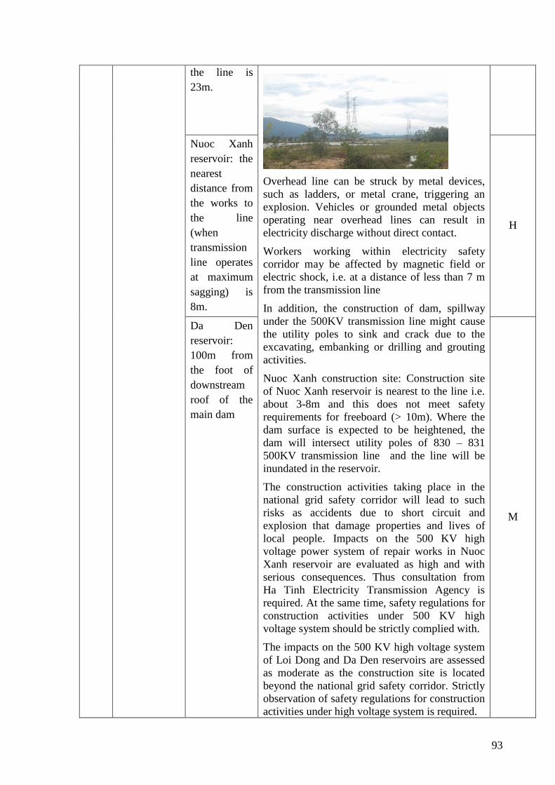
93
the line is
23m.
Overhead line can be struck by metal devices,
such as ladders, or metal crane, triggering an
explosion. Vehicles or grounded metal objects
operating near overhead lines can result in
electricity discharge without direct contact.
Workers working within electricity safety
corridor may be affected by magnetic field or
electric shock, i.e. at a distance of less than 7 m
from the transmission line
In addition, the construction of dam, spillway
under the 500KV transmission line might cause
the utility poles to sink and crack due to the
excavating, embanking or drilling and grouting
activities.
Nuoc Xanh construction site: Construction site
of Nuoc Xanh reservoir is nearest to the line i.e.
about 3-8m and this does not meet safety
requirements for freeboard (> 10m). Where the
dam surface is expected to be heightened, the
dam will intersect utility poles of 830 – 831
500KV transmission line and the line will be
inundated in the reservoir.
The construction activities taking place in the
national grid safety corridor will lead to such
risks as accidents due to short circuit and
explosion that damage properties and lives of
local people. Impacts on the 500 KV high
voltage power system of repair works in Nuoc
Xanh reservoir are evaluated as high and with
serious consequences. Thus consultation from
Ha Tinh Electricity Transmission Agency is
required. At the same time, safety regulations for
construction activities under 500 KV high
voltage system should be strictly complied with.
The impacts on the 500 KV high voltage system
of Loi Dong and Da Den reservoirs are assessed
as moderate as the construction site is located
beyond the national grid safety corridor. Strictly
observation of safety regulations for construction
activities under high voltage system is required.
Nuoc Xanh
reservoir: the
nearest
distance from
the works to
the line
(when
transmission
line operates
at maximum
sagging) is
8m.
H
Da Den
reservoir:
100m from
the foot of
downstream
roof of the
main dam
M
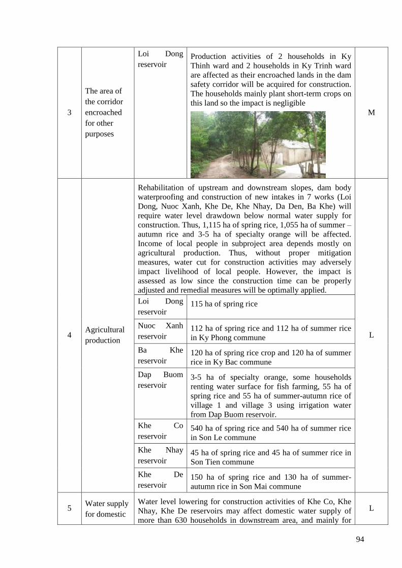
94
3
The area of
the corridor
encroached
for other
purposes
Loi Dong
reservoir Production activities of 2 households in Ky
Thinh ward and 2 households in Ky Trinh ward
are affected as their encroached lands in the dam
safety corridor will be acquired for construction.
The households mainly plant short-term crops on
this land so the impact is negligible
M
4 Agricultural
production
Rehabilitation of upstream and downstream slopes, dam body
waterproofing and construction of new intakes in 7 works (Loi
Dong, Nuoc Xanh, Khe De, Khe Nhay, Da Den, Ba Khe) will
require water level drawdown below normal water supply for
construction. Thus, 1,115 ha of spring rice, 1,055 ha of summer –
autumn rice and 3-5 ha of specialty orange will be affected.
Income of local people in subproject area depends mostly on
agricultural production. Thus, without proper mitigation
measures, water cut for construction activities may adversely
impact livelihood of local people. However, the impact is
assessed as low since the construction time can be properly
adjusted and remedial measures will be optimally applied.
L
Loi Dong
reservoir 115 ha of spring rice
Nuoc Xanh
reservoir 112 ha of spring rice and 112 ha of summer rice
in Ky Phong commune
Ba Khe
reservoir 120 ha of spring rice crop and 120 ha of summer
rice in Ky Bac commune
Dap Buom
reservoir 3-5 ha of specialty orange, some households
renting water surface for fish farming, 55 ha of
spring rice and 55 ha of summer-autumn rice of
village 1 and village 3 using irrigation water
from Dap Buom reservoir.
Khe Co
reservoir 540 ha of spring rice and 540 ha of summer rice
in Son Le commune
Khe Nhay
reservoir 45 ha of spring rice and 45 ha of summer rice in
Son Tien commune
Khe De
reservoir 150 ha of spring rice and 130 ha of summer-
autumn rice in Son Mai commune
5 Water supply
for domestic
Water level lowering for construction activities of Khe Co, Khe
Nhay, Khe De reservoirs may affect domestic water supply of
more than 630 households in downstream area, and mainly for
L
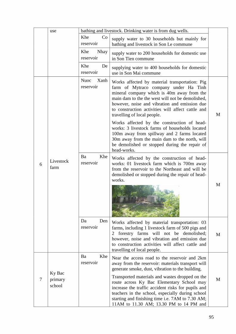
95
use bathing and livestock. Drinking water is from dug wells.
Khe Co
reservoir supply water to 30 households but mainly for
bathing and livestock in Son Le commune
Khe Nhay
reservoir supply water to 200 households for domestic use
in Son Tien commune
Khe De
reservoir supplying water to 400 households for domestic
use in Son Mai commune
6 Livestock
farm
Nuoc Xanh
reservoir Works affected by material transportation: Pig
farm of Mytraco company under Ha Tinh
mineral company which is 40m away from the
main dam to the the west will not be demolished,
however, noise and vibration and emission due
to construction activities will affect cattle and
travelling of local people.
Works affected by the construction of head-
works: 3 livestock farms of households located
100m away from spillway and 2 farms located
30m away from the main dam to the north, will
be demolished or stopped during the repair of
head-works.
M
Ba Khe
reservoir Works affected by the construction of head-
works: 01 livestock farm which is 700m away
from the reservoir to the Northeast and will be
demolished or stopped during the repair of head-
works.
M
Da Den
reservoir Works affected by material transportation: 03
farms, including 1 livestock farm of 500 pigs and
2 forestry farms will not be demolished;
however, noise and vibration and emission due
to construction activities will affect cattle and
travelling of local people.
M
7
Ky Bac
primary
school
Ba Khe
reservoir Near the access road to the reservoir and 2km
away from the reservoir: materials transport will
generate smoke, dust, vibration to the building.
Transported materials and wastes dropped on the
route across Ky Bac Elementary School may
increase the traffic accident risks for pupils and
teachers in the school, especially during school
starting and finishing time i.e. 7AM to 7.30 AM;
11AM to 11.30 AM; 13.30 PM to 14 PM and
M
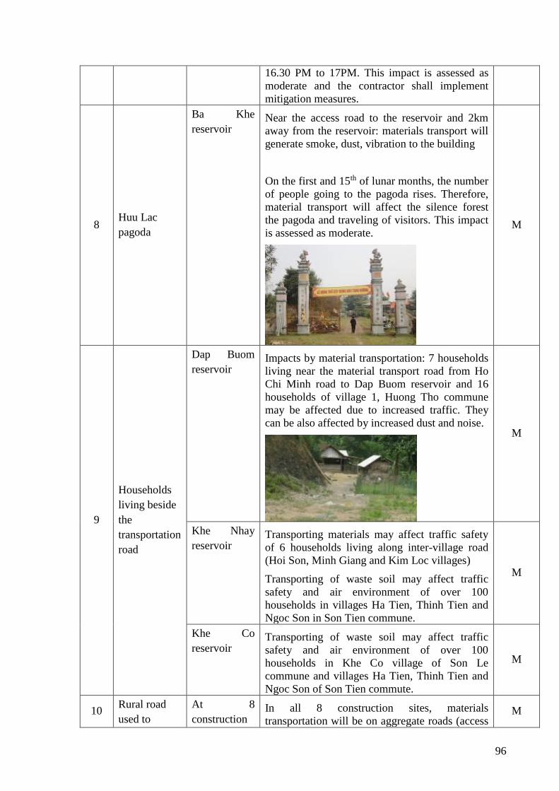
96
16.30 PM to 17PM. This impact is assessed as
moderate and the contractor shall implement
mitigation measures.
8 Huu Lac
pagoda
Ba Khe
reservoir Near the access road to the reservoir and 2km
away from the reservoir: materials transport will
generate smoke, dust, vibration to the building
On the first and 15th of lunar months, the number
of people going to the pagoda rises. Therefore,
material transport will affect the silence forest
the pagoda and traveling of visitors. This impact
is assessed as moderate.
M
9
Households
living beside
the
transportation
road
Dap Buom
reservoir Impacts by material transportation: 7 households
living near the material transport road from Ho
Chi Minh road to Dap Buom reservoir and 16
households of village 1, Huong Tho commune
may be affected due to increased traffic. They
can be also affected by increased dust and noise.
M
Khe Nhay
reservoir Transporting materials may affect traffic safety
of 6 households living along inter-village road
(Hoi Son, Minh Giang and Kim Loc villages)
Transporting of waste soil may affect traffic
safety and air environment of over 100
households in villages Ha Tien, Thinh Tien and
Ngoc Son in Son Tien commune.
M
Khe Co
reservoir Transporting of waste soil may affect traffic
safety and air environment of over 100
households in Khe Co village of Son Le
commune and villages Ha Tien, Thinh Tien and
Ngoc Son of Son Tien commute.
M
10 Rural road
used to
At 8
construction In all 8 construction sites, materials
transportation will be on aggregate roads (access M
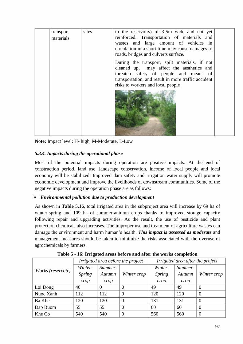
97
transport
materials
sites to the reservoirs) of 3-5m wide and not yet
reinforced. Transportation of materials and
wastes and large amount of vehicles in
circulation in a short time may cause damages to
roads, bridges and culverts surface.
During the transport, spilt materials, if not
cleaned up, may affect the aesthetics and
threaten safety of people and means of
transportation, and result in more traffic accident
risks to workers and local people
Note: Impact level: H- high, M-Moderate, L-Low
5.3.4. Impacts during the operational phase
Most of the potential impacts during operation are positive impacts. At the end of
construction period, land use, landscape conservation, income of local people and local
economy will be stabilized. Improved dam safety and irrigation water supply will promote
economic development and improve the livelihoods of downstream communities. Some of the
negative impacts during the operation phase are as follows:
➢ Environmental pollution due to production development
As shown in Table 5.16, total irrigated area in the subproject area will increase by 69 ha of
winter-spring and 109 ha of summer-autumn crops thanks to improved storage capacity
following repair and upgrading activities. As the result, the use of pesticide and plant
protection chemicals also increases. The improper use and treatment of agriculture wastes can
damage the environment and harm human’s health. This impact is assessed as moderate and
management measures should be taken to minimize the risks associated with the overuse of
agrochemicals by farmers.
Table 5 - 16: Irrigated areas before and after the works completion
Works (reservoir)
Irrigated area before the project Irrigated area after the project
Winter-
Spring
crop
Summer-
Autumn
crop
Winter crop
Winter-
Spring
crop
Summer-
Autumn
crop
Winter crop
Loi Dong 40 0 0 49 49 0
Nuoc Xanh 112 112 0 120 120 0
Ba Khe 120 120 0 131 131 0
Dap Buom 55 55 0 60 60 0
Khe Co 540 540 0 560 560 0
98
Khe Nhay 45 45 0 50 50 0
Khe De 150 130 0 160 140 0
Da Den 53 53 0 54 54 0
Total 1,115 1,055 0 1,184 1,164 0
➢ Emergency flood discharge and impacts due to risks and incidents:
Description
When the sub-project is finished, the construction will no longer generate wastewater,
exhausted emissions and solid waste. Risks generated by environmental pollution will almost
not exist. However, due to the specific characteristics of the irrigation projects and given the
unpredictable nature of weather conditions, such risks as dam failure, landslide, seepage, dam
body leakage still should be taken into account. Damages caused by these accidents mean
serious not only to production activities but also to lives of local people in the downstream
areas.
In case of heavy rain or flood and unusual increase of water level, the reservoirs management
agency will carry out emergency flood discharge to ensure reservoir safety. Emergency
flooding discharge may have such downstream impacts as inundation of infrastructure, crops
or crop losses and damages or negative impacts on livelihoods and travelling. It is surveyed
that the project localities have never experienced such emergency situation since the
construction of reservoirs. The impact is assessed as moderate.
Evaluating potential accidents and risks
Given advanced equipment, technology and qualified and well trained technical staff and
workers and effective design, above mentioned risks or incidents are not likely to happen.
The technical design stage should also take into account the drainage basin and flood marks
for unusually large flood and rains. The repairs and upgrading works should ensure adequate
capacity of new drainage facilities which should not be lower than the existing ones, taking
into account the context of unusually large flood/rains to avoid prolonged flooding events.
Dams upgraded in the project are small dams as classified under provision of the GoV and
WB. It is surveyed that, dam failure have never happened to this reservoir in the past. Once
they are upgraded, these dams will be more secured. Dam Safety Reports have to be prepared
for all reservoirs in the subprojects to ensure that all risks related to the dam and ancillary
works are reviewed before the investment approval from the Client.
The reservoirs with small capacity and low dams are mainly for raising water level for
irrigation purposes. They are not in charge of flood storage and its capacity is not engouh for
flood storage. Therefore, flooding risks to the downstream area will not be present due to
flood discharging. All drainage works are free overflowing and when water level is higher
than the overflow level, the water will overflow to the downstream. Since spillways are free
overflowing types, emergency flood discharge that affect property and lives of people in the
downstream areas will not happen. The flood drainage channels are natural rivers with steep
slopes and rapid flood drainage capacity. It is surveyed that local people have not been
affected by flood flow from these reservoirs in recent years.
According to the Dam safety and Dam Inspection Reports, dams are located on bedrock
99
which is slightly weathered, black-gray and blue-gray. These solid rocks are widely
distributed where head-works are located. Two dam shoulders have good geological
conditions. Soil and stone in the study area have weak permeability. Reserve of groundwater
is poor, almost exclusively found in fracture rock zones and gravel sediments on a limited
distribution area and thin thickness. Groundwater is mainly recharged from surface water and
annual rainfall. Lands where reservoirs are located are generally sloping and composed of
alternating types of sand shale siltstone, solid clay lime and thin vegetation of Forth Period.
The reservoir impoundment is small and erosion and landslide are not likely to happen. As a
result, the possibility of erosion, subsidence and landslide of these works are minimal.
According to the Dam safety inspection reports, following activities are required for all dams:
Upgrading solutions for head-works and ancillary works are properly implemented; close
monitoring of construction activities and quality management; management and safety
operation of dams; competent and qualified agency will be assigned with the management and
safety operation of reservoirs who will prepare and carry out annual O&M plans, report on
regular basis and monitor and record all operations of the work; monitoring system is fully
installed; emergency response plan is prepared for each reservoir. By so doing, dam failure
risks of these reservoirs will be minimal and can be predicted and mitigated.
In summary, risks due to objective reasons are difficult to avoid. The management and
operation process should follow O&M safety guidelines and regulation or unexpected and
undesired incidents may occur. However, regarding the position, nature and scale of the
works intervened in the sub-project, the possibility of such incidents is not high. The impacts
thus are evaluated as low.
5.4. Analysis of impact types
5.4.1. Cumulative impacts
Although there are many dams in the sub-project areas, they are scattered and independently
located. Moreover, as scale and nature of subproject activities are small and simple, the
implementation of subproject activities is not likely to cause cumulative effects. According to
surveys and consultations with relevant agencies, there is no other large scale project of
similar nature taking place at the same time and in the same location where Ha Tinh
subprojects WB8 are located. Thus cumulative effects created together with other projects are
none.
5.4.2. Direct impacts
The implementation of the subproject will generate direct impacts on the environmental and
social conditions of the subproject area. Subproject activities will result in temporary or
permanent loss of production lands. Construction activities will cause direct impacts on the
quality of the surrounding environment such as air, land and water due to the generation of
wastes and exhausted emissions and the removal of vegetation.
5.4.3. Indirect impacts
Temporary or permanent loss of land will result in impacts on livelihoods of affected people
i.e. reduced or lost income, shifting occupations or possible social conflicts. Indirect impacts
100
are also identified as deteriorated water quality due to soil erosion caused by vegetation
clearance during the construction process. Water pollution due to waste generated from the
construction activities can result in a decline in composition and number of individuals of
aquatic species. Or compacted soil due to the use of heavy equipment on farmland can lead to
a reduction of the number of useful soil microorganisms as soil structures change. Loss of
vegetation will also lead to the loss of habitat of many animal species in the subproject area
and to the increased erosion, landslide and flooding risks. Restoration of the design irrigated
area may lead to an increase of pesticides amount applied to fields and negative affects on the
environment and public health can be observed.
5.4.4. Temporary impacts
In general, most of the impacts associated with construction activities within the subproject
are short-term such as noise, vibration, dust, exhausted emission, solid waste and wastewater.
These impacts will no longer exist when construction activities are completed.
5.4.5. Long-term impacts
Permanent loss of production land will have a lasting impact on the affected people as some
households will lose part of their production inputs and they are forced to change their
occupations. Such environmental incidents as oil spills or hazardous chemicals will also have
long-term effects on the environment and human health as these chemicals have a long semi-
decomposition time. They can penetrate into soil, water and enter the food chain. Risks
relating to occupational accidents will also cause long-term effects once workers' health is
reduced or lost.
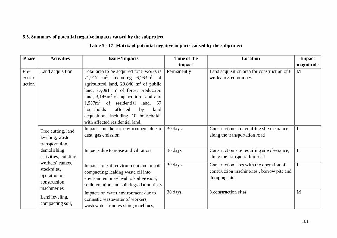
101
5.5. Summary of potential negative impacts caused by the subproject
Table 5 - 17: Matrix of potential negative impacts caused by the subproject
Phase Activities Issues/Impacts Time of the
impact
Location Impact
magnitude
Pre-
constr
uction
Land acquisition Total area to be acquired for 8 works is
71,917 m2, including 6,263m2 of
agricultural land, 23,840 m2 of public
land, 37,081 m2 of forest production
land, 3,146m2 of aquaculture land and
1,587m2 of residential land. 67
households affected by land
acquisition, including 10 households
with affected residential land.
Permanently Land acquisition area for construction of 8
works in 8 communes
M
Tree cutting, land
leveling, waste
transportation,
demolishing
activities, building
workers’ camps,
stockpiles,
operation of
construction
machineries
Land leveling,
compacting soil,
Impacts on the air environment due to
dust, gas emission
30 days Construction site requiring site clearance,
along the transportation road
L
Impacts due to noise and vibration
30 days Construction site requiring site clearance,
along the transportation road
L
Impacts on soil environment due to soil
compacting; leaking waste oil into
environment may lead to soil erosion,
sedimentation and soil degradation risks
30 days Construction sites with the operation of
construction machineries , borrow pits and
dumping sites
L
Impacts on water environment due to
domestic wastewater of workers,
wastewater from washing machines,
30 days 8 construction sites M

102
Phase Activities Issues/Impacts Time of the
impact
Location Impact
magnitude
operation of
construction
machineries
rainwater runoff
Impacts due to risks, incidents 30 days 8 construction sites L
Impacts on biological environment 30 days L
Constr
uction
phase
Soil digging and
backfilling;
Operation of heavy
equipment such as
bulldozers, shovels,
compactors, trucks,
etc.;
Material loading
and uploading;
Waste and material
transportation;
Washing machine
such as truck cabins,
concrete mixers,
etc.;
Activities of
workers on
construction sites
and in workers’
camps; waste
Impact on air environment due to earth
works, materials transport (soil, stone,
cement, steel, etc.), waste soil transport
11 months during
construction phase
8 construction sites, stockpiles, dumping
sites, along the transporting roads
M
Impacts on the environment caused by
noise, vibration
11 months during
construction phase
8 construction sites, stockpiles, dumping
sites; Ky Bac primary school, Huu Lac
pagoda and households living along the
transporting roads
M
Impacts on water environment due to
wastes water from workers
11 months during
construction phase
8 construction sites, workers’ camps,
reservoirs and canals in downstream
M
Impacts on the water environment due
to runoff
11 months during
construction phase
8 construction sites, reservoirs and canals
in downstream
L
Impact on water environment due to
construction wastewater
11 months during
construction phase
8 construction sites, workers’ camps,
stockpiles, reservoirs and canals in
downstream
L
Impacts on the water environment of the
reservoirs and canals due to solid waste
from construction activities
11 months during
construction phase
8 construction sites, workers’ camps,
stockpiles
L
Impact on soil environment due to
domestic wastes
11 months during
construction phase
8 construction sites, workers’ camps,
stockpiles
L
Impacts on soil environment due to
waste disposal and soil excavating and
11 months during
construction phase
8 construction sites, workers’ camps,
stockpiles, dumping site, borrow pits, area
L
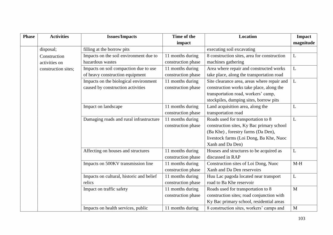
103
Phase Activities Issues/Impacts Time of the
impact
Location Impact
magnitude
disposal;
Construction
activities on
construction sites;
filling at the borrow pits executing soil excavating
Impacts on the soil environment due to
hazardous wastes
11 months during
construction phase
8 construction sites, area for construction
machines gathering
L
Impacts on soil compaction due to use
of heavy construction equipment
11 months during
construction phase
Area where repair and constructed works
take place, along the transportation road
L
Impacts on the biological environment
caused by construction activities
11 months during
construction phase
Site clearance area, areas where repair and
construction works take place, along the
transportation road, workers’ camp,
stockpiles, dumping sites, borrow pits
L
Impact on landscape 11 months during
construction phase
Land acquisition area, along the
transportation road
L
Damaging roads and rural infrastructure 11 months during
construction phase
Roads used for transportation to 8
construction sites, Ky Bac primary school
(Ba Khe) , forestry farms (Da Den),
livestock farms (Loi Dong, Ba Khe, Nuoc
Xanh and Da Den)
L
Affecting on houses and structures 11 months during
construction phase
Houses and structures to be acquired as
discussed in RAP
L
Impacts on 500KV transmission line 11 months during
construction phase
Construction sites of Loi Dong, Nuoc
Xanh and Da Den reservoirs
M-H
Impacts on cultural, historic and belief
relics
11 months during
construction phase
Huu Lac pagoda located near transport
road to Ba Khe reservoir
L
Impact on traffic safety 11 months during
construction phase
Roads used for transportation to 8
construction sites; road conjunction with
Ky Bac primary school, residential areas
M
Impacts on health services, public 11 months during 8 construction sites, workers’ camps and M
104
Phase Activities Issues/Impacts Time of the
impact
Location Impact
magnitude
health and construction workers construction phase subproject communes
Impacts due to influx of workers in the
subproject area
11 months during
construction phase
8 construction sites, workers’ camps and
subproject communes
L
Impacts on utility services 11 months during
construction phase
8 construction sites, workers’ camps and
subproject communes
L
Impact on production and domestic
water supply
11 months during
construction phase
8 subproject communes L
Impacts on aquaculture, tourism,
navigation
11 months during
construction phase
8 subproject communes L
Negative impact of demolition activities
of auxiliary works after construction
11 months during
construction phase
8 construction sites where prepared
auxiliary works such as workers’ camps,
stockpile, etc.
M
Impacts due to risks, incidents:
Accident, fire explosion, landslide,
natural disasters, electrical incidents,
impacts of rainfall and flood
11 months during
construction phase
8 construction sites M
Operat
ion
phase
Restore the
irrigation area as
originally designed
Environmental pollution due to
production development
Long – term 8 subproject communes M
Emergency flood
discharge
Emergency flood discharge and impacts
due to risks, incidents
Flood season, Long
– term
8 subproject communes M
105
CHAPTER VI. ANALYSIS OF ALTERNATIVES
6.1. Without the Sub-project
The reservoirs under Sub-project 1 were built during from the 60s - 70s of the 20th century. So
far, they have been operating for about 30-50 years and significantly contributed to effective
production, safety for people and infrastructure in the sub-project area. However, as they have
been built for so long time ago by farmers themselves and that they are earthen dams, they
cannot meet dam safety standards. Head-works have been degraded and damaged, affecting
safety of reservoirs and water supply capacity to downstream areas. If the Sub-project cannot
be implemented, dam failure risks will happen and 1,129 ha of cultivated land, 2,488
households, 4 utility poles of 500 KV, National Highway 1A, Ho Chi Minh Road passing sub-
project communes and other infrastructure will be affected. Detailed impacts caused by dam
failure (without the project) for each reservoir are summarized in Table 6.1
Table 6 - 1: Impacts in case of dam incidents (without the project)
No. Reservoir Location Year of
construction
Impacted objects in case of dam incidents
(without the subproject)
1 Loi Dong
Reservoir
Ky Trinh
Ward, Ky
Anh
District
1970
Affecting lives and property of 28 households
in Ky Trinh Ward, 46 ha of cultivated land, 4
utility poles of 500KV, entrance to
thermoelectric plant and Tay Yen Bara.
2
Nuoc
Xanh
Reservoir
Ky Phong
Commune,
Ky Anh
District
1967
Affecting 120 ha of cultivated land in Ky
Phong Commune, lives and property of 35
households with more than 130 people,
National Highway 1A, Irrigation Canal of
Song Rac irrigation system and an 18 ha of a
ranch of Ha Tinh Mitraco Company.
3 Ba Khe
Reservoir
Ky Bac
commune,
Ky Anh
District
1970
Affecting 110 ha of cultivated land of Ky Bac
commune, lives and property of 125
households with more than 500 people, inter-
communal roads and other infrastructure.
4 Dap Buom
Reservoir
Huong Tho
Commune,
Vu Quang
District
1978
Affecting lives and property of 25 households
in Huong Tho commune, 48 ha of cultivated
land, Ho Chi Minh highway and other
infrastructure
5 Khe Co
Reservoir
Son Le
commune,
Huong Son
District
1987
Affecting 560 ha of cultivated land of Son Le
and Son Tien Communes, lives and property
of 1,125 households with more than 4,500
people, Ho Chi Minh Road and other
infrastructure of Son La and Son Tien
Communes.
6 Khe Nhay
Reservoir
Son Tien
commune, 1966
Affecting 50 ha of cultivated land of Son
Tien commune, lives and property of 50
106
Huong Son
district
households, inter-communal roads and other
infrastructure.
7 Khe De
Reservoir
Son Mai
commune,
Huong Son
1977
Affecting 140 ha of cultivated land in Son
Mai, Son Thuy and Son Phuc communes,
lives and property of 600 households with
more than 1,600 people, inter-commune
roads and other infrastructure.
8 Da Den
Reservoir
Ngoc Son
commune,
Thach Ha
district
1978
Affecting 55 ha of cultivated land of Ngoc
Son Commune, lives and property of 500
households with more than 2,000 people,
provincial road 21, provincial road 3 and
other infrastructure.
6.2. With the Sub-project
The implementation of the subproject will improve dam safety, limit risks due to dam failure,
and stabilize production activities and livelihoods of local farmers in the area. However, the
sub-project preparation phase and the construction/repairs of sub-project items will produce
negative impacts on the environment. Impacts can be limited or reversed if the subproject
owner selects appropriate intervention options and implements mitigation measures. A
number of measures have been selected for minimal environmental impacts:
6.2.1. Alternations during the construction of works under the full water supply
Repairs of the dam mainly relate to the expansion of dam surface, heightening of dam crest,
downstream slope reinforcing, repairing or building spillway which are all carried out above
the normal water level (NWL) and will not affect water supply to the downstream. On the
other hand, rehabilitation activities of the upstream and downstream slopes, waterproofing
and construction of new intakes in 7 works (Loi Dong, Nuoc Xanh, Da Buom, Khe De, Khe
Nhay, Da Den, Ba Khe) will need the drawndown of water level in reservoirs to below the
normal water level for construction.
The lowering of the water level for construction may affect the production of 1,115 ha of
spring rice and 1,055 ha of summer-autumn rice and domestic water supply for more than 600
households for washing and livestock. Local people use drinking water from dug wells. As
income of local people in subproject area depends mostly on agricultural production, wihout
any remedial measure, impacts of lowered water level in reservoirs for construction may
cause serious consequence, especially to income and daily lives of local people. In stead of
cutting water and compensating for production losses due to water cut, the subproject owner
has selected following alternatives so as not to affect production activities and to save costs:
a) Arranging suitable construction time so as not to affect downstream production activities
According to the survey results, there is no winter crop in the sub-project area due to the lack
of water resources. The subproject owner planned the construction of dam heel and water
intakes which are works under normal water level during July - August. This is the dry
season and at the end of the summer-autumn crop season when irrigation demand is quite low.
At the same time, the Sub- project Client planned alternative water sources for the region.
107
Thus impact on water supply for downstream areas due to construction activities will not be
likely to happen.
b) Flow diversion measure and cofferdam solutions during the construction of intake will
ensure no impact on downstream production activities
During construction and repair of earthen dam and building new water intakes, flow diversion is
applied to ensure water demands of the downstream users. Flow diversion for construction is carried
out using existing water intakes. Once the pre-casting and construction of new intakes is
finished, the existng intakes will be removed, creating a diversion canal at the location of the
old intake to continue diverting water to downstream area. As soon as the new intakes ensure
water drainage, flow will diverted through the new inake and cofferdam of the drainage canal
gate will be built to block the dam section of the diversion canal (where the old intake exists)
and the dam section on the new intake in accordance with design cross section.
Among 8 works under the subproject 01, construction of new water intakes will be carried out
for 7 works (Loi Dong, Nuoc Xanh, Ba Khe, Dap Buom, Khe Nhay, Khe De, Da Den). All of
8 works will repair dam heel on upstream slope and water drainage system in downstream
slope. Embankment of cofferdam for construction will be applied in all of 8 works and old
intakes can be used for downstream irrigation during this time. Once the new intakes are put
into use, the old ones will be demolished and production activities will not be affected.
c) Using other water sources to supply to downstream users during the water cut for
construction activities
During the construction of 7 new intakes (except for Khe Co reservoir), the subproject owner
will use other water sources to supply downstream uses. Water from Bau Son and Hoi Lay
reservoirs will be use to supply Loi Dong reservoir; water from Song Rac canal will be used
instead of Ba Khe and Nuoc Xanh reservoirs; water from Cau Trang reservoir will be used
instead of Da Den reservoir; water from Nuc Trong reservoir or after Linh Cam pump station
will be used instead of Khe De reservoir; water from Vu Quang dam will replace water from
Dap Buom reservoir; replacement water source for Khe Nhay reservoir is not available so
cofferdam and existing intake will be used to supply water to the downstream.
6.2.2. Alternative measures for selected auxiliary works (borrow pits, dumpsites)
a) Selection of borrow pit
The construction of the earthen dams involves the use of filling soil materials from different
borrow pits. Exploitation of soil will affect production areas and involve the compensation for
land acquisition and recovery, impacts on environment and necessary licenses for exploitation
as required by Vietnam laws. In order to limit mentioned above impacts, the subproject owner
selected following alternatives:
- Loi Dong, Ba Khe and Dap Buom reservoirs: soil will be purchased from licensed
borrow pits beyond the sub-project area. These are borrow pits at the shortest distance to the
dam to avoid compensation costs and do not lead to loss of production lands.
- Nuoc Xanh, Khe Co, Khe Nhay, Khe De and Da Den Reservoir: soil will be
exploited from hills or high grounds within the dam protection corridors or inside the
reservoirs. This option has such advantage of saving transportation costs (average distance

108
from the pits to dams ranging from 140m to 500m), saving compensation cost for lost land
and crops. This option can increase the risk of erosion and sedimentation in the Reservoirs.
However, as the construction will take place during the dry season and these impacts will be
limited.
b) Selection of dumpsites
The rehabilitation and upgrading of earthen dams, intakes, and flood spillway will generate an
amount of non-reusable organic soil which cannot be recycled for the construction of above
items. Therefore, they should be transported to suitable locations for disposal. This will affect
production areas and crops of farmers near the dumping area, landscape and environment
which will result in increased compensation costs for affected land and crops. In order to
minimize the above impacts, following alternatives have been selected:
- Nuoc Xanh, Ba Khe, Khe Co, Khe Nhay, Khe De and Da Den Reservoirs: the
subproject owner coordinated with local authorities to select the dumpsite location which are
vacant and weedy areas or depressed lands at the foot of mountains, along roads, suitable for
waste dumping, far away from water bodies and residential areas (0.5÷1.5 km) and 0.3 - 0.3
km from the construction site and no compensation is needed for land and crops.
- There are 2 available dumpsites: Loi Dong Reservoir will have its dumpsite as Con
Moc dumpsite, Dap Buom Reservoir as Khe Gieng dumpsite in Huong Tho commune. All
these dumpsites are public lands under the management of local governments and no
compensation is needed for land and crops.
6.2.3. Alternation of roads for construction material and waste transport
The transport of wastes and materials will affect people living on both sides of roads and
increase traffic as well as damage roads. In order to minimize these impacts, the Consultant
surveyed and selected the shortest and least traffic routes to save money and limit impacts as
follows:
- Loi Dong, Ba Khe, Dap Buom, Da Den Reservoirs: make the most of material
transportation along National Highway 1A, Ho Chi Minh road, provincial road 21, and
provincial road 3 to minimize transporting accross residential areas.
- For the remaining works, materials to be transported accross inter-village or inter-
commune roads will be in 7 ton - trucks or less load trucks to limit damages to roads. The
transport activities should take place during low peak time to limit impacts on the travelling
of local people.
Table 6 - 2: Options for borrow pits, dumpsites and material and waste transport routes
No. Reservoir Location
Type of
material
and
waste
soil
Location of borrow pits
and dumpsites Preferred transport routes
1
Loi Dong
Reservoir
Ky Trinh
Ward, Ky
Anh
Backfill
soil
Borrow pit of Việt Gia-
Song Hui Jsc. Ky Trinh
Ward – licensed until
National Highway IA 1.6
km, asphalt road 6.0 m wide
and 2.8 km long, asphalt
109
District
2030 road 4.0 to 5.0 m wide and
2.3 km long, concrete road
of 4.0 m wide and 0.4 km
long, the remaining is the
aggregate road of 3.0 to 5.0
m wide
Waste
soil
Con Moc, Ky Trinh
Ward managed by Ky
Trinh Ward
Inter-commune asphalt road
across Ky Trinh Ward
0,91km
2
Nuoc
Xanh
Reservoir
Ky Phong
Commune,
Ky Anh
District
Backfill
soil
Backfill soil from
borrow pit of 666
Commerce and Service
Co., in Ky Phong
Commune, Ky Anh
district
Concrete and aggregate road
width 3.5-5m and length
2km
Waste
soil
Dumpsite near Mr. Vo
Van Tai household,
Lang Con village, Ky
Phong commune, Ky
Anh District
Inter-village concrete road of
Ky Phong commune of 3 km
long
3 Ba Khe
Reservoir
Ky Bac
commune,
Ky Anh
District
Backfill
soil
Ngoc Thao Borrow pit,
Cam Trung commune,
Cam Xuyen district;
managed by Ngoc Thao
Construction material
Co.Ltd.
National Highway IA of
3.2km, asphalt road 4.0 to
5.0 m wide and 2.0 km long,
the remaining is the
aggregate road of 3.0 to 5.0
m wide
Waste
soil
Depressed lands of
Gieng Cho, Hop Tien
village, Ky Bac
commune which is
vacant land with weeds
Inter-village concrete road of
Ky Bac commune of 2.6 km
long
4
Dap
Buom
Reservoir
Huong
Tho
commune,
Vu Quang
district
Backfill
soil
Purchase from borrow
pit of Minh Huong
Company, Duc An
commune, Duc Tho
district
Transport distance: 32km,
crossing Ho Chi Minh road,
asphalt road of 4.0 -5.0 m
wide and aggregate road 3.0
- 5.0 m.
Waste
soil
Vacant and depressed
land in Huong Tho
commune managed by
Huong Tho CPC
Inter- commune road of
Huong Tho commune of 0.9
km long
5 Khe Co
Reservoir
Son Le
Commune,
Huong
Son
Backfill
soil
03 borrow pits wihint the
project site
Construction and
management road to dam
sites 0.2-0.3 km
Waste Vacant site A1 in Son Le Inter- commune concrete
110
District soil and managed by Son Le
CPC
road in Son Le commune of
6.5km long
6
Khe
Nhay
Reservoir
Son Tien,
Huong
Son
District
Backfill
soil
Borrow pit in the
reservoir impoundmemts
Reservoir construction and
management Road of 1.5
km long
Waste
soil
Vacant site A1 in Son Le
and managed by Son Le
CPC
Inter- commune concrete
road in Son Tien commune
of 5.5km
7 Khe De
Reservoir
Son Mai,
Huong
Son
District
Backfill
soil
Borrow pit in the
reservoir impoundmemts
Reservoir construction and
management Road of 0.1
km long
Waste
soil
Vacant site, managed by
Son Mai CPC
Inter- commune concrete
road in Son Mai commune of
2.0 km long
8 Da Den
Reservoir
Ngoc
Son. H.
Thach Ha
Backfill
soil
Purchasing from Vinaco
company, in Ngoc Son
commune, Thach Ha
district
Inter-village aggregate road
of 2km
Waste
soil
Dumpsite in 19-5 field in
Ngoc Ha village, Ngoc
Son commune
Asphalt roads including
Provincial Highway 21 of
0.8 km, Provincial Road 3 of
3.1 km and on-farm road of
0.4km
111
CHAPTER VII. ENVIRONMENTAL AND SOCIAL MANAGEMENT
PLAN (ESMP)
The Environmental and Social Management Plan (ESMP) aims to deal with potential
environmental and social impacts by feasible mitigation measures which have been discussed
and agreed by the sub-project owner, identify requirements, including a reference to other
safeguard instruments, specify a monitoring plan or strategy, and determine responsibilities
for implementing mitigation and monitoring measures. The ESMMP will be considered as a
general reference for all stakeholders in the sub-project implementation.
7.1. Mitigation measures
7.1.1. Measures for pre-construction phase
➢ Measures to minimize the impacts of land acquisition
The main issue at this stage is compensation, assistance and resettlement for people affected
by the loss of land, house, income and assets. Compensation for site clearance will follow the
updated resettlement plan of the project. The estimated cost of implementing the Resettlement
Action Plan of the subproject is VND 2,275,354,800. This includes the
compensation/assistance cost for land, structure and assets affected by the project, income
restoration program, transitional support, monitoring and evaluation and redundancy costs.
Implementing compensation and assistance for affected households
- Project owners contract and coordinate with the Land Development Center, DoNRE,
District People's Committee, Division of Natural Resources and Environment at
district level, CPCs, organizations, concerned households and individual having land
and assets associated with land to be acquired to inform and guide the measurement,
identify land ownership, list the properties in an accurate and public manner, approve
compensation and support options in the most exactly way.
- Widely communicate on compensation, support and resettlement policy of the
subproject.
- Disseminate information on compliance to laws.
- Disclose compensation price details of each type of loss to affected households.
- Cary out timely payment of compensations to the right subjects as planned
- Coordinate with local authorities if any disputes occur to ensure that site clearance will
be carried out smoothly.
Compensation, support and other management costs for affected land/property (land, house,
works, structures and trees) in the subproject are shown in the table below. More details is
presented in the RAP report.
Table 7 - 1: Cost estimate of compensations for affected items
No. Works Total amount: exchange rate:
US$ 1 = VND 22,700
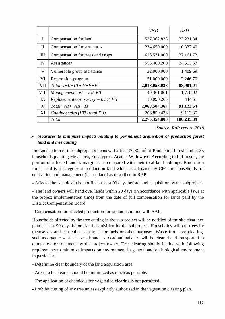
112
VND USD
I Compensation for land 527,362,838 23,231.84
II Compensation for structures 234,659,000 10,337.40
III Compensation for trees and crops 616,571,000 27,161.72
IV Assistances 556,460,200 24,513.67
V Vulnerable group assistance 32,000,000 1,409.69
VI Restoration program 51,000,000 2,246.70
VII Total: I+II+III+IV+V+VI 2,018,053,038 88,901.01
VIII Management cost = 2% VII 40,361,061 1,778.02
IX Replacement cost survey = 0.5% VII 10,090,265 444.51
X Total: VII+ VIII+ IX 2,068,504,364 91,123.54
XI Contingencies (10% total XII) 206,850,436 9,112.35
Total 2,275,354,800 100,235.89
Source: RAP report, 2018
➢ Measures to minimize impacts relating to permanent acquisition of production forest
land and tree cutting
Implementation of the subproject’s items will affect 37,081 m2 of Production forest land of 35
households planting Melaleuca, Eucalyptus, Acacia, Willow etc. According to IOL result, the
portion of affected land is marginal, as compared with their total land holdings. Production
forest land is a category of production land which is allocated by CPCs to households for
cultivation and management (leased land) as described in RAP:
- Affected households to be notified at least 90 days before land acquisition by the subproject.
- The land owners will hand over lands within 20 days (in accordance with applicable laws at
the project implementation time) from the date of full compensation for lands paid by the
District Compensation Board.
- Compensation for affected production forest land is in line with RAP.
Households affected by the tree cutting in the sub-project will be notified of the site clearance
plan at least 90 days before land acquisition by the subproject. Households will cut trees by
themselves and can collect cut trees for fuels or other purposes. Waste from tree clearing,
such as organic waste, leaves, branches, dead animals etc. will be cleared and transported to
dumpsites for treatment by the project owner. Tree clearing should in line with following
requirements to minimize impacts on environment in general and on biological environment
in particular:
- Determine clear boundary of the land acquisition area.
- Areas to be cleared should be minimized as much as possible.
- The application of chemicals for vegetation clearing is not permitted.
- Prohibit cutting of any tree unless explicitly authorized in the vegetation clearing plan.
113
- The Contractor shall ensure that no hunting, trapping shooting, poisoning of fauna will take
place in the sub-project area.
7.1.2. Mitigation measures during construction phase
7.1.2.1. Mitigation measures for generic construction-related impacts
Mitigation measures have been developed based on WBG EHS Guidelines and National
Regulations and Standards to address the generic construction-related impacts, and presented
in the form of Environmental Codes of Practice (ECOP). The ECOP describes typical
requirements to be undertaken by Contractors and supervised by the Construction Supervision
Consultant (CSC) during construction. The ECOP will be a reference for preparation of the
Environmental, Social, Health and Safety (ESHS) requirements under Section VII – Works’
Requirements of SPDs. The ECOP addresses the followings which would connect with ESHS
issues.
- Dust and exhaust emission
- Noise and vibration impacts
- Management of wastes
- Management of hazardous materials
- Workers’ camp management
- Disruption of vegetative cover and ecological resources
- Control of erosion and sedimentation
- Management of stockpiles and borrow pits
- Traffic safety management
- Chance Find Procedures or Discoveries
- Occupational Health and Safety
- Community Health and Safety
- Communication with local communities
- Natural disaster, heavy rain and flood management
- Labour influx management
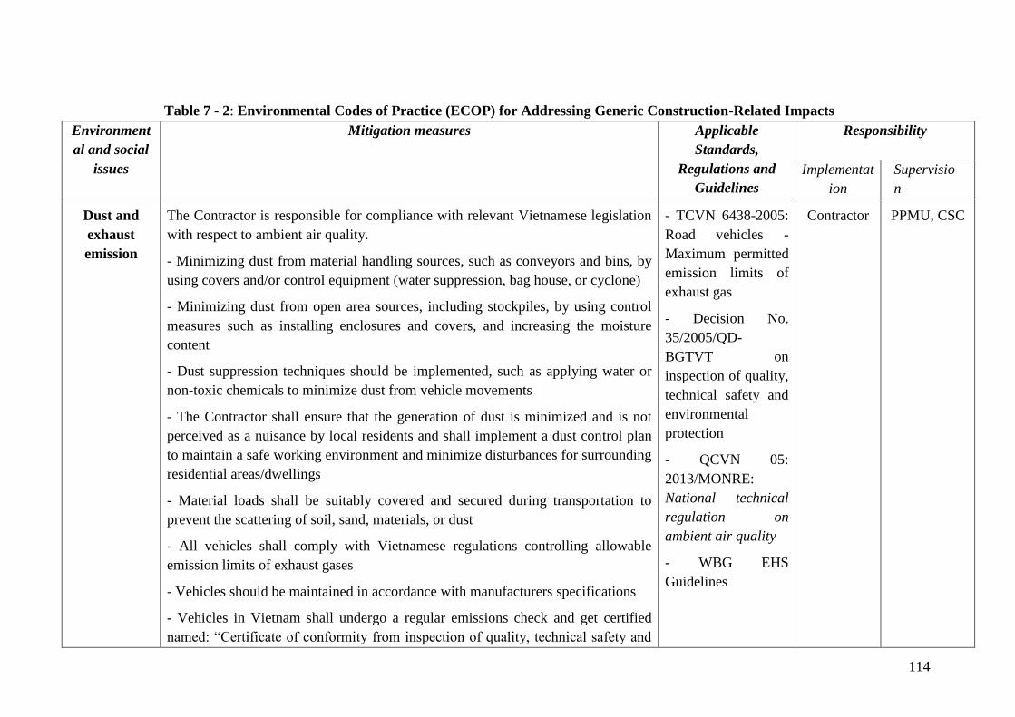
114
Table 7 - 2: Environmental Codes of Practice (ECOP) for Addressing Generic Construction-Related Impacts
Environment
al and social
issues
Mitigation measures
Applicable
Standards,
Regulations and
Guidelines
Responsibility
Implementat
ion
Supervisio
n
Dust and
exhaust
emission
The Contractor is responsible for compliance with relevant Vietnamese legislation
with respect to ambient air quality.
- Minimizing dust from material handling sources, such as conveyors and bins, by
using covers and/or control equipment (water suppression, bag house, or cyclone)
- Minimizing dust from open area sources, including stockpiles, by using control
measures such as installing enclosures and covers, and increasing the moisture
content
- Dust suppression techniques should be implemented, such as applying water or
non-toxic chemicals to minimize dust from vehicle movements
- The Contractor shall ensure that the generation of dust is minimized and is not
perceived as a nuisance by local residents and shall implement a dust control plan
to maintain a safe working environment and minimize disturbances for surrounding
residential areas/dwellings
- Material loads shall be suitably covered and secured during transportation to
prevent the scattering of soil, sand, materials, or dust
- All vehicles shall comply with Vietnamese regulations controlling allowable
emission limits of exhaust gases
- Vehicles should be maintained in accordance with manufacturers specifications
- Vehicles in Vietnam shall undergo a regular emissions check and get certified
named: “Certificate of conformity from inspection of quality, technical safety and
- TCVN 6438-2005:
Road vehicles -
Maximum permitted
emission limits of
exhaust gas
- Decision No.
35/2005/QD-
BGTVT on
inspection of quality,
technical safety and
environmental
protection
- QCVN 05:
2013/MONRE:
National technical
regulation on
ambient air quality
- WBG EHS
Guidelines
Contractor
PPMU, CSC
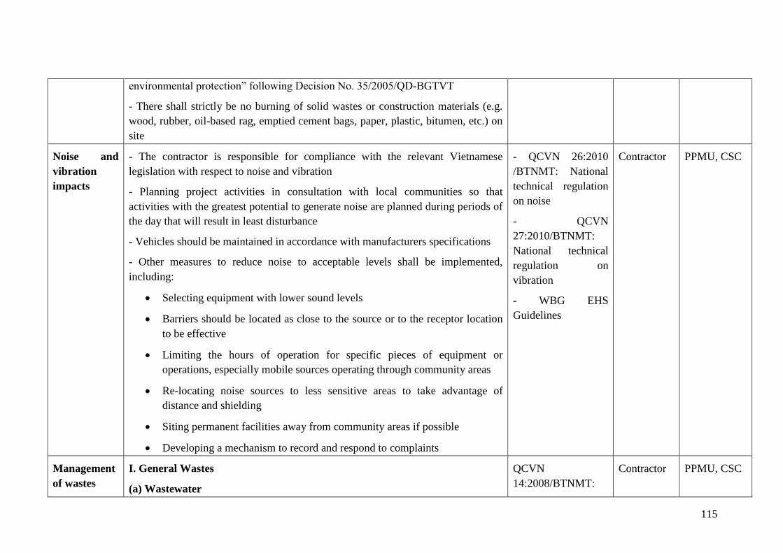
115
environmental protection” following Decision No. 35/2005/QD-BGTVT
- There shall strictly be no burning of solid wastes or construction materials (e.g.
wood, rubber, oil-based rag, emptied cement bags, paper, plastic, bitumen, etc.) on
site
Noise and
vibration
impacts
- The contractor is responsible for compliance with the relevant Vietnamese
legislation with respect to noise and vibration
- Planning project activities in consultation with local communities so that
activities with the greatest potential to generate noise are planned during periods of
the day that will result in least disturbance
- Vehicles should be maintained in accordance with manufacturers specifications
- Other measures to reduce noise to acceptable levels shall be implemented,
including:
• Selecting equipment with lower sound levels
• Barriers should be located as close to the source or to the receptor location
to be effective
• Limiting the hours of operation for specific pieces of equipment or
operations, especially mobile sources operating through community areas
• Re-locating noise sources to less sensitive areas to take advantage of
distance and shielding
• Siting permanent facilities away from community areas if possible
• Developing a mechanism to record and respond to complaints
- QCVN 26:2010
/BTNMT: National
technical regulation
on noise
- QCVN
27:2010/BTNMT:
National technical
regulation on
vibration
- WBG EHS
Guidelines
Contractor
PPMU, CSC
Management
of wastes
I. General Wastes
(a) Wastewater
QCVN
14:2008/BTNMT:
Contractor
PPMU, CSC
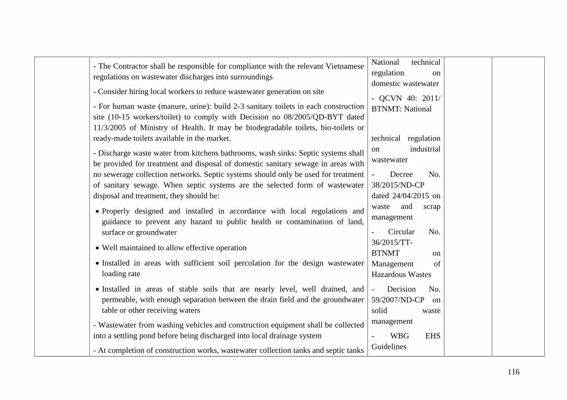
116
- The Contractor shall be responsible for compliance with the relevant Vietnamese
regulations on wastewater discharges into surroundings
- Consider hiring local workers to reduce wastewater generation on site
- For human waste (manure, urine): build 2-3 sanitary toilets in each construction
site (10-15 workers/toilet) to comply with Decision no 08/2005/QD-BYT dated
11/3/2005 of Ministry of Health. It may be biodegradable toilets, bio-toilets or
ready-made toilets available in the market.
- Discharge waste water from kitchens bathrooms, wash sinks: Septic systems shall
be provided for treatment and disposal of domestic sanitary sewage in areas with
no sewerage collection networks. Septic systems should only be used for treatment
of sanitary sewage. When septic systems are the selected form of wastewater
disposal and treatment, they should be:
• Properly designed and installed in accordance with local regulations and
guidance to prevent any hazard to public health or contamination of land,
surface or groundwater
• Well maintained to allow effective operation
• Installed in areas with sufficient soil percolation for the design wastewater
loading rate
• Installed in areas of stable soils that are nearly level, well drained, and
permeable, with enough separation between the drain field and the groundwater
table or other receiving waters
- Wastewater from washing vehicles and construction equipment shall be collected
into a settling pond before being discharged into local drainage system
- At completion of construction works, wastewater collection tanks and septic tanks
National technical
regulation on
domestic wastewater
- QCVN 40: 2011/
BTNMT: National
technical regulation
on industrial
wastewater
- Decree No.
38/2015/ND-CP
dated 24/04/2015 on
waste and scrap
management
- Circular No.
36/2015/TT-
BTNMT on
Management of
Hazardous Wastes
- Decision No.
59/2007/ND-CP on
solid waste
management
- WBG EHS
Guidelines
117
shall be safely disposed of or effectively sealed off
(b) Runoff water
- Dig drainage canals along both the dam shoulders, arranging manholes (50
m/manhole) to separate solid materials. The canals have trapezoidal cross section,
their bottom is 60 cm wide, their top is 100m wide and their height is 50 cm.
- Dig similar canals around material yards and dumping sites.
- Reduce construction activities during rainy season.
(c) Solid waste
- Before construction, a solid waste control procedure (storage, provision of bins,
site clean-up schedule, bin clean-out schedule, etc.) shall be prepared by
Contractors and it must be carefully followed during construction activities
- Before construction, all necessary waste disposal permits or licenses shall be
obtained.
- For reservoirs of Loi Dong, Nuoc Xanh, Ba Khe, Khe De, Dap Buom, there is
service to collect domestic waste and process at focusing region. Construction
contractors can sign contract with service units to collect and treat waste.
- For reservoirs of Khe Co, Khe Nhay and Da Den, there is no service to collect
and process domestic waste at the locality, the contractors shall collect and process
domestic waste by themselves at camp site in compliance with following provision:
- For reusable waste (metal, plastic, glass such as cans, cartoon, paper) shall
be collected and sold.
- Biodegradable organic debris (fruit peel, vegetables, leftovers ...) should be
contained in bins with lid and provided for people to collect food for
livestock daily. In case of not using animal feed, use waste bins to make
118
compost. Prepare from three to five 240-litre bins for composting purpose at
each construction site.
- For inorganic waste, no reusability, sign contracts with the waste collection
group of the communes to collect and dispose such waste in accordance with
the local regulations related. If no collection groups are available, dig holes
to bury the waste or burn flammable and non-toxic waste (paper, wood,
leaves …)
- Measures shall be taken to reduce the potential for litter and negligent behavior
with regard to the disposal of all refuse. At all places of work, the Contractor shall
provide litter bins, containers and refuse collection facilities
- Solid waste shall be temporarily stored on site in a designated area approved by
the CSC and relevant local authorities prior to collection and disposal through a
licensed waste collector
- Waste storage containers shall be covered, tip-proof, weatherproof and scavenger
proof
- No burning, on-site burying or dumping of solid waste shall occur
- Recyclable materials such as wooden plates for trench works, steel, scaffolding
material, site holding, packaging material, etc. shall be collected and separated on-
site from other waste sources for reuse, for use as fill, or for sale
- If not removed off site, solid waste or construction debris shall be disposed of
only at sites identified and approved by the CSC and included in the solid waste
plan. Under no circumstances shall the contractor dispose of any material in
environmentally sensitive areas, such as in areas of natural habitat or in
watercourses.
II. Hazardous Wastes
119
(a) Storage of hazardous wastes Hazardous waste should be stored so as to
prevent or control accidental releases to air, soil, and water resources in area
location where:
- Waste is stored in a manner that prevents the commingling or contact between
incompatible wastes, and allows for inspection between containers to monitor leaks
or spills. Examples include sufficient space between incompatibles or physical
separation such as walls or containment curbs
- Store in closed containers away from direct sunlight, wind and rain
- Storage should be on an impermeable surface that readily able to be cleaned, and
that is appropriately bunded to contain any spills or leaks. The storage area should
be covered to prevent rainwater from accumulating in the bunded area
(b) Hazardous Wastes Transportation
- On-site and Off-site transportation of waste should be conducted so as to prevent
or minimize spills, releases, and exposures to employees and the public
- All waste containers designated for off-site shipment should be secured and
labelled with the contents and associated hazards, be properly loaded on the
transport vehicles before leaving the site, and be accompanied by a shipping paper
(i.e., manifest) that describes the load and its associated hazards, consistent with
the guidance.
(c) Disposal of hazardous wastes
- The removal of hazardous wastes shall be performed and disposed of by specially
trained and certified workers
- Used oil and grease shall be removed from site and sold to an approved used oil
recycling company;
120
- Routine maintenance of machines and trucks are carried out only at machine
repair workshop and waste oil shall be collected by facility owners for treatment or
reuse.
- Used oil, lubricants, cleaning materials, etc. from the maintenance of vehicles and
machinery shall be collected in holding tanks and removed from site by a
specialized oil recycling company for disposal at an approved hazardous waste site.
- Regard to the small repair and maintenance of equipment’s and tools due to
unexpected damage, hazardous wastes such as waste oil and grease shall be
collected and concentrated in solid waste bins. Construction contractors will sign
contract with relevant units to transport for disposal in accordance with the
guidance in Circular 36/2015/TT-BTNMT dated 30/6/2015 of the MONRE
regulations on hazardous waste management.
Disruption of
vegetative
cover and
ecological
resources
The Contractor shall prepare a Clearance, Revegetation and Restoration
Management Plan for prior approval by the Construction Engineer, following
relevant regulations. The Clearance Plan shall be approved by CSC and followed
strictly by contractor. Areas to be cleared should be minimized as much as
possible.
- The Contractor shall remove topsoil from all areas where topsoil will be impacted
on by rehabilitation activities, including temporary activities such as storage and
stockpiling, etc.; the stripped topsoil shall be stockpiled in areas agreed with the
CSC for later use in re-vegetation and shall be adequately protected.
- The application of chemicals for vegetation clearing is not permitted.
- Prohibit cutting of any tree unless explicitly authorized in the vegetation clearing
plan.
- The Contractor shall ensure that no hunting, trapping shooting, poisoning of fauna
- Law on
biodiversity
No.20/2008/QH12
- Decree
65/2010/ND-CP on
biodiversity
protection
Contractor
PPMU, CSC
121
takes place.
- Limit withdrawing water in reservoir during construction phase to avoid
disturbing habitat of aquatic species
Traffic safety
management
- Contractor shall strictly comply with Law on Roadway Traffic
- Adoption of best transport safety practices across all aspects of subproject
operations with the goal of preventing traffic accidents and minimizing injuries
suffered by subproject personnel and the public. Measures should include:
- Regular maintenance of vehicles and use of manufacturer approved parts to
minimize potentially serious accidents caused by equipment malfunction or
premature failure
- Minimizing pedestrian interaction with construction vehicles
- Collaboration with local communities and responsible authorities to improve
signage, visibility and overall safety of roads, particularly along stretches located
near schools or other locations where children may be present. Collaborating with
local communities on education about traffic and pedestrian safety (e.g. school
education campaigns)
- Coordination with emergency responders to ensure that appropriate first aid is
provided in the event of accidents
- Law on traffic and
transport No.
23/2008/QH12;
- Decree
46/2016/ND-CP on
administrative
penalty for traffic
safety violation
- Circular No.
22/2010/TT-BXD on
regulation on labor
safety in
construction
- WBG EHS
Guidelines
Contractor
PPMU, CSC
Workers’
camp
management
- The camps will be constructed far enough from the places to be used for stockpile
of construction materials, fuel storage, garbage storage, wastewater drainage canal,
sensitive sites such as school, hospital, church, pagoda, temple, and other
dangerous areas such as landslide, land subsidence, and erosion.
- The camps must be ensured with good environmental conditions such as
ventilation, full sunlight, clean water, garbage collection, hygienic toilets, mosquito
net, fire extinguishers, First-aid Kits, and other health protection measures to all
- Law on Labor
No.10/2012/QH13
- Workers‟
Accommodation:
Process and
Standards (IFC and
EBRD)
Contractor
PPMU, CSC
122
workers.
Chance Find
Procedures
Where the risk and identification process determines that there is a chance of
impacts to cultural heritage, the Contractor will retain competent professionals to
assist in the identification and protection of cultural heritage.
If the Contractor discovers archaeological sites, historical sites, remains and
objects, including graveyards and/or individual graves during excavation or
construction, the Contractor shall:
• Stop the construction activities in the area of the chance find;
• Delineate the discovered site or area;
• Secure the site to prevent any damage or loss of removable objects. In cases of
removable antiquities or sensitive remains, a night guard shall be arranged until
the responsible local authorities or the Department of Culture and Information
takes over;
• Notify the Construction Supervision Consultant who in turn will notify
responsible local or national authorities in charge of the Cultural Property of
Viet Nam (within 24 hours or less);
• Relevant local or national authorities or Department of Culture, Information
and Tourism would be in charge of protecting and preserving the site before
deciding on subsequent appropriate procedures. This would require a
preliminary evaluation of the findings to be performed. The significance and
importance of the findings should be assessed according to the various criteria
relevant to cultural heritage; those include the aesthetic, historic, scientific or
research, social and economic values;
• Decisions on how to handle the finding shall be taken by the responsible
authorities and Department of Culture, Information and Tourism. This could
Law on cultural
heritage No.
28/2001/QH10;
- Amended and
Contractor
PPMU, CSC
123
include changes in the layout (such as when finding an irremovable remain of
cultural or archaeological importance) conservation, preservation, restoration
and salvage;
• If the cultural sites and/or relics are of high value and site preservation is
recommended by the professionals and required by the cultural relics authority,
the subproject owner will need to make necessary design changes to
accommodate the request and preserve the site;
• Decisions concerning the management of the finding shall be communicated in
writing by relevant authorities; and
• Construction works could resume only after permission is granted from the
responsible local authorities concerning safeguard of the heritage.
Controlling
erosion and
sedimentatio
n
- The contractor should follow the detailed drainage plan included in the
construction plan, to avoid rainwater that might cause flooding or localized
inundation or erode slopes and non-embanked lands. Increased sedimentation or
affected local water resources can be among the consequences.
- Ensure the drainage system is regularly maintained; mud and other obstructions
are cleared;
- Other areas in the construction site which are not affected by construction
activities should be maintained.
- The earthwork and roof curtailing should be carried out in accordance with the
technical specifications of the work, including such items as installing drainage
ditches and planting vegetation.
- In order to make sure soil and rocks will not be swept away with runoff and water
resource will be affected, sediment control devices should be installed where
necessary to reduce the flow velocity or to orient flow to other directions and to
trap sediments. They can be wooden trenches, stone curbs, settling basin, pipe
protection equipment or fences.
- WB’s EHS
guidelines
Contract
PPMU, CSC
124
- Separate water from the site and divert water flows: sediments in the water will
be pumped out of the site and discharged into proper sediment control system for
treatment prior to re-discharge into downstream areas.
Construction of energy dissipation works downstream of the discharge point.
Occupational
health and
safety
- Training and raising awareness of employees on health and safety. Provide first
aid kits at the contractor's office
- Provide appropriate safety equipment/devices for workers such as clothing,
gloves, boots and hard hats and monitor their uses
- Install fences, barriers and warning signs to restrict access to construction sites,
signs must show potential hazards to the public.
- Place signs reflecting safety regulations in the construction area
- Provide enough light at night
- Arrange the building materials neatly and tidily. Ensure that the transport of
materials will not block the site entrance;
- Do not store flammable materials near construction camps.
- In the process of demolishing existing infrastructure, workers and residents must
be protected from debris using such measures as screens, traffic control, and
restricted access to the above areas.
- Use safe traffic control measures, including roads/rivers/canals, installing signs to
warn of hazardous conditions.
- Ensure workers have access to safe water and toilets and mosquito nets.
- Provide suitable fire extinguishers for on-site materials. Place fire extinguishers in
a clear and accessible locations, etc.
Good management of hygienic conditions in the construction areas and/or storage
area: Ensure that easily damaged material or lightweight materials are contained in
a covered area; Keep ladders and escalators away from material stockpiles and
avoid interfering with other activities in the area; Lightweight materials are placed
Directive No. 02
/2008/CT-BXD on
labor safety and
sanitation in
construction
agencies;
- Circular No.
22/2010/TT-BXD on
regulation on labor
safety in
construction
- QCVN
18:2014/BXD:
Technical regulation
on safety in
construction
- WBG EHS
Guidelines
Contractor
PPMU, CSC
125
against wall foot to a height of 2m; Cleaning or bending nails protruding from
wooden bars; place pipes, wires etc. away from the access roads or within the site;
ensure the construction site is fully protected.
Community
health and
safety
A. General Site Hazards
- Subproject should implement risk management strategies to protect the
community from physical, chemical, or other hazards associated with sites under
construction
- Restricting access to the site, through a combination of institutional and
administrative controls, with a focus on high risk structures or areas depending on
site-specific situations, including fencing, signage, and communication of risks to
the local community
- Removing hazardous conditions on construction sites that cannot be controlled
affectively with site access restrictions, such as covering openings to small
confined spaces, ensuring means of escape to open air and lock hazardous material
stockpiles;
B. Disease Prevention
Communicable Diseases
- Providing surveillance and active screening and health treatment to workers
- Preventing illness among workers in local communities by:
• Undertaking health awareness and education initiatives, for example, by
implementing an information strategy to reinforce person-to-person counselling
addressing systemic factors that can influence individual behaviour as well as
promoting individual protection, and protecting others from infection, by
encouraging condom use
- Law on Roadway
Traffic No.
23/2008/QH12
- Directive No. 02
/2008/CT-BXD on
labour safety and
sanitation in
construction
agencies;
- Circular No.
22/2010/TT-BXD on
regulation on labour
safety in
construction
- QCVN
18:2014/BXD:
Technical regulation
on safety in
construction
- WBG EHS
Guidelines
Contractor
PPMU, CSC
126
• Training health workers in disease treatment
• Conducting immunization programs for workers in local communities to
improve health and guard against infection
• Providing health services
• Providing treatment through standard case management in on-site or
community health care facilities. Ensuring ready access to medical treatment,
confidentiality and appropriate care, particularly with respect to migrant
workers
• Promoting collaboration with local authorities to enhance access of workers
families and the community to public health services and promote
immunization
Vector-Born Diseases
- Prevention of larval and adult propagation through sanitary improvements and
elimination of breeding habitats close to human settlements
- Elimination of unusable impounded water
- Implementation of integrated vector control programs
- Monitoring and treatment of circulating and migrating populations to prevent
disease reservoir spread
- Educating subproject personnel and area residents on risks, prevention, and
available treatment
- Distributing appropriate education materials
- Following safety guidelines for the storage, transport, and distribution of
pesticides to minimize the potential of misuse and contact with Vector medicine
127
Management
of stockpiles
and borrow
pits
- All locations to be used must be previously identified in the approved
construction specifications.
- An open ditch shall be built around the stockpile to intercept wastewater.
- Topsoil on the stockpile will be removed when a borrow pit is operated and will
be restored to intitial conditions.
- An open ditch shall be constructed around the area with an approved settling
pond/oil trap at the outlet
- Control water flow through construction sites or disturbed areas with ditches,
check structures, grass and rock barriers
- Contractor will carry out grading, levelling, compacting layer by layer in the
course of dumping waste and at the same time filling embankments surrounding
the dumping ground to avoid soil eroding and sliding.
- If landowners are affected by use of their areas for stockpiles or borrow pits, they
must be included in the subproject RAP.
- If access roads are needed, they must have been considered in the environmental
assessment.
- Environmental remediation measures: Planting drought-resistant crops, crops
being resistant to arid and leguminous plants that have ability to improve soil such
as wild peanut mixed with forest trees, such as acacia, cajuput
- For dumping sites:
• Dumping sites of 8 works ara located in lowland areas, thus ther is no need to
build surrounding embankment. They are also empty and vacant land area with
no capacity for farming. However, to avoid subsidence, soil should be disposed
in layers of 50cm and then compacted. The discharge height should be equal to
Contractor
PPMU, CSC
128
natural ground so as not to alter the landscape and soil erosion.
- Dumping site of Ba Khe reservoir is adjacent to kindergartens and
residential areas, it needs to make fence to avoid dust and stop cattle from
going into the disposal area, set the board at disposal area and restrict people
from entering the area. Inform the local authorities, kindergartens and
residents about the timing of disposal, measures to minimize the
environmental and social impacts.
- Compact the soil and cover the ground with fertilized topsoil after the
completion of the project.
• Borrow pits of 3 reservoirs Khe Co, Khe De, Khe Nhay:
- Excavating soil in borrow pits of 3 reservoirs Khe Co, Khe De, Khe Nhay
may disturb the soil layers, leading to cultivation capacity in ther future.
Therfore, before exploiting materials, the farming soil or fertilized soil (25-
30cm thick) should be removed and will be retunred on the cultivation land
after the project. This is to shorten the land reclaimtion time and enure early
soil environment restoration.
• Only exploit construction materials to specified depth
• After completion of the project, use waste soil from the demolition of
cofferdam to level ground of borrow pits.
Communicati
on with local
communities
- Maintain open communications with the local government and concerned
communities; the contractor shall coordinate with local authorities (leaders of local
wards or communes, leader of villages) for agreed schedules of construction
activities at areas nearby sensitive places or at sensitive times (e.g., religious
festival days).
- Copies in Vietnamese of this ECOP and of other relevant environmental
Decree No.
167/2013/ND-CP on
administrative
penalty for
violations related to
Contractor
PPMU, CSC
129
safeguard documents shall be made available to local communities and to workers
at the site.
- Disseminate subproject information to affected parties (for example local
authority, enterprises and affected households, etc.) through community meetings
before construction commencement.
- Provide a community relations contact from whom interested parties can receive
information on site activities, subproject status and subproject implementation
results.
- Provide all information, especially technical findings, in a language that is
understandable to the general public and in a form of useful to interested citizens
and elected officials through the preparation of fact sheets and news release, when
major findings become available during subproject implementation phase.
- Monitor community concerns and information requirements as the subproject
progresses.
- Inform local residents about construction and work schedules, interruption of
services, traffic detour routes and provisional bus routes, blasting and demolition,
as appropriate.
- At least 15 days in advance of any service interruption (including water and
electricity supply, telephone service, bus service, etc.) the community must be
advised through postings at the subproject site, at bus stops, and in affected
homes/businesses.
- Provide technical documents and drawings to local authority and community,
especially a sketch of the construction area and the ESMP of the construction site.
- Notification boards shall be erected at all construction sites providing information
about the subproject, as well as contact information about the site managers,
social security, order
and safety issues
130
environmental staff, health and safety staff, telephone numbers and other contact
information so that any affected people can have the channel to voice their
concerns and suggestions.
Labour
influx
management
A) Mitigate conflicts between workers and local residents:
- Formulate a regulation on worker management and disseminate this regulation.
- Register workers’ temporary residence and cooperate with the local authorities as
well as heads of villages to manage workers.
- Employ as many as possible local unskilled laborers
- Encourage local residents to support workers during the construction period
- Cooperate with mass organizations to deal with conflicts between workers and
local residents.
B) Mitigate impacts of social problems
- Inform workers about the local security and social evils.
- Have workers sign commitments on non-violation of social evils.
- Cooperate with commune police to manage social evils.
Natural
disaster,
heavy rain
and flood
management
Do not execute construction activities during rainy season, especially earth moving
activities to avoid erosion;
Make plan to shield and respond to incidents during rainy season;
Organize training and disseminate information on response to storm, flood,
lightning, etc. for contractors and workers on construction site in line with EPP
prepared in Dam Safety Plan;
Construction contractors cooperate with the Client to regularly monitor storms,
flood and unusual weather phenomena at the site for timely information and
Contractor
PPMU, CSC
131
responses
7.1.3. Mitigation measures for site-specific impacts on sensitive subject during construction phase
Mitigation measures for site-specific impacts on sensitive receptors during construction are depicted below.
Table 7 - 3: Mitigation measures for site-specific impacts on sensitive receptors
Affected
subjects
Potential impacts Specific mitigation measures Responsibility
Implement
ation
Supervision
Biologica
l
environm
ent
The excavation, filling and discharge will cause loss of
habitat, hatching grounds and death of some species of
animals living in the soil such as insects, cave-dwelling
animals such as snakes and frogs. During pre-construction
and construction phase, this impact is difficult to avoid.
As the survey results, there is no rare and protected species
in the subproject area. Affected objects are common plants
and species living in natural environment of the locality.
When completing construction activities, the contractor will
apply measures to recover environment as original.
Regarding to position, nature and scale of the works, the
impact is assessed as moderate.
- Stockpile topsoil when first opening a borrow pit
and use it later to restore the area to near natural
conditions.
- Control water flow through construction sites or
disturbed areas with ditches, check structures, live
grass barriers, and rock
- Contractor will carry out grading, levelling,
compacting layer by layer in the course of
dumping site and at the same time filling
embankments surrounding the dumping sites to
avoid eroding, sliding.
- Planting crops being resistant to arid and
leguminous plants that have ability to improve soil
such as wild peanut mixed with forest trees, such
as acacia, cajuput.
Contractor
PPMU, CSC
Transmis
sion line
500kV
Although the construction sites are out of transmission line
safety corridor, the incidents may occur. Construction
activities may pose damage to the transmission line due to
short-circuit by operation of cranes and concrete mixers
- Establishing “No-trepassing” zones around or
under the transmission line within a minimum
distance of 7 meters.
- Not allowed to carry out construction activities
Contractor
PPMU, CSC
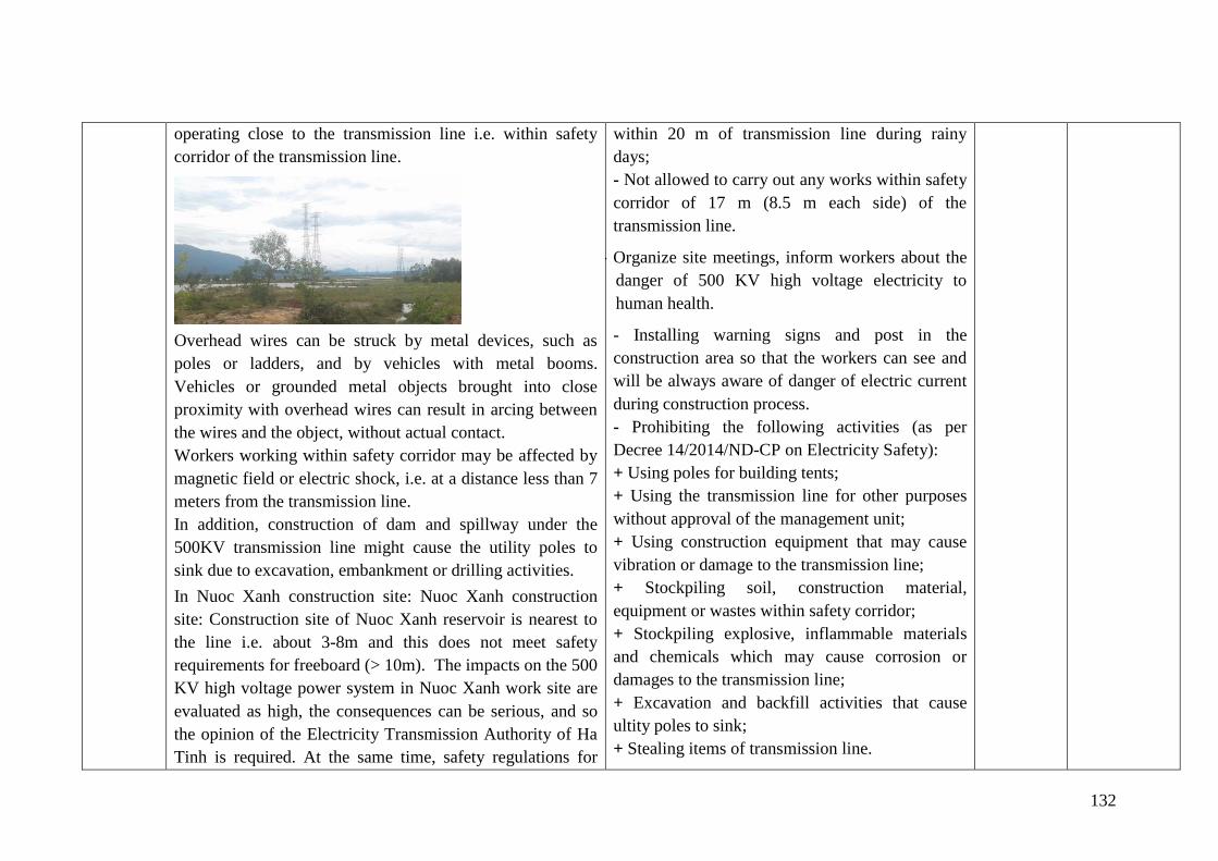
132
operating close to the transmission line i.e. within safety
corridor of the transmission line.
Overhead wires can be struck by metal devices, such as
poles or ladders, and by vehicles with metal booms.
Vehicles or grounded metal objects brought into close
proximity with overhead wires can result in arcing between
the wires and the object, without actual contact.
Workers working within safety corridor may be affected by
magnetic field or electric shock, i.e. at a distance less than 7
meters from the transmission line.
In addition, construction of dam and spillway under the
500KV transmission line might cause the utility poles to
sink due to excavation, embankment or drilling activities.
In Nuoc Xanh construction site: Nuoc Xanh construction
site: Construction site of Nuoc Xanh reservoir is nearest to
the line i.e. about 3-8m and this does not meet safety
requirements for freeboard (> 10m). The impacts on the 500
KV high voltage power system in Nuoc Xanh work site are
evaluated as high, the consequences can be serious, and so
the opinion of the Electricity Transmission Authority of Ha
Tinh is required. At the same time, safety regulations for
within 20 m of transmission line during rainy
days;
- Not allowed to carry out any works within safety
corridor of 17 m (8.5 m each side) of the
transmission line.
- - Organize site meetings, inform workers about the
danger of 500 KV high voltage electricity to
human health.
- Installing warning signs and post in the
construction area so that the workers can see and
will be always aware of danger of electric current
during construction process.
- Prohibiting the following activities (as per
Decree 14/2014/ND-CP on Electricity Safety):
+ Using poles for building tents;
+ Using the transmission line for other purposes
without approval of the management unit;
+ Using construction equipment that may cause
vibration or damage to the transmission line;
+ Stockpiling soil, construction material,
equipment or wastes within safety corridor;
+ Stockpiling explosive, inflammable materials
and chemicals which may cause corrosion or
damages to the transmission line;
+ Excavation and backfill activities that cause
ultity poles to sink;
+ Stealing items of transmission line.
133
construction under 500 KV high voltage power system
should be strictly complied with.
The impact on the high voltage power system 500 KV in
construction site of Loi Dong and Da Den reservoirs is
assessed as medium, since the construction sites area are out
of transmission line safety corridor. The consequences can
be serious so it is necessary to comply with safety
regulations when construction activities take place under the
high voltage line.
- In construction sites of Nuoc Xanh, in addition
to electrical safety measures as for Loi Dong and
Da Den, the following measures should be taken:
+ Move the position of new spillway for 5m
towards the K0 position to ensure that it is outside
the safety distance of the national grid (the design
has been adjusted according to the drawings in
Appendix 1 and approved by the Ha Tinh power
transmission agency in Official Document No.
232/TTDHT-KT dated 28/6/2018 on the agreed
design option to ensure safety of electricity
transmission lines during construction activities;
- Prior to the construction within the electricity
safety corridor, it is necessary to agree on the
construction organization method with Ha Tinh
Power Transmission Agency and announce the
construction period so that the Agency can send
their staff for supervision. Ensure safety of 500
KV lines during construction phase.
The area
of the
corridor
encroach
ed for
other
purposes
Two households of Ky Thinh ward and two households of
Ky Trinh ward are affected as they cultivate on encroached
land in the dam protection corridor and these lands are
acquired for construction. The households mainly plant
short-term plants in this area so the impact is negligible
- Construction schedule and plans and associated
impacts shall be sent to landholders at least 3
months before start of the construction.
- Strictly comply with Resettlement Action Plan
(RAP) to address the potential impacts related to
land acquisition.
Contractor
PPMU, CSC
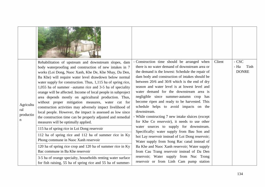
134
Agricultu
ral
productio
n
Rehabilitation of upstream and downstream slopes, dam
body waterproofing and construction of new intakes in 7
works (Loi Dong, Nuoc Xanh, Khe De, Khe Nhay, Da Den,
Ba Khe) will require water level drawdown below normal
water supply for construction. Thus, 1,115 ha of spring rice,
1,055 ha of summer –autumn rice and 3-5 ha of speciality
orange will be affected. Income of local people in subproject
area depends mostly on agricultural production. Thus,
without proper mitigation measures, water cut for
construction activities may adversely impact livelihood of
local people. However, the impact is assessed as low since
the construction time can be properly adjusted and remedial
measures will be optimally applied.
- Construction time should be arranged when
there is no water demand of downstream area or
the demand is the lowest: Schedule the repair of
dam body and construction of intakes should be
between 20/6 and 30/8 which is the end of dry
season and water level is at lowest level and
water demand for the downstream area is
negligible since summer-autumn crop has
become ripen and ready to be harvested. This
schedule helps to avoid impacts on the
downstream.
- While constructing 7 new intake sluices (except
for Khe Co reservoir), it needs to use other
water sources to supply for downstream.
Specifically: water supply from Bau Son and
hoi Lay reservoir instead of Loi Dong reservoir;
Water supply from Song Rac canal instead of
Ba Khe and Nuoc Xanh reservoir; Water supply
from Cau Trang reservoir instead of Da Den
reservoir; Water supply from Nuc Trong
reservoir or from Linh Cam pump station
Client - CSC
- Ha Tinh
DONRE
115 ha of spring rice in Loi Dong reservoir
112 ha of spring rice and 112 ha of summer rice in Ky
Phong commune in Nuoc Xanh reservoir
120 ha of spring rice crop and 120 ha of summer rice in Ky
Bac commune in Ba Khe reservoir
3-5 ha of orange specialty, households renting water surface
for fish raising, 55 ha of spring rice and 55 ha of summer-
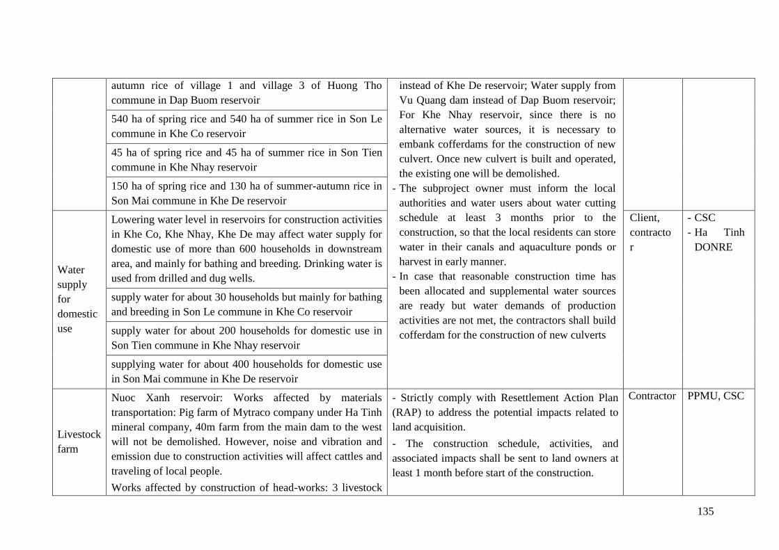
135
autumn rice of village 1 and village 3 of Huong Tho
commune in Dap Buom reservoir
instead of Khe De reservoir; Water supply from
Vu Quang dam instead of Dap Buom reservoir;
For Khe Nhay reservoir, since there is no
alternative water sources, it is necessary to
embank cofferdams for the construction of new
culvert. Once new culvert is built and operated,
the existing one will be demolished.
- The subproject owner must inform the local
authorities and water users about water cutting
schedule at least 3 months prior to the
construction, so that the local residents can store
water in their canals and aquaculture ponds or
harvest in early manner.
- In case that reasonable construction time has
been allocated and supplemental water sources
are ready but water demands of production
activities are not met, the contractors shall build
cofferdam for the construction of new culverts
540 ha of spring rice and 540 ha of summer rice in Son Le
commune in Khe Co reservoir
45 ha of spring rice and 45 ha of summer rice in Son Tien
commune in Khe Nhay reservoir
150 ha of spring rice and 130 ha of summer-autumn rice in
Son Mai commune in Khe De reservoir
Water
supply
for
domestic
use
Lowering water level in reservoirs for construction activities
in Khe Co, Khe Nhay, Khe De may affect water supply for
domestic use of more than 600 households in downstream
area, and mainly for bathing and breeding. Drinking water is
used from drilled and dug wells.
Client,
contracto
r
- CSC
- Ha Tinh
DONRE
supply water for about 30 households but mainly for bathing
and breeding in Son Le commune in Khe Co reservoir
supply water for about 200 households for domestic use in
Son Tien commune in Khe Nhay reservoir
supplying water for about 400 households for domestic use
in Son Mai commune in Khe De reservoir
Livestock
farm
Nuoc Xanh reservoir: Works affected by materials
transportation: Pig farm of Mytraco company under Ha Tinh
mineral company, 40m farm from the main dam to the west
will not be demolished. However, noise and vibration and
emission due to construction activities will affect cattles and
traveling of local people.
Works affected by construction of head-works: 3 livestock
- Strictly comply with Resettlement Action Plan
(RAP) to address the potential impacts related to
land acquisition.
- The construction schedule, activities, and
associated impacts shall be sent to land owners at
least 1 month before start of the construction.
Contractor
PPMU, CSC
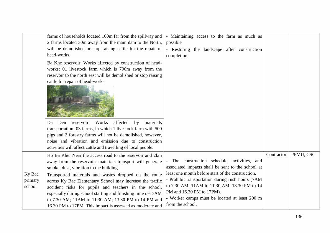
136
farms of households located 100m far from the spillway and
2 farms located 30m away from the main dam to the North,
will be demolished or stop raising cattle for the repair of
head-works.
- Maintaining access to the farm as much as
possible
- Restoring the landscape after construction
completion
Ba Khe reservoir: Works affected by construction of head-
works: 01 livestock farm which is 700m away from the
reservoir to the north east will be demolished or stop raising
cattle for repair of head-works.
Da Den reservoir: Works affected by materials
transportation: 03 farms, in which 1 livestock farm with 500
pigs and 2 forestry farms will not be demolished, however,
noise and vibration and emission due to construction
activities will affect cattle and travelling of local people.
Ky Bac
primary
school
Ho Ba Khe: Near the access road to the reservoir and 2km
away from the reservoir: materials transport will generate
smoke, dust, vibration to the building.
Transported materials and wastes dropped on the route
across Ky Bac Elementary School may increase the traffic
accident risks for pupils and teachers in the school,
especially during school starting and finishing time i.e. 7AM
to 7.30 AM; 11AM to 11.30 AM; 13.30 PM to 14 PM and
16.30 PM to 17PM. This impact is assessed as moderate and
- The construction schedule, activities, and
associated impacts shall be sent to the school at
least one month before start of the construction.
- Prohibit transportation during rush hours (7AM
to 7.30 AM; 11AM to 11.30 AM; 13.30 PM to 14
PM and 16.30 PM to 17PM).
- Worker camps must be located at least 200 m
from the school.
Contractor
PPMU, CSC
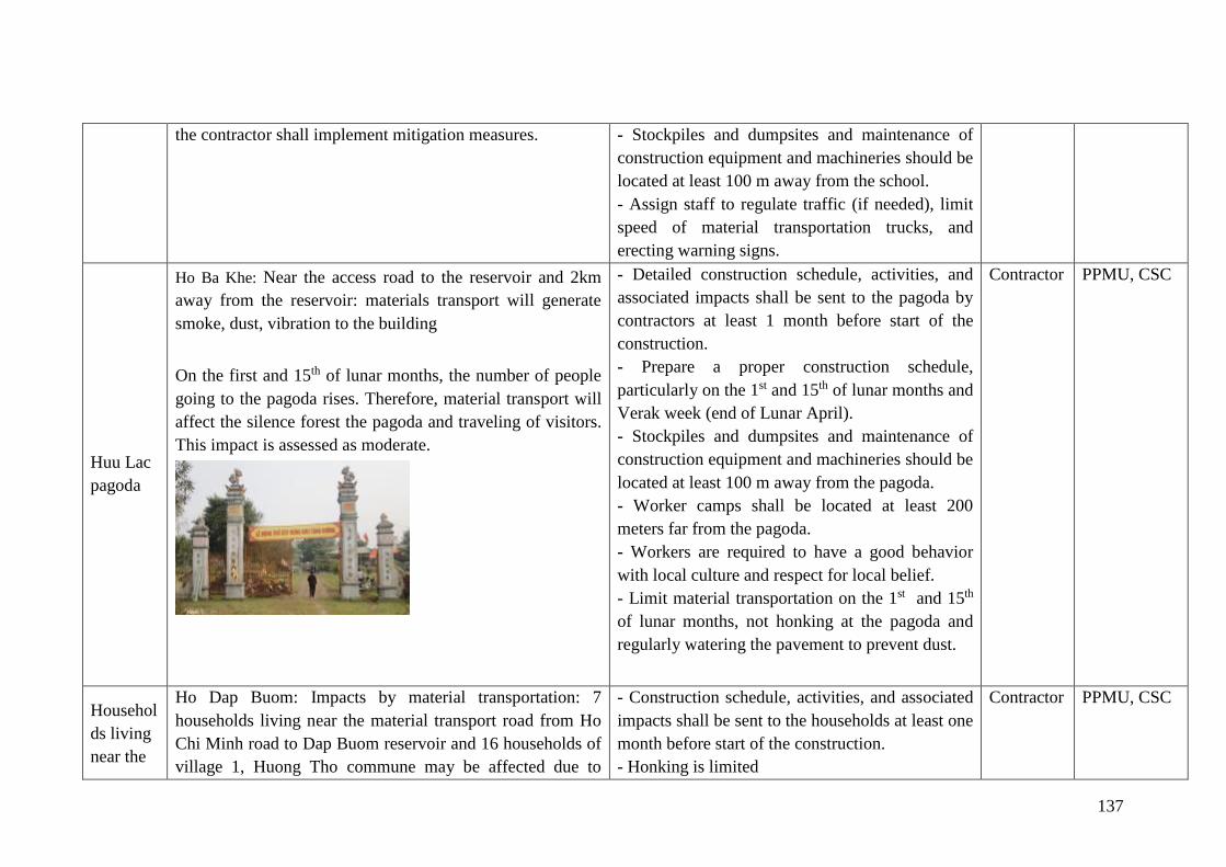
137
the contractor shall implement mitigation measures. - Stockpiles and dumpsites and maintenance of
construction equipment and machineries should be
located at least 100 m away from the school.
- Assign staff to regulate traffic (if needed), limit
speed of material transportation trucks, and
erecting warning signs.
Huu Lac
pagoda
Ho Ba Khe: Near the access road to the reservoir and 2km
away from the reservoir: materials transport will generate
smoke, dust, vibration to the building
On the first and 15th of lunar months, the number of people
going to the pagoda rises. Therefore, material transport will
affect the silence forest the pagoda and traveling of visitors.
This impact is assessed as moderate.
- Detailed construction schedule, activities, and
associated impacts shall be sent to the pagoda by
contractors at least 1 month before start of the
construction.
- Prepare a proper construction schedule,
particularly on the 1st and 15th of lunar months and
Verak week (end of Lunar April).
- Stockpiles and dumpsites and maintenance of
construction equipment and machineries should be
located at least 100 m away from the pagoda.
- Worker camps shall be located at least 200
meters far from the pagoda.
- Workers are required to have a good behavior
with local culture and respect for local belief.
- Limit material transportation on the 1st and 15th
of lunar months, not honking at the pagoda and
regularly watering the pavement to prevent dust.
Contractor
PPMU, CSC
Househol
ds living
near the
Ho Dap Buom: Impacts by material transportation: 7
households living near the material transport road from Ho
Chi Minh road to Dap Buom reservoir and 16 households of
village 1, Huong Tho commune may be affected due to
- Construction schedule, activities, and associated
impacts shall be sent to the households at least one
month before start of the construction.
- Honking is limited
Contractor
PPMU, CSC

138
transport
ation
road
increased traffic. They can be also affected by increased dust
and noise
- Pile driving shall not be applied.
- Drivers shall comply with safety regulations
during their operation.
- Restoration of landscape after construction
completion
- Use trucks of ≤7 tons to avoid damaging
concrete and asphalt roads.
- Report to the competent agencies on any
damages to the public utilities and repair such
damages when possible
- Compensate for damages to roads and
infrastructure.
- Collect and clean falling materials along the
transportation roads
Ho Khe Nhay: Va Transporting materials may affect traffic
safety of 6 households living along inter-village road (Hoi
Son, Minh Giang and Kim Loc villages)
Transporting of waste soil may affect traffic safety and air
environment of over 100 households in villages Ha Tien,
Thinh Tien and Ngoc Son in Son Tien commune.
Ho Khe Co: Transporting of waste soil may affect traffic
safety and air environment of over 100 households in Khe
Co village of Son Le commune and villages Ha Tien, Thinh
Tien and Ngoc Son of Son Tien commute.
Rural
road used
to
transport
materials
In all 8 construction sites, materials transportation will be on
aggregate roads (access to the reservoirs) of 3-5m wide and
not yet reinforced. Transportation of materials and wastes
and large amount of vehicles in circulation in a short time
may cause damages to roads, bridges and culverts surface.
During the transport, spilt materials, if not cleaned up, may
affect the aesthetics and threathen safety of people and
means of transportation, and result in more traffic accident
risks to workers and local people.
- Construction schedule, activities, and associated
impacts shall be sent to the households at least one
month before start of the construction.
- Using of proper load trucks for transportation.
- Water pavements frequently to reduce dust,
especially in dry and hot days.
- Collect spilt materials on roads and clean road
every day.
The Client should require contractors to commit to
Contractor
PPMU, CSC
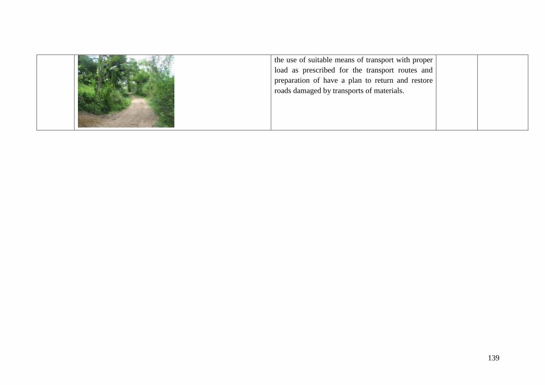
139
the use of suitable means of transport with proper
load as prescribed for the transport routes and
preparation of have a plan to return and restore
roads damaged by transports of materials.
140
7.1.3. Mitigation Measures for Impacts generated during Operation Phase
➢ Measures to ensure the safety of works:
- In order to ensure the safety of the local population, the reservoir O&M unit will
strictly comply with the current regulations on flood discharge and must promptly
notify in order to minimize damage to human and property as much as possible.
Providing an alarm system for people in the downstream in an emergency case relating
to sudden discharge of a large amount of water;
- In case of flood discharges that damage crops or infrastructure, the Client shall be
responsible for compensation.
- Monitoring and timely detecting soil subsidence, seepage, or cracking of breakwater
walls, obstruction of water culverts causing mud accumulation on downstream slope
etc. Pay special attention to seepage in the downstream drains of the dam, regularly
check the infiltration flow and turbidity of the downstream infiltration flow.
- Properly regulate flood to avoid danger to the dam safety during flood season, ensure
design irrigation supply and meet different irrigation supply times during the year.
Timely detecting and treating termite net that damage dam body. Clearing trees within
the dam area. Assign a full-time staff to guard and prevent negative impacts of humans
and animals on dam body, including collisions, timber fallings, and floating rafts.
Effective protection of watersheds to create a stable source of water resources and
avoid flash flood causing risks to the works.
- Every year, in the dry season, there should be a regular dredging plan for intakes and
outlets of culverts to clear the upstream and downstream flows. Monitoring erosion
after the spillway if any so that timely treatment can take place.
- The O & M Unit will work closely with local authorities during the operation and
notification of flood discharges to ensure timely and adequate information to all
affected households.
- Planting grass on talus according to the approved plan. Tend and maintain grass
according to technical requirements.
➢ Measures to limit impacts on environment due to the increased irrigation area
With the increased use of fertilizers and pesticides, if not controlled and mitigation measures
are not in place. Negative impacts on environmental quality and people's health in the
subproject area will be found.
However, the improved irrigation system is a basis for optimal water uses for System Rice
Intensification (SRI) principle. Integrated Pest Management and System Rice Intensification
(SRI) will result in minimum land preparation. Biological prevention measures should be
included in contents of Farmer Field Schools - FFS, so that farmers in the subproject may
improve their knowledge and skills relating to cultivation and effective development of soil
eco-system. Crops will be able to withstand pests, extreme weather. Productivity will
increase, chemical uses will be reduced, especially pesticides, fungicides, reducing
greenhouse gas emissions. Also due to the effects of IPM, less harmful chemicals will
141
gradually replace toxic chemicals. Parallel to the training for farmers on IPM/SRI/minimum
tillage, community activities on Pesticide risk reduction-PRR such as training for local
leaders, pesticide users, pesticide supplier... regulations on pesticide management, risks from
pesticides and labor protective measures needed for pesticides exposure, collection of
pesticide packaging after using, etc. will have integrated effects to reduced risks generated
from pesticide use in the project area.
Integrated pest management (IPM) will be prepared to provide mitigation tools to impacts
caused by pesticide uses. The most relevant measures are training and raising awareness and
knowledge of farmers on IPM, issues relating to increased use of chemicals and pesticides;
increased hazardous wastes (bottles, pesticides packaging).
During the operation of the subproject, Plant Protection Sub-Department of the province will
hold training course on IPM as attached in the Annex 3 of this Report.
Local governments and stakeholders should advocate local people in the subproject area to
apply trained integrated pest management skills.
7.2. Implementation arrangement
7.2.1. Project management
Central level
The Ministry of Agriculture and Rural Development (MARD) is responsible for the
implementation and management of the entire project. Provinces carrying out the repair and
upgrading of dams under Component 1 and MARD will coordinate activities with the
Ministry of Industry and Trade and MONRE under Component 2. The Central Project
Management Unit (CPMU) under MARD is responsible for coordination and overall
supervision of the project. Implementation of repair and preparation of dam safety plans,
including protection and authorization are decentralized to provincial government. Provincial
People's Committee, Department of Agriculture and Rural Development (DARD) are focal
points at provincial level. The Provincial Project Management Unit (PPMU) is responsible for
managing and supervising the works with support from the CPMU.
The central level project management unit will assist in the implementation of the project by
the environmental and social technical support unit; in addition CPMU shall hire independent
consultants to evaluate the implementation of environmental safeguard policy of the whole
project for every 6 months. This is the organization which is selected through the competitive
bidding process who will provide support and quality guarantee to the central level during the
implementation process. This includes support to the central level project management unit in
reviewing and adjusting as necessary and re-implementing the development framework
during project implementation which can provide a framework for national programs. This
process is ensured to be compliance with Decree 72 through the assistance to MARD in the
establishment of necessary systems in place for the implementation of the National Dam
Safety Program.
Provincial level
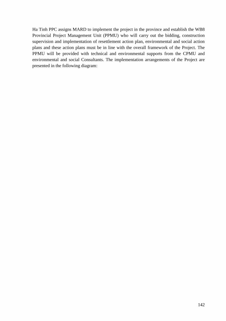
142
Ha Tinh PPC assigns MARD to implement the project in the province and establish the WB8
Provincial Project Management Unit (PPMU) who will carry out the bidding, construction
supervision and implementation of resettlement action plan, environmental and social action
plans and these action plans must be in line with the overall framework of the Project. The
PPMU will be provided with technical and environmental supports from the CPMU and
environmental and social Consultants. The implementation arrangements of the Project are
presented in the following diagram:
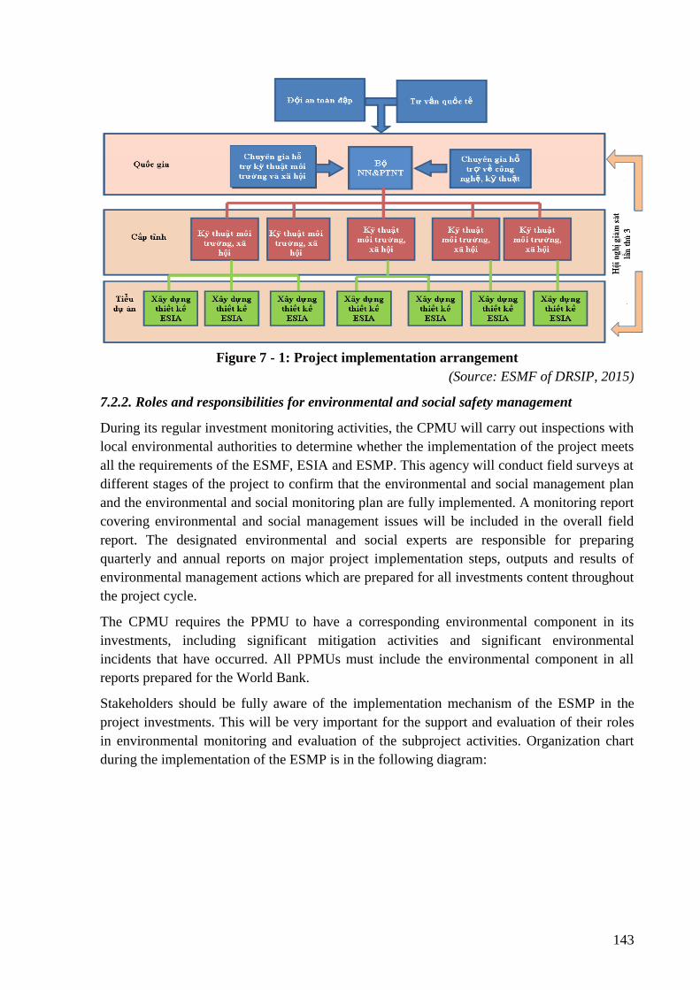
143
Figure 7 - 1: Project implementation arrangement
(Source: ESMF of DRSIP, 2015)
7.2.2. Roles and responsibilities for environmental and social safety management
During its regular investment monitoring activities, the CPMU will carry out inspections with
local environmental authorities to determine whether the implementation of the project meets
all the requirements of the ESMF, ESIA and ESMP. This agency will conduct field surveys at
different stages of the project to confirm that the environmental and social management plan
and the environmental and social monitoring plan are fully implemented. A monitoring report
covering environmental and social management issues will be included in the overall field
report. The designated environmental and social experts are responsible for preparing
quarterly and annual reports on major project implementation steps, outputs and results of
environmental management actions which are prepared for all investments content throughout
the project cycle.
The CPMU requires the PPMU to have a corresponding environmental component in its
investments, including significant mitigation activities and significant environmental
incidents that have occurred. All PPMUs must include the environmental component in all
reports prepared for the World Bank.
Stakeholders should be fully aware of the implementation mechanism of the ESMP in the
project investments. This will be very important for the support and evaluation of their roles
in environmental monitoring and evaluation of the subproject activities. Organization chart
during the implementation of the ESMP is in the following diagram:
144
Figure 7 - 2: Organizational chart for ESMP Implementation
Details of roles and responsibilities of the stakeholders involved in environmental and social
management activities during project implementation are presented in the following table.
Table 7 - 4: Roles and responsibilities of key stakeholders in ESMP Implementation
Community/
Agencies
Responsibilities
CPMU CPMU on behalf of the Client as MARD will be responsible for
monitoring the overall subproject implementation, including compliance to
environmental and social safeguard policies of the subproject.
- Responsible for reporting the implementation of environmental and social
safeguard policy to the MONRE and the World Bank.
- The CPMU will be assisted in the overall implementation of the project
with a TA Consultant. The TA Consultant will develop a system to
properly monitor environmental and social safeguard aspects during the
project implementation.
- Independent monitoring of the Third party will be carried out regularly
for project activities. Independent monitoring of the third party will also
assess the compliance to environmental and social safeguard policies and
the implementation of safeguard instruments, including Environmental
management plans/Practical environmental principles/Resettlement policy
framework/resettlement action plan/ Ethnic minority development plan and
Gender action plan.
145
PPMU PPMU will be responsible for overall implementation of the sub-project
including the compliance to environmental and social safeguard polices of
the sub-project. PPMU have the final responsibility for ESMP
implementation and environmental performance of the subproject during
the construction and operation phases.
Specifically the PPMU will: (i) closely coordinate with local authorities in
the participation of the community during subproject preparation and
implementation; (ii) monitor and supervise ESMP implementation
including incorporation of ESMP into the detailed technical designs and
bidding and contractual documents; (iii) ensure that an environmental
management system is set up and functions properly; (iv) be in charge of
reporting on ESMP implementation to the CPMU and the World Bank.
For effective implementation, PPMU will assign an Environmental and
Social Staff(s) (ES) to help with the monitoring of environmental aspects of
the subproject.
PPMU
Environmental and
Social Staff(s) (ES)
- The ES is responsible for monitoring the implementation of the World
Bank’s environmental and social safeguard policies in all phases and
process of the subproject. Specifically, ES will be responsible for: (i)
supporting PPMU in the incorporation of ESMP into the detailed
technical designs and civil works bidding and contractual documents;
(ii) supporting PPMU in the incorporation of ESMP and RAP
monitoring and supervision tasks into the TORs, bidding and
contractual documents for the Construction Supervision Consultant
(CSC) as needed; iii) providing relevant inputs to the consultant
selection process; (iv) reviewing reports submitted by the CSC and
safeguard consultants; (v) conducting periodic site checks; (vi) helping
the PPMU with the preparation of social and resettlement issues of the
subproject; and (vii) preparing environmental and social performance
contents in the Progress reports and evaluation reports to be submitted
to the CPMU and the World Bank.
Construction
Supervision
Consultant (CSC)
- The CSC will assign Environmental and Social Staff(s) and will be
responsible for routine supervising and monitoring all construction
activities and for ensuring that Contractors comply with the
requirements of the contracts and the ESMP. The CSC will engage
sufficient number of qualified staff (e.g. Environmental Engineers) with
adequate knowledge on subproject environmental protection and
construction management to perform required duties and to supervise
the Contractor’s performance.
- The CSC will also assist the PPMU in (i) reporting on and maintaining
close coordination with the local community, and (ii) strengthening
environmental and social safeguard policies for civil contractors.
146
Bidders The Bidders shall submit to PPMU the following additional documents in
its Bids:
Code of Conduct (ESHS)
• The Bidder shall submit its Code of Conduct that will apply to its
employees and subcontractors, to ensure compliance with its
Environmental, Social, Health and Safety (ESHS) obligations under
the contract.
• In addition, the Bidder shall show details of how this Code of Conduct
will be implemented. This will include: how it will be introduced into
conditions of employment/engagement, what training will be
provided, how it will be monitored and how the Contractor proposes
to deal with any breaches
Management Strategies and Implementation Plans (MSIP) to manage the
(ESHS) risks
• The Bidder shall submit Management Strategies and Implementation
Plans (MSIP) to manage the following key Environmental, Social,
Health and Safety (ESHS) risks to PPMU.
Contractor - The contractor shall assign its Environmental and Social Staff(s) to
carry out Environmental and Social mitigation measures proposed in the
ESMP.
- The Contractor shall be required to submit to PPMU/CSC for approval,
and subsequently implement, the Contractor’s Environment
and Social Management Plan (C-ESMP), in accordance with the
Particular Conditions of Contract Sub-Clause, that includes the agreed
Management Strategies and Implementation Plans.
- Take actions to mitigate all potential negative impacts in line with the
objective described in the CESMP.
- Actively communicate with local residents and take actions to prevent
disturbance during construction.
- Ensure that all staff and workers understand the procedure and their
tasks in the environmental management program.
- Report to the PPMU and CSC on any difficulties and their solutions.
- Report to local authority and PPMU and CSC if environmental
incidents occur and coordinate with agencies and keys stakeholders to
resolve these issues.
Local governments
and community
- Community: According to Vietnamese practice, the community has the
right and responsibility to routinely monitor environmental performance
during construction to ensure that their rights and safety are adequately
protected and that the mitigation measures are effectively implemented
147
by contractors and the PPMU. If unexpected problems occur, they will
report to the CSC and PPMU.
Province and City
People’s Committees
(PPCs/DPCs),
Provincial DONRE
- Oversee implementation of subprojects under recommendations of
DONRE and PPMU to ensure the compliance of Government policy
and regulations. DONRE is responsible for monitoring the compliance
with the Government environmental requirements.
7.3. Environmental Compliance Framework
Duties of the Contractor, the Social and Environmental Officer (SSEO) and the CSC which
have not been set out in te SPD should be integrated into the Client’s Requirements (Part 7 of
the SPD).
7.3.1. Environmental Duties of the Contractor 3
The contractor shall firstly comply with environmental regulations to ensure minimized
impacts will be generated from the subproject and mitigation measures under ESMP must be
applied to prevent harm and nuisances to local communities and environment which are
caused by impacts during the construction and operation phases.
The Contractor shall be required to submit to PPMU/CSC for approval, and subsequently
implement, the Contractor’s Environment and Social Management Plan (C-ESMP), in
accordance with the Particular Conditions of Contract Sub-Clause 16.24, that includes the
agreed Management Strategies and Implementation Plans
3If the Contractor was, or is, failing to perform any ESHS obligations or work under the Contract, the value of
this work or obligation, as determined by the Project Manager, may be withheld until the work or obligation has
been performed, and/or the cost of rectification or replacement, as determined by the Project Manager, may be
withheld until rectification or replacement has been completed. Failure to perform includes, but is not limited to
the following:
• failure to comply with any ESHS obligations or work described in the Works‟ Requirements which
may include: working outside site boundaries, excessive dust, failure to keep public roads in a safe
usable condition, damage to offsite vegetation, pollution of water courses from oils or sedimentation,
contamination of land e.g. from oils, human waste, damage to archeology or cultural heritage features,
air pollution as a result of unauthorized and/or inefficient combustion;
• failure to regularly review C-ESMP and/or update it in a timely manner to address emerging ESHS
issues, or anticipated risks or impacts;
• failure to implement the C-ESMP;
• failing to have appropriate consents/permits prior to undertaking Works or related activities;
• failure to submit ESHS report/s (as described in Appendix C of SPDs), or failure to submit such reports
in a timely manner;
• failure to implement remediation as instructed by the Engineer within the specified timeframe (e.g.
remediation addressing non-compliance/s) 4 The Contractor shall not commence any Works, including mobilization and/or pre-construction activities (e.g.
limited clearance for haul roads, site accesses and work site establishment, geotechnical investigations or
investigations to select ancillary features such as quarries and borrow pits), unless the Project Manager is
satisfied that appropriate measures are in place to address environmental, social, health and safety risks and
impacts. At a minimum, the Contractor shall apply the Management Strategies and Implementation Plans and
Code of Conduct, submitted as part of the Bid and agreed as part of the Contract. The Contractor shall submit, on
a continuing basis, for the Project Manager‟s prior approval, such supplementary Management Strategies and
Implementation Plans as are necessary to manage the ESHS risks and impacts of ongoing works. These
Management Strategies and Implementation Plans collectively comprise the Contractor‟s Environmental and
Social Management Plan (C-ESMP). The C-ESMP shall be approved prior to the commencement of construction
148
Remedial actions that cannot be effectively carried out during construction should be carried
out on completion of the works (and before the issuance of the acceptance of completion of
works) the duties of the Contractor include, but not limited to:
- Compliance with relevant legislative requirements governing the environment, public
health and safety;
- Work within the scope of contractual requirements and other tender conditions;
- Organize representatives of the construction team to participate in the joint site inspections
undertaken by the Environmental Staff of the CSC;
- Carry out any corrective actions instructed by the Environmental Staff of the PPMU and
CSC;
- In case of non-compliances/discrepancies, carry out investigation and submit proposals on
mitigation measures, and implement remedial measures to reduce environmental impact;
- Stop construction activities, which generate adverse impacts upon receiving instructions
from the Environmental Staff of PPMU and CSC. Propose and carry out corrective actions
and implement alternative construction method, if required, in order to minimize the
environmental impacts; Non-compliance by the Contractor will be cause for suspension of
works and other penalties until the non-compliance has been resolved to the satisfaction of
the ES of PMU and CSC.
7.3.2. Contractor’s Social and Environmental Safeguard Officer (SEO)
The contractor shall be required to appoint competent staff(s) as the Contractor’s on-site
Social and environmental safeguard officer (SEO). The SEO must be appropriately trained in
environmental management and must possess necessary skills to transfer environmental
management knowledge to all personnel involved in the contract. The SEO will be
responsible for monitoring the contractor’s compliance with the ESMP requirements and the
environmental specifications. The duties of the SEO shall include but not be limited to the
following:
- Carry out environmental site inspections to assess and audit the contractors' site practice,
equipment and work methodologies with respect to pollution control and adequacy of
environmental mitigation measures implemented;
- Monitor compliance with environmental protection measures, pollution prevention and
control measures and contractual requirements;
- Monitor the implementation of environmental mitigation measures;
- Prepare audit reports for the site environmental conditions;
- Investigate complaints and recommend any required corrective measures;
activities (e.g. excavation, earth works, bridge and structure works, stream and road diversions, quarrying or
extraction of materials, concrete batching and asphalt manufacture). The approved C-ESMP shall be reviewed,
periodically (but not less than every six (6) months), and updated in a timely manner, as required, by the
Contractor to ensure that it contains measures appropriate to the Works activities to be undertaken. The updated
C-ESMP shall be subject to prior approval by the Project Manager.
149
- Advise the contractor on environment improvement, awareness and proactive pollution
prevention measures;
- Recommend suitable mitigation measures to the contractor in the case of non-compliance.
Carry out additional monitoring of noncompliance instructed by the ES of PPMU and CSC
- Inform the contractor and ES (of PPMU and CSC) of environmental issues, submit
contractor’s ESMP Implementation Plan to the ES of PPMU and CSC, and relevant
authorities, if required;
- Keep detailed records of all site activities that may relate to the environment.
7.3.3. Environmental and Social Supervision during Construction (CSC)
During construction phase, a qualified CSC reporting to the PPMU shall carry out the
environmental supervision. The CSC will assign environmental and social staff(s) who will
be responsible for inspecting and supervising all construction activities to ensure that
mitigation measures adopted in the ESMP are properly implemented, and that the negative
environmental impacts of the subproject are minimized. The CSC shall engage sufficient
number of Environmental Supervision Engineers with adequate knowledge on environmental
protection and construction subproject management to perform the required duties and to
supervise the Contractor’s performance. Specifically ES of CSC will:
- Review and assess on behalf of the PPMU whether the construction design meets the
requirements of the mitigation and management measures of the ESMP,
- Supervise site environmental management system of contractors including their
performance, experience and handling of site environmental issues, and provide corrective
instructions;
- Review the ESMP implementation by the contractors, verify and confirm environmental
supervision procedures, parameters, monitoring locations, equipment and results;
- Report on ESMP implementation status to PPMU and prepare the environmental
supervision statement during the construction phase;
7.3.4. Compliance with Legal and Contractual Requirements
The constructions activities shall comply not only with contractual environmental protection
and pollution control requirements but also with Law on Environmental protection and
pollution control of Viet Nam.
All the construction methods will be submitted by the Contractor to the CSC and PPMU for
approval to make sure there are adequate environmental protection and pollution control
measures included.
The CSC and PPMU shall also review the progress and program of the works to check that
relevant environmental laws have not been violated, and that any potential violation can be
prevented.
The Contractor shall copy relevant documents to the SEO and the ES of CSC and PPMU. The
document shall at least include the updated work progress report, the updated work measure,
and the application letters for different license/permits under the environmental protection
150
laws, and all the valid license/permit. The SEO and the ES shall also have access, upon
request, to the Site Log-Book.
After reviewing the documents, the SEO or the ES of the CSC and PPMU will advise PPMU
and the contractor of any non-compliance with the contractual and legislative requirements on
environmental protection and pollution control for them to take follow-up actions. If the SEO
or the ES concludes that the status on license/permit application and any environmental
protection and pollution control preparation works may not comply with the construction
measure or may result in potential violation of environmental protection and pollution control
requirements, they shall advise the Contractor and the PPMU accordingly and promply.
7.3.5. Reporting Arrangements
In addition to the progress report, the Contractor shall also provide a report on the
Environmental, Social, Health and Safety (ESHS) data as set out in the Appendix B of SPDs.
In addition to Appendix B reports, the Contractor shall also provide immediate notification to
the PPMU of incidents in the following categories. Full details of such incidents shall be
provided to the PPMU within the timeframe agreed with the PPMU.
• Any confirmed or likely violations to any law or international agreement;
• Any fatality, serious injury or damages (temporal damages)
• Significant adverse effects or damage to private property (e.g. vehicle accident,
damage caused by flying rock or due to working beyond the boundary)
• Major pollution of aquifer or groundwater or damages or destruction of habitat of rare
or endangered species (including protected areas) or species; or
• Any allegation of sexual harassment or sexual misbehavior, child abuse, defilement, or
other violations involving children.
Table 7 - 5: Regular reporting requirement
No. Report Prepared by Submitted
to
Frequency of Reporting
1 Contractors CSC Immediately, for certain aspects and on
monthly basis with respect to a wider
range of aspects
2 Construction Supervision
consultant (CSC)
PPMU Immediately or monthly basis
3 Community Monitoring
Board (CMB)
PPMU When the community has any complaint
about the implementation of
environmental and social safeguards
policies
4 PPMU DONRE
and CPMU
Once every six months in accordance
with the GoV‟s environmental and
social safeguard regulations
151
5 PPMU WB Once every six months in accordance
with Section II of the Loan agreement
7.4. Grievance Redress Mechanism
Complaints relating to any subproject's problems will be solved through negotiations to achieve
the consensus. A complaint will go through three stages at commune, district and provincial
levels, before it can be transferred to the court. The enforcement unit (PPMU) will pay all
administrative and legal fees relating to the acceptance of complaints. This cost is included in the
subproject budget. Complaint procedures and resolution will be performed as follows:
7.4.1.Grievance Redress Mechanism
(i) People’s Committee of ward /commune. An affected household is to take his/her complaint
to any member of the People's Committee of the ward/commune, through the village head or
directly to People’s Committee of the commune/ward, in written or oral form. The said
member(s) of the People’s Committee or the village head will inform the People’s Committee
of the ward/commune on the complaint. The People's Committee of Ward/Commune will
work directly in person with the said affected household and will decide on the settlement of
the complaint within 5 days after receiving such complaint (this may take 15 days in
mountainous or remote areas). The Secretariat of the People’s Committee of the relevant
commune/ward is responsible for documenting and recording all the complaints that it is
handling.
After the Ward/Commune People's Committee issues its decision, the relevant household can
make an appeal within 30 days. In case a second decision has been issued but the said
household is still not satisfied with such decision, such household can appeal to the municipal
(city) People’s Committee (CPC).
(ii) People’s Committee of district/town. Upon receiving a complaint from a household, the
DPC will have 15 days (or 30 days in case of remote and mountainous areas) after receiving
the complaint to resolve the case. The DPC is responsible for filing and storing documents on
all complaints that it handles.
When the CPC has issued a decision, the household can make an appeal within 30 days. In
case a second decision has been issued and the household is still not satisfied with such a
decision, they can appeal to the Provincial People’s Committee (PPC) in line with Law of
Complaint 2011 and relevant documents.
(iii) Provincial People’s Committee: Upon receiving a complaint from the household, the PPC
will have 30 days (or 45 days in case of remote and mountainous areas) after receiving the
complaint to resolve the case. The PPC is responsible for filing and storing documents for all
complaints to be submitted.
After the PPC has issued a decision, the household can appeal within 45 days. In case a
second decision has been issued and the household is still not satisfied with such decision,
they can appeal to the court within 45 days. The PPC will then have to pay the compensation
into an account.
(IV) Provincial Court. In case a complainant brings his/her case to a provincial court and the
court rules in favour of the complainant, the provincial authorities will have to increase the
152
compensation up to such a rate as may be ruled by the court. In case the court’s ruling is in
favour of the PPC, the complainant will be refunded the amount of money that has been paid
to the court.
The decision ruling the settlement of complaints will have to be sent to complainants and
concerned parties, and shall be publicly posted at the headquarters of the People's Committee
of the relevant level. The complainant will receive such ruling three days after the result of
complaint resolution at the ward/commune/town level has been decided upon and 7 days at
the district or provincial level.
To minimize the number of complaints at provincial level, the PPMU will coordinate with the
District Compensation Committee of Cam Xuyen, Thach Ha, Ky Anh, Huong Son district to
participate and provide consultation in solving complaints and respond to complainants. Its
role and capacity is to carry out the compensation, support and arrange resettlement for
affected households and displaced persons.
Personnel: The environment and resettlement staff chosen by the PPMU will design and
maintain a database of the subproject-related complaints from affected households, including
information such as: the nature of the complaint, the source and date of receipt of the
complaint, the name and address of the complainant, action plan, and current status.
For oral complaints, the receiving/ mediator board will record these requests in a complaint
form at the first meeting with the affected person.
7.4.2.Contractor and Construction Supervision Consultant:
During construction, the GRM will also be managed by the contractors under supervision of
the CSC. The contractors will inform the affected communities and communes about the
GRM availability to handle complaints and concerns about the subproject. This will be done
via the community consultation and information disclosure process under which the
contractors will communicate with the affected communities and interested authorities on a
regular basis. Meetings will be held at least quarterly, monthly information brochures will be
published, announcements will be placed in local media, and notices of upcoming planned
activities will be posted, etc.
All complaints and corresponding actions undertaken by the contractors will be recorded in
subproject safeguard monitoring reports. Complaints and claims for damages could be lodged
as follows:
- Verbally: direct to the CSC and/ or the contractors’ safeguard staff or representatives
at the site offices.
- In writing: by hand-delivering or posting a written complaint to specified addresses.
- By telephone, fax, e-mails: to the CSC, the contractors’ safeguard staff or
representatives.
Upon receipt of a complaint, the CSC, the contractors’ safeguard staff or representatives will
register the complaint in a complaint file and maintain a log of events pertaining to it
thereafter, until it is resolved. Immediately after receipt, four copies of the complaint will be
prepared. The original will be kept in the file, one copy will be used by the contractor’s
153
safeguard staff, and one copy will be forwarded to the CSC, and the fourth copy to the PPMU
within 24 hours since receipt of the complaint.
Information to be recorded in the complaint log will consist of:
- The date and time of the complaint.
- The name, address and contact details of the complainant.
- A short description of the complaint.
- Actions taken to address the complaint, including contact persons and findings at each
step in the complaint redress process.
- The dates and times when the complainant is contacted during the redress process.
- The final resolution of the complaint.
- The date, time and manner in which the complainant was informed thereof.
- The complainant’s signature when resolution has been obtained.
Minor complaints will be dealt with within one week. Within two weeks (and weekly
thereafter), a written reply will be delivered to the complainant (by hand, post, fax, e-mails)
indicating the procedures taken and progress to date.
The main objective will be to resolve an issue as quickly as possible by the simplest means,
involving as few people as possible, and at the lowest possible level. Only when an issue
cannot be resolved at the simplest level and/ or within 15 days, will other authorities be
involved. Such a situation may arise, for example, when damages are claimed, the to-be-paid
amount cannot be resolved, or damage causes are determined.
7.4.3.World Bank Grievance Redress Mechanism
Communities and individuals who believe that they are adversely affected by a World Bank
(WB) supported subproject may submit complaints to existing subproject-level grievance
redress mechanism or the WB’s Grievance Redress Service (GRS). The GRS ensures that
complaints received are promptly reviewed in order to address subproject-related concerns.
Subproject affected communities and individuals may submit their complaints to the WB’s
independent Inspection Panel which determines whether harms occurred, or could occur, as a
result of WB non-compliance with its policies and procedures. Complaints may be submitted
at any time after concerns have been brought directly to the WB’s attention, and Bank
Management has been given an opportunity to respond. For information on how to submit
complaints to the World Bank’s corporate Grievance Redress Service (GRS), please visit
www.worldbank.org/grs. For information on how to submit complaints to the World Bank
Inspection Panel, please visit www.inspectionpanel.org.
7.5. ESMP implementation plan
7.5.1. ESMP implementation plan of the Contractor
Shortly after the contract is signed, based on the approved subproject ESMP and construction
methods, construction plan approved by CSC and PPMU, the Contractor prepares
154
Contractor’s ESMP (C-ESMP) of the package and submits to the CSC for review and
approval.
- After the C-ESMP is approved by CSC, the contractor carries out the environmental and
social impact mitigation measures on site.
- The C-ESMP will be disclosed at worker’s camp and site office to disseminate the
information of mitigation measures to workers.
- Making the public information panel at entrances of construction site, address,
representative, phone number of stakeholders for supervision by local community and
contact as necessary.
- Assigning staff in charge of environment and safety, training, providing PPE, regular
health examination for workers.
- Surveying, examination of environmental status on site, reporting to the CSC if there are
significant differences compared to the environmental background.
- Contracting with the authorized units for treatment of domestic wastes, hazardous wastes,
and clean water supply.
- Managing the workers and construction equipment and providing new certificate in case
of expiration.
- Implementing ESMP and updating, and submitting to the CSC for approval if there are
changes before application.
- Cooperating with the PPMU and CSC to deal with the complaint of local people about the
environmental and safety problem of the package in a timely manner.
- Reporting on the package ESMP implementation monthly.
7.5.2. Start of the subproject and personnel
The staff in charge of environmental safeguards of the contractor must be environmental
engineer or have relevant disciplines and must have a certificate of occupational health and
safety and work fulltime on site.
Providing training in occupational health and safety for workers and regular conducting
examination of worker’s health.
7.6. Training and capacity building
7.6.1. Training on safeguard policy
Document on environmental safety policy of the sub-project since construction: Most of the
dams and reservoirs had been built before 1980, when the environmental protection law has
not been promulgated and there were no regulations on environmental impact assessment. In
subproject 01, there are no records of design, completion of construction works and the works
were built by the people themselves which do not have the design file
Regarding environmental and social management resources: At the Ha Tinh Sub-project,
there are already professional sections or staffs in charge of Environment and Social issues

155
(already involved in projects funded by ADB or WB). Number of officials in charge of
environmental management is 1-2 persons and mainly are irrigation engineers and economy
engineers. There is no qualified official who is environmental engineer. However, these staffs,
in addition to their environmental management tasks, also undertake other tasks and often
change their positions.
Regarding to training programs have been involved: The staff in charge of environmental-
social management of the subproject 011 has been involved in the implementation of projects
related to safety policies of the WB through the projects that WB sponsored and participated
in training programs such as: Environmental safety policy, involuntary resettlement policy,
gender and gender equality. However, the knowledge and experience of the Bank's safety
requirements on environmental and social issues is limited. Domestic capital projects do not
have training programs on environmental safeguard policy.
Such training courses will be held at the early stages of the subproject process to ensure that
the ESMP is properly integrated into the bidding documents (and subsequently the contract).
Technical assistance should be provided by experienced and skilled staff the of construction
supervision consultants, and be implemented in accordance with the terms of reference which
consist of specific reference to the development of request of the Client for the standard
tender documents.
Table 7 - 6: Capacity building training program on environmental management
No. Training contents Cost (VND)
1 Capacity building on environmental protection (1
class/district)
4 classes x VND 30 million/
class = VND 120 million
2 Capacity building on Environmental and Social
monitoring (1 class/district)
4 classes x VND 30 million/
class = VND 120 million
3 Training on environmental health and labor safety
measures and environmental safety (1 class/district)
4 classes x VND 30 million/
class = VND 120 million
4 Training to enhance awareness on dam safety (1
class/district)
4 classes x VND 30 million/
class = VND 120 million
Total 480.000.000
7.6.2. Training on safety and occupational health
Provisions will be prepared to provide orientation training on safety and occupational health
for all new employees to ensure they are informed of site-specific requirements, on-site work
and personal protection and injury prevention.
Training program will include awareness on basic hazard, specific hazards, safe work
practices, and emergency procedures for fire, evacuation, and natural disasters. Any specific
hazard will be considered thoroughly as part of the orientation training.
156
7.6.3. Visitor Orientation
If visitors are allowed to access to areas with present of hazardous conditions or substances,
visitor orientation and control programs will be established to ensure that visitors do not enter
dangerous areas without the accompanying person.
7.6.4. Training for contractors and new workers
The PPMU will ensure that workers and contractors, before undertaking new jobs, receive
adequate training and information so that they can understand the hazards of work and protect
themselves from the surrounding hazards factors may be present. Training will fully cover:
- Understanding of materials, equipment and tools;
- Understand the hazards during operation and how to control them;
- Potential risks to health;
- Warnings to prevent exposure;
- Sanitary requirements;
- Wear and use protective clothing and equipment;
- The appropriate response to the harsh operating conditions, accidents and incidents
7.6.5. Training on basic health and occupational safety
A basic training program and intensive courses will be implemented as needed to ensure that
workers are oriented towards the specific hazards of individual work tasks. Training will
generally be provided to managers, supervisors, workers, and occasional visitors to areas with
risk and hazards.
Workers in charge of first aid and rescue tasks will receive special training not to intentionally
exacerbate the exposure and health hazards to themselves and their colleagues. Training will
include the risk of transmitting the disease through blood due to contact with tissue and body
fluids.
Through appropriate contractual terms and monitoring, the PPMU will ensure that service
providers, as well as contract and subcontractors, are adequately trained before
commencement of work.
The PPMU will be responsible for coordinating with the construction supervision consultants
and the contractor's social environment officers to organize the training courses mentioned
above.
7.7. Environmental and social monitoring plan
The environmental monitoring plan includes two types of environmental monitoring:
- Compliance monitoring: Periodic environmental and social monitoring to check the
compliance with environmental and social management requirements of the subproject
and to identify non-compliance actions or variations and to propose corrective actions.
- Environmental quality monitoring: Taking environmental quality assessment samples
157
to verify the effectiveness of mitigation measures, proposing solutions if
environmental quality exceeds the allowable standards.
7.7.1. Compliance Monitoring:
Compliance monitoring will be done regularly by PPMU and its construction supervision
consultant (CSC). PPMU and its CSC will be responsible for daily monitoring contractor’s
compliance with agreed mitigation measures. Results will be reflected in the monthly progress
reports.
Local authority and community will be undertaking the monitoring task in accordance with
the GoV’s regulations, i.e. Law on Environmental Protection 2014 and Decree 80/2005/ND-
CP - Regulation on community’s investment monitoring.
In addition, contractors’ ES officer will be responsible for daily monitoring labor safety and
environmental hygiene on site and reporting to PPMU and CSC.
Detailed monitoring plan will be prepared during detailed design phase. The cost estimates for
monitoring shall be included in the ESMP implementation cost.
7.7.2. Ambient Environmental quality monitoring:
a) Environmental quality monitoring program
Ambient environmental quality monitoring program such as air, soil and water quality
provides information that can be used to assess the effectiveness of pollution management
strategies. A systematic planning process is recommended to ensure that the data collected are
adequate for their intended purposes (and to avoid collecting unnecessary data). This process,
sometimes referred to as a data quality objectives process, defines the purpose of collecting
the data, the decisions to be made based on the data and the consequences of making an
incorrect decision, the time and geographic boundaries, and the quality of data needed to
make a correct decision. The ambient environmental quality monitoring program shall
consider the following elements:
• Monitoring parameters: The monitoring parameters selected should reflect the
pollutants of concern associated with subproject processes.
• Baseline calculations: Before the subproject is developed, baseline ambient
environmental quality monitoring at and in the vicinity of the site should be
undertaken to assess background levels of key pollutants, in order to differentiate
between existing ambient conditions and subproject-related impacts.
• Monitoring type and frequency: Data on ambient environmental quality generated
through the monitoring program shall be representative of the pollutants emitted by
the subproject over time. Monitoring frequency and duration may also range from
continuous to less frequent, monthly, quarterly or yearly tests.
• Monitoring locations: Ambient environmental quality monitoring May consists of off-
site or fence line monitoring either by the subproject owner, DONRE, or by
collaboration between both. The location of monitoring stations should be established
based on the results of scientific methods and mathematical models to estimate
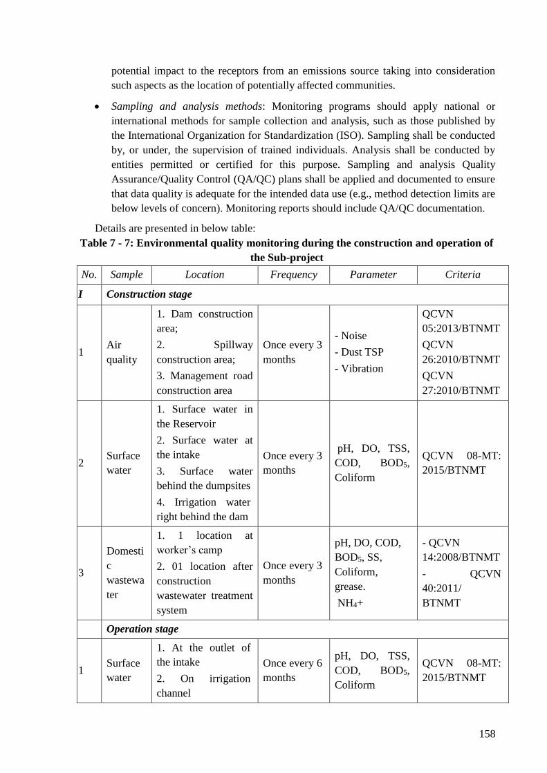
158
potential impact to the receptors from an emissions source taking into consideration
such aspects as the location of potentially affected communities.
• Sampling and analysis methods: Monitoring programs should apply national or
international methods for sample collection and analysis, such as those published by
the International Organization for Standardization (ISO). Sampling shall be conducted
by, or under, the supervision of trained individuals. Analysis shall be conducted by
entities permitted or certified for this purpose. Sampling and analysis Quality
Assurance/Quality Control (QA/QC) plans shall be applied and documented to ensure
that data quality is adequate for the intended data use (e.g., method detection limits are
below levels of concern). Monitoring reports should include QA/QC documentation.
Details are presented in below table:
Table 7 - 7: Environmental quality monitoring during the construction and operation of
the Sub-project
No. Sample Location Frequency Parameter Criteria
I Construction stage
1 Air
quality
1. Dam construction
area;
2. Spillway
construction area;
3. Management road
construction area
Once every 3
months
- Noise
- Dust TSP
- Vibration
QCVN
05:2013/BTNMT
QCVN
26:2010/BTNMT
QCVN
27:2010/BTNMT
2 Surface
water
1. Surface water in
the Reservoir
2. Surface water at
the intake
3. Surface water
behind the dumpsites
4. Irrigation water
right behind the dam
Once every 3
months
pH, DO, TSS,
COD, BOD5,
Coliform
QCVN 08-MT:
2015/BTNMT
3
Domesti
c
wastewa
ter
1. 1 location at
worker’s camp
2. 01 location after
construction
wastewater treatment
system
Once every 3
months
pH, DO, COD,
BOD5, SS,
Coliform,
grease.
NH4+
- QCVN
14:2008/BTNMT
- QCVN
40:2011/
BTNMT
Operation stage
1 Surface
water
1. At the outlet of
the intake
2. On irrigation
channel
Once every 6
months
pH, DO, TSS,
COD, BOD5,
Coliform
QCVN 08-MT:
2015/BTNMT
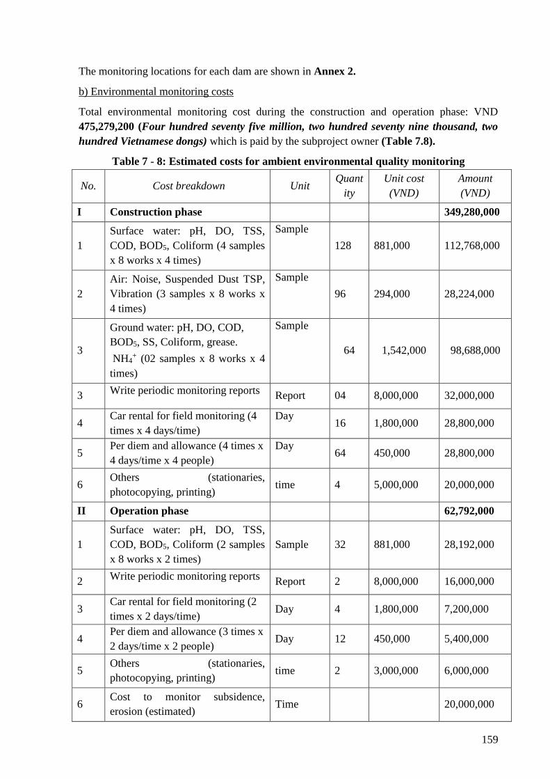
159
The monitoring locations for each dam are shown in Annex 2.
b) Environmental monitoring costs
Total environmental monitoring cost during the construction and operation phase: VND
475,279,200 (Four hundred seventy five million, two hundred seventy nine thousand, two
hundred Vietnamese dongs) which is paid by the subproject owner (Table 7.8).
Table 7 - 8: Estimated costs for ambient environmental quality monitoring
No. Cost breakdown Unit Quant
ity
Unit cost
(VND)
Amount
(VND)
I Construction phase 349,280,000
1
Surface water: pH, DO, TSS,
COD, BOD5, Coliform (4 samples
x 8 works x 4 times)
Sample
128 881,000 112,768,000
2
Air: Noise, Suspended Dust TSP,
Vibration (3 samples x 8 works x
4 times)
Sample
96 294,000 28,224,000
3
Ground water: pH, DO, COD,
BOD5, SS, Coliform, grease.
NH4+ (02 samples x 8 works x 4
times)
Sample
64 1,542,000 98,688,000
3 Write periodic monitoring reports
Report 04 8,000,000 32,000,000
4 Car rental for field monitoring (4
times x 4 days/time)
Day 16 1,800,000 28,800,000
5 Per diem and allowance (4 times x
4 days/time x 4 people)
Day 64 450,000 28,800,000
6 Others (stationaries,
photocopying, printing) time 4 5,000,000 20,000,000
II Operation phase 62,792,000
1
Surface water: pH, DO, TSS,
COD, BOD5, Coliform (2 samples
x 8 works x 2 times)
Sample 32 881,000 28,192,000
2 Write periodic monitoring reports
Report 2 8,000,000 16,000,000
3 Car rental for field monitoring (2
times x 2 days/time) Day 4 1,800,000 7,200,000
4 Per diem and allowance (3 times x
2 days/time x 2 people) Day 12 450,000 5,400,000
5 Others (stationaries,
photocopying, printing) time 2 3,000,000 6,000,000
6 Cost to monitor subsidence,
erosion (estimated) Time 20,000,000
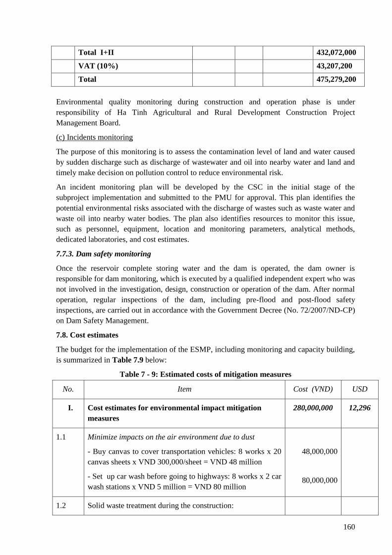
160
Total I+II 432,072,000
VAT (10%) 43,207,200
Total 475,279,200
Environmental quality monitoring during construction and operation phase is under
responsibility of Ha Tinh Agricultural and Rural Development Construction Project
Management Board.
(c) Incidents monitoring
The purpose of this monitoring is to assess the contamination level of land and water caused
by sudden discharge such as discharge of wastewater and oil into nearby water and land and
timely make decision on pollution control to reduce environmental risk.
An incident monitoring plan will be developed by the CSC in the initial stage of the
subproject implementation and submitted to the PMU for approval. This plan identifies the
potential environmental risks associated with the discharge of wastes such as waste water and
waste oil into nearby water bodies. The plan also identifies resources to monitor this issue,
such as personnel, equipment, location and monitoring parameters, analytical methods,
dedicated laboratories, and cost estimates.
7.7.3. Dam safety monitoring
Once the reservoir complete storing water and the dam is operated, the dam owner is
responsible for dam monitoring, which is executed by a qualified independent expert who was
not involved in the investigation, design, construction or operation of the dam. After normal
operation, regular inspections of the dam, including pre-flood and post-flood safety
inspections, are carried out in accordance with the Government Decree (No. 72/2007/ND-CP)
on Dam Safety Management.
7.8. Cost estimates
The budget for the implementation of the ESMP, including monitoring and capacity building,
is summarized in Table 7.9 below:
Table 7 - 9: Estimated costs of mitigation measures
No. Item Cost (VND) USD
I. Cost estimates for environmental impact mitigation
measures
280,000,000 12,296
1.1 Minimize impacts on the air environment due to dust
- Buy canvas to cover transportation vehicles: 8 works x 20
canvas sheets x VND 300,000/sheet = VND 48 million
- Set up car wash before going to highways: 8 works x 2 car
wash stations x VND 5 million = VND 80 million
48,000,000
80,000,000
1.2 Solid waste treatment during the construction:
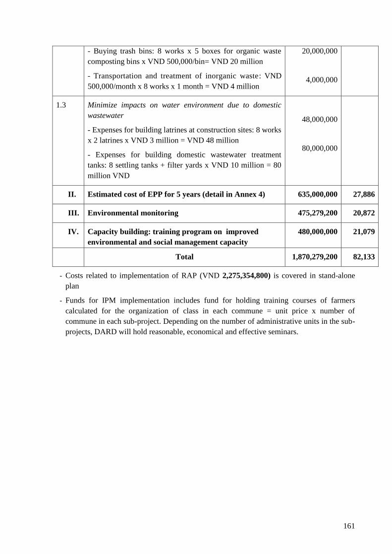
161
- Buying trash bins: 8 works x 5 boxes for organic waste
composting bins x VND 500,000/bin= VND 20 million
- Transportation and treatment of inorganic waste: VND
500,000/month x 8 works x 1 month = VND 4 million
20,000,000
4,000,000
1.3 Minimize impacts on water environment due to domestic
wastewater
- Expenses for building latrines at construction sites: 8 works
x 2 latrines x VND 3 million = VND 48 million
- Expenses for building domestic wastewater treatment
tanks: 8 settling tanks + filter yards x VND 10 million = 80
million VND
48,000,000
80,000,000
II. Estimated cost of EPP for 5 years (detail in Annex 4) 635,000,000 27,886
III. Environmental monitoring 475,279,200 20,872
IV. Capacity building: training program on improved
environmental and social management capacity
480,000,000 21,079
Total 1,870,279,200 82,133
- Costs related to implementation of RAP (VND 2,275,354,800) is covered in stand-alone
plan
- Funds for IPM implementation includes fund for holding training courses of farmers
calculated for the organization of class in each commune = unit price x number of
commune in each sub-project. Depending on the number of administrative units in the sub-
projects, DARD will hold reasonable, economical and effective seminars.
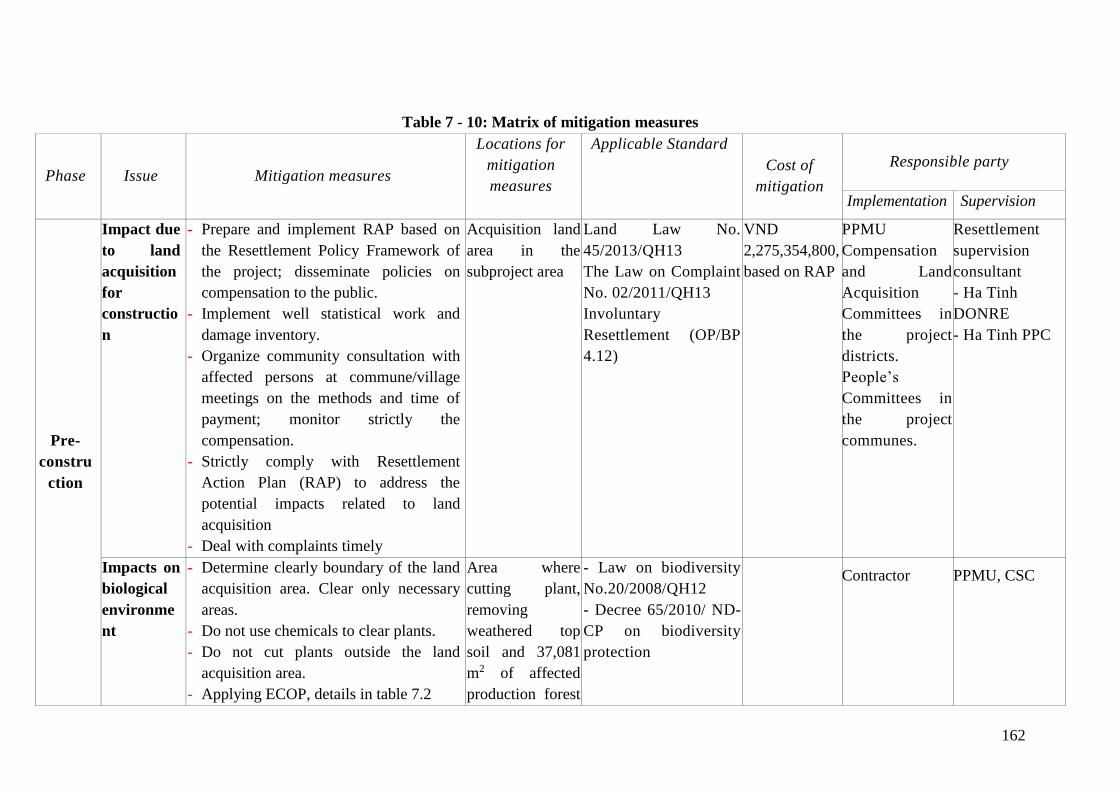
162
Table 7 - 10: Matrix of mitigation measures
Phase Issue Mitigation measures
Locations for
mitigation
measures
Applicable Standard
Cost of
mitigation
Responsible party
Implementation Supervision
Pre-
constru
ction
Impact due
to land
acquisition
for
constructio
n
- Prepare and implement RAP based on
the Resettlement Policy Framework of
the project; disseminate policies on
compensation to the public.
- Implement well statistical work and
damage inventory.
- Organize community consultation with
affected persons at commune/village
meetings on the methods and time of
payment; monitor strictly the
compensation.
- Strictly comply with Resettlement
Action Plan (RAP) to address the
potential impacts related to land
acquisition
- Deal with complaints timely
Acquisition land
area in the
subproject area
Land Law No.
45/2013/QH13
The Law on Complaint
No. 02/2011/QH13
Involuntary
Resettlement (OP/BP
4.12)
VND
2,275,354,800,
based on RAP
PPMU
Compensation
and Land
Acquisition
Committees in
the project
districts.
People’s
Committees in
the project
communes.
Resettlement
supervision
consultant
- Ha Tinh
DONRE
- Ha Tinh PPC
Impacts on
biological
environme
nt
- Determine clearly boundary of the land
acquisition area. Clear only necessary
areas.
- Do not use chemicals to clear plants.
- Do not cut plants outside the land
acquisition area.
- Applying ECOP, details in table 7.2
Area where
cutting plant,
removing
weathered top
soil and 37,081
m2 of affected
production forest
- Law on biodiversity
No.20/2008/QH12
- Decree 65/2010/ ND-
CP on biodiversity
protection
Contractor
PPMU, CSC
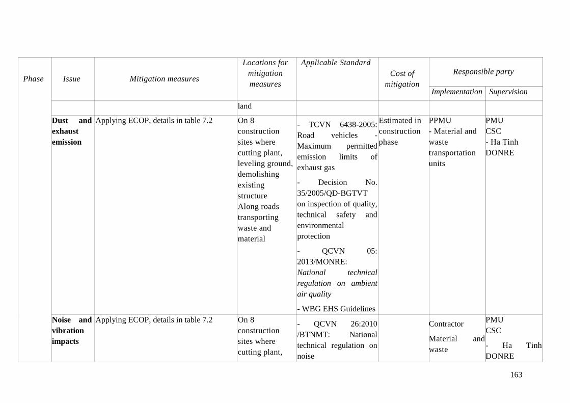
163
Phase Issue Mitigation measures
Locations for
mitigation
measures
Applicable Standard
Cost of
mitigation
Responsible party
Implementation Supervision
land
Dust and
exhaust
emission
Applying ECOP, details in table 7.2 On 8
construction
sites where
cutting plant,
leveling ground,
demolishing
existing
structure
Along roads
transporting
waste and
material
- TCVN 6438-2005:
Road vehicles -
Maximum permitted
emission limits of
exhaust gas
- Decision No.
35/2005/QD-BGTVT
on inspection of quality,
technical safety and
environmental
protection
- QCVN 05:
2013/MONRE:
National technical
regulation on ambient
air quality
- WBG EHS Guidelines
Estimated in
construction
phase
PPMU
- Material and
waste
transportation
units
PMU
CSC
- Ha Tinh
DONRE
Noise and
vibration
impacts
Applying ECOP, details in table 7.2 On 8
construction
sites where
cutting plant,
- QCVN 26:2010
/BTNMT: National
technical regulation on
noise
Contractor
Material and
waste
PMU
CSC
- Ha Tinh
DONRE
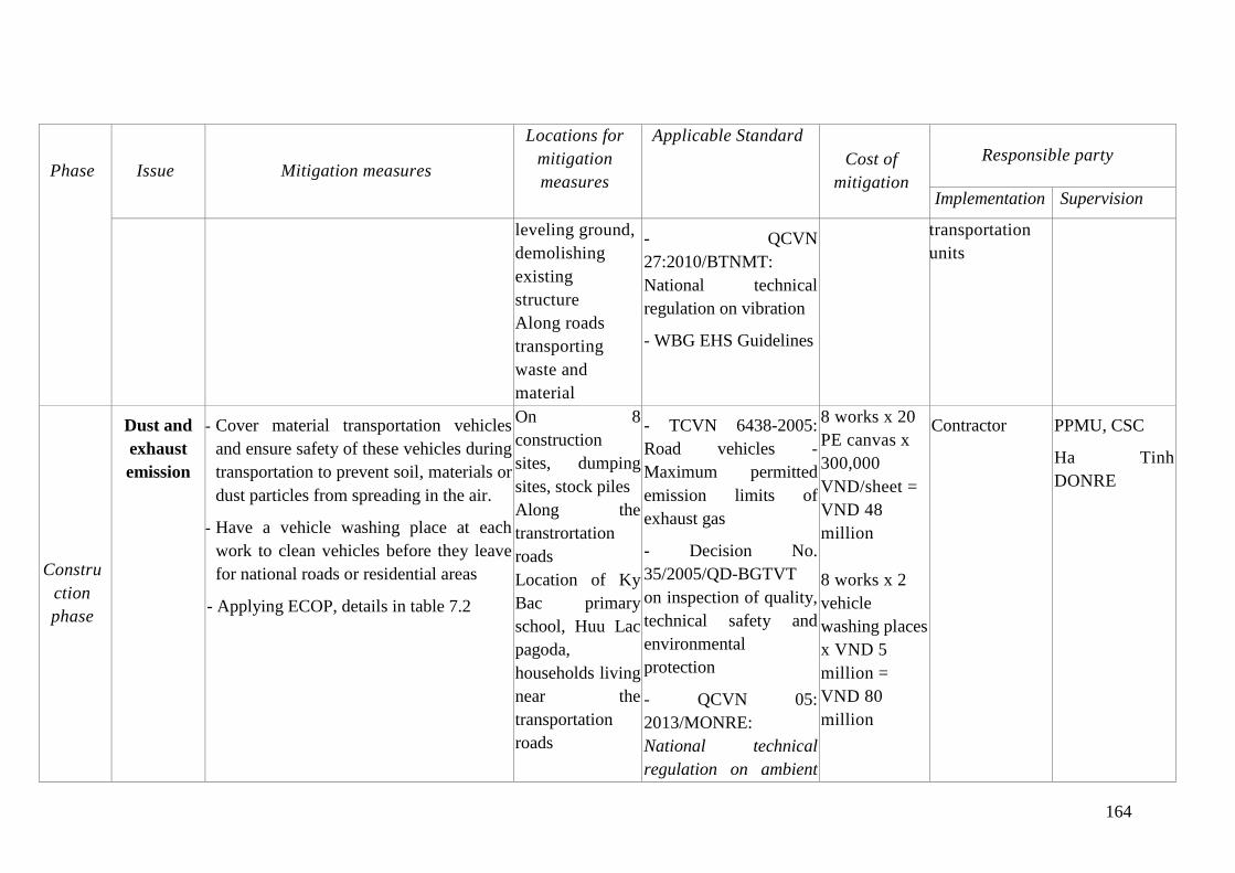
164
Phase Issue Mitigation measures
Locations for
mitigation
measures
Applicable Standard
Cost of
mitigation
Responsible party
Implementation Supervision
leveling ground,
demolishing
existing
structure
Along roads
transporting
waste and
material
- QCVN
27:2010/BTNMT:
National technical
regulation on vibration
- WBG EHS Guidelines
transportation
units
Constru
ction
phase
Dust and
exhaust
emission
- Cover material transportation vehicles
and ensure safety of these vehicles during
transportation to prevent soil, materials or
dust particles from spreading in the air.
- Have a vehicle washing place at each
work to clean vehicles before they leave
for national roads or residential areas
- Applying ECOP, details in table 7.2
On 8
construction
sites, dumping
sites, stock piles
Along the
transtrortation
roads
Location of Ky
Bac primary
school, Huu Lac
pagoda,
households living
near the
transportation
roads
- TCVN 6438-2005:
Road vehicles -
Maximum permitted
emission limits of
exhaust gas
- Decision No.
35/2005/QD-BGTVT
on inspection of quality,
technical safety and
environmental
protection
- QCVN 05:
2013/MONRE:
National technical
regulation on ambient
8 works x 20
PE canvas x
300,000
VND/sheet =
VND 48
million
8 works x 2
vehicle
washing places
x VND 5
million =
VND 80
million
Contractor
PPMU, CSC
Ha Tinh
DONRE
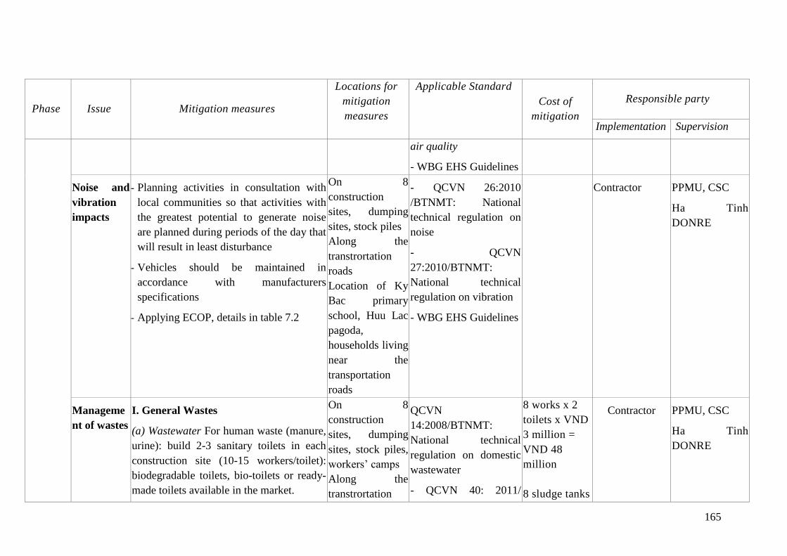
165
Phase Issue Mitigation measures
Locations for
mitigation
measures
Applicable Standard
Cost of
mitigation
Responsible party
Implementation Supervision
air quality
- WBG EHS Guidelines
Noise and
vibration
impacts
- Planning activities in consultation with
local communities so that activities with
the greatest potential to generate noise
are planned during periods of the day that
will result in least disturbance
- Vehicles should be maintained in
accordance with manufacturers
specifications
- Applying ECOP, details in table 7.2
On 8
construction
sites, dumping
sites, stock piles
Along the
transtrortation
roads
Location of Ky
Bac primary
school, Huu Lac
pagoda,
households living
near the
transportation
roads
- QCVN 26:2010
/BTNMT: National
technical regulation on
noise
- QCVN
27:2010/BTNMT:
National technical
regulation on vibration
- WBG EHS Guidelines
Contractor
PPMU, CSC
Ha Tinh
DONRE
Manageme
nt of wastes
I. General Wastes
(a) Wastewater For human waste (manure,
urine): build 2-3 sanitary toilets in each
construction site (10-15 workers/toilet):
biodegradable toilets, bio-toilets or ready-
made toilets available in the market.
On 8
construction
sites, dumping
sites, stock piles,
workers’ camps
Along the
transtrortation
QCVN
14:2008/BTNMT:
National technical
regulation on domestic
wastewater
- QCVN 40: 2011/
8 works x 2
toilets x VND
3 million =
VND 48
million
8 sludge tanks
Contractor
PPMU, CSC
Ha Tinh
DONRE
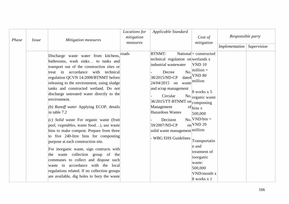
166
Phase Issue Mitigation measures
Locations for
mitigation
measures
Applicable Standard
Cost of
mitigation
Responsible party
Implementation Supervision
Discharge waste water from kitchens,
bathrooms, wash sinks… to tanks and
transport out of the construction sites or
treat in accordance with technical
regulation QCVN 14:2008/BTNMT before
releasing to the environment, using sludge
tanks and constructed wetland. Do not
discharge untreated water directly to the
environment.
(b) Runoff water Applying ECOP, details
in table 7.2
(c) Solid waste For organic waste (fruit
peel, vegetables, waste food…), use waste
bins to make compost. Prepare from three
to five 240-litre bins for composting
purpose at each construction site.
For inorganic waste, sign contracts with
the waste collection group of the
communes to collect and dispose such
waste in accordance with the local
regulations related. If no collection groups
are available, dig holes to bury the waste
roads
BTNMT: National
technical regulation on
industrial wastewater
- Decree No.
38/2015/ND-CP dated
24/04/2015 on waste
and scrap management
- Circular No.
36/2015/TT-BTNMT on
Management of
Hazardous Wastes
- Decision No.
59/2007/ND-CP on
solid waste management
- WBG EHS Guidelines
+ constructed
wetlands x
VND 10
million =
VND 80
million
8 works x 5
organic waste
composting
bins x
500,000
VND/bin =
VND 20
million
Transportatio
n and
treatment of
inorganic
waste:
500,000
VND/month x
8 works x 1
167
Phase Issue Mitigation measures
Locations for
mitigation
measures
Applicable Standard
Cost of
mitigation
Responsible party
Implementation Supervision
or burn flammable and non-toxic waste
(paper, wood, leaves …)
Applying ECOP, details in table 7.2
II. Hazardous Wastes
Applying ECOP, details in table 7.2
month = VND
4 million
Funding for
collecting and
treating solid
waste:
500,000
VND/month x
8 months x 8
construction
sites = VND
32 million
Disruption
of
vegetative
cover and
ecological
resources
- Applying ECOP, details in table 7.2 On 8
construction
sites, dumping
sites, stock piles,
workers’ camps,
along the
transportation
roads where
cutting plant and
operation of
machineries and
- Law on biodiversity
No.20/2008/QH12
- Decree 65/2010/ND-
CP on biodiversity
protection
Contractor
PPMU, CSC
168
Phase Issue Mitigation measures
Locations for
mitigation
measures
Applicable Standard
Cost of
mitigation
Responsible party
Implementation Supervision
vehicleds
compating soil.
Traffic
safety
manageme
nt
- Applying ECOP, details in table 7.2 On 8
construction
sites, dumping
sites, stock piles,
workers’ camps
Along the
transtrortation
roads
- Law on traffic and
transport No.
23/2008/QH12;
- Decree 46/2016/ND-
CP on administrative
penalty for traffic safety
violation
- Circular No.
22/2010/TT-BXD on
regulation on labor
safety in construction
- WBG EHS Guidelines
Included in
construction
cost
Contractor
PPMU, CSC
Workers’
camp
manageme
nt
- Applying ECOP, details in table 7.2 Workers’ camps
of 8 construction
sites
- Law on Labor
No.10/2012/QH13
- Workers’
Accommodation:
Process and Standards
(IFC and EBRD)
Included in
construction
cost
Contractor
PPMU, CSC
169
Phase Issue Mitigation measures
Locations for
mitigation
measures
Applicable Standard
Cost of
mitigation
Responsible party
Implementation Supervision
Chance
Find
Procedures
Where the risk and identification process
determines that there is a chance of
impacts to cultural heritage, the Contractor
will retain competent professionals to
assist in the identification and protection
of cultural heritage.
If the Contractor discovers archeological
sites, historical sites, remains and objects,
including graveyards and/or individual
graves during excavation or construction,
the Contractor shall comply with steps
describing in ECOP, table 7.2
Location where
construction
activities require
digging, such as
location of
repairing dam
heel, spillway
new building
water intakes;
location of
borrow pits
Law on cultural heritage
No. 28/2001/QH10
- Make adjustments
Actual
expenses Contractor
PPMU, CSC
Occupation
al health
and safety
- Training and use of safety labour
equipment
- Planning work site to miniimize
unsafety condition for workers
- Implementing administrative controls
into work processes, such as job
rotations and rest or stretch breaks;
- Use of control zones and safety
monitoring systems and warning sign to
warn workers.
- Applying ECOP, details in table 7.2
Whole of 8
construction sites
and at location of
auxiliary works
On transportation
roads
Directive No. 02
/2008/CT-BXD on labor
safety and sanitation in
construction agencies;
- Circular No.
22/2010/TT-BXD on
regulation on labor
safety in construction
- QCVN 18:2014/BXD:
Technical regulation on
Included in
training cost Contractor
PPMU, CSC
170
Phase Issue Mitigation measures
Locations for
mitigation
measures
Applicable Standard
Cost of
mitigation
Responsible party
Implementation Supervision
safety in construction
- WBG EHS Guidelines
Community
health and
safety
A. General Site Hazards
- Subproject should implement risk
management strategies to protect the
community from physical, chemical, or
other hazards associated with sites
under construction.
- Applying ECOP, details in table 7.2
B. Disease Prevention
Communicable Diseases
- Providing surveillance and active
screening and treatment of workers
- Preventing illness among workers in
local communities
Vector-Born Diseases
- Implementation of integrated vector
control programs
- Distributing appropriate education
materials
Applying ECOP, details in table 7.2
8 construction
site, workesr’
camps,
subproject
communes
- Law on Roadway
Traffic No.
23/2008/QH12
- Directive No. 02
/2008/CT-BXD on labor
safety and sanitation in
construction agencies;
- Circular No.
22/2010/TT-BXD on
regulation on labor
safety in construction
- QCVN 18:2014/BXD:
Technical regulation on
safety in construction
- WBG EHS Guidelines
Included in
training cost Contractor
PPMU, CSC
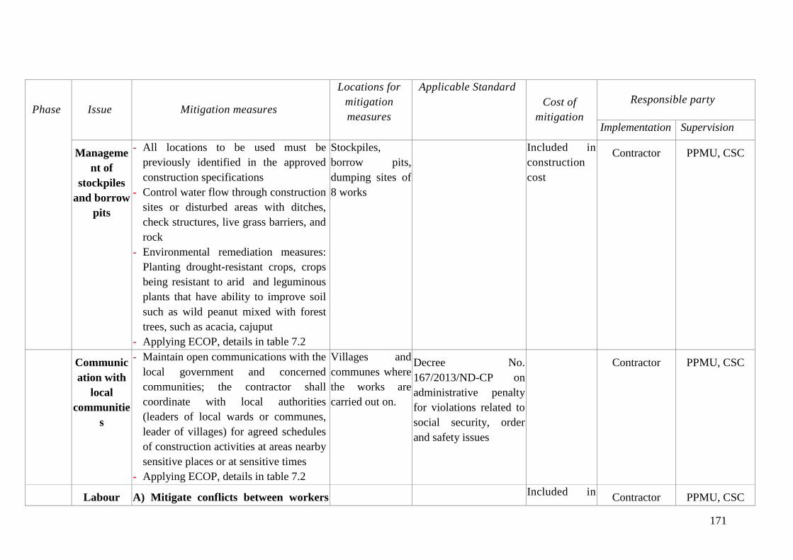
171
Phase Issue Mitigation measures
Locations for
mitigation
measures
Applicable Standard
Cost of
mitigation
Responsible party
Implementation Supervision
Manageme
nt of
stockpiles
and borrow
pits
- All locations to be used must be
previously identified in the approved
construction specifications
- Control water flow through construction
sites or disturbed areas with ditches,
check structures, live grass barriers, and
rock
- Environmental remediation measures:
Planting drought-resistant crops, crops
being resistant to arid and leguminous
plants that have ability to improve soil
such as wild peanut mixed with forest
trees, such as acacia, cajuput
- Applying ECOP, details in table 7.2
Stockpiles,
borrow pits,
dumping sites of
8 works
Included in
construction
cost
Contractor
PPMU, CSC
Communic
ation with
local
communitie
s
- Maintain open communications with the
local government and concerned
communities; the contractor shall
coordinate with local authorities
(leaders of local wards or communes,
leader of villages) for agreed schedules
of construction activities at areas nearby
sensitive places or at sensitive times
- Applying ECOP, details in table 7.2
Villages and
communes where
the works are
carried out on.
Decree No.
167/2013/ND-CP on
administrative penalty
for violations related to
social security, order
and safety issues
Contractor
PPMU, CSC
Labour A) Mitigate conflicts between workers
Included in
Contractor PPMU, CSC
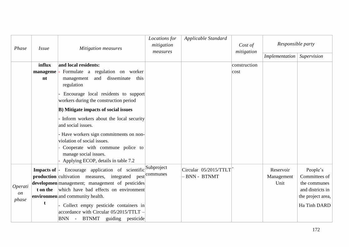
172
Phase Issue Mitigation measures
Locations for
mitigation
measures
Applicable Standard
Cost of
mitigation
Responsible party
Implementation Supervision
influx
manageme
nt
and local residents:
- Formulate a regulation on worker
management and disseminate this
regulation
- Encourage local residents to support
workers during the construction period
B) Mitigate impacts of social issues
- Inform workers about the local security
and social issues.
- Have workers sign commitments on non-
violation of social issues.
- Cooperate with commune police to
manage social issues.
- Applying ECOP, details in table 7.2
construction
cost
Operati
on
phase
Impacts of
production
developmen
t on the
environmen
t
- Encourage application of scientific
cultivation measures, integrated pest
management; management of pesticides
which have bad effects on environment
and community health.
- Collect empty pesticide containers in
accordance with Circular 05/2015/TTLT –
BNN - BTNMT guiding pesticide
Subproject
communes Circular 05/2015/TTLT
– BNN - BTNMT
- Reservoir
Management
Unit
People’s
Committees of
the communes
and districts in
the project area,
Ha Tinh DARD
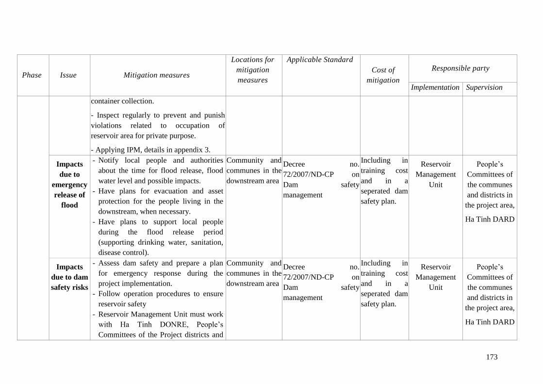
173
Phase Issue Mitigation measures
Locations for
mitigation
measures
Applicable Standard
Cost of
mitigation
Responsible party
Implementation Supervision
container collection.
- Inspect regularly to prevent and punish
violations related to occupation of
reservoir area for private purpose.
- Applying IPM, details in appendix 3.
Impacts
due to
emergency
release of
flood
- Notify local people and authorities
about the time for flood release, flood
water level and possible impacts.
- Have plans for evacuation and asset
protection for the people living in the
downstream, when necessary.
- Have plans to support local people
during the flood release period
(supporting drinking water, sanitation,
disease control).
Community and
communes in the
downstream area
Decree no.
72/2007/ND-CP on
Dam safety
management
Including in
training cost
and in a
seperated dam
safety plan.
Reservoir
Management
Unit
People’s
Committees of
the communes
and districts in
the project area,
Ha Tinh DARD
Impacts
due to dam
safety risks
- Assess dam safety and prepare a plan
for emergency response during the
project implementation.
- Follow operation procedures to ensure
reservoir safety
- Reservoir Management Unit must work
with Ha Tinh DONRE, People’s
Committees of the Project districts and
Community and
communes in the
downstream area
Decree no.
72/2007/ND-CP on
Dam safety
management
Including in
training cost
and in a
seperated dam
safety plan.
Reservoir
Management
Unit
People’s
Committees of
the communes
and districts in
the project area,
Ha Tinh DARD
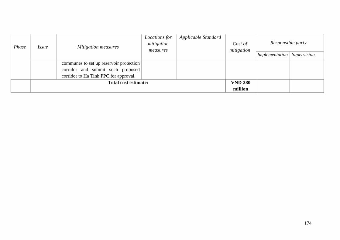
174
Phase Issue Mitigation measures
Locations for
mitigation
measures
Applicable Standard
Cost of
mitigation
Responsible party
Implementation Supervision
communes to set up reservoir protection
corridor and submit such proposed
corridor to Ha Tinh PPC for approval.
Total cost estimate: VND 280
million
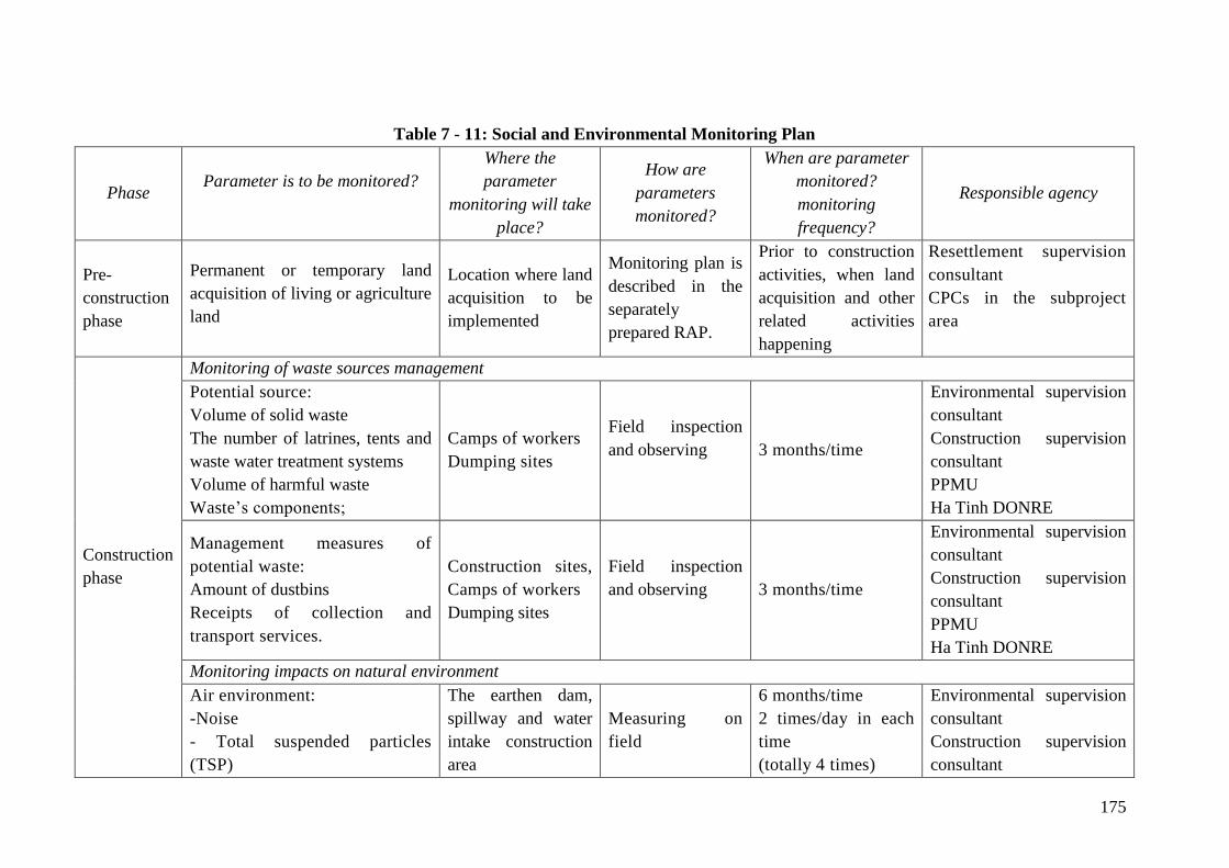
175
Table 7 - 11: Social and Environmental Monitoring Plan
Phase Parameter is to be monitored?
Where the
parameter
monitoring will take
place?
How are
parameters
monitored?
When are parameter
monitored?
monitoring
frequency?
Responsible agency
Pre-
construction
phase
Permanent or temporary land
acquisition of living or agriculture
land
Location where land
acquisition to be
implemented
Monitoring plan is
described in the
separately
prepared RAP.
Prior to construction
activities, when land
acquisition and other
related activities
happening
Resettlement supervision
consultant
CPCs in the subproject
area
Construction
phase
Monitoring of waste sources management
Potential source:
Volume of solid waste
The number of latrines, tents and
waste water treatment systems
Volume of harmful waste
Waste’s components;
Camps of workers
Dumping sites
Field inspection
and observing
3 months/time
Environmental supervision
consultant
Construction supervision
consultant
PPMU
Ha Tinh DONRE
Management measures of
potential waste:
Amount of dustbins
Receipts of collection and
transport services.
Construction sites,
Camps of workers
Dumping sites
Field inspection
and observing
3 months/time
Environmental supervision
consultant
Construction supervision
consultant
PPMU
Ha Tinh DONRE
Monitoring impacts on natural environment
Air environment:
-Noise
- Total suspended particles
(TSP)
The earthen dam,
spillway and water
intake construction
area
Measuring on
field
6 months/time
2 times/day in each
time
(totally 4 times)
Environmental supervision
consultant
Construction supervision
consultant
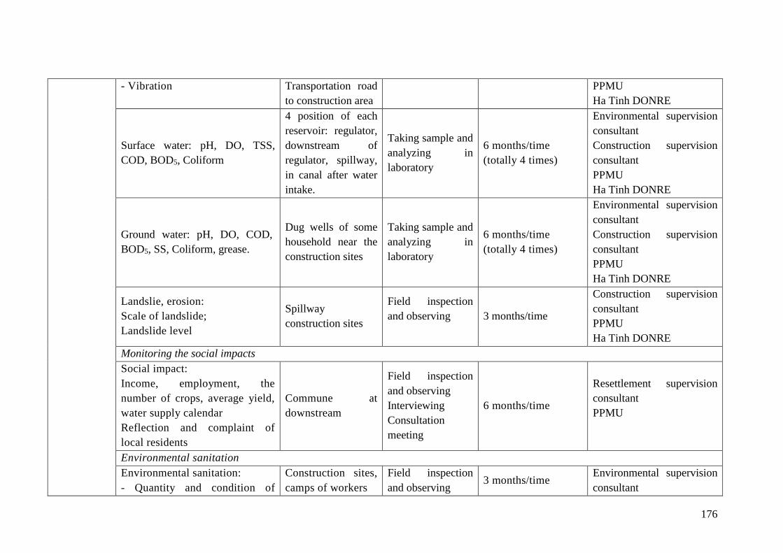
176
- Vibration Transportation road
to construction area
PPMU
Ha Tinh DONRE
Surface water: pH, DO, TSS,
COD, BOD5, Coliform
4 position of each
reservoir: regulator,
downstream of
regulator, spillway,
in canal after water
intake.
Taking sample and
analyzing in
laboratory
6 months/time
(totally 4 times)
Environmental supervision
consultant
Construction supervision
consultant
PPMU
Ha Tinh DONRE
Ground water: pH, DO, COD,
BOD5, SS, Coliform, grease.
Dug wells of some
household near the
construction sites
Taking sample and
analyzing in
laboratory
6 months/time
(totally 4 times)
Environmental supervision
consultant
Construction supervision
consultant
PPMU
Ha Tinh DONRE
Landslie, erosion:
Scale of landslide;
Landslide level
Spillway
construction sites
Field inspection
and observing
3 months/time
Construction supervision
consultant
PPMU
Ha Tinh DONRE
Monitoring the social impacts
Social impact:
Income, employment, the
number of crops, average yield,
water supply calendar
Reflection and complaint of
local residents
Commune at
downstream
Field inspection
and observing
Interviewing
Consultation
meeting
6 months/time
Resettlement supervision
consultant
PPMU
Environmental sanitation
Environmental sanitation:
- Quantity and condition of
Construction sites,
camps of workers
Field inspection
and observing 3 months/time
Environmental supervision
consultant
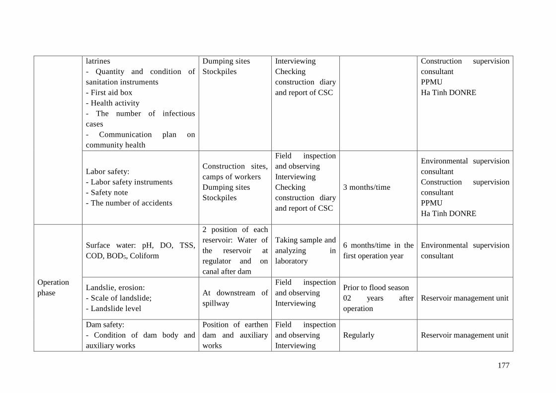
177
latrines
- Quantity and condition of
sanitation instruments
- First aid box
- Health activity
- The number of infectious
cases
- Communication plan on
community health
Dumping sites
Stockpiles
Interviewing
Checking
construction diary
and report of CSC
Construction supervision
consultant
PPMU
Ha Tinh DONRE
Labor safety:
- Labor safety instruments
- Safety note
- The number of accidents
Construction sites,
camps of workers
Dumping sites
Stockpiles
Field inspection
and observing
Interviewing
Checking
construction diary
and report of CSC
3 months/time
Environmental supervision
consultant
Construction supervision
consultant
PPMU
Ha Tinh DONRE
Operation
phase
Surface water: pH, DO, TSS,
COD, BOD5, Coliform
2 position of each
reservoir: Water of
the reservoir at
regulator and on
canal after dam
Taking sample and
analyzing in
laboratory
6 months/time in the
first operation year
Environmental supervision
consultant
Landslie, erosion:
- Scale of landslide;
- Landslide level
At downstream of
spillway
Field inspection
and observing
Interviewing
Prior to flood season
02 years after
operation
Reservoir management unit
Dam safety:
- Condition of dam body and
auxiliary works
Position of earthen
dam and auxiliary
works
Field inspection
and observing
Interviewing
Regularly Reservoir management unit
178
- Detecting abnormal status of
works
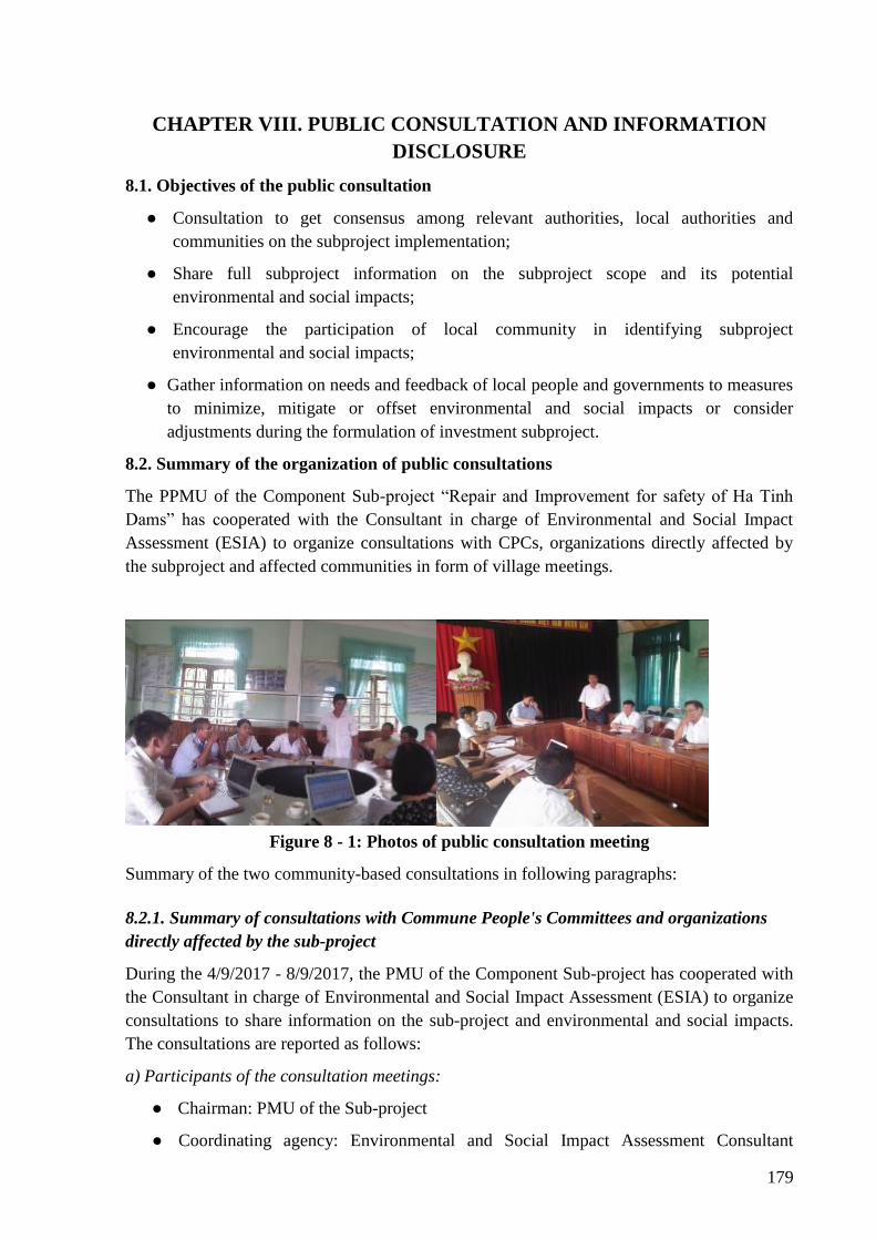
179
CHAPTER VIII. PUBLIC CONSULTATION AND INFORMATION
DISCLOSURE
8.1. Objectives of the public consultation
● Consultation to get consensus among relevant authorities, local authorities and
communities on the subproject implementation;
● Share full subproject information on the subproject scope and its potential
environmental and social impacts;
● Encourage the participation of local community in identifying subproject
environmental and social impacts;
● Gather information on needs and feedback of local people and governments to measures
to minimize, mitigate or offset environmental and social impacts or consider
adjustments during the formulation of investment subproject.
8.2. Summary of the organization of public consultations
The PPMU of the Component Sub-project “Repair and Improvement for safety of Ha Tinh
Dams” has cooperated with the Consultant in charge of Environmental and Social Impact
Assessment (ESIA) to organize consultations with CPCs, organizations directly affected by
the subproject and affected communities in form of village meetings.
Figure 8 - 1: Photos of public consultation meeting
Summary of the two community-based consultations in following paragraphs:
8.2.1. Summary of consultations with Commune People's Committees and organizations
directly affected by the sub-project
During the 4/9/2017 - 8/9/2017, the PMU of the Component Sub-project has cooperated with
the Consultant in charge of Environmental and Social Impact Assessment (ESIA) to organize
consultations to share information on the sub-project and environmental and social impacts.
The consultations are reported as follows:
a) Participants of the consultation meetings:
● Chairman: PMU of the Sub-project
● Coordinating agency: Environmental and Social Impact Assessment Consultant
180
(ESIA)
● Participants: Representatives local authority, local NGOs (Women's Union, Youth
Union, Farmer's Union, Veterans Association); Village chiefs; Representatives of
affected households
b) Consultations with CPCs and affected organizations:
● Representative of the PMU of the Sub-project introduced main objectives, main items
of the sub-project, scope of the Sub-project and affected objects;
● Environmental and Social Impact Assessment Consultant provided information on
Environmental and Social Safeguard Policy as defined in the WB8 Environmental and
Social Management Framework. Expected negative impacts of the sub-project on
environment and society. Identify affected objects and level of impacts. Propose
mitigation measures to impacts of the subproject on environment and society.
● Commune People's Committees and affected organizations discuss to get consensus on
the sub-project implementation and provide information on the current state of the
environment, natural and socio-economic conditions and discuss positive and negative
impacts of the subproject on environment and society.
Table 8 - 1: Summary of consultations with CPCs and affected organizations in the
subproject area
Name of
work
Consultation
date Location
Total
participants
Female
participan
ts
Minutes of consultation
meetings
Loi Dong
Reservoir 18/9/2017
CPC of Ky
Trinh 25 5
Document No.
37/UBND, 18/9/2017
of Ky Trinh CPC
Nuoc Xanh
Reservoir 19/9/2017
CPC of Ky
Phong 28 8
Document
No.134/UBND
19/9/2017 Ky Phong
CPC
Ba Khe
Reservoir 20/9/2017
CPC of Ky
Bac 23 5
Document
No.211/UBND,
20/9/2017 Ky Bac CPC
Dap Buom
Reservoir 18/9/2017
CPC of
Huong Tho 25 4
Document
No.157/UBND
18/9/2017 Huong Tho
CPC
Khe Co
Reservoir 20/9/2017
CPC of Son
Le 36 4
Document
No.206/UBND
20/9/2017 Son Le CPC
Khe Nhay
Reservoir 18/9/2017
CPC of Son
Tien 29 7
Document
No.273/UBND
18/9/2017 Son Tien
CPC
181
Khe De
Reservoir 19/9/2017
CPC of Son
Mai 24 3
Document no
159/UBND 19/9/
No.Son Mai CPC
Da Den
Reservoir 18/9/2017
CPC of
Ngoc Son 21 3
Document
No.241/UBND
18/9/2017 Ngoc Son
CPC
8.2.2. A summary of community-based consultation meetings for directly affected
communities
After the draft of the ESIA report of Sub-project No. 1 - Repairing and improving safety for
dams in Ha Tinh, the PMU issued Official Letter No. 146/WB8-KHKT dated 15/9/2017 to
Commune People's Committees in the subproject area to consult on the ESIA report and to
jointly organize consultation meetings with affected local communities.
a) Participants
Consultation meetings were held at CPCs in the subproject area with following participations:
- Chair: PMU in collaboration with CPCs in the subproject area
- Village Party Secretary
- Head, vice heads of villages
- All households affected by sub-project activities such as households whose lands
have been acquired, crops are affected or ones affected by the transportation of materials or
water cut, lonely households or households with difficult conditions etc.
b) Contents of community consultation meetings
At these consultation meetings, the PMU presented objectives of the subproject and
summarized construction/repair works, location of auxiliary works, implementation progress
and construction methods.
Consultant who prepares Environmental and Social Impact Assessment report presented
contents of the ESIA report and proposed measures to mitigate impacts on environment and
society.
The subproject owner declared commitments, acceptable feedbacks, and added proper
information into the ESIA and responded to unacceptable feedbacks and mentioned the
reasons for non-acceptance.
Local authorities and the community discussed and agreed on solutions committed by the
subproject owner. At the same time, local authorities and communities also expressed their
expectations that the subproject would be soon implemented to stabilize their lives and
promote economic developments. Local community also pledges to create favorable
conditions for the early and smooth project implementation.
In response to Official Letter No. 146/WB8-KHKT dated 15/9/2017, the CPCs of all
communes in the subproject area sent an official letter to the PMU to provide their feedbacks
on the Environmental and Social Impact Assessment report. Summary of community
182
consultation activities is in Table 8.2.
Table 8 - 2: Summary of consultations with affected households
Name of
work
Consultatio
n date Location
Total
participants
Female
participa
nts
Minutes of consultation
meetings
Loi Dong
Reservoir 18/9/2017
CPC of Ky
Trinh 25 5
Document No.
37/UBND, 18/9/2017
of Ky Trinh CPC
Nuoc Xanh
Reservoir 19/9/2017
CPC of Ky
Phong 28 8
Document No.
134/UBND 19/9/2017
Ky Phong CPC
Ba Khe
Reservoir 20/9/2017
CPC of Ky
Bac 23 5
Document No.
211/UBND, 20/9/2017
Ky Bac CPC
Dap Buom
Reservoir 18/9/2017
CPC of
Huong Tho 25 4
Document No.
157/UBND 18/9/2017
Huong Tho CPC
Khe Co
Reservoir 20/9/2017
CPC of Son
Le 36 4
Document No.
206/UBND 20/9/2017
Son Le CPC
Khe Nhay
Reservoir 18/9/2017
CPC of Son
Tien 29 7
Document No.
273/UBND 18/9/2017
Son Tien CPC
Khe De
Reservoir 19/9/2017
CPC of Son
Mai 24 3
Document No.
159/UBND 19/9/2017
Son Mai CPC
Da Den
Reservoir 18/9/2017
CPC of
Ngoc Son 21 3
Document No.
241/UBND 18/9/2017
Ngoc Son CPC
8.3. Community consultation results
8.3.1. Feedbacks of the CPCs and directly affected organizations
The feedbacks of the 8 directly affected communes are summarized in Table 8.3. It is found
that all communes agreed with the subproject implementation and ask the subproject owner to
accelerate the subproject progress and carry out all mitigation measures as presented in the
report.
Table 8 - 3: Feedbacks of CPCs of affected communes and affected organizations
Work Consulted agency Feedbacks in writing from CPCs
183
Loi Dong
Reservoir UBND P. Ky Trinh
- High consensus on the repair and raising dam height
of Loi Dong Reservoir
- Agree with contents of Environmental and Social
impact assessment and mitigation measures in ESIA
Report
- Construction activities and transportation of
materials are far away from residential areas so
impacts are not significant.
- Noise only affects 2 households at the dam heel.
- During the construction period, the People's
Committee of Ky Trinh Ward is responsible for
coordinating with the subproject owner and
contractors in the implementation of measures to
minimize impacts on the environment and society;
- Recommendations: i) Loi Dong Reservoir is
composed of 03 reservoirs: Loi Dong, Bau Son and
Hoi Lay; 02 intakes of the remaining 02 reservoirs
should be repaired; ii) Contractor must pledge not to
affect schools and make a plan available to shield
construction vehicles and works under construction
from surrounding area
Nuoc
Xanh
Reservoir
CPC of Ky Phong
- Agree with impact assessments of Nuoc Xanh
Reservoir repairs on the environment and society in
the affected area. Impacts are minimal and mitigation
measures can be applied.
- The proposed environmental and social mitigation
measures are appropriate. Local authorities agreed
with and will coordinate with subproject owner and
contractors in site clearance, worker management and
monitoring of mitigation measures to mitigate impacts
on environment and society.
- It is recommended that the subproject owner inform
early and in details the construction plan to local
governments and stakeholders so that they can
cooperate in the implementation of mitigation
measures.
- It is recommended that Nuoc Xanh Reservoir is
repaired as soon as possible to ensure the safety of the
reservoir and of local people living in the downstream
area
Ba Khe
Reservoir CPC of Ky Bac
- Agree with the repair of Ba Khe reservoir to ensure
safety for production activities and people living
downstream.
- Agree with environmental impact assessment for Ba
184
Khe Reservoir as presented by the Consultant
- Agree with mitigation measures to reduce impacts
on the environment and society of the subproject
owner.
- The People's Committee of Ky Bac Commune will
facilitate the land acquisition and support the
subproject owner in the implementation of mitigation
measures for impacts on the environmental and
society.
- If water is cut for construction during cropping time,
the subproject owner has to coordinate with Nam Ha
Irrigation Management Company (IMC)
Dap
Buom
Reservoir
The irrigation water will be supplied from Rac River
canal under Rac River irrigation system to make sure
cultivation activities will not be affected.
- Recommendation: Ba Khe Reservoir is silted up due
to upstream mining activities and reservoir capacity
has decreased by 40-50% (from over 1 million m3 of
water to only 500 – 600,000 m3). This Reservoir
should be significantly dredged and rehabilitated to
restore its water volume to 700-800,000 m3 of water
Khe Co
Reservoir CPC of Huong Tho
- The ESIA report lists all possible impacts of the
subproject on natural environment, socio-economic
and community health. Local stakeholders agreed
with the above assessment
- Agree with mitigation measures for environment and
society as proposed by the subproject owner. They are
proper and highly feasible measures.
- Recommendation: i) The subproject owner should
comply with their commitments in the ESIA report; ii)
Information related to the subproject implementation
should be disclosed as regulated.
- Agree with social and environmental impact
assessment contents relating to the repair of Khe Co
reservoir. The construction activities and transport of
materials are far away from the residential areas so
impacts are minimal
185
Khe
Nhay
Reservoir
CPC of Son Le
- Agree with the impact mitigation measures for
environmental and social impacts proposed by the
subproject owner. The subproject owner should pay
attention to mitigation measures for affected
production activities and domestic activities of local
people during water cut. Mitigation measures for
affected infrastructure and rural transport should be
focused during the transporting of construction
materials
- Recommendations: i) The downstream of the two
main and auxiliary spillways are inter-village roads.
Therefore, the subproject owner has to work out
effective structural solutions to ensure traffic safety
in the area; ii) Make sure that construction schedule
will help minimize impacts on production activities
and domestic activities; iii) Inform local authorities in
time of any problems for prompt solutions
Khe De
Reservoir CPC of Son Tien
- Strongly agree with the subproject owner on the
repair and improvement of Khe Nhay reservoir.
- Agree with the environmental and social impacts
assessments. The construction of the new sluice will
require lowered water level in the reservoir, which
means impacts on downstream production activities
so adequate assessments should be made.
- Agree on environmental and social mitigation
measures suggested by the subproject owner. Local
authorities will coordinate with the subproject owner
in the management of workers and supervision of
environmental and social impacts as well as solutions
to incidents.
- Recommendations: i) The subproject implementation
should be synchronous and due construction progress
should be ensured so that the subproject will be
completed on time.
Da Den
Reservoir
ii) Khe Nhay reservoir spillway threshold has a
transport road of submerged overflow style. The
upgrading of the Reservoir should design safety plan
for travellers. iii) The Khe Nhay Reservoir dam crest
can operate as a transport road at the same time.
Currently the road pavement is narrow and should be
expanded once the dam is rehabilitated.
Khe De
Reservoir CPC of Son Mai
- The ESIA report fully described impacts of the
subproject on the natural environment, socio-
economic conditions and community health,
186
especially the negative impacts. Local government
agreed with the assessment.
- Local authorities fully agree with the mitigation
measures for affected natural environment, socio-
economic conditions and public health proposed by
the subproject owner as these measures are proper and
feasible.
- Recommendations: i) the subproject owner should to
strictly comply with solutions suggested in the ESIA
report; ii) The subproject owner should coordinates
with local authorities to disseminate project
information to stakeholders as regulated.
Da Den
Reservoir CPC of Ngoc Son
- The People's Committee of Ngoc Son Commune
agreed with the Environmental and social impact
Assessment relating to negative impacts of the
project.
- The People's Committee of Ngoc Son Commune
also agrees with mitigation measures to minimize
negative impacts on the environment and society as
suggested in the ESIA report.
- Recommendations: subproject management unit
should coordinate with contractors to carry out
environmental protection measures during the
subproject implementation.
8.3.2. Feedbacks of local communities who are directly affected by the Sub-project
Summary of feedbacks of local communities in 8 communes directly affected by the Sub-
project in Table 8.4:
Table 8 - 4: Feedbacks of local communities who are directly affected by the Sub-project
Works Location Feedbacks of local community on the subproject
Loi Dong
Reservoir
Ky Trinh
Ward
- Households are very happy with the subproject as it will help
improve the safety of Loi Dong dam and expect the subproject
will be soon implemented.
- Local people agree with the Environmental and Social impact
assessment Report and mitigation measures presented by the
Consultant
- Loi Dong reservoir does not supply water for summer-autumn
and winter crop. The construction of intakes and dam below the
full supply level during June-August will not affect cultivation
activities.
- Recommendation: paying labor costs for people involving in
the digging of trench to avoid leakage from the Reservoir (local
parish mobilized labors many years ago for this activity).
187
Nuoc
Xanh
Reservoir
Ky phong
commune
- All participants agreed with the Sub-project.
- Agree with environmental and social impact assessments and
mitigation measures proposed by the ESIA consultant and hope
the subproject will be implemented soon.
- Recommendations: i) if water cut is inevitable, the subproject
owner should pump water from the main canal of Song Rac
Irrigation system to irrigate affected cultivation areas; ii) To
minimize impacts on lives of local people, it is proposed that
materials and wastes will be transported along the National
Defence Road after the ranch; iii) the spillway as transport road
serving 9 households in the downstream area become slippery
during the rainy season and local people cannot travel on that
and it is recommended for repairs and upgrading.
Ba Khe
Reservoir Ky Bac CPC
- Requesting the Client to fully implement compensation and
support policies for affected households due to land
accquisition
- It is recommended to improve the reservoir bed to restore the
water capacity and irrigation area as designed
- If water is to be cut for construction during the irrigation time,
water should be pumped from main canal of Song Rac
irrigation system to irrigate the affected area.
- Local households all look forwards to early implementation of
the subproject, especially village 1 and 3.
- Agree with Environmental and social impact assessments and
mitigation measure proposed by the subproject owner.
Dap
Buom
Reservoir
Residential
group of Vil
1 - Huong
Tho
commune
- The rehabilitation of Dap Buom reservoir is quite necessary.
Local authorities and people have been expecting for this
subproject for a long time.
- The subproject owner should consider the application of
advanced technologies in upgrading items, especially for
improvement of drainage valve, intakes and outlets.
- The subproject owner should arrange a temporary road during
the construction time to ensure uninterrupted transfer for local
people
- Head of residential group of Village 1 hopes that local
authorities will support affected households whose lands has
been acquired for dam construction.
Khe Co
Reservoir
CPC of Son
Le
- Local people and stakeholders in the commune are excited
and agreed with the repair and upgrading of Khe Co Reservoir.
- Agree with environmental and social impacts assessments as
well as mitigation measures proposed in the ESIA and hope the
subproject will be implemented soon.
- Recommendation: i) Khe Co Reservoir is to irrigate 560 ha in
Son Le, Son Tien and Son An communes. The Reservoir also
188
supplies domestic water to nearly 1,000 people of Son Le
commune. Thus it is necessary to allocate proper construction
schedule in order to minimize impacts on downstream areas; ii)
In case of water cut for construction, the subproject owner
should calculate and make sure that minimal adverse impacts
will happen to local people and production activities; iii) Repair
and upgrade flood spillway to ensure safety for downstream
travelling; iv) Canals after dams have been damaged and should
be upgraded.
Khe
Nhay
Reservoir
Son Tien
CPC
- Local households agreed with the repairing and upgrading of
Khe Nhay Reservoir.
- Agree with environmental and social impacts assessment and
mitigation measures as proposed by the subproject owner.
- Recommendation: i) the construction has to be very quick as
the main road crosses the dam and spillway; ii) Bridge should
be built over spillway instead of submerged overflow; iii) There
should be a bypass for the dam, or dam surface will be
expanded using concrete; iv) The subproject owner should
inform local people and governments of construction schedule
and plan and mitigation measures for local monitoring and
supervision.
Khe De
Reservoir
Village
common
house of
Minh Giang
village, Son
Mai
commune
- Local authorities and people support the subproject and hope
it will be implemented soon. Participants in the consultation
meeting agreed with environmental and social impact
assessments.
- The local authorities commit to carrying out land acquisition
procedure for 5% (0.5 ha) which is temporarily allocated to the
Hoang Van Tai family to make sure construction site in place
for the subproject.
- The subproject owner should consider replacing the rescue
road with the construction of a new road of 800m connecting
the dam heel base as the locality is planning the construction of
2.5 km of rescue road under the new rural development
program.
- During the construction phase, the subproject owner is asked
to produce specific instructions on the use of temporary roads
and bypass to ensure smooth ensure traffic by local people.
Ho Da
Den
CPC of Ngoc
Son
- Local authorities and people support the subproject and hope
it will be implemented soon.
- Agree with environmental and social impact assessments and
mitigation measures
- The subproject owner is requested to dredge the reservoir area
to increase storage capacity for more irrigation water storage
during dry season.
189
- The subproject owner is requested to work out water supply
solutions for local people during the construction time.
8.3.3 Responses and commitments of the subproject owner to recommendations and
suggestions of consulted agencies, organizations and communities
Following the feedbacks are received during the consultations with affected CPCs and
communities in Sub-project 1 “Dam Rehabilitation and Safety Improvement Project - Ha Tinh
province”, the subproject owner responded and committed as follows:
a) Feedback
Summary of subproject owner’s feedbacks to acceptable and unacceptable suggestions in
Table 8.5:
Table 8 - 5: The subproject owner’s feedbacks and and commitments
Works Location Acceptable comments Unacceptable comments and
reasons
Loi Dong
Reservoir
Ky Trinh
Ward
- The subproject owner will
arrange the construction time of
intakes and dam repairs below full
water supply during June to
August so that downstream
production activities will not be
affected
- Labor of local people for
dugging trench to prevent
water leakage which have been
done some years ago is feree
free mobilized labor activities
so it is not accepted for
financial supports in the
project.
- The repair of intakes of Bau
Son and Hoi Lay Reservoirs is
not under the scope of the Sub-
project
Nuoc
Xanh
Reservoir
Ky Phong
commune
- If water is cut for construction
during cropping time, the
subproject owner will coordinate
with Nam Ha Irrigation
Management Company (IMC) and
the irrigation water will be
supplied from Rac River canal
under Rac River irrigation system
to make sure cultivation activities
will not be affected
- The subproject owner will
consider transporting materials
and wastes along the National
Defence Road after the ranch;
- The subproject owner has
planned to build a new spillway,
and line the spillway surface with
None
190
concrete which is also the farmer
road for 9 households downstream
Ba Khe
Reservoir
Ky Bac
commune
- The subproject owner will
consider suggestions of local
people relating to the dredging and
renovating of the reservoir to
restore design irrigation capacity.
None
Dap
Buom
Reservoir
Huong
Tho
commune
- The subproject owner will
consider applying advanced
technologies for automatically
operated sluice to ensure design
requirements and meet subproject
cost.
- The subproject owner commits
to arranging a temporary road and
publicly announcing the use of
temporary road before and during
the construction process to ensure
transport of local people.
- Stakeholders closely coordinated
during the site clearance to ensure
the construction progress and
implementation of environmental
and social safety policy.
None
Khe Co
Reservoir
Son Le
commune
- Khe Co reservoir only relates to
the repairs and upgrading of
spillways. As the intake is not
repaired, water supply is not
affected
- The subproject owner will
arrange the construction of items
below the full water supply during
June - August (the lowest water
demand) to avoid impact to
production activities and living of
people
The repair and upgrading
irrigation canals are not under
the scope of this Sub-project
Khe Nhay
Reservoir
Son Tien
commune
- The subproject owner has had a
plan to expand dam surface to B =
5m and line dam surface using
concrete M250 and 20cm thick
and upgrade flood spillway to
ensure traffic over dam and
spillway.
- The dam and spillway surface
The construction of bridge
over the spillway is difficult to
be implemented as the
spillway is located ahead of
the dam, the bridge may affect
dam structure as well as flood
drainage capacity of the
spillway
191
construction options will be
carried out in as fastest as possible
to minimize traffic block.
Khe De
Reservoir
Son Mai
commune
- The subproject owner will
consider replacing rescue road
with a new road of 800m
connecting to the dam heel (on the
left shoulder of the dam) as this
road is quite necessary for rescue
work and management and
operation of the subproject later.
- The subproject owner undertakes
to notify and provide specific
guidance on the use of temporary
roads and bypass for local people.
- Stakeholders will cooperate in
site clearance work to ensure
construction progress and
compensations for damages per
project policies.
In 2015, local government
built a transport road under the
spillway using funding from
new rural development
program and the design sluice
has an aperture of D = 50 cm.
Given such small aperture, the
system cannot meet flood
drainage requirements and the
sluice aperture should be D =
80 cm. However, upgrading of
the road under the spillway
cannot be funded in the Sub-
project and it should be
upgraded using other sources
of funding to make sure local
economic and social activities
can be stabilized.
Da Den
Reservoir
Ngoc Son
commune
- The construction of items under
the full water supply will take
place during June – August so not
to affect production activities
downstream. Water from Lam
River will be supplied to
compensate the water cut during
construction time.
- Contractors are asked to comply
with allowed load and speed
during the transport of materials
so not to affect traveling of local
people in the subproject area.
- The repair of irrigation canal
in the downstream of the dam
is not in the scope of the Sub-
project
b) ) Commitments of the subproject owner
● Commit to compensating affected households having lands acquired and households
with affected production lands in accordance with the Resettlement policy framework
of the "Repair and improvement safety for dams" and Resettlement Action Plan of
Subproject 1 "Repairing and improving for safety of dams in Ha Tinh Province".
● Commit to compensating for damages of infrastructure and rural transports due to the
construction of subproject.
● Commit to full implementation of pollution mitigation measures as described in the
192
Sub-project Environmental and Social Impact Assessment Report.
● Commit to regularly coordination with local authorities and contractors for effective
management of staff during the implementation of the subproject so as to avoid
conflicts with local people and to prevent any traffic accidents, labor accidents, and
incidents that threat local people and infrastructure.
● Commit to ensuring smooth traffic along the material and waste transport routes
throughout the construction period.
● After the completion of each work, construction site will be cleaned and restored to
the initial conditions and environmental sanitation is ensured as regulated.
8.4. Information Disclosure
In compliance with the WB's policy on access to information and OP 4.01 (Environmental
Assessment), the ESIA report will be locally disclosed on the project website and at
subprojects sites accessible to locally-affected people and local NGOs in Vietnamese
language and on the Bank external website in English prior to appraisal of the subproject.
Table 8.6 indicates the dates and locations of disclosure of the draft and final ESIA of the
subproject.
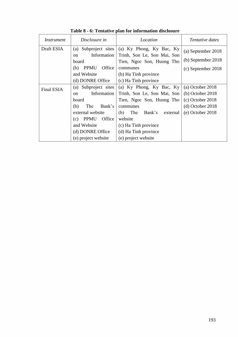
193
Table 8 - 6: Tentative plan for information disclosure
Instrument Disclosure in Location Tentative dates
Draft ESIA
(a) Subproject sites
on Information
board
(b) PPMU Office
and Website
(d) DONRE Office
(a) Ky Phong, Ky Bac, Ky
Trinh, Son Le, Son Mai, Son
Tien, Ngoc Son, Huong Tho
communes
(b) Ha Tinh province
(c) Ha Tinh province
(a) September 2018
(b) September 2018
(c) September 2018
Final ESIA (a) Subproject sites
on Information
board
(b) The Bank’s
external website
(c) PPMU Office
and Website
(d) DONRE Office
(e) project website
(a) Ky Phong, Ky Bac, Ky
Trinh, Son Le, Son Mai, Son
Tien, Ngoc Son, Huong Tho
communes
(b) The Bank’s external
website
(c) Ha Tinh province
(d) Ha Tinh province
(e) project website
(a) October 2018
(b) October 2018
(c) October 2018
(d) October 2018
(e) October 2018
194
REFERENCES
1. Report on curen environmental status of Ha Tinh province in 2015 - Ha Tinh Department
of Natural Resources and Environment;
2. Report on environmental protection planning in Ha Tinh province for period 2010-2020 -
Ha Tinh Department of Natural Resources and Environment;
3. Statistical yearbook of Ha Tinh province, 2016;
4. Report on the implementation of socio-economic, defense-security tasks in 2016 and
objectives, tasks and solutions in 2017 of the communes in subproject area;
5. Land use planning up to 2020, land use planning for the first 5 years (2011 - 2015) of Ha
Tinh province, Ha Tinh Department of Natural Resources and Environment, 2011;
6. Overall planning of irrigation system of Ha Tinh province, Ha Tinh Department of
Agriculture and Rural Development, 2012;
7. Decision no. 82/2008/QD-BNN dated 17/7/08 of MARD on announcement of the list of
endangered precious and rare aquatic species in Vietnam to be protected, rehabilitated
and developed;
8. Ha Tinh Irrigation Department, research topic "Assessment of surface water resources in
Ha Tinh terrain for sustainable socio-economic development strategy", 2008;
9. Report on investment preparation of subproject 1 “Dam safety repair and improvement of
Ha Tinh province”;
10. Dam safety report of subproject 01, Ha Tinh province;
11. Environmental impact assessment report of the subproject “Dam safety repair and
improvement of Ha Tinh province”;
12. Social impact assessment report of the project “Dam safety repair and improvement of Ha
Tinh province”;
13. Resettlement action plan report of the subproject “Dam safety repair and improvement of
Ha Tinh province”.
14. Project operation manual of Dam rehabilitation and safety improvement project (attached
with Decision no. 2793 /QD-BNN-HTQT dated July 6th, 2016 of Minister of MARD,
2016;
15. Environmental and social management framework of Dam rehabilitation and safety
improvement project, 2015.

195
APPENDIX
Appendix 1- Maps and diagram of sampling locations
Appendix 2 - Analysis results of ambient environmental quality
Appendix 3- Integrated pest management plan (IPM)
Appendix 4- Emergency preparedness plan
Appendix 5– Technical parameter of the works
Appendix 6- List of participants preparing ESIA
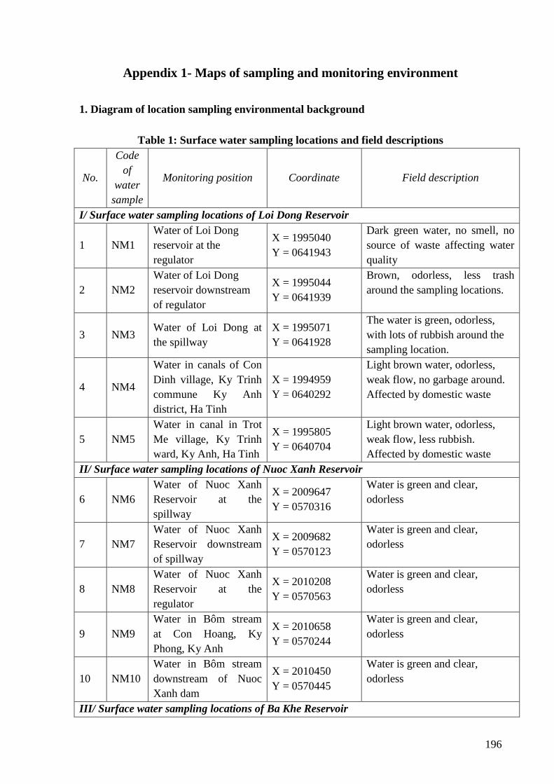
196
Appendix 1- Maps of sampling and monitoring environment
1. Diagram of location sampling environmental background
Table 1: Surface water sampling locations and field descriptions
No.
Code
of
water
sample
Monitoring position Coordinate Field description
I/ Surface water sampling locations of Loi Dong Reservoir
1 NM1
Water of Loi Dong
reservoir at the
regulator
X = 1995040
Y = 0641943
Dark green water, no smell, no
source of waste affecting water
quality
2 NM2
Water of Loi Dong
reservoir downstream
of regulator
X = 1995044
Y = 0641939
Brown, odorless, less trash
around the sampling locations.
3 NM3 Water of Loi Dong at
the spillway
X = 1995071
Y = 0641928
The water is green, odorless,
with lots of rubbish around the
sampling location.
4 NM4
Water in canals of Con
Dinh village, Ky Trinh
commune Ky Anh
district, Ha Tinh
X = 1994959
Y = 0640292
Light brown water, odorless,
weak flow, no garbage around.
Affected by domestic waste
5 NM5
Water in canal in Trot
Me village, Ky Trinh
ward, Ky Anh, Ha Tinh
X = 1995805
Y = 0640704
Light brown water, odorless,
weak flow, less rubbish.
Affected by domestic waste
II/ Surface water sampling locations of Nuoc Xanh Reservoir
6 NM6
Water of Nuoc Xanh
Reservoir at the
spillway
X = 2009647
Y = 0570316
Water is green and clear,
odorless
7 NM7
Water of Nuoc Xanh
Reservoir downstream
of spillway
X = 2009682
Y = 0570123
Water is green and clear,
odorless
8 NM8
Water of Nuoc Xanh
Reservoir at the
regulator
X = 2010208
Y = 0570563
Water is green and clear,
odorless
9 NM9
Water in Bôm stream
at Con Hoang, Ky
Phong, Ky Anh
X = 2010658
Y = 0570244
Water is green and clear,
odorless
10 NM10
Water in Bôm stream
downstream of Nuoc
Xanh dam
X = 2010450
Y = 0570445
Water is green and clear,
odorless
III/ Surface water sampling locations of Ba Khe Reservoir
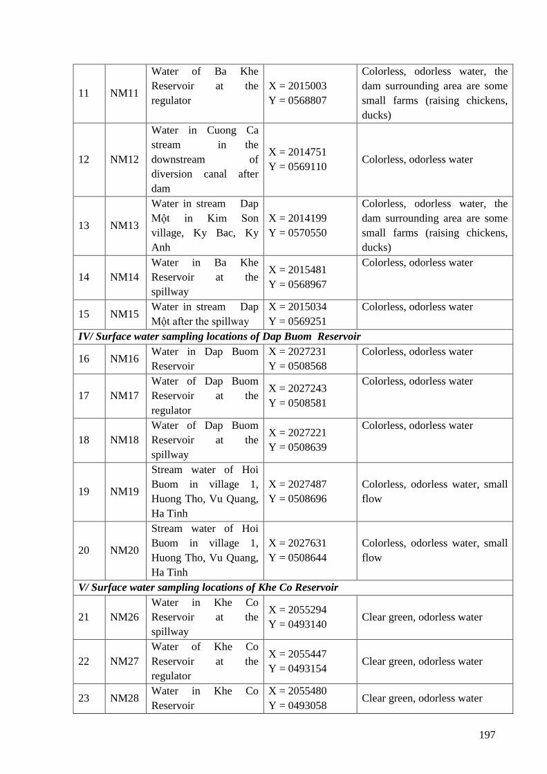
197
11 NM11
Water of Ba Khe
Reservoir at the
regulator
X = 2015003
Y = 0568807
Colorless, odorless water, the
dam surrounding area are some
small farms (raising chickens,
ducks)
12 NM12
Water in Cuong Ca
stream in the
downstream of
diversion canal after
dam
X = 2014751
Y = 0569110 Colorless, odorless water
13 NM13
Water in stream Dap
Một in Kim Son
village, Ky Bac, Ky
Anh
X = 2014199
Y = 0570550
Colorless, odorless water, the
dam surrounding area are some
small farms (raising chickens,
ducks)
14 NM14
Water in Ba Khe
Reservoir at the
spillway
X = 2015481
Y = 0568967
Colorless, odorless water
15 NM15 Water in stream Dap
Một after the spillway
X = 2015034
Y = 0569251
Colorless, odorless water
IV/ Surface water sampling locations of Dap Buom Reservoir
16 NM16 Water in Dap Buom
Reservoir
X = 2027231
Y = 0508568
Colorless, odorless water
17 NM17
Water of Dap Buom
Reservoir at the
regulator
X = 2027243
Y = 0508581
Colorless, odorless water
18 NM18
Water of Dap Buom
Reservoir at the
spillway
X = 2027221
Y = 0508639
Colorless, odorless water
19 NM19
Stream water of Hoi
Buom in village 1,
Huong Tho, Vu Quang,
Ha Tinh
X = 2027487
Y = 0508696
Colorless, odorless water, small
flow
20 NM20
Stream water of Hoi
Buom in village 1,
Huong Tho, Vu Quang,
Ha Tinh
X = 2027631
Y = 0508644
Colorless, odorless water, small
flow
V/ Surface water sampling locations of Khe Co Reservoir
21 NM26
Water in Khe Co
Reservoir at the
spillway
X = 2055294
Y = 0493140 Clear green, odorless water
22 NM27
Water of Khe Co
Reservoir at the
regulator
X = 2055447
Y = 0493154 Clear green, odorless water
23 NM28 Water in Khe Co
Reservoir
X = 2055480
Y = 0493058 Clear green, odorless water
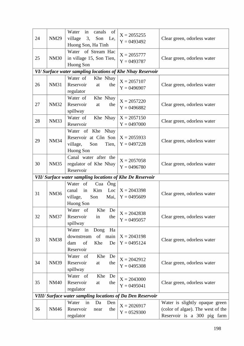
198
24 NM29
Water in canals of
village 3, Son Le,
Huong Son, Ha Tinh
X = 2055255
Y = 0493492 Clear green, odorless water
25 NM30
Water of Stream Hac
in village 15, Son Tien,
Huong Son
X = 2055777
Y = 0493787 Clear green, odorless water
VI/ Surface water sampling locations of Khe Nhay Reservoir
26 NM31
Water of Khe Nhay
Reservoir at the
regulator
X = 2057107
Y = 0496907 Clear green, odorless water
27 NM32
Water of Khe Nhay
Reservoir at the
spillway
X = 2057220
Y = 0496882 Clear green, odorless water
28 NM33 Water of Khe Nhay
Reservoir
X = 2057150
Y = 0497000 Clear green, odorless water
29 NM34
Water of Khe Nhay
Reservoir at Côn Son
village, Son Tien,
Huong Son
X = 2055933
Y = 0497228 Clear green, odorless water
30 NM35
Canal water after the
regulator of Khe Nhay
Reservoir
X = 2057058
Y = 0496780 Clear green, odorless water
VII/ Surface water sampling locations of Khe De Reservoir
31 NM36
Water of Cua Ông
canal in Kim Loc
village, Son Mai,
Huong Son
X = 2043398
Y = 0495609 Clear green, odorless water
32 NM37
Water of Khe De
Reservoir in the
spillway
X = 2042838
Y = 0495057 Clear green, odorless water
33 NM38
Water in Dong Ha
downstream of main
dam of Khe De
Reservoir
X = 2043198
Y = 0495124 Clear green, odorless water
34 NM39
Water of Khe De
Reservoir at the
spillway
X = 2042912
Y = 0495308 Clear green, odorless water
35 NM40
Water of Khe De
Reservoir at the
regulator
X = 2043000
Y = 0495041 Clear green, odorless water
VIII/ Surface water sampling locations of Da Den Reservoir
36 NM46
Water in Da Den
Reservoir near the
regulator
X = 2026917
Y = 0529300
Water is slightly opaque green
(color of algae). The west of the
Reservoir is a 300 pig farm
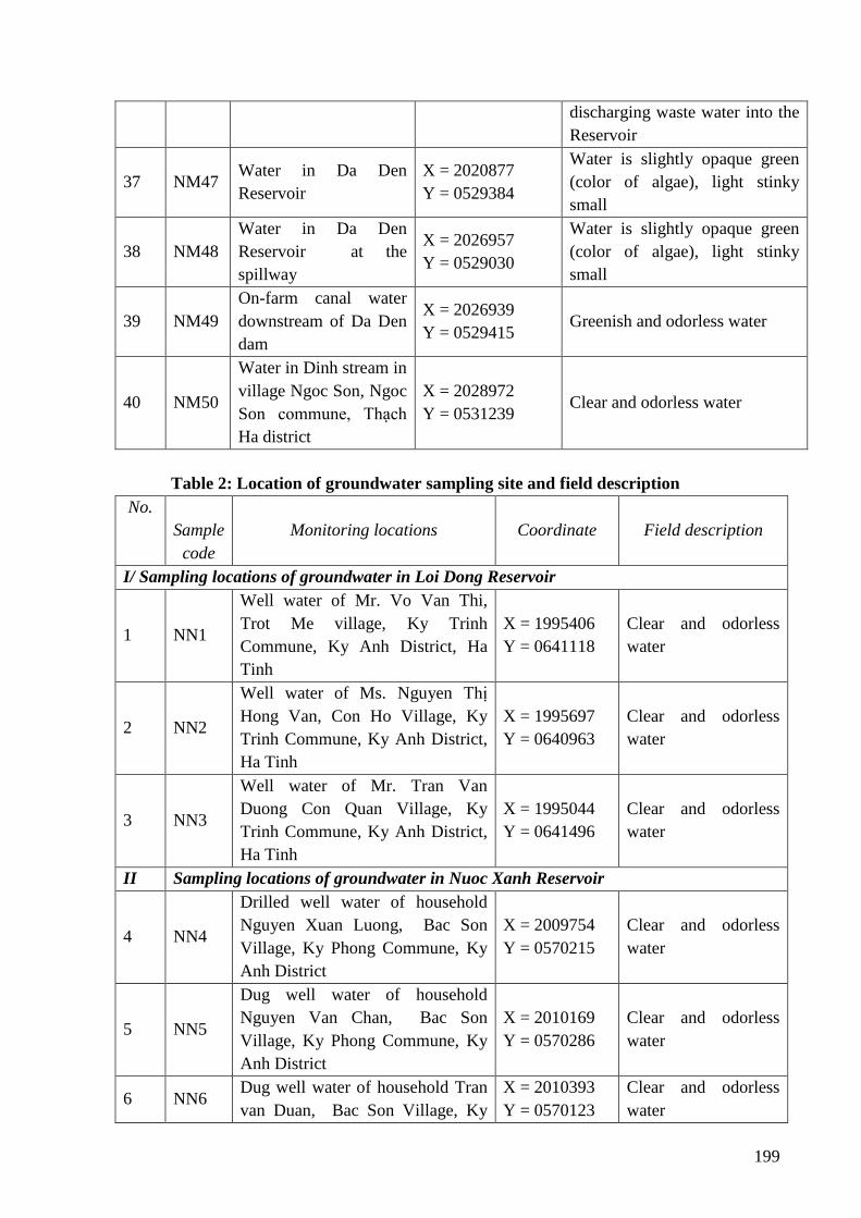
199
discharging waste water into the
Reservoir
37 NM47 Water in Da Den
Reservoir
X = 2020877
Y = 0529384
Water is slightly opaque green
(color of algae), light stinky
small
38 NM48
Water in Da Den
Reservoir at the
spillway
X = 2026957
Y = 0529030
Water is slightly opaque green
(color of algae), light stinky
small
39 NM49
On-farm canal water
downstream of Da Den
dam
X = 2026939
Y = 0529415 Greenish and odorless water
40 NM50
Water in Dinh stream in
village Ngoc Son, Ngoc
Son commune, Thạch
Ha district
X = 2028972
Y = 0531239 Clear and odorless water
Table 2: Location of groundwater sampling site and field description
No.
Sample
code
Monitoring locations Coordinate Field description
I/ Sampling locations of groundwater in Loi Dong Reservoir
1 NN1
Well water of Mr. Vo Van Thi,
Trot Me village, Ky Trinh
Commune, Ky Anh District, Ha
Tinh
X = 1995406
Y = 0641118
Clear and odorless
water
2 NN2
Well water of Ms. Nguyen Thị
Hong Van, Con Ho Village, Ky
Trinh Commune, Ky Anh District,
Ha Tinh
X = 1995697
Y = 0640963
Clear and odorless
water
3 NN3
Well water of Mr. Tran Van
Duong Con Quan Village, Ky
Trinh Commune, Ky Anh District,
Ha Tinh
X = 1995044
Y = 0641496
Clear and odorless
water
II Sampling locations of groundwater in Nuoc Xanh Reservoir
4 NN4
Drilled well water of household
Nguyen Xuan Luong, Bac Son
Village, Ky Phong Commune, Ky
Anh District
X = 2009754
Y = 0570215
Clear and odorless
water
5 NN5
Dug well water of household
Nguyen Van Chan, Bac Son
Village, Ky Phong Commune, Ky
Anh District
X = 2010169
Y = 0570286
Clear and odorless
water
6 NN6 Dug well water of household Tran
van Duan, Bac Son Village, Ky
X = 2010393
Y = 0570123
Clear and odorless
water
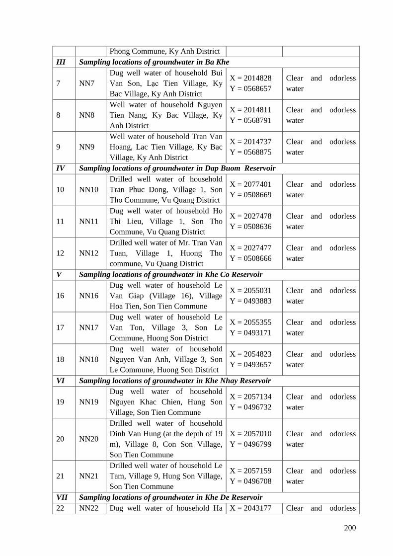
200
Phong Commune, Ky Anh District
III Sampling locations of groundwater in Ba Khe
7 NN7
Dug well water of household Bui
Van Son, Lạc Tien Village, Ky
Bac Village, Ky Anh District
X = 2014828
Y = 0568657
Clear and odorless
water
8 NN8
Well water of household Nguyen
Tien Nang, Ky Bac Village, Ky
Anh District
X = 2014811
Y = 0568791
Clear and odorless
water
9 NN9
Well water of household Tran Van
Hoang, Lac Tien Village, Ky Bac
Village, Ky Anh District
X = 2014737
Y = 0568875
Clear and odorless
water
IV Sampling locations of groundwater in Dap Buom Reservoir
10 NN10
Drilled well water of household
Tran Phuc Dong, Village 1, Son
Tho Commune, Vu Quang District
X = 2077401
Y = 0508669
Clear and odorless
water
11 NN11
Dug well water of household Ho
Thi Lieu, Village 1, Son Tho
Commune, Vu Quang District
X = 2027478
Y = 0508636
Clear and odorless
water
12 NN12
Drilled well water of Mr. Tran Van
Tuan, Village 1, Huong Tho
commune, Vu Quang District
X = 2027477
Y = 0508666
Clear and odorless
water
V Sampling locations of groundwater in Khe Co Reservoir
16 NN16
Dug well water of household Le
Van Giap (Village 16), Village
Hoa Tien, Son Tien Commune
X = 2055031
Y = 0493883
Clear and odorless
water
17 NN17
Dug well water of household Le
Van Ton, Village 3, Son Le
Commune, Huong Son District
X = 2055355
Y = 0493171
Clear and odorless
water
18 NN18
Dug well water of household
Nguyen Van Anh, Village 3, Son
Le Commune, Huong Son District
X = 2054823
Y = 0493657
Clear and odorless
water
VI Sampling locations of groundwater in Khe Nhay Reservoir
19 NN19
Dug well water of household
Nguyen Khac Chien, Hung Son
Village, Son Tien Commune
X = 2057134
Y = 0496732
Clear and odorless
water
20 NN20
Drilled well water of household
Dinh Van Hung (at the depth of 19
m), Village 8, Con Son Village,
Son Tien Commune
X = 2057010
Y = 0496799
Clear and odorless
water
21 NN21
Drilled well water of household Le
Tam, Village 9, Hung Son Village,
Son Tien Commune
X = 2057159
Y = 0496708
Clear and odorless
water
VII Sampling locations of groundwater in Khe De Reservoir
22 NN22 Dug well water of household Ha X = 2043177 Clear and odorless
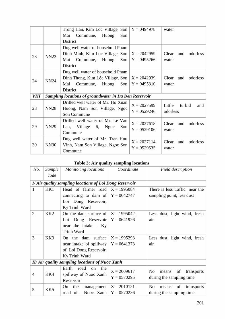
201
Trong Han, Kim Loc Village, Son
Mai Commune, Huong Son
District
Y = 0494978 water
23 NN23
Dug well water of household Pham
Dinh Minh, Kim Loc Village, Son
Mai Commune, Huong Son
District
X = 2042959
Y = 0495266
Clear and odorless
water
24 NN24
Dug well water of household Pham
Dình Thong, Kim Lộc Village, Son
Mai Commune, Huong Son
District
X = 2042939
Y = 0495310
Clear and odorless
water
VIII Sampling locations of groundwater in Da Den Reservoir
28 NN28
Drilled well water of Mr. Ho Xuan
Huong, Nam Son Village, Ngoc
Son Commune
X = 2027599
Y = 0529246
Little turbid and
odorless
29 NN29
Drilled well water of Mr. Le Van
Lan, Village 6, Ngoc Son
Commune
X = 2027618
Y = 0529106
Clear and odorless
water
30 NN30
Dug well water of Mr. Tran Huu
Vinh, Nam Son Village, Ngoc Son
Commune
X = 2027114
Y = 0529535
Clear and odorless
water
Table 3: Air quality sampling locations
No.
Sample
code
Monitoring locations Coordinate Field description
I/ Air quality sampling locations of Loi Dong Reservoir
1 KK1 Head of farmer road
connecting to dam of
Loi Dong Reservoir,
Ky Trinh Ward
X = 1995084
Y = 0642747
There is less traffic near the
sampling point, less dust
2 KK2 On the dam surface of
Loi Dong Reservoir
near the intake - Ky
Trinh Ward
X = 1995042
Y = 0641926
Less dust, light wind, fresh
air
3 KK3 On the dam surface
near intake of spillway
of Loi Dong Reservoir,
Ky Trinh Ward
X = 1995293
Y = 0641373
Less dust, light wind, fresh
air
II/ Air quality sampling locations of Nuoc Xanh
4 KK4
Earth road on the
spillway of Nuoc Xanh
Reservoir
X = 2009617
Y = 0570295
No means of transports
during the sampling time
5 KK5 On the management
road of Nuoc Xanh
X = 2010121
Y = 0570236
No means of transports
during the sampling time
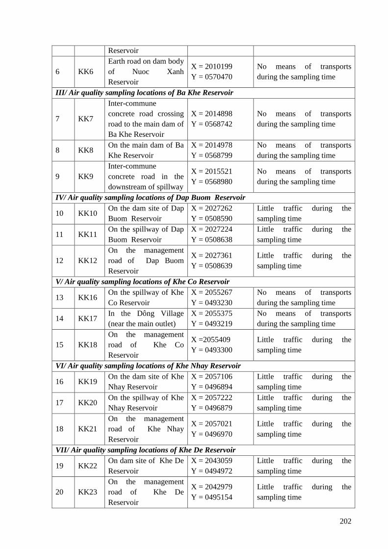
202
Reservoir
6 KK6
Earth road on dam body
of Nuoc Xanh
Reservoir
X = 2010199
Y = 0570470
No means of transports
during the sampling time
III/ Air quality sampling locations of Ba Khe Reservoir
7 KK7
Inter-commune
concrete road crossing
road to the main dam of
Ba Khe Reservoir
X = 2014898
Y = 0568742
No means of transports
during the sampling time
8 KK8 On the main dam of Ba
Khe Reservoir
X = 2014978
Y = 0568799
No means of transports
during the sampling time
9 KK9
Inter-commune
concrete road in the
downstream of spillway
X = 2015521
Y = 0568980
No means of transports
during the sampling time
IV/ Air quality sampling locations of Dap Buom Reservoir
10 KK10 On the dam site of Dap
Buom Reservoir
X = 2027262
Y = 0508590
Little traffic during the
sampling time
11 KK11 On the spillway of Dap
Buom Reservoir
X = 2027224
Y = 0508638
Little traffic during the
sampling time
12 KK12
On the management
road of Dap Buom
Reservoir
X = 2027361
Y = 0508639
Little traffic during the
sampling time
V/ Air quality sampling locations of Khe Co Reservoir
13 KK16 On the spillway of Khe
Co Reservoir
X = 2055267
Y = 0493230
No means of transports
during the sampling time
14 KK17 In the Dông Village
(near the main outlet)
X = 2055375
Y = 0493219
No means of transports
during the sampling time
15 KK18
On the management
road of Khe Co
Reservoir
X =2055409
Y = 0493300
Little traffic during the
sampling time
VI/ Air quality sampling locations of Khe Nhay Reservoir
16 KK19 On the dam site of Khe
Nhay Reservoir
X = 2057106
Y = 0496894
Little traffic during the
sampling time
17 KK20 On the spillway of Khe
Nhay Reservoir
X = 2057222
Y = 0496879
Little traffic during the
sampling time
18 KK21
On the management
road of Khe Nhay
Reservoir
X = 2057021
Y = 0496970
Little traffic during the
sampling time
VII/ Air quality sampling locations of Khe De Reservoir
19 KK22 On dam site of Khe De
Reservoir
X = 2043059
Y = 0494972
Little traffic during the
sampling time
20 KK23
On the management
road of Khe De
Reservoir
X = 2042979
Y = 0495154
Little traffic during the
sampling time

203
21 KK24 On the spillway of Khe
De Reservoir
X = 2042838
Y = 0495057
Little traffic during the
sampling time
VIII/ Air quality sampling locations of Da Den Reservoir
22 KK28
On the management
road of Da Den
Reservoir
X = 2026932
Y = 0529440
Some soil trucks acrosing
sampling location during the
observation time.
23 KK29
On the earth road
crossing the spillway of
Da Den Reservoir
X = 2027023
Y = 0528932
Little traffic during the
sampling time
24 KK30 On dam site of Da Den
Reservoir
X = 2026949
Y = 0529312
Little traffic during the
sampling time
Table 4: Soil environment sampling locations
No. Sample
code Monitoring location Coordinate Field description
I/ Soil quality sampling locations of Loi Dong Reservoir
1 MD1
Rice field lands downstream of Loi
Dong, Ky Trinh Ward, Ky Anh
Town, Ha Tinh
X = 1995658
Y = 0640828
Black soil, slightly
fishy.
2 MD2 Soil at the flood of Con Mộc, Ky
Trinh Ward, Ky Anh Town, Ha Tinh
X = 1995639
Y = 0640612
The soil is black
and fine
3 MD3
Rice field lands downstream of Loi
Dong, Ky Trinh Ward, Ky Anh
Town, Ha Tinh
X = 1995621
Y = 0640580 Grey soil
II/ Soil quality sampling locations of Nuoc Xanh Reservoir
4 MD4
Soil. in Con Hoang hill, Ky Phong
Commune, Ky Anh District (Planned
dumpsite)
X = 2010576
Y = 0570186 Yellow soil
5 MD5 Land in the management road for the
management of Nuoc Xanh Reservoir
X = 2010126
Y = 0570233 Yellow soil
6 MD6 Lands planned as borrow pits for back
fill in Nuoc Xanh Reservoir
X = 2009574
Y = 0570409
Yellow soil with
grit
III/ Soil quality sampling locations of Ba Khe Reservoir
7 MD7
Planned site as borrow pit for dam
backfill soil- Ba Khe Reservoir in site
02 at the slope of Cau Nhung, Ky Bac
Village, Ky Anh District
X = 2015485
Y = 0569134
The soil is grayish
yellow
8 MD8 Soil from management road of Ba
Khe Reservoir
X = 2015315
Y = 0569015
The soil is grayish
yellow
9 MD9 Soil in the new stadium Ky Bac
Village (planning of dumpsite No. 1)
X = 2013917
Y = 0570315 The soil is gray
IV/ Soil quality sampling locations of Dap Buom Reservoir
10 MD10 Soil from Khe Gieng dam, Village 1,
Huong Tho commune, Vu Quang
X = 2027505
Y = 0508509 Yellow soil
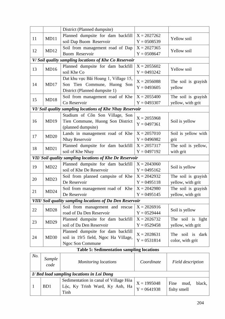
204
District (Planned dumpsite)
11 MD11 Planned dumpsite for dam backfill
soil Dap Buom Reservoir
X = 2027262
Y = 0508539 Yellow soil
12 MD12 Soil from management road of Dap
Buom Reservoir
X = 2027365
Y = 0508647 Yellow soil
V/ Soil quality sampling locations of Khe Co Reservoir
13 MD16 Planned dumpsite for dam backfill
soil Khe Co
X = 2055602
Y = 0493242 Yellow soil
14 MD17
Dat khu vực Bãi Hoang 1, Village 15,
Son Tien Commune, Huong Son
District (Planned dumpsite 1)
X = 2056088
Y = 0493605
The soil is grayish
yellow
15 MD18 Soil from management road of Khe
Co Reservoir
X = 2055400
Y = 0493307
The soil is grayish
yellow, with grit
VI/ Soil quality sampling locations of Khe Nhay Reservoir
16 MD19
Stadium of Côn Son Village, Son
Tien Commune, Huong Son District
(planned dumpsite)
X = 2055968
Y = 0497361 Soil is yellow
17 MD20 Lands in management road of Khe
Nhay Reservoir
X = 2057010
Y = 0496982
Soil is yellow with
grit
18 MD21 Planned dumpsite for dam backfill
soil of Khe Nhay
X = 2057317
Y = 0497192
The soil is yellow,
with grit
VII/ Soil quality sampling locations of Khe De Reservoir
19 MD22 Planned dumpsite for dam backfill
soil of Khe De Reservoir
X = 2043060
Y = 0495162 Soil is yellow
20 MD23 Soil from planned campsite of Khe
De Reservoir
X = 2042932
Y = 0495118
The soil is grayish
yellow, with grit
21 MD24 Soil from management road of Khe
De Reservoir
X = 2042980
Y = 0495145
The soil is grayish
yellow, with grit
VIII/ Soil quality sampling locations of Da Den Reservoir
22 MD28 Soil from management and rescue
road of Da Den Reservoir
X = 2026916
Y = 0529444 Soil is yellow
23 MD29 Planned dumpsite for dam backfill
soil of Da Den Reservoir
X = 2026732
Y = 0529458
The soil is light
yellow, with grit
24 MD30
Planned dumpsite for dam backfill
soil in 19/5 field, Ngoc Ha Village,
Ngoc Son Commune
X = 2028631
Y = 0531814
The soil is dark
color, with grit
Table 5: Sedimentation sampling locations
No.
Sample
code Monitoring locations Coordinate Field description
I/ Bed load sampling locations in Loi Dong
1 BD1
Sedimentation in canal of Village Hòa
Lộc, Ky Trinh Ward, Ky Anh, Ha
Tinh
X = 1995048
Y = 0641938
Fine mud, black,
fishy smell
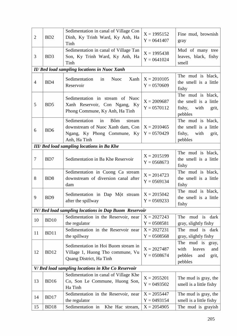
205
2 BD2
Sedimentation in canal of Village Con
Dinh, Ky Trinh Ward, Ky Anh, Ha
Tinh
X = 1995152
Y = 0641407
Fine mud, brownish
gray
3 BD3
Sedimentation in canal of Village Tan
Son, Ky Trinh Ward, Ky Anh, Ha
Tinh
X = 1995438
Y = 0641024
Mud of many tree
leaves, black, fishy
smell
II/ Bed load sampling locations in Nuoc Xanh
4 BD4 Sedimentation in Nuoc Xanh
Reservoir
X = 2010105
Y = 0570609
The mud is black,
the smell is a little
fishy
5 BD5
Sedimentation in stream of Nuoc
Xanh Reservoir, Con Ngang, Ky
Phong Commune, Ky Anh, Ha Tinh
X = 2009687
Y = 0570112
The mud is black,
the smell is a little
fishy, with grit,
pebbles
6 BD6
Sedimentation in Bôm stream
downstream of Nuoc Xanh dam, Con
Ngang, Ky Phong Commune, Ky
Anh, Ha Tinh
X = 2010465
Y = 0570429
The mud is black,
the smell is a little
fishy, with grit,
pebbles
III/ Bed load sampling locations in Ba Khe
7 BD7 Sedimentation in Ba Khe Reservoir X = 2015199
Y = 0568673
The mud is black,
the smell is a little
fishy
8 BD8
Sedimentation in Cuong Ca stream
downstream of diversion canal after
dam
X = 2014723
Y = 0569134
The mud is black,
the smell is a little
fishy
9 BD9 Sedimentation in Dap Một stream
after the spillway
X = 2015042
Y = 0569233
The mud is black,
the smell is a little
fishy
IV/ Bed load sampling locations in Dap Buom Reservoir
10 BD10 Sedimentation in the Reservoir, near
the regulator
X = 2027243
Y = 0508581
The mud is dark
gray, slightly fishy
11 BD11 Sedimentation in the Reservoir near
the spillway
X = 2027231
Y = 0508568
The mud is dark
gray, slightly fishy
12 BD12
Sedimentation in Hoi Buom stream in
Village 1, Huong Tho commune, Vu
Quang District, Ha Tinh
X = 2027487
Y = 0508674
The mud is gray,
with leaves and
pebbles and grit,
pebbles
V/ Bed load sampling locations in Khe Co Reservoir
13 BD16
Sedimentation in canal of Village Khe
Co, Son Le Commune, Huong Son,
Ha Tinh
X = 2055201
Y = 0493502
The mud is gray, the
smell is a little fishy
14 BD17 Sedimentation in the Reservoir, near
the regulator
X = 2055447
Y = 0493154
The mud is gray, the
smell is a little fishy
15 BD18 Sedimentation in Khe Hac stream, X = 2054905 The mud is grayish
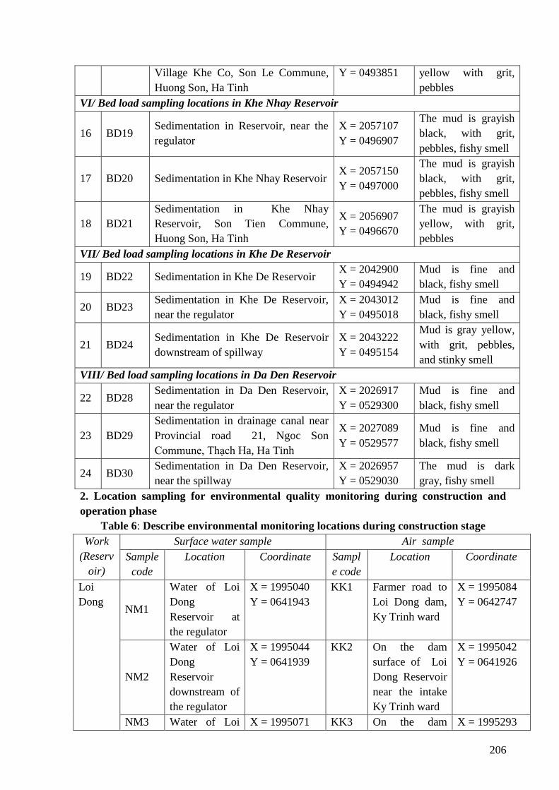
206
Village Khe Co, Son Le Commune,
Huong Son, Ha Tinh
Y = 0493851 yellow with grit,
pebbles
VI/ Bed load sampling locations in Khe Nhay Reservoir
16 BD19 Sedimentation in Reservoir, near the
regulator
X = 2057107
Y = 0496907
The mud is grayish
black, with grit,
pebbles, fishy smell
17 BD20 Sedimentation in Khe Nhay Reservoir X = 2057150
Y = 0497000
The mud is grayish
black, with grit,
pebbles, fishy smell
18 BD21
Sedimentation in Khe Nhay
Reservoir, Son Tien Commune,
Huong Son, Ha Tinh
X = 2056907
Y = 0496670
The mud is grayish
yellow, with grit,
pebbles
VII/ Bed load sampling locations in Khe De Reservoir
19 BD22 Sedimentation in Khe De Reservoir X = 2042900
Y = 0494942
Mud is fine and
black, fishy smell
20 BD23 Sedimentation in Khe De Reservoir,
near the regulator
X = 2043012
Y = 0495018
Mud is fine and
black, fishy smell
21 BD24 Sedimentation in Khe De Reservoir
downstream of spillway
X = 2043222
Y = 0495154
Mud is gray yellow,
with grit, pebbles,
and stinky smell
VIII/ Bed load sampling locations in Da Den Reservoir
22 BD28 Sedimentation in Da Den Reservoir,
near the regulator
X = 2026917
Y = 0529300
Mud is fine and
black, fishy smell
23 BD29
Sedimentation in drainage canal near
Provincial road 21, Ngoc Son
Commune, Thạch Ha, Ha Tinh
X = 2027089
Y = 0529577
Mud is fine and
black, fishy smell
24 BD30 Sedimentation in Da Den Reservoir,
near the spillway
X = 2026957
Y = 0529030
The mud is dark
gray, fishy smell
2. Location sampling for environmental quality monitoring during construction and
operation phase
Table 6: Describe environmental monitoring locations during construction stage
Work
(Reserv
oir)
Surface water sample Air sample
Sample
code
Location Coordinate Sampl
e code
Location Coordinate
Loi
Dong NM1
Water of Loi
Dong
Reservoir at
the regulator
X = 1995040
Y = 0641943
KK1 Farmer road to
Loi Dong dam,
Ky Trinh ward
X = 1995084
Y = 0642747
NM2
Water of Loi
Dong
Reservoir
downstream of
the regulator
X = 1995044
Y = 0641939
KK2 On the dam
surface of Loi
Dong Reservoir
near the intake
Ky Trinh ward
X = 1995042
Y = 0641926
NM3 Water of Loi X = 1995071 KK3 On the dam X = 1995293
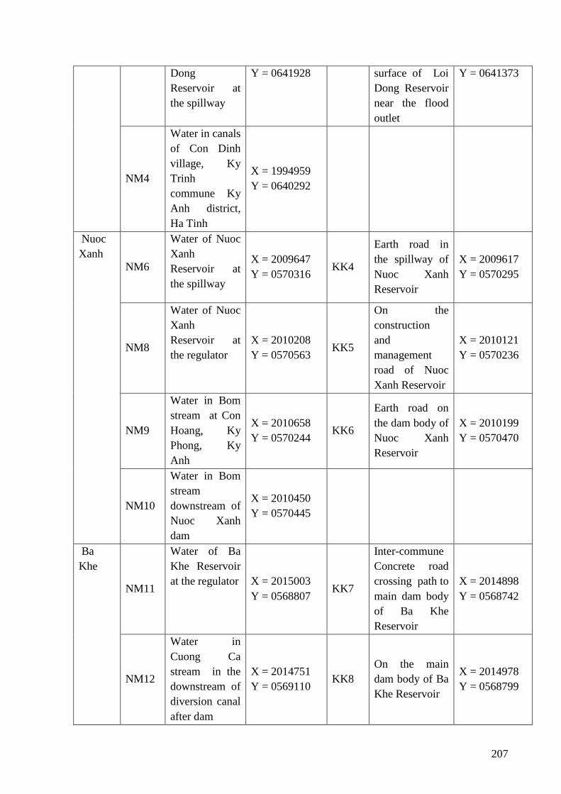
207
Dong
Reservoir at
the spillway
Y = 0641928 surface of Loi
Dong Reservoir
near the flood
outlet
Y = 0641373
NM4
Water in canals
of Con Dinh
village, Ky
Trinh
commune Ky
Anh district,
Ha Tinh
X = 1994959
Y = 0640292
Nuoc
Xanh
NM6
Water of Nuoc
Xanh
Reservoir at
the spillway
X = 2009647
Y = 0570316 KK4
Earth road in
the spillway of
Nuoc Xanh
Reservoir
X = 2009617
Y = 0570295
NM8
Water of Nuoc
Xanh
Reservoir at
the regulator
X = 2010208
Y = 0570563 KK5
On the
construction
and
management
road of Nuoc
Xanh Reservoir
X = 2010121
Y = 0570236
NM9
Water in Bom
stream at Con
Hoang, Ky
Phong, Ky
Anh
X = 2010658
Y = 0570244 KK6
Earth road on
the dam body of
Nuoc Xanh
Reservoir
X = 2010199
Y = 0570470
NM10
Water in Bom
stream
downstream of
Nuoc Xanh
dam
X = 2010450
Y = 0570445
Ba
Khe
NM11
Water of Ba
Khe Reservoir
at the regulator X = 2015003
Y = 0568807 KK7
Inter-commune
Concrete road
crossing path to
main dam body
of Ba Khe
Reservoir
X = 2014898
Y = 0568742
NM12
Water in
Cuong Ca
stream in the
downstream of
diversion canal
after dam
X = 2014751
Y = 0569110 KK8
On the main
dam body of Ba
Khe Reservoir
X = 2014978
Y = 0568799
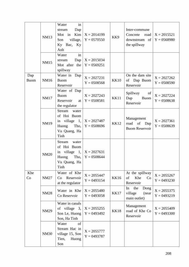
208
NM13
Water in
stream Dap
Mot in Kim
Son village,
Ky Bac, Ky
Anh
X = 2014199
Y = 0570550 KK9
Inter-commune
Concrete road
downstream of
the spillway
X = 2015521
Y = 0568980
NM15
Water in
stream Dap
Mot after the
spillway
X = 2015034
Y = 0569251
Dap
Buom NM16
Water in Dap
Buom
Reservoir
X = 2027231
Y = 0508568 KK10
On the dam site
of Dap Buom
Reservoir
X = 2027262
Y = 0508590
NM17
Water of Dap
Buom
Reservoir at
the regulator
X = 2027243
Y = 0508581 KK11
Spillway of
Dap Buom
Reservoir
X = 2027224
Y = 0508638
NM19
Stream water
of Hoi Buom
in village 1,
Huong Tho,
Vu Quang, Ha
Tinh
X = 2027487
Y = 0508696 KK12
Management
road of Dap
Buom Reservoir
X = 2027361
Y = 0508639
NM20
Stream water
of Hoi Buom
in village 1,
Huong Tho,
Vu Quang, Ha
Tinh
X = 2027631
Y = 0508644
Khe
Co NM27
Water of Khe
Co Reservoir
at the regulator
X = 2055447
Y = 0493154 KK16
At the spillway
of Khe Co
Reservoir
X = 2055267
Y = 0493230
NM28 Water in Khe
Co Reservoir
X = 2055480
Y = 0493058 KK17
In the Dong
village (near
main outlet)
X = 2055375
Y = 0493219
NM29
Water in canals
of village 3,
Son Le, Huong
Son, Ha Tinh
X = 2055255
Y = 0493492 KK18
Management
road of Khe Co
Reservoir
X = 2055409
Y = 0493300
NM30
Water of
Stream Hac in
village 15, Son
Tien, Huong
Son
X = 2055777
Y = 0493787
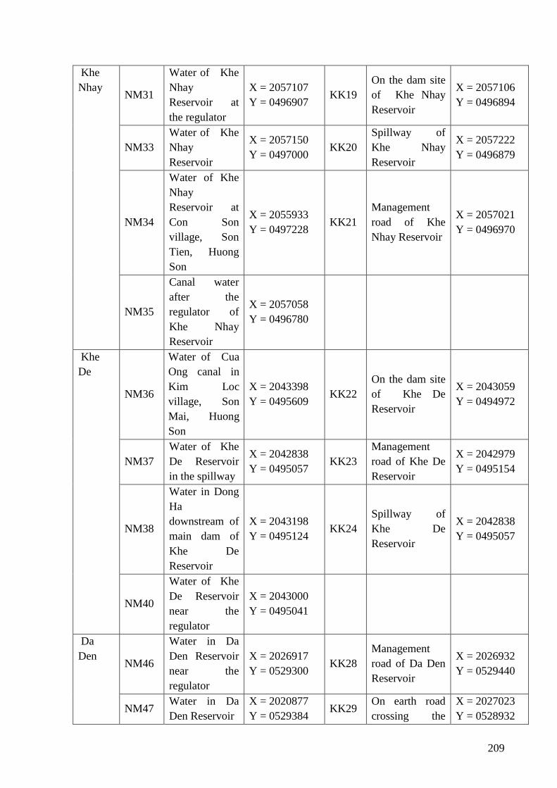
209
Khe
Nhay NM31
Water of Khe
Nhay
Reservoir at
the regulator
X = 2057107
Y = 0496907 KK19
On the dam site
of Khe Nhay
Reservoir
X = 2057106
Y = 0496894
NM33
Water of Khe
Nhay
Reservoir
X = 2057150
Y = 0497000 KK20
Spillway of
Khe Nhay
Reservoir
X = 2057222
Y = 0496879
NM34
Water of Khe
Nhay
Reservoir at
Con Son
village, Son
Tien, Huong
Son
X = 2055933
Y = 0497228 KK21
Management
road of Khe
Nhay Reservoir
X = 2057021
Y = 0496970
NM35
Canal water
after the
regulator of
Khe Nhay
Reservoir
X = 2057058
Y = 0496780
Khe
De
NM36
Water of Cua
Ong canal in
Kim Loc
village, Son
Mai, Huong
Son
X = 2043398
Y = 0495609 KK22
On the dam site
of Khe De
Reservoir
X = 2043059
Y = 0494972
NM37
Water of Khe
De Reservoir
in the spillway
X = 2042838
Y = 0495057 KK23
Management
road of Khe De
Reservoir
X = 2042979
Y = 0495154
NM38
Water in Dong
Ha
downstream of
main dam of
Khe De
Reservoir
X = 2043198
Y = 0495124 KK24
Spillway of
Khe De
Reservoir
X = 2042838
Y = 0495057
NM40
Water of Khe
De Reservoir
near the
regulator
X = 2043000
Y = 0495041
Da
Den NM46
Water in Da
Den Reservoir
near the
regulator
X = 2026917
Y = 0529300 KK28
Management
road of Da Den
Reservoir
X = 2026932
Y = 0529440
NM47 Water in Da
Den Reservoir
X = 2020877
Y = 0529384 KK29
On earth road
crossing the
X = 2027023
Y = 0528932
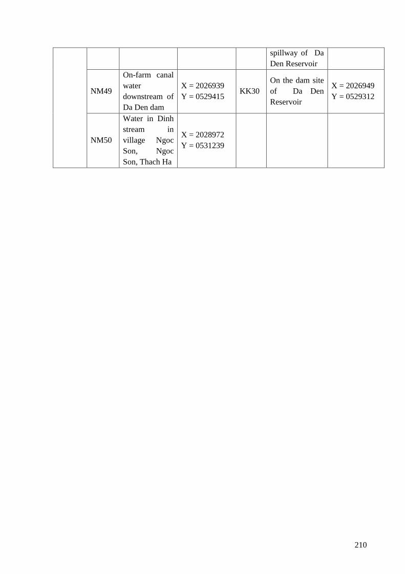
210
spillway of Da
Den Reservoir
NM49
On-farm canal
water
downstream of
Da Den dam
X = 2026939
Y = 0529415 KK30
On the dam site
of Da Den
Reservoir
X = 2026949
Y = 0529312
NM50
Water in Dinh
stream in
village Ngoc
Son, Ngoc
Son, Thach Ha
X = 2028972
Y = 0531239
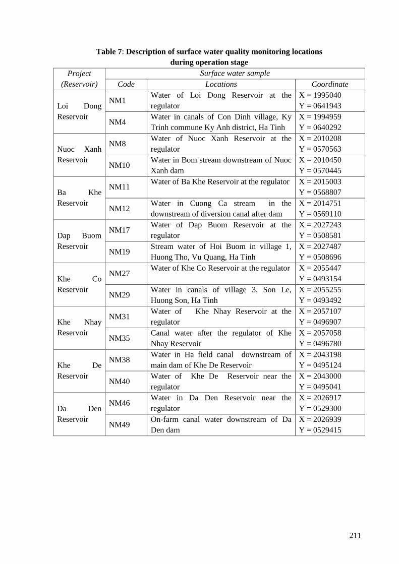
211
Table 7: Description of surface water quality monitoring locations
during operation stage
Project
(Reservoir)
Surface water sample
Code Locations Coordinate
Loi Dong
Reservoir
NM1 Water of Loi Dong Reservoir at the
regulator
X = 1995040
Y = 0641943
NM4 Water in canals of Con Dinh village, Ky
Trinh commune Ky Anh district, Ha Tinh
X = 1994959
Y = 0640292
Nuoc Xanh
Reservoir
NM8 Water of Nuoc Xanh Reservoir at the
regulator
X = 2010208
Y = 0570563
NM10 Water in Bom stream downstream of Nuoc
Xanh dam
X = 2010450
Y = 0570445
Ba Khe
Reservoir
NM11 Water of Ba Khe Reservoir at the regulator X = 2015003
Y = 0568807
NM12 Water in Cuong Ca stream in the
downstream of diversion canal after dam
X = 2014751
Y = 0569110
Dap Buom
Reservoir
NM17 Water of Dap Buom Reservoir at the
regulator
X = 2027243
Y = 0508581
NM19 Stream water of Hoi Buom in village 1,
Huong Tho, Vu Quang, Ha Tinh
X = 2027487
Y = 0508696
Khe Co
Reservoir
NM27 Water of Khe Co Reservoir at the regulator X = 2055447
Y = 0493154
NM29 Water in canals of village 3, Son Le,
Huong Son, Ha Tinh
X = 2055255
Y = 0493492
Khe Nhay
Reservoir
NM31 Water of Khe Nhay Reservoir at the
regulator
X = 2057107
Y = 0496907
NM35 Canal water after the regulator of Khe
Nhay Reservoir
X = 2057058
Y = 0496780
Khe De
Reservoir
NM38 Water in Ha field canal downstream of
main dam of Khe De Reservoir
X = 2043198
Y = 0495124
NM40 Water of Khe De Reservoir near the
regulator
X = 2043000
Y = 0495041
Da Den
Reservoir
NM46 Water in Da Den Reservoir near the
regulator
X = 2026917
Y = 0529300
NM49 On-farm canal water downstream of Da
Den dam
X = 2026939
Y = 0529415
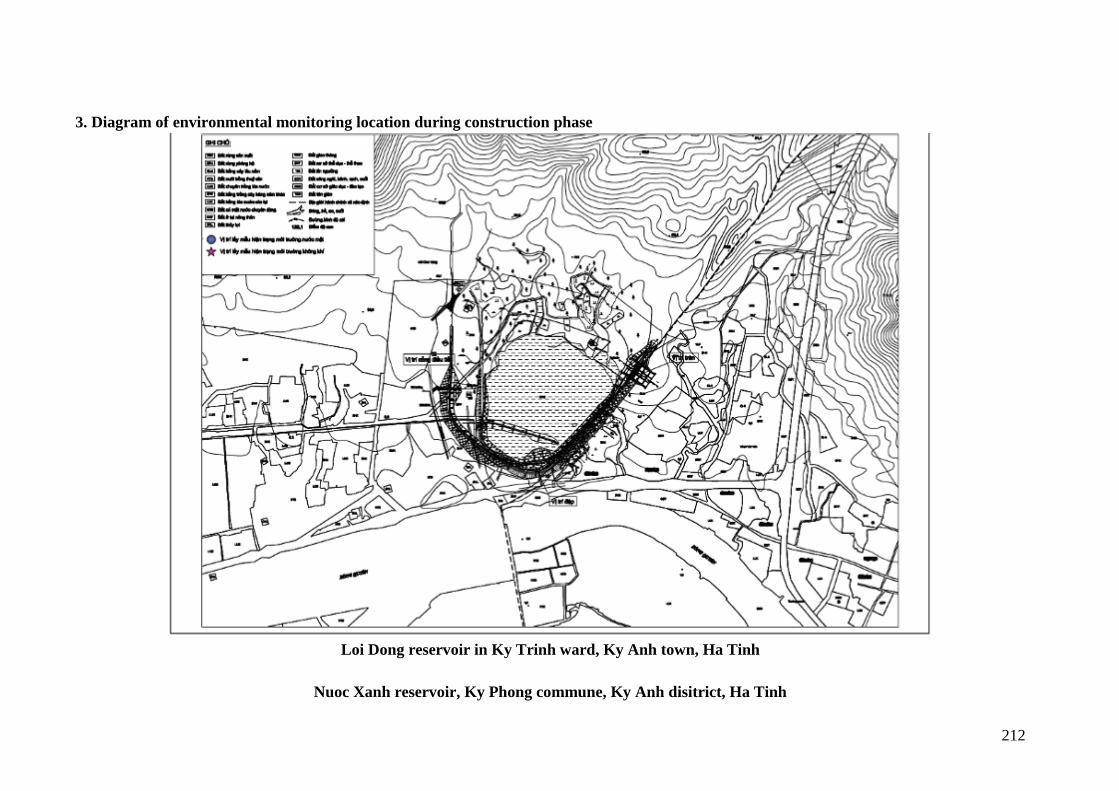
212
3. Diagram of environmental monitoring location during construction phase
Loi Dong reservoir in Ky Trinh ward, Ky Anh town, Ha Tinh
Nuoc Xanh reservoir, Ky Phong commune, Ky Anh disitrict, Ha Tinh
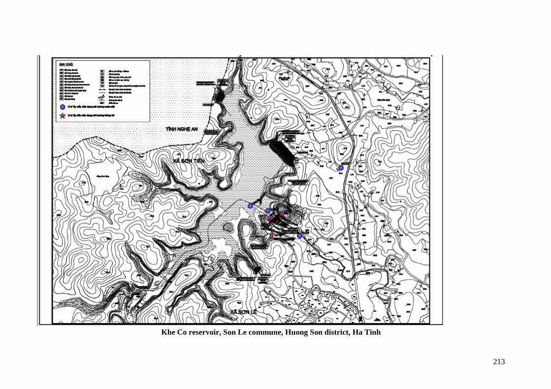
213
Khe Co reservoir, Son Le commune, Huong Son district, Ha Tinh
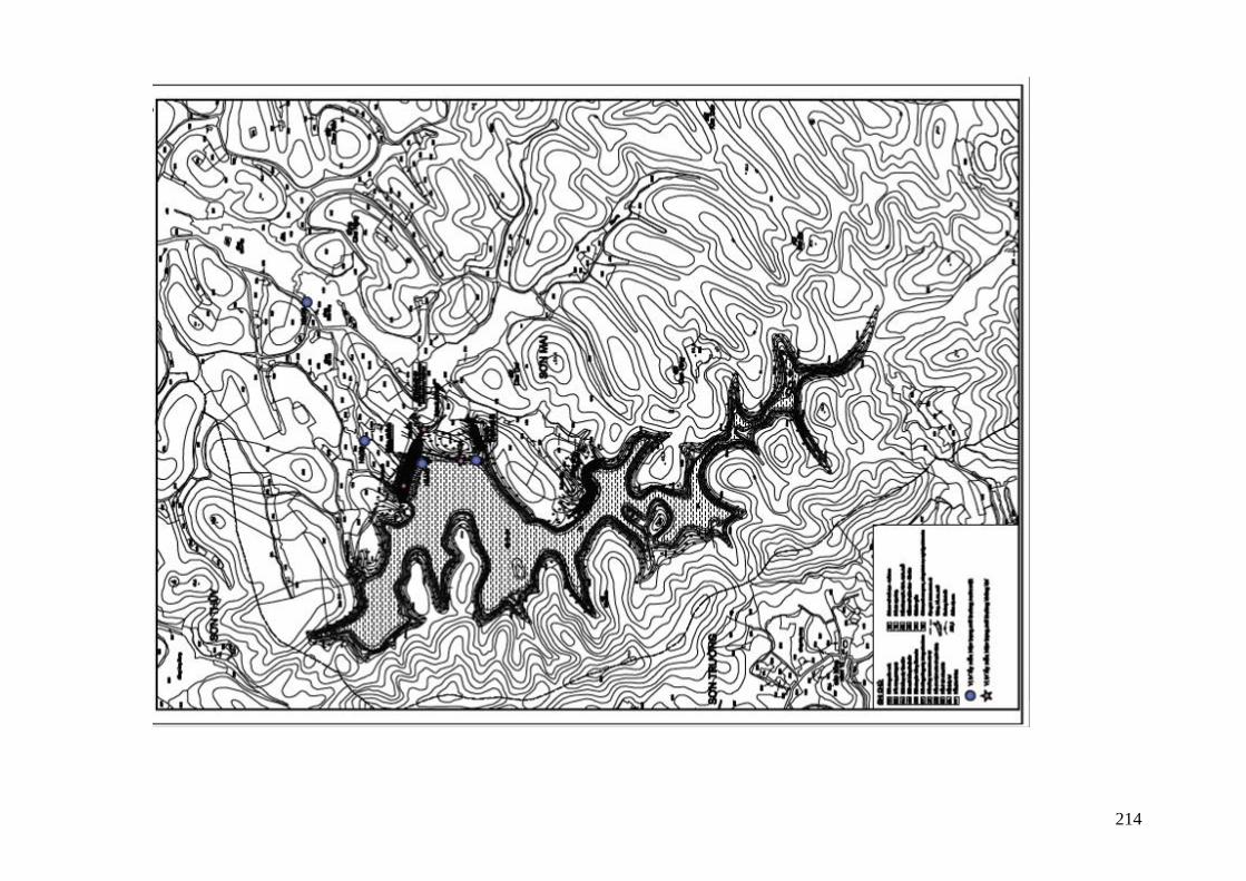
214
215
Khe De reservoir, Son Mai commune, Huong Son disitrict, Ha Tinh
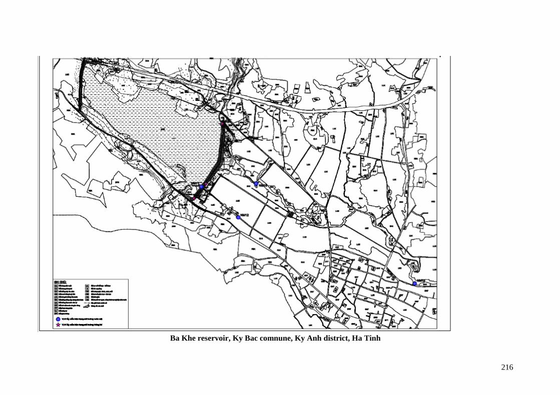
216
Ba Khe reservoir, Ky Bac comnune, Ky Anh district, Ha Tinh
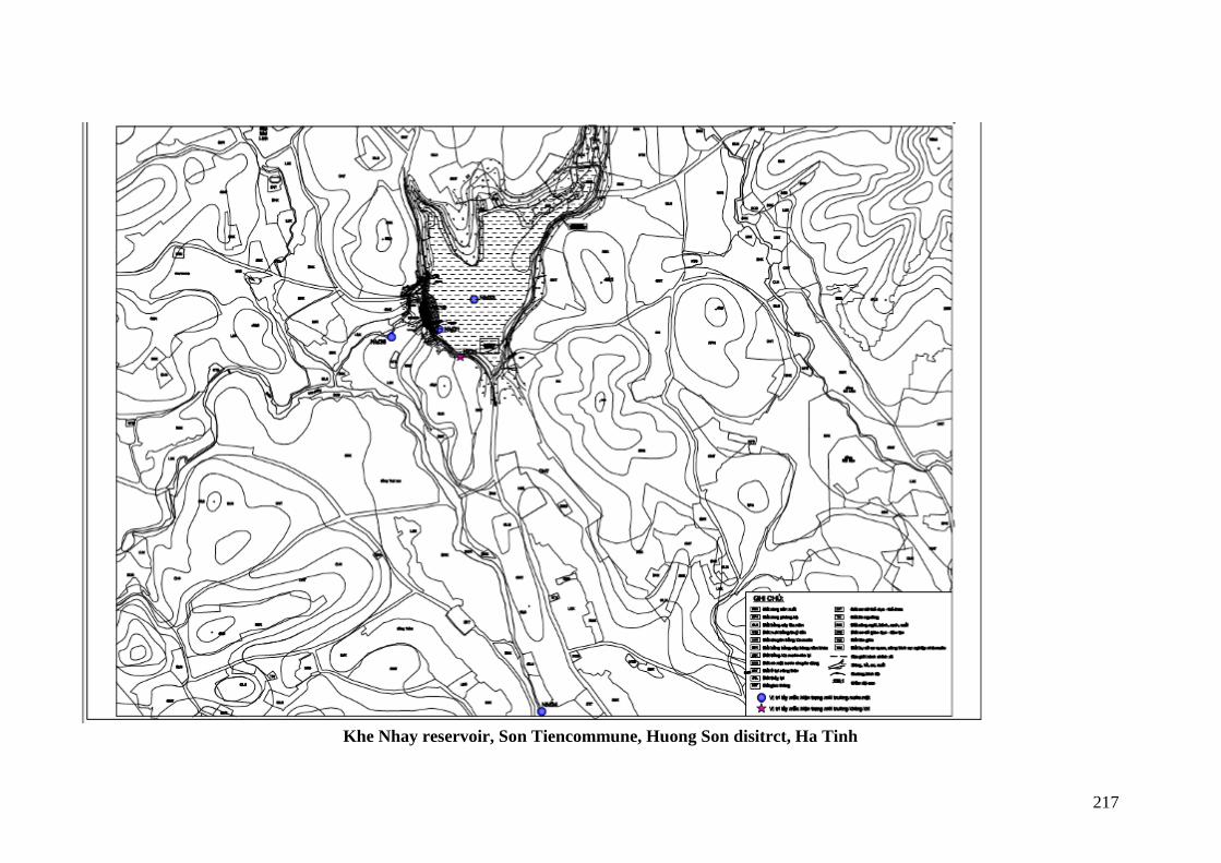
217
Khe Nhay reservoir, Son Tiencommune, Huong Son disitrct, Ha Tinh
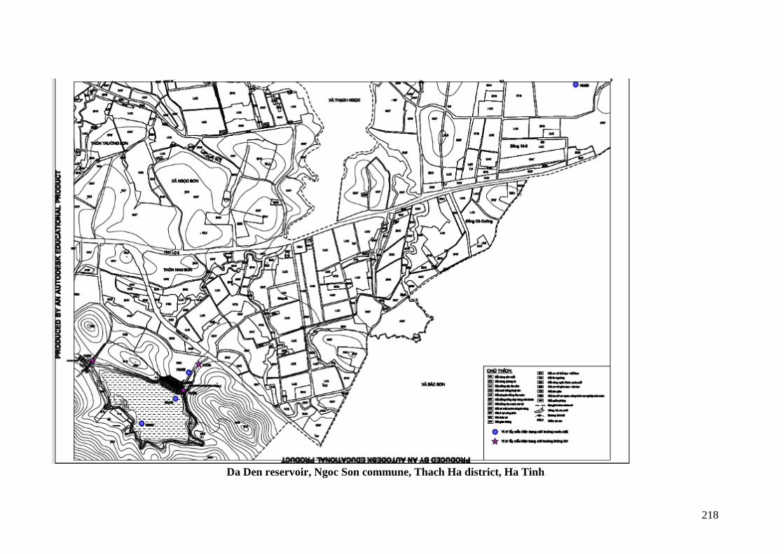
218
Da Den reservoir, Ngoc Son commune, Thach Ha district, Ha Tinh
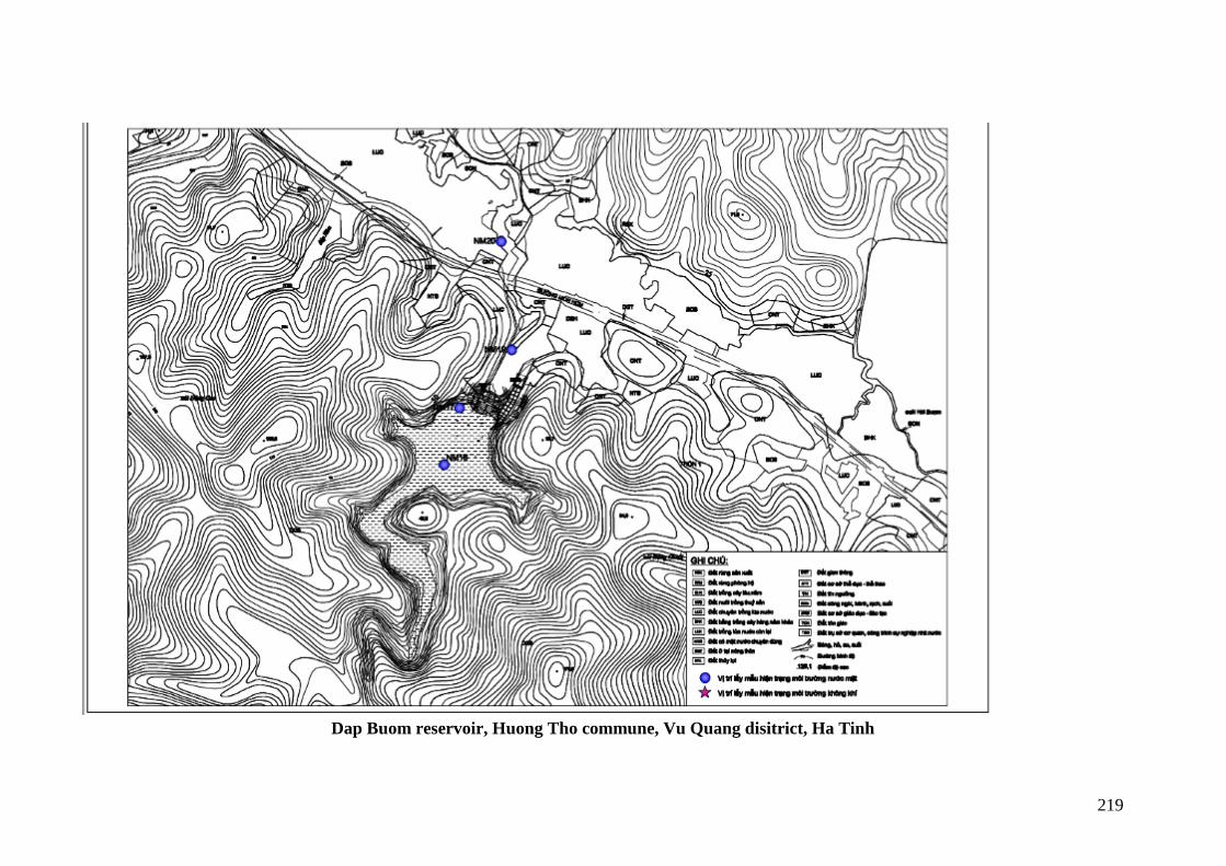
219
Dap Buom reservoir, Huong Tho commune, Vu Quang disitrict, Ha Tinh
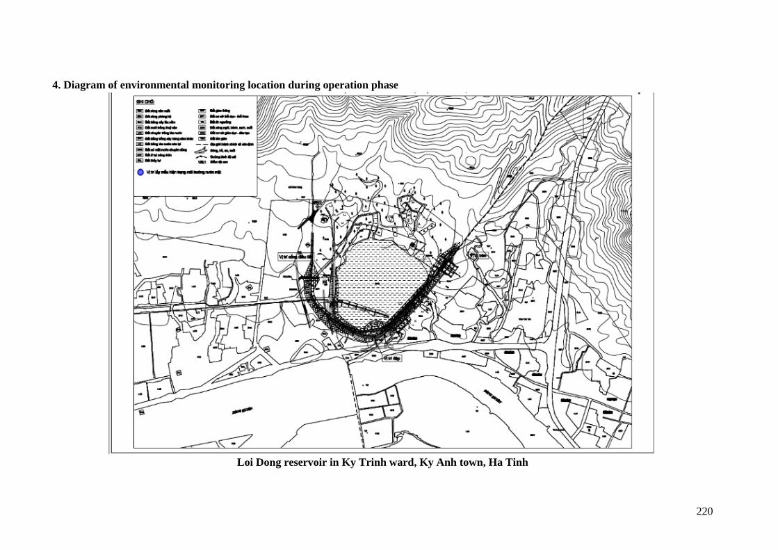
220
4. Diagram of environmental monitoring location during operation phase
Loi Dong reservoir in Ky Trinh ward, Ky Anh town, Ha Tinh
221
Nuoc Xanh reservoir, Ky Phong commune, Ky Anh disitrict, Ha Tinh
222
Khe Co reservoir, Son Le commune, Huong Son district, Ha Tinh
223
224
Khe De reservoir, Son Mai commune, Huong Son disitrict, Ha Tinh
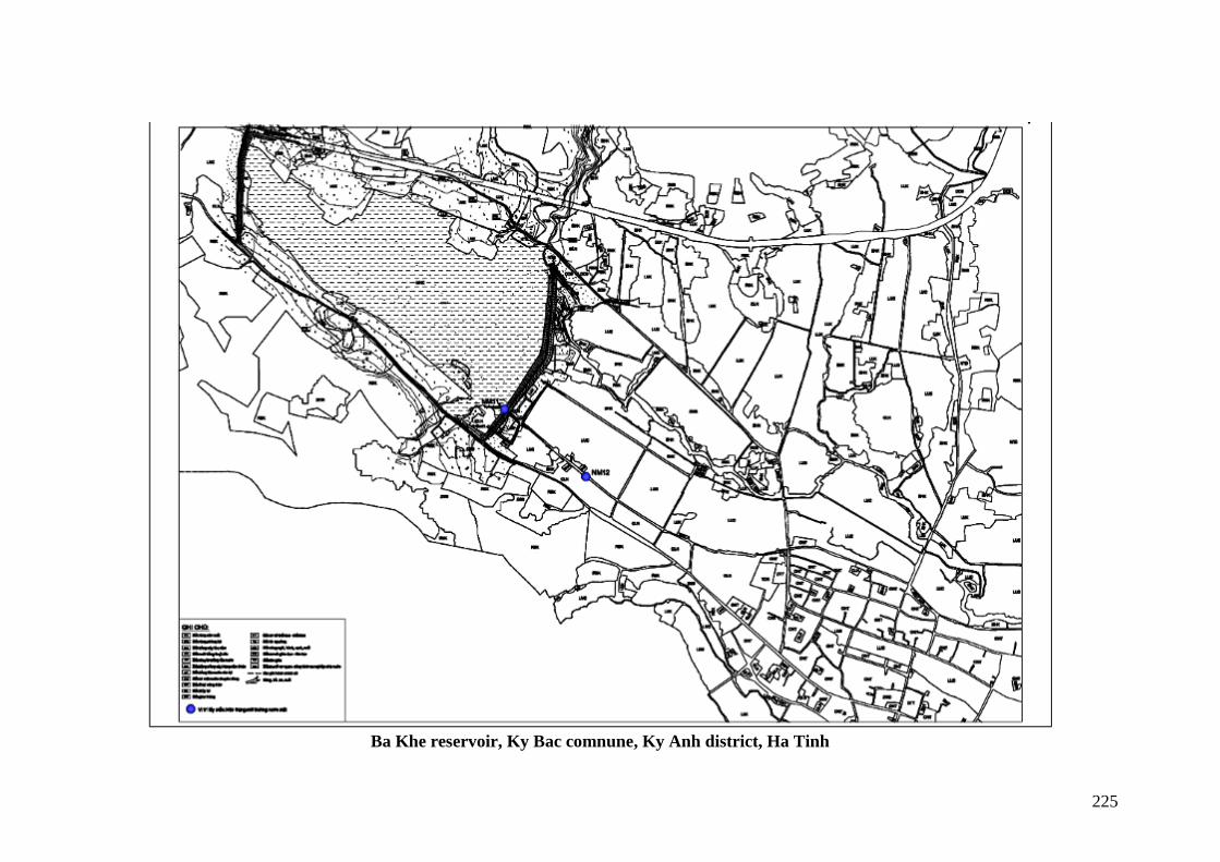
225
Ba Khe reservoir, Ky Bac comnune, Ky Anh district, Ha Tinh

226
Khe Nhay reservoir, Son Tiencommune, Huong Son disitrct, Ha Tinh
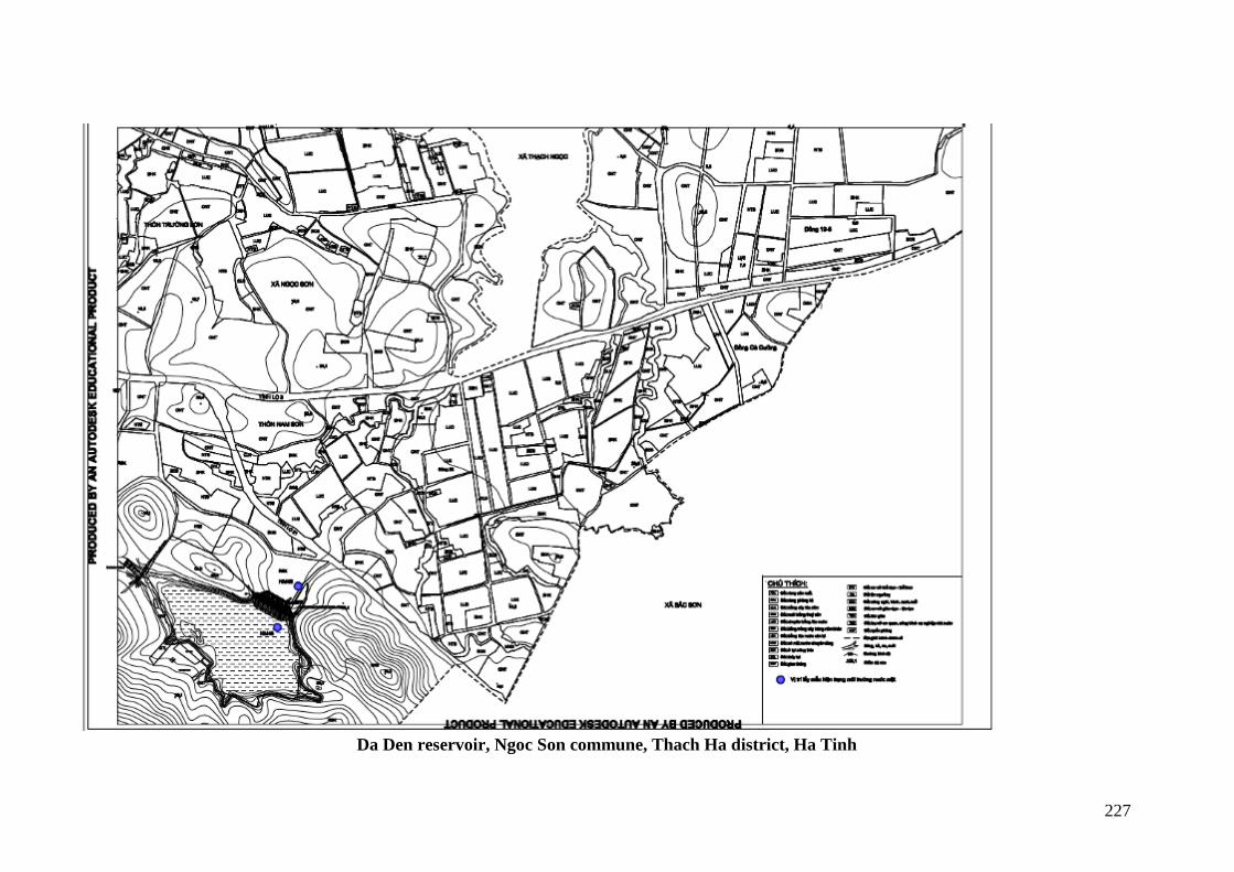
227
Da Den reservoir, Ngoc Son commune, Thach Ha district, Ha Tinh
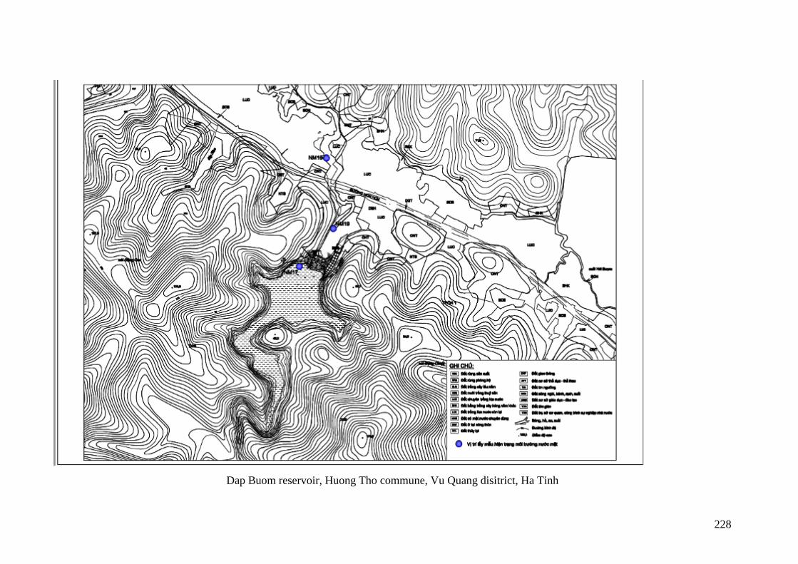
228
Dap Buom reservoir, Huong Tho commune, Vu Quang disitrict, Ha Tinh
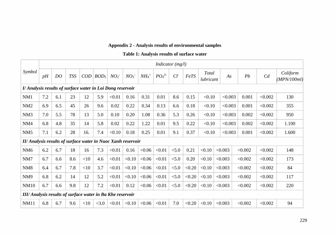
229
Appendix 2 - Analysis results of environmental samples
Table 1: Analysis results of surface water
Symbol
Indicator (mg/l)
pH DO TSS COD BOD5 NO2- NO3
- NH4+ PO4
3- Cl- FeTS Total
lubricant As Pb Cd
Coliform
(MPN/100ml)
I/ Analysis results of surface water in Loi Dong reservoir
NM1 7.2 6.1 23 12 5.9 <0.01 0.16 0.31 0.01 8.6 0.15 <0.10 <0.003 0.001 <0.002 130
NM2 6.9 6.5 45 26 9.6 0.02 0.22 0.34 0.13 6.6 0.18 <0.10 <0.003 0.001 <0.002 355
NM3 7.0 5.5 78 13 5.0 0.10 0.20 1.08 0.36 5.3 0.26 <0.10 <0.003 0.002 <0.002 950
NM4 6.8 4.8 35 14 5.8 0.02 0.22 1.22 0.01 9.5 0.22 <0.10 <0.003 0.002 <0.002 1.100
NM5 7.1 6.2 28 16. 7.4 <0.10 0.18 0.25 0.01 9.1 0.37 <0.10 <0.003 0.001 <0.002 1.600
II/ Analysis results of surface water in Nuoc Xanh reservoir
NM6 6.2 6.7 18 16 7.3 <0.01 0.16 <0.06 <0.01 <5.0 0.21 <0.10 <0.003 <0.002 <0.002 148
NM7 6.7 6.6 8.6 <10 4.6 <0.01 <0.10 <0.06 <0.01 <5.0 0.20 <0.10 <0.003 <0.002 <0.002 173
NM8 6.4 6.7 7.8 <10 3.7 <0.01 <0.10 <0.06 <0.01 <5.0 <0.20 <0.10 <0.003 <0.002 <0.002 84
NM9 6.8 6.2 14 12 5.2 <0.01 <0.10 <0.06 <0.01 <5.0 <0.20 <0.10 <0.003 <0.002 <0.002 117
NM10 6.7 6.6 9.8 12 7.2 <0.01 0.12 <0.06 <0.01 <5.0 <0.20 <0.10 <0.003 <0.002 <0.002 220
III/ Analysis results of surface water in Ba Khe reservoir
NM11 6.8 6.7 9.6 <10 <3.0 <0.01 <0.10 <0.06 <0.01 7.0 <0.20 <0.10 <0.003 <0.002 <0.002 94
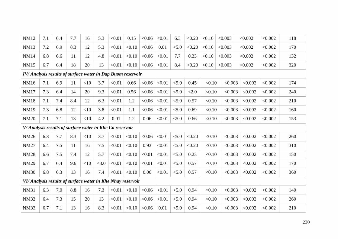
230
NM12 7.1 6.4 7.7 16 5.3 <0.01 0.15 <0.06 <0.01 6.3 <0.20 <0.10 <0.003 <0.002 <0.002 118
NM13 7.2 6.9 8.3 12 5.3 <0.01 <0.10 <0.06 0.01 <5.0 <0.20 <0.10 <0.003 <0.002 <0.002 170
NM14 6.8 6.6 11 12 4.8 <0.01 <0.10 <0.06 <0.01 7.7 0.23 <0.10 <0.003 <0.002 <0.002 132
NM15 6.7 6.4 18 20 13 <0.01 <0.10 <0.06 <0.01 8.4 <0.20 <0.10 <0.003 <0.002 <0.002 320
IV/ Analysis results of surface water in Dap Buom reservoir
NM16 7.1 6.9 11 <10 3.7 <0.01 0.66 <0.06 <0.01 <5.0 0.45 <0.10 <0.003 <0.002 <0.002 174
NM17 7.3 6.4 14 20 9.3 <0.01 0.56 <0.06 <0.01 <5.0 <2.0 <0.10 <0.003 <0.002 <0.002 240
NM18 7.1 7.4 8.4 12 6.3 <0.01 1.2 <0.06 <0.01 <5.0 0.57 <0.10 <0.003 <0.002 <0.002 210
NM19 7.3 6.8 12 <10 3.8 <0.01 1.1 <0.06 <0.01 <5.0 0.69 <0.10 <0.003 <0.002 <0.002 160
NM20 7.1 7.1 13 <10 4.2 0.01 1.2 0.06 <0.01 <5.0 0.66 <0.10 <0.003 <0.002 <0.002 153
V/ Analysis results of surface water in Khe Co reservoir
NM26 6.3 7.7 8.3 <10 3.7 <0.01 <0.10 <0.06 <0.01 <5.0 <0.20 <0.10 <0.003 <0.002 <0.002 260
NM27 6.4 7.5 11 16 7.5 <0.01 <0.10 0.93 <0.01 <5.0 <0.20 <0.10 <0.003 <0.002 <0.002 310
NM28 6.6 7.5 7.4 12 5.7 <0.01 <0.10 <0.01 <0.01 <5.0 0.23 <0.10 <0.003 <0.002 <0.002 150
NM29 6.7 6.4 9.6 <10 <3.0 <0.01 <0.10 <0.01 <0.01 <5.0 0.57 <0.10 <0.003 <0.002 <0.002 170
NM30 6.8 6.3 13 16 7.4 <0.01 <0.10 0.06 <0.01 <5.0 0.57 <0.10 <0.003 <0.002 <0.002 360
VI/ Analysis results of surface water in Khe Nhay reservoir
NM31 6.3 7.0 8.8 16 7.3 <0.01 <0.10 <0.06 <0.01 <5.0 0.94 <0.10 <0.003 <0.002 <0.002 140
NM32 6.4 7.3 15 20 13 <0.01 <0.10 <0.06 <0.01 <5.0 0.94 <0.10 <0.003 <0.002 <0.002 260
NM33 6.7 7.1 13 16 8.3 <0.01 <0.10 <0.06 0.01 <5.0 0.94 <0.10 <0.003 <0.002 <0.002 210
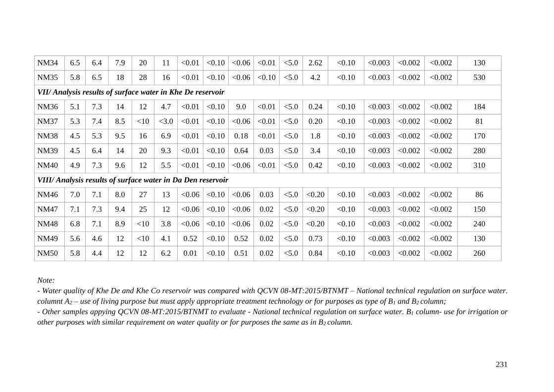
231
NM34 6.5 6.4 7.9 20 11 <0.01 <0.10 <0.06 <0.01 <5.0 2.62 <0.10 <0.003 <0.002 <0.002 130
NM35 5.8 6.5 18 28 16 <0.01 <0.10 <0.06 <0.10 <5.0 4.2 <0.10 <0.003 <0.002 <0.002 530
VII/ Analysis results of surface water in Khe De reservoir
NM36 5.1 7.3 14 12 4.7 <0.01 <0.10 9.0 <0.01 <5.0 0.24 <0.10 <0.003 <0.002 <0.002 184
NM37 5.3 7.4 8.5 <10 <3.0 <0.01 <0.10 <0.06 <0.01 <5.0 0.20 <0.10 <0.003 <0.002 <0.002 81
NM38 4.5 5.3 9.5 16 6.9 <0.01 <0.10 0.18 <0.01 <5.0 1.8 <0.10 <0.003 <0.002 <0.002 170
NM39 4.5 6.4 14 20 9.3 <0.01 <0.10 0.64 0.03 <5.0 3.4 <0.10 <0.003 <0.002 <0.002 280
NM40 4.9 7.3 9.6 12 5.5 <0.01 <0.10 <0.06 <0.01 <5.0 0.42 <0.10 <0.003 <0.002 <0.002 310
VIII/ Analysis results of surface water in Da Den reservoir
NM46 7.0 7.1 8.0 27 13 <0.06 <0.10 <0.06 0.03 <5.0 <0.20 <0.10 <0.003 <0.002 <0.002 86
NM47 7.1 7.3 9.4 25 12 <0.06 <0.10 <0.06 0.02 <5.0 <0.20 <0.10 <0.003 <0.002 <0.002 150
NM48 6.8 7.1 8.9 <10 3.8 <0.06 <0.10 <0.06 0.02 <5.0 <0.20 <0.10 <0.003 <0.002 <0.002 240
NM49 5.6 4.6 12 <10 4.1 0.52 <0.10 0.52 0.02 <5.0 0.73 <0.10 <0.003 <0.002 <0.002 130
NM50 5.8 4.4 12 12 6.2 0.01 <0.10 0.51 0.02 <5.0 0.84 <0.10 <0.003 <0.002 <0.002 260
Note:
- Water quality of Khe De and Khe Co reservoir was compared with QCVN 08-MT:2015/BTNMT – National technical regulation on surface water.
columnt A2 – use of living purpose but must apply appropriate treatment technology or for purposes as type of B1 and B2 column;
- Other samples appying QCVN 08-MT:2015/BTNMT to evaluate - National technical regulation on surface water. B1 column- use for irrigation or
other purposes with similar requirement on water quality or for purposes the same as in B2 column.
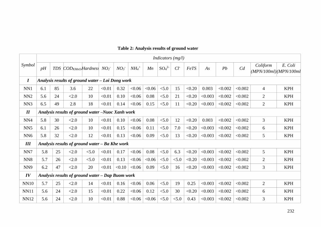
232
Table 2: Analysis results of ground water
Symbol
Indicators (mg/l)
pH TDS CODKMnO4 Hardness NO2- NO3
- NH4+ Mn SO4
2- Cl- FeTS As Pb Cd Coliform
(MPN/100ml)
E. Coli
(MPN/100ml
I Analysis results of ground water – Loi Dong work
NN1 6.1 85 3.6 22 <0.01 0.32 <0.06 <0.06 <5.0 15 <0.20 0.003 <0.002 <0.002 4 KPH
NN2 5.6 24 <2.0 10 <0.01 0.10 <0.06 0.08 <5.0 21 <0.20 <0.003 <0.002 <0.002 2 KPH
NN3 6.5 49 2.8 18 <0.01 0.14 <0.06 0.15 <5.0 11 <0.20 <0.003 <0.002 <0.002 2 KPH
II Analysis results of ground water –Nuoc Xanh work
NN4 5.8 30 <2.0 10 <0.01 0.10 <0.06 0.08 <5.0 12 <0.20 0.003 <0.002 <0.002 3 KPH
NN5 6.1 26 <2.0 10 <0.01 0.15 <0.06 0.11 <5.0 7.0 <0.20 <0.003 <0.002 <0.002 6 KPH
NN6 5.8 32 <2.0 12 <0.01 0.13 <0.06 0.09 <5.0 13 <0.20 <0.003 <0.002 <0.002 5 KPH
III Analysis results of ground water – Ba Khe work
NN7 5.8 25 <2.0 <5.0 <0.01 0.17 <0.06 0.08 <5.0 6.3 <0.20 <0.003 <0.002 <0.002 5 KPH
NN8 5.7 26 <2.0 <5.0 <0.01 0.13 <0.06 <0.06 <5.0 <5.0 <0.20 <0.003 <0.002 <0.002 2 KPH
NN9 6.2 47 <2.0 20 <0.01 <0.10 <0.06 0.09 <5.0 16 <0.20 <0.003 <0.002 <0.002 3 KPH
IV Analysis results of ground water – Dap Buom work
NN10 5.7 25 <2.0 14 <0.01 0.16 <0.06 0.06 <5.0 19 0.25 <0.003 <0.002 <0.002 2 KPH
NN11 5.6 24 <2.0 15 <0.01 0.22 <0.06 0.12 <5.0 30 <0.20 <0.003 <0.002 <0.002 6 KPH
NN12 5.6 24 <2.0 10 <0.01 0.88 <0.06 <0.06 <5.0 <5.0 0.43 <0.003 <0.002 <0.002 3 KPH
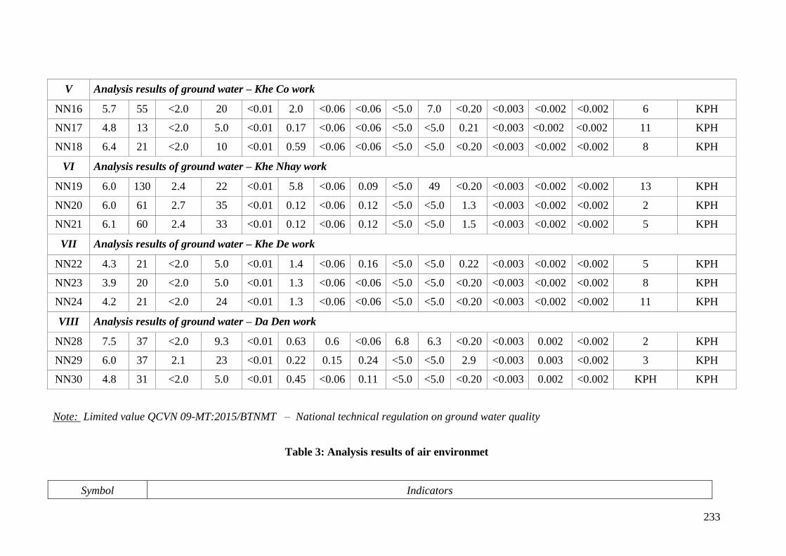
233
V Analysis results of ground water – Khe Co work
NN16 5.7 55 <2.0 20 <0.01 2.0 <0.06 <0.06 <5.0 7.0 <0.20 <0.003 <0.002 <0.002 6 KPH
NN17 4.8 13 <2.0 5.0 <0.01 0.17 <0.06 <0.06 <5.0 <5.0 0.21 <0.003 <0.002 <0.002 11 KPH
NN18 6.4 21 <2.0 10 <0.01 0.59 <0.06 <0.06 <5.0 <5.0 <0.20 <0.003 <0.002 <0.002 8 KPH
VI Analysis results of ground water – Khe Nhay work
NN19 6.0 130 2.4 22 <0.01 5.8 <0.06 0.09 <5.0 49 <0.20 <0.003 <0.002 <0.002 13 KPH
NN20 6.0 61 2.7 35 <0.01 0.12 <0.06 0.12 <5.0 <5.0 1.3 <0.003 <0.002 <0.002 2 KPH
NN21 6.1 60 2.4 33 <0.01 0.12 <0.06 0.12 <5.0 <5.0 1.5 <0.003 <0.002 <0.002 5 KPH
VII Analysis results of ground water – Khe De work
NN22 4.3 21 <2.0 5.0 <0.01 1.4 <0.06 0.16 <5.0 <5.0 0.22 <0.003 <0.002 <0.002 5 KPH
NN23 3.9 20 <2.0 5.0 <0.01 1.3 <0.06 <0.06 <5.0 <5.0 <0.20 <0.003 <0.002 <0.002 8 KPH
NN24 4.2 21 <2.0 24 <0.01 1.3 <0.06 <0.06 <5.0 <5.0 <0.20 <0.003 <0.002 <0.002 11 KPH
VIII Analysis results of ground water – Da Den work
NN28 7.5 37 <2.0 9.3 <0.01 0.63 0.6 <0.06 6.8 6.3 <0.20 <0.003 0.002 <0.002 2 KPH
NN29 6.0 37 2.1 23 <0.01 0.22 0.15 0.24 <5.0 <5.0 2.9 <0.003 0.003 <0.002 3 KPH
NN30 4.8 31 <2.0 5.0 <0.01 0.45 <0.06 0.11 <5.0 <5.0 <0.20 <0.003 0.002 <0.002 KPH KPH
Note: Limited value QCVN 09-MT:2015/BTNMT – National technical regulation on ground water quality
Table 3: Analysis results of air environmet
Symbol Indicators
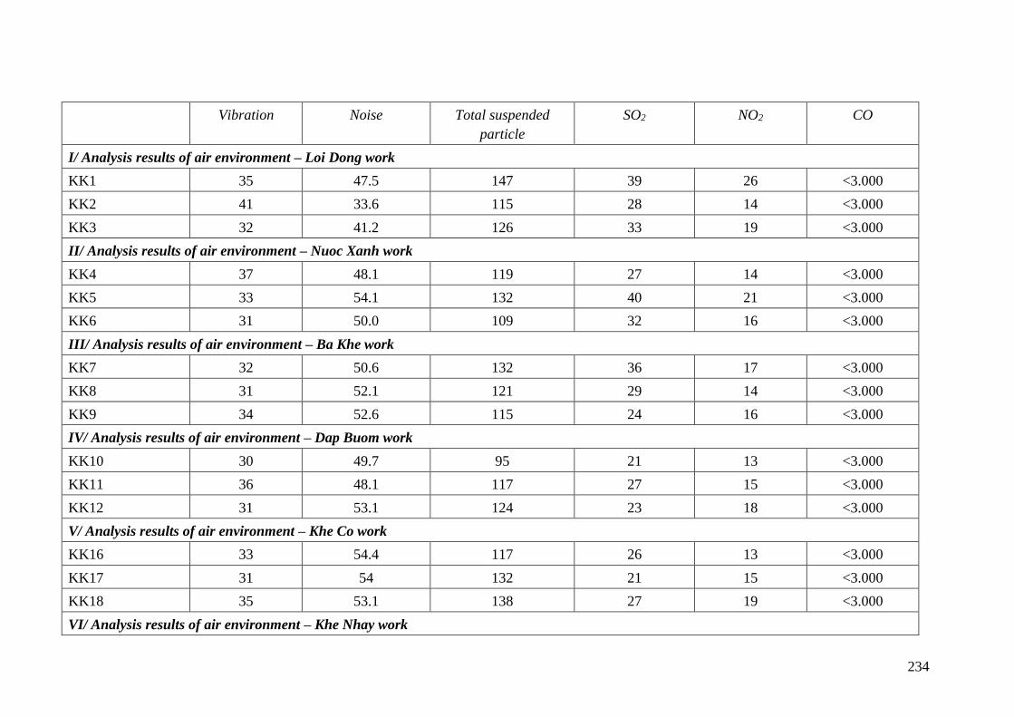
234
Vibration Noise Total suspended
particle
SO2 NO2 CO
I/ Analysis results of air environment – Loi Dong work
KK1 35 47.5 147 39 26 <3.000
KK2 41 33.6 115 28 14 <3.000
KK3 32 41.2 126 33 19 <3.000
II/ Analysis results of air environment – Nuoc Xanh work
KK4 37 48.1 119 27 14 <3.000
KK5 33 54.1 132 40 21 <3.000
KK6 31 50.0 109 32 16 <3.000
III/ Analysis results of air environment – Ba Khe work
KK7 32 50.6 132 36 17 <3.000
KK8 31 52.1 121 29 14 <3.000
KK9 34 52.6 115 24 16 <3.000
IV/ Analysis results of air environment – Dap Buom work
KK10 30 49.7 95 21 13 <3.000
KK11 36 48.1 117 27 15 <3.000
KK12 31 53.1 124 23 18 <3.000
V/ Analysis results of air environment – Khe Co work
KK16 33 54.4 117 26 13 <3.000
KK17 31 54 132 21 15 <3.000
KK18 35 53.1 138 27 19 <3.000
VI/ Analysis results of air environment – Khe Nhay work
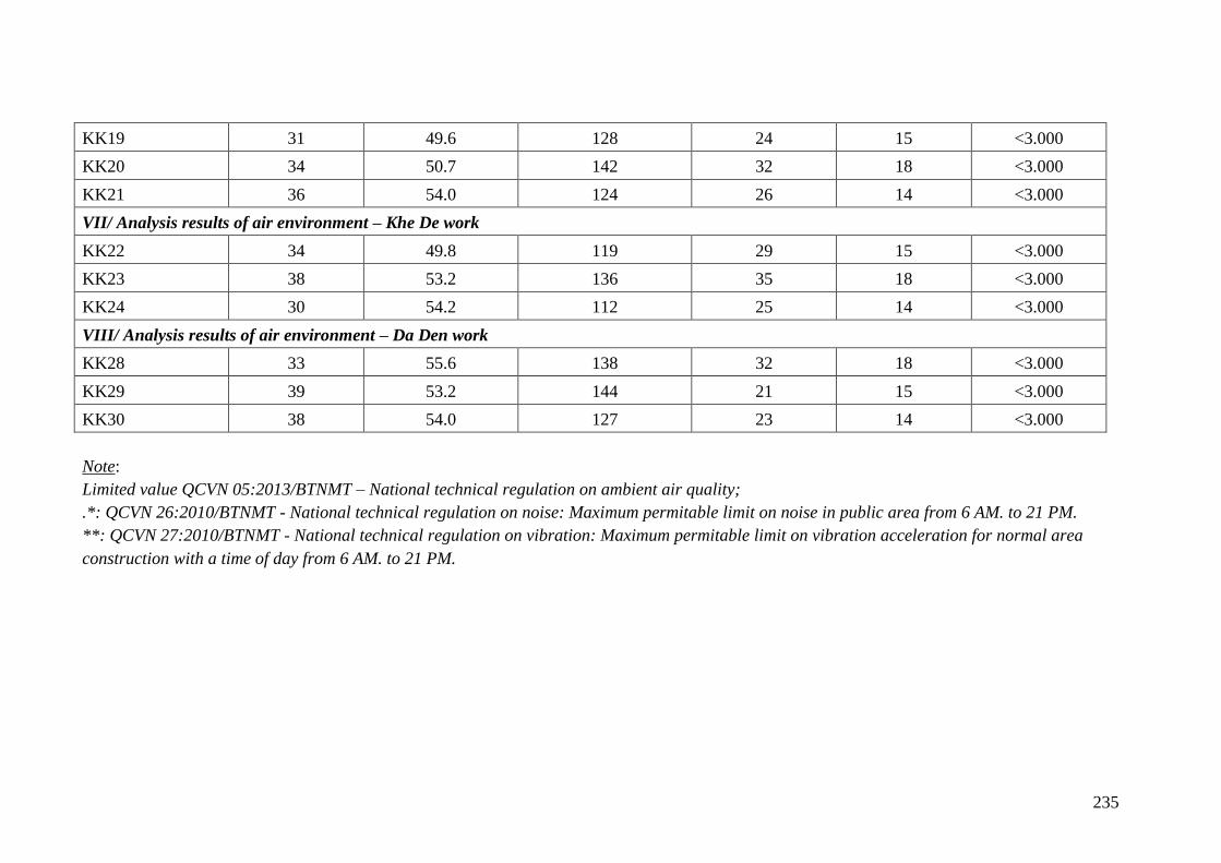
235
KK19 31 49.6 128 24 15 <3.000
KK20 34 50.7 142 32 18 <3.000
KK21 36 54.0 124 26 14 <3.000
VII/ Analysis results of air environment – Khe De work
KK22 34 49.8 119 29 15 <3.000
KK23 38 53.2 136 35 18 <3.000
KK24 30 54.2 112 25 14 <3.000
VIII/ Analysis results of air environment – Da Den work
KK28 33 55.6 138 32 18 <3.000
KK29 39 53.2 144 21 15 <3.000
KK30 38 54.0 127 23 14 <3.000
Note:
Limited value QCVN 05:2013/BTNMT – National technical regulation on ambient air quality;
.*: QCVN 26:2010/BTNMT - National technical regulation on noise: Maximum permitable limit on noise in public area from 6 AM. to 21 PM.
**: QCVN 27:2010/BTNMT - National technical regulation on vibration: Maximum permitable limit on vibration acceleration for normal area
construction with a time of day from 6 AM. to 21 PM.
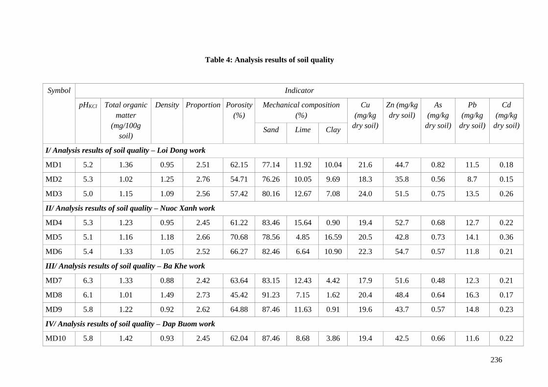
236
Table 4: Analysis results of soil quality
Symbol Indicator
pHKCl Total organic
matter
(mg/100g
soil)
Density Proportion Porosity
(%)
Mechanical composition
(%)
Cu
(mg/kg
dry soil)
Zn (mg/kg
dry soil)
As
(mg/kg
dry soil)
Pb
(mg/kg
dry soil)
Cd
(mg/kg
dry soil) Sand Lime Clay
I/ Analysis results of soil quality – Loi Dong work
MD1 5.2 1.36 0.95 2.51 62.15 77.14 11.92 10.04 21.6 44.7 0.82 11.5 0.18
MD2 5.3 1.02 1.25 2.76 54.71 76.26 10.05 9.69 18.3 35.8 0.56 8.7 0.15
MD3 5.0 1.15 1.09 2.56 57.42 80.16 12.67 7.08 24.0 51.5 0.75 13.5 0.26
II/ Analysis results of soil quality – Nuoc Xanh work
MD4 5.3 1.23 0.95 2.45 61.22 83.46 15.64 0.90 19.4 52.7 0.68 12.7 0.22
MD5 5.1 1.16 1.18 2.66 70.68 78.56 4.85 16.59 20.5 42.8 0.73 14.1 0.36
MD6 5.4 1.33 1.05 2.52 66.27 82.46 6.64 10.90 22.3 54.7 0.57 11.8 0.21
III/ Analysis results of soil quality – Ba Khe work
MD7 6.3 1.33 0.88 2.42 63.64 83.15 12.43 4.42 17.9 51.6 0.48 12.3 0.21
MD8 6.1 1.01 1.49 2.73 45.42 91.23 7.15 1.62 20.4 48.4 0.64 16.3 0.17
MD9 5.8 1.22 0.92 2.62 64.88 87.46 11.63 0.91 19.6 43.7 0.57 14.8 0.23
IV/ Analysis results of soil quality – Dap Buom work
MD10 5.8 1.42 0.93 2.45 62.04 87.46 8.68 3.86 19.4 42.5 0.66 11.6 0.22
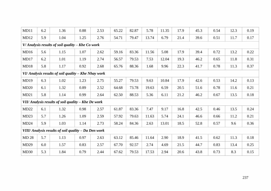
237
MD11 6.2 1.36 0.88 2.53 65.22 82.87 5.78 11.35 17.9 45.3 0.54 12.3 0.19
MD12 5.9 1.04 1.25 2.76 54.71 79.47 13.74 6.79 21.4 39.6 0.51 11.7 0.17
V/ Analysis results of soil quality – Khe Co work
MD16 5.6 1.15 1.07 2.62 59.16 83.36 11.56 5.08 17.9 39.4 0.72 13.2 0.22
MD17 6.2 1.01 1.19 2.74 56.57 79.53 7.53 12.04 19.3 46.2 0.65 11.8 0.31
MD18 5.8 1.17 0.92 2.68 65.76 88.36 1.68 9.96 22.3 41.7 0.78 11.3 0.37
VI/ Analysis results of soil quality – Khe Nhay work
MD19 6.3 1.02 1.23 2.75 55.27 79.53 9.63 10.84 17.9 42.6 0.53 14.2 0.13
MD20 6.1 1.32 0.89 2.52 64.68 73.78 19.63 6.59 20.5 51.6 0.78 11.6 0.21
MD21 5.8 1.14 0.99 2.64 62.50 88.53 5.36 6.11 21.2 46.2 0.67 13.5 0.18
VII/ Analysis results of soil quality – Khe De work
MD22 6.1 1.32 0.98 2.57 61.87 83.36 7.47 9.17 16.8 42.5 0.46 13.5 0.24
MD23 5.7 1.26 1.09 2.59 57.92 79.63 11.63 5.74 24.1 46.6 0.66 11.2 0.21
MD24 5.9 1.03 1.14 2.73 58.24 84.36 2.63 13.01 18.5 52.8 0.57 9.6 0.36
VIII/ Analysis results of soil quality – Da Den work
MD 28 5.7 1.13 0.97 2.63 63.12 85.46 11.64 2.90 18.9 41.5 0.62 11.3 0.18
MD29 6.0 1.57 0.83 2.57 67.70 92.57 2.74 4.69 21.5 44.7 0.83 13.4 0.25
MD30 5.3 1.84 0.79 2.44 67.62 79.53 17.53 2.94 20.6 43.8 0.73 8.3 0.15
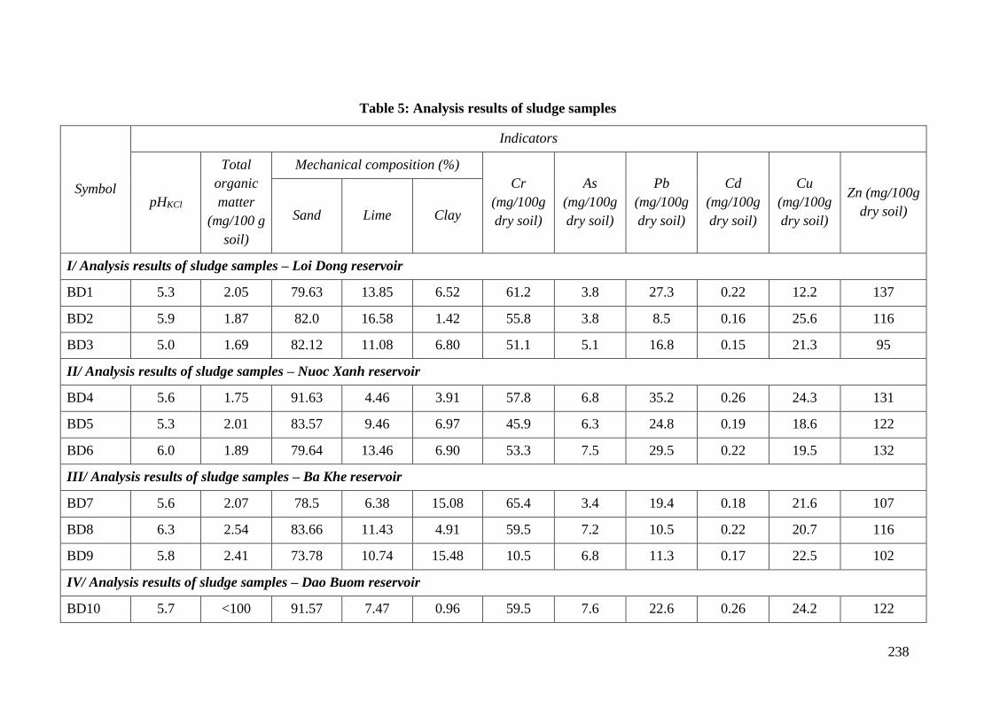
238
Table 5: Analysis results of sludge samples
Symbol
Indicators
pHKCl
Total
organic
matter
(mg/100 g
soil)
Mechanical composition (%)
Cr
(mg/100g
dry soil)
As
(mg/100g
dry soil)
Pb
(mg/100g
dry soil)
Cd
(mg/100g
dry soil)
Cu
(mg/100g
dry soil)
Zn (mg/100g
dry soil) Sand Lime Clay
I/ Analysis results of sludge samples – Loi Dong reservoir
BD1 5.3 2.05 79.63 13.85 6.52 61.2 3.8 27.3 0.22 12.2 137
BD2 5.9 1.87 82.0 16.58 1.42 55.8 3.8 8.5 0.16 25.6 116
BD3 5.0 1.69 82.12 11.08 6.80 51.1 5.1 16.8 0.15 21.3 95
II/ Analysis results of sludge samples – Nuoc Xanh reservoir
BD4 5.6 1.75 91.63 4.46 3.91 57.8 6.8 35.2 0.26 24.3 131
BD5 5.3 2.01 83.57 9.46 6.97 45.9 6.3 24.8 0.19 18.6 122
BD6 6.0 1.89 79.64 13.46 6.90 53.3 7.5 29.5 0.22 19.5 132
III/ Analysis results of sludge samples – Ba Khe reservoir
BD7 5.6 2.07 78.5 6.38 15.08 65.4 3.4 19.4 0.18 21.6 107
BD8 6.3 2.54 83.66 11.43 4.91 59.5 7.2 10.5 0.22 20.7 116
BD9 5.8 2.41 73.78 10.74 15.48 10.5 6.8 11.3 0.17 22.5 102
IV/ Analysis results of sludge samples – Dao Buom reservoir
BD10 5.7 <100 91.57 7.47 0.96 59.5 7.6 22.6 0.26 24.2 122
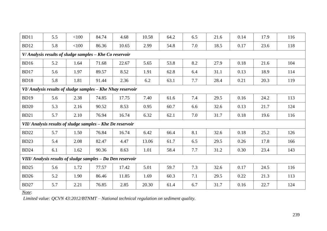
239
BD11 5.5 <100 84.74 4.68 10.58 64.2 6.5 21.6 0.14 17.9 116
BD12 5.8 <100 86.36 10.65 2.99 54.8 7.0 18.5 0.17 23.6 118
V/ Analysis results of sludge samples – Khe Co reservoir
BD16 5.2 1.64 71.68 22.67 5.65 53.8 8.2 27.9 0.18 21.6 104
BD17 5.6 1.97 89.57 8.52 1.91 62.8 6.4 31.1 0.13 18.9 114
BD18 5.8 1.81 91.44 2.36 6.2 63.1 7.7 28.4 0.21 20.3 119
VI/ Analysis results of sludge samples – Khe Nhay reservoir
BD19 5.6 2.38 74.85 17.75 7.40 61.6 7.4 29.5 0.16 24.2 113
BD20 5.3 2.16 90.52 8.53 0.95 60.7 6.6 32.6 0.13 21.7 124
BD21 5.7 2.10 76.94 16.74 6.32 62.1 7.0 31.7 0.18 19.6 116
VII/ Analysis results of sludge samples – Khe De reservoir
BD22 5.7 1.50 76.84 16.74 6.42 66.4 8.1 32.6 0.18 25.2 126
BD23 5.4 2.08 82.47 4.47 13.06 61.7 6.5 29.5 0.26 17.8 166
BD24 6.1 1.62 90.36 8.63 1.01 58.4 7.7 31.2 0.30 23.4 143
VIII/ Analysis results of sludge samples – Da Den reservoir
BD25 5.6 1.72 77.57 17.42 5.01 59.7 7.3 32.6 0.17 24.5 116
BD26 5.2 1.90 86.46 11.85 1.69 60.3 7.1 29.5 0.22 21.3 113
BD27 5.7 2.21 76.85 2.85 20.30 61.4 6.7 31.7 0.16 22.7 124
Note:
Limited value: QCVN 43:2012/BTNMT – National technical regulation on sediment quality.
240
Appendix 3- Integrated pest management plan (IPM)
1. Objectives
a. General objectives
Strengthening the plant protection at local level, reducing pesticide use in fields, improving
the efficiency of pest prevention, management and application of plant protection chemicals
to reduce the risks of pesticide contamination in the environment and on human health.
b. Specific objectives
• Strengthening environmental protection through strengthening the role of natural
predators; reducing pesticide residues, reducing environmental pollution (on water, land,
air);
• Improving farmers' knowledge: distinguish major and secondary pests; identify predators
and their role in the field, clearly understand two side effect of pesticides, properly use
and know how to survey pest and use control threshold, understand the application of pest
control measures adopting IPM to increase income for farmers.
2. Basic principles of IPM plan
The following principles will be applied to the sub-projects:
1 "Prohibited list": As defined in the screening criteria in Environmental and social
Management Framework (ESMF), the project will not finance the purchase of
pesticides in large quantities and hence do not trigger OP4.09 as the project is aimed at
repairing headwork to improve dam safety other than increasing the storage capacity
and expanding the downstream irrigated area. However, if there is a serious infestation
of pests in the region, the procurement, storage and transportation of pesticide will be
subjected to the provisions of the Government. The list of banned pesticides will not be
used and circulated.
2 The project will apply IPM programs as a method to minimize the potential negative
impact of the increased use of fertilizers and chemicals.
3 In normal conditions, if pesticide use is considered to be a necessary option, only
pesticides registered with the government and the international recognition in use and
project will also provide technical and economic information for chemicals use
demand. The use and management of non-harmful chemicals should be considered to
reduce the reliance on pesticides. Measures will be incorporated into the project design
to reduce risks related to the handling and use of pesticides to allowable level and to be
managed by users.
3. The approach of IPM
Focus more on the risks of plant protection chemcical overuse. Such important crops as rice,
vegetables, etc. are those in higher need of pesticides.
Focus on awareness raising and capacity building for trainer/facilitators of IPM. The training
program will be enriched with the integration of many activities such as System Rice
Intensification (System Rice Intensification - SRI), minimum tillage, community producing
241
and using bio-products in place of plant protection chemicals, training activities and
applications for duplication on wider scale.
For this activity, following steps should be carried out:
- Step 1: Identify training needs of the application of restriction and management
measures for plant chemicals. Consultation with key agencies on the organization of
training courses and registration of farmers’ participation in these trainings;
- Step 2: Develop work plan and schedule including budgeting and implementation
targets. The work plan will be approved by PMU and will be carried out by provincial
Department of Plant Protection either independently or to be integrated in current local
programs.
- Step 3: Implement and carry out annual review. After the approval of the work plan,
activities will be implemented. Implementation progress will be included in the project
progress reports. An annual evaluation report will be implemented by PMU and Sub-
Department of Plant Protection.
4. The contents of the sub-projects
(i) Collection of information and selection of solutions
Before implementing IPM program, Consultants must carry out initial investigation to get
necessary information, including:
• Survey to collect data on: staple crops have economic significance in the project area:
seeds, crop, growth characteristics, and farming techniques.
• Survey to collect data on soil conditions, pedology, local climate.
• Investigate the situation of major pests, operating rules, economic damages caused to
major crops in the project area.
• Investigate role and components of natural enemies parasitic of pests on major crops in
the project area.
• Investigate the actual situation of pest control measures, pesticide use and their effects in
the locality.
• Investigate socio-economic conditions, income, technical knowledge, and practices.
On the basis of these findings, evaluate IPM measures which will be applied on specific crops
in regions and localities as follows:
• Cultivation methods: land preparation, field cleaning, cropping rotation, intercropping,
suitable cropping seasons, reasonable sowing and planting density, rational use of
fertilizers; appropriate caring measures.
• Using seed: the traditional seed varieties and proposed seed varieties for use.
• Biological measures: taking advantage of available natural enemies in the field, using
biological products.
• Determine the harmful level and prevention threshold.
242
• Chemical measures: make sure the safe application of chemicals on natural enemies,
adopting economic threshold; 4 correct uses of pesticides.
(ii) Training of IPM staff/trainers
TOT (Training of trainers) and Farmer Field School (FFS):
● Each sub-project will organize IPM training workshops. The contents of the training
workshops are as follows:
o Distinguish major and secondary pests.
o Identify natural enemies of pests and diseases in the field.
o Investigate methods to detect worms and diseases.
o Understand impact of two side effects of pesticides and know how to use pesticides
properly
o Pest control techniques under IPM principles.
o Advanced farming techniques.
● Trainees : The technical staff of the Department of Agriculture, Sub-department of Plant
Protection, Agricultural Extension of districts, communes, and cooperatives. These
trainees will train farmers in the project area and guide the implementation of models.
● The size of each class is 20 to 30 trainees and classes are held in communes. Training time
can be by period and by topics. Each training course may last for 3-5 days including both
theory and practice.
● Lecturer: experts are hired from University/Research institute/Agricultural Extension
Centers...
(iii) Coaching and training of farmers
Training of Farmers (TOF) in Farmer Field School (FFS):
o Method: Combine theoretical training and base on practical fields of farmers and
demonstration model on IMP in pilot fields.
o Training contents are the same as IMP ToT training.
o Participants: farmers in the project areas, farmers directly implement models and
farmers outside the sub-project area if they are interested.
o Classes are organized in each commune.
o Lecturer: trained trainers from TOT courses.
(iv) Evaluate and visits to fields applying farmer based IPM models
Visit the coast conference, farmers performing the demonstration models are reporters. The
farmers implement the model directly with the participants; visiting farmers will calculate,
compare economic performance and identify lessons, limitations and the work being done
and not being done
243
Organize a field based visit, farmers who involved in demonstration models are also the
reporters and they will together with other farmers to visit, calculate, compare economic
efficiency, draw lessons and challenges to be overcome.
5. Expected results
● Capacity of Thach Ha, Ky Anh, Vu Quang, Huong Son PPDs and farmer trainers are
improved after IPM training and IPM practices will be maintained.
● Support farmer groups following IPM training courses in the application of training
knowledge to make sure safe production and say no to the overuse of plant protection
chemicals and disseminate the knowledge among communities.
● Support local governments in the reinforcement of pesticide management including
the implementation and enforcement of legislations controlling plant protection
products.
6. Implementation of IPM programs
Currently, Vietnam is implementing the national IPM program, so sub-projects requires
coordinated planning and integration of the IPM program of the project in the National IPM
program for more effective performance within each sub-project.
● Ha Tinh Project Management Unit PPMU:
o Developing and organizing the implementation of IPM program.
o Responsible for the preparation of periodic reports on the UPM implementation and
submitting to CPO and WB. Final plan and budget will be completed and consulted
with the CPO. All documents will be stored in the project profiles.
● Ha Tinh Sub-Department of Plant Protection:
o Provide policy and technical guidelines for the implementation of the IPM program.
o Participate in ToT IPM training courses.
● Thach Ha, Ky Anh, Vu Quang, Huong Son Plant Protection Stations
o Coordinate with IPM staff to implement farmer training courses on IPM through the
provision of knowledge and supports to safe use of pesticides when necessary.
o Introduce the list of banned pesticides
o Examine the distribution facilities selling pesticides to ensure safe pesticides are sold
to farmers
● PPCs in the subproject area:
Maintain the success of IPM training courses by organizing diversified IPM clubs of farmers
at different organizational levels and structures management (integrating livestock, credit,
market access contents etc.)
● Households in the project area:
Implementing measures to reduce the use of plant protection chemicals, applying IPM as
trained.
244
Members of the IPM club support each other in agriculture developments. They also play a
central role in the organization of community based IPM program and agricultural
development planning at commune and district levels.
● Environmental Safety Monitoring Consultant:
o Monitoring the implementation of IPM program of sub-projects;
o Guides PPMU in the implementation of IPM program;
o Recommend measures to improve the efficiency of IPM program of sub-projects.
7. Funds for the implementation of IPM program
Cost estimates of IPM program in sub-projects as follows:
- ToT IPM training: Calculated for the classes held in each district = unit price x
number of district of each sub-project.
- ToF IPM training: Calculated for the organization of class in each commune = unit
price x number of commune in each sub-project.
- Cost of organizing evaluation and study visits to fields applying farmer based IPM
models. Study visits to fields is 1 day for 1 commune.
245
Appendix 4- Emergency preparedness plan (EPP)
1. Overview of emergency preparedness plan
The existence of large dams and reservoirs at the upstream of the residential areas requires the
preparation of an Emergency Preparedness Plan (EPP) relating to the professional for each
dam. The purpose of the emergency preparedness Plan aims to assist the authorities
responsible for public safety issues in order to take the proper and necessary measures for
preventing injury and minimizing material damages by the accidents predicted in case of
occurring the dam failures.
Each dam, reservoir and risk-containing areas have its own characteristics, and so each
Emergency Preparedness Plan shall be prepared taking into account the specific conditions of
such work. However, there are some general issues need to be mentioned for each work in
need of the emergency preparedness Plan.
So far, the Consultant has yet to determine the guidelines of Vietnam on the issue of the
requirements for the preparation of emergency preparedness Plan or the directives such as the
responsibilities relating to the preparation and implementation of emergency preparedness
Plan shall be handed over to anyone.
Finally, a sample estimation for making the emergency preparedness Plan has also been
formulated. It is more difficult to determine the problem of benefit. Generally, it should be
considered that if the dam safety management is better and the emergency preparedness Plan
is made for all existing dams, the average number of accidents caused by the floods shall be
reduced.
2. General requirements for emergency preparedness plan
To turn an emergency preparedness Plan into a useful tool for prevention of disasters and
mitigation of disasters, it is necessary to have the certain legal tools in order to allow the
relevant authorities responsible for the formulation and implementation of emergency
preparedness Plans to implement their necessary powers. These powers shall be decentralized
and specified for the urgent conditions relating to legislation. If the current law is proved to be
insufficient for this purpose, it is necessary to consider the adjustment of the legal framework.
In principle, the organizations responsible for the management and the operation and
maintenance of a certain dam shall also have the primary responsibility for making the
emergency preparedness Plan. These organizations should have the reasonable knowledge
relating to the risks associated with dams and reservoirs of a certain work. In case of project
for supporting the water resources of Vietnam, the hydraulic works management and
exploitation Companies shall take primary responsibility for the formulation and
implementation of emergency preparedness Plans for each certain work .
The provincial People’s Committees, where the dams are located in, shall be able to play a
supervisory role. Other relevant authorities can also be entrusted to set out the rules and
regulations, and to make, implement, inspect and promote the emergency preparedness Plans.
The preparation of an emergency preparedness Plan in detail for a dam and reservoir requires
the proper maps, data relating to river, dam, topography, hydrology, rural and urban
infrastructure, population and the physical assets at risk, etc.as well as the special skills and
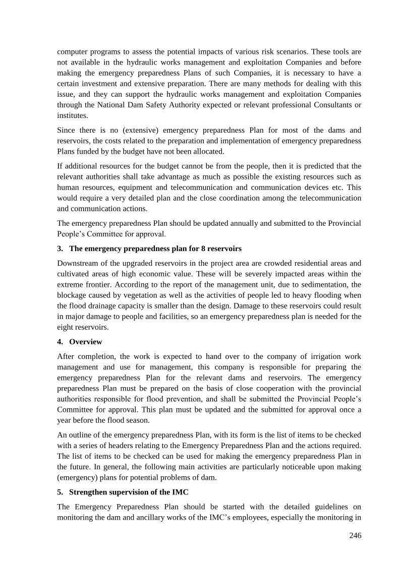
246
computer programs to assess the potential impacts of various risk scenarios. These tools are
not available in the hydraulic works management and exploitation Companies and before
making the emergency preparedness Plans of such Companies, it is necessary to have a
certain investment and extensive preparation. There are many methods for dealing with this
issue, and they can support the hydraulic works management and exploitation Companies
through the National Dam Safety Authority expected or relevant professional Consultants or
institutes.
Since there is no (extensive) emergency preparedness Plan for most of the dams and
reservoirs, the costs related to the preparation and implementation of emergency preparedness
Plans funded by the budget have not been allocated.
If additional resources for the budget cannot be from the people, then it is predicted that the
relevant authorities shall take advantage as much as possible the existing resources such as
human resources, equipment and telecommunication and communication devices etc. This
would require a very detailed plan and the close coordination among the telecommunication
and communication actions.
The emergency preparedness Plan should be updated annually and submitted to the Provincial
People’s Committee for approval.
3. The emergency preparedness plan for 8 reservoirs
Downstream of the upgraded reservoirs in the project area are crowded residential areas and
cultivated areas of high economic value. These will be severely impacted areas within the
extreme frontier. According to the report of the management unit, due to sedimentation, the
blockage caused by vegetation as well as the activities of people led to heavy flooding when
the flood drainage capacity is smaller than the design. Damage to these reservoirs could result
in major damage to people and facilities, so an emergency preparedness plan is needed for the
eight reservoirs.
4. Overview
After completion, the work is expected to hand over to the company of irrigation work
management and use for management, this company is responsible for preparing the
emergency preparedness Plan for the relevant dams and reservoirs. The emergency
preparedness Plan must be prepared on the basis of close cooperation with the provincial
authorities responsible for flood prevention, and shall be submitted the Provincial People’s
Committee for approval. This plan must be updated and the submitted for approval once a
year before the flood season.
An outline of the emergency preparedness Plan, with its form is the list of items to be checked
with a series of headers relating to the Emergency Preparedness Plan and the actions required.
The list of items to be checked can be used for making the emergency preparedness Plan in
the future. In general, the following main activities are particularly noticeable upon making
(emergency) plans for potential problems of dam.
5. Strengthen supervision of the IMC
The Emergency Preparedness Plan should be started with the detailed guidelines on
monitoring the dam and ancillary works of the IMC’s employees, especially the monitoring in
247
the periods of extreme rain in the basin or in the case of the reservoir water level rising. The
guidelines should detail the special points in need of observe, especially in the case of rapidly
rising the reservoir water level. The work of monitoring consist of the regular observe of
seepage along the dam heel and in any position along the dam in the place where is expected
that the seepage shall only occur upon the high reservoir water level. Depending on the
number of parameters, for example:
- The heavy and widespread rainfall in the basin for a prolonged period;
- The rainfall in the basin of water collected in a short period;
- The water level of the reservoir and the rising of water level in the reservoir;
- The increase of seepage; or
- The cloudy seepage in the downstream slope or at the dam heel;
- The movement of the dam crest and the downstream of dam.
The IMC should calculate a reasonable alarming level in more detail, and adjust according to
the actual situation.
6. Definitions and notice of alarming level
For each alarming level or a specific situation, it is necessary to initiate the measures that
would be widely deployed in the future when the conditions become deteriorated and the
situation becomes more serious. These measures shall start with the internal information of
the IMC, and increase in terms of intensity along with increase of the severity of the situation,
for example:
- The IMC must be continuously informed;
- Suspend the annual leave of a certain number of staff of the IMC;
- Police and local rescue forces must be in alarming condition;
- Some certain staff and operators with the devices transferred to the dam or other locations;
- Notify through local media and radio stations;
- The officials of Provincial People Committee, the military, the public work department and
other departments must be in alarming condition, and must be instructed;
- Mobilize support units (firefighting forces, the army, the Red Cross) and equipment;
- Public information and ensure that everyone is informed;
- Block some certain routes, stop or strengthen bus and train;
- Mobilize helicopters, boats and other transport equipment;
- Prepare shelter;
- Request removal for the most dangerous areas;
- Request the entire removal;
- Notify the emergency situation.
248
The alarming level should be clearly defined, and the definition should be distributed to all
staff and agencies concerned immediately after the approval of emergency preparedness Plan.
The people need to be fully aware of the alarming levels which shall be clearly informed to
them by sirens or similar things. After consulted by the local authorities, the IMC shall be
guided to achieve the best results for alarming people.
7. Data collection
To establish an emergency preparedness plan, firstly the hydraulic work management and
irrigation management company require detailed maps of the entire region which can be
affected. The buildings, roads, bridges, high and low areas, dam banks, canals, etc. must be
presented on the map. Especially for the preparation of dam failure analysis, it is necessary to
have the detailed information, including cross section of the river basin, the main obstacles for
the progress of a flood wave in the flow of the river or the mudflats, sunken areas can
temporarily act as reservoirs, dykes, water dividing roads, ditches, creeks and other
topographical factors which can affect flood wave. The terrain maps must extend beyond the
project area in order to determine the approach road and areas and works (such as schools and
community halls) which can be used as a place for shelter and a place of relocation for the
victims of the flood. The hospitals near the flooded areas must be identified and be informed
on the tasks which they may have in the event of injury from broken dam problem.
8. Dam failure analysis
It is necessary to conduct a dam failure analysis to map the boundaries of the area may be
affected by the flood. The analysis is recommended to conduct many different conditions such
as assumption of the normal water level, the full reservoir water level with maximum flood
load, a quickly open hole in the dam body, a lot of preliminary cases such as an alluvial
flooded, and the relatively dry conditions, high surface water flows at the same time from the
river tributaries in the downstream.
Moreover, the computer programs, upon analyzing dam failure, can be run on multi
coefficient of roughness and possible measures to reduce or otherwise affect flood conditions
in some certain locations such as decrease of flooding speed near the residential areas, or
lifting to the roads to access or exit some certain areas.
The impact of the obstacles in the flow of a river or mudflats should also be evaluated in the
regulatory view to limit the flooding level on the river, not only in the catastrophic cases but
also for “normal” extreme point floods. The implementation of most possible measures to
minimize the impact of extreme point flood discharge cannot be conducted in the short term,
it must be used as tools for planning and policy for the river basin in the future, or it must be
gradually implemented.
9. Flooding map
Dam failure analysis must identify clearly the most dangerous areas in case of occurring
disaster. Results of the analysis shall be presented on the flooding maps, describe the possible
depth, flood velocity (as a sign of potentially dangerous conditions), the progression of waves
interrupted in the basin, and mention the time for salvage activity.
249
When a preliminary dam failure analysis may briefly indicate above mentioned flooding
parameters, sooner or later the dam failure analysis shall be upgraded under the same relevant
and better conditions. Especially the influence of the embankment (slightly) improved which
is used for road, railway, irrigation canal, flood prevention, sediment piles along the canal, is
also notable. In such locations, the maximum flood velocity can also increase making it
impossible to access the embankment or the roads and causing the landslides destroying a part
or whole of this embankments. A network of high obstacles in sunken areas may divert flood
flows and cause more serious conditions at the locations where these conditions are not
desired.
The flooding maps for selected conditions must be available to submit to the important
agencies relating to the physical planning of the area, and submit to the relevant authorities
relating to the salvage activities if possible (province, city, police, firefighting, hospital,
military, etc.). Such maps need to be updated and redistributed in cases of determining the
conditions with the important changes. Number of agencies and organizations receive such
maps (and other information) depend on the severity of the conditions, and generally depend
on the water collecting function of the reservoirs, the dam height and areas directly affected.
10. Organizational issues
Although the IMC shall be responsible for preparing and maintaining an emergency
preparedness Plan, most of the activities after a catastrophic event shall be carried out by
other agencies and organizations. The task of the IMC for the dams and reservoirs is that
preventing the critical situations. It is assumed occurrence of emergency case, the IMC shall
take all primary measures possible to avoid a disaster. As long as the conditions become more
serious, the IMC should not wait for being warned and assigned by the higher levels. In case
of occurring those conditions, it is necessary to clearly define the person who is responsible
for their own job. A detailed plan with an extended information system must be continuously
sustained until occurrence of disaster.
Firstly the IMC must prepare an Emergency Preparedness Plan for the internal purposes in the
flood conditions and in case where the expression of the dam shall require more attention. The
internal organization of the IMC shall immediately deal with at the first alarming level, and
inform higher authorities about the concerns and the consequences in case of occurrence.
In the next alarming higher level, it is possible to need the support of other organizations, and
a responsibility can be transferred to such organizations. For these cases, it is necessary to
have a detailed planning, and the information shall be ready for the necessary actions. It is
necessary to be aware that in the bad weather condition, there would have no electricity, the
roads can be flooded, the telephone line can be damaged, and the publication of print,
photocopy of maps and planning documents or other directives cannot be implemented.
When the situation become serious, the functional authority of the province shall implement
all their responsibilities, and shall need to be provided the plan for the actions to be
implemented, which were established in the previous stage. These plans should include
organizational issues for emergency activities expected, and should state clearly the
responsible lines and communication for all activities and actions decentralized (but well-
coordinated), depending on the specific situation.
250
The competent authority under the emergency preparedness Plan responsible for a number of
activities and certain inputs in any alarming phase should be fully informed for any changes
of the emergency preparedness Plan. And similar to the organizations designated to support
activities such as means of transportation, equipment, material resources and other inputs
required in the case of occurring disaster.
11. Procedures
In the lowest alarming level, the relatively simple internal application procedure of the IMC
shall remain in effect as action procedure for the monitor and management of dam and
ancillary works. When the situation become worse, and the next alarming level starts, the
normal operating procedure of the IMC shall be supplemented and replaced by a new
procedure focusing on the implementation of the emergency preparedness Plan.
The management guidelines of main dam shall be valid, and the dam management shall be
implemented by the experts of the IMC as specified in the procedure of the IMC for that year.
Other agencies have no right to make temporary decision where spillway gate or other inlet or
outlet gates shall be opened or not.
The procedure for the higher alarming level shall transfer the entire responsibility for the
implementation of emergency preparedness Plan to the higher authority levels (preferably
PPC). These procedures shall be clearly allocated for the responsibility and the right for the
certain agencies with the cooperation or support of emergency activities.
The emergency preparedness Plan should include the clear organization plans for easily
following the levels of emergency activities. These plans should also include the main
telecommunication and communication lines and procedures in need of following for some
certain activities, for example requesting the central government to help and requesting the
military forces for more support.
In case where the situation become deteriorated, and the displacement becomes the only
option, the area to be relocated shall be protected by the police or other armed forces. The
emergency preparedness Plan also proposes some provisions for these conditions, and they
shall be discussed with the executive agencies which are responsible for maintaining order
and rules. The last provisions should include arrangements for taking the necessary forces
(such as the red cross society and similar forces) to the higher residential area in the heart of
flooded areas.
12. Communication
Communication is a vital part of any emergency plan. In the very special conditions, most of
the means of communication can be damaged. The emergency preparedness Plan should take
into account this fact, and identify the means of communication that can be used in the
emergency conditions.
The normal telephone lines and mobile phones cannot be used in extremely emergency
conditions. The communication via radio can solve somehow of the problem. In this regard,
the mobilization of police and the armed forces involved in making emergency preparedness
Plan is vital.
251
First of all, the communications between the field of dam and the headquarters of the IMC
must be ensured safety. These communication lines must be active at all times, and the
information about the water level of reservoir can be read at the IMC’s headquarters at any
time. During the regular dam inspections, the dam safety inspector must pay attention to the
means of communication established for each dam (or saddle dam).
Secondly, the communication with higher levels should be well structured. When the dam’s
situation become deteriorated, and when the responsibilities are beyond the capacity of the
IMC, a higher authority must be able to smoothly receive the responsibilities (or part) and
continue to cooperate in the implementation of the emergency preparedness Plan. In such
situation, the means of communication are in need of capacity of receiving multiple incoming
calls.
The contacts and communication procedures must be clearly and fully documented. All
agencies, where have primary responsibility for making emergency plan, shall be received a
copy of these procedures as well as the directives and supporting guidance.
13. The training and exercise of emergency preparedness plan
An emergency preparedness Plan shall include the training and exercise of a selected number
of components in the emergency preparedness Plan. It is best to have a need analysis as the
basis for the program. The exercise program must be prepared in conjunction with other
relevant agencies. The training and exercise shall focus on the components that the parties
concerned are not familiar.
14. The participation and information of community
The main beneficiaries of the emergency preparedness plan are the general population who
can be affected by the risks of an incident which can occur on the dam. In order to achieve
their full cooperation, then the raising of public awareness and support received from the
public are essential.
The emergency preparedness Plan must mention the issue of public awareness as an important
content, because of the lack of public awareness and support and involvement of the public,
all emergency preparedness Plans shall become useless.
After established and approved the draft of the emergency preparedness Plan by the
Provincial People’s Committee, the public must be informed about the characteristics of the
dam, the risks can occur, the measures are implemented and plans are prepared to avoid the
negative impacts or mitigate the consequences. For this purpose, the types of information
shall be conveyed to the public through the media such as posters and informing to the
students, information on Televisions, announcing in the local newspapers and other mass
media.
15. Legislation
After all the plans are established, it is necessary to analyze whether the proposed measures
have been backed by a full legal framework or not. In case where the legal system is
somehow defective, requesting the competent authority to immediately start adjusting the
current law in order to allow the implementation of essential measures. The legislation shall
252
give the authority with the rights to take necessary measures in order to deal with the
emergency conditions.
16. Reporting
The emergency preparedness Plan should also include requirements for annual report on its
objectives, the process of implementation and the problems encountered. The People’s
Committee of the provinces and the Ministry of Agriculture and Rural Development need this
information to be able to identify what is a common problem to be solved, and learn from the
hydraulic work management and exploitation Companies. The experience gained is to draw in
an adjusted approach for the problem of establish and implementation of the emergency
preparedness plans.
Annual report should be brief and include:
- Plans of the previous year;
- Training and practice have been carried out, results and recommendations for upgrading and
improvements;
- Adjustments required for the emergency preparedness Plan of next year;
- Training program for next year;
- Information and data changed;
- Finalization of the budget of the previous year and the budget of the following year.
17. Estimation relating to the emergency preparedness plan
A series of actions and requirements determined above need an estimated budget and
allocated approximately one year before the planned activities are implemented in practice.
The degree of costs depends on many conditions. Apart of the costs can be covered from the
operating expenses of the IMCs but others may need to be covered by the budget as well as
additional funding, and must be allocated specifically for the establishment and
implementation of emergency preparedness Plans. The specific costs related to an emergency
preparedness Plan include the following items:
- Public information materials;
- Computers, softwares for dam failure analysis;
-The printed materials, instructions, reports, flooding maps, and other materials;
- Means of enhancing communication (telephone, radio);
- Additional transport costs;
- The costs related to the implementation of training and exercise.
- Costs are summarized in the table below:
Table 1. Estimation of EPP for 5 years
Year Basic cost
(million VND)
Human resources
cost
Cost of office
operation
Total cost
(million VND)
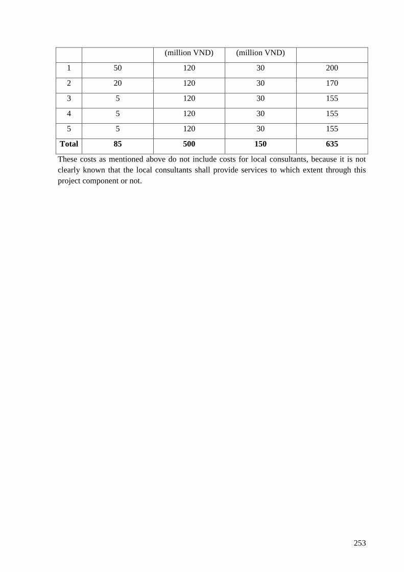
253
(million VND) (million VND)
1 50 120 30 200
2 20 120 30 170
3 5 120 30 155
4 5 120 30 155
5 5 120 30 155
Total 85 500 150 635
These costs as mentioned above do not include costs for local consultants, because it is not
clearly known that the local consultants shall provide services to which extent through this
project component or not.
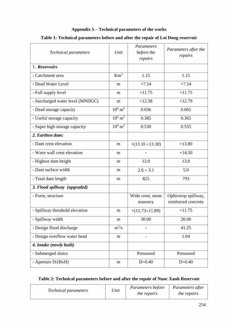
254
Appendix 5 – Technical parameters of the works
Table 1: Technical parameters before and after the repair of Loi Dong reservoir
Technical parameters Unit
Parameters
before the
repairs
Parameters after the
repairs
1. Reservoirs
- Catchment area Km2 1.15 1.15
- Dead Water Level m +7.54 +7.54
- Full supply level m +11.75 +11.75
- Surcharged water level (MNDGC) m +12.58 +12.79
- Dead storage capacity 106 m3 0.036 0.065
- Useful storage capacity 106 m3 0.385 0.365
- Super high storage capacity 106 m3 0.530 0.555
2. Earthen dam:
- Dam crest elevation m +(13.10 13.30) +13.80
- Wave wall crest elevation m - +14.50
- Highest dam height m 12.0 13.0
- Dam surface width m 2.6 3.1 5.0
- Total dam length m 825 793
3. Flood spillway (upgraded)
- Form, structure Wide crest, stone
masonry
Ophicerop spillway,
reinforced concrete
- Spillway threshold elevation m +(11.7311.89) +11.75
- Spillway width m 30.00 20.00
- Design flood discharge m3/s - 41.25
- Design overflow water head m - 1.04
4. Intake (newly built)
- Submerged sluice Pressured Pressured
- Aperture D/(BxH) m D=0.40 D=0.40
Table 2: Technical parameters before and after the repair of Nuoc Xanh Reservoir
Technical parameters Unit Parameters before
the repairs
Parameters after
the repairs
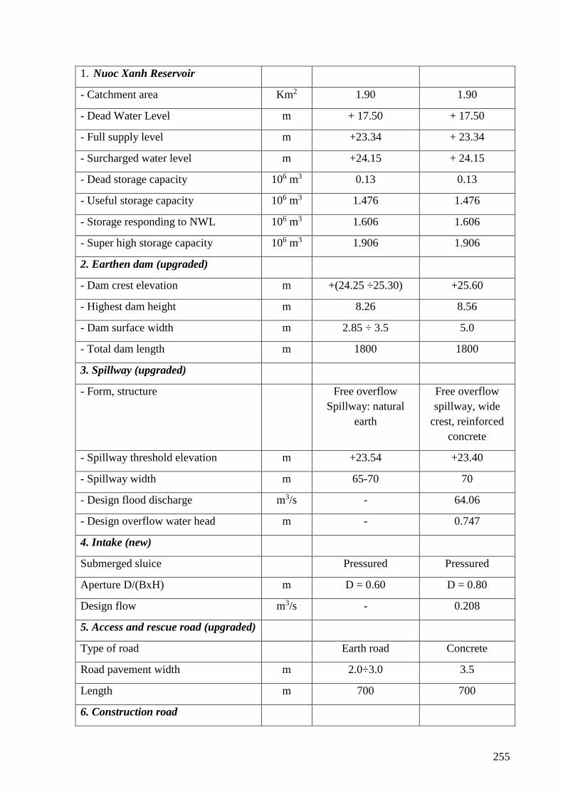
255
1. Nuoc Xanh Reservoir
- Catchment area Km2 1.90 1.90
- Dead Water Level m + 17.50 + 17.50
- Full supply level m +23.34 + 23.34
- Surcharged water level m +24.15 + 24.15
- Dead storage capacity 106 m3 0.13 0.13
- Useful storage capacity 106 m3 1.476 1.476
- Storage responding to NWL 106 m3 1.606 1.606
- Super high storage capacity 106 m3 1.906 1.906
2. Earthen dam (upgraded)
- Dam crest elevation m +(24.25 ÷25.30) +25.60
- Highest dam height m 8.26 8.56
- Dam surface width m 2.85 ÷ 3.5 5.0
- Total dam length m 1800 1800
3. Spillway (upgraded)
- Form, structure Free overflow
Spillway: natural
earth
Free overflow
spillway, wide
crest, reinforced
concrete
- Spillway threshold elevation m +23.54 +23.40
- Spillway width m 65-70 70
- Design flood discharge m3/s - 64.06
- Design overflow water head m - 0.747
4. Intake (new)
Submerged sluice Pressured Pressured
Aperture D/(BxH) m D = 0.60 D = 0.80
Design flow m3/s - 0.208
5. Access and rescue road (upgraded)
Type of road Earth road Concrete
Road pavement width m 2.0÷3.0 3.5
Length m 700 700
6. Construction road
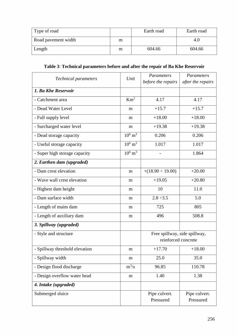
256
Type of road Earth road Earth road
Road pavement width m 4.0
Length m 604.66 604.66
Table 3: Technical parameters before and after the repair of Ba Khe Reservoir
Technical parameters Unit Parameters
before the repairs
Parameters
after the repairs
1. Ba Khe Reservoir
- Catchment area Km2 4.17 4.17
- Dead Water Level m +15.7 +15.7
- Full supply level m +18.00 +18.00
- Surcharged water level m +19.38 +19.38
- Dead storage capacity 106 m3 0.206 0.206
- Useful storage capacity 106 m3 1.017 1.017
- Super high storage capacity 106 m3 - 1.864
2. Earthen dam (upgraded)
- Dam crest elevation m +(18.90 ÷ 19.00) +20.00
- Wave wall crest elevation m +19.05 +20.80
- Highest dam height m 10 11.0
- Dam surface width m 2.8 ÷3.5 5.0
- Length of maim dam m 725 805
- Length of auxiliary dam m 496 508.8
3. Spillway (upgraded)
- Style and structure Free spillway, side spillway,
reinforced concrete
- Spillway threshold elevation m +17.70 +18.00
- Spillway width m 25.0 35.0
- Design flood discharge m3/s 96.85 110.78
- Design overflow water head m 1.40 1.38
4. Intake (upgraded)
Submerged sluice Pipe culvert.
Pressured
Pipe culvert.
Pressured
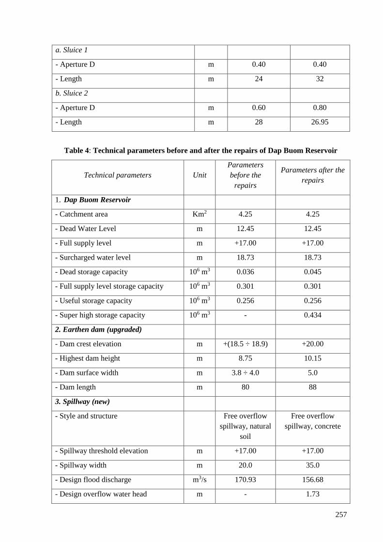
257
a. Sluice 1
- Aperture D m 0.40 0.40
- Length m 24 32
b. Sluice 2
- Aperture D m 0.60 0.80
- Length m 28 26.95
Table 4: Technical parameters before and after the repairs of Dap Buom Reservoir
Technical parameters Unit
Parameters
before the
repairs
Parameters after the
repairs
1. Dap Buom Reservoir
- Catchment area Km2 4.25 4.25
- Dead Water Level m 12.45 12.45
- Full supply level m +17.00 +17.00
- Surcharged water level m 18.73 18.73
- Dead storage capacity 106 m3 0.036 0.045
- Full supply level storage capacity 106 m3 0.301 0.301
- Useful storage capacity 106 m3 0.256 0.256
- Super high storage capacity 106 m3 - 0.434
2. Earthen dam (upgraded)
- Dam crest elevation m +(18.5 ÷ 18.9) +20.00
- Highest dam height m 8.75 10.15
- Dam surface width m 3.8 ÷ 4.0 5.0
- Dam length m 80 88
3. Spillway (new)
- Style and structure Free overflow
spillway, natural
soil
Free overflow
spillway, concrete
- Spillway threshold elevation m +17.00 +17.00
- Spillway width m 20.0 35.0
- Design flood discharge m3/s 170.93 156.68
- Design overflow water head m - 1.73
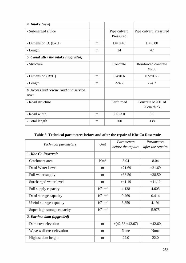
258
4. Intake (new)
- Submerged sluice Pipe culvert.
Pressured
Pipe culvert. Pressured
- Dimension D. (BxH) m D= 0.40 D= 0.80
- Length m 24 47
5. Canal after the intake (upgraded)
- Structure Concrete Reinforced concrete
M200
- Dimension (BxH) m 0.4x0.6 0.5x0.65
- Length m 224.2 224.2
6. Access and rescue road and service
river
- Road structure Earth road Concrete M200 of
20cm thick
- Road width m 2.5÷3.0 3.5
- Total length m 200 338
Table 5: Technical parameters before and after the repair of Khe Co Reservoir
Technical parameters Unit Parameters
before the repairs
Parameters
after the repairs
1. Khe Co Reservoir
- Catchment area Km2 8.04 8.04
- Dead Water Level m +21.69 +21.69
- Full water supply m +38.50 +38.50
- Surcharged water level m +41.19 +41.12
- Full supply capacity 106 m3 4.128 4.605
- Dead storage capacity 106 m3 0.269 0.414
- Useful storage capacity 106 m3 3.859 4.191
- Super high storage capacity 106 m3 - 5.975
2. Earthen dam (upgraded)
- Dam crest elevation m +(42.53 ÷42.67) +42.60
- Wave wall crest elevation m None None
- Highest dam height m 22.0 22.0
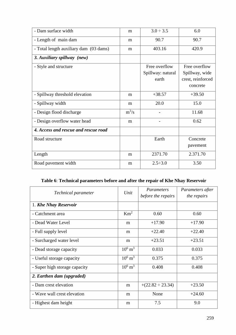
259
- Dam surface width m 3.0 ÷ 3.5 6.0
- Length of main dam m 90.7 90.7
- Total length auxiliary dam (03 dams) m 403.16 420.9
3. Auxiliary spillway (new)
- Style and structure Free overflow
Spillway: natural
earth
Free overflow
Spillway, wide
crest, reinforced
concrete
- Spillway threshold elevation m +38.57 +39.50
- Spillway width m 20.0 15.0
- Design flood discharge m3/s - 11.68
- Design overflow water head m - 0.62
4. Access and rescue and rescue road
Road structure Earth Concrete
pavement
Length m 2371.70 2.371.70
Road pavement width m 2.5÷3.0 3.50
Table 6: Technical parameters before and after the repair of Khe Nhay Reservoir
Technical parameter Unit Parameters
before the repairs
Parameters after
the repairs
1. Khe Nhay Reservoir
- Catchment area Km2 0.60 0.60
- Dead Water Level m +17.90 +17.90
- Full supply level m +22.40 +22.40
- Surcharged water level m +23.51 +23.51
- Dead storage capacity 106 m3 0.033 0.033
- Useful storage capacity 106 m3 0.375 0.375
- Super high storage capacity 106 m3 0.408 0.408
2. Earthen dam (upgraded)
- Dam crest elevation m +(22.82 ÷ 23.34) +23.50
- Wave wall crest elevation m None +24.60
- Highest dam height m 7.5 9.0
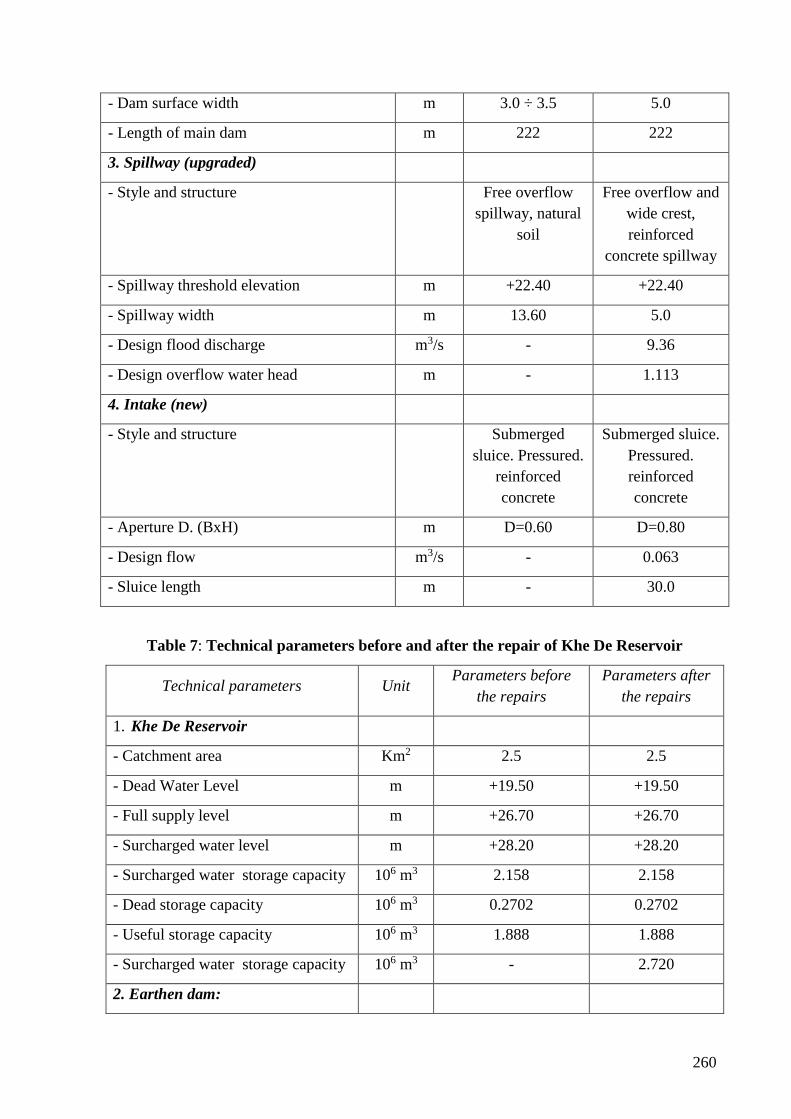
260
- Dam surface width m 3.0 ÷ 3.5 5.0
- Length of main dam m 222 222
3. Spillway (upgraded)
- Style and structure Free overflow
spillway, natural
soil
Free overflow and
wide crest,
reinforced
concrete spillway
- Spillway threshold elevation m +22.40 +22.40
- Spillway width m 13.60 5.0
- Design flood discharge m3/s - 9.36
- Design overflow water head m - 1.113
4. Intake (new)
- Style and structure Submerged
sluice. Pressured.
reinforced
concrete
Submerged sluice.
Pressured.
reinforced
concrete
- Aperture D. (BxH) m D=0.60 D=0.80
- Design flow m3/s - 0.063
- Sluice length m - 30.0
Table 7: Technical parameters before and after the repair of Khe De Reservoir
Technical parameters Unit Parameters before
the repairs
Parameters after
the repairs
1. Khe De Reservoir
- Catchment area Km2 2.5 2.5
- Dead Water Level m +19.50 +19.50
- Full supply level m +26.70 +26.70
- Surcharged water level m +28.20 +28.20
- Surcharged water storage capacity 106 m3 2.158 2.158
- Dead storage capacity 106 m3 0.2702 0.2702
- Useful storage capacity 106 m3 1.888 1.888
- Surcharged water storage capacity 106 m3 - 2.720
2. Earthen dam:
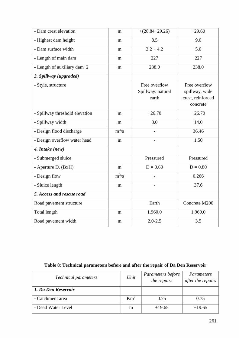
261
- Dam crest elevation m +(28.84÷29.26) +29.60
- Highest dam height m 8.5 9.0
- Dam surface width m 3.2 ÷ 4.2 5.0
- Length of main dam m 227 227
- Length of auxiliary dam 2 m 238.0 238.0
3. Spillway (upgraded)
- Style, structure Free overflow
Spillway: natural
earth
Free overflow
spillway, wide
crest, reinforced
concrete
- Spillway threshold elevation m +26.70 +26.70
- Spillway width m 8.0 14.0
- Design flood discharge m3/s - 36.46
- Design overflow water head m - 1.50
4. Intake (new)
- Submerged sluice Pressured Pressured
- Aperture D. (BxH) m D = 0.60 D = 0.80
- Design flow m3/s - 0.266
- Sluice length m - 37.6
5. Access and rescue road
Road pavement structure Earth Concrete M200
Total length m 1.960.0 1.960.0
Road pavement width m 2.0-2.5 3.5
Table 8: Technical parameters before and after the repair of Da Den Reservoir
Technical parameters Unit Parameters before
the repairs
Parameters
after the repairs
1. Da Den Reservoir
- Catchment area Km2 0.75 0.75
- Dead Water Level m +19.65 +19.65
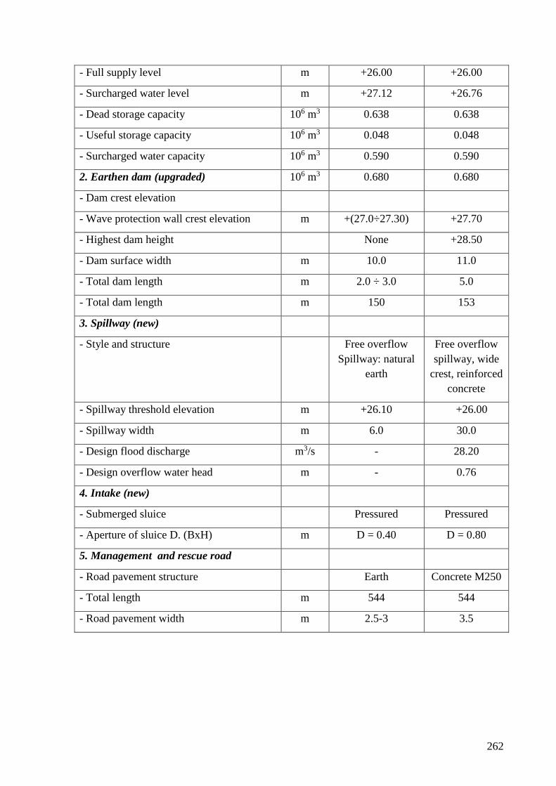
262
- Full supply level m +26.00 +26.00
- Surcharged water level m +27.12 +26.76
- Dead storage capacity 106 m3 0.638 0.638
- Useful storage capacity 106 m3 0.048 0.048
- Surcharged water capacity 106 m3 0.590 0.590
2. Earthen dam (upgraded) 106 m3 0.680 0.680
- Dam crest elevation
- Wave protection wall crest elevation m +(27.0÷27.30) +27.70
- Highest dam height None +28.50
- Dam surface width m 10.0 11.0
- Total dam length m 2.0 ÷ 3.0 5.0
- Total dam length m 150 153
3. Spillway (new)
- Style and structure Free overflow
Spillway: natural
earth
Free overflow
spillway, wide
crest, reinforced
concrete
- Spillway threshold elevation m +26.10 +26.00
- Spillway width m 6.0 30.0
- Design flood discharge m3/s - 28.20
- Design overflow water head m - 0.76
4. Intake (new)
- Submerged sluice Pressured Pressured
- Aperture of sluice D. (BxH) m D = 0.40 D = 0.80
5. Management and rescue road
- Road pavement structure Earth Concrete M250
- Total length m 544 544
- Road pavement width m 2.5-3 3.5
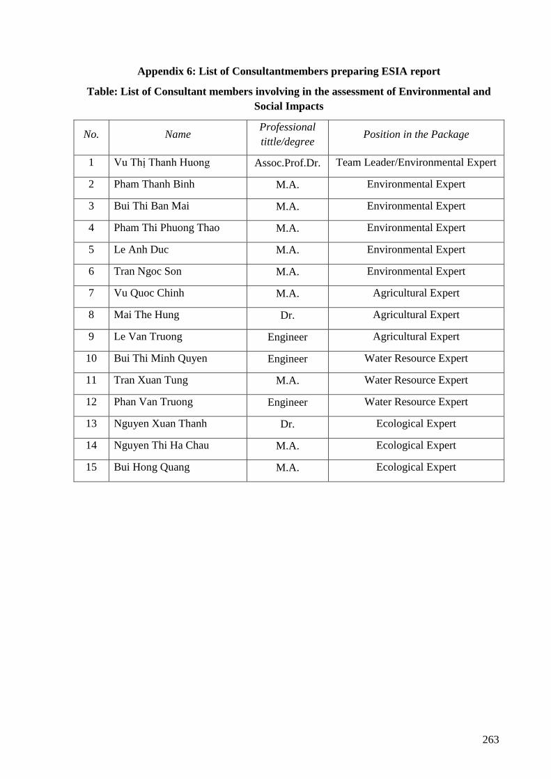
263
Appendix 6: List of Consultantmembers preparing ESIA report
Table: List of Consultant members involving in the assessment of Environmental and
Social Impacts
No. Name Professional
tittle/degree Position in the Package
1 Vu Thị Thanh Huong Assoc.Prof.Dr. Team Leader/Environmental Expert
2 Pham Thanh Binh M.A. Environmental Expert
3 Bui Thi Ban Mai M.A. Environmental Expert
4 Pham Thi Phuong Thao M.A. Environmental Expert
5 Le Anh Duc M.A. Environmental Expert
6 Tran Ngoc Son M.A. Environmental Expert
7 Vu Quoc Chinh M.A. Agricultural Expert
8 Mai The Hung Dr. Agricultural Expert
9 Le Van Truong Engineer Agricultural Expert
10 Bui Thi Minh Quyen Engineer Water Resource Expert
11 Tran Xuan Tung M.A. Water Resource Expert
12 Phan Van Truong Engineer Water Resource Expert
13 Nguyen Xuan Thanh Dr. Ecological Expert
14 Nguyen Thi Ha Chau M.A. Ecological Expert
15 Bui Hong Quang M.A. Ecological Expert