File Code: 1900; 2700 Date: April 6,2017 Kimberly D. Bose ...
66
I | C r \ United states \ J D L J f \t o f Agriculture Forest Service Monongahela National Forest 200 Sycamore Street Elkins, WV 26241 304-636-1800 File Code: 1900; 2700 Date: April 6,2017 Kimberly D. Bose, Secretary Federal Energy Regulatory Commission 888 First St., N.E., Room 1A Washington, DC 20426 Dear Ms. Bose: Subject: Forest Service's Comments on the Construction, Operation, and Maintenance for the Proposed Atlantic Coast Pipeline Project 0EP/DG2E/Gas 4 Atlantic Coast Pipeline, LLC Docket No. CP 15-554-000 and CP 15-554-001 The Forest Service provides comments on the Construction, Operation, and Maintenance Plan (Com Plan) submitted by Atlantic Coast Pipeline, LLC (ACP) for the proposed Atlantic Coast Pipeline Project (ACP Project). The proposed ACP Project would affect National Forest System (NFS) lands on the Monongahela National Forest and George Washington National Forest. Detailed comments are contained in the attachment. The comments provide guidance to ACP for further developing the COM Plan. We recommend that ACP incorporate our comments into the COM plan and submit a revised draft. We also recommend that the Forest Service and ACP continue to meet and discuss the COM Plan to finalize the COM Plan and ensure that the ACP Project would be implemented on NFS lands in accordance with Forest Service guidelines. Thank you for the opportunity to review and comment on ACP Project documents. For questions or additional information, please contact Jennifer Adams, Special Project Coordinator, by phone at (540) 265-5114 or by email at [email protected]. Sincerely, Forest Supervisor cc: Atlantic Coast Pipeline, LLC Caring for the Land and Serving People Printed on Recycled Paper
-
Upload
khangminh22 -
Category
Documents
-
view
0 -
download
0
Transcript of File Code: 1900; 2700 Date: April 6,2017 Kimberly D. Bose ...
I | C r \ United states \ J D L J f \t of
Agriculture
Forest Service
Monongahela National Forest 200 Sycamore Street Elkins, WV 26241 304-636-1800
File Code: 1900; 2700 Date: April 6,2017
Kimberly D. Bose, Secretary Federal Energy Regulatory Commission 888 First St., N.E., Room 1A Washington, DC 20426
Dear Ms. Bose:
Subject: Forest Service's Comments on the Construction, Operation, and Maintenance for the Proposed Atlantic Coast Pipeline Project 0EP/DG2E/Gas 4 Atlantic Coast Pipeline, LLC Docket No. CP 15-554-000 and CP 15-554-001
The Forest Service provides comments on the Construction, Operation, and Maintenance Plan (Com Plan) submitted by Atlantic Coast Pipeline, LLC (ACP) for the proposed Atlantic Coast Pipeline Project (ACP Project). The proposed ACP Project would affect National Forest System (NFS) lands on the Monongahela National Forest and George Washington National Forest.
Detailed comments are contained in the attachment. The comments provide guidance to ACP for further developing the COM Plan. We recommend that ACP incorporate our comments into the COM plan and submit a revised draft. We also recommend that the Forest Service and ACP continue to meet and discuss the COM Plan to finalize the COM Plan and ensure that the ACP Project would be implemented on NFS lands in accordance with Forest Service guidelines.
Thank you for the opportunity to review and comment on ACP Project documents. For questions or additional information, please contact Jennifer Adams, Special Project Coordinator, by phone at (540) 265-5114 or by email at [email protected].
Sincerely,
Forest Supervisor
cc: Atlantic Coast Pipeline, LLC
Caring for the Land and Serving People Printed on Recycled Paper

1
FOREST SERVICE COMMENTS
CONSTRUCTION, OPERATION, AND MAINTENANCE PLAN
ATLANTIC COAST PIPELNE PROJECT
Page # Section Comment
COMP-Main Body
n/a Attachments,
General
All Attachments need pages numbered in final version of COM plan, possibly using a format of “attachment number-page number.
n/a Alignment Sheets
and COM plan
Acronyms and terms should be the same in both drawings and word documents. Documents refer to ATWS as additional temporary
workspace. Drawings show symbol for extra workspace.
i TOC The COM Plan includes many types of plans that are part of construction, such as Section 4.0 Timber Removal Plan, Section 5.0 Fire
Prevention and Suppression Plan, Section 6.0 Blasting Plan, Section 7.0 Traffic and Transportation Management Plan, etc.). But the COM
Plan does not include a Section Plan for the main part of construction: Excavation and Embankment (Cut and Fill) Construction.
Section 2 Project Description is not an Excavation and Embankment (Cut and Fill) Construction Plan. Section 2 and other Sections of the
COM Plan make reference to Attachment A as “typical right-of-way configurations”. But Attachment A has only two typical construction
cross-sections, and neither typical is typical of the construction that would be on NFS lands. In addition, the Cut and Fill Construction
configuration has unrealistic and unstable cut-and-fill slope angles.
An Excavation and Embankment (Cut and Fill) Construction Plan with a typical for each different combination of construction methods +
topographic positions on NFS lands is needed 1) to verify land requirements, 2) to assess the scope and magnitude of the slope
modifications and surface and subsurface disturbance on NFS lands, and 3) to assess the potential for project-induced landslides (cut slope
failures, fill slope failures, trench spoil failures, temporary spoil failures, topsoil segregation failures), 4) to develop a Slope Stability Plan
to design geotechnical measures to avoid or reduce the potential for project-induced landslides.
Provide an Excavation and Embankment (Cut and Fill) Construction Plan either as a section within Section 2 or as a new Section
immediately following Section 2. For each type of construction configuration on NFS lands, provide a typical construction cross-section
perpendicular to centerline, and a typical construction cross-section parallel to centerline for 100 feet up station and down station from the
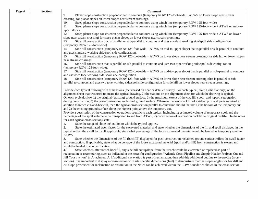
cross-section perpendicular to centerline, including as applicable, such configurations as:
1. Ridgetop construction (temporary ROW 125-foot-wide) requiring cut-and-backfill of ridgetop in addition to trench.
2. Ridgetop construction (temporary ROW 125-foot-wide + ATWS on mid-to-upper slope) requiring cut-and-backfill of ridgetop in
addition to trench.
3. Ridgetop construction (temporary ROW 125-foot-wide + ATWS on lower slope near stream crossing) for ridges which extend
downslope to stream crossings.
4. Steep sloping ridgetop construction using winch line (temporary ROW 125-foot-wide).
5. Steep sloping ridgetop construction using winch line (temporary ROW 125-foot-wide + ATWS on mid-to-upper slope).
6. Steep sloping ridgetop construction using winch line (temporary ROW 125-foot-wide + ATWS on lower slope near stream
crossing) for steep sloping ridges which extend downslope to stream crossings.
7. Planar slope construction perpendicular to contours (temporary ROW 125-foot-wide).
8. Planar slope construction perpendicular to contours (temporary ROW 125-foot-wide + ATWS on mid-to-upper slope).
2
Page # Section Comment
9. Planar slope construction perpendicular to contours (temporary ROW 125-foot-wide + ATWS on lower slope near stream
crossing) for planar slopes on lower slopes near stream crossings.
10. Steep planar slope construction perpendicular to contours using winch line (temporary ROW 125-foot-wide).
11. Steep planar slope construction perpendicular to contours using winch line (temporary ROW 125-foot-wide + ATWS on mid-to-
upper slope).
12. Steep planar slope construction perpendicular to contours using winch line (temporary ROW 125-foot-wide + ATWS on lower
slope near stream crossing) for steep planar slopes on lower slopes near stream crossings.
13. Side hill construction that is parallel or sub-parallel to contours and uses standard working side/spoil side configuration
(temporary ROW 125-foot-wide).
14. Side hill construction (temporary ROW 125-foot-wide + ATWS on mid-to-upper slope) that is parallel or sub-parallel to contours
and uses standard working side/spoil side configuration.
15. Side hill construction (temporary ROW 125-foot-wide + ATWS on lower slope near stream crossing) for side hill on lower slopes
near stream crossings.
16. Side hill construction that is parallel or sub-parallel to contours and uses two tone working side/spoil side configuration
(temporary ROW 125-foot-wide).
17. Side hill construction (temporary ROW 125-foot-wide + ATWS on mid-to-upper slope) that is parallel or sub-parallel to contours
and uses two tone working side/spoil side configuration.
18. Side hill construction (temporary ROW 125-foot-wide + ATWS on lower slope near stream crossing) that is parallel or sub-
parallel to contours and uses two tone working side/spoil side configuration for side hill on lower slopes near stream crossings.
Provide each typical drawing with dimensions (feet) based on lidar or detailed survey. For each typical, state 1) the station(s) on the
alignment sheet that was used to create the typical drawing, 2) the stations on the alignment sheet for which the drawing is typical.
On each typical, show 1) the original (existing) ground surface, 2) the maximum extent of the cut, fill, spoil, and topsoil segregation
during construction, 3) the post-construction reclaimed ground surface. Wherever cut-and-backfill of a ridgetop or a slope is required in
addition to trench cut-and-backfill, then the typical cross-section parallel to centerline should include 1) the bottom of the temporary cut
and 2) the existing ground surface along the highest point above the temporary cut.
Provide a description of the construction operations specific to each typical, including 1) estimated volume of temporary spoil and the
percentage of the spoil volume to be transported to and from ATWS, 2) construction of restoration backfill to original profile. In the notes
for each typical cross-section) state:
1. State the range of slope inclination to which the typical applies.
2. State the estimated swell factor for the excavated material, and state whether the dimensions of the fill and spoil displayed in the
typical reflect the swell factor. If applicable, state what percentage of the loose excavated material would be hauled as temporary spoil to
ATWS.
3. State whether the dimensions of the fill (backfill) displayed for post-construction reclaimed ground surface reflect the swell factor
and compaction. If applicable, state what percentage of the loose excavated material (spoil and/or fill) from construction is excess and
would be hauled to another location.
4. State whether, after trench backfill, any side hill cut upslope from the trench would be excavated or replaced as part of
reclamation or recontouring, such as indicated in the notes for configuration “Atlantic Coast Pipeline and Supply Header Projects Cut and
Fill Construction” in Attachment A. If additional excavation is part of reclamation, then add this additional cut line to the profile (cross-
section). It is important to display a cross-section with site specific dimensions (feet) to demonstrate that the slopes angles for backfill and
cut slope prescribed for reclamation or restoration in the Notes can be achieved within the ROW boundaries shown in the cross-section.
3
Page # Section Comment
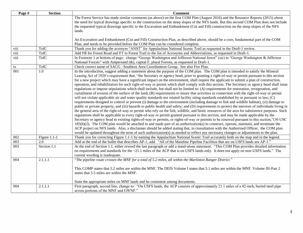
The Forest Service has made similar comments (as above) on the first COM Plan (August 2016) and the Resource Reports (2015) about
the need for typical drawings specific to the construction on the steep slopes of the NFS lands. But this second COM Plan does not include
the requested typical drawings specific to the Excavation and Embankment (Cut and Fill) construction on the steep slopes of the NFS
lands.
An Excavation and Embankment (Cut and Fill) Construction Plan, as described above, should be a core, fundamental part of the COM
Plan, and needs to be provided before the COM Plan can be considered complete.
viii TofC Thank you for adding the acronym “ANST” for Appalachian National Scenic Trail as requested in the Draft-1 review.
viii TofC Add FR for Forest Road and FT to Forest Trail to the list of Acronyms and Abbreviations, as requested in Draft-1.
viii TofC In Footnote 1 at bottom of page: change “George Washington and Jefferson National forest” (sic) to “George Washington & Jefferson
National Forests” with Ampersand (&), capital F, plural Forests, as requested in Draft-1.
ix TofC Check correct name of SACG –Southern Area Coordination Group. See also Fire Plan.
001 1.0 In the introduction, suggest adding a statement about the purpose of the COM plan. The COM plan is intended to satisfy the Mineral
Leasing Act of 1920’s requirement that, “the Secretary or agency head, prior to granting a right-of-way or permit pursuant to this section
for a new project which may have a significant impact on the environment, shall require the applicant to submit a plan of construction,
operation, and rehabilitation for such right-of-way or permit which shall comply with this section. The Secretary or agency head shall issue
regulations or impose stipulations which shall include, but shall not be limited to: (A) requirements for restoration, revegetation, and
curtailment of erosion of the surface of the land; (B) requirements to insure that activities in connection with the right-of-way or permit
will not violate applicable air and water quality standards nor related facility siting standards established by or pursuant to law; (C)
requirements designed to control or prevent (i) damage to the environment (including damage to fish and wildlife habitat), (ii) damage to
public or private property, and (iii) hazards to public health and safety; and (D) requirements to protect the interests of individuals living in
the general area of the right-of-way or permit who rely on the fish, wildlife, and biotic resources of the area for subsistence purposes. Such
regulations shall be applicable to every right-of-way or permit granted pursuant to this section, and may be made applicable by the
Secretary or agency head to existing rights-of-way or permits, or rights-of-way or permits to be renewed pursuant to this section,”(30 USC
185(h)(2). The COM plan would be attached to and made part of an authorization(s) to construct, operate, maintain, and terminate the
ACP project on NFS lands. Also, a disclaimer should be added stating that, in consultation with the Authorized Officer, the COM plan
would be updated throughout the term of such authorization(s) as needed to reflect any necessary changes or adjustments to the plan.
002 Figure 1.1-1 Thank you for correcting Figure 1.1-1 by naming the Appalachian National Scenic Trail accurately both on the map and in the legend.
003 2.0 Add at the end of the bullet that describes AP-1, add: “All of the Mainline Pipeline Facilities that are on USFS lands are AP-1.”
003 Section 1.1 At the end of Section 1.1, either reword the last paragraph or add a stand-alone statement. “This COM Plan provides detailed information
on requirements and standards for the ~21.1 miles of the ACP that is on USFS lands only. It does not apply on non-USFS lands.” The
current wording is inadequate.
004 2.1.1.1 “The pipeline route crosses the MNF for a total of 5.2 miles, all within the Marlinton Ranger District.”
This COMP states that 5.2 miles are within the MNF. The DEIS Volume I states that 5.1 miles are within the MNF. Volume III-Part 2
states that 5.5 miles are within the MNF.
State the appropriate miles on MNF lands and be consistent among documents.
004 2.1.1.1 First paragraph, second line, change to: “On USFS lands, the ACP consists of approximately 21.1 miles of a 42-inch, buried steel pipe
across portions of the MNF and GWNF.”

4
Page # Section Comment
005 2.1.1.1 First paragraph states: “Some CP test stations will be installed on USFS lands.” I do not find these locations detailed anywhere in the
document or attachments. USFS needs to know where these are planned to ensure they are in acceptable locations. More information is
needed.
005 2.1.1.2 “Typical right-of-way configurations are provided in Attachment A 7.”
Typical right-of-way configurations provided in Attachment A are inadequate for a COM Plan on NFS lands. The first configuration
(“Atlantic Coast Pipeline AP-1 (Federal Lands Only) Typical Construction Right-of-Way Non-Agricultural Areas”) is a profile (cross-
section) with dimensions (feet) but is for flat ground where the only excavation is for the trench. The second configuration (“Atlantic Coast
Pipeline and Supply Header Projects Cut and Fill Construction”) is a profile (cross-section) for side hill construction but with unknown
dimensions (“Additional ROW As Required”) and vertical and/or horizontal distortion of configuration. The Cut and Fill Construction
configuration has unrealistic and unstable cut-and-fill slope angles. Neither of these two configurations is representative of most of the
proposed pipeline ROW construction on NFS lands.
In order to verify land requirements, typical cross-sections need to have dimensions (feet) and be based on stable angles for cut and fill
slopes. The second configuration (“Atlantic Coast Pipeline and Supply Header Projects Cut and Fill Construction”) has neither
dimensions nor stable cut and fill angles. See the comments on TOC on the need for several typical drawings in an Excavation and
Embankment (Cut and Fill) Plan in order to verify land requirements.
“The alignment sheets (Attachment B) provide exact dimensions of the proposed construction right-of-way widths on NFS lands.”
Because the configurations in Attachment A are not representative of most of the proposed pipeline ROW construction on NFS lands, and
because the Cut and Fill Construction configuration has unrealistic and unstable cut-and-fill slope angles, we have concerns about the basis
for ACP’s determination of the “exact dimensions of the proposed construction right-of-way widths on NFS lands” in the alignment
sheets.
Attachment A and Attachment B are mismatched in detail. Attachment B provides “exact dimensions of the proposed construction right-
of-way widths on NFS lands” but Attachment A provides configurations not representative of most of the proposed pipeline ROW
construction on NFS lands, and a cut-and-fill configuration with no dimensions.
005 2.1.1.2 “Additional temporary workspace (ATWS) is proposed at certain locations, such as road crossings, and where additional spoil storage, log
landings or equipment staging is needed.” This statement is inadequate in describing the scope and magnitude of additional temporary
workspace (ATWS) on NFS lands. Section 8.3.2 states, “ATWS measuring 50 by 150 feet will typically be required on both sides of the
corridor and both sides of the crossing at wetlands, waterbodies measuring greater than 10 feet in width, two lane roads, and railroads.
ATWS measuring 25 by 100 feet will typically be required on both sides of the corridor and both sides of the crossing at waterbodies
measuring less than 10 feet in width and single lane roads.” Where ATWS adds 50 feet on each side of the 125-feet-wide temporary
construction ROW, the results is a 225-feet-wide temporary construction ROW. Where ATWS adds 25 feet on each side of the 125-feet-
wide temporary construction ROW, the results is a 175-feet-wide temporary construction ROW. The ATWSs 40 to 80% increase in width
is a major increase in temporary construction. So far, more than 80 ATWS are identified on the GWNF, and at least 11 ATWS on the
MNF. 80 ATWS would mean about 40 sections where the temporary construction ROW would be 175-feet-wide or 225-feet-wide rather
than 125-feet-wide.
In order to verify land requirements for ATWS, typical cross-sections with dimensions (feet) and stable angles for cut and fill slopes are
needed where ATWS would have cuts or fills including log landings or storage of temporary spoils. See the comments on TOC on the
need for several typical drawings in an Excavation and Embankment (Cut and Fill) Plan in order to verify land requirements ATWS.

5
Page # Section Comment
Equally important is that the ATWS for stream crossings in the mountains narrow valleys would be excavated into steep slopes at the base
of or on the lower slopes of the mountainside. Stream down cutting and incision in narrow mountain valleys makes these lower slopes near
streams susceptible to stream or storm-induced landslides as well as excavation-induced slope failures, such as by a road or pipeline
construction.
1. For each ATWS pair (on both side of the pipeline corridor), provide a profile (cross-section) perpendicular to the centerline with
dimensions (feet) based on lidar or detailed survey showing the ATWS pair and the 125-feet-wide temporary construction ROW.
2. For each ATWS pair (on both side of the pipeline corridor), provide three profiles (cross-sections) parallel to the centerline with
dimensions (feet) showing the ATWS pair and the 125-feet-wide temporary construction ROW: 1) one cross-section along the centerline,
2) a cross-section in each ATWS.
3. For each unpaired ATWS, provide a profile (cross-section) perpendicular to the centerline with dimensions (feet) showing the
ATWS and the 125-feet-wide temporary construction ROW.
4. For each unpaired ATWS, provide two profiles (cross-sections) parallel to the centerline with dimensions (feet) showing the
ATWS and the 125-feet-wide temporary construction ROW: 1) one cross-section along the centerline, 2) a cross-section in the ATWS.
5. Provide a detailed description of the construction activities and ground disturbance that will occur in each ATWS.
6. Provide a table with basic information for each paired and unpaired ATWS for the GWNF and the MNF.
Coordinate and include or reference the ATWS cross-sections and information listed here with the Excavation and Embankment (Cut and
Fill) Plan described in the comments on TOC.
005 2.1.1.2 “All temporary construction work areas outside the permanent right-of-way will be restored in accordance with the Restoration and
Rehabilitation Plan.”
The USFS had substantial edits to the Restoration and Rehabilitation Plan. This document lacked NFS land-specific direction. Please see
the comments from USFS staff to this document.
005 2.1.1.2 Topsoil segregation could require additional construction ROW width as allowed in FERC’s Upland Erosion Control, Revegetation, and
Maintenance Plan.
The FS and ACP are still discussing topsoil segregation needs on NFS lands. Revise as needed based on the outcome of these discussions.
005 2.1.1.2 Land Requirements: Delete word “nominal” from the description of the width of the proposed right-of-way. The paragraph goes on to
say that this width accommodates construction activities for most pipelines; so this proposal is neither nominal for the industry nor for
Forest Service special uses as evidenced by the DEIS. The point being made here is that it is insufficient in places therefore ATWS is
required; but it’s a subjective word.
006 2.1.1.2 Table 2.1.1-1 Lists GWNF Road 281 as Tower Mountain Road. FS road 281 is Campbell Hollow Road.
006 Table 2.1.1-1 This table shows the same total number of access roads on the GWNF as Draft-1, however one road has been dropped off and one new one
added. The road that was a part of Draft-1 that is not on this table in Draft-2 is #06-001-B001.AR7, 1.2 miles long. This is 1.2 miles of
riparian area running directly up Laurel Run. However, this access road still shows on Alignment Sheet #127 of 344 in Attachment B, and
in the Access Road Improvement Maps received as a part of Attachment F. To minimize any chance for confusion, this road should be
removed from all documents, maps, sheets, etc associated with the project, AND a footnote should be added to this table stating that this
referenced road is no longer proposed for any construction or use.
006 Table 2.1.1-1 “New Road” 06-001-B001.AR7 at MP 85.3 is indeed truly a new road that was not in Draft-1. Confirm that all required field surveys have
been completed.

6
Page # Section Comment
006,7 2.1.1.2, Table 2.1.1-
1
Planned roads on the GWNF: Please add FDR 1757, which was extended by 0.273 miles in FY16. This road has recently been approved
for use during the boring phase of the project.
Route 309 is a closed road (meaning it is in storage).
Route 449A is a closed road (meaning it is in storage), listed in the system as 3.19 mi. The pipeline is proposing to use 3.0 miles of 449
and 449A, need clarification as to how many miles of 449 and how many miles of 449A?
Road 006-001-B001-AR5 appears to end on National Forest (66+00 to +68+40). This is missing from the table.
007-001-AR1.AR6 is listed in the table as 0.8 miles, but only 1392 feet are shown on the map (roughly 0.25 miles). Please clarify.
008 2.1.1.3 Formatting of entire section needs to be revised. Separate each of the 4 “spreads” on USFS lands into its own paragraph. Currently, some
are split (stand-alone) and some are lumped. Very confusing. Should be broken into 3 additional paragraphs.
008 2.1.1.3 Please confirm the amount of USFS lands on the GWNF within each spread, and the description of Spread 3A on the GWNF. The
description does not match the depiction in Figure 2.1-1 and the length on USFS lands within this spread seems high.
008 Table 2.1.1-2 To be transparent and to assist in considering cumulative effects, add a column to this table to show the Total Construction ROW, which is
a compilation of the Permanent ROW and the Temporary Workspace. Using current figures, once verified/confirmed, for the Mon, this is
80.1 ac, for the GWNF = 249.7 ac, total USFS = 329.8 acres.
008 and
85
2.1.1.2 Land
Requirements and
8.3.3 Access Roads
“Some existing roads require minor grading and graveling and/or widening to accommodate construction vehicles.”
It appears from the tables above this page 8 statement that all existing roads on USFS will require improvements.
010-11 Table 2.1.1.-3 Need either this table MODIFIED or a new additional table developed to show the information stated in text form in section 2.1.1.3. This
table shows the entire 300+ mile long project. We need also a tabular summary of the description shows detail for the Spreads on USFS
lands (3, 3A, 4, 4A, and 5) with explicit detail about the ANST-BLR HDD within Spread 5. Also need a column added showing which
national forest Is involved in which spreads, and the length of each spread on USFS lands.
011 2.1.1.3 “Timber removal on the MNF is scheduled to take place between November 1 and April 1 of both construction seasons. For any areas of
the right-of-way within 5 miles of known Indiana bat hibernacula, no timber removal will occur before November 16.”
Cite LRMP standards within this document. This document needs to include specific direction on NFS Lands for construction, operation,
and maintenance.
Timber harvesting on steep slopes (40% or greater) would need to be done in a manner that ensures slope stability and complies with
LRMP SW07 from the time the timber is harvested until pipeline construction begins. Winter logging must meet LRMP SW09 as well as
all other erosion control plans and LRMP standards. Timber harvesting by use of skid trails and landings must comply with SW40.
Options include helicopter logging, use of overland equipment that does not require skid road development, and other non-ground
disturbing methods as approved by FS personnel.
Sediment and erosion control features are to be employed on these slopes as outlined in the COMP. Short term erosion control measures
are to be utilized as directed in the COMP prior to the start of disturbance for the construction of the pipeline replacement.
All timber harvest roads are to be fully reclaimed and restored according to MNF LRMP standards (RF07, RF12, RF13, and RF15).

7
Page # Section Comment
011 2.1.1.3 Timber Removal - Bottom of page, the wording used to restrict timber removal is confusing. Is it restricted to occur during those dates or
restricted not to occur during those dates?
011 2.1.1.3
Construction
Schedule
“Based on agency consultations to date, timing restrictions for tree clearing in West Virginia and Virginia are as follows:
• West Virginia:
o migratory birds: restricted between April 1 through August 31
o Indiana bat: restricted between April 1through November 15
• Virginia:
o migratory birds: restricted between April 1 through August 15
o Indiana bat: restricted between April 1 through November 15 (if hibernacula is within 5 miles of right-of-way); otherwise April 15
through September 15.”
These restrictions will result in timber removal operations mostly occurring outside what is termed the “normal operating season” for
timber harvesting on the GWNF. December 15 to March 15 is considered outside “normal operating season” on the GWNF. This means
the FS will have more contractual authority to stop operations due to high soil moisture and increased rutting hazards due to weather than
we would during the “normal operating season”. The MNF may also have similar designations. Temporary erosion control structures and
treatments will be required as some tree clearing will occur outside normal seeding seasons.
The identified seasonal restrictions on timber removal operations may also conflict with current Forest Plan standards addressing slope
stability concerns when working in areas with steep slopes, as well as other aquatic T&E and sensitive species concerns of soil movement
and stream crossings that restrict timber removal activities during winter months. Conflicting seasonal restrictions concerning T&E and
Migratory Bird species have been brought to the attention of the FWS.
012 2.1.1.3 “Stream and Wetland Crossings
At streams containing sensitive fisheries and other sensitive aquatic organisms, crossings utilizing dry crossing methods will be scheduled
to occur during the least sensitive periods, determined in consultation with federal and state/commonwealth agencies, including the
USFS.”
Incorporate USFS LRMP standards for construction, operation, and maintenance on stream and wetland crossings on NFS Lands. ACP
must meet the LRMP guidelines and standards (SW37).
012 2.1.1.3 “If additional bald eagle nests or occupied bald or golden eagle winter roosting habitat are identified ahead of or during construction,
Atlantic will follow the National Bald Eagle Management Guidelines for work within 660 feet of bald eagle nests.”
Comment: To the end of this sentence needs to be added, “except on USFS lands, where the agency-specific buffers listed above (Table
5.2.1-2) will be followed”. We have also made this comment on the Migratory Bird Plan.
012 2.1.1.3 “For tree clearing that occurs during the winter roosting or nesting season, a qualified biological monitor will accompany the clearing
crews for work conducted in areas where golden and bald eagles are believed to be present on USFS lands.”
Comment: The phrase “where….believed to be present” sounds like the biological monitor will only survey in certain areas. Please
remove the phrase “for work conducted in areas where golden and bald eagles are believed to be present on USFS lands”.
Given the large home range sizes of wintering bald and golden eagles, they can be present anywhere during the winter season along the
proposed route that crosses National Forest lands. Therefore, a biological monitor will need to be present while clearing crews are working
in the proposed pipeline route. In addition, bald eagles start nesting activities early in the calendar year, well before the normal breeding
season of most migratory birds.
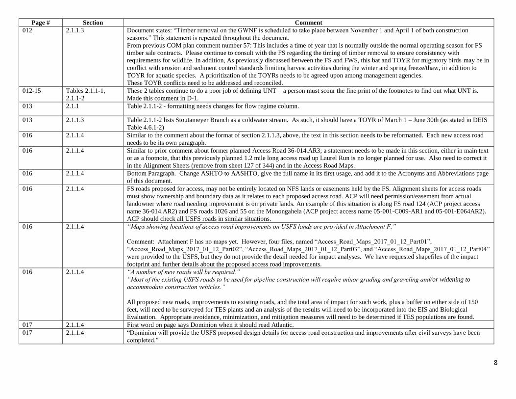
8
Page # Section Comment
012 2.1.1.3 Document states: “Timber removal on the GWNF is scheduled to take place between November 1 and April 1 of both construction
seasons.” This statement is repeated throughout the document.
From previous COM plan comment number 57: This includes a time of year that is normally outside the normal operating season for FS
timber sale contracts. Please continue to consult with the FS regarding the timing of timber removal to ensure consistency with
requirements for wildlife. In addition, As previously discussed between the FS and FWS, this bat and TOYR for migratory birds may be in
conflict with erosion and sediment control standards limiting harvest activities during the winter and spring freeze/thaw, in addition to
TOYR for aquatic species. A prioritization of the TOYRs needs to be agreed upon among management agencies.
These TOYR conflicts need to be addressed and reconciled.
012-15 Tables 2.1.1-1,
2.1.1-2
These 2 tables continue to do a poor job of defining UNT – a person must scour the fine print of the footnotes to find out what UNT is.
Made this comment in D-1.
013 2.1.1 Table 2.1.1-2 - formatting needs changes for flow regime column.
013 2.1.1.3 Table 2.1.1-2 lists Stoutameyer Branch as a coldwater stream. As such, it should have a TOYR of March 1 – June 30th (as stated in DEIS
Table 4.6.1-2)
016 2.1.1.4 Similar to the comment about the format of section 2.1.1.3, above, the text in this section needs to be reformatted. Each new access road
needs to be its own paragraph.
016 2.1.1.4 Similar to prior comment about former planned Access Road 36-014.AR3; a statement needs to be made in this section, either in main text
or as a footnote, that this previously planned 1.2 mile long access road up Laurel Run is no longer planned for use. Also need to correct it
in the Alignment Sheets (remove from sheet 127 of 344) and in the Access Road Maps.
016 2.1.1.4 Bottom Paragraph. Change ASHTO to AASHTO, give the full name in its first usage, and add it to the Acronyms and Abbreviations page
of this document.
016 2.1.1.4 FS roads proposed for access, may not be entirely located on NFS lands or easements held by the FS. Alignment sheets for access roads
must show ownership and boundary data as it relates to each proposed access road. ACP will need permission/easement from actual
landowner where road needing improvement is on private lands. An example of this situation is along FS road 124 (ACP project access
name 36-014.AR2) and FS roads 1026 and 55 on the Monongahela (ACP project access name 05-001-C009-AR1 and 05-001-E064AR2).
ACP should check all USFS roads in similar situations.
016 2.1.1.4 “Maps showing locations of access road improvements on USFS lands are provided in Attachment F.”
Comment: Attachment F has no maps yet. However, four files, named “Access_Road_Maps_2017_01_12_Part01”,
“Access_Road_Maps_2017_01_12_Part02”, “Access_Road_Maps_2017_01_12_Part03”, and “Access_Road_Maps_2017_01_12_Part04”
were provided to the USFS, but they do not provide the detail needed for impact analyses. We have requested shapefiles of the impact
footprint and further details about the proposed access road improvements.
016 2.1.1.4 “A number of new roads will be required.”
“Most of the existing USFS roads to be used for pipeline construction will require minor grading and graveling and/or widening to
accommodate construction vehicles.”
All proposed new roads, improvements to existing roads, and the total area of impact for such work, plus a buffer on either side of 150
feet, will need to be surveyed for TES plants and an analysis of the results will need to be incorporated into the EIS and Biological
Evaluation. Appropriate avoidance, minimization, and mitigation measures will need to be determined if TES populations are found.
017 2.1.1.4 First word on page says Dominion when it should read Atlantic.
017 2.1.1.4 “Dominion will provide the USFS proposed design details for access road construction and improvements after civil surveys have been
completed.”

9
Page # Section Comment
Comment: Four files, named “Access_Road_Maps_2017_01_12_Part01”, “Access_Road_Maps_2017_01_12_Part02”,
“Access_Road_Maps_2017_01_12_Part03”, and “Access_Road_Maps_2017_01_12_Part04” were provided to the USFS, but they do not
provide the detail needed for impact analyses. We have requested shapefiles of the impact footprint and further details about the proposed
access road improvements.
017 2.1.2 Document states: “Wetland boundaries and other environmentally sensitive areas will also be marked at this time.”
Wetlands and environmentally sensitive areas should have already been identified and marked by qualified individuals. Please describe
what is meant by environmentally sensitive areas and how the surveyors will know if they are in them.
017 2.1.3 Prior to beginning ground-disturbing activities, existing populations of NNIS will need to be controlled to prevent spreading them via
project activities.
019 2.1.3 “In accordance with the Upland Erosion Control Plan, in areas where topsoil segregation is required Atlantic will segregate at least 12
inches of topsoil in deep soils (more than 12 inches of topsoil) and the entire topsoil layer in shallow soils (less than 12 inches of topsoil).
Excavated topsoil will be placed on the edge or edges of the construction right-of-way as shown in the typical drawings provided in
Attachment A.”
Describe locations and techniques for topsoil segregation. For NFS lands, the default is segregation over the trench area for the top 6
inches of material, or all actual topsoil as identified by the FS, whichever is deeper, throughout all areas of National Forest land, including
forested areas.
019 2.1.3 “In areas where topsoil segregation is conducted, subsoil from trench excavations will be placed adjacent to the topsoil in a separate pile
to allow for proper restoration of the soil during backfilling and restoration.”
Dominion must provide an option for preventing erosion of the piles and/or preventing the soil from becoming too saturated to backfill.
Control options may include the use of temporary seeding and mulching as well as an accelerated backfill schedule along portions of the
project, which will reduce the amount of time between initial excavation and backfilling.
019 2.1.3 “Topsoil will be segregated in accordance with the Upland Erosion Control Plan.”
“In areas disturbed by grading, and as required by the Upland Erosion Control Plan, temporary erosion and sediment controls will be
installed…”
Please add, “and the Non-Native Invasive Plant Species Management Plan,” or “and other applicable plans” or something like that, given
that there are more specific guidelines to protect specific resources that the Upland Erosion Control Plan does not cover.
019 2.1.3 Clearing and
Grading
“In accordance with the Upland Erosion Control Plan, in areas where topsoil segregation is required….”
“Atlantic will conduct topsoil segregation in accordance with the FERC Upland Erosion Control, Revegetation and Maintenance Plan.”
ACP will segregate topsoil according to FS requirements, which are being developed.
019 2.1.3 and Elsewhere Paragraph 4 is the first of many references to weed-free materials for erosion and sediment control and revegetation throughout the
document. The Forest Service has been unable to require certified weed free materials for other permittees and cooperators due to lack of
availability. Please confirm that viable options exist for obtaining and using weed-free materials for this project.
019 2.1.4 First paragraph, last sentence: “…..or result in heavily silt-laden water flowing into……” Remove the word “heavily.” Any silt-laden
water is unacceptable.
019 and 20 2.1.4 and 2.1.5 Table 2.1.4-1 dealing with trench dimensions is shown within section 2.1.5. In D-1 of COM plan it was in section 2.1.4. Confirm
appropriate location (I think 2.1.4) and move.

10
Page # Section Comment
020 2.1.5 “Following welding and after inspection, pipe weld joints will be coated with an epoxy coating in accordance with required specifications.
If the coating is sprayed on, it will be contained within semi-automatic application rings that ensure little or no overspray of coating into
the environment. The coating will be inspected for defects, and repaired, if necessary, prior to lowering the pipe into the trench.”
All coating must be pre-applied to pipes prior to being brought on to NFS lands. Where welds need to be made, epoxy coating may be
applied on site in the trench area. Epoxy coating being applied in the trench at weld sites is to be applied by hand, no epoxy application
shall be sprayed or splattered onto the surrounding environment. Any mixing of materials would need to be done in a specialized area
where any spill or potential contamination can be contained and not have contact with the soil.
020 2.1.6 “As necessary, trench breakers (stacked sand bags, bags of ready mix concrete or foam) will be installed in the trench around the pipe
where necessary to prevent movement of subsurface water along the pipeline.”
No foam shall be permitted on MNF lands.
Trench breaker material may consist of sand bags, bags of concrete mix, or earthen bags (earthen material must be free from contaminates
and pre-approved by FS personnel). Intervals will be based on soil type and slope.
Trench plug spacing in the FERC Upland Erosion Control Revegetation and Maintenance Plan (May 2013 version) is acceptable to the
Forest Service and shall be employed on National Forest lands by Dominion. Closer trench plug spacing will be allowed where Dominion
determines a need due to slope steepness.
021 2.1.7 “No water will be withdrawn or discharged from sources on either the MNF or the GWNF. No hydrostatic discharge locations are
anticipated to be required on either the MNF or the GWNF.” No hydrostatic discharge will be approved on National Forest Lands. As,
such edit this first sentence and strike other.
022 2.1.8
“If seasonality or timing prevent the use of vegetative erosion control measures, physical measures such as matting, silt fences, etc. will be
used in the short term and inspected and maintained regularly to ensure proper functioning until seeding occurs and revegetation becomes
effective.”
Erosion control matting will not be used on NFS lands. Soil conditioners or hydraulic mulches shall be permitted instead (FS-approval
required).
Silt fence shall not be used at locations of concentrated overland flow, whether the flow is natural or constructed. Compost filter socks or
other controls designed to filter or chemically remove sediment from water shall be used in those locations, subject to FS approval.
022 2.1.8 Very bottom of page states, “No aerial markers will be installed on USFS lands.” Please explain whether any marking indicators are
needed on NFS lands.
022 2.1.8 The 5th and 6th paragraphs dealing with pipeline markers are unclear, especially when compared to the wording in the original D-1 of the
COM plan. Suggest changing to:
“Two types of pipeline markers showing the location of the pipeline will be installed after construction – “Line-of-Sight markers and
“Crossings” markers. These markers will convey emergency information in accordance with applicable government regulations,
including USDOT safety requirements.
“Line-of-Sight” pipeline markers will be installed intermittently along the pipeline right-of-way according to ACP specifications. These
“Line-of-Sight” pipeline markers will be flat fiberglass stakes (wands) at least XX high, with markings/wording on both sides of the
marker.

11
Page # Section Comment
“Crossings” markers will be installed on both sides of all road, rail, and trail crossings, and at fencelines. These “Crossings” pipeline
markers will be round posts (3” in diameter and 5’ in height) with markings/wording on at least one side facing the roadway, railway, or
trailway, and away from the fenceline.
Both types of markers will contain markings/wording required by law, including:
(continue with the 5 bullet points).
Include that bottom sentence about no aerial markers on USFS lands.
Ensure that trails are given equal status as travelways for marking as roads and railroads throughout this section.
022 2.1.8 Cleanup and Restoration – Include Visual Resources Plan to first sentence: “Revegetation measures will be implemented in accordance
with the Restoration and Rehabilitation Plan and the Visual Resources Plan.”
On USFS lands, clearing the entire permanent right-of-way in all upland areas could mean clearing areas that were revegetated with native
plants for wildlife habitat restoration and visual aesthetics purposes. As stated in our previous comments on the COM plan, per the
USFS’s conversation with FERC, and in order to reduce the effects of forest fragmentation on NFS lands and also reduce effects on visual
resources, the permanent right-of-way should maintained consistent with FERC’s Wetland and Waterbody Construction and Mitigation
Procedures (Procedures), for the length of the entire right-of-way on both the MNF and GWNF. Therefore, the ROW would not be cleared
for the width of the right-of-way; the permanent right-of-way would be maintained in an herbaceous state for a 10-foot-wide corridor
centered over the pipeline. The remainder of the corridor should be replanted with shrubs or shallow-rooted trees as approved by the
USFS and in accordance with FERC’s Procedures.
022 2.1.8 “Segregated topsoil will be spread over the surface of the right-of-way”
please add, “with the exception of topsoil infested with NNIS”
“Revegetation measures will be implemented in accordance with the Restoration and Rehabilitation Plan”
Please add, “and the Non-Native Invasive Plant Species Management Plan (Section 11).”
023 2.1.9 In the first sentence, change “…wetlands, roads, highways….” to “….wetlands, roads and trails, highways,” to match the sub-header of the
sub-section on “Roads and Trails” on page 27.
023 2.1.9.1 “…and any additional requirements contained in federal or state/commonwealth waterbody crossing permits, including applicable
permits and approvals from the U.S. Army Corps of Engineers and various state/commonwealth agencies.”
“ATWS will be required on both sides of waterbody crossings to stage construction equipment, fabricate the pipeline, and store
construction materials. Except as authorized by the FERC and the AO, the ATWS will be located at least 100 feet away from the water’s
edge at each waterbody on USFS lands.”
“Clearing adjacent to waterbodies will involve the removal of trees and brush from the construction right-of-way and ATWS areas. Woody
vegetation within the construction right-of-way will be cleared to the edge of each waterbody. Sediment barriers will be installed at the top
of the bank if no herbaceous strip exists. Initial grading of the herbaceous strip will be limited to the extent needed to create a safe
approach to the waterbody and to install temporary bridges.”

12
Page # Section Comment
All activities taking place in or near streams or bodies of water on MNF Lands must comply with LRMP SW37, SW07, SW40, SW51, and
SW52.
023 2.1.9.1 Regarding the reference to the HDD crossing of the ANST and BRP within this section on “Waterbody Crossings” perhaps add: “For
information on the HDD crossing of the ANST and BRP, refer to subsection 2.1.9.10, and Attachment O.
023 2.1.9.1 4th paragraph in this section states that AWTS will be located at least 100’ from water’s edge at each waterbody on USFS land. However,
Attachment A (Right-Of-Way Configurations) shows only a 50’ distance on multiple sheets. All of these sheets in Attachment A need to
be changed.
On the GWNF, the buffer is a minimum of 100 feet, and it increases with slopes > 10%
024 2.1.9.1 Vehicle and equipment refueling and lubricating at waterbodies will take place in upland areas that are a minimum of 100 feet or more
from the edge of the waterbody and adjacent wetlands, and the buffer distance increases with slopes >10%.
024 2.1.9.1 Document states: “Any non-biodegradable fabric used for bank stabilization will be removed when vegetation is re-established.”
Only biodegradable fabric should be used and it should be material and of the size that does not cause a hazard to snakes or other animals
getting trapped in the mesh. See page 144 of COM plan for description.
025 2.1.9.2 “Spoil excavated from the waterbody trench will be placed and stored on the bank above the high water mark and a minimum of 10 feet
from the edge of the waterbody.”
Spoils 10ft away does not meet Forest Plan standards. Even if the crossing construction will take place within 48 hours with silt fence,
spoils directly next to the stream pose a hazard. On USFS spoils will be stored outside of the riparian corridor, meaning 100ft or more
depending on slope.
025 2.1.9.2 “Additionally, fish trapped in the dewatered area will be removed and returned to the flowing waterbody.”
As we commented previously, other aquatic species, including but not limited to frogs, toads, mussels, crayfish, and salamanders, also
need to be removed and relocated along with the fish. This detail is stated for the various dewatering methods in section 2.4 of the draft
Biological Assessment as “fish and other aquatic species”. Any species that are visible need to be removed and relocated along with the
fish.
025 2.1.9.2 “Silt-laden trench water will be discharged into an energy dissipation/sediment filtration device, such as a geotextile filter bag or straw
bale (weed-free) structure or a well-vegetated upland area.”
Such discharges need to go through an appropriate filtration structure in all cases, and then be discharged into a well-vegetated upland
area. On NFs lands, the FS will not allow discharge in upland areas without a filtration device, and preference is for use of the geotextile
filter bag rather than straw bales.
025 2.1.9.3 “Prior to dewatering the streambed, a fish relocation procedure will be implemented to remove fish from the section of the waterbody to
be dewatered.”
As we commented previously, other aquatic species, including but not limited to frogs, toads, mussels, crayfish, and salamanders, also
need to be removed and relocated along with the fish. This detail is stated for the various dewatering methods in section 2.4 of the draft
Biological Assessment as “fish and other aquatic species”. Any species that are visible need to be removed and relocated along with the
fish.
026 2.1.9.4 Two wetlands are proposed to be crossed by 2 roads on the GWNF. The total area affected by these two roads combined is 0.6 acres,
shown in Table 2.1.1-1 on page 6, and here the total area of wetland crossed is 0.1 acres. Please clarify whether all possible reasonable
alternatives to the construction of these two roads have been fully explored.

13
Page # Section Comment
026 2.1.9.4 “…two are crossed in the GWNF.”
We recall 3 locations on the GWNF; the MP 99.3 location is missing. Please also discuss locations and construction methods for all the
wetlands crossed by access roads or ATWS.
026 2.1.9.4 “…non-essential equipment will be allowed to travel through wetlands once.”
On NFS lands, non-essential equipment will avoid travel through the wetland. The wetlands are typically very small in size and therefore
can be easily avoided by going around.
026 2.1.9.4 “Silt-laden trench water will be discharged into an energy dissipation/sediment filtration device, such as a geotextile filter bag or straw
bale (weed-free) structure or a well-vegetated upland area.”
Such discharges need to go through an appropriate filtration structure in all cases, and then be discharged into a well-vegetated upland
area. On NFs lands, the FS will not allow discharge in upland areas without a filtration device, and preference is for use of the geotextile
filter bag rather than straw bales.
026 2.1.9.4 Document states: “ATWS will be located in upland areas a minimum of 50 feet from the wetland edge.”
ATWS will be located a minimum of 100 feet away from the water’s edge at each waterbody on NFS lands. On the GWNF, the buffer
distance increases with slopes >10%.
027 “Road and Trail
Crossings”
(unnumbered
header)
2nd paragraph, change to: “All roads and trails, with the exception of the ANST, that are crossed by the ACP…”
027 “Road and Trail
Crossings”
(unnumbered
header)
Bottom line on page – the section referenced for the ANST crossing is not the correct section.
027 2.1.9.4 Road and Trail Crossings –
This sub-section is found within the Wetlands Crossings section. This is out of place.
Road crossings are listed in Section 7.4, but the COM Plan does not identify the trails crossed. A list of FS system trails should be
added.
A reference to Section 2.1.9.11 for ANST is erroneous. The correct reference is Section 2.1.9.10.
027-33 2.1.9 Beginning on page 27 with the unnumbered sub-section header “Roads and Trails”, the formatting of section 2.1.9 falls apart, with some
bold headers being numbered and some not. ALL should be numbered. In addition, some numbered bold headers have no spaces between
the number and the wording. Please see our previous comments on the COM Plan.
028 2.1.9.5 “The BIC Program Team will convene in a series of design workshops to examine the identified hazards and supporting information along
the pipeline alignment. The hazards will be initially identified by studies such as the “Geohazards Assessment” (which may include
geotechnical or hydrotechnical investigations) or the karst study, and/or by other targeted studies such as the soil survey. These studies
identify and assess or support the review of the hazard, and provide a basis to select the most applicable and robust BIC mitigation
response to minimize or eliminate the hazard, and then monitor the hazard through ongoing operations. Atlantic intends to submit to the
USFS supplemental drawings associated with steep slope design and will include these drawings in Attachment A.”
Provide detail on sections along the ROW on NFS Lands where specific BIC controls will exist and provide the effectiveness of the
selected BIC Controls.

14
Page # Section Comment
Identify all slopes along the ROW on NFS lands that are greater than 40% slope.
For mechanized equipment operation on slopes greater than 40% on the MNF, compliance with MNF LRMP SW07 needs to be
demonstrated.
All areas greater than 40% slope will require site-specific stabilization measures.
On slopes greater than 30 percent, bleeder drains shall be spaced no farther apart than every other trench plug. Closer spacing may be used
where ACP determines a need due slope steepness, discharge volume, or other factors.
Bleeder drains may be needed on slopes less than 30 percent if subsurface flow or seeps are encountered during trench excavation. The
Forest Service representative and ACP’s environmental inspector will consult to determine the need for bleeder drains on slopes less than
30 percent.
Protect bleeder drain outlets using rip-rap or other FS-approved material. The FS may specify alternate materials in certain locations if
necessary for protection of resources.
The FS will require post-construction water quality testing at selected bleeder drain outlets. Locations will be selected by the FS based on
nearby sensitive resources, and the FS will provide the chemical parameters to be included in the testing.
028 2.1.9.5 Incorporate site specific design of steep slope stabilization measures into this section by reference. Add the design sheets and narratives to
Attachment C. (reference: 10/24/2016 USFS letter to FERC, Request for Site Specific Design…)
028 2.1.9.5 The FS has not received the project-specific Erosion and Sediment Control Plan. Please clarify when we can expect to receive this plan.
Site-specific information, rather than typical drawings, is needed to determine adequate mitigation measures and impact analysis.
028 2.1.9.5 Documents states: “Atlantic intends to submit to the USFS supplemental drawings associated with steep slope design and will include
these drawings in Attachment A.”
Attachment A includes very general typical drawings, not specific to USFS. They do not include the correct buffers around streams as
required by Forest Plans.
029 2.1.9.8 For snow plowing on unpaved roads on the MNF, the SUP will require leaving 2 inches of snow above the gravel surface to prevent excess
road base removal. This is in the operation plan for every special use road permit. This requirement will also apply where similar
language occurs in Attachment D Winter Construction Plan.
031-32 2.1.9.10 Several comments on this section:
Reformat header to include spaces.
Bottom paragraph says the HDD will take 12 months. It says 6 months several places elsewhere in the document.
Need to add language to state clearly that the USFS and FERC are requiring that the ANST-BLP HDD crossing portion of Spread
5 must be completed before any work is done on any other Spread on USFS lands (affects Spreads 3, 3A, 4, 4A, and 5).
Define and describe specifically which is the Entry Side and which is the Exit Side for the HDD. Use cardinal directions and
county names.
Change the last paragraph to state that ACP has also developed a contingency plan for the HDD crossing of the ANST and BRP,
and it includes an initial contingency plan of utilizing alternative HDD paths and an alternative contingency plan using Direct
Pipeline trenchless technology. And that all this is detailed in Attachment P.
031-32 2.1.9.10 ANST and BRP Crossing: The EIS discloses that users of the ANST will be able to hear the HDD construction and provides a decibel
level at the ANST’s tread. A reasonable decibel threshold should be established in the COM Plan, and the decibel level should be

15
Page # Section Comment
monitored during HDD construction. If the threshold is exceeded, the HDD should cease until the noise level can be mitigated through
installation of sound walls at the entry and exit sites or other means.
032 2.1.9.11 Reformat to add spaces in header.
033 2.1.9.11 Last paragraph of this section. Change to: “..., any road or trail closures or detours,…..
033 2.2.1 “The pipeline facilities will be inspected by qualified personnel from the air (quarterly) and on foot (yearly) in accordance with the
applicable regulations. This will allow for adequate viewing of the right-of-way… Foot patrols are conducted by staff trained to identify
potential issues such as erosion, slips, and leaks.”
This is not sufficient to adequately survey for or allow for treatment of non-native invasive species, which Atlantic has stated it will
control as in accordance with the MNF LRMP. Appendix J of the COM plan describes each NNIS species and its optimal treatment
timeframe and method, with timeframes ranging from early spring to late fall. Please use this to develop a plan to conduct annual NNIS
monitoring for each occurrence of NNIS along the pipeline route on NFS lands, so as to discover populations before they go to seed, to
develop a plan for treating those populations in the same growing season before they go to seed, and to follow up after treatment the next
year to ensure eradication was successful. Ensure that monitoring visits will be conducted by staff trained to identify the relevant NNIS.
Please also ensure that inspectors’ clothing (including boots) is clean of mud, seeds, and other plant parts prior to entering NFS lands to
prevent introduction or spread of NNIS.
034 2.2.1 Top paragraph – refers to foot travel (yearly). If any UTV or ATV use is anticipated or desired during operations and maintenance over
the lifetime of the proposal, it should be documented here. If not, that should be stated.
034 2.2.1 In 2nd paragraph on page It should be stated that “Integrity of the pipeline” includes reporting to the USFS on observed trespasses and
encroachments, including those by OHV and others.
034 2.2.1 Routine Maintenance:
The guidance on vegetative maintenance should include routine maintenance of the edges of the corridor that will be purposefully
designed to undulate and be “feathered” to avoid straight and/or parallel edges where visible from roads, trails, other use areas, and
communities. If natural succession is allowed to occur at these locations, vegetation will eventually fill these areas in to a uniform
density and height which will defeat the purpose.
Insert a reference to Section 20 (Visual Resources Plan) here.
034 2.2.1 4th paragraph: States that clearing equipment will be pre-approved by the USFS. Describe what equipment ACP plans or intends on using.
034 2.2.1 “Vegetation along the right-of-way will be cleared periodically…in accordance with the Upland Erosion Control Plan and Stream and
Wetland Crossing Procedures”
Please add, “and the Non-Native Invasive Plant Species Management Plan.”
034 2.2.1 “In uplands, trees and brush will be cleared over the entire width of the permanent right-of-way on an as-needed basis not to exceed once
every 3 years”
On USFS lands, clearing the entire permanent right-of-way in all upland areas could mean clearing areas that were revegetated with native
plants for wildlife habitat restoration and visual aesthetics purposes. As stated in our previous comments on the COM plan, per the
USFS’s conversation with FERC, and in order to reduce the effects of forest fragmentation on NFS lands and also reduce effects on visual
resources, the permanent right-of-way should maintained consistent with FERC’s Wetland and Waterbody Construction and Mitigation
Procedures (Procedures), for the length of the entire right-of-way on both the MNF and GWNF. Therefore, the ROW would not be cleared
for the width of the right-of-way; the permanent right-of-way would be maintained in an herbaceous state for a 10-foot-wide corridor

16
Page # Section Comment
centered over the pipeline. The remainder of the corridor should be replanted with shrubs or shallow-rooted trees as approved by the
USFS and in accordance with FERC’s Procedures.
Please also ensure that equipment and workers’ clothing (including boots) is clean of mud, seeds, and other plant parts prior to entering
NFS lands to prevent introduction or spread of NNIS, and that NNIS infestations are treated prior to setting seed so that any clearing does
not spread them.
034 2.2.1 “DTI will monitor the right-of-way for infestation of non-native invasive species that may have been created or exacerbated by its
construction activities, and may utilize USFS-approved herbicides to treat such infestations, in accordance with the Non-Native Invasive
Plant Species Management Plan.”
Please change the word “may” to “will,” as DTI and ACP have committed to treat NNIS as part of the necessary compliance with the
MNF LRMP. Also, please add that DTI and ACP will treat infestations both prior to and after construction, as specified in the Non-Native
Invasive Plant Species Management Plan.
Also, monitoring and treating just the ROW is not sufficient to control NNIS. All areas of impact, including the ROW, access roads,
access road improvements, ATWS, and permanent above ground facilities need to be monitored and treated for NNIS.
035 2.2.2 Major Maintenance Work – Once initial construction is complete, the temporary construction area permit would terminate and only the
long-term right-of-way would be available for any maintenance work. If any maintenance work is proposed to extend beyond the long-
term right-of-way, a new temporary construction permit (and appropriate level of NEPA analysis) would be required. Sensitive resources
would need to be avoided, damage to restored habitats would need to be minimized, and the affected areas would need to be restored
again. Add a statement that Atlantic will seek appropriate temporary authorization(s) from the USFS in the event work areas are required
outside of the permanent right-of-way boundary for major maintenance work.
035 2.2.3 In the event of an emergency repair, after the emergency is remedied and safe operations have resumed, that the site will be restored to the
conditions originally agreed upon with the Forest Service.
038 2.3 Key Contacts – Recommend adding:
Special Project Coordinator, George Washington and Jefferson National Forests
Ecosystems Group Leader, Monongahela National Forest
Lands Program Manager, George Washington and Jefferson National Forests
Site Compliance Monitor, George Washington and Jefferson National Forests
Site Compliance Monitor, Monongahela National Forest
038 2.3 Below is an excerpt from FSM 2716.72. Incorporate the requirements below into section 2.3, (perhaps as a separate section labeled 2.3.1):
“Forest Service Manual 2716.72 - Operating Plan Requirements:
Include the provisions enumerated in paragraphs 1 through 3 in all operating plans for special use authorizations.
1. Incident Notification. Require the holder to contact the authorized officer as soon as practicable after the following incidents occur on
National Forest System lands covered by a special use authorization:
a. An incident resulting in death, permanent disability, or personal injuries that are life-threatening or that are likely to cause permanent
disability;
b. A structural, mechanical, or electrical malfunction or failure of a component of a facility designed for passenger transport or any
operational actions that impair the function or operation of such a facility in a way that could affect public safety;
c. A search and rescue operation to locate a person; or

17
Page # Section Comment
d. Any incident that has high potential for serious personal injury or death or significant property, environmental, or other natural resource
damage, including avalanches, landslides, flooding, fire, structural failures, and release of hazardous materials.
2. Method of Notification. Specify the method of incident notification. The authorized officer shall determine how incident notification
must be made. The means of incident notification may be tailored to the characteristics of the authorized use or occupancy, as needed.
3. Contents of Notification. Require the holder to specify when, where, and how the incident occurred and who was present or affected by
the incident.”
Paragraph 2 above (Method of Notification) – Atlantic will notify the AO (or his or her delegated agent) by phone as soon as possible.
Atlantic will follow-up within 48 hours of notifying the AO by phone with a written incident report that meets Paragraph 3 above.
040 3.5 “Due to the two-season construction schedule, as well as the need to complete certain surveys, conduct treatment at cultural resource
sites, etc., Atlantic anticipates requesting from both the FERC and the USFS partial NTPs covering those segments of the Project that are
ready to commence construction and for which pre-construction conditions have been satisfied. Any such requests will document the
reasons for the request of a partial NTP, as well as documentation that pre-construction conditions have been satisfied for the requested
segment(s).”
The Forest Service will not grant partial NTP’s. NTP’s will only be granted when full environmental analysis, mitigation, and LRMP
compliance has been completed, and a special use permit has been issued for the entire portion of the route on National Forest lands.
041 3.6.10 Please also ensure the Environmental Inspector(s), in conjunction with the Environmental Monitors, would be responsible for:
Implementing the NNIS plan, including a policy of clean clothing, boots, and equipment prior to each entry on NFS lands. The
EI should also ensure appropriate treatment prior to any soil disturbance or timbering, post-construction monitoring several times
a year or as necessary depending on the species, and same-season treatment of NNIS populations in perpetuity, for the life of the
project on USFS lands, as is stated in Section 10, the Restoration and Rehabilitation Plan.
Implementing the Restoration and Rehabilitation Plan, including erosion control plantings and wildlife plantings, monitoring for
plant survival and spread and overall species composition, and ensuring follow-up treatments where establishment is not initially
successful.
041 3.6.2 “The USFS AO will have environmental compliance oversight over the portion of the project on USFS lands, and is responsible for
determining overall environmental compliance with the COM Plan, Record of Decision, and terms of the right-of-way grant. The AO has
stop work authority on all USFS lands. The AO manages the Field Compliance/Monitoring Officers. The AO is responsible for issuing
NTPs on USFS lands and for approving requested project changes on USFS lands using the variance request process described in Section
3.9 below.”
On NFS lands, the USFS AO will have Forest Service representatives on the ground who will communicate directly with the EI and the
Field Compliance/Monitoring Officers. The Forest Service representative will promptly notify the EI and/or the Field Compliance
Monitoring Officers of any situation that requires corrective action. Upon receipt of such notification, whether oral or written, the EI
and/or Field Compliance Monitoring Officers shall immediately stop work in the affected area until the situation has been corrected to the
satisfaction of the Forest Service representative.
Per our comment on the previous version of the COM plan, please change the language in the second sentence to indicate that the Forest
Service ultimately has stop-work authority for all project-related activities on NFS lands.
041 3.6.3 Field Compliance/Monitoring Officers – As noted in the comment above, the USFS AO will have Forest Service representatives on the
ground who will communicate directly with the EI and the Field Compliance/Monitoring Officers. The Forest Service representative will
promptly notify the EI and/or the Field Compliance Monitoring Officers of any situation that requires corrective action. Upon receipt of

18
Page # Section Comment
such notification, whether oral or written, the EI and/or Field Compliance Monitoring Officers shall immediately stop work in the affected
area until the situation has been corrected to the satisfaction of the Forest Service representative.
We are concerned that the text seems to indicate that the Field Compliance Monitoring Officers are restricted from communicating directly
with the contractor. This may cause delays in relaying stop work instructions to the contractor.
042 3.6.6 Third Party Compliance Monitor – We are concerned that the Third Party Compliance Monitor appears to be restricted from
communicating directly with the contractor. This limits the potential for immediate corrective action.
Also, the text states that the Third Party Compliance Manager will be responsible to approve or deny Level 2 variance requests. This
statement is not correct. Only Forest Service personnel can approve variances on National Forest land, regardless of the level of the
variance.
042 3.6.7 “Atlantic’s Project Manager will be responsible to Atlantic and is responsible for overall management of construction activities.”
Atlantic’s Project Manager will be responsible to Atlantic and is responsible for overall management of construction activities not existing
on NFS Lands.
046 3.9 On USFS lands, Level 1 variances will be site specific and must be approved in writing by the USFS Field Compliance/Monitoring
Officer, unless the USFS delegates this authority to the FERC Compliance Monitor.
046 3.9 On USFS lands, Level 2 variance requests will be site specific and must be approved in writing by the USFS Field Compliance/Monitoring
Officer.
046 3.9 On USFS lands, Level 3 variance requests will be site specific and must be approved in writing by the AO.
047 4.1 The Com plan states “This Timber Removal Plan has been written to conform to the standards and guidelines contained within the LRMPs
of both National Forests”. This is not accurate as timber removal on steep slopes on the MNF may require a Forest Plan project specific
Forest Plan Amendment.
047 4.1 Third paragraph – First sentence. Consider changing to: “The ACP will cross under the ANST on USFS lands administered by the
GWNF.
047 4.3 Please make the edits to this section in bolded italics below:
Timber located on National Forest Service (NFS) lands will be paid for and disposed of through the use of the 2400-6T or 2400-4 Forest
Service Timber Sale Contract forms. The appropriate contract form will be determined at the discretion of the Timber Sale Contracting
Officer’s. The volume of merchantable timber to be removed for pipeline construction will be determined by a timber cruise complying
with a cruise plan provided by the Forest Service. The cruise will evaluate forest products within the Project’s footprint and provide a
volume estimate for merchantable timber. The Forest Service will perform a timber appraisal based upon this cruise to determine the value
of the merchantable timber to be removed and will provide Atlantic with a Forest Service Timber Contract(2400-6T or 2400-4) for
review and execution. Atlantic will reimburse the Federal government based on that valuation by executing the provided Forest Service
Timber Contract and paying for merchantable timber, prior to any cutting taking place.
047 4.3 First sentence – improper use of …..National Forest Service (NFS) lands…… Consider changing to “…USFS lands…..” See Also
Acronyms and Abbreviations pages near Table of Contents.
047 4.4 The timber cruise and extraction plan will NOT identify dollar value of the timber to be removed. That will be determined in the appraisal.
Please remove “the dollar value of the timber” from the list in section 4.4.
048 4.5 Please add the phrase “(a.k.a. skyline yarding)” after the first instance of the phrase “high line yarder logging.” This will tie to more
common terminology in the Forest Service. We only need to make this tie once.

19
Page # Section Comment
048 4.5.1 “Forwarders, skyline, or other advanced harvesting system may be utilized on slopes from 35-50 percent as approved by the USFS on a
case-by-case basis. Skyline systems or helicopters may be used on slopes steeper than 50 percent.”
Cite LRMP standards within this document. This document needs to include specific direction on NFS Lands for construction, operation,
and maintenance.
Timber harvesting on steep slopes (40% or greater) would need to be done in a manner that ensures slope stability and complies with MNF
LRMP SW07 from the time the timber is harvested until pipeline construction begins. Winter logging must meet MNF LRMP SW09 as
well as all other erosion control plans and LRMP standards. Timber harvesting by use of skid trails and landings must comply with MNF
LRMP SW40.
Options include helicopter logging, use of overland equipment that does not require skid road development, and other non-ground
disturbing methods as approved by FS personnel.
Sediment and erosion control features are to be employed on these slopes as outlined in the COM plan. Short term erosion control
measures are to be utilized as directed in the COM plan prior to the start of disturbance for the construction of the pipeline replacement.
All timber harvest roads are to be fully reclaimed and restored according to MNF LRMP standards (RF07, RF12, RF13, and RF15).
049 4.6.1 The COM plan states “Timber removal on the MNF and the GWNF is scheduled to take place between November 1 and April 1 of both
construction seasons, which will minimize the potential to take nesting migratory birds. For any areas of the right-of-way within 5 miles of
known Indiana bat hibernacula, no timber removal will occur before November 16.” Be aware that timber sale contracts identify a normal
operating season. This is from March 15 to December 15 on the GWNF and generally mid-April through November on the MNF. . The
November 1 – April 1 time frame for harvest may also conflict with time-of-year restrictions for aquatic species. Timber removal outside
of the normal operating season may be permitted by contract so long as soil moisture is not excessive and resource damage is not
occurring. However, operations outside of the normal operating season likely will be halted periodically per standard contract provisions
to prevent unacceptable resource damage. Discussions are ongoing among the Forest Service, U.S. Fish and Wildlife Service, and state
wildlife management agencies to determine prioritization of the various time of year restrictions.
049 4.6.1 “The training program will focus on the FERC Upland Erosion Control, Revegetation, and Maintenance Plan (Plan) and Wetland and
Waterbody Construction and Mitigation Procedures (Procedures), other Project-specific construction, restoration, and mitigation plans;
and applicable permit conditions.”
Please ensure the training covers the Restoration and Rehabilitation Plan and the Non-Native Invasive Species Management Plans
(Sections 10 and 11 in this document), as timber removal has the potential to be a major source of sediment and erosion, and a major
vector for the spread of non-native invasive species such as Japanese Stiltgrass. To prevent the spread of NNIS as a result of timbering,
known populations of NNIS will need to be treated prior to timber removal, and all equipment, clothing, and boots will need to be cleaned
both prior to entering NFS lands and after working in areas of NNIS infestation before moving to areas without NNIS.
050 4.6.1 “Slash may be chipped and blown off the right-of-way outside wetlands or stream channels. If approved by the CO, slash may be burned.
Stumps will be cut as close to the ground as possible and left in place, except over the trench line, or where grading is necessary to create
a safe and level work surface. The top of the stumps will be ground flush to grade within the majority of the rights-of-way. All stumps
excavated from the trench line that cannot be ground to mulch onsite will be placed along the edge of the construction rights-of-way or in
temporary extra workspaces. Stumps will be hauled from the extra workspaces to a pulp mill, a permitted disposal facility, used on the
rights-of-way for restoration purposes, burned, or disposed of according to land managing agency or landowner specifications. ”

20
Page # Section Comment
Further coordination with the USFS is needed prior to approval of these methods. Chipped material may not be blown off of the ROW on
NFS lands.
051 4.7.1 “Soil quality standards will be maintained and detrimental soil disturbance will be avoided. Proper skid roads will be constructed if
needed to ensure safe operations and protection of resources on site. Use of skid roads will not cause soil movement resulting in erosion
and sedimentation. Since skid roads will lie within the limits of the pipeline construction work area, such areas will be restored as part of
the pipeline construction restoration effort.”
No new disturbance shall take place without Forest Service approval (skid roads/trails included). Mechanized equipment shall not operate
on slopes greater than 40 percent without interdisciplinary team review and line officer approval of mitigation measures that are capable of
maintaining soil/slope stability (MNF LRMP SW07).
051 4.7.2.1 Add a bullet stating that no mechanized equipment shall operate on slopes greater than 40%, or on wet soils, without interdisciplinary team
review and line officer approval of mitigation measures that are capable of maintaining soil/slope stability (MNF LRMP SW07).
Provide the alternative solution to meet this standard.
052 4.7.2.1 All MNF LRMP direction that is applicable to timber harvesting shall be followed, not only the direction listed within this section.
SW34, SW37, SW40, SW51, SW52, etc.
053 4.7.2.2 4th and 10th bullets on page refer to “Forest CO.” On page 47, same broad header, section 4.3, it refers to Timber Sale Contracting Officer.
Please use consistent terminology and state is correctly on the Acronym page.
056 5.3.1 Determine correct reference for acronym SACG and use consistently here and in Acronym and Abbreviations page. I believe it is simply
Southern Area Coordination Group. Please consult with the GWJNF FMO.
058 5.3.2 Under the header “Fire Authorized Officer (FAO), the first sentence is unclear. The section is under “ACP Responsibilities” and the
sentence says that the FAO may include dispatch centers and staff from land managing agencies. Please see our previous comments on the
COM plan and consult with the Forest Service if clarification is needed.
066 6.1 “Based on an analysis of the Natural Resource Conservation Service’s Soil Survey Geographic Database, approximately 5.0 miles of the
proposed ACP pipeline route on the MNF and 12.8 miles on the GWNF will cross areas with bedrock at depths of less than 60 inches.
Some of this bedrock is considered paralithic (soft) and may not require blasting during construction.”
Depth to bedrock needs to come from seismic refraction test results and the Order 1 Soil Survey. These results will provide the most
detailed and accurate depth to bedrock along the ROW. Order 1 Soil Survey data should provide whether bedrock will be paralithic or
lithic. The areas where blasting will be required should be designated on route maps for NFS Lands and provided to the USFS prior to
construction.
066 6.1 Section does not do a good job of giving realistic info on extent of blasting anticipated on USFS lands. At end of first paragraph under 6.1,
add a chart similar to:
National Forest Pipeline Length Bedrock <60” Hard Bedrock <60”
MNF 5.1 mi 5.0 mi 3.6 mi
GWNF 15.9 mi 12.8 mi 7.9 mi
Total ~21.0 mi 17.8 mi 11.5 mi
This means it is highly likely that blasting will be needed on at least 55% of the length of the pipeline on USFS lands – this appears
significant and misleading understated as currently written.

21
Page # Section Comment
066 6.3 “Blasting for grade or trench excavation will be used where deemed necessary by the Contractor, and approved by an Atlantic
representative, after examination of the site.”
Areas where blasting is known will be provided to the USFS prior to construction.
069 6.7.1 “Removing fish from blasting area and relocating them downstream (will only be used in smaller streams).”
As we commented on the previous version, other aquatic species, including but not limited to frogs, toads, mussels, crayfish, and
salamanders, also need to be removed and relocated along with the fish. This detail is stated for the various dewatering methods in section
2.4 of the draft Biological Assessment as “fish and other aquatic species”. Any species that are visible need to be removed and relocated
along with the fish.
071 6.7.2 Draft-1 of the COM Plan, in this section on Protection of Personnel, included a bullet:
Stopping vehicular and/or pedestrian traffic near the blast site
This bullet does not exist in D-2. Please include information in D-2 to address how ACP plans to ensure the protection and safety of off-
trail and off-road users of USFS lands near the pipeline (hunters, bushwhackers, etc).
073 6.8 “If rock removal intercepts an open void, channel, or cave, construction activities will cease in the vicinity of the void, channel, or cave
until a remedial assessment is performed by a qualified geologist or engineer with experience in karst terrain.”
As we commented on the previous version, a qualified biologist should also be consulted. The opening should be investigated by a
qualified biologist to determine if bats or other species are present in the structure, if the feature is suitable for bats (large enough, suitable
microclimate), and how remediation will affect the microclimate upon which bats and other species depend. A biologist should investigate
the entire biotic environment and be consulted on remediation in addition to the geologist/engineer.
“If the track drill used to prepare drill holes for explosive charges encounters a subsurface void larger than 6 inches within the first 10
feet of bedrock, or a group of voids totaling more than 6 inches within the first 10 feet of bedrock, then explosives will not be used until a
subsurface exploration is conducted to determine if the voids have connectivity to a deeper karst structure. The subsurface exploration will
be carried out with track drill probes, coring drill, electrical resistivity, or other techniques capable of resolving open voids in the
underlying bedrock. If a track drill or coring rig is used, then all open holes will be grouted shut after the completion of the investigation.
”
As we commented on the previous version, a qualified biologist should also by consulted. The opening should be investigated by a
qualified biologist to determine if bats or other species are present in the structure, if the feature is suitable for bats (large enough, suitable
microclimate), and how remediation will affect the microclimate upon which bats and other species depend. A biologist should investigate
the entire biotic environment and be consulted on remediation in addition to the geologist/KS.
Please define how the voids will be measured (e.g., longest dimension, shortest dimension, average diameter, etc.). A 6 inch diameter
crack is too large to serve as a trigger for cessation of blasting. Use a 1 inch diameter.
078 7.3 Access to the Right-of-Way: Minor edit – delete the word “may” in the 1st sentence – “Some of the existing USFS roads identified for
access to the pipeline right-of-way may require improvement… “ Table 2.1.1-1 lists the USFS roads that require improvement.
079 7.3 Last paragraph in section 7.3 – “maintence” is a misspelling. It was also misspelled in Draft-1.
080 7.4 Table 7.4-1 USFS Roads Crossed by the ACP: The list doesn’t include GWNF Road 468B or GWNF Road 1757. It appears to me when
viewing the route in our GIS inventory that both of these GWNF roads are crossed.

22
Page # Section Comment
080 7.5 “Once on the right-of-way, construction equipment will move in a linear manner along the right-of-way as work progresses, minimizing
traffic on local roads.”
This emphasizes the importance of treating NNIS along the right-of-way prior to construction, to avoid spreading NNIS along the right-of-
way as construction progresses.
080 Table 7.4-1 Please see our previous comments on the COM plan and change the title to Roads and Major Travelways. Please also add the ANST info.
081 7.6.1 Specific Federal Guidelines: This is guidance pertaining to access roads. The naming of the section should be more informative as to its
specific content.
081 7.6.1.1 Because installation and maintenance of new roads is a primary vector for the spread of species such as Japanese stiltgrass and garlic
mustard, the following MNF LRMP Goals and Standards are also applicable:
“VE 19 a) Work to prevent new infestations of NNIS, with emphasis on areas where species have a high probability for
establishment and spread.
VE 19 b) Work with WVDNR, utility companies, and special use operators to control NNIS in openings, rights-of way, and other
use areas.
VE 22: Projects that may contribute to the spread or establishment of noxious weeds shall be designed to include measures to
reduce the potential for spread and establishment of noxious weed infestations.”
Please describe how the above will be addressed in order for the project to remain in compliance with the MNF LRMP.
082 7.6.1.1 All applicable MNF LRMP must be followed, not only the standards and guides listed in this section.
SW35, SW45, SW51, etc.
083 8.0 Provide a Slope Stability Plan section immediately before Section 8.0 the Upland Erosion Control Plan. The Upland Erosion Control Plan
is described as an Erosion and Sediment Control Plan (ESCP). A Slope Stability Plan is needed to: 1) to assess the scope and magnitude of
the slope modifications and surface and subsurface disturbance on NFS lands, 2) to assess the potential for project-induced landslides (cut
slope failures, fill slope failures, trench spoil failures, temporary spoil failures, topsoil segregation failures), 5) to develop geotechnical
design and construction measures to avoid or reduce the potential for project-induced landslides as well as to mitigate for natural
landslides. The Slope Stability Plan is the foundation for site stabilization, and should appear before an ESCP in the COM Plan.
The Slope Stability Plan includes but is not limited to;
1) implement the BIC Program with the site and slope stability hazard mitigation plans including BIC design and construction
practices and best management practices.
2) provide design and construction measures for slope stability of large masses of loose excavated material such as trench spoils and
temporary spoils in the temporary ROW and ATWS.
3) provide design, construction, maintenance and monitoring measures to provide for the short term and long term stability of the
restoration fills which are temporary spoils backfilled to original contour.
4) inform the slope stability plan mitigation measures with a debris flow hazard and risk assessment assessing the project-induced
debris flow potential of failure of 1) trench spoils and temporary spoils in the temporary ROW and ATWS, and 2) restoration fills which
are temporary spoils backfilled to original contour. The risk assessment would consider risks to public safety, resources and infrastructure
downslope on NFS lands and non-federal lands.
5) provide surface and subsurface design measures to prevent surface and subsurface flows from destabilizing cut slopes and fill
slopes.

23
Page # Section Comment
6) consider the potential for temporary cuts to become potential slip surfaces for failure of overlying restoration fills, and provide
control measures.
7) provide design and construction measures for slope stability on lower slopes in temporary ROW and ATWS near stream
crossings.
8) provide design and construction measures for access roads and log landings. Select
9) select BIC incremental controls for stabilizing cut and fill slopes.
10) consider the potential for surface and subsurface drainage from the ROW to destabilize slope outside the ROW, and use this
information in the design of surface and subsurface drainage.
11) approval signatures and identification of the geotechnical engineer(s) and engineering geologist(s) who are part of the team that
developed the Slope Stability Plan.
The Slope Stability Plan includes surface and subsurface measures needed for slope stability. Surface measures, such control of surface
drainage, are part of the geotechnical design for slope stability. Because the Slope Stability Plan is the foundation for site stabilization it is
important that the ESCP be developed in harmony with the Slope Stability Plan and does not inadvertently undermine the surface and
subsurface measures in the Slope Stability Plan. The Slope Stability Plan should include a requirement that a geotechnical engineer be part
of the review and approval of 1) the ESCP in the COM Plan, 2) any change in the ESCP during construction.
Move the 8.7.2 Steep Terrain and Best in Class (BIC) Program section to the Slope Stability Plan section.
Incorporate in the Slope Stability Plan and refer to the Slope Stability Policy and Procedure for Pipeline Design, Construction and Right of
Way Maintenance (Attachment C). The Slope Stability Plan would become the new Section 8.0. The Upland Erosion Control Plan would
become the new Section 9. The remaining Section numbers would be adjusted accordingly.
Up to now, it would be difficult to have a complete Slope Stability Plan because of the lack of an Excavation and Embankment (Cut and
Fill) Construction Plan in the COM Plan (see comments on TOC). So now, another major task will be for ACP to develop a Slope Stability
Plan that considers each typical drawing in the Excavation and Embankment (Cut and Fill) Construction Plan and provides the relevant
design and construction measures for slope stability.
084 8.3.1 “In areas where full width topsoil segregation is required (e.g., agricultural areas), an additional 25 feet of temporary construction
workspace will be needed on the working side of the corridor to provide sufficient space to store topsoil.”
In all areas of excavation and/or stump removal on National Forest land, including the pipe trench and areas of the work space that require
cut and fill, the principal means for maintaining and restoring soil productivity is to segregate and stockpile topsoil during construction and
replace it upon completion of construction. For the purposes of this project, the material to be segregated is defined as the top 6 inches of
the soil, or all actual topsoil, whichever is deeper.
We recognize that ACP has identified potential operational constraints related to topsoil segregation in areas of mountainous topography.
ACP has indicated that the typical 125-foot-wide construction right-of-way (ROW) is not sufficient in this type of topography to
accommodate stockpiled topsoil, and that topographic constraints may not allow stockpiling beyond the 125-foot-wide area. The Forest
Service asks that ACP address the following in the COM Plan that would justify and specify the circumstances that would dictate use of
alternative methods to protect soil productivity:
Provide drawings or other descriptions depicting the uses that are currently planned for the 125-foot construction ROW. Include
typical dimensions of each use and volumes of stockpiled materials;

24
Page # Section Comment
Evaluate the potential for accommodating the anticipated volume of segregated topsoil within the 125-foot ROW and currently
planned additional temporary workspace (ATWS);
Where the 125-foot ROW and planned ATWS does not provide sufficient space for stockpiling topsoil in a separate pile, evaluate
the potential for “stacking” segregated topsoil beneath stockpiles of other material, with appropriate markers such as mulch,
fabric, or other material to indicate the boundary between topsoil and other material;
Where the 125-foot ROW and planned ATWS cannot accommodate separate or stacked segregated topsoil, evaluate the need for
and feasibility of additional space to accommodate topsoil segregation; and
In areas where it is not possible to segregate topsoil, provide alternative methods for restoring soil productivity, which may
include the use of commercially produced organic material and nutrient supplements.
With these circumstances disclosed in the COM Plan, the Forest Service would evaluate actual site conditions during construction on a
case by case basis and determine whether alternative soil mitigation measures are to be employed as a variance to the standard soil
segregation practice.
Segregated topsoil and spoil piles must be protected from erosion. The use of filter socks may be used in conjunction with temporary
seeding of the topsoil and spoil piles if material will be left out of the trench and bare for greater than seven days.
084 8.3.1 Document states: “In areas with steep terrain, construction personnel will be required to work in the trench to weld the pipeline. In these
areas, the top of the trench will typically be 30 feet wide to provide sufficient space for construction personnel to work in the trench safely.
The additional spoil from excavation of a wider trench will be stockpiled in the temporary construction right-of-way and ATWS.”
Page 66 states that about 7.9 miles on the GWNF may require blasting. Much of that is on steep slopes. The intersection of steep slopes,
blasting, and much wider trenches is a concern for stabilization and downstream effects. Site specific plans for steep slopes should be
developed and adequately address stabilization and the downstream effects.
The effects of blasting on T&E species, sensitive species, wildlife, etc. need to be evaluated in the EIS.
088 8.5.3 “erosion control fabric;”
Erosion control fabric will not be permitted on NFS Lands. Alternatives may be used with USFS approval.
088 8.5.3 “Reseed/replant work areas with native and pollinator species as provided in the Restoration and Rehabilitation Plan (Section 10) and the
Visual Resources Plan (Section 20).”
USFS Seed Mix guidance document shall be followed on NFS Lands.
088 8.5.4 Signs and highly visible flagging will also be used to mark the boundaries of sensitive resource areas, including waterbodies and wetlands,
and/or areas with special requirements”
Please also mark any areas adjacent to or upslope of occurrences of TES plants as high priority for erosion and sediment control measures,
and maintenance of such, to ensure no impact to those populations.
Do not identify the species of any TES plants, publicize the existence of TES plants in that area, or create any visible trails to the plants for
any reason.
Please also mark areas downslope from known NNIS populations that are within the construction area of impact. These should be high
priority areas for sediment control and for monitoring, to ensure no NNIS within the construction area are spread via sediment movement
either within or beyond the construction area boundaries.

25
Page # Section Comment
089 8.5.5 “The construction entrance must function to remove mud from vehicles and equipment leaving the right-of-way. …The mud will be
returned to the right-of-way.”
Keeping mud off public roadways is an important goal. This methodology has the potential to mix mud from multiple parts of the
construction zone and redistribute that mixed mud in other areas, which, if the mud contains NNIS seeds, would spread NNIS seeds up and
down the pipeline. Atlantic would then be responsible for treating all those new areas of infestation.
This highlights the importance of pre-treating known NNIS infestations, and cleaning vehicle tires on site immediately after working in an
area of NNIS prior to entering any non-infested area either within or outside the project area. At the very minimum, vehicles need to be
washed in accordance with Section 11.4.1.2 of this document, and NNIS monitoring and treatment will need to be conducted along all
routes to and from such wash stations.
091 8.5.7 “Install temporary sediment barriers at the base of slopes greater than 5 percent where the base of the slope is less than 50 feet from a
road crossing, waterbody and/or wetland until revegetation is complete. Leave adequate room between the base of the slope and the
sediment barrier to accommodate ponding of water and sediment deposition. For silt fencing, an effort should be made to locate the
fencing at least 5 feet to 10 feet beyond the toe of the slope.”
Sediment barriers need to be established where needed, even if slope is <5 %, and not limited to places closer than 50 feet to a road or
waterbody. It should be recognized that multiple barriers might be necessary to contain sediment, and basins or sediment traps will need to
be maintained and cleaned out as they fill up.
Silt fence shall not be used at locations of concentrated overland flow, whether the flow is natural or constructed. Compost filter socks or
other controls designed to filter or chemically remove sediment from water shall be used in those locations, subject to FS approval.
091 8.5.7 TES plant populations need to be protected from erosion and overland sediment flow. Please add a bullet point describing how and where
sediment barriers will be installed upslope of TES plant populations, and how they will be inspected and maintained. In the process of
marking and protecting these areas, do not identify the species of any TES plants, publicize the existence of sensitive plants in that area, or
create any visible trails to the plants for any reason.
Areas downslope of NNIS populations need to be protected from erosion and overland sediment flow. Please add a bullet describing how
and where sediment barriers will be installed downslope of NNIS plant populations, how they will be inspected and maintained, and how
sediment suspected to contain NNIS seeds will be handled.
094 8.5.9 “A temporary ridge of compacted soil constructed at the top of a sloping disturbed area will be used to divert stormwater runoff from
upslope drainage areas away from the unprotected slope.”
Compacted soil used to create diversion dikes will not consist of segregated topsoil on NFS Lands.
094 8.5.9 “Where channel slope is greater than 2 percent, Rolled Erosion Control Product (RECP) will be used to stabilize soil until vegetation is
established.”
RECP will not be used on NFS Lands. Hydraulic mulches or soil conditioners shall be used upon approval by the USFS.
095 8.5.10 “The temporary sediment trap will be stabilized immediately following installation with temporary or permanent vegetation.”
Vegetation seeded on NFS Lands will be free of weeds, invasive species, and other contaminates.

26
Page # Section Comment
096 8.5.10 “Remove accumulated sediments when sediment reaches ½ the design storage volume. Sediment removed will be deposited in a disturbed
area in a manner that it will not erode and cause sedimentation problems.”
The sediment will be relocated onto spoil piles with the ROW.
096 8.5.12 “Because of the increased need for additional right-of-way width and loss of additional forestland, and need to remove stumps, which
would increase topsoil mixing with the subsoil and the increase the potential for erosion, topsoil segregation is generally not conducted in
forested areas.”
In all areas of excavation and/or stump removal, including the pipe trench and areas of the work space that require cut and fill, the
principal means for maintaining and restoring soil productivity is to segregate and stockpile topsoil during construction and replace it upon
completion of construction. For the purposes of this project, the material to be segregated is defined as the top 6 inches of the soil, or all
actual topsoil, whichever is deeper.
We recognize that ACP has identified potential operational constraints related to topsoil segregation in areas of mountainous topography.
ACP has indicated that the typical 125-foot-wide construction right-of-way (ROW) is not sufficient in this type of topography to
accommodate stockpiled topsoil, and that topographic constraints may not allow stockpiling beyond the 125-foot-wide area. The Forest
Service asks that ACP address the following in the COM Plan that would justify and specify the circumstances that would dictate use of
alternative methods to protect soil productivity:
Provide drawings or other descriptions depicting the uses that are currently planned for the 125-foot construction ROW. Include
typical dimensions of each use and volumes of stockpiled materials;
Evaluate the potential for accommodating the anticipated volume of segregated topsoil within the 125-foot ROW and currently
planned additional temporary workspace (ATWS);
Where the 125-foot ROW and planned ATWS does not provide sufficient space for stockpiling topsoil in a separate pile, evaluate
the potential for “stacking” segregated topsoil beneath stockpiles of other material, with appropriate markers such as mulch,
fabric, or other material to indicate the boundary between topsoil and other material;
Where the 125-foot ROW and planned ATWS cannot accommodate separate or stacked segregated topsoil, evaluate the need for
and feasibility of additional space to accommodate topsoil segregation; and
In areas where it is not possible to segregate topsoil, provide alternative methods for restoring soil productivity, which may
include the use of commercially produced organic material and nutrient supplements.
With these circumstances disclosed in the COM Plan, the Forest Service would evaluate actual site conditions during construction on a
case by case basis and determine whether alternative soil mitigation measures are to be employed as a variance to the standard soil
segregation practice.
ACP shall make every attempt to segregate topsoil from subsoil as best as they can. The FS agrees that it is worth segregating topsoil even
if mixing occurs from stump removal for the benefits of salvaging organic material and mineral horizons for revegetation.
Ditch plus spoil side segregation can occur on MNF lands, if ACP can provide an alternative soil amendment that meets the intent of the
MNF LRMP for soil stabilization and to provide topsoil for revegetation.
096 8.5.12 “Atlantic will conduct topsoil segregation in accordance with the FERC Upland Erosion Control, Revegetation and Maintenance Plan.”

27
Page # Section Comment
There is nothing in the FERC plan that mentions segregating topsoil infested with NNIS. Please add that topsoil segregation will also be
conducted in accordance with Section 11, the Non-Native Invasive Plant Species Management Plan.
097 8.5.12 “Topsoil shall be uniformly distributed to a minimum compacted depth of 2 inches on 3:1 slopes or steeper slopes and 4 inches on flatter
slopes.”
No intentional compaction of topsoil shall occur on any areas with NFS Lands. On steep slope areas it is important to avoid compaction to
allow for infiltration, soil porosity, and ultimately revegetation and slope stabilization.
097 8.5.12.1 These bullet points are very thorough, but it is not clear what they apply to. Please add a heading or explanatory sentence to the preceding
paragraph.
099 8.5.14 Document states: “Atlantic has not proposed, and does not currently anticipate the use of riprap for streambank stabilization on USFS
lands.”
According to the one site specific steep slope design on the GWNF that was provided in the Jan 10, 2017 Revised Site Specific Geohazard
Mitigation Design Drawings, this statement is incorrect; there is riprap planned at the base of the slope along the stream channel.
099 8.5.15 On slopes <5 percent gradient, slope breakers often do not function properly; therefore, slope breakers are not required on slopes less than
5 percent unless field conditions are such that a slope breaker would enhance the temporary or permanent water control. The ACP
environmental inspector and the Forest Service representative will coordinate to determine where this is desirable in the field.
On slopes between 5 and 30 percent gradient, spacing between slope breakers shall not exceed 100 ft.
On slopes having 30 to 40 percent gradient that ACP has identified as moderate to high risk areas for slope failures (based on the Phase 1
and 2 Geohazard Analysis Reports), spacing between slope breakers shall not exceed 50 ft.
On all slopes >40 percent gradient, spacing between slope breakers shall not exceed 50 ft.
Spacing wider than the requirements stated for any of the above situations requires prior approval from the Forest Service. Conversely,
closer spacing of slope breakers is permitted without Forest Service approval where ACP believes additional drainage control is needed.
099 8.5.15 “Direct the outfall of each slope breaker to a stable, well vegetated area or construct an energy-dissipating device (silt fence, staked weed-
free straw bales, erosion control fabric) at the end of the slope breaker.”
Silt fence shall not be used at locations of concentrated overland flow, whether the flow is natural or constructed. Compost filter socks or
other controls designed to filter or chemically remove sediment from water shall be used in those locations, subject to FS approval.
102 8.5.17.2 “Permanent sacks of sand, polyurethane foam, bentonite clay, or possibly cement bags (in areas of steep terrain) installed around the pipe
will remain in the trench to prevent subsurface channeling of water along the trench.”
No foam shall be used on NFS Lands. Trench Breakers shall be made of sand, bags of concrete mix, or earthen materials (free of
contaminates) on NFS Lands.
102 8.5.17.2 Needs a space between the section number and the title of the section.
103 8.5.17.6 Needs a space between the section number and the title of the section.
104 8.5.17.7 Needs a space between the section number and the title of the section.
104 8.5.17.8 Needs a space between the section number and the title of the section.
105 8.5.17.11 “Permanent slope breakers will be installed during final grading…to…prevent sediment deposition into sensitive resources.”

28
Page # Section Comment
The transport of water with NNIS seeds would lead to the spread of NNIS which Atlantic would then be responsible for treating. Please
describe how NNIS upslope of slope breakers will be treated, how slope breakers and areas downslope of slope breakers will be monitored
and treated for NNIS, and/or how slope breakers will be installed in relation to known infestations of NNIS.
106 8.5.17.11 On slopes <5 percent gradient, slope breakers often do not function properly; therefore, slope breakers are not required on slopes less than
5 percent unless field conditions are such that a slope breaker would enhance the temporary or permanent water control. The ACP
environmental inspector and the Forest Service representative will coordinate to determine where this is desirable in the field.
On slopes between 5 and 30 percent gradient, spacing between slope breakers shall not exceed 100 ft.
On slopes having 30 to 40 percent gradient that ACP has identified as moderate to high risk areas for slope failures (based on the Phase 1
and 2 Geohazard Analysis Reports), spacing between slope breakers shall not exceed 50 ft.
On all slopes >40 percent gradient, spacing between slope breakers shall not exceed 50 ft.
Spacing wider than the requirements stated for any of the above situations requires prior approval from the Forest Service. Conversely,
closer spacing of slope breakers is permitted without Forest Service approval where ACP believes additional drainage control is needed.
106 8.5.17.12 &
8.5.17.13
Soil stabilization blankets and matting will not be used on NFS Lands. The use of alternatives such as hydraulic mulches, soil tackifiers,
soil conditioners, etc. may be used upon FS approval.
108 8.5.18 5 feet per second (ft./sec.). Velocity is measured in cubic feet per second (cfs). Update.
108 8.5.18 Document states: “Any non-biodegradable fabric used for bank stabilization will be removed when vegetation is re-established.”
Erosion control fabric should be biodegradable material and of the size that does not cause a hazard to snakes or other animals getting
trapped in the mesh. See page 144 of the COM plan.
108 8.5.18 – 8.5.19 mechanical protection such as rip-rap. USFS may also require more natural materials, such as logs, root wads, boulders, to be incorporated
in addition to just riprap and gabions.
109 8.6 “The only access roads that can be used in wetlands, other than the construction right-of-way, are those existing roads requiring no
modification or improvements, other than routine repair, and posing no impact on the wetland.” Evaluate any potential impacts from use
and repair of existing roads.
110 8.6 “Where access roads in upland areas do not provide reasonable access, limit all other construction equipment to one pass through the
wetland using the construction right-of-way.”
The best management practice is actually to take equipment back out and around, and approach the project from the next available access
point/opposite direction and not have to cross at all.
110 8.6 Do not side-cast fill material if there is a chance that it will enter a stream, or if side slope exceeds 60 percent. Ensure this meets Forest
Plan standards and modify as needed.
111 8.6 “Virginia Requirements” is an unnumbered bold header. Please number and format consistent with other sections.
111 8.6 10th bullet point under “Virginia Requirements” – change “facility” to “facilitate.”
113 8.7.2 Move the 8.7.2 Steep Terrain and Best in Class (BIC) Program section to the Slope Stability Plan section. (See comment on Section 8.0,
page 083)
113 8.7.2.1 “drainage improvement that may include providing subsurface drainage at seep locations through granular fill and outlet pipes,
incorporating drainage into trench breakers using granular fill, and/or intercepting groundwater seeps and diverting them from the right-
of-way;”

29
Page # Section Comment
Please specify in more detail what type of granular fill will be utilized and how it will be utilized.
113 8.7.2.1 “using alternative backfill;
chemical stabilization of backfill;”
Alternative backfill material will need to have FS approval prior to use on NFS Lands.
Chemical stabilization material will need to have FS approval prior to use on NFS Lands.
114 8.7.2 Document states: “The locations where the BIC Program will be implemented are identified on the construction alignment sheets
(Attachment A) and on plans developed for a select group of the most challenging and unique steep slopes requiring site-specific designs
(Attachment G).”
Attachment A is typical drawings of ROW configurations, not alignment sheets. Attachment G is soil survey, not site specific designs.
114 8.7.2.1 Need to add a space in “…(see FiguresA-1/2 through…..”
115-116 Figures A-1/2, A-3,
and A-4
Unreadable as currently displayed. Reformat on landscape orientation, and please use only one Figure per page. Consider changing some
text/background color combinations for better readability.
117 8.7.3 After 8.7.3, add back into this version of the COM plan several of the items from pages 101-102 of Draft-1 – references to where other
Special Construction Practices are discussed within this documents. In particular, list the ANST HDD crossing, and Roads and Trails
Crossings and give current references. This is an important feature in order to make this COM document useful in the field over the life of
the construction phase.
119 8.11.2 Reformat the bold text and spacing of this subsection header to make it make sense.
119 8.11.2 Bottom bullet point on page. Change “to control unauthorized off-road vehicle use” to “to control all types of off-highway vehicle use”
for consistency with the Acronyms and Abbreviations page, including the footnote definition on that page.
119 8.11.2 “In no case shall routine vegetation mowing or clearing occur during the migratory bird nesting season between April 15 and August 1 of
any year unless specifically approved in writing by the responsible land management agency or the FWS.”
The mowing/clearing restriction is April 1 – August 31 for West Virginia and March 15 – August 15 for Virginia, as stated on pages 24
and 28 of the Migratory Bird Plan. State the restrictions by state or give a single, encompassing range of March 15 – August 31.
119 8.11.2 “In uplands, trees and brush will be cleared over the entire width of the permanent right-of-way on an as-needed basis not to exceed once
every 3 years”
On USFS lands, clearing the entire permanent right-of-way in all upland areas could mean clearing areas that were revegetated with native
plants for wildlife habitat restoration and visual aesthetics purposes. As stated in our previous comments on the COM plan, per the
USFS’s conversation with FERC, and in order to reduce the effects of forest fragmentation on NFS lands and also reduce effects on visual
resources, the permanent right-of-way should maintained consistent with FERC’s Wetland and Waterbody Construction and Mitigation
Procedures (Procedures), for the length of the entire right-of-way on both the MNF and GWNF. Therefore, the ROW would not be cleared
for the width of the right-of-way; the permanent right-of-way would be maintained in an herbaceous state for a 10-foot-wide corridor
centered over the pipeline. The remainder of the corridor should be replanted with shrubs or shallow-rooted trees as approved by the
USFS and in accordance with FERC’s Procedures.

30
Page # Section Comment
Please also ensure that equipment and workers’ clothing (including boots) is clean of mud, seeds, and other plant parts prior to entering
NFS lands to prevent introduction or spread of NNIS, and that NNIS infestations are treated prior to setting seed so that any clearing does
not spread them.
“permanent right-of-way. stateIn no case”—typo noted.
120 8.12.1 and 8.12.2 “…the areas disturbed will be returned to their pre-development condition.” This statement is incorrect. The current condition is forested,
whereas the final condition would be herbaceous cover or in many places likely riprapped. Stormwater management would be substantially
changed and this change is accounted for by engineers in the design of bleeder drains and other erosion and sediment control plans to
manage runoff. Update sections substantially and prepare stormwater management plans for permitting requirements. On NFS lands, state
permit standards or higher level of conservation measures will be required, and post-construction monitoring, including water quality
monitoring, will be needed.
120 8.13 Virginia Erosion and Sediment Control Law Minimum Standard 16a is in place to minimize erosion and sedimentation, and it will need to
be followed. On NFS lands, construction schedules will have to accommodate for this perceived limitation and not get ahead of disturbing
areas ahead of schedule to minimize disturbance. The GWNF does not anticipate any variance, due to past issues resulting in major
resource damage. A variance would be approved only if it is demonstrated to be in the best interests of the Forest resources. Any such
variances would be site specific and very limited in scope, and must be approved on an individual basis by the Forest Service.
120 8.13 Describe whether or not a variance to open trench length would apply to or be sought on NFS lands.
123 8.14.2 case=by-case basis – formatting needs
124 8.14.2 The last 4 bullets are Forest Plan Standards, not Desired conditions, as labeled.
125 9.1.1 “Only two wetlands are crossed; both on the GWNF.”
This statement is incorrect. Refer to the GWNF and MNF Wetland and Waterbody Survey Reports (Jan 2017), and subsequent USFS filed
comments on those reports, for the most up to date information. Update accordingly.
125 9.2 Forest plan standards require a 100ft buffer for perennial waterbodies and thus wetlands. “Site-specific justifications for extra work areas
that would be closer than 50 feet from a waterbody or wetland;” are not acceptable to the Forest Service.
126 9.4 “The GWNF specifies that construction of crossings is completed on all channeled ephemerals as soon as possible after work has started
on the crossing. Permanent and temporary roads on either side of crossings within the channeled ephemeral zone are to be graveled
(MNF LRMP SW-24).”
This is actually GWNF LRMP SW-24, not MNF
127 9.4.2.3 “These buffer widths are 100 feet for perennial streams, and large intermittent streams (i.e. >50 acre drainage areas), 50 feet for small
intermittent streams (i.e. <50 acre drainage area) and 25 feet for ephemeral streams.”
These buffer widths come from the MNF LRMP. On the GWNF, buffer widths for perennial and intermittent streams increase with slope
as per Forest Plan Appendix A.
128 9.4.2.3 These buffer widths are the minimum and may be adjusted…
128 9.4.2.3 “…dry or frozen and notflowing.”
Frozen conditions would require winter construction methods, not standard upland techniques.

31
Page # Section Comment
128 9.4.2.3 case=by=case basis – correct formatting
128 9.4.2.4 “… at least 10 feet from the water’s edge…”
Even for construction crossing, spoils shall be controlled outside of the riparian corridor, at a minimum of 100ft. On the GWNF, this
distance increases with slope >10%.
130 9.4.2.7 Document states: “Unless approved otherwise by the appropriate federal or state agency, Atlantic will install the pipeline using one of the
dry-ditch methods outlined below for crossings of waterbodies up to 30 feet wide (at the water’s edgeat the time of construction) that are
state-designated as either coldwater or significant coolwater or warmwater fisheries, or federally- designated as critical habitat.”
This implies dry ditch method will only be used on coldwater, coolwater, and T&E streams. The DEIS states that dry ditch method will be
used at all crossings on FS land. Update COM plan.
131 9.4.3 Document states: “Use clean gravel or native cobbles for the upper 1 foot of trench backfill inall waterbodies that contain coldwater
fisheries.”
Clean gravel or native cobbles should be used in all waterbodies, not just those with coldwater fisheries. Describe what is proposed for
non-coldwater fishery waterbodies. Explain why it would only be used in upper 1 foot of trench backfill, which would seem to be
insufficient in the event of scour. Base the depth on the scour analysis for stream crossings.
133 8.4.4 “Time of year restrictions specified in section VII.A.5 of the Plan (April 15 – August 1 of any year) apply to routine mowing and clearing
of riparian areas.”
The mowing/clearing restriction is April 1 – August 31 for West Virginia and March 15 – August 15 for Virginia, as stated on pages 24
and 28 of the Migratory Bird Plan. State the restrictions by state or give a single, encompassing range of March 15 – August 31.
136 9.5.3 “Time of year restrictions specified in section VII.A.5 of the Plan (April 15 – August 1 of any year) apply to routine mowing and clearing
of wetland areas.”
The mowing/clearing restriction is April 1 – August 31 for West Virginia and March 15 – August 15 for Virginia, as stated on pages 24
and 28 of the Migratory Bird Plan. State the restrictions by state or give a single, encompassing range of March 15 – August 31.
136 9.5.3 “In uplands, trees and brush will be cleared over the entire width of the permanent right-of-way on an as-needed basis not to exceed once
every 3 years”
On USFS lands, clearing the entire permanent right-of-way in all upland areas could mean clearing areas that were revegetated with native
plants for wildlife habitat restoration and visual aesthetics purposes. As stated in our previous comments on the COM plan, per the
USFS’s conversation with FERC, and in order to reduce the effects of forest fragmentation on NFS lands and also reduce effects on visual
resources, the permanent right-of-way should maintained consistent with FERC’s Wetland and Waterbody Construction and Mitigation
Procedures (Procedures), for the length of the entire right-of-way on both the MNF and GWNF. Therefore, the ROW would not be cleared
for the width of the right-of-way; the permanent right-of-way would be maintained in an herbaceous state for a 10-foot-wide corridor
centered over the pipeline. The remainder of the corridor should be replanted with shrubs or shallow-rooted trees as approved by the
USFS and in accordance with FERC’s Procedures.
Please also ensure that equipment and workers’ clothing (including boots) is clean of mud, seeds, and other plant parts prior to entering
NFS lands to prevent introduction or spread of NNIS, and that NNIS infestations are treated prior to setting seed so that any clearing does
not spread them.

32
Page # Section Comment
136 9.5.3 “non-native invasive species and noxious weeds are absent, unless they are abundant in adjacent areas that were not disturbed by
construction.”
The measure of success should be the net change in NNIS density and diversity in and adjacent to the work zone, pre-construction to post-
construction. A zero or negative delta means success. An increase in NNIS means a negative impact has occurred.
If new NNIS are found outside the work zone only subsequent to installation, it is likely that construction had something to do with their
introduction, be it through overland flow of seed-containing sediment, workers and animals walking through disturbed areas and carrying
seed to undisturbed areas, etc. Also, construction disturbance creates the perfect opportunity for existing NNIS infestations outside the
work area to seed into the work area. By the current criteria in the COM plan, a new infestation in the work area adjacent to an existing
one outside the work area would be considered an NNIS control success. This defies logic.
138 10.3.1.1 and seeding (where needed).
140 10.3.1 Similar to 8.11.2, please reformat the bold text and spacing of this subsection.
140 10.3.1.14 10.3.1.5Measures – needs space
140 10.3.1.4 “In areas where topsoil segregation occurs, plowing with a paraplow or other deep tillage implement to alleviate subsoil compaction will
be conducted before replacement of the topsoil. In rocky or heavily rooted soils, a representative compaction measurement may be difficult
to obtain. If compaction testing is impeded by rock or roots, Atlantic will investigate the use of other methods to measure compaction (e.g.,
use of pocket penetrometer) or may conclude that there is a suitable amount of large material in the soil to rectify potential compaction.
Soil compaction will be remediated prior to re-spreading of salvaged topsoil.”
Employ timber mats or trench spoil to protect underlying soil where possible.
Limit the use of heavy equipment on steep slopes to the minimum amount necessary.
Use a cone penetrometer to measure compaction on the construction ROW prior to and following completion of construction activities.
Post-construction compaction that exceeds pre-construction compaction indicates the need for compaction remediation.
On ROW slopes <20% where compaction remediation is needed, use de-compaction techniques such as a ripper, harrow disk, backhoe
bucket teeth, chisel plow, or other FS-approved techniques to de-compact travel lanes and any other compacted areas.
On ≥20% slopes where compaction remediation is needed and can be accomplished safely and effectively without causing further resource
damage, use backhoe bucket teeth, or another safe, FS-approved method, to break up compacted soils.
140 10.3.1.5 Needs a space between the section number and the title of the section.
140 10.3.1.6 “Areas with steep slopes along the pipeline route may make the establishment of vegetation more difficult due to the increased potential
for erosion by water. Slopes greater than 35 percent will be restored to natural contours to the extent practicable, or in accordance with
specific requests from the USFS.”
This needs to be more specific. Please specify if “steep slopes” pertain to the side of the slope that construction will take place on OR the
flat surface at the peak of a mountain or summit once the top has been removed for pipe installation. This needs to be identified when
discussing steep slopes and restoration.

33
Page # Section Comment
141 10.3.1.6 “engineering of the backfill around or within steep slope areas to dry the backfill, add compaction, improve backfill soil strength, and
reduce saturation;”
More internal discussion needs to occur before a decision is made on compaction with backfill material. However, specific information is
needed on depth, location, and degree of compaction are needed to arrive at a decision on this issue on MNF Lands.
141 10.3.1.6 “installation of targeted structures to stabilize backfill using engineered fill, retaining walls, bagged concrete mix, key trenches, and/or
shear trenches; and”
More information on the location of where these structures will be utilized is required before a decision can be made on MNF Lands.
However, the use of concrete mix and/or retaining walls is not favorable on MNF Lands.
141 10.3.1.7 “Instead, materials may include clean straw, wood or paper fiber, coconut fiber, synthetic mulch, or other USFS-approved material that is
not likely to contain seeds or viable parts of invasive plants.”
The use of synthetic mulch on MNF Lands is not favored.
142 10.3.1.8 “Unless otherwise specified by the USFS, the seedbed will be prepared in disturbed areas to a depth of 3 to 4 inches using appropriate
equipment (e.g., cultipacker roller) to provide a seedbed that is firm, yet rough. Atlantic will imprint exposed soils with a sheepsfoot,
landfill compactor, tractor with studded tires, or land imprinter equipment.”
The use of a cultipacker roller, sheepsfoot, landfill compactor, tractor with studded tires, or land imprinter equipment will not be used on
MNF Lands. This equipment could result in compaction and hindering revegetation in disturbed areas. On steep slopes, leaving the ROW
in a rough grade will be acceptable on MNF Lands in addition to other restoration practices such as seeding, mulching, fertilizing, liming,
etc.
142 10.3.1.8 “In compacted areas, additional measures such as chisel plowing or disking may be necessary to improve water infiltration and soil
aeration necessary to prepare an adequate seedbed.”
Employ timber mats or trench spoil to protect underlying soil where possible.
Limit the use of heavy equipment on steep slopes to the minimum amount necessary.
Use a cone penetrometer to measure compaction on the construction ROW prior to and following completion of construction activities.
Post-construction compaction that exceeds pre-construction compaction indicates the need for compaction remediation.
On ROW slopes <20% where compaction remediation is needed, use de-compaction techniques such as a ripper, harrow disk, backhoe
bucket teeth, chisel plow, or other FS-approved techniques to de-compact travel lanes and any other compacted areas.
On ≥20% slopes where compaction remediation is needed and can be accomplished safely and effectively without causing further resource
damage, use backhoe bucket teeth, or another safe, FS-approved method, to break up compacted soils.
142 10.3.1.9 “Provide soil nutrient additions where suggested by soil chemistry or soil fertility data. However, in absence of this data, the USFS
recommends the application of 600 – 800 pounds per acre of 10-20-10 (Nitrogen, Phosphorous, and Potassium), 400 pounds per acre of

34
Page # Section Comment
15-30-15, or 800 -1,000 pounds per acre of10-10-10 fertilizer. Lime will be applied at the rate of 1,500 - 4,000 pounds per acre (pelletized
or dust) or 4,000 pounds per acre as hydro Lime.”
Documentation of where these came from is needed or this bullet needs to be removed. If data is available from the Order 1 Soil Survey,
ACP should always utilize this information for fertilizer application rates.
142-152 10.3.1.9 and
10.3.1.10
Please reformat and organize the sub-headers in these two sections to add numbering.
143
10.3.1.9 “Weed-free straw will be used to preserve the soil base in areas where native salvaged material is not available. In areas that are seeded
by drill, Atlantic will apply one bale of clean straw per 1,000 square feet. Where broadcast seeding is used, Atlantic will apply two bales
of clean straw per 1,000 square feet, or in accordance with requirements specified by the USFS.”
If straw is going to be utilized in certain areas, ACP needs to utilize chopped straw in conjunction with whole straw over top of the
chopped straw. This will provide protection against erosion from overland flow and raindrop impact protection.
145 10.3.1.5 10.3.1.5Measures to prevent….Management Plan. Re-Contouring”
Re-format
147 Table 10.3.12 Thank you for following guidance provided by USFS in developing this mix. Please ensure this mix is used in conjunction with temporary
erosion control species as was recommended in the USFS documents from which this was drawn, and that initial erosion control seeding
contains at least 100lbs of seed per acre, as specified in section 10.3.1.10 on p. 145.
Many of the natives are not, on their own, suitable for erosion control, and are only meant to be installed after slope stabilization has been
achieved, and then only on areas where slope allows for seeds to be drilled, which enhances native germination. Please ensure this is
clarified in the document.
148 Table 10.3.1-3 This mix does not reflect the species recommended by the FS in documents submitted in Nov/Dec 2016. Some species are what FS
recommended, some are what FS recommended for different types of sites, and some aren’t on any list FS provided. Please work directly
with FS contacts to resolve discrepancies.
Maintaining the integrity of native genetic stock is a recognized priority in the MNF LRMP, as demonstrated in Goal VE09: Work with
researchers, ecologists, geneticists and other interested parties to develop seed zones or breeding zones for native plants. All species that
the FS recommended to Atlantic were available in local genotypes from a reputable provider. If different species are to be used other than
what was recommended, to ensure consistency with the LRMP, please ensure and demonstrate that they are sourced from local genotypes
as per the following:
When using native seed, use as local an ecotype as is available, in the following order of preference:
from within state
from the mountain regions of an adjoining state
from within 100 miles, as long as it is within the Appalachian mountain ecosystem
149 Table 10.3.1-4 This mix does not reflect the species recommended by the FS in documents submitted in Nov/Dec 2016. Some species are what FS
recommended, some are what FS recommended for different types of sites, and some aren’t on any list FS provided. Please work directly
with FS contacts to resolve discrepancies.

35
Page # Section Comment
Maintaining the integrity of native genetic stock is a recognized priority in the MNF LRMP, as demonstrated in Goal VE09: Work with
researchers, ecologists, geneticists and other interested parties to develop seed zones or breeding zones for native plants. All species that
the FS recommended to Atlantic were available in local genotypes from a reputable provider. If different species are to be used other than
what was recommended, to ensure consistency with the LRMP, please ensure and demonstrate that they are sourced from local genotypes
as per the following:
When using native seed, use as local an ecotype as is available, in the following order of preference:
from within state
from the mountain regions of an adjoining state
from within 100 miles, as long as it is within the Appalachian mountain ecosystem
151 Table 10.3.1-6 This mix is closer than “FS03” and “FS04”, but still does not totally reflect the species recommended by the FS in documents submitted in
Nov/Dec 2016. Please work directly with FS contacts to resolve discrepancies.
Maintaining the integrity of native genetic stock is a recognized priority in the MNF LRMP, as demonstrated in Goal VE09: Work with
researchers, ecologists, geneticists and other interested parties to develop seed zones or breeding zones for native plants. All species that
the FS recommended to Atlantic were available in local genotypes from a reputable provider. If different species are to be used other than
what was recommended, to ensure consistency with the LRMP, please ensure and demonstrate that they are sourced from local genotypes
as per the following:
When using native seed, use as local an ecotype as is available, in the following order of preference:
from within state
from the mountain regions of an adjoining state
from within 100 miles, as long as it is within the Appalachian mountain ecosystem
152 10.3.1.10 Revegetation and Visual Resource-Related Plantings:
I do not understand the intention behind the second sentence. Restructure, reword, or delete this sentence. It doesn’t look like it is
really needed.
Process/Timing Question – There is a future tense for coordination and development of the final revegetation plan pertaining to
reducing impacts to scenery. At what stage in this planning process will that occur? Will that take place prior to the COM Plan
finalization or will it be developed later (as late as during construction)?
152 & 196 10.3.1.10 & 20.0 REVEGETATION & SCENERY: Additional coordination is needed with the USFS regarding the sections of the EIS and COM
Plan related to revegetation options to reduce impacts to scenery.
153 10.3.2.2 Additional Restoration/Mitigation on the GWNF: I’m glad to see the inclusion of monitoring of revegetation in perpetuity for the life of
the project on USFS lands. Please include an interval such as at least once every five years; and written reports that include photographs
will be submitted to the USFS.
153 10.3.3 “Atlantic will restore the banks of waterbodies…”
Restore floodplains also.
153 10.3.3 “…restore stream bank integrity, including both shore crossings up to the ordinary high water mark;…”
The streambank includes the area above the OHWM. This section is call riparian restoration – as such it should include the area extending
outwards from the streambank a minimum of 100ft, according to the Forest Plans, and often goes far beyond that distance depending on
the stream channel type and vegetation type. Restore the floodplain and riparian functioning.

36
Page # Section Comment
153 10.3.3 “…in accordance with permit requirements...”
Follow recommendations from the geohazard analysis program (hydrotechnical section) also.
154 10.3.4 “In accordance with the Procedures…”
Follow USACE permit requirements also.
154 10.3.4 right-of-way Scrub-shrub. Capitalize or check grammar, doesn’t read clearly.
154 10.3.5 “In areas with exposed bedrock or bedrock, Atlantic will restore the area using crushed rock rather than attempting to revegetate the
area.“
There is substantial exposed bedrock with partial vegetated/shallow overburden on the GWNF, due to steepness of the slopes crossed by
ACP. USFS was told that a Best in Class Program would be implemented to stabilize these areas. Expand this section further to describe
BIC options other than addition of crushed rock. Clarify what constitutes exposed bedrock. Once the trench/ROW corridor is initially
constructed, much of the area will have exposed bedrock. This is concerning, as could this could imply a significant change in existing
condition.
155 10.4.1 Restoration Monitoring:
Add to final bullet a timeframe of 5-10 years to check on survival of plants.
Add similar bullet as found at 10.3.2.2 that monitoring for revegetation will be conducted in perpetuity, for the life of the Project on
USFS lands. Monitoring activities need to have a stated interval, such as at least once every five years; and written monitoring reports
that include photographs need to be provided to the USFS.
155 10.4.1.2 “Lack of erosion at a site provides evidence that the soils have been adequately stabilized.”
This statement needs to be more specific in that lack of erosion can indicate surficial topsoil particle stabilization due to adequate
vegetation establishment. Lack of erosion does not indicate slope stabilization or that subsurface stabilization is occurring.
155-156 10.4.1.1 to 10.4.2 Revegetation Performance and Monitoring: Include monitoring of elements provided to reduce impacts to scenery such as vegetative
plantings, screenings, feathering techniques, etc.
156 10.4.1.2 “Recommendations could also include waiting another year or two prior to any remediation to allow for favorable re-establishment
conditions.”
This will be based off of the severity of the situation that is rendering remediation.
156 10.4.1.4 “Reports, including a summary of corrective actions proposed, will be submitted within three months of identifying these conditions.
Areas where control applications for noxious weeds are needed will be reported.”
Three months is too long to delay if monitoring is going to be truly useful for catching and correcting problem areas. There are multiple
other places in this document where it is stated that monitoring for erosion control devices etc. will take place on a much more frequent
basis and that any problems will be corrected on a much shorter time frame. Restoration monitoring should be conducted so as to be
equally effective. Please revise this reporting protocol so that issues observed in the field can be corrected in the same field season, with
reasonable time allowed for application and germination of re-seeding, for example, or for treatment of invasive species before they go to
seed or senesce.
156 10.4.2 “Atlantic will use mechanical mowing or cutting along their right-of-way for normal vegetative maintenance.”

37
Page # Section Comment
Comment: Incorporate time of year restrictions for migratory bird nesting: April 1 – August 31 for West Virginia and March 15 – August
15 for Virginia, or a single, encompassing date range of March 15 – August 31.
156 10.4.2 “In uplands, trees and brush will be cleared over the entire width of the permanent right-of-way on an as-needed basis not to exceed once
every 3 years”
On USFS lands, clearing the entire permanent right-of-way in all upland areas could mean clearing areas that were revegetated with native
plants for wildlife habitat restoration and visual aesthetics purposes. As stated in our previous comments on the COM plan, per the
USFS’s conversation with FERC, and in order to reduce the effects of forest fragmentation on NFS lands and also reduce effects on visual
resources, the permanent right-of-way should maintained consistent with FERC’s Wetland and Waterbody Construction and Mitigation
Procedures (Procedures), for the length of the entire right-of-way on both the MNF and GWNF. Therefore, the ROW would not be cleared
for the width of the right-of-way; the permanent right-of-way would be maintained in an herbaceous state for a 10-foot-wide corridor
centered over the pipeline. The remainder of the corridor should be replanted with shrubs or shallow-rooted trees as approved by the
USFS and in accordance with FERC’s Procedures.
Please also ensure that equipment and workers’ clothing (including boots) is clean of mud, seeds, and other plant parts prior to entering
NFS lands to prevent introduction or spread of NNIS, and that NNIS infestations are treated prior to setting seed so that any clearing does
not spread them.
160 11.4 “prevent the introduction and spread of non-native invasive plants from construction equipment moving along the right-of-way;”
Please revise to say, “along the right-of-way, ATWS, staging areas, pipe/contractor yards, and temporary access roads.”
MNF LRMP Goal VE13 states, “For management actions that have been identified by the Forest as likely to cause a negative effect on
RFSS populations, negative effects shall be avoided or minimized to the maximum extent practical while still accomplishing the purpose
of the project or action. Unavoidable negative effects shall be mitigated to the extent practical and consistent with the project purpose.”
MNF LRMP Goal VE19 a) states “Work to prevent new infestations of NNIS, with emphasis on areas where species have a high
probability for establishment and spread.
As stated in ACP’s documents, “federal agencies shall not authorize, fund, or carry out actions likely to cause or promote the spread of
invasive species… [unless the benefits outweigh the potential harm] and that all feasible and prudent measures…will be taken to minimize
the risk of harm.”
The 64 rare plant species on the MNF, including both known and undiscovered populations along the project corridor, will not receive
benefit from the proposed project; therefore it is important that risk of harm be minimized to the maximum extent possible. Therefore to
stay in compliance with the MNF LRMP, please demonstrate that all areas on the MNF affected by this project will be covered by plans to
control NNIS.
160 11.4 “Prior to construction, the EIs will mark areas of [NNIS] plant infestations…Atlantic will…determine whether soil disturbance can
reasonably be avoided within infested areas…[ID of these locations] will alert EIs and construction personnel to implement control
measures during construction.”
Please revise to say, “to implement control measures before, during, and after construction.”

38
Page # Section Comment
Timber clearing is a major vector for the spread of NNIS, even if there is no additional soil disturbance planned during construction itself.
All NNIS infestations in areas that will be cleared need to be treated prior to and following clearing.
160 11.4.1.1 “Prior to clearing and grading operations, pre-treatment of non-native invasive plant infestations may be conducted if it will aid in
controlling the spread of non-native invasive plants during construction.”
Please change the word “may” to “will,” as DTI and ACP have committed to treat NNIS as part of the necessary compliance with the
MNF LRMP.
161 11.4.1.1 “Mechanical control (e.g., mowing or disking) can also be an effective control measure for annual species. The efficacy of mechanical
control measures is dependent upon proper timing to cut the vegetation prior to the maturation of seed and may require multiple treatments
during the growing season.”
Comment: Same comment as above – Incorporate time of year restrictions for migratory bird nesting: April 1 – August 31 for West
Virginia and March 15 – August 15 for Virginia, or a single, encompassing date range of March 15 – August 31.
161 11.4.1.1 “Mechanical control (e.g., mowing or disking) can also be an effective control measure for annual species.”
Potentially true, but soil disturbance can also stimulate germination of disturbance-adapted invasives, especially those with long-lived seed
banks such as Japanese stiltgrass. Please only conduct mechanical control on USFS lands in coordination with USFS.
161 11.4.1.2 “Atlantic will install wash stations for construction equipment near the entrance and exit points of each contiguous USFS tract, outside the
Forest boundaries.”
Thank you. Please ensure the routes to the wash stations (that dirty machinery would have taken) are marked for post-construction NNIS
follow-up and treatment.
162
11.4.1.3 COM Plan says: “and to treat areas of the right-of-way where, in comparison to adjacent areas, non-native invasive plant species form a
significant portion of the vegetation community.”
Comment: It is not clear how the ROW will be compared to the adjacent areas, and what constitutes a “significant portion” of the
vegetation community. What metrics will be used? It would be better to treat non-native plant species in the ROW regardless of the status
of adjacent areas. In fact, if there are sources of infestation near the ROW, those should be treated also and before construction occurs.
162 11.4.1.3 COM Plan says: ongoing revegetation and monitoring efforts will ensure adequate vegetative cover to discourage the establishment of
non-native invasive plant species.
The USFS will make the determination of adequate cover on NFS lands.
162 11.4.1.3 “Following construction, the ACP Project area will be monitored in accordance with the Plan and Procedures.”
Taken together, the Non-Native Invasive Plant Species Management Plan (COM Plan Section 11), the Restoration and Rehabilitation Plan
(COM Plan Section 10), and the Upland Erosion Control, Revegetation, and Maintenance Plan (“the Plan”) state the following plans for
NNIS monitoring:
• post construction monitoring and treatment will continue until the density and cover of non-NNIS species is similar to nearby
non-forested, undisturbed lands, and until NNIS and noxious weeds are absent unless they are abundant in adjacent undisturbed
areas. (Non-Native Invasive Plant Species Management Plan)
• “post-construction and post-disturbance monitoring should be conducted in perpetuity, for the life of the project on USFS lands”,
“Qualitative monitoring will be conducted in years 1 to 5”, and quantitative monitoring (via random quadrat sampling in

39
Page # Section Comment
consultation with USFS) would be done in year 3. “Reports, including a summary of corrective actions proposed, will be
submitted within three months of identifying these conditions. Areas where control applications for noxious weeds are needed
will be reported.” (Restoration and Rehabilitation Plan)
• “Conduct follow-up inspections of all disturbed areas, as necessary…at a minimum…after the first and second growing seasons.”
(Upland Erosion Control, Revegetation, and Maintenance Plan)
Early and effective treatment is the most cost-efficient approach to deal with existing invasives. However, the sum of the guidance
provided by these documents is insufficient for effective control. Invasive species need to be treated in the same growing season as the
infestation is discovered, in sufficient time to apply treatment(s) such that plants are prevented from setting seed that season. For some
species, this means treatment before flowering (as early as April for garlic mustard). Other species such as Japanese knotweed and
Japanese stiltgrass require a minimum of two treatments in the same growing season for effective control. Herbaceous species also emerge
at different times of the growing season, some as early as March, others as late as June. A once annual monitoring visit and a 3-month
delay in reporting is inadequate to effectively treat invasive species.
Appendix J of the COM plan describes each NNIS species and its optimal treatment timeframe and method, with timeframes ranging from
early spring to late fall. Please use this to develop a plan to conduct annual NNIS monitoring and treatment at appropriate times of the
year for each species. Please model the NNIS reporting and monitoring plan after the ESCP plan, section 8.10 of this document, the
monitoring and reporting plan for wetlands, section 8.11.2, and the quantitative monitoring methods for restoration, section 10.4.1.3.
Please provide more details re: how often monitoring and reporting will be conducted for the remainder of the life of the project on USFS
land, after year 5.
When a sufficiently detailed plan for monitoring and treatment is developed, please add those details to COM plan sections 10 and 11, the
SWP Evaluation report, the BA, and the DEIS. These important details need to be accessible to the reader in one place in order to
understand and evaluate Atlantic’s NNIS strategy.
163 11.4.1.3 “Mechanical treatments will be conducted prior to seed maturation where required.”
Comment: Same as above – Incorporate time of year restrictions for migratory bird nesting: April 1 – August 31 for West Virginia and
March 15 – August 15 for Virginia, or a single, encompassing date range of March 15 – August 31.
163 11.4.1.3 COM Plan says: Applications will be controlled to minimize impacts on surrounding vegetation. Herbicide treatment methods will be
based on species-specific and area-specific conditions as described above and will be coordinated with the USFS as applicable.
Use of herbicides is not currently a proposed action of this project on Forest Service lands. Types of herbicides proposed to be selected and
effects of herbicide use has not been analyzed in the EIS or related BA, BE, or locally rare reports. Any use of herbicide or pesticide on
Forest Service lands requires NEPA analysis. Present NEPA documents covering herbicide/pesticide use on Forest Service lands do not
include this proposed project.
Comment: delete “as applicable”, treatments will be coordinated with the USFS.
163 11.4.1.4 COM Plan says: NNIS control measures shall be considered successful if upon visual survey the density and cover of non-NNIS are
similar in density and cover to nearby non-forested, undisturbed lands. NNIS and noxious weeds are absent, unless they are abundant in
areas that were not disturbed by construction.

40
Page # Section Comment
Comment: This implies that if there are non-native invasive plant species in the vicinity of the ROW then no action will be taken. This is
unacceptable. ROWs are potential corridors for the spread of non-native invasive plants. Infestations in the ROW will be treated.
163 11.4.1.4 COM Plan says: Atlantic will continue NNIS monitoring and treatment until the conditions articulated above are achieved. Atlantic’s
operations staff will monitor and treat non-native invasive plant species as part of its normal operations and maintenance activities in
accordance with applicable USFS regulations.
Comment: The FS will determine when the treatments are adequate.
163 11.4.1.4 “Following construction, non-native invasive plant infestations will be monitored as part of Atlantic’s restoration monitoring activities as
described in the Restoration and Rehabilitation Plan.”
The Restoration and Rehabilitation Plan states: “post-construction and post-disturbance monitoring should be conducted in perpetuity, for
the life of the project on USFS lands”, “Qualitative monitoring will be conducted in years 1 to 5”, and quantitative monitoring (via random
quadrat sampling in consultation with USFS) would be done in year 3. “Reports, including a summary of corrective actions proposed, will
be submitted within three months of identifying these conditions. Areas where control applications for noxious weeds are needed will be
reported.”
A once annual monitoring visit and a 3-month delay in reporting is inadequate to effectively treat invasive species. See comments re:
11.4.1.3.
163 11.4.1.4 “NNIS control measures shall be considered successful if…NNIS and noxious weeds are absent, unless they are abundant in areas that
were not disturbed by construction.”
The measure of success should be the net change in NNIS density and diversity in and adjacent to the work zone, pre-construction to post-
construction. A zero or negative delta means success. An increase in NNIS means a negative impact has occurred.
If new NNIS populations are found outside the work zone subsequent to construction, it is likely that construction had something to do
with their introduction, be it through overland flow of seed-containing sediment, workers and animals walking through disturbed areas and
carrying seed to undisturbed areas, etc. Also, construction disturbance creates the perfect opportunity for existing NNIS infestations
outside the work area to seed into the work area. By the above-stated criteria in the COM plan, a new infestation in the work area adjacent
to an existing infestation outside the work area would be considered an NNIS control success. Please revise.
163 11.5.1 COM Plan says: Herbicide application will be conducted in accordance with applicable laws and regulations by a licensed contractor.
Use of herbicides is not currently a proposed action of this project on Forest Service lands. Types of herbicides selected and effects of
using herbicides has not been analyzed in the EIS. Any use of herbicide or pesticide on Forest Service lands requires NEPA analysis.
Present NEPA documents covering herbicide/pesticide use on Forest Service lands do not include this proposed project.
Comment: add “LRMP Standards” to applicable laws and regulations
164 11.7 “Atlantic will provide USFS with a treatment schedule once the Project nears the construction timeframes.”
It is neither necessary nor desirable to wait that long. The timing of monitoring and treatment for NNIS depends on species’ biology, not
construction timeframes. Pre-clearing and pre-construction treatments may need to begin months in advance to be effective. Waiting to
develop an NNIS treatment schedule may mean that treatment windows are missed, and Atlantic will need to spend more money later on
follow-up applications.

41
Page # Section Comment
Appendix J of this COM plan describes each NNIS species and its optimal treatment timeframe and method, with timeframes ranging from
early spring to late fall. This is sufficient to develop an annual NNIS monitoring and treatment schedule for each species that could start
being applied even before exact construction timeframes are finalized. Please develop this plan and provide it with the next iteration of the
COM plan.
166 12.4.1 Staging areas and facility sites for hazardous materials storage, overnight parking, and refueling and servicing of machinery, etc., should
not be located upslope of any TES plants where runoff or spills could possibly impact them.
170 12.6 The FS previously commented on the following, but no change was made in the COM Plan: “Atlantic’s environmental team will report the
spill to the MNF or GWNF, as appropriate, as well as the applicable state regulatory agencies if the spill meets or exceeds a reportable
threshold. Table 12.6-1 lists the Federal and State/Commonwealth agencies that would be contacted if a spill meets or exceeds a
reportable threshold.”
Any and all spills on USFS lands, regardless of whether they meet a ‘reportable threshold’ will be reported to the MNF or GWJNF.
Consult with the USFS for reporting requirements.
170 12.6 “Atlantic’s environmental team will report the spill to the MNF or GWNF, as appropriate…if the spill meets or exceeds a reportable
threshold.”
Please report all spills to the MNF or GWNF, as appropriate, that occur upslope of a marked location of a TES plant population.
182 14.0 The COM plan should address Forest LEI concerns involving Post-Construction issues. These issues overlap with cultural resource
concerns in that several archaeological sites once protected from collecting will now have uncontrolled access via the pipeline corridor if
proposed construction occurs. Furthermore, LEI concerns involving poaching, illegal ATV-OHV usage, ARPA violations, dumping, and
other illegal activities will increase utilizing the pipeline corridor. A plan for monitoring involving both USFS LEI and Heritage personnel
will be provided by the USFS and included in the COM plan. For Heritage an incremental or phased monitoring plan of the
archaeological resources located adjacent to the proposed corridor is necessary and will be implemented by USFS archaeologists to meet
SHPO and THPO programmatic agreement demands. LEI concerns covering a constant monitoring of the areas will need to be
implemented to ensure public safety and protection of forest resources. Monitoring of forest and cultural resources will be conducted by
the USFS and funded through cost recovery.
184 15 COM Plan says: Information on threatened and endangered plants and animals as well as USFS species of concern is contained within the
Biological Evaluation submitted to the USFS in November, 2016 and an updated report is scheduled to be filed in February, 2017. The
Biological Evaluation is incorporated by reference into this COM Plan.
Comment: The Biological Evaluation will analyze effects to species on the Regional Forester’s Sensitive Species list. Federally listed
species will be analyzed by a Biological Assessment. Please clarify the difference between the two documents. This comment has been
made before.
188 17.4 “Prior to construction, ACP will work with both Forests to identify specific road or trail closures or detours necessary… On roads and
trails that cross the pipeline right-of-way, ACP will post temporary signs informing road and trail users of any closures, detours, or other
restrictions associated with crossing the construction zone.”
No trails should be routed in a way that will direct the public near TES plant populations, and no sign should contain information about
sensitive botanical resources.
190 18.3 Add “and trails” after “roads” in this paragraph. Please see our previous comments on the COM Plan.
191 Table 18.3-1 Add GWNF trails (total of 5 trails) into this chart. These are known required OHV blocking locations.

42
Page # Section Comment
192 18.4 Blocking Measures for ATVs/OHVs:
I do not understand how the “utilize existing vegetation” blocking method would work – if it allows for the passage of maintenance
vehicles, it seems it would allow for the passage of ATVs and/or OHVs. Please improve on the description or provide a simple
graphic that demonstrates how this would work.
For gated areas that allow for foot traffic (hunting and other dispersed recreation), a clear passage for wheelchairs is required to meet
federal accessibility guidelines.
192 18.5 OHV monitoring should be ongoing by ACP personnel with reporting of findings to USFS for the life of the permit/project.
192 18.5 Post-Construction Monitoring: In the second paragraph, add the phrase “in perpetuity: “After two years, the locations will be monitored
periodically, in perpetuity, by USFS and pipeline operations staff….”
193 19.0 Atlantic will install stream crossings in accordance with the FERC Procedures and USACE permitting requirements
193 19.0 The purpose of this plan is to describe how water quality monitoring activities will be conducted on USFS lands where stream crossings
are planned. Please also address water quality monitoring at bleeder drain outlets.
193-195 19.1-19.6 Only West Virginia has numeric standards applicable to turbidity. Consider also Virginia’s benthic macroinvertebrate standards. That is in
essence a surrogate for turbidity impacts. Update the following sections to account for macroinvertebrate standards as well.
194 19.4 Document states: “Measurements of turbidity will occur at all stream crossings that are state-designated as either coldwater or significant
coolwater or warmwater fisheries.”
The Water Quality monitoring plan only includes turbidity monitoring and only “at all stream crossings that are state-designated as either
coldwater or significant coolwater or warmwater fisheries” for 4 days following construction. This does not address chronic impacts.
Downstream turbidity monitoring during and following construction is good, but Monitoring needs to include the physical and biological
stream condition post construction for a number of years. It also needs to include streams other than those designated as cold water or
significant cool and warm water fisheries. It is unclear exactly which streams will be included in this monitoring. Please provide a list.
Several streams that are crossed on FS land are tributaries to coldwater streams and should be included in this list.
196 20.2 “Atlantic is also considering active replanting of the outer most 20 feet…with a combination of indigenous tree and shrub seedlings
(Figure 20-2). If replanting is conducted, tree and shrub species [and] seed stocks…will be selected based on availability within the project
area, as well as with consultations with USFS staff.”
Thank you for considering this restoration measure. If done correctly it has the potential to benefit many resources. Figure 20-2 only
shows a diagram of the planting layout, and does not provide any species lists. In keeping with the MNF LRMP, please do consult with
USFS to develop lists of site-appropriate native species, sourced from genetically local stock, that are likely to thrive with minimal to no
follow-up care.
“Atlantic would monitor the planted area…but would not plan to actively monitor or mange…”
Fix typo.
196-199 20.1 to 20.2 and
Figures 20-1 & 20-2
Feathering Vegetation Clearing on the Right-of-Way: The definition of feathering needs to include that it results in a mixed density and
mixed height of trees and shrubs to reduce the strong contrast of the vegetative edge of the corridor. I do not agree that this technique,
particularly if only employed in the construction r-o-w, will be sufficient to reduce impacts to scenery at certain road crossings, trails, and
areas visible in the middleground viewed from the ANST. Additional coordination is needed with the USFS regarding the sections of the
EIS and COM Plan related to revegetation options to reduce impacts to scenery.
Attachment A: ROW Configurations

43
Page # Section Comment
n/a Attachment A The configuration “Atlantic Coast Pipeline and Supply Header Projects Cut and Fill Construction” contains this Note: “1. TWO-TONE
THE RIGHT OF WAY TO LIMIT THE NEED FOR DEEP CUTS AND ADDITIONAL RIGHT OF WAY ON STEEP SOILS.” Provide
a detailed description of the Two Tone configuration and how it differs from standard working side/spoil side configuration.
A FERC DEIS displays a Typical Two-Tone Construction Right-of-Way (FIGURE: 2.3.2-2, page 2-22, FERC, 2006b, Draft
Environmental Impact Statement for the Carthage to Perryville Project, May 26. Available at
http://www.ferc.gov/industries/gas/enviro/eis/2006/05-26-06.asp.). The FERC DEIS Typical Two Tone has a different configuration from
the ACP Two Tone configuration. Explain the reason for the difference.
The FERC DEIS states, “The two-tone construction technique would likely require extra workspace areas to accommodate the additional
volumes of fill material generated by this technique (see Section 3.8). Following pipeline installation and backfill of the trench, excavated
material would be placed back in the cut and compacted to restore the approximate original contours.” Provide site specific locations
where ACP would use the two tone method on NFS lands, including every location where ATWS would be needed. Provide a set of
profiles (cross-sections) with dimensions (feet) based on lidar or detailed survey for each two tone segment on each Alignment Sheet in
Attachment B.
Another Note states, “4. USE BACKHOE TO ASSIST BULLDOZERS WITH REPLACING CUTS. RECONTOUR TO MAXIMUM 1:3
GRADE UNLESS OTHERWISE DIRECTED BY GEOTECHNICAL ENGINEER.” Clarify if this note refers to recontouring cuts to a
maximum 1:3 or maximum 3:1. If it is meant to recontour to 3 horizontal to 1 vertical, justify the use of such low-angle to recontour a
vertical cut as deep into the mountainside as shown in two tone configuration in Attachment A. Since Note 1 justifies the two tone method
for use on steep slopes, explain the circumstances when “recontouring” a cut into a 3 horizontal to 1 vertical slope would be justified for
the two tone configuration displayed in Attachment A. The excavation for a 3:1 slope would extend upslope beyond the additional ROW
boundary, regardless of whether the 3:1 “recontour” begins at the base of the vertical cut or far to the left at the intersection of the natural
grade and the horizontal workspace and regardless of using a combination of cut-and-fill to create a 3:1 slope.
The excavation for a 3:1 slope would extend upslope beyond the additional ROW boundary, regardless of whether the 3:1 “recontour”
begins at the base of the vertical cut or far to the left at the intersection of the natural grade and the horizontal workspace and regardless of
using a combination of cut-and-fill to create a 3:1 slope. Explain how a 3:1 slope could be justified in the two tone configuration displayed
in Attachment A.
The left side of the configuration shows a spoil and fill placed on a 60% natural slope grade. The fill slope has an unrealistically steep
slope grade (overall slope of about 65 degrees or 200% or 1/2:1) with a vertical slope as the base of the fill slope. The fill slope shown
would be unstable and likely to result in a massive fill slope failure. The instability of the fill slope is increased by placing the added
weight of a spoil pile on top of the fill. If the fill slope were drawn at a realistic slope grade, such as 1.5:1 or 2:1, the fill would extend
downslope far beyond the additional ROW boundary. The same type of unstable fill slope is shown perched above the top of the cut on
the right side of the configuration.
If one uses the “Standard R.O.W. Width” as a scale for 125 feet, there are other distortions, such as a 22 feet deep trench. While Note 4
directs recontouring, there is no profile showing the reclaimed ground surface. For example, does the fill on left side remain in place as
part of reclamation or does equipment scoop the fill up and use it as backfill over the cut as part of reclamation. What is the practicality
and extent of reach to retrieve fill placed on a 60% natural slope grade?

44
Page # Section Comment
Overall, the two tone configuration in Attachment A is a misleading and erroneous conceptual configuration. Replace this configuration in
Attachment A with a profile (cross-section) with dimensions (feet) based on a lidar or ground survey and display 1) the original ground
surface, 2) the maximum extent of the cut, fill and spoil during construction, 3) the post-construction reclaimed ground surface. Provide a
description of the sequence of construction operations and reclamation operations.
04-10 Attachment A These 7 diagrams show a 50’ dimension as distance from live streams to ATWS areas. Per page 23, section 2.1.9.1, 4 th paragraph, this
dimension should be a minimum of 100’ either side of all live streams.
Attachment B – Alignment Sheets
n/a Attachment B Attachment B provides the alignment sheets for the pipeline route. Within these sheets, there is a list of notes 1-7. Number 6 states that,
“These drawings are not intended to provide erosion and sedimentation control requirements. See erosion and sediment control plans for
complete requirements and BMP location.”
The FS has not seen the erosion and sediment control requirement plans for construction which include the placement of E&S controls and
BMP control locations along the pipeline route on NFS Lands. These plans should include identification of areas that are > 40% slope,
wetlands, streams, riparian areas, mileposts, environmentally sensitive areas, construction entrances, sensitive species locations and
buffers, and all E&S controls and BMP controls (i.e., trench plug locations, timber mats, ATWS, temporary workspaces, permanent
workspaces, filter socks, slope breakers, bleeder drain outlets, etc.) drawn to scale.
n/a Attachment B Attachment B is the Alignment Sheets for the proposed pipeline route. Several comments:
Similar to the Access Road Improvement Map Sheets of Attachment 5, use of the fall-color and leaf-off background imagery is
confusing and distracting.
Property boundaries and property ownerships are difficult to identify.
Mileposts (location of this sheet within the broader context of the overall pipeline) are difficult to see.
Ownership information does not include identification of landowner by name, and it needs to, at least for the USFS.
Diagrams in this attachment refer to “Extra Work Space” – clarify if this is the same as or different than “Additional Temporary
Work Space (ATWS)” as labelled and described everywhere else throughout the COM plan and attachments
All sheets show certain areas of “Extra Work Space”, presumably for topsoil segregation. As previously stated – please
determine whether full topsoil segregation is required on all USFS lands or on all GWNF lands and revise diagrams accordingly –
including corridor width and ATWSs.
ALL Alignment Sheets need to be modified to include readable Road Numbers (US-##, VA-##, SR-##, FR-##, etc). This
comment was made on Draft-1 and not incorporated.
Alignment Sheets need to show and identify all Forest Trails (Name and Forest Trail ## (FT-##) crossed by and adjacent to the
proposed pipeline route. Total of 5 Forest Trails on the GWNF. This comment was made on Draft-1 and not incorporated.
Sheet 127 of 344 shows 2 proposed access roads, including one (36-014.AR3) that runs right up Laurel Run, is unacceptable to
the USFS, and which ACP has promised not to use. Please remove this from all sheets to avoid confusion.
These Alignment Sheets appear to show ATWS in many locations at 50’ from live streams. Per page 23 of COM Plan, all ATWS
must be a minimum of 100’ from live streams. Revise / change this throughout.
Sheets 198 and 199 of 344, change “Appalachian Trail” to “Appalachian National Scenic Trail” throughout.
Sheet 198 of 344: label Blue Ridge Parkway.
n/a Attachment B If it doesn’t already exist (I didn’t find it, but maybe missed it), provide a crosswalk table or index that shows Alignment Sheet
Drawing Numbers, PI Stations and ACP Mileposts.
Add the MNF and GWNF boundaries to the alignment sheets.

45
Page # Section Comment
Add name labels to all public roads that appear on the alignment sheets.
n/a Alignment Sheets
(General)
1) Provide vicinity map(s) for alignment sheets either as insets into map sheets or as separate overview maps in order to more easily
find where the alignment sheets are located. 2) Add milepost references to alignment sheets in order to match up locations described in
the COM plan with where they are on the alignment sheets. 3) Add Forest Service tract numbers to the property ownership labels. 4)
update alignment sheets with accurate NFS boundaries based on field boundary surveys and locations (reference: 12/19/2016 USFS letter
to FERC regarding Surveys of Property Boundaries on NFS Lands). 5) provide alignment sheets for new access roads and existing roads
proposed for reconstruction/ improvement.
n/a Attachment B
Alignment Sheets
Most people do not use county tax maps to locate themselves. Maps should clearly show MNF lands. Map groups should be separated by
the MNF and GWJNF.
Attachment C – Slope Stability Policy and Procedure
n/a Attachment C The Slope Stability Policy and Procedure for Pipeline Design, Construction and Right of Way Maintenance (Appendix C, Sept 28, 2016)
refers to a DTI Project Team/field engineer and DTI Engineering Management as every stage of the process but does not state what
professionals are on the Team. Landslides (or slips) are geologic hazards. An engineering geologist is essential to every phase of Slope
Stability Policy and Procedure for projected-induced landslides as well as natural landslides. Revise the Slope Stability Policy and
Procedure to state specifically that an engineering geologist experienced in landslide avoidance, identification, prevention, and remediation
will be a core member of the team at each phase of Pipeline Siting, Design, Construction and Right of Way Maintenance.
The Slope Stability Policy and Procedure focuses on a few factors, such as slope inclination, which while important, are not sufficient to
characterize the many geologic factors (such as different geologic materials, geologic structures, and geologic processes) relevant to
assessing natural and project-induced landslide hazards. The Slope Stability Policy and Procedure appears to be a document developed by
engineers trying to assess geologic hazards with little input if any from geologists experienced in landslide avoidance, identification,
prevention, and remediation.
Revise the Slope Stability Policy and Procedure with the aid of an engineering geologist working together with a geotechnical engineer. A
geotechnical engineer alone is not sufficient to insure that complex geologic conditions are properly identified, interpreted, and applied in
the siting, design, construction and maintenance of the project and in the remediation of landslides. An engineering geologist and
geotechnical engineer working together are core team members required to assure due diligence for projects like this where recognition of
natural and project-induced landslide hazards and other geologic hazards are critical to a successful project.
16 3.2.2 “3.2.2 Define Slopes of Greater than 30 Degrees.
The desktop study must identify the degree of slope for the entire route. There are several methods to identify and define the degree of
slope, either by direct measurement from topographic maps or using various computer programs. The DTI Project Team/field engineer
will select an appropriate method based on the size of the project. The DTI Project Team/field engineer may select a slope angle that is
shallower than 30 degrees on a project‐specific bases.”
Please provide the results from this desktop analysis along with site-specific designs for each location that is greater than 40% slope on
NFS Lands.
21 4.1 4.1 Excavation Minimization—address the maximum amount of construction and disturbance lengths allowed during pipeline installation
at any one time- Realizing that the steeper sloped areas especially with unstable soils require limits on lengths of active construction where
length decreases as slope increases. Set a limit of maximum allowable disturbance per particular amount of slope.

46
Page # Section Comment
22 4.2 “Slope failures and slope failure‐prone areas must be included in the project plans. The following items must be included on the
Stormwater Pollution Prevention Plans (SWPPP) and the Erosion and Sediment
(E&S) control plans:
Slope failure areas having high risk, as determined in Section 3.4;
Existing slope failures; and,
Slopes steeper than 30 degrees (58 percent).
The above items will be clearly identified on the plans using legend items, shading, or call outs such that the information is conveyed to
the construction personnel and that awareness of the hazard is communicated.”
The Forest Service has not seen this SWPPP document. Please provide this document for FS review.
22 4.4 “The project plans and specifications must include provisions for additional subsurface drainage on slopes greater than 30 degrees (58
percent). Include callouts and details in the E&S plans for location and type of drainage.”
On MNF Lands, SW07 prohibits the use of mechanized equipment on slopes greater than 40% (approx. 22 degrees) without
interdisciplinary team review and line officer approval of mitigation measures to maintain stability. Therefore, on MNF Lands, project
plans and specifications must include provisions for additional subsurface drainage on slopes greater than 40%.
22 4.5 “Project‐specific engineered details and specifications must be developed for those slope failure‐prone areas requiring engineered
preventative measures, as identified in Section 3.5. These locations will likely include areas with slopes steeper than 30 degrees (58
percent), or locations requiring pre‐emptive repair of an existing slope failure in the proposed pipeline corridor.”
On MNF Lands, compliance with SW07 means assurance that slope stability can be attained on slopes greater than 40%. Therefore,
project-specific engineered details and specifications must be developed for those slope failure-prone areas requiring preventative
measures including areas with slopes steeper than 40% (approx. 22 degrees).
23 4.5 “ Drainage Improvement:
Provide subsurface drainage at seep locations through granular fill and outlet pipes.
Incorporate drainage into trench breakers using granular fill.
Intercepting groundwater seeps and diverting off ROW.”
Please specify in more detail what type of granular fill will be utilized and how it will be utilized.
24 4.5 “ Bench and Regrade with Controlled Backfill:
A common slope failure repair approach for slopes up to 30 degrees (58 percent) includes removal of the failed soil mass and
reconstruction of the slope by cutting level benches into competent soil or rock beneath the failure plane, installing subsurface
drainage, and placing compacted soil or other material as backfill.”
Although geotechnical compaction may be needed, intentional compaction of soils will not occur on NFS Lands.
24 4.5 “ Use Alternate Backfill:
The potential use of controlled low strength material (CLSM), such as cementitious flowable fill, as backfill within the pipeline trench
could be considered as a method to reduce the pipeline trench from collecting and transporting water. The challenge is placing this
material incrementally up the slope and containing it long enough for the flowable fill to harden and gain strength. Note: Dominion
policy does not allow the use of CLSM containing fly ash as filler. Therefore a flowable fill using fine aggregates or sand must be
used.”

47
Page # Section Comment
CLSM will not be used as backfill material on NFS Lands.
24 4.5 “ Chemical Stabilization of Backfill:
Chemical modifiers, such as cement and lime, have successfully been used to dry cohesive soils that are saturated beyond the optimum
moisture content, and are often used to extend the construction season. When used at higher concentrations, these modified soils can
exhibit increased strength properties that can benefit slope failure stabilization projects on slopes up to 30 degrees (58 percent) or
greater.”
Cement will not be used on NFS Lands to dry cohesive soils that are saturated. The use of USFS-approved lime may be used to dry
saturated soil.
25-26 4.6 Any modification to stormwater BMPs will require USFS approval on NFS Lands.
27 4.7 “West Virginia: WVDEP requires that the SWPPP include information on slide prone areas and the methods to be implemented to both
avoid slope failures and a plan of action should slope failures occur.”
In WV on MNF lands, SWPP shall include information on slide-prone areas including steep slopes (slopes >40%).
36 6.2.2 “Typical details for temporary containment measures, including silt fence, silt sock, super silt fence, and jersey barriers, are included in
the SWPPP.”
Silt fence shall not be used at locations of concentrated overland flow, whether the flow is natural or constructed. Compost filter socks or
other controls designed to filter or chemically remove sediment from water shall be used in those locations, subject to FS approval.
Silt fence may be used as perimeter control where concentrated flow does not exist, as well as where prescribed as a barrier to keep
threatened, endangered, and sensitive (TES) species out of the work area, or spoil materials or sediments out of TES habitat.
38 6.2.5 “ Remove soil at the top of the slope failure to unload the slope;
Install a toe buttress using soil or rock fill, gabion baskets or similar devices;
If possible, perform minor regrading of the slope with some level of compaction to smooth out the existing scarps and reduce the
number of pockets in which water can collect;
Direct drainage away from the slope failure through waterbars, diversion ditches, or temporary drains;
Place plastic on the failed slope to protect the soils from rainfall and surface runoff; and
Monitor the slope failure for signs of slope movement, especially after periods of heavy rain fall. If additional movement is detected or
visible (i.e. cracks or scarps), notify Dominion Engineering for assistance.”
If soil is removed from the top of the slope failure to unload the slope, this soil material will need to be stockpiled using appropriate
erosion control measures to reduce erosion and sedimentation and replaced for revegetation once the slope is stabilized.
Increasing compaction to the slope will increase soil bulk density, decrease porosity and water infiltration, thus decreasing revegetation
potential which will increase the overall instability of the slope long-term.
Plastic will not be placed on any NFS Lands. The use of hydraulic mulches, soil tackifiers, mulch, soil conditioners, etc. will be used to
cover bare soil and reduce exposure to rain impact.

48
Page # Section Comment
39 8.0 “ If it is determined that a slope failure is caused by the actions of a third party and not related to pipeline construction or activities by
DTI, the DTI Engineering Team or Operations will contact the DTI Land, Lease, and ROW group to make notification to the third party of
the slope failure.”
If the failure was caused by a third party contracted by DTI, ACP, or Dominion, and the third party does not have the funds to remediate,
repair, and restore the slope failure, then DTI ACP Dominion is responsible for such repairs, restorations, and remediations on NFS Lands.
Attachment D – Winter Construction
1 2.0 “Within the ACP Project area and SHP Project area, the timing and extent of Winter conditions, such as snowfall and frozen soils, vary a
great deal. The northern portions of the Projects, including Pennsylvania and the mountainous regions of West Virginia and Virginia, can
have temperatures below freezing from early October through late April, with frozen soil conditions potentially occurring within these
months (National Oceanic and Atmospheric Administration [NOAA], 2012a and 2012b).”
Due to the current varying weather conditions, it is unlikely that soils will continue to freeze. If soils do not freeze during the projected
winter operation season, ACP will need to utilize methods that are not conducive to erosion and compaction of soils.
ACP EI’s and FS representatives will need to determine on site if soil are frozen to the point that compaction and erosion issues will be
limited.
ACP will need to provide the FS with construction methods that will meet MNF LRMP’s such as SW06, SW07, SW09, SW19, etc.
1 2.0 “In the transitional period between non-frozen and frozen soil conditions, Atlantic and DTI will implement appropriate measures as
described in the Plan, Procedures, Restoration and Rehabilitation Plan, or this Winter Construction Plan based on site-specific conditions
(e.g., soil stability) as determined by Atlantic’s and DTI’s Environmental Inspectors (EIs), 1 activity inspectors, and construction
manager.”
On NFS Lands, the FS representative will also determine if site-specific conditions are such that will not result in compaction or erosion
and sedimentation.
2 4.0 Snow Removal- on graveled access roads on National Forest System Lands shall have a minimum of snow left to protect the road base
and with required drainage-if such sections and conditions require blading down to road base then operator will be required to repair and
replace this material per NFS standards. A road use permit may be required. SNOW REMOVAL. Snow removal shall be conducted in a
manner that protects roads, ensures safe and efficient transportation of materials, and prevents erosion damage to roads, streams, and
adjacent lands. The holder shall:
1. Remove snow from the entire width of the road surface, including turnouts.
2. Remove snow slides, earth slides, fallen timber, and boulders that obstruct the road surface.
3. Remove snow, ice, and debris from ditches and culverts so that the drainage system will function efficiently at all times.
4. Deposit all debris, except snow and ice, removed from the road surface and ditches at locations approved by the responsible official
and away from stream channels.

49
Page # Section Comment
5. Blades used to remove snow shall be equipped with skid shoes to prevent loss of surfacing and damage to the road. A minimum of
2 (two) inches of snow must be left to protect the road.
6. Restore any damage resulting from snow removal in a timely manner.
7. Ensure that snow plowing is conducted in accordance with the traffic control plan required under clause II.D.
The holder shall not:
8. Undercut constructed slopes or remove gravel or other surfacing material from the road surface.
9. Leave snow berms on the road surface. Berms on the shoulder of the road shall be removed or drainage holes shall be opened and
maintained. Drainage holes shall be spaced as necessary to obtain satisfactory surface drainage without discharge on erodible fills.
10. Use equipment with cleats or other tracks to plow snow without prior written approval of the responsible official.
11. Use any agents, chemical or physical, to aid in the removal of snow
2 4.0 “Snow will be removed from both the working and spoil sides of the construction right-of-way prior to topsoil segregation and grading to
prevent mixing of snow with excavated spoil. Snow will be removed and stockpiled along the edges of the construction right-of-way or in
approved ATWS areas, or blown off the right-of-way as described above. Gaps will be left in stockpiled snow piles based on an assessment
of drainage patterns to allow water to drain off of the right-of-way during the Spring thaw or other warm periods. Gaps also will be left in
the stockpiled snow at drainage crossings.”
ACP will use temporary erosion controls, such as filter socks, in between stockpiled topsoil and spoil material and stockpiled snow to
prevent erosion or mixing on NFS Lands.
3 5.0 “In agricultural lands, topsoil will be removed and segregated from the trenchline and the spoil side of the construction right-of-way with
the exception of areas directly beneath snow stockpiles. In open uplands, including pasture and hay fields, topsoil will be removed and
segregated from the trenchline only with the exception of limited areas where grading is necessary to create a level work surface within
the construction right-of-way. Topsoil typically will be removed using a step blade attached to a bulldozer. Alternatively, Atlantic and DTI
may remove topsoil in frozen conditions by ripping with a grader or heavy disc or by utilizing a pavement excavator to pulverize the
topsoil and allow for conventional removal.”
ACP needs to provide details on how topsoil will be segregated in forested areas and on steep slopes on NFS Lands.
At a minimum, the FS will require segregation over the trench area for the top 6 inches of material, or all actual topsoil as identified by the
FS, whichever is deeper, throughout all areas of National Forest land.
4 5.0 “Soils excavated while frozen may slump if they thaw. To prevent the mixing of topsoil and subsoil if slumping occurs, Atlantic and DTI
will cover the stockpiled topsoil in mulch, which will create a barrier between topsoil and subsoil.”
ACP will need to have topsoil separate from subsoil during stockpiling on NFS Lands.

50
Page # Section Comment
4 5.0 “In upland areas, the trench will be backfilled with subsoil as described below. Depending on the extent of frost penetration in topsoil
piles, however, the topsoil may be stockpiled over the Winter for replacement during the following Spring when it can be worked and
contoured.”
Stockpiled topsoil will need to have temporary erosion control measures to limit erosion. This will require mulch and filter socks providing
a perimeter barrier that will limit sedimentation and erosion.
4 5.0 “Stockpiled subsoil will develop a layer of frost penetration, the thickness of which will be dependent on water content, temperature, wind,
and snow cover conditions. Prior to backfilling, frozen material will be skimmed off the top of the subsoil pile to provide access to
underlying, unfrozen subsoil for backfilling. The unfrozen subsoil material will be backfilled over the pipeline first, followed by the frozen
subsoil material. If frozen subsoil exhibits lumps or sharp edges that could damage the coating on the pipeline, Atlantic’s or DTI’s
construction manager will determine appropriate backfill measures to be implemented. Such measures may include the use of mechanical
shakers or grinders to break up frozen subsoils prior to backfilling, or in extreme cases, the use of sand padding around the pipe. If sand
padding is used, it will be obtained from an upland commercial source and used in upland areas only.”
Frozen subsoil will not be placed back into the trench until it has thawed and then dried to the allowable moisture content explained below:
Topsoil and spoil material shall be replaced only when moisture levels in those reserved materials are at appropriate levels. Appropriate
levels shall be determined using Time Domain Reflectometry (TDR) measurements taken at 5 or more locations in each pile between 1
and 2 ft below the pile surface. This requirement applies to all spoil piles on National Forest land, except as noted otherwise below.
In jurisdictional wetland areas, ACP is not required to conduct soil moisture testing. The flat topography of the wetlands being crossed by
the project is not likely to lead to slope failures.
In areas that (1) are not jurisdictional wetlands, and (2) were identified by the Order 1 soil survey as having wet or poorly drained soil,
testing is required regardless of the timing of excavation and backfill, and regardless of any precipitation that may or may not have
occurred between initial excavation and completion of backfilling. In all other areas, testing is not required if (1) excavation and
backfilling occur on the same day, or (2) no precipitation occurs between initial excavation and completion of backfilling.
All individual moisture values from each pile (not the average of all measurements) must be less than 25 percent volumetric water content
for replacement of material into the trench (spoil material) or onto the surface of the trench (topsoil). Twenty-five percent volumetric
water content is approximately field capacity (field capacity is the approximate soil moisture resulting from 2 to 3 days of drainage
following saturation).
ACP shall employ qualified and trained inspectors who will be responsible for taking TDR measurements and evaluating whether the
results meet allowable soil moisture requirements for backfilling. The number of inspectors will be adjusted (increased or decreased) based
on the schedule of activities and the needs of the project. The TDR unit (brand and model) must be agreed to as suitable by the Forest
Service.
ACP’s inspector shall keep records of the measured moisture levels for each topsoil and spoil pile at or just before the time of replacement
into or onto the trench. The location (i.e., GPS locations along with the nearest milepost) of each topsoil or spoil pile shall be noted along
with those moisture levels.

51
Page # Section Comment
TDR measurements shall be taken during the construction phase of the Project during trench backfilling (both subsoil and topsoil) on
National Forest lands. Measurement results shall be provided to the Forest Service weekly, except for weeks when no backfilling occurs on
National Forest land. The Forest Service will be notified that no backfilling occurred via ACP’s weekly status report, which is filed on the
FERC docket.
If moisture levels are found to be unsuitable for replacement (i.e., they exceed allowable moisture requirements), topsoil or spoil material
may be mechanically mixed, or Forest Service-approved materials (e.g. lime, etc.) may be physically mixed in, to allow evaporation to
achieve allowable moisture levels.
5 5.0 “Final cleanup activities will be performed once the ground is fully thawed in the Spring and the topsoil (and subsoil, if applicable)
stockpiled over Winter has dried sufficiently to allow it to be worked without causing excessive compaction and/or rutting. The schedule
for final clean-up will be determined based on ground conditions, but Atlantic and DTI anticipate that activities will resume in the Spring
or as soon as extended periods above freezing occur”
Describe techniques for ensuring moisture levels in backfilled material do not present an elevated risk of slippage.
Topsoil and spoil material shall be replaced only when moisture levels in those reserved materials are at appropriate levels. Appropriate
levels shall be determined using Time Domain Reflectometry (TDR) measurements taken at 5 or more locations in each pile between 1
and 2 ft below the pile surface. This requirement applies to all spoil piles on National Forest land, except as noted otherwise below.
In jurisdictional wetland areas, ACP is not required to conduct soil moisture testing. The flat topography of the wetlands being crossed by
the project is not likely to lead to slope failures.
In areas that (1) are not jurisdictional wetlands, and (2) were identified by the Order 1 soil survey as having wet or poorly drained soil,
testing is required regardless of the timing of excavation and backfill, and regardless of any precipitation that may or may not have
occurred between initial excavation and completion of backfilling. In all other areas, testing is not required if (1) excavation and
backfilling occur on the same day, or (2) no precipitation occurs between initial excavation and completion of backfilling.
All individual moisture values from each pile (not the average of all measurements) must be less than 25 percent volumetric water content
for replacement of material into the trench (spoil material) or onto the surface of the trench (topsoil). Twenty-five percent volumetric
water content is approximately field capacity (field capacity is the approximate soil moisture resulting from 2 to 3 days of drainage
following saturation).
ACP shall employ qualified and trained inspectors who will be responsible for taking TDR measurements and evaluating whether the
results meet allowable soil moisture requirements for backfilling. The number of inspectors will be adjusted (increased or decreased) based
on the schedule of activities and the needs of the project. The TDR unit (brand and model) must be agreed to as suitable by the Forest
Service.
ACP’s inspector shall keep records of the measured moisture levels for each topsoil and spoil pile at or just before the time of replacement
into or onto the trench. The location (i.e., GPS locations along with the nearest milepost) of each topsoil or spoil pile shall be noted along
with those moisture levels.

52
Page # Section Comment
TDR measurements shall be taken during the construction phase of the Project during trench backfilling (both subsoil and topsoil) on
National Forest lands. Measurement results shall be provided to the Forest Service weekly, except for weeks when no backfilling occurs on
National Forest land. The Forest Service will be notified that no backfilling occurred via ACP’s weekly status report, which is filed on the
FERC docket.
If moisture levels are found to be unsuitable for replacement (i.e., they exceed allowable moisture requirements), topsoil or spoil material
may be mechanically mixed, or Forest Service-approved materials (e.g. lime, etc.) may be physically mixed in, to allow evaporation to
achieve allowable moisture levels.
5 6.0 “Construction in Winter months may minimize impacts in wetlands because construction will occur outside of the wet (Spring, Summer,
and Fall) seasons in areas where sustained frozen conditions occur along the pipeline routes. In Winter conditions, frozen soils may
provide stability for construction equipment working on the right-of-way and help prevent sloughing of the pipe trench which could occur
in the Spring, Summer, and Fall seasons due to saturated conditions.”
Due to the current varying weather conditions, it is unlikely that soils will continue to freeze. If soils do not freeze during the projected
winter operation season, ACP will need to utilize methods that are not conducive to erosion and compaction of soils.
ACP EI’s and FS representatives will need to determine on site if soil are frozen to the point that compaction and erosion issues will be
limited.
ACP will need to provide the FS with construction methods that will meet MNF LRMP’s such as SW06, SW07, SW09, SW19, SW37, etc.
5 6.0 “In frozen soil conditions in wetlands, Atlantic and DTI will remove and segregate topsoil from the area disturbed by trenching, but a thin
layer of topsoil may be left over the trenchline during the process of removing the topsoil to prevent the introduction of subsoil into the
segregated topsoil.”
ACP will not leave a thin layer of topsoil over the trench line during the removal of topsoil. If very limited amounts of subsoil are
introduced unintentionally into topsoil piles that is more acceptable than mixing topsoil amounts with the majority of subsoil amounts
when stockpiled.
5 and 6 6.0, 7.0 Wetlands,
Waterbodies
“Construction in Winter months may minimize impacts in wetlands because construction will occur outside of the wet (Spring, Summer,
and Fall) seasons in areas where sustained frozen conditions occur along the pipeline routes.” “Construction in the Winter may
minimize impacts on waterbodies because construction will occur outside of the wet seasons in the areas crossed. This may avoid or
minimize the potential for increased turbidity within waterbodies as well as impacts on fisheries.”
Spring, Summer and Fall are not necessarily the wet times of year on FS lands in Virginia. Precipitation is normally well distributed.
Many years Winter can be very wet due to rain, snow melt, rain on snow events and lower evapotranspiration levels. Freezing and
thawing, especially on southerly aspects, can create high soil compaction hazards and rutting. Frozen soil conditions are variable on FS
land in Virginia in Winter, depending on weather, aspects and elevations. In reality there does not appear to be “wet seasons” in many
areas of FS land in Virginia, so these statements may not apply there and maybe other areas along the proposed route.
6 8.0 “In frozen conditions, temporary slope breakers will not be installed during initial clearing and grading activities because soils will be
frozen and not subject to erosion.”
Due to the current varying weather conditions, it is unlikely that soils will continue to freeze. If soils do not freeze during the projected
winter operation season, ACP will need to utilize methods that are not conducive to erosion and compaction of soils.

53
Page # Section Comment
ACP EI’s and FS representatives will need to determine on site if soil are frozen to the point that compaction and erosion issues will be
limited. If soils are or are not frozen, temporary erosion control devices will still need to be in place to reduce the risk of erosion and
sedimentation if potential thawing were to occur.
ACP will need to provide the FS with construction methods that will meet MNF LRMP’s such as SW06, SW07, SW09, SW19, etc.
8 8.0 “Where required on the construction right-of-way, mulch typically will be applied at a rate of 2 tons/acre. When mulching before seeding,
however, mulch will be applied at a rate of 3 tons/acre on slopes within 100 feet of waterbodies and wetlands. If conditions preclude
crimping, Atlantic or DTI may elect to spray water to freeze the mulch in place, or apply a biodegradable tackifier.”
Atlantic will not spray water on NFS Lands to freeze mulch in place. On NFS Lands, the application of a hydraulic mulch or tackifier will
be used.
9 13.0 “The Contractors will install mats along the travel lane where soils are excessively wet and rutting is occurring to prevent mixing of
topsoil and subsoil.”
ACP will have to provide description on how they are going to comply with MNF LRMP SW06 and SW07.
9 13.0 • “ The Contractors may use frost driving measures, such as snow packing, to increase the load bearing capacity of the ground
where necessary to remove equipment off the right-of-way (but not as a condition to allow construction to continue). The frost
driving measures will be implemented in the early morning or evening to take advantage of colder temperatures.
• If native materials become unsuitable for frost driving, e.g., mud resulting from snow melt, timber equipment mats will be used to
create a suitable driving surface.
• If the EI and construction manager determine that muddy conditions are severe and rutting occurs, work will be suspended until
conditions improve.”
Atlantic will have to comply with MNF LRMP SW06 and SW07. Atlantic will not be able to conduct construction operations when soil
conditions are saturated and create erosion and compaction issues along the ROW and disturbance areas on NFS Lands.
9 Dominion should note that when construction is halted due to weather or dangerous operating conditions during the winter, seeding at
normal or increased rates alone will not meet Forest Service requirements for stabilization.
Therefore:
-To the maximum extent practicable, Dominion shall complete construction in areas identified as susceptible to slope instability or erosion
(e.g., steep slopes) at a time in the construction cycle that maximizes the available growing season length for revegetation, while
complying with other timing commitments related to TES species. Dominion shall address this aspect of construction sequencing in the
COM plan for National Forest land.
- Soil conditioner or hydraulic mulch applications shall be permitted year-round for pipeline restoration. West Virginia Department of
Environmental Protection vegetative ground cover requirements (70 percent cover) shall be met in spring even if hydroseeding and soil
conditioner or hydraulic mulch applications are made during late fall or winter. If ground cover requirements are not met because the seed
sowed during the dormant season became nonviable, additional seeding and soil amendments shall be applied. Reseeding and soil
amendment application shall be required at the start of the spring. The timing for reseeding and other amendments shall be in accordance
with manufacturer’s recommendations for both the seed mix and the application for soil conditioners or hydraulic mulches. Dominion will

54
Page # Section Comment
coordinate with the Forest Service by March 15th to determine if reseeding or other amendments are necessary in areas that were seeded
during late fall or winter and are on the schedule for early inspection in the spring.
Temporary erosion control for work stoppages during the winter shall be required where soil disturbance has occurred but pipeline
construction or reclamation has not been completed.
Temporary erosion control shall require treatment of soil materials and the soil surface to reduce the potential for soil movement, as well
as installation of erosion control treatments to further ensure sediment transport is controlled.
Rough surfacing shall be used to increase the potential for water infiltration and reduce the potential for sheet erosion.
Soil protection shall be provided to rough surfaced areas to enhance temporary erosion control during the dormant season. Protection will
be in the form of soil conditioners or hydraulic mulches (e.g., polyacrylamides, polysaccharides, etc.) or weed-free mulch or similar soil
cover determined to be suitable by the Forest Service. Weed-free mulch or similar soil cover may be used as a substitute for, or
augmentation to, soil conditioners or hydraulic mulches. These forms of soil protection may be applied with or without seed application.
The soil conditioners or hydraulic mulches that are used shall be identified by Dominion and be suitable for the soil chemical conditions.
The Forest Service must approve the selected conditioner(s) prior to application.
Different soil conditioners or hydraulic mulches may be needed at different locations along the pipeline route because soil chemistry varies
along the route. The expected life of the soil conditioner or hydraulic mulch shall be a consideration in the selection; if the expected
effective life of the soil conditioner or hydraulic mulch is less than the time until work resumes, additional applications of the soil
conditioner or hydraulic mulch shall be required.
For mulches, at a minimum, the type of mulch and application method shall be capable of preventing erosion by raindrop impact and
interrill and rill flow. The type, application rate, and application method must be approved by the Forest Service prior to application.
Tackifiers that are used for retention of mulch on the site must be approved by the Forest Service. Use of asphalt emulsion tackifiers shall
not be permitted on National Forest land.
Additional sediment control treatments, such as barriers, shall be used in addition to other winter-work stoppage temporary erosion
controls in case the other erosion controls (e.g., soil conditioners or hydraulic mulches, mulch, etc.) are not fully effective.
Attachment F – Access Road Maps
n/a General Engineering will need to review site specific plans and project specifications for any road work, including maintenance, reconstruction,
and construction.
Road reconstruction or construction should follow FP03 standards (FHWA). Culverts should be designed for 50 year storm event (at a
minimum)
Please include all planned culvert crossings. Attachment F does not appear to address all needed crossings.
n/a Access Road Imp.
Maps
Some ownership labels are erroneously placed.

55
Page # Section Comment
n/a Access Road
Improvement maps
In general the maps do not appear to be based on true parcel boundary locations, appears to be a GIS product. Ownership boundaries are
not accurate. Survey grade data should be used to delineate parcel boundaries, features, and areas to be potentially encumbered
(permanently and temporary) on USFS lands.
n/a Access Road
Improvement Maps
Part 01 (FR 1012)
- Widening should be clearly marked out prior to a full field visit.
- Overall width is very narrow, this is a cause for concern over access with any truck/trailer combination.
- Road profile: The grade from station 2+50 to 16+00 is moderately steep, the modification to drainage dips on this portion of road
could cause drainage problems, and this could be a problem for heavy truck/trailer combination.
- At 00+00 (beginning of road) off of WV 92, suggestion would be to increase sight distance along with increasing the width of FR
1012 at the entrance.
- At 34+00, do they mean south when referring to “widen area 25 feet north by 100 feet to allow passing of equipment on roadway”.
North at this area is a steep downslope embankment while south looks to be the better option for widening.
- From 73+00 to 93+27 (Y intersection), ACP should look at this more closely, a full reconstruction of the road would be suggested.
The roadway looks to be as little as 8 feet wide in some sections along with a steep embankment downhill on the western side and
steep embankment uphill on the eastern side.
- At 93+27 (end of road) does ACP plan to build a turnaround or will they be build a short access to the pipeline and use that?
n/a Access Road
Improvement Maps
Part 01 (FR 1026)
- Widening should be clearly marked out prior to a full field visit.
- Distance to property line should be clearly labelled where the property line is close to the roadway work.
- ACP should also keep in mind that this is a slip prone area and has a high erosion potential.
- At 00+00, if widened, the pipe under the roadway would need to be replaced.
- At 32+25, remove the mounds on the north side of the road and ensure that the drainage is still effective. How will ACP manage the
leadoff ditch damage? ACP needs to specify the taper.
- At 35+00, ACP commented on extending the culvert, how did they plan on doing this? They would need to specify if welding onto
the existing pipe or a solid joint. They also need to specify which side the culvert may be extended on.
- At 42+00, ACP may need to consider cutting on the east side of the road along with maintaining the drainage on the west side. The
length of 100 feet of widening seems to be short for long trailers.
- At 48+50, ACP has not commented on this curve but it would be suggested that they take a look at this.
- At 55+50, the embankment with the curve located here is not shown on the map and this could be a future issue with long trailers.
- At 56+00, widening of the roadway would be suggested.
- At 61+75, would suggest adding fill on the outlet side of the culvert along with new pipe, any additional fill would have trouble due
to the current aluminum pipe. Extension of the current pipe could cause future hazards so doing so would be strongly discouraged.
- At 68+00, ACP’s comment states 5 feet in length, this seems to be wrong, maybe they meant 50 feet but 5 feet looks to be entirely too
short. There is a lot of water in the ditch on the left side of the roadway, a possible culvert may need to be installed to lower the risk
of saturation at the toe of the proposed cut.
- At 75+50, a new longer pipe would be suggested, the cover over the culvert is thin. The current culvert is already crushed. The fill
and stone on each side before the culvert may need to be longer as in 80 feet instead of 60 feet along with the taper needing to be
clarified.
- At 102+00, it would be recommended to extend the pipe at the outlet, the culvert cover at the inlet is less than 1 foot.
- At 105+25, ACP needs to address the culvert and the culvert length.
- At 107+00 to 108+00, this curve will be a possible trouble spot for longer trailers, map barely shows a curve.
- At 154+50, a new one piece culvert would be suggested at this location.
- At 185+75 to 187+00, curve widening is suggested between the culverts located between these locations.
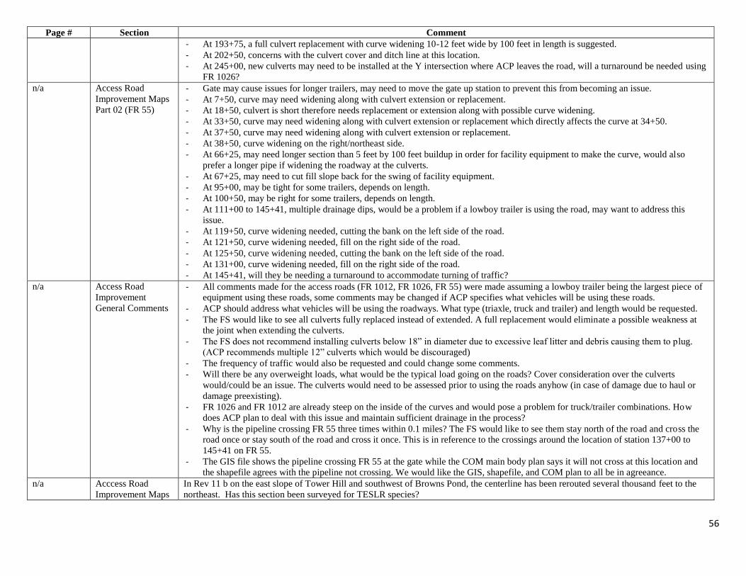
56
Page # Section Comment
- At 193+75, a full culvert replacement with curve widening 10-12 feet wide by 100 feet in length is suggested.
- At 202+50, concerns with the culvert cover and ditch line at this location.
- At 245+00, new culverts may need to be installed at the Y intersection where ACP leaves the road, will a turnaround be needed using
FR 1026?
n/a Access Road
Improvement Maps
Part 02 (FR 55)
- Gate may cause issues for longer trailers, may need to move the gate up station to prevent this from becoming an issue.
- At 7+50, curve may need widening along with culvert extension or replacement.
- At 18+50, culvert is short therefore needs replacement or extension along with possible curve widening.
- At 33+50, curve may need widening along with culvert extension or replacement which directly affects the curve at 34+50.
- At 37+50, curve may need widening along with culvert extension or replacement.
- At 38+50, curve widening on the right/northeast side.
- At 66+25, may need longer section than 5 feet by 100 feet buildup in order for facility equipment to make the curve, would also
prefer a longer pipe if widening the roadway at the culverts.
- At 67+25, may need to cut fill slope back for the swing of facility equipment.
- At 95+00, may be tight for some trailers, depends on length.
- At 100+50, may be right for some trailers, depends on length.
- At 111+00 to 145+41, multiple drainage dips, would be a problem if a lowboy trailer is using the road, may want to address this
issue.
- At 119+50, curve widening needed, cutting the bank on the left side of the road.
- At 121+50, curve widening needed, fill on the right side of the road.
- At 125+50, curve widening needed, cutting the bank on the left side of the road.
- At 131+00, curve widening needed, fill on the right side of the road.
- At 145+41, will they be needing a turnaround to accommodate turning of traffic?
n/a Access Road
Improvement
General Comments
- All comments made for the access roads (FR 1012, FR 1026, FR 55) were made assuming a lowboy trailer being the largest piece of
equipment using these roads, some comments may be changed if ACP specifies what vehicles will be using these roads.
- ACP should address what vehicles will be using the roadways. What type (triaxle, truck and trailer) and length would be requested.
- The FS would like to see all culverts fully replaced instead of extended. A full replacement would eliminate a possible weakness at
the joint when extending the culverts.
- The FS does not recommend installing culverts below 18” in diameter due to excessive leaf litter and debris causing them to plug.
(ACP recommends multiple 12” culverts which would be discouraged)
- The frequency of traffic would also be requested and could change some comments.
- Will there be any overweight loads, what would be the typical load going on the roads? Cover consideration over the culverts
would/could be an issue. The culverts would need to be assessed prior to using the roads anyhow (in case of damage due to haul or
damage preexisting).
- FR 1026 and FR 1012 are already steep on the inside of the curves and would pose a problem for truck/trailer combinations. How
does ACP plan to deal with this issue and maintain sufficient drainage in the process?
- Why is the pipeline crossing FR 55 three times within 0.1 miles? The FS would like to see them stay north of the road and cross the
road once or stay south of the road and cross it once. This is in reference to the crossings around the location of station 137+00 to
145+41 on FR 55.
- The GIS file shows the pipeline crossing FR 55 at the gate while the COM main body plan says it will not cross at this location and
the shapefile agrees with the pipeline not crossing. We would like the GIS, shapefile, and COM plan to all be in agreeance.
n/a Acccess Road
Improvement Maps
In Rev 11 b on the east slope of Tower Hill and southwest of Browns Pond, the centerline has been rerouted several thousand feet to the
northeast. Has this section been surveyed for TESLR species?

57
Page # Section Comment
n/a ATTACHMENT F Document says they will be provided later. We can’t comment on information that is not provided.
n/a Attachment F Access Road improvement plan and alignment sheets for the access roads need to be provided. Specifications for alignment sheets of
access roads are the same as alignment sheets for pipeline.
n/a Attachment F Attachment F contains no access road improvement maps, so we cannot comment on them at this time. However, four files, named
“Access_Road_Maps_2017_01_12_Part01”, “Access_Road_Maps_2017_01_12_Part02”, “Access_Road_Maps_2017_01_12_Part03”,
and “Access_Road_Maps_2017_01_12_Part04” were provided to the USFS, but they do not provide the detail needed for impact analyses.
We have requested shapefiles of the impact footprint and further details about the proposed access road improvements in order to make
comments and help make determinations of effects in wildlife habitat areas.
n/a Road Improvement
Maps
First 9 maps are hard to read with fall colors, yellow road lines, orange boundary lines. Could use better colors. Label roads with FS road
numbers. Make Forest Service ownership lines more visible. Group maps agency by Mon National Forest, GW/Jeff National Forest, and
other agencies. As previously discussed, ACP needs permission of private landowner for access across some private lands even though the
FS has access.
n/a Road Improvement
Maps
Show Forest Service Tract numbers to help locate maps or tie to mile markers.
Map 45 of 47 Attachment F,
access road
improvement maps
part 4
This map shows access road 07-001.AR.AR9 crossing a delineated stream at least 4 times and actually sharing the same space as the
stream with no identified culverts or crossings. This must be an error. Please correct.
Attachment G – Soil Survey
12 6.2 “Throughout the Project, the predominant soil textures observed in the field were silt loams. The ridgelines and steep backslopes were
mostly comprised of soil material with this silt-rich texture. The silt particle size (2-50 μm) is the most susceptible to erosion due to its
light weight and minimal cohesiveness. Erosion and sediment control measures will be critical during and post construction with soil
material that is highly susceptible to erosion, especially on steep slopes.”
ACP needs to incorporate the information into the BIC and site-specific design controls for erosion especially on steep slopes.
13 6.3 “Based on an estimated bulk density (not measured during survey) of 0.2 g cm-3 for the O-horizons, 1.2 g cm-3 for the A-horizons, and 1.4
g cm-3 for subsoil horizons it would be estimated that the O-horizons, A horizons and Subsoil horizons would contain about 64.8 mg C
cm-3, 73.2 mg C cm-3, and 12.6 mg C cm-3 respectively. Due to their interaction with the environment, surface horizons provide
numerous ecosystem services as a result of the higher organic carbon contents and biotic interactions including facilitating higher
infiltration rates, carbon sequestration, nutrient cycling, providing a seed bank, etc. Carbon contents are dynamic because they are a
balance between vegetative inputs and decomposition rates. Complete loss of these layers during construction would require decades of
high inputs to recover. Conservation of these layers during construction and replacement following construction will ensure a faster
recovery and provide ecosystem services that would assist in the restoration of these habitats.”
ACP will be required to calculate the estimated carbon lost to construction of the ROW using the carbon data from the Order 1 Soil
Survey. The estimated carbon that is lost due to construction will need to be mitigated.
Attachment H – Karst Plan
n/a Attachment H The FS commented about this issue previously. While we understand that the karst report was conducted by a geologist from a strictly
geological/structural point of view without regard to the microclimate of the feature or potential karst inhabitants, biological considerations
need to be included when addressing the unanticipated scenarios detailed in the document. Openings, voids, channels, “features”, and

58
Page # Section Comment
“structures” all have the potential to contain cave inhabitants, which depend on the consistent microclimate of the feature. If this
microclimate is altered because of interception by construction or blasting, it could affect the biotic environment, which is why a qualified
biologist needs to be consulted upon the discovery and on remediation.
11-13 Attachment H Karst
Terrain
Construction and
Mitigation Plan
Pre construction and Construction Phase- needs to address and include dye tracing as an accepted and reasonable process to determine
connectivity, flow rate and delineate the areas of effect and potentially identify changes and effects from activities and or possibly
construction. It needs to be incorporated with ERI.
11 Attachment H Karst
Terrain
Construction and
Mitigation Plan
Electrical Resistivity Investigation (ERI)- Include use of these protocols/process in the Pre-Construction Section page 13.
At the beginning (page 1), the document provides a description of the contents outlined and includes ERI during the construction phase.
Essentially, this is too late in the process and ERI needs to be used during the pre-construction phase. This will allow proper time to assess,
evaluate and develop a proper case specific plan should a cave or sinkhole be discovered.
13 Attachment H Karst
Terrain
Construction and
Mitigation Plan
Describe process and mitigation for minimizing effects from using a boring (drilling) machine that is within planned ROW disturbance
and any extra or changed mitigations for such boring outside the ROW disturbance area.
13 Attachment H “ a. If an identified feature with potential impact to the subterranean environment falls within the area
designated for earth disturbing activities and cannot be avoided, the feature will be documented by field location and photographs, and
then assessed for pre-construction remediation by Atlantic/DTI staff with input and guidance to be provided by the KS.”
Comment: A biologist should also be consulted. Structural integrity and hydrology are not the only concerns that need to be addressed
upon the discovery of an opening or feature. The opening should be investigated by a qualified biologist to determine if bats or other
species are present in the structure, if the feature is suitable for bats (large enough, suitable microclimate), and how remediation will affect
the microclimate upon which bats and other species depend. A biologist should investigate the entire biotic environment and be consulted
on remediation in addition to the geologist/KS.
13 Attachment H Karst
Terrain
Construction and
Mitigation Plan
Provide greater detail and description to define the ‘greater than 6 inch hole’ during the blasting phase. Is this a diameter measurement? Is
there connectivity or inferred connectivity? A one inch hole parallel along a plane can connect and transfer enormous amounts of flow.
14 Attachment H “If changes in the features are observed, Atlantic/DTI staff will report the condition to the KS who will provide consultation on potential
impacts to the karst environment and possible remedial actions.”
and
“If any feature is intercepted during work activities including borings, blasting, and excavation or trenching, the onsite geologist will
conduct an initial assessment of the feature to determine if further inspection (Level 2) by the KS will be required.”
Comment: Same comment as above - Because structural integrity of the feature is not the only concern, a biologist should also be
consulted. The opening should be investigated by a qualified biologist to determine if bats or other species are present in the structure, if
the feature is suitable for bats (large enough, suitable microclimate), and how remediation will affect the microclimate upon which bats
and other species depend. A biologist should investigate the entire biotic environment and be consulted on remediation in addition to the
geologist/KS.

59
Page # Section Comment
14 Attachment H “ a. The KS will examine the feature and determine if it has potential impact to the subterranean
environment based on potential connectivity with the phreatic aquifer via the epikarst stratum (Moore, et al, 2013).”
and
“b. If the feature is determined to have potential impact to the subterranean environment, the KS will
advise Atlantic/DTI staff regarding appropriate remedial actions.”
Comment: Impact to the subterranean environment cannot be based solely on hydrology. The microclimate, including temperature, above
the aquifer is vital to endangered, threatened, and regionally sensitive bat species and other species. A biologist should be consulted upon
discovery of a feature to determine if bats or other species are present in the structure, if the feature is suitable for bats (large enough,
suitable microclimate), and how remediation will affect the microclimate upon which bats and other species depend. The biologist should
investigate the entire biotic environment and be consulted on remediation in addition to the geologist/KS.
14, 15 Attachment H
Also, footnotes 2 and 3 refer only to caves or cave entrances. Throughout the document, there are references to “voids”, “openings”, and
“features”, any of which have the potential to house bats and other species, and therefore should be included in the coordination addressed
in the footnotes.
15 Attachment H “ a. The KS will examine the feature and determine if it has potential impact to the subterranean
environment based on potential hydraulic connectivity with the karst aquifer via the epikarst stratum.”
and
“c. If the feature is determined to have potential impact to the subterranean environment, the KS will
consult with Atlantic/DTI staff regarding appropriate remedial actions. c. If the feature is determined to have potential impact to the
subterranean environment, the KS will consult with Atlantic/DTI staff regarding appropriate remedial actions.”
and
“e. If any changes are observed, the KS will provide consultation on potential impact to the karst environment and remedial actions, if
necessary.”
Comment: Impact to the subterranean environment cannot be based solely on hydrology. The microclimate, including temperature, above
the aquifer is vital to endangered, threatened, and regionally sensitive bat species and other species. A biologist should be consulted upon
discovery of a feature to determine if bats or other species are present in the structure, if the feature is suitable for bats (large enough,
suitable microclimate), and how remediation will affect the microclimate upon which bats and other species depend. A biologist should
investigate the entire biotic environment and be consulted on remediation in addition to the geologist/KS.
15 Attachment H Footnote 3 “If an opening to a cave forms during construction activities, should be immediate coordination with the Virginia DCRNHP
Karst Program (or) West Virginia Department of Conservation for investigation. ”
Comment: Footnote 3 needs to include the USFWS and USFS and read the same as footnote 2 – “If an opening to a cave forms during
construction activities, there should be immediate coordination with the US Fish and Wildlife Service, US Forest Service (if within Forest
Service ownership land) Virginia DCR-NHP Karst Program (or) West Virginia Department of Conservation, for investigation.”.

60
Page # Section Comment
16 Attachment H Karst
Terrain
Construction and
Mitigation Plan
Reference is made to Columbia’s HCP BMPs for ACP—Checking whether if this is a misprint or intended use.
“Measures to Avoid Impact to the Karst Aquifer and Environment
These measures shall apply to any karst feature which allows the unfiltered and unimpeded flow of surface
drainage into the subsurface environment, including (but not limited to): open throat sinkholes, caves which
Receive surface drainage, sinking streams, and losing stream segments. These avoidance measures were
derived from the NiSource Habitat Conservation Plan, Madison Cave Isopod Avoidance and Minimization
Measures, and the Columbia Pipeline Group HCP and non-HCP species Best Management Practices”
18 Attachment H 5 b. and 5 c. “The void will be inspected by the KS and the most appropriate remedial method will be determined on a case-by-case basis.”
Comment: A biologist should also be consulted upon discovery of a void to determine if bats or other species are present in the structure,
if the feature is suitable for bats (large enough, suitable microclimate), and how remediation will affect the microclimate upon which bats
and other species depend. A biologist should investigate the entire biotic environment and be consulted on remediation in addition to the
geologist/KS.
18 Attachment H 6 b. “If the rock removal intercepts an open void, channel, or cave, the work in that area will be
stopped until a remedial assessment can be carried out by a qualified geologist or engineer with experience in karst terrain.”
Comment: Structure is not the only concern when intercepting a void, channel, and cave. The biotic environment is of concern because of
possible alterations, upon exposure, to the microclimate upon which cave inhabitants depend. A biologist should be consulted upon
discovery of a feature to determine if bats or other species are present in the structure, if the feature is suitable for bats (large enough,
suitable microclimate), and how remediation will affect the microclimate upon which bats and other species depend. A biologist should
investigate the entire biotic environment and be consulted on remediation in addition to the geologist/KS.
Attachment I – Typical Erosion and Sediment Control Details
n/a Attachment I Erosion control blankets will not be used on NFS Lands. Alternative erosion control materials may be used on steep slopes such as
hydraulic mulches, soil conditioner, soil tackifiers, etc. The USFS is open to alternative suggestions from ACP.
n/a Attachment I Foam shall not be used for trench plugs anywhere along the pipeline on National Forest lands.
Trench plug spacing in the FERC Upland Erosion Control Revegetation and Maintenance Plan (May 2013 version) is acceptable to the
Forest Service and shall be employed on National Forest lands by Dominion. Closer trench plug spacing will be allowed where Dominion
determines a need due to slope steepness.
Bags of concrete mix may be used for trench plugs no more frequently than every other trench plug; sand bags or earth-filled sacks shall be
used for all other trench plugs and sand bags or earth-filled sacks may be used for consecutive trench plugs (i.e., more frequently than
every other trench plug) at Dominion’s discretion. Any off-site earthen material must be shown through testing or inspection to be free of
chemical contaminants, non-native invasive species propagules, and other undesirable contaminants, and is subject to Forest Service
approval prior to use.
n/a Attachment I Bleeder drains will be used on slopes greater than 30% on NFS Lands with an outlet at every other trench plug.

61
Page # Section Comment
Bleeder drain outlets (daylighting) anticipated to be installed on slopes greater than 30 percent shall be spaced no farther apart than every
other trench plug. Closer bleeder drain outlet spacing will be allowed where Dominion determines a need due to slope steepness, bleeder
drain discharge volumes, or other factors.
Bleeder drains may need to be installed on slopes less than 30% if subsurface flow and/or seeps are encountered during excavation of the
trench. The Dominion EI and the Forest Service representative will determine when this is applicable in the field.
Riprap at the outlet of bleeder drains shall be composed of limestone or other suitable stone material to achieve the purpose of energy
dissipation.
Water quality testing at selected bleeder drain outlets will be required post-pipeline construction. The Forest Service is still working to
identify the locations where testing will be conducted. The testing locations will be based on site sensitivities (i.e., Threatened,
Endangered, and Sensitive (TES) species habitat, brook trout spawning, presence of nearby private or public wells, etc.). The Forest
Service will provide Dominion with the locations and chemical parameters at a later date.
n/a Attachment I Silt fence shall not be used at locations of concentrated overland flow, whether the flow is natural or constructed. Compost filter socks or
other controls designed to filter or chemically remove sediment from water shall be used in those locations, subject to FS approval.
Silt fence may be used as perimeter control where concentrated flow does not exist, as well as where prescribed as a barrier to keep
threatened, endangered, and sensitive (TES) species out of the work area, or spoil materials or sediments out of TES habitat.
Where temporary slope breakers are deemed necessary during construction, as determined by consultation between ACP’s environmental
inspector and the FS representative, install berms or other appropriate diversion structures on the ROW to intercept and divert water from
the ROW. Install 12-inch diameter or larger compost filter socks at the outlet of the berms to control sediment transport.
In areas where excessive run-on (i.e., onto the ROW or access roads) is expected or occurs, diversion channels or berms may be installed
on the upslope side of the ROW. Run-on diversions or berms shall disperse the water into a well vegetated area, such that it does not result
in concentrated discharge or rill erosion at or downslope of the outlet. One or more 12-inch or larger diameter compost filter socks shall be
installed at each outlet to aid in reducing energy and removing sediment suspended in the discharged water.
n/a Appendix I USFS requested more site specific sediment and erosion control plan measures. We were told a best in class program was established.
Where is that information? This appendix is still just the basics with limited details. Supplement with BIC program information.
Attachment J – Nonnative Plant Doc.
n/a Attachment J The herbicides proposed in Attachment J are listed below along with the effects on the soil resource:
Herbicide effects on the soil resource are dependent on the chemical components and their mobility in the soil. Some herbicides are not
mobile and bind readily with the soil—these are less likely to result in groundwater contamination unless soil erosion potential is high (i.e.,
steep slopes), whereas other herbicides are more mobile and depending on the half-life of the particular herbicide, the more mobile
herbicides are more likely to result in groundwater contamination. All of this however, is based on the soil type.
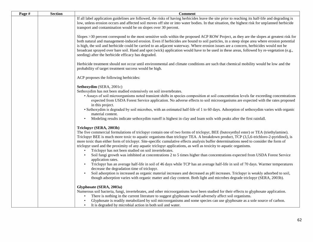
62
Page # Section Comment
If all label application guidelines are followed, the risks of having herbicides leave the site prior to reaching its half-life and degrading is
low, unless erosion occurs and affected soil moves off site or into water bodies. In that situation, the highest risk for unplanned herbicide
transport and contamination would be on slopes over 30 percent.
Slopes >30 percent correspond to the most sensitive soils within the proposed ACP ROW Project, as they are the slopes at greatest risk for
both natural and management-induced erosion. Even if herbicides are bound to soil particles, in a steep slope area where erosion potential
is high, the soil and herbicide could be carried to an adjacent waterway. Where erosion issues are a concern, herbicides would not be
broadcast sprayed over bare soil. Hand and spot (wick) application would have to be used in these areas, followed by re-vegetation (e.g.,
seeding) after the herbicide efficacy has degraded.
Herbicide treatment should not occur until environmental and climate conditions are such that chemical mobility would be low and the
probability of target treatment success would be high.
ACP proposes the following herbicides:
Sethoxydim (SERA, 2001c)
Sethoxydim has not been studied extensively on soil invertebrates.
• Assays of soil microorganisms noted transient shifts in species composition at soil concentration levels far exceeding concentrations
expected from USDA Forest Service application. No adverse effects to soil microorganisms are expected with the rates proposed
in this project.
• Sethoxydim is degraded by soil microbes, with an estimated half-life of 1 to 60 days. Adsorption of sethoxydim varies with organic
material content.
• Modeling results indicate sethoxydim runoff is highest in clay and loam soils with peaks after the first rainfall.
Triclopyr (SERA, 2003b)
The five commercial formulations of triclopyr contain one of two forms of triclopyr, BEE (butoxyethyl ester) or TEA (triethylamine).
Triclopyr BEE is much more toxic to aquatic organisms than triclopyr TEA. A breakdown product, TCP (3,5,6-trichloro-2-pyridinol), is
more toxic than either form of triclopyr. Site-specific cumulative effects analysis buffer determinations need to consider the form of
triclopyr used and the proximity of any aquatic triclopyr applications, as well as toxicity to aquatic organisms.
• Triclopyr has not been studied on soil invertebrates.
• Soil fungi growth was inhibited at concentrations 2 to 5 times higher than concentrations expected from USDA Forest Service
application rates.
• Triclopyr has an average half-life in soil of 46 days while TCP has an average half-life in soil of 70 days. Warmer temperatures
decrease the degradation time of triclopyr.
• Soil adsorption is increased as organic material increases and decreased as pH increases. Triclopyr is weakly adsorbed to soil,
though adsorption varies with organic matter and clay content. Both light and microbes degrade triclopyr (SERA, 2003b).
Glyphosate (SERA, 2003a)
Numerous soil bacteria, fungi, invertebrates, and other microorganisms have been studied for their effects to glyphosate application.
• There is nothing in the current literature to suggest glyphosate would adversely affect soil organisms.
• Glyphosate is readily metabolized by soil microorganisms and some species can use glyphosate as a sole source of carbon.
• It is degraded by microbial action in both soil and water.

63
Page # Section Comment
• Glyphosate degrades in soil, with an estimated half-life of 30 days.
• Glyphosate is highly soluble, but adsorbs rapidly and tightly to soil.
• Glyphosate has low leaching potential because it binds so tightly to soil.
• Modeling results indicate glyphosate runoff is highest in loam soils with peaks after the first rainfall.
Pendimethalin (epa.gov)
• There is nothing in the literature to suggest Pendimethalin would adversely affect soil organisms.
• Pendimethalin dissipates in the environment by binding to soil, microbially-mediated metabolism and volatilization.
• It is essentially immobile in soil.
• Pendimethalin may contaminate surface water from spray drift associated with aerial and ground spray application, or in runoff
from rainfall events and through irrigation waters (chemigation).
• Its high affinity to bind to soil and sediment particles should limit concentrations of pendimethalin in surface waters unless in
areas that are have risks of erosion such as steep slopes.
• Pendimethalin has been detected in ground water (at very low levels), the potential for ground water contamination from
pendimethalin residues is low.
• Overall, pendimethalin does not represent a high risk to aquatic animals and plants, including estuarine organisms.
• The use of pendimethalin may adversely affect endangered species of terrestrial and semi-aquatic plants, aquatic plants and
invertebrates including mollusks, fish, and birds (specifically grazers).
• The risk to nontarget terrestrial and semi-aquatic plants is expected to be moderate.
• To lessen the risks posed by pendimethalin, follow handling, mixing, and application instructions.
• To reduce risks to nontarget plants, add spray drift best management practices.
2, 4-D Amine (epa.gov)
Esters of 2,4-D are rapidly hydrolyzed in alkaline aquatic environments, soil/water slurries, and moist soils. The 2,4-D amine salts have
been shown to dissociate rapidly in water. However, 2,4-D esters may persist under sterile acidic aquatic conditions and on dry soil. These
bridging data indicate under most environmental conditions 2,4-D esters and 2,4-D amines will degrade rapidly to form 2,4-D acid.
• The dissipation is dependent on oxidative microbial-mediated mineralization, photodegradation in water, and leaching.
• Degrades rapidly in soils (half life = 6.2 days), degrades rapidly in aerobic aquatic environments (half life = 15 days), and is
relatively persistent in anaerobic aquatic environments (half life ranges from 41 to 333 days).
• 2,4-D esters volatilize readily, particularly in conditions of high temperatures and low humidity.
• 2,4-D has a low binding affinity in mineral soils and sediment.
• 2,4-D has been detected in groundwater at approximately 15 ppb. This is below the DWLOCs determined to be protective in the
human health risk assessment and below the maximum contaminant level (MCL) set at 70 ppb by the EPA Office of Water.
• 2,4-D is considered to be moderately to practically non-toxic to birds on an acute basis.
• 2,4-D is classified as slightly toxic to small mammals on an acute oral basis.
• A honey bee acute toxicity study indicated that 2,4-D is practically non-toxic to the honey bee. 2,4-D is toxic to terrestrial plants;
it is more toxic to dicots than to monocots.
• 2,4-D acid and amine salts have been found to be practically non-toxic to freshwater or marine fish.
• The 2,4-D esters have been found to be highly toxic to fish.
• Acute toxicity studies on 2,4-D acid and amine salts show these compounds to be slightly toxic to practically nontoxic to aquatic
invertebrates.

64
Page # Section Comment
• The 2,4-D esters have been found to be very highly toxic to slightly toxic to freshwater and marine invertebrates.
• The 2,4-D esters may be chronically toxic to freshwater and marine invertebrates.
• 2,4-D is toxic to aquatic plants; it is more toxic to vascular plants than to non-vascular plants.
• Most ecological risk quotient (RQ) values exceed the LOC, with the following exceptions: chronic risk to fish from use of 2,4-D
BEE for aquatic weed control, risk to endangered aquatic plants from use of 2,4-D on rice and for aquatic weed control, chronic
risk to mammals from use of 2,4-D liquid spray, acute risk to non-endangered and endangered plants from use of 2,4-D liquid
spray, and acute risk to non-endangered and endangered plants from use of 2,4-D granules.
• There is a potential for risk to endangered species.
• Reductions in application rates and/or number of applications will reduce overall risk.
• The spray drift control measures are expected to reduce the risk to non-target plants.
Attachment K – Spill Report
n/a Attachment K- Spill
Report
The Spill Prevention Countermeasures and Control Plan (SPCC) should be included with this form
Attachment L – GWNF Unanticipated Discoveries
Attachment L 4E-5 Brian Webb is no longer patrol Captain on the G.W. & Jeff. Nat. Forests. The Patrol Captain is Katie Ballew
Attachment M –MNF Unanticipated Discoveries Plan
n/a Attachment M
Add new section-
Paleontological
Resource
Protections
Add new Section- Unanticipated Paleontological Discovery Plan and provide protocol for encountering potential vertebrate fossils
Add to Attachment L as well for the GWNF
Attachment O – ANST HDD Drawings
n/a Attachment O 2nd page, first line reads: “Blue Ridge Parkway.” Note that Blue Ridge Parkway is not USFS lands.
n/a Attachment O All pages in this Attachment, and ALL Attachments to the COM Plan, need to have page numbers.
n/a Attachment O 3rd page, oversized sheet, Drawing Label: “BR Parkway 1”
Property ownerships are not shown clearly and need to be emphasized, especially the federal ownerships.
“Appalachian Trail” needs to be relabeled as “Appalachian National Scenic Trail”
n/a Attachment O 5th and 9th pages are very similar, both labelled “Stress Analysis, “worst-case)”.
Please label these sheets and explain their difference to an interested non-geotechnical-drilling-engineer.
Explain what “with BC” and “no BC” mean.
Attachment P – Contingency Plan ANST and BRP
multiple Attachment P Throughout this Attachment, beginning on 3rd page, in List of Acronyms and Abbreviations, change “AT” to “ANST”. Also:
Page 1, first paragraph in section 2.0, two references,
Page 2, 2nd paragraph in section 6.9, two references,
Page 3, top line,
1 Attachment P First paragraph, change “AGL Resources” to match the successor company, as shown in section 1.1 on page 1 of the main COM Plan
document.

65
Page # Section Comment
2 Attachment P Section 6.0, first sentence. Change “results” to “result” to match singular/plural.
2 Attachment P Section 6.0, 3rd paragraph. Refers to NPS lands. This COM Plan is specific to USFS lands, per the statement on page 3 in section 1.1 of
the main document. Should this be “USFS” instead of “NPS”?
3 Attachment P Section 6.0, first partial paragraph on this page – states no ground disturbance or tree clearing within 350’ of the ANST. This conflicts
with the dimensions and distances listed in Figure 1 on page 4 of this Attachment (400’). This section needs to be reworded to give the
correct distances and to add a clear and direct statement as to whether or not any ground disturbance or tree clearing will occur on any
USFS lands in this area; knowing that one goal of the HDD and DPI is to completely avoid all ground disturbance or tree clearing on
USFS lands.
4 Attachment P Figure 1. Thank you for delineating and labelling the Appalachian National Scenic Trail correctly on this page. Several other comments
on this page:
In the legend, change “National Forest Service” to “USFS Lands”. Previously requested in Draft-1.
Revise this figure to clearly show the Trenchless Exit and the limits of surface disturbance as ending on private land, NOT
partially on private and partially on USFS lands.
Revise this figure to eliminate the “ghost” irregular wedge of apparent private land as shown east of the USFS land (dark green)
and west of the NPS land (purple). This does not exist, and showing it on this figure is confusing and erroneous. The USFS lands
abuts and joins the NPS lands. Previously requested in Draft-1.
5 Attachment P Show USFS ownership and property lines much more clearly. Also, change the label “Appalachian Trail” to “Appalachian National
Scenic Trail”.
Attachment Q – Timber Cruise Plan
n/a Attachment Q Because certain MNF Land and Resource Management Plan standards and guidelines will not be followed, resulting in the destruction of
primary bat roosting trees, additional mitigation measures for bats need to be incorporated into various documents. These mitigation
measures will include snag creation and artificial roosting structures at a 1:1 ratio. To do this, it must be known how many shagbark
hickory trees over 5 DBH and snags of particular specifications are taken, which requires timber cruisers to keep track of them.
Attachment Q MNF Timber Cruising Specifications will need to be updated to reflect these details once bat surveys are complete.