Figure 6 illustrates the general parkway cross section between ...
8
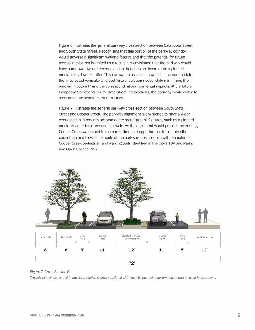
5 SOUTHSIDE PARKWAY CORRIDOR PLAN Figure 6 illustrates the general parkway cross section between Calapooya Street and South State Street. Recognizing that this portion of the parkway corridor would traverse a significant wetland feature and that the potential for future access in this area is limited as a result, it is envisioned that the parkway would have a narrower two-lane cross section that does not incorporate a planted median or sidewalk buffer. This narrower cross section would still accommodate the anticipated vehicular and ped/bike circulation needs while minimizing the roadway “footprint” and the corresponding environmental impacts. At the future Calapooya Street and South State Street intersections, the parkway would widen to accommodate separate left-turn lanes. Figure 7 illustrates the general parkway cross section between South State Street and Cooper Creek. The parkway alignment is envisioned to have a wider cross section in order to accommodate more “green” features, such as a planted median/center turn lane and bioswale. As the alignment would parallel the existing Cooper Creek watershed to the north, there are opportunities to combine the pedestrian and bicycle elements of the parkway cross section with the potential Cooper Creek pedestrian and walking trails identified in the City’s TSP and Parks and Open Spaces Plan. 8’ 12’ 8’ 5’ 5’ sidewalk bike lane bike lane travel lane bioswale 12’ 11’ 11’ 72’ travel lane planted median or bioswale creekside trail Figure 7. Cross Section B Typical rights-of-way and ultimate cross section shown. Additional width may be needed to accommodate turn lanes at intersections.
-
Upload
khangminh22 -
Category
Documents
-
view
1 -
download
0
Transcript of Figure 6 illustrates the general parkway cross section between ...
5SOUTHSIDE PARKWAY CORRIDOR PLAN
Figure 6 illustrates the general parkway cross section between Calapooya Street and South State Street. Recognizing that this portion of the parkway corridor would traverse a significant wetland feature and that the potential for future access in this area is limited as a result, it is envisioned that the parkway would have a narrower two-lane cross section that does not incorporate a planted median or sidewalk buffer. This narrower cross section would still accommodate the anticipated vehicular and ped/bike circulation needs while minimizing the roadway “footprint” and the corresponding environmental impacts. At the future Calapooya Street and South State Street intersections, the parkway would widen to accommodate separate left-turn lanes.
Figure 7 illustrates the general parkway cross section between South State Street and Cooper Creek. The parkway alignment is envisioned to have a wider cross section in order to accommodate more “green” features, such as a planted median/center turn lane and bioswale. As the alignment would parallel the existing Cooper Creek watershed to the north, there are opportunities to combine the pedestrian and bicycle elements of the parkway cross section with the potential Cooper Creek pedestrian and walking trails identified in the City’s TSP and Parks and Open Spaces Plan.
8’ 12’8’ 5’5’
sidewalk bikelane
bikelane
travellanebioswale
12’ 11’11’
72’
travellane
planted median or bioswale creekside trail
Figure 7. Cross Section BTypical rights-of-way and ultimate cross section shown. Additional width may be needed to accommodate turn lanes at intersections.

6 CITY OF SUTHERLIN
8’ 8’8’ 8’5’5’
sidewalk bikelane
bikelane
travellane bioswalebioswale
12’ 11’11’
76’
travellane
planted median or bioswale sidewalk
Figure 8 illustrates the general parkway cross section along that section of the corridor that will traverse through the existing Meadows Park development. The alignment is envisioned to have a full roadway cross section with a planted median/center turn lane, bioswales, sidewalks, and bike lanes. Recognizing that the parkway will have some social impacts along this portion of the corridor, the plan envisions a wider right-of-way that would accommodate a green buffer and/or other barrier features that would soften the visual impacts of the parkway from the adjacent neighborhoods.
Figure 8. Cross Section CTypical rights-of-way and ultimate cross section shown. Additional width may be needed to accommodate turn lanes at intersections.

7SOUTHSIDE PARKWAY CORRIDOR PLAN
8’ 8’ 5’ 12’ 11’ 8’5’ 12’
sidewalk bioswale bikelane
travellane
bikelane
11’
80’
travellane
planted median /left turn lane bioswale
multi-usetrail
Figure 9. Cross Section D
Figure 9 illustrates the general parkway cross section along the undeveloped land currently owned by the Sutherlin School District. Given that this section has the fewest social, environmental, and topographical constraints, this portion of the corridor is envisioned to fully implement the parkway concept, as originally envisioned in the TSP. This includes the planted median, bioswales, bike lanes, sidewalks, and multi-use recreation trail (on one side of the parkway).
Typical rights-of-way and ultimate cross section shown. Additional width may be needed to accommodate turn lanes at intersections.
8 CITY OF SUTHERLIN
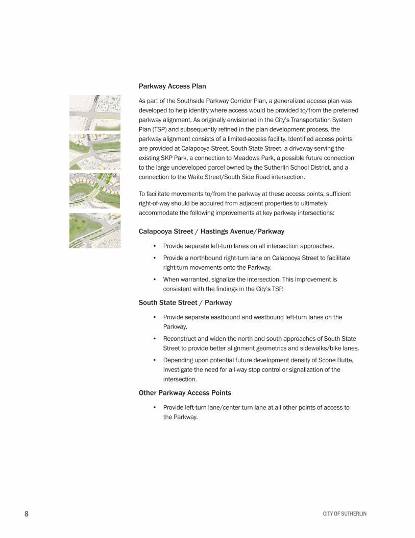
Parkway Access Plan
As part of the Southside Parkway Corridor Plan, a generalized access plan was developed to help identify where access would be provided to/from the preferred parkway alignment. As originally envisioned in the City’s Transportation System Plan (TSP) and subsequently refined in the plan development process, the parkway alignment consists of a limited-access facility. Identified access points are provided at Calapooya Street, South State Street, a driveway serving the existing SKP Park, a connection to Meadows Park, a possible future connection to the large undeveloped parcel owned by the Sutherlin School District, and a connection to the Waite Street/South Side Road intersection.
To facilitate movements to/from the parkway at these access points, sufficient right-of-way should be acquired from adjacent properties to ultimately accommodate the following improvements at key parkway intersections:
Calapooya Street / Hastings Avenue/Parkway
Provide separate left-turn lanes on all intersection approaches.
Provide a northbound right-turn lane on Calapooya Street to facilitate right-turn movements onto the Parkway.
When warranted, signalize the intersection. This improvement is consistent with the findings in the City’s TSP.
South State Street / Parkway
Provide separate eastbound and westbound left-turn lanes on the Parkway.
Reconstruct and widen the north and south approaches of South State Street to provide better alignment geometrics and sidewalks/bike lanes.
Depending upon potential future development density of Scone Butte, investigate the need for all-way stop control or signalization of the intersection.
Other Parkway Access Points
Provide left-turn lane/center turn lane at all other points of access to the Parkway.
•
•
•
•
•
•
•

9SOUTHSIDE PARKWAY CORRIDOR PLAN
Parkway Landscaping
Landscaping features for the Southside Parkway should include an attractive mix of paving treatments, “green” stormwater features, and climate-appropriate plants that require little or no irrigation and minimal maintenance. The following are guidelines and recommendations for landscaping along the Southside Parkway Corridor:
Drought tolerant and native plant materials are encouraged;
Landscaping should enhance natural site elements through the careful use of flower and leaf color and texture, plant forms and plant masses.
In an effort to reduce localized flood events and stormwater runoff impacts to the Cooper Creek watershed, the Plan recommends using linear bioswales in the median and between the roadway and the sidewalk/trail. Additionally, sidewalks and trails should be constructed of permeable pavement (i.e., permeable asphalt or concrete) to further reduce impacts. Permeable organic materials, like decomposed granite or crushed aggregate, may be suitable for walking areas along Cooper Creek but must be constructed to the highest possible standards to meet ADA access requirements and not require continual maintenance.
Where possible, existing mature landscaping should be preserved and incorporated into the design of the roadway. Landscaping should be designed to effectively enhance existing views or provide new view corridor opportunities.
Where the Parkway impacts adjacent residential development, dense vegetated buffers should be established to provide privacy and protection from parkway noise. Dense vegetated buffers are recommended over sound walls or other impenetrable barriers as they improve pedestrian safety by providing some transparency between the corridor and the adjacent buildings. Vegetated buffers also help filter harmful gases and particulates generated by vehicles along the Parkway.
If used, perimeter fencing or walls visible to the public and neighboring properties shall avoid monotony by the use of recesses, planting materials and architectural features to visually “break up” their linear appearance.
•
•
•
•
•
•
10 CITY OF SUTHERLIN
Compatibility with Existing Plans
The elements of the Southside Parkway Corridor Plan are intended to be consistent with the City’s current planning documents. From a circulation perspective, the more detailed refinement work for the parkway does not deviate from or require modifications to the long-term transportation improvements identified in the 2005 TSP. These compatible, long-term improvements include the following:
Roadway Projects
Duke Avenue / Hastings Avenue – this identified improvement would realign the connection between Duke Avenue and Hastings Avenue and bring the entire corridor up to full collector street design standards.
Signalize the Calapooya Street / Hastings Avenue / Parkway intersection.
Signalize the Central Avenue / Waite Street intersection.
Bicycle and Pedestrian Projects
Calapooya Street – add sidewalks and bike lanes to Sutherlin Creek Bridge.
Duke Avenue / Hastings Avenue – add sidewalks and bike lanes.
South State Street – add sidewalks and bike lanes from Central Avenue to Southside Parkway alignment.
Waite Street – add sidewalks and bike lanes from Central Avenue to Southside Parkway.
Construct a new multi-use path following Cooper Creek from the Southside Parkway to Cooper Creek Reservoir.
•
•
•
•
•
•
•
•

11SOUTHSIDE PARKWAY CORRIDOR PLAN
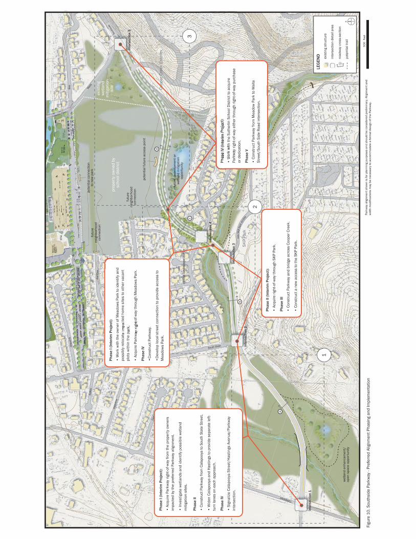
Implementation Plan
A planning level cost estimate was completed for the entire length of the parkway corridor. The estimate includes subgrade and pavement for travel lanes, curbs, gutters, subsurface drainage associated with the roadway, sidewalks, signing, and striping, and the need for drainage culverts and small bridges that would span Cooper Creek. In recognition of the need to construct portions of the parkway corridor in identified wetland areas, the cost estimate also includes allowances for special construction techniques and materials, such as subgrade stabilization, water quality features, retaining walls, and culverts. In summary, the cost to physically construct the parkway in 2007 dollars is approximately $7,000,000. Assuming that the City would need to acquire all of the right-of-way for the parkway (no dedication), right-of-way is estimated to cost an additional $4,000,000.
The Southside Parkway Corridor Plan is a long-term vision for ensuring alternative east-west travel ways within the east side area of the City of Sutherlin. As Sutherlin continues to grow and traffic continues to increase on Central Avenue, the need for the Southside Parkway will become increasingly important. However, given the size and magnitude of the parkway and the estimated costs to construct such a facility, it is likely that development of the parkway will need to occur over time, as funds become available to purchase right-of-way and construct the roadway. To assist with this, a possible phased implementation plan has been developed that would pace out the acquisition of right-of-way and construction over time. This implementation plan is illustrated in Figure 10.
inte
rsec
tion
1
inte
rsec
tion
2
inte
rsec
tion
3
inte
rsec
tion
4
inte
rsec
tion
5
prop
erty
ow
ned
bysc
hool
dis
tric
t
wet
land
enh
ance
men
t/op
en s
pace
opp
ortu
nity
exis
ting
wet
land
miti
gatio
nsi
te
futu
re d
evel
opm
ent o
rw
etla
nd m
itiga
tion
oppo
rtun
ityde
nse
land
scap
e bu
ffer
Coop
er C
reek
Est
ates
SKP
Park
a
d
c
b
Calapooya
South State
South State
Wai
te
coop
er cr
eek
pote
ntia
l fut
ure
acce
ss p
oint
pote
ntia
l con
nect
ion
to n
ew p
ark
futu
rene
ighb
orho
odco
nnec
tion
futu
rene
ighb
orho
odco
nnec
tion
Rai
ntre
e
Spen
ce
Sea
Sout
hsid
e
Valle
y
Cam
as
Vale
ntin
e
Azal
ea
new
SK
P Pa
rk a
cces
s
Hea
venl
y
Figu
re 1
0. S
outh
side
Par
kway
- Pr
efer
red
Alig
nmen
t Pha
sing
and
Impl
emen
tatio
n
1
2
3
Pha
se I
(Inte
rim
Pro
ject
):
• A
cqui
re P
arkw
ay ri
ght-o
f-way
from
the
prop
erty
ow
ners
im
pact
ed b
y th
e pr
efer
red
Park
way
alig
nmen
t.
• In
vest
igat
e w
etla
nds
and
iden
tify
poss
ible
wet
land
m
itiga
tion
site
s.
Pha
se II
• C
onst
ruct
Par
kway
from
Cal
apoo
ya to
Sou
th S
tate
Str
eet.
• W
iden
Cal
apoo
ya a
nd H
astin
gs to
pro
vide
sep
arat
e le
ft-
turn
lane
s on
eac
h ap
proa
ch.
Pha
se IV
• S
igna
lize
Cal
apoo
ya S
tree
t/H
astin
gs A
venu
e/Pa
rkw
ay
inte
rsec
tion.
Pha
se II
(Int
erim
Pro
ject
):
• A
cqui
re ri
ght-o
f-way
thro
ugh
SKP
Park
.
Pha
se II
I
• C
onst
ruct
Par
kway
and
brid
ge a
cros
s Co
oper
Cre
ek.
• C
onst
ruct
a n
ew a
cces
s to
the
SKP
Park
.
Pha
se I
(Inte
rim
Pro
ject
):
• W
ork
with
the
owne
r of M
eado
ws
Park
to id
entif
y an
d po
ssib
ly r
eloc
ate
impa
cted
hom
e si
tes
to o
ther
vac
ant
plot
s w
ithin
the
park
.
• A
cqui
re P
arkw
ay ri
ght-o
f-way
thro
ugh
Mea
dow
s Pa
rk.
Pha
se IV
•Co
nstr
uct P
arkw
ay.
•D
evel
op lo
cal s
tree
t con
nect
ion
to p
rovi
de a
cces
s to
M
eado
ws
Park
.
Pha
se IV
(Int
erim
Pro
ject
):
• W
ork
with
the
Suth
erlin
Sch
ool D
istr
ict t
o ac
quire
Pa
rkw
ay ri
ght-o
f-way
eith
er th
roug
h rig
ht-o
f-way
pur
chas
e or
ded
icat
ion.
Pha
se V
• C
onst
ruct
Par
kway
from
Mea
dow
Par
k to
Wai
te
Stre
et/S
outh
Sid
e R
oad
inte
rsec
tion.
LEG
END
exis
ting
stru
ctur
e
inte
rsec
tion
deta
il ar
ea
road
way
cro
ss-s
ectio
n
pote
ntia
l tra
iln
b
500
Feet
Park
way
alig
nmen
t sho
wn
is fo
r pla
nnin
g pu
rpos
es a
nd s
houl
d be
con
side
red
prel
imin
ary.
Alig
nmen
t and
w
idth
mod
ifica
tions
may
be
nece
ssar
y to
acc
omm
odat
e a
form
al d
esig
n of
the
Park
way
.