
Feb' - Andhra Pradesh Pollution Control Board
341
DRAFT ENVIRONMENTAL IMPACT ASSESSMENT REPORT FOR SRI CHIMALADINNE SRIDHAR (MINING OF COLOUR GRANITE-Srikakulam Blue) Lessee, Chimaladinnee Sridhar, Address: SS Grandeur Plot no: 5, 6,7,8,9 & 10, Phase -5, KPHB Colony, Hyderabad Site Address Extent: 14.54 Ha Sy. No. 1, Bellukola (V) Nandigama (M), Srikakulam District, Andhra Pradesh Production capacity Colour Granite – 12180 m 3 per Annum Baseline data collected: October’ 2021 to December’ 2021 Sector: 01 – Mining of minerals, Cat –B1 Approved ToR Lr. No: SEIAA/AP/SKM/MIN/12/2020/2641-267 Dt: 07.07.2021 PREPARED BY H.O: Block-B, B-1, IDA, Autonagar -12, Visakhapatnam Ph: 0891-2755528, Fax: 0891-2755529, E-mail: [email protected] Ph: 9440338628 QCI NABET & NABL Accredited & Recognized by MOEF&CC, New Delhi. Feb’ 2022 SVELC/CS/DRAFT/EIA
-
Upload
khangminh22 -
Category
Documents
-
view
3 -
download
0
Transcript of Feb' - Andhra Pradesh Pollution Control Board
aa
DRAFT ENVIRONMENTAL IMPACT ASSESSMENT REPORT
FOR
SRI CHIMALADINNE SRIDHAR (MINING OF COLOUR GRANITE-Srikakulam Blue)
Lessee, Chimaladinnee Sridhar, Address: SS Grandeur
Plot no: 5, 6,7,8,9 & 10, Phase -5, KPHB Colony, Hyderabad
Site Address
Extent: 14.54 Ha Sy. No. 1, Bellukola (V)
Nandigama (M), Srikakulam District, Andhra Pradesh
Production capacity Colour Granite – 12180 m3 per Annum
Baseline data collected: October’ 2021 to December’ 2021 Sector: 01 – Mining of minerals, Cat –B1
Approved ToR Lr. No: SEIAA/AP/SKM/MIN/12/2020/2641-267 Dt: 07.07.2021
PREPARED BY
H.O: Block-B, B-1, IDA, Autonagar -12, Visakhapatnam
Ph: 0891-2755528, Fax: 0891-2755529, E-mail: [email protected] Ph: 9440338628
QCI NABET & NABL Accredited & Recognized by MOEF&CC, New Delhi.
Feb’
2022
SVELC/CS/DRAFT/EIA

UNDERTAKING
I, the undersigned Mr. Chimaladinne Sridhar, Lessee of Colour Granite mine in the
name of Sri Chimaladinne Sridhar over an extent of 14.54 Ha., located at Sy. No. 1 of
Bellukola Village, Nandigam Mandal, Srikakulam District, Andhra Pradesh do hereby
solemnly affirm and declare that SV Enviro Labs & Consultants located at Enviro
House, Block –B, B-1, IDA, Autonagar, Visakhapatnam -12 has obtained ToRs for
our mine to obtain Environmental Clearance under the EIA notification, 2006.
As a Project proponent, I undertake that the present Draft EIA study report of the
mining project of Sri Chimaladinne Sridhar located at Sy. No: 1 of Bellukola Village,
Nandigam Mandal, Srikakulam District is entirely with the prescribed ToRs.
And further, I endorse all the data and information of the EIA report, as presented by
EIA consultant SV Enviro Labs & Consultants to be accurate, true and correct and I
own the responsibility for the same.
Thanks & Regards
For Sri Chimaladinne Sridhar
Chimaladinne Sridhar
Lessee

DECLARATION BY EXPERTS CONTRIBUTING TO THE EIA
“Draft Environmental Impact Assessment for the mining of Colour Granite – 12180 m3 per
annum in an area of 14.54 Ha at Sy. No: 1, Bellukola Village, Nandigama Mandal,
Srikakulam District, Andhra Pradesh by Sri Chimaladinne Sridhar.
I hereby certify that I was a part of the EIA team in the following capacity that developed the
above EIA.
EIA Co-ordinator
Name : Dr. M. Tarakeswara Naidu
Signature :
Functional Area Experts:
S. No Functional
Areas
Name of the
Expert
Category as per NABET
Involvement (Period and task**)
Signature and Date
1. EIA
Coordinator
Dr. M. Tarakeswara
Naidu
A Mining
2. AP M. Murali Krishna
A Air Pollution monitoring, prevention & control
3. WP V. Hemalatha
A Water Pollution monitoring, prevention & control
4. SHW K. Anitha A Solid waste management
5. SE Dr. B. Vijay Bhaskara
Rao
A Socioeconomic studies
6. EB Dr. M. Tarakeswara
Naidu
A Ecology and Bio-diversity
7. HG Dr. G.V.A
Ramakrishna
A Hydrology
8. GEO Dr. G.V.A
Ramakrishna
A
Geology
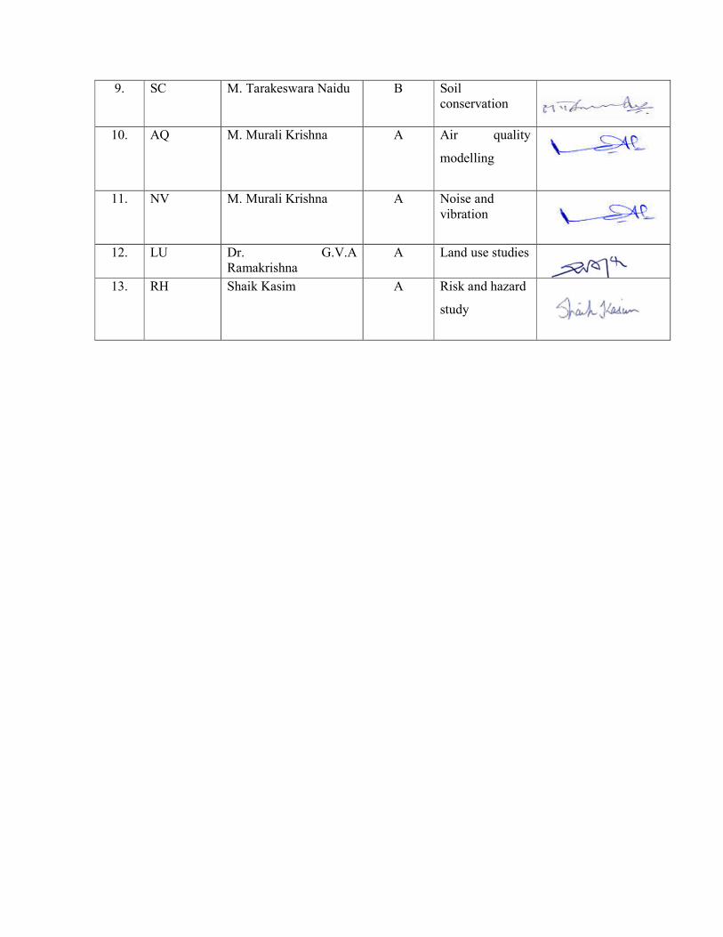
9. SC M. Tarakeswara Naidu B Soil conservation
10. AQ M. Murali Krishna A Air quality
modelling
11. NV M. Murali Krishna A Noise and vibration
12. LU Dr. G.V.A
Ramakrishna A Land use studies
13. RH Shaik Kasim A Risk and hazard
study

Declaration by the Head of the accredited consultant organization/ authorized person
I, M. Murali Krishna, hereby, confirm that the above mentioned experts prepared the Draft
EIA for Colour Granite mine – 12180 m3 per annum, in an area of 14.54 Ha at Sy. No: 1,
Bellukola Village, Nandigama Mandal, Srikakulam District, Andhra Pradesh by Sri
Chimaladinne Sridhar.
Signature:
Name: M. Murali Krishna
Designation: Managing Partner
Name of the EIA consultant organization: SV Enviro Labs & Consultants
NABET Certificate No. & Issue Date: NABET/EIA/1821/SA 0118 Dt: 28.09.2020 and valid up
to 16.04.2022.

INDEX
Sl.No. PARTICULARS PAGE NO.
Chapter-I Introduction
1.0 Introduction 1-1
1.1 Purpose of the report 1-1
1.2 Details of the project & identification of project proponent 1-2
1.3 Background Information of the Project 1-2
1.4 Brief description of the project 1-3
1.5 Justification and need of the project 1-3
1.6 Project location 1-4
1.7 Regulatory compliances & applicable laws/regulations 1-6
1.8 Environmental parameters in the study area 1-6
1.9 Generic structure of EIA document 1-7
1.10 Post environment clearance monitoring 1-7
Chapter-II Project Description
2.0 General 2-1
2.1 Description of the project 2-1
2.2 Location details 2-1
2.2.1 Details about Project Site 2-2
2.3 Geology and exploration 2-6
2.3.1 Regional geology 2-6
2.3.2 Local geology 2-6
2.4 Method of Mining 2-8
2.4.1 Details of Production 2-8
2.5 Reserves 2-11
2.6 Waste Dump Management 2-12
2.7 Conceptual Plan 2-13
2.7.1 Land use 2-13
2.7.2 Mining methodology 2-14
2.7.3 Mining machinery 2-14
2.7.4 Site services 2-15
2.8 Employment potential 2-15
2.9 Project cost 2-16

Chapter-III Description Of The Environment
3.0 Introduction 3-1
3.1 Study area 3-1
3.2 Study period 3-1
3.3 Methodology of EIA study 3-1
3.4 Collection of baseline data 3-2
3.4.1 Micro meteorological data 3-2
3.4.2 Winds 3-4
3.5 Air environment 3-7
3.5.1 Selection of sampling locations 3-7
3.5.2 Methodology of sampling and analysis 3-7
3.5.3 Frequency of sampling 3-7
3.5.4 Existing ambient air quality 3-12
3.6 Water environment 3-13
3.6.1 Surface water & ground water quality assessment 3-13
3.6.2 Selection of sampling locations 3-13
3.6.3 Sampling techniques 3-14
3.6.4 Analytical techniques 3-15
3.6.5 Water sampling stations 3-16
3.6.6 Ground water quality of the study area 3-19
3.6.7 Summary of groundwater quality 3-21
3.6.8 Surface water quality of the study area 3-22
3.6.9 Surface water quality results are summarized 3-23
3.7 Soil quality 3-23
3.7.1 Selection of sampling locations 3-23
3.7.2 Sampling and analytical techniques 3-24
3.7.3 Details of soil sampling locations 3-25
3.7.4 Soil analysis results in the study area 3-27
3.7.5 Summary of soil analysis data 3-28
3.7.6 Standard soil classification 3-29
3.8 Noise environment 3-30
3.8.1 Identification of sampling locations 3-30
3.8.2 Methodology 3-30
3.8.3 Noise monitoring locations 3-31
3.8.4 Description of locations 3-31
3.8.5 Noise levels in the study area 3-33

3.9 Geology and Hydrogeology 3-35
3.9.1 Topography 3-35
3.9.2 Drainage 3-35
3.9.3 Geology 3-35
3.9.4 Geomorphology 3-36
3.10 Landuse/Land cover 3-42
3.10.1 Objectives 3-42
3.10.2 Methodology 3-43
3.10.3 Land use pattern-remote Sensing data 3-43
3.10.3.1 Satellite data 3-44
3.10.3.2 Topographical data 3-44
3.10.4 Land use Map Analysis 3-45
3.10.5 Spatial Data from SOI Topographical Sheets 3-45
3.10.6 Contour Map and Elevations of Study Area 3-46
3.10.7 Topography (digital elevation model) 3-46
3.10.8 Land use land cover statistics of buffer zone 3-46
3.11 Biological environment 3-54
3.12 Socio - economic environment 3-87
Chapter-IV Anticipated Environmental Impacts And Mitigation Measures
4.0 Introduction 4-1
4.1 Impacts on air quality 4-8
4.1.1 Quantitative estimation of impacts on air environment 4-8
4.1.2 Sources of dust emission 4-8
4.1.3 Emission details 4-9
4.1.4 Meteorological data 4-9
4.1.5 Assumptions made in the prediction of air pollution impacts 4-9
4.1.6 Summary of predicted ground level concentrations of particulate matter
4-10
4.1.7 Air quality mitigation measures 4-10
4.2 Water environment 4-11
4.2.1 Impacts on surface water bodies and control measures 4-11
4.2.2 Rain water harvesting 4-12
4.2.3 Impacts on ground water table 4-12
4.3 Land environment 4-12
4.3.1 Solid waste generation 4-12

4.3.2 Soil erosion 4-13
4.3.3 Reclamation of degraded areas 4-13
4.3.3 Program of afforestation 4-14
4.3.4 Impact on land use and reclamation measures 4-14
4.4 Noise environment 4-15
4.4.1 Impact due to Noise and Vibration 4-15
4.4.2 Noise and Vibration Control Measures 4-16
4.5 Biological environment 4-16
4.5.1 Impacts on Biological Environment 4-16
4.5.2 Mitigation measures 4-17
4.5.3 Greenbelt developmnet 4-18
4.6 Traffic analysis 4-19
4.6.1 Impact on road network 4-20
4.7 Socio-economic conditions 4-20
4.7.1 Impact on socio-economic conditions 4-20
4.7.2 Impact on Human Settlement 4-21
4.8 Impact on occupational health and safety 4-22
Chapter-V Analysis Of Alternatives
5.0 General 5-1
5.1 Alternate Technology 5-1
5.2 Alternate Site 5-1
Chapter-VI Environmental Monitoring Programme
6.0 Environmental Monitoring 6-1
6.1 Environment management 6-1
6.2 Monitoring around the Mine site 6-2
6.3 Post Project Monitoring programme 6-2
6.3.1 Environmental Monitoring 6-2
6.4 Monitoring schedule for environmental parameters 6-3
6.5 Implementation Schedule 6-3
6.6 Monitoring Equipment And Consumables 6-4
Chapter-VII Additional Studies
7.0 Public consultation 7-1
7.1 Risk assessment 7-1
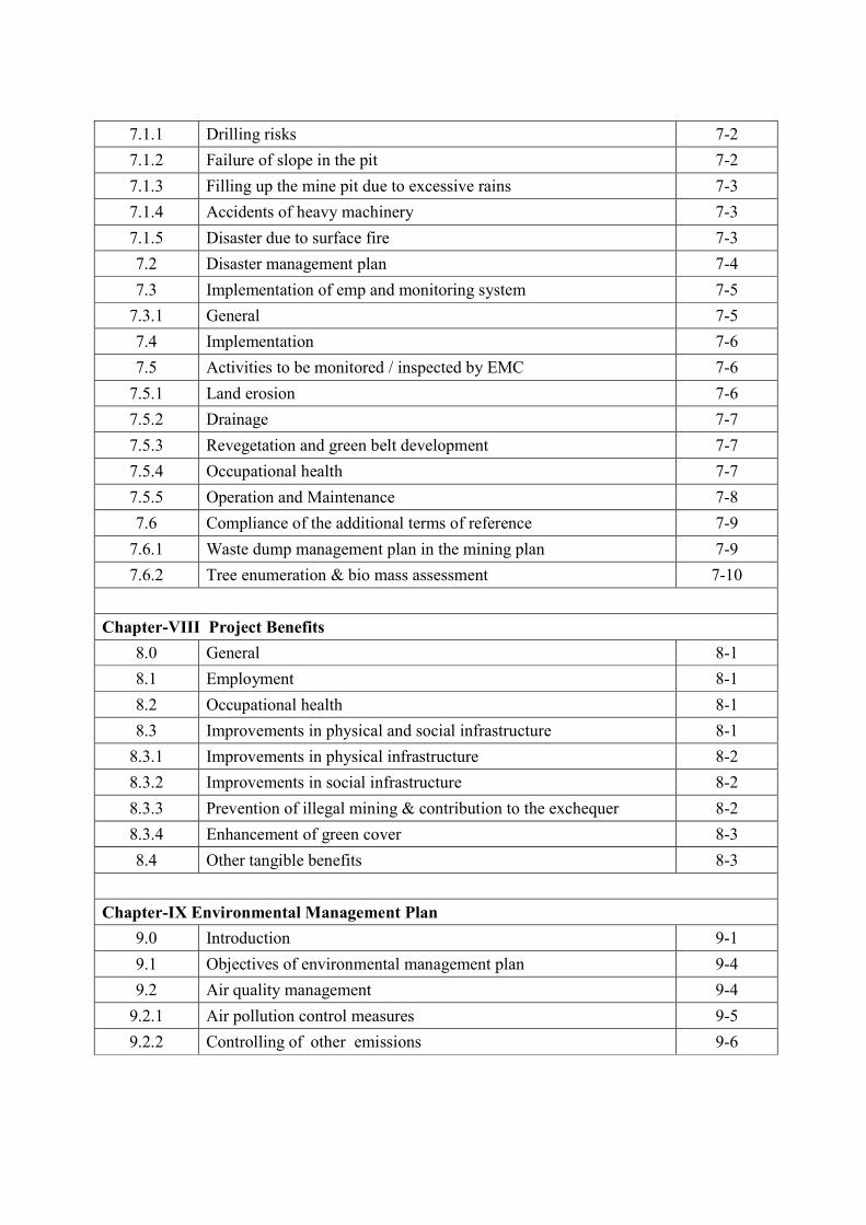
7.1.1 Drilling risks 7-2
7.1.2 Failure of slope in the pit 7-2
7.1.3 Filling up the mine pit due to excessive rains 7-3
7.1.4 Accidents of heavy machinery 7-3
7.1.5 Disaster due to surface fire 7-3
7.2 Disaster management plan 7-4
7.3 Implementation of emp and monitoring system 7-5
7.3.1 General 7-5
7.4 Implementation 7-6
7.5 Activities to be monitored / inspected by EMC 7-6
7.5.1 Land erosion 7-6
7.5.2 Drainage 7-7
7.5.3 Revegetation and green belt development 7-7
7.5.4 Occupational health 7-7
7.5.5 Operation and Maintenance 7-8
7.6 Compliance of the additional terms of reference 7-9
7.6.1 Waste dump management plan in the mining plan 7-9
7.6.2 Tree enumeration & bio mass assessment 7-10
Chapter-VIII Project Benefits
8.0 General 8-1
8.1 Employment 8-1
8.2 Occupational health 8-1
8.3 Improvements in physical and social infrastructure 8-1
8.3.1 Improvements in physical infrastructure 8-2
8.3.2 Improvements in social infrastructure 8-2
8.3.3 Prevention of illegal mining & contribution to the exchequer 8-2
8.3.4 Enhancement of green cover 8-3
8.4 Other tangible benefits 8-3
Chapter-IX Environmental Management Plan
9.0 Introduction 9-1
9.1 Objectives of environmental management plan 9-4
9.2 Air quality management 9-4
9.2.1 Air pollution control measures 9-5
9.2.2 Controlling of other emissions 9-6

9.3 Water quality management 9-6
9.4 Noise level monitoring 9-6
9.4.1 Parameters 9-7
9.4.2 Methodology 9-7
9.4.3 Noise quality management 9-7
9.4.4 Noise pollution control 9-7
9.5 Water consumption & waste water generation 9-8
9.6 Biological management 9-9
9.6.1 Tree plantation program 9-9
9.6.2 Biological Management Plan 9-9
9.6.3 Criteria for selection of species 9-9
9.6.4 Design of green development 9-10
9.7 Soil management 9-11
9.8 Land environment 9-11
9.8.1 Land use 9-11
9.8.2 Mine roads 9-11
9.8.3 Proposed mitigating measures 9-12
9.9 Socio-economic environment & safety 9-12
9.9.1 Occupational health and safety measures 9-13
9.9.2 Public health implication, occupational health survey program and first aid
9-14
9.10 Project cost 9-15
Chapter-X Summary & Conclusion
10.0 Summary and conclusions 10-1
10.1 Recommendation 10-1
Chapter-XI Disclosure of Consultants
11.0 Disclosure of NABET accredited organisation for EIA studies 11-1
11.1 About Sv Enviro Labs & Consultants (SVELC) 11-2
11.2 Services offered by Sv Enviro 11-2

LIST OF TABLES
TABLE NO. TITLE PAGE NO.
Chapter -I:- Introduction
1.1 Description of project proponent 1-2
Chapter -II :-Project Description
2.1 Details about the project area 2-2
2.2 Year wise production 2-10
2.3 Waste generation 2-12
2.4 Land Use details 2-13
2.5 Details of Machinery 2-14
2.6 Fresh Water Requirement & Wastewater generation 2-15
2.7 Employment details 2-16
Chapter -III:-Description Of The Environment
3.1 IMD Climatological Data (History) of Kalingapatnam from 1960-2000
3-3
3.2 Micro meteorological data at site 3-4
3.3 Techniques and Detectable limits for ambient air quality monitoring
3-8
3.4 Location of ambient air quality monitoring stations 3-8
3.5 Summary of Ambient Air Quality in the Study Area 3-10
3.6 Standard Operating Procedures (SOP) for water sampling 3-14
3.7 Analytical techniques for water analysis 3-15
3.8 Water sampling stations 3-16
3.9 Ground water quality results 3-19
3.10 Surface water quality of the study area 3-22
3.11 Analytical techniques for soil analysis 3-24
3.12 Soil Sampling Locations 3-25
3.13 Soil analysis results 3-27
3.14 Noise monitoring locations 3-31
3.15 Noise levels in the study area 3-33
3.16 Dynamic Ground water Resources - Nandigam 3-42
3.17 Land use land cover statistics of buffer zone 3-52
3.18 Details of the forest blocks in the study area 3-55
3.19 Mode of data collection and parameters considered during the 3-57

survey
3.20 List of plant species observed in core area of the project 3-58
3.21 List of plant species observed in buffer area of the project 3-65
3.22 List of wildlife found in the study area 3-79
3.23 List of Avian species found in and around proposed project 3-80
3.24 List of Reptiles found in and around the mining site 3-83
3.25 List of Amphibian species 3-83
3.26 List of butterflies 3-84
3.27 List of aquatic / semi aquatic macrophytes found in the study area
3-85
3.28 Freshwater Phytoplankton from the study area 3-86
3.29 Freshwater Zooplankton from the Study Area 3-86
3.30 Checklist of fishes in the study area 3-87
3.31 Demographical details as per 2011 census 3-93
3.32 Population details of the Nandigama Mandal 3-95
3.33 Number of government medical facilities (allopathic) available
during 2009-2010 year
3-102
Chapter -IV:-Anticipated Environmental Impacts & Mitigation Measures
4.1 Expected Nature of Impacts 4-1
4.2 Identified/Predicted Environmental Impacts with & without Mitigation Measures
4-2
4.3 Noise impact 4-15
4.4 Details of proposed plantation 4-17
4.5 Selected lists of plant species for Greenbelt development 4-19
4.6 Surrounging villages with their population 4-21
Chapter -VI:- Environmental Monitoring Programme
6.1 Monitoring Schedule for Environmental Parameters 6-3
6.2 Implementation Schedule 6-3
Chapter-VII Additional Studies
7.1 List of total trees enumerated in the proposed mine 7-15
7.2 List of dominant families with reference to species number 7-17
7.3 Biodiversity parameters of tree species enumerated in the mine 7-18
7.4 Importance Value Index (IVI) of tree species in the Ch. Sridhar mine
7-20

7.5 Species wise contribution of biomass in the mine lease area 7-28
Chapter -IX:- Environmental Management Plan
9.1 EMP costing for the proposed project 9-2
9.2 Ambient Air Quality Standards 9-5
9.3 Air Pollution Control Measures 9-5
LIST OF FIGURES
FIGURE NO. TITLE PAGE NO.
Chapter -I:- Introduction
1.1 Location of Sri Chimaladinne Sridhar 1-5
Chapter -II :-Project Description
2.1 Google map (10 km radius) 2-4
2.2 Topomap of Project site with 10 km radius 2-5
2.3 Geological plan the project site 2-7
2.4 Five year production plan and sections 2-10
Chapter -III:-Description of the Environment
3.1 Wind rose diagram for the month of October 2021 to December 2021
3-6
3.2 Location Ambient Air Quality Stations 3-9
3.3 Water sampling locations 3-18
3.4 Soil sampling locations 3-26
3.5 Noise monitoring locations 3-32
3.6 Geology map of the Srikakulam district 3-37
3.7 Geomorpholgy of the Srikakulam District 3-37
3.8 Hydrogeology of the Srikakulam district 3-38
3.9 Depth of water level Pre-monsoon in Srikakulam district 3-41
3.10 Depth of water level Post – Monsoon in Srikakulam district 3-41
3.11 Flow chart of methodolgy 3-44
3.12 Satellite image within the 10 km radius 3-47
3.13 Contour levels within the 10 km radius 3-48
3.14 Digital Elevation Map 3-49

3.15 The map showing river order within the 10 km radius 3-50
3.16 The map showing Land use and Land Cover within the 10 km radius
3-51
3.17 Graphical Presentation of Land Use Statistics 3-53
Chapter-VII Additional Studies
7.1 Organizational setup of EMC 7-5
7.2 Location of the study area 7-11
7.3 Floristic survey and quantitative assessment of plant resources of Ch. Sridhar mine
7-13
7.4 Girth class distribution of density and basal area in the study area
7-23
7.5 Raunkiaer’s frequency classes 7-24
Chapter -IX:- Environmental Management Plan
9.1 Water balance 9-8
Chapter –XII: - Disclosure of Consultants
11.1 NABET Certificate 11-3
11.2 NABET validity extension 11-4
ANNEXURES
Annexure -I ToR Copy
Annexure -II Mining plan & Drawings
Annexure -III Cluster Letter and cluster Map
Annexure -IV Cluster EMP

APPROVED TERMS OF REFERENCE COMPLIANCE
ToR Lr. No: SEIAA/AP/SKM/MIN/12/2020/2641-267 Dated: 07.07.2021
S. No Standard Terms Of Reference TOR Compliance/Section No.
1 Year wise production details since 1994
should be given, clearly stating the highest
production achieved in any one year prior to
1994. It may also be categorically informed
whether there had been any increase in
production after EIA Notification 1994 came
into force, w.r.t the highest production
achieved prior to 1994.
The Director of Mines & Geology
after careful examination had
granted a quarry lease for Colour
Granite over an extent of 14.54 Ha.,
in Sy. No. 1 of Bellukola Village,
Nandigama Mandal, Srikakulam
District in favour of Sri
Chimaladinne Sridhar vide Notice
No: 1279/D1-2/2020, Dated:
03.11.2020 for a period of 20
years.
2 A copy of the document in support of the fact
that the Proponent is the rightful lessee of the
mine should be given.
The rightful lessee of the mine is
Chimaladinne Sridhar vide Notice
No: 1279/D1-2/2020, Dated:
03.11.2020 and mine lease
document is available in the
approved mining plan attached as
Annexure – I.
3 All documents including approved mine plan,
EIA and Public Hearing should be compatible
with one another in terms of the mine lease
area, production levels, waste generation and
its management, mining technology etc. and
should be in the name of the lessee.
While preparing EIA it has been
ensured that all the documents
including approved mining plan,
EIA are compatible with one
another in terms of the mine lease
area, production levels, waste
generation and its management,
mining technology etc and are in the
name of Sri Chimaladinne Sridhar.

4 All corner coordinates of the mine lease area,
superimposed on a High Resolution Imagery/
toposheet, topographic sheet, geomorphology
and geology of the area should be provided.
Such an Imagery of the proposed area should
clearly show the land use and other ecological
features of the study area (core and buffer
zone).
All the corner coordinates of mine
lease are has been
marked/superimposed on topo
sheet.
10 km radius Topo map of 1:50,000
scale of the mine lease area is given
in Chapter II; Fig. 2.2.
Corner co-ordinates are
superimposed on High resolution
Google earth imagery is given in
Chapter-II under Fig 2.1.
5 Information should be provided in Survey of
India Topo sheet in 1:50,000 scale indicating
geological map of the area, geomorphology of
land forms of the area, existing minerals and
mining history of the area, important water
bodies, streams and rivers and soil
characteristics.
Required topo sheet is provided at
Fig:-2.2 in Chapter-II.
Important water bodies, streams,
rivers are shown in topo sheet
which is provided by Survey of
India.
6 Details about the land proposed for mining
activities should be given with information as
to whether mining conforms to the land use
policy of the State; land diversion for mining
should have approval from State land use
board or the concerned authority.
The Director of Mines & Geology
after careful examination had
granted a quarry lease for Colour
Granite over an extent of 14.54 Ha.,
in Sy. No. 1 of Bellukola Village,
Nandigama Mandal, Srikakulam
District in favour of Sri
Chimaladinne Sridhar. Notice No:
1279/D1-2/2020, Dated: 03.11.2020
for a period of 20 years.
Land diversion is not applicable.
7 It should be clearly stated whether the The project proponent is committed

proponent Company has a well laid down
Environment Policy approved by its Board of
Directors? If so, it may be spelt out in the EIA
Report with description of the prescribed
operating process/procedures to bring into
focus any infringement/deviation/ violation of
the environmental or forest norms/
conditions? The hierarchical system or
administrative order of the Company to deal
with the environmental issues and for
ensuring compliance with the EC conditions
may also be given. The system of reporting of
non compliances / violations of environmental
norms to the Board of Directors of the
Company and/or shareholders or stakeholders
at large, may also be detailed in the EIA
Report.
to environmental safeguard and
sustainable development.
Environmental Monitoring Cell
shall be established for reporting
environmental issues. The
Environmental policy is as follows:
Prevent Environmental
pollution by continual
improvement in environmental
performance of the
Environmental Management
Plan.
Comply with all the
environmental legislations,
regulations under the EIA
Notification 2006 & subsequent
amendments.
Promote environmental
awareness amongst employees,
local communities and
interested parties through
proactive communication and
training.
Training to employees in terms of
Safety, Health & Environment
through Mining association &
Authorized Agency.
8. Issues relating to Mine Safety, including
subsidence study in case of underground
mining and slope study in case of open cast
mining, blasting study etc. should be detailed.
The proposed safeguard measures in each
The method of mining is open cast
semi mechanised.
Subsidence study is not applicable
as the mine is not underground

case should also be provided. mining.
Mining will be done during non-
rainy period.
Safety measures:
The working pits will be
under vigilance during the
working and non working
hours.
Detailed occupational health and
safety is mentioned at Chapter -IV
under section: 4.8.
9. The study area will comprise of 10 km zone
around the mine lease from lease periphery
and the data contained in the EIA such as
waste generation etc. should be for the life of
the mine lease period.
About 45790 m3 of Granite waste
will be generated every year and
228950.40 m3 will be generated
during the ensuing five years
period. It will be dumped separately
in the earmarked yard within the
mine over an extent of 2.250 Ha.
Waste generated during the ensuing
scheme will be dumped in a single
step and the slopes will have angle
of repose so that no creep of waste
will take place. The detailed year
wise waste production is mentioned
in Chapter-II under section 2.7.
10 Land use of the study area delineating forest
area, agricultural land, grazing land, wildlife
sanctuary, national park, migratory routes of
fauna, water bodies, human settlements and
other ecological features should be indicated.
Land use plan of the mine lease area should
Land use/Land cover is exclusively
detailed in section 3.10 of Chapter-
III.
Impacts on Land Use are mentioned
in section 4.3 of Chapter-IV.

be prepared to encompass preoperational,
operational and post operational phases and
submitted. Impact, if any, of change of land
use should be given.
11. Details of the land for any Over Burden
Dumps outside the mine lease, such as extent
of land area, distance from mine lease, its land
use, R&R issues, if any, should be given.
About 45790 m3 of Granite waste
will be generated every year and
228950.40 m3 will be generated
during the ensuing five years
period. It will be dumped separately
in the earmarked yard within the
mine over an extent of 2.250 Ha.
Waste generated during the ensuing
scheme will be dumped in a single
step and the slopes will have angle
of repose so that no creep of waste
will take place.
No R&R issues are anticipated for
this mine.
12 A Certificate from the Competent Authority
in the State Forest Department should be
provided, confirming the involvement of
forest land, if any, in the project area. In the
event of any contrary claim by the Project
Proponent regarding the status of forests, the
site may be inspected by the State Forest
Department along with the Regional Office of
the Ministry to ascertain the status of forests,
based on which, the Certificate in this regard
as mentioned above be issued. In all such
cases, it would be desirable for representative
of the State Forest Department to assist the
There is no involvement of forest
land in the mine area, hence not
applicable.

Expert Appraisal Committees.
13 Status of forestry clearance for the broken up
area and virgin forestland involved in the
Project including deposition of net present
value (NPV) and compensatory Afforestation
(CA) should be indicated. A copy of the
forestry clearance should also be furnished.
Not Applicable.
14 Implementation status of recognition of forest
rights under the Scheduled Tribes and other
Traditional Forest Dwellers (Recognition of
Forest Rights) Act, 2006 should be indicated.
Not Applicable.
15 The vegetation in the RF / PF areas in the
study area, with necessary details, should be
given.
Flora studies conducted in the core
and buffer zones and are covered in
Chapter-III under section-3.11.
16 A study shall be got done to ascertain the
impact of the Mining Project on wildlife of
the study area and details furnished. Impact of
the project on the wildlife in the surrounding
and any other protected area and accordingly,
detailed mitigative measures required, should
be worked out with cost implications and
submitted.
Fauna studies conducted in the core
and buffer zone is covered in
Chapter-III under section-3.11.
Mitigation measures on the
biological environment are covered
in Chapter-IX.
17 Location of National Parks, Sanctuaries,
Biosphere Reserves, Wildlife Corridors,
Ramsar site Tiger/Elephant Reserves/(existing
as well as proposed), if any, within 10 km of
the mine lease should be clearly indicated,
supported by a location map duly
authenticated by Chief Wildlife Warden.
Necessary clearance, as may be applicable to
such projects due to proximity of the
No National Parks, Wildlife
Sanctuaries, Tiger/Elephant
Reserves exist in the core or buffer
zone of the lease area.

ecologically sensitive areas as mentioned
above, should be obtained from the Standing
Committee of National Board of Wildlife and
copy furnished.
18 A detailed biological study of the study area
[core zone and buffer zone (10 km radius of
the periphery of the mine lease)] shall be
carried out. Details of flora and fauna,
endangered, endemic and RET Species duly
authenticated, separately for core and buffer
zone should be furnished based on such
primary field survey, clearly indicating the
Schedule of the fauna present. In case of any
scheduled-I fauna found in the study area, the
necessary plan along with budgetary
provisions for their conservation should be
prepared in consultation with State Forest and
Wildlife Department and details furnished.
Necessary allocation of funds for
implementing the same should be made as
part of the project cost.
Biological study is covered in
Chapter-III under section-3.11.
Tabular data of the species also
mentioned in section 3.11 in
Chapter-III.
19 Proximity to Areas declared as 'Critically
Polluted' or the Project areas likely to come
under the 'Aravali Range', (attracting court
restrictions for mining operations), should
also be indicated and where so required,
clearance certifications from the prescribed
Authorities, such as the SPCB or State Mining
Department should be secured and furnished
to the effect that the proposed mining
activities could be considered.
No critically polluted areas come
under the core zone or buffer zone
of the lease area.
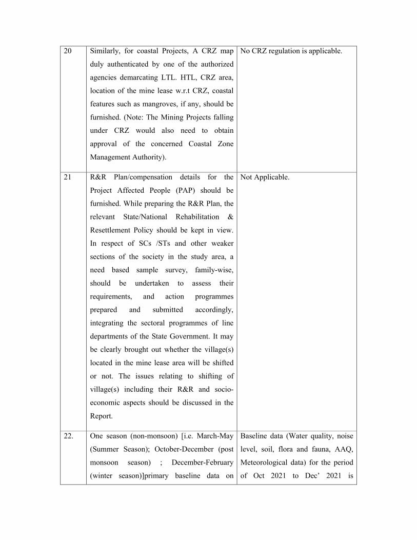
20 Similarly, for coastal Projects, A CRZ map
duly authenticated by one of the authorized
agencies demarcating LTL. HTL, CRZ area,
location of the mine lease w.r.t CRZ, coastal
features such as mangroves, if any, should be
furnished. (Note: The Mining Projects falling
under CRZ would also need to obtain
approval of the concerned Coastal Zone
Management Authority).
No CRZ regulation is applicable.
21 R&R Plan/compensation details for the
Project Affected People (PAP) should be
furnished. While preparing the R&R Plan, the
relevant State/National Rehabilitation &
Resettlement Policy should be kept in view.
In respect of SCs /STs and other weaker
sections of the society in the study area, a
need based sample survey, family-wise,
should be undertaken to assess their
requirements, and action programmes
prepared and submitted accordingly,
integrating the sectoral programmes of line
departments of the State Government. It may
be clearly brought out whether the village(s)
located in the mine lease area will be shifted
or not. The issues relating to shifting of
village(s) including their R&R and socio-
economic aspects should be discussed in the
Report.
Not Applicable.
22. One season (non-monsoon) [i.e. March-May
(Summer Season); October-December (post
monsoon season) ; December-February
(winter season)]primary baseline data on
Baseline data (Water quality, noise
level, soil, flora and fauna, AAQ,
Meteorological data) for the period
of Oct 2021 to Dec’ 2021 is

ambient air quality as per CPCB Notification
of 2009, water quality, noise level, soil and
flora and fauna shall be collected and the
AAQ and other data so compiled presented
date-wise in the EIA and EMP Report. Site-
specific meteorological data should also be
collected. The location of the monitoring
stations should be such as to represent whole
of the study area and justified keeping in view
the pre-dominant downwind direction and
location of sensitive receptors. There should
be at least one monitoring station within 500
m of the mine lease in the predominant
downwind direction. The mineralogical
composition of PM10, particularly for free
silica, should be given.
collected within the study area and
same is elaborated in chapter -III.
23. Air quality modelling should be carried out
for prediction of impact of the project on the
air quality of the area. It should also take into
account the impact of movement of vehicles
for transportation of mineral. The details of
the model used and input parameters used for
modelling should be provided. The air quality
contours may be shown on a location map
clearly indicating the location of the site,
location of sensitive receptors, if any, and the
habitation. The wind roses showing
predominant wind direction may also be
indicated on the map.
Detailed air quality for prediction of
impacts is elaborated in Chapter –
IV under section: 4.1.
There are no point sources proposed
in the mine lease area.
Vehicular movement will be
restricted in terms of speed, hence
the fugitive emissions will be
localised.
The wind rose is shown in chapter -
III under Fig no: 3.1.
24 The water requirement for the Project, its
availability and source should be furnished. A
detailed water balance should also be
The total water requirement for
mine expansion is 14.0 KLD and
will be met through water tankers

provided. Fresh water requirement for the
project should be indicated.
from surrounding villages. Detailed
water balance is mentioned in
Chapter -IX under Fig 9.1
25. Necessary clearance from the Competent
Authority for drawl of requisite quantity of
water for the project should be provided.
As we are not drawing any ground
water, hence clearance from ground
water board is not applicable.
26. Description of water conservation measures
proposed to be adopted in the project should
be given. Details of rainwater harvesting
proposed in the project, if any, should be
provided.
Water conservation measures are
mentioned under section-9.3 in
Chapter-IX.
Rain water Harvesting is covered
under section 4.2.2 in Chapter-IV.
27 Impact of the Project on the water quality,
both surface and groundwater, should be
assessed and necessary safeguard measures, if
any required, should be provided.
Impacts on water quality are tabled
in Chapter-IV under Table-4.2 and
safeguard measures are covered
under section 4.2.
28. Based on actual monitored data, it may clearly
be shown whether working will intersect
groundwater. Necessary data and
documentation in this regard may be
provided. In case the working will intersect
groundwater table, a detailed Hydro
Geological Study should be undertaken and
Report furnished. The Report inter-alia, shall
include details of the aquifers present and
impact of mining activities on these aquifers.
Necessary permission from Central Ground
Water Authority for working below ground
water and for pumping of ground water
should also be obtained and copy furnished.
The mine workings will not
intersect ground water as per
Approved Mining Plan.
29 Details of any stream, seasonal or otherwise, There are no streams or other

passing through the lease area and
modification / diversion proposed, if any, and
the impact of the same on the hydrology
should be brought out.
natural water courses existing in this
mine.
30 Information on site elevation, working depth,
groundwater table etc. Should be provided
both in AMSL and bgl. A schematic diagram
may also be provided for the same.
Site elevation is 139 m AMSL, The
water table is located at a depth of
about 50-60m from the ground
level. The mine workings will not
reach the ground water table depth
as per approved mining plan.
31 A time bound Progressive Greenbelt
Development Plan shall be prepared in a
tabular form (indicating the linear and
quantitative coverage, plant species and time
frame) and submitted, keeping in mind, the
same will have to be executed up front on
commencement of the Project. Phase-wise
plan of plantation and compensatory
afforestation should be charted clearly
indicating the area to be covered under
plantation and the species to be planted. The
details of plantation already done should be
given. The plant species selected for green
belt should have greater ecological value and
should be of good utility value to the local
population with emphasis on local and native
species and the species which are tolerant to
pollution.
Year-wise Green belt development
schedule is depicted in section 4.5
in Chapter-IV.
Schedule of species for plantation is
also shown in Table 4.4 in chapter-
IV.
32. Impact on local transport infrastructure due to
the Project should be indicated. Projected
increase in truck traffic as a result of the
Project in the present road network (including
Traffic analysis has been done in
section 4.6 in chapter-IV.
those outside the Project area) should be
worked out, indicating whether it is capable of
handling the incremental load. Arrangement
for improving the infrastructure, if
contemplated (including action to be taken by
other agencies such as State Government)
should be covered. Project Proponent shall
conduct Impact of Transportation study as per
Indian Road Congress Guidelines.
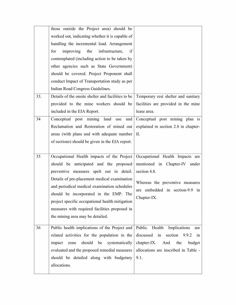
33. Details of the onsite shelter and facilities to be
provided to the mine workers should be
included in the EIA Report.
Temporary rest shelter and sanitary
facilities are provided in the mine
lease area.
34 Conceptual post mining land use and
Reclamation and Restoration of mined out
areas (with plans and with adequate number
of sections) should be given in the EIA report.
Conceptual post mining plan is
explained in section 2.8 in chapter-
II.
35 Occupational Health impacts of the Project
should be anticipated and the proposed
preventive measures spelt out in detail.
Details of pre-placement medical examination
and periodical medical examination schedules
should be incorporated in the EMP. The
project specific occupational health mitigation
measures with required facilities proposed in
the mining area may be detailed.
Occupational Health Impacts are
mentioned in Chapter-IV under
section 4.8.
Whereas the preventive measures
are embedded in section-9.9 in
Chapter-IX.
36 Public health implications of the Project and
related activities for the population in the
impact zone should be systematically
evaluated and the proposed remedial measures
should be detailed along with budgetary
allocations.
Public Health Implications are
discussed in section 9.9.2 in
chapter-IX. And the budget
allocations are inscribed in Table -
9.1.

37 Measures of socio economic significance and
influence to the local community proposed to
be provided by the Project Proponent should
be indicated. As far as possible, quantitative
dimensions may be given with time frames for
implementation.
Measures on socio-economic
conditions are mentioned in chapter
-IV under section 4.7.
38 Detailed environmental management plan
(EMP) to mitigate the environmental impacts
which, should inter-alia include the impacts of
change of land use, loss of agricultural and
grazing land, if any, occupational health
impacts besides other impacts specific to the
proposed Project.
Detailed Environmental
Management Plan and cost
implication for EMP is mentioned
in Chapter -IX.
39 Public Hearing points raised and commitment
of the Project Proponent on the same along
with time bound Action Plan with budgetary
provisions to implement the same should be
provided and also incorporated in the final
EIA/EMP Report of the Project.
The Draft EIA is being submitting
for conducting public hearing. Final
EIA report will be submitted along
with public hearing points after
conducting public hearing.
40 Details of litigation pending against the
project, if any, with direction /order passed by
any Court of Law against the Project should
be given.
No litigations pending against the
project.
41 The cost of the Project (capital cost and
recurring cost) as well as the cost towards
implementation of EMP should be clearly
spelt out.
Total project cost is Rs. 65.0 lakhs
EMP BUDGET
Capital Cost : 8.5 Lakhs
Recurring cost per annum : 7.3
Lakhs
Detailed EMP budget is given in
Chapter IX

42 A Disaster management Plan shall be
prepared and included in the EIA/EMP
Report.
DMP is covered in section 7.2 in
chapter-VII.
43 Benefits of the Project if the Project is
implemented should be spelt out. The benefits
of the Project shall clearly indicate
environmental, social, economic, employment
potential, etc.
Project Benefits is covered in
Chapter-VIII.
Additional TOR
S. No Additional Terms Of Reference TOR Compliance/Section No.
1 Waste Dump Management Plan in the Mining
plan.
2 Tree Enumeration & Bio mass assessment.

SRI CHIMALADINNE SRIDHAR – 14.54 Ha EXECUTIVE SUMMARY
1
EXECUTIVE SUMMARY
OF
SRI CHIMALADINNE SRIDHAR (MINING OF COLOUR GRANITE-Srikakulam Blue)
Lessee, Chimaladinnee Sridhar, Address: SS Grandeur
Plot no: 5, 6,7,8,9 & 10, Phase -5, KPHB Colony, Hyderabad
Site Address
Extent: 14.54 Ha Sy. No. 1, Bellukola (V)
Nandigama (M), Srikakulam District, Andhra Pradesh
Production capacity Colour Granite – 12180 m3 per Annum
Baseline data collected: October’ 2021 to December’ 2021 Sector: 01 – Mining of minerals, Cat –B1
Approved ToR Lr. No: SEIAA/AP/SKM/MIN/12/2020/2641-267 Dt: 07.07.2021
PREPARED BY
H.O: Block-B, B-1, IDA, Autonagar -12, Visakhapatnam
Ph: 0891-2755528, Fax: 0891-2755529, E-mail: [email protected]
Ph: 9440338628
QCI NABET & NABL Accredited & Recognized by MOE&F, New Delhi.
Feb’
2022

SRI CHIMALADINNE SRIDHAR – 14.54 Ha EXECUTIVE SUMMARY
2
1.0 INTRODUCTION
Sri Chimaladinne Sridhar, Lessee has filed an application for grant of Colour
Granite (Srikakulam Blue) quarry over an extent of 21.77 Hectares in Sy.No.01 of
Bellukola Village, Nandigama Mandal, Srikakulam District, Andhra Pradesh.
The Assistant Director of Mines & Geology, Tekkali submitted proposals for grant of
quarry lease in favour of Sri Chimaladinne Sridhar for an extent of 14.54 Hectares in
Sy. No.1 of Bellukola Village, Nandigama Mandal, Srikakulam District vide proposal
in File No: 1889/Q/2014, dt.15.02.2020.
After careful examination of the proposals of the Assistant Director of Mines &
Geology, Tekkali, The Director of Mines & Geology, Ibrahimpatnam has agreed for
grant of Quarry lease for a period of 20 years in favour of Sri Chimaladinne Sridhar
over an extent of 14.54 Hectares in Sy.No.01 of Bellukola Village, Nandigama
Mandal, Srikakulam District vide Notice No: 1279/D1-2/2020, Dated: 03.11.2020
The Mining plan was approved by DDM&G, Srikakulam vide Letter No: 1318/MP-
TKL/2020, dated: 01.12.2020.
In order to fulfill the further necessary requirements for obtaining the Environmental
Clearance for this mining activity, the proponent has initiated steps to carryout
required Environmental Impact Assessment (EIA) study in and around the mine lease
area.
This assessment is performed to identify the likely Environmental Impacts and based
on the findings; an effective Environmental Management Plan is in place as per the
EIA Notification 2006 general guidelines and the revised Model TOR outlined for
Mining projects.
The standards set by the Central Pollution Control Board (CPCB) and the State
Pollution Control Board (SPCB) will be met and adhered to.
This study covers an area surrounding the project site with a radial distance of 10 km
from the mining lease area. The baseline monitoring was carried out during the Period
of October’ 2021 to December’ 2021.

SRI CHIMALADINNE SRIDHAR – 14.54 Ha EXECUTIVE SUMMARY
3
1.1 SALIENT FEATURES OF THE PROJECT SITE
Details about Project site
Nature of the project Sri Chimaladinne Sridhar
Mining of Colour Granite (Srikakulam Blue)
Size of the Project Maximum Production:
Colour Granite – 12180 m3/Annum
LOCATION OF PROJECT
District & State Srikakulam District, Andhra Pradesh
Village & Mandal Bellukola Village & Nandigama Mandal
Land Availability 14.54 Ha.
Nearest Village Nilapuram Village at a distance of 0.35 km.
Ownership Government land
Toposheet No. 74 B/6
GENERAL CLIMATIC CONDITIONS
Annual rainfall 1027 mm
Min and max temp. 17.5 C to 34 C
Predominant wind direction SE to SW and E to W
GENERAL LOCATION DETAILS
Nearest human settlement Nilapuram Village at a distance of 0.35 km.
Nearest town Nandigam at a distance of 5.92 km
Nearest railway station/Airport Tekkali Railway Station at 9.16 km
Archaeological /Historically Important Site
No historical monuments exist in and around the
mine lease area.
Infrastructure Facilities Hospitals, schools and community facilities are
available at Nandigam Mandal and nearby
villages.
Sanctuaries / National parks None within 10 km radius of the site
Reserve Forests/Protected Forests Pedda Kedari R.F-2.69Km-W
Jadupalli R.F-5.45km-NW
Banapuram R.F – 6.94Km NE
Water bodies One first order stream passing through the buffer
zone of the lease area in West.
Seasonal Pond – 1.54 km SW

SRI CHIMALADINNE SRIDHAR – 14.54 Ha EXECUTIVE SUMMARY
4
Seasonal Pond – 2.01 km N
Seasonal Pond – 2.20 km N
Seasonal Pond – 2.12 km E
Gotta Barrage Left Main Canal – 2.78 km SE
Sitagal Cheruvu – 5.06 km SE
Mahendra Tananaya River – 4.36 km NW
Balancing Reservoir – 7.69 km SW

SRI CHIMALADINNE SRIDHAR – 14.54 Ha EXECUTIVE SUMMARY
5
Topo Map (10 km radius
SRI CHIMALADINNE SRIDHAR – 14.54 Ha EXECUTIVE SUMMARY
6
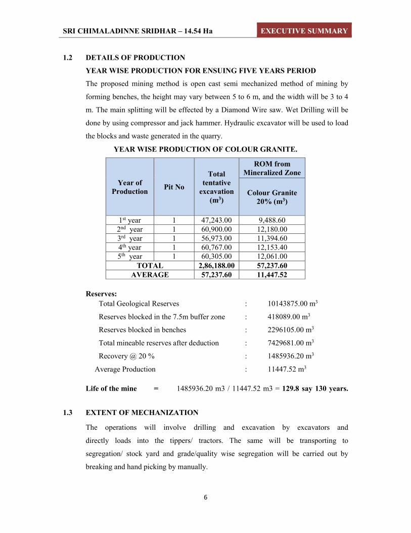
1.2 DETAILS OF PRODUCTION
YEAR WISE PRODUCTION FOR ENSUING FIVE YEARS PERIOD
The proposed mining method is open cast semi mechanized method of mining by
forming benches, the height may vary between 5 to 6 m, and the width will be 3 to 4
m. The main splitting will be effected by a Diamond Wire saw. Wet Drilling will be
done by using compressor and jack hammer. Hydraulic excavator will be used to load
the blocks and waste generated in the quarry.
YEAR WISE PRODUCTION OF COLOUR GRANITE.
Year of Production
Pit No
Total tentative
excavation (m3)
ROM from Mineralized Zone
Colour Granite 20% (m3)
1st year 1 47,243.00 9,488.60 2nd year 1 60,900.00 12,180.00 3rd year 1 56,973.00 11,394.60 4th year 1 60,767.00 12,153.40 5th year 1 60,305.00 12,061.00
TOTAL 2,86,188.00 57,237.60 AVERAGE 57,237.60 11,447.52
Reserves:
Total Geological Reserves : 10143875.00 m3
Reserves blocked in the 7.5m buffer zone : 418089.00 m3
Reserves blocked in benches : 2296105.00 m3
Total mineable reserves after deduction : 7429681.00 m3
Recovery @ 20 % : 1485936.20 m3
Average Production : 11447.52 m3
Life of the mine = 1485936.20 m3 / 11447.52 m3 = 129.8 say 130 years.
1.3 EXTENT OF MECHANIZATION
The operations will involve drilling and excavation by excavators and
directly loads into the tippers/ tractors. The same will be transporting to
segregation/ stock yard and grade/quality wise segregation will be carried out by
breaking and hand picking by manually.

SRI CHIMALADINNE SRIDHAR – 14.54 Ha EXECUTIVE SUMMARY
7
Mining Machinery
S. No Extent of Mechanization
1 Excavators (Hire) 2
2 Compressor (Hire) 2
3 Jack Hammers 5
4 Tippers (Hire) 2
5 Diamond Wire Saw
Machines (Mortar Driven)
2
6 Water tanker/Tractor 1
1.5 PROPOSED MANPOWER
By this project many people will be benefited for their livelihood and get employment
in this remote area.
Employment Details
S. No Category No. of Persons
1. Mines Manager 1
2. Site Supervisor 2
3. Excavator Operators 3
4. Tipper Operators 2
5. Compressor Operators 2
6. Wire Saw Operators 5
7. Skilled Workers 5
8. Unskilled Workers 10
9. Drivers 2
10. Watchman 1
TOTAL 33
1.6 WATER SUPPLY
Around 14.0 KLD of water will be required for the mining activity. Water
requirement will be met through water tankers. Water is required in the mine for
spraying on the roads and working faces to suppress the dust and also for use in the
garage. Also a small quantity of drinking water is required.

SRI CHIMALADINNE SRIDHAR – 14.54 Ha EXECUTIVE SUMMARY
8
1.7 BASELINE DATA
The study area covers an area of 10km radius around the mining site. The study
includes detailed characterization of various Environmental components such as Air,
Water, noise, Land and Socio-Economic within the study area.
OBJECTIVES OF STUDY AREA
To assess the existing base line data of Air, Water, Noise, Land and Socio-
economic environment.
To evaluate the beneficial and adverse impacts of the mining activity.
To prepare an Environmental Management Plan (EMP) detailing control
technologies and measures to be adopted for minimizing the impacts and
improving the Environmental Quality.
To predict the incremental levels of pollutants in the study area due to the
mining activity.
To prepare post mining programme for monitoring and regulating
Environmental parameters.
1.7.1 ENVIRONMENTAL SETTINGS:
Air Environment:
To know the existing ambient air quality, Eight sampling stations with in Core and
buffer zone were identified and monitored for pollutants like, Particulate Matter – 10
(PM10), Particulate Matter – 2.5 (PM2.5), SO2, NOx and Free silica. For this sampling
calibrated through samplers of PM2.5 & PM10 dust samplers.
The Ambient air quality measured at mine site and surrounding stations with in the
study zone showed the following maximum and minimum concentrations of the
pollutants-
It may be seen that all the parameters i.e., PM 10, PM 2.5, SO2 and NOx, Free silica are
well within the range of 24 hr average of National Ambient Air Quality Standards.
1.7.2 Noise Pollution:
The Ambient noise levels monitored within the study area show levels varied from
43.8 to 53.5 Leq dB (A) during day time and 36.6 to 43.8Leq dB (A) during night
time.

SRI CHIMALADINNE SRIDHAR – 14.54 Ha EXECUTIVE SUMMARY
9
1.7.3 Water Environment:
Ground water samples are collected from eight locations and surface water from four
locations. All these samples are free from colour and pollutants.
Summary of Ground water:
The pH limit fixed for drinking water samples as per IS: 10500 is 6.5 to 8.5.
During the study period, the pH of the groundwater was found varying
between 7.02 and 7.72. The pH values for all the samples collected in the study
area during study period were found to be within the acceptable limits.
The desirable limit for total dissolved solids as per IS: 10500 is 500 milligrams
per liter (mg/l) where as the permissible limits in absence of alternate source is
2000 mg/l. In groundwater samples collected from the study area, the total
dissolved solids (TDS) were found to be varying between 538 mg/l and 674
mg/l. The TDS of all the samples were below the permissible limit of 2000
mg/l.
The desirable limit for Chloride is 250 mg/l as per IS:10500 where as the
permissible limit of the same is 1,000 mg/l. The Chloride levels in the
groundwater samples collected in the study area were ranging from 96 – 147
mg/l.
The desirable limit as per IS:10500 for hardness is 300 mg/l where as the
permissible limit for the same is 600mg/l. In the groundwater samples
collected from the study area, the hardness was found to be varying from 168
mg/l to 230 mg/l.
Fluoride is the other important parameter, which has the desirable limit of 1
mg/l and permissible limit of 1.5 mg/l. However, the optimum content of
fluoride in the drinking water is 0.6 to 1.5 mg/l. In the groundwater samples of
study area the fluoride values were found to be within a range of 0.34 mg/l to
0.58 mg/l.
All the heavy metals in all samples were found to be below the permissible
limits.

SRI CHIMALADINNE SRIDHAR – 14.54 Ha EXECUTIVE SUMMARY
10
An overview of the results obtained reveals that none of parameters were found above
the permissible limits of IS: 10500 Drinking Water Standards.
Summary of surface water:
pH of the surface water collected was neutral with pH ranging from 7.42 -7.73.
TDS was found to be 85.8mg/l to 93.5mg/l. The tolerance limit of 1,500 mg/l as
per IS:2296
Total hardness was found to be 94 mg/l to 109 mg/l
Presence of Nitrate was recorded as 4.2 mg/l to 6.0mg/l
DO was observed as 5.8 mg/l to 6.3 mg/l
Total coliform in water was 240 MPN/100ml to 900 MPN/100ml The likely
source of bacteriological contamination was due to the proximity to residential
area
All the heavy metals were found to be within below detectable limits.
1.7.4 Land Environment:
Soil survey was carried out at 5 locations to assess the soil characteristics which
include both physical and chemical details. Based on the above results, the soils in the
region are average fertile enough for cultivation of crops.
Land Use Pattern:
The total mine lease area is about 14.54 Ha. During the ensuing scheme period, an
area of 5.071 Ha of land will be mined out during the plan period. The proponent is
maintaining a buffer zone with existing natural vegetation and the proponent will
develop green belt on either side of the approach road to the mine from to Village,
which is extending to a stretch of 1.0 kms with 1000 plants.
1.7.5 FLORA & FAUNA:
No endangered species are found in the study area. No schedule – I species are found
within 10km radius from the mine lease area.
1.7.6 SOCIO-ECONOMIC ENVIRONMENT:
The operation of the mining activity could result in elevation of living standards of the
people in nearby villages as it will generate work for the unemployed and further will
result in the upliftment of their socio-economic status. The Management of Sri

SRI CHIMALADINNE SRIDHAR – 14.54 Ha EXECUTIVE SUMMARY
11
Chimaladinne Sridhar colour Granite mine has proposed to give preference to local
people for recruitment of personal for mining operation. Therefore the impact on
socio-economic Environment could be beneficial.
1.8 RECLAMATION & REHABILITATION
Since it is envisaged that the quarry life is about 130 years, no back filling is proposed
during the lease period. At the end of mine life, the remaining pit after backfilling
with the stored mineral waste will be used as water harvesting structure. After
removal of mineral the benches below the surface level benches will be applied top
soil and develop grass and plantation. Pit will be used as water reservoir/ponds.
1.9 PROJECT SCHEDULE AND COST ESTIMATES
The total project cost is 65.0 Lakhs and for EMP, capital budget is 8.5 Lakhs and
recurring budget per annum is 7.3 Lakhs.
1.10 ENVIRONMENT MANAGEMENT PLAN
The Environment Management Plan envisaged for this mining activity is described
hereunder with a strong commitment to follow best environmental practices to reduce
the negative implication to make this project a sustainable development endeavor.
Environment Management Plan (EMP) is required to ensure sustainable development
in the study area of the Mine Lease Area.
Air Environment:
Mitigation measures proposed to maintain the air quality are as follows:
Regular water sprinkling to suppress the dust on haul roads, service roads and
mining face by truck mounted water tankers.
Grading of haul roads, service roads time to time, to remove the accumulated
dusty material will be done.
Development of Green belt all around Plant and along mining area boundary.
Periodical monitoring of air quality to take steps to control the pollutants.
Noise Environment
There will be intermittent noise levels due to vehicular movement and trucks loading.
However the impact of noise on the surrounding area is likely to be minimal and
appropriate mitigation measures will be adopted accordingly.

SRI CHIMALADINNE SRIDHAR – 14.54 Ha EXECUTIVE SUMMARY
12
Control Measures
The Management Plan for controlling noise pollution is envisaged as follows.
Selection of suitable machinery and equipment,
Proper mounting of equipment,
Providing noise insulation/padding wherever practicable and
Machinery will be fitted with properly designed noise acoustic silencers.
Proper maintenance and periodic lubrication of noise generating parts of the
machines.
Provision of thick plantation in and around the mine is planned in order to reduce
the noise and prevent it from reaching to surrounding habitation area.
Water Environment
There will not be any waste water generation except domestic waste water, therefore
no post waste water monitoring required.
Water Pollution Management
There are no seasonal streams and run-off in the core zone, however garland
channels and bunds would be constructed and maintained to collect rain water for
harvesting.
The mine pit water collected due to rains will be utilized for water spraying on
the haul roads and for watering plantation.
This water will be harvested for utilization in plantation watering, spraying on the
haulage roads and mineral and waste dumps.
1.11 SOCIO-ECONOMIC ENVIRONMENT AND SAFETY
The company management shall give preference to local people through both direct
and indirect employment.
It will provide ample opportunity to the locals to up-lift their living standards by
organizing events that propagate mutual benefits to all, such as health camps,
awareness campaigns, donations to poorer sections of society and downtrodden.
Educational needs of the region will be improved by encouraging the workers to
allow their children to attend schools.
Sufficient funds shall be allocated for these and other emergency needs.
Adequate supply of potable water to the workers will be made during the working
hrs.

SRI CHIMALADINNE SRIDHAR – 14.54 Ha EXECUTIVE SUMMARY
13
The mines department will supervise the safe working of the contractor and their
employees. The working personnel will be provided with face masks, ear plugs,
safety helmets and goggles in order to reduce health hazards.
The proponent will provide all necessary provisions stipulated under the Mines Act.
In addition a Safety committee will be formed and manned by equal participants from
Management and Workers.
Personnel Protection Equipment (PPE) will be issued to each worker. Other safety
equipments shall be used according to the nature of job involved.
1.12 ENVIRONMENTAL MONITORING
Regular monitoring of various Environmental parameters shall be carried out to
ascertain the following points,
Status of air, noise, water, land pollution within the mining activity and in its
vicinity;
Generate data for predictive or corrective purpose in respect of environmental;
and
To assess and monitor Environmental impacts periodically.
1.13 SAFETY AND ENVIRONMENT
The management firmly believes in the concept of safety and environmentally
sustainable growth. The authorities and staff are very much concern in
Environmental issues.
The management is going to develop scientifically designed green belt around the
premises to mitigate air and noise pollution impacts on the surroundings.
The management proposed to monitor ambient air as per APPCB guidelines.
All the employees will be provided with personnel protective equipment
The management will provide safety training to all employees periodically and
regularly.
1.14 CONCLUSION
The management of Sri Chimaladinne Sridhar will committed to meet all stringent
norms and to safe guard environment.

CHAPTER – I
INTRODUCTION
DRAFT ENVIRONMENTAL IMPACT ASSESMENT REPORT FOR SRI CHIMALADINNE SRIDHAR – 14.54 Ha
CHAPTER-I INTRODUCTION
1-1
1.0 INTRODUCTION
1.1 PURPOSE OF THE REPORT
Sri Chimaladinne Sridhar has files an application for grant of colour granite located at
Survey No: 1, Bellukola (V), Nandigama (M), Srikakulam District, Andhra Pradesh in an
area of 14.54 Ha. The Assistant Director of Mines & Geology, Tekkali submitted
proposals for grant of quarry lease in favour of Sri Chimaladinne Sridhar for an extent of
14.54 Hectares in Sy. No.1 of Bellukola Village, Nandigama Mandal, Srikakulam District
vide proposal in File No: 1889/Q/2014, dt.15.02.2020.
After careful examination of the proposals of the Assistant Director of Mines & Geology,
Tekkali, The Director of Mines & Geology, Ibrahimpatnam has agreed for grant of
Quarry lease for a period of 20 years in favour of Sri Chimaladinne Sridhar over an
extent of 14.54 Hectares in Sy.No.01 of Bellukola Village, Nandigama Mandal,
Srikakulam District vide Notice No: 1279/D1-2/2020, Dated: 03.11.2020.
The Mining plan was approved by DDM&G, Srikakulam vide Letter No: 1318/MP-
TKL/2020, dated: 01.12.2020.
The present proposal is for obtaining EC for proposed fresh mine of Colour Granite
production for 12180 m3/Annum under Category B1 and the mining activity will be
carried out by opencast mechanized mining method by developing benches with drilling,
wire saw cutting and controlled blasting.
Presentation of TOR has been made before the SEAC, Andhra Pradesh committee and
the TOR has been issued by AP SEIAA vide order no: SEIAA/AP/SKLM/MIN/12/
2020/2641-267 Dt: 07.07.2021 attached as Annexure - I.
In order to fulfil the further necessary requirements for obtaining the Environmental
Clearance for this mining activity, the proponent has initiated steps to carryout required
Environmental Impact Assessment (EIA) study in and around the mine lease area.
This assessment is performed to identify the likely Environmental Impacts and based on
the findings an effective Environmental Management Plan is in place as per the EIA

DRAFT ENVIRONMENTAL IMPACT ASSESMENT REPORT FOR SRI CHIMALADINNE SRIDHAR – 14.54 Ha
CHAPTER-I INTRODUCTION
1-2
Notification 2006 general guidelines and the revised Model TOR outlined for Mining
projects and approved ToR’s. The standards set by the Central Pollution Control Board
(CPCB) and the State Pollution Control Board (SPCB) will be met and adhered to.
This study covers an area surrounding the mine area with a radial distance of 10km from
the mine lease. The baseline monitoring was carried out during the Period of Oct’ 2021 to
Dec’ 2021.
1.2 DETAILS OF THE PROJECT & IDENTIFICATION OF
PROJECT PROPONENT
Sri Chimaladinne Sridhar, is the applicant for this mining project
Table: 1.1 Description of Project Proponent
Address of the
lessee
Chimaladinne Sridhar ,
Lessee,
SS Grandeur,
Plot No. 5, 6, 7, 8, 9, and 10,
Phase – 5, KPHB Colony, Hyderabad,
Telangana– 500085.
Address of Mine Sri Chimaladinne Sridhar
Sy.No.1,
Bellukola Village,
Nandigam Mandal,
Srikakulam District,
Andhra Pradesh – 532201
1.3 BACKGROUND INFORMATION OF THE PROJECT
Sri Chimaladinne Sridhar, Lessee has filed an application for grant of Colour Granite
(Srikakulam Blue) quarry over an extent of 21.77 Hectares in Sy.No.01 of Bellukola
Village, Nandigama Mandal, Srikakulam District, Andhra Pradesh.

DRAFT ENVIRONMENTAL IMPACT ASSESMENT REPORT FOR SRI CHIMALADINNE SRIDHAR – 14.54 Ha
CHAPTER-I INTRODUCTION
1-3
The Assistant Director of Mines & Geology, Tekkali submitted proposals for grant of
quarry lease in favour of Sri Chimaladinne Sridhar for an extent of 14.54 Hectares in Sy.
No.1 of Bellukola Village, Nandigama Mandal, Srikakulam District vide proposal in File
No: 1889/Q/2014, dt.15.02.2020.
After careful examination of the proposals of the Assistant Director of Mines & Geology,
Tekkali, The Director of Mines & Geology, Ibrahimpatnam has agreed for grant of
Quarry lease for a period of 20 years in favour of Sri Chimaladinne Sridhar over an
extent of 14.54 Hectares in Sy.No.01 of Bellukola Village, Nandigama Mandal,
Srikakulam District vide Notice No: 1279/D1-2/2020, Dated: 03.11.2020
The Mining plan was approved by DDM&G, Srikakulam vide Letter No: 1318/MP-
TKL/2020, dated: 01.12.2020.
1.4 BRIEF DESCRIPTION OF THE PROJECT
As per the approved scheme of mining (Lr. No: 1318/MP-TKL/2020, dated: 01.12.2020),
Sri Chimaladinne Sridhar had a mining lease for Colour Granite over an extent of 14.54
Ha in Sy. No: 1 of Bellukola Village, Nandigama Mandal, Srikakulam District, Andhra
Pradesh.
The mining activity is for production of Colour Granite with a production capacity of
12180 m3/annum by open cast semi mechanized method of mining by forming benches
and the height may vary between 5 to 6 m and the width will be 3 to 4 m. The main
splitting will be effected by a Diamond Wire saw. Wet Drilling will be done by using
compressor and jack hammer. Hydraulic excavator will be used to load the blocks and
waste generated in the quarry.
1.5 JUSTIFICATION AND NEED OF THE PROJECT
Andhra Pradesh is well known since time immemorial for its building and dimensional
stones like Marble, Sandstone, Limestone, Slate etc. Recently granite has also been added
to this list. Granite occupies a prominent place among dimensional stones on account of
its hardness, durability, capability to take mirror polish and fascinating colours. As such

DRAFT ENVIRONMENTAL IMPACT ASSESMENT REPORT FOR SRI CHIMALADINNE SRIDHAR – 14.54 Ha
CHAPTER-I INTRODUCTION
1-4
the use of granite has increased many folds as dimensional and decorative stone all over
the world and this has created a good export market for Indian Granite.
Granite in the form of slabs and tiles has several attractive features, which, inter alia,
includes extra fine mirror polish, scratch free Glossy surface and durability. Granite can
be compared very well with other floor and wall application materials such as ceramics
and marble.
1.6 PROJECT LOCATION
The mining area is located in Sy. No. 1, Bellakola Village of Nandigama Mandal,
Srikakulam District of Andhra Pradesh. The index map is depicted in the Fig.1.1. The
Quarry lease area is located at a distance of about 0.35 kms from Nilapuram Village. The
Nandigama Mandal is located at the distance of 5.92 kms. The Quarry lease area can be
approached from Tekkali –Meliyaputti Road (SH-90) which is at a distance of 3.14Km.
ACCESSIBILITY
Road link
The quarry lease area can be approached through Tekkali – Meliyaputti Road (SH-90)
which is at a distance of 3.14 km.
Rail link
The nearest rail head is Tekkali Railway Station at a distance of 9.16 km from the mine
location.
Air link
The nearest airport is available at Brahmapur Airport which is about 93.93 km away from
mine.

DRAFT ENVIRONMENTAL IMPACT ASSESMENT REPORT FOR SRI CHIMALADINNE SRIDHAR – 14.54 Ha
CHAPTER-I INTRODUCTION
1-5
Fig 1.1 Location of Sri Chimaladinne Sridhar
DRAFT ENVIRONMENTAL IMPACT ASSESMENT REPORT FOR SRI CHIMALADINNE SRIDHAR – 14.54 Ha
CHAPTER-I INTRODUCTION
1-6
1.7 REGULATORY COMPLIANCES & APPLICABLE LAWS/REGULATIONS
a) The Scheme of mining was approved by Deputy Director, Directorate of Mines &
Geology, Srikakulam vide letter no: 1318/MP-TKL/2020, dated 01.12.2020
b) Mine safety
c) To obtain Environmental Clearance from SEIAA, AP.
d) NOC from Pollution Control Board for establishment and operation.
e) Labor license.
1.8 ENVIRONMENTAL PARAMETERS IN THE STUDY AREA
Collection of Base line data is an Integral aspect of the preparation of Environmental
Impact Assessment report. Base line data reflects the present status of Environment
before the initiation of any activity of the existing mine which is to be resumed. The
possible effects due to the operation of mine are estimated and superimposed on the
compiled baseline data subsequently to asses Environmental impacts.
Pre Project Environment assessment was conducted in the study area during October’
2021 to December 2021. Studies were under taken to generate base line data of the
following:-
1. MICRO-METEOROLOGICAL DATA.
2. AIR QUALITY – EXISTING AMBIENT AIR QUALITY
3. WATER ANALYSIS - GROUND WATER, SURFACE WATER
4. NOISE LEVELS
5. GEOLOGY
6. HYDROGEOLOGY
7. BIOLOGICAL ENVIRONMENT
8. LAND ENVIRONMENT
9. LAND USE / LAND COVER
10. SOIL CHARACTERISTICS
11. SOCIO – ECONOMIC STATUS SURROUNDING THE MINE AREA

DRAFT ENVIRONMENTAL IMPACT ASSESMENT REPORT FOR SRI CHIMALADINNE SRIDHAR – 14.54 Ha
CHAPTER-I INTRODUCTION
1-7
1.9 GENERIC STRUCTURE OF EIA DOCUMENT
In terms of the EIA notification of the MoEF&CC dated 14th September 2006 as
amended Dec 2009, the generic structure of the EIA document should be as under:
1. Introduction
2. Project Description
3. Description of the Environment
4. Anticipated environmental Impact & Mitigation Measures
5. Analysis of alternatives (Technology and site)
6. Environmental Monitoring Programme
7. Additional Studies
8. Project Benefits
9. Environmental Management Plan
10. Summary & Conclusion
11. Disclosure of Consultants engaged
1.10 POST ENVIRONMENT CLEARANCE MONITORING:
The project management will submit half yearly compliance report in respect of
stipulated Environmental Clearance terms and conditions on 1st June and 1st December of
each calendar year.

CHAPTER – II
PROJECT DESCRIPTION

DRAFT ENVIRONMENTAL IMPACT ASSESSMENT REPORT FOR SRI CHIMALADINNE SRIDHAR – 14.54 Ha
CHAPTER-II PROJECT
DESCRIPTION
2 - 1
2.0 GENERAL
The Environmental Impact Assessment has been prepared in terms of EIA notification of
MoEF&CC dated 14.09.2006, as amended on 1st Dec 209, 4th April 2011 and the EIA
Guideline Manual for Mining of Minerals (Feb, 2010) of ASCI, Hyderabad, approved
ToR’s for seeking Environmental Clearance for Sri Chimaladinne Sridhar over an extent
of 14.54 Ha., falling under category “B”.
2.1 DESCRIPTION OF THE PROJECT
Sri Chimaladinne Sridhar, Lessee has filed an application for grant of Colour Granite
(Srikakulam Blue) quarry over an extent of 21.77 Hectares in Sy.No.01 of Bellukola
Village, Nandigama Mandal, Srikakulam District, Andhra Pradesh.
As per Environmental Impact Assessment (EIA) Notification S.O 1533 (E) dt:
14.09.2006 and amended Notification S.O 3977 (E) Dt: 14.08.2018, the project is
categorized as Category –B2. But as per the latest National Green Tribunal (NGT) New
Delhi issued orders in O.A 186 of 2016 Dt: 13.09.2018 & in E.A no 55/2018 of O.A No.
520/2015 Dt: 11.12.2018, O.M F. no: L-11011/175/2018-I-I (M) Dt: 12.12.2018, the
projects with individual area or cluster area of mine leases from 5 to 25Ha falls under
Category B2 at par with category B1 attracts Public hearing & necessitates obtaining the
Environmental clearance from State Environmental Impact Assessment Authority
(SEIAA) as the mine extent is 14.54Ha which is more than 5.0 Ha.
The project is for mining of Colour granite in the lease area of 14.54 Ha of Government
land. The method of mining is through conventional method of open cast mining for the
production of 12180 m3/Annum for Colour Granite.
2.2 LOCATION DETAILS
The mining area is located in Bellukola Village of Nandigama Mandal at Srikakulam
District, Andhra Pradesh. The area is located at a distance of 57.26 Km from the district
headquarters. The mine lease area falls under the Toposheet No. 74 B/6
The nearest Railway Station is Tekkali Railway Station at a distance of 9.16 km. The
nearest airport is Brahmapur Airport at 93.93 km from the mining site. The district
Headquarters Srikakulam is at a distance of 57.26 km.

DRAFT ENVIRONMENTAL IMPACT ASSESSMENT REPORT FOR SRI CHIMALADINNE SRIDHAR – 14.54 Ha
CHAPTER-II PROJECT
DESCRIPTION
2 - 2
2.2.1 Details about Project Site
Table: 2.1 Details about the Project Site
Nature of the project Sri Chimaladinne Sridhar
Mining of Colour Granite (Srikakulam Blue)
Size of the Project Maximum Production:
Colour Granite – 12180 m3/Annum
LOCATION OF PROJECT
District & State Srikakulam District, Andhra Pradesh
Village & Mandal Bellukola Village & Nandigama Mandal
Land Availability 14.54 Ha.
Nearest Village Nilapuram Village at a distance of 0.35 km.
Ownership Government land
Toposheet No. 74 B/6
GENERAL CLIMATIC CONDITIONS
Annual rainfall 1027 mm
Min and max temp. 17.5 C to 34 C
Predominant wind direction SE to SW and E to W
GENERAL LOCATION DETAILS
Nearest human settlement Nilapuram Village at a distance of 0.35 km.
Nearest town Nandigam at a distance of 5.92 km
Nearest railway station/Airport Tekkali Railway Station at 9.16 km
Archaeological /Historically Important Site
No historical monuments exist in and around the
mine lease area.
Infrastructure Facilities Hospitals, schools and community facilities are
available at Nandigam Mandal and nearby
villages.
Sanctuaries / National parks None within 10 km radius of the site
Reserve Forests/Protected Forests Pedda Kedari R.F-2.69Km-W
Jadupalli R.F-5.45km-NW
Banapuram R.F – 6.94Km NE
Water bodies One first order stream passing through the buffer

DRAFT ENVIRONMENTAL IMPACT ASSESSMENT REPORT FOR SRI CHIMALADINNE SRIDHAR – 14.54 Ha
CHAPTER-II PROJECT
DESCRIPTION
2 - 3
zone of the lease area in West.
Seasonal Pond – 1.54 km SW
Seasonal Pond – 2.01 km N
Seasonal Pond – 2.20 km N
Seasonal Pond – 2.12 km E
Gotta Barrage Left Main Canal – 2.78 km SE
Sitagal Cheruvu – 5.06 km SE
Mahendra Tananaya River – 4.36 km NW
Balancing Reservoir – 7.69 km SW
Boundary Coordinates:
Boundary Points
Latitude Longitude
P1 18°41'14.77540"N 84°14'54.30187"E
P2 18°41'21.76690"N 84°15'05.20350"E
P3 18°41'17.87580"N 84°15'11.42180"E
P4 18°41'15.10010"N 84°15'12.83110"E
P5 18°41'10.75930"N 84°15'16.46660"E
P6 18°41'08.33370"N 84°15'04.19150"E

DRAFT ENVIRONMENTAL IMPACT ASSESSMENT REPORT FOR SRI CHIMALADINNE SRIDHAR – 14.54 Ha
CHAPTER-II PROJECT
DESCRIPTION
2 - 4
Fig 2.1: Google map (10 km radius)

DRAFT ENVIRONMENTAL IMPACT ASSESSMENT REPORT FOR SRI CHIMALADINNE SRIDHAR – 14.54 Ha
CHAPTER-II PROJECT
DESCRIPTION
2 - 5
Fig. 2.2 Topomap of project site with 10 km radius

DRAFT ENVIRONMENTAL IMPACT ASSESSMENT REPORT FOR SRI CHIMALADINNE SRIDHAR – 14.54 Ha
CHAPTER-II PROJECT
DESCRIPTION
2 - 6
2.3 GEOLOGY AND EXPLORATION:
2.3.1 Regional Geology:
The regional geology is a part of Eastern Ghat Group of rocks consisting of Charnockite,
Khondalite and Granitoids, a variety of hybrid rock formed by the interaction of Intrusive
Granite into the Khondalite. The Eastern Ghat group attains a maximum thickness in the
Ganjam – Cuttack tract. It occurs as ridges trending NE-SW. The Eastern Ghat belt
exhibits high grade metamorphism as evidenced by the presence of Garnet and
Silliminite. The Charnockite shows intrusive relation towards Khondalite and ha itself
under gone post magmata changes. Felspathic bands are common and are due to
Granitisation.
2.3.3 Local Geology:
The quarry lease area is occupied of boulders and sheet of Colour Granite which are
exposed to the surface. The main rock exposed in the area consists of Charnockite Gneiss
and Khondalite. Two set of joints are observed, one is parallel and the other
perpendicular to strike direction. They are widely spaced and are useful in splitting big
blocks from the mother rock. The rock on physical examination is medium colour and
grained, massive and compact. The accessory minerals present are biotite and garnet. The
rock at places is intruded by Quartz vein and Feldspar band. The weathering extends to a
depth varying from few inches to a foot in some areas. Megascopic and polished sample
indicates that the rock takes good polish and exhibits fine texture. The overall appearance
of the rock is bluish in colour. The rock is commercially known as Imperial Green and
Brown. The other mineral assemblages are Silliminite, Garnet and Quartz.

DRAFT ENVIRONMENTAL IMPACT ASSESSMENT REPORT FOR SRI CHIMALADINNE SRIDHAR – 14.54 Ha
CHAPTER-II PROJECT
DESCRIPTION
2 - 7
Fig 2.3: Geological Plan the Project Site

DRAFT ENVIRONMENTAL IMPACT ASSESSMENT REPORT FOR SRI CHIMALADINNE SRIDHAR – 14.54 Ha
CHAPTER-II PROJECT
DESCRIPTION
2 - 8
2.4 METHOD OF MINING:
Open cast Mining:
The proposed mining method is open cast semi mechanized method of mining by
forming benches, the height may vary between 5 to 6 m, and the width will be 3 to 4 m.
The main splitting will be effected by a Diamond Wire saw. Wet Drilling will be done by
using compressor and jack hammer. Hydraulic excavator will be used to load the blocks
and waste generated in the quarry.
2.4.1 Details of production
Year wise Production Proposal for the Scheme period: The applicant proposes to take
up quarrying operations between sections A-A1 to B-B1 in the grids N 2068250 –
2068550 & E 209930 – 210430. The mining operations will be initiated from south of the
quarry lease applied area and the mining advances Northwards. The year wise
production planning for the ensuing scheme period is given below:
1st year: During the 1st year, the mining will be initiated from South of the quarry lease
applied area between the grids N 2068250 – 2068550 & E 209930 – 210430 and between
the Contour 130 – 70 to RL 115 – 92 M covering sections A-A1 to B-B1. The mining
advance Northwards.
An surface area of 37180.00 M2 will be excavated producing 47243.00 M3 of Rock Mass,
20% (9448.60 M3) of Market Grade Rough Blocks and 80% (37794.40 M3) of waste rock
will be generated.
2nd year: During the 2nd year, the mining will continue below 1st year workings between
the grids N 2068250 – 2068550 & E 209930 – 210430 and between RL 115 – 92 to RL
111 – 88 M covering sections A-A1 to B-B1. The mining advance Northwards.
An surface area of 33500.00 M2 will be excavated producing 60900.00 M3 of Rock Mass,
20% (12180.00 M3) of Market Grade Rough Blocks and 80% (48720.00 M3) of waste
rock will be generated.

DRAFT ENVIRONMENTAL IMPACT ASSESSMENT REPORT FOR SRI CHIMALADINNE SRIDHAR – 14.54 Ha
CHAPTER-II PROJECT
DESCRIPTION
2 - 9
3rd year: During the 3rd year, the mining will continue below 2nd t year workings
between the grids N 2068250 – 2068550 & E 209930 – 210430 and between RL 111 –
88 to RL 108 – 85 M covering sections A-A1 to B-B1. The mining advance Northwards.
An surface area of 30060.00 M2 will be excavated producing 56973.00 M3 of Rock Mass,
20% (11394.60 M3) of Market Grade Rough Blocks and 80% (45578.40 M3) of waste
rock will be generated.
4th year: During the 4th year, the mining will continue below 3rd year workings between
the grids N 2068250 – 2068550 & E 209930 – 210430 and between RL 108 – 85 M to
RL 105 - 82covering sections A-A1 to B-B1. The mining advance Northwards.
An surface area of 27600.00 M2 will be excavated producing 60767.00 M3 of Rock Mass,
20% (12153.40 M3) of Market Grade Rough Blocks and 80% (48613.60 M3) of waste
rock will be generated.
5th year: During the 5th year, the mining will continue below 4th year workings between
the grids N 2068250 – 2068550 & E 209930 – 210430 and between RL 105 – 82 to RL
102 – 79 M covering sections A-A1 to B-B1. The mining advance Northwards.
An surface area of 23500.00 M2 will be excavated producing 60305.00 M3 of Rock Mass,
20% (12061.00 M3) of Market Grade Rough Blocks and 80% (48244.00 M3) of waste
rock will be generated.

DRAFT ENVIRONMENTAL IMPACT ASSESSMENT REPORT FOR SRI CHIMALADINNE SRIDHAR – 14.54 Ha
CHAPTER-II PROJECT
DESCRIPTION
2 - 10
Fig 2.4: Five Year Production Plan and Sections
Table 2.2 Year wise production
Year of
Production Pit No
Total tentative
excavation
(m3)
ROM from Mineralized Zone
Colour Granite
20% (m3)
Granite waste
80% (m3)
1st year 1 47,243.00 9,488.60 37,794.40
2nd year 1 60,900.00 12,180.00 48,720.00
3rd year 1 56,973.00 11,394.60 45,578.40
4th year 1 60,767.00 12,153.40 48,613.60
5th year 1 60,305.00 12,061.00 48,244.00
TOTAL 2,86,188.00 57,237.60 2,28,950.40
AVERAGE 57,237.60 11,447.52 45,790.08

DRAFT ENVIRONMENTAL IMPACT ASSESSMENT REPORT FOR SRI CHIMALADINNE SRIDHAR – 14.54 Ha
CHAPTER-II PROJECT
DESCRIPTION
2 - 11
2.5 RESERVES:
The reserves were re-estimated depending on the geological study of the area during
preparation of scheme of mining and are presented below:
TOTAL GEOLOGICAL RESERVES
Sections Category &
UNFC Code
Sectional
Area (M2)
Sectional Influence (M) Volume
(M3)
Recovery of
@20% (M3)
A-A1
(Proved)
(111)
6551.00 77.00 504427.00 100885.40
B-B1 21881.00 91.00 1991171.00 398234.20
C-C1 27210.00 91.00 2476110.00 495222.00
D-D1 28912.00 91.00 2631811.00 526362.20
E-E1 25922.00 98.00 2540356.00 508071.20
TOTAL PROVED RSERVES 10143875.00 2028775.00
RESERVES BLOCKED UNDER 7.5 M BUFFER ZONE
Sections Category & UNFC Code Sectional Area (M2) Sectional Influence (M) Volume (M3)
A-A1
(Proved) (221)
1348.00 77.00 103796.00
B-B1 723.00 91.00 65793.00
C-C1 805.00 91.00 73255.00
D-D1 907.00 91.00 82537.00
E-E1 946.00 98.00 92708.00
TOTAL BLOCKED 418089.00
RESERVES BLOCKED UNDER SAFETY SLOPES
Sections Category & UNFC Code Sectional Area (M2) Sectional Influence (M) Volume (M3)
A-A1
(Proved) (221)
939.00 77.00 72303.00
B-B1 1030.00 91.00 93730.00
C-C1 1413.00 91.00 128583.00
D-D1 1703.00 91.00 154973.00
E-E1 18842.00 98.00 1846516.00
TOTAL BLOCKED 2296105.00
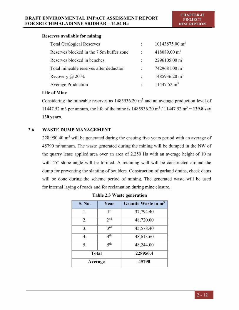
DRAFT ENVIRONMENTAL IMPACT ASSESSMENT REPORT FOR SRI CHIMALADINNE SRIDHAR – 14.54 Ha
CHAPTER-II PROJECT
DESCRIPTION
2 - 12
Reserves available for mining
Total Geological Reserves : 10143875.00 m3
Reserves blocked in the 7.5m buffer zone : 418089.00 m3
Reserves blocked in benches : 2296105.00 m3
Total mineable reserves after deduction : 7429681.00 m3
Recovery @ 20 % : 1485936.20 m3
Average Production : 11447.52 m3
Life of Mine
Considering the mineable reserves as 1485936.20 m3 and an average production level of
11447.52 m3 per annum, the life of the mine is 1485936.20 m3 / 11447.52 m3 = 129.8 say
130 years.
2.6 WASTE DUMP MANAGEMENT
228,950.40 m3 will be generated during the ensuing five years period with an average of
45790 m3/annum. The waste generated during the mining will be dumped in the NW of
the quarry lease applied area over an area of 2.250 Ha with an average height of 10 m
with 45 slope angle will be formed. A retaining wall will be constructed around the
dump for preventing the slanting of boulders. Construction of garland drains, check dams
will be done during the scheme period of mining. The generated waste will be used
for internal laying of roads and for reclamation during mine closure.
Table 2.3 Waste generation
S. No. Year Granite Waste in m3
1. 1st 37,794.40
2. 2nd 48,720.00
3. 3rd 45,578.40
4. 4th 48,613.60
5. 5th 48,244.00
Total 228950.4
Average 45790
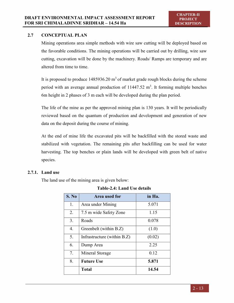
DRAFT ENVIRONMENTAL IMPACT ASSESSMENT REPORT FOR SRI CHIMALADINNE SRIDHAR – 14.54 Ha
CHAPTER-II PROJECT
DESCRIPTION
2 - 13
2.7 CONCEPTUAL PLAN
Mining operations area simple methods with wire saw cutting will be deployed based on
the favorable conditions. The mining operations will be carried out by drilling, wire saw
cutting, excavation will be done by the machinery. Roads/ Ramps are temporary and are
altered from time to time.
It is proposed to produce 1485936.20 m3 of market grade rough blocks during the scheme
period with an average annual production of 11447.52 m3. It forming multiple benches
6m height in 2 phases of 3 m each will be developed during the plan period.
The life of the mine as per the approved mining plan is 130 years. It will be periodically
reviewed based on the quantum of production and development and generation of new
data on the deposit during the course of mining.
At the end of mine life the excavated pits will be backfilled with the stored waste and
stabilized with vegetation. The remaining pits after backfilling can be used for water
harvesting. The top benches or plain lands will be developed with green belt of native
species.
2.7.1. Land use
The land use of the mining area is given below:
Table-2.4: Land Use details
S. No Area used for in Ha.
1. Area under Mining 5.071
2. 7.5 m wide Safety Zone 1.15
3. Roads 0.078
4. Greenbelt (within B.Z) (1.0)
5. Infrastructure (within B.Z) (0.02)
6. Dump Area 2.25
7. Mineral Storage 0.12
8. Future Use 5.871
Total 14.54

DRAFT ENVIRONMENTAL IMPACT ASSESSMENT REPORT FOR SRI CHIMALADINNE SRIDHAR – 14.54 Ha
CHAPTER-II PROJECT
DESCRIPTION
2 - 14
2.7.2. Mining Methodology
The removal of weathered and under sized boulders will be cleared in the quarry leased
area using excavator. The sheet that is exposed will be subjected to drilling and splitting
from mother rock. Thus mass will be separated from mother rock by drilling the slotter
holes on both sides of the mass and a top hole intersecting these two holes and wire saw
rope is passed through and cutting is done horizontally and vertically and by this there
will be mass opening on all the sides from the mother mass. After removal of weathered
and under sized boulders.
The large boulders will be subjected to splitting into require sizes of blocks by using Jack
Hammers by drilling series of deep holes at right angles at regular intervals, later by
inserting feather and wedges in these holes and hammering with sledge hammer will
release the blocks.
The boulders will be splitted to the required sizes with drilling only. The boulders
separated will be brought to the dressing yard for dressing. If the boulders, which fit into
the required market grade size will be transformed into cuboids.
2.7.3. Mining Machinery
Table 2.5 Details of machinery
S. No. Machinery No. of Units Cost (Lakhs)
1. Excavators (Hire) 2 24.0
2. Compressor (Hire) 2 8.0
3. Jack Hammers 5 2.0
4. Tippers (Hire) 2 20.0
5. Diamond Wire Saw Machines
(Mortar Driven)
2 6.0
6. Water tanker/Tractor 1 2.0
7. Miscellaneous -- 3.0
TOTAL 65.0

DRAFT ENVIRONMENTAL IMPACT ASSESSMENT REPORT FOR SRI CHIMALADINNE SRIDHAR – 14.54 Ha
CHAPTER-II PROJECT
DESCRIPTION
2 - 15
2.7.4. Site Services
Office, Rest Room, First Aid Room, Shelters, drinking water are provided in the North of
the quarry leased area covering an area of 200 m2.
Water Requirement
Around 14.0 KLD of water will be required for the project activity. Water requirement
will be met through water tankers. Water is required in the mine for spraying on the roads
and working faces to suppress the dust and mine operations. Also a small quantity of
drinking water is required.
Table 2.6 Fresh Water Requirement & Wastewater generation
S. No Description Fresh water Waste water Disposal
1. Domestic 1.5 KLD 1.2 KLD Septic tank followed by
soak pit
2. Green belt 4.0 KLD -- --
3. Dust suppression 3.5 KLD -- --
4. Wire saw cutting 3.0 KLD --
5. Drilling by wet
jacket method 2.0 KLD -- --
TOTAL 14.0 KLD 1.2 KLD
2.8 EMPLOYMENT POTENTIAL
By this project many people will be benefited for their livelihood and get employment in
this remote area. The lessee is proposing to employ full time mine manager and geologist
as per Rule 42 of MCDR 1988.The following persons are employed to carryout/
supervise the day to day mining operations.

DRAFT ENVIRONMENTAL IMPACT ASSESSMENT REPORT FOR SRI CHIMALADINNE SRIDHAR – 14.54 Ha
CHAPTER-II PROJECT
DESCRIPTION
2 - 16
Table 2.7 Employment Details
S. No Category No. of Persons
1. Mines Manager 1
2. Site Supervisor 2
3. Excavator Operators 3
4. Tipper Operators 2
5. Compressor Operators 2
6. Wire Saw Operators 5
7. Skilled Workers 5
8. Unskilled Workers 10
9. Drivers 2
10. Watchman 1
TOTAL 33
2.9 PROJECT COST
The envisaged annual production of Colour Granite in a year is estimated to be 12180 m3.
The cost of the project : 65.00 Lakhs
EMP BUDGET
Capital Cost : 8.5 Lakhs
Recurring cost per annum : 7.3 Lakhs
CHAPTER – III
DESCRIPTION OF ENVIRONMENT

DRAFT ENVIRONMENTAL IMPACT ASSESSMENT
REPORT FOR SRI CHIMALADINNE SRIDHAR – 14.54 Ha
CHAPTER –III DESCRIPTION OF ENVIRONMENT
3 - 1
3.0 INTRODUCTION
Collection of base line data is an integral aspect of the preparation of Environmental
Impact Assessment report. Baseline data reflects the present status of Environment
before the initiation of any activity. The possible effects due to the violated mine are
estimated and superimposed on the compiled baseline data subsequently to assess
Environmental Impacts.
3.1 STUDY AREA
Study area covers 10 km radius from mine boundaries located at Sy. No 1, of Bellukola
Village, Nandigama Mandal, Srikakulam District, Andhra Pradesh.
3.2 STUDY PERIOD
The baseline environmental quality represents the background scenario of various
environmental components in the study area.
As part of the Environmental Impact Assessment study, the secondary baseline
monitoring was carried out in and around the proposed mine area during the period of
October,2021 to December,2021. Studies were under taken to generate base line data
of the following:-
3.3 METHODOLOGY OF EIA STUDY
The various steps involved in Environmental Impact Assessment Study of the mine site
are divided into following phases:
Identification of significant environmental parameters and assessing the existing
status within the impact zone with respect to air, water, noise, soil and socio-
economic components of environment. Following studies were carried out:
MICROMETEOROLOGICAL DATA
AIR QUALITY – EXISTING AMBIENT AIR QUALITY
WATER ANALYSIS - GROUND WATER, SURFACE WATER
NOISE LEVELS
GEOLOGY
HYDROGEOLOGY
FLORA AND FAUNA

DRAFT ENVIRONMENTAL IMPACT ASSESSMENT
REPORT FOR SRI CHIMALADINNE SRIDHAR – 14.54 Ha
CHAPTER –III DESCRIPTION OF ENVIRONMENT
3 - 2
LAND ENVIRONMENT
LAND USE / LAND COVER
SOIL CHARACTERISTICS and
SOCIO – ECONOMIC STATUS SURROUNDING THE MINE AREA.
Study of various mining activities of the mine to identify the area leading to
impact/change in environmental quality.
Quantification/prediction of impact for the identified activities and to study the
level of impact on various environmental components.
Evaluation of impacts after superimposing the predicted/quantified scenario over
the baseline scenario.
Formulation of Environmental Management Plan for implementation in the mine
lease area.
3.4 COLLECTION OF BASELINE DATA
3.4.1 MICRO METEOROLOGICAL DATA
Micrometeorological studies are simultaneously conducted with the ambient air quality
monitoring. Meteorology plays an important role in the dispersion of pollutants. The
meteorological data is very useful for interpretation of the base line information and for
model study of air quality impacts also.
A temporary meteorological station was installed at mine site. The station was installed
at a height of 4 m above the ground level in such a way that there are no obstructions
facilitating flow of wind, wind speed, wind direction, humidity and temperature are
recorded on hourly basis.
CLIMATE
The tropical climate of the region is manifested as hot and humid summer, moderately
monsoon and mild winter seasons. The climate of the region is characterized as hot &
dry.
Regional Meteorology:
Climate:

DRAFT ENVIRONMENTAL IMPACT ASSESSMENT
REPORT FOR SRI CHIMALADINNE SRIDHAR – 14.54 Ha
CHAPTER –III DESCRIPTION OF ENVIRONMENT
3 - 3
The climate of the region is governed by its location in the tropics and by the monsoon.
The climate of the southeastern coast of the Bay of Bengal is characterized by the
annually recurring seasonal monsoons, which divide the year in to four seasons as
Indian Meteorological Department.
The winter season of the year from December to February predominantly north
winds and recorded coolest season of the year.
The summer season (Pre monsoon period) from March to May predominantly
W and SW winds and is hottest part of the year.
The South-West monsoon tropical rainy season from June to September is
characterized by predominantly South-west winds.
The Post monsoon period (North-East monsoon) from November to January
when predominant winds are North-East and wind changes the direction from
North-East to North-West or west when, cyclones are active in Bay-of-Bengal.
Table 3.1 IMD Climatological Data (History) of Kalingapatnam from 1960-2000
Month Temperature ºC
Mean Relative Humidity % Rainfall
mm Maximum Minimum Day Night
January 28.4 16.4 78 74 8.6
February 31.2 17.3 77 76 18.2
March 32.7 23 75 79 10.5
April 32.2 24.4 74 83 19.2
May 33.4 26.7 75 83 48.9
June 32.8 25.7 77 83 122.4
July 31.5 25.6 82 83 157.3
August 32.1 25.5 86 82 156.7
September 31.8 24.5 86 81 157.5
October 32.4 23.8 84 76 207.6
November 30.8 22 81 69 89.4
December 27.3 18.3 79 67 4.7
Temperature:

DRAFT ENVIRONMENTAL IMPACT ASSESSMENT
REPORT FOR SRI CHIMALADINNE SRIDHAR – 14.54 Ha
CHAPTER –III DESCRIPTION OF ENVIRONMENT
3 - 4
The maximum temperature recorded is 38.1ºC in May and the minimum is 14.3ºC in
December and January.
Relative Humidity:
The relative humidity is comparatively high and fairly uniform throughout the year.
The average relative humidity was maximum 85% in July and minimum 68% recorded
in December.
Rainfall:
The region of Srikakulam district receives an annual rainfall of 1027.4 mm. The region
also receives rain from the occasional low-pressure systems developing during the post
monsoon and pre-monsoon season.
3.4.2 WINDS
A weather station was installed near the site for hourly monitoring of temperature,
humidity & wind velocity for the month of October’ 2021 to December’ 2021. Average
data is given below:
Table: 3.2 Micro Meteorological Data at Site
Sl. No.
Parameters Oct’21 Nov’21 Dec’21
1 Temperature (0C) Maximum 31.57 30.12 29.5
Minimum 21.49 19.15 13.24
Average 27.08 25.41 22.74
2 Relative Humidity (%) Maximum 94.78 97.11 100.82
Minimum 59.1 59.41 39.24
Average 84.36 87.30 80.01
3 Wind Speed (m/s) Maximum 5.14 8.19 6.81
Minimum 0.2 0.94 0.23
Average 2.19 3.59 2.97
4 Wind Direction (%) E 12.36 22.50 14.38
ENE 7.39 32.22 25.53
ESE 7.25 11.80 6.98

DRAFT ENVIRONMENTAL IMPACT ASSESSMENT
REPORT FOR SRI CHIMALADINNE SRIDHAR – 14.54 Ha
CHAPTER –III DESCRIPTION OF ENVIRONMENT
3 - 5
N 4.30 0.00 7.12
NE 4.83 23.47 15.45
NNE 4.83 3.33 8.87
NNW 12.50 0.00 6.18
NW 2.41 0.00 1.20
S 0.94 0.13 0.67
SE 4.43 2. 08 1.20
SSE 3.89 0.27 2.55
SSW 1.07 0.00 0.00
SW 2.28 0.00 0.00
W 3.09 0.00 0.00
WNW 1.74 0.00 0.26
WSW 3.49 0.00 0.00
CALM 22.98 4.02 9.40
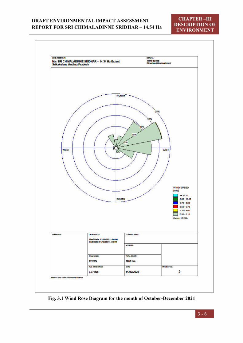
DRAFT ENVIRONMENTAL IMPACT ASSESSMENT
REPORT FOR SRI CHIMALADINNE SRIDHAR – 14.54 Ha
CHAPTER –III DESCRIPTION OF ENVIRONMENT
3 - 6
Fig. 3.1 Wind Rose Diagram for the month of October-December 2021

DRAFT ENVIRONMENTAL IMPACT ASSESSMENT
REPORT FOR SRI CHIMALADINNE SRIDHAR – 14.54 Ha
CHAPTER –III DESCRIPTION OF ENVIRONMENT
3 - 7
3.5 AIR ENVIRONMENT
3.5.1 Selection of Sampling Locations: To assess the baseline ambient air quality a
scientifically designed ambient air quality monitoring network was established. Air
quality monitoring study was carried out during post-monsoon season (i.e. October’21
to December’21) within 10km radius of the mine lease area. The ambient air quality
monitoring stations were selected after a brief study based on the following
considerations.
Meteorological conditions
Topography of the study area
Predominant wind direction
Emission sources
Receptors sensitivity
Ambient Air Quality monitoring stations were set up at eight locations with due
consideration to the above mentioned points. The locations of the sampling stations are
given in the Table 3.4 and the same are also show in the Fig 3.2.
3.5.2 Methodology of Sampling and Analysis
Air samples collected were tested for the following parameters
PM10
PM2.5
Sulphur Dioxide (SO2)
Oxides of Nitrogen ( NOx)
Free silica
The sampling and analysis of ambient air quality parameters was carried out as per the
procedures detailed in relevant parts of IS: 5182 (Indian Standards for Ambient Air
Quality Test Methods). The methods used for determining the above mentioned
parameters and furnished in the Table: 3.3
3.5.3 Frequency of Sampling: 24 hourly samples for PM10, PM2.5, SO2, NOx and Free silica
were collected from each station, at a frequency of twice a week for the post-monsoon
season.
Table: 3.3 Techniques and Detectable limits for Ambient Air Quality Monitoring

DRAFT ENVIRONMENTAL IMPACT ASSESSMENT
REPORT FOR SRI CHIMALADINNE SRIDHAR – 14.54 Ha
CHAPTER –III DESCRIPTION OF ENVIRONMENT
3 - 8
S. No. Parameter Technique Technical Protocol Minimum Detectable
Limit (g/m3)
1 PM10 Respirable Dust Sampler (Gravimetric method)
IS-5182 (Part-XXIII) 5.0
2 PM2.5 Fine Particulate Sampler (Gravimetric method)
IS-5182 (Part-XXIV) 5.0
3 Sulphur dioxide
Modified West and Gaeke
IS-5182 (Part-II) 4.0
4 Oxides of Nitrogen
Jacob & Hochheiser IS-5182 (Part-VI) 4.0
5 Free Silica Personal Respirable Dust Sampler
OSHA (0142) (Occupational Safety and
Health Administration) 3.5
Table 3.4: Location of Ambient Air Quality Monitoring Stations
S. No
Location Station Code
Direction from
Project Site
Distance w.r.t
Project Site
Latitude and Longitude
Environmental Setting
1. Project site A1 --- --- 18°39'2.44"N 84°14'44.04"E
Mine Area
2. Jayapuram A2 SW 1.29 18°40'36.55"N 84°14'35.34"E
Residential Area
3. Kolivalasa A3 SW 2.8 18°40'29.76"N 84°13'31.33"E
Residential Area
4. Jammipeta A4 ENE 0.8 18°41'27.84"N 84°15'37.03"E
Residential Area
5. Dimmidijola A5 NNE 3.75 18°43'11.79"N 84°16'0.68"E
Residential Area
6. Bhiriboddapadu A6 ESE 0.99 18°40'59.59"N 84°15'48.04"E
Residential Area
7. Pedhaguruvuru A7 NE 7.9 18°44'25.09"N 84°18'14.21"E
Residential Area
8 Savarasomanadhapuram A8 NNW 1.01 18°41'47.04"N 84°14'43.12"E
Residential Area
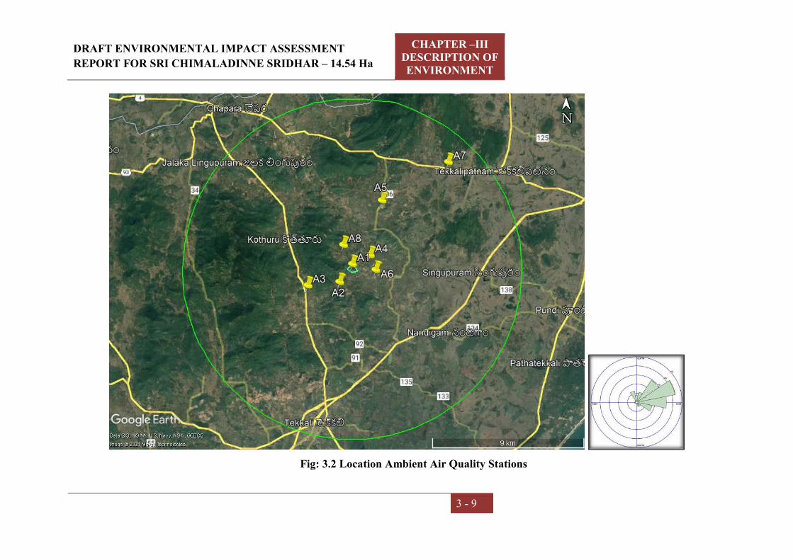
DRAFT ENVIRONMENTAL IMPACT ASSESSMENT
REPORT FOR SRI CHIMALADINNE SRIDHAR – 14.54 Ha
CHAPTER –III DESCRIPTION OF ENVIRONMENT
3 - 9
Fig: 3.2 Location Ambient Air Quality Stations
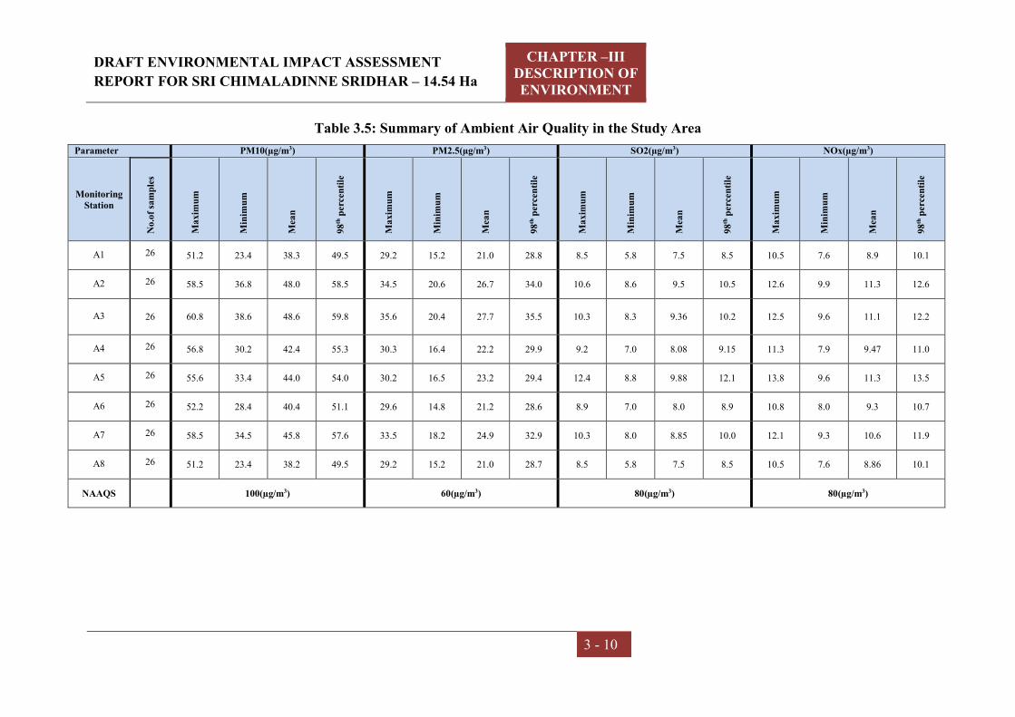
DRAFT ENVIRONMENTAL IMPACT ASSESSMENT
REPORT FOR SRI CHIMALADINNE SRIDHAR – 14.54 Ha
CHAPTER –III DESCRIPTION OF ENVIRONMENT
3 - 10
Table 3.5: Summary of Ambient Air Quality in the Study Area
Parameter PM10(µg/m3) PM2.5(µg/m3) SO2(µg/m3) NOx(µg/m3)
Monitoring Station
No.
of s
amp
les
Max
imu
m
Min
imu
m
Mea
n
98th
per
cen
tile
Max
imu
m
Min
imu
m
Mea
n
98th
per
cen
tile
Max
imu
m
Min
imu
m
Mea
n
98th
per
cen
tile
Max
imu
m
Min
imu
m
Mea
n
98th
per
cen
tile
A1 26 51.2 23.4 38.3 49.5 29.2 15.2 21.0 28.8 8.5 5.8 7.5 8.5 10.5 7.6 8.9 10.1
A2 26 58.5 36.8 48.0 58.5 34.5 20.6 26.7 34.0 10.6 8.6 9.5 10.5 12.6 9.9 11.3 12.6
A3 26 60.8 38.6 48.6 59.8 35.6 20.4 27.7 35.5 10.3 8.3 9.36 10.2 12.5 9.6 11.1 12.2
A4 26 56.8 30.2 42.4 55.3 30.3 16.4 22.2 29.9 9.2 7.0 8.08 9.15 11.3 7.9 9.47 11.0
A5 26 55.6 33.4 44.0 54.0 30.2 16.5 23.2 29.4 12.4 8.8 9.88 12.1 13.8 9.6 11.3 13.5
A6 26 52.2 28.4 40.4 51.1 29.6 14.8 21.2 28.6 8.9 7.0 8.0 8.9 10.8 8.0 9.3 10.7
A7 26 58.5 34.5 45.8 57.6 33.5 18.2 24.9 32.9 10.3 8.0 8.85 10.0 12.1 9.3 10.6 11.9
A8 26 51.2 23.4 38.2 49.5 29.2 15.2 21.0 28.7 8.5 5.8 7.5 8.5 10.5 7.6 8.86 10.1
NAAQS 100(µg/m3) 60(µg/m3) 80(µg/m3) 80(µg/m3)

DRAFT ENVIRONMENTAL IMPACT ASSESSMENT
REPORT FOR SRI CHIMALADINNE SRIDHAR – 14.54 Ha
CHAPTER –III DESCRIPTION OF ENVIRONMENT
3 - 11
GRAPHICAL PRESENTATION OF AMBIENT AIR QUALITY IN THE STUDY AREA
49.5 58.5 59.8 55.3 54 51.1 57.6 49.5
100
0
50
100
150
A1 A2 A3 A4 A5 A6 A7 A8 NAAQS
PM
10
Co
nce
ntr
atio
ns
Sampling Locations
98 Percentile of PM10 (µg/m3)
28.834 35.5
29.9 29.4 28.6 32.9 28.7
60
010203040506070
PM
2.5
Co
nce
ntr
atio
ns
Sampling Locations
98 Percentile of PM2.5 (µg/m3)
8.5 10.5 10.25 9.15 12.1 8.9 10 8.5
80
0
20
40
60
80
100
A1 A2 A3 A4 A5 A6 A7 A8 NAAQS
SO2
Co
nce
ntr
atio
ns
Sampling Locations
98 Percentile of SO2 (µg/m3)
10.1 12.6 12.2 11 13.5 10.7 11.9 10.1
80
0
20
40
60
80
100
NO
x C
on
cen
trat
ion
sSampling Locations
98 Percentile of NOx (µg/m3)
DRAFT ENVIRONMENTAL IMPACT ASSESSMENT
REPORT FOR SRI CHIMALADINNE SRIDHAR – 14.54 Ha
CHAPTER –III DESCRIPTION OF ENVIRONMENT
3 - 12
3.5.4 Existing Ambient Air Quality
On the perusal of above summary of analysis of ambient air quality in the study are it
is evident that all monitored values in various locations are well within the specified
limits of CPCB. The results are summarized below:
PM10: The highest PM10 concentration 60.8 µg/m3 was observed in the ambient air was
recorded at station A3 while the lowest PM10 concentration was found to be 23.4 µg/m3
at A1 and A8. All the monitored values of PM10 are well below the specified limit of
100µg/m3.
PM2.5: The highest PM2.5 concentration 35.6 µg/m3 was observed in the ambient air was
recorded at station A3 while the lowest PM2.5 concentration was found to be 14.8 µg/m3
at A6. All the monitored values of PM2.5 are well below the specified limit of 60µg/m3.
SO2: The highest SO2 concentration 12.4 µg/m3 was observed in the ambient air was
recorded at station A5 while the lowest SO2 concentration was found to be 5.8 µg/m3 at
A1 and A8. All the monitored values of SO2 are well below the specified limit of 80
µg/m3.
NOx: The highest NOx concentration 13.8 µg/m3 was observed in the ambient air was
recorded at station A5 while the lowest NOx concentration was found to be 7.6 µg/m3
at A1 and A8. All the monitored values of NOx are well below the specified limit of
80µg/m3.
Free Silica:
Free Silica found to be <3.5 µg/m3which is Minimum Detectable Limit in all AAQ
locations as per the method of OSHA ID 0142.Permissible Exposure Limit as OSHA
(Occupational Safety and Health Administration) is 50 µg/m3.
Interpretation:
Ambient air quality monitoring locations were selected maximum locations on
downwind of project site as predominant wind direction of North East to South West
recorded in the site specific meteorological data.

DRAFT ENVIRONMENTAL IMPACT ASSESSMENT
REPORT FOR SRI CHIMALADINNE SRIDHAR – 14.54 Ha
CHAPTER –III DESCRIPTION OF ENVIRONMENT
3 - 13
It was observed that, there was no impact of project on buffer zone villages as the
concentration of ambient air quality parameters were higher in villages of study area
compared to mine site by local activities in respective villages in the study area.
An over view of the above results indicate the ambient air quality in the study area were
well within the prescribed limits of CPCB.
3.6 WATER ENVIRONMENT
The water resources, both surface and groundwater play an important role in the
development of the area. Likewise, the water resources of the area have been studied to
establish the current status of water quality in the area. The parameters of prime
importance were selected under physical, chemical inorganic, chemical organic and
heavy metal groups. Water samples from ground and surface water sources were
collected. The water samples were collected in pretreated sampling cans and
transported to laboratory for analysis. Due care was taken during sampling &
transportation of these samples.
3.6.1 Surface Water and Ground Water Quality Assessment
In order to assess water quality impacts surface water and ground water samples are
collected from the surrounding villages. The samples analyzed for various physical and
chemical parameters to know the contamination levels as per the IS Standards.
1. Ground water quality --- IS 10500-2012
2. Surface/canal/sea water quality --- IS 2296-1992
3.6.2 Selection of Sampling Locations
Sampling locations were selected on basis of:
a) Drainage pattern
b) Location of residential areas respecting different activities
c) Likely areas those can represent baseline conditions
Samples for bacteriological analysis were collected in sterilized glass bottles. Selected
physico-chemical and bacteriological parameters have been analyzed for projecting
the existing water quality status in the study area.
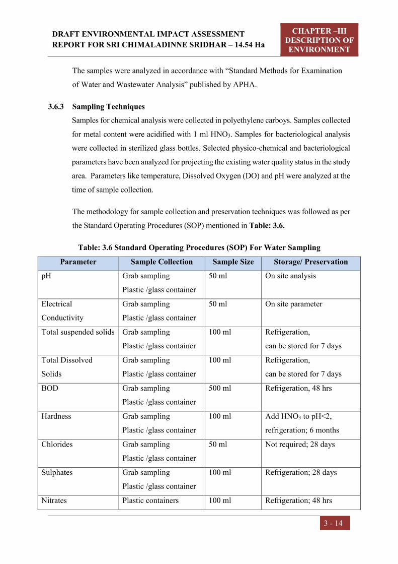
DRAFT ENVIRONMENTAL IMPACT ASSESSMENT
REPORT FOR SRI CHIMALADINNE SRIDHAR – 14.54 Ha
CHAPTER –III DESCRIPTION OF ENVIRONMENT
3 - 14
The samples were analyzed in accordance with “Standard Methods for Examination
of Water and Wastewater Analysis” published by APHA.
3.6.3 Sampling Techniques
Samples for chemical analysis were collected in polyethylene carboys. Samples collected
for metal content were acidified with 1 ml HNO3. Samples for bacteriological analysis
were collected in sterilized glass bottles. Selected physico-chemical and bacteriological
parameters have been analyzed for projecting the existing water quality status in the study
area. Parameters like temperature, Dissolved Oxygen (DO) and pH were analyzed at the
time of sample collection.
The methodology for sample collection and preservation techniques was followed as per
the Standard Operating Procedures (SOP) mentioned in Table: 3.6.
Table: 3.6 Standard Operating Procedures (SOP) For Water Sampling
Parameter Sample Collection Sample Size Storage/ Preservation
pH Grab sampling
Plastic /glass container
50 ml On site analysis
Electrical
Conductivity
Grab sampling
Plastic /glass container
50 ml On site parameter
Total suspended solids Grab sampling
Plastic /glass container
100 ml Refrigeration,
can be stored for 7 days
Total Dissolved
Solids
Grab sampling
Plastic /glass container
100 ml Refrigeration,
can be stored for 7 days
BOD Grab sampling
Plastic /glass container
500 ml Refrigeration, 48 hrs
Hardness Grab sampling
Plastic /glass container
100 ml Add HNO3 to pH<2,
refrigeration; 6 months
Chlorides Grab sampling
Plastic /glass container
50 ml Not required; 28 days
Sulphates Grab sampling
Plastic /glass container
100 ml Refrigeration; 28 days
Nitrates Plastic containers 100 ml Refrigeration; 48 hrs

DRAFT ENVIRONMENTAL IMPACT ASSESSMENT
REPORT FOR SRI CHIMALADINNE SRIDHAR – 14.54 Ha
CHAPTER –III DESCRIPTION OF ENVIRONMENT
3 - 15
Parameter Sample Collection Sample Size Storage/ Preservation
Fluorides Plastic containers only 100 ml Not required; 28 days
Alkalinity Plastic/ glass containers 100 ml Refrigeration; 14 days
Ammonia Plastic/ glass containers 100 ml Add H2SO4 to pH>2,
refrigeration, 28 days
Heavy Metals (As,
Cd, Mn, Cu, Fe, Zn,
Pb etc.)
Plastic/ Glass rinse with
1+1 HNO3
500 ml Filter, add HNO3 to pH>2;
Grab sample; 6 months
Source: Standard Methods for the Examination of Water and Wastewater, Published
By APHA (American Public Health Association) 23rd Edition 2017
3.6.4 Analytical Techniques
The analytical techniques used for water analysis is given in the Table: 3.7.
Table: 3.7 Analytical Techniques for Water Analysis
Parameter Method
pH APHA-4500-H+
Colour APHA-2120 C
Odour APHA- 2150
Temperature APHA-2550 B
Dissolved Oxygen APHA-4500 DC
Electrical conductivity APHA-2510 B
Turbidity APHA-2130 B
Chlorides APHA-4500 Cl-
Fluorides APHA-4500 F-
Total dissolved solids APHA-2540 C
Total suspended solids APHA-2540 D
Total hardness APHA-2340 C
Sulphates APHA-4500 SO4-2
Arsenic APHA-3120 B/ APHA-3114 B/ APHA-3500 As
Calcium APHA-3120 Ca B
Magnesium APHA-3120 Mg B
Sodium APHA-3120 Na B

DRAFT ENVIRONMENTAL IMPACT ASSESSMENT
REPORT FOR SRI CHIMALADINNE SRIDHAR – 14.54 Ha
CHAPTER –III DESCRIPTION OF ENVIRONMENT
3 - 16
Parameter Method
Potassium APHA-3120 KB
Manganese APHA-3120 B
Mercury APHA-3120 B
Lead APHA-3120 B
Copper APHA-3120 B
Cadmium APHA-3120 B
Iron APHA-3120 B
Zinc APHA-3120 B
Boron APHA-3120 B
Coliform organisms APHA-9215 D
Alkalinity APHA-2320 B
COD APHA-5220 D
Phenolic Compounds APHA-5530 C
Source: Standard Methods for the Examination of Water and Wastewater, Published
By APHA (American Public Health Association) 23rd Edition 2017
3.6.5 Water Sampling Stations
The locations of the water samples collected in the study area are furnished hereunder
Table: 3.8 Water Sampling Stations
Code Station Direction
bearing w.r.t
Project Site
Distance
from Project
Site (km)
Latitude &
Longitude Source of
collection
GW1 Jayapuram SSW 1.31 18°40'36.88"N 84°14'33.58"E
Ground water
GW2 Kollivalasa SW 2.77 18°40'28.52"N 84°13'33.32"E
Ground water
GW3 Sarvarasomanadhapuram NNW 1.0 18°41'45.55"N 84°14'43.85"E
Ground water
GW4 Bharthupuram NNE 0.93 18°41'49.32"N 84°15'18.72"E
Ground water
GW5 Dimmidijola NNE 3.82 18°43'13.59"N 84°16'2.22"E
Ground water
GW6 Bhiriboddapadu ESE 0.93 18°40'59.47"N 84°15'45.73"E
Ground water
GW7 Bellukola SSE 0.37 18°41'0.89"N 84°15'14.08"E
Ground water

DRAFT ENVIRONMENTAL IMPACT ASSESSMENT
REPORT FOR SRI CHIMALADINNE SRIDHAR – 14.54 Ha
CHAPTER –III DESCRIPTION OF ENVIRONMENT
3 - 17
GW8 Peddalaxmipuram ENE 2.06 18°41'52.22"N 84°16'11.31"E
Ground water
SW1 Gotta Barrage left main Canal
ESE 2.77 18°40'22.74"N 84°16'36.55"E
Surface water
SW2 Bharthupuram Cheruvu
NNE 0.47 18°41'35.63"N 84°15'11.83"E
Surface water
SW3 Bellakola Cheruvu S 0.57 18°40'50.52"N 84°15'9.55"E
Surface water
SW4 Chinnalaxmipuram Cheruvu
S 1.45 18°40'21.41"N 84°15'9.82"E
Surface water

DRAFT ENVIRONMENTAL IMPACT ASSESSMENT
REPORT FOR SRI CHIMALADINNE SRIDHAR – 14.54 Ha
CHAPTER –III DESCRIPTION OF ENVIRONMENT
3 - 18
Fig 3.3: Water Sampling Locations
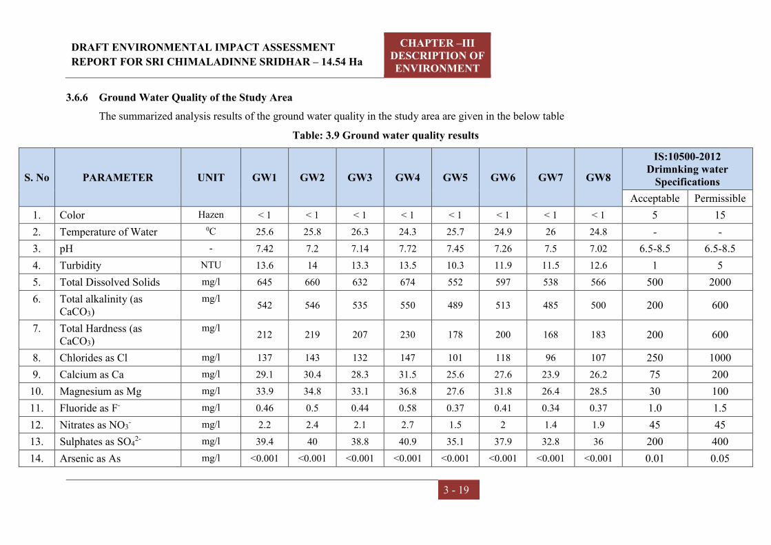
DRAFT ENVIRONMENTAL IMPACT ASSESSMENT
REPORT FOR SRI CHIMALADINNE SRIDHAR – 14.54 Ha
CHAPTER –III DESCRIPTION OF ENVIRONMENT
3 - 19
3.6.6 Ground Water Quality of the Study Area
The summarized analysis results of the ground water quality in the study area are given in the below table
Table: 3.9 Ground water quality results
S. No PARAMETER UNIT GW1 GW2 GW3 GW4 GW5 GW6 GW7 GW8
IS:10500-2012 Drimnking water
Specifications
Acceptable Permissible
1. Color Hazen < 1 < 1 < 1 < 1 < 1 < 1 < 1 < 1 5 15
2. Temperature of Water 0C 25.6 25.8 26.3 24.3 25.7 24.9 26 24.8 - -
3. pH - 7.42 7.2 7.14 7.72 7.45 7.26 7.5 7.02 6.5-8.5 6.5-8.5
4. Turbidity NTU 13.6 14 13.3 13.5 10.3 11.9 11.5 12.6 1 5
5. Total Dissolved Solids mg/l 645 660 632 674 552 597 538 566 500 2000
6. Total alkalinity (as CaCO3)
mg/l 542 546 535 550 489 513 485 500 200 600
7. Total Hardness (as CaCO3)
mg/l 212 219 207 230 178 200 168 183 200 600
8. Chlorides as Cl mg/l 137 143 132 147 101 118 96 107 250 1000
9. Calcium as Ca mg/l 29.1 30.4 28.3 31.5 25.6 27.6 23.9 26.2 75 200
10. Magnesium as Mg mg/l 33.9 34.8 33.1 36.8 27.6 31.8 26.4 28.5 30 100
11. Fluoride as F- mg/l 0.46 0.5 0.44 0.58 0.37 0.41 0.34 0.37 1.0 1.5
12. Nitrates as NO3- mg/l 2.2 2.4 2.1 2.7 1.5 2 1.4 1.9 45 45
13. Sulphates as SO42- mg/l 39.4 40 38.8 40.9 35.1 37.9 32.8 36 200 400
14. Arsenic as As mg/l <0.001 <0.001 <0.001 <0.001 <0.001 <0.001 <0.001 <0.001 0.01 0.05

DRAFT ENVIRONMENTAL IMPACT ASSESSMENT
REPORT FOR SRI CHIMALADINNE SRIDHAR – 14.54 Ha
CHAPTER –III DESCRIPTION OF ENVIRONMENT
3 - 20
15. Cadmium as Cd mg/l <0.002 <0.002 <0.002 <0.002 <0.002 <0.002 <0.002 <0.002 0.003 0.003
16. Copper as Cu mg/l <0.01 <0.01 <0.01 <0.01 <0.01 <0.01 <0.01 <0.01 0.05 1.5
17. Lead as Pb mg/l <0.001 <0.001 <0.001 <0.001 <0.001 <0.001 <0.001 <0.001 0.01 0.01
18. Iron as Fe mg/l 0.15 0.15 0.16 0.18 0.13 0.15 0.12 0.14 0.3 0.3
19. Manganese as Mn mg/l <0.01 <0.01 <0.01 <0.01 <0.01 <0.01 <0.01 <0.01 0.1 0.3
20. Zinc as Zn mg/l 0.15 0.12 0.14 0.16 0.1 0.13 0.09 0.11 5.0 15.0
21. Dissolved phosphates mg/l <0.01 <0.01 <0.01 <0.01 <0.01 <0.01 <0.01 <0.01 - -
22. Phenolic Compounds as C6H5OH
mg/l <0.001 <0.001 <0.001 <0.001 <0.001 <0.001 <0.001 <0.001 0.001 0.002
23. Residual Chlorine mg/l <0.1 <0.1 <0.1 <0.1 <0.1 <0.1 <0.1 <0.1 - -
24. E. Coli CFU/100 ml ND ND ND ND ND ND ND ND Shall not be
detected Shall not be
detected
25. Total Coliforms CFU/100 ml 51 47 40 63 43 37 41 39 Shall not be
detected Shall not be
detected
ND - Not Detected

DRAFT ENVIRONMENTAL IMPACT ASSESSMENT
REPORT FOR SRI CHIMALADINNE SRIDHAR – 14.54 Ha
CHAPTER –III DESCRIPTION OF ENVIRONMENT
3 - 21
3.6.7 Summary of Groundwater quality:
The pH limit fixed for drinking water samples as per IS 10500:2012 Drinking
Water Specifications is 6.5 to 8.5. During the study period, the pH of the
groundwater was found to be varying between 7.02 and 7.72. The pH values for
all the samples collected in the study area during study period were found to be
within the limits.
The desirable limit for total dissolved solids as per IS 10500:2012 Drinking
Water Specifications is 500 milligrams per liter (mg/l) where as the permissible
limits in absence of alternate source is 2000 mg/l. In groundwater samples
collected from the study area, the total dissolved solids (TDS) were found to be
varying between 538 mg/l and 674 mg/l. The TDS of all the samples were below
the permissible limit of 2000 mg/l.
The desirable limit for Chloride is 250 mg/l as per IS 10500:2012 Drinking
Water Specifications where as the permissible limit for the same is 1,000 mg/l.
The Chloride levels in the groundwater samples collected in the study area were
ranging from 96 mg/l to 147 mg/l.
The desirable limit as per IS 10500:2012 Drinking Water Specifications for
hardness is 200 mg/l where as the permissible limit for the same is 600mg/l. In
the groundwater samples collected from the study area, the hardness was found
to be varying between 168 mg/l to 230 mg/l.
Fluoride is the other important parameter, which has the desirable limit of 1 mg/l
and permissible limit of 1.5 mg/l. In the groundwater samples of study area the
fluoride values were found to be within a range 0.34 to 0.58 mg /l.All, the heavy
metals in all samples were found to be below the permissible limits.
An overview of the results obtained reveals that all the parameters were well within the
permissible limits of IS 10500:2012 Drinking Water Specifications.
3.6.8. Surface Water Quality of the Study Area

DRAFT ENVIRONMENTAL IMPACT ASSESSMENT
REPORT FOR SRI CHIMALADINNE SRIDHAR – 14.54 Ha
CHAPTER –III DESCRIPTION OF ENVIRONMENT
3 - 22
The water in the region (surface water) has been compared with respect to the Drinking
water Quality Standards as IS-2296:1992. The summarized analysis of results of the
surface water quality in the study area are given in the below table.
Table No. 3.10 Surface Water Quality of the Study Area
S. No. PARAMETER UNIT SW1 SW2 SW3 SW4 IS:2296 -
Standards
1. Color Hazen <1 <1 <1 <1 -
2. Odour - Agreeable Agreeable Agreeable Agreeable -
3. Turbidity NTU 0.78 0.65 0.72 0.59 -
4. pH - 7.49 7.68 7.42 7.73 6.50 –8.50
5. Temperature 0C 25.8 25.4 26.0 26.2 -
6. Electrical Conductivity mmhos/cm 232 212 216 230 -
7. Total Dissolved Solids mg/l 145 136 138 142 1500
8. Total Suspended Solids mg/l 20 18 15 13 -
9. Total Alkalinity as CaCO3 mg/l 85.2 90.6 82.8 96.4 -
10. Total Hardness as CaCO3 mg/l 104 95 109 94 -
11. Calcium as Ca mg/l 20.8 18.5 21.2 17.8 -
12. Magnesium as Mg mg/l 12.6 11.8 13.5 12.0 -
13. Chloride as Cl mg/l 28.8 25.2 23.6 24.5 -
14. Sulphate as SO4 mg/l 10.8 9.6 11.3 12.2 -
15. Nitrate as NO3 mg/l 5.8 4.2 6.0 5.3 -
16. Iron as Fe mg/l <0.01 <0.01 <0.01 <0.01 -
17. Hexavalent Chromium as Cr6+
mg/l <0.01 <0.01 <0.01 <0.01 0.05
18. Phenolic Compounds mg/l <0.001 <0.001 <0.001 <0.001 0.005
19. Cyanide as CN mg/l <0.002 <0.002 <0.002 <0.002 0.05
20. Zinc as Zn mg/l < 0.01 < 0.01 < 0.01 < 0.01 15
21. Lead as Pb mg/l <0.001 <0.001 <0.001 <0.001 0.01
22. Copper as Cu mg/l <0.01 <0.01 <0.01 <0.01 1.5
23. Aluminium as Al mg/l <0.01 <0.01 <0.01 <0.01 0.1
24. Manganese as Mn mg/l <0.01 <0.01 <0.01 <0.01 5.0
25. Mercury as Hg mg/l <0.001 <0.001 <0.001 <0.001 -

DRAFT ENVIRONMENTAL IMPACT ASSESSMENT
REPORT FOR SRI CHIMALADINNE SRIDHAR – 14.54 Ha
CHAPTER –III DESCRIPTION OF ENVIRONMENT
3 - 23
26. Arsenic as As mg/l <0.001 <0.001 <0.001 <0.001 -
27. Cadmium as Cd mg/l <0.002 <0.002 <0.002 <0.002 -
28. Dissolved Oxygen mg/l 6.1 6.3 5.8 6.0 5.0 min
29. Chemical Oxygen Demand mg/l 5.6 5.4 6.2 5.8 -
30. Biochemical Oxygen Demand
mg/l 2.1 2.0 2.3 2.1 3.0
31. Total Kjheldhal Nitrogen mg/l < 1.0 < 1.0 < 1.0 < 1.0 -
32. Free Ammonical Nitrogen mg/l < 0.01 < 0.01 < 0.01 < 0.01 -
33. Oil & Grease mg/l < 0.1 < 0.1 < 0.1 < 0.1 -
34. E. Coli MPN/100
ml Absent Absent Absent Absent Absent
35. Total Coliforms MPN/100
ml 300 240 900 500 5000
3.6.9. Surface water quality results are summarized below:
pH of the surface water collected was found to be neutral with pH ranging from
7.42 to 7.73.
TDS was found to be 136 mg/l to 145 mg/l. The tolerance limit of TDS is 1,500
mg/l as per IS 2296.
Total hardness was found to be 94 mg/l to 109 mg/l.
Presence of Nitrate was recorded as 4.2 mg/l to 6.0 mg/l.
DO was observed to be ranging from 5.8 mg/l to 6.3 mg/l.
Total coliform in water was 240 MPN/100ml to 900 MPN/100ml.
All the heavy metals were found to be well within the detectable limits.
3.7 SOIL QUALITY
3.7.1 Selection of sampling Locations
For studying soil profile of the region, sampling locations were selected to assess the
existing overall soil conditions around the mine lease area. The study of the soil profile
establishes the baseline characteristics and this will help in future for identifying the
incremental concentrations if any, due to the resumed mine operations. The sampling
locations have been identified with following objectives.
a) To determine the baseline soil characteristics of the study area
b) To determine the impact of the project activities on soil characteristics

DRAFT ENVIRONMENTAL IMPACT ASSESSMENT
REPORT FOR SRI CHIMALADINNE SRIDHAR – 14.54 Ha
CHAPTER –III DESCRIPTION OF ENVIRONMENT
3 - 24
3.7.2 Sampling and Analytical Techniques
Five sampling locations were selected to assess the existing soil conditions representing
various land use conditions and geological features. At each location, soil samples were
collected from three different depths viz. 30 cm, 60 cm and 90 cm below the surface
and are homogenized. This is in line with IS: 2720 & Methods of Soil Analysis, Part-
1, 2nd edition, 1986 of (American Society for Agronomy and Soil Science Society of
America). The homogenized samples were analyzed for physical and chemical
characteristics. The soil samples were collected and analyzed once in post-monsoon
season.
The samples have been analyzed as per the established scientific methods for physico-
chemical parameters. The heavy metals have been analyzed by using Atomic
Absorption Spectrophotometer.
The methodology adopted for each parameter is described in Table: 3.11
Table: 3.11 Analytical Techniques for Soil Analysis
Parameter Method (ASTM number)
Textural classification Chart developed by Public Roads Administration
pH pH meter (D 1293-84)
Electrical conductivity Conductivity meter (D 1125-82)
Nitrogen Kjeldahl distillation (D 3590-84)
Phosphorus Molybdenum blue, colourimetric (D 515-82)
Potassium Flame photometric (D 1428-82)
Sodium Flame photometric (D 1428-82)
Calcium IS:2720
Magnesium IS:2720
Chlorides Argentometric (D 512-81 Rev 85)
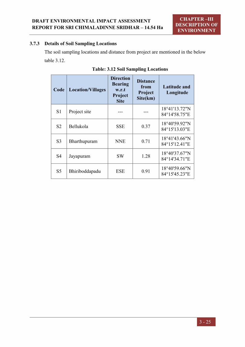
DRAFT ENVIRONMENTAL IMPACT ASSESSMENT
REPORT FOR SRI CHIMALADINNE SRIDHAR – 14.54 Ha
CHAPTER –III DESCRIPTION OF ENVIRONMENT
3 - 25
3.7.3 Details of Soil Sampling Locations
The soil sampling locations and distance from project are mentioned in the below
table 3.12.
Table: 3.12 Soil Sampling Locations
Code Location/Villages
Direction Bearing
w.r.t Project
Site
Distance from
Project Site(km)
Latitude and Longitude
S1 Project site --- --- 18°41'13.72"N 84°14'58.75"E
S2 Bellukola SSE 0.37 18°40'59.92"N 84°15'13.03"E
S3 Bharthupuram NNE 0.71 18°41'43.66"N 84°15'12.41"E
S4 Jayapuram SW 1.28 18°40'37.67"N 84°14'34.71"E
S5 Bhiriboddapadu ESE 0.91 18°40'59.66"N 84°15'45.23"E

DRAFT ENVIRONMENTAL IMPACT ASSESSMENT
REPORT FOR SRI CHIMALADINNE SRIDHAR – 14.54 Ha
CHAPTER –III DESCRIPTION OF ENVIRONMENT
3 - 26
Fig 3.4: Soil Sampling Locations
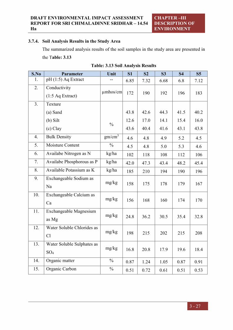
DRAFT ENVIRONMENTAL IMPACT ASSESSMENT REPORT FOR SRI CHIMALADINNE SRIDHAR – 14.54 Ha
CHAPTER –III DESCRIPTION OF ENVIRONMENT
3 - 27
3.7.4. Soil Analysis Results in the Study Area
The summarized analysis results of the soil samples in the study area are presented in
the Table: 3.13
Table: 3.13 Soil Analysis Results
S.No Parameter Unit S1 S2 S3 S4 S5 1. pH (1:5) Aq Extract -- 6.85 7.32 6.68 6.8 7.12
2. Conductivity
(1:5 Aq Extract) mhos/cm 172 190 192 196 183
3. Texture
(a) Sand
(b) Silt
(c) Clay
%
43.8
12.6
43.6
42.6
17.0
40.4
44.3
14.1
41.6
41.5
15.4
43.1
40.2
16.0
43.8
4. Bulk Density gm/cm3 4.6 4.8 4.9 5.2 4.5
5. Moisture Content % 4.5 4.8 5.0 5.3 4.6
6. Availabe Nitrogen as N kg/ha 102 118 108 112 106
7. Availabe Phosphorous as P kg/ha 42.0 47.3 43.4 48.2 45.4
8. Available Potassium as K kg/ha 185 210 194 190 196
9. Exchangeable Sodium as
Na mg/kg 158 175 178 179 167
10. Exchangeable Calcium as
Ca mg/kg 156 168 160 174 170
11. Exchangeable Magnesium
as Mg mg/kg 24.8 36.2 30.5 35.4 32.8
12. Water Soluble Chlorides as
Cl mg/kg 198 215 202 215 208
13. Water Soluble Sulphates as
SO4 mg/kg 16.8 20.8 17.9 19.6 18.4
14. Organic matter % 0.87 1.24 1.05 0.87 0.91
15. Organic Carbon % 0.51 0.72 0.61 0.51 0.53
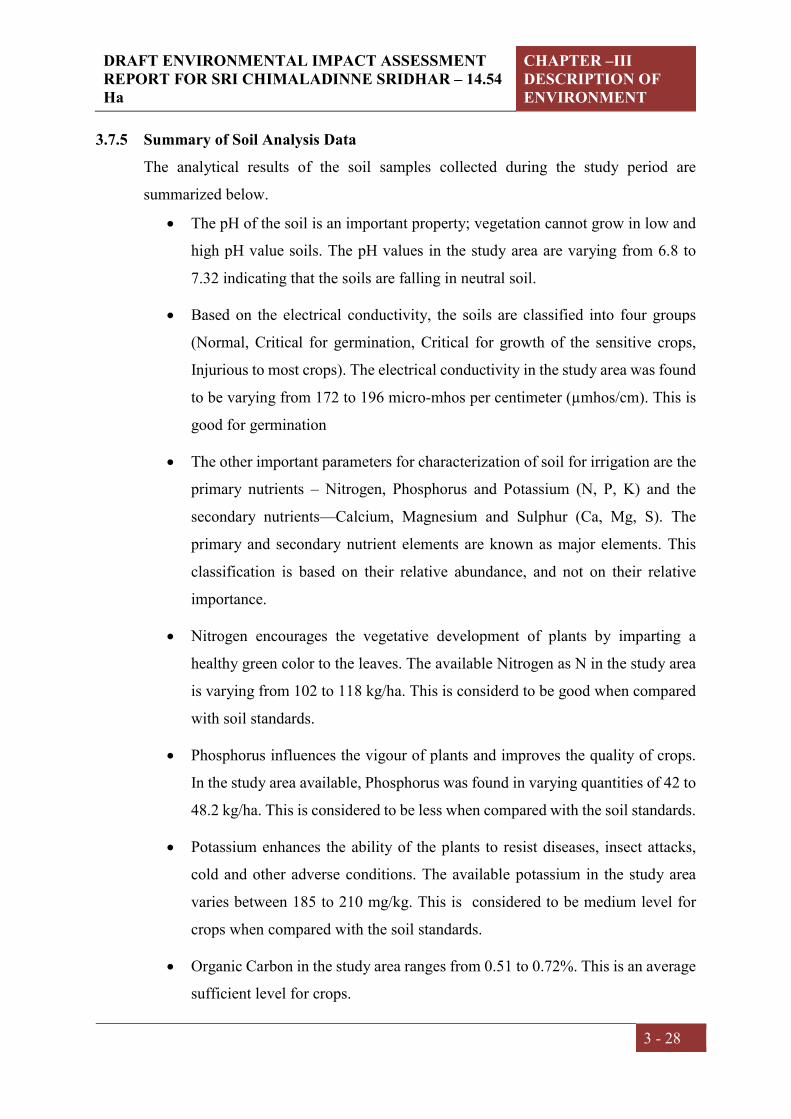
DRAFT ENVIRONMENTAL IMPACT ASSESSMENT REPORT FOR SRI CHIMALADINNE SRIDHAR – 14.54 Ha
CHAPTER –III DESCRIPTION OF ENVIRONMENT
3 - 28
3.7.5 Summary of Soil Analysis Data
The analytical results of the soil samples collected during the study period are
summarized below.
The pH of the soil is an important property; vegetation cannot grow in low and
high pH value soils. The pH values in the study area are varying from 6.8 to
7.32 indicating that the soils are falling in neutral soil.
Based on the electrical conductivity, the soils are classified into four groups
(Normal, Critical for germination, Critical for growth of the sensitive crops,
Injurious to most crops). The electrical conductivity in the study area was found
to be varying from 172 to 196 micro-mhos per centimeter (µmhos/cm). This is
good for germination
The other important parameters for characterization of soil for irrigation are the
primary nutrients – Nitrogen, Phosphorus and Potassium (N, P, K) and the
secondary nutrients—Calcium, Magnesium and Sulphur (Ca, Mg, S). The
primary and secondary nutrient elements are known as major elements. This
classification is based on their relative abundance, and not on their relative
importance.
Nitrogen encourages the vegetative development of plants by imparting a
healthy green color to the leaves. The available Nitrogen as N in the study area
is varying from 102 to 118 kg/ha. This is considerd to be good when compared
with soil standards.
Phosphorus influences the vigour of plants and improves the quality of crops.
In the study area available, Phosphorus was found in varying quantities of 42 to
48.2 kg/ha. This is considered to be less when compared with the soil standards.
Potassium enhances the ability of the plants to resist diseases, insect attacks,
cold and other adverse conditions. The available potassium in the study area
varies between 185 to 210 mg/kg. This is considered to be medium level for
crops when compared with the soil standards.
Organic Carbon in the study area ranges from 0.51 to 0.72%. This is an average
sufficient level for crops.
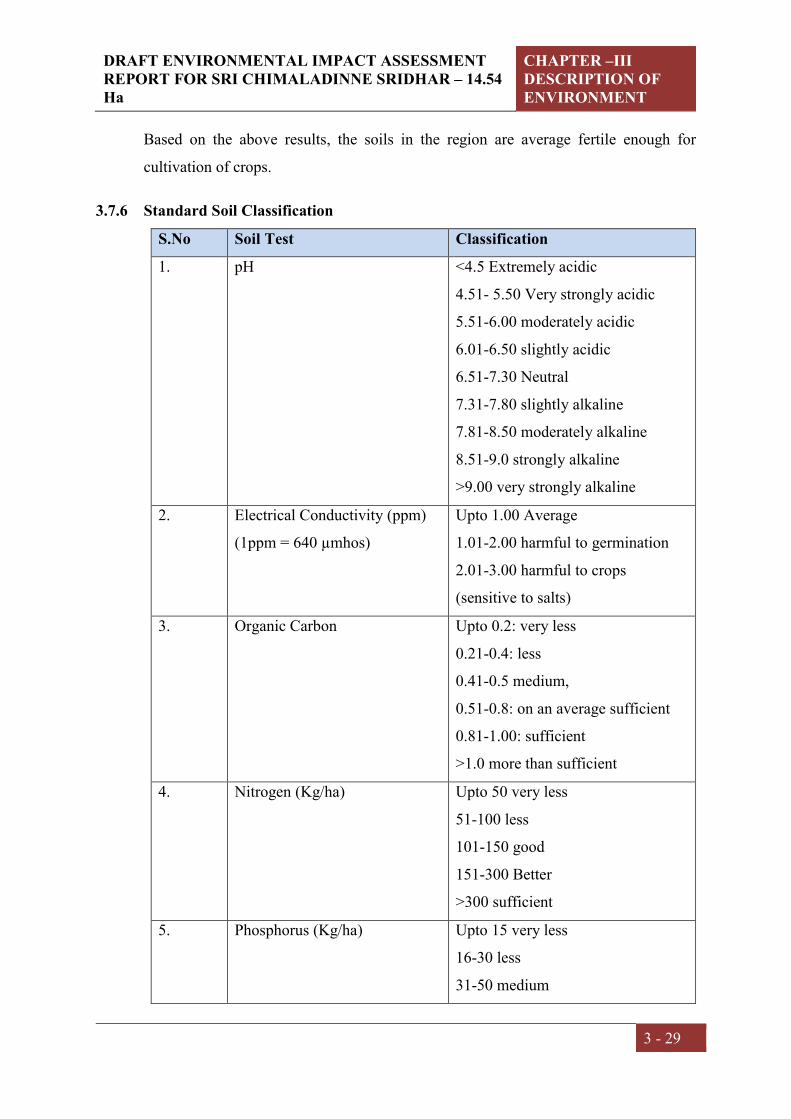
DRAFT ENVIRONMENTAL IMPACT ASSESSMENT REPORT FOR SRI CHIMALADINNE SRIDHAR – 14.54 Ha
CHAPTER –III DESCRIPTION OF ENVIRONMENT
3 - 29
Based on the above results, the soils in the region are average fertile enough for
cultivation of crops.
3.7.6 Standard Soil Classification
S.No Soil Test Classification
1. pH <4.5 Extremely acidic
4.51- 5.50 Very strongly acidic
5.51-6.00 moderately acidic
6.01-6.50 slightly acidic
6.51-7.30 Neutral
7.31-7.80 slightly alkaline
7.81-8.50 moderately alkaline
8.51-9.0 strongly alkaline
>9.00 very strongly alkaline
2. Electrical Conductivity (ppm)
(1ppm = 640 µmhos)
Upto 1.00 Average
1.01-2.00 harmful to germination
2.01-3.00 harmful to crops
(sensitive to salts)
3. Organic Carbon Upto 0.2: very less
0.21-0.4: less
0.41-0.5 medium,
0.51-0.8: on an average sufficient
0.81-1.00: sufficient
>1.0 more than sufficient
4. Nitrogen (Kg/ha) Upto 50 very less
51-100 less
101-150 good
151-300 Better
>300 sufficient
5. Phosphorus (Kg/ha) Upto 15 very less
16-30 less
31-50 medium

DRAFT ENVIRONMENTAL IMPACT ASSESSMENT REPORT FOR SRI CHIMALADINNE SRIDHAR – 14.54 Ha
CHAPTER –III DESCRIPTION OF ENVIRONMENT
3 - 30
51-65 on an average sufficient
66-80 sufficient
>80 more than sufficient
6. Potassium (Kg/ha) 0 -120 very less
120-180 less
181-240 medium
241-300 average
301-360 better
>360 more than sufficient
Source: Hand Book of Agriculture, ICAR, New Delhi
3.8 NOISE ENVIRONMENT
3.8.1 Identification of Sampling Locations
Noise at different generating sources has identified based on the activities in the village
area and the noise at sensitive areas. A detailed survey on noise environment was
carried in and around the project site to study the levels of noise, as the high dB (A)
levels may cause adverse effect on human beings and associated environment,
including structures, domestic animals and natural ecological systems. The locations
were identified keeping in view the land use pattern and environmental setting. Spot
noise levels were measured using a precision noise level meter at mine area and
residential areas in all eight locations were covered with in study zone.
3.8.2 Methodology
The monitoring was carried out at each location for a period of 24hrs, once in each
season. The locations were identified keeping in view the land use pattern and
environmental setting. The day levels of noise have been monitored during 6 am to 10
pm and the night levels during 10 pm to 6 am. The Ld, Ln and Ldn were calculated
based on the hourly Leq values. Spot noise levels were measured using a precision noise
level meter at residential areas and mine area, in all five locations which were covered
with in study zone. The noise levels include vehicular movement and local activities.
Noise levels were recorded for every 15minutes in a clock hour for a continuous 24-
hour period at all locations.

DRAFT ENVIRONMENTAL IMPACT ASSESSMENT REPORT FOR SRI CHIMALADINNE SRIDHAR – 14.54 Ha
CHAPTER –III DESCRIPTION OF ENVIRONMENT
3 - 31
3.8.3 Noise Monitoring Locations -The noise monitoring locations along with their
distance from project are mentioned in the below Table: 3.14
Table: 3.14 Noise Monitoring Locations
S.No Location Station Code
Direction from
Project Site
Distance w.r.t
Project Site
Latitude and Longitude
Environmental Setting
1. Project Site N1 - - 18°41'14.71"N 84°14'54.80"E
Industrial Area
2. Jayapuram N2 SW 1.32 18°40'35.90"N 84°14'34.56"E
Residential Area
3. Kollivalasa N3 WSW 2.81 18°40'30.18"N 84°13'30.66"E
Residential Area
4. Savarasomanadhapuram N4 NNW 1.0
18°41'46.40"N 84°14'42.60"E
Residential Area
5. Bharthupuram N5 NNE 0.70 18°41'43.15"N 84°15'13.10"E
Residential Area
6. Bellukola N6 ENE 0.32 18°41'0.58"N 84°15'13.64"E
Residential Area
7. Bhiriboddapadu N7 ESE 1.03 18°40'59.50"N 84°15'49.64"E
Residential Area
8. Jammipeta N8 SSE 0.75 18°41'26.34"N 84°15'36.16"E
Residential Area
3.8.4 Description of Locations:
N1 – the location has been selected to assess noise levels in the proposed mine site.
N2, N3, N4, N5, N6, N7 and N8 – the locations have been selected to assess noise levels
near to the mine area in residential areas with light Vehicular Movement.

DRAFT ENVIRONMENTAL IMPACT ASSESSMENT REPORT FOR SRI CHIMALADINNE SRIDHAR – 14.54 Ha
CHAPTER –III DESCRIPTION OF ENVIRONMENT
3 - 32
Fig 3.5: Noise Monitoring Locations

DRAFT ENVIRONMENTAL IMPACT ASSESSMENT REPORT FOR SRI CHIMALADINNE SRIDHAR – 14.54 Ha
CHAPTER –III DESCRIPTION OF ENVIRONMENT
3 - 33
3.8.5 Noise Levels in the Study Area
The noise level monitored during the study period is given in Table: 3.15 in the form
of Lday, Lnight and Ldn compared with CPCB Standards.
Table: 3.15 Noise Levels in the Study Area
Location Code
Environmental Setting
CPCB norms Leq dB(A) Leq dB(A)
day Leq dB(A)
night Day Night
N1 Project site 75 70 43.8 36.6
N2 Residential 55 45 50.2 41.3
N3 Residential 55 45 53.5 43.8
N4 Residential 55 45 51.6 42.4
N5 Residential 55 45 49.8 38.9
N6 Residential 55 45 48.4 37.5
N7 Residential 55 45 50.6 39.2
N8 Residential 55 45 47.3 38.4

DRAFT ENVIRONMENTAL IMPACT ASSESSMENT REPORT FOR SRI CHIMALADINNE SRIDHAR – 14.54 Ha
CHAPTER –III DESCRIPTION OF ENVIRONMENT
3 - 34
GRAPHICAL PRESENTATION OF AMBIENT NOISE LEVELS
IN THE STUDY AREA
43.850.2 53.5 51.6 49.8 48.4 50.6 47.3
55
75
0
10
20
30
40
50
60
70
80
No
ise
Leve
ls
Sampling Locations
Equivalent Noise Day TimeLeq (dBA)
36.641.3 43.8 42.4
38.9 37.5 39.2 38.445
70
0
10
20
30
40
50
60
70
80
No
ise
Leve
ls
Sampling Locations
Equivalent Noise Night TimeLeq (dBA)
DRAFT ENVIRONMENTAL IMPACT ASSESSMENT REPORT FOR SRI CHIMALADINNE SRIDHAR – 14.54 Ha
CHAPTER –III DESCRIPTION OF ENVIRONMENT
3 - 35
3.9 GEOLOGY AND HYDROGEOLOGY
3.9.1 Topography
The applied Quarry lease area consists of an undulating terrain and comprise of hill
range locally known as Durgam hill. The quarry lease area is located on the flank of a
rather steeply sloping hill and is occupied of boulders and sheet of Colour Granite
which are exposed to the surface. The area slope rather steeply in Northern direction.
The drainage of the area is controlled by a network of streams which act as feeders to
the tanks present in the area. The water table is located at a depth of about 50-60m from
the ground level. The drainage pattern of the area is dendritic pattern. There are no
perennial or seasonal streams or other water bodies within this existing mine area.
3.9.2 Drainage
The main rivers drain the district is Vamsadhara and Nagavali. The other
importantrivers flowing in the district are Suvarnamukhi, Vegavati, Mahendra Tanya
and Bahuda. Among the rivers Vamsadhara, Nagavali and Suvarnamukhi are perennial.
The general drainage pattern is dendritic to sub-dendritic and occasionally parallel at
places. The drainage in western part of the district resembles dendritic type, where as
in the central part it is parallel to sub-dendritic. The overall drainage is of medium to
coarse textured towards west and north of the district, whereas in central and southern
parts it is very coarse.
3.9.3 Geology
Regional Geology:
The regional geology is a part of Eastern Ghat Group of rocks consisting of
Charnockite, Khondalite and Granitoids, a variety of hybrid rock formed by the
interaction of Intrusive Granite into the Khondalite. The Eastern Ghat group attains a
maximum thickness in the Ganjam – Cuttack tract. It occurs as ridges trending NE-SW.
The Eastern Ghat belt exhibits high grade metamorphism as evidenced by the presence
of Garnet and Silliminite. The Charnockite shows intrusive relation towards Khondalite
and ha itself under gone post magmata changes. Felspathic bands are common and are
due to Granitisation.

DRAFT ENVIRONMENTAL IMPACT ASSESSMENT REPORT FOR SRI CHIMALADINNE SRIDHAR – 14.54 Ha
CHAPTER –III DESCRIPTION OF ENVIRONMENT
3 - 36
Local Geology:
The quarry lease area is occupied of boulders and sheet of colour Granite which are
exposed to the surface. The main rock exposed in the area consists of Charnockite
Gneiss and Khondalite. Two set of joints are observed, one is parallel and the other
perpendicular to strike direction. They are widely spaced and are useful in splitting big
blocks from the mother rock. The rock on physical examination is medium colour and
grained, massive and compact. The accessory minerals present are biotite and garnet.
The rock at places is intruded by Quartz vein and Feldspar band. The weathering
extends to a depth varying from few inches to a foot in some areas. Megascopic and
polished sample indicates that the rock takes good polish and exhibits fine texture. The
overall appearance of the rock is bluish in colour. The rock is commercially known as
Imperial Green and Brown. The other mineral assemblages are Silliminite, Garnet and
Quartz.
3.9.4 Geomorphology
Using IRS satellite data and GIS detailed geological, geomorphological and
structural map of Srikakulam District was generated as per Rajiv Gandhi National
Drinking Water Mission (RGNDWM) guidelines on 1: 50,000 scale. The objective of
this is to map lithology, geomorphology and structural characteristics of an area on
1:50,000 scale and to integrate the same to locate potential ground water prospect
zones and to recommend suitable structures for ground water recharge. Various
hydrogeomorphic units are delineated and suitable recharge structures are
proposed at drinking water affected villages under this project. The description of
geomorphic units of different origins (Fig.3.7) mapped in Srikakulam District are
described
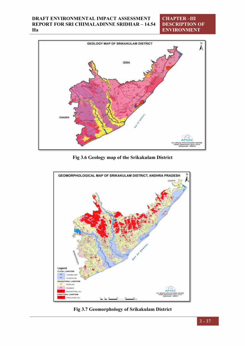
DRAFT ENVIRONMENTAL IMPACT ASSESSMENT REPORT FOR SRI CHIMALADINNE SRIDHAR – 14.54 Ha
CHAPTER –III DESCRIPTION OF ENVIRONMENT
3 - 37
Fig 3.6 Geology map of the Srikakulam District
Fig 3.7 Geomorphology of Srikakulam District

DRAFT ENVIRONMENTAL IMPACT ASSESSMENT REPORT FOR SRI CHIMALADINNE SRIDHAR – 14.54 Ha
CHAPTER –III DESCRIPTION OF ENVIRONMENT
3 - 38
Hydrogeology
The district is underlain by variety of geological formations from the oldest Archaeans
to Recent Alluvium. The Archaean Group of rocks includes Khondalites and
Charnockites of Eastern Ghat Super Group and Granitic gneisses of Migmatite Group.
The Gondwana rocks which are represented by sandstones are of very limited aerial
extent. These sandstones occur as outlier in Ranastalam mandal on western part of the
district. The thickness of this formation is more than 220 m. The recent sediments
constitute coarse to fine sands, gravels, silts and clays. Structurally the are is highly
disturbed as evidenced by the structurally controlled rivers viz: Vamsadhara and
Nagavali which are observed to flow in the faulted zone trending NW-SE direction.
Prominent lineaments are trending in NE-SW, NW-SE and NNW-SSE.
Fig 3.8 Hydrogeology of the Srikakulam District

DRAFT ENVIRONMENTAL IMPACT ASSESSMENT REPORT FOR SRI CHIMALADINNE SRIDHAR – 14.54 Ha
CHAPTER –III DESCRIPTION OF ENVIRONMENT
3 - 39
Ground water occurs in almost all geological formations. From the ground water point
of view, the aquifers found in the district can be broadly classified into hard rocks
(khondalites, quartzites, charnockites, granitic gneisses etc.) and soft rocks (sand
stones, river alluvium, coastal alluvium etc.). Ground water occurs under unconfined to
semi-confined conditions in the hard rock formations, while it occurs under unconfined
to confined conditions in soft rock formations. The yields in the weathered zones of
khondalites and charnockites are very limited and are in the order of 10 to 20 m3/d. In
the weathered granitic gneisses the yields are in theranges from 10 to 40 m3/d. The bore
wells constructed in the hard rocks generally tap the fractured and fissured zones. The
yields of the bore wells range between <1 lps to 3 lps. The higher yields are limited to
the available thickness of fractured, fissured and jointed zones. The occurrence of
fractures is limited down to 30 to 40 m bgl and occasionally extends down to 70- 100m
bgl. The river alluvium being unconsolidated sediment and having high porosity and
permeability forms potential aquifer system. The yields generally range in this aquifer
between 3 and 5 lps. Occasionally 7 to 9 lps yields are also observed in the sediments
consisting of thick sand and gravel beds. Coastal alluvium has good yield potential in
the range of 2 to 4 lps depending upon the availability of sand beds. The yields in
sandstone formation range between 6 and 19 lps. Granularity of the sandstone bed is
the deciding factor of yield potential as the higher yields are recorded in the wells
tapping coarse sand stone beds.
Ground water level
The depth to water level during pre monsoon season (May, 2012) in the district
generally ranges between 5 and 10 mbgl (Fig. 3.9). Shallow water levels less than 5 m
bgl occur in parts of Seetampeta, Veeraghattam, Vangara, Saravakota, Gara, Meliaputti,
Patapatnam, and Ichapuram mandals. Whereas water levels more than 10 m bgl are
recorded at Palasa and Kotturu.
The depth to water level during post monsoon season (Nov, 2012) in the district
generally less than 2 mbgl (Fig. 3.10). Deeper water levels more than 2 mbgl occur in
Laveru, G.Sigadam, Ponduru, Rajam and Ranastalam mandals.

DRAFT ENVIRONMENTAL IMPACT ASSESSMENT REPORT FOR SRI CHIMALADINNE SRIDHAR – 14.54 Ha
CHAPTER –III DESCRIPTION OF ENVIRONMENT
3 - 40
Ground water availability
Ground water levels fluctuate considerably in response to the recharge and draft
conditions of ground water reservoir. Rise in water levels from pre-monsoon to post-
monsoon is in the range of 1.31 m to 9.05 m exist in the district. Majority of the district
is below 4 m fluctuation. The minimum average fluctuation is in alluvium, whereas
maximum average fluctuation is in khondalites. Long-term trend of water level (2001
to 2011) indicates during pre monsoon an overall raise in the district in the range of
0.002 to 0.532 m/yr where as fall in the range of 0.007 to 0.228 m/yr exist at Kanchili,
Ponduru, Heeramandalam and Srikakulam. During post-monsoon period overall raise
exists in the district, it varies from 0.003 to 0.487 m/yr except at Srikakulam and
Kanchili, where fall recorded of 0.013 and 0.018 m/yr respectively.
The water table elevation ranges between <1 m amsl (Kalingapatnam) and 139 m.amsl
(Sitampeta). The water table contours are almost parallel to the topographic contours
with gentle slopes along higher order streams of Vamsadhara and Nagavali and steep
slopes in the hilly and intermontane upland areas. The general ground water flow
direction is towards south directing towards the sea. Pumping test data of exploratory
wells drilled by CGWB reveal that the transmissivity values in hard rocks vary between
2 and 44 m2/day while the storativity ranges from 2.5x10⁻⁴ to 5.8x10⁻⁴. The aquifer
parameters will be very high in soft rock formations i.e. alluvium and sandstone due to
high yield potential.
Ground Water Resources
Ground water resources for each mandal are presented in Table-3.16. Net annual
ground water availability is 411.30 MCM in the command area and 515.86 MCM in
non-command area with a total of 927.16 MCM in the entire district. The gross ground
water draft for all uses in the command area is in the order of 80.75 MCM whereas it is
191.42 MCM in non-command area and the total gross ground water draft for all uses
in the district is 272.17 MCM. Out of this Resource 23.41 MCM in Command area and
68.29 MCM in non-command area with the total of 92.103 MCM in the entire district
allocated to cater the domestic and industrial needs of the population in the district as
on 2025. Net ground water availability for future irrigation use is 318.49 MCM in the
command, 287.26 MCM in non-command area and 605.75 MCM in the entire district.

DRAFT ENVIRONMENTAL IMPACT ASSESSMENT REPORT FOR SRI CHIMALADINNE SRIDHAR – 14.54 Ha
CHAPTER –III DESCRIPTION OF ENVIRONMENT
3 - 41
All the mandals in the district are categorized as safe except Ranasthalam (Over
exploited) and Laveru (Semi Critical) mandals. Ground water resources for each
Mandal are presented as Table 3.16.
Fig 3.9 Depth of water level-Pre-Monsoon in Srikakulam District
Fig 3.10 Depth of water level-Post-Monsoon in Srikakulam District

DRAFT ENVIRONMENTAL IMPACT ASSESSMENT REPORT FOR SRI CHIMALADINNE SRIDHAR – 14.54 Ha
CHAPTER –III DESCRIPTION OF ENVIRONMENT
3 - 42
Table: 3.16 Dynamic Ground water Resources - Nandigama
S. N
o
Man
dal
Su
b-u
nit
Tot
al
ann
ual
gr
oun
d
wat
er
Rec
har
ge
Pro
visi
on
for
Nat
ura
l
dis
char
ges
Net
A
uu
nal
gr
oun
d
wat
er
avai
lab
ilit
y
Exi
stin
g gr
oss
grou
nd
w
ater
dra
ft f
or a
ll u
ses
Pro
visi
on
for
dom
esti
c an
d
ind
ust
rial
req
uir
emen
t su
pp
ly
Net
gro
un
d w
ater
ava
ilab
ilit
y
for
futu
re
irri
gati
on
dev
elop
men
t
Sta
ge
of
gro
un
d
wat
er
dev
elop
men
t
Cat
egor
y
1 Nandig
ama
C 904 95 809 284 53 507 35 Safe
Non-C 2055 189 1866 584 147 1282 31 Safe
Total 2959 284 2675 868 200 1789 32 safe
3.10 LAND USE/LAND COVER
Indian Remote Sensing satellite, multi-spectral digital data has been used for the
preparation of land use/ land cover map of present study. Survey of India reference map
on 1:50,000 scales have been used for the preparation of base map and geometric
correction of satellite data. Ground truthing has been carried out to validate the
interpretation accuracy and reliability of remotely sensed data, by enabling verification
of the interpreted details and by supplementing with the information, which cannot be
obtained directly on satellite imagery.
3.10.1 Objectives
Present status of land component of the environment including Standard ToR
points for the project within the study area covering 10 km radial distance around
the mine lease area.
Identification of forest land, agricultural land, waste land, water bodies etc. in the
area of interest.
Preparation of an Environmental Management Plan (EMP) to be adopted for
mitigation of anticipated adverse impacts, if any.

DRAFT ENVIRONMENTAL IMPACT ASSESSMENT REPORT FOR SRI CHIMALADINNE SRIDHAR – 14.54 Ha
CHAPTER –III DESCRIPTION OF ENVIRONMENT
3 - 43
3.10.2 Methodology:
The overall methodology (Fig 3.11) adopted and followed to achieve the objectives of
the present study involves the following steps:
Collection of source data of SOI toposheets. These are the main inputs for the
preparation of essential layers.
Satellite data of IRS P6 LISS IV sensor is geometrically corrected and enhanced
using principal component method and Nearest Neighborhood re-sampling
technique.
Preparation of basic themes like layout map, transport & settlement map and from
the source data. Then updating of layout map, transport map and drainage map
from the satellite image by visual interpretation.
Essential maps (related to natural resources) like Land use / Land cover map are
prepared by visual interpretation of the satellite imagery. Visual interpretation is
carried out based on the image characteristics like tone, size, shape, pattern, texture,
location, association, background etc. in conjunction with existing maps/ literature.
Preliminary quality check and necessary corrections are carried out for all the maps
prepared.
All the maps prepared are converted into soft copy by digitization of contours and
drainages. In that process editing, labeling, mosaicing, quality checking, data
integration etc are done, finally Land use areas are measured in Square Kilometers.
3.10.3 Land use Pattern-Remote Sensing data
The basic purpose of land use pattern and classification in an EIA study is to identify
the manner in which different parts of land area is utilized or not utilized. Remote
sensing data provides reliable accurate baseline information for land use mapping as it
is a rapid method of acquiring up-to-date information of over a large geological area.
Studies on land use aspects of eco-system play an imperative role in identifying
susceptible issues and to take appropriate action to uphold ecological equilibrium in
the region. The main objective of this section is to provide a baseline status of the study
area covering 10 km radius around the mine lease area so that temporal changes due to
the Mining activities on the surroundings can be assessed in future.
The objectives of Land use Pattern are to:
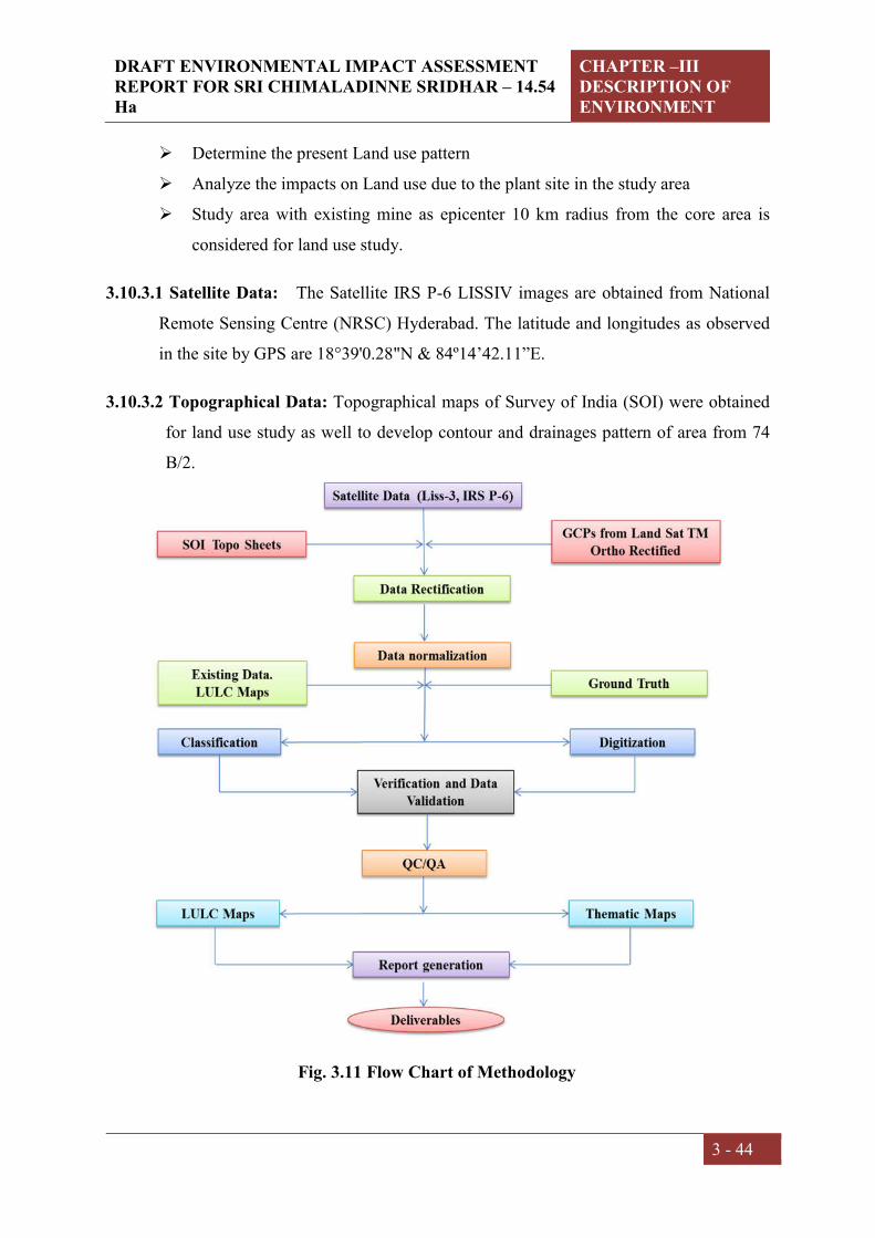
DRAFT ENVIRONMENTAL IMPACT ASSESSMENT REPORT FOR SRI CHIMALADINNE SRIDHAR – 14.54 Ha
CHAPTER –III DESCRIPTION OF ENVIRONMENT
3 - 44
Determine the present Land use pattern
Analyze the impacts on Land use due to the plant site in the study area
Study area with existing mine as epicenter 10 km radius from the core area is
considered for land use study.
3.10.3.1 Satellite Data: The Satellite IRS P-6 LISSIV images are obtained from National
Remote Sensing Centre (NRSC) Hyderabad. The latitude and longitudes as observed
in the site by GPS are 18°39'0.28"N & 84º14’42.11”E.
3.10.3.2 Topographical Data: Topographical maps of Survey of India (SOI) were obtained
for land use study as well to develop contour and drainages pattern of area from 74
B/2.
Fig. 3.11 Flow Chart of Methodology

DRAFT ENVIRONMENTAL IMPACT ASSESSMENT REPORT FOR SRI CHIMALADINNE SRIDHAR – 14.54 Ha
CHAPTER –III DESCRIPTION OF ENVIRONMENT
3 - 45
3.10.4 Land use Map Analysis
Land use Map Analysis carried out based on the image color, texture, Tone etc.
Following steps are used to analyze the Land use pattern of mine lease area:
Collection of scanned toposheets and Geo-reference the scanned image using the
available coordinates
Collection of IRS LISS IV images and made fused and blended the images for
color combinations using Image interpreter-Utilities and Layer stack option
available in ERDAS
Identification Area of interest (AOI) and made a buffer of 10 km radius.
Enhance the Fused and blended LISS IV image using the Spatial, Radiometric
and Temporal options in ERDAS
Rectified the LISS IV image using Geo-referencing technique, Toposheet to get
UTM coordinate system
Subset the LISS images and Toposheet using 10 km buffer AOI
Automatic classifications done for LISS IV images using maximum iterations
and number of options in unsupervised classification options
Created the signature file by selecting the more samples of different features with
AOI on Unsupervised classification image
Visual interpretation and supervised classification mixed with recoding practice
Verified through the QC / QA and finalized the data.
3.10.5 Spatial Data from SOI Topographical Sheets
Creating a GIS spatial database is a complex operation, and is the heart of the entire
work; it involves data capture, verification and structuring processes. Raw
geographical data are available in many different analogue and digital form such as
toposheets, aerial photographs, satellite imageries and tables. Out of all these sources,
the source of toposheets is of much concern to natural resource scientist and an
environmentalist.

DRAFT ENVIRONMENTAL IMPACT ASSESSMENT REPORT FOR SRI CHIMALADINNE SRIDHAR – 14.54 Ha
CHAPTER –III DESCRIPTION OF ENVIRONMENT
3 - 46
In the present study, the essential maps generated from SOI topographical maps.
Using the topographical maps, the drainage map and contour Map were also
developed. The maps are prepared to a certain scale and with attributes complying
with the requirement of terms of reference (ToR). The location of entities on the
earth’s surface is then specified by means of an agreed co-ordinate system. For most
GIS, the common frame of co-ordinate system used for the study is UTM co-ordinates
system. All the maps are first Geo-referenced. The same procedure is also applied on
remote sensing data before it is used to prepare the Essential maps.
Satellite image of the study area is provided in Fig 3.12. No National parks and wild
life sanctuaries located in the study area.
3.10.6 Contour Map and Elevations of Study Area
The contours in Toposheet have been digitized in the GIS environment and assigned
the respective elevation values in meters with reference to the mean sea level. From the
mine area the high range hill area were observed towards North West direction and the
lowest contours were observed in South direction. While the remaining areas showed
variations with respect to contours. Contour Map and Elevations of Study Area is
presented in Fig.3.13.
3.10.7 Topography (Digital Elevation Model)
A digital elevation model (DEM) is a digital representation of ground surface
topography or terrain (Fig.3.14). It is also widely known as a digital terrain model
(DTM). A DEM can be represented as a raster (a grid of squares, also known as a
height map when representing elevation) or as a triangular irregular network. For the
relief study of the area very higher quality SRTM (Shuttle Radar Topography Mission)
and DEM is downloaded.
3.10.8 Land use land cover statistics of buffer zone
The Land Use Land Covers Statistics of Buffer Zone shown in Table 3.17

DRAFT ENVIRONMENTAL IMPACT ASSESSMENT REPORT FOR SRI CHIMALADINNE SRIDHAR – 14.54 Ha
CHAPTER –III DESCRIPTION OF ENVIRONMENT
3 - 47
Fig 3.12 Satellite image within the 10 km radius

DRAFT ENVIRONMENTAL IMPACT ASSESSMENT REPORT FOR SRI CHIMALADINNE SRIDHAR – 14.54 Ha
CHAPTER –III DESCRIPTION OF ENVIRONMENT
3 - 48
Fig 3.13 Contour levels within the 10 km radius

DRAFT ENVIRONMENTAL IMPACT ASSESSMENT REPORT FOR SRI CHIMALADINNE SRIDHAR – 14.54 Ha
CHAPTER –III DESCRIPTION OF ENVIRONMENT
3 - 49
Fig 3.14 Digital Elevation Map

DRAFT ENVIRONMENTAL IMPACT ASSESSMENT REPORT FOR SRI CHIMALADINNE SRIDHAR – 14.54 Ha
CHAPTER –III DESCRIPTION OF ENVIRONMENT
3 - 50
Fig 3.15 The map showing river order within the 10 km radius

DRAFT ENVIRONMENTAL IMPACT ASSESSMENT REPORT FOR SRI CHIMALADINNE SRIDHAR – 14.54 Ha
CHAPTER –III DESCRIPTION OF ENVIRONMENT
3 - 51
Fig 3.16 The map showing Land use and Land Cover within the 10 km radius

DRAFT ENVIRONMENTAL IMPACT ASSESSMENT REPORT FOR SRI CHIMALADINNE SRIDHAR – 14.54 Ha
CHAPTER –III DESCRIPTION OF ENVIRONMENT
3 - 52
Land Use Land Cover Statistics of Mine Buffer Zone:
The core and buffer area of the mine is covered with Vegetation land around 11.17 % of
the total area. Other class around the Agricultural land edges is the Settlement (Built-up
area) is located and occupies around 7.97 % of the total study area. It is an area of human
habitation developed due to non-agricultural use and that has a cover of buildings, transport
and communication, utilities in association with water, vegetation and vacant lands. Fallow
land area is 60.35% and Forest area is covering around 19.56 %. The water bodies cover
0.94 % of the total area. The water bodies cover Sitagal cheruvu and Banshadhara Main
Canal and few 10 and 20 order streams. These area have a very prominent signature and
can be seen as almost Dark blue and light blue in the satellite image.
Table 3.17 Land Use Land Covers Statistics of Buffer Zone
S.No LU/LC Class Area (Sqkm) Area (%)
1 Agriculture Land 120.187 36.33
2 Barren Land 6.197 1.87
3 Builtup Area 4.527 1.37
4 Canal Dump 7.695 2.33
5 Fallow Land 101.371 30.64
6 Forest Land 86.196 26.05
7 Mined Out Area 1.302 0.39
8 Water Body 3.378 1.02
TOTAL 330.854 100.00

DRAFT ENVIRONMENTAL IMPACT ASSESSMENT REPORT FOR SRI CHIMALADINNE SRIDHAR – 14.54 Ha
CHAPTER –III DESCRIPTION OF ENVIRONMENT
3 - 53
Fig. 3.17 Graphical Presentation of Land Use Statistics
36.33
1.87
1.37
2.33
30.64
26.05
0.391.02
LULC
1 Agriculture Land
2 Barren Land
3 Builtup Area
4 Canal Dump
5 Fallow Land
6 Forest Land
7 Mined Out Area
8 Water Body

DRAFT ENVIRONMENTAL IMPACT ASSESSMENT REPORT FOR SRI CHIMALADINNE SRIDHAR – 14.54 Ha
CHAPTER –III DESCRIPTION OF ENVIRONMENT
3 - 54
3.11. Biological environment
Introduction
Plant and animal communities are indicators of the environment. They respond not only to
one environmental factor, but also to an interacting group of factors. The plant and animal
communities integrates these influences and reacts sensitively to changes in the balance of
environmental stresses such as abitotic and biotic factors and anthropogenic activities. This
could cause changes in the physiognomy, structure and species composition of the flora
and fauna. Since the ecological integrity is one of the fundamental factors towards attaining
a sustainable ecosystem, following biological study in and around of mine lease areas of
Mandasa region was undertaken to assess the species diversity, distribution and present
status of flora and fauna.
Study area
The mine lease area is located Bellukola Village in the Tekkali Forest Range of Srikakulam
Division. The division is located on the Eastern slopes of Eastern Ghats. The Eastern Ghats
are the range of hills running parallel in the North-South Direction. The forests are
distributed from about 120 m to 1600 m. deciduous forests and Semi evergreen forests with
the increase in altitude gradually replace the dry scrub forests in the foothills. The hilltops
are characterized by dry Savannah forests. Though the distribution of forests is largely
influenced by the altitudinal variation, anthropogenic activities have changed the
landscape. The single major activity, which changed the face of forests in the region, is
Podu cultivation. Jack and Tamarind trees are the mute spectators of the past Podu
cultivation.
Based on Champion and Seth’s classification, the forests of the Srikakulam Division can
be divided in to the 5 types. Though the mine area is restricted to the hilltops, the impact
of mining will have bearing on the vegetation in the adjoining areas.
S.No. Technical description Types of forests
1 2B/2S Southern tropical semi evergreen forest
2 3B/2S Southern tropical secondary Moist mixed forests
3 5A/2S1 Southern tropical secondary dry deciduous forests
4 6A/C1 Southern thorn forests
5 5D/S2 Dry Savannah forests

DRAFT ENVIRONMENTAL IMPACT ASSESSMENT REPORT FOR SRI CHIMALADINNE SRIDHAR – 14.54 Ha
CHAPTER –III DESCRIPTION OF ENVIRONMENT
3 - 55
Podu cultivation (shifting cultivation) practiced by the tribes in the region. The trees in the
area are cut and the cleared patch is burnt. Crop seeds are sown before the rains. There will
be good harvest for few years in the beginning, later the yield comes down due to soil
erosion and due to lack of soil erosion control measures. Almost all the villages adjoining
the block practice Podu cultivation. The Podu cultivation, in the long run will not only
affect the ecology of the region but also the very existence of the people living in the nearby
villages.
Forest blocks in study area
The details of forest blocks in study area are presented below in the Table 3.18. Small
plantations agro forestry) could also be seen in the buffer zone of the project (Anacardium
occidentale, Eucalyptus globules, Tectona grandis and Mangifera indica).
Table 3.18. Details of the forest blocks in the study area
S.No Details of forest blocks Distance (KM) Direction 1 Pedda Kedari RF 2.69 W
2 Jadupalle RF 5.45 NW
3 Banapuram RF 6.94 NE
Objectives
To study the present Ecological status and Biodiversity of core and buffer zones of
project areas
To generate baseline data on Flora and Fauna of core and buffer zones with
assessment of possible impacts
To suggest a Mitigation Plan for Conservation and Management of Biodiversity in core and
buffer zones.
Methodology
Vegetation survey
Vegetation and plant species composition observed and documented during field visit in
and around the mining site in the summer season. Besides primary surveys in the mining
sites, published literature and various floras were consulted to prepare an inventory of plant
species growing at project sites. The vegetation of the study area is highly degraded and

DRAFT ENVIRONMENTAL IMPACT ASSESSMENT REPORT FOR SRI CHIMALADINNE SRIDHAR – 14.54 Ha
CHAPTER –III DESCRIPTION OF ENVIRONMENT
3 - 56
some areas consisting water bodies. The plant diversity is classified into various plant
groups such as tree, shrubs, herbs, climbers, sedges and grasses. The plant diversity survey
in the project area was undertaken during the winter season with the objectives of preparing
a checklist of flora in the study area. The list included total plant diversity belonging to
various groups such as agricultural crops, vegetable crops, and horticultural crops, natural
and aquatic flora (Table 3.19).
Fauna survey
A linear transect of 1 km each was chosen for sampling at each site. Each transect was
trekked for 1.5 hr for the sampling of faunal diversity through following methods for
different categories. For the sampling of butterflies, the standard ‘Pollard walk’ method was
employed and all the species that could not be identified in the field were collected using a
butterfly net besides photographing them.
For bird’s sampling ‘point sampling’ along the fixed transects (foot trails) was carried out.
All the species of birds were observed through a binocular and identified with the help of
field guidebook and photographs.
For sampling of mammals, direct count on open width (20m) transect was used. In addition,
information on recent sightings/records of mammals by the villagers/locals was also
collected. For carnivores, indirect sampling was carried out and the mammals wee identified
by foot marks, faeces and other marks/sign created by them. In case of reptiles mainly lizards
were sampled by direct count on open width transects.
The study of fauna takes substantial amount of time to understand the specific faunal
characteristics of area. The assessment of fauna has been done by extensive field survey of
the area. During survey, the presence of wildlife was also inhabitants depending on animal
sightings and frequency of their visits in the project area which was later confirmed from
forest department, Wildlife department etc.

DRAFT ENVIRONMENTAL IMPACT ASSESSMENT REPORT FOR SRI CHIMALADINNE SRIDHAR – 14.54 Ha
CHAPTER –III DESCRIPTION OF ENVIRONMENT
3 - 57
Table 3.19. Mode of data collection and parameters considered during the survey
S.No. Aspect Data Mode of data
collection
Parameters
monitored
Remarks
1 Terrestrial
Biodiversity
Primary
data
collection
By field survey Flora and
faunal diversity
For floral diversity:
Random survey,
Sampling survey/ Forest
inventory, walking
transect, collection and
identification with the
help of relevant
literature.
For faunal diversity:
Direct and indirect
sampling, walking
transect, point sampling
and nest sampling etc.
2 Secondary
data
collection
From authentic
sources like
published
literature and
Forest
Department of
Andhra Pradesh
literature and
from BSI and
ZSI etc.
Floral,
vegetation and
forest types
studied from
Flora of
Andhra
Pradesh.
Data collected from the
working plan of the
region, forest types from
the authentic literature
of Vegetation types of
India (Champion and
Seth) Flora of Andhra
Pradesh (Pullaiah et al
1997) and Flora of
Srikakulam district (Rao
and Sreeramulu 1986).
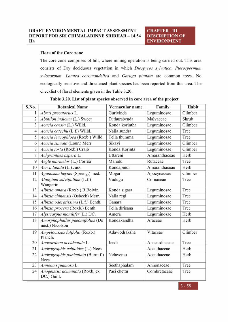
DRAFT ENVIRONMENTAL IMPACT ASSESSMENT REPORT FOR SRI CHIMALADINNE SRIDHAR – 14.54 Ha
CHAPTER –III DESCRIPTION OF ENVIRONMENT
3 - 58
Flora of the Core zone
The core zone comprises of hill, where mining operation is being carried out. This area
consists of Dry deciduous vegetation in which Diospyros sylvatica, Pterospermum
xylocarpum, Lannea coromandelica and Garuga pinnata are common trees. No
ecologically sensitive and threatened plant species has been reported from this area. The
checklist of floral elements given in the Table 3.20.
Table 3.20. List of plant species observed in core area of the project
S.No. Botanical Name Vernacular name Family Habit
1 Abrus precatorius L. Gurivinda Leguminosae Climber
2 Abutilon indicum (L.) Sweet Tuthurabenda Malvaceae Shrub
3 Acacia caesia (L.) Willd. Konda korintha Leguminosae Climber
4 Acacia catechu (L.f.) Willd. Nalla sundra Leguminosae Tree
5 Acacia leucophloea (Roxb.) Willd. Tella thumma Leguminosae Tree
6 Acacia sinuata (Lour.) Merr. Sikayi Leguminosae Climber
7 Acacia torta (Roxb.) Craib Konda Korinta Leguminosae Climber
8 Achyranthes aspera L. Uttareni Amaranthaceae Herb
9 Aegle marmelos (L.) Corrêa Maredu Rutaceae Tree
10 Aerva lanata (L.) Juss. Kondapindi Amaranthaceae Herb
11 Aganosma heynei (Spreng.) ined. Mogari Apocynaceae Climber
12 Alangium salviifolium (L.f.) Wangerin
Vudugu Cornaceae Tree
13 Albizia amara (Roxb.) B.Boivin Konda sigara Leguminosae Tree
14 Albizia chinensis (Osbeck) Merr. Nalla regi Leguminosae Tree
15 Albizia odoratissima (L.f.) Benth. Ganara Leguminosae Tree
16 Albizia procera (Roxb.) Benth. Tella dirisana Leguminosae Tree
17 Alysicarpus monilifer (L.) DC. Amera Leguminosae Herb
18 Amorphophallus paeoniifolius (Dennst.) Nicolson
Kondakandha Araceae Herb
19 Ampelocissus latifolia (Roxb.) Planch.
Adaviodraksha Vitaceae Climber
20 Anacardium occidentale L. Jeedi Anacardiaceae Tree
21 Andrographis echioides (L.) Nees Acanthaceae Herb
22 Andrographis paniculata (Burm.f.) Nees
Nelavemu Acanthaceae Herb
23 Annona squamosa L. Seethaphalam Annonaceae Tree
24 Anogeissus acuminata (Roxb. ex DC.) Guill.
Pasi chettu Combretaceae Tree

DRAFT ENVIRONMENTAL IMPACT ASSESSMENT REPORT FOR SRI CHIMALADINNE SRIDHAR – 14.54 Ha
CHAPTER –III DESCRIPTION OF ENVIRONMENT
3 - 59
25 Anogeissus latifolia (Roxb. ex DC.) Wall. ex Bedd.
Sirumanu Combretaceae Tree
26 Apluda mutica L. - Poaceae Grass
27 Argyreia nervosa (Burm. f.) Bojer Samudra pala Convolvulaceae Climber
28 Aristida funiculata Trin. & Rupr. Cheepurugaddi Poaceae Grass
29 Aristida setacea Retz. Parakagaddi Poaceae Grass
30 Aristolochia bracteolata Lam. Gadidagadapa Aristolochiaceae Herb
31 Aristolochia indica L. Nall eswari Aristolochiaceae Herb
32 Arundinella setosa Trin. Poaceae Grass
33 Asparagus racemosus Willd. Pilligaddalu Asparagaceae Climber
34 Asystasia gangetica (L.) T.Anderson
- Acanthaceae Herb
35 Atalantia monophylla DC. Karu nimma Rutaceae Tree
36 Azadirachta indica A.Juss. Vepa Meliaceae Tree
37 Balanites aegyptiaca (L.) Delile Gara Zygophyllaceae Tree
38 Bambusa bambos (L.) Voss Veduru Poaceae Shrub
39 Bauhinia racemosa Lam. Are Leguminosae Tree
40 Bauhinia vahlii Wight & Arn. Addaku Leguminosae Climber
41 Blumea virens DC. Compositae Herb
42 Boerhavia diffusa L. Atikamamidi Nyctaginaceae Herb
43 Bombax ceiba L. Buruga Malvaceae Tree
44 Bothriochloa glabra (Roxb.) A.Camus
Poaceae Grass
45 Brachiaria eruciformis (Sm.) Griseb.
Poaceae Grass
46 Brachiaria ramosa (L.) Stapf - Poaceae Grass
47 Brachiaria reptans (L.) C.A.Gardner & C.E.Hubb.
Poaceae Grass
48 Breynia vitis-idaea (Burm.f.) C.E.C.Fisch.
Purugudu Euphorbiaceae Shrub
49 Bridelia montana (Roxb.) Willd. Balli chettu Phyllanthaceae Tree
50 Bridelia retusa (L.) A.Juss. Anemu Phyllanthaceae Tree
51 Bridelia tomentosa Blume Balli Phyllanthaceae Tree
52 Buchanania cochinchinensis (Lour.) M.R.Almeida
Sara Anacardiaceae Tree
53 Bulbostylis barbata (Rottb.) C.B.Clarke
Cyperaceae Sedge
54 Butea monosperma (Lam.) Taub. Modhuga Leguminosae Tree
55 Butea superba Roxb. Tiga moduga Leguminosae Climber

DRAFT ENVIRONMENTAL IMPACT ASSESSMENT REPORT FOR SRI CHIMALADINNE SRIDHAR – 14.54 Ha
CHAPTER –III DESCRIPTION OF ENVIRONMENT
3 - 60
56 Cadaba fruticosa (L.) Druce Capparaceae Climber
57 Cajanus scarabaeoides (L.) Thouars
Konda kandui Leguminosae Herb
58 Canavalia gladiata (Jacq.) DC. Tamma Leguminosae Climber
59 Canthium coromandelicum (Burm.f.) Alston
Balusu Rubiaceae Shrub
60 Capparis decidua (Forssk.) Edgew. Capparaceae Shrub
61 Capparis sepiaria L. Capparaceae Shrub
62 Careya arborea Roxb. Kumbi Lecythidaceae Tree
63 Carissa carandas L. Vaka Apocynaceae Shrub
64 Caryota urens L. Geelugu Arecaceae Tree
65 Casearia elliptica Willd. Chilakaya Salicaceae Shrub
66 Casearia tomentosa Roxb. Gidiguru Salicaceae Tree
67 Cassia fistula L. Rela Leguminosae Tree
68 Catunaregam spinosa (Thunb.) Tirveng.
Manga Rubiaceae Shrub
69 Cayratia auriculata (Roxb.) Gamble
Mura palleru Vitaceae Climber
70 Chloris barbata Sw. Uppu gaddi Poaceae Grass
71 Chloris virgata Sw. Poaceae Grass
72 Chloroxylon swietenia DC. Billudu Rutaceae Tree
73 Chromolaena odorata (L.) R.M.King & H.Rob.
Kampu rodda Compositae Shrub
74 Cipadessa baccifera (Roth) Miq. Ranaberi Meliaceae Tree
75 Cleistanthus collinus (Roxb.) Benth. ex Hook.f.
Vadisa Euphorbiaceae Tree
76 Cochlospermum religiosum (L.) Alston
Konda gogu Bixaceae Tree
77 Combretum albidum G.Don Combretaceae Climber
78 Commiphora wightii (Arn.) Bhandari
Burseraceae Tree
79 Costus speciosus (J.König) Sm. Bogachika dumpa Costaceae Herb
80 Crotalaria medicaginea Lam. Leguminosae Herb
81 Crotalaria retusa L. Pottigiligicha Leguminosae Herb
82 Cyanthillium cinereum (L.) H.Rob. Sahadevi Compositae Herb
83 Cymbopogon citratus (DC.) Stapf Nimmagaddi Poaceae Grass
84 Cymbopogon coloratus (Hook.f.) Stapf
Dabbagaddi Poaceae Grass
85 Cynodon dactylon (L.) Pers. Gariki Poaceae Grass

DRAFT ENVIRONMENTAL IMPACT ASSESSMENT REPORT FOR SRI CHIMALADINNE SRIDHAR – 14.54 Ha
CHAPTER –III DESCRIPTION OF ENVIRONMENT
3 - 61
86 Dactyloctenium aegyptium (L.) Willd.
- Poaceae Grass
87 Dalbergia lanceolaria subsp. paniculata (Roxb.) Thoth.
Saibothu Leguminosae Tree
88 Dalbergia latifolia Roxb. Iridi Leguminosae Tree
89 Dendrobium aphyllum (Roxb.) C.E.C.Fisch.
- Orchidaceae Herb
90 Dendrocalamus strictus (Roxb.) Nees
Sadanaala Veduru Poaceae Shrub
91 Dendrophthoe falcata (L.f.) Ettingsh.
- Loranthaceae Herb
92 Derris scandens (Roxb.) Benth. Leguminosae Climber
93 Desmodium gangeticum (L.) DC. Kola panna Leguminosae Herb
94 Dichrostachys cinerea (L.) Wight & Arn.
Veluthuru Leguminosae Tree
95 Digitaria ciliaris (Retz.) Koeler Poaceae Grass
96 Dinebra retroflexa (Vahl) Panz. Poaceae Grass
97 Dioscorea bulbifera L. Karukanda Dioscoreaceae Climber
98 Dioscorea oppositifolia L. Adda dumpa Dioscoreaceae Climber
99 Diospyros chloroxylon Roxb. Thorika Ebenaceae Tree
100 Diospyros melanoxylon Roxb. Thummika Ebenaceae Tree
101 Diospyros montana Roxb.
102 Diospyros sylvatica Roxb. Gatha Ebenaceae Tree
103 Diospyros vera (Lour.) A.Chev. Pisini Ebenaceae Tree
104 Dodonaea viscosa (L.) Jacq. Bandaru Sapindaceae Shrub
105 Dolichandrone atrovirens (Roth) K.Schum.
Bignoniaceae Tree
106 Eragrostis amabilis (L.) Wight & Arn.
Chinna gariki Poaceae Grass
107 Euphorbia hirta L. Nanubalu Euphorbiaceae Herb
108 Euphorbia neriifolia L. Jemudu Euphorbiaceae Shrub
109 Ficus racemosa L. Medi Moraceae Tree
110 Ficus semicordata Buch.-Ham. ex Sm.
Bommala marri Moraceae Tree
111 Ficus tomentosa Roxb. ex Willd. Moraceae Tree
112 Flacourtia indica (Burm.f.) Merr. Kanaregu Salicaceae Tree
113 Flacourtia jangomas (Lour.) Raeusch.
114 Gardenia latifolia Aiton Pedda karinga Rubiaceae Tree
115 Gardenia resinifera Roth Karinga Rubiaceae Tree

DRAFT ENVIRONMENTAL IMPACT ASSESSMENT REPORT FOR SRI CHIMALADINNE SRIDHAR – 14.54 Ha
CHAPTER –III DESCRIPTION OF ENVIRONMENT
3 - 62
116 Garuga pinnata Roxb. Garugu Burseraceae Tree
117 Glycosmis pentaphylla (Retz.) DC. Golimi Rutaceae Shrub
118 Gmelina arborea Roxb. Gummadi teku Lamiaceae Tree
119 Grewia damine Gaertn. Malvaceae Tree
120 Grewia flavescens Juss. Jana Malvaceae Shrub
121 Grewia hirsuta Vahl Jana Malvaceae Shrub
122 Grewia rothii DC. Pedda chipuru Malvaceae Tree
123 Grewia tiliifolia Vahl Thada Malvaceae Tree
124 Gyrocarpus americanus Jacq. Poliki Hernandiaceae Tree
125 Hemidesmus indicus (L.) R. Br. ex Schult.
Sugandipala Apocynaceae Climber
126 Holarrhena pubescens Wall. ex G.Don
Tedla pala Apocynaceae Tree
127 Imperata cylindrica (L.) Raeusch. Darba gaddi Poaceae Grass
128 Indigofera cassioides DC. Sirali Leguminosae Herb
129 Indigofera linnaei Ali Cheragadam Leguminosae Herb
130 Indigofera prostrata Willd. Leguminosae Herb
131 Iseilema laxum Hack. Nalla kokita Convolvulaceae Herb
132 Ixora pavetta Roxb. Korivi Cheetu Rubiaceae Tree
133 Jasminum arborescens Roxb. Garuda malli Oleaceae Shrub
134 Kavalama urens (Roxb.) Raf. Jeelugu Arecaceae Tree
135 Kyllinga nemoralis (J.R.Forst. & G.Forst.) Dandy ex Hutch. & Dalziel
Cyperaceae Herb
136 Lagerstroemia parviflora Roxb. Chennangi Lythraceae Tree
137 Lannea coromandelica (Houtt.) Merr.
Gumpena Anacardiaceae Tree
138 Lantana camara L. Gajupulu Verbenaceae Shrub
139 Leptadenia reticulata (Retz.) Wight & Arn.
Mukkupala teega Apocynaceae Climber
140 Leucas aspera (Willd.) Link Tummi Lamiaceae Herb
141 Litsea glutinosa (Lour.) C.B.Rob. Naramamidi Lauraceae Tree
142 Madhuca indica J.F.Gmel. Ippa Sapotaceae Tree
143 Mallotus philippensis (Lam.) Müll.Arg.
Sindhuram Euphorbiaceae Tree
144 Memecylon edule Roxb. Alli Melastomataceae Tree
145 Mimosa pudica L. Athipathi Leguminosae Herb
146 Mimosa rubicaulis Lam. Korundam Leguminosae Climber
147 Mimusops elengi L. Pogada Sapotaceae Tree
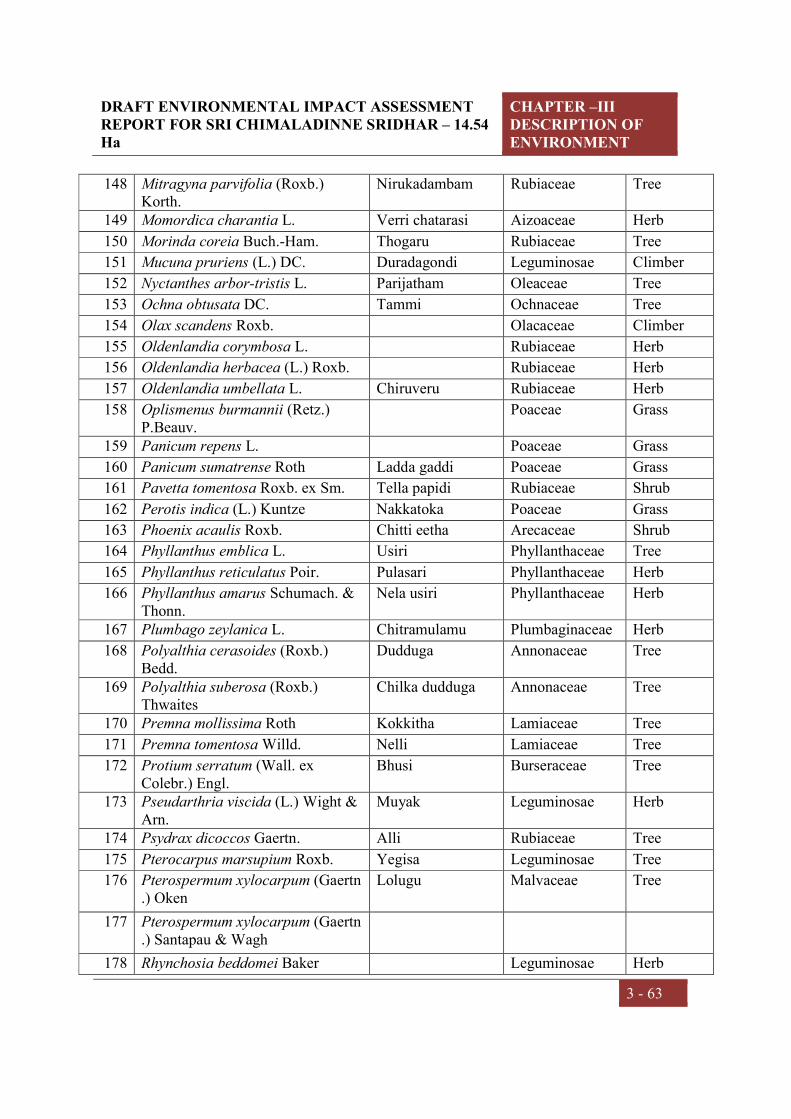
DRAFT ENVIRONMENTAL IMPACT ASSESSMENT REPORT FOR SRI CHIMALADINNE SRIDHAR – 14.54 Ha
CHAPTER –III DESCRIPTION OF ENVIRONMENT
3 - 63
148 Mitragyna parvifolia (Roxb.) Korth.
Nirukadambam Rubiaceae Tree
149 Momordica charantia L. Verri chatarasi Aizoaceae Herb
150 Morinda coreia Buch.-Ham. Thogaru Rubiaceae Tree
151 Mucuna pruriens (L.) DC. Duradagondi Leguminosae Climber
152 Nyctanthes arbor-tristis L. Parijatham Oleaceae Tree
153 Ochna obtusata DC. Tammi Ochnaceae Tree
154 Olax scandens Roxb. Olacaceae Climber
155 Oldenlandia corymbosa L. Rubiaceae Herb
156 Oldenlandia herbacea (L.) Roxb. Rubiaceae Herb
157 Oldenlandia umbellata L. Chiruveru Rubiaceae Herb
158 Oplismenus burmannii (Retz.) P.Beauv.
Poaceae Grass
159 Panicum repens L. Poaceae Grass
160 Panicum sumatrense Roth Ladda gaddi Poaceae Grass
161 Pavetta tomentosa Roxb. ex Sm. Tella papidi Rubiaceae Shrub
162 Perotis indica (L.) Kuntze Nakkatoka Poaceae Grass
163 Phoenix acaulis Roxb. Chitti eetha Arecaceae Shrub
164 Phyllanthus emblica L. Usiri Phyllanthaceae Tree
165 Phyllanthus reticulatus Poir. Pulasari Phyllanthaceae Herb
166 Phyllanthus amarus Schumach. & Thonn.
Nela usiri Phyllanthaceae Herb
167 Plumbago zeylanica L. Chitramulamu Plumbaginaceae Herb
168 Polyalthia cerasoides (Roxb.) Bedd.
Dudduga Annonaceae Tree
169 Polyalthia suberosa (Roxb.) Thwaites
Chilka dudduga Annonaceae Tree
170 Premna mollissima Roth Kokkitha Lamiaceae Tree
171 Premna tomentosa Willd. Nelli Lamiaceae Tree
172 Protium serratum (Wall. ex Colebr.) Engl.
Bhusi Burseraceae Tree
173 Pseudarthria viscida (L.) Wight & Arn.
Muyak Leguminosae Herb
174 Psydrax dicoccos Gaertn. Alli Rubiaceae Tree
175 Pterocarpus marsupium Roxb. Yegisa Leguminosae Tree
176 Pterospermum xylocarpum (Gaertn.) Oken
Lolugu Malvaceae Tree
177 Pterospermum xylocarpum (Gaertn.) Santapau & Wagh
178 Rhynchosia beddomei Baker Leguminosae Herb

DRAFT ENVIRONMENTAL IMPACT ASSESSMENT REPORT FOR SRI CHIMALADINNE SRIDHAR – 14.54 Ha
CHAPTER –III DESCRIPTION OF ENVIRONMENT
3 - 64
179 Rhynchosia minima (L.) DC. Leguminosae Herb
180 Schleichera oleosa (Lour.) Merr. Erra bhusi Sapindaceae Tree
181 Semecarpus anacardium L.f. Nalla jeedi Anacardiaceae Tree
182 Senna auriculata (L.) Roxb. Tangedu Leguminosae Shrub
183 Solanum anguivi Lam. Chiru benda Malvaceae Herb
184 Solanum torvum Sw. Vusti Solanaceae Shrub
185 Soymida febrifuga (Roxb.) A. Juss. Somitha Meliaceae Tree
186 Streblus asper Lour. Baranika Moraceae Tree
187 Strychnos nux-vomica L. Mushidi Loganiaceae Tree
188 Strychnos potatorum L.f. Mushidi Loganiaceae Tree
189 Syzygium cumini (L.) Skeels Neredu Myrtaceae Tree
190 Tamarindus indica L. Chinta Leguminosae Tree
191 Tamilnadia uliginosa (Retz.) Tirveng. & Sastre
Nalla manga Rubiaceae Tree
192 Tectona grandis L.f. Teku Lamiaceae Tree
193 Teramnus labialis (L.f.) Spreng. Masha parni Leguminosae Herb
194 Terminalia tomentosa Wight & Arn.
Nalla maddi Combretaceae Tree
195 Thysanolaena maxima (Roxb.) Kuntze
Konda cheepuru gaddi
Poaceae Grass
196 Trema orientalis (L.) Blume Boggu chettu Ulmaceae Tree
197 Vitex altissima L.f. Lamiaceae Tree
198 Vitex pinnata L. Lamiaceae Tree
199 Waltheria indica L. Nallabenda Malvaceae Herb
200 Woodfordia fruticosa (L.) Kurz Jeguru Lythraceae Shrub
201 Wrightia tinctoria R.Br. Ankudu Apocynaceae Tree
202 Xanthium strumarium L. Marula mathangi Compositae Herb
203 Xylia xylocarpa (Roxb.) Taub. Konda tangini Leguminosae Tree
204 Ziziphus jujuba Mill. Regu Rhamnaceae Tree
205 Ziziphus oenopolia (L.) Mill. Parimi Rhamnaceae Climber
206 Ziziphus xylopyrus (Retz.) Willd. Gotti chettu Rhamnaceae Tree
Flora of the buffer zone
Buffer zone of the proposed project is mainly forest and agricultural land. The flora of
buffer zone comprises of Wrightia tinctoria, Hollarhena pubescens, Diospyros sylvatica,
Pterospermum xylocarpum, Lannea coromandelica, Cassia fistula, Gmelina arborea and
Garuga pinnata trees are growing. Many tree species are planted in the area because of

DRAFT ENVIRONMENTAL IMPACT ASSESSMENT REPORT FOR SRI CHIMALADINNE SRIDHAR – 14.54 Ha
CHAPTER –III DESCRIPTION OF ENVIRONMENT
3 - 65
their usefulness, economic and aesthetic values. The tree species observed in the area are,
Mangifera indica, Albizia lebbeck, Bombax ceiba, Dalbergia sissoo, Sapindus
emarginatus, and Tamarindus indica etc. Flora of the buffer zone provided in the Table
3.21.
Table 3.21. List of plant species observed in buffer area of the project
S.No. Botanical Name Vernacular name Family Habit
1 Abelmoschus moschatus Medik. Kasturi benda Malvaceae Herb
2 Abrus fruticulosus Wight & Arn. Tella gurivenda Leguminosae Climber
3 Abrus precatorius L. Gurivinda Leguminosae Climber
4 Abutilon indicum (L.) Sweet Tuthurabenda Malvaceae Shrub
5 Acacia auriculiformis Benth. Australian thumma Leguminosae Tree
6 Acacia caesia (L.) Willd. Konda korintha Leguminosae Climber
7 Acacia catechu (L.f.) Willd. Nalla sundra Leguminosae Tree
8 Acacia leucophloea (Roxb.) Willd. Tella thumma Leguminosae Tree
9 Acacia nilotica (L.) Delile Nalla thumma Leguminosae Tree
10 Acacia sinuata (Lour.) Merr. Sikayi Leguminosae Climber
11 Acacia torta (Roxb.) Craib Konda Korinta Leguminosae Climber
12 Acalypha indica L. Muripindi Euphorbiaceae Herb
13 Acanthospermum hispidum DC. Compositae Herb
14 Achyranthes aspera L. Uttareni Amaranthaceae Herb
15 Aegle marmelos (L.) Corrêa Maredu Rutaceae Tree
16 Aerva lanata (L.) Juss. Kondapindi Amaranthaceae Herb
17 Aeschynomene aspera L. Neetijeeluga Leguminosae Herb
18 Aeschynomene indica L. Tellajeelugu Leguminosae Herb
19 Aganosma heynei (Spreng.) ined. Mogari Apocynaceae Climber
20 Agave americana L. Kittanara Asparagaceae Shrub
21 Ageratum conyzoides (L.) L. Vasavi Compositae Herb
22 Ailanthus excelsa Roxb. Pedda manu Simaroubaceae Tree
23 Alangium salviifolium (L.f.) Wangerin Vudugu Cornaceae Tree
24 Albizia amara (Roxb.) B.Boivin Konda sigara Leguminosae Tree
25 Albizia chinensis (Osbeck) Merr. Nalla regi Leguminosae Tree
26 Albizia lebbeck (L.) Benth. Dirisena Leguminosae Tree
27 Albizia odoratissima (L.f.) Benth. Ganara Leguminosae Tree
28 Albizia procera (Roxb.) Benth. Tella dirisana Leguminosae Tree
29 Albizia saman (Jacq.) Merr. Nidraganneru Leguminosae Tree
30 Allmania nodiflora (L.) R.Br. ex Wight Amaranthaceae Herb

DRAFT ENVIRONMENTAL IMPACT ASSESSMENT REPORT FOR SRI CHIMALADINNE SRIDHAR – 14.54 Ha
CHAPTER –III DESCRIPTION OF ENVIRONMENT
3 - 66
31 Alloteropsis cimicina (L.) Stapf - Poaceae Grass
32 Aloe vera (L.) Burm.f. Kalabanda Asparagaceae Herb
33 Alstonia scholaris (L.) R. Br. Edakula pala Apocynaceae Tree
34 Alternanthera pungens Kunth Mullu-ponnaganti Amaranthaceae Herb
35 Alternanthera sessilis (L.) R.Br. ex DC. Ponnagantikura Amaranthaceae Herb
36 Alysicarpus heterophyllus (Baker) Jafri & Ali
Leguminosae Herb
37 Alysicarpus monilifer (L.) DC. Amera Leguminosae Herb
38 Amaranthus spinosus L. Mullu thotakura Amaranthaceae Herb
39 Amaranthus viridis L. Thotakura Amaranthaceae Herb
40 Ammannia baccifera L. Agnivendrapaaku Lythraceae Herb
41 Amorphophallus paeoniifolius (Dennst.) Nicolson
Kondakandha Araceae Herb
42 Ampelocissus latifolia (Roxb.) Planch. Adaviodraksha Vitaceae Climber
43 Anacardium occidentale L. Jeedi Anacardiaceae Tree
44 Andrographis echioides (L.) Nees Acanthaceae Herb
45 Andrographis paniculata (Burm.f.) Nees
Nelavemu Acanthaceae Herb
46 Anisochilus carnosus (L.f.) Wall. Ritchu-rodda Lamiaceae Herb
47 Anisomeles indica (L.) Kuntze Dabeera Lamiaceae Herb
48 Annona reticulata L. Ramaphal Annonaceae Tree
49 Annona squamosa L. Seethaphalam Annonaceae Tree
50 Anogeissus acuminata (Roxb. ex DC.) Guill.
Pasi chettu Combretaceae Tree
51 Anogeissus latifolia (Roxb. ex DC.) Wall. ex Bedd.
Sirumanu Combretaceae Tree
52 Apluda mutica L. - Poaceae Grass
53 Argemone mexicana L. Balurakshasi Papavaraceae Herb
54 Argyreia nervosa (Burm. f.) Bojer Samudra pala Convolvulaceae Climber
55 Aristida funiculata Trin. & Rupr. Cheepurugaddi Poaceae Grass
56 Aristida hystrix L.f. Poaceae Grass
57 Aristida setacea Retz. Parakagaddi Poaceae Grass
58 Aristolochia bracteolata Lam. Gadidagadapa Aristolochiaceae Herb
59 Aristolochia indica L. Nall eswari Aristolochiaceae Herb
60 Artocarpus heterophyllus Lam. Panasa chettu Moraceae Tree
61 Arundinella setosa Trin. Poaceae Grass
62 Arundo donax L. Peepalu Poaceae Grass
63 Asparagus racemosus Willd. Pilligaddalu Asparagaceae Climber

DRAFT ENVIRONMENTAL IMPACT ASSESSMENT REPORT FOR SRI CHIMALADINNE SRIDHAR – 14.54 Ha
CHAPTER –III DESCRIPTION OF ENVIRONMENT
3 - 67
64 Asystasia gangetica (L.) T.Anderson - Acanthaceae Herb
65 Atalantia monophylla DC. Karu nimma Rutaceae Tree
66 Azadirachta indica A.Juss. Vepa Meliaceae Tree
67 Azima tetracantha Lam. Uppu kampa Salvadoraceae Shrub
68 Balanites aegyptiaca (L.) Delile Gara Zygophyllaceae Tree
69 Bambusa bambos (L.) Voss Veduru Poaceae Shrub
70 Barleria prionitis L. Neellagorinta Acanthaceae Herb
71 Barringtonia acutangula (L.) Gaertn. Kanapa Barringtoniaceae Tree
72 Bauhinia purpurea L. Pedddari Leguminosae Tree
73 Bauhinia racemosa Lam. Are Leguminosae Tree
74 Bauhinia vahlii Wight & Arn. Addaku Leguminosae Climber
75 Bauhinia variegata L. Mandari Leguminosae Tree
76 Biophytum sensitivum (L.) DC. Jala puspa Oxalidaceae Herb
77 Blepharis integrifolia (L.f.) E.Mey. & Drège ex Schinz
Acanthaceae Herb
78 Blumea axillaris (Lam.) DC. Compositae Herb
79 Blumea bifoliata (L.) DC. Compositae Herb
80 Blumea virens DC. Compositae Herb
81 Boerhavia diffusa L. Atikamamidi Nyctaginaceae Herb
82 Bombax ceiba L. Buruga Malvaceae Tree
83 Borassus flabellifer L. Thati chettu Arecaceae Tree
84 Bothriochloa glabra (Roxb.) A.Camus Poaceae Grass
85 Brachiaria eruciformis (Sm.) Griseb. Poaceae Grass 86 Brachiaria ramosa (L.) Stapf - Poaceae Grass
87 Brachiaria reptans (L.) C.A.Gardner & C.E.Hubb.
Poaceae Grass
88 Breynia vitis-idaea (Burm.f.) C.E.C.Fisch.
Purugudu Euphorbiaceae Shrub
89 Bridelia montana (Roxb.) Willd. Balli chettu Phyllanthaceae Tree
90 Bridelia retusa (L.) A.Juss. Anemu Phyllanthaceae Tree
91 Bridelia tomentosa Blume Balli Phyllanthaceae Tree
92 Buchanania cochinchinensis (Lour.) M.R.Almeida
Sara Anacardiaceae Tree
93 Bulbostylis barbata (Rottb.) C.B.Clarke Cyperaceae Sedge
94 Butea monosperma (Lam.) Taub. Modhuga Leguminosae Tree
95 Butea superba Roxb. Tiga moduga Leguminosae Climber
96 Cadaba fruticosa (L.) Druce Capparaceae Climber

DRAFT ENVIRONMENTAL IMPACT ASSESSMENT REPORT FOR SRI CHIMALADINNE SRIDHAR – 14.54 Ha
CHAPTER –III DESCRIPTION OF ENVIRONMENT
3 - 68
97 Caesalpinia bonduc (L.) Roxb. Gachakaya Leguminosae Shrub
98 Cajanus scarabaeoides (L.) Thouars Konda kandui Leguminosae Herb
99 Calotropis gigantea (L.) Dryand. Tella jilledu Apocynaceae Shrub
100 Calotropis procera (Aiton) Dryand. Jilledu Apocynaceae Shrub
101 Canavalia gladiata (Jacq.) DC. Tamma Leguminosae Climber
102 Canthium coromandelicum (Burm.f.) Alston
Balusu Rubiaceae Shrub
103 Canthium dicoccum (Gaertn.) Merr. Alli Rubiaceae Tree
104 Canthium parviflorum Lam. Balusu Rubiaceae Shrub
105 Capparis decidua (Forssk.) Edgew. Capparaceae Shrub
106 Capparis sepiaria L. Capparaceae Shrub
107 Capparis zeylanica L. Aarudodna Capparaceae Shrub
108 Caralluma umbellata Haw. Apocynaceae Herb
109 Cardiospermum halicacabum L. Buddakakara Sapindaceae Climber
110 Careya arborea Roxb. Kumbi Lecythidaceae Tree
111 Carissa carandas L. Vaka Apocynaceae Shrub
112 Caryota urens L. Geelugu Arecaceae Tree
113 Casearia elliptica Willd. Chilakaya Salicaceae Shrub
114 Casearia tomentosa Roxb. Gidiguru Salicaceae Tree
115 Cassia fistula L. Rela Leguminosae Tree
116 Cassytha filiformis L. Akashavalli Lauraceae Climber
117 Casuarina equisetifolia L. Sarugudu Casuarinaceae Tree
118 Catharanthus roseus (L.) G.Don Billaganneru Apocynaceae Herb
119 Catunaregam spinosa (Thunb.) Tirveng.
Manga Rubiaceae Shrub
120 Cayratia auriculata (Roxb.) Gamble Mura palleru Vitaceae Climber
121 Ceiba pentandra (L.) Gaertn. Tella buruga Malvaceae Tree
122 Celastrus paniculatus Willd. kasara teega Celastraceae Climber
123 Celosia argentea L. Gurumu Amaranthaceae Herb
124 Cenchrus ciliaris L. Bunch grass Poaceae Grass
125 Chloris barbata Sw. Uppu gaddi Poaceae Grass
126 Chloris virgata Sw. Poaceae Grass
127 Chloroxylon swietenia DC. Billudu Rutaceae Tree
128 Chromolaena odorata (L.) R.M.King & H.Rob.
Kampu rodda Compositae Shrub
129 Chrysopogon fulvus (Spreng.) Chiov. Peddapal Poaceae Grass

DRAFT ENVIRONMENTAL IMPACT ASSESSMENT REPORT FOR SRI CHIMALADINNE SRIDHAR – 14.54 Ha
CHAPTER –III DESCRIPTION OF ENVIRONMENT
3 - 69
130 Chrysopogon lancearius (Hook.f.) Haines
Poaceae Grass
131 Chukrasia tabularis A.Juss. Konda vepa Meliaceae Tree
132 Cipadessa baccifera (Roth) Miq. Ranaberi Meliaceae Tree
133 Cissus quadrangularis L. Nalleru Vitaceae Climber
134 Citrullus colocynthis (L.) Schrad. Putsakaya Cucurbitaceae Climber
135 Citrus limon (L.) Osbeck Nimma Rutaceae Tree
136 Cleistanthus collinus (Roxb.) Benth. ex Hook.f.
Vadisa Euphorbiaceae Tree
137 Cleome aspera J.Koenig ex DC. Kukka vaminta Cleomaceae Herb
138 Cleome gynandra L. Vaminta Capparaceae Herb
139 Cleome viscosa L. Vaminta Cleomaceae Herb
140 Clerodendrum phlomidis L.f. Jaya Chettu Lamiaceae Shrub
141 Clitoria ternatea L. Shankupushpi Leguminosae Climber
142 Coccinia grandis (L.) Voigt Kaki donda Cucurbitaceae Climber
143 Cocculus hirsutus (L.) W.Theob. Dusarituga Menispermaceae Climber
144 Cochlospermum religiosum (L.) Alston Konda gogu Bixaceae Tree
145 Cocos nucifera L. Coconut Arecaeae Tree
146 Colocasia esculenta (L.) Schott Atuka teega Araceae Herb
147 Combretum albidum G.Don Combretaceae Climber
148 Commelina benghalensis L. - Commelinaceae Herb
149 Commelina erecta L. Kodikalu Commelinaceae Sedge
150 Commelina longifolia Lam. Kodikalu Commelinaceae Sedge
151 Commelina undulata R.Br. Commelinaceae Sedge
152 Commiphora wightii (Arn.) Bhandari Burseraceae Tree
153 Conyza stricta Willd. Compositae Herb
154 Corchorus aestuans L. Nela bera Tiliaceae Herb
155 Corchorus tridens L. Tiliaceae Herb
156 Cordia dichotoma G.Forst. Nakiri Cordiaceae Tree
157 Costus speciosus (J.König) Sm. Bogachika dumpa Costaceae Herb
158 Cressa cretica L. Uppu senaga Convolvulaceae Shrub
159 Crotalaria juncea L. Janumu Leguminosae Herb
160 Crotalaria laburnifolia L. Pedda giligicha Leguminosae Herb
161 Crotalaria medicaginea Lam. Leguminosae Herb
162 Crotalaria paniculata Willd. Leguminosae Herb
163 Crotalaria prostrata Willd. Leguminosae Herb
164 Crotalaria retusa L. Pottigiligicha Leguminosae Herb

DRAFT ENVIRONMENTAL IMPACT ASSESSMENT REPORT FOR SRI CHIMALADINNE SRIDHAR – 14.54 Ha
CHAPTER –III DESCRIPTION OF ENVIRONMENT
3 - 70
165 Crotalaria verrucosa L. Giligicha Leguminosae Herb
166 Croton bonplandianus Baill. Galivana mokka Euphorbiaceae Herb
167 Cuscuta reflexa Roxb. Paasi teega Lythraceae Herb
168 Cyanotis axillaris (L.) D.Don ex Sweet Golla gundi Commelinaceae Sedge
169 Cyanotis cristata (L.) D.Don Commelinaceae Sedge
170 Cyanthillium cinereum (L.) H.Rob. Sahadevi Compositae Herb
171 Cymbopogon citratus (DC.) Stapf Nimmagaddi Poaceae Grass
172 Cymbopogon coloratus (Hook.f.) Stapf Dabbagaddi Poaceae Grass
173 Cynodon dactylon (L.) Pers. Gariki Poaceae Grass
174 Cyperus compressus L. - Cyperaceae Sedge
175 Cyperus squarrosus L. Cyperaceae Sedge
176 Cyperus castaneus Willd. Cyperaceae Sedge
177 Cyperus iria L. Cyperaceae Sedge
178 Cyperus rotundus L. Thunga Cyperaceae Sedge
179 Dactyloctenium aegyptium (L.) Willd. - Poaceae Grass 180 Dalbergia paniculata Roxb. Saibothu Leguminosae Tree
181 Dalbergia latifolia Roxb. Iridi Leguminosae Tree
182 Dalbergia sissoo DC. Sisam Leguminosae Tree
183 Datura innoxia Mill. Nalla ummetha Solanaceae Shrub
184 Datura metel L. Ummetha Solanaceae Shrub
185 Datura stramonium L. Ummetha Solanaceae Shrub
186 Delonix regia (Hook.) Raf. Thurai Leguminosae Tree
187 Dendrobium aphyllum (Roxb.) C.E.C.Fisch.
- Orchidaceae Herb
188 Dendrocalamus strictus (Roxb.) Nees Sadanaala Veduru Poaceae Shrub
189 Dendrophthoe falcata (L.f.) Ettingsh. - Loranthaceae Herb
190 Derris scandens (Roxb.) Benth. Leguminosae Climber
191 Desmodium dichotomum (Willd.) DC. Leguminosae Herb
192 Desmodium gangeticum (L.) DC. Kola panna Leguminosae Herb
193 Desmodium oojeinense (Roxb.) H.Ohashi
Vandanam chettu Leguminosae Tree
194 Desmodium triflorum (L.) DC. Muntamandu Leguminosae Herb
195 Dichanthium caricosum (L.) A.Camus Poaceae Grass
196 Dichrostachys cinerea (L.) Wight & Arn.
Veluthuru Leguminosae Tree
197 Digera muricata (L.) Mart. Chenchalikura Amaranthaceae Herb
198 Digitaria ciliaris (Retz.) Koeler Poaceae Grass

DRAFT ENVIRONMENTAL IMPACT ASSESSMENT REPORT FOR SRI CHIMALADINNE SRIDHAR – 14.54 Ha
CHAPTER –III DESCRIPTION OF ENVIRONMENT
3 - 71
199 Dinebra retroflexa (Vahl) Panz. Poaceae Grass
200 Dioscorea bulbifera L. Karukanda Dioscoreaceae Climber
201 Dioscorea hispida Dennst. Dioscoreaceae Climber
202 Dioscorea oppositifolia L. Adda dumpa Dioscoreaceae Climber
203 Dioscorea pentaphylla L. Adavi gunusutheega
Dioscoreaceae Climber
204 Dioscorea tomentosa J.Koenig ex Spreng.
Tiga dumpa Dioscoreaceae Climber
205 Diospyros chloroxylon Roxb. Thorika Ebenaceae Tree
206 Diospyros melanoxylon Roxb. Thummika Ebenaceae Tree
207 Diospyros sylvatica Roxb. Gatha Ebenaceae Tree
208 Diospyros vera (Lour.) A.Chev. Pisini Ebenaceae Tree
209 Dipteracanthus prostratus (Poir.) Nees - Acanthaceae Herb
210 Dodonaea viscosa (L.) Jacq. Bandaru Sapindaceae Shrub
211 Dolichandrone atrovirens (Roth) K.Schum.
Bignoniaceae Tree
212 Dolichandrone falcata (Wall. ex DC.) Seem.
Chitinirudi Bignoniaceae Tree
213 Drimia indica (Roxb.) Jessop Asparagaceae Herb
214 Echinochloa colona (L.) Link Bontha chamalu Poaceae Grass
215 Eclipta prostrata (L.) L. Guntagalagara Compositae Herb
216 Eleocharis dulcis (Burm.f.) Trin. ex Hensch.
Cyperaceae Sedge
217 Emilia sonchifolia (L.) DC. ex DC. Compositae Herb
218 Enicostema axillare (Poir. ex Lam.) A.Raynal
Gulvidi Gentianaceae Herb
219 Eragrostiella bifaria (Vahl) Bor Poaceae Grass
220 Eragrostis amabilis (L.) Wight & Arn. Chinna gariki Poaceae Grass
221 Eucalyptus globulus Labill. Neelagiri Myrtaceae Tree
222 Euphorbia antiquorum L. Bonthajemudu Euphorbiaceae Herb
223 Euphorbia cordifolia Elliott Euphorbiaceae Shrub
224 Euphorbia hirta L. Nanubalu Euphorbiaceae Herb
225 Euphorbia neriifolia L. Jemudu Euphorbiaceae Shrub
226 Euphorbia nivulia Buch.-Ham. Vadthor Euphorbiaceae Shrub
227 Euphorbia prostrata Aiton Euphorbiaceae Herb
228 Euphorbia rosea Retz. Euphorbiaceae Herb
229 Euphorbia thymifolia L. Reddivari nanubalu Euphorbiaceae Herb
230 Euphorbia tirucalli L. Thirukali Euphorbiaceae Tree
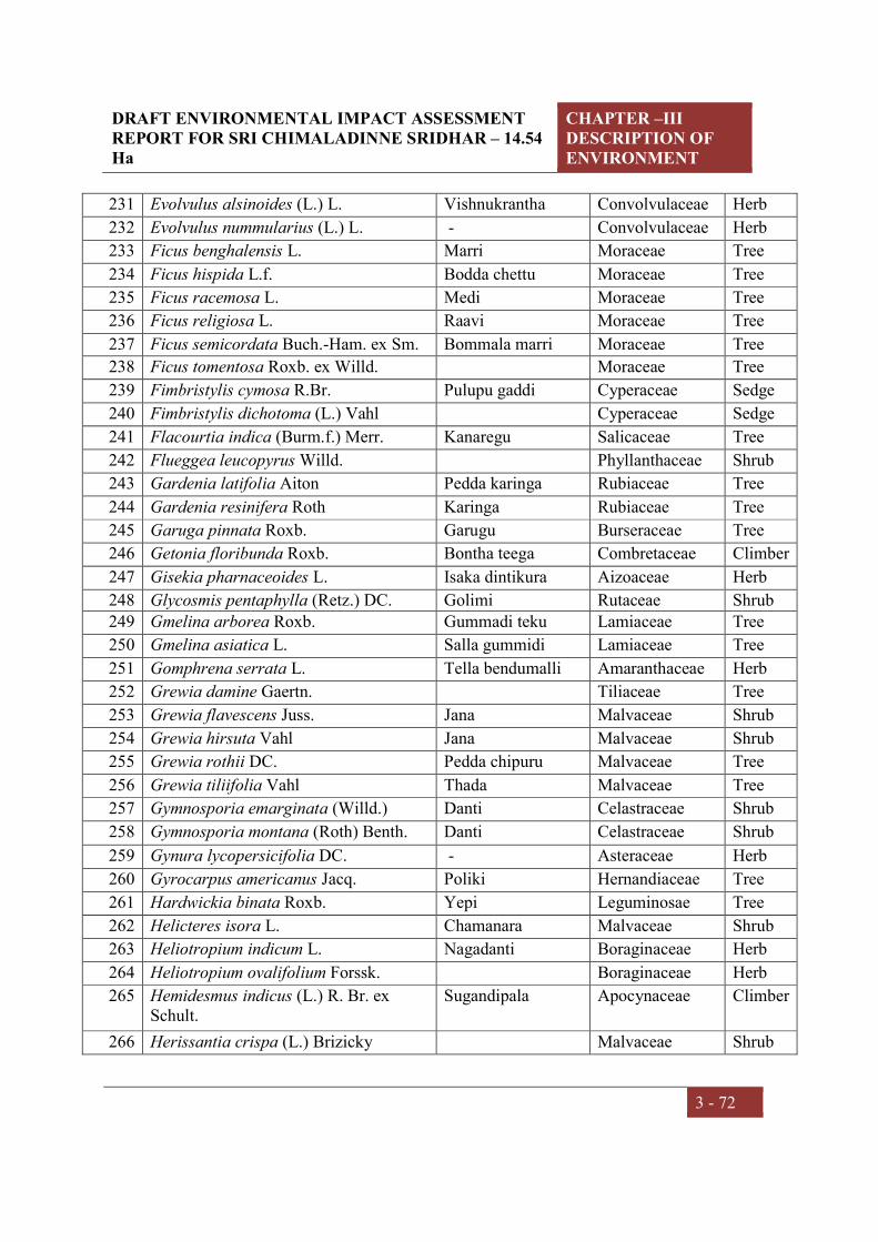
DRAFT ENVIRONMENTAL IMPACT ASSESSMENT REPORT FOR SRI CHIMALADINNE SRIDHAR – 14.54 Ha
CHAPTER –III DESCRIPTION OF ENVIRONMENT
3 - 72
231 Evolvulus alsinoides (L.) L. Vishnukrantha Convolvulaceae Herb
232 Evolvulus nummularius (L.) L. - Convolvulaceae Herb
233 Ficus benghalensis L. Marri Moraceae Tree
234 Ficus hispida L.f. Bodda chettu Moraceae Tree
235 Ficus racemosa L. Medi Moraceae Tree
236 Ficus religiosa L. Raavi Moraceae Tree
237 Ficus semicordata Buch.-Ham. ex Sm. Bommala marri Moraceae Tree
238 Ficus tomentosa Roxb. ex Willd. Moraceae Tree
239 Fimbristylis cymosa R.Br. Pulupu gaddi Cyperaceae Sedge
240 Fimbristylis dichotoma (L.) Vahl Cyperaceae Sedge
241 Flacourtia indica (Burm.f.) Merr. Kanaregu Salicaceae Tree
242 Flueggea leucopyrus Willd. Phyllanthaceae Shrub
243 Gardenia latifolia Aiton Pedda karinga Rubiaceae Tree
244 Gardenia resinifera Roth Karinga Rubiaceae Tree
245 Garuga pinnata Roxb. Garugu Burseraceae Tree
246 Getonia floribunda Roxb. Bontha teega Combretaceae Climber
247 Gisekia pharnaceoides L. Isaka dintikura Aizoaceae Herb
248 Glycosmis pentaphylla (Retz.) DC. Golimi Rutaceae Shrub 249 Gmelina arborea Roxb. Gummadi teku Lamiaceae Tree
250 Gmelina asiatica L. Salla gummidi Lamiaceae Tree
251 Gomphrena serrata L. Tella bendumalli Amaranthaceae Herb
252 Grewia damine Gaertn. Tiliaceae Tree
253 Grewia flavescens Juss. Jana Malvaceae Shrub
254 Grewia hirsuta Vahl Jana Malvaceae Shrub
255 Grewia rothii DC. Pedda chipuru Malvaceae Tree
256 Grewia tiliifolia Vahl Thada Malvaceae Tree
257 Gymnosporia emarginata (Willd.) Danti Celastraceae Shrub
258 Gymnosporia montana (Roth) Benth. Danti Celastraceae Shrub
259 Gynura lycopersicifolia DC. - Asteraceae Herb
260 Gyrocarpus americanus Jacq. Poliki Hernandiaceae Tree
261 Hardwickia binata Roxb. Yepi Leguminosae Tree
262 Helicteres isora L. Chamanara Malvaceae Shrub
263 Heliotropium indicum L. Nagadanti Boraginaceae Herb
264 Heliotropium ovalifolium Forssk. Boraginaceae Herb
265 Hemidesmus indicus (L.) R. Br. ex Schult.
Sugandipala Apocynaceae Climber
266 Herissantia crispa (L.) Brizicky Malvaceae Shrub

DRAFT ENVIRONMENTAL IMPACT ASSESSMENT REPORT FOR SRI CHIMALADINNE SRIDHAR – 14.54 Ha
CHAPTER –III DESCRIPTION OF ENVIRONMENT
3 - 73
267 Heteropogon contortus (L.) P.Beauv. ex Roem. & Schult.
Poaceae Grass
268 Hibiscus micranthus L.f. Nityamalli Malvaceae Herb
269 Holarrhena pubescens Wall. ex G.Don Tedla pala Apocynaceae Tree
270 Holoptelea integrifolia Planch. Nemali chettu Ulmaceae Tree
271 Hugonia mystax Cav. Kakibira Linaceae Shrub
272 Hybanthus enneaspermus (L.) F.Muell. Ratna purusa Violaceae Herb
273 Hygrophila auriculata (Schumach.) Heine
Mundla gobbi Acanthaceae Herb
274 Hyptis suaveolens (L.) Poit. Simathulasi Lamiaceae Herb
275 Imperata cylindrica (L.) Raeusch. Darba gaddi Poaceae Grass
276 Indigofera cassioides DC. Sirali Leguminosae Herb
277 Indigofera colutea (Burm.f.) Merr. Nakkenaru Leguminosae Herb
278 Indigofera cordifolia Roth Leguminosae Herb
279 Indigofera hirsuta L. Kolapattitulu Leguminosae Herb
280 Indigofera linifolia (L.f.) Retz. Leguminosae Herb
281 Indigofera linnaei Ali Cheragadam Leguminosae Herb
282 Indigofera prostrata Willd. Leguminosae Herb
283 Ipomoea carnea Jacq. Thutu Convolvulacae Shrub
284 Ipomoea hederifolia L. Nalla kokita Convolvulaceae Herb
285 Ipomoea nil (L.) Roth Convolvulacae Climber
286 Ipomoea obscura (L.) Ker Gawl. Kasirathnam Convolvulaceae Herb
287 Ipomoea purpurea (L.) Roth Kaarukolli Convolvulaceae Herb
288 Ipomoea violacea L. Convolvulacae Climber
289 Iseilema laxum Hack. Nalla kokita Convolvulaceae Herb
290 Ixora pavetta Roxb. Korivi Cheetu Rubiaceae Tree
291 Jasminum arborescens Roxb. Garuda malli Oleaceae Shrub
292 Jasminum cuspidatum Rottl. & Willd. Adavi malli Oleaceae Shrub
293 Jatropha curcas L. Nepalam Euphorbiaceae Shrub
294 Jatropha gossypiifolia L. Seema nepalamu Euphorbiaceae Herb
295 Justicia adhatoda L. Addasaram Acanthaceae Shrub
296 Justicia betonica L. Acanthaceae Shrub
297 Justicia glauca Rottler Tellarantu Acanthaceae Herb
298 Justicia procumbens L. Acanthaceae Herb
299 Justicia prostrata Gamble Kondapindi Acanthaceae Herb
300 Kavalama urens (Roxb.) Raf. Jeelugu Arecaceae Tree
301 Kyllinga nemoralis (J.R.Forst. & G.Forst.) Dandy ex Hutch. & Dalziel
Cyperaceae Herb

DRAFT ENVIRONMENTAL IMPACT ASSESSMENT REPORT FOR SRI CHIMALADINNE SRIDHAR – 14.54 Ha
CHAPTER –III DESCRIPTION OF ENVIRONMENT
3 - 74
302 Lagerstroemia parviflora Roxb. Chennangi Lythraceae Tree
303 Lannea coromandelica (Houtt.) Merr. Gumpena Anacardiaceae Tree
304 Lantana camara L. Gajupulu Verbenaceae Shrub
305 Lawsonia inermis L. Gorintaku Lythraceae Shrub
306 Leonotis nepetifolia (L.) R.Br. Ranaberi Lamiaceae Herb
307 Leptadenia reticulata (Retz.) Wight & Arn.
Mukkupala teega Apocynaceae Climber
308 Leucas aspera (Willd.) Link Tummi Lamiaceae Herb
309 Leucas cephalotes (Roth) Spreng. Lamiaceae Herb
310 Leucas hirta (B.Heyne ex Roth) Spreng.
Thummi Lamiaceae Herb
311 Limonia acidissima Groff Velaga Rutaceae Tree
312 Lindernia anagallis (Burm.f.) Pennell Scrophulariaceae Herb
313 Lindernia crustacea (L.) F.Muell. - Scrophulariaceae Herb
314 Litsea glutinosa (Lour.) C.B.Rob. Naramamidi Lauraceae Tree
315 Ludwigia perennis L. Onagraceae Herb
316 Madhuca indica J.F.Gmel. Ippa Sapotaceae Tree
317 Magnolia champaca (L.) Baill. ex Pierre
Sampangi Mgnoliaceae Tree
318 Mallotus philippensis (Lam.) Müll.Arg. Sindhuram Euphorbiaceae Tree
319 Malvastrum coromandelianum (L.) Garcke
Malvaceae Herb
320 Mangifera indica L. Mamidi Anacardiaceae Tree
321 Manilkara hexandra (Roxb.) Dubard Palachettu Sapotaceae Tree
322 Marsilea quadrifolia L. Marseliaceae Herb
323 Martynia annua L. Martyniaceae Shrub
324 Maytenus emarginata (Willd.) Ding Hou
Danti Celastraceae Shrub
325 Melia azedarach L. White cedar Meliaceae Tree
326 Memecylon edule Roxb. Alli Melastomataceae Tree
327 Merremia emarginata (Burm. f.) Hallier f.
Convolvulaceae Herb
328 Merremia tridentata (L.) Hallier f. Suraputiga Convolvulaceae Herb
329 Mimosa polyancistra Benth. Thumma Leguminosae
330 Mimosa pudica L. Athipathi Leguminosae Herb
331 Mimosa rubicaulis Lam. Korundam Leguminosae Climber
332 Mimusops elengi L. Pogada Sapotaceae Tree

DRAFT ENVIRONMENTAL IMPACT ASSESSMENT REPORT FOR SRI CHIMALADINNE SRIDHAR – 14.54 Ha
CHAPTER –III DESCRIPTION OF ENVIRONMENT
3 - 75
333 Mitragyna parvifolia (Roxb.) Korth. Nirukadambam Rubiaceae Tree
334 Mollugo cerviana (L.) Ser. Molluginaceae Herb
335 Mollugo nudicaulis Lam. Verri chitarasi Aizoaceae Herb
336 Mollugo pentaphylla L. Pedda paripata Aizoaceae Herb
337 Momordica charantia L. Verri chatarasi Aizoaceae Herb
338 Morinda coreia Buch.-Ham. Thogaru Rubiaceae Tree
339 Moringa oleifera Lam. Munaga Moringaceae Tree
340 Mucuna pruriens (L.) DC. Duradagondi Leguminosae Climber
341 Murraya koenigii Karivepa Rutaceae Tree
342 Naringi crenulata (Roxb.) Nicolson Torru velaga Rutaceae Tree
343 Neolamarckia cadamba (Roxb.) Bosser Kadamba Rubiaceae Tree
344 Nerium oleander L. Ganneru Apocynaceae Shrub
345 Nyctanthes arbor-tristis L. Parijatham Oleaceae Tree
346 Ochna obtusata DC. Tammi Ochnaceae Tree
347 Ocimum americanum L. Kukka tulasi Lamiaceae Herb
348 Ocimum gratissimum L. Rama tulasi Lamiaceae Herb
349 Ocimum tenuiflorum L. Tulasi Lamiaceae Herb
350 Olax scandens Roxb. Olacaceae Climber
351 Oldenlandia corymbosa L. Rubiaceae Herb
352 Oldenlandia herbacea (L.) Roxb. Rubiaceae Herb
353 Oldenlandia umbellata L. Chiruveru Rubiaceae Herb
354 Oplismenus burmannii (Retz.) P.Beauv. Poaceae Grass
355 Opuntia dillenii (Ker Gawl.) Haw. Nagajemudu Cactaceae Shrub
356 Opuntia elatior Mill. Cactaceae Shrub
357 Oxalis corniculata L. Puli chinta Oxalidaceae Herb
358 Panicum repens L. Poaceae Grass
359 Panicum sumatrense Roth Ladda gaddi Poaceae Grass
360 Parthenium hysterophorus L. Vayyaribhama Compositae Herb
361 Passiflora edulis Sims Fashion fruit Passifloraceae Climber
362 Pavetta indica L. Kolimi Rubiaceae Tree
363 Pavetta tomentosa Roxb. ex Sm. Tella papidi Rubiaceae Shrub
364 Pavonia zeylanica (L.) Cav. Karubenda Malvaceae Herb
365 Pedalium murex L. Yenugu palleru Padaliaceae Herb
366 Peltophorum pterocarpum (DC.) K.Heyne
Kondachinta Leguminosae Tree
367 Pergularia daemia (Forssk.) Chiov. Dustapu teega Apocynaceae Climber
368 Perotis indica (L.) Kuntze Nakkatoka Poaceae Grass

DRAFT ENVIRONMENTAL IMPACT ASSESSMENT REPORT FOR SRI CHIMALADINNE SRIDHAR – 14.54 Ha
CHAPTER –III DESCRIPTION OF ENVIRONMENT
3 - 76
369 Phoenix acaulis Roxb. Chitti eetha Arecaceae Shrub
370 Phoenix sylvestris (L.) Roxb. Eetha Arecaceae Tree
371 Phyllanthus reticulatus Poir. Pindi pulla Phyllanthaceae Shrub
372 Phyllanthus emblica L. Usiri Phyllanthaceae Tree
373 Phyllanthus maderaspatensis L. Nalla usirika Phyllanthaceae Herb
374 Phyllanthus reticulatus Poir. Pulasari Phyllanthaceae Herb
375 Phyllanthusamarus Schumach. & Thonn.
Nela usiri Phyllanthaceae Herb
376 Physalis minima L. Budama Solanaceae Herb
377 Pithecellobium dulce (Roxb.) Benth. Chima chinta Leguminosae Tree
378 Plumbago zeylanica L. Chitramulamu Plumbaginaceae Herb
379 Polyalthia cerasoides (Roxb.) Bedd. Dudduga Annonaceae Tree 380 Polyalthia suberosa (Roxb.) Thwaites Chilka dudduga Annonaceae Tree
381 Polycarpaea corymbosa (L.) Lam. Bommasari Caryophyllaceae Herb
382 Polygala chinensis L. Polygalaceae Herb
383 Pongamia pinnata (L.) Pierre Kanuga Leguminosae Tree
384 Portulaca oleracea L. Pappukura Portulacaceae Herb
385 Portulaca quadrifida L. Goddu pavali Portulacaceae Herb
386 Premna latifolia Roxb. Kokkitha Lamiaceae Tree
387 Premna tomentosa Willd. Nelli Lamiaceae Tree
388 Prosopis chilensis (Molina) Stuntz Jammi Leguminosae Tree
389 Prosopis juliflora (Sw.) DC. Sarkaru Thumma Leguminosae Tree
390 Protium serratum (Wall. ex Colebr.) Engl.
Bhusi Burseraceae Tree
391 Pseudarthria viscida (L.) Wight & Arn. Muyak Leguminosae Herb
392 Psidium guajava L. Jama Myrtaceae Tree
393 Pterocarpus marsupium Roxb. Yegisa Leguminosae Tree
394 Pterospermum xylocarpum (Gaertn.) Oken
Lolugu Malvaceae Tree
395 Pupalia lappacea (L.) Juss. Thella uttareni Amaranthaceae Herb
396 Pycreus flavidus (Retz.) T.Koyama Cyperaceae Sedge 397 Pyrenacantha volubilis Hook. Icacinaceae Climber
398 Reissantia indica (Willd.) N.Hallé Celastraceae Climber
399 Rhynchosia beddomei Baker Leguminosae Herb
400 Rhynchosia minima (L.) DC. Leguminosae Herb
401 Rivea hypocrateriformis Choisy Bodditeega Convolvulacae Climber
402 Rotheca serrata (L.) Steane & Mabb. Lamiaceae Shrub 403 Rothia indica (L.) Druce Leguminosae Herb

DRAFT ENVIRONMENTAL IMPACT ASSESSMENT REPORT FOR SRI CHIMALADINNE SRIDHAR – 14.54 Ha
CHAPTER –III DESCRIPTION OF ENVIRONMENT
3 - 77
404 Ruellia tuberosa L. Jurbula gadda Acanthaceae Herb
405 Rungia repens (L.) Nees Acanthaceae Herb
406 Saccharum spontaneum L. Rella gaddi Poaceae Grass
407 Salvadora persica L. Pailu Salvadoraceae Shrub
408 Sansevieria roxburghiana Schult. & Schult.f.
Nelakithalu Asparagaceae Herb
409 Sapindus emarginatus Vahl Kunkudu Sapindaceae Tree
410 Schleichera oleosa (Lour.) Merr. Erra bhusi Sapindaceae Tree
411 Scoparia dulcis L. Potti boli Plantaginaceae Herb
412 Semecarpus anacardium L.f. Nalla jeedi Anacardiaceae Tree
413 Senna alata (L.) Roxb. Leguminosae Shrub
414 Senna auriculata (L.) Roxb. Tangedu Leguminosae Shrub
415 Senna occidentalis (L.) Link Kasinta Caesalpinaceae Herb
416 Senna tora (L.) Roxb. Tantemu Leguminosae Herb
417 Sesuvium portulacastrum (L.) L. Thikka kura Aizoaceae Herb
418 Sida acuta Burm.f. Medabirusaku Malvaceae Herb
419 Sida cordifolia L. Gayapaku Malvaceae Herb
420 Sida spinosa L. Nagabala Malvaceae Herb
421 Solanum anguivi Lam. Chiru benda Malvaceae Herb
422 Solanum surattense Burm. f. Nela vakudu Solanaceae Herb
423 Solanum torvum Sw. Vusti Solanaceae Shrub
424 Solanum virginianum L. Vakabu Solanaceae Herb
425 Sonchus oleraceus (L.) L. Vusti Compositae Herb
426 Soymida febrifuga (Roxb.) A. Juss. Somitha Meliaceae Tree
427 Spermacoce hispida L. Rubiaceae Herb
428 Spermacoce neohispida Govaerts Madanaku Rubiaceae Herb
429 Sphaeranthus indicus L. Bodasaramu Compositae Herb
430 Stachytarpheta jamaicensis (L.) Vahl Verbenaceae Herb
431 Streblus asper Lour. Baranika Moraceae Tree
432 Strychnos nux-vomica L. Mushidi Loganiaceae Tree
433 Strychnos potatorum L.f. Mushidi Loganiaceae Tree
434 Syzygium cumini (L.) Skeels Neredu Myrtaceae Tree
435 Tamarindus indica L. Chinta Leguminosae Tree
436 Tamarix indica Willd. Rajilai Tamaricacreae Shrub
437 Tamilnadia uliginosa (Retz.) Tirveng. & Sastre
Nalla manga Rubiaceae Tree
438 Tectona grandis L.f. Teku Lamiaceae Tree
439 Tephrosia pumila (Lam.) Pers. Nugu vempali Leguminosae Herb

DRAFT ENVIRONMENTAL IMPACT ASSESSMENT REPORT FOR SRI CHIMALADINNE SRIDHAR – 14.54 Ha
CHAPTER –III DESCRIPTION OF ENVIRONMENT
3 - 78
440 Tephrosia purpurea (L.) Pers. Vempali Leguminosae Herb
441 Tephrosia villosa (L.) Pers. Leguminosae Herb
442 Teramnus labialis (L.f.) Spreng. Masha parni Leguminosae Herb
443 Terminalia arjuna (Roxb. ex DC.) Wight & Arn.
Tella maddi Combretaceae Tree
444 Terminalia bellirica (Gaertn.) Roxb. Thadi chettu Combretaceae Tree
445 Terminalia catappa L. Baadam Combretaceae Tree
446 Terminalia chebula Retz. Karaka Combretaceae Tree
447 Terminalia tomentosa Wight & Arn. Nalla maddi Combretaceae Tree
448 Thespesia populnea (L.) Sol. ex Corrêa Ganga raavi Malvaceae Tree
449 Thysanolaena maxima (Roxb.) Kuntze Konda cheepuru gaddi
Poaceae Grass
450 Tiliacora acuminata Miers Kappa teega Menispermaceae Climber
451 Tinospora cordifolia (Willd.) Miers Tippa teega Menispermaceae Climber
452 Tragia involucrata L. Duradagondi Euphorbiaceae Herb
453 Trema orientalis (L.) Blume Boggu chettu Ulmaceae Tree
454 Trianthema portulacastrum L. Galijeru Aizoaceae Herb
455 Trianthema triquetra Rottler & Willd. Kukka palakoora Aizoaceae Herb 456 Tribulus terrestris L. Palleru Zygophyllaceae Herb
457 Trichodesma indicum (L.) Lehm. Guvva gutti Boraginaceae Herb
458 Tridax procumbens (L.) L. Gaddichamanti Compositae Herb
459 Triumfetta pentandra A.Rich. Chirusitrika Malvaceae Herb
460 Triumfetta rhomboidea Jacq. Chiru sitrika Malvaceae Herb
461 Tylophora indica (Burm. f.) Merr. Kakapala Apocynaceae Herb
462 Typha domingensis Pers. Jammu Typhaceae Herb
463 Urena lobata L. Nalla benda Malvaceae Herb
464 Urochloa panicoides P.Beauv. Salla wudu Poaceae Herb
465 Vanda tessellata (Roxb.) Hook. ex G.Don
Orchidaceae Herb
466 Vernonia cinerea (L.) Less. Sahadevi Compositae Herb
467 Vigna trilobata (L.) Verdc. Pillipeasara Leguminosae Herb
468 Vitex altissima L.f. Lamiaceae Tree
469 Vitex negundo L. Vaavili Lamiaceae Tree
470 Waltheria indica L. Nallabenda Malvaceae Herb
471 Woodfordia fruticosa (L.) Kurz Jeguru Lythraceae Shrub
472 Wrightia tinctoria R.Br. Ankudu Apocynaceae Tree
473 Xanthium strumarium L. Marula mathangi Compositae Herb
474 Xylia xylocarpa (Roxb.) Taub. Konda tangini Leguminosae Tree

DRAFT ENVIRONMENTAL IMPACT ASSESSMENT REPORT FOR SRI CHIMALADINNE SRIDHAR – 14.54 Ha
CHAPTER –III DESCRIPTION OF ENVIRONMENT
3 - 79
475 Ziziphus jujuba Mill. Regu Rhamnaceae Tree
476 Ziziphus oenopolia (L.) Mill. Parimi Rhamnaceae Climber
477 Ziziphus xylopyrus (Retz.) Willd. Gotti chettu Rhamnaceae Tree
Fauna in the study area
Mammals
The fauna evaluated to gain insight in the following respects for species of carnivore,
ungulates, non-human primates, birds, reptiles, amphibians and butterflies. As many as 13
species (Table 3.22) of wild animals (mammals) were seen inhabiting the study area.
Table 3.22. List of wildlife found in the study area
Scientific name Common name Family IWPA 1972 Act Status
IUCN status
Canis aureus indicus Indian Jackal Canidae Schedule II Least Concern
Herpestis javanicus Common Indian Mpngoose
Herpestidae Schedule II Least Concern
Rhinopoma hardwickii Lesser Mouse - Tailed Bat
Chiroptera Schedule V Least Concern
Cynopterus sphinx Short-Nosed fruit bat Chiroptera Schedule V Least Concern
Taphazous melanopogon Black-bearded tomb bat Chiroptera Schedule V Least Concern
Hipposideros speoris Schmeider's Leaf-Nose Bat
Chiroptera Schedule V Least Concern
Lepus nigricollis Black-naped Hare Leporidae Schedule IV Least Concern
Bendicota benghalensis Indian Mole rat Muridae Schedule IV Least Concern
Bendicota indica Bandicoot rat Muridae Schedule IV Least Concern
Mus booduga Little Indian Filed Mouse
Muridae Schedule V Least Concern
Mus musculus Houise mouse Muridae Schedule V Least Concern
Rattus rattus House rat Muridae Schedule V Least Concern
Funambulus palmarum Three stripes palm squirrel
Sciuridae Schedule IV Least Concern
Source: Primary data and secondary data from AP Forest Department
Reference: Vivek Menon (2014). Indian Mammals: A field guideHachette Book
Publishing India Pvt Ltd, Gurgoan, India.pp:1-522; IUCN(2015). The IUCN Redlist of
threatened species. Version2015-4; Schedules I-VI, Indian Wildlife Protection Act, 1972.

DRAFT ENVIRONMENTAL IMPACT ASSESSMENT REPORT FOR SRI CHIMALADINNE SRIDHAR – 14.54 Ha
CHAPTER –III DESCRIPTION OF ENVIRONMENT
3 - 80
Avifauna
The avifauna is very well represented in and around study area within 10km radius of the
proposed project. The investigators come across 82 bird species (Table 6) during the study
period. Species of conservation significance includes those listed, as in the IUCN Redlist
Category and Schedule I of Indian Wildlife Protection Act 1972.
Table 3.23. List of Avian species found in and around proposed project
Scientific name Common name Family IWPA 1972 Act status
IUCN Status
Accipiter badius Shikra Accipitridae Schedule IV Least Concern
Accipiter nisus Eurasian Sparrow Hawk
Accipitridae Schedule IV Least Concern
Accipiter virgatus Besra Sparrow Hawk Accipitridae Schedule IV Least Concern
Acridotheres tristis Common Myna Sturnidae Schedule IV Least Concern
Aegithina tiphia Common lora Aegithinidae Schedule IV Least Concern
Alcedo atthis Common Kingfisher Alcedininae Schedule IV Least Concern
Anthus rufulus Paddy pipet Motacilladae Schedule IV Least Concern
Apus affinis House Swift Apodidae Schedule IV Least Concern
Ardea cinerea Grey Heron Ardeidae Schedule IV Least Concern
Ardea intermedia Medium Egret Ardeidae Schedule IV Least Concern
Ardea laba Large Egrets Ardeidae Schedule IV Least Concern
Ardeola grayii Pond Heron Ardeidae Schedule IV Least Concern
Bubulcus ibis Cattle Egret Ardeidae Schedule IV Least Concern
Calidris temminckii Temminck's Stint Scolopacidae Schedule IV Least Concern
Centropus sinensis Crow Pheasant Curculidae Schedule IV Least Concern
Ceryle rudis Pied Kingfisher Cerylidae Schedule IV Least Concern
Charadrius alexandrines Kentish Plovers Charadriide Schedule IV Least Concern
Charadrius hiaticula Ringed Plover Charadriide Schedule IV Least Concern
Cinnyris asiaticus Purple Sunbird Nectariniidae Schedule IV Least Concern
Cisticola juncidis Streaked Fantail Warbler
Cisticolidae Schedule IV Least Concern
Columba livia Rock Pigeon Columbidae Schedule IV Least Concern
Copsychus saularis Oriental Magpie Robin
Muscicapidae Schedule IV Least Concern
Coraciiformsac bengalensis
Indian Roller Coraciiformesidae Schedule IV Least Concern
Corvus splendens House Crow Corvidae Schedule IV Least Concern
Cypsiurus balasiensis Asian Palm Swift Apodidae Schedule IV Least Concern

DRAFT ENVIRONMENTAL IMPACT ASSESSMENT REPORT FOR SRI CHIMALADINNE SRIDHAR – 14.54 Ha
CHAPTER –III DESCRIPTION OF ENVIRONMENT
3 - 81
Delichon urbicum Northern House Martin
Hirumdinidae Schedule IV Least Concern
Dendrocitta formosae Grey Treepie Corvidae Schedule IV Least Concern
Dicrurus macrocercus Black Drongo Dicruridae Schedule IV Least Concern
Dinopium benghalense Lesser Golden Backed Woodpecker
Picidae Schedule IV Least Concern
Egretta garzetta Little Egret Ardeidae Schedule IV Least Concern
Elanus caeruleus Black Shouldered Kite
Accipitridae Schedule IV Least Concern
Eremopterix grisea Ashy crowned Sparrow Lark
Alaudidae Schedule IV Least Concern
Eudynamys scolopacea Asian Koel Cuculidae Schedule IV Least Concern
Euodice malabarica White throated Munia Estrildidae Schedule IV Least Concern
Francolinus pondicerianus
Grey Patridge Phasianidae Schedule IV Least Concern
Fulica atra Common coot Rallidae Schedule IV Least Concern
Gallinago gallinago Common snipe Scolopacidae Schedule IV Least Concern
Himantopus himantopus Black winged stilt Recurvirostridae Schedule IV Least Concern
Hirundo daurica Red Rumped Swallows
Hirumdinidae Schedule IV Least Concern
Hydrophasianus chirurgus
Pheasant Tailed Jacana
Jacanidae Schedule IV Least Concern
Lanius cristatus Brown shrike Laniidae Schedule IV Least Concern
Leptocoma zeylanica Purple Rumped Sunbird
Nectariniidae Schedule IV Least Concern
Lonchura atricapilla Black Headed Munia Estrildidae Schedule IV Least Concern
Lonchura punctulata Spotted Munia Estrildidae Schedule IV Least Concern
Megalaina haemacephala Copper Smith Barbet Megalaimidae Schedule IV Least Concern
Merops orientalis Small Bee Eater Meropidae Schedule IV Least Concern
Metopedius indicus Bronze Winged Jacana
Jacanidae Schedule IV Least Concern
Milvus migrans Black Kite Accipitridae Schedule IV Least Concern
Motacilla alba White wagtail Motacilladae Schedule IV Least Concern
Motacilla cinerea Grey Wagtail Motacilladae Schedule IV Least Concern
Motacilla flava Yellow Wgatail Motacilladae Schedule IV Least Concern
Motacilla maderaspatensis
Pied Wagtail Motacilladae Schedule IV Least Concern
Nettapus coromandelianus
Cotton Teal Anatidae Schedule IV Least Concern
Nyctyornis athertoni Blue tailed Bee eaters Meropidae Schedule IV Least Concern
Ocyceros birostris Grey Hornbills Bucerotidae Schedule IV Least Concern

DRAFT ENVIRONMENTAL IMPACT ASSESSMENT REPORT FOR SRI CHIMALADINNE SRIDHAR – 14.54 Ha
CHAPTER –III DESCRIPTION OF ENVIRONMENT
3 - 82
Oriolus oriolus Eurasian Golden Oriole
Oriolodae Schedule IV Least Concern
Passer domesticus House sparrow Passeridae Schedule IV Least Concern
Pellorneum ruficeps Puff-throated Babbler Pellorneidae Schedule IV Least Concern
Pericrocotus cinnamomeus
Small Minivet Campephagidae Schedule IV Least Concern
Pericrocotus flammeus Scarlet Minivet Campephagidae Schedule IV Least Concern
Phalacrocorax niger Little Cormorant Phalacrocoracidae Schedule IV Least Concern
Prinia hodgsonii Grey Breasted Prinia Cisticolidae Schedule IV Least Concern
Psittacula eupatria Alexandrine Parakeet Psittacidae Schedule IV Least Concern
Psittacula krameri Rose ringed Parakeet Psittacidae Schedule IV Least Concern
Pycnonotus cafer Red vented Bulbul Pycnonotidae Schedule IV Least Concern
Saxicola caprata Pied Bush chat Muscicapidae Schedule IV Least Concern
Saxicoloides fulicata Indian Robin Muscicapidae Schedule IV Least Concern
Sterna hirundo Common Terns Sternidae Schedule IV Least Concern
Streptopelia decaocto Eurasian Collared Dove
Columbidae Schedule IV Least Concern
Streptopelia orientalis Spoted Dove Columbidae Schedule IV Least Concern
Streptopelia turtur Turtle Doves Columbidae Schedule IV Least Concern
Sturnia pagodarum Brahminy starlings Sturnidae Schedule IV Least Concern
Sturnus vulgaris Common Starling Sturnidae Schedule IV Least Concern
Sylvia althea Lessre Whitethroat Sylviidae Schedule IV Least Concern
Sylvia communis Common Whitethroat Sylviidae Schedule IV Least Concern
Sylvia nana Desert Warbler Sylviidae Schedule IV Least Concern
Tachybaptus ruficollis Little Grebe Podicipedidae Schedule IV Least Concern
Tephrodornis pondicerianus
Common Wood Shrike
Prionopidae Schedule IV Least Concern
Turdoides caudate Common Babbler Timaliidae Schedule IV Least Concern
Turdoides malcolmi Large Grey Babblers Timaliidae Schedule IV Least Concern
Turdoides striata Jungle Babbler Timaliidae Schedule IV Least Concern
Upupa epops Hoopoe Upupidae Schedule IV Least Concern
Vanellus indicus Red Wattled Lapwing Charadriide Schedule IV Least Concern
Source:
Ali S and Ripley SD. 1969. Hand Book of the birds of India and Pakistan together with
those of Nepal, Sikkim, Bhutan and Ceylon,3. Stone Culews to Owls. Oxford University
Press, Bombay, 327 pp.

DRAFT ENVIRONMENTAL IMPACT ASSESSMENT REPORT FOR SRI CHIMALADINNE SRIDHAR – 14.54 Ha
CHAPTER –III DESCRIPTION OF ENVIRONMENT
3 - 83
Birdlife International 2012. In: IUCN 2012. IUCN Red List of Threatened Species. Version
2012.2. www.iucnredlist.org
Grimmett R, Inskipp C and Inskip T. 2001. Pocket Guides to the Birds of the Indian
Subcontinent. Cristopher Hel Publishers, Oxford University Press 384 pp.
Reptiles, Amphibians and Butterflies
The reptilian species are generally warm blooded and they hibernate during summary
season they are abundantly seen in rainy and summer seasons. As many as 14 species of
Reptiles were seen inhabiting the study area. Five species of Amphibians and 18 species
of Butterflies are recorded in the study area. During the present survey there is no any
threatened/endangered species (IUCN-Vulnerable category) has been recorded in the study
area.
Table 3.24. List of Reptiles found in and around the mining site
Scientific name Common name IWPA, 1972 status IUCN Status
Achaetulla nasutus Green whip snake Least Concern
Naja naja Indian Cobra Schedule II Least Concern
Dendrelaphis tristis Tree snake Schedule IV Least Concern
Ptyas mucosus Common Rat snake Schedule II Least Concern
Amphiesma stolata Buffstriped keelback Schedule IV Least Concern
Trimeresurus gramineus
Green Pit wiper Schedule IV Least Concern
Typhlops hypomethes Common blind snake Schedule IV Least Concern
Enhydris enhydris Common smooth water snake
Least Concern
Chameleon zelanicus Chameleon Schedule II Vulnerable
Mabuya carinata Common Skink Schedule IV Least Concern
Calotes rouxi Forest calottes Schedule IV Least Concern
Calotes versicolor Common Garden Lizard Schedule IV Least Concern
Hemidactylus brooki House Gecko Schedule IV Least Concern
Hemidactylus forenatus
Southern House Gecko Schedule IV Least Concern
Table 3.25. List of Amphibian species
Scientific name Common name IWPA, 1972 Status IUCN Status
Bufo melanosticus Common toad Schedule IV Least Concern
Rana hexadactyla Common green frog Schedule IV Least Concern

DRAFT ENVIRONMENTAL IMPACT ASSESSMENT REPORT FOR SRI CHIMALADINNE SRIDHAR – 14.54 Ha
CHAPTER –III DESCRIPTION OF ENVIRONMENT
3 - 84
Rana leptodactyla Small frog Schedule IV Least Concern
Rana tigrina Bullfrog Schedule IV Least Concern
Rhacophorus maculatus Common tree frog Schedule IV Least Concern
Table 3.26. List of butterflies
Scientific name Common name
Acraea violae Tawny coster
Danas chrysippus Plain Tiger
Danas genutia Striped Tiger
Euploea core Common Crow
Phalanta phalanta Common Leopard
Precis lemonias Lemon Pansy
Precis orythia Blue Pansy
Chilades laius Lime Blue
Everes lacturnus Indian Cupid
Freyeria trochylus Grass Jewel
Jamides celeno Common Cerulean
Tarucus nara Rounded Pierrot
Colotis etrida Small or Little Orage trip
Colotis eucharis Plain Orange Tip
Catopsilia Pomona Common Emigrant
Eurema hecabe Common Grass Yellow
Papilio demoleus Lime Butterfly
Papilio polytes Common Mormon
Sources: Indraneil Das (2002). Snakes and other Reptiles in India.New Holland Publishers
(UK) Ltd pp. 1-44; Romulus Whitaker and Ashok Captain (2006). Snakes of India; Dreko
Books, Chennai, pp1-146; IUCN Redlist Threatened Species. Version 2015-4; Schedule I
to Vi: Indian Wildlife Protection Act 1972.
As many as 15 species of mammals, 98 species of birds, 18 species of Butterflies, 15
species of Reptiles and 5 species amphibians were recorded in the study area of proposed
project mine dyring the survey. During the present survey, there is no any Schedule I
species has been recorded in the vicinity of the proposed project.
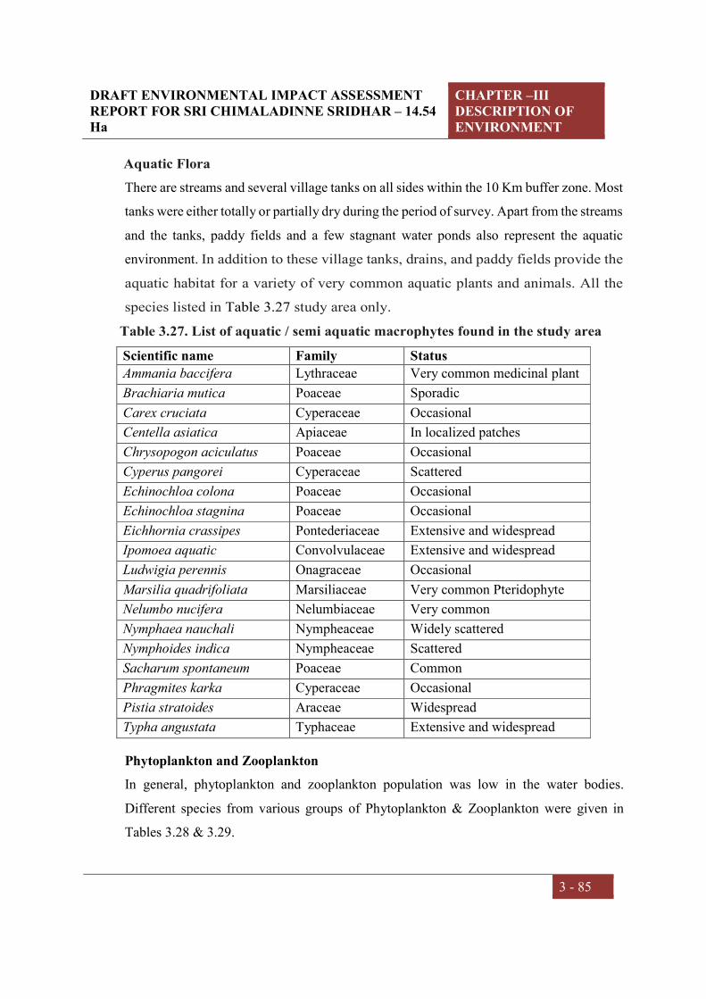
DRAFT ENVIRONMENTAL IMPACT ASSESSMENT REPORT FOR SRI CHIMALADINNE SRIDHAR – 14.54 Ha
CHAPTER –III DESCRIPTION OF ENVIRONMENT
3 - 85
Aquatic Flora
There are streams and several village tanks on all sides within the 10 Km buffer zone. Most
tanks were either totally or partially dry during the period of survey. Apart from the streams
and the tanks, paddy fields and a few stagnant water ponds also represent the aquatic
environment. In addition to these village tanks, drains, and paddy fields provide the
aquatic habitat for a variety of very common aquatic plants and animals. All the
species listed in Table 3.27 study area only.
Table 3.27. List of aquatic / semi aquatic macrophytes found in the study area
Scientific name Family Status
Ammania baccifera Lythraceae Very common medicinal plant
Brachiaria mutica Poaceae Sporadic
Carex cruciata Cyperaceae Occasional
Centella asiatica Apiaceae In localized patches
Chrysopogon aciculatus Poaceae Occasional
Cyperus pangorei Cyperaceae Scattered
Echinochloa colona Poaceae Occasional
Echinochloa stagnina Poaceae Occasional
Eichhornia crassipes Pontederiaceae Extensive and widespread
Ipomoea aquatic Convolvulaceae Extensive and widespread
Ludwigia perennis Onagraceae Occasional
Marsilia quadrifoliata Marsiliaceae Very common Pteridophyte
Nelumbo nucifera Nelumbiaceae Very common
Nymphaea nauchali Nympheaceae Widely scattered
Nymphoides indica Nympheaceae Scattered
Sacharum spontaneum Poaceae Common
Phragmites karka Cyperaceae Occasional
Pistia stratoides Araceae Widespread
Typha angustata Typhaceae Extensive and widespread
Phytoplankton and Zooplankton
In general, phytoplankton and zooplankton population was low in the water bodies.
Different species from various groups of Phytoplankton & Zooplankton were given in
Tables 3.28 & 3.29.

DRAFT ENVIRONMENTAL IMPACT ASSESSMENT REPORT FOR SRI CHIMALADINNE SRIDHAR – 14.54 Ha
CHAPTER –III DESCRIPTION OF ENVIRONMENT
3 - 86
Table 3.28. Freshwater Phytoplankton from the study area
S. No. Group Species
1
Bacillariophyceae
Diatoma sp.
Gomphonema sp.
Navicula sp.
Nitzschia sp.
Ankistrodesmus sp.
Chlorococcum sp.
Chlorella sp.
2
Chlorophyceae
Closterium sp.
Pandorina sp.
Anabaena sp.
Anacystis sp.
Spirulina sp.
3
Cyanophyceae
Merismopedia sp.
Phormidium sp.
Euglena sp.
4 Euglenophycea Phacus sp.
Table 3.29. Freshwater Zooplankton from the Study Area
S. No. Group Species
1
Copepoda Cyclops sp.
Pseudocyclops sp.
Nauplius larva
2
Rotifera
Asplanchna sp.
Brachionus sp.
Conochilus sp
Keratella tropica
Trichocera sp.
3 Cladocera Daphnia sp.
Diaphanosoma sp.
Fishes
The primary study reveals that, potential fishing activities do not exist in the study area
during summer season as water gets dry in stagnant water bodies and ponds during summer.
The aquatic habitats consist of Vamsadara canal; streams, ditches and water logged areas

DRAFT ENVIRONMENTAL IMPACT ASSESSMENT REPORT FOR SRI CHIMALADINNE SRIDHAR – 14.54 Ha
CHAPTER –III DESCRIPTION OF ENVIRONMENT
3 - 87
were represented by fin-fish (fishes), shell-fish (mollusk) and prawns (crustaceans) of
seasonal varieties. Some commercial fishing takes place in the ponds and sold in the local
market. As per information collected from the Fishery Department, Commercial fish fauna
found in the area is I) Catla (Catla catla) ii) Rohu (Labeo rohita) iii) Mrigal (Cirrhinus
mrigala) and iv) Kalbasu (Labeo kalbasu). Total fishes listed in the Table 3.30.
Table 3.30. Checklist of fishes in the study area
Common name Scientific name
Catla Catla catla
Rohu Labeo rohita
Murrel Channa striatus
Wallago Wallago attu
Cat fish Mystus vittatus
Cat fish Hetyeropneustes fossilis
Spiny eel Mastesembalus armatus
Prawn Macrobrachium rosenberghii
Prawn Macrobrachium malcolmsonii
Giant prech Lates calcarifer
Silonia Silonia silonia
Pearl spot Etroplus suratensis
Eel Anguilla sp
Gobies Glassogobius giuris
Mrigal Cirrhinus mrigala
3.12 SOCIO - ECONOMIC ENVIRONMENT
Overview
This report presents the socio-economic impact assessment (SIA), as part of the EIA for
the mining Project. The socio-economic baseline focuses on demographic patterns of socio
economic conditions and livelihood profile and infrastructure facilities in the study area.
Based on the data that is collected in this section, the socio economic impact assessment
will envisage and evaluate any potential impacts of the mining project on the local
community, livelihoods and other social systems.
The key aims and objectives of the socio-economic study included:

DRAFT ENVIRONMENTAL IMPACT ASSESSMENT REPORT FOR SRI CHIMALADINNE SRIDHAR – 14.54 Ha
CHAPTER –III DESCRIPTION OF ENVIRONMENT
3 - 88
To provide an accurate representation of the social, economic and cultural conditions
in existing project location - within the limits of Chimmaldenne Sridhar, quarry lease
for Colour Granite in Sy. No. 1, of Bellukola Village, Nandigama Mandal, Srikakulam
District, Andhra Pradesh.
To identify the potential socio-economic positive and negative impacts of the mining
project; and
To develop management and monitoring measures to be implemented throughout the
life of the project.
The socio-economic baseline has been prepared on the basis of a review of available
secondary sources of information as well as select primary consultations in the vicinity of
the project area. In addition, a sample survey of 66 people were participated from various
demographical aspects to know the socio economic livelihood, awareness of the project
and community perceptions about the mining project and other related information.
Brief profile of the District
The District is skirted to a distance by Vamsadhara, Nagavali, and Bahuda rivers at certain
stretches of their courses white a line of heights of the great Eastern Ghats run from North
East. Vizianagaram District flanks in the south and west while Orissa bounds it on the north
and Bay of Bengal on the East .The total area of the District is 5837 Sq. Kms. The District
derived its name from Srikakulam its headquarters town. Srikakulam District was carved
out in 1950 by bifurcating it from Visakhapatnam District; it remained unaffected in its
territorial jurisdiction for quite some time. But in November, 1969 the District lost 63
Villages from Saluru Taluk and 44 Villages from Bobbili Taluk on account of their transfer
to the then newly constituted Gajapathinagaram Taluk of Visakhapatnam District. Again
in May, 1979, the District had undergone major territorial changes on account of the
formation of new District with head quarters at Vizianagaram which involved transfer of
Saluru, Bobbili, Parvathipuram and Cheepurupalli Taluks to the new District. The total
area of the District is 5837 Sq Km. The district has a long coastal lieu of about 193 Km.

DRAFT ENVIRONMENTAL IMPACT ASSESSMENT REPORT FOR SRI CHIMALADINNE SRIDHAR – 14.54 Ha
CHAPTER –III DESCRIPTION OF ENVIRONMENT
3 - 89
Administrative set up
Administratively, the district is divided into three Revenue Divisions viz.,
Srikakulam, Palakonda and Tekkali with 38 Revenue Mandals and equal number
of Mandal Parishads comprising of 1870 villages of which 1757 are inhabited.
There are 11 semi-Urban areas which 5 Municipalities and 1101 are gram
panchayats. Revenue divisions are headed by RDOs whereas Mandal and Mandal
Parishads are lead by MROs and MDOs respectively. The district collector is
overall administrative head of the district.
District at a glance:
S.No Particular Year Unit Statistics
1 Geographical features
(A) Geographical Data
i) Latitude 2011 degrees 18-20 &19-10
ii) Longitude 2011 degrees 83-5 & 84-50
iii) Geographical Area 2011 Hectares 5,83,700
(B) Administrative Units
i) Sub divisions 2011 Nos. 3
ii) Tehsils/Mandals 2011 Nos. 38
iii) Sub-Tehsil 2011
iv) Patwar Circle 2011
v) Panchayat Simitis 2011
vi)Nagar nigam 2011
vii) Nagar Palika 2011
viii) Gram Panchayats 2011 Nos. 1,101
xi) Revenue villages 2011 Nos. 1,870
x) Assembly Area 2011 Nos. 10
2 Population
(A) Sex-wise
i) Male 2011 Nos. 13,40,430

DRAFT ENVIRONMENTAL IMPACT ASSESSMENT REPORT FOR SRI CHIMALADINNE SRIDHAR – 14.54 Ha
CHAPTER –III DESCRIPTION OF ENVIRONMENT
3 - 90
ii) Female 2011 Nos. 13,59,041
(B) Rural Population 2011 Nos. 22,59,000
3 Agriculture
A Land utilization
i) Total Area 2010-11 Hectare 5,83,700
ii) Forest cover 2010-11 “ 68,641
iii) Non Agriculture Land
2010-11 “ 99,269
v) cultivable Barren land 2010-11 “ 659
4 Forest
(i) Forest 2010-11 Ha. 68,641
5 Livestock & Poultry
A Cattle
i) Cows 2007 Nos. 8,07,235
ii) Buffaloes 2007 Nos. 1,25,958
B Other livestock
i) Goats/Sheep 2007 Nos. 6,88,687
ii) Pigs 2007 Nos. 10,350
iii) Dogs & Bitches 2007 Nos. 200
Source: http://dcmsme.gov.in/dips/srikakulam%20profile%20.pdf
Agriculture/ Crop study
The agricultural sector in Srikakulam district has good potential to grow. With nearly two-
thrid of the cropped area covered by irrigation and the incidence of high rainfall, both the
irrigated and rain fed crops can do well in the district. The soils are quite diverse and can
support a broad range of crops. Paddy, sugarcane, groundnut and sesamum are important
crops grown in the district. With the augmentation of irrigation resources by the
Jalayagnam projects, there is good scope for expansion of irrigated area and increases in
crop yields. With the output price situation being favorable, the profitability of crops is
likely to increase.

DRAFT ENVIRONMENTAL IMPACT ASSESSMENT REPORT FOR SRI CHIMALADINNE SRIDHAR – 14.54 Ha
CHAPTER –III DESCRIPTION OF ENVIRONMENT
3 - 91
The principal crops are bifurcated into Cereals, Pulses, Oilseeds and other crops. Of which
under cereals Rice, Bajra and Raagi are the prominent crops of the district. Green gram,
Horse Gram and Black gram are the prominent Pulses; Groundnut, Sesamum, and Coconut
are the prominent oil-seeds of the district. Cotton, Sugarcane and cashewnut are the other
prominent crops; Mangoes, Acid Lime, Behndi, Brinjal, Green leafy vegetables and
Tomatoes are the important vegetables and fruits of the district.
The cropping pattern of the district varies from one situation to another due to different
agro-climatic conditions. The major crops grown in the district during kharif are Rice,
Groundnut, Bajra, Sesamum, Mesta, Sugarcane, Cotton and Major crops grown during rabi
are Paddy, Groundnut, Sunflower, Sesamum, Green gram, Black gram, Horse gram.
The field crops dominate the area allocation with a share of 86.2 per cent. The horticulture
crops have 13% of the total area under them. Others have a 0.8 per cent share only in the
total area under crops. The area increase in rice mainly depends on the inflows of water in
to the rivers and timely rainfall received from monsoons. The maximum area under rice
during 2006-07 was 1.94 lakh ha, which is 41% higher than that recorded in the year 2002-
03 (1.53 lakh ha). The area under maize and sunflower is increasing due to good returns
obtained from them under irrigated dry conditions.
In Srikakulam district, irrigated area is allocated during kharif season only for rice and
sugarcane. But even these two crops are also cultivated under rain fed condition. All other
crops like bajra, maize, ragi, groundnut, sesamum and mesta are exclusively grown under
rain fed condition. While only 14.4% of the rice area is grown under rain fed condition,
58.3% of sugarcane area is grown under rain fed condition. There is no response to
irrigation as the yields of both rice as well as sugarcane are reported to be the same under
irrigated and rain fed conditions.
During the rabi season, only green gram and black gram are grown under rain fed condition
in rice fallows. All other crops including rice, ragi, maize, groundnut, sesamum and
sunflower are grown under only irrigation. The rice yield is less in rabi season when
compared to that under kharif season. But the yield of maize and ragi are higher in rabi

DRAFT ENVIRONMENTAL IMPACT ASSESSMENT REPORT FOR SRI CHIMALADINNE SRIDHAR – 14.54 Ha
CHAPTER –III DESCRIPTION OF ENVIRONMENT
3 - 92
season than in kharif season. In case of groundnut and sunflower also, rabi yields are higher
than those reported for kharif season. The yield of sesamum did not differ much between
the two seasons. Crops such as groundnut, sesame, mesta, jowar, bajra, red gram and, to
some extent, paddy and sugarcane are grown under rainfed conditions. The crops grown
during Kharif mainly depend on south-west monsoon and the crops grown during rabi
depend on north- east monsoon as well as on residual moisture available in the soil. Nearly
0.617 lakh ha is under rain fed agriculture out of the total cropped area of 2.93 lakh ha.
There are 675 agro service centres in Srikakulam district. All of them deal in seeds
fertilizers in pesticides. The maximum number of service centres is recorded in Srikakulam
ADA circle and it is followed by Narasannapeta and Ranasthalam ADA circles. The least
number of service centres is noted in Somepeta ADA circle, followed by Kothuru and
Palasa ADA circles. The branch of AGROS in the district supplies farm equipments and
machinery to the farmers in the entire district. No service centres deal with irrigation
equipment in the district. There is no agriculture consultancy agency or for providing
diagnostic services in the district.
Area Coverage under different crops (Ha.)
180392
1430035479
7300
1265
31577
39870
12541
1482
12423
12735
Rice
Sugarcane
Groundnut
Sesamum
Sunflower
Greengram
Blackgram
Horsegram
Redgram
Mesta
Other Agril. Crops

DRAFT ENVIRONMENTAL IMPACT ASSESSMENT REPORT FOR SRI CHIMALADINNE SRIDHAR – 14.54 Ha
CHAPTER –III DESCRIPTION OF ENVIRONMENT
3 - 93
Demographical details of the study area
Nandigama Mandal, with population of about 56 thousand is Srikakulam district's the 10th
least populous sub district, located in Srikakulam district of the state Andhra Pradesh in
India. There are 101 villages in the sub district, among them Nandigam is the most
populous village with population of 4180 and Santhoshapuram is the least populous village
with population of 2. Bellukola is the biggest village in the sub district with an area of 8
Km2 and population 246.
Table 3.31 Demographical details as per 2011 census
Description Nandigama Mandal
Population 56,443
Children (0-6 years) 5,709
Literacy 53.77%
Sex Ratio 1014
Scheduled Caste 12.18%
Scheduled Tribe 5.71%
Source: https://www.censusindia2011.com/andhra-pradesh/srikakulam/nandigama-population.html
Population distribution
The Mandal is home to about 56 thousand people, among them about 28 thousand (50%)
are male and about 28 thousand (50%) are female. 82% of the whole population are from
general caste, 12% are from schedule caste and 6% are schedule tribes. Child (aged under
6 years) population of Nandigam mandal is 10%, among them 51% are boys and 49% are
girls. There are about 14 thousand households in the sub district and an average 4 persons
live in every family. 100% population of Nandigam mandal live in the Nandigam rural part.

DRAFT ENVIRONMENTAL IMPACT ASSESSMENT REPORT FOR SRI CHIMALADINNE SRIDHAR – 14.54 Ha
CHAPTER –III DESCRIPTION OF ENVIRONMENT
3 - 94
Religion wise distribution of population
Hindus contribute 99% of the total population and are the largest religious community in
the sub district. Female Sex ratios per 1000 male in Hindus are 1014.

DRAFT ENVIRONMENTAL IMPACT ASSESSMENT REPORT FOR SRI CHIMALADINNE SRIDHAR – 14.54 Ha
CHAPTER –III DESCRIPTION OF ENVIRONMENT
3 - 95
Table 3.32 Population details of the Nandigama Mandal
Name No_HH TOT_P TOT_M TOT_F P_06 P_SC P_ST P_LIT P_ILL
Nandigam 14090 56443 28032 28411 5709 6873 3223 30351 26092
Tamalapuram 94 394 192 202 43 64 0 142 252
Deenabandupuram 191 850 437 413 106 16 0 470 380
Savarakothuru 35 172 84 88 17 0 165 80 92
Beniavooru 12 52 24 28 3 0 51 25 27
Savararampuram 41 171 85 86 12 0 119 78 93
Peddaguruvooru 76 270 126 144 30 0 263 144 126
Chinnaguruvuru 22 89 44 45 8 0 82 52 37
Saradapuram 55 246 126 120 21 26 6 138 108
Badagam 229 853 418 435 74 104 121 461 392
Agarlagokarla Palle 46 192 88 104 26 53 0 91 101
Jadyada 197 770 383 387 73 182 24 429 341
Kothagraharam 308 1266 624 642 129 3 0 682 584
Thotaneela Puram 0 0 0 0 0 0 0 0 0
Peddinaidupeta 60 213 104 109 19 12 0 145 68
Pathrunivalasa 76 262 132 130 17 118 0 161 101
Panukuru 0 0 0 0 0 0 0 0 0
Peddabanapuram 211 716 338 378 72 122 0 431 285
Savarabanapuram 49 190 90 100 24 63 0 112 78
Hanumanthulova 0 0 0 0 0 0 0 0 0
Turakalakota 152 541 260 281 40 8 0 350 191

DRAFT ENVIRONMENTAL IMPACT ASSESSMENT REPORT FOR SRI CHIMALADINNE SRIDHAR – 14.54 Ha
CHAPTER –III DESCRIPTION OF ENVIRONMENT
3 - 96
Vissampalle 6 28 13 15 2 0 28 14 14
Kasirajukasipuram 114 397 207 190 29 26 2 218 179
Kondatemburu 114 470 240 230 47 25 0 265 205
Majjigopalapuram 51 208 103 105 28 41 0 118 90
Mogilipadu 29 103 50 53 16 0 39 45 58
Savaralingupuram 113 611 389 222 51 0 579 410 201
Venkatapuram 15 70 29 41 8 0 70 32 38
Savararama Krishnapuram 74 311 154 157 47 55 0 155 156
Dimmidijola 399 1710 840 870 239 71 0 746 964
Karajada 26 119 60 59 7 0 116 64 55
Annapuram 145 625 322 303 78 0 0 243 382
Khallada 134 543 266 277 61 129 4 312 231
Peddalaxmipuram 0 0 0 0 0 0 0 0 0
Malliveedu 9 35 15 20 9 0 30 11 24
Kaijola 141 537 273 264 54 9 0 202 335
Sagarampeta 5 23 13 10 2 0 23 5 18
Harshabada 157 673 333 340 90 89 0 427 246
Mukundapuram 37 155 75 80 22 2 148 71 84
Kaliavooru 0 0 0 0 0 0 0 0 0
Temburu 455 1882 942 940 185 130 1 984 898
Chinnalavunipalle 96 407 210 197 54 108 0 221 186
Lattigam 50 188 90 98 17 0 0 79 109
Santhosha Puram 1 2 1 1 0 0 2 1 1
Devupuram 202 858 430 428 111 18 29 437 421

DRAFT ENVIRONMENTAL IMPACT ASSESSMENT REPORT FOR SRI CHIMALADINNE SRIDHAR – 14.54 Ha
CHAPTER –III DESCRIPTION OF ENVIRONMENT
3 - 97
Uddandabartupuram 19 70 30 40 5 0 0 38 32
Panasalapadu 0 0 0 0 0 0 0 0 0
Kaviti 388 1672 829 843 159 39 0 832 840
Anandapuram 148 558 261 297 66 34 0 318 240
Madigapuram 115 372 180 192 30 0 0 205 167
Borubhadra 197 764 396 368 74 0 0 401 363
Savaraneelapuram 0 0 0 0 0 0 0 0 0
Kanchivooru 24 102 46 56 11 0 0 54 48
Peddalavunipalle 213 679 337 342 53 123 0 354 325
Singupuram 89 365 181 184 27 116 0 257 108
Hukumpeta 78 267 128 139 25 22 0 96 171
Madanapuram 150 568 287 281 59 54 0 294 274
Jammipeta 21 87 43 44 10 0 0 46 41
Savarasomanadha Puram 0 0 0 0 0 0 0 0 0
Bharthupuram 66 213 105 108 29 7 109 70 143
Kandulagudem 20 47 16 31 4 0 46 9 38
Radhajanabodda Padu 211 836 425 411 101 63 146 343 493
Mamidipalle 8 31 16 15 5 0 0 16 15
Nowgam 340 1363 684 679 157 180 0 645 718
Totada 0 0 0 0 0 0 0 0 0
Polavaram 41 159 82 77 20 158 0 102 57
Subhadrapuram 252 997 512 485 107 268 0 555 442
Palavalasa 100 400 205 195 36 365 0 286 114
Kamadhenuvu 70 286 147 139 35 0 19 138 148

DRAFT ENVIRONMENTAL IMPACT ASSESSMENT REPORT FOR SRI CHIMALADINNE SRIDHAR – 14.54 Ha
CHAPTER –III DESCRIPTION OF ENVIRONMENT
3 - 98
Krishnarayapuram 36 149 83 66 14 0 0 89 60
Haridasupuram 427 1391 648 743 93 189 0 745 646
Prathapaviswana Dhapuram 149 562 285 277 55 52 0 254 308
Cherukupalle 162 607 285 322 26 105 0 353 254
Marlapadu 195 794 401 393 75 7 0 465 329
Kanithivooru 255 1029 509 520 125 0 0 643 386
Manigam 134 490 254 236 22 58 0 287 203
Nadupuram 0 0 0 0 0 0 0 0 0
Narendrapuram 167 649 330 319 63 0 0 370 279
Nandigam 859 4180 1880 2300 329 1422 33 2613 1567
Bejjipalle 95 350 171 179 46 11 0 168 182
Pothuluru 79 344 170 174 34 0 0 176 168
Karlapudi 103 408 207 201 40 118 0 228 180
Padmapuram 13 62 34 28 10 0 0 23 39
Bhiriboddapadu 36 143 78 65 14 0 138 75 68
Bellukola 83 252 127 125 25 0 246 106 146
Nelluru 0 0 0 0 0 0 0 0 0
Jayapuram 49 380 292 88 16 2 296 300 80
Rampuram 135 534 276 258 50 9 0 317 217
Chinnalaxmipuram 34 147 78 69 14 0 15 92 55
Sontinooru 65 246 119 127 32 0 233 164 82
Chinnarigokarla Palle 45 178 84 94 18 0 0 111 67
Peddatamarapalle 592 2335 1157 1178 250 363 0 1253 1082
Chinnatamarapalle 67 288 155 133 35 0 0 141 147

DRAFT ENVIRONMENTAL IMPACT ASSESSMENT REPORT FOR SRI CHIMALADINNE SRIDHAR – 14.54 Ha
CHAPTER –III DESCRIPTION OF ENVIRONMENT
3 - 99
Akularaghunadha Puram 166 661 319 342 72 0 1 295 366
Pentavooru 429 1457 694 763 125 365 0 820 637
Venugopalapuram 182 719 367 352 80 2 28 278 441
Mojjuvada 55 207 111 96 19 0 0 132 75
Vallabharayapadu 122 494 248 246 47 0 0 326 168
Bharanigam 45 167 91 76 21 0 0 72 95
Dodlarama Chandrapuram 98 364 179 185 34 0 0 172 192
Devada 127 537 274 263 60 3 0 268 269
Kotipalle 135 555 293 262 64 0 0 251 304
Badabanda 69 291 154 137 38 61 0 187 104
Mondrayavalasa 142 560 280 280 55 0 0 233 327
Komatooru 42 176 82 94 20 0 0 105 71
Narsipuram 233 904 466 438 80 288 0 547 357
Devalabhadra 382 1516 732 784 142 399 11 908 608
Dimilada 310 1244 624 620 126 180 0 768 476
Lakkidasupuram 334 1310 654 656 140 13 0 647 663
Uyyalapeta 123 462 222 240 53 0 0 172 290
Sivarampuram 168 728 370 358 90 0 0 305 423
Routhupuram 316 1243 587 656 141 323 0 631 612
Banjeerupeta 55 292 142 150 32 0 0 151 141
Source: http://censusindia.gov.in/pca/cdb_pca_census/Houselisting-housing-AP.html

DRAFT ENVIRONMENTAL IMPACT ASSESSMENT REPORT FOR SRI CHIMALADINNE SRIDHAR – 14.54 Ha
CHAPTER –III DESCRIPTION OF ENVIRONMENT
3 - 100
COMMUNITY PERCEPTIONS
Field work
The primary data collection was subsequently undertaken during process. This included
the collection of baseline demographic and socio-economic information through a
standardized survey focusing on household composition, education levels, general
health status, livelihood strategies, employment, and income and expenditure. In light
of potential resettlement requirements, the survey took the form of a census in villages
of 10 km radius.
A primary survey was conducted on data of 63 participants among the local
communities within the study area villages of Bellukola, Somanathapuram,
Ramapuram, Chinnagokarapalli, Gudem, Jayarampuram and Gollavuru. This survey
was conducted to identify the community perception. In this connection, filed experts
used the technique of sampling was used to administer a questionnaire on the existing
awareness among the community on the project and its potential impacts. This survey
was focused on various dimensions of economical, social & cultural, health &
wellbeing, economical, personal & psychological and heath & public infrastructure
aspects to assess that significant impact differences about this mining project. This
study was carried on population living in the 10 villages. The hamlets covered within10
KM of core and buffer areas.
Overall Outcome of the primary survey
The data is process to bring out the positive as well as negative impacts due to this
mining project as we discussed.
Economical impact
It can be observed from the nature of the existing mining project that during the process
mining activity it requires employability in various levels on contract and regular bases
in technical and non technical areas. Once the mining work resumed, It is
approximately estimated a total of 30 workers will be required for the mining project.
As a part of road regular gradation to the site it is estimated no of 10 temporary workers
will be required.
DRAFT ENVIRONMENTAL IMPACT ASSESSMENT REPORT FOR SRI CHIMALADINNE SRIDHAR – 14.54 Ha
CHAPTER –III DESCRIPTION OF ENVIRONMENT
3 - 101
The mining project is enclosed with different villages, whereas most of these workers
are likely to be from the project area, because the surrounding villages are having
human resource with skilled, semi skilled people and unskilled. These people will be
recruited as technical back ground like; technicians, service providers, tipper driver,
machine operators, supervisors in this project. The uneducated human beings will be
useful as labor and helpers. Hence, there would be more economical flow and the people
who are in the middle and low poverty line can be come out through employability due
to this project. An influx of population into the project area, including contracted
construction teams, will increase the demand for goods and services. Increases in
income-earning opportunities will also increase spending potential, providing
opportunities for supply of such services, indirectly increasing the overall wealth of the
area.
Employment with skill development programs
Skills are required for the most of the graduates. Hence, if the management takes the
initiative steps towards skill development programs to the local community will be
useful to generate the number direct and indirect opportunities to the local community.
As a result, both management and local people will be benefited. The management can
be benefited in the form of hire the local people with reasonable salaries, more support
from local communities and this training program can be included as part of CSR
activity. On the other hand, the local community will be getting assistance in the form
enhancing their skills, permanent or contract base employment opportunity and many
other tangible and non tangible benefits.
Social & Cultural impacts
Social and culture aspects are the most essential elements for every community and
social development. This domain focused on various social and cultural impacts of the
mining project. It is also observed from the survey; there will not be any out migration
from mining project. But, a very less people might be stayed due to employability form
outside study area. Other than there is no rehabilitation plan. In the context of cultural
aspect, it can be said that people were positively responded towards this project. Hence,
It can be said that people may not be have break ups with cohesion, may not have any
differences in social and cultural norms due to this project.

DRAFT ENVIRONMENTAL IMPACT ASSESSMENT REPORT FOR SRI CHIMALADINNE SRIDHAR – 14.54 Ha
CHAPTER –III DESCRIPTION OF ENVIRONMENT
3 - 102
Health & wellbeing impacts
In general, the mining site loaded with tipper, and drilling machines any other vehicles
may temporarily generate ambient noise and fugitive, dust from roads. Noise and air
quality studies are included in the full EIA and associated impacts need to refer to the
social environment. But, the mining site is situated far away to the community livings.
Hence, it can be concluded there would be any negative impact on communities with
this project. Another side, the wellbeing of the local people will be developed in the
form of direct and indirect employment.
Health care Facilities:
Healthcare facilities range from small clinics and doctors offices to urgent care centres
and large hospitals with elaborate emergency rooms and trauma centres. The number
and quality of health facilities in a country, region, state, Mandal, village is one
common measure of that area’s prosperity and quality of life. The various government
medical facilities exclusively allopathic available during 2009-2010 year is mentioned
below
Table 3.33: Number of Government Medical facilities (Allopathic) available
during 2009-2010 year
S.No Category of hospital 2009-2010
1 General Hospitals 4
2 T.B. Hospitals 1
3 Allied Hospitals 11
4 Primary Health Centers 73
5 Dispensaries 9
6 Regular Doctors 310
7 Contract Doctors 38
8 No. of Beds available 1020
(a) Men 150
(b) Women 75
(c) Children 25
(d) Common 770
DRAFT ENVIRONMENTAL IMPACT ASSESSMENT REPORT FOR SRI CHIMALADINNE SRIDHAR – 14.54 Ha
CHAPTER –III DESCRIPTION OF ENVIRONMENT
3 - 103
Public infrastructure & Services
It is estimated that the mining project would be caused for Improvement in
communication, transport, education, community development and medical facilities.
The infrastructure development, extension of new roads for smooth transportation of
vehicle, increase of private services due to the activity, frequent health camps will be
campaigned for local people. By increasing of connectivity, people have more
opportunities to enrich their business in various sectors.
Personal and psychological Impact
It is observed from personal and psychological context, most of the respondents have
positive attitude towards this project. Participants felt that have more economical and
infrastructure benefits due to this project. And another words, it come to known people
have thought of expression towards encouraging new industries. Hence, this could be
more helpful to the coming generations, in context of education, business and
employment aspect.
Socio-economic development
As a part of the social responsibilities, the project proponent will take up the
following peripheral developmental works.
Encouraging entrepreneurship among locals by vocational training.
Upgrading one primary school.
Health camps
Distribution of school uniforms and books to needy students
Cultural activities in the villages
Provision or free Transportation of patients
Preferential employment to the local people depending upon their qualification
and suitability of post.
Need Assessment:
Primary consultations identified certain key expectations that are also indicative of the
local community’s attitude towards industrial development in the study area:
Job opportunities to the local community during construction and operations;
Moral and technical support to the local people

DRAFT ENVIRONMENTAL IMPACT ASSESSMENT REPORT FOR SRI CHIMALADINNE SRIDHAR – 14.54 Ha
CHAPTER –III DESCRIPTION OF ENVIRONMENT
3 - 104
Expectations on education facilities for local village people;
Expectations on health facilities or frequent health camps;
Skill development programs to the unemployed educated people
Frequent government transport facility to local villages

CHAPTER – IV
ANTICIPATED ENVIRONMENTAL IMPACTS
& MITIGATION MEASURES

DRAFT ENVIRONMENTAL IMPACT ASSESSMENT REPORT FOR SRI CHIMALADINNE SRIDHAR – 14.54 Ha
CHAPTER-IV
ANTICIPATED ENVIRONMENTAL
IMPACTS & MITIGATION
MEASURES
4 - 1
4.0 INTRODUCTION
The mining activity is likely to make significant changes in land use and land pattern. This
activity may alter existing Environmental conditions, biological attributes, existing
ecosystem and associated biodiversity. The mining projects have positive as well as
negative impacts on Environment. Keeping in mind the Environmental baseline scenario as
detailed in Chapter III and the mining activity described in Chapter II, it is attempted to
predict the likely impacts, their extent on various parameters and likely mitigation measures
to be adopted.
Impact prediction is a very important phenomenon in evaluating the environmentally
potential adverse impacts for any mining project. The impact prediction is always carried
out under worst possible conditions so as to mitigate or to eliminate the Environmental
hazards. These predictions thus calculated are superimposed over the baseline data (the
quality of Environment in the vicinity of the project site) so as to calculate the net impact on
the Environment after the project comes into production.
Table: 4.1 Expected Nature of Impacts
ASPECT IMPACT
Fugitive dust,
Air emissions.
Effects on air quality, ecology due to increase in PM10 &
PM2.5, SO2, NOX and Free silica levels depending up on the
type of process and energy requirements.
Noise emissions &
Vibrations.
Effects on community noise environment of the region due
to increase in day night equivalent noise levels.
Transportation Impact on existing infrastructure.

DRAFT ENVIRONMENTAL IMPACT ASSESSMENT REPORT FOR SRI CHIMALADINNE SRIDHAR – 14.54 Ha
CHAPTER-IV
ANTICIPATED ENVIRONMENTAL
IMPACTS & MITIGATION
MEASURES
4 - 2
Table: 4.2 Identified/Predicted Environmental Impacts with & without Mitigation Measures
S. No Description Activity Effect
Impact without
mitigation measure
Mitigation measure proposed
Impact after
mitigation Remarks
1 Impact on
Topography
& Drainage
Excavation Changes in land use
pattern
High It is proposed to develop
avenue plantation on
either side of the
approach road.
After removal of
mineral, the excavated
pit will be backfilled and
will be converted into
animal grazing field.
The mining activity will
not intersect with ground
water.
Medium The
topographical
changes caused
due to mining
activity can be
transformed
into social
benefit by
adopting and
implementing
proper
reclamation
plan

DRAFT ENVIRONMENTAL IMPACT ASSESSMENT REPORT FOR SRI CHIMALADINNE SRIDHAR – 14.54 Ha
CHAPTER-IV
ANTICIPATED ENVIRONMENTAL
IMPACTS & MITIGATION
MEASURES
4 - 3
2 Air Pollution Excavation operation
Fugitive dust
emissions effecting
ambient air quality
& workers health
High Covered aprons with
nose masks will be
provided to the work
force.
Regular inspection and
maintenance of
machinery will be
practiced.
Low Localized
effect which
can be
mitigated with
controlled
mining
practices
Loading & Dispatch. Fugitive dust
effecting air quality
& health effect
High Mineral on vehicles will
be covered with
tarpaulin.
Water will be sprinkled
regularly along the
haulage roads
Vehicular speed will be
limited to 25KMPH.
Haul road compaction
and grading at periodic
intervals will be
practiced.
Low Localized
effect which
can be
mitigated

DRAFT ENVIRONMENTAL IMPACT ASSESSMENT REPORT FOR SRI CHIMALADINNE SRIDHAR – 14.54 Ha
CHAPTER-IV
ANTICIPATED ENVIRONMENTAL
IMPACTS & MITIGATION
MEASURES
4 - 4
Green belt development
on either side of the
approach road.
Vehicular movement
and machinery
operation
Release of SO2 and
NOx due to
combustion of fossil
fuels
Low Regular maintenance of
vehicles and machineries
will be practiced to
improve their efficiency
Negligible
3 Water
Pollution
Run off from
surrounding area into
ML area
Siltation of mine
pits.
High
During mining activities
desiltation works will be
carried out regularly
Low Negligible
effect which
can be
mitigated
Domestic sewage from
mine area
Increases BOD
levels of the water
bodies if released
directly
High Domestic waste water
generated is disposed
through septic tank followed
by soak pit
Low Negligible
effect which
can be
mitigated
Seepage of mine water
to aquifers
Contaminates
Ground water
High No effluents will be
released from this mine
Mining activity will not
Low Negligible
effect which
can be
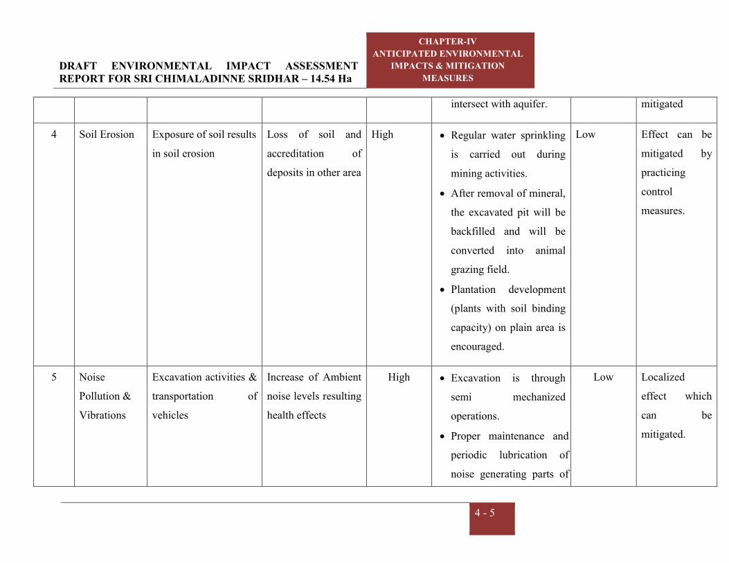
DRAFT ENVIRONMENTAL IMPACT ASSESSMENT REPORT FOR SRI CHIMALADINNE SRIDHAR – 14.54 Ha
CHAPTER-IV
ANTICIPATED ENVIRONMENTAL
IMPACTS & MITIGATION
MEASURES
4 - 5
intersect with aquifer. mitigated
4 Soil Erosion Exposure of soil results
in soil erosion
Loss of soil and
accreditation of
deposits in other area
High Regular water sprinkling
is carried out during
mining activities.
After removal of mineral,
the excavated pit will be
backfilled and will be
converted into animal
grazing field.
Plantation development
(plants with soil binding
capacity) on plain area is
encouraged.
Low Effect can be
mitigated by
practicing
control
measures.
5 Noise
Pollution &
Vibrations
Excavation activities &
transportation of
vehicles
Increase of Ambient
noise levels resulting
health effects
High Excavation is through
semi mechanized
operations.
Proper maintenance and
periodic lubrication of
noise generating parts of
Low Localized
effect which
can be
mitigated.

DRAFT ENVIRONMENTAL IMPACT ASSESSMENT REPORT FOR SRI CHIMALADINNE SRIDHAR – 14.54 Ha
CHAPTER-IV
ANTICIPATED ENVIRONMENTAL
IMPACTS & MITIGATION
MEASURES
4 - 6
the machinery & vehicle
machines.
PPE such as ear plug will
be supplied for the
workers.
Vehicle speed is
controlled to a maximum
of 25KMPH
Green belt development
6 Biological &
Socio-
economic
aspect
Operational activities
of mine
This area consists of
Dry deciduous
vegetation in which
Diospyros sylvatica,
Pterospermum
xylocarpum, Lannea
coromandelica and
Garuga pinnata are
common trees. No
ecologically sensitive
and threatened plant
species has been
High It is proposed to develop
avenue plantation on
either side of the
approach road.
After complete
exploration of the mineral
the land on top benches
will be applied top soil
and developed with
grasses and plantation.
Medium No notable
biodiversity
resources are
present within
the mine site

DRAFT ENVIRONMENTAL IMPACT ASSESSMENT REPORT FOR SRI CHIMALADINNE SRIDHAR – 14.54 Ha
CHAPTER-IV
ANTICIPATED ENVIRONMENTAL
IMPACTS & MITIGATION
MEASURES
4 - 7
reported from this area
Positive socio
economic effect.
-- Medical/first aid
facilities, Employment
opportunities., Water
supply, communication
will be enhanced due to
the mine activity
It is proposed to develop
avenue plantation on
either side of the
approach road.
Positive --
7 Occupational
Health &
Safety
Operational activities
of mine like
excavation, loading etc.
Pulmonary health
effects predicted and
other minor injuries.
High Provision of appropriate
PPE viz., nose masks, hand
gloves, shoes and aprons
First aid/Medical check
facilities will be provided
Low Medical/ Life
insurance &
Workman
compensation
procedures will
be followed.

DRAFT ENVIRONMENTAL IMPACT ASSESSMENT REPORT FOR SRI CHIMALADINNE SRIDHAR – 14.54 Ha
CHAPTER-IV
ANTICIPATED ENVIRONMENTAL
IMPACTS & MITIGATION
MEASURES
4 - 8
4.1 IMPACTS ON AIR QUALITY
The impact on air quality due to production of Colour Granite with maximum production of
about 12180 m3 /Annum is limited to the mining lease area. The operations involve drilling,
wire saw cutting, and excavation by excavators. The major source for dust emissions are
from excavation operations and transportation of the material. The mine rated capacity and
the baseline ambient air quality values were monitored during non-monsoon season reflects
the emissions in the area. The impact due to mining activities and transport of material has
been considered to estimate the contribution of dust levels to the existing ambient air quality
by the mine.
4.1.1 Quantitative estimation of impacts on air environment
The following options have been employed to predict the ground level concentrations due to
emissions from mine.
1. Area being rural, rural dispersion parameters is considered.
2. Predictions have been carried out to estimate concentration values over radial distance of
10 km around the sources.
3. Polar receptor network has been considered.
4. Emission rates from the point sources and area sources were considered as constant
during the entire period.
5. The ground level concentrations computed were as is basis without any consideration of
decay coefficient.
6. Calm winds recorded during the study period were also taken into consideration.
7. Site specific meteorological data to estimate ground level concentrations for period of
Oct-21 to Dec-21.
4.1.2 Sources of dust emission
Mining will be carried out by opencast method mainly involving drilling and excavation by
excavators and directly loads into the tippers. Based on the various operations involved in
the production, the various emission sources at each stage have been identified as given
below.

DRAFT ENVIRONMENTAL IMPACT ASSESSMENT REPORT FOR SRI CHIMALADINNE SRIDHAR – 14.54 Ha
CHAPTER-IV
ANTICIPATED ENVIRONMENTAL
IMPACTS & MITIGATION
MEASURES
4 - 9
a. Area sources
b. Line sources
Drilling, wire saw cutting and excavation by excavators and directly loads into the tippers
operations of the mine are considered as area sources. Transportation from mining pit to
stock pile/dump area and stockpile to end users is considered as line sources. The impact of
above sources on air environment is discussed below:
The impacts of emission from above sources on air environment are discussed below:
4.1.3. Emission details
All the emissions discussed above are quantified for material handling for Colour Granite of
12180 m3/annum. The existing baseline concentrations are already covered in the baseline
scenario (Chapter - III). The emissions are computed based on AP-42 emission factors.
Operational hours and activity rate have been considered for estimation of emissions from
point and area sources. For line source, apart from operational hours and activity rate,
moisture and silt content of the haulage road have been considered.
4.1.4. Meteorological data
The meteorological data recorded continuously during the months of Oct’21 to Dec’21 on
hourly basis on wind speed, wind direction and temperature has been processed to extract
the 24 – hourly meteorological data.
4.1.5 Assumptions made in the prediction of air pollution impacts
For the purpose of computation of rise in the ground level concentrations due to mining
operations, the following assumptions have been considered.
Mining operations are carried out for a period of 8-10 hours a day and hence it is not a
continuous source of emission and other operations may not be simultaneous and
continuous. However, for the prediction of worst case concentration, the sources mentioned
in the above are assumed to be under simultaneous and continuous operation for 8-hours.
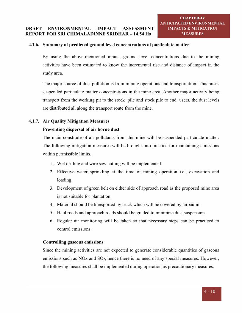
DRAFT ENVIRONMENTAL IMPACT ASSESSMENT REPORT FOR SRI CHIMALADINNE SRIDHAR – 14.54 Ha
CHAPTER-IV
ANTICIPATED ENVIRONMENTAL
IMPACTS & MITIGATION
MEASURES
4 - 10
4.1.6. Summary of predicted ground level concentrations of particulate matter
By using the above-mentioned inputs, ground level concentrations due to the mining
activities have been estimated to know the incremental rise and distance of impact in the
study area.
The major source of dust pollution is from mining operations and transportation. This raises
suspended particulate matter concentrations in the mine area. Another major activity being
transport from the working pit to the stock pile and stock pile to end users, the dust levels
are distributed all along the transport route from the mine.
4.1.7. Air Quality Mitigation Measures
Preventing dispersal of air borne dust
The main constitute of air pollutants from this mine will be suspended particulate matter.
The following mitigation measures will be brought into practice for maintaining emissions
within permissible limits.
1. Wet drilling and wire saw cutting will be implemented.
2. Effective water sprinkling at the time of mining operation i.e., excavation and
loading.
3. Development of green belt on either side of approach road as the proposed mine area
is not suitable for plantation.
4. Material should be transported by truck which will be covered by tarpaulin.
5. Haul roads and approach roads should be graded to minimize dust suspension.
6. Regular air monitoring will be taken so that necessary steps can be practiced to
control emissions.
Controlling gaseous emissions
Since the mining activities are not expected to generate considerable quantities of gaseous
emissions such as NOx and SO2, hence there is no need of any special measures. However,
the following measures shall be implemented during operation as precautionary measures.

DRAFT ENVIRONMENTAL IMPACT ASSESSMENT REPORT FOR SRI CHIMALADINNE SRIDHAR – 14.54 Ha
CHAPTER-IV
ANTICIPATED ENVIRONMENTAL
IMPACTS & MITIGATION
MEASURES
4 - 11
Water sprinkling arrangements such as specially fabricated tankers mounted on
tipper are deployed at mine site to control the fugitive dust generation from the
haulage roads.
The vehicles and machinery will be maintained in good condition so that emission
of gaseous constituents will be minimized.
Periodical monitoring of air quality will be done to take steps for controlling the
pollutant emissions.
4.2 WATER ENVIRONMENT
4.2.1 Impacts on surface water bodies and control measures
The operation of Colour Granite mining activity requires water for wire saw cutting and
drilling. The water will be used for drinking/domestic purpose and dust suppression/
plantation purpose. The required water is sourced through water tankers. There will be no
effluent discharge expected from this mine, except domestic effluent which is treated in
septic tank followed by soak pit. Hence, no impact on the quality of surface and ground
water is expected. Whereas the core zone will ultimately fall in safe zone, there is no
possibility of any changes in the water quality. The chemical analysis of water samples
collected reveal that there is no significant change in the constituents and surface water and
ground water in the nearby mining areas have remained suitable for all purposes and all
constituents within the water standards of IS-10500-2012.
One first order stream passing through the buffer zone of the lease area in West. Garland
drains will be constructed within the mine area to collect rain water into the siltation pond.
The total water requirement is about 14 KLD for various activities such as,
Green-belt watering
Dust suppression
Wet drilling & Wire saw cutting
Domestic use

DRAFT ENVIRONMENTAL IMPACT ASSESSMENT REPORT FOR SRI CHIMALADINNE SRIDHAR – 14.54 Ha
CHAPTER-IV
ANTICIPATED ENVIRONMENTAL
IMPACTS & MITIGATION
MEASURES
4 - 12
The water requirement will be met from water supply through tankers from nearest village
and no bore well is proposed. The processes of mining do not generate any hazardous liquid
effluent except domestic sewage. About 1.2 KLD of domestic sewage will be generated
during mine operations; the same will be disposed through septic tank followed by soak pit.
The mining operations will be carried out throughout the year avoiding rainy days. Rain
water collected in mine pits are withdrawn and will be used for watering plants and
sprinkling on haul roads.
4.2.2 Rain water harvesting
During mining operations, the rainwater stored in the pit area is pumped out to carry out
excavation operations without hindrance. At the end of mine life, rainwater collected in pit
will be allowed to soak into the ground for recharging the ground water table.
4.2.3 Impacts on ground water table
The mine working will be above the water table throughout the life of the mine. The
groundwater table is available at 10-35 m from the ground level. There will be no
intersection of ground water table due to this mining. Hence, the possible impacts on the
ground water table because of open cast mining will be minimal.
4.3 LAND ENVIRONMENT
Land environment is divided into the following three components
Solid waste management
Soil Erosion
Reclamation of degraded areas
Afforestation /Plantation/ Greenbelt development
4.3.1. Solid waste generation
The waste that will be generated in this mining period is 228,950.40 m3 during the ensuing
five years period with an average of 45790 m3/annum. The waste generated during the
mining will be dumped in the NW of the quarry lease applied area over an area of 2.250 Ha
with an average height of 10 m with 45 slope angle will be formed. A retaining wall will be

DRAFT ENVIRONMENTAL IMPACT ASSESSMENT REPORT FOR SRI CHIMALADINNE SRIDHAR – 14.54 Ha
CHAPTER-IV
ANTICIPATED ENVIRONMENTAL
IMPACTS & MITIGATION
MEASURES
4 - 13
constructed around the dump for preventing the slanting of boulders. Construction of
garland drains, check dams will be done during the scheme period of mining. The generated
waste will be used for internal laying of roads and for reclamation during mine closure.
4.3.2 Soil Erosion
The mine activity will expose out the loose earthy material which leads to soil erosion
through runoff or wind action. This may cause in deposition of silt in low-lying water
bodies.
This effects can be controlled by following the below suggested conservation practices.
Regular water sprinkling is carried out during mining activities.
After removal of mineral the top benches will be applied with top soil and grasses and
plantation will be developed
Plantation development (plants with soil binding capacity) on plain area is encouraged
Construction of garland drains should be done to avoid siltation of nearby water
sources
4.3.3 Reclamation of degraded areas
i) Impact due to land degradation
The mine lease area of 14.5 Ha. is a part of hilly terrain. However, the proponent is
maintaining a buffer zone with existing natural vegetation and the proponent will be planted
1100 plants within Buffer Zone, in open places and along the approach road on either side
for a stretch of 0.8 km.
ii) Land reclamation Control Measures
Opencast mining activity will change land use pattern of the present mine area. The top soil
generated during this mine operation will be stored and will be used for plantation works.
The land degradation is minimal and restricted only to the mining area and the facilities
within the mine lease boundary.

DRAFT ENVIRONMENTAL IMPACT ASSESSMENT REPORT FOR SRI CHIMALADINNE SRIDHAR – 14.54 Ha
CHAPTER-IV
ANTICIPATED ENVIRONMENTAL
IMPACTS & MITIGATION
MEASURES
4 - 14
iii) Reclamation of land affected due to mining activities.
The lessee must take steps to keep the granted lease area under disturbance at any stage to
the minimum. This can be achieved by ensuring reclamation during excavation.
The land can be reclaimed as the excavated pit may be partially backfilled by the stored
waste generated during mining. The buffer area will be maintained with existing natural
greenbelt. It can be used for indigenous plant developed as a plantation at the end of the
mining activity.
iv) Soil conservation measures and Top soil management
The top soil will be preserved within the lease area and the same will be used for plantation,
roads, filling ditches and reclamation whenever necessary.
v) Maintenance of road
The road for movement of trucks to the mine will be kept in good condition during the
reclamation/afforestation period till the mine is fully reclaimed and afforested. The material
required for planting and growth of plants and trees, measures, water etc. can be transported
to the site by trucks.
4.3.3 Program of Afforestation
The proponent is maintaining the buffer zone with existing natural vegetation and also
proposed to develop avenue plantation with 1100 plants within Buffer Zone, in open places
and along the approach road on either side for a stretch of 0.8 km.
4.3.4 Impact on land use and reclamation measures
Open cast semi mechanized mining activities may alter the landscape of the lease area and
some disturbance to the surface features of the surrounding areas. The total mine lease area
is about 14.54 Ha. During the ensuing mining plan period, an area of 5.071 Ha of land will
be brought under mining.
It is proposed to develop avenue plantation on either side of the approach road. It can be
used for native species plantation at the end of the mining activity.

DRAFT ENVIRONMENTAL IMPACT ASSESSMENT REPORT FOR SRI CHIMALADINNE SRIDHAR – 14.54 Ha
CHAPTER-IV
ANTICIPATED ENVIRONMENTAL
IMPACTS & MITIGATION
MEASURES
4 - 15
4.4 NOISE ENVIRONMENT
4.4.1 Impact due to Noise and Vibration
At mines, noise is generated by movement of machinery, drilling and transportation by
vehicles, etc. The noise level in the working environment are compared with the standards
prescribed by Occupational Safety and Health Administration (OSHA-USA) which has been
adopted and enforced by the Govt. of India through model rules framed under Factories Act,
1980 and CPCB 2000 norms. The summary of the permissible exposures in case of
continuous noise as per above rules is given below:
Table 4.3 Noise impact
Total time of exposure
per day in hour
Sound pressure
dB(A)
Remarks
1 2 ----
8.0 90 No exposure in excess of 115 dB(A) is permissible
6.0 92 --
4.0 95 For any period of exposure falling in between any figure and lower figure as indicated in column (1), the permissible sound is to be determined by extrapolation or proportionate scale.
3.0 97
2.0 100
1 ½ 102
1 105
¾ 107
½ 110
¼ 115
Noise at lower levels (sound pressure) is quite acceptable and does not have any bad effect
on human beings, but when it is abnormally high- it incurs some maleficent effects. For the
mining operations, the noise is expected to be generated from machineries used for this
project. During mining the noise pollution can take place due to external transport
machinery as dumper/tractor etc.

DRAFT ENVIRONMENTAL IMPACT ASSESSMENT REPORT FOR SRI CHIMALADINNE SRIDHAR – 14.54 Ha
CHAPTER-IV
ANTICIPATED ENVIRONMENTAL
IMPACTS & MITIGATION
MEASURES
4 - 16
4.4.2 Noise and Vibration Control Measures
The ambient noise level monitoring carried out has revealed that the ambient noise levels
are well within the prescribed limits. However, the following measures will further tend to
abate the noise level and vibration:
Proper maintenance and periodic lubrication of noise generating parts of the
machinery & vehicle machines.
Vehicle speed will be restricted to a maximum of 25KMPH.
A thick tree plantation will be developed.
Regular preventive maintenance of machinery and the transport vehicles.
Provision of silencers, to module the noise generated by the machines, where
required.
Equipment’s with permissible noise level will be procured.
Provision of Protective Devices like ear muffs/ear plugs will be provided to workers.
4.5 BIOLOGICAL ENVIRONMENT
4.5.1. Impacts on Biological Environment
Mining activities generally result in the deforestation, land degradation, water, air and noise
pollution which directly or indirectly affect the faunal and floral status of the project area.
However, occurrence and magnitude of these impacts are entirely dependent upon the
project location, mode of operation and technology involved. Impact prediction is the main
footstep in impact evaluation and identifies project actions that are likely to bring significant
changes in the project environment. The present study was carried out to predict the likely
impacts of the proposed Colour Granite Mine of Sri Chimaladinne Sridhar at Bellukola
Village surrounding environment with special reference to biological attributes covering
habitats/ecosystems and associated biodiversity. Although impacts on key habitat elements
will occur on a local scale, but on a regional scale they would not be critical for the life
cycle needs of the species observed or expected. Moreover, the successive reclamation of
mined out areas, following completion of mining activities, will replace habitat resources for
fauna species in this locality over a longer time.

DRAFT ENVIRONMENTAL IMPACT ASSESSMENT REPORT FOR SRI CHIMALADINNE SRIDHAR – 14.54 Ha
CHAPTER-IV
ANTICIPATED ENVIRONMENTAL
IMPACTS & MITIGATION
MEASURES
4 - 17
The study area comprise of Tropical Dry Deciduous vegetation. Several tropical elements
can be seen scattered in the area. Species of Lannea coromandelica, Diospyros sylvatics,
Morinda pubescens, Sterculia urens, Dalbergia paniculata, Anogeissus latifolia, etc. are of
common occurrence. Tree species viz., Tectona grandis, Mangifera indica, Anacardium
occidentale, etc. are found planted along the boundary of the agricultural lands and along the
road sides. Ground vegetation mainly consists of grasses and small shrubs. Among the
grasses, Thysanolaena maxima, Heteropogon contortus are very common in the area. Useful
fodder grasses, Cynodon dactylon, Eleusine indica, Trifolium alexandrinum, etc. are present
in the proposed project area. Wild life is not commonly found in the lease area and its
immediate environs because of lack of vegetal cover and surface water. Except domestic
animals, wild animals commonly observed are reptiles, fox, hares and some birds.
4.5.2. Mitigation Measures
Keeping all in mind the mitigations have been suggested under environmental management
plan. With the understanding of the role of plant species as bio-filter to control air pollution,
appropriate plant species (mainly tree species) have been suggested conceding the area/site
requirements and needed performance of specific species. The details of year wise proposed
plantation program are given in Table 4.4.
Table 4.4 Details of proposed plantation
Year No. of plants 1st 200
2nd 200
3rd 200
4th 200
5th 200
TOTAL 1000
In order to compensate the loss of vegetation cover, it is suggested to carry out afforestation
program mainly in mine lease area earmarked for plantation program in different phases.
This habitat improvement program would ensure the faunal species to re-colonize and
improve the abundance status in the core zone. In order to improve the fodder availability
DRAFT ENVIRONMENTAL IMPACT ASSESSMENT REPORT FOR SRI CHIMALADINNE SRIDHAR – 14.54 Ha
CHAPTER-IV
ANTICIPATED ENVIRONMENTAL
IMPACTS & MITIGATION
MEASURES
4 - 18
some of the grass species suggested growing within the plantation area proposed by the
proponent as silvopastural adaptation in the initial phase. Wherever mining is completed,
within that area (preferably flat terrain) some grass species can also grow simply sowing
grass seeds in pellet form after ploughing at sub-surface level before the onset of monsoon
season in phase manner. This can provide fodder for the local livestock and thereby reduce
grazing pressure in the nearby areas.
4.5.3. Greenbelt Development
Development of the green belt is one of the most sensitive issues and shall be done with due
care. Selection of proper locally grown species in addition to checking of their growth rate,
quality, thickness of canopy cover, etc. shall be duly done as it helps in abatement of
fugitive noise, reduce the pollution level, thus making the place worth dwelling for the
diversified species flora. The plant species suitable for green belt development need to be
selected based on the flowing criteria.
Native plant species will be preferred
Fast growing plants will be planted
Good soil binding potential
Plants having thick canopy cover will be used
Preferably perennial and evergreen species will be selected
Plants having large leaf area index will be considered
Road sides will be planted with local vegetation.
While making choice of plant species for cultivation in green belts, weightage has to be
given to the natural factor of bio-climate. It is also presumed that the selected plants will be
grown as per normal horticultural or forestry practices.
Trees are important sinks for air pollutants. Trees absorb noise and by enhancing the green
cover, improve the ecology and aesthetics and affect the local micrometeorology. Trees also
have major long-term impacts on soil quality and the ground water table. By using suitable
plant species, green belts can be developed in strategic zones to provide protection from
emitted and noise.

DRAFT ENVIRONMENTAL IMPACT ASSESSMENT REPORT FOR SRI CHIMALADINNE SRIDHAR – 14.54 Ha
CHAPTER-IV
ANTICIPATED ENVIRONMENTAL
IMPACTS & MITIGATION
MEASURES
4 - 19
In view of this, the list of species to be planted in the green belt area is illustrated below.
The suitable variety/species shall be finalized in consultation with local forest officer and
horticultural experts. Mixed plantation shall be done keeping optimum spacing between the
saplings.
Table 4.5 Selected list of plant species for Greenbelt development
SI. No. Botanical name Family
1 Albizia odoratissima Mimosaceae
2 Azadirachta indica Meliaceae
3 Dalbergia sissoo Fabaceae
4 Delonix regia Mimosaceae
5 Feronia elephant Rutaceae
6 Ficus benghalensis Moraceae
7 Ficus religiosa Moraceae
8 Hardwickia binata Fabaceae
9 Mangifera indica Anacariaceae
10 Polyalthia longifolia Annonaceae
11 Pongamia pinnata Fabaceae
12 Sapindus emarginatus Sapindaceae
13 Syzygium cumini Myrtaceae
4.6 TRAFFIC ANALYSIS
During mine operation
Colour Granite : 12180 m3/annum
No. of working days : 270 days
Truck Capacity : 8 m3 (20 T)
No of trucks per day : 8 trucks/day
Total working hours per day : 8 hours/day
No. of trips deployed/hour : 1-2 trips/hour

DRAFT ENVIRONMENTAL IMPACT ASSESSMENT REPORT FOR SRI CHIMALADINNE SRIDHAR – 14.54 Ha
CHAPTER-IV
ANTICIPATED ENVIRONMENTAL
IMPACTS & MITIGATION
MEASURES
4 - 20
4.6.1 Impact on road network
Following control measures will implemented for traffic management.
Usage of project vehicles will be restricted near sensitive zones such as schools,
settlements etc.
Speed of the vehicles will be restricted to 25 KMPH.
Vehicular movement will be restricted to specific routes.
Adequate training on traffic and road safety operations will be provided to the drivers.
Routine maintenance vehicles will be ensured to prevent any abnormal emissions and
high noise generation.
Road network within site and nearby site will be developed.
The entry and exit points carefully designed to avoid any disturbance to traffic and will
have enough buffer before merging into the main roads. However mine is operational
since last long and no issue related with traffic congestion.
Signal for speed limit will be placed and are maintained.
4.7 SOCIO-ECONOMIC CONDITIONS
4.7.1 Impact on socio-economic conditions
No displacement of people is envisaged from the mine lease area. The acquired ML area
involves 14.54 Ha of hilly terrain. The lease area is unfit for agriculture as it is hill and
strewed with small stones/boulders. The surrounding inhabitants are mainly agricultural
oriented & mine workers. Unemployment and under-employment are the main problems of
inhabitants.
Communication facilities are already present in the village and first aid facility, rest shelters
and other facilities will be provided by the proponent as Corporate Environment
Responsibility which will be positively benefited the local population. Other beneficial
impacts can be:
Increase in employment opportunities.
Enhance the capabilities of education.
Growth in service sectors.

DRAFT ENVIRONMENTAL IMPACT ASSESSMENT REPORT FOR SRI CHIMALADINNE SRIDHAR – 14.54 Ha
CHAPTER-IV
ANTICIPATED ENVIRONMENTAL
IMPACTS & MITIGATION
MEASURES
4 - 21
Increase in consumer prices of indigenous produce and services, land prices, house rent
rates and labor cost.
Improvement in socio-cultural Environment of the study area.
Improvement in transport, communication, health and educational services.
The overall impact on the Socio economic Environment will be beneficial.
4.7.2 Impact on Human Settlement
The area is surrounded by few small villages and towns where some people are working as
daily labor. The main occupation of the local people is Cultivation and cattle rearing. The
details of the villages, location, distance and population are given in the following table.
Table 4.6 Surrounding villages with their population
S. No Village Direction Distance
(Km)
Population
(Nos)
1 Nilapura S 0.50 658
2 Naugam SE 1.00 643
3 Pedda Tamarapalle SE 4.75 2,335
4 Chinnari Gokarlapalle SE 4.75 745
5 Sontunuru S 3.50 143
6 Ramapuram SW 3.50 534
7 Narasingapalli SW 3.75 159
8 Jayapuram SW 3.00 380
9 Bellakola SW 2.00 170
10 Janturu NW 3.50 306
11 Venkatapuram NW 4.00 70
12 Bandapalli NW 4.50 809
13 Kotturu NW 4.50 199
14 Maradikota NW 4.00 200
15 Tamalapuram N 4.00 394
16 Rampuram NE 4.75 534
Source: Mining Plan

DRAFT ENVIRONMENTAL IMPACT ASSESSMENT REPORT FOR SRI CHIMALADINNE SRIDHAR – 14.54 Ha
CHAPTER-IV
ANTICIPATED ENVIRONMENTAL
IMPACTS & MITIGATION
MEASURES
4 - 22
4.8 IMPACT ON OCCUPATIONAL HEALTH AND SAFETY
During the high windy days in summer, the Colour Granite could be the problems for eyes
like itching and watering of eyes. Dust in air can be a health hazard leading to respiratory
issues such as asthma and irritating the lungs and bronchial passages.
For mitigating, the aspects following measures will be implemented:
Regular water sprinkling on haul roads.
Dust mask will be provided to the workers,
Periodical medical examinations will be carried out for the workers as per norms,
Medical records will be maintained,
Medical facilities to the workers,
Any early symptom of diseases, if observed, such workers will be taken off in the
dusty atmosphere and suitably employed elsewhere,
Personal Protective Equipments such as helmets, safety shoes and aprons with nose
masks will be provided to the workers,
Good quality water will be provided to the workers and proper test for water quality
to be carried out regularly.
A well equipped first aid facility will be available in ML area,
Safety of the employee during operations, maintenance of mining equipments will be
taken care as per Mine Regulations 1961.
Effective communication system like mobile phones, land line phones, e-mail etc.
facilities will be available at the mine site.
Uniforms will be provided to the workers and they will be allowed to go home after
changing clothes.

CHAPTER – V
ANALYSIS OF ALTERNATIVES

DRAFT ENVIRONMENTAL IMPACT ASSESSMENT REPORT FOR SRI CHIMALADINNE SRIDHAR – 14.54 Ha
CHAPTER-V ANALYSIS OF ALTERNATIVES
5- 1
5.0 GENERAL
The analysis of alternative is the process of comparing potential impacts and mitigation
options of a series of alternative location, technologies, operation to identify optimal
alternatives.
5.1 ALTERNATE TECHNOLOGY
Sri Chimaladinne Sridhar has been granted in principle a Quarry lease for Colour
Granite (Srikakulam Blue) over an extent of 14.54 Ha in Sy.No.01 of Bellukola Village,
Nandigama Mandal, Srikakulam District, Andhra Pradesh. The method of mining is
conventional method of open cast mining for the production of 12180 m3/annum for
Colour Granite.
The production technology for excavation of Colour Granite is open cast semi
mechanized method of mining with drilling, wire saw cutting and loaded in to tippers.
The technology suggested is best suited for Colour Granite production. The present
technology will be implemented in safe and environmental friendly manner.
5.2 ALTERNATIVE SITE
Mining activities will be carried out based on local geology and availability of the
mineral. As proved Colour Granite reserves are observed in the adjacent mines, this area
is selected for mining proposal, hence alternate site selection is not applicable
CHAPTER –VI
ENVIRONMENTAL MONITORING
PROGRAMME
DRAFT ENVIRONMENTAL IMPACT ASSESSMENT REPORT FOR SRI CHIMALADINNE SRIDHAR – 14.54 Ha
CHAPTER-VI ENVIRONMENTAL MONITORING
PROGRAMME
6 - 1
6.0 ENVIRONMENTAL MONITORING
Success of any environmental management programme depends upon the efficiency of the
organizational set up responsible for Implementation of the programme. Post project
monitoring is an essential part to check the impact of any project activity. Hence monitoring
of various environmental parameters will be carried out a regular basis to ascertain the
following:
State of pollution within the mine and in its vicinity.
Generate data for predictive or corrective purpose in respect of pollution.
Examine the efficiency of pollution control systems installed in the ML area.
To assess and monitor environmental impacts.
Environmental monitoring will be taken up for various environmental components
as per conditions stipulated in Environmental Clearance Letter issued by SEIAA
Committee & Consent to operate issued by the State Pollution Control Board.
Compliance of same will be submitted to respective authorities on regular basis. The
Management will assign the third party which is recognized by MoEF&CC /NABL to
monitor the environmental parameters in the mine site and the surroundings as per the
schedule and will maintain the log books.
6.1 ENVIRONMENT MANAGEMENT
In order to maintain the environmental quality within the stipulated standard, regular
monitoring of various environmental components is necessary which will be complied as
per condition.
An environmental management cell will be implemented. The structure of the team
proposed for environmental management is a simple one; this is due to the limited size of
the organization. As the employees are mostly unskilled labourers and the operating size
of the management is small, it is better that a member of senior management or a
manager level employee assumes the responsibility of complying with environmental
measures.

DRAFT ENVIRONMENTAL IMPACT ASSESSMENT REPORT FOR SRI CHIMALADINNE SRIDHAR – 14.54 Ha
CHAPTER-VI ENVIRONMENTAL MONITORING
PROGRAMME
6 - 2
6.2 MONITORING AROUND THE MINE SITE
a. Meteorology
The Management will assign the third party which is recognized by MoEF & CC to
monitor the weather conditions of the mine site and the surroundings as per the schedule
and will maintain the log books.
b. Ambient air quality monitoring
Ambient air quality will be monitored in the mine site and in the surrounding villages
through a third party as per the guidelines.
c. Ground water monitoring
Ground water levels for physical and chemical parameters will be monitored in and
around the mine site premises during the pre and post monsoon seasons.
d. Wastewater sampling
The wastewater sample will be collected regularly for analysis.
6.3 POST PROJECT MONITORING PROGRAMME
In order to maintain the environmental quality within the standards, regular monitoring of
various environmental components is necessary.
The proponent will allocate Rs. 0.75 Lakhs annual budget towards environmental
monitoring initiatives.
6.3.1 Environmental Monitoring
Regular monitoring of various Environmental parameters shall be carried out to ascertain
the following points,
Status of air, noise, water, land pollution within the mining activity and in its
vicinity;
Generate data for predictive or corrective purpose in respect of pollution; and
To assess and monitor Environmental impacts periodically.

DRAFT ENVIRONMENTAL IMPACT ASSESSMENT REPORT FOR SRI CHIMALADINNE SRIDHAR – 14.54 Ha
CHAPTER-VI ENVIRONMENTAL MONITORING
PROGRAMME
6 - 3
6.4 MONITORING SCHEDULE FOR ENVIRONMENTAL PARAMETERS
Table: 6.1 Monitoring Schedule for Environmental Parameters
S.No. Particulars Monitoring
Frequency
IMP. Monitoring
Parameters
1. Water and Waste Water Quality
a. Sanitary Effluents
b. Ground Water Quality
Once in a month
Pre monsoon and
Post monsoon season
pH,TDS,BOD,COD
pH,TDS,BOD,COD
2. Air Quality
a. Ambient Air Quality Monitoring
at mine site & other sampling
locations given in the report
Quarterly
PM10, PM2.5,SO2,
NOX and Free silica
3. Noise levels in and around Mine site Quarterly
Noise levels -
Day and Night in
dB(A)
6.5 IMPLEMENTATION SCHEDULE
The mitigation measures suggested above should be implemented so as to reduce the
impact on environment due to the operations of the mining activities. In order to facilitate
easy implementation, the mitigation measures are phased as per the priority of
implementation. The implementation schedule is given as below. (Table 6.2)
Table - 6.2 Implementation Schedule
S.
No.
Recommendations Time
Requirement
Immediate Progressive Discretion of the
Management
1 Air pollution
control measures
Being
implemented
* -- --
2 Water pollution
control measures
Being
implemented
* -- --
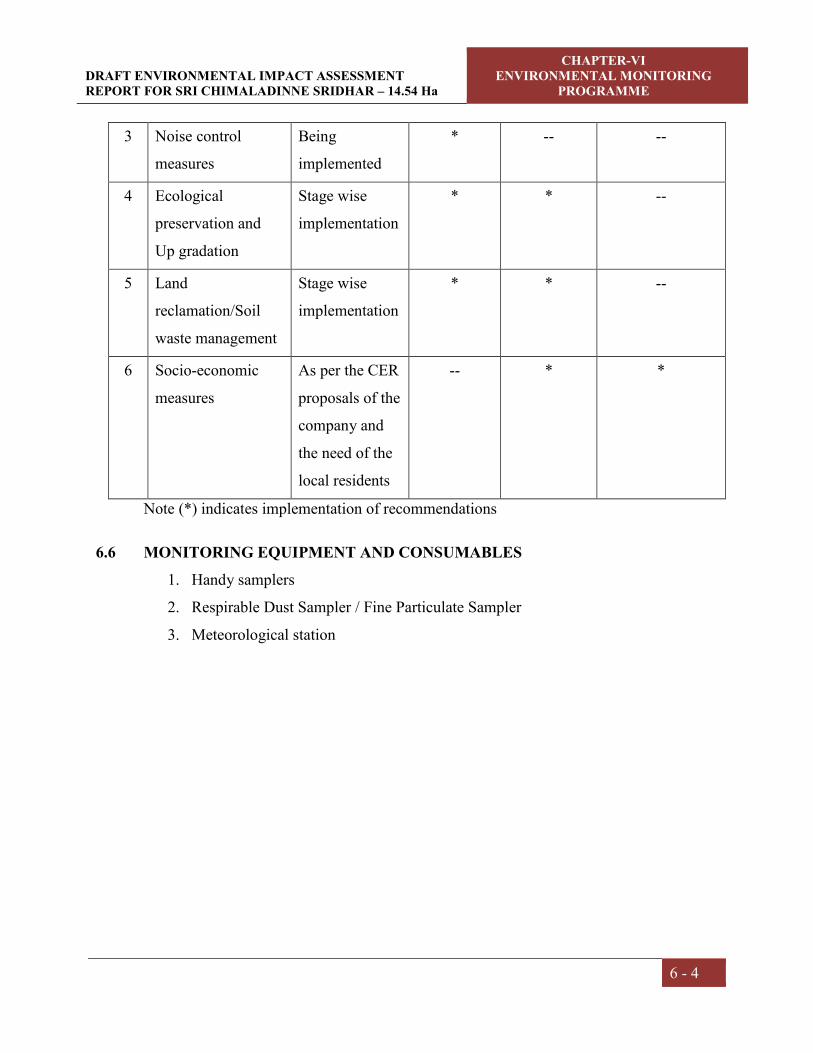
DRAFT ENVIRONMENTAL IMPACT ASSESSMENT REPORT FOR SRI CHIMALADINNE SRIDHAR – 14.54 Ha
CHAPTER-VI ENVIRONMENTAL MONITORING
PROGRAMME
6 - 4
3 Noise control
measures
Being
implemented
* -- --
4 Ecological
preservation and
Up gradation
Stage wise
implementation
* * --
5 Land
reclamation/Soil
waste management
Stage wise
implementation
* * --
6 Socio-economic
measures
As per the CER
proposals of the
company and
the need of the
local residents
-- * *
Note (*) indicates implementation of recommendations
6.6 MONITORING EQUIPMENT AND CONSUMABLES
1. Handy samplers
2. Respirable Dust Sampler / Fine Particulate Sampler
3. Meteorological station

CHAPTER –VII
ADDITIONAL STUDIES

DRAFT CLUSTER ENVIRONMENTAL IMPACT ASSESSMENT REPORT FOR SRI CHIMALADINNE SRIDHAR – 14.54 Ha
CHAPTER-VII ADDITIONAL STUDIES
7- 1
7.0 PUBLIC CONSULTATION:
The project is categorized as Category –B2 as per Environmental Impact Assessment
(EIA) Notification S.O. 1533 (E) Dt: 14.09.2006 and amended Notification S.O. 3977
(E) Dt: 14.08.2018. But, as per the latest National Green Tribunal (NGT) New Delhi
issued orders in O.A. 186 of 2016 Dt: 13.09.2018 & in E.A. No. 55/2018 of O.A. No.
520/2015 Dt: 11.12.2018; OM F. No. L-11011/175/2018-IA-I (M) Dt: 12.12.2018 the
projects with individual area or cluster area of mine leases from 5 to 25 Hectares falls
under Category B2 at par with Category B1, necessitates Public Hearing
for obtaining the Environmental Clearance from State Environmental Impact
Assessment Authority (SEIAA).
The present Draft EIA is being submitted for conducting Public Hearing. The issues
raised during the public hearing, the response of the proponent along with action plan
and budgetary allocation will be given in the Final EIA report and submitted to
MoEF&CC for obtaining environmental clearance.
7.1 RISK ASSESSMENT
Risk analysis provides identification of the risks/accidents and to take necessary steps
to prevent it happening. The main objective of preparing a disaster management plan
includes;
To identify the potential hazardous areas so that necessary design safety
measures can be adopted to minimize the probability of accidents.
To identify the potential areas of Environmental disaster, this can be prevented
by proper design of the installations and their control operations.
To manage emergency situations or a disastrous event, if any, from the mining
operations.
It begins with the identification of probable hazardous events at an operational area
and categorization as per the predetermined criteria. Risk assessment should be done
on the basis of past accident analysis at similar projects, previous judgments and
expertise in the field of risk analysis especially in accident analysis.

DRAFT CLUSTER ENVIRONMENTAL IMPACT ASSESSMENT REPORT FOR SRI CHIMALADINNE SRIDHAR – 14.54 Ha
CHAPTER-VII ADDITIONAL STUDIES
7- 2
7.1.1 Drilling Risks
Drilling is common operation for mining of Colour Granite, which is a hard mineral.
The main hazards involved are as follows:
Drill falling from the edge of a bench
Dust created during the drilling operations
Noise produced during drilling
The risk will occur during the drilling of the first line of holes parallel with the
working edge of the bench. Measures that can be taken to reduce the risk of falling off
the edge of the bench is to provide suitable portable rail fencing which can be erected
between the drill and the edge of the bench and direction by the supervisor from
guidance of the driller.
Control measures for Dust and Noise produced during drilling are discussed in detail
in Chapter IV.
7.1.2 Failure of Slope in the Pit
In open pit mining, mineral deposits are mined from the ground surface and
downward. Consequently, pit slopes are formed as the mineral is being extracted. The
issues concerned with slope stability in the open cast mines have come to forefront in
the mining operations due to increasing pit depth.
The pit slopes must thus be inclined at some angle to prevent failure of the rock mass.
This angle is governed by the geo-mechanical conditions at the specific mine and
represent an upper bound to the overall slope angle. The actual slope angles used in
the mine depend upon (i) the presence of haulage roads, or ramps, necessary for the
transportation of the mineral from the pit (ii) possible drill damage (iii) mineral
grades, and (iv) economical constraints.
During the planning period, the individual benches will be kept nearly vertical. Rock
being stable ultimate final pit slope will be kept at 60° by maintaining bench height of
3-6 m and bench width 8 m will be maintained.
Besides determining factor of safety, the slopes shall be monitored at regular intervals
by using real time slope stability radar system to monitor for any possible failure. The
well developed drainage system over the lease area should ensure that storm water

DRAFT CLUSTER ENVIRONMENTAL IMPACT ASSESSMENT REPORT FOR SRI CHIMALADINNE SRIDHAR – 14.54 Ha
CHAPTER-VII ADDITIONAL STUDIES
7- 3
does not accumulate in the lease area and therefore hydrostatic pressure remains at a
low level.
7.1.3 Filling up the mine pit due to excessive rains
Filling up the mine pit due to excessive rains in the worked out area is a remote
possibility. Normally there will be sufficient warning time before such an incident
takes place, harming equipment and human life. However, as a precautionary
measure, interceptor ditches along the outer boundary of the pit area constructed to
control inflow of runoff into the mine pits. Water that collects in the mine pit from
rainfall will be coursed out from the pits, through garland drains by using pump.
7.1.4 Accidents of heavy machinery
Most of the accidents during transfer of product, trucks and other vehicles are often
attributed to mechanical failures, in which the factor of human errors cannot be ruled
out. Regular maintenance and testing of all mine equipment as per manufacturers
guide lines can largely eliminate accidents of heavy machinery. Competent drivers
will be employed to minimize accidents during transportation. To avoid falling
material from the moving vehicles, closed trucks are deployed or the material will be
covered with tarpaulin.
7.1.5 Disaster due to Surface Fire
There could be fire accidents due to diesel fuel getting into contact of naked flames,
machinery developing excessive heat due to imperfect lubrication of bearings etc.
Proper maintenance of equipment is proposed to avoid catching of fire. Project
proponent will be having wireless communication system for quick passing of
information for any assistance in case of any emergency. Fire extinguishers should be
kept at accessible distance from cause sources. A competent person shall examine all
equipments, material and arrangement provided for firefighting at least once in a
month and record of the examination shall be maintained in a register. A competent
person shall at least once in 3 months examine every fire extinguisher.
Training will be imparted to the employees about emergency preparedness. Mock
drills will also be conducted at regular interval to handle the emergency situation.
Refresher awareness programs will also be planned among the employees.

DRAFT CLUSTER ENVIRONMENTAL IMPACT ASSESSMENT REPORT FOR SRI CHIMALADINNE SRIDHAR – 14.54 Ha
CHAPTER-VII ADDITIONAL STUDIES
7- 4
Risk analysis involves systematic identification and assessment of major damage
potential credible risk scenarios to help management to make objective decisions on
hazard reduction or avoidance measures meeting regulatory requirements and develop
a structured management framework for an effective Disaster Management Plan
(DMP) including emergency preparedness and contingency plans.
7.2 DISASTER MANAGEMENT PLAN
A disaster is a catastrophic event in which personnel working in the affected area are
immediately planed into a chaotic situation, which demands their immediate rescue,
medical and social case to restore normalcy. It creates a major emergency in mining
area requiring an Emergency response in accordance with a Mine Disaster
Management Plan formulated by the management.
A detailed DMP for handling emergencies includes;
Identification and assessment of major credible risk scenarios anticipated at a
particular workplace/activity (Slope failure, fly rock fragments, fires, etc.)
Setting up an Emergency response organization identified key personnel at the
mine with assigned duties and responsibilities for incident response and
emergency response.
Emergency actions plan with implementation procedures by emergency response
personnel for each scenario after emergency warning.
Details of safety measures to prevent accident and disaster.
Emergency notification by sending warning messages to identified agencies for
liaison and stake holders.
Setting up a permanent organization for completion of emergency and restoration
of normalcy by complying with health, safety, and environmental laws and
regulations
Disaster management plan for safe mining.
Supplementary response plans under mutual aid
Any other stipulations made by regulatory agencies for handling emergency
situations that may arise either from natural or manmade.
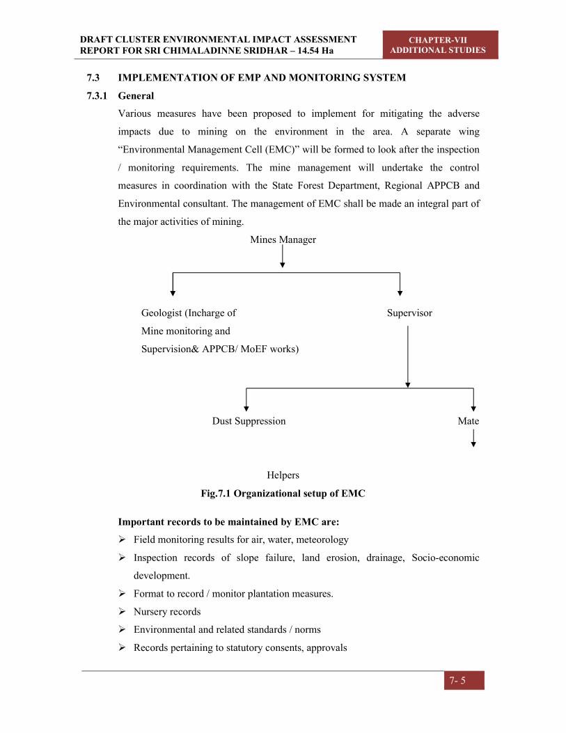
DRAFT CLUSTER ENVIRONMENTAL IMPACT ASSESSMENT REPORT FOR SRI CHIMALADINNE SRIDHAR – 14.54 Ha
CHAPTER-VII ADDITIONAL STUDIES
7- 5
7.3 IMPLEMENTATION OF EMP AND MONITORING SYSTEM
7.3.1 General
Various measures have been proposed to implement for mitigating the adverse
impacts due to mining on the environment in the area. A separate wing
“Environmental Management Cell (EMC)” will be formed to look after the inspection
/ monitoring requirements. The mine management will undertake the control
measures in coordination with the State Forest Department, Regional APPCB and
Environmental consultant. The management of EMC shall be made an integral part of
the major activities of mining.
Mines Manager
Geologist (Incharge of Supervisor
Mine monitoring and
Supervision& APPCB/ MoEF works)
Dust Suppression Mate
Helpers
Fig.7.1 Organizational setup of EMC
Important records to be maintained by EMC are:
Field monitoring results for air, water, meteorology
Inspection records of slope failure, land erosion, drainage, Socio-economic
development.
Format to record / monitor plantation measures.
Nursery records
Environmental and related standards / norms
Records pertaining to statutory consents, approvals

DRAFT CLUSTER ENVIRONMENTAL IMPACT ASSESSMENT REPORT FOR SRI CHIMALADINNE SRIDHAR – 14.54 Ha
CHAPTER-VII ADDITIONAL STUDIES
7- 6
Periodic medical examination (PME) records.
Records pertaining to laboratory equipment maintenance and calibration.
Complaints register (environmental pollution).
Records on water and electricity consumption.
Periodic progress records
Environmental audit records
Records of annual budgetary requirement and allocation for pollution control.
7.4 IMPLEMENTATION
The following system shall be followed to see that the environmental scheme is
implemented as per schedule.
a) A separate wing will be created to see that the engineering measures such as
construction of garland drains and retention walls are taken up, wherever
necessary.
b) A crew attends for afforestation measures on a regular basis for culturing,
manuring and watering.
c) On an annual/quarterly basis, the quality of air, water, noise and soil will be
monitored to understand the status vis-à-vis the baseline data. This will enable the
management for taking up any corrective measures, if required. The frequency of
sampling will be as prescribed by the MOEF guidelines issued in this regard.
7.5 ACTIVITIES TO BE MONITORED / INSPECTED BY EMC
7.5.1 Land erosion
The mine activity will expose out the loose earthy material, which leads to soil
erosion through rainwater runoff, or wind action. This phenomenon should be
monitored regularly and necessary actions should be implemented. Garland drains
will be constructed around the mine area to avoid siltation of nearby lands/water
bodies. These constructed drains should be regularly inspected and the proponent
should take up desiltation works.

DRAFT CLUSTER ENVIRONMENTAL IMPACT ASSESSMENT REPORT FOR SRI CHIMALADINNE SRIDHAR – 14.54 Ha
CHAPTER-VII ADDITIONAL STUDIES
7- 7
7.5.2 Drainage
The general ground water table is found at a depth of about 10-35 m below ground
level in the surrounding area. The mining operations will not reach up to ground water
table. Hence, no ground water is likely to be encountered throughout the life of the
mine.
Garland drains are constructed for dump and mine area to collect rainwater into a
siltation pond. The collected water will be used for green belt development and water
sprinkling.
The effectiveness of drainage system depends upon proper cleaning of all drains and
sumps. Any blockage due to silting or accumulation of loose materials will be
checked on regular basis. Stone pitching, brick mounds etc. on drains shall also be
monitored.
7.5.3 Re-vegetation and green belt development
Green belt will be developed within Buffer Zone, in open places and along the
approach road on either side for a stretch of 0.8 km 1100 plants.
Planned schedule for green belt development will be checked after every year and
improvement required will be implemented. Post plantation status will be regularly
checked in every season. Phase wise development in the areas of plantation including
rate of growth, survival rate etc. will be recorded systematically.
7.5.4 Occupational health
Since it is opencast mining, health problems due to dust may be expected at various
locations (excavation & loading) during excavation of Colour Granite. Control
measures such as water sprinkling will be implemented at source areas by the
proponent.
Monitoring:
The efficiency of installed dust controlling equipments like water sprinkling system
should be monitored on regular basis. Measurements to determine employee ceiling
exposure can be taken during period of maximum expected air borne concentrations.

DRAFT CLUSTER ENVIRONMENTAL IMPACT ASSESSMENT REPORT FOR SRI CHIMALADINNE SRIDHAR – 14.54 Ha
CHAPTER-VII ADDITIONAL STUDIES
7- 8
Safety measures followed by the work force during mineral production (like usage of
PPE) should be monitored by the mine supervisor/management.
Control Measures:
Location of dust generation:
1. Mining area
2. Loading & Transportation
It is advisable to use dust collectors at source points and water sprinkling on haul
roads to suppress the dust generated, so that the workers will not get expose to the
dust.
Precautions:
By using various PPEs, the chances of occupational health disease will be
lowered.
Periodical medical checkups for lungs functioning and breathing.
First aid will be given for in case of emergency.
Each group of mine worker will undergo regular medical checkup at regular
intervals by specialist doctors.
Persons not wearing protective equipment and clothing should be restricted
from areas of spills until clean up has been completed.
The workmen especially who are literate should be sent for first aid training
conducted by the group vocational training center to maintain by the DGMS
(Director General of Mine Safety).
7.5.5 Operation and Maintenance:
The problem of occupational health in the operation and maintenance phase is
primarily due to dust and noise, which could affect the workers from respiratory and
hearing problems. The necessary personal protective equipments will be given to all
the workers. The working personal will be given to all the workers. The working
personnel will be given the following appropriate personnel protective equipments.
Safety helmets
Face shield
Plain goggles with cut type filters on both ends.
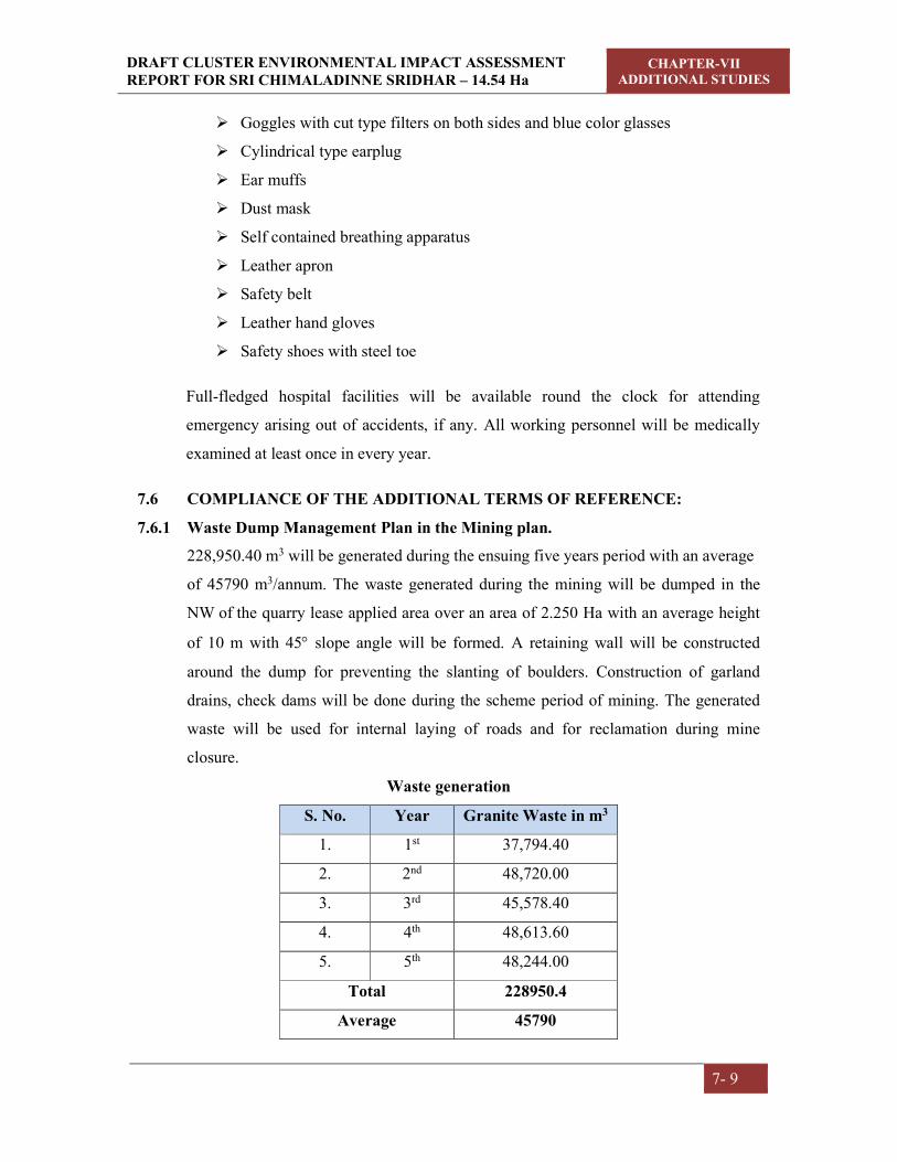
DRAFT CLUSTER ENVIRONMENTAL IMPACT ASSESSMENT REPORT FOR SRI CHIMALADINNE SRIDHAR – 14.54 Ha
CHAPTER-VII ADDITIONAL STUDIES
7- 9
Goggles with cut type filters on both sides and blue color glasses
Cylindrical type earplug
Ear muffs
Dust mask
Self contained breathing apparatus
Leather apron
Safety belt
Leather hand gloves
Safety shoes with steel toe
Full-fledged hospital facilities will be available round the clock for attending
emergency arising out of accidents, if any. All working personnel will be medically
examined at least once in every year.
7.6 COMPLIANCE OF THE ADDITIONAL TERMS OF REFERENCE:
7.6.1 Waste Dump Management Plan in the Mining plan.
228,950.40 m3 will be generated during the ensuing five years period with an average
of 45790 m3/annum. The waste generated during the mining will be dumped in the
NW of the quarry lease applied area over an area of 2.250 Ha with an average height
of 10 m with 45 slope angle will be formed. A retaining wall will be constructed
around the dump for preventing the slanting of boulders. Construction of garland
drains, check dams will be done during the scheme period of mining. The generated
waste will be used for internal laying of roads and for reclamation during mine
closure.
Waste generation
S. No. Year Granite Waste in m3
1. 1st 37,794.40
2. 2nd 48,720.00
3. 3rd 45,578.40
4. 4th 48,613.60
5. 5th 48,244.00
Total 228950.4
Average 45790

DRAFT CLUSTER ENVIRONMENTAL IMPACT ASSESSMENT REPORT FOR SRI CHIMALADINNE SRIDHAR – 14.54 Ha
CHAPTER-VII ADDITIONAL STUDIES
7- 10
7.6.2 Tree Enumeration & Bio mass assessment.
TREE ENUMERATION OF CHAMALADINNE SRIDHAR Introduction
Trees are significant due to their rich species diversity, composition and structure over
small geographic scales often has been correlated with changes in topography and soil
characteristics (Naidu et al 2018). Trees form the major structural and functional basis
of forest ecosystems and can serve as robust indicators of changes and stresses at the
landscape scale (Suthari et al 2018). Trees are useful for analysis of species-area and
species-individual relationships because they are easy to locate precisely and to count
(Naidu and Kumar 2015). Trees are dominant plant growth form with considerable
economic uses and substantial base of information stand out as a good choice for one
of the taxa to be sampled in the monitoring programme.
The close bonding of humans with trees may be traced back to their arboreal ancestry.
Reposing under a tree is like being cuddled by a mother-comfortable and secured.
Trees are major constituents of forests, which are considered as the most valuable
natural resource and are of immense importance both to man and the nation (Pragasan
and Parthasarathy 2010). By sequestering carbon, releasing oxygen and losing a large
amount of water vapour, trees profoundly influence the environment. Trees bind the
soil, recycle minerals and regulate the course of rain water. Unparalleled in the variety
of useful products they give and the wide range of organisms they feed and shelter
(Naidu and Kumar 2016). Trees are essential for maintaining the health of
ecosystems. They are the largest and longest-lived immobile organisms and often an
amazing diversity of forms (Panda et al 2013; Premavani et al 2017).
The present study focused on species composition and diversity help informing
appropriate management and conservation plan. Conservation management also
requires data on tree species diversity and the forest community structure in order to
maintain necessary action (Suthari 2018; Gopalkrishna et al. 2018). In view of these
conditions, we enumerated trees and their diversity and distribution in proposed mine,
as part of Srikakulam district, aiming to provide fundamental data for appropriate
management strategies that will improve the ecosystem conservation status.
Objectives
To enumerate the trees, their population levels and structure in the study area
To assess the existing status of the trees quantitatively and qualitatively

DRAFT CLUSTER ENVIRONMENTAL IMPACT ASSESSMENT REPORT FOR SRI CHIMALADINNE SRIDHAR – 14.54 Ha
CHAPTER-VII ADDITIONAL STUDIES
7- 11
To know the diversity, density and dominance of the species in the study area.
Fig 7.2. Location of the study area
Study area
The study area is secondary dry deciduous forest in which all trees are growing with
less than 30cm girth. The primary forest completely degraded due to anthropogenic
activities. The tree begin to shed their leaves by about December and between
February and May the forest looks very open and at times eye-soaring, but no area is
completely leafless during the study period. Flowering and fruiting are generally far
advanced before the first flush of new leaves appears with the conventional showers
in April-May.
Diospyros sylvatica is perhaps the commonest tree in this area. Wrightia tinctoria,
Cochlospermum religiosum, Gardenia latifolia, Sterculia urens, Strychnos potatorum,
Ziziphus xylopyrus, Terminalia spp., Chloroxylon swietenia, Pterospermum
xylocarpum, Albizia chinense, Cassia fistula, Diospyros melanoxylon etc. are some of

DRAFT CLUSTER ENVIRONMENTAL IMPACT ASSESSMENT REPORT FOR SRI CHIMALADINNE SRIDHAR – 14.54 Ha
CHAPTER-VII ADDITIONAL STUDIES
7- 12
the typical trees; Flaucortia indica, Gmelina asiatica and Naringi crenulata are armed
trees present, at the edges of the mine. Holarrhena antidysenterica, Alangium
salvifolium, Bauhinia racemosa, Tarenna asiatica, Flacourtia indica, Helicteris isora,
Woodfordia fruticosa, Grewia rothii etc. are some of the common small trees found in
this area.
A number climbers and twiners are found in this type of forests. To mention, some of
them are Butea superba, Cansjera rheedii, Celastrus paniculatus, Combretum
ovalifolium, Dioscorea spp., Pueraria tuberosa, Ventilago denticulata, Mucuna spp.
etc.
Methodology
The field work on quantitative inventory was carried out by ground sampling, analysis
of dominant species and their common associates and interaction with forest officials.
The entire study area was divided into nine quadrats, which formed the sampling plots
for quantitative assessment of plant biodiversity (Fig 1). In the study area, thirty
quadrats with a size of 50m × 50m (7.5 Ha) were laid. All the live individual trees of
≥10 dia at breast height (DBH) were measured using a diameter tape and documented
all the individuals of various species. The representative plant taxa were collected and
identified with the help of regional floras (Rao and Sreeramulu 1986; Rao and Kumari
2002; Venkaiah 2004), AP state flora (Pullaiah et al 1997), e-floras and also with the
online herbarium catalogue of Royal Botanic Garden, Kew.

DRAFT CLUSTER ENVIRONMENTAL IMPACT ASSESSMENT REPORT FOR SRI CHIMALADINNE SRIDHAR – 14.54 Ha
CHAPTER-VII ADDITIONAL STUDIES
7- 13
Fig 7.3 Floristic survey and quantitative assessment of plant resources of Ch. Sridhar mine
Data analysis
The collected data were quantitatively analyzed for basal area, relative density,
relative frequency, relative dominance, importance value index (IVI) of tree species
(Curtis & Mc Intosh, 1950). The density and basal area (BA) of each species was
calculated on the basis of data recorded from all quadrats of the particular mine and
the values were expressed per hectare basis for comparison. The GBH was converted
into basal area (BA) as BA=GBH2/4π (Naidu et al 2016; Gopalkrishna et al. 2018).
Total number of quadrats in which a species occur Frequency = --------------------------------------------------------------------- × 100
Total number of quadrats studied
Total number of individuals of a species Density = -----------------------------------------------------------
Total number of quadrats studied
Total number of individuals of the species occurring Abundance = ---------------------------------------------------------------------
Total number of quadrats in which the species occur
Frequency of one species Relative frequency (RF) = --------------------------------------------------- × 100
Sum of all frequencies
Number of individuals of a species Relative density (RD) = ----------------------------------------------------- × 100
Total number of individuals of all species
Combined basal area of a single species Relative dominance (RDom) = --------------------------------------------------- × 100
Total basal area of all species
Importance Value Index (IVI) = RF + RD + RDom

DRAFT CLUSTER ENVIRONMENTAL IMPACT ASSESSMENT REPORT FOR SRI CHIMALADINNE SRIDHAR – 14.54 Ha
CHAPTER-VII ADDITIONAL STUDIES
7- 14
The diversity indices were calculated by using PAST software in core zone of the
project areas to know variation among the plant species. The data collected were also
used to compute community indices like species diversity (H') of different tree species
was calculated by using the Shannon- Weiner Index (Shannon and Weiner, 1963), as
such:
H' = -Σ (ni/N)/ n (ni/N),
Where, ni/N, which denotes the importance probability of each species in a
population, ni= Importance of value of species and N is the total number of
individuals of all species in that vegetation type. Species dominance (Cd) was
calculated following Simpson (Simpson, 1949): Such that
Cd = Σ (ni/N)2,
Where, ni and N are the same as those for Shannon-Weiner information function.
Equitability of evenness refers to the degree of relative dominance of each species in
that area. It was calculated according to Pielou (Pielou, 1966) as:
Evenness (e) = H'/log S, where, H'= Shannon index, S = number of species
Distributions of tree species were calculated using ration of abundance to frequency
(Whitford 1949). If the values lies below 0.025: regular, 0.025 – 0.05: random, and if
>0.05 contagious (Curtis and Cottam 1956).
Results
Floristic composition
A total of 66 species of trees ≥ 10 cm dbh belonging to 54 genera and 31 families
were recorded in the entire mine site (Table 1). The nine inventory quadrats in mine
site yielded a total of 1812 stem individuals ≥ 10 cm dbh (Diameter at Breast Hieght),
66 species encountered in the study area is given in Table1. An obvious variation in
presentation of tree species and proportion of dominant species in the mine site can
directly be attributed to rain fall distribution and favourable topographic conditions.
With regard to the number of species found within families, Mimosaceae was the
most diverse tree family in samples, being represented by 6 species, followed by
Euphorbiaceae and Rubiaceae (5 species each) and Verbenaceae and Ebenaceae (4
species each). Two families Anacardiaceae and Caesalpiniaceae represented by 3
species, ten families represented by 2 species and remaining families represented by
single species (Table 2). Within the family Ebenaceae, Diopyros was the most

DRAFT CLUSTER ENVIRONMENTAL IMPACT ASSESSMENT REPORT FOR SRI CHIMALADINNE SRIDHAR – 14.54 Ha
CHAPTER-VII ADDITIONAL STUDIES
7- 15
common genus, being represented by 3 species, whilst the Mimosaceae and
Verbenaceae were dominated by the genus Acacia, Albizia, Gmelina and Premna (2
species each) respectively.
Table 7.1. List of total trees enumerated in the proposed mine
S.No. Species Name Family No of individuals
1 Acacia catechu (L.f.)Willd. Mimosaceae 58
2 Acacia leucophloea (Roxb.)Willd. Mimosaceae 43
3 Alangium salviifolium (L.f.) Wangerin Alangiaceae 72
4 Albizia chinensis (Osbeck)Merr. Mimosaceae 35
5 Albizia odoratissima (L.f.)Benth. Mimosaceae 7
6 Antidesma acidum Retz. Stilaginaceae 4
7 Azadirachta indica A. Juss. Meliaceae 2
8 Bauhinia racemosa Lam. Caesalpiniaceae 13
9 Bridelia montana (Roxb.) Willd. Euphorbiaceae 40
10 Bridelia retusa (L.) A.Juss. Euphorbiaceae 35
11 Buchanania lanzan Spreng. Anacardiaceae 20
12 Canthium dicoccum (Gaertn.) Merr. Rubiaceae 16
13 Careya arborea Roxb. Lecythidaceae 9
14 Casearia tomentosa Roxb. Flacourtiaceae 31
15 Cassia fistulaL. Caesalpiniaceae 58
16 Chloroxylon swietenia (Roxb.) DC. Flindersiaceae 79
17 Cipadessa baccifera (Roth) Miq. Meliaceae 38
18 Cleistanthus collinus
(Roxb.) Benth. ex Hook.f.
Euphorbiaceae 26
19 Cochlospermum religiosum (L.) Alston Cochlospermaceae 10
20 Dalbergia paniculata(Roxb.) Thoth. Fabaceae 35
21 Dichrostachys cinerea Sensu R.Vig. Mimosaceae 11
22 Diospyros chloroxylon Roxb. Ebenaceae 41
23 Diospyros melanoxylon Roxb. Ebenaceae 30
24 Diospyros sylvatica Roxb. Ebenaceae 75
25 Euphorbia antiquorumL. Euphorbiaceae 5
26 Ficus racemosaL. Moraceae 43
27 Ficus semicordata Buch. ex J.E. Smith Moraceae 13
28 Flacourtia indica (Burm. f.) Merr. Flacourtiaceae 52
29 Gardenia latifolia Aiton Rubiaceae 11
30 Garuga pinnata Roxb. Burseraceae 26
31 Gmelina arborea Roxb. ex Sm. Verbenaceae 20
32 Gmelina asiaticaL. Verbenaceae 6
33 Grewia rothiiDC. Tiliaceae 25
34 Grewia tiliifoliaVahl Tiliaceae 27

DRAFT CLUSTER ENVIRONMENTAL IMPACT ASSESSMENT REPORT FOR SRI CHIMALADINNE SRIDHAR – 14.54 Ha
CHAPTER-VII ADDITIONAL STUDIES
7- 16
35 Ixora pavettaAndr. Rubiaceae 84
36 Lagerstroemia parvifloraRoxb. Lythraceae 1
37 Lannea coromandelica (Houtt.) Merr. Anacardiaceae 58
38 Maba buxifolia(Rottb.) Pers. Ebenaceae 16
39 Mallotus philippensisMuell.Arg Euphorbiaceae 43
40 Manilkara hexandra(Roxb.) Dubard Sapotaceae 24
41 Memecylon eduleRoxb. Melastomataceae 15
42 Mimusops elengiL. Sapotaceae 1
43 Mitragyna parvifolia (Roxb.) Korth. Rubiaceae 6
44 Morinda pubescensJ.E. Smith Rubiaceae 13
45 Naringi crenulata (Roxb.) D.H.
Nicolson
Rutaceae 13
46 Ochna obtusataDC. Ochnaceae 2
47 Polyalthia cerasoides (Roxb.) Hook.f.
& Thomson
Annonaceae 16
48 Premna latifoliaRoxb. Verbenaceae 19
49 Premna tomentosaWilld. Verbenaceae 6
50 Protium serratum (Wall. ex Colebr.)
Engl.
Burseraceae 30
51 Pterospermum xylocarpum (Gaertn.)
Oken
Sterculiaceae 13
52 Sapindus emarginatusVahl Sapindaceae 14
53 Schleichera oleosa (Lour.) Oken Sapindaceae 53
54 Semecarpus anacardiumL.f. Anacardiaceae 24
55 Sterculia urensRoxb. Sterculiaceae 44
56 Streblus asper Lour. Moraceae 7
57 Strychnos nux-vomica L. Loganiaceae 17
58 Strychnos potatorumL.f. Loganiaceae 20
59 Syzygium cumini (L.) Skeels Myrtaceae 15
60 Tamarindus indicaL. Caesalpiniaceae 3
61 Terminalia alata Heyne ex Roth Combretaceae 35
62 Terminalia chebulaRetz Combretaceae 16
63 Wrightia tinctoria(Roxb.) R.Br. Apocynaceae 104
64 Xylia xylocarpa (Roxb.)Taub. Mimosaceae 29
65 Ziziphus mauritianaLam. Rhamnaceae 30
66 Ziziphus xylopyrus (Retz.) Willd. Rhamnaceae 25
Total 1812

DRAFT CLUSTER ENVIRONMENTAL IMPACT ASSESSMENT REPORT FOR SRI CHIMALADINNE SRIDHAR – 14.54 Ha
CHAPTER-VII ADDITIONAL STUDIES
7- 17
Table 7.2. List of dominant families with reference to species number
S.No Family Genera Species
1 Mimosaceae 4 6
2 Euphorbiaceae 4 5
3 Rubiaceae 5 5
4 Ebenaceae 2 4
5 Verbenaceae 2 4
6 Anacardiaceae 3 3
7 Caesalpiniaceae 3 3
8 Moraceae 2 3
9 Burseraceae 2 2
10 Combretaceae 1 2
11 Flacourtiaceae 2 2
12 Loganiaceae 1 2
13 Meliaceae 2 2
14 Rhamnaceae 1 2
15 Sapindaceae 2 2
16 Sapotaceae 2 2
17 Sterculiaceae 2 2
18 Tiliaceae 1 2
19 Alangiaceae 1 1
20 Annonaceae 1 1
21 Apocynaceae 1 1
22 Cochlospermaceae 1 1
23 Fabaceae 1 1
24 Flindersiaceae 1 1
25 Lecythidaceae 1 1
26 Lythraceae 1 1
27 Melastomataceae 1 1
28 Myrtaceae 1 1
29 Ochnaceae 1 1
30 Rutaceae 1 1
31 Stilaginaceae 1 1
Total 54 66
Quantitative ecological study of tree species
Floristic composition and species richness
A total number of 1812 individuals of tree species with >10 cm GBH were recorded
from 9 sample quadrates (2.25 Ha) of Ch. Sridhar mine. They represent 66 species
belonging to 54 genera under 31 families. The values of diversity indices such as

DRAFT CLUSTER ENVIRONMENTAL IMPACT ASSESSMENT REPORT FOR SRI CHIMALADINNE SRIDHAR – 14.54 Ha
CHAPTER-VII ADDITIONAL STUDIES
7- 18
Shannon-Weiner Index, Simpson Index and Evenness Index were calculated as 3.89,
0.97 and 0.74 respectively (Table 7.3).
Table 7.3. Biodiversity parameters of tree species enumerated in the mine
No. of tree species 66
No. of Genera 54
No. of Families 31
Number of individuals 1812
Stand density (No of stems/Ha) 805
Total Basal Area 15.29
Simpson index 0.9751
Shannon Weiner Index 3.89
Evenness Index 0.7412
Importance Value Index (IVI)
Species dominance is calculated based on the Importance Value Index (IVI) and was
calculated every species found in each study sites. It is usually practiced in ecological
scrutinizes; IVI indicates the ecological importance of a species in a specific
ecosystem which can be used for computing species conservation and management
through which species having low IVI value require soar protection preference. The
IVI for a species was calculated as the sum of its relative basal area, relative
frequency, and relative density and often to describe and compare the species
dominance of the sites.
The IVI depict the sociological structure of a species in its totality in community.
TheImportant value index (IVI) of the 66 species varied considerably (Table 5). The
IVI value of the top ten predominant species in each plot with their IVI values is more
for Wrightia tinctoria (18.6), Ixora pavetta (10.7), Chloroxylon swietenia (10.6),
Schleichera oleosa (10.4) and Diospyros sylvatica (9.85) are predominant tree species
with greater values in the study area. Quantitative values encountered in study area
are given in Table 5.
The population density of the 176 tree species varied considerably across the fifteen
study plots. Based on the population density, the top fifteen species were Wrightia
tinctoria (104 individuals) was the most abundant species in the study plots, followed
by Ixora pavetta (84), Chloroxylon swietenia (79), Diospyros sylvatica (75),
Alangium salvifolium (72), Acacia catechu, Cassia fistula and Lannea coromandelica
(58 each), remaining species represented by different individuals showed in Table 5.
DRAFT CLUSTER ENVIRONMENTAL IMPACT ASSESSMENT REPORT FOR SRI CHIMALADINNE SRIDHAR – 14.54 Ha
CHAPTER-VII ADDITIONAL STUDIES
7- 19
The present study on distribution pattern of tree species indicated that maximum
number of tree species i.e. 57 had contagious distribution whereas 8 species showed
regular and only one species had random distribution pattern in the present study. In
natural conditions, contagious distribution is most common type of distribution due to
significant variation in environmental conditions (Odum, 1971). Distribution pattern
of species in the study area is identified as contagious distribution as the value of A/F
ratio is 0.105. This distribution of species is contagious because of several ecosystems
contagiously distributed in the study area.

DRAFT CLUSTER ENVIRONMENTAL IMPACT ASSESSMENT REPORT FOR SRI CHIMALADINNE SRIDHAR – 14.54 Ha
CHAPTER-VII ADDITIONAL STUDIES
7- 20
Table 7.4. Importance Value Index (IVI) of tree species in the Ch. Sridhar mine
S.No. Species Name No of individuals
No of quadrats occurred
A F A/F D BA RF RD Rdom IVI Distribution
1 Acacia catechu 58 6 9.67 66.67 0.15 6.44 0.4055 2.33 3.21 2.652 8.19 Contiguous
2 Acacia leucophloea 43 5 7.17 55.56 0.13 4.78 0.2751 1.95 2.38 1.799 6.12 Contiguous
3 Alangium salvifolium 72 7 12 77.78 0.15 8 0.4286 2.72 3.98 2.803 9.51 Contiguous
4 Albizia chinensis 35 5 5.83 55.56 0.11 3.89 0.2378 1.95 1.93 1.555 5.44 Contiguous
5 Albizia odoratissima 7 1 1.17 11.11 0.11 0.78 0.0513 0.39 0.39 0.335 1.11 Contiguous
6 Antidesma acidum 4 1 0.67 11.11 0.06 0.44 0.0164 0.39 0.22 0.107 0.72 Contiguous
7 Azadirachta indica 2 1 0.33 11.11 0.03 0.22 0.0065 0.39 0.11 0.042 0.54 Regular
8 Bauhinia racemosa 13 2 2.17 22.22 0.1 1.44 0.0623 0.78 0.72 0.408 1.9 Contiguous
9 Bridelia montana 40 5 6.67 55.56 0.12 4.44 0.2213 1.95 2.21 1.447 5.6 Contiguous
10 Bridelia retusa 35 4 5.83 44.44 0.13 3.89 0.225 1.56 1.93 1.472 4.96 Contiguous
11 Buchanania lanzan 20 5 3.33 55.56 0.06 2.22 0.162 1.95 1.11 1.059 4.11 Contiguous
12 Canthium dicoccum 16 3 2.67 33.33 0.08 1.78 0.0882 1.17 0.88 0.577 2.63 Contiguous
13 Careya arborea 9 2 1.5 22.22 0.07 1 0.039 0.78 0.5 0.255 1.53 Contiguous
14 Casearia tomentosa 31 4 5.17 44.44 0.12 3.44 0.1481 1.56 1.71 0.968 4.24 Contiguous
15 Cassia fistula 58 9 9.67 100 0.1 6.44 0.4215 3.5 3.21 2.757 9.46 Contiguous
16 Chloroxylon swietenia 79 7 13.2 77.78 0.17 8.78 0.5425 2.72 4.37 3.548 10.6 Contiguous
17 Cipadessa baccifera 38 4 6.33 44.44 0.14 4.22 0.2781 1.56 2.1 1.819 5.48 Contiguous
18 Cliestanthus collinus 26 3 4.33 33.33 0.13 2.89 0.1712 1.17 1.44 1.12 3.72 Contiguous
19 Cochlospermum religiosum 10 2 1.67 22.22 0.08 1.11 0.0812 0.78 0.55 0.531 1.86 Contiguous
20 Dalbergia paniculata 35 7 5.83 77.78 0.08 3.89 0.2765 2.72 1.93 1.809 6.47 Contiguous
21 Dichrostachys cinerea 11 3 1.83 33.33 0.06 1.22 0.0749 1.17 0.61 0.49 2.26 Contiguous
22 Diospyros chloroxylon 41 5 6.83 55.56 0.12 4.56 0.2738 1.95 2.27 1.791 6 Contiguous
23 Diospyros melanoxylon 30 5 5 55.56 0.09 3.33 0.1858 1.95 1.66 1.215 4.82 Contiguous

DRAFT CLUSTER ENVIRONMENTAL IMPACT ASSESSMENT REPORT FOR SRI CHIMALADINNE SRIDHAR – 14.54 Ha
CHAPTER-VII ADDITIONAL STUDIES
7- 21
24 Diospyros sylvatica 75 7 12.5 77.78 0.16 8.33 0.4553 2.72 4.15 2.978 9.85 Contiguous
25 Euphorbia antiquorum 5 3 0.83 33.33 0.03 0.56 0.0311 1.17 0.28 0.203 1.65 Random
26 Ficus racemosa 43 5 7.17 55.56 0.13 4.78 0.3098 1.95 2.38 2.026 6.35 Contiguous
27 Ficus semicordata 13 2 2.17 22.22 0.1 1.44 0.0814 0.78 0.72 0.533 2.03 Contiguous
28 Flacourtia indica 52 8 8.67 88.89 0.1 5.78 0.2336 3.11 2.87 1.528 7.51 Contiguous
29 Gardeinia latifolia 11 2 1.83 22.22 0.08 1.22 0.0739 0.78 0.61 0.483 1.87 Contiguous
30 Garuga pinnata 26 3 4.33 33.33 0.13 2.89 0.1884 1.17 1.44 1.232 3.84 Contiguous
31 Gmelina arborea 20 3 3.33 33.33 0.1 2.22 0.1471 1.17 1.11 0.962 3.23 Contiguous
32 Gmelina asiatica 6 1 1 11.11 0.09 0.67 0.0359 0.39 0.33 0.235 0.96 Contiguous
33 Grewia rothii 25 3 4.17 33.33 0.13 2.78 0.1544 1.17 1.38 1.01 3.56 Contiguous
34 Grewia tiliifolia 27 6 4.5 66.67 0.07 3 0.1129 2.33 1.49 0.738 4.57 Contiguous
35 Ixora pavetta 84 8 14 88.89 0.16 9.33 0.4483 3.11 4.64 2.932 10.7 Contiguous
36 Lagerstroemia parviflora 1 1 0.17 11.11 0.02 0.11 0.005 0.39 0.06 0.033 0.48 Regular
37 Lannea coromandelica 58 7 9.67 77.78 0.12 6.44 0.3038 2.72 3.21 1.987 7.92 Contiguous
38 Maba buxifolia 16 3 2.67 33.33 0.08 1.78 0.07 1.17 0.88 0.458 2.51 Contiguous
39 Mallotus philippensis 43 6 7.17 66.67 0.11 4.78 0.5801 2.33 2.38 3.794 8.51 Contiguous
40 Manilkara hexandra 24 3 4 33.33 0.12 2.67 0.2254 1.17 1.33 1.474 3.97 Contiguous
41 Memecylon edule 15 3 2.5 33.33 0.08 1.67 0.1749 1.17 0.83 1.144 3.14 Contiguous
42 Mimusops elengi 1 1 0.17 11.11 0.02 0.11 0.01 0.39 0.06 0.065 0.51 Regular
43 Mitragyna parvifolia 6 2 1 22.22 0.05 0.67 0.0385 0.78 0.33 0.252 1.36 Regular
44 Morinda pubescens 13 4 2.17 44.44 0.05 1.44 0.1539 1.56 0.72 1.007 3.28 Regular
45 Naringi crenulata 13 3 2.17 33.33 0.07 1.44 0.1436 1.17 0.72 0.939 2.82 Contiguous
46 Ochna obtusata 2 1 0.33 11.11 0.03 0.22 0.006 0.39 0.11 0.039 0.54 Regular
47 Polyalthia cerasoides 16 2 2.67 22.22 0.12 1.78 0.0933 0.78 0.88 0.61 2.27 Contiguous
48 Premna latifolia 19 3 3.17 33.33 0.1 2.11 0.1343 1.17 1.05 0.879 3.1 Contiguous
49 Premna tomentosa 6 2 1 22.22 0.05 0.67 0.041 0.78 0.33 0.268 1.38 Regular
50 Protium serratum 30 3 5 33.33 0.15 3.33 0.427 1.17 1.66 2.793 5.62 Contiguous

DRAFT CLUSTER ENVIRONMENTAL IMPACT ASSESSMENT REPORT FOR SRI CHIMALADINNE SRIDHAR – 14.54 Ha
CHAPTER-VII ADDITIONAL STUDIES
7- 22
51 Pterospermum xylocarpum 13 1 2.17 11.11 0.2 1.44 0.1723 0.39 0.72 1.127 2.23 Contiguous
52 Sapindus emarginatus 14 3 2.33 33.33 0.07 1.56 0.1714 1.17 0.77 1.121 3.06 Contiguous
53 Schleichera oleosa 53 6 8.83 66.67 0.13 5.89 0.7805 2.33 2.93 5.105 10.4 Contiguous
54 Semecarpus anacardium 24 3 4 33.33 0.12 2.67 0.3588 1.17 1.33 2.347 4.84 Contiguous
55 Sterculia urens 44 7 7.33 77.78 0.09 4.89 0.5574 2.72 2.43 3.646 8.8 Contiguous
56 Streblus asper 7 2 1.17 22.22 0.05 0.78 0.0486 0.78 0.39 0.318 1.48 Contiguous
57 Strychnos nuxvomica 17 3 2.83 33.33 0.09 1.89 0.2586 1.17 0.94 1.692 3.8 Contiguous
58 Strychnos potatorum 20 5 3.33 55.56 0.06 2.22 0.1256 1.95 1.11 0.822 3.87 Contiguous
59 Syzygium cumini 15 4 2.5 44.44 0.06 1.67 0.3625 1.56 0.83 2.371 4.76 Contiguous
60 Tamarindus indica 3 1 0.5 11.11 0.05 0.33 0.0834 0.39 0.17 0.546 1.1 Regular
61 Terminalia alata 35 5 5.83 55.56 0.11 3.89 0.3954 1.95 1.93 2.586 6.47 Contiguous
62 Terminalia chebula 16 3 2.67 33.33 0.08 1.78 0.2448 1.17 0.88 1.601 3.65 Contiguous
63 Wrightia tinctoria 104 9 17.3 100 0.17 11.6 1.4232 3.5 5.75 9.308 18.6 Contiguous
64 Xylia xylocarpa 29 5 4.83 55.56 0.09 3.22 0.5648 1.95 1.6 3.694 7.24 Contiguous
65 Ziziphus mauritiana 30 5 5 55.56 0.09 3.33 0.2248 1.95 1.66 1.47 5.07 Contiguous
66 Ziziphus xylopyrus 25 4 4.17 44.44 0.09 2.78 0.166 1.56 1.38 1.086 4.02 Contiguous
Total 1812 302 2856 201 15.29 100 100 100 300

DRAFT ENVIRONMENTAL IMPACT ASSESSMENT REPORT FOR SRI CHIMALADINNE SRIDHAR – 14.54 Ha
CHAPTER-VII ADDITIONAL STUDIES
7 - 23
The distribution of girth classes suggests that tree species richness as well as density
decreased with increasing girth class and it shows reverse J pattern which is conformity
with many tropical trees in India. Girth class distribution showed that 11-20 cm class
having the greatest individuals with 561 (31%), followed by 21-30 cm with 482 (27%),
31-40 cm with 468 (25.8%), 41-50 cm with 153 (8.5%), 51-60 cm with 65 (3.6%), 61-70
cm with 64 (3.5%), 71-80 cm with 13 individuals and less abundance in higher girth class
with 5 individuals. Low tree density in lower girth class could be attributed to firewood
collection, timber collection, grazing activity, invasive weeds and forest fires. Basal area
showed the A-shaped curve which suggests a medium age forest (Fig. 7.4).
Fig 7.4. Girth class distribution of density and basal area in the study area
Present study showed the majority of species were observed in the frequency class B=
21-40% (26 spp.), followed by C=41-60% (17), C=61-80% (10), A=1-20% (9) and E=81-
100% (4) (Fig 4), this trend of frequency classes have been representing the
0
100
200
300
400
500
600
0
1
2
3
4
5
6
11 to 20 21-30 31-40 41-50 51-60 61-70 71-80 >80
No
of
ind
ivid
ula
s
Bas
al a
rea
Girth classes
Series1 Series2

DRAFT ENVIRONMENTAL IMPACT ASSESSMENT REPORT FOR SRI CHIMALADINNE SRIDHAR – 14.54 Ha
CHAPTER-VII ADDITIONAL STUDIES
7 - 24
heterogeneous nature of the forest community. The frequency of Raunkiaer’s classes was
followed the pattern of B>C>D>A>E. As per Raunkiaer, when classes B, C, D, A are
high, the community is considered to be heterogeneous; on the other hand, if the class E
is greater than another, it is a uniform or homogeneous community (Fig 7.5).
Fig 7.5. Raunkiaer’s frequency classes
Conclusion
Vegetation is an essential element of all major ecosystems. The present study indicated
that the proposed mine area is consisting secondary forest because more than 60% trees
are below 30cm girth. The results of our study can help the status of dominant tree
species including their diversity indices that will also help for monitoring and sustaining
the diversity of tree species to plan further on plantation and conservation of selected tree
species. Stand density of 1812 individuals will not clear in the proposed mine wherever is
necessary those trees will be cleared. The management should develop greenbelt around
the mine area with more than 4000 saplings.
References
Curtis JT, G. Cottom (1962) Plant Ecology Workbook. Burgers Publishing Co.,
Minnesota. PP: 163.
0
5
10
15
20
25
30
A (1-20) B (21-40) C (41-60) D (61-80) E (81-100)
No
of
Spe
cie
s
Frequency classes

DRAFT ENVIRONMENTAL IMPACT ASSESSMENT REPORT FOR SRI CHIMALADINNE SRIDHAR – 14.54 Ha
CHAPTER-VII ADDITIONAL STUDIES
7 - 25
Curtis JT, McIntosh RP (1950) The interrelations of certain analytic and synthetic
phytosociological characters. Ecology. 31: 434-455.
Gopalkrishna P, Suthari S, Raju VS (2018) Natural regeneration in the tropical deciduous
forest ecosystem of Godavari valley in Warangal region of Telangana, India. Ind For
144(7):616–625.
Naidu MT, Kumar OA (2015) Tree species diversity in the Eastern Ghats of northern
Andhra Pradesh, India. J Threat Taxa 7(8):7443-7459.
Naidu MT, Kumar OA (2016) Tree diversity, stand structure and community composition
of tropical forests in Eastern Ghats of Andhra Pradesh, India. J Asia-Pac Biod 9:328-334.
Naidu MT, Premavani D, Suthari S, Venkaiah M (2018) Assessment of tree diversity in
tropical deciduous forests of North-central Eastern Ghats, India. Geol Ecol Landscapes
2(3):216-227.
Panda PC, Mahapatra AK, Acharya PK, Debata AK (2013) Plant diversity in tropical
deciduous forests of Eastern Ghats, India: a landscape level assessment. Int J Biod Cons
5(10):625-639.
Pielou EC (1966) The measurement of diversity in different types of biological
collections. J Theo Biol 13: 131-144.
Pragasan AL, Parthasarathy N (2010) Landscape-level tree diversity assessment in
tropical forests of Eastern Ghats, India. Flora 205:728-737.
Premavani D, Naidu MT, Kumar OA, Venkaiah M (2017) Diversity and distribution of
tree species in tropical forests of northcentral Eastern Ghats, India. Asian J Forestry 1(1):
27-32.
Pullaiah T, Chennaiah E, PSP Babu (1997) Flora of Andhra Pradesh. Scientific
Publishers, Jodhpur, India.
Rao GVS, Kumari GR (2002) Flora of Visakhapatnam district, Andhra Pradesh.
Botanical Survey of India, Kolkata, India.
Rao RS, Hara Sreeramulu H (1986) Flora of Srikakulam district, Andhra Pradesh. Indian
Botanical Society, Meerut, India.
DRAFT ENVIRONMENTAL IMPACT ASSESSMENT REPORT FOR SRI CHIMALADINNE SRIDHAR – 14.54 Ha
CHAPTER-VII ADDITIONAL STUDIES
7 - 26
Shannon CE, Weiner W (1963) The Mathematical Theory of Communication. University
of Illinois Press. Urbana, pp: 117.
Simpson EH (1949) Measurement of Diversity. Nature163:688.
Suthari S, Raju VS (2018) Tree species composition and forest stratification along the
gradients in the dry deciduous forests of Godavari valley, Telangana, India. Eur J Ecol
4(1):1–12.
Venkaia M (2004) Studies on the vegetation and flora of Vizianagaram district, Andhra
Pradesh. Andhra University, Visakhapatnam.
Witford PB (1988) Distribution of woodland plants in relation to succession and clonal
growth. Ecology. 36: 117-127.

DRAFT ENVIRONMENTAL IMPACT ASSESSMENT REPORT FOR SRI CHIMALADINNE SRIDHAR – 14.54 Ha
CHAPTER-VII ADDITIONAL STUDIES
7 - 27
BIOMASS ESTIMATION
Introduction
National level biomass inventories carried out based on remote sensing. However, the
uncertainty in biomass estimates persisted because CS and sequestration potential varied
due to numerous factors. Biomass varied at a spatial scale in any forest type even in a
small patch due to variation in microclimate. Accurate estimation method through
harvesting is not practically feasible because most of the forest ecosystems declared as
protected in several countries. Allometric equation provides an alternative estimation of
biomass accepted by the scientific community and UNFCCC. The biomass reserves
currently being depleting continuously from last two decades. Hence, the present study
was a preliminary work undertaken with the objectives to assess the biomass of trees in
the proposed mine lease area.
Methodology
Ground sampling, analysis of dominant species and their common associates and
interaction with forest officials carried out the fieldwork on quantitative inventory. The
entire study area was divided into nine quadrats, which formed the sampling plots for
quantitative assessment of plant biodiversity. In the study area, thirty quadrats with a size
of 50m × 50m (7.5 Ha) were laid. All the live tree individuals above 1 cm DBH (Dia at
Breast Height) were enumerated and its diameter at 1.37 m height was measured. The dia-
meter of each stem was measured and summed up for multistemmed trees. The
representative plant taxa were collected and identified with the help of regional floras
(Rao and Sreeramulu 1986; Rao and Kumari 2002; Venkaiah 2004), AP state flora
(Pullaiah et al 1997), e-floras and also with the online herbarium catalogue of Royal
Botanic Garden, Kew.
Data analysis
The Biomass (≥10 cm DBH) of trees was estimated with below the allometric equation
given by Brown, Gillespie, and Lugo (1989).
Biomass = 34.4703 — 8:0671× DBH + 0.6589 × DBH2
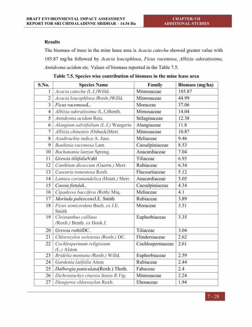
DRAFT ENVIRONMENTAL IMPACT ASSESSMENT REPORT FOR SRI CHIMALADINNE SRIDHAR – 14.54 Ha
CHAPTER-VII ADDITIONAL STUDIES
7 - 28
Results
The biomass of trees in the mine lease area is Acacia catechu showed greater value with
185.87 mg/ha followed by Acacia leucophloea, Ficus racemosa, Albizia odoratissima,
Antidesma acidum etc. Values of biomass reported in the Table 7.5.
Table 7.5. Species wise contribution of biomass in the mine lease area
S.No. Species Name Family Biomass (mg/ha)
1 Acacia catechu (L.f.)Willd. Mimosaceae 185.87
2 Acacia leucophloea (Roxb.)Willd. Mimosaceae 44.99
3 Ficus racemosaL. Moraceae 37.06
4 Albizia odoratissima (L.f.)Benth. Mimosaceae 14.04
5 Antidesma acidum Retz. Stilaginaceae 12.38
6 Alangium salviifolium (L.f.) Wangerin Alangiaceae 11.8
7 Albizia chinensis (Osbeck)Merr. Mimosaceae 10.87
8 Azadirachta indica A. Juss. Meliaceae 9.46
9 Bauhinia racemosa Lam. Caesalpiniaceae 8.53
10 Buchanania lanzan Spreng. Anacardiaceae 7.04
11 Grewia tiliifoliaVahl Tiliaceae 6.93
12 Canthium dicoccum (Gaertn.) Merr. Rubiaceae 6.34
13 Casearia tomentosa Roxb. Flacourtiaceae 5.12
14 Lannea coromandelica (Houtt.) Merr. Anacardiaceae 5.05
15 Cassia fistulaL. Caesalpiniaceae 4.34
16 Cipadessa baccifera (Roth) Miq. Meliaceae 4.1
17 Morinda pubescensJ.E. Smith Rubiaceae 3.89
18 Ficus semicordata Buch. ex J.E. Smith
Moraceae 3.51
19 Cleistanthus collinus (Roxb.) Benth. ex Hook.f.
Euphorbiaceae 3.35
20 Grewia rothiiDC. Tiliaceae 3.04
21 Chloroxylon swietenia (Roxb.) DC. Flindersiaceae 2.62
22 Cochlospermum religiosum (L.) Alston
Cochlospermaceae 2.61
23 Bridelia montana (Roxb.) Willd. Euphorbiaceae 2.59
24 Gardenia latifolia Aiton Rubiaceae 2.44
25 Dalbergia paniculata(Roxb.) Thoth. Fabaceae 2.4
26 Dichrostachys cinerea Sensu R.Vig. Mimosaceae 2.24
27 Diospyros chloroxylon Roxb. Ebenaceae 1.94

DRAFT ENVIRONMENTAL IMPACT ASSESSMENT REPORT FOR SRI CHIMALADINNE SRIDHAR – 14.54 Ha
CHAPTER-VII ADDITIONAL STUDIES
7 - 29
28 Diospyros sylvatica Roxb. Ebenaceae 1.94
29 Diospyros melanoxylon Roxb. Ebenaceae 1.93
30 Euphorbia antiquorumL. Euphorbiaceae 1.87
31 Mitragyna parvifolia (Roxb.) Korth. Rubiaceae 1.71
32 Careya arborea Roxb. Lecythidaceae 1.65
33 Pterospermum xylocarpum (Gaertn.) Oken
Sterculiaceae 1.64
34 Gmelina asiaticaL. Verbenaceae 1.61
35 Garuga pinnata Roxb. Burseraceae 1.47
36 Bridelia retusa (L.) A.Juss. Euphorbiaceae 1.46
37 Premna latifoliaRoxb. Verbenaceae 1.26
38 Manilkara hexandra(Roxb.) Dubard Sapotaceae 1.23
39 Gmelina arborea Roxb. ex Sm. Verbenaceae 1.15
40 Premna tomentosaWilld. Verbenaceae 1.09
41 Memecylon eduleRoxb. Melastomataceae 1.05
42 Maba buxifolia(Rottb.) Pers. Ebenaceae 0.82
43 Flacourtia indica (Burm. f.) Merr. Flacourtiaceae 0.79
44 Lagerstroemia parvifloraRoxb. Lythraceae 0.64
45 Strychnos nux-vomica L. Loganiaceae 0.61
46 Mallotus philippensisMuell.Arg Euphorbiaceae 0.6
47 Ziziphus xylopyrus (Retz.) Willd. Rhamnaceae 0.57
48 Mimusops elengiL. Sapotaceae 0.55
49 Sterculia urensRoxb. Sterculiaceae 0.55
50 Wrightia tinctoria(Roxb.) R.Br. Apocynaceae 0.49
51 Naringi crenulata (Roxb.) D.H. Nicolson
Rutaceae 0.3
52 Syzygium cumini (L.) Skeels Myrtaceae 0.26
53 Strychnos potatorumL.f. Loganiaceae 0.19
54 Streblus asper Lour. Moraceae 0.18
55 Ixora pavettaAndr. Rubiaceae 0.17
56 Protium serratum (Wall. ex Colebr.) Engl.
Burseraceae 0.16
57 Ziziphus mauritianaLam. Rhamnaceae 0.08
58 Semecarpus anacardiumL.f. Anacardiaceae 0.06
59 Ochna obtusataDC. Ochnaceae 0.05
60 Polyalthia cerasoides (Roxb.) Hook.f. & Thomson
Annonaceae 0.04
61 Terminalia alata Heyne ex Roth Combretaceae 0.04

DRAFT ENVIRONMENTAL IMPACT ASSESSMENT REPORT FOR SRI CHIMALADINNE SRIDHAR – 14.54 Ha
CHAPTER-VII ADDITIONAL STUDIES
7 - 30
62 Terminalia chebulaRetz Combretaceae 0.02
63 Sapindus emarginatusVahl Sapindaceae 0.02
64 Schleichera oleosa (Lour.) Oken Sapindaceae 0.02
65 Xylia xylocarpa (Roxb.)Taub. Mimosaceae 0.02
66 Tamarindus indicaL. Caesalpiniaceae 0.01

CHAPTER –VIII
PROJECT BENEFITS

DRAFT ENVIRONMENTAL IMPACT ASSESSMENT REPORT FOR SRI CHIMALADINNE SRIDHAR – 14.54 HA
CHAPTER-VIII PROJECT BENEFITS
8 - 1
8.0 GENERAL
The surrounding inhabitants are mainly agriculture oriented and daily labour.
Unemployment and under employment are the main problems of the inhabitants. No
displacement or evacuation of human settlement has been anticipated during mining
operation. Mining activity will help in improving the socio-economic status in the area
like employment, communication, education etc. It improves the living standard of the
people, supports for education and increase the ability of people to understand the
changes.
The following paragraphs will discuss the benefits that are obtained from this mining
activity.
8.1 EMPLOYMENT
The resumed operations of the mine will generate direct and indirect employment
opportunities for the local people. The mine will create employment for a total of
approximately 33 persons including skilled as well as semi-skilled staff directly.
Additionally, certain works like security will be outsourced on contract. The secondary
employment in the form of providing services to the employed manpower will also be
developed in the neighboring villages.
8.2 OCCUPATIONAL HEALTH
Each group of mine workers undergo regular medical checkup at regular intervals by
specialist doctors as per Mines Act/ Rules and other social development and promotional
activities will be undertaken. PPE will be provided to the workforce.
8.3 IMPROVEMENTS IN PHYSICAL AND SOCIAL INFRASTRUCTURE
The resumed operations of the mine will enhance the socio-economic activities in the
adjoining areas. This will result in following benefits:-
Improvements in physical infrastructure.
Improvements in social infrastructure.
Increase in employment potential
Prevention of illegal mining.
During and post-mining enhancement of green cover.
DRAFT ENVIRONMENTAL IMPACT ASSESSMENT REPORT FOR SRI CHIMALADINNE SRIDHAR – 14.54 HA
CHAPTER-VIII PROJECT BENEFITS
8 - 2
8.3.1 Improvements in Physical Infrastructure
Although the mining area is well connected with important places in the vicinity
however, the resumed operations of the mine will improve the physical infrastructure of
the adjoining areas. This will include the following:-
Improved road communication due to operation of the mine.
Strengthening of existing community facilities through the Community
Development Programme.
Creation of community assets (infrastructure) like provision for drinking water,
village roads/ linked roads, dispensary & health center, community center, market
place etc.
Awareness program and community activities, like health camps, medical aids,
family welfare programs, immunization camp sports & cultural activities, plantation
etc.
8.3.2 Improvements in Social Infrastructure
The mining activity shall create awareness with the local people for preferring permanent
services than seasonal agricultural activities. The activities will help them to analyze the
importance of education. With the increased amount of income, people can send their
children for higher education/professional courses. There will be some obvious changes
in various environmental parameters due to mining activity. There will also be positive
impact in socio-economic area due to increased economic activities, creation of new
employment opportunities, infrastructural development and better educational and health
facilities. Lessee will also undertake awareness program and community activities like
health camps, medical aids, family welfare camps, awareness program etc.
8.3.3 Prevention of Illegal Mining & Contribution to the Exchequer
Since the mine areas will be leased out to successful allottees, mining operation in the
state will be legalized and it will fetch income to the state exchequer. The proponent will
take due care to avoid illegal mining within the mine lease area. The production will be
as per approved mining plan after obtaining statutory clearances from respective
authorities. Providing fence along the mine boundary is not possible as the mine is

DRAFT ENVIRONMENTAL IMPACT ASSESSMENT REPORT FOR SRI CHIMALADINNE SRIDHAR – 14.54 HA
CHAPTER-VIII PROJECT BENEFITS
8 - 3
located on hilly terrain. Watch and ward is provided by the management to protect the
mine from unlawful entry.
8.3.4 Enhancement of Green Cover
Plantation/Afforestation will be done as per program i.e. along the road sides and near
civic amenities. Post plantation, the area will be regularly monitored in every season for
evaluation of success rate. For selection of plant species local people will also be
involved. The management will provide free saplings of fruit and other trees, etc. to local
during rain for plantation.
8.4 OTHER TANGIBLE BENEFITS
The mining project is likely to have other tangible benefits as given below.
Indirect employment opportunities to local people in contractual works like
transportation, sanitation, for supply of goods and services to the project and other
community services.
Market and business establishment facilities will also increase.
Improvement in communication, transport, education, community development and
medical facilities.
Overall change in employment and income opportunity.
The State Government will also be benefit directly from the mining project, through
increased revenue from royalties, excise duty.
CHAPTER –IX
ENVIRONMENTAL MANAGEMENT PLAN

DRAFT ENVIRONMENTAL IMPACT ASSESSMENT REPORT FOR SRI CHIMALADINNE SRIDHAR – 14.54 Ha
CHAPTER-IX ENVIRONMENTAL MANAGEMENT PLAN
9 - 1
9.0 INTRODUCTION
Any types of development project exert certain benefits and adverse impacts on the
surroundings. The major objective and benefit of utilizing Environmental Impact
Assessment in project planning stage itself, is to prevent avoidable losses of
Environmental resources and values as a result of Environmental Management Plan.
Environmental Management Plan includes protection/mitigation/enhancement measures
as well as suggesting post project monitoring program. Environmental Management Plan
may often suggest additional project operations that have to be incorporated in the
conventional operation.
Any development in the study area needs to be with judicious utilization of non-
renewable resources of the study area and within the limits of permissible assimilative
capacity. The assimilative capacity of the study area is the maximum amount of pollution
load that can be discharged in the environment without affecting the designated use and is
governed by dilution, dispersion, and removal due to physio-chemical and biological
processes. The Environment Management Plan (EMP) is required to ensure sustainable
development in the study area of the Mine Lease Area.
It has been evaluated that the study area has not been affected adversely as there are no
major polluting industries in the study area and likely to get economical fillip.
Environmental Management Plan aims at the preservation of ecosystem by considering
the pollution abatement facilities at the site inception.
Fully conscious towards Environmental responsibility the proponent mainly focuses,
apart from other relevant concerns, on the following important aspects,
a) Dust suppression measures by water sprinkling and
b) Proper maintenance of vehicles and equipment.
The different Environmental components that are identified in the assessment chapter are
dealt hereunder with necessary Environmental Management Plan.

DRAFT ENVIRONMENTAL IMPACT ASSESSMENT REPORT FOR SRI CHIMALADINNE SRIDHAR – 14.54 Ha
CHAPTER-IX ENVIRONMENTAL MANAGEMENT PLAN
9 - 2
Applicable Regulations
Following Regulations & policies with the amendments thereof need to be taken into
consideration under comprehensive environmental management systems (EMS)
programme as an integral part of the mine operation:
The Mines Act, 1952
The Mines and Mineral (regulation and Development) Act, 1957.
Mineral conservation and Development Rules (MCDR), 1988.
Mines Rules, 1955 for Health and Safety of Mining workers.
Section 21 of Air (Prevention and Control of Pollution) Act, 1981.
Section 25 and 26 of Water (Prevention and Control of Pollution) Act, 1974.
Gazette Notifications of Central Pollution Control Board (CPCB) as and when
notified for pollution prevention and control.
Applicable State Acts and Rules for Mining.
Directives of Andhra Pradesh Pollution Control Board (APPCB) in their Consent
Letters and Notifications.
EP Act 2006
Table: 9.1 EMP costing for the project
S.No Details Capital Cost (in Lakhs)
Recurring Cost (Lakhs)
per annum
Remarks
1 Air Pollution
Nose masks (Rs. 25/- each) - 0.3 Replaceable once in a week
Sprinkling system 3.5 KLD (Rs. 750/- for 1 tank of capacity 5KL)
0.5 2.0 Required daily on 250 working days
Wire saw cutting and Wet Drilling, 3.0 KLD
-- 0.5 Required daily on 250 working days
Graded road Construction -- 0.1
2 Water Pollution
Garland drains, Contour trenches, retention wall and siltation pond
1.0 0.05 Drains construction around the mine site
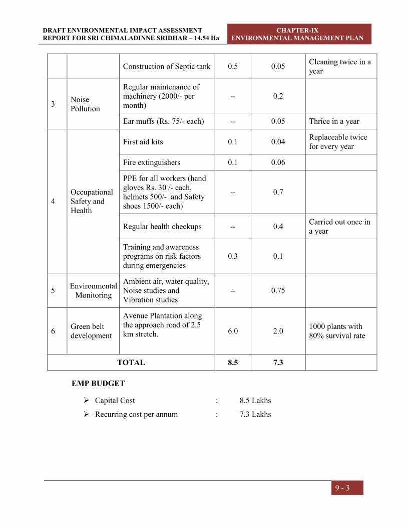
DRAFT ENVIRONMENTAL IMPACT ASSESSMENT REPORT FOR SRI CHIMALADINNE SRIDHAR – 14.54 Ha
CHAPTER-IX ENVIRONMENTAL MANAGEMENT PLAN
9 - 3
Construction of Septic tank 0.5 0.05 Cleaning twice in a year
3 Noise Pollution
Regular maintenance of machinery (2000/- per month)
-- 0.2
Ear muffs (Rs. 75/- each) -- 0.05 Thrice in a year
4 Occupational Safety and Health
First aid kits 0.1 0.04 Replaceable twice for every year
Fire extinguishers 0.1 0.06
PPE for all workers (hand gloves Rs. 30 /- each, helmets 500/- and Safety shoes 1500/- each)
-- 0.7
Regular health checkups -- 0.4 Carried out once in a year
Training and awareness programs on risk factors during emergencies
0.3 0.1
5 Environmental
Monitoring
Ambient air, water quality, Noise studies and Vibration studies
-- 0.75
6 Green belt development
Avenue Plantation along the approach road of 2.5 km stretch.
6.0 2.0 1000 plants with 80% survival rate
TOTAL 8.5 7.3
EMP BUDGET
Capital Cost : 8.5 Lakhs
Recurring cost per annum : 7.3 Lakhs

DRAFT ENVIRONMENTAL IMPACT ASSESSMENT REPORT FOR SRI CHIMALADINNE SRIDHAR – 14.54 Ha
CHAPTER-IX ENVIRONMENTAL MANAGEMENT PLAN
9 - 4
CORPORATE ENVIRONMENT RESPONSIBILITY (CER):
Sri Chimaladinne Sridhar will follow Corporate Environmental Responsibility (CER) as
per O.M. File No. 22-65/2017-IA.III dated: 01.05.2018.
The following measures will be taken to maintain a clean and sustainable environment in
and around the plant:
Integrate sound environmental practices in all its activities.
Promote development of innovate environment friendly processes
Improve employee commitment and responsibility towards environment protection
Promote environmentally responsible behaviour amongst contractual workforce and
suppliers.
Development of greenbelt in surrounding areas and along the approach road.
CER activities by the proponent
Development of Infrastructure facilities in nearby schools
Health camps
Providing public toilets in nearby villages
Development of greenbelt in surrounding areas
9.1 OBJECTIVES OF ENVIRONMENTAL MANAGEMENT PLAN
Overall objectives of EMP are:
Prevention: Measures aimed at impeding the occurrence of negative environmental
impact and/or preventing such as occurrence having harmful environmental impacts.
Preservation: Preventing any future actions that might adversely affect as environmental
resource or attribute.
Minimization: Limiting or reducing the degree, extent, magnitude or duration of adverse
impacts.
9.2 AIR QUALITY MANAGEMENT
The mining activity would result in the increase of PM concentrations due to fugitive
dust. Frequent water sprinkling in the vicinity would be undertaken and will be continued

DRAFT ENVIRONMENTAL IMPACT ASSESSMENT REPORT FOR SRI CHIMALADINNE SRIDHAR – 14.54 Ha
CHAPTER-IX ENVIRONMENTAL MANAGEMENT PLAN
9 - 5
as there is possibility for dust generation due to truck mobility. It will be ensured that
vehicles are properly maintained to comply with exhaust emission requirements.
Table: 9.2 Ambient Air Quality Standards
Concentration Microgram's per Meter Cube
PM10 PM2.5 SO2 NOX
100 60 80 80
Mitigative measures suggested for air pollution control are based on the baseline ambient
air quality monitoring data. From the point of view of maintenance of an acceptable
ambient air quality in the region, it is desirable that air quality should be monitored on a
regular basis to check it vis-à-vis the standards prescribed by CPCB and in case of non-
compliance, appropriate mitigative measures shall be adopted.
As per the results of ambient air quality monitoring data, the background concentrations
of PM10, PM2.5, SO2, NOX and Free Silica are within the stipulated CPCB standards.
9.2.1 Air Pollution Control Measures
Dust is the major pollutant generated from the mining operations. Dust would be
generated during mining, handling and transportation of the material. The Environmental
control measures are proposed to control the fugitive dust releases during the Colour
Granite production are given in the below table.
Table: 9.3 Air Pollution Control Measures
S.No Dust Source Control measure
1 Mineral
Exploration
Regular water spraying in working areas.
Practicing wet drilling and wire saw cutting
2 Haul Road
Compaction, gradation and drainage on both sides.
Proper maintenance.
Regular water spraying.
3 Truck
Movement
No overloading of trucks.
Trucks to be covered with tarpaulin while transporting

DRAFT ENVIRONMENTAL IMPACT ASSESSMENT REPORT FOR SRI CHIMALADINNE SRIDHAR – 14.54 Ha
CHAPTER-IX ENVIRONMENTAL MANAGEMENT PLAN
9 - 6
the material.
Enforcing speed limit of 25 KMPH.
In addition the following measures will be undertaken
Development of Green belt along the mine approach road.
Periodical monitoring of air quality to take steps to control the pollutants.
Regular water sprinkling to suppress the dust on haul roads, service roads and
mining face by truck mounted water tankers.
PPE will be provided to the workforce.
9.2.2 Controlling of Other Emissions
The other emissions are mainly SO2, NOx and the source would be from vehicles. But,
these emissions are very minimal. This will be controlled by proper maintenance and
servicing of vehicles.
9.3 WATER QUALITY MANAGEMENT
There will not be any waste water generation except domestic waste water, therefore no
post waste water monitoring required.
Water Pollution Management
There are no seasonal or perennial streams within the mine area. However, garland
drains are proposed to collect rain water.
In addition, contour trenches along with siltation pond are suggested at hill slope
and dump slopes.
The rain water collected in mine pit and siltation pond utilized for water spraying
on the haul roads and for watering plantation.
9.4 NOISE LEVEL MONITORING
There will be intermittent noise levels due to vehicular movement, trucks loading and
during mining operations.

DRAFT ENVIRONMENTAL IMPACT ASSESSMENT REPORT FOR SRI CHIMALADINNE SRIDHAR – 14.54 Ha
CHAPTER-IX ENVIRONMENTAL MANAGEMENT PLAN
9 - 7
No mining activities are planned during night time. Plantation will be developed all along
the mine buffer area which act as noise attenuator. The Management Plan for controlling
noise pollution is envisaged as follows.
Selection of suitable machinery and equipment,
Proper mounting of equipment,
Providing noise insulation/padding wherever practicable and
Machinery will be fitted with properly designed noise acoustic silencers.
Proper maintenance and periodic lubrication of noise generating parts of the
machines.
9.4.1 Parameters
The noise level recordings are measured in dB (A) Leq values, where dB (A) denotes the
time weighted average of the level of sound in decibels on scale A, which is relatable to
human hearing.
9.4.2 Methodology
Precision integrated sound level meters are being used for monitoring of Leq noise levels
in dB (A) scale at the work place and also in the surrounding villages.
9.4.3 Noise Quality Management
The following measures shall be implemented
Proper lubrication, fitting of effective silencers and good maintenance.
Provision of personnel hearing protective equipment to all workers likely to be
exposed to noise.
Restricting duty hours of operators likely to be exposed to higher noise levels.
The maintenance of natural vegetation as well as afforestation in the lease shall serve
as acoustic barriers.
9.4.4 Noise Pollution Control
The ambient noise level monitoring is carried out in and around the existing mine shows
that ambient noise levels are well within the stipulated limits of CPCB.

DRAFT ENVIRONMENTAL IMPACT ASSESSMENT REPORT FOR SRI CHIMALADINNE SRIDHAR – 14.54 Ha
CHAPTER-IX ENVIRONMENTAL MANAGEMENT PLAN
9 - 8
Noise generation may be for an instant, intermittent or for continuous periods, with low
to high decibels. Periodic inspection and checks of the risk prone areas and equipments
have to be conducted.
To control noise pollution during the mining operations following steps will be practiced.
Proper selection of machinery
Proper and timely maintenance of mining and plant machinery
Limiting speed of haulage vehicles/tippers
9.5 WATER CONSUMPTION AND WASTE WATER GENERATION
A total of approximately 14.0 KLD of fresh water is required for the mining activity
which will be met through water tankers. Water is required in the mine for spraying on
the roads and working faces to suppress the dust and also for use in the garage. Also a
small quantity of drinking water is required.
Fig 9.1 Water balance
14.0 KLD
(Water tankers)
Wet drilling (2.0 KLD)
Green Belt (4.0 KLD)
Dust Suppression (3.5 KLD)
No outflow No outflow No outflow
Domestic purpose
(1.5 KLD)
Septic Tank (Soak pit) (1.2 KLD)
Wire saw (3.0 KLD)
No outflow

DRAFT ENVIRONMENTAL IMPACT ASSESSMENT REPORT FOR SRI CHIMALADINNE SRIDHAR – 14.54 Ha
CHAPTER-IX ENVIRONMENTAL MANAGEMENT PLAN
9 - 9
9.6 BIOLOGICAL MANAGEMENT
Trees are very suitable for detecting, recognizing and monitoring air pollution effects.
Monitoring of biological effects of air pollutant by the use of plants as indicators has
been applied on local, regional and national scale. Trees function as sinks of air
pollutants, besides their bio esthetical values, owing to its large surface area. Annual need
of oxygen for one person is met by 150 sq.m of leaf surface. So it is necessary to develop
green belt in and around the polluted site with suitable species to combat the air pollution
effectively. The plantation scheme covers the following areas
Plantation around peripheral portion of mine and other structures.
Haul road and approach road plantation.
Plantation by way of reclamation/rehabilitation of mined out blocks at the end of
mine life.
9.6.1 Tree Plantation Program
The main aim of plantation of mined out areas is to stabilize the land, to protect it from
erosion and provide an aesthetic landscape. During the ensuing scheme period, Green belt
will be developed within Buffer Zone, in open places and along the approach road on
either side for a stretch of 1.0 km 1000 plants.
9.6.2 Biological Management Plan
The mining activity will have impact on vegetation in the mine lease area and in order to
minimize the impacts, it is proposed to reclaim the entire plain areas at the end of mine
life with indigenous plant species as early as possible. Plantation programme is proposed
to be carried out in and around the mine lease area so that the natural habitat is restored.
9.6.3 Criteria for Selection of Species
Species to be selected should fulfill the following specific requirements of the area
Availability of seed material
Tolerance to specific conditions or alternatively wide adapts ability to eco-
physiological conditions.
Rapid growth

DRAFT ENVIRONMENTAL IMPACT ASSESSMENT REPORT FOR SRI CHIMALADINNE SRIDHAR – 14.54 Ha
CHAPTER-IX ENVIRONMENTAL MANAGEMENT PLAN
9 - 10
Capacity to endure water stress and climatic extremes after initial establishment
Differences in height, growth habits
Pleasing appearance
Providing shade
Ability of fixing atmospheric Nitrogen
Improving waste lands.
9.6.4 Design of green development
The greenbelt shall be developed around the mine to act as a sink for pollutants,
attenuation of noise levels and improvement in aesthetic quality of the plant. The
following criteria shall be adopted in the design of greenbelt:
1. Generally fast growing trees should be planted as otherwise it will take many
years for other types of trees to attain their full height.
2. Trees will be planted along the road side in such a way that there is no direct line
of sight when viewed from a point outside the foliage perimeter.
3. Trees growing up to 10 m or more in height with thick perennial foliage should be
planted around the plant.
4. Trees shall be planted staggered in each row (minimum three rows encircling the
perimeter of the plant).
5. Tree trunk being free foliage up to a height of 2 to 3 m, it is advisable to grow
shrubs in front of trees to give coverage to the open portion.
6. Greenbelt will be developed along the mine approach road.

DRAFT ENVIRONMENTAL IMPACT ASSESSMENT REPORT FOR SRI CHIMALADINNE SRIDHAR – 14.54 Ha
CHAPTER-IX ENVIRONMENTAL MANAGEMENT PLAN
9 - 11
9.7 SOIL MANAGEMENT
Top Soil Management
The top soil will be preserved within the lease area and the same will be used for
plantation, roads, filling ditches and reclamation whenever necessary.
Waste Management
About 2,28,950.40 m3 will be generated during the ensuing five years period with an
average of 45790 m3/annum. The waste generated during the mining will be dumped in
the NW of the quarry lease applied area over an area of 2.250 Ha with an average height
of 10 m with 45 slope angle will be formed.
9.8 LAND ENVIRONMENT
9.8.1 Land use
The project covers a total ML area of 14.54 hectares of Govt. waste land. During the
ensuing scheme period an area of 5.071 hectares of land will be mined out and 5.874
hectares will be degraded till the end of the mine life.
At the end of mine life the resulting pit will be used as water harvesting pit after
backfilling with the available stored mineral waste. Barbed wire is proposed around the
mine pits to avoid accidents. The plain land will be developed with green belt to increase
soil stability.
9.8.2 Mine roads
Roads for haulage and access to different locations would be laid as per the statutory
regulations stipulated in the Metalliferous Mines Regulations, 1961. Some of the basic
features of laying the haul roads at the Mine Lease Area as required from environmental
and safety angle cover the following:
The road layout would be generally followed as per scheme shown in mine general
layout. The main haul road and feeder roads would be generally of 12m wide keeping
provisions for road side plantation.
The corners and bends would be made in such a way as to offer the vehicle operator,
a clear visibility of at least 30m along the road.

DRAFT ENVIRONMENTAL IMPACT ASSESSMENT REPORT FOR SRI CHIMALADINNE SRIDHAR – 14.54 Ha
CHAPTER-IX ENVIRONMENTAL MANAGEMENT PLAN
9 - 12
The alignment of haul roads and feeder roads may require alteration with the progress
of mining work.
9.8.3 Proposed Mitigating Measures
The land management plays an important role in reducing the adverse impacts caused by
surface mining operation. Land management is required in the key areas like land use
scheme with the ML area, calendar plan, mine bench advancement to arrest
indiscriminate degradation of landform, top soil preservation, soil erosion control and the
restoration of the mine pit. On each of these prime areas of land management, the
following schemes are proposed.
Land restoration:
The formed pits will be used for water storage after backfilling some extent of pits with
available stocked mineral waste. The plain lands left undisturbed within the mine area
will be encouraged to develop green belt with native and soil binding species. While,
reclaiming the mined out area, the original land form cannot be fully restored. There
would be some left out pit and depressions of varying depth which can serve as a
recharge pit by the impounding rain water. This would be beneficial in two aspects,
namely (i) it may recharge the spring table by seepage of water through cracks and joints
and (ii) the impounded water reservoir can be utilized for development of afforestation.
9.9 SOCIO-ECONOMIC ENVIRONMENT & SAFETY
The company management shall give preference to local people through both direct and
indirect employment.
It will provide ample opportunity to the locals to up-lift their living standards by
organizing events that propagate mutual benefits to all, such as health camps,
awareness campaigns, donations to poorer sections of society and downtrodden.
Educational needs of the region will be improved by encouraging the workers to
allow their children to attend schools.
Sufficient funds shall be allocated for these and other emergency needs.
Adequate supply of potable water to the workers will be made during the working
hrs.

DRAFT ENVIRONMENTAL IMPACT ASSESSMENT REPORT FOR SRI CHIMALADINNE SRIDHAR – 14.54 Ha
CHAPTER-IX ENVIRONMENTAL MANAGEMENT PLAN
9 - 13
The mines department will supervise the safe working of the contractor and their
employees. The working personnel will be provided with face masks, ear plugs,
safety helmets and goggles in order to reduce health hazards.
The proponent will provide all necessary provisions stipulated under the Mines Act. In
addition a Safety committee will be formed and manned by equal participants from
Management and Workers.
Personnel Protection Equipment (PPE) will be issued to each worker. Other safety
equipments shall be used according to the nature of job involved.
9.9.1 Occupational Health and Safety Measures
Mining profession involves exposure of workers to open area & dusty environment
requiring assessment of likely impacts on the health aspects. Workers are prone to be
affected by respiratory and pulmonary diseases, apart from health hazards related to
water pollution, noise and vibrations. Health impact assessment will be undertaken by
studying the nature of the mining activities and its impact. The proponent will appoint a
doctor well versed with occupational health surveillance to meet the medical needs of the
employees. The employees will be subjected to medical examination on an annual basis.
The medical histories of all the employees shall be maintained in a standard format.
These medical histories over a period will show if there is occupation related
deterioration in the employees’ health. The budget allocated for occupational health &
safety measures is Rs. 1.3 lakhs per annum.
Fugitive dust, noise and fines, may affect the health of workers, safety of employees
during operation will be taken care of as per Mine Regulations Act, 1961. To avoid any
adverse effects on the health of workers due to dust and noise sufficient measures have
been provided in the mining project. These may include:
It should be ensured that all employees are adequately trained and qualified to
perform their duties. Visitors must be familiarized with the safety precautions of the
mine.
One occupational health and safety officer will be employed by the mine.

DRAFT ENVIRONMENTAL IMPACT ASSESSMENT REPORT FOR SRI CHIMALADINNE SRIDHAR – 14.54 Ha
CHAPTER-IX ENVIRONMENTAL MANAGEMENT PLAN
9 - 14
Provision of rest shelters for mine workers with amenities like drinking water, fans,
toilets etc.
Provision of personal protection devices to the workers.
Dust suppression of haul road.
First aid facilities within lease area.
Height, slope shall be developed as per the approved mining plan.
Regular medical examination shall be conducted for the employees.
Working benches shall be developed as per approved mining plan.
9.9.2 Public Health Implication, Occupational Health Survey Program and First Aid:
According to ILO and WHO, occupational health should aim at the promotion and
maintenance of the highest degree of physical, mental and social well being of workers in
all occupations; the prevention amongst workers of departures from health caused by
their working conditions; the protection of workers in their employment from risks
resulting from factors adverse to health. In brief, as applicable for Sri Chimaladinne
Sridhar mine, any employee should not have any health risk due to its assigned
occupation and should not lose the productivity of the employee on health ground. So far
and as per the health checkups conducted, none of the employees have any abnormal
findings. Rest other occupational ailments are not alarming and medical treatment as well
as counseling will be provided to all employees periodically.
An occupational health survey program includes:
Preliminary screening of all the employees for their baseline health condition.
Medical evaluation of workers condition before joining to the duty.
Educating the workers w.r.t. the safety conditions & occupational health diseases.
Refresher Training will be provided on malaria eradication, health effects on
exposure to mineral dust.
Regular health checkups for all the workers will be conducted.
Data base will be created for individual worker and will be updated regularly to
compare the health status.
Ergonomic Program Manager will take care of all the needs of OH & S.
Doctor specialized in Occupational Health will be appointed for special needs.

DRAFT ENVIRONMENTAL IMPACT ASSESSMENT REPORT FOR SRI CHIMALADINNE SRIDHAR – 14.54 Ha
CHAPTER-IX ENVIRONMENTAL MANAGEMENT PLAN
9 - 15
Mine Safety
Mine Safety is a statutory requirement which will be fully complied at Sri Chimaladinne
Sridhar mine. Mining area will be fenced off to prevent falling down of man and animals.
Proposed security will be providing to prevent pilferage or theft.
Fuels:
No fuel is required for minerals processing. Only diesel oil is required for operation of
mining machineries and mine vehicles. The average monthly consumption is around 20
KL diesel oil.
9.10 PROJECT COST
Cost Estimates of the Project
The Total cost of the project would be around Rs. 65.0 Lakhs.
EMP BUDGET
Capital Cost : 8.5 Lakhs
Recurring cost per annum : 7.3 Lakhs

CHAPTER –X
SUMMARY AND CONCLUSIONS

DRAFT ENVIRONMENTAL IMPACT ASSESSMENT REPORT FOR SRI CHIMALADINNE SRIDHAR – 14.54 HA
CHAPTER-X SUMMARY &
CONCLUSIONS
10 - 1
10.0 SUMMARY & CONCLUSION
Sri Chimaladinne Sridhar, Lessee was granted a quarry lease for Colour Granite over an
extent of 14.54 Hectares in Sy.No.1 of Bellukola Village, Nandigam Mandal, Srikakulam
District of Andhra Pradesh.
The project is for Environmental Clearance, initially TOR application for the same was
submitted to SEAC, Andhra Pradesh and was considered in the SEAC meeting held on
03.12.2019. Obtained ToR vide Lr. No: SEIAA/AP/SKM/MIN/VIO/02/2015/227-114
Dated: 07.01.2020.
The lease area is located in Survey of India, Toposheet No: 74B/6 between the Latitude:
18°41'14.77"N and Longitude: 84°14'54.30"E.in Bellukola Village, Nandigam Mandal,
Srikakulam District of Andhra Pradesh.
10.1 RECOMMENDATIONS
The regular medical check-up of workers is to be carried out. The general environmental
awareness is given to the local workers. Regular maintenance of vehicle is carried out.
Slogans of Environment, health & safety are recommended for display in local language.
Hence significantly there is no likely impact is envisaged due to mining activity. The
management must keenly celebrate the importance of World Environment Day to create
awareness amongst the workers. Conservation of soil and water must be emphasized not
only at works but also at their own place. With implementation of Environment
management plan and providing continual improvement the mine may be accorded
environmental clearance.
Adequate measures will be taken for control of noise at source.
Intensive green belt will be developed all around mining premises.
Control of dust emissions.
Consequently,
This project aims at keeping the key industries within the country well supplied with
an essential raw material

DRAFT ENVIRONMENTAL IMPACT ASSESSMENT REPORT FOR SRI CHIMALADINNE SRIDHAR – 14.54 HA
CHAPTER-X SUMMARY &
CONCLUSIONS
10 - 2
Does not give rise to any adverse biophysical or socio-economic impacts
No rehabilitation required
The project has significant positive socio economic aspects such as generation of
employment
Acceptable impact on environmental parameters
The EMP should be implemented by senior qualified environmental personnel who have
competency and credibility to interpret the requirements of the EIA and EMP. A detailed
record of all activities related to environmental and social management should be retained
for review. The audit findings should be made available to the relevant environmental and
local authorities.

CHAPTER –XII
DISCLOSURE OF CONSULTANTS

DRAFT ENVIRONMENTAL IMPACT ASSESSMENT REPORT
FOR SRI CHIMALADINNE SRIDHAR – 14.54 HA CHAPTER-XI
DISCLOSURE OF CONSULTANTS
11 -1
11.0 DISCLOSURE OF NABET ACCREDITED ORGANIZATION FOR EIA STUDIES
This chapter provides the overview of the consultants engaged in EIA studies.
11.1 ABOUT SV ENVIRO LABS & CONSULTANTS (SVELC)
Pioneered its way in the mid 90’s in Yanam, the Evergreen Union Territory of
Puducherry, to cater quality service in the area of environmental pollution. The laboratory
serves have been set up in an extent of 7500 sq.ft in the city of destiny Visakhapatnam.
To provide Analytical expertise in the field of Environmental Engineering. Our technical
expertise is one among the best in the country, providing economical & sound
environmental and safety solutions.
SVELC is an ISO 9001:2008 company and is accredited by:
ISO 9001:2008
ISO 14001: 2004
Ministry of Environment, Forests & Climate Change (MoEF&CC), Govt. of
India, New Delhi
National Accreditation Board for Education & Training (NABET) registered
Environmental consultants by Quality Council of India (QCI).
National Accreditation Board for Testing and Calibration Laboratories (NABL) in
the field of testing
OSHAS 18001: 2007
11.2 SERVICES OFFERED BY SV ENVIRO
Environmental:
Environmental Impact Assessments
Environmental Management Plan
Environmental Audits preparation
Solid and hazardous waste management
Risk assessment and disaster management plans
Occupational health and safety studies
Socio-economic studies
Marine impact assessment

DRAFT ENVIRONMENTAL IMPACT ASSESSMENT REPORT
FOR SRI CHIMALADINNE SRIDHAR – 14.54 HA CHAPTER-XI
DISCLOSURE OF CONSULTANTS
11 -2
Rehabilitation and resettlement studies
Analysis:
Environmental monitoring for air, water, soil, noise, ecology, hazardous waste, etc
Industrial emission source monitoring
Offshore sampling and analysis of marine water and sediments
Analysis of water, wastewater, soil, solid waste, hazardous waste, lube oils, etc
Noise quality monitoring
Work zone source emission analysis
The firm has been engaged in the work of Environmental Impact Assessment studies for
category –A & B projects, preparation of Environmental management plans (EMP) for
the last 10 years for the purpose of obtaining clearance from Ministry of Environment,
Forests & Climate Change.

DRAFT ENVIRONMENTAL IMPACT ASSESSMENT REPORT
FOR SRI CHIMALADINNE SRIDHAR – 14.54 HA CHAPTER-XI
DISCLOSURE OF CONSULTANTS
11 -3
Fig: 11.1 – NABET Certificate

DRAFT ENVIRONMENTAL IMPACT ASSESSMENT REPORT
FOR SRI CHIMALADINNE SRIDHAR – 14.54 HA CHAPTER-XI
DISCLOSURE OF CONSULTANTS
11 -4
Fig: 11.2 – NABET validity extension

ANNEXURES
ANNEXURE – I
TOR COPY


ANNEXURE – II
MINING PLAN
&
DRAWINGS


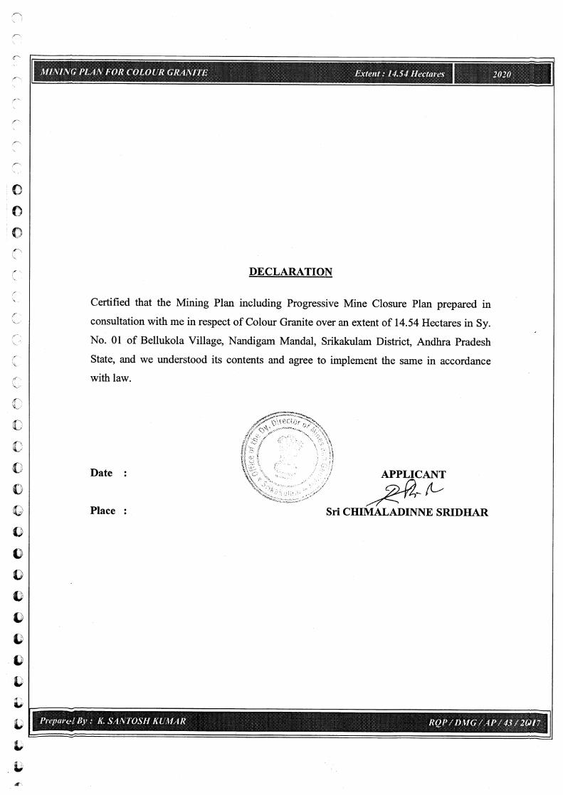
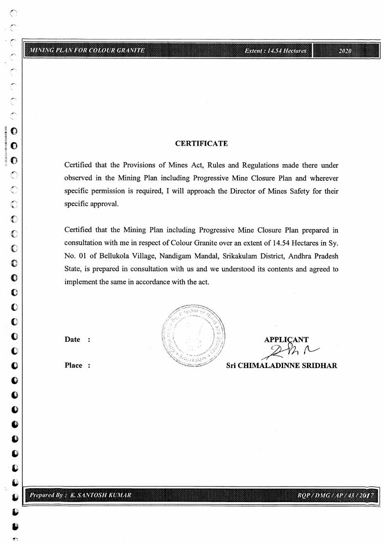
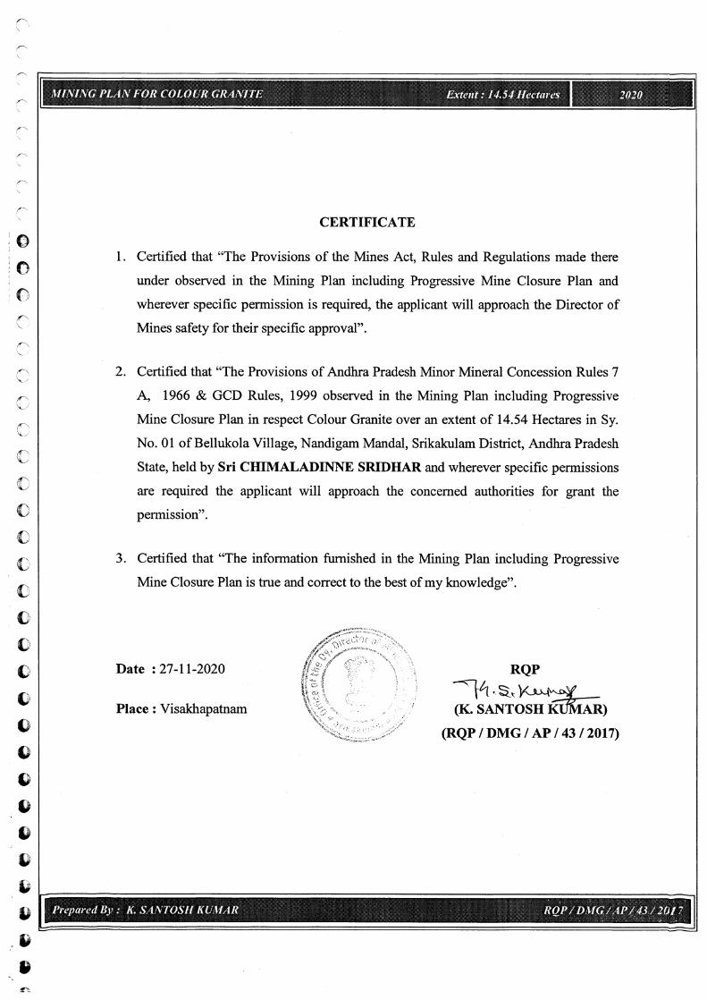


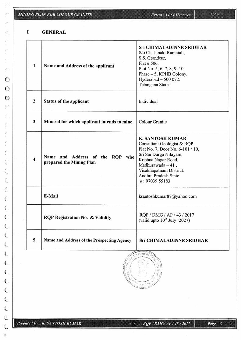
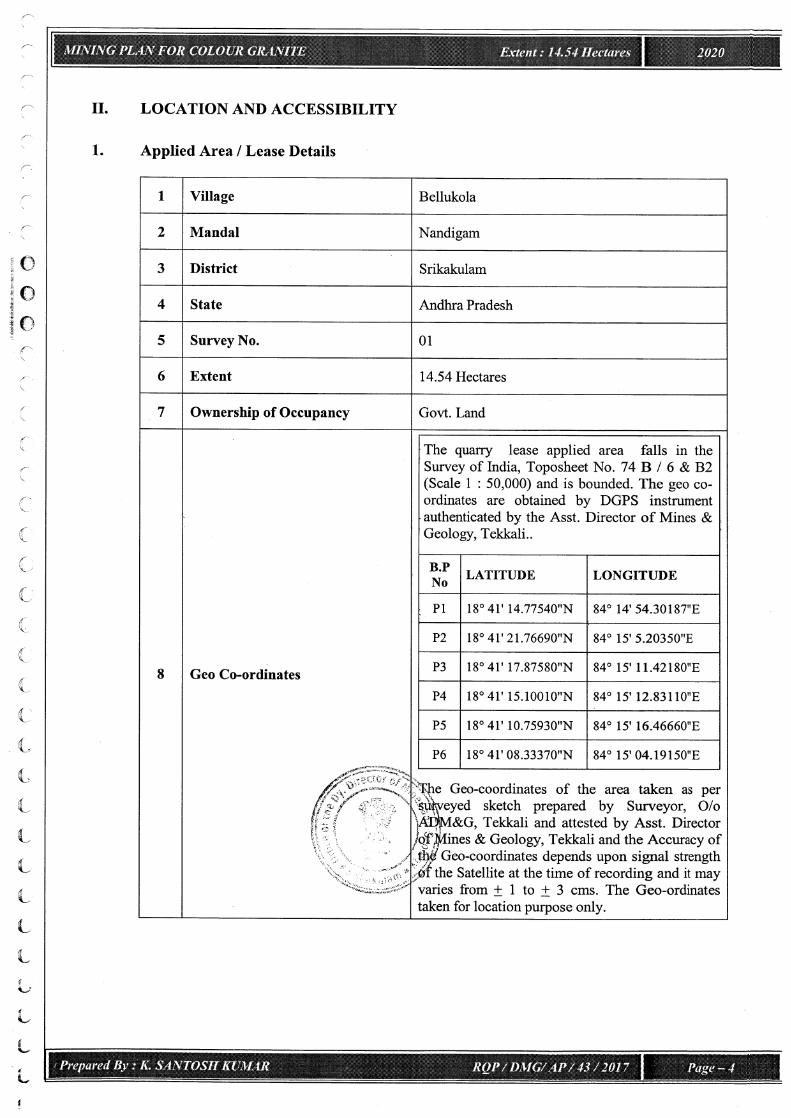


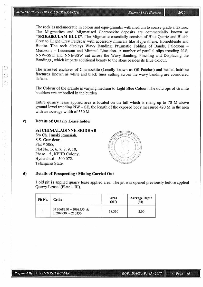

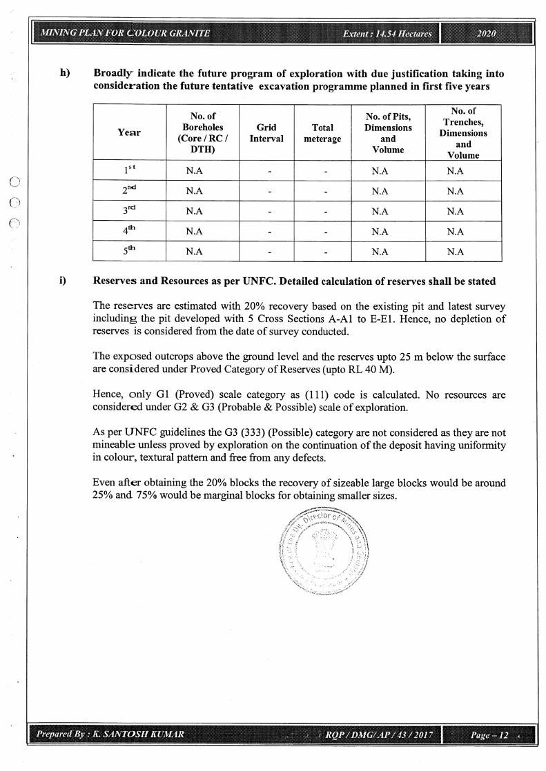


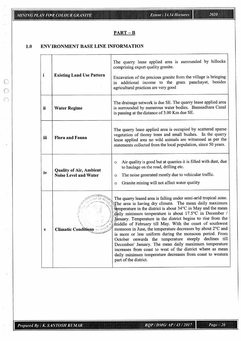


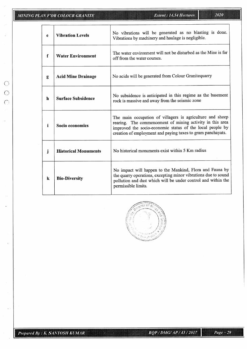


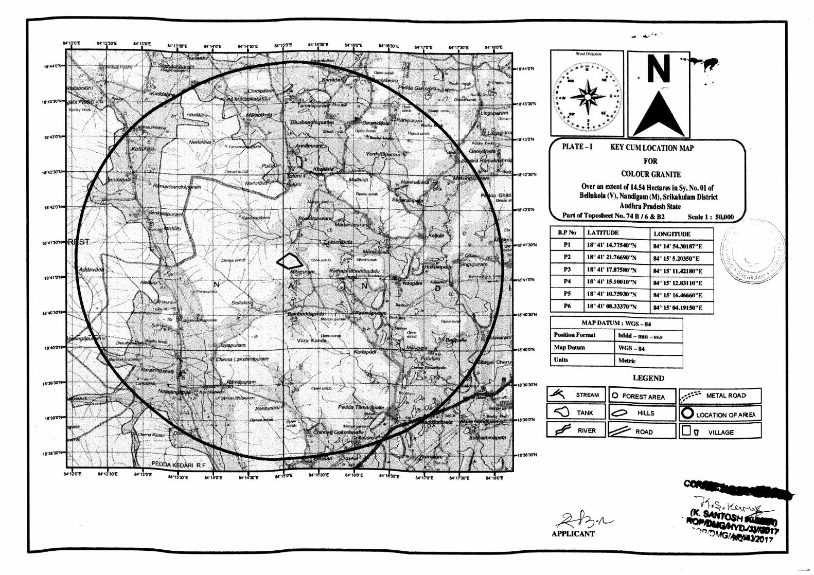


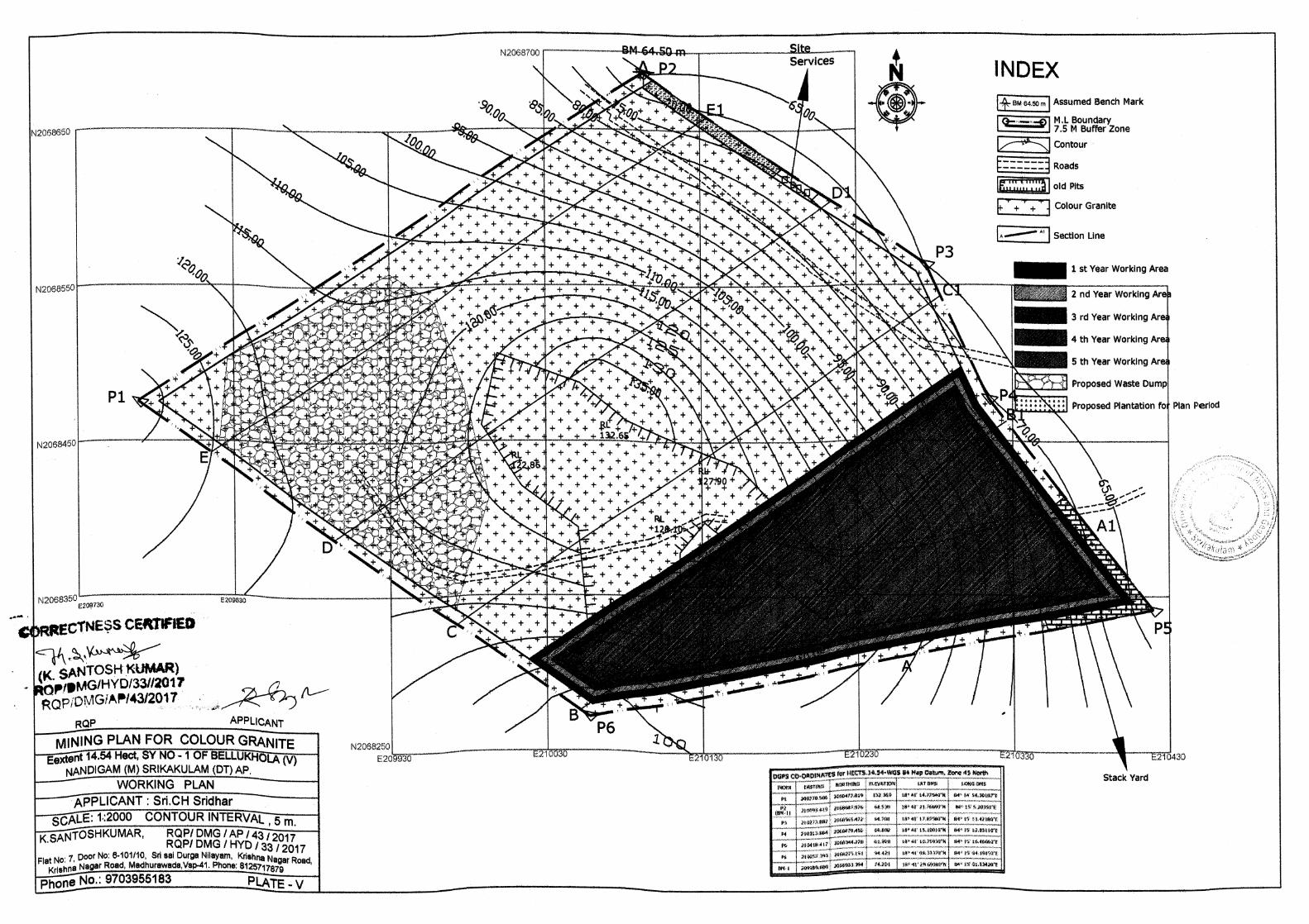


ANNEXURE – III
CLUSTER LETTER
& MAP

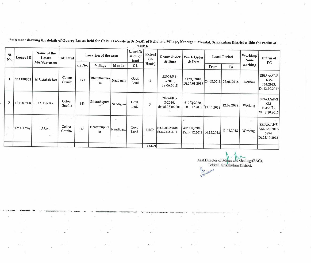


ANNEXURE – IV
CLUSTER EMP
Sri Chimaladinne Sridhar (Extent – 14.54 Ha) Cluster EMP
Page 1 of 16
CLUSTER ENVIRONMENTAL
MANAGEMENT PLAN
Submission to
The State Environmental Impact Assessment Authority (SEIAA)
and State Environmental Appraisal Committee (SEAC)
Andhra Pradesh.
of
SRI CHIMALADINNE SRIDHAR
COLOUR GRANITE (Srikakulam Blue)
Extent: 14.54 Ha, Sy. No: 1 of
Bellukola Village, Nandigama Mandal,
Srikakulam District A.P.
Prepared by
SV ENVIRO LABS & CONSULTANTS Environment Engineers & Consultants In Pollution Control
H.O: Block-B, B-1, IDA, Autonagar, Visakhapatnam – 530 012 Ph: 0891-2755528, Tel/Fax: 0891-2755529, E-mail: [email protected]
Ph: 9440338628 QCI NABET Accredited & Recognized by MOE&F, New Delhi
Sri Chimaladinne Sridhar (Extent – 14.54 Ha) Cluster EMP
Page 2 of 16
1.0 INTRODUCTION:
Sri Chimaladinne Sridhar has been granted a quarry lease for Colour Granite
(Srikakulam Blue) over an extent of 14.54 Ha., in Sy.No. 1 of Bellukola Village,
Nandigama Mandal, Srikakulam District in favour of Sri Chimaladinne Sridhar
vide Proc.No.1279/D1-2/2020, Dt.03.11.2020 for a period of 20 years. The
Assistant Director of Mines & Geology, Tekkali, Srikakulam has executed the
Quarry lease deed vide Proceeding No.1899/Q//2014, Dt.24.12.2020 for a period
of 20 years from 26.12.2008 to 25.12.2028.
Sri Chimaladinne Sridhar proposes for environmental clearance for Colour
Granite mine over an Extent of 14.54 Ha, in Sy. No: 1 of Bellukola Village,
Nandigama Mandal, Srikakulam District, Andhra Pradesh.
Accordingly, the project proponent applied for TOR to the State Environmental
Impact Assessment Authority (SEIAA), Andhra Pradesh, and TOR presentation
has been made before the SEAC, Andhra Pradesh committee and the TOR has
been issued by AP SEIAA vide order no: SEIAA/AP/SKM/MIN/12/2020/ 2641-
267, Dt: 07.07.2021.
A certificate about the existing quarries within 500M radius range around the
periphery of the proposed quarry has been obtained vide Letter No. 1889/Q/2014;
dated 24.12.2020 from the Assistant Director of Mines & Geology, Tekkali,
Srikakulam District, so as to ascertain whether the existing quarries in the said
range from a cluster situation and to prepare the EMP accordingly.
1.1 CLUSTER FORMATION:
The existing quarry lease was granted for Colour Granite (Srikakulam Blue) over
an extent of 14.54 Ha., in Sy.No. 1 of BellukolaVillage, Nandigama Mandal,
Srikakulam District in favour of Sri Chimaladinne Sridhar vide Proc.No.1279/D1-
2/2020, Dt. 03.11.2020 for a period of 20 years. As per EIA notification DT: 14th
Sep, 2006 & its amendments EMP has to submitted to get Environmental
Clearance (EC) as B2 project.
As per MoEF & CC notification S.O. 141(E) dt: 15th January, 2016 “A cluster shall
be formed when the distance between the peripheries of one lease is less than 500
m from the periphery of other lease in a homogeneous mineral area” and the
Sri Chimaladinne Sridhar (Extent – 14.54 Ha) Cluster EMP
Page 3 of 16
proposed mine is having three working mines area included applied area covering
in Bellukola Village, Nandigam Mandal, Srikakulam District.
As per S.O.2269 (E) dt 1st July, 2016 “(6) A cluster shall be formed when the
distance between the peripheries of one lease is less than 500 meters from the
periphery of other lease in a homogeneous mineral area which shall be applicable
to the mine leases or quarry licenses granted on and after 9th September 2013” and
mine leases not operative for three years or more and leases which got
environmental clearance as on 15th January 2016 shall not be counted for
calculating of cluster, but shall be included in the Environmental Management Plan
for cluster.
1.2 LOCATION OF THE MINE:
The above said applied quarry lease falling in Topo sheet No. 74 B/6. The details
of mines located 500 meters peripheral of the proposed projects covering in
Ballekola Village, Nandigama Mandal, Srikakulam District.
1.3 CLUSTER CLASSIFICATION AND LOCATION DETIALS:
A certificate about the existing quarries within 500 M radius range around the
periphery of the proposed quarry has been obtained from the Assistant Director,
Mines & Geology, Srikakulam, Government of Andhra Pradesh. The Assistant
Director, Mines & Geology, Srikakulam to ascertain whether the existing quarries
in the said range from a cluster situation and to prepare the EMP accordingly the
certificate & cluster map.
As per cluster notification by MoEF&CC mines which not executed lease or
Environmental Clearance before 9th September 2013 were considered and
were included in preparation of cluster EMP. As per records of the ADM&G,
Srikakulam vide Lr. No. 1899/Q/2014 Dt: 24.12.2020 there is three existing
mine were present within 500 mtrs radius proposed mine. However, the three
existing mines which were granted after to 09.09.2013. As per the notification,
the mines, which were granted after 09.09.2013, will be considered for cluster
count. However, cluster EMP is prepared for the four mines. The cluster
details are given below.

Sri Chimaladinne Sridhar (Extent – 14.54 Ha) Cluster EMP
Page 4 of 16
Cluster Mine Details:
*The total considered area for cluster is 29.199 Ha
SI. No.
Name of the applicant
Extent (Ha)
Village Mandal TOR/EC Order No. Lease Period Work order Proceedings
1. Sri Chimaladinne Sridhar
14.54 Bellukola Nandigama,
Srikakulam
TOR: SEIAA/AP/SKM/MIN/12/
2020/ 2641-267 Dt: 07.07.2021
LOI Issued Notice No. 1279/D1-2/2020 Dt: 03.11.2020
2. Sri U. Ankala Rao 3.0 Bharathupuram Nandigama, Srikakulam
EC Order: SEIAA/AP/SKM-104/2013;
Dt.12.10.2017
24.08.2018 to 23.08.2038
Proceeding No.612/Q//2010, Dt.24.08.2018
3. U. Ankala Rao 5.0 Bharathupuram Nandigama, Srikakulam
EC Order: SEIAA/AP/SKM-104/2013;
Dt.12.10.2017
13.12.2018 to 12.08.2038
Proceeding No.611/Q//2010, Dt.12.08.2018
4. U. Ravi 6.659 Bharathupuram Nandigama, Srikakulam
EC Order: SEIAA/AP/SKM-120/2013-
5294; Dt.25.10.2013
14.12.2018 to 13.08.2038
Proceeding No.4057/Q//2010, Dt.14.12.2018
Total 29.199

Sri Chimaladinne Sridhar (Extent – 14.54 Ha) Cluster EMP
Page 5 of 16
Boundary Coordinates of Individual Mines:
2.0 Geology:
The regional geology is a part of Eastern Ghat Group of rocks consisting of
Charnockite, Khondalite and Granitoids, a variety of hybrid rock formed by the
interaction of Intrusive Granite into the Khondalite. The Eastern Ghat group attains
a maximum thickness in the Ganjam – Cuttack tract. It occurs as ridges trending
NE-SW. The Eastern Ghat belt exhibits high grade metamorphism as evidenced by
the presence of Garnet and Silliminite. The Charnockite shows intrusive relation
towards Khondalite and ha itself under gone post magmata changes. Felspathic
bands are common and are due to Granitisation.
2.1 Mineable Reserves:
i. Mode of Mining, Recovery factors etc.,
Method of mining is opencast mining with semi – mechanization like
excavators and tipper/tractor combination with drilling
SI. No.
Name of the applicant
Extent (Ha.) Points North Latitude East Longitude
1 Sri
Chimaladinne Sridhar
14.54
P1
P2
P3
P4
P5
P6
18°41'14.77540"N
18°41'21.76690"N
18°41'17.87580"N
18°41'15.10010"N
18°41'10.75930"N
18°41'08.33370"N
84°14'54.30187"E
84°15'05.20350"E
84°15'11.42180"E
84°15'12.83110"E
84°15'16.46660"E
84°15'04.19150"E
2 Sri U. Ankala
Rao 3.0
-- -- --
3. U. Ankala Rao 5.0
-- -- --
4. U. Ravi 6.659
-- -- --

Sri Chimaladinne Sridhar (Extent – 14.54 Ha) Cluster EMP
Page 6 of 16
The waste generated during the mining will be preserved in the
earmarked area within the mine
No processing operations are involved
ii. Reserves Estimation
The reserves were re estimated depending on the geological study of the
area during preparation of scheme of mining and are presented below
iii. Minerals blocked due to presence of / Maintenance of benches, barriers
electrical lines etc.
Minerals will be blocked in 7.5 m safety buffer at barriers, and
Mineral blocked in safety benches
iv. Total Mineral Reserves
These are the reserves that can be actually be mined. These can be computed
after deducting the quantities of material that should be left out for safety of the
mine but here the reserves indicated are inclusive of material that will be
locked up in the final pit and in the safety zone.
RESERVES IN CLUSTER OF MINES
2.2 PROJECT DESCRIPTION
MINING PROCESS
The proposed mining method is open cast semi mechanized method of mining by
forming benches and the height may vary between 3 to 6 m and the width will be 8
m. Drilling will be carried out by using compressor and jack hammer. Diamond
Wire saw will be used for cutting the big chunk of boulder in to smaller blocks.
Hydraulic excavator will be used to load the blocks and waste generated in the
quarry.
S.
No.
Name of the
applicant
Geological
Reserves (Cbm)
Mineable
Reserves (Cbm)
Mine Life
(Years)
1. Sri Chimaladinne Sridhar
3443560 2839502 47 years
2. Sri U. Ankala Rao
-- -- --
3. U. Ankala Rao
-- -- --
4. U. Ravi
-- -- --
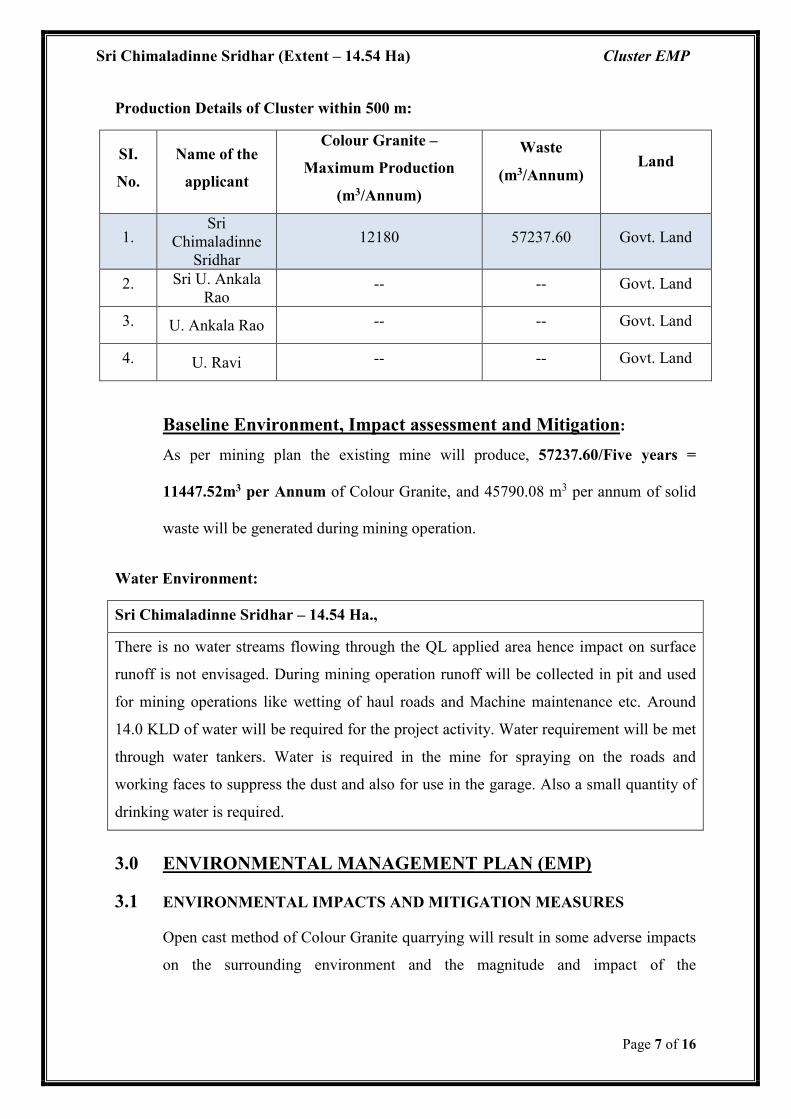
Sri Chimaladinne Sridhar (Extent – 14.54 Ha) Cluster EMP
Page 7 of 16
Production Details of Cluster within 500 m:
Baseline Environment, Impact assessment and Mitigation:
As per mining plan the existing mine will produce, 57237.60/Five years =
11447.52m3 per Annum of Colour Granite, and 45790.08 m3 per annum of solid
waste will be generated during mining operation.
Water Environment:
Sri Chimaladinne Sridhar – 14.54 Ha.,
There is no water streams flowing through the QL applied area hence impact on surface
runoff is not envisaged. During mining operation runoff will be collected in pit and used
for mining operations like wetting of haul roads and Machine maintenance etc. Around
14.0 KLD of water will be required for the project activity. Water requirement will be met
through water tankers. Water is required in the mine for spraying on the roads and
working faces to suppress the dust and also for use in the garage. Also a small quantity of
drinking water is required.
3.0 ENVIRONMENTAL MANAGEMENT PLAN (EMP)
3.1 ENVIRONMENTAL IMPACTS AND MITIGATION MEASURES
Open cast method of Colour Granite quarrying will result in some adverse impacts
on the surrounding environment and the magnitude and impact of the
SI.
No.
Name of the
applicant
Colour Granite –
Maximum Production
(m3/Annum)
Waste
(m3/Annum) Land
1. Sri
Chimaladinne Sridhar
12180 57237.60 Govt. Land
2. Sri U. Ankala Rao
-- -- Govt. Land
3. U. Ankala Rao -- -- Govt. Land
4. U. Ravi -- -- Govt. Land

Sri Chimaladinne Sridhar (Extent – 14.54 Ha) Cluster EMP
Page 8 of 16
Environmental pollution depends on method of mining, scale and concentration of
mining activity.
The following are the possible impacts while carrying out the quarrying activities.
Change in land use pattern
Waste generation
Impact on flora & fauna around quarry site.
Dust generation during quarrying and transportation
Silting of local water bodies due to soil erosion
Vibrations and impact on surroundings
Noise from quarrying operations.
However the above impacts can be mitigated with proper Environmental
Management Plan supported by adequate financial allocation.
3.2 WASTE GENERATION
Solid waste
About 42000 228,950.40 m3 will be generated during the ensuing five years period
with an average of 45790 m3/annum. The waste generated during the mining will
be dumped in the NW of the quarry lease applied area over an area of 2.250 Ha
with an average height of 10 m with 45 slope angle will be formed. A retaining
wall will be constructed around the dump for preventing the slanting of boulders.
Construction of garland drains, check dams will be done during the scheme period
of mining. The generated waste will be used for internal laying of roads and for
reclamation during mine closure.
Liquid Waste:
The liquid waste will be mainly run of rain water during monsoon months from the
Quarry face. The rain water draining the exposed rocks, fragment and dust in the
quarry is susceptible for incorporating the above as suspended solids into the
runoff. Seepage of such water down to the water table may cause pollution to the
ground water.

Sri Chimaladinne Sridhar (Extent – 14.54 Ha) Cluster EMP
Page 9 of 16
However there is no scope for run off rain waste, as the quarrying is above the
ground level. Only rain water will be collected in the lease low elevation portion
and the same will be used for greenbelt development, Dust depression.
Very small quantity of waste water will be generated from domestic consumption.
3.3 WASTE MANAGEMENT:
Solid waste:
About 228,950.40 m3 will be generated during the ensuing five years period with
an average of 45790 m3/annum. The waste generated during the mining will be
dumped in the NW of the quarry lease applied area over an area of 2.250 Ha with
an average height of 10 m with 45 slope angle will be formed. A retaining wall
will be constructed around the dump for preventing the slanting of boulders.
Construction of garland drains, check dams will be done during the scheme period
of mining. The generated waste will be used for internal laying of roads and for
reclamation during mine closure.
Liquid Waste:
Since the stone is free toxic minerals, there will not be any toxicity in the collected
rain water. As no chemical activity is involved in the quarry operations, treatment
of waste water is not required.
The rain water collected in the lease area lowest elevated portion and the same will
be used for sprinkling on roads for wetting and mitigate the dust pollution, wetting
and also some quantity will be used in Machinery maintance.
The small quantity of waste water generated from domestic consumption will be
sent to septic followed by a soak pit.
3.4 AIR POLLUTION
Dust Generation during quarrying operation and transportation
Dust will be generated during the quarry operation and handling of extracted stone,
which needs to be controlled to mitigate the pollution.
Hence dust will be generated during movement of transportation vehicles.
The following measures are proposed to mitigate pollution due to dust emissions.

Sri Chimaladinne Sridhar (Extent – 14.54 Ha) Cluster EMP
Page 10 of 16
Developing tree cover all along the periphery of the cluster of mines to reduce
dust impact
Sprinkling water at frequent intervals on the haul road to reduce dust
generation during plying of dumpers.
Periodic maintenance of haulage roads.
Wetting of road from quarry site to village road.
Spraying water over the ROM to be loaded to reduce dust generation during
loading operation.
Developing plantation along the mining leases cluster boundary and outside
roads to reduce spread of dust.
Green Belt Development Plan
Green belt is proposed to be developed in the buffer zone and other vacant area on
the bunds formed with top soil removed during the quarrying for mitigating the air
pollution due to fugitive dust emissions and the noise generated. Native species
like Neem, Mango, Pongamia, Eucalyptus etc will be planted.
3.5 IMPACT ON FLORA AND FAUNA
Vegetation in the area is moderate and is mainly in the form of thorny bushes,
small shrubs and some tress.
On the other hand green belt is proposed to be developed nearby areas.
Plant species like Neem, Mango & Eucalyptus will be used to develop green
belt.
Sapling consisting of Neem, Teak will be planted along the cluster buffer zone
and the top soil bunds. Ade foot of the hill.
3.6 VIBRATIONS AND IMPACT
No blasting will be practiced in the present existing mine for winning the mineral.
3.7 NOISE SOURCESS AND CONTROL MEASURES
The main sources of noise in mining activity are drilling, material handling
machinery, loading equipment, etc. The noise generated by the machinery and
vehicles as well as drilling operations will be minimal in the range of maximum
100dB.

Sri Chimaladinne Sridhar (Extent – 14.54 Ha) Cluster EMP
Page 11 of 16
Following mitigation measures would control noise pollution:
Maintaining the machinery in good condition by properly lubricating all
moving parts.
Providing earmuffs, ear plugs etc. to workers.
Using hydraulic drills for drilling.
Avoiding secondary blasting by using rock breakers.
Developing thick greenbelt around the cluster and along the approach roads
along the haulage roads.
Limiting the use of horns by the drivers of the vehicles.
3.8 RISK ASSESSMENT AND DISASTER MANAGEMENT PLAN
The major risks associated with quarrying are drilling risks, slope failure; and
filling of mine pit with rain water etc.
Risk analysis involves systematic identification and assessment of major damage
potential credible risk scenario to help management to make objective decisions on
hazards reduction or avoidance measures meeting regulatory requirements and
develop a structured management framework for an effective Disaster
Management Plan including emergency preparedness and contingency plans.
The planning for mitigating the emergency involves the reorganization of the
accident or possible assessing the consequences of such possible accident and
deciding on emergency planning/procedures in advance.
Both on site & off site that would be necessary to be implemented in the event of
emergency without any delay and confusion.
Proper bench design in mines and observing safety measures for transportation
storage, handling of material & fuels, etc, good maintenance of vehicles, roads, and
fire prevention measures shall go in preventing disaster/accidents.
Mining shall be carried out as per Regulation of the MMR 1961 & rules and
Regulations made there under applicable. The project in charge is having a
mobile/alternative communication for quick intimation of information if need
arises.

Sri Chimaladinne Sridhar (Extent – 14.54 Ha) Cluster EMP
Page 12 of 16
As the quarry operation is open cast, only possible risk is collapse of quarry/ pit
sides when people are working. For this proper bench slope will be maintained as
per the mining plan.
Mining operation will not be conducted during rainy days to avoid any collapse of
the overburden into mine pit.
.The quarry area is to be provided with good communication facilities like
telephone & mobile phone or wireless walky talks.
In case of any minor/major accidents within the mine, the same will be
communicated to the DGMS officials, the District Magistrate and Mines &
Geology officials concern and local authorities concern.
A vehicle is kept all the time at the quarry site for conveyance.
The workmen in the project are periodically trained at group vocational training
center for proper safety training as per the DGMS circulars.
At quarry level first aid facility is provided and person(s) will be shifted to nearest
major hospital.
A key person will be assigned duties and responsibilities for incident response and
emergency response at the quarry. At mine level first aid will provide and person
shall be shifted to nearby government hospital, having all basic facilities and
qualified medical officer who is capable of handling normal accidents.
In case of high risk accidents injured will be shifted by department vehicle to well
equipped hospitals at Tekkali which is about 8.15 kms from quarry site.
Quarry manager is the person responsible of the disaster management and he need
to be contacted in case of any disaster.
3.9 OCCUPATIONAL HEALTH & SAFETY
As a measure of occupational safety & health, the following facilities will be
provided to the workmen;
Providing Dust masks to prevent exposure to dust
Providing ear muffs/ear plugs for protecting from adverse affects of noise
Sri Chimaladinne Sridhar (Extent – 14.54 Ha) Cluster EMP
Page 13 of 16
Monitoring the health of the workers on regular basis Periodical Medical
Examination (PME) as per Mines Rules 1956.
Providing First Aid Facility at the work site.
Providing basic amenities to the quarry workmen.
3.10 BUDGETS FOR IMPELEMENTATION OF EMP
The Environmental Management plan involves:
Dust Suppression measures
Green Belt Development,
Undertaking periodical Environmental monitoring
Garland drains and retention wall
Providing personal protective equipments
3.11 ENVIRONMENTAL MONITORING PLAN
Monitoring Strategy
The monitoring of various environmental parameters is necessary and is a part of
the environmental protection measures. Monitoring is as important as that of
controlling, since the efficiency of control measures can only be determined by
monitoring.
A well-defined environmental monitoring program would be taken up to monitor
the ambient air to check whether the quality of air is maintained within the
permissible limits.
The following environmental attributes should be monitored:
Air pollution.
Noise pollution
Workers Health
Locations and frequency of monitoring should be as per the guide lines of APPCB
and MOEF.
AMBIENT AIR MONITORING
As per MoEF, there is a need to identify 3 ambient air stations at 1200 angle
keeping the main source in the center.

Sri Chimaladinne Sridhar (Extent – 14.54 Ha) Cluster EMP
Page 14 of 16
The ground level concentrations of suspended particulate (PM10 &PM2.5,), sulphur
dioxide SO2 and Nitrogen Oxide (NOX) in the ambient air outside the quarry
boundaries shall be monitored at regular intervals.
Any deviation from predicted /expected values shall be investigated and necessary
action be taken.
NOISE MONITORING
Noise levels in the work space environment will be monitored periodically. If any
deviation is observed necessary corruptive measures will be taken.
Monitoring noise levels is essential to assess the efficacy of maintenance of
schedules undertaken to reduce noise levels and noise protection measures.
A good quality sound pressure level meter is essential for this purpose.
This work can be handled by out sourcing the surveillance is for the benefit of the
workers will being and to keep track of machine wear.
WORKERS HEALTH
Regular health check up of workers will be carried out at the nearest hospital once
at least 5 Years as per the Rule 29 of Mines Rules 1955.
3.12 POST CLOSURE PLAN
Based on the estimation of mineable reserves in the mining plan, the quarrying
operations will be continued further reserves may be proved within the Mining
Plan period. At the end of the lease period after completion of the quarrying, the
resulting quarry pits would be developed as rainwater reservoirs after backfilling,
which act as sources for recharging the ground water levels in the area. Green belt
will be developed on the bunds of the quarry and along the benches, haulage roads,
etc.
4.0 CLUSTER EMP BUDGET:
The following budget is proposed for implementation of Environmental
Management Plan.
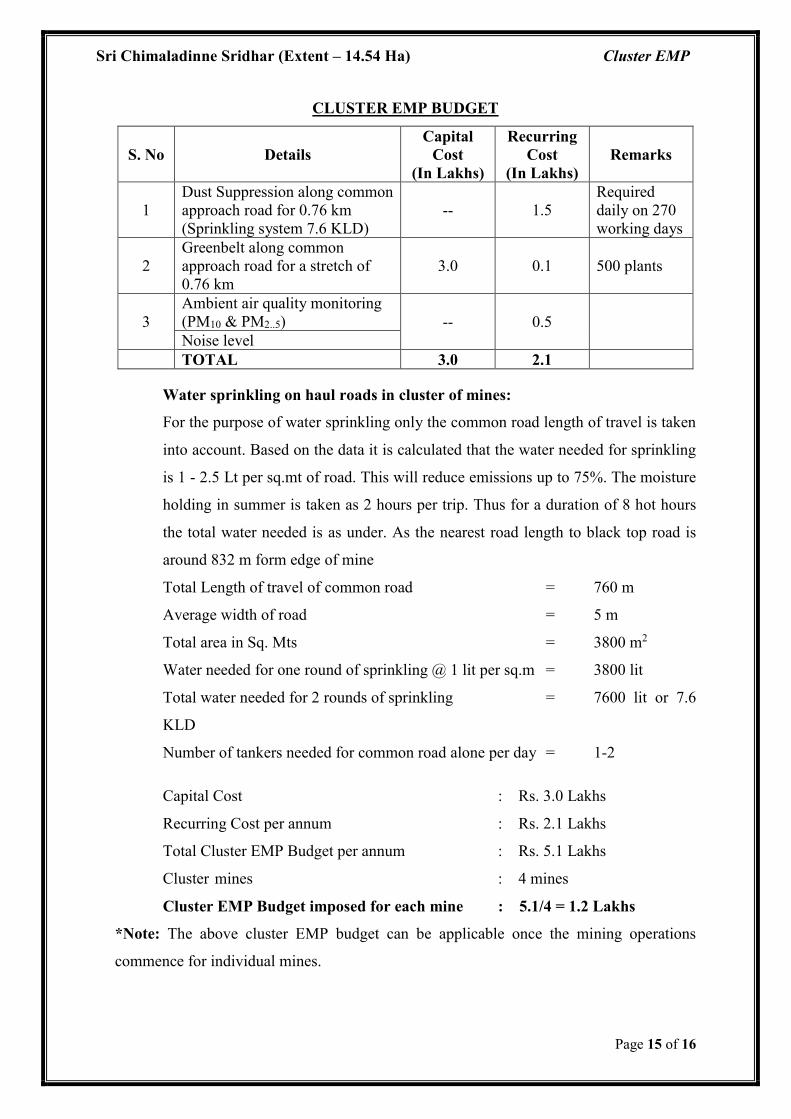
Sri Chimaladinne Sridhar (Extent – 14.54 Ha) Cluster EMP
Page 15 of 16
CLUSTER EMP BUDGET
S. No Details Capital
Cost (In Lakhs)
Recurring Cost
(In Lakhs) Remarks
1 Dust Suppression along common approach road for 0.76 km (Sprinkling system 7.6 KLD)
-- 1.5 Required daily on 270 working days
2 Greenbelt along common approach road for a stretch of 0.76 km
3.0 0.1 500 plants
3 Ambient air quality monitoring (PM10 & PM2..5) -- 0.5 Noise level
TOTAL 3.0 2.1
Water sprinkling on haul roads in cluster of mines:
For the purpose of water sprinkling only the common road length of travel is taken
into account. Based on the data it is calculated that the water needed for sprinkling
is 1 - 2.5 Lt per sq.mt of road. This will reduce emissions up to 75%. The moisture
holding in summer is taken as 2 hours per trip. Thus for a duration of 8 hot hours
the total water needed is as under. As the nearest road length to black top road is
around 832 m form edge of mine
Total Length of travel of common road = 760 m
Average width of road = 5 m
Total area in Sq. Mts = 3800 m2
Water needed for one round of sprinkling @ 1 lit per sq.m = 3800 lit
Total water needed for 2 rounds of sprinkling = 7600 lit or 7.6
KLD
Number of tankers needed for common road alone per day = 1-2
Capital Cost : Rs. 3.0 Lakhs
Recurring Cost per annum : Rs. 2.1 Lakhs
Total Cluster EMP Budget per annum : Rs. 5.1 Lakhs
Cluster mines : 4 mines
Cluster EMP Budget imposed for each mine : 5.1/4 = 1.2 Lakhs
*Note: The above cluster EMP budget can be applicable once the mining operations
commence for individual mines.

Sri Chimaladinne Sridhar (Extent – 14.54 Ha) Cluster EMP
Page 16 of 16
4.0 CONCLUSION:
The Colour Granite (Srikakulam Blue) quarrying project proposed by Sri
Chimaladinne Sridhar, Lessee Sri Chimaladinne Sridhar proposed to obtain a
mining lease for quarrying Colour Granite over an Extent of 14.54 Ha which is
located in Sy.No. 1 of Bellukola Village, Nandigama Mandal, Srikakulam District,
Andhra Pradesh will be environmental compatible to the surrounding and there
will be no long term environmental impact based on the existing environmental
scenario. The particulate matter getting airborne from the quarrying activity gets
dispersed in close proximity itself and settles down early. The noise levels due to
the proposed quarry activity are also not of a higher order that calls for immediate
corrective measures. There will be positive socio-economic front in the
surrounding region due to the proposed quarrying activity. The green belt
development would help in achieving ecological balance.
Environmental Management Plan (EMP) will help mitigate adverse impacts on the
environment. Where impacts occur, immediate action would be taken to reduce the
escalation of effects associated with these impacts.
Hence, it is requested that Environmental Clearance be accorded to the Colour
Granite (Srikakulam Blue) quarry project.