Exploiting heterogeneity:habitat use by cattle in dryland Zimbabwe
17
Journal of Arid Environments (1995) 29:221-237 Exploiting heterogeneity: habitat use by cattle in dryland Zimbabwe Ian Scoones Drylands and Sustainable Agriculture Programmes, International Institute for Environment and Development, 3 Endsleigh Street, London WC1H ODD, U.K. (Received 15June 1993, accepted 31 August 1993) Savanna landscapes in the dry communal areas of southern Zimbabwe are highly spatially heterogeneous. This year-long study explores the responses of cattle to variation in the availability of fodder in different habitat types situated in clay and sandy soil savanna zones. Low land habitat types of relatively small overall area, such as drainage lines, riverine strips and dambos, have the highest availability of herbaceous biomass per unit area in the dry season and in dry years in both savanna types. Browse is available in all habitats, but particularly where there is a low nnderstorey of shrub vegetation. Cattle feeding patterns respond to this heterogeneity of available fodder at the landscape level. Studies of foraging behaviour demonstrate that cattle show high levels of seasonal feeding preference for particular parts of the landscape, notably low lying 'key resource' habitat types with high levels of available herbaceous biomass. Cattle foraging strategies (through free grazing or herding) involve both concentration on these key resource areas and switching between a variety of habitats and forage sources, including browse. These strategies differ both between savanna types and seasons of the year. Planning for livestock management in the dry areas of Zimbabwe should take into account the importance of landscape heterogeneity in the design of grazing interventions. Policies also need to ensure that flexible movement responses to a highly spatially and temporally variable resource base are possible. Keywords: foraging behaviour; cattle movement; spatial and temporal hererogeneity; savanna vegetation; Zimbabwe Introduction Savanna vegetation is patterned at various spatial scales, from the micro-level to the landscape and region (Frost et al., 1986; Solbrig, 1991). At the regional level, gradients of rainfall and major changes in geomorphology occur resulting in changes in savanna vegetation over long distances (Cole, 1982; Breman & de Wit, 1983; Coughenour et al., 1990). At the landscape level, repeating catenary sequences of soil types occur across slopes (Milne, 1947; Morison et al., 1948; Walker, 1985). At the micro-level, a range of variation in slope, soil type and vegetation disturbance influences the heterogeneity of vegetation (Belsky, 1983, 1987; McNaughton, 1983, 1985). It is this enormous spatial variability of vegetation resources to which foraging herbivores must respond (Anderson & Herlocker, 1973; McNaughton & Georgiadis, 1986). 0140-1963/95/020221 + 17 $08-00/0 © 1995 AcademicPress Limited
Transcript of Exploiting heterogeneity:habitat use by cattle in dryland Zimbabwe
Journal of Arid Environments (1995) 29:221-237
Exploiting heterogeneity: habitat use by cattle in dryland Zimbabwe
Ian Scoones
Drylands and Sustainable Agriculture Programmes, International Institute for Environment and Development,
3 Endsleigh Street, London W C 1 H ODD, U.K.
(Received 15June 1993, accepted 31 August 1993)
Savanna landscapes in the dry communal areas of southern Zimbabwe are highly spatially heterogeneous. This year-long study explores the responses of cattle to variation in the availability of fodder in different habitat types situated in clay and sandy soil savanna zones. Low land habitat types of relatively small overall area, such as drainage lines, riverine strips and dambos, have the highest availability of herbaceous biomass per unit area in the dry season and in dry years in both savanna types. Browse is available in all habitats, but particularly where there is a low nnderstorey of shrub vegetation. Cattle feeding patterns respond to this heterogeneity of available fodder at the landscape level. Studies of foraging behaviour demonstrate that cattle show high levels of seasonal feeding preference for particular parts of the landscape, notably low lying 'key resource' habitat types with high levels of available herbaceous biomass. Cattle foraging strategies (through free grazing or herding) involve both concentration on these key resource areas and switching between a variety of habitats and forage sources, including browse. These strategies differ both between savanna types and seasons of the year. Planning for livestock management in the dry areas of Zimbabwe should take into account the importance of landscape heterogeneity in the design of grazing interventions. Policies also need to ensure that flexible movement responses to a highly spatially and temporally variable resource base are possible.
Keywords: foraging behaviour; cattle movement; spatial and temporal hererogeneity; savanna vegetation; Zimbabwe
Introduction
Savanna vegetation is patterned at various spatial scales, f rom the micro-level to the landscape and region (Frost et al., 1986; Solbrig, 1991). At the regional level, gradients of rainfall and major changes in geomorphology occur resulting in changes in savanna vegetation over long distances (Cole, 1982; Breman & de Wit, 1983; Coughenour et al., 1990). At the landscape level, repeating catenary sequences of soil types occur across slopes (Milne, 1947; Morison et al., 1948; Walker, 1985). At the micro-level, a range of variation in slope, soil type and vegetation disturbance influences the heterogeneity of vegetation (Belsky, 1983, 1987; McNaughton, 1983, 1985). I t is this enormous spatial variability of vegetation resources to which foraging herbivores must respond (Anderson & Herlocker, 1973; McNaughton & Georgiadis, 1986).
0140-1963/95/020221 + 17 $08-00/0 © 1995 Academic Press Limited

222 I. SCOONES
In addition to spatial variability in vegetation resources at these various levels, fodder resources vary in time. Within years seasonal variation in available biomass is extremely variable in savanna environments (Ruthe.rford, 1978; O'Connor, 1985), with episodic rainfall resulting in pulses of spatially disparate production in grassland areas. Similarly, rainfall variability between years also results in high levels of variability in available fodder for grazing herbivores (Bell, 1982; Deshmukh, 1984). The result is a temporally uncertain and spatially heterogenous fodder resource.
Flexible and opportunistic foraging strategies are a response to this type of spatial and temporal variability. Migratory movement is a characteristic response of both wildlife and pastoral livestock populations. Such movement may occur in response to regional rainfall gradients or plant nutrient and mineral content differences existing at a regional scale (Breman & DeWit, 1983; McNaughton, 1990). Resident herds replicate the more dramatic movements of migratory wildlife or transhumant pastoral herds at a more localised landscape scale, with movements down slopes to dry season grazing areas along drainage lines or in drainage sinks or transition zones. This is noted for both wildlife (Sinclair, 1977; Jarman & Sinclair, 1979; McNaughton, 1985) and livestock (Coppock et al . , 1986; Homewood et al . , 1987; Homewood & Rodgers, 1991) in African savannas.
Understanding the responses of livestock to heterogeneous vegetation resources is critical in the design of livestock management and development policies for Africa's drylands (Ellis & Swift, 1988; Behnke & Scoones, 1992). Too often spatial variation, at any scale, is ignored in livestock development planning and movement restrictions with grid- designed paddock systems are imposed. Such interventions are ill-suited to the spatial complexity of African rangeland systems, where flexible movements to spatially dispersed resources are key to livestock survival (Homewood & Lewis, 1987; Cousins, 1992). This type of flexibility is particularly important in times of drought, when making use of a heterogeneous vegetation resource base can reduce mortality or prevent the need for culling in both livestock (Homewood & Lewis, 1987; Scoones, 1990) and wildlife (Walker et al . , 1986) populations.
When considering the impact livestock or other herbivores have on the environment it is necessary to examine the details of habitat use patterns before assuming 'overstocking' or 'overgrazing' (Scoones, 1989; Homewood & Rodgers, 1991). Simplistic assessments of 'carrying capacity' that do not assess the complex spatial use of vegetation resources made by livestock have little utility when livestock make use of a diverse range of habitat types scattered across the savanna landscape (Abel & Blaikie, 1989; Scoones, 1993b).
This paper examines how cattle make use of the spatially heterogenous vegetation resource at the landscape scale in clay soil and sandy soil savanna in southern Zimbabwe. The paper provides details of a year-long study that examined differences in vegetation composition and available forage in different habitat types situated in different parts of the landscape and described the habitat use patterns of four herds of cattle and four flocks of goats in response to this spatial heterogeneity in the forage resource. The paper concludes with a discussion of the ecological and management implications of the findings.
Study area and methods
S tudy area
The study area was centred on Mototi ward in Mazvihwa communal area in southern Zimbabwe. This is a low potential agropastoral area with an economy based on a mix of dryland cropping, livestock keeping and off-farm income earning activities (Scoones, 1990). In Zvishavane town, the long-term (1923-91) average annual rainfall is 568 ram, with a coefficient of variation of 25%. The study area consists of two contrasting ecological zones-- sandy soil and clay soil savanna areas-- plus an intermediate area, the edge zone.
The sandy soil zone of the study area is associated with the Bungowa hills. The soils are
EXPLOITING HETEROGENEITY 223
derived from the weathering and eluviation of a group of ancient granite inselbergs. A recognisable catena is evident, starting from bare rock on the hill tops and moving through a sequence of sandy soil upland dominated by dry miombo vegetation (typified by Julbernadia globiflora (Benth.) and Brachystegia spiciformis (Benth.)) to treeless dambos in the valley bottom position (Ingrain, 1991; Watson, 1964). Upland soils are slightly acid, fairly coarse-grained sands with low clay content, containing a poor reserve of weatherable minerals and relatively high infiltration rates. Lower slope dambo soils have much higher clay fractions, higher plant-available nutrients and lower infiltration rates.
The clay soft zone of the study area is found in the Mazvihwa plains. Deep clay-rich softs are derived from basic doleritic dykes which intrude the underlying granitic geomorphology. Other softs in the plains include illuvial softs at the base of the granite hills of the sandy soil zone. These softs have relatively high clay content, high reserves of weatherable minerals, exchangeable bases and low infiltration rates. A catenary sequence can be identified in the clay soil zone also, with upper sequence softs supporting a mixed woodland dominated by Colophospermum mopane (Kirk ex Benth.) and lower lying areas along drainage lines and near pans having an Acacia tortilis (Forsk) and Combretum apiculatum (Sonder) dominated vegetation. Riverine vegetation exists in narrow strips along the major tributaries (Goldthorp, 1957).
Methods
The habitat classification used for the study was based on a local classification of resource types used by herders (Scoones, 1989). Local people distinguished two ecological zones and 11 habitat types. In the clay soil ecological zone these were: Acacia woodland, Mopane woodland, sodic patches, riverine areas, drainage lines, contour bunds and field areas. In the sandy soil ecological zone the identified habitat types were: miombo woodland, dambos, contour ridges and field areas.
Assessments of tree and grass species composition, estimates of available browse and grass standing crop measures were made in single 100-m transects set up in each habitat type. Quadrat sampling (50 cm × 50 cm) of herbaceous biomass and species composition was carried out along the transects randomly located within each habitat type, identified by farmers' classifications and sited using aerial photographs. Twenty randomly-selected quadrats along each transect were used to estimate the standing crop of herbaceous biomass in February 1987, August 1987 and March 1988. Clipped above-ground herbaceous biomass was oven-dried at 60°C (Gelbenken oven) until no further weight loss occurred and then weighed.
At the same transect sites, stem density and an indicator of available biomass of browse below 2"5 m by species was estimated using 100-m belt transects of variable width (10 m width for trees below 1 m in height and 20 m width for larger trees). The canopy volume, assuming cylindrical canopies, was used as the indicator of browse availability. I n addition, the species composition of both grasses and trees was collected at each transect site, with species dominance recorded in relation to the frequency of occurrence in each transect.
The availability of the different habitat types was assessed using 1985 aerial photographs of the area. The area of each habitat type within 2 km of each herd's kraal was used as an estimate of availability. This approximates to the average foraging radius for cattle in this area (Scoones, 1990). The availability of different habitat types changes between seasons, with restricted access to arable areas during the cropping season.
Four cattle herds were selected purposively to be representative of the different eco- logical zones. Two clay soft zone, one edge zone and one sandy soft zone herds were chosen. The home sites of these herds were thus situated on a transect stretching from the central sandy soil zone in the Bungowa hills, through an edge site to the centre of the Mazvihwa clay soil plains area and on to the edge of the clay plains adjacent to the Runde river.

224 I. SCOONES
A range of different animals were chosen for the cattle foraging study to reflect the age, sex and breed composition of the local herd. Each cattle herd was followed for a full day each month during the period November 1986 to November 1987. Cattle were followed from kraal release until the herd's return (approximately from 0600 h to 1800 h). Daylight activities were recorded with habitat position for four to five chosen animals in each herd being recorded every 15-30m in. Observation methods and recording intervals were chosen to be appropriate to the activity bout behaviour typical of cattle (Rollinson et al., 1956). No attempt was made to record night-time feeding which occurred at the close of the dry season when kraaling was abandoned for two herds. Data are based on 3423 observations of 17 cattle over the 12-month period.
The preferences of cattle for feeding in different habitat types was investigated by relating the feeding time spent in a patch to the overall availability of the habitat type (Pratt et al., 1986). Hunter 's index describes the feeding preference level (Hunter, 1960). The preference index Pi is:
Pi = % feeding time spent in habitat type x in seasony
% of total area as habitat type x available in seasony
The preference index (Pi) is > 1 when the habitat type if preferred; Pi = 1 when the area is used in proportion to its availability and Pi > 1 when the habitat type is used less than expected if animals were just choosing areas to feed in proportion to their availability.
Results
Vegetation species composition
Tables 1 and 2 show the results of the vegetation species composition transect studies for both clay soil and sandy soil savanna areas. Table 1 lists the top five tree species according to measures of stem density and indicates the contribution to estimated total browse volume for each of these species.
The vegetation in the clay soil areas is dominated by Colophospermum mopane in areas undisturbed by previous cultivation, with other associated species, notably Combretum apiculatum, in positions lower in the catena. In old field sites, Acacia tortilis dominates, while a unique vegetation association is found along riverine strips. Arable areas are generally cleared of woodland. However remaining root stocks can regenerate in fields that have not been destumped. Some trees are preferentially retained in fields for shade, fruit and soil improvement (Wilson, 1989) and along contour bunds small, heavily harvested trees exist (Abel et al., 1989). Within the clay soil zone sodic soil patches exist. These are areas where fine particle clays and minerals accumulate and a distinct vegetation of stunted Colophospermum mopane exists (Dye & Walker, 1980). Accumulations of salt occur in sodic areas which act as important salt licks for animals.
By contrast the sandy soil zone is characterized by a diverse miombo vegetation, with Brachystegia spiciformis and Julbernadia globiflora being key species. Browse volume measures are dominated by Grewia spp. which have a large canopy area close to the ground. Termite mounds are an important sub-habitat in this zone with a particular vegetation association. Dambo areas within this zone are generally treeless, but Ficus spp. and Terminalia sericea may be found on the fringes.
The grass species found in the transect sites in the two ecological zones are shown in Table 2. Grass species in the clay soil savanna area tend to be higher quality fodder species, with higher levels of crude protein content (Plowes, 1957; O'Connor, 1985). However there is a good degree of species overlap between sites and it is more site-specific factors, such as soil type, that affect forage quality than species composition (Plowes, 1957).

E X P L O I T I N G H E T E R O G E N E I T Y 225
,....a
t ~ ¢q
~ I O , ,
ii
~a
• ~ t-- ~.~- ~ ~ , ~ . ~ ~ ' ~ " ~2 ~,~'~
• "~ o ,
e~
II
226 I. SCOONES
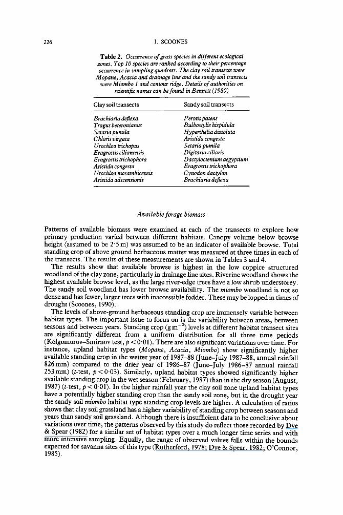
Table 2. Occurrence of grass species in different ecological zones. Top I0 species are ranked according to their percentage occurrence in sampling quadrats. The clay soil transects were
Mopane, Acacia and drainage line and the sandy soil transects were Miombo I and contour ridge. Details of authorities on
scientific names can be found in Bennett (1980)
Clay soil transects Sandy soil transects
Brachiaria deflexa Tragus beteronianus S etaria pumila C hloris virgata Urochloa trichopus Eragrostis cilianensls Eragrostis trichophora Aristida congesta Urochloa mosambicensis A ristida adscensionis
P erotis patens Bulbos¢ylis hispidula H yperthelia dissoluta Aristida congesta Setaria pumila Digitaria ciliaris Dactyloctenium aegyptium Eragrostis trichophora Cynodon dacCylon Brachiaria deflexa
Available forage biomass
Patterns of available biomass were examined at each of the transects to explore how primary production varied between different habitats. Canopy volume below browse height (assumed to be 2"5 m) was assumed to be an indicator of available browse. Total standing crop of above ground herbaceous matter was measured at three times in each of the transects. The results of these measurements are shown in Tables 3 and 4.
The results show that available browse is highest in the low coppice structured woodland of the clay zone, particularly in drainage line sites. Riverine woodland shows the highest available browse level, as the large river-edge trees have a low shrub understorey. The sandy soil woodland has lower browse availability. The miombo woodland is not so dense and has fewer, larger trees with inaccessible fodder. These may be lopped in times of drought (Scoones, 1990).
The levels of above-ground herbaceous standing crop are immensely variable between habitat types. The important issue to focus on is the variability between areas, between seasons and between years. Standing crop (gm -2) levels at different habitat transect sites are sigrtificanfly different from a uniform distribution for all three time periods (Kolgomorov-Smirnov test, p < 0"01). There are also significant variations over time. For instance, upland habitat types (Mopane, Acacia, Miombo) show significantly higher available standing crop in the wetter year of 1987-88 (June-July 1987-88, annual rainfall 826mm) compared to the drier year of 1986-87 (June-July 1986-87 annual rainfall 253 mm) (t-test, p < 0"03). Similarly, upland habitat types showed significantly higher available standing crop in the wet season (February, 1987) than in the dry season (August, 1987) (t-test, p < 0"01). In the higher rainfall year the clay soil zone upland habitat types have a potentially higher standing crop than the sandy soil zone, but in the drought year the sandy soil miombo habitat type standing crop levels are higher. A calculation of ratios shows that clay soil grassland has a higher variability of standing crop between seasons and years than sandy soil grassland. Although there is insufficient data to be conclusive about variations over time, the patterns observed by this study do reflect those recorded by Dye & Spear (1982) for a similar set of habitat types over a much longer time series and with more intensive sampling. Equally, the range of observed values fails within the bounds expected for savanna sites of this type (Rutherford, 1978; Dye & Spear, 1982; O'Connor, 1985).

EXPLOITING HETEROGENEITY 227
Table 3. Total tree stem density and browse volume in each of the vegetation transects
Browse volume Zone Transect Stems ha-1 m 3 ha-1
Clay Mopane 3580 4396 Acacia 1360 5528 Drainage 3800 6816 Riverine 2400 9415 Contour 800 651
Sand Miombo I 940 2860 Miombo 2 405 1540 Dambo 0 0
T h e s tand ing crop o f pa r t i cu la r lower s lope hab i ta t types (dra inage l ines, r iver ine s t r ips , dambos) were s ignif icant ly h igher than the up l and areas (Mopane, Acacia, Miombo) in the dry year and in the d ry season (t-test , p < 0"05). I f the rat io of s t and ing crop in the up l and habi ta t types to such areas is cons ide red , the signif icance of these lower s lope habi ta t s is unde r l ined . F o r ins tance, in the clay soil zone the rat io of the Mopane t ransec t s t and ing crop to that f rom the dra inage l ine was 1 : 9 in the wet season and 1 : 6 in the d ry season of 1987. In the sandy soil zone this cont ras t is even more accentua ted . T h e rat io o f rniornbo 2 t ransec t to the d a m b o t ransec t s t and ing crop was 1 : 17 in the wet season and 1 : 3 4 i n the d ry season o f 1987 (Tab le 4).
2 Table 4. Herbaceous above-ground standing crop measures (oven dry weight, g m- and S.E. in brackets) for each of the vegetation transects
February August March 1987 1987 1988 Ratio Ratio
Zone Transect (g m - l ) ( g m - t ) (gm-1) 1988/87 wet/dry
Clay
Sand
Mopane 14"7 4"8 69"9 4"7 3"0 (4"8) (1"4) (16"3)
Acacia 32-2 2"3 123"8 3"8 13"8 (5-9) (0"6) (15"2)
Riverine 50"7 5"3 216"6 4"3 9"5 (2"8) (0"6) (7"4)
Drainage 137"8 31 "4 100"6 0"7 4"4 (25"7) (9"11) (18"2)
Contour 325"6 44"8 500 ~ 1"5 7"7 (49"7) (10"I)
Miombo 1 49"9 20"6 110"8 2"2 2"4 (15"0) (3"2) (10"4)
Miombo 2 35"5 12"0 80 ~ 2"3 2"9 (8"4) (4"0)
Dambo 615"5 411" 1 1000 ~ 1"6 1"5 (93"4) (56"4)
Contour 213"8 115 "5 251 "7 1 "2 1 "4 (53"8) (45"7) (80"2)
Data gaps occurred due to the accidental destruction of collected samples prior to weighing. The visual estimate was carried out in the field during data collection. Visual estimates and actual measurements were highly correlated (p < 0"01), so the estimates are included here.
nd = no data; * = visual estimate.

228 I. SCOONES
Table 5. Percentage area of each habitat types within a 2 km radius of each herd home site
Clay 1 Clay 2 Edge Sand Habitat type (%) (%) (%) (%)
Upland 50"8 31"9 41"6 80"5 Arable 25-7 34"5 32"3 12"3 Contours 2"8 3'8 3"6 1"4 Drainage line 6"3 16"8 15"7 - - Home sites 8"0 5"4 5"8 1"0 Riverine 6"2 7"6 - - - - Dambo - - - - 1"0 4"8
Although small in total area (Table 5), these lower slope habitats are key resources for grazing, offsetting seasonal and interannual shortages in available herbaceous biomass in the extensive upland areas.
Areas of different habitat types
Table 5 shows the area of each habitat patch within a 2 km radius of each study herd's home site.
Clay site 1 has a reasonably extensive grazing area along the banks of the Runde river; these were previously cultivated lands and so the area is dominated by Acacia tortilis regrowth. This contrasts with clay site 2 which has had a history of arable encroachment, although the remaining woodland has never been completely cleared. Drainage lines criss- cross both areas, particularly clay site 2, where they drain into the Gwen'ombe river.
The edge zone site sits on the boundary between the sandy soil and clay soil zones. Most of the grazing land is in the hilly, sandy soil zone, although there are important drainage lines that flow from the hills into the clay plains. The dambo sites at the edge of the hilly area are key grazing resources for cattle in the edge zone. The sandy soil zone is a further 5 km into the hilly area. The mountainous nature of the area means that the amount of arable area is considerable reduced. Most agricultural activities are concentrated on dambo fringes in the valleys. The extensive area of upland grazing is not particularly productive; indeed large portions of it are bare, granite rock.
The availability of these habitat types varies seasonally, with arable areas, including contour bunds and some drainage lines, only used for grazing following the harvest. In calculations of seasonally-specific availability of grazing, the figures must be adjusted accordingly.
Taking into account both the information on seasonal habitat type availability and the data on estimated herbaceous standing crop, a better idea of the relative importance of different parts of the landscape emerges. In both wet seasons, upland grazing (from Acacia and C. mopane transect areas) would provide c. 85% of the total standing crop in the clay zone sites, if the transect data present in Table 4 is extrapolated. However this drops to 28% in the dry season, with total available standing crop being made up by lower slope drainage line and riverine grassland. By contrast, the sandy soil zone upland miombo woodland areas contribute much less to total available standing crop, with dambo grassland contributing c. 45% during the wet season and 66% in the dry season. This highlights the important contrasts both between ecological zones and between habitat types. It is thus relatively small key resource areas (often < 5% of total area) that make up a significant portion of available total herbaceous biomass.

EXPLOITING HETEROGENEITY 229
Seasonal patterns of habitat use by cattle
Seasonal patterns of habitat use are dependent on the availability of grazing resources through the year. Cropping in the arable area restricts grazing tliere between November and March, while the concentration of feeding time on particular habitat types or the switching from grazing to browsing depends on the availability of herbaceous forage at different times.
The year can be divided into three seasons that are distinguished by different forage resource use and management patterns: the cropping season (November to March), the early dry season (April to June) and the late dry season (July to October). Herding takes place in the cropping season and sometimes in the late dry season if cattle have to trek long distances for forage or water. The months that these seasons apply to will vary from year to year, depending on the year's pattern of rainfall. However for the period over which this study was carried out (November 1986 to November 1987), this division is appropriate.
Habitat use by clay soil zone herds
The clay soil zone herds spent a major proportion of the feeding time during the cropping season in the upland grazing area (26"2% and 42"9% of total feeding time for clay herds 1 and 2). Here there was a sparse covering of grass early in the season following the rains. However both herds complemented this with river bank grazing (25"4% and 41" 3% of total feeding time) where grazing was associated with drinking from pools. This became increasingly important as the season progressed. Clay herd 1 spent 42"3% of total feeding time in the drainage line running along the border of the arable block. This was largely under close supervision of adult herders early in the morning and late in the evening.
The early dry season was dominated for both herds by arable grazing - - both on the contour ridges (35"0% and 36"4% of total feeding time) and off crop residue remains (36"3% and 47"0% of total feeding time). The end of the dry season saw a variety of strategies employed by the clay soil herds. By this stage there was very little grass available in the upland areas and browse became an important component of feeding. The intense use of riverine grazing in the previous months had left them bare, depleting what, in other years, had been a critical dry season resource. Riverine grazing made up only 17% and 1"3% total feeding time for the two herds by the late dry season. The arable areas continued to be important feeding sites through the dry season (contours 22"6% and 27"3% of total feeding time) and fields (0% and 38"3%). Home sites were also important feeding areas for clay herd 1 (13"2%), as stored maize residue was fed to herds as the drought situation progressively worsened. In the clay herd 2 site the fodder situation became so bad that the herd was moved out of the area to a nearby hilly area in the sandy soil zone where upland grazing was still available.
Habitat use by edge zone herd
The edge zone herd was in the position of being able to switch between clay and sandy soil resources at different times of year, without having to transfer the whole herd. During the cropping season most feeding time was spent in the sandy soil upland grazing (45" 1%). This was extensive but of poor quality. This was complemented by drainage line grazing in the clay soil zone (36"0%) and dambo grazing in the sandy soil zone (7"5%).
The early dry season shows a wide range of habitat types used. The reliance on the contour bund grazing (33"3%) and crop residues (24" 1%) from fields is not shown as much in the edge zone. This is because the options are wider in this zone, with upland (13"0%) and drainage line (24" 1%) sites both being used in the early dry season. This pattern of diverse habitat patch use continues into the late dry season. At this time arable fields
230 I. SCOONES
(3"4%), drainage lines (8"5%), contour bunds (9"6%), dambos (13"0%) and home sites (19"8%) are all used to complement a return to extensive grazing in the upland areas of the sandy soil zone (45"8%). This upland grazing is sparse and inaccessible in the mountainous areas and animals were left free to graze day and night for some of this period.
Habitat use by sandy soil zone herds
The sandy soil herd showed a broadly similar pattern with the use of upland mountain grazing throughout the year (43"4% in the cropping season, 8"8% in the early dry season and 31" 3% in the late dry season). Of particular importance is the use of dambo grazing in both the cropping season and the late dry season (49"5% and 31"3%). In the early dry season, extensive use is made of field grazing (60%) and contour grass (28"9%).
Dry season water source use
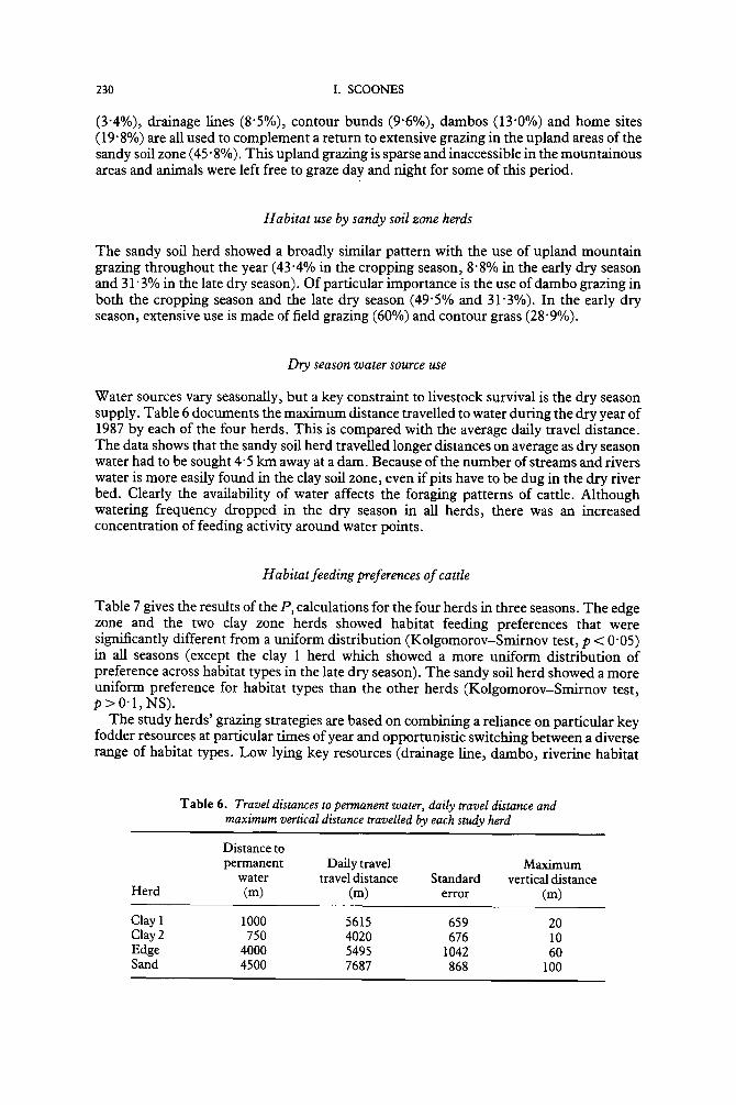
Water sources vary seasonally, but a key constraint to livestock survival is the dry season supply. Table 6 documents the maximum distance travelled to water during the dry year of 1987 by each of the four herds. This is compared with the average daily travel distance. The data shows that the sandy soil herd travelled longer distances on average as dry season water had to be sought 4"5 km away at a dam. Because of the number of streams and rivers water is more easily found in the clay soil zone, even if pits have to be dug in the dry river bed. Clearly the availability of water affects the foraging patterns of cattle. Although watering frequency dropped in the dry season in all herds, there was an increased concentration of feeding activity around water points.
Habitat feeding preferences o f cattle
Table 7 gives the results of the Pi calculations for the four herds in three seasons. The edge zone and the two clay zone herds showed habitat feeding preferences that were significantly different from a uniform distribution (Kolgomorov-Smirnov test, p < 0"05) in all seasons (except the clay 1 herd which showed a more uniform distribution of preference across habitat types in the late dry season). The sandy soil herd showed a more uniform preference for habitat types than the other herds (Kolgomorov-Smirnov test, p > 0 " I , N S ) .
The study herds' grazing strategies are based on combining a reliance on particular key fodder resources at particular times of year and opportunistic switching between a diverse range of habitat types. Low lying key resources (drainage line, dambo, riverine habitat
Table 6. Travel distances to permanent water, daily travel distance and maximum vertical distance travelled by each study herd
Distance to permanent Daily travel Maximum
water travel distance Standard vertical distance Herd (m) (m) error (m)
Clay1 1000 5615 659 20 Clay2 750 4020 676 10 Edge 4000 5495 1042 60 Sand 4500 7687 868 100

EXPLOITING HETEROGENEITY 231
Table 7. Hunter's preference indices (Pi) for each habitat and study herd for three seasons
RJveF
Herd Season Upland dambo Drainage Contour Home site Field
Clay 1 C 0'51 4"09 6'72 0"00 0"77 0'00 ED 0"00 0"00 3"97 12"24 0"47 1'41 LD 0"15 2"14 6'29 7"92 1'65 0"00
Clay2 C 1"34 5"43 0'33 1-04 0"00 0'18 ED 0"38 0"00 0"09 9"49 0"56 1"36 LD 0"73 0"17 0"58 7'12 0"00 I ' l l
Edge C 1'09 7"41 2"29 0"48 1"67 0"00 ED 0"31 0"00 1"53 6'69 0"96 1"03 LD 1"1 12"9 0"54 2"67 3"41 0"10
Sand C 0"54 10"31 1"47 5"05 0'00 ED 0"10 0"69 21"1 0"00 4"87 LD 0"39 6"53 18'03 3"61 0"73
C = Cropping Season (herded); ED = Early Dry Season (free grazing); LD = Late Dry Season (free grazing).
types) are particularly important . Feeding preferences for these habitat types were significantly greater than for upland grazing for all seasons and by all herds (t-test, p = 0"002). This pattern is typified by the clay soil herd 1 which showed high feeding preferences for the drainage line and riverine habitats. In all herds, contour bund grass in field areas is important throughout the dry season. Feeding preferences for contour bund grass are significantly higher than for all other habitat types during the dry season (t-test, p = 0"000). Opportunistic foraging is exemplified by the edge zone herd which makes use of a range of habitat types, both in the clay and sandy soil zones.
Patterns of habitat feeding preference (Table 7) can be related to spatial and temporal variation in available fodder resources (Tables 3 and 4). Table 8 shows that the availability of herbaceous biomass in each of the identified habitats is strongly correlated with the foraging preference index of cattle in all zones in all seasons. Low lying key resource
Table 8. Relationship between available herbaceous biomass per unit area (Table 4) and foraging preference
index (Table 7)for three seasons and three herds (Clay 1 and 2 and Sand) during 1987
Correlation Significance Season coefficient, r (1-tailed),p
Cropping season 0" 77 0"01 Early dry season 0" 53 0"04 Late dry season 0"45 0"08
Available herbaceous biomass was calculated for upland (average of Acacia and Mopane transects for clay soil zone and average of two miombo transects for sandy soil zone), riverineddambo, drainage and contour (see Table 4). This was related to preference indices for upland, river/dambo, drainage and contour for the two clay zone herds and the sandy soil herd during 1987. Home site and field areas were left from the calculations as no biomass estimates were made for these habitats. The cropping season period excluded the contour habitat type (not available for grazing) but otherwise used February 1987 measurements; the early dry season calculation used February 1987 measurements for contour grazing (protected due to cropping) and August 1987 dry season measurements for other areas. The late dry season calculation used the August 1987 biomass measurements.
232 I. SCOONES
habitats have higher herbaceous standing crop and often higher available browse, particularly in the dry season and in dry years. For this reason, cattle preferentially make use of these relatively small habitat types. Cattle's use of the landscape thus responds to this spatial heterogeneity of the resource base, particularly at times of fodder shortage.
Activity patterns of cattle
The activities of the cattle in the four study herds were recorded in order to investigate the seasonal patterns of grazing and browsing. Six activities were differentiated: grazing, browsing, crop residue feeding, moving, drinking and resting. Cattle spent between 55% and 12% of total daylight time feeding, with feeding times reduced during the late dry season. This was in part because of compensatory night-time feeding on crop residues but also as an energy conservation strategy. Total dayhght feeding times reported here are low by comparison with other studies of free ranging cattle (Arnold & Dudzinski, 1982).
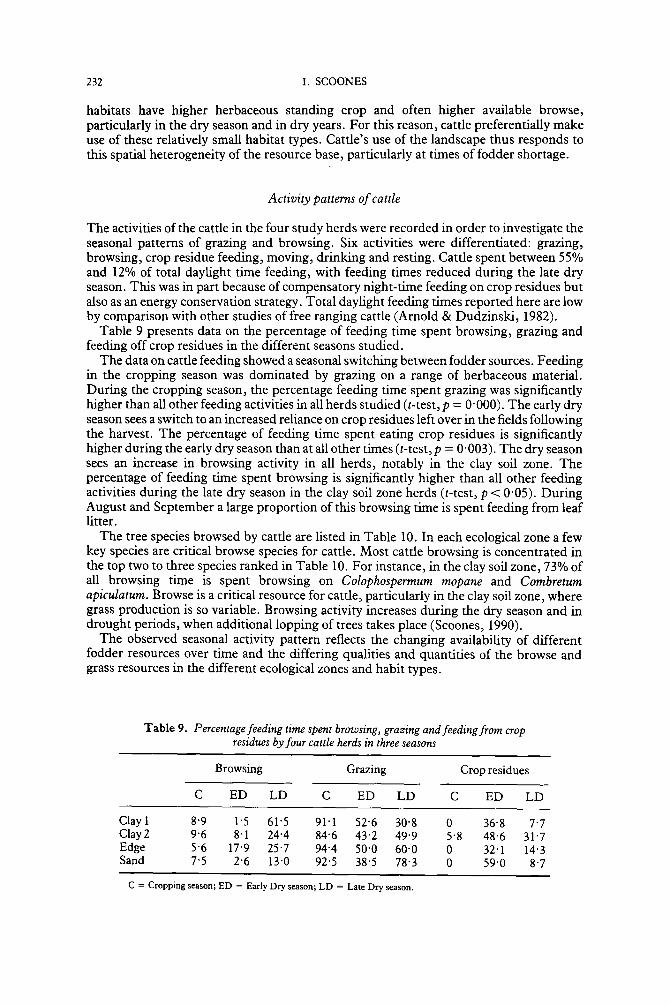
Table 9 presents data on the percentage of feeding time spent browsing, grazing and feeding off crop residues in the different seasons studied.
The data on cattle feeding showed a seasonal switching between fodder sources. Feeding in the cropping season was dominated by grazing on a range of herbaceous material. During the cropping season, the percentage feeding time spent grazing was significantly higher than all other feeding activities in all herds studied (t-test, p = 0"000). The early dry season sees a switch to an increased reliance on crop residues left over in the fields following the harvest. The percentage of feeding time spent eating crop residues is significantly higher during the early dry season than at all other times (t-test, p = 0"003). The dry season sees an increase in browsing activity in all herds, notably in the clay soil zone. The percentage of feeding time spent browsing is significantly higher than all other feeding activities during the late dry season in the clay soil zone herds (t-test, p < 0"05). During August and September a large proportion of this browsing time is spent feeding from leaf litter.
The tree species browsed by cattle are listed in Table 10. In each ecological zone a few key species are critical browse species for cattle. Most cattle browsing is concentrated in the top two to three species ranked in Table 10. For instance, in the clay soil zone, 73% of all browsing time is spent browsing on Colophospermum mopane and Combretum apiculatum. Browse is a critical resource for cattle, particularly in the clay soil zone, where grass production is so variable. Browsing activity increases during the dry season and in drought periods, when additional lopping of trees takes place (Scoones, 1990).
The observed seasonal activity pattern reflects the changing availability of different fodder resources over time and the differing qualities and quantities of the browse and grass resources in the different ecological zones and habit types.
Table 9. Percentage feeding time spent browsing, grazing and feeding from crop residues by four cattle herds in three seasons
Browsing Grazing Crop residues
C ED LD C ED LD C ED LD
Clay I 8"9 1"5 61"5 91" 1 5 2 " 6 30"8 0 36-8 7"7 Clay 2 9"6 8" 1 24"4 84"6 4 3 " 2 49"9 5"8 48"6 31 "7 Edge 5"6 17"9 25"7 94"4 5 0 " 0 60"0 0 32' 1 14'3 Sand 7"5 2"6 13"0 92"5 38'5 78-3 0 59"0 8"7
C = Cropping season; ED = Early Dry season; LD = Late Dry season.

EXPLOITING HETEROGENEITY 233
Table 10. Trees browsed by cattle in different ecological zones. Species are ranked in descending order in relation to the proportion
of browsing time spent feeding from a particular species
Clay soil zone Edge/Sandy soil zone
Colophospermum mopane Combretum apiculatum Grewia monticola Julbernadia globiflora S clerocaryea birrea Berchemia discolor Diospyros licyoides C ombr etum her oense Acacia tortilis Dichrostachys cinerea Lonchocarpus capassa Grewia flavescens Combretum imberbe
Julbernadia globiflora Bridelia mollis C olophospermum mopane Combretum apiculatum A fzelia quanzensis Grewia monticola Terminalia sericea Euphorbia sp. Lonchocarpus capassa Bauhinia galpinii Dichrostachys cinerea Acacia tortilis Boscia angustifolia
Discuss ion
Responding to spatial and temporal variability
The availability of forage biomass is highly variable between habitat types, seasons and years in the communal areas of southern Zimbabwe (Tables 1 to 4). Consideration of this spatial and temporal variability is important in understanding the foraging responses of cattle in the study area. Clay soil grassland has a higher variability of standing crop between years and seasons than sandy soil grassland (Dye & Spear, 1982; O'Connor, 1985), but this variability is dampened by the presence of browse and 'key resource' habitat types. Low lying habitat types (drainage lines, dambos and riverine strips) have higher available herbaceous standing crop per unit area in all seasons (Table 4). Vegetation quality tends also to be higher than surrounding dryland rangeland (Plowes, 1957; Scoones, 1990). This is particularly important during the dry season when cattle show high levels of feeding preference for these relatively small areas (Table 7).
These observations parallel others from livestock systems in Zimbabwe (Cousins, 1992) and in Kenya (Coppock et al. , 1986; Homewood & Rodgers, 1991), as well as from mixed wildlife systems in east Africa (Sinclair, 1977; McNaughton, 1985, McNaughton & Georgiadis, 1986).
Resource partitioning
Habitat use and feeding activity patterns respond to this spatial and temporal availability of available fodder resources (Tables 7 to 9). As upland forage resources decrease in quantity and quality following the rains, cattle foraging becomes increasingly concentrated on the lower catena 'key resources' of riverine strips and dambos. Arable area forage (grass on contour bunds and crop residues), that becomes available in the early dry season, delays the switching to these key resource habitats and the browse resource. As bulk feeders, cattle must maintain high forage intake levels. Opportunistic switching between different habitats or concentrated feeding, particularly in the dry season, on key resource patches are complementary foraging strategies employed by cattle.
Goats, by contrast, show a much more localized use of habitats (Scoones, 1990). Most

234 I. SCOONES
goat foraging is restricted to areas around homes; the use of the key resource areas used by cattle is thus limited. Physiological adaptation for selective feeding means goats are less constrained by the availability of grass biomass than cattle and can select browse, seed pods or fruits, as well as new green shoots in the wet season. Goats are thus able to survive in areas around homes which are heavily grazed and browsed and unable to support cattle feeding to any extent (Table 7).
The degree to which cattle and goats' foraging patterns overlap in a free ranging setting therefore appears quite limited. Competition for fodder resources may increase in the late dry season as animals congregate on the remaining lower slope key resources (often also the source of dry season water), but the degree to which goats have access to such sites is limited by predation risk and herding patterns. The option of cattle transhumance over longer distances in times of drought (Scoones, 1993b), adds further to the potential separation of resource niches between cattle and goats at times of fodder shortage.
These conclusions are supported by other studies of herbivore communities in Africa. This applies to both livestock (Donaldson, 1979; Mentis, 1980; Schwartz & Ellis, 1981) and mixed wildlife systems (Hirst, 1975; Jarman & Sinclair, 1979; Diamond, 1986) where, due to resource partitioning on the basis of selective habitat and food use, coexistence of different species is possible.
Implications for range management and livestock policy
Responses to spatial heterogeneity and temporal variability of vegetation resources at different spatial scales - - from micro-level patches to habitat types in the landscape to regional ecosystem differences in savanna type - - are critical to the understanding of livestock survival strategies. This interaction between animal behaviour, herd management and the vegetation resource is the background on which the fundamental processes of population dynamics are set. Without an insight into the spatial and temporal use of resources, questions of livestock population change and 'carrying capacity' cannot be understood. A critical issue for management thus becomes the maintenance of habitat patchiness to ensure the resilience of the system (Scoones, 1990, 1993a; Behnke & Scoones, 1992; Behnke et al., 1993). This has important consequences for range management and livestock policy.
If flexible access to a range of habitat resources is assured, higher populations of herbivores can be maintained in any area (Scoones, 1993a; Walker el al., 1986). Yet, over the past 50 years, conventional range management in Zimbabwe, as in many other places, has concentrated on the limitation of animal numbers (sometimes through destocking) to conservative stocking rates appropriate for commercial beef ranching operations, despite the economic need in communal areas to support high populations of cattle for a range of uses (Scoones, 1989; Gambiza, 1992). Similarly, grazing management interventions have emphasized paddocked, rotational grazing that restrict flexible movement options. Such interventions take little notice of local herd management practices that so carefully exploit existing patterns of spatial and temporal variability of fodder resources (Cousins, 1992). In the same way, mainstream range management has concentrated on the elimination of bush as a competitor to grass (Hill, 1984; Gambiza, 1992), rather than its management as a vital fodder resource, with fodder production that is often more stable between years and of higher quality than grass (Walker, 1980). Each of these interventions thus has acted to undermine locally adapted livestock management strategies and survival mechanisms.
An alternative approach to range management and livestock policy for the dry communal areas of Zimbabwe, and other similar areas in Africa, is suggested by the results of this study. This would emphasize the need to ensure opportunistic and flexible movement between resources at different scales. Changes in the availability and pattern of habitat types that sustain livestock production would be important areas for long term monitoring (Meltzer & Hastings, 1992). Higher priority would also be given to

EXPLOITING HETEROGENEITY 235
management investiment in key resources, including both key browse species and particular habitat patches (Behnke & Scoones, 1992; Westoby et al., 1989).
The research for this paper was carried out with the help of many peol~le in Mazvihwa communal area, notably my hosts the Mukamuri family and the case study herd and flock owners: M. Magwidi, S. Jimu, J. Madyakuseni and C. Chikudo. The work was carried out with support from M. Chaka- vanda, J. Madyakuseni, A. Mawere, B. Mukamuri, Z. Phiri, F. Shumba and K. Wilson. Funding for the research was received from the SERC/ESRC research body and the International Institute for Environment and Development. I would like to thank G. Conway and J. Beddington of Imperial College, University of London and B. Campbell and P. Frost of the University of Zimbabwe for their assistance during the research. Thanks are also due to Roy Behnke, Jon Moris, Nick Abel and Mark Stafford-Smith for commenting on an earlier version of this paper.
References
Abel, N. & Blaikie, P. (1989). Land degradation, stocking rates and conservation policies for the communal rangelands of Botswana and Zimbabwe. Land Degradation and Rehabilitation, 1: 101-123. (Also published as Pastoral Development Network, 29a (1990), London: Overseas Development Institute.)
Abel, N., Drinkwater, M., Ingram, J., Okafor, J. & Prinsley, R. (1989). Agroforestry for Shurugwi, Zimbabwe. Report of an Appraisal Excercisse for Agroforestry Research and Extension. Technical Paper, 277. London: Commonwealth Science Council. 229pp.
Anderson, G. & Herlocker, D. (1973). Soil factors affecting the distribution of the vegetation types and their utilisation by wild animals in Ngorongoro crater, Tanzania. Journal of Ecology, 61: 627-652.
Arnold, G. & Dudzinski, M. (1978). Ethology of Free Ranging Animals. Amsterdam: Elsevier. 198pp.
Behnke, R., Scoones, I. & Kerven, C. (Eds) (1993). Range Ecology at Disequilibrium. New models of natural variability and pastoral adaptation in African savannas. London: Overseas Development Institute. 248pp.
Behnke, R. & Scoones, I. (1992). Rethinking range ecology: implications for rangeland management in Africa. Drylands Issues Paper, 33. London: International Institute for Environment and Development. 46pp.
Belsky, A. (1983). Small scale pattern in grassland communities of the Serengeti National Park, Tanzania. Vegetatio, 55: 141-155.
Belsky, A. (1987). Revegetation of natural and human caused disturbance in the Serengeti National Park, Tanzania. Vegetatio, 70: 51-60.
Bell, R. H. V. (1982). The effect of soil nutrient availability on community structure in African ecosystems. In: Huntley, B. J. & Walker, B. H. (Eds), Ecology ofTropicalSavannas, pp. 193-216. Berlin: Springer-Verlag. 669pp.
Bennett, K. (1990). Keys to Zimbabwean grass species. Kirkia, I1: 169-286. Breman, H. & de Wit, C. (1983). Rangeland productivity and exploitation in the Sahel Science, 221:
1341-1347. Coates-Palgrave, K. (1984). Trees of Southern Africa. (2nd Edn). Cape Town: C. Struik. 585pp. Cole, M. (1982). The influence of soils, geomorphology and geology on the distribution of plant
communities in savanna ecosystems. In: Huntley, B. & Walker, B. (Eds), Ecology of Tropical Savannas, pp. 145-174. Berlin" Springer-Verlag. 669pp.
Coppock, D. L., Ellis, J. E. & Swift, D. M. (1986). Livestock feeding ecology and resource utilization in a nomadic pastoral ecosystem. Journal of Applied Ecology, 23: 585-583.
Coughenour, M., Coppock, D. L. & Ellis, J. (1990). Herbaceous forage availability in an add pastoral region of Kenya: importance of topographic and rainfall gradients. Journal of Arid Environments, 19: 147-159.
Cousins, B. (1992). Managing Communal Rangeland in Zimbabwe: Experiences and lessons. London: Commonwealth Secretariat. 154pp.
Deshmukh, I. K. (1984). A common relationship between precipitation and grassland peak biomass for east and southern Africa. Aft'can Journal of Ecology, 22: 181-186.
Diamond, J. (1986). Carnivore dominance and herbivore coexistence in Africa. Naturej 320:112.
236 I. SCOONES
Donaldson, C. H. (1979). Goats and/or cattle on Mopani veld. Proceedings of the Grassland Society of Southern Africa, 14:119-123.
Dye, P. J. & Spear, P. T. (1982). The effects of bush clearing and rainfall on grass yield and composition in S W Zimbabwe. Zimbabwe Journal of Agricultural Research, 20:103-118.
Dye, P. & Walker, B. (1980). Vegetation-environment relations on sodic soils of Zimbabwe- Rhodesia. Journal of Ecology, 68: 589-606.
Ellis, J. & Swift, D. (1988). Stability of African pastoral ecosystems: alternate paradigms and implications of development. Journal of Range Management, 41:450-459.
Frost, P., Manault, J., Walker, B., Medina, E., Solbrig, O. & Swift, M. (1986). Responses of savannas to stress and disturbance: a proposal for a collaborative programme of research. Report of IUBS Working Group on Decade of the Tropics Programme/Tropical Savanna Ecosystems. Biology International. Paris: International Union for the Biological Sciences. 82pp.
Gambiza, J. (1992). Rangeland Management Research in Zimbabwe: A review. London: Commonwealth Secretariat. 50pp.
Goldthorp, G. (1957). The ecology and land-use of the Belingwe-Shabani Intensive Conservation Area. Rhodesian Agriculture Journal, 54: 402-437.
Hill, J. (1984). Communal agriculture in Zimbabwe: present vegetation conditions. Zimbabwe Science News, 18: 50-52.
Hirst, S. M. (1975). Ungulate-habitat relationships in a South Africa woodland-savanna ecosystem. Wildlife Monographs, 44: 1-58.
Homewood, K. & Lewis, J. (1987). Impact of drought on pastoral livestock in Baringo, Kenya, 1983-1985. Journal of Applied Ecology, 24:615-631.
Homewood, K. & Rodgers, W. (1991). Maasailand Ecology. Pastoralist development and wildlife conservation in Ngorongoro, Tanzania. Cambridge: Cambridge University Press. 298pp.
Homewood, K., Rodgers, W. & Arhem, K. (1987). Ecology of pastoralism in Ngorongoro Conservation Area, Tanzania. Journal of Agricultural Science (Cambridge), 108: 47-72.
Hunter, R. F. (1960). Hill sheep and their pasture: a study of sheep grazing in South East Scotland. Ecology, 50: 651-680.
Ingram, J. (1991). Soil and water processes. In: Scoones, I. (Ed.), Wetlands in Drylands: The agroecology of savanna systems in Africa, Part 2. London: International Institute for Environment and Development. 69pp.
Jarman, P. & Sinclair, A. (1979). Feeding strategy and the pattern of resource partitioning in ungulates. In: A. Sincalir & M. Norton-Griffiths (Eds), Serengeti: Dynamics of an Ecosystem. Chicago: University of Chicago Press. 389pp.
McNaughton, S. (1983). Serengeti grassland ecology: the role of composite environmental factors and contigency in community organisation. Ecological Monographs, 53: 291-320.
McNaughton, S. (1985). The ecology of a grazing ecosystem: the Serengeti. Ecological Monographs, 55: 259-294.
McNaughton, S. (1990). Mineral nutrition and seasonal movement of African migratory tmgulates. Nature, 345: 613-615.
McNaughton, S. & Georgiadis, N. J. (1986). Ecology of African grazing and browsing mammals. Annual Review of Ecology and Systematics, 17: 39-65.
Meltzer, M. & Hastings, H. (1992). The use of fractals to assess the ecological impact of increased cattle population: case study from the Runde Communal Land, Zimbabwe. Journal of Applied Ecology, 29: 635-646.
Mentis, M. T. (1980). The effect of animal size and adaptation on defoliation, selective defoliation and production and reid condition. Proceedings of the Grassland Society of Southern Africa, 15: 147-151.
Milne, G. (1947). A soil reconnaissance journey through parts of Tanganyika territory. Journal of Ecology, 35: 192-265.
Morison, C., Hoyle, A. & Hope-Simpson, J. (1948). Tropical soil vegetation catenas and mosaics: a study in south western part of Anglo-Egyptian Sudan. Journal of Ecology, 36: 1-48.
O'Connor, T. G. (1985). A synthesis of field experiments concerning the grass layer in the savanna regions of southern Africa. South African National Scientific Programme Report, 114. Pretoria: CSIR. 126pp.
Plowes, D. (1957). The seasonal variation in crude protein in 20 common veld grasses at Matopos, Southern Rhodesia. Rhodesian Agricultural Journal, 54: 33-55.
Pratt, R., Putman, R., Ekins, J. & Edwards, P. (1986). Use of habitat by free-ranging cattle and ponies in the New Forest, Southern England. Journal of Applied Ecology, 23: 539-557.

EXPLOITING HETEROGENEITY 237
RoUinson, D., Harker, K., Taylor, J. & Leech, F. (1956) Studies on the habits on zebu cattle, IV: Errors associated with recording techniques. Journal of Agricuhural Science (Cambridge), 47: 1-5.
Rutherford, M. C. (1978). Primary production ecology in southern Africa. MonographiaeBiologicae, 31: 623-4559.
Schwartz, C. & Ellis, J. (1981). Feeding ecology and niche separation in some native and domestic ungulates on the shortgrass prairie. Journal of Applied Ecology, 18: 343-353.
Scoones, I. (1989). Economic and ecological carrying capacity: implications for livestock development in Zimbabwe's communal areas. Pastoral Development Network, 27b. London: Overseas Development Institute. 26pp.
Scoones, I. (1990). Livestock Populations and the Household Economy: A Case Study from Southern Zimbabwe. Ph.D. thesis, University of London. 577pp.
Scoones, I. (1993a). Why are there so many animals? Cattle population dynamics in the communal areas of Zimbabwe. In: Behnke, R., Scoones, I. & Kerven, C. (Eds), Range Ecology at Disequilibrium. New Models of Natural Variability and Pastoral Adaptation in African Savannas, pp. 62-76. London: Overseas Development Institute. 248pp.
Scoones, I. (1993b). Coping with drought: responses of herders and livestock in contrasting savanna environments in southern Zimbabwe. Human Ecology, 20:31-52.
Sinclair, A. (1977). The African Buffalo: A study of resource limitation. Chicago: Chicago University Press. 389pp.
Solbrig, O. (1991). Savanna modelling for global change. Biology International, 24, Paris: International Union for Biological Sciences. 26pp.
Walker, B. (1980). A review of browse and its role in livestock production in southern Africa. In: Le Hou6rou, H. (Ed.), Browse in Africa, pp. 7-22. Addis Ababa: International Livestock Centre for Africa. 491pp.
Walker, B. (1985). Structure and function of savannas: an overview. In: Tothill, J. & Mott, J. (Eds), Management of the WorM's Savannas, pp. 83-91. Canberra: Australian Academy of Sciences. 379pp.
Walker, B., Enslie, R., Owen-Smith, R. & Scholes, R. (1986). To cull or not to cull: lessons from an African drought. Journal of Applied Ecology, 24:381-402.
Watson, J. (1964). A soil catena on granite in Southern Rhodesia. I - Field Observations. II - Analytical data. Journal of Soil Science, 15: 235-257.
Westoby, M., Walker, B. & Noy-Meir, I. (1989). Opportunistic management for rangelands not at equilibrium. Journal of Range Management, 42: 266-274.
Wilson, K. (1989). Trees in fields in southern Zimbabwe. Journal of Southern African Studies, 15: 1-15.