Expert Witness Statement - Amazon AWS
80
Expert Witness Statement 0B2B3BCrib Point Gas Import Jetty and Crib Point-Pakenham Gas Pipeline Project 2 October 2020 Cardno i Expert Witness Statement Crib Point Gas Import Jetty and Crib Point-Pakenham Gas Pipeline Project AWE200093 Marine Biodiversity & Shorebirds Prepared for Harwood Andrews 2 October 2020
-
Upload
khangminh22 -
Category
Documents
-
view
1 -
download
0
Transcript of Expert Witness Statement - Amazon AWS

Expert Witness Statement 0B2B3BCrib Point Gas Import Jetty and Crib Point-Pakenham Gas Pipeline Project
2 October 2020 Cardno i
Expert Witness Statement
Crib Point Gas Import Jetty and Crib Point-Pakenham Gas Pipeline Project
AWE200093 Marine Biodiversity & Shorebirds
Prepared for Harwood Andrews
2 October 2020

© Cardno. Copyright in the whole and every part of this document belongs to Cardno and may not be used, sold, transferred, copied or reproduced in whole or in part in any manner or form or in or on any media to any person other than by agreement with Cardno.
AWE200093 Marine Biodiversity & Shorebirds | 2 October 2020 ii
Contact Information Document Information
Cardno (NSW/ACT) Pty Ltd ABN 95 001 145 035
Level 9 - The Forum
203 Pacific Highway
St Leonards NSW 2065
Australia
www.cardno.com
Phone +61 2 9496 7700
Fax +61 2 9439 5170
Prepared for
Project Name
File Reference
Job Reference
Date
Version Number
Dr. Craig Blount
Senior Principal
Effective Date
Harwood Andrews
Crib Point Gas Import
Jetty and Crib Point-
Pakenham Gas Pipeline
Project
AWE200093_Expert
witness report_marine
biodiversity&shorebirds
2_10_2020 Rev0
AWE200093 Marine
Biodiversity & Shorebirds
2 October 2020
Rev 0
2/10/2020
Dr. Marcus Lincoln Smith
Senior Principal
Document History Version Effective Date Description of
Revision Prepared by
V1 28 Sept 2020 For internal review
Craig Blount & Marcus Lincoln Smith
Rev A 1 Oct 2020 For issue Craig Blount & Marcus Lincoln Smith
Rev 0 2 Oct 2020 For issue Craig Blount & Marcus Lincoln Smith

AWE200093 Marine Biodiversity & Shorebirds | 2 October 2020 iii
Table of Contents
1 Scope of this Statement 1 2 Details of Experts and Declaration 3
2.1 Names and Addresses 3 3 Approach to this Expert Witness Statement 7
3.1 Key Issue 1: Limitations to data 7 3.2 Key Issue 2: EES approach to identification of hazards, risk and impact
assessment 11 3.3 Key Issue 3: Cumulative impacts 13 3.4 Key Issue 4: Consideration of alternatives, mitigation and management 14 3.5 Key Issue 5: Ramsar and threatened/migratory shorebirds 17 3.6 Other Issues 20 3.7 Relevance of Issues to Councils’ Municipal Areas 21 3.8 Consideration of Responses Provided by Ashurst, 28-9-20 21
4 Summary 26 5 References 27
Appendices
Appendix A EES Scoping Requirements Appendix B CVs for Expert witnesses Appendix C Reviewed Risk Assessment
AWE200093 Marine Biodiversity & Shorebirds | 2 October 2020 1
1 Scope of this Statement
In letters dated 10 July 2020 and 27 August 2020, Harwood Andrew lawyers instructed Drs. Craig Blount and Marcus Lincoln Smith to prepare an expert witness report on behalf of Mornington Peninsula Shire Council on opinions on the following matters, as relevant to Councils’ municipal area and the experts’ areas of expertise (marine biodiversity and shorebirds):
a. Does the EES adequately document the investigation, avoidance and minimisation of potential environmental effects (marine biodiversity and shorebirds), of the Proposal and relevant alternatives, as well as associated environmental mitigation and management measures? If not, why not?
b. Do you agree with the EES assessment of the potential environmental effects of the Project, their significance and acceptability having regard to the draft evaluation objectives in the EES scoping requirements, relevant policy, legislation, best practice, and the principles and objectives of “ecologically sustainable development”? If not, why not?
c. Are there any specific measures or changes (including to the design or management of the Project via the draft Amendment, works approval and environmental management framework) you recommend to avoid, mitigate or manage the environmental effects of the Project within acceptable limits having regard to the draft evaluation objectives in the C, relevant policy, legislation, best practice, and the principles and objectives of “ecologically sustainable development”?
d. If you do recommend such measures, then to the extent that it is within your expertise to do so, please provide you opinion on whether or not such measures are feasible.
The expert witness statement must:
a. Comply with Planning Panels Guide to expert evidence (DOCX, 81.8 KB), April 2019;
b. Provide a summary of key issues, opinions and recommendations.
We have also been instructed to review other relevant expert witness statements and other nominated material given below and to include coverage of issues potentially related to Bass Coast Shire Council’s municipal area.
Additional material reviewed for this expert witness statement
Expert Witness Statement of Scott Selwyn Chidgey (Marine Biodiversity Impact Assessment). Prepared for: Ashurst and Hall & Wilcox Lawyers, September 2020.
Expert Witness Statement of Ian Wallis (Hydrodynamic and Water Quality Issues). Prepared for: Ashurst and Hall & Wilcox Lawyers, September 2020.
Expert Witness Statement of Brett Lane (Terrestrial and Freshwater Biodiversity Impacts). Prepared for: Ashurst and Hall & Wilcox Lawyers, 25 September 2020.
Ashurst and Hall & Wilcox Lawyers responses to letter requests by Harwood Andrews, 28 September 2020. 1 The draft evaluation objectives in the Scoping requirements for the Gas Import Jetty and Pipeline Project Environmental Effects Statement (hereafter referred to as the ‘EES scoping requirements’)
AWE200093 Marine Biodiversity & Shorebirds | 2 October 2020 2
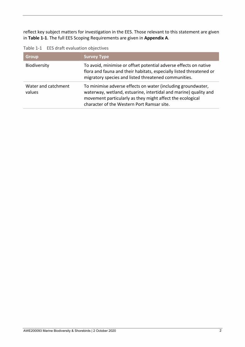
reflect key subject matters for investigation in the EES. Those relevant to this statement are given in Table 1-1. The full EES Scoping Requirements are given in Appendix A.
Table 1-1 EES draft evaluation objectives
Group Survey Type
Biodiversity To avoid, minimise or offset potential adverse effects on native flora and fauna and their habitats, especially listed threatened or migratory species and listed threatened communities.
Water and catchment values
To minimise adverse effects on water (including groundwater, waterway, wetland, estuarine, intertidal and marine) quality and movement particularly as they might affect the ecological character of the Western Port Ramsar site.

AWE200093 Marine Biodiversity & Shorebirds | 2 October 2020 3
2 Details of Experts and Declaration
2.1 Names and Addresses This expert witness statement was prepared jointly by Dr Craig Blount and Dr Marcus Lincoln Smith (CVs are given in Appendix B).
2.1.1 Dr Craig Blount
2.1.1.1 Address.
Level 9, The Forum, 203 Pacific Highway, St Leonards, NSW, 2065
2.1.1.2 Qualifications
> Bachelor of Science (Hons) – James Cook University of North Queensland
> Graduate Diploma in Industrial Maths and Computing – Charles Sturt University
> Doctor of Philosophy – Sydney University
2.1.1.3 Experience and Area of Expertise
Craig Blount has 30 years of experience in marine ecological research and consulting for government and private industry and has excellent analytical, presentation, reporting and interpretive skills. He has participated in Expert Witness Training given by the University of NSW. His area of expertise is in the design, implementation and management of marine, estuarine and freshwater ecological investigations. He has undertaken many ecological investigations that have supported government or private clients plan for, or construct urban developments, marinas, port facilities, oil and gas facilities, fisheries, waste water disposal and other activities. These studies have included investigations of various biota and habitats associated with infrastructure and how to assess the potential for ecological impact and, where present, how to mitigate these. Craig has an expert understanding of how to interpret the level of an ecological impact that takes into consideration its scale, severity and longevity and whether it is within the range of change that could be expected to occur naturally. Craig has been the leading investigator of two Environmental Impacts Statements (EISs) for large developments, the lead author of specialist investigations for many EIS’s and is an experienced peer reviewer. As a result of his work, Craig has a good understanding of the process of environmental impact assessment, and what is considered to be best practice and fit for purpose.
Craig has written numerous reports and publications about nearshore marine habitats and biota such as intertidal flats, seagrass, saltmarsh, shorebird roosting and foraging areas and shallow and deep subtidal soft sediment or open water areas. Some of the more relevant and recent reports or publications are given below.
Blount, C, Bennett, R and Lincoln Smith, M. (2017). Managing Sensitive Habitats Adjacent to the Port Botany Expansion, Proceedings of the Coasts & Ports 2017 Conference – Cairns, 21-23 June 2017.
The Penrhyn Estuary Habitat Enhancement Project (PEHEP), implemented by the Port Authority of New South Wales (NSW) is one of the most ambitious estuarine habitat rehabilitation projects in NSW. To compensate for the port expansion works completed in 2011, which reclaimed part of Botany Bay and partially enclosed the adjacent Penrhyn Estuary, the PEHEP aimed to rehabilitate and expand Penrhyn Estuary’s ecologically important intertidal flat, saltmarsh, shorebird and seagrass habitats. The Estuary is known

AWE200093 Marine Biodiversity & Shorebirds | 2 October 2020 4
as an important roosting and feeding area for migratory shorebirds. Rehabilitation involved a hybrid approach whereby some degraded habitat was restored while some other areas were created and/or expanded. Intertidal sand/mud flats and saltmarsh were expanded for shorebird feeding, islands were created for roosting and a lookout and bird hide constructed for the community. New seagrass habitat was created and directly affected Posidonia australis (a threatened seagrass) was transplanted to other areas in Botany Bay. A key challenge was to determine the appropriate levels (relative to tidal range) and features that would maximise the functionality of newly created habitats. Numerical modelling was used to develop a design engineered to maintain water quality by facilitating tidal flushing and mitigating contamination from groundwater and industrial/urban inputs under transient and ambient conditions. The project had maintenance built-in to avoid unwanted encroachment by mangroves, weeds, bird disturbance by predators, noise and light. Another challenge was ensuring the PEHEP had suitable means of determining its success or failure. Cardno and the Port Authority of NSW designed and implemented a long-term, ecological monitoring program from 2012 - 2017 to assess the success of the PEHEP. This included the development of targets against which key indicators such as shorebird abundance, seagrass and saltmarsh condition and water quality were assessed through quantitative field investigations. Results to date demonstrate that many of the key indicators have been met or show a positive trend, although the numbers of shorebirds have not yet reached target pre-construction levels. The monitoring program is currently under review to determine whether there is a need for new mitigation or ameliorative measures towards meeting PEHEP targets in the longer term. Overall, the PEHEP is considered a useful model for how ports can coexist with important natural habitats with the combined aid of engineering and ecological solutions.
See also https://www.portauthoritynsw.com.au/sustainability-and-environment/penrhyn-estuary-rehabilitation/
Blount, C, and Zhang, D. (2020). Western Harbour Tunnel and Warringah Freeway Upgrade EIS Appendix T. Technical working paper: Marine ecology January 2020.
The Western Harbour Tunnel and Beaches Link is a NSW Government initiative to provide additional road network capacity across Sydney Harbour and to improve connectivity with Sydney’s northern beaches. A major part of the works will be a crossing of Sydney Harbour that would involve placing immersed tube tunnels on a dredged trench on the sea floor. This report was prepared to support the environmental impact statement for the project and has been completed to assess the potential impacts of the project on receiving marine habitats and biota. This report assesses marine biodiversity values related to the project in accordance with relevant guidelines and scoping requirements for the EIS.
See also https://majorprojects.planningportal.nsw.gov.au/prweb/PRRestService/mp/01/getContent?AttachRef=SSI-8863%2120200116T053258.775%20GMT
AWE200093 Marine Biodiversity & Shorebirds | 2 October 2020 5
2.1.1.4 Declaration
“I have made all the enquiries that I believe are desirable and appropriate and no matters of significance which I regard as relevant have to my knowledge been withheld from the Panel.”
Your sincerely
Craig Blount
2.1.2 Dr Marcus Lincoln Smith
2.1.2.1 Address.
Level 9, The Forum, 203 Pacific Highway, St Leonards, NSW, 2065
2.1.2.2 Qualifications
> Bachelor of Science (Hons) – Sydney University
> Masters of Science – Sydney University
> Doctor of Philosophy – Sydney University
2.1.2.3 Experience and Area of Expertise
Marcus has 40 years’ experience in the field of impact assessment for aquatic habitats. His PhD was based on the application of aquatic ecology in EIA and, as part of this work, produced a manual for the NSW Planning Department. Experience relevant to the Crib Point Project includes the following:
• NW Shelf – oil and gas projects (Apache Energy, now Santos; BHPB Petroleum). Ongoing work from 2009 to 2019. Design, implementation and reporting in relation to monitoring beds of macroalgae and corals.
• Ichthys Darwin Harbour Dredging Project – 2015 – 2018. Design and review of monitoring programs, including audit of various elements of the project.
• Port Phillip Channel Deepening project, Supplementary EES and Expert providing evidence on behalf of the Port of Melbourne Corporation at the Commission hearing 2009
• Sealark Proposal and litigation, 2019 – 2020. This project involves a large urban development proposed in the NSW south coast at Culburra. Engaged by the NSW Planning Department to review and present at a NSW Land and Environment Court hearing to determine the application
• Port Botany Expansion – environmental assessments and environmental monitoring (e.g. seagrasses) 2006 to present
• Snowy Hydro 2.0 – pumped hydro project. Field studies undertaken on ecological receptors and report writing, including ecological risk assessment.

AWE200093 Marine Biodiversity & Shorebirds | 2 October 2020 6
2.1.2.4 Declaration
“I have made all the enquiries that I believe are desirable and appropriate and no matters of significance which I regard as relevant have to my knowledge been withheld from the Panel.”
Your sincerely
Marcus Lincoln Smith
AWE200093 Marine Biodiversity & Shorebirds | 2 October 2020 7
3 Approach to this Expert Witness Statement
This statement addresses the scope in Section 1 by prioritising our findings into ‘Key issues’ and ‘Other issues’ associated with the EES, identifying issues relevant to particular Council municipalities and responding to additional material.
3.1 Key Issue 1: Limitations to data Biodiversity was recognised as key subject matter for investigation in the EES (see draft evaluation objectives in Section 1) and Section 3.2 of the EES Scoping Requirements which requires “descriptions of the existing environment to the extent relevant to the assessment of potential impacts”. We do not consider that the EES satisfies this requirement and provide our reasons for this conclusion below.
3.1.1 Marine Biodiversity
The Marine Biodiversity component of the EES is set out in Chapter 6 of the EES and in Technical Report A and Annexures A-A to A-G. We have provided a detailed review of the marine diversity component of the EES risk analysis and this is tabulated in Appendix C. Key aquatic receptors (i.e. components of the environment potentially at risk from the Proposal) include:
• Benthic (Seabed) habitats and biodiversity
• Subtidal epifauna and infauna
• Plankton
• Fish and fishing
• Seals and penguins
• Protected matters
There has been a very extensive amount of research on aquatic habitats and associated flora and fauna in Western Port, much of it dating from the 1970s. Inspection of the many of the references relied upon in the EES indicates that much of that information is old and does not apply specifically to Crib Point. Given the predicted impacts of Climate Change and natural variation in aquatic systems through time though, it is possible that spatial comparisons among sites in Western Port would be confounded with temporal changes. This can be said of general comparisons with old data, but potential confounding is also evident within much of the field work done for the EES. Some of the key issues that need to be considered by the IAC include the following.
3.1.1.1 Poor sampling design for descriptions of the aquatic environment.
For example, we acknowledge that the plankton studies done for the EES are extensive and superficially represent an impressive body of work. This work, however, is flawed for the purposes of environmental impact assessment (EIA) in two significant ways. First, there is no correct sample replication, that is, one sample is taken at each location and time and the EES combines sites when comparing times of sampling (e.g. Figures 5-63 and 5-64 of Chapter 6). Therefore, we cannot say if the relationships among sites varies consistently through time. Or follows a different trajectory for individual sites at individual times. Figure 5-68 has no error bars (a measure of confidence) because only one sample was taken at each site and time. This limitation renders meaningless any comparison of plankton adjacent to Crib Point with the other sites sampled. This information is crucial for the EIA, but is lacking.
AWE200093 Marine Biodiversity & Shorebirds | 2 October 2020 8
The second problem is the use of (unreplicated) vertical sampling, that is, hauling and towing the sampling device from the seabed to the surface, which provides no indication of variation in plankton through the water column. The EES states that the intake and discharge for the FSRU have been positioned to reduce or avoid entrainment or toxic effects on plankton (i.e. to be deeper than 2 m below the surface and shallower than 3 m above the seabed). The plankton sampling for the EES does not inform this decision.
Similar examples can be found for other components of the marine diversity work, including benthic habitats and biodiversity, and subtidal epifauna and infauna.
3.1.1.2 Lack of inferential statistical analyses
Our review of the marine biodiversity work did not locate a single example of inferential statistics (i.e., hypothesis testing) for any of the marine ecological components. In many EIA studies inferential statistics are used to provide:
• an objective assessment of variation among times and/or sites that can form the basis for descriptions of the environment and, following approvals, detecting impacts (see below).
• An indication of the statistical power of a sampling design to detect differences or change and
• Ways of presenting findings that can be clearly interpreted.
Beginning in the 1970s powerful tools have been applied to EIA and, to name a few, Analysis of Variance (ANOVA), Permutational Analysis of Variance (PERMANOVA) and ways of displaying differences among assemblages of organisms (e.g. the plankton), including non-dimensional multidimensional scaling (nMDS). The level of data interrogation applied in the marine biodiversity component of the EES is largely confined to graphical interpretations, which are unsatisfactory.
A useful example of this statistical approach is provided in the studies of Deep Reef Habitat for the Supplementary EES for the Port of Melbourne Channel Deepening Project.
3.1.1.3 Crib Point Jetty as an aquatic habitat
There is scant consideration of the habitat value of the jetty structure at Crib Point and how it could be affected by the intake and discharges for the FSRU. As noted in the EES, natural rock reef habitat is very limited in many parts of Western Port. Ecologically, the Crib Point jetty mimics an artificial reef. With the strong tidal flows passing around the jetty, it is likely that reef-associated species, particularly larval and small juveniles, would adopt the jetty structure as habitat. Some of these species have a high conservation value (e.g. the Syngnathidae – seahorse and pipefishes).
The assessment of impacts to the biota associated with the jetty structure is based on the modelling of plumes and the derived, site-specific water quality guidelines (Technical Report A Section 7), but this is not balanced by the description of the jetty habitat and biota, which is poor. A description and assessment of the value as aquatic habitat of the Crib Point should have been part of the EES.
3.1.1.4 Where do the penguins go?
Society places a very high value on penguins and it is inarguable that the penguins associated with Western Port and the Victoria coast are a highly valued species there. The EES acknowledges this and addresses the matter of little penguins in Section 5.10.2 of Technical Report A. The focus of this section is the colony that occurs at Phillip Island and other penguin colonies are not discussed. The section concludes:
AWE200093 Marine Biodiversity & Shorebirds | 2 October 2020 9
Penguin populations along Phillip Island are mainly at Penguin Parade which is at the southwestern end of the island. Thus, penguins can be found in the western entrance of Western Port. As the penguins spend the majority of their time at sea, they rarely swim up in Western Port or near Crib Point. Individuals are occasionally sighted in Lower North Arm. (Technical Report A, page 195).
However, Section 5.1.6.3 of Technical Report B: Terrestrial and freshwater biodiversity impact assessment states:
Western Port provides habitat for Little Penguin Eudyptula minor. A large and significant breeding colony is located at Phillip Island, and small numbers have been recorded breeding within Western Port at Barralier Island (Melbourne Water 2011). Little Penguins that breed on Phillip Island are less likely to use Western Port for foraging compared with those that breed in the small colony at Barralier Island, which undertake most of their foraging within Western Port (Dann et al. 2001; Melbourne Water 2011.) (Technical Report B, page 85).
Clearly the Marine Biodiversity Report (A) does not identify the presence of penguins at Barralier Island and nowhere is any estimate of population size or feeding range provided for penguins at this island. Barralier Island is approximately 10 km from Crib Point and may be well within the feeding range of the penguin population occurring there.
Technical Report B does not appear to undertake any impact assessment on penguins (e.g. Table 34, page 178-180). The assessment of impact to penguins and seals in Technical Report A predicts a very low risk of impact to these marine animals, based largely on the premise that both groups rarely travel to Crib Point. The presence of the penguin colony at Barralier casts doubt on that assessment; further, the photograph of Crib Point with a fur seal shown on page 2 of Technical Report A also casts doubt on the risk assessment with respect to fur seals.
3.1.1.5 “Modelling” does not equal “Fact”
The use of hydrological modelling and derivation of site-specific guidelines for water temperature and chlorine form the basis of much of the impact assessment on aquatic receptors of Western Port. Both the modelling and guidelines are predictions of conditions when the FSRU has been installed and become operational. Neither the modelling nor the guidelines have been validated within Western Port, as that is not possible at this stage. Both are extremely valuable tools and are a major part of current environmental assessments. Notwithstanding this, it must be recognised that the proposed Project is to be placed and operated in a highly sensitive aquatic environment, including species of conservation significance, the Ramsar designation and values related to fishing activity.
A clear example of this is the assessment of the jetty habitat, which is based solely on the modelling and guideline, without due consideration (i.e. description) of the habitat and associated biota.
If the modelling and guidelines are in any way flawed, the only way to detect this is by a suitable program of monitoring. A highly precautionary approach is warranted due to the presence of sensitive aquatic habitat and biota and to Australia’s obligations under Ramsar.
3.1.2 Shorebirds and Ramsar
The local marine environment around Crib Point is within a Ramsar site. These rare or unique wetlands are recognised internationally as important to conserving biological diversity. All areas within a Ramsar site are considered ‘important habitat’. Known marine habitat types at Crib Point and surrounds include seagrass, intertidal mud/sand flats, subtidal soft sediment and overlying water column. All of the above habitats harbour benthic invertebrates, plankton and fish which

AWE200093 Marine Biodiversity & Shorebirds | 2 October 2020 10
are food sources for various taxa and higher trophic levels such as water birds. Detailed studies in the EES were required to understand the interactions and interdependence among habitats, resources and biota of the local marine environment within and adjacent to the Project area.
The approach taken in the EES has been to draw upon existing information where available and supplement this with targeted studies where appropriate. However, many of the existing studies that were used were old and generally only included investigations at Crib Point as part of broader investigations within Western Port or even larger areas. Very little quantitative information about marine habitats and biota or detailed information about conditions of habitats or abundances of species was included in the EES that had either been sourced from existing studies or from specific targeted studies. This low level of detail about the condition of the marine environment at Crib Point, or the extent of utilisation of particular habitats by particular biota has not provided a robust means for assessing the effects of the Project. Just as importantly, insufficient detail has been given about similar areas within Western Port (i.e. reference areas/controls) to allow for a comparison with conditions at Crib Point. Such contextual information for a Project area is generally an important part of the impact assessment process as it provides for an understanding of how unique or common-place the Project area is and hence a better understanding of what the severity of localised impacts may be (see also Section 3.2.3 of this statement for further information).
We consider that insufficient data has been presented in the EES for the following marine habitats or biota at Crib Point or control/reference areas:
> Shorebirds – abundance1
> Seagrass – condition and density
> Intertidal flats – condition, abundance and diversity of biota
> Subtidal soft sediment – condition, abundance and diversity of biota
> Epifauna on Crib Point jetty – condition, abundance and diversity of biota
> Open water – condition, abundance and diversity of biota (additional to plankton), particularly those specifically associated with the Crib Point jetty
> Diving birds- abundance 1EPBC Act Policy Statement 3.21 Industry guidelines for avoiding, assessing and mitigating impacts on EPBC Act listed migratory shorebird species is the key document for determining how to conduct fit-for-purpose shorebirds surveys. Although the timing and frequency of surveys is consistent with the minimal guidance level, the guidelines indicate that this minimum level is adequate in ‘most cases’. It is our opinion that the Project warrants more survey effort given its scale and longevity. The four summer surveys for example would have monitored only around 1% of the total potential shorebird low tide foraging time for the summer. The guidelines also indicate that guidance regarding ‘survey coverage’ may not to have been met. That is surveys should ideally cover the network of habitats used by shorebirds within the broader wetland and the entire area of contiguous habitat. Although this can be difficult to do in large Ramsar sites such as Western Port, more scientists working simultaneously may have been more appropriate. Further, very little detail was given in the EES as to whether data had been collected in a manner consistent with the ‘minimum data requirements’ given in the guidance document. In particular, data were not provided on variability in abundance (at Crib Point and other areas that could be considered for context), species richness, or behaviour that would have allowed hypotheses to be made in the

AWE200093 Marine Biodiversity & Shorebirds | 2 October 2020 11
EES about the extent of usage of Crib Point by shorebirds to be verified. In addition, nocturnal surveys in summer do not appear to have been undertaken.
Given limitations to data provide less than ideal clarity around the description of the local environment and the potential for Project impacts, we recommend that the IAC seek further information describing the local habitats and biota potentially affected by the Project to refine hypotheses about potential impacts and to refer to the precautionary principle in its determinations.
3.2 Key Issue 2: EES approach to identification of hazards, risk and impact assessment
3.2.1 Identification of hazards
The potential hazard to marine habitats of tug or vessel wash during berthing or departure of large vessels has had the least attention in the EES. Section 7.10.3 of EES Technical Report A: Marine biodiversity impact assessment refers to tug wash velocities of 0.3 m/s to 0.4 m/s at the seabed at 100-300 m distant from tugs sufficient to raise a turbidity plume. Given these are below peak tidal velocities of 0.8 m/s, the EES considers the additional area of scour would be small and remote from the intertidal areas or subtidal seagrass communities. The EES also considered that any eroded sediment (resulting from the wash) would settle nearby the disturbance. No consideration of tug wash velocities close to the tugs has been given, where velocities are likely to be far greater than 0.8 m/s. It is likely that the intensities, durations and extents from the tugs would be great and regular given there would be 40 vessels berthing at Crib Point each year. Given the shallow water depth of the berthing area and approaches we are not confident that tugs would not cause substantial scour and resuspension of bottom sediment. The effects of this potentially include scour from vessel wash in soft sediment or seagrass habitat, increased turbidity levels in water within the vicinity of Crib Point and upstream and downstream, settlement of suspended sediment into other areas, disturbance of subtidal soft sediment biota and mobilisation of contaminants in sediment in Berth 1 (see below and Key Issue 3).
Chapter 10 of the EES Contamination and acid sulfate soils, indicates that there are elevated levels of the contaminant TBT in marine sediment at Berth 1. The EES indicates that this would not be of concern given that the project area is at Berth 2. However, no mapping of extent of the contamination is given to confirm that it is sufficiently distant to not be disturbed by tug wash from operations in Berth 2.
These all have potential for localised impacts to marine habitats and biota within the vicinity of Crib Point or further reaching impacts. Hence we conclude that the effects on water quality (dispersion of contaminants, turbidity to sensitive areas) resulting from seabed scour from tugs have not been sufficiently addressed.
We consider that further studies are required to justify conclusions made in the EES regarding this hazard.
3.2.2 Risk assessment
There are significant shortcomings evident in the marine ecology component of the risk analysis. These shortcomings fall into two broad categories: underestimation of the risk (either likelihood, consequence or both); and insufficient information available in the EES to make an appropriately informed assessment. These shortcomings are identified for each of the Risk IDs in Appendix C.
As an example, entrainment of plankton into the intake for the FSRU (ME6) is identified in the register as having a rare or possible likelihood, depending on scale. However, given that plankton

AWE200093 Marine Biodiversity & Shorebirds | 2 October 2020 12
will be constantly entrained into the FSRU, the likelihood category should be “likely” or “almost certain”. Additionally, because plankton were sampled through the water column, there is uncertainty surrounding the potential for some components of the plankton to be more or less entrained into the FSRU.
The assessment in Appendix C (shown as red text) identifies Risks where the severity of consequences has either been upgraded or is uncertain due to insufficient information. One example in Appendix C is Risk ME47: Vessel Grounding, including potential grounding of the FSRU or LNG carriers. In that instance, Consequence without mitigation is considered Minor, Likelihood is identified as Likely, but this is probably meant to be Unlikely or Possible; and initial risk assessment is Low. Additional mitigation is described as follows: “FSRU is moored [that’s not mitigation as it is part of the project proposal]. LNG carriers will be under the control of experienced captain or pilot and stay in dredged channel within speed limit”. Residual risk is then assigned a Negligible consequence, Possible likelihood and Low residual risk. In all probability this mitigation may reduce likelihood of grounding, but is less likely to reduce consequence to Negligible if a grounding does occur. Moreover, the consequence of a grounding may be Severe or Major, depending on where the grounding occurs, for example on a shoreline with seagrass beds, or if the grounding results in a spillage of fuel, oil or LNG.
There is a notable discrepancy in how the risk assessment consequence criteria have been developed for many marine receptors compared to the framework provided in Table 5-3 in Section 5.1.1 which had indicated that local environmental settings would be considered when assigning potential consequences to hazards. In most instances, however, the actual consequence criteria for marine receptors given in Appendix A of Attachment III have only assessed severity of consequence at much larger spatial scales (e.g. at the scale of populations for shorebirds, plankton or at the entire Ramsar site). As such, the scale of the actual risk assessment for many of the marine receptors does not match the overview presented in in Table 5-3 in Section 5.1.1 and does not inform interpretation of potential small-scale impacts from the project (see below) at Crib Point itself.
Shortcomings to how the risk assessment has been applied to shorebirds are discussed further in Key Issue 5.
3.2.3 Impact assessment
As indicated above, the impact assessment has been hindered by limitations to data describing the existing environment at Crib Point (Section 3.1, Key Issue 1) and shortcomings of the risk assessment (Section 3.2.2). It is our view that there is insufficient information available to complete a robust assessment of the potential impacts of the Project on marine habitats and biota at a local scale at Crib Point. The potential for localised impacts to biodiversity during operational phases of the Project is of particular relevance given Section 3.2 of the EES Scoping Requirements requires “descriptions of the existing environment to the extent relevant to the assessment of potential effects”. We interpret this as fine scale quantitative data about the utilisation of habitats by marine biota and water birds within the vicinity of the Project is needed along with a fit-for-purpose risk assessment to properly determine the impacts of the Project and where mitigation, if required, could be focused. It is our opinion that the Project should not be approved until these investigations are done properly and particularly given the sensitivity of the area (i.e. the entire Ramsar area is important habitat to so many threat-listed or migratory shorebirds).
Notwithstanding the issues above, a major shortcoming of the impact assessment is that it has been focused at a broader scale (i.e. the entire Ramsar site) than the more appropriate local scale. Table 34 of Technical Report B (p. 178) proposes Limits of Acceptable Change (LAC) to various

AWE200093 Marine Biodiversity & Shorebirds | 2 October 2020 13
ecosystem components (denoted “Critical Components, Processes and Services (CPS)”). These have been assigned in the context of the entire Ramsar site for Western Port. We do not consider that this is strictly appropriate because the scale of this is far too large to place in a context of the Crib Point Study Area. Examples of CPSs relevant to shore birds include:
• Wetland bathymetry, where the LAC of no loss of intertidal mudflat area is considered against the entire area of this habitat in Western Port (270 km2). A loss of a few km2) at Woolleys Beach may be immeasurable against the total area of this habitat in Western Port, but may have very significant effects on shore bird habitat there. We could find no estimate of the extent of this habitat at Woolleys Beach so there is nothing to compare change against.
• Saltmarsh, where the LAC is a decline of not below 850 ha in Western Port, compared against a total (2011 estimate) of 1143 ha. Again, a loss of a few ha at Woolleys Beach could be locally significant in terms of protecting the Ramsar, but immeasurable against the total area in Western Port.
• Waterbirds, where LAC is calculated against a rolling 5-year average of maximum total count of 12,000 (and a breakdown for different bird classes, e.g., migratory waders) against a total abundance of all waterbirds of 20,100.
Given all areas of Ramsar are important habitat we do not consider comparisons at the scale of Western Port are acceptable, and more information should be provided to assess the implications of potential changes from the Project that may occur at smaller scales relative to natural changes.
3.3 Key Issue 3: Cumulative impacts Section 3.1 of the Scoping requirements for the EES required address of “potential cumulative impacts arising in conjunction with the impacts of other projects or actions that may affect the same environmental asset or assets”. This requires consideration of: (1) the effect of additional potential impacts from the Project to existing impacts from other projects; and (2) the combined effects of all of the Project impacts on environmental receptors.
Section 6.6.8 of the EES and Section 7.12 of EES Technical Report A considers the potential combined impacts of some Project risks (entrainment and discharges, vessel shading and discharge scour), and other catchment development and climate change impacts but does not discuss other projects at Crib Point or other shipping in Western Port.
Section 7.1.6 of EES Technical Report B: Terrestrial and freshwater biodiversity impact assessment states that “the geographic region local to the Project has been subject to very considerable anthropogenic modification in the period since European settlement. Industry, urbanisation and agriculture have changed the local environment and continue to have effects. By way of example, it is probable that waterbirds using Western Port have been influenced by all of these and more particular effects such as fisheries and recreational uses of beaches. However, studies of waterbirds in Western Port that have included consideration of deleterious effects on their populations (e.g. Hansen et al. 2011; Loyn et al. [in Melbourne Water 2018]) have not been able to quantify the impacts of any of the currently operating influences within the region on waterbird populations. Hansen et al. say, "for the majority of these species, there are no obvious biological or environmental factors for which adequate data was available, which could be tested to explore possible causal relationships. In view of the over-riding lack of such information, it is not feasible to

AWE200093 Marine Biodiversity & Shorebirds | 2 October 2020 14
specify how the current project might add to the cumulative effects of individual or collective components of the array of pre-existing influences on biodiversity.”
The lack of available data or information is generally not a valid reason for not addressing cumulative or interactive impacts. In such circumstances the precautionary principle should be applied.
Cumulative impacts are relevant to all of the habitats and biota described in Key Issue 1 but particularly so for shorebirds given EPBC Act Policy Statement 3.21 Industry guidelines for avoiding, assessing and mitigating impacts on EPBC Act listed migratory shorebird species states the following “Human disturbance is a major threat to migratory shorebirds in some areas and can have a significant impact on the quality of habitat available to migratory shorebirds. Hence it is important that shorebird surveys adequately assess the current disturbance regime to allow for an analysis of whether cumulative disturbance in the area (for example existing disturbance plus expected disturbance from the Project) will likely result in a significant impact on migratory shorebirds”.
Current levels of disturbance from other operations at Crib Point jetty Berth 1 have not been described in sufficient detail that would allow this analysis (see also Key Issue 1). As a minimum, the EES should have considered the cumulative and interactive effects of noise, boat wash and other disturbances on shorebirds from the Project vessels and other vessels/operations at Crib Point jetty. An example of why this is important is that the contaminant TBT is known to be present in Berth 1 but not Berth 2 where the Project would occur. These contaminants could be spread into Berth 2 by operations at Crib Point jetty Berth 1 and then dispersed further into sensitive habitats by the Project.
3.4 Key Issue 4: Consideration of alternatives, mitigation and management
3.4.1 Consideration of alternatives
The implementation of alternative measures may be considered as a means of mitigating impacts to shorebird habitat associated with regasification (i.e. consideration at a much broader scale). For example Section 2.5.1 Technology options, considers alternative operations in terms of the FSRU approach. Land-based regasification was considered but no alternatives were considered regarding “at sea” processes. That is, what alternatives are possible for regasification to the proposed proportion of operations to be carried out using open loop versus closed loop regasification process? This is important given closed loop regasification has less discharge of chlorinated water than the open loop process. Apart from some consideration of seasonal differences in operation, neither the Technical Report A nor the Risk Register consider alternatives in terms of how these may vary in terms of environmental outcomes as had been specified in Sections 3.4 and 4.2 of the EES Scoping Requirements.
3.4.2 Avoidance, Mitigation and Management
In regard to Project design, features have been included to avoid entrainment of small biota during water intake for the regasification process. The only consideration proposed for avoiding/mitigating impacts to shorebirds is that the Project would adhere to principles set out in the National Light Pollution Guidelines for Wildlife Including Marine Turtles, Seabirds and Migratory Shorebirds (Commonwealth of Australia 2020). It is noted that the EMP and OEMP are to include a monitoring program for waders and waterbirds at Woolleys Beach and Jacks Beach to allow for potential responses to the construction and operation of the FSRU to be detected and, if appropriate, mitigated through an adaptive management response.

AWE200093 Marine Biodiversity & Shorebirds | 2 October 2020 15
Although monitoring of the shorebirds is proposed in the OEMP and EMP, that will include triggers for adaptive management if required, this is not an appropriate fall-back in this instance. Best practice in a site of such sensitivity and conservation significance is to be more certain about the impacts in the first instance and then apply a monitoring and adaptive management framework to activate solutions to unexpected outcomes. It is also noted that what constitutes ‘adaptive’ management has also not been given in the EES. Without this detail we are not confident that ‘adaptive’ management would indeed provide appropriate solutions to any unexpected impacts that may become apparent during operation of the Project.
Notwithstanding the issues raised above, the key to a fit for purpose OEMP will be to have a proper quantitative description of existing conditions compared against appropriate control locations and to use those data to establish a scientifically rigorous baseline against which change can be measured. For a project of this scale that is situated in a very sensitive shallow marine environment and where many potential impacts are uncertain, the most appropriate monitoring program would be a Trigger Action Response Plan (TARP). TARPS can be designed to include triggers for remedial actions, with tiered responses to the size of a measured impact. Small, unexpected changes to indicators may trigger first tier actions for provide further detail about the extent of impact to a sensitive receptor and these in turn may trigger higher tiered actions that could include adaptive or contingency management, depending on the severity of the impact.
The EES includes indicates that unexpected results would result in remedial action and that the management plan will be developed in consultation with the EPA and a statistician, but there are currently no details of trigger levels or what the potential remedial action would entail, in terms of ‘adaptive’ or ‘contingency’ changes to operations of the project.
An example could be during tug operation, where observed increases in turbidity above natural ranges in waters over seagrass beds could trigger further surveys of seagrass to check for impacts to that receptor. Currently, it is unclear as to what levels of unexpected impact (and to what receptors) would trigger (remedial) management responses, whether remedial actions would be effective, or whether adaptive or contingency changes to operations are even possible (see discussion above regarding Consideration of Alternatives). Adaptive measures could involve a modification to operating procedures that would be expected to reduce impacts and contingency management would ideally involve alternatives to the proposed operations. Potential options (in terms of type and effectiveness) need to be clarified in the TARP to provide certainty that effective remedial actions in the event that potential unexpected impacts were measured, would safeguard permanent damage to ecological components of the Ramsar.
As per Section 6.8 of Chapter 6, the marine monitoring program (MP) identifies five components:
1. Monitor Rates and Characteristics of all discharges;
2. Plankton Survival (post - entrainment);
3. Seabed Biota (soft sediment infauna) Monitoring in Port Area;
4. Water Quality Sampling (temperature and chlorine);
5. Transplanted Mussel Monitoring (chlorinated or brominated organics).
The following is noted regarding these components:
• Items 1 and 4 are basically the same thing: Item 1 is water quality monitoring at the FSRU discharge and Item 2 is water quality monitoring elsewhere, including reference sites. Both entail measurements of chlorine and chlorine compounds and both could be incorporated

AWE200093 Marine Biodiversity & Shorebirds | 2 October 2020 16
into one program. Note that the Risk Register does not provide a specific risk assessment for these components in terms of biodiversity.
• Item 2 is given risk ratings (depending on scale) of consequences of Negligible or likelihoods of Minor and Rare and possible, with risks of Very Low to Low. There are many other Risk IDs with similar ratings, so why single out the plankton for monitoring and not others?
• Item 2 also specifies that samples would be taken to determine percentage of survival of zooplankton and fish larvae. The objective, however, states that this task would establish a smaller loss might actually occur in practice, so the effect of the project on primary productivity is less than calculated [predicted?] How can sampling zooplankton and fish larvae provide information on primary productivity (i.e. phytoplankton, chlorophyll a?). Also, what is the rationale for thinking that the loss might be smaller, when the treatment involves electrolysis, chlorine and temperature change – all of which would cause mortality or moribundity (and hence would make biota very susceptible to predation once discharged).
• Item 3 refers to soft sediment infauna, which could be affected by cold water, warm water, chlorine, vessel scour and build-up or organic material from entrained organisms that are dead or moribund. The latter disturbance is assessed only in terms of excluding fishing activities (ME51 in the Risk Register); the others (warn, cold water, chlorine) are assessed as Low, Very Low and Low, respectively. Again, why has this been identified ahead of other risks with similar assessments?
• Item 5 relates to potential bioaccumulation of chlorine compounds. The Risk Register assigns values of Negligible and Possible for consequence and likelihood, respectively, with a Risk of Low. Again, why would this be selected for monitoring when there are many other identified risks with a similar risk rating.
• Items 2 – 5 have a designated horizon for monitoring of three years, with sampling at intervals at either three or six months for items 2 – 4. No rationale is provided for this timing.
Given the inadequate address in the EES of risk of turbidity or scour (to seagrass) from tug wash, it would be appropriate to expand the Water Quality Sampling (Item 4) to include measurement of turbidity and wash velocity. During tug operations, sampling should be done along down-stream and cross-stream gradients (including into seagrass beds), and coincident with ship berthing/departure at low tide, to cover a worse-case scenario. To understand the context of findings with the extreme natural turbidity, sampling should also be done when there are no tug operations, during runout spring tides or at other times when ambient turbidity would be expected to be greatest.
Given the inadequate address in the EES of the risk of spread of TBT in sediments in Berth 1 from tug wash from nearby operations in Berth 2, Monitoring of Seabed Biota (Item 3) should be broadened to include corresponding measurement of concentrations of TBT in sediment as well as any other contaminants of concern that were found in previous studies at Berth 1. If present, bioaccumulation of contaminants should also be measured in infauna. These surveys should be designed to sample along down-stream and cross-stream gradients and include reference areas.
It is recommended most strongly that the proponent be required to provide a detailed monitoring plan for the Marine Biodiversity component of the project prior to approval of the project, including, but not limited to detailing the following:

AWE200093 Marine Biodiversity & Shorebirds | 2 October 2020 17
• All components of the aquatic environment to be measured • All sampling methods • Spatial and temporal scales of investigation • Period(s) of baseline sampling (e.g. 1-2 years of baseline sampling before project
commissioning) • Sample replication for all quantitative variables associated with biota, water quality and
sediment quality, Effect Sizes considered important to detect potential impacts • Statistical methods – design and tests • Justification of when monitoring could be scaled-back or discontinued.
/
3.5 Key Issue 5: Ramsar and threatened/migratory shorebirds
3.5.1 Ramsar
Section 8.0 of Attachment I of the EES covers the assessment of the project on the Western Port Ramsar.
Significant Impact Guidelines are provided by the Commonwealth to determine whether an action will have a significant impact on a wetlands of international importance (i.e. Ramsar sites). Assessment of the Project against significant impact criteria in the Significant Impact Guidelines for the Western Port Ramsar site is given in the EES in Table 26 of Appendix A of Attachment I.
Criteria 1. Will the action lead to areas of the wetland being destroyed or substantially modified?
The EES considers that there would be no trophic impacts from the discharge(s) of cooler water or chlorine from the FSRU. We consider that there is insufficient information for determining this in regard to the impacts of chlorine on fish assemblages, and higher trophic levels, that rely on fish as a food source. The risk assessment considered the impacts to chlorinated water to Pelagic and Demersal Fish (ME 34 in Attachment III of the EES) to be ‘Low’ based on the likelihood of the event (chlorination) being ‘almost certain’ and the consequence being ‘negligible’. However, given the descriptions of assemblages of pelagic and demersal fish and other biota within the vicinity of the modelled chlorine plumes (including around the jetty) is insufficient, the extent to which these resources are presently utilised by higher trophic groups (predatory fish, penguins, seals, diving birds) and severity of impact cannot be determined. It is therefore arguable (under the precautionary principle) that a consequence level of ‘negligible’ may not be appropriate and a more conservative consequence level should be applied. Table 2 of Section 3 of Attachment III of the EES describes the framework for determining consequence level. We suggest that a ‘minor’ (Short-term, reversible changes, within natural variability range, in a local environmental setting) or even a ‘moderate’ (Long-term but limited changes to local environmental setting that are able to be managed) consequence level may be more applicable if chlorinated water potentially has a localised effect on Pelagic and Demersal Fish. A minor or moderate consequence would change the overall risk rating to ‘medium’ or ‘high’ and potentially, conclusions regarding the level of expected impact of the project to pelagic and demersal fish.
Criteria 3. Will the works result in a substantial and measurable change in the water quality of the wetland - for example, a substantial change in the level of salinity, pollutants, or nutrients in the wetland, or water temperature which may adversely impact on biodiversity, ecological integrity, social amenity or human health?

AWE200093 Marine Biodiversity & Shorebirds | 2 October 2020 18
See Section 3.2.1. We consider that it is not unreasonable to conclude that the effects on water quality (dispersion of contaminants, turbidity to sensitive areas) resulting from seabed scour from tugs have not been sufficiently addressed.
3.5.2 Shorebirds
The draft evaluation objectives in the EES included “To avoid, minimise or offset potential adverse effects on native flora and fauna and their habitats, especially listed threatened migratory species and listed threatened communities”. Key guidance as to how this would best be done is given in EPBC Act Policy Statement 3.21 Industry guidelines for avoiding, assessing and mitigating impacts on EPBC Act listed migratory shorebird species.
Key considerations for assessing impacts on shorebirds, as given in EPBC Act Policy Statement 3.21 are given in the table below, along with comment regarding their address in the EES.
Key Consideration
Description Comment
Important Habitat
Determining whether site is ‘important habitat’ for shorebirds is the key element in assessing likely impacts from a proposed action on migratory shorebirds. Given Crib Point lies with the boundaries of the Western Port Ramsar site, EPBC Act Policy Statement 3.21 indicates that the ‘entire’ area is considered important habitat (see also Zharikov and Milton (2009)).
Abundances of shorebirds have not been provided in the EES for areas that would allow an assessment of the extent of usage of Crib Point relative to other areas within the Ramsar site (see Key Issue 1).
Levels of Human Disturbance
Human disturbance is a major threat to migratory shorebirds in some areas and can have a significant impact on the quality of habitat available to migratory shorebirds. Hence it is important that shorebird surveys adequately assess the current disturbance regime to allow for an analysis of whether cumulative disturbance in the area (for example existing disturbance plus expected disturbance from the Project) will likely result in a significant impact on migratory shorebirds.
Current levels of disturbance from other operations at Crib Point jetty Berth 1 have not been given that would allow this analysis (see Key Issue 3).
Refuge Areas Some areas may only be marginal habitat for migratory shorebirds under normal conditions but may be an important refuge when shorebirds are disturbed from preferred roosting or feeding areas, or when there are unusual conditions such as extreme high tides or very strong winds.
As above, abundances of shorebirds have not been provided in the EES for areas that would allow an assessment of the extent of usage of Crib Point relative to other areas within the Ramsar

AWE200093 Marine Biodiversity & Shorebirds | 2 October 2020 19
site, including temporal variability among years.
Nocturnal Roosts
Migratory shorebirds may use different roost areas during the hours of darkness. The most commonly used nocturnal roosts (except for species that often perch in mangroves such as whimbrel and grey-tailed tattler) are shallow pools such as flooded saltmarshes that are free from wave action.
It would appear that nocturnal surveys weren’t done for the EES during peak season when the majority of migratory shorebirds would be present apart from one survey done an hour before sunrise on 21 March 2019. Other existing information about nocturnal usage of the Crib Point area by shorebirds was also not provided in the EES.
Shorebird assemblages at Crib Point potentially include listed migratory species. Hence, it is important to refer to EPBC Act Policy Statement 1.1 Significant Impact Guidelines for migratory species when considering the significance of the potential effects of the Project. Key considerations for assessing significance of impacts to shorebirds, as given in the EPBC Act Policy Statement 1.1 Significant Impact Guidelines for migratory species are given in the table below, along with comment regarding their address in the EES.
An action is likely to have a significant impact on a migratory species if there is a real chance or possibility that it will:
Comment
Substantially modify (including by fragmenting, altering fire regimes, altering nutrient cycles or altering hydrological cycles), destroy or isolate an area of important habitat for a migratory species
The EES has used a risk assessment to determine impacts to biodiversity. To determine risk, the ‘likelihood’ of an event was combined with ‘consequence’ criteria. Although there are consequence criteria given in Tables 9 and 10 of Technical Report B Terrestrial biodiversity impact assessment for assessing general impacts to ‘ecosystem function’ and the ‘Eastern Port Ramsar site’ these are not specific to local shorebird habitat and are therefore inappropriate for addressing this significant impact criteria.
Result in an invasive species that is harmful to the migratory species becoming established in an area of important habitat for the migratory species
This is not so much of a concern to the habitats of migratory shorebirds apart from feral predators, and these would not be a consequence of the Project.

AWE200093 Marine Biodiversity & Shorebirds | 2 October 2020 20
Seriously disrupt the lifecycle (breeding, feeding, migration or resting behaviour) of an ecologically significant proportion of the population of a migratory species.
Consequence criteria as given in the EES for assessing risks to shorebirds (as given in Tables 6 of Technical Report B Terrestrial biodiversity impact assessment) are focused primarily on the potential for the Project to affect the viability of shorebird populations through detectable population change. Although this is important, there is no mechanism for determining whether there will be specific disruptions to breeding, feeding, migration or resting behaviour (i.e. to which this significant impact criteria refers to).
3.6 Other Issues > We note that the EES has considered that the wader bird guild of shorebird species that forage
in intertidal flats includes 7 threatened and 5 migratory species that have a medium or higher likelihood of occurring within the Gas Import Jetty Works area (including Woolleys Beach immediately adjacent). There were also more non-threatened shorebirds identified as occurring or having potential to occur. Of note was that the EES considered that the shorebird Pacific Golden Plover (Pluvialis fulva) (EPBC Act-Migratory, Victoria Threatened Advisory list-Vulnerable) was not likely to occur within the vicinity of the Project site, presumably because no recent records were found. We note that desktop searches for the EES did not include the Atlas of Living Australia (ala.org.au). This search tool has an old record of Pacific Golden Plover at ‘Crib Point’ (EPBC Act-Migratory, Victoria Threatened Advisory list-Vulnerable). Given Pacific Golden Plover is known to feed at night in other locations, there are recent records of it close by to Crib Point, and no nocturnal surveys were done in peak season (apart from one done an hour before sunrise on 21 March 2019) when it would be in Australia, it may be precautionary to consider a greater likelihood of occurrence than given in the EES.
> In the EES Technical Reports A, entrainment of plankton was indicated to be a proxy for impacts to species that depend on plankton (i.e. higher trophic levels). However, this was not discussed in any detail.
> There is an inconsistency between EES Technical Reports A & B in the description of the existing environment and environmental assessment for little penguins. According to Report B (p 85 of Tech Report B) most little penguins occur on Phillip Island, with a small breeding population at Barralier Island. Penguins from the latter do most of their foraging within Western Port. This is not considered nor assessed in Technical Report A, hence the EES needs to provide a more comprehensive assessment of the potential impact on of the Proposal on penguins.
> In terms of hydrodynamic modelling of plumes of water temperature anomalies or chlorine, a number of scenarios have been modelled and percentile occurrence of the predicted distribution of plumes mapped. It would be useful to see percentiles of worst case scenarios (e.g. this may be when strong easterly winds, or other phenomena potentially force a strong current towards the west at slack tide) to determine if the plume tracks westward toward, and potentially over, sensitive nearshore habitats. If this percentile is zero then that would also be useful to know. The same worst case scenario of noise modelling (e.g. in easterly winds) would be useful.

AWE200093 Marine Biodiversity & Shorebirds | 2 October 2020 21
3.7 Relevance of Issues to Councils’ Municipal Areas Large parts of the municipal areas of Mornington Peninsula Shire Council and Bass Coast Shire Councils border the Western Port Ramsar site. Potential localised impacts from Project operations at Crib Point are more relevant to Mornington Peninsula Shire Council given it borders with the municipality. However, the Western Port Ramsar site is an interconnected network of habitats and any localised impacts to any of its components would potentially have broader consequences to other parts of its network such as those parts bordering the municipality of Bass Coast Shire Council. Shorebirds are just one example of a group of biota that would regularly move within these networks between parts of the Ramsar site bordering Mornington Peninsula Shire Council and other parts bordering Bass Coast Shire Council according to the time of day, availability of resources, level of disturbance or environmental conditions. Hence, any adverse outcomes in one area could put pressure on the resources of other areas and affect behaviour, abundance or condition of biota that use the Ramsar site.
In addition to the increase in disturbance and potential impacts from Project operations at Crib Point the increased shipping traffic would potentially add to any potentially adverse ecological effects of present shipping in the waters between Phillip Island and Mornington Peninsula. The potential and severity of this cumulative impact has received insufficient address in the EES for determining whether it would be significant or not to particular biota.
3.8 Consideration of Responses Provided by Ashurst, 28-9-20
Requests from Harwood Andrews, 14/9/20
Correspondence from Ashurst (28/9/20) provided responses to concerns raised about the marine biodiversity and shorebirds. We provide further consideration of these matters in reply to Ashurst’s responses as follows:
> Items 1-5 requested clarification on operational aspects of the FSRU. The responses are most helpful and we are grateful for that additional information. It is noted that further information will become available in response to questions raised by the IAC.
• With respect to Item 1, it is evident that at times when regasification is occurring at the same time as the LNG carrier is moored adjacent to the FSRU, intake and discharge of water will behave differently from when the carrier is absent. As summarised on page 249 of Tech Rpt A there would be a much larger pool of cooler seawater on the seabed and lasting for several hours. At peak and average production, this anomaly could extend over 20 ha or 12 ha, respectively., at the 5-percentile level. This effect represents a “pulse disturbance” which may cause intermittent impacts to biota associated with the seabed, and should be examined as part of a monitoring program, subject to Project approval. With respect to Item 2, presence of a vessel at Berth 1 during regasification, reference to Section 8.5.3: this section identifies and confirms that there would be additional stresses associated with the second vessel, but does not provide a cumulative assessment of such stresses.
• Item 3. No further comment. • Item 4. No further comment. • Item 5. No further comment.
> Item 6, tug wash. It is noted that the effects of tug wash were not modelled, but were considered qualitatively. We refer to Dr Wallis’ expert witness statement, which predicts resuspension of sediment from tug was to be up to 640 t per year from 80 LNG vessel

AWE200093 Marine Biodiversity & Shorebirds | 2 October 2020 22
movements. This is placed into context with total input of sediment into Western Port from catchment runoff and shoreline erosion of ~ 60,000 tyr-1, with reworking and resuspension of fine sediment estimated to be 6,000,000. As noted in our concerns regarding other receptors, the issue is not a whole-of-bay matter, but what is happening at Crib Point and in particular sub-tidal seagrasses. Dr Wallis predicts that any sediment re-suspended by the tugs would not be carried by currents to the nearest seagrass beds. Notwithstanding this view, the seagrasses at Crib Point form an important habitat and are within the Ramsar designation, that they are susceptible to sedimentation and reduced light in the water column, and given that a substantial amount of sediment would be resuspended indicates that they should have been more thoroughly surveyed for the EES (e.g., measures of depth limits at Crib Point and control areas) and incorporated into monitoring. On page 31 of his report, Dr Wallis mentions a report by Professor Greg Jenkins for CEE that is available as a separate report. We would appreciate receiving a copy of that report.
> Item 7. No further comment
> Item 8. No further comment
> Item 9. It is assumed that reference to Section 59 in the response should be Section 5.9. It is assumed that the reference to a more detailed annexure refers to Annexure A-G, ichthyoplankton program, which is considered above in our Section 3.1.1.1.
• Regarding fish, as far as we can determine there was no survey of larger, post-settlement fishes in any habitat specifically for the EES, which relies totally on existing information. The only work referred to that specifically identified sampling at Crib Point was Robertson (1980), who sampled seagrass fishes. He sampled a single site at Crib Pt, however, no map showing site was provided in the paper and GPS coordinates are incorrect (or use an unspecified chart datum). Notwithstanding, he recorded a relatively rich ichthyofauna of 48 species, including the important fishing species, King George whiting and yellow eye mullet. Given that Robertson’s survey is over 40 years old, we consider this to be inadequate as a basis for describing fishes in seagrasses adjacent to Crib Point.
• Regarding benthos, there is no Section 5.4.3 in Technical Report A, and we assume that the intent is Section 5.7. The introductory paragraph cites several papers, most of which are potentially out of date.
• Annexure D of Technical Report A (Section 3) describes epifauna and habitats based on photographic stills and videos. Whilst it presents a large number of images, the report does not provide a quantitative assessment of whether the epifauna of the seabed below the FSRU and LNG carrier. In other words, how different (or similar) is the assemblage of the berthing area from other parts of Western Port?
• Annexure D (Section 4) describes sampling of benthic infauna, in which a small number of grab samples (28 samples from 28 sites – text page 44, Figure 23) is collected. The sampling is confounded with different depths and unreplicated, therefore no confidence limits can be applied to determine if the single sample collected is representative of the site sampled. There is no analysis of small-scale variability, which is described as being an important consideration in the introduction to Section 4 of the Annexure. Results are highly variable (e.g. Figure 25 – which

AWE200093 Marine Biodiversity & Shorebirds | 2 October 2020 23
presents data for only 25 samples) and not assessed to determine statistically significant variation among the locations sampled, let alone small-scale variability.
> Item 10. This is a case of relying on the modelling to eliminate the need for a proper examination of on an aquatic receptor. That is, if the model turns out to be deficient in the “real world”, we won’t know what was there prior to the FSRU (see our Section 3.1.1.5, above). Further, fish living at the jetty will comprise some highly cryptic fish that stay on or very close to the jetty structures; other fish will range out from the jetty to feed and therefore may be at risk of entrainment or exposure to the discharge water. Without knowledge of the species present, we cannot predict how they may be affected by the FSRU.
> Item 11. It is unclear if the EES provides details of birds “wherever observed” – is this information based on approximations or are GPS coordinates available for review? Also, with respect, the implication of the response by Ashurst is that non-listed birds are not important.
> Item 12. Given the sampling designs presented for the EES as considered above, and the large scale of the proposed Project, we recommend most strongly that the design of monitoring and methods for data analysis and reporting be presented prior to any approval; and then subject to Government review following approval.
> Item 13. See response to Item 10. Further, the remoteness of natural reef and other jetties may enhance the local value as artificial reef of the Crib Point Jetty.
> Item 14. No survey of benthic assemblages or fishes was done as part of the EES and the literature cited on these receptors was largely out-of-date and in other parts of Western Port. The decision to not sample the intertidal and shallow subtidal habitats as part of the EES appears to have been based on the predictions derived from the modelling. As noted above, the reliance totally presents a risk, particularly given the importance of seagrasses and mudflats and the Ramsar status. In addition to the modelling, other risks to these habitats (albeit with a small likelihood) are movement of sediments and accidental spills.
> Item 15. As identified previously, the design of the plankton study is flawed (lack of sample replication, vertical sampling), inferential statistical analysis is absent and the results make limited contribution to the impact assessment.
> Item 16. No data are presented on fish species within or surrounding the Crib Point basin. The description in Section 5-9 is very general in nature and insufficient to describe the biota of the immediate area that would be at risk from the Project. The mesh proposed for the intakes is sufficiently large to entrain adults of smaller species. Not all adult fish (or post-settlement life history stages)are larger than the mesh size proposed. If it is predicted that impacts on adult fishes would be less than recreational fishing, where is the data in support of the current impact of recreational fishing that can be compared with the Project?
> Item 17. Figures 7-17 and 7-18 show the temperature impact envelope impinging on the southern end of Crib Point Jetty, which suggests that there may be an effect on the biota of the jetty. As noted previously, the modelling constitutes predictions and there are likely to be numerous untested assumptions within the modelling and occasions in the environment that are outside the modelling parameters. We are not saying that the modelling is unreliable, but that it constitutes predictions, not fact. A precautionary approach warrants that there be a proper, quantitative description of potentially important receptions as part of the discussion on approval of the Project. We believe that the jetty habitat and associated biota constitute a potentially important receptor.
AWE200093 Marine Biodiversity & Shorebirds | 2 October 2020 24
> Item 18. A similar concern is expressed for chlorine dispersal as per item 17, above (see also Figure 7-26 in Technical Report A). Moreover, the potential disturbance associated with both temperature and chlorine may have a cumulative effect.
> Item 19. In environmental impact assessment, disturbances typically are described as “pulse” or “press”. A pulse disturbance is one that is not constant and may occur at regular or random intervals. The vessel arrival, offloading, regasification and vessel departure can be considered as a series of pulse disturbances. Fish may be repelled by the discharge and noise associated with various activities and be temporarily repelled from the area. Once these disturbances cease, they may be attracted back, only to be exposed to discharges, entrainment, etc once the vessel returns. A press disturbance is a constant one, such as discharge from an outfall, or hot water from a power station. At Crib Point, permanent lighting may be considered a permanent night time press disturbance.
> Item 20. During the data-gathering phase for the EES, there should have been some effort to describe the underwater noise environment at Crib Point, which is already subject to both natural and anthropogenic sound sources (and as was done for atmospheric sound). The modelling undertaken for underwater noise was not based on similar projects elsewhere. Again, having a baseline of information on the underwater sound environment would enable changes (including any unforeseen ones) to be identified and their effect assessed and mitigated.
> Item 21. No further comment
Requests from Harwood Andrews, 16/9/20
> Item 1a. No GPS coordinates provided. Supplementary questions:
• Were GPS coordinates obtained? • If not, would the Proponent please provide a map of the track(s) walked during each
survey date and the position of the track(s) relative to low and high tide?
> Item 1b. Were opportunistic observations at Jacks Beach and Hastings provide in Technical Report B. If so, were in the reporting were they provided? If not, can they be provided?
> Item 1c. Please provide notes on weather conditions
> Item 1d. Please provide notes on tide heights and notes and also the actual time “blocks” during which counts were made.
> Item 1e. The lack of control sites prevents an adequate survey of shorebirds at Crib Point. Comparisons with other work in Western Port indicate that there can be substantial inter-annual variability of numbers in Western Port which limits the extent of comparisons between the surveys at Crib Point for the EES and earlier surveys. This inter-annual variability is evident in Figure 3 (page 83) of Technical Report B and strongly supports the need to have concurrent sampling of control sites to place Crib Point data within an appropriate context.
> Item 1f. Please provide the actual times of survey for each date (time blocks).
> Item 1g. Reliance on earlier studies regarding roost sites is useful but needs to be interpreted cautiously because time and space are confounded. Please provide the location(s) in the reporting that present the results of surveys of roosting habitats and roosting birds.
> Item 1h. We agree with the importance of Western Port regarding migratory shorebirds. The targeted surveys identified require clarification so that they can be reviewed properly.

AWE200093 Marine Biodiversity & Shorebirds | 2 October 2020 25
> Item 1i. Please provide Birdlife Australia data from June 2019, as per page 91, Paragraph 3 in Section 5.1.6.4, or provide the source reference (if publicly available) from which the data came.
> Item 1j. No further comment.
> Item 1k. No further comment
> Item 2. Please provide records of where diving birds were recorded when observed. Please identify if the 5 km distance is a latitude (i.e. linear) or radius from a designated point and’ if so, where that point was.
> Item 3. Please provide the time blocks (i.e. survey start and finish times)
> Item 4. No further comment
> Item 5. No further comment
> Item 6. This is under further consideration
> Item 7. We recommend that the monitoring program be provided in detail prior to Project approval and reviewed by the regulators prior to implementation.
> Item 8. Our concern here is that the LAC focused on the whole of Western Port (Table 34) and it would never be possible to attribute changes in the populations identified to any change occurring at Crib Point. A more appropriate approach would be to compile a baseline of information prior to the commencement of the Project and to identify an effect size that changes in abundance or species richness can be assessed against. If concurrent sampling at Crib Point and at least 2 control areas confirms that the flats adjacent to the jetty are of minimal value for shorebirds, then a baseline will have been established and the monitoring can be scaled back to a minimalist program. If patterns of usage by birds subsequently change, then the full program can be reactivated and data collected compared against the pre-Project baseline.
> Item 9. Please see item 8 above.
> Item 10. Please see Section 3.1.1.4 of out report (above). The assessment of impacts to penguins (and seals) in Technical Report A appears to be unreliable it assumes penguins would be unlikely to travel to Crib Point, but does not consider penguins occurring at Barralier Island. The statement in item 10 that “Penguins would readily be able to avoid the area where the guideline value for temperature is predicted to be exceeded” is plausible, but no evidence is provided to support avoidance behaviour by penguins in response to variable temperatures. Given the information in Technical Report B, it is likely that chlorine will reach areas used by penguins – at least the penguins at Barralier Island.
AWE200093 Marine Biodiversity & Shorebirds | 2 October 2020 26
4 Summary
The Ramsar Convention aims to conserve internationally important wetlands. Within Australia, Ramsar sites are one of nine matters of national environmental significance and at a local level they attract tourists and contribute to the natural environmental assets of local Councils. These multiple layers of importance require wise use and management. This does not mean that new projects should be refused within these areas, given our need to used coastal waterways, where some Ramsar sites occur, for ports and other activities. However, it does indicate that proposals that could adversely affect them are considered with the utmost scrutiny, and particularly so when projects are of considerable spatial and temporal scale.
This level of scrutiny requires EIA to be done to a standard of best practice that gives decision makers confidence of the project’s risks. In this instance, we do not believe that the EES has given sufficient attention to potential Project impacts to shorebirds and marine ecology. In summary, our reasoning is broadly as follows:
> The description of the existing environment and activities at and adjacent to Crib Point, where the majority of Project activity would occur, is inadequate. Descriptions of habitat and biota are often qualitative and contain scant information about the condition of habitat and biota in potentially affected areas for comparison with those in surrounding unaffected areas. The scale of the Project, sensitivity of habitats at the site and potentially occurring biota (including various threatened or migratory species) calls for a greater level of information about the existing environment. (including quantitative data and statistical analysis among sites and times of sampling). This information facilitates a clear assessment of impact and has an extremely important contribution to ongoing management and monitoring.
> Existing levels of human activity are also not sufficiently described to assess the context of the additional Project activities (at Crib Point and with respect to shipping levels entering and leaving the port). Given that more detailed existing information would provide for greater precision around levels of impact and also direct where monitoring should be done, we recommend that further detailed investigations are done.
> There are gaps in how Project hazards have been handled. While comprehensive modelling has been done for some Project hazards (such as FSRU discharges) other potential Project hazards (such as tug wash) has received very minimal attention. Given the sensitivities of habitats and biota in the receiving environment, we recommend that all potential hazards of concern, are adequately addressed prior to the Project’s approval.
> Issues with the risk assessment and impact assessment. In many instances, consequence criteria for Project hazards have been assessed at far greater scales than the scale at which expected Project hazards would operate at (e.g. the local environment at Crib Point versus the entire Ramsar site or entire populations of shorebirds). In these instances, the risk assessment offers no assistance to the interpretation of potential localised impacts. A poor description of the receiving environment also limits precision regarding predictions of the severity impact (see above)
> Potential cumulative impacts from the Project are given limited consideration. The Project potentially adds to impacts from current operations at Crib Point and Hastings and we recommend that the cumulative impacts of all hazards from all operations are given further address.

AWE200093 Marine Biodiversity & Shorebirds | 2 October 2020 27
> Mitigation and management of unexpected impacts from the Project. Given the sensitivities of habitats and biota in the receiving environment, it is not sufficient to say that operations will be adapted if monitoring determines there are unexpected impacts from the Project. The effectiveness of adaptive or contingent operations need to be assessed prior to the Project’s approval so that decision makers and stakeholders can be confident that safeguarding will be sufficiently effective if it is required.
5 References
Commonwealth of Australia 2020. National Light Pollution Guidelines for Wildlife Including Marine Turtles, Seabirds and Migratory Shorebirds Version 1.0.
Hansen, B., Menkhorst, P., & Loyn, R. 2011. Western Port Welcomes Waterbirds: waterbird usage of Western Port. Arthur Rylah Institute for Environmental Research Technical Report Series No. 222, Victorian Government Department of Sustainability and Environment Arthur Rylah Institute for Environmental Research, Melbourne.
Loyn, R.H., Dann, P. & McCulloch, E. 2001. Important wader sites in the East Asian-Australasian Flyway: 1. Western Port, Victoria, Australia. Stilt 38, 39-53. [in Melbourne Water 2018]
Melbourne Water 2018. Understanding the Western Port Environment: a summary of research findings from the Western Port Environmental Research Program 2011-2017 and priorities for future research, Melbourne Water, Melbourne.
Zharikov, Y., & Milton, D.A. 2009 Valuing coastal habitats: predicting high-tide roosts of non-breeding migratory shorebirds from landscape composition, Emu - Austral Ornithology, 109:2, 107-120, DOI: 10.1071/MU08017

AWE200093 Marine Biodiversity & Shorebirds | 2 October 2020 | Commercial in Confidence 28
0B2B3BCrib Point Gas Import Jetty and Crib Point-Pakenham Gas Pipeline Project
APPENDIX
EES SCOPING REQUIREMENTS

Environment Effects Act1978


Aboriginal Heritage Act 2006
Catchment and Land Protection Act 1994 Conservation, Forests and Lands Act 1987
Environment Effects Act 1978
Environment Protection Act 1970 Environment Protection and Biodiversity Conservation Act 1999Flora and Fauna Guarantee Act 1988
Marine and Coastal Act 2018
Occupational Health and Safety Act 2004
Planning and Environment Act 1987Public Health and Wellbeing Act 2008
Road Management Act 2004

Environment Effects Act 1978

Scoping requirements for the Gas Import Jetty and Crib Point to Pakenham Gas Pipeline EES
Scoping requirements for the Gas Import Jetty and Crib Point to Pakenham Gas Pipeline EES
Ministerial guidelines for assessment of environmental effects under the Environment Effects Act 1978


Scoping requirements for the Gas Import Jetty and Crib Point to Pakenham Gas Pipeline EES
Environment Protection Act 1970 Pipelines Act 2005
Aboriginal Heritage Act 2006

Scoping requirements for the Gas Import Jetty and Crib Point to Pakenham Gas Pipeline EES
Environment Protection and Biodiversity Conservation Act 1999


Scoping requirements for the Gas Import Jetty and Crib Point to Pakenham Gas Pipeline EES

Scoping requirements for the Gas Import Jetty and Crib Point to Pakenham Gas Pipeline EES
Environment and Protection Biodiversity Conservation Act 1999Maritime Transport and Offshore Facilities Security Act 2003
Navigation Act 2012Occupational Health and Safety (Maritime Industry) Act 1993Marine Safety (Domestic Commercial Vessel) National Law Act 2012National Law Act 2012Native Title Act 1993
Environment Effects Act 1978Environment Protection Act 1970 Environment Protection Amendment Act 2018
Noise from industry in regional VictoriaPipelines Act 2005Public Health and Wellbeing Act 2008Planning and Environment Act 1987
Catchment and Land Protection Act 1994Conservation, Forests and Lands Act 1987 Climate Change Act 2017
Scoping requirements for the Gas Import Jetty and Crib Point to Pakenham Gas Pipeline EES
Occupational Health and Safety Act 2004Marine and Coastal Act 2018 Crown Land (Reserves) Act 1978Land Act 1958Local Government Act 1989Flora and Fauna Guarantee Act 1988Water Act 1989Wildlife Act 1975Fisheries Act 1995;Road Management Act 2004Aboriginal Heritage Act 2006Traditional Owners Settlement Act 2010Heritage Act 2017National Parks Act 1975Marine Safety Act 2010; Maritime Transport and Offshore Facilities Security Act 2003; Port Management Act 1995; Gas Safety Act 1997.

Scoping requirements for the Gas Import Jetty and Crib Point to Pakenham Gas Pipeline EES
Scoping requirements for the Gas Import Jetty and Crib Point to Pakenham Gas Pipeline EES
Eubalaena australisMegaptera novaeangliae
(Isoodon obseulus obesulusCaretta caretta
Chelonia mydasDermochelys coriaceaPrototroctes maraena
Galaxiella pusillaLitoria raniformisSternula nereis nereisNumenius madagascariensis
Calidris ferrugineaCalidris acuminata
Calidris canutusCalidris tenuirostris
Charadrius leschenaultiaCharadrius mongolus
Limosa lapponicaLimosa lapponica baueri
Limosa limosa menzbieriCalidris ruficollis
Charadrius bicinctusArdenna tenuirostris
Prasophyllum spicatum
Scoping requirements for the Gas Import Jetty and Crib Point to Pakenham Gas Pipeline EES

Scoping requirements for the Gas Import Jetty and Crib Point to Pakenham Gas Pipeline EES
Scoping requirements for the Gas Import Jetty and Crib Point to Pakenham Gas Pipeline EES

Scoping requirements for the Gas Import Jetty and Crib Point to Pakenham Gas Pipeline EES

Scoping requirements for the Gas Import Jetty and Crib Point to Pakenham Gas Pipeline EES
Scoping requirements for the Gas Import Jetty and Crib Point to Pakenham Gas Pipeline EES


Environment Effects Act 1978
Environment Effects Act 1978
Environment Effects Act 1978
Ministerial guidelines for assessment of environmental effects under the Environment Effects Act 1978

Scoping requirements for the Gas Import Jetty and Crib Point to Pakenham Gas Pipeline EES
Environment Effects Act 1978
Environment Effects Act 1978
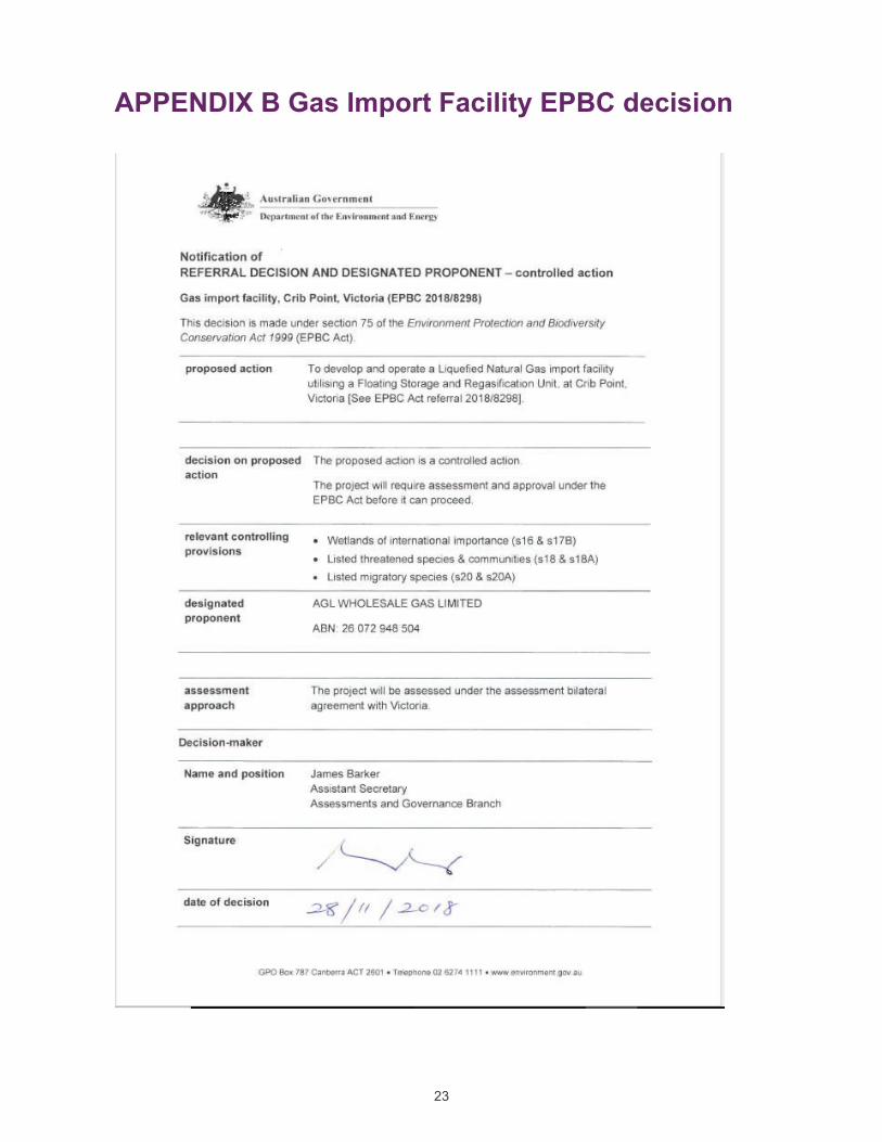
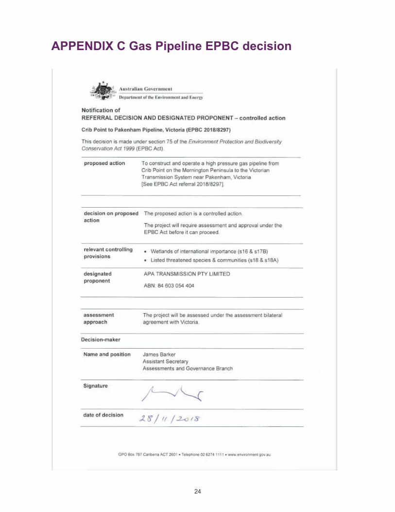

AWE200093 Marine Biodiversity & Shorebirds | 2 October 2020 | Commercial in Confidence 30
0B2B3BCrib Point Gas Import Jetty and Crib Point-Pakenham Gas Pipeline Project
APPENDIX
CVS FOR EXPERT WITNESSES

Current Position Regional Senior Principal Water & Environment
Profession Marine Ecologist
Years' Experience 30
Joined Cardno 2003
Education PhD, University of Sydney
BSc (Hons), James Cook University of North QLD
Grad Dip Ind Maths Comp, Charles Sturt University
Summary of Experience Craig is a leading technical specialist in the consulting industry, and has published and presented papers in conferences around the world and in peer-reviewed journals. His current position of Regional Senior Principal requires him to lead the technical discipline of aquatic ecology within Cardno by mentoring and developing staff, developing and maintaining consistently great technical ability and services that are at the forefront of the field and by building long-term and productive business relationships with new and existing internal and external clients.
Craig has 30 years of consulting and research experience in marine and freshwater ecology. He has a PhD in reef ecology and has worked in all regions of Australia and parts of the Pacific, including PNG. Craig is an expert in the design, implementation and management of marine, estuarine and freshwater monitoring investigations and has excellent analytical, presentation, reporting and interpretive skills. He has participated in Expert Witness Training given by the University of NSW. Craig has undertaken many studies investigating the potential for ecological impacts of infrastructure development including for marinas, roads, foreshore reclamation, ports and oil and gas systems. These studies have included investigations of water quality, sediment, contaminants, habitats and biota on or associated with these structures and options for mitigation including restoration of sensitive habitats. Craig has been the leading investigator of two Environmental Impacts Statements for large developments. As a result of his work, Craig has a good understanding of the process of environmental impact assessment and how developments can best be done to operate sustainably and to minimise or mitigate the potential for environmental impact, including mitigation through offsetting.
Significant Projects > PNG APEC Haus Land Reclamation - Baseline Environmental Studies (for Oil
Search (PNG) Ltd). Baseline survey of marine and terrestrial ecology and water quality at the project site and surrounds to identify ‘environmental sensitivities’ (coral, seagrass and macroalgae). As part of the CEMP, Cardno partnered with the local community to transplant ~500 coral colonies to safe sites away from the project footprint.
> Bass Strait investigations of environmental risk of produced formation water and drill cutting discharges (present) for an O&G client. Validation of PFW and drill cutting discharges to determine area of impact. Included program design, collection and analysis of water quality, sediment chemistry and soft sediment biota in situ to validate and determine risk.
> INPEX Browse Ltd Marine Monitoring Program (2012-16). Design of coral monitoring program in relation to dredging for a gas plant shipping channel (Darwin, NT). Coral surveys using photoquadrat sampling to monitor coral mortality and bleaching in relation to permit thresholds
> Western Harbour Tunnel and Beaches Link Crossings - Field and desktop studies of Sydney Harbour and Middle Harbour marine biota and habitats, risk assessment, EIS technical report preparation and stakeholder consultation to assist with planning for the proposed tunnel crossing.
> Shark Deterrents and Detectors: Review of Bather Protection Technologies. Preparation of report for NSW DPI.
Dr Craig Blount
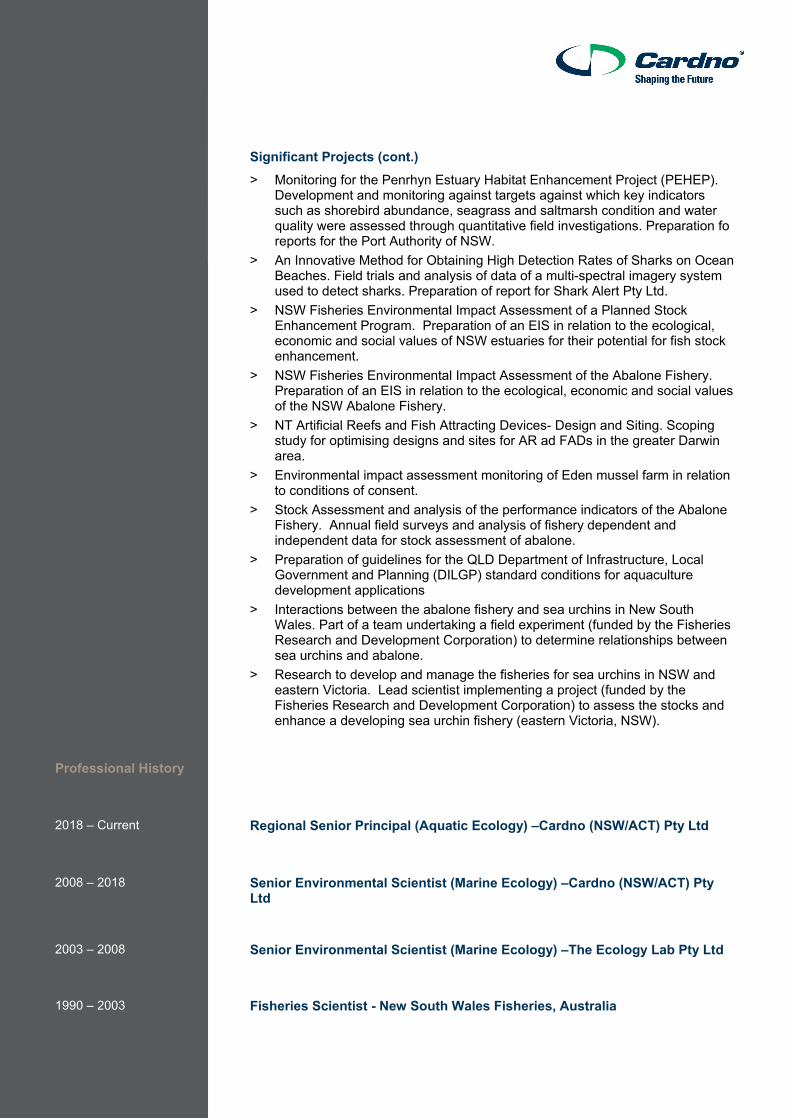
Significant Projects (cont.) > Monitoring for the Penrhyn Estuary Habitat Enhancement Project (PEHEP).
Development and monitoring against targets against which key indicators such as shorebird abundance, seagrass and saltmarsh condition and water quality were assessed through quantitative field investigations. Preparation fo reports for the Port Authority of NSW.
> An Innovative Method for Obtaining High Detection Rates of Sharks on Ocean Beaches. Field trials and analysis of data of a multi-spectral imagery system used to detect sharks. Preparation of report for Shark Alert Pty Ltd.
> NSW Fisheries Environmental Impact Assessment of a Planned Stock Enhancement Program. Preparation of an EIS in relation to the ecological, economic and social values of NSW estuaries for their potential for fish stock enhancement.
> NSW Fisheries Environmental Impact Assessment of the Abalone Fishery. Preparation of an EIS in relation to the ecological, economic and social values of the NSW Abalone Fishery.
> NT Artificial Reefs and Fish Attracting Devices- Design and Siting. Scoping study for optimising designs and sites for AR ad FADs in the greater Darwin area.
> Environmental impact assessment monitoring of Eden mussel farm in relation to conditions of consent.
> Stock Assessment and analysis of the performance indicators of the Abalone Fishery. Annual field surveys and analysis of fishery dependent and independent data for stock assessment of abalone.
> Preparation of guidelines for the QLD Department of Infrastructure, Local Government and Planning (DILGP) standard conditions for aquaculture development applications
> Interactions between the abalone fishery and sea urchins in New South Wales. Part of a team undertaking a field experiment (funded by the Fisheries Research and Development Corporation) to determine relationships between sea urchins and abalone.
> Research to develop and manage the fisheries for sea urchins in NSW and eastern Victoria. Lead scientist implementing a project (funded by the Fisheries Research and Development Corporation) to assess the stocks and enhance a developing sea urchin fishery (eastern Victoria, NSW).
Professional History
2018 – Current Regional Senior Principal (Aquatic Ecology) –Cardno (NSW/ACT) Pty Ltd
2008 – 2018 Senior Environmental Scientist (Marine Ecology) –Cardno (NSW/ACT) Pty Ltd
2003 – 2008 Senior Environmental Scientist (Marine Ecology) –The Ecology Lab Pty Ltd
1990 – 2003 Fisheries Scientist - New South Wales Fisheries, Australia
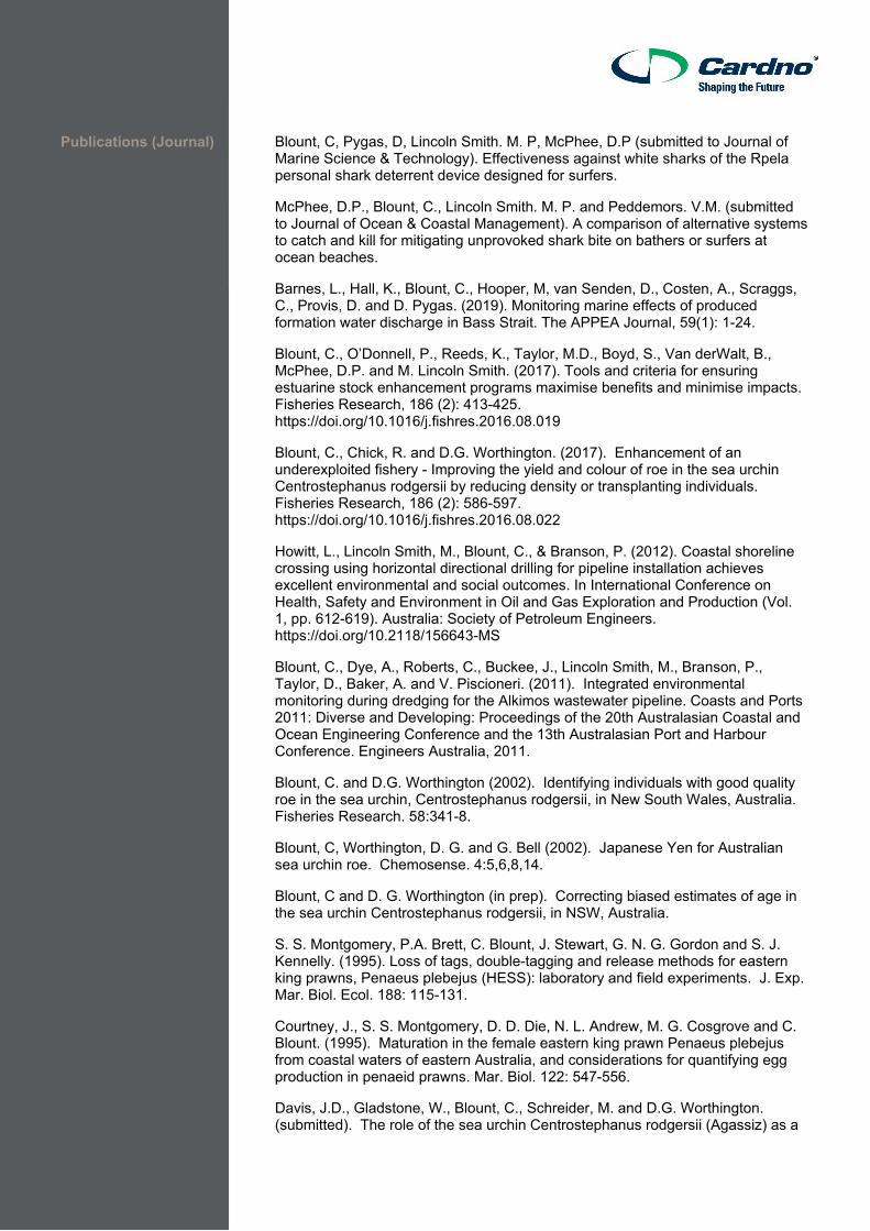
Publications (Journal) Blount, C, Pygas, D, Lincoln Smith. M. P, McPhee, D.P (submitted to Journal of Marine Science & Technology). Effectiveness against white sharks of the Rpela personal shark deterrent device designed for surfers.
McPhee, D.P., Blount, C., Lincoln Smith. M. P. and Peddemors. V.M. (submitted to Journal of Ocean & Coastal Management). A comparison of alternative systems to catch and kill for mitigating unprovoked shark bite on bathers or surfers at ocean beaches.
Barnes, L., Hall, K., Blount, C., Hooper, M, van Senden, D., Costen, A., Scraggs, C., Provis, D. and D. Pygas. (2019). Monitoring marine effects of produced formation water discharge in Bass Strait. The APPEA Journal, 59(1): 1-24.
Blount, C., O’Donnell, P., Reeds, K., Taylor, M.D., Boyd, S., Van derWalt, B., McPhee, D.P. and M. Lincoln Smith. (2017). Tools and criteria for ensuring estuarine stock enhancement programs maximise benefits and minimise impacts. Fisheries Research, 186 (2): 413-425. https://doi.org/10.1016/j.fishres.2016.08.019
Blount, C., Chick, R. and D.G. Worthington. (2017). Enhancement of an underexploited fishery - Improving the yield and colour of roe in the sea urchin Centrostephanus rodgersii by reducing density or transplanting individuals. Fisheries Research, 186 (2): 586-597. https://doi.org/10.1016/j.fishres.2016.08.022
Howitt, L., Lincoln Smith, M., Blount, C., & Branson, P. (2012). Coastal shoreline crossing using horizontal directional drilling for pipeline installation achieves excellent environmental and social outcomes. In International Conference on Health, Safety and Environment in Oil and Gas Exploration and Production (Vol. 1, pp. 612-619). Australia: Society of Petroleum Engineers. https://doi.org/10.2118/156643-MS
Blount, C., Dye, A., Roberts, C., Buckee, J., Lincoln Smith, M., Branson, P., Taylor, D., Baker, A. and V. Piscioneri. (2011). Integrated environmental monitoring during dredging for the Alkimos wastewater pipeline. Coasts and Ports 2011: Diverse and Developing: Proceedings of the 20th Australasian Coastal and Ocean Engineering Conference and the 13th Australasian Port and Harbour Conference. Engineers Australia, 2011.
Blount, C. and D.G. Worthington (2002). Identifying individuals with good quality roe in the sea urchin, Centrostephanus rodgersii, in New South Wales, Australia. Fisheries Research. 58:341-8.
Blount, C, Worthington, D. G. and G. Bell (2002). Japanese Yen for Australian sea urchin roe. Chemosense. 4:5,6,8,14.
Blount, C and D. G. Worthington (in prep). Correcting biased estimates of age in the sea urchin Centrostephanus rodgersii, in NSW, Australia.
S. S. Montgomery, P.A. Brett, C. Blount, J. Stewart, G. N. G. Gordon and S. J. Kennelly. (1995). Loss of tags, double-tagging and release methods for eastern king prawns, Penaeus plebejus (HESS): laboratory and field experiments. J. Exp. Mar. Biol. Ecol. 188: 115-131.
Courtney, J., S. S. Montgomery, D. D. Die, N. L. Andrew, M. G. Cosgrove and C. Blount. (1995). Maturation in the female eastern king prawn Penaeus plebejus from coastal waters of eastern Australia, and considerations for quantifying egg production in penaeid prawns. Mar. Biol. 122: 547-556.
Davis, J.D., Gladstone, W., Blount, C., Schreider, M. and D.G. Worthington. (submitted). The role of the sea urchin Centrostephanus rodgersii (Agassiz) as a
biogenic habitat for macrofaunal assemblages on subtidal rocky reefs of New South Wales, Australia. J. Exp. Mar. Biol. Ecol.
Davis, J.D., Gladstone, W., Blount, C., Schreider, M. and D.G. Worthington. (submitted). Patterns in the distribution and abundance of fauna associated with the sea urchin Centrostephanus rodgersii (Agassiz) in New South Wales, Australia. Mar. Fresh. Res.
Gibson, P.T., D.G. Worthington, C. Blount and N.L. Andrew (2002). Incidental damage to blacklip abalone, Haliotis rubra, by commercial divers in New South Wales, Australia. Journal of Shellfish Research. 21:787-792.
Hill, N. A., Blount, Poore, A. G. B., Worthington, D. G. and P. D. Steinberg (2003) Grazing effects of the sea urchin Centrostephanus rodgersii in two contrasting rocky reef habitats: effects of urchin density and its implications for the fishery. Mar. Fresh. Res. 54:
Publications (Key Reports)
Cardno (2018). Penrhyn Estuary Habitat Enhancement Plan- End of Project report. Cardno (NSW/ACT) Pty Ltd, Sydney
Cardno (2017). NT Artificial Reefs and Fish Attracting Devices- design and Siting. Report for NT DPIR, Cardno (NSW/ACT) Pty Ltd, Sydney.
Cardno (2016). APEC Haus (PNG) Land Reclamation, Baseline Environmental Study. Prepared for Oil Search (PNG) Ltd, Cardno (NSW/ACT) Pty Ltd, Sydney.
Cardno (2016). An Innovative Method for Obtaining High Detection Rates of Sharks on Ocean Beaches. Report for Shark Alert Pty Ltd., Cardno (NSW/ACT) Pty Ltd, Sydney.
Cardno (2015). Shark Deterrents and Detectors: Review of Bather Protection Technologies. Preparation of report for NSW Department of Primary Industries, Cardno (NSW/ACT) Pty Ltd, Sydney.
Cardno (2015). Post dredging Coral Monitoring Report. Ichthys Nearshore Environmental Monitoring Program. Report for INPEX, Cardno (NSW/ACT) Pty Ltd, Sydney.
Cardno (2014). End of dredging Coral Monitoring Report. Ichthys Nearshore Environmental Monitoring Program. Report for INPEX, Cardno (NSW/ACT) Pty Ltd, Sydney.\
Cardno (2012-2014). Bimonthly Coral Monitoring Reports: Dredging Reports 1-13 - Ichthys Nearshore Environmental Monitoring Program. Report for INPEX, Cardno (NSW/ACT) Pty Ltd, Sydney.
Cardno (2012). Coral Baseline Report- Ichthys Nearshore Environmental Monitoring Program. Report for INPEX, Cardno (NSW/ACT) Pty Ltd, Sydney.
Blount, C., Buckee, J. and A. Dye (2011). Apache Coral Monitoring Program 2010. Report to Apache Energy Ltd., 148 pp.
Blount, C., Reeds, K., O'Donnell, P. and M. Lincoln Smith (2011). Marine Fish Stocking in NSW Environmental Impact Statement Vols 1-3. Report to NSW Department of Primary Industries, 815 pp.
Blount, C., Branson, P., Buckee, J., Dye, A., Roberts, C., and D. Aveling (2011). Devil Creek Development Project Marine Monitoring Program - HDD. Report to Apache Energy Ltd., 276 pp.

The Ecology Lab (now Cardno) (2011). Abalone Fishery Environmental Impact Statement, Vols 1-3. Report to NSW Department of Primary Industries.
Worthington, D.G. and C. Blount (2003). Research to develop and manage the fisheries for sea urchins in NSW and eastern Victoria. NSW Fisheries’ Final Report Series. 188 pp.
Worthington, D.G., R.C. Chick, C. Blount and P.T. Gibson (2001). An assessment of the performance indicators of the Abalone Share Management Plan in 2000. NSW Fisheries’ Fishery Resource Assessment Series No. 11, 48 pp.
Worthington, D.G., R.C. Chick, C. Blount, P.A. Brett and P.T. Gibson (1998). A final assessment of the NSW abalone fishery in 1997. NSW Fisheries’ Fishery Resource Assessment Series No. 5, 74 pp.
Andrew, N.L., D.G. Worthington, P.A. Brett, N. Bentley, R.C. Chick and C. Blount (1998). Interactions between the abalone fishery and sea urchins in New South Wales. NSW Fisheries’ Final Report Series No. 12, 108 pp.
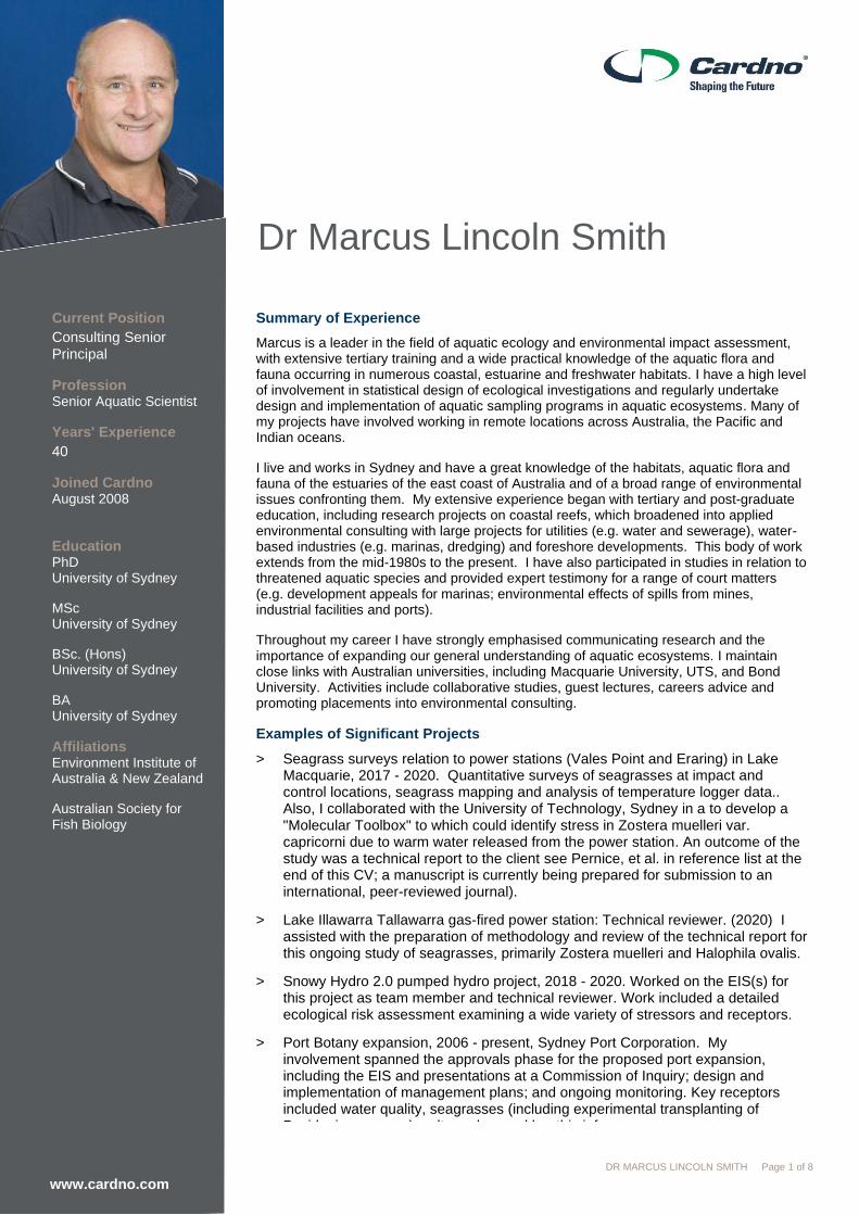
www.cardno.com DR MARCUS LINCOLN SMITH Page 1 of 8
Current Position
Consulting Senior Principal
Profession Senior Aquatic Scientist
Years' Experience
40
Joined Cardno August 2008
Education PhD University of Sydney
MSc University of Sydney
BSc. (Hons) University of Sydney
BA University of Sydney
Affiliations Environment Institute of Australia & New Zealand
Australian Society for Fish Biology
Summary of Experience
Marcus is a leader in the field of aquatic ecology and environmental impact assessment, with extensive tertiary training and a wide practical knowledge of the aquatic flora and fauna occurring in numerous coastal, estuarine and freshwater habitats. I have a high level of involvement in statistical design of ecological investigations and regularly undertake design and implementation of aquatic sampling programs in aquatic ecosystems. Many of my projects have involved working in remote locations across Australia, the Pacific and Indian oceans.
I live and works in Sydney and have a great knowledge of the habitats, aquatic flora and fauna of the estuaries of the east coast of Australia and of a broad range of environmental issues confronting them. My extensive experience began with tertiary and post-graduate education, including research projects on coastal reefs, which broadened into applied environmental consulting with large projects for utilities (e.g. water and sewerage), water-based industries (e.g. marinas, dredging) and foreshore developments. This body of work extends from the mid-1980s to the present. I have also participated in studies in relation to threatened aquatic species and provided expert testimony for a range of court matters (e.g. development appeals for marinas; environmental effects of spills from mines, industrial facilities and ports).
Throughout my career I have strongly emphasised communicating research and the importance of expanding our general understanding of aquatic ecosystems. I maintain close links with Australian universities, including Macquarie University, UTS, and Bond University. Activities include collaborative studies, guest lectures, careers advice and promoting placements into environmental consulting.
Examples of Significant Projects
> Seagrass surveys relation to power stations (Vales Point and Eraring) in Lake Macquarie, 2017 - 2020. Quantitative surveys of seagrasses at impact and control locations, seagrass mapping and analysis of temperature logger data.. Also, I collaborated with the University of Technology, Sydney in a to develop a "Molecular Toolbox" to which could identify stress in Zostera muelleri var. capricorni due to warm water released from the power station. An outcome of the study was a technical report to the client see Pernice, et al. in reference list at the end of this CV; a manuscript is currently being prepared for submission to an international, peer-reviewed journal).
> Lake Illawarra Tallawarra gas-fired power station: Technical reviewer. (2020) I assisted with the preparation of methodology and review of the technical report for this ongoing study of seagrasses, primarily Zostera muelleri and Halophila ovalis.
> Snowy Hydro 2.0 pumped hydro project, 2018 - 2020. Worked on the EIS(s) for this project as team member and technical reviewer. Work included a detailed ecological risk assessment examining a wide variety of stressors and receptors.
> Port Botany expansion, 2006 - present, Sydney Port Corporation. My involvement spanned the approvals phase for the proposed port expansion, including the EIS and presentations at a Commission of Inquiry; design and implementation of management plans; and ongoing monitoring. Key receptors included water quality, seagrasses (including experimental transplanting of Posidonia seagrass), saltmarshes and benthic infauna.
Dr Marcus Lincoln Smith
www.cardno.com
www.cardno.com DR MARCUS LINCOLN SMITH Page 2 of 8
Other Significant Projects
> Development, implementation and reporting for Nearshore Monitoring Associated with Dredging, Ichthys Project, Darwin Port Development, 2011 – 2017. Engaged by INPEX to develop monitoring programs, specifically related to water quality, fish health, recreational fishing and habitats including corals, seagrasses and mangroves during the extensive dredging for the largest oil and gas development in the Northern Territory.
> Investigations of PFAS in aquatic biota at Fiskville, Victoria, 2013-4. I was engaged by Ashurst Lawyers on behalf of the Country Fire Authority to investigate potential bioaccumulation of PFCs (PFAS) in local aquatic biota. Work involved development and implementation of a field plan to collect biota from water bodies at the Fiskville facility and in the Moorabool River, dissect samples for chemical analysis and prepare a report for the client.
> Victorian Desalination Plant, Wonthaggi, 2010, technical adviser for marine ecology monitoring. I was engaged as part of a team to review and provide advice on monitoring the potential effects of the plant on aquatic receptors (e.g., plankton, reef habitats). Worked through GHD on behalf of the Victoria State Government.
> Port of Melbourne Channel Deepening Project, Supplementary EES, 2009-10. Assisted with the review of marine ecology studies of the deep reefs at the entrance to Port Phillip Bay. Original research done by Australian Marine Ecology P/L (AME). I also present the findings of the deep reef studies at the Public Hearing into the project. Subsequently collaborated with AME on the monitoring program for the deep reefs.
> Port of Hastings Decision support tool for introduced marine species, ~2008. I was engaged by Merrick and Associates to review a Decision Support System for Introduced aquatic pest species that may potentially be translocated into the Port of Hastings. Work involved review of biological and ecological parameters of pest species and modelling the of risk of introductions using the Support System and the attributes of selected pest species.
Professional History July 2011 - Present
August 2008 - June 2011
1985 to 2008
1980 to 1985
1978 to 1980
Consulting Senior Principal, Marine and Freshwater Ecology group, Cardno Limited
> Focus on project implementation, technical review and business development.
Business Unit Manager, Cardno Ecology Lab
> Following the merger of The Ecology Lab with Cardno Limited, Marcus was Head of Marine and Freshwater Ecology group, with offices in Sydney & Perth.
Founder and Director, The Ecology Lab Pty Ltd
> Founder and Director of the Ecology Lab Pty Ltd beginning as sole operator and growing the business to a staff of 20 highly skilled scientists.
> Post-graduate studies and environmental consulting.
> Ecology study of Botany Bay fish; marine reserves programme, artificial reefs programme.

www.cardno.com DR MARCUS LINCOLN SMITH Page 3 of 8
Awards/Skills
Publications & selected Technical Papers
> Environment Institute of Australia and New Zealand, accredited practitioner specialist in aquatic ecology CEnvP (ecology) 2016 -
> Visiting Research Fellow, Macquarie University June 2012– tasks: collaborative research, lectures and advice to students
> Recipient of the “Jabez King Heydon” Memorial Prize for the meritorious PhD in School of Biological Sciences, University of Sydney awarded in 1998.
> AusRivAS Course – Rapid Assessment Methods for freshwater rivers and streams, University of Technology, Sydney (Undertaken 2006)
> MapInfo Professional Training Course (Undertaken 2002)
> Responsible handling of animals accreditation, Macquarie University (2012)
> PADI advanced open water SCUBA diver (Undertaken 1978).
> Commonwealth Commercial SCUBA Diver, with Nitrox endorsement (AS 2815.1)
> Commercial Diving Supervisor (AS 2815.1)
> > NSW boat operators licence (NSW).
> General Purpose Hand (commercial vessels) 2011 – NSW Maritime
> Marine Radio Operator’s Licence 2011
> Class 1 drivers licence (NSW).
> 4WD off-road driving and vehicle recovery (Obtained 2012)
> St John Ambulance Australia, Senior First Aid Certificate (current to May 2021)
> CPR & Oxygen First Aid Provider’s Certificate
> NSW Workcover Green Card (Obtained 2001)
Bell, J. D., Albert, J, Andréfouët, S. Andrew, N. L., Blanc, M., Bright, P., Brogan, D., Campbell, B., Govan, H., Hampton, J., Hanich, Q., Harley, S., Jorari, A. Lincoln Smith, M. P., Scott Pontifex, S., Sharp, M. K., Sokimi, W., and Webb, A. (in press). Optimising the use of nearshore fish aggregating devices for food security in the Pacific Islands. Marine Policy.
Bishop, M. J., Kelaher, B. P., Lincoln Smith, M. P., York, P. H. and Booth, D. J. (2006). Ratio-dependent response of a temperate Australian estuarine system to sustained nitrogen loading. Oecologia, 149: 701 – 708.
Bull, A., Lane, A., DeNola, G., Lincoln Smith, Gringinger, P. (in press). PFCs: Emerging, Persistent and Prevalent Environmental Contaminants. Paper for presentation and proceedings at the Australian Groundwater and Land Conference, Auckland, NZ, 6 - 8 May 2015.
Connell, S. D., Samoilys, M. A., Lincoln Smith, M. P. and Leqata, J. (1998). Comparisons of abundance of coral-reef fish: Catch and effort surveys versus visual census. Australian Journal of Ecology, 23: 579 – 586.
Connell, S.D. and Lincoln Smith, M. P. (1999). Depth and the Structure of Assemblages of Demersal Fish: Experimental Trawling Along a Temperate Coast. Estuarine Coastal and Shelf Science 48: 483-495.
Cooper, T. F., Lincoln Smith, M. P., Bell, J. D. and Pitt, K. A. (2002). Assessing the effects of

www.cardno.com DR MARCUS LINCOLN SMITH Page 4 of 8
logging on corals reefs in Solomon Islands. Proceedings of the 9th International Coral Reefs Symposium, Bali, 2000, pp. 1199 – 1204.
Fairweather, P. G. and Lincoln Smith, M. P. (1994). The difficulty of assessing environmental impacts before they have occurred: a perspective from Australian consultants. Pp. 121-130 in Battershill, C. N. et al. (eds) Proceedings of the Second International Temperate Reef Symposium. 7-10 January, 1992, Auckland, New Zealand. NIWA Marine, Wellington, New Zealand. 252 p.
Hawes, I, Lasiak, T and Lincoln Smith, M. P. and C. Oengpepa, C. 2011). The Status of Silverlip Pearl Oyster Pinctada maxima (Jameson) (Mollusca, Pteridae) in the Solomon Islands After A 15-Year Export Ban. Journal of Shellfish Research, 30(2):255-260.
Howitt, L., Lincoln Smith, M., Blount, C. and Branson, P. (2012). Coastal shoreline crossing using horizontal directional drilling for pipeline achieves excellent environmental and social outcomes. Proceedings of the SPE/APPEA International Conference on Health, Safety and the Environment in Oil and Gas Exploration and Production, Perth, 11-13 September 2012. Article No. SPE 156643, 8 pages.
Inglis, G. J. and Lincoln Smith, M. P. (1994). Choosing appropriate spatial scales for ecological monitoring programs: and estuarine case study. Pages 171-181, in, Orpha Bellwood, Howard Choat & Narendra Saxena (Eds), Recent Advances in Marine Science and Technology 1994. James Cook University, Townsville, pp 171 - 181.
Inglis, G. J. and Lincoln Smith, M. P. (1995). An examination of observer bias as a source of error in surveys of seagrass shoots. Australian Journal of Ecology, 20: 273-281.
Inglis, G. J. and Lincoln Smith, M. P. (1998). Synchronous flowering of estuarine seagrass meadows. Aquatic Botany, 60: 37-48
Jacoby, C. A., Langtry, S. K., Ferrell, D. J., Lincoln Smith, M. P., Hair, C.A., Worthington, D.G., McNeill, S. E. and Bell, J. D. (1995). Shallow water fishes and mobile macro-invertebrate assemblages. Chapter 19 in: George Cho, Arthur Georges, Ros Stoutjeddijk and Richard Longmore (Eds.), Jervis Bay, A place of cultural, scientific and educational value. Australian Nature Conservation Agency, Kowari 5 series. Canberra.
James, R.L., Lincoln Smith, M.P. and Fairweather, P.G. (1995). Sieve mesh-size and taxonomic resolution needed to describe natural spatial variation of marine macrofauna. Marine Ecology Progress Series, 118:187-198.
Lincoln Smith, M.P. (1978). Aspects of the Ecology of Artificial Reefs. Honours Thesis, University of Sydney. 52 pp.
Lincoln Smith, M.P. (1985). The Development and Application of Visual Survey Procedures for Fish Communities on Shallow Rocky Reefs. Master of Science Thesis, University of Sydney. 187 pp.
Lincoln Smith, M.P. (1988). Effects of observer swimming speed on sample counts of temperate rocky reef fish assemblages. Marine Ecology Progress Series, 43: 223-231.
Lincoln Smith, M.P. (1989). Improving multispecies rocky reef fish censuses by counting different groups of species using different procedures. Environmental Biology of Fishes, 26: 29-37.
Lincoln Smith, M.P. (1991). Environmental impact assessment: the roles of predicting and monitoring the extent of impact. Australian Journal of Marine and Freshwater Research, 42(5): 603-614.
Lincoln Smith, M. P. (1998). Aquatic Ecology and Environmental Impact Assessment: a Critical Evaluation. Doctor of Philosophy Thesis, University of Sydney. 167 pages.
Lincoln Smith, M. P. (1999). Reef sharks and rays. Chapter 17 in N. Andrew (Editor), Under

www.cardno.com DR MARCUS LINCOLN SMITH Page 5 of 8
Southern Seas, the Ecology of Australia’s Rocky reefs. U NSW Press, Sydney.
Lincoln Smith, M. P. (1998). Guidelines for Assessment of Aquatic Ecology in EIA. Prepared on behalf of the NSW Department of Urban Affairs and Planning, Sydney. 61 pages. NSW Department of Planning Website.
Lincoln Smith, M. P. (2006). Cabbage Tree Aquatic Reserve: Investigation of fish and fish habitat, Results of surveys in 2003 & 2004. Report prepared for Manly Council, Belgrave Street, Manly, NSW.
Lincoln Smith, M. P. (2007). Redevelopment of land at Caboolture: Aquatic ecology investigations for the proposed Northeast Business Park. Report prepared for Northeast Business Park Pty Ltd, Springhill, Queensland.
Lincoln Smith M., Dye A, Kemsley, K. and Denholm J. (2011). Environmental monitoring and assessment: a statistical analysis of concentrations of silver and indium at generator locations. Journal of Weather Modification, 1 - 8, April 2011
Lincoln Smith, M. P., Bell, J. D. Pollard, D. A. and Russell, B. C. (1989). Catch records from spearfishing competitions: their use in assessing and managing reef fish communities. Fisheries Research, 8: 45-61.
Lincoln Smith, M. P., Bell, J. D and. Hair, C. A. (1991). Spatial variation in abundance of recently settled rocky reef fish in south-eastern Australia: implications for detecting change. Marine Ecology Progress Series, 77: 95-103.
Lincoln Smith, M. P., Bell, J. D. and Mapstone, B. D. (1997). Testing the use of a marine protected area to restore and manage invertebrate fisheries at the Arnavon Islands, Solomon Islands: choice of methods and preliminary results. Proceedings of the 8th Coral Reefs Symposium, Panama, 2: 1937-1942.
Lincoln Smith, M. P. and Cooper, T. C. (2004). Combining the use of gradients and reference areas to study bioaccumulation in wild oysters in the Hunter River estuary, New South Wales, Australia. Marine Pollution Bulletin, 48: 873 - 883.
Lincoln Smith, M. P., Dye, A., Hose, G. and Sharp, S. (2012). Effects of Mine Water Salinity on Freshwater Biota: Investigations of Coal Mine water Discharge in NSW. Australian Coal Association Research Program, Project No. C15016, available at: www.acarp.com.au/reports.aspx. Cardno Ecology Lab Report Number 38/0506A. Cardno, St Leonards, NSW.
Lincoln Smith, M. P. and Jones, G. P. (1995). Fish of shallow coastal habitats. In, Chapman, M. G. and Underwood, A. J. (editors) Marine Ecology of Temperate Australia. University of New South Wales Press.
Lincoln Smith, M. P., Hawes, P. M. H. and Duque-Portugal, F. J. (1995). Short Communication: Spatial variability in the nekton of a canal estate in southern New South Wales, Australia, and its implications for estuarine management. Marine and Freshwater Research, 46: 715-721.
Lincoln Smith, M. P., Pitt, K., Bell, J. D. and Mapstone, B. D (2006). Using impact assessment methods to determine the effects of a marine reserve on abundances and sizes of valuable tropical invertebrates. Canadian Journal of Fisheries and Aquatic Sciences, 63: 1251 – 1266.
Lincoln Smith, M. P. and Samoilys, M. (1997). Sampling Design and Hypothesis Testing. Chapter 2 in, M. Samoilys (Ed.), Manual for Assessing Fish Stocks on Pacific Coral Reefs. Training Series QE97009. Department of Primary Industries, Queensland. 75 pages.
Lincoln Smith, M. P., Skilleter, G. A. and Underwood, A. J. (1995). Cocos (Keeling) Islands: managing the harvesting of marine organisms. Pages 605-613, in, Orpha Bellwood, Howard Choat & Narendra Saxena (Eds), Recent Advances in Marine Science and Technology

www.cardno.com DR MARCUS LINCOLN SMITH Page 6 of 8
1994. James Cook University, Townsville.
Olympic Co-ordination Authority (1996). Homebush Bay Ecological Studies 1993-1995 Volume 1, Prepared for: NSW Government/Department of Defence. CSIRO, Collingwood Vic.
Olympic Co-ordination Authority (1996). Homebush Bay Ecological Studies 1993-1995 Volume 2, for: NSW Government/Department of Defence. CSIRO, Collingwood Vic.
Pernice, M., Kim, M, Lincoln Smith, M. P. and Ralph, P. J. (2019). Evaluation of a molecular toolkit to assess chronic thermal impact on seagrass in Lake Macquarie. Report to Delta Electricity.
Pollard, D. A., Lincoln Smith, M. P. and Smith, A. K. (1996). The biology and conservation status of the grey nurse shark (Carcharias taurus Rafinesque 1810) in New South Wales, Australia. Aquatic Conservation: Marine and Freshwater Ecosystems, 6: 1-20.
Reinfelds, I, Lincoln-Smith, M. P., Haeusler, T, Ryan, D. and Growns, I., I (2010). Hydraulic assessment of environmental flow regimes to facilitate fish passage through natural riffles: Shoalhaven River below Tallowa Dam, New South Wales, Australia. River Research and Applications, 26: 589 – 604.
Samoilys, M., Lincoln Smith, M. P. and Tuwai, I. (1997). Data Analysis and Application. Chapter 6 in, M. Samoilys (Ed.), Manual for Assessing Fish Stocks on Pacific Coral Reefs. Training Series QE97009. Department of Primary Industries, Queensland. 75 pages.
Smith, G., Lincoln Smith, M. P., Jack, C., and Carr, R. (1997). The Way Water Moves Linking Hydrology and River Hydraulics With Ecology. In: Proceedings of the Institution of Engineers Australia, 24th Hydrology and Water Research Symposium, New Zealand, 1997, NSW.
Whitley, G. P. (1983) "Sharks of Australia" (edited by M. P. Lincoln Smith). Published by Jack Pollard, Sydney.
Cameron McNamara, Lincoln Smith, M. P. and Smith, P. (1987). Barrenjoey Peninsular-Pittwater Environmental Overview. A Report to the Council of the Shire of Warringah. Published by Cameron McNamara. 42 pp.
Cooper, T., Lincoln Smith, M. P., Morrissey, D., Pitt, K. and Bell, J. (2000). Effects of Alternative Logging Operations on Aquatic Ecosystems in the Tropical Western Pacific: Pilot Study. Prepared by the International Centre for Living Aquatic Resources Management (ICLARM) for the New Zealand Ministry of Foreign Affairs and Trade.
Howitt, L. and Lincoln Smith, M. P. (1995). An assessment of impacts on marine flora, fauna and fisheries of a proposal to extract sand from Griffins Bay, Lake Illawarra. Final Report, April 1995. Prepared for Gutteridge, Haskins & Davey, Sydney.
Inglis, G. J. and Lincoln Smith, M. P. (1993). A quantitative study of the impact of construction of a third runway at Mascot on seagrasses in Botany Bay: Towra Point Posidonia, Final Report: November 1993. Prepared for Federal Airports Corporation, Sydney.
Lincoln Smith, M. P. (1992). Impact of spoil disposal on rocky reef fish communities. In, A. C. Roach (Ed), "Port Kembla Dredge Spoil Report: The Environmental Effects of Spoil Disposal off Port Kembla Following Construction of the Grain Terminal." Environment Protection Authority, EPA, Sydney. 71 pages plus appendices.
Lincoln Smith, M. P. (1994). Testing the use of marine protected areas to restore and manage tropical multispecies invertebrate fisheries at the Arnavon Islands, Solomon Islands: report on pilot investigations. Prepared for Great Barrier Reef Marine Park Authority, Canberra and the Australian Centre for International Agricultural Research,

www.cardno.com DR MARCUS LINCOLN SMITH Page 7 of 8
Sydney.
Lincoln Smith, M. P. and Bell, J. D. (1996). Testing the use of marine protected areas to restore and manage tropical multispecies invertebrate fisheries at the Arnavon Islands, Solomon Islands: Abundance and size frequency distributions of invertebrates, and the nature of habitats, prior to declaration of the Marine Conservation Area. Prepared for Great Barrier Reef Marine Park Authority, Canberra and the Australian Centre for International Agricultural Research, Sydney.
Lincoln Smith, M. P., Bell, J. D., Ramohia, P. and Pitt, K. A. (2000). Testing the Use of Marine Protected Areas to Restore and Manage Tropical Multispecies Invertebrate Fisheries at the Arnavon Islands, Solomon Islands – Termination Report. ACIAR Project No. FIS/1994/117. Prepared for the Great Barrier Reef Marine Park Authority and the Australian Centre for International Agricultural Research. The Ecology Lab, 4 Green St, Brookvale, NSW Australia.
Lincoln Smith, M. P. and James, R. J. (1993). Marine Aggregate Proposal: marine ecological investigations (2 Volumes). Prepared for Metromix Pty Limited, Sydney.
Lincoln Smith, M. P., C. A. Hair and J. D. Bell (1992). Jervis Bay Marine Ecology Study, Project 4: Fish Associated with Natural Rocky Reefs and Artificial Breakwaters, Final Report, December 1992. Fisheries Research Institute, Cronulla, NSW.
Lincoln Smith, M. P., Howitt, L., Cawley, R. and Scully, C. (1998). Macroalgal Habitats of the Lowendal/Montebello Island Region: Review of Literature, Pilot Study and Development of Methods. For Apache Energy Limited, Perth, WA.
Lincoln Smith, M.P. and Mann, R. A. (1989). Bioaccumulation in Nearshore Marine Organisms I: Organochlorine compounds and trace metals in rocky reef animals near the Malabar Ocean Outfall (1989). Published by the NSW State Pollution Control Commission.
Lincoln Smith, M. P. and Mann, R. A. (1989). Bioaccumulation in Nearshore Marine Organisms II: Organochlorine compounds in the red morwong, Cheilodactylus fuscus, around Sydney's three major sewage ocean outfalls (1989). Published by the NSW State Pollution Control Commission.
Lincoln Smith, M. P., Pope, A. and Howitt, L. (1995). Environmental Survey on and in the vicinity of the premises of ICI Australia Pty Ltd Botany: Report on Investigations for Stage 2. Prepared for AGC Woodward-Clyde, Sydney & Brisbane.
Lincoln Smith, M. P., Skilleter, G. A. and Underwood, A. J. (1995). Cocos (Keeling) Islands: managing the harvesting of marine organisms. Pages 605-613, in, Orpha Bellwood, Howard Choat & Narendra Saxena (Eds), "Recent Advances in Marine Science and Technology '94". James Cook University, Townsville.
Lincoln Smith, M. P., Skilleter, G. A., Underwood, A. J., Smith, A. K., Hawes, P. M. H., Howitt, L., Stark, J. and Chapman, M. G. (1993). Study of the impact of harvesting marine invertebrates and fish on marine ecosystems of Cocos (Keeling) Islands, Final Report, November 1993. Prepared for Australian Nature Conservation Agency, Canberra.
Lincoln Smith, M. P., Skilleter, G. A., Underwood, A. J., Smith, A. K., Hawes, P. M. H., White, G. A. and Chapman, M. G. (1993). Study of the impact of harvesting marine invertebrates and reef fish in the Christmas Island National Park, Final Report, November 1993. Prepared for Australian Nature Conservation Agency, Canberra.
Lincoln Smith, M. P., Skilleter, G. A., Underwood, A. J., Stark, J., Smith, A. K., Hawes, P. M. H., Howitt, L., White, G. A. and Chapman, M. G. (1995). Cocos (Keeling) Islands: Quantitative Baseline Surveys for Core Marine Reserves and Biosphere Reserve in the South Keeling Lagoon, Final Report, January 1995. Prepared for Australian Nature Conservation Agency, Canberra.
Lincoln Smith, M. P, Smith, A. K. and Anink, P. A. (1993). Effects of Shoreline Disposal and of Construction on Epibenthos and Rocky Reef Fish Bondi, Sydney, Australia. Report

www.cardno.com DR MARCUS LINCOLN SMITH Page 8 of 8
prepared for the NSW EPA, published by the EPA, Sydney. 115 pages, plus appendices.
Lincoln Smith, M. P., White, G. A. and Hawes, P. M. H. (1994). Homebush Bay Ecological Studies: Fish Study (2 Volumes), September 1994. Prepared for Homebush Bay Corporation, Sydney.
Smith, A. K., Inglis, G. J. and Lincoln Smith, M. P. (1993). An assessment of impacts on marine flora and fauna of the proposed Forster Sewage Augmentation and Pacific Palms Sewerage Scheme. Prepared for Manidis Roberts, Sydney.
Smith, A. K. and Lincoln Smith, M. P. (1994). A quantitative survey of the impact of sewage on fish and macrobenthic assemblages in the Illawarra coastal zone. Final Report, October 1994. Prepared for Environmental Management Unit, Water Board, Sydney.
White, G. A., Inglis, G. J., Lincoln Smith, M. P. and Irvine, I. (1994). A study of trace metals and organochlorines in oysters and sediments in Botany Bay, Final Report: February 1994. Prepared for Federal Airports Corporation, Sydney.

AWE200093 Marine Biodiversity & Shorebirds | 2 October 2020 | Commercial in Confidence 31
0B2B3BCrib Point Gas Import Jetty and Crib Point-Pakenham Gas Pipeline Project
APPENDIX
REVIEWED RISK ASSESSMENT

Risk ID Risk Name Risk Pathway Initial Mitigation Measure Consequence Likelihood Initial Risk Additional mitigation
Consequence Likelihood Residual Risk
Cardno: Assessment of Consequence
Cardno: Assessment of Likelihood
Cardno: Initial/ Residual Risk
Cardno Comments
ME1 Entrainment: mangroves & Saltmarsh
Entrainment of seeds into FSRU
Design of intake, velocity & screen size
Negligible Rare Very low None required Negligible Rare Very low ? Possible ? Velocity and screen size irrelevant because seeds annot actively avoid the seawater intake and seeds are much smaller then the screen aperture; Likelihood will probably depend on seasonality, but event will be possible at certain times, not rare
ME2 Entrainment: intertidal mudflat invertebrates
Entrainment of larvae into FSRU
Design of intake, velocity & screen size
Minor Rare Very low None required Negligible Rare Very low ? Almost certain ? Velocity and screen size irrelevant; there would be a constant intake of larvae; these biota not discriminated in zooplankton studies
ME3 Entrainment: inter- & subtidal seagrasses
Entrainment of seeds & propagules into FSRU
Design of intake, velocity & screen size
Minor Minor Very low None required Negligible Rare Very low ? Possible ? Risk dependent on relative size of proximal beds, buoyancy of seeds and their relative contribution of seeds & propagules in Western Port; Inadequate description of existing conditions. Also, velocity and screen size irrelevant
ME4 Entrainment: benthic subtidal invertebrates
Entrainment of eggs & larvae into FSRU
Design of intake, velocity & screen size
Minor Rare Very low None required Minor Rare Very low ? Almost certain ? > velocity and screen size irrelevant; there would be a constant intake of larvae; these biota not discriminated in zooplankton studies; > Does not consider entrainment of benthos mobilised upwards into intake by propeller scour
ME5A Pelagic & demersal fish: spring
Entrainment of pelagic & demersal fish into FSRU (spring)
Design of intake, velocity & screen size
Moderate Likely Medium Reduce flow volume
Minor Possible Low Moderate Likely Medium > Mitigation likely to be ineffective for small, weak swimmers, fish attracted to inflows, ichthyoplankton
ME5B Pelagic & demersal fish: autumn-winter
Entrainment of pelagic & demersal fish into FSRU (autumn)
Design of intake, velocity & screen size
Negligible Possible Low None required Negligible Possible Low Minor Likely Medium > Mitigation likely to be ineffective for small, weak swimmers, fish attracted to inflows, ichthyoplankton
ME6NNE Plankton in NNE Zone Entrainment of Plankton from NNE Zone
Design of intake, velocity & screen size
Negligible Rare Very low None required Negligible Rare Very low ? Likely ? > Poor understanding of plankton in relation to study area> velocity and screen size irrelevant
ME6NA Plankton in North Arm Entrainment of Plankton from North Arm
Design of intake, velocity & screen size
Minor Possible Low None required Minor Possible Low ? Likely ? > Poor understanding of plankton in relation to study area> velocity and screen size irrelevant
ME6WPB Plankton in WPB as a whole
Entrainment of Plankton from WPB
Design of intake, velocity & screen size
Negligible Rare Very low None required Negligible Rare Very low ? Likely ? > Poor understanding of plankton in relation to study area> velocity and screen size irrelevant
ME7 Entrainment Protected areas (Ramsar)
Entrainment impact on values of the Ramsar Site
Design of intake, velocity & screen size
Negligible Unlikely Very low None required Negligible Unlikely Very low ? Likely ? > Ramsar includes basically the whole of WPB, interference with plankton could disrupt a range of ecological processes> Poor understanding of plankton in relation to study area> velocity and screen size irrelevant
ME8 Entrainment Protected areas (Other)
Entrainment impact on values of Marine National Parks & other protected areas
Design of intake, velocity & screen size
Negligible Unlikely Very low None required Negligible Unlikely Very low Negligible Unlikely Very low Agreed due to relative remoteness of other protected areas
ME9 Entrainment: protected species
Entrainment effect on listed protected spp. In WPB
Design of intake, velocity & screen size
Minor Unlikely Low None required Minor Unlikely Low Minor Unlikely Low Agreed
ME10 Cold water: mangroves and saltmarsh
Cooler water from discharge plume alters natural habitat
6-port design; discharge velocity to increase mixing
Negligible Rare Very low None required Negligible Rare Very low Negligible Unlikely Very low Basically agree; but there may be certain weather and tide conditions that could move plume to these habitats
ME11 Cold water: intertidal mudflat & invertebrate communities
Cooler water from discharge plume alters natural intertidal mudflat communities
6-port design; discharge velocity to increase mixing
Negligible Rare Very low None required Negligible Rare Very low ? Possible ? Insufficient information presented on intertidal mudflat communities adjacent to understand existing communities at Crib Point.
ME12 Cold water: intertidal and subtidal seagrasses
Coooler water from discharge plume alters the natural communities
6-port design; discharge velocity to increase mixing
Negligible Rare Very low None required Negligible Rare Very low ? Possible ? Insufficient information presented on intertidal and subtidal habitat (includes seagrasses & associated biota) adjacent to Crib Point.
Table 1. DRAFT Independent review of Environmental Risk Report (as per EES Attachment III). Black text summarises risk register in terms of marine ecology/biodiversity issues. Red text for each risk identifies comments by Cardno. "?" = insufficient information available to assign a Consequence, Likelihood or Risk category to an specified Risk ID. These categories as per definitions in Tables 2, 3 and 4 of Attachment III.
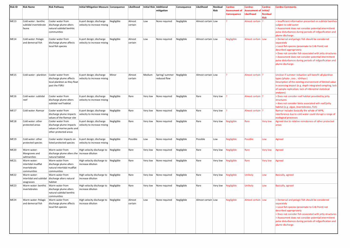
Risk ID Risk Name Risk Pathway Initial Mitigation Measure Consequence Likelihood Initial Risk Additional mitigation
Consequence Likelihood Residual Risk
Cardno: Assessment of Consequence
Cardno: Assessment of Likelihood
Cardno: Initial/ Residual Risk
Cardno Comments
ME13 Cold water : benthic subtidal invertebrate fauna
Cooler water from discharge plume alters natural subtidal benhtic communities
6-port design; discharge velocity to increase mixing
Negligible Almost certain
Low None required Negligible Almost certain Low ? Almost certain ? > Insufficient information presented on subtidal benthos subject to cold water> Assessment does not consider potential intermittent pulse disturbances during periods of refgasification and plume discharge.
ME14 Cold water: Pelagic and demersal fish
Cooler water from discharge plume affects local fish species
6-port design; discharge velocity to increase mixing
Negligible Almost certain
Low None required Negligible Almost certain Low Negligible Almost certain Low > Demersal and pelagic fish should be considered separately> Local fish species (proximate to Crib Point) not described appropriately> Does not consider fish associated with jetty structures> Assessment does not consider potential intermittent pulse disturbances during periods of refgasification and plume discharge.
ME15 Cold water : plankton Cooler water from discharge plume affects local plankton as they float past the FSRU
6-port design; discharge velocity to increase mixing
Minor Almost certain
Medium Spring/ summer reduced flow
Negligible Almost certain Low ? Almost certain ? Unclear if summer reduction will benefit all plankton types (phyto-, zoo-, ichthyo-)Description of the existing environment of limited value in assessing impact (e.g. depth integrated sampling; lack of sample replication; lack of inferential statistical analyses)
ME16 Cold water: subtidal reef
Cooler water from discharge plume alters subtidal reef habitat
6-port design; discharge velocity to increase mixing
Negligible Rare Very low None required Negligible Rare Very low ? Almost certain ? > Does not consider reef habitat provided by jetty structures > does not consider biota associated wth reef/jetty habitat (e.g. algae, invertebrates, fish)
ME17 Cold water: Ramsar Cooler water from discharge plume impacts values of the Ramsar site
6-port design; discharge velocity to increase mixing
Negligible Rare Very low None required Negligible Rare Very low ? Almost certain ? Ramsar includes basically the whole of WPB, interference due to cold water could disrupt a range of ecological processes
ME18 Cold water: other protected areas
Cooler water from discharge plume impacts values of marine parks and other protected areas
6-port design; discharge velocity to increase mixing
Negligible Rare Very low None required Negligible Rare Very low Negligible Rare Very low Agreed due to relative remoteness of other protected areas
ME19 Cold water: other protected species
Cooler water impacts on listed protected species
6-port design; discharge velocity to increase mixing
Negligible Possible Low None required Negligible Possible Low Negligible Possible Low Agreed
ME20 Warm water: Mangroves and saltmarshes
Warm water from discharge plume alters the natural habitat
High velocity discharge to increase dilution
Negligible Rare Very low None required Negligible Rare Very low Negligible Rare Very low Agreed
ME21 Warm water: intertidal mudflat invertebrate communities
Warm water from discharge plume alters natural intertidal mudflat communities
High velocity discharge to increase dilution
Negligible Rare Very low None required Negligible Rare Very low Negligible Rare Very low Agreed
ME22 Warm water: intertidal and subtidal seagrasses
Warm water from discharge alters natural habitat
High velocity discharge to increase dilution
Negligible Rare Very low None required Negligible Rare Very low Negligible Unlikely Low Basically, agreed
ME23 Warm water: benthic invertebrates
Warm water from discharge plume alters natural subtidal benthic communities
High velocity discharge to increase dilution
Negligible Rare Very low None required Negligible Rare Very low Negligible Unlikely Low Basically, agreed
ME24 Warm water: Pelagic and demersal fish
Warm water from discharge plume affects local fish species
High velocity discharge to increase dilution
Negligible Almost certain
Low None required Negligible Almost certain Low Negligible Almost certain Low > Demersal and pelagic fish should be considered separately> Local fish species (proximate to Crib Point) not described appropriately> Does not consider fish associated with jetty structures> Assessment does not consider potential intermittent pulse disturbances during periods of refgasification and plume discharge.
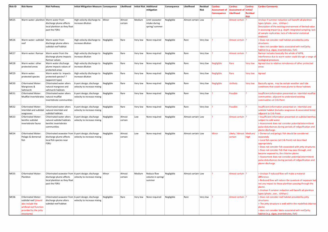
Risk ID Risk Name Risk Pathway Initial Mitigation Measure Consequence Likelihood Initial Risk Additional mitigation
Consequence Likelihood Residual Risk
Cardno: Assessment of Consequence
Cardno: Assessment of Likelihood
Cardno: Initial/ Residual Risk
Cardno Comments
ME25 Warm water: plankton Warm water from discharge plume affects local plankton as they float past the FSRU
High velocity discharge to increase dilution
Minor Almost certain
Medium Limit seawater intake during spring/ summer
Negligible Almost certain Low ? Almost certain ? Unclear if summer reduction will benefit all plankton types (phyto-, zoo-, ichthyo-)Description of the existing environment of limited value in assessing impact (e.g. depth integrated sampling; lack of sample replication; lack of inferential statistical analyses)
ME26 Warm water: subtidal reef
Warm water from discharge plume alters subtidal reef habitat
High velocity discharge to increase dilution
Negligible Rare Very low None required Negligible Rare Very low ? Almost certain ? > Does not consider reef habitat provided by jetty structures > does not consider biota associated wth reef/jetty habitat (e.g. algae, invertebrates, fish)
ME27 Warm water: Ramsar Warm water from the discharge plume impacts Ramsar values
High velocity discharge to increase dilution
Negligible Rare Very low None required Negligible Rare Very low ? Almost certain ? Ramsar includes basically the whole of WPB, interference due to warm water could disrupt a range of ecological processes
ME28 Warm water: other protected areas
Warm water discharge plume impacts values of protected areas
High velocity discharge to increase dilution
Negligible Rare Very low None required Negligible Rare Very low Negligible Rare Very low Agreed due to relative remoteness of other protected areas
ME29 Warm water: protected species
Warm water to impacts protected species? ? (apparent typo)
High velocity discharge to increase dilution
Negligible Rare Very low None required Negligible Rare Very low Negligible Rare Very low Agreed
ME30 Chlorinated Water: Mangroves & Saltmarsh
Chlorinated water alters natural mangrove and saltmarsh habitats
6-port design; discharge velocity to increase mixing
Negligible Rare Very low None required Negligible Rare Very low Negligible Unlikely Very low Basically agree, may be certain weather and tide conditions that could move plume to these habitats
ME31 Chlorinated Water: Mudflat Invertebrates
Chlorinated water alters natural mudflat invertebrate communities
6-port design; discharge velocity to increase mixing
Negligible Rare Very low None required Negligible Rare Very low ? Possible ? Insufficient information presented on intertidal mudflat communities adjacent to understand existing communities at Crib Point.
ME32 Chlorinated Water: Intertidal and subtidal seagrasses
Chlorinated water alters natural intertidal and subtidal habitats
6-port design; discharge velocity to increase mixing
Negligible Rare Very low None required Negligible Rare Very low ? Possible ? Insufficient information presented on intertidal and subtidal habitat (includes seagrasses & associated biota) adjacent to Crib Point.
ME33 Chlorinated Water: benthic subtidal invertebrate fauna
Chlorinated water alters natural subtidal habitats benthic invertebrate communities
6-port design; discharge velocity to increase mixing
Negligible Almost certain
Low None required Negligible Almost certain Low ? Almost certain ? > Insufficient information presented on subtidal benthos subject to cold water> Assessment does not consider potential intermittent pulse disturbances during periods of refgasification and plume discharge.
ME34 Chlorinated Water: Pelagic & demersal fish
Chlorinated seawater from discharge plume affects local fish species near FSRU
6-port design; discharge velocity to increase mixing
Negligible Almost certain
Low None required Negligible Almost certain Low Minor Likely / Almost certain
Medium/ High
> Demersal and pelagic fish should be considered separately> Local fish species (at Crib Point) not described appropriately> Does not consider fish associated with jetty structures> Does not consider fish that may pass through, and become exposed to, the chlorine plume > Assessment does not consider potential intermittent pulse disturbances during periods of refgasification and plume discharge.
ME35 Chlorinated Water: Plankton
Chlorinated seawater from discharge plume affects local plankton as they float past the FSRU
6-port design; discharge velocity to increase mixing
Minor Almost certain
Medium Reduce flow volume in spring/ summer
Negligible Almost certain Low ? Almost certain ? > Unclear if reduced flow will make a material difference. > Reduced flow will reduce the quantum of exposure but not any impact to those plankters passing through the plume.> Unclear if summer reduction will benefit all plankton types (phyto-, zoo-, ichthyo-)
ME36 Chlorinated Water: subtidal reef (should also include the artificial reef function provided by the jetty structures)
Chlorinated seawater from discharge plume alters subtidal reef habitat
6-port design; discharge velocity to increase mixing
Negligible Rare Very low None required Negligible Rare Very low ? Almost certain ? > Does not consider reef habitat provided by jetty structures > The jetty structure is well within the modelled chlorine plume > does not consider biota associated wth reef/jetty habitat (e.g. algae, invertebrates, fish)

Risk ID Risk Name Risk Pathway Initial Mitigation Measure Consequence Likelihood Initial Risk Additional mitigation
Consequence Likelihood Residual Risk
Cardno: Assessment of Consequence
Cardno: Assessment of Likelihood
Cardno: Initial/ Residual Risk
Cardno Comments
ME37 Chlorinated Water: Protected Areas(Ramsar)
Chlorinated seawater from discharge plume impacts values of the Ramsar Site
6-port design; discharge velocity to increase mixing
Minor Rare Very low None required Minor Rare Very low ? Almost certain ? Ramsar includes basically the whole of WPB, interference due to cold water could disrupt a range of ecological processes
ME38 Chlorinated Water: Protected Areas (Other)
Chlorinated seawater from discharge plume impacts values of marine parks and other protected areas
6-port design; discharge velocity to increase mixing
Negligible Rare Very low None required Negligible Rare Very low Negligible Rare Very low Agreed due to relative remoteness of other protected areas
ME39 Chlorinated Water: Protected Species
Chlorinated seawater from discharge plume impacts on listed protected species
6-port design; discharge velocity to increase mixing
Negligible Possible Low None required Negligible Possible Low Negligible Possible Low Partially agreed, but see below
ME39A Chlorinated Water: Exposure to pinnepeds, penguins and diving water birds (e.g. cormorants)
Fish-eating birds, pinnepeds exposed to the chlorinated plume and potential for eating contaminated fish
Minor Likely Medium Seals are known to occur at Crib Point; also strong likelihood that cormorants would also be present and also potentially penguins. These may all be subject to chlorinated plume and potential consumption of fish in the discharge or swimming in the plume.
ME40 Chlorinated Water: Accumulation in the Food Chain
Chlorine produced oxidants bioaccumulating in species in the food chain
6-port design; discharge velocity to increase mixing
Negligible Possible Low None required Negligible Possible Low ? Possible ? Not possible to attribute a negligible consequence until pathways and species at risk have been identified. This Risk also has a human health and safety aspect.
ME41 Hazardous material or waste spill / leaks (Construction)
Accidental spills or leaks from chemicals, materials or waste streams into Western Port during Construction
Correct handling, usage and storage of chemicals and wastes, and compliance with the Port of Hastings Operating Handbook.
Minor Possible Low Compliance with OEMP, regs and policies
Minor Unlikely Low ? Unlikely ? Mitigation reduces the likelihood of risk, but does little to reduce the consequence, which should be considered to range between Minor and Major
ME42 Hazardous material or waste spill / leaks(Operation)
Accidental spills or leaks from chemicals, materials or waste streams into Western Port during Operation
Correct handling, usage and storage of chemicals and wastes, and compliance with the Port of Hastings Operating Handbook.
Minor Possible Low Compliance with OEMP, regs and policies
Minor Unlikely Low ? Possible ? Mitigation reduces the likelihood of risk, but does little to reduce the consequence, which should be considered to range between Minor and Severe
ME43 Contamination Spills from Vessel
Spills or leaks of fuel, oil or other chemicals from the FSRU or LNG carriers.
Correct handling, usage and storage of chemicals and wastes, and compliance with the Port of Hastings Operating Handbook.
Major Unlikely Medium Compliance with OEMP, regs and policies
Major Rare Medium ? Possible ? Mitigation reduces the likelihood of risk, but does little to reduce the consequence, which should be considered to range between Minor and Severe dependong, for example, on where a ground may occur
ME44 Hull and Prop Cleaning Release of contaminants from FSRU hull and propeller cleaning processes
Correct handling, usage and storage of chemicals and wastes, and compliance with the Port of Hastings Operating Handbook.
Minor Possible Low Compliance with the operational environment management plan, regulations or policies
Minor Unlikely Low Minor Unlikely Low Agreed
ME45 Seabed Scour (FSRU) Alteration of the seabed due to FSRU increasing seabed current and encouraging scour
Proposed FSRU location in dredged area of Port of Hastings
Minor Likely Medium Proposed FSRU location in dredged area of Port of Hastings
Minor Unlikely Low Minor or, cumulatively with attraction to dead or moribund plankton from discharge, Moderate
Almost certain Medium > Scour from FSRU would cause combined pulse and press disturbance throughout the life of the project. Potential impacts include:>> continuous disturbance of seabed (small scale)>> potential mobilisation of toxic dinoflagellate cysts>> attraction of avoidance by mobile invertebrates>> transfer of turbid water onto adjacent seagrass beds

Risk ID Risk Name Risk Pathway Initial Mitigation Measure Consequence Likelihood Initial Risk Additional mitigation
Consequence Likelihood Residual Risk
Cardno: Assessment of Consequence
Cardno: Assessment of Likelihood
Cardno: Initial/ Residual Risk
Cardno Comments
ME46 Seabed Scour(LNG carrier and Tugs)
Alteration of the seabed from higher velocity water movement from propellers
Operations in defined port area, within dredged channel and turning basin. PoHDA maintaining berth a depth of 13 m
Minor Likely Medium Operations in defined port area, within dredged channel and turning basin. PoHDA maintaining berth a depth of 13 m
Negligible Likely Low Moderate Almost certain High > Unclear how EMP would mitigate this risk (e.g. measures to be adopted, performance criteria, monitroing, etc). Potential impacts as above, but potentially more severe:>> continuous disturbance of seabed (small scale)>> potential mobilisation of toxic dinoflagellate cysts>> attraction of avoidance by mobile invertebrates>> transfer of turbid water onto adjacent seagrass beds
ME47 Vessel Grounding Unplanned grounding of FSRU or LNG carriers impacting shallow habitats and communities
Complying with the PoHDA Handbook, class and IMO standards
Minor I think they mean Unlikely, but have inserted "Likely" or "Possible"
Low FSRU is moored. LNG carriers will be under the control of experienced captain or pilot, and stay in dredged channel within speed limit.
Negligible Possible Low Severe Possible High Mitigation may reduce likelihood, but not consequence. This could cause severe (irreversible) damage depending on where the grounding occurred.
ME48 Light Spill Extra light from FSRU and intermittently from the LNG carriers
Limiting lights to the number for safe operations. Reducing direct light spill where possible subject to meeting navigation and vessel safety standards.
Negligible Almost certain
Low None required Negligible Almost certain Low Minor Almost certain Medium Numerous fish and invertebrates (e.g. squid) can be attracted to light; some may show avoidance behaviour. Impact on biota showing avoidance is considered negligible as these species would simply move to areas with less illumination. Species attacted to the light may be more at risk of entrainment, predation from larger fish attracted to the light and exposure to chloring plume. May also interact with species attracted to increased food supply discharged from the FSRU (ME51)
ME49 Marine Pest Introduction(FSRU)
FSRU introducing marine pest species when it arrives to Western Port
FSRU has appropriate antifouling system, is cleaned, inspected and follows relevant regulations
Moderate Unlikely Low Compliance with the environment management plan and regulations or policies
Moderate Rare Low Moderate Rare Low Agreed
ME50 Marine Pest Introduction(LNG Tanker and Tugs)
LNG carriers introduce marine pest species as they enter Western Port
LNG carriers appropriate antifouling system, is cleaned, inspected and follows relevant regulations
Moderate Unlikely Low Compliance with the environment management plan and regulations or policies
Moderate Rare Low Moderate Rare Low Agreed
ME51 Aggregation of Marine Fauna
Increased food supply from damaged biota and increased light causes unnatural aggregation of fauna.
Exclusion zone around FSRU
Negligible Almost certain
Low Policing of exclusion zone
Negligible Almost certain Low ? Almost certain ? > Risk focuses only on potential secondary impacts due to fishing pressure, no assessment of biological effects, potentially including:>> Build-up of nutrients on seabed and in sediments>> concentration of fish from outside the area>> interaction with light attraction (ME48)
ME52 Whale strike LNG carriers collide with whales
FSRU and LNG carriers will comply with the maximum allowed vessel speeds and comply with operational instruction if a marine mammal is encountered
Minor Unlikely Low None required Minor Unlikely Low Major Possible High Increasing populations of humpback and southern right whales and proximity to migratory paths suggest likelihood of whale strike may increase.Suggested additional mitigation is the use of observers on LNG carriers to notify vessel of the presence of whales and avoidance strategy in the event of a possible whale strike

Risk ID Risk Name Risk Pathway Initial Mitigation Measure Consequence Likelihood Initial Risk Additional mitigation
Consequence Likelihood Residual Risk
Cardno: Assessment of Consequence
Cardno: Assessment of Likelihood
Cardno: Initial/ Residual Risk
Cardno Comments
ME53 Underwater noise Underwater noise generated by operation of the FSRU causes injury or disturbance to marine biota
Risk is low and does not require mitigation
Minor Unlikely Low None required Minor Unlikely Low ? Almost certain ? Several key issues emerge from the EES:> The underwater noise environment of Western Port (soundscape) has not been measured and cannot be approximated from measurements at other locations. > Use of other souces of sound as a surrogate for the FSRU is weak> Impacts of underwater noise on birds and invertebrates not available.The noises associated with the project may cause pulse and press disturbances, which may prevent many animals from becoming habituated to the underwater noise associated with the project. These limitations suggest a significant degree of uncertainty with this risk assessment, which may be unjustifiably optimistic
MEx1 Impacts to pinnipeds ? ? ? Vessel strike, food supply, etc.Note, Technical Report A (Figure 5-90)and cover photo shows an Australian fur seal resting on jetty structure at Crib Point.Most recent survey of seals in Western Port in 1996, and seal population is increasing. Is the information out-of-date?
MEx2 Impacts to penguins ? ? ? Vessel strike, food supply, etc.MEx3 Disturbance of
contaminated sediments (e.g. TBT) with impact on invertebrates and fish
Turbulence from FSRU discharge and vessel thrusters mobilise contaminants in sediment, especially at Berth 1
Major Possible High Tug avoidance of thrusters towards Berth 1; Monitoring
MEx4 Exposure of epifauna of jetty piles to contamination
Buoyant contaminants (e.g. oils) coating intertidal epifauna
Minor Possible Low Diverse and abundant biota associated with Crib Point jetty pilons would be exposed to buoyant contaminants over the tidal range (~ 3 m).