Excavations at Site 22CH698, Red Hills Mine, Choctaw County, Mississippi
200
EXCAVATIONS AT SITE 22CH698, RED HILLS MINE, CHOCTAW COUNTY, MISSISSIPPI by Eloise Frances Gadus John E. Dockall Karl W. Kibler and Ross C. Fields Principal Investigator: Ross C. Fields REPORTS OF INVESTIGATIONS NO. 174 submitted to Mississippi Lignite Mining Company Ackerman, Mississippi by Prewitt and Associates, Inc. Cultural Resources Services Austin, Texas PAI No. 213015 May 2015
Transcript of Excavations at Site 22CH698, Red Hills Mine, Choctaw County, Mississippi

Excavations at sitE 22ch698, REd hills MinE, choctaw county, Mississippi
by
Eloise Frances Gadus
John E. Dockall
Karl W. Kibler
and
Ross C. Fields
Principal Investigator: Ross C. Fields
REPORTS OF INVESTIGATIONS NO. 174
submitted to
Mississippi Lignite Mining CompanyAckerman, Mississippi
by
Prewitt and Associates, Inc.Cultural Resources Services
Austin, Texas
PAI No. 213015
May 2015

ii
Excavations at sitE 22ch698, REd hills MinE, choctaw county, Mississippi
Prepared for the Mississippi Lignite Mining Company, Ackerman, Mississippi
By Prewitt and Associates, Inc., 2105 Donley Drive, Suite 400, Austin, Texas
Ross C. Fields, Principal Investigator ([email protected]; 512-459-3349, ext. 203)
Eloise Frances Gadus, Project Archeologist ([email protected]; 512-459-3349, ext. 214)
John E. Dockall, Project Archeologist ([email protected], 512-459-3349, ext. 216)

iii
tablE of contEnts
ABSTRACT AND MANAGEMENT SuMMARy ............................................................................ viii
ACKNOWLEDGMENTS .................................................................................................................. x
ChAPTER 1: INTRODuCTION, ENVIRONMENTAL SETTING, AND PREVIOuS INVESTIGATIONS ........................................................................... 1
Environmental Setting ........................................................................................................ 2Overview of Local Prehistoric
Cultural history ............................................................................................................... 4Previous Investigations ....................................................................................................... 6
ChAPTER 2: ThE 2013 TEST ExCAVATIONS ............................................................................. 7Work Accomplished and Methods ....................................................................................... 7Results .................................................................................................................................. 9
ChAPTER 3: RESEARCh DESIGN FOR DATA RECOVERy ExCAVATIONS .......................... 15Chronology ............................................................................................................................ 15Assemblage Organization .................................................................................................... 16Subsistence Strategies ......................................................................................................... 16Intrasite Patterning ............................................................................................................. 17Interregional Interaction ..................................................................................................... 17
ChAPTER 4: WORK ACCOMPLIShED IN DATA RECOVERy ExCAVATIONS ....................... 19Field Strategy ....................................................................................................................... 19Work Accomplished and Field Methods ............................................................................. 20Analysis Methods ................................................................................................................. 24
Lithic Analysis ..................................................................................................... 25Ceramic Analysis ................................................................................................. 28
ChAPTER 5: DATA RECOVERy ExCAVATION RESuLTS ......................................................... 31Soil Stratigraphy and Geomorphology ................................................................................ 31Features ................................................................................................................................ 35Radiocarbon Dates ............................................................................................................... 38Luminescence Dates ............................................................................................................ 40
ChAPTER 6: LIThIC TEChNOLOGy AND RAW MATERIAL uSE ........................................... 43Raw Material Types ............................................................................................................. 43
Tuscaloosa Gravels .............................................................................................. 44Camden Chert ..................................................................................................... 45Citronelle Gravels ............................................................................................... 45Fort Payne Cherts ............................................................................................... 46Bangor Cherts ..................................................................................................... 46Tallahatta Quartzite ........................................................................................... 47Kosciusko Quartzite ............................................................................................ 47

iv
Petrified Wood ...................................................................................................... 47Ferruginous Sandstone ....................................................................................... 48Novaculite, Quartz, and Quartz Crystal ............................................................ 48
Description of the Assemblage ............................................................................................ 48Cores .................................................................................................................... 48Debitage ............................................................................................................... 49Chipped Stone Tools ............................................................................................ 51Ground Stone Tools ............................................................................................. 63
ChAPTER 7: CERAMIC VESSEL ShERDS................................................................................... 71Analysis Results ................................................................................................................... 71
Middle Gulf Formational Period Types .............................................................. 72Late Gulf Formational Period Types .................................................................. 72Woodland Period Types ....................................................................................... 74Late Woodland Period Types............................................................................... 78
Conclusions ........................................................................................................................... 83
ChAPTER 8: OThER MATERIALS RECOVERED ....................................................................... 85Burned Rocks ....................................................................................................................... 85unmodified Rocks ................................................................................................................ 85Burned Clay.......................................................................................................................... 85Faunal Remains ................................................................................................................... 86Macrobotanical Remains ..................................................................................................... 87historic Artifacts .................................................................................................................. 87
ChAPTER 9: DISTRIBuTION OF ThE CuLTuRAL MATERIALS ............................................ 89horizontal Distributions ...................................................................................................... 89Vertical Distributions .......................................................................................................... 91
ChAPTER 10: INTERPRETATIONS AND CONCLuSIONS ........................................................ 99Chronology ............................................................................................................................ 99Assemblage Organization .................................................................................................... 101Subsistence Strategies ......................................................................................................... 103Intrasite Patterning ............................................................................................................. 104Interregional Interaction ..................................................................................................... 105Conclusions ........................................................................................................................... 106
REFERENCES CITED ..................................................................................................................... 109
APPENDIx A: Radiocarbon Dates ................................................................................................... 119
APPENDIx B: Plant Remains .......................................................................................................... 137
APPENDIx C: Metric Data for Chipped Stone Tools and Cores and Ground Stone Tools ........... 155
APPENDIx D: Luminescence Dates ................................................................................................ 169
APPENDIx E: Inventory of Major Artifact Classes by Provenience .............................................. 179

v
list of figuREs
1. uSGS 7.5-minute topographic map showing the location of 22Ch698 ............................... 3
2. Aerial photograph showing Prewitt and Associates’ 2013 test excavations and positive shovel tests excavated by Morton and Little ................................................... 8
3. Photograph facing west of the north end of Trench 9 with Feature 1 exposed in its north and west walls ........................................................................................................ 11
4. Photographs of Feature 3 in Trench 6 ................................................................................... 12
5. Photograph of cross-sectioned Feature 4, a root mold, in Trench 6 ..................................... 13
6. Map of the data recovery excavations ................................................................................... 21
7. View northwest across reopened Trench 10 .......................................................................... 22
8. View northwest across Trench 10 and shallow Excavation units 2–8 west and north of the trench .................................................................................................................. 23
9. View southeast as work extends the block excavation east of Trench 10 ............................ 23
10. Photograph of the north wall of the excavation block showing thick alluvial deposits becoming thinner as they lap up onto the Eocene substrate moving west .......................... 32
11. Profile drawing of the north walls of Excavation units 5, 4, 3, 2, 11, and 12 within the excavation block ............................................................................................................... 33
12. Photograph of the south wall of the excavation block showing thin alluvial deposit above gleyed Eocene bedrock ................................................................................................. 34
13. West wall profile of Excavation units 6–9 showing Feature 9 in relation to the soil strata exposed in the block ..................................................................................................... 36
14. Photographs of Feature 9 ....................................................................................................... 37
15. Plan and cross section of Feature 10 ..................................................................................... 38
16. Location of site 22Ch698 relative to major lithic sources represented in the assemblage .............................................................................................................................. 44
17. Bifaces and bifacial knives ..................................................................................................... 52
18. Madison arrow points ............................................................................................................. 54
19. Typed dart points .................................................................................................................... 56
20. untyped relatively complete dart points ............................................................................... 59
21. Drills, bead preforms, microblades, microliths, and unifaces ............................................... 61
22. Pitted stones ........................................................................................................................... 64
23. Chopping tools ........................................................................................................................ 66
24. Large anvil fragment with upper surface smooth from use and localized surface battering ..................................................................................................................... 67
25. Abraders and saws.................................................................................................................. 68
26. Polished and cut sandstone and pigment sources ................................................................. 69
27. Middle Gulf Formational period sherds ................................................................................ 73
28. Late Gulf Formational period sherds .................................................................................... 75

vi
29. Late Gulf Formational period Baldwin Plain variety O’Neal vessel podal supports .......... 76
30. Woodland period Baldwin Plain variety unspecified sherds ................................................ 77
31. Other Woodland period ceramic types ................................................................................... 79
32. Late Woodland period Baytown Plain sherds ....................................................................... 81
33. Late Woodland period Mulberry Creek Cord Marked sherds .............................................. 82
34. unique burned clay specimens .............................................................................................. 86
35. Plans showing densities of selected artifact classes within the excavation block .............. 90
36. Northwest-southeast cross section through the excavation block showing vertical distributions of ceramic sherds, burned rocks, and debitage................................................ 92
37. Southwest-northeast cross section through the excavation block showing vertical distributions of ceramic sherds, burned rocks, and debitage ............................................... 93
38. Graphs of the vertical distributions of typed ceramic sherds grouped by time period in Excavation units 1, 2, 10–22, and 24–26 ............................................................... 95
39. Graphs of densities per square meter of ceramic sherds, debitage, and burned rocks by level in Excavation units 1, 2, 10–22, and 24–26 ................................................... 96
B.1. Three grass family seeds from unit 22, Level 4 .................................................................... 151

vii
list of tablEs
1. Radiocarbon dates .................................................................................................................. 39
2. Luminescence dates ................................................................................................................ 41
3. Frequency of debitage by raw material type ......................................................................... 49
4. Frequency of debitage by raw material and size grade ........................................................ 50
5. Frequency of cortex and deliberate heat treatment on debitage by size grade for selected raw materials ...................................................................................................... 51
6. Amounts of noncortical vs. cortical debitage and heat-treated material for the six largest raw material categories ........................................................................................ 51
7. Vertical distributions of radiocarbon dates (highest-probability ranges only), luminescence dates, and temporally diagnostic artifacts (except ceramics) in Excavation units 1, 2, 10–22, and 24–26 .............................................................................. 94
8. Distances to source areas for lithic raw materials in the tool and debitage assemblage .............................................................................................................................. 106
9. Percentages of raw material types among chipped stone debitage and tools ...................... 106
B.1. Wood taxa represented in charcoal samples (count) ............................................................. 141
B.2. Wood taxa represented in charcoal samples (weight in grams) ........................................... 142
B.3. uncarbonized (modern) seeds from flotation samples (presence/absence) .......................... 143
B.4. Botanical remains from flotation samples (count) ................................................................ 145
B.5. Botanical remains from flotation samples (weight in grams) .............................................. 147
C.1. Metric data for chipped stone tools and cores and ground stone tools ................................ 157
D.1. Coarse-grained luminescence sample preparation protocol ................................................. 172
D.2. OSL/SAR sequence (BOSL) .................................................................................................... 173
D.3. Laser and sample gas settings, ICP-MS sampling parameters ........................................... 174
D.4. Dosimetry results ................................................................................................................... 175
D.5. Luminescence measurements ................................................................................................ 176
D.6. Averaged luminescence dates ................................................................................................ 177
E.1. Inventory of major artifact classes by provenience ............................................................... 181

viii
abstRact and ManagEMEnt suMMaRy
This report present the results of testing and data recovery excavations at the south and east edges of 22Ch698, a National Register of historic Places-eligible site that is within the boundaries of the Red hills Mine in Choctaw County, Mississippi. Prewitt and Associates, Inc., conducted these investigations for the Mississippi Lignite Mining Company, a subsidiary of North American Coal Corporation. Fieldwork was carried out in June 2013 and January–February 2014 and involved excavating 10 trackhoe trenches and a 25.5-m2 block to a maximum depth of 1.35 m (21.35 m3). These investigations determined that the landform containing most of the site is a strath terrace of Eocene age with thin surface sediments derived from weathering of the ancient deposits. Testing determined that the east edge of the terrace and most of the south edge had a low potential to contain important archeological information because of the thin sediments and disturbance by erosion and plowing, consistent with the original assessment made when the site was recorded in 2000. In contrast, one area at the south edge was found to contain ca. 1.4 m of late holocene alluvium derived from the nearby Little Bywy Creek drainage. Artifacts were abundant in this alluvium, and this is where the excavation block was placed.
The excavations discovered three cultural features: two possible pits and a possible pit hearth, all in terrace settings where the Eocene bedrock is shallowly buried. Cultural materials recovered consist of 11 cores, 4,515 pieces of debitage, 125 chipped stone tools, 87 ground stone tools, 1,620 ceramic vessel sherds, 92.3 kg of burned rocks, 13.0 kg of unmodified rocks, 669 g of burned clay, 3 faunal elements, 85.1 g of macrobotanical remains, and 10 historic artifacts. The temporally diagnostic artifacts, 11 radiocarbon dates, and 6 luminescence dates indicate that the main site components represent occupations during the Middle Archaic, Gulf Formational, and Woodland periods, with a very minor Mississippian-period component indicated by a single radiocarbon date.
The artifact distributions indicate that the area of the excavation block contained a gully cut into the floodplain edge that apparently was used for disposal of trash resulting from activities performed upslope on the terrace. This gully depression was used this way for at least 2,000 years during the Gulf Formational and Woodland periods, and perhaps longer extending back into the Archaic period, as it filled slowly. Sometime after about a.d. 1000, the pace of alluvial deposition picked up, and it appears that cultural materials were translocated into the upper alluvium from the deeper high-density deposit by bioturbation and from the terrace edge to the north by slopewash. Because of these processes, the cultural materials could not be fully segregated into components for interpretation.
Despite this problem, the excavations did provide sufficient evidence to paint a picture of how Native Americans probably used the site, particularly for the Gulf Formational and Woodland periods. It is inferred that 22Ch698 was neither a semipermanent base camp nor a short-term camp, but instead was a camp where occupations were of moderate duration lasting up to a month or maybe a few months. Presumably, these occupations were part of a seasonal round, and the ceramic evidence suggests that these people came from the Tombigbee drainage to the east. There is no indication that the occupations were task specific, and it appears that the occupants engaged in the range of activities one would expect at a general-purpose camp.

ix
With completion of these investigations, the Mississippi Lignite Mining Company has fulfilled its obligations mandated by Section 106 of the National historic Preservation Act of 1966 (as amended) concerning 22Ch698. In May 2014, the Mississippi Department of Archives and history concurred with this conclusion based on a preliminary report on the results of the excavations.

x
acknowlEdgMEnts
The successful completion of this project was due to the determination and hard work of many people. First and foremost, Rebecca McGrew, Environmental Manager for the Red hills Mine, deftly coordinated work at all levels. The field crew appreciated her constant lookout for their safety and her help in navigating the mine and mine regulations.
Project coordination for Prewitt and Associates Inc., was done by Ross C. Fields, who acted as principal investigator for both the testing and data recovery phases. Mr. Fields also edited this report. Thanks also go to the 2013 testing field crew and the 2014 data recovery field crew. The testing crew—Prewitt and Associates staff archeologists John Dockall, Eloise Frances Gadus, and Karl Kibler—worked in record summer heat and gathered the data needed to determine if data recovery would be needed. All three continued on the project in the second phase of work: John Dockall served as the lithic analyst, Eloise Frances Gadus served as the ceramic analyst, and Karl Kibler was the geoarcheologist. Conversely, the data recovery crew braved a record cold and wet winter field season. They were Aaron Norment and Eloise Frances Gadus, project archeologists with Prewitt and Associates, and Jesse Morton and Jason Irving, field archeologists, who at the time were also completing graduate studies at Mississippi State university.
The data recovery crew consisted of, from right to left, Aaron Norment, Eloise Frances Gadus, Jesse Morton, and Jason Irving.

xi
Also important to the successful completion of the project was the able attention given by Prewitt and Associates staff to artifact and record curation, laboratory analysis, and report preparation. Rob Thrift managed and cataloged the artifacts and samples brought into the lab and processed the flotation samples. he was assisted in these efforts by Aaron Norment and Damon Burden. Data processing was undertaken by Karen Gardner, and Brian J. Wootan completed the artifact photography and figure layout. Sandra L. hannum produced the excellent maps and other graphics and created the layout. Elaine Robbins copyedited this report.


1
In June 2013 and January–February 2014, personnel with Prewitt and Associates, Inc., completed testing and data recovery excavations at prehistoric site 22Ch698 at the Red hills Mine, which is operated by the Mississippi Lignite Mining Company of Ackerman, Mississippi. This report presents the methods and findings of that work, which was done to assist Red hills Mine in complying with Section 106 of the National historic Preservation Act of 1966 (as amended) and the requirements of the Mississippi Department of Archives and history (MDAh) and the Mississippi Department of Environmental Quality (MDEQ).
The 2013 testing was prompted by the planned construction of a new haul road and the results of a previous phase of work, which revealed that part of the site could contain important archeological information and thus be eligible for listing in the National Register of historic Places under Criterion D (see Previous Investigations below). Testing confirmed that the south edge of the site could yield important information, and an August 2013 report on that work recommended that a limited data recovery program be implemented, if the site could not be avoided. MDAh concurred with that recommendation, and in September 2013, Prewitt and Associates submitted a data recovery plan. Following review of the plan by MDAh and MDEQ and consultation with Native Americans by the u.S. Army Corps of Engineers, data recovery fieldwork began in January 2014. Prewitt and Associates submitted a preliminary report on the results of the excavations in April 2014, and MDAh concurred that Red hills Mine had fulfilled its data recovery obligation on May 6, 2014.
These investigations focused on the southeastern part of the site, where testing suggested that holocene alluvium contained Miller I and II phase occupations (ca. 100 b.c. to a.d. 700) and possibly a later Miller III occupation (see Chapter 2). Although mixed to some extent, these components appeared to be in correct stratigraphic position and to contain important information about short-term camps, a little-known aspect of Woodland period Miller phase settlement patterns. The subsequent data recovery excavations determined that the site actually contains components dating to the Archaic, Gulf Formational, and Woodland periods, with a small amount of evidence for later use as well. With artifacts from these components mixed within the deposits of the excavation block, the focus of the analysis shifted from examining Woodland period utilization of the site to trying to gain an understanding of how 22Ch698 was used throughout the ages.
chaptER 1: intRoduction, EnviRonMEntal sEtting, and pREvious invEstigations

2 Excavations at Site 22CH698, Red Hills Mine
EnviRonMEntal sEtting
Site 22Ch698, located in Choctaw County in north-central Mississippi, sits on a small rise in the Little Bywy Creek floodplain (Figure 1). Choctaw County is in the East Gulf Coastal Plain section of the Coastal Plains physiographic province of the united States (Fenneman 1946). In Mississippi, the bedrock geology of the East Gulf Coastal Plain consists of a series of stacked and tilted beds that dip and become progressively younger to the southwest. These formations represent sediments deposited along the eastern margin of the Mississippi Embayment from the late Cretaceous through the Quaternary. The deposits of the Eocene Wilcox Formation crop out across almost all of Choctaw County (Moore 1968). These fluvial-deltaic deposits consist of irregularly bedded fine to coarse sands, lignitic clay, and lignite, as well as bauxite at the base of the formation (u.S. Geological Survey 2013).
The topography of Choctaw County is characterized by rounded hills with gentle to steep slopes separated by narrow to wide floodplains, many of which are flanked by broad, level to undulating terraces (Chapman et al. 2004). The elevation of this landscape, which is dissected by numerous streams, ranges from 210 to 630–660 ft above mean sea level (McMullen 1986:2). These streams are part of the Big Black, Tombigbee, and Pearl River basins. Little Bywy Creek, which is part of the Big Black River basin, drains the area around 22Ch698.
Soils formed on this landscape are largely ultisols, Alfisols, Entisols, and Inceptisols (Chapman et al. 2004). Around and at 22Ch698, soils of the Arkabutla, Chenneby, and Oaklimeter series are mapped on the holocene alluvium of the Little Bywy Creek floodplain (McMullen 1986). Arkabutla and Chenneby soils are somewhat poorly drained silty Inceptisols, whereas Oaklimeter soils are moderately well-drained silty Inceptisols. Soils of the Providence, Smithdale, Sweatman, and Tippah series are mapped on the Eocene bedrock of the uplands and valley slopes (McMullen 1986). Providence soils are thin but moderately well-drained silty Alfisols that have a fragipan. Smithdale and Sweatman soils are well-drained ultisols, the former formed in loamy materials and the latter formed on stratified shaley clay and loamy sediments. Tippah soils are moderately well-drained Alfisols formed on a mantle of silty sediments and underlying clays.
Choctaw County is part of the Southern hilly Gulf Coastal Plain ecoregion (Chapman et al. 2004). The floral community in the northern portion of this ecoregion consists of oak-hickory-pine forests, while in the southern part pine and pine-oak forests are more common. Dominant arboreal species within the oak-hickory-pine forest community include post oak, blackjack oak, southern red oak, shortleaf pine, pignut, and mockernut hickory, whereas longleaf and shortleaf pine, blackjack oak, sand post oak, and bluejack oak are dominant species in the pine and pine-oak forest communities. Cypress-gum swamps, bottomland hardwoods, and some loblolly pine are common constituents within the riparian zones throughout the ecoregion.
Modern floral and faunal communities and climatic conditions were established across the southeastern united States in the late holocene, between 2,000 and 1,000 b.c. (Bense 1994:22). The climate today can be characterized as humid subtropical with hot summers and generally cool winters. Average

3Chapter 1: Introduction, Setting, and Previous Investigations
figure 1. uSGS 7.5-minute topographic map (Tomnolen quadrangle) showing the location of 22Ch698.
22CH698
0 400 800200
Meters
³ ChoctawCounty
Mississippi
Figure 1
PAI/13/slh

4 Excavations at Site 22CH698, Red Hills Mine
temperatures range from 46ºF in winter to 79ºF in summer, with a growing season generally lasting from April to September (McMullen 1986:1, 85). Total annual precipitation, almost all of which is in the form of rainfall, is 55 inches, which comes generally evenly throughout the year with the greatest monthly averages in December through April (McMullen 1986:1, 84). The middle holocene, peaking at about 3,000 b.c., was warmer and drier than today, ultimately leading to the establishment of modern vegetation patterns (Bense 1994:22). The climate before that was more like that of today, but floral and faunal patterns were not, as this was a time of extensive postglacial changes in the environment.
ovERviEw of local pREhistoRic cultuRal histoRy
The location of 22Ch698 at the headwaters of the Big Black River in the North Central hills physiographic region of Mississippi is between the yazoo River basin to the west and the Tombigbee drainage to the east, both of which have seen extensive archeological investigations from which robust Native American culture histories have been derived. In contrast, relatively little work has been done in the North Central hills itself (Peacock 1994, 1997). however, survey in the Ackerman unit of the Tombigbee National Forest, south and southeast of 22Ch698 in Choctaw, Winston, and Oktibbeha Counties, has identified site components representing most of the culture periods recognized for the yazoo and Tombigbee drainages (Parrish 2006:15–18). These survey data suggest that the North Central hills of Mississippi have long been utilized by Native American groups.
Most of the known components within the Ackerman unit, some 78 percent, are associated with the Middle and Late Woodland periods, or simply the Woodland period (Parrish 2006:Figure 3.1). This apparent spike suggests that the area saw intensive occupation during the Woodland period. Paleoindian through Late Archaic period occupations are represented by 1 to 3 percent of the components identified, while Gulf Formational and Mississippian occupations each make up 5 percent of the components. No protohistoric components were recognized, and only one historic Indian component is known (Parrish 2006:Figure 3.1).
The limited number of sites attributable to the Paleoindian period (ca. 12,000 to 8,000 b.c.) may be the result of a highly mobile lifeway based on intensive hunting of large mammals, which is the basic subsistence model accepted for the period (Bense 1994:37–60; Walthall 1980:25–35). Also indicative of a mobile lifeway is the fact that early projectile points were often fashioned from exotic materials, such as Fort Paine chert which crops out beyond the North Central hills in the Tennessee River drainage (Barry 2004; McGahey 1996:378–379).
During the Archaic period (ca. 8000 to 1000 b.c.), Native American groups came to rely on more geographically localized resources. Adaptive strategies involved seasonal hunting and foraging of a wide range of animal and plant foods along with the advances in technology necessary to do so (Bense 1994:61–107; McGahey 1996:378–379). A focus on local resources is also seen in stone tool manufacture with locally available quartzites, chert gravels, and ironstone commonly utilized as

5Chapter 1: Introduction, Setting, and Previous Investigations
raw materials. As such, the period saw decreased residential mobility, which may have pushed the importance of trade and alliances as a means of solving economic and social conflicts that Paleoindian groups could have handled by simply moving camp (Sassaman 1995:187–193).
The Early Woodland period (ca. 1000–100 b.c.) is marked by the first use of ceramic vessels by groups living in the North Central hills. This introduction of pottery vessels to an otherwise Late Archaic lifeway has caused this interval to be designated the Gulf Formational stage of prehistory (Jenkins and Krause 1986:39, 49). Early in the period, fiber-tempered wares associated with Wheeler series beakers and simple bowls were present. Wheeler vessels can be plain or decorated with punctations and dentate stamping. Later in the period, the Alexander series of sand-tempered beakers and deep bowls replaced fiber-tempered wares. Alexander series ceramics are decorated with pinching and incising (Jenkins and Krause 1986:30–47).
The Middle Woodland period (ca. 100 b.c.–a.d. 650) is marked by the appearance of a widely accepted ideology that engendered a complex sociopolitical organization based on personal status, burial ritual, and earthen mound construction (Bense 1994:140–142). The Miller phase is an expression of that ideology and sociopolitical organization in northeastern Mississippi. This phase mainly encompasses the Tombigbee drainage but also extends into the northeastern section of the North Central hills (Jenkins and Krause 1987:50–55). Large mound and village complexes associated with the Miller phase, such as the Bynum and the Miller Mound sites, occur on the edges of the North Central hills east and northeast of the Ackerman unit and 22Ch698 (Jenkins and Krause 1986:50). The definite spike in Middle and Late Woodland components in the Ackerman unit suggests that the area saw intensive use attributable to Miller phase occupations. One explanation for this could be an increasing population utilizing a wide variety of environmental settings (Parrish 2006; Rafferty 2002:212).
The Miller phase has been subdivided on the basis of changes in pottery. Early Miller phase pottery is dominated by sand-tempered wares such as Saltillo Fabric Marked and Baldwin Plain (Jenkins and Krause 1987:55–64). Sand-tempered Furrs Cord Marked generally replaced Saltillo Fabric Marked, and during the Late Woodland period (a.d. 650–1100), grog-tempered wares such as Baytown Plain and Mulberry Creek Cord Marked predominated (Jenkins and Krause 1987:64–75). A variety of styles of dart points characterize Woodland period contexts in the North Central hills, and the triangular Madison arrow point appeared late (McGahey 2004), reflecting introduction of the bow and arrow.
Madison arrow points continued in use during the Mississippian period (a.d. 1100–1500), while ceramic vessels associated with the period were shell-tempered wares (Jenkins and Krause 1987:86–92). This period saw the intensification of maize agriculture and a hierarchical political system that managed large multimound centers, satellite mound centers, villages, and farmsteads. These centers tend to be associated with large river drainages, such as the Tombigbee, while the predominant Moundville variant of the phase is associated with the Black Warrior River of western Alabama. Large habitations and political centers are not

6 Excavations at Site 22CH698, Red Hills Mine
known for the North Central hills, leading some researchers to suggest that the North Central hills were abandoned during the Mississippian period (Peacock 2003). Possibly groups were drawn to the cultural developments taking place along the major rivers. Clearly, the Ackerman unit survey data show a dramatic drop in Mississippian period site components (Parrish 2006:Figure 3.1). Native American occupation in the Ackerman unit apparently remained almost nonexistent during protohistoric and historic times.
pREvious invEstigations
Site 22Ch689 was recorded by Thorne and Curry (2000) during a Phase I survey of approximately 828 acres surrounding Little Bywy and Middle Bywy Creeks. The Mississippi Lignite Mining Company initiated this work prior to expansion of their surface mine. Thorne and Curry (2000) found that the site had a prehistoric component likely dating to the Miller I and II phases (Early to Middle Woodland period). A systematic surface collection was made, and 12 shovel tests were dug to help define the site as covering some 8,000 m2. Soil depth to underlying bedrock was approximately 25 cm. Thorne and Curry (2000:23–24) considered the site not eligible for National Register listing because it appeared to be a diffuse artifact scatter adversely affected by many years of plowing; no further work was recommended. These investigations were focused mainly on top of the rise and its northeastern edge. After this initial site assessment was made and with the concurrence of MDAh, a topsoil stockpile was placed on top of the site, leaving only the southern and eastern edges of the landform undisturbed.
Additional Phase I investigations were undertaken in 2013, as the south and southeastern edges of the site intersected a survey corridor for the Red hills Mine Wetlands cultural resources survey (Morton and Little 2013). Twenty-five shovel tests were excavated along the edges of the site, and 15 tests produced cultural materials. As with the original site survey, artifacts were sparse, with each shovel test producing only one to four items. These artifacts appeared to Morton and Little (2013:5–18) to be a more-diverse collection than previously recovered, however. They included an Opossum Bayou biface, suggesting the site has a late Middle Archaic or early Late Archaic component (McGahey 2004:132–133), as well as ceramic sherds consistent with a Woodland component. The recovery of a piece of mica from Shovel Test 40 was consistent with trade networks that existed during the Middle Woodland period (Morton and Little 2013:15). Soils within the shovel tests were generally shallow (10–40 cm), but some deeper (90–100 cm) tests were on the south edge of the site. Deeper soils in Shovel Test 33 with artifacts extending to 90 cm below the surface suggested that this test may have intersected a deep pit feature. In addition, a possible buried soil was noted in Shovel Test 31 at 18 cm below the surface at the southeast corner of the site. These factors led Morton and Little (2013:18) to conclude that a part of 22Ch698 might produce important information that would make it eligible for National Register listing. They recommended that further work be done to assess this possibility.

7
woRk accoMplishEd and MEthods
Prewitt and Associates conducted test excavations at 22Ch698 from June 24 to June 28, 2013 (5 field days). The excavations consisted of 10 trackhoe trenches and a single 1x1-m test unit that targeted the south and east edges of the site, which had not been impacted by placement of the topsoil stockpile and where Morton and Little (2013) suggested that cultural features and paleosols could be present (Figure 2). The test unit was excavated to 1.4 m below surface in deep alluvium at the south edge of the site, resulting in a total of 1.225 m3 of hand-excavated sediment (the lower three levels did not extend across the full unit). All hand-excavated sediment was screened through 1/4-inch-mesh hardware cloth. Eight possible cultural features were identified in the trenches, and five of these were cross-sectioned. The only cultural materials found were in the test unit.
The tested part of the site supported a cover of waist-high grasses and forbs with scattered small trees. As such, surface visibility was extremely limited. Still, it was easy to reestablish old shovel test locations using the GPS data collected by Morton and Little (2013). Several of the shovel tests appeared to have been left partially open or were sunken in, confirming their location. Shovel Test 33, where deep deposits had been found, was marked by a large fence post placed into it. Nine trenches were opened initially, and a 1x1-m test unit was placed adjacent to Shovel Test 33. The test unit was excavated in 10-cm levels. After the unit reached a depth of 50 cm, a tenth trench was opened off its south wall. This trench facilitated excavation of the deep test unit and established its stratigraphic context.
A second test unit planned for the area of Shovel Test 31, where a possible buried soil had been identified during previous work, was not excavated because the south end of Trench 4, which was within 3 m of Shovel Test 31, showed that there is no buried A horizon in that area. Rather, the soils there are sands with thick dark argillic banding, which could have looked like a buried soil in the small exposure of a shovel test.
The trenches on the south edge of the site were oriented north-south, and those on the eastern edge were oriented east-west (see Figure 2). The trenches had an average length of 11.1 m and a depth range of 0.4 to 1.8 m. The width of these trenches was 1.7 m, which was based on the width of the straight-bladed trackhoe bucket; the 189 m2 exposed in trenching amounts to 2.4 percent of the total site area. All trenches were excavated to the underlying Eocene bedrock. The wide
chaptER 2: thE 2013 tEst Excavations

8 Excavations at Site 22CH698, Red Hills Mine
figure 2. Aerial photograph showing Prewitt and Associates’ 2013 test excavations and positive shovel tests excavated by Morton and Little (2013).
")
Spoil Pile
Topsoil Stockpile
8
7
6 54
3
2
1
40 0
30313233
34353637
38
3940
42
44
45
50
3
7
8
9
5
6
102
4
1
0 20 4010
Meters³Feature
") Test Unit 1Positive Phase 1 Shovel TestTrench
Figure 2
PAI/15/slh

9Chapter 2: The 2013 Test Excavations
blade on the trackhoe exposed expansive horizontal views ideal for identification of cultural features, if present. Trench floors were shovel-skimmed to look for features, and at least one wall in each trench was cleaned and photographed to record the site stratigraphy. Sediment descriptions and profile drawings were made on a representative sample of trenches. The geoarcheologist used these data to complete a geomorphic assessment of the site that is critical to understanding site formation processes.
Given the thin surface sediments over most of the site, it was hoped that any cultural features present, such as pits, postholes, or hearths, would penetrate into the underlying clay and be easily distinguishable there. Of the eight potential features identified, all but one were in trenches on the east edge of the site where surface sediments were thin. Five potential features, three possible postholes and two possible pits, were cross-sectioned and photographed, and a plan and profile drawing was made of each with a description of the feature fill and matrix, along with a discussion of the excavator’s interpretations. Cultural materials were not recovered from any of the features, and no special samples were taken. Only the profiles of Feature 1 showed evidence of small fragments of burned rock and charcoal flecking. Three of the excavated features were considered to be noncultural, as were the three unexcavated ones.
REsults
Test excavations showed that the east edge of the site is on an ancient strath terrace remnant and has thin nonalluvial surface sediments atop Eocene bedrock (see Chapter 4 for details on the stratigraphy and geomorphology of the site). In contrast, the trenches on the south side of the site and Test unit 1 revealed that a small area there (less than 400 m2) contains comparatively thick alluvium with apparently stratified cultural components.
The depth of Eocene bedrock varied in Trenches 1–10, occurring at or near the surface in Trenches 4–8 on the eastern edge of the strath terrace and as deep as 1.8 m in Trench 10 on the south edge, where holocene alluvium and an infilled tributary channel are present. Trenches 4–8 ranged from 0.4 to 0.8 m in depth. Features 1–8 were identified in these trenches, although ultimately only Features 1 and 3 were considered to be possibly cultural in origin (see feature descriptions below). Very sparse cultural materials, i.e., a tiny chert flake and occasional burned rock fragments, were noted in the walls of these trenches. Trenches 1–3, 9, and 10 on the southern edge of the landform were 0.6 to 1.8 m deep. holocene alluvium was noted in Trenches 2 and 10 and to a lesser extent Trench 3; the relict infilled stream channel was encountered in the southern end of Trench 2 and the middle of Trench 10. Cultural materials consisting of burned rocks, burned clay, and charcoal were noted in the walls of these trenches. These materials were sparse but more common than those observed in the trenches on the east side of the landform. Feature 1 was defined in Trench 9, the southwesternmost trench.
The eight potential cultural features were found at the bottom of thin surface sediments penetrating into the Eocene bedrock, mainly on the eastern edge of the

10 Excavations at Site 22CH698, Red Hills Mine
site but also at the southwest corner. Five of these features were cross-sectioned, and only two (Features 1 and 3) may be of cultural origin. They are hard to interpret, though, because they are not very distinctive and contain little or no cultural materials. Because of this and their context—i.e., intrusive into the Bt horizon in areas with thin nonalluvial surface sediments—it is impossible to determine how they relate to the stratified cultural deposits in Test unit 1.
Feature 1 was in the northwest corner of Trench 9; it was the only feature identified on the southwest edge of the site. The feature was cross-sectioned fortuitously by Trench 9, and its profiles appear in the north and west walls of that trench at 0.35 to 0.40 m below the surface. The cross sections show a shallow (10–15 cm) flat-bottomed possible pit emerging from dark brown surface sediments, which appear to represent a soil imprinted on weathered Eocene deposits. The feature is 0.5 m wide on the north-south wall and 0.6 m wide on the east west wall (Figure 3). The overall horizontal dimensions of the feature must be reconstructed from the trench wall profiles, as no plan view was defined. The profiles suggest an oval-shaped feature that was 1.5x1.2 m. While the cross sections are suggestive of a pit, it is also possible that this feature was a low spot or gully cut into the Eocene bedrock. Cultural material noted in that zone as well as the feature includes small fragments of burned ironstone rock and charcoal. Both the feature fill and the soil zone from which it emerges are very dark brown (7.5yR 2.5/2) silt loam.
Feature 2 was in Trench 5, 1.1 m from the west end of the trench along the south wall. It was not cross-sectioned. It is partially in the wall of the trench, which precluded observation of its north-south dimension, but its east-west dimension is 0.33 m. It emerges from the plow zone at 0.15 m below surface and extends 0.40 m below the surface into the bottom of the trench. Its fill consists of a brown (10yR 4/3) silty clay loam with a few ironstone fragments noted throughout. It is likely a root disturbance, based on its irregular plan and proximity to a recent tree disturbance in the wall of the trench.
Feature 3 was identified in the floor of Trench 6 with its center point 6.5 m from the west end of the trench. It was detected at 0.40 m below the surface. The west end of the feature is cut by the north wall of the trench and shows that the feature begins in the upper soil zone. In plan, the feature is an irregular oval with dimensions of 0.60 m north-south by 0.40 m east-west. Its shape suggested it could be two small conjoined pits (Figure 4a). To test this idea, the feature was quarter-sectioned, and the fill of its southeastern section was excavated and screened. The north and western profiles of this quarter section showed a possible shallow basin-shaped pit, 0.20 m deep from its point of definition within the trench floor, which was 0.40 m below the surface (Figure 4b). Whether there was more than one pit or an associated disturbance could not be determined. No cultural material was recovered from screening of the feature fill. The fill consisted of dark yellowish brown (10yR 4/4) silty clay loam with some ironstone flecks.
Feature 4 was in Trench 6 at 10.2 m from the west end along the south wall. It was defined in plan at 0.40 m below the surface in the Eocene bedrock as a possible posthole with a diameter of 0.15 m. After cross-sectioning, however, it

11Chapter 2: The 2013 Test Excavations
became clear that it was a root mold with irregular sides that tapered to a point 0.68 m below the surface (Figure 5). A decaying root was found near the base of the feature profile. The fill consisted of dark yellowish brown (10yR 4/4) silty clay loam with yellowish brown (10yR5/4) mottles. Many insect casts were present within the fill, but no artifacts were observed.
Feature 5 also was in Trench 6, 6.6 m from the west end along the south wall. Like Feature 4, it was defined in plan at 0.40 m below the surface as a possible posthole with a diameter of 0.15 m. however, cross-sectioning showed the feature to be a root mold with irregular sides that tapered to a point 0.84 m below the surface. The fill consisted of a dark yellowish brown (10yR 4/4) silty clay loam with
Figure 3
figure 3. Photograph facing west of the north end of Trench 9 with Feature 1 exposed in its north and west walls.

12 Excavations at Site 22CH698, Red Hills Mine
figure 4. Photographs of Feature 3 in Trench 6. (a) Plan view; (b) view after quarter-sectioning.
a
b
Figure 4

13Chapter 2: The 2013 Test Excavations
yellowish brown (10yR5/4) mottles. Many insect casts were present within this fill, but no artifacts were observed.
Feature 6 was in Trench 6, 5.6 m from the west end along the north wall. In plan, it is 0.20 m in diameter, and it was defined at 0.40 m below the surface. Its fill was consistent with that of Feature 3, which was 0.20 m to the east. Feature 6 was considered a possible posthole. It was not cross-sectioned, but based on similarities to Features 4 and 5 also in Trench 6, which were cross-sectioned and found to be root molds, Feature 6 is likely a root disturbance.
Feature 7 was in Trench 7 at 2.65 m from the west end along its south wall. In plan, it is 0.25 m in diameter, and it was defined at 0.35 m below the surface. Fill consists of yellowish brown (10yR 5/4) silty clay loam with grayish brown (10yR 5/2) mottles. It was not cross-sectioned, but based on its similar size and color to Features 5 and 8, which were cross-sectioned and found to be root molds, Feature 7 is probably a root disturbance as well.
Feature 8 was in Trench 8 at 7.0 m from the northwest end along the north wall. The feature was defined in plan as a possible posthole measuring 0.22x0.18 m. After cross-sectioning, however, it was apparent that it was a root mold with irregular sides and bottom. It was recognized at 0.55 m below the surface and extended to 0.85 m with an irregular curl still continuing down. There was also a decaying root on the east side of the feature profile. The fill consisted of very dark brown (10yR 3/2) silty clay loam with brown (10yR 5/3) mottles. No artifacts were observed in the fill.
The cultural materials recovered—3 projectile points, 2 biface fragments, 41 pieces of lithic debitage, 1 pitted stone, 17 ceramic vessel sherds, 110 burned rock fragments, 1 piece of burned clay, 4 unmodified rocks, and 1 charcoal sample—all
figure 5. Photograph of cross-sectioned Feature 4, a root mold, in Trench 6.
Figure 5Figure 5

14 Excavations at Site 22CH698, Red Hills Mine
came from Test unit 1 (most of these materials are included in the analyses presented in Chapters 6–8). Analysis of the ceramics confirmed occupations during the Miller I and II phases and possibly the early part of the Miller III phase of the Woodland period. Their vertical distributions in Test unit 1 suggested that they were in correct stratigraphic position. As such, it was thought that the cultural materials within the alluvium could be separated into reasonably discrete cultural components and used to address issues of chronology, assemblage organization, subsistence strategies, intrasite patterning, and interregional interaction for the Woodland period. While testing indicated that this part of the site had some significant data limitations—few interpretable features, no faunal bone, limited macrobotanical materials, and low artifact densities—the positives appeared to outweigh these negatives, and the south edge of the site was judged to have the potential to yield important information that could make a significant contribution to understanding the prehistory of the region. hence, it was considered eligible for listing in the National Register of historic Places under Criterion D and to warrant data recovery excavations if it could not be avoided. MDAh subsequently concurred with this recommendation.
In contrast, the east edge of the site on the ancient strath terrace was considered to have a low potential for important information, consistent with the original assessment made by Thorne and Curry (2000) for the part of the site that is now under the topsoil stockpile. Although a possible feature was found here, it was not certain that it was cultural, and it contained few or no artifacts, including datable materials. Further, the shovel testing that Morton and Little (2013) did in that part of the site did recover a small number of artifacts, but the scatter was so sparse as to be invisible in the trenches excavated there during testing. For these reasons, no further work was proposed in the part of the site on top of the rise. MDAh also concurred with this recommendation.

15
Based on the survey and testing data, the archeological remains at 22Ch698 appeared to represent short-term occupations. These kinds of camps are a little-explored site type in any settlement system, and data recovery excavations at 22Ch698 were considered important to a better understanding of their use during the Miller I, II, and III phases of the Woodland period. Research issues that were considered potentially addressable, drawn partly from the State historic Context Document (www.trails.mdah.ms.gov/phases.htm), included chronology, assemblage organization, subsistence strategies, intrasite pattering, and interregional interaction. Data recovery investigations revealed that the site components are not isolable as originally thought and that they represent a much longer time span than the Woodland period, extending from the Middle Archaic period through the Woodland period and perhaps into the Mississippian period. Despite these limitations, most of the issues put forth in the data recovery research design, presented in modified form below, remain pertinent to interpretation of the site.
chRonology
The holocene alluvial deposits at the south end of 22Ch698 contain components relating to multiple Miller phase occupations, as well as earlier and later occupations. As such, they present an opportunity to test and possibly add radiocarbon evidence to the ceramic sequence established for these phases. For instance, there appears to have been a change in ceramic types through the Woodland period, with Baldwin Plain and Saltillo Fabric Marked dominating in Miller I and Furrs Cord Marked coming to prominence in Miller II times (Jenkins and Krause 1986:61–64, 70–72). By the Miller III phase, grog-tempered wares such as Baytown Plain and Mulberry Creek Cord Marked had been introduced, with cord marking becoming dominant late (Jenkins and Krause 1986:82–85). This sequence has been established by extensive work in the upper Tombigbee drainage. Relevant questions include the following:
Does the ceramic sequence established for the Miller sites in the upper Tombigbee drainage apply to the Red hills region of Mississippi?
If so, what does that tell us about cultural connections and continuities? If not, is that informative about cultural boundaries?
Can the ceramic sequence at 22Ch698 be tied to an absolute chronology by radiocarbon dating?
chaptER 3: REsEaRch dEsign foR data REcovERy Excavations

16 Excavations at Site 22CH698, Red Hills Mine
assEMblagE oRganization
Assemblage organization concerns how the kinds of materials preserved archeologically reflect the ranges of activities performed on a site. A Miller phase short-term camp is thought to be a seasonal foraging camp marked by sparse scatters of ceramic and lithic artifacts (Jenkins and Krause 1986:61–69). In contrast to long-term base camps, which were the main focus of the Miller settlement system, short-term camps lacked middens and evidence of permanent structures. The identification of 22Ch698 as a short-term camp was based mainly on the small size of the site and low number of artifacts, with few formal tools found during survey and testing. Initially, only four artifact categories were noted: ceramic sherds, burned clay (daub?), lithic debitage, and a bifacial preform (Thorne and Curry 2000:19–23). These categories were expanded by the later survey work to include a hafted biface, a pitted stone, ground stone, and a fragment of mica (Morton and Little 2013:13–14). Similar categories of artifacts, with the addition of stemmed dart points, were recovered during testing. This expanded inventory suggested that the artifact assemblage could be used to answer some of the following questions.
What were the functions of the various classes of tools? Is there evidence of tool kits associated with particular extraction needs? Can particular ceramic vessel forms and vessel sizes be identified, and what
may these forms and sizes say about site activities? What kind of chipped stone manufacture took place at the site, and what were
the tool production strategies?What kinds of activities does the tool assemblage suggest, and how do those
activities define the site’s role within an overall subsistence and settlement system?
subsistEncE stRatEgiEs
Survey and testing investigations did not recover evidence of the kinds of resources that were exploited by the people who occupied 22Ch698. Faunal bone, mussel shells, and macrobotanical remains were not encountered, although some wood charcoal was recovered from Test unit 1. These kinds of materials are limited at the site, but it was considered possible that flotation of samples of the site sediments could result in recovery of such remains. If so, they would be informative about subsistence strategies, particularly if subsistence information could be tied to particular components. For instance, there is evidence that resource exploitation became more diverse from the Miller I to Miller II phases, with less emphasis on deer by Miller II times (Jenkins and Krause 1986:66–69). Whether this diversification of the resource base was a response to changing environmental conditions or increasing social complexity is not known. Recovery of these kinds of remains would allow the following kinds of questions to be addressed.
What kinds of faunal and floral resources were available and utilized, and how were these resources distributed both seasonally and spatially across the landscape?
how were these resources used? Were they processed for storage, consumed on the spot, or intensively exploited?

17Chapter 3: Research Design for Data Recovery Excavations
Did resource use change over time, and if so, did that change follow regional or local resource patterns? Is there any evidence of cultigens?
intRasitE pattERning
Intrasite patterning involves looking at the distributions of feature types, tool types, and other materials such as burned rocks and macrobotanical remains to determine how a site was used. If it is possible to define relationships between features, such as between hearths and pits or hearths and concentrations of materials, questions concerning the size and composition of the group that utilized a site may be addressed. however, key to defining such patterns is the ability to date particular features or groups of features (Gadus et al. 2006:129–163). Radiocarbon assays on wood charcoal, burned residue on sherds, or burned nutshells along with the recovery of time-diagnostic lithic artifacts and ceramic sherds from discrete stratigraphic or feature contexts were considered essential for sorting out the site components. Some questions that could be addressed if the appropriate kinds of data were recovered include the following.
What activities do specific feature types represent, and how are they distributed across the site?
Can specific activities be associated with particular site components, and do they suggest consistency or change in the site’s function within an overall subsistence-settlement system?
intERREgional intERaction
One way to understand how groups adapted to environmental change or increasing social complexity is to understand how they interacted with their neighbors. A means of getting at interaction preserved in the archeological record is to trace the movement of goods, especially exotic goods, between groups. The exchange of lithic raw materials as represented in the stone tools and debitage may provide evidence of such interactions. The analysis of the lithic raw materials recovered during the test investigations showed that both local and nonlocal materials were used at the site. In addition, a small fragment of mica, a common Woodland period prestige item, was recovered from Shovel Test 40. These nonlocal materials, along with the site’s proximity to the Natchez Trace, suggest that the groups utilizing 22Ch289 were linked to Woodland period trade networks. The Natchez Trace was a historic trail founded and used by prehistoric and historic Native American groups. It was likely a corridor between the Woodland period Marksville groups of the Lower Mississippi Valley and the Miller and Copena groups with their large mound complexes in the Tombigbee and Tennessee River drainages (Jenkins and Krause 1986:58; Walthall 1980:151). Questions that might be addressed considering interaction include the following.
What were the sources of lithic materials utilized at 22Ch698? Is there evidence that prestige goods were manufactured or used on the site? Is
there any evidence that goods were transported offsite?What is the relationship of the Natchez Trace to the site?


19
fiEld stRatEgy
At the completion of testing, it was clear that the ability of the data recovered during excavations at 22Ch698 to address the research questions outlined in Chapter 3 would depend on three factors. The first and most basic one hinged on separating the archeological remains into components consistently, a task complicated by the lack of natural stratigraphy within the holocene deposits and the scarcity of discernible cultural features. In the absence of these characteristics, cultural stratigraphy was considered key to isolating the components. To maximize the definition of cultural stratigraphy, a block excavation was planned using arbitrary levels to track vertical artifact distributions. Attention also was to be paid to the locations of temporally diagnostic artifacts recovered within the minimum provenience units (1x1x0.1 m) of the block. In this way, the field archeologists could adjust the vertical and horizontal extents of the block to follow the higher artifact densities.
The second factor concerned the apparently low artifact densities within the alluvium, since that controlled how much of the deposit needed to be excavated to obtain an interpretable sample. Based on Test unit 1, the overall artifact density appeared to be just 49 artifacts (lithic tools, debitage, and ceramic sherds) per cubic meter, and lithic tools were projected to be 5 tools per cubic meter. It was proposed that a block unit totaling approximately 30 m3 in the area surrounding Test unit 1, which would yield a total artifact sample of approximately 1,560 items, would be large enough to address the research questions listed above. As the excavations progressed, however, total artifact densities were higher than projected by Test unit 1, allowing the block excavation to be reduced to 21.6 m3 (including Test unit 1) without compromising the target artifact sample size (this change was made in consultation with MDAh).
The third factor affecting site interpretation is the poor preservation of botanical and faunal remains. It was recognized that this would make it difficult to date the site components and interpret resource procurement patterns by component. Because of the anticipated scarceness of charcoal from secure contexts, other dating techniques were added to the tool kit. One such method is dating burned residues on ceramic sherds, and one date was obtained from a large Saltillo Fabric Marked rim sherd with burned residue on its outer surface. unfortunately, no other sherds with burned residues were recovered. To expand the sample, luminescence dates were obtained from six other large sherds. Radiocarbon samples and botanical information
chaptER 4: woRk accoMplishEd in data REcovERy Excavations

20 Excavations at Site 22CH698, Red Hills Mine
were also gleaned from flotation samples taken as a column from Excavation unit 22, which extended though the thickest part of the alluvium, and from a cultural feature and concentrations of charcoal in the general fill.
woRk accoMplishEd and fiEld MEthods
The data recovery excavations were accomplished between January 7 and February 27, 2014, and were conducted in accordance with the MDAh’s Guidelines for Archaeological Investigations and Reports in Mississippi. A crew of four archeologists worked a total of 43 field days on the excavation of a block of 1x1-m units totaling 21.6 m3 (including previously excavated Test unit 1) over an area of 25.5 m2 (representing 0.3 percent of the total site area) at the southern end of 22Ch698 (Figure 6; Test unit 1 has been relabeled Excavation unit 1 in this figure). unit depth within the block ranged from 0.20 to 1.35 m below the modern surface at the highest point within the block (along the north edge), with the deeper excavations restricted to an ancient gully filled with holocene alluvium (see below). Twelve units (Excavation units 1–10, 23, and 26) reached the Eocene bedrock at 0.2–1.2 m, 8 units (Excavation units 15–20, 24, and 25) reached gleyed bedrock at 0.8–1.2 m, and 6 units (Excavation units 11–14, 21, and 22) were terminated in saturated sediments just above bedrock in the bottom of the gully at 1.20–1.35 m. The 1x1-m units were excavated in 0.1-m-thick arbitrary levels. Each 1x1-m unit was given a consecutive numerical identifier as it was opened, and vertical control was maintained across the block by use of a laser level or a level line set by the laser level. The horizontal extent of the block was mapped using a total data station. Recording of the excavations was based on the minimum provenience units with notations of soil color, texture, and artifact content. All sediments excavated from the unit levels were screened through 1/4-inch-mesh hardware cloth, and materials recovered were bagged by provenience. Drawing and photographing of trench and block walls and excavation unit floors were done to record soil stratigraphy and features. The single feature encountered was mapped, cross-sectioned, and recorded using plan and profile drawings. The project archeologist kept a daily journal of all project activities, observations, and findings. Finally, all excavations were backfilled upon the completion of fieldwork.
Excavation began with reopening and extending Trenches 3 and 10 using a trackhoe equipped with a straight-edged bucket. Trench 10 was extended northward to encompass Test unit 1, which had been excavated off the north end of the original trench. Thus, Trench 10 was extended up the southern slope of the landform in an attempt to understand how the alluvium thinned out on this slope. The reopened Trench 10 was 12.6 m long and 1.6 m wide with a maximum depth of 1.5 m (Figure 7). As work progressed, it became necessary to deepen the southern end of Trench 10 to 3 m or more to provide a sump for holding rain and groundwater that accumulated in the trench and the block excavated off the trench. After cleaning of the Trench 10 walls, the cross section of the relict channel south of the site, observed in the original trench, was apparent approximately 7 m south of the north end of the reopened trench (see Figures 5 and 7). Trench 3 to the east of Trench 10 was reopened and extended both north and south in an unsuccessful attempt to intersect the relict

21Chapter 4: Work Accomplished
Topsoil Stockpile
10 32
0 4 82
Meters
³
Testing TrenchExcavation BlockReopened Testing TrenchRelict ChannelToe of Topsoil Stockpile
Figure 6
PAI/15/slh
EU9
EU23 EU8
EU7
EU6
EU5 EU4 EU3 EU2 EU11 EU12
EU26 EU10 EU13 EU14
EU1 EU15 EU16
EU17 EU18
EU19 EU20 EU25
EU24
EU22
EU21
EU23a
0 1 20.5
Meters¢Grid
¢
Excavation Block
10
Gully Extent
figure 6. Map of the data recovery excavations.

22 Excavations at Site 22CH698, Red Hills Mine
channel and also to determine how the deep alluvium pinched out upslope to the east of Trench 10. The reopened Trench 3 was 16 m long and 1.6 m wide; its maximum depth was 1.25 m at its southern end.
The data recovery plan envisioned that the block excavation would surround the northern part of Trench 10 and Test unit 1 with excavations started from the trench walls. This happened, but with some modification because of an initial rainstorm and the configuration of the alluvial deposit. The night after Trench 10 was reopened, a heavy rain caused the trench to flood and its walls to slump. Approximately 0.5 m of the wall on the northwest side slumped, and similar sections were lost along the southeast and southwest walls. The wall slump was left in place as it formed an angle of repose that would protect from additional wall loss during subsequent rains. however, excavation could not proceed off the trench walls, but rather had to start from the ground surface surrounding the trench (Figure 8). The block was started with Excavation units 2–9 placed north and west of Trench 10. The first units west of the trench were
relatively shallow, as they encountered Eocene sands at 0.2 to 0.6 m below the surface. Consequently, most of the block was east and northeast of Trench 10 where the alluvium was thickest at 1.10 to 1.35 m (Figure 9).
The majority of the cultural materials recovered came from the 1/4-inch screening of unit levels within the block. Special samples collected from the block excavations included 14 flotation samples, 5 charcoal samples, and 6 luminescence samples. A flotation sample was taken from the north half of the single cultural feature identified, and 3 additional flotation samples were taken from general-level contexts within the deep alluvium. The latter were taken from sediments that appeared to have numerous charcoal flecks. In addition, a column of 10 flotation samples was taken from Excavation unit 22; these samples extended from Level 4, below the plow zone, to Level 13 in the deepest part of the alluvium. The charcoal samples came from the southern end of Trench 10 within the relict channel fill and from general-level contexts within the block. The luminescence samples also are from general-level contexts.
Figure 7
figure 7. View northwest across reopened Trench 10. Note the landform rise and topsoil stockpile in the background. The west wall of the trench shows a relict channel at the lower left of frame cutting the alluvial deposit and a yellow spot of Eocene bedrock at the trench bottom in the northwest corner where Test unit 1 was originally positioned.

23Chapter 4: Work AccomplishedFigure 8
Figure 9
figure 8. View northwest across Trench 10 and shallow Excavation units 2–8 west and north of the trench.
figure 9. View southeast as work extends the block excavation east of Trench 10. Note the Little Bywy Creek floodplain in the distance. An active tributary is in the close tree line, and Trench 3 is just behind the linear backdirt pile at the left of the frame.

24 Excavations at Site 22CH698, Red Hills Mine
analysis MEthods
The data recovery excavations recovered 125 chipped stone tools or tool fragments, 4,636 pieces of debitage, 12 cores or core fragments, 87 ground stone tools, 1,620 ceramic sherds, 5,931 (92.3 kg) burned rock fragments, 288 (13.0 kg) unmodified rocks and rock fragments, 293 (669 g) burned clay fragments, 85.1 g of macrobotanical remains, 1.43 g of faunal remains, and 10 historic artifacts (the chipped stone, ground stone, and ceramic numbers include materials from Test unit 1, which are included in the analyses in Chapters 6 and 7). The overall artifact density (ceramics and lithic tools, cores, and debitage) is 300 items per cubic meter, which is more than five times the density found in Test unit 1. By this measure, the artifacts recovered amply exceeded expectations based on the testing data.
All of these materials, as well as the special samples described above, were returned to the Prewitt and Associates laboratory in Austin, Texas, where they were processed and then sent to appropriate analysts. All were washed and sorted by category or otherwise processed. Each provenience grouping (e.g., unit and level) of materials was given a lot number, and items were recorded in a specimen inventory catalog by lot number. Artifacts considered tools were labeled with the site number, their lot number, and a lot-specific specimen number so that they could be tracked through the analysis process. In addition, 20 to 25 percent of the lithic debitage and ceramic sherds from each provenience were labeled with site and lot numbers.
Flotation samples were processed at the Prewitt and Associates lab using a Flote-Tech system. Two recovery fractions were obtained for each sample: a fine fraction composed of materials that floated and were caught in a 0.32-mm mesh screen, and a coarse fraction that did not float and was caught in a 1.00-mm screen. After processing, coarse fractions were further sorted to remove artifacts, which were reincorporated into the excavation recovery. Fine and coarse recovery fractions from all 14 flotation samples and the 13 in situ charcoal samples were analyzed by archaeobotanist Dr. Leslie Bush of Macrobotanical Analysis. Based on the results of her analysis, material for 12 radiocarbon assays was selected from the macrobotanical recovery. These radiocarbon samples were sent to Beta Analytic, Inc., for analysis.
Other special samples include the six luminescence samples collected in situ from the block excavation, Each consisted of a single ceramic sherd paired with a soil sample. The paired samples were sent to the IIRMES Laboratory at California State university Long Beach. The sherds were described and photographed before being sent for analysis, since the analysis process is destructive.
General material categories, such as burned rock, burned clay, and unmodified rock, were described based on material type, size or shape, count, and weight by project archeologist Eloise Frances Gadus. She also described the small amount of faunal material and historic Euro-American artifacts recovered, as well as completing the ceramic vessel sherd analysis. Dr. John Dockall completed the lithic analysis. The detailed methods employed for the lithic and ceramic analyses are presented below.

25Chapter 4: Work Accomplished
All artifacts recovered, databases, inventories, logs, field notes and journals, site maps and drawings, analysis notes, and photographs generated by this project are curated at the Mississippi Department of Archives and history (MDAh). These materials were prepared according to that facility’s curatorial standards.
lithic analysis
The approach to lithic analysis and interpretation applied in this study is that of technological organization (Amick and Carr 1996; Carr 2008; Carr et al. 2012). Studies of lithic technological organization address technical aspects of raw material procurement, production, tool use, and tool discard (Carr 2008:215–219). Technological organization entails the techniques and methods a group uses to design its tools so that they perform efficiently in meeting basic daily needs. The group must consider the types of raw materials available, the distances and locations of suitable materials, techniques for getting and processing food, distribution and abundance of food and non-food resources, group mobility patterns, and interactions and relations with other social groups (Koldehoff 1987:154; Nelson 1991:57).
Observations were recorded on raw material type, technological attributes (stylistic and manufacture-related), functional information, typological assessments, and patterns of tool use, breakage, repair, and discard. The debitage analysis incorporates mass debris analysis (Ahler 1989) and technological interpretation of the results (Odell 2004:121–129).
Debitage
All debitage was sorted according to raw materials prior to size grading. Size grading provides a quick yet reliable method of acquiring dimensional data that can be useful in comparisons to other sites. The size grades used are: Grade 1, 1-inch sieve; Grade 2, 3/4-inch sieve; Grade 3, 1/2-inch sieve; Grade 4, 1/4-inch sieve; Grade 5, <1/4 inch. Size grade analysis focuses on the collection and analysis of size distribution data and basic flake shape information (Ahler 1989:25). It is an efficient means of deriving behavioral and technological information from large samples of flaking debris or samples dominated by multiple types and sources of raw material.
A simple suite of informative technological data was also recorded for each individual lot of debitage or subsets of these artifacts. These include raw material type (lithology), total number with deliberate thermal alteration, total number with incidental burning, aggregate weight of debris in each grade, total number of flakes in each grade, and total number of pieces with exterior cortex. These attributes and counts allow comparisons among different raw materials and size grades. Once analysis had begun, it was apparent that there would be difficulty in making accurate determinations and distinctions of Tuscaloosa/Camden chert and cherts from the Citronelle Gravels. For this reason, these raw materials were coded together as gravel cherts with no geographic distinctions attempted. unaltered and heat-treated colors and textures of these materials show considerable overlap between sources, and given the site location in a chert-poor region between the source areas

26 Excavations at Site 22CH698, Red Hills Mine
for each material, any attempt to segregate them would be suspect. That said, the assemblage probably includes an unknown amount of gravel chert material from both sources and potentially other sources.
Cores
Core reduction techniques across much of the southeastern united States can be classified as amorphous core or generalized core reduction (Johnson 1986a; Teltser 1991). however, bipolar percussion and blade and microblade production have also figured prominently as core reduction and flake tool production techniques in the region (Ensor 1980; Johnson 1987; Koldehoff 1987). Selection of flake production techniques was based on raw material quality, abundance, initial shape and size, and specific tool needs. Much research has been done on more specialized production techniques like Archaic and Mississippian blade and microblade manufacture for drills, perforators, and microliths (Austin 2000; Ensor 1991; Ford and Webb 1956; Ford et al. 1955; Johnson 1987; Koldehoff 1987; Morse and Sierzchula 1980; Pope 1989; yerkes 1983, 1989a, 1989b, 1991, 1993, 2003). Researchers have also reported the presence of bipolar percussion (Bradbury and Carr 2012; Ensor 1980; Johnson 1987; Koldehoff 1987; Potts 2012).
The analysis protocol for cores emphasized assessments of raw material type, core type, flake removal patterns, techniques of platform preparation, and metric dimensions. Possible core types included cobble/pebble cores and fragments, noncortical cores and core shaping elements, cores on flakes, tested raw material, bipolar cores, blade cores, microblade/microflake cores, bifacial (discoid) cores, and core fragments. Potential flake removal patterns included unidirectional, bidirectional, multidirectional, and indeterminate. Platform preparation techniques consist of unabraded and abraded versions of cortical, single-facet, and multiple-facet platform types and combinations of these. Metric observations included overall maximum core length, maximum width, maximum thickness, and weight. Core fragments were recorded as completely as possible.
Bifaces
The biface category includes stemmed and unstemmed artifacts frequently interpreted as manufacturing failures, preforms, knives, projectile points, and drills. Bifaces were recorded by completeness, fragment type, breakage type or inferred breakage cause, raw material, flake scar pattern(s), presence or absence of heat treatment and other material alteration, manufacture or modification stages, tool type, and typological identification (for projectile points). The manufacture and modification stages emphasize use, maintenance, recycling, and discard, as well as manufacture (Andrefsky 1998:180–186; Johnson 1981; Odell 2004:97–102).
Patterns of biface manufacture and core reduction are important for discussions of site-level and regional technological organization, land use, group mobility, and foraging strategies among hunter-gatherer groups (Johnson 1981, 1989; Kelly 1988; Nelson 1991; Parry and Kelly 1987; Shott 1986). Both also are significant for assemblage-level interpretations of tool design and tool kit composition, and
27Chapter 4: Work Accomplished
how these are influenced by mobility, subsistence strategies, and the need for maintainable or expedient technologies or some combination of the two (Bousman 1993; Kuhn 1994; Sassaman 1994; Torrence 1983).
Bifaces were classified according to stage of manufacture where possible in an effort to distinguish sequences and lengths of the manufacture process for different raw materials. The basic method and reasoning follows that described and applied by Johnson (1981, 1984, 1986b) and other researchers in the Southeast (Futato 1980; Lurie 1987; Phillips 1985). For bifaces and most chipped stone tools, five steps in the general manufacture sequence were recognized: (1) initial reduction; (2) blank preparation; (3) preform shaping and thinning; (4) final edge trimming and sharpening; and (5) rejuvenation, resharpening or recycling. Within this sequence, bifacial artifacts were identified according to Stages 1 to 4 based on lateral edge shape, plan view shape, flaking characteristics, and presence or absence of haft elements.
Flake Tools and Edge-Modified Flake Tools
Only a limited number of these types of tools are in the assemblage. These tools were classified based on the presence of macro- or microscopic use wear, retouch, or a combination of these attributes. Tools were classified by raw material, completeness, and technological origin, and standard metric dimensions and weight were recorded. Microscopic use wear analysis was conducted for each tool to determine the basic type of wear present and possible function(s) of these implements. The paucity of edge-modified and other expedient flake tools coincides with the scarcity of generalized or amorphous flake cores, blade cores, and evidence of substantial core reduction at the site, aside from a few small bipolar cores. The bulk of the evidence suggests that flake tool manufacture was not a significant part of the technological organization at 22Ch689. This is demonstrated in the core and debitage analysis and patterns of reduction associated with each raw material making up the assemblage. It is also evident in the observed patterns of raw material procurement and provisioning. Microliths and microblades are included as a subset of this category because of the small number of these artifacts.
Ground Stone Tools
This category includes all ground, battered, cut, pecked, and polished stone artifacts and fragments. Classification follows a morphological and technological format comparable to schemes used by other researchers in the southeastern united States (Davis 2008; Price 2008; Price and Carr 2009a, 2009b). These artifacts were classified into the following categories: slabs, grinding slabs, abraders, grooved abraders, pitted stones, battered stones, flaked pieces, pigment stones, stone saws, polished stones, and polished/cut/sawn stone and indeterminate fragments. Specimens might exhibit single or multiple types of modification or wear.
Grinding is characterized by smoothed or polished surfaces on one or more faces of the artifact. Tabular artifacts may have been used as grinding slabs or work surfaces, with some larger pieces perhaps used as milling stones in conjunction

28 Excavations at Site 22CH698, Red Hills Mine
with grinding slabs. Grinding observed on soft hematitic stones usually occurs as multiple striated flat to concave surfaces. These artifacts commonly were used to produce powdered pigments. Stone abraders have grinding on broad faces or surfaces and may also exhibit striations or grooves associated with grinding use wear. Battering is another wear type that may be observed on anvil stones and a variety of other ground stone tool types. Some of these anvils or grinding slabs may have been used as whetstones to finish or maintain items like ground stone axes, celts, beads, plummets, and bannerstones.
Battering wear is identified by crushing and pitting of the rock surface and is typical of hammerstones and other artifacts that functioned in this manner. Such artifacts were commonly used in stone tool manufacture and also as accessory implements in other tasks and for processing a variety of other materials: pigment, crushed bone and shell for tempering agents, and resurfacing the abrasive surfaces of milling equipment.
Anvils or pitted stones have one or more pits or depressions on one or more flat surfaces. The pits or depressions may have been used to seat small chert pebbles during bipolar percussion or hardwood nuts during shelling. These implements also probably were used on occasion to process other hard materials, such as grinding and pulverizing pigment stone. Surface pits appear to have been produced primarily through pecking, although some pits are smooth, suggesting a somewhat different function as small mortars for crushing and grinding.
Evidence for the manufacture, use, and maintenance of ground, pecked, and battered stones is observed in the form of percussion flakes, flake scars, and angular chunks of the same raw materials. Sometimes these items have ground, pitted, or polished dorsal surfaces and striking platforms. Technologically, they resemble percussion flakes of chert and other fine-grained materials, and in this report they were analyzed similarly.
Raw materials recorded include ferruginous sandstone, sandstone, and quartzite. Recorded metric dimensions include maximum length, maximum width, and maximum thickness. Attributes such as pits, depressions, wear traces, and technology were recorded in a comments section.
ceramic analysis
All ceramic vessel sherds were counted and weighed. The sherds larger than 2 cm became part of the analyzed sample and were described using the following attributes: temper, vessel part, interior and exterior surface finish, exterior and core color, thickness, decoration, and ceramic type. The definitions of these attributes follow Rice (1987). Temper was determined on a fresh break using mainly 10x magnification and occasionally 60x magnification. Temper types considered include fiber, sand, grog, clay, bone, limestone, shell, and voids. In several instances, hydrochloric acid was used to distinguish white grog or clay from limestone or bone, which should react with the acid whereas grog or clay would not. Vessel parts include sherds that can be attributed to the body, rim, neck, base, near-base, or podal support of a vessel. Rim sherds were further

29Chapter 4: Work Accomplished
described by orientation (everted, inverted, or direct), lip form (rounded, tapered, flat, exterior rolled, folded, or cambered), and rim diameter. Where possible, rim diameter was measured by fitting the sherd to a concentric-ring scale graded in 1-cm increments. Rim characteristics generally provide the best indication of vessel form. Base form can also help to define vessel form, and base sherds were further described as rounded or flat. Surface finishes include smoothed, floated, burnished, or textured. These finishing techniques can provide some evidence on intended vessel use. For instance, a burnished or floated surface can reduce the penetrability of a vessel wall, which would be advantageous for both cooking and storage vessels. unfortunately, many of the sherd surfaces in this sample are eroded, and surface finish was coded as indeterminate.
Sherd color may provide information on firing techniques, but it is used here mainly to characterize the sample, as is sherd thickness, which was measured in millimeters. Recording of surface and core colors was based on the Munsell color chart. The colors and color groupings include: black (10yR2/1), gray brown (10yR5/2), brown (10yR4/3 and 5/3), gray to dark gray (10yR4/1 to 5/1), yellowish brown (10yR5/4 to 5/6), brownish yellow to light yellowish brown (10yR6/4 to 6/6), white to very pale brown to yellow (10yR8/1 to 8/6), and red (2.5yR5/6).
Decoration includes fabric marking, cord marking, incised lines, engraved lines, stick punctations, fingernail punctations, pinching, stamping, notching, and bossing. Marking made by a fabric-wrapped paddle was distinguished by the impressions of both the warp and weft of the fabric, which would not be present on a paddle wrapped with cord. however, this distinction was sometimes challenging to make on sherds with eroded surfaces. Similarly, identifying impressions made with a cord-wrapped dowel or stick—which distinguishes the infrequent type Saltillo Fabric Marked variety China Bluff—as opposed to those made by a cord-wrapped paddle, is difficult on eroded sherds. Bossing is also infrequent in the sample. A boss is an exterior node made on a vessel by pushing clay outward from the interior surface when the clay body is wet. The hole on the interior left by the bossing tool is then smoothed over so that tool marks do not mar the vessel.
Several of the decorative techniques discussed here were used together and could be used to define motifs. But because of the small size of this sample and small size of most sherds, this occurs infrequently, and motif definition was not pursued. however, notations were made of the configuration of a decoration. Examples include a line of punctations, pinching, or bosses below a notched lip; a field of stick punctations; horizontal lines around a lip; or juxtaposed lines that form chevrons or triangles.
All of the sherd attributes discussed above were used to distinguish ceramic types. Established type descriptions were drawn from the major work done in the Gainesville Lake area of the upper Tombigbee River drainage (Jenkins and Grumet 1981) and in central and northeast Mississippi in general (Jenkins and Krause 1986). Also considered were type descriptions established for the Bynum Mounds site, which is a Miller phase mound and village site situated along the Natchez Trace in Chickasaw County, Mississippi (Cotter and Corbett 1951). For general

30 Excavations at Site 22CH698, Red Hills Mine
background on the ceramic types in Mississippi and Alabama, several additional studies were consulted (Johnson et al. 2002; Meredith 2007; Phillips et al. 2003; Steponaitis 1983; Wimberly 1960).

31
This chapter presents the results of the data recovery excavations. Included are a discussion of the soil stratigraphy and geomorphology of the site discerned from the test excavations and the data recovery excavation block, descriptions of the two features identified in the excavation block (only one of which was cultural), and the results of radiocarbon and luminescence dating efforts. Descriptions, analyses, and distributional studies of the artifacts and other materials recovered are discussed in Chapters 6–9.
soil stRatigRaphy and gEoMoRphology
Most of 22Ch698 occupies an isolated strath terrace on the eastern side of the Little Bywy Creek valley. This terrace remnant appears as a low-relief rise on the floodplain measuring ca. 160 m north-south by ca. 100 m east-west on the uSGS 7.5-minute Tomnolen quadrangle (see Figure 1). In 2013–2014, a 2–3-m-thick topsoil stockpile, designated for future reclamation purposes, sat on top of the terrace remnant, obscuring much of its surface. Test unit 1 and the trackhoe trenches excavated along the eastern and southern margins of this terrace remnant revealed that the landform contains 6–25 cm of light brown (7.5yR 6/4) to yellowish brown (10yR 5/4) silty sediments representing historic–age slopewash resulting from plowing over deeply weathered and eroding Eocene-age deposits. Soils mapped on this landform belong to the Providence series, which are thin silty Alfisols with fragipans that form on fine sandy Eocene-age deposits (McMullen 1986). Soils of this series were observed in Test unit 1, the excavation block, and all of the trenches.
Other soils present at the site are derived from alluvium associated with the Little Bywy Creek floodplain, which surrounds the terrace remnant. Soils mapped on the floodplain belong to the Chenneby and Oaklimeter series. These floodplain soils were noted during test investigations only in Test unit 1 and Trenches 2, 3, and 10. They were also noted in reopened Trenches 3 and 10 and in the excavation block during data recovery. This Little Bywy Creek alluvium laps onto the eroded Eocene deposits of the toe of the terrace. The observed thickness of the alluvial deposit ranged from less than 15 cm in Trench 2 to as much as 180 cm at the south end of the original Trench 10, where a filled relict channel cut into the alluvium was exposed. This channel was again observed when Trench 10 was reopened (see Figure 7). Test unit 1, at the northern end of Trench 10, sampled the alluvial deposit from its surface to its contact with the underlying Eocene bedrock. The west wall profile of Test unit 1 was recorded as having a C-2Ap-2Ab-2Bwb-2BCb-3C soil. The
chaptER 5: data REcovERy Excavation REsults

32 Excavations at Site 22CH698, Red Hills Mine
C horizon represents the recent mantle of slopewash derived from plowing, while the 3C horizon represents highly weathered and mottled Eocene sand. Between the two deposits was 100–125+ cm of Little Bywy Creek alluvium.
The data recovery excavations revealed that the thickness of the alluvial deposit recognized in Test unit 1 varied significantly across the block, with almost no alluvium on the northwestern and western edges (Excavation units 4–7; Figure 10). here, brownish yellow (10yR 6/6) sediments mottled with yellowish brown (10yR 5/8) Eocene sands appeared at a depth of 20–30 cm below the surface. Above the sands was historic slopewash and a plow zone (Zones 1 and 2 in Figure 11) and a trace (<5 cm) of dark brown (10yR 3/3) silty clay loam alluvium (Zone 3). Moving 1–2 m east and southeast, the same upper zones were present, but the Eocene sands (Zone 5) dropped off marking the eroded sloping edge of the terrace, overlapped by holocene alluvium (see Figures 10 and 11). upon excavation, the relatively steeply sloping terrace edge was evident in Excavation units 2, 3, 9, 11, and 26 and in the northwest corner of Trench 10. Moving east from this scarp across the north wall of the excavation block, the Eocene sands appeared at 40–70 cm below the surface in Excavation unit 3, 70–110 cm in Excavation unit 2, and 110–130 cm in Excavation unit 11. They were not encountered in Excavation unit 12, although the deepest level excavated (Level 14, 140 cm below the highest point in the block and 130 cm below the surface at that location) was starting to transition to pale brown (10yR 6/2) sandy clay with many manganese concretions, which appeared to be a gleyed expression of the Eocene bedrock. This gleyed bedrock was encountered at a similar depth in most of the deeper units. Figure 10
figure 10. Photograph of the north wall of the excavation block showing thick alluvial deposits becoming thinner as they lap up onto the Eocene substrate moving west (left).

33Chapter 5: Data Recovery Excavation Results
Little Bywy Creek alluvium overlies the Eocene substrate across the southeastern two-thirds of the block. As seen in the profile of the north wall (see Figure 11), it consists of dark brown (10yR 3/3) silty clay loam (Zone 3a, 2Ab horizon) at 20–60 cm below the surface, dark reddish brown (5yR 3/3) silty clay loam (Zone 3b, 2Bwb horizon) at 60–80/100 cm, and dark yellowish brown (10yR 3/4, 4/6) sandy clay loam (Zones 4a and 4b, 2BCb horizon) at 80/100–130 cm. Stratigraphy indicating multiple depositional packages (as opposed to differences reflecting soil horizonation) could not be discerned in this alluvium, although such packages certainly could be present.
The thickest alluvium (as much as 130 cm) was in Excavation units 1 (Test unit 1), 10–13, 21, and 22 and parts of Excavation units 2, 14–17, 19, and 26, which together cross the central part of the block from northeast to southwest and appear to have sampled a gully cut into the alluvium (see Figure 6). Southeast of there beyond the gully and farther out onto the floodplain in Excavation units 18, 20, 24, and 25 and parts of Excavation units 15–17 and 19, the alluvium was thinner (70–80 cm) and consisted of dark brown (10yR 3/3) silty clay loam similar to the 2Ab horizon sediments seen in the north wall of the block. Its lower boundary was distinct, as it overlay the gleyed Eocene bedrock (Figure 12). The floors of Excavation units 14, 15, 17, and 19 (at the bottom of Levels 11–14) showed a distinct horizontal break between the alluvium and the gleyed sandy clay indicating the southeastern edge of the gully. The orientation of this edge corresponds well with the edge of the brownish yellow Eocene sands encountered on the northwest side of the block. Together, these edges suggest that the gully was about 2 m across at its deepest point.
1
23a
3b
4b
4a
5
meters
feet
0
0 2
1/2 1 2
4 8
EU12EU11EU2EU3EU4EU5
Figure 11
L E G E N D
Zone1
PAI/14/BW
figure 11. Profile drawing of the north walls of Excavation units 5, 4, 3, 2, 11, and 12 within the excavation block.

34 Excavations at Site 22CH698, Red Hills Mine
Key conclusions regarding the geomorphology of 22Ch698 are as follows: (1) most of the site, including the northwest part of the excavation block, is on an ancient strath terrace with thin, probably historic-age slopewash overlying Eocene deposits; (2) holocene alluvium laps up onto the lower slope of the south side of the terrace and is present across the central and southeast parts of the block and beyond to the south and west toward Little Bywy Creek; (3) in the southeast part of the block, this alluvium is thin; (4) in the central part of the block, it is thicker because it fills a gully that skirted the lower slope of the strath terrace; and (5) this alluvium was truncated not far south of the block, probably during the historic era (see Radiocarbon Dates below), by a now-filled channel probably relating to the unnamed tributary that drains the uplands east of the site. The sequence of all of these events remains poorly understood, however. Most importantly, it is not clear when the gully formed and how the deposits that fill it relate to the thinner alluvium outside it to the southeast. Based on the consistent occurrence of archeological remains throughout both the thicker gully fill and the thinner nongully alluvium, though, it is surmised that the deposits accumulated in the two settings concurrently, which implies that the gully could predate most or all of the archeological remains. Based on this reconstruction, the radiocarbon dates, and the ages of the temporally diagnostic artifacts, it is speculated that the strath terrace and surrounding floodplain saw
Figure 12
figure 12. Photograph of the south wall of the excavation block showing thin alluvial deposit above gleyed Eocene bedrock. The edge of the dark alluvium-filled gully is visible in the floor at the right of the frame.

35Chapter 5: Data Recovery Excavation Results
extensive erosion during the middle holocene, resulting in stripping of the surface sediments down to Eocene bedrock and cutting of the gully, and that alluvium has been accumulating atop this eroded surface since then.
fEatuREs
Features 9 and 10 were defined during the data recovery excavations; however, only Feature 9 was found to be cultural in origin. Feature 9 was below the shallow surface sediments on the west side of the block. It appears to be a basin-shaped pit dug into the Eocene sands above the edge of the gully a little over a meter to its east. The feature was observed as a soil stain with a few burned rocks at the base of Level 3 (30 cm below the surface) in the northwest corner of Excavation unit 8 and southwest corner of Excavation unit 7. At that depth, it covered a 10x30-cm area along the west wall of these units. It was excavated and screened separately in Level 5 and partly into Level 6 in these units with little recovery. A west wall profile of Excavation units 7 and 8 and adjacent Excavation units 6 and 9 show Feature 9 in cross section and in relation to the soil strata on the west side of the block (Figure 13). Feature 9 had a dark fill zone positioned in its northern half surrounded by a highly bioturbated zone. Together, these zones extend 120 cm north-south and 40–45 cm deep in this western cross section. The pit extends below a thin (ca. 5 cm) remnant of dark brown (10yR 3/3) alluvium at the base of the plow zone and goes into the yellowish brown (10yR 5/8) sands of the Eocene bedrock, which were at 20 to 65 cm below the surface in this part of the block.
Further investigation of Feature 9 consisted of opening Excavation unit 23 west of Excavation unit 8 and creating an east-west cross section. The feature was exposed and taken down by level, with the feature fill zone screened separately from the surrounding matrix. The feature was excavated in this way because disturbance made it difficult to define the edges of the feature. At the base of Level 3, the feature appeared somewhat rectangular in plan. It was not until the base of Level 5, approximately 50 cm below the surface, that it began to look rounder in plan as would be expected of a pit (Figure 14a). The edges of the dark fill continued to be distinct in Level 6 with the dark fill disappearing midway though Level 7, or 65 cm below the surface. In these levels, the feature contained dark brown (10yR 3/3) silty loam fill with patches of dark yellowish brown (10yR 4/4) silt loam and yellowish brown (10yR 5/8) sandy loam running through and surrounding it. The highly mottled nature of the feature indicates extensive bioturbation, with plow disturbance probably causing the rectangular appearance at the base of Level 3, which was just below the plow zone.
The north wall of Excavation unit 23 captured the east-west cross section of the feature, and a 0.5-m northern extension of Excavation unit 23, labeled Excavation unit 23a, was opened to expose and remove the remainder of it (Figure 14b). These excavations revealed that the dark fill zone of the pit was about 80 cm in diameter in Level 4; it contracted to 60 cm in diameter in Level 5 and to 50 cm in Level 6. Some reddening of the dark fill and the presence of larger burned rocks at the bottom suggest that it may have been a pit hearth. however, little charcoal was noted within the fill.

36 Excavations at Site 22CH698, Red Hills Mine
Materials recovered from Feature 9 consist of 1 untyped dart point stem fragment, 36 pieces of debitage, 1 bipolar core, 1 pitted stone, 2 (1.52 g) sherds too small for analysis, 148 (3,160 g) burned rock fragments, and 3 (8.09 g) unmodified rocks. Twenty chert gravel flakes, 9 ferruginous sandstone flakes, 6 Tallahatta quartzite flakes, and 1 unidentified flake make up the debitage. The bipolar core is chert gravel, and the dart point fragment was fashioned from Tallahatta quartzite.
A flotation sample was taken from the dark feature fill exposed in Excavation unit 23a. The macrobotanical material identified in this 8.5-liter sample included 91 fragments (1.04 g) of burned hickory nut shells, 16 fragments (0.08 g) of burned nutshells identified as hickory or walnut family, 3 fragments (0.02 g) of white oak wood charcoal, and 1 fragment (0.01 g) of grass (Poaceae) (see Appendix B). A radiocarbon sample of hickory nutshell produced a calibrated two-sigma date range of 4000 to 3936 b.c. (Beta-385390), indicating that the feature may be associated with the end of the Middle Archaic period (Walthall 1980:57–58).
PAI/14/BW
Figure 13
EU9 EU8 EU7 EU6
L E G E N D
Brownish yellow to very pale brown silt loam, slopewash
Dark yellowish brown silt loam, plow zone
Dark brown silt loam, alluvium Yellowish brown silt loam, bedrock
inches
centimeters
0
0
10 20 40
4 8 16
1
2
34
Feature 9
Dark Brown Feature Fill
1
2
3
4
Bioturbated Feature Fill
figure 13. West wall profile of Excavation units 6–9 showing Feature 9 in relation to the soil strata exposed in the block.

37Chapter 5: Data Recovery Excavation Results
figure 14. Photographs of Feature 9 (mislabeled Feature 1 in the photo board). (a) Plan view at the bottom of Level 5; (b) cross section along north wall of Excavation unit 23, with Excavation unit 23a beyond excavated through Level 4.
Figure 14
a
b

38 Excavations at Site 22CH698, Red Hills Mine
Feature 10 was recognized at the base of Level 7 (70 cm below the surface) in the northwest corner of Excavation unit 12. It was one of several small soil stains that looked like root disturbances within the deep alluvium in the east half of the excavation block. It was given a feature designation because it was the best defined of these mottled soil stains. Feature 10 was approximately 15 cm in diameter with undulating edges (Figure 15). Its silty clay loam fill was black (10yR 2/1) to very dark grayish brown (10yR 3/2) with brownish yellow (10yR 6/6) mottles. The surrounding matrix was dark brown (10yR 3/3) silty clay loam. The feature was cross-sectioned to expose a north profile, which revealed it to be only 4 cm deep with an irregular bottom. Screening of the excavated fill produced no artifacts. Based on these characteristics, Feature 10 is interpreted as part of a root mold.
RadiocaRbon datEs
Twelve radiocarbon samples were submitted to Beta Analytic, Inc. All were run as AMS samples. however, the lab rejected one sample, a fragment of possible Zea mays from Excavation unit 22, Level 11, as too small for analysis. The analysis results of the remaining 11 samples are presented in Appendix A, and a discussion
PAI/14/BW
Figure 15
A A’
A A’
Plan
Profile
centimeters
inches
0 5 10 20
0 2 4 8
L E G E N D
Black to Dark Brown
Brownish Yellow
figure 15. Plan and cross section of Feature 10.

39Chapter 5: Data Recovery Excavation Results
of those results is presented here. These samples consist of material taken from 1/4-inch-screen unit recovery, in situ charcoal samples, and flotation samples. All the materials used were identified by the paleobotanist, except for the burned residue scraped from the outer surface of one Saltillo Fabric Marked sherd from Excavation unit 1, Level 11. The dating strategy was to select samples from the single feature found and from multiple levels within the excavation block, first using vegetal material that represents possible food resources and secondarily wood charcoal. Table 1 presents the dates with calibrated two-sigma ranges based on the Calib Radiocarbon Calibration Program Rev 7.0.2 (Stuiver et al. 2014).
The radiocarbon results indicate that 22Ch698 has a long history of use. A Middle Archaic component is represented by an assay on hickory nutshell from Feature 9 (Walthall 1980:57–58); its highest-probability date range is 4000–3936 b.c. While it is not certain that the nutshell was associated functionally with the feature, there is no reason to think that it is not the product of Native American occupation of the site, given some of the dart points present. As discussed above, Feature 9 was
Table 1. Radiocarbon dates
Beta Number Provenience MaterialCalibrated Two-Sigma Range(and probability)
385379 Unit 1, Level 11 burned residue A.D. 258–284 (0.06)A.D. 321–427 (0.94)
385380 Unit 11, Level 2 hickory wood 361–179 B.C. (1.00)385381 Unit 12, Level 8 white oak wood A.D. 1660–1698 (0.19)
A.D. 1722–1817 (0.55)A.D. 1833–1879 (0.08)A.D. 1916–1949* (0.18)
385382 Unit 26, Level 5 hickory wood A.D. 1647–1688 (0.27)A.D. 1730–1809 (0.58)A.D. 1926–1949* (0.15)
385383 Unit 25, Level 11 white oak wood A.D. 1649–1693 (0.24)A.D. 1727–1812 (0.59)A.D. 1840–1840 (<0.01)A.D. 1855–1855 (<0.01)A.D. 1865–1865 (<0.01)A.D. 1919–1949* (0.17)
385384 Trench 10, 110 cm oak wood A.D. 1647–1688 (0.27)A.D. 1730–1809 (0.58)A.D. 1926–1949* (0.15)
385386 Unit 22, Level 13 cf. Zea mays A.D. 410–546 (1.00)385387 Unit 22, Level 13 acorn nutshell A.D. 264–273 (0.01)
A.D. 330–433 (0.90)A.D. 460–466 (0.01)A.D. 489–532 (0.09)
385388 Unit 12, Level 9 Zea mays A.D. 1490–1602 (0.73)A.D. 1612–1654 (0.27)
385389 Unit 12, Level 9 hickory nutshell A.D. 1024–1155 (1.00)385390 Feature 9 hickory nutshell 4039–4015 B.C. (0.08)
4000–3936 B.C. (0.78)3871–3870 B.C. (<0.01)3863–3811 B.C. (0.14)
Note: Ranges with an asterisk (*) are suspect due to impingement on the end of the calibration data set.
table 1. Radiocarbon dates.

40 Excavations at Site 22CH698, Red Hills Mine
mainly in Excavation unit 23 on the west edge of the excavation block and was not within the deep alluvial sediments. hence, this date is not directly useful for assessing the chronology of alluvial deposition at the site.
Samples taken from the bottom of the alluvial deposit in Excavation unit 1 (Level 11) and Excavation unit 22 (Level 13) date to the Miller II phase of the Woodland period, with their highest-probability intervals at ca. a.d. 321–427 and 330–433 (Beta-385379 and 385387). however, a sample from Level 2 of Excavation unit 11 produced a date associated with the preceding late Gulf Formational period, 361–179 b.c. (Beta-385380). This early date, high in the alluvial deposits, is clearly out of place. Perhaps in better stratigraphic position in the middle of the alluvium is a sample from Level 9 of Excavation unit 12, which yielded a late Woodland period Miller III phase date of a.d. 1024–1155 (Beta-385389). But in the same unit and level, a Zea mays sample (Beta-385388) yielded a date suggesting a Mississippian-period component, with it highest-probability range at a.d. 1490–1602.
This late Zea mays date is consistent with the development of corn as a food staple in the Tombigbee drainage during the Mississippian period (Jenkins and Krause 1986:99–100). however, another date on starchy material that may be corn from Level 13 of Excavation unit 22, a.d. 410–546 (Beta-385386), suggests that maize also may have made up some part of the diet during the Woodland period Miller II–III transition. This seems early for Native American corn cultivation, but Jenkins and Krause (1986:76) state that corn was present, however minimally, by Miller III times. This early cf. Zea mays date and the other early dates from Levels 11 and 13 (110–130 cm below the surface) appear to mark a time when the gully was open and slowly filling.
A second period of alluvial deposition may be marked by the latest dates on wood charcoal from Levels 5, 8, and 11 (40–110 cm below the surface) in Excavation units 12, 25, and 26 (Beta-385381, 385382, and 385383) and a fourth date on wood charcoal from the base of the relict channel (110 cm below the surface) in Trench 10 south of the block (Beta-385384). All four have multiple date ranges between a.d. 1650 and 1950, with the highest-probability intervals at ca. a.d. 1720–1820. These late dates probably represent vegetation burns related to Euro-American settlement in the area rather than Native American occupation. Their positions no deeper than Level 11 in the excavation block may indicate that deposition occurred relatively rapidly and at the same time that the relict channel to the south filled.
luMinEscEncE datEs
Six ceramic sherds and accompanying sediment samples collected in situ from the excavation block were submitted to the Institute for Integrated Research in Materials, Environments, and Societies (IIRMES) at California State university Long Beach for luminescence dating. The methods and results of that analysis are presented in Appendix D, and the results are summarized in Table 2.
The luminescence dates support other lines of evidence indicating that the site has multiple components dating to the Woodland period, and they are consistent with previous temporal estimates for the types identified. Saltillo Fabric Impressed
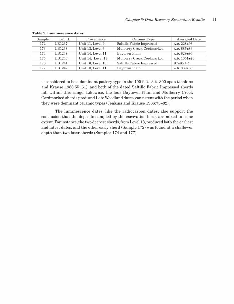
41Chapter 5: Data Recovery Excavation Results
is considered to be a dominant pottery type in the 100 b.c.–a.d. 300 span (Jenkins and Krause 1986:55, 61), and both of the dated Saltillo Fabric Impressed sherds fall within this range. Likewise, the four Baytown Plain and Mulberry Creek Cordmarked sherds produced Late Woodland dates, consistent with the period when they were dominant ceramic types (Jenkins and Krause 1986:73–82).
The luminescence dates, like the radiocarbon dates, also support the conclusion that the deposits sampled by the excavation block are mixed to some extent. For instance, the two deepest sherds, from Level 13, produced both the earliest and latest dates, and the other early sherd (Sample 172) was found at a shallower depth than two later sherds (Samples 174 and 177).
Table 2. Luminescence dates
Sample Lab ID Provenience Ceramic Type Averaged Date172 LB1237 Unit 11, Level 9 Saltillo Fabric Impressed A.D. 228±96173 LB1238 Unit 13, Level 6 Mulberry Creek Cordmarked A.D. 886±83174 LB1239 Unit 14, Level 11 Baytown Plain A.D. 829±90175 LB1240 Unit 14, Level 13 Mulberry Creek Cordmarked A.D. 1051±73176 LB1241 Unit 16, Level 13 Saltillo Fabric Impressed 87±95 B.C.177 LB1242 Unit 18, Level 11 Baytown Plain A.D. 869±65
table 2. Luminescence dates.


43
This chapter synthesizes materials recovered in both the testing and data recovery excavations, with reference where appropriate to materials in the survey assemblages. The complete assemblage provides an opportunity to examine regional and local aspects of lithic material procurement patterns, technological organization (production, use, repair, and discard), and the types of activities performed at the site.
This assemblage is particularly useful for addressing raw material procurement and use. Basic questions concern the types of raw materials utilized, plausible locations for procurement of these materials, and technological differences in the use of various materials. hence, the analysis begins with definitions of material types within the collection. Then, the various artifact categories are described, referencing the material type descriptions. Interpretations and conclusions based on analysis of the materials are synthesized in Chapter 10.
Raw MatERial typEs
Raw materials were identified based on experience with identified materials from the test excavations and a number of published archeological and geological sources that provide excellent descriptions of each type and observed variability among them (Barry 2004; Collins 1984; Cushing et al. 1964; Ensor 1980; Futato 1980; heinrich 1984; Johnson 1981; Lurie 1987; Matson 1916; McGahey 1999; Stallings 1989; Thomas et al. 1979).
Raw material types are described below. Presented is information on basic fracture properties, physical descriptions, color variation (before and after heat treatment), and literature references. Color variation is expanded based on identified materials in the assemblage from 22Ch698. Some of the materials could be identified to specific types or geographic locations (Figure 16), and others could not. Generic materials include sandstone, ferruginous sandstone, petrified wood, quartzite, crystalline quartz, and indeterminate cherts. Types identified to specific source areas or source names are Fort Payne cherts, Bangor cherts, Tallahatta quartzite, Kosciusko quartzite, and novaculite. Three other common materials—Camden cherts and Tuscaloosa and Citronelle gravels—can be identified to source area but are so similar that they cannot be readily distinguished when analyzing artifacts, particularly small flakes and fragments (Sarah Price, personal communication, June 24, 2014; Rego 2010). For this reason, these three chert types were collapsed into one broad category of gravel cherts, the assumption being that all three are represented. Not only are unheated colors of these cherts similar, but the heat-treated changes in color and fracture properties are very similar.
chaptER 6: lithic tEchnology and Raw MatERial usE

44 Excavations at Site 22CH698, Red Hills Mine
tuscaloosa gravels
This material is referred to as red jasper or yellow jasper and is part of the Tuscaloosa Formation, occurring as pebbles and cobbles in creek and river beds (Barry 2004:26). This chert occurs as well-rounded pebbles with a thin stream cortex
figure 16. Location of site 22Ch698 relative to major lithic sources represented in the assemblage.
Citronelle
Tuscaloosa/Camden
Fort Payne/Bangor
TallahattaKosciusko
Little Tallhatchie River
Yazo
o Rive
r
Yocona River
Sunflower River
Luxa
pallil
a Cree
k
Pearl RiverBig
Blac
k Riv
er
Mississippi River
Sucarnoochie River
Noxubee River
Bogue Phalia River
Oktibbee Creek
Skuna River
Yock
anoo
kany
Rive
r
Yalobusha River
Talla
hatc
hie
Rive
rCo
ldw
ater
Riv
er
Tuscumbia River
Tenn
esse
e-To
mbi
gbee
Wat
erw
ay
Hatc
hie
Rive
r
22CH698
0 40 8020
Kilometers³
Figure 16
PAI/14/slh

45Chapter 6: Lithic Technology and Raw Material Use
and varies in color from yellow to yellowish brown. Grain size ranges from fine to coarse within the same piece, and fracture quality is good to poor (Lurie 1987:274). As noted, it is difficult to distinguish between Tuscaloosa, Camden, and Citronelle gravel cherts among small pieces of debitage and small artifacts.
Two major Late Cretaceous stream systems carried Tuscaloosa gravels into northeastern Mississippi (Merrill 1988:3; Russell 1987). One was a system of southeast-draining streams that contributed chert from western Tennessee and northern Mississippi, and the other was a southwest-flowing system that crossed northern Alabama and contributed quartz, quartzite, chert, and quartz sand. The northern and western extent of continuous Tuscaloosa gravel exposures in Mississippi extends from northern Tishomingo County across southeastern Alcorn County and northeastern Prentiss County. Outcrops continue south and eastward into parts of Itawamba, Monroe, and Lowndes Counties in Mississippi and into Alabama and Georgia (Merrill 1988:5). The most abundant distributions of these cherts appear to be within the drainage basins of the Tombigbee and Tennessee Rivers.
camden chert
Camden cherts constitute a larger proportion of the Tuscaloosa Formation than the similar Tuscaloosa gravels. Barry (2004:26–28) notes that Camden and Tuscaloosa materials originated from the same geological formation and occur on the upper terraces of the Tombigbee River and in streams and rivers across much of western Alabama and eastern and northeastern Mississippi. Pebbles and cobbles of this material have a 1–2-mm-thick cortex (Lurie 1987:274). Colors include white, yellow, olive-yellow, tan, light gray, and blue gray (Barry 2004:27; Skrivan and King 1983:98). The differences are due to various inclusions and greater amounts of color mottling in the Camden material. Inclusions include quartz vugs that occur as streaks. When Camden and Tuscaloosa cherts are heated, they are very similar and mottling is enhanced. heat-treated Camden material is white, pink-white, orange, dark gray, gray-pinkish red, or orange red (Skrivan and King 1983:98). Grain size is usually finer than Tuscaloosa gravel chert and improves with heat treatment.
citronelle gravels
The Citronelle Formation is a band of secondarily deposited gravels extending from southern Illinois southward following the general trend of the Mississippi River alluvial valley. The gravels extend west to the coastal plains of Louisiana and east along the Mississippi and Alabama coastal plains to western Florida (Matson 1916; Stallings 1989:38). In western Mississippi, these gravels occur within the Loess hills physiographic province, and they can also be found on stream and river gravel bars that drain across the region. Raw materials include chert, quartzite, and sandstone pebbles. Much of the material probably was transported by streams from Mississippian formations that defined the northern edge of the Mississippi Embayment in southeastern Missouri, southern Illinois, and western Kentucky (Stallings 1989:39). The quartz and quartzite constituents are probably much older, having originated from pre-Cambrian rocks in Missouri or the Canadian Shield
46 Excavations at Site 22CH698, Red Hills Mine
(Stallings 1989:39). Cortex is common on all materials. Color variation in unaltered nodules includes red, gray, brown, yellowish to grayish brown, yellowish brown, reddish brown, yellowish red, and similar combinations (Stallings 1989:44). Many of the pebbles contain vugs lined with crystals or crystal pockets, and some also contain fossils like crinoid stems (Matson 1916).
fort payne cherts
Although there are several varieties of Fort Payne chert, all were combined under a general Fort Payne term. Material color is variable and includes light gray to blue, blue-gray, and dark gray or black (Thomas et al. 1979:18). Blue translucent mottles occur in some of the darker specimens (Lurie 1987:275). Lighter and coarse-grained samples can become yellow to tan through weathering. Lurie (1987) notes a sort of banding or zoning in some nodules when they have a dense zone of coarse-grained chert. Fort Payne cherts occur in the Lower Mississippian Fort Payne Formation that crops out in portions of the Carolinas, Georgia, Tennessee, Kentucky, northern Alabama, northeastern Mississippi, and southern Illinois (Barry 2004). Primary outcrops relevant to this project occur in northeastern Mississippi, northern Alabama, and central Tennessee. It occurs as in situ bedrock sources with some material also being reworked from northeast to southwest as constituents in stream bed loads and gravel deposits within the Tombigbee drainage basin. Barry (2004) discusses the following chert varieties under the Fort Payne heading: Blue Gray Fort Payne, Fort Payne (Florence County, Alabama), Fort Payne Dover, Fort Payne (Jefferson County, Alabama), Fort Payne (Tupelo, Mississippi), and Fossiliferous Fort Payne. Lurie (1987:275) also includes a fossiliferous variety that ranges from light gray to blue-gray, white, tan, and brown with fossils being darker than the surrounding matrix. Crinoid fragments are most common, but some brachiopods also occur.
bangor cherts
Lurie (1987) and Barry (2004) discuss this chert type. Lurie (1987:276) mentions three types: blue-green, Little Mountain, and fossiliferous. Bangor chert is largely limited to the upper half of the Bangor Limestone Formation (Thomas et al. 1979:19), which crops out in portions of northeastern Alabama. Like Fort Payne material, it occurs in both in situ bedrock contexts and as reworked gravels in the Tombigbee drainage basin. Blue-green Bangor varies from light blue-green to dark blue-green approaching gray. Pieces are often uniform in color but can exhibit a color shift between exterior and interior parts of a nodule. The material is fine grained, and flakes can be translucent; flaking quality is fair to excellent. Color patterns are similar for fossiliferous Bangor chert, but fossil fragments appear white. The most common fossils are Bryozoa. Sometimes fossils are weathered or leached out of the material leaving voids. Cobbles are thick and blocky and have squarish fracture planes. Pieces that are heat treated often are inconsistently altered and have a reddish band through the material. Mottles are rarely present, unlike in the Fort Payne material (Barry 2004:33).

47Chapter 6: Lithic Technology and Raw Material Use
tallahatta Quartzite
The Tallahatta Formation is found in south-central and southwestern Alabama and central to north-central Mississippi, with isolated outcrops in the western and southwestern portions of Choctaw County. This material is actually sandstone that has been metamorphosed to quartzite by silica cementation. It is the basal member of the Tertiary Claiborne Group and is an equivalent geological unit to the Carrizo Sand in Texas, Arkansas, and Louisiana (Cushing et al. 1964). A key trait is the sugary and sparkled appearance of individual grains in the ground mass. It varies in color with the degree of weathering. It is usually gray to blue-gray with white mottles on fresh samples or breaks but ranges to opaque tan mottles on weathered specimens (Lurie 1987:276). Prehistoric artifacts of this material typically have a weathered appearance due to the coarse-grained nature and relatively weak cement causing flake scar ridges to erode.
kosciusko Quartzite
This material is part of the Eocene-age Claiborne Group and consists of irregularly bedded sands, clay, and some quartzite. It crops out in a narrow band about 32 km wide in the northern hills of Mississippi flanking the alluvial plain in Attala, Carroll, Grenada, Tallahatchie, and Panola Counties and the Bluff hills area. Attala County, bordering Choctaw County on the west, is known to have the most abundant sources of Kosciusko quartzite with some exposures being up to 1.5 m thick. Beds of this material may consist of separate bands exceeding 0.3 m in thickness with the bands separated by sandstone or siltstone. In Attala County, it is commonly found along hilltops and slopes as large boulders and as a local constituent in colluvial materials (McGahey 1999:2). This is a very tough gray to steel gray material. Some sources indicate that artifacts of this material only occur in the vicinity of the geological occurrences. McGahey (1999:2) notes two variations of this material. One is coarse grained and varies from almost white to light gray with small reddish inclusions. Although this material improves considerably with heat treatment, it has been seldom reported in archeological assemblages. The second, more-common variation is very workable and fine grained and ranges from light to medium gray with some mottling. Some very fine-grained samples can be mistaken for chert. heat treatment appears generally not to alter the natural color to any great degree.
petrified wood
Petrified wood is ubiquitous in Tertiary strata across Texas, Louisiana, Mississippi, Alabama, and Florida. Quality and color vary considerably even within the same exposure (heinrich 1984). It also occurs as pebbles in streams and rivers that drain the region. Petrified wood recovered at 22Ch698 is predominantly unmodified and of very poor fracture quality. While common in the area, it does not appear to have been an important source of tool stone.

48 Excavations at Site 22CH698, Red Hills Mine
ferruginous sandstone
This material is found in the Tuscaloosa and upper Cretaceous formations in the region. It is generally coarse grained but can vary from medium to medium fine grained. The material was typically used to manufacture a variety of pecked or pecked and ground implements like axes, pitted stones, slabs, abraders, hammers, stone saws, and the like. Color varies from black to reddish black (Cushing et al. 1964; Lurie 1987:275). Reworked pieces can also be found in the Plio-Pleistocene deposits of the Gulf Coastal Plain (Matson 1916). Based on the abundance of ground stone artifacts manufactured of ferruginous sandstone at 22Ch698 and the abundance of unmodified pieces recovered during excavations, the source for much of this material must be close to the site.
novaculite, Quartz, and Quartz crystal
Although not common materials in the assemblage, the presence of novaculite, quartz, and quartz crystals is significant given the distances that such materials had to be culturally transported to the region. All of the flakes of quartz appear to have been removed from larger good-quality quartz crystals, and some retain remnants of crystal faces on the dorsal surface. Quartz crystals and novaculite both occur in the Ouachita Mountains of Arkansas and Oklahoma more than 350 km to the west of the site. Colors can vary from gray to white, although a variety near hot Springs, Arkansas, has colors of gray, yellow, black, white, red, and pink (Banks 1990:38–40). It is possible that some small pieces of white chert in the assemblage could be pieces of novaculite, but the distinction could not be made.
dEscRiption of thE assEMblagE
The assemblage recovered from both testing and data recovery consists of 11 cores or core fragments, 4,509 pieces of debitage, 125 chipped stone tools and fragments, and 87 ground stone tools and fragments. The chipped stone tool component consists of 45 nonprojectile point bifaces, 14 arrow points, 34 dart points, 4 drills, 14 chert bead preforms and fragments, 6 microblades and microliths, 2 unifaces, 5 utilized flakes, and 1 flaked pebble. The ground stone tool component consists of 7 pitted stones, 11 flaked sandstone chunks, 7 flaked sandstone choppers, 17 battered stones, 3 anvils, 23 slabs, 7 abraders, 2 sandstone saws, 1 fragment of a polished implement, 1 polished and cut stone, 3 pigment sources, and 5 indeterminate. Flaked sandstone choppers and sandstone chunks are included with the ground stones because of the raw material. Metric data for these artifacts, other than debitage, are given in Appendix C.
cores
A significant aspect of the assemblage is the virtual absence of cores. That so few are present is not surprising, though, given that raw materials suitable for tool manufacture are not abundant locally. Of the 11 bipolar cores recovered, 10 are of gravel cherts, and 1 is a quartzite pebble. Each exhibits remnant exterior cortex. Although bipolar percussion was employed to fracture the pebbles, 3 have flake

49Chapter 6: Lithic Technology and Raw Material Use
removals from one end, and 8 exhibit bidirectional flake removals. None appear to show evidence of deliberate heat treatment. Certainly, the abundance of chert gravel source material in the debitage and chipped tools argues for core reduction beyond strictly bipolar percussion. This is also born out by deliberate heat treatment of some of the debitage and tools and the complete sequence of biface manufacture. Amorphous or generalized core reduction undoubtedly was more common than bipolar techniques of pebble smashing, in spite of the fact that no cores other than bipolar ones were recovered. Cores range from 17.8 to 40.2 mm in length and 10.6 to 25.6 mm in width, indicating that there was some selection for rod-shaped or elongated pebbles.
debitage
Most of the 4,509 pieces of debitage are gravel cherts likely derived from Citronelle Gravel and Tuscaloosa and Camden chert sources (Table 3). Ferruginous sandstone is the next-most-common material. Ferruginous sandstone has the heaviest average flake weight (excluding two very small categories; see Table 3), which suggests that it represents more-complete reduction sequences from raw material masses to finished implements than the other materials and that the tools made of this material (i.e., ground stones) were larger than those made of the other materials. The rest of the main raw material categories have much smaller average flake weights, hinting that the majority of these materials represent later-stage reduction and maintenance of smaller tools. Raw materials with source areas farther from the site are dominated by smaller and lighter flakes and correspondingly less overall contribution to the total debitage component. The debitage assemblage reflects a mix of knapping goals oriented toward ground stone tool manufacture, biface manufacture, flake tool production, tool repair, and tool maintenance.
Table 3. Frequency of debitage by raw material type
Raw Material CountPercent by
Count Weight (g)Percent by
WeightAverage Flake
Weight (g)Gravel cherts 2,603 57.7 1,124.4 19.8 0.4Ferruginoussandstone
706 15.7 3,689.2 65.0 5.2
Kosciusko quartzite 415 9.2 165.1 2.9 0.4Tallahattaquartzite
252 5.6 292.6 5.2 1.2
Fort Payne chert 200 4.4 57.7 1.0 0.3Unidentified chert 172 3.8 146.7 2.6 0.9Quartzite, other 66 1.5 83.5 1.5 1.3White chert 34 0.8 13.4 0.2 0.4Petrified wood 32 0.7 36.7 0.6 1.1Bangor chert 17 0.4 8.6 0.2 0.5Quartz/quartzcrystal
6 0.1 4.2 0.1 0.7
Novaculite 3 0.1 0.8 0.0 0.3Sandstone 2 0.0 25.7 0.5 12.8Other 1 0.0 27.8 0.5 27.8Totals 4,509 100.0 5,676.4 100.0
table 3. Frequency of debitage by raw material type.

50 Excavations at Site 22CH698, Red Hills Mine
All debitage was size graded and segregated by raw material type (Tables 4 and 5). Apparent is the abundance of debitage in smaller size grades for all materials, with ferruginous sandstone having more larger flakes (34 percent in Size Grades 1–3) and the most divergent distribution. The distribution of material by size is influenced primarily by the initial size of the raw material and the amount of trimming and shaping it had been subjected to prior to being brought to the site. Ferruginous sandstone appears to have been more common as larger masses of material, which probably says something about its closer source areas. Gravel cherts like Citronelle, Tuscaloosa, and Camden occur as small pebbles or cobbles in stream gravels or terrace deposits, and thus they are small to begin with and will not have much debitage to contribute to the larger size grades (98 percent are in Size Grades 4 and 5). unidentified cherts (92 percent in Size Grades 4 and 5) follow a similar pattern as gravel cherts and may be related to these materials. Kosciusko quartzite (99 percent), Fort Payne chert (99 percent), Bangor chert (94 percent), white chert (97 percent), and novaculite (100 percent) follow this pattern as well, but this likely relates to these materials having arrived at the site in small packages, either as flakes, preforms, or finished tools, with initial reduction having occurred elsewhere closer to their sources. Slightly less of the Tallahatta quartzite debitage is in Size Grades 4 and 5 (89 percent), which may be related to the difficulty of flaking this material due to its poor fracture qualities. The material also has a tendency to weather and degrade at a granular level.
table 4. Frequency of debitage by raw material and size grade.
Table 4. Frequency of debitage by raw material and size grade
Raw Material Size Grade 1 Size Grade 2 Size Grade 3 Size Grade 4 Size Grade 5 Totals
Gravel cherts 0 4 (0.2) 55 (2.1) 1,093 (42.0) 1,451 (55.7) 2,603
Ferruginous sandstone 32 (4.5) 61 (8.6) 150 (21.2) 319 (45.2) 144 (20.4) 706
Kosciusko quartzite 0 0 5 (1.2) 131 (31.6) 279 (67.2) 415
Tallahatta quartzite 1 (0.4) 4 (1.6) 22 (8.7) 85 (33.7) 140 (55.6) 252
Fort Payne chert 0 0 3 (1.5) 72 (36.0) 125 (62.5) 200
Unidentified chert 0 2 (1.2) 12 (7.0) 88 (51.2) 70 (40.7) 172
Quartzite, other 1 (1.5) 1 (1.5) 8 (12.1) 30 (45.4) 26 (39.4) 66
White chert 0 0 1 (2.9) 16 (47.1) 17 (50.0) 34
Petrified wood 0 1 (3.1) 4 (12.5) 13 (40.6) 14 (43.8) 32
Bangor chert 0 0 1 (5.9) 7 (41.2) 9 (52.9) 17
Quartz/quartz crystal 0 0 0 2 4 6
Novaculite 0 0 0 1 2 3
Sandstone 0 1 1 0 0 2
Other 0 1 0 0 0 1
34 (0.8) 75 (1.7) 262 (5.8) 1,357 (41.2) 2,281 (50.6) 4,509
Note: Values in parentheses are row percentages. Percentages calculated only for raw materials with counts greater than 10 pieces.

51Chapter 6: Lithic Technology and Raw Material Use
Table 6 shows the amounts of noncortical vs. cortical debitage and heat-treated material for the six largest raw material categories. Apparent are the dominance of noncortical debitage for each material and the almost exclusive application of heat treatment to gravel cherts and unidentified cherts. This indicates that a good proportion of the gravel chert arrived at the site in the form of finished artifacts or preforms that had been heat treated and partially finished elsewhere. But the presence of cortex even in the smaller size grades for gravel cherts indicates that some of the smaller debris was associated with initial reduction of chert pebbles by bipolar percussion and other techniques (see Table 5). It appears that most of the tools manufactured of Fort Payne chert, Tallahatta quartzite, and Kosciusko quartzite were manufactured without thermal pretreatment of blanks and preforms.
chipped stone tools
Non-Projectile Bifaces
Bifacial artifacts were identified as any lithic artifact with flake removals on both surfaces of an edge or edges (Odell 2004:45; Whittaker 1994:178). This discussion does not include projectile points and drills, which are discussed separately below. Based on the types of manufacturing failures, flaking characteristics, size, and
Table 5. Frequency of cortex and deliberate heat treatment on debitage by size grade for selected raw materials
Raw Material Size Grade 1 Size Grade 2 Size Grade 3 Size Grade 4 Size Grade 5
Cortex Heated Cortex Heated Cortex Heated Cortex Heated Cortex Heated
Gravel cherts 0 0 3 1 38 8 255 394 47 597
Ferruginous sandstone 7 0 5 0 11 0 7 0 0 0
Kosciusko quartzite 0 0 0 0 1 0 3 1 1 0
Tallahatta quartzite 0 0 0 0 3 0 2 0 0 0
Fort Payne chert 0 0 0 0 0 0 0 1 0 1
Unidentified chert 0 0 0 1 1 3 8 22 0 12
table 5. Frequency of cortex and deliberate heat treatment on debitage by size grade for selected raw materials.
table 6. Amounts of noncortical vs. cortical debitage and heat-treated material for the six largest raw material categories.
Table 6. Amounts of noncortical vs. cortical debitage and heat-treated material for the six largestraw material categories
Raw Material Noncortical Cortical Heat-TreatedCount Percent Count Percent Count Percent
Gravel cherts 2,260 86.8 343 13.2 1,000 38.4Ferruginous sandstone 676 95.8 30 4.2 0 0Kosciusko quartzite 410 98.8 5 1.2 1 0.2Tallahatta quartzite 247 98.0 5 2.0 0 0Fort Payne chert 200 100.0 0 0 2 1.0Unidentified chert 163 94.8 9 5.2 37 21.5

52 Excavations at Site 22CH698, Red Hills Mine
degree of completion, most of these appear to represent efforts to make bifacial tools rather than bifacial cores for production of expedient flake tools. Forty-five artifacts are in this group: 29 indeterminate biface fragments, 2 bifacial knives, and 14 bifaces classified according to manufacturing stage (Stage 1, n = 1; Stage 2, n = 4; Stage 3, n = 6; and Stage 4, n = 3) (Figure 17). Raw material types are Bangor chert (n = 1), Fort Payne chert (n = 1), gravel cherts (n = 23), unidentified cherts (n = 11), Kosciusko quartzite (n = 3), Tallahatta quartzite (n = 4), petrified wood (n = 1), and other quartzite (n = 1). When the sample is examined by stage of manufacture, gravel cherts and Tallahatta quartzite are associated with earlier stages of manufacture than other raw materials.
Only 1 bi face is complete, 7 are proximal or proximal-medial fragments, 10 are medial fragments, 13 are distal fragments, and 14 are indeterminate portions. In terms of break types and reasons for discard, 11 have evidence of excessive heat damage, 22 have snap or end shock breaks, 1 has a perverse fracture, 5 have multiple fracture types, 1 has a material flaw, and 5 are indeterminate. Snap or end shock breaks can occur during use but are inferred to primarily represent manufacture failure in this sample because most are on unfinished preforms. Of the 22 bifaces broken in this manner, only 2 are bifacial knives that may have broken in use. Each of these knife fragments has alternate beveling pressure retouch along existing blade edges. There are no distal impact fractures or other evidence that any of these fragments may have broken during use as hafted projectile points.
In terms of secondary alteration of raw materials, 4 artifacts exhibit heat crazing from intense burning, 24 are heat treated, and 4 are weathered (Tallahatta
centimeters
0 1 2 4
centimeters
0 1 2
centimeters
0 1 2
a b
c
de
f
figure 17. Bifaces and bifacial knives. (a–b) Stage 2 proximal-medial fragments of gravel chert and Tallahatta quartzite; (c) Stage 3 proximal fragment of quartzite; (d) Stage 3 distal-medial fragment of gravel chert; (e–f) distal fragments of bifacial knives of gravel cherts with alternate edge beveling.

53Chapter 6: Lithic Technology and Raw Material Use
quartzite specimens). Bifaces and fragments manufactured of heat-treated materials are limited to 16 of gravel cherts and 8 of unidentified cherts. There is no indication in the small samples of Fort Payne chert, Bangor chert, and Kosciusko quartzite that these materials were heat treated as part of the manufacture process. This is also reflected in the debitage analysis presented earlier.
Biface shape reflects variation on the triangular plan view with basal edges varying between straight, concave, and convex and lateral edges primarily convex or recurved. This shape variation corresponds to the array of morphologies represented among the dart points and arrow points recovered as part of the assemblage.
Projectile Points
hafted bifaces include both arrow (n = 14) and dart (n = 34) points. These differ from the bifaces described above in that each artifact went through the entire manufacture sequence and has technological indications that the tool was designed to be hafted in some manner. The raw materials reflect reliance on various gravel cherts for manufacture of projectile points, with a distinct difference between arrow points and dart points. Arrow points were manufactured of only two raw materials, while dart points were made on a greater variety of materials (see descriptions below). Six arrow points and 15 dart points are heat treated.
A number of different sources were consulted for typological identifications: Cambron and hulse (1975), Justice (1987), McGahey (2004), Barry (2004), Edmonds (2009), Rego (2010), and DeMasi (2013). Types were assigned based on morphological comparisons with illustrated specimens. Where specific type names could not be reliably assigned, Justice (1987) was consulted to attempt to assign the points in question to broader groups of projectile point types that may be regionally applied to a time period.
ARROW POINTS
Of the 14 arrow points, 7 are of Kosciusko quartzite and 7 are of gravel cherts. All of the quartzite specimens and 6 of the gravel chert ones are considered to be Madison points (Figure 18); the remaining gravel chert distal fragment is untyped. heat treatment is evident on 6 specimens. One has proximal staining reminiscent of asphaltum. Ten are considered finished tools, 2 are late-stage preforms, and 2 are indeterminate to stage of manufacture. Six points are whole, 6 are proximal/proximal-medial fragments, and 2 are distal pieces. Six points have snap or end shock fractures, and 2 have impact fractures; 6 complete arrow points exhibit no reason for discard. Based on these fracture types, some points were broken in use as projectiles, and others were broken in use or manufacture.
Madison points are small, triangular, pressure-flaked bifaces having straight to slightly concave bases and straight to slightly convex lateral blade edges. In this group of 13 points, 5 have slightly concave basal edges, 4 have straight bases, 3 have slightly convex basal edges, and 1 is indeterminate. The points from 22Ch698 exhibit good flaking control, even for the quartzite specimens, and reflect a singular use of pressure flaking techniques to finish the points. Five points have straight

54 Excavations at Site 22CH698, Red Hills Mine
blade edges, 5 have convex edges, and 3 are indeterminate. Justice (1987:224) assigns the Madison type to a Late Wo o d l a n d / M i s s i s s i p p i a n Triangular Cluster. Price and Carr (2009a:135) note that there are many sites in central and southern Alabama that have yielded Madison points in direct association with Late Woodland components. Cambron and hulse (1975) indicate that Madison points have a primarily Mississippian association. McGahey (2004:201) remarks that the earliest appearance of Madison points in Mississippi was in the northeastern portion of the state during Miller III times (a.d. 300–700). Recent projects in Alabama have yielded radiocarbon dates for contexts
that include Madison points. An early calibrated date of a.d. 573–688 was derived from a sample containing a Madison point from site 1CK56 (Price and Carr 2009b). Elsewhere, Potts and Carr (2008:112) report dates of a.d. 890–1020 and a.d. 1010–1180 from 1MT318 for contexts containing Madison points. A calibrated radiocarbon age of a.d. 680–900 for a Late Woodland assemblage with Madison points from the Lower Salt Works site (1CK28) is reported by Dumas (2007:346). Rafferty (2002:208) notes that small Madison and Collins arrow points became popular during the Late Woodland period, replacing earlier stemmed forms. The fact that half of the Madison points from 22Ch698 are of Kosciusko quartzite may relate this assemblage to extensive settlement of the north-central hills in Mississippi during the Late Woodland period (Rafferty 2002:208) and the peak use of Kosciusko quartzite at the same time (McGahey 1999:3–4).
DART POINTS
Of the 34 dart points, 5 are of Fort Payne chert, 16 are of gravel cherts, 2 are of unidentified chert, 10 are of Tallahatta quartzite, and 1 is of other quartzite. This greater variety of raw materials than in the arrow points may reflect greater group mobility or more access to various raw materials through other social means. Twelve are complete enough that they can be related to established stylistic forms. These represent the following time periods: Early Archaic (Big Sandy), Middle/Late Archaic–Poverty Point–Gulf Formational (Flint Creek/Pontchartrain, Little Bear Creek, McIntire, and Pickwick), and Woodland (Edwards Stemmed and Tombigbee Stemmed).
centimeters
0 1 2
b c
e g
a d
fh
figure 18. Madison arrow points. (a–d) heat-treated gravel cherts; (e–h) Kosciusko quartzite.
55Chapter 6: Lithic Technology and Raw Material Use
Big Sandy
A single proximal-medial fragment compares closely to the Big Sandy type (Figure 19a). It has a shallowly side-notched rectangular stem with a straight basal edge. Grinding is present on the basal edge and into one of the side notches. The raw material is a mottled dark red-light orange-medium red, fine-grained gravel chert that may be heat treated. The specimen has an impact/bending fracture. This point is provisionally considered an Early Archaic form of Big Sandy based on the stem edge grinding. McGahey (2004:52) notes that Big Sandy points in Mississippi typically have concave basal edges, but a number with straight bases are also illustrated. Specimens with basal grinding are considered Early Archaic, whereas similar specimens with no grinding from the Eva site in west-central Tennessee were found in Middle Archaic contexts (Lewis and Lewis 1961:37; McGahey 2004:52). Justice (1987:60–62) places Big Sandy points within a Large Side-Notched Cluster of point types from the Early Archaic period.
Edwards Stemmed
Of the two Edwards Stemmed points (Figure 19b–c), one is manufactured from gravel chert, and one is of unidentified chert. Both appear heat treated. The unidentified chert specimen is complete, and the gravel chert specimen is a proximal-medial fragment. Edwards Stemmed points are medium-sized bifaces with narrow, relatively straight stems and straight basal edges. Shoulders are slight to prominent, and basal edges can sometimes be convex. Stems can be parallel, slightly contracting, or slightly expanding. The complete specimen has been heavily resharpened and exhibits a basal edge with a remnant transverse fracture of the original preform, which is characteristic of some points of this style (McGahey 2004:194). Blade edges on both points are slightly convex. The proximal-medial fragment has a transverse bending fracture across the blade and alternately beveled blade edges. Given the alternately beveled blade edges, this point is not considered a manufacturing failure. McGahey (2004:194) provides a length range of 44–60 mm, width range is 15–25 mm, and thickness range is 5–10 mm for the type. Dimensions of both specimens from 22Ch698 are within these ranges (see Appendix C). McGahey (2004:194) dates this type to a.d. 0–700 during the Woodland period.
Flint Creek/Pontchartrain
The single Flint Creek/Pontchartrain dart point is a proximal-medial fragment of deep reddish orange, heat-treated gravel chert (Figure 19d). Following McGahey (2004:166), the Flint Creek and Pontchartrain types are combined due to the difficulties of segregating them morphologically or geographically. Perino (1986:132, 306) indicates that these point styles were related. The blade has a transverse snap/end shock break. This point is considered unfinished because it lacks the characteristic carefully controlled pressure flaking along the blade edges (McGahey 2004:167). The lateral blade edges are percussion flaked, and the medial portion appears overthickened as if unfinished. Shoulders are prominent but curved. The well-made stem has parallel, slightly ground lateral edges and a slightly convex basal edge. Pontchartrain points have been noted to have some stem edge grinding

56 Excavations at Site 22CH698, Red Hills Mine
(McGahey 2004:167). Dimensions of the proximal-medial fragment are comparable to those provided for this point style by McGahey (2004). The Pontchartrain point style is one of the major types associated with Poverty Point and occurs over much of western Mississippi (Ford and Webb 1956). At the Teoc Creek site, it has been dated between 1700 and 1000 b.c. (Connaway et al. 1977). Cambron and hulse
centimeters
0 1 2
a
bc
e
ij
f g
d
h
figure 19. Typed dart points. (a) Big Sandy; (b–c) Edwards Stemmed; (d) Flint Creek/Pontchartrain; (e) Little Bear Creek; (f–g) McIntire; (h) Pickwick; (i–j) Tombigbee Stemmed.

57Chapter 6: Lithic Technology and Raw Material Use
(1975) indicate that Flint Creek points overlap between the Archaic and Gulf Formational periods (Sparks 1987:37). Sparks (1987) notes that Flint Creek points were found in Gulf Formational stage contexts in association with Wheeler and Alexander series ceramics at the yarbrough site in northeastern Mississippi. Flint Creek points have been identified with Gulf Formational occupations (Alexander) and occurring until the Middle Woodland period in the western part of the Middle Tennessee River valley (Futato 1999:48). Lewis and Lewis (1961:33, 35) illustrate narrow stemmed points of similar morphology from the Eva site that occurred in both earlier Big Sandy deposits and Three Mile components.
Little Bear Creek
A proximal stem fragment is tentatively identified as Little Bear Creek following Justice (1987) and McGahey (2004). The stem is slightly contracting with straight edges (Figure 19e). The type also includes examples with parallel straight stems. This point was manufactured of heat-treated gravel chert. The stem has a snap or end shock fracture and may have broken during impact. Stem grinding is not present on this specimen but has been noted for the type (Cambron and hulse 1975:83). Cambron and hulse (1975:83) indicate that use of the type began in the Late Archaic period and reached a height of popularity in the Late Woodland period. Sparks (1987:7) considers Little Bear Creek points diagnostic of the Late Archaic period. Futato (1999:48) includes types such as Mulberry Creek within the Little Bear Creek Cluster. Radiocarbon ages of 1650+180 b.c. and 1070+75 b.c. were obtained for contexts with Little Bear Creek points at site 1FR520 in the Bear Creek watershed in Alabama (Futato 1999:48).
McIntire
Two of the three probable McIntire points are manufactured of Tallahatta quartzite, and one is of gravel chert (Figure 19f–g). All are essentially complete and are finished items. One has a small portion of tip broken in a snap or bending fracture, another has an impact fracture, and one has been heavily retouched. Luster on the gravel chert specimen suggests it is heat treated, but there is no associated color change. The others are not heat treated. These points have slightly expanding stems with straight to slightly convex basal edges. Blade edges vary from straight to slightly convex. The Tallahatta quartzite specimens are moderately weathered. The basal edge of one represents a transverse break of either the biface preform or the original flake blank. Dimensions are within the range of variation discussed by McGahey (2004:138). McGahey (2004:139) considers McIntire points to be diagnostic of the early Late Archaic period between 5,000 and 4,000 b.p. Cambron and hulse (1975:87) attribute them to a Middle to Late Archaic time span.
Pickwick
Two points similar to the Pickwick style are made of Tallahatta quartzite and gravel chert (Figure 19h). Neither is heat treated, but the Tallahatta quartzite point is moderately weathered. The gravel chert point is complete, while the Tallahatta quartzite point is a distal-medial fragment missing a portion of the tapering stem.

58 Excavations at Site 22CH698, Red Hills Mine
Blade edges are convex or recurved, and shoulders vary from sloped to angular. The complete point has a stem with parallel edges and straight basal edge. Cortex is present on both sides of this point, indicating that it was manufactured from a flat chert pebble. Dimensions are within published ranges for this type (Cambron and hulse 1975:104; McGahey 2004:139). In Mississippi, Pickwick points span the time from the late Middle Archaic to the Late Archaic but are not well-dated (Cambron and hulse 1975:104; McGahey 2004:139). Justice (1987:149–150) includes Pickwick points within his Ledbetter Cluster for the Late Archaic period and notes similarities with the Ledbetter point style. These types share similar morphologies and similar geographic ranges across Mississippi, Alabama, Georgia, Tennessee, and Kentucky. Justice (1987:150) notes that Ledbetter points have been found with Pickwick, Cypress Creek, Little Bear Creek, Cotaco Creek, and Mulberry points in the upper Duck River valley, Tennessee. At 22LD521, the Toby Thornhill site, an assemblage of Middle Archaic Cypress Creek and Pickwick dart point types of Tallahatta quartzite were recovered in association with Middle Archaic Benton points of Fort Payne chert (Brookes 1999:87). This site is a large Tallahatta quartzite workshop, and many of the points found there are identical to points found in association with Benton point caches in the Tombigbee area. The majority of those Tallahatta quartzite points were of the Pickwick/Ledbetter cluster, originally thought to belong strictly in the Late Archaic based on the contracting stems on some points. Brookes (1999:88) notes that the majority of Pickwick cluster points have stem widths well within the range of wide-stemmed Middle Archaic forms. No Pickwick cluster points had been recovered from dated contexts until the Benton caches were found. These caches have been dated between 4750 and 3900 b.c. and demonstrate the temporal relationship between Pickwick cluster and Benton points as part of a larger exchange network involving Tallahatta quartzite in the Middle Archaic period.
Tombigbee Stemmed
Two specimens identified as Tombigbee Stemmed consist of a proximal-medial quartzite specimen and a complete but damaged point of heat-treated gravel chert (Figure 19i–j). Both have slightly contracting stems with straight lateral edges and straight basal edges. The quartzite point is broken obliquely across the blade in a snap/end shock fracture, and the gravel chert biface has a reworked blade with an impact fracture remnant. The shoulders of both are rounded to sloping. McGahey (2004:196) describes the type as having contracting stems and sloped shoulders and generally poor workmanship compared to other similar points. Dimensions are comparable to those cited by McGahey (2004:196) and Sparks (1987:22–25). McGahey (2004) assigns the type to the Woodland period between a.d. 0 and 700. Ensor (1980:92) dates these points between 100 b.c. and a.d. 600. Sparks (1987:7) considers the Tombigbee Stemmed type, along with the Bear Creek and Flint Creek styles, to be temporal markers for the Late Archaic and Gulf Formational periods.
untyped
Of the 22 untyped dart points and fragments, 9 are gravel cherts, 5 are Fort Payne chert, 7 are Tallahatta quartzite, and 1 is unidentified chert. heat treatment is

59Chapter 6: Lithic Technology and Raw Material Use
apparent on 2 gravel chert examples and 1 Fort Payne chert specimen. Represented are 1 early-stage form, 2 late-stage forms, 10 finished items, 1 recycled specimen, 1 rejuvenated or repaired item, and 7 specimens that are indeterminate as to stage of manufacture. Five are complete, 6 are proximal or proximal-medial fragments, 2 are medial fragments, 7 distal or distal-medial fragments, and 2 are indeterminate portions. Reasons for discard include 1 with an apparent deliberate snap break, 10 with snap or end shock fractures, 4 with impact fractures, 1 with a material flaw, 4 indeterminate, and 1 exhausted biface. The sample reflects both manufacture and use-related fractures. The mix of fracture types and fragment portions suggests that the sample represents hafted bifaces used as both projectiles and hafted cutting tools. One late-stage preform is a lenticular narrow biface of banded gravel chert with a possible haft element on one end with cortex on the basal edge.
Although these dart points could not be attributed to known types, it is possible to assign six relatively complete ones and three proximal or proximal-medial fragments to broad clusters that have morphological similarities to established forms. Seven resemble Middle to Late Archaic forms like Morrow Mountain, Opossum Bayou, McIntire, Cypress Creek, Pickwick, and Ledbetter (Figure 20; Brookes 1999; Lewis and Lewis 1961; McGahey 2004). There is also some resemblance to McGahey’s (2004) provisional type Late Archaic Barbed and Cotaco Creek point styles and to point styles in the Terminal Archaic Barbed Cluster discussed by Justice (1987:179–184). A complete preform and a proximal-medial fragment of a similar preform have parallel to slightly contracting stems with rounded to angular shoulders similar to dart point forms like Little Bear Creek, Flint Creek/Pontchartrain, Delhi, and others (Justice 1987; McGahey 2004). As a group, the untyped dart points from 22Ch698 resemble a range of forms spanning the Late Archaic and Gulf Formational periods.
Drills
Fo u r ch i p p e d s t o n e artifacts are complete drills or drill fragments (Figure 21). One is of gravel chert, two are unidentified chert, and one is Kosciusko quartzite. heat treatment is evident on one gravel chert and one unidentified chert drill. One is complete, two are distal fragments, and one is a figure 20. untyped relatively complete dart points. (a) unidentified
chert; (b) gravel chert; (c–e) Tallahatta quartzite.
centimeters
0 1 2
Figure 20
a
b
c
d e

60 Excavations at Site 22CH698, Red Hills Mine
proximal-medial fragment. Reasons for discard are as follows: two have snap or end shock breaks at the tip or along the bit; one was exhausted; and one is indeterminate. The three fragmentary specimens are recycled projectile points or point fragments on which the tip or blade area was retouched by pressure flaking into a suitable drill. Two are reworked distal fragments with transverse bending fractures, and the other is a dart point stem with a remnant of the blade retouched into a drill and broken distally. The fourth drill is a small pressure-flaked narrow biface with a slight rectangular haft element.
Chert Bead Preforms
Fourteen trifacial and quadrifacial, rod-shaped, percussion-flaked preforms and other fragments resemble broken drills but are identified as cylindrical preforms for chert beads based on fracture patterns, absence of use wear, and cross-section morphology (see Figure 21). This identification was confirmed by Philip Carr (personal communication, July 16, 2014). Eleven are of gravel cherts, and 3 are unidentified chert. Eight have no evidence of heat treatment, 4 have possible heat treatment, and 2 are heat-crazed from burning. Five represent an early stage of manufacture, 7 are late-stage, and 2 are indeterminate. Snap breaks are present on 11, 1 has multiple fracture types, and 2 are indeterminate. Almost all of the snap breaks are essentially 90-degree fracture faces. It is difficult to determine if these breaks were deliberately produced to create bead preforms or if these specimens represent manufacturing failures. Two specimens have small patches of stream-worn cortex on their ends indicating that they were manufactured from small chert pebbles. Two specimens are tentatively identified as effigy bead blanks (see Figure 21i). One exhibits a lateral triangular tang along one side, and the other appears similar.
Cylindrical and discoidal chert and jasper beads and evidence of bead manufacture have been found at a number of Middle Archaic sites in Louisiana, Mississippi, and Alabama, including Cad Mound, Watson Brake, and Poverty Point in Louisiana (Anderson and Sassaman 2004; Ford and Webb 1956; Gibson 1968; Johnson 2000); and Jaketown, Denton, and Loosa yokena in Mississippi (Ford et al. 1955; McGahey 1977, 2007). These items also have been found as large caches, such as the Keenan Cache and Fulton Cache (Anderson and Sassaman 2004:99; Connaway 1981).
hadley and Carr (n.d.) have recently discussed the temporal and contextual aspects of Middle Archaic chert bead manufacture and craft specialization, and Connaway (1981) and Johnson (2000) provide detailed analyses of the manufacture process of these artifacts. The sequence began with percussion chipping a pebble of local chert gravel into a cylindrical form using bifacial or trifacial flaking, keeping the edges as close to 90 degrees as possible. The second stage consisted of grinding to give the bead blank a round or oval cross section. The third and fourth stages entailed completion of grinding, removal of the tapered ends, and drilling. Connaway (1981) and Johnson (2000) agree that bead preforms were mostly ground to acceptable shapes prior to removal of the tapered ends and drilling. All of the specimens from 22Ch698 exhibit almost identical 90-degree fractures, and none have been ground
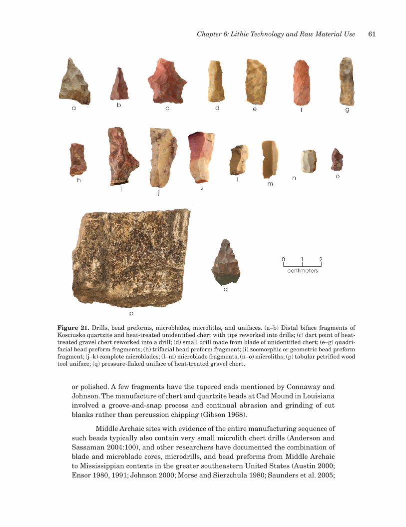
61Chapter 6: Lithic Technology and Raw Material Use
or polished. A few fragments have the tapered ends mentioned by Connaway and Johnson. The manufacture of chert and quartzite beads at Cad Mound in Louisiana involved a groove-and-snap process and continual abrasion and grinding of cut blanks rather than percussion chipping (Gibson 1968).
Middle Archaic sites with evidence of the entire manufacturing sequence of such beads typically also contain very small microlith chert drills (Anderson and Sassaman 2004:100), and other researchers have documented the combination of blade and microblade cores, microdrills, and bead preforms from Middle Archaic to Mississippian contexts in the greater southeastern united States (Austin 2000; Ensor 1980, 1991; Johnson 2000; Morse and Sierzchula 1980; Saunders et al. 2005;
figure 21. Drills, bead preforms, microblades, microliths, and unifaces. (a–b) Distal biface fragments of Kosciusko quartzite and heat-treated unidentified chert with tips reworked into drills; (c) dart point of heat-treated gravel chert reworked into a drill; (d) small drill made from blade of unidentified chert; (e–g) quadri-facial bead preform fragments; (h) trifacial bead preform fragment; (i) zoomorphic or geometric bead preform fragment; (j–k) complete microblades; (l–m) microblade fragments; (n–o) microliths; (p) tabular petrified wood tool uniface; (q) pressure-flaked uniface of heat-treated gravel chert.
Figure 21
centimeters
0 1 2
a b c d e f g
h
i jk
lm
n o
q
p

62 Excavations at Site 22CH698, Red Hills Mine
yerkes 1983, 1989a, 1989b, 1991, 1993, 2003). Site 22Ch698 yielded no other evidence for manufacture of chert beads, however, suggesting that only part of the process was performed there. This could be a function of the limited data recovery in the accessible remaining portion of the site, though, and one of the microliths described below is reminiscent of a microdrill that has no wear.
Microblades and Microliths
Four microblades and two microliths are in the assemblage (see Figure 21). Microliths and microblades are often reported from sites with Archaic and Woodland components (Ensor 1980, 1999; Price 2008:218; Price and Carr 2009a:139). Each of the microblades is of gravel chert, as is one of the microliths; the other microlith is of unidentified nonlocal chert. None are heat treated, although one complete blade is discolored distally by heat exposure. Two microblades are relatively complete blades (see Figure 21j–k), one is a proximal-medial fragment (see Figure 21l), and one is a distal-medial fragment (see Figure 21m). One of the complete blades has a small patch of stream-worn cortex along one lateral edge. The second complete blade retains a small portion of the distal end of the small microblade core. Both complete microblades and one fragment have bidirectional dorsal blade scars from previous microblade removals, indicating that blades were removed from opposing ends of each core. Each of the blade fragments also has ridges and scar facets from earlier blade removals. One complete blade exhibits use wear along one concave edge. The wear consists of unifacial microscars with feather and step terminations and slight edge rounding indicative of a scraping motion.
Microliths include a small rectangular white chert microblade segment with light bifacial pressure flaking along both lateral edges and one end (see Figure 21n). No wear is present. The dorsal surface has a central flake scar ridge and two previous microblade scars. The second microlith is a small chert or microblade fragment that has bifacial pressure flaking and a triangular cross section creating a very sharp point (see Figure 21o). There is no use wear apparent on this artifact, and it resembles unworn chert microdrills reported from Middle Archaic sites in Mississippi and Louisiana that have also yielded evidence of chert bead manufacture. These artifacts are very small, each about 12 mm in length and less than 4 mm in thickness.
Flake Tools and Unifaces
Two unifaces, five small utilized flakes, and one flaked pebble make up the remainder of the chipped stone tool assemblage. The unifaces reflect use of local materials for expedient tool manufacture. One is a rectangular piece of tabular petrified wood that has percussion retouch along an edge (Figure 21p). Very light smoothing and edge rounding are similar to wear on tools that have been used for cutting or sawing. The second uniface is an angular fragment of heat-treated gravel chert with unifacial pressure flaking to create a serrated edge (Figure 21q). No wear was observed on this specimen, but it may have been intended for expedient use in cutting tasks.

63Chapter 6: Lithic Technology and Raw Material Use
The five utilized flake tools have an edge or edge segment with unifacial microscars from use in light scraping tasks and then discarded. Two are of gravel chert, one is sandstone, one is Tallahatta quartzite, and 1 is Kosciusko quartzite.
The flaked pebble is a roughly percussion-flaked piece of quartzite. No cortex is present. There is no use wear. It does not appear to represent a core or a discarded bifacial preform. Its function is unknown.
ground stone tools
The sizable assemblage of ground stone tools and fragments (n = 87) is mostly of ferruginous sandstone (n = 83), which likely was procured nearby. Two of the other four items are of hematite, and 1 each is of quartzite and nonferruginous sandstone. The sandstone varies from rather loosely cemented soft material to quite dense and well-cemented material with fair to good conchoidal fracture and flaking properties. Many of the artifacts exhibit percussion trimming and shaping along their edges, and this appears to have contributed the 705 pieces of sandstone debitage described earlier in this chapter. These artifacts are grouped as follows: 7 pitted stones, 11 flaked pieces, 7 choppers, 17 battered stones, 3 anvils, 23 slabs, 7 abraders, 2 saws, 1 polished stone, 1 polished and cut stone, 3 pigment sources, and 5 indeterminate fragments. Their classification, and in some cases presumed functions, are based on morphology, macroscopic wear traces (where apparent), and manufacturing technology. Metric data are provided in Appendix C.
Pitted Stones
All seven pitted stones are tabular ferruginous sandstone. These artifacts have one or two pits on one or more surfaces (Figure 22). The pits include both smooth and roughened depressions created by various activities. Roughened pits could represent pits in the early stages of use or could be functionally different than smoothed pits. Four also have light to moderate crushing and battering along edge segments indicating use as hammerstones or heavy chopping and breaking tools. One implement has hematite staining indicating possible use in pigment processing. Another tool has been roughly percussion flaked to a circular shape.
Flaked Sandstone
There are 11 angular pieces or tabular fragments of ferruginous sandstone that have evidence of percussion flaking. Their functions are unknown. These artifacts may represent pieces produced during trimming and shaping of other artifact classes like slabs, grinding slabs, pitted stones, and abraders. Some with battering may have served as expedient hammerstones, chopping implements, or expedient anvils. One piece has a lightly striated and smoothed surface suggesting it may be a flaked grinding slab fragment.
Chopping Tools
There are seven heavy chopping tools of tabular ferruginous sandstone created by unifacial or bifacial percussion flaking along a portion of an edge or the

64 Excavations at Site 22CH698, Red Hills Mine
centimeters
0 1 2
a
b
figure 22. Pitted stones. (a) Tabular fragment with rough pit near edge; (b) stone with roughened central depression and roughly battered circumference.

65Chapter 6: Lithic Technology and Raw Material Use
entire circumference of the piece (Figure 23). Some of these appear to be recycled fragments of other artifact classes based on traces of surface wear or isolated surface pitting and striations. The identifying characteristics are the dense nature of the sandstone and conchoidal percussion flaking, battering, and crushing wear along portions of the retouched area. These implements were used in heavy chopping and cutting tasks, and they could have been used to resurface anvils, slabs, and abraders as they became worn. Each implement was manufactured from fist-sized or slightly larger pieces of material. Length varies from 76 to 114 mm, width from 45 to 90 mm, and thickness from 27 to 52 mm.
Battered Stones
Sixteen of the battered stones are of ferruginous sandstone, and 1 is quartzite. Included are angular fragments, tabular pieces, small portions that appear to be weathered subangular chunks of material of sufficient size for the intended tasks, and fragments of other tools that have been repurposed for additional tasks. The functions of such pieces are varied and likely included manufacture- and processing-related tasks. In many cases, they likely were used as hammerstones or as chopping and crushing tools, and they could have been used to roughen and resurface worn abraders, anvils, slabs, and grinding slabs. Most likely, these and similar implements were employed to percussion flake and break up sandstone masses for tool manufacture.
Anvils
Three implements manufactured from masses of tabular ferruginous sandstone are identified as anvils (Figure 24). One has some peripheral percussion flaking and shaping, and two are angular fragments. Each has flat surface areas marked by battering, pitting, and smoothing/abrasion from use in a variety of tasks requiring flat surfaces. Some of the pitting appears to be the result of such actions as bipolar percussion and breaking of hard material, perhaps as anvil stones for chipping and shaping sandstone artifacts. These implements also could represent the early stages of development of pitted stones.
Slabs
There are 23 tabular ferruginous sandstone slabs. Two with flat or concave surfaces showing abrasion and smoothing wear can be identified confidently as grinding slab fragments. The remainder appear to have functioned similarly but were used less intensively, resulting in less wear. The tabular material tends to fracture naturally into rectangular, square, or triangular fragments of various sizes that could have functioned as work surface slabs or grinding slabs with no further modification. In the absence of edge shaping or percussion trimming, distinguishing complete tools from fragments is difficult, but based on size and portion, none of these appear to be complete. Although most have unmodified edges or natural breaks, 8 have edge portions that were deliberately shaped by percussion flaking, abrasion, pecking, or some combination of these techniques.

66 Excavations at Site 22CH698, Red Hills Mine
centimeters
0 1 2 4
centimeters
0 1 2
b
c
d
e
a
centimeters
0 1 2
figure 23. Chopping tools. (a) Tabular stone with unifacial percussion along one edge; (b) stone with unifacial percussion around circumference (central depression is natural but lined with soft hematite).

67Chapter 6: Lithic Technology and Raw Material Use
Abraders
Six ferruginous sandstone specimens and one other sandstone implement are identified as abraders (Figure 25). Two have narrow linear grooves, and five do not. There may be little functional difference between these two types other than intensity of wear, although the grooved ones may have been used in specific tasks such as shaping and modifying bone or wooden implements like awls or perhaps chert beads. Each item has at least one smoothed and abraded surface. The grooved specimens also exhibit one or more grooves created by abrasion. The coarse white or gray sandstone abrader has hematite staining on one end and may also have been used to process hematite pigment. Another of ferruginous sandstone is very soft and hematitic and could have functioned as a pigment source and abrader.
Saws
Two ferruginous sandstone implements are identified as saws based on the presence of smooth edges and faces resulting from use in cutting other abrasive materials. One is a tabular fragment containing two edge portions with rounding and smoothing that extend onto both faces (Figure 25c). The other is an angular
figure 24. Large anvil fragment with upper surface smooth from use and localized surface battering.
centimeters
0 1 2

68 Excavations at Site 22CH698, Red Hills Mine
a
b
centimeters
0 1 2
c
d
figure 25. Abraders and saws. (a) Tabular abrader fragment with surface grooves on one face (left) and smooth opposite surface used as a grinding slab (right); (b) hematitic tabular abrader fragment with grooves that are slightly weathered; (c) tabular saw fragment with wear on two portions of the edge; (d) angular saw fragment with wear on one acute edge.

69Chapter 6: Lithic Technology and Raw Material Use
fragment that has one heavily worn and abraded acute edge (Figure 25d). Wear on the specimens is identical.
Polished Sandstone
There is one piece of polished sandstone that is identified tentatively as an impact-fracture flake from the bit or cutting edge of a ferruginous sandstone polished implement like a celt or axe. It has no striking platform or bulb of percussion but has a feathered termination. The dorsal surface is well smoothed and polished and exhibits slight surface convexity similar to the bit face of such tools. Although no such tools are present in the 22Ch698 assemblage, they have been documented at other sites of the same time periods in the southeastern united States.
Polished and Cut Sandstone
One piece of polished and cut ferruginous sandstone may represent a fragment of a hematite bead or other ornament (Figure 26a). The raw material is soft and hematitic. A larger flat surface and two shorter edge segments intersect at about 90 degrees, giving the artifact a roughly rectangular shape in plan view.
centimeters
0 1 2
b c
a
figure 26. Polished and cut sandstone and pigment sources. (a) Polished and cut piece of hematitic sand-stone possibly representing a bead; (b–c) pieces of tabular hematite and ferruginous sandstone showing striated and smoothed surfaces representing use as pigment sources.

70 Excavations at Site 22CH698, Red Hills Mine
Pigment Sources
Two very hematitic ferruginous sandstone pieces and one piece of hematite appear to have been used as pigment sources. Two exhibit worn concave surfaces with striations and abrasion (Figure 26b–c). The other has been percussion flaked around part of its circumference and has a smoothed upper face.
Indeterminate Fragments
Five fragments of ferruginous sandstone could not be readily identified as a specific type of implement yet retain wear traces or flaking characteristic of the rest of the assemblage. They appear to be fragments of tools. All are angular fragments or chunks that have a remnant surface portion that is smooth from use. No other functional interpretations are possible.

71
A total of 1,620 ceramic vessel sherds (8,375 g) were recovered from the excavations (includes the sherds from Test unit 1, relabeled Excavation unit 1 for the data recovery excavations). Of these, 844 sherds (6,986 g) are large enough (>2 cm in diameter) for further analysis. This sample contains 52 percent of the sherds by count and 83 percent by weight. The large number of small sherds and the eroded surfaces of most sherds indicate a poor preservation environment, which probably can be explained by the alternating wet and dry conditions of the filled gully in which most of them were deposited.
analysis REsults
The sherds in the analyzed sample are mainly tempered with sand (n = 462, 55 percent) or grog (n = 347, 41 percent). Fiber-tempered sherds are present (n = 24) but account for only 3 percent of the sample. These tempering agents are suggestive of Gulf Formational and Woodland period ceramic assemblages. Other tempering agents are minimal: round voids that may be eroded bone (n = 6), clay (n = 3), bone (n = 1), and an indeterminate temper (n = 1).
Most are vessel body sherds (n = 704, 83 percent). Rim sherds make up 9 percent (n = 72) of the sample, and base (n = 9), basal podal supports (n = 7), and near-base (n = 25) sherds account for 5 percent. Twenty-eight sherds are indeterminate as to vessel part. Of the rims, 35 are everted, 18 are inverted, 3 are direct, and 16 are of indeterminate orientation. Rim lip form is varied, consisting of rounded (n = 34), tapered (n = 14), exterior rolled (n = 10), flat (n = 4), cambered (n = 3), folded (n = 2), and indeterminate (n = 5). Six rims are large enough to indicate that they are from vessels with diameters ranging from 18 to 30 cm; rim orientations represented are everted, inverted, direct, and cambered. Most of the base sherds appear to have a rounded form (n = 6), although flat bases (n = 2) are present as well (1 base is indeterminate). The 25 near-base sherds show the curvature and thickening of the vessel wall typically associated with rounded-base vessel forms. These characteristics suggest that the vessels represented include medium to large globular jars and bowls with rounded bases and mainly everted rims, as well as flat-based beakers or bowls, some of which had quadripodal supports. These forms are consistent with the vessel forms associated with the ceramic types identified in the sample.
A total of 619 sherds (73 percent) could be assigned to established ceramic types. Included are sherds attributable to the Gulf Formational period types Wheeler
chaptER 7: cERaMic vEssEl shERds

72 Excavations at Site 22CH698, Red Hills Mine
Plain (n = 4), Wheeler Punctated (n = 12), Wheeler Dentate Stamped (n = 9), Alexander Incised (n = 22), Alexander Pinched (n = 30), and Baldwin Plain variety O’Neal (n = 81). Woodland period types are Baldwin Plain (n = 111), Saltillo Fabric Marked variety unspecified (n = 56), Saltillo Fabric Marked variety China Bluff (n = 3), and Furrs Cord Marked (n = 6). Late Woodland period types are Baytown Plain variety Tishomingo (n = 36), Baytown Plain variety Roper (n = 172), Mulberry Creek Cord Marked variety Tishomingo (n = 12), and Mulberry Creek Cord Marked variety Aliceville (n = 65).
Middle gulf formational period types
Wheeler Plain, Wheeler Punctated, and Wheeler Dentate Stamped are the fiber-tempered wares that make up 3 percent of the analyzed sample. These types have been associated with the middle Gulf Formational period, as part of the Broken Pumpkin Creek phase in the upper Tombigbee drainage, ca. 1000 to 500 b.c. (Jenkins and Krause 1986:43). The vessel forms for these types include flat-bottom, wide-mouth beakers and simple flat-bottom bowls that are constructed using a slab technique (Jenkins and Grumet 1981:165–170; Jenkins and Krause 1986:37–38).
The 4 Wheeler Plain sherds are all body sherds with the same paste characteristics as the decorated Wheeler sherds (Figure 27a). The 12 sherds typed as Wheeler Punctated are mainly body sherds but also include 2 small rims of indeterminate orientation and diameter. One rim has a rounded lip, and the other a slight exterior-rolled lip (Figure 27b). Regular stick punctations on the rim and fields of haphazard stick punctations on the body characterize the decoration on these sherds (Figure 27b–d). The 9 Wheeler Dentate Stamped sherds include 1 near-base sherd that is suggestive of the flat-base vessel form. The near-base and several body sherds are decorated with square to rounded, closely spaced tool impressions considered here to be dentate stamping (Figure 27e–g). For some sherds, distinguishing between stick punctations and tool stamping was difficult because of the soft and highly eroded exterior surfaces.
The soft clay paste of these sherds is chalky to the touch. The fiber temper was noted as thin sinuous voids that can give a platy appearance to a sherd cross section on a fresh break. Sand and clay chunks may also be present in the paste but are minimal. Interior surfaces are eroded, although over half could be distinguished as having been smoothed in the vessel finishing process. Exterior surface color is mainly brownish yellow to light yellowish brown (10yR 8/1–8/6), with white to very pale brown to yellow (10yR 8/1–8/6), brown (10yR 4/3–5/3), and gray to dark gray (10yR 4/1–5/1) the next-most-common colors. Core color is mainly gray to dark gray (10yR 4/1to 5/1). Sherd thickness ranges from 5.79 to 15.59 mm with a mean of 9.15 mm (standard deviation of 2.11 mm), reflecting a rather thick vessel wall.
late gulf formational period types
The Late Gulf Formational period sand-tempered wares Alexander Incised, Alexander Pinched, and Baldwin Plain variety O’Neal make up 16 percent of the analyzed ceramics. The three types have been associated with the henson Springs

73Chapter 7: Ceramic Vessel Sherds
phase in the upper and middle Tombigbee drainage and may represent the period from ca. 600 to 100 b.c. (Jenkins and Krause 1986:43–44, 47). Vessels are cylindrical forms or beakers with everted rims, flat bases, and quadrapodal supports (Jenkins and Grumet 1981:114–119; Jenkins and Krause 1986:46). They were constructed using the coil method, which became the main method of manufacture for the Woodland and Mississippian periods.
The clay pastes are hard to the touch with little exfoliation of sherd surfaces. Temper is dense, fine- to medium-textured quartz sand that gives the paste a somewhat glassy surface after firing. This hard paste appears to have minimized erosion, allowing for good preservation of surface treatment information. Over half of the exterior and interior sherd surfaces are smoothed, floated, burnished, or textured. Exterior surface colors are mainly brownish yellow to light yellowish brown (10yR 8/1–8/6) and gray to dark gray (10yR 4/1–5/1). Core colors are mainly gray to dark gray (10yR 4/1–5/1).
The 22 Alexander Incised sherds consist of 19 body sherds, 2 rims, and 1 sherd indeterminate as to vessel part. The rim sherds are both everted in orientation and have rounded lips. These rim and body sherds are decorated with rectilinear motifs that include chevrons, chevrons adjacent to areas filled with close parallel lines, and closely spaced lines parallel to the rim (Figure 28a–d). In addition, the rims display a line of bosses below the lip (Figure 28e–f). Jenkins and Krause (1986:46) note that such bosses “punched through from the interior immediately below the lip are common and distinctive to Alexander pottery.” On one rim (see Figure 28e),
Figure 27
centimeters
0 1 2
ac d
e fg
b
figure 27. Middle Gulf Formational period sherds. (a) Wheeler Plain body sherd; (b) Wheeler Punctated rim sherd; (c–d) Wheeler Punctated body sherds; (e) Wheeler Dentate Stamped near-base sherd; (f–g) Wheeler Dentate Stamped body sherds.

74 Excavations at Site 22CH698, Red Hills Mine
the bosses are eroded and the sherd is broken in such a way as to show the open punch marks. Both of these rims also have ticking or notching on the top of the lip. One of these bossed rims is large enough to indicate a rim diameter of 25 cm. The Alexander Incised sherds are 4.84–8.73 mm thick, with a mean of 7.12 mm (standard deviation of 0.93 mm).
The 30 Alexander Pinched sherds consist of 23 body sherds and 7 rims. Five rims are everted in orientation, and 2 are direct. Lip forms are 4 rounded, 2 exterior rolled, and 1 flat. Two rims are large enough to measure vessel rim diameters of 24 and 30 cm. These rims and body sherds are decorated with vertical rows of pinching and closely spaced horizontal rows (Figure 28g–i). Some pinched rim sherds also have closely spaced ticking or notching on a rounded lip, similar to that seen on the incised sherds with rim bosses (see Figure 28h–i). The Alexander Pinched sherds are 5.25–9.59 mm thick with a mean of 6.95 mm (standard deviation of 1.06 mm).
The 81 Baldwin Plain variety O’Neal sherds are typed as such based on their similar paste characteristics to the decorated Alexander ware and the original type variety definitions (Jenkins and Grumet 1981:126–127; Meredith 2007:49–50). They make up a significant part (10 percent) of the sample and may represent both undecorated vessels and undecorated sections of decorated Alexander vessels. Sixty-four body sherds, 4 rims, 5 near-bases, 1 indeterminate sherd, and 7 podal supports are included. One rim has an everted form, and 3 are of indeterminate form due to their small size. Lips are cambered (n = 1), rounded (n = 2), and indeterminate form (n = 1).
No true base sherds were identified for Alexander Incised, Alexander Pinched, or Baldwin Plain variety O’Neal. however, one of the seven undecorated base podal supports adheres to part of an apparent flat base (Figure 29a). These podal supports are typed as Baldwin Plain variety O’Neal based on paste characteristics, but they may have come from Alexander Incised and Alexander Pinched vessels as well. The podal supports appear to have either a cone-shaped form (see Figure 29a–b) or a flat triangular form (Figure 29c–d). All are broken in such a way that length, width, and thickness measurements could not be taken. however, overall sherd thickness for Baldwin Plain variety O’Neal sherds ranges from 4.69 to 19.06 mm with a mean of 8.2 mm (standard deviation of 2.60 mm). This range and mean are slightly thicker than the Alexander Incised and Alexander Pinched sherds. Again, this difference may suggest that the thicker plain sherds are from the lower undecorated parts of Alexander Incised and Alexander Pinched vessels.
woodland period types
Woodland period sand-tempered ceramic wares—Baldwin Plain variety unspecified, Saltillo Fabric Marked variety unspecified, Saltillo Fabric Marked variety China Bluff, and Furrs Cord Marked—constitute 21 percent of the sample. These types have been associated with the Miller I and II phases in the central and upper Tombigbee drainages, ca. 100 b.c. to a.d. 600, with Saltillo Fabric Marked variety China Bluff appearing toward the end of the Miller II phase (Jenkins and Krause 1986:53–55, 71). Such sand-tempered wares apparently continued to be

75Chapter 7: Ceramic Vessel Sherds
centimeters
0 1 2
ab
c
de
f
g
h
i
figure 28. Late Gulf Formational period sherds. (a–f) Alexander Incised rim and body sherds; (g–i) Alexander Pinched rim sherds.

76 Excavations at Site 22CH698, Red Hills Mine
used in the Late Woodland Miller III phase by people living in the upper Tombigbee drainage, but grog-tempered wares gained prominence along with cord marking (Jenkins and Krause 1986:70–75). The flat-bottomed beaker form continued to be used into the Woodland period, along with forms such as the hemispherical or simple bowl and large conical and globular jars with everted rims and rounded bases (Jenkins and Grumet 1981:123–127, 132–133, 140–143; Jenkins and Krause 1986:55–57).
The Baldwin Plain sherds were not divided into varieties such as Baldwin and Blubber because identification of these varieties depends on rim form, and this sample is too small for that (Jenkins and Krause 1986:55). Rather, 111 sherds were sorted into the type Baldwin Plain variety unspecified based mainly on temper and paste characteristics, i.e., dense fine sand temper and a soft friable paste that erodes easily. Because of this, 55 percent of exterior surfaces and 44 percent of the interior ones are of indeterminate finish. Identifiable surface finishes are smoothed or floated. Surface colors are mainly brown (10yR 4/3, 10yR 5/3) and brownish yellow to light
centimeters
0 1 2
a b
c d
figure 29. Late Gulf Formational period Baldwin Plain variety O’Neal vessel podal supports. (a–b) Conical podal supports; (c–d) triangular podal supports.

77Chapter 7: Ceramic Vessel Sherds
yellowish brown (10yR 6/4–6/6). Core colors are gray to dark gray (10yR 4/1–5/1), brown, or black (10yR 2/1). Sherd thickness ranges from 5.22 to 14.01 mm with a mean of 7.85 mm (standard deviation of 1.55 mm).
Baldwin Plain variety unspecified consists of 98 body sherds, 6 rims, 1 flat base, 2 near-bases, and 4 sherds of indeterminate vessel part (Figure 30). Five of the rims are everted, and the sixth is of indeterminate orientation. Their lip forms indicate variability within this type, as 1 has a rounded form, 1 is folded (Figure 30b), 1 is exterior rolled (Figure 30c), 1 is tapered, 1 is cambered (Figure 30d), and 1 is indeterminate. The rim with the cambered lip may be a shortened version of a bowl with a rim lip at a right angle to the vessel wall (Cotter and Corbett 1951:17 and Plate 1, Figure 12-13). This form is common at the Bynum Mounds site but rarely occurs south in the middle Tombigbee drainage (Jenkins and Krause 1986:55). The folded rim form on Baldwin Plain vessels also appears at the Bynum Mounds site (Cotter and Corbett 1951: Plate 1, Figure 29–30). Two rims are large enough for rim diameter measurements. One everted rim with a rounded lip has a diameter of 18 cm, and the rim with the cambered lip has a diameter of 25 cm.
centimeters
0 1 2
a
b
c d
figure 30. Woodland period Baldwin Plain variety unspecified sherds. (a) Body sherd; (b) folded near-rim with a line of stick punctations; (c) everted rim with a exterior-rolled lip and stick punctations; (d) everted rim with a cambered lip.

78 Excavations at Site 22CH698, Red Hills Mine
Several Baldwin Plain variety unspecified sherds are decorated with stick (n = 6) or fingernail (n = 2) punctations. The type determination is based on Cotter and Corbett’s (1951:18) observation that Baldwin Plain vessels can have punctations near the rim. Rims with such punctations in this sample (see Figure 30b–c) have the same paste characteristics as other Baldwin Plain sherds. Given the lack of bases and variability within the rim lip forms attributed to this type, no attempt is made here to suggest associated vessel forms, other than to note that the vessels were likely of medium to large size based on sherd thickness.
The 56 Saltillo Fabric Marked variety unspecified sherds are characterized by the same friable sandy paste and colors as Baldwin Plain variety unspecified. Again, surface erosion is prevalent, making it difficult to distinguish the fabric-wrapped paddle impressions that define the type. Included are 44 body sherds, 6 rims, 1 base, and 5 near-base sherds. Five of the rims are everted, and 1 is slightly inverted. None of the rims are large enough to determine rim diameter. Lip form is variable with 3 tapered, 1 rounded (Figure 31a), 1 flat (Figure 31b), and 1 exterior rolled rim (Figure 31c). The single base appears rounded. These sherds indicate the large jar-like vessel form often associated with the type (Jenkins and Grumet 1981:142–142; Jenkins and Krause 1986:55–57). Sherd thickness data support the conclusion that vessels were large; it ranges from 6.14 to 13.04 mm with a mean of 8.76 mm (standard deviation of 1.65 mm).
Only three Saltillo Fabric Marked variety China Bluff sherds were identified. This variety is characterized by exterior surfaces textured by cord-wrapped dowel impressions (Figure 31e). The paste characteristics and colors are similar to those of Baldwin Plain and Saltillo Fabric Marked variety unspecified. One sherd, however, has some grog temper in the sandy paste and may be transitional to the grog-tempered types that increased in the Miller III phase. Two body sherds and one slightly inverted rim are present. Sherd thickness ranges from 6.85 to 8.57 mm.
The six Furrs Cord Marked sherds also have a dense sandy paste that can be friable and easily eroded. One reason why there are so few sherds identified to this type may be the difficulty of distinguishing cord marking from fabric marking on eroded surfaces. however, a few of these sherds have a harder sandy paste similar to that associated with Alexander wares (Figure 31f). Exterior colors include brown (10yR 4/3, 10yR 5/3), brownish yellow to light yellowish brown (10yR 6/4–6/6), grayish brown (10yR 5/2), and gray to dark gray (10yR 4/1–5/1). Core colors are brownish yellow to light yellowish brown, brown, or black (10yR 2/1). All are body sherds with textured exterior surfaces and smoothed or scraped interior surfaces. Thickness ranges from 4.94 to 7.10 mm with a mean of 5.95 mm (standard deviation of 0.80 mm). Because only body sherds were recovered, vessel form associations cannot be made.
late woodland period types
use of grog temper and cord marking increased in the Miller III phase (Jenkins and Krause 1986:70–75). The grog-tempered wares include the types Baytown Plain variety Tishomingo, Baytown Plain variety Roper, Mulberry Creek

79Chapter 7: Ceramic Vessel Sherds
centimeters
0 1 2
a
b
cd
ef
figure 31. Other Woodland period ceramic types. (a–d) Saltillo Fabric Marked rim and body sherds; (e) Saltillo Fabric Marked variety China Bluff body sherd; (f) Furrs Cord Marked body sherd.

80 Excavations at Site 22CH698, Red Hills Mine
Cord Marked variety Tishomingo, and Mulberry Creek Cord Marked variety Aliceville. These types, which make up 33 percent of the analyzed sample, have been associated with the late Miller II to Miller III phases, ca. a.d. 600 to 1100 (Jenkins and Krause 1986:70–71, 82–83). The vessel forms associated with the Tishomingo and Roper varieties of Baytown Plain are thought to be mainly flat-bottom beakers, while the Mulberry Creek Cord Marked varieties are associated with large hemispherical or conical bowls (Jenkins and Grumet 1981:89–90, 99–102; Jenkins and Krause 1986:75). however, this distinction could not be confirmed for this sample. Of the six grog-tempered bases recovered, all were undecorated and therefore typed as Baytown Plain. It is possible that cord marking on globular vessels did not reach the base or near-base portions of the vessels, thus making vessel form associations problematic.
The 36 Baytown Plain variety Tishomingo sherds are grog tempered with a sandy paste and distinguished from the variety Roper sherds by the sandiness of its paste and, to a lesser degree, paste color (Jenkins and Grumet 1981:89–90). The sherds in this sample have relatively hard pastes, and there is little exfoliation of the surface to the touch. As a result, surface erosion is minimal, with interior and exterior surfaces either smoothed or floated. The main exterior color is brown (10yR 4/3, 5/3), although it can be brownish yellow to light yellowish brown (10yR 6/4–6/6), grayish brown (10yR 5/2), or gray to dark gray (10yR 4/1–5/1) (Figure 32a–c). There are also a few sherds with white to very pale brown to yellow (10yR 8/1–8/6) or yellowish brown (10yR 5/4–5/6) exteriors. Core color is just as variable, although it is mainly gray to dark gray. Sherd thickness ranges from 4.47 to 12.6 mm with a mean of 7.68 mm (standard deviation of 1.67 mm). A total of 30 body sherds were identified along with 4 rims and 2 base fragments. The rim sherds include 3 with inverted orientations (see Figure 32a–b) and 1 of indeterminate orientation. Lips are rounded (n = 3) or tapered (n = 1). Both base sherds are indicative of vessels with rounded bottoms.
The 172 Baytown Plain variety Roper sherds have grog-tempered pastes with little sand content (Jenkins and Grumet 1981:89). As a result, they are soft and chalky to the touch, but exfoliation of the smoothed or floated surfaces is minimal. This variety generally has a lighter surface color, with white to very pale brown to yellow (10yR 8/1–8/6) or brownish yellow to light yellowish brown (10yR 6/4–6/6) predominating (Figure 32d–f). Minor exterior colors include gray to dark gray (10yR 4/1–5/1), brown (10yR 4/2, 10yR 5/3), grayish brown (10yR 5/2), and yellowish brown (10yR 5/4–5/6). Cores are mainly gray to dark gray, although a substantial number of sherds have white to very pale brown to yellow or black cores. Brownish yellow to light yellowish brown, brown, and yellowish brown cores are less common. Sherd thickness ranges from 2.11 to 13.54 mm with a mean of 7.83 mm (standard deviation of 1.56 mm).
A total of 152 body sherds, 10 rim sherds, 4 bases, and 6 near-base sherds are identified as Baytown Plain variety Roper. The rim sherds include 7 with inverted orientations (Figure 32d–e), 2 everted rims, and 1 of indeterminate orientation. Lips are rounded (n = 4), tapered (n = 4), flat (n = 1), and indeterminate (n = 1). One of the inverted rims is large enough to indicate a vessel diameter of 30 cm. This rim

81Chapter 7: Ceramic Vessel Sherds
is decorated with a triangular notch just below the lip, and two body sherds have single incised lines on their exterior surfaces (see Figure 32d, f). This indicates that some decoration may occur near the rims on the Baytown Plain vessels. Three of the base sherds are rounded, and 1 is flat.
The 12 Mulberry Creek Cord Marked variety Tishomingo sherds have sparse grog temper with a sandy paste and cord marked body (Jenkins and Grumet 1981:102; Jenkins and Krause 1986:71). Some exfoliation of surfaces was noted but little surface erosion (Figure 33a–b). Exterior surfaces are textured, and interior surfaces are floated or smoothed. Exterior color is mainly brown or brownish yellow to light yellowish brown, and cores are gray to dark gray to black or white to very pale brown to yellow. Eleven are body sherds, and 1 is a rim. The rim is everted and has a rounded lip (Figure 33a). Sherd thickness ranges from 6.16 to 9.59 mm with a mean of 7.45 mm (standard deviation is 1.16 mm).
The 65 Mulberry Creek Cord Marked variety Aliceville sherds have more grog temper with generally less sand in the paste than variety Tishomingo (Jenkins and Grumet 1981:100; Jenkins and Krause 1986:71). They are textured on the
centimeters
0 1 2
bca
de
f
figure 32. Late Woodland period Baytown Plain sherds. (a–b) Baytown Plain variety Tishomingo inverted rim sherds; (c) Baytown Plain variety Tishomingo body sherd; (d–e) Baytown Plain variety Roper inverted rim sherds; (f) Baytown Plain variety Roper body sherd with incision.
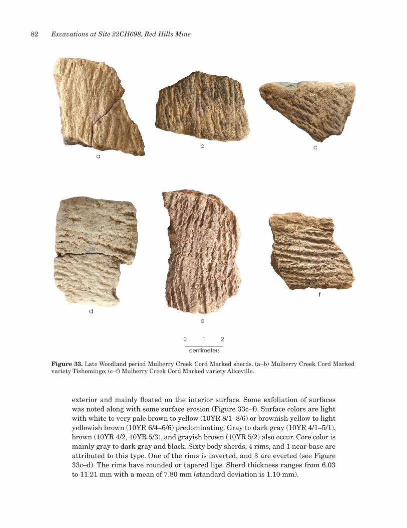
82 Excavations at Site 22CH698, Red Hills Mine
exterior and mainly floated on the interior surface. Some exfoliation of surfaces was noted along with some surface erosion (Figure 33c–f). Surface colors are light with white to very pale brown to yellow (10yR 8/1–8/6) or brownish yellow to light yellowish brown (10yR 6/4–6/6) predominating. Gray to dark gray (10yR 4/1–5/1), brown (10yR 4/2, 10yR 5/3), and grayish brown (10yR 5/2) also occur. Core color is mainly gray to dark gray and black. Sixty body sherds, 4 rims, and 1 near-base are attributed to this type. One of the rims is inverted, and 3 are everted (see Figure 33c–d). The rims have rounded or tapered lips. Sherd thickness ranges from 6.03 to 11.21 mm with a mean of 7.80 mm (standard deviation is 1.10 mm).
figure 33. Late Woodland period Mulberry Creek Cord Marked sherds. (a–b) Mulberry Creek Cord Marked variety Tishomingo; (c–f) Mulberry Creek Cord Marked variety Aliceville.
centimeters
0 1 2
a
b c
d
e
f
83Chapter 7: Ceramic Vessel Sherds
conclusions
The 844 analyzed ceramic vessel sherds from 22Ch698 provide evidence of a long occupational history. The sherds in this sample are tempered with fiber (3 percent), sand (55 percent), and grog or clay (42 percent), indicating components dating to the Gulf Formational and Woodland periods. A total of 619 sherds, or 73 percent, could be assigned to an established ceramic type. Gulf Formational period types make up 19 percent of the sample and include Wheeler Plain, Wheeler Punctated, Wheeler Dentate Stamped, Alexander Incised, Alexander Pinched, and Baldwin Plain variety O’Neal. Types dating to the Woodland period in general—Baldwin Plain, Saltillo Fabric Marked variety unspecified, Saltillo Fabric Marked variety China Bluff, and Furrs Cord Marked—constitute 21 percent of the sample, while types specific to the Late Woodland period—Baytown Plain variety Tishomingo, Baytown Plain variety Roper, Mulberry Creek Cord Marked variety Tishomingo, and Mulberry Creek Cord Marked variety Aliceville—account for 33 percent. The abundance of sherds attributable to the Late Woodland period may indicate relatively intensive occupation at that time, or it may simply reflect greater utilization of ceramic vessels. Increased use of ceramic vessels and the shift to grog tempering, which adds strength to the vessel wall (Rice 1987:407), may signal a change in cooking and food storage techniques toward the end of the Woodland period that followed an expanding population and a concomitant intensification of food production (Walthall 1980:155).
Little evidence can be gleaned from the sherd sample concerning the forms and sizes of vessels that may be useful in determining site-specific activities. This is due to the small sizes of the sherds and the few rim and bases recovered. Still, the information on vessel part, base form, rim orientation, and lip form that is discernible appears consistent with the vessel forms known to be associated with the particular ceramic types represented. For instance, a near-base sherd and thick fiber-tempered sherds are indicative of the thick vessel walls of Wheeler flat-bottom beakers and bowls (Jenkins and Krause 1986:37–38). Also, the podal supports and everted rims associated with the Alexander Incised, Alexander Pinched, and Baldwin Plain variety O’Neal sherds represent the cylindrical vessels with everted rims and quadrapodal supports identified for these types by Jenkins and Krause (1986:46). The change to globular jar and bowl forms during the Woodland period is supported by the preponderance of everted and inverted rims and rounded bases or near-bases, which suggest the curving vessel walls expected for globular and conical forms. Information concerning vessel size is based on only six rims, which indicate vessels with diameters ranging from 18 to 30 cm with an average 25 cm. The rims include two Alexander Pinched, one Alexander Incised, two Baldwin Plain (one of which has punctations at the rim), and one Baytown Plain variety Roper. This size data, limited as it is, suggests some consistency of vessel size over time.
The sherd sample also is useful for relating the site occupations to the spatial and temporal constructs, i.e., cultural phases and subphases, refined by Jenkins and Grumet (1981) and Jenkins and Krause (1986) for the middle and upper Tombigbee River drainage. The geographic extent of these phases is generally shown as stopping at the western edge of the Mississippi Flatwoods physiographic

84 Excavations at Site 22CH698, Red Hills Mine
zone, or at the western edge of the upper Tombigbee drainage (Jenkins and Krause 1986:Figures 4, 8, and 10). however, the evidence from 22Ch68 suggests that these phases are applicable to the eastern edge of north-central Mississippi as well. For instance, the Wheeler fiber-tempered sherds from 22Ch698, and in particular the Wheeler Dentate Stamped sherds, fit well with the description of the ceramics associated with the Broken Pumpkin Creek phase, ca. 1000–500 b.c. (Jenkins and Krause 1986:37–43; Walthall 1980:87), and the Alexander sand-tempered sherds suggest an association with the henson Springs phase, ca. 600–100 b.c., a late Gulf Formational manifestation (Jenkins and Krause 1986:43–47). For the Woodland period, distinguishing between Miller I (ca. 100 b.c.–a.d. 300) and Miller II (ca. a.d. 300–600) occupations is difficult because it depends on percentages of the dominant types such as Baldwin Plain, Saltillo Fabric Marked, and Furrs Cord Marked, which were made and used throughout the Woodland period (Jenkins and Krause 1986:61–73). however, the prominence of Saltillo Fabric Marked sherds relative to Furrs Cord Marked sherds suggests a more-substantial Miller I component, since Saltillo Fabric Marked is considered a dominant Miller I type (Jenkins and Krause 1986:55). The possible Baldwin Plain right-angled rim with folded lip and punctations supports this conclusion, since ceramic vessels with these characteristics are known from the Bynum Mounds site, a Miller I ceremonial complex and village site. Still, a limited Miller II component may be marked by the few Furrs Cord Marked sherds and the presence of the minority type Saltillo Fabric Marked variety China Bluff (Jenkins and Krause 1986:71). These two types combine make up just over 1 percent of the 22Ch698 sample.
The Miller III (a.d. 600–1100) component at 22Ch698 is well represented, based on the prominence of grog-tempered Baytown Plain and Mulberry Creek Cord Marked varieties. Jenkins and Krause’s (1986:82–85) subphase refinement for this late Woodland phase may provide some additional information on component timing. They break up Miller III into four subphases based on percentages of the dominant types mentioned above and the occurrence of minority types not found in this sample. Still, the prominence of Baytown Plain variety Roper and the prominent but lesser Mulberry Creek Cord Marked variety Aliceville at 22Ch698 may indicate a substantial component associated with the early Miller III Vienna subphase (Jenkins and Krause 1986:83). Most telling as to the end of occupation at 22Ch698 is the lack of strap handles and shell-tempered ceramics in the sample, characteristics that are associated with the late Miller III Gainesville subphase (Jenkins and Krause 1986:84). Their absence at 22Ch698 signals that site occupation ended prior to the transition from the Woodland period to the Mississippian period.

85
Other materials recovered during the excavations consist of burned rocks (92.3 kg), unmodified rocks (13.0 kg), burned clay (669 g), faunal remains (n = 3), macrobotanical remains (85.1 g), and historic artifacts (n = 10). These materials were recovered during 1/4-inch screening of the excavated sediment and from flotation or in situ charcoal samples. A summary of the macrobotanical analysis results is presented here, and the complete report is in Appendix B.
buRnEd Rocks
A total of 5,931 fragments of burned rock, weighing 92.3 kg, was recovered. Most are ferruginous sandstone (n = 5,914, 92.2 kg), which range in size from 1 to 10 cm with the majority being less than 5 cm in diameter. Given the natural reddish brown coloration, it often difficult to distinguish sandstone that has been thermally altered by color alone. This analysis used fractured and deteriorated surfaces along with often a blue-black coloration to make the determination. Other burned rocks include hematitic sandstone (n = 14, 48.9 g) and siltstone (n = 3, 24.9 g).
unModifiEd Rocks
A total of 288 fragments of unmodified rocks weighing 13.0 kg were recovered. These are mostly ferruginous sandstone (n = 184, 12.7 kg), along with hematitic sandstone (n = 47, 204.0 g), siltstone (n = 25, 16.9 g), silicified wood (n = 24, 135.2 g), quartzite pebbles (n = 5, 26.3 g), and unidentified material (n = 3, 11.9 g). Rocks range in size from 2 to 15 cm. These rocks show no evidence of heat alteration or fracturing, deliberate chipping, or abrasions.
buRnEd clay
A total of 293 fragments of burned clay weighing 669 g were recovered. They are generally of amorphous shape, ranging from 1 to 5 cm in size. They are brown to yellowish brown to grayish brown. Most likely they are the result of natural or manmade fires. A few have more-defined shapes that suggest a different firing or use trajectory. Six are large enough and rounded enough to indicate that they may be the eroded remains of clay balls possibly used as heating elements for cooking. These range in length from 25.9 to 42.2 mm and weigh 7.3 to 28.7 g. Four of them have a sandy paste (Figure 34a–c).
chaptER 8: othER MatERials REcovEREd

86 Excavations at Site 22CH698, Red Hills Mine
Another seven burned clay specimens have a structure that is suggestive of a wasp’s nest, possibly of the genus Sceliphron or Polistes. Initially, these were thought to be sherds associated with the type Wheeler Dentate Stamped. But on inspection of their cross sections, the closely spaced cells that look like stamping on their exterior surfaces (Figure 34d) continue down through the bodies of the fragments (Figure 34e). Combined with the fact that none of these have temper within them, this atypical structure suggests that these are not vessel sherds. It is surmised that these may be fragments of paper wasp nests that somehow became impregnated with mud and were then burned, either by natural or manmade fires. These unique burned clay fragments range in size from 2 to 5 cm and in weight from 2.0 to 31.0 g. Their total weight is 67.8 g.
faunal REMains
Faunal preservation was extremely poor, and only three animal bone fragments with a total weight of 1.43 g were recovered. All three are burned. Two are unidentifiable, but the third appears to be a fragment of a marginal scute from the carapace of a turtle. It is too small to determine genus or species and can only
centimeters
0 1 2
a
b c
de
figure 34. unique burned clay specimens. (a–c) Burned clay balls with sandy paste; (d) surface view of possible burned clay wasp nest fragment showing cell structure; (e) side view of possible burned clay wasp nest fragment showing cell structure evident on the surface continuing through the body of the fragment.

87Chapter 8: Other Materials Recovered
be classified as order Testudines. The three fragments were found in Levels 4 and 5, just below the plow zone.
MacRobotanical REMains
At total of 85.1 g of macrobotanical remains were recovered (see Appendix B). Analysis of 12 samples recovered as in situ samples or from 1/4-inch screening indicates that this material is wood charcoal consisting of nine hardwood taxa and southern yellow pine. The main hardwoods represented are white oak, sweetgum, sassafras, hickory, and slippery elm, all of which would be expected in the local riparian forests during the prehistoric period. Wood charcoal is also a major component of the flotation recovery. Five additional hardwood taxa are in the flotation samples, with white oak and hickory the main constituents. Also recovered from the flotation samples are corn (Zea mays), starchy material that may be corn, hickory nutshell, acorn nutshell, cane, and other seeds. Corn and possible corn were found in three samples. The majority of the hickory nutshells came from the north half of pit Feature 9, and one other fragment came from another context. Acorn nutshells came from three proveniences. The cane could have been used as a construction material.
histoRic aRtifacts
The 10 historic artifacts consist of 4 cut nails, 3 corroded nail or nail fragments, 2 wire fragments, and 1 piece of lead shot. The shot was distorted into an oval by impact; it weighs 4.5 g. These artifacts indicate some limited use of the landform on which 22Ch698 is situated during the late nineteenth and early twentieth centuries.


89
This chapter examines the horizontal and vertical distributions of the cultural materials in the excavations. The goals are to address the depositional context and integrity of the materials and to demonstrate whether they can or cannot be segregated into components for interpretation. Based on the 2013 test excavations, the deposits in the area where data recovery excavations were done were interpreted as holocene alluvium, and the artifacts within that alluvium appeared to be in correct stratigraphic order. The 2014 excavations confirmed the former of these conclusions but not the latter.
hoRizontal distRibutions
The presence of Feature 9, the single cultural feature identified during data recovery, on the strath terrace in the western part of the block implies that at least some of the artifacts in this area are in primary contexts, having been deposited at or close to where they were used or created. The same cannot be said for the central and southeastern parts of the block, since no features were found there. Instead, it appears that those cultural materials likely are the result of intentional trash discard by people camping on the adjacent higher terrace surface to the north, as well as redeposition of artifacts from the terrace by erosion.
Figure 35 shows the density distributions of five classes of materials—ceramic sherds, burned clay, lithic debitage, lithic tools, and burned rocks—horizontally across the block. All five classes tend to be densest where the holocene alluvium is thickest, i.e., just beyond the toe of the terrace where a gully had been cut into the floodplain surface. This is consistent with the interpretation that the bulk of these materials represent debris resulting from activities performed upslope to the north, mostly outside the block excavation. The fact that no concentrations of sherds representing vessel sections left in situ or concentrations of debitage and lithic tools representing chipping stations were present supports this conclusion as well, as do the high percentages of broken lithic tools (83 percent of chipped stone and 100 percent of ground stone).
The fact that all classes of materials have similar distributions suggests that they came from living and work spaces in general, as opposed to areas devoted to particular activities. The occurrence of various kinds of remains in moderate densities in the southeast part of the block, i.e., beyond the gully, probably is a function simply of discard tailing off away from the terrace edge, although some
chaptER 9: distRibution of thE cultuRal MatERials

90 Excavations at Site 22CH698, Red Hills Mine
EU9
EU23 EU8
EU7
EU6
EU5 EU4 EU3 EU2 EU11 EU12
EU26 EU10 EU13 EU14
EU1 EU15 EU16
EU17 EU18
EU19 EU20 EU25
EU24
EU22
EU21EU23a
F-9
0 2 41
Meters
No Data
EU9
EU23 EU8
EU7
EU6
EU5 EU4 EU3 EU2 EU11 EU12
EU26 EU10 EU13 EU14
EU1 EU15 EU16
EU17 EU18
EU19 EU20 EU25
EU24
EU22
EU21EU23a
F-9
EU9
EU23 EU8
EU7
EU6
EU5 EU4 EU3 EU2 EU11 EU12
EU26 EU10 EU13 EU14
EU1 EU15 EU16
EU17 EU18
EU19 EU20 EU25
EU24
EU22
EU21EU23a
F-9
EU9
EU23 EU8
EU7
EU6
EU5 EU4 EU3 EU2 EU11 EU12
EU26 EU10 EU13 EU14
EU1 EU15 EU16
EU17 EU18
EU19 EU20 EU25
EU24
EU22
EU21EU23a
F-9
Burned Rock (g)0.00 - 1457.141457.15 - 2614.29
2614.30 - 4827.274827.28 - 6656.006656.01 - 9292.50
Debitage (#)3 - 4142 - 8485 - 127128 - 286
287 - 424
Ceramics (#)0 - 10
11 - 3536 - 6465 - 101102 - 193
Burned Clay (g)0.00 - 3.503.51 - 11.8411.85 - 24.47
24.48 - 49.0549.06 - 91.54
Figure 35
EU9
EU23 EU8
EU7
EU6
EU5 EU4 EU3 EU2 EU11 EU12
EU26 EU10 EU13 EU14
EU1 EU15 EU16
EU17 EU18
EU19 EU20 EU25
EU24
EU22
EU21EU23a
F-9
Tools (#)0 - 23 - 67 - 910 - 16
17 - 20
Excavation Unit
Gully Extent
Feature
figure 35. Plans showing densities of selected artifact classes within the excavation block. (Excavation unit 1, which was removed as Test unit 1 during testing, has no burned rock weight because the rocks were counted and not collected.)

91Chapter 9: Distribution of the Cultural Materials
redeposition of artifacts from the higher-density, gully-associated deposit just to the northwest by flooding also is a possibility.
vERtical distRibutions
Since the majority of the artifacts came from alluvial depositional contexts, vertical distributions were examined to determine whether the materials could be segregated into components, as suggested by the data from test excavations. Two tactics were used: (1) trying to identify peaks in artifact frequencies that could be traced from unit to unit and thus provide indicators of cultural stratigraphy; and (2) plotting the distributions of radiocarbon and luminescence dates and temporally diagnostic artifacts.
Figure 36 shows the vertical distributions of the three most-abundant kinds of cultural materials (ceramic sherds, burned rocks, and debitage) in five units along a northwest-southeast cross section though the block. Excavation unit 3 is on the lower terrace edge, Excavation units 10 and 15 are just off this edge in the filled gully where alluvium is thickest, and Excavation units 18 and 25 are in the thinner alluvium beyond the gully. In Excavation unit 3, all three classes of materials have a similar distribution, being densest in Level 3 (and Level 4 in the case of the debitage). There clearly is a distributional disconnect between this unit and the others, which makes sense given their different depositional contexts. In the four alluvial units, the cultural materials tend to be densest in the middle to lower part of the deposits, but it is hard to see peaks in densities that can be traced from unit to unit. The ceramics are most frequent in Levels 10–13 in the two deeper units and Levels 8–11 in the two shallower ones. Debitage is most frequent in Level 7 in one of the deeper units but Levels 8 and 11 in the other one; it peaks in Levels 6 and 9 in one of the shallower units and Levels 6, 9, and 10 in the other. Burned rocks are most abundant in Levels 11–13 in one gully unit and Levels 8 and 11 in the other; they peak in Level 6 or 7 in the nongully units.
Figure 37 provides a short cross section showing the distributions of the same three classes of materials on a southwest-northeast axis. All three of these units are in thick alluvium where the gully cut into the floodplain. The ceramics tend to be most frequent in Levels 9–10 and 12–14, while the debitage counts are highest in Levels 9–10. Burned rocks are densest in Level 7 in one unit, Level 8 in another, and Level 11 in the third.
In short, there are some suggestions of patterning in the vertical distributions of the artifacts in the alluvium—for example, generally higher densities in the lower deposits and some corresponding peaks between units in some remains—but the patterns are not strong enough to provide a solid basis for confident isolation of components. No two units show exactly the same pattern, which, combined with the absence of cultural features to serve as anchors, makes it impossible to use these data to discern cultural stratigraphy.
Looking at the vertical distributions of radiocarbon and luminescence dates and temporally diagnostic artifacts in the part of the block in alluvial contexts provides evidence of why this is the case (Table 7). While four of the eight dates

92 Excavations at Site 22CH698, Red Hills Mine
CERAMICS (#)Level EU3 EU10 EU15 EU18 EU25
1 12 0 03 15 1 04 12 6 1 55 4 8 7 5 06 2 12 3 2 17 21 4 6 38 4 20 7 49 18 8 4 11
10 28 10 6 611 24 36 7 312 16 2413 12 23
BURNED ROCKS (g)Level EU3 EU10 EU15 EU18 EU25
1 5002 300 633 800 679 404 400 450 320 805 300 1089 390 330 606 304 1019 180 590 2207 1136 160 190 2908 697 1090 80 1909 545 400 280 110
10 1182 440 210 7011 1252 1070 170 8012 1520 62013 1530 600
DEBITAGE (#)Level EU3 EU10 EU15 EU18 EU25
1 92 20 23 25 30 44 26 33 21 75 21 37 28 17 16 5 32 15 31 277 45 22 14 228 26 54 5 189 39 23 25 27
10 33 32 14 2611 35 57 9 712 29 3813 8 37
Figure 36
EU9
EU23 EU8
EU7
EU6
EU5 EU4 EU3 EU2 EU11 EU12
EU26 EU10 EU13 EU14
EU1 EU15 EU16
EU17 EU18
EU19 EU20 EU25
EU24
EU22
EU21EU23.5
A'
A
figure 36. Northwest-southeast cross section through the excavation block showing vertical distributions of ceramic sherds, burned rocks, and debitage.

93Chapter 9: Distribution of the Cultural Materials
figure 37. Southwest-northeast cross section through the excavation block showing vertical distributions of ceramic sherds, burned rocks, and debitage.
CERAMICS (#)Level EU22 EU13 EU12
12 203 0 1 34 0 0 35 6 0 116 2 8 147 10 10 138 14 14 229 24 18 3010 36 22 2211 20 16 1412 10 12 2913 38 28 2114 23 9
BURNED ROCKS (g)Level EU22 EU13 EU12
12 300203 0 190 4004 80 100 2005 320 40 4006 480 600 15007 1260 1550 13008 1260 570 18009 0 1130 370
10 820 690 50011 1760 830 27012 1120 940 49013 920 350 52014 780 270
DEBITAGE (#)Level EU22 EU13 EU12
12 913 8 11 184 22 16 15 26 2 236 24 15 577 50 40 508 62 39 359 92 56 6610 82 42 5311 52 25 5112 48 41 3013 44 37 2114 19 12
Figure 37
EU9
EU23 EU8
EU7
EU6
EU5 EU4 EU3 EU2 EU11 EU12
EU26 EU10 EU13 EU14
EU1 EU15 EU16
EU17 EU18
EU19 EU20 EU25
EU24
EU22
EU21EU23.5
B
B'

94 Excavations at Site 22CH698, Red Hills Mine
from the lower part of the alluvium (Levels 11 and 13; 87±73 b.c., a.d. 321–427, 330–433, and 410–546) are consistent with Middle Woodland period occupations, three others (a.d. 829±90, 869±65, and 1051±73) are Late Woodland, and the eighth (a.d. 1727–1812) is from a piece of historic-age wood charcoal that somehow worked its way deep into the deposits. Two of the six dates in the middle part of the deposit (Levels 5–9; a.d. 1722–1817 and 1730–1809) also are intrusive historic-age wood charcoal, one (a.d. 228±96) is Middle Woodland, one (a.d. 886±83) is Late Woodland, one (a.d. 1024–1155) is Late Woodland or Early Mississippian, and one is a fragment of corn with a Mississippian period age (a.d. 1490–1602). This piece of corn certainly appears to be out of place. Equally disconcerting is the Late Gulf Formational period date from Level 2 (361–179 b.c.). There are archeological remains to go with this dated piece of wood charcoal, but it must be out of context.
The diagnostic lithic tools support the idea that the cultural materials are not in good stratigraphic order (see Table 7). Four of the 10 typed dart points are of styles (Flint Creek/Pontchartrain, Little Bear Creek, and Tombigbee Stemmed) that are considered typical for occupations during the latter part of pre-Mississippian time frame; these came from Levels 10–14 in the lower part of the alluvium. The other 6 points, which could be earlier (1 Big Sandy, 3 McIntire, and 2 Pickwick), are
Table 7. Vertical distributions of radiocarbon dates (highest-probability ranges only),luminescence dates, and temporally diagnostic artifacts (except ceramics) in Excavation Units 1,2, 10, 22, and 24–26
Level
Radiocarbon andLuminescence
Dates* Typed Dart PointsArrowPoints
ChertBead
PreformsHistoricArtifacts
1 0 0 0 02 361–179 B.C. 0 1 0 03 1 (McIntire) 1 1 34 1 (McIntire) 1 2 05 A.D. 1730–1809 0 3 1 36 A.D.886±83 0 2 2 07 0 1 1 28 A.D. 1722–1817 0 0 2 19 A.D. 228±96
A.D. 1024–1155A.D. 1490–1602
0 2 0 0
10 3 (Pickwick, FlintCreek/Pontchartrain, McIntire)
1 1 0
11 A.D. 321–427A.D. 829±90A.D. 869±65A.D. 1727–1812
0 1 2 1
12 2 (Tombigbee, Pickwick) 0 0 013 87±73 B.C.
A.D. 330–433A.D. 410–546A.D. 1051±73
2 (Big Sandy, Tombigbee) 0 1 0
14 1 (Little Bear Creek) 0 0 0
*Luminescence dates are in italics.
table 7. Vertical distributions of radiocarbon dates (highest-probability ranges only), luminescence dates, and temporally diagnostic artifacts (except ceramics) in Excavation units 1, 2, 10–22, and 24–26.

95Chapter 9: Distribution of the Cultural Materials
from Levels 3, 4, 10, 12, and 13, and thus are more widely distributed than the later points. Also informative are the distributions of the Late Woodland Madison arrow points, which occur from Level 2 through Level 11, and the probable Middle Archaic chert bead preforms, which were found from Level 3 through Level 13. Finally, the distribution of the small assemblage of historic artifacts, occurring in Levels 3–11, indicates that recent artifacts have worked their way into the alluvium.
Examination of the typed ceramic sherds grouped according to time period supports the conclusion that discrete components cannot be isolated within the alluvium. All three groups—Wheeler and Alexander wares and Baldwin Plain variety O’Neal representing the Gulf Formational period; Baldwin Plain variety unspecified, Saltillo Fabric Marked, and Furrs Cordmarked representing the overall Woodland period; and Baytown Plain and Mulberry Cord Marked representing the Late Woodland period—have similar distributions (Figure 38). All three are scarce or absent in Levels 1–4 and increase in frequency to Level 12. The general Woodland types continue to increase in density to the bottom of the deposit at Level 14, while the two earlier and later groups decrease below Level 12.
figure 38. Graphs of the vertical distributions of typed ceramic sherds grouped by time period in Excavation units 1, 2, 10–22, and 24–26.
The evidence presented above makes a solid case that the Middle Archaic, Gulf Formational, and Woodland components cannot be separated from one another, in spite of the fact that the artifacts are in alluvium that accumulated during
0.0 0.5 1.0 1.5 2.0 2.5 3.0 3.5 4.0 4.5
1
2
3
4
5
6
7
8
9
10
11
12
13
14
Leve
l
Leve
lNo. of Sherds/m2
Figure 38
Gulf FormationalWoodland Late Woodland

96 Excavations at Site 22CH698, Red Hills Mine
the late holocene. It also shows that individual items, both charcoal pieces and artifacts, can be highly mobile in these deposits. Beyond that, though, it provides important insights into the history of the site. Specifically, the fact that all three of the most-abundant classes of materials increase in density with depth in the alluvium, with debitage and burned rocks peaking in Level 12 and ceramic sherds peaking in Levels 12 and 13, indicates that these deposits are not so mixed as to be homogenized (Figure 39).
figure 39. Graphs of densities per square meter of ceramic sherds, debitage, and burned rocks by level in Excavation units 1, 2, 10–22, and 24–26 (values are normalized such that 1.0 is the maximum).
Instead, there is some remnant patterning that relates to how these materials came to rest here. As noted, the high artifact densities in the units just off the terrace edge are interpreted as an indication that this area, and in particular the gully depression, was used for trash disposal. This gully was cut into the bedrock, perhaps at the beginning of the late holocene, and apparently filled as alluvium accumulated on the adjacent floodplain. The abundance of cultural materials deep in the deposit, and the presence of artifacts diagnostic of the Gulf Formational and Woodland periods, and maybe the Middle Archaic period too, indicates that this gully depression was open and used as a receptacle for trash as it filled slowly. At a minimum, this span may have covered about 2,000 years, perhaps ending around a.d. 1000. Based on the late Middle Archaic date (4000–3936 b.c.) from Feature 9
0.0 0.5 1.0 1.5 2.0 2.5 3.0 3.5 4.0 4.5
1
2
3
4
5
6
7
8
9
10
11
12
13
14
0 0.2 0.4 0.6 0.8 1 1.2
1
2
3
4
5
6
7
8
9
10
11
12
13
14
Leve
l
Leve
l
DensityNo. of Sherds/m2
Figure 38 Figure 39
Gulf FormationalWoodland Late Woodland
Ceramic SherdsDebitageBurned Rocks

97Chapter 9: Distribution of the Cultural Materials
adjacent to the gully and the possible Middle Archaic dart points and chert bead preforms in the lower gully fill, this span could have been much longer. It is inferred that the upper alluvium accumulated more rapidly, after the end of the Woodland period, and that the cultural materials encased within it reflect translocation from the deeper high-density deposit by bioturbation and from the terrace edge to the north by slopewash. Redeposition by flooding of the relict tributary channel just south of the site also may have been a factor, judging from the historic-age radiocarbon date (a.d. 1730–1809) from this channel.


99
Alluvial deposits at the southeast corner of 22Ch698 yielded remains relating to occupations during the Middle Archaic, Gulf Formational, and Woodland periods, but these components cannot be isolated fully for complete interpretation. This makes moot some the original research questions proposed based on survey and testing results. Still, the original research issues—which include chronology, assemblage organization, subsistence strategies, intrasite patterning, and interregional interaction—offer interpretive value. They are discussed here, taking into account the site’s data limitations.
chRonology
The earliest main component dates to the Middle Archaic period. The single Big Sandy dart point could be earlier, but there is no other corroborating evidence of Early Archaic occupation, and its recovery from what appears to be late holocene alluvium suggests that it is a recycled specimen. The Middle Archaic component is represented by one radiocarbon date (highest-probability range = 4000–3936 b.c.) from pit hearth Feature 9, which indicates an occupation near the end of the period. Also likely associated are the 14 chert bead performs and probably the 5 Pickwick and McIntire dart points. As for the later components, the Middle Archaic occupation produced unknown numbers of the other lithic tools and pieces of debitage. A Late Archaic component is not defined because there are no radiocarbon dates for this interval. It certainly is possible the site was occupied then, as suggested by the 4 dart points that are considered typical of both Late Archaic and Gulf Formational period contexts in the region (Flint Creek/Pontchartrain, Little Bear Creek, and Tombigbee Stemmed).
The Gulf Formational period component is marked by one radiocarbon date (361–179 b.c.) and the fiber-tempered Wheeler ceramic vessel sherds along with sand-tempered Alexander Incised, Alexander Pinched, and Baldwin Plain variety O’Neal ceramic sherds. These sherds account for 26 percent of the ceramics recovered. As noted above, four of the typed dart points could go with this component as well.
Four radiocarbon dates (a.d. 321–472, a.d. 330–433, a.d. 410–546, and a.d. 1024–1155) and all six luminescence dates (87±95 b.c., a.d. 228±96, a.d. 829±90, a.d. 869±65, a.d. 886±83, and a.d. 1051±73) relate to the Woodland component. They indicate occupations during the Miller I–III phases (Jenkins and Krause 1986:70–71, 82–83). The high percentage of Saltillo Fabric Marked sherds
chaptER 10: intERpREtations and conclusions

100 Excavations at Site 22CH698, Red Hills Mine
marks a Miller I component, as this technique came to prominence then (Jenkins and Krause 1986:55). Sand-tempered Furrs Cord Marked pottery began to replace fabric-marked vessels in the Miller II phase (Jenkins and Krause 1986:66). Furrs Cord Marked sherds make up less than 1 percent of the ceramic sample, placing the ceramic recovery at odds with the radiocarbon assays for a Miller II component. however, surface erosion on many sherds made it difficult to distinguish cord marking from fabric marking, such that there actually may be more Furrs Cord Marked than the analysis identified. Occupation during the Miller III phase is represented by the grog-tempered plain and cord-marked wares, with cord marking becoming dominant late (Jenkins and Krause 1986:82–85). The high percentage of Baytown Plain variety Roper and Mulberry Creek Cord Marked variety Aliceville (46 percent of the typed sherds) fits well with a substantial Miller III component, suggesting increased occupational intensity. Triangular arrow points also appeared in the Miller III phase (Jenkins and Krause 1986:75), consistent with the presence of 13 such points in the assemblage. The 5 dart points typed as Edwards Stemmed, Little Bear Creek, and Tombigbee Stemmed also could relate to the Woodland period occupations.
No Mississippian period ceramics were recovered, suggesting that the site was abandoned after the Late Woodland period. The recovery of Zea mays dated to a.d. 1490–1602 (highest-probability range) indicates the site may not have been fully abandoned, though, and was used instead as an agricultural field by people who lived nearby. The triangular Madison arrow points could relate to such an occupation, although this seems unlikely given the absence of associated ceramics. The small collection of historic artifacts indicates some limited use by Euro-Americans, and the four late radiocarbon dates support this.
The research questions posed for the subject of chronology focused on defining a Woodland period ceramic sequence at 22Ch698. One question asked if the Miller phase sequence from sites in the upper Tombigbee drainage, as defined by Jenkins and Krause (1986), could be used to interpret the assemblage from 22Ch698. This question can be answered in the affirmative, as that sequence fits well with the ceramic vessel sherds recovered. This fit is strengthened by the fact that no Lower Mississippi Valley ceramic types were identified at the site, and it indicates a strong cultural connection between the Woodland groups who utilized the resources of this region and the groups who lived to the east and northeast along the Tombigbee. Actually, these groups were likely one and the same. Still, the evidence from 22Ch698 suggests that the continuity of that connection varied. It was long-lived, extending back at least to the Gulf Formational period, but it appears to have been altered by the end of the Woodland period, as there was little or no use of the site after that time, unlike in the Tombigbee area where Mississippian sites are present as nucleated villages close to the main river channel (Jenkins and Krause 1986:93–102). A final research question asked if the ceramic assemblage at 22Ch698 could be related to an absolute chronology. The radiocarbon dates from 22Ch698 are generally in sync with what Jenkins and Krause (1986) report for Gulf Formational and Woodland assemblages from sites

101Chapter 10: Interpretations and Conclusions
in the upper Tombigbee drainage, but the inability to isolate discrete components means that the dates cannot be linked to specific assemblages.
assEMblagE oRganization
Assemblage organization concerns how the kinds of materials preserved archeologically reflect the ranges of activities performed on a site and how those activities define the nature of the site within a settlement system. Based on survey and testing data, it was hypothesized that 22Ch698 was a Woodland Miller phase short-term camp. This functional assessment was based on the small size of the site, the sparseness of artifacts, the lack of middens, and the lack of constructed earthen mounds. These characteristics put 22Ch698 in contrast to other kinds of sites known to be parts of the Miller phase settlement system: mound and village sites and semipermanent base camps.
Along with the introduction of cultigens and the bow and arrow, which increased the efficiency of the hunting and harvesting economy that prevailed during the preceding Gulf Formational period (Jenkins and Krause 1986:48–55), trade in prestige items and construction of earthen burial mounds are hallmarks of the Woodland period, reflecting a level of social organization not previously seen. The Bynum Mounds site, situated along the Natchez Trace in Chickasaw County, is an example of this type of site. In addition to its six mounds, Bynum had an extensive village with circular and ovate houses that were some 10–24 m across over an area of about 7 acres (Cotter and Corbett 1951:11). Jenkins and Krause (1986:60–61) suggest that such villages were semi-sedentary. In addition to the mound-associated villages, semi-sedentary base camps with two or three houses, trash-filled pits, and middens were part of the system during the Miller phase, along with short-term camps. It has been conjectured that short-term camps, sometimes referred to as transitory camps, were used to take advantage of seasonally abundant resources, and Jenkins and Krause (1986:78) postulate based on the high frequencies of lithic debris that, during Miller III times, they functioned as hunting camps.
There are three significant limitations to using the information from the excavations to evaluate the idea that 22Ch698 was used as a short-term camp. First, we now know that, in addition to its Woodland component, it has Middle Archaic and Gulf Formational period components for which the Miller phase settlement system model does not apply fully. Second, the materials representing the three main components cannot be fully segregated from one another, making assemblage-level interpretations impossible. Third, most of the excavated sample is from a discard context that cannot be considered representative of the site as a whole.
Despite these limitations, the data do provide information on how Native Americans used the site. In the discussion that follows, the focus is on trying to assess whether the remains recovered represent narrow ranges of activities, as would be expected at a short-term camp, or broader ranges, which would imply occupations of longer duration. One line of evidence relates to the artifact distributions discussed in Chapter 9. The abundance of artifacts in the gully depression on the floodplain just beyond the toe of the terrace suggests that at least some of the debris was deposited

102 Excavations at Site 22CH698, Red Hills Mine
there intentionally, probably as a result of maintenance of upslope activity areas. This implies that occupations were of sufficient duration to make removal of debris from underfoot desirable. Based on the distributions of the temporally diagnostic artifacts, this appears to have been the case during both the Gulf Formational and Woodland periods. Artifacts specific to the Middle Archaic period are too few to speculate for that component.
The ceramic vessel sherds are one indication of the kinds of activities that occurred at a site, as a vessel’s form often is a good indicator of whether it was used for food processing, serving, or storage (Rice 1987:210–212). For 22Ch698, small sherd size and the limited number of rims, bases, near-bases, and podal supports hamper the reconstruction of vessel forms, but the limited rim and base data are consistent with the kinds of vessels expected for the time periods represented. The Gulf Formational period Alexander flat-bottomed and quadrapodal beakers and Baldwin Plain variety O’Neal vessels, both with everted (n = 8) and direct (n = 2) rims, gave way to globular or conical jar and bowl forms with everted (n = 15) and inverted (n = 13) rims during the Woodland period (Jenkins and Krause 1986:Figures 5 and 16). The relatively high frequencies of everted and direct rims in the 22Ch698 assemblage suggest that activities requiring easy access to vessel contents, such as processing (i.e., cooking) or serving, were common at the site in both Gulf Formational and Woodland times. A single everted rim, typed as Saltillo Fabric Marked, retains burned residue or evidence of cooking on its outer surface. Most of the inverted rims (n = 11), which may be associated with storage vessels because a constricted orifice limits access to and protects vessel contents, are typed as Baytown Plain and Mulberry Creek Cord Marked, suggesting that storage vessels were added to the assemblage by late Woodland times. This may point to purposeful, repeated use of the site as part of a more-regular seasonal round and possibly occupations of longer duration late in the site’s use history.
The chipped stone tool assemblage indicates that activities associated with hunting, butchering, and processing of game animals were performed at the site, although it is hard to sort this by component in artifacts other than the projectile points. Personal hunting gear also was repaired there. This is based on the number of biface fragments and some projectile points with impact fractures, as well as the abundance of pressure flakes and small bifacial retouch flakes indicating late-stage tool finishing and maintenance/resharpening of worn tools such as knives and projectile points.
Poorly represented at 22Ch698 are core reduction to produce expedient tools and early-stage production of bifacial tools. The former is indicated by the small number of chert pebbles reduced by bipolar percussion and the scarceness of bipolar debris and shatter in the debitage assemblage (although this was not quantified). The latter is indicated by the low frequency of early-stage bifaces and the fact that more than 90 percent of the debitage lacks cortex. Early reduction debris is present in the assemblage, though, and the apparent focus on late-stage tool production must be due at least partly to the fact that the site is in an area where raw materials suitable for chipped stone tool manufacture are scarce.

103Chapter 10: Interpretations and Conclusions
The chipped stone artifacts also include 14 cylindrical chert bead fragments that are presumed to relate to the Middle Archaic component. Each reflects an early stage of manufacture, since none are drilled or ground/polished, and all are fragmentary with likely manufacturing breaks. hence, they appear to be discarded bead preforms. Other evidence for the onsite manufacture of these ornaments is absent, except perhaps for 1 microlith that could be a microdrill without wear, and thus it appears that only part of the manufacturing process was performed at 22Ch698. Nonetheless, the fact that these artifacts are present at all is not consistent with the idea that the Middle Archaic occupations involved a narrow range of activities.
The ground stone tool assemblage reflects an array of activities that were conducted on the site, although, like most of the chipped stone tools, these cannot be sorted by component. Many likely were used in a variety of processing and manufacturing tasks associated with subsistence and tool maintenance. Also, it is possible that some of them were associated with lapidary crafts, i.e., chert bead manufacture. That many of these tools were manufactured at the site is evident based on the indications of flaking, pecking, and grinding on them and the presence of ferruginous sandstone debitage. In contrast to the chipped stones, this likely relates to the fact that source materials were available locally.
Many of the research questions posed for the topic of assemblage organization in Chapter 3 have been answered to some extent, in spite of the site’s long history of use and the inability to isolate components fully. The artifacts indicate that a variety of domestic activities were performed there during the Gulf Formational and Woodland periods, and probably during the Middle Archaic period as well. Among these activities were manufacture and repair of stone tools needed for hunting and procurement and processing of other resources, such as hardwood nuts; food preparation and serving and, by the end of the Woodland period, food storage perhaps signaling more-extended site visits; and, apparently during the Middle Archaic period, manufacture of chert beads. This variety of activities, and the abundance of artifacts in the part of the site where data recovery excavations were performed, seems out of character at a site thought originally to represent a short-term camp. And yet, there is no evidence from the survey, testing, or data recovery work that 22Ch698 was ever used as a base camp as defined by Jenkins and Krause (1986). This suggests that the base camp vs. short-term camp model may be too simplistic, and that sites such as 22Ch698 instead fall somewhere in between. It is speculated that, during its main occupations, it was a camp used for perhaps one or a few months at a time as part of a seasonal round.
subsistEncE stRatEgiEs
Due to a poor preservation environment, the excavations at 22Ch698 provided minimal information concerning subsistence strategies. As a result, the proposed research questions concerning the kinds of subsistence resources that were available, how those resources were exploited, and changes in subsistence patterns over time cannot be addressed. Still, a few general statements can be made

104 Excavations at Site 22CH698, Red Hills Mine
concerning these issues, based mainly on the tool recovery, macrobotanical remains, and location of the site.
As noted above, the chipped stone tool assemblage contains implement types associated with hunting, butchering, and processing of game animals. yet, the only identifiable animal bone from the site is a fragment of turtle carapace, which suggests some exploitation of small game. Miller phase archeological data for the Tombigbee drainage indicates that white-tailed deer was the major resource taken from the riparian and upland forests of northeast Mississippi, although percentages of deer bone decrease in Miller II assemblages and it appears there was greater diversification in animal exploitation in Miller III times (Jenkins and Krause 1986:66–70, 76–77). That such forests covered 22Ch698 or were near the site prehistorically can be surmised from the wood charcoal taxa recovered, including white oak, sweetgum, sassafras, hickory, slippery elm, and southern yellow pine. Another important forest resource was hardwood nuts, and both hickory nuts and acorns were recovered from 22Ch698 flotation samples. Most of the hickory nutshells are from Feature 9, which dates to the Middle Archaic period, but there is no reason to think that nut processing was not an important subsistence activity during the later Gulf Formational and Woodland occupations as well, judging from the recovery of seven pitted stones and a variety of other battered stones that could have been used in nut processing.
Evidence of cultigens was found at 22Ch698. This consists of one fragment of Zea mays and two of starchy material classed as cf. Zea mays, two of which were radiocarbon dated. The Zea mays date is consistent with the Mississippian period development of corn as a food staple in the Tombigbee drainage (Jenkins and Krause 1986:99–100). The presence of corn but absence of Mississippian pottery suggests that, late in its history, the site may have been used solely as an agricultural field by peoples who lived somewhere else nearby. Such a scenario could be linked to the timing of the breakup of the sociopolitical order marked at the great Southeastern centers such as Moundville. Peebles (1987:9) states that, after Moundville was abandoned ca. a.d. 1500, “settlement spread to every available niche…to control arable soil for cultivation and the hinterlands for hunting.” The cf. Zea mays date suggests that corn also made up some part of the diet during the Miller II–III transition of the Woodland period. Scant as it is, this may be evidence of the Miller phase diversification of subsistence resources proposed by Jenkins and Krause (1986:66–69).
intRasitE pattERning
The sole pit hearth (Feature 9) found on the west side of the data recovery excavation block and the two possible pits (Features 1 and 3) found in Trenches 6 and 9 on the eastern and southwestern sides of the site during testing suggest that outdoor activity areas were positioned around the edges of the strath terrace overlooking the adjacent floodplain. The sparseness of features and the fact that only Feature 9 yielded a date (Middle Archaic) make it impossible to know if there are any temporal patterns in use of the margins of the landform. It is presumed that other activity areas, and probably domiciliary areas during some occupations,

105Chapter 10: Interpretations and Conclusions
were upslope on the higher part of the terrace, but there is no way to know for sure, since this area had been compromised by erosion and many years of plowing and thus saw no investigation beyond survey.
Within the excavation block, the abundance of cultural materials in units just off the terrace slope indicates that trash was discarded intentionally there, presumably as a result of maintenance of site areas upslope to the north, or that artifacts were deposited there as a result of erosion off the terrace. Of course, it is possible that both mechanisms were at play. The debris disposal hypothesis would imply that some occupations were of sufficient duration to warrant trash removal. Discard in this particular area could have been spurred by the fact that a shallow gully, i.e., a natural receptacle for trash, had been cut into the floodplain edge there, but, if this was the case, the moderate densities of artifacts in the adjacent nongully alluvium indicate that trash disposal was not restricted to the gully. The test excavations did not find evidence that such a discard pattern was repeated elsewhere along the south or east sides of the site.
Otherwise, the excavations did not yield the kinds of information needed to address questions about the intrasite patterning of activities, such as those posed in Chapter 3. This is because the excavations were largely restricted to a trash discard context with no chance to sample a range of feature types and settings.
intERREgional intERaction
Site 22Ch698 is near the Natchez Trace, a major regional route for transfer of economic and ideological information during prehistoric times and a probable pathway for the acquisition of some of the distant raw materials, such as Fort Payne or Bangor chert, identified in the site’s lithic assemblage. The ceramic assemblage also contains a few sherds, like a Baldwin Plain cambered rim, that suggest that vessels from Woodland period mound sites, such as Bynum or Pharr, may have traveled south along the trace and found their way to 22Ch698. however, the majority of both the ceramic and lithic assemblages was likely acquired locally or from the surrounding region. The ceramic sherds in particular show a strong association with groups to the east of 22Ch698. As discussed above, the ceramic types identified fit well with Gulf Formational and Miller phase ceramics known from sites in the upper Tombigbee River drainage ca. 16 to 80 km to the east (Jenkins and Grumet 1981; Jenkins and Krause 1986). Not present at 22Ch698 are ceramic types, such as Twin Lakes Punctated or Churupa Punctated, that are associated with Woodland period groups living to the west toward the Mississippi delta.
The patterns of lithic raw material use at 22Ch698 suggest that most materials were acquired intraregionally, either through direct procurement or by exchange with nearby neighbors. Ferruginous sandstone for production of ground stone tools apparently was available locally, and most of the chipped stone artifacts are of gravel cherts that likely came from Tuscaloosa and Camden chert sources to the east or Citronelle gravels to the west (Tables 8 and 9). unfortunately, it is difficult to distinguish materials from these different sources in the artifacts, so this evidence is not conclusive about the directionality of interaction or mobility. however, other

106 Excavations at Site 22CH698, Red Hills Mine
evidence of eastward connections makes it seem likely that Tuscaloosa and Camden sources were used more heavily, and if the interpretation given above that 22Ch698 was used by people whose more-permanent settlements were in the Tombigbee drainage to the east is on target, then it is plausible that most of the gravel cherts used in tool manufacture at 22Ch698 were acquired directly and brought to the site during those seasonal visits. Also procured from near-local, but westward, sources were the items of Tallahatta and Kosciusko quartzite.
Only a very few items from the site, nine novaculite or crystalline quartz flakes and a single fleck of mica (Morton and Little 2013), can be considered truly exotic. All of these likely originated in the Ouachita Mountains of Arkansas and Oklahoma and probably reached the site through trade, as did the artifacts made of Fort Payne and Bangor cherts from the Tennessee River valley. Other researchers have indicated that, from the Archaic period into the Mississippian period, raw materials were exchanged and traded widely across the entire southeastern united States (Brookes 1999; Carr 2008; Edmonds 2012; Futato 1999; McGahey 1999; Thacker et al. 2012), and the fact that some exotic materials are in the 22Ch698 assemblage indicates that the people who occupied the site did have some connections to a wide-ranging trade network, although little material reflection of this ended up in the trash deposits at the site.
conclusions
In making the case that the south edge of 22Ch698 contained important information and thus was eligible for listing in the National Register of historic Places, the plan for this project proposed a modest data recovery effort because it was recognized that the site had some data limitations: (1) the lack of natural stratigraphy within the holocene deposits
and the scarcity of cultural features would make it hard to isolate components; (2) the low artifact density would make it a challenge to acquire samples large enough for confident interpretation; and (3) the poor preservation of botanical remains
table 8. Distances to source areas for lithic raw materials in the tool and debitage assemblage.
table 9. Percentages of raw material types among chipped stone debitage and tools.
Table 8. Distances to source areas for lithic raw materials in the tool and debitage assemblage
Raw Material Source AreaDistance and
DirectionTallahatta Formation (in situ) 30 km westKosciusko Formation (in situ) 30 km westCitronelle Formation (Loess Hills, secondary)
70 km west
Tuscaloosa Formation (in situ and gravel)
80 km east
Fort Payne, Bangor (and other in situ bedrock cherts, some gravel)
190 km northeast
Novaculite, quartz, and quartz crystal
350 km west, northwest
Petrified wood Site vicinityFerruginous sandstone Site vicinity
Table 9. Percentages of raw material types among chipped stone debitage and tools
Raw Material Debitage ToolsGravel cherts 68.0 53.2Kosciusko quartzite 11.4 10.5Tallahatta quartzite 6.6 12.1Fort Payne cherts 5.3 4.8Unidentified cherts 4.5 13.7Quartzite, other 1.7 2.4White chert 0.9 0Petrified wood 0.9 1.6Bangor chert 0.4 0.8Quartz/quartz crystal 0.2 0Novaculite 0.1 0Sandstone 0.1 0.8Other <0.1 0Totals 100 100

107Chapter 10: Interpretations and Conclusions
would present difficulties in dating the site components and recovering subsistence information. In spite of these, the promise that the stratified deposits could yield useful information made data recovery excavations the logical choice.
As it turned out, artifact densities were much higher than expected, and good samples of ceramic, chipped stone, and ground stone assemblages were recovered. The sparseness of botanical remains did translate into limited information on subsistence, although in that small sample were two pieces of surprising information: (1) a corn kernel dated to the Mississippian period, which suggests that Native Americans may have used the site area as an agricultural field very late in its history (but left few, if any, artifacts); and (2) starchy material that may be corn dated to the middle Woodland period, which suggests diversification of subsistence resources via agriculture somewhat earlier than anticipated. Radiocarbon dating of the site also suffered from the scant charcoal preserved there. Six of the 11 dates obtained appear sound and form part of the basis for identifying Middle Archaic, Gulf Formational, and Woodland components, and a seventh date appears to relate to the Mississippian period agricultural use noted above, but 4 dates, or 36 percent, are too recent to relate to any of the archeological remains and clearly are from pieces of intrusive historic or modern charcoal.
By far the most significant limitation, though, was the difficulty of isolating components, since the inability to do this fully prevents us from answering many component-specific questions. As discussed in Chapter 9, there is some interpretable remnant patterning preserved in the horizontal and vertical distributions of the cultural materials. This patterning may reflect use of the gully depression cut into the edge of floodplain for disposal of trash resulting from activities performed upslope on the terrace. This gully may have been used this way for at least 2,000 years during the Gulf Formational and Woodland periods, and perhaps longer extending back into the Archaic period, as it filled slowly. Sometime after about a.d. 1000, the pace of alluvial deposition picked up, and it appears that cultural materials were translocated into the upper alluvium from the deeper high-density deposit by bioturbation and from the terrace edge to the north by slopewash. These processes, along with vertical mobility of individual artifacts and pieces of charcoal, explain why some of the diagnostic artifacts and radiocarbon dates have anomalous distributions that hinder segregation of the cultural materials into components.
Despite this problem, and the one introduced by the fact that the data recovery excavations were largely restricted to a trash discard context related to activity and probably domiciliary areas upslope on the terrace to the north, the excavations did provide sufficient evidence to paint a picture of how Native Americans probably used the site, particularly for the Gulf Formational and Woodland periods. It is inferred that 22Ch698 was neither a semipermanent base camp nor a short-term camp, but instead was a camp site where occupations were of moderate duration lasting up to a month or maybe a few months. Presumably, these occupations were part of a seasonal round, and the ceramic evidence suggests that these people came from the Tombigbee drainage to the east. There is no indication that the occupations were task specific, for example, procurement or processing of a single resource, and it appears that the occupants engaged in the range of activities one would expect

108 Excavations at Site 22CH698, Red Hills Mine
at a general-purpose camp site. The most obvious limitation in terms of activities performed is the small amount of early-stage chipped stone tool production, but this likely is a function of the limited availability of raw materials locally. Apparently, most of the materials used to make chipped stone tools were acquired elsewhere within the region before people came to this site.

109
Ahler, Stanley A. 1989 Mass Analysis of Flaking Debris: Studying the Forest Rather than the Tree. In
Alternative Approaches to Lithic Analysis, edited by Donald O. henry and George h. Odell, pp. 86–118. Archeological Papers of the American Anthropological Association No. 1.
Amick, Daniel S., and Philip J. Carr 1996 Changing Strategies of Lithic Technological Organization. In Archaeology of the Mid-
Holocene Southeast, edited by Kenneth E. Sassaman and David G. Anderson, pp. 47–56. The university Press of Florida, Tallahassee.
Anderson, David G., and Kenneth E. Sassaman 2004 Early and Middle holocene Periods, 9500 to 3750 b.c. In Handbook of North American
Indians, Vol. 14, Southeast, edited by William C. Sturtevant, pp. 87–100. Smithsonian Institution, Washington, D.C.
Andrefsky, Jr., William 1998 Lithics: Macroscopic Approaches to Analysis. Cambridge university Press, New york.
Austin, Robert J. 2000 Microlithic Drills from the Anderson Mound at Jungle Prado: Possible Evidence for Late
Prehistoric Craft Production on the Gulf Coast of Florida. North American Archaeologist 21(4):291–321.
Banks, Larry D. 1990 From Mountain Peaks to Alligator Stomachs: A Review of Lithic Sources in the
Trans-Mississippi South, the Southern Plains, and Adjacent Southwest. Oklahoma Anthropological Society Memoir No. 4. Norman, Oklahoma.
Barry, Steven Edward 2004 Lithic Raw Materials and Chipped Stone Tools: A Comparison of Two Sites in Moundville
Chiefdom. M.A. thesis, Department of Anthropology, university of Alabama, Tuscaloosa.
Bense, Judith A. 1994 Archaeology of the Southeastern United States: Paleoindian to World War I. Academic
Press, San Diego, California.
Bousman, C. Britt 1993 hunter-Gatherer Adaptations, Economic Risk, and Tool Design. Lithic Technology
18(1–2):59–86.
Bradbury, Andrew P., and Philip J. Carr 2012 Evaluating Early Archaic Blade and Bipolar Technologies. In Contemporary Lithic
Analysis in the Southeast: Problems, Solutions, and Interpretations, edited by Philip J. Carr, Andrew P. Bradbury, and Sarah E. Price, pp. 79–95. The university of Alabama Press, Tuscaloosa.
REfEREncEs citEd

110 Excavations at Site 22CH698, Red Hills Mine
Brookes, Samuel O. 1999 Prehistoric Exchange in Mississippi, 10,000 b.c.–a.d. 1600. In Raw Materials and
Exchange in the Mid-South, Proceedings of the 16th Annual Mid-South Archaeological Conference, Jackson, Mississippi–June 3 and 4, 1999, edited by Evan Peacock and Samuel O. Brookes, pp. 86–94. Archaeological Report No. 29. Mississippi Department of Archives and history, Jackson.
Cambron, James W., and David C. hulse 1975 Handbook of Alabama Archaeology. Part I: Point Types, Revised Edition. Archaeological
Research Association of Alabama, Tuscaloosa.
Carr, Philip J. 2008 Through the Lens of the Lithic Analyst: The Organization of Mississippi Delta Chipped
Stone Technologies. In Time’s River: Archaeological Syntheses from the Lower Mississippi River Valley, edited by Janet Rafferty and Evan Peacock, pp. 201–222. The university of Alabama Press, Tuscaloosa.
Carr, Philip J., Andrew P. Bradbury, and Sarah E. Price 2012 Lithic Studies in the Southeast: Retrospective and Future Potential. In Contemporary
Lithic Analysis in the Southeast: Problems, Solutions, and Interpretations, edited by Philip J. Carr, Andrew P. Bradbury, and Sarah E. Price, pp. 1–12. The university of Alabama Press, Tuscaloosa.
Chapman, S. S., G. E. Griffith, J. M. Omernik, J. A. Comstock, M. C. Beiser, and D. Johnson 2004 Ecoregions of Mississippi (color poster with map [scale 1:1,000,000], descriptive text,
summary tables, and photographs). u.S. Geological Survey, Reston, Virginia.
Collins, Wilkie J. 1984 Observations on Thermal Treatment of Citronelle Gravels from Louisiana and
Mississippi: An Archaeological Assessment. Mississippi Archaeology 19(2):7–13.
Connaway, John M. 1981 The Keenan Bead Cache, Lawrence County, Mississippi. Louisiana Archaeology 8:57–71.
Connaway, John M., Samuel O. McGahey, and Clarence h. Webb 1977 The Teoc Creek Site: A Poverty Point Site in Carroll County, Mississippi. Archaeological
Report No. 3. Mississippi Department of Archives and history, Jackson.
Cotter, John L., and John M. Corbett 1951 Archaeology of the Bynum Mounds, Mississippi. Archaeological Research Series No. 1.
National Park Service, Washington, D.C.
Cushing, E. M., E. h. Boswell, and R. L. hosman 1964 General Geology of the Mississippi Embayment. Geological Survey Professional Paper
448-B. united States Department of the Interior, Washington, D.C.
Davis, Jeremy R. 2008 Crafting in the Countryside: A Comparison of Three Late Prehistoric Nonmound Sites
in the Black Warrior River Valley. M.A. thesis, Department of Anthropology, university of Alabama, Tuscaloosa.
DeMasi, Natalie 2013 Refining Point Types in Southwest Mississippi. honor’s thesis, Curriculum in
Anthropology, university of North Carolina, Chapel hill.
Dumas, Ashley A. 2007 The Role of Salt in the Late Woodland to Early Mississippian Transition in Southwest
Alabama. Ph.D. dissertation, Department of Anthropology, university of Alabama, Tuscaloosa.

111References Cited
Edmonds, Jason L. 2009 Mobility and Population Change in Northeastern Mississippi: An Object-Based Seriation
of Projectile Points as a Relative Paleodemographic Indicator. M.A. thesis, Department of Anthropology and Middle Eastern Studies, Mississippi State university, Starkville.
2012 Lithic Reduction at a Middle Woodland Site in Mississippi: Scale, Classification, and Explanation. In Contemporary Lithic Analysis in the Southeast: Problems, Solutions, and Interpretations, edited by Philip J. Carr, Andrew P. Bradbury, and Sarah E. Price, pp. 165–181. The university of Alabama Press, Tuscaloosa.
Ensor, hal Blaine 1980 An Evaluation and Synthesis of Changing Lithic Technologies in the Central Tombigbee
Valley. SEAC Bulletin 22:83–90. Proceedings of the Thirty-Fifth Southeastern Archaeological Conference, Knoxville, Tennessee.
1991 The Lubbub Creek Microlith Industry. Southeastern Archaeology 10(1):18–39.
Fenneman, Nevin M. 1946 Physical Divisions of the United States (map scale 1:7,000,000). u.S. Geological Survey,
Reston, Virginia.
Ford, James A., and Clarence h. Webb 1956 Poverty Point, A Late Archaic Site in Louisiana. Anthropological Papers, Vol. 46, Pt. 1.
American Museum of Natural history, New york.
Ford, James A., Philip Phillips, and William G. haag 1955 The Jaketown Site in West-Central Mississippi. Anthropological Papers, Vol. 45, Pt. 1.
of the American Museum of Natural history, New york.
Futato, Eugene M. 1980 Chipped Stone Biface Manufacture in the Bear Creek Watershed. SEAC Bulletin
22:77–83.
1999 Lithic Raw Materials and Settlement Patterns in the Western Middle Tennessee Valley uplands. In Raw Materials and Exchange in the Mid-South, Proceedings of the 16th Annual Mid-South Archaeological Conference, Jackson, Mississippi–June 3 and 4, 1995, edited by Evan Peacock and Samuel O. Brookes, pp. 44–56. Archaeological Report No. 29. Mississippi Department of Archives and history, Jackson.
Gadus, E. Frances, Ross C. Fields, and Karl W. Kibler 2006 Data Recovery Excavations at the J. B. White Site (41MM341), Milam County, Texas.
Reports of Investigations No. 145. Prewitt and Associates, Inc., Austin, Texas.
Gibson, Jon L. 1968 Cad Mound: A Stone Bead Locus in East Central Louisiana. Bulletin of the Texas
Archeological Society 38:1–17.
hadley, Alison M., and Philip J. Carr n.d. Archaic Chert Beads and Craft Specialization: Application of an Organization of
Technology Model.
heinrich, Paul V. 1984 Lithic Resources of Western Louisiana. Louisiana Archaeology 13:165–190.
Jenkins, Ned, and Robert Steven Grumet (editors) 1981 Gainesville Lake Area Ceramic Description and Chronology. In Archaeological
Investigations in the Gainesville Lake Area of the Tennessee-Tombigbee Waterway, Volume 2. Report of Investigations No. 12. Office of Archaeological Research, university of Alabama, Tuscaloosa.

112 Excavations at Site 22CH698, Red Hills Mine
Jenkins, Ned, and Richard A. Krause 1986 The Tombigbee Watershed in Southeastern Prehistory. The university of Alabama Press,
Tuscaloosa.
Johnson, Jay K. 1981 Yellow Creek Archaeological Project—Volume 2. Lithic Procurement and Utilization
Trajectories: Analysis, Yellow Creek Nuclear Power Plant Site, Tishomingo County Mississippi. Archaeological Papers of the Center for Archaeological Research No. 1. university of Mississippi, university, Mississippi.
1984 Prehistoric Settlement in the upper yocona Drainage, North Central Mississippi. Mississippi Archaeology 19(1):13–23.
1986a Amorphous Core Technologies in the Mid-South. Midcontinental Journal of Archaeology 11(2):135–151.
1986b Rocks, River Channels and Prehistory on the Lower yalobusha. Mississippi Archaeology 21(1):2–27.
1987 Cahokia Core Technology in Mississippi: The View from the South. In The Organization of Core Technology, edited by Jay K. Johnson and Carol A. Morrow, pp. 187–205. Westview Press, Boulder.
1989 The utility of Production Trajectory Modeling as a Framework for Regional Analysis. In Alternative Approaches to Lithic Analysis, edited by Donald O. henry and George h. Odell, pp. 119–138. Archeological Papers of the American Anthropological Association No. 1.
2000 Beads, Microdrills, Bifaces, and Blades from Watson Brake. Southeastern Archaeology 19(2):95–104.
Johnson, Jay K., Gena M. Aleo, Rodney J. Stuart, and John Sullivan 2002 1996 Excavations at the Batesville Mounds, A Woodland Period Platform Mound Complex
in Northwest Mississippi. Archaeological Report No. 32. Mississippi Department of Archives and history, Jackson.
Justice, Noel D. 1987 Stone Age Spear and Arrow Points of the Midcontinental and Eastern United States.
Indiana university Press, Bloomington.
Kelly, Robert L. 1988 The Three Sides of a Biface. American Antiquity 53(4):717–734.
Koldehoff, Brad 1987 The Cahokia Flake Tool Industry: Socioeconomic Implications for Late Prehistory in
the Central Mississippi Valley. In The Organization of Core Technology, edited by Jay K. Johnson and Carol A. Morrow, pp. 151–185. Westview Press, Boulder.
Kuhn, Steven L. 1994 A Formal Approach to the Design and Assembly of Mobile Toolkits. American Antiquity
59(3):426–442.
Lewis, Thomas M. N., and Madeline Kneberg Lewis 1961 Eva, An Archaic Site. university of Tennessee Press, Knoxville.
Lurie, Rochelle 1987 Lithic Analysis. In The Midden Mound Project, edited by Judith A. Bense, pp. 231–350.
Report of Investigations No. 6. Office of Cultural and Archaeological Research, university of West Florida, Pensacola.

113References Cited
Matson, George C. 1916 The Pliocene Citronelle Formation of the Gulf Coastal Plain. united States Geological
Survey Professional Paper 98-1. united States Department of the Interior, Washington, D.C.
McGahey, Samuel O. 1977 The Denton Site: A Middle Archaic Occupation in the Northern Yazoo Basin, Mississippi.
Archaeological Report No. 4. Mississippi Department of Archives and history, Jackson.
1996 Paleoindian and Early Archaic Data from Mississippi. In The Paleoindian and Early Archaic Southeast, edited by David G. Anderson and Kenneth E. Sassaman, pp. 354–384. The university of Alabama Press, Tuscaloosa.
1999 use and Avoidance of Kosciusko Quartzite in Prehistoric Mississippi Flaked Stone Assemblages. In Raw Materials and Exchange in the Mid-South. Proceedings of the 16th Annual Mid-South Archaeological Conference, Jackson, Mississippi, June 3–4, 1995. Archaeological Report No. 29. Mississippi Department of Archives and history, Jackson, Mississippi.
2004 Mississippi Projectile Point Guide, revised edition. Archaeological Report 31. Mississippi Department of Archives and history, Jackson.
2007 Prehistoric Stone Bead Manufacture: The Loosa yokena Site, Warren County, Mississippi. Mississippi Archaeology 40:3–30.
McMullen, James W. 1986 Soil Survey of Choctaw County, Mississippi. united States Department of Agriculture,
Soil Conservation Service and Forest Service, in cooperation with the Mississippi Agricultural and Forestry Experiment Station.
Meredith, Steven M. 2007 An Analysis of Alexander Culture Pottery in the Alabama Valley and Ridge Physiographic
Province. M.A. thesis, Department of Anthropology, university of Alabama, Tuscaloosa.
Merrill, Robert K. 1988 Lithostratigraphy and Thickness Trends of the Tuscaloosa Group in Tishomingo County,
Mississippi. Mississippi Geology 9(2):1–10.
Moore, William halsell 1968 Geologic Map of Mississippi. Mississippi Geological Survey, Jackson.
Morse, Dan F., and Michael Sierzchula 1980 The Zebree Microlithic Industry. In Zebree Archeological Project: Excavation, Data
Interpretation, and Report on the Zebree Homestead Site, Mississippi County, Arkansas, edited by Dan F. Morse and Phyllis A. Morse, pp. 19-1 to 19-33. Arkansas Archeological Survey, Fayetteville.
Morton, Jesse, and Keith J. Little 2013 Phase 1 Archaeological Survey Along Red Hills Mine Wetlands. Tennessee Valley
Archaeological Research, huntsville, Alabama.
Nelson, Margaret C. 1991 The Study of Technological Organization. In Archaeological Method and Theory, Vol. 3,
edited by M. Schiffer, pp. 57–100. university of Arizona Press, Tucson.
Odell, George h. 2004 Lithic Analysis. Kluwer Academic/Plenum Publishers, New york.

114 Excavations at Site 22CH698, Red Hills Mine
Parrish, Jason Lee 2006 An Archaeological Investigation of Four Woodland Period Sites in the North Central
Hills Physiographic Region of Mississippi: 22CH653, 22WI536, 22WI588, and 22WI1670. M.A. thesis, Department of Sociology, Anthropology, and Social Work, Mississippi State university, Starkville.
Parry, William J., and Robert L. Kelly 1987 Expedient Core Technology and Sedentism. In The Organization of Core Technology,
edited by Jay K. Johnson and Carol A. Morrow, pp. 285–304. Westview Press, Boulder.
Peacock, Evan 1994 Twenty-Five years of Cultural Resource Survey Management on the National Forest
of Mississippi. Mississippi Archaeology 29:72–81.
1997 Woodland Ceramic Affiliations and Settlement Pattern Change in the North Central hills of Mississippi. The Midcontinental Journal of Archaeology 22(2):237–261.
2003 Excavations at Stinking Water (22WI515/516), a Prehistoric habitation Site in the North Central hills Physiographic Province of Mississippi. Mississippi Archaeology 38(1):3–91.
Peebles, Christopher S. 1987 The Rise and Fall of the Mississippian in Western Alabama: The Moundville and
Summerville Phases, a.d. 1000–1600. Mississippi Archaeology 22(1):1–31.
Perino, Gregory 1986 Selected Preforms, Points, and Knives of the North American Indian, Vol. 1. Points and
Barbs Press, Idabel, Oklahoma.
Phillips, John C. 1985 Diachronic Variation in Lithic Production Trajectory Length in the Central Tombigbee
Valley. Mississippi Archaeology 20(2):31–42.
Phillips, Philip, James A. Ford, and James B. Griffin2003 Archaeological Survey of in the Lower Mississippi Alluvial Valley, 1940–1947. Classics in
Southeastern Archaeology. Stephen Williams, series editor. The university of Alabama Press, Tuscaloosa.
Pope, Melody K. 1989 Microtools from Black Warrior Valley: Technology, use and Context. M.A. thesis,
Department of Anthropology, State university of New york, Binghamton.
Potts, Tara L. 2012 Low Quality Quartz and Implications for Technological Inferences. In Contemporary
Lithic Analysis in the Southeast: Problems, Solutions and Interpretations, edited by Philip J. Carr, Andrew P. Bradbury, and Sarah E. Price, pp. 113–127. The university of Alabama, Tuscaloosa.
Potts, Tara L., and Philip J. Carr 2008 Lithic Analysis. In Archaeology at Madison Park: Phase III Data Recovery at 1MT318,
the Madison Park Site, Associated with the Bridge Replacement over the Western RR overpass/Sevenmile Creek, ALDot Project BRF153(11) and NHF507(4). Montgomery County, Alabama (AHC981029). Center for Archaeological Studies, university of South Alabama, Mobile.
Price, Sarah E. 2008 Phase III Archaeology at Plash Island, Archaeological Site 1BA134, in Baldwin County,
Alabama. Center for Archaeological Studies, university of South Alabama, Mobile.

115References Cited
Price, Sarah E., and Philip J. Carr 2009a Lithic Assemblage Analysis. In Archaeology at Orange Beach: Phase III Data Recovery
at 1BA21, the Bayou St. John Site, Orange Beach, Baldwin County, Alabama, Volume I: Report, edited by Sarah Price, pp. 118–148. Center for Archaeological Studies, university of South Alabama, Mobile.
2009b Lithic Analysis. In Archaeology on the Tombigbee River: Phase III Data Recovery at 1CK56, the Corps Site, Clarke County, Alabama, edited by Sarah E. Price, pp. 104–188. Report submitted to the u.S. Army Corps of Engineers, Mobile District.
Rafferty, Janet 2002 Woodland Period Settlement Patterning in the Northern Gulf Coastal Plain of Alabama,
Mississippi, and Tennessee. In The Woodland Southeast, edited by David G. Anderson and Robert C. Mainfort, Jr., pp. 204–227. The university of Alabama Press, Tuscaloosa.
Rego, Justin Peter 2010 A Lithic Technological Analysis of the Nunnery Collection Bifaces from the Toby-
Thornhill Site in Lauderdale County, Mississippi. M.A. thesis, Department of Anthropology, university of Mississippi, university, Mississippi.
Rice, Prudence M. 1987 Pottery Analysis: A Sourcebook. The university of Chicago Press, Chicago.
Russell, E. E. 1987 Gravel Aggregate in Mississippi—Its Origin and Distribution. Mississippi Geology
7(3):1–7.
Sassaman, Kenneth E. 1994 Changing Strategies of Biface Production in the South Carolina Coastal Plain. In The
Organization of North American Prehistoric Chipped Stone Tool Technologies, edited by Philip J. Carr, pp. 99–117. International Monographs in Prehistory, Archaeological Series 7. Ann Arbor, Michigan.
1995 The Cultural Diversity of Interactions Among Mid-holocene Societies of the American Southeast. In Native American Interactions, Multiscalar Analysis and Interpretations in the Eastern Woodlands, edited by Michael S. Nassaney and Kenneth E. Sassaman, pp. 174–204. university of Tennessee Press, Knoxville.
Saunders, Joe W., Rolfe D. Mandel, C. Garth Sampson, Charles M. Allen, E. Thurman Allen, Daniel A. Bush, James K. Feathers, Kristen J. Gremillion, C. T. hallmark, h. Edwin Jackson, Jay K. Johnson, Reca Jones, Roger T. Saucier, Gary L. Stringer, and Malcolm F. Vidrine
2005 Watson Brake, A Middle Archaic Mound Complex in Northeast Louisiana. American Antiquity 70(4):631–668.
Shott, Michael J. 1986 Technological Organization and Settlement Mobility: An Ethnographic Examination.
Journal of Anthropological Research 42(1):15–51.
Skrivan, Robert J., and Van D. King Jr. 1983 Lithic Raw Materials. In The Archaeology of the Emmett O’Neal Site (22TS954) in the
Bay Springs Lake Segment of the Tennessee-Tombigbee Waterway, Tishomingo County, Mississippi, edited by Lawrence S. Alexander, pp. 94–107. Report of Investigations No. 37. Office of Archaeological Research, university of Alabama, Moundville.
Sparks, John T. 1987 Prehistoric Settlement Patterns in Clay County, Mississippi. Archaeological Report
No. 20. Mississippi Department of Archives and history, Jackson.

116 Excavations at Site 22CH698, Red Hills Mine
Stallings, Richard 1989 Factors in Interpreting the Prehistoric use of the Citronelle Gravels in Mississippi.
Mississippi Archaeology 24(1):35–58.
Steponaitis, Vincas P. 1983 Ceramics, Chronology, and Community Patterns. An Archaeological Study at Moundville.
Academic Press, New york.
Stuiver, Minze, Paula J. Reimer, and Ron Reimer 2014 CALIB Radiocarbon Calibration Rev 7.0.2. Electronic document, http://calib.qub.ac.uk/
calib/calib.html.
Teltser, Patrice A. 1991 Generalized Core Technology and Tool use: A Mississippian Example. Journal of Field
Archaeology 18:363–375.
Thacker, Paul T., Joel hardison, and Carolyn Conklin 2012 Provisioning Middle Archaic Places: Changing Technological Organization and Raw
Material Economy in the uwharrie Mountains. In Contemporary Lithic Analysis in the Southeast: Problems, Solutions, and Interpretations, edited by Philip J. Carr, Andrew P. Bradbury, and Sarah E. Price, pp. 96–112. The university of Alabama Press, Tuscaloosa.
Thomas, William A., W. Everett Smith, and Alvin R. Bicker Jr. 1979 The Mississippian and Pennsylvanian (Carboniferous) Systems in the United States—
Alabama and Mississippi. Geological Survey Professional Paper 1110-I. united States Department of the Interior, Washington, D.C.
Thorne, Robert M., and hugh K. Curry 2000 Phase 1 Archaeological Survey of 828 Acres, Choctaw County, Mississippi. Prepared for
the Mississippi Lignite Mining Company, Inc., Ackerman, Mississippi.
Torrence, Robin 1983 Time Budgeting and hunter-Gatherer Technology. In Hunter-Gatherer Economy in
Prehistory, edited by Geoff Bailey, pp. 11–22. Cambridge university Press, New york.
u.S. Geological Survey 2013 Wilcox Formation. Electronic document, available at http://mrdata.usgs.gov/geology/
state/sgmc-unit.php?unit = MSEOw;0, accessed July 9, 2013.
Walthall, John A. 1980 Prehistoric Indians of the Southeast: Archaeology of Alabama and the Middle South.
The university of Alabama Press, Tuscaloosa.
Whittaker, John C. 1994 Flintknapping: Making and Understanding Stone Tools. university of Texas Press,
Austin.
Wimberly, Steve B. 1960 Indian Pottery from Clarke County and Mobile County, Southern Alabama. Alabama
Museum of Natural history, Museum Paper No. 36. university of Alabama, Tuscaloosa.
yerkes, Richard W. 1983 Microwear, Microdrills, and Mississippian Craft Specialization. American Antiquity
48(3):499–518.
1989a Lithic Analysis and Activity Patterns at Labras Lake. In Alternative Approaches to Lithic Analysis, edited by Donald O. henry and George h. Odell, pp. 183–212. Archeological Papers of the American Anthropological Association No. 1.

117References Cited
1989b Mississippian Craft Specialization on the American Bottom. Southeastern Archaeology 82(2):93–106.
1991 Specialization in Shell Artifact Production at Cahokia. In New Perspectives on Cahokia, Views from the Periphery, edited by James B. Stoltman, pp. 49–64. Monographs in World Archaeology No. 2. Prehistory Press, Madison, Wisconsin.
1993 Methods of Manufacturing Shell Beads at Prehistoric Mississippian Sites in Southeastern North America. In Traces et fonction les gestes retrouvés, Volume 1, edited by Patricia C. Anderson, Sylvie Beyries, Marcel Otte, and hugues Plisson. Centre de Recherches Archéologiques du CNRS, Études et Recherches Archéologiques de l’universite de Liège No. 50. Liege, Belgium.
2003 using Lithic Artifacts to Study Craft Specialization in Ancient Societies: The hopewell Case. In Written in Stone: The Multiple Dimensions of Lithic Analysis, edited by P. Nick Kardulias and Richard W. yerkes, pp. 17–34. Lexington Books, New york.


appEndix a: Radiocarbon dates


121Appendix A: Radiocarbon Dates
Digital signature on file
August 1, 2014
Ms. Eloise GadusPrewitt and Associates, Incorporated2105 Donley DriveAustin, TX 78758-4513USA
RE: Radiocarbon Dating Results For Samples 22CH698-11, 22CH698-56, 22CH698-88, 22CH698-223,22CH698-251, 22CH698-252, 22CH698-F146A, 22CH698-F146B, 22CH698-F165A, 22CH698-F165B,22CH698-F248
Dear Ms. Gadus:
Enclosed are the radiocarbon dating results for 11 samples recently sent to us. As usual, themethod of analysis is listed on the report with the results and calibration data is provided whereapplicable. The Conventional Radiocarbon Ages have all been corrected for total fractionation effectsand where applicable, calibration was performed using 2013 calibration databases (cited on the graphpages).
Note that two of the samples (22CH698-11, 22CH698-F165A, Beta-385379 & 385388) do nothave a Measured Radiocarbon Age and 13C/12C Ratio reported. This is because the sample was toosmall to do a separate 13C/12C ratio and AMS analysis. The only available 13C/12C ratio available tocalculate a Conventional Radiocarbon Age was that determined on a small aliquot of graphite. Althoughthis ratio corrects to the appropriate Conventional Radiocarbon Age, it is not reported since it includeslaboratory chemical and detector induced fractionation.
Reported results are accredited to ISO-17025 standards and all chemistry was performed here inour laboratories and counted in our own accelerators here in Miami. Since Beta is not a teachinglaboratory, only graduates trained to strict protocols of the ISO-17025 program participated in theanalyses.
As always Conventional Radiocarbon Ages and sigmas are rounded to the nearest 10 years perthe conventions of the 1977 International Radiocarbon Conference. When counting statistics producesigmas lower than +/- 30 years, a conservative +/- 30 BP is cited for the result.
When interpreting the results, please consider any communications you may have had with usregarding the samples. As always, your inquiries are most welcome. If you have any questions or wouldlike further details of the analyses, please do not hesitate to contact us.
The cost of the analysis was charged to the American Express card provided. Thank you. Asalways, if you have any questions or would like to discuss the results, don’t hesitate to contact me.
Sincerely,
Page 1 of 15

122 Excavations at Site 22CH698, Red Hills Mine
Ms. Eloise Gadus Report Date: 8/1/2014
Prewitt and Associates, Incorporated Material Received: 7/15/2014
Sample Data Measured 13C/12C ConventionalRadiocarbon Age Ratio Radiocarbon Age(*)
Beta - 385379 NA NA 1670 +/- 30 BPSAMPLE : 22CH698-11ANALYSIS : AMS-Standard deliveryMATERIAL/PRETREATMENT : (charred material): acid/alkali/acid2 SIGMA CALIBRATION : Cal AD 265 to 275 (Cal BP 1685 to 1675) and Cal AD 330 to 420 (Cal BP 1620 to 1530)COMMENT: The original sample was too small to provide a 13C/12C ratio on the original material. However, a ratio includingboth natural and laboratory effects was measured during the 14C detection to calculate the true Conventional Radiocarbon Age.____________________________________________________________________________________
Beta - 385380 2190 +/- 30 BP -24.7 o/oo 2190 +/- 30 BPSAMPLE : 22CH698-56ANALYSIS : AMS-Standard deliveryMATERIAL/PRETREATMENT : (charred material): acid/alkali/acid2 SIGMA CALIBRATION : Cal BC 360 to 170 (Cal BP 2310 to 2120)____________________________________________________________________________________
Beta - 385381 190 +/- 30 BP -26.1 o/oo 170 +/- 30 BPSAMPLE : 22CH698-88ANALYSIS : AMS-Standard deliveryMATERIAL/PRETREATMENT : (charred material): acid/alkali/acid2 SIGMA CALIBRATION : Cal AD 1660 to 1695 (Cal BP 290 to 255) and Cal AD 1725 to 1815 (Cal BP 225 to 135) and
Cal AD 1835 to 1880 (Cal BP 115 to 70) and Cal AD 1915 to Post 1950 (Cal BP 35 to Post 0)____________________________________________________________________________________
Beta - 385382 230 +/- 30 BP -26.7 o/oo 200 +/- 30 BPSAMPLE : 22CH698-223ANALYSIS : AMS-Standard deliveryMATERIAL/PRETREATMENT : (charred material): acid/alkali/acid2 SIGMA CALIBRATION : Cal AD 1650 to 1685 (Cal BP 300 to 265) and Cal AD 1730 to 1810 (Cal BP 220 to 140) and
Cal AD 1925 to Post 1950 (Cal BP 25 to Post 0)____________________________________________________________________________________
Page 2 of 15

123Appendix A: Radiocarbon Dates
Ms. Eloise Gadus Report Date: 8/1/2014
Sample Data Measured 13C/12C ConventionalRadiocarbon Age Ratio Radiocarbon Age(*)
Beta - 385383 220 +/- 30 BP -26.7 o/oo 190 +/- 30 BPSAMPLE : 22CH698-251ANALYSIS : AMS-Standard deliveryMATERIAL/PRETREATMENT : (charred material): acid/alkali/acid2 SIGMA CALIBRATION : Cal AD 1650 to 1690 (Cal BP 300 to 260) and Cal AD 1730 to 1810 (Cal BP 220 to 140) and
Cal AD 1920 to Post 1950 (Cal BP 30 to Post 0)____________________________________________________________________________________
Beta - 385384 220 +/- 30 BP -26.0 o/oo 200 +/- 30 BPSAMPLE : 22CH698-252ANALYSIS : AMS-Standard deliveryMATERIAL/PRETREATMENT : (charred material): acid/alkali/acid2 SIGMA CALIBRATION : Cal AD 1650 to 1685 (Cal BP 300 to 265) and Cal AD 1730 to 1810 (Cal BP 220 to 140) and
Cal AD 1925 to Post 1950 (Cal BP 25 to Post 0)____________________________________________________________________________________
Beta - 385386 1570 +/- 30 BP -24.6 o/oo 1580 +/- 30 BPSAMPLE : 22CH698-F146AANALYSIS : AMS-Standard deliveryMATERIAL/PRETREATMENT : (charred material): acid/alkali/acid2 SIGMA CALIBRATION : Cal AD 405 to 550 (Cal BP 1545 to 1400)____________________________________________________________________________________
Beta - 385387 1670 +/- 30 BP -26.4 o/oo 1650 +/- 30 BPSAMPLE : 22CH698-F146BANALYSIS : AMS-Standard deliveryMATERIAL/PRETREATMENT : (charred material): acid/alkali/acid2 SIGMA CALIBRATION : Cal AD 340 to 425 (Cal BP 1610 to 1525)____________________________________________________________________________________
Page 3 of 15

124 Excavations at Site 22CH698, Red Hills Mine
Ms. Eloise Gadus Report Date: 8/1/2014
Sample Data Measured 13C/12C ConventionalRadiocarbon Age Ratio Radiocarbon Age(*)
Beta - 385388 NA NA 300 +/- 30 BPSAMPLE : 22CH698-F165AANALYSIS : AMS-Standard deliveryMATERIAL/PRETREATMENT : (charred material): acid/alkali/acid2 SIGMA CALIBRATION : Cal AD 1490 to 1655 (Cal BP 460 to 295)COMMENT: The original sample was too small to provide a 13C/12C ratio on the original material. However, a ratio includingboth natural and laboratory effects was measured during the 14C detection to calculate the true Conventional Radiocarbon Age.____________________________________________________________________________________
Beta - 385389 930 +/- 30 BP -23.8 o/oo 950 +/- 30 BPSAMPLE : 22CH698-F165BANALYSIS : AMS-Standard deliveryMATERIAL/PRETREATMENT : (charred material): acid/alkali/acid2 SIGMA CALIBRATION : Cal AD 1020 to 1160 (Cal BP 930 to 790)____________________________________________________________________________________
Beta - 385390 5160 +/- 30 BP -25.4 o/oo 5150 +/- 30 BPSAMPLE : 22CH698-F248ANALYSIS : AMS-Standard deliveryMATERIAL/PRETREATMENT : (charred material): acid/alkali/acid2 SIGMA CALIBRATION : Cal BC 4030 to 4025 (Cal BP 5980 to 5975) and Cal BC 3990 to 3945 (Cal BP 5940 to 5895)____________________________________________________________________________________
Page 4 of 15

125Appendix A: Radiocarbon Dates
CALIBRATION OF RADIOCARBON AGE TO CALENDAR YEARS
Database usedINTCAL13
ReferencesMathematics used for calibration scenario
A Simplified Approach to Calibrating C14 Dates, Talma, A. S., Vogel, J. C., 1993, Radiocarbon 35(2):317-322References to INTCAL13 database
Reimer PJ et al. IntCal13 and Marine13 radiocarbon age calibration curves 0– 50,000 years cal BP. Radiocarbon 55(4):1869– 1887.
Beta Analytic Radiocarbon Dating Laboratory4985 S.W. 74 Court Miami Florida 33155 USA • Tel: (305)-667-5167 • Fax: (305)-663-0964 • Email: [email protected]
(Variables: C13/C12 = N/A : lab. mult = 1)
Laboratory number Beta-385379
Conventional radiocarbon age 1670 ± 30 BP
2 Sigma calibrated result95% probability
Cal AD 265 to 275 (Cal BP 1685 to 1675)Cal AD 330 to 420 (Cal BP 1620 to 1530)
Intercept of radiocarbon age with calibration curve
Cal AD 390 (Cal BP 1560)
1 Sigma calibrated results68% probability
Cal AD 345 to 405 (Cal BP 1605 to 1545)
1670 ± 30 BP CHARRED MATERIAL
225 250 275 300 325 350 375 400 425 4501550
1575
1600
1625
1650
1675
1700
1725
1750
1775
Cal AD
Rad
ioca
rbon
age
(BP
)
Page 5 of 15

126 Excavations at Site 22CH698, Red Hills Mine
CALIBRATION OF RADIOCARBON AGE TO CALENDAR YEARS
Database usedINTCAL13
ReferencesMathematics used for calibration scenario
A Simplified Approach to Calibrating C14 Dates, Talma, A. S., Vogel, J. C., 1993, Radiocarbon 35(2):317-322References to INTCAL13 database
Reimer PJ et al. IntCal13 and Marine13 radiocarbon age calibration curves 0– 50,000 years cal BP. Radiocarbon 55(4):1869– 1887.
Beta Analytic Radiocarbon Dating Laboratory4985 S.W. 74 Court Miami Florida 33155 USA • Tel: (305)-667-5167 • Fax: (305)-663-0964 • Email: [email protected]
(Variables: C13/C12 = -24.7 o/oo : lab. mult = 1)
Laboratory number Beta-385380
Conventional radiocarbon age 2190 ± 30 BP
2 Sigma calibrated result95% probability
Cal BC 360 to 170 (Cal BP 2310 to 2120)
Intercept of radiocarbon age with calibration curve
Cal BC 345 (Cal BP 2295)Cal BC 320 (Cal BP 2270)Cal BC 205 (Cal BP 2155)
1 Sigma calibrated results68% probability
Cal BC 355 to 285 (Cal BP 2305 to 2235)Cal BC 230 to 200 (Cal BP 2180 to 2150)
2190 ± 30 BP CHARRED MATERIAL
400 375 350 325 300 275 250 225 200 175 1502075
2100
2125
2150
2175
2200
2225
2250
2275
2300
Cal BC
Rad
ioca
rbon
age
(BP
)
Page 6 of 15

127Appendix A: Radiocarbon Dates
CALIBRATION OF RADIOCARBON AGE TO CALENDAR YEARS
Database usedINTCAL13
ReferencesMathematics used for calibration scenario
A Simplified Approach to Calibrating C14 Dates, Talma, A. S., Vogel, J. C., 1993, Radiocarbon 35(2):317-322References to INTCAL13 database
Reimer PJ et al. IntCal13 and Marine13 radiocarbon age calibration curves 0– 50,000 years cal BP. Radiocarbon 55(4):1869– 1887.
Beta Analytic Radiocarbon Dating Laboratory4985 S.W. 74 Court Miami Florida 33155 USA • Tel: (305)-667-5167 • Fax: (305)-663-0964 • Email: [email protected]
(Variables: C13/C12 = -26.1 o/oo : lab. mult = 1)
Laboratory number Beta-385381
Conventional radiocarbon age 170 ± 30 BP
2 Sigma calibrated result95% probability
Cal AD 1660 to 1695 (Cal BP 290 to 255)Cal AD 1725 to 1815 (Cal BP 225 to 135)Cal AD 1835 to 1880 (Cal BP 115 to 70)Cal AD 1915 to Post 1950 (Cal BP 35 to Post 0)
Intercept of radiocarbon age with calibration curve
Cal AD 1680 (Cal BP 270)Cal AD 1765 (Cal BP 185)Cal AD 1775 (Cal BP 175)Cal AD 1800 (Cal BP 150)Cal AD 1940 (Cal BP 10)Post AD 1950 (Post BP 0)
1 Sigma calibrated results68% probability
Cal AD 1665 to 1685 (Cal BP 285 to 265)Cal AD 1730 to 1780 (Cal BP 220 to 170)Cal AD 1795 to 1810 (Cal BP 155 to 140)Cal AD 1925 to Post 1950 (Cal BP 25 to Post 0)
170 ± 30 BP CHARRED MATERIAL
1600 1650 1700 1750 1800 1850 1900 1950 200050
75
100
125
150
175
200
225
250
275
Cal AD
Rad
ioca
rbon
age
(BP
)
Page 7 of 15
128 Excavations at Site 22CH698, Red Hills Mine
CALIBRATION OF RADIOCARBON AGE TO CALENDAR YEARS
Database usedINTCAL13
ReferencesMathematics used for calibration scenario
A Simplified Approach to Calibrating C14 Dates, Talma, A. S., Vogel, J. C., 1993, Radiocarbon 35(2):317-322References to INTCAL13 database
Reimer PJ et al. IntCal13 and Marine13 radiocarbon age calibration curves 0– 50,000 years cal BP. Radiocarbon 55(4):1869– 1887.
Beta Analytic Radiocarbon Dating Laboratory4985 S.W. 74 Court Miami Florida 33155 USA • Tel: (305)-667-5167 • Fax: (305)-663-0964 • Email: [email protected]
(Variables: C13/C12 = -26.7 o/oo : lab. mult = 1)
Laboratory number Beta-385382
Conventional radiocarbon age 200 ± 30 BP
2 Sigma calibrated result95% probability
Cal AD 1650 to 1685 (Cal BP 300 to 265)Cal AD 1730 to 1810 (Cal BP 220 to 140)Cal AD 1925 to Post 1950 (Cal BP 25 to Post 0)
Intercept of radiocarbon age with calibration curve
Cal AD 1665 (Cal BP 285)Cal AD 1780 (Cal BP 170)Cal AD 1795 (Cal BP 155)
1 Sigma calibrated results68% probability
Cal AD 1660 to 1680 (Cal BP 290 to 270)Cal AD 1765 to 1800 (Cal BP 185 to 150)Cal AD 1940 to Post 1950 (Cal BP 10 to Post 0)
200 ± 30 BP CHARRED MATERIAL
1600 1650 1700 1750 1800 1850 1900 1950 200075
100
125
150
175
200
225
250
275
300
325
Cal AD
Rad
ioca
rbon
age
(BP
)
Page 8 of 15
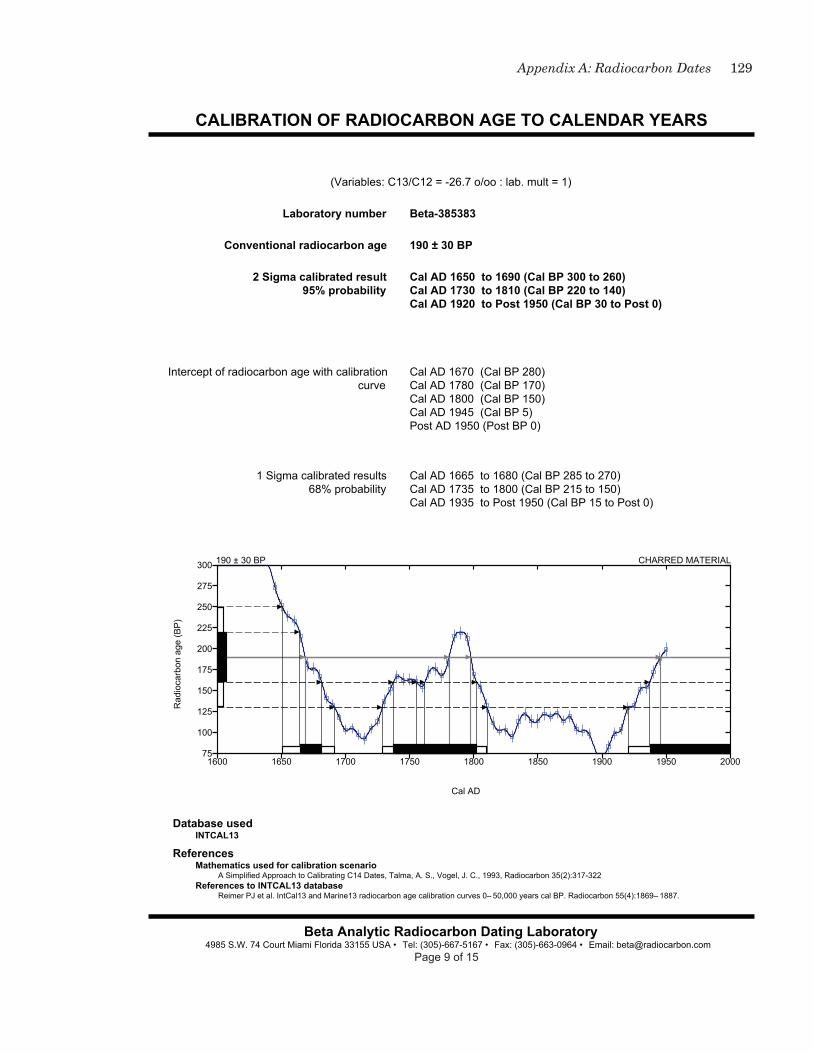
129Appendix A: Radiocarbon Dates
CALIBRATION OF RADIOCARBON AGE TO CALENDAR YEARS
Database usedINTCAL13
ReferencesMathematics used for calibration scenario
A Simplified Approach to Calibrating C14 Dates, Talma, A. S., Vogel, J. C., 1993, Radiocarbon 35(2):317-322References to INTCAL13 database
Reimer PJ et al. IntCal13 and Marine13 radiocarbon age calibration curves 0– 50,000 years cal BP. Radiocarbon 55(4):1869– 1887.
Beta Analytic Radiocarbon Dating Laboratory4985 S.W. 74 Court Miami Florida 33155 USA • Tel: (305)-667-5167 • Fax: (305)-663-0964 • Email: [email protected]
(Variables: C13/C12 = -26.7 o/oo : lab. mult = 1)
Laboratory number Beta-385383
Conventional radiocarbon age 190 ± 30 BP
2 Sigma calibrated result95% probability
Cal AD 1650 to 1690 (Cal BP 300 to 260)Cal AD 1730 to 1810 (Cal BP 220 to 140)Cal AD 1920 to Post 1950 (Cal BP 30 to Post 0)
Intercept of radiocarbon age with calibration curve
Cal AD 1670 (Cal BP 280)Cal AD 1780 (Cal BP 170)Cal AD 1800 (Cal BP 150)Cal AD 1945 (Cal BP 5)Post AD 1950 (Post BP 0)
1 Sigma calibrated results68% probability
Cal AD 1665 to 1680 (Cal BP 285 to 270)Cal AD 1735 to 1800 (Cal BP 215 to 150)Cal AD 1935 to Post 1950 (Cal BP 15 to Post 0)
190 ± 30 BP CHARRED MATERIAL
1600 1650 1700 1750 1800 1850 1900 1950 200075
100
125
150
175
200
225
250
275
300
Cal AD
Rad
ioca
rbon
age
(BP
)
Page 9 of 15

130 Excavations at Site 22CH698, Red Hills Mine
CALIBRATION OF RADIOCARBON AGE TO CALENDAR YEARS
Database usedINTCAL13
ReferencesMathematics used for calibration scenario
A Simplified Approach to Calibrating C14 Dates, Talma, A. S., Vogel, J. C., 1993, Radiocarbon 35(2):317-322References to INTCAL13 database
Reimer PJ et al. IntCal13 and Marine13 radiocarbon age calibration curves 0– 50,000 years cal BP. Radiocarbon 55(4):1869– 1887.
Beta Analytic Radiocarbon Dating Laboratory4985 S.W. 74 Court Miami Florida 33155 USA • Tel: (305)-667-5167 • Fax: (305)-663-0964 • Email: [email protected]
(Variables: C13/C12 = -26 o/oo : lab. mult = 1)
Laboratory number Beta-385384
Conventional radiocarbon age 200 ± 30 BP
2 Sigma calibrated result95% probability
Cal AD 1650 to 1685 (Cal BP 300 to 265)Cal AD 1730 to 1810 (Cal BP 220 to 140)Cal AD 1925 to Post 1950 (Cal BP 25 to Post 0)
Intercept of radiocarbon age with calibration curve
Cal AD 1665 (Cal BP 285)Cal AD 1780 (Cal BP 170)Cal AD 1795 (Cal BP 155)
1 Sigma calibrated results68% probability
Cal AD 1660 to 1680 (Cal BP 290 to 270)Cal AD 1765 to 1800 (Cal BP 185 to 150)Cal AD 1940 to Post 1950 (Cal BP 10 to Post 0)
200 ± 30 BP CHARRED MATERIAL
1600 1650 1700 1750 1800 1850 1900 1950 200075
100
125
150
175
200
225
250
275
300
325
Cal AD
Rad
ioca
rbon
age
(BP
)
Page 10 of 15

131Appendix A: Radiocarbon Dates
CALIBRATION OF RADIOCARBON AGE TO CALENDAR YEARS
Database usedINTCAL13
ReferencesMathematics used for calibration scenario
A Simplified Approach to Calibrating C14 Dates, Talma, A. S., Vogel, J. C., 1993, Radiocarbon 35(2):317-322References to INTCAL13 database
Reimer PJ et al. IntCal13 and Marine13 radiocarbon age calibration curves 0– 50,000 years cal BP. Radiocarbon 55(4):1869– 1887.
Beta Analytic Radiocarbon Dating Laboratory4985 S.W. 74 Court Miami Florida 33155 USA • Tel: (305)-667-5167 • Fax: (305)-663-0964 • Email: [email protected]
(Variables: C13/C12 = -24.6 o/oo : lab. mult = 1)
Laboratory number Beta-385386
Conventional radiocarbon age 1580 ± 30 BP
2 Sigma calibrated result95% probability
Cal AD 405 to 550 (Cal BP 1545 to 1400)
Intercept of radiocarbon age with calibration curve
Cal AD 430 (Cal BP 1520)Cal AD 490 (Cal BP 1460)Cal AD 510 (Cal BP 1440)Cal AD 515 (Cal BP 1435)Cal AD 530 (Cal BP 1420)
1 Sigma calibrated results68% probability
Cal AD 420 to 540 (Cal BP 1530 to 1410)
1580 ± 30 BP CHARRED MATERIAL
375 400 425 450 475 500 525 550 5751475
1500
1525
1550
1575
1600
1625
1650
1675
1700
Cal AD
Rad
ioca
rbon
age
(BP
)
Page 11 of 15

132 Excavations at Site 22CH698, Red Hills Mine
CALIBRATION OF RADIOCARBON AGE TO CALENDAR YEARS
Database usedINTCAL13
ReferencesMathematics used for calibration scenario
A Simplified Approach to Calibrating C14 Dates, Talma, A. S., Vogel, J. C., 1993, Radiocarbon 35(2):317-322References to INTCAL13 database
Reimer PJ et al. IntCal13 and Marine13 radiocarbon age calibration curves 0– 50,000 years cal BP. Radiocarbon 55(4):1869– 1887.
Beta Analytic Radiocarbon Dating Laboratory4985 S.W. 74 Court Miami Florida 33155 USA • Tel: (305)-667-5167 • Fax: (305)-663-0964 • Email: [email protected]
(Variables: C13/C12 = -26.4 o/oo : lab. mult = 1)
Laboratory number Beta-385387
Conventional radiocarbon age 1650 ± 30 BP
2 Sigma calibrated result95% probability
Cal AD 340 to 425 (Cal BP 1610 to 1525)
Intercept of radiocarbon age with calibration curve
Cal AD 400 (Cal BP 1550)
1 Sigma calibrated results68% probability
Cal AD 385 to 420 (Cal BP 1565 to 1530)
1650 ± 30 BP CHARRED MATERIAL
320 340 360 380 400 420 4401525
1550
1575
1600
1625
1650
1675
1700
1725
1750
1775
Cal AD
Rad
ioca
rbon
age
(BP
)
Page 12 of 15

133Appendix A: Radiocarbon Dates
CALIBRATION OF RADIOCARBON AGE TO CALENDAR YEARS
Database usedINTCAL13
ReferencesMathematics used for calibration scenario
A Simplified Approach to Calibrating C14 Dates, Talma, A. S., Vogel, J. C., 1993, Radiocarbon 35(2):317-322References to INTCAL13 database
Reimer PJ et al. IntCal13 and Marine13 radiocarbon age calibration curves 0– 50,000 years cal BP. Radiocarbon 55(4):1869– 1887.
Beta Analytic Radiocarbon Dating Laboratory4985 S.W. 74 Court Miami Florida 33155 USA • Tel: (305)-667-5167 • Fax: (305)-663-0964 • Email: [email protected]
(Variables: C13/C12 = N/A : lab. mult = 1)
Laboratory number Beta-385388
Conventional radiocarbon age 300 ± 30 BP
2 Sigma calibrated result95% probability
Cal AD 1490 to 1655 (Cal BP 460 to 295)
Intercept of radiocarbon age with calibration curve
Cal AD 1640 (Cal BP 310)
1 Sigma calibrated results68% probability
Cal AD 1520 to 1575 (Cal BP 430 to 375)Cal AD 1630 to 1645 (Cal BP 320 to 305)
300 ± 30 BP CHARRED MATERIAL
1450 1475 1500 1525 1550 1575 1600 1625 1650 1675175
200
225
250
275
300
325
350
375
400
425
Cal AD
Rad
ioca
rbon
age
(BP
)
Page 13 of 15

134 Excavations at Site 22CH698, Red Hills Mine
CALIBRATION OF RADIOCARBON AGE TO CALENDAR YEARS
Database usedINTCAL13
ReferencesMathematics used for calibration scenario
A Simplified Approach to Calibrating C14 Dates, Talma, A. S., Vogel, J. C., 1993, Radiocarbon 35(2):317-322References to INTCAL13 database
Reimer PJ et al. IntCal13 and Marine13 radiocarbon age calibration curves 0– 50,000 years cal BP. Radiocarbon 55(4):1869– 1887.
Beta Analytic Radiocarbon Dating Laboratory4985 S.W. 74 Court Miami Florida 33155 USA • Tel: (305)-667-5167 • Fax: (305)-663-0964 • Email: [email protected]
(Variables: C13/C12 = -23.8 o/oo : lab. mult = 1)
Laboratory number Beta-385389
Conventional radiocarbon age 950 ± 30 BP
2 Sigma calibrated result95% probability
Cal AD 1020 to 1160 (Cal BP 930 to 790)
Intercept of radiocarbon age with calibration curve
Cal AD 1040 (Cal BP 910)Cal AD 1110 (Cal BP 840)Cal AD 1115 (Cal BP 835)
1 Sigma calibrated results68% probability
Cal AD 1025 to 1050 (Cal BP 925 to 900)Cal AD 1080 to 1150 (Cal BP 870 to 800)
950 ± 30 BP CHARRED MATERIAL
1000 1025 1050 1075 1100 1125 1150 1175825
850
875
900
925
950
975
1000
1025
1050
1075
Cal AD
Rad
ioca
rbon
age
(BP
)
Page 14 of 15

135Appendix A: Radiocarbon Dates
CALIBRATION OF RADIOCARBON AGE TO CALENDAR YEARS
Database usedINTCAL13
ReferencesMathematics used for calibration scenario
A Simplified Approach to Calibrating C14 Dates, Talma, A. S., Vogel, J. C., 1993, Radiocarbon 35(2):317-322References to INTCAL13 database
Reimer PJ et al. IntCal13 and Marine13 radiocarbon age calibration curves 0– 50,000 years cal BP. Radiocarbon 55(4):1869– 1887.
Beta Analytic Radiocarbon Dating Laboratory4985 S.W. 74 Court Miami Florida 33155 USA • Tel: (305)-667-5167 • Fax: (305)-663-0964 • Email: [email protected]
(Variables: C13/C12 = -25.4 o/oo : lab. mult = 1)
Laboratory number Beta-385390
Conventional radiocarbon age 5150 ± 30 BP
2 Sigma calibrated result95% probability
Cal BC 4030 to 4025 (Cal BP 5980 to 5975)Cal BC 3990 to 3945 (Cal BP 5940 to 5895)
Intercept of radiocarbon age with calibration curve
Cal BC 3965 (Cal BP 5915)
1 Sigma calibrated results68% probability
Cal BC 3975 to 3955 (Cal BP 5925 to 5905)
5150 ± 30 BP CHARRED MATERIAL
4060 4040 4020 4000 3980 3960 3940 39205025
5050
5075
5100
5125
5150
5175
5200
5225
5250
5275
Cal BC
Rad
ioca
rbon
age
(BP
)
Page 15 of 15


appEndix b: plant Remains
Leslie L. Bush, Ph.D., R.P.A.Macrobotanical AnalysisManchaca, Texas


139Appendix B: Plant Remains
intRoduction
Thirteen botanical lots and 14 flotation samples collected during investigations at site 22Ch698 in Choctaw County, Mississippi, were submitted for identification and analysis. The flotation samples represent 61.00 cubic decimeters of soil from five units, with 10 of the samples (39.5 cu. dm.) coming from a single column in unit 22.
sitE sEtting
Choctaw County, Mississippi, lies in the Southern hilly Gulf Coastal Plain, where pre-Columbian vegetation was dominated by oak-hickory-pine forests (Braun 2001:277–278; Chapman et al. 2004). The diversity of soil types and topography, however, mean that many species typical of southern mixed forests such as magnolia and beech would also have been present. Modern timber species in the county include white oaks, red oaks, hickory, sweetgum, elm, sugarberry, ash, water tupelo, blackgum, yellow-poplar, red maple, and sycamore (uSDA, SCS 1986:44). The frost-free season is at least 192 days in 9 of 10 years (uSDA, SCS 1986:Table 3).
MEthods
Flotation samples were processed in a Flote-Tech machine at the Prewitt and Associates, Inc., laboratory in Austin (Dausman 1989). Any carbonized material remaining in the heavy fractions after flotation was removed by hand and added to the light fractions before transfer to Macrobotanical Analysis.
Flotation samples were sorted according to standard procedures (Pearsall 2000). Flotation light fractions were size-sorted through a stack of graduated geologic mesh. Materials that did not pass through the No. 10 mesh (2-mm square openings) were completely sorted, counted, weighed, recorded, and labeled. Weights were taken on an Ohaus Scout II 200x0.01-g electronic balance. Materials in this size fraction other than carbonized botanical remains were weighed and labeled as “contamination.” At this site, contamination consisted primarily of rootlets and grass stems. Materials that fell through the 2-mm mesh were examined at 7–45x magnification for carbonized botanical remains not previously identified in the larger size fraction. Remaining material in this smaller size fraction after examination was weighed and labeled as “residue.” uncarbonized seeds were recorded on a presence/absence basis on laboratory forms.
Charcoal samples arrived in the Macrobotanical Analysis laboratory in clean plastic bags. Organic labeling material (paper tags) was in plastic slips and not in direct contact with the charcoal. In the laboratory, all samples were subject to full radiocarbon protocols to retain suitability for dating. Charcoal samples were not screened. They were sorted on freshly cleaned glassware and handled only with latex gloves and metal forceps. Sorting dishes and scale pans were cleaned between samples. Contact with paper and other plant products was avoided. Only one sample was open at a time in the laboratory. Writing instruments used for data recording of samples were plastic mechanical pencils.

140 Excavations at Site 22CH698, Red Hills Mine
Wood charcoal fragments larger than 2 mm were selected for identification from charcoal or floation samples until 20 fragments were examined. When fewer than 20 fragments larger than 2 mm were present, identification was attempted for progressively smaller fragments until identification became impractical or 20 fragments were identified. For flotation samples, wood charcoal fragments were selected at random. For charcoal samples, the largest pieces were selected for identification first to best identify the concentration of wood that attracted the attention of the excavator in the field. Accordingly, wood charcoal is listed in descending order of count in the flotation results tables but by weight in the charcoal tables. Wood charcoal fragments were snapped to reveal a transverse section and examined under a stereoscopic light microscope at 28–180x magnification. When necessary, tangential or radial sections were examined for ray seriation, presence of spiral thickenings, types and sizes of intervessel pitting, and other minute characteristics that can only be seen at the higher magnifications of this range.
Botanical materials were identified to the lowest possible taxonomic level by comparison to materials in the Macrobotanical Analysis comparative collection and through the use of standard reference works (Core et al. 1979; Davis 1993; hoadley 1990; InsideWood 2004; Martin and Barkley 2000; Musil 1963; Panshin and de Zeeuw 1980; Wheeler 2011). Botanical nomenclature follows that of the PLANTS Database (uSDA, NRCS 2014).
REsults and discussion
charcoal samples
As shown in Tables B.1 and B.2, all plant material in the charcoal samples consists of wood charcoal. Ten types of wood are present: nine hardwood taxa and pine of the Southern yellow group. By weight, white group oak is the most abundant type. It is present in five samples, as is sweetgum, which is the second most abundant taxon. Elm is present in four samples, and the remaining woods are present in one or two samples each.
flotation samples
Archeological Versus Modern Plants
uncarbonized seeds are present in all flotation samples (Table B.3). uncarbonized seeds are a common occurrence at most archeological sites, but they usually represent seeds of modern plants that have made their way into the soil either through their own dispersal mechanisms or by faunalturbation, floralturbation, or argilliturbation (Bryant 1985:51–52; Miksicek 1987:231–232). In all except the driest areas of North America, uncarbonized plant material at open-air sites can be assumed to be of modern origin unless compelling evidence suggests otherwise (Lopinot and Brussell 1982; Miksicek 1987:231). The uncarbonized seeds at 22Ch698 represent weedy annuals common in the area today, indicating that they are modern. The unit 22 column provides additional evidence for the recent origin of the uncarbonized seeds because the number of seed taxa present is strongly and inversely correlated with depth (r = 0.94), indicating an origin at the modern surface.

141Appendix B: Plant Remains
Tab
le B
.1. W
ood
tax
a re
pre
sen
ted
in
ch
arco
al s
amp
les
(cou
nt)
Pro
ven
ien
ceU
nit
3,
Lev
el 1
Un
it 9
,L
evel
6U
nit
10,
Lev
el 1
0U
nit
11,
Lev
el 2
Un
it 1
1,L
evel
8U
nit
12,
Lev
el 8
Un
it 1
3,L
evel
8U
nit
13,
Lev
el 9
Un
it 1
4,L
evel
10
Un
it 1
5,L
evel
12
Un
it 2
5,L
evel
11
Un
it 2
6,L
evel
5T
ren
ch10
Tot
alW
hit
e gr
oup
oak
(Qu
ercu
s su
bg.
Qu
ercu
s)
15
13
2030
Sw
eetg
um
(Liq
uid
amba
rst
yrac
iflu
a)
113
720
1556
Sas
safr
as(S
assa
fras
albi
du
m)
1111
Hic
kory
(C
arya
sp.
)2
13
Sli
pper
y el
m(U
lmu
s ru
bra)
31
215
30
Pin
e, h
ard
grou
p(P
inu
s sp
.)4
37
Su
mac
(R
hu
s sp
.)2
1012
Oak
(Q
uer
cus
sp.)
72
9R
ed g
rou
p oa
k(Q
uer
cus
subg
.L
obat
ae)
115
16
Tu
lip-
popl
ar(L
irio
den
dro
ntu
lipi
fera
)
11
Am
eric
an e
lm(U
lmu
s am
eric
ana)
22
4
Har
dwoo
d2
2N
ot e
xam
ined
for
spec
ies
3248
1251
7822
1
Tot
al7
1716
214
5268
3221
371
198
402
table b.1. Wood taxa represented in charcoal samples (count).

142 Excavations at Site 22CH698, Red Hills Mine
table b.2. Wood taxa represented in charcoal samples (weight in grams).
Tab
le B
.2. W
ood
tax
a re
pre
sen
ted
in
ch
arco
al s
amp
les
(wei
ght
in g
ram
s)
Pro
ven
ien
ceU
nit
3,
Lev
el 1
Un
it 9
,L
evel
6U
nit
10,
Lev
el 1
0U
nit
11,
Lev
el 2
Un
it 1
1,L
evel
8U
nit
12,
Lev
el 8
Un
it 1
3,L
evel
8U
nit
13,
Lev
el 9
Un
it 1
4,L
evel
10
Un
it 1
5,L
evel
12
Un
it 2
5,L
evel
11
Un
it 2
6,L
evel
5T
ren
ch10
Tot
alW
hit
e gr
oup
oak
(Qu
ercu
s su
bg.
Qu
ercu
s)
0.23
1.19
0.01
0.53
10.6
512
.61
Sw
eetg
um
(Liq
uid
amba
rst
yrac
iflu
a)
0.58
1.77
0.55
1.31
2.87
7.08
Sas
safr
as(S
assa
fras
albi
du
m)
5.74
5.74
Hic
kory
(C
arya
sp.
)1.
252.
033.
28S
lipp
ery
elm
(Ulm
us
rubr
a)1.
070.
150.
720.
482.
42
Pin
e, h
ard
grou
p(P
inu
s sp
.)1.
380.
431.
81
Su
mac
(R
hu
s sp
.)0.
021.
501.
52O
ak (
Qu
ercu
s sp
.)0.
930.
441.
37R
ed g
rou
p oa
k(Q
uer
cus
subg
.L
obat
ae)
0.06
1.05
1.11
Tu
lip-
popl
ar(L
irio
den
dro
ntu
lipi
fera
)
0.32
0.32
Am
eric
an e
lm(U
lmu
s am
eric
ana)
0.11
0.11
0.22
Har
dwoo
d0.
210.
21N
ot e
xam
ined
for
spec
ies
0.79
0.76
0.71
2.37
1.45
6.08
Tot
al2.
516.
991.
801.
251.
484.
212.
074.
280.
720.
4313
.02
2.03
2.98
43.7
7

143Appendix B: Plant Remains
Tab
le B
.3. U
nca
rbon
ized
(m
oder
n)
seed
s fr
om f
lota
tion
sam
ple
s (p
rese
nce
/ab
sen
ce)
Un
it 1
112
1922
2222
2222
2222
2222
22F
eat.
9T
otal
Lev
el8
911
45
67
89
1011
1213
Flo
tati
on v
olu
me
(cu
. dm
.)5.
54.
53.
04.
03.
53.
54.
04.
04.
54.
04.
53.
54.
08.
5
Car
petw
eed
(Mol
lugo
vert
icil
lata
)X
XX
XX
XX
XX
XX
XX
X14
Pu
rsla
ne
(Por
tula
caol
erac
ea)
XX
XX
XX
XX
X9
Cop
perl
eaf
(Aca
lyph
asp
.)X
XX
XX
XX
7
Pok
ewee
d (P
hyt
olac
caam
eric
ana)
XX
XX
XX
6
Gra
ss f
amil
y (P
oace
ae)
XX
XX
X5
Eld
erbe
rry
(Sam
bucu
sn
igra
)X
XX
XX
5
Eve
nin
g-pr
imro
se(O
enot
her
a sp
.)X
XX
X4
San
dmat
(C
ham
aesy
cesp
.)X
XX
3
Woo
dsor
rel (
Oxa
lis
sp.)
XX
X3
Fla
tsed
ge (
Cyp
eru
ssp
.)X
X2
Bro
wn
-eye
d S
usa
n(R
ud
beck
ia h
irta
)X
X2
Car
rot
fam
ily
(Api
acea
e)X
1
Sed
ge(C
arex
sp.
)X
1
May
pop
(Pas
sifl
ora
inca
rnat
a)X
1
Bla
ckbe
rry
(Ru
bus
sp.)
X1
Sam
ple
Tot
al1
33
99
56
65
22
21
1064
table b.3. uncarbonized (modern) seeds from flotation samples (presence/absence).
144 Excavations at Site 22CH698, Red Hills Mine
Carbonized plants in the unit 22 column, on the other hand, do not correlate with depth (r = -0.08; total carbonized plant weight versus depth). uncarbonized seeds at 22Ch698 are therefore interpreted as modern.
Although carbonized plant weight does not correlate with sample depth, some carbonized plants appear to be of recent origin. Most notably, a carbonized grain of wheat, a Eurasian native, was recovered from unit 22, Level 4. This is the shallowest sample collected for flotation. At the time the site was recorded in 2000, the area was reported to have been planted in winter wheat, other spring grasses, and clover. The wheat grain is thus likely to have been the result of recent burning on the site. It is unclear whether other carbonized material is also recent. No semicarbonized material is present to suggest which carbonized taxa may have been recently burned. Some specimens have reddish-brown spots on the exterior, but this appears to be soil staining rather than incomplete carbonization. The lack of clear distinction between ancient and recent carbonized remains is particularly problematic for interpretation of the corn kernel from unit 12, discussed below.
Wood Charcoal
A total of 604 fragments of wood charcoal weighing 19.67 g was present in the flotation samples (Tables B.4 and B.5). Identification was attempted for 207 fragments, of which 176 could be identified to botanical genus or species. Thirteen hardwood taxa and Southern yellow Pine were identified. As in the carbon samples, white group oak was the most common taxon (n = 53; 30 percent of identifiable fragments). Other common woods, in descending order of abundance, were hickory, ash, elms, magnolia, pine, tulip-poplar, and sweetgum. Two fragments of wood charcoal from unit 22, Level 4, that could be identified only as ring-porous hardwood are consistent with the latewood of sassafras, a species found in the charcoal samples but not the flotation samples.
Wood charcoal at 22Ch698 is interpreted as fuel wood. It reflects the local oak-hickory-pine and southern mixed forests, but with an emphasis on the highest-quality fuel woods (oak, hickory, and ash).
Corn
One nearly complete corn kernel was recovered from unit 12, Level 9. The specimen is missing most of the seed coat and embryo (germ). The kernel is 4.5 mm wide, 3.0 mm tall, and 2.8 mm thick. The small round shape suggests the kernel is from the distal (tip) end of a cob, making it impossible even to speculate about the type of corn that might be represented (e.g., Eastern Eight Row, Southern Dent). An additional two fragments of starchy botanical material from unit 22, Levels 11 and 13, exhibited the dimpled surface texture associated with corn and are categorized as cf Zea mays. Corn was not anticipated in these samples, which were expected to reflect Woodland period subsistence. Corn has been recovered from Woodland contexts in Mississippi, however, and it increases in abundance during the a.d. 800–1000 period (Fritz 2008:334, 337). The presence of a carbonized wheat grain in unit 22, Level 4, indicates at least some of the carbonized botanical remains

145Appendix B: Plant Remains
Tab
le B
.4. B
otan
ical
rem
ain
s fr
om f
lota
tion
sam
ple
s (c
oun
t)
Un
it11
1219
2222
2222
2222
2222
2222
Fea
t. 9
Tot
alL
evel
89
114
56
78
910
1112
13F
lota
tion
vol
um
e(c
u. d
m.)
5.5
4.5
3.0
4.0
3.5
3.5
4.0
4.0
4.5
4.0
4.5
3.5
4.0
8.5
61.0
Cro
ps
Cor
n k
ern
el (
Zea
may
s)1
1?1?
3W
hea
t gr
ain
(T
riti
cum
sp.)
11
Nu
tsh
ells
Hic
kory
(C
arya
sp.
)1
9192
Hic
kory
/wal
nu
t fa
mil
y(J
ugl
anda
ceae
)1
1617
Aco
rn (
Qu
ercu
s sp
.)1
31
5S
tem
sR
iver
can
e (A
run
din
aria
giga
nte
a)3
22
21
11
12
Gra
ss (
Poa
ceae
)4
15
Her
bace
ous
11
See
ds
Dai
sy f
amil
y (A
ster
acea
e)3
14
Am
eric
an h
orn
beam
(Car
pin
us
caro
lin
ian
a)3
3
Gra
ss f
amil
y (P
oace
ae)
23
Inde
term
inat
e2
13
Woo
dW
hit
e gr
oup
oak
(Qu
ercu
ssu
bg. Q
uer
cus)
1010
54
101
22
51
353
Hic
kory
(C
arya
sp.
)19
14
832
Ash
(F
raxi
nu
s sp
.)2
45
12
115
Mag
nol
ia (
Mag
nol
ia s
p.)
110
11P
ine,
har
d gr
oup
(Pin
us
sp.)
42
12
11
11
Tu
lip-
popl
ar(L
irio
den
dro
n t
uli
pife
ra)
42
22
10
table b.4. Botanical remains from flotation samples (count).

146 Excavations at Site 22CH698, Red Hills Mine
Ta
ble
B.4
, con
tin
ued
Un
it11
1219
2222
2222
2222
2222
2222
Fea
t. 9
Tot
alL
evel
89
114
56
78
910
1112
13S
wee
tgu
m (
Liq
uid
amba
rst
yrac
iflu
a)2
11
22
19
Red
gro
up
oak
(Qu
ercu
ssu
bg. L
obat
ae)
23
12
8
Elm
(U
lmu
s sp
.)3
13
7A
mer
ican
elm
(U
lmu
sam
eric
ana)
51
6
Bee
ch (
Fag
us
gran
dif
olia
)3
14
Su
mac
(R
hu
s sp
.)1
34
Am
eric
an h
orn
beam
(Car
pin
us
caro
lin
ian
a)2
2
Oak
(Q
uer
cus
sp.)
11
2M
aple
(A
cer
sp.)
11
Gra
pe (
Vit
is s
p.)
11
Rin
g-po
rou
s h
ardw
ood
22
Har
dwoo
d3
28
52
13
529
Not
exa
min
ed f
or s
peci
es13
218
820
1613
2839
7O
ther
Fu
ngu
s2
21
46
116
Inde
term
inat
e1
91
21
115
Sta
rch
y fr
agm
ents
11
13
Bar
k1
1U
nkn
own
11

147Appendix B: Plant Remains
table b.5. Botanical remains from flotation samples (weight in grams).
Tab
le B
.5. B
otan
ical
rem
ain
s fr
om f
lota
tion
sam
ple
s (w
eigh
t in
gra
ms)
Un
it11
1219
2222
2222
2222
2222
2222
Fea
t. 9
Tot
alL
evel
89
114
56
78
910
1112
13F
lota
tion
vol
um
e(c
u. d
m.)
5.5
4.5
3.0
4.0
3.5
3.5
4.0
4.0
4.5
4.0
4.5
3.5
4.0
8.5
61.0
Cro
ps
Cor
n k
ern
el(Z
ea m
ays)
0.01
? 0.
01?
0.01
0.03
Wh
eat
grai
n(T
riti
cum
sp.
)0.
010.
01
Nu
tsh
ells
Hic
kory
(Car
ya s
p.)
0.01
1.04
1.05
Hic
kory
/w
aln
ut
fam
ily
(Ju
glan
dace
ae)
0.01
0.08
0.09
Aco
rn(Q
uer
cus
sp.)
0.01
0.02
0.01
0.04
Ste
ms
Riv
er c
ane
(Aru
nd
inar
iagi
gan
tea)
0.01
0.01
0.01
0.01
0.01
0.01
0.01
0.07
Gra
ss (
Poa
ceae
)0.
010.
010.
02H
erba
ceou
s0.
010.
01S
eed
sD
aisy
fam
ily
(Ast
erac
eae)
0.01
0.01
0.02
Am
eric
an h
orn
beam
(Car
pin
us
caro
lin
ian
a)
0.03
0.03
Gra
ss f
amil
y(P
oace
ae)
0.02
0.03
Inde
term
inat
e0.
020.
010.
03W
ood
Wh
ite
grou
p oa
k(Q
uer
cus
subg
.Q
uer
cus)
0.05
0.17
0.01
0.05
0.06
0.01
0.66
0.01
0.01
0.01
0.02
1.06

148 Excavations at Site 22CH698, Red Hills MineT
abl
e B
.5, c
onti
nu
ed
Un
it11
1219
2222
2222
2222
2222
2222
Fea
t. 9
Tot
alL
evel
89
114
56
78
910
1112
13H
icko
ry(C
arya
sp.
)1.
740.
030.
100.
522.
39
Ash
(Fra
xin
us
sp.)
0.01
0.23
0.24
Mag
nol
ia (
Mag
nol
iasp
.)0.
030.
020.
010.
010.
010.
010.
09
Pin
e, h
ard
grou
p(P
inu
s sp
.)0.
020.
010.
020.
010.
010.
020.
09
Tu
lip-
popl
ar(L
irio
den
dro
ntu
lipi
fera
)
0.08
0.05
0.02
0.06
0.21
Sw
eetg
um
(Liq
uid
amba
rst
yrac
iflu
a)
0.03
0.07
0.01
0.01
0.01
0.01
0.14
Red
gro
up
oak
(Qu
ercu
s su
bg.
Lob
atae
)
0.01
0.07
0.01
0.03
0.12
Elm
(Ulm
us
sp.)
0.02
0.01
0.01
0.04
Am
eric
an e
lm(U
lmu
s am
eric
ana)
0.30
0.01
0.31
Bee
ch (
Fag
us
gran
dif
olia
)0.
020.
010.
03
Su
mac
(Rh
us
sp.)
0.01
0.02
0.03
Am
eric
an h
orn
beam
(Car
pin
us
caro
lin
ian
a)
0.01
0.01
Oak
(Qu
ercu
s sp
.)0.
010.
010.
02
Map
le(A
cer
sp.)
0.01
0.01
Gra
pe(V
itis
sp.
)0.
050.
05
Rin
g-po
rou
sh
ardw
ood
0.02
0.02
Har
dwoo
d0.
010.
010.
040.
040.
010.
010.
010.
010.
14

149Appendix B: Plant Remains
Ta
ble
B.5
, con
tin
ued
Un
it11
1219
2222
2222
2222
2222
2222
Fea
t. 9
Tot
alL
evel
89
114
56
78
910
1112
13N
ot e
xam
ined
for
spec
ies
0.74
12.9
00.
060.
050.
130.
7914
.67
Oth
erF
un
gus
0.01
0.01
0.01
0.02
0.03
0.01
0.09
Inde
term
inat
e0.
010.
010.
010.
010.
010.
010.
06S
tarc
hy
frag
men
ts0.
010.
010.
010.
03B
ark
0.01
0.01
Un
know
n0.
010.
01
Con
tam
inat
ion
> 2
mm
0.24
0.50
0.11
0.16
0.06
0.09
0.10
0.12
0.19
0.16
0.06
0.07
0.04
0.25
2.15
Res
idu
e <
2mm
0.92
2.81
1.29
0.62
0.66
0.67
0.52
0.65
1.44
0.49
0.22
0.2
0.21
1.27
11.9
7

150 Excavations at Site 22CH698, Red Hills Mine
are recent. Although the corn kernel and starchy fragments that may also be corn come from deeper levels than the wheat grain, uncarbonized seeds were also present in these levels, indicating that at least some modern material has been carried to these depths. Whether or not the corn kernel is ancient cannot be determined from the evidence available at this time.
Nutshells
Thick-shelled hickory and acorn nutshells were recovered in six samples. The hickory nutshells consisted of 92 fragments weighing 1.05 g, with an additional 17 fragments (0.09 g) identifiable only to the hickory/walnut family. Nearly all of the hickory and related nutshells occurred in Feature 9. With only five fragments (0.04 g) recovered, acorn was much less abundant than hickory. It was present in samples in units 11 and 22.
Cane and Other Stems
River cane and smaller grass stems were recovered from eight contexts. An herbaceous stem was recovered from unit 22, Level 9. Cane was a tremendously useful plant for Native Americans, providing raw material for items such as mats, baskets, sieves, spear and arrow shafts, pipe stems, blow guns, flutes, screens to divide rooms, and blow tubes used in healing (Moerman 1998:104).
Seeds
Four seeds from the daisy family, three American hornbeam seeds, two grass seeds, and three indeterminable seeds were recovered. American hornbeam has few known ethnographic uses, and all of these are structural uses of the wood or medicinal uses, usually of the bark. The American hornbeam seeds at 22Ch698 are likely present incidental to the burning of American hornbeam wood for fuel. American hornbeam wood was present in the same sample as three of the daisy family seeds, unit 12, Level 9.
The two grass seeds were recovered from unit 22, Level 4, the sample that also produced the wheat kernel (Figure B.1). Gayle Fritz (personal communication, June 6, 2014) examined photographs of them and determined that they are not the large Toltec Type x grass that has previously been reported from sites in the Lower Mississippi Valley (Fritz 2007, 2008). The two specimens compare well to the shape and texture of giant cutgrass seeds (Zizaniopsis miliacea), but they are larger than other illustrated cutgrass specimens (Crane 1982; uSDA, NRCS 2014). Given the context, it is possible these are recent seeds.

151Appendix B: Plant Remains
suMMaRy
Archeological macrobotanical remains recovered in 13 botanical lots and 14 flotation samples from 22Ch698 consist of wood charcoal, corn, nutshell, river cane and other grass stems, and a smattering of seeds. Wood charcoal is consistent with the expected composition of local forests in prehistoric times, but with an emphasis on higher-quality fuel woods. Corn was unexpected at this site, and it is unclear whether the specimen is ancient. Nutshell consisted of thick-shelled hickory and acorn, nearly all from Feature 9. River cane would have provided an important raw material for crafts and construction. The seeds recovered do not have clear subsistence indications.
centimeters
0 1 2 4
millermeters
0 1 2
centimeters
0 1 2a
bc
d
e
Figure B.1
figure b.1. Three grass family seeds from unit 22, Level 4. The specimen on the left is wheat.

152 Excavations at Site 22CH698, Red Hills Mine
REfEREncEs citEd
Braun, E. Lucy 2001 Deciduous Forests of Eastern North America. The Blackburn Press, Caldwell, New Jersey.
Bryant, John A. 1985 Seed Physiology. The Institute of Biology’s Studies in Biology No. 165. Edward Arnold,
Ltd., London.
Chapman, S. S., G. E. Griffith, J. M. Omernik, J. A. Comstock, M. C. Beiser, and D. Johnson 2004 Ecoregions of Mississippi. Color poster with map, descriptive text, summary tables, and
photographs, map scale 1:1,000,000. u.S. Geological Survey, Reston, Virginia.
Core, h. A., W. A. Cote and A. C. Day 1979 Wood Structure and Identification. 2nd ed. Syracuse university Press, Syracuse, New
york.
Crane, Cathy J. 1982 Plant utilization at Spoonbill, an Early Caddo Site in Northeast Texas. Midcontinental
Journal of Archaeology 7:81–97.
Davis, Linda W. 1993 Weed Seeds of the Great Plains: A Handbook for Identification. university Press of
Kansas, Lawrence.
Dausman, Raymond J. 1989 Multimodal Flotation. Wisconsin Archaeologist 70:362–366.
Fritz, Gayle 2007 Plum Bayou Foodways: Distinctive Aspects of the Paleoethnobotanical Record. Arkansas
Archeologist 47.
2008 Paleoethnobotanical Information and Issues Relevant to the I-69 Overview Process, Northwest Mississippi. In Time’s River: Archaeolgical Syntheses from the Lower Mississippi River Valley, edited by Janet Rafferty and Evan Peacock, pp. 299–343. The university of Alabama Press, Tuscaloosa.
hoadley, R. Bruce 1990 Identifying Wood: Accurate Results with Simple Tools. The Taunton Press, Newtown,
Connecticut.
InsideWood 2004–onwards Inside Wood database. Electronic document, http://insidewood.lib.ncsu.edu/search.
Lopinot, Neal h., and David Eric Brussell 1982 Assessing uncarbonized Seeds from Open-air Sites in Mesic Environments: An Example
from Southern Illinois. Journal of Archaeological Science 9:95–108.
Martin, Alexander C., and William D. Barkley 2000 Seed Identification Manual. The Blackburn Press, Caldwell, New Jersey.
Miksicek, Charles h. 1987 Formation Processes of the Archaeobotanical Record. In Advances in Archaeological
Method and Theory, Vol. 10, edited by M. B. Schiffer, pp. 211–247. Academic Press, Inc., New york.
Moerman, Daniel 1998 Native American Ethnobotany. Timber Press, Portland, Oregon.

153Appendix B: Plant Remains
Musil, Albina F. 1963 Identification of Crop and Weed Seeds Agriculture handbook No. 219. u.S. Department
of Agriculture, Washington, D.C.
Panshin, A. J. and Carol de Zeeuw 1980 Textbook of Wood Technology: Structure, Identification, Properties, and Uses of the
Commercial Woods of the United States and Canada. 4th ed. McGraw-hill Book Company, New york.
Pearsall, Deborah M. 2000 Paleoethnobotany: A Handbook of Procedures. 2nd ed. Academic Press, San Diego.
Wheeler, Elizabeth A. 2011 InsideWood – A Web Resource for hardwood Anatomy. IAWA Journal 32(2):199–211.
uSDA, NRCS (united States Department of Agriculture, Natural Resources Conservation Service) 2014 The PLANTS Database. Electronic document, http://plants.usda.gov, accessed June 5,
2014.
uSDA, SCS (united States Department of Agriculture, Soil Conservation Service) 1986 Soil Survey of Choctaw County, Mississippi.


appEndix c: Metric data for chipped stone tools and cores and ground stone tools


157Appendix C: Metric Data for Tools
Tab
le C
.1. M
etri
c d
ata
for
chip
ped
sto
ne
tool
s an
d c
ores
an
d g
rou
nd
sto
ne
tool
s Provenience
Level
Category
Group
Maximum Length
Maximum Width
Maximum Thickness
Blade Length, Left
Blade Length, Right
Stem Length
Stem Width
Neck Width
Weight
Ch
ippe
d S
ton
es
EU
12
9C
ore
Bip
olar
25.9
713
.31
12.7
23.
45
EU
12
9C
ore
Bip
olar
18.2
111
.74
6.96
1.89
EU
13
7C
ore
Bip
olar
17.8
16.8
48.
941.
99
EU
13
10C
ore
Bip
olar
25.2
317
.37
13.4
4.62
EU
13
13C
ore
Bip
olar
33.0
117
.54
10.7
84.
75
EU
14
13C
ore
Bip
olar
36.2
21.2
720
.23
19.2
4
EU
16
11C
ore
Bip
olar
40.1
710
.63
16.6
216
.11
EU
17
5C
ore
Bip
olar
21.7
716
.44
10.9
94.
14
EU
17
13C
ore
Bip
olar
21.8
116
.69
11.4
83.
69
EU
22
9C
ore
Bip
olar
28.3
113
.38
12.1
64.
29
Fea
ture
9C
ore
Bip
olar
30.3
725
.59
11.3
97.
91
EU
23
Bif
ace
Bif
ace,
In
dete
rmin
ate
2.86
0.39
EU
210
Bif
ace
Bif
ace,
Inde
term
inat
e0.
78
EU
35
Bif
ace
Bif
ace,
In
dete
rmin
ate
33.8
217
.29
6.82
4.78
EU
10
5B
ifac
eB
ifac
e,
Inde
term
inat
e2.
1
EU
10
9B
ifac
eB
ifac
e,
Inde
term
inat
e21
.08
11.6
16.
18
EU
10
9B
ifac
eB
ifac
e,
Inde
term
inat
e12
.212
.59
Table C.1. Metric data for chipped stone tools and cores and ground stone tools

158 Excavations at Site 22CH698, Red Hills Mine
Ta
ble
C.1
, con
tin
ued
Provenience
Level
Category
Group
Maximum Length
Maximum Width
Maximum Thickness
Blade Length, Left
Blade Length, Right
Stem Length
Stem Width
Neck Width
Weight
EU
10
10B
ifac
eB
ifac
e,
Inde
term
inat
e15
.89
10.5
95.
53
EU
12
6B
ifac
eB
ifac
e,
Inde
term
inat
e8.
652.
980.
28
EU
12
8B
ifac
eB
ifac
e,
Inde
term
inat
e21
.13
6.77
3.04
EU
12
10B
ifac
eB
ifac
e,
Inde
term
inat
e1.
25
EU
13
6B
ifac
eB
ifac
e,
Inde
term
inat
e1.
43
EU
13
11B
ifac
eB
ifac
e,
Inde
term
inat
e6.
592.
42
EU
13
11B
ifac
eB
ifac
e,
Inde
term
inat
e6.
491.
24
EU
14
8B
ifac
eB
ifac
e,
Inde
term
inat
e0.
81
EU
14
10B
ifac
eB
ifac
e,
Inde
term
inat
e0.
5
EU
14
11B
ifac
eB
ifac
e,
Inde
term
inat
e1.
97
EU
15
6B
ifac
eB
ifac
e,
Inde
term
inat
e18
.01
4.39
0.93
EU
16
3B
ifac
eB
ifac
e,
Inde
term
inat
e21
.29
7.55
4.5
EU
16
10B
ifac
eB
ifac
e,
Inde
term
inat
e23
.02
6.75
2.74
EU
17
6B
ifac
eB
ifac
e,
Inde
term
inat
e1.
56

159Appendix C: Metric Data for Tools
Ta
ble
C.1
, con
tin
ued
Provenience
Level
Category
Group
Maximum Length
Maximum Width
Maximum Thickness
Blade Length, Left
Blade Length, Right
Stem Length
Stem Width
Neck Width
Weight
EU
17
7B
ifac
eB
ifac
e,
Inde
term
inat
e0.
65
EU
17
13B
ifac
eB
ifac
e,
Inde
term
inat
e0.
55
EU
18
4B
ifac
eB
ifac
e,
Inde
term
inat
e1.
88
EU
18
11B
ifac
eB
ifac
e,
Inde
term
inat
e0.
22
EU
22
9B
ifac
eB
ifac
e,
Inde
term
inat
e10
.39
3.68
EU
22
10B
ifac
eB
ifac
e,
Inde
term
inat
e2.
76
EU
22
12B
ifac
eB
ifac
e,
Inde
term
inat
e4.
27
EU
26
9B
ifac
eB
ifac
e,
Inde
term
inat
e0.
96
EU
26
11B
ifac
eB
ifac
e,
Inde
term
inat
e12
.48
EU
12
11B
ifac
eB
ifac
e, K
nif
e19
.59
8.15
4.45
EU
12
11B
ifac
eB
ifac
e, K
nif
e13
.74
7.7
1.91
EU
26
4B
ifac
eB
ifac
e, S
tage
119
.01
19.6
54.
5419
.65
1.64
EU
19
Bif
ace
Bif
ace,
Sta
ge 2
38.5
328
.34
14.5
519
.3
EU
13
14B
ifac
eB
ifac
e, S
tage
228
.25
12.8
711
.14
EU
16
12B
ifac
eB
ifac
e, S
tage
231
.07
9.2
12
EU
17
6B
ifac
eB
ifac
e, S
tage
216
.78
4.57
1.49
EU
34
Bif
ace
Bif
ace,
Sta
ge 3
26.5
913
.65
8.04
EU
11
9B
ifac
eB
ifac
e, S
tage
324
.19
9.17
8.53

160 Excavations at Site 22CH698, Red Hills Mine
Ta
ble
C.1
, con
tin
ued
Provenience
Level
Category
Group
Maximum Length
Maximum Width
Maximum Thickness
Blade Length, Left
Blade Length, Right
Stem Length
Stem Width
Neck Width
Weight
EU
11
10B
ifac
eB
ifac
e, S
tage
328
.28
9.89
3.84
EU
16
8B
ifac
eB
ifac
e, S
tage
324
.84
74.
18
EU
21
11B
ifac
eB
ifac
e, S
tage
323
.87.
863.
68
Tre
nch
10
Bif
ace
Bif
ace,
Sta
ge 3
20.5
66.
412.
47
EU
11
7B
ifac
eB
ifac
e, S
tage
416
.51
5.33
1.37
EU
15
10B
ifac
eB
ifac
e, S
tage
421
.06
5.11
1.5
EU
17
11B
ifac
eB
ifac
e, S
tage
415
.41
6.4
1.31
EU
26
Arr
owM
adis
on22
.91
13.4
54.
1523
.56
24.1
113
.50.
98
EU
26
Arr
owM
adis
on0.
49
EU
10
3A
rrow
Mad
ison
17.1
74.
3417
.20.
79
EU
11
2A
rrow
Mad
ison
4.51
0.89
EU
14
7A
rrow
Mad
ison
19.2
77.
8619
.32.
37
EU
16
11A
rrow
Mad
ison
27.1
713
.81
4.04
27.5
28.1
813
.75
1.27
EU
16
10A
rrow
Mad
ison
16.9
11.0
93.
717
.48
17.0
811
.16
0.62
EU
17
9A
rrow
Mad
ison
28.2
618
.69
7.25
28.6
727
.69
18.7
2.47
EU
17
5A
rrow
Mad
ison
15.2
15.
7915
.21
1.2
EU
17
4A
rrow
Mad
ison
14.9
12.
7414
.96
0.52
EU
19
5A
rrow
Mad
ison
12.6
13.
2112
.60.
45
EU
22
9A
rrow
Mad
ison
19.5
913
.88
3.07
21.0
820
.45
13.9
0.71
EU
26
5A
rrow
Mad
ison
25.1
116
.83
4.19
26.0
226
.48
16.8
1.27
EU
15
11A
rrow
un
type
d12
3.49
0.41
EU
15
13D
art
Big
San
dy10
.02
22.1
119
.23
7.26
Tre
nch
10
Dar
tE
dwar
ds
Ste
mm
ed22
.79
10.9
712
.49
15.0
716
.68
10.4
9

161Appendix C: Metric Data for Tools
Ta
ble
C.1
, con
tin
ued
Provenience
Level
Category
Group
Maximum Length
Maximum Width
Maximum Thickness
Blade Length, Left
Blade Length, Right
Stem Length
Stem Width
Neck Width
Weight
EU
61
Dar
tE
dwar
ds
Ste
mm
ed40
.31
20.5
17.
9428
.27
28.5
113
.32
10.7
515
.77
5.77
EU
24
10D
art
Fli
nt
Cre
ek-
Pon
tch
artr
ain
22.9
212
.32
13.6
12.3
614
.72
8.35
EU
13
14D
art
Lit
tle
Bea
r C
reek
12.9
312
142.
89
EU
13
Dar
tM
cIn
tire
41.9
132
.27
9.44
30.4
815
.47
23.9
922
.93
13.2
9
EU
24
Dar
tM
cIn
tire
28.8
331
.31
11.2
112
.79
18.1
420
.66
6.96
EU
26
10D
art
McI
nti
re31
.56
9.1
9.41
21.1
120
.51
10.0
6
EU
112
Dar
tP
ickw
ick
50.2
534
.63
8.84
41.4
436
.94
14.0
718
.31
19.0
912
.62
EU
12
10D
art
Pic
kwic
k32
.15
9.57
37.0
137
.35
16.1
10.9
2
EU
12
12D
art
Tom
bigb
ee
Ste
mm
ed28
.32
7.9
14.7
110
.58
18.0
78.
39
EU
17
13D
art
Tom
bigb
ee
Ste
mm
ed36
.07
24.5
410
.55
14.1
917
.28
20.0
98.
99
EU
13
Dar
tU
nty
ped
8.23
5.21
EU
14
Dar
tU
nty
ped
34.8
427
.59
8.12
23.9
927
.59
10.5
218
.18
18.2
5.45
EU
43
Dar
tU
nty
ped
7.6
4.15
EU
72
Dar
tU
nty
ped
30.3
810
.94
33.1
433
21.3
112
.83
EU
10
6D
art
Un
type
d13
.19
1.17
EU
11
5D
art
Un
type
d5.
622.
85
EU
11
8D
art
Un
type
d68
.63
23.7
910
.44
14.5
7
EU
11
13D
art
Un
type
d16
.02
7.54
2.06
EU
12
12D
art
Un
type
d32
.66
27.5
98.
3314
.99
12.1
516
.68
6.12
EU
14
5D
art
Un
type
d1.
45
EU
14
10D
art
Un
type
d25
.39.
876.
07

162 Excavations at Site 22CH698, Red Hills Mine
Ta
ble
C.1
, con
tin
ued
Provenience
Level
Category
Group
Maximum Length
Maximum Width
Maximum Thickness
Blade Length, Left
Blade Length, Right
Stem Length
Stem Width
Neck Width
Weight
EU
14
14D
art
Un
type
d38
.62
29.8
10.3
529
.58
27.2
810
.33
18.8
121
.74
10.1
8
EU
15
6D
art
Un
type
d15
.82
8.07
3.53
EU
15
7D
art
Un
type
d20
.57
9.67
9.25
11.8
314
.35.
45
EU
16
6D
art
Un
type
d11
.26
15.1
115
.45
1.61
EU
16
11D
art
Un
type
d20
.29
5.22
2.05
EU
16
13D
art
Un
type
d8.
945.
05
EU
20
7D
art
Un
type
d36
.91
26.6
911
.17
10.5
117
.65
17.4
48.
65
EU
26
5D
art
Un
type
d11
.42
20.8
816
.28
7.06
EU
26
12D
art
Un
type
d24
.39
7.32
16.2
3.64
Fea
ture
9D
art
Un
type
d17
.47
21.2
54.
43
Tre
nch
3D
art
Un
type
d55
.91
24.3
914
.05
12.8
815
.56
15.7
16.5
EU
11
10D
rill
23.2
316
.93
7.73
2.06
EU
15
12D
rill
22.2
49.
195
0.99
EU
17
11D
rill
17.3
310
.11
3.85
0.52
Tre
nch
10
Dri
ll20
.84
8.97
3.49
EU
10
4B
ead
pref
orm
12.9
57.
62.
24
EU
10
5B
ead
pref
orm
23.3
910
.82
6.51
1.27
EU
13
3B
ead
pref
orm
16.2
19.
663.
48
EU
13
8B
ead
pref
orm
8.18
7.52
1.65
EU
14
11B
ead
pref
orm
16.1
58.
535.
92
EU
14
11B
ead
pref
orm
18.0
411
.29
52.6
EU
15
8B
ead
pref
orm
8.88
7.76
1.35
EU
15
13B
ead
pref
orm
24.6
29.
436.
881.
92
EU
16
6B
ead
pref
orm
1.11

163Appendix C: Metric Data for Tools
Ta
ble
C.1
, con
tin
ued
Provenience
Level
Category
Group
Maximum Length
Maximum Width
Maximum Thickness
Blade Length, Left
Blade Length, Right
Stem Length
Stem Width
Neck Width
Weight
EU
17
4B
ead
pref
orm
17.3
46.
510.
96
EU
19
6B
ead
pref
orm
0.32
EU
19
7B
ead
pref
orm
11.7
39.
471.
37
EU
24
10B
ead
pref
orm
13.4
77.
863.
08
Tre
nch
10
Bea
d pr
efor
m11
.65
8.73
2.82
EU
23
Mic
robl
ade
20.2
98.
812.
930.
48
EU
33
Mic
robl
ade
16.5
29.
934.
70.
72
EU
14
11M
icro
blad
e27
.61
14.2
63.
191.
52
EU
22
13M
icro
blad
e31
.72
14.8
24.
312.
16
EU
94
Mic
roli
th12
.09
6.53
3.96
0.27
EU
15
4M
icro
lith
12.3
18.
662.
740.
39
EU
20
11U
nif
ace
51.6
960
.42
13.9
160
.86
EU
21
10U
nif
ace
24.6
315
.69
7.99
2.33
EU
13
9U
tili
zed
fl ak
e29
.924
.45
6.77
4.27
EU
14
9U
tili
zed
fl ak
e20
.94
18.4
56.
752.
66
EU
14
14U
tili
zed
fl ak
e35
.74
23.9
16.
254.
25
EU
20
11U
tili
zed
fl ak
e20
.99
17.4
76.
582.
58
EU
22
13U
tili
zed
fl ak
e23
.19
18.7
33.
41.
54
EU
16
5F
lake
d pe
bble
44.7
636
.83
21.3
639
.8
Gro
un
d S
ton
es
EU
14
Pit
ted
ston
e69
.19
56.5
544
.73
EU
14
8P
itte
d st
one
107.
9795
.24
41.7
3
EU
14
13P
itte
d st
one
87.6
374
.642
.28

164 Excavations at Site 22CH698, Red Hills Mine
Ta
ble
C.1
, con
tin
ued
Provenience
Level
Category
Group
Maximum Length
Maximum Width
Maximum Thickness
Blade Length, Left
Blade Length, Right
Stem Length
Stem Width
Neck Width
Weight
EU
19
5P
itte
d st
one
90.0
871
.87
46.4
6
EU
25
10P
itte
d st
one
EU
26
9P
itte
d st
one
65.5
154
.72
44.5
5
Fea
ture
95
Pit
ted
ston
e87
.360
.92
27.6
4
EU
211
Fla
ked
ston
e63
.27
49.7
218
.89
EU
10
11F
lake
d st
one
59.5
434
.97
27.9
6
EU
12
6F
lake
d st
one
66.3
858
30.1
5
EU
13
8F
lake
d st
one
56.3
545
.35
28.4
8
EU
15
3F
lake
d st
one
EU
15
13F
lake
d st
one
80.1
52.6
517
.44
EU
17
6F
lake
d st
one
94.8
550
.49
15
EU
21
9F
lake
d st
one
EU
22
4F
lake
d st
one
58.5
438
.35
22.9
2
EU
24
6F
lake
d st
one
62.3
351
.74
28.6
8
EU
26
4F
lake
d st
one
91.0
158
.87
33.8
8
EU
10
9C
hop
per
114.
3790
.83
37.2
4
EU
10
10C
hop
per
84.8
288
.51
38.0
9
EU
15
5C
hop
per
86.0
245
.92
52.7
8
EU
15
6C
hop
per
102.
6191
.58
31.9
EU
17
11C
hop
per
80.4
257
.82
30.9
8
EU
25
6C
hop
per
76.1
469
.16
38.4
6
Tre
nch
3C
hop
per
87.2
270
.68
27.0
6
EU
26
Bat
tere
d st
one
49.4
444
.43
18.9
7
EU
211
Bat
tere
d st
one
70.4
456
.81
31.7

165Appendix C: Metric Data for Tools
Ta
ble
C.1
, con
tin
ued
Provenience
Level
Category
Group
Maximum Length
Maximum Width
Maximum Thickness
Blade Length, Left
Blade Length, Right
Stem Length
Stem Width
Neck Width
Weight
EU
10
12B
atte
red
ston
e56
.75
EU
11
4B
atte
red
ston
e76
.17
51.2
41.8
3
EU
11
5B
atte
red
ston
e64
.859
.89
30.7
2
EU
14
4B
atte
red
ston
e77
.09
49.8
433
.56
EU
15
13B
atte
red
ston
e54
.49
38.1
838
.71
EU
16
3B
atte
red
ston
e74
.63
70.2
646
.41
EU
18
7B
atte
red
ston
e55
.76
46.1
137
.47
EU
19
11B
atte
red
ston
e84
.365
.29
46.1
4
EU
20
11B
atte
red
ston
e52
.74
53.6
35.6
7
EU
21
9B
atte
red
ston
e77
.44
49.2
840
.11
EU
22
8B
atte
red
ston
e78
.13
56.5
955
.69
EU
26
11B
atte
red
ston
e69
.58
57.7
132
.81
Tre
nch
3B
atte
red
ston
e49
.65
42.1
933
.29
Tre
nch
3B
atte
red
ston
e44
.82
40.2
30.8
3
Tre
nch
10
Bat
tere
d st
one
86.9
574
.08
39.3
4
EU
10
6A
nvi
l86
.02
63.1
643
.31
EU
10
6A
nvi
l81
.93
61.2
671
.5
EU
22
13A
nvi
l10
9.79
81.3
447
.56
EU
11
4G
rin
din
g sl
ab39
.35
33.0
421
.5
Tre
nch
10
Gri
ndi
ng
slab
81.1
169
.17
31.8
7
EU
28
Sla
b
EU
28
Sla
b79
.53
59.1
812
.09
EU
35
Sla
b
EU
84
Sla
b12
.43

166 Excavations at Site 22CH698, Red Hills Mine
Ta
ble
C.1
, con
tin
ued
Provenience
Level
Category
Group
Maximum Length
Maximum Width
Maximum Thickness
Blade Length, Left
Blade Length, Right
Stem Length
Stem Width
Neck Width
Weight
EU
10
2S
lab
EU
10
10S
lab
55.4
8
EU
10
12S
lab
43.1
8
EU
10
13S
lab
38.7
53.3
227
.57
EU
11
5S
lab
103.
1592
.51
12.3
3
EU
15
9S
lab
154.
983
.35
40.5
3
EU
15
11S
lab
EU
15
13S
lab
EU
15
13S
lab
EU
16
8S
lab
95.8
273
.14
35.8
3
EU
16
10S
lab
60.0
744
.111
.892
EU
17
11S
lab
78.3
555
.53
26.2
6
EU
19
5S
lab
EU
19
6S
lab
EU
19
8S
lab
EU
20
11S
lab
69.8
146
.61
20.2
2
EU
22
7S
lab
111.
2256
.91
39.1
7
EU
26
Abr
ader
71.9
248
.65
30.0
8
EU
95
Abr
ader
47.4
548
.32
29.8
9
EU
26
4A
brad
er65
.16
46.1
27.
98
EU
26
11A
brad
er80
.45
62.4
819
.77
EU
26
11A
brad
er52
.33
31.5
122
.75
EU
11
6G
roov
ed a
brad
er73
.21
54.2
622
.27
EU
26
11G
roov
ed a
brad
er69
.48
52.5
915
.18

167Appendix C: Metric Data for Tools
Ta
ble
C.1
, con
tin
ued
Provenience
Level
Category
Group
Maximum Length
Maximum Width
Maximum Thickness
Blade Length, Left
Blade Length, Right
Stem Length
Stem Width
Neck Width
Weight
EU
22
9S
aw48
.25
45.7
27.
99
EU
26
11S
aw64
.06
46.5
223
.15
EU
21
12P
olis
hed
sto
ne
67.5
241
.17
10.3
2
EU
15
12P
olis
hed
an
d cu
t st
one
16.0
112
.87.
69
EU
14
9P
igm
ent
sou
rce
70.9
150
.82
22.3
7
EU
25
8P
igm
ent
sou
rce
61.2
264
.32
23.0
5
EU
26
13P
igm
ent
sou
rce
74.6
353
.417
.7
EU
10
6In
dete
rmin
ate
EU
21
13In
dete
rmin
ate
22.1
718
.35
8.81
EU
22
7In
dete
rmin
ate
40.6
435
.45
20.1
8
EU
22
9In
dete
rmin
ate
EU
25
8In
dete
rmin
ate
47.8
833
.59
20.2
2
Not
e: M
easu
rem
ents
are
in m
illi
met
ers;
wei
ghts
are
in g
ram
s.


appEndix d: luminescence dates
Carl P. Lipo and Sachiko SakaiProgram in Archaeological Sciences and IIRMESCalifornia State university Long Beach


171Appendix D: Luminescence Dates
backgRound: luMinEscEncE dating
Luminescence dating is based on the premise that charged particles generated from environmental radiation (through radioactive decay and the release of alpha, beta, and gamma particles) accumulate over time in flaws in the structure of crystalline materials. When sufficient energy is applied, these stored particles are released in the form of light (Feathers 2003:1493). The amount of light released is a function of time and energy exposure. If the amount of light released is measured, the rate of luminescence accumulation is determined, and based on an estimate of the amount of radiation present in the environment, an age can be calculated that is the amount of time passed since the last point of heating or exposure to energy. Quartz and feldspar are common crystalline materials present in ceramics and sediments with properties that result in stable and well-known accumulation of luminescence over time. In this analysis, we chose to use coarse-grained quartz, since there seems to be a fairly large amount of quartz in these samples. Coarse-grained quartz analysis has several benefits over the fine-grained mix mineral analysis. Quartz has little internal source of radiation, so the interiors of grains of this size will not be subject to alpha radiation, which need not be considered in the calculations. The grains are small enough to limit beta attenuation. Most importantly, coarse-grained quartz analysis can avoid potential fading associated with feldspar, which could make dates younger. In this analysis, we chose to focus on 90–125-micron coarse-grained quartz grains, since we believed that this grain size would have the best chance of being bleached (exposed to light and “zeroed”) during an event of interest. In the case of ceramic materials, grains of feldspar/quartz may be bleached (i.e., zeroed of luminescence signal) during firing.
To extract the minerals from the sample, we remove the outer 2 mm of the sample since it was exposed to light and presumably dates to “today.” Once the outer surface was removed, we extracted material from the interior portion of the sample. We then used a mortar and pestle to disaggregate the mineral grains.
All sample preparation was conducted in a dark room illuminated with minimal filtered light (Gel 106 Primary Red filter). A small portion of each sample was used for dosimetry analyses. All of the extracted material was treated with hCl to remove carbonates and h2O2 to remove organic material. After chemical treatment, we employed a sieve to extract grains that were 90–125 microns. After grain-size separations, quartz particles were extracted using heavy liquid method. Quartz and feldspar were removed by floating the fraction in a dense liquid, sodium polytungstate with densities of 2.68 g/cm3. Quartz particles were extracted from this light fraction using sodium polytungstate with densities of 2.58 g/cm3. In case of analyzing quartz, which is applied in this study, etching the surface of the quartz using hydrofluoric acid (hF) was necessary. This was done to eliminate the portion of the grain that has been given a signal due to alpha particles. Etching removes the surface of the grains (alpha particles only travel through 30–50 microns). Quartz grains were placed on several disks.
When measuring optically stimulated luminescence, one stimulates samples with light, usually a particular wavelength that is known to release

172 Excavations at Site 22CH698, Red Hills Mine
luminescence from the material. The amount of light released is then measured with a photomultiplier tube. The release of energy simulates a “zeroing” event that empties crystals of charged particles that accumulated since the paleo-“zeroing event” such as one that would occur during exposure of crystals to the sun. Once the accumulated paleosignal is measured, subsequent measures are made by exposing the material to calibrated amounts of radiation to determine the rate at which luminescence signals are generated in the sample.
In addition to measurements of the paleodose and the rate at which luminescence accumulates in the sample, one must also have a good estimate of the amount of radiation in the environment that would have provided the particles (via alpha, beta, and gamma radiation) with the source energy for the accumulated luminescence signal. The annual dose rate of radiation is determined by measuring radioactivity (in uranium, thorium, and potassium) in the sample and in the surrounding sediments. We also estimate the contribution of gamma via cosmic rays based on the latitude and longitude of the sample. using this information—the amount of archaeologically accumulated luminescence signal, the sensitivity of a sample to radiation, and the annual dose rate of radiation—a direct date (from the time of the previous zeroing event) can be calculated.
MEthods
Samples were prepared according to standard procedures modified from Aitken (1985) and Banerjee et al. (2001) and adopted from the university of Washington Luminescence Dating Laboratory under the direction of Dr. James Feathers. The submitted samples were processed and analyzed using a coarse-grained quartz protocol utilizing grains 90–125 microns in size (Table D.1).
We made luminescence measurements using an automated Risø TL/OS 12B/C reader that incorporates calibrated beta (90Sr) radioactive sources for evaluating the rate of luminescence signal accumulation. We employed blue-light OSL (BOSL) stimulation with the single-aliquot regenerative dose (SAR) protocol outlined by Feathers (2003; Murray and Wintle 2000). Blue-light LED on the Risø TL/OS 12B/C
Table D.1. Coarse-grained luminescence sample preparation protocol
Step Procedure
1 Calculate percent water absorption
2 Crush sample and disaggregate sample in shaker mill/mortar and pestle
3 Treat samples with HCl and H202 to remove carbonates and organics
4 Grain-size separation using sieve (90–125µ)
5 Mineral separation using sodium polytungstate
6 Etch quartz surface by HF
7 Place quartz particle on the disks
table d.1. Coarse-grained luminescence sample preparation protocol.

173Appendix D: Luminescence Dates
stimulates samples in the 400–550 nm range (centered at 470±30 nm). A u-340 filter was used to eliminate spillover from stimulation light. A double-IR wash was employed to help eliminate contribution by any feldspar contaminants (Banerjee et al. 2001), although we did not expect much of this due to extraction of quartz for the analysis. For this step, the samples were stimulated using infrared diodes in the 800–900 nm transmission range. Table D.2 outlines the BOSL protocol stimulation sequence used to measure the samples. Six to 11 aliquots were measured on each sample.
We made measurements for accumulated (paleo) luminescence signal as part of the stimulation sequence. The rate at which radiation creates luminescence signals was measured through a series of incremental beta irradiations. The response curve based on these artificial doses was used to determine the amount of radiation that must have been present to generate the paleoluminescence signal.
using the facilities at IIRMES, California State university Long Beach, dosimetric measurements were made to determine the amount of radioactivity present in the sample and in the local environment. Measurement of the annual radiation dose rate was calculated from the amount of these elements in surrounding sediments as well as estimates of cosmic rays at the location of the deposition. For analysis of Th and u, we utilized a GBC OptiMass 8000 ICP Time of Flight Mass Spectrometer attached to a New Wave Research uP-213 Laser Ablation system (LA-TOF-ICP-MS). Samples from the sediment samples were ball-milled to ~5mm and thoroughly mixed with 40 ppm indium internal standard and briquetting additive before being pressed into pellets using a 15-ton geological sample press. The resulting
table d.2. OSL/SAR sequence (BOSL).
Table D.2. OSL/SAR sequence (BOSL)
Step Procedure
1 Preheat sample to 240ºC for 10 seconds
2 Give dose, D1, for 5 seconds
3 Preheat sample to 240ºC for 10 seconds
4 Stimulate with infrared light at 125ºC for 50 seconds
5 Stimulate with infrared light at 200ºC for 50 seconds
6 Stimulate with blue light at 125ºC for 100 seconds
7 Measure OSL (natural signal)
8 Give test dose, Dt, for 15 seconds
9 Reduce heat to 160ºC for 5 seconds
10 Stimulate with infrared light at 125ºC for 50 seconds
11 Stimulate with infrared light at 200ºC for 50 seconds
12 Stimulate with blue light at 125ºC for 100 seconds
13 Measure OSL (regenerated signal)
14 Repeat steps 2–13

174 Excavations at Site 22CH698, Red Hills Mine
pellet was analyzed for more than 45 elements including u and Th concentrations using laser ablation ICP-MS. Replicates of 5-second acquisitions were averaged, and the standard error of each analysis was reported with the sample averages. All intensity counts were normalized to the internal standard, and calibration curves for each element were generated using external calibration standards (Table D.3).
To obtain the concentration of K, the same pellets used in the ICP analyses were measured using a Bruker portable x-Ray Fluorescence (xRF). The pellets were measured by xRF using a Ti filter with a current setting of 21.40 micro amps and voltage of 15 kV utilizing vacuum for 3 minutes to analyze low-energy elements including K (and Mg, Si, Ca, Sc, Ti, V, Cr, Mn, and Fe). All raw counts were calculated into the concentrations by the calibration curves based on mud rock samples with known concentration by INAA and ICP-MS. These data were used to calculate the years since the last zeroing event. Additionally, the elemental data from the dosimetry of the samples provides information useful for sourcing and compositional studies.
REsults
All of the samples have enough quartz grains, and 6–11 aliquots for each sample were produced for luminescent measurement. Overall, the luminescence signals stimulated by the BOSL for the aliquots were very strong. In addition, the regeneration curves that indicate a sample’s ability to recover a known dose were linear. After the accumulated paleosignal was measured, subsequent measures were made by exposing the material to calibrated amounts of radiation to determine the rate at which luminescence signals were generated in the sample.
using the dosimetric information in Table D.4 and the measured paleodose values (equivalent dose in Gy) in Table D.5, we calculated the age values for all six samples. To determine the ages, a “mean age” model was used, and the average from multiple aliquots was calculated. A mean age model is appropriate when it can be assumed that there was one zeroing event that affected the entire sample. To estimate the mean value of the equivalent dose and error, the dispersion of the equivalent dose was considered. Two statistical models are usually used based on the distribution of the equivalent dose. When the equivalent doses are the same or very similar for all aliquots without any overdispersion, then the “common age” model can be used to obtain the average equivalent dose and error. When the equivalent doses are dispersed with higher overdispersion values, then the “central age model”
Table D.3. Laser and sample gas settings, ICP-MS sampling parameters
Sample Pre-Ablation: Single pass, 100-µm/second scan speed, 5-µm sampling depth, 60% laser power, 20 Hz laser repetition rate, 200-µm spot size
Sample Ablation: Single pass, 30-µm/second scan speed, 5-µm sampling depth, 100% laser power, 20 Hz laser repetition rate, 100-µm spot size
Sample Flow: 1.2 liters per minute Argon through sample chamber into ICP-MS
ICP-MS Method Properties: 5-second sample introduction delay, 5-second acquisition, 4 replicates
ICP-MS External Calibration Standards: NIST SRM 612 and NIST SRM 612 glass reference materials, and NIST SRM 679 brick clay at 20% and 40% dilution in briquetting additive
table d.3. Laser and sample gas settings, ICP-MS sampling parameters.

175Appendix D: Luminescence Dates
is used. This latter model was used to estimate the equivalent dose and error for these six samples. When the central age model is used, overdispersion rates are also calculated, and those of all six samples are less than 15 percent (Table D.6), which shows that most dates based on multiple aliquots from single samples agreed with each other (cf., cut-off values for overdispersion rates to accept is 25 percent).
sample 172-11-9 (lb1237)
Ten aliquots were analyzed, and all pass the criteria to use for age generation. The OSL signal was very strong. The date based on 10 equivalent doses is a.d. 228±96 with a small error term of 5 percent.
sample 173-13-6 (lb1238)
Eleven aliquots were analyzed, and all pass the criteria test. The OSL signal was very strong. The date based on all aliquots is a.d. 886±83 with a small error term of 7 percent.
sample 174-14-11 (lb1239)
Six aliquots were analyzed, and all were used for age generation. The OSL signal was very strong. The date based on all aliquots is a.d. 829±90 with a small error term of 8 percent.
sample 175-14-13 (lb1240)
Ten aliquots were analyzed, and all were used for age generation. The OSL signal was very strong. The date based on all aliquots is a.d. 1051±73 with a small error term of 8 percent.
Table D.4. Dosimetry results (all measures in ppm)
Sample ID Lab ID U-238 (ICP-MS) Th-236 (ICP-MS) K-39 (XRF)172-11-9 ceramic LB1237_d 0.45 2.34 10657.60172-11-9 background sediment LB1237_r 0.36 1.54 13893.16173-13-6 ceramic LB1238_d 1.40 3.14 8309.04173-13-6 background sediment LB1238_r 0.36 2.03 14701.47174-14-11 ceramic LB1239_d 1.00 3.33 11123.47174-14-11 background sediment LB1239_r 0.32 1.34 13126.77175-14-13 ceramic LB1240_d 1.34 5.14 15955.56175-14-13 background sediment LB1240_r 0.27 1.24 10805.86176-16-13 ceramic LB1241_d 0.27 1.24 11556.51176-16-13 background sediment LB1241_r 0.34 1.42 12042.81177-18-11 ceramic LB1242_d 0.89 2.89 10999.59177-18-11 background sediment LB1242_r 0.35 1.09 11671.63
table d.4. Dosimetry results.

176 Excavations at Site 22CH698, Red Hills Mine
Table D.5. Luminescence measurements
SampleID Lab ID Disk
EquivalentDose (Gy)
Error(±)
Age(ka)
Error(±)(ka)
ErrorTerm*
(%) Date172-11-9 LB1237 9 2.28 0.04 1.677 0.093 6 A.D. 337±93
172-11-9 LB1237 1 2.35 0.09 1.728 0.114 7 A.D. 286±114
172-11-9 LB1237 4 2.38 0.03 1.746 0.094 5 A.D. 268±94
172-11-9 LB1237 7 2.38 0.03 1.747 0.094 5 A.D. 267±94
172-11-9 LB1237 10 2.43 0.04 1.784 0.097 5 A.D. 230±97
172-11-9 LB1237 3 2.43 0.02 1.788 0.096 5 A.D. 226±96
172-11-9 LB1237 6 2.46 0.03 1.807 0.098 5 A.D. 207±98
172-11-9 LB1237 8 2.49 0.03 1.828 0.099 5 A.D. 186±99
172-11-9 LB1237 2 2.49 0.02 1.829 0.098 5 A.D. 185±98
172-11-9 LB1237 5 2.67 0.07 1.959 0.117 6 A.D. 55±117
172-11-9 LB1237 mean 2.43 0.03 1.786 0.096 5 A.D. 228±96
173-13-6 LB1238 6 1.56 0.05 0.957 0.063 7 A.D. 1057±63
173-13-6 LB1238 7 1.59 0.03 0.971 0.06 6 A.D. 1043±60
173-13-6 LB1238 4 1.64 0.04 1.001 0.064 6 A.D. 1013±64
173-13-6 LB1238 3 1.68 0.06 1.029 0.069 7 A.D. 985±69
173-13-6 LB1238 8 1.71 0.06 1.048 0.072 7 A.D. 966±72
173-13-6 LB1238 1 1.76 0.03 1.076 0.065 6 A.D. 938±65
173-13-6 LB1238 9 1.88 0.03 1.153 0.071 6 A.D. 861±71
173-13-6 LB1238 10 1.90 0.04 1.164 0.072 6 A.D. 850±72
173-13-6 LB1238 5 2.04 0.05 1.249 0.079 6 A.D. 765±79
173-13-6 LB1238 11 2.08 0.04 1.274 0.078 6 A.D. 740±78
173-13-6 LB1238 2 2.65 0.05 1.624 0.099 6 A.D. 390±99
173-13-6 LB1238 mean 1.84 0.08 1.128 0.083 7 A.D. 886±83
174-14-11 LB1239 2 1.62 0.02 1.015 0.055 5 A.D. 999±55
174-14-11 LB1239 6 1.66 0.06 1.035 0.065 6 A.D. 979±65
174-14-11 LB1239 5 1.85 0.09 1.156 0.082 7 A.D. 858±82
174-14-11 LB1239 3 1.90 0.06 1.188 0.074 6 A.D. 826±74
174-14-11 LB1239 4 2.15 0.10 1.342 0.094 7 A.D. 672±94
174-14-11 LB1239 1 2.33 0.08 1.455 0.093 6 A.D. 559±93
174-14-11 LB1239 mean 1.90 0.10 1.185 0.09 8 A.D. 829±90
175-14-13 LB1240 3 1.49 0.29 0.715 0.144 20 A.D. 1299±144
175-14-13 LB1240 10 1.57 0.29 0.754 0.145 19 A.D. 1260±145
175-14-13 LB1240 1 1.59 0.30 0.763 0.151 20 A.D. 1251±151
175-14-13 LB1240 8 1.76 0.15 0.846 0.086 10 A.D. 1168±86
175-14-13 LB1240 2 1.90 0.25 0.913 0.132 14 A.D. 1101±132
175-14-13 LB1240 5 2.17 0.23 1.043 0.125 12 A.D. 971±125
table d.5. Luminescence measurements.

177Appendix D: Luminescence Dates
Table D.5, continued
SampleID Lab ID Disk
EquivalentDose (Gy)
Error(±)
Age(ka)
Error(±)(ka)
ErrorTerm*
(%) Date175-14-13 LB1240 6 2.23 0.23 1.069 0.126 12 A.D. 945±126
175-14-13 LB1240 9 2.28 0.36 1.096 0.184 17 A.D. 918±184
175-14-13 LB1240 4 2.39 0.34 1.149 0.176 15 A.D. 865±176
175-14-13 LB1240 7 2.42 0.30 1.165 0.161 14 A.D. 849±161
175-14-13 LB1240 mean 2.00 0.10 0.963 0.073 8 A.D. 1051±73
176-16-13 LB1241 4 2.76 0.12 1.992 0.12 6 A.D. 22±120
176-16-13 LB1241 1 2.77 0.03 1.998 0.085 4 A.D. 16±85
176-16-13 LB1241 6 2.77 0.06 2 0.094 5 A.D. 14±94
176-16-13 LB1241 2 2.82 0.03 2.039 0.087 4 B.C. 25±87
176-16-13 LB1241 5 3.01 0.04 2.172 0.094 4 B.C. 158±94
176-16-13 LB1241 3 3.05 0.04 2.204 0.096 4 B.C. 190±96
176-16-13 LB1241 7 3.16 0.06 2.278 0.103 5 B.C. 264±103
176-16-13 LB1241 mean 2.91 0.06 2.101 0.095 5 B.C. 87±95
177-18-11 LB1242 3 1.56 0.03 1.027 0.056 5 A.D. 987±56
177-18-11 LB1242 7 1.60 0.03 1.049 0.058 6 A.D. 965±58
177-18-11 LB1242 6 1.63 0.05 1.073 0.065 6 A.D. 941±65
177-18-11 LB1242 5 1.64 0.02 1.082 0.058 5 A.D. 932±58
177-18-11 LB1242 4 1.74 0.05 1.144 0.067 6 A.D. 870±67
177-18-11 LB1242 10 1.82 0.04 1.197 0.066 6 A.D. 817±66
177-18-11 LB1242 1 1.83 0.04 1.204 0.067 6 A.D. 810±67
177-18-11 LB1242 2 1.87 0.06 1.233 0.075 6 A.D. 781±75
177-18-11 LB1242 9 1.88 0.09 1.238 0.086 7 A.D. 776±86
177-18-11 LB1242 8 1.92 0.03 1.26 0.069 5 A.D. 754±69
177-18-11 LB1242 mean 1.74 0.04 1.145 0.065 6 A.D. 869±65
*Error term: Error (ka)/Age (ka)
table d.6. Averaged luminescence dates.
Table D.6. Averaged luminescence dates
Sample ID n*EquivalentDose (Gy)
Error(±) Date
ErrorTerm(%) Age Model
Overdispersion**(%)
172-11-9 10 2.43 0.03 A.D. 228±96 5 central 2.9173-13-6 11 1.84 0.08 A.D. 886±83 7 central 14.6174-14-11 6 1.90 0.10 A.D. 829±90 8 central 12.6175-14-13 10 2.00 0.10 A.D. 1051±73 8 central 7.6176-16-13 7 2.91 0.06 B.C. 87±95 5 central 4.7177-18-11 10 1.74 0.04 A.D. 869±65 6 central 4.7
*n = number of aliquots analyzed** based on one sigma

178 Excavations at Site 22CH698, Red Hills Mine
sample 176-16-13 (lb1241)
Seven aliquots were analyzed, and all aliquots pass the criteria to use for age generation. The OSL signal was very strong. The date based on all aliquots is 87±95 b.c. with a small error term of 5 percent.
sample 177-18-11 (lb1242)
Ten aliquots were analyzed, and all were used for age generation. The OSL signal was very strong. The date based on all aliquots is a.d. 869±65 with a small error term of 6 percent.
REfEREncEs citEd
Aitken, M. J. 1985 Thermoluminescence Dating. Academic Press, London.
Banerjee, D., A. S. Murray, L. Bøtter-Jensen, and A. Lang 2001 Equivalent Dose Estimation using a Single Aliquot of Polymineral Fine Grains.
Radiation Measurements 33:73–94.
Feathers, J. K. 2003 use of Luminescence Dating in Archaeology. Measurement Science and Technology
14:1493–1509.
Murray, A. S., and A. G. Wintle 2000 Luminescence Dating of Quartz using an Improved Single-Aliquot Regenerative-Dose
Protocol. Radiation Measurements 32 (1):57–73.

appEndix E: inventory of Major artifact classes by provenience


181Appendix E: Inventory of Major Artifact Classes by Provenience
Table E.1. Inventory of major artifact classes by provenience
BHT EU Level Feature Cores Debitage
Chipped Stone Tools
Ground Stone Tools Sherds
Burned Rocks
1 1 0 3 0 0 0
1 2 0 2 0 0 0
1 3 0 11 2 0 0
1 4 0 5 1 1 0
1 5 0 6 0 0 0
1 6 0 7 0 0 5
1 7 0 0 0 0 2
1 8 0 3 0 0 1
1 9 0 1 1 0 2
1 10 0 1 0 0 1
1 11 0 1 0 0 5
1 12 0 1 1 0 1
2 1 0 2 0 0 0 90
2 2 0 6 0 0 0 400
2 3 0 15 2 0 7 1,100
2 4 0 35 1 0 9 700
2 5 0 33 0 0 13 1,700
2 6 0 22 2 2 5 200
2 7 0 30 0 0 27 552
2 8 0 28 0 2 11 500
2 9 0 5 0 0 11 130
2 10 0 21 1 0 3 670
2 11 0 5 0 2 3 340
3 1 0 9 0 0 1 500
3 2 0 20 0 0 0 300
3 3 0 25 1 0 15 800
3 4 0 26 1 0 12 400
3 5 0 21 1 1 4 300
3 6 0 5 0 0 2 304
4 1 0 18 0 0 2 800
4 2 0 8 0 0 3 800
4 3 0 1 1 0 2 0
5 1 0 50 0 0 6 700
E.1. Inventory of major artifact classes by provenience

182 Excavations at Site 22CH698, Red Hills Mine
Table E.1, continued
BHT EU Level Feature Cores Debitage
Chipped Stone Tools
Ground Stone Tools Sherds
Burned Rocks
5 2 0 0 0 0 0 100
6 1 0 10 1 0 3 200
6 2 0 14 0 0 2 100
6 3 0 4 0 0 0 10
7 1 0 4 0 0 0 100
7 2 0 23 1 0 3 200
7 3 0 12 0 0 0 300
7 4 0 5 0 0 0 200
7 5 0 1 0 0 0 50
8 1 0 1 0 0 0 30
8 2 0 9 0 0 0 90
8 3 0 20 0 0 0 400
8 4 0 20 0 1 2 500
8 5 0 4 0 0 3 250
8 6 0 3 0 0 0 30
8 7 0 0 0 0 1 30
9 2 0 1 0 0 1 80
9 3 0 4 0 0 0 100
9 4 0 24 1 0 5 900
9 5 0 20 0 1 2 800
9 6 0 11 0 0 1 160
9 7 0 9 0 0 1 160
10 2 0 2 0 1 0 63
10 3 0 30 1 0 1 679
10 4 0 33 1 0 6 450
10 5 0 37 2 0 8 1,089
10 6 0 32 1 3 12 1,019
10 7 0 45 0 0 21 1,136
10 8 0 26 0 0 4 687
10 9 0 39 2 1 18 545
10 10 0 33 1 2 28 1,182
10 11 0 35 0 1 24 1,252
10 12 0 29 0 2 16 1,520
10 13 0 8 0 1 12 1,530

183Appendix E: Inventory of Major Artifact Classes by Provenience
Table E.1, continued
BHT EU Level Feature Cores Debitage
Chipped Stone Tools
Ground Stone Tools Sherds
Burned Rocks
11 1 0 2 0 0 0 6
11 2 0 12 1 0 0 66
11 3 0 21 0 0 5 87
11 4 0 29 0 2 8 390
11 5 0 33 1 2 15 77
11 6 0 40 0 1 8 1,410
11 7 0 62 1 0 19 1,400
11 8 0 29 1 0 20 500
11 9 0 37 1 0 22 10
11 10 0 44 2 0 17 600
11 11 0 38 0 0 22 1,600
11 12 0 19 0 0 14 900
11 13 0 19 1 0 12 600
11 14 0 2 0 0 3 300
12 2 0 9 0 0 2 300
12 3 0 18 0 0 3 400
12 4 0 1 0 0 3 200
12 5 0 23 0 0 11 400
12 6 0 57 1 1 14 1,500
12 7 0 50 0 0 13 1,300
12 8 0 35 1 0 22 1,800
12 9 2 66 0 0 30 370
12 10 0 53 2 0 22 500
12 11 0 51 2 0 14 270
12 12 0 30 2 0 29 490
12 13 0 21 0 0 21 520
12 14 0 12 0 0 9 270
13 2 0 1 0 0 0 20
13 3 0 11 1 0 1 190
13 4 0 16 0 0 0 100
13 5 0 2 0 0 0 40
13 6 0 15 1 0 8 600
13 7 1 40 0 0 10 1,550
13 8 0 39 1 1 14 570
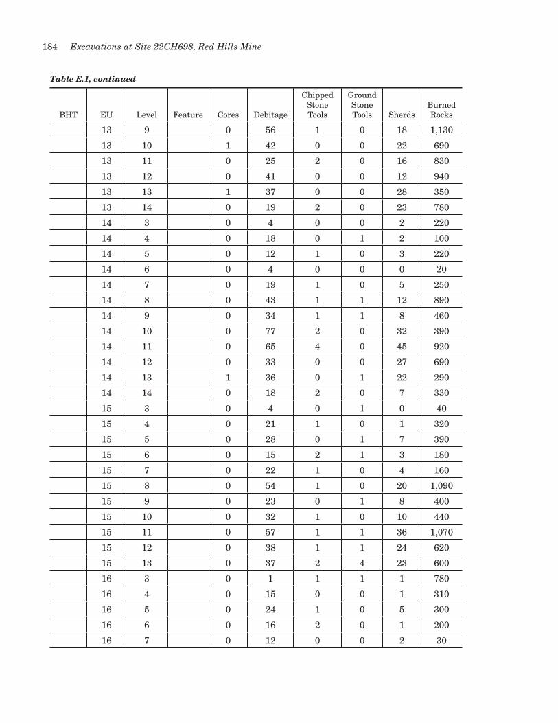
184 Excavations at Site 22CH698, Red Hills Mine
Table E.1, continued
BHT EU Level Feature Cores Debitage
Chipped Stone Tools
Ground Stone Tools Sherds
Burned Rocks
13 9 0 56 1 0 18 1,130
13 10 1 42 0 0 22 690
13 11 0 25 2 0 16 830
13 12 0 41 0 0 12 940
13 13 1 37 0 0 28 350
13 14 0 19 2 0 23 780
14 3 0 4 0 0 2 220
14 4 0 18 0 1 2 100
14 5 0 12 1 0 3 220
14 6 0 4 0 0 0 20
14 7 0 19 1 0 5 250
14 8 0 43 1 1 12 890
14 9 0 34 1 1 8 460
14 10 0 77 2 0 32 390
14 11 0 65 4 0 45 920
14 12 0 33 0 0 27 690
14 13 1 36 0 1 22 290
14 14 0 18 2 0 7 330
15 3 0 4 0 1 0 40
15 4 0 21 1 0 1 320
15 5 0 28 0 1 7 390
15 6 0 15 2 1 3 180
15 7 0 22 1 0 4 160
15 8 0 54 1 0 20 1,090
15 9 0 23 0 1 8 400
15 10 0 32 1 0 10 440
15 11 0 57 1 1 36 1,070
15 12 0 38 1 1 24 620
15 13 0 37 2 4 23 600
16 3 0 1 1 1 1 780
16 4 0 15 0 0 1 310
16 5 0 24 1 0 5 300
16 6 0 16 2 0 1 200
16 7 0 12 0 0 2 30

185Appendix E: Inventory of Major Artifact Classes by Provenience
Table E.1, continued
BHT EU Level Feature Cores Debitage
Chipped Stone Tools
Ground Stone Tools Sherds
Burned Rocks
16 8 0 21 1 1 15 660
16 9 0 41 0 0 8 690
16 10 0 29 2 1 6 310
16 11 1 36 2 0 16 400
16 12 0 50 1 0 28 640
16 13 0 22 1 0 18 310
17 3 0 2 0 0 1 20
17 4 0 8 2 0 1 150
17 5 1 36 1 0 7 390
17 6 0 34 2 1 5 330
17 7 0 13 1 0 2 140
17 8 0 4 0 0 2 70
17 9 0 22 1 0 2 600
17 10 0 16 0 0 4 390
17 11 0 23 2 2 9 150
17 12 0 28 0 0 12 230
17 13 1 23 2 0 19 380
18 4 0 7 1 0 5 80
18 5 0 17 0 0 5 330
18 6 0 31 0 0 2 590
18 7 0 14 0 1 6 190
18 8 0 5 0 0 7 80
18 9 0 25 0 0 4 280
18 10 0 14 0 0 6 210
18 11 0 9 1 0 7 170
19 4 0 2 0 0 0 280
19 5 0 8 1 2 3 110
19 6 0 14 1 1 2 210
19 7 0 26 1 0 8 700
19 8 0 13 0 1 3 120
19 9 0 0 0 0 3 210
19 10 0 13 0 0 4 200
19 11 0 10 0 1 1 80
20 5 0 14 0 0 2 330

186 Excavations at Site 22CH698, Red Hills Mine
Table E.1, continued
BHT EU Level Feature Cores Debitage
Chipped Stone Tools
Ground Stone Tools Sherds
Burned Rocks
20 6 0 19 0 0 1 200
20 7 0 12 1 0 3 230
20 8 0 11 0 0 0 40
20 9 0 15 0 0 2 80
20 10 0 5 0 0 2 50
20 11 0 8 2 2 7 90
21 4 0 1 0 0 0 10
21 5 0 8 0 0 0 41
21 6 0 16 0 0 1 140
21 7 0 11 0 0 5 60
21 8 0 4 0 0 5 60
21 9 0 17 0 2 2 170
21 10 0 10 1 0 2 220
21 11 0 29 1 0 7 480
21 12 0 16 0 1 6 390
21 13 0 15 0 1 7 330
22 3 0 4 0 0 0 0
22 4 0 11 0 1 0 40
22 5 0 13 0 0 3 160
22 6 0 12 0 0 1 240
22 7 0 25 0 2 5 630
22 8 0 31 0 1 7 630
22 9 1 46 2 2 12 0
22 10 0 41 1 0 18 410
22 11 0 26 0 0 10 880
22 12 0 24 1 0 5 560
22 13 0 22 2 1 19 460
23 2 0 7 0 0 0 0
23 3 0 33 0 0 5 330
23 4 0 5 0 0 2 210
24 4 0 3 0 0 3 10
24 5 0 7 0 0 1 70
24 6 0 37 0 1 4 320
24 7 0 19 0 0 3 350

187Appendix E: Inventory of Major Artifact Classes by Provenience
Table E.1, continued
BHT EU Level Feature Cores Debitage
Chipped Stone Tools
Ground Stone Tools Sherds
Burned Rocks
24 8 0 10 0 0 0 90
24 9 0 14 0 0 1 50
24 10 0 22 2 0 4 100
24 11 0 5 0 0 3 80
25 5 0 1 0 0 0 60
25 6 0 27 0 1 1 220
25 7 0 22 0 0 3 290
25 8 0 18 0 2 4 190
25 9 0 27 0 0 11 110
25 10 0 26 0 1 6 70
25 11 0 7 0 0 3 80
26 3 0 12 0 0 4 330
26 4 0 24 1 2 6 590
26 5 0 16 2 0 8 500
26 6 0 25 0 0 7 610
26 7 0 13 0 0 1 770
26 8 0 18 0 0 4 610
26 9 0 24 1 1 14 720
26 10 0 21 1 0 6 780
26 11 0 13 1 5 6 540
26 12 0 16 1 0 2 870
26 13 0 10 0 1 1 490
3 0 3 1 3 0 50
10 0 5 4 2 4 10
9 1 44 1 1 2 3,160
Totals 11 4,509 125 87 1,620 92,285
Notes: All quantities are counts, except burned rocks, which are weights in grams. Burned rock weights for EU 1 are missing because rocks were only counted.