Evolution of the eastern Indian Ocean since the Late Cretaceous: Constraints from Geosat altimetry
28
JOURNAL OF GEOPHYSICAL RESEARCH, VOL. 94, NO. BI0, PAGES 13,755-13,782, OCTOBER 10, 1989 Evolution of the Eastern Indian Ocean Since the Late Cretaceous: Constraints From Geosat Altimetry JEAN-YVES ROYER AND DAVID T. SANDWELL Institute for Geophysics, University of Texas at Austin We propose a new model forthe tectonic evolution of the eastern Indian Ocean from the LateCretaceous tofile present. Twotypes ofdata are used toimprove previously published reconstructions. First, recent reinterpretations of seafloor magnetic anomalies, between Australiaand Antarctica and in the Wharton Basin, providenew constraints on spreading rates and thetimingof major reorganizations. Second, vertical deflection profiles (i.e., horizontal gravity anomaly), derived from 22 repeat cycles of Geosat altimeter data, reveal the tectonic fabric associated withfracture zones. These newGeosat data provide fight constraints onpaleospreading directions. For example, three prominent fracture zones can betraced fromsouth of Tasmania to theGeorge V Basin, Antarctica, providing an important constraint onthe relative motions of Australia and Antarctica through theLate Eocene. In addition, theGeosat profiles are used to locate the conjugate continental margins and continent-ocean boundaries of Australia and Antarctica, as well as theconjugate rifted margins of Kerguelen Plateau and Broken Ridge. Based ona compilation of magnetic anomaly data fromtheCrozet Basin, theCentral Indian Basin, theWharton Basin and the Australian-Antarctic Basin, ten plate tectonic reconstructions are proposed. Reconstructions at chrons 5 (11Ma), 6 (21Ma), 13 06 Ma) and 18 (43 Ma) confirm that theSoutheast IndianRidgebehaved asa single plate boundary since chron 18. Theconstraints from the Geosat data provide an improvement in the fit of the Kerguelen Plateau andBroken Ridgeat chron 20 (46 Ma). To avoid overlaps between Broken Ridgeandthe Kerguelen Plateau prior to their breakup, our model includes relative motions between the northern and southern provinces of the Kerguelen Plateau.Finally,we examine theimplications of our model for the relative motions of India, Australia andAntarctica on the tectonic evolution of the Kerguelen Plateau andBroken Ridge,andthe adjacent Labuan Basin and Diamantina Zone, as wellas the emplacement ofthe Ninetyeast Ridge and the Kerguelen Plateau overa fixed hot spot. INTRODUCTION Many authors [e.g., McKenzieand Sclater, 1971; Sclater and Fisher, 1974; Johnson et al., 1976; Duncan, 1978; Norton and Sclater•1979; Curray et al., 1982] have usedthe theoryof plate tectonics to reconstruct the tectonic history of the eastern Indian Ocean and the past position of the continents surrounding this basin. Particularly enigmatic hasbeenthehistory of the Southeast Indian Ridgewhichextends from the Rodriguez Triple Junction at 25øS, 70øE tothe Macquarie TripleJunction south ofNew Zealand at61øS, 162øE. This spreading center separates the Indian andAustralian continents from Antarctica. In addition, the eastern Indian Ocean floor is the siteofuncommonly large submarine plateaus such as the Ninetyeast and Broken ridges, and theKerguelen Plateau (Figure1). Seafloor spreading among the majorplates (India, Australia and Antarctica) in the easternIndian Ocean occurredin three main phases. First,fromLateJurassic to Early Cretaceous times, Greater India separated from Antarctica/Australia resulting in theMesozoic basins along the western Australian margin [Markl, 1974, 1978; Larson et al., 1979; Veevers et al., 1985]. Second, from Early Cretaceous to Middle Eocene times, therapidnorthward motionof India created the CentralIndian Basin andtheCrozetBasin [McKen- zieandSclater,1971;Schlich, 1975, 1982]. The Wharton Basinalso opened during this period [Sclater and Fisher,1974 ;Liu et al., 1983] and spreading initiated between Australia and Antarctica [Cande and Mutter, 1982]. Finally,fromEocene topresent time,theAustralian- Antarctic Basin [Weissel and Hayes, 1972], the northern Crozet Basin andsouthern CentralIndian Basin [Schlich,1975; Sclater et al., 1976] opened along the Southeast Indian Ridge. Thesethree Copyright 1989 by the American Geophysical Union. Paper number 89JB01078 0148-0227/89/89JB-01078505.00 phases of spreading were separated by two periods of oceanwide plate reorganization, the first during Early/mid-Cretaceous time (Cretaceous magnetic quiet zone) and the second duringMiddle Eocene time (magnetic anomaly 20 to 18). The reorganizations occurred by ridge jumps, changes in spreading direction and spread- ing rate. The reinterpretation of the seafloor magnetic pattem in the Austra- lian-Antarctic Basin [Cande andMutter, 1982] has important conse- quences for the breakup of Australia and Antarctica, and for thefit of the Kerguelen Plateau and Broken Ridge (Figure 1). Broken Ridge isa shallow (~1000 m), east-west trending plateau witha steep scarp facing theAustralian-Antarctic Basinanda gentle slope facing the WhartonBasin. The conjugate Kerguelen Plateau facesBroken Ridgeand extends in a NNW-SSE direction for morethan 2,000 kin. Theoriginal interpretation of the oldest magnetic anomaly (anomaly 22, 44 Ma) between Australia and Antarctica [Weissel and Hayes, 1972], resulted in an overlap between the two ridges atEarly Eocene time [e.g.,Houtz et al., 1977;Norton and Molnar, 1977; Ktnig, 1980]. However,bothBrokenRidge and the Kerguelen Plateau existed in the Late Cretaceous and thus could not overlap. OnBroken Ridge, Santonian sediments have been recovered atDeep Sea Drill- ing Project (DSDP) site255 [Davies et al., 1974],while samples fromtheKerguelen Plateau include sediments of Cenomanian age [Wicquart, 1983] and Lower Cretaceous basalts[Leclaire et al., 1987]. Ocean Drilling Program (ODP) Legs119, 120 and121have recentlyprovidedfurther evidence that Broken Ridge and the Kerguelen Plateau formed more than 90 million years ago [ODPLeg 119 Scientific Drilling Party, 1988; ODP Leg 119 Shipboard Scien- tificParty,1988; ODP Leg120Scientific Drilling Party, 1988; ODP Leg 120 Shipboard Scientific Party, 1988;ODP Leg 121 Scientific Drilling Party, 1988; ODP Leg 121 Shipboard Scientific Party, 1988]. The reinterpretation by Candeand Mutter [1982] for the chronology of the breakup of Australia and Antarctica atchron 34 (84 Ma) partially solves the problem of overlap[Mutter and Cande, 13,755
Transcript of Evolution of the eastern Indian Ocean since the Late Cretaceous: Constraints from Geosat altimetry

JOURNAL OF GEOPHYSICAL RESEARCH, VOL. 94, NO. BI0, PAGES 13,755-13,782, OCTOBER 10, 1989
Evolution of the Eastern Indian Ocean Since the Late Cretaceous:
Constraints From Geosat Altimetry
JEAN-YVES ROYER AND DAVID T. SANDWELL
Institute for Geophysics, University of Texas at Austin
We propose a new model for the tectonic evolution of the eastern Indian Ocean from the Late Cretaceous to file present. Two types of data are used to improve previously published reconstructions. First, recent reinterpretations of seafloor magnetic anomalies, between Australia and Antarctica and in the Wharton Basin, provide new constraints on spreading rates and the timing of major reorganizations. Second, vertical deflection profiles (i.e., horizontal gravity anomaly), derived from 22 repeat cycles of Geosat altimeter data, reveal the tectonic fabric associated with fracture zones. These new Geosat data provide fight constraints on paleospreading directions. For example, three prominent fracture zones can be traced from south of Tasmania to the George V Basin, Antarctica, providing an important constraint on the relative motions of Australia and Antarctica through the Late Eocene. In addition, the Geosat profiles are used to locate the conjugate continental margins and continent-ocean boundaries of Australia and Antarctica, as well as the conjugate rifted margins of Kerguelen Plateau and Broken Ridge. Based on a compilation of magnetic anomaly data from the Crozet Basin, the Central Indian Basin, the Wharton Basin and the Australian-Antarctic Basin, ten plate tectonic reconstructions are proposed. Reconstructions at chrons 5 (11Ma), 6 (21Ma), 13 06 Ma) and 18 (43 Ma) confirm that the Southeast Indian Ridge behaved as a single plate boundary since chron 18. The constraints from the Geosat data provide an improvement in the fit of the Kerguelen Plateau and Broken Ridge at chron 20 (46 Ma). To avoid overlaps between Broken Ridge and the Kerguelen Plateau prior to their breakup, our model includes relative motions between the northern and southern provinces of the Kerguelen Plateau. Finally, we examine the implications of our model for the relative motions of India, Australia and Antarctica on the tectonic evolution of the Kerguelen Plateau and Broken Ridge, and the adjacent Labuan Basin and Diamantina Zone, as well as the emplacement of the Ninetyeast Ridge and the Kerguelen Plateau over a fixed hot spot.
INTRODUCTION
Many authors [e.g., McKenzie and Sclater, 1971; Sclater and Fisher, 1974; Johnson et al., 1976; Duncan, 1978; Norton and Sclater• 1979; Curray et al., 1982] have used the theory of plate tectonics to reconstruct the tectonic history of the eastern Indian Ocean and the past position of the continents surrounding this basin. Particularly enigmatic has been the history of the Southeast Indian Ridge which extends from the Rodriguez Triple Junction at 25øS, 70øE to the Macquarie Triple Junction south of New Zealand at 61 øS, 162øE. This spreading center separates the Indian and Australian continents from Antarctica. In addition, the eastern Indian Ocean
floor is the site ofuncommonly large submarine plateaus such as the Ninetyeast and Broken ridges, and the Kerguelen Plateau (Figure 1).
Seafloor spreading among the major plates (India, Australia and Antarctica) in the eastern Indian Ocean occurred in three main phases. First, from Late Jurassic to Early Cretaceous times, Greater India separated from Antarctica/Australia resulting in the Mesozoic basins along the western Australian margin [Markl, 1974, 1978; Larson et al., 1979; Veevers et al., 1985]. Second, from Early Cretaceous to Middle Eocene times, the rapid northward motion of India created the Central Indian Basin and the Crozet Basin [McKen- zie andSclater, 1971; Schlich, 1975, 1982]. The Wharton Basin also opened during this period [Sclater and Fisher, 1974 ; Liu et al., 1983] and spreading initiated between Australia and Antarctica [Cande and Mutter, 1982]. Finally, from Eocene to present time, the Australian- Antarctic Basin [Weissel and Hayes, 1972], the northern Crozet Basin and southern Central Indian Basin [Schlich, 1975; Sclater et al., 1976] opened along the Southeast Indian Ridge. These three
Copyright 1989 by the American Geophysical Union.
Paper number 89JB01078 0148-0227/89/89JB-01078505.00
phases of spreading were separated by two periods of oceanwide plate reorganization, the first during Early/mid-Cretaceous time (Cretaceous magnetic quiet zone) and the second during Middle Eocene time (magnetic anomaly 20 to 18). The reorganizations occurred by ridge jumps, changes in spreading direction and spread- ing rate.
The reinterpretation of the seafloor magnetic pattem in the Austra- lian-Antarctic Basin [Cande andMutter, 1982] has important conse- quences for the breakup of Australia and Antarctica, and for the fit of the Kerguelen Plateau and Broken Ridge (Figure 1). Broken Ridge is a shallow (~1000 m), east-west trending plateau with a steep scarp facing the Australian-Antarctic Basin and a gentle slope facing the Wharton Basin. The conjugate Kerguelen Plateau faces Broken Ridge and extends in a NNW-SSE direction for more than 2,000 kin. The original interpretation of the oldest magnetic anomaly (anomaly 22, 44 Ma) between Australia and Antarctica [Weissel and Hayes, 1972], resulted in an overlap between the two ridges at Early Eocene time [e.g., Houtz et al., 1977; Norton and Molnar, 1977; Ktnig, 1980]. However, both Broken Ridge and the Kerguelen Plateau existed in the Late Cretaceous and thus could not overlap. OnBroken Ridge, Santonian sediments have been recovered at Deep Sea Drill- ing Project (DSDP) site 255 [Davies et al., 1974], while samples from the Kerguelen Plateau include sediments of Cenomanian age [Wicquart, 1983] and Lower Cretaceous basalts [Leclaire et al., 1987]. Ocean Drilling Program (ODP) Legs 119, 120 and 121 have recently provided further evidence that Broken Ridge and the Kerguelen Plateau formed more than 90 million years ago [ODP Leg 119 Scientific Drilling Party, 1988; ODP Leg 119 Shipboard Scien- tificParty, 1988; ODP Leg 120 Scientific Drilling Party, 1988; ODP Leg 120 Shipboard Scientific Party, 1988; ODP Leg 121 Scientific Drilling Party, 1988; ODP Leg 121 Shipboard Scientific Party, 1988]. The reinterpretation by Cande and Mutter [1982] for the chronology of the breakup of Australia and Antarctica at chron 34 (84 Ma) partially solves the problem of overlap [Mutter and Cande,
13,755

13,756 ROYER AND SANDWELL: EASTERN INDIAN OCEAN SINCE THE L•TE CRETACEOUS
60øE 90OE 120OE 150•'E
0 e
30os
OMALI BASIN
Cr•t Plateau
Marlon
Dufresne S.
CROZET BASIN
CENTRAL
INDIAN BASIN
Osborn Knoll
ß
• WHARTON BASIN
- AUSTRALIA
30øS
i've •,o• e TASMAN SEA
Australian-Antarctic Dis
AUSTRALIAN-ANTARCTIC BASIN
BOoS I ENDERBY BASIN Banzare BOOs
60øE 90øE 120øE 150øE
Fig. 1. General bathymetric map of the Indian Ocean (4000-m and 2000-m isobaths) and main structural features (after General Bathymetric Chart of the Oceans (GEBCO) summary chart 5-00).
1983], but no attempt has yet been made to include these results in a larger framework.
The existence of a Middle Eocene fossil spreading ridge in the Wharton Basin [Liu et al., 1983; Geller et al., 1983] is evidence that the Indian and Australian plates shared a divergent plate boundary until chron 19, and that the relative motions between India, Australia and Antarctica are coupled. The magnetic anomaly pattern identified by Sclater and Fisher [1974] in the Wharton Basin shows east-west magnetic lineations with ages decreasing from Late Cretaceous (anomaly 33) in the south to Late Eocene in the north. The youngest anomalies they identified are anomalies 19, 20 and 22, with a more questionable anomaly 17 identification. They postulated that the magnetic anomaly pattern continued northward to anomaly 11 be- fore the Wharton Basin subducted under the Java-Sunda trench.
Using additional magnetic profiles, Liu et al. [1983] were able to identify remnants of an extinct spreading ridge, extending from the Sunda trench at the equator to the Ninetyeast Ridge in a succession of right-lateral offset segments. Magnetic datareinterpretations [Liu et al., 1983; Geller et al., 1983] show that seafloor spreading ceased during Middle Eocene time (•-chron 19), and that, in addition to the
magnetic anomalies identified by Sclater and Fisher [1974], a symmetric pattern of magnetic lineations can be identified north of the fossil ridge axis, the youngest corresponding to anomaly 20 and the oldest, to anomaly 31. The Wharton Basin also appears more segmented than initially proposed. The new interpretation provides a stronger constraint on plate motions than was available when only a transform plate boundary between India and Australia was consid- ered [e.g., Sclater and Fisher, 1974; Johnson et al., 1976; Duncan, 1978; Norton and Sclater, 1979]. Furthermore, chron 19 is about the time when Broken Ridge and Kerguelen Plateau separated, and when spreading rates in the Australian-Antarctic Basin [Cande and Mut- ter, 1982] drastically increased from 0.5 cngyr (half rate) before anomaly 19, to 2.7 cngyr after anomaly 19 time. The question of whether India and Australia behaved as two different plates after seafloor spreading ceased in the Wharton Basin is another issue raised by these reinterpretations.
We present here an improved reconstruction for the last two of the three phases of spreading in the eastern Indian Ocean using the reinterpretations of the magnetic anomaly pattern in the Australian- Antarctic [Cande and Mutter, 1982] and Wharton [Liu et al., 1983]

RoYp. R AND SANDWELL: EASTERN INDIAN OCtiAN SINCti THE LATE CRtiTACtiOU$ 13,757
basins, a compilation of magnetic anomalies in the Central Indian Basin and Crozet Basin, and fracture zone lineations derived from Geosat altimeter data. We have not yet attempted to model the earliest phase of evolution because of the absence of symmetric Mesozoic basins in the eastern Indian Ocean.
GEOSAT ALTIMETER DATA
Satellite altimetry data have now been widely used for locating topographic features of the ocean floor [e.g., Haxby, 1985; Gahagan et al., 1988]. In some areas, they are particularly suited to outlining tectonic fabrics on the seafloor and have provided evidence to reappraise or improve plate reconstruction models [e.g., Royer et al., 1988; Cande et al., 1988]. The recent release of the Geosat data [Sandwell andMcAdoo, 1988] significantly improves the amount of information on the poorly charted oceans south of 60øS. In this paper, the seafloor tectonic fabrics and the main structural features of the
ocean floor are derived from data on the deflection of the vertical
which is the f'zrst derivative of the ocean-geoid signal along the satellite passes (Figures 2 and 3). To improve the accuracy and coverage of the data, 22 Geosat repeat cycles were averaged. Cov- erage is nearly complete between 72øN and 72øS because Geosat has operated for more than one seasonal cycle. In addition, the uncer- tainty in the average of the 22 repeat profiles is generally less than 1 grad (1 grad = 1 mgal). The data processing procedure is described by Sandwell and McAdoo [1988].
We present in Figure 4a some examples of interpretations of the deflection of the vertical signal. The combination of the information from the ascending and descending passes permits us to delineate
prominent features on the ocean floor such as fracture zones, sea- mounts and the continental shelf. For the purpose of plate tectonic reconstructions, the most useful information is the accurate location
and extension of the fracture zones. Depending on the age offset and the spreading rates which control the topographic and geoid signa- ture of a fracture zone, these features can be precisely mapped (Figure 4b). The best illustration of such a feature is the Balleny Fracture Zone (trace 3 in Figure 5) that lies between the South Tasman Rise and the Balleny Islands (Figure 1) and has an age offset of about 10 Ma.
The tectonic features identified on the deflection of the vertical
charts place strong constraints on the closure of the Australian/ Antarctic Basin. From east to west, the major constraints are the fracture zones between Tasmania and Antarctica, the continent-
ocean boundaries of Australia and Antarctica, and the margins of Broken Ridge and the Kerguelen Plateau. The prominent offset fracture zones south of Tasmania can be traced all the way south into the Antarctic margin (Figure 5). The George V, Tasman and B alleny fracture zones tightly constrain the longitudinal motions of Australia relative to Antarctica at least from Late Eocene (anomalies 18-13) to present time.
The location of the continental slope and the continent-ocean boundary (COB) along the south coast of Australia can be identified on the deflection of the vertical charts (Figure 6). On the Australian margin, Talwani et al. [1979] and more recently Veevers [1986] mapped the COB by correlating seismic data with what Weissel and Hayes [1972] recognized as magnetic anomaly 22, and Cande and Mutter [ 1982] as magnetic anomaly 34. Veevers [ 1986] interpreted the magnetic anomaly marking the southern limit of the magnetic
-30
-60
t',Geosat ••,•.'• • .Ascending Passes -
ANTARCTICA
1 60 90 120 150E
Fig. 2. Deflection of the vertical plotted along the Geosat ascending ground tracks. Note the pattem of linear fracture zones perpendicular to the Southeast Indian Ridge. Their orientation progressively shifts from N45øE in the Crozet Basin (between 60øE and 90øE), to N5øE in the vicinity of the Australian-Antarctic Discordance and N10øW east of 150øE.

13,758 Ro¾•.R AND SANDWELL: EASTERN INDIAN OCEAN SINCE THE LATE CRETACEOUS
-3O
-6O
Deflection of the Vertical
• Geosat ,,
-- Descending Passes--
AUSTRALIA
ANTARCTICA
6O 9O 120 150E
Fig. 3. Deflection of the vertical plotted along the Geosat descending ground tracks. The descending passes mosfiy oufiine the Southeast Indian Ridge axis, the fracture zones southeast of Australia and the margins of Australia and Antarctica, and the rifted margins of Broken Ridge and the Kerguelen Plateau.
Seamou•••_ a Sea Surface Slope
• Sea Surface
,\\•..,.\\x\•.-,.-,.-,..,.•.-,-,.•l x•xxxxxx-,.-,•xx.•\ Seafloor
Trough
Fracture Zo•.._••'• • C
-,.\\\-,..\\\\\\\\x\\\x
,•o o•'IG •
•r •c,•r e 7.o•e
Fig. 4. (a) Signature of the deflection of the vertical or variation of sea surface slope over (top) a seamount, (middle) a trough and (bottom) an offset in the basement. (b) Changes in the deflection of the vertical along a large offset fracture zone. The signal reverses at the midpoint of the transform section of the fracture zone.
RoYER AND SANDWELL: EASTERN INDIAN OCEAN SINCE THE LATE CRETACEOUS 13,759
-30
-40
-50
-60
-70
140E 160 180
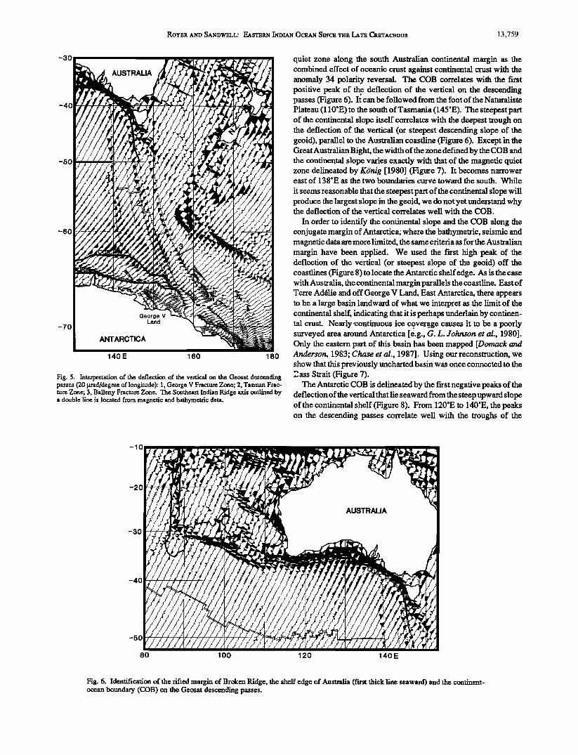
Fig. 5. Interpretation of the deflection of the vertical on the Geosat descending passes (20 l. trad/degre½ of longitude): 1, George V Fracture Zone; 2, Tasman Frac- ture Zone; 3, Balleny Fracture Zone. The Southeast Indian Ridge axis outlined by a double line is located from magnetic and bathymetric data.
quiet zone along the south Australian continental margin as the combined effect of oceanic crest against continental crust with the anomaly 34 polarity reversal. The COB correlates with the first positive peak of thee deflection of the vertical on the descending passes (Figure 6). It can be followed from the foot of the Naturalism Plateau (110øE) to the south of Tasmania (145øE). The steepest part of the continental slope itself correlates with the deepest trough on the deflection of the vertical (or steepest descending slope of the geoid), parallel to the Australian coastline (Figure 6). Except in the Great Australian Bight, the width of the zone defined by the COB and the continental slope varies exactly with that of the magnetic quiet zone delineated by K6nig [1980] (Figure 7). It becomes narrower east of 138øE as the two boundaries curve toward the south. While
it seems reasonable that the steepest part of the continental slope will produce the largest slope in the geoid, we do not yet understand why the deflection of the vertical correlates well with the COB.
In order to identify the continental slope and the COB along the conjugate margin of Antarctica; where the bathymetric, seismic and magnetic data are more limited, the same criteria as for the Australian margin have been applied. We used the first high peak of the deflection of the vertical (or steepest slope of the geoid) off the coastlines (Figure 8)to locate the Antarctic shelf edge. As is the case with Australia, the continental margin parallels the coastline. East of Terre Ad61ie and off George V Land, East Antarctica, there appears to be a large basin landward of what we interpret as the limit of the continental shelf, indicating that it is perhaps underlain by continen- tal crest. Nearly'continuous ice co. ver•age causes it to be a poorly surveyed area around Antarctica [e.g., G. L. Johnson et al., 1980]. Only the eastern part of this basin has been mapped [Domack and Anderson, 1983; Chase et al., 1987]. Using our reconstruction, we show that this previously uncharted basin was once connected to the 2ass Strait (Figure 7).
The Antarctic COB is delineated by the first negative peaks of the deflection of the vertical that lie seaward from the steep upward slope of the continental shelf (Figure 8). From 120øE to 140øE, the peaks on the descending passes correlate well with the troughs of the
-10
-20
-30
-40
-50
80 100 120 140E
Fig. 6. Identification of the rifted margin of Broken Ridge, the shelf edge of Australia (first thick line seaward) and the continent- ocean boundary (COB) on the Geosat descending passes.
13,760 ROY•.R AND SANDWBLL: EASTBRN •IDIAN OCRAN SINCB THB LATH CRHTACROUS
Austratian Bight
8ass Strait
South -%
--e34--•. Magnetic Anomalies
COB (a)
-- = c or. COB (b)
Magnetic Quiet Zone -csB• Continental Shelf Break
o 14c Chron 13- 36 Ma
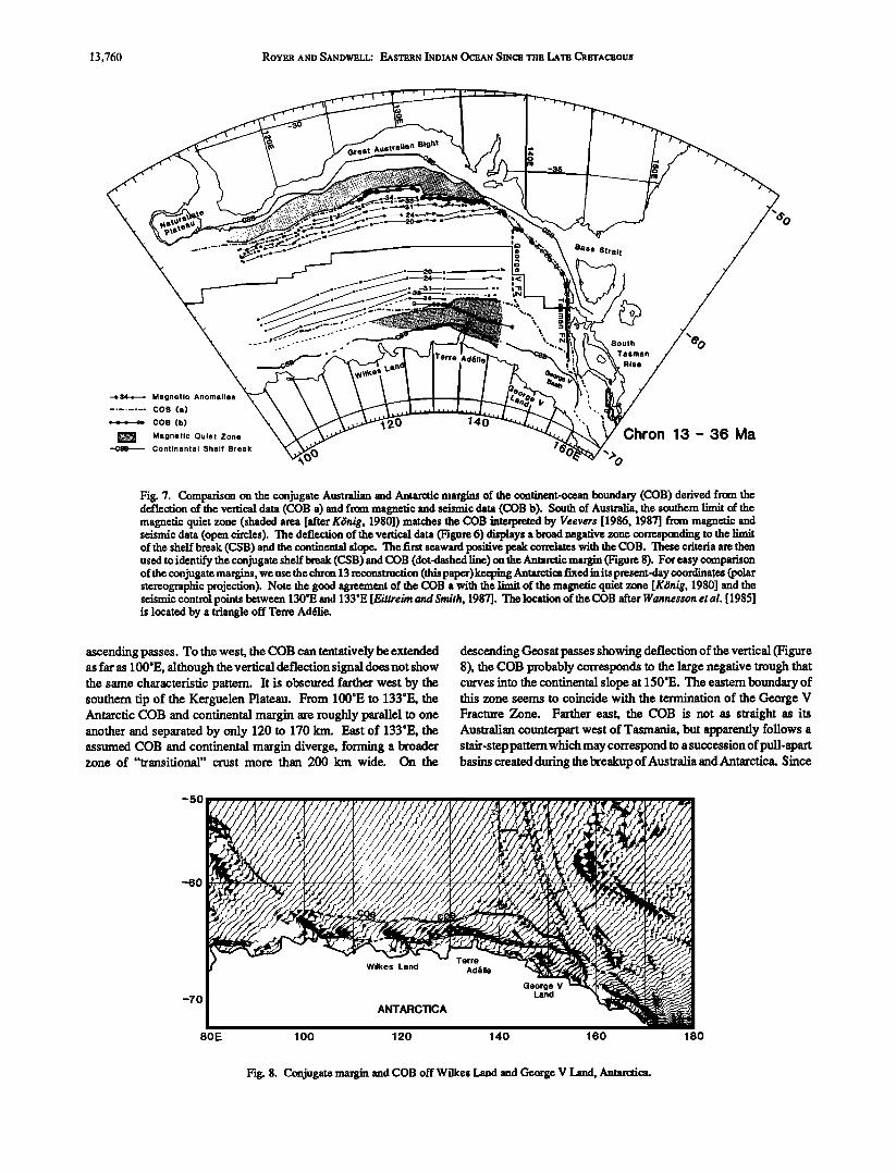
Fig. 7. Comparison on the conjugate Australian and Antarctic margins of the continent-ocean boundary (COB) derived from the deflection of the vertical data (COB a) and from magnetic and seismic data (COB b). South of Australia, the southem limit of the magnetic quiet zone (shaded area [after KOnig, 1980]) matches the COB interpreted by Veevers [1986, 1987] from magnetic and seismic data (open circles). The deflection of the vertical data (Figure 6) displays a broad negative zone corresponding to the limit of the shelf break (CSB) and the continental slope. The first seaward positive peak correlates with the COB. These criteria are then used to identify the conjugate shelf break (CSB) and COB (dot-dashed line) on the Antarctic margin (Figure 8). For easy comparison of the conjugate margins, we use the chron 13 reconstruction (this paper) keeping Antarctica fixed in its present-day coordinates (polar stereographic projection). Note the good agreement of the COB a with the limit of the magnetic quiet zone [K•nig, 1980] and the seismic control points between 130'E and 133'E [Eittreim and Smith, 1987]. The location of the COB after Wannes•on et al. [1985] is located by a triangle off Terre Ad6lie.
ascending passes. To the west, the COB can tentatively be extended as far as 100øE, although the vertical deflection signal does not show the same characteristic partcm. It is obscured farther west by the southem tip of the Kerguelen Plateau. From 100øE to 133øE, the Antarctic COB and continental margin are roughly parallel to one another and separated by only 120 to 170 km. East of 133øE, the assumed COB and continental margin diverge, forming a broader zone of "transitional" crust more than 200 km wide. On the
descending Geosat passes showing deflection of the vertical (Figure 8), the COB probably corresponds to the large negative trough that curves into the continental slope at 150øE. The eastern boundary of this zone seems to coincide with the termination of the George V Fracture Zone. Farther east, the COB is not as straight as its Australian counterpart west of Tasmania, but apparently follows a stair-step pattern which may correspond to a succession of pull-apart basins created during the breakup of Australia and Antarctica. Since
-50
-60
-70
80E
ß
100 120 140 160 180
? Fig. 8. Conjugate margin and COB off X• ilkes Land and George V Land, Antarctica.

ROYER AND SANDWELL: EASTERN INDIAN OCEAN SINCE THE LATE CRETACEOUS 13,761
the orbits of the satellite are tangent to the 72øS parallel, the data are about twice as dense along the Antarctic margin as along the Australian margin.
The comparison of our interpretation with previous mapping of the Antarctic COB is shown on Figure 7. Our COB, based on the deflection of the vertical, agrees fairly well with the northem limit of the magnetic quiet zone as mapped by K6nig [1980]. It also correlates with the seismic control points located between 130øE and 134øE of K6nig [1980], Veevers [1986] and Eittreim and Smith [1987]. The latter authors show consistent line-to-line correlations of the continent-ocean boundary along with the limit of the magnetic quiet zone. Wannesson et al.'s [1985] identification of the COB off Terre Ad6lie (Figure 7) appears to be inconsistent with the results from Eittreim and Smith [1987], Veevers [1986, 1987] and our interpretation. Their point lies too close to the continental shelfbreak compared to the location of the COB in adjacent areas. Farther east between 134øE and 145øE, our interpretation as well as KOnig's [1980] differs significantly from that of Veevers [1986, 1987]. Seismic coverage in this area is poor, and according to Eittreim and Smith [ 1987], the available data do not show a tectonic pattern as characteristic as west of 134øE. Veevers [ 1986,1987] determined the COB using magnetic anomaly profiles which have low amplitudes and do not exhibit a characteristic "COB" magnetic anomaly that is observed west of 134øE or south of Australia [e.g., Veevers, 1987, Figure 1 la]. This discrepancy in interpretation raises the question whether the breakup of Australia and Antarctica was synchronous [Veevers, 1986, 1987] or whether it propagated from west to east [K6nig, 1980, 1987].
South of Australia, magnetic lineations lengthen eastward as their age become younger [K6nig, 1980; Cande andMutter, 1982], which is a clear evidence that seafloor spreading propagated eastward. This is in agreement with Veevers' [1986, 1987] interpretations, where the Australian COB becomes younger toward the east. Mutter et al. [1985] looking at subsidence curves along the Australian margin reached the same conclusion that breakup propagated from 128øE to 140øE at a rate of 2 cm/yr. Our interpretation is consistent with K6nig's [ 1980] model where the conjugate COBs converge to the east. A kink in the COB similar to that observed at 131 øE south of
Australia can be mapped at about 134øE off Antarctica from the deflection of the vertical profiles. In general, we note that continental breakup and initiation of seafloor spreading are not synchronous (in the South Atlantic [e.g., Rabinowitz and LaBrecque, 1979], in the Central Ariantic [e.g., Dunbar, 1988], or in the Red Sea [Cochran, 1983]).
The basement offset that delineates the rifted margin of Kerguelen Plateau [Coffin et al., 1986] is clearly visible on the Seasat data. The deflection of the vertical charts from Geosat permit us to extend this structural limit by a few 100 km to the south (Figure 9). The northeastern edge of the Kerguelen Plateau shows a pronounced bend corresponding to William's Ridge (Figure 10). This bend, which is exactly reproduced along the scarp of Broken Ridge (Figures 6 and 10), is a constraint on the relative position of the two ridges at the time when they broke apart. The Labuan Basin between 90 ø and 105øE and the Diamantina Zone (Figure 10), its northem counterpart, have similar deflection of the vertical signatures (Fig- ures 6 and 9), corresponding to the ragged topography associated with the slow spreading episode between anomaly 34 (84 Ma) and anomaly 20 time (46 Ma) [Cande and Mutter, 1982].
In addition to the features described above, numerous fracture
zones appear on the deflection of the vertical charts (ascending lines mostly, Figure 2) along the Southeast Indian Ridge. While many of these fracture zones were akeady mapped in great detail [e.g., $chlich, 1975; Sclater et al., 1976; Patriat, 1987; Royer andSchlich, 1988; Vogt et al., 1983], new fracture zones appear in the vertical deflection profiles (Figure 2) between Broken Ridge and Kerguelen Plateau. The Kerguelen Fracture Zone, which runs NNE-SSW west of the Kerguelen Plateau (Figure 2), is another major feature clearly delineated by the deflection of the vertical charts. This fracture zone disappears at about 62øS. In the Central Indian Basin and the Wharton Basin, the wide spacing and low angle of incidence of Geosat profiles are not suitable for mapping the north-south fracture zones. Furthermore, the basement undulations related to the defor- mation of the Central Indian Basin cause east-west lineated geoid anomalies [McAdoo and Sandwell, 1985] which obscure the seafloor tectonic fabric. For instance, it is not possible to identify the northern counterpart of the Kerguelen Fracture Zone.
-5o
-60
-70 60 80 100 120E
Fig. 9. Rifted margin of the Kerguelen Plateau (heavy dotted line) on the Geosat descending passes. Note the peak and trough signature of the Labuan Basin, which extends between the Plateau (outlined by the 3000-m isobath) and the rifted margin of the Plateau.

13,762 Ro¾•R n•t• Sn•t•w•LL: Ens'r•R• Ist• Oc•n• Sz•c. 'm. Ln'r• C•.'rnc•ous
80 90 1 O0 I 10 120E
-3O
-4O
-5O
-6O
Enderby Basin
Banzare Bank
PC2
Australian-Antarctic
Basin
60 70 80 90 100E
b)
Fig. 10. Tectonic summary diagram of (a) the Broken Ridge area and (b) the Kerguclen Plateau. Depths of the isobaths are in kilometers (after Fisher et al. [ 1982] (Figure 10a) and ScMich et al. [ 1987] (Figure 10b)). Shaded areas outline the trenches bordering Broken Ridge and the Diamantina Zone. The Mesozoic magnetic anomaly interpretations are from Markl [1974, 1978] and Veevers et al. [1985]. CFR (Cretaceous fossil ridge) shows the location of a mid-Cretaceous extinct spreading axis [Markl, 1974; Powell et al., 1988]. DSDP and ODP drilling sites (bold numbers) are located by stars. Piston cores (PC) and dredges (DR) are indicated by asterisks. The light dashed lines are isochrons and the solid circles along them are the magnetic picks. The dotted line corresponds to the conjugate rifted margin of Broken Ridge and Kerguelen Plateau as identified on the deflection of the vertical data (Figures 6 and 9). The dot-dashed line with anticline symbols corresponds to a broad arch of the southern Kerguelen province and the dashed line with syncline s•anbols to the axis of the Raggatt Basin [after Coffin et al., 1986]. The oldest date on Broken Ridge is early Turonian (site 755 [ODP Leg 121 Scientific Drilling Party, 1988; ODP Leg 121 Shipboard Scientific Party, 1988]). The oldest date on the northern Kerguelen Plateau is Cenomanian (PC1 [Wicquart, 1983]), and on the southern province 114 Ma (DR [Leclaire et al., 1987]) and Cenomanian (site 748, 750 [ODP Leg 120 Scientific Drilling Party, 1988; ODP Leg 120 ShipboardScientific Party, 1988]; EL54- 7 [Quilty, 1973]).

ROYER AND SANDWELL; EASTERN •NDIAN OCEAN SINCE THE LATE CRETACEOUS 13,763
A REVISED TECTONIC CHART FOR THE
EASTERN INDIAN OCEAN
The tectonic diagrams on Figures 11a and 1 lb summarize the seafloor tectonic fabric derived from the deflection of the vertical
charts, the magnetic anomaly pattern since the Late Cretaceous and the main structural features identified in the eastern Indian Ocean.
With regard to the seafloor tectonic fabric, the best documented period in the evolution of the eastem Indian Ocean corresponds to the last stage of evolution that follows the major reorganization of the spreading centers in Middle Eocene time. From anomaly 18 time (43 Ma) to present day, the closure of the Central Indian Basin, the Crozet Basin, and the Australian-Antarctic Basin is tightly constrained by the numerous fracture zones identified between the Rodriguez Triple Junction (25øS, 70øE) and the Macquarie Triple Junction (61øS, 162øE). The fit of Broken Ridge with Kerguelen Plateau is now well constrained by the distinctive shape of their respective scarps, as identified on the deflection of the vertical charts. The direction of
motions between India and Antarctica between Late Cretaceous
(anomaly 34) and Middle Eocene (anomaly 20) time are constrained by the fracture zone pattern in the Crozet Basin and in particular by the Kerguelen Fracture Zone, while the motions of India relative to Australia are determined by the north-south fracture zones in the Wharton Basin, and in particular by the large offset Investigator Fracture Zone. Finally, a new reconstruction of Australia and Antarctica can be proposed on the basis of the revised contours of their respective COBs and continental margins.
The magnetic anomaly identifications used in this study are based on earlier data compilations. However, for the purpose of making reconstructions, we have standardized the locations of the picks with respect to the magnetic anomaly signatures. This standardization is critical for reconstructing areas of fast spreading rams such as the Wharton Basin, the Central Indian Basin or the Crozet Basin (11 to 4 cm/yr, half rates), but is of less consequence in the areas of slow spreading rates, such as between Australia and Antarctica between Late Cretaceous and Middle Eocene time (0.5 to 1.0 cm/yr). The reversal boundaries that we selected and their ages (Kent and Gradstein's [ 1986] reversal time scale) are shown in Table 1.
Between Australia and Antarctica, anomaly 5, 6, 13 and 18 identifications are from Stock and Molnar [1982] and Vogt et al. [1983]. Anomaly 20 to 33 interpretations are from Cande and Mutter's [1982]. Anomaly 34 is from Veevers[ 1986], who attributes the positive anomaly identified as anomaly 34 by Cande and Mutter's [1982] to an edge effect of the COB combined with the anomaly 34 polarity reversal. Similarly, east of 131 øE, anomaly 33 becomes part of the COB anomaly. In the Crozet and Central Indian basins, anomaly 5 and 6 identifications are fromRoyer and Schlich [1988], while anomaly 13 through 34 identifications are fromPatriat [ 1987]. Additional identifications (anomalies 5, 6, 13 and 18) between Kerguelen and Broken Ridge have been made from data published by Tilbury [1981]. In the Wharton Basin, profiles of total intensity magnetic anomaly have been reinterpreted in the interest of consis- tency of the data set. We favor the interpretation ofLiu et al. [ 1983] and Geller et al. [1983]. New evidence for the existence of a fossil spreading ridge of Middle Eocene age (~ anomaly 19/18) will be presented elsewhere (J.-Y. Royer et al., manuscript in preparation). The oldest magnetic anomalies recognized in the northern Wharton Basin are anomalies 28 and 31 (at 92øE). Finally, magnetic data along the Southwest Indian Ridge and the Central Indian Ridge are from Patriat [1987]. There are two areas where the magnetic data coverage is poor: the southern part of the Australian-Antarctic Basin between 85øE and 115øE, and in the vicinity of the Nine•yeast Ridge where there are very few magnetic profiles parallel to this feature.
RECONSTRUCTIONS AT CHRONS 5, 6, 13 AND 18
As a result of combining the deflection of the vertical charts and the magnetic anomaly compilation, the best documented period of evolution of the Southeast Indian Ridge is the Late Eocene to present time span. Our confidence in the reconstructions decreases as we go back further in the past. All the reconstructions are presented backward in time and with Australia fixed.
Past reconstructions of the Southeast Indian Ridge from the Rodriguez Triple Junction to the Macquarie Triple Junction have raised the question of whether or not this accreting plate boundary has behaved as a single plate boundary since motions may have occurred between India and Australia after seafloor spreading ceased in the Wharton Basin, at Middle Eocene time (~anomaly 19 [Liu et al., 1983]). Plate tectonic reconstructions along the SoutheastIndian Ridge [Stock and Molnar, 1982] show that, at anomaly 5, 6 and 13 times (11, 20 and 36 Ma, respectively), different finite poles are not required to simultaneously match magnetic anomaly data from the three main segments of the ridge: between India and Antarctica (i.e., west ofthe Ninetyeast Ridge), between Australia and Antarctica, and eastofthe B alleny Fracture Zone. Between anomaly 18 and 13 times, however, when the central section and either one of the outer sections
are reconstructed, a match cannot be achieved for the remaining section. Because of this discrepancy, Stock and Molnar [1982] proposed that either the Indo-Australian plate was deforming or deformation occurred in the region of the Macquarie Triple Junction. More detailed reconstructions of the section of the Southeast Indian
Ridge west of the Ninetyeast Ridge at anomalies 5, 6, 13 and 18 [Patriat, 1987; Molnar et al., 1988; œoyer and Schlich, 1988] yield f'mite rotations different from those proposed by Stock and Molnar [1982], which mainly rely upon data from the Australian-Antarctic Basin (east of the Ninetyeast Ridge). The combinations of the different solutions for the India/Antarctica motions with the Austra- lia/Antarctica motions lead to India/Australia motions different from
the solutions derived from recent global models for present-day plate motions [Stein and Gordon, 1984; Wiens et al., 1985, 1986; R. G. Gordon et al., Present-day motion between the Australian and Indian plates: Kinematic constraints on distributed lithospheric deforma- tion in the equatorial Indian Ocean, submitted to Tectonics, 1989 (hereinafter Gordon et al. (1989))]. Our reconstructions show that two different rotations are not required to match the data along the entire Southeast Indian Ridge, and confirm that the Southeast Indian Ridge has behaved as a single plate boundary at least since anomaly 13 time (36 Ma), and probably since anomaly 18 time (43 Ma). This conclusion is well supported by our data set which extends between the two extremities of the Southeast Indian Ridge, from the Ro- driguez Triple Junction to the Macquarie Triple Junction, and is uniformly dense and detailed all along the ridge.
The reconstructions at anomaly 5 and 6 times (Figures 12a and 12b) are well constrained by the crenelate shape of the ridge between Australia and Antarctica (Australian-Antarctic Discordance), the large offset Amsterdam, Saint-Paul, George V, and Tasman fracture zones (Figure 11), as well as the numerous magnetic anomaly identifications west of the Amsterdam Fracture Zone. Although the magnetic picks identified east of the Balleny Fracture Zone agree, there is a clear mismatch of the two limbs of the Balleny Fracture Zone at chron 5 (Figure 12a).
The fit for anomaly 13 (35.5 Ma) is also well constrained (Figure 12c). In particular, the anomaly 13 picks between Broken Ridge and Kerguelen Plateau reproduce the shalJe of the "basement offsets" of the ridges on either side. To the west, this lineation disappears under the northwesternmost part of the Kerguelen Plateau and the southern tipof the Ninetyeast Ridge. The basement reached at DSDP site 254,

13,764 ROYER AND SANDWELL: EASTERN INDIAN OCEAN SINCE THE LATE CRETACEOUS
+1ON
-40
-50
-60
-70
a)
?ø & m M
Fig. 11. Tectonic summary diagram of the Eastem Indian Ocean: long-dashed lines A outline the fracture zones mapped from bathymetric and magnetic evidence; line types B through E outline the seafloor tectonic fabrics mapped from the deflection of the vertical charts. They are, respectively, B, the fracture zones; C, the limit of the continental shelf; D, the continent/ocean boundary; and E, the rifted margin of Broken Ridge and the Kerguelen Plateau. The ridge axes are shown by a double line. Symbols (by sequences of four) represent the magnetic anomaly picks identified in the Eastern Indian Ocean: squares (magnetic anomalies 5, 20 and 33), triangles (anomalies 6, 24 and 34 ), circles (anomalies 13 and 28) and asterisks (anomalies 18 and 31). In the Wharton Basin, the double-lined segments locate the fossil ridge axis; the youngest magnetic anomaly on either side is anomaly 20 (square). The bathymetric contours are in kilometers and are taken from the GEBCO overlays [Laughton, 1975; Falconer and Tharp, 1981; Fisher et al., 1982; Monahan et al., 1982]. The contours of the Kerguelen Plateau are from Schlich et al. [1987].

ROYER AND SANDWELL: EASTERN •aNDIAN OCEAN SINCE THE LATE CRETACEOUS 13,765
-70
Fig. 11. (continued)
TABLE 1. Ages of the Selected Magnetic Anomalies.
Anomaly Age, Ma
5 10.5 6 20.5
13y 35.5 18 42.7
20 46.2 24 56.1
28y 64.3 3 ly 68.5 33 80.2
34y 84.0
Here, y refers to the youngest boundary of the magnetic reversal. Ages are from Kent and Gradstein's [1986] reversal time scale.
~25 0 km to the north, is estimated at about 38 M a [Duncan, 1978] and the oldest sediment recovered is of Late Eocene/Oligocene age [Davies et al., 1974]. The northwestmost part of the Kerguelen Plateau might be of the same age or even younger. The oldest age determined by isotopic dating for the volcanism of the Kerguelen Islands is Middle Eocene; a K-At date of 39 Ma was obtained from
igneous rocks [Giret and Laineyre, 1983]. Our anomaly 13 recon- struction indicates that the conjugate to the westernmost magnetic
pick identified south of Broken Ridge has been covered by the Kerguelen Plateau. Consequently, the northwestern part of the Kerguelen Plateau, which supports the Kerguelen Islands, would be underlain by Late Eoce•fe/Early Oligocene oceanic crust. This hypothesis agrees with the location of the oldest magnetic anomaly recognized north of this portion of the Kerguelen Plateau, that is Early/Late Oligocene (anomaly 11 [Schlich and Patriat, 1971]). Between Australia and Antarctica, except the George V Fracture Zone (at 138'E), there are no observable major transform offsets. East of George V Fracture Zone, the lineament that we identified as the COB along the Tasman Rise lines up with the George V Land continental shelf. The oldest sediments recovered at DSDP site 282
are of Late Eocene age [Kennett et al., 1975]. At that time, Australia and Antarctica were still connected south of Tasmania, so deep sea water circulation between the Indian Ocean and the Pacific Ocean
initiated only in Late Oligocene time, in accordance with the sedi- ment stratigraphy of the DSDP holes in this area [Kennett et al., 1975]. To the southwest, the Balleny Islands and associated sea- mount chain start overlapping the South Tasman Rise of continental origin according to DSDP site 281 [Kennett et al., 1975], suggesting an oceanic origin and a Late Eocene age limit for these seamounts. According to the position of DSDP site 280, the crest lying west of the Balleny Island chain is probably older than Middle Eocene [Kennett et al., 1975]. Such an age is compatible with our recon- struction.

13,766 Ro¾•.H AND SANDWELL: EASTERN •NDIAN OCEAN SINCE THE LATE CRETACEOUS
90 120 150E
a)
-30
-50
90 120 150E
Fig. 12. Reconstructions at chrons 5, 6, 13 and 18. Asterisks represent magnetic picks from the Antarctic Plate, squares from the Australian Plate, and triangles from the African Plate. Fracture zones are identified by dotted lines. (a) Reconstruction at chron 5 (10.5 Ma). Note the mismatch ofthe two limbs of the Balleny Fracture Zone at 150øE. (b) Reconstruction at chron 6 (20.5 Ma). (c) Reconstruction at chron 13 05.5 Ma). Note the perfect correspondence between the shape ofthe anomaly 13 lineation and ofthe rifted margins of Broken Ridge and the Kerguelen Plateau as identified on the deflection of the vertical charts. (d) Reconstruction at chron 18 (42.7 Ma). DSDP site 255 and a piston core (PC) on the nonl•eastem flank of the Kerguelen Plateau both contain sediments of Santonian age [Davies et al., 1974; Wicquart, 1983]. The overlap of the rifted margins of Broken Ridge and the Kerguelen Plateau is evidence for a diachronous breakup. The mismatch of the magnetic picks southeast of Tasmania is larger than at chron 13. The large right-lateral transform offsets in the Wharton Basin are opposed to the change of spreading direction that is occurring in the Central Indian Basin and in the Crozet Basin. ConsequenQy, seafloor spreading in the Wharton ceased and jumped southward in the Diamantina and Labuan basins, leaving a. fossil ridge axis in the Labuan Basin.

ROYER AND SANDWELL: EASTERN INDIAN OCEAN SINCE THE LATE CRETACEOUS 13,767
c)
90
Chron 13- 35.5 Ma
120
\,
150E
-30
-50
d)
90 120
Chron 18 - 42.7 Ma
150E
-10
-30
-50
Fig. 12. (continued)
The anomaly 18 reconstruction is probably the least constrained in this series. There are only a few conjugate pairs of picks in the Australian-Antarctic Basin (Figure 12d) and some of those appear to be misplaced (at 115øE, 128øE and 130øE). The principal constraint comes from the match of the "basement offsets" north of the
Kerguelen Plateau and south of Broken Ridge. The use of a single f'mite pole for this reconstruction inevitably produces some misfit of the two lines. A perfect match causes the older magnetic anomalies to overlap in the Australian-Antarctic Basin and-creates large gaps west of the Ninetyeast Ridge. Our reconstruction suggests that the rifting of Kerguelen Plateau and Broken Ridge was not synchronous
and propagated from east to west between anomaly 18 and 13. The increasing ages of the magnetic anomaly identified between the two ridges support this hypothesis. To the west the oldest anomaly clearly identifiable is anomaly 13 [Le Pichon and Heirtzler, 1968; McKenzie and Sclater, 1971], farther east anomaly 17 [Houtz et al., 1977]; the farst typical anomaly 18 is identified at 102øE (Figure 12d). Although a single finite rotation is consistent with the data along the Southeast Indian Ridge, it is possible that some differential motion between India and Australia may have continued at that time along the Ninetyeast Ridge, since seafloor spreading in the Wharton Basin may have not ceased at once along 1000 km of spreading ridge.

13,768 ROYER AND SANDWELL: EASTERN •2•DIAN OCEAN SINCE THE LATE CRETACEOUS
In agreement with Stock and Molnar's [1982] results, we are unable to match the few anomaly 13 and 18 picks lying east of the B alleny Fracture Zone (Figures 12c and 12d). There is a gap of about 40 km at anomaly 13 time that increases to 100 km at anomaly 18 time. The rotation that makes these data coincide degrades the closure of the Australian-Antarctic Basin and the fit of Kerguelen Plateau and Broken Ridge. Several models can explain this discrep- ancy. First, another plate boundary east of the Tasman Rise and the present-day B alleny Islands existed before anomaly 13 time anduntil shortly thereafter. This interpretation is favored by the respective position of the continent/ocean boundaries and margins of Australia and Antarctica which were in contact at that time. Some extension between East and West Antarctica in the Ross Sea would be suffi-
cient to explain the observed gaps on anomaly 13 and 18 reconstruc- tions. Similar ideas have been proposed to solve problems in reconstructing the south Pacific [Molnar et al., 1975; Stock and Molnar, 1982], since extension in the Ross Sea is relevant for the period of time involved. We note that Cooper and Davey [1985] relate Late Cenozoic volcanism within the Ross Sea with extensional tectonic events. An alternative model is that the misfits reflect some
deformation of the Australian Plate resulting from the convergence between the Pacific and Australian plates. The initiation of subduc- tion along the Macquarie Trench might explain why the anomaly 5 and 6 lineations are not affected or less affected by such deformation. However, at chrons 5 and 6 (Figures 12a and 12b), the azimuthof the B alleny Fracture Zone is not compatible with the direction ofmotion between Australia and East Antarctica. TheDeMets et al. [ 1988] and
Gordon et al. (1989) syntheses of present-day plate motions in the Indian Ocean show that the India-Africa-Antarctica-Australia mo-
tions are consistent with circuit closure, with the exception of the data (transform azimuths and spreading rates) in the vicinity of the Macquarie Triple Junction. These results conf'm'n that the Southeast Indian Ridge has behaved as a single plate boundary since Late Eocene time, while suggesting that deformation of the Australian or East Antarctic plates south of Tasmania has occurred since then and continues presently.
RECONSTRUCTIONS AT CtIRONS 20, 24, 28, 31, 33 AND 34, AND CLOSURE OF mite AUSTRALIAN-ANTARCTIC BASIN
Anomaly 20 (46 Ma) is the youngest magnetic anomaly recorded before seafloor spreading ceased in the Wharton Basin. From Late Cretaceous time until then, there were three accreting plate bounda- ries and three interacting plates in the Eastern Indian Ocean: the Indian, Australian and Antarctic plates. However, because seafloor spreading was extremely slow between Australia and Antarctica, the main plate motion corresponded to the rapid northward drift oflndia toward Asia.
In the Australian-Antarctic Basin, the observed magnetic linea- tions are very linear with almost no fracture zones. To the east, the only constraint for closir/g this basin is the shear margin between George V Land and the Tasman Rise. To the west, the constraint is that the Kerguelen Plateau and Broken Ridge cannot overlap. The question is where the plate boundary between Australia and Antarc- tica extended to the west. Tectonic elements older than chron 18 in
the area are Broken Ridge, the Kerguelen Plateau, the Labuan Basin and the Diamantina Zone (Figure 10). The Labuan basin is bounded to the northeast by the Kerguelen "basement offset", t6 the north by William's Ridge, and to the southwest by the northeastern flank of the southern Kerguelen Plateau. The Diamantina Zone, character- ized by an extremely rugged topography, stretches from south of the Naturaliste Plateau to the eastern limit of Broken Ridge where it
abruptly ends. Houtz et al. [1977] identified three different tectonic trends on the Kerguelen Plateau: NW-SE horsts and grabens between Kerguelen and Heard islands, N-S trending grabens between the northem and southem Kerguelen Plateau, where the bathymetry deepens and forms a saddle, and NW-SE horsts and grabens on the southern and easternmost part of the plateau. No such tectonic features have been identified on Broken Ridge. Multichannel surveys in a basin south of Kerguelen Island [Munschy andSchlich, 1987] and in the Raggatt Basin [Ramsay et al., 1,986; Schlich et al., 1988], which tops the southern Kerguelen Plateau (Figure 10b), show no evidence for a major faulting in the basement, indicating that the subsidence of these basins is not caused by extensional tectonics (M. F. Coffin et al., Seismic stratigraphy of the Raggatt Basin, southern Kerguelen Plateau: 'Tectonic and paleoceanographic impli- cations, submitted to Geological Society of America Bulletin, 1989). Most of the faulting in the northern province is related to the breakup of Kerguelen and Broken Ridge at 43 Ma (chron 18). Several hypotheses have been proposed to relate these features.
Mutter and Cande [ 1983] and Mutter et al. [ 1985] proposed that the horst and graben zone on the northern province is the western termination of the Diamantina Zone and that the rough topography in the Diamantina Zone resulted from extremely slow seafloor spreading between anomaly 34 and 18 [Cande and Mutter, 1982]. In this model, the Australian-Antarctic plate boundary would extend through the Diamantina Zone and Labuan Basin and through the northern Kerguelen Plateau. However, the basement offset that limits the Labuan Basin and matches the trenches along Broken Ridge and the Diamantina Zone at chron 18 is evidence for a discontinuity in seafloor spreading.
Analyzing Seasat altimetry data and seismic reflection data, Coffin et al. [1986] and Ramsay et al. [1986] prefer to distinguish three different structural provinces: a northern sector including the Kerguelen and Heard islands, a southern sector comprising the southern plateau, and an eastern sector including the Labuan Basin. Their data show that the Labuan Basin has a structural style (rough basement topography) that is similar to the Diamantina Zone, sug- gesting that the Labuan Basin represents the former western exten- sion of the Diamantina Zone or its conjugate. In this scheme, the Australian-Antarctic plate boundary would extend through the Labuan Basin and DiamantinaZone; farther to the west, it must extend either to the north of Broken Ridge, or to the south of the Kerguelen Plateau. However, north of Broken Ridge, magnetic lineations are oriented NE-SW (Figure 10a) and are related to seafloor spreading between Australia and Greater India during Early and Late Cretaceous time [Markl, 1974, 1978]. Furthermore, there is no evidence either in the bathymetry or the deflection of the vertical profiles for the Austra- lian/Antarctic plate boundary; one would expect such a boundary to be at right angles to the Cretaceous magnetic anomaly pattern, with a SW-NE connection with the spreading center located in the Diamantina•abuan zone. Thus in the absence of significant exten- sion within the northern and southern Kerguelen Plateau, the only observed tectonic feature that could represent a plate boundary is the N-S oriented grabens recognized by Houtz et al. [ 1977] between the two provinces, referred to as the 75'E and 77'E grabens. Coffin et al. [1986] suggested that the 75'E graben is a minor feature compared to the 77'E graben (e.g., Figure 10b) and M. F. Coff'm et al. (A Cretaceous to Eocene tectonic history of the Kerguelen Plateau province and Diamantina Zone, manuscript in preparation, 1989; hereinafter Coff'm et al. (1989)) provide seismic evidence that the 77'E graben was created by predominantly strike-slip motion.
Taking into account these observations, we consider that the northern and southern provinces o f the Kerguelen Plateau behaved as

ROYER AND SANDWELL: EASTERN INDIAN OCEAN SINCE THE LATE CRETACEOUS 13,769
a single entity before the breakup of Australia and Antarctica. After the breakup and until chron 18, they were on two different plates. The northern part of the Kerguelen Plateau would have remained attached to Broken Ridge (i.e., the Australian Plate) until the Early Eocene, while the southern part, which would include the Elan and Banzare banks (Figure 10b), remained attached to the Antarctic plate. This hypothesis would allow for the opening of the Labuan Basin and Diamantina Zone while avoiding large extension on the Broken/ Kerguelen Ridge. This model predicts that seafloor spreading occurred south of the northern Kerguelen Plateau and perhaps north of the Elan Bank (Figure 10b) as suggested by Goslin and Patfiat [1984]. Implications of our model on the development of the Kerguelen Plateau will be examined in the discussion section.
The closure of the Wharton Basin is constrained by the regular pattern of parallel N-S fracture zones (Figure 11a). The major offset occurs along the Investigator Fracture Zone (at 98'E, Figure 11a), which curves into the Australian margin and records the change of motion in mid-Cretaceous time. We consider the magnetic lineations located north of the fossil ridge axis as part of the Indian Plate, i.e., fixed relative to the magnetic lineations in the Central Indian Basin. Subsequent intraplate deformation of the Indo-Australian plate since the Miocene is not accounted for in our model. There are only a few anomalies for which we have picks on both sides of the fossil spreading ridge (anomalies 20, 22, 23 and 24). For the older anomalies, we assumed that the offsets along the fracture zones remained roughly constant through time and that spreading was symmetric. We then made sure that the spreading rams deduced from the finite rotations were compatible with the observations.
For the last link of the circuit between India and Antarctica, finite
rotation poles are derived from the reconstructions of Patriat [1987], which are similar to those presented by Molnar et al. [1988]. After anomaly 29 time, the reconstructions along the Southeast Indian Ridge are required to agree with the reconstructions along the Southwest and Central Indian ridges in order to maintain the coher- ency of the Central IndianTriple Junction [e.g.,Patriat andSdgoufin, 1988]. Prior to that time, the motions oflndiarelative to Antarctica are not well constrained. In particular, the reconstructions at anoma- lies 33 and 34 between India and Antarctica may differ substantially depending onhow the data from the Crozet and Central IndianB asins are matched. It is not possible to constrain these assemblages by solving the plate circuit Antarctica--> Africa+Madagascar--> India. Although the Africa/Antarctica reconstructions are well determined [Royer et al., 1988], the occurrence of a Paleocene fossil ridge (anomalies 27-28) in the Mascarene Basin [Schlich, 1982] prevents any direct determination of the relative motions between Madagascar and India prior to that time.
The anomaly 20 (46.2 Ma) reconstruction (Figure 13a) brings the edges of the Kerguelen Plateau and Broken Ridge in contact. DSDP site 255 on Broken Ridge and a piston core [Wicquart, 1983] (noted PC on Figures 12d and 13a) on Kerguelen Plateau, where sediments of S antonian age have been recovered, appear to be almost conjugate points. At that time, Kerguelen Plateau can be rotated in a unit. At that time (Figure 13a), the southernmost part of the Ninetyeast Ridge did not exist according to the basement age of DSDP site 254 (~38 Ma [Duncan, 1978]). West of the Ninetyeast Ridge, the anomaly 20 ridge axis occtirs in the vicinity of DSDP site 253 where basement is older than 44 Ma [Davies et al., 1974]. 'In the first •ompartmem east of the Ninetyeast Ridge, the position of the ridge axis can be deduced from the distance between chrons 20 and 28 (or 31) observed on the Australian Plate at 9-5'E and from the location of chron 28 (or 31) at 92'E on the Indian Plate. This puts the ridge axis almost due east of the Osborn Knoll. From this, the transform boundary along the
eastem side of the Ninetyeast Ridge can be estimated to be 1700 to 1800 km long. The India-Australia-Antarctica or Eastern Indian Ocean Triple Junction would be located somewhere between DSDP site 253 and Broken Ridge.
The anomaly 24 (56.1 Ma) reconstruction is one of the best controlled (Figure 13b). In the Wharton Basin, there are two magnetic picks for anomaly 24 from the Indian Plate on both sides of a 200-km transform offset that match with-well defined anomalies on
the Australian plate. The reconstruction of the Central Indian Ocean Triple Junction is also consistent [Patriat, 1987; Royer et al., 1988]. Finally, the anomaly 24 identifications in the Australian-Antarctic Basin are numerous so a good match can be achieved. Figure 13b shows that the South Tasman Rise slightly overlaps the Antarctic margin. This can be accommodated by assuming Early Eocene stretching between Tasmania and the Tasman rise [Houtz, 1975]. Using the same reasoning as for the chron 20 reconstruction, the major transform boundary between the Indian and Australian plates can be estimated at 1400 km, with the triple junction remaining in the vicinity of the combined Broken and Kerguelen ridges. Chron 24 is also the time when problems of overlap between the northern Kerguelen Plateau and Brokon Ridge arise. In order to avoid these problems, while accounting for the relative motions of Australia and Antarctica before chron 24, we consider that relative motions be-
tween the Kerguelen provinces, with the northern part attached to Broken Ridge (i.e., Australia) and the southern part to Antarctica, lasted until chrons 20-24.
The reconstruction for anomaly 28 time (64.3 Ma; Figure 13c) is not as well constrained as the anomaly 24 reconstruction. The rotation between Australia and •Antarctica is interpolated between the finite rotations for chrons 24 and 31 (56.1 and 68.5 Ma, respec- tively). The ridge axis configuration is inherited from the chron 31 configuration and is significantly different from that at chron 24 in the area immediately west of the Ninetyeast Ridge. The location of the ridge axis west of the Ninetyeast Ridge is compatible with the position of the anomalies 30 and 31 identified to the north [Sclater and Fisher, 1974; Peirce, 1978] and with the location of DSDP sites 214 and 215, where basal sediments are 60 Ma old [yon der Borch et al., 1974], that is, younger than chron 28. The chron 28 reconstruc- tion also restores the symmetry of the magnetic anomaly pattern between the Ninetyeast Ridge and the Kerguelen and 84'E fracture zones. The transform fault east of the Ninetyeast Ridge probably did not exist at that time.
The chron 31 reconslruction (Figure 13d) is constrained by the numerous anomaly identifications in the Central Indian Basin and Crozet Basin, as well as in the Australian-Antarctic Basin. There are also several anomaly picks in the Wharton Basin. This reconslruc- tion rotates two anomaly 31 picks'from the Indian Plate with the northern part of the Ninetyeast Ridge. Those picks are offset by 5* on either side of the ridge. We believe that the transform offset was located east of the Ninetyeast Ridge in order to put DSDP site 216 north of the ridge axis. Age of the basal sediments recovered at site 216 range from 65 to 80 Ma [yon der Borch et al., 1974] while the basalts give a maximum isotopic age of 81 Ma [Duncan, 1978].
Several models have been proposed for the Central Indian Ocean at chrons 33 and 34. Patriat [ 1987] matches pairs of anomaly 33 and 34 picks located at 80*E in the Central Indian Basin with conjugate picks identified south of the Marion Dufresne Seamount. Molnar et al. [1988] matched the picks from the Central Indian Basin with the picks identified north of Conrad Rise (between 74*and 77'E on Figure 18). This brings India closer to Madagascar. We prefer a slight modification of the model ofPatriat [ 1987]. The lineations for anomalies 31, 32, 33 and 34 that intersect 80*E between 0* and 7'S

13,770 ROYER AND SANDWELL: EASTERN INDIAN OCEAN SINCE THE LATE CRETACEOUS
90 120 150E
Chron 20 - 46.2 Ma
+ + + '•
-lO
-30
-5o
90 12o 15OE
Fig. 13. Reconstructions at chrons 20, 24, 28 and 31. Asterisks represent magnetic picks from the Antarctic Plate, squares from the Australian Plate, triangles from the African Plate, and circles from the Indian Plate. DSDP sites are located by stars. The stippled areas show the extension of the combined Broken and Kerguelen ridges. (a) Reconstruction at chron 20 (46 Ma). DSDP site 255 and a piston core (PC) on the northeastem flank of the Kerguelen Plateau both contain sediments of Santonian age [Davies et al., 1974; Wicquart, 1983]. (b) Reconstruction at chron 24 (56.1 Ma). Co•ffiguration of the ridge after a large ridge jump to the south, west of the Ninetyeast Ridge. (c) Reconstruction at chron 28 (64.3 Ma). The ridge axis immediately west of the Ninetyeast Ridge is migrating away from the Kerguelen hot spot; spreading rates after chron 31 are greater than 10 cm/yr (half rate). (d) Reconstruction at chron 31 (68.5 Ma).

ROYER AND SANDWELL: EASTERN INDIAN OCEAN SINCE THE LATE CRETACEOUS 13,771
9O 120 150E
Chron 28 - 64.3 Ma
c)
z• + + + + + + +
-lO
-3o
-5o
9O 120 150E
Chron 31 - 68.5 Ma
+ + + +
0 ø•-J ......
d) ,
Fig. 13. (continued)
-lO
-3O
-50
in the Central Indian Basin (Figure 1 la), are limited to the west by a fracture zone that has a left-lateral offset of-200 km at anomaly 31 time. A similar offset is apparent on the deflection of the vertical charts (Figures 3 and 11a) due east of the Crozet Plateau. The reconsmaction ofPatriat [ 1987] places this fracture zone between the two easternmost seamounts of the Conrad Rise. We think that it in
fact corresponds to a linear tectonic feature, 60 km to the west, outlined as a cusp in the isobaths north of Conrad Rise (at 50øE,
Figure 11 a) and with a strong signature on the magnetics [Goslin and Patriat, 1984, Figure 7]. This solution implies a more continuous spreading direction between anomalies 31 and 34 and also avoids overlaps of the northernmost and oldest part of the Ninetyeast Ridge (DSDP site 217) with the combined Broken and Kerguelen ridges. Furthermore, the directions of motion between anomalies 34, 33 and 31 agree much better than Patriat's model does with the trend of the large offset Kerguelen Fracture Zone. Finally, the combination of

13,772 ROYER AND SANDWELL: EASTERN TNDIAN OCEAN SINCE THE LATE CRETACEOUS
the India-Antarctica finite rotations with the Antarctica-Africa rota-
tions [Royer et al., 1988] leads to a direction and amount of motion between Madagascar and India compatible with the spreading rates and fracture zone trends observed in the Mascarene Basin between
anomalies 31 and 34 [Schlich, 1982]: 3.2 cm/yr and N54øE, com- puted, compared to 3.0 cm/yr and N55øE, observed.
Chrons 33 and 34 mark the beginning of seafloor spreading between Australia and Antarctica [Cande and Mutter, 1982]. Be-
tween 131øE and 140øE, the anomaly 33 lineation and the COBs coincide, as noted by Veevers [1986]. Although the COBs are expected to be younger farther east [Veevers, 1986, 1987], our reconstruction at chron 33 (80 Ma; Figure 14a) fits almost synchro- nously the Antarctic and Australian COBs from 132øE down to Tasmania. Using Veevers' [ 1986, 1987] interpretation of the COB off Antarctica, east of 134øE (Figure 7), some oceanic crust would still remain south o f the Australian COB dated as 80 Ma old. At chron
9O 12O 150E
[' .......................... ,:, ......... /,t •' ,,, Chron 33 - 80.2 Ma
-lO
-30
-50
6O 9O 12O 150E
i .............. ,? • Chron 34 - 84.0 Ua + + /
+ + ! •,._3 ß
'".' -30
• , • Im I • ' • ' I • • • • ( • • • • 9 m m • • I • • •m • I • • • • I m • • m• 1 • -50
Fig. 14. Reconstructions at chr•ons 33 and 34. Asterisks represent magnetic picks from the Antarctic Plate, squares from the Australian Plate, triangles from the African Plate, and circles from the Indian Plate. DSDP sites are located by stars. (a) Reconstruction at chron 33 (80.2 Ma). Note the change of orientation of the transform offsets east and west of the Kerguelen Fracture Zone, resulting from a ridge jump of the African/Antarctic and Indian/Antarctic spreading ridges north of the Conrad Rise, during the Cretaceous Quiet Zone [Goslin rind Patfiat, 1984]. (b) Reconstruction at chron 34 (84.0 Ma). Note the discontinuity of seafloor spreading along south of Australia.

ROYER AND SANDWELL: EASTERN •NDIAN OCEAN SINCE THE LATE C•RETACEOU$ 13,773
34 (84 Ma; Figure 14b), the conjugate COBs west of 120øE come in contact, indicating that accretion of oceanic crust at this time only occurred within a restricted area in the Great Australian Bight and also possibly south of the Naturaliste Plateau, in the Diamantina Zone and the Labuan Basin.
Finally, Figures 15a and 15b present a possible fit for the COBs and the continental shelves of Australia and Antarctica. These
reconstructions (in the absence of magnetic lineations) are extrapo- lated from the reconstruction at chron 34 and rely on a visual match
of the COBs and continental shelf edges identified on the deflection of the vertical charts (Figures 6 and 8). Seafloor spreading between Australia and Antarctica initiated in the Great Australian Bight where the oldest magnetic anomalies (34) are identified. Our match of the oldest portion of the COBs, dated at 96 Ma [Veevers, 1986], produces overlaps (cross-hatched areas on Figure 15a) on either side ofthe Great Australian Bight. The Labuan and Diamantina basins are almost closed. Overlaps between the COB and the continental shelves (cross-hatched areas on Figure 15a) appear where the deflec-
90 120 150E .... i .... ! .... i .... i .... i , , , ,--.-q•,-, ,
Cretaceous Quiet Zone • •e•-w• •
• • + +
+ •, -
-lO
-3o
-5o
9o
Fit - 160 Ma
120 150E -10
-3O
8hillong Plateau
+
\
,,.
-5O
Fig. 15. (a) Closure of the Australian-Antarctic Basin at 96 Ma by matching the conjugate continent/ocean boundaries mapped on the deflection ofthe vertical charts. Hatched areas show overlaps between the COBs; the cross-hatched pattern outlines the areas of overlap between the COBs and the continental shelves. Our pole of rotation for the closure of the COB is similar to that proposed by Kanig [1980] (1.5øN, 37.0øE), and the angle agrees with that of Veevers [1987] (angle=27.85ø). (b) New fit of the margins of Australia and Antarctica based on the interpretation of the deflection of the vertical charts. Hatched areas show overlaps between the continental shelves. Rotation of India relative to Antarctica is from Lawyer and $cotese [ 1987] (4.4øS, 16.7øE, angle=-92.77ø). The Shillong Plateau is a Precambrian outcrop that marks the eastern limit of the Indian Shield. The heavy dashed line represents the possible extent of Greater India. Possible oceanic plateaus are shaded. Note that little room is left between India and Antarctica to fit even a small fragment of the Kerguelen Plateau.

13,774 ROYER AND SANDWELL: EASTERN •,I'DIAN OCEAN SINCE THE LATE CRETACEOUS
tion of the vertical charts shows evidence for stretched continental
crust (George V Basin) and between the Tasman Rise and the Antarctic margin. As mentioned earlier, this latter overlap can be avoided first by closing the Early Eocene iift between Tasmania and the Tasman Rise [Houtz, 1975] and second by restoring some extension in the Bass Strait between Tasmania and the mainland.
Thenew fit of Australia and Antarctica (Figure 15b) indicates that the George V Basin is a continuation of the Bass Basin between Tasma- nia and the mainland. The complete restoration of extension in the Bass Basin [e.g., Etheridge et al., 1987] would eliminate the slight overlap of Tasmania with East Antarctica.
DIs cus SION
This section discusses some aspects and implications of our new plate reconstructions: the interactions between the relative motions of the Indian, Antarctic and Australian plates, the influence of the Kerguelen hot spot on the evolution of the plate boundary between India and Australia-Antarctica and the tectonic setting of the Nine- tyeast Ridge, and the motion between the southern and northern Kerguelen Plateaus between Late Cretaceous and Middle Eocene time.
Figure 16 shows the evolution of the directions and (half) rates of spreading derived from the f'mite rotations (Table 2) with respect to different flow lines in the Central Indian Basin, in the Wharton Basin and in the Australian-Antarctic Basin. The parameters of rotation between India and Australia are determined by adding the rotations between India and Antarctica, and Antarctica and Australia. Since the relative motions between India, Australia and Antarctica are
dependent, it is not surprising that the rams and direction of spreading along the three shared plate boundaries present a coherent evolution. At chron 31, the drastic increase of the spreading rams between India and the two other plates corresponds to a change of spreading direction between Australia and Antarctica. This important change in the spreading rates (from 5 to 10 cm/yr, half rates) is observed in the Crozet and Madagascar basins [Schlich, 1975], in the Central Indian Basin [McKenzie and Sclater, 1971; Patriat, 1987], in the Wharton Basin [Sclater and Fisher, 1974; Liu et al., 1983] and also in the Mascarene Basin [Schlich, 1982]. This major change also corresponds to seafloor spreading reorganizations along the South- west Indian Ridge [Royer et al., 1988], and in the South Ariantic [Barker, 1979;LaBrecque andHayes, 1979; Candeet al., 1988]. At chron 24, the slowing in spreading recorded in the Central Indian, Crozet and Wharton basins coincides with a slight acceleration of spreading in the Australian-Antarctic Basin. This becomes more apparent at the time of anomaly 20 and 18. West of the Ninetyeast Ridge the change of motion is abrupt, with the direction of spreading shifting by more than 30 ø while the spreading rams drop from 5.0 to 2.5 cm/yr. East ofthe Ninetyeast Ridge, the same changes occur, but the large right-lateral transform offsets (~ N-S orientation) in the Wharton Basin (Figure 13a) opposed the change of motion (~ NE- SW direction). This change in regional spreading directions may explain why seafloor spreading stalled in the Wharton Basin. Be- tween Australia and Antarctica, the change ofmotion occurs abruptly between chron 24 and 20, a little earlier than in the contiguous basins. The last noticeable change of motion along the Southeast Indian Ridge occurs at chron 5.
The ridge axis configurations at chrons 33 and 34 (Figures 14a and 14b) show that the location of the proto-Southeast Indian Ridge is asymmetrical relative to India and Antarctica-Australia, in agree- ment with the identifications of large westward ridge jumps in the Mesozoic sequences of magnetic anomalies along the westem Aus- tralian margin [Larson et al., 1979; B. D. Johnson et al., 1980]. The
breakup between Madagascar and India in mid- to Late Cretaceous time coincides with the propagation of the Southwest and Southeast Indian Ridges north of the Conrad Rise. Goslin and Patriat [1984] suggest that the northward propagation of these ridges resulted from a ridge jump during the Cretaceous magnetic quiet zone and that these events coincided with the emplacement of the Conrad Rise. This reorganization caused the transform offsets on the Indian/ Antarctic and Indian/Australian plate boundaries to become left- lateral west of the Kerguelen Fracture Zone, while they all remained right-lateral from the Kerguelen Fracture Zone up to the Investigator Fracture Zone.
From chron 34 to 28, the Indian/Australian and Indian/Antarctic plate boundaries migrated away from Australia and Antarctica. As a result, the triple junction between India, Australia and Antarctica moved from the combined Broken and Kerguelen ridges at chrons 33 and 34 (Figures 14a and 14b) to about 200 km northward at chron 31 and 500 km at chron 28. Two branches of the triple junction were the mid-oceanic ridges in the Central Indian Basin and in the Wharton Basin, and the third branch or Antarctica/Australia plate boundary was at this time a transform fault east and parallel to the Ninetyeast Ridge (dotted lines on Figures 13c and 13d). Although such Ridge- Ridge-Fault geometry would not be stable, we believe that this plate boundary configuration is regionally correct. Liu et al. [1983] propose a different model where the triple junction at chron 28 is located along the "86øE Fracture Zone" (actually at 84øE) of Sclater and Fisher [1974]. Their model would require the westernmost segment of the Australian-Antarctic ridge to lie farther west and south of Kerguelen Plateau than we assume here. Whatever model is preferred, the motions along the transform boundary east of the Ninetyeast Ridge were very slow between chrons 33 and 28; the Australian-Antarctic stage poles are located on the Broken and Kerguelen ridges (Table 2). During this period, the Kerguelen hot spot migrated westward relative to Australia. This can explain the obliqueness of the Ninetyeast Ridge relative to the fracture zone pattern in the adjacent basins. The only way the Kerguelen hot spot could have generated the Ninetyeast Ridge during the chron 33 to 28 interval would be through a resurgence of volcanic material at the ridge axis itself, as the hot spot model of Morgan [1978] would predict.
Between chron 28 (64.3 Ma) and chron 26 (58 Ma), the ridge axis west of the Kerguelen Fracture Zone reached the latitude of the Kerguelen hot spot (Figure 17). The short distance (~ 300 km) between the ridge axis and the Kerguelen hot spot across the Kerguelen Fracture Zone, combined with the weakness of the litho- sphere due the thermal perturbation of the Kerguelen plume, may have caused the Indian/Antarctic boundary to propagate eastward through the Kerguelen Fracture Zone. For a short period of time, since the spreading center 900 km to the north was still active, it created a microplate bounded to the east by the Ninetyeast Ridge and to the west by the 84øE and northern termination of the Kerguelen Fracture Zone (Figure 17). The magnetics in this area are too sparse to observe any fanned anomaly pattern, as observed elsewhere on present [e.g., Hey et al., 1985] or past [e.g., Tamaki and Larson, 1988] microplates. Later on, when spreading ceased on the northern ridge segment (chron 25?' 59 Ma), this microplate transferred to the Indian plate. This scenario best explains the 11 ø southward ridge jump documented by Sclater and Fisher [1974] and Peirce [1978].
Drilling results on the Ninetyeast Ridge (DSDP Leg 22 and 26) show a close correspondence between the ages of the Ninetyeast Ridge and of the adjacent oceanic crust to the west [Davies et al., 1974; yonder Borch etal., 1974;Duncan, 1978]. However, the ages along the ridge do not decrease regularly from north to south (site 217 to 254) as expected from the ages of the magnetic lineations farther

ROYER AND SANDWELL: EASTERN INDIAN OCEAN SINCE THE LATE CRETACEOUS 13,775
3ø I 20
•o
o
Wharton Basin
3ø I---- 20
10
0
34 33 31 28 24 20 18
80 70 60 50
A) Direction of spreading
(o from north)
Chron
Ma
100 100
90 _[• 90 80 80
70 70
60 60
30 30
20 20
lO lO
23O
22O
210
2O0
190
18O
170
B) Half spreading rate
(mm/a)
230
•' .... 220
_ _ ._,_ _1 2•o 200
190 180
Central Indian Basin •o
80 70 60 50 40 30 20 10 0
A)
Chron
Ua
1oo
i._ ] 1 9O
8O
7O
6O
,50 ._• ..... 3O
2O
lOO
90
80
70
6o
50
4o
30
20
B)
220
210
200
190
180
170
160
150
140
A u s tr alia n-A nt arc tic Basin
90 80 70 60 50 40 30 20 10 0
220
210
200
190
180
170
160
150
140
A)
Chron
Ua
30 I -• I ..... J 30 20 - - - 20
10 I __ __ __ __ __ 10 0 • ..... -r ..... ! 0
B)
Fig. 16. Evolution of the direction and half rate of spreading in the Wharton Basin (Australian Plate), in the Central Indian Basin (Indian Plate) and in the Australian-Antarctic Basin (Australian Plate). Derived from the finite rotations and stage rotations on Table 2. The solid and dashed lines show the evolution of the spreading parameters along two different flow lines: in the Wharton Basin, they are located respectively along the Ninetyeast Ridge and the hivesfigator FZ; in the Central Indian Basin, one is passing through the Rodriguez Triple Junction and the other northwesi of the Amsterdam FZ, respectively; in the Australian-Antarctic Basin, they are respectively located at 97øE (Diamantina Zone) and 130øE.
13,776 Ro¾•.R ̂ Nt) S^•t)W•.LL: EAST•-RN •t)• OC•-^• S•c•. Tt-I•. LAT•- C•.T^C•.OUS
west in the Central Indian Basin. Magnetic anomaly identifications in the compartment adjacent to the Ninetyeast Ridge and the base- ment ages at sire 214 and 216 suggest that a ridge jump to the south of about 11 ø occurred at about anomaly 25-26 time (-58 Ma) [Sclater and Fisher, 1974; PeiPce, 1978]. The position of the fossil ridge axis would be in the vicinity of sire 215, as inferred from the position of the magnetic anomalies (30 and 31) identified to the north (between the fracture zone at 86øE and the Ninetyeast Ridge [Sclater and Fisher, 1974; Peirce, 1978]), and the age of sire 214 (60 Ma). Our scenario is compatible with these results and predicts that anomaly 31 lies in the vicinity of the Osborn Knoll and that this feature might represent the location of the fossil propagating rift.
There is evidence of small southward ridge jumps, west of the Ninetyeast Ridge, between chrons 26-25 and 24, 24 and 20, and 20 and 18 (Figures 13b, 13a and 12d). For instance, west of the Kerguelen and 84øE fracture zones, the average distance between anomalies 20 and33/34 is about 19 degrees (Figures 11aor 13a). In contrast, the first anomaly 20 lineation identitled east, of the Kerguelen Plateau is at about 9 and 11 degrees from the lineations 33 and 34 (Figure 13a), respectively. Moreover, east ofthe 84øE Fracture Zone in the Central Indian Basin, anomaly 20 lineation is separated from the anomalies 33 and 34 by a distance greater than 24 degrees. The difference is greater than the mount of crust transferred to the Indian plate at chrons 25-26. From our analysis, assuming Australia fixed in its present-day position, the Kerguelen hot spot has remained almost stationary relative to Australia and Antarctica between the Late Cretaceous to the Middle Eocene (chrons 20-18). From chron 31 to 26, when spreading rates between India and Antarctica were high (- 10 crn/yr, half-rate), the spreading ridge migrated northward, away from the hot spot. Afmr the ridge jump at chrons 26-25, the ridge axis returned to the vicinity of the plume. From chron 25 to 18, the India/Antarctica boundary kept migrating northward, but at a much slower rate (- 5 crn•r between chrons 24 and 20, 3 cm/yr between chrons 20 and 18, Table 2). The influence of the thermal plume may then have predominamd, causing the easmrnmost ex- tremity of the India/Antarctica plato boundary to remain in the vicinity of the Kerguelen hot spot. Meanwhile, the transform boundary east and parallel to the Ninetyeast Ridge between the Indian and Australian plates lengthened drastically (Figures 13a and 13b).
A variety of sources have been proposed for the volcanism that created the Ninetyeast Ridge: a fixed hot spot [Morgan, 1972, 1981; Duncan, 1978, 1981; Peirce, 1978], a leaky transform-spreading ridge junction [Sclater and Fisher,' 1974], a combination of the two processes [Luyendyk and Davies, 1974; Johnson et al., 1976], and two hot spots [Luyendyk and Rennick, 1977]. Most of the evidence favors the hot spot hypothesis, which postulams that the Ninetyeast Ridge was Created as the Indian plato drifted away from Antarctica over the Kerguelenhot spot, fixed relative to the spin axis. The ages (paleontology, basal sediments and isotopic dating) at the drilling sims along the Ninetyeast Ridge decrease from north to south [Davies et al., 1974; yon der Borchet al., 1974;Duncan, 1978; ODP Leg 121 Scientific Drilling Party, 1988; ODP Leg 121 Shipboard Scientific Party, 1988]. Basalts from the Ninetyeast Ridge display a constant paleolatitude [Peirce, 1978] which is close to the present latitude of Kerguelen Island (- 50øS). However, a linear age progression of the Ninetyeast Ridge is not compatible with the ages of the oceanic crust lying east of the ridge which record several southward ridge jumps, as discussed earlier. Models involving several sources ofvolcanism [e.g., Sclater andFisher, 1974; Luyendyk and Davies, 1974; Johnson et al., 1976; Luyendyk and Rennick, 1977], although more complicated, palliate this difficulty. Our model, which includes a large ridge jump at chron 26 and a succes-
TABLE 2a. Finite Rotations
Age, Latitude, Longitude, Chron Ma +*N +*E
Angle, deg Comments
Antarctica Relative to India
5 10.5 12.5 36.7 6.62 1
6 20.5 14.5 32.8 11.98 1 13 35.5 13.4 32.7 20.40 1
18 42.7 16.6 29.9 23.62 1 20 46.2 16.3 28.5 25.24 24 56.1 12.3 21.5 34.40 28 64.3 9.7 17.4 45.12
31 68.5 9.4 13.7 51.59 2 33 80.2 8.2 11.0 62.18 34 84.0 7.8 10.9 65.10
Antarctica Relative to Australia
5 10.5 12.5 36.7 6.62 3 6 20.5 14.5 32.8 11.98 3
13 35.5 13.4 32.7 20.40 3
18 42.7 16.6 29.9 23.62 3 2 46.2 15.1 31.3 24.50
24 56.1 12.5 31.7 25.24 _
31 68.5 8.7 33.2 25.83
33 80.2 6.2 35.1 26.37
34 84.0 4.9 35.8 26.81 96 96.0 1.0 38.0 28.30 4
160 160.0 -2.0 38.9 31.50 5
Australia Relative to India
18 42.7 90.0 0.0 0.00 20 46.2 17.6 -32.8 1.47
24 56.1 3.4 -1.5 10.47 28 64.3 1.8 1.0 21.39 31 68.5 1.7 -2.1 28.43
33 80.2 0.6 -3.1 39.43
34 84.0 0.4 -3.1 42.16
Angles are positive counterclockwise. Comments are as follows: 1, same rotations as Antarctica relative to Australia; 2, from Patriat [1987]; 3, same rotations as Antarctica relative to India; 4, closure of the Australian and Antarctic COBs; 5, fit.
sion of ridge jumps lamr on, agrees with the ages of the DSDP and ODP drilling sites. However, it predicts that the ages may not decrease monotonically: the ages would decrease from 84 to 60 Ma between 10øN and 7øS (drilling sims 217, 758, 216, 215), then increase from 60to 70Mabetween 7øS and about 16øS (sire 214), and finally decrease with some discontinuity from 60 to 35 Ma between 16øS and 32øS (sites 757, 253, 756 and 254). This assumes that, between chrons 33 and 26, while the Indian-Antarctic spreading cenmr was migrating northward away from the Kerguelen hot spot, the Ninetyeast Ridge was still being generated at the ridge axis. An almmative to our model would be that the ridge jumps west of the Ninetyeast Ridge were continuous allowing the spreading center to remain in the vicinity of the plume.
Using our model for the relative motions among India, Australia and Antarctica, we further examine the fixed hot spot hypothesis (Figure 18). India drifted away from the Kerguelen hot spot at an overall ram of 9.7 cm/yr between 84 and 36 Ma, similar to the ram of 9.4+0.3 cm/yr inferred by Duncan's [1978] isotopic dating of the DSDP basalts from the Ninetyeast Ridge. From simple geometric considerations (i.e., the linearity of the Ninetyeast Ridge), the Kerguelen hot spot slowly migrated westward relative to Australia

Ro¾• AND SANDWELL: EASTERN •IDIAN OCEAN SINCE THE LATE CRETACEOUS 13,777
TABLE 2b. Stage Poles, Half Rates and Directions of Spreading between India, Australia and Antarctica.
Flow Line 1 Flow Line 2
Age, DT, Latitude, Longitude, Angle, Distance, V, Direction, Distance, V, Direction, Chrons Ma Ma +øN +øE deg deg mm/yr deg deg mm/yr deg
Relative Motions Between Antarctica and India (Indian Plate Fixed) in the Central Indian Basin a
0 - 5 0.0 10.5 12.5 36.7 6.62 51 27 225 60 31 222
5 - 6 10.5 10.0 16.4 27.7 5.40 60 26 218 69 28 215 6- 13 20.5 15.0 11.8 32.8 8.43 53 25 216 62 28 213
13- 18 35.5 7.2 30.1 7.7 3.59 83 23 216 92 28 213 18 - 20 42.7 3.5 7.5 11.2 1.72 70 26 195 79 27 194 20- 24 46.2 9.9 -3.0 8.3 10.00 70 53 183 77 55 182
24- 28 56.1 8.2 -2.5 9.2 11.20 69 71 182 76 74 182 28- 31 64.3 4.2 -2.8 -6.1 7.13 84 94 178 91 95 177 31 - 33 68.5 11.7 -2.9 3.4 10.95 75 50 178 82 52 178 33 - 34 80.2 3.8 -0.1 13.5 2.95 65 39 179 72 41 181
Relative Motions Between Antarctica and Australia (Australian Plate Fixed) in the Australian-Antarctic Basin b
0- 5 0.0 10.5 12.5 36.7 6.62 80 35 211 102 35 186
5 - 6 10.5 10.0 16.4 27.7 5.40 89 30 204 111 28 182 6- 13 20.5 15.0 11.8 32.8 8.43 82 31 204 104 31 183
1- 18 35.5 7.2 30.1 7.7 3.59 112 26 202 133 20 186 18 - 20 42.7 3.5 -11.2 65.3 1.22 43 13 206 64 18 186
20- 24 46.2 9.9 -39.0 54.1 1.35 39 4 160 58 7 153
24- 31 56.1 12.4 -45.8 82.1 1.90 19 3 141 37 5 151 31 - 33 68.5 11.7 -33.3 93.1 1.51 9 1 190 31 4 176 33 - 34 80.2 3.8 -35.0 78.1 0.81 21 4 173 42 8 166
34- 96 84.0 12.0 -34.6 79.8 2.60 19 4 174 41 8 167 96- 160 96.0 64.0 -23.1 53.3 3.58 45 2 181 66 3 168
Relative Motions Between India and Australia (Australian Plate Fixed) in the Wharton Basin c
18- 20 42.7 3.5 17.6 -32.8 1.47 124 20 12 128 19 23 20- 24 46.2 9.9 0.7 2.8 9.28 87 52 2 94 52 1 24- 28 56.1 8.2 -0.1 3.1 10.95 86 74 1 94 74 0 28 - 31 64.3 4.2 3.6 -11.1 7.16 100 93 -1 109 90 0 31 - 33 68.5 11.7 -1.2 -6.5 11.03 94 53 -4 103 51 -4 33 - 34 80.2 3.8 -2.2 -4.1 2.73 92 40 -4 100 40 -6
Age corresponds to the youngest chron and DT is the time span between the two chrons. Distance is the distance in degrees between the stage pole of rotation and the point of measurement. V is the half rate of motion in mm/yr or km/Ma. Direction is the direction of spreading expressed in degrees from north.
a Along two flow lines passing through the Southeast Indian Ridge axis at 26øS, 71øE (flow line 1) and 33øS, 78øE (flow line 2). b Along two flowlines passing through the Southeast Indian Ridge axis at 47øS, 97øE (flow line 1) and 50øS, 130øE (flow line 2). c Along two flow lines running east of the Ninetyeast Ridge (flow line 1) and west of the Investigator FZ (flow line 2) through Chron 20 at 15 øS, 89øE
and 0øN, 97øE, respectively.
and Antarctica at a rate of 1.4 cm/yr between chron 34 and chron 24 (-390 km for 28 Ma). The northwesternmost part of the Kerguelen Plateau was created during this time span and forms the mirror image ofthe Ninetyeast Ridge. While longitudinal positions of the hot spot are well constrained, the latitudinal positions can tentatively be inferred from the ages atthe drilling sims. The location of the hot spot at chrons 34 (84 Ma) and 33 (80 Ma) is constrained by the presence of a late Cretaceous sedimentary basin on the northern Kerguelen Plateau [Munschy andSchlich, 1987]. Whether ornot our prediction agrees with the hot spot models of Morgan [ 1981 ] or Duncan [ 1981 ] is beyond the scope of this paper. However, we note that neither model uses the revised ages for the seafloor spreading between Australia and Antarctica to derive the relative motions between India
and Australia (via Antarctica), to which the Kerguelen Plateau, at least its northern part, remained attached until chron 24.
The relative motions between the southern and northern Kerguelen plateaus can be considered in three intervals (Table 3): 96 Ma to chron 31 (70 Ma), chron 31 to chron 24 (56 Ma), and chron 24 to
chron 20 (46 Ma). For these three intervals, the amount and direction ofrelative motions at 80øE are respectively: 110 km along N180', 62 km along N145øE, and 79 km along N170øE. Overall, 240 km of north-south relative motion and 50 km of east-west motion are
predicted. We have raised the hypothesis that since limited extension occurred within the northern and southern Kerguelen plateaus prior to the Middle Eocene, the 77øE graben may represent a former plate boundary between the two Kerguelen provinces. Consistent with Coffin et al. (1989) observations, our kinematic model predicts that from 96 Ma to the Middle Eocene the 77øE graben has behaved primarily as a strike-slip fault (~ 240 km of strike-slip) and has undergone relatively minor extension (~ 50 km). We note that the 2000-m isobaths on either side of the 77øE graben (Figure 10) reconstruct at 84 and 96 Ma (e.g., Figures 14b and 15a). Extension would have mostly occurred during the Early and Middle Eocene (chron 28 to 20). However, east-west extensionbetween the northern and southern provinces implies some compression in the western extremity of the Kerguelen Plateau (outlined by an overlap of the

13,778 ROYER AND SANDWELL: EASTERN •.NDIAN OCEAN SINCE THE LATE CRETACEOUS
7O 9O 110E
lO
lO 217 •80Ma
Chron 13- 36 Ma
•14Ma! ...... r.•,.--,i
i
! •-•-4---J
r ......
0 i
Fig. 17. Schematic diagram showing the eastward propagation of the Indian/ Antarctic plate boundary through the Kerguelen FZ at about chron 26 (60 Ma). The hatched area shows the portion of crust transferred from the Antarctic to the Indian Plate that may have behaved as a microplate during a few million years. The magnetic anomaly pattem immediately west of Kerguelen FZ and its northern counterpart, is severely disturbed both in the Crozet Basin and the Central Indian Basin; there are no recognizable magnetic anomalies from anomaly 28 to 24 in this area [Patfiat, 1987].
isochrons on Figures 13a and 13b); but no compressional tectonic features have yet been documented in this area. Seafloor spreading south of the northern Kerguelen Plateau would have been limited, which results from proximity to the poles ofrelafive motions (Table 3). Between 96 Ma and 46 Ma the overall spreading rate (full) is 2 mm/yr at 65 øE and4 mm/yr at 75øE, with most of the spreading taking place between chrons 28 and 20.
Mutter and Cande [ 1983] suggested that rifting between Broken Ridge and Kerguelen Plateau resulted from a ridge jump from the south at chron 24. We question this age for the ridge jump, since it relies mainly upon a reconstruction that brings the edges of Kerguelen Plateau and Broken Ridge in contact. This reconstruction is interpo- lated from previous reconstructions [KOnig, 1980] to which the authors have assigned the revised ages of Cande and Mutter [ 1982]. Furthermore no magnetic anomalies older than anomaly 18 have been identified between the two ridges. Recent drilling on Broken Ridge [ODP Leg 121 Scientific Drilling Party, 1988; ODP Leg 121 Shipboard Scientific Party, 1988] has continned that the stratigra- phic unconformity, erosional in nature as observed at DSDP site 255 [Davies et al., 1974] and related to the rifting episode between Broken Ridge and Kerguelen Plateau, is not much older than chron 18 (Upper Eocene, -42 Ma). Regarding the nature of the basement offsets along these two ridges, Mammerickx and Sandwell [1986] observed that deep troughs generally appear at the location of new spreading centers resulting from ridge jumps in old oceanic Etho- sphere. The trenches at the foot of Broken Ridge and south of the Diamantina Zone (Figure 10a) would have been created this way.
-3O
-4O
i
G4-J :?
80 90 100E
Fig. 18. Reconstruction at chron 13 (36 Ma) showing the location of the Kerguelen hot spot (shaded circles) at chrons 34 (84 Ma), 33 (80 Ma), 31 (69 Ma), 28 (64 Ma), 24 (56 Ma), 20 (46 Ma), 18 (43 Ma) and 13 (36 Ma; solid circle). The Indian and Australian plates are fixed relative to their present-day coordinates. DSDP sites [Da vies et al., 1974; yon der Borch et al., 1974; Duncan, 1978] and ODP sites [ODP Leg ]2] Scientific Drilling Party, 1988; ODP Leg 221 Shipboard Scientific Party, 1988] are located by stars with their corresponding ages below. Between 84 and 56 Ma, a westward migration (-390 km) of the Kerguelen hot spot relative to Australia is required to maintain the linearity of the Ninetyeast Ridge. The predicted ages do not contradict the observed ages; however, between 7'S and 14'S, the age progres- sion does not match the ages of the ocean floor west of the Ninetyeast Ridge. West of the Ninetyeast Ridge, the distance between the ridge axis and the hot spot in- creased from chrons 31 to 26.
Their conjugate, northeast of the Kerguelen Plateau, would corre- spond to the basement offset observed by Coffin et al. [ 1986] along the scarps of the Kerguelen Plateau and clearly visible on the deflection of the vertical charts (Figure 6). The question of whether the ridge jumped from the north (Wharton Basin) or from the south (south of Kerguelen Plateau) can be long debated. However, it is

ROYER AND SANDWELL: EASTERN INDIAN OCEAN SINCE THE LATE CRETACEOUS 13,779
clear that two major tectonic events are concomitant at citron 18 in the eastern Indian Ocean: the demise of spreading in the Wharton Basin and the initiation of seafloor spreading between Broken Ridge and Kerguelen Plateau.
The extension of the basement offsets along the eastern scarp of the Kerguelen Plateau and the extension of the deep troughs along Broken Ridge and the western Diamantina Zone are evidence that the' breakup of Kerguelen and Broken Ridge at citron 18 also affected the Labuan Basin and Diamantina Zone. East of 95øE, the Kerguelen basement offset becomes more gradual [Coffin et al., 1986]. The amplitudes of the associated deflection of the vertical signal decrease from west to east (Figure 9) and the deep trenches (in some places deeper than 6000 m) bordering the Diamantina Zone (Figure 10a) disappear east of 110øE. If one assumes that these features corre- spond to the scars left by the anomaly 18 ridge jump, as inferred by the Mamm•rickx and Sandwell [ 1986] model, then the age offsets decrease toward the east, and consequently the newly emplaced spreading ridge merged with the Australian-Antarctic spreading ridge. In our attempt to define the plate boundaries in the Kerguelen/ Broken Ridge area, we have assumed continuous seafloor spreading from chron34 until chron 20 (Figures 14a, 13d, 13c, 13b, 13a)in the Labuan Basin and Diamantina Zone. The location of the spreading center north of the southern Kerguelen Province is constrained at chron 34 (Figure 14b) by the position of the piston core EL54-7 where Cenomanian sediments were recovered [Quilty, 1973]. We propose that at chron 18 the new ridge axis cut obliquely the magnetic anomaly pattern in the Labuan Basin and left remnants of a fossil spreading axis in the Labuan Basin, south of the basement offset (as in Figure 12d). This hypothesis does not preclude the possibility that part of the Labuan Basin and Diamantina Zone was generated in the Early Cretaceous during the separation of Greater India from Austra- lia. This has to be considered to account for the occurrence of
TABLE 3a. Finite Rotations Between the Northem and Southem
Provinces of the Kerguelen Plateau
Age, Latitude, Longitude, Angle, Chron Ma +øN +øE deg
20 46.2 90.0 0.0 0.00
24 56.1 -46.6 26.5 1.30 28 64.3 -53.7 35.7 2.52 31 68.5 -55.0 38.1 3.16 33 80.2 -55.4 49.7 4.60 34 84.0 -54.4 50.4 5.41 96 96.0 -52.8 52.5 8.00
130 130.0 -48.2 48.6 9.73
Cenomanian sediments in the Labuan Basin. A more detailed
account of the Labuan Basin and Diamantina Zone will appear in the work by Coffin et al. (1989). A puzzling questionremains: if a slow spreading ridge was active south of the Kerguelen Plateau and in the Labuan and Diamantina Zone basins with the 77øE graben acting as a transform fault, why would a ridge jump occur through the Kerguelen/Broken Ridge?
SUMMARY
The accurate mapping of the tectonic fabrics from Geosat al- timetry enabled us to reappraise and to improve previous plate tectonic models of the eastem Indian Ocean. Trends and extension
of tectonic features such as fracture zones can be accurately deline- ated because of the uniform coverage and high signal to noise ratio obtained by averaging 22 Geosat repeat cycles.
A consistent model of evolution for the eastem Indian Ocean since
the Late Cretaceous was developed using fracture zone trends from Geosat along with reinterpreted magnetic anomalies in the Austra- lian-Antarctic Basin [Cande and Mutter, 1982] and in the Wharton Basin [Liu et al., 1983]. Our model is compatible with the results from the recent drilling on the Ninetyeast Ridge, Broken Ridge and the Kerguelen Plateau (ODP Legs 119, 120 and 121). The main tectonic results are as follows.
1. The Southeast Indian Ridge has behaved as a single plate boundary since the Middle Eocene (anomaly 18). This is consistent with the conclusion of recent syntheses of present-day plate motions in the Indian Ocean [Wiens et al., 1985, 1986; DeMets et al., 1988; Gordon et al., 1989].
2. The Kerguelen hot spot could be the unique source for the volcanism of the Ninetyeast Ridge and the Kerguelen Plateau. To maintain the linearity of the Ninetyeast Ridge, which is oblique relative to the flow lines in the adjacent basins, we propose that the Kerguelen hot spot has migrated westward relative to Australia and Antarctica at a rate of 1.4 cm/yr between citrons 34 and 24.
3. Finally, the interpretation of the deflection of the vertical profiles allows for a better fit of the Kerguelen Plateau and the Broken Ridge. Breakup between these two features propagated from east to west between citron 18 (43 Ma) and citron 13 (36 Ma). The breakup possibly resulted from a ridge jump to the south and the demise of seafloor spreading in the Wharton Basin at anomaly 19-18 time. The closure of the Australian-Antarctic Basin with motion
between the northern and southern Kerguelen Plateau avoids the overlap of the Kerguelen Plateau and the Broken Ridge before these two features broke apart in Middle Eocene time. The northern Kerguelen Plateau may have remained attached to Broken Ridge (or Australian plate) until citron 24-20, while the southern Kerguelen Plateau (Banzare Bank and Elan Bank) transferred to the Antarctic
TABLE 3b. Relative Motions Between the Northern and Southem Provinces of the Kerõuelen Plateau
Westem Point Eastem Point
Age, DT, Latitude, Longitude, Angle, Distance, Vt, Direction, Distance, Vt, Direction, Chrons Ma Ma +øN +øE deg deg mm/yr deg deg mm/yr deg
20 - 24 46.2 9.9 -46.6 26.5 1.30 30 7 169 34 8 169 24- 28 56.1 8.2 -59.9 49.1 1.25 16 5 133 18 5 145 28 - 31 64.3 4.2 -59.4 49.3 0.65 16 5 134 18 5 146 31 - 33 68.5 11.7 -52.1 72.9 1.51 3 1 163 4 1 181 33 - 34 80.2 3.8 -48.6 53.4 0.82 12 5 178 17 7 182 34- 96 84.0 12.0 -49.2 56.0 2.60 10 4 175 15 6 182
Calculations are made for two points located on the northem Kerguelen Plateau at 50øS, 72øE (westem point) and in the Labuan Basin at 53øS, 80øE (eastern point). Ages, DT, distance and direction same as in Table 2b. Vt is the total rate of motion in millimeters per year.

13,780 ROYER AND SANDWELL: EASTERN •DIAN OCEAN SINCE THE LATE CRETACEOUS
Plate when Australia and Antarctica broke apart in the mid-Creta- ceous. From the Late Cretaceous to the Middle Eocene, the 77'E
graben may have been a transform fault separating the north and south Kerguelen provinces. The overall motion between the two provinces is 240 km N-S and 50 km E-W. Seafloor spreading from 96 Ma to 46 Ma (chron 20) south of the Kerguelen Plateau may have been extremely slow.
Acknowledgments. Critical reviews from Mike Coffin, Seth Stein, Richard Gordon and two anonymous reviewers, and comments from John Peirce have largely contributed to clarify and improve this paper. A special thanks to Mike Coffin for his thorough and careful review of the paper, and insights about the model presented here. The authors also thank Larry Lawver and John Sclater for constructive comments and criticism on a first
draft of the manuscript. The senior author is in debt to Larry Lawver for his painstaking efforts in translating "frenglish" into an idiom more accessible to the reader. We thank Joann Stock for providing some of her digitized magnetic anomaly data, and Nancy Kelly for helping complete the figures. This work has been supported by National Science Foundation grant OCE- 8617193, the NASA Geodynamics Program NAG5-787 and the sponsors of the Paleoceanographic Mapping Project at the Institute for Geophysics, University of Texas at Austin CLITIG). This is UTIG contribution 749.
REFERENCES
Barker, P. F., The history of ridge-crest offset at the Falkland-Agulhas fracture zone from a small-drcle geophysical profile, Geophys. J. R. Astron. Soc., 59, 131-145, 1979.
Cande, S.C., and J. C. Mutter, A revised identification of the oldest sea-floor spreading anomalies between Australia and Antarctica, Earth Planet. Sci. Lett., 58, 151-160, 1982.
Cande, S.C., J. L. LaBrecque, and W. F. Haxby, A high resolution seafloor spreading history of the South Atlantic, J. Geophys. Res., 93, 13479- 13492, 1988.
Chase, T. E., B. A. Seekins, J. D. Young, and S. L. Eittreim, Marine topography of offshore Antarctica, in The Antarctic Continental Margin: Geology and Geophysics of Offshore Wilkes Land, Earth Sci. Ser., vol.. 5A, edited by S. L. Eittreim and M. A. Hampton, p. 147, Circum Pacific Conf. for Energy and Miner. Resour., Houston, Tex., 1987.
Cochran, J. R., A model for development of the Red Sea, Am. Assoc. Pet. Geol. Bull., 67, 41-69, 1983.
Coffin, M. F., H. L. Davies, and W. F. Haxby, Structure of the Kerguelen Plateau province from SEASAT altimetry and seismic reflection data, Nature, 324, 134-136, 1986.
Cooper, A. K., and F. J. Davey, Episodic rifting of Phanerozoic rocks in the Victoria Land Basin, Westem Ross Sea, Antarctica, Science, 229, 1085- 1087, 1985.
Curray, J. R., F. J. Emmel, D. G. Moore, and W. R. Russel, Stmcture, tectonics, and geological history of the northeastem Indian Ocean, in The Ocean Basins and Margins, vol. 6, The Indian Ocean, edited by A. E. Naim and F. G. Stheli, pp. 399-450, Plenum, New York, 1982.
Davies, T. A., B. P. Luyendyk, K. S. Rodolfo, D. R. C. Kempe, B.C. McKelvey, R. D. Leidy, G. J. Horvath, R. D. Hyndman, H. R. Thierstein, R. C. Herb, E. Boltovskoy, and P. Doyle, Initial Reports ofthe Deep Sea Drilling Project, 26, 1129 pp., U.S. Govemment Printing Office, Wash- ington, D.C., 1974.
DeMets, D.C., R. G. Gordon, and D. F. Argus, Intraplate deformation and closure of the Australia-Antarctica-Africa plate circuit, J. Geophys. Res., 93, 11877-11897, 1988.
Domack, E. W., and J. B. Anderson, Marine geology of the George V continental margin, Combined results of Deep Freeze 79 and the 1911-14 Australasian Expedition, in Antarctic Earth Sciences, edited by R. L. Oliver, P. R. James, and J. B. Lago, pp. 402-406, Australian Academy Press, Canberra, 1983.
Dunbar, J. A., Kinematics and dynamics of continental breakup, Ph.D. thesis, Univ. of Texas at Austin, 171 pp., 1988.
Duncan, R. A., Geochronology of basalts from the Ninetyeast Ridge and continental dispersion in the Eastem Indian Ocean, J. Volcanol. Geoth- erm. Res., 4, 283-305, 1978.
Duncan, R. A., Hotspots in the southem oceans: An absolute frame of reference motion of the Gondwana continents, Tectonophysics, 74, 29- 42, 1981.
Eittreim, S. L., and G. L. Smith, Seismic sequences and their distribution on the Wilkes Land margin, in The Antarctic Continental Margin: Geology
and Geophysics of Offshore Wilkes Land, Earth Sci. Ser., vol. 5A, edited by S. L. Eittreim and M. A. Hampton, pp. 15-43, Circum Pacific Conf. for Energy and Miner. Resour., Houston, Tex., 1987.
Etheridge, M. A.,J. C. Branson, and P. G. Stuart-Smith, The Bass, Gippsland and otway Basins, southeast Australia: A branched rift system formed by continental extension, in Sedimentary Basins and Basin-Forming Mecha- n/srns, edited by C. Beaumont and A. J. Tankard, Mem. Can. Soc. Pet. Geol., 12, 147-162, 1987.
Falconer, R. H. K., and M. Tharp, General Bathymetric Chart of the Oceans (GEBCO), Chart 5.14, Can. Hydrogr. Serv., Ottawa, Ont., Canada, 1981.
Fisher, R.L., M. Z. Jantsch, and R. L. Comer, General Bathymetric Chart of the Oceans (GEBCO), Chart 5.09, Can. Hydrogr. Serv., Ottawa, Ont., Canada, 1982.
Gahagan, L. M., J.-Y. Royer, C. R. $cotese, D. T. Sandwell, K. Winn, R. L. Tomlins, M. I. Ross, J. $. Newman, D. M'dller, C. L. Mayes, L. A. Lawver, and C. E. Huebeck, Tectonic fabric map of the ocean basins from satellite altimetry data, Tectonophysics, 155, 1-26, 1988.
Geller, C. A., J. K. Weissel, and R. N. Anderson, Heat transfer and intraplate deformation in the central Indian Ocean, J. Geophys. Res.,88,1018-1032, 1983.
General Bathymetric Chart of the Oceans (GEBCO), Chart 5.00, Can. Hydrogr. Serv., Ottawa, Ont., Canada, 1984.
Giret, A., and J. Lameyre, A study of Kerguelen plutonism: Petrology, geochronology, and geophysical implications, in Antarctic Earth Sci- ence, edited by R. L. Oliver, P. R. James, and J. B. Lago, pp. 646-651, Australian Academy Press, Canberra, 1983.
Goslin, J., and P. Patriat, Absolute and relative plate motions and hypotheses on the origin of five aseismic ridges in the Indian Ocean, Tectonophysics, 101,221-244, 1984.
Haxby, W. F., Gravity Field of Word' s Oceans, color map, Lamont Doherty Geol. Observ., Palisades, N.Y., 1985.
Hey, R. N., D. F. Naar, M. C. Kleinrock, W. J. Phipps Morgan, E. Morales, and J.-G. Schilling, Microplate tectonics along a superfast seafloor spreading system near Easter Island, Nature, 317, 320-325, 1985.
Houtz, R. E., South Tasman Basin and borderlands, a geophysical summary, Initial Rep. Deep Sea Drill. Proj., 29, 1135-1146, 1975.
Houtz, R. E., D. E. Hayes, and R. G. Markl, Kerguelen Plateau bathymetry, sediment distribution and crustal stmcture, Mar. Geol., 25, 95-130, 1977.
Johnson, B. D., C. M. Powell, and J. J. Veevers, Spreading history of the eastem Indian Ocean and greater India' s northward flight from Antarctica and Australia, Geol. Soc. Am. Bull., 87, 1560-1566, 1976.
Johnson, B. D., C. M. Powell, and J. J. Veevers, Early spreading history of the Indian Ocean between India and Australia, Earth Planet. Sci. Lett., 47, 131-143, 1980.
Johnson, G. L., J.-R. Vanney, D. S. Drewry, and G. Q. Robin, General Bathymetric Chart of the Oceans (GEBCO), Chart 5.18, Can. Hydrogr. Serv., Ottawa, ont., 1980.
Kenneu, J.P., R. E. Houtz, P. B. Andrews, A. R. Edwards, V. A. Gostin, M. Hajos, M. A. Hampton, D. G. Jenkins, S. V. Margolis, A. T. Ovenshine, and K. Perch-Nielsen, Initial Reports of the Deep Sea Drilling Project, 29,1197 pp., U.S. Govemment Printing Office, Washington, D.C., 1975.
Kent, D. V., and F. M. Gradstein, A Jurassic to recent chronology, in The Geology of North America, Vol. M, The Western Atlantic Region, edited by P. R. Vogt and B. E. Tucholke, pp. 45-50, Geological Society of America, Boulder, Colo., 1986.
K6nig, M., Geophysical investigations of the southem continental margin of Australia and the conjugate sector of East Antarctica, Ph.D. thesis, 337 pp. Columbia Univ., New York, 1980.
K6nig, M., Geophysical data from the continental margin off Wilkes Land, Antarctica: Implications for breakup and dispersal of Australia-Antarc- tica, in The Antarctic Continental Margin: Geology and Geophysics of Offshore Wilkes Land, Earth Sci. Ser., vol. 5A, edited by S. L. Eittreim and M. A. Hampton, pp. 117-146, Circum Pacific Conf. for Energy and Miner. Resour., Houston, Tex., 1987.
LaBrecque, J. L., and D. E. Hayes, Seafloor spreading history of the Agulhas Basin, Earth Planet. Sci. Lett., 45,411-428, 1979.
Larson, R. L., J. C. Mutter, J. B. Diebold, and G. B. Carpenter, Cuvier Basin, a product of ocean crest formation by Early Cretaceous rifting off Westem Australia, Earth. Planet. Sci. Lett., 45, 105-114, 1979.
Laughton, A. S., General Bathymetric Chart of the Oceans (GEBCO), Chart 5.05, Can. Hydrogr. Serv., Ottawa, ont., 1975.
Lawver, L. A., and C. R. Scotese, A revised reconstruction of Gondwanal- and, in Gondwana Six: Structure, Tectonics and Geophysics, Geophys. Monogr. Ser., Vol. 40, edited by G. D. McKenzie, pp. 17-23, AGU, Washington, D.C., 1987.
Leclaire L., Y. Bassias, M. Denis-Clocchiatti, H. Davies, I. Gautier, B. Gensous, P.-J. Giannesini, P. Patriat, J. S6goufin, M. Tesson, and J. Wan-

Ro¾•-R ̂NH SANDWELL: EASTERN INDIAN OCEAN SINCE THE LATE CRETACEOUS 13,781
nesson, Lower Cretaceous basalt and sediments from the Kerguden Plateau, Geo Mab. Lett., 7, 169-176, 1987.
Le Pichon, X., and J. R. Heirtzler, Magnetic anomalies in the Indian Ocean and seafloor spreading, J. Geophys. Res., 73, 2101-2117, 1968.
Liu, C. S., J. R. Curray, and J. M. McDonald, New constraints on the tectonic evolution of the Eastern Indian Ocean, Earth Planet. Sci. Lett., 65,331- 342, 1983.
Luyendyk, B. P., and T. A. Davies, Results of DSDP Leg 26 and the geologic history of the Southern Indian Ocean, Initial Rep. Deep Sea Drill. Proj., 26, 909-944, 1974.
Luyendyk, B. P., and W. Rennick, Tectonic history of aseismic ridges in the eastern Indian Ocean, Geol. Soc. Am. Bull., 88, 1347-1356, 1977.
Mammerickx, J., and D. T. Sandwell, Rifting of old oceanic lithosphere, J. Geophys. Res., 91, 1975-1988, 1986.
Markl, R. G., Evidence for the breakup of Eastern Gondwanaland by the Early Cretaceous, Nature, 251, 196-200, 1974.
Markl, R. G., Further evidence for the Early Cretaceous breakup of Gond- wanaland off Southwestern Australia, Mar. Geol., 26, 41-48, 1978.
McAdoo, D.C., and D. T. Sandwell, Folding of the oceanic lithosphere, J. Geophys. Res., 90, 8563-8569, 1985.
McKenzie, D. P., and J. G. Sclater, The evolution of the Indian Ocean since the Late Cretaceous, Geophys. J. R. Astron. Soc., 25, 437-528, 1971.
Molnar, P'., T. Atwater, J. Mammerickx, and S. M. Smith, Magnetic anomalies, bathymetry, and the tectonic evolution of the South Pacific since the Late Cretaceous, Geophys. J. R. Astron. Soc., 40, 383-420,1975.
Molnar, P., F. Pardo-Casas, and J. Stock, The Cenozoic and Late Cretaceous evolution of the Indian Ocean Basin, uncertainties in the reconstructed position of the Indian, African and Antarctic plates, Basin Res. • 1, 23-40, 1988.
Monahan, D., R. H. Falconer, and M. Tharp, General Bathymetfic Chart of the Oceans (GEBCO), Chart 5.10, Can. Hydrogr. Serv., Ottawa, Ont., 1982.
Morgan, W. J., Plate motions and deep mantle convection, Am. Assoc. Pet. Geol. Bull., 56, 203-213, 1972.
Morgan, W. J., Rodrigues, Darwin, Amsterdam ..., a second type of hot spot islands, J. Geophys. Res., 83, 5355-5360, 1978.
Morgan W. J., Hotspot tracks and the opening of the Atlantic and Indian oceans, in The Sea, vol. 7, The Oceanic Lithosphere, edited by C. Emiliani, pp. 443-487, Wiley, New York, 1981.
Munschy, M., and R. Schlich, Structure and evolution of the Kerguden- Heard Plateau (Indian Ocean) deduced from seismic stratigraphy studies, Mar. Geol., 76, 131-152, 1987.
Mutter, J. C., and S.C. Cande, The early opening between Broken Ridge and Kerguelen Plateau, Earth Planet. Sci. Lett., 65, 369-376, 1983.
Mutter, J. C., K. A. Hegany, S.C. Cande, and J. K. Weissel, Breakup between Australia and Antarctica, a brief review in the light of new data, Tectonophysics, 114, 255-279, 1985.
Norton, I. O., and P. Molnar, Implications of a revised fit between Australia and Antarctica for the evolution of the eastern Indian Ocean, Nature, 267, 338-339, 1977.
Norton, I. O., and J. G. Sclater, A model for the evolution of the Indian Ocean and the breakup of Gondwanaland, J. Geophys. Res., 84, 6803-6830, 1979.
Ocean Drilling Program (ODP) Leg 119 Scientific Drilling Party, Leg 119 studies climatic history, Geotimes, 33 (7), 14-16, 1988.
ODP Leg 120 Scientific Drilling Party, Leg 120 explores origins and history, Geotimes, 33(9), i2-16, 1988.
ODP Leg 121 Scientific Drilling Party, Leg 121 traces rdting and hot spots, Geotimes, 33(11), 9-11, 1988.
ODP Leg 119 Shipboard Scientific Party, Early glaciation of Antarctica, Nature, 333, 303-304,. 1988.
ODP Leg 120 Shipboard Scientific Party, That sinking feeling, Nature, 334, 385-386, 1988.
ODP Leg 121 Shipboard Scientific Party, A tale of two ridges, Nature, 335, 593-594, 1988.
Patriat, P., Reconstitution de l'6volution du syst•me de dorsales de l'Oc6an Indien par les m6thodes de la cin6matique des plaques, 308 pp., Terri- mires des Terres Au•trales et Antarctique Fran9aises, Pads, 1987.
Patfiat, P., and J. S6goufin, Reconstruction of the central Indian Ocean, Tectonophysics, 155, 211-234, 1988.
Peirce, J. W., The northward motion of India since the Late Cretaceous, Geophys. J. R. Astron. Soc., 52,277-311, 1978.
Powell, C. M., S. R. Roots, and J. J. Veevers, Pre-breakup continental extension in East Gondwanaland and the early opening of the eastern Indian Ocean, Tectonophysics, 155,261-283, 1988.
Quilty, P. G., Cenomanian-Turonian and Neogene sediments from northeast of Kerguelen Ridge, Indian Ocean, J. Geol. Soc. Aust., 20, 361-371,1973.
Rabinowitz, P. D., and J. LaBrecque, The Mesozoic South Ariantic Ocean and evolution of its continental margins, J. Geophys. Res., 84, 5973-6002, 1979.
Ramsay, D.C., J. B. Colwell, M. F. Coffin, P. J. Davies, C. J. Pigram, and H. M. J. Stagg, New findings from the Kerguelen Plateau, Geology, 14, 589-593, 1986.
Royer, J.-Y., and R. Schlich, The Southeast Indian Ridge between the Rodriguez Triple Junction and the Amsterdam and Saint-Paul Islands, detailed kinematics for the past 20 m.y., J. Geophys. Res., 93, 13524- 13550, 1988.
Royer, J.-Y., P. Patfiat, H. Bergh, and C. R. Scotese, Evolution of the Southwest Indian Ridge from the 'Late Cretaceous (anomaly 34) to the Middle Eocene (anomaly 20), Tectonophysics, 155, 235-260, 1988.
Sandwell, D. T., and D.C. McAdoo, Marine gravity of the southern ocean and Antarctic Margin from Geosat, tectonic implications, J. Geophys. Res., 93, 10389-10396, 1988.
Schlich, R., Structure et •ge de l'oc6an Indien occidental, Mere. Hors Ser. Soc. Geol. Fr., 6, 103 pp., 1975.
Schlich, R., The Indian Ocean, aseismic ridges, spreading centers and basins, in The Ocean Basins and Margins, vol. 6, The Indian Ocean, edited by A. E. Naim and F. G. Stheli, pp. 51-147, Plenum, New York, 1982.
Schlich, R., and P. Patriat, Anomalies magn6tiques de la branche est de la dotsale m6dio-indienne entre les iles Amsterdam et Kerguelen, C. R. Acad. Sci. Paris, Ser. B, 272, 773-776, 1971.
Schlich, R., M. F. Coffin, M. Munschy, H. M. Stagg, Z. G. Li, and K. Revill, Bathymetric chart of the Kerguelen Plateau, joint publication, Bur. of Miner. Resour., Canberra, Australia, and Inst. de Phys. du Globe, Stras- bourg, France, 1987.
Schlich, R., M. Munschy, D. Boulanger, B. Cantin, M. F. Coffin, J. Durand, E. Humlet, Z. G. Li, M. Schaming, and J.-D. Tissot, R6sultats pr61imi- naires de la campagne oc6anographique de sismique reflexion multitraces MD47 dans le domaine sud du plateau de Kerguelen, C. R. Acad. Sci. Paris, 306, 635-642, 1988.
Sclater, J. G., and R. L. Fisher, Evolution of the east-central Indian Ocean, with emphasis on the tectonic setting of the Ninetyeast Ridge, Geol. Soc. Am. Bull., 85, 683-702, 1974.
Sclater, J. G., B. P. Luyendyk, and L. Meinke, Magnetic lineations in the southern pan of the Central Indian Basin, Geol. Soc. Am. Bull., 87, 371- 378, 1976.
Stein, S., and R. G. Gordon, Statistical tests of additional plate boundaries from plate motion inversions, Earth Planet. Sci. Lett., 69,401-412, 1984.
Stock, J., and P. Molnar, Uncertainties in the relative positions of Australia, Antarctica, Lord Howe, and Pacific plates since the Late Cretaceous, J. Geophys. Res., 87, 4697-4714, 1982.
Talw.ani, M., J. Mutter, R. Houtz, and M. K6nig, The crustal stmcture and evolution of the area underlying the magnetic quiet zone on the margin south of Australia, Geological and Geophysical Investigations of the Continental Margins, edited by J. S. Watkins, L. Montader, and P. W. Dickerson, Am. Assoc. Pet. Geol. Mere., 29, 151-175, 1979.
Tamaki, K., and R. L. Larson, Mesozoic tectonic history of the Magellan microplate in the western central Pacific, J. Geophys. Res., 93, 2857- 2874, 1988.
Tilbury, L. A., The 1980 Heard Island Expedition, Marne geophysical operations and preliminary results, Rec. 1981/16, Bur. of Miner. Resour., Geol. and Geophys., Canberra, Australia, 1981.
Veevers, J. J., Breakup of Australia and Antarctica estimated as mid- Cretaceous (95_+_5 Ma) from magnetic and seismic data at the continental margin, Earth Planet. Sci. Lett., 77, 91-99, 1986.
Veevers, J. J., The conjugate continental margins of Antarctica and Austra- lia, in The Antarctic Continental Margin: Geology and Geophysics of Offshore Wilkes Land,Earth Sci. Ser., vol. 5A, edited by S. L. Eittreim and M. A. Hampton, pp. 45-73, Circum Pacific Conf. for Energy and Miner. Resour., Houston, TX, 1987.
Veevers, J. J., J. W. Tayton, B. D. Johnson, and L. Hansen, Magnetic expression of the continent-ocean boundary between the western margin of Australia and the Eastern Indian Ocean, J. Geophys., 56, 106-120, 1985.
Vogt, P. R., N. Z. Cherkis, and G. A. Morgan, Project Investigator I, evolution of the Australia-Antarctic discordance deduced from a detailed
aeromagnetic survey, in Antarctic Earth Science, edited by R. L. Oliver, P. R. James, and J. B. Lago, pp. 608-613, Australian Academy Press, Canberra, 1983.
yon der Botch, C., J. G. Sclater, J. J. Veevers, R. Hekinian, R. W. Thompson, A. Pimm, B. McGowran, S. Gatmet, and D. A. Johnson, Initial reports of the Deep Sea Drilling Project, 22, 890 pp., U.S. Government Printing Office, Washington, D.C., 1974.
Wannesson, J., M. Pelras, B. Petitperrin, M. Perret, and J. S6goufin, A

13,782 Ro¾•.R AND SANDWBLL: EASTBRN INDIAN OCBAN SINCS THS L•TS CRBTACBOUS
geophysical transect of the Ad61ie margin, East Antarctica, Mar. Pet. Geol., 2, 192-201, 1985.
Weissel, J. K., and D. E. Hayes, Magnetic anomalies in the southeast Indian Ocean, in Antarctic Oceanology H, The Australian-New Zealand Sector, Antarct. Res. Ser., vol. 19, edited by D. E. Hayes, pp. 165-196, AGU, Washington, D.C., 1972.
Wicquart, E., Mod[les lithostratigraphiques du plateau de Kerguelen-Heard, ocean Indien, th•se 83-87, 135 pp., Univ. Pierre et Made Curie, Paris, 1983.
Wiens, D. A., D.C. DeMets, R. G. Gordon, S. Stein, D. Argus, J. F. Engeln, P. Lundgren, D. Quible, C. Stein, S. Weinstein, and D. F. Woods, A diffuse plate boundary model for Indian Ocean tectonics, Geophys. Res. Lett., 12, 429-432, 1985.
Wiens, D. A., S. Stein, D.C. DeMets, R. G. Gordon, and C. Stein, Plate tectonic models for the Indian Ocean "intraplate" deformation, Tectono- physics, 132, 37-48, 1986.
J.-Y. Royer and D. T. Sandwell, Institute for Geophysics, University of Texas at Austin, 8701 Mopac Boulevard, Austin, TX 78759. (512) 471- 6156, Fax: (512) 471-UTIG.
(Received June 1, 1988; revised February 14, 1989; accepted May 25, 1989.)