ETR 129, Energy & Wetlands Research Group, CES, IISc
83
1 Karnataka’s Waterscape T.V. Ramachandra, Vinay S, Bharath S. and Bharath H. Aithal KARNATAKA– AT A GLANCE: Karnataka is one of the four southern states of Peninsular India (Figure 1a), came into existence with the passage of the States Reorganisation Act (1956, Nov 1) and is located 11°30' North and 18°30' North latitudes and 74° East and 78°30' East longitude (https://en.wikipedia.org/wiki/Geography_of_Karnataka). The state covers an area of 191,976 km² (5.83% of India’s geographical area). Karnataka is the eighth largest Indian state by area, the ninth largest by population and comprises 30 districts (figure 1b) divided in to 4 administrative divisions, 270 towns and 29406 villages (http://ssakarnataka.gov.in/). The state is situated on a table land where the Western and Eastern Ghats ranges converge into the complex, in the western part of the Deccan Peninsular region of India. Karnataka is bordered by the Arabian Sea to the west, Goa to the northwest, Maharashtra to the north, Andhra Pradesh to the east, Tamilnadu to the southeast, and Kerala to the southwest. Figure 1: Karnataka State, India with districts and River Systems RIVERS OF KARNATAKA: Rivers are a source of water for drinking, irrigation and electricity generation in Karnataka. Most of the rivers originate in the Western Ghats that generally flow westward meet the Arabian Sea after a short run varying from 50 kilometres to 300 kilometres. Almost all the major east- flowing rivers are inter-state rivers and runs towards the eastern side of the state and drain towards the Bay of Bengal. a) Karnataka State, India b) Districts Figure 1c: River basins - 1: Godavari, 2: Krishns, 3: Cauvery, 4: North Pennar, 5: South Pennar, 6: Palar, 7: West flowing rivers There are seven rivers (Figure 1c) in Karnataka No. River System Drainage Area 1000 Sq. km % East Flowing Rivers 1. Godavari 4.41 2.31 2. Krishna 113.29 59.48 3. Cauvery 34.27 17.99 4. North Pennar 6.94 3.64 5. South Pennar 4.37 2.29 6. Palar 2.97 1.56 7. West Flowing Rivers 24.25 12.73 Total 190.50 100 Rivers Drainage area 1000 sq.km. % East Flowing rivers (1 to 6) 166.25 12.73 West Flowing rivers 24.25 87.27 Total 190.5 Source: Ramachandra T V, Vinay S, Bharath Settur and Bharath H. Aithal, 2017. Profile of Rivers in Karnataka, ENVIS Technical Report 129, Sahyadri Conservation Series 71, Energy & Wetlands Research Group, CES, Indian Institute of Science, Bangalore 560012
-
Upload
khangminh22 -
Category
Documents
-
view
4 -
download
0
Transcript of ETR 129, Energy & Wetlands Research Group, CES, IISc

1
Karnataka’s Waterscape
T.V. Ramachandra, Vinay S, Bharath S. and Bharath H. Aithal
KARNATAKA– AT A GLANCE: Karnataka is one of the four southern states of Peninsular
India (Figure 1a), came into existence with the passage of the States Reorganisation Act (1956,
Nov 1) and is located 11°30' North and 18°30' North latitudes and 74° East and 78°30' East
longitude (https://en.wikipedia.org/wiki/Geography_of_Karnataka). The state covers an area
of 191,976 km² (5.83% of India’s geographical area). Karnataka is the eighth largest Indian
state by area, the ninth largest by population and comprises 30 districts (figure 1b) divided in
to 4 administrative divisions, 270 towns and 29406 villages (http://ssakarnataka.gov.in/). The
state is situated on a table land where the Western and Eastern Ghats ranges converge into the
complex, in the western part of the Deccan Peninsular region of India. Karnataka is bordered
by the Arabian Sea to the west, Goa to the northwest, Maharashtra to the north, Andhra Pradesh
to the east, Tamilnadu to the southeast, and Kerala to the southwest.
Figure 1: Karnataka State, India with districts and River Systems
RIVERS OF KARNATAKA:
Rivers are a source of water for drinking,
irrigation and electricity generation in
Karnataka. Most of the rivers originate in
the Western Ghats that generally flow
westward meet the Arabian Sea after a
short run varying from 50 kilometres to
300 kilometres. Almost all the major east-
flowing rivers are inter-state rivers and
runs towards the eastern side of the state
and drain towards the Bay of Bengal. a) Karnataka State, India b) Districts
Figure 1c: River basins -
1: Godavari, 2: Krishns, 3:
Cauvery, 4: North Pennar, 5:
South Pennar, 6: Palar, 7: West
flowing rivers
There are seven rivers (Figure 1c) in Karnataka
No. River System Drainage Area
1000 Sq. km %
East Flowing Rivers
1. Godavari 4.41 2.31
2. Krishna 113.29 59.48
3. Cauvery 34.27 17.99
4. North Pennar 6.94 3.64
5. South Pennar 4.37 2.29
6. Palar 2.97 1.56
7. West Flowing Rivers 24.25 12.73
Total 190.50 100
Rivers Drainage area
1000 sq.km. % East Flowing rivers (1 to 6) 166.25 12.73 West Flowing rivers 24.25 87.27
Total 190.5
Source: Ramachandra T V, Vinay S, Bharath Settur and Bharath H. Aithal, 2017. Profile of Rivers in Karnataka, ENVIS Technical Report 129, Sahyadri
Conservation Series 71, Energy & Wetlands Research Group, CES, Indian Institute of Science, Bangalore 560012
2
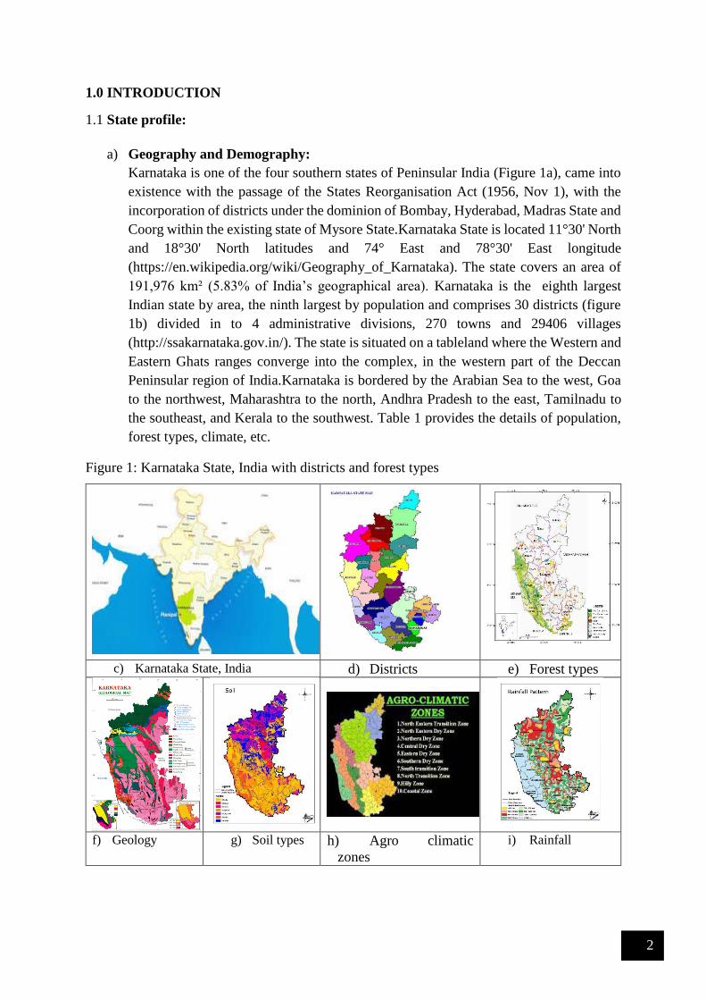
1.0 INTRODUCTION
1.1 State profile:
a) Geography and Demography:
Karnataka is one of the four southern states of Peninsular India (Figure 1a), came into
existence with the passage of the States Reorganisation Act (1956, Nov 1), with the
incorporation of districts under the dominion of Bombay, Hyderabad, Madras State and
Coorg within the existing state of Mysore State.Karnataka State is located 11°30' North
and 18°30' North latitudes and 74° East and 78°30' East longitude
(https://en.wikipedia.org/wiki/Geography_of_Karnataka). The state covers an area of
191,976 km² (5.83% of India’s geographical area). Karnataka is the eighth largest
Indian state by area, the ninth largest by population and comprises 30 districts (figure
1b) divided in to 4 administrative divisions, 270 towns and 29406 villages
(http://ssakarnataka.gov.in/). The state is situated on a tableland where the Western and
Eastern Ghats ranges converge into the complex, in the western part of the Deccan
Peninsular region of India.Karnataka is bordered by the Arabian Sea to the west, Goa
to the northwest, Maharashtra to the north, Andhra Pradesh to the east, Tamilnadu to
the southeast, and Kerala to the southwest. Table 1 provides the details of population,
forest types, climate, etc.
Figure 1: Karnataka State, India with districts and forest types
c) Karnataka State, India d) Districts e) Forest types
f) Geology g) Soil types h) Agro climatic
zones
i) Rainfall

3
TABLE 1: Profile of Karnataka State
State Karnataka
Capital Bangalore
Area 1,91,791 sq. Km (eighth largest state in India);
Districts: 30; Taluks: 220; Villages: 29406; Towns: 270
Length 760 Km. (north -south)
Breadth 420 Km. (east-west)
Physiography
Karavali, the Coastal Plain; Sahyadris, the Western Ghats; Malnad, the
Transitional Belt; the Southern Plateau; the Northern Plateau; the Eastern
Ghats (http://www.karnataka.com/profile/physiography)
Forest types
(Figure 1c)
Tropical Evergreen, Tropical Semi-evergreen, Dry Deciduous (Malnad), Dry
Deciduous(Plateau), Shrub (http://wgbis.ces.iisc.ernet.in/biodiversity)
Vegetation types Wide variety of vegetation formations, ranging from coastal land plants to
montane flora of the Western Ghats, four-storied tropical evergreen monsoon
forests to arid thorn and scrub. A large chunk of the vegetation of the state is
embedded in the sprawling Western Ghats that is also the home to an
overwhelming number of plant species with immeasurable biological diversity
and a wealth of intricate adaptations. Indeed, a majority of plant species of the
Indian subcontinent are represented in the forests of the Western Ghats and
account for probably 75% of the state’s plant wealth
(http://florakarnataka.ces.iisc.ac.in/hjcb2/karnataka.php).
Geology (Figure
1d)
Four main types of geological formations are: (i) The Archean complex made
up of Dharwad schists and granitic gneisses: These cover around 60% of the
area of the state and consist of gneisses, granites and charnockite rocks. Some
of the minerals found in this region are dolomite, limestone, gabbro, quartzite,
pyroxenite, manganese and iron ores and metabasalt, (ii) The Proterozoic non-
fossiliferous sedimentary formations of the Kaladgi and Bhima series: The
Kaladgi series has horizontal rocks that run for 160 km in the districts of
Belgaum, Raichur, Dharwad and Bijapur districts. The Bhima series that is
present on either side of the Bhima River consists of rocks containing
sandstone, limestone and shale and this is present in the Gulbarga and Bijapur
districts, (iii) The Deccan trappean and intertrappean deposits: This is a part
of the Deccan traps which were formed by the accumulation of basaltic lava.
This is made up of greyish to black augite-basalt, and (iv) The tertiary and
recent laterites and alluvial deposits: Laterite capping are found over the
Deccan Traps and were formed after the cessation of volcanic activity in the
early tertiary period. These are found in many districts in the Deccan plateau
and also in the coast (http://www.portal.gsi.gov.in).
Soil types (Figure
1e)
Soil cane be grouped into 9 categories: red sandy soils, red loamy soils,
shallow black soils, medium black soils, deep black soils, mixed red and
black soils, laterite soils, laterite gravelly soils and coastal alluvium
(http://www.nbsslup.in)
Soil order Alfisols, Andisols, Aridisols, Entisols, Histosols, Inceptisols, Mollisols,
Oxisols, Spodosols,Ultisols, Vertisols (http://www.nbsslup.in)
Agro-climatic
zones (Fig 1f)
Ten agro climatic zones in Karnataka (http://raitamitra.kar.nic.in) are: (i).
North Eastern Transition Zone [Bidar (5) & Gulbarga (2)], (ii). North
Eastern Dry Zone [Gulbarga (5) Yadgir (3) & Raichur (3)], (iii). Northern

4
Dry Zone [Koppal (4), Gadag (4), Dharwad (1), Belgaum (5), Bijapur (5),
Bagalkot (6), Bellary (7), Davangere (1), Raichur (2)], (iv). Central Dry
Zone [Chitradurga (6), Davangere (3), Tumkur (6), Chickmagalur (1),
Hassan (1)], (v). Eastern Dry Zone [Bangalore Rural (4 taluks), Ramanagar
(4) Bangalore Urban (3), Kolar (5), Chikkaballpur (6) Tumkur (2)], (vi).
Southern Dry Zone [Mysore (4), Chamarajnagar(4), Mandya (7), Tumkur
(2), Hassan (2)], (vii).Southern Transition Zone [Hassan (4), Chickmagalur
(1), Shimoga (3), Mysore (3), Davanagere (2)], (viii). Northern Transition
Zone [Belgaum (4), Dharwad (3), Haveri (6), Gadag (1)], (ix). Hilly Zone
[U.Kannada (6), Belgaum (1), Dharwad (1), Haveri (1), Shimoga (4),
Chickmangalur (5), Kodagu (3), Hassan (1)], (x). Coastal Zone
[Udupi (3), Dakshina Kannada (5), Uttara Kannada (5 taluks)
Climate Semi-tropical (http://www.karnataka.com/profile/karnataka-climate/)
Seasons Summer - March to May (18° C to 40° C); Winter -Oct to Dec (14° C to 32°
C); South-West Monsoon: June to August; North-East Monsoon
October to December
(http://www.karnataka.com/profile/karnataka-climate/)
Rainfall (Figure
1g)
500 mm to over 4000 mm. Agumbe in the Central Western Ghats receives
the second heaviest annual rainfall (7600 mm) in India
(http://www.karnataka.com/profile/karnataka-climate/)
Population 611.31 (approx) (2011), 968 females per 1000 males
(http://censuskarnataka.gov.in)
Population density: Top three districts in density of population per sq km are Bangalore Urban
(4,378), Dakshina Kannada (457), Bangalore Rural (431) and lowest density
districts are Chickmagalur (158), Uttara Kannada (140) and Kodagu (135).
(http://censuskarnataka.gov.in)
Population density in other districts is: Mysore (441), Dharwad (434), Kolar
(384), Mandya (365), Belgaum (356), Haveri (331), Davangere (329), Bidar
(312), Udupi (304), Ramanagaram (303), Chickballapur (298), Bagalkot
(288), Hassan (261), Tumkur (253), Koppal (250), Gulbarga (233), Gadag
(229), Raichur (228), Yadgir (224), Bijapur (207), Shimoga (207),
Chamarajangar (200) and Chitradurga (197) (http://censuskarnataka.gov.in)
Literacy 75.60 % (female literacy: 68.13%; male literacy 82.85%)
(http://censuskarnataka.gov.in)
Traditional
Products
Coffee, silk, sandalwood, agarbathis, ivory carvings, etc.
Major Crops Ragi, jowar, rice; sugarcane, coconut, groundnuts; coffee; cotton
(http:// raitamitra.kar.nic.in/agriprofile/table10.htm)
Major Minerals Gold (90% of India's production), iron ore, manganese, bauxite
(http:// http://www.karnataka.com/profile/mineral-resource/)
Roads
Total length of roads: 1,22,489 kms; National Highways: 2,357 kms; State
Highways: 28,311 kms; Major District roads: 2,090 kms
Languages Kannada, Telugu, Tamil, Urdu, Marathi, Tulu, Kodagu, Konkani, Hindi
River systems Karnataka has seven river systems and their tributaries flowing through the
state. The river systems of Karnataka are: Cauvery, Godavari, Krishna, North
Pennar, South Pennar, Palar, The West Flowing Rivers. Karnataka has 26 east
flowing rivers and 10 west flowing rivers. The west flowing rivers of

5
Karnataka provide 60% of the state’s inland water resources.
(http://www.karnataka.com/rivers/)
b) Physiographic features: The state can be divided into four physiographic landforms – (i)
the Northern Karnataka Plateau, (ii) the Central Karnataka Plateau, (iii) the Southern
Karnataka Plateau and (iv) the Coastal Karnataka Region.
(i) Northern Karnataka Plateau: This region is mainly composed
of the Deccan trap and covers the districts of Belgaum, Bidar,
Bijapur and Gulbarga. It represents an extensive deforested
plateau landscape. The Northern Karnataka Plateau has an
elevation of 300 m to 600 m asl. The plateau slopes towards the
east. The landscape is mainly covered with rich black cotton
soils. The vast expanse of treeless plateau is interspersed with
river plains, watersheds, residual hills and ridges. The river
plains are represented by those of River Bhima, River
Ghataprabha, River Krishna and River Malaprabha.
(ii) Karnataka Coastal Region: The coastal belt starts from the Western Ghats in the west and
extends till the edge of the Karnataka Plateau in the east and includes Uttara Kannada, Udupi and
Dakshina Kannada districts. The terrain consists of rivers, creeks, waterfalls, ranges of hills and
peaks. This region can be divided into two main geographical divisions, known as the Western
Ghats and the plains. The coastal belt has an average width of 50 km to 80 km and covers a
distance of around 267 km from north to south.
(iii) Central Karnataka Plateau: This region is located between the Northern Karnataka Plateau
and the Southern Karnataka Plateau and consists of districts like Bellary, Chikmagalur,
Chitradurga, Dharwad, Raichur and Shimoga. The elevation varies between 450 m to 700 m asl
and slope towards the east. This region is the location of the Tungabhadra River basin.
(iv) Southern Karnataka Plateau: This region is covered by a high degree of slope and encircled
by the Western Ghats on the west and the south. Southern plateau includes the districts of
Bangalore Urban, Bangalore Rural, Hassan, Kodagu, Kolar, Mandya, Mysore and Tumkur.. The
Southern Karnataka Plateau has a general elevation of 600 m to 900 m asl, except Biligirirangan
hills (of Mysore district) and Brahmagiri range (of Kodagu district) have elevation ranging
between 1,500 m to 1,750 m. The Cauvery River basin forms a significant part of this plateau.
c) Hydrogeology: The state is covered by peninsular gneisses, granites, schists, and basalts along
with sedimentaries of Kaldagi and Bhima groups. The recent alluvium is restricted to coastal
areas and stream courses. The water bearing and yield characteristics in hard rock are primarily
controlled by the extent of weathering and fracturing. In limestone areas, solution cavities impart
secondary porosity. The yield of tube wells tapping hard rocks is as high as 50 m3/hr. The tube
wells in sedimentaries can yield up to 15 m3/hr
(http://cgwb.gov.in/gw_profiles/st_karnataka.html).
Dynamic Ground Water Resources
Annual replenishable Ground water Resource 15.93 BCM
Net Annual Ground Water Availability 15.30 BCM
Annual Ground Water Draft 10.71 BCM
Stage of Ground Water Development 70 %
Ground Water Development & Management
Over Exploited 65 talukas
Critical 3 talukas

6
Semi- critical 14 talukas
Artificial Recharge to Ground Water (AR) Area identified for AR: 36710 sq km
Quantity of Surface Water to be
Recharged: 2065 MCM
Ground Water Quality Problems
Contaminants Districts affected (in part)
Salinity (EC > 3000 µS/cm at 25 ° C) Bagalkot, Belgaun, Bellary, Davangiri,Gadag,
Gulburga, Raichur
Fluoride (>1.5 mg/l) Bagalkot, Bangalore, Belgaun, Bellary, Bidar,
Bijapur, Chamarajanagara, Chikmagalur,
Chitradurga, Davanagere, Dharwad, Gadag,
Gulburga, Haveri, Kolar, Koppala, Mandya,
Mysore, Raichur, Tumkur
Chloride (> 1000 mg/l) Bagalkot, Belgaum, Gadag, Dharwar
Iron (>1.0 mg/l) Bagalkot, Bangalore, Belgaum, Bellary, Bidar,
Bijapur, Chikmagalur, Chitradurga, Dakshina
Kannada, Davanagere, Gulburga, Hasan, Haveri,
Kodagu, Kolar, Koppala, Mysore, Raichur,
Shimoga, Tumkur, Udupi, Uttar Kannada
Nitrate (>45 mg/l) Bagalkot, , Bangalore, Belgaum, Bellary, Bidar,
Bijapur, Chamarajanagara, Chikmagalur,
Chitradurga, Davanagere, Dharwad, Gadag,
Gulburga, Hassan, Haveri, Kodagu, Kolar,
Koppala, Mandya, Mysore, Raichur. Shimoga,
Udupi, Uttar Kannada
Groundwater quality Groundwater
Vulnerable area
Schist Aquifers
Enactment of Ground Water Bill to regulate and control the development of ground water
(http://www.groundwaters.in/regulations): Government of Karnataka came up with a new
regulation for groundwater in 2009. 2009 bill is a significant shift from 1999 act which was focused
solely on drinking water protection. 2009 bill emphasizes on regulation and control of groundwater
development and management. This 2009 bill was later passed as an act in 2011 and came to be
recognized as Karnataka Groundwater regulations and control of development and management act,
2011. Highlights of this act includes (i) restriction and regulation of extraction of groundwater in the
notified area; (ii) Specification of the minimum distance between the bore wells dug for the purpose
of irrigation; (iii) Registration of existing and new borewells with the authority within 120 days of
formation of authority; (iv) Declaration by notification any areas as drought hit areas; etc.

7
d) River Systems of Karnataka:
The rivers are a source of water for drinking, irrigation and
electricity generation in Karnataka. Most of the rivers
originate in the Western Ghats that generally flow
westward meet the Arabian Sea after a short run varying
from 50 kilometres to 300 kilometres (http://
http://waterresources.kar.nic.in/river_systems.htm#map).
These rivers are very steep in the upper reaches and fairly
steep in the middle reaches. Near the sea, they have
relatively flat gradients and a mild flood plain. Almost all
the major east-flowing rivers are inter-state rivers and runs
towards the eastern side of the state and drain towards the
Bay of Bengal.
River basins: 1: Godavari, 2:
Krishns, 3: Cauvery, 4: North
Pennar, 5: South Pennar, 6:
Palar, 7: West flowing rivers
There are seven river systems in Karnataka.
No. River System Drainage Area
1000 Sq. km %
East Flowing Rivers
1. Godavari 4.41 2.31
2. Krishna 113.29 59.48
3. Cauvery 34.27 17.99
4. North Pennar 6.94 3.64
5. South Pennar 4.37 2.29
6. Palar 2.97 1.56
7. West Flowing Rivers 24.25 12.73
Total 190.50 100
Rivers Drainage area
1000 sq.km. %
East Flowing rivers (1 to 6) 166.25 12.73
West Flowing rivers 24.25 87.27
Total 190.5
i). East-flowing Rivers: Major east flowing rivers in the state are Cauvery (or Kaveri), Krishna, Manjra,
North Pennar and Palar
Cauvery (or Kaveri) is the largest river in the state and originates at Talakaveri in Coorg. It
is often called the Dakshina Ganga (the Ganges of the South) and considered one of the sacred
rivers of India. the origin of the River Kaveri, is a famous pilgrimage and tourist spot set amidst
Bramahagiri Hills near Madikeri in Coorg. The tributaries of the Kaveri include: Harangi,
Hemavathi (origin in western Ghats joins the river Kaveri near Krishnarajasagar),
Lakshmanatirtha, Kabini (originates in Kerala and flows eastward and joins the Kaveri at

8
Tirumakudal, Narasipur), Shimsha, Arkavati, Suvarnavathi or Honnuholé, Bhavani,
Lokapavani, Noyyal, Amaravati
Krishna is second largest river in peninsular India, rises in the Western Ghats at an altitude of
1337 m. near Mahabaleshwar in Maharashtra State. It flows across the whole width of the
peninsula, from west to east, for a length of about 1400 km, through Maharashtra (catchment
area: 69,425 sq.km), Karnataka (113,271 sq.km) and Andhra Pradesh (76,251 sq.km). The
entire catchment area of Krishna basin is 2,58,948 sq km. including the three major basin states
(Maharastra (26.81%), Karnataka (43.74%) and Andhra Pradesh(29.45%)). It originates in
Maharashtra and passes through Karnataka. The principal tributaries of the Krishna in
Karnataka are: Ghataprabha (Origin in the Western Ghats and flows eastwards and joins the
river Krishna. The river forms the well-known Gokak Falls in Belgaum District), Malaprabha
(origin in Western Ghats and flows first in easterly and north-easterly directions and joins river
Krishna at Kudalasangama), Bhima (originates in the forest of Bhimashankar in Pune, and
flows through the states of Maharashtra and Karnataka and joins Krishna near Kudlu in Raichur
taluk and Tungabhadra (formed in the district of Shimoga, by the union of the Tunga and the
Bhadra rivers. The river Tungabhadra flows east across the Deccan Plateau and join river
Krishna in Andhra Pradesh). Details of the principal tributaries of Krishna in Karnataka
are Ghataprabha, Malaprabha, Bhima and Tungabhadra and details (catchment area,
altitude, length) are given below:
Sl.
No.
Name of the
tributary
Catchment
Sq.kms
Origin , Altitude &
Length
Sub-tributaries Name of the
state
1 Ghataprabha 8829 Western Ghats, 884 m,
283 kms
Hiranyakeshi,
Markandeya
Maharshatra,
Karnataka
2 Malaprabha 11549 Western Ghats, 792.48
m, 306 kms
Bennihalla,
Hirehalla, Tas nadi
Karnataka
3 Bhima 70,614 Western Ghats, 945 m,
861 kms
Combined waters
of Mula and
Mutha Ghod,
Nira,Sina
Maharastra,
Karnataka
4 Tungabhadra 47,866 Western Ghats at
Gangamula, 1198 m, 531
kms
Combined waters of
Tunga and Bhadra,
Varada, Hagari
(vedavathy)
Karnataka &
Andhra Pradesh
Manjra, a tributary of the river Godavari, originates in the Bala Ghat range in Karnataka.
Details of Manjra River with catchment details is given below.
Sl.
No.
Tributary Catchment area in Sq.kms. Origin ,
Altitude
Sub-
tributaries
state
1 Manjra
(tributary
of
Godavari)
15,667 Sq.kms Maharastra,
4,406 Sq.kms -Karnataka,
10,772 Sq.kms -Andhra Pradesh
Bala Ghat
range of
hills, 823m
Tirina,Karanja,
Haldi,Lendi &
Mannar
Maharastra,
Karnataka &
Andhra
Pradesh

9
North Pennar or the Uttara Pinakini and the South Pennar originate in Nandi hills of Kolar
district. Details of catchment extent, origin and length are given below.
Name of the
tributary
Catchment
area in Sq.kms.
Origin ,
Length Sub-tributaries State
Uttara Pinakini
(North Pennar
River )
6937 Nandi hills of
Kolar, 597km
Jayamangali,
Kumadavathy,
Chitravathy and Papagni
Karnataka, Andhra
Pradesh
Palar begins in Talagavara in Kolar district and runs through Karnataka, Andhra Pradesh and
Tamilnadu.
l.
No.
Name of the
tributary
Catchment area
in Sq.kms
Origin Sub-
tributaries
Name of the state
1 South Pennar 4370 Nandi hills of
Kolar
- Karnataka, Tamil
Nadu
ii). West-flowing Rivers in Karnataka: The Western Ghats provides a principal geographical
barrier in the path of the Arabian Sea branch of the Southwest monsoon, and is principally
responsible for the heavy rainfall over the western coastal belt. The Southwest monsoon
season (June to September) is the principal rainy season, over 90 % of annual rainfall is
realised in this period.
The rivers in the Western Ghats region generally originate at an elevation ranging from 400 meters to
1,600 meters above the mean sea level, close to the Western Ghats ridge. The rivers generally flow
westward and meet the Arabian Sea after a short run varying from 50 kms to 300 kms. These rivers are
very steep in the upper reaches and fairly steep in the middle reaches and relatively flat gradients near
the Sea. Major West flowing rivers are Mandavi, Kali, Bedthi (or Gangavali), Aghnashini, Sharavathi
and Vekatapura. The other west-flowing rivers, which run through Karnataka, are the Chakra Nadi, the
Varahi, the Netravathy, and the Barapole.
Mandavi originates in the Western Ghats in Belgaum and flows through Karnataka and Goa.
Kalinadi originates in Bidi village in the Western Ghats.
Gangavalli starts in the Western Ghats south of Dharwad.
Aghanashini begins in the Western Ghats near Sirsi.
Sharavathi originates at Ambuthirtha in Thirthahalli Taluk, flows north-west through the
Western Ghats. It forms the famous Jog Falls before joining the Arabian Sea at Honavara.
Details of the west flowing rivers, their important tributaries are given below:
Sl.No. Name of the
tributary
Catchment
area in
Sq.kms.
Origin , Altitude &
Length
Sub-
tributaries
Name of
the state
1 Mahadayi/ Mandavi 2,032 Western Ghats, Belgaum
district, 600 m 87
kms.
Maderi Karnataka,
Goa
2 Kalinadi 4,188 Western Ghats, Bidi
village, 600 m, 153 kms.
Pandhari,
Tatti-halla and
Nagi
Karnataka
3 Gangavalli (Bedthi) 3,574 Western Ghats south Of
Dharwad 700 m, 152
kms.
- Karnataka
4 Aghanashini (Tadri) 1,330 Western Ghats Near
Sirsi, 500 m 84 kms.
- Karnataka

10
5 Sharavathi 3,592 Westren Ghats Ambutirtha
in Shimoga
district, 700 m, 128
kms.
- Karnataka
6 Chakra Nadi 336 East of Kodachadri in
Shimoga district, 600
m, 52 kms.
Kollur Karnataka
7 Varahi (Haladi) 759 Kavaledur-ga in the
Shimoga district, 600
m, 66 kms
- Karnataka
8 Netravathy 3,222 Bellarayan-a Durga in the
Dakshina Kannada, 1,000
m, 103 kms
Gundiahole,
Kumaradara
and
Shisiahole.
Karnataka
9 Barapole
(Valapattanam)
1,867 Brahamagiri Ghat Reserve
Forest in Coorg, 900 m,
110 kms
- Karnataka
& Kerala
Independent streams in the west flowing river system of Karnataka are given below: Kollur River, Ghantihole, Venkatapur, Baindurhole,
Shankargundi, Kumbarhole and Yedamavinahole are
the important streams in this reach.
Independent streams between Sharavathi and
Chakra rivers joining the Arabian Sea.
Swarna, Seethanadhi, Mulki river, Pavanje, Nadisalu,
Gurpur,Yennehole and Madisalhole. Independent streams between Varahi and
Netravathi rivers Chandragiri (Payaswani) and Shiriya river. The
Chandragiri rises west of Mercara in Coorg District
of Karnataka State at an elevation of about 600 Mts.
Pyayaswani River originates from Patti Ghats reserve
forest in Coorg District of Karnataka at an elevation
of 1350 Mts. The two river joins together at
Machipana about 15 kms upstream of their out fall
point into Arabian sea near Kasaragud. It drains
catchment area of 1406 Sq kms out of which 836 Sq
kms lies in Karnataka state and the balance portion in
Kerala state.
Streams between Netravathy and Chandragiri
(Payaswani)
2.0 Aghanashini

11
1 Geography River Aghanashini is located in Uttara Kannada District of Karnataka (Figure 1).
Originating at Sirsi (Figure 2) (Ramachandra et al 2015). Aghanashini river origin
in Sirsi and flows for a distance of nearly 117 km before it joins Arabian Sea at
Tadri, Belegadde/Kirubele-Kumta (Uttara Kannada) (Figure 2).
Tributaries of Aghanashini include, Bakurhole, Donihalla, Chandika hole, Masti
mane halla, Benne holé, Badala, Divalli, Santeguli, Hulidevara kodalu and many
more. Aghanashini river has a catchment area of 1449 sq.km spread across
districts of Uttara Kannada (Kumta, Sirsi, Siddapura, Ankola) and Shimoga
(Sorba).
Figure 1: Aghanashini River Location
Figure 2: Overlay of Google Earth
Figure 3: Topography

12
Topography of Aghanashini river catchment is as depicted in Figure 3, elevation
ranges between < 0m and 786m w.r.t Mean Sea Level, slope of the catchment
varies up to 119%. Very high slope we observed in the Ghats (Devi mane Ghat).
The variations in the terrain has led to formation of various water falls such as the
Burude falls, Dabbe falls, Waate halla, Benne holé falls, Unchalli falls
(Ramachandra et al 2015, Balachandran et al, 2012, www. welcomenri.com,
www.dreamroutes.org) etc.
Rock types: Granites to schists, shale, quartzite’s, Phyllites.
Ores: Iron, limestone, bauxite, quartz, limestone, sand, clay, lime shell,
Manganese, Asbestos, Mica.
Soil: Red Soil, Lateritic soils, Black soil, etc
2 Rainfall and
Water Yield
Rainfall assessment in Aghanashini catchment (Figure 4) indicates that rainfall in
the catchment is orographic with annual rainfall varying spatially between
2500mm at the plains of Sirsi, to over 6300 mm at the Ghats. Water yield in the
catchment is about 28-41 TMC (and is showing declining trend with the changes
in the land uses in the catchment)
Figure 4: Rainfall
3 Anthropology Population in the catchment (Figure 5) has increased from 2,21,562 in 2001 to
2,41,884 in 2011 (Census of India) and is projected to increase to 2,53,135 in the
year 2016 at a growth rate of 9.2% per decade. Population density in the catchment
is 175 persons per square kilometer as on 2016. Major Population is contained at
towns such as Sirsi, Gokarna and Kumta.
Communities: Kumri Marati, Goudas, Konkanis. Havyaka Brahmin, Namadhari
Naik, Goud Saraswat Brahmin, Nadavas, Kurubas, Siddis, Daivajna, Muslims etc.
(Chandran and Hughes 2000, Wikipedia, Gazetter of India-Uttara Kannada
district).

13
Figure 5: Population dynamics in Aghanashini river catchment
4 History,
Culture,
Heritage
River Aghanashini has history beyond the Himalayas i.e., 88 Million year
compared to Himalayas (50 Million years). Mirjan was known as trading hub for
spices such as pepper, cardamom, etc
The word Aghanashini means Destroyer of Sins.
Culture
Festivals and Jatras: Uura habba (Village Festival), Nadi habba (River
festival), Bandi habba, Vadya Panchami, Mahamay jatra, Durga devi
jatra, Kannika parameshwari jatra, Shantika parameshwari jatra,
Venkataramana jatra, etc
Dance: Folk dances (suggi kunita), bharatha natya, Kolata, bedara kunita,
dhamami kunita, Huli kunita, Yakshagana, Masti Kunita, Preta kuntia,
Bedara kunita, Mandala kunita, etc
Music: Folk Songs, Garatiya Haadu, Halliya Haadu, Nadapadagalu,
Bingina pada, Gumatepada, Jogavve haadu, Doni pada, Jogi pada, Badi
vadya etc.
Traditional Games: Kallata, kavade, Channe mane, Karu aata, Katte aata,
Hulighatta, Bandi aata, Devarata, Sariya mugila aata, Achchu aata,
Chowkabara, Tabalamane, etc.
Major temples in the catchment of Aghanashini includes: Veknateshwara Temple
(Majguni - one of the origin of river Aghanashni), Gokarna, Babbru lingeshwara
(worshiped by fishermen), Devi mane, and many deities of the sacred groves.
Places like Mirjan fort once provided defenses at the coasts
5 Land use
dynamics
Land use analysis between 1970’s till 2016 show that the catchment forest cover
is reducing due to intense anthropogenic activities such as logging, plantation, etc.
Figure 6 depicts FCC in the catchment of 1975 and 2016. Figure 7 and Table 1
depicts land use changes in the catchment between 1973 and 2016.

14
Figure 6: False colour composite (FCC) of the River basin
Figure 7: Land use dynamics in Aghanashini Catchment
Table1: Land use dynamics in Aghanashini Catchment
Land use 1973 2016
Built up 0.08% 4.81%
Water 0.80% 2.76%
Crop land 4.05% 16.26%
Open Space 1.43% 3.44%
Moist Deciduous 9.63% 20.41%
Evergreen - Semi Evergreen Forest 73.05% 27.73%
Scrub/Grass land 3.92% 4.01%
Acacia/Eucalyptus/Casuarina 2.86% 2.91%
Teak/Bamboo/Cashew 0.49% 7.90%
Arecanut/Coconut 3.55% 9.22%
Dry Deciduous Forest 0.14% 0.57%
6 Agriculture,
Irrigation
Variety of Paddy, Sugar cane, Banana, Arecanut, Coconut, Mango, spices, etc.
7 Diversions Fortunately, senseless river diversion has not happened. However, there is now
illogical proposal (by individuals who lacks knowledge of river hydrology and
people’s livelihood and known for mismanagement of natural resources) to
divert water to dying city - Bangalore
8 Bio Diversity Aghanashini river has no diversion works or dams along the river, due to which
the estuary is highly productive with rich diversity of Fishes yielding over 43 crore
rupee per annum (Mahima et al, 2012), Insects (Balachandran et al, 2012),
Bivalves (Table 4) yielding over rupee 5 crores per year (Boominathan et al,
2008), Flora (http://wgbis.ces.iisc.ernet.in/biodiversity/database_new/) .
Fishes: Mahima et al, 2012

15
Ambassis commersoni , Apogon hyalosoma, Arius arius, Arius sps,
Austrobatrachus dussumeri, Carangoides sps, Carangoids chrysophrys,
Carangoids preustus, Caranx praeustus (Marine), Cephalophalis boenak, Cybium
commersoni, Cynoglossus macrostomus, Eel, Etroplus suretansis, Gerres
limbatus, Gerries filamentosus, Glossogobius giuris, Lactarius lactarius, Lates
calcarifer EST-MAR, Liza parsia, Lutjanus argentimaculatus, Lutjanus johni,
Lutjanus ruselli, Monopterus albus, Mugil cephalus, Nemipterus japonicas,
Opisthopterus tardoore, Otolithus ruber, Pampus argenteus, Paraplagusia
biliniata, Parastromateus niger, Platax orbicularis, Platycephalus scaber,
Pomadasys maculatus, Pseudorhombus javanicus, Rastrilliger kanagurta,
Rhinobatus halavi, Rhinobatus sps, Sardinella fimbriata, Scatophagus argus,
Scolidon sps, Secutor insidator, Siganus vermiculatus, Sillago sihama, Sphyraena
barracuda, Sphyraena obtusata, Sphyraena spp, Stoliphorus commersoni,
Stoliphorus indicus, Strongylura leiura, Synaptura commersoniana, Terapon
jarbua.
Insects: Balachandran et al, 2012.
Isonychia sp., Choroterpes sp., Thraulus sp., Isca sp., Notophlebia sp.,
Edmundsula sp., Petersula sp., Afronurus sp., Thalerosphyrus sp., Cinygmina sp.,
Ephemerella (Torleya) sp., Ephemerella (Drunella) sp., Baetis sp., Platybaetis sp.,
Caenis sp., Clypocaenis bisetosa, Cheumatopsyche sp., Hydropsyche sp.,
Lepidostoma sp., Helicopsyche sp., Psychomyia sp., Wormaldia sp., Neoperla sp.,
Naucoris sp., Micronecta sp., Eubrianax sp., Noterus sp.,Stenocolus , Dineutus
sp., Orectochilus sp., Laccobius sp., Euphaea sp., Heliogomphus sp.,
Lamelligomphus sp., Crocothemis sp., Hexatoma sp., Pilaria sp., Chironomus sp.,
Simulium sp., Coridalus sp.
Bivalves: Boominathan et al, 2008
Paphia malabarica, Katelysia opima, Meretrix meretrix, Meretrix casta, Villorita
cyprinoides, Arca granosa, Crassostrea sp., Perna viridis.
Flora: http://wgbis.ces.iisc.ernet.in/biodiversity/database_new (Sirsi, Kumta,
Siddapura Taluks) Forest types found in the district are: Evergreen, Semi
Evergreen, Moist Deciduous, Scrub, Thorny, un wooded with following species.
Acronychia pedunculata, Actinodaphne hookeri, Actinodaphne sp, Aglaia
ananmallayana, Aglaia lawii, Aglaia roxburghiana, Aglaia sp, Ailanthus
excelsa, Alseodaphne semicarpifolia, Alstonia scholaris, Ancistrocladus
hamatus, Antiaris toxicaria, Antidesma menasu, Aporosa lindleyana,
Archidendron bigeminum, Artabotrys hexapetalus, Artocarpus gomezianus,
Artocarpus heterophyllus, Artocarpus hirsutus, Atlantia racemosa,
Beilschmiedia fagifolia, Bischofia javanica, Blachia sp, Bombax ceiba, Bridelia
crenulata, Buchania lanzan, Calicopteris floribunda, Callicarpa tomentosa,
Calophyllum apetalum, Calophyllum polyanthum, Calophyllum tomentosum,

16
Canarium strictum, Canthium dicoccum, Carallia brachiata, Careya arborea,
Carissa inermis, Caryota urens, Casearia championii, Casearia sp, Cassia
fistula, Cassine glauca, Chrysophyllum roxburghii, Cinnamomum
macrocarpum, Cinnamomum malabathricum, Cinnamomum verum,
Cinnamomum zeylanicum, Clausena SP, Cleidion javanicum, Combretum
latifolium, Cryptocarya wightiana, Dalbergia latifolia, Dalbergia rubiginosa,
Dalbergia sp, Dalbergia sympathetica, Derris scandens, Derris sp, Dillenia
pentagyana, Dimocarpus longan, Diospyros assimilis, Diospyros buxifolia,
Diospyros candolleana, Diospyros crumenata, diospyros ebenum, Diospyros
melanoxylon, Diospyros montana, Diospyros oocarpa, Diospyros paniculata,
Diospyros pruriens, Diospyros saldanhae, Diospyros sp, Diospyros sylvatica,
Dipterocarpus indicus, Drypetes confertiflora, Drypetes venusta, Dysoxylum,
Dysoxylum binectariferum, Dysoxylum malabaricum, Elaeagnus conferta,
Elaeocarpus serratus, Elaeocarpus tuberculatus, Emblica officinalis, Entada
pursaetha, Ervatamia heyneana, Erycibe paniculata, Euonymus indicus, Ficus
callosa, Ficus nervosa, Flacourtia montana, Garcinia gummi_gutta, Garcinia
indica, Garcinia morella, Garcinia talbotii, Glochidion johnstonei, Glochidion
sp, Glochidion zeylanicum, Gnetum ula, Grewia sp, Grewia tiliifolia,
Gymnacranthera canarica, Harpullia imbricata, Holigarna arnotiana,
Holigarna beddomii, Holigarna ferruginea, Holigarna grahamii, Homalium
ceylanicum, Hopea parviflora, Hopea ponga, Hopea wightiana, Hydnocarpus
laurifolia, Ixora arborea, Ixora brachiata, Knema attenuata, Lagerstroemia
lanceolata, Lagerstroemia microcarpa, Lepisanthes tetraphylla, Linociera
malabarica, Litsea floribunda, Litsea laevigata, Litsea mysorensis, Litsea
wightiana, Lophopetalum wightianum, Macaranga peltata, Madhuca longifolia,
Mallotus phillipinesis, Mammea suriga, Mangifera indica, Margaritaria indica,
Mastixia arborea, Meiogyne pannosa, Meliaceae sp, Memecylon talbotianum,
Memecylon umbellatum, Mesua ferrea, Mimusops elengi, Moullava spicata,
Murraya paniculata, Myristica dactyloides, Myristica malbarica, Neolitsea
scrobiculata, Nothapodytes foetida, Nothopegia colebrookeana, Nothopegia
racemosa, Odina wodier, Olea dioica, Pajanalia longifolia, Palaquim
ellipticum, Persia macarantha, Phyllanthus emblica, Pittosporum dasycaulon,
Polyalthia fragrance, Polyalthia sp, Pongamia pinnata, Prunus ceylanica,
Pterocarpus marsupium, pterospermum acerifolium, Pterospermum
diversifolium, Pterospermum reticulatum, Randia dumetorum;, Randia
rugulosa, Sageraea laurina, Salacia macrosperma, Salacia oblonga, Sapindus
emarginatus, Schleichera oleosa, Semecarpus Kathlekanensis, Sterculia guttata,
Stereospermum personatum, Stereospermum tetragonum, Strombosia ceylanica,
Symplocos racemosa, Syzigium caryophyllatum, Syzygium cumini, Syzygium
gardneri, Syzygium hemesphericum, Syzygium laetum, Syzygium macrocephala,

17
Syzygium sp, Tectona grandis, Terminalia alata, Terminalia bellirica,
Terminalia chebula, Terminalia paniculata, Tetrameles nudiflora, Tetrastigma
gamblei, Toddalia asiatica var floribunda, Toona ciliata, Trewia nudiflora,
Vateria indica, Ventilago madraspatana, Vepris bilocularis, Vitex altissima,
Walsura trifoliolata, Xantolis tomentosa, Xeromorphis spinosa, Xylia
xylocarpa,
Fauna: : http://wgbis.ces.iisc.ernet.in/biodiversity/database_new
Mammals: Tiger, Black Panther, Leopard, Bison, Gaur, Hare, Wild Boar, Sloth
Bear, Deer, Thar, Bonnet Macaque, Lion Tailed Macaque, Giant Squirrel,
Hanuman Languor.
Reptiles: Snakes (Vipers, Cobra, Rat snake, Crate, King cobra, Python, Wolf
snake, etc), Monitor Lizard.
9 References 1) Survey of India Topographic Sheets, 1:50000 scale.
2) Water Resource Information System of India, http://www.india-
wris.nrsc.gov.in.
3) Google Earth, https://www.google.com/earth/.
4) Ramachandra, T.V., Chandran, M. D, S., Joshi, N. V., Karthick, B., and
Vishnu, D. M., 2015, Ecohydrology of Lotic Systems in Uttara Kannada,
Central Western Ghats, India, Environmental Management of River
Basin Ecosystems – Earthy System Science, 621-655.
5) Census of India, 2001 and 2011, censusindia.gov.in.
6) Wild Wonderful Karnataka,
http://www.dreamroutes.org/western/burudefalls.html.
7) Balachandran, C., Dinakaran, S., Chandran, M. D. S., and Ramachnadra,
T. V., 2012, Diversity and Distribution of Aquatic Insects in Aghanashini
River of Central Western Ghats, India, National Conference on
Conservation and Management of Wetland Ecosystems – LAKE 2012,
6th to 8th November 2012, Mahatma Gandhi University, Kottayam,
Kerala.
8) Wikipedia, https://en.wikipedia.org/wiki/Sirsi,_Karnataka.
9) Mahima, B., Nayak, V. N., Chandran, M. D. S., and Ramachnadra, T. V.,
2012, Impact of Hydroelectric Dams on Fisheries in the Sharavathi
Estuary of Uttara Kannada District, National Conference on
Conservation and Management of Wetland Ecosystems – LAKE 2012,
6th to 8th November 2012, Mahatma Gandhi University, Kottayam,
Kerala.
10) Boominathan, M., Chandran, M. D. S., and Ramachandra, T. V., 2008,
Economic Valuation of Bivalves in the Aghanashini Estuary, West
Coast, Karnataka, Sahyadri Conservation Series 9, ENVIS Technical
Report: 301, November 20082, Energy & Wetlands Research Group,
Centre for Ecological Sciences, Indian Institute of Science, Bangalore
560 012.

18
11) Chandran, M. D S., Ramachandra, T. V, Joshi, N. V., Rao, G. R, Prakash,
N. M., Balachandran, C., and Sumesh, N. D., 2012. Conservation
Reserve Status to Lateritic Plateaus of Coastal Uttara Kannada., Sahyadri
Conservation Series 21, ENVIS Technical Report: 51, November 2012,
Energy & Wetlands Research Group, Centre for Ecological Sciences,
Indian Institute of Science, Bangalore 560 012.
12) ENVIS Sahyadri Web Portal,
http://wgbis.ces.iisc.ernet.in/biodiversity/database_new/
13) Chandran, M. D. S., and Hughes, J. D., 2000, Sacred Groves and
Conservation: The Comparative History of Traditional Reserves in the
Mediterranean Area and in South India, Environment and History, 6, 2,
169–186.
14) Gazetter of India, Uttara Kannada district, 1985
15) https://www.researchgate.net/profile/T_V_Ramachandra/publications
16) http://ces.iisc.ernet.in/energy
17) http://ces.iisc.ernet.in/biodiversity
3.0 Kali

19
1 Geography River Kali is located in Uttara Kannada District of Karnataka (Figure 1).
Originating at Diggi Vilalge - Supa (Figure 2), Kali flows for a distance of nearly
184 km (Amit et al 2008, Survey of India Topographic sheets, Gazetteer of India-
Karnataka State – Uttara Kannada) before it joins Arabian Sea at Karwar (Uttara
Kannada) (Figure 2).
Tributaries of Kali include, Pandrali, Kali, Tattihala, Vaki, Kaneri, Thananala,
Kariholé and many more. Kali river has a catchment area of 5085.9 sq.km spread
across districts of Uttara Kannada (Ankola, Karwar, Supa, Yellapur, Haliyal),
Dharwad (Kalgatgi, Dharwad) and Belgaum (Khanapura, Bialhongal).
Figure 1: Kali River
Figure 2: Overlay of Google Earth
Figure 3: Topography

20
Topography of Kali river catchment is as depicted in Figure 3, elevation ranges
between < 0m and 1023 m w.r.t Mean Sea Level, slope of the catchment varies up
to 139%. Very high slope we observed in the Ghats (Anshi-Dandeli Ghat).
The variations in the terrain has led to formation of various water falls such as the
Sathodi Falls, Nagarmadi falls, Devkar falls, Anshi water fall etc.
Rock types: Granites to schists, shale, quartzite’s, Phyllites.
Ores: Iron, limestone, bauxite, quartz, limestone, sand, clay, lime shell,
Manganese, Asbestos, Mica.
Soil: Red Soil, Lateritic soils, Black soil, etc
2 Rainfall and
Water Yield
Rainfall assessment in Kali catchment (Figure 4) indicates that rainfall in the
catchment is orographic with annual rainfall varying spatially between 946 mm at
the plains of Dharwad, to over 5951 mm at the Ghats of Anshi-Dandeli.
Water yield in the catchment is 35 - 75 TMC
Figure 4: Rainfall
3 Anthropology Population in the catchment (Figure 5) has increased from 497892 in 2001 to
542036 in 2011 (Census of India) and is projected to increase to 566065 in the
year 2016 at a growth rate of 8.8% per decade. Population density in the catchment
is 111.3 persons per square kilometer as on 2016. Major Population is contained
at towns such as Dandeli, Haliyar, Dharwad, Karwar, Yellapura, Ramnagar, Virje,
Majali, Ammadalli.
Communities: Ambiga, Arer, Bandi, Bedar, Bandaris, Brahmins, Devadiga,
Devalis, Gabit, Ganiga, Gouli, Gudikar, Harikanta, Hulsvara, Kahrvi, Vaishyas,
Maratha, Kumri Maratha, Lingayath,, Maratha Kubri, Nadava, Namdharis, Padits,
Gidbudukis, Siddis, Buddists, Jains, Muslims, Sikhs, Christians, etc (Chandran
and Hughes 2000, Wikipedia, Gazetter of India-Uttara Kannada district).

21
Figure 5: Population dynamics in Kali river catchment
4 History,
Culture,
Heritage
River Kali has history beyond the Himalayas i.e., 88 Million year compared to
Himalayas (50 Million years).
Culture
Festivals and Jatras: Kurumgad jatra, Karavali utsava, karwar utsava,
Uura habba (Village Festival), Nadi habba (River festival), Bandi habba,
Vadya Panchami, Mahamay jatra, Durga devi jatra, Kannika
parameshwari jatra, Shantika parameshwari jatra, Venkataramana jatra,
etc
Dance: Folk dances (suggi kunita), bharatha natya, Kolata, bedara kunita,
dhamami kunita, Huli kunita, Yakshagana, Masti Kunita, Preta kuntia,
Bedara kunita, Mandala kunita, etc
Music: Folk Songs, Garatiya Haadu, Halliya Haadu, Nadapadagalu,
Bingina pada, Gumatepada, Jogavve haadu, Doni pada, Jogi pada, Badi
vadya etc.
Traditional Games: Kallata, kavade, Channe mane, Karu aata, Katte aata,
Hulighatta, Bandi aata, Devarata, Sariya mugila aata, Achchu aata,
Chowkabara, Tabalamane, etc.
Major temples in the catchment of Kali includes: Uluvi, Shanthadurga temple,
Kavale Caves, etc.
5 Land use
dynamics
Land use analysis of 2013 show that the catchment forest cover is about 55 %
(about 38% covered with evergreen species). Figure 6 depicts FCC of the
catchment, Figure 7 and Table 1 depicts land use in the catchment as on 2013.

22
Figure 6: False colour composite
Figure 7: Land use in Kali Catchment
Table1: Land use of Kali Catchment
Land use 2013
Urban 1.7%
Water 3.7%
Agriculture 17.4%
Open lands 1.9%
Moist Deciduous Forest 14.5%
Evergreen to Semi Evergreen forest 38.6%
Scrub/Grassland 3.3%
Acacia/Eucalyptus 11.8%
Teak/Bamboo 3.3%
Coconut/Arecanut 1.7%
Dry Deciduous 2.1%

23
6 Agriculture,
Irrigation
Variety of Paddy, Sugar cane, Banana, Arecanut, Coconut, Mango, spices, etc.
7 Diversions
/Reservoirs
Supa, Kodasalli, Tattihalla, Bommanalli Balancing Reservoir, Kaneri, Kadra.
8 Bio Diversity Anshi Dandeli is Tiger Reserve, habitat of wild elephants, Hornbill reserves and
also wild life corridor.
Bivalves: Ramachandra et al, 2012, http://www.cmfri.org.in
Paphia malabarica, Meretrix meretrix, Meretrix casta, Villorita cyprinoides, Arca
granosa, Polymesoda erosa, Oysters, Perna viridis
Flora: Chandran et al 2012, http://wgbis.ces.iisc.ernet.in/biodiversity/database_new
Forest types found in the district are: Evergreen, Semi Evergreen, Moist
Deciduous, Scrub, Thorny, un wooded with following species.
Acacia auriculiformis, Acanthus ilicifolius, Aegiceras corniculatum, Albizia
lebbeck, Alseodaphne semicarpifolia, Alstonia scholaris, Alysicarpus vaginalis,
Anacardium occidentale., Anogeisus latifolia, Aporosa lindleyana,
Aristalochia indica, Artabotrys zeylanica, Artocarpus heterophyllus,
Artocarpus hirsutus, Arundinella metzii, Atalantia racemosa, Avicinnia
officinalis, Bacopa monnieri, Bambusa sp., Barringtonia acutangula, Bauhinia
racemosa, Blyxa aubertii , Bombax ceiba, Breynia retusa, Bridelia scandens,
Bridelia crenulata, Bridelia retusa, Bridelia scandens, Buchanania lanzan,
Calicopteris floribunda, Callicarpa wightii, Calophyllum inophyllum,
Calophylum wightii, Canscora decurrens, Canthium dicoccum, Canthium
parviflorum, Caralia antigerrima, Carallia brachiata, Careya arborea, Carissa
carandas, Caryota urens, Casearia rubescens, Cassia fistula, Cassia tora,
Centranthera indica, Cinnamum macrocarpum, Clerodendrum inerme,
Clerodendrum paniculatum, Cordia myxa, Crotalaria filipes, Crotalaria
lutescens, Crotalaria retusa, Cyperus compressus , Cyperus difformis ,
Cyperus halpan , Cyperus malaccensis, Cyperus iria , Dactyloctenium
aegyptium, Dalbergia horrida, Dalbergia latifolia, Derris scandens, Derris
trifoliate , Desmodium triflorum, Desmodium laxiflorum, Dilenia pentagyna,
Dillenia pentagyna, Dillinia pentagyna, Dimeria hohenackeri, Dimeria
ornithopoda, Diospyros montana, Diospyros paniculata, Diospyros pruriens,
Dolichondrone spathaceae, Elaeocarpus serratus, Eleocharis acutangula ,
Embelia ribes, Epaltes divaricata, Eragrostis uniloides, Ervatamia heyneana,
Eupatorium odoratum, Euphorbia notoptera, Excoecaria agallocha, Ficus
arnottiana, Ficus drupacea, Ficus hisda, Ficus sp., Ficus tinctoria, Fimbristylis
bisumbellata , Fimbristylis ferruginea, Fimbristylis tetragona , Fimbristylis
dichotoma, Flacourtia indica, Flacourtia montana, Fuirena ciliaris , Garcinia
indica, Geissaspis cristata, Glochidion sp., Gloriosa superba, Glycosmis
pentaphylla, Glyphochloa acuminata, Gnedia glauca, Grewia microcos,
Grewia tiliaefolia, Grewia tilifolia, Gymnema sylvestre, Hedyotis herbacea,

24
Helicteres isora, Hemidesmus indicus, Holarrhena antidysenterica, Holigarna
arnotiana, Hopea ponga, Hopea wightiana, Hoppea dichotoma, Hydnocarpus
laurifolia, Hydnocarpus, Ichnocarpus frutescens, Isacne globosa ,
Ischaemum indicum, Ixora arborea, Ixora brachiata, Ixora coccinea, Justica
simplex, Kandelia candel, Kyllinga melanosperma , Lagerstroemia microcarpa,
Lagerstroemia microcarapa, Lagerstromia lanceolata, Lagerstromia
microcarpa, Lannea coromandelica, Lea indica, Lea robust, Lea sp, Leucas
lavandulifolia, Lindernia crustacea, Lindernia tenuifolia, Litsea laevigata,
Lobelia alsinoides, Lobelia nicotianifolia, Ludwigia perennis, Macaranga
peltata, Madhuca neriifolia, Mallotus phillipensis, Mallotus, Mammea suriga,
Mangifera indica, Mariscus javanicus , Mellotus phillipinesis, Memecylon
talbotianum, Memycelon sp., Mimosa pudica, Mimusops elengi, Moullava
spicata, Moulva spicata, Movalva spicata, Murraya koenghii, Myristica
malabarica, Nothapodytes foetida, Nymphaea nouchali, Ochlandra, Ocimum
canum, Odina wodier, Olea dioica, Oplismenus burmanii,
Paspalum scrobiculatum, Phyllanthus simplex, Phyllanthus emblica,
Phyllanthus urinaria, Piper nigrum, Polyalthia fragrans, Pongamia pinnata,
Porteresia coarctata, Portulaca oleracea, Pseudanthistiria umbellata , Psidium
guajava, Pycreus pumilus , Pycreus sanguinolentus , Pycreus stramineus ,
Pycreus polystachyos, Randia dumatorum, Rauvolfia serpetina, Rhizophora
apiculata, Rhizophora mucronata, Rhynchospora wightiana,
Rhynchostylis retusa, Sapindus laurifolia, Sapium insigne, Saraca asoca,
Schleichera oleosa, Schoenoplectus lateriflorus , Sida acuta, Smilax zeylanica,
Smithia hirsuta, Sonneratia caseolaris, Spaeranthus indicus, Spermacoce
articularis, Spermacoce verticillata, Sphenoclea Zeylanica, Sporobolus
virginicus , Stereospermum personatum, Streblus asper, Striga lutea,
Strobilanthus heyneana, Strobilanthus, Strychnos nux-vomica, Symplocos
racemosa , Syzigium caryophyllatum, Syzigium cumini, Syzygium
caryophyllatum, Syzygium hemispericum, Syzygium, Teak, Tephrosia
pulcherrima, Terminalia alata, Terminalia bellarica, Terminalia chebula,
Terminalia paniculata, Terminalia tomentosa, Theriophonum dalzellii, Trewia
nudiflora, Tricholepis glaberrima, Triumfetta rhomboidea , Urena lobata ,
Utricularia reticulata, Vernonia divergens, Vitex altissima, Vitex negundo,
Weisneria triandra , Wendlandia thyrasoides, Xylia xylocarpa, Zizhiphus
rugosa, Ziziphus oenoplia, Ziziphus sp, Ziziphus xylopyrus, Zornia gibbosa,
Zoysia matrella,. etc..
Fauna: : http://wgbis.ces.iisc.ernet.in/biodiversity/database_new

25
Mammals: Elephants, Tiger, Black Panther, Leopard, Bison, Gaur, Hare, Wild
Boar, Sloth Bear, Deer, Thar, Bonnet Macaque, Lion Tailed Macaque, Giant
Squirrel, Hanuman Languor.
Reptiles: Snakes (Vipers, Cobra, Rat snake, Crate, King cobra, Python, Wolf
snake, etc), Monitor Lizard, Crocodile.
Birds: Amit et al, 2008
Acridotheres tristis, Aegithina tiphia, Alcedo athis, Alcedo meninting, Amaurornis
fusca, Amaurornis phoenicurus, Anas creca, Anas penelope, Anas poecilorhynca,
Anas querquedula, Anas Strepera, Anastomus oscitans, Anhinga rufa, Ans
clypeata, Anthracoceros coronatus, Anthropoides virgo, Anus acuta, Apus
nipalensis, Ardea alba, Ardea cinerea, Ardea purpurea, Ardeola grayii, Ardeola
grayii , Arenaria interpres, Aythya nyroca, Botaurus stellaris, Bubulcus ibis,
Bulbulcus ibis, Burhinus oedicnemus, Butorides striatus, Calidris alpina, Calidris
minuta, Calidris temnickii, Calidris testacea, Casmerodius albus, Centropus
sinensis, Ceryle rudis, Ceyx erithacus, Charadrius alexandrinus, Charadrius d.
jerdoni, Charadrius dubius, Charadrius leschenaultii, Charadrius mongolus,
Charadrius veredus, Chliodinas hybridus, Ciconia episcopus, Ciconia nigra,
Circus aeruginosus, Columba livia, Copsychus saularis, Corvus levaillantii,
Corvus splendens, Cursorius coromandelicus, Dendrocygna javanica, Dicrurus
macrocercus, Egretta garzetta, Egretta gularis, Egretta intermediata, Esacus
magniristris, Eudynamys scolopaceus, Fulica atra , Gallicrex cinerea, Gallinago
gallinago, Gallinago minima , Gallinago stenura, Gallinula chloropus ,
Gelochelidon nilotica, Glareola lactea, Gorsachius melanolophus, Haematopus
ostralegus, Halcyon pileata , Halcyon smyrnensis, Haliastur indus, Halycon
Chloris , Himantopus himantopus, Hydrophasianus chirurgus , Hydroprogne
caspia , Ixobrychus cinnamomeus, Ixobrychus flavicollis, Lanius schach, Larus
brunnicephalus, Larus genei, Larus icthyaetus , Larus ridibundus , Leptoptilos
javanicus, Limicola falcinellus , Limosa Limosa , Lonchura striata, Merops
leschenaulti, Merops Orientalis, Merops philippinus, Metopidius indicus, Milvus
migrans, Mycteria leucocephalus, Nattapus coromandelicus, Nectarinia
zeylonica, Numenius arquata , Numenius phaeopus, Nycticorax nycticorax,
Oriolus oriolus, pelargopsis capensis, Phalacrocorax fuscicollis, Phalacrocorax
niger, Philomachus pugnax, Phoenicopterus roseus, Platalea leucorodia,
Plegadis falcinnellus, Pluvialis dominica, Pluvialis squatarola, Porphyrio
porphyrio, Porzona parva, Porzona pusilla, Prinia Socialis, Pseudibis papilosa,
Psittacula cyanocephala, Psittacula krameri, Pycnonotus cafer, Rallina
eurizonoides, Rallus striatus , Recurvirostra avosetta , Rhynchops albicollis,
Rostratula benghalensis, Sarkidiornis melanotos, Saxicola caprata, Spilornis
cheela, Sterna acuricauda, Sterna anaethetus, Sterna aurantia, Sterna
bengalensis, Sterna bergii, Sterna fuscuta, Sterna Sandvicensis, Streptopelia

26
chinensis, Sturnus roseus, sypheotides indicus, Tadorna ferruginea, Threskiornis
melanocephala, Tringa erythropus, Tringa glareola, Tringa hypoleucos, Tringa
nebularia , Tringa ochropus , Tringa stagnatilis, Tringa terek, Tringa totanus,
Vanellus cinereus, Vanellus indicus, Vanellus malabaricus, Venellus indicus.
9 References 1) Survey of India Topographic Sheets, 1:50000 scale.
2) https://www.researchgate.net/profile/T_V_Ramachandra/publications
3) http://ces.iisc.ernet.in/energy
4) http://ces.iisc.ernet.in/biodiversity
5) Google Earth, https://www.google.com/earth/.
6) Ramachandra, T.V., Chandran, M. D, S., Joshi, N. V., and Boominathan,
M., 2012. Edible Bivalves of Central West Coast, Uttara Kannada
District, Karnataka, India., Sahyadri Conservation Series 17, ENVIS
Technical Report : 48, Energy & Wetlands Research Group, Centre for
Ecological Sciences, Indian Institute of Science, Bangalore 560012.
7) Census of India, 2001 and 2011, censusindia.gov.in.
8) Chandran, M. D. S., Rao, G.R., Vishnu, D. M., Prakash, M., and
Ramachandra, T. V., 2012. Grasslands of Anshi-Dandeli Tiger Reserve.,
ENVIS Technical Report: 36, Energy & Wetlands Research Group,
Centre for Ecological Sciences, Indian Institute of Science, Bangalore
560012.
9) ENVIS Sahyadri Web Portal,
http://wgbis.ces.iisc.ernet.in/biodiversity/database_new/
10) Chandran, M. D. S., and Hughes, J. D., 2000, Sacred Groves and
Conservation: The Comparative History of Traditional Reserves in the
Mediterranean Area and in South India, Environment and History, 6, 2,
169–186.
11) Gazetter of India, Uttara kannada district, 1985
12) Central Marine and Fisheries Institute, http://www.cmfri.org.in
13) Amit S. Yadav, Gururaja, K.V., Karthik, B., Rao, G. R., Vishnu, D. M.,
Chandran, M.,D. S and Ramachandra, T.V., 2008, Ecological Status of
Kali River Flood Plain, ENVIS Technical Report: 29, Energy &
Wetlands Research Group, Centre for Ecological Sciences, Indian
Institute of Science, Bangalore 560012.
4.0 Sharavathi 1 Geography River Sharavathi is spread across Uttara Kannada and Shimoga District of
Karnataka (Figure 1). Originating at Ambutirthha (Tirthahalli) (Figure 2)

27
(Karnataka State Gazetteer, Ramachandra et al 2004), Sharavathi flows for a
distance of nearly 128 km (Survey of India Topographic sheets, Water resource
information system of India) before it joins Arabian Sea at Karki, Honnavar
(Uttara Kannada) (Figure 2).
Tributaries of Aghanashini include, Nandiholé, Haridravathi, Sharmanavathi,
Hilkunjiholé, Nagodiholé, Hurliholé, Yenneholé, Mavinaholé, Gundabalaholé,
Kalkatteholé, Kandodiholé and many more. Sharavathi river has a catchment area
of 3042 sq.km spread across districts of Uttara Kannada (Honavara, Siddapura,
Kumta) and Shimoga (Sagara, Hosanagara, Tirthahalli).
Figure 1: Sharavathi River Location
Figure 2: Overlay of Google Earth
Figure 3: Topography
Topography of Sharavathi river catchment is as depicted in Figure 3, elevation
ranges between < 0m and 1135m w.r.t Mean Sea Level, slope of the catchment
varies up to 187%. Very high slope we observed in the Ghats (Gersoppa Ghat).
The variations in the terrain has led to formation of various water falls such as the
Jog falls, Apsarakonda, Mavinagundi falls, Dabbe fall
(http://www.karnataka.com) etc. The plain regions of the catchment are
dominated by lakes whereas the Ghats are dominated by streams.
Rock types: Granites to schists, Quartzite’s, Phyllites, Porphyry, etc.

28
Ores: Iron, bauxite, quartz, sand, clay, lime shell, Manganese, Asbestos, Mica.
Soil: Red Soil, Lateritic soils, etc
2 Rainfall and
Water Yield
Rainfall assessment in Sharavathi river catchment (Figure 4) indicates that rainfall
in the catchment is orographic with annual rainfall varying spatially between
1700mm at the plains of Siddapura, to over 6500 mm at the Ghats (Gersoppa to
Mavinagundi).
Water yield in the catchment is ~60 - 110 TMC
Figure 4: Rainfall
3 Anthropology Population in the catchment (Figure 5) has increased from 319380 in 2001 to
353800 in 2011 (Census of India) and is projected to increase to 371010 in the
year 2016 at a growth rate of 9.72% per decade. Population density in the
catchment is 109 persons per square kilometer as on 2016. Major Population is
contained at towns such as Honnavar, Sagar, Talguppa.
Communities: Kumri Marati, Goudas, Konkanis. Havyaka Brahmin, Namadhari
Naik, Goud Saraswat Brahmin, Nadavas, Kurubas, Siddis, Daivajna, Muslims,
etc. (Chandran and Hughes 2000, Wikipedia, Gazetter of India-Uttara Kannada
district).
Figure 5: Population dynamics in Sharavathi river catchment

29
4 History,
Culture,
Heritage
River Shatravathi has history beyond the Himalayas i.e., 88 Million year
compared to Himalayas (50 Million years). Mirjan was known as trading hub for
spices such as pepper, cardamom, etc
River Sharavathi origins at ambutirtha, and is also explained in Epic of Ramayana
and Mahabharatha.
Culture
Festivals and Jatras: Marikamba jatra, Shani deva jatra, Rameshwara
Jatra, Gram deva Jatra, Nandi Jatra, Lakshmi narasimha jatra,
Venkataramana jatra, Ganapathi jatra, Shambhulingeshwara Jatra, Uura
habba (Village Festival), Nadi habba (River festival), Bandi habba,
Vadya Panchami, Mahamay jatra, Durga devi jatra, Kannika
parameshwari jatra, Shantika parameshwari jatra, Mari habba, etc
Dance: Folk dances (suggi kunita), bharatha natya, Kolata, bedara kunita,
dhamami kunita, Huli kunita, Yakshagana, Masti Kunita, Preta kuntia,
Bedara kunita, Mandala kunita, etc
Music: Folk Songs, Garatiya Haadu, Halliya Haadu, Nadapadagalu,
Bingina pada, Gumatepada, Jogavve haadu, Doni pada, Jogi pada, Badi
vadya etc.
Traditional Games: Kallata, kavade, Channe mane, Karu aata, Katte aata,
Hulighatta, Bandi aata, Devarata, Sariya mugila aata, Achchu aata,
Chowkabara, Tabalamane, etc.
Major temples in the catchment of Sharavati includes: Siganduru, Kollur
Mookambika, Gersoppa Hanumatha, Bellimakki Hanumantha, Idugunji,
Ramatirtha, Karikan Parameshwari, Mugva Subramanya, Gundbala Hanumanta,
Chandavara Hanumantha, Gunavateshwara, and many deities of the sacred
groves.
5 Land use
dynamics
Land use analysis of 2013 show that the catchment forest cover is reducing due to
intense anthropogenic activities such as logging, plantation, etc. Figure 6 depicts
FCC, Figure 7 and Table 1 depicts land use in the catchment. Sharavathi
catchment has a forest cover of 33.7% (Evergreen 19.6%, Moist Deciduous
14.1%). Upstream of Sharavathi is dominated by agriculture (paddy), and
downstream is dominated by horticulture activities (Arecanut).

30
Figure 6: False colour composite
Figure 7: Land use in Sharavati Catchment
Table1: Land use in Sharavati Catchment
Land use 2013
Urban 1.0%
Water 6.9%
Agriculture 14.1%
Open lands 1.1%
Moist Deciduous Forest 14.1%
Evergreen to Semi Evergreen
forest 19.6%
Scrub/Grassland 9.1%
Acacia/Eucalyptus 13.6%
Teak/Bamboo 8.5%
Coconut/Arecanut 12.0%
6 Agriculture,
Irrigation
Variety of Paddy, Sugar cane, Banana, Arecanut, Coconut, Mango, spices, etc.
7 Diversions Sharavathi Generating Station (1035 MW) commissioned in 1964-65, the
Linganamakki Dam Power House (55 MW) and the Sharavathi Tail Race Project
(240 MW) at Gerusoppa in 2001. (Ramachandra et al 2004). Yet another dam
proposed near Jog falls

31
8 Bio Diversity Fishes: Mahima et al, 2014., Mahima et al, 2012., Sreekantha and
Ramachandra, 2005., Sreekantha et al 2006.
Ambassis ambassis, Amblyphyrngodon mol, Aplocheilus lineatus, Arius ariu,
Arothron stellat, Barilius canarensis, Carangoides chrysophrys, Carangoides
chrysophrys, Catla catla, Chanda nama, Channa marulius, Cirhina fulungee,
Cirhina mrigala, Cirrhinus reba, Clarius byatracus, Cyprinus carpio, Danio
aequipinnatus, Dawkinsia filamentosa, Eleutheronema tetradactylum, Etroplus
suretansis, Etroplus suratensi, Garra gotyla stenorynchus, Gerres limbatus ,
Gerries filamentosus, Glossogobius giuris , Glossogobius giurus, Grammoplites
scaber, Heteropneustis fossilis, Hyporhamphus xanthopterus, Hyporhampus
xanthopterus, Labeo fimbriatus, Labeo rohita, Lates calcarifer,
Lepidocephalichthys thermalis, Liza parsia, Lutjanus argentimaculatus, Lutjanus
johni, Lutjanus johnii, Lutjanus ruselli, Lutjanus russellii, Mastacembalus
arnatus, Mugil cephalus, Mystus cavesius, Mystus keletius, Mystus malabaricus,
Namacheilus rueppell, Ompok bimaculatu, Ompok sp, Oreochromis mossambica,
Otolithus ruber, Platycephalus scaber, Pseudambasis ranga, Pseudeutropius
atherenoide, Pseudorhombus javanicus, Puntius arulius, Puntius dorsalis,
Puntius fasciatus, Puntius filamentosis, Puntius filamentosus, Puntius kolus,
Puntius narayani, Puntius parrah, Puntius ticto, Rasbora daniconius, Ray fish,
Salmostoma boopis, Sardinella fimbriata, Scatophagus argus, Schistura
nagodiensis, Schistura. Sharavathiensis, Secutor ruconius, Siganus vermiculatus ,
Sillago sihama, Sphyraena baracuda, Stolephorus commersonnii, Stolephorus
indicus , Stoliphorus commersoni, Strongylura strongylura, Terapon jarbua, Tor
khudree, Tor mussullah, Tylosurus strongylurus, Wallago attu, Xenentodon
cancil,
Ants: Ramachandra et al 2012a
Acantholepis opaca, Acantholepis sp, Anoplolepis longipes, Aphaenogaster
beccari, Bothriomyrmex sp, Camponotus (Colobopsis) sp, Camponotus
angusticollis, Camponotus compressus, Camponotus invidus, Camponotus
irritans, Camponotus paria, Camponotus rufoglaucus, Camponotus sericeus,
Camponotus sp, Cardiocondyla sp, Cardiocondyla wroughtonii, Cataulacus
taprobanae, Crematogaster nr dohrni, Crematogaster rothneyi, Crematogaster sp
1, Crematogaster sp 2, Crematogaster sp 3, Crematogaster sp 4, Crematogaster
sp 5, Crematogaster sp 6, Crematogaster wroughtoni, Diacamma rugosm,
Dolichoderus sp, Harpegnathos saltator, Holcomyrmex sp, Leptogenys diminuta,
Leptogenys processionalis, Leptogenys sp, Lophomyrmex quadrispinosa,
Meranoplus bicolor, Monomorium dichroum, Monomorium floricola,
Monomorium gracillimum, Monomorium indicum, Monomorium latinode,
Monomorium pharaonis, Monomorium scabriceps, Monomorium sp 1,
Monomorium sp 2, Monomorium sp 3, Monomorium sp 4, Myrmicaria brunnea,

32
Oecophylla smaragdina, Pachycondyla henrie, Pachycondyla luteipes,
Pachycondyla rufipes, Pachycondyla tesserinoda, Paratrechina longicornis,
Paratrechina sp, Pheidole nr sharpi, Pheidole parva, Pheidole sp 1, Pheidole sp
2, Pheidole sp 3, Pheidole spathifera, Pheidole watsoni, Pheidole wood-masoni,
Pheidologeton affinis, Pheidologeton diversus, Platythyrea parallela, Platythyrea
sagei, Polyrhachis mayri, Polyrhachis rastellata, Polyrhachis simplex,
Polyrhachis tibialis, Prenolepis, Recurvidris recurvispinosa, Solenopsis
geminata, Tapinoma sp, Technomyrmex albipes, Tetramorium sp 1, Tetramorium
sp 2, Tetramorium sp 3, Tetramorium sp 4, Tetramorium sp 5, Tetramorium
walshi, Tetraponera aitkeni, Tetraponera nigra, Tetraponera rufonigra,
Flora: Ramachandra et al 2012b,
http://wgbis.ces.iisc.ernet.in/biodiversity/database_new (Siddapura,
Honnavar, Sagar, Hosnagara, Tirthahalli Taluks) Forest types found in the
district are: Evergreen, Semi Evergreen, Moist Deciduous, Scrub, Thorny, un
wooded with following species.
Actinodaphne hookeri, Aglaia anamallayana, Aglaia roxburghiana, Aglaia sp,
Agrostistaches indicus, Alpinia malaccensis, Ancistrocladus heyneanus,
Antidesma menasu, Aporosa lindleyana, Arenga whiti, Artabotrys zeylanica,
Artocarpus hirsutus, Atalantia racemosa, Atylosia sp, Beilschmiedia fagifolia,
Blachia denudata, Boesenbergia pulcherrima, Briedelia stipularis, Calamus sp,
Calamus thwaitesii, Callicarpa tomentosa, Calophyllum tomentosum, Canarium
strictum, Canthium dicoccum, Canthium rheedei, Canthium sp., Capparis sp.,
Carallia brachiata, Carex sp., Careya arborea, Caryota urens, Casearia sp.,
Cassine glauca, Cassine sp, Celtis cinnomomea, Cinnamomum macrocarpum,
Cleidion javanicum, Clerodendrum viscosum, Combretum latifolium,
Connaraceae member, Croton gibsonianus, Croton sp., Cyclea peltata,
Cyrtococcum oxyphyllum, Dichapetalum gelonioides, Dimocarpus longan,
Dimorphocalyx lawianus, Dioscorea bulbifera, Diospyros candolleana,
Diospyros crumenata, Diospyros oocarpa, Diospyros paniculata, Diospyros
saldanhae, Diospyros sp, Dipterocarpus indicus, Dracaena terniflora, Drypetes
elata, Drypetes sp (2), Drypetes sp(1), Elaeocarpus tuberculatus, Ervatamia
heyneana, Euonymus indicus, Euphorbiaceae-1, Euphorbiaceae-2, Fahrenhetia
zeylanica, Ficus callosa, Ficus nervosa, Flacourtia montana, Flacourtia sp,
Flemingia strobilifera, Garcinia cambogia, Garcinia morella, Garcinia talbotii,
Glochidion javanicum, Glycosmis pentaphylla, Gnetum scandens, Gomphandra
axillaris, Gymnacranthera canarica, Gymnosporia rothiana, Hemidesmus
indicus, Hibiscus furcatus, Holigarna ferruginea, Holigarna grahamii, Hopea
ponga, Hydnocarpus laurifolia, Hydnocarpus pentandra, Ixora brachiata, Ixora
nigricans, Ixora parviflora, Ixora polyantha, Ixora sp., Justicia simplex, Knema
attenuata, Lagenandra ovata, Lagerstroemia microcarpa, Leea indica,

33
Lepisanthes deficiens, Litsea floribunda, Litsea ghatica, Litsea laevigata, Litsea
sp., Litsea sp.(2), Lophopetalum wightianum, Luvunga sarmentosa, Macaranga
peltata, Mallotus philippensis, Mallotus sp, Mallotus sp., Mallotus stenanthus,
Mangifera indica, Mastixia arborea, Meiogyne pannosa, Memecylon terminale,
Mesua ferrea, Microtropis wallichiana, Mimusops elengi, Mitrephora heyneana,
Murraya paniculata, Myristica dactyloides, Myristica fatua, Myristica
malabarica, Neolitsea zeylanica, Nothapodytes foetida, Nothopegia
colebrookeana, Ochlandra sp, Olea dioica, Ophiorrhiza hirsutula, Orophea
zeylanica, Palaquium ellipticum, Pandanus sp, Persea macrantha, Phoebe cathia,
Phyllanthus lawii, Pinanga dicksonii, Piper sp., Polyalthia fragrans, Polyalthia
sp, Pothos scandens, Pothos scandens, Psychotria flavida, Pterospermum
diversifolium, Randia rugulosa, Randia ruugosa, Rungia pectinata, Sageraea
laurifolia, Santalum album, Scutia myrtina, Smilax spp, Smilax zeylanica,
Strobilanthus heynianus, Strombosia ceylanica, Strychnos climber, Strycnos sp.,
Symplocos racemosa, Syzigium hemisphericum, Syzigium laetum, Syzigium sp(1),
Syzigium sp(2), Syzygium cumini, Syzygium gardneri, Syzygium macrophylla,
Terminalia paniculata, Tetrameles nudiflora, Tiliaceae member, Todalia asiatica,
Ventilago maderaspatana, Vepris bilocularis, Vitaceae member, Walsura trifolia,
Zingiber cernum, Zingiber sp., Zingiberaceae, Ziziphus rugose.
Bivalves: Ramachandra et al 2012c, Boominathan et al, 2014.
Polymesoda erosa, Oysters
Fauna: : http://wgbis.ces.iisc.ernet.in/biodiversity/database_new
Mammals: Tiger, Black Panther, Leopard, Bison, Gaur, Hare, Wild Boar, Sloth
Bear, Deer, Thar, Bonnet Macaque, Lion Tailed Macaque, Giant Squirrel,
Hanuman Languor.
Reptiles: Snakes (Vipers, Cobra, Rat snake, Krait, Pythons, King cobra, Python,
Wolf snake, etc), Monitor Lizard.
9 References 1) Survey of India Topographic Sheets, 1:50000 scale.
2) Water Resource Information System of India, http://www.india-
wris.nrsc.gov.in.
3) Google Earth, https://www.google.com/earth/.
4) Ramachandra, T. V., Chandran, M. D, S., Sreekantha, Mesta, D., Rao, G. R.,
and Sameer, A., 2004, Cumulative Impact Assessment in the Sharavathi river
basin, International Journal of Environment and Development, 1(1), 113 –
135.
5) Ramachandra, T.V., Chandran, M. D, S., Joshi, N. V., Karthick, B., and
Vishnu, D. M., 2015, Ecohydrology of Lotic Systems in Uttara Kannada,
Central Western Ghats, India, Environmental Management of River Basin
Ecosystems – Earthy System Science, 621-655.
6) Census of India, 2001 and 2011, censusindia.gov.in.

34
7) Welcome NRI Web portal,
http://www.welcomenri.com/Tourism/Waterfalls/waate-halla-waterfall-in-
karnataka.aspx.
8) Wild Wonderful Karnataka,
http://www.dreamroutes.org/western/burudefalls.html.
9) http://www.karnataka.com
10) Mahima, B., Nayak,V. N., Chandran, M. D. S., and Ramachandra, T. V.,
2014. Impact of hydroelectric projects on finfish diversity in the Sharavathi
River estuary of Uttara Kannada District, central west coast of India,
International Journal of Environmental Sciences, 5(1): 58-66
11) Mahima, B., Nayak, V. N., Chandran, M. D. S., and Ramachnadra, T. V.,
2012, Impact of Hydroelectric Dams on Fisheries in the Sharavathi Estuary of
Uttara Kannada District, National Conference on Conservation and
Management of Wetland Ecosystems – LAKE 2012, 6th to 8th November
2012, Mahatma Gandhi University, Kottayam, Kerala.
12) Ramachandra, T.V., Chandran, M .D. S., Joshi, N.V., Ajay, N., and Ali, T.M.,
2012a. Ant Species Composition and Diversity in the Sharavathi River Basin,
Central Western Ghats., ENVIS Technical Report: 20, Energy & Wetlands
Research Group, Centre for Ecological Sciences, Indian Institute of Science,
Bangalore 560 012.
13) Ramachandra, T. V., Chandran, M. D., Joshi, N. V., Sooraj, N. P., Rao, G. R.,
and Vishnu D. M., 2012b, Ecology of Sacred Kan Forests in Central Western
Ghats., Sahyadri Conservation Series 15, ENVIS Technical Report: 41,
Energy & Wetlands Research Group, Centre for Ecological Sciences, Indian
Institute of Science, Bangalore 560 012.
14) Ramachandra, T. V., Chandran, M. D., Joshi, N. V., and Boominathan, M.,
2012. Edible Bivalves of Central West Coast, Uttara Kannada District,
Karnataka, India., Sahyadri Conservation Series 17, ENVIS Technical Report:
48, Energy & Wetlands Research Group, Centre for Ecological Sciences,
Indian Institute of Science, Bangalore 560 012.
15) Boominathan, M., Chandran, M. D. S., and Ramachandra, T. V., 2008,
Economic Valuation of Bivalves in the Aghanashini Estuary, West Coast,
Karnataka, Sahyadri Conservation Series 9, ENVIS Technical Report: 301,
November 20082, Energy & Wetlands Research Group, Centre for Ecological
Sciences, Indian Institute of Science, Bangalore 560 012.
16) Chandran, M. D S., Ramachandra, T. V, Joshi, N. V., Rao, G. R, Prakash, N.
M., Balachandran, C., and Sumesh, N. D., 2012. Conservation Reserve Status
to Lateritic Plateaus of Coastal Uttara Kannada., Sahyadri Conservation
Series 21, ENVIS Technical Report: 51, November 2012, Energy & Wetlands

35
Research Group, Centre for Ecological Sciences, Indian Institute of Science,
Bangalore 560 012.
17) ENVIS Sahyadri Web Portal,
http://wgbis.ces.iisc.ernet.in/biodiversity/database_new/
18) Chandran, M. D. S., and Hughes, J. D., 2000, Sacred Groves and
Conservation: The Comparative History of Traditional Reserves in the
Mediterranean Area and in South India, Environment and History, 6, 2, 169–
186.
19) Gazetter of India, Uttara kannada district, 1985
20) Sreekantha., Gururaja, K. V., Ramadevi, K., Indra, T. J., and Ramacahndra,
T. V., 2006, Two Species of Fishes of the Genus Schistura
McClelland(Cypriniformes:Balitoridae) from Western Ghats, India,
http://wgbis.ces.iisc.ernet.in/energy/water/paper/twonew_fishes/index.htm
21) Sreekantha and Ramachandra, T. V.,, 2005, Fish diversity in Linganamakki
reservoir and Sharavathi River., Ecology, Environment and Conservation,
11(3-4), 337-348
22) https://www.researchgate.net/profile/T_V_Ramachandra/publications
23) http://ces.iisc.ernet.in/energy
24) http://ces.iisc.ernet.in/biodiversity
5.0 Varada
1 Geography River Varada is spread across Shimoga, Uttara Kannada and Haveri districts of
Karnataka (Figure 1). Originating at Varadamoola (Figure 2) (Ramachandra et al
2014), Varada flows in the north east direction for a distance of nearly 198 km
(Survey of India Topographic sheets,) before it joins Tungabhadra at Galagantha
village Haveri district (Figure 2).
Tributaries of Varada include, and many more. Varada river has a catchment area
of 5135 sq.km.
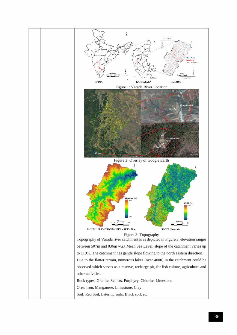
36
Figure 1: Varada River Location
Figure 2: Overlay of Google Earth
Figure 3: Topography
Topography of Varada river catchment is as depicted in Figure 3, elevation ranges
between 507m and 836m w.r.t Mean Sea Level, slope of the catchment varies up
to 119%. The catchment has gentle slope flowing to the north eastern direction.
Due to the flatter terrain, numerous lakes (over 4000) in the catchment could be
observed which serves as a reserve, recharge pit, for fish culture, agriculture and
other activities.
Rock types: Granite, Schists, Porphyry, Chlorite, Limestone
Ores: Iron, Manganese, Limestone, Clay
Soil: Red Soil, Lateritic soils, Black soil, etc

37
2 Rainfall and
Water Yield
Rainfall assessment in Varada catchment (Figure 4) indicates that rainfall in the
catchment is orographic with annual rainfall varying spatially between 663mm at
the plains of Haveri, to over 3600 mm at the Ghats of Sagar (Shimoga).
Water yield in the catchment is 40 – 80 TMC
Figure 4: Rainfall
3 Anthropology Population in the catchment (Figure 5) is about1234523. Population density in the
catchment is 245 persons per square kilometer as on 2016. Major Population is
contained at towns such as Sagara, Siddapura, Haveri, Sorab, Shiggaon, Savanur,
Hangal. Agasanahalli, Byadgi, etc.
Communities: Kumri Marati, Goudas, Konkanis. Havyaka Brahmin, , Nadavas,
Kurubas, Siddis, Daivajna, Muslims, Lingayaths etc. (Chandran and Hughes 2000,
Wikipedia, Gazetter of India-Uttara Kannada district, Mysore Gazetteer).
4 Culture,
Heritage
Culture
Festivals and Jatras: Uura habba (Village Festival), Nadi habba (River
festival), Renukanma jatra, Mari habba, Ganapathi jatra, Rameshwara
Ratha jatra, Basaveshwara Jatra, Gam devara jatra, Nandi jatra, etc
Dance: Folk dances (suggi kunita), bharatha natya, Kolata, bedara kunita,
dhamami kunita, Huli kunita, Yakshagana, Masti Kunita, Preta kuntia,
Bedara kunita, Mandala kunita, etc
Music: Folk Songs, Garatiya Haadu, Halliya Haadu, Nadapadagalu,
Bingina pada, Gumatepada, Jogavve haadu, Jogi pada, Badi vadya etc.
Traditional Games: Kallata, kavade, Channe mane, Karu aata, Katte aata,
Hulighatta, Bandi aata, Devarata, Sariya mugila aata, Achchu aata,
Chowkabara, Tabalamane, etc.
Major temples in the catchment of Ikkeri, Keladi, Marikamba, Varadambe,
Varadalli, Banavasi, Chandragutgi, Tarakeshwara, Siddeswhara, Kaginele,
Kedareswhara, Bankapura, Hosagunda, Ranganatha etc and many deities of the
sacred groves.
5 Land use
dynamics
Land use analysis as on 2013 show that the catchment is dominated by agricultural
activities towards the plains (69.11% of the total catchment) and plantation

38
activities in the Ghats. Forests cover only 15.4% of the entire catchments,
dominated at Ghats. Figure 5 depicts FCC , Figure 6 and Table 1 depicts land use
in the catchment as on 2013.
Figure 5: False colour composite
Figure 7: Land use dynamics in Varada Catchment
Table1: Land use in Varada Catchment
Land use Area (%)
Water 1.08
Evergreen Forest 5.24
Deciduous Forest 10.23
Horticulture 6.95
Forest Plantation 3.45
Scrub/Grass 1.26
Open/Others 1.95
Built up 0.74
Agriculture 69.11
6 Agriculture,
Irrigation
Variety of Paddy, Sugar cane, Jowar, Ragi, Cotton, Maize, Pineapple, Ginger,
Banana, Arecanut, Coconut, Mango, spices, etc.

39
7 Diversions Numerous barrages, check-dams, lakes for maintaining water demand of
agriculture and horticulture crops.
8 Bio Diversity Flora: http://wgbis.ces.iisc.ernet.in/biodiversity/database_new (Sorba,
Sagara,) Forest types found in the district are: Evergreen, Semi Evergreen, Moist
Deciduous, Scrub, Thorny, un wooded with following species.
Actinodaphne hookeri, Adina cordifolia, Aglaia ananmallayana, Aglaia
roxburghiana, Alangium salvifolium, Albizia sp, Alseodaphne semicarpifolia,
Alstonia scholaris, Antiaris toxicaria, Aphanamixis polystachya, Aphananthe
cuspidata, Aporosa lindleyana, Artocarpus gomezianus, Artocarpus
heterophyllus, Artocarpus hirsutus, Beilschmiedia fagifolia, Bombax ceiba, Butea
monosperma, Calicopteris floribunda, Careya arborea, Caryota urens, Casearia
championii, Cassine glauca, Celtis cinnomomea, Chrysophyllum roxburghii,
Chukrasia tabularis, Clausena anisata, Cleidion javanicum, Cordia sp, Dalbergia
latifolia, Dalbergia sympathetica, Diospyros crumenata, Diospyros montana,
Diospyros oocarpa, Diospyros sylvatica, Drypetes confertiflora, Dysoxylum
malabaricum, Entada pursaetha, Ervatamia heyneana, Erythrina variegata,
Fagraea ceilanica, Ficus callosa, Ficus nervosa, Ficus tsjahela, Flacourtia
montana, Glochidion zeylanicum, Gnetum ula, Grewia tiliifolia, Harpullia
imbricata, Holigarna arnotiana, Holigarna beddomii, Holigarna ferruginea,
Holigarna grahamii, Hydnocarpus laurifolia, Ipomoea sp, Ixora brachiata,
Knema attenuata, Lagerstroemia microcarpa, Lannea coromandelica, Linociera
malabarica, Macaranga peltata, Mammea suriga, Mangifera indica,
Margaritaria indica, Memecylon talbotianum, Merremia emarginata, Mimusops
elengi, Mussaenda belilla, Nothapodytes foetida, Olea dioica, Phyllanthus
emblica, Pterocarpus marsupium, Pterospermum reticulatum, Sapindus
emarginatus, Sapindus laurifolia, Saraca asoca, Schefflera wallichiana,
Spatholobus parviflorus, Spondias pinnata, Sterculia guttata, Stereospermum
tetragonum, Streblus asper, Strombosia ceylanica, Strychnos nuxvomica,
Syzygium cumini, Terminalia alata, Terminalia bellirica, Terminalia chebula,
Terminalia paniculata, Tetrameles nudiflora, Tetrastigma gamblei, Toddalia
asiatica var floribunda, Toona ciliata, Trema orientalis, Uvaria narum,
Vengueria spinosa, Ventilago madraspatana, Vepris bilocularis, Vitex altissima,
Xantolis tomentosa, Xeromorphis spinosa, Xylia xylocarpa, Zanthoxylum rhetsa.
Fauna: : http://wgbis.ces.iisc.ernet.in/biodiversity/database_new
Mammals: Tiger (Ghats), Black Panther, Leopard, Bison, Gaur, Hare, Wild Boar,
Sloth Bear, Deer, Thar, Bonnet Macaque, Giant Squirrel, Hanuman Languor, Fox,
etc
Reptiles: Snakes (Vipers, Cobra, Rat snake, Krait, King cobra, Python, Wolf
snake, etc), Monitor Lizard.
9 References 1) Survey of India Topographic Sheets, 1:50000 scale.

40
2) Water Resource Information System of India, http://www.india-
wris.nrsc.gov.in.
3) Google Earth, https://www.google.com/earth/.
4) Census of India, 2001 and 2011, censusindia.gov.in.
5) Ramachandra, T. V., Chandran, M. D. S., Vinay, S., Bharath, H. Aithal.,
2014, Water Scarcity in Varada Catchment: Need to arrest Deforestation
on Priority, ENVIS Technical Report No. 82, Centre for Ecological
Sciences, Indian Institute of Science, Bangalore 560012, India
6) ENVIS Sahyadri Web Portal,
http://wgbis.ces.iisc.ernet.in/biodiversity/database_new/
7) Chandran, M. D. S., and Hughes, J. D., 2000, Sacred Groves and
Conservation: The Comparative History of Traditional Reserves in the
Mediterranean Area and in South India, Environment and History, 6, 2,
169–186.
8) Gazetter of India, Uttara Kannada district, 1985
9) Mysore Gazetteer, Volume 5, Part 2, 2011.
10) https://www.researchgate.net/profile/T_V_Ramachandra/publications
11) http://ces.iisc.ernet.in/energy
12) http://ces.iisc.ernet.in/biodiversity
6.0 Venkarapura
1 Geography River Venkatapura is spread across the Western Ghats in Uttara Kannada and
Shimoga districts of Karnataka (Figure 1). Originating at Sagara (Figure 2),
Originating near Bhimeshwara temple -Sagara (Shimoga), Venkarapura flows for
a distance of nearly 50 km (Survey of India Topographic sheets, High resolution
satellite data-optical and radar) before it joins Arabian Sea at Alvekodi/
Tenginagundi - Bhatkal (Uttara Kannada) (Figure 2). Tributaries of Venkatapura
include, Chitihalla, Katagar Nala, Basti Halla, Kitreholé, Venkatapura river and
many more. Venkatapura river has a catchment area of 459.70 sq.km spread across
districts of Uttara Kannada (Bhatkal) and Shimoga (Sagar).

41
Figure 1: Venkatapura River Location
Figure 2: Overlay of Google Earth
Figure 3: Topography
Topography of Venkatapura river catchment is as depicted in Figure 3, elevation
ranges between < 0m and 815m w.r.t Mean Sea Level, slope of the catchment
varies up to 119%. Very high slope we observed in the Ghats (Kogar Ghat).
Water falls such as the Bhimeshwara falls etc form in the Ghats of Venkatapura.
Rock types: Granites to schists, shale, quartzite’s, Phyllites.
Ores: Iron, limestone, bauxite, quartz, limestone, sand, clay, shell, Manganese,
Asbestos, Mica,Bauxitr
Soil: Red Soil, Lateritic soils, Black soil, etc
2 Rainfall and
Water Yield
Rainfall assessment in Venkatapura catchment (Figure 4) indicates that rainfall in
the catchment is orographic with annual rainfall varying spatially between
3700mm at the plains of coast, to over 5700 mm at the Ghats.
Water yield in the catchment is 8 - 16 TMC
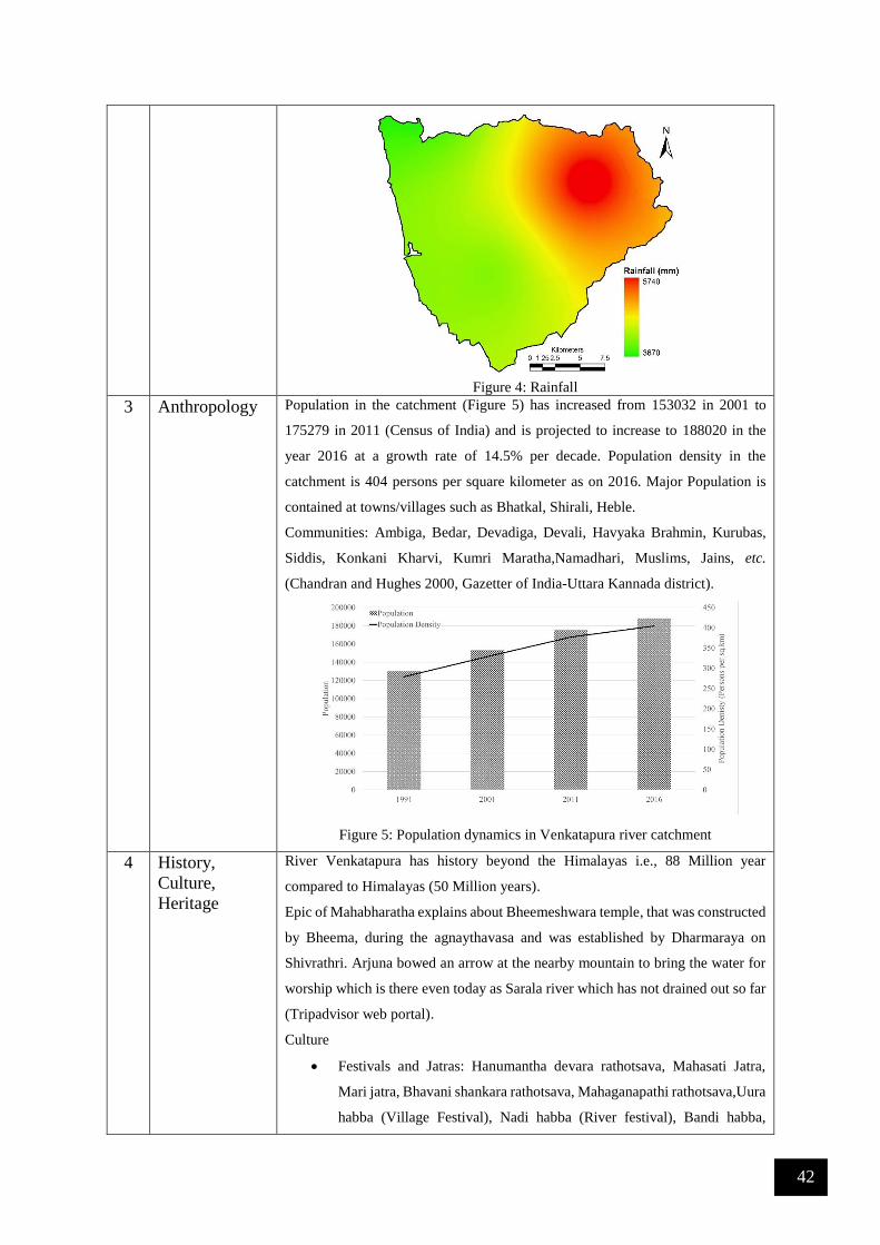
42
Figure 4: Rainfall
3 Anthropology Population in the catchment (Figure 5) has increased from 153032 in 2001 to
175279 in 2011 (Census of India) and is projected to increase to 188020 in the
year 2016 at a growth rate of 14.5% per decade. Population density in the
catchment is 404 persons per square kilometer as on 2016. Major Population is
contained at towns/villages such as Bhatkal, Shirali, Heble.
Communities: Ambiga, Bedar, Devadiga, Devali, Havyaka Brahmin, Kurubas,
Siddis, Konkani Kharvi, Kumri Maratha,Namadhari, Muslims, Jains, etc.
(Chandran and Hughes 2000, Gazetter of India-Uttara Kannada district).
Figure 5: Population dynamics in Venkatapura river catchment
4 History,
Culture,
Heritage
River Venkatapura has history beyond the Himalayas i.e., 88 Million year
compared to Himalayas (50 Million years).
Epic of Mahabharatha explains about Bheemeshwara temple, that was constructed
by Bheema, during the agnaythavasa and was established by Dharmaraya on
Shivrathri. Arjuna bowed an arrow at the nearby mountain to bring the water for
worship which is there even today as Sarala river which has not drained out so far
(Tripadvisor web portal).
Culture
Festivals and Jatras: Hanumantha devara rathotsava, Mahasati Jatra,
Mari jatra, Bhavani shankara rathotsava, Mahaganapathi rathotsava,Uura
habba (Village Festival), Nadi habba (River festival), Bandi habba,

43
Vadya Panchami, Mahamay jatra, Durga devi jatra, Kannika
parameshwari jatra, Shantika parameshwari jatra, Venkataramana jatra,
etc
Dance: Folk dances (suggi kunita), bharatha natya, Kolata, bedara kunita,
dhamami kunita, Huli kunita, Yakshagana, Masti Kunita, Preta kuntia,
Bedara kunita, Mandala kunita, etc
Music: Folk Songs, Garatiya Haadu, Halliya Haadu, Nadapadagalu,
Bingina pada, Gumatepada, Jogavve haadu, Doni pada, Jogi pada, Badi
vadya etc.
Traditional Games: Kallata, kavade, Channe mane, Karu aata, Katte aata,
Hulighatta, Bandi aata, Devarata, Sariya mugila aata, Achchu aata,
Chowkabara, Tabalamane, etc.
Religious places in the catchment of Venkatapura includes: Bastis, Khetappayya
Narayana,Chindnadapalli mosque etc.
5 Land use
dynamics
Land use analysis of 2013 show that the catchment is dominated by evergreen
forest cover (~42.7%), followed by Agriculture (~21.8%), etc. Figure 6 depicts
FCC, Figure 7 and Table 1 depicts land use in the catchment as on 2013.
Figure 6: False colour composite

44
Figure 7: Land use of Venkatapura Catchment
Table1: Land use in Venkatapura Catchment
Land use 2013
Built up 3.8%
Water 0.4%
Crop land 21.8%
Open Space 2.5%
Moist Deciduous 13.5%
Evergreen - Semi Evergreen Forest 42.7%
Scrub/Grass land 2.2%
Acacia/Eucalyptus/Casuarina 7.3%
Teak/Bamboo/Cashew 0.8%
Arecanut/Coconut 5.1%
6 Agriculture,
Irrigation
Variety of Paddy, Sugar cane, Banana, Arecanut, Coconut, Mango, spices, etc.
7 Diversions No Major Diversion works in the catchment
8 Bio Diversity Bivalves: Ramachandra et al 2012
Villorita cyprinoides
Flora: http://wgbis.ces.iisc.ernet.in/biodiversity/database_new (Sagara,
Bhatkal Taluks) Forest types found in the district are: Evergreen, Semi
Evergreen, Moist Deciduous, Scrub, Thorny, un wooded with following species.
Actinodaphne hookeri, Aglaia ananmallayana, Aglaia roxburghiana, Ailanthus
excelsa, Alphonseo sp, Alstonia scholaris, Ancistrocladus hamatus, Aphananthe
cuspidata, Aporosa lindleyana, Artabotrys hexapetalus, Artocarpus gomezianus,
Artocarpus hirsutus, Beilschmiedia fagifolia, Bischofia javanica, Calophyllum
polyanthum, Canarium strictum, Canthium dicoccum, Canthium parviflorum,
Caryota urens, Casearia championii, Cassine glauca, Celtis cinnomomea,
Chrysophyllum roxburghii, Cinnamomum macrocarpum, Cinnamomum
malabathricum, Dillenia pentagyana, Dimocarpus longan, Diospyros buxifolia,
Diospyros candolleana, Diospyros montana, Diospyros paniculata, Diospyros

45
sylvatica, Dipterocarpus indicus, Elaeocarpus serratus, Entada pursaetha,
Ervatamia heyneana, Ficus nervosa, Flacourtia montana, Garcinia gummi_gutta,
Garcinia morella, Glochidion zeylanicum, Gnetum ula, Harpullia imbricata,
Holigarna arnotiana, Holigarna ferruginea, Holigarna grahamii, Holigarna
nigra, Homalium ceylanicum, Hopea ponga, Hydnocarpus laurifolia, Ixora
brachiata, Knema attenuata, Lagerstroemia microcarpa, Linociera malabarica,
Litsea floribunda, Lophopetalum wightianum, Macaranga peltata, Mallotus
philippensis, Mangifera indica, Mimusops elengi, Myristica dactyloides,
Nothopegia racemosa, Olea dioica, Persia macarantha, Pittosporum dasycaulon,
Pterospermum diversifolium, Pterospermum reticulatum, Schleichera oleosa,
Sterculia guttata, Stereospermum tetragonum, Strombosia ceylanica, Symplocos
racemosa, Syzygium cumini, Syzygium laetum, Syzygium travancoricum,
Terminalia bellirica, Tetrameles nudiflora, Trichilia connaroides, Vitex altissima,
Xantolis tomentosa.
Fauna: : http://wgbis.ces.iisc.ernet.in/biodiversity/database_new
Mammals: Tiger, Black Panther, Leopard, Bison, Gaur, Hare, Wild Boar, Sloth
Bear, Deer, Thar, Bonnet Macaque, Lion Tailed Macaque, Giant Squirrel,
Hanuman Languor.
Reptiles: Snakes (Vipers, Cobra, Rat snake, Krait, King cobra, Python, Wolf
snake, etc), Monitor Lizard, etc.
9 References 1) Survey of India Topographic Sheets, 1:50000 scale.
2) Water Resource Information System of India, http://www.india-
wris.nrsc.gov.in.
3) Google Earth, https://www.google.com/earth/.
4) Census of India, 2001 and 2011, censusindia.gov.in.
5) Wild Wonderful Karnataka,
http://www.dreamroutes.org/western/burudefalls.html.
6) ENVIS Sahyadri Web Portal,
http://wgbis.ces.iisc.ernet.in/biodiversity/database_new/
7) Chandran, M. D. S., and Hughes, J. D., 2000, Sacred Groves and
Conservation: The Comparative History of Traditional Reserves in the
Mediterranean Area and in South India, Environment and History, 6, 2,
169–186.
8) Gazetter of India, Uttara kannada district, 1985
9) Ramachandra, T. V., Chandran, M. D., Joshi, N. V., and Boominathan,
M., 2012. Edible Bivalves of Central West Coast, Uttara Kannada
District, Karnataka, India., Sahyadri Conservation Series 17, ENVIS
Technical Report: 48, Energy & Wetlands Research Group, Centre for
Ecological Sciences, Indian Institute of Science, Bangalore 560 012.
10) https://www.researchgate.net/profile/T_V_Ramachandra/publications

46
11) http://ces.iisc.ernet.in/energy
12) http://ces.iisc.ernet.in/biodiversity
7.0 Cauvery River
Cauvery (or Kaveri) is the largest river in the state and originates at Talakaveri in Coorg. It is often
called the Dakshina Ganga (the Ganges of the South) and considered one of the sacred rivers of India.
the origin of the River Kaveri, is a famous pilgrimage and tourist spot set amidst Bramahagiri Hills
near Madikeri in Coorg. The tributaries of the Kaveri include: Harangi, Hemavathi (origin in western
Ghats joins the river Kaveri near Krishnarajasagar), Lakshmanatirtha, Kabini (originates in Kerala
and flows eastward and joins the Kaveri at Tirumakudal, Narasipur), Shimsha, Arkavati,
Suvarnavathi or Honnuholé, Bhavani, Lokapavani, Noyyal, Amaravati
Salient Features of Cauvery Basin 1 Catchment Area (Sq. Kms) 81,155
2 Basin Extent - Longitude
Latitude
75° 30’ to 79° 45’ E
10° 05’ to 13° 30’ N
3 Length of Cauvery River (Km) 800
4 Average Water Resource Potential (MCM) 21358
5 Utilizable Surface Water Resource (MCM) 19000
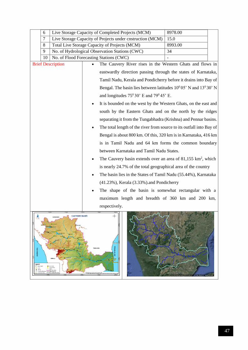
47
6 Live Storage Capacity of Completed Projects (MCM) 8978.00
7 Live Storage Capacity of Projects under cnstruction (MCM) 15.0
8 Total Live Storage Capacity of Projects (MCM) 8993.00
9 No. of Hydrological Observation Stations (CWC) 34
10 No. of Flood Forecasting Stations (CWC) -
Brief Description The Cauvery River rises in the Western Ghats and flows in
eastwardly direction passing through the states of Karnataka,
Tamil Nadu, Kerala and Pondicherry before it drains into Bay of
Bengal. The basin lies between latitudes 100 05’ N and 130 30’ N
and longitudes 750 30’ E and 790 45’ E.
It is bounded on the west by the Western Ghats, on the east and
south by the Eastern Ghats and on the north by the ridges
separating it from the Tungabhadra (Krishna) and Pennar basins.
The total length of the river from source to its outfall into Bay of
Bengal is about 800 km. Of this, 320 km is in Karnataka, 416 km
is in Tamil Nadu and 64 km forms the common boundary
between Karnataka and Tamil Nadu States.
The Cauvery basin extends over an area of 81,155 km2, which
is nearly 24.7% of the total geographical area of the country
The basin lies in the States of Tamil Nadu (55.44%), Karnataka
(41.23%), Kerala (3.33%).and Pondicherry
The shape of the basin is somewhat rectangular with a
maximum length and breadth of 360 km and 200 km,
respectively.

48
Upper Sub-Basin (WRIS) Middle (WRIS Portal) Lower basin (WRIS Portal)
Flow of river Cauvery (Source: WRIS Portal http://wrmin.nic.in)
Physiography Physiographically, the basin can be divided into three parts: the Western
Ghats area, the Plateau of Mysore and the Delta. The delta area is the
most fertile tract in the basin.
Drainage Area (Km2) Statewise Drainage Area
(Km2)
Name of State Drainage area
Tamil Nadu 43,867
Karnataka 34,273
Kerala 2,866
Pondicherry 149
Total Drainage Area ( Km2) 81,155
Geology of the Basin The geology of the drainage basin is predominantly formed from
Precambrian rocks, principally the Dharwars, Peninsular granitic
Gneiss, Charnockites and the Closepet Granite. The Dharwar
metamorphics mainly comprise of phyllites, slates, schists with chlorite,
biotite, garnet, and hornblende. Accompanying these are greenstones
and quartzite. The Closepet Granite of the upper reaches of the Cauvery
basin is a pink granite consisting mainly of quartz, plagioclase,

49
microcline, perthite, and subordinate hornblende. Over the main basin,
the peninsular granites and gneisses comprising of biotite granitic
gneiss, hornblende granitic gneiss are widely found. The Charnockites
are confined to the Nilgiri Range in the central part of the drainage basin.
These are represented by gabbros, olivine norites, and pyroxene.
Cretaceous sediments crop out in the coastal region and consist of
conglomeratic sandstone, coralline limestone, and shale.
Soil of the Basin The principal soil types found in the basin are black
soils, red soils, laterites, alluvial soils, forest soils,
and mixed soils. Red soils occupy large areas in the
basin. Alluvial soils are found in the delta areas. The
culturable area of the basin is about 58,000 km2
which is about three percent of the culturable area
of the country.
Forest
Out of the total area of the basin, the area under
forest is just 19.53%. In Kerala part of the basin, the
forest cover is much higher but considering that area
forms a small part of the basin, this comes out to be
negligible. The forest cover is much below the
desirable forest cover of 33%. The minimal forest
cover is in the districts of Thanjavur (1.5%),
Tumkur (2%) and Mandya (4.8%). These forests are
ecologically unique and very rich. Home to some of
the unique flora and fauna, the area is famous for its
many sanctuaries.
Climate of Cauvery
Basin
Cauvery basin experiences tropical climate. Here, the main climatic
feature is the monsoon rain. The north-east monsoon provides the
greater portion of the annual precipitation. The far north-western part of
the drainage basin has a per-humid climate which passes eastwards into
humid, moist sub-humid, dry sub-humid and semi-arid zones. The
recorded maximum and minimum temperatures are 44°C and 18°C
respectively.
The highest rainfall in the basin is received along the western border of
the basin during the southwest monsoon. The eastern side of the basin
gets most of the rain during the northeast monsoon. Depressions in the

50
Bay of Bengal affect the basin in the monsoon, causing cyclones and
widespread heavy rains
Water Potential of the
Basin
Surface Water potential 66.88 km3
Ground Water potential 16.46 km3
Major Tributaries with
drainage area in sq. km.
The important tributaries joining Cauvery in the Coorg district are the
Kakkabe, the Kadanur and the Kummahole. Cauvery then enters the
Mysore district where important tributaries joining the river from the left
are the Harangi, the Hemavathi, the Shimsha and the Arkavathi. The
tributaries joining it from the right are the Lakshmanathirtha, the
Kabbani, and the Survanavathi. Further down, the river enters Tamil
Nadu state where the many tributaries, namely, the Bhavani, the Noyil,
and the Amravathi join it.
Major Projects Krishnaraja sagar dam, Nugu, Mettur and Grand Anicut projects
Agriculture The major part of basin is covered with agricultural land accounting to
66.21% of the total area and 4.09% of the basin is covered by water
bodies. The basin spreads over 33 parliamentary constituencies (2009)
comprising 18 of Tamil Nadu, 11 of Karnataka, 3 of Kerala and 1 of
Puducherry.

51
Water Quality Several studies were made by the Central Pollution Control Board to
ascertain the status of water quality in the Cauvery River. The results
show that at many places, the quality of water was quite poor compared
to what was the desired class.
Problems in the Basin Occasional flood problem in lower reaches and delta areas of Cauvery
river.
Mythology The Cauvery River, also known as Dakshin Ganga or 'Ganga of South',
is one of the holy rivers of South India.

52
8.0 Krishna River
Brief Description: Krishna is second largest river in peninsular India, rises in the Western Ghats at
an altitude of 1337 m. near Mahabaleshwar in Maharashtra State, about 64 km from the Arabian Sea
(http://nihroorkee.gov.in/). On the north, the basin is bounded by the range separating it from the
Godavari basin, on the south and east by the Eastern Ghats and on the west by the Western Ghats. It
flows across the whole width of the peninsula, from west to east, for a length of about 1400 km, through
Maharashtra (a distance of 305 km; catchment area 69,425 sq.km), Karnataka (length 483 km;
catchment area 113,271 sq.km) and Andhra Pradesh (length 612 km; catchment area 76,251 sq.km).
Krishna basin lies between latitudes 13º 07’ N and 19º 20’ N and longitudes 73º 22’ E and 81º 10’ E
with the catchment area of 2,58,948 sq km., spanning across the three major basin states (Maharastra
(26.81%), Karnataka (43.74%) and Andhra Pradesh(29.45%)). It originates in Maharashtra and passes
through Karnataka. The principal tributaries of the Krishna in Karnataka are: Ghataprabha (Origin in
the Western Ghats and flows eastwards and joins the river Krishna. The river forms the well-known
Gokak Falls in Belgaum District), Malaprabha (origin in Western Ghats and flows first in easterly and
north-easterly directions and joins river Krishna at Kudalasangama), Bhima (originates in the forest of
Bhimashankar in Pune, and flows through the states of Maharashtra and Karnataka and joins Krishna
near Kudlu in Raichur taluk and Tungabhadra (formed in the district of Shimoga, by the union of the
Tunga and the Bhadra rivers. The river Tungabhadra flows east across the Deccan Plateau and join
river Krishna in Andhra Pradesh).
http://India-wris.nrsc.gov.in

53
State-wise Drainage area of the Basin
State wise Drainage area (Km2)
Maharashtra 69,425
Karnataka 113,271
Andhra Pradesh 76,252
Total 258,948
Details of the principal tributaries of Krishna in Karnataka are Ghataprabha, Malaprabha,
Bhima and Tungabhadra and details (catchment area, altitude, length) are given below:
Name of the
tributary
Catchment
Sq.kms
Origin , Altitude &
Length
Sub-tributaries Name of the state
Ghataprabha 8,829 Western Ghats, 884 m,
283 kms
Hiranyakeshi,
Markandeya
Maharshatra,
Karnataka
Malaprabha 11,549 Western Ghats, 792.48
m, 306 kms
Bennihalla,
Hirehalla, Tas nadi
Karnataka
Bhima 70,614 Western Ghats, 945 m,
861 kms
Combined waters
of Mula and
Mutha Ghod,
Nira,Sina
Maharastra,
Karnataka
Tungabhadra 71,417 Western Ghats at
Gangamula, 1198 m,
531 kms
Combined waters
of Tunga and
Bhadra, Varada,
Hagari
(vedavathy)
Karnataka &
Andhra Pradesh
Tungabhadra
River
Tungabhadra River also known as Pampa or Hampi is formed by the Tunga River
and Bhadra River that originate in the Western Ghats and flows in Karnataka and
Andhra Pradesh. The Tunga and Bhadra Rivers rise at Gangamoola, in Varaha
Parvatha in the Western Ghats forming parts of the Kuduremukh, at an elevation of
1198 metres.
Bhadra flows through Bhadravati city and is joined by numerous streams. At
Koodli, a small town near Shimoga City, Karnataka, these two rivers meet
(Tungabhadra) and then Thungabhadra meanders through the plains to a distance

54
of 531 km and mingles with the Krishna at Gondimalla, near Mahaboobnagar in
Andhra Pradesh. Significance of Tungabhadra River are:
Presence of ancient and holy sites on the banks, for example
Harihareshwara temple at Harihara.
The river surrounds the modern town of Hampi, where are the ruins of
Vijayanagara, the site of the powerful Vijayanagara Empire’s capital city
and now a World Heritage Site.
Alampur, on the left – northern bank of the river, known as Dakshina
Kashi in Mahabubnagar Dist. The Nava Brahma Temples complex is one
of the earliest models of temple architecture in India.
Bhadravthi, Hospet, Hampi, Mantralayam, Kurnool are located on its bank.
Tributaries of Tungabhadra: Tunga River, Kumudvati River, Varada River,
Bhadra River, Vedavathi River, Handri River
Bhima River Bhima River originates in Bhimashankar hills near Karjat in Maharashtra and flows
southeast for 861 km through Maharashtra, Karnataka, Andhra Pradesh states.
Bhima river catchment is densely populated and form a fertile agricultural area.
During its 861 km journey, many smaller rivers flow into it. Kundali River,
Kumandala River, Ghod river, Bhama, Indrayani River, Mula River, Mutha River
and Pavna River are the major tributories of this river around Pune. Of these
Indrayani, Mula, Mutha and Pawana flow through Pune and Pimpri Chinchwad city
limits. Chandani, Kamini, Moshi, Bori, Sina, Man, Bhogwati and Nira are the major
tributaries of the river in Solapur. Of these Nira river meets with the Bhima in
Narsingpur, in Malshiras taluka in Solapur district. Tributaries of Bhima are: Ghod,
Sina, Kagini, Bhama, Indrayani, Mula-Mutha, Nira. Significance of this river are:
Pandharpur city of is on the bank of Bhima River.
Bhimashankar is one of the twelve esteemed Jyotirlinga shrines. Other
temples are Siddhatek, Siddhivinayak Temple of Ashtavinayak Ganesh
Pandharpur Vithoba Temple in Solapur district., Sri Dattatreya Temple,
Ganagapura, Gulbarga district, Karnataka, Sri Kshetra Rasangi
Balabheemasena Temple in Rasanagi, Jevargi Taluq, Gulbarga district,
Karnataka
Malaprabha
River
Malaprabha River It rises at Kanakumbi in the Belgaum district and joins Krishna
River at Kudalasangama in Bagalkot district. It also flows through Dharwar District.
Hubli city gets its drinking water from this reservoir. Tributaries of Malprabha:
Bennihalla, Hirehalla and Tuparihalla are the major tributaries to Malaprabha.

55
Ghataprabha
River
Ghataprabha is a tributary of Krishna that flows in Karnataka with the hydroelectric
and irrigational dam at Hidkal. Tributaries of Ghataprabha: Hiranyakeshi and
Markandeya rivers are tributaries of Ghataprabha.
Other tributaries are: Other tributaries are Koyna River (catchment: 4,890 Km2) , Kudali river, Venna
River, Yerla River, Warna River, Dindi River (3,490 Km2), Halia (3,780 Km2), Peddavagu (2,343
Km2), Paleru River, Musi River (11,212 Km2), Urmodi River, Tarli River and Dudhganga River.
The rivers Venna, Koyna, Vasna, Panchganga (2,575 Km2), Dudhganga (2,350 Km2), Ghataprabha,
Malaprabha and Tungabhadra join Krishna from the right bank; while the Yerla River, Musi River,
Halia, Maneru and Bhima rivers join the Krishna from the left bank.
Geology of the
Basin
The geology of the Krishna basin is dominated in the northwest by the Deccan Traps,
in the central part by unclassified crystallines, and in the east by the Cuddapah
Group. The Dharwars (southwest central) and the Vindhian (east central) form a
significant part of the outcrops within the unclassified crystallines. Krishna delta is
predominantly formed by Pleistocene to recent material.
Water
Potential
Surface Water potential 78.1 km3
Ground Water potential 26.41 km3
Hydropower
Potential
Nagarjunsagar 815
Nagarjunsagar RC 91
Nagarjunsagar CH 61
Srisailam 770
Srisailam LB 900
Water
Utilization
Surface Water Utilization Drinking
Irrigation
Ground Water Utilization Drinking
Irrigation purposes
Major Projects Upper Krishna Project Stage-1,Upper Krishna Project Stage-2, Srisailam dam,
Pulichintala project, Nagarjunasagar project, Ghatprabha dam, Tungabhadra project,
Vanivilas Sagar project, Bennihora project, Bhadha Reservoir project, Bhima
Irrigation project, Hipparagi Barrage, Malprabha project, Upper Tunga project,
Koyna dam, Markendaya project, Singatalur lift irrigation, Krishna irrigation
project, Osman Sagar reservoir and Prakasam barrage.
Water Quality
of the Basin
Due to the sustained inflow of untreated sewage and industrial effluents, the water
quality is very poor evident from higher values of BOD, lower values of DO and the
presence of total coliform.
Problems in
the Basin
The Krishna basin particularly in east coast faces periodically flood problems in the
wake of cyclonic storms.

56
Mythology Krishna is a mighty east flowing river of peninsular India. It is the same river as
Krsnavena in the Puranas or Krsnaveni in the Yoginitantra. It is also known as
Kanhapenna in Jatakas and Kanhapena in the Hathigumpha inscription of Kharavela.
The word Krishna also indicates dark color
Important
places
Mahabaleshwar the ‘land of five rivers - Krishna, Koyna, Venna, Gayatri and
Savitri’ is located at an altitude of 1,372 meters in the Western Ghats. Some of tourist
locations are: Lodwick Point, Arther Point, Elphinstone Point, Tiger’s Spring,
Kate’s Point, Bombay Point, Wilson Point, Venna Lake and Kate’s Point, Lingmala,
Chinaman and Dhobi waterfalls (http://www.gktoday.in/blog/krishna-river/).
Srisailam (in Andhra Pradesh) is a holy town with a sanctuary (an area of 3568 sq
kms) located on the banks of the Krishna. Srisailam is surrounded by lush greenery
and has beautiful locations around. Krishna river meanders through Narsobachi,
Wadi in Maharashtra and flows through Karnataka to Andhra Pradesh.
Nagarjuna Sagar or Nagarjuna Sagar Dam (one of the world’s largest man-made
lake) stretches across the mighty river Krishna. Nagarjunakonda was the largest and
most important Buddhist centres in South India.
Amaravati is a small town in Guntur district of Andhra Pradesh and was once the
capital of Satavahanas. The Shiva temple is with five lingams -Pranaveswara,
Agasteswara, Kosaleswara, Someswara and Parthiveswara. The remains of a 2000-
year-old Buddhist settlement along with the great Buddhist stupa are among the main
attractions in Amaravati. Mahachaitya or the Great Stupa was constructed
approximately 2000 years ago. The stupa is made of brick with a circular vedika and
depicts Lord Buddha in a human form, subduing an elephant
(http://www.gktoday.in/blog/krishna-river/).
Vijayawada: Vijayawada is the third largest city and a popular trade and commerce
centre in Andhra Pradesh on the banks of Krishna River.
8.0 Gangavali / Bedthi 1 Geography River Gangavali (also known as Bedthi or Gangavalli) is spread across in Uttara
Kannada, Dharwad, Haveri Districts of Karnataka (Figure 1). Originating at
Dharwad district (Huble- Bedti stream, Dharwad-Shalmal stream) (Figure 2),
Gangavali flows for a distance of nearly 161 km (Survey of India Topographic

57
sheets, Uttara Kannada District – Gazetteer of India) before it joins Arabian Sea
at Manjguni-Ankola (Uttara Kannada) (Figure 2).
Tributaries of Gangavali include, Gangavali, Bedthi, Vibuthi holé , Huli devara
kodlu, Yenne hole, Shalmala, Sonda and many more. Gangavali river has a
catchment area of 3935 sq.km spread across districts of Uttara Kannada (Sirsi,
Mundgod, Ankola), Dharwad (Hubli, Dharwad, Kundgol) and Haveri (Shiggaon).
Figure 1: Gangavali River Location
Figure 2: Overlay of Google Earth
2 Topography Topography of Gangavali river catchment is as depicted in Figure 3, elevation
ranges between < 0m and 834m w.r.t Mean Sea Level, slope of the catchment
varies up to 536.8%. Very high slope we observed in the Yellapura (Arabial
Ghat). The variations in the terrain has led to formation of various water falls
such at the Ghats as the Magod, Vibuthi, etc. Flatter terrains in the plain land have
led to creation of large number of lakes (Figure 1).
Rock types: Granites to schists, shale, quartzite’s, Phyllites, Dolerite rocks
including granite, basalt, etc.
Ores: Iron, limestone, bauxite, quartz, limestone, sand, clay, lime shell,
Manganese, Asbestos, Mica.
Soil: Red Soil, Lateritic soils, Black soil, etc.

58
Figure 3: Topography
3 Rainfall and Water
Yield
Rainfall assessment in Gangavali catchment (Figure 4) indicates that rainfall in
the catchment is orographic with annual rainfall varying spatially between
1000mm at the plains of Hubli, to over 4500 mm at the Ghats of Yellapura
(Arabial Ghats). Water yield in the catchment is 45 to 70 TMC
Figure 4: Rainfall
4 Demography Population in the catchment (Figure 5) has increased from 879809 in 2001 to
1014711 in 2011 (Census of India) and is projected to increase to 1092504 in the
year 2016 at a growth rate of 15.3% per decade. Population density in the
catchment is 277.5 persons per square kilometer as on 2016. Major Population is
contained at towns such as Ankola, Yellapura, Hubli, Dharwad, Mundgod, Sirsi,
etc.
Communities: Ambiga, Arer, Bandi, Bedar, Bandaris, Brahmins, Devadiga,
Devalis, Gabit, Ganiga, Gouli, Gudikar, Harikanta, Hulsvara, Kahrvi, Vaishyas,
Maratha, Kumri Maratha, Lingayath,, Maratha Kubri, Nadava, Namdharis,
Padits, Gidbudukis, Siddis, Buddists, Jains, Muslims, Sikhs, Christians,etc.
(Chandran and Hughes 2000, Wikipedia, Gazetter of India-Uttara Kannada
district).

59
Figure 5: Population dynamics in Gangavali river catchment
5 History, Culture,
Heritage
Festivals and Jatras: Uura habba (Village Festival), Nadi habba (River
festival), Bandi habba, Vadya Panchami, Mahamay jatra, Durga devi
jatra, Kannika parameshwari jatra, Shantika parameshwari jatra,
Venkataramana jatra, etc
Dance: Folk dances (suggi kunita), bharatha natya, Kolata, bedara
kunita, dhamami kunita, Huli kunita, Yakshagana, Masti Kunita, Preta
kuntia, Bedara kunita, Mandala kunita, etc
Music: Folk Songs, Garatiya Haadu, Halliya Haadu, Nadapadagalu,
Bingina pada, Gumatepada, Jogavve haadu, Doni pada, Jogi pada, Badi
vadya etc.
Traditional Games: Kallata, kavade, Channe mane, Karu aata, Katte aata,
Hulighatta, Bandi aata, Devarata, Sariya mugila aata, Achchu aata,
Chowkabara, Tabalamane, etc.
Major temples in the catchment of Gangavali includes: Mari Kamba,
Someshewara, Ganga Temple, Chandramauleshwara, Navagraha teertha,
5 Land use
dynamics
Land use analysis of 2013 show that the catchment forest cover is about 32.16 %
(about 18.17% covered with evergreen species). Figure 6 depicts FCC of the
catchment, Figure 7 and Table 1 depicts land use in the catchment as on 2013.
The catchment is dominated by agriculture in the plains (34.89% of total area)

60
Figure 6: False colour composite
Figure 7: Land use dynamics in Gangavali Catchment
Table1: Land use in Gangavali Catchment
Land use 2013
Urban 2.18%
Water 0.44%
Agriculture 34.89%
Open lands 2.46%
Moist Deciduous Forest 12.61%
Evergreen to Semi Evergreen forest 18.17%
Scrub/Grassland 3.01%
Acacia/Eucalyptus 15.07%
Teak/Bamboo 6.19%
Coconut/Arecanut 3.59%
Dry Deciduous 1.38%

61
6 Agriculture,
Irrigation
Variety of Paddy, Sugar cane, Banana, Arecanut, Coconut, Mango, spices, Jowar,
Ragi, Ground Nut, Cotton, etc.
7 Diversions/Storage
Structures
Numerous small scale diversions (check dams, bunds) can be found along the
valley (the plains are dominated by lakes namely Neersagara, Devargudihal,
etc…)
8 Bio Diversity Fishes: Mahima et al 2016
Cephalopholis boenak, Caranx ignobilis, Trichiurus lepturus, Colletteichthys
dussumieri, Nemipterus japonicus, Sardinella fimbriata, Opisthopterus tardoore,
Stolephorus commersonnii, Thryssa mystax, Siganus vermiculatus, Sillago
sihama, Otolithes ruber, Sphyraena barracuda, Lactarius lactarius, Eubleekeria
splendens, Lobotes surinamensis, Secutor insidiator, Johnius belangeri,
Sphyraena obtusata, Lutjanus johnii, Lutjanus russellii, Synaptura commersonnii,
Grammoplites scaber, Arius arius, Tricanthus biaculeatus, Arothron stellatus,
Etroplus suratensis, Monopterus albus, Pisoodonophis cancrivorus, Mugil
cephalus, Liza parsia, Scatophagus argus, Lutjanus argentimaculatus,
Glossogobius giuris, Gerres filamentosus, Eleutheronema tetradactylum,
Terapon jarbua, Gerres limbatus, Secutor ruconius, Lates calcarifer, Ambassis
ambassis, Apogon hyalosoma and Cynoglossus punticeps, etc.
Bivalves: Boominathan et al, 2014, Ramesha et al 2013
Paphia malabarica, Katelysia opima, Meretrix meretrix, Meretrix casta, Villorita
cyprinoides, Perna viridis, Tegillarca granosa, Polymesoda erosa,. L.
marginalis, Parreysia corrugate, P. favidens, P. rajahensis, P. theobaldi
Flora: Ramchandra et al, 2012,
http://wgbis.ces.iisc.ernet.in/biodiversity/database_new (Sirsi, Yellapura,
Ankola, Hubli Taluks) Forest types found in the district are: Evergreen, Semi
Evergreen, Moist Deciduous, Scrub, Thorny, un wooded with following species.
Endemic Flowering Species (Trees, Shrubs, Plants):
Actinodaphne hookeri, Aerides maculosum, Aerides crispa, Aglaia anamalayana,
Ancistrocladus heyneanus, Arenga wightii, Argostemma courtallense, Artocarpus
hirsuta, Arundinella metzii, Asystastia dalzelliana, Begonia integrifolia, Begonia
malabarica, Beilschmiedia fagifolia, Blepharis asperrima, Boesenbergia
pulcherrima, Calamus thwaitesii, Canscora decurrens, Canscora perfoliata,
Canthium parviflorum, Casearia rubescens, Chrysophyllum roxburghii,
Cinnamomum macrocarpum, Cleisostoma tenuifolium, Connarus wightii,
Crotalaria filipes, Crotolaria heyneana, Cryptocoryne spiralis, Curcuma
neilgherrensis, Cyanotis papilionaceae, Cyanotis tuberosa, Cyclea peltata,
Dimeria hohenackeri, Dimorphocalyx beddomei, Diospyros assimilis, Diospyros
candolleana, Diospyros paniculata, Diospyros saldanhae, Drypetes elata,
Dysoxylum malabaricum, Erinocarpus nimmonii, Ervatamia heyneana,
Euonymus indicus, Flacourtia montana, Garcinia indica, Glochidion johnstonei,
Grewia umbellifera, Holigarna arnotiana, Holigarna ferruginea, Holigarna

62
grahamii, Hopea ponga, Hydnocarpus laurifolia, Jasminum malabaricum,
Knema attenuata, Linociera malabarica, Litsea floribunda, Litsea laevigata,
Mammea suriga, Memecylon talbotianum, Memecylon umbellatum, Memecylon
wightii, Myristica malabarica, Neanotis foetida, Nothopegia colebrookeana,
Oberonia brunoniana, Oberonia recurva, Oberonia santapaui, Ochlandra
scriptoria, Orophea zeylanica, Pittosporum dasycaulon, Polyalthia fragrans,
Porpax reticulata, Porpax jerdoniana, Psychotria dalzellii, Psychotria flavida,
Psychotria truncata, Pterospermum reticulatum, Sageraea laurifolia,
Strobilanthus heyneanus, Symplocos racemosa, Syzygium laetum, Syzygium
macrocephala, Tragia hispida, Vepris bilocularis, Walsura trifolia.
Trees:
Acacia spp, Actinodaphne hookeri, Adina cordifolia, Aglaia anamalayana,
Aglaia roxbhurgii, Ailanthus excelsa, Alangium salvifolium, Albizzia lebbeck,
Alstonia scholaris, Alseodaphne semecarpifolia, Anacardium occidentale,
Annonaceae sp, Anogeissus latifolia, Antidesma menasu, Aporosa lindleyana,
Artocarpus hirsuta, Artocarpus gomezianus, Atlantia racemosa, Bauhinia
foveolata, Beilschmiedia fagifolia, Bombax ceiba, Bridelia crenulata,
Buchanania lanzan, Butea monosperma, Careya arborea, Carallia brachiata,
Caryota urens, Cassine glauca, Cassia spp, Casuarina spp, Chrysophyllum
roxburghii, Cinnamomum macrocarpum, Dalbergia latifolia, Dillenia pentagyna,
Diospyros assimilis, Diospyros buxifolia, Diospyros candolleana, Diospyros
ebenum, Diospyros melanoxylon, Diospyros buxifolia, Diospyros montana,
Diospyros oocarpa, Diospyros paniculata, Diospyros spp, Dysoxylum
malabaricum, Ervatamia heyneana, Euphorbiaceae spp, Ficus benghalensis,
Ficus drupacea, Ficus nervosa, Ficus racemosa, Ficus spp, Ficus tsjahela,
Flacourtia montana, Garcinia gummi-gutta, Garcinia indica, Garcinia morella,
Gliricidia sepium, Gmelina arborea, Grewia tiliaefolia, Heterophragma
roxburgii, Hiptage benghalensis, Holigarna arnotiana, Holigarna ferruginea,
Holigarna grahamii, Hopea ponga, Hydnocarpus laurifolia, Ixora arborea, Ixora
brachiata, Knema attenuata, Lagerstroemia microcarapa, Lannea
coromandelica, Lepisanthes tetraphylla, Linociera malabarica, Litsea spp,
Lophopetalum wightianum, Macaranga peltata, Madhuca latifolia, Mallotus
philippensis, Mangifera indica, Mimusops elengi, Mitragyna parviflora,
Myristica malabarica, Olea dioica, Pajanalia longifolia, Persea macrantha,
Phyllanthus emblica, Polyalthia fragrans, Pterospermum diversifolium,
Pterocarpus marsupium, Randia dumetorum, Saccopetalum tomentosum,
Santalum album, Sapindus laurifolia, Saraca asoca, Schleichera oleosa, Scutia
myrtina, Sageraea laurifolia, Semecarpus anacardium, Sapium insigne, Spondias
pinnata, Steriospermum personatum, Sterculia guttata, Strychnos nux-vomica,
Symplocos racemosa, Syzygium caryophyllatum, Syzygium cumini, Syzygium

63
gardnerii, Syzygium hemesphericum, Syzygium laetum, Tectona grandis,
Terminalia bellirica, Terminalia chebula, Terminalia paniculata, Terminalia
alata. etc…
Fauna: : http://wgbis.ces.iisc.ernet.in/biodiversity/database_new
Mammals: Tiger, Black Panther, Leopard, Bison, Gaur, Hare, Wild Boar, Sloth
Bear, Deer, Thar, Bonnet Macaque, Lion Tailed Macaque, Giant Squirrel,
Hanuman Languor, etc.
Reptiles: Snakes (Vipers, Cobra, Rat snake, Crate, King cobra, Python, Wolf
snake, etc), Monitor Lizard, Crocodile.
9 References 1) Survey of India Topographic Sheets, 1:50000 scale.
2) Water Resource Information System of India, http://www.india-
wris.nrsc.gov.in.
3) Google Earth, https://www.google.com/earth/.
4) Ramachandra, T.V., Chandran, M. D, S., Joshi, N. V., Karthick, B., and
Vishnu, D. M., 2015, Ecohydrology of Lotic Systems in Uttara Kannada,
Central Western Ghats, India, Environmental Management of River
Basin Ecosystems – Earthy System Science, 621-655.
5) Mahima, B., Nayak, V. N., Chandran, M. D. S., and Ramachandra, T.
V., 2016, Inventory of fishes of Gangavali estuary in Uttara Kannada,
Karnataka state, Journal of Marine Biology Association of India, 58 (1),
69 – 74 (http://mbai.org.in/php/journaldload.php?id=2381&bkid=115)
6) Boominathan, M., Ravikumar, G., Chandran, M. D. S., and
Ramachandra, T. V., 2014, Impact of Hydroelectric Projects on Bivalve
Clams in the Sharavathi Estuary of Indian West Coast, The Open
Ecology Journal,7, 52 – 58.
7) Ramesha, M. M., Sophia, S., and Muralidhar, M., 2013, Freshwater
bivalve fauna in the Western Ghats rivers of Karnataka, India: Diversity,
distribution patterns, threats and conservation needs, International
Journal of Current Research, 5(9), 2500 – 2505
8) Ramachandra, T. V., Chandran, M. D. S., Prakash, M., Rao, G. R.,
Bharath, S., Bharath, H. A., Harsish, R. B., Sumesh, N. D.,Gautham, K.,
Sudarshan, P. B., Boominathan, M., Balachandran, C., Vishnu, D. M.,
and Shrikant, N.,, 2012, Biological Diversity, Ecology and Environment
Impact Assessment with Mitigation Measures: Hubli-Ankola New
Broad Gauge Railway line, CES Technical Report 125, Energy &
Wetlands Research Group, Centre for Ecological Sciences, Indian
Institute of Science, Bangalore 560 012.
9) Census of India, 2001 and 2011, censusindia.gov.in.
10) Wikipedia, https://en.wikipedia.org/wiki/Sirsi,_Karnataka.

64
11) ENVIS Sahyadri Web Portal,
http://wgbis.ces.iisc.ernet.in/biodiversity/database_new/
12) http://www.karnataka.gov.in/Gazetteer
13) Chandran, M. D. S., and Hughes, J. D., 2000, Sacred Groves and
Conservation: The Comparative History of Traditional Reserves in the
Mediterranean Area and in South India, Environment and History, 6, 2,
169–186.
14) Gazetter of India, Uttara kannada district, 1985

65
10.0 Mahadayi -Mandovi 1 Geography River Mahadayi is Spread across the Districts of Goa, Karnataka and
Maharashtra. Originating at Khanpur (Belgaum-Karnataka), Mahadayi flows for
a distance of nearly 117 km (http://thesurveyofindia.gov.in, Survey of India
Topographic sheets) before it joins Arabian Sea at Panji (North-Goa) (Figure 1).
Figure 1: Mahadayi River
Tributaries of Mahadayi include, Kalasa Nala, Surla Nala, Haltar Nala, Poti
Nala, Mahadayi Nala, Pansheer Nala, Bail Nala, Andher Nala and many more.
Mahadayi river has a catchment area of 2032 sq.km.
Topography of Mahadayi river: Elevation ranges between < 0m and > 980m
w.r.t Mean Sea Level, slope of the catchment varies up to 150%. Very high slope
we observed in the Ghats (Braganja Ghats).
The variations in the terrain has led to formation of various water falls such as
the Doodhsagar falls,Vajra poha falls etc.
Rock types: Granites to schists, shale, quartzite’s, Phyllites. Charnockites. etc.
Ores: Iron, limestone, bauxite, quartz, limestone, sand, clay, lime shell,
Manganese, Asbestos, Mica, Lead, Cadmium,
Soil: Kanhaplic Rhodustalfs, Kanhaplic Hapustalfs, Typic Kandiustalfs, Ustoxic
Kanhaplustalfs, Typic Ustropepts, Ustic Kandihumults, Ustic Haplohumults,
Kandic Paleustalfs, Typic Rhodustalfs, Typic Chromusterts, Rhodic
Paleustalfs, Ustic Palehumults, etc.
2 Rainfall and
Water Yield
Rainfall assessment in Mahadayi catchment indicates that rainfall in the
catchment is orographic with annual rainfall varying spatially between 1918 mm
at the plains(Khanapur), to over 5425 mm at the Ghats (Gavalli).
Water yield in the catchment is 3164 M.cum to 5703 M.cum.
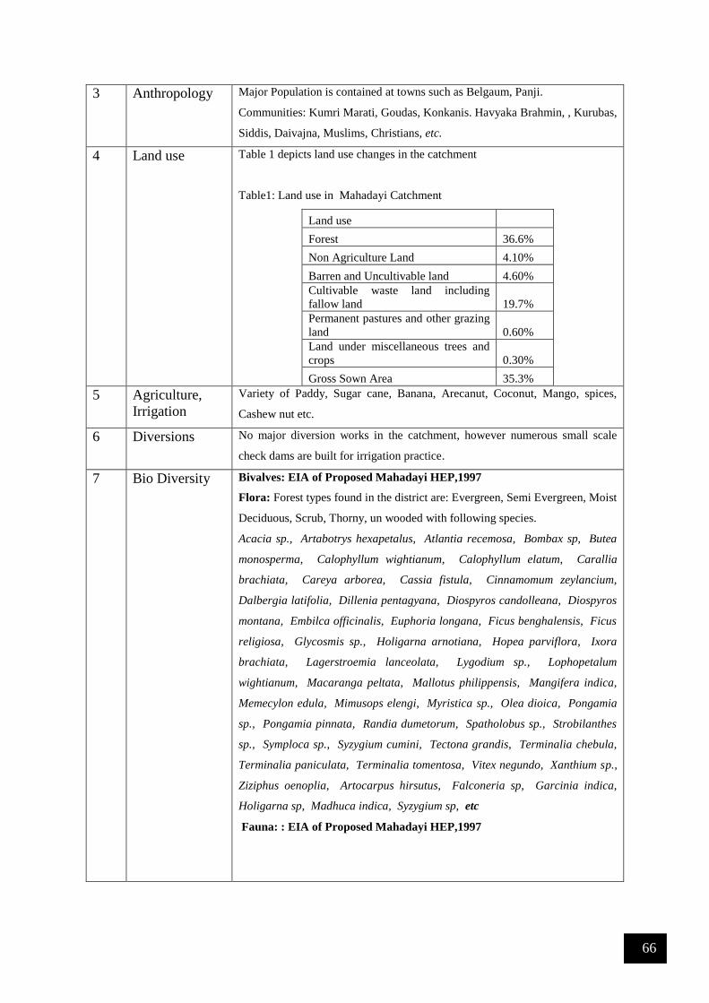
66
3 Anthropology Major Population is contained at towns such as Belgaum, Panji.
Communities: Kumri Marati, Goudas, Konkanis. Havyaka Brahmin, , Kurubas,
Siddis, Daivajna, Muslims, Christians, etc.
4 Land use Table 1 depicts land use changes in the catchment
Table1: Land use in Mahadayi Catchment
Land use
Forest 36.6%
Non Agriculture Land 4.10%
Barren and Uncultivable land 4.60%
Cultivable waste land including
fallow land 19.7%
Permanent pastures and other grazing
land 0.60%
Land under miscellaneous trees and
crops 0.30%
Gross Sown Area 35.3%
5 Agriculture,
Irrigation
Variety of Paddy, Sugar cane, Banana, Arecanut, Coconut, Mango, spices,
Cashew nut etc.
6 Diversions No major diversion works in the catchment, however numerous small scale
check dams are built for irrigation practice.
7 Bio Diversity Bivalves: EIA of Proposed Mahadayi HEP,1997
Flora: Forest types found in the district are: Evergreen, Semi Evergreen, Moist
Deciduous, Scrub, Thorny, un wooded with following species.
Acacia sp., Artabotrys hexapetalus, Atlantia recemosa, Bombax sp, Butea
monosperma, Calophyllum wightianum, Calophyllum elatum, Carallia
brachiata, Careya arborea, Cassia fistula, Cinnamomum zeylancium,
Dalbergia latifolia, Dillenia pentagyana, Diospyros candolleana, Diospyros
montana, Embilca officinalis, Euphoria longana, Ficus benghalensis, Ficus
religiosa, Glycosmis sp., Holigarna arnotiana, Hopea parviflora, Ixora
brachiata, Lagerstroemia lanceolata, Lygodium sp., Lophopetalum
wightianum, Macaranga peltata, Mallotus philippensis, Mangifera indica,
Memecylon edula, Mimusops elengi, Myristica sp., Olea dioica, Pongamia
sp., Pongamia pinnata, Randia dumetorum, Spatholobus sp., Strobilanthes
sp., Symploca sp., Syzygium cumini, Tectona grandis, Terminalia chebula,
Terminalia paniculata, Terminalia tomentosa, Vitex negundo, Xanthium sp.,
Ziziphus oenoplia, Artocarpus hirsutus, Falconeria sp, Garcinia indica,
Holigarna sp, Madhuca indica, Syzygium sp, etc
Fauna: : EIA of Proposed Mahadayi HEP,1997
67
Mammals: Tiger, Black Panther, Leopard, Bison, Gaur, Hare, Wild Boar, Sloth
Bear, Deer, Thar, Bonnet Macaque, Lion Tailed Macaque, Giant Squirrel,
Hanuman Languor, Wroughton’s Freetailed bat (endemic-endangered), Sambar,
Chital, Porcupine, Giant Squirrel, Barking Deer, Mouse Deer,
Reptiles: Snakes (Vipers, Cobra, Rat snake, Crate, King cobra, Python, Wolf
snake, Blind snake, Shield tail snake, Boa, Banded kurki, Russel Kurki snake,
Flying snake, coral snake, Russel viper, rat snake, etc), Monitor Lizard.
9 References 1) Survey of India Topographic Sheets, 1:50000 scale,
http://thesurveyofindia.gov.in
2) Water Resource Information System of India, http://www.india-
wris.nrsc.gov.in.
3) Google Earth, https://www.google.com/earth/.
4) Census of India, 2001 and 2011, http://censusindia.gov.in.
5) Environmental Impact assessment of proposed Mahadayi
Hydroelectric Project, KPCL, Bangalore September 1997

68
12 Bio-monitoring to Assess River Health
Western Ghats is the primary catchment for most of the rivers in peninsular India. Pristine forests in
this region are rich in biodiversity and are being cleared due to unsound developmental activities. This
has given rise to concerns about land use/land cover changes with the realization that land processes
influence climate. Rapid land-use changes have undermined the hydrological conditions, there by
affecting all the components in the hydrological regime. The development programmes based on ad-
hoc decisions, is posing serious challenges in conserving fragile ecosystems. Considerable changes in
the structure and composition of the land use and land cover in the region have been very obvious during
the last four decades. Pressure on land for agriculture, vulnerability of degraded ecosystems to the
vagaries of high intensity of rainfall and high occurrence of steep erosion and landslide-prone areas,
lack of integrated and coordinated land use planning are some of the reasons for rapid depletion of the
natural resource base. These changes have adversely affected the hydrological regime of river basins
resulting in diminished river / stream flows. This necessitates conservation of ecosystems in order to
sustain the biodiversity, hydrology and ecology. In this situation, in order to resolve present problems
and to avoid a future crisis, a comprehensive assessment of land use changes, its spatial distribution and
its impact on hydrological regime was carried out and accordingly, appropriate remedial methods are
being explored for the sustainable utilization of the land and water resources of the catchment.
Figure 1: Study region - Uttara Kannada district with rivers (Source: Energy & Wetlands Research
Group, CES, Indian Institute of Science)

69
Figure 2: River Kali with sampling sites
Figure 3: River Bedthi with sampling sites
Figure 4: River Aghanashini with sampling sites

70
Figure 5: River Sharavathi with sampling sites
A total of 140 diatom taxa were identified across sites (Figure 2-5: River basin wise sampling locations),
61 of them reaching a relative abundance of over 5% in at least one site. The species compositions were
dominated by Gomphonema gandhii Karthick and Kociolek, Achnanthidium minutissimum Kützing,
Achnanthidium sp., Gomphonema sp., Gomphonema parvulum Kützing, Nitzschia palea (Kützing)
W.Smith, Nitzschia frustulum (Kützing) Grunow var. frustulum, Navicula sp., Navicula cryptocephala
Kützing, Cyclostephanos sp., Cymbella sp., Eolimna subminuscula (Manguin) Moser Lange-Bertalot
and Metzeltin, Sellaphora pupula (Kützing) Mereschkowksy, Eunotia minor (Kützing) Grunow in Van
Heurck, Nitzschia amphibian Grunow f. amphibia, Cyclotella meneghiniana Kützing, Gomphonema
difformum Karthick and Kociolek, Navicula rostellataKützing, Cocconeis placentula Ehrenberg var.
euglypta (Ehr.) Grunow, Brachysira sp., Stauroneis sp., Encyonema minutum (Hilse in Rabh.) D.G.
Mann, Cyclotella sp. and Nitzschia sp. The species composition contains cosmopolitan to possible
Western Ghats endemic species and in general species from oligotrophy to highly eutrophic condition
were also observed. The current study also documents some of the species for the first time in Western
Ghats and many new species descriptions are underway. In some sampling locations, water quality
show tendency towards alkalinity in the streams drained from agriculture and urban catchment. The
highest ionic and nutrient values correspond to the agriculture catchment dominated streams,
particularly in the leeward side of the mountains. Oxygenation was generally close to saturation; the
lowest values are due to wastewater water inflows in few localities. Streams closer to industries and
city reflect higher amount of nutrients and is reflected by pollution tolerant tax (Figure 6). The most
oligotrophic sites were located in mountain watercourses, while downstream sites were generally more
polluted, becoming eutrophic in condition. The detailed water chemistry variables are presented in
Table 1 (Source: Ramachandra T V, Subash Chandran M.D., Joshi N V, Karthick B and Vishnu D. Mukri, 2015.
Ecohydrology of Lotic Ecosystems of Uttara Kannada, Central Western Ghats, In: Ramkumar, M.,
Kumaraswamy, K. and Mohanraj, R. (Eds.). Environmental management of River Basin ecosystems, Springer
Earth System Sciences, DOI 10.1007/978-3-319-13425-3_29).

71
Table 1: water chemistry variables in 45 sites (streams) across river basins
Variables Mean Std. dev Median Min Max
pH 7.22 0.49 7.14 6.03 8.16
WT (C) 25.31 2.70 25.07 19.00 33.00
EC (µScm-1) 160.55 207.10 107.67 41.55 1164.67
TDS (mg L-1) 122.24 204.98 60.30 20.88 1299.67
Alkalinity (mg L-1) 54.55 50.32 30.00 6.81 180.00
Chlorides (mg L-1) 32.39 40.40 22.72 5.90 220.24
Hardness (mg L-1) 51.26 71.05 28.00 10.00 348.00
Calcium (mg L-1) 13.88 16.14 8.02 1.60 78.56
Magnesium (mg L-1) 16.35 16.73 9.36 1.17 65.95
DO (mg L-1) 6.96 1.68 7.23 2.93 10.87
Phosphates (mg L-1) 0.36 0.56 0.04 0.00 2.30
Nitrates (mg L-1) 0.74 1.10 0.13 0.03 4.30
Sulphates (mg L-1) 25.73 20.84 16.87 0.00 74.10
Sodium (mg L-1) 25.77 72.18 9.09 4.11 370.00
Potassium (mg L-1) 6.33 15.72 1.30 0.19 75.00
The species composition contains cosmopolitan to possible Western Ghats endemic species and in
general species from oligotrophy to highly eutrophic condition were also observed. Among the species
observed in this study, two species were possibly endemic to Western Ghats (G. gandhii, G. difformum
and few other species yet to identify). In few sites these species were very dominant reaching more than
80% of the total assemblages. The remaining dominant taxa were cosmopolitan and well documented
in international literatures (Krammer and Lange Bertalot, 1986-1991). It is important to note that the
indices that were developed and tested in European rivers, lacks Western Ghats endemic taxa. Most
sites were oligo-mesotrophic and only a few of the streams were eutrophic. The differences in the water
quality of these rivers were reflected in the values for the diatom indices, by the relative abundances of
indicators of trophic/saprobic stage and by different types of diatom community.
Diatom Assemblages: Among the 113 taxa the most common and dominant diatom taxa are Eolimna
subminuscula, Achnanthidium sp., Navicula sp., Nitzschia palea, Gomphonema parvulum,
Gomphonema sp., Gomphonema gandhii, Achnanthidium minutissima and Cyclostephanos sp. Species
richness varied from 4 to 29 with an average of 15. Shannon-Wiener diversity varied from 0.71 to 2.94

72
with an average of 1.76. According to the pH classification, diatom assemblages were characterized by
a high proportion of neutrophilous diatom species (64.62%) followed by alcaliphilous species (26.64%).
Salinity classification based on the diatom species assemblages infer the fresh to brackish water species
were the dominant form with 86.16% followed by brackish to freshwater (7.84%) and exclusively
freshwater (5.3%) flora.
Nitrogen autotrophic taxa, which tolerate elevated concentrations of organically bound nitrogen, were
dominant with 53.31%. Species which require 100% oxygen saturation were prevailing community
with 42.98% followed by low level (30% oxygen saturation) oxygen requirement species by 29.08%.
The composition of diatom community with respect to saprobity in the order or oligosaprobous, β-
mesosaprobous, α-mesosaprobous, α-meso-/polysaprobous and polysaprobous were 7.8%, 46.09%,
10.58%, 26.56% and 8.97% respectively. The species occurs in the eutraphentic and oligo to
eutraphentic were equally dominant with respect to the trophic state explained by diatoms.
Figure 6: Pollution status in the rivers of Uttara Kannada
HIGHLY POLLUTED
POLLUTED
NO POLLUTION
Arabian
Sea
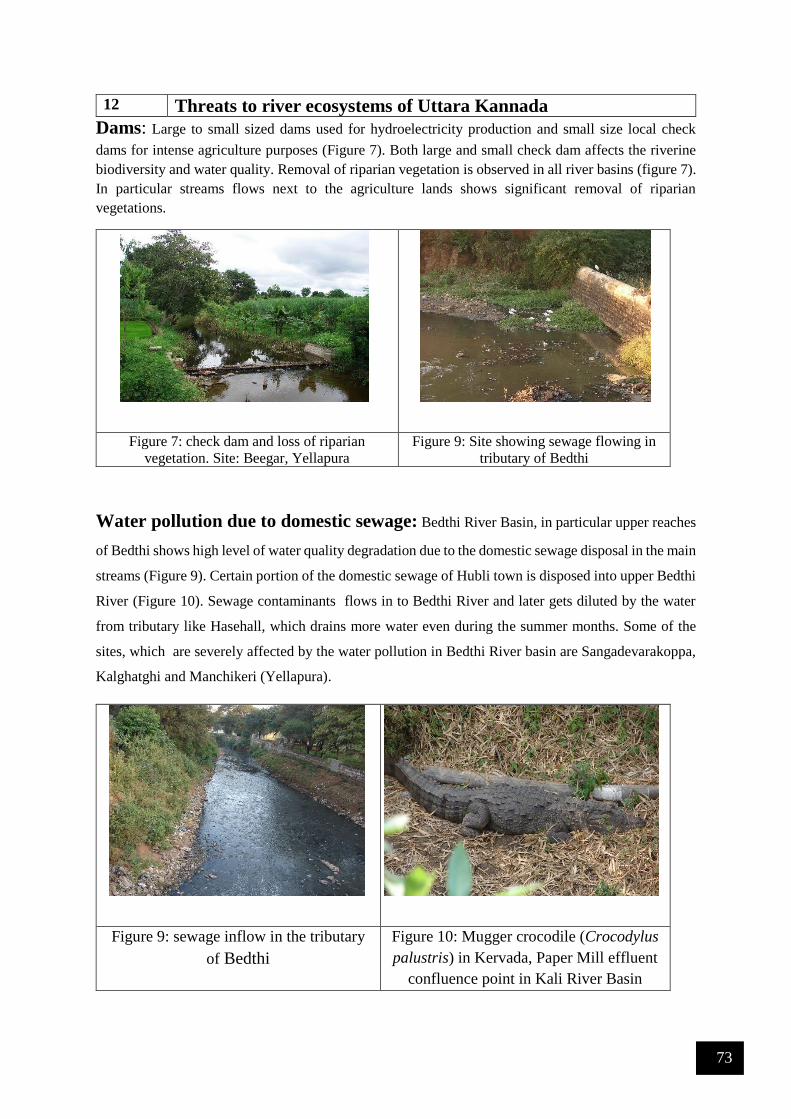
73
12 Threats to river ecosystems of Uttara Kannada Dams: Large to small sized dams used for hydroelectricity production and small size local check
dams for intense agriculture purposes (Figure 7). Both large and small check dam affects the riverine
biodiversity and water quality. Removal of riparian vegetation is observed in all river basins (figure 7).
In particular streams flows next to the agriculture lands shows significant removal of riparian
vegetations.
Figure 7: check dam and loss of riparian
vegetation. Site: Beegar, Yellapura
Figure 9: Site showing sewage flowing in
tributary of Bedthi
Water pollution due to domestic sewage: Bedthi River Basin, in particular upper reaches
of Bedthi shows high level of water quality degradation due to the domestic sewage disposal in the main
streams (Figure 9). Certain portion of the domestic sewage of Hubli town is disposed into upper Bedthi
River (Figure 10). Sewage contaminants flows in to Bedthi River and later gets diluted by the water
from tributary like Hasehall, which drains more water even during the summer months. Some of the
sites, which are severely affected by the water pollution in Bedthi River basin are Sangadevarakoppa,
Kalghatghi and Manchikeri (Yellapura).
Figure 9: sewage inflow in the tributary
of Bedthi
Figure 10: Mugger crocodile (Crocodylus
palustris) in Kervada, Paper Mill effluent
confluence point in Kali River Basin

74
Industrial Pollution: Kali River Basin is under the influence of industrialization in Uttara
Kannada, in particular Dandeli region with polluting industries. The West Coast Paper Mills Ltd
situated in the bank of River Kali pollutes the water and surrounding riparian environment by letting
partially treated or untreated effluents into the river. Kervada village, next to Dandeli witness severe
water and air pollution due to the effluent of paper mill. Paper mill waste increases total dissolved and
suspended solids, turbidity and ionic content. In addition to the effluents the river also receives sewage.
Organic waste let in to the river decreases the dissolved oxygen, which eventually causes threat to
aquatic biodiversity. Site where confluence of sewage is also witnessed soaring population of Mugger
crocodiles (Figure 10) resulting in the higher instances of human wildlife conflicts.
Sand Mining: Sand mining is one of the common problems observed in lower reaches of all the
river basins (Figure 11). Sand mining is predominant in brackish water region of Kali and Sharavathi
River Basins, where mechanized sand mining is in practice for a while. Sand mining cause severe threat
to the benthic organisms. Most of the marine and esturine benthic organisms breed in brackish regions
faces severe threat due to the mechanized sand mining. Mangrove regions in Kali estuary is also
threatened by sand mining due to loss or alteration of habitat.
Figure 11: Mechanized sand mining in Kali River Basin
Table 2 lists the river basin wise threats with the appropriate mitigation measures to enhance the
functional aspects of aquatic ecosystems.
75
Table 2: Threats and Mitigation Measures
River Basin Region Problem Remedial Measures
Kali Dandeli Paper mill effluent Enforce effluent treatment by the
industry (implementation of the control
of water pollution, Polluter pays
principle)
Kali Ramnagar Non-point source
pollution in
streams and rivers
from Agriculture fields
Avoiding intense use of chemical
fertilizers and pesticides
Kali Honkon
(Brackish)
Mechanized sand
mining
Stopping of sand mining in certain
ecologically sensitive region and
regulated sand mining in selected
localities
Bedthi Sangdevarkoppa Non-point source
pollution
Avoiding intense use of chemical
fertilizers and pesticides
Bedthi Kalghatghi Urban domestic
sewage, non-point
source pollution
Implementation of sewage treatment
plant in Hubli town. Sewage should be
treated before letting in to the river.
Bedthi Kalghatghi Solid Waste Disposal
in River
Setting up Solid waste treatment and
landfill facility in outskirts of Hubli
town.
Manchikeri Urban domestic
sewage, non-point
source pollution
Implementation of sewage treatment
plant in Hubli town. Sewage should be
treated before letting in to the river.
Sharavathi Gerusoppa and
downstream
Mechanized sand
mining
Stopping of sand mining in certain
ecologically sensitive region and
regulated sand mining in selected
localities
References
1. Ramachandra T V, Subash Chandran M.D., Joshi N V, Karthick B and Vishnu D. Mukri, 2015.
Ecohydrology of Lotic Ecosystems of Uttara Kannada, Central Western Ghats, In: Ramkumar, M.,
Kumaraswamy, K. and Mohanraj, R. (Eds.). Environmental management of River Basin ecosystems,
Springer Earth System Sciences, DOI 10.1007/978-3-319-13425-3_29
2. Ramachandra, T.V. 2014. Hydrological Responses at Regional Scale to Landscape Dynamics, J
Biodiversity, 5(1,2): 11-32.
3. Ramachandra T V, Vinay S, Bharath Settur and Bharath H. Aithal, 2017. Profile of Rivers in Karnataka,
ENVIS Technical Report 129, Sahyadri Conservation Series 71, Energy & Wetlands Research Group,
CES, Indian Institute of Science, Bangalore 560012

76
River Aghanashini

77
River Cauvery

78
River Gangavali

79
River Kali

80
River Krishna

81
River Sharavathi

82
River Varada

83
River Venkatapura