Environment Seabed Beach (ESB).pdf
112
NORTH ATLANTIC TREATY ORGANISATION (NATO) ADDITIONAL MILITARY LAYERS ENVIRONMENT SEABED & BEACH PRODUCT SPECIFICATION Version 2.1, 1 November 2005 Produced and issued by the United Kingdom Hydrographic Office under the direction of the Geo-spatial Maritime Working Group of the NATO Geographic Conference. © UKHO 2005 ALL RIGHTS RESERVED The copyright in this document, which contains information of a proprietary nature, is vested in UKHO. The contents of this document may not be used for purposes other than that for which it has been supplied.
-
Upload
khangminh22 -
Category
Documents
-
view
2 -
download
0
Transcript of Environment Seabed Beach (ESB).pdf
NORTH ATLANTIC TREATY ORGANISATION
(NATO)
ADDITIONAL MILITARY LAYERS ENVIRONMENT SEABED & BEACH
PRODUCT SPECIFICATION Version 2.1, 1 November 2005
Produced and issued by the United Kingdom Hydrographic Office under the direction of the Geo-spatial Maritime Working
Group of the NATO Geographic Conference. © UKHO 2005
ALL RIGHTS RESERVED The copyright in this document, which contains information of a proprietary nature, is vested in UKHO. The
contents of this document may not be used for purposes other than that for which it has been supplied.

Additional Military Layers Environment Seabed & Beach Product Specification
Page 2 of 112 Version 2.1
Document Control ISSUE Date Author Issue Summary of Changes
1/11/01 AML 1.0 No prior version 31/07/04 B Parish 2.0 Includes amendments to AML
ESB Product Specification approved by AHHWG-9 & AHHWG-10
1/11/05 B Parish 2.1 Amended in response to industry review & GMWG-3 approval
APPROVALS Approver and Title Signature Date Chairman Geo-spatial Maritime Working Group
21/10/05
VERSION CONTROL Version Review Date Reviewed By
FILE DETAILS Component Name & Location Tool Document text J:\AML\Specification\Specifications\ ESB \ ESB PS
2.1 MS Word
Correspondence and hard copy
HA/351/002/013 N/A
Additional Military Layers Environment Seabed & Beach Product Specification
Page 3 of 112 Version 2.1
Contents Contents ........................................................................................................................................................................................ 3 1 INTRODUCTION............................................................................................................................................................. 5
1.1 SCOPE.......................................................................................................................................................................... 5 1.2 GENERAL INFORMATION ON THE PRODUCT SPECIFICATION.......................................................... 5
1.2.1 Version Number ............................................................................................................................................... 5 1.2.2 Date of Issue...................................................................................................................................................... 5 1.2.3 Custodian of the Product Specification ........................................................................................................ 5 1.2.4 Relevant STANAG Number .......................................................................................................................... 5
1.3 STATUS OF THE PRODUCT SPECIFICATION .............................................................................................. 6 1.4 SECURITY.................................................................................................................................................................. 6
1.4.1 Security Classification of the Specification................................................................................................. 6 1.4.2 Security Classification of the Product .......................................................................................................... 6 1.4.3 Copyright Statement ........................................................................................................................................ 6
1.5 CONTENTS OF THE DOCUMENT...................................................................................................................... 6 1.6 REFERENCES............................................................................................................................................................ 7
1.6.1 Standards........................................................................................................................................................... 7 1.6.2 Specifications.................................................................................................................................................... 8 1.6.3 Other References .............................................................................................................................................. 8
1.7 DEFINITIONS ............................................................................................................................................................ 8 1.8 KEY WORDS ............................................................................................................................................................. 8 1.9 MAINTENANCE AND SUPPORT OF THE PRODUCT SPECIFICATION ............................................... 8
1.9.1 Frequency of Review....................................................................................................................................... 8 1.9.2 Method of Maintenance.................................................................................................................................. 9 1.9.3 Method of Promulgation................................................................................................................................. 9 1.9.4 Authority Responsible for Maintenance ...................................................................................................... 9 1.9.5 Error Reporting/Change Request Procedure ............................................................................................... 9 1.9.6 Available Support............................................................................................................................................. 9
2 GENERAL PRODUCT DESCRIPTION.................................................................................................................... 10 2.1 MAINTENANCE OF THE DATA PRODUCT ................................................................................................. 10 2.2 SUPPORT FOR MULTIPLE MODES OF OPERATION................................................................................ 10 2.3 GEOGRAPHIC ORGANISATION ...................................................................................................................... 11
2.3.1 Regional Scheme ............................................................................................................................................ 11 2.3.2 Tiling Scheme ................................................................................................................................................. 11
2.4 LAYER ORGANISATION.................................................................................................................................... 11 2.5 EXCHANGE STANDARD IMPLEMENTATION........................................................................................... 11
2.5.1 Spatial Data Type........................................................................................................................................... 11 2.5.2 Level of Topology.......................................................................................................................................... 11 2.5.3 Relationship with Layering .......................................................................................................................... 11 2.5.4 Textual Information ....................................................................................................................................... 11 2.5.5 Reference to External Files .......................................................................................................................... 11
2.6 SIZING REQUIREMENTS.................................................................................................................................... 12 2.7 GENERAL SOURCE DESCRIPTION ................................................................................................................ 12
2.7.1 Minimum Source Requirements.................................................................................................................. 12 2.7.2 Applicable Sources ........................................................................................................................................ 12
3 GENERAL DATA DESCRIPTION ............................................................................................................................ 13 3.1 DATUMS................................................................................................................................................................... 13
3.1.1 Horizontal Datum........................................................................................................................................... 13 3.1.2 Vertical Datums .............................................................................................................................................. 13
3.2 UNITS......................................................................................................................................................................... 13 3.2.1 Time .................................................................................................................................................................. 13
3.3 CO-ORDINATE SYSTEM ..................................................................................................................................... 13 3.4 PROJECTION........................................................................................................................................................... 14 3.5 LANGUAGE AND CHARACTER SETS........................................................................................................... 14
3.5.1 Language ......................................................................................................................................................... 14 3.5.2 Character Sets ................................................................................................................................................. 14
Additional Military Layers Environment Seabed & Beach Product Specification
Page 4 of 112 Version 2.1
3.6 DATA QUALITY .................................................................................................................................................... 14 3.6.1 Accuracy.......................................................................................................................................................... 14 3.6.2 Up-to-Dateness/Currency ............................................................................................................................. 14 3.6.3 Source(s) of the data...................................................................................................................................... 15 3.6.4 Completeness for the Product Specification.............................................................................................. 15 3.6.5 Geometric Validation .................................................................................................................................... 15
4 DATA STRUCTURE ..................................................................................................................................................... 16 5 DATA DICTIONARY.................................................................................................................................................... 17
5.1 GENERAL GUIDELINES ..................................................................................................................................... 17 5.2 UNKNOWN/MISSING ATTRIBUTE VALUES .............................................................................................. 17 5.3 USE OF META INFORMATION......................................................................................................................... 17 5.4 EXTERNAL REFERENCING .............................................................................................................................. 21 5.5 SCHEMA ................................................................................................................................................................... 21
5.5.1 Features............................................................................................................................................................ 22 5.5.2 Attributes ......................................................................................................................................................... 40 5.5.3 Relationships Between Features................................................................................................................106
6 DATA CAPTURE GUIDELINES .............................................................................................................................108 6.1 CONTINUITY........................................................................................................................................................108 6.2 GUIDANCE ON FEATURE CODING........................................................................................................108
7 DATA PRESENTATION............................................................................................................................................109 7.1 SCOPE......................................................................................................................................................................109
8 PROVISION OF DATA...............................................................................................................................................110 8.1 GENERAL...............................................................................................................................................................110
8.1.1 File Format (Encapsulation).......................................................................................................................110 8.1.2 Auxiliary Information..................................................................................................................................110
8.2 DISTRIBUTION MEDIA .....................................................................................................................................110 8.3 VOLUME NAMING.............................................................................................................................................110 8.4 FILE NAMING.......................................................................................................................................................110 8.5 DIRECTORY STRUCTURE ...............................................................................................................................110 8.6 ERROR DETECTION...........................................................................................................................................110 8.7 COMPRESSION.....................................................................................................................................................110 8.8 ENCRYPTION........................................................................................................................................................110 8.9 HARDWARE AND SOFTWARE REQUIREMENTS...................................................................................111
9 TESTING METHOD....................................................................................................................................................112
Additional Military Layers Environment Seabed & Beach Product Specification
Page 5 of 112 Version 2.1
1 INTRODUCTION
1.1 SCOPE The main body of this Product Specification describes the content and defines the data dictionary of the AML Environment Seabed & Beach (ESB) product, independent of any exchange standard data format. The schema and data format imposed by the chosen exchange standard implementation are defined in separate annexes (where provided). It has been prepared in accordance with NATO STANAG 7170, Additional Military Layers and the draft NATO STANAG 4564, Performance Standards for Warship Electronic Chart Display and Information System (WECDIS) Data Products. It is based on the proposed Common Product Specification Framework (CPSF) which is contained as Annex B to the draft STANAG 4564. The ESB Product Specification is designed to facilitate the encoding of the following AML components: · High resolution seabed texture information for MCM purposes · Features related to amphibious operations, the landward limit of which being the
beach exits, including any significant objects such as lights and landmarks useful to align oneself onto and when on the beach.
AML ENVIRONMENT SEABED & BEACH MUST NOT BE USED IN ISOLATION
FOR NAVIGATIONAL PURPOSES
1.2 GENERAL INFORMATION ON THE PRODUCT SPECIFICATION
1.2.1 Version Number 2.1
1.2.2 Date of Issue 1 November 2005
1.2.3 Custodian of the Product Specification The Custodian of this specification is the United Kingdom Hydrographic Office: United Kingdom Hydrographic Office Admiralty Way Taunton Somerset TA1 2DN Telephone: +44(0) 1823 337900 Fax: +44(0) 1823 284077 E-mail:[email protected]
1.2.4 Relevant STANAG Number NATO STANAG No.7170 Additional Military Layers (AML).
Additional Military Layers Environment Seabed & Beach Product Specification
Page 6 of 112 Version 2.1
1.3 STATUS OF THE PRODUCT SPECIFICATION This product specification has been endorsed by the Geo-spatial Maritime Working Group of the NATO Geographic Conference and is subject to the change control procedures implemented by that group.
1.4 SECURITY
1.4.1 Security Classification of the Specification The Product Specification is UNCLASSIFIED.
1.4.2 Security Classification of the Product AML ESB can be issued at various security classification levels according to content. AML ESB products of differing security levels (specified at the dataset level by the ‘Protective Marking’ and ‘Caveat’ details) are physically partitioned. The table at section 5.3 contains details of how AML ESB security classification information must be described in this product.
1.4.3 Copyright Statement Producers of AML datasets must ensure that: • the Intellectual Property Rights of those owning the information that has been
used for production of the AML product is not compromised. • sufficient mechanisms are put in place to ensure that material is not copied either
in whole or part, except as specifically required within the host system, without prior agreement of the data producer and any other copyright holders
Copyright statements should be shown at the following locations: • on the product label • on the product packaging • within the product
1.5 CONTENTS OF THE DOCUMENT The AML ESB Product Specification defines the real-world features, attributes and metadata required for the production and use of the product. It is laid out as described in the table of contents. Also included, as annexes to the product specification, are details of the implementation using the relevant exchange standard(s). Each annex (if included) is identified as follows: • AML ESB S-57 Implementation (ANNEX A) • AML ESB DIGEST-C Implementation (ANNEX B) A cross-reference in the text will be included for instances when there are relevant details in one or more of the implementation annexes.
Additional Military Layers Environment Seabed & Beach Product Specification
Page 7 of 112 Version 2.1
1.6 REFERENCES The following standards and specifications affect the content of this Product Specification.
1.6.1 Standards NATO STANAG 1059 (Edition 6) Distinguishing Letters for Geographical Entities for use in
NATO. NATO STANAG 2211 Geodetic Datums, Ellipsoids, Grids & Grid References NATO STANAG 7170 Additional Military Layers. NATO STANAG 4564 Standard for Warship Electronic Chart Display and
Information System (WECDIS), Edition 1, Annex B, Data Products.
NATO STANAG 7074 Digital Geographic Information Exchange Standard
(DIGEST), Edition 2.1, September 2000. Part 1: General Description
Part 2: Theoretical Model, Exchange Structure and Encapsulation Specifications, Annex C – Vector Relational Format (VRF) Encapsulation Specification.
Part 3: Codes, Parameters and Tags Part 4: Feature and Attribute Coding Catalogue (FACC) S-57 IHO Transfer Standard for Digital Hydrographic Data,
Edition 3.1, November 2000 Appendix A: Chapter 1, Object Classes Annex A - IHO Codes for Producing Agencies Chapter 2, Attributes Annex B - Attributes/Object Classes Cross Reference
S-52 Specifications for Chart Content and Display Aspects of
ECDIS 5th Edition, dated December 1996 (amended March 1999)
Appendix 1 Guidance on Updating the Electronic Navigational Chart ISO 8859 Information processing - 8-bit single-byte coded graphic
character sets Part 1: Latin alphabet No.1 ISO 9660 Information Processing - Volume and File Structure of CD-
ROM for Information Interchange.
Additional Military Layers Environment Seabed & Beach Product Specification
Page 8 of 112 Version 2.1
ANSI/IEEE 802.3 IEEE Standards for Local Area Networks, Carrier Sense Multiple Access with Collision Detection (CSMA/CD) Access Method and Physical Layer Specifications
ISO/IEC 8211 Information processing - Specification for a data descriptive
file for information interchange ISO/IEC 10646 Information technology - Universal Multiple-Octet Coded
Character Set (UCS) Part 1: Architecture and Basic Multilingual Plane
1.6.2 Specifications MIL-PRF-0089049 General Performance Specification, Vector Product
Format (VPF) Products, dated 24 November 1998 MIL-STD-2407 Interface Standard for Vector Product Format, dated
28 June 1996 The Open GIS Abstract Open GIS Consortium. Topic 9: Quality Version 4 Specification 1999 S-57 Edition 3.1 Appendix B.1: ENC Product
Specification
1.6.3 Other References AML Feature and Attribute Catalogue
1.7 DEFINITIONS AML AML is a unified range of digital geospatial data products designed
to satisfy the totality of NATO non-navigational maritime defence requirements.
1.8 KEY WORDS AML Additional Military Layers ESB Environment Seabed & Beach Product Specification
1.9 MAINTENANCE AND SUPPORT OF THE PRODUCT SPECIFICATION Specific processes and mechanisms that are established for the maintenance of AML Product Specifications are described in the sections 1.9.1 to 1.9.6 below.
1.9.1 Frequency of Review The AML ESB Product specification (version 2.0) will be frozen for a period of 2 years following endorsement.
Additional Military Layers Environment Seabed & Beach Product Specification
Page 9 of 112 Version 2.1
1.9.2 Method of Maintenance Corrections, clarifications and requests for change will be administered by the custodian. Discussion regarding proposed changes will be carried out by correspondence with national Points of Contact. Consolidated maintenance documents will be issued periodically containing published corrections and clarifications together with details of agreed extensions to the object catalogue (these will be formally incorporated into the Product Specification and become live at its next revision). Changes to the Product Specification beyond extensions to the object catalogue will be reviewed by committee1 during preparatory work for production of the next edition of the specification.
1.9.3 Method of Promulgation Maintenance documents, new editions of specifications, and related documentation will be sent to nations through their appointed AML point of contact.
1.9.4 Authority Responsible for Maintenance AML Product Specifications will be maintained by the Custodian specified in section 1.2.3.
1.9.5 Error Reporting/Change Request Procedure Comments concerning the content of the AML Product Specifications and requests for change should be addressed to the Custodian.
1.9.6 Available Support Contact the Custodian for guidance and advice relating to this product specification.
1 Will be a specific group reporting to the AHHWG or its successor.

Additional Military Layers Environment Seabed & Beach Product Specification
Page 10 of 112 Version 2.1
2 GENERAL PRODUCT DESCRIPTION PRODUCT TITLE Additional Military Layers – Environment Seabed & Beach. SHORT TITLE ESB REFERENCE NATO STANAG No.7170 (Additional Military Layers). NATO STANAG No. 4564 (Performance Standards for Warship Electronic Chart Display and Information System (WECDIS), Edition 1, Annex B, Data Products.
2.1 MAINTENANCE OF THE DATA PRODUCT The frequency and method of provision of update or replacement data will be defined by each AML producing agency.
2.2 SUPPORT FOR MULTIPLE MODES OF OPERATION AML ESB data is compiled for a variety of purposes to support MCM and amphibious operations, humanitarian operations, non-combatant operations and Joint Logistics over The Sea (JLOTS). It may therefore be compiled and made available at the scale bands shown in the following tables.
SCALE BAND DATA COMPILATION SCALE 1 < 1:100,000,000 2 1: 25,000,000 3 1: 5,000,000 4 1: 1,000,000 5 1:250,000 6 1:50,000 7 1:10,000 8 1:2,500 9 > 1:1,600
Data may be used or displayed in information systems at a range of scales as shown in the following table.
SCALE BAND DISPLAY SCALE RANGE 1 < 1:40,000,000 2 1: 10,000,000 - 1:62,500,000 3 1: 2,000,000 - 1:12,500,000 4 1:400,000 - 1: 2,500,000 5 1:100,000 - 1:625,000

Additional Military Layers Environment Seabed & Beach Product Specification
Page 11 of 112 Version 2.1
SCALE BAND DISPLAY SCALE RANGE 6 1:20,000 - 1:125,000 7 1:4,000 - 1:25,000 8 1:1,000 - 1:6,250 9 > 1:1,500
2.3 GEOGRAPHIC ORGANISATION
2.3.1 Regional Scheme AML products will be partitioned by geographic region. This will vary widely depending upon the scale band of the product and the density of the data.
2.3.2 Tiling Scheme See appropriate annex.
2.4 LAYER ORGANISATION The content of the product is not layered. However, specific exchange standards may impose their own internal layering requirements.
2.5 EXCHANGE STANDARD IMPLEMENTATION This product specification has been written to be independent of the exchange standard used. Details of exchange standard implementations are given in the relevant annex.
2.5.1 Spatial Data Type AML ESB contains spatial objects as vector data.
2.5.2 Level of Topology See appropriate annex.
2.5.3 Relationship with Layering See appropriate annex.
2.5.4 Textual Information Attributes that contain free text must not be used when it is possible to encode the information by means of any other attribute.
2.5.5 Reference to External Files Text and picture files may also be included in the AML product to provide additional information. Below are examples of potential formats. • ASCII • TIFF • PDF • HTML • JPEG
Additional Military Layers Environment Seabed & Beach Product Specification
Page 12 of 112 Version 2.1
• AVI • MPEG
2.6 SIZING REQUIREMENTS Data producers should partition datasets such that the screen refresh time in the receiving display system is acceptable to users. This will vary between data types and receiving systems. At present 5Mb is a recommended file size maximum for vector data in WECDIS type display systems.
2.7 GENERAL SOURCE DESCRIPTION
2.7.1 Minimum Source Requirements Sources for any real-world feature detailed in section 5.5.1 meet the following requirements • the data capture point-density fulfils the data capture requirements appropriate to the
scale bands specified in section 2.2 • mandatory features specified in section 5.5.1.1 are included • the mandatory attribution levels for each object, specified in section 5.5.1, are met
2.7.2 Applicable Sources All sources used must meet the minimum requirements. Wherever available, sources which provide exact definitions of entities e.g. geographical co-ordinates should be used in preference to digitising from graphical representations.
Additional Military Layers Environment Seabed & Beach Product Specification
Page 13 of 112 Version 2.1
3 GENERAL DATA DESCRIPTION
3.1 DATUMS Please refer to NATO STANAG 2211 - Geodetic Datums, Ellipsoids, Grids & Grid References, which establishes the NATO guidelines to the use of horizontal and vertical datums.
3.1.1 Horizontal Datum The horizontal datum for the AML ESB is the World Geodetic System 1984 (WGS 84).
3.1.2 Vertical Datums 3.1.2.1 Height Datum The default height datum for the AML ESB is specified in the metadata of the dataset. The default height datum can be varied by the use of lower level metadata or feature level attribution. 3.1.2.2 Sounding Datum The default sounding datum for AML ESB is specified in the metadata of the dataset. The default sounding datum can be varied by the use of lower level metadata or feature level attribution.
3.2 UNITS The default units to be used in AML ESB are: • Position: latitude and longitude in decimal degrees • Depth: metres • Height: metres • Length/width: metres • Positional accuracy: metres • Distance: nautical miles or metres The default units can be varied by the use of lower level metadata or feature level attribution.
3.2.1 Time AML may contain attributes used to encode time e.g. the beginning and end of an active period for an object. When using these attributes all times should be encoded as Coordinated Universal Time (UTC). ISO 8601 states that the format for UTC time should be CCYYMMDDThhmmssZ (where ’T’ is a separator). However, AML attributes that encode time using the ISO 8601 format DO NOT include the ’Z’ and they should all be interpreted as UTC.
3.3 CO-ORDINATE SYSTEM The co-ordinate system used by AML ESB is Latitude and Longitude. These will be recorded as: Positive values: Used for latitudes north of the equator and longitudes east of the Greenwich Meridian. Negative values: are used for latitudes south of the equator and longitudes west of the Greenwich Meridian.

Additional Military Layers Environment Seabed & Beach Product Specification
Page 14 of 112 Version 2.1
3.4 PROJECTION AML ESB is based upon geographical co-ordinates and is not projected.
3.5 LANGUAGE AND CHARACTER SETS
3.5.1 Language The exchange language used by AML ESB is English.
3.5.2 Character Sets ISO 8859-1 supports English and most European languages. For those languages that it does not support ISO/IEC 10646 sha ll be used.
3.6 DATA QUALITY AML ESB data quality information should be encoded at an appropriate level, as specified by the exchange standard implementation. AML data quality information encompasses the following categories: • Accuracy • Up-to-dateness/currency • Source(s) of the data • Completeness for the Product Specification Data quality information defined for AML ESB can be encoded in the dataset as: • dataset metadata • meta information features2 • feature attributes See section 5.3
3.6.1 Accuracy Where applicable, the maximum two-dimensional error of AML data should be stated. All positional accuracy figures are cumulative and allow for: • the accuracy of the original data • additional errors introduced by the AML production process If applicable, the cumulative error should be stated for the following: • Horizontal Accuracy • Sounding Accuracy • Vertical (Height) Accuracy
3.6.2 Up-to-Dateness/Currency Where applicable, currency information should specify the up-to-dateness of the AML dataset(s). This information should include: • issue date • update date3 2 Only applicable if supported by the exchange standard implementation 3 Only applicable if updating is supported by the exchange standard implementation
Additional Military Layers Environment Seabed & Beach Product Specification
Page 15 of 112 Version 2.1
3.6.3 Source(s) of the data Where available, AML source information should include the following details: • authority (e.g. data provider) • source type (e.g. graphic or report) • source ID • source date
3.6.4 Completeness for the Product Specification AML products may be produced to fulfil operational requirements, and therefore, may not contain all the meta data, features or attributes included in this Product Specification. All AML datasets must specify instances when: • all available data/information has been encoded. Missing data means that the
information is not available • only specified/required data/information is encoded
3.6.5 Geometric Validation All data produced for AML ESB must be validated for geometric anomalies.
Additional Military Layers Environment Seabed & Beach Product Specification
Page 16 of 112 Version 2.1
4 DATA STRUCTURE Refer to the appropriate implementation annex for details of specific implementation, format, and structure.
Additional Military Layers Environment Seabed & Beach Product Specification
Page 17 of 112 Version 2.1
5 DATA DICTIONARY
5.1 GENERAL GUIDELINES This section provides real-world descriptions for the metadata and features contained within the AML ESB dataset. Details of how this information is to be encoded (e.g. using the chosen Exchange Standard) can be found in the tables contained in the relevant implementation annexes.
5.2 UNKNOWN/MISSING ATTRIBUTE VALUES The way in which an unknown or missing attribute value is handled is dependent upon the exchange standard implemented.
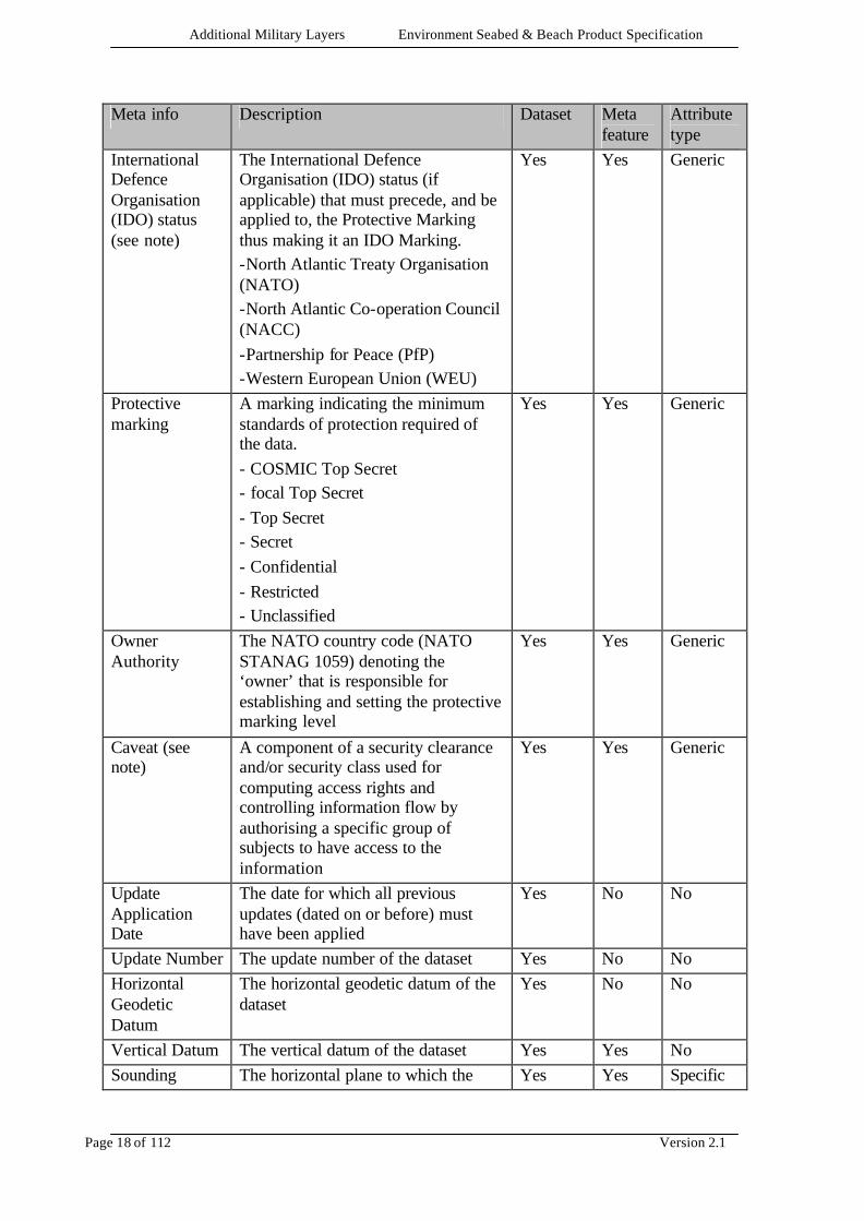
5.3 USE OF META INFORMATION AML datasets contain the following meta- information, the information may be encoded at the levels in the dataset indicated in the following table depending upon the capability of the exchange standard used. Column four indicates the requirement for a feature whose sole purpose is the encoding of meta information. Column five indicates the nature of the meta attribute, where they exist. Meta attributes are either Generic or Specific as indicated. For details of how to represent the metadata described, refer to the appropriate exchange standard implementation annex. All meta information encoded at Dataset and or Meta feature levels in the following table are mandatory. Meta info Description Dataset Meta
feature Attribute type
Production Agency
The agency responsible for the production of the AML data (IHO Codes for Producing Agencies)
Yes Yes Generic
Dataset Name The name of the dataset Yes No No Edition Number The edition number of the dataset Yes No No Date of Release The date of the dataset was made
available by the AML data producer (e.g. edition or revision date)
Yes No No
Product Specification Description
The name of the AML Product Specification to which the dataset conforms (see section 2)
Yes No No
Product Specification Version Number
The version number of the AML Product Specification to which the dataset conforms (section 1.2.1)
Yes No No
Product Scale Band
The usage application scale-band of the AML dataset (see section 2.2)
Yes No No
Compilation Scale
The scale at which the AML data was compiled (see compilation scale band table in section 2.2)
Yes Yes Generic
Additional Military Layers Environment Seabed & Beach Product Specification
Page 18 of 112 Version 2.1
Meta info Description Dataset Meta feature
Attribute type
International Defence Organisation (IDO) status (see note)
The International Defence Organisation (IDO) status (if applicable) that must precede, and be applied to, the Protective Marking thus making it an IDO Marking. -North Atlantic Treaty Organisation (NATO) -North Atlantic Co-operation Council (NACC) -Partnership for Peace (PfP) -Western European Union (WEU)
Yes Yes Generic
Protective marking
A marking indicating the minimum standards of protection required of the data. - COSMIC Top Secret - focal Top Secret - Top Secret - Secret - Confidential - Restricted - Unclassified
Yes Yes Generic
Owner Authority
The NATO country code (NATO STANAG 1059) denoting the ‘owner’ that is responsible for establishing and setting the protective marking level
Yes Yes Generic
Caveat (see note)
A component of a security clearance and/or security class used for computing access rights and controlling information flow by authorising a specific group of subjects to have access to the information
Yes Yes Generic
Update Application Date
The date for which all previous updates (dated on or before) must have been applied
Yes No No
Update Number The update number of the dataset Yes No No Horizontal Geodetic Datum
The horizontal geodetic datum of the dataset
Yes No No
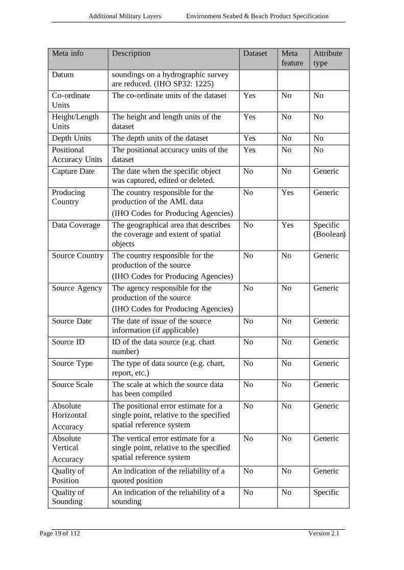
Vertical Datum The vertical datum of the dataset Yes Yes No Sounding The horizontal plane to which the Yes Yes Specific
Additional Military Layers Environment Seabed & Beach Product Specification
Page 19 of 112 Version 2.1
Meta info Description Dataset Meta feature
Attribute type
Datum soundings on a hydrographic survey are reduced. (IHO SP32: 1225)
Co-ordinate Units
The co-ordinate units of the dataset Yes No No
Height/Length Units
The height and length units of the dataset
Yes No No
Depth Units The depth units of the dataset Yes No No Positional Accuracy Units
The positional accuracy units of the dataset
Yes No No
Capture Date The date when the specific object was captured, edited or deleted.
No No Generic
Producing Country
The country responsible for the production of the AML data (IHO Codes for Producing Agencies)
No Yes Generic
Data Coverage The geographical area that describes the coverage and extent of spatial objects
No Yes Specific (Boolean)
Source Country The country responsible for the production of the source (IHO Codes for Producing Agencies)
No No Generic
Source Agency The agency responsible for the production of the source (IHO Codes for Producing Agencies)
No No Generic
Source Date The date of issue of the source information (if applicable)
No No Generic
Source ID ID of the data source (e.g. chart number)
No No Generic
Source Type The type of data source (e.g. chart, report, etc.)
No No Generic
Source Scale The scale at which the source data has been compiled
No No Generic
Absolute Horizontal Accuracy
The positional error estimate for a single point, relative to the specified spatial reference system
No No Generic
Absolute Vertical Accuracy
The vertical error estimate for a single point, relative to the specified spatial reference system
No No Generic
Quality of Position
An indication of the reliability of a quoted position
No No Generic
Quality of Sounding
An indication of the reliability of a sounding
No No Specific
Additional Military Layers Environment Seabed & Beach Product Specification
Page 20 of 112 Version 2.1
Meta info Description Dataset Meta feature
Attribute type
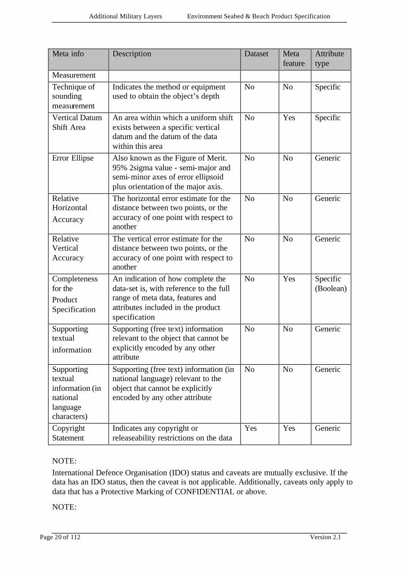
Measurement Technique of sounding measurement
Indicates the method or equipment used to obtain the object’s depth
No No Specific
Vertical Datum Shift Area
An area within which a uniform shift exists between a specific vertical datum and the datum of the data within this area
No Yes Specific
Error Ellipse Also known as the Figure of Merit. 95% 2sigma value - semi-major and semi-minor axes of error ellipsoid plus orientation of the major axis.
No No Generic
Relative Horizontal Accuracy
The horizontal error estimate for the distance between two points, or the accuracy of one point with respect to another
No No Generic
Relative Vertical Accuracy
The vertical error estimate for the distance between two points, or the accuracy of one point with respect to another
No No Generic
Completeness for the Product Specification
An indication of how complete the data-set is, with reference to the full range of meta data, features and attributes included in the product specification
No Yes Specific (Boolean)
Supporting textual information
Supporting (free text) information relevant to the object that cannot be explicitly encoded by any other attribute
No No Generic
Supporting textual information (in national language characters)
Supporting (free text) information (in national language) relevant to the object that cannot be explicitly encoded by any other attribute
No No Generic
Copyright Statement
Indicates any copyright or releaseability restrictions on the data
Yes Yes Generic
NOTE: International Defence Organisation (IDO) status and caveats are mutually exclusive. If the data has an IDO status, then the caveat is not applicable. Additionally, caveats only apply to data that has a Protective Marking of CONFIDENTIAL or above. NOTE:
Additional Military Layers Environment Seabed & Beach Product Specification
Page 21 of 112 Version 2.1
Update information is only applicable if updating is supported by the exchange standard implementation. NOTE: The ’Source Agency’ refers to the originators of the data and not the agency responsible for producing AML. If the source agency is not listed in IHO Codes for Producing Agencies, then the agency name should prefix any details provided in the attribute ’Source ID’ using a solidus (forward slash) to separate it from the ID.
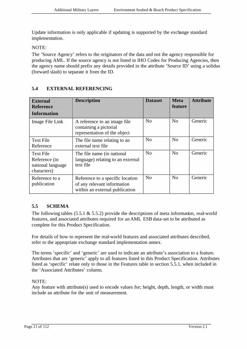
5.4 EXTERNAL REFERENCING
External Reference Information
Description Dataset Meta feature
Attribute
Image File Link A reference to an image file containing a pictorial representation of the object
No No Generic
Text File Reference
The file name relating to an external text file
No No Generic
Text File Reference (in national language characters)
The file name (in national language) relating to an external text file
No No Generic
Reference to a publication
Reference to a specific location of any relevant information within an external publication
No No Generic
5.5 SCHEMA The following tables (5.5.1 & 5.5.2) provide the descriptions of meta information, real-world features, and associated attributes required for an AML ESB data-set to be attributed as complete for this Product Specification. For details of how to represent the real-world features and associated attributes described, refer to the appropriate exchange standard implementation annex. The terms ‘specific’ and ‘generic’ are used to indicate an attribute’s association to a feature. Attributes that are ‘generic’ apply to all features listed in this Product Specification. Attributes listed as ‘specific’ relate only to those in the Features table in section 5.5.1, when included in the ‘Associated Attributes’ column. NOTE: Any feature with attribute(s) used to encode values for; height, depth, length, or width must include an attribute for the unit of measurement.
Additional Military Layers Environment Seabed & Beach Product Specification
Page 22 of 112 Version 2.1
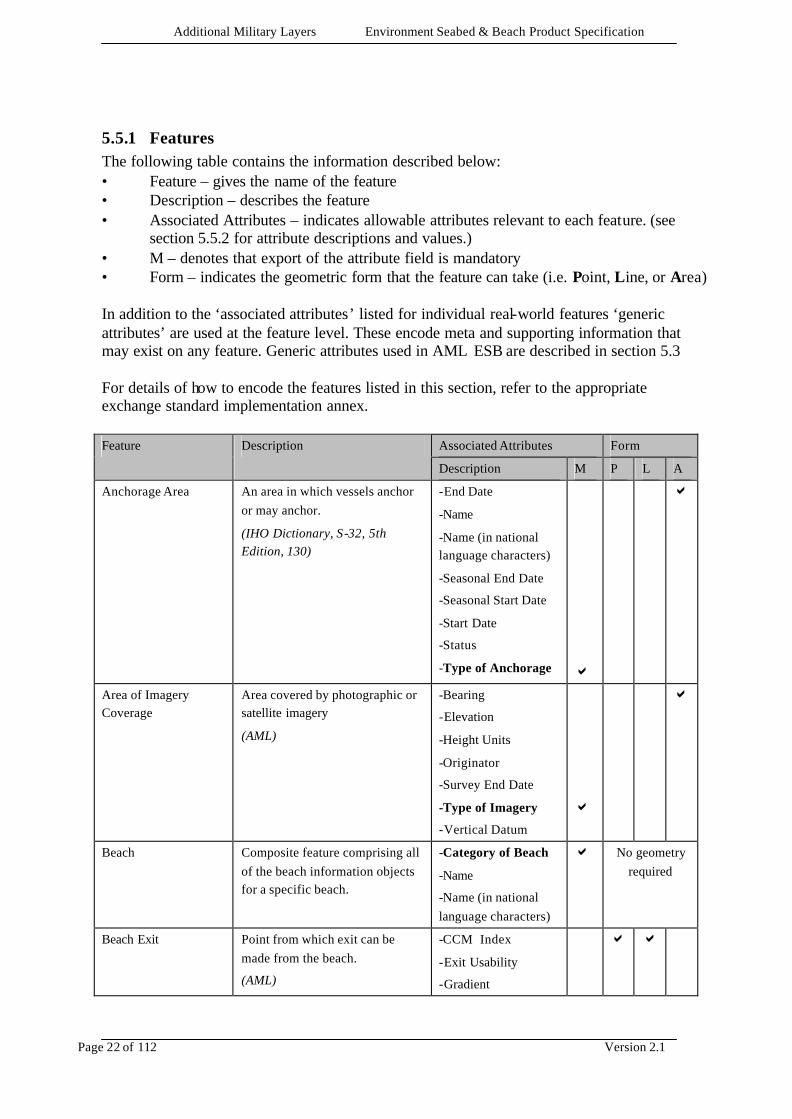
5.5.1 Features The following table contains the information described below: • Feature – gives the name of the feature • Description – describes the feature • Associated Attributes – indicates allowable attributes relevant to each feature. (see
section 5.5.2 for attribute descriptions and values.) • M – denotes that export of the attribute field is mandatory • Form – indicates the geometric form that the feature can take (i.e. Point, Line, or Area) In addition to the ‘associated attributes’ listed for individual real-world features ‘generic attributes’ are used at the feature level. These encode meta and supporting information that may exist on any feature. Generic attributes used in AML ESB are described in section 5.3 For details of how to encode the features listed in this section, refer to the appropriate exchange standard implementation annex.
Associated Attributes Form Feature Description
Description M P L A
Anchorage Area An area in which vessels anchor or may anchor.
(IHO Dictionary, S-32, 5th Edition, 130)
-End Date
-Name
-Name (in national language characters)
-Seasonal End Date
-Seasonal Start Date
-Start Date
-Status
-Type of Anchorage
a
a
Area of Imagery Coverage
Area covered by photographic or satellite imagery
(AML)
-Bearing
-Elevation
-Height Units
-Originator
-Survey End Date
-Type of Imagery
-Vertical Datum
a
a
Beach Composite feature comprising all of the beach information objects for a specific beach.
-Category of Beach
-Name
-Name (in national language characters)
a No geometry required
Beach Exit Point from which exit can be made from the beach.
(AML)
-CCM Index
-Exit Usability
-Gradient
a a
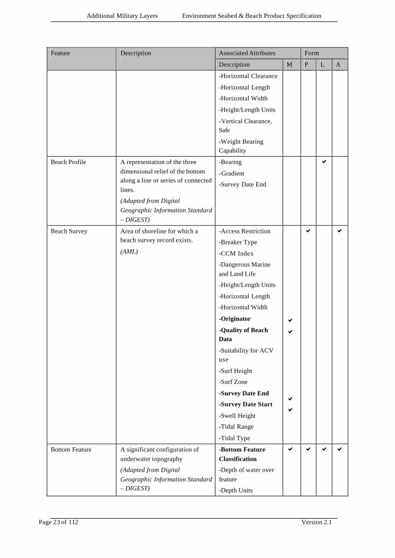
Additional Military Layers Environment Seabed & Beach Product Specification
Page 23 of 112 Version 2.1
Associated Attributes Form Feature Description
Description M P L A
-Horizontal Clearance
-Horizontal Length
-Horizontal Width
-Height/Length Units
-Vertical Clearance, Safe
-Weight Bearing Capability
Beach Profile A representation of the three dimensional relief of the bottom along a line or series of connected lines.
(Adapted from Digital Geographic Information Standard – DIGEST)
-Bearing
-Gradient
-Survey Date End
a
Beach Survey Area of shoreline for which a beach survey record exists.
(AML)
-Access Restriction
-Breaker Type
-CCM Index
-Dangerous Marine and Land Life
-Height/Length Units
-Horizontal Length
-Horizontal Width
-Originator
-Quality of Beach Data
-Suitability for ACV use
-Surf Height
-Surf Zone
-Survey Date End
-Survey Date Start
-Swell Height
-Tidal Range
-Tidal Type
a a a a
a a
Bottom Feature A significant configuration of underwater topography
(Adapted from Digital Geographic Information Standard – DIGEST)
-Bottom Feature Classification
-Depth of water over feature
-Depth Units
a a a a
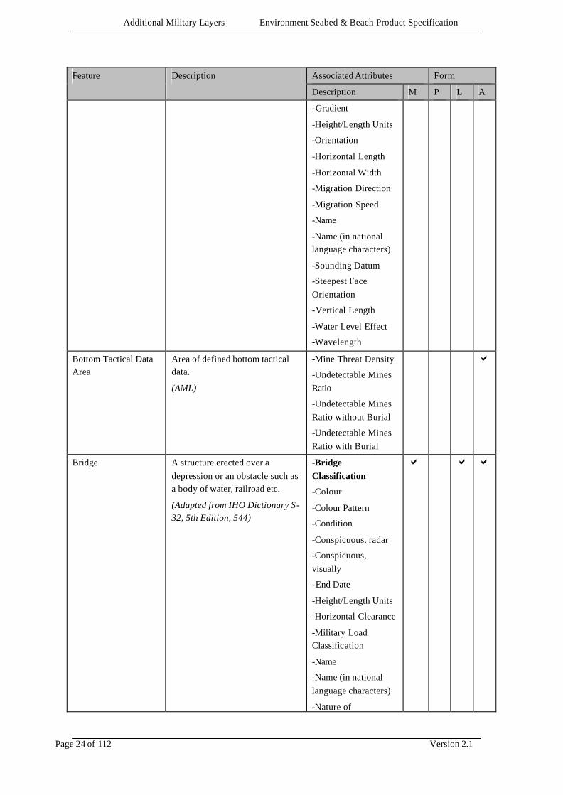
Additional Military Layers Environment Seabed & Beach Product Specification
Page 24 of 112 Version 2.1
Associated Attributes Form Feature Description
Description M P L A
-Gradient
-Height/Length Units
-Orientation
-Horizontal Length
-Horizontal Width
-Migration Direction
-Migration Speed
-Name
-Name (in national language characters)
-Sounding Datum
-Steepest Face Orientation
-Vertical Length
-Water Level Effect
-Wavelength
Bottom Tactical Data Area
Area of defined bottom tactical data.
(AML)
-Mine Threat Density
-Undetectable Mines Ratio
-Undetectable Mines Ratio without Burial
-Undetectable Mines Ratio with Burial
a
Bridge A structure erected over a depression or an obstacle such as a body of water, railroad etc.
(Adapted from IHO Dictionary S-32, 5th Edition, 544)
-Bridge Classification
-Colour
-Colour Pattern
-Condition
-Conspicuous, radar
-Conspicuous, visually
-End Date
-Height/Length Units
-Horizontal Clearance
-Military Load Classification
-Name
-Name (in national language characters)
-Nature of
a a a
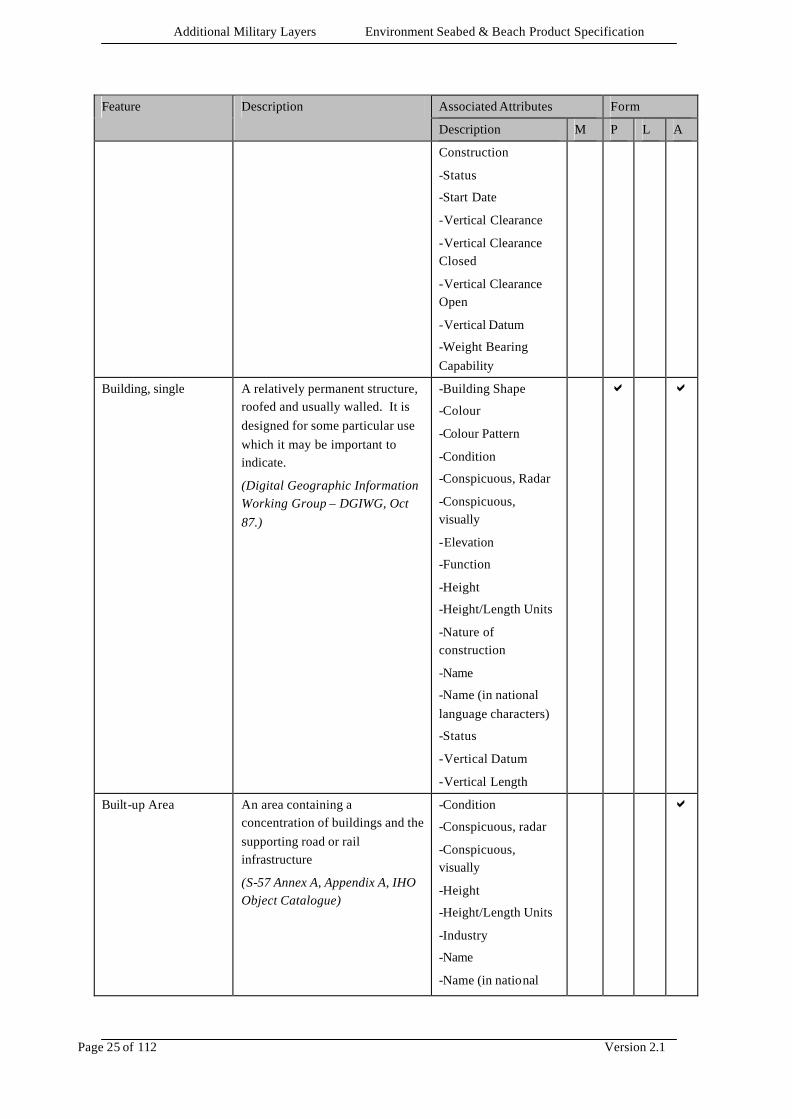
Additional Military Layers Environment Seabed & Beach Product Specification
Page 25 of 112 Version 2.1
Associated Attributes Form Feature Description
Description M P L A
Construction
-Status
-Start Date
-Vertical Clearance
-Vertical Clearance Closed
-Vertical Clearance Open
-Vertical Datum
-Weight Bearing Capability
Building, single A relatively permanent structure, roofed and usually walled. It is designed for some particular use which it may be important to indicate.
(Digital Geographic Information Working Group – DGIWG, Oct 87.)
-Building Shape
-Colour
-Colour Pattern
-Condition
-Conspicuous, Radar
-Conspicuous, visually
-Elevation
-Function
-Height
-Height/Length Units
-Nature of construction
-Name
-Name (in national language characters)
-Status
-Vertical Datum
-Vertical Length
a
a
Built-up Area An area containing a concentration of buildings and the supporting road or rail infrastructure
(S-57 Annex A, Appendix A, IHO Object Catalogue)
-Condition
-Conspicuous, radar
-Conspicuous, visually
-Height
-Height/Length Units
-Industry
-Name
-Name (in national
a

Additional Military Layers Environment Seabed & Beach Product Specification
Page 26 of 112 Version 2.1
Associated Attributes Form Feature Description
Description M P L A
language characters)
-Population
-Type of Built-up area
-Vertical Datum
a
Burial Probability Area
Area of defined burial probability
(AML)
-Burial Mechanism
-Burial Period
-Burial Probability
-Target Reference Weight
a
Cable Area An area which contains one or more submarine cables.
(S-57 Annex A, Appendix A, IHO Object Catalogue)
-End Date
-Height/Length Units
-Name
-Name (in national language characters)
-Start Date
-Status
-Type of Cable
-Vertical Length
a
a
Cable, Overhead An assembly of wires or fibres, or a wire rope or chain, which is supported by structures such as poles or pylons and passing over or nearby navigable waters.
(Hydrographic Service, Royal Australian Navy)
-Condition
-Conspicuous, Radar
-Conspicuous, Visually
-End Date
-Height/Length Units
-Ice Factor
-Name
-Name (in national language characters)
-Start Date
-Status
-Type of Cable
-Vertical Clearance
-Vertical Clearance, Safe
-Vertical Datum
a
a
Cable, Submarine An assembly of wires or fibres, or a wire rope or chain which has been laid underwater or buried
-Buried Depth
-Condition
-End Date
a

Additional Military Layers Environment Seabed & Beach Product Specification
Page 27 of 112 Version 2.1
Associated Attributes Form Feature Description
Description M P L A
beneath the seabed.
(Hydrographic Service, Royal Australian Navy)
-Depth range - shoalest value
-Depth range - deepest value
-Depth Units
-Height/Length Units
-Horizontal Width
-Name
-Name (in national language characters)
-Start Date
-Status
-Sounding Datum
-Type of Cable
-Vertical Length
a
Coastline The line where the shore and water meet. Although the terminology of coasts and shores is rather confused, shoreline and coastline are generally used as synonyms.
(IHO Dictionary, S-32, 5th Edition, 858, 4695)
-Category of coastline
-Colour
-Conspicuous, Radar
-Conspicuous, Visually
-Elevation
-Height/Length Units
-Name
-Name (in national language characters)
-Vertical Datum
a a
Completeness for the Product Specification
An indication of how complete the data-set is, with reference to the full range of meta data, features and attributes included in the product specification (AML)
Category of completeness
a a
Control Point A point on the ground where position (horizontal and vertical) is used as a base for a dependent survey. Also referred to as a control station.
(IHO Dictionary S-32, 5th Edition,1026)
-Class of Control Point
-End Date
-Start Date
-Elevation
-Height/Length Units
-Name
-Name (in national
a a
Additional Military Layers Environment Seabed & Beach Product Specification
Page 28 of 112 Version 2.1
Associated Attributes Form Feature Description
Description M P L A
language characters)
-Vertical Datum
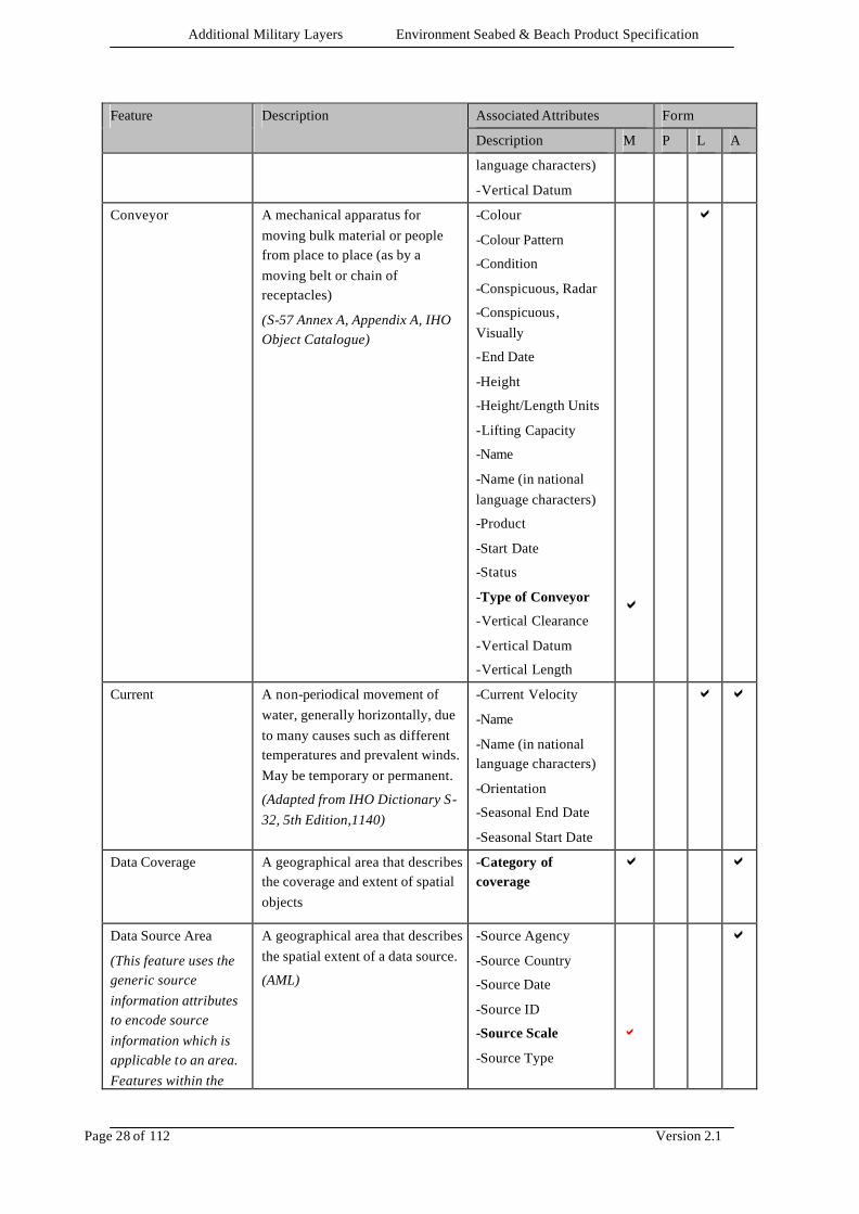
Conveyor A mechanical apparatus for moving bulk material or people from place to place (as by a moving belt or chain of receptacles)
(S-57 Annex A, Appendix A, IHO Object Catalogue)
-Colour
-Colour Pattern
-Condition
-Conspicuous, Radar
-Conspicuous, Visually
-End Date
-Height
-Height/Length Units
-Lifting Capacity
-Name
-Name (in national language characters)
-Product
-Start Date
-Status
-Type of Conveyor
-Vertical Clearance
-Vertical Datum
-Vertical Length
a
a
Current A non-periodical movement of water, generally horizontally, due to many causes such as different temperatures and prevalent winds. May be temporary or permanent.
(Adapted from IHO Dictionary S-32, 5th Edition,1140)
-Current Velocity
-Name
-Name (in national language characters)
-Orientation
-Seasonal End Date
-Seasonal Start Date
a a
Data Coverage A geographical area that describes the coverage and extent of spatial objects
-Category of coverage
a
a
Data Source Area
(This feature uses the generic source information attributes to encode source information which is applicable to an area. Features within the
A geographical area that describes the spatial extent of a data source.
(AML)
-Source Agency
-Source Country
-Source Date
-Source ID
-Source Scale
-Source Type
a
a
Additional Military Layers Environment Seabed & Beach Product Specification
Page 29 of 112 Version 2.1
Associated Attributes Form Feature Description
Description M P L A
area need not be individually attributed)
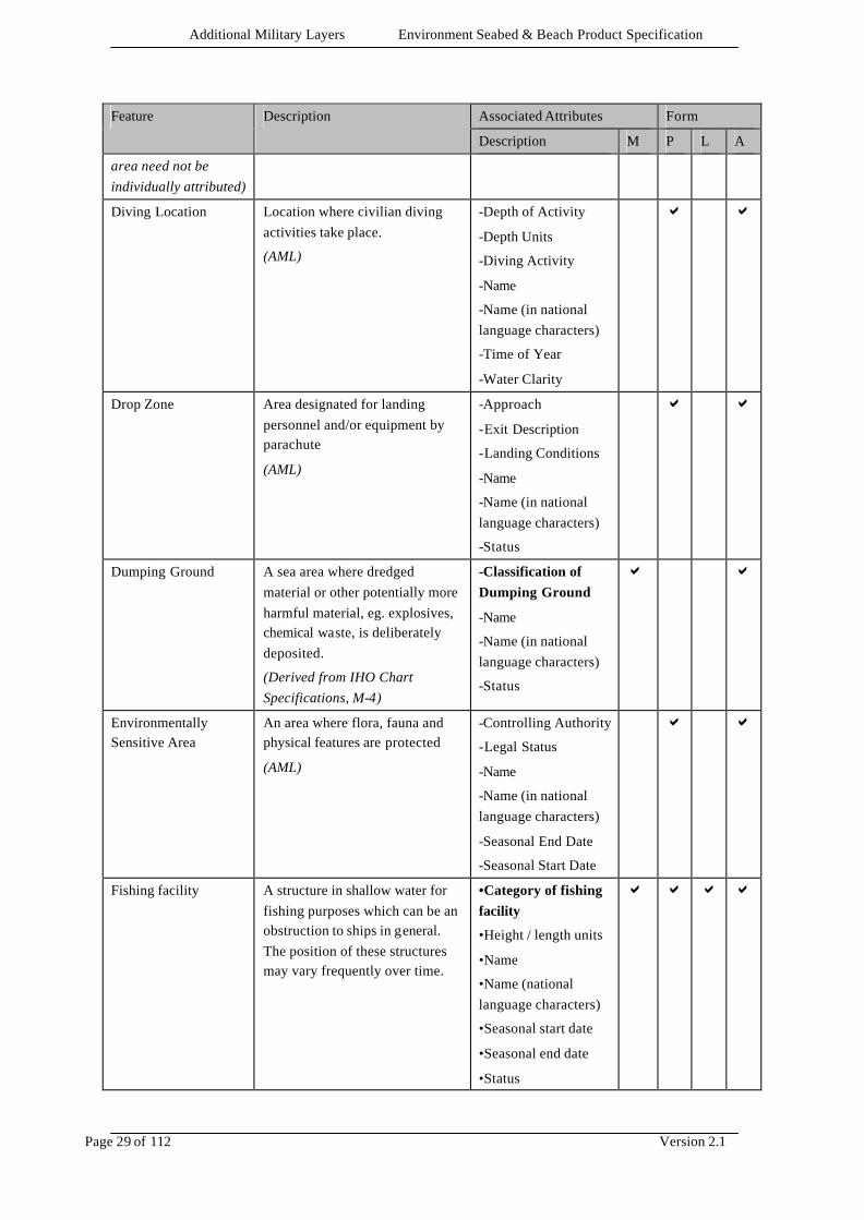
Diving Location Location where civilian diving activities take place.
(AML)
-Depth of Activity
-Depth Units
-Diving Activity
-Name
-Name (in national language characters)
-Time of Year
-Water Clarity
a a
Drop Zone Area designated for landing personnel and/or equipment by parachute
(AML)
-Approach
-Exit Description
-Landing Conditions
-Name
-Name (in national language characters)
-Status
a a
Dumping Ground A sea area where dredged material or other potentially more harmful material, eg. explosives, chemical waste, is deliberately deposited.
(Derived from IHO Chart Specifications, M-4)
-Classification of Dumping Ground
-Name
-Name (in national language characters)
-Status
a a
Environmentally Sensitive Area
An area where flora, fauna and physical features are protected
(AML)
-Controlling Authority
-Legal Status
-Name
-Name (in national language characters)
-Seasonal End Date
-Seasonal Start Date
a a
Fishing facility A structure in shallow water for fishing purposes which can be an obstruction to ships in general. The position of these structures may vary frequently over time.
•Category of fishing facility
•Height / length units
•Name
•Name (national language characters)
•Seasonal start date
•Seasonal end date
•Status
a a a a
Additional Military Layers Environment Seabed & Beach Product Specification
Page 30 of 112 Version 2.1
Associated Attributes Form Feature Description
Description M P L A
•Vertical length
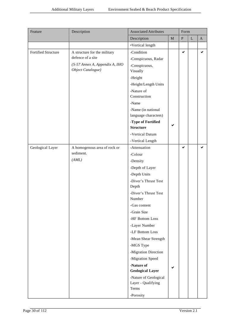
Fortified Structure A structure for the military defence of a site
(S-57 Annex A, Appendix A, IHO Object Catalogue)
-Condition
-Conspicuous, Radar
-Conspicuous, Visually
-Height
-Height/Length Units
-Nature of Construction
-Name
-Name (in national language characters)
-Type of Fortified Structure
-Vertical Datum
-Vertical Length
a
a a
Geological Layer A homogenous area of rock or sediment.
(AML)
-Attenuation
-Colour
-Density
-Depth of Layer
-Depth Units
-Diver’s Thrust Test Depth
-Diver’s Thrust Test Number
-Gas content
-Grain Size
-HF Bottom Loss
-Layer Number
-LF Bottom Loss
-Mean Shear Strength
-MGS Type
-Migration Direction
-Migration Speed
-Nature of Geological Layer
-Nature of Geological Layer - Qualifying Terms
-Porosity
a
a a

Additional Military Layers Environment Seabed & Beach Product Specification
Page 31 of 112 Version 2.1
Associated Attributes Form Feature Description
Description M P L A
-Reflection Coefficient
-Reverberation
-Reverberation Frequency
-Reverberation Grazing Angle
-Sample Retained
-Sonar Reflectivity
-Sounding Datum
-Sound Velocity
-Water Level Effect
-Weight Bearing Capability
Iceberg An Iceberg is a massive piece of glacial ice, greatly varying in shape and showing more than 5 metres above the sea surface.
(ECDIS Ice Objects Version 3.0)
-Iceberg Shape
-Iceberg Size
-Icedrift or Iceberg Direction
-Icedrift or Iceberg Speed
-Name
-Name (in national language characters)
a a
Iceberg Area An Iceberg Area is an area at sea in which icebergs, floebergs, bergy bits or growlers are present.
(ECDIS Ice Objects Version 3.0)
-Name
-Name (in national language characters)
-Number of Icebergs in Area
a
Ice Lead The Ice Lead identifies any fracture or passage-way through ice which is navigable by surface vessels.
(ECDIS Ice Objects Version 3.0)
-Ice Lead Type
-Ice Lead Status
-Name
-Name (in national language characters)
a a a
Ice Line The Ice Line provides a measured, observed or estimated limit of the ice infested waters.
(ECDIS Ice Objects Version 3.0)
-Ice Line Category
-Name
-Name (in national language characters)
a a
Ice Movement Ice Movement is the speed and direction of an iceberg, floe or ice area.
-Icedrift or Iceberg Direction
-Icedrift or Iceberg
a a
Additional Military Layers Environment Seabed & Beach Product Specification
Page 32 of 112 Version 2.1
Associated Attributes Form Feature Description
Description M P L A
(ECDIS Ice Objects Version 3.0) Speed
-Name
-Name (in national language characters)
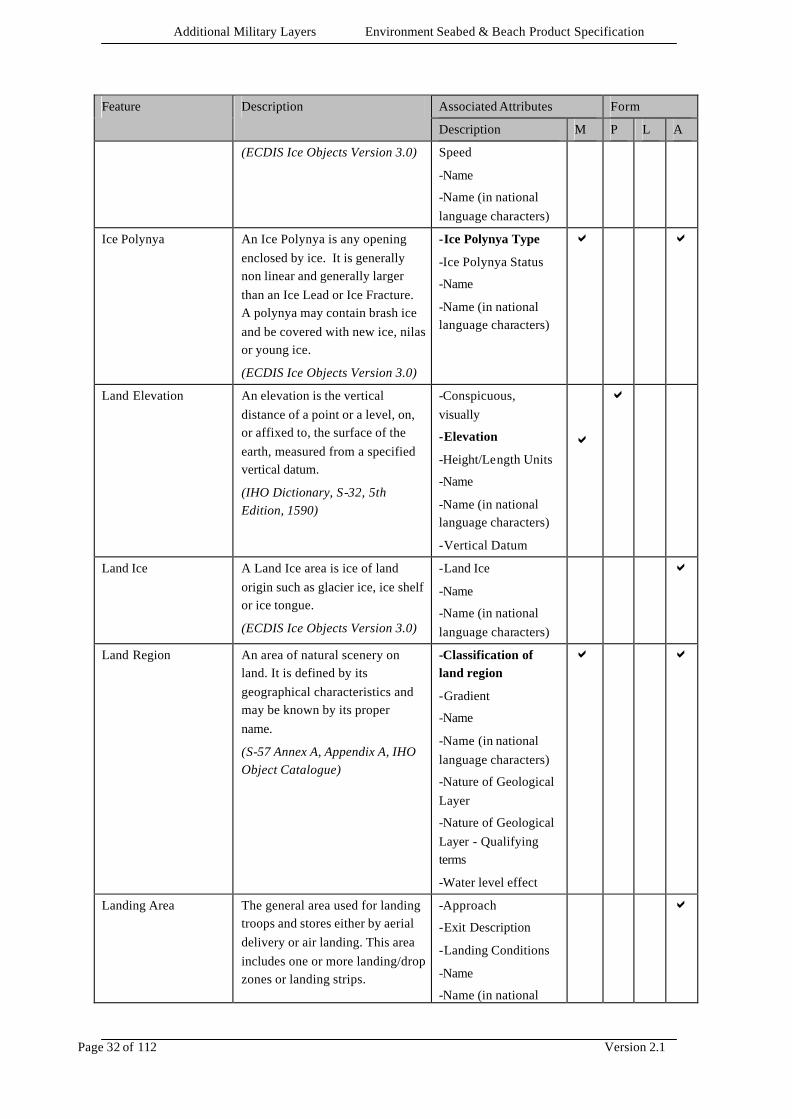
Ice Polynya An Ice Polynya is any opening enclosed by ice. It is generally non linear and generally larger than an Ice Lead or Ice Fracture. A polynya may contain brash ice and be covered with new ice, nilas or young ice.
(ECDIS Ice Objects Version 3.0)
-Ice Polynya Type
-Ice Polynya Status
-Name
-Name (in national language characters)
a a
Land Elevation An elevation is the vertical distance of a point or a level, on, or affixed to, the surface of the earth, measured from a specified vertical datum.
(IHO Dictionary, S-32, 5th Edition, 1590)
-Conspicuous, visually
-Elevation
-Height/Length Units
-Name
-Name (in national language characters)
-Vertical Datum
a
a
Land Ice A Land Ice area is ice of land origin such as glacier ice, ice shelf or ice tongue.
(ECDIS Ice Objects Version 3.0)
-Land Ice
-Name
-Name (in national language characters)
a
Land Region An area of natural scenery on land. It is defined by its geographical characteristics and may be known by its proper name.
(S-57 Annex A, Appendix A, IHO Object Catalogue)
-Classification of land region
-Gradient
-Name
-Name (in national language characters)
-Nature of Geological Layer
-Nature of Geological Layer - Qualifying terms
-Water level effect
a a
Landing Area The general area used for landing troops and stores either by aerial delivery or air landing. This area includes one or more landing/drop zones or landing strips.
-Approach
-Exit Description
-Landing Conditions
-Name
-Name (in national
a

Additional Military Layers Environment Seabed & Beach Product Specification
Page 33 of 112 Version 2.1
Associated Attributes Form Feature Description
Description M P L A
(AML) language characters)
-Status
Landing Place Point on the beach where the landing of troops and vehicles can take place.
(AML)
-Gradient
-Status
-Weight Bearing Capability
a
Landing Point A point within a landing site where one helicopter can land.
(AML)
-Approach
-Exit Description
-Landing Conditions
-Name
-Name (in national language characters)
-Status
a
Landing Site A site within a landing zone containing one or more landing points.
(AML)
-Approach
-Exit Description
-Landing Conditions
-Name
-Name (in national language characters)
-Status
a
Landing Strip Area designated for operating fixed wing aircraft.
(AML)
-Approach
-Exit Description
-Landing Conditions
-Name
-Name (in national language characters)
-Status
a
Landing Zone
A specified zone within an objective area used for landing aircraft. This includes a number of landing sites.
(AML)
-Approach
-Exit Description
-Landing Conditions
-Name
-Name (in national language characters)
-Status
a
Landmark
A prominent object at a fixed location which can be used in determining a location or a direction.
(Adapted from IHO Dictionary, S-
-Colour
-Colour Pattern
-Condition
-Conspicuous, Radar
-Conspicuous,
a
Additional Military Layers Environment Seabed & Beach Product Specification
Page 34 of 112 Version 2.1
Associated Attributes Form Feature Description
Description M P L A
32, 5th Edition, 2643). Visually
-Elevation
-Function
-Height
-Height/Length Units
-Nature of Construction
-Name
-Name (in national language characters)
-Status
-Type of Landmark
-Vertical Datum
-Vertical Length
a
Leisure Activity Area Area where civilian leisure activities take place
(AML)
-Leisure Activity
-Time of Year
a
Light A luminous or lighted aid to navigation.
(Adapted from IHO Dictionary, S-32, 5th Edition, 2766).
-Category of Light
-Colour
-End Date
-Exhibition Condition of Light
-Height
-Height/Length Units
-Light Characteristic
-Light Visibility
-Marks Navigational – System of
-Multiplicity of Lights
-Name
-Name (in national language characters)
-Orientation
-Seasonal End Date
-Seasonal Start Date
-Sector Limit One
-Sector Limit Two
-Signal Group
-Signal Period
a a

Additional Military Layers Environment Seabed & Beach Product Specification
Page 35 of 112 Version 2.1
Associated Attributes Form Feature Description
Description M P L A
-Signal Sequence
-Start Date
-Status
-Value of nominal range
-Vertical Datum
MCM Area Area where MCM operations have taken place.
(AML)
-Milec Density
-Mine-hunting classification
-NOMBO Density
a
Mooring Facility The equipment or structure used to secure a vessel
(adapted from IHO Dictionary, S-32, 5th Edition, 3322)
-Category of Mooring Facility
-Communications
-Logistics
-Manoeuvring
-Navigational Description
-Navigational Difficulty
-Pier Contact Details
-Pier Description
-Sea Direction
-Self Protection (Air)
-Self Protection (Near Defence)
-Self Protection (Surface)
-Sensor Coverage
-Surface Threat
-Weapon Coverage
a a
Performance Data Area
Area of defined performance data.
(AML)
-Clearance Percentage
-Characteristic Detection Width (A)
-Characteristic Detection Probability (B)
-Classification Probability
-Detection Probability
-Disposal Probability
a
Additional Military Layers Environment Seabed & Beach Product Specification
Page 36 of 112 Version 2.1
Associated Attributes Form Feature Description
Description M P L A
Pipeline Area An area containing one or more pipelines.
(S-57 Annex A, Appendix A, IHO Object Catalogue)
-Category of Pipeline
-Condition
-End Date
-Height/Length Units
-Name
-Name (in national language characters)
-Product
-Start Date
-Status
-Vertical Length
a a
Pipeline, submarine/on land
A pipeline is a string of interconnected pipes used for the transport of matter, nowadays mainly oil or gas
(IHO Dictionary, S-32, 5th Edition, 3857)
A submarine or land pipeline is a pipeline lying on or buried under the seabed or the land. (AML)
-Buried Depth
-Category of Pipeline
-Condition
-End Date
-Depth Range - shoalest value
-Depth Range - deepest value
-Depth Units
-Height/Length Units
-Horizontal Width
-Name
-Name (in national language characters)
-Product
-Start Date
-Status
-Sounding Datum
-Vertical Length
a
a
Pipeline, Overhead An overhead pipeline is a pipeline supported by pylons and passing over or nearby navigable waters
(S-57 Annex A, Appendix A, IHO Object Catalogue)
-Category of pipeline
-Condition
-Conspicuous, radar
-Conspicuous, visually
-End Date
-Height/Length Units
-Name
-Name (in national
a a
Additional Military Layers Environment Seabed & Beach Product Specification
Page 37 of 112 Version 2.1
Associated Attributes Form Feature Description
Description M P L A
language characters)
-Product
-Start Date
-Status
-Vertical Clearance
-Vertical Datum
Resource Location Location where resources are available.
(AML)
-Status
-Type of resource location
a
a a
Risk Data Area Area within which risk data has been defined.
(AML)
-Confidence Level
-Number of Remaining Mines
-Probability for remaining mines
-Remaining Mines Likely, Maximum Number
-Simple Initial Threat
-Zone Colour
a
River A relatively large natural stream of water
(IHO Dictionary, S-32, 5th Edition, 4405)
-Name
-Name (in national language characters)
-Status
a a
Road A road is an open way for the passage of vehicles
(United States Geological Survey, Jan.89)
-Classification of Road
-Condition
-Military Load Classification
-Nature of Construction
-Name
-Name (in national language characters)
-Status
a a
Sea Area A geographically defined part of the sea or other navigable waters. It may be specified within its limits by its proper name
(S-57 Annex A, Appendix A, IHO Object Catalogue)
-Category of Sea Area
-Gradient
-Name
-Name (in national language characters)
a a
Additional Military Layers Environment Seabed & Beach Product Specification
Page 38 of 112 Version 2.1
Associated Attributes Form Feature Description
Description M P L A
Sea Ice An area at sea that contains ice.
(ECDIS Ice Objects Version 3.0)
-Ice Attribute Concentration Total
-Ice Coverage Type
-Ice Ridge Development
-Ice Stage of Development
-Maximum Ice Thickness
-Minimum Ice Thickness
-Name
-Name (in national language characters)
a
Seismic activity area Area where earthquake activity has taken place.
(AML)
•Bearing
•Strength according to Richter Scale
a
Shelter location Place for casualties or personnel for evacuation
(AML)
-Name
-Name (in national language characters)
-Status
a
Shoreline Construction A fixed (not afloat) artificial structure between the water and the land.
(S-57 Annex A, Appendix A, IHO Object Catalogue)
-Colour
-Colour Pattern
-Condition
-Conspicuous, Radar
-Conspicuous, Visually
-Gradient
-Height
-Height/Length Units
-Horizontal Clearance
-Horizontal Length
-Horizontal Width
-Name
-Name (in national language characters)
-Nature of
a a
Additional Military Layers Environment Seabed & Beach Product Specification
Page 39 of 112 Version 2.1
Associated Attributes Form Feature Description
Description M P L A
Construction
-Seasonal End Date
-Seasonal Start Date
-Status
-Type of Shoreline Construction
-Vertical Datum
-Vertical Length
-Water Level Effect
-Weight Bearing Capability
a
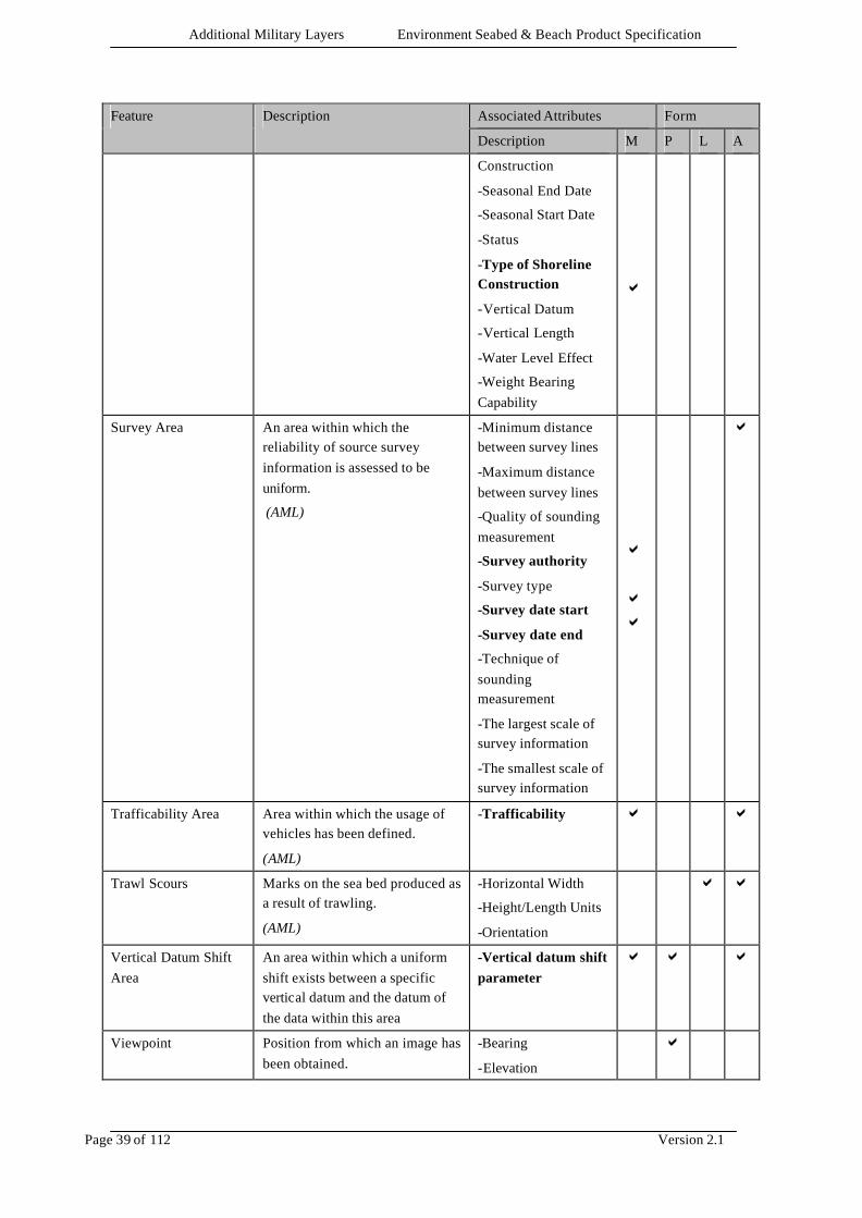
Survey Area An area within which the reliability of source survey information is assessed to be uniform.
(AML)
-Minimum distance between survey lines
-Maximum distance between survey lines
-Quality of sounding measurement
-Survey authority
-Survey type
-Survey date start
-Survey date end
-Technique of sounding measurement
-The largest scale of survey information
-The smallest scale of survey information
a a a
a
Trafficability Area Area within which the usage of vehicles has been defined.
(AML)
-Trafficability a a
Trawl Scours Marks on the sea bed produced as a result of trawling.
(AML)
-Horizontal Width
-Height/Length Units
-Orientation
a a
Vertical Datum Shift Area
An area within which a uniform shift exists between a specific vertical datum and the datum of the data within this area
-Vertical datum shift parameter
a a a
Viewpoint Position from which an image has been obtained.
-Bearing
-Elevation
a

Additional Military Layers Environment Seabed & Beach Product Specification
Page 40 of 112 Version 2.1
Associated Attributes Form Feature Description
Description M P L A
(AML) -Height/Length Units
-Type of Imagery
-Vertical Datum
Weed/Kelp Seaweed is the general name for marine plants of the Algae class which grow in long narrow ribbons.
(International Maritime Dictionary, 2nd Ed)
Kelp is one of an order (laminariales) of usually large, blade-shaped or vine-like brown algae.
(IHO Dictionary, S-32, 5th Edition, 2611)
-Category of Weed/Kelp
-Foliar Index
-Height/Length Units
-Name
-Name (in national language characters)
-Prairies Density
-Seabed Coverage
-Vertical Length
a a
User Defined A feature not otherwise permissible within the AML content model
Textual description a a a
5.5.1.1 Mandatory Features There are no mandatory features in ESB AML.
5.5.2 Attributes The table below displays the following information: • Attribute – gives the name of attribute. • Definition – gives a more detailed description of the attribute if required. • Values – specifies the possible values the attribute may take. For details of how to encode the attributes listed in this section, refer to the appropriate exchange standard implementation annex. Attribute & definition Values & definitions
Absolute horizontal accuracy
The positional error estimate for a single point, relative to the specified spatial reference system.
(AML)
Value: min 0
Units: metres or feet
(units must be defined)
Resolution: 0.1 (metres or ft)
Absolute vertical accuracy
The vertical error estimate for a single point, relative to the specified spatial reference system.
(AML)
Value: min 0
Units: metres or feet
(units must be defined)
Resolution: 0.1 (metres or ft)
Access Restriction Text String

Additional Military Layers Environment Seabed & Beach Product Specification
Page 41 of 112 Version 2.1
Attribute & definition Values & definitions
Restrictions on access to the beach from the sea.
(AML)
Approach
Description of approach including direction and potential hazards.
(AML)
Text String
Attenuation
Reduction in intensity of sound waves.
(Adapted from IHO-Dictionary S-32, 5th Edition, 292)
Value: min 0
Unit: decibels/metre
Resolution: 0.1
Bearing
The horizontal direction of one terrestrial point from another, expressed as the angular distance from a reference direction.
(IHO Dictionary, S-32, 5th Edition, 435.)
Value: 0.0 - 359.9
Unit: degree
Resolution: 0.1
Bottom Feature Classification
Classification of naturally occurring bottom features on the seabed.
(AML)
-Berm: A narrow, raised embankment along a beach formed by the deposit of material by waves and marks the limit of high tides. (Adapted from IHO Hydrographic Dictionary, S-32, 5th Edition, 468)
-Fault line: A break of shear in the earth’s crust with an observable displacement between the two sides of the break, and parallel to the end of the break. (IHO Hydrographic Dictionary, S-32, 5th Edition 1778)
-Ledge: A rocky formation continuous with and fringing the shore. (IHO Hydrographic Dictionary, S-32, 5th Edition, 2707)
-Highly Reflective Patch: Highly reflective patch of seabed found by side scan, no contact found using MM sonar. (AML)
-Magnetic Anomaly: An anomaly of the magnetic field of the earth, extending over a relatively small area, due to local magnetic influences. (IHO Hydrographic Dictionary, S-32, 5th Edition, 2874)
-Pockmark: Small depression on the seabed. (AML)
-Ridge: A long narrow elevation with steep sides. (IHO Hydrographic Dictionary, S-32, 5th Edition 4388)
-Ribbon: Normally apparent overlying a coarser type of seabed. Most are straight and parallel with currents. They can be up to 12km long, 200m wide and are generally only a few cm thick. Typically they have a laddered appearance due to the presence
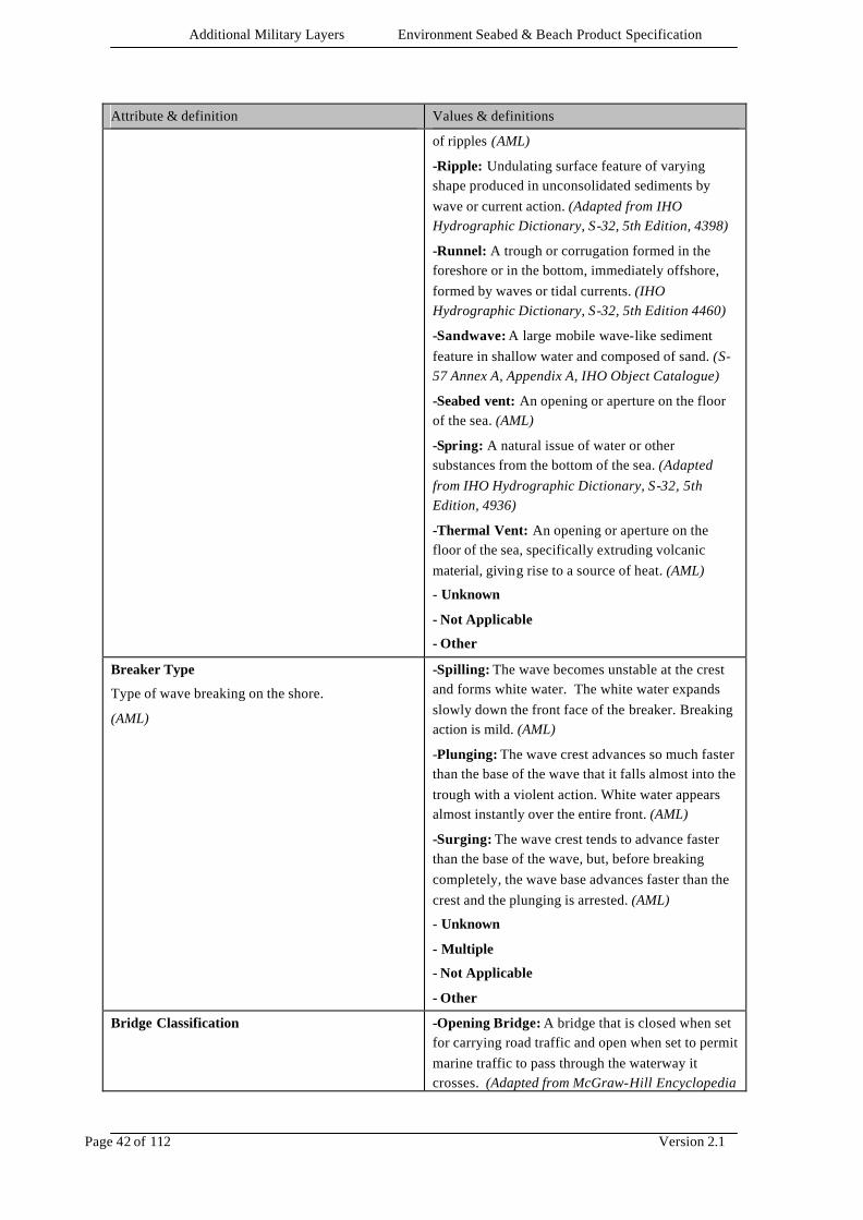
Additional Military Layers Environment Seabed & Beach Product Specification
Page 42 of 112 Version 2.1
Attribute & definition Values & definitions
of ripples (AML)
-Ripple: Undulating surface feature of varying shape produced in unconsolidated sediments by wave or current action. (Adapted from IHO Hydrographic Dictionary, S-32, 5th Edition, 4398)
-Runnel: A trough or corrugation formed in the foreshore or in the bottom, immediately offshore, formed by waves or tidal currents. (IHO Hydrographic Dictionary, S-32, 5th Edition 4460)
-Sandwave: A large mobile wave-like sediment feature in shallow water and composed of sand. (S-57 Annex A, Appendix A, IHO Object Catalogue)
-Seabed vent: An opening or aperture on the floor of the sea. (AML)
-Spring: A natural issue of water or other substances from the bottom of the sea. (Adapted from IHO Hydrographic Dictionary, S-32, 5th Edition, 4936)
-Thermal Vent: An opening or aperture on the floor of the sea, specifically extruding volcanic material, giving rise to a source of heat. (AML)
- Unknown
- Not Applicable
- Other
Breaker Type
Type of wave breaking on the shore.
(AML)
-Spilling: The wave becomes unstable at the crest and forms white water. The white water expands slowly down the front face of the breaker. Breaking action is mild. (AML)
-Plunging: The wave crest advances so much faster than the base of the wave that it falls almost into the trough with a violent action. White water appears almost instantly over the entire front. (AML)
-Surging: The wave crest tends to advance faster than the base of the wave, but, before breaking completely, the wave base advances faster than the crest and the plunging is arrested. (AML)
- Unknown
- Multiple
- Not Applicable
- Other
Bridge Classification
-Opening Bridge: A bridge that is closed when set for carrying road traffic and open when set to permit marine traffic to pass through the waterway it crosses. (Adapted from McGraw-Hill Encyclopedia
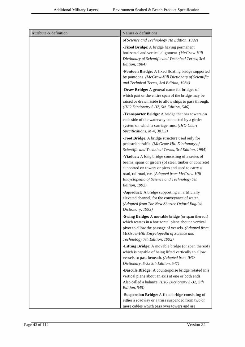
Additional Military Layers Environment Seabed & Beach Product Specification
Page 43 of 112 Version 2.1
Attribute & definition Values & definitions
of Science and Technology 7th Edition, 1992)
-Fixed Bridge: A bridge having permanent horizontal and vertical alignment. (McGraw-Hill Dictionary of Scientific and Technical Terms, 3rd Edition, 1984)
-Pontoon Bridge: A fixed floating bridge supported by pontoons. (McGraw-Hill Dictionary of Scientific and Technical Terms, 3rd Edition, 1984)
-Draw Bridge: A general name for bridges of which part or the entire span of the bridge may be raised or drawn aside to allow ships to pass through. (IHO Dictionary S-32, 5th Edition, 546)
-Transporter Bridge: A bridge that has towers on each side of the waterway connected by a girder system on which a carriage runs. (IHO Chart Specifications, M-4, 381.2)
-Foot Bridge: A bridge structure used only for pedestrian traffic. (McGraw-Hill Dictionary of Scientific and Technical Terms, 3rd Edition, 1984)
-Viaduct: A long bridge consisting of a series of beams, spans or girders (of steel, timber or concrete) supported on towers or piers and used to carry a road, railroad, etc. (Adapted from McGraw-Hill Encyclopedia of Science and Technology 7th Edition, 1992)
-Aqueduct: A bridge supporting an artificially elevated channel, for the conveyance of water. (Adapted from The New Shorter Oxford English Dictionary, 1993)
-Swing Bridge: A movable bridge (or span thereof) which rotates in a horizontal plane about a vertical pivot to allow the passage of vessels. (Adapted from McGraw-Hill Encyclopedia of Science and Technology 7th Edition, 1992)
-Lifting Bridge: A movable bridge (or span thereof) which is capable of being lifted vertically to allow vessels to pass beneath. (Adapted from IHO Dictionary, S-32 5th Edition, 547)
-Bascule Bridge: A counterpoise bridge rotated in a vertical plane about an axis at one or both ends. Also called a balance. (IHO Dictionary S-32, 5th Edition, 545)
-Suspension Bridge: A fixed bridge consisting of either a roadway or a truss suspended from two or more cables which pass over towers and are

Additional Military Layers Environment Seabed & Beach Product Specification
Page 44 of 112 Version 2.1
Attribute & definition Values & definitions
anchored by backstays to a firm foundation. (Adapted from McGraw-Hill Encyclopedia of Science and Technology 7th Edition, 1992)
- Unknown
- Not Applicable
- Other
Building Shape
Describes the specific shape of a building.
(AML)
-High-rise building: A building having many storeys. (The New Shorter Oxford English Dictionary, 1993)
-Pyramid: A polyhedron of which one face is a polygon of any number of sides, and the other faces are triangles with a common vertex. (The New Shorter Oxford English Dictionary, 1993)
-Cylindrical: Shaped like a cylinder, which is a solid geometrical figure generated by straight lines fixed in direction and describing with one of its points a close curve, especially a circle. (The New Shorter Oxford English Dictionary, 1993)
-Spherical: Shaped like a sphere, which is a body the surface of which is at all points equidistant from the centre. (The New Shorter Oxford English Dictionary, 1993)
-Cubic: A shape the sides of which are six equal squares; a regular hexahedron. (The New Shorter Oxford English Dictionary, 1993)
- Unknown
- Not Applicable
- Other
Burial Mechanism
The method by which a mine has or could become buried.
(AML)
-Impact: The contact could become buried by the force of the contact hitting the sediment. (AML)
-Scour: The contact could become buried by the action of current or flow of water around the object. (AML)
-Liquefaction: The contact could become buried by the process whereby under certain conditions, a solid seafloor sediment behaves as a liquid. (AML)
-Sandwave Migration: The contact could become buried by the movement of sandwaves. (AML)
-Sediment Migration: The contact could become buried by the movement of sediment. (AML)
-Unknown: The mechanism of burial is unknown. (AML)
- Multiple

Additional Military Layers Environment Seabed & Beach Product Specification
Page 45 of 112 Version 2.1
Attribute & definition Values & definitions
- Not Applicable
- Other
Burial Period
Time likely to be taken to achieve burial.
(AML)
Value: min 0
Unit: hours
Resolution: 1 hour
Burial Probability
The likelihood of subsequent burial and its estimated rate.
(AML)
-A: Burial Unlikely. (AML)
-B: Partial burial taking more than 7 days. (AML)
-C: Partial burial taking between 24 hours and 7 days. (AML)
-D: Partial burial taking less than 24 hours. (AML)
-E: Total burial taking more than 7 days. (AML)
-F: Total Burial taking between 24 hours and 7 days. (AML)
-G: Total burial taking less than 24 hours. (AML)
- Unknown
- Not Applicable
Buried Depth
The depth below the sea bed to which an object is buried.
(S-57 Annex A, Appendix A, IHO Object Catalogue)
Value: min 0
Units: metres or feet
(units must be defined)
Resolution: 0.1 (metres or ft)
Capture date
Gives the date when the object was captured, edited or deleted
(AML)
CCYYMMDD
4 digits for the calendar year (CCYY), 2 digits for the month (MM) (e.g. April = 04) and 2 digits for the day (DD).
Category of Beach
Suitability of the beach for certain types of landing craft.
(AML)
-Green: Also known as Category A, suitable for LSLs and smaller
-Yellow: Also known as Category B, suitable for LCMs and smaller
-Red: Also known as Category C, suitable for minor craft only.
- Unknown
- Not Applicable
- Other
Category of Coastline
-Steep Coast: A coast backed by rock or earth cliffs, gives a good radar return and is useful for visual identification from a considerable distance off, where cliffs alternate with low lying coast along the shoreline. (IHO Chart Specifications, M-4)
-Stony Shore: A shoreline area made up of rock and rock fragments ranging in size from pebbles and
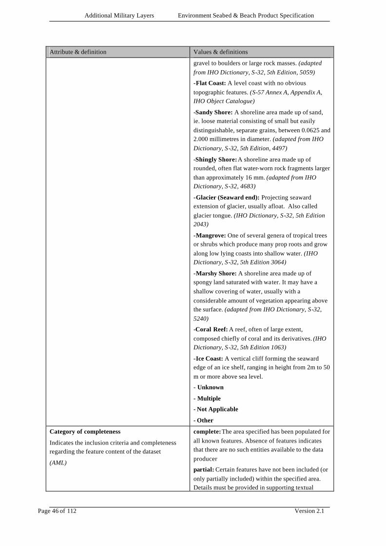
Additional Military Layers Environment Seabed & Beach Product Specification
Page 46 of 112 Version 2.1
Attribute & definition Values & definitions
gravel to boulders or large rock masses. (adapted from IHO Dictionary, S-32, 5th Edition, 5059)
-Flat Coast: A level coast with no obvious topographic features. (S-57 Annex A, Appendix A, IHO Object Catalogue)
-Sandy Shore: A shoreline area made up of sand, ie. loose material consisting of small but easily distinguishable, separate grains, between 0.0625 and 2.000 millimetres in diameter. (adapted from IHO Dictionary, S-32, 5th Edition, 4497)
-Shingly Shore: A shoreline area made up of rounded, often flat water-worn rock fragments larger than approximately 16 mm. (adapted from IHO Dictionary, S-32, 4683)
-Glacier (Seaward end): Projecting seaward extension of glacier, usually afloat. Also called glacier tongue. (IHO Dictionary, S-32, 5th Edition 2043)
-Mangrove: One of several genera of tropical trees or shrubs which produce many prop roots and grow along low lying coasts into shallow water. (IHO Dictionary, S-32, 5th Edition 3064)
-Marshy Shore: A shoreline area made up of spongy land saturated with water. It may have a shallow covering of water, usually with a considerable amount of vegetation appearing above the surface. (adapted from IHO Dictionary, S-32, 5240)
-Coral Reef: A reef, often of large extent, composed chiefly of coral and its derivatives. (IHO Dictionary, S-32, 5th Edition 1063)
-Ice Coast: A vertical cliff forming the seaward edge of an ice shelf, ranging in height from 2m to 50 m or more above sea level.
- Unknown
- Multiple
- Not Applicable
- Other
Category of completeness
Indicates the inclusion criteria and completeness regarding the feature content of the dataset
(AML)
complete: The area specified has been populated for all known features. Absence of features indicates that there are no such entities available to the data producer
partial: Certain features have not been included (or only partially included) within the specified area. Details must be provided in supporting textual
Additional Military Layers Environment Seabed & Beach Product Specification
Page 47 of 112 Version 2.1
Attribute & definition Values & definitions
information
Category of coverage
The availability of coverage
(AML)
coverage available : Continuous coverage of spatial objects is available within this area
no coverage available: An area containing no spatial objects
Category of fishing facility
•fishing stake: a pole or stake placed in shallow water to outline a fishing ground or to catch fish (IHO Dictionary, S-32, 5th Edition, 1818).
•fish trap: a structure (usually portable) for catching fish (IHO Dictionary, S-32, 5th Edition, 1819) .
•fish weir: a fence of stakes or stones set in a river or along the shore to trap fish (IHO Dictionary, S-32, 5th Edition, 5967).
•tunny net: a net built at sea for catching tunny (IHO Dictionary, S-32, 5th Edition, 5700).
Unknown
Not Applicable
Other
Category of Light
-Directional Function: A light illuminating a sector of very narrow angle and intended to mark a direction to follow. (IHO Dictionary S-32, 5th Edition, 2778)
-Leading Light: A light associated with other lights so as to form a leading line to be followed. (Adapted from IHO Dictionary S-32, 5th Edition, 2794)
-Aero Light: An aero light is established for aeronautical navigation and may be of high power than marine lights and visible from well offshore. (IHO Chart Specifications, M-4, 476.1)
-Air Obstruction Light: A light marking an obstacle which constitutes a danger to air navigation. (IHO Dictionary S-32, 5th Edition ,2767)
-Fog Detector Light: A light used to automatically determine conditions of visibility which warrant the turning on or off of a sound signal. (IHO Dictionary S-32, 5th Edition , 1885)
-Flood Light: A broad beam light used to illuminate a structure or area (Adapted from the Collins Dictionary)
-Strip Light: A light whose source has a linear form generally horizontal, which can reach a length of several metres. (S-57 Annex A, Appendix A, IHO
Additional Military Layers Environment Seabed & Beach Product Specification
Page 48 of 112 Version 2.1
Attribute & definition Values & definitions
Object Catalogue)
-Subsidiary Light: A light placed on or near the support of a main light and having a special use in navigation. (ALRS)
-Spotlight: A powerful light focused so as to illuminate a small area. (The Collins Dictionary)
-Front, Rear, Upper, Lower: Terms used with leading lights to describe the position of the light on the lead as viewed from seaward. (S-57 Annex A, Appendix A, IHO Object Catalogue)
-Emergency Light: A light available as a back-up to a main light which will be illuminated should the main light fail. (S-57 Annex A, Appendix A, IHO Object Catalogue)
-Moiré Effect: A short Range (up to 2km) type of directional light. Sodium lighting gives a yellow background to a screen on which a vertical black line will be seen by an observer on the centre line. (IHO Chart Specifications, M-4, 475.8)
-Bearing Light: A light which enables its approximate bearing to be obtained without the use of a compass. (IHO Chart Specifications, M-4, 478.1)
-Horizontally Disposed: A group of lights of identical character and almost identical position, that are disposed horizontally. (S-57 Annex A, Appendix A, IHO Object Catalogue)
-Vertically Disposed: A group of lights of identical character and almost identical position, that are disposed vertically. (S-57 Annex A, Appendix A, IHO Object Catalogue)
-Marine Light: A light intended primarily for marine navigation. (S-57 Annex A, Appendix A, IHO Object Catalogue)
- Unknown
- Multiple
- Not Applicable
- Other
Category of Mooring Facility
-FPB Waiting Position: Position where Fast Patrol Boats can moor to an islet or land. (AML)
- Unknown
- Not Applicable
- Other

Additional Military Layers Environment Seabed & Beach Product Specification
Page 49 of 112 Version 2.1
Attribute & definition Values & definitions
Category of Pipeline
-Intake Pipe: A pipe taking water from a river or other body of water, to drive a mill or supply a canal, waterworks, etc. (IHO Dictionary, S-32, 5th Edition, 2468)
-Outfall Pipe: A pipe (generally a sewer or drainage pipe) discharging in to the sea or river. (S-57 Annex A, Appendix A, IHO Object Catalogue)
-Sewer: A pipe in a sewage system for carrying water or sewage to a disposal area. (S-57 Annex A, Appendix A, IHO Object Catalogue)
-Bubbler System: A submerged pipe from which warm water bubbles, preventing the surrounding water from freezing. (S-57 Annex A, Appendix A, IHO Object Catalogue)
-Supply Pipe: A pipe used for supplying of gas or liquid product. (S-57 Annex A, Appendix A, IHO Object Catalogue)
- Unknown
- Not Applicable
- Other
Category of Sea Area
-Beach area: A geographical area selected as convenient according to size, shape & type and uniquely identified with a letter eg “A” (STANAG 2263 Ed. 4)
-Beach sector: A division of a “Beach Area” usually not more than 100Km in length. Each sector within a “Beach Area” will be given a unique identification number eg “A/2” (STANAG 2263 Ed. 4)
-Estuary: A bay as the mouth of a river, where the tide meets the river current. (IHO Dictionary, S-32, 5th Edition, 1712)
-Nearshore: Sea area close to the shore below low tide. (Adapted from IHO Dictionary, S-32, 5th Edition, 3419)
- Unknown
- Not Applicable
- Other
Category of weed/kelp
-Kelp: A giant plant sometimes 60 metres long with no roots, it is anchored by hold-fasts or tendrils up to 10 metres long, that cling to rock. Gas filled bubbles on fronds act as floats keeping the kelp just below the surface. (Earth Sciences References, Mary McNeil)
Additional Military Layers Environment Seabed & Beach Product Specification
Page 50 of 112 Version 2.1
Attribute & definition Values & definitions
-Sea weed: General name for marine plants of the algae class which grow in long narrow ribbons. (International Maritime Dictionary, 2nd Edition)
-Sea grass: Any grass-like marine alga. Eelgrass is one of the best known seagrasses. (IHO Dictionary, S-32, 5th Edition, 4565)
-Sargasso: A certain type of sea weed, or more generally, a large floating mass of this sea weed. (IHO Dictionary, S-32, 5th Edition, 4501)
-Posidonia: A flowering marine plant, common in the Mediterranean, found at depths of up to 13m on sandy substrates. (AML)
- Unknown
- Not Applicable
- Other
Caveat
A component of a security classification used for authorising a specific group to have access rights
(AML)
Text string
CCM Index
Indication of the degree to which terrain of a given area will permit Cross Country Movement.
(Adapted from NATO STANAG 2259)
Value: Min 0 Max 100
Unit: None
Resolution: 1
Characteristic Detection Probability (B)
The ratio of the number of mines detected on a single run to the number of mines that could have been detected.
(AML)
Value: Min 0 Max 1
Unit: None
Resolution: 0.01
Characteristic Detection Width (A)
Width of path over which mines can be detected on a single run.
(AML)
Unit: metres
Resolution: 1
Class of Control Point
-Triangulation point: A recoverable point on the earth, whose geographic coordinates have been determined by angular methods with geodetic instruments. (Adapted from IHO Dictionary, S-32, 5th Edition, 5646)
-Observation Spot: A point used by surveyors for determining precise position by astronomical means. (IHO Chart Specifications, M-4)
-Fixed Point: A point whose position has been accurately determined and plotted. (IHO Chart
Additional Military Layers Environment Seabed & Beach Product Specification
Page 51 of 112 Version 2.1
Attribute & definition Values & definitions
Specifications, M-4)
-Bench-mark: A permanent, stable object containing a marked point of known elevation with respect to a datum used as a reference level for tidal observations or as a control point for levelling. (IHO Dictionary, S-32, 5th Edition, 462)
-Boundary Mark: A marker identifying the location of a surveyed boundary line (Digital Geographic Information Standard – DIGEST, Oct.87)
-Horizontal Control, Main Station: A station in a network of permanently marked control points having their geographic positions established to form third order accuracy or better. (Canadian Hydrographic Service, Survey Standing Order, 3.1-85)
-Horizontal Control, Secondary Station: A station in a network of control points of a localised nature utilised for shoreline plots, sounding marks, stadia work, etc., whose geographic position may be established to a slightly lower order than main control points. (Canadian Hydrographic Service, Survey Standing Order, 3.1-85)
- Unknown
- Multiple
- Not Applicable
- Other
Classification of Dumping Ground
-Chemical Waste Dumping Ground: An area at sea where chemical waste is dumped. (S-57 Annex A, Appendix A, IHO Object Catalogue)
-Nuclear Waste Dumping Ground: An area at sea where nuclear waste is dumped. (S-57 Annex A, Appendix A, IHO Object Catalogue)
-Explosives Dumping Ground: An area at sea where explosives are dumped. (S-57 Annex A, Appendix A, IHO Object Catalogue)
-Spoil Ground: An area at sea where dredged material is deposited. Also called dumping ground. (IHO Dictionary, S-32, 5th Edition, 4930)
-Vessel Dumping Ground: An area at sea where disused vessels are scuttled. (S-57 Annex A, Appendix A, IHO Object Catalogue)
- Unknown
- Multiple
Additional Military Layers Environment Seabed & Beach Product Specification
Page 52 of 112 Version 2.1
Attribute & definition Values & definitions
- Not Applicable
- Other
Classification of Land Region
General terms for describing landscapes e.g. land use and/or geology.
(AML)
-Backshore: That part of a beach which is usually dry, being reached only by the highest tides. (IHO Dictionary, S-32, 5th Edition, 349)
-Beach: On a shore, the area on which the waves break and over which shore debris, such as sand, shingle, pebbles, accumulate. A beach includes backshore and foreshore. (IHO Dictionary, S-32, 5th Edition, 418)
-Foreshore: That part of the shore which lies between high and low water mark at ordinary tide. (IHO Dictionary, S-32, 5th Edition, 1907)
- Unknown
- Not Applicable
- Other
Classification of Road
-Motorway: A main road with separate carriageways and limited access, specially constructed and controlled for fast motor traffic. (S-57 Annex A, Appendix A, IHO Object Catalogue)
-Major Road: A hard surfaced (metalled) road; a main through route. (S-57 Annex A, Appendix A, IHO Object Catalogue)
-Minor Road: A secondary road for local traffic. (S-57 Annex A, Appendix A, IHO Object Catalogue)
-Track/path: Track – a rough path or way formed by use. Path – a way or track laid down for walking or made by continual treading. (S-57 Annex A, Appendix A, IHO Object Catalogue)
-Major Street: A main road, in an urban area, for local traffic. (S-57 Annex A, Appendix A, IHO Object Catalogue)
-Minor Street: A secondary road, in an urban area, for local traffic. (S-57 Annex A, Appendix A, IHO Object Catalogue)
-Crossing: A place where roads, etc. intersect. (S-57 Annex A, Appendix A, IHO Object Catalogue)
- Unknown
- Not Applicable
- Other
Classification Probability
The probability of classifying a mine or other object of potential military significance.
Value: Min 0 Max 1
Unit: None
Resolution: 0.01
Additional Military Layers Environment Seabed & Beach Product Specification
Page 53 of 112 Version 2.1
Attribute & definition Values & definitions
(AML)
Clearance Percentage
The expected value of the percentage of mines of a given type to be cleared from an area or channel.
(AML)
Value: 0 - 100
Unit: Percentage (%)
Resolution: 1
Colour
-White:
-Black:
-Red:
-Green:
-Blue:
-Yellow:
-Grey:
-Brown:
-Amber:
-Violet:
-Orange:
-Magenta:
-Pink:
- Unknown
- Multiple
- Not Applicable
- Other
Colour Pattern
-Horizontal Stripes: Straight bands or stripes of differing colours painted horizontally. (S-57 Annex A, Appendix A, IHO Object Catalogue)
-Stripes (direction unknown): Straight bands or stripes of differing colours painted in an unknown direction. (S-57 Annex A, Appendix A, IHO Object Catalogue)
-Vertical Stripes: Straight bands of different colours painted vertically. (S-57 Annex A, Appendix A, IHO Object Catalogue)
-Diagonal Stripes: Straight bands or stripes of differing colours painted diagonally (ie not horizontally or vertically) (S-57 Annex A, Appendix A, IHO Object Catalogue)
-Squared: Often referred to as checker plate, where alternate colours are used to create squares similar to a chess or draught board. The pattern may be straight or diagonal. (S-57 Annex A, Appendix A, IHO Object Catalogue)
-Border Stripe: A band or stripe of colour which is
Additional Military Layers Environment Seabed & Beach Product Specification
Page 54 of 112 Version 2.1
Attribute & definition Values & definitions
displayed around the outer edge of the object, which may also form a border to an inner pattern or plain colour. (S-57 Annex A, Appendix A, IHO Object Catalogue)
- Unknown
- Multiple
- Not Applicable
- Other
Communications
Method of communication available.
(AML)
-Ship-shore
-Mobile
-Mil VHF
-HF
-Civ VHF
-Broadcast
-UHF
- Unknown
- Multiple
- Not Applicable
- Other
Condition
The state of the object where it is not considered to be normal i.e. completed, undamaged or working normally.
(Adapted from S-57 Annex A, Appendix A, IHO Object Catalogue)
-Under Reclamation: An area of the sea that is being reclaimed as land usually by the dumping of earth and other material. (S-57 Annex A, Appendix A, IHO Object Catalogue)
-Wingless: A windmill or wind motor from which the turbine blades are missing. (S-57 Annex A, Appendix A, IHO Object Catalogue)
-Under Construction: A structure that is in the process of being built. (S-57 Annex A, Appendix A, IHO Object Catalogue)
-Ruined: A structure in a decayed or deteriorated condition resulting from neglect or disuse, or a damaged structure in need of repair. (IHO Dictionary, S-32, 5th Edition, 4456.)
-Planned Construction: An area where a future construction is planned. (S-57 Annex A, Appendix A, IHO Object Catalogue)
-Operational: Completed, undamaged and working normally (S-57 Annex A, Appendix A, IHO Object Catalogue)
- Unknown
- Multiple
- Not Applicable
Additional Military Layers Environment Seabed & Beach Product Specification
Page 55 of 112 Version 2.1
Attribute & definition Values & definitions
- Other
Confidence Level
The probability that the assumption made from a negative result of the exploratory operations is correct.
(AML)
Value: Min 0 Max 1
Unit: None
Resolution: 0.01
Conspicuous, Radar
Indicates if the object returns a radar echo.
(S-57 Annex A, Appendix A, Chapter 2 Attributes)
•radar conspicuous: an object which returns a strong radar echo. (IHO Dictionary, S-32, 5th Edition, 4142.)
•not radar conspicuous: an object which does not return a particularly strong radar echo. (S-57 Annex A, Appendix A, Chapter 2 Attributes)
Conspicuous, Visually
Indicates if the object is distinctly visible from seaward.
(S-57 Annex A, Appendix A, Chapter 2 Attributes)
•visually conspicuous: term applied to an object either natural or artificial which is distinctly and notably visible from seaward. (IHO Dictionary, S-32, 5th Edition, 984)
•not visually conspicuous: an object which is visible fro m seaward, but is not conspicuous. (S-57 Annex A, Appendix A, Chapter 2 Attributes)
Controlling Authority
The recognised authority responsible for establishing and maintaining the administrative affairs of all matters relating to a particular field or subject.
(AML)
Text string.
Copyright Statement Indicates any copyright or releaseability restrictions on the data. (AML)
Text string
Current Velocity
The rate of travel of a current
(S-57 Annex A, Appendix A, IHO Object Catalogue)
Unit: knot (kt)
Resolution: 0.1 kt
Dangerous Marine and Land Life
Marine and land life that could be dangerous to personnel during amphibious operations.
(AML)
-Anemones: Solitary soft-bodied polyps, having many tentacles. (Adapted from Chambers Concise Dictionary)
-Insects: A division of Arthropods having a distinct head, thorax and abdomen, with three pairs of legs attached to the thorax, usually winged in adult life, and commonly having a metamorphosis in the life-history. (Adapted from Chambers Concise Dictionary)
-Jelly Fish: A marine coelenterate with a jelly-like body. (Adapted from Chambers Concise Dictionary)
-Land Snakes: Land living elongated limbless
Additional Military Layers Environment Seabed & Beach Product Specification
Page 56 of 112 Version 2.1
reptiles, often venomous. (Adapted from Chambers Concise Dictionary)
-Sea Snakes: Marine elongated limbless reptiles, often venomous. (Adapted from Chambers Concise Dictionary)
-Sea Urchins: Marine animal with a globular body and shell of calcareous plates. (Adapted from Chambers Concise Dictionary)
-Sharks: Voracious elasmobranch fishes with lateral gill-slits and the mouth on the underside. (Adapted from Chambers Concise Dictionary)
-Spiders: An arachnid of the order Araneida, the body divided into two distinct parts. (Adapted from Chambers Concise Dictionary)
-Venomous Fish: Fish secreting poisonous fluids. (Adapted from Chambers Concise Dictionary)
- Unknown
- Multiple
- Not Applicable
- Other
Density
The proportion of a mass to its bulk or volume
(Chambers Concise Dictionary)
Value: min 0
Unit: kg/m3
Resolution: 0.01
Depth of Activity
Average depth at which diving activities are taking place.
(AML)
Value: min 0
Units: metres or feet
(units must be defined)
Resolution: 0.1 (metres or ft)
Depth of Layer
Estimated general depth of rock layer or unconsolidated surface materials.
(Adapted from DIGEST FACC, Annex B: B105)
Value: min 0
Units: metres or feet
(units must be defined)
Resolution: 0.1 (metres or ft)
Depth of water over feature
Average depth of water over the feature relative to the specified vertical datum.
(AML)
Value: min 0
Units: metres or feet
(units must be defined)
Resolution: 0.1 (metres or feet)
Depth range - deepest value
The maximum (deepest) value of a depth range.
(S-57 Annex A, Appendix A, IHO Object Catalogue)
Value: min 0
Units: metres or feet
(units must be defined)
Resolution: 0.1 (metres or ft)
Depth range - shoalest value
The minimum (shoalest) value of a depth range
(S-57 Annex A, Appendix A, IHO Object Catalogue)
Value: min 0
Units: metres or feet
(units must be defined)
Additional Military Layers Environment Seabed & Beach Product Specification
Page 57 of 112 Version 2.1
Resolution: 0.1 (metres or ft)
Depth units
Unit of measurement for depths
(AML)
Metres
Fathoms and Feet
Feet
Fathoms and Fractions
Unknown
Not Applicable
Other
Detection Probability
The estimated probability of detecting a mine.
(AML)
Value: Min 0 Max 1
Unit: None
Resolution: 0.01
Disposal Probability
The estimated probability of neutralising a mine.
(AML)
Value: Min 0 Max 1
Unit: None
Resolution: 0.01
Diver’s Thrust Test Depth
The depth to which a diver is able to thrust his arm.
(AML)
-A: Clenched fist – arm penetrates to shoulder. (AML)
-B: Clenched fist – arm penetrates to elbow. (AML)
-C: Clenched fist – arm penetrates to wrist (AML)
-D: Extended fingers – hand penetrates to palm. (AML)
-E: Extended fingers – hand penetrates to knuckles. (AML)
-F: No penetration. (AML)
- Unknown
- Not Applicable
Diver’s Thrust Test Number
Number of arm thrusts required to bury to the shoulder.
(AML)
Value: min 1 max 4
Diving Activity
Type of diving activity taking place
(AML)
-Commercial: Diving taking place for financial gain. (AML)
-Sports: Diving for recreational purposes. (AML)
-Training: Practical instruction in diving techniques.
- Unknown
- Multiple
- Not Applicable
- Other
Elevation
The altitude of the ground level of an object, measured from a specified vertical datum.
Value: min 0
Units: metres or feet
(units must be defined)
Additional Military Layers Environment Seabed & Beach Product Specification
Page 58 of 112 Version 2.1
(S-57 Annex A, Appendix A, IHO Object Catalogue) Resolution: 0.1 (metres or ft)
End Date
Indicates the latest date on which an object will be present.
(S-57 Annex A, Appendix A, IHO Object Catalogue)
Indication:
4 digits for the calendar year (CCYY), 2 digits for the month (MM) (e.g. April = 04) and 2 digits for the day (DD).
Error Ellipse
Also known as the Figure of Merit. 95% 2 sigma value – semi -major and semi-minor axes of error ellipsoid plus orientation of the major axis .
(AML)
Encodes in triplets: The semi-major, semi -minor and orientation of the error ellipse. Orientation is expressed as the true bearing of the major axis.
Exhibition Condition of Light
-Light shown without change of character: A light shown throughout the 24 hours without change of character. (IHO Specifications, M-4)
-Daytime Light: A light which is only exhibited by day. (S-57 Annex A, Appendix A, IHO Object Catalogue)
-Fog Light: A light which is exhibited in fog or conditions of reduced visibility. (S-57 Annex A, Appendix A, IHO Object Catalogue)
-Night Light: A light which is only exhibited at night. (S-57 Annex A, Appendix A, IHO Object Catalogue)
- Unknown
- Not Applicable
- Other
Exit Description
Description of exits from an area used for air landing purposes.
(AML)
Text String
Exit Usability
Usability of exits from beach for vehicles and infantry.
(AML)
-Excellent: Vehicles and infantry can cross any part of the back of the beach without restriction or hindrance. (AML)
-Good: A number of vehicles can drive easily from the beach at the same time through a number of exits. Infantry can leave the beach and move inland without difficulty, along much of the beach. (AML)
-Fair: Exits are becoming fewer and smaller, usually accepting only one vehicle at a time. Infantry may be restricted to some extent by dense undergrowth, swamp, cliff, etc along part of the back of the beach. (AML)
-Poor: Exits for vehicles and infantry are severely restricted in number and quality. (AML)
- Unknown
Additional Military Layers Environment Seabed & Beach Product Specification
Page 59 of 112 Version 2.1
- Not Applicable
- Other
Foliar Inde x
The surface value (in square centimetres) of one significant leaf, and is obtained by multiplying the leaf length by the leaf width.
(AML)
Value: min 0 max 999
Units: cm2
Resolution: 0.1
Function
-Harbour Master’s Office: The office of the local offic ial who has charge of mooring and berthing of vessels. (Adapted from IHO Dictionary, S-32, 5th Edition, 2191)
-Custom’s Office: An office which is charged with enforcing customs regulations. (S-57 Annex A, Appendix A, IHO Object Catalogue)
-Police Station: The office of the local police force. (S-57 Annex A, Appendix A, IHO Object Catalogue)
-Railway Station: A building with platforms where trains arrive, load, discharge and depart. (Adapted from the New Shorter Oxford English Dictionary, 1993)
-Hotel: An establishment, especially of a comfortable or luxurious kind, where paying visitors are provided with accommodation, meals and other services. (Adapted from the New Shorter Oxford English Dictionary, 1993)
-Post Office: The public department, agency or organisation responsible primarily for the collection, transmission and distribution of mail. (The New Shorter Oxford English Dictionary, 1993)
-Health Office: The office which is charged with the administration of health laws and sanitary inspections. (Adapted from the New Shorter Oxford English Dictionary, 1993)
-Pilot Office: The office or headquarters of pilots; the place where the services of a pilot may be obtained. (IHO Dictionary, S-32, 5th Edition, 3845)
-Water-police Station: The headquarters of a local water-police force. (S-57 Annex A, Appendix A, IHO Object Catalogue)
-Factory: A building or buildings with equipment for manufacturing; a workshop. (The New Shorter Oxford English Dictionary, 1993)
-Hospital: An institution or establishment providing medical or surgical treatment for the ill or wounded. (The New Shorter Oxford English Dictionary, 1993)
Additional Military Layers Environment Seabed & Beach Product Specification
Page 60 of 112 Version 2.1
-Pilot Lookout: A distinctive structure on shore from which personnel keep watch upon events at sea or along the coast. (IHO Dictionary, S-32, 5th Edition, 2917)
-Bank Office: An office for custody, deposit, loan, exchange or issue of money. (Adapted from the New Shorter Oxford English Dictionary, 1993)
-Headquarters for District Control : The quarters of an executive officer (director, manager, etc.) with responsibility for an administrative area. (S-57 Annex A, Appendix A, IHO Object Catalogue)
-Transit shed/Warehouse: A building or part of a building for storage of wares or goods. (Adapted from the New Shorter Oxford English Dictionary, 1993)
-Power Station: A stationary plant containing apparatus for large scale conversion of some form of energy (such as hydraulic, steam, chemical or nuclear energy) into electrical energy. (McGraw-Hill Dictionary of Scientific and Technical Terms, 3rd Edition, 1984)
-Admi nistrative: A building for the management of affairs. (Adapted from the New Shorter Oxford English Dictionary, 1993)
-Educational Facility: A building concerned with education (eg. school, college, university etc). (S-57 Annex A, Appendix A, IHO Object Catalogue)
-Church: A building for public Christian worship. (The New Shorter Oxford English Dictionary, 1993)
-Chapel: A place for Christian worship other than a parish, cathedral or church, especially one attached to a private house or institution. (The New Shorter Oxford English Dictionary, 1993)
-Temple: A building for public Jewish worship. (Adapted from the New Shorter Oxford English Dictionary, 1993)
-Pagoda: A Hindu or Buddhist temple or sacred building. (The New Shorter Oxford English Dictionary, 1993)
-Shinto Shrine: A building for public Shinto worship. (Adapted from the New Shorter Oxford English Dictionary, 1993)
-Buddhist Temple: See Pagoda
-Mosque: A Muslim place of worship. (The New Shorter Oxford English Dictionary, 1993)
-Marabout: A shrine marking the burial place of a
Additional Military Layers Environment Seabed & Beach Product Specification
Page 61 of 112 Version 2.1
Muslim holy man. (The New Shorter Oxford English Dictionary, 1993)
-Lookout: Keeping watch upon events at sea or along the coast. (Adapted from IHO Dictionary, S-32, 5th Edition, 2917)
-Communication: Transmitting and/or receiving electronic communication signals. (Adapted from Digital Geographic Information Standard – DIGEST)
-Television: Broadcast of television signals. (S-57 Annex A, Appendix A, IHO Object Catalogue)
-Radio: Broadcast of radio signals. (S-57 Annex A, Appendix A, IHO Object Catalogue)
-Radar: A method, system or technique of using beamed, reflected, and timed radio waves for detecting, locating, or tracking objects, and for measuring altitudes. (IHO Dictionary, S-32, 5th Edition, 4158)
-Light Support: Supporting a light. (S-57 Annex A, Appendix A, IHO Object Catalogue)
-Microwave: Broadcasting and receiving signals using microwaves. (S-57 Annex A, Appendix A, IHO Object Catalogue)
-Cooling: Dissipating heat. (S-57 Annex A, Appendix A, IHO Object Catalogue)
-Observation: A place from which the surroundings can be observed but at which a watch is not habitually maintained. (Adapted from IHO Dictionary, S-32, 5th Edition, 2917)
-Time Ball: A visual time signal in form of a ball. (S-57 Annex A, Appendix A, IHO Object Catalogue)
-Clock: Visual time signal. (Adapted from IHO Dictionary, S-32, 5th Edition, 5536)
-Control: Used to control the flow of air, rail, or marine traffic. (Digital Geographic Information Standard – DIGEST)
-Airship Mooring: A facility to secure an airship. (Adapted from Digital Geographic Information Standard – DIGEST)
-Stadium: A large usually unroofed building with tiers of seats for spectators. (S-57 Annex A, Appendix A, IHO Object Catalogue)
-Bus Station : A location at which buses arrive and from which they depart. (S-57 Annex A, Appendix A, IHO Object Catalogue)
Additional Military Layers Environment Seabed & Beach Product Specification
Page 62 of 112 Version 2.1
- Unknown
- Multiple
- Not Applicable
- Other
Gas Content
Gas content of the sediment expressed as a percentage
(AML)
Value: 0 - 100
Unit: Percentage (%)
Resolution: 1
Gradient
The change of any quantity with distance in any given direction
(IHO Dictionary, S-32, 5th Edition, 2062.)
-Steep: > 1:15 (AML)
-Moderate : 1:15 – 1:30 (AML)
-Gentle: 1:30 – 1:60 (AML)
-Mild: 1:60 – 1:120 (AML)
-Flat: < 1:120 (AML)
- Unknown
- Not Applicable
- Other
Grain Size
Grain size of the sediment.
(AML)
Units: millimetres
Resolution: 0.001
Height
Value of the vertical distance to the highest point of the object, measured from a specified vertical datum.
(S-57 Annex A, Appendix A, Chapter 2 Attributes)
Value: 0 - 999.9
Units: metres or feet
(units must be defined)
Resolution: 0.1
Height/Length Units
Unit of measurement for heights and lengths.
-Metres
-Feet
HF Bottom Loss
The loss of high frequency sonar signal from the geological layer
(AML)
Units: dB
Resolution: 0.1
Horizontal Clearance
The width of an object, such as a canal or a tunnel, which is available for safe navigation. This may, or may not, be the same as the total physical width of the object.
(S-57 Annex A, Appendix A, IHO Object Catalogue)
Value: min 0
Units: metres or feet
(units must be defined)
Resolution: 0.1 (metres or ft)
Horizontal Length
A measurement of the longer of the two linear axes.
(Digital Geographic Information Working Group – DGIWG, Oct 87.)
Value: min 0
Units: metres or feet
(units must be defined)
Resolution 1 (metres or feet)
Horizontal Width Value: min 0
Additional Military Layers Environment Seabed & Beach Product Specification
Page 63 of 112 Version 2.1
A measurement of the shorter of the two linear axes.
(Digital Geographic Information Working Group – DGIWG, Oct 87.)
Units: metres or feet
(units must be defined)
Resolution 1 (metres or feet)
Ice Attribute Concentration Total
Specifies the total concentration of ice in an area. This attribute represents the ratio expressed in tenths describing the area of water surface covered by ice as a fraction of the whole area.
(ECDIS Ice Objects Version 3.0)
-1/10
-2/10
-3/10
-4/10
-5/10
-6/10
-7/10
-8/10
-9/10
-<1/10 - 2/10
-1/10 - 3/10
-4/10 - 6/10
-7/10 - 8/10
-9/10 - <10/10
-10/10 with openings (Often called 9+/ 10)
-10/10 without openings
-<1/10
-Undetermined or Unknown
- Not Applicable
Iceberg Shape
Indicates the shape of an iceberg.
(ECDIS Ice Objects Version 3.0)
-Tabular:
-Domed:
-Pinnacled:
-Wedged:
-Dry-docked:
-Blocky:
-Undetermined/Unknown:
- Not Applicable
- Other
Iceberg Size
Categorizes the size of an iceberg.
(ECDIS Ice Objects Version 3.0)
-Growler:
-Bergy Bit:
-Small Iceberg:
-Medium Iceberg:
-Large Iceberg:
-Very Large Iceberg:
-Ice Island Fragment:
-Ice Island:
-Radar Target:
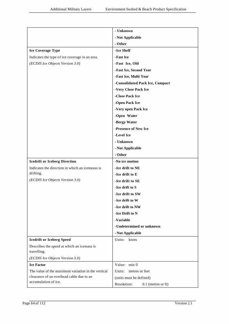
Additional Military Layers Environment Seabed & Beach Product Specification
Page 64 of 112 Version 2.1
- Unknown
- Not Applicable
- Other
Ice Coverage Type
Indicates the type of ice coverage in an area.
(ECDIS Ice Objects Version 3.0)
-Ice Shelf
-Fast Ice
-Fast Ice, Old
-Fast Ice, Second Year
-Fast Ice, Multi Year
-Consolidated Pack Ice, Compact
-Very Close Pack Ice
-Close Pack Ice
-Open Pack Ice
-Very open Pack Ice
-Open Water
-Bergy Water
-Presence of New Ice
-Level Ice
- Unknown
- Not Applicable
- Other
Icedrift or Iceberg Direction
Indicates the direction in which an icemeass is drifting.
(ECDIS Ice Objects Version 3.0)
-No ice motion
-Ice drift to NE
-Ice drift to E
-Ice drift to SE
-Ice drift to S
-Ice drift to SW
-Ice drift to W
-Ice drift to NW
-Ice Drift to N
-Variable
-Undetermined or unknown
- Not Applicable
Icedrift or Iceberg Speed
Describes the speed at which an icemass is travelling.
(ECDIS Ice Objects Version 3.0)
Units: knots
Ice Factor
The value of the maximum variation in the vertical clearance of an overhead cable due to an accumulation of ice.
Value: min 0
Units: metres or feet
(units must be defined)
Resolution: 0.1 (metres or ft)
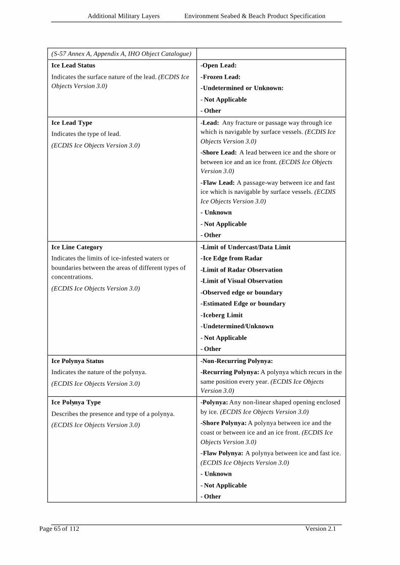
Additional Military Layers Environment Seabed & Beach Product Specification
Page 65 of 112 Version 2.1
(S-57 Annex A, Appendix A, IHO Object Catalogue)
Ice Lead Status
Indicates the surface nature of the lead. (ECDIS Ice Objects Version 3.0)
-Open Lead:
-Frozen Lead:
-Undetermined or Unknown:
- Not Applicable
- Other
Ice Lead Type
Indicates the type of lead.
(ECDIS Ice Objects Version 3.0)
-Lead: Any fracture or passage way through ice which is navigable by surface vessels. (ECDIS Ice Objects Version 3.0)
-Shore Lead: A lead between ice and the shore or between ice and an ice front. (ECDIS Ice Objects Version 3.0)
-Flaw Lead: A passage-way between ice and fast ice which is navigable by surface vessels. (ECDIS Ice Objects Version 3.0)
- Unknown
- Not Applicable
- Other
Ice Line Category
Indicates the limits of ice-infested waters or boundaries between the areas of different types of concentrations.
(ECDIS Ice Objects Version 3.0)
-Limit of Undercast/Data Limit
-Ice Edge from Radar
-Limit of Radar Observation
-Limit of Visual Observation
-Observed edge or boundary
-Estimated Edge or boundary
-Iceberg Limit
-Undetermined/Unknown
- Not Applicable
- Other
Ice Polynya Status
Indicates the nature of the polynya.
(ECDIS Ice Objects Version 3.0)
-Non-Recurring Polynya:
-Recurring Polynya: A polynya which recurs in the same position every year. (ECDIS Ice Objects Version 3.0)
Ice Polynya Type
Describes the presence and type of a polynya.
(ECDIS Ice Objects Version 3.0)
-Polynya: Any non-linear shaped opening enclosed by ice. (ECDIS Ice Objects Version 3.0)
-Shore Polynya: A polynya between ice and the coast or between ice and an ice front. (ECDIS Ice Objects Version 3.0)
-Flaw Polynya: A polynya between ice and fast ice. (ECDIS Ice Objects Version 3.0)
- Unknown
- Not Applicable
- Other

Additional Military Layers Environment Seabed & Beach Product Specification
Page 66 of 112 Version 2.1
Ice Ridge Development
Describes the type of ridges present.
(ECDIS Ice Objects Version 3.0)
-New Ridge
-Weathered Ridge
-Very Weathered Ridge
-Aged Ridge
-Consolidated Ridge
-Undetermined or unknown
- Not Applicable
- Other
Ice Stage of Development
Describes the ages and thicknesses of the ice.
(ECDIS Ice Objects Version 3.0)
-No ice present
-New Ice
-Nilas, ice rind
-Young Ice
-Grey Ice
-Grey-white ice
-First Year Ice
-Thin first year ice
-Medium first year ice
-Thick first year ice
-Old ice
-Second year ice
-Multi year ice
-Ice of land origin
-Undetermined or Unknown
- Not Applicable
- Other
Image file link
Indicates an external file containing a pictorial representation of the object
(S-57 Annex A, Appendix A, IHO Object Catalogue)
Text string
Industry
Information on the industries including potential hazards.
(AML)
Text String
International Defence Organisation (IDO) status
The International Defence Organisation (IDO) status (if applicable) that must precede, and be applied to, the Protective Marking thus making it an IDO Marking
(AML)
-North Atlantic Treaty Organisation (NATO)
-North Atlantic Co-operation Council (NACC)
-Partnership for Peace (PfP)
-Western European Union(WEU)
-Unknown
- Multiple
-Not Applicable

Additional Military Layers Environment Seabed & Beach Product Specification
Page 67 of 112 Version 2.1
-Other
Land Ice
The type of ice of land origin
(ECDIS Ice Objects Version 3)
-Glacial Ice: Ice in or originating from a glacier, whether on land or floating on the sea as icebergs, bergy bits, growlers or ice islands. (ECDIS Ice Objects Version 3)
-Glacial Tongue: Projecting seaward extension of a glacier, usually afloat. (ECDIS Ice Objects Version 3)
-Ice Shelf: A floating ice sheet of considerable thickness showing 2m or more above sea level, attached to the coast. (ECDIS Ice Objects Version 3)
-Undetermined or Unknown:
- Not Applicable
- Other
Landing Conditions
Description of the landing conditions including surface composition and immediate topographical features.
(AML)
Text String
Layer Number
Number of geological layer, ascending from the lowest identified layer.
(AML)
Value: min 1
Units: none
Resolution: 1
Legal Status
Classification of the area with respect to the law.
(AML)
Text String
Leisure Activity
Type of leisure activity taking place.
(AML)
Text String
LF Bottom Loss
The loss of low frequency sonar signal from the geological layer
(AML)
Units: dB
Resolution: 0.1
Lifting Capacity
The specific safe lifting capacity of an object.
(S-57 Annex A, Appendix A, IHO Object Catalogue)
Value: min 0
Units: tonnes
Resolution: 0.1 (t)
Light characteristic
-Fixed: A signal light that shows continuously, in any given direction, with constant luminous intensity and colour. (IHO Dictionary, S-32, 5th Edition, 2780)
-Flashing: A rhythmic light in which the total duration of the light in a period is clearly shorter than the total duration of darkness and all the
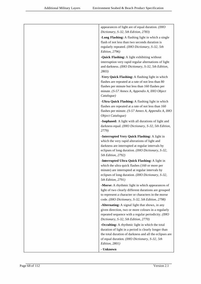
Additional Military Layers Environment Seabed & Beach Product Specification
Page 68 of 112 Version 2.1
appearances of light are of equal duration. (IHO Dictionary, S-32, 5th Edition, 2783)
-Long Flashing: A flashing light in which a single flash of not less than two seconds duration is regularly repeated. (IHO Dictionary, S-32, 5th Edition, 2796)
-Quick Flashing: A light exhibiting without interruption very rapid regular alternations of light and darkness. (IHO Dictionary, S-32, 5th Edition, 2803)
-Very Quick Flashing: A flashing light in which flashes are repeated at a rate of not less than 80 flashes per minute but less than 160 flashes per minute. (S-57 Annex A, Appendix A, IHO Object Catalogue)
-Ultra Quick Flashing: A flashing light in which flashes are repeated at a rate of not less than 160 flashes per minute. (S-57 Annex A, Appendix A, IHO Object Catalogue)
-Isophased: A light with all durations of light and darkness equal. (IHO Dictionary, S-32, 5th Edition, 2779)
-Interrupted Very Quick Flashing: A light in which the very rapid alterations of light and darkness are interrupted at regular intervals by eclipses of long duration. (IHO Dictionary, S-32, 5th Edition, 2792)
-Interrupted Ultra Quick Flashing: A light in which the ultra quick flashes (160 or more per minute) are interrupted at regular intervals by eclipses of long duration. (IHO Dictionary, S-32, 5th Edition, 2791)
-Morse: A rhythmic light in which appearances of light of two clearly different durations are grouped to represent a character or characters in the morse code. (IHO Dictionary, S-32, 5th Edition, 2798)
-Alternating: A signal light that shows, in any given direction, two or more colours in a regularly repeated sequence with a regular periodicity. (IHO Dictionary, S-32, 5th Edition, 2770)
-Occulting: A rhythmic light in which the total duration of light in a period is clearly longer than the total duration of darkness and all the eclipses are of equal duration. (IHO Dictionary, S-32, 5th Edition, 2801)
- Unknown
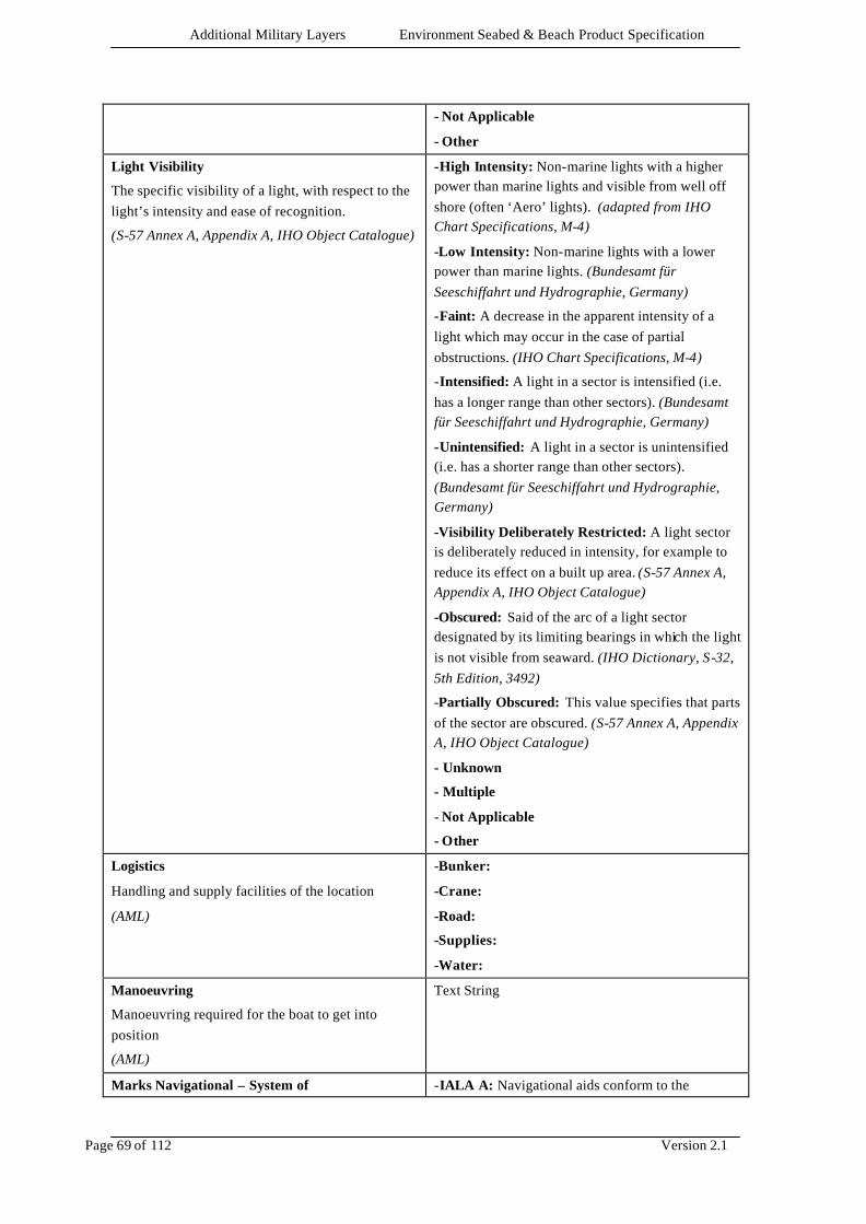
Additional Military Layers Environment Seabed & Beach Product Specification
Page 69 of 112 Version 2.1
- Not Applicable
- Other
Light Visibility
The specific visibility of a light, with respect to the light’s intensity and ease of recognition.
(S-57 Annex A, Appendix A, IHO Object Catalogue)
-High Intensity: Non-marine lights with a higher power than marine lights and visible from well off shore (often ‘Aero’ lights). (adapted from IHO Chart Specifications, M-4)
-Low Intensity: Non-marine lights with a lower power than marine lights. (Bundesamt für Seeschiffahrt und Hydrographie, Germany)
-Faint: A decrease in the apparent intensity of a light which may occur in the case of partial obstructions. (IHO Chart Specifications, M-4)
-Intensified: A light in a sector is intensified (i.e. has a longer range than other sectors). (Bundesamt für Seeschiffahrt und Hydrographie, Germany)
-Unintensified: A light in a sector is unintensified (i.e. has a shorter range than other sectors). (Bundesamt für Seeschiffahrt und Hydrographie, Germany)
-Visibility Deliberately Restricted: A light sector is deliberately reduced in intensity, for example to reduce its effect on a built up area. (S-57 Annex A, Appendix A, IHO Object Catalogue)
-Obscured: Said of the arc of a light sector designated by its limiting bearings in which the light is not visible from seaward. (IHO Dictionary, S-32, 5th Edition, 3492)
-Partially Obscured: This value specifies that parts of the sector are obscured. (S-57 Annex A, Appendix A, IHO Object Catalogue)
- Unknown
- Multiple
- Not Applicable
- Other
Logistics
Handling and supply facilities of the location
(AML)
-Bunker:
-Crane:
-Road:
-Supplies:
-Water:
Manoeuvring
Manoeuvring required for the boat to get into position
(AML)
Text String
Marks Navigational – System of -IALA A: Navigational aids conform to the
Additional Military Layers Environment Seabed & Beach Product Specification
Page 70 of 112 Version 2.1
International Association of Lighthouse Authorities – IALA A system. (S-57 Annex A, Appendix A, IHO Object Catalogue)
-IALA B: Navigational aids conform to the International Association of Lighthouse Authorities – IALA B system (S-57 Annex A, Appendix A, IHO Object Catalogue)
-No System: Navigational aids do not conform to any defined system. (S-57 Annex A, Appendix A, IHO Object Catalogue)
-Other System: Navigational aids conform to a defined system other than International Association of Lighthouse Authorities – IALA. (S-57 Annex A, Appendix A, IHO Object Catalogue)
- Unknown
- Not Applicable
Maximum distance between survey lines
The maximum spacing of the principal sounding lines of a survey
(S-57 Annex A, Appendix A, IHO Object Catalogue)
Units: metres or feet
(units must be defined)
Resolution: 1
Maximum Ice Thickness
Specifies the maximum thickness of the ice.
(ECDIS Ice Objects Version 3.0)
Value: min 0
Units: cm
Resolution: 5cm
Mean Shear Strength
Pressure required to deform the sediment.
(AML)
Value: min 0
Units: kg/m2
Resolution: 0.1
MGS Type
Classification of the seabed using Marine Geophysical Survey values.
(AML)
Note: this attribute must only be used where more detailed information that could populate the attribute Nature of Geological Layer is not available. MGS Type and Nature of Geological Layer must not be used on the same object.
-1: Hard bottom (till, also bedrock)
-2: Hard bottom and sand bottom equally distributed.
-3: Sand bottom (sand and gravel)
-4: Sand bottom with minor soft bottom areas
-5: Sand bottom and soft bottom equally distributed
-6: Soft bottom (silt, clay and mud)
-7: Soft bottom with minor hard bottom outcrops
-8: Soft bottom and hard bottom equally distributed
-9: Hard bottom with minor soft bottom areas
-0: Unknown
Not Applicable
Migration Direction
Direction of movement of feature.
(AML)
Value: 0 - 359
Unit: degree
Resolution: 1
Migration Speed Value: min 0
Additional Military Layers Environment Seabed & Beach Product Specification
Page 71 of 112 Version 2.1
Speed of movement of feature in metres per day.
(AML)
Units: metres or feet per day
(units must be defined)
Resolution: 0.01 (metres or ft)
Milec Density
Density of mine-like echoes per square mile.
(AML)
-0: No data available. (AML)
-1: Light – 1-20 Milecs/sq mile. (AML)
-2: Medium – 21-40 Milecs/sq mile. (AML)
-3: Heavy – 41-70 Milecs/sq mile . (AML)
-4: 71 Milecs/sq mile and more. (AML)
Unknown
Not Applicable
Military Load Classification
Class number which represents the safe load carrying capacity of the object and indicates the maximum vehicle class that can be accepted under normal conditions.
(Adapted from NATO STANAG 2174)
-4
-8
-12
-16
-20
-24
-30
-40
-50
-60
-70
-80
-90
-100
-120
-150
- Unknown
- Not Applicable
- Other
Mine Threat Density
The estimated density of mines.
(AML)
Units: mines/m2
Resolution: 1
Minehunting Classification
Classification of profile of the sea bed.
(AML)
-A: Smooth – Very few craters, gullies, ridges or seaweed patches (5% of the area or less), sand ripples 150mm high or less. (AML)
-B: Moderate – Large numbers of craters, gullies, ridges or seaweed patches (5 to 15% of the area), sand ripples 150 to 300 mm high. (AML)
-C: Rough – Extensive areas (over 15% of the whole) of craters etc., or large sand ripples or closely spaced sandwaves. (AML)
Additional Military Layers Environment Seabed & Beach Product Specification
Page 72 of 112 Version 2.1
-D: Very Rough - very extensive areas (over 50% of the whole) (AML)
Unknown
Not Applicable
Minimum distance between survey lines
The minimum spacing of the principal sounding lines of a survey
(S-57 Annex A, Appendix A, IHO Object Catalogue)
Units: metres or feet
(units must be defined)
Resolution: 1
Minimum Ice Thickness
Specifies the minimum thickness of the ice.
(ECDIS Ice Objects Version 3.0)
Value: min 0
Units: cm
Resolution: 5cm
Multiplicity of Lights
The number of lights of identical character that exist as a co-located group.
(S-57 Annex A, Appendix A, IHO Object Catalogue)
Value: min 2
Unit: none
Resolution: 1
Name
The principal name or identifier of an object in English.
(AML)
Text string.
Name (in national language characters)
The principal name or identifier of an object in national language characters.
(AML)
Text string.
Nature of Construction
The material(s) used to make the object.
(S-57 Annex A, Appendix A, IHO Object Catalogue)
-Unsurfaced: Constructed with no extra protection, usually a term applied to roads not surfaced with a hard material. (S-57 Annex A, Appendix A, IHO Object Catalogue)
-Hard Surface: Constructed with a surface of hard material, usually a term applied to roads surfaced with aphsalt or concrete. (S-57 Annex A, Appendix A, IHO Object Catalogue)
-Loose boulders: Constructed from large stones or blocks of concrete, often placed loosely for protection against waves or water turbulence. (S-57 Annex A, Appendix A, Chapter 2 Attributes)
-Masonry: Constructed from brick or stone. (S-57 Annex A, Appendix A, IHO Object Catalogue)
-Metal: Constructed from metal. (S-57 Annex A, Appendix A, IHO Object Catalogue)
-Concreted: Constructed of concrete, a material made of sand and gravel that is united by cement into a hardened mass used for foundations etc.
Additional Military Layers Environment Seabed & Beach Product Specification
Page 73 of 112 Version 2.1
(Adapted from the Illustrated Contemporary Dictionary, Encyclopaedic Edition, 1978)
-Glass Reinforced Plastic (GRP): Constructed from a plastic material strengthened with fibres of glass. (S-57 Annex A, Appendix A, Chapter 2 Attributes)
- Wooden: Constructed from wood. (S-57 Annex A, Appendix A, Chapter 2 Attributes)
- Unknown
- Multiple
- Not Applicable
- Other
Nature of Geological Layer
Type of rock or sediment making up the geological layer.
(AML)
-Undifferentiated metamorphic rock: Rock formed by alteration of existing rocks by heat, pressure, or other processes in the earth’s crust. (Chambers Concise Dictionary)
-Undifferentiated igneous and volcanic rock: Rock formed by solidification of molten material or magma. (IHO Dictionary SP-32 5th Edition, 2391)
-Granite: Light coloured, acidic igneous rock mineralogically composed primarily of quartz and potassium-sodium feldspars in which the mineral grains are visible to the naked eye (phaneritic texture) (IHO Dictionary SP-32 5th Edition, 2067)
-Dolerite: A basic igneous rock occurring in minor intrusions such as sills and dykes. Usually dark coloured and fine or medium textured. (A Dictionary of Geography, 2nd Edition)
-Basalt: Dark grey to black, dense to fine-grained, extrusive igneous rock. (Adapted from Webster’s 3rd New International Dictionary)
-Gneiss: A coarse-grained crystalline rock of foliated texture and of streaked, wavy or banded appearance. Formed by the metamorphism of granite and other igneous rocks. (Adapted from A Dictionary of Geography, 2nd Edition)
-Marble: Limestone that has been crystalised in varying degrees by metamorphism. It ranges from granular to compact in texture and can be black or white, tinted, veined, or mottled with various colours. (Adapted from Webster’s 3rd International Dictionary)
-Schist: A foliated metamorphic rock which can be split into thin flakes or flat lenticles. Schists are usually named from the dominant mineral, eg. mica schist. (IHO Dictionary SP-32 5th Edition, 4541)
Additional Military Layers Environment Seabed & Beach Product Specification
Page 74 of 112 Version 2.1
-Slate: A dense fine-grained rock produced by the compression of clays, shales and various other rocks that develops a characteristic cleavage which may be at any angle with the original bedding plane. (Adapted from Webster’s 3rd International Dictionary)
-Quartzite: A compact granular rock composed of quartz. It is a metamo rphosed sandstone in which the siliceous element is often so blended with the quartz grains so as to give the rock a nearly homogenous texture. (Adapted from Webster’s 3rd International Dictionary)
-Breccia: A rock consisting of sharp fragments embedded in a fine-grained matrix. (Adapted from Webster’s 3rd International Dictionary)
-Conglomerate: Sedimentary rock composed of rounded fragments varying from small pebbles to larger boulders in a cement of calcareous material, iron oxide, silica or hardened clay. (Adapted from Webster’s 3rd International Dictionary)
-Coral: Hard calcareous skeletons of many tribes of marine polyps. (IHO Dictionary SP-32 5th Edition, 4541)
-Clays: Mineralogically, a hydrous aluminium silicate material with plastic properties and a crystal structure. (IHO SP-32 Ed5: 817)
-Chalk: A white soft rock, composed of calcium carbonate. (Chambers Concise Dictionary)
-Evaporite: A natural salt or mineral deposit formed by evaporation of water.
-Shale: Clay rock that splits readily into thin layers along the bedding planes. (Chambers Concise Dictionary)
-Siltstone and mudstone: Types of rock formed of compacted and hardened silt and mud. (AML)
-Sandstone: A type of rock formed of compacted and hardened sand. (Chambers Concise Dictionary)
-mud: Pelagic or terrigenous detrital material consisting mostly of silt and clay-sized particles (less than 0.06 mm) but often containing varying amounts of sand and/or organic materials. It is a general term applied to any sticky fine-grained sediment whose exact size classification has not been determined. (IHO SP-32 Ed5: 3336)
-sandy mud (Folk)
-slightly gravelly mud (Folk)
Additional Military Layers Environment Seabed & Beach Product Specification
Page 75 of 112 Version 2.1
-slightly gravelly sandy mud (Folk)
-gravelly mud (Folk)
-sand: Loose material consisting of small but easily distinguishable, separate grains, between 0.0625 and 2.000 mm in diameter. (IHO SP-32 Ed5: 4497)
-muddy sand (Folk)
-slightly gravelly sand (Folk)
-slightly gravelly muddy sand (Folk)
-gravelly muddy sand (Folk)
-gravelly sand (Folk)
-gravel (Folk): Loose detrital material ranging in size from 2 to 256 mm.
-muddy gravel (Folk)
-muddy sandy gravel (Folk)
-sandy gravel (Folk)
-Limestone: A rock that consists chiefly of calcium carbonate. (IHO SP-32 Ed5: 2833)
-silt: An unconsolidated sediment whose particles range in size fro m 0.0039 to 0.0625 mm in diameter. (IHO Dictionary, S-32, 5th Edition, 4746)
-Stone: A general term for rock fragments ranging in size from pebbles and gravel to boulders or a large rock mass. (IHO Dictionary, S-32, 5th Edition, 5059)
-Pebbles: A small stone worn smooth and round by the action of water, sand, ice, etc. ranging in diameter between 4 and 64 mm. (IHO Dictionary, S-32, 5th Edition, 3721)
-Cobbles: A naturally rounded stone larger than 64 mm in diameter. (Adapted from IHO Dictionary, S-32, 5th Edition, 863)
-Rock: Any formation of natural origin that constitutes an integral part of the lithosphere. The natural occurring material that forms firm, hard and solid masses. (Adapted from IHO Dictionary, S-32, 5th Edition, 4415)
-Lava: The fluid or semi-fluid matter flowing from a volcano. The substance that results from the cooling of the molten rock. Part of the ocean bed is composed of lava. (IHO Dictionary, S-32, 5th Edition, 2680)
-Shells: Exoskeletons of various water dwelling animals. (Adapted from IHO Dictionary, S-32, 5th Edition, 4680)
Additional Military Layers Environment Seabed & Beach Product Specification
Page 76 of 112 Version 2.1
-Boulder: A rounded rock with a diameter of 256 mm or larger. (Adapted from IHO Dictionary, S-32, 5th Edition, 527)
- Unknown
- Not Applicable
- Other
Nature of Geological Layer - Qualifying Terms
Physical characteristics of the geological layer in terms of size, morphology and consistency.
(AML)
-fine: falls within the smallest size continuum for a particular nature of surface term. (M-4 425.6)
-medium: falls within the moderate size continuum for a particular nature of surface term. (M-4 425.6)
-coarse: falls within the largest size continuum for a particular nature of surface term. (M-4 425.6)
-broken: fractured or in pieces. (adapted from Webster’s II New Riverside Dictionary, 1984)
-sticky: having an adhesive or glue like property. (adapted from Webster’s II New Riverside Dictionary, 1984)
-soft: not hard or firm. (adapted from Webster’s II New Riverside Dictionary, 1984)
-stiff: not pliant; thick, resistant to flow. (adapted from Webster’s II New Riverside Dictionary, 1984)
-volcanic: composed of or containing material ejected from a volcano. (adapted from Webster’s II New Riverside Dictionary, 1984)
-calcareous: composed of or containing calcium or calcium carbonate. (IHO Dictionary, S-32, 5th Edition, 603)
-hard: firm; usually refers to an area of the sea floor not covered by unconsolidated sediment. (IHO Dictionary, S-32, 5th Edition, 2194 and adapted from Webster’s II New Riverside Dictionary, 1984)
- Unknown
- Multiple
- Not Applicable
- Other
Navigational Description
Description of any specific navigational requirements
(AML)
Text String
Navigational Difficulty
An indication of the navigational difficulties associated with the location.
(AML)
-Easy:
-Normal:
-Hard:
- Unknown
Additional Military Layers Environment Seabed & Beach Product Specification
Page 77 of 112 Version 2.1
- Not Applicabl e
- Other
NOMBO Density
Density of non-mine mine-like bottom objects.
(AML)
-0: No data available (AML)
-1: Light – 1-4 NOMBOS/sq mile (AML)
-2: Medium – 5-8 NOMBOS/sq mile (AML)
-3: Heavy – 9-14 NOMBOS/sq mile (AML)
-4: 15 NOMBOS/sq mile and more (AML)
Unknown
Not Applicable
Number of Icebergs in Area
The number of icebergs within a specified area
(ECDIS Ice objects Version 3.0)
The number of icebergs in an area expressed by a density measurement on the basis of a grid
Number of Remaining Mines
The maximum acceptable number of remaining mines
(AML)
Unit: None
Resolution: 1
Orientation
The angular distance measured from true north to the major axis of the object.
(Digital Geographic Information Working Group – DGIWG, Oct.87)
Value: 0.00- 359.99
Unit: degree
Resolution: 0.01
Originator
Name of vessel or unit from which the information originated
(AML)
Text string
Owner authority
Denotes the ‘owner’ that is responsible for establishing and setting the protective marking level
(AML)
The NATO country code (NATO STANAG 1059)
Pier Contact Details
Name and telephone number of the pier owner.
(AML)
Text String
Pier Description
A description of the pier
(AML)
Text String
Population
The number of inhabitants
(Chambers Concise Dictionary)
Unit: None
Resolution: 1
Porosity
The ratio of the aggregate volume of pore space in a rock or sediment to its total volume, expressed as a
Value: 0 - 100
Unit: Percentage (%)
Resolution: 1
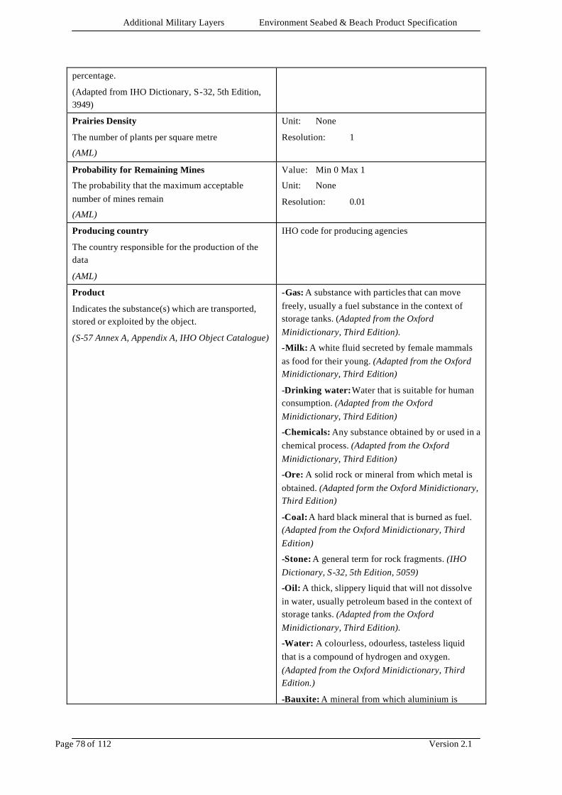
Additional Military Layers Environment Seabed & Beach Product Specification
Page 78 of 112 Version 2.1
percentage.
(Adapted from IHO Dictionary, S-32, 5th Edition, 3949)
Prairies Density
The number of plants per square metre
(AML)
Unit: None
Resolution: 1
Probability for Remaining Mines
The probability that the maximum acceptable number of mines remain
(AML)
Value: Min 0 Max 1
Unit: None
Resolution: 0.01
Producing country
The country responsible for the production of the data
(AML)
IHO code for producing agencies
Product
Indicates the substance(s) which are transported, stored or exploited by the object.
(S-57 Annex A, Appendix A, IHO Object Catalogue)
-Gas: A substance with particles that can move freely, usually a fuel substance in the context of storage tanks. (Adapted from the Oxford Minidictionary, Third Edition).
-Milk: A white fluid secreted by female mammals as food for their young. (Adapted from the Oxford Minidictionary, Third Edition)
-Drinking water: Water that is suitable for human consumption. (Adapted from the Oxford Minidictionary, Third Edition)
-Chemicals: Any substance obtained by or used in a chemical process. (Adapted from the Oxford Minidictionary, Third Edition)
-Ore: A solid rock or mineral from which metal is obtained. (Adapted form the Oxford Minidictionary, Third Edition)
-Coal: A hard black mineral that is burned as fuel. (Adapted from the Oxford Minidictionary, Third Edition)
-Stone: A general term for rock fragments. (IHO Dictionary, S-32, 5th Edition, 5059)
-Oil: A thick, slippery liquid that will not dissolve in water, usually petroleum based in the context of storage tanks. (Adapted from the Oxford Minidictionary, Third Edition).
-Water: A colourless, odourless, tasteless liquid that is a compound of hydrogen and oxygen. (Adapted from the Oxford Minidictionary, Third Edition.)
-Bauxite: A mineral from which aluminium is
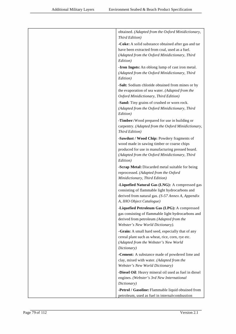
Additional Military Layers Environment Seabed & Beach Product Specification
Page 79 of 112 Version 2.1
obtained. (Adapted from the Oxford Minidictionary, Third Edition)
-Coke: A solid substance obtained after gas and tar have been extracted from coal, used as a fuel. (Adapted from the Oxford Minidictionary, Third Edition)
-Iron Ingots: An oblong lump of cast iron metal. (Adapted from the Oxford Minidictionary, Third Edition)
-Salt: Sodium chloride obtained from mines or by the evaporation of sea water. (Adapted from the Oxford Minidictionary, Third Edition)
-Sand: Tiny grains of crushed or worn rock. (Adapted from the Oxford Minidictionary, Third Edition)
-Timber: Wood prepared for use in building or carpentry. (Adapted from the Oxford Minidictionary, Third Edition)
-Sawdust / Wood Chip: Powdery fragments of wood made in sawing timber or coarse chips produced for use in manufacturing pressed board. (Adapted from the Oxford Minidictionary, Third Edition)
-Scrap Metal: Discarded metal suitable for being reprocessed. (Adapted from the Oxford Minidictionary, Third Edition)
-Liquefied Natural Gas (LNG): A compressed gas consisting of flammable light hydrocarbons and derived from natural gas. (S-57 Annex A, Appendix A, IHO Object Catalogue)
-Liquefied Petroleum Gas (LPG): A compressed gas consisting of flammable light hydrocarbons and derived from petroleum (Adapted from the Webster’s New World Dictionary).
-Grain: A small hard seed, especially that of any cereal plant such as wheat, rice, corn, rye etc. (Adapted from the Webster’s New World Dictionary)
-Cement: A substance made of powdered lime and clay, mixed with water. (Adapted from the Webster’s New World Dictionary)
-Diesel Oil: Heavy mineral oil used as fuel in diesel engines. (Webster’s 3rd New International Dictionary)
-Petrol / Gasoline: Flammable liquid obtained from petroleum, used as fuel in internal-combustion
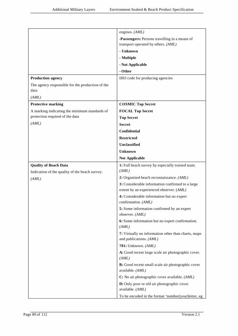
Additional Military Layers Environment Seabed & Beach Product Specification
Page 80 of 112 Version 2.1
engines. (AML)
-Passengers: Persons travelling in a means of transport operated by others. (AML)
- Unknown
- Multiple
- Not Applicable
- Other
Production agency
The agency responsible for the production of the data
(AML)
IHO code for producing agencies
Protective marking
A marking indicating the minimum standards of protection required of the data
(AML)
COSMIC Top Secret
FOCAL Top Secret
Top Secret
Secret
Confidential
Restricted
Unclassified
Unknown
Not Applicable
Quality of Beach Data
Indication of the quality of the beach survey.
(AML)
1: Full beach survey by especially trained team. (AML)
2: Organised beach reconnaissance. (AML)
3: Considerable information confirmed to a large extent by an experienced observer. (AML)
4: Considerable information but no expert confirmation. (AML)
5: Some information confirmed by an expert observer. (AML)
6: Some information but no expert confirmation. (AML)
7: Virtually no information other than charts, maps and publications. (AML)
701: Unknown. (AML)
A: Good recent large scale air photographic cover. (AML)
B: Good recent small scale air photographic cover available. (AML)
C: No air photographic cover available. (AML)
D: Only poor or old air photographic cover available. (AML)
To be encoded in the format ‘number(year)letter, eg
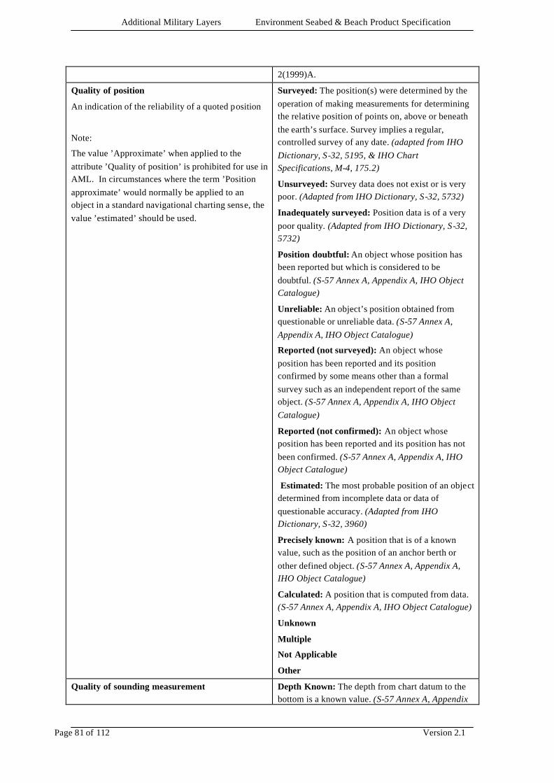
Additional Military Layers Environment Seabed & Beach Product Specification
Page 81 of 112 Version 2.1
2(1999)A.
Quality of position
An indication of the reliability of a quoted position
Note:
The value ’Approximate’ when applied to the attribute ’Quality of position’ is prohibited for use in AML. In circumstances where the term ’Position approximate’ would normally be applied to an object in a standard navigational charting sense, the value ’estimated’ should be used.
Surveyed: The position(s) were determined by the operation of making measurements for determining the relative position of points on, above or beneath the earth’s surface. Survey implies a regular, controlled survey of any date. (adapted from IHO Dictionary, S-32, 5195, & IHO Chart Specifications, M-4, 175.2)
Unsurveyed: Survey data does not exist or is very poor. (Adapted from IHO Dictionary, S-32, 5732)
Inadequately surveyed: Position data is of a very poor quality. (Adapted from IHO Dictionary, S-32, 5732)
Position doubtful: An object whose position has been reported but which is considered to be doubtful. (S-57 Annex A, Appendix A, IHO Object Catalogue)
Unreliable: An object’s position obtained from questionable or unreliable data. (S-57 Annex A, Appendix A, IHO Object Catalogue)
Reported (not surveyed): An object whose position has been reported and its position confirmed by some means other than a formal survey such as an independent report of the same object. (S-57 Annex A, Appendix A, IHO Object Catalogue)
Reported (not confirmed): An object whose position has been reported and its position has not been confirmed. (S-57 Annex A, Appendix A, IHO Object Catalogue)
Estimated: The most probable position of an object determined from incomplete data or data of questionable accuracy. (Adapted from IHO Dictionary, S-32, 3960)
Precisely known: A position that is of a known value, such as the position of an anchor berth or other defined object. (S-57 Annex A, Appendix A, IHO Object Catalogue)
Calculated: A position that is computed from data. (S-57 Annex A, Appendix A, IHO Object Catalogue)
Unknown
Multiple
Not Applicable
Other
Quality of sounding measurement Depth Known: The depth from chart datum to the bottom is a known value. (S-57 Annex A, Appendix
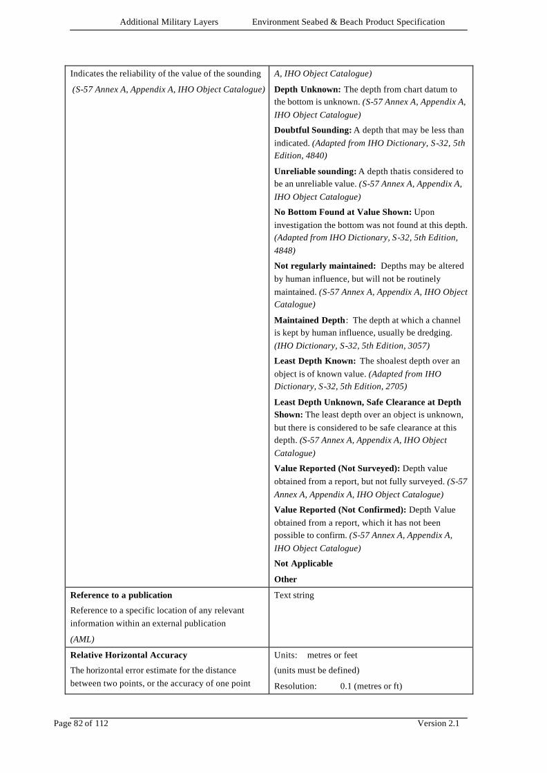
Additional Military Layers Environment Seabed & Beach Product Specification
Page 82 of 112 Version 2.1
Indicates the reliability of the value of the sounding
(S-57 Annex A, Appendix A, IHO Object Catalogue)
A, IHO Object Catalogue)
Depth Unknown: The depth from chart datum to the bottom is unknown. (S-57 Annex A, Appendix A, IHO Object Catalogue)
Doubtful Sounding: A depth that may be less than indicated. (Adapted from IHO Dictionary, S-32, 5th Edition, 4840)
Unreliable sounding: A depth thatis considered to be an unreliable value. (S-57 Annex A, Appendix A, IHO Object Catalogue)
No Bottom Found at Value Shown: Upon investigation the bottom was not found at this depth. (Adapted from IHO Dictionary, S-32, 5th Edition, 4848)
Not regularly maintained: Depths may be altered by human influence, but will not be routinely maintained. (S-57 Annex A, Appendix A, IHO Object Catalogue)
Maintained Depth: The depth at which a channel is kept by human influence, usually be dredging. (IHO Dictionary, S-32, 5th Edition, 3057)
Least Depth Known: The shoalest depth over an object is of known value. (Adapted from IHO Dictionary, S-32, 5th Edition, 2705)
Least Depth Unknown, Safe Clearance at Depth Shown: The least depth over an object is unknown, but there is considered to be safe clearance at this depth. (S-57 Annex A, Appendix A, IHO Object Catalogue)
Value Reported (Not Surveyed): Depth value obtained from a report, but not fully surveyed. (S-57 Annex A, Appendix A, IHO Object Catalogue)
Value Reported (Not Confirmed): Depth Value obtained from a report, which it has not been possible to confirm. (S-57 Annex A, Appendix A, IHO Object Catalogue)
Not Applicable
Other
Reference to a publication
Reference to a specific location of any relevant information within an external publication
(AML)
Text string
Relative Horizontal Accuracy
The horizontal error estimate for the distance between two points, or the accuracy of one point
Units: metres or feet
(units must be defined)
Resolution: 0.1 (metres or ft)
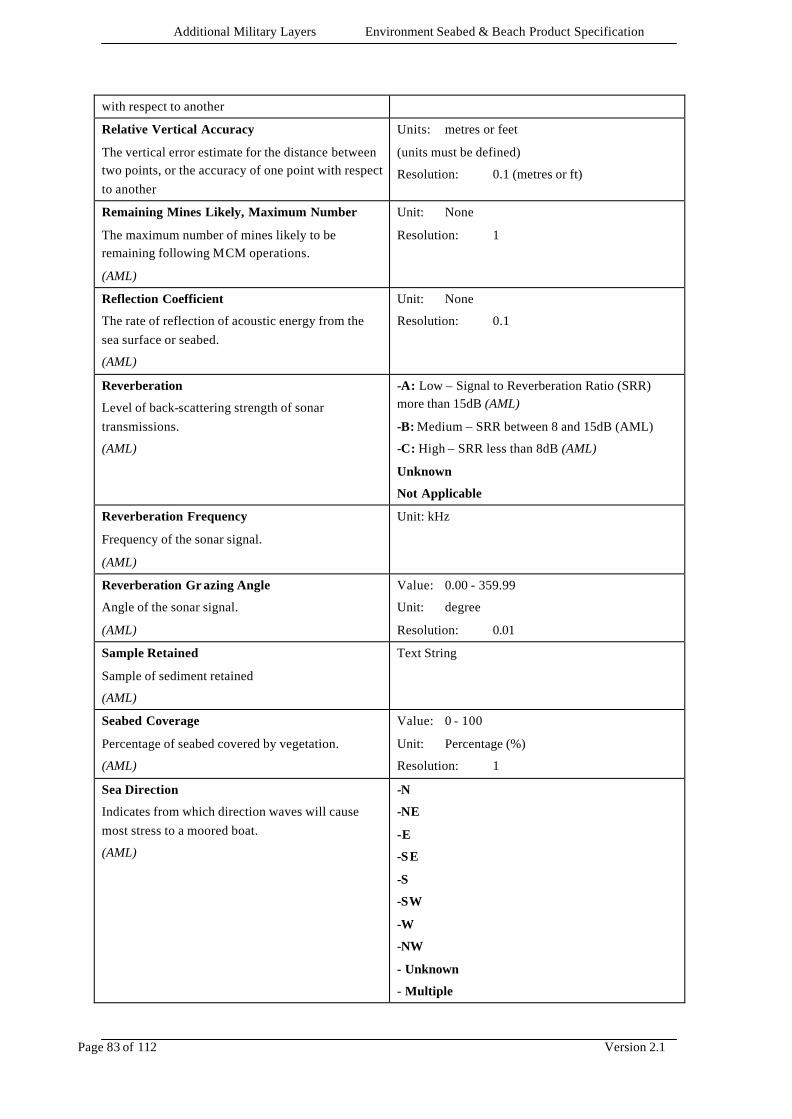
Additional Military Layers Environment Seabed & Beach Product Specification
Page 83 of 112 Version 2.1
with respect to another
Relative Vertical Accuracy
The vertical error estimate for the distance between two points, or the accuracy of one point with respect to another
Units: metres or feet
(units must be defined)
Resolution: 0.1 (metres or ft)
Remaining Mines Likely, Maximum Number
The maximum number of mines likely to be remaining following MCM operations.
(AML)
Unit: None
Resolution: 1
Reflection Coefficient
The rate of reflection of acoustic energy from the sea surface or seabed.
(AML)
Unit: None
Resolution: 0.1
Reverberation
Level of back-scattering strength of sonar transmissions.
(AML)
-A: Low – Signal to Reverberation Ratio (SRR) more than 15dB (AML)
-B: Medium – SRR between 8 and 15dB (AML)
-C: High – SRR less than 8dB (AML)
Unknown
Not Applicable
Reverberation Frequency
Frequency of the sonar signal.
(AML)
Unit: kHz
Reverberation Gr azing Angle
Angle of the sonar signal.
(AML)
Value: 0.00 - 359.99
Unit: degree
Resolution: 0.01
Sample Retained
Sample of sediment retained
(AML)
Text String
Seabed Coverage
Percentage of seabed covered by vegetation.
(AML)
Value: 0 - 100
Unit: Percentage (%)
Resolution: 1
Sea Direction
Indicates from which direction waves will cause most stress to a moored boat.
(AML)
-N
-NE
-E
-SE
-S
-SW
-W
-NW
- Unknown
- Multiple

Additional Military Layers Environment Seabed & Beach Product Specification
Page 84 of 112 Version 2.1
- Not Applicable
- Other
Seasonal End Date
The end of the active period for a seasonal object.
(Adapted from S-57 Annex A, Appendix A, IHO Object Catalogue)
CCYYMMDD
4 digits for the calendar year (CCYY), 2 digits for the month (MM) (e.g. April = 04) and 2 digits for the day (DD).
Seasonal Start Date
The start of the active period for a seasonal object.
(Adapted from S-57 Annex A, Appendix A, IHO Object Catalogue)
CCYYMMDD
4 digits for the calendar year (CCYY), 2 digits for the month (MM) (e.g. April = 04) and 2 digits for the day (DD).
Sector Limit One
A sector is the part of a circle between two straight lines drawn from the centre to the circumference. Sector limit 1 specifies the first limit of the sector. The order of sector limit 1 and sector limit 2 is clockwise around the central object.
(S-57 Annex A, Appendix A, IHO Object Catalogue)
Value: 0.00 - 359.99
Unit: degree
Resolution: 0.01
Sector Limit Two
A sector is the part of a circle between two straight lines drawn from the centre to the circumference. Sector 2 specifies the second limit of the sector.
(S-57 Annex A, Appendix A, IHO Object Catalogue)
Value: 0.00 - 359.99
Unit: degree
Resolution: 0.01
Self Protection (Air)
Indication of the level of self protection from air attack
(AML)
-Bad
-Normal
-Good
- Unknown
- Not Applicable
- Other
Self Protection (Near Defence)
Indication of the level of self protection from land attack
(AML)
-Bad
-Normal
-Good
- Unknown
- Not Applicable
- Other
Self Protection (Surface)
Indication of the level of self protection from surface attack
(AML)
-Bad
-Normal
-Good
- Unknown
- Not Applicable
- Other
Sensor Coverage Text String

Additional Military Layers Environment Seabed & Beach Product Specification
Page 85 of 112 Version 2.1
Description of sensor coverage
(AML)
Signal Group
The number of signals, the combination of signals or the morse character(s) within one period of full sequence.
(S-57 Annex A, Appendix A, IHO Object Catalogue)
Signal Period
The time occupied by an entire cycle of intervals of light and eclipse.
(S-57 Annex A, Appendix A, IHO Object Catalogue)
Value: min 0
Unit: seconds (s)
Resolution: 0.01
Signal Sequence
The sequence of times occupied by intervals of light and eclipse for all ‘light characteristics’ except for occulting where the sequence of times is occupied by intervals of eclipse and light.
(S-57 Annex A, Appendix A, IHO Object Catalogue)
Unit: seconds (s)
Resolution: 0.01
Format: LL.L + (EE.E)
Simple Initial Threat
The threat posed to the first ship to transit a minefield, given that there have been no previous MCM and that only poised mines have been used in the calculations.
(AML)
Value: Min 0 Max 1
Unit: None
Resolution: 0.01
Sonar Reflectivity
Measure of sonar reflectivity returned by the contact.
(AML)
-H: A high level of reflectivity is returned by the contact. (AML)
-M: A medium level of reflectivity is returned by the contact. (AML)
-L: A low level of reflectivity is returned by the contact. (AML)
- Unknown
- Not Applicable
- Other
Sound Velocity
Speed of sound
(AML)
Value: min 0
Unit: metres/second (m/s)
Resolution: 0.01
Sounding datum
Indicates the datum to which soundings are referred.
(Adapted from S-57 Annex A, Appendix A, IHO Object Catalogue)
Approximate Lowest Astronomical Tide: An arbitrary level, usually within ± 0.3m from that of Lowest Astronomical Tide (LAT). (Hydrographic Service, Royal Australian Navy)
Approximate Mean Low Water Springs: An arbitrary level, usually within ± 0.3m from that of Mean Low Water Springs (MLWS). (Hydrographic Service, Royal Australian Navy)
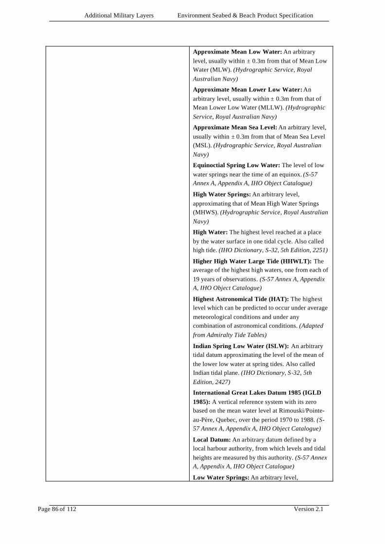
Additional Military Layers Environment Seabed & Beach Product Specification
Page 86 of 112 Version 2.1
Approximate Mean Low Water: An arbitrary level, usually within ± 0.3m from that of Mean Low Water (MLW). (Hydrographic Service, Royal Australian Navy)
Approximate Mean Lower Low Water: An arbitrary level, usually within ± 0.3m from that of Mean Lower Low Water (MLLW). (Hydrographic Service, Royal Australian Navy)
Approximate Mean Sea Level: An arbitrary level, usually within ± 0.3m from that of Mean Sea Level (MSL). (Hydrographic Service, Royal Australian Navy)
Equinoctial Spring Low Water: The level of low water springs near the time of an equinox. (S-57 Annex A, Appendix A, IHO Object Catalogue)
High Water Springs: An arbitrary level, approximating that of Mean High Water Springs (MHWS). (Hydrographic Service, Royal Australian Navy)
High Water: The highest level reached at a place by the water surface in one tidal cycle. Also called high tide. (IHO Dictionary, S-32, 5th Edition, 2251)
Higher High Water Large Tide (HHWLT): The average of the highest high waters, one from each of 19 years of observations . (S-57 Annex A, Appendix A, IHO Object Catalogue)
Highest Astronomical Tide (HAT): The highest level which can be predicted to occur under average meteorological conditions and under any combination of astronomical conditions. (Adapted from Admiralty Tide Tables)
Indian Spring Low Water (ISLW): An arbitrary tidal datum approximating the level of the mean of the lower low water at spring tides. Also called Indian tidal plane. (IHO Dictionary, S-32, 5th Edition, 2427)
International Great Lakes Datum 1985 (IGLD 1985): A vertical reference system with its zero based on the mean water level at Rimouski/Pointe-au-Père, Quebec, over the period 1970 to 1988. (S-57 Annex A, Appendix A, IHO Object Catalogue)
Local Datum: An arbitrary datum defined by a local harbour authority, from which levels and tidal heights are measured by this authority. (S-57 Annex A, Appendix A, IHO Object Catalogue)
Low Water Springs: An arbitrary level,
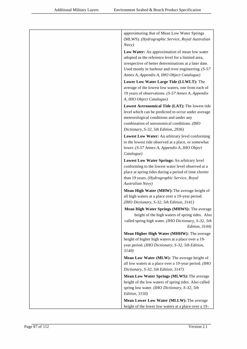
Additional Military Layers Environment Seabed & Beach Product Specification
Page 87 of 112 Version 2.1
approximating that of Mean Low Water Springs (MLWS). (Hydrographic Service, Royal Australian Navy)
Low Water: An approximation of mean low water adopted as the reference level for a limited area, irrespective of better determinations at a later date. Used mostly in harbour and river engineering. (S-57 Annex A, Appendix A, IHO Object Catalogue)
Lower Low Water Large Tide (LLWLT): The average of the lowest low waters, one from each of 19 years of observations. (S-57 Annex A, Appendix A, IHO Object Catalogue)
Lowest Astronomical Tide (LAT): The lowest tide level which can be predicted to occur under average meteorological conditions and under any combination of astronomical conditions. (IHO Dictionary, S-32, 5th Edition, 2936)
Lowest Low Water: An arbitrary level conforming to the lowest tide observed at a place, or somewhat lower. (S-57 Annex A, Appendix A, IHO Object Catalogue)
Lowest Low Water Springs: An arbitrary level conforming to the lowest water level observed at a place at spring tides during a period of time shorter than 19 years. (Hydrographic Service, Royal Australian Navy)
Mean High Water (MHW): The average height of all high waters at a place over a 19-year period. (IHO Dictionary, S-32, 5th Edition, 3141)
Mean High Water Springs (MHWS): The average height of the high waters of spring tides. Also
called spring high water. (IHO Dictionary, S-32, 5th Edition, 3144)
Mean Higher High Water (MHHW): The average height of higher high waters at a place over a 19-year period. (IHO Dictionary, S-32, 5th Edition, 3140)
Mean Low Water (MLW): The average height of all low waters at a place over a 19-year period. (IHO Dictionary, S-32, 5th Edition, 3147)
Mean Low Water Springs (MLWS): The average height of the low waters of spring tides. Also called spring low water. (IHO Dictionary, S-32, 5th Edition, 3150)
Mean Lower Low Water (MLLW): The average height of the lower low waters at a place over a 19-
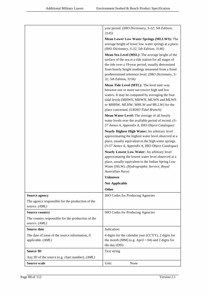
Additional Military Layers Environment Seabed & Beach Product Specification
Page 88 of 112 Version 2.1
year period. (IHO Dictionary, S-32, 5th Edition, 3145)
Mean Lower Low Water Springs (MLLWS): The average height of lower low water springs at a place. (IHO Dictionary, S-32, 5th Edition, 3146)
Mean Sea Level (MSL): The average height of the surface of the sea at a tide station for all stages of the tide over a 19-year period, usually determined from hourly height readings measured from a fixed predetermined reference level. (IHO Dictionary, S-32, 5th Edition, 3156)
Mean Tide Level (MTL): The level mid-way between one or more successive high and low waters. It may be computed by averaging the four tidal levels (MHWS, MHWN, MLWN and MLWS or MHHW, MLHW, MHLW and MLLW) for the place concerned. (UKHO Tidal Branch)
Mean Water Level: The average of all hourly water levels over the available period of record. (S-57 Annex A, Appendix A, IHO Object Catalogue)
Nearly Highest High Water: An arbitrary level approximating the highest water level observed at a place, usually equivalent to the high water springs. (S-57 Annex A, Appendix A, IHO Object Catalogue)
Nearly Lowest Low Water: An arbitrary level approximating the lowest water level observed at a place, usually equivalent to the Indian Spring Low Water (ISLW). (Hydrographic Service, Royal Australian Navy)
Unknown
Not Applicable
Other
Source agency
The agency responsible for the production of the source. (AML)
IHO Codes for Producing Agencies
Source country
The country responsible for the production of the source. (AML)
IHO Codes for Producing Agencies
Source date
The date of issue of the source information, if applicable. (AML)
Indication:
4 digits for the calendar year (CCYY), 2 digits for the month (MM) (e.g. April = 04) and 2 digits for the day (DD).
Source ID
Any ID of the source (e.g. chart number). (AML)
Text string
Source scale Unit: None
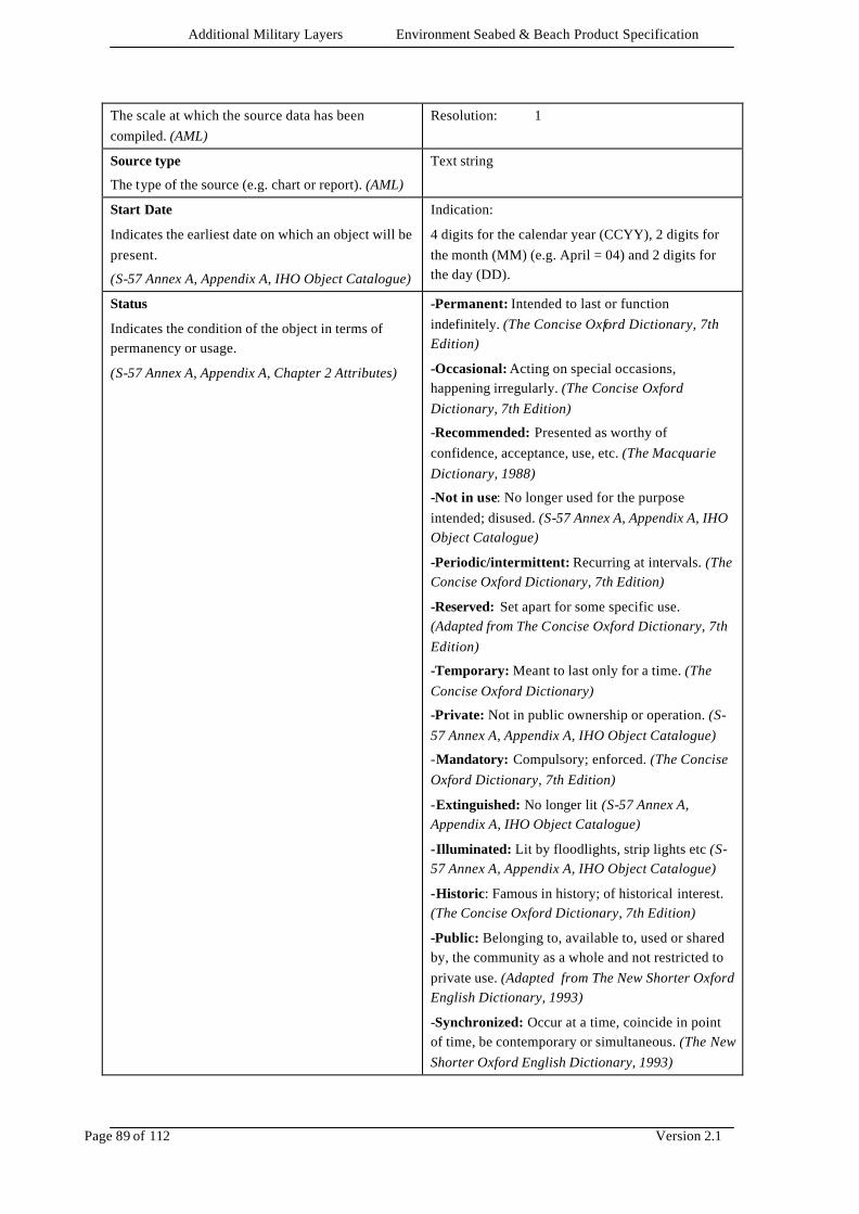
Additional Military Layers Environment Seabed & Beach Product Specification
Page 89 of 112 Version 2.1
The scale at which the source data has been compiled. (AML)
Resolution: 1
Source type
The type of the source (e.g. chart or report). (AML)
Text string
Start Date
Indicates the earliest date on which an object will be present.
(S-57 Annex A, Appendix A, IHO Object Catalogue)
Indication:
4 digits for the calendar year (CCYY), 2 digits for the month (MM) (e.g. April = 04) and 2 digits for the day (DD).
Status
Indicates the condition of the object in terms of permanency or usage.
(S-57 Annex A, Appendix A, Chapter 2 Attributes)
-Permanent: Intended to last or function indefinitely. (The Concise Oxford Dictionary, 7th Edition)
-Occasional: Acting on special occasions, happening irregularly. (The Concise Oxford Dictionary, 7th Edition)
-Recommended: Presented as worthy of confidence, acceptance, use, etc. (The Macquarie Dictionary, 1988)
-Not in use: No longer used for the purpose intended; disused. (S-57 Annex A, Appendix A, IHO Object Catalogue)
-Periodic/intermittent: Recurring at intervals. (The Concise Oxford Dictionary, 7th Edition)
-Reserved: Set apart for some specific use. (Adapted from The Concise Oxford Dictionary, 7th Edition)
-Temporary: Meant to last only for a time. (The Concise Oxford Dictionary)
-Private: Not in public ownership or operation. (S-57 Annex A, Appendix A, IHO Object Catalogue)
-Mandatory: Compulsory; enforced. (The Concise Oxford Dictionary, 7th Edition)
-Extinguished: No longer lit (S-57 Annex A, Appendix A, IHO Object Catalogue)
-Illuminated: Lit by floodlights, strip lights etc (S-57 Annex A, Appendix A, IHO Object Catalogue)
-Historic: Famous in history; of historical interest. (The Concise Oxford Dictionary, 7th Edition)
-Public: Belonging to, available to, used or shared by, the community as a whole and not restricted to private use. (Adapted from The New Shorter Oxford English Dictionary, 1993)
-Synchronized: Occur at a time, coincide in point of time, be contemporary or simultaneous. (The New Shorter Oxford English Dictionary, 1993)

Additional Military Layers Environment Seabed & Beach Product Specification
Page 90 of 112 Version 2.1
-Watched: Looked at or observed over a period of time especially so as to be aware of any movement or change. (Adapted from The New Shorter Oxford English Dictionary, 1993)
-Un-watched: Usually automatic in operation, without any permanently-stationed personnel to superintend it. (Adapted from IHO Dictionary, S-32, 5th Edition, 2814)
-Existence Doubtful: An object that has been reported but has not been definitely determined to exist. (S-57 Annex A, Appendix A, IHO Object Catalogue)
- Unknown
- Multiple
- Not Applicable
- Other
Steepest Face Orientation
The angular distance measured from true north to the axis of the steepest face of the object.
(Adapted from Digital Geographic Information Working Group – DGIWG, Oct.87)
Value: 0.00 - 359.99
Unit: degree
Resolution: 0.1
Strength according to Richter Scale
Strength of seismic activity.
(AML)
Integer value in the range 1 to 9.
Suitability for ACV use
Suitability for use by Air Cushioned Vehicles
(AML)
-Yes: There are no obstructions with height greater than 1.7m and gradient is acceptable. (AML)
-No: Not suitable for ACV use. (AML)
Supporting textual information
Supporting (free text) information relevant to the object that cannot be explicitly encoded in any other attribute
Text string
Supporting textual information (in national language characters)
Supporting (free text) information in national language characters relevant to the object that cannot be explicitly encoded in any other attribute
Text string
Surf Height
Average height of surf
(AML)
Value: min 0
Units: metres or feet
(units must be defined)
Resolution: 0.1 (metres or ft)
Surf Zone
Distance of surf zone from water line.
Value: min 0
Units: metres or feet
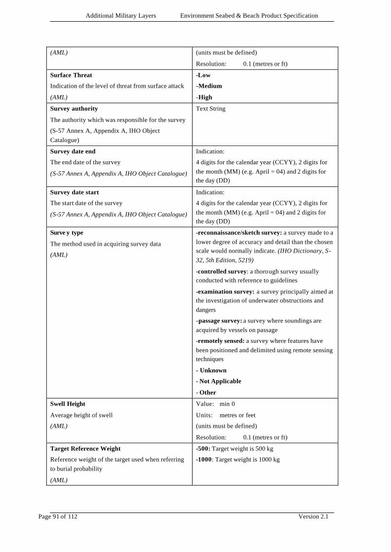
Additional Military Layers Environment Seabed & Beach Product Specification
Page 91 of 112 Version 2.1
(AML) (units must be defined)
Resolution: 0.1 (metres or ft)
Surface Threat
Indication of the level of threat from surface attack
(AML)
-Low
-Medium
-High
Survey authority
The authority which was responsible for the survey
(S-57 Annex A, Appendix A, IHO Object Catalogue)
Text String
Survey date end
The end date of the survey
(S-57 Annex A, Appendix A, IHO Object Catalogue)
Indication:
4 digits for the calendar year (CCYY), 2 digits for the month (MM) (e.g. April = 04) and 2 digits for the day (DD)
Survey date start
The start date of the survey
(S-57 Annex A, Appendix A, IHO Object Catalogue)
Indication:
4 digits for the calendar year (CCYY), 2 digits for the month (MM) (e.g. April = 04) and 2 digits for the day (DD)
Surve y type
The method used in acquiring survey data
(AML)
-reconnaissance/sketch survey: a survey made to a lower degree of accuracy and detail than the chosen scale would normally indicate. (IHO Dictionary, S-32, 5th Edition, 5219)
-controlled survey: a thorough survey usually conducted with reference to guidelines
-examination survey: a survey principally aimed at the investigation of underwater obstructions and dangers
-passage survey: a survey where soundings are acquired by vessels on passage
-remotely sensed: a survey where features have been positioned and delimited using remote sensing techniques
- Unknown
- Not Applicable
- Other
Swell Height
Average height of swell
(AML)
Value: min 0
Units: metres or feet
(units must be defined)
Resolution: 0.1 (metres or ft)
Target Reference Weight
Reference weight of the target used when referring to burial probability
(AML)
-500: Target weight is 500 kg
-1000: Target weight is 1000 kg
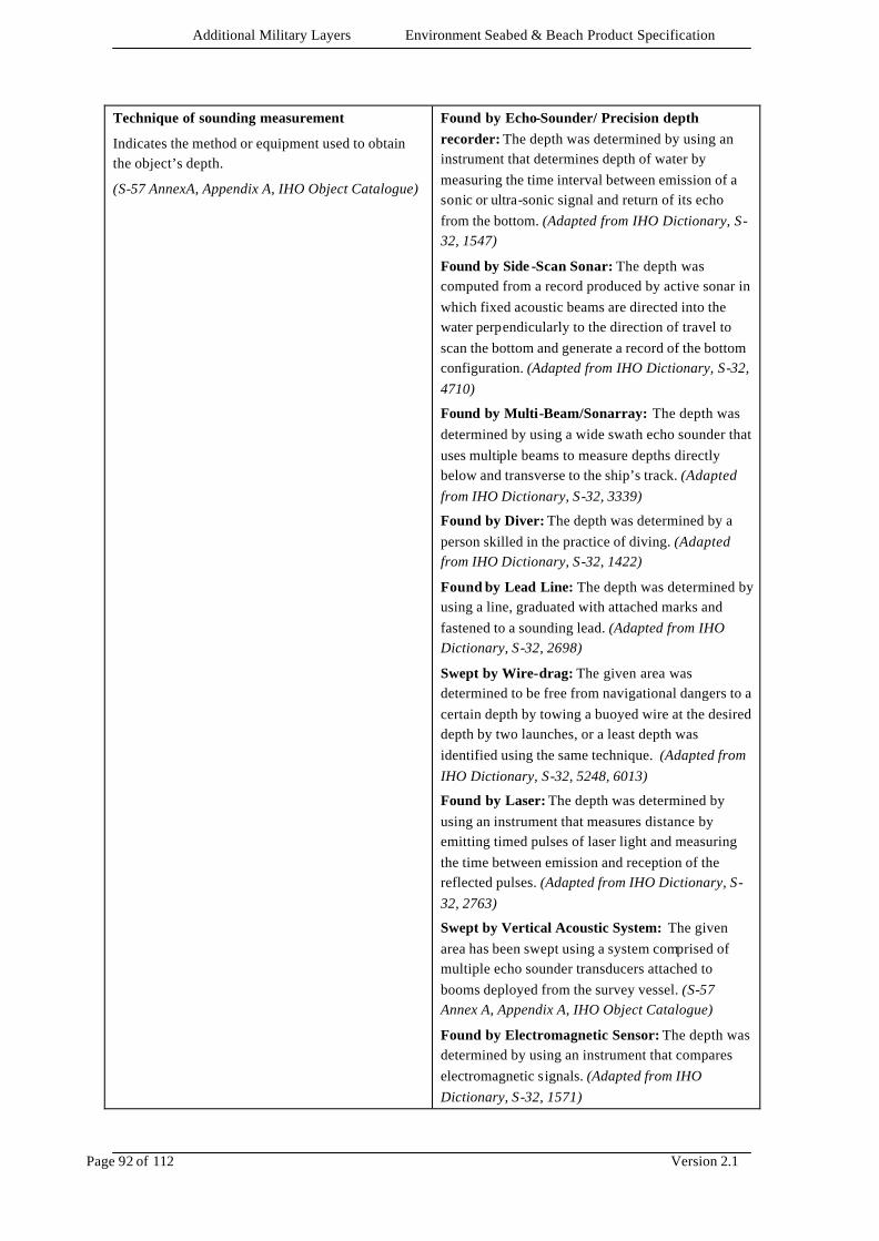
Additional Military Layers Environment Seabed & Beach Product Specification
Page 92 of 112 Version 2.1
Technique of sounding measurement
Indicates the method or equipment used to obtain the object’s depth.
(S-57 AnnexA, Appendix A, IHO Object Catalogue)
Found by Echo-Sounder/ Precision depth recorder: The depth was determined by using an instrument that determines depth of water by measuring the time interval between emission of a sonic or ultra-sonic signal and return of its echo from the bottom. (Adapted from IHO Dictionary, S-32, 1547)
Found by Side -Scan Sonar: The depth was computed from a record produced by active sonar in which fixed acoustic beams are directed into the water perpendicularly to the direction of travel to scan the bottom and generate a record of the bottom configuration. (Adapted from IHO Dictionary, S-32, 4710)
Found by Multi-Beam/Sonarray: The depth was determined by using a wide swath echo sounder that uses multiple beams to measure depths directly below and transverse to the ship’s track. (Adapted from IHO Dictionary, S-32, 3339)
Found by Diver: The depth was determined by a person skilled in the practice of diving. (Adapted from IHO Dictionary, S-32, 1422)
Found by Lead Line: The depth was determined by using a line, graduated with attached marks and fastened to a sounding lead. (Adapted from IHO Dictionary, S-32, 2698)
Swept by Wire-drag: The given area was determined to be free from navigational dangers to a certain depth by towing a buoyed wire at the desired depth by two launches, or a least depth was identified using the same technique. (Adapted from IHO Dictionary, S-32, 5248, 6013)
Found by Laser: The depth was determined by using an instrument that measures distance by emitting timed pulses of laser light and measuring the time between emission and reception of the reflected pulses. (Adapted from IHO Dictionary, S-32, 2763)
Swept by Vertical Acoustic System: The given area has been swept using a system comprised of multiple echo sounder transducers attached to booms deployed from the survey vessel. (S-57 Annex A, Appendix A, IHO Object Catalogue)
Found by Electromagnetic Sensor: The depth was determined by using an instrument that compares electromagnetic signals. (Adapted from IHO Dictionary, S-32, 1571)
Additional Military Layers Environment Seabed & Beach Product Specification
Page 93 of 112 Version 2.1
Photogrammetry: The depth was determined by applying mathematical techniques to photographs. (Adapted from IHO Dictionary, S-32, 3791)
Found by Levelling: The depth was determined by using levelling techniques to find the elevation of the point relative to the datum. (Adapted from IHO Dictionary, S-32, 2741)
Swept by Side -scan sonar: The given area was determined to be free from navigational dangers to a certain depth by towing a side scan sonar . (Adapted from IHO Dictionary, S-32, 5248, 4710)
Satellite Imagery: The depth was determined by using instruments placed aboard an artificial satellite. (Adapted from IHO Dictionary, S-32, 4509)
Computer Generated: The sounding was determined from a bottom model constructed using a computer. (S-57 Annex A, Appendix A, Chapter 2 Attributes)
Unknown
Not Applicable
Other
Text file reference
The file name relating to an external text file
Text string
Text file reference (in national language characters)
The file name (in national language characters) relating to an external text file
Text string
Textual description
The actual words used to define a particular thing, for the capture of information related to the feature “User Defined” (adapted from SOED)
Text string
The largest scale of survey information
The largest scale for the range of survey scale as used in source diagram information
Units: none
Resolution: 1
The smallest scale of survey information
The smallest scale for the range of survey scale as used in source diagram information
Units: none
Resolution: 1
Tidal Range
The average difference in height between high and low tides.
(Adapted from IHO Dictionary, S-32, 5th Edition, 4225)
Value: min 0
Units: metres or feet
(units must be defined)
Resolution: 0.1 (metres or ft)
Tidal Type -Diurnal: A tide in which the tidal cycle consists of
Additional Military Layers Environment Seabed & Beach Product Specification
Page 94 of 112 Version 2.1
The characteristic feature of tide determined from the combination of its diurnal and semi-diurnal components.
(IHO Dictionary, S-32, 5th Edition, 5716)
one high water and one low water each tidal day. (IHO Dictionary, S-32, 5th Edition, 5434)
-Mixed: The type of tide in which a diurnal wave produces large inequalities in heights and/or durations of successive high and/or low waters. This term applies to the tides intermediate to those predominantly semidiurnal and those predominantly diurnal. (IHO Dictionary, S-32, 5th Edition, 5450)
-Mixed Diurnal: Diurnal tides which become semidiurnal with a considerable decrease of range when the moon’s declination is small. (IHO Dictionary, S-32, 5th Edition, 5451)
-Mixed Semidiurnal: Semidiurnal tides with noticeable inequality in corresponding extremes. (IHO Dictionary, S-32, 5th Edition, 5452)
-Quarter Diurnal: The tide resulting from the distortion of the normal tide in shallow water with four high waters and four low waters during one day. (IHO Dictionary, S-32, 5th Edition, 5459)
-Semidiurnal: A tide in which the tidal cycle consists of two high waters and two low waters each tidal day, with comparatively little diurnal inequality. (IHO Dictionary, S-32, 5th Edition, 5462)
-Shallow Water: A tide with distortional effects resulting from shallow water. (Adapted from IHO Dictionary, S-32, 5th Edition, 5463)
- Unknown
- Not Applicable
- Other
Time of Year
Time of year an activity is taking place
(AML)
-All year round: The activity takes place at any time during the year. (AML)
-January:
-February:
-March:
-April:
-May:
-June:
-July:
-August:
-September:
-October:
-November:
-December:
Additional Military Layers Environment Seabed & Beach Product Specification
Page 95 of 112 Version 2.1
- Unknown
- Multiple
- Not Applicable
- Other
Trafficabi lity
Ability of the beach to support vehicular traffic
(AML)
-Firm: Can be used by 2WD vehicles or 4WD vehicles and trailers unless heavy and continued use is intended. (AML)
-Moderate: Can be used by military 3 or 4 tonne vehicles starting from rest in 4WD. (AML)
-Soft: 4WD unable to start from rest but can cross soft patch if already on the move. (AML)
-Very Soft: Impassable to wheeled vehicles, tracked vehicles may have difficulty. (AML)
- Unknown
- Not Applicable
- Other
Type of Anchorage
-Unrestricte d Anchorage: An area in which vessels anchor or may anchor. (IHO Dictionary, S-32, 5th Edition, 130)
-Deep Water Anchorage: An area in which vessels of deep draught or may anchor. (S-57 Annex A, Appendix A, IHO Object Catalogue)
-Tanker Anchorage: An area in which tankers anchor or may anchor. (S-57 Annex A, Appendix A, IHO Object Catalogue)
-Explosives Anchorage: An area set apart for anchored ships discharging or receiving explosives. (IHO Dictionary, S-32, 5th Edition, 1732)
-Quarantine Anchorage: An area where a vessel anchors when satisfying quarantine regulations. (IHO Dictionary, S-32, 5th Edition, 4117)
-Sea-plane Anchorage: An area in which sea-planes anchor or may anchor. (S-57 Annex A, Appendix A, IHO Object Catalogue)
-Small craft Anchorage: An area in which small boats anchor or may anchor. (S-57 Annex A, Appendix A, IHO Object Catalogue)
-Small Craft Mooring Area: An area in which yachts and small boats moor. (S-57 Annex A, Appendix A, IHO Object Catalogue)
-Anchorage for periods up to 24 hours: An area in which vessels anchor or may anchor for periods of up to 24 hours. (S-57 Annex A, Appendix A, IHO Object Catalogue)
Additional Military Layers Environment Seabed & Beach Product Specification
Page 96 of 112 Version 2.1
- Unknown
- Multiple
- Not Applicable
- Other
Type of Built-up Area
-Urban Area: An area predominantly occupied by man-made structures used for residential, commercial and industrial purposes. (Nautical Chart Manual, US Department of Commerce, 1992)
-Settlement: A small collection of dwellings in a remote area. (S-57 Annex A, Appendix A, IHO Object Catalogue)
-Village: A collection of houses in a rural area, usually smaller than a town. (S-57 Annex A, Appendix A, IHO Object Catalogue)
-Town: Any considerable collection of dwellings and other buildings larger than a village, but not incorporated as a city. (S-57 Annex A, Appendix A, IHO Object Catalogue)
-City: A major town inhabited by a large permanent community with all essential. (S-57 Annex A, Appendix A, IHO Object Catalogue)
-Holiday Village: A collection of smaller houses (cottages, mobile homes etc.) which is mainly populated on a seasonal basis. (S-57 Annex A, Appendix A, IHO Object Catalogue)
- Unknown
- Not Applicable
- Other
Type of Cable
-Power Line: A cable used for the supply of electricity. (S-57 Annex A, Appendix A, IHO Object Catalogue)
-Transmission Line: Multiple un-insulated cables usually supported by steel lattice towers. Such features are generally more prominent than normal power lines. (S-57 Annex A, Appendix A, IHO Object Catalogue)
-Telephone: A cable used for the transmission of telephone signals. (S-57 Annex A, Appendix A, IHO Object Catalogue)
-Telegraph: A cable used for the transmission of telegraph signals. (S-57 Annex A, Appendix A, IHO Object Catalogue)
-Mooring Cable/chain: A cable or chain used to secure a mooring buoy or other floating structure. (S-57 Annex A, Appendix A, IHO Object Catalogue)
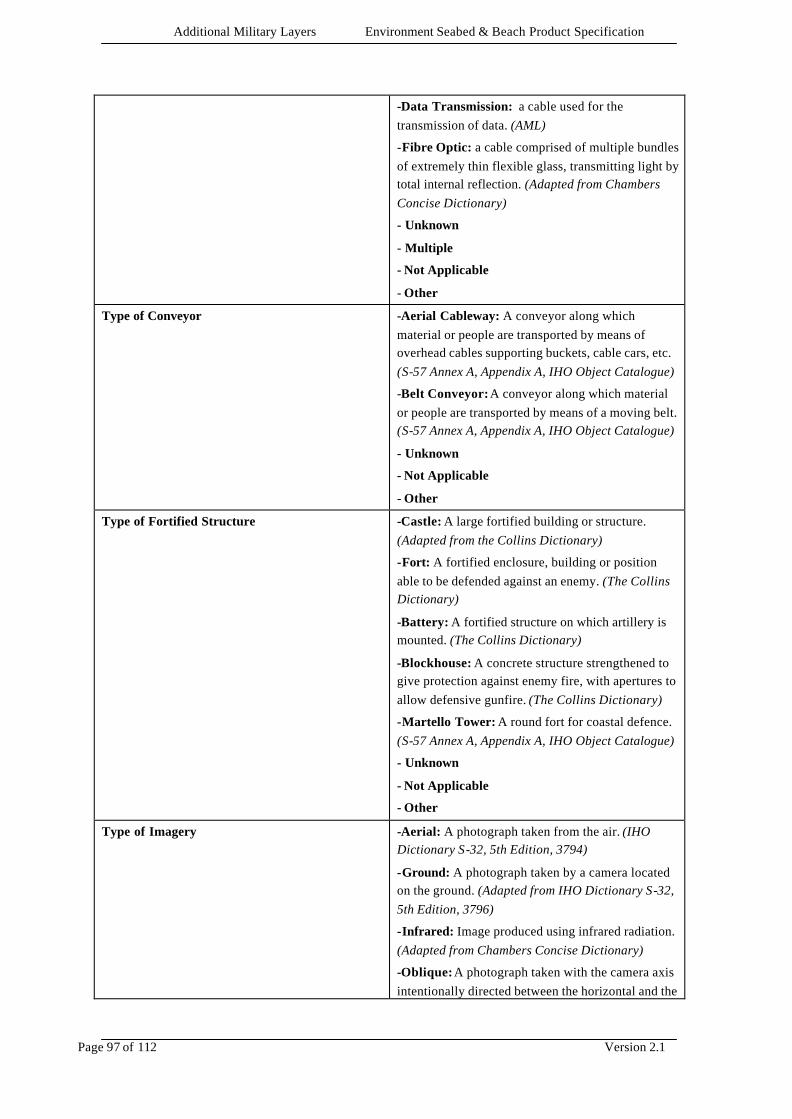
Additional Military Layers Environment Seabed & Beach Product Specification
Page 97 of 112 Version 2.1
-Data Transmission: a cable used for the transmission of data. (AML)
-Fibre Optic: a cable comprised of multiple bundles of extremely thin flexible glass, transmitting light by total internal reflection. (Adapted from Chambers Concise Dictionary)
- Unknown
- Multiple
- Not Applicable
- Other
Type of Conveyor
-Aerial Cableway: A conveyor along which material or people are transported by means of overhead cables supporting buckets, cable cars, etc. (S-57 Annex A, Appendix A, IHO Object Catalogue)
-Belt Conveyor: A conveyor along which material or people are transported by means of a moving belt. (S-57 Annex A, Appendix A, IHO Object Catalogue)
- Unknown
- Not Applicable
- Other
Type of Fortified Structure
-Castle: A large fortified building or structure. (Adapted from the Collins Dictionary)
-Fort: A fortified enclosure, building or position able to be defended against an enemy. (The Collins Dictionary)
-Battery: A fortified structure on which artillery is mounted. (The Collins Dictionary)
-Blockhouse: A concrete structure strengthened to give protection against enemy fire, with apertures to allow defensive gunfire. (The Collins Dictionary)
-Martello Tower: A round fort for coastal defence. (S-57 Annex A, Appendix A, IHO Object Catalogue)
- Unknown
- Not Applicable
- Other
Type of Imagery
-Aerial: A photograph taken from the air. (IHO Dictionary S-32, 5th Edition, 3794)
-Ground: A photograph taken by a camera located on the ground. (Adapted from IHO Dictionary S-32, 5th Edition, 3796)
-Infrared: Image produced using infrared radiation. (Adapted from Chambers Concise Dictionary)
-Oblique: A photograph taken with the camera axis intentionally directed between the horizontal and the
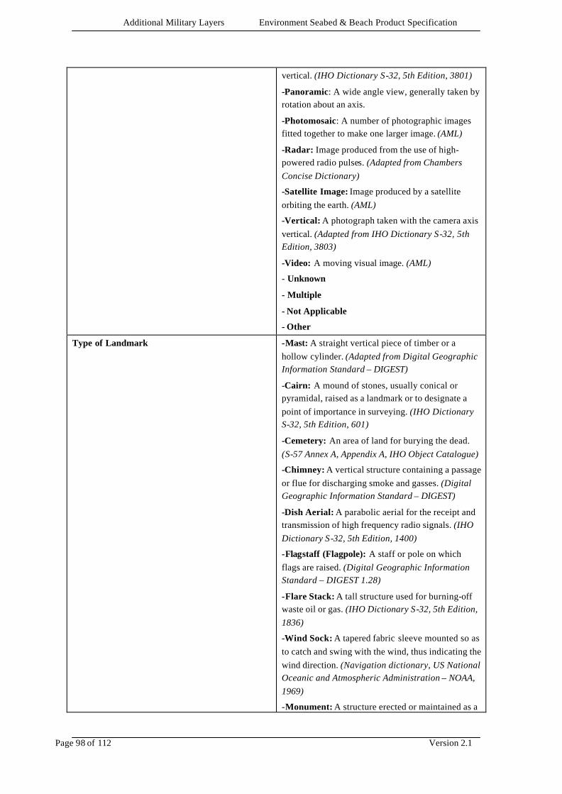
Additional Military Layers Environment Seabed & Beach Product Specification
Page 98 of 112 Version 2.1
vertical. (IHO Dictionary S-32, 5th Edition, 3801)
-Panoramic: A wide angle view, generally taken by rotation about an axis.
-Photomosaic: A number of photographic images fitted together to make one larger image. (AML)
-Radar: Image produced from the use of high-powered radio pulses. (Adapted from Chambers Concise Dictionary)
-Satellite Image: Image produced by a satellite orbiting the earth. (AML)
-Vertical: A photograph taken with the camera axis vertical. (Adapted from IHO Dictionary S-32, 5th Edition, 3803)
-Video: A moving visual image. (AML)
- Unknown
- Multiple
- Not Applicable
- Other
Type of Landmark
-Mast: A straight vertical piece of timber or a hollow cylinder. (Adapted from Digital Geographic Information Standard – DIGEST)
-Cairn: A mound of stones, usually conical or pyramidal, raised as a landmark or to designate a point of importance in surveying. (IHO Dictionary S-32, 5th Edition, 601)
-Cemetery: An area of land for burying the dead. (S-57 Annex A, Appendix A, IHO Object Catalogue)
-Chimney: A vertical structure containing a passage or flue for discharging smoke and gasses. (Digital Geographic Information Standard – DIGEST)
-Dish Aerial: A parabolic aerial for the receipt and transmission of high frequency radio signals. (IHO Dictionary S-32, 5th Edition, 1400)
-Flagstaff (Flagpole): A staff or pole on which flags are raised. (Digital Geographic Information Standard – DIGEST 1.28)
-Flare Stack: A tall structure used for burning-off waste oil or gas. (IHO Dictionary S-32, 5th Edition, 1836)
-Wind Sock: A tapered fabric sleeve mounted so as to catch and swing with the wind, thus indicating the wind direction. (Navigation dictionary, US National Oceanic and Atmospheric Administration – NOAA, 1969)
-Monument: A structure erected or maintained as a

Additional Military Layers Environment Seabed & Beach Product Specification
Page 99 of 112 Version 2.1
memorial to a person or event. (Digital Geographic Information Standard – DIGEST)
-Column (pillar): A cylindrical or slightly tapering body of considerably greater length than diameter erected vertically. (Oxford English Dictionary)
-Memorial Plaque: A slab of metal, usually ornamented, erected as a memorial to a person or an event. (S-57 Annex A, Appendix A, IHO Object Catalogue)
-Obelisk: A tapering shaft usually of stone or concrete, square or rectangular in section, with a pyramidal apex. (Adapted from Oxford English Dictionary)
-Statue: A representation of a human, animal or fantasy figure in marble, bronze etc. (S-57 Annex A, Appendix A, IHO Object Catalogue)
-Cross: A monument, or other structure in form of a cross. (Funk and Wagnells Dictionary)
-Dome: A landmark comprising a hemispherical or spheroidal shaped structure (Adapted from the Macquarie Dictionary)
-Radar Scanner: A device used for directing a radar beam through a search pattern. (Adapted from Navigation dictionary, US National Oceanic and Atmospheric Administration – NOAA, 1969)
-Tower: A relatively tall structure which may be used for observation, support, storage or communication etc. (Digital Geographic Information Working Group – DGIWG, Oct 1987)
-Windmill: A wind driven system of vanes attached to a towerlike structure (excluding wind generated power plants). (Digital Geographic Information Standard – DIGEST)
-Windmotor: A modern structure for the use of windpower. (IHO Chart Specifications, M-4)
-Spire/Minaret: A tall conical or pyramid -shaped structure often built on the roof or tower of a building, especially a church or mosque. (Adapted from The New Shorter Oxford English Dictionary, 1993)
- Unknown
- Not Applicable
- Other
Type of Resource Location
-Drinking Water: Location where drinking water is available. (AML)

Additional Military Layers Environment Seabed & Beach Product Specification
Page 100 of 112 Version 2.1
-Engineer Resources: Location where building materials are available. (AML)
-Storage: Location suitable for bulk storage, eg. a fuel dump. (AML)
- Unknown
- Multiple
- Not Applicable
- Other
Type of Shoreline Construction
-Breakwater: A structure protecting a shore area, harbour, anchorage, or basin from waves. (IHO Dictionary, S-32, 5th Edition, 542)
-Groyne: A low artificial wall-like structure of durable material extending from the land to seaward for a particular purpose, such as to prevent coast erosion. (Adapted from IHO Dictionary, S-32 5th Edition, 2525 and IHO Chart Specifications, M-4)
-Mole: A form of breakwater alongside which vessels may lie on the sheltered side only; in some cases it may lie entirely within an artificial harbour, permitting vessels to lie along both sides. (IHO Chart Specifications, M-4)
-Pier (jetty): A long narrow structure extending into the water to afford a berthing place for vessels to serve as a promenade, etc. (IHO Dictionary, S-32, 5th Edition, 3833)
-Promenade Pier: A pier built only for recreational purposes. (IHO Chart Specifications, M-4)
-Wharf (quay): A structure serving as a berthing place for vessels. (IHO Dictionary, S-32, 5th Edition, 5985)
-Rip Rap: A layer of broken rock, cobbles, boulders, or fragments of sufficient size to resist the erosive forces of flowing water and wave action. (Adapted from Marine Chart Manual, US National Oceanic and Atmospheric Administration – NOAA, 1992)
-Training Wall: A wall or bank, often submerged, built to direct or confine the flow of a river or tidal current, or to promote a scour action. (Adapted from IHO Dictionary, S-32, 5th Edition, 5586 and IHO Chart Specifications, M-4)
-Revetment: Facing of stone or other material, either permanent or temporary, placed along the edge of a stream, river or canal to stabilise the bank and to protect it from the erosive action of the stream. (IHO Dictionary, S-32, 5th Edition ,4379)
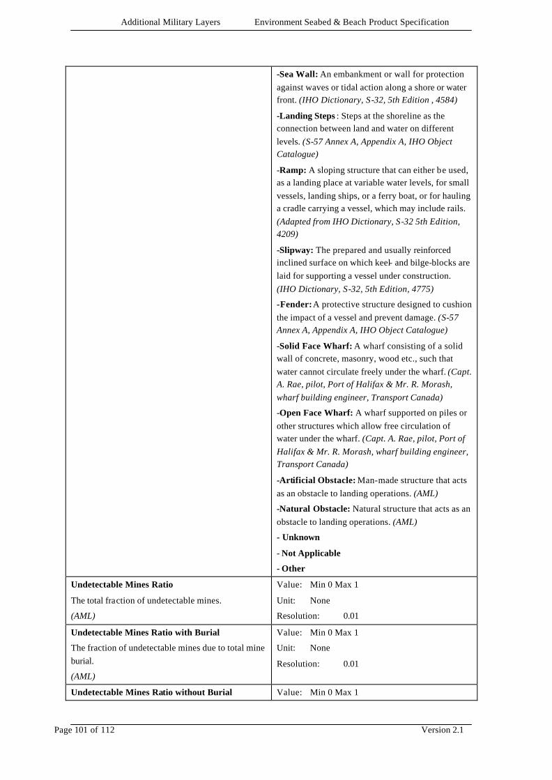
Additional Military Layers Environment Seabed & Beach Product Specification
Page 101 of 112 Version 2.1
-Sea Wall: An embankment or wall for protection against waves or tidal action along a shore or water front. (IHO Dictionary, S-32, 5th Edition , 4584)
-Landing Steps : Steps at the shoreline as the connection between land and water on different levels. (S-57 Annex A, Appendix A, IHO Object Catalogue)
-Ramp: A sloping structure that can either be used, as a landing place at variable water levels, for small vessels, landing ships, or a ferry boat, or for hauling a cradle carrying a vessel, which may include rails. (Adapted from IHO Dictionary, S-32 5th Edition, 4209)
-Slipway: The prepared and usually reinforced inclined surface on which keel- and bilge-blocks are laid for supporting a vessel under construction. (IHO Dictionary, S-32, 5th Edition, 4775)
-Fender: A protective structure designed to cushion the impact of a vessel and prevent damage. (S-57 Annex A, Appendix A, IHO Object Catalogue)
-Solid Face Wharf: A wharf consisting of a solid wall of concrete, masonry, wood etc., such that water cannot circulate freely under the wharf. (Capt. A. Rae, pilot, Port of Halifax & Mr. R. Morash, wharf building engineer, Transport Canada)
-Open Face Wharf: A wharf supported on piles or other structures which allow free circulation of water under the wharf. (Capt. A. Rae, pilot, Port of Halifax & Mr. R. Morash, wharf building engineer, Transport Canada)
-Artificial Obstacle: Man-made structure that acts as an obstacle to landing operations. (AML)
-Natural Obstacle: Natural structure that acts as an obstacle to landing operations. (AML)
- Unknown
- Not Applicable
- Other
Undetectable Mines Ratio
The total fraction of undetectable mines.
(AML)
Value: Min 0 Max 1
Unit: None
Resolution: 0.01
Undetectable Mines Ratio with Burial
The fraction of undetectable mines due to total mine burial.
(AML)
Value: Min 0 Max 1
Unit: None
Resolution: 0.01
Undetectable Mines Ratio without Burial Value: Min 0 Max 1
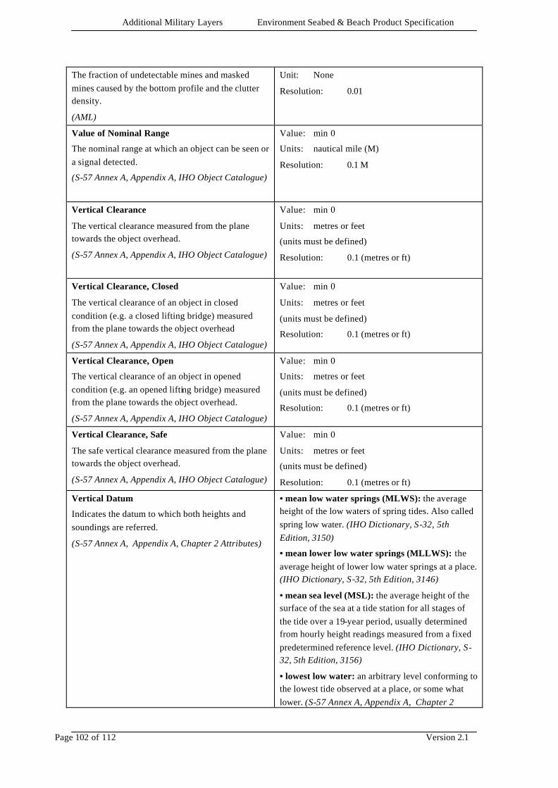
Additional Military Layers Environment Seabed & Beach Product Specification
Page 102 of 112 Version 2.1
The fraction of undetectable mines and masked mines caused by the bottom profile and the clutter density.
(AML)
Unit: None
Resolution: 0.01
Value of Nominal Range
The nominal range at which an object can be seen or a signal detected.
(S-57 Annex A, Appendix A, IHO Object Catalogue)
Value: min 0
Units: nautical mile (M)
Resolution: 0.1 M
Vertical Clearance
The vertical clearance measured from the plane towards the object overhead.
(S-57 Annex A, Appendix A, IHO Object Catalogue)
Value: min 0
Units: metres or feet
(units must be defined)
Resolution: 0.1 (metres or ft)
Vertical Clearance, Closed
The vertical clearance of an object in closed condition (e.g. a closed lifting bridge) measured from the plane towards the object overhead
(S-57 Annex A, Appendix A, IHO Object Catalogue)
Value: min 0
Units: metres or feet
(units must be defined)
Resolution: 0.1 (metres or ft)
Vertical Clearance, Open
The vertical clearance of an object in opened condition (e.g. an opened lifting bridge) measured from the plane towards the object overhead.
(S-57 Annex A, Appendix A, IHO Object Catalogue)
Value: min 0
Units: metres or feet
(units must be defined)
Resolution: 0.1 (metres or ft)
Vertical Clearance, Safe
The safe vertical clearance measured from the plane towards the object overhead.
(S-57 Annex A, Appendix A, IHO Object Catalogue)
Value: min 0
Units: metres or feet
(units must be defined)
Resolution: 0.1 (metres or ft)
Vertical Datum
Indicates the datum to which both heights and soundings are referred.
(S-57 Annex A, Appendix A, Chapter 2 Attributes)
• mean low water springs (MLWS): the average height of the low waters of spring tides. Also called spring low water. (IHO Dictionary, S-32, 5th Edition, 3150)
• mean lower low water springs (MLLWS): the average height of lower low water springs at a place. (IHO Dictionary, S-32, 5th Edition, 3146)
• mean sea level (MSL): the average height of the surface of the sea at a tide station for all stages of the tide over a 19-year period, usually determined from hourly height readings measured from a fixed predetermined reference level. (IHO Dictionary, S-32, 5th Edition, 3156)
• lowest low water: an arbitrary level conforming to the lowest tide observed at a place, or some what lower. (S-57 Annex A, Appendix A, Chapter 2

Additional Military Layers Environment Seabed & Beach Product Specification
Page 103 of 112 Version 2.1
Attributes)
• mean low water (MLW): the average height of all low waters at a place over a 19-year period. (IHO Dictionary, S-32, 5th Edition, 3147)
• lowest low water springs: an arbitrary level conforming to the lowest water level observed at a place at spring tides during a period of time shorter than 19 years. (Hydrographic Service, Royal Australian Navy)
• approximate mean low water springs: an arbitrary level, usually within ± 0.3m from that of Mean Low Water Springs (MLWS). (Hydrographic Service, Royal Australian Navy)
• Indian spring low water (ISLW): an arbitrary tidal datum approximating the level of the mean of the lower low water at spring tides. Also called Indian Tidal Plane. (IHO Dictionary, S-32, 5th Edition, 2427)
• low water springs: an arbitrary level, approximating that of Mean Low Water Springs (MLWS). (Hydrographic Service, Royal Australian Navy)
• approximate lowest astronomical tide: an arbitrary level, usually within ± 0.3m from that of Lowest Astronomical Tide (LAT). (Hydrographic Service, Royal Australian Navy)
• nearly lowest low water: an arbitrary level approximating the lowest water level observed at a place, usually equivalent to the Indian Spring Low Water (ISLW). (Hydrographic Service, Royal Australian Navy)
• mean lower low water (MLLW): the average height of the lower low waters at a place over a 19-year period. (IHO Dictionary, S-32, 5th Edition, 3145)
• low water: an approximation of mean low water adopted as the reference level for a limited area, irrespective of better determinations at a later date. Used mostly in harbour and river engineering. (S-57 Annex A, Appendix A, Chapter 2 Attributes)
• approximate mean low water: an arbitrary level, usually within ± 0.3m from that of Mean Low Water (MLW). (Hydrographic Service, Royal Australian Navy)
• approximate mean lower low water: an arbitrary level, usually within ± 0.3m from that of Mean
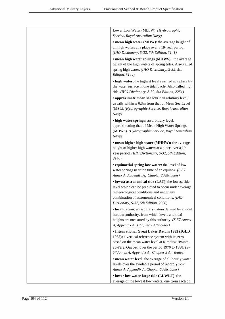
Additional Military Layers Environment Seabed & Beach Product Specification
Page 104 of 112 Version 2.1
Lower Low Water (MLLW). (Hydrographic Service, Royal Australian Navy)
• mean high water (MHW): the average height of all high waters at a place over a 19-year period. (IHO Dictionary, S-32, 5th Edition, 3141)
• mean high water springs (MHWS): the average height of the high waters of spring tides. Also called spring high water. (IHO Dictionary, S-32, 5th Edition, 3144)
• high water: the highest level reached at a place by the water surface in one tidal cycle. Also called high tide. (IHO Dictionary, S-32, 5th Edition, 2251)
• approximate mean sea level: an arbitrary level, usually within ± 0.3m from that of Mean Sea Level (MSL). (Hydrographic Service, Royal Australian Navy)
• high water springs: an arbitrary level, approximating that of Mean High Water Springs (MHWS). (Hydrographic Service, Royal Australian Navy)
• mean higher high water (MHHW): the average height of higher high waters at a place over a 19-year period. (IHO Dictionary, S-32, 5th Edition, 3140)
• equinoctial spring low water: the level of low water springs near the time of an equinox. (S-57 Annex A, Appendix A, Chapter 2 Attributes)
• lowest astronomical tide (LAT): the lowest tide level which can be predicted to occur under average meteorological conditions and under any combination of astronomical conditions. (IHO Dictionary, S-32, 5th Edition, 2936)
• local datum: an arbitrary datum defined by a local harbour authority, from which levels and tidal heights are measured by this authority. (S-57 Annex A, Appendix A, Chapter 2 Attributes)
• International Great Lakes Datum 1985 (IGLD 1985): a vertical reference system with its zero based on the mean water level at Rimouski/Pointe-au-Père, Quebec, over the period 1970 to 1988. (S-57 Annex A, Appendix A, Chapter 2 Attributes)
• mean water level: the average of all hourly water levels over the available period of record. (S-57 Annex A, Appendix A, Chapter 2 Attributes)
• lower low water large tide (LLWLT): the average of the lowest low waters, one from each of
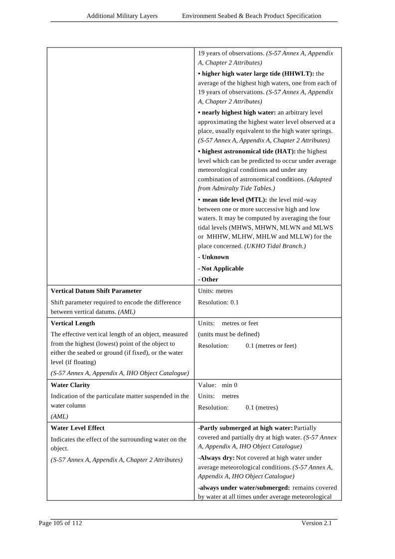
Additional Military Layers Environment Seabed & Beach Product Specification
Page 105 of 112 Version 2.1
19 years of observations. (S-57 Annex A, Appendix A, Chapter 2 Attributes)
• higher high water large tide (HHWLT): the average of the highest high waters, one from each of 19 years of observations. (S-57 Annex A, Appendix A, Chapter 2 Attributes)
• nearly highest high water: an arbitrary level approximating the highest water level observed at a place, usually equivalent to the high water springs. (S-57 Annex A, Appendix A, Chapter 2 Attributes)
• highest astronomical tide (HAT): the highest level which can be predicted to occur under average meteorological conditions and under any combination of astronomical conditions. (Adapted from Admiralty Tide Tables.)
• mean tide level (MTL): the level mid -way between one or more successive high and low waters. It may be computed by averaging the four tidal levels (MHWS, MHWN, MLWN and MLWS or MHHW, MLHW, MHLW and MLLW) for the place concerned. (UKHO Tidal Branch.)
- Unknown
- Not Applicable
- Other
Vertical Datum Shift Parameter
Shift parameter required to encode the difference between vertical datums. (AML)
Units: metres
Resolution: 0.1
Vertical Length
The effective vert ical length of an object, measured from the highest (lowest) point of the object to either the seabed or ground (if fixed), or the water level (if floating)
(S-57 Annex A, Appendix A, IHO Object Catalogue)
Units: metres or feet
(units must be defined)
Resolution: 0.1 (metres or feet)
Water Clarity
Indication of the particulate matter suspended in the water column
(AML)
Value: min 0
Units: metres
Resolution: 0.1 (metres)
Water Level Effect
Indicates the effect of the surrounding water on the object.
(S-57 Annex A, Appendix A, Chapter 2 Attributes)
-Partly submerged at high water: Partially covered and partially dry at high water. (S-57 Annex A, Appendix A, IHO Object Catalogue)
-Always dry: Not covered at high water under average meteorological conditions. (S-57 Annex A, Appendix A, IHO Object Catalogue)
-always under water/submerged: remains covered by water at all times under average meteorological
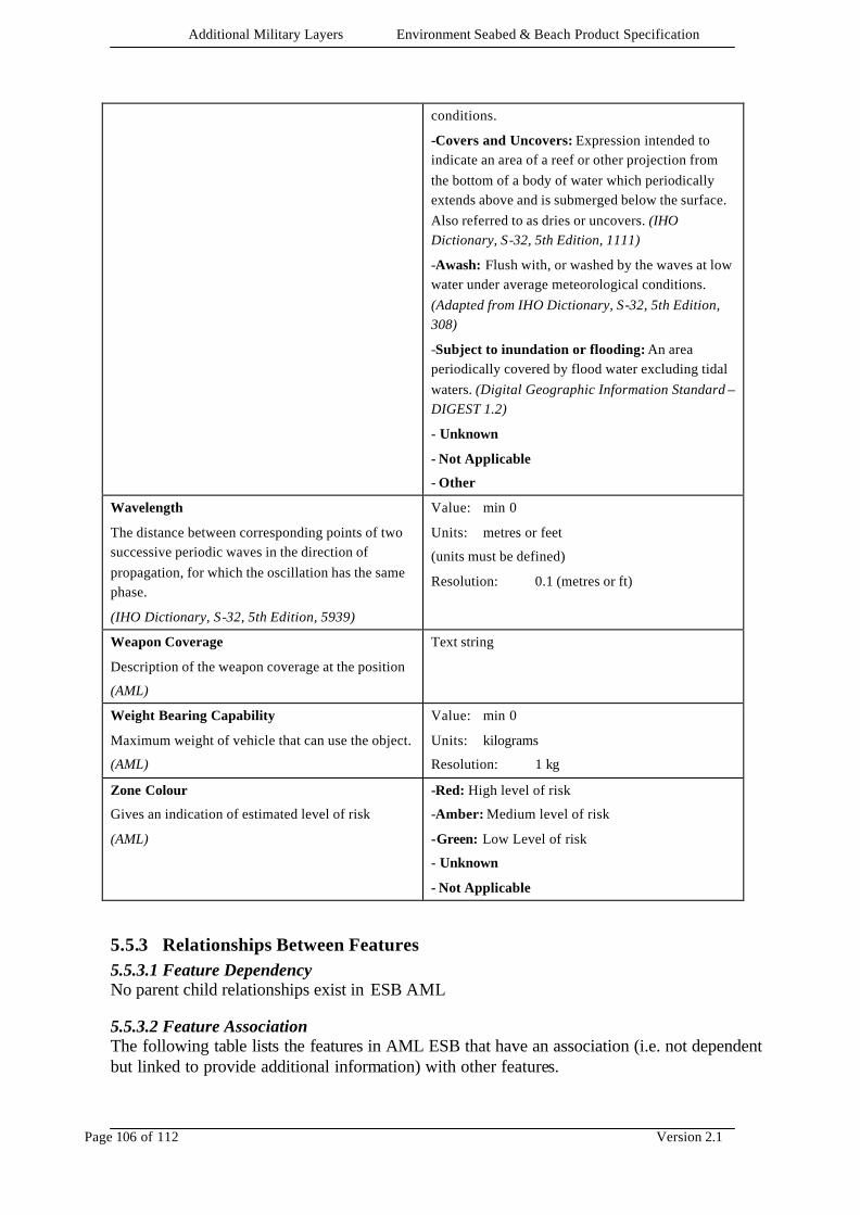
Additional Military Layers Environment Seabed & Beach Product Specification
Page 106 of 112 Version 2.1
conditions.
-Covers and Uncovers: Expression intended to indicate an area of a reef or other projection from the bottom of a body of water which periodically extends above and is submerged below the surface. Also referred to as dries or uncovers. (IHO Dictionary, S-32, 5th Edition, 1111)
-Awash: Flush with, or washed by the waves at low water under average meteorological conditions. (Adapted from IHO Dictionary, S-32, 5th Edition, 308)
-Subject to inundation or flooding: An area periodically covered by flood water excluding tidal waters. (Digital Geographic Information Standard – DIGEST 1.2)
- Unknown
- Not Applicable
- Other
Wavelength
The distance between corresponding points of two successive periodic waves in the direction of propagation, for which the oscillation has the same phase.
(IHO Dictionary, S-32, 5th Edition, 5939)
Value: min 0
Units: metres or feet
(units must be defined)
Resolution: 0.1 (metres or ft)
Weapon Coverage
Description of the weapon coverage at the position
(AML)
Text string
Weight Bearing Capability
Maximum weight of vehicle that can use the object.
(AML)
Value: min 0
Units: kilograms
Resolution: 1 kg
Zone Colour
Gives an indication of estimated level of risk
(AML)
-Red: High level of risk
-Amber: Medium level of risk
-Green: Low Level of risk
- Unknown
- Not Applicable
5.5.3 Relationships Between Features 5.5.3.1 Feature Dependency No parent child relationships exist in ESB AML 5.5.3.2 Feature Association The following table lists the features in AML ESB that have an association (i.e. not dependent but linked to provide additional information) with other features.
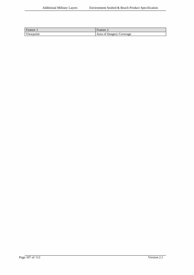
Additional Military Layers Environment Seabed & Beach Product Specification
Page 107 of 112 Version 2.1
Feature 1 Feature 2 Viewpoint Area of Imagery Coverage

Additional Military Layers Environment Seabed & Beach Product Specification
Page 108 of 112 Version 2.1
6 DATA CAPTURE GUIDELINES
6.1 CONTINUITY Features crossing the boundaries of digital source files or other media should be continuous whenever possible. Datasets consisting of multiple digital source files should also aim to be contiguous for consistency of display.
6.2 GUIDANCE ON FEATURE CODING The ‘AML ESB Guidance on Feature Coding and Attribution’ section of the carrier format annex provides guidance on the conventions that are to be used to encode features, their geometry, and associated attribution, using a relevant implementation standard. The content of the AML ESB product is at the discretion of the producing authority, provided that the conventions described in the ‘AML ESB Guidance on Feature Coding and Attribution’ section of the carrier format annex are followed.
Additional Military Layers Environment Seabed & Beach Product Specification
Page 109 of 112 Version 2.1
7 DATA PRESENTATION
7.1 SCOPE The way in which AML ESB is displayed is dependent upon an individual customer’s requirement. How their systems are developed to display AML ESB data will large ly be governed by the: • environment in which the data is to be viewed • types of products that are to be displayed with the AML product This Product Specification is designed to support the production and supply of ESB. It does not address data presentation.
Additional Military Layers Environment Seabed & Beach Product Specification
Page 110 of 112 Version 2.1
8 PROVISION OF DATA
8.1 GENERAL
8.1.1 File Format (Encapsulation) The file format or encapsulation is exchange standard specific.
8.1.2 Auxiliary Information All media containing AML products will contain cataloguing information regarding the coverage of the products contained within it. A complete AML catalogue is planned for future development.
8.2 DISTRIBUTION MEDIA AML is available in the following format(s): • CD-ROM • DVD Other approved means of distribution will be promulgated in due course. While data must be available to users on standard media, other media/transmission means may be agreed directly between producers and recipients.
8.3 VOLUME NAMING AML volumes (defined as packages) may contain several datasets, each from a different product specification. The volume naming convention for AML ‘Packages’ is not defined by AML Product Specifications.
8.4 FILE NAMING CD-ROM AML file naming conforms to ISO 9660, International Standards Organisation,
Information Processing - Volume and File Structure of CD-ROM for Information Interchange. See appropriate implementation annex.
8.5 DIRECTORY STRUCTURE CD-ROM The directory structure conforms to ISO 9660, International Standards
Organisation, Information Processing - Volume and File Structure of CD-ROM for Information Interchange. See appropriate implementation annex.
8.6 ERROR DETECTION Datasets will undergo file integrity checks that are dependent upon the exchange standard implemented.
8.7 COMPRESSION AML products do not use compression techniques.
8.8 ENCRYPTION All AML products are unencrypted, irrespective of security classification.

Additional Military Layers Environment Seabed & Beach Product Specification
Page 111 of 112 Version 2.1
8.9 HARDWARE AND SOFTWARE REQUIREMENTS N/A.
Additional Military Layers Environment Seabed & Beach Product Specification
Page 112 of 112 Version 2.1
9 TESTING METHOD This product specification has been designed to achieve interoperability of AML data products and other digital data products. This is achieved by the separation of the data dictionary from the standard used to encode the data and by the use of internationally recognised standards for the transfer of the data. It is the responsibility of the data producer to ensure that AML data products fully conform to this Product Specification and to the chosen transfer standard.