ENVIROIIVJENTAI - Town of Mammoth Lakes
312
ENVIROIIVJENTAI tPACT REPORT EIR EIP ASSOCIATES I FEBRUARY I ! Communi Delment ent Planning Oivision Lib: _ Catalogue Number
-
Upload
khangminh22 -
Category
Documents
-
view
3 -
download
0
Transcript of ENVIROIIVJENTAI - Town of Mammoth Lakes

ENVIROIIVJENTAItPACTREPORT
EIR
EIPASSOCIATESI FEBRUARY
I
!
Communi DelmententPlanning Oivision Lib:
_Catalogue Number

Final
Environ.mental Impact ReportClearinghouse #89040321
TOWN OF MAMMOTH LAKES, CALIFORNIA
NORTH VILLAGE SPECIFIC PLAN
Prepared. byEIP Associates
80 South Lake Avenue, Suite 600Pasadena, California 91101
February 1991

I!IIi
Ii!!II!II!
TABLE OF CONTENTS

!I
|
IiiIIIIIIII
5.
6.
90182
TABLE OF CONTENTS
SUMMARYSummary of Proposed Action 1-1Alternatives 1-ISummary Table of Impacts and Mitigation Measures 1-2
PROJECT DESCRIPTIONProject Location 2-1Project Background 2-1Project Objectives 2-6Projec Characteristics 2-6
GENERAL DESCRIPTION AND ENVIRONMENTAL SETI’INGOverview of Environmental Setting 3-1Related Projects 3-2
ENVIRONMENTAL IMPACT ANALYSIS4.1 Geology, Soils. and Seismicity 4.1-14.2 Hydrology and Water Quality 4.2-14.3 Biological Resources 4.3-14.4 Land Use and Planning 4,4-1
4.5 Jobs/Housing Relationship 4.5-14.6 Utilities 4,6-1
4.7 Traffic 4.7-14.8 A,r Quality 4.8-14.9 Noise 4.9-14.10 Archaeological Resources 4.10-l4.11 Aeslletics/Visual Impacts 4.11-14.12 Light-Glare 4.12-14,13 Public Services/Fiscal Impacts 4.13-14.14 Energy Conservation 4.14-1
LONG-TERM IMPLICATIONS OF THE PROPOSED PROJECTRelationship Between Local Short-Term Uses of Man’s
Environment and Enhancement of Long-Term Productivity 5-1
Irreversible Environmental Changes 5-1
Cumulative Impacts 5-1
GROWTH-INDUCING IMPACTS OF THE PROPOSED PROJECTGrowth-lnducing Project Impacts 6-1

III
i!I!:1IaI!
9.
lO.
90182
Table of Contents
ALTERNATIVESNO Project 7-2Reduced Project Scale 7-4Alternative Site 7-6Environmentally Preferred Alternative 7-9
PERSONS CONTACTI’ED 8-1
EIR AUTHORS 9-1
APPENDICESA. Biotic ResourcesB. CNDDB SummaryC. Erosion GuidelinesD. Traffic StudyE. Initia/StudyF. Particulate Emmissions Regulations

LIST OF TABLES
1
!
!I
!
1-14.2-14.4-14.4-24.5-14.5-24.5-3
4.5-44.5-5
4.5-6
4,5-7
4.6-14.6-24.7-14.7-24.7-3
4.7-4
4.7-54.7-64.7-74.7-84,7-9
4.7-104.7-11
4.7-124.8-14.8-24.8-3
4.8-44.8-54.8-6
4.9-14.9-24.9-34.9-4
4.9-5
90182
Summary Table of Impacts and Mitigation Measures 1-3Active Wells in Mammoth Lakes Vicinity 4.2-6North Village Development Phasing Plan Summary 4.4-7Existing and Proposed Land Use in North Village 4.4-8Permanent Population of Mammoth Lakes 4.5-2Housing Composition of Mammoth Lakes 4.5-3Survey of Average Housing Prices
and Apartment Rents 4.5-4Housing Needs for Mono County by Income Categories 4.5-5Estimates of Existing Employment on the North
Village Sie 4.5-6Employment Opportunities of the Proposed North
Village Specific Plan 4.5-8Construction Related Employment Generated by
North Village 4.5-9MCWD Well and Booster Pumping Systems 4.6-2Annual Water Demand 4.6-3Existing Daily Winter Weekend Roadways LOS 4.7-13Existing PM Peak Hour LOS Summary 4.7-14Net Winter Weekend Vehicul" Trip Generation
for Cumulative Projects 4.7-18North Village Winter Weekend Vehicular Trip
Generation 4.7-20Cure. Base Daily Winter Weekend Roadway LOS 4.7-23Cure. Peak Hour LOS Summary 4.7-24Cum. Plus Project Daily Winter Weekend Roadway LOS 4.7-26Cum. Plus Project PM Peak Hour LOS Summary 4.7-27Cure. Plus Project Daily Winter Weekend LOS 4.7-34Cure. Plus Project PM Peak Hour LOS Summary 4.7-35Percent Contribution of Project to Daily Traffic 4.7-37Percent Contribution of Project to PM Peak Hour 4.7-38Federal and State Ambient Air Quality Standards 4.8-2Health Effects Summary of Criteria Air Polutants 4.8-3Contxol Measures Mammoth Lakes Air Quality
Management Plan 4.8-6
Air Pollutant Data Summary 4.8-7Predicted Roadside Carbon Monoxide Concentrations 4.8-11Estimated Daily Peak PMo
from Cumulative Development 4.8-14Typical Sound Levels 4.9-2Land Use Compatibility Standards 4.9-4Projected Peak Noise Levels 4.9-6
Typical Construction Noise Levels 4.9-7
Typical Construction Equipment Noise 4.9-8
iii

4.13-14.13-2
4.13-34.13-44.13-54.13-6
90182
Table of Cotuents
Current Property Tax Allocation 4.13-9One-Time Revenues from the Development of the
North Village Specific Plan 4.13-10Projected Tax Revenues from the Project 4.13-11North Village Property Tax Allocation 4.13-12Other Revenues Nonla Village Specific Plan 4.13-14Net Fiscal Impact North Village Specific Plan 4.13-16

LIST OF FIGURES
2,1-1
2,1-22,2-1
2.2-22.4-14.1-14.1-24.1-34.1-.44.1-54.1-64.2-14.2-24.2-34.4-14.5-14.6-14.7-14.7-24.7-34.7-44.7-54.7-64.7-74.7-84.7-94.7-104.7-14.11-14.11-24.11-34.11-44.11-54.11-67-1
Regional Location Map 2-2Vicinity Map 2-3Exis)Jng Zoning Map 2-4Project Site Existing Conditions 2-5Pedestrian Circulation System 2-10Long Valley Caldera 4.1-3Topography a"ld Slope Stability 4.1-4Existing Slopes 4.1-5Regional Geologic Map 4,1-7
Land Forms 4.1-8Fault Map 4.1-9Mammoth Creek Basin 4.2-2Stoml Drainage System 4.2-4Long Valcy Ground Water Basin 4.2-5Existing and Proposed Land Use Map 4.4-9Eraployment by Major Industry 4.5-2Existing and I:h’oposed Sewer System 4.6-8Vicinity Map 4.7-2Vehicular Circulation 4.7=3Proposcd Vehicular Circulation 4.7.4Roadway Network Improvements 4.%5
Existing Winter Saturday ADT 4.7-7Circulation Elemcnt 4.7-9Cumulative ProJects 4.7.17Cumulative Winter Saturday ADT 4.7=21Cumulative Plus Project Winter Salurday ADT 4.7-22Pedestrian Circulation 4.7-41
Shuttle System 4.7-42Photo Key Map 4.11-2Site Photos 4.11-3Site Photos 4, I-4
Site Photos 4.11-5
Proposed Gondola Route 4.11-I0Gondola Schematic 4. l l-
Alternative Site Location Map 7-7
90182

1
I
I
IiiiI!.i
l. SUMMARY

!!
1. SUMMARY
SUMMARY OF PROPOSED ACTION
This Environmental Impact Report (EIR) addresses a proposed 64. l-acre Specific Plata in Mammoth Lakes.California. The project includes 2.000 new hotel units, 400 resort condominium units. 60.000 square feetof commercial/retail space, skating rink and ski lift. The majority of the parcels within the project site are
currently zoned as Commercial with the peripheral acreages zoned as Residential. The Specific Plan calls
for a modification in zoning such that more flexible site designs would be allowed. Also. the Specific Plan
is proposing a circulation system that would require the Transportation Element in the Town of Mammoth
Lakes General Plan to be modified. An amendment to the Land Use Element is required.
ALTERNATIVES
In accordance with Section 15126 (d) of the State CEQA Guidelines. a range of project alternatives are
addressed in this EIR. A detailed analysis of this evaluation is provided in Section 7 (Alternatives) of this
document. The following three alternatives are considered:
"No Project"
Reduced Project Size
Alternative Project Site
The No Project Alternative would mean that the proposed project would not be constructed and the project
site would remain in its present undeveloped state. None of the unavoidable significant impacts outlined
for the proposed project would occur.
The Reduced Project Size Alternative would reduce the overall intensity (square footage) of the project
by 30 percent. The result of this alternative would reduce the overall project impact of the proposed
Specific Plan.
The Mtemative Project Site is approximately 130 acres and is located south of Meridian Road and east
of Old Mammoth Road referred to as the South Gateway. This alternative assumes the same number
of hotel/condominium units and commercial floor space as the proposed Sixcifi Plan. The itepacts of
this alternative are comparable to the proposed project.
90182 1-1

I!
IiIII
. Sumrna.
SUMMARY TABLE
Inom’ation in the following Table 1-1. Summary of Environmental Impacts has been organized to
correspond to ’,he environmental issues discussed in C’hapler 4 (Environmenta.l Setting, Impacts and
Mitigation Measures), The summary table is arranged in four columns: 1) environmental impacts; 2)
potential level of significance without mitigation: 3) recommended mitigation measures; and 4) the level
of significance after implementation of mitigation measures. A series Of mitigation measures ate noted
where more than one mitigation measure may be required to reduce the impact to a less-than-significant
level.
Although not required by CEQA. some less-than-sig,nificant impacts and associated mitigation measures
have been included to further reduce the level of impact. This type of impacl is identified in the text. For
a complete description of potential impacts and recommended mitigation measures, please refer to the
scific issue section in Chapter 4.
90182 1-2

TABLE I-I
SUMMARY OF ENVIRONMENTAL IMPACIS AND MITIGATION MEASURES
1. Summary
Level of Signilicance Miligalion Level of SignilicaaceImpacl WilhOul Miligalion Measures Wilh Miligalion
4.1 Geology, Soils, and Scismicit,
4.1-1 If the projec! wen implemented &s prowled,i! cmld ereile w or increased slopinstbilily. This a pemt-//y iuficRtimpact.
LS 4. I-I(a) Soils and foundation analyes shall be approved LS
hY the Puldic W’Rs Director prior tofproject design prta,al. as stipuled ifl tamldst Town’s Safety Pdicy #18. Allna.ures requied v Ihe Public Wor Dfeclorshall iporated inlo grting plilding pl.
4.l-I(b)
4.1-1(c)
4.1-1(d)
Ne. shqes shall be constructed at angle anddegree t( cmoacthm that will enure sability.v stipulated m the standards fthe 7wn’sMumcipal Code.
All work shall be overseen by a licensed civil
engineer, certified engineering geologist (CEG)simdar prriely quedpres,
who shl repot o Tn in der to ure
tstdstpliclecset.
Any impacts resulting from any ofthe abovemeasures nol ana(vzed by this EIR shall be
subject to further e,nv#ronmental review and
approval tv the Planrung Ccmunissicm prior to
apprcn’al Ih final project design.
S,gnilicaol SIJ Significaal tJnavoidaldc
Less Than Signifit’anl PS Polenlially Signiftt:anl
9O182 I-3
TABLE I-I
SUMMARY OF ENVIRONMENTAl. IMPACTS AND MITIGATION MEASURES
I. Summary
Levcl of Significance Miligalion Level of SignificanceImpacl Wilhoul Miligalion Measures With Mitigation
4. i-2 I| the project welt implemented us plmx’d, PS 4. I-2 A conq,rebenive Erosi,m and Sedinwnt LSil gould ltile nw Iw inerenic,d soil erol). Tran.oort Conlrol Plan .ihall be prepwed andTh is a ellyat. l,rwed by he Town pri to iue
gtling building rmit. I’ PI slliluded in t Propel design, tipuled in
#W lTwn’s Safe;y Pditv #18. TPld.*,, ett requires t Regit WerQuMdy CrolBd the TtnMCe.
4.1-3 If the project welt implemented as prolmcd S 4 I-3 Prh to issuance ofgrading or building permiv. LSit could significanlly tiler the Iopggaphy d geow’lmical studies sldl he cooleted ad their
Ihe site. This is an a*lvot4ab $igiJcant recmmlendalior shal im’ed in t
ct. Prect design. slipuled m t Tn’sSyP(dicy #26.
4.14 If Ihe Project were Implemenled as proltd. LS 4.1 4 The Project Sponsor sh,dl complete the LSwouct living geotcc stud
in and vli an aa subjl toi recein
livily. Th b assa-s qmlaed m the TKsSePi 26. All
structures sl sigd built to le
4. 1-5 If the projecl ’,lt implemented as propod, PS 4.1-5(a) The Plan includes improvemems M, LSRoiIhe humor ofle living evi Miel Rs;lwould
la and vti aabjt to vnk prot,de resMes tlw sles sidiviim with
livily. inqw,ved travel routes toh o[he .voctiroutes h’ing out H :own.
Simficam SU Significanl Unavoidable
Thai] Sigiificanl I)S I)olenhally Sigllifican!

TABLE I-I
SUMMARY OF ENVIRONMENTAl. IMPACTS AND MITIGATION MEASURES
I. Sunnnao/
Level of Significance Mitigation Level of SignilicanceImpact Wilhoul Mitigation Measures Wilh Miligalion
4.1-5(b) The developer shall cooperate with the Town in
designing and disminating mformatum to assist
cilizen md visitors in re,pcmdmg to enlergen’y
siluathm Ie lilly to i. (Set#31). All sum-tesl desigd ilt
to at least Iads UBC Seismice 4,
S Signihcall SU Significant Unawidahle
I,S Lcss Than Sigmlicant PS Polentially Significant
B Benehial
9(1182

m m m m , . mmm m m m m mmm - m
TABLE I-I
SUMMARY OF ENVIRONMENTAL IMPACTS AND MITIGATION MEASURES
I. Sul||m;.try
Level of Signilicance Mitigation Level of SignilicanceImpact Withoul Miligalion Measures With Mitigation
4.2 Itydro and Waler Quality
4.2-1 Development under the Specific Plan will PS 4.2-1(a)suhstanlially increase and inlensifydevelopment, Ihus increasing SUlTace runffrom the Plan area. This is a poetHysiifican( impact.
4.2-1(h)
4.2-1(c)
A more complete hydrology analysis/or designpurpo.es shall he required to he conleted to
estimate the amounts of rum*ff which wold berequired to he relaind onsile.
Runff control shall be designed to meet theLdu,ntan Regional Water Quality C*mtrolBmrd’s requirements and mu.t be approved bythe l’own prior to issuance of my gradingpermits. Design shall be to the standards of theStorm Drain Maser Plan.
The folh’ing water conserration proceduresshall be ir’orporated into project elements where
feasible:
Landscape with low water-u:ffng planls;
Install efficient irrigation systems that minimize
runoff and evaporation and maaimize the water
that will reach the plant rs. such as drip
Use pervims nuerial whenever
LS
S Signilicant SII Signi[icanl tlnavoitlalleLS L.x, Than Signif)canl PS Polcnhally Signilicn!
B Bcnelicial
90182 I-6

TABLE.I-I
SIJMMARY OF ENVIRONMENTAL IMPACTS AND MITIGATION MEASURES
I. Sumitlllilfy
Level of Signilicance Miligalion Level of Signilicam:eImpact Without Miligalion Measus With Mitigat
4.2-2
4.2-3
Quulity of ggoundwuler wmtld not be aflected
I,y pt-oject cmtstruction activities, and will oresult ia sigi[cat impav_s to groundwaterqualily mr quanlily.
1’he qualily o( surface runoff could be
degra4d us u result o( development. ThL is u
jltntially significant
LS 4.2-2 IVo miligati(m measures required.
PS 4.2-3(a) Fen" each individual project considered under diis LS
development concept, disttubance of soil requiesWaste Discharge Report to he filed with the
Laho.tan Regional Wate Quality Control Boa.4
and a Waste Discha/ge Peru|it to he issued folr
"adhered to duing all phes of tim Ioject.
4.2-3h) See Mitigation Mea,e 4.1 21
S Stgnthcanl SU Signil’icmt Unavoidable
I.S Less Than SlglllliCalll IIS Poleniially Sigllil-lt’alll
90182 7

TABLE I-I
SUMMARY OF ENVIRONMENTAL IMPACFS AND MITIGATION MEASURES
I. Summary
Level of Signilicance Miligation Level of SignilicanceImpact Without Miligalion Measures With Miligalion
4.3 Biological Resources
4.3-1 As prenlly conceived in Ibe Norlb ViJlaKe PS 4.3.1(a) The proleCl sl pre,e eisting
SiF PI, i reallamercl vegetation 1o Z magnum tent
vepmentspfthis leB Lmul.wmg sl enizet use o/tivesdt In Ihe aReral dI allerd pls indigeus to tJPi.FW Fest.
pnlly on Ih perly. Cor ma tually ctmmunitws Whever pos.sie ives
apltg; eer, thirm replacement ilm vdue. 5ile
n(4 ire hat valsn Ihe subject to t Design Reviprtedure
pemenl velal wouM "urn" and
sight,cant t PjI.4.3.1(b) All trees greater than 12 inches dbh (diameter
brect heighl) and significa stands on the
Pr,lect site shall be mapi,ed prior to issuance ofgrading permits or rlearing. A registered
forester arborist shall then determine tlw age
and condititm of these trees and wher theysluald be relained removed based upon health
cmd visual significance of the trees, e:ep( forremoval required by approved improvements.Ome this determitlalion is made Iluse trees
should be relained and integrated into #he design
t[ the Project. A p’rogram q specific protectionnu’a.ures shall be prepared by the devehper arid
(qvrow’d by the Town pri(r to issuatu’e of an.vconstructim permits (e.g., ottstrm t.m ]mcing.
grading cmtrols, grading h,sign. etc L Any
S Signil’tcam SU Sgnil’i’.:at:t Unli,vokial..le
LS Less Than Sigmlicanl PS Polenlially Sgmficant
9(1182

mm m N mm N m m m U N l ml
TABLE I-I
SUMMARY OF ENVIRONMENTAL IMPACrS AND MITIGATION MEASURES
I. Summary
Level of Significance Miligalion Lcvel of Signilicancemmpacl Wdhoul Miligalion Measures Wilh Miligalion
4.3-I(d)
4.3-I(e)
4.3-1(D
trees renuved unavoidobly by the finjI Projectqqroral shall be m -’wde with
di(’ie. O.slte replen.nt wdl need
poval t ?n Plnmg Directs.
grading and trenching, shall be prohibited within
the dr,pline Orelalned trees. Equipmem shall
sludl mt cover the ground surface within the
clearly defined and proecled.
Lds,.ape nerials shall be used that allowforthe preclion and preservation 4existing trees.
Native pl ecies, preferly sd or
’ullingsmlIpIs. sld udwe
V the Plmg Director priw to issue y
Irrigation, fertilization, and other landscapemanugemenl pcactices shall be designed to
minimi2e efecls on eillng trees dnd othe
vegetation.
Prq,er di.posul methods Jot all z’miferms slth
.ludl Ie used in order
bark
S Sigmlicant SLJ SiguHlicanl Udavoidalle

mm m mm mm m m m mmm mm mmm mm mm m m m m mmm
TABLE I-I
SUMMARY OF ENVIRONMENTAL IMPAI’5 AND MITIGATION MEASURES
I. umma
Level of Significance Miligalion Level of SignificanceImpact Wilhoul Mitigation Measures With Miligalion
4.3-2 The pta,d project will eesnlt in a chaage ia PS 4.32 Implement Migalion Mesure 4.3-I avc. LSweRetali from cifer fo to urbandevek)pmenl within uu
veKetalt ver, Isce twilllikely ufl in
T change mu
4.3-3 Any of i plant species og concern would LS 4.3-3 Noe required. LSlte considered significant. Field surveys donein late .June, 1990, a time flwering for all
species u( concern, failed Io find lUy o the six
species d’ concern. As u result il is exp.’ledlhnl Ihere will he no signi[want odverst eJectson any species .( conceru.
Devekpmeu! of the pcojel would result in Ihe
ks e( 25 ucls of fraKmenled native wiidli(e
habitat. Tltis is u/ss-//san-sga]cm mpact.
4.3I PS 4.3(a) To retain wildlife values, as much native LSvegelation as poie shall
ected ding colruction. A RegelPhm. prepped by quailedqqrwrd by t Town ofMhs,
" conqdeted prior to the cm*eenwm
oect wl6ch wl deri tail I ecestrees sb$ whk’h will ud, wre
Iv will pled, a in what
she th plling nle’e which
will ee scesful growth. It lll include
LS Less Than Signil-anl P Ptlenlially SignifieamB t%cnchcia|
m m m m m , m m m m m m m m m N
TABLE I-I
SUMMARY OF ENVIRONMENTAL IMPACT[’S AND MITIGATION MEASURES
I. Sumnlary
Level of Signilicance Mitigalion Level of SignilicanceImpacl Without Miligalion Measures With Mitigation
4.3-5 I)islurlmnces and dJsruplioos during projectmstruion scarier/disperse and |rnKment
exJinK wiJdiife communities osile, fm’inKsurvivors into already occupied habilats to
cause cumulative neKulive impas on uJl
wildlife in the urea. This is at polenliaJly
PS 4.3-5
4.3&(b)
mtmiuring peogram to fi,llow the progress ofnew plantings and ensure replacement
unsuccessful plants. Lalscaplng with native
pecies qtrees and hrubs should be undertakenIo enlumce wildlife use of cleared areas. AnyIrees renuved unavoidably by the fial Projciapproval shall be replaced a me-to one basis
o’-site. Off-site replacemem will need the
approval of the Tawn Planning Director.
Onder the recelly eoled AB 3180. once
mitigation pl desigd m lel Iseseoved t sificewre Iywill h’alede ideated. Immust
ovide a progr WmIprogress[a peri oft(u(y tee Wfi yes)deenwd sufficiem by e Planning ectm to
ssme I sus[ul development. Aualemiy shall siti Town msme scsful imeb th
storage of vehicles and the sttage ofbuihllng and aher materials, shall he confined to
rea* slaled foe development. (.’are shdll be
LS
S Signdican! SI.J Signiliclml Unavoidable
LS Le’,s 3"iiall Signilil:anl I*; llolentilllly Signilicllnl
R tlciit’ficial
90182 l-I

m n m m m m .,m n m mm m m m m mm m m[
TABLE I-I
SUMMARY OF ENVIRONMENTAL IMPACTS AND MITIGATION MEAS[JRES
I. Summary
Level of Signilicance Miligalion Level of SignificanceImpacl Without Miligalion Measures With Miligalion
shall he replaced on a one-lo-one basis on- or
off sile. ()if-site rcplacemenl will need the
approval o[ tba Town Planning Direclor.
1"o prevent erosion and siltation into intermittent,eeLs. areas cleared of vegetation, fill oe ohermaterials should be stabilized after cleo,rmg andgrading. Ilay bales, silt screens or simiht
devhes .should be used Io prevent siltations. Tofitrtht,r protecl the drainage system and preventerosim, all grading and construction should be
cmqdeted during the summer month or. afterOctda.r 15 af each year. he in a ondilion to beslabdzed within 48 hours should inclemenl
LS
4.4 Lnd |l.,f and ’lannin
4.4-1 The visual impact of Ih hi,h-speed Golol S 4.4-1(a)over a 20-fool easement within a residenlialarea may not I a dmlimabl fealnre. This is
convicted to bea sil-caat impact.
4.4-t(b)
height af tbe proposed gemdola $h,uld be
mamtamed at imum of)[eel1 the tree li). m order to precl vies
fl jem residenti ildings.
To Ihe maximum extent [easlble existing trees
located along the gondola easement sludl be
retained. Replacenwnt trees, in addition to thoseei,ting, shall be planted adlacent to the gondolaeasmwnt (wilh property approval) in
SU
S Sigmlicant SLI Significant Llnavoidable
LS Less Than Significant PS Potentially SgnificantB Henelicial
9(1182 l-m2

m n n m == in iu m m m m m m iml m uI ann
TABLE I-I
SUMMARY OF ENVIRONMENTAL IMPACTS AND MITIGATION MEASURES
I. Summa,
Level of Signilicancc Miligalion Level of SignilicanceImpacl Willoul Miligation Measuucs Wilh Miligalion
4.4-2 The propped projecl would creale significantchanges in IO exisling physical bndpatterns and mandsh in I pjt urea
un thrghoul the cmercl areas
Mammoth k. Thk u
igniflcotc
4.4-3 The proposed project represents a much mo
iniense us o tl bud Ibaa Ibe elisIing ningand presn! u.. This is considered to be a
potenIiaUy-ignificant impacl.
4.4-I(c)
rdcr t creule a buffer Ihat will protect priv,’y
properties.
reflective maleriols shall be usedfor Ihe gondolatowers and cabins.
PS 4.4-2 The Nwlh Village Specific Plan suggests LSspeci/ic schedule developnwnl and specific mia
pening. A cullypddevelmplshall help to preclude sur. Isuccess INh Village’siccleiS e.ei a " crilic to I vilily o/Ihe ]wn OfMuhs. Micmionthe phging pll red bytPlng Cissi Tn Mhes. Mificmion se pltedslsubject o Tn Cou’H delermin pt
I proMpress of this Specific Pl y
fulure m,ificion.
PS 4.4-3 Prior to every development phase othe LSproposed project, the plan for thai proposedphase sludl be submiued o the Town oManm*oth Lakes. North Village Design Review
Cemlmittee and Ihe Norlh Village Assoc’ialioul for
S Signdcan! SIJ Significanl Unawidable

TABLE I-I
SUMMARY OF ENVIRONMENTAL IMPACTS AND MITIGATION MEASURES
I. Summary
Level of Significance Miligation Level of SignificanceImpacl Without Miligalion Measures With Miligalion
4.4A
4.4-5
4.&6
1"he prompted pnJjecl represenls an
opporlunily to see infill development
eLting land areas. This is u sin’ant
The pllxw’d projecl would meet a purl Ihe
increu,d demand for visilor accommodations
in Mammoth Llte. An increasinK demndwmld be eslablLhed ns Ihe preclsa
yeur-rnd rreulnul ilily Iumhr. Th m sa
The pposed projecl is ilalcJpiled Io
Kenerule u peak population o 2,.30 peopleosile. These vistlut*s would conlrilJle to the
ecomni base by means a ellmtilures for
accummodlJons, ski IJfl IJckels, ski realis,
fud, srices and olher toods- The propoddevelopmenl is designed more Io caplure
polealal new marhel demund by business and
Kuided Iown groups than Io answer Ihe
exisling demand. This is nol a sKnificautimpact.
B 4.44 None required.
B 4.4-5 None required.
B 4.4-6 None required.
S Signdicaud SLI Signilicam Unavoidable
LS Less "lhan Slgllificanl PS |Olellllnlly Signilicn!B Bcm’licil
’0182 1-14

m m m N m m m m m m mm m am mmu
TABLE I-I
SUMMARY OF ENVIRONMENTAL IMPACI’S AND MITIGATION MEASURES
I. Summary
Level of Significmce Mitigation Level of SignificanceImpacl Wilhoul Miligalion Measures With MitigatL,n
4.4-7
4.4-8
4.4-9
The proposed project wooid promote propertylax( bases on rnt t value
unnlly after buiMl. Tb new Ivennes to MoCntyatTn orMammothkw gl by Ihe
els and cmercl.Th u
guint ct.
The prol)vd project woId he consistenl wilh
Ihe General PnIU Elenl whh)nseI Mirel Cmmcl Dklrl, aniy,mste { SiEc PnPnning Opunit This m
gnifinl ct.
The proposed Norlh Village Specific Plan
would b consistent wilh she Town of
Mammoth Lakes General Plan with the
exeeplion of minor changes in land
desinnti(ms from residenllal Io ommerclaland Circulation Element changes which
permit the retreating of Canyo BoulevardTraffic impacts).
B 4.4-7 None required.
B 4.4-8 Hon required.
B 4.4-9 None required.
I.S Less Them Signil]cant PS I’olcnlially Signifmcan!
H Hcnt’l’icial
00182, 1-15

TABI.E I-I
SUMMARY OF ENVIRONMENTAL IMPACI’S AND MITIGATION MEASURES
I, SUlllUllary
Level of Signilicaacc Miligalion Level of SignificanceImpact Withoul Miligalion Measures Wilh Mitigalion
4.5 lobs/Housing Relalionship
4.5-1 As prented in Table 4.54 (in sectionthe prups North Village Specific Plan could
pcotially generate 1,612 permanent m-site
jobs and 106 temporary cmstrac4km-relatedjobs. ]’his is a meficl iapat’t.
4.5.2 Empoymenl created from Ihe hegel and
c*mamercial develolment in Ihe North VillageSpecific Plan area will incras the populationo[ Ihe Town of Mammoth Lakes and its
surnmnding area by as much as 2,82 pJple,with an accompanying hot.rig demand of
1.230 nniLs. This is a s/ga’icant/mpct.
4.5 None required.
S 4.5-2(a) I00 percera of the housing f,r e,doyees LSgetteraled by us within t project slprovided ile. iludinfdeeoe&,uSing bd u,n Ilelh Say ceclion5( 50105 criteria uesst
ed -sae: tough in-lwu ee.equlvah.m prog*. If the Inlsloyee/e using progr requiringm o-site smg m in-Iu fsmmya ofveln provisn of sing indce wilh at oinc shl stilute
eql mitign.
4.5.2(b)
4.5.2(c)
Any housing constructed off site should be
sub]eel tofvther environnwnlal review to in.ure
thor signiflcanl or cumulative environmenlal
effects are mitigaled on a sile specific bis.
E,qdo’e housing ew an in lieu fee equivalenli,ogrm approved by the 7as’n Cumcil
S Signdicmtl SU SignificmJ! Unavoidable
LS Less Than Signilicant PS Potentially StgnificanlB Berg’lictal
90182 16

TABLE I-I
SUMMARY OF ENVIRONMENTAL IMPACTS AND MITIGATION MEASURES
I. Sun|mary
Level of Significance Miligalion Level of SignilicanccImpacl Withoul Miligation Measures With Mitigation
4.6 Utilities
WATER
4.6-1
4.6-2
The Mammolh Counly Water Dislrkt reporls
that tile prolg,ed prjecl would have an
eslinmled Iolal water demand d 200,000
gullons per day, whish is equivalenl Io 218
acre-feet per year. This is a e//a//y
The cumulelive impucls of olher developmentprojecls propesed for Mummolh Ike shall
crease cmsumpOon to appeoalmae| 5,946re-feel. T cumulative impel bul
uerI Mamh ulPn will
ruire I pptvenl the DCreek welah deve byMCWD.bb U enlll nifantimpel
should b in plae prior to concurrenl wilh
1he n,n.residential developnu,nl g’raling IhC
need fir such housing.
PS 4.6-I Tla" projecl operalion will lve Io comply wilh LSall MC’WD waler conrvalion teslrictiou. Inaddition, the projec hould
no.live and/or drought-tolerant landscaping
reclaimed water where feasible
PS 4.6-2(a) The projecl proponent shall contribute "lair L$
share" mitigation fees. as deermind by the
Mamuh Coumy Wmer Di.ricl, /or e.pandedfacilities needed 1o rv cumulative derelopem
demamls.
4.6-2(b) In 1he event 1hat addilional supplies are
devehped in a limely fahion, deveh,pnu,nt shall
Iw deferred pending exixlence t(adequatr water
re.sources alfacililies as determined byMCWD.
I.. Less Than Significam I)S P)lenlially Signihcant
9l)182 1-17

TABLE
SUMMARY OF ENVIRONMENTAL IMPAC’rs AND MITIGATION MEASURES
I, Sunlnlary
Level of Sigoilicance Mitigation Level of SigniticanceImpact Withou! Mitigation Measures With Mitigation
WASTEWATER
4.63 The pq)osed projecl is nnticipaled Io
genrnte n Iolai of apppoaintatdygallons of walewnler per60000 gallons pr day tgpd| frmnusts (combos|, I9,1OO gpd (roea the mail
,space. 300,000 glad from the hotel roomsqtmsed upon full occupancy, and 80,0 gpdfrom reslnurnnt uses. Since MCWD has
udequuta trtatmtstt capacity for project-generated waslewaler/’lows,
impact on wnsewnier fac|lltics. Ths s a iesso
4.6-4 New, o rerouttd, sewertir.es wilt he necessaryto serve the project. Cstruction and
cqrutlmt ol any swage lins connecting wilb
Ihe MCWD filllies r conlingenl uponbtaining a Sewer Permit from the MCWD|)in-igl Manager in accordance with Division
$ of the MCWD Sanitary Sewer Service Code.
All additions and rrontlng will occur within
existing or proposed st rights-o|oway, at
the lime o( sweet construction. Theretoro, tA/s
/s n/skon-a/fgaat .ana.
LS 4.6-3
LS 4.6-4
TIw Proecl shall ten,ply with all requlrenwnsanmuffll County Wmer Dilricl regdingreduction a er slem design
No required. LS
S Sigmficmtt SU Significant Unavoidable
LS b.’s Than Significant PS Potentially Significa.tB Betel-idol
9()i82 1-18

TABLE I-I
SUMMARY OF ENVIRONMENTAl. IMPACI’S AND MrI’IGATION MEASURES
Summary
Level of Signilicance Mitigation Level of SignificanceImpacl Withoul Mitigalion Measures With Miligalion
SOLID WAI’E
4.6-5 The pjccl is anticipated it prluc a toal of
un wery,m upI,sryr all
a 33, ryf all
mmclent The Mamh
DInyhittt il h
quatedl faciUt Io veIpjl. TnlCng ndfill h
ar 19 years of capacily and, Ihus,equate apacily It rve Ihepdevepment. Thus, I pjl wM ve a
4.6-6 Southern California F.zlism (SCE) supplies the
2’own of Mammoth Lakes wilh its el:tricily.Based on current project pans, it is estimaled
thai 20,415,200 ktlowatl hirers will b used bythe development annually Not enough is
LS 4.6-5(a)
4.6-$(b)
4.6-5(c)
4.6-5(d)
LS 4.6-6
Alternate awthods efsatid waste disposal, su,h
as the use onsiw trash compaction, sklim’*pewaled ioIfil Project design subjectIt IprtheMIhsPiingDeptnw.
All visible trash collection facilities and features,(the development shall be designed to
The Project applicant shah provide a recycling
dislssal company which will offer a syaem of
to the revie md approval of llw Plawalng
The Project appltcant shah provide ec’h
residence with a divided cabinet suitable foraluminum cans, glass bottles, and plastic bottles.
Non, required. LS
S Signilicanl SO Significa! Llnavoidable
()182 I-IO
TABLE I-I
SIIMMARY OF ENVIRONMENTAL IMPAC’I’S AND MITIGATION MEASURES
I. Summary
Level of Signilicance Mitigation Level of SignilicanceImpact Without Miligalion Measures With Mitigation
kmwn Io project ekctricity consumption of
Ihe gondola, Ihcmgh it is not expcled to he
signilicant. Cnrrenlly, E has Ihe
iofrslruclore in place to handle overall
pljecl demand, thus Ihe project wmlld have
le-t&an-sigmificat.ipact.
TEI.EPIIONE
4.6-7 Conlinenlat Telephone (ConTel) suppliesTown of Mammoth Lkes with telephoneservice. II is eslimuted, based on projecl
deeipliolz, Ihat approximalely 2,700 phonlines will he needed. IdonTel has Ihe
infraslrnclure in place to meel Ibis demand.
Therefore Ihe project would have a less-than-
4.’/TraWc
4.7-1 The Level el Service analysis for roadwaysindicaled that the following segments would
optrale It LOS
Lahe Mary Roud/Lahevlew Road to
Minaret Road
Main Street/Minaret Red to Sierra
Boulevard
LS
PS
4.6-7 None req.ired.
4.7.1 Roadway Improvements
Minaret Road Main Street Mary Road to south o[ OIdManmuth Rcsd Widen Minaret Road[rm Main
Street/Lake Mary Road to south of Old Mammoth Road to
provide/our thr{mgh travel latles. This iml;rovemetlt would be
ronistent with the l’nvn of Mammoth ldws General Plan.which designate: Minaret Rut an arterial.
LS
PS
S Sigmlicalll SU Significant Llnavoidable
I.S Lcs "lha,l Signilicant PS Potentially Signillcanl
90182 1-211

TABLE I-I
SUMMARY OF ENVIRONMENTAL IMPACI’S AND MITIGATION MEASURES
I, Summary
Level of Significance Miligalion Level of SignificanceImpact Wilhoul Mitigation Measures Wilh Mitigalion
4.7-2
Minaret Kl/Old Mnmmolb Knad to
Chateau Rtmd
Minaret Kd/Cbatenu Rnad to Merklian
Boulevard
Minaret ilml/Meridian Boulevard to
Main Slreei
Old Mammolh Road/Chaleau Rnad to
Meridian Iloulevard
Old Mnmmnll Road/Meridian Iulevard
Io Main Sireel
Main Street frnm F’esl Trail to Old
Mammoth Rnad and Minaret Rnad frm
Main Slreel to Forest Trail would operate at
LOS "D’.
A review of Table 4.7.8 reveals the followingLevel o Service deficiencies:
The unsignnlized tnlene:tions of Sierra
Ihmlevnrd/Muin SIrl nnd MinaretRoad/Old Mammoth Road wold operateat LOSThe signalized Intersectio o Laheview
Kaad/Lahe Mary Road would operate at
LOSThe following signalized inierstions
would nperate at LOS
PS
Old M,mmuh Raul (Main Street to south o[ Chateau Road)Widen re-.*tripe ()MMhR[r Main Street to
mth Cheau Rta to provide ]mr Iravel Is while
iaming the exiaing clmus If-turn I.
Lake Mary Rocid (Main Street to Lakeiew R,lcl Widen
Lake Mary Rid ta.tween Main Street and Lakeview Road to
provide[our trm’cl lanes. The westbmnd thrmgh lane in this
the itersectiem wtth Lakeview Road.
Mare Street (Sierra ll,,ulevard to Minael Road Provide a
Iwo-way conlmubus left-turn law i the median by wideningMare Streel between Sierra Boulevard and Minaret Road.This wtuld be (’osislenl with the eaisling Iwo-way
le-lun lane east ofSierra lloulevad.
4.7-2 Intersectio Improvements
Tkefollowg tersectiog lmprovemettsrecommended o mtltRal cuma’ve plus projectconditions in
improvements dscrlbed
Mitmret Road/Forest Trail Widen Minaret Road
jst ortk oForest Tm11 to poide two souodlones, sung eturn ne, oe tkgkne ad roqMrneon euthuMrdapprch to Forest Tm.
S Slgllilica.I SU Significa.t Unavoidable
I.S Lc’ss Than Sgnil-tcanl PS Potentially SigmlcnlH Belg’iicial
90182 I-21

TABLE I-I
SUMMARY OF ENVIRONMENTAl. IMPACTS AND MITIGATION MEASURES
I. Summary
Level of Signilicance Mitigalion Level of SignilicanceImpacl Withoul Mitigalion Measures With Miligalion
Minaref Road/Maia Street/le Mary Road Widenthe nohboand Minaret Road approck to provid adgM-turn line. Wids tk* southbouml appnmck to
provide thefolliwig coRfigurati*m: two left-turn
S Signiftcant SO Significanl Unavoidable
LS Le’, Tham Sig,ificanl PS Polenttally Signiftca.I
B Hcllicial
90182 22

TABLE I-I
SUMMARY OF ENVIRONMENTAL IMPACI’S AND MITIGATION MEASURES
I. Summary
Level of Signilicancc Miligalion Level of SignilicanccImpac! Witlx)u! Miligalion Me&sun:s With Miligalion
Sierra }touievard/Mai Street Restre Mai SWeet
approach (i conjunctiotl wii tke recommemtedwidening o] Maicouous ft-turturning rebates
appck ae. The
e actuol]ture
Old Mammoth Road/Main Street Restrip the
acwtboad approack to provide one let-torn iant
and oe shared left/kt-trn iae. The two-laneoutlbound depatttlr skouid be modi]ied to provide
for a contiuous eastoand to southbound
S Signthcant SJ Signil’,c;m! Jnavoidabl[,S Less "l’ha Sigulficant PS Polentially Sguhca!
90182

TABLE I-I
SUMMARY OF ENVIRONMENTAl. IMPACTS AND MITIGATION MEASURES
I. Summary
Level o1 Signilicance Miligaiion Level of SignilicanceImpal Wiihoul Miligation Measures With Miligalion
molmen Traffic turig leJfrom the westboundapproack would be able to turn nto tl otllersoft,houri departur lae.
Mitret Road/Meridian Boulevard Widetl bo tiletlortkbotl ad southboad Minaret
approaches to provideo iefl4m lae, oe
t rht-mm e wk aMro.
Old Mammoth RoodlMeridia Bouleord- Widen
the aotlhboumt ami satkbou.d Old Mammotk
apprackes to povide ont lep4ut lae, two
t&rogk iaes, ado rght tm t-he.
Minaret RoadlOId Mammoth Road. This
sigl, wkdkuoaapces.Wn tkenuasoMtappches topone k4u ne. Two
wesarck top0
fl4urn thug ne, tkugh ne, and
S Signlllcanl SO Significant Unawfidable
LS Less Tllan Significant PS Polcntially Significant
9(1182 1-24

TABLE I-I
SUMMARY OF ENVIRONMENTAl. IMPACTS AND MITIGATION MEASURES
I. Summary
Level of Sigiilicance Mitigation Level of SignilicanceImpact Wilhoul Miligalion Measures Wilh Miligalion
ight-urn lane. The additional eastboal tl’oRghlatce should be extended approximatelythe inteeetion and he two trough lacs couldallen transition back ito oe
PS 4.8- (a 1"o reduc-e the inlential ]cw nui.m’e due to dt al LS
watering k’e dail. withc1ile coverage; t
#eque’ watering sll i’re ces to
mmmu:e dust wi speeds eeed 15 h.
4.8-2
4.8-3
Operation o( conslruclion vehicle and
equipmenl duing Ihe coaslcuclion phe 0(
Ihe prop(l PrjecI mtkl result in iolalJons
cd" I’edrml and Slate I-hour aud S-hour CO
slandards. This is a shod-term, IOntiallysigniJ’uont impoct during the msiruclion
phase o the proposed Projecl only.
Emissions |tom vehicular Irafl’lc generaled byIhe pre Project could esull in violi*ms
u federal and Slale ambient quulily
PS 4.8-2 To reduce the potential o[sp riolatitms of the CO LSstandards and cMors ctruction equpt. ucessy idhng ofcorucl equim1 awid.
PS 4.8-3 Development will no be allowed within 50/eel oJ" the LSOld Mamnuh and Main intersectkm.
S Signthca.t SU Significant Unavoidable
L.S Less Thai Signal’;cant PS Polenlially Sig.ilicam
B Bcnelicial
t)0182 25

TABLE I-I
SLJMMARY OF ENVIRONMENTAL IMPACTS AND MITIGATION MEASURES
I. Summao,
Level of Signilicance Miligalion Level of SignilicanceImpact Without Mitigalion Measures With Mitigation
standards. This is a pattial/y significantimpact.
4.81 Rcuspended road cinders and vehicle tail pipe S 4.8-4and life weal" will emulribute appemtimately1.400 kg/day to the Iotal PM, emissions
inventory at buildmnt of the proposed Project.This is asiiJ’want impact.
4.8-5 At Buildoul of Ihe proposed peoject, in 2005, S 4.8-5(a)Ihe contribution of.PM,ofrom woodburningwonld I1 approximalely 19A Mg annually,and, h" a worst-case day, approximately .169
kg. This is a signftant impact.
Adopt and enfl,rc Control Measures tluough 7 ofthe Town of Mammoth L.kes Lhaft Air QualilyManagemenl Plan (see Table 4.8-3).
4.8-5c)
Residential units shall be limited go one
woodburnmg appliance per dwelling. Theapplian’e must be an EPA Phae II-certffiedoodburning stove pellet stove. Woodburningslull mply with tandards in the Town’swlburning ordinance (Chapter 830.Pcerti ulnte Emissiortt Regulations).
Ea’h hotel may have only one fireplace in
Iobiv o other common area. No olurr olidfuelalplicances shall be alhnced.
All strm’ture shall have high-eficiency central
beat.
LS
LS
5 Significant SU Significant Unavoidable
LS Less Thaii Signilicanl PS Potcnlally SlgnilicanlII Be.qicial
90182 I-6

TABLE I-I
SUMMARY OF ENVIRONMENTAL IMPACTS AND MITIGATION MEASURES
i. Summary
Level of Signilicance Mitigation Level of SignificanceImpact Without Mitigation Measures With Mitigation
Cogslruclion.rlaled noise from the proposedproject wouM |ncrase ambient noise kvek |u
aras srromling Ibe pt die. Tbb b a
lft.
S 4.9. I(a) Construction activities shall be limited to the LShours belween 7 a.m. and 8 p.m. Mclay throughSday O a.m. o p.m. Su mr
419. D)
4.9.2 Nois kvel exceeding 60 dBA currally exlsl S 4.9.2(a)all maj aerb andl
vwnaprot toas-niantJy a rJt cumutJve deve-merit with attpdpl.Nkveftar5 with the projectwod n keably hr than
kvebpji witt pj. Teil wilt ba an pt.Bbiandtd kveb
excIhmbli by t Town.Thb b asfimt.
4.9.2(b)
4.9.2(c)
Construction equipmeat shall be required to be
muffled or conlrolled. Conlr’ts shall specifythat engine-driven equipmenl be fined with
appropriate noise mufflers. Copies of coracfsshall be flied with the Ptlc Worts Director
prior lo issuance ofpermits.
Sensitive receptors within the proposed prect shall
Ia’cls will not eac’,,d ) dB and imeror noise
levels wmld not exceed 4 dB.
Multi-family buildings shall be located or
architecturally designed so the interior noise l,el
will no e’eed 45 L,. certiwd by an acoustical
engineer.
Transit alternatices to reduce traffic, asrecommended in the Transportation section of thi.
EIR. shdl be included in project design to educe
tragic-generated noise levels and their impact on
the prcqosed project and adja:enl land uses.
LS
Significad SU Significant Unavoidable
LS Less Than Significant PS Potentially Significant
B Be.eficial
tX)182 1-27

n m am m m m nm m mmm mm m mm m m mare m m mmm
TABLE 1-1
SUMMARY OF ENVIRONMENTAL IMPAC’FS AND MITIGATION MEASURES
I. Summary
Level of Significance Mitigation Lvel at SignificanceImpact Wit&out Miligalion Measures Wilh Mitigation
,4.10
I)picaliy, a reduction in traffic ofone.half willreduce the noise level by 3 db.
4.10-I Development of the pmmeed proj PS 4.10-I(a) North Village Site #1 shall be subject to LSt’m disturb prebork cultutll subsurface testing and a thcough archaeologicalresource This is iially sirRa’toast survey prior to issuance o/a permit for gradingimimcf, or con.tfruction. #found to be stgnificaat, the site
should be avoided or excavaled prior o anyearth-disturbing activitWs.
4.10-n(b)
4.n0-1(c)
North Village Site N2 shall be avoided or
eJcavaled prior to any earth-disturbing activity.All construction activity at this site and peetouslyune2cavaled sites shall be maturated by aqualified archaeologist. I[ subsurface prehioricwchaeological evidence isfound, Jcavatioa or
her conlruction actiity in the area Mall caseand an archaeological consultanl tall beretairted to evaluate findings in accordance wihstandard pracfice and applicable regalations.
Data recovery, ifdeemed ppropriate,shall be conducted during the period whenconstruction activities are on hold.
North Village #1 may meet the CEQA criteria forinortanl sites, for its ala’hly to address
scienlcally consequenlial research questions.The site will be impacted by construction.
S Significant SU Significant Unavoidable
LS Less Than Significant PS Polentially Sigmfican!B Beneficial
iX)IS2 1-28

TABLE I-I
SUMMARY OF ENVIRONMENTAl. IMPACTS AND MITIGATION MEASURES
I. SUllllll;llaj
Level of Signilicance Miligalion Level of SignilicanccImpact Without Miligalion Measures With Miligation
4.lm(d)
Ahlumgh avoidance might be considered the
pre/erred treatment for buried site. Ilu, adoplummitigion asures would preute
]e Ibe sae’s significe is delermi. Incda’e with CEQA. an carli wnI site ea sl pretend by da rovery.Ts will im’l ecavi ofup tofi 2 b25 cm svel test ut$, surfe clti 1supine 1i[als. lilhic obsldi hydrivesaiyoil cbemi.ffry sidi
mrc ysis. If substiM subsuf’edepo*il i eered, this wk wd
suce[ da recover. No permltsfor gringr earlh.dislurbing ’llvilie$ w# iued
d1emitigie cleted.
North Village 02 apears signi]icanL The site is
in dangerm’e(y craclion. ItsI highvisibilitym it susceie toccdleai
iirect its, In owde with CEQA,coructi within t
preceded a recery. Minily this woMd
ile
least si by I eavation umts.curium clecled erials.a a ret. No
mits grg her emth.dibingtivities wdl issudlpriemiligoio are cleled.
Sigmttcatt SU Significt Unavoidable
Loss Thai| Slgmhcanl |)S Poicl|lially SignificantB Bcleficial
9(1182 1-29

TABLE I-I
SUMMARY OF ENVIRONMENTAl. IMPACTS AND MITIGATION MEASIIRES
I. Sumtnaty
Level of Signilicance Miligalitm Level of SignilicaneeImpac! Wilhout Miligalion Measures With Miligalion
4.10 2 C’onstructicm activities could disturb
prevkmsly unknown huntan burial sites of
Native American groups. This is a po,tlly
PS 4.10-2 See Maigahm Measure 4./0-1: in ahlition, if human LS
ptriate repre.*enlative ofNative Ameri’an Iian
grips tl CountyCr sll th
infnd couh. required by
4.11 Aesihegics/Visual Impacts
4. I- Pruject development would change the
physical and visual chnrllcler o/the projectle. This s ii s,sJa/im/ct.
S 4. I- (a) I th maximum e.tent feasible the proposed LS
prolect shall retain forested aret, and shall
4.1 l-I(b) Prior to final approval project development
plan.L the plic shl suti a tree
prervaliona replm’em pleed a
professil foresler, rist, Iscee(t. Trees sl repIm-ed .1
issible. Where Ireese to relm’aled off-
coultatim with the Plning Director. Tphm. i’luding the type. size. num,.r.hwhm ofreple trees slll subject to
the approeal the wn Manh LasPlanning Deparl.
.’ingmlicam SLI Significmt Unavoidable
Less "l’ha Sgmhcam PS Poleax,ally Sigmlit;m!
II I|t’tt’hcal
’)(1182 1-30
m mmm m m m m m m m - mm m N m m m m m
TABLE I-I
SUMMARY OF ENVIRONMENTAL IMPACTS AND MITIGATION MEASURES
I. Summary
Level of Signilicance Miligation Level of SignificanceImpacl Wilhoul Miligalion Measures Wilh Miligation
4.11-I()
4.11-l(d)
4.1 I-I()
4.ll-I(f)
4.iI-I()
Comcmr grading shall be used to blendnumu[u’tured Mopes into the natural terrain.
Graling shall be minimized to preserve e:listing
ible.
In order to reduce vi.ual impacts, forestedIm[h’r averaging lesst lJl1retald along MR,t ntrneMension Miel R.long t weern1 eaMern edges1project site
JjringaigM restrictu sl Rin to
Tbe lanslt’ape designfor the site shall maximize
the use texisling vegetation, and whre new
plants introdm’ed, they shall include, and/or
blend with. plants native to the Mammoth Lakesenvir(mment. Landscape Plart ]ar the site shallbe campleted by a certified landscape architect.
7"o tlu, ma,imum extent feasible, native trees and
lamlscaping shall be concentrated artmnd all
Grading shall utdize decorative retaining walls"
rather titan slopes to minintize the area o[disturbam-e.
S SiglUficam SLJ Significant Unavoidable
LS Less Than Stgnificant PS =Potcnttally Signtl-ttanlB Beneficial
90182 I-

mm m mmm mm m m mm mm mm mmmm m m mm mm mm mm mm m m
TABLE I-I
SUMMARY OF ENVIRONMENTAL IMPACTS AND MITIGATION MEASURES
I. Summary
Level of Signilicance Miligalion Level of SiglilicanceImpacl Without Miligalion Measures Wilh Mitigalion
4,11-2 Exisling views fr(ml off-site resldenlial areas, S 4.11-2(a) The height of the proposed go’/utda shall he Sand (m-silt holels will be ilemalnlly illerd nuimained at o near a ulimum oil)feetwith derek)pineal d IIpgondola, below the tree line), in order to prale’t viewsThis is a sigi-Icat impacL Jk(ml adlacent residential buildings.
4.11-2(b)
4.11-2(c)
4.1 I-3 Existing views Io Ibe projecl site PS 4.1 I-3(a)from Minarl Rod and Main
SIreel/Lake Mary Road would be
permanenfly allred.
4.11-3(b)
To the nt:imum extent feasible istin& trees
located olong the gondola easement shallretaid. Ree trees, m dit to
eaisting, sl pled jm’e to
easennt (with prerlyrprov) m orrto creale bfer Ih will eclprdmminlile viud it$ ledprerts.
Natural earth tone redoes and non-glare, non-
reflective materiols shall be used for the gocldolatowers and cabin.
Ad)pti,,n o[the North Village Specific Plan shall
include all provisions for design review tated in
the Plan. with all phases and developmentsproposed within the Specific Plan area
undergoing review by a Town appointed DesignReview Cmlmiuee andlor Planning Cmmllssion.
The design and height limits o/hotels along the
ridgehne in the western portiere o/the site, and
along Lae Mary Road. shall be care[ully
reviewed/or visu inkum’ts. 1"he height, massingand vi.ilnlity of these hotels shall re.prad to. and
S Stgnilicanl SU Significant Unavoidable
1.5; Lcr, "l’han Sigmftcanl PS Polenlially SgnificantB Bcnclicial
90182 1-32

m n m m m m m m m m m m m m m m n m m
TABLE I-i
SUMMARY OF ENVIRONMENTAL IMPACTS AND MITIGATION MEASURES
I. Sm]lnlary
Level of Significance Miligalion Level of SignilicanccImpact Without Mitigation Measures Wilh Mitigation
4. I-3(c)
4.1 l-3(d)
be compatible wilh. tlw natural environing’hi and"lm’n" character of Maranulh Lalays.
Tbe architectural style for time develolmwnl shallbleml with the site’s aural wttmg. Re]linesshould reflect IM t site."eth t" odors lerissh sto
wsl enized. Projldev4m,enl pl Use Pmits BuildingPermas) shall sub,el to r,MuhsPling Cixxim.
In order to reduce the visual ioact of theproposed Minaret Road pedestrio es.Iracture’s ight su sl pl to
a minimal T design eisedftcn’erpass shah cie with t meris
chitectur cter lh Village.
4.12 L,ihI-Glare
4.12-1 Exlerim" lighting, SlCifically slreet lighling, ifIml mllrolled, cmdd have Sillillculat impacts
adjacent residences and he
I’S 4.12-1(a) All etlerlor lighting,shall be designed aml locatedso as Io avoid inlrusive efJecls on j’emresidenli prrties uv’eld areas
je Io Ihe projecl sile. w-mlen.sity street
lighting a low.ieity eteruw liging
LS
Signilican! SD S,gniticant Unavoidable
Less Than Sgtlficanl |’S Potentially SignificanlB Beneficial
)()182 1-33

TABLE I-I
SUMMARY OF ENVIRONMENTAl. IMPAC’.I’S AND MITIGATION MEASURES
I. Summary
Level of Signilicance Miligalion Level of Signilic;mceImpacl Wilhou[ Mitigation Measures Wiih Miligalion
4.12-I(b)
4.12-I(c)
used thrtughmt the dew,lopnwnl to the degreeleaihl,.
Lighting used/or various cpmems atthedeveltmu’nl plan shall be consiswnl with NorthVillage 5eclfic Plan implementation standad
fi,r ligla iraensit levds, future height, fixtureha’atim, and design.
Vegetative buffers sttall be used to reduce light
fireted area located adjacem to the project site.
4.12-2 Sources of reflective glare eauld emanute from
and fromrIImalemb. The
have sniant imams jenl
ling Mireli ke Masy.4.13 Public rvtcesJFiscal Impacts
Snow rmJmvui requirements will increase
as rasuR ofr improvements ar.d the
deveJopment of the pedesfriun plaza. The
thing of Cuyon Ioukvard. wilt re.lit in
ac(tsibilily pl)kms for Ihe removal of
PS
S
4.12-2 The project shall use minimally reflective glas and
all her materials used exterior buildings and
tructures {including the gondola cabins and towers),
should be selected with atlcnlion to rainmizing
reflective glare.
4.13-1(a) All prtject road alignments and projecl phasesshall be desgnd Io provide tlw necessary smn
Department ofPubtic Wrks. Snow lorage are
LS
LS
Significa,t SU Signilicant |/navoidable
Less Tila. Sigrlllcal|l PS PotcldlaJly Sigllilicalll
tl- IIcucfit,al
911182 I- 4

m n m m m n m m m m m m m m m m m m
TABLE I-I
SUMMARY OF ENVIRONMENTAL IMPACTS AND MITIGATION MEASURES
I. Summa
Level of Signilicance Mitigalion Level of SignilicanccImpact Wilhoul Mitigalion Measures Wilh Miligalion
snow from the pa. This is a significaat/m/mot.
4.13-1(b)
4.13-1(c)
4.13-1(d)
4.13-1(e)
4.m3-m(O
4.13-1(g)
shaR eqtal at least I0 percent tthe surfacesbe’leared.
All buildings, walkways and pedestrian openspaces shall be located a minimum o]"20 [eetm the roadway edge to limit the amtnntsnow storagelblowing inlerfereu’e.
radiant heot decking, shall be tnoleranted in the
plaza area. Access to the plaza shall be providedai all times Io provide for emoval stcvices.
Prking garage entry points shall avoid norlh-
facing orientotion. Design solariums shall be
inolenwnted to prevent b&nving and driving antra,
]ora occumulating in the garage entry ea.
Sloping rocks shall be designed so a no to shedsnow onto adjacent properties, parking bts.walltways o other lasage ways.
The Town and CALTRAN$ hall retain the rightto cover with snow any sidewalks located
adjclent to struts during removal activities.
No snow removal activities, except thai which is
performed by the "Fawn by CALTRANS. shall
Signilicant SU Significam Unavoidable
Than Significalt PS Polenlially SignificanlH Beneficial
90182 1-35

mm m m m m m m mmmm m m m n n m
TABLE I-I
SIJMMARY OF ENVIRONMENTAL IMPACFS AND MITIGATION MEASURES
I. Summary
Level of Signilicance Miligation Level of SignilicanceImpact Withoul Miligaliofl Measmes With Miligalion
4.13-2 The proje! is anticipated o produce
approximately 373 slen(t4J
JoblnK etihip), rulling in an
overcwd lual rtfilit cumullve impel Ippjs with I To,iingNoh Vii, willr in t f m new
emtary wnt
ex iol I dtrt $1J, in capitalfiJit pJ an aitial,7 in oting
4.13-3 The populatioe increase resulling from Norlh
Vilbge will require a 24-hour palroi of the
projecl urea. Service calls ussociuled with
4.13-1(h)
4.13-I{i)
4.13-I(i)
be alh,wed to deposit sruw within the publicrig/as.of-way.
To avoid ice build-up, all structures shall be
Clearing r-private roads shall be handled by the
Nth Vdlage nmintenance district.
Smw sxiated with the plaza .’ill be hauled
site and deposited at a suitable Iocmion.
SU 4.13-2(a) 7"he project proponent shall pay school impact SU
fees under the provismot AB 2926 or provide
equivalem a/term|i mitigation as determined bythe Sclul District.
4.13-2(b)
PS 4.13-3(a)
The project proponent nmy voluntr to designatea portion oft projecl site to the Diariclftpurpre cructi a eleyschfacilily to plicipe m aprolee
ahsite Ii.
All ctmceptual and final developnwnt plav shallbe reviewed b the Mummth Lakes Police
Dqartn#ent for crime.prou, design [eatures prior
LS
S Sigmlicanl SLI: Significanl Unavoidable
LS |xss TI.m SJgniticanl PS Polelllially SignilicantH Ht’ncficml
X)182 1-36

TABLE I-I
SUMMARY Ok" ENVIRONMENTAL IMPAC’rs AND MITIGATION MEASURES
I. Suil|fllary
Level of Signilicancc Miligation Level o( SignificanceImpact Wilhoul Mitigation Measures Wilh Mitigation
North Village are eitpecled to increase I$ to
percent. The eking ofykvardtwn Minarel andoreralianemp I1,ulLq in limit to mor vehg Asa ruit,1will
bck and Ihrnte wl er.Th may al tr ruas
Nh Vilge as a ruXCanyon Blvd. Thg
FIRE PROTECTION
4.13-4 The closing Canyon Blvd. will result in inaccess peo/alzm boib to the ceor
propcm] buildings and to surroundingcesklenlial ureas; Ihus, access for deliveryservice will not meet District requirements.Inleaslve new developnnt wilhin Ihe Townwill also resuJl in n need for n new aerialladder Iruck. Thece is also concern over
pumping capacitywithin Ihe projel urea.
This is n ve/a//y sigR{ca/report.
PS
4.13-3(b)
4.13-3(c)
4.13t(a)
to plan approval, police Departmentre,’ommenilations sltall be ita-luded in final plans.
If nca provided by the developer, phasing plansshall also include the prot’iion ofpalace
The proje’l proponent shall omlribute safficint]ands to the 7"on o[Maunoth Lakes[o tbe
(purchaing one palrol car.
A fire lane shall be dedicated to all oflbecomnwrcial properties Horth Village. Accessto all structures shall comply with
Lakes Fire Prolectin Dislict Odinance 1185 02.Acce, roads shall be ofan approved hard all-
weather surface and shall have a minimum clear
unobstructed width of 2Ofeel. All access toads
shall have a minimum ertical clearance of 15feet. Access roads hall hate a grade of natntore Ihan ten percent. To provide for aerial
ladder ar’ess to building rcsf tops, a minimum
20fia wide access rood shall be provided foreach tructure locatedn nwre than 2 feet fromlhe slruclure, but closer than onefoot forevery Ihee feet bnilding height. This access
LS
S Signilican! SU Significan! Uaaw)idable
LS Lr.,.s Than Signdican! PS Po!entially SignificanlB Bc,cliciai
90182 1-37

TABLE I-I
SUMMARY OF ENVIRONMENTAL IMPACTS AND MITIGATION MEASURES
I. Summary
Level of Signilicance Miligation Level of SignificanceImpacl Wilhoul Mifigalion Measures Wi01 Mitigalion
4.13-4(b)
4.13-4(c)
rl sludl have a grade of ntl more than threeprcenl and shall be clearly posted "No ParkingFire Lane." All high-rise structures (defined b.v
slories or 35 ]eet in beighl for nonesldentlal
shall be required to ave appr.ved Fire
tbe str.q’ture. O of these cc roads shlthe side of tbe building with Ihe longest
provided with approvedfire apparalusarounds. The required width and
clearances for Fire Departrnenl access roads
shall be mainlained. A lime shall also be
surrounding neighborhoods.
The project proponenl shall pay a one-time
mitigation feefor construction ofthe project,based uptm building highl, ad anolber one-lime
mitigalion fee on project operalio. Bolh feesate Io be deermined by thr Fire Procction
District and collected by the Town.
If a smohe tower or stairway is used as a
required exit for a tructure, thai exit shall have
an ibstrucled passage of not less Ihan si feet
S Significant! SU Significanl Unavoidable
LS Less "l’haa Signifiean| PS Potentially SignificanlB Bt’aeficial
90182 38

TABLE I-I
SUMMARY OF ENVIRONMENTAL IMPACFS AND MITIGATION MEASURES
I. Sunlm;ly
Level of Signilicance Miligalion Level of SignificanceImpact Without Mitigation Measures With Mitigation
4.13(d)
4.13I(e)
4.
4.13(g)
in width to the Fire Department access: and. fromthai point. t less than Ihree]eet in width to the
public way.
An approved waler supply $yslem capablesupplying required fire flow fen" fire praectionpurposes shall be provided to all premises uponwhich buildings or portiots of buildings are
constructed. The establishment ofgallons-per.minute requirements for fire flow shall he ha.sod
the "’Guide for Delermination of Required Fire
Flow" published by the Insurance Service
Fire hydrants shall be located and installed perFire Depa.ment standat’ds and approved by the
Fire Chie On-site fire hydrants shall be
provided when any porlion ofthe building
preaected is in ey.cess of I50feet fr,en a water
supply on a public sreet, or as required by the
Fire hydrants and access roads shall be installed
and made serviceable prior to and during time ofconslruclia. All hydrants shall be pr,perly
idenlifled per Fire Department standards.
An at,proved automatic ]ire eatinguishing system
shall be inatalled in all covered parking areas
and otlwr structures aving: foundatim
Signil’ca! SO Signiftcanl Onavoidable
Less Than Signdican! PS Polentially SgnificanlB Beeftcial
90182 39

TABLE I-I
SUMMARY OF ENVIRONMENTAL IMPACFS AND MITIGATION MEASURES
I. Summary
Level of Signilicance Miligalion Level of SignificanceImpact Wilhout Mitigation Measures With Mitigation
4.13-4(h)
4.13-4(i)
4.
f)lprinl 1"5.000 square feel#u,re Ihln .5 fe (50 feelf residentialcohminiu t’nt buildings): a
igmettee sties. Fire
ealinXinshingother a’c’ie$ designed/ort Unorm Fire Unifm Building C.aructes iified scid
’eul’iesNalio Fire PrectiAssipet.
Fire standpipe Vslers shall be installed in
conformance with National Fie ProtectionAssociation Sladards and the Unifocm FireCode.
Incorporation of other fire prolelion melhods as
necessary in underground parking garages and
lugh-rise slructures based upon buildingconruclion, size, and adjoining occupancy types.
shall b determined by the Fire Chiupon
formal plan submission.
All vehicuhr bridges and pedestrian bridges hall
comply with fire apparatus access road
requirements in regards Io minimum widlh and
highl -Iearance$.
S Sigmlicant SU Significant Onavo,dable
I.S Less Tiil| Sig.ifican! PS Potenlially SignificanlB Ieneficial
9O182

TABLE I-I
SUMMARY OF ENVIRONMENTAL IMPAC’FS AND MITIGATION MEASURES
I. Summary
Level o1 Signilicance Miligalion Level of SignificanceImpacl Withoul Miligalion Mcasurrs With Miligalion
RECREATION AND PARKS
r appalely 14 acr park.
FISCAL IMPACTS
4.13-6
4.13-7
The proposed proecl wouM resul! in a
revenue for the Town of Mammh Lakes.
This is a beneficial impel.
The proposed project wokl add 3?3 more
sludenls to Ibe Mammolh Unified School
District and would result in a net cost for the
I)islricl. This is In ,,o/daMt, sinl’anl
4.131(k)
4.1.34(I)
PS 4.13-5
B 4.13-6
SU 4.13-7
establishes and regulmes the storage of liquidpelro/eum gases.
The tier’clever shall contribute fair share
propictiona/amount as deermined by Ihe
LFPDfor lhe purchase of a aerial ladder.
To help ,ffet this increase in demandforpaMand m tTn Mhs,tocprsl required opf
dedici of -silek rrei
Hone required.
Implewnt Mitigalion Measure 4.13-2(a) an4.13-2(bL
LS
N/A
SU
S Sigmhcant SU Significant Unavoidable
LS Less 3l,an Significanl PS Potenhally Significal
B Beneficial
90182 1-41

TABLE I-I
SUMMARY OF ENVIRONMENTAl. IMPACTS AND MITIGATION MEASURES
I. Summary
Level of Signilicance Mitigation Level of SignilicanceImpact Will)out Miligalion Measures Wilh Miligation
4.13-g
4.13-9
4.13-10
The papsed project would result ia u net
til for Ihe Mammolh Lakes Fire Proleclion
Dkslricl. This is u ss-Iau-sinl’caet Lv,epct.
The proposed lwoject would coribate towards
B 4.13-g Non required. N/A
LS 4.13-9 Impleau’m Mitigation Measure 4.134(b). LS
B 4.13-10 None required.NA
4,13-11 Tke proposed Iwoject woald slt o
ur.determd net cost to Mouo Coa. Tks sS 4.13-11 Non required. SU
4.14 Ertl’ C’aservation
4.14-1 The tmstruclou o( tbe proF,ed project
woukl twmlve the cousumptiou etrkaflf It imat tt
appzimtely BTU gi,dkl
1, and ekclrity are eznf everyddr of cslruclc for fabratn and
LS 4.14- None required. LS
S Sigmlicant SU Significant Unavoidable
LS Les Than Significant PS Potentially Significant
B Beneficial
90182 42

Impacl
TABLE I-I
SUMMARY OF ENVIRONMENTAL IMPACTS AND MITIGATION MEASURES
I. Summary
Level of SignificanceWithoul Miligalion
MiligationMeauns
Love| of SignificanceWith Mitigation
4.14-2
transportation o building matt’ioL% worker
trattslmrtalion site developmeltt, and boildingtemPt’notion. The onttct procures will
also invdve the con.tmplioa of water, mainlyfor du atementrTh
The project is aniicipaled to consume
approximately 20A15,00 kilowall hors
(Kwh) erily annlly. Thb uegutensumptn umnt m upapproximately 6,432, Kwh f rniial
u23kWh for rail N9lkWh ft hotel rs(bau full
cuncyl,u2,kwh f raunl
u& Thh lsMea snifkanliraqi.
4.14-2(a)
4.14-2b
4.14-2
Energy efficient lighting (e.g.. high-presxure
slll ud rherI lessitypes.
Whe possible, mmiureJluoee’e
fiwes. Fter ligmg1 crled by
TItfrnud inulalion thai meets or exceed andardsestlid by t Ste C t
Darn ofBuildlng Sa]ety1 tledin MI wls ceilings.
Fie pluniliex[or pive ur heingcing sl iedin Ihe building
d’xignx, which coMd ilude: tied sMar reflexivedouse glazm refleclve drerie on
prrle eJsures; wiM,wless walls cerlam
LS
S Signil-lcant SLJ Significant Unavoidable
LS Lss TI,m Significan! 1’S Polentially SignificanlB Bc*cl]ctal
{0182 1-43

TABLE I-I
SUMMARY OF ENVIRONMENTAL IMPACI’S AND MITIGATION MEASURES
I. Summary
Level of Signilicance Mitigalion Level of SignificanceIn,pact Will)ul Mitigation Measures wi Miligalion
eJposures appropriale passive .udar inet
windtvs; thermal tulmim in wls whichsor
e.cds StateaIstds; plac oftfius pedestri timty within sred
4.14-2d The incorl.ation of high-elicieney air conditioningco.rolled by ccmpaterized energy management
systems shall be installed to provide thef.llowingvariable air volume systems which result in mirantm
energy consumplion and which avoid hot water
energy consumption; I00 percent outdoor air
et’ononazer cycle: to olain free cooling during cool
and dry climath: periods; sequential operation o[airconditioning equlpmem in accordance with buildingdemands; the isdatlon air conditiming to anyselectedfloor or floors; and tirae-controlled iaterio
and exteriw public area lighting as necessary forsecurity purposes.
4.14-2e The proj’t spmxor hall consult with the
Cifnia Fi,nCyfor msiste with ergy
crtim designfees hersive ergysign]eures.
4.14-2f The feasibilitv ofgeothefmal energy an ahernative
energy source shall be eaplored
- Signilicanl SU Significam Unavoidable
LS lzss Than Stgnil.cant PS Potentially Sigmticant
B Be*K’lctal
t)(I 182 1-44

1
iIII!I
I
II
2 PROJECT DESCRIPTION

IIII1IIiIIIIIIiIII!
2. PROJECT DESCRIPTION
The proposed project is comprised of 41 separate parcels under 36 different ownerslfips, totallingapproximately 64.1 acres. The North Village Specific Plan Area focuses on creating visitor services and
attractions, while emphasizing pedestrian access and mobility. Ultimate buildout of North Village gould
include the construction of approximately 2.000 new hotel/motel lodging units, bringing the total for the
area to 2,250 (includes approximately 250 existing). In addition, approximately 400 new condominium
units (in addition to 30 existing) and employee housing are planned for construction. Parcels developedfor non-lodging purposes will be oriented toward visitor commercial uses.
The Environmental hnpact Report (EIR) has been prepared to inform The Town of Mammoth Lakes
officials and citizens concerning this project. The descriptions and illustrations of the project contained
herein, although conceptual in nature, identify the significant features of the project. The final worlngdrawings will be more detailed, but are not anticipated to vary significantly from the project design
described in this EIR.
PROJECT LOCATION
The North Village Specific Plan Area is located within portions of Section 34. Township 3 South, Range27 East. For the general site location, see the Regional Location Map (Figure 2.1-1) and the Vicinity Map(Figure 2.1-2). The project area is located adjacent to both the northerly and southerly sides of Slain
Street and Lake Mary Road. as well as both the westerly and easterly sides of Minaret Road. The project
site contains land adjacent to all sides of the Main. Minaret. and Lake Mary Roads intersection.
PROJECTBACKGROUND
Under the Town of Maramoth Lakes Zoning Ordinance. existing zoning of parcels within the North
Village area is primarily Commercial Lodging (C-L) and Commercial General (C-G), with some of the.
fringe parcels currently zoned Residential Multiple Family-2 (RIVlF-2), Residential Single Family (RSI:’).
Public and Quasi-Public (P-S). and Open Space (OS). A map depicting current zoning is presented in
Figure 2.2- I.
Approximately 34 acres (53%) of the Specific Plan Area have already been substantially developed (see
Figure 2.2-2). Existing land uses within the project area are varied and include hotels, restaurants, visitor-
oriented and general commercial operations, professional and medical offices, condominiums, single family
homes, and community facilities.
90182 2-1

IIIIIIIIIIIIIIiII
Regional Location Map Figure 2.1.1
PROJECT SITE
North Village Specific Plan
OAK.HURSTBISHOP
BIG PI2CE
NationalPark
ENDEPENDENCE
HFORDVISAI,,IA
EXETER
I

i Vicinity Map
Min Lodge
MAMMOTH MOUNTAIN
MAMMOTH
Figure 2.1.2
To Mammoth Mountain
IIIIIIIII
SNOWCREEK
SHERWIN
THE VALL’
MERIDIAN
MAMMOTH SLOPES
North VillageSpecific Plan
A:ea
SIEIRA VALLEY
Highway 395
MAMMOTH KN,..,L_S
COMMERCIAL
,OLD MAMMOTHCOMMERCIAL
II
dp

Figure 2.2-:1
Existing Zoning LegendCL COMMERCIAL LODGING
CG COMMERCIAL GENERALRSF RESIDENTIAL SINGLE FAMILYRMF RESIDENTIAL MULTIPLE FAMILY... : .: EZZ PS PUBLIC SPACE

!
IiI|
IIIIIIIIIiI
Exfension
SpdngLane
Figure 2.2-
Miller’s Sicgwy 203

IiII!IIIiIIIIIII!iI
. P’roec Description
The identification and delineation of the Nor Village Specific Plan Area has occurred as a result of a
number of factors. The primary factor is that a large proportion of the land which comprises the core ofthe North Village" Area is held by a small group of landowners: all of whom have been involved in
development elsewhere in the community. These landowners, recognizing the need for a cohesive, resort-
oriented development in the Town, enlisted the cooperation of other adjacent and surrounding property
owners. The North ViLlage Association was formed in 1987 and is the official proponent of this Plan.
Prior to the development of the North Village Specific Plan, the Mammoth Mounlain Ski Area, co-ownersof several of the North Village "core" paroeis, had planned to construct a pedestrian-oriented ski lift [n
the current project area to enable pedestrian access to the ski area’s base facilities. Plans for the
pedestrian-oriented ski lift have been retained and incorporated as a central feature of the Noah Village
Specific Plan.
PROJECT OBJECTIVES
The North Village Specific Plan aims at fulfilling specific objectives. The proposed developments have
been designed t implement the provisions in the North Village Specific Plan while fulfiLling the goals
and objectives of the Town of Mammoth Lakes General Plan. The North Village Specific Plan contains
the following project objectives:
North Village Specific Plan Objectives
Create a set of land use designations and development standards which will facilitate the development
(or renovation) of the parcels comprising "North Village" as a concenLrated, pedesan-oriented
activity center with restricted vehicular access.
Create a set of land use designations and development standards that would be oriented toward year-
round uses and visitor activity.
Stten.hen the existing winter visitor market.
Improve Mammoth’s attractiveness toward e market of wring, summer, and fall resort visitors.
PROJECT CHARACTERISTICS
The North Village Specific Plan is divided into the following development areas:
90182 2-6

II!IIIIIiIIIIIIi!I.!
:2. Projec Description
Plaza Resor
A pedestrian plaz resort area has been designed for approximately IS.2 acres which comprise the center
of the North Villag area. This area will serve as the "core" of the North Village development, and will
contain the base of the Mammoth Mountain Ski Arca (MMSA) lift to Warming Hut It facilities. Also
proposed for development in the pedestrian plaza will be three hotels totalling 800 rooms, and
approximately 60,000 square feet of new commercial space not including support commercial and
convention facilities enclosed within the confines of the full service hotels. Commercial within the plazaarea will be focused toward the visitor and will include specialty retail shops and eating establishments.Also planned for construction either above the commercial facilities or as free standing units are
approximately 120 condominium units which may be operated as samllite facilities of the full service
hotels. The Plaza Resort complex will be located on both sides of Minat Road. Access to and travel
between the two pans will be provided by an overhead walkway across Minaret Road.
Ski Lift
Included within the confines of the plaza area is the base of a planned ski lift facility which will transport
skiers from the.North Village Area to MMSA’s base facilities. The lift is proposed to be a high speedenclosed gondola with a design capacity of 2,500 skiers per hour. No day-use skier parking will be
provided at the ski lift, and its use will be oriented toward those skiers staying in accommodations in
North Village or other facilities wilt’fin walking distance of the lift or those accessing the facility via the
public shutlle system.
A Use Permit Application for the gondola and ski lift has been submitled to the Town of Mammoth Lakes
Planning Department independcndy of the North Village Specific Plan. as portions of the lift’s
cascmcntroutc extend beyond the confirms of the North Village Specific Plan Area. However, the ski lift
facilities am integral to North Village and its pedestrian orientation.
Ski Back
A ski back trail will be provided to enable skiers from MMSA to return to the lodging facilities or
meeting paces in North Village without use of private or poblic vehicles. The majority of the ski-back
trail will be located outside the Specific Plan Area. between MMSA and North Village. The ski-back will
originate at the base of Chair Lift #4 and will generally parallel the westerly/southerly side of State Route2(13 from the ski area to the northerly poon of the Specific Plan Area at the northwesterly comer of
State Route 203 and Forest Trail Road. Access from the ski-back to the marshalling aa/bus stop on the
northeastern comer of the intersection will be provided via an undercrossing. Pedestrian access from the
marshalling area to the plaza area and the central core of North Village will be provided across Forest
Trail Road, east of the Forest Trail and State Route 203 intersection.
90182 2-7

II!IiiII!IIIIII!!Ii
2. l’oject Derption
Pedestrian Circulation System
Fundamental to the North Village Plan is the emphasis on pedestrian orientation and accessibility. This
theme will be rein/orced via te creation of a pedestrian walkway system to link facilities throughout
North Village to the Plaza Core and to interconnect all development areas within the Specific Plan Area.
Major features of the pedestrian circulation system are depicted on Figure 2-4.2 and include over three
miles of sidewalks and walkways. Pedestrian access across Forest Trail Road [inking the skier marshalling
area with North Village, and pedestrian access via a bridge across Minaret Road to connect the westerly
and easterly poons of the plaza, will also be pmvided.
Supporting Resort Development
Approximately forty acres surrounding the plaza area have been designated for the development of
commercial and/or lodging facilities. Approximately 1,200 new hotel/motel lodging units, 280
condominiums, and employee housing units are planned for Ms area. in addition to commercial facilities.
These facilities will lend support and diversity to the plaza and will serve to strengthen the visitor
orientation of North ViLlage.
Recreational Facilities
Recreational facilities have been planned for development on several parcels in North Village and include
an outdoor skating rink adjacent to the pedestrian plaza and tennis courts.
Open Space
Approximately three acres in the northerly portion of the project site have been designated as open space.
This area will contain the skier marshalling area. In the non.winter months, this area will sere as
greenspace belt and troffer between the North ViLlage Area and existing residential areas in Mammoth
Lakes, particularly the Mammoth Knolls subdivision.
Community Facilities
Five acres in the northerly portion of the Specific Plan Area are owned by the Town of Mammoth Lakes
and currently support community-oriented development, including community meeting areas and
recreational facilities. No changes to development of this parcel are proposed by the North Village
Specific Plan, and it is anticipated that any future development of this parcel by the Town of Mammoth
Lakes would be similar in nature to existing uses.
90182 2-8 0

IIIIIIIII
Conceptual ite Plan
Ski R
Ice SI
Ski Rertgn
HOe
Exishng
Hotel
ExisjgGocer. loe
Bus Drop-Off/Acce to-’ParKing Garage(Both Sides of ROG)
LOdging
Figure 2.4-1
Area
Area/Bus Slop
Serve Access
Ov6{pass

!
IIIIIIII!IiIIII
P_edestrian"Circulation System
Legend
PEDESTRIAN WALNAYS
Figure 2.4-2
Area
Loog:ng

!IiI!!iiIi!III!I!!!
ENDNOTES
Based on the Town’s estimate that two-thirds of )he workers generated by the development projectwill be in the very-low and low-income camgories, there wil/ be a need for approximately 800affordable housing units (See the Jobs/Housing Relationship section).
90152 2-10

IIIIIIIIIIiIIIIIIII
3. GENERAL DESCRIPTION AND ENVIRONMENTAL SETTING

IIIIiIIIIIIIIIIIIII
3. GENERAL DESCRIPTION AND ENVIRONMENTAL SETTING
OVERVIEW OF ENVIRONMENTAL SETTING
The project site is located in the Town of Mammoth Lakes. a resort community of approximately 4,500
residents situated on the eastern slope of the Sierra Nevada Mountains east of the San Francisco Bay area.
The region is characterized by steeply sloping mountains (the eastern Sierra escarpment), eroded by glacial
and water action into gently rolling morrains and alluvial fans which spread into the Owens Valley, Long
Valley, and Mono Basin areas. The Eastern Sierra is considered geologically active, with numerousearthquakes in historic time and evidence of recent volcanic activity throughout the area.
The biological setting of the Town of Mammoth Lakes is a combination of Pine and Fir forest (with
Jeffrey and Lodgepole Pines and White Fir predominating) and Sagebrush Scrub. A wide range of
indigenous plant and animal species inhabit the area, including a number of rare and endangered species.Some introduced species exist in the vicinity.
The Town of Mammoth Lakes is in the precipitation shadow of the Sierra Nevada Mountains. The higher
elevations (e.g., Mammoth Mountain) are known for their extensive snowfall. Within the Town of
Mammoth Lakes. average annual precipitation runs about 20 inches. Air quality is generally good.
however, extensive use of wood burning fireplaces and stoves has resulted in frequent intermittent
violations of Federal PMo standards.
The full range of municipal services are provided by the Town of Mammoth Lakes and other agencies.
Founded and incorporated in 1984, the Town has grown slowly over the past decade, but is expected to
approximately double in population during the next 15 years. The focus of the local economy has been
wintertime tourist trade connected with local ski facilities. Extensive efforts have been made to promote
the area as a 4-season recreation area.
90182 3-1

II
I
3, General Description and Environmenta] Settin
RELATED PROJECTSBelow are other projects similar to the North Village Specific Plan in the area:
Name/Location Land Use Siz._.g
Lodestar
Area Condominiums 300 du.
Area 2 Condominiums 375 du.
Area 3 Single Family 40 du.
Area 4 Employee Housing I00 du.
Area 5 Condominiums 150 du.
Resort Hotel 550 rooms
Retail 80,000 square feet
Condominiums/i-louses
Single Family
Resort Hotel/Inns
Commercial
1.200 du
100 du
1,500 rooms150,000 square feet
Juniper Ridge
Condominiums
Resort Hotel
Commercial
Single Family
120 du.
250 rooms
35,000 square feet
44 du.
Deer Creek.
Bluff__sGateway.
est
MMSA (MammothMountain Ski Expansion)
Sherwin Bowl Ski Area
Resort Hotel
Single Family
Single Family
Mixed Housing
195 rooms
60 du.
100 du.
100-200 du.
5,000 SAOT8,000 SAOT
90182 3-2

i
It!
4. ENVIRONMENTAL SETTING, IMPACTSAND MITIGATION MEASURES
IiIIIt1III!!

IIiIIiiIiI
IIIIIi!I
4.1 GEOLOGY, SOILS AND SEISMICITY

I!
iiiIiIIIII
4.1 GEOLOGY, SOILS, AND SEISMICITY
INTRODUCTION
This section discusses the on-site geologic hazards associated with the proposed North Village SpecificPlan. Emphases were on potential volcanic and seismic hazards. Data were extrapolated from earlier
geologic reports of the Califorrda Division of Mines and Geology, U.S. Geology Survey, the North
Village Scific Plan, the draft Supplemental EIR for the Town of Mammoth Lakes Parks and Recreation
Element of the General Plan.
SETTING
The Town of Mammoth Lakes is located near fie southwest edge of the Long Valley caldera. The LongValley caldera formed about 700,000 years ago during the massive eroptions that deposited the Bishoptuff.’- It is an oval depression, the site of a dormant volcano, approximately 20 miles long and 9 miles
wide and surrounded by high mountains which constitutes the caldera wall. Glass Mountains form west
and southwest walls and Benton Range the east wail Near the center of the caldera, and off to the west,
is a system of hills that mark the remnants of a resurgent dome (Figure 4.l-l). Mammoth Mountain is
a smaller dome on the rim of the caldera.
During the past three million years, glaciers have formed and melted several times in the eastern Sierra.
The tillites preserved in Town represent younger Pleistocene glacial deposits.
Tonot,raphy
The land surface of Mammoth Lakes rises irregularly, but gently, toward the southwest from about 7.910
feet above mean sea level (msl) near the intersection of Joaquin Road and Main Street to about + 8.070
feet msl near Camp High Sierra off Lake Mary Road ( Figure 4.1-2). The North Village project site is
located at the intersection of the Main Street portion of State Route 203 and Minaret on a moraine of
Tioga till.
The elevation at the project site ranges from approximately 8,040 feet msl in the southeastern section (near
the intersection of Minaret Road and Main Street) to 8.070 feet msl in the northwestern section. Slopes
of the area are generally less than 5percem; severe natural slope instabilities are localized. The State
90182 4.1.1

!!
IIii
I1i
!III
4.I Geology, Soils and Seismiity
Highway 203-Lake Mary Road roughly marks the boundary between low instability to the north (0 topercent slopes) and moderate instability (I to 5 percent) to the south (Figure 4.1-3).
9(1182 4.1-2

II
Long Valley Caldera Figure 4.1.1
Calaero :8o0 Th’ and
ana
Ifhf’o.o ’oung*an Caldera(een) u)nknow’n)
II
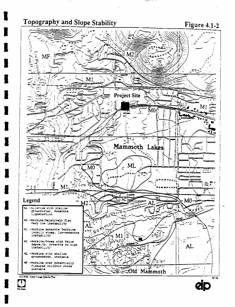
IIIIII!I!II!I!I
Topography and Slope Stability Figure 4.1.2
Project Site
M1
Legend
I!

Existing Shq)es Figure 4.1 3
Legend
EXISII4G BULDIGS
SE}PESI4EXCESSOi: 30%
;I,OPE S’I_’ABIL[T ZONE I}OUNI)AN
{ir-:f N3,;.vF,,,

IIIIiIIIIiIIII!IIII
4.1 Geology. Soils and Seismicity
However. several small areas with slopes greater than 30 percent exist:
A semicircular spur in lots 14 and 15 (north of Lake Mary Road to about the junction of CanyonBoulevard and Hillside Drive).
In the south, between Lake Mary Road and Minaret Extension, east of lots and 2 and west oflots 11 and 12.
Along the northeastern edge in lots 29 and 30.
The Town is situated near the junction of several different types of geologic material (Figure 4.1-.4):
Pliocenc volcanic flow rock (about 12 million to 3 million years old); Pleistocene through Holocene
volcanic and pyroclastic rock (less than 3 million years old); Pleistocene glacial deposits (about 2.5 million
to 10 thousand’years old): and Holocene alluvium (less than 10 thousand years old). About 80 percent
of the developed area of the town is underlain by glacial deposits (moraine). The landform map (Figure4.1-5) shows the general relationship of the geologic materials.
The glacial deposits preserved in Town represent younger Pleistocene materials. These include the Tahoe
till (maximum ice about 65 thousand to 50 thousand years ago), the Tioga till (maximum ice about 20
thousand to 10 thousand years ago), and related outwash deposits of gravel and sand swept away from
the glacial margins by meltwater streams.
The till has been described as gravelly silty sand containing cobbles and boulders of gramte as large as
four feet in diameter. The unweathered material is dense to very dense and well consolidated.’ It is
known to be at least 14 feet thick and is not water-bearing to that depth.
There are several active and potentially active fault zones within 60 miles of the Town (Figures 4.1-4 thru
4.1-6). These include faults that are historically active (during the last 200 years), those that have been
active in the gcologically recent past (about the last 10.000 years, usually referred to as the Holocenc) and
those that have been active at some time during the Quaternary geologic period (the last 2 million years).
The Mono Lake. June Lake. and Hilton Creek faults are historically active but these are I0 to 15 miles
away from the plan area. They form the non.hem extension of the Sierra Nevada frontal fault system.
90182 4.1-6

Regional Geologic Map Figure 4.1-4

IIIIIIIIIIIIIIIIIII
Geology Map Legend For Figure 4.1-4
---- (tr,e* (alernary eruct’,ve centers
= Ther,"t,al Srr’t,g Io,"tiOn
r = E;icenlers of t,e tree Mk-,5.0 sn(cks of 1980

Land Forms
.LOLlMMOTH
To Mammoth NounMain Lodge
P
Figure 4.1-5
I!IIIIIII
C
MAMMOTH MOUNTAIN
C
MAMMOTH SLOPES _.North VillageSpecific PlanProject Area,
WEST RIDGE
OTA
Legend
A -ALLUVIUMOT -OU’TWASH AND TILLC -COLLUVIUMP -PUMICI=
MM -MAMMOTH MOUNTAINGV -GLACIATED VOLCANIC LANDDD -DISSECTED DOME
THE VALLEY
P
OT
MINARET
SIERRA VALLEYMAMMOTH
MAIN STREET’, / COMMERCIAL
//IOT OLD MAMMO
COMMERCIAL
GAT’WAY
TO Bishop Nwy. 395


IIIIIIIIII!IIIIIIII
Geology, Soils and Seismicily
The southern extension of this system includes the main trace of the Sierra Nevada fault and the OwensValley fault. These also are historically active.
Holocene faults occur as branches within the major active fault zones and as segments of other faults in
Mono and Inyo Counties. The faults that have been classified as Quaternary or older do not display
evidence of recent movement, These include the Bodie Hills. White Mountains, Death Valley FurnaceCreek, and Saline Valley faults, Other faults exist throughout the County but have shown no evidence
of activity during the last two million years.
The nearest faults are the South Boundary, Earthquake, and Inyo crater fault zones (Klein.felder &Associates)) The South Boundary fault is about 2.5 miles south of the projectarea. Klein/elder &Associates found no evidence of movement in the last 2 million yeats and the fault is. therefore.
considered inactive. Inyo Craters Fault zone is mapped as trminating near the Mammoth Mountain Ski
Lodge. Klein/elder Inc., in 1976, concluded that it is active.
The Earthquake Fault is an open fissure a few meters wide and several hundred yards long which
continues as a fault trace. Neither slip along the trace nor the timing of faulting can be verified. The
crack might have resulted from shrinkage of volume during cooling of the lava rather than a true fault.
Each of the historically active faults is in an Alquist-Priolo Special Studies Zone, but none crosses or
trends toward the site.8’9 Consequently. the potential for damage to the project by surface faulting is vcry,
low)
Seisrnicitv
The Mono Lake Long Valley region is part of one of the most active seismic regions in the United
States. Low and moderate magnitude earthquakes occurring within the caldera are felt frequently by
residents of Mono and lnyo Counties. Very large shocks have occurred in the area and are expected to
occur again. Each of the major fault zones is capable of generating a maximum credible earthquake of at
least magnitude (RM) 6.2 on the Richter scaleJ ’’- The Owens Valley fault is capable of generating
an RM8.3 earthquake,tJ Earthquakes of these magnitudes are sufficient to create ground accelerations
in bedrock and in unconsolidated deposits severe enough to cause major damage to structures, foundations
and uodcrground utility linesJ’
Seismic activity in the vicinity of the Town of Mammoth Lakes is one result of continuing tectohic
movement along the eastern front of the Sierra Nevada. Regional deformation, faulting, groundshakng.
and volcanism accompany tectonic movement. The present elevation and westward tilt of the.regio9 are
the result of broad up-warping between about nine million and three million years ago, but the major
90182 4.1-10

IIIIIIIIIIIIIIIIIII
4.1 Geology, Soils and Seismicity
down-aulting that created the eastern front did not begin until the Pleistocene (less than 3 milion years
ago). The Sierra Nevada frontal fault system offsets glacial deposits as old as 65,000 years (Tahoe till)
and as young as 20 thousand years old (Tioga till). During the last two thousand years, volcanism has
formed a chain of domes, flows, craters, and pyroclastic deposits from the islands in Mono Lake to
Mammoth Moumaln. It is this active volcanism that is considered the proximal cause of local
seismicityJ6
In 1872, one of the largest historic earthquakes in California (estimated RM 8.0) occurred along the OwensValley fault (one of the major active faults along the Sierra Nevada from) causing surface rupture for 60
miles. In 1980 a series of earthquakes, culminating in ",hree M 6+ shocks caused damage and ground
failures throughout the vicinity of Mammoth Lakes. Surface rapture occurred along numerous north to
northwest-trending faults. The Hilton fault (about 12 miles southeast of the Town) experienced as much
as one foot of offset. Surface rupture ranging from less than one inch to about three incbes of offset also
occurred on fault traces four miles east and one mile west of the TownJ The most recendy reportedseries of earlhquakes, all smaller than RM2, began in November 1989 and continued tl’u’ough March 1990.
Volcanism
At least 30 volcanic events have occurred during the past 2,000 years in the Mono Lake Long Valley
area. including at least 10 eruptions in the Mono Inyo volcanic chain during the past 600 years. The
Long Valley caldera formed about 700,000 years ago. during the eruption of the Bishop Algicide and
continues to be a center of volcanically-related seismic activity.
Actual volcanic eruption in the vicinity of the Town of Mammoth Lakes has not occurred in recenttimes.The most recent eruption occurred about 1890 beneath the southern pan of Mono Lake about 25 miles
north of the Town. Eruptions occurred about 1400 A.D. within four miles of the Town at Mammoth
Mountain and at the southernmost lnyo Crater. Both eruptions were of the "phreatic" type; that is. they
produced steam, water, mud, and other gasses and materials, probably as a result of groundwater being
heated by magma.t
Soils
The soils in the Mammoth area are derived from glacial and volcanic deposits. They include alluvials and
tills in varying stages of weathering and consolidation.
During construction of an underpass on the Lodestar site south of the project area, the Tioga till was
exposed in cuts more than ten feet deep across the Minaret right-of-way. In the excavation, the exposed
moraine is oxidized and loosened by root penetration to about 4.5 feet below the ground surface. Below
this level is a boulder lag. one to two feet thick, of rounded to sub-angular cobbles, about eight inches in
90182 4.1-11

IIIIIIIIIIIIIIIIIII
4.1 Geology. Soils and Seismicity
diameter, embedded in an indurated gravel matrix. Below the lag deposit is at least six feet of un-oxidized, very densely compacted dll. Few rootlets penetrate below the boulder lag)9
The topsoil is estimated to be less than two feet thick, but root structures and organic material ate reportedto penetrate the loose dry sand portions of the deposit as far as five feet below th ground surface.2
Hazards
Several types of geologic hazards may occur in the vicinity of the Town of Mammoth Lakes that could
have an impact on. or be impacted by, the proposed plan. They are not all of equal severity and they
would not all affect the plan to the same extent. For convenience, they may be grouped into three types:
geotechnical, seismic, and volcanic hazards. Slope instability and erosion are geoteclmical events; they
result from the intrinsic properties of the nxks and soils. Hazards related to seismicity include surface
rupture, groundshaking, landslides, liquefaction, and seiche inundation. Hazards related to volcanism
include flowage, flooding, phenomena, tephra eruption and gas emission.
Geotechnical Hazards
Slope Instability
Landslides. earthslips, mudflows and soilcreeps are expressions of soil conditions related to instabilities
created by steep slopes, shallow soil development, the presence of excess water, or the lack of shear
strength in the soil or at the soil/rock interface. Each of these conditions is observable in Mono County.but usually is reported simply as a "landslide." Slope instability can be of static or dynamic odgia.
Earthquake activity induces some landsliding, but most slides result from the weight of rain-saturated soil
and rock exceeding the effective shear strength of the underlying material. Erosion of supporting material
at the foot of constructed slopes is another major cause of sliding. Landslides are a significant component
of the natural erosional processes in the Sierra Nevada. Although an existing geologic material or
condition may form the basis of an unstable situation, natural processes and human activities have initiated
landslides in otherwise stable areas.2t
Slopes in the plan area am generally less than 5 percent; therefore, severe natural slope instabilities are
absent in the plan area. The Lake Mary Road section rougbly marks t boundary between low instability
to the north ( 0 to 1 percent slopes) and moderate instability (1 to 3 percent) to the south. As already
mentioned in the topographic setting, there are localized areas with slopes greater than 30 percent. These
areas are liable to instabilities if they are further disturbed and not properly engineered:
Geologic materials, such as clay minerals, have a great capacity to absorb water, resulting in a reduction
of shear strength. The force of gravity (shear stress) can cause a water-soaked mass of rock or soil to
slide when saturated clays reduce the shear strength of the material below its minimum stability thresh,old.
90182 4.1-12

IIIIIIIIIIIIIIIIIII
,.l Geology, 5oils and Seisraicity
Certain formations of glacial and lacustrine origin, ate only marginally stable in steep natural or
constructed slopes because of their clay constituents.
The moraines south, west and nor of flae Town are considered unstable partly because they contain
irregular deposits of clay that lack the strength to smad in steep slopes. Moraines in e center of Town(i.e.. at or near the project site), and to the east. are considered generally stable because of their relatively
low topography, unless they are underlain by shallow groundwater (Figure 4.1-2). The till may contain
isolated bodies of clay but subsurface and surface inspection indicates that generally the till is very dense
and very sandy. Constructed slopes have been engineered to provide stability, and are subject to
inspection by the Town to ensure their maintenance in good condition.
Erosion
Erosion potential is variable throughout flae area. The highest erosion potentials occur in loose and/or
shallow soils on steep slopes. Foundation components may be weakened by the loss of soil support
created through erosion. If uncorrected, the effects can range from the nuisance level (sticking doors and
windows) to the major structural damage level (shifted or collapsed foundations). Combined with seismic
loads, the effect could be sufficient to make the difference between survival and destruction of a
component of the foundation system during a major earthquake.22 Naturally occurring steep slopes are
not a factor at the project site.
The loose, sandy portion of the moraine is subject to erosion, if its surface is disrupted or devegetated.Under existing conditions, the potentially erosive effects of overland flow from snowmelt and rain/al/
runoff are reduced by the ground-cover of fallen leaves and needles, and by the root systems of living
trees. Also. the underlying till is dense enough, and contains sufficient silt-sized particles, to resist these
relatively mild erosive forces.
Soil erosion also creates several other problems. The loss of the soil itself reduces the vegetal viability
of an area (endangered wildlife habitat see Section 4.3, Biology). The re,deposition of the eroded soil
in streams creates turbidity (endangering aquatic life see Section 4.3. Biology and Section 4.2, Hydrology
and Water Quality) and may reduce the water-carrying capacity of streams or drainage systems
(aggravation of flood conditions see Section 4.2. Hydrology and Water Quality).
90182 4.1-13

I!!IIIIIIiIIIIIiiIi
4.1 Geology, Soils and Seismicity
Seismic Hazards
Surface rUDtUre
Earthquake swarms and surface rupturing in the caldera ate accompanied by uplift and deformation. Thesehave increased concerns about the possibility of renewed eruptive activity.’s Surface rupturing along thetrace of a fault affects all types of material, however, it does not always show clearly in a loose or water-
saturated soil. Damage due to surface rupturing is limited to the actual location of the fault-line break.unlike damage from groundshaking, which can occur al great distances from the fault. Even a moderate
earthquake can be accompanied by enough surface rupturing to damage foundations and buried utility lines
that have not been adequately protected where they cross fault traces, There is no known fault trace
crussing the project area. Therefore the risk from surface rupture is very low.
Groundshakin
Bedrock formations and unconsolidated deposits (soils) exhibit different responses to seismically-induced
groundshaking. As a general rule, the severity of groundshaking increases with proximity to the epicenterof the earthquake. However, given similar location and seismic energy output, the least amount of
damaging vibration would occur on a site that was completely composed of bedrock or densely compactedsediments, such as till. A site underlain by major thicknesses of loose alluvial material would experienceconsiderably more damaging vibration because of the unconsolidated material’s tendency to deform to a
greater degree than the bedrock.2s
Landslides
Earthquake-induced landsliding of steep slopes can occur in either bedrock or unconsolidated deposits.Bedrock hills and hills composed of unconsolidated deposits (till, outwash, soil) respond differently to
seismic vibration. General, the closer the hill is to the epicenter of the earthquake, the greater the amount
of vibration it will experience. Firm bedrock usually can stand in steeper slopes, and withstand more
severe vibration, than soils or glacial materials are able to maintain. However, rock type, grain size.
degree of consolidation and angle of the bedding or jointing planes all contribute to the su’eng’da
weakness of a bedrock hillside. Deeply weathered till and fractured volcanic rocks ate susceptible to slope
failures.2‘s As previously discussed, existing manufactured slopes have been engineered to be stable.
Naturally occurring steep slopes ate underlain by dense till composed of boulders and cobbles immersed
in indurated sand aqd clay matrix.
Liquefaction
Another response to severe groundshaking that can occur in loose soils is liquefaction. This
transformation from a solid state to a liquid state ("quicksand"), as a response to seismically- induced
groundshaking, can cause ground settling, landsliding and lurch cracl0ng. Eatthquake-induced liquefaction
does not affect bedrock or densely compacted sediments containing a wide gradation of grain-sizes. The
soil characteristics of a liquefaction-prone deposit ate saturated conditions, loose uniformly fine sand with
90182 4.1.14

!II!iIii!iiii!!I,
!!I
,.l Geology. Soils and Seismicity
lio.le or no clay-sized panicles to act as binders, and sufficiently violent vibration to increase pore pressurebeyond the shear strength of the sand particles.:v The project site is underlain by dense compacted softshence the liquefaction polgntial is low.
Volcanic Hazards
The hazards associated with volcanic events a of two Idnds: the direct desu’ucfion by material issued
from [he volcano and the indirect daraage caused by floods and mudflows. The hazards described below
that would affect the area are expected to emanate from a possible vent zone southeast of the Town of
Mammoth Lakes (Figure 4.1-4). The zone includes the epicenters of earthquake swarms and the focus
of extensive deformations of the crust between 1982 and 1985. Although no eruptions have occurred in
this potion of the caldera during the last 10,00(3 years, ,,.he hehavior of the Mono-lnyo volcanic chaha
during that time makes this vent zone a likely location of a furore eruption. The entire Town of MammothLakes and the area for about ten miles in any direction is subject to flowage hazards from the possiblevent zone. Shifting this zone several miles in any direction would not significantly alter h hazards
analysis for the Town.’s
Tephra eruption-’9
Fragments of lava or rock are blasted into [he air by volcanic explosions, or carried upward on currents
of hot gases. They fall downwind as deposits of ash (panicles less than 0,08 inches in diameter), lapilli
(0.08 to 2..5 inc,hes), or blocks (greater than 2.5 inches), that are called tephra. They may be hot or cold.
and may land a few yards or several miles from their vents. Close to the vents, the main hazards include
high temperatures, burial, and impact of falling fragments: fires may be iguhed by hot debris.
Based on the relationship between the thickness and distribution of the largest ash falls from volcanic
events in the general Mammoth Lakes area during the last 10,000 years, the area subject to at least eight
inches of compacted ash extends about 22 miles from the possible vent zone. The area of at least two
inches of compacted ash fall is about 53 miles.
Flowage phenomena
Material erupted into the air or onto the flanks of a volcano flows downslope as lava or as a mixture of
panicles (lava blocks, lapilli, ash) and fluids (water, gases). Flow speed and direction is dictated by the
specific composition, temperature of the flow, slope and topography of the area surrounding the volcanic
vent.
Lava flows are streams of molten rock that move relatively slowly (depending on mineral coment,
viscosity and slope) and spread I0 to 30 miles from their sources. They usually move a few yards or a
few hundred of yards per hour along paths that can be at least roughly predicted. Lava domes are masses
of solid rock formed of viscous lava erupted slowly from a vent. Their direct hazards include Ioc bu,rial
90182 4.1-15

|
I
!
4.1 Geolosy. Soils and Seisrniciy
by the dome itself or by rock debris mattered around the dome. Fires may be staed because of the hightemperature of the dome and debris.
Pyroclastic flows are masses of hot. dry rock fragments mixed with hot gases. They travel at speeds upto 100 miles per hour. and are extcmely hot (several hundreds of degrees). They are extremely hazardous
because of their speed, temperature and wide dispersion.
Debris flows are mixtures of water-saturated materials flowing under the force of gravity. The material
may range from clay-sized (mud flows) to blocks several dozens of yards in diameter. They may be hot
or cold, and usually are highly viscous. They can travel long distances at high speeds, down slopes or
confined to valleys. Impact and burial are the hazards of debris flows.
Floods related to volcanic activity can be produced by melting of ice and snow during eruptions, and by
heavy rains that may accompany eruptions (,juvenile water and/or cloud seeding effects). Their hazards
are similar to those of other floods, but they may be more damaging because of their high sediment and
debris content.
Gas Emission
Gas emission often precedes eruptions, and may continue for thousands of yeats afterward. The most
conmon volcanic gas is steam, followed in order of abundance by cart)on dioxide, sult’ur compounds,
chlorine compounds and minor amounts of carbon monoxide, fluorine, boron, ammonia, etc. Distribution
is controlled by the wind. which also is responsible for diluting the concentration (and therefore, the
effects) of the various gases. Near the vents, high concentrations of acidic gases may endanger life and
injure respiratory systems and eyes. Concentration of heavy gases (like CO,.) in closed depressions can
suffocate animals or people. Plant destruction or damage and metal cosion am other hazards. These
are associated with all volcanic activity. Wind direction frequency analysis indicates gases (and air-home
tephra) generally would travel east nonla east from eruptions in the Mono Lake Long Valley area.
The possibility of such an occurrence in the Mono Lake Long Valley area has resulted in increased
monitoring of seismic and non.eruptive volcanic ctivity. and in increased efforts by local, State and
federal offices to prepare emergency response plans. The potential hazards from future eruptions of
volcanoes in the area are being studied by the U.S. Geological Survey.
Safety Element2The Town’s Safety Element of the General Plan was adopted in 1984 and addresses, among other issues;
geologic hazards and seismic potential, and seismically related landsliding on steep slopes with loose soils.
An emergency response plan has been prepared in the event of volcanic activity (Finding #14). The plan
is administered by the Mammoth Lakes Police Department (Finding #20).
90182 a.l-16

IIIIIIIiIIIIii,!
!iI!
4.1 Geology. Soils and Seismicity
Goals related to these Findings are to protect life and property (Geologic Hazard Safety Goal #12. SeismicHazard Safety Goal #16), to condition or prohibit development in geologically hazardous areas (GHSG#13). to reduce or avoid adverse seismic impacts (SHSG #17). to participate in volcanic hazard responseplanning (Volcanic Hazards Safety Goal #14). Under Hards. the findings identify poorlyconsolidated soils and steep slopes contributing to landslides (Of0). erosion (#I l). volcanic activity (#12).
and volcanically related seismic activity, ash fail. pyroclastic surges and flows (#13). Under SeismicHazards. the findings identify several active faults capable of generating M7.0 earthquakes (#15). a
groundshaking intensity rating of MM-IZ to MM-X for most of the region (#16). several active faults
displaying recent surface rupture, and mapped within AIquisbPriolo Special Studies Zones (#17), potential
liquefaction areas at Sherwin Meadows and near Old Mammoth Disct (#I$). and faster effective
volcanic hazard response (VHSG #15).
The following policies regarding Geologic Safety (#18 9m3ugh #25) and Seismic Safety (#26 through #32)appear in the Element. Those Policies indicated with asterisks (*) are directly applicable to the proposedNorth Village project.
Geologic Safety
18. The Town shall require developers to complete a preliminary soils and foundation analysis, and
prepare a comprehensive erosion control plan to prevent erosion and siltation of streams in the
Community. through conditions stated in the Town Development Code.
19. The Town shall require detailed geotectmic studies of sites with slopes of 20percent or greater.
land slide or liquefaction potential, or other potential geotechnic hazards, through requirements
in the Town Development Code.
20. The Town shall encourage clustered development in areas with problem soils and other geotechnic
problems, through requirements in the Development Code, in order to reduce impact to fragile
areas or reduce development exposure to hazard areas.
"21. The Town shall encore’age grading and foundation plans which minimi excavation. Off-site
disposal of soils shall be discouraged, and where excavation is necessary, balanced cut and fill will
be encouraged. Further, if excavated soils must be moved off-site, designated borrow pits shall
be used and sculpted to fit the surrounding topography. Fill materials shall be extracted from
Town designated areas.
*22. Soil erosion and soil transport during construction shall be controlled through requirements in the
Town Development code. including:
a) Disturbed soils surfaces covered with mulch or grass until vegetation is re-established and/or
permanent surface is overlaid.
90182 4.1-17

IiIIII|
iIIIIiI!III!
4.1 Geology. Soils and Seisrnicity
b) Minimization of exposed graded areas for extended periods through project phasing.
c) Sprinkling of disturbed soils.
d) Covering. windfcncing around, or wetting of stockpiled topsoil or dusty buiMing materials.
e) Use of wind erosion construction barriers in sites exposed to wind erosion during conslruction.
f) Limitation of construction equipment and vehicle speeds o 15 miles per hour on construction
sites.
g) Use of sedimentation basins or ponds to prevent sediment reaching streams and the Town drainage
system.
*23. The Town shall prohibit activities which could potentially dcvcgclatc or loosen soil surfaces.
unless a comprehensive water and wind erosion control plan is prepared and adoled. Of
panictlar concern are intensive recreational activity areas (such as hildng and horseback riding
trails).
24. The Town shall participate in any updating and implementation of hazards response planfung
including an emergency evacuation facilities plan and training programs.
*25. The Town shall require major developments to prepare and Specific Area Plans to address hazard
emergencies such as evacuation, shelter, communication issues, etc.
Seismic Safety
*26.
a)
b)
c)
90182
The Town shall ensure that new development modernization projects and public works facilities
projects will be constructed to reduce structural damage during seismic events t3ugh conditions
in the Town’s Development Code. including:
The strict enforcement of the Uniform Building Code sections regarding seismic design, grading
and excavation.
Upgrading of utilities serving the development to withstand projected earthquake loadings and/0rto shut off utility in case of failure (e.g.. gas pressure drop valves).
Requiring detailed geoteclmic studies for development sites with liquefaction, landslide,and
faulting potential to insure appropriate siting and design is utilized in project development.
4.1-18

III!
IIIIII
,I.1 Geology. Soils and Seismici|y
27. The Town shall adopt the state criteria for regulating development witlain the Alquist-PrioloSpecial Study zones.
28. The Town shall designate open space uses for areas which have been identified in EIR’s or specialstudies 1o present potential hazards which cannot be satisfactorily mitigated to allow for moreintensive development.
*29. The Town shall ensure that adequate emergency access is available to evacuate peak populations
during emergencies through:
a) Designation of an addilional emergency access road alignment(s) to accommodate buildout
populations.
h) Completion of the existing roadway system.
c) Encouragement of continued airport improvements to improve its use for emergency evacuation.
30. The Town shall develop an Emergency Plan for Mammoth Lakes which sets forth the
respoibilities, functions and operations of the Town government and its interrelationship wi
other agencies and jurisdictions which provide services during an emergency.
"31. The Town shall initiate emergency training programs for Town employees and community
volunteers and shall initiate a public education program which advises people on what to do in
an emergency.
32. The Town shall utilize interagency agreements (i.e., mutual and joint use agreements) and support
the consolidation of public safety services were appropriate, in order to establish a more efficient
and coordinated emergency service system.
Administration and lraining of personnel involved in the emergency response plans for the Town is carried
out by the Unified Command System. Members of the Command meet at least once each calendar quarter
to coordinate and participate in response exercises. Additional equipment and volunteers are being
acquired to assist the Command. The County Office of Emergency Services is in the process of updating
the emcrgency response plan?
90182 4.1-19

IiIII
!iIIilI!IIIi
..1 Geology. Soils and Seismicity
4.1.2 IMPACTS AND MITIGATION MEASURES
Section 15382 of the CEQA Guidelines defines a significant effect on the geologic environment as "asubstantial, or potentially substantial, adverse change in any of the physical conditions within the areaaffected by the project.’’s4 Further, Section 15126 (a) of the Guidelines stipulates that the EIR analyze"sig?lJ f]cant environmental effects the project might cause by bringing development or people into the areaaffected." The example used in the Guidelines is that of a subdivision astride an active fault having the
effect of attracting people to an area where they would be exposed to seismic hazards.
The examination of geologically related issues, i.e. geology, geotechnology, soils, tpography, seismicity.and volcanism in .this report is based on information obtained from site observation, from the review of
existing literature, including reports, maps and conceptual drawings provided by the town. and from
personal and telepbone communications with persons involved with, or concerned about, the proposed
plan. The mitigation measures recommended to reduce, eliminate or avoid potential geologically related
effects of. or on. the proposed project are not intended to be an exhaustive catalogue of all conceivable
actions. They are based on existing techniques, generally recognized by geotechnical consultants in
California t be applicable, feasible, and conservative in approach. They do not always rely on structural
solutions, such as building more retaining walls, or installing heavier foundations. The timing of
excavation activities, the continuation of current inspection procedures, and the maintenance of on-going
clean-up and repair programs oflen provide the most effective environmental protection.
In general, it is the responsibility of a project applicant to implement the mitigation measures through the
planning, design, construction and occupation phases of the project. The mitigation measures should be
required as part of the grading/construction permits, unless otherwise specified. It is the responsibility of
the Lead Agency. the Town of Mammoth Lakes, to monitor the mitigation measures through plan
checking, periodic reporting procedures, and on-site inspections. Many "moniloring" programs already
exist in the form of planning policies, required standards of construction and permit approval procedures
that are administered routinely by deparmaents of Imblic works, branches of building inspection, and
similar agencies in the public sector. Other mitigation and monitoring programs have been formalized as
conditions of project approval agreed upon by the Lead Agency and the applicant.
Most of the detailed recommendations regarding specific techniques and designs to reduce, eliminate or
avoid geologically related hazards will be provided by the reports of geoteclmical investigations for
proposed projects. Plan review, field inspection and site observation also are involved in the mitigation
of geotechnical effects. The completed site development plans would be reviewed by the lead Agency
to determine conformance with the recommended geotechnicai procedures. Final field inspection of the
mitigation measures would be performed by a Certified Engineering Geologist. or a similarly qualified
professional, during the earthwork and construction operations. The observation of cuts. fills, backfills,
foundation excavations, and the preparation of pavement subgrades would take place during these phases
90182 ,.1-20

I
iiii!ilI!
III
I
4.1 Geokg). Soils and Seismiciy
of site development. The recommendations of the geotechnical report and the inspecting professionalwould be incorporated in the work.
4.1-1 If the project were implemented as proposed, it could create new or increlsed slopeinstability. This is a potentially significant impact.
The site is not now subject to slope instability because the natural slopes are relatively shallow. The soil
is very dense and manufactured slopes have been engineered to provide adequate stability.
However. development would involve sutantial grading, especially in lots 14 and 15. If new cuts and
fills were not similarly engineered, or if any proposed ponds saturated areas downslope or placed undue
stress on areas downslope, slope failures could occur.
Mitigation Measure
Implementation of Mitigation Measures 4.1-l(a) through 4.1-l(e) would reduce Project impacts to a less-
than-significant level.
4.1-1(a) Soils and foundation analyses shall be approved by the Public Work Director prior to
final Project design approval, as stipulated in the Town’s Safety PoliO’ #18. All measures
required b.v the Public Works Director shall be incorporated into grading plas and
building plans.
4.1.1(b) New slopes shall be constructed at an angle and degree o.f compaction that will ensure
stability, as stipulated in the standards of the Town’s Municipal Code.
4.1-1(c) All work shall be overseen by a licensed Civil Engineer (CE), Certified Engineering
Geologist (CEG), or similar appropriately qualified professional, who shall report to the
Town in order to ensure the standards of the applicable Codes are met.
4.1-1(d) Any impacts resulting from an)’ of the above measures not analyzed by this EIR shall be
subject to further environmental review and approval by the Planning Commission prior
to approval of the final Project design.
4.1-2 If the project were implemented as proposed, it could create new or increased soil erosion.
This is a potentially slgnQicant impact.
The site is slightly erosion-prone in its natural condition and moderately erosion-prone where soils are
disturbed by human activities. The subsoils are dense, the slopes are shallow, and the natural ground
90182 4.1-21

!!
4.1 Geology, Soits and Seismicity
cover is generally intact. The existing consmacted slopes for the extension of Minaret Road are agled,compacted, and protected with riprap or vegetation to prevent erosion. If new slopes, foundationexcavations, pad cuts-and-fills, etc., not similarly engineered, the erosion potential of the site wouldincrease to moderalely high or high.
Mitigation Measure
Implementation of Mitigation Measure 4.1-2 would reduce the proposed Project impacts to a less-than.
significant level.
4. I-2 A comprehensive Erosion and Sediment Transport Control Plan shall be prepared and approvedby the Town prior to issuance of any grading or building permit. The Plan shall be included in
the Project design, as stipulated in the Town’s Safety Policy #18. The Plan shall also meet the
requirements of the Regional Water Quality Control Board and the Town Municipal Code.
The language and specifications of such plans vary. depending on site conditions, but the general
principles to bc adhered to are listed in the Town’s Safety Policies #21, 22 and 23. Further types of
recommendalions to be applied as appropriate are listed in Endnote 35 of tltis section of the reportJAll work shall be overseen by a CE. CEG, or similar appropriately qualified professional, who shall report
to the Town to ensure the standards of the applicable Codes are met.
4.1-3 If the project were implemented as proposed, it could significantly alter the topography of
the site. This is an unavoidable, signifwant impact.
Topographic alteration is unavoidable during the development of any site. The proposed site includes
irregular slopes that would be leveled or obscured by building pads and landscaping. This impact cannot
be avoided if the site is developed as proposed. The site does not contain other unmitigable conditions
or pose undue geo/seismic risks (see below) that would require the Town to invoke Safety Policy #28.
designating it as permanent open space. However, the town may consider preserving the existing character
of property: i.e., preserving some of existing steep slopes (i.e., 30 percent) during project design.
Mitigation Measure
Implementation of Mitigation Measure 4.1-3 would reduce Project impacts to a less-than-significant level.
4.1-3 Prior to issuance ofgrading or building permits, geotechnical studies shall be comPleted and their
recommendati,ns shall be incorporated in the Project design, as stipulated in the Town’s Safe.’
Polio3.’ #26.
90182 4.1-22

!!
4.1 Geology, Soils and Seimicity
4.1-4 If the project were implemented as proposed, it shall increase the number of people livingin and visiting an area subject to seismic activity. This is a less-atan.signOcant imlmct
Some increased density is unavoidable following the development of any site. regardless of its locationin a high or low seismically active area. or of its proposed use. The entire Mammoth Lakes region, and
about 45 percent of the rest of California, is in the UBC Seismic Zone 4, the Mghest activity zone in the
code. The findings of the Town’s Safety Element recognize this situation. The Element provides Goal
and Policies, to be met by the Town and by developers, that reduce or avoid the risk of living in ad
visiting a seismically active region.
The Town is implementing the Safety Policies regarding emergency response in the evem of destructive
seismic activity (Policies 024, #30 and #32). The project site is not subject to known surface fating.
earthquake-induced landsliding, liquefaction or seiche inundation hazards. Generally. the project site is
subject to the same groundshaking hazards as other areas in the Town located on outwash/fill (see Figure
4.1-5).
Mitigation Measure4.1-4 The Project Sponsor shall complete the geotechnical studies and incorporate
recommendations in the project design, as stipulated in the Town’s Safety Policy #26.
structures shall be designed and built to at least the standards of UBC Seismic Zone 4.
their
All
4.1-5 If the project were implemented as proposed, it shall increase the number of people living
in and visiting an area subject to volcanic activity.
Some increased population density is unavoidable following the development of any site. regardless of its
location in a high or low volcanically active area. or of its proposed use. A cumulative increase in the
number of persons wlao potentially would need assistance during an emergency would occur as the
population of the site comes more dense.
The Town is adjacent to a possible vent zone in the Long Valley caldera and near the epicenter of the
volcamc hazards zones associated with volcanic eruptions in the Mono Lake-Long VaLley area. Because
the project site is centrally located in the Town. it is subject to the same flowage phenomena, tephra
eruption and gas emission hazards as the rest of the developed portion of Mammoth Lakes.
The Findings of the Town’s Safety Element recognize this situation and provide Goals to be met by the
Town that reduce the risks of living in and visiting a volcanically active region ( Geologic Safety Policies
#20 and #24. and under Seismic Safety Policies #28 through #32).
90182 4.1-23

,IIiI
4.1 Geology, Soils d Seismicity
According to Dr. David P. Hill, a volcano expert of the U. S. Geological Survey (USGS), Menlo Park.seismic stations in the Long Vatley region have been increased to forty and a network of other instrumentsare in place. Volcmic and volcano-seismic activity are being monitored by the USGS: it is expected that
at least several hours, and probably several days, warning-time could be provided for any threatenederoption.
As discussed earlier in this chapter, the Town is implementing the Safety Policies regarding emergencyresponse in the event of destructive volcanism. The Project Sponsor is also assisting the Town in
completing the existing and emergency access roadway system to the project site (Safety Policy #29).
Most of the site is not adjacent to or near a creek valley where floods are likely to concentrate. The risk
tO life and property at the site appears to be about the sme as that which exists throughout the
community.
Mitigation Measure
4.1.5a The plan includes improvements on Lake Mary, Lakeview and Minaret Roads; these wouldprovide
residents of the slopes subdirision with improved travel routes to both of the ’acuation routes
leading out of the town.
4. l-5b The developer shall cooperate with the Town in designing and disseminating information to assist
citizens and visitors in responding to emergenQ situations that are likely to arise (Safeo’ Polio’#31). All structures shall be designed and built to at least the standards of UBC Seismic Zone
4.
CUMULATIVE IMPACTS
Cumulative development would increase the permanent and temporary popultion of the Town of Mammoth
Lakes. As a result, an increased number of people living in and visiting the Town would be exposed to
landsliding, groundshaking, and associated hazards that commonly occur in a seismic- and volcanic-active
area. However, implementation of the General Safety and Seismic Safety Elements of the Town of
Mammoth Lakes General Plan would reduce the risk associated with these unavoidable impacts.
90182 ,1.1-2

Geology. Soils ad Seismicity
ENDNOTES
2.
3.
4.
Hill, M., Geology of the Sierra Nevada, University of California Press, lrkeley, 175,232 pg.
Allots, J.T., "Regional Geology of the Mammoth Lakes Region, California" in Mammoth Les. California Earthquakes,California Division of Mires and Geology, Special Report 150, edited by R.W. Shburn, 1980, pgs 1-6.
Bailey, R.A., and R.P. Koeppen, Preliminary Geologic Map of Long Valley Caldera Mono Count’y California. U.S.Geological Sttrvey, Open File Report 77--468, 1977, cale 1:62.500.
Platz, T.A., RPE #42039, Grading and Pavement Recommendations Minaret Road Extension Mammoth Lake MoroCounty California, Sierra Geotech.nieal Services, Inc., 7 February 199(I, 18 pages, 2 mal (scale 1:480), 7 plates (test
pit logs).
Jerrs’dngs, C.W. et al, Fault Map of California, Geologic Data Map series, Number 1, California Division of Mines and
Geology, 1975, scale 1:750 000.
Strand, R.G., "Geologic Map of California, Mariposa Sheet", in Geologic Atlas of California. Old P. Jet,as, editor,California Division of Mines and Geology, Sacramento, Califorrfia, 1967, scale 1:250 0O.
7. J. H. Kleinfelder & Associates; Prelimina, Geotecb,.nical Study for the Allan Davis Project, Mammoth Lakes,California. 1977. l.pp.
!!!I
Alquist-Priolo Special Studies Zones: the State of California has delineated special studies nes around active and
potentially active faults in the state. The zones extend about 60 feet on either side of identified fault ta’aces. Nostructures for humart occupancy may be built across an idemified active fault ace. A.&of 50 feet on either sideof an active fault trace is assumed to be underlain by the fault, unless proven otherwise. Proposed construction withinthe Special Studies Zone can take place only following tl completion of a geological report prepared by a California
Registered Geologist.
California Division of Mines & Geology, Special Studies Zones Map, NW 1/’, MI. Morrison Quadrangle, Effective Datelanuary 1982, scale 1:2 000,
California Division of Mines and Geology, Fault-Rupture Hazard Zones in Califomia Alquist-Priolo Special StudiesZone Act of 1972, revised [987.
Maximum credible earthquake: tl largest Richter magnitude 0D ismi vent that appeass to be rea.nably capableof occumng under the cc,nditions of the presently known geological fr’ne’ork. In the Bay area, Mg.3 is the maxaumcredible earthquake for the San Andrea$ fault, M7.5 for the Hayward and Calaveras faults, and MT.0 for the RodgersCreed and Green Valley-Concord faults.
12. Richter scale: a logaritiamic scale developed m 1935/36 by Dr. Charles F. Richter and Dr. Beno Gutenb’g to measure
earthquake mgnitude by the amount of energy releasl, as oppo.d to earthquake intensity as determid by local
effects on people, structures, and eaiah materials.
13. R.D. Borcherdt, et al., Maximum Earthquake Intensity Predicted on a Relional Scale, U.S. Geological Survey,Miscellaneous Field Investigations Map MF-709, 1975, scale 1:125
Greensfelder R.W., Maximum Credible Rock Acceleration from Ealuakes in California, California Division of
Mines and Geology, Map Sheet 23, 19’74, scale 1:2.500
15. Greensfelder, R.W., "Scismicity, Groundshaking and Liquefaction Potemial," in: M.E. Huffm, md C.F. Armstrong,
Geology for Planmn in Sonoma County, California Division of Mines and Geology, Special Repel 120, 1980, pages5 to la.
90182 4.1-25

!III
IIiIII
4.1 Geology, Soils and Seismicity
16.
17.
18.
19.
20.
22.
23.
24.
25.
26.
27.
28.
29.
30.
31.
32,
33.
3.
35.
Ki]boume, R.T., and C.L. Anderson, "Volcanic History and ’Active’ Volcanism in California" in California Geology.August 1981, pg$ 159-168.
Taylor, G.C., and W.A, Bryant, "Surface Rupture Associated with the Mammoth Lakes Earthques of2 and 27 May,1980: in CDMG S:ial Report 150, 19g0, op. cir., pgs 49-67, with plate, scale 1:62,500.
Killmurae, R.T., C.W. Chesterman, and S.H, Wood, "Recent Volcanism in the Mono Basin-Long Valley Region ofMono County, California," in CDI3M Special Repor 150, 1980, pgs. 7-22.
Site visit, EIP Asiates, 20 June 1990.
Howell, R.D., C.E., and CM. McRae, CEG, Prelimina Geotechnical Sudy for AIan Davis proiect Mammoth
Lakes California, J.H. Kleinfelder & Associates, 23 February 1977, 33 pages, 2 maps (scale c. 1:12,000 and c.
1:66,000), 13 plales (test pil logs).
OakeshOtt, G.B., Califom!a’s Changing Landscapes A Guide to the Geology of the State, 2rid edition, McGraw-HillBook Company, San Francisco, 1978, 378 pages.
Association of Bay Area Governments (ABAG), Manual of Standards for Erosion and Sedimentation Conl’ol Measures,Berkeley, revised, June 19gl.
Miller, C,D,, Potential Hazards from Future Volcanic Eptions in California. U.S, Geological Surey. Bulletin I,7,1989, 17 pgs, 3 figures, 2 tables, plate, map scale 1:500 000. Unless otherwise noted, descriptions of volcanic
phenomena included in the AWARE are from this Bulletin.
Huffman, M.E. and C.F. Armsn’ong, Geology for Planrang in Sonoma County, California Division of Mines and
Geology, Special Report 120, 1980, 31 pages, 5 plates, map scale 1:62 500.
R.D. Borcherdt, el al., Maximum Earthquake Intensity, Predicted on a Regional Scale, U.S. Geological Su.evey,Miscellaneous Field Investigations Map MF.709, 1975, scale 1:125 000.
Borcherdt et at, 1975, op. cit-
Greensfelder, 1980, op. cir.
Miller, 1989, op. cir.
Ibid.
Miller, 1989, op.cit.
Ibid.
Safety Elernem, To’,cn of Mammoth Lakes General Plan, 1984, pages 186 through 216.
F’e Chief .l. Sweeney, personal communication with EIP Associates, 21 lune 19(}0.
Office of Planning and Research, CEQA: The California Environ.meotal Quality Ach Stanates and Guidelines, 1986,
revised June 1986.
This list contains many of the recommendations of the Association of Bay Area Govemmems (ABAG), Manual ofStandards for Erosion and Sediment Conu’ol Measures, revised, June 1981. They are applicable Itmaugh most of the
State with little or no modification.
Confine construction Io the dry season, whenever possible.
90182 4.1-26

IIIIII|
IIIIIiI!
36.
4.1 Geo|ogy. SoCks an Se.smic:ty
If construction needs to be scheduled for the wet season, ensure that erosion sedknent ’anspon conwol measures
ready for u’plernentainn prior m .e onset of the first major storm of e season.
l.cae staging reas outside mjor srearc and drainage-ways.
Keep slope lengl and gradients to a nnimum.
Discharge consructinn runoff into small drainage at rruen intervals to avoid buildup of large poeniaJl erosive
flows.
l’event runoff from flowing over unprotected slopes.
Keep disturbed areas to the minimum necessary for consmction.
Keep runoff away from disturbed areas during construction.
Stabilize disrbed areas as quicidy as pssible, either by vegetative or mechanical mathods.
Dh’ecx flows over vegexaed areas prior to discharge into public ston’n drti.nage systems.
Trap sedimen before i leaves the si: with such {echniques as check dams, sedimem ponds, or sillation fences.
Remora| and disposal of all project cor,srctinn-generated siltation "at cec’-s m off-site retemion ponds is the
responsibility of the project sponsor.
Use landscaping and g’ading methods tha lower the poeollal for downsU’eam sedimeoton. Medifled drainage
patterns, onger flow pas, encorag;ng ’l.raon to the ground and slow storrnws.er cove’ance ve!,oces are
examples of effective rneods.
Conol landscapLng acxiviies carelly with regard to he appllcallon or rilizers, pesticides or other hazardous
substances. Provi.de proper ins’uc.ion to i [sndscapm$ personne! on the conswuc/on team, and to residential
landscapers.
D. Hill, U.S. Geological Survey, telephone communication with EIP Associates, 16 June 1990.
4.1-27

IIII
IIIII
!I!!i
4.2 HYDROLOGY AND WATER QUALITY

II
4.2 HYDROLOGY AND WATER QUALITY
SETTING
The North Village Specific Plan Area covers an area of approximately 64.1 acres and is located within
the northwest portion of the Town of Mammoth Lakes. The town is situated within the boundaries of theLong Valley caldera, on the eastern side of the Sierra Nevada. The Sierra Nevada lies along the west ndsouth margins of the caldera. Mountains to the immediate north of the township range in elevation frcm9,386 feet to 8258 feet. The plan area is situated at elevations between 8.040 feet and 8,070 feet, with
slopes generally less than five percent.
The average annual air temperature in the study area is approximately 5.6* C with high temperatures of
about 32.2 C and low temperatures of approximately -29.4 C. The total precipitation averages about 20
inches per year. although with a study-area altitude greater than 7,0130 feet, most of the precipitation occursas snowfall. The majority of the runoff occurs in the spring as snowmelt.
Surface Water
The project site lies within the Mammoth Creek Basin. shown on Figure 4.2-I and has a total watershed
area of 27.110 acres. Mammoth Creek originates from Lake Mary, located southwest of the town at an
elevation of g.913 feet and various tributaries near the Mammoth crest area of inyo National Forest. At
a junction below the Hot Creek Fish Hatchery, it becomes Hot Creek. Hot Creek drains an area of visible
thermal activity and flows into Long Valley, where it joins the Owens River immediately upstreana of
Crowley Lake. Water from Crowley Lake represents more than 50 percent of the water entering the Los
Angeles-Owens River aqueductJ
The majority of the project site is contained within the drainage of Murphy Gulch which eventually flows
into Mammoth Creek. just west of the Highway 395 and SR 203 intersection. Murphy Gulch is a seasonal
stream and has very little or no flow during dry months but does carry significant runoff volumes during
the spring snow melt, as well as during heavy rain/all periods.
An integrated storm drainage system is not complete for the Town. The majority of the community is
traversed by numerous natural or man-made surface channels, and drainage problems are prevalent.:Existing drainage facilities for the plan area comprise a 42-inch diameter reinforced concrete pipe located
in Canyon Drive east to Minaret Road, increasing to a 54-inch pipe and continuing east on Beroer Street
and finally connecting into storm drains in Main Street and discharging into Murphy Gulch. The drainage
system was installed to alleviate severe ruioff problems in the Murphy Gulch area. A 43.560 cubic foot
siltation basin was constructed at the downstream end of the storm drain to settle sediments before the
stream enters Mammoth CreekJ Storm drainage facilities for the project area ate shown on Figure 4.2-2.
90182 4.2-1

IIIIIII
Mammoth Creek Basin Figure 4.2.1
II

IIIIIIIIIIIIIIIII
Storm Drainage
Legen
System
Ex/ing Condominiums
Figure 4.2-2

,I
IIIIIIiIIIIIIIIIII
4,2 Hydrology and Water Quality
A detailed ston drainage plan for the community has been prepared under the direction of the MonoCounty Public Works Department. The Mammoth Lakes Storm Drainage Plan sets forth an improvementprogram to rehabilitate existing developed areas and policies, standards, and procedures to guide future
development. The Storm Drainage Plan proposes to retain or improve natural streams wbem possible,rather than replacing then with storm pipe for aesthetic, cost and functional masons.
The Federal Emergency M.a.a.a.a.a.a.a.a.aagement Agency is preparing revised Flood Zone Maps for the Town of
Mammoth Lakes. Potential flood hazard areas in the Tow of Mammoth Lakes are located along the
length of the Mammoth Creek drainage channel. The project site is not located within a flood hazard
Groundwater
The project site is located within the Long Valley Groundwater Basin, shown on Figure 4.2-3. The basin
is bordered to the west and southwest by the Sierra Nevada. to the north by Bald Mountain and Glass
Mountain, and to the east by Round Mountain.4 The basin has a total area of 248,600 acres. The
groundwater system consists of a shallow unconfined groundwater system, a shallow, generally non-
thermal confined groundwater system and a deeper geothermal system.6 Groundwater is found erratically
in the Recent and underlying older alluvial deposits. Deeper underlying volcanics could contain extemive
openings locally and have been considered possible sites for artificial recharge.7
The movement of groundwater in the shallow non.thermal system is generally from west to east. and
southeasterly towards the Owens River gorge area where it may seep through the tuffaceous deposits into
.Owens VaLley. Recharge occurs around the caldera rim, within the western portion, and beneath the
resurgent area in the northwestero-central portion of the caldera. Groundwater discharge also occurs in
springs located around the caldcra rim, and along the south and cast sides of the resurgent area)
Depth to groundwater within the Specific Plan Area is anticipated not to occur within 50 feet of groundlevel surface. Groundwater wells used for water supply are generally located to the south of Mammoth
Lakes, south of Old Mammoth Road. Active wells of the Mammoth County Water District are shown on
Figure 4.2-1. and characteristics are outlined in Table 4.2.1. A test well drilled to the northwest (TH-9)was found to be dry and a well drilled in the northeast (TH-8) could be developed but contained excessive
amounts of arsenic and mercury.
Water level fluctuations are associated with seasonal recharge, seismic events and a,seismic rock
deformation. A water level rise of 0.63 feet was documented in a test water well on November 23, 1984
as a response to a magnitude 5.8 earthquake with an epicenter located 25 miles southeast of Mammoth
Lakes.9
90182 4.2-3

IIIIIIIIIIIIIIII|
II

IIIIIIIIIIIIIIIIIII
4.2 Hydrology and Water Quality
TABLE 4.2.1
ACTIVE WELLS IN MAMMOTH LAKES VICINITY
Groundwater DepthWell Date Date Depth to Water Quality PrluctionNo. Consmzcted Sampled Water Problems Rate
7/76 4/88 176.0 elevated iron and low Ph 700 gpm4 12/85 1985 379.0 elevated arsenic 190 gpm6 11/87 1,000 gpm10 10/87 1987 16.6 iron/manganese and low pH 1,200 gpm
Depth to groundwater below ground surface.gpm gallons per minute.Production rate will produce a water level of approximately 300 feet.
Water Quality,
Streams fed by melting snow and runoff from the high Sierras are generally calcium carbonate in charactcr
with total dissolved solids concentrations of less than 200 mg/1. and generally have excellent water quality.The water is soft to moderately hard. Groundwater is suitable for domestic and irrigation uses. It is either
calcium bicarbonate or sodium bicarbonate in character and has a TDS concentration ranging from 100
to 400 rag/1. Test wells and active wells of the Mammoth County Water District have shown elevated
levels of iron, low Ph, and excessive amounts of manganese, mercury and arsenic. Iron/manganese
treaUent is currently required at Well Nos. 6 and 10.
Regulation
Federal regulation 40 CFS 130.40 requires each state to classify its surface water according to m’o
segmental categories. (1) water quality class and (2) effluent limitation class. The segments are used to
determine priorities for federal and state grants for the construction of water quality control facilities.
Mammoth Creek has been classified by the California State Water Quality Resources Control Board as
an effluent-limited segment (El-l-A). An effluent limited segment of this type is a stream reach that is
suspected of violating the water-quality objectives requisite to maintain the stated beneficial uses. The
quality of the water in Manunoth Creek is suspected of violating the numeric:at objectives for coliform
bacteria, nutrients and possible sediment. The affected beneficial uses of Mammoth Creek are: (1)
Municipal supply. (2) cold-water habitat, and (3) contact and noncontact water recreation. Other beneficial
90182 4.2-6

Ii!IIIIIIIIIIIII!II
,.2 Hydrology and Water Qualiy
uses.are groundwater recharge (Mammoth Creek and Hot Creek), agricultural use (Mammoth Creek, Lake
Mary, and Hot Creek), and wildlife habitat (Mammoth Creek and its lakes and Hot Creek).u
Erosion
Past development activities in the community, which were conducted under limited development control.
have created significant erosion problems. The largely uncontrolled runoff is accelerating erosion thereby
increasing sediment loads and creating water quality problems in Mammoth Creek. These problems are
also aggravated by direct discharges to Mammoth Creek or surface runoff fm heavily developedcommercial areas containing sediment, oil, grease and nutrients,t2 The quality of Mammoth Creek water
has declined in recent years, based on samples from Hot Creek.3
In June 1983. the Lahontan Regional Water Quality Control Board adopted "Guidelines for Erosion
Control in the Mammoth Lakes Area", attached as Appendix C. The Guidelines prescribe erosion control
requirements which must be complied with during all phases of development, above 7.000 feet which
consists of: 1) six or more dwellings units, or 2) commercial developments including soil disturbance of
I/4 acre or more.t4 The Guidelines specify that drainage collection, retention and infiltration facilities
should be constructed and maintained to prevent transport of the runoff from a 20-year, 1-hour designstorm from the project site.
IMPACTS AND MITIGATION MEASURES
The North Village Specific Plan proposes the construction of 2,000 new hotel/notel lodging units. 400
new condominium units and retail/commercial plazas within a site area of 64 acres. Approximately 3
acres in the northerly portion of the plan area have been designated as open space. The proposed plan
as shown on Figure 4.2-2 represents a substantial increase in impervious surfaces. New drainage facilities
to carry the increased runoff will be of great importance.
The CEQA Guidelines indicate that a project will normally be considered to have significant adverse
effects on water resources if it, substantially degrades or depletes groundwater resources, interferes
substantially with groundwater recharge, causes substantial flooding, or substantially degrades water quality
either through pollutants or siltation.
90182 4.2-7

IIIIIIIIIIIIIIIIIII
d,.2 Hyology and Water Quaifly
Surface Water
Iact4.2-I Development under the Specific Plan will substantially increas and intensify
development, thus increasing surface runoff from the Plan area. This is a potentially
signqcant impact.
The proposed general plan revision would result in the intensification of land use and development. Of
the total 6z,. acres, presently only approximately 34 acres have been developed. Under the North Village
Specific Plan, approximately 61.1 acres (or 95% of the study area) will be developed. Intensified land
development increases the amount of land covered with roadways, rooftops and other impermeable
surfaces, and would result in an increase in the rate and amount of stormwater runoff. Plaza areas
between plan elements, that is, hotel and commercial areas, in particular, will increase runoff. The storm
drainage system downstream is limited and any increase in runoff resulting fm the proposed plan would
constitute a significant adverse impact on downstream drainage.
The Specific Plan incorporates a drainage plan to comrol this excess flow. An additional 54-inch
stormdrain pipe would be installed parallel to the existing storm drain. Portions of the route of the
upstream 42-inch pipe will be modified. The southern portion of the plan area will be drained to the south
by a storm drain installed in Minaret Road.
Mitigation Measure
Implementation of Mitigation Measure 4.2-1 will reduce project impacts to a less-than-significant level.
4.2-1(a) A more complete hydrology analysis for design purposes shall be required to be completed
to estimate the amounts of runoff which will be required to be retained on-site.
4.2-1(b) Runoff control shall be designed to meet the Lahontan Regional Water Quality Control
Board’s requirements and must be approved by the Town prior to issuance of any grading
permits. Design shall be to the standards of the Storm Drain Master Plan.
4.2-1 (c) The following water conservation procedures shall be incorporated into project elements
where feasible:
Landscape with low water.using plants;
Intall efficient irrigation yystems that minimize runoffand evaporation and maximize the
water that will reach the plant roots, such as drip irrigation, soil moisture sensors, and
automatic irrigation systems," and
9o182

IIIIIIIIIIIIIIIIIII
4.2 Hydrology and Water Quality
Use perviou paring material wheneverfeasible.
Groundwater
Impact
4.2-2 Quality of groundwater would not be affected by project construction activities, and will
result in less-than-significant impacts to groundwater quality or quantity.
Groundwater for the majority of the community is not anticipated to occur within 50 feet of the ground
surface. Construction of new development will not require excavation below the water table, and will not
result in significant impacts on groundwater. The quality of the groundwater would not be affected by
these construction activities.
Recharge lo the underlying aquifer occurs from the valley fill. Development will remove approximately27 acres of pervious surface and decrease the recharge area of the basin; however, the total basin area is
248,600 acres and this decrease will not significantly impact groundwater recharge.
Mitigation Measure
4.2-2 No mitigation measures required.
Water Quality
4.2-3 The quality of surface runoff could be degraded as a result of development. This is a
potentially significant impact.
The quality of surface runoff could be degraded as a result of development. Grading activities during the
construction period of new projects within the community for foundations, structures and parking lots,
would expose soils to the erosive forces of wind and storm runoff to a potentially significant degree. This
could adversely affect downstream water quality through erosion, the transport of sediments and dissolved
constituents entering the natural receiving waters and increasing turbidity and contaminant load.
Deposition of eroded soil in the storm drains downstream of the community would decrease their capacity
and have an adverse impact from possible local flooding within the area.
Runoff from developed areas tends to contain higher levels of suspended solids, as well as gasoline and
other hydrocarbons, oil and grease, robber, lead and other automotive related contaminants, than the runoff
from undeveloped lands. These contaminants already exist in the surrounding environment and the
incremental increase of contaminants in the surface runoff due to the increase in urban development would
not have a significant impact on water quality. These impacts should be viewed in a cumulative manner,
90182 4.2.9

IIIIIIIIIIIIIIIIIII
4.2 Hydrology and Water Quality
as increasing ufounization leads to a degradation of the waters of Mammoth Creek. However, the planincludes storm drainage improvements as described under Impact 4.2.1 which will reduce the potential for
pollutants to enter surface waters.
Mitigation Measure
Implementation of Mitigation Measure 4.2-3 will reduce project impacts to a less-than-significant level.
4.2-3(a) For each individual project considered under this development concept, disturbance of soil
requires a Waste Discharge Report to be filed with the Lahontan Regional Water Quality
Control Board and a Waste Discharge Permit to be issued for the project to ensure that proper
control measures for the protection of water quality are taken and adhered to during all phases
of the project.
4.2.3(b) See Mitigation Measure 4.1-2
CUMULATIVE IMPACTS
The proposed Project in combination with future projects within the Town will result in a substantial
increase of paved and other impervious surfaces within the Mammoth Creek Basin. This will result in
1) significant increases in surface runoff, 2) a decrease in total pervious areas available for groundwater
recharge, and 3) may !ead to substantial degradation of water quality from surface flow over the increased
area of paved surfaces.
The Lahontan Regional Water Quality Control Board has implemented Erosion Control Guidelines which
attempt to reduce the impacts of development on the drainage of the watershed and water quality of
Mammoth Creek. However, retention or detention facilities reduce peak flow by retaining the majority
of the stormwaters and releasing water over a longer penod of time. Use of these facilities for the
cumulative proposed projects may result in a change in flow regime (for example, continuous dry weather
flows and extended low flow periods) within the downstream water courses of Murphy Gulch and
Mammoth Creek. The mitigation measures required by the LRWQCB reduce the impacts related to a
change in the stream flow regime cannot be determined at this point, and may not be significant.
Cumulative development will result in a significant increase in impervious surfaces and may reduce areas
of land available for groundwater recharge. Development is not anticipated to have a significant impact
on recharge within the groundwater basin as it represents only a small portion of the total basin area of
248,600 acres. Mitigation measures required by the LRWQCB to reduce water quality impacts from
developmen! will reduce impacts from cumulative development to a less-than-significant level.
90182 4.2-10

IIIIIIIIIIIIIIIIIII
4.2 Hydrology and Wamr Quality
ENDNOTES
I. Semire, J.G., Water Quality Appraisal Mammoth Creek and Hot Creek, Mono County, California.U.S. Geological Survey Water-Resources Investigations Report 84-4060, 1984.
2. Town of Mammoth Lakes, Genera/Plan. October. 1987, p.32.
3. Town of Mammohh, Draft Environmental Impact Report, North Village Specific Plan, April, 1989.p.29.
4. Department of Water Resources, Ground Water Occurrence and Quality, Lahontan Region, BulletinNo. 106-1. June, 1964.
5. Regional Water Quality Control Board, Lahontan Region (6), Water Quality Control Plan Report,South Lahontan Basin (6B), 1987.
6. Eccles, L.A.. Sources ofArsenic in Streams Tributary to Lake Crowley, California, U.S. GeologicalSurvey Water-Resources Investigations 76-36. 1976.
7. Department of Water Resources, Mammoth Basin WaterResources Environmental Study, FinalReport,December, 1973.
8. Farrar, C.D.. Sorey, M.L., Tojstaczer, S.A, Janik. C.J., Mariner, R.H., Winnett, T.L. and Clark, M.D..Hydrologic and Geochemical Monitorhg in Long Valley Caldera, Mono Count), California, 1982-1984, U.S. Geological Survey Water-Resources Investigation Report 85.-4183.
9. Farrar, C.D., et.al., op, cir.. 1985.
10. Regional Water Qual’ity Control Board, Lahontan Region (6), Water Quality Control Plan Report,South Lahontan Basin (6B), 1987.
11. Setmire, J.G., Water-Quality Appraisal Mammoth Creek and Hot Creek, Mono County, California,U.S. Geological Survey Water-Resources Invesigat!ons Report 84-4060, 1984.
12. Town of Mammoth Lakes, General Plan. refers to Mammoth Lakes Storm Drainage Plan, p. 32.
13. Town of Mammoth Lakes, General Plan, refers to Mammoth County Water District, 1982, WaterMaster Plan, p.162.
14. Regional Water Quality Control Board, South Lahontan Basin, Guidelinesfor Erosion Control in the
Mammoth Lakes Area, contained within the Water Quality Control Plan Report, South LahontanBasin (6B) ", Reprinted 1987.
90182 4.2-I

IlIIIiI
4.3 BIOLOGICAL RESOURCES
IIIIIi
IIIIII

4.3 BIOLOGICAL RESOURCES
IiiIIIIIIIIII
II
OBJECTIVES AND METHODS
Biological resources on the proposed project site were assessed during field surveys conducted by Eft’
biologists on June 16-18 and June 26-27, 1990. Additional surveys were conducted by Mark Bagley,
a botanist, and Timothy Taylor. a wildlife biologist, in April and May 1990.-’’ During these efforts, the
site was examined on foot to determine the types and extent of suitable wildlife habitats and to identify
as many plant and wildlife species as possible.
The search for plant and wildlife species was conducted with special emphasis directed toward identifying
the presence of any Species of Special Concern previously identified through a literature search as
occurring in the region,a The list of rare plant or animal species potentially occurring within the study
area, was refined using geographic distribution and habitat information provided in standard floristic and
wildlife manuals and tare plant status reports prepared for the California Native Ptant Society (CNPS))Additional references were consulted to generate a list of all vegetation and wildlife which could be
reasonably expected to occur in the region.6 This list. all species positively identified during the field
survey, and the scientific nantes of all plant and animal species referred to in this section are presented
as Appendix A.
SETTING
The proposed project is located at the 8,000 foot (20m) level in the eastern Sierra Nevada of MonoCounty between Mono Lake and the City of Bishop. The eastern Sierra is affected by a rain shadow
formed by the higher peaks of the range and precipitation is usually much less on the eastern side than
on the west at the same elevation. It is estimated that precipitation at the Valentine Reserve of the
University of California (located 0.5 mile south of the proposed project) is 25 inches annually, while at
similar elevations west of the Sierra crest there is approximately 45 to 50 inches annually.7 Estimates
of precipitation at the same elevation as Mammoth Lakes but to the north and south are approximately
15 to 20 inches annually. It is likely that the relatively low passes 0ower than 10,000 feet) in the region
around Mammoth Mountain allow additional precipitation from winter storms to cross the crest. This
additional precipitation, fatting mostly as snow in winter, is reflected in the vegetation present on the site.
Summer thundershowers can be common but do not add appreciably to the annual precipitation totals.
Summer rainfall may, however, allow some species to persist in areas where they may not otherwise
OCCUL
90182 4.3-1

IIIIIIIIII,
IIII!IIII
4.3 Biological Resources
Temperatures in the area of the proposed project range between 65 and 80 degrees Fahrenheit for highsand between 40 and 50 degrees Fahrenheit for lows during the summer months. Daily ranges during the
winter months range from highs of 35 to 45 degrees Fahrenheit to lows from 15 to 25 degreesFal,,rerit.
The combination of relatively high precipitation and relatively moderate temperatures has resulted in a mix
of species representative of the more moist western slopes and the drier eastern slopes. The predominate
vegetation on the site consists of Jeffrey Pine-Fir Forest.
VEGETATION
Jeffrey Pine-Fir ForestThe forest community on the site of the proposed project is dominated by Jeffrey. Pine and LodgepolePine. While Fir and Red Fir are common associates; Red Fir is more common on the upper portion of
this site than on the flatter side across Main Street.
In areas where trees form dense stands there is little in the way of understory vegetation. In more openlocations, however, there is a diverse understory of sagebrush scrub and montane chaparral species.
including Big Sagebrush. Antelope Bitterbrush. Snowberry. Squaw Currant, Snowbush. Tobacco Brush,
and Greerdeaf Manzanita.
Common herbaceous perennials include Mule’s Ears, Paintbrush. Phlox, Nuttall’s Linanthus. Anderson’s
Lupine, and Puss)paws.- Numerous annuals can be found in open areas at various times of year but are
of greatest abundance in the spring. A list of plants seen or collected in April and May can be found in
Appendix A.
Plan,t Species of Special Concern
A search of the California Natural Diversity Data Base (CNDDB) indicates a potential for five species of
concern: hoary draba. Kobresia, Mono Milk Vetch, M0no Lake lupine and Mono County lupine? A
summary of these plant species is found in Appendix B.
Both hoar3’ draba and kobresia occur at elevations higher than the present site, and in different habitat as
well. Both are common in other states as indicated by the California Native Plant Society (CNPS))Neither were seen dunng field surveys conducled in April and May 1990, and it is unlikely that they occur
on the site.
90182 4.3-2

I!IiIItIIIIIIIII
4.3 Biological Resources
Mono milk vetch is listed as rare by the State of California and by the US Fish and Wildlife Service as
having enough information to support federal listing. This species grows in pumic or gravelly, sandysoil in Great Basin scrub and occasionally in montane coniferous forests. Known locations occur to the
north and east of Mammoth Lakes. Mono milk vetch was not found during the April and May 1990
survey. Only A. purshii vat. lectulu, was included in the Valentine Flora. t
Of the remaining plants on the list, Mono Lake lupine commonly occurs with Mono milk vetch to the
north of Mammoth Lakes in similar habitat. This species is found along Smokey Bear Flat. It was not
found on the site of the proposed project.
Mono County lupine is known only from the type locality "between Mammoth and Earthquake Fault,
Mono Co.. California" and was collected by the hoaiculturist Lester Rowntree on July 16, 1935. It wasnamed by Alice Eastwood of the California Academy of Sciences (CAS) from this one SpecimenS2; no
other examples ate known, and no other populations have been located. According to the original
description no habitat was given, but it can be assumed that it would be montane coniferous forest.
Mono County lupine was not found during field surveys.
Wildlife
The scattered growths of mixed conifers on the proposed project site have low structural diversity and.
as a result, are relatively low in animal species and numbers. While Lodgepole Pines provide little in the
way of wildlife values, the Jeffrey Pine component of this mixed conifer ecosystem is valuable to wildlife
due in large part to the food value of their seeds. Pine seeds are included in the diets of more wildlife
species than any other genus of trees except the oak.t4 The bank and foliage also serve as important food
sources for squirrels such as Douglas’s Squirrel and Lodgepole Chipmunk and Mule Deer. Jeffrey Pines
also provide vital nesting cover for several bird species such as the Pygmy Nuthatch, Brown Creeper,
White-Headed Woodpecker and Clarks’s Nutcracker all recorded on or near the project site.
Despite the encroachment of urbanization with its disturbance of habitats and wildlife species themselves
and the introduction of pets which harass and destroy many wild animals, the project site is still being
used by wildlife. A Coyole was observed near the site. Black Bear scats were plentiful and a number of
Mule Deer were seenin addition to the smaller birds and mammals which can exist neat human
developments. In general, the area continues to provide good wildlife habitat values, particularly on lhe
undisturb,e,d sites.
90182 4.3-3

iiti
i
4.3 Biological Resources
Wildlife Species of Special Concern
Although no Threatened or Endangered wildlife species are known to reside on the project site and none
were observed during the wildlife survey, a search of the CNDDB for sensitive wildlife species which
might occur on the study area or in nearby areas indicated that two State listed species, the Great GreyOwl (Endangered) and the Wolverine (Threatened) and one recently listed federal species, the Spotted Owl(Threatened) are known to have occurred in the region. The proximity of human habitation and the
absence of suitable habitats for these species within project boundaries argues’strongly for their absence
from the site.
Specific searches for the newly listed Spotted Owl were conducted throughout the project site every other
night for eight consecutive nights between April 12-20, 1990. Beginning about one hour after official
sunset, recorded Spotted Owl calls were played at 100 meter intervals along transects through or near the
project site following guidelines provided in the Spotted Owl Inventorv ana Monitoring Handbook)
No responses were elicited from Spotted Owls during this survey)6 Only one Great-homed Owl was
heard calling from the Lodgepole Pine forest south of the project on the night of April 14. The results
of this survey in conjunction with the lack of suitable habitat components such as old growth trees, snags.a more complete canopy closure and available water on the project site indicate strongly that the SpottedOwl is not present in the area.
In addition to the listed species, three species classified by the California Deparent of Fish and Game
as species of special concern in California were found to have distributional ranges which include the
project site. These include the Northern Goshawk, the Yellow Warbler and the Pacific Fisher. Again.
for the reasons stated above for listed species, it is extremely unlikely that any of these candidate species
would be able to utilize the project sites. The status of all sensitive wildlife species is summarized in
Appendix B.
IMPACTS AND MITIGATION MEASURES
As presently conceived in the North Village Conceptual Development Plan, the residential and commercial
developments planned for this site would result in the alteration or elimination of most of the native
vegetation and wildlife resources presently on the property. Site plans available at tiffs time do not
specifically note which trees and other vegetation would be removed but it can be assumed from the
intensity of the proposed development that most would be removed. Specific grading and drainage plans,
final elevations and other details of the project were not available, consequently, some worse-case
assumptions were used to evaluate certain elements of the proposed project.
90182 4.3-4

4.3 Biological Resottrces
!|
!!
II!|
I!!!
The loss of wildlife habitat in Califomi& especially in tiffs rapidly developing area, threatens the continued
existence of a number of wildlife slecies which depend on these aras for most or all of their life
requirements. In addition to the water, food and shelter available in these monlane habitats, forest
corridors are used for concealment during dally passages to and from foraging and nesting sites and during
seasonal migrations in much the same way that man uses a highway. Any activity which interrupts or
blocks these corridors severely restricts or eliminates heir use by wildlife.
Because of the foraging, nesting and roosting opportunities provided by these habitats, their loss would
cause the extirpation or displacement of most wildlife presently residing on the site. The more mobile
birds and mammals such as the Coyote and Mule Deer would be dispersed into nearby, undeveloped areas.
Less mobile mammals, reptiles and amphibians would be destroyed during construction. Some of the bird
species observed during the field survey adapt to planned, landscaped urban environments and may return
to the site after project completion.
Disturbances and disruptions during project construction will scatter and fragment wildlife communities
forcing survivors into already occupied habitats to cause cumulative negative impacts on all wildlife in
the area. Increased population pressures will reduce habitat values through excessive foraging, weakening
populations through increased competition for resources and reducing reproductive success. Construction
noise will impact wildlife by curtailing exploratory behavior, limiting access to food and shelier and
disrupting breeding behavior. Noise impacts will likely extend the total area from which wildlife will be
displaced well beyond the project boundaries.
For the purposes of this EIR. significant impacts to vegetation are considered to include:
a loss of vegetation cover,
a change in vegetation type,a loss of any species of concern, and
a loss of large, specimen trees.
A loss of vegetation cover is the removal of most. if not all, of the vegetation on the site. and is e result
of clearing land for urban development sucb as buildings or parking lots. Loss of cover is considered
significant since it results in lowered wildlife habitat values and can lead to soil erosion, blowing dust,
and other environmental problems.
A change in vegetation type refers to a change from one vegetation type or community to another: forexample, a change from forest to an urban landscape. This type of change in vegetation is oten considered
significant but it may be positive or negative depending on the nature of the change.
A significant impact to vegetation would be the result of one or more of these losses or changes.
90182 ,.3-5
I
iiIiII!1tIIII!Ii!
4.3 Biological Resources
4.3-1 As presently conceived in the North Village Specific Plan, the recreational and commercial
developments proposed for this site would result in the alteration of most of the scatterednative vegetation and wildlife resources presently on the property. Cover may actually be
increased in some areas as a result of landscape planting, however, this increase may not
increase habitat values since the replacement vegetation would b "urban" and representsa loss of plant species diversity. This would be considered a potentially significant impact ofthe project.
Mitigation MeasureImplementation of Mitigation Measure 4.3-I will reduce project impacts to a less-than-significant level.
4.3-1(a) The project shall preserve existing nath,e vegetation to the nuximum extent feasible.Landscaping shall emphasize the use of native plants OMigenous to the Jeffrey Pine-Fir
Forest, Sagebrush Scrub, and Riparian plant communities. Whenever possible natb’e plantsused onsite shall be selectedfor their replacement habitat value. Site designs shall be subject
to the Design Review procedure of the Town.
4.3-1(b) All trees greater than 12 inches dbh (diameter breast height) and significant stands on the
Project site shall be mapped prior to issuance ofgrading permits or clearing. A registered
forester or arborist shall then determine the age and condition ofthese trees and whether
should be retained or removed based upon health and visual significance of the trees, except
for removal required by approved intprovements. Once this determination is made those trees
should be retained and integrated into the design of the Project. A program of specific
protection measures shall be prepared by the developer and approved by the Town prior to
issuance of any construction permits (e.g., construction fencing, grading controls, grading
design, etc.). Apry trees removed unavoidably by the final Project approval shall be in
accordance with Town policies. Off-site replacement will need the approval of the Town ofPlanning Director.
4.3-1(c) Construction and site development, such as grading and trenching, "shall be prohibited within
the dripline ofretained trees. Equipment shall not be stored or driven under trees. Grading
shall not cover the ground surface within the dripline of existing trees. Grading limits shall
be clearly defined and protected.
4.3-1(d) Landscape materials shall be used that allowfor he protection and preservation of existing
trees. Native plant species, preferablyfrom seed or cuttingsfrom local plants, shall be used
90182 4.3-6

!IIIi
!
II1I
4.3-I(e)
4.3-I(f)
4.3-2
,.3 Biological Resources
where possible, The Landscape Plan shall be approved by the Plannning Director prior to
issuance of any construction permits.
Irrigation, fertilization, and other landscape management practices shall be designed to
minimize effects on existing trees and other vegetation.
Proper disposal methodsfor all coniferouS slash shall be used in order to prevent the spread
of bark beetles.
The proposed project will result in a change in vegetation from conifer forest to urban
development within portions of undisturbed vegetation. As in the case of changes in
vegetation cover, this change in vegetation will likely result in a lowering of habitat values.
The change must be considered less-than.significant due to fragmented nature of habitat.
Mitigation MeasureImplementation of Mitigation Measure 4.3-2 will reduce project impacts to a less-than-significant level.
4.3-2
4.3-3
Implement Mitigation Measure 4.3-1 above.
Any loss of a plant species of concern would be considered significant. Field surveys done
in late June, 1990, a time of flowering for all species of concern, failed to find any of the six
species of concern. As a result it is expected that there will be no significant adverse effectson any species of concern.
Mitigation Measure
4.3-3 None required.
Wildlife
A preliminary site plan for the proposed project showing the locations of the proposed buildings.
recreational facilities, roadways, and open space was available during the preparation of this report.
Specific grading and drainage plans, final elevations and other details of the project were not available,
but it can be assumed from the intensity of the proposed development that most of the fragmented native
wildlife habitat would be removed.
90182 4.3-7

I!!!
!!
!
IIIIiI!
4.3 Biological Resources
4.3-4 Development of the project would result in the loss of 25 acres of fragmented native wildlife
habitat. This is a less-than.stgncant impact.
As presently designed, the commercial/urban and recreational development planned for this site would
result in the alteration or elimination of much of the native vegetation and wildlife resources presently on
the property. However, as little of the 25 acres are contiguous, the habitat value of the site is not
equivalent to undisturbed contiguous forest. Portions of the remaining habitat are surrounded by residential
development which further reduces habitat value.
Mitigation Measures
Implementation of Mitigation Measures 4.3-4 will reduce project impacts to a less-than-significant level.
4.3-4(a) To retain wildlife values, as much native vegetation as possible shall be retained and
protected during construction. A Revegetarion Plan, prepared by a qualified botanist and
approved by the Town ofMammoth Lakes, shall be completedprior to the conencement ofthe project which will describe in detail the species of trees and shrubs which will be used,
where they will be planted, and in what numbers, and the methods of plantihg and
maintenance which will ensure successful growth. It shall include a monitoring program to
follow the progress of new plantings and ensure replacement of unsuccessful plants.
Landscaping with native species of trees and shrubs should be undertaken to enhance wildlifeuse of cleared areas, Any trees removed unavoidably by the final Project approval shall be
replaced on a one-to-one basis on or off-site, Off-site replacement will need the approval ofthe Town Planning Director.
4.3-4(b)
4.3-5
90182
Umler the recently enacted AB 3180, once mitigation plans designed to offset habitat losses
are approved and the specific areas where they will be located are identified, the proponent
must provide a program to monitor their progressfor a period of time (usually three to fiveyears) deemed sufficient by the Planning Director to assure their successful development.
Adequate security shall be deposited with the Town to ensure successful implementation of
this measure.
Disturbances and disruptions during project construction scatter/disperse and fragment
existing wildlife communities onsite, forcing survivors into already occupied habitats to causecumulative negative impacts on all wildlife in the area. This is a potentially significant
impact.
4,3-8

!
!iit
I
iI
4.3 Biological Resources
Increased population pressures reduCe habitat values through excessive foraging, weakening populationsthrough increased competition for resources and reducing reproductive success. Construction noise can
have impacts on wildlife by curtailing exploratory behavior, limiting access to food and shelter and
disrupting breeding behavior. Noise impacts would likely extend the total area from which wildlife would
be displaced beyond the project boundaries.
Mitigation Measure
Implementation of Mitigation Measure 4.3-5 will reduCe project impacts to a less-than-significant level.
4.3-5 All construction activities, including moveraent and storage of vehicles and the storage ofbuildingand other materials, shall be confined to areas slated for development. Care shall be taken
during construction to avoid damage to vegetation and habitats not directly involved in projectconstruction. Any damaged vegetation shall be replaced on a one-to-one basis on- or off-site.
Off-site replacement will need the approval of the Town Planning Director.
4.3-6 Increased erosion and siltation as a result of construction and grading activities could alter
vegetation in the project area. This is a potentially signqcant impact.
Increased erosion and siltation can reduce habitat productivity which may impact forage for wildlife.
Mitication MeasureImplementation of Miilgation Measure 4.3-6 will reduce project impacts to a less-than-significant level.
4.3-6 To prevent erosion and siltation into intermittent creeks, areas cleared of vegetation, fill or other
materials should be stabilized after clearing and grading. Hay bales, silt screens or similar
devices shouM be used to prevent siltation. To further protect the drainage ’stem and prevent
erosion, all grading and cotstruction should be completed during the summer months, or, afterOctober 15 of each year be h a condition to be stabili:ed within 48 hours should inclement
weather threaten.
CUMULATIVE IMPACTS
Cumulative devel.opment in the vicinity may directly and indirectly contribute, to the loss of wildlife
habitat and the displacement of wildlife species.
90182 .3.9

!!!
!!
2.
3.
4.
4.3 Biological Resources
ENDNOTES
EIP Associates. 1990. Lodestar DEIR, prepared for Mammoth Lakes, California.
Bagley, M. 1990. Vegetation and Rare Plant Report on the North Village Site, in preparation.October 1990.
Taylor, T.J. 1990. Nol Village Study, Parcels I, 2, 10, 12 14, 15. Mimeo, August 1990. 15pages.
California Natural Diversity Data Base (CNDDB). Computer printout for four surrounding 7.5minute quadrangle USGS maps in the project region (Old Mammoth, Bloody Mountain, MammothMountain, Crystal Crag). June 30, 1990.
Mammalian Species of Special Concern in California, Report 86-1 (June 1986).
Special Animals List. April 1990.
California Department of Fish and Game. Bird Species of Special Concern m California, No. 78-1(June 1978).
Smith, J.P. and K. Berg,. Inventory of Rare and Endangered Vascular Plants of California. SpecialPublication No. (4th ed.). California Native Plant Society (1988).
California Native Plant Society, Plant Communities of Soutbern California. Special Publication No.2, 1976.
Grenfell. W.E., Jr., and W.F. Laudenslayer, Jr.. eds. The Distribution of California Birds. CaliforniaWildlife/Habitat Relationships Program. Publ. #,4, California Department of Fish and Game.Sacramento, and USDA Forest Service, San Francisco, CA, 1983.
Ivey. G. A wildlife invento of two areas proposed for recreational ski developments on MammothRanger District, Ino National Forest. Special Forest Service Report. March 1979.
Laudenslayer. W.F., Jr., and W.E. Grenfell. Jr.. A List of California Vertebrates Except Fishes,
California Wildlife/Habitat Relationships Program. California Department of Fish and Game.Sacramento, and USDA Forest Service. San Francisco, CA, 1983.
McMinn. H.E., An Illustrated Manual of California Shrubs. 1939.
Munz, P.A. and Keck. D.D., A California Flora, 1970.
Howald, Arm M. 1981. A Flora of Valentine Eastern Sierra Reserve: Part 1, Valentine Camp. TheHerbarium, Department of Biological Sciences, University of California, Santa Barbara. PublicationNumber 1.
Ibid.
90182

I!i!IIIIIiIIIiIii!1
4.3 Biological Resources
11.
12.
13.
14.
Califomia Natural Diversity Data Base. California Department of Fish and Game, Expiration date06/12/90.
Smith, J. P., Jr., and K. Berg. 1988. Inventory of Rare and Endangered Vascular Plants ofC...,ifomial0.. California Native Plant Society, Special Publication No. I, September, 1988 (ForthEdition).
Howald. op. cit. page 25.
Eastwood. A. 1942. Leafl. West. Bot. 3:174.
Ibid.
Light. J. T. 1973. "Effects of Oxidant Air Pollution on the Forest Ecosystem of the San BematdinoMountains." Pages B1-BI4 in O. C. Taylor. ed. Oxident Air Pollutant Effects on a WesternConiferous Forest Ecosystem. Statewide Air Pollution Res. Center, Univ. of California. Riverside.
15.
16.
U.S. Forest Service. 1988. May 25, 1988 Addendum to Spotled Owl Inventory and monitoringHandbook of February 16, 1988.
Taylor, T.V. 1990. North Village Wildlife Study, Parcels 1, 2, 10, 12, 14, 15.
90182 4.3-11

!
iII1
l1
4.4 LAND USE AND PLANNING

4.4 LAND USE AND PLANNING
IIIIIIIiIII!IIIiI
SETTING
Mammoth Lakes is surrounded by the Sierra Nevada on the West and the White Mountains on the East.Its dramatic mountain scenery, rich natural resources and diverse recreational opporeanities have long
attracted residents and visitors. Indians once lived and traded in the area, goldseekers prospected in the
1870’s, and skiers, hikers, sightseers, fishermen and hunters enjoy the area today. The tremendous growth
in the ski industry in the 1960’s and 1970’s changed the Town of Mammoth Lakes from a small
community of 390 people in 1960 to its present pe’manent population of 5.000, The Mammoth Mountain
Ski Area, one of the nation’s leading ski resorts, has been hosting over one million skiers each winter
season since 1988.
The Town of Mammoth Lakes, incorporated,in August 1984, includes within its boundaries the Mammoth
Mountain Ski Area and the Lakes Basin recreational and scenic assets that make the Town a year-round
resort community. Almost 90 percent of the visitors originated from Southern California Counties.
Mammoth is currently one of the largest ski resorts in the West, and with the addition of June Lake to
the Mammoth Mountain Ski Area. the diversity of skiing opportunities witl be even greater.
Tourism has created a local economic base that is highly dependent on seasonal visitors to the area. In
addition. Mammoth Lakes also serves as the commercial and retail services center for Mono County,
where Main Street Commercial, between Old Mammoth Road and Minaret Road. is presently the
predominantly central business area. Because winter tourism is more diffused throughout the greater
Mammoth area. the overall summer business climate is considered far less than the winter. Balancing the
summer and winter economy is one of the optimum goals of the Town of Mammoth Lakes. Local
employment is highly seasonable, as is the economy, and is almost exclusively involved with the operation
of recreational and associated support facilities (accommodations. services and associated supply of goods).
A small fraction of the labor force is employed in the government bodies providing services to local
residents (schools, Town, County. U.S. Forest and others).
EXISTING LAND USE
Existing land uses in the Mammoth Lakes community are characterized by a wide range of land use type,
intensities and ownership patterns. The urbanized portion of the community consists of less than 2500
acres of privately-owned land which is surrounded entirely by land administered by the U.S. Forest
service. Other nearby major land owners include the U.S. DeparUnent of the Interior (The Bureau of Land
Management and the National Park Service) and the City of Los Angeles.
90182 4.4-1

I
IIIIiiIIIIIII!Ii
4.4 Land U d Plmng
To the west of the community are National Forest System lands used for active and passive recreation
which include the Lake Mary/Twin Lakes Basin. Reds Meadow. Mammoth Mountain and Devils PostPile National Montmacnt administered by the National Park Service. The Mammoth Mountain sir Area
(MMSA) is the most impoaant land use activity and employer in Mammoth Lakes. Major activity nodes
at the MMSA are the main lodge, warming hut 11. chair 2, and chair 15.
A major characteristic of the community is the seasonality of land use activities. During the seven month
winter season when the MMSA is available for skiing, activity is centered in the Town of Mammoth
Lakes. During the summer months of July. August. and September. activity shifts to areas outside of the
Town, and includes hiking, camping, fishing and other outdoor recreation activities. As a result, many
businesses experience large fluctuations in demand for services and products. October and November are
the lowest period of visitor and business activity. The existing development reflects the recreational-retail
visitor orientation of the Town.
Not Village. located in the Minaret District. is one of 6 existing distinct shopping areas in Mammoth
Lakes which have a combined total of 486,750 square feet. Each center contains a mixture of tourist,
service, retail, food and restaurant, office and hardware uses. The other 5 centers include:
"The Village Center" predominantly food and retail with a tourist orientation:
"Gateway Center" convenience-oriented with a Thrifty. clothing stores, offices and a hardware
store;
"Mammoth Mall" retail, gift and office-oriented:
"Minaret Village" convenience, retail, food and tourist-oriented with Von’s, Giovanm’s and the
Outfitter as major tenants; and
"Sherwin Plaza" convenience, office and service uses.
Commercial areas parallel the major roadways, principally Highway 203 (also known as Main Street).. Old
Mammoth Road (Old Mammoth Commercial) and Minaret Boulevard. The Main Street Commercial
District is the oldest business district in the community and is characterized by haphazard strip commercial
development. Parking, snow storage, pedestrian and auto access and circulation present problems in the
area during peak winter months. The area lacks any cohesive architectural theme which further contributes
to an impression of fragmentation. However, the Minaret Commercial District is also auto-oriented and
primarily serves the winter visitor although some non-winter, non-visitor uses are established in this area.
Residential land uses primarily make up the remaining area surrounding ten commercial strips.
Approximately 6900 dwelling units exist in Town. The vast majority, approximately 4.120 units are
condominiums which dominate the Town’s urban landscape. In the past. the absence of urban design
consideration and the lack of rigid application of required zoning setbacks and height limits has resulted
in a community image which reflects missed design opportunities.
90182 4.4-2

I
!!!!I
,.. Land Use and Planning
Lodging residential uses, approximately 920 units, are presently concentrated in the three major
commercial districts. Mobile home residential uses are a minor component of the total dwelling unit
supply.
The Industrial Land use sector contains approximately 119,430 square feet of industrial space (General
Plan, October 1987) of which approximately 11,I 10 square feet are vacant. Industrial uses along Sierra
Park and Sierra Manor roads in the Old Mammoth District do not corfform to existing zoning district
designations and conflict with adjacent residential and commercial uses. These incompatible uses are
encouraged to relocate to the industrial park in the Gateway District.
A critical factor which will dictate the level and scheduling of land development projects in North Village
is the availability of adequate infrastructure and/or public facilities needed to accommodate the proposed
development. Sigrtificant improvements will be required for the area’s roads, sewer and water lines, and
utilities including telephone connections. With the exception of roads, the Land Use Element addresses
goals, policies, and implementation standards for providing the necessary public facilities improvements
for the EIR area.
General Plan Policies
The Town of Mammoth Lakes General Plan
The Town General Plan designates the Specific Plan project area as Minaret Commercial District #2. The
district is designated as an Activity mode with surrounding low and high density residential, commercialand institutional uses. Its main constraint within the General Plan is its road and major circulation
problems. The area offers special planning opportunities for Specific Plan infdl development in order to
achieve architectural unity and invite pedestrian use. Adequate off-street parking, a trail/pedestrian path
system, transit mode construction, parking structures and overhead transit to connect to Warming Hut II
are pan of other special planning opportunities to be implemented.
Relevant objectives and principles of the General Plan are shown below. A discussion of the relationship
of the proposed project to each is shown in italics:
1. To provide for community development that is consistent with the community’s general health,
safety and welfare.
The proposed project would provide a place of recreation, employment, seasonal housing, retail
development, andfiscal success. The positive impact of the creation of an Activity Node in the
Minaret District would allow a consistency with the Town General Plan and would alleviate the
traffic congestion off Highway 203.
90182 4.4-3

IIIIIIIIIIIiI
4.4 Land Use and Planning
90182
To preserve and maintain the unique natural sening and mountain resort character of Mammoth
Lakes while accommodating changing community needs and conditions.
Theproposedproject wouldprovide the opportunityfor infill development within the Specific Plan
Area, allowing for the open space existing structures and the convnunity needs and conditions to
form in the planned setting in the Minaret District.
3. To preserve and maintain the natural environment and wildlife of the area.
The proposedproject will maintain its open space natural environment atut habitat. The Specific
Plan proposes to utilize the natural contouring of the Minaret District to enhance the North
Village image and to maintain the mountain side character of Mammoth Lakes.
4. To provide opportunities for economic growth and diversification.
The North Village Specific Plan allows for a development phasing plan that wouM assure the
fiscal marketability of the variety of uses through the next 10 to 15 years. The Plan proposes
North Village as an important Activity Node that could improve economic stability, establishing
the community as a year-round destination resort.
5. To provide a wide range of housing, employment and community facilities for e Town.
The proposed project proposes a mix of uses on the project site including housing, employment
and conmuniry facilities. A detailed development and land use phasing plan will be submitted
for approval prior to any ground-breaking for North Village.
6. To provide a land use plan and policies that provide suitable types and intensities of land use.
The North Village Specific Plan is a proposed rewision to the existing Town Zoning Ordinance.
Existing andproposed land uses have been specifically noted in the Land Use Plan. The intensity
and density of these uses will be determined by the conceptual plan andfinally approved by the
North Village Design Review Committee.
To establish conservation and development policies for the wise management of the Town’s
resources.
The proposedproject establishes a land usepolicy plan that sets appropriate types and intensities
of land use commensurate with fimtre recreation development, public service and facility
capabilities, and sensitive environmental opportunities and constraints.
4.4,.4

IIIIIIIIIII,
IIIIIIII
4.4 Lard U and Planning
8. To establish transportation policies that will promote the development of a comprehensive
transportation system for the community.
Theproposedproject specifically addresses the advantages ofstreet and road improvements basedon the prospective density and mix of uses. A comprehensive transportation system for the
community is detailed in the EIR.
9. To establish policies for the development of public services and facilities in accordance witla the
community’s needs and the Town’s resources to provide for those needs.
The proposed project addresses the needs of permanent residents of Mammoth including the
provision of" public facilities and services, improved retail and service commercial development,
and adequate housing opportunities,
Zoning Plan
The Mammoth Lakes Zoning Plan (March 8, 1989) for the study area and surrounding properties is
depicted in Figure 2.2-1. Most of the project site and study area is zoned C-G (Commercial General, 56
percent) and C-L (Commercial Lodging. 25 percent), under the Town of Mammoth Lakes Zoning
Ordinance. This zoning designation allows some growth and prospective expansion capabilities for most
of the underdeveloped parcels. Other fringe parcels of the 64.1 acres are currendy zoned Residential
Multiple Family-2 (RMF-2. 6 percent). Residential Single Family (RSF, percent), Public and Quasi-
Public (P-S, 5 percent), and Open Space (OS. 3 percent).
With approval of a conditional use permit (CUP) for the C-L and C-G, each parcel could have most types
of offices, automobile service, personnel services, retail shops, department and grocery stores, hotels and
motels, recreation facilities, restaurants, churches, schools, laundries and other commercial uses. All uses
and implementations should be in compliance with the Town Zoning Ordinance, aml should abide by the
Town General Requirements and Development Standards. (See Specific Plan, Table 7. Land Use Matrix).
90182

II1IIIIIIIIIIIIIIII
4.4 Lnd Us and Planning
The North Villaae Soecific Plan Area DevelopmentThe proposed North Village development concept was designed by a team of planning and engineeringconsultants, using input from experts in the economic and financial feasibility sector. The conceptual
development plan focuses on the creation of visitor services and attractions, while emphasizing pedestrianaccess and mobility. Ultimate build out of North Village could include the construction of approximately2.000 new hotel/motel lodging units bringing the total for the area to 2,250 (250 are existing);approximately 400 new condominium units (in addition to 30 existing condomium parcels developedfor non-lodging purposes) which wilJ be oriented toward visitor commercial uses; approximately 191,000
square feet of commercial/retail space; and approximately 60,000 square feet of total restaurant space.
The plan incorporates the following major features: a plaza resort, a high-speed gondola, a ski back trail,
a pedestrian circulation system, resort development, recreational facilities, open space, housing, and
community facilities. As the center of the project, the plaza resort will contain the focal point of North
Village: the high-speed gondola. The gondola fits into the pedestrian focus of the project since only skiers
staying within North Village or other facilities within walking or shuttle distance will be likely to use the
gondola. There will be no day-use skier parking associated with the facility. Also associated with the
plaza will be hotels, condominiums, and accompanying retail developments. Surrounding the plaza will
be the above mentioned features which are designed in support of the plaza.
The North Village area is presently characterized by a loose mixture of hotel and restaurant uses, some
retail business oriented toward skiers, a few office and service businesses, a 31-unit condominium
complex, and a vehicle service yard. There is a general lack of unity or relationship among uses.
Building styles range from Swiss to Modem to metal preform tilt-up buildings. Individual ownership
parcels range from 0.2 acres to 8.9 acres. There are 41 separate ownerships within this 64.1 acre studysite.
The North Village Development Phasing Plan
It is anticipated that development of the North Village Area will occur over a 10 to 15 year l:riod. Initial
development in the project area has been planned to occur in the plaza to establish it as the focal point
of activity and to promote from the outset the pedestrian orientation of the project (Table 4.4-1). Facilities
planned for construction are based on a desired mix of uses and only reflect the needs of the community
to provide land use guidelines and development standards for the area. The initial development phase
includes an underground parking structure, a 300-room luxury hotel, and a gondola ski lift facility.
Ancillary to development of these first-phase facilities will be the completion of the majority of the
infrastructure and circulation improvements required by total buildout of North Village. Basically. the
need for the majority of the planned improvements will be triggered by two events: 1) the construction
of the first hotel in the plaza area. and 2) the proposed abandonment of lower Canyon Boulevard (i.e..
90182 4,4-6

IIII
4.4 Land Use and Planning
TABLE 4.4-1NORTH VILLAGE DEVELOPMENT PHASING PLAN SUMMARY
Anticipated
(Cslructio Yr) (Csrucion Yr)
IIIIIIIIIII!II1
Lake Mary/Lake’Aew Improvements
Minarel Road Improvements
Canyon Blvd. Abandonment and AccessRealignment
Underground Parking St,ructure
Millers Siding Improvements
Gondola
First Hotel in West Plaza
First Block of Plaza Commercial with
Condominiums
Second Hotel in Plaza (Fast Plaza)
Closure of Bemer
Second Block of Commercial
Pedestrian Access Across Minaret Road
Developmenl of 10% Additional Propertiesin North Village
Two Additional Hotels
Second Hotel in West Plaza
Development of 50% Remaining Property
Development of Remaining 40% of Property
90182
2
2 2
2
or2 2
2
2
2
3 5
3 5
3 5
3 5
3 7
4 7
4 7
4 7
8 15
4.4-7

IiIIIII!
4A Land Ue and Planing
Canyon Boulevard east of Hillside to Minaret) and realignment of lower Canyon traffic to Forest Trail.Most infrastructure improvements (sewer, water, storm drain, and utilities) will be installed when the roads
which they parallel are being improved or realigned.
Present Pattern of Development of North Village
An analysis of existing land uses wit/tin the 64.1 acre North Village Specific Plan Area was completedand is included in Table 4.4-2. Currently, the largest single component of land use, over 25 acres, is
vacant, undeveloped land that could be developed under the existing Town General Plan and ZorungOrdinance and Specific Plan Area. Approximately 22 acres have already been developed for resort-
oriented and supporting commercial uses compatible with those which are proposed for North Village.
although there is no central focus to this existing development, TIuee acres in the Specific Plan are
reserved as Permanent Open Space, and the remaining 14 acres currently suppoa land uses which are
considered incompatible with the ultimate development concept for North Village.
IIIIII
TABLE 4.4-2
EXISTING AND PROPOSED LAND USE IN NORTH VILLAGE
Existing ProposedLand Use Acreage Acreal....__Ee
Vacant 25 0
Commercial/Lodging/General 12 13
Open Space 3 3
Plaza Resort 0 16
Resort Commercial/Restauram 5 27
Recreational/uasi-Public 5 5
Non Resort 14 0
Total 6,*
*non-resort uses include industrial uses, private home sites, and non-visitor oriented commercial operations such as office
buildings.
IIIII
While these 41 lots are owned by different individuals and agencies, the Specific Land Use (see Figure
4.4-1) apply only six designations allowing for a mix of uses. It is anticipated, therefore, that the vacant
land will be developed according to the Town Specific Plan standards and guidelines; existing compatible
uses will be retained, renovated, or replaced in kind; and existing non-supporting uses will ultimately be
replaced by resort-supporting uses in confomaanc with the General Plan.
90182 4.4-8

Existii:iandProposed Land Use Map Figure 4.4-1
SpecifiC Land Use Deslg ationsUfi’to Top of Uff 16LOT LAND APPROX. LOT LAND APPROX. i Re
i,"-- Maintenance BuIdlrNO. OWNER USE ACREAGE NO. OWNER USI ACREACEIce Skating -- \
/’ % "’. #,,--- Parking Garage/Sen
3 Cushen MC 0.6 24 Norton RG 0 64 Tofal MC 1.3 25 Trajtet RC 0.3 4AddltionrCourl - - :.. ..
lg High Sierra EnL PR 0.9 Counl Ifins :
’::::::::" ":’" ’:
Land_Use LegendPRRG
SLEZZ2 PS
PLAZA RESORTRESORT GENERALMIXED COMMERCIALSPECIALTY LODGINGPUBLIC-QUASI PUBLICOPEN SPACE
IIIII

Land Use and Planning
IIiIII
The applicant contracted Parmel, Kerr. Forster (PKF) to prepare an economic analysis of the North ViLlage
concept. This report suggests a specific schedule of development and a specific mix of uses to prevent
the "worst" case scenario from happening (see Table 4.4-1). A carefully phased development plan could
help to preclude market saturation as the success of North Village is as essential as it is critical to the
vitality and economic success of the Town of Mammoth Lakes.
The study emphasizes that new hotel facilities in phase I of the North Village project must create a critical
mass to balance the retail, restaurant, and entertainment amenities which will also be part of the first phase
of construclion. There should be a minimum of two hotels, with a total of 400 to 500 rooms and a strong
group orientation. These facilities would add only 10 percent to the total 4.834 hotel/motel and
condominium rooms that were available for the 1988-89 ski season. A mid-priced to first class national
chain affiliation, preferably with hotel companies which have strong ties to the corporate group d tour
group segments is desirable. An additional 500 to 1000 rooms should be developed in later phases, as
the market warrants.
IIIIIIIIIII
Furthermore. according to the report, mid-priced facilities with group orientation would allow a smooth
transition from the present lodging environment to a full-service.ski-in-ski-out hotel facility. The hotel
components of phase II would then have a higher-priced, more luxurious orientation. By that time. air
service may be well established. Surveys of tour operators and travel agencies indicate that such a full
service hotel supported by regularly scheduled air service would gain strong customer support.
In terms of retail development, PKF indicated that there appears to be market support for the development
of approximately 100.000 to 170,000 square feet of specialty retail, restaurants and entertainment facilities
to be primarily supported by the hotel occupants. Tie facility should be pedestrian oriented and include
amenities suitable for leisure activity. The retail component is essential for the North Village area to
become a center of activity in Mammoth. While the existing retail centers have relatively high vacancy
rates, it is believed this is a result of scattered locations, quality and design of the available space.
Three other shopping districts are presently proposed for the Mammoth Lakes area which could impact
considerably the success of the North Village design and affect the orientation of the established "shopping
areas". Snowcreek. along Mammoth Road. will have a 39-acre hotel and commercial resort center.
Juniper Ridge. at, the western extension of Meridian Boulevard is proposing 250 hotel units and a 120
condominium units plus ,40 single family lots, condominium complex with ancillary conference and
commercial facilities, Likewise. Doe Ridge. located near the Mammoth/June Lakes Airport, is proposing
a 150 room full-services and golf course with ancillary commercial uses.
In addition, it is felt that the demand for retail space will increase with the full build out of the hotel
component of this project as well as the hotel components from Snow Creek. Juniper Ridge, etc. It is
critical, however, that the development of a portion of the proposed lodging accommodations and a
90182 4.4-10

IIIIIIIIIII
IIIIIII
4.4 Land Use nd Planning
proportionate amount of the retail component be bllt snultancously in order to fulfill the demand that
is anticipated from visitors utilizing these facilities.
IMPACTS AND MITIGATION MEASURES
Land Use Patterns
4.4-1 The visual impact of the high-speed Gondola over a 20-foot easement over the residential
population may not be a desirable feature. This is considered a significant impact.
While cortsmaction of the Gondola contributes significantly to the development of this area. there is an
outstanding issue of land use compatibility and privacy associated with the Gondola due to its proximity
to neighboring residences. Even though air right easements have been obtained, it is unclear whether the
clear right of way will be obtained. Opposed residents may impact the final decision on whether this
feature is implemented.
Mitigation Measures
4.4-1 The design of the system shall make use of existing trees to off-set visual impacts; # addition,
colors and non-glare glass/materials shall be used to further off-set visual impacts. Howei’er, the
impact will still be significant and una,oidable.
4.4-2 Development of the site with high-rise uses will result in the casting of shades and shadows
on the project site and surrounding areas. This is considered to be a significant impact.
The purpose of the North Village Specific Plan is to set forth land use development guidelines and
standards to direct future land uses. In order to establish a cohesive visual image in the Specific Plan
Area. the Architectural Guidelines were established. Building heights, setbacks and landscaping, along with
Specific Architectural Standards are presented in the Specific Plan.
Mitigation Measures4.4-2 The Architectural Guidelines of the North Village Specific Plan shall be followed to avoid the
ctmulative loss of sutl exposure, incorporate height constraints, improve architectural image,
establish setbacks and implement other design issues.
4.4-3 The proposed project would create significant changes in the existing physical land use
patterns and demands both in the project area and throughout the commercial areas of
Mammoth Lakes. This is a potentially significant impact.
90182 4.4-I

IIIIIIIIIIIIIIIIIII
4.4 Land Us and Planning
The intent to accelerate and commit to the development of this area according to a comprehensive planwould create a more intensive, impacting commercial district. Given that the location of North Vitlageis in conformance with the General Plan as the new Town Activity Node, and that the General Plan
anticipated the eventual build-out of the North Village area at maximum densities, the appearance of this
area and visitor’s perceptions of Mammoth Lakes could likely change from that of a casual small town
to an orderly planned resort.
Mitigation Measures
4.4-3 The North Village Specific Plan suggests a specific schedule of development and specific mix ofuses to prevent worst case scenariofrom happening. A carefully-phased development plan shall
help to preclude market saturation, as the success of the North Village’s economic climate is as
essential as it is critical to the vitality of the Town of Mammoth Lakes. Modification of the
phasing plan shall be approved by the Planning Commission of the Town of Manmoth Lakes.
Modification of use permitted shall be subject to Town Council detemtination as part of the
approval process of this Specific Plan or any future modification.
4.4-4 The proposed, project represents a much more intense use of the land than the existing
zoning and present use. This is considered a potentially significant impact.
The North Village Specific Plan is a proposed revision to the existing zoning ordinance for the 64.1 acres
which comprise the project area. Existing and surrounding residential land uses are likely to feel the
changes most dramatically. Residents of this project and adjacent areas have perceived North Village as
a small neighborhood convenience shopping area with some tourist-oriented activities rather than as a
growing residential community. This is understandable, given the fact that 34 acres (53 percent) of the
Specific Plan Area have already been substantially developed.
Once built out. the modified North Village would consist of mostly commercial uses: full-service hotels,
upscale retail shops, high-quality restaurants and a high-speed Gondola lift; thus, present uses would not
only be enhanced, but upscaled, and fiscal changes in land ownership would result.
Mitigation Measure4.4-4 Prior to every development phase of the proposed project, the planfor that proposed phase shall
be submitted to the Town of Mammoth Lakes, North Village Design Review Conm)itree and the
North Village Association for approval of transition of uses bem,een new urban development and
existing adjacent uses.
90182 4A-12

IIiIIIIIIIIIIII!III
Land Us and Planning
4.4-5 The proposed projec represents an opportunity to see infill development of existing land
areas. This is not a significant impact.
The Town General Plan and Zoning Ordinance encourage in.fill of commercial and residential
development. Pressure to develop competing centers adjacent to North ViLlage is small because all of the
adjacent land is either developed, under Forest Service jurisdiction or in an approved Master Plan
(Lodestar). The financial success of North Village is dependent on several factors: national affiliation
of hotels for marketing purposes; adequate meeting and conference facilities to increase midweek and
shoulder seasons; variety of food and beverage services; variety of recreational activities such as ice
skating, outdoor entenainmem, festivals and cultural evems: pedestrian access to the ii and ski areas;
and a strong archmctural statement to create a distinct identity.
Mitigation Measures
4.4-5 None required.
Tourism and the Economic Base
4.4-6 The proposed project would meet a part of the increased demand for visitor
accommodations in Mammoth Lakes. An increasing demand would be established as the
project becomes a year-round recreational facility of the Mammoth region. This is not a
significant impact.
Mitigation Measures
4.4-6 None required.
4.4-7 The proposed project is anticipated to generate a peak population of 2,300 people on-site.
These visitors would contribute to the economic base by means of expenditures spent for
accommodations ski lift tickets, ski rentals, rood, services and other goods. The proposed
development is designed more to capture potential new market demand by business and
guided town groups than to answer the existing demand. This is not a significant impact.
Mitigation Measures4.4-7 None required.
90182 4.4.13

IIiIIIIIIIIIIIIIIII
4.4 Land Use and Planning
4.4-8 Tl proposed project would promote property tax bases on 1 percent of the assessed value
which would amount to about $1 million annually after build-out. These new tax revenues
to Mono County and the Town of Mammoth Lakes would be generated by the hotels and
commercial sales. This is not a significant impact.
Mitigation Measures
4.4-8 None required.
Consistency with the Town of Mammoth Lakes General Plan, Land Use Element
4.4-9 The proposed project would be consistent with the General Plan Land Use Element which
considers the Minaret Commercial District, an activity node, and a site for Specific Plan
Planning Opportunities. This is not a significant impact.
Mitigation Measures
4.4-9 None required.
Consistency with the Town of Mammoth Lakes General Plan
4.4-10 The proposed North Village Specific Plan would be consistent with the Town of Mammoth
Lakes General Plan, with the exception of minor changes in land use designation from
residential to commercial and circulation element changes which permit the rerouting of
Canyon Blvd. (see Traffic impacts)
Mitization Measures
4.4.10 None required.
90182 4.4-14

IIiiIIIIIIIIIIiI!iI
4.5 JOBS/HOUSING RELATIONSHIP

i
I
I
I
I
I
4.5 JOBS/HOUSING RELATIONSHIP
INTRODUCTION
This section examines the potential effects of the North Village Specific Plan on the balance ofjobs and
housing for the Town of Mammoth Lakes. The relationship ofjobs and housing has become a major issue
because of recent commercial developments, proposed expansion of the ski area and escalating housing
prices.
The North Village Specific Plan proposes 2,003 hotel units, 400 resort condominiums, approximately
191,000 square feet of commercial/retail, 60,000 square feet of restaurant, a skating rink and a ski lJf that
will connect the slopes of Mammoth Mountain with the hotel complex. In addition, an unspecified
number of employee housing units is planned. A potential of 1,612 new permanent jobs could be
generated from the ultimate development of the Specific Plan, While new jobs may benefit the Town of
Mammoth Lakes, the resulting impacts on housing demand are significant.
SETTING
Po_9.p_ulation
The permanent population of Mammoth Lakes in 1990 was estimated at 5,200 by the State Departmentof Finance (DOF)--about half of Mono County’s total population. As shown in Table 4.5.1, Mammoth
Lakes experienced its greatest growth during the decade of the 1970s, with population growth rates
averaging 21.2 percent per year. During the 1980s, annual growth rates fell to 2.6 percent. According to
the Mammoth Lakes General Plan (1987) by the year 2005. resident population is projected to increase
to 8.0130 people, an annual increase of 5.4 pereent.
Mammoth Lakes’ population is composed of permanent year-round and seasonal residents. The seasonal
population is heavily dependent on the ski industry, therefore, the population fluctuates with the four
seasorts, as well as year to year depending on snowfall levels--greater the snowfall, greater number of
temporary jobs and tourists. During a peak winter weekend, the seasonal and tourist population has risen
to as high as 30,000 people, almost six times the permanent population.
90182 4.5-1

4.5 Jobs/Housing Relationship
TABLE 4.$.1
PERMANENT POPULATION OF MAMMOTH LAKES
(1970-2005)
1970 1980 1990 200_.._5
MAMMOTH LAKES 1,318 4,089 5,200 8,000
Ann. % Inc. 21.2% 2.6% 5.4%
MONO COUNTY 4,016 8,577 10,355 N/A
Ann. % Inc. 11.4% 2.1%
Source: 1970, 1980 U.S. Census, Department of Finance, Mammoth Lakes General Plan, 1987.
The median household income of Mammoth Lakes and its immediate surrounding unincorporated areas
increased from $19,600 in 1980 to an estimated $26,200 in 1990. Despite rising median income, over
haLf of the households in the area had incomes that were 80 percent or less than the median County
income of $34,000 in 1990. 30.5 percent of the households in 1990 were in the very low income category
(State Housing and Community Development definition of households earning 50 percent or less of
County median) and 20.9 percent in the low income categories (51-80 percent of County median).
Housing
According to DOF estimates, Mammoth Lakes’ housing stock increased by 1,659 units between 1980 and
1990, from 5.649 units to 7,308 units. In 1990, the number of permanent households in the Town of,
Mammoth Lakes was only 2,298. Therefore. total housing units oumumbered households by a factor of
three to one. This illustrates the large housing stock of seasonal and temporary rental dwelling units.
Despite a large housing stock, "affordable housing", which is housing that families in the very low and
low income categories can afford, is needed in Mammoth Lakes.
Composition of the Housing Stock
As shown in Table 4.5.2, single family units accounted for 31.2 percent of the Town’s 1980 housing stock
and multiple family housing units for 65.3 percent. Over the decade, multiple units comprised over three-
quarters (77.5%) of the total housing growth. This resulted in a decline in the percentage of single-family
90182 4.5-2

..5 Iobaff-lousing Relationship
units (29.7%) and an increase in multiple family units (68.1%) in 1990. Of the total existing housingstock, approximately two-thirds is made up of condominium units.
Currently. there are approximately 250 hotel/motel lodging units and about 30 condominium units within
the boundaries of the North Village Specific Plan. Although the number of existing units to be removed
is uncertain, for the purposes of tiffs EIR, it is assumed that about 150 existing units will be removed
during the analysis period.
TABLE 4.5.2
HOUSING COMPOSITION OF MAMMOTH LAKES
(1980 & 1990)
1980 Percent 1990 Percent 1980-90 Percent
Single Family 1,764 31.2 2,173 29.7 409 24.6
Multiple Family 3,691 65.3 4,976 68.1 1,285 77.5
Mobile Homes 194 3.4 15.9 2.:2 -35 -TOTAL UNITS 5,649 100.0 7,308 100.0 1,659 100.0
Note;
Source:May not equal 100% due to rounding and negative growth.
State Department of Finance Estimates.
Tenure
According to the 1980 Census data, renter occupied units represented 55.8 percent of all occupied units
in Mammoth Lakes and owner occupied units accounted for the remaining 44.2 percent. Recent estimates
show a slight increase in the renter proportion (56.1%).
Vacano,
The vacancy rates for the Town of Mammoth Lakes are very high. According to the 1990 DOF housing
estimates, 5,042 units out of 7,308 total units or 69 percent were vacant in Mammoth Lakes. This rate
is misleading since a majority of the units are short-term rentals--a reflection of the resort nature of the
town. Furthermore, approximately 88 percent of the condominium units in Mammoth Lakes were used
for seasonal occupancy; five percent of the condominiums were owner occupied and the remaining seven
percent rented to permanent households.
90182 4.5-3

III,,!!
!!
!,!
,.5 .i’obsousing Relationship
Price of Homes and Affordabillt
The 1990 Inyo/Mono Advocates for Community Action’s (IMACA) survey report, Affordable HousingNeeds Assessment. found that housing prices in the Mammoth Lakes Market Area eliminated single familyunits from the affordable housing stock and limited the number of condominium units that could1 be
purchased by moderate-income families. For very low- and low-income families, purchasing a housing
unit was not possible. Apartment units with two-bedrooms renting for about $650-700/month were beyond
the affordable levels of very low- and low-income households. See Table 4.5.3 below for the results of
the housing survey. As discussed in the IMACA study, affordable housing is defined by the State as that
which is affordable (paying less than 30 percent of households income) to household earning less than 80
percent of the County median income.
TABLE 4.$.3
SURVEY OF AVERAGE HOUSING PRICES AND APARTMENT RENTS
(1989 Sold Listing)
Single Family Unit
Condominimn Unit
Mobile Home
Apartment Unit (2-Br.)
$198,0(X)(148 units)
$118,400(780 units)
$ 17,700
$600/mo.+ $I00 utility
Source: Inyo Mort0 Advocates for Community Action. 1990.
This survey also found about 350 affordable rental units in town, but it concluded that given the number
of existing households in the very low- and low-income categories, there is a current need and demand
for 966 affordable housing units for pennancnt residents and an additional 300 affordable units for
seasonal residents. By 1995, the repor projected the need for 1,232 affordable units for permanent
residents.
In 1985. the Stale Housing and Community Development (HCD) prepared the Regional Housing Needs
Plan which allocated the regional housing needs to the local areas. The Plan called for the construction
of 387 affordable units in Mammoth Lakes by 1992.’ Currently, Mammoth Lakes is not in compliance
with these numbers. In 1990, HCD developed new housing needs numbers for the period 1990 to 1997
for Mono County. At this time. allocations to the local levels have not been developed by the Inyo-
Mono Association of Governmental Entities.
90182 4.5-4

IIIIIiIIIiiIIiIIIIi
4.5 Jobs/Housing Relationship
TABLE 4.$.4
HOUSING NEEDS FOR MONO COUNTYBY INCOME CATEGORIES
1990-1997
Ve Low Lo.._w Moderate Total Units
82 units 74 units 91 units 16 units 411 units
Four income categories: very low income (less than 50% of the areas median
income), low (50-80%), moderate (80-120%). and high (more than 120%)
Note:
Source:
Includes the Town of Mammoth Lakes.
State Housing and Community Development
EmploymentOver half (55%) of Mono County’s jobs and labor force were in the Town of Mammoth Lakes in 1990
(2,981 jobs and 3,094 labor force). The six largest private sector employers comprise almost a third
of the Town’s jobs. The largest employer in Mammoth Lakes is the Mammoth Mountain Ski Resort
which employs up to 1.900 workers during the peak winter months. However. the number of jobs
fluctuate according to the time of year and snow condition. This is exemplified by the fact that in June
of 1989, Mammoth Mountain Ski Resort employed only 470 workers.
Currently, on the North Village site, there are approximately 280 hotel/condominium units, 34,000 square
feet of commercial/retail, and 16,000 square feet of restaurants. Based on these existing units and square
footage, there are approximately 150 jobs currendy on the proposed North Village Specific Plan site (See
Table 4.5.5).
90182 4.5-5

!IIIIIIIII
II
IiiI
4.5 Jobs/Housing Relationship
TABLE 4.$
ESTIMATES OF EXISTING EMPLOYMENT ON THE NORTH VILLAGE SITE
Unit or Sq. Ft. Emp/Unit Employment
Hotel Units 250 .10 25
Condo Units 30 .30 9
Commercial/Retail 33.000 sq. ft. 500 67
Restaurants 15,000 sq. ft. 300 50
TOTAL 151
Source: Mountain Environment
Unemployment
The May, 1990 unemplo)ent rote for Mammoth Lakes stood at 3.7 percent, this compared to 3.9
percent for Mono County and 5.4 percent for the state as a whole. A year ago (May 1989), the
unemployment rate was as high as 8.3%--highest for the whole year. Again, unemployment rates can
fluctuate with the masons and year by year.
Employment by Sector
As shown in Figaare 4.5-1, the largest number of jobs in Inyo-Mono Counties are in the service industry
(28.4%). followed by retail trade (26.3%) and government (25.3%). (The State Employment Development
Department combines Inyo and Mono Counties for detailed employment data). According to the EDD.
between 1987 and 1992, flae fastest growing sector are projected in theconstruction industry (39.1%) and
the finance, insurance and reai estate (FIR) industry (37.5%).
90182 4.5-6

I
IIIII!I
Employment By Major Industry Figure 4.5.1
Employment By Major IndustryInyo-Mono Counties 1987
Services 29.10%26.80% Government
Finance,Ins., & Real Est.3.60%
Retail Trade 25.30%
4.00% Mining & Manu/
5.I0% Construction
3.40% Trans. & Public UtiLities
2.70% Wholesale Trade
II
Source: Empioymt Development

IIIIIIIIIIIiIII
4.5 Jobs/Housing Relationship
IMPACTS AND MITIGATION MEASURES
Employment Impacts4.5-I AS presented in Table 4.$-6, the proposed North Village Specific Plan could potentially
generate 1,612 permanent on-site jobs and 106 temporary construction-related jobs. This
is a benefucial impact.
TABLE 4.5-6
EMPLOYMENT OPPORTUNITIES OF THEPROPOSED NORTH VILLAGE SPECIFIC PLAN
Land Use Siz_._e Employment Factor Jobs fFTE’s}
Budget Hotel 600 units .10 emp./unit 60
Moderate Hotel 650 units .20 emp./unit 130
Full Serv. Hotel 700 units 1.130 emp./unit 700
Bed & Breakfast 50 rooms .20 emp./room 10
Resort Condo 400 units .30 emp./unit 120
Commercial/Retail 191,000 sq. ft. 500 sq. ft./emp. 382
Restaurant 60,0130 sq. ft. 300 sq. fl./emp. 200
Ski Lift I.._..Q0
TOTAL EMPLOYMENT 1,612
Sources: Federal Highway Administration; North Village Specific Plan (July, 1990)
Based on the project description: 600 budget hotel units; 650 moderate units; 700 full service units; 50
bed and breakfast rooms; 400 condominium units; 191,000 square feet of new commercial/retail space;60,000 square feet of new restaurant space; and one ski lift, the North Village Specific Plan could generate
1.612 new full-time employees.
The employment projections are based on ssumptions of employment generation factors (ie. number of
employees per square feet or room/units). Jobs associated with hotels (managers, maids, food
preparers/servers, maintenance, etc.) are based on the following employment generation assumptions:
budget hotel (.10 jobs per unit); moderate hotel (.20); full service hotel (,1.0); bed and breakfast (.20); and
resort condominiums (.30). Commercial/retail jobs are projected based on a factor of 500 square feet per
commercial/retail employee. Included in the Specific Plan is a ski lift and recreational facilities (skating
90182 4.5-8

I!IIiIIIIII!IIIiIII
4.5 Jos/14ousing Relationship
rink. and tennis cour). The ski lift will transport skiers from the North Village area to the MammothMountain ski facilities and will employ 10 lift operators. The recreational facilities which include an
outdoor skating rink and tennis courts will be serviced by the hotel.
A portion of the new jobs could be filled by current unemployed residents, but this should be minimal
considering the relatively low unemployment rate of Mammoth Lakes. It is anticipated that a sizable
portion of the new labor force to fall the jobs generated from the North Village development will come
from immigrants.
Specific occupations will be required to fill the new jobs generated from the North Village project. A
lge segment of .the occupations will be service related. These include food and beverage preparers.waiters/waitresses, and hotel cleaners. Other needed occupations will be sale and retail related (sales
clerks, cashiers); managerial (restaurants, retail store, hotels); and construction. Typically, service related
jobs fall into the lower income categories, thus creating a greater demand for affordable housing.
As shown below in Table 4.5.7, approximately 106 temporary, construction-related employmem positions
would be generated from the North Village project. This estimate is based on asstuned construction values
of $41,200 per hotel unit, $89,000 per condo unit and $63 per square foot per commercial/retail/restaurant
space. It also assumes that 25 percent of total value goes to labor, and that the average salary of a
construction worker is approximately $22,000 per year.
TABLE 4.5.7
CONSTRUCTION-RELATED EMPLOYMENT GENERATED BY NORTH VILLAGE
Hotel Condo Commercial/ SkatingUnits Units Restaurn Rink Ski L Total
Units or Sq. Ft. 2000 400 251,000
Value/Unit or Sq. Ft. $41,200 $89,000 $63/SF
Total Value (l,000’s) $82,370 $35,636 $15,813 $900 $5,000
Total Value to Labor 25% 25% 25% 25% 25%
Average Ann. Salary $22,000 $22,000 $22,000 $22,000 $22,000
Person Yrs. 936 404 180 10 57 1587
Constction Workers t06
Source: Construction Industry Research Board, Califomia Economic Development Department.
90182 4.5-9

IIIIIIIIIIII
IIIIII
4.5 Jobs/Housing Relationship
Mitigation Measure4.5-1 None required.
Housine Impacts
4.5-2 Employment created from the hotel and commercial development in the North VillageSpecific Plan area will increase the population of the Town of Mammoth Lakes and its
surrounding area by as much as 2,828 people, with an accompanying housing demand of
1,230 units. This is a significant Impact.
All units anticipated in the Specific Plan are hotel or resort condominium units, except for an undisclosed
number of employee housing units in the Specific Plan area. Population increases from the proposedSpecific Plan are anticipated from the jobs that are created from the hotel and commercial development.
The projections of population and housing needs are based on current jobs to population and household
size assumptions.
(1) 1.612 jobs / .57 jobs to population ratio 2,828 people
(2) 2.828 people / 2.3 household size 1.230 housing units
Since the Specific Plan does not indicate any development of permanent resident units, new employeesand their families will need to find housing elsewhere in town or outside Mammoth.
Based on the type of jobs to be created, it is likely that about two-thirds of the North Village employees
will be in the low-income category, therefore an additional 800 affordable housing units will be needed)
The 800 affordable housing units are a worst-case scenario, since a portion of the new workers will
already reside in Town. Furthermore, a portion of the employee housing demand could be met through
alternative housing facilities such as employee dormitories.
Since there is a present unmet need for affordable housing in Mammoth Lakes, any additional demands
created by the North Village Specific Plan is cortsidered a significant impact on the Town’s ability to meet
the needs for affordable housing.
Mitigation Measures
Implementation of Mitigation Measure 4.5-2 will reduce project impacts to a less-than-significant level.
4.5-2(a) One hundred percent of the housing for employees generated by uses within the project shall
be provided onsite, including affordable employee housing based upon Health and Safe. code
section 50079.5 and 50105 criteria unless the Town Council allows a portion of this housing
need off-site; through an in-lieu fee, or equivalent program. If the Town adopts a,
90182 4.5-10

!!II!III!IIIIIIIIII
4.5-2(b)
4.5-2(c)
90182
4.5 Jobs/Housing Relationship
employee housing program, requiring on- or off-site housing or in-lieu fees prior
to any phase of development, provision of housing in accordance with that ordinance shall
constitute adequate mitigation.
Any houaing constructed off-site shall be subject tofurther environmental review to insure that
significant or cumulative environmental effects are mitigated on a site specific basis.
Employee housing, in-lieu fee, or an equivalent program as approved by the Town Council
shall be in place prior to or concurrent with the non-residential development generating the
needfor such housing.

III!III
IIIIIIIIIIi
4. Jobs/Housing Relationship
ENDNOTES
1. The commercial/retail nd restaurant square footage is described below:
Commercial/Retail RestaurantPlaza 45,000 sq. ft. 15,000 sq. ft.Hotel 18,000 sq. ft. 6,000 sq. ft.Surrounding Area 128,000 sq. ft. 39,0(X) . ft.
191.000 sq. ft. 60,000 sq. ft.
Assumptions:Restaurants equals about 25 percent of total commercial footage.
Surrounding area footage is based on 130 sq. ft, of total commercial per unit,
Half of existing commercial in the surrounding area to removed. (16,000 sq. ft. of commerciaretail and 9,000 sq. ft. of restaurant).
2. Town of Mammoth Lakes GeneraLPlan, 1987.
3. The Town of Mammoth Lakes and the non-profit Inyo Mono Advocates for Community Action have
commissioned Laurin Associates to prepare this Affordable Housing Needs Assessment for the
Mammoth Lakes Housing Market Area.
4. Town of Mammoth Lakes General Plan, 1987.
5. Department of Housing and Community Development. Housing Policy Division.
6. California Employment Development Depara’nent, Labor Market Information Division,
400-C Report, 1990.
7. Ibid.
8. Estimates of very low and low households provided by the Town of Mammoth Lakes.
90182 ,1.5.12

IIIIIIIIIIIIIIIIIII
4.6 UTILITIES

IIIIIIIIIIIIIIIIIII
4.6 UTILITIES
WATER
SETTING
Water SuDDIV
Water for the Town of Mammoth Lakes is provided by The Mammoth County Water District (MCWD).
The MCWD pro)rides water to over 2,000 service connections and has a service area covering
approximately 3.640 acres, including 2,500 acres of privately owned land.
Lake Mary (elevation 8,917 feet) is the main water supply source for the District providing up to 5 cubic
feet of water per second) Water from Lake Mary is divered to the District’s surface water f’dtration
plant through a submerged surface water intake structure. Following filtration, water is stored in a two
million gallon storage reservoir located near this filtration plant. The District has a surface water
entitlement of 2,760 acre-feet per year (994.8 million gallons). This water fight also lhnits the rate of
diversion from Lake Mary to 2,250 gallons per minute (gpm), equivalent to 5 cubic feet per second (cfs),
which is the design capacity of the District’s surface water filtration plant)
Groundwater wells represent Mammoth Lakes other major source of water. Groundwater in the area varies
greatly in terms of level, quality, and quantity. The Mammoth Lakes General Plan EIR states that
geophysical studies have identified at least two separate aquifers in the Mammoth Basin. These aquifers
are estimated by MCWD to be at least 500 feet deep. However, it is unknown how much water the
aquifers actually comain or how much percolation occurs either into or out of the aquifers.
The active groundwater production wells operated by MCWD are District Wens No. 1 in the Town. and
6 and 10. which are located in Snowcreek. These active production wells have a combined rated capacity
of 2,900 gpm. Drilled in 1976, Well No. produces about 700 gpm. Although originally used only
to meet seasonal peak demands, this well has been used throughout the year since 1987 to enable the
District to meet its current water demand. Well No. 6, completed in November 1987, is equipped to
produce around 1.0(30 gpm and is currently producing 700 gpm. Completed in October 1987. Well No.
10 is equipped o produce about 1,200 gpm and is currently producing 1,000 gpm.4 A description of the
District’s active production wells and booster pumping system is provided in Table 4.6-I.
90182 a.6-1

m m m m mm mmm m m mmm m n m mmm mmmm mm m m
Tab|e 4.6.1’K|CI,VD SVE.L|. AND BOOSTEK PUMPING SYSTEMS
Pumping System tumbcr of Electric CapacityName & Location rumps Motor and Ilcad
(Constclion Yearn) Ecb
Elevation
Tank T-2, Souih of
Lake Mary Road 11979)
Timber Ridge, end of
Division Road (19fl5)
Well No. I (1979)
Well No. 6 (1988)
2 100 hp 900 gpm 1.270 PR Fio. 12 with 2-6*
3500 rpm 300 #1. PliV In sedel
2 50 hp 350 Spin
.5500 rpm 350 fl.
2 8,220 Requires PKV
I i50 bp 600 ipm 7,925 300 ft. bowl aeltinK,1750 rpm 595 ft. 150 hp, 1800 imp,
1 100 hp 1000 gpm LPG engine & rfghlangle drive, flow is
Well depIh* .582 It.
Well No. 10 (1908)
I & M Piano
I & M Plant
100 hp 1200 spm
100 hp 1000 8pro
5 hp 1000 gpm

IIIIIIIIIIIIIII
:1III
4.6 Utilities
Water Distribution
The District’s water distribution system is divided into several pressure zones. These pressure zones are
separated by closed gate va/ues and pressure-reducing valves. The project site is located within Pressure
Zone No. 3. which receives water directly from District Well No. 1.5 The water dislribution system in
the Town consists of a network of water lines ranging from two to twelve inches in diameter. Most of
the water lines serving residential properties in the Town are eight inches in diameter.
A waste water design will determine which lines will be abandoned within North Village. In large, a new
water distribution system wiLl be created. This system will draw water from Knolls tank which currently
receives water from Lake Mary. The Dry Creek Wells, discussed on page 4.6-7, may supplement the
water stored in the tank following their completion.
The District’s fire flow requirements are a minimum of 750 gpm for one-half acre lots or larger, 1,000
gpm for one-quarter acres lots or smaller. 1,250-1,500 gpm for multi-family residences, and 1,000-1,500
gpm for commercial areas.6
Local Water Demand
During 1989. the average water demand from District customers amounted to 2.444 million gallorts per
day. The peak water demand for 1989 was 5.296 million gallons. The ratio of maximum day water use
to average day water use during 1989 equalled 2.17 to 1.7 Based upon an analysis of 23 distinct water
billing types from February 1988 to March 1989. the following average annual water consumption rates
were determined:
TABLE 4.6-2ANNUAL WATER DEMAND
Gallons EDU..Single Family 81,778 1.0(30
Multi-Family 64.794 0.792Condominiums 50,400 0.616Mobile Home/RV 64,524 0.789
Dormitory 17,016 0.208Motel 34.7,44 0,425
Restaurant Seat 5.391 0.066Bar Seat 5,391 0.066
Landscape’ 37,372 0,457
Source: Capital Expansion Lon, Ran/e Financial Plan. Marnmoth Counly Water District, August 1989
90182 4.6-3

IIIIIIIIIIIIIIIIIII
4.6 Utilities
Estimated water demand varies seasonally, increasing dramatically in dry or summer months due to
irrigation and watering. During average precipitation years, there is adequate surface water to meet
existing needs except during the months of.January, February and March, when the MCWD uses well
water to supplement the Lake Mary water supply. However, it is not known whether these supplies shall
be adequate under drought conditions. During a severe drought, pumping from wells may have to be done
year-round, which could result in an overdraught of groundwater supplies.
The MCWD Board of Directors set forth the detemaination in Resolution No. 03-15-90-06 that there is
a threatened or existing water shortage within the District during 1990. In an effort to assure the efficient
use of current water supplies, the MCWD Board adopted ordinances placing some restrictions on the use
of its potable water. Effective October 1990, the following Level 4 water restrictions have been instituted:
1. All existing variances granted by the District for irrigation are null and void.
North of Meridian Blvd, has two days remaining to water for 1990:
Saturday, October 6 and Saturday, October 13, 1990.
During the hours between 5:00 a.m. and 9:00 a.m. only multi-family and/or commercial properties
may irrigate.
During the hours between 5:00 p.m. and 9:00 p.m. only single family dwellings and/or mobile home
areas may irrigate.
South of Meridian Blvd. has two days remaining to water for 1990:
Friday, October 5, and Friday. October 12. 1990:
During the hours between 5:00 a.m. and 9:00 a.m. only multi-family and/or commercial properties
may irrigate.
During the hours between 5:00 p.m. and 9:00 p,m. only single family dwellings and/or mobile home
areas may irrigate.
4. The Dempsey GoLf Course will not receive any additional water from the District’s system. They may
irrigate using the water contained within their lakes on-site.
5. The Town may continue irrigating the green belt along Main Street with reclaimed wastewater.
6. Mammoth High School and Elementary School may irrigate the playing fields at these facilities
between 5:00 a.m. and 9:00 a.m., only on Fridays within the month of October.
90182 4.6-4

!
4.6 Utifities
7. Shady Rest Park playing fields may be irrigated between 12:00 a.m. and 4:00 a.m., only on Mondays
within October.
The previous Level 1, 2, and 3 restrictions continue to be in effect. Violation Of any of these regulations
may, after one wriuen warning, result in installation of a flow restricting device in the service line of
the customer or the shut-off of water service. MCWD has, however, granted variances to some
condominium project, residences, and other customers.
MCWD does not provide any unconditional guarantee of priority or reservation of capacity regarding
water availability. The project proponent must acquire a water permit from MCWD prior to any
construction activities. Such permits are issued by MCWD solely on a first-come first-serve basis and
only to the extent there is remaining available capacity in the physical facilities for conveyance and
treaU’nent.
Future supplies identified by MCWD include wells that have been drilled and pump tested in the Dry
Creek area. Groundwater supplies available for MCWD use from the Dry Creek area are being projected
at this time to be approximately 2,000 acre-feet. The first Dry Creek Well is to be completed in the
summer of 1991, while the second will be developed when needed. MCWD has projected an annual water
demand of 5.946 acre-feet under General Plan buildout. The cumulative impacts of potential future
developments shall require MCWD to connect available groundwater supplies from the Dry Creek area
to the distribution system?
4.6-1 The Mammoth County Water District reports that the proposed project shall have an
estimated total water demand of200,000 gallons per day, which is equivalent to 218 acre-feet
per year. This is a potentially significant impact.
The most recent data available to MCWD indicates that there is approximately 3,400 acre-feet of water
available on an annual basis to serve existing community needs. Total water demand for 1989 amounted
to 2.746 acre-feet. The development portion of the project shall therefore create a total annual community
water demand of 2,964 acre-feet, which is 436 acre-feet less the current available supply. Assuming
Lodestar does not build at the same time, the project.generated water demand can be met with the existing
available supply. Since MCWD has available groundwater supplies which can be utilized to meet future
projected demand under General Plan buiJdout, the project shall have a potentially significant impact.
90182 4.6-5

!
ii
i
I
II
!
4.6 Ufitities
Mitigation Measures
4.6-1 The project operations will have to comply with all MCWD water couservation restrictions. Inaddition, the project shall use:
ultra-low flow plumbing frmresnative and drought-tolerant landscapingreclaimed water where feasible
4.6-2 The cumulative impacts of other development projects proposed for Mammoth LakesTM
shall increase consumption to approximately 5,946 acre-feet. The cmulative impact of
buildout under the Mammoth Lakes General Plan will require the prompt development of
the Dry Creek wells and other sources as developed by MCWD. This is a potentially
significant npact.
Mitigation Measures
4.6-2(a) The project proponent shall contribute ’fair share" mitigation fees, as determined by the
Mammoth County Water District, for expanded .facilities needed to serve cumulative
development demands.
4.6-2(b) In the event that additional supplies are not developed in a timely fashion, development shall
be deferred pending existence of adequate water resources and facilities as determined by
MCWD.
WASTEWATER
The Mammoth County Water District (MCWD) owns, operates, and maintains complete sewage collection
systems for the Town of Mammoth Lakes, including pump stations and over 35 miles of sewer mains and
interceptors. MCWD also operates and maintains pump stations and 11 miles of sewers for the U.S.Forest Service.n Raw wastewater is delivered to the MCWD wastewater treannent facility, located near
the intersection of Meridian Boulevard and State Highway 203, through two 18-inch interceptor sewer
lines. The current capacity of this treatment facility is 2.2 million gallons per day with treatment
requirements of a 30 mg/L BOD, 1.0 mg/L MBAS, >5.9 Ph, >0.9 mg/L dissolved oxygen, and a seven
day median coliform bacteria count of 2.2 MPN/100ml. This facility is a secondary treatment plant
utilizing activated sludge with sand filtration and chlorination. During 1989, the average dally wastewater
90182 ,.6-6

!iIIIIii!Ii
4.6 Utilities
flOw amounted to 1.4z14 million gallons per day. The maximum daily flow rate for 1989 was 2.598
million gallons. Design for expansion of the treatment plant to an average 30 day flow rate of 4.05
million gallons per day has been approved, with constnaction scheduled to begin in August 199072
The Tom’s corn area sewage coUection was constructed in 1966. Although most sewer lines were
constructed with asbestos cement (AC) pipe, some vitrified clay (VC) pipe has been used in areas with
fiat slopes and newly constructed lines utilize ABS pipe. Most sewage collection lines in the Town are
8-inches in diameter. Existing sewer lines are not adequate to serve the Specific Plan area and thus, must
be modified. Parallel to Minaret St.. a new trunk line will be installed prior to construction of any new
hotels in North Village to provide additional service capacity. Most existing sewer lines will remain in
service. The lines along Canyon Blvd., which service residential areas west of North Village, will be re-
routed at Spring St. and connect with the Millers Sliding Line. Another new line will be added on the east
side of the project area, and will feed into the new Minaret trunk line (see Figure 4.6-1).
4.6-3 The proposed project is anticipated to generate a total of approximately 459,100 gallons of
wastewater per day, made up of 60,000 gallons per day (gpd) from residential uses (condos),
19,100 gpd from the retail space, 300,000 gpd from the hotel rooms (based upon full
occupancy), and 80,000 gpd from restaurant uses.1 Since MCWD has adequate treatment
capacity for project-generated wastewater flows, the proposed project shall have a less-than-
significant impact on wastewater facilities. This is a less-than.significant impact.
Mitigation Measures
4.6-3 The Project shall comply with all requirements of the Mammoth County Water District regarding
flow reduction and sewer system design and operation.
4.6-4 New or rerouted sewerlines will be necessary to serve the project. Construction and
operation of any sewage lines connecting with the MCWD facilities are contingent upon
obtaining a Sewer Permit from the MCWD District Manager in accordance with Division
5 of the MCWD Sanitary Sewer Service Code)’ All additions and rerouting will occur
within existing or proposed street rights-of-way, at the time of street construction.
Therefore, this is a less-than-signqcant impact.
Mitigation Measures
4.6-4 None required.
90182 4.6-7

I
IIIIII
I
IIIIIIII
Existing. and: Proposed Sewer System Figure 4.6-1
eligned Infe::flon
Access to Marshalling ea
Legend
EXISTING SEWER LINEEXISTING SEWER LINE TO BE REMOVEDFUTURE SEWER UNE
Underground Crosng

IIIIIIIIIIIiIIIiIII
,.6 Utiides
SOLID WASTES
Collection services for the Town of Mammoth Lakes are provided by the Mammoth Disposal Company.Operating every day of the year, Mammoth Disposal hauls approximately 300 cubic yards of materials
per day to the County landfill, an estimated 80% of which is refuse (the remainder being constructionmaterials, etc.).s Waste hauled to the landfill is compacted which allows it to take up less space.
All solid waste collected in the Town of Mammoth Lakes is delivered to the Benton Crossing Landt-dl.located on a site leased from the Los Angeles Department of Water and Power approximately five miles
east of the U.S. Highway 395/Benton Crossing Road intersection. This landfill is approximately 40 acresin size with a design capacity of 1.35 million cubic yards. The maximum daily delivery of all solid waste
to this landfill is 100 cubic yards of compacted waste. The in-place volume of existing solid waste is
378.000 cubic yards. Based upon present population and disposal rates, this landfill will not reach full
capacity until another 19 years. Ten acres of the landfill are devoted to the disposal of treated sludge(with an 86% moisture content) from the Mammoth County Water District. averaging 234 cubic yards of
sludge per week. There are no recycling activities currently taking place at this landfill, l*
4.6-5 The project is anticipated to produce a total of 35,340 pounds of solid waste per day, made
up of !,440 pounds per day from all residences and 33,900 pounds per day from all
commercial operations,t The Mammoth Disposal Company has indicated that it has
adequate collection facilities to serve the project,t* The Benton Crossing Landfill has
another 19 years of capacity and, thus, has adequate capacity to serve the proposed
development,t) Thus, the project shall have a less-than-slgncant impact on solid waste
collection and disposalfacilities.
Mitigation MeasureThe following mitigation measures are recommended to minimize impacts on collection and disposal
systems:
4.6-5(a) Alternate methods of solid waste disposal, such as the use of on.site trash compaction, shall
be incorporated into the final Project design subject to the approval of the Mammoth Lakes
Planning Department.
4.6-5(b) All visible trash collection facilities and features of the development shall be designed to
complement the Project design scheme.
90182 4.6-9

III!IIIIIII
IiiII
il
4,6 Utilities
4.6-5(c) The _Project applicant shall provide a rcycling collection station or contract a solid wast
disposal company which will offer a system of convenient recycling stations for Projectresidents. Placement and design shall be subject to the review and approval of the Planning
Director.
4.6-6(d) The Project applicant shall provide eagh sidence wi a divided cabinet suitable foraluminum cans, glass bottles, and plastic bottles.
ELECTRICITY
4.6-6 Southern California Edison (SCE) supplies the Town ofMammoth Lakes with its electricity.
Based on current project plans, it is estimated that 20,415,200 kilowatt hours will be used
by the development annuallyfl Not enough is known to project electricity consumption of
the gondola, though it is not expected to be significant. Currently, SCE has the
infraslructure in place to handle overall project demand, thus the project shall have a
titan.significant impact.
Mitigation Measures
4.6-6 None required.
TELEPHONE
4.6-7 Continent Telephone (ConTel) supplies the Town of Mammoth Lakes with telephone,
service. It is estimated, based on project descriptions, that approximately 2,700 phone lines
will be needed. ConTei has the infrastructure in place to meet this demand. Therefore, the
project shall have a iess-tan.slgniflcant impact.
Mitigation Measures
4.6-7 None required.
90182 4.6-10

iI!!IIIIIiIIIIII!II
4.6 Utilities
CUMULATIVE IMPACTSCumulative development in the Town of Mammoth Lakes will result in increased pressure one utilities.
For instance, cumulative impacts on water will require the MCWD to develop new water soutr.es if the
proposed projects are to be developed. In anticipation of growth, the MCWD is planning to expand their
wastwater treatmem facilities. Increased development will rluce the numberofcapacity years remaining
at St-4, the Benton Crossing Landfill. This will re.quire the Town to locat alternative landfill space.
90182 ,*.6-11

IIIIIIIIIIIIIIIIIII
4.6 Utilities
ENDNOTES
1..Town of Mammoth Lakes, CA, 1989.
2. Iron and Manganese Groundwater Treatment Plant Report, Boyle Engineering, May 1989.
3. Correspondence from Gary 5isson, Operations and Maintenance Manager, Mammoth County WaterDistrict. June 4. 1990.
4. Iron and Manganese Groundwater Treatment Plant Report, op. cir.
5. Iron and Manganese Groundwater Treatment Plant Report, op. cir.
6. Gary Sisson, June 4, 1990. op. cir.
7. Gary Sisson, June 4, 1990, op. cir.
8. Correspondence from Gary Sisson, Operations and Maintenance Manager, Mammoth County WaterDistrict. January 31. 1990.
9. Communication with Gary $isson, Operations and Maintenance Manager, Mammoth County WaterDistrict, October 17, 1990.
10. Correspondence from Gary Sisson, Operations and Maintenance Manager, Manmoh County WaterDistrict, July 5, 1990.
I. Gary Sisson, June 4. 1990. op.cit.
12. Gary Sisson, June 4, 1990, op. cir.
13. Projections are based upon generation rates of 150 gpd per dwelling unil, 150 gpd per hotel room,
glxl per every 1.000 square feet of gross retail floor area, and 50 glXl per restaurant seat.
14. Gary Sisson, June 4, 1990, op. cll.
15. Communicalion wih Dennis Hartman, Mammoth Disposal Company, October 18, 1990.
16. Communication with James Ward, Director of Public Works, Mono Courtly Depamnent of PublicWorks, Ocior 17, 1990.
17. Projections are based upon generation rates of 3.6 pounds per day per dwelling unit and 20.9 poundsper day per employee.
18. Dennis Haman. Mammoth Disposal Company. op. cir.
19. James Ward, Director of Public Works, op. cir.
90182 4.6-12

IiIIIIIIIIIIIIIIIII
4,6 Utilities
20. Projections bad on generation rates of 16,081 Kwh per dwelling unit per year for residemial uses,11.8 Kwhplnare foot of retail space per year. 6.8 kWh per square foot of hotel space per year.md 4"/.3 kWh pet squaw foo of restanran space per year. These gencralion rates are taken from Air
Quality Handlok for Prevaring Envimnmemal Impact Reoons. South Coast Air Quality ManagementDistrict. 1987.
90182 4.6-13

IIIIIIIIIIIIIIIIIII
4.7 TRAFFIC

IIIIIIIIIII
IIIIIII
4.7 TRAFFIC
INTRODUCTION
Ths section of the E1R documents the findings of a traffic study conducted by TRANSTECH to analyze
and evaluate the transportation and traffic circulation of the proposed North Village Specific Plan and
assess the impacts of the proposed development in the Town of Mammoth Lakes, California. The traffic
study has been prepared in compliance with the California Environmental Quality Act (CEQA) of 1990.
the CEQA Guidelines of January. 1984 and the CEQA requirements for an EIR as the proposed project
has been determined to present potential siguficant impacts on existing environs.
Project Deription
The North Village Specific Plan is a master plan for developing approximately 64 acres. The specific plan
area is located along Minaret Road north and south of Lake Mary RoadfMain Street. Ultimate build-out
of North Village could include approximately 2.000 new hotel/motel lodging units and 400 condominium
lodging units. Integral to the hotel complex are 24.000 square feet of commercial, relail and restaurant
space. Added to approximately 250 existing hotel/motel units and 30 existing condominium units, build-
out of the project would bring the total lodging for the area to 2.250 hotel/motel units and 430
condominium units. In addition, approximately 227.000 square feet of new commercial (retail shops and
eating establis/’tments) and units for employee housing am planned. The Specific Plan does not ident/fy
the number of employee housing units that will be provided. The number of units is a subject specifically
being addressed by the Jobs/Housing section of the EIR.
Figure 4.7-1 shows the location of ti North Village Specific Plan in relationship to the existing roadway
system. The master plan for North Village is presented in Figure 4.7-2. The proposed vehicular
circulation for the Specific Plan is illustrated in Figure 4.7-3. This roadway network includes
improvements to the existing roadway system which arc depicted in Figure 4.7-4. They include:
1. Abandon lower Canyon Boulevard east of Hillside Drive and elimination of the Canyon Boulevard
and Minaret Road intersection.
2. Reroute skier traffic from Warming Hut I1 to Lake Mary Road to relieve congeslion at the Forest
Trail-Minaret Road intersection and enable traffic from MMSA Main Lodge and Warming Hut
II to meet at conttolled conditions at the Lake Mary Road/Main Street-Minaret Road intersection.
90182 4.7-1

Figure 4.7.1
iIIIIIIIIIII
North VillageSpecific Plan

I
IIII
IIIIIIIII
Vehiculai? Circulation
Ski Return /IParking Garage/SauceAcc
LegendAR.TEALCOLLECTORLOCAL COLLECTORS-’qkOCE ACCESSUNDEqGROUND PARKINGENTRY/EXIT-PLAZA PARKING GARAGE
Rea[.ned Intersection
Figure 4.%2
Lodging
Chain-Up Area

II!I!IIIiii!!l
III
Proposed Vehicular Circulation Figure 4.%3
Legend
Attedal
i i Collector
Mo Trat’t Route
Signal Ught
To Mammoth Mtn.Main Lo<ge
P,roDosecSi ,etrn
ii

II!iiIiIiIiIII!
Roadway Network Improvements
ToMMain Loclge
::::::::::::::::::::::: }!
Minaret [eion/ ::
Figure 4.7.a.
!!
ROOa Realignment
Roacl Wiclening
RooQ Closures
Sgnal Ugnt
Potential rocclRealignmen
Lff Turn Lane
To Mammoth Mtn.
North Vllage SpecificPlan Project Bounclaty

!i!IIII!!!III!IIII,
I
4.7 Traffic
3. Physical improvements, including modification of grades and/or widening of streets on LakeviewRoad, Lakeview Boulevard, Lake Mary Road, Millers Siding Road. and Minaret Road to safelyaccommodate projected traffic flows.
4. Closure of the westerly portion of Berner Street and elimination of the Bemer Street-Minaret Roadintersection, rerouting of Berner Street to connect with Forest Trail to reduce traffic flow on
Bemer Street.
SETTING
A comprehensive data collection effort was used to identify the traffic related conditions on the roadwaysthat will be impacted by the proposed North Village Specific Plan. The data collection included
identifying current traffic volumes, the physical features of the streets and arterial highways and
operational conditions of the roadway network.
Local Roadways
The following paragraphs describe the current classification ofeach of the important roadways in the studyarea and compares these ultimate classifications to current conditions. Relevant circulation features and
Average Daily Traffic (ADT) volumes in the study area are summarized in Figure 4.7-5.
Main Street,/Lake Mary Road West of Minaret Road. this facility is known as Lake Mary Road
and is a two-lane collector street. East of Minaret Road, this facility is kown as Main Street and
is also designated as State Route 203. Main Street is a major east/west arterial in the Town.Main Street/State Route 203 also provides the primary access into and out of the Mammoth Lakes
area. connecting with U.S. 395 approximately three miles to the east of the Town. Main Street
provides four travel lanes east of Minaret Road. A two-way continuous left-turn lane is provided
between Mnno Street/Sierra Boulevard and Sierra Park Boulevard. The intersections with Minaret.Road and Old Mammoth Road are signalized.
Meridian Boulevard Meridian Boulevard is a four.lane arterial between its western terminus at
Majestic Pines Drive and Sierra Park Road east of Old Mammoth Road. East of Sierra Park
Road, Meridian Boulevard is striped for two lanes and connects with State Route 203, providing
an alternative route into and out of Mammoth Lakes. The intersection with Old Mammoth Road
is signalized.
_. Minaret Road Minaret Road is designated as State Route 203 between Main Street and the
Mammoth Mountain Ski Area and is classified as an Arterial in the Town General Plan. From
90182 4.7-6

| Existing Winter Saturday ADT Figure 4.7-5
’
17,200
I,,

i
I
I
!
!
4.7 Traffic
Canyon Road to the Mammoth Mountain Ski Area. Minaret Road is a two-lane rural highway.Minaret Road provides two through travel lanes from Canyon Boulevard to Old Mammoth Road,
The intersection with Main Street/Lake Mary Road is signalized.
Old Mammoth Road Old Manunoth Road is classified as an Arterial. Between its nordaem
terminus at Main Street and south of Chateau Road, Old Mammoth Road has two travel lanes and
a two-way continuous left-ram lane. Two lanes are provided from south of Chateau Road to the
western terminus. West of this point to Lake Mary Road, Old Mammoth Road is narrow, unpaved.and closed during winter months. The intersections of Old Mammoth Road with Meridian
Boulevard and Main Street are signalized.
Kelley Road Kelley Road is a two-lane local road which connects Majestic Pines Drive with
Lake Mary Road.
Forest Trail Forest Trail is a two-lane collector serving residential areas to the east and west
of Minaret Road. To the east it terminates at Main Street and to the west at Lakeview Boulevard.
Lakeview Boulevard Lakeview Boulevard is classified as a collector. It provides two travel
lanes and provides access between Warming Hut II and residential areas and Lake Mary Road (via
Lakeview Road) and Minaret Road (via Canyon Boulevard).
Lakeview Road Lakeview Road is a short, two-lane local road which connects Lakeview
Boulevard with Lake Mary Road. Traffic travelling from Lake Mary Road to Warming Hut II
must use Lakeview Road to access Lakeview Boulevard.
Canyon Boulevard Canyon Boulevard is an east/west, two-lane collector. Near Warming Hut
II at the western end of Canyon Boulevard it toms south and becomes Lakeview Boulevard. It
provides access between Warming Hut II and residential areas and Minaret Road.
Mille Siding This short two-lane local street provides a connection between Minaret Road and
Lake Mar Road.
Sierra Boulevard Sierra Boulevard is a north/south, two-lane collector that connects Forest Trail
with Main Street.
The Town of Mammoth Lakes Circulation Element that identifies the roadway classifications of the
roadways previously discussed is provided in Figure 4.7-6.
90182 4.7-8

Circulation Ele_ment Figure 4.7.6
IIiI,,I!!i
,mtla Or.
-.i
Legend -%i, Aenal
Collector

!i!ii!IIIIIIi
..7 Trfic
Study Intersections
Ten intersections in the study area can expect to be measurably impacted by the proposed project and forthat reason were evaluated throughout the study. The intersections were:
Minaret Road & Main Street/Lake Mary Road
Minaret Road & Canyon Boulevard
Minaret Road & Forest Trail
Kelley Road & Lake Mary Road
Lakeview Road & Lake Mary Road
Sierra Boulevard & Main Street
Old Mammoth Road & Main Street
Minaret Road & Meridian Boulevard
Old Mammoth Road & Meridian Boulevard
Minaret Road & Old Mammoth Road
The traffic lane configurations on the approaches to these intersections and estimated traffic volumes fora typical PM eak winter ski weekend Saturday are summarized with the capacity calculations providedin the Technical Appendix.
Evaluation of Existing Conditions
The ability of a circulation network to accommodate ’ehicular traffic can be measured by dividing the
actual or projected volume of a nadway or intersection by its theoretical capacity. This can be done with
daily and/or peak period volumes. Peak hour volume/capacity analysis (V/C). particularly at intersections.
give the most accurate picture of the relative level of congestion experienced by a motorist. Midblock
ADT capacity evaluations are used in determining long range (10 to 20 years) roadway capacity needs for
large or moderately sized study areas. Both midb|ock ADT and intersection analyses were used
throughout the study to evaluate the impacts of the proposed North Village Specific Plan.
To go along with the quantitative analysis, the qualitative description known as "Level of Service" (LOS)
was used to express traffic flow conditions identified by volume/capacity ratios. A LOS "C" during peak
hour conditions is most often considered the lowest acceptable LOS in a rural setting and is typically used
as a design standard for roadway improvements where capacity is a major consideration. It’s the Town
of Mammoth Lakes’ policy to maintain Level of Service C or better.
A detailed breakdown explanation of the LOS concept for signalized and unsignalized intersections is
provided in the Technical Appendix.
90182 4.7-10

IIIiI
!!I!II
4.7 Traffic
Estimated PM peak winter weekend Saturday turning volumes were used along with estimated AverageDaily Traffic (ADT) volumes for a winter Saturday to document existing conditions in the study area and
as a basis for the analysis of future conditions. This traffic dam was taken from previous traffic studies
conducted for the North Village Specific Plan and other proposed projects: in the area.
The Town of Mammoth Lakes has identified Saturday mid-winter a representative "worst case" traffic
conditions. These conditions occur from 10 to 20 days per year, or 3 to 6 percent of the time at the height
of the winter ski season. The remainder of the year traffic conditions can expect to be substantially beuer.
However, the analysis performed throughout this study will be representative of the Saturday mid-winter
traffic conditions.
The traffic data was used to calculate Volume to Capacity (V/C) and to determine Levels of Service (LOS)
for the intersections studied.
The "Critical Movement Analysis Planning’’3 (CMA) method of intersection capacity analysis was used
to determine the intersection volume to capacity (V/C) ratio and corresponding Level of Service at each
of the signalized intenections in the study area. The CMA methodology normally uses a volume of 1,500
vehicles per lane per hour of green time as the capacity for the sum of the critical movements at two-phase
traffic signal, with critical capacities of 1,425 for signals with three to six phases and 1,375 vehicles per
hour for eight phase signals. However, adverse weather and street surface conditions experienced in
Mammoth Lakes during winter months substantially reduce street and intersection capacities. To present
a "worst case" analysis a reduced capacity value of 1,275 vehicles per lane per hour of green was used
in this study for two phase signals (15 percent lower than the standard capacity value), with corresnding
15 percent reductions in capacity for multi-phased signals.
The "Two-Way Stop Control" method presented in the 1985 Highway Capacity Manual was used to
conduct intersection capacity analyses for the unsignalized intenections. This methodology provides an
estimate of the "available reserve capacity" and corresponding level of service for each of the constrained
movements at the intersection. Under existing conditions, all but three of the analyzed intersections.
(Minaret Road/Main Street, Old Mammoth Road/Meridian Boulevard and Old Mammoth Road/Main
Street) are unsignalized.
90182
Letter Report (to David Laverty; Triad Engineering Corporation) rgarding the North Village
Specific Plan Traffic Impacts, BSI Consultants Inc., March 23, 1990.
Draft Lodestar Master Plan EIR. EIP Associates, September 1990.
"Interim Materials on Highway Capacity Circular 213;" Transportation Research Board:
January 1980.
1985 Highway Capacity Manual; Transportation Research Board; Washington, D.C.
4.7-11

I
iI
I
i
I
II!I
,.7 Traffic
The mid-block roadways Level ofServices were determined using Average Daily Traffic (ADT) evaluationcriteria using procedures similar to the analysis used to prepare the Circulation Element for the MammothLakes General Plan. These procedures are based on estimated two-way daily roadway capacity values of
12,500 vehicles per day (vpd) for a two-lane street; 17.500 vpd for two through lanes plus a two-way
continuous left-turn lane along segments with numerous adjoining access points, or with left turn pocketsat major intersections along segments with little or no adjoining access points; 25,000 vpd for a four-lane
arterial and 30,000 vlxl for four through lanes plus a two-way continuous left-turn lane (or left turn
pockets along segments with little or no adjoining access points). These values are lower than typical
daily capacity values used for rural and suburban streets. This approach takes into account the reduced
capacities often experienced in Mammoth Lakes during winter months due to adverse weather, street
surface conditions and rural/mountain conditions that affect roadway design.
Existing Levels of Service
Table 4.7.1 shows the estimated existing dally Levels of Service on major streets in Manmaoth Lakes for
a typical winter Saturday. As shown, all but two street segments are currently operating at acceptable
Levels of Service (LOS C or better). Old Mammoth Road is operating at LOS E between Meridian
Boulevard and Main Street, and Minaret Road is operating at LOS F between Canyon Boulevard and
Forest Trail.
Table 4.7.2 summzes the estimated existing aftemoon peak hour V/C ratio or available reserve capacity
and corresponding level of service at each of the ten analyzed intersections for a typical winter Saturday.
As indicated in the table, under estimated existing conditions, five of the ten analyzed intersections are
currently operating at unacceptable Levels of Service (i.e. LOS D, E or F) during the PM peak hour. The
signalized intersection of Old Mammoth Road/Meridian Boulevard and the unsignaiized intersection of
Minaret Road/Forest Trail operate at LOS D. The unsignalized intersections of Sierra Boulevard/Main
Street, Lakeview Road/Lake Mary Road. and Minaret Road/Canyon Boulevard operate at LOS E.
It should be recognized that the poor operating conditions indicated for the four unsignalized intersections
reflect conditions only for the stop-controlled vehicles waiting to turn from the side steer onto the major
street. They do not represent conditions for the intersection as a whole. Traffic on the major street is for
the most pan unrestricted and free flowing.
It is interesting to note that the estimated existing traffic volumes at two. of the five unsignaiized
intersections currently operating at poor Levels of Service (Minaret Road/Canyon Boulevard and Lakeview
Road/Lake Mary Road) are sufficiently heavy to satisfy standard traffic signal warrants. Traffic signals
at these two locations would improve conditions to acceptable levels. However, circulation improvements
proposed as part of the North Village Specific Plan. if implemented, would eliminate the Minaret
Road/Canyon Boulevard intersection.
90182 4.7-12

Table 4.7-1
EXISTING I)AII.Y WINTEIt WEEKENI)
ROADWAYS LEVELS OF SERVICE
ROAI)WAY
Lake Mary RoadMain StreetMain SlreetMeridian BoulevardMeridian BoulevardMinaret RoadMinaret RoadMinaret RoadOld Mammolh RoadOld Mammolh RoadForest Trail RoadForest Trail RoadCanyon Blvd.
S’F.,MENT
EXISTING"l’lt AVI;.I.
I.akeview ltd. Io Minaret ltd. 2-undMinaret R(I. to Sierra Blvd. 4-undForesl Trail to Old Ma,n|||oth Rd. 4-ItMajestic Pines Dr. to Minarel ltd. 4-undMinaret ltd. to Old Mammoth ltd. 4-undOld Mammolh ltd. to Chateau ltd. 2-undChateau Rd. to Meridian Blvd. 2-undMain Blvd. Io Forest Trail 2-undChateau lid. Io Meridian Blvd. 2-ItMe[idian IIIvd. Io Main St. 2-ItE/O Mi|larel ltd. 2-nlltlWlO Minarel ltd. 2-undWIO Minaret lld. 2-und
I)AILY Eisling Conditions
12,500 9,400 0.75 C25,000 19,500 0.78 C30,000 19,700 0.66 II25,000 5,200 0.21 A25,000 7,500 0.30 A12,500 5,400 0.43 A12,500 1,600 0.12 A12,500 i 3,500 1.08 F17,500 0,900 0.62 B17,500 17,200 0.98 E12,500 650 0.05 A12,500 1,250 0.10 A12,500 6,250 0.50 A
Note:It Left-Turn channelizalion for all major segments.nnd Undivided, little or no left turn channelization.

I
I
I
I
tI
Table 4.7-2
Bou I.EW. OF SERV’tC
Unsialized Intertioa
Ma_ Rd. & Fort
MJa_t Rd. & Cyon Bird.
Kcey R. & M Rd.
Leew Rd. & LM R.
Siena Blvd. & M
=et Rd. & Mefi Blvd.
=et Rd. & Old Mo Rd.
il._]&" LOS
+iii D
+ 60 E
+525 A
+ 12 E
+292 C
+6 C
Si_nalized Intersections
Minaret Rd. & Main St.
Old Mammot.b Rd & Mai St.
Old Mammoth Rd. & Meridla= Blvd.
0.60 B
0.72 C
0.85 D
Reserve Capacit3", Available reserve capacffy for the most comst,--l intersectionmoveaa.t.
LOS Level of Service Description (See Appendix).
V/C Volume to Capacity (percent of intersection capacity utilized).
II

I
IIiiIIIii
iIIII
4.7
The existing Level of Service was also determined on the major roadway segmems analyzed. Theroadway segment on Old Mammoth Road from Meridian Boulevard to Main Street currently operates at
LOS "E". The segment on Minaret Road from Canyon Boulevard to Forest Trail operates at LOS "F’.All other segments studied operate at LOS "C’ or better.
IMPACTS
A three-step process is used to estimate project-related traffic volumes that wRl be added to the street
network by one or more developments. First. the trips which will be generated by future land uses.
Second. the traffic volumes are geographically distributed toward major attractors of trips, such as the
home. work place and recreation centers. Finally. trips are assigned to specific roadways and the
projected-related traffic volumes are determined on route-by-route basis.
Traffic Impact Measure of Significance
The Town of Mammoth Lakes has established a policy to maintain a circulation system that operates
equivalent to he Transportation Research Board’ss definition of Level of Service (LOS) "C".
In order to highlight potentially significant impacts identified by this analysis, any segment or intersection
that will operate at a Level of Service "D", "E" or "F’ that is measurably impacted by the proposed
Specific Plan has been identified. Mitigation measures have also been developed for each of these
locations..
Criteria other than achieving LOS "C" may be more appropriate as a measure of "Significant Impact" for
traffic conditions for the following two reasons. First. throughout the capacity analysis a conservative
approach was used. The standard capacities used for the intersection peak hour and roadway daily traffic
analyses are inherendy conservative. The capacities were further reduced to stimulate the adverse effects
of inclement weather typical of winter conditions in Mammoth. The resulting capacity used for the
analysis is then expected to be somewhat lower than the actual capacity which will exist on the system.
Second, the study analyzes both the peak hour and Average Daily Traffic associated with peak winter
weekend Saturday conditions. As mentioned previously, these conditions are expected to occur only 10
to 20 days per year. or 3 to 6 percent of the time. Generally. circulation systems are designed to
accommodate traffic conditions as they occur on a typical, average day of the year. Achieving a desirable
Level of Service under average conditions may be more appropriate then designing for the peak days.
provided that the system does not totally fail during these peak days. Acceptance of the lower Level of
Service for limited time periods each year is balanced by the significant reduction in the cost and
Transportation Research Circular No. 212 Interim Materials on Highway Capacity.
Transportation Researoh Board, January 1980,
90182 4.7-15

4.7 Traffic
secondary impacts (right-of-way ete.) associated with mitigating thv worsl.-case trdfic conditions. The
expecled beneflffcost ratio of mitigating "worst case" conditions would be very low. sinc the system
would be under-utilized during the major ponlon of the time.
Cumulative Base Traffic Projections
The cumulative traffic projections that represent c No Project Alternative include traffic expected to be
generated by the following sources: proposed expansion of the Mammoth Mountain Ski Area (MMSA)
to 24.000 skiers-at-one-time (SAOT); conslruction of the proposed Sherwin Ski Area at a capacity of8,000 SAOT; and a number of residentialAodging/commercial projects proposed for development
throughout the Town. Information regarding these projects was obtained from the Marnmoth Lakes
General Plan and from previous traffic and environmental studies conducted in the Town. They represent
the mnsl up to date information on future development available from the Town of Mammoth Lakes
Planning Department. Their locations are identified in Figure 4.7-7.
Future traffic generation was estimated for the cumulative developments through a methodology developed
specifically for use in Mammoth Lakes.6 This methodology was designed to take into account the unique
trip-making characteristics associated with the ski resorts and the resort lodging developments, and the
interrelationships between the two. The basis for-the methodology is provided in the Technical Appendix,
The resulting estimates of net vehicular trip generation for each of the cumulative development projects
is summarized on Table 4.7.3. The seven cumulative development projects are projected to generate anet total of approximately 42,280 daily vehicle trips on a peak winter Saturday, of which approximately,,645 would be during the afternoon peak hour. These projections include future trips generated to and
from the MMSA expansion and the Shcrwin Ski Area since the cumulative projects include ski-related
trips,
A quarter-mile walk-in zone was established to assist in analyzing the impacts of base facilities and
overhead lifts. The majority of the skiers lodging wilhin the quarmr-mile zone would be expected to walk
to the nearby base facility or till. Those outside of the walk-in zones ae expected to drive or use the
transit service to reach the skiing destinations. Two basic generation rates for lodging were therefore used;
one rate within the walk-in zone and another rate for lodging outside of the walk-in zone.
Project Traffic Generation
Traffic generation estimates for the proposed North Village Specific Plan were developed using the same
methodology, assumptions and trip genera!ion rates developed to take into account the unique trip making
characteristics associated with the hotel and commercial development.
90182
Draf Lodestar Master Plan EIR. EIP Associates, September 1990.
4.7-16

IiiI
Cumulative Projects Figure 4.7.7
IIIiIIII

IIIIIIIIiIIIIIIII
Table 4.7-3NE’r WHe’I’ER WEEKEND
Wf.HICULAR GENERATION FOR CUMULATIVE PROIECTS
Lodeszr
Daily PM Pa Hour
Rort Hotel (w_ak-.) (] rms 3,970Motd 50 duCondoma’unu (walk-in) 3 du 1320Condo (non--) 52 duSfe Fy I du 1,010Employ Hog 1 du 620Co Vag 0,
S.cweek
I00 95 19520 10 30I3 120 260370 250 62065 35 10050 20 70
Totl 13,470 880 670 1550
Ridge
Reo HotI (wk-m) 1,200 rmsCoadomiu (walk-u) 575 duCondommium (non-walk-in) 856 dCoze:Cal I.0,000 sf
8,660 Z20 2102,430 270 2.0 5004,790 605 5 1,01O
Toul 20,720 15 1,040 2,2.
Reor Hol (walk-) 2.0 mu I,I0 5 45 90Condommiums (w-N) 120 du 510 55 50 105Co 35, 1,880 I0
Se Fy du
Total 4,110 0 200 420
De Czeek 8.eort Hoel (walk-in) 195 ra 1,410
Shady Ret CondonKmm 120 du 670
BloTs Se Fy 60 du 610
Gateway Se Fy 75 du 7
Ne To 4280
Da.y u-ips rounded to he nearest ten vehicles.Pe hour trips roundi-to the earest five vehicles.
35 35 90
85 55 I0
0 20 60
I95 2,050 4,645

IIIIIIIIiIIIIIIIIII
4.7 TroJ’fic
The resulting estimates of net vehicular trip generation for the North ViLlage Specific Plan am summarized
on Table 4.7,4. As indicated on the table, the project is projected to generate a net total of approximately:24,230 daily vehicle trips on a peak winter Saturday, of which approximately 1.760 would be during the
afternoon peak hour.
Cumulative and Project Related Distribution and Assignment
Trip distribution and assignment as it applies to this study are significantly influenced by the recreational
nature of the tip making. Ski-related traffic generated by the resort hotel, motel and condominium
elements of both the North Village Specific Plan and cumulative projects was distributed to the various
ski base facilities (MMSA and Sherwin). Non-ski-related traffic generated by the resort hotel, motel nd
condominium elements were distributed to commercial areas throughout the Town as well as to the resort
commercial uses la-olxsed within future development. Traffic generated by the employee housing element
of the project are reflected in the trip rates for all other project and cumulative land uses with a negligiblenumber of new daily and peak vehicle trips going to existing non-ski facility uses. The net external traffic
generated by future commercial uses was distributed primarily to residential areas throughout the Town.
Figure 4.7-8 provides the results of assigning the cumulative ADT traffic to the roadway network. Figure4.7-9 provides the results of assigning the cumulative plus project related ADT traffic to the roadway
network. PM peak traffic projections for the same two scenarios were also developed. The PM peak
volumes are summarized in the Capacity calculations found in the Traffic Appendix D.
Cumulative (No Project) Conditions
The Cumulative traffic volumes were analyzed using the same Level of Service methodologies used to
assess existing conditions. The programmed improvement plans by the Town of Mammoth Lakes were
assumed to be in place for the scenario. The roadway Level of Service analysis is summarized in Table
4.7.5. The resulting intersection Levels of Service are summarized in Table 4.7.6.
The results of the intersection analysis indicates that there would be a significant decline in the Level of
Service at most of the intersections under the Cumulative conditions.
The roadway Level of Service analysis presented in Table 4.7.5 indicates that the following segments
would operate at LOS "F" under cumulative conditions:
Minaret Road Main Street to Forest Trail
Main Street Minaret Road to Sierra Boulevard
Minaret Road Old Mammoth Road to Chateau Road
Old Mammoth Road Chateau Road to Meridian Boulevard
Old Mammoth Road Meridian Boulevard to Main Street
90182 4.7-19

IIIIIII
IIIIIIII
Table 4.7.4
NO.Tn VLLOE s,EcIIC VLAaC GEON
Daily PM Peak Hor
Hotel/Motel (non-walk-in)t>
200 rms 1,600 70 40 110Hotel/Motel (walk-in/d 1,800 rms 12,960 330 315 645Condomin/ums (non-waLk-in) 40 du 220 25 20 45Condominimm (waLk-in) 360 du 1,590 170 145 315Pla2a Commercial 60,000 f 2,670 115 120 235Other Commercial 167,000 sf 5,190 200 210 410Employee Hosing (a) 600c’) f. f ._Total 24,830 910 850 1560
Dily trips rounded to the nearest ten vehicles.Peak ho t.tips rounded to the nearest five vehicles.
(a) Accommodations for 800 employee. (See lobs Housing ction for discussion).Co) Net hacrease ha trips to existiag uses. Total vehicle trips are refl’,ed ha rates for all
other project and cumtflative u..() Vehicle ps are reflected in the rates for atl other project aad cv,mulativ laad uses with
a negligible peak homr trips to e.’dstig uses.
(d) Trip rates reflect 24,000 squar feet of commrcialdttail and restaurants integral to the hotelcomplex.
II

Cumulative Winter Saturday_ADT Figure 4.7.8
,,,/
-"Splflc Plan
IIIIII[I
z
PROPOSED ROADWAY

Cumulative Plus Project Winter Saturday ADT Figure 4.7-9
1,,.1
1

mmm m m m m m m m m,. m m m m m mm m m mmmm
Table 4.7-5
CIJMUI.ATIVE BASE DALLY WIN’I’ER WEI6KF.NI)
ROADWAY Li.VEI.S OI SP.RVICi
ROADWAY
Lake Mary RoadMain Street.Main StreetMeridian BoulevardMeridian IloulevardMinaret RoadMinaret RoadMinaret RoadMinaret RoadOld Mammolh RoadOld Mammoth RoadForest Trail RoadForesl Trail RoadCanyon Blvd.
TRAVEL I)AILY Cnnml:tlive Base CondilionsSEGMENT LAHES .CAPACLT_Y dT__ Y2C LOS
Lakeview ltd. to Minaret Rd. 2-u,ul
Minaret Rd. to Sierra Itlwl. 4-u,,I
17orest Trail to Okl Mammoth Rd. 4-1!Majestic Pines Dr. to Minaret ltd. 4-oralMinaret 1o Old Mammolh Rd. 4-undOld Mammoth Rd. to Chateau Rd. 2-undChateau ltd. to Meridian Blvd. 2-undMerklian Bird, 1o Main St. 2-nnd"Main St. Io Forest Trail 2-timidChalean Rd. to Meridian I|lvd. 2-ItMeridian Blvd. Io Mai,i SI. 2-ItF30 Minarel Rd. 2-umlW/O Minaret ltd. 2-nndW/O Minaret ltd. 2-uml(I
12,50025,(030,00025,0C025,00012,50012,50012,50012,50017,51)017,50012,50012,50012,500
12, 100 0.97 E26,400 1.06 F23,500 0.78 C13,200 0.53 A16,000 0.64 II13,200 1.06 F10,700 0.86 D12,300 0.98 E15,900 1.27 I;
19,600 1.12 F18,500 1.06 F
800 0.06 AI, 150 0.09 A6,000 O.48 A
Nolo:I[ l.ft-Turn dmnnelizalion for all major scgmenls.und Undivided, litlle or no left turn cltannelizalion.* Town of Mammoth Lakes Programmed hnprovemenl.

!IIII.I!IIIIIIIII
Table 4.7.6
CITM’U’LA’rrcE PM PEAK. HOUR LEVEL OF SERVICE SlIM’MARYTOWN OF MAMMOTH LAKES PROGI’MED nVIOVEMEIT
Unsignalized Intersections
,,Mazet Rd. & Forest Trail
ML,a:et Rd. & Canyon Blvd.
Ke Rd. & Lake Maxy Rd.
Lake,dew Rd. & Le M Rd.
Siena Blvd. & M
e Rd. & Old Mo Rd.
Signalized Intersections
M.naze: Rd. & Main St.
Old .M.oth Rd & Main St.
Old Ma=mmoth Rd. & Mcridia Blvd.
Miaxet Rd. & Meridian Blvd.
+ 55 E
+ 71 F
+459 A
37 F
+ 10 E
-816 F
c LOS
1.12 F
0.91 E
1.41 F
0.90 E
Rse,-=;e Capacity Available reserve capacity for the most comstrained imters#ction
LOS I.evei of Service Dcscrit.ion (See
V,’C Volume to Capacity (percent of intersection capacity uttlil).

IIIIIIIIIIIIIII
III
,.7 Traffic
|
roadway and intersection Livels
respectively.
The segments on Minaret R from Chateau Road to Meridian Boulevard would operate at LOS "D".Lake May Road from Lakevliew Road to Minaret Road and Minaret Road from Meridian Boulevard to
Main Street would operate at LOS "E". All other roadway segments studied would operate at LOS "C’or better.
The results presented in Table 4.7.6 indicate that the following intersections would operate at an
unacceptable Level of Servicle:
The unsignalized intersections of Minaret Road/Forest Trail and Sierra Boulevard/Main Streetwould operate at LOS "E";
The unsignalized intersections o roarer Road/Canyon Boulevard, Lakeview Road/Lake MaryRoad, and Minaret Rad/Old Mammoth Road would operate at LOS "F";
The signalized intersections of Old Mammoth Road/Main Street and Minaret Road/Meridian
Boulevard would opelate at LOS "E";
The signalized intersections of Minaret Road/Main Street and Old Mammoth Road/Meridian
Boulevard would operate at LOS "F".
Cumulative Plus Pro,ieet Conditions
The cumulative plus project scenario represents traffic conditions with full build-out of the North Vitlage
Specific Plan. The improvements identified in the North Village Specific Plan were assumed to be
implemented in addition to e Town of Mammoth Lakes "Programmed Improvements." The resulting
of Service summaries are presented in Tables 4.7.7 and 4.7.8,
4.7-1
90182
The Level of Set
operate at LOS i’F":Lake Mary Road Lakeview Road to Minaret Road
Main Street Minaret Road to Sierra Boulevard
Minare Road Old Mammoth Road to Chateau Road
Minare Road Chateau Road tO Meridian Boulevard
Minare Road Meridian Boulevard to Main StreetOld Malmmoth Road Chateau Road to Meridian Boulevard
Old Malmmoth Road. Meridian Boulevard to Main Street
vice analysis for roadways indicated that the following segments would
4.7-25

| m nmo m m u m mg m ,n n n nl m Umll mn
Table 4.7-7CUMUI.ATIVI! PLUS PROJECT DALLY WINTER WEEKEND
ROADWAY LEVELS O1: SERVICE
TRAVEL DALLYSEGM’EbiT LANS CAPCI
Cumulative PlusProject Conditions
Lake Mary RoadMain StreetMain StreetMeridian BoulevardMeridian BoulevardMinaret RoadMinaret RoadMinaret RoadMinaret RoadOld Mammoth RoadOld Mammoth RoadForest Trail RoadForest Trail Road
Lakcview Rd. go Minaret Rd. 2-und
Minaret Rd. to Sierra Blvd. 4-und
Forest Trail Rd. to Ohl Mammolh ltd. 4-ItMajestic Pines Dr. to Minaret ltd. 4-und
Minaret Rd. to Old Mammoth ltd. 4-undOld Mammoth Rd. to Chateau ltd. 2-undChateau ltd. to Meridian Blvd. 2-nnd
Meridian Blvd. to Main St. 2-und"Main St. go Forest Trail 4-ItChateau ltd. to Meridian Blvd. 2-11Meridian Blvd. to Main St. 2-ItE/O Minaret ltd. 2-undW/O Minaret Rd. 2-und
12,500 18,000 1.44 F25,000 31,900 1.28 F30,000 27,500 0.92 D25,000 14,000 0.56 A25,000 16.700 0,67 B12,500 8,800 1.50 F12,500 16,300 1.30 F12,500 22.600 1.81 F30,000 25,200 0.84 D17,500 21,600 1.23 F17,500 22,200 ! .27 P! 2,500 4,200 0.34 A12,500 8,600 0.69 il
Note:It Left-Turn channelization for all major segments.
und Undivided, little or no left tuni channelization.
* Town of Mammolh Lakes Programmed Improvement.** Norlh Village Specific Phm lmprovemenL

III
II
II
I
I
i
Table 4.7.8CUMULTZ’ PLUS PROJECT
PM PEAK HOU1 LEIEL OF SERIIICE SUMMARYHORT’1 I,LAGE SPECZFIC PLAN
IYnsi_nalized Intetsions
Kelley Rd. & Lake Max7 Rd.
Sierra Blvd. & Main Street
Vfinaxet Rd. & Old Mammoth Rd.
+426
39
-991
Signalized Intersections
bI3.naxe Rd. & Forest Trfil
Lakeview Rd. & Lake Ma., Rd.
,Vdnaret Rd. & Main St.
,Mimxret Rd. & MericRan Blvd.
Old Mammoth Rd. & Main St.
Old Mammoth Rd. & Meridian Blvd.
1.33
.93
1.20
1.07
1.02
1.47
Oes:
Reserve Capacity Available reserve capacity for the most constrained
rsection movement.
LOS Level o[ Serce Descpton (See Appendix).
V/C Volume to Capacity (lrcent of intersection capacity utilized).
A
F
F
LOb
F
E
F
F
F
F
!!

IIII
I
II
IIII
II
4.7 Traffic
Main Street from Forest Trail to Old Mammoth Road and Minaret Road from Main Street to
Forest Trail would operate at LOS "D".
4.7-2 A review of Table 4.7.8 reveals the following Level of Service deficiencies:
The unsignalized intersections of Sierra Boulevard/Main Street and Minaret Road/Old
Mammoth Road would operate at LOS "F";The signalized intersection of Lakeview Road/Lake Mary Road would operate at LOS "E";The following signalized intersections would operate at LOS "F":
Minaret Road/Forest Trail
Minaret Road/Main StreetMinaret Road/Meridian Boulevard
Old Mammoth Road/Main StreetOld Mammoth Road/Meridian Boulevard
MITIGATION MEASURES
A series of street system improvements have been developed and are presented in tl’fis section in an effort
to achieve acceptable operating conditions on the roadway system and intemection with projected future
traffic volumes. These mitigation measures can be grouped into two general categories; physical
improvements to increase capacity and transportation management measures to decrease traffic demand.
The physical mitigation improvements are described below and are illustrated in Appendix D. The
mitigations developed for the most pan conform to roadway designation goals and policies contained
in the Circulation Element of the Mammoth Lakes General Plan. The improvements presented below
would be in addition to the roadway improvements either currently programmed by the Town of
Mammoth Lakes or those proposed as part of the North Village Specific Plan.
Mitigation Measure
4.7-1 Roadway Improvements
Minaret Road (Main Street/Lake Mary Road to south of Old Mammoth Road)- Widen Minaret
Roadfrom Main Street/Lake Mary Road to south of Old Mammoth Road to providefour through
travel lanes. This improvement would be consistent with the Town of Mammoth Lakes General
Plan. which designates Minaret Road as an arterial.
90182 4.7-28

IIIIIIIIIIIIIIIIIII
4.? Trfic
Old Mammoth Road (Main Street to south ofChateau Road} Widen or re-stripe Old MammothRoad,from Main Street to south of Chateau Road to provide four travel lanes while maintainingthe existing continuous left-turn lane.Lake Mar Road (Main Street to Lakeview Road Widen Lake Mary Road between Main Streetand Lakeview Road to provide four travel lanes. The westbound through lane in this road
segment would become an exclusive right-turn lane at the intersection with lakeview Road.
Main Street (Sierra Boulevard to Minaret Road}- Provide a two-way continuous left-turn lane
in the median by widening Main Street between Sierra Boulevard and Minaret Road. This would
be consistent with the existing t,o-way continuous left-turn lane east of Sierra Boulevard.
Mitigation Measure
4.7-2 Intersection Improvements
Thefollowing intersection improvements recommended to mitigate cumulative plus project conditions are
in conjunction with the roadway improvements described above
Minaret Road/Forest Trail Widen Mi,aret Road just north of Forest Trail to provide ’o
southbound lanes, resulting in one left.turn lane, one through lane and a through/right-turn lane on
the southbound Minaret approach to Forest Trail. Provide north-south protectedJpermissive left-turnphasing. Restripe the eastbound approach to provide a right turn lane and provide a right-n4rn
overlap phase. Restripe the westbound approach (widened as part of the North Village Specific Plan
improvements) for a left-turn lane and a through/right-turn lane.
lakeview Road Mary Road Restripe the eastbound lake Mar)’ Road approach to provide one
left.turn lane and one through lane (which would be the second eastbound through lane recoremended
as part of the Lake Mary Road widening east of Lakeview Road); widen the westbound Lake Mar)"
Road approach to provide one through lane and one right-turn lane (which would be the second
westbound through lane recommended as part of the Lake Mary Road widening east of LakeviewRoad) and restripe the southbound Lakeview Road approach to provide one left-turn lane and one
shared left/right-turn lane. These improvements would be in addition to the installation of a trafficsignal, widening and grade reductions proposed in the North Village Specific Plan Circulation Plan.
Minaret RoadlMain Street/Lake Mary Road Widen the northbound Minaret Road approach to
provide a right.turn lane. Widen the southbound approach to provide the following configuration:
two left-turn lanes, one through lane, and one through/right.turn lane. Resrripe the westbound
approach to provide a second left-turn lane. Provide eight-phase signal operation by modif’ing the
northbound and southboundfrom split phasing to protected left-turn phasing.
90182 ,.7-29

!!
I!IIIIiIIIIIIIII
4.7 Traffic
Sierra BoulvardlMain Street Restripe Main Street to provide a left.turn lane on the eastboundapproach (in conjunction with the recommended widening of Main Street to provide a two-way
continuous left-turn lane). This would remove turning vehiclesfrom the through traffic lanes and thusimprore the overall operation of the intersection. Also, restripe the southbound approach to providea left-turn lane and a right-turn lane. This would reduce the delay to right turning traffic caused
by vehicles waiting to turn left from a single approach lane. The intersection comes very close to
meeting signal warrants with the projected traffic and should be monitored periodically to detetwine
if the actual future volumes or accident incidence warrant the installation of a signal.
Old Mammoth Road/Main Street Restripe the northbound approach to provide one left-turn lane
and one sharedleft lane. The two.lane southbound departure should be modified to provide
for a continuous eastbound to southbound movement. Traffic turning left from the westbound
approach would be able to turn into the other southbound departure lane,
Minaret Road/Meridian Boulevard Widen both the northbound and southbound Minaret Road
approaches to provide one left-turn lane, one through lane, and one through/right-turn lane on each
approach.. Widen the eastbound approach to provide a right-turn lane with a right turn overlap.
Provide left-turn lanes on the eastbound atut westbound Meridian approahes.
Old Mammoth Road/Meridian Boulevard Widen the northbound and southbound Old Mammoth
approaches to provide one left-turn lane, two through lanes, and one right turn lane.
Minaret Road/Old Mammoth Road This intersection will satisfy traffic signal warrants under
cumulative conditions. Install an eight.phase traffic signal, with protected left-turns on all
approaches. Widen the northbound atut southboundMinaret approaches to provide one left-turn lane.
Two through lanes and one right.turn lane. Widen the westbound approach to provide two left-turnlanes, one through lane and one right-turn lane: widen the eastbound approach and departure to
provide one left-turn through lane, one through lane, and one right-turn lane. The additional
eastbound through lane should be extended approximately 300feet past the intersection and the two
through lanes could then transition back into one lane.
Transportalion Demand Management
Transportation Demand Management programs are aimed at reducing the automobile trips on a circulation
system, paculazly during the peak hou of the day. In a resort setting such as Mammo Lakes. the
goal is best accomplished by increasing the use of alternative transportation modes such as transit and tour
bus and pedestrian transportation.
90182 4.7-30

II
4.7 Traffic
The North Village project will provide an on-site shuttle service along Minaret road to connect thesouthero project boundary and the bus loop on Forest Trail. In addition, the Mammoth Area Transit will
connect North Village and the Warming Hut II ski area. The overhead lifts conacting North Village to
MMSA 2 and Lodeslat to MMSA 7 will also decrease the automobile trips from the lodging to the ski
areas.
II!iIIi,
!
The Town of Mammoth Lakes General Plan identifies the developmem of an imegrad transit and non-
motored (e.g. pedestrian, bicycles, cross country skiing) system as a major transportation goal. Such a
system should not only link lodging and skiing aas, but should also link the lodging and residential areas
of the Town with the resort commercial areas. Linking the major commercial and lodging developmentstogether (such as Nord Village. Lodestar, Soowcreek) and to the existing commercial areas in the Townwith an effective transit system would measurably decrease the traffic levelS on the roadways.
The Town of Mammoth Lakes will be undertaking a transit system design study in the near future. It is
anticipated that is study will assess the effects of an improved transit system on the potential reduction
in vehicular trips resulting from increased transit ridership. Based on conservative estimates, a
comprehensiye transit system can be expected to decrease traffic demand by 5%-10% on a daily basis and
10%-15% during peak hours. These significant reductions in vehicular trips could reduce the need to
provide certain roadway capacity improvements presented in this report. The level of developer financial
participation in support of an improved transit system, "in lieu" of participation in certain roadway
improvements which may no longer be required, should also be included in the upcoming transit system
study.
The measures outlined below are aimed at realizing the maximtm benefit from Transportation Demand
Managemem.
All access ints from adjacent land uses to Minaret Road. Lake Mary Road and Main Street
within the Specific Plan shall be evaiuated by a qualified Traffic Engineer and approved by the
Town of Mammoth Lakes Public Works Deparanent.
A system of pedestrian walkways shall be developed in substantial confon-aance to the Pedestrian
Circulation Plan conlained in the approved Specific Plan.
Evidence of binding agreements for transit services substantially in conformance with the ScificPlan shall be provided prior to approval of more than one half of the lodging units allowed for
the plan.
Effect of Mitigation Measures
90182 4.7-31

IIIIIiIIIiIII!IiIII
4.7 Tralfic
The mitigation improvement measures presented would substantially improve me operation of thecirculation system. The Level of Service for cumulative plus project traffic wih the recommended
mitigation improvements is summarized in Table 4.7.9 for roadways and Table 4.7.10 for intersections.However, the analysis indicated that a selected number of intersections would continue to operate at LOS"D", "E, or "F’:
The signalized intersections of Minaret Road/Main Street and Old Mammoth Road/Meridian
Boulevard would continue to operate at LOS "F";
The signalized intersections of Minaret Road with Forest Trail, Meridian Boulevard and Old
Mammoth Road would operate at LOS "D":
The unsignalized inteection of Sierra Road/Main Street would experience Level of Service "F"for the minor street traffic. The through traffic on Main Street would not be affected and would
continue to operate at free flow conditions.
The roadway Level of Service analysis indicated for the following conditions:
Main Street between Minaret Road and Sierra Boulevard would operate at LOS "F’:
Main Street from Forest Trail to Old Mammoth would operate at LOS "E";
Minaret Road from Meridian Boulevard to Forest Trail would operate at LOS "D".
Substantial additional physical improvements (such as widening Main Street m provide six through lanes
or widening the Old Mammoth/Meridian Boulevard intersection into adjacent commercial parcels) would
be needed to completely mitigate cumulative plus project conditions. These further measures necessary
to fully mitigate these conditions would have significant secondary impacts due to right-of-way constraints.
They would also not b consistent with the Town’s Circulation Element. The implementation of
comprehensive u,ansportation demand management alternatives can be expected to improve the intersection
Level of Setice to more acceptable standards.
It should be emphasized again that these Level of Service projections arc based on a "worst.case" scena.This scenario combines reduced capacities due to adverse weather conditions and peak winter weekend
tffic volumes which are expected to occur from 3% 6% of the me. This scenario also includes fully
planned expansion of the ski facilities and Iild-out of the fture developments as unndy proposed.
90182 4.7-32

!
iII
I!
II!
Traffic
Project Contribution
The mitigation measures described in the previous section are recommended to mitigate traffic coritions
resulting from cumulative plus projecl traffic. A review of Tables 4.7.5 and 4.7.6 indicates that the
roadways intersections would require a number of the mitigation measures with the cumulative traffic
alone. Only a portion of the cumulative mitigation measures can be directly atu’ibuZable to development
of North Village. The percent of furore traffic which is conu’ibuted by the North Village project was
deU:mincd for each roadway and interection in order to equibly assess project mitigations.
o3182 4.7-33
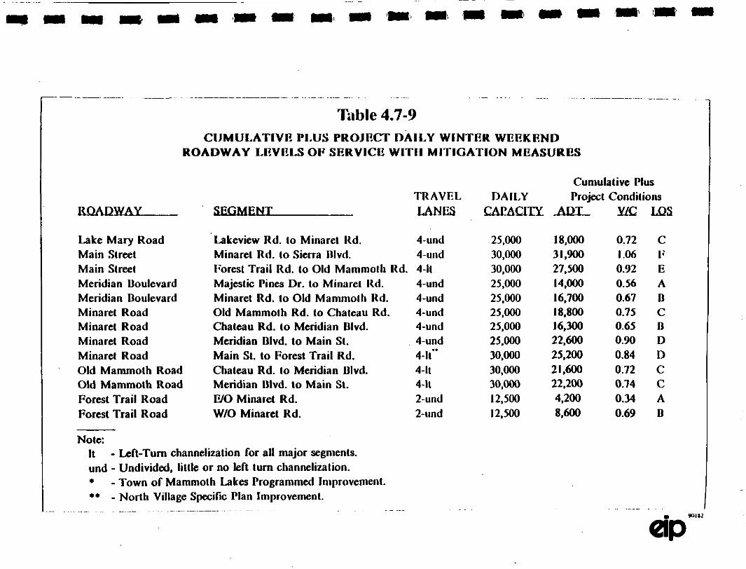
Table 4.7-9CIMLA’rlVE PLUS eROJECT D^ILV wm’rER WEEN[
ROADWAY LEVELS OF SERVICE WITII MITIGATION MEASURES
TRAVEL DALLYSEGMENT LANES C,AP_
Cumulative PlusProject Conditions
Lake Mary RoadMain StreetMain StreetMeridian BoulevardMeridian BoulevardMinaret RoadMinaret RoadMinaret RoadMinaret RoadOld Mammoth RoadOld Mammoth RoadForest Trail RoadForest Trail Road
’Lakeview Rd. to Minaret Rd. 4-undMinaret Rd. to Sierra Blvd. 4-uudForest Trail Rd. to Old Mammolh Rd. 4-ItMajestic Pines Dr. to Minaret Rd. 4-undMinaret Rd. to Old Mammoth Rd. 4-undOld Mammolh Rd. to Chateau Rd. 4-undChateau Rd. to Meridian Blvd. 4-undMeridian Blvd. to Main St. 4-undMain St. to Forest Trail Rd. 4-It’"Chateau Rd. to Meridian Blvd. 4-ItMeridian Blvd. to Main St. 4-ItE/O Minaret Rd. 2-undW/O Minaret Rd. 2-und
25,000 18,000 0.72 C30,000 31,900 1.06 F30,000 27,500 0.92 E25,000 14,000 0.56 A25,000 16,700 0.67 B25,000 i8,800 0.75 C25,000 16,300 0.65 B25,000 22,600 0.90 D30,000 25,200 0.84 D30,000 21,600 0.72 C30,000 22,200 0.74 C12,500 4,200 0.34 A12,500 8,600 0.69 O
Nole:It Left-Turn channelization for all major segments.
und Undivided, little or no left turn channelization.* Town of Mammoth Lakes Programmed Improvement.** North Village Specifio Plan Improvement.

!I!!I
I
Table 4.7-10CUMULATIVE PLUS PROJECT
PM PEAK HOUR LEVEL OF SERVICE SUmMArYMrrIGATION DdPROVEMElqTS
Unsialized InteroetJons " LOS
Kelley Rd. & LakeM R& +426 A
Sierra Blvd. & Mai Street 30 F
Si_nalized Lntersections
Minaret Rd. & Forest Trail Rd.
Lake’ew Rd. & Lake Mary Rd.
Minaret Rd. & Main St.
Minaret Rd. & Meridiaa Blvd.
Minaret Rd. & Old Mamraoth Rd.
Old Mammoth Rd & Main St.
Old Mammoth Rd. & Meridian Blvd.
Notes:
’ Reserve Capacity
LOSb
0.83 D
(1.50 A
1.05 F
0.81 D
0.85 D
0.57 A
1.02 F
Available reserve capadty for the ,most constrainedinte)ction movement.
LOS Level of Service Des’ription (So() Appendix).
V/C Volume to Capacity (percent of inters,;’tion capacity utild).
No Mitigation Required.

I
4.7 Traffic
The percent contribution on the roadway segments is presented in Table 4.7. 1. Table 4.7.12 presents the
percent contribution of the project at the study intersections. The percent contribution was determined
both for total future traffic and for cumulative traffic gn3wth.
Evaluation of the Proposed Specific Plan Circulation System and Site Act:ess
The North Village Specific Plan includes individual plans that address the areas of vehicular and
pedestrian circulation and public transit. In addition, the prima points of vehicular access of major land
uses are identified. The traffic study analyzes and assesses the Specific Plan Circulation System and site
access based on the Cumulative plus Project winter weekend traffic projections.
Overview of the Circulation Plan
One of the intents of the North Village Specific Plan is to promote pedestrian access and circulation to
minimize additional impacts to vehicular traffic, while also providing for improvements to existing
circulation cooditions. The circulation plan consists of three components:
Improve and modify the existing street system (both within and outside the Specific Plan Area
boundaries) to reduce the level of skier traffic passing through predominantly residential areas, while
maintaining adequate levels of circulation in these areas for residents and emergency vehicles.
2. Increase in mass transit/public transportation service to reduce the numbers of visitor vehicles on the
roads.
3. Provide a pedestrian circulation system, including trails, walkways, and a pedestrian-oriented sial lift
to reduce the need for visitor vehicle use.
Vehicular Circulation
Roadway System: The proposed vehicular circulation for the Specific Plan is illustrated in Figure 4.7-3.
This roadway network includes improvements to the existing roadway system which are depicted in Figure.4.7-4. They include:
1. Abandon lower Canyon Boulevard east of Hillside Drive and eliminate the Canyon Boulevard and
Minaret Road intersection.
90182 4.7-36

Table 4.7-11PERCLNT CONTRIBUTION OF PROJECT TRAFFIc TO CUMULATIV DAILY TRAFFIC
I,.ADWAY
Lake Mary RoadMain StreetMain Slreet
Meridian BoulevardMeridian BoulevardMinaret RoadMinaret RoadMinaret RoadMinaret RoadOld Mammolh RoadOld Mammoth Road
3UCtMIT
Percent of Total"C,mlll;tl ire Traffic
North Oilier
’illag lrts Eisting
Lakcvicw Rd. to Minaret ltd. 33% 15% 52%
Minaret Rd. to Siena Blvd. 17% 22% 61%
Forest Trail to Old Mammoth ltd. 15% 13% 72%
Majestic: Pines Dr. to Minaret Rd. 13% 50% 37%
Minaret Road to Old Mammoth I.d. 4% 52% 44%
Old Mammolh ltd. Io Chateau Rd. 30O/0 41% 29%
Chateau Rd. to Meridian Blvd. 34% 56% 10/0
Meridian Blvd. to Main St. N/A N/A N/A
Main St. to Forest Trail 37*/0 9% 54%
Chateau Rd. to Meridian Blvd. 9% 4I% 50O/0
Meridian Blvd. to Main St. 15% 8% "/7%
Pe..tnt ofCumulativeTraB]c GfowlhNorlh Other
690/0 31%44%5I% 49%20/0 80%8% 92%42*/0 58%38% 62%NIA79% 21%19% 81%64% 36%
a. Consists of existing, cumulative and pro’t traffic.
b. Incremental increa in traEfic, not incl,ding existing traffic.
N/A Not applicable (no existing segment)

!IIIIII’1IIIIIIII
Table 4.7.12
X’ERCLnCr cos’ntmu’noxoomcrTS.mCTOcME0
Oth= Other
Minaret Rd. & Foreb’ Trail
Kelley Rd. &eMRd. 1/0 16% 74% 38% 62%
kecw Rd, & LeM Rd. 6% 16% 76% 35% 65%
:Rd. &M St. 23% 31% % /o 58%
Siena B1. &M Su 13% 2P 66% 3/e 62%
OldMoRd. &MS IA 25 65% 2/o 71%
Minat Rd. & Mdi B1. 1/o 58% 23% 24% 76%
OldMoRd. &MdB1. 4% 36% /o /o 91%
etRd. & OldMoRd. 11% e/o 23% 14% 86%
Not:
a. Consu of existing cumtdative and project traffic.
b. Incremental increase in traffic, not including existing traffic.
,I

I!IIIIIiIIIIiIIiIII
,.7 Trzfffic
2. Reroute skier traffic from Warming Hut !I to Mary Road to relieve congestion at the ForestTrail-Minaret Road intersection and enable traffic fn3m MMSA Main Lodge and Wamaing HutII to met at controlled conditions at tbe Lake Mary Road/Main Street-Minaret Road intersection.
Physically improve Lakeview Road, Lakeview Boulevard, Lake Mary Road, Millers Siding Road.and Minaret Road to safely accommodate projected traffic flows and winter conditions. The
improvements include reducing roadway grades and street widenings.
Closure of the westerly portion of Bemer Street and elimination of the Berner Street-Minaret Roadintersection; rerouting of Bemer Street to connect with Forest Trail to reduce traffic flow on
Bemer Street.
While the previously described improvements include eliminating one of the existing roadway connections
to Minaret Road from the Warming Hut II area, lhe overall circulation for the area in the vicinity can
expect to be improved Iy the proposed roadway network. There will continue to be two primary pointsof access to the Warming Hut II area and both will be able to accommodate higher levels of traffic in a
safer, more efficient manner than current roadway and operational conditions allow. Increased roadway
capacity, reduced grades and traffic signals at the key intersections (Lakeview Road at Lake Mary Road
and Forest Trail at Minaret Road) will provide the level of traffic control and efficient operation needed
to accommodate the traffic rerouted from the intersection of Canyon BoulevardMinaret Road and future
traffic generated by the Specific Plan. As previously discussed in the mitigations section, Forest Trail and
Minaret Road will operate at a LOS "C" under "worst case" conditions with the recommended improve-
merits. These conditions include lhe Canyon Boulevan:l realignment and cumulative plus project traffic
lcvels. Lakeview Road and Lake Mary Road will operate at LOS "A" with the mitigations recommended.
The alternative of leaving intersection of Canyon Boulevard and Minaret Road is from a traffic safety
and operations standpoint, undesirable for a number of reasons. Without signalization this intersection
would eventually become a liability from a safety standpoint due to existing and fture traffic volumes.
Current peak Saturday winter traffic levels show that the intersection has sufficient traffic to be a candidate
for a traffic signal. Entering Minaret Road from Canyon Boulevard will become increasingly difficult
because of the growth in traffic levels on Minaret Road.
However. three sigrmlized intersections (Main Street/Lake Mary Road/Minaret Road, Minaret Road/Canyon
Boulevard and Minaret Road/Forest Trail) in such close proximity would be undesirable from a traffic
operations standint, particularly for moving traffic along Minaret Road. Traffic queues from each
intersection would impact the adjacent location reducing effective capacity of Minaret Road. This
would all but eliminate the benefits of the signals in assigning right-of-way. Traffic queues would also
restrict the vehicular access points to the project along Minaret Road.
90182 4.7-39

IIIIIIII!IIIiIII!I
4.7 Traffic
Roadway Design C,Ansiderations: One of the key factors to consider in the Canyon Road realignment arethe design elements (design speed and curve radii) for the sections of roadway that will be modified.Caltrans design criteria) indicate that the appropriate design speed for a local collector roadway such asthe realigned Canyon Road would be 30 mph. This in turn would dictate minimum curve radii of 300feet. The Caltrans criteria (or simltar criteria recognized by the Town of Mammoth Public Works
DepaCanent) should be incorporated into the Canyon Road realignment design.
In relationship to closure and realigning Bemer Street there is also a significant design element that will
have to be addressed. Bemer Street is proposed to intersea Forest Trail just west of an existing horizontalcurve. This intersection location could resdt in limited site distance looking east along Forest Trail from
Bemer Street. The design will need to meet the alicae sighf distance criteria for movements at this
intersection. The design should conform to the Cahrans Design Manual. AASHTO or other criteria that
approximates these requirements as required by the Town of Mammoth Lakes Public Works Depm’tment.
Access Considerations: The overall circulation plan includes a series of Local Collector Su’eets that will
provide circulation to and from the primary arterial and collector roadways serving the Specific Plan area.
These local collectors in turn will provide access to the parking facilities in North Village via strategically
placed entry/exit plazas. This system is effective and will be more than adequate for a number of reasons:
I) The number of conflicting points along the arterial roadways will be minimized.
2) Typically low speed maneuvers to and from parking areas will be provided from the lower volume
local collector streets instead of from arterials with higher volumes al speeds. Based on the very
conceptual layout and distribution of land uses provided in the Specific Plan each of the local
coUectors will have adequate capacity.
However. the specifics of the access and internal circulation of the individual projects that will b
developed in the Specific Plan should be subject to review and approval by a qualified Traffic Engineer
during the final alrval imacess. During this subsequent review minimizing th number of dtS.veways,
aligning access points on the opposite side of the street and controlled access (limiting movements at
specific points of access) should be evaluated for any proposed ingress/egress to Minaret Road and Lake
Mary Road/Main Street.
Pedestrian Circulation and Public Transit
An integral pan of the North Village circulation plan is oriented toward pedestrian and tansit modes.
(See Figures 4.7-10 and 4.7-I 1). Major features of the pedestrian circulation system includes three miles
90182
Caltrsns Highway Desitm Manual, 4th Edition. State of California Department of Transporta-tion.
4.7-40

etleS[FlaI1 tArcLllatlon
IIIIIIIIIIIIIIIIIII
LegendPEDESTRIAN WALKWAYSPEDESTRIAN PLAZA
Illllllllilll: SKIING ACCESS
[] [] [] [] PEDESTRIAN TRAIL
SOURCE: Ton. Tech
Lodging
6
ce 8udng
Garage;Service ACCESS
Figure 4.7-10
Si Relurn
Up Area
ng Area/Bus Stop
esrian Walkway

iIIIIII!IIIIIIIIIII
\\
Legend
$UTTLE ROUTEn=- POSSIBLE ROUTE EXqENSiON
[] SHUTTLE STOP
SOURCE: Tfarm TeCh
Figure 4.7-11
f
[La’n
Area
Marshalling Area/Sus StcD
ar War,way

IIIIIIIIIIIIIIIIIII
4.7 Traffic
of walkways. Also included within the corff’mes of the main plaza is the base of a planned ski lift facilitywhich will transport skiers from the North Village Area tO MMSAs base facilities. The lift is proposedto be a high-speed enclosed gondola with a design capacity of 2.500 skiers per hour. No day-use skier
parking will be provided at the ski lift. The lift will be oriented toward those skiers staying inaccommodatibns in North Village or other facilities witlfin walking distance and those accessing thefacility via public transit shuttle.
A ski-back trail will be provided to enable skiers from MMSA to return to the lodging facilities or
meeting places in North Village without use of private or public vehicles, The majority of the ski-back
trail will be located outside of the Specific Plan Area, between MMSA and North Village. The trail will
end at the northwest corner of State Route 203 (Minat Road) and Forest Trail Road. Access from the
ski-back to the marsiaalling area/bus stop on the northeastern corner of the intersection will be providedvia a pedestrian undercrossing.
Controlled pedestrian access across Forest Trail linking the skier marshalling area with North Village. and
pedesu’ian access across Minaret Road to connect the westerly and easterly portions of the plaza, would
be accommodated by the traffic signal proposed for the int’rsection of Minaret Road and Forest Trail.
Public transit enhancements are proposed to be provided through the MMSA operated shuttle. These
enhancements will include additional stops, increased trip frequency extended operating hours, ad better
service to other areas in the Town.
While difficult to quantify, the integrated pedestrian and transit element of the circulation plan could
reduce non-ski related trips by as much as 15%. The transit system design study to be undertaken by the
Town will assist in identifying the effects of an improved transit system on reducing vehiclar trips.
Significant reductions in vehicular trips could reduce the need to provide certain roadway capacity
improvements presented in this repot. The level of developer financial participation in support of an
improved transit system. "in lieu" of participation in certain roadway improvements, would be included
in the upcoming transit system study.
Specific Plan Circulatlnn and Site Access Mitlgatinn Measures
The mitigation measures that follow are not directed toward eliminating any specific deficiencies identified
in Specific Plan’s Circulation and Access element. They are intended to complement the mitigation
measures outlined for the roadway system. The overall goal is to provide a safe, efficient roadway system
and to reduce travel demand so that the "worst case" traffic projection presented by lids analysis are not
realized.
90182 4.7-3

IIIIIIIIIIIIIIIIIII
90182
4.7 Traffic
The final design of the Canyon Road and Bemer Street realignments shall be in conformance with
recognized standards for roadway design as required by the Town of Mammoth Department of
Public Works.
All access points from adjacent land uses to Minaret Road, Lake Mary Road and Main Streetwithin the Specific Plan shall be evaluated by a qualified Traffic Engineer and approved by the
Town of Mammoth Lakes Public Works Department.
A system of Pedestrian waikways shall be developed in substantial conformance to the Pedestrian
Circulation Plan contained in the approved Specific Plan.
Evidence of binding agreements for transit services substantially in conformance with the Specific
Plan shall be provided prior to approval of more than one half of the lodging units allowed for
the plan.
All developments in North Village shou]d participate in the development of a transit hub and
transit, system.
4.7-44

4.8 AIR QUALITY

IIIIIIIIiIIIIIIIIII
4.8 AIR QUALITY
INTRODUCTION
This section of the Draft EIR evaluates the potential impacts on air quality resulting from the construction
or operation of the proposed project. Where appropriate, mitigation measures are suggested that could
minimize or eliminate potential significant air quality impacts.
SETTING
Climate
The proposed project site is located in Mono County. The climate of Mono County may be characterized
as dry with wide fluctuations in daily temperatures, clear skies, excellent visibility and hot summers.
Typically 70 percent of the rainfall occurs between November and February. The average minimum
temperature is in the upper 20’s with the average maximums in the mid to high 50’s. Spring is the
windiest season with fast-moving northerly weather fronts. Summer winds are northerly at night as a
result of cool air draining off the mountain sides. Southerly winds during the day result from strong sol
heating of the mountain slopes causing upslope circulation. The mean annual wind speed in Mammoth
Lakes is less than 11 mphI. Wind speeds just outside of Mammoth Lakes at elevations of 8,900 ft. and
7,800 ft. showed mean annual wind speeds of 21.7 and 11.5 respectively.
Regulatory Background
Criteria Pollutants. The 1970 Clean Air Act gave the U.S. Environmental Protection Agency (EPA) the
authority to set federal ambient air quality standards. The Act indicated the need for primary standards
to protect public health and secondary standards to protect public welfare from air pollution effects such
as visibility reduction, soiUng, nuisance, and other forms of damage, It also required that the federal
standds be designed to protectthose people most susceptible to respiratory distress, such as asthmatics.
the elderly, very young,children, people already weakened by illness, and persons engaged in strenuous
work or exercise (all termed "sensitive receptors"). In 1971. the EPA established federal standards for five
major criteria: air pollutants: photochemical oxidants (ozone), carbon monoxide (CO), suspended
pa.iculate matter (originaibi standard applied to particulates of any diameter, termed total suspended
particulates or TSP. but the standard was changed in 1987 to apply only to particulates less than 10
microns in diameter, termed PM0). nitrogen dioxide (NO2). and sulfur dioxide (SO2). State ambient air
quality standards were first established for California in 1969. pursuant to the Mulford-C,arrell Act. The
federal and State standards, given in Table 4.8-1. provide acceptable concenations for specific
contaminant levels in order to protect sensitive receptors from adve effects as indicated in Table 4.8-2.
90182 4.8-1

I!IIIiiIIIIIIIIIIII
4.8 Air Quality
Ozone
Cadxm M’oxide
Ni*.msen Dioxide
Hydrogen SulfideVinyl ChlorideVifib/lity ReducingPanicles
TABLE 4.$- 1
FEDERAL AND STATE AMBIENT AIR QUALITY STANDARDS
Federtia Federal,=Averagin$ Prima SeemdayTime StandaM Stendl
Califom/a
Staada
l-Hour 0.]2 0.12
-Hour 3:5.0 pn 35.08-Hour 9.0 p$ 9.0
Annual 0.053 ppm 0.053 ppm
20.09.0
0.25
l-Hour 0.25 183-Hor 0.5 Im24-Hour 0.14 ppm 0.05 RmtAnnual 0.03 Ran
24-Hour 150 lg/m 150 8n* 50 ktg/msl
Annual 50 .m’ 30 ,/ms
24-hor 25 /m30 Day Av$. 1.5Calenda 1.5 Ifjm 1.5 I,m
l-Ho’ 42 /m24-Hour 26 m,/m
<10 miles when negative humidity<70%’,
ppm pans per millim, g/m micrograms per cubic meter.
(I)
(2) Natical standards (other than annual standards) ate not to he exceeded per year.
(3) The standard applies whenever the otone cocerttratio is $eater than 9 pm 0 the 24-hour total SSFded icul cc=ceraration is
gater than I00
(4) Panicles with teyltic diameten lest than equal to 10
(6)
(7)
National standards for PM=o replaced tcxal suspended peniculme miner TSP) slandard=, effective July 31, 1987. TSP data, however, an=
sfig being sed indiciton of ambient PM,o in ias wilh air ins’ficienl PMIo datatme. The tmioml PMIo sdarda m calcUlaled as
Prevailing visibility is defined e gealest visibility which is attained of qsted arotmd at !cut half " the hofiz’t care|e, ha not
necessarily in commuos setont.
Noe: The Federal PMto Annual Sqdatd is hated o the Arithrae|ic Mean and the State PMto Almal Stailad it based (m the Geometric Mean.
Suce: California Air Resoues
90182 4.8-2

!I
IIII
IIIIIIIIIII
.8 Ah" Qualiy
TABLE 4.8-2HEALTH EFFECTS SUMMARY OF THE CRITERIA AIR POLLUTANTS
Air PollutantOzone
Carbon Monoxide
Nitrogen Dioxide
Sulfur Dioxide
Total Suspended
PMo
Lead
Adverse Effectseye imtationrespiratory function impairment
impairment of oxygen transpo, in the bloodsffeam,carboxyhemoglobinaggravation of cardiovascular diseaseimpairment of central nervous system functionfatigue, headache, confusion, dizzinesscan he fatal in the case of very high concentrations in enclosed places
of
risk of acute and chronic respiratory illness
aggravation of chronic obstruction lung diseaseincreased risk of acute and chronic respiratory illness
increased risk of chronic respiratory illness Particulate with long exposurealtered lung function in children with SO2, may produce acute illness
particulate matter 10 microns or less in size (PMI) which may he inhaled, andpossibly lodge in and/or irritate the lungs
impairment of blood function and nerve constructionbehavioral and learning problems n children
Source: Bay Area Air Quality Management District.
90182 4.8.3

!I
IiI!i!IIII!I!!
4.8 Air Quality
The 1977 Clean Air Act Amendment required that each state identify areas within its borders that do not
meet federal primary standards for criteria polluumts (i.e.. non-attainment areas) and devise a StateImplementation Plan (SIP), subject to EPA approval, to attain federal primary standards no later than 1987.The Caiifornia standards do not have specific attainment dates.
The California Air Resources Board (CARB) coordinates and oversees both State and federal air pollutioncontrol programs in California. As part of this responsibility, the CARB monitors existing air quality,
establisles State air quality standards (which in many cases are more stringent than federal standards, sshown in Table 4.8-1), limits allowable emissions from vehicular sources, and is responsible for overseeing
the SIP. The CARB has divided the State into many single and multi-county 9it basins. Authority for
air quality managemem within each air basin has been given to local Air Quality Management Districts
which develop local non-attainment plans within their jurisdiction. The CARB has designated the Great
Basin Valley Air Basin (GBVAB) under the jurisdiction of the Great Basin Unified Air Pollution Control
District (GBUAPCD).
Air Quality Planning and Control in the GBUAPCD
Air quality in Mammoth Lakes is monitored by the Great Basin Unified Air Pollution Control District
(GBUAPCD) located in Bishop. California. The airshed above Mammoth Lakes is pan of the Great Basin
Valley Air Basin (GBVAB). GBVAB consists of Inyo, Mono, and Alpine Counties, which is the same
as the jurisdiction of the GBUAPCD. The GBVAB is defined by the Sierra Nevada mountain range to
the wesl; the White, Inyo. and Coso ranges to the east; Mono Lake to the north; and Little Lake to the
south.
Spot monitoring in the GBVAB. conducted by the California Air Resources Board (CARB) in 1972.
identified particulates as the most likely air quality problem. Monitoring for pan|culates by the
GBUAPC’D began in 1979 with 18 sites monitoring particulates. Currently there a 12 sites in the
GBVAB monitoring particulates all of which have been modified to monitor PMo. A Draft Air Quality.Management Plan (Plan) for the Town of Mammoth Lakes was relea,,qed on January 19, 1990, to identify
PMto sources and mitigation measures which may be instituted to attain National Ambient Air Quality
Standards. The Plan. prepared by the GBUAPC’D. is required under the federal Clean Air Act and win
become part of the State Implememation Plan to attain federal standanls.
The Plan identifies exceedances of the PMo standard as occurring in the winter and associates the
exceedances with increased emissions from wood stoves, fireplaces, and traffic-related road dust and
cinders. These increased emissions result from the large influx of visitors who come to Mammoth Lakes
during the ski season. Periods of meteorological stagnation combined with peak periods of the ski season
result in violations of the PMo standards.
90182 4.8.

I
I
Quality
The Town of Mammoth Lakes has already taken action to reduce the PM,o emissions from road dust and
cinders by operating a vacuum sueet sweeper. Three ordinances developed by the Town of MammothLakes and one ordinance prepared by the Wood Energy Institute are currently being considered to address
the control of residential wood combustion and related PMo emissions. All control measures suggested
in the Plan are listed in Table 4.8-3.
In December 7, 1990, paniculate emissions regulations were adopted by the Town. The ordinance
addresses the regulation of solid fuel appliances, density limits, replacement schedules, capacity limits,
prohibited fuels, mandatory curtailment, education programs, road dust reduction measures, fees, and
penalties (see Appendix F).
Air Pollutant Problems and Trends. Mammoth Lakes and Proiect Vicinity
The GBUAPCD operates a regional air quality monitoring network in order to gauge the GBVAB’sprogress toward attainment of federal and State ambient air quality standards. At monitoring stations
throughout thi network, readings ate taken regularly of criteria air pollutants. On the basis of monitoringdata from the 14 stations spread throughout the GBVAB, the CARB has designated the entire GBVABas a non-attainment area with respect to the State and federal PMo standards and State ozone standards.
A three-year summary of the data collected at the Mammoth Lakes Gateway Home Center station is
shown in Table 4.8-4. The data in Table 4.8-4 reveals an increase in the number of days of ozone
exceedances over the last u’ee yeats. The number of days of actual exceedances of the PMo 24-hour
standard also have risen steadily as well as the annual geometric mean. Because PMo measurements are
only taken once every six days, the number of exceedances would be higher. Exceedances of the federal
24-hour PMo standard have been estimated to occur on an average of 9.5 times during each of the last
four winter seasons)
Exceedances of the ozone standard have occun’ed predominately at night’. Because ozone requires
sunlight to form. high levels of ozone in Mammoth Lakes has been hypothesized to result from transport
of pollutants rather than local sourees. The Northern San Joaquin Valley and the Mountain Counties Air
Basin are currently under investigation by the CARB to determine their potential for contributing to
exceedances of the ozone standard in Mammoth Lakes.
90182 4.8-3

!
lIIiI!iiI,,!!!
MeasurNumr1.
3.
4.
Source:
4.8 Ah" Quality
TABLE 4.8-3
CONTROL MEASURES LISTED IN THE TOWN OF MAMMOTH LAKESDRAFT AIR QUALITY MANAGEMENT PLAN
Control MeasureUse vacuum street sweeper for cinders and mad dust.
Reduce vehicle traffic.
Institute a public awareness program for wood burning.
Wood stove replacement.
4.a. Require replacement or removal of non-ceified wood stoves upon resale of dwelling.4.b. Limit installation of wood stoves after July l, 1990 to EPA Phase It Certified or
pellet stoves.
Fii’eplace phase-out.
5.a. Ban fireplaces in new dwellings.5.b. Require transient occupancy units to render fireplaces inoperable or to replace with
a gas burner of pellet stove.5.c. Require fireplaces to be rendered inoperable or replaced with a gas burner of pellet
stove upon resale of dwelling.
Wood bun’dng performance,
6.a, Require certification for wood stove installers.O.b. Require a 20 percent wood moisture limit for wood retailers.6.c. Prohibit trash and coal burning in wood stoves.6,d. Set 20 percent opacity limit for wood burning.
Curtail wood bun’ng during air pollution episodes.
7.a. Institute a voluntary wood burning ban during periods of poor air quality.7.b. Institute a mandatory wood burning ban when continued sto’e use is expected to
cause a federal PMIo standard violation.
Draft Air Quality Management Plan for the Town of Mammoth Lakes, January 19, 1990.
90182 4.8-6

!IIII
IIIiIIIII!i!
4.8 Ah" Qualiy
TABLE 4.8-4AIR POLLlYrANT DATA SUMMARY 198-1987
STATION: Mammoth Lakes Gateway Home Center
PoUutant 1986 1987 1988
OZONE: (ppm)Highest l-hour 0.10" 0.10" 0.10Days > 0.09 3 4 5
CARBON MONOXIDE: (ppm)Highest l-hour 9.0"Days > 20.0 0
9.0 11.00 0
Highest 8-ho 4.6" 6.4 6.0Days > 9.1 0 0 0
PMt0: (ug/m)Highest 24-hour 166 110 159Samples > 50 4 14 1Annual Gcomec Mean 23.4 31.0 36.7"Year > 30 No Yes Yes
Notes: Highest recorded values for specific averaging times are followed by number of exceedances of theCalifornia state standards for each of the criteria pollutants.
* Data presentd are valid, but incomplete in that an insufficient numlr of valid data points were
collected to mctt EPA arid/or ARB criteria for statistical significance.
Units ppm: parts per million; ug/m: microsram per cubic memrNM: not monitored
Source: California A" R(C)sources Board, A" Quality Data Summary. 1986-1988.
90182 4.8-7

I
I
III
4.8 A- Qaliy
IMPACTS AND MITIGATION MEASURES
Criteria of Significance
Unless otherwise noted, all identified impacts are considered to be adverse significant impacts. Cur-responding mitigation measures, unless otherwise noted, would be sufficient to reduce impacts to a lessthan significant level. Air quality impacts can be classified as having effects either on a regional or local
scale. The CEQA Guidelines indicate that a project will have a significant effect if it would violate anyambient air quality standard, contribute substantially to an existing or projected air quality violation, or
expose sensitive recepto to substantial pollutant concentrations. Impacts that would violate federalstandards, i.e., primary staJ3dards designed to safeguard sensitive recepto or secondary standards to
safeguard public health, or State standards developed by CARB are considered significant adverse impacts.Additionally, a project would be considered to have a significant effect if it would violate any GBUAPCDstandards.
Construction Impacts
4.8-1 Construction in the area of the proposed site will temporarily increase PMe concentrations
and could lead to violations of the federal and State ]4-hour average PMe standards. This
is a potenlly sgn’tcant npac.
Clearing, excavation and grading operations, construction vehicle h’affiC on unpaved ground, and wind
blowing over exposed earth surfaces generate dust. Therefore, conswaction in the area of the proposed
site would temporarily increase PMo concentnions and could lead to violations of ti federal and State
24-hour average PM,o standards. It is not possible to estimate accurately the PMto concentrations that
would occur at or adjacent to the consmction sites because such concenlrations arc very sensitive to local
meteorology and topography, to variations in soil silt and moisture content, and to the level of equipment
use. However. EPA meents made during apartment and shopping center construction provide a
rough indication of the maximum rate of particulate emissions. These measurements indicate that
approximately 1.089 kg (1.2 tons) of dust are emitted per acre per month of consttction activity,s One-
half of the dust would be comprised of large particles (i.e., diameter greater than 10 microns) which sereout rapidly on nead3y horizontal surfaces and are easily f’dtered by human brealldn.g passages. Tlds dust
is of concern as a soiling nuisance rather than a health hazard. The remaining fraction (PMto) could be
sufficient to violate the federal and State PMo standards in the site vicinity.
90182 4.8.8

IIIIIIIIIIIiIIIIIII
,1.8 Air Quality
Mitigation Meaares
Implementation of Mitigation Measures 4.8-I will reduce Project impacts to a less-than-significant level.
4.8-1(a) To reduce the potentialfor nuisance due to dust and odors, all construcn’on contracts shallrequire watering twice daily with complete site coverage; the frequency of watering shall
increase as necessary to minimize dust if wind speeds exceed 15 mph.
4.8-1(U) Drift fencing tackifiers and covering of stockpiles shall b used in areas not under active
construction.
Dust emissions related to cortstmction can be reduced approximately 50 percent by watering exposed earth
surfaces during excavation, grading and construction activities? Conditions of approval should also
require daily cleanup of mud and dust corned onto street surfaces by consmction vehicles. Throughoutconstruction activities, haul trucks should use tarpaulins or other effective covers. Upon completion of
construction, 8ontractors should lake measures to reduce wind erosion. Replanting and repaying should
be completed as soon as possible. Construction activities shtld be scheduled so that they.do not
comribute to peak periods of woodbuming and vehicular traffic, previously discussed as major contributors
to PMo xceedances.
Impact
4.8-2 Operation of construction vehicles and equipment during the construction phase of the
proposed Project could result in violations of federal and State l-hour and 8-hour COstandards. This is a sort.term, potentially slgnqkant irapact during the nstruction phase
of the proposed Project only.
Large numbers of vehicles and equipment operating or idling in a small area may cause spot violations
of the federal and State CO stand;mls. Odors of construction equipment exhaust would probably be
noticeable in the environs of the project site for the duration of consffction.
Mitigation Measure
Implementation of Mitigation Measure 4.8-2 will reduce Project impacts to a less-than-signff’,cant level.
4.8-2 To reduce the potential of spot violations of the CO standards and odors from construction
equipment exhaust, unnecessary idling of construction equipment shall be avoided.
90182 4.$-9

IIIIIIIIIIIIIIIIIiI
. Ah" Qualiy
Carbon Monoxide "Hot Spots"
4.8-3 Emissions from vehicular traffic generated by the proposed Project could result in violationsof federal and State ambient quality sandards. This is a poemtally signifY.ant impact.
By generating additional traffic in the Town of Mammoth Lakes. the proposed project wou/d affect localtraffic patlems and, thereby, change the local spatial and temporal distributions of ambient CO. Local air
quality effects were estimated by using the CALINE4 air pollutant dispersion model to determine if the
proposed project woukl cause any exceedances of the l-hour or 8-hour federal or State sndards. The
State l-hour and 8-hour standards, given in Table 4.8-1. are 20.0 ppm and 9.0 ppm respectively.
Table4.8-5 shbws existing, future cumulative and future cumulative plus project worst-case cuCoside COconcentrations expected at five interactions where project u’affic is expected to have the greatest impact.As shown in the table, the potential for existing and future violations of the State’s 9 ppm 8-hour CO
standard exists. Of the five intersections analyzed, two intersections (Minaret and Main. and Old
Mammoth and Main) showed potential exccedances of the CO standard. Combined traffic impacts from
cumulative development,plus the proposed project at buildout could exceed the 8-hour CO standards for
receptors at the roadside. A sensitivity analysis showed that CO levels at this intersection dropped rapidly
as recepto were moved away from the intersection. At a receptor distance of 50 feet from the roadside,
CO concentrations at the inonofMinaret and Main were determined W below the standards (8.7
ppm). Cumulative development without the proposed project did not show the potential for exceedances
of the CO standards at any of the intersections reviewed. No exceedances of the 1-hour CO standard are
projected as a result of the proposed project or cumulative development.
Mitigation Measure
Implementation of Mitigation Measure 4.8-3 will reduce Project impact to a less.than-significant level.
4.8-3 Development will not be allowed w#hin 50/eet of the Old Mammoth and Main intersection.
A 50-foot open space buffer around the Old Mammoth and Main intersection will reduce lhe potential for
exposure of individuals to elevated CO concentrat.ions.
90182 .8-10

IIIIIIIIIIIIIIIIIiI
4.8 Ah" Quality
TABLEPREDICTED ROADSIDE CARBON MONOXIDE CONCENTRATIONS
(IN PPM)I
Averaging Existing Cumuive Cumulative+ Project
Location Time 1990 2010 2010
1. Minaret/ l-hr. 11.5 15.2 14.6Forest 8-hr. 6.4 8.9 8.5
2. Mina/ l-r. 14.2 14.5 16.1Main 8-hr. 8.2 8.5 9.6
3. Sierra/ l-hr. 10.4 10.3 10.6Main 8-hr. 5.6 5.5 5.7
4. Old Mammoth/ l-hr. 14.4 14.8 15.3Main 8-hr. 8.4 8.7 9.0
5. Old Mammofl’V 1-hr. 14.4 14.6 15.0Meridian 8-hr. 8.4 8.5 8.8
Backgrounds -hr. 10.0 10.0 10.08-hr. 5.3 5.3 5.3
Standards l-hr. 20.0 20.0 20.08-hr. 9.0 9.0 9.0
IThe labulated concentralions are the sums of a background component, which includes he cumulativeeffects of all CO sources in he project viciniv/, and a local componen, which reflects the effects ofveh/cular n’afflc on roadways. Background components were otined from he Air Oualitv and UrbanDevelovment Guidelines for Assessimz Impacts of Proiects and Plans. BAAQMD, Revised April 1988.Local CO components were derived from me CALINF,A computer program, assuming worsx-caseconditions at lhe inrsecons, Traffic data was provided by Transtech Transporon Engineer.
90182 4.8-11

IIIIIIIIIIIIIIIIIII
4.8 Air Quality
Emissions
4.8-4 Resnspended road cinders and vehicle tail pipe and tire wear will contribute approximately1,400 kg/day to the total PMI. emiss/ons inventory at buildout of the proposed Project. Thisis a significant impact.
Resuspended road cinders contributed to 99 percent of the projected PMto emissions from vehicularsources. In the year 2005 the proposed project would contribute approximately 44 percent of the dailyemissions of PM:0 from vehicular sources. Likewise. if the reductions from Table 4.8-3 axe notimplemented, the proposed project would increase annual PMo emissions by 98 percent above thecumulative annual emissions from vehicular sources. Because the proposed project is in a non-attainmentarea for PMo, any increase in emissions of this pollutant would be a significant impact on air quaiJty.Therefore, the proposed project would have a significant impact on air quality with respect to PMtoemissions from vehicular sources.
Traffic-related PMo emissions were calculated using the same methodology as described in the DraftAQMP for Mammoth Lakes, Sections 3.2 and 3.3. Projected peak 24-bout PMo emissions for lhe year2005 were taken from Table 5.2 of the Draft AQMP for Mammoth Lakes. Traffic generated by theproposed project was estimated at 104,650 Vehicle Kilometers Travelled (VKT) daily. Traffic generatedby the cumulative impacts was estimated at 186,728 VKT daily. The VKT was obtained from TranstechTransportation Engineers.
Mitigation Measure
Implementation of Mitigation Measure 4.8-4 will reduce Project PMto emissions impacts to a less-than-significant level.
4.8-4 Adopt and enforce Control Measures 1 through 7 of the Town of Mammoth Lakes Draft Air
Quality Management Plan (see Table 4.8-3).
The Plan aims to limit vehicular traffic in the Town of Mammoth Lakes to 106,600 VMT. which is 40,320
VMT more than the present peak traffic estimates. The proposed project without any transpoaion planswould increase the VMT by approximately 64,000. To attain the goals of this mitigation measure the Plan
will call on future development projects, such as the proposed project, to implement transportation plans.Potential reductions from the above measures are illustrated in Table 4.8-6 for the years 1993. 1995. 2000and 2005. Alone these mitigation measures would not be sufficient to bring the Town of Mammoth Lakes
into compliance with PM,o standards, however, acting in conjunction with mitigation measures proposedfor rducing PMto emission from wood burning. PM0 standards may be obtained.
Woodbuming Impact4.8-5 At buildout of the proposed project, in 2005, the contribution of PMs. h’om wcodburning
would be approximately 19.4 MgT annually and for a worst-case day approximately 369 kg.
This is a signOcant impact.
90182 4.8-12

IIIIIIIIIIIIIIIIIII
,.8 Air Qualiy
Thse calculations assume that all 2.400 proposed units will have EPA certified woodburning swves. Theproposed project would increase annual PM0 emissions by |3 percent above the current annual emissionsfrom residential wol combustion. In th year 2003 proposed project would conbute approximatelytwelve percent of the daily emissions of PMo from fireplaces and wood stoves/’mserts. Because theproposed project is in a non-alzainment area for PM0, any increase in emissions of this pollutant would
a significant impact on air quality. Therefore, the proposed project would have a sigrdficant impacton air quality with resVcct to PMo emissions fim woodbuming related to the project.
Mitization Measures
To be consistent with the Plan and reduce Project impacts to less-than-significant levelS, the proposedProject will need to apply the following restrictions to wood burning:
4.8-5(a) Residential units shall be limited to one woodburning appliance per dwelling. The appliancemuzt be an EPA Phase H-certified woodburning stove or pellet stove. Woodburning shallcomply with standardz in the Town’s woodburning ordinance (Chapter 8.30, ParticulateEmissions Regulations).
4.8-5(b) Each hotel may have only onefireplace in the lobby or other common area, No other solid
.fuel appliances shall be allowed.
4.8-5(c) All structures shall have high-efficiency central heat.
CUMULATIVE IMPACTS
The proposed Project wiU contribute to an increase in the degradation of the general air quality of theTown. Since both population and vehicular traffic will increase as a result of the buildout of the proposedProject, the release of pollutants will correspondingly increase. The changes in the level of poLlutants fromthe proposed Project and other proposed cumulative development are summarized in Tables 4.7-5 and 4.7-6. The increases in PMo emissions from cumulative development at sigrdficant, with and without the
proposed Project. However, the Traffic Element of the Town of Mammoth Lakes General Plan calls for
trastrtation systems management measures to w,duce peak-hour trip generation. Implementationof thesemeasures will reduce the cumulative impact on ambient air quality.
90182 4.8-13

IIIIIIiI!II!IIII!i!
#,.8 Air Quality
TABLE 4.8-6
ESTIMATED DAILY PEAK PMtoFROM CUMULATIVE DEVELOP,mNT
Uncontrolled Concentrations (ug/m#) 244 267 324 381
Total Reductions Needed (ug/m) 94 117 174 231
Ambient Reductions (u3)Control Measure 199._3 199.__5 2000 20051. Vacuum Streets 35 38 44 512.a. Increase Mass Transit (reduce exhaust) 0 0 O 02.b. Increase Mass Transit (reduce cinders) 11 19 38 574.a. Remove Stove Upon Resale 6 [0 19 294.b. Install Phase II Certified Slaves 0990) 0 0 1 15.a. Ban New Fireplaces 8 13 26 395.b. Ban Existing Fireplaces in Rental Units 20 20 20 205.c. Ban Exisling Fireplaces Upon Home Resale 6 1O 21 316.a. Certify Stove InstaLlers 1 1 2 36.b. Limit Wood Moisture 4 4 3 27.a. Voluntary Wood Bun’ring Ban $ 7 6 47.b. Mandatory Wood Burning Ban 32 29 24 18
Total Reductions Without 7.b. 99 122 180 237Total Reductions With 7,b. (= all measures) 131 151 203 255
Total Concentrations Without 7.b. 145 145 144 144Total Concentrations With 7.b. (= all measures) 113 116 121 126
Source: Draft Air Quality Management Plan for the Town of Mammoth Lakes. GBUAPCD, January 19,
1990.
90182 4.8-14

IIIIIIIIIIIIIIIIIII
4.8 Aix Qualiy
ENDNOTE$
1. ,California Energy Commission. April 1985.
2. Acceptable concentration levels for some pollutants at chosen after careful review of available dataon health effects. Pollutanm subject o federal ambient standards ate referred to as criteria pollutantsbecause the EPA publishes criteria documents to justify the choice of standaxds.
3. Draft Air QualitT Management Plan for the Town ofMmoth Lakes. GBUA.PCD, .lanuar 19,[990.
4. Proposed Identification of Districts Affected by Transported Air Pollutants which Contribute to
Violations of he Stae Ambient Air Quality Standard for Ozone, CARB, October 1989.
5. The particulate emission factor was obtained from Air Quality and Urban Development, BAAQMD,November 1985, Table V1-C-2,p. Vl-18.
6. U.S. Environmental Protection Agency, Compilation of Air Pollutant Emission Factors, AP-42, ThirdEdition, August 1977. p. 11.2.4-1.
7. Mg is defined as one million grams.
90182 4.8-15

III!II 4.9 NOISE
!I!!I!I!!
i!I

I
Ii
I
4.9 NOISE
INTRODUCTION
Ts section of the Draft EIR evaluates the potential impacts on noise resulting from the construction or
operation of the proposed project. Where appropriate, mitigation measures are suggested that could
minimize or eliminate potential significant noise impacts.
SETTING
The human response to environmental noise is subjective and varies considerably from individual to
individual. The effects of noise can range from interference with sleep, concentration, and communication.
to the causation of physiological and psychological stress, and. at the higher intensity levels, to hearing
loss. Several examples of the noise levels associated with common situations are listed in Table 4.9.1,
given in A-Weighted decibels (abbreviated dBA).
Environmental noise fluctuates in intensity over time, and several descriptors of time-averaged noise levels
are in use. The three most commonly used are L,, L,. and CNEL. L,, the energy equivalent noise level.
is a measure of the average energy content (intensity) of noise over any given period of time. Lo., the
day/night average noise level, is the 24-bout average of the noise intensity, with a 10 dB "penalty" added
for nighttime noise (10:00 PM to 7:00 AM) to account for ’,he greater sensitivity to noise during this
period. CNEL. the community noise equivalent level, is similar to L,, but adds a 5 dB penalty to evening
noise (7:00 PM to 10:00 PM). In situations where motor vehicles are the dominant source of noise, a
useful rule of thumb for relating these three quantifies is to remember that the L, for the peak commute
hour is usually about equal to the L, and CNEL.
Regulatory Backgroun
In order to limit population exposure to physically and/or psychologically damaging noise levels, the State
of California. the various County governments, and most municipalities in the State have established
standards and ordinances to control noise (see Table 4.9-1).
90182 4.9-1

IIIIIiIIIIIIIIIIIII
..9 Noise
TABLE 4.9-1
TYPICAL SOUND LEVELS MEASURED IN THEENVIRONMENT AND IN THE INDUSTRY
A-WeightedAt a Given Distance Sound Level SubjectiveFrom Noise Source in Decibels Noise Environments
140Civil DefenseSiren (100’) 130
PainJet Takeoff (200’) 120 Thshold
110 Rock Music Concert
Pile Driver (50’) 1130 VeryAmbulance Siren (100’) Loud
90 Boiler RoomFreight Cars (50’) Printing Press PlantPneumatic Drill (50") 80 In Kitchen with
Garbage DiSlSalRumaing
70 ModeratelyLoud
Vacuum Cleaner (10") 60 Data ProcessingDepartment Store CenterLight Traffic (10W) 50 Private Business
Large Transfomler (200) Office40 Quiet
Soft Whisper (5") 30 Quiet Bedroom
20 Recording Studio
10 Thresholdof Hearing
0
Source: "Handbook of Noise Measurement" by Arnold P. G. Peterson and Ervin E. Gross. Jr., 1963
90182 4.9-2

IIiIIIIt!iII!III1!I
4.9 Noise
The California DeparUent of Health Services’ (DH$) Office of Noise Control has studied the correlation of noise
levels and their effects on different land uses. A summary of Land Use Compatibility Standards for Community
Noise is presented in Table 4.9.2. Table 4.9.2 shows the noise levels (in this case. L) below which the land use
would be compatible with the exterior noise environment with no special noise insulation requirements (e.g.. for
residential uses. this would be an L of 60 dB). Table 4.9.2 also shows the noise levels above which the
identified land use would be considered incompatible due to the difficulty of providing the needed noise insulation
(e.g., for residential uses, this would be an L of 75 dB). Table 4.9.2 indicates ’,.hat there is often a large range
of exterior noise levels in which different land uses could be made compatible if necessary noise reduction features
are included in the design of a proposed project (e.g.. for residential uses, L= levels ranging from 60 dB to 75 dB
could be accommodated by installing adequate insulation).
The Town of Mammoth Lakes has adopted noise guidelines as part of the Noise Element of its General Plan. The
noise guidelines state that a "normally acceptable" L should not exceed 60 dB for detached housing and muhi-
fan]ily buildings should not exceed an L of 65 riB. The Town has adopted the Mono County Noise Regulations
.which also has specific noise limit standards, as set forth in Municipal Code Chapter 10.16. In addition to
establishing exterigr noise limits, Chapter 10.16 restricts construction noise and the hours during which it may
Occur.
Title 24 of the California Administrative Code establishes standards governing interior noise levels that apply to
all new multi-family residential units in California. These standards require that acoustical studies be pcrfomaed
prior to construction at building locations where the existing Ld, exceeds 60 riB. Such acoustical studies are
required to establish mitigation measures that will limit maximum L, noise levels to 45 dB in any irhabitable
room. Although there are no generally applicable interior noise standards pertinent to all uses. many communities
in California have adopted an L of 45 dB as an upper limit on interior noise in all residential units.
Town of Mammoth Lakes Noise Environment
The major sources of noise in the Town of Mammoth Lakes arc motor vehicles. Based on the Noise Element of
the General Plan, Main Street. east of Minaret Road is the only source of traffic noise that generates noise above
65 dBA. Levels of up to 75 dBA have been recorded at the intersection of Main Street and Old Manamoth Road.
Vehicles using other streets, including Lake Mar Road, Meridian Boulevard. Forest Trail and Sierra Park Road,
contribute significantly to the total ambient noise level. The remainder of the ambient noise is produced by
aircraft overflights from the Mammoth/June Lakes Airlrt, recreational vehicles including snowmobiles and off-
road motorcycles, and construction operations.
90182 4.9-3

I!
Land Use Compatability for Community NoiseEnvironments Table 4.9.2
COMMUNITY NOISE EXPOSURELAND USE CATEGORY n or CNEL, db
Residential Low Density Single Family,Duplex. Mobile Homes | ’’////I
Transient Lodging Motels, Hotels
So,heels, Libraries. C,h’.::c.hs3, .H-’.pil:, ::;’:; ::;: /Nursing Homes "////////,
Auditoriums, Concert Halls. Amphi0heaters
Sporls Arena. Outdoor Spsc:ator Sprots
Playgrounds, Neighborhood Parks
Golf Courses, Riding Sales, WaterRecreation, Cemeteries
Cffice Buildings. Etusness Commercialand Professional
ndsvia{. Manufacring. UtiliZes,Agriculture
/////////
."’t
////////
NORMALLYACEI’ABLESgecif lanai use is =tisfctor/, based upon the usumption that any buildings involved are ofnorm," conventional ontnction, wthout any special noise insulation recluiremente.
CONDITIONALLY ACCEPTABLENew onstucon or velopment shoul uneaken only er a taisis of ghe noise
Coemi0n conson, butwc=so windows dfrh r supgly systems or air
Rioni wiU norm= suffice.
r////////J NORILLY UN&CCEABLENew construction or development should I: generally di..:ourgd. n con=re=ion or
devepment dspr, a detail analyss ot ;he noise ruion ruimmems must maOe
end need noise insuiaon fe=turos nclueO in the sign.
CLEARLY UNACCEPTABLENew onstruc’3c.fl cr ,ev[cpment shcu{d ;enett,/not e
I:i
Source: ,State ot Calitornia General Pt=n Guidelines, Office o1 Pnnng ant Research, June 1987.

!I!i
!IliiIII!iii
4.9 Noise
Several of the Town’s major arterial streets lead to, or border the proposed project area and would contribute to
the total ambient nois. Noise measurements based on existing tr’fic volumes were predicted along streetsand outside the proposed project to define the existing ambient noise. A summary of these predicted noise levelsat nine locations is given in Table 4.9.3. Existing and projected noise peak L, levels were calculated by usingtraffic counts taken in the preparation of the ’affic study presented in this DEIR. Predicted noise levels weredetermined at a distance of 50 feet from the centerline oft roaways for existing peak mffflc volumes. The
ranged from a low of 59 dBA for existing conditions south of the imersection of Minaret Road and Main Streetto a high of 74 dBA west of the imersection of Sierra Boulevard and Main Street.
IMPACTS AND MITIGATION MEASURES
CEQA indicates that a project will normally result in a significant adverse noise impact if it causes a substantial
increase in the ambient noise level in areas sensitive to noise adjacent to the project site. The potential for
significant impacts also exists where land use compatibility standards for community noise, as defined by the Stateof California and/or those adopted by the Town of Mammoth Lakes, are exceeded.
Construction Noise
4.9.1 Construction.related noise from the proposed project would increase ambient noise levels in
areas surrounding the project site. This is a significant impact.
Construction activities would lemporarily generate high noise levels on and around the proposed project site.
Table 4.9.4 shows outdoor noise levels likely to be experienced during the various consU’uction phases. Since
noise from localized sources is typically reduced by about 6 dB with each doubling of distance from the source
of noise to the person heating he noise (receptor), outdoor receptors wi.in 1,600 feet of construction sites, with
an uninterrupted view of the construction site. would experience noise greater than 60 dB when noise on the
construction site exceeds 90 dB. This would occur if pile driving is necessary. Noise levels during other stages
of construction would also be high. Table 4.9.5 depicts noise levels associated with various types of construction
equipment.
Construction noise has the greatest potential for disrupting and disturbing residents and workers in the surrounding
neighborhoods. The time of greatest noise sensitivity generally occurs during morning and evening hou for
residents neighboring the proposed sit, and during the daytime for people working in the vicinity of the con-
struction site.
90182 4.9-5

IInII
TABLE 4.9.3
PROJECFED PEAK NOISE LEVELS FORPROPOSED PROJEC’r AND CUMULATIVE DEVELOPMENT
(AND DISTANCE TO 60 dBA NOISE CONTOURS)
_dBA (ft.)
Locations Existing. Cumulative
I. Minaret Road noah ofMinaret & Forest Trail
Cumulative +Proiect
71 73 73(645) (910) (1020)
2. Minaret Road south of 71 74 74Minaret & Forest Trail (690) (I 145) (1345)
3. Forest Trail east of 62 65 67Minaret & Forest Trail (72) (160) (275)
4. Forest Trail west of 61 67 69Minaret & Forest Trail (63) (240) (360)
5. Minaret Road south of 59 71 73Minaret & Main Street (41) (690) (1070)
6. Main Street east of 71 73 74
Minaret & Main Street (630) (975) (1200)
7. Lake Mar)’ Road west of 72 74 75Minaret& Main Street (870) (1200) (1410)
8. Sierra Boulevard west of 74 75 76Sierra & Main Street (1170) (1545) (1775)
73 75 75(955) (1410) (1475)
9. Old Mammoth Road north ofOld Mammoth & Meridian
rei’ted noi: leve’s were cacu|atecl for 50 fet from center of mad.
90182 4.9-6
4.9 Noe

IiiIII
IIIII,
Ii
-1.9 .No se
CommercialContmconAverage Noise
Conruction Phase
G;oundcleaa-ing
Excavation
Pile Driving
Foundations
Erection
Finishing
TABLE 4.9.4
TYPICAL CONSTRUCI"ION NOISE LEVELS AT 50 FEET (dB)
Housing ConstructionNoise Level Average Noise Level
84 84
89 88
101 101
78 81
85 82
89 88
Taken from Noise from Construction Equipment and Operations Building’ Equipment, d Homeprepared by Bolt. Beranek. and Newman for the U.S. Envimnmenta/Protection Agency,
December 31, 1971, p. 20.
90182 4.9-7
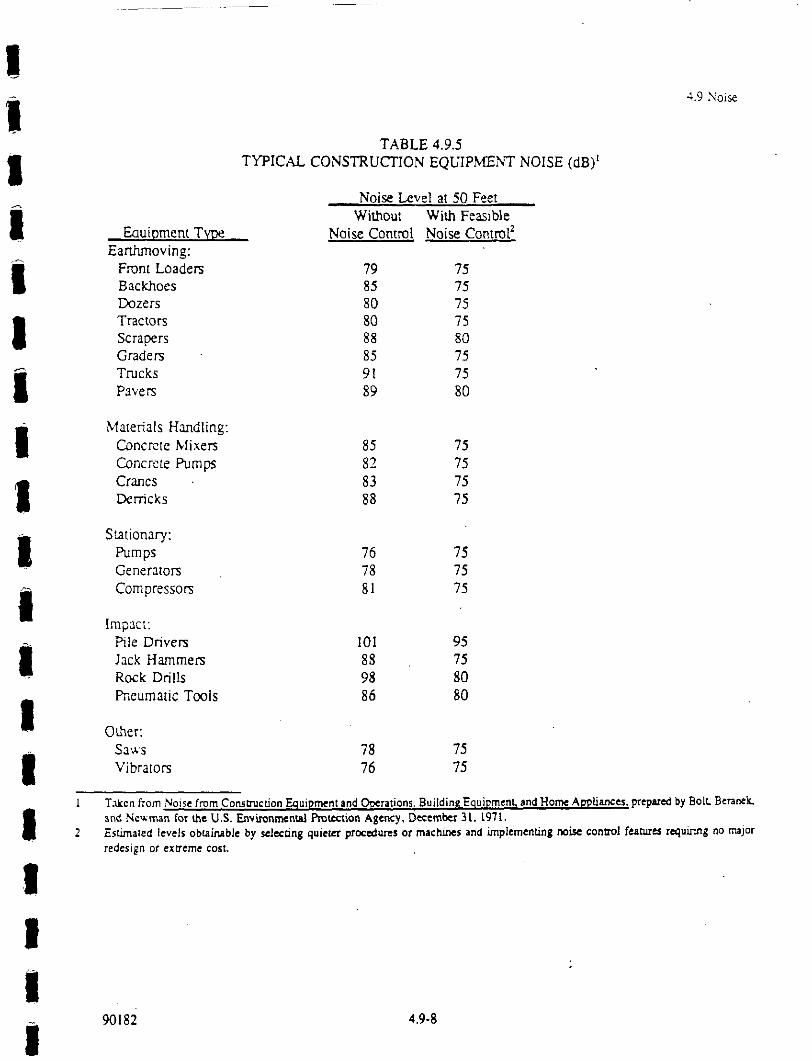
III
Iiii!iIIIiI
..9 Noise
TABLE 4.9.5TYPICAL CONSTRUCTION EQUIPMENT NOISE (dB)
Noise Level at 50 FeetWithout With Feasible
Eouiment TV Noise Contrq,,l, Noise ControlEarthmoving:Front Loaders 79 75Backhoes 85 75Dozers 80 75Tractors 80 75Scrapers 88 80Graders 85 75Trucks 91 75Pavers 89 80
Materials Handling:Concrete Mixers 85 75Concrete Pumps 82 75Cranes 83 75Derricks 88 75
Sationary:Pumps 76 75Generators 78 75Compressor 81 75
Impact:Pile Drivers 101 95Jack Hammers 88 75Rock Drills 98 80Pneumatic Tools 86 80
Oer:Saws 78 75Vibrators 76 75
Taken from Noise from Cons,t:l’tacfion Equipment sd Crations, Building Equipment) md 1-1ome Applia.mes) prep y Bolk Be=neaNe for e U,S.vnntion Agey, Demr 31. I971.
2 Esaled levels obible by lng quiet prs or machs and plemenng tonalfrug no jor
redesign or exeme cost.
90182 1.9-8

|
IlIiIIIiI
4.9 Noise
The following measures would reduce Project impacts to a less-than-significant level.
Mitigation Measures
4.9-1(a) Construction activities shall be limited to the hours between 7 a.m. and 8 p.m. Monday throughSaturday and 9 a.m. to 5 p.m. on Sunday in order to minimize noise impacts.
4.9-I(b) Construction equipment shall be required to be mu)Ted or controlled. Contracts shall specify that
engiqe-driven equ(ment be fitted with appropriate noise mufflers. Copies of contracts shall be
filed with the Public Works Director prior to issuance ofpermits.
Orational Noi, Effects (Traffic and Gondola)
4.9.2 Noise levels exceeding 60 d/3A currently exist on all major arterials and most streets reviewed and
are projected to increase significantly as a result of cumulative development with and without the
proposed Project. Noise levels for the year 2005 with the project would not be noticeably higher
than noise levels projected without the project. The electrical gondola will not have a noise impact.
Both indoor and outdoor noise levels could exceed thresholds established by the Town. This is a
significant impact.
The largest increases between existing noise levels and predicted cumulative noise levels with and without the
proposed project occurred sduth of the intersection of Main Street and Minaret Road on Minaret Road. Increases
along this corridor would be perceived to be twice as loud as a result of increased traffic from cumulative develo-
pment. The incremental increase in noise from the proposed project to traIfic noise generated by cumulative
development would not be detectable. To te average person an increase in noise levels of 3 dB would be
perceived as just noticeable while a 10 dB increase in noise levels would be penzeived as twice as loud.
The increase in noise levels reported in Table 4.9.3 would be considered a significant adverse noise impact anyif it causes a substantial increase in the ambient noise level in areas sensitive to noise adjacent to the project site.
Based on the distances to the 60 dB contour, referenced in Table 4.9.3, receptors located inside this contour would
be subjected to an adverse significant noise impact from cumulative traffic noise.
An adverse significant noise impact would also exist if the proposed project assigned land uses which were not
in agreement with the land use compatibility standards for community noise, presented in Table 4.9.2. Setbacks
front streets generating noise in excess of 60 dB have not currently been defined for tlae proposed project and
90182 4.9.9
!!!!!
I!I!!
4.9 Noise
u,arefore a determination of the potential for a significant noise impact on a specific type of land use carmot at
this time be determined.
3.2,,. ,ondola wll not have a noise impact on the residents of the Town of Mammoth Lakes. The gondola wille!ectric sand will have a diesel back-up for emergencies. Both engines will be outside t.,he town. Noise
generated by eit,r engine will be below ambient noise levels at sensitive recelors.
N,itiation Me:sures
4.9.2(a) The proposed project shall be located or architecturally designed so the exterior noise levels ’ill
not exceed 60 dB apid interior noise le’els will not exceed 45 d.B. Design features could D1clude
setbacks, bernls, lald.caping and architectural features, adjacent to both arterial and Dlterior
streets.
4.9.2(b) vlulri-family buildings shall be located or architecturally designed so the interior noise le’el will
exceed 45 L,. As a minimum, multi-family housing shall comply with Title 24 of the CaliforniaAdministrative Code.
4.9.2(c) The project propotents shall work with Town staff ro implement transit alternatives to reduce
automobile trafjqc as outlhted in the Town’s Geteral Plat. Cumulative site development sha,’l be
revie’ed at each phase attd a trip reduction program developedfor current phase implemeta,qoa.
T3pical.’, a reduction in traffic of one-half would reduce the noise level by 3 dB.
CU|ULATIVE IMPACTS
The Project will contribute to an increase in noise levels resulting from increased tmc and population growth.
Noise exposure estimates resulting from project buildout and population gmwt,h have been analyzed in the Traffic
d Population sections. The resulting estimates are summarized in Table ,1.9-3. Mitigation measures ,.9-I
a.9-2 will reduce the impact of long-term noise. Implementation of the Town of Mammoth General Plan Noise
element will further reduce ambient noise levels.
90182 4.9-10

IIII
I
I
IIIIIIII
4.10 ARCHAEOLOGICAL RESOURCES

4.10 ARCHAEOLOGICAL RESOURCES
I SETTING
The North ViLlage project area is located within the Town of Mammoth lakes, along Minaret Road and
Main Street (State Highway 203). The legal location is within the northwest quarter of section 34. T3S.R27E. MDB&M. The archaeological survey studied a total of 90 acres, including the area considered in
the North Village Specific Plan. The North ViLlage Specific Plan identified existing and new developmentsto include construction of resort dweLling units, commercial and retail developments, and ski lift.
IIIIIIII
Background
The project area is located in territories that were once occupied by several ethnic groups: the Mono LakePaiute to the north, the Owens Valley Paiute to the south. Benton and Round Valley Palute to the east,
Monacbe to the west, and Southern Sierra Miwok to the northwest. The Paiute and Monacbe are Numic
speakers, of th.e Uto-Aztecan language family, while the Southern Sierra Miwok is a branch of the Utian
language family. The tribes from the Northern section of the Sierras. primarily the Mono Lake Paiule,
travelled the Sierras and would oflen unify with other smaller groups when searching for food. The
Owens Valley Paiute group usually stayed in one location year-ruund in permanent villages. Both LongValley and Owens Valley tribes traded many items in exchange for shell money, acorns, baskets, arrows,
a fungus used in paints, manzanita berries, elderberries, and squaw berries (Hall 1983:57-58).
Some items traded by the Owens Valley Paiute were salt. pinyon pine nuts, seeds, obsidian, sinew-backed
bows. rabbit skin blankets, deerskins, moccasins, mountain sheepskins, fox skin leggings, balls of tobacco,
baskets, basketry, water bottles waterproofed with pitch, wooden hot rock lifters, and red and white
pigments, in exchange for shell money (e.g., disc beads, tubular clam beads, and more recently white glass
beads), acorns and acorn meal. finely constructed Yokuts baskets, cane for at-tow, manzmita berries.
squaw berries, and elderberries from the Monache (Hall 1983:56-57). The Mono Lake Paiute traded salt,
pinyon pine nuts, piuga, brine, fly larvae, rabbit skin blankets, baskets, pumice stones, and red and white
pigments to the Sierra Miwok.
IiII
Historical Background
The first non-lndians to travel through the Owens Valley were Euroamericans in the 1830s and the Owens
Valley later became an occasionally-used immigrant trail (Busby et al.. 1979:37-39). Prospecting and
mining east of the Sierra Nevada began in the 1850s: the Lost Cement Mine, near Mammoth Lakes, was
purportedly discovered in 1857. In 1861 the first permanent herds of cattle were brought into Owens
Valley to supply the growing population of the mining camps of the Inyo-Mono region. Due to grazing
by the cattle and the cutting of pinyon for lumber and firewood by the miners and ranchers, the Paiute’s
90182 4.10-1

I
IIIIIIIIII
!!II
4.10 Archaeological Resources
food supply was greatly reduced by the winter of 1862. The PaJutes and the new settlers engaged in manybattles over land and food during the next year. However. by I$63, the fighting was over and most of thePalute in the region were removed to a reservation at Fort Tejon. south of the Owens Valley.
With the ending of hostilities, settlement of the region continued unabated. In the 1880s cattle ranchingand lumber production replaced mining as the principal enterprise, although small-scale mining continued.
In the 1900s. Mammoth was promoted as a resort community. Recreation and tourism then became the
dominant industry in the region.
ARCHAEOLOGICAL BACKGROUND
Previous Work
Aside survey of archaeological resources was conducted by Jeffery F. Burton in February 1990. Two sites
and four isolas were recorded during this survey. The archaeological work identifies four major phasesof time in the Medithermal Period; pre-Newberry Period (Pre-1200 B.C.). the Newberry Period (1200B.C.- A.D. 600), Halwe Period (A.D. 600-1300). and the Marana Period (A.D. 1300-historic). Information
compiled from the various excavations and surveys provides a glimpse of Life ways during these periods.The pre-Newberry occupation of Long Valley may have been sporadic. During the Newbery period.
obsidian quarrying and biface pnluction, apparently for trade, appears to have become intensive. During
the Halwee and Marana periods, biface production diminished, and there is evidence of increasing direct
subsistence activity. Long Valley has lacked evidence of the shifts in direct subsistence that appear to
have occurred in Owens Valley. to the south. For example, occupation sites are usually associated with
riparian settings and were used throughout the Medithermal period (Bettinger 1982a: 112-114). However.there is some evidence that pinyon exploitation did not begin on any intensive scale in Long Valley until
the Haiwee period (after A.D. 600). and there may have been a partial abandonment or reduction in the
use of upland and desert scrub aas after ca. A.D. 1000 (Bettinger 1977).
A total of 90 acres was examined. The survey located and recorded four isolates and two sites. Of the four
isolates, only Six obsidian flakes and an obsidian core fragment were found. At the two North Village
sites. 1.100 obsidian flakes and flake fragments were found. Soil development for the majority of the
North Village site suggests the potential for subsurface deposits.
IMPACTS AND MITIGATION MEASURES
For the purpose of this EIR. the effect of any activity that has the potential to disrupt or adveely affect
a prehistoric, historic, archaeological or paleontological resource (except as pan of a scientific study) is
considered a significant adverse effect.
90182 4.10-2

IIIIIiIIiIIIIIIIIII
4.10 Archaeological Resources
Unless othenvise noted, all identified impacts ate considered to be significant adverse impacts.Corresponding mitigation measures, unless otherwise noted, would b sufficient to reduce impacts to a lessthan significant leveL
Cultural resources within the project area could be affected by direct and indirect adverse impacts. Directadve impacts would accompany ground-disturbing activities. The impacts would arise primarily fromgrading and other construction activities. Indirect adverse impacts would accompany the increase in
population associated with development. These indirect impacts, such as from "souvenir collecting,"uncontrolled excavation, vandalism, or off-road driving, also can be substantial over time (Wildesen
1982). It has been shown that the accessibility of sites to population centers and roads ate a major factorfor the vandalism suffered al a site (Lyneis et at. 1980),
The four isolates do not meet the California Environmental Quality Act (CEQA) definition of a significantcultural resource; these require no further archaeological work under the CEQA guidelines.
4.10-1 lvelopmnt of the proposed project could disturb prehistoric cultural resources. This
is a potentially stgqcant impac
North Village Site #1 may meet the CEQA criteria for impoant sites, for the site’s ability to address
scientifically consequential research questions. The site would be impacted by construction.
North Village site #2 appears significant. Due to its location and high visibility, the site is in danger of
slow degradation and is susceptible to casual collection and indirect impacts.
Mitigation
4.10-1(a)
Measure
North Village Site #1 shall be subject to subsurface testing and a thorough archaeological
survey prior to issuance of a permit for grading or construction. Iffound to be significant,
the site shall be avoided or excavated prior to any earth-disturbing activities.
4.10-1(b) North Village Site #2 shall be avoided or excavated prior to any earth disturbing activity.
All construcaon activity at this site and previogs, unexcavated sites shall be monitored by
a qualified archaeologist. If subsurface prehistoric archaeological evidence is found,
excavation or other construction activity in the area shall cease and an archaeological
consultant shall be retained to evaluate findings in accordance with standard practice and
applicable regulations. Data/artifact recovery, if deemed appropriate, shall be conducted
during the period when construction acavities are on hold.
90182 4.10-3

IIIIIIIIIIIIIIIIIII
4.10 Archaeological Resources
4.10-I(c) North Village #1 may meet the CEQA criteria for important sites, for its ability to addressscientifically consequential research questions. The site will be impacted by construct[on.
Although avoidance might be considered the preferred treatment for a buried site, the
adoption of any mit[gation measures would be premature before the site’s significance is
determined. In accordance with CEQA, any construct[on within the site area shall beprecededby data recovery. This will includ excavation of up ta five 25 by 25 cm shovel test units,
surface collection ofall surface artifacts, l#hic and obsidian hydration analyses and, possibly,
soil chemistry and obsidian source analysis. If no substantial subsurface deposit is
encountered, this work will also suffice for data recovery. No permits for grading or other
ear,h-disturbing activities will be issued until all appropriate mitigations are completed.
4.10-1(d) North Village #2 appears significant. The site is in danger of slow degradation even in the
absence of any construction. Its location and high visibility make it susceptible to casual
collection and indirect impacts. In accordance with CEQA, any construction within the site
area shall be preceded by data recovery Minimally this would include a sample surfacecollection, excavat[on ofat least six 1 by 1 m excavat[on units, analyses, curat[on of collectedmaterials, and a report. No permits for grading or other earth disturbing activit[es will be
issued until all appropriate mitigations are completed.
4.10-2 Construction activities could disturb previously unknown human burial sites of Native
American groups. This is a potentially significant Impact.
In the event that human burial sites are discovered during development of the proposed project, the
following mitigation measures would be implemented.
Mitigation Measure4.10-2 See Mitigation Measure 4,10-1; in addition, if human remains are discovered, work shall
cease and an appropriate representative of Native American Indian groups and the County
Coroner shall both be informed and consulted, as required by State law.
CUMULATIVE IMPACTS
The proposed Project al the series of related projects in the Mammoth Lakes area will not collectively
affect long-term impacts on cultural resources.
90182 4.10-4

IIIIIIIIIIIIIIIIII
4. I0 A:haeolo$ical Resources
REFERENCES CITED
Bettinger. Robert L..1977 The Surface Archaeology of the Long Valley Caldera. Mono county. California.
Archaeological Research Unit Monograph I. Riverside. California.
1952a Archaeology East of the Range of Light: Aboriginal Human Ecology of the Inyo-MonoRegion of C.ntral-Eastem California. Monographs in California and Great Basin
Anthropology I. Davis, California
Burton, Jeffrey F.1989 An Archaeological Survey of Minaret Road Extension, Mammolh Lakes. C_.a.liforrda.
MS. on f’de. Town of Mammoth Lakes, California, and CAl. Riverside, Califorrda.
Busby. Colin I., John M. Findlay. and James C. Bard1979 A Cultural Resource Overview of the Bureau of Land Management Coleville. Bodie.
Benton. and Owens Valley Planning Units. California. University of CaliforniaArchaeological Survey AnnuaI Report 1963-1964: 251-392. LOs Angeles. California.
Hall, Mardaew,. C.1983 Late Holcene Hunter-Gatherers and Volcanism in the Long Valley- Mono Basin Region:
Prehistoric Culture Change in the Eastern Sierra Nevada. Ph.d. Dissertation. Universityof C_.a/ifomia, Riverside.
Lyneis, Margaret M., David L. Weide, and Elizabeth yon Till Warren1980 Impact: Damage to Cultural Resources in the California Deset MS, on file, Bureau of
Land Management. Riverside, California.
Wildesen. Leslie E.1982 The Study of Impacts on Archaeological Sites. In Advances in ArchaeologicalMethod and
Theory 5, M.B. Schiffer, editor. Academic iss, New Yok.
90182 4.10-5

IIIi
4.11 AESTHETICS/VISUAL IMPACTS

IIIIIIIIIIIIIIIIIII
4.11 AESTHETICS/VISUAL IMPACTS
INTRODUCTION
A number of factors are evaluated in a visual quality analysis. These faqors include a definRion of the
landscape unit as described by its visual elements: landform, water, vegetation, and structures: a
determination of visual resource quality based on the uniqueness or desirability of a visual resource: aan evaluation of the site’s visibility, as it exists and as it may be affected with project implementation.
Collectively these factors are used in determining the visual impacts that could potentially occur with the
construction of a proposed project.
Visual features of the project site and adjacent areas were determined by conducting a photographic field
survey, and by examining aerial photographs and applicant drawings. The site survey was conducted on
October 17, 1990. A photo key map (’Figure 4.1 I-I) indicates the locations and direction-of-view from
which site photographs (Figures 4.1 I-2 through J,) were taken.
SETTING
The North Village Specific Plan area is located in the northwestern pordon of the Town of Mammoth
Lakes in the vicinity of the Main Street/Lake Mary Road and Minaret Road intersection. The 64.1 acre
site supports a mix of land uses !ncltding visitor-oriented retail, motels, a community center, municipal
maintenance yard. and a number of private homes and rental condominiums. These land uses currently
occupy approximately 50 percent of the Specific Plan area. The remaining portions of the site are for the
most part undeveloped and covered with forest. The site varies in elevation from approximately g0,;0 feet
in the southeast to 8070 feet in the northwestern portion of the site. Slopes are moderate throughout most
of the site, with small areas having slopes in excess of 30 percent. The site contains no prominent
ridgelines, land and water junctions, or other unique visual features.
Existing Views
The project site is generally bordered to the north by Forest Trail. to the south by undeveloped portions
of the Lodestar property, to the west by Hillside Drive. and to the east by single-family residential
development. Primary views to the sile are along sections of Minaret Road. Main Street/Lake Mary Road,
and from residential properties located to the west and north of the site. From off-site vantage points,
many views to the site and its interior are screened by tall pine trees. The approximate height of the forest
canopy in the project area is 120 feet.
90182 4.11.1

I ,Photo Key Map Figure 4.1__1-1
I i I:::
1

Site Photos Figure 4.11-2
IIIIIIII
Photo A: View to the project site as seen by motorists
Photo B: Axeas of the site located west of Minaret Road sh
90152
I

Site Photos Figure 4.11.3
IIIIIIIIII
Phoo C: View to the north along M/narct Road (Hwy. 203) shows the existing characmr of the su’ect
frontage and mid- to long-range views. This is the aa of Minaret Road planned for a pedestrian overpass.
Photo D: Photo shows the area of he site fronting the north side of Lake Mat,/Road This forestedridgeline extends north into the si above Miller’s Siding.
I

Site Photos Figure 4.11-4
!II!IIIII!I
IIII-III
Photo E: Fo-.t1dg of sire as seen by motoris approaching Ma/n Su-e.eI..ak Max,/Road,from the southern portion of Minaret Road.
Photo F: Extreme northern portion of the site adjacent to Highway 203. This aroa of the sit is
designated as open space in fle proposed Specific Plan.

II!i!III!!!iI
Ii!ii
4.11 Aesthetics/Visual Impacts
Development along Miharet Road includes low-rise commercial buildings and a number of two to four
story motels which exhibit a mix of architectural styles. Residential areas of the site, and those locatedto the west and east, are characterized by two to four story condominiums and one to two story singlefamily residences. Arctecmral styling tttroughout these residential areas emphasizes the Town’s alpinecharacter through the ue of gabled roofs, timbers and wood exteriors.
The most visually prominent areas of the site include the intersection of Main Street and Minaret Road,
and the areas located immediately east and west of Minaret Road. Parking lots, commercial buildings,and hotels establish the visual character of these areas (Figure 4.11-2). While short-range views to these
areas are not significant, development along the v sually prominent sections of Minaret Road and Main
Street/Lake Mary Road is enhanced by the background provided by the forested areas of the site, Fromboth Minaret Road andl Main StreeLake Mary Road, there are significant long-range views of distaat
mountains to the north, south and west (Figure 4.11-3). These view corridors are particularly significant
due 1o the high level of vehicular travel along these major roadways. Areas of the site fronting Lake MaryRoad west of Minaret Road are also visually prominent.
Two distinct areas of thd site remain undeveloped and heavily forested; the southern portion located acrossStreet/LkeMain Mary! Road, and the extreme northern portion of the site which is designated in the
proposed Specific Plan as Open Space (Figure 4.11-4).
Plans and Policies
The Ton of Mammo Lakes General Plan (adopted October 14, 1987). Conservation and Open SpaceElement. sets forth a nulmber of goals and policies that are intended to encourage development that will
be sensitive to and compatible with the natural environment and scenic resources of the community. The
Conservat|on and Open, Space Element emphasizes that retention of the Town’s alpine character is
essential to its livability and continued economic viability. The policies stated in the element are
implemented through th Design Review Ordinance. No. 86-12. of the Municipal Cnde. and the Town of
Mammoth Lakes Desigl Review Manual. The Design Review Manual provides citizens and project
proponents with the deslign criteria and standards that are used in evaluating development plans.
The fotlowing impact analysts and the mitigation measures included in this section are intended to
reinforce and ensure coistency with the goals, standards, and policies contained within the Conservation
and Open Space Elcmdnt.Review Manual.
90182
the Design Review Ordinance, and the Town of Mammoth Lakes Design
4.11-6

4.11 Aesthetics/Visual Impacts
IMPACTS AND MITIGATION MEASURES
i
IIIIi!iII!I!!iI
The proposed Noah V,illage Specific Pfn would include the construction of approximately 2,000 new
hotel/motel lodging uts, and 400 new condominium units. Areas of the Specific Plan not developed for
lodging purposes woul,d be developed with visitor-oriented commercial uses.
proposed Nor lVitlage Specific Plan designates the maximum height for full-service hoelThe
development in the West Plaza area at 100 feet from natural grade or plaza level 7 with a maximum
average building height of 65 feet. Outside of the West Plaza aa full service hotels would have a
maximum allowable height of 65 feet and all other buildings would have a maximum height of 55 fee.
In order to establish cohesive visual image for the North Village aa. the Specific Plan providesarchitectural guideline’,s which are intended to define acceptable design parameters for proposeddevelopments. The mast important aspect of the guidelines is the proposed establishment of a Design
Review Committee to tvaluate architectural and landscaping plans for individual development projectswithin the Specific PI area. The Committee would offer guidance in the overall design of a project, and
would ultimately deterhine a project’s conformance with the architectural and landscaping standards set
forlh in the guidelines. Commitlee members would include a representative of MMSA. a representativeof the plaza area develo,pers/landowners, a developer/owner of land in North Village outside the plaza, a
member of the Town f Mammoth Lakes Planning Department, and a local professional architect.
Standards of SignificanceFor the purposes of tiffs EIR, visual impacts are considered potentially significant where they have a
substantial, demonsu’ab,le negative aesthetic impact. This determination is based on several criteria,
including observer position, views, backdrop and the characteristics of the proposed development. The
visual character of the surrounding natural areas and the design context established by existing
development in the Twn of Mammoth Lakes are also taken into account in the determination of
significant visual impats. There is no quantitative method for assessing visual and aesthetic impacts; as
a result, determination ,of the significance of a particular effect may he expected to differ among viewers.
The following factors w,’ere taken into account: sho1-range, mid-range, or long-range views; development
character, grading effects on landscape and topography; significant difference in scale, massing and form
of the proposed project! within the surrounding context.
Unless otherwise not. all identified impacts are considered to he significant adverse impacts.
Corresponding mitigation measures, unless otherwise noted, would be sufficient to reduce impacts to a less
than significant level. Although not required by CEQA. some less than significant impacts are discussed
because they are gencr issues of local concern. Whle no mitigation measures are required by CEQA,
in some cases mlagation measures are proposed that would further reduce the level of impact.
90182 4.11-7

!iII!/i!!I!!I!i!!!!
4. Aesthdcs/Visul Impac.s
In assessing the overalllimpacts of the project, a significant area of forested land within the Specific Plan
area would be converte,d to a built use. The most significant and potentially affected views would be fromalong [he various roadways adjacent to the project site, and from the residential properties affected by theproposed gondola that Would connect [he site to the bas facilities of the Mammoth Mountain Ski Area.
4.11-1 Project development would change the physical and visual character of the project site.
This is a significant impact.
Approximately 27 acre of the project site and additional areas off-site would be converted from forest
to built uses and to accommodate a ski-back run and gondola. Three acres located at the extreme north
of the site would b re[amed as open space and for use as a sloer maa’shalling area and bus stop. The
increased density of deyelopment with project construction, and the subsequent loss of open space and
forest, would be consid[red a significant visual impact.
Mitigation Measures4.11-1 (a) To the maximum extent feasible, the proposed project shall retain forested areas, and shall
remain subordinate to the natural character of the site and the surrounding landscape.
4.11-l(b) Prior to fial approval of project development plans, the applicant shall submit a tree
preservatioh and replacementplan prepared by. a professionalforester, arborist or landscape
architect. Trees shall be replaced on a one-to.one basis with as many trees retained on-site
as possible.i Where the trees have to be relocated off-site, the locations shall be determined
through co, ultation with the Planning Director. The preservation and replacement plan.
including te type, si:e, number, and location of replacement trees shall be subject to the
approval oflthe Town ofManmoth Lakes Planning Deparm,ent.
4.11-1(c) Contour grading shall be used to blend mam(actured slopes into the natural terrain.
Grading shall be mmtmtzed to preserve extsnng landform and vegetanon to the greatest extent
possible.
4l l-l(d) In order to ’reduce visual impacts, a forested buffer averaging no less than lOO feet sball be
retained al,ng Lake Mary Road, the southern extension of Minaret Road, and along the
western and eastern edges of the project site. Special buffering and height restrictions shall
be given to !he hotel that is proposed for development across Forest Trail from the Town’s
community enter.
4. I 1- l(e) The landscape designfor the site shall maximize the use ofexisting vegetation, and where new
plants are tntroduced, they shall include, and/or blend with, plants native to the Mammoth
90182 4.11-8

IIIIII
4.1 Aesthetics/Visual Impacts
Lakes environment. Landscape Plans.for the site shall be completed by a certified landscapearchitect.
4.11-1 (f) To the maximum extent feasible, native trees and landscaping shall be concentrated aroundall structur, es located on the project site.
4.11-l(g) Grading shall utilize decorative retaining walls rather than slopes to minimize the area of
disturbancie.Full implementation of these mitigation measures would reduce visual impact 4.11-1 to a less-than-significant level.
I!
4.11-2 Existing views from off-site residential areas, and on-site hotels will be permanentlyaltered with development of the proposed gondola. This is a slgntcant Impact.
The approximately 1-mile route for the gondola that would connect North Village plaza with MMSA base
facilities would pass directly through the mammoth slopes residential area located to the west of the
project site. Cabins spaced a distance of 100 feet. and suspended from a height varying from 36 to
approximately 90 feet Would be highly visible, passing over,residential streets and between one and two
story homes and two-(o-five story condominiums (Figures 4.11-5 and 4.1 I-6). Although a 20-foot air
rights easement has bee:n secured along the majority of the route, there is not a cleared ground level right-
of-way. As a result, ainumber of developed properties would be located directly adjacent to the towers
and or directly below ,the gondola cabins. In some instances, where taller condominiums are located
alongside the gondola !route, the cabins could be visible from the windows of individual condominium
units. Homes and conlominJum units not located directly adjacent to the gondola route could also have
indirect views to the g’ondola from interior windows. Where trees do not adequately buffer views, the
gondola cabins and to’ers would also Ix) highly visible from other outdoor axas within [he Mammoth
slopes neighborhood. Additional visual impacts could also occur within the project site as units from the.hotel planned along le western ridgeline could potentially view the gondola from their north-facing
windows.
IIIII
Mitigation Measures4.1 l-2(a) The height of the proposed gondola shall be maintained at or near a maximura ofgOfeet (just
below the ree line), in order to protect views from adjacent residential buildings.
4.11-2(b) To the maximum extent feasible, existing trees located along the gondola easement shall be
retained. eplacement trees, in addition to those existing, shall be planted adjacent to the
90152 4,11-9

Proposed Gondola Route Figure 4.11-5Norlh VillageSpecific Plan Area
J’foposed IAM INLX
(;ondola Roule
WARMING

Gondola Schematic Figure 4.11-6
!I
85’
60’
30’
!I

i
I
I
II
4.! Aeslhecs/VisuM Impacts
4.11-2(c)
gondola easement (with property owner approval) in order to create a buffer that will protect
privacy and minimize visual impacts on affected properties.
Natural earth-tone colors and non.glare, non.reflective materials shall be used for the
gondola towers alut cabins.
Notwithstanding these mititigation measures, impacts related to the visual, effects of the proposed gondolawould remain significant.
4.11-3 Existing views to the project site from Minaret Road and Main Street]Lake MaryRoad will be permanently altered.
Distant views from motorists and pedestrians traveling along Minaret Road and Main Street/Lake MaryRoad would not be significantly affected by the proposed gondola.
The proposal pedestrian overpass connecting the eastern and western components of the North Village
Plaza would extend across Minaret Road, screening forest and mountain views from motorists traveling
north along the road (Figure 4.11-3).
Views from both Minaret Road and Main Street/Lake Mary Road would also be affected by the
intensification of development, and by potential 1130 foot maximum hotel heights in the area limited to
West Plaza. Hotels potentially having the greatest impact on views and on the visual character of the area.
are those which could Ix located on the ridgeline in the western portion of the site. and adjacent to Lake
Mary Road. Due to the higher elevations of these sites and their proximity to major roadways, these
areas, if developed to their maximum height, could be visually obtrusive and contrary to the Town’s goal
of encouraging development that is sensitive to and compatible with the natural environment and scenic
resources of the community)
Other aspects of the project that have not been defined at this time including building heights, massing,
landscaping, type of construction materials, and exterior colors -.could have a negative visual effect on
the Town’s environment if not properly guided and controlled.
Mitigation Measures
4.1 l-3(a) Adoption of the North Village Specific Plan shall include all provisions for design review
stated in the Plan, with all phases and developments proposed within the Specific Plan area
undergoing review by a Town-appointed Design Review Committee andlor Plammg
Commission.
90182 4.11-12

Ii
III
4.11-3(b) The design and height limits of hotels along the ridgeline in the western portion of the site,
and along Lake Mary Road, shall be card., reviewed for visual impacts. The height,massing and visibility of these hotels shall respond to, and be compatible with, the natural
environment aJut "Town" character ofMarrmwth Lakes.
4.11-3() The architectural style for the development shall blend with the site’s natural setting.
Rooflines shall reflect the slope ofthe site, and natural "earth tone" colors and materials such
as stone and wood shall be emphasized. Project development plans (Use Permits & Building
Permits), shall be subject to rewiew by the Town ofMammoth Lakes Planning Commission.
4.1 l-3(d) In order to reduce the visual impact of the proposed Minaret Road pedestrian overpass, the
structure’s height and visual mass shall be kept to a minimum. The design and materials used
for the overpass shall be compatible with the materials and architectural character ofNorthVillage.
Full implementation of these mitigation measures would reduce impact 4.11-3 to a less-than-significant
level.
CUMULATIVE IMPACTS
The cumulative impacts of development in the Town of Mammoth Lakes on visual quality cannot
assessed without a review of site-s’pccific development plans. However, it can be assumed that plarmed
and future development in the area will alter the visual character of the Town. particularly where forested
areas are replaced with structures, roads, and parking lots. In some cases new, new development may
obstruct or degrade scenic views from highways, residential areas, and public gathering spaces.
90182 4.11.13

I
IIIi
I. Town of Mamn
90182
4.11 Aesl/e6cs/Visual Impacts
ENDNOTES
)th Lakes General Plan, Conservation aad Open Space Element, October 14, 1987.
4.11-14

IIIIII 4.12 LIGHT-GLARE
IIiIiiIII,,I

III!IIIiIIiI
III!II
4.12 LIGHT-GLARE
SETTING
As a result of project development, intrusive light and glare often occur in the vicinity of a project. There
are primarily two sources of light intrusion: 1) light emanating from the inlerior of a strucre and passgthrough windows: and 2) light from exterior sources, such as street lighting, building illumination, security
lighting, and landscape lighting. Glare mainly results from sunlight reflection off flat building surfaces,
with glass typically contributing to the highest degree of reflectivity, Light intrusion can be a nuisance
to adjacent residential areas and if uncontrolled can disturb wildlife in natural habitat areas.
The existing site does not produce undue light and/or glare impacts to adjacent uses. Ground surfaces are
generally nonreflective, and there are no significant light generating sources.
IMPACTS
Levels of lighting on-site would increase with the implementation of the proposed project. External
lighting systems would be introduced for safety and security. Street lights may also be extended into new
area of the project site. Internal lighting systems would not be of an intensity that would cause impacts
to adjacent residential areas. The most light sensitive receptor would be residential and hotel uses located
adjacent to the project site.
4.12-1 Exterior lighting, specifically street lighting, if not controlled, could have significant
impacts on adjacent residences and hotels.
Mitigation MeasureS4.12-1(a) A exterir ighting sha be designed and lcateds as t avid intrusive eects n adjacent
residentialproperties and undeveloped areas adjacent to the project site. Low-intensity street
lighting azwl Iow-intensi. exterior lighting shall be used throughout the development to the
degree feasible.
4.12-1(b) Lighting usedfor various components of the developmentplan shall be consistent with North
Village Specific Plan implementation standardsfor light intensity levels,fixture height,fixture
location, and design.
90182 4.12-1

IIIIIIIIIIItIIIIIII
4.12 Light-Glare
4.12-1 (c) Vegetative buffers shall be used to reduce light intrusion on residential development and on
forested areas located adjacent to the project site.
4.12-2 Sources of reflective glare could emanate from window glass (including the gondola
cabins), and from other construction materials. The use of reflective glass and other
materials could have significant impacts on adjacent land uses, pedestrians, and
motorists traveling along Minaret and Lake Mary Road.
Mitigation Measure4.12-2 The project shall use mininmlly reflective glass and all other materials used on exterior
buildings and structures (including the gondola cabins and towers, shall be selected with
attention to minimizing reflecave glare.
90182 4.12-2

IIIlIIIIIII
IIII
ENDNOTES
The Town of Mammoth Lakes curndy has a sign ordinance prohibiting neon signs: thus,
not I any gb’ from signs.
901824.12-3
,igh.G|are
would

IIIIIIIIIIIIIIIIIII
4.13 PUBLIC SERVICES/FISCAL IMPACTS

iIIIIIIIIIiIIIII!I
4.13 PUBLIC SERVICES/FISCAL IMPACTS
PUBLIC SERVICES
SNOW REMOVAL
CALTRANS provides snow removal services or State Highway 203 (Minaret Road and Main Street) from
the junction of State Highway 395 to the Mammoth Mountain Inn. Snow removal service for all other
publicly maintained roads is provided by The Town of Mammoth Lakes Public Works Deparmaent. Roads
and paved surfaces on privately maintained areas, such as the plaza, project sidewalks, and private roads
will be the responsibi!Jty of the North Village maintenance district. The Town considers current snow
removal activities adequate to meet exisdng needs.
SCHOOLS
Mammoth Unified School District provides public school services for Mammoth Lakes. The two District
facilities are Mammoth Elementar School (K-6). located on Meridian Boulevard. and Mammoth High
School (7-12). located at the intersection of Sierra Park Road and Meridian Boulevard in the GatewayDistrict, Mammoth Elementary has a present enrollment of about 500 students with a 513 student
capacity, while Mammoth High has a present enrollment of about 300 students with a 366 student
capacity.:
POLICE PROTECTION
The Mammoth Lakes Police Depanment provides police protection set ces and parking erfforcement to
the Town. The Department staff is currently made up of fifteen sworn officers and six non-sworn
personnel. The sworn officers consist ofone chief, one lieutenant, three sergeants, one detective. and nine
patrol officers, The non-sworo personnel are made up of one clerk dispatcher, one community service
representative, one secretary, a part-time clerk, and two staff persons in charge of the Animal Control
Division. Police facilities include six patrol cars and a police station located near the intersection of Old
Mammoth Road and Chateau Road. Non-emergency response time averages 8-10 minutes, wle
emergency response time is typically less than two rainutes) In event of natural disasters such as
earthquakes and olcanJc eruptions, the County Sheriff is responsible for implementing the Mono County
Emergency Plan. Traffic control and accident investigations for State Highway 203 are performed by the
Highway Patrol.
90182 4.13-1

IIIIIIIIIIIIIIIIII
4.13 Public Services/Fiscal Impacts
FIRE PROTECTION
Fire protection and emergency response to the urbanized portions of Mammoth Lakes are provided by t.he
Mammoth Lakes Fire Protection District. Properties surrounding the Town are within the Inyo NationalForest and are therefore protected by the U.S. Forest Service, as is the Mammoth Mountain Ski Area. The
Fire District will assist in fighting structural fires in the Forest if requested by the Forest Service. TheDistrict covers approximately 8 square miles and operates from two fire stations, one located at teintersection of Main and Pinecrest Streets the or/mr on Old Mammoth at the Snowcreek subdivision
entrance. The District facilities consist of four engine companies, two truck companies, one heavy-duty
rescue truck, and one ambulance. Fire District personnel consists of 65 volunteer firefighters and six
paramedics.4
IMPACTS AND MITIGATION MEASURES
SNOW REMOVAL
,1.13-1 Snow removal requirements will increase as a remit of street improvements and the
development of the pedestrian plaza. The closing of Canyon Boulevard. will result in
accessibility problems for the removal of snow from the plaza. This is a significant
impat.
Mitigation Measures
The project would have a less-than-significant impact on snow removal services pursuant to the
incorporation of the following mitigation measures:
4.13-1(a) All project road alignments and project phases shall be designed to provide the necessary
snow storage areas as determined by the Town Department ofPublic Works. Snow storage
areas shall equal at least 70 percent of the surfaces to be cleared.
4.13- Co) All buildings, walkways and pedestrian open spaces shall be located a minimum of 20 feet
from the roadway edge to limit the amount of snow storage/blowing interference.
4.13-1(c) Alternate methods ofsnow removal, such as radiant heat decking, shall be implemented in the
plaza area. Access to the plaza shall be provided at all times to provide for snow removal
services.
93192 4.13-2

IIIIIIIIIIIIIIIIIII
4.13 Public Services/Fiscal Impacts
4.13-1(d) Parka’ng garage entry, points shall avoid north-facing orientation. Design solutions shall beimplemented to prevent blowing and drifting snow from accumulating in the garage entry
area.
4.13.1 (e) Sloping roofs shall be designed so as not to shed snow onto adjacent properties, parking lots,
wallo,ays or other passage ways.
4.13-I(t3 The Town and CALTRANS shall retain the right to cover with snow an?/’ side,alks located
adjacent to streets during snow removal activities.
4.13-l(g) No snow removal activities, except that which is performed by the Town or by CALTRANS,
shall be allowed to deposit snow within the public rights-of-way.
4.13-I(h) To avoid ice build.up, all structures shall be oriented to prevent shading of streets and
pedestrian areas to the fullest extent feasible.
4.13-10) Clearing ofprivate roads shall be handled by the North Village ma#ttenance district.
4.13. (j) Snow associated with the plaza will be hauled off-site and deposited at a suitable location.
SCHOOLS
4.13-2 The project is anticipated to produce approximately 373 students (see section 4.5
Jobs/Housing Relationship), resulting in an overcrowded situation for School District
facilities,s The cumulative impact of the proposed projects within the Town, including
North Village, will result in the need for a new elementary school. Each new student is
expected to cost the district $11,000 in capital facilities plus an additional $4,760 in
operating cost? This is an unavoidable, slgnCicant impact.
The inconporation of this mitigation measure will not reduce project impacts to a less-than-sigmficant
impact unless funding levels provided by State law are dramatically increased.
Mitigation Measure
4.13-2(a) The project proponent shall pay school impact fees under the provisions of AB 2926 or
provide equivalent alternative mitigation as determined by the School District.
90182 4.13-3

IIIIIIIIIIIIIIIIIII
4.13 Public Services/Fiscal Impacts
4.13-2(’0) The project proponent may volunteer to designate a portion of the project site to the District
for the purpose of constructiong a new elementary school facility or to participate in a
proporffonate share of a school site of another location.
POLICE PROTECTION
4.13-3 The population increase resulting from North Village will require a 24-hour patrol of the
project area. Service calls associated with North Village are expected to increase 15 to
30 percent. The closing of Canyon Boulevard between Minaret and Hillside, along with
the overall pedestrian emphasis of the project, results in limited access to motor vehicles.
As a result, patrols will be conducted on foot or bicycle and thus, response time wilt be
longer. This may also be true for areas surrounding North Village as a result of the
closing of Canyon Blvd.) This is a potentially significant impact.
Mitigation Measures
The p3ject witl have a less-than-significant impact on police protection services puuant to the
incorporationof the following mitigation measure:
4.13-3(a) All conceptual atwlfinal development plans shall be reviewed by the Mammoth lke Police
Department for crime-prone design features prior to plan approval Police Departmentrecommendations shall be included in final plans.
4.13-3(b) If not provided by the developer, phasing plans shall also include the provision of policeprotection by the Town.
4.13-3(c) The Project proponent shall contribute sufficient fund.t to the Town ofMammoth l.kes forthe cost ofpurchasing one patrol car.
FIRE PROTECTION
4.13-4 The dosing of Canyon Boulevard will result in an access problem both to the rear of the
proposed buildings and to surrounding residential areas; thus, access for delivery service
will not meet District requirements. Intensive new development within the Town will also
result in a need for a new aerial ladder truck. There is also concern over pumping
capacity within the project area. This is a potentially slgnticant tmpact.
90182 4,13-4

IIIIIIIIIIIIIIIIIII
4.13 Public Services/Fiscal Impacts
Mitigation MeasuresThe project is anticipated to have a less-than-sisnificant impact on fire protection services pursuant to theincorporation of the following mitigation measures:
4,13-4(a) A fire lane shall be dedicated to all of the commercial properties of North Village. Accessto all structures shall comply with Mammoth Lakes Fire Protection District Ordinance #85-
02. Access roads shall be ofan approved hard all-weather surface andshall have a minimum
clear unobstructed width of 20 feet. All access roads shall have a minimum vertical
clearance of 15 feet. Access roads shall have a grade of not more than ten percent. To
provide for aerial ladder access to building roof tops, a minimum 20 ,foot wide access road
shall be providedfor each structure located not more than 25feetfrom the structure, but no
closer than one footfor every three feet of building height. This access road shall have a
grade of not more than three percent and shall be clearly posted "No Parking -Fire Lane."All high-rise structures (defined by the District as ary structure exceeding three stories or 35
feet in height for nonresidential structures and 55 feet for residential structures) shall be
required to have approved Fire Department access roads to at least two sides ofthe structure.
One ofthese access roads shall be on the side of the building with the longest continual rooflihe. Fire Department access roads that are 150feet or more in length shall be providedwith approved fire apparatus turn.arounds. The required width and height clearances forFire Department access roads shall be maintained. A lane shall also be designed within
North Village to allow access to surrounding neighborhoods.
4.13-4(b) The project proponent shall pay. a one-time mitigation fee for construction of the project,
based upon building height, and another one-time mitigation fee on project operations. Both
fees are to be determined by the Fire Protection District and collected by the Town.
4.13-4(c) Ira smoke tower or stairway is used as a required exit for a structure, that exit shall have
an unobstructedpassage ofnot less than sixfeet in width the to Fire Department access, and
not less than three feet in width from that point to the public way.
4.13-4(d) An approved water supply system capable of supplying requiredfireflowfor fire protection
purposes shall be provided to all premises upon which buildings or portions ofbuildings are
constructed. The establishment of gallon.per-minute requirements for fire flow shall be
based on the "Guide for Determination of Required Fire Flow" published by the Insurance
Service Office.
4.13-4(e) Fire hydrants shall be located and installed per Fire Department standards and approved by
the Fire Chi On-site fire hydrants shall be provided when any portion of the building
90182 4.13-5
IIIIII!iIIIII!I!!II
4.13-4(I)
4.13-4(g)
4.13-4(h)
4.13-4(i)
4. 3-40)
4.13-4(k)
4.13-4(1)
4.13 Public Services/Fiscal Impacts
protected is in excess of 150 feetfrom a water suppb" on a public street, or as required bythe Fire Chi
Fire hydrants and access roads shall be installed and made serviceable prior to and duringtime ofconstruction. All hydrants shall be properly identifiedper Fire Department standards.
An approved automatic fire extinguishing system shall be installed in all covered parkhgareas and other structures having: a foundation fooqrim of 5,000 square feet or more; a
height of more than 35 feet (50 feetfor residential condominiums or apartment buildings);or a height of more than three stories. Fire extinguishit,g systems shall also be installed forall other occupancies designatedfor this system in the Uniform Fire and Uniform BuildingCode, or structures identified as special hazard occupancies as outlined in the appropriate
National Fire Protection Association pamphlet.
Fire standpipe systems shall be installed in conformance with National Fire Protection
Association Standards and the Uniform Fire Code.
Incorporation ofotherfire protection methods, as necessary, in undergroundparking garages
and high-rise structures based upon building construction, size, and adjoining occupancy.’pes, shall be determined " the Fire Chief upon formal plan submission.
All vehicular bridges and pedestrian bridges shall comply with fire apparatus access road
requirements in regards to minimum width and height clearances.
Liquidpetroleum gas storage and yystem installation shall comply with Mammoth Lakes Fire
Protection District Ordinance #85-02, which establishes and regulates the storage of liquid
petroleum gases.
The developer shall contribute afair share proportional amount as determined by theMLFPD
for the purchase of a new aerial ladder.
RECREATION AND PARKS
4.13-5 The proposed project would create a demand for approximately 14 acres of parkland.
This is a potentially sign(ficant impact.
As providcd by the Quimby Act, and as stated in the Town of Mammolh Lakes Parks and Recreation
Element. 5 acres of parkland per 1000 people should b provided to off-set the increase in demand created
90182 4.13-6

IIIIIIIIIIIIII
IIII
4.13 Public Services/Fiscal Impacts
by new development projects. Based on this ratio and an estimated project generated population ofapproximatcly 2,828 he Nor Village Specific Plan development w@ create a demand for approximately14 acres of parkland.
Mitigation Measure4.13-5 To help off-set this increase in demand for parkland in the Town of Mammoth Lakes, the
project propoenent shall be required to help fund the dedication of an off-site park orrecreation facility.
90182 4.13-7

IIiI!iIIII!ii!!ii
4.13 Public Set’vices/Fiscal Impacts
FISCAL
The purpose of this fiscal impact analysis is to detemaine the net effect of the proposed North VillageSpecific Plan on the fiscal condition of the Town of Mammoth Lakes and local public agencies. Theanalysis will project the direct, current, public costs and revenues associated with the North Villagedevelopment.
The proposed North Village Specific Plan would have a net fiscal impact on various jurisdictions that
provide services to this project. The jurisdictions include the Town of Mammoth Lakes, the County of
Mono. the Mammotia Unified School District (MUSD). the Mammoth County Water DisUSct (MCWD).F;,re Protection District and the Southern Mono Hospital District. Capital and operating revenues and costs
are estimated, and a cost/revenue balance is calculated. Dollar amount are calculated in current (1990)
dollars. All projections of project revenues and costs are based on build-out.
SETTING
The North Village Specific Plan area consists of 41 separate parcels involving 36 different owners;
together, these parcels total about 64 acres. The current total taxable assessed valuation of the project site
is approximatily $17.8 million*. North Village Development is the largest land owner in the North
Village site with almost thirteen acres or one-fifth of the total land. All 41 parcels are located in the TaxArea Code (TAC) 10-6, which has a property tax rate of 1.08671 percent. This rate includes the Prop.13 one percent property tax rate and an additional .08671 percent for school, water and hospital bonds.
Based on the total taxable assessed value, the site generated $193,400. (See Table 4.13-1) In 1990. the
Town of Mammoth Lakes General Fund receives $11.100 or 5.72 percent of the total property tax revenue.
Other jurisdictions also receive property tax revenues: Mono County (37.45%), MUSD (19.46%), MCWD
(12.67%). Fire Protection District (5.86%) and the Southern Mono Hospital District (4.57%)2.
IMPACTS AND MITIGATION MEASURES
Development of the Specific Plan would generate demand for various services and utilities from the Town
of Mammoth Lakes, Mono County and various other public agencies. At the same time. development of
the Specific Plan would provide these jurisdictions with one-time and on-going revenues.
When the 2,400 unit hotel/condo and 251,000 square feet commercial/retail/restaurant development is
completed. North Village has the potential of adding about 2,800 people to the Manunoth Lakes area, with
2,240 people going to the Town of Mammoth Lakes (assumes 80 percent of the workers and family reside
in Mammoth Lakes. and the other 20 percent commute from communities such as Crowley/Hilton. June
Lake, Bridgeport, Lee Vining and Bishop). For more detail of employment and housing projections, see
the Jobs and Housing Relationship section of this EIR.
Ii
90182 ,1.13-$

IIIiIIIIII
4.13 Public Services/Fiscal Impacts
TABLE 4.13.1CURRENT PROPERTY TAX ALLOCATION BY JURISDICTION
Taxable Assessed Valuation
Property Tax Rate (10-6)$17,800,000
1.08671%
Tax TaxAgency Funds Apportionment Revenue
Mono County 37.45% $72,400Mammoth Lakes 5.72% 11,100M.U.S.D. 19.46% 37,600Library 2.02% 3,900E.S.U.S.D. 10.24% 19,800Supt. School 2.01% 3,900Fire Protection Dist. 5.86% 11,300So. Mono Hospital Dist 4.57% 8,800Mono Co. Water Dist. 12.67% 24,500
TOTAL 100.1)0% $193,400
Source: Town of Mammoth Lakes Final Budget. Fiscal Year 1959-1990
!IIIIIII
TOWN OF MAMMOTH LAKES
4.13-6 The proposed Project would result in a net revenue for the Town of Mammoth Lakes.
This is a beneficial impact.
Mammoth Lakes provides public services such as general government, planning and zoning, police
protection, recreation and public works, all of which will be impacted by the North Village Specific Plan.
The largest expenditure of the 1959-90 General Fund was for police services. This accounted for 21
percent of the total expenditure. The primary revenue source for the Town is transient occupancy tax,
which generated almost half (48%) of the total General Fund revenues for the 1989-90 fiscal year.
One-Time RevenuesThese are revenues generated from the original construction of the site. These include building permits.
and water and sewer hook-up fees. These fees are structured to offset the cost of providing the respective
services. The total one-time revenues from North Village is projected at about $9.70 million, Mammoth
Lakes’ General Fund would receive about half of the revenues, at $4.56 million. Table 4.13-2, presents
the one-time revenues for the Town of Mammoth Lakes and the Mono County Water District
90182 4.13-9

!it!III!!II!I
4.13 Public Services/Fiscal Impacts
Butldin Permits
Residential building permit fees are based on the valuation of the structure. Additional fees, such asseismic, new construction, public works, state program surcharge, solid waste, and fire mitigation fees arealso added into the building permit fee9. Residential building fee amount to about $4.15 million and
commercial building fees about $410,300 for a total of over $,4.56 million.
TABLE 4.13.2ONE-TIME REVENUES FROM THE DEVELOPMENT OF THE
NORTH VILLAGE SPECIFIC PLAN(1990 Dollars)
Revenue Source Revenues
MAMMOTH LAKES GENERAL FUND:Residential Building Permit 4,151,500Commercial Building Pemit 410,800
$ 4,561,800
MCWD:Sewer Hook-upWater Hook-up
TOTAL REVENUES
2,378,8002,760,300
5.139,100
$ 9,700.900
Source: Mammoth Lakes Building Department, MCWD
Annual RevenuesProperty Tax Revenues
The property tax rate for the North Village site is 1.08671 percent of the total assessed value of the
property. Current assessed value of the land and existing structures is about $17.02 million. Currently..
Mammoth Lakes receives 5.72 percent of the property tax. As presented in Table 4.13-3, the project site
is projected to have a total assessed valuation of $16.10 million upon completion, Based on the current
property tax rate. the property tax revenue from North Village is projected at about $1.78 million.
90182 4.13-10

!!IiiIi!IIlI
4.13 Public Services/Fiscal Impacts
TABLE 4.13.3
PROJECTED TAX REVENUES FROMTHE NORTH VILLAGE SPECIFIC PLAN
s_q_Units F Value/Sq.Ft3 Assessed Value
Budget Hotel 600 500 $ 63Moderate 650 650 $ 63Full Service 700 800 $ 63Bed & Break. 50 500 $ 63Resort Condo 400 1,1130 $ 81Commercial/Retail 191,000 $ 63Restaurant 60.000 $ 70Skating Rink3
Ski Lft
Total Improvements
Total Land4
TOTAL
$ 18,900,00026,617,50035,280,000
1.575.0035,640.00012,033,0004,200.000
5,000.00
$140,145,500
$ 23,958.500
$164,104,000
1,._.Tax Rev.
$ 205,400289,300383,400
17,100387,3(3130,80045,6009,800
54,300
$1,523,000
$ 2,4
$1,783,400
tSquare footage estimates provided by developer.2Building Valuation Data. November-December, 1989 Building Standard.3Skating Rink and Ski Lifl cost provided by the developer.2% inflation adjustment for fifteen years allowed by Proposition 13.
II!i
90182 4.13-11

IIiIIiiiIi
4.13 Public Services/Fiscal Impacts
TABLE 4.13.4
NORTH VILLAGE PROPERTY TAX ALLOCATIONBY JURISDICTION
Taxable Assessed Valuation: $164.I04,000Property Tax Rate: 1.08671%
Tax TaxJurisdiction Apporlionment Revenu._..__e
Mono County 37.45% $ 667,900
Mammoth Lakes 5,72% 102,0(30M.U.S.D. 19.46% 347,100Library 2.02% 36,000E.S.U.S.D. 10.24% 182,600
Supt. School 2.01% 35,800
Fire Protection Dist. 5.86%. 104,500
So. Mono Hospital Dist. 4.57% 81,500
Mammoth Co. Water Dist. 12.67% 226,000
TOTAL 100.00% $1,783,400
Source: Town of Mammoth Lakes Final Budget. Fiscal Year 1989-1990
90182 4.13-12
4.13 Public Services/Fiscal Impacts
Property tax revenues from the proposed hotel and commercial development in the project area would
generate a significant amount of revenues for the Town. The Specific Plan would generate $102,000 in
annual property tax revenue to the Town of Mammoth Lakes at project bulldout. (See Table 4.13.4)
IIiiIIIi
Transient Occupancy Tax
According to the 1989-1990 Mammoth Lakes General Fund. transiem occupancy tax represented almost
half of the revenues. With 2,000 hotel rooms and 400 resort condomirfium units proposed for rent under
the North Village Specific Plan. a transient occupancy tax rate of nine percent would generate
approximately $5.66 million annually to the Town’s General Fundfl
Sales Ta,__.._.xThe Town of Mammoth Lakes’ General Fund receives one percent (1%) of the total taxable sales. Annual
taxable sales is based on an assumed sales factor of $150 per square feet of commercial/retail
development. The North Village Specific Plan proposes 191,003 square feet of commercial/retail spaceand 60.000 square feet of restaurant space; therefore, sales tax revenues would generate approximately
$436,5(30 to the Mammoth Lakes" General Fund. It cannot be detemined whether the sales revenue is
totally from new customers or customers attracted away from another store in town.
Franchise Tax
The Town of Mammoth Lakes is serviced by three privately operad utility companies. Southern
California Edison. Mammoth Disposal, and King Videocable Company. Based on a 1989 per capita utility
charge, revenues would amount to $74,900. Below is the per capita factors used to determine the
franchise tax:
Southern California Edison: $21.24
Mammoth Disposal: $3.85
King Videocable Company: $8.36
Business Tax
Business tax revenues are imposed on all business establishmem by the Town. Business tax is based on
the type of business established. Hotel and condominium units ate generally taxed at a rate of about $5. l0
per unit and commercial/retail at $207 per eslablishmem. Based on the number of businesses proposed
by North Village, revenues total $28,6002.
Other Revenues
Other revenues, which include license and permits, inU;rgovemmemal agencies, charges in services, police
fmes, interest on invesnents, were estimated based on a per capita basis, relying on the actual revenue
levels in the Town of Mammoth Lakes 1989-1990 budget. Total 1959-1990 revenues from this source
90182 4.13-13

Ii,l
tili
4.13 Public ServicesFiscal Impacts
accounted for 23 percent of Mammoth Lakes to revenue budget in 1989. As summarized in Table4.13.5, other revenues from North Village, at the time of completion, would generate $549,100.
TABLE 4.13.$OTHER REVENUES FROM THE NORTH VILLAGE SPECIFIC PLAN TO
THE TOWN OF MAMMOTH LAKES
Revenue Sources Protected Revenues
License and Permits $ 24.21 $ 54,200lntergovemmental 56.03 125,500
Charges for Services 76.46 171,300Police Fines 9.62 21,500Interest on Investments 49.04 109,800Misc. Revenues 29.81 66,800
TOTAL REVENUES $ 549,100
Source: Town of Mammoth Lakes Final Budget, Fiscal Year 1989-1990.
ExpendituresThe Town’s services wnicia would b affected by development of the Specific Plan include general
government, planning and zoning, public works, recreation, and poSce protection. Based on per capita
expenditures from the 1989-1990 Mammoth Lakes Budget, the annual expenditure is projected at about
$2.18 million. (See Table 4.13.6) Per capita expenditure factors are listed below:
General Government $ 340.54
Planning and Zoning $ 56.45
Public Works $121,30
Recreation $ 58.19
Public Services $ 253.34
Expenditure Contingency $ 26.69
Transfer to Gas Tax Fund $115.50
Cost/Revenue Balance
The total revenues to the Town of Mammoth Lakes generated from North Village at the time of
completion is projected at $6.85 mill/on, and the total cost is projected at about $2.18 million: thus, as
shown in Table 4.13.6 below, a sifive fiscal impact amounting to $4.68 million is projected for eTown of Mammoth Lakes.
90182 4.13-14

i
I!III
.13 Public Servicesisca Irnpacm
Mitigation Measure
4,13-6 None Required.
MAMMOTH UNrFIED SCHOOL DISTRICTImpact
4.13-7 The proposed Project would add 373 more students to the Mammoth Unified School
District and would result in a net cost for the District. This is an unavoidable, significant
impact.
During the 1989-90 academic year, there were 865 students attending school grades K-12 in the Mammoth
Unified School District. A current student/population ratio of 166 (865 studems/5,200 people) and a
projected population increase to the Town of Mammoth Lakes of 2,2,0 generate an additional 373 students
to the District.
School Impact FeesThe State enables school district to charge impact fees on new development in their jurisdiction to payfor capital facilities associated with increased students population. The District could collect $1.58 per
square feet of residential development and $.26 per square feet of non-residential development. As the
present time. MUSD is not collecting school impact fees.
90182 4.13-15

I
II
iI
4.13 Public Services/Fiscal Impacts
TART.I d_l 3_1t
ANNUAL FISCAL IMPACT OF THE NORTH VILLAGE SPECIFIC PLANON THE TOWN OF MAMMOTH LAKES’ GENERAL FUND
Revenue Sources Ne,t Impacts
Property Tax $ I02,000Transient Occupancy Tax 5,663.400Sales Tax 436,500Fnmchise Tax 74.g(X3
Business Tax 28,600Other Revenues 549,100
Total Revenues: 6,854,500
Costs
General GovernmentPlanning ZoningPublic WorksRecreationPolice ServicesExpenditure ContingencyTransfer to Gas Tax Fund
$ 762,800126,400271,700130,300567,500
59.800258,700
Total Costs:
NET REVENUES/(COSTS)
$2,177,200
$4,677,300
Source: Town of Mammoth Lakes Firal Budget, Fiscal Year 1989-1990.
90182 4.13-16

4.13 lblic Servicesiscal Impacts
Annual MUSD RevenuesThese revenues include propery tax and Average Daily ARendance (ADA) revenues. Property tax
revenues are projected to be $347.100. ADA revenues, money from the State to be spent on each student.is based on a rate of $3,400 per student. The added students from North Vil}age could generate as muchas $1.27 million.
Cost Per StudentEach student is expected 1o cost the District $4.760 in operating costs and $11,000 in capital costs.
Therefore, an additional 373 students would cost approximately $1.78 million in operating costs and $4.10
million in capital costs, totalling $5.88 million.
Mitigation Measure4.13-7 Implement Mitigation Measure 4.13-2(a) at 4.13-2(b).
MAMMOTH COUNTY WATER DISTRICT
4.13-8 The proposed Project is anticipated to generate a net revenue to the Mammoth
County Water District. This is a beneficial mlmct.
Sewer and Water Hook-up FeesSewer hook-up fees are based on rates of: $1.440/condo units; $824/hotel room: and $93.25/retail fixture;
and $93.80/rcstaurant seat. Water hook-up fees a calculated according to the rates: $1,442/condo unit:
$995/hotel room; and $I 17/retail fixture. One-time revenues generated by sewer and water hook-up fees
amount to $2.38 million and $2.76 million, respectively, for a total of $5.14 million. See Table 4.13.2.
CostRevenue Balance
Property tax aliocation is the annual revenue for the MCWD. At the time of completion, property tax
revenues will total $ 226,000. The increase in cost of providing water service on accoum of the
development is picked-up by the sewer and water hook-up fee and any new on-site facilities is the
responsibilily of the developer. Therefore, the North Village Specific Plan would be a net benefit to
MCWD in the amount of the property tax.
Mitigation Measure4.13-8 None required.
90182 4.13-17

!IIIiI
I
I
4.13 Public Services/Fiscal Impacts
FIRE PROTE(TI’ION DISTRICT
4.13-9 Th proposed Project would result in a net cost for the Mammoth Lakes Fire
Protection District. This is a I.timn.signOcant impacL
Fire Mitigation FeesA fire mitigation fee is included in the building permit as a one-time revenue. Based on square footageof building space, fire mitigation fees amount to $585.300.
Cost/Revenue Balance
Pr6perty ray amounts to $ 10,1.500 for the Fire Protection District. It was estimated by Fire Chief John
Sweeny. that the project would require the purchase of additional equipment at art annual cot to eDistrict of $175,000. Therefore. on an annual basis, the impact would be a net deficit of $70,500.4
Mitigation Measure
4.13-9 lraplement Mitigation Measure 4.13-4(b).
SOUTHERN MONO HOSPITAL DISTRIC-’]"
4.13-10 The proposed Project would contribute towards the Southern Mono Hospital
District’s annual revenues through payment of property taxes. This is a beneficialImpat.
Cost/Revenue Balance
Property tax from North Village will contribute to $81,500 towards the Southern Mono Hospital District.
No impact fees are imposed by the Mono County Hospital District. Currently there are enougia beds to
meet the demands of the project, and therefore, no additiotal costs to the District.Miti,ation Measure
4.13-10 None required.
MONO COUNTY
4,13-I The proposed Project would result in an undetermined net cost to Mono County.
This is a signqcant impact.
90182 4.13-18

I
IIIIII
IIIIIiiIII
#.13 Public Services/Fiscal Impacts
Cost/Revenue Balance
budget)e Based the countywide population of 9,900 people, the per capita expenditure is
approx/mately $I,260. Therefore, an increase of 2,800 people W the Coun would result in a eoretical
increase expendinre of approximately $3.53 million. Given that the ProjeCs property tax revenue wo-ld
only contribute $67.900, there remains a theoretical deficit of about $2.$6 million. However. Countyservices to Mammoth Lakes are limited since Town d special distrcts provide e bulk orgovernmental services.
Mitigation Measure
4.13- Nonefeasible.
90182 4,13-19

IIIIIIIII
IIIIIIIII
ENDNOTES
4.13 Public Services/Fiscal tmpacts
1. North Village EIR, Town of Mammoth Lakes, CA, 1989.
2..Communication with Richat McAteer, Superintendent, Mammoth Unified Schtxl DisWict, October19, 1990.
3. Communication with Michael Dormelly, Police Lieutenant, Mammoth Lakes Police Department.October 18, 1990.
4. Communication with .Ion Sweeny, Fire Chief, Mammoth Lakes Fire Protection District. October 18.1990.
5. Projection based upon student to population ratio.
6. Richard McAeer, S,perintendent of Schools. Mammoth Unified School District. telephoneconversation. June 1. 1990.
7.. Michacl Dormelly, Mammoth Lakes Police Deparanent, op. cir.
8. Mono County Assessor’s Office.
9. Permit fees and additional fees based on worksheets provided by Mammoth Lakes BuildingDepartment.
10. Assumes hotel occupancy rate of 67% at $117 a day and condomirtium occupancy rate of 33%.Market Study and Finaacial Analysis of Proposed 300-Room Hotel in Mammoth Lakes, by Kenneth
Leventhal and Company, 1989; and Steve Black, Mammoth Reservation Bureau, June 1990.
11. Tracy Fuller, Finance Director, Town of Mammoth Lakes, June 7, 1990.
12. Tracy Fuller, oo. cir.
13. Richard McAteer, Superintendent of Schools, Mammoth Unified School District. telephone
communication, June 1, 1990.
14. John Sweeney, Fire Chief, Fire Protection District, telephone communication, December 13, 1990.
15. Sally DePermt, Administrator. Mono County Hospil District, telephone communication. July 7.1990.
16. Onaika Wilkes, County Auditor, Mono County, tlephone communication, October 29, 1990.
90182 4.13-20

IIIIII 4.14 ENERGY CONSERVATION
IIIIIIIIiIIII

4.14 ENERGY CONSERVATION
iIIIIIIIIIII!IIII
SETTING
Electricity is provided to the Towa of Mammoth Lakes by the Southern California Edison Company.Propane gas is supplied by a number of private firms when requested by property owners. There is nonatural gas distribution system in the Town.
The electric power comes from both hydroelectric facilities and thermai generating plants which bum oil
and natural gas to generate eleca-icity. In an effort to improve current air quality conditions in Caiiforrfia.
many of the power generating facilities have been moved to other Western States such as Utah. Arizona
and Nevada.
The energy consumption of new buildings in Caiifomia is regulated under the State Building EnergyEfficiency Standards contained in Title 24 of the California Administrative Code. These efficiency
standards regtilate the energy consumption for air heating and cooling, water heating, ventilation, and
lighting. The building efficiency standards are controlled through the local building permit process.
Compliance with Title 24 can be achieved through either a "performance" or a "prescriptive" approach.
In the performance compliance approach, a building must be designed to consume no more energy than
specified in the appropriate energy "budget." The energy budget is based on building type and size. and
the climatic zone in which it is located. In the prescriptive compliance approach, a building must comply
with design requirements that have been determined to achieve building designs that meet the applicable
energy budgets. In ’,his approach, the builder can choose from a variety of alternative component packages
which specify features such as insulation, glazing, lighting, shading, and water and space heating systems.
IMPACTS AND MITIGATION MEASURES
Project Construction
4,14-1 The construction of the proposed project would involve the consumption of electricity and
fossil fuels. It is estimated that approximately 2,000 BTU of gasoline, diesel fuel, and
electricity are expended for every dollar of construction cost for fabrication and
transportation of building materials, worker transportation, site development, and building
construction: The construction process will also involve the consumption of water, mainly
for dust abatement purposes. This is not considered a significant impact.
90182 4,14-1
IIIIIIIIiII
IIIIII
4.14 Energy Conservation
Mitigation Measure4.14-1 None required.
Development of the proposed project would result in increased short- and long-term energy consumption.However, as there would be no need to develop new power plants or other supply systems other than tie-
ins to the existing electrical distribution systero, the project’s impact on the Town’s energy supply needs
is considered to be less-than-significant.
Project Operations
4.14-2 The project is anticipated to consume approxiroately 20,415,200 kilowatt hours (Kwh) of
electricity annually. This aggregate consuroption amount is made up of approxiroately6,432,400 Kwh for residential uses, 2,253,800 kWh for retail uses, 8,891,000 kWh for the
hotel rooros (based upon full occupancy), and 2,838,00 kWh for restaurant uses.: This is
not considered a significant iropact.
Development of the proposed project would result in increased short- and long-term energy consumption.
However. as there would be no need to develop new power plants or other supply systems other than tie-
ins to the existing electrical distribution system, the project’s impact on the Town’s energy supply needs
is considered to be less-than-significant.
The following mitigation measures are recommended to improve energy efficiency:
Mitigation
4.14-
4.14-2b
4.14-2c
90182
MeasuresEnergy efficient lighting (e.g., high-pressure sodium outdoor andfluorescent indoor lightingl
shall be used rather than less-efficient types. Where possible, miniature fluorescent lamps
shall be used rather than incandescent lamps infixtures. External lighting shall be controlled
by photocells and/or time switches. Internal lighting systems shall employ separate switching
schemes to ensure maximum use ofdaylight. Public area lighting, both interior and exterior,
shall be time controlledfor safety and protection.
Thermal insulation that meets or exceeds standards established by the State of California andthe Deparment of Building and Safe.’ shall be installed in all walls and ceilings.
Feasible opportunitiesfor passive or natural heating and cooling shall be incorporated in the
building desigtts, which could #wlude: tinted or solar reflective double glazing and heat
reflective draperies on appropriate exposures; windowless walls for certain exposures or
appropriate passive solar inset of wiadows; thermal insulation in walls which meets or

iIIIIIIIIIIIIIIIIII
4.14 -nergy Consecvaon
exceeds State and local standards; and placement of the focus ofpedestrian activity within
sheltered outdoor areas.
4.14-2d The incorporation of high efficiency air conditioning controlled by computerized energymanagement systems shall be installed to provide the following: variable air volume systems
which result in minimum energy consumption and which avoid hot water energy consump6on;100 percent outdoor air economizer cycles to obtainfree cooling during cool and dry climatic
periods; sequential operation of air conditioning equipment in accordance with buildingdemands; the isolaaon ofair conditioning to any selectedfloor orfloors; and time-controlled
interior and exterior public area lighting as necessary for security purposes.
4.14-2e The project sponsor should consult with the Southern California Edison Company forassistance with energy conservation design features and other passive energy designfeatures.
4.14-2f The feasibility of geothermal energy as an alternative energy source should be explored.
The project sponsor is required by law to demonstrate compliance with the standards of the Uniform
Building Code and Title 24 of the California Administrative Code prior to issuance of a building permit.
Furthermore. the following State laws require water-efficient plumbing fixtures:
Health and Safety Code Section 17921.3 requires low-flush toilets, as defined by the American
National Standards Institute Standard A112.19.2, and urinals lhat use less than an average of 1.5
gallons per flush.
Title 20, California Administrative Code Section 1604(0 establishes efficiency standards for
maximum flow rates of all new showerheads, lavatory faucets, and sink faucets.
Tide 24, California Administrative Code Section 2-5307(b) prohibits the installation of fixtures
unless the manufacturer has certified CEC compliance wilh e flow rate standards.
Title 24, California Administrative Code Section 2-5352(i) and Q) estabLishes pipe insulation
requirements for steam and steam-condensate return piping and recirculating hot water piping.
90182 4.14-3

IIIIIIIIIIIII!IIIII
4.14 Energy Consrkion
ENDNOTES
The British Thermal Unit (BTLD is th quantity of heat required to raise the mporature of one pound of water onedeuee Fahrenhei at se level. Energy use was estimated in accordance w/th Title 24 energy budgets shown /n theCalifornia Energy’ Comrmssion’s E,nerBy Efficiency Standards, 198.$ Edidon.
Projections based on generation rates of 16,081 kWh dwellLng units per year for residential uses, 11.8 kWh persquare foot of retail space per year. 6.8 kWh pel’ square foot of hotel space per year, and 47.3 kWh per square foot ofrestaurant space per year. These generation rates are aken from Air (uality Handbook for Preparm, EnvironmenlalImpact Reports, South Cot Air Qualit Manas,emem District. 1987.
90182 4.14-4

IIIIIIIIIIIIIIIIIII
5. LONG-TERM IMPLICATIONS OF THE PROPOSED PROJECT

IIIiIIIIIIIIIII!III
5. LONG-TERM IMPLICATIONS OF THE PROPOSED PROJECT
RELATIONSHIP BETWEEN LOCAL SHORT-TERM USES OF MAN’S ENVIRONMENTAND ENHANCEMENT OF LONG-TERM PRODUCTIVITY
The North Village Specific Plan will increase the density of existing development in the area from a sparsesemi-urban character to multiple-density residential, retail, and commercial use. The dcvelopmem of the
property will continue a long-term commitment by the Town to provide its curnt and future residents
with a wide range of housing types and services. Future long-term uses of the property would include
the development of the area as it residential neighborhood, commercial, retail and public space
developments.
Advantages of the near-term development of the project would be the extension of fly improved streets
and utdties to the area planned for future growda. Development of the project will also increase sales tax
revenue to the Town.
IRREVERSIBLE ENVIRONMENTAL CHANGES
The development of the project implies an irreversible commitment of resources. Building materials,
energy spent during consmction and energy spent during the operational phase of the project axe
essentially irreversible commitments of resources. Upon completion of tim project, naRiral resources
would be used by the occupants of hotels and condos, including feis used by project-generated traffic.
The proposed project would increase recreational and commercial demities on the site and would preclude
other uses of the site for the Lifetime of the project.
Increased human activity accompanying the development could further induce wildlife to decaease or
discontinue use of wildlife habitats. Effects on the scattered Jeffrey Pine-Fir forest are considered the most
sensitive to long term impacts on North Village’s limited natural ccosystetn productivity.
CUMULATIVE IMPACTS
The current Mammoth Lakes General Plan and the currant Zoning Ordinance density and land use
regulations permit the uses and design concepts of the North ViLlage Specific Hart. There is nothing
proposed in the Specific Plan that could not hitve been accommodated under traditional zoning
90182 5-I 4/’29
IIIIIIIIIIi,
IIIIIII
5. Long-Ten Implica.ons of the poed Project
clsificado d dertTocies. erefo. e developmem on No Vage repnm excd, pled md cmen sge in e developmem of eTo ofMoLes.
However, femnced in Mmo Les Gene Plm vimenp Re, each
incremnt developme conbu cecva effe. e ude:
ove cwill enmy exertponegmways md temeououte comm.
le deced r not en identified m anvimnp it cod
come a cve pt when viewed njon wi or le developmen
comemplated for Mmo Les.
e No ViSage development codc lev ofgecoei ado
nose n e plg em
e loss of es oer ve vegeon, when view conjon oer major
dvel6pmen pld forMoLes. cod coided a mveve effecL
e gem inc ine md war co.option for coon md hm imdon
cod place didonponegsoues. p,fion wres may
need to develop.
Sc dage. jud Io of Hfe cod amr ff a ble volcc or seiic event
we oc vic.
cedoaagmevoem of No Vag cod
conmbu to wamr dgpblems .Bd on fi ysis, No Villagej is exd ve a sifive Iong-te
fisc mpt on To ofoLes.
90182 5-2

IIIIII 6. GROWTH-INDUCING IMPACTS OF THE PROPOSED PROJECT
IIIIIIIIIIII

I!IIIIIIIIIIIIIIIII
6. GROWTH.INDUCING IMPACTS OF THE PROPOSED PROJECT
A discussion of the ways in which the prOposed prOject, directly or indirectly, could foster economic or
population growth in the surrounding envirOnment is required under Section 15126(g) of the CEQAGuidelines. Growth-inducing impacts include projects which would remove obstacles to population growthand projects which may encourage ,nd facilitate other activities that could algnificanfly affect "eenvironment, either individually or cumulatively.
Typically, e grow-da-inducing potential of a project either induces growth or creates the capacity to
accommodate growth above and beyond that which is permitted by planning policies or contained in
independent growth projections. However. the creation ofgrowth-inducing potential does not automaticallycause growth, whether it be a portion of the project growth or an actual increase over projected growthlevels. Growth at the local level is fundamentally controlled by the land use policies of local municipalitiesor counties, which are determined by the local politics of growth in each jurisdiction. Growth-inducingpotential or pressure created by economic and social conditions interacts with a loeality’s grOwth-management policy in the transformation of growth potential into actual grOwa.
The Town of Mammoth Lakes General Plan governs commercial and residential growth in the North
Village Specific Plan Area. This area is currently divided into several zoning units, including areas
characterized by a mixture of hotels and restaurants, some retail businesses, several office and service
businesses, and a condominium complex.
The North Village Specific Plan will create new employment oppomanities in the Town, both during and
following construction and, therefore, could direcdy induce growlh in the Town’s population. It is
projected that 292 employees will be associated with the Commercial Space outside the Plaza. Based on
the number of jobs created by Norda Village. there is projected to be an inereas of 2,000 in the region’s
population. Assuming each employee is associated with an additional 1.3 people, there will be a demmd
for housing. Since over half of these jobs will be in low to very low income brackets, there will be a
definite need for affordable housing. The Specific Plan states that there will be employee housing
associated with the project, however, no numbers regarding dwelling units are given. An increase th
population (both permanent and temporary) may cause a grw,da in retail sewices designed to
accommodate the needs of this population increase. Many of these services will be prOvided within the
North Village project itself, however additional grow may occur outside of the project area.
The intensity of the proposed project, along with its prOximity to Mammoth Mountain, may result in a
shift in the Town’s main business district from Old Mammoth Road. between Meridian Street and State
Highway 203. to Nor Village itself. This shift would not be in accordance with The Town of Mammoth
Lakes General Plan.
90182 6-1

IIIIIiI!IiI!!I!!!ii
7. ALTERNATIVES TO THE PROJECT

!IIIIi
II
!
I!
7. ALTERNATIVES TO THE PROJECT
INTRODUCTION
In accordance with Section 15125 (d) of the California Environmental Quality Act (CEQA) guidelines
require that an EIR describe a range of reasonable alternatives to the proposed pmject or aitemative
locations and designs for the proposed project. These alternatives should be those which could feasibly
attain the basic objective of the project and/or eliminate significant adverse impacts to the environment.
In addition, these aitematives must include a comparative evaluation of the No Project alternative. rSection 15143 of the CEQA Guidelines.
This chapter identifies and discusses three project alternatives for the proposed North Village project. The
environmental effects associated with the No Project alternative are examined under Alternative One.
Alternative Two examines the impacts of a project reduced in scale while Alternative Three evaluates the
project at an Itemative site.
Town ot" Mammoth Lakes General Plan Goals
The proposed project should meet the following objectives to the degree feasible:
Provide for community development that is consistent with the community’s general health, safety and
welfare.
Preserve and maintain the unique natural setting and mountain resort character of Mammoth Lakes
while accommodating changing community needs and conditions.
Preserve and maintain the natural environment and wildlife of the area.
Provide opportunities for economic growth and diversification.
Provide a wide range of housing, employment and community facilities for the Town.
Provide a land use plan and policies that provide suitable types and intensities of land use.
Establish conservation and development policies for the wise management of the Town’s resources.
Establish transportation policies that will promote the development of a comprehensive transportation
system for the community.
90182 7-1

ii
IIIIIIII
7. Alrematives To The Project
Establish policies for the development of public services and facilities in accordance with thecommunity’s needs and the Town’s rsources to provide for those needs.
The General Plan Designation for the project sire is Commercial and High Density Residential with LowDensity Residential as the surrounding use.
ALTERNATIVE ONE NO PROJECT
Under the No Project alternative, the North Village project would not be constructed. The prolx)sed
hotel/motel lodging, Plaza Resort. Ski Lift, Condominiums, Recreational and Community Facilities wouldnot be developed and the project site would remain in its undeveloped state. The followingsectiondiscusses the Impacts associated with the "No Project" alternative.
AestheticsVisual Impacts
No project-related impacts would occur, and the site would continue to be used as a mixed-use
commercial/mtel and retail use.
Archaeoloev
Because of the absence of grading and construction, the No Project alternative would avoid the likelihood
for inadvertent excavation of cultural resources in the proposed project area.
Biological Resources
The proposed project area currently comprises numerous mature trees and partially vacant areas. The
existing commercial/retail uses (including hotels/motels) ate predominately located along Minaret Road.
One beneficial impact of the No Project alternative is the preservation of approximately 25 acres of non-
contiguous undeveloped lots.
Energy Conservation
No significant impacts would occur under the No Project alternative.
Geologv/Soils/Seismicity
The area would not be subject to new or increased slope instability or soil erosion under the No Project
alternative. Existing slope stability and soil erosion condition would not be changed. There would be no
increase in the number of people exposed to seismic and volcanic activity.
90182 7-2

IIIIiiIIi|
IIIIII
7. Alternatives To The Project
NO excavations for sub-surface parking or construction would occur under the No Project alternative and
no eulh would be exported from the project site. Existing drainage patms would be retained and there
would be no change in slormwater runoff rates.
Hydrolw,v/Water Ouallty
There would be no change in stormwater runoff rates.
Jobs/Housin2
There would be no impact on employment Or housing. Without the construction of the proposed project
under this aJtemative, no additional housing (2,400 hotel/condo units) would be provided. In addition, a
housing demand of 1,280 units would not be generaled.
Ligh//Glare2Aesthetics
Impacts in the areas of urban design, light and glare, aesthetics or shade and shadow would not occur
under the No Project alternative.
Noise
No construction or project-related impacts on noise levels would occur under the No Project Alternative.
Public Services
School enrollment increases and demands on police and fire services will not increase under the No
Project alternative.
Risk of Upset/Human Healih
No project-related impacts would occur under this alternative.
Transportation/Circulation
T’affic impacts in the site vicinity would decrease under the No Project alternative.
Utilities
II
SewerUnder the No Pject alternative, there would be no increased demmd placed oa the existing sewer
treatment operations.
90182 7-3
!

IIIIIiII
IIIIiI!IIi
Solid Wasle
Landf’Al capacity would not be affected by the No Project alternative.
WaterWater demand on-site would not increase under the No Project alternative.
7. Alternatives To The Project
ALTERNATIVE TWO REDUCED SCALE PROJECT
The Reduced P3ject Size Alternative involves a 30 percent reduction in the overall intens,ty (square
footage) of the project. The alternative includes the removal of all commercial and resort
condominium/hotel uses east of Meridian Road.
The overall result of this alternative would be a lower magnitude in project impact for each environmental
concern. The relative significance of the project impacts would be similar to impacts resulting from the
project as proposed on the developed areas, but would have substantially less impact on the remaining
portion of the site to be left undeveloped.
Aesthetics/Visual Impacts
The implemenlation of the Reduced Project Size would result in a reduction in project impacts. A decrease
in Floor Area Ratio (FAR) would reduce aesthetic impacts due to scale.
ArchaeoloEv
Grading would be reduced with this alternative. Depending on the area of construction, grading may
decrease the potential for the excavation of cultural resources.
Biological Resources
Because me proposed project area currently comprises numerous mature trees and partially vacant areas.
impacts associatezl with biological resources will be similar to the proposed project. However, the impact
may be decreased depending on the location of construction, due to the reduced project size.
Energy Conservation
No significant impacts. Energy consumption under the Reduced Project Size would reduce electrical and
gas consumption.
9182 7-4

!I
II
IIIIiiI
7. Alternatives To The Project
Geoloev/Soils/Seismicity
The potential risk would be similar to other developments in the area and would not be considered a
significant impact.
Shon-term adverse impacts due to grading activities would be reduced with a shorter cortstmction periodand the elimination of at least one level of the subterranean parking structure.
Housing,
A 30% decrease in housing construction will result in a decrease in housing demand to 896 units. The
increase in population and employment levels associated with the project would also be reduced.
Hydrology/Water Quality
The increased discharge to the existing drainage capacity as a result of the construction of the projectwould be reduced. Stormwater runoff would be reduced due to less impervious surfaces and impact on
groundwater and surface water quality would be minimal.
Light/Glare/Aesthetics
Depending on the type of architecture style, development under the alternative may reduce impacts from
light and glare when compared to the proposed project, No sigmficant impacts would occur with
implementation of mit!gation measures.
Noise
Contingent upon the amount of architectural changes that will occur as a result of the reduced project
alternative, construction and traffic may decrease. If a shorter construction period and a reduction in
vehicle trips occur, there would be a decrease in the project’s contbution to ambient noise levels when
compared to the proposed project.
Public Services
As with the proposed project, the alteroative would increase the level of demand for police protection. The
level of potential impacts under this alternative would be slightly reduced.
As with the proposed project, the alternative would increase the level of demand for fire protec)ion and
emergency services. The level of potential impacts under this alternative would be sllghfly reduced.
9(1182 7-5

IIII!IiIIi!IIi!1IilI
7. A.lemaive To The Pojec
The Reduced Project Size would decrease the school en,I.Iment from the proposed project. No significant
impacts would occur with implementation of the mitigation measures required under the proposed project.
The Reduced Project Size would lower snow removal. However, implementation of mitigation measureswill still be necessary to have a less-than-significant impact.
Risk of Upset/Human Health
No significant impacts would occur with implementation of the mitigation measures required under the
proposed project.
Transportation/Circulation
As with the proposed project, the reduced project alternative would increase the level of demand for
transportation and circulation. The level of potential impacts under this alternative would be slightlyreduced.
Utilities.
The Reduced Project Size would increase surface water runoff, however, not to the same degree as the
proposed development.
ALTERNATIVE THREE ALTERNATIVE SITE
Alternative Three would relocate the project to a 100-acre site southeast of the proposed project. The
alternative site. currently referred to as the "South Gateway" is located south of Meridian Road and east
of Old Mammoth Road. The Alternative Site opdon assumes that the number of dwelling units and design
of the master plan would remain as proposed at the alternative location (s Figure 7-1).
Due to the location of the Alternative site, a gondola-type transportation system will not be const’ucted.
Aesthetics/Visual Impacts
Due to the undeveloped condition of the site, visual impacts will be more significant than at the proposed
site.
Archaeoloe,v
Without an Archaeological reconnaissance at the Alternative Site, it is difficult to determine the impacts
at this time.
90182 7-6

!!!!!III
.lternative Site Location Map
To M(.Enoth MountainMcn Lodge
MAMMO’II.! MOUNTAJN
WEST rIDGE MAMMOTH SLOPES
OLDMAMMOTH
North VllageSoecific PlanProject Aea
SNOWCEEK
MErIDiAN
ALTERNATIVE SITE.LOCATION
SHERWlN
THE VALLEYHigrway 395
Figure 7.
EOPOSED
MAMMOTH KNOLLS
COMMEICIAL
OLD MAMMOTHCOMMERCIAL

IIIiIIIIIIIIIl
7. Altemmives To The Project
Biological ResourcesAt the Alternative Project site, development would result in a similar disruption and loss of native plantand wildlife communities than on the proposed project site.
Ener.y Conservation
No significant impacts. The level of demand would remain the same as for the proposed project.
Geolov/SoilsJSeismicity
Not considered a significant impact. Same level of risk as with other alternatives,
Impacts and mitigation measures for the Alternative Site would be essentially the same as proposed
project.
Housing impacts would be similar to the prnposed project.
Hydrology/Water Quality
Surface runoff would be increased and will require mitigation measures similar to proposed project.
Light/Glare/Aesthetics
Lighting impacts would be similar to the proposed project.
Noise
The construction period and the amouat of traffic generated from this alternative would remain virtually
the same as with the proposed project.
Public Services
As with the proposed project, development at the alternative site would place a near equal demand on
police services, which would be considered a significant impact.
As with the proposed project, development at the alternative site would increase demand for fire protection
and emergency services. With implemenlation of the mitigation measures required under th pro.pos,ed
90182 7-8

III!iIIiIIiIIIIIIII
7. Alternatives To The Project
alternative and any others that may be required for the new site, the level of impact on fire protection
services would not be considered adverse,
As with the proposed project, development a the alternative site would place an equal demand on student
services, which would be considered a significant impact.
Risk of Upset/Human Health
It is not known if the alternative site contains any hazardous materials or abandoned oil fields, thus the
risk to human health is unknown. It can be assumed that with adequate mitigation measures potential rsks
would be reduced to less than significant levels.
Transportation/Circulation
Without a Traffic impact study at the Alternative Site, it is difficult to determine the impacts at this time.
Because of the absence of the gondola transportation system, vehicle miles per trip may increase slightly.
Utilities
Surface runoff will be increased and will require mitigation measures similar to the proposed project.
ALTERNATIVE FOUR-ENVIRONMENTALLY SUPERIOR ALTERNATIVE
Tie enviromnentatly superior alternative in terms of avoidance of significant adverse impacts attributableto the project would be Alternative One No Project. where the effects of the environment would remain
substantially the same as presently exist.
The Reduced Scale Alternative would be the environmentally superior alternative because it meets the
following goals of the Town’s General Plan.
Preserve and maintain the unique natural setting and mountain resort character of Mammoth Lakes
while accommodating changing community needs and conditions. The Reduced Scale Alternative
accomplishes both goals.
Preserve and maintain the natural environment and wildlife of the area. Because the Reduced Scale
Alternative is less intense, there would be less disruption to the natural environment and wildlife of
the area.
9O182 7-9

IIiIIIIiI
IIIII!IIi
Alternatives To The Project
Provide a wide range of housing, employment and community facilities for the Town. The ReducedScale Alternative involves a 30% percent reduction in the number of proposed dwelling units.
Provide a land use plan and polices that provide suitable types and intensities of land use. The land
use under the Reduced Scale Alternative would remain consislznt with the Town’s General Plan. The
level of intensity under this alternative would I at a lower degree.
Establish conservation and development policies for the wise management of the Town’s resources.
The Reduced Scale Alternative for the proposed project would result in a slight reduction in project
impacts on the Town’s resources. Because of its smaller building footprint, this alternative would
result in the preservation and conservation of more open space than the proposed project.
Alternative Three Alternative Site option is not significantly dissimilar to rL,e proposed project. No
environmental benefits will be derived from the relocation of the proposed project site to the alternative
site. In addition, the site is a contiguous, undisturbed parcel of land. Any development would have an
adverse impact to the parcel’s pristine state.
COMPARISON OF ALTERNATIVES
Table 7-1 is a comparison of the North Village project and the alternatives considered.
90182 7-10

IIIIIIIIIIIIIIII
7. Alternatives To The Project
TABLE 7-1: COMPARISON OF ALTERNATIVES
Impa Area
Aesthetics/Visufl Imts
Archaeology
Biological
Energy
Geology. Soils. &Seismiciy
Grading
Alternative 1No Project
No proect.related impactswould occur, and the sirewould continue to he used as
a mixod-uscommercial/moral and retailuse,
Because of the absence ofgrading and cons’ction, theNo lh’oject alternative would
avoid likelihood forihadvermnt excavation ofcultural resources in the
proposed project area.
The proposed projectctmently comprises numerousmature u’ees and partiallyvacant m’s. One beneficialimpact of the No Projectalternative is the preservationof approximate]y 25 aes of
non-contiguous unA-velopedlots.
No significant impacts wouldoccur under the No Pr#jectaltm’native.
No Significant Impacts.Without woject consn’uction.the deHee of geologic hazm’dat the site would not bechaged.
No Significant Impacts. Nogtding or removal of soilswould take place.
Alternative 2Reduce Scale
A reduction in woject scalewill lessen project impacts.The dec:ease in FAR wouldreduce sthetic impacts dato scale.
Redction m grading woulddec’Tease the potential for theexcavation of culturalresources, contingent uponlecatiun of cons’uction.
[mpeca associated withbiological resources will hesimilar the propusedptojecl. However. the impactsmay he decreased dependingon the location ofcons’uction, due to the
reduced project size,
No significant impacts.Energy consumption underthe reduced ale Mm’nativewould reduce electrical
e ntiflsil oth veloentsinconsided a significt
Shon-m adverm impure
ould
sho consfionand e elimaonone level of e sueane
Alternative 3Altert|ve Site
Due to ihe undeveloped conditionof the site, visual impacts will be
more significant th&q the
Fmposed si.e.
Wiflut an A’chaologicalreconnaissance a the Alternative
Site, it is diffcuh m determinethe impacts at tl.s time.
At the AJmrative Project site,
development would result in a
similar disruptio.n and loss of
native plant and wildlife
communitius than on the proposedproject site.
No significant impacts. The levelof demand would remain thesin,he as for tim proposed project.
Not considered a significantimpact- Same level of risk as with
other ahematives.
[mpacls and mitigation measuresfur the Aternazive Site would be
essentiaUy the same s lxoposelojac.
III
90182 7-II

IIIIIIIIIIIIIIIII
I
Hydrology/Water Quality
Noise
Public Sen,icesPolice
Public ServicessFre
Public Services
sSchools
90182
7. Alternatives To The Project
Alternative 1No Project
Without construction of theproposed project under thisalternative, no additionalhousing (2,400 hotel/condounits), would be provided. Inaddition, a housing demand of1,280 units will not be
generated.
There would be no change instormwater runoff rates.
No constntc.ion or pv3jectrelated impacts on noiselevels would occur under theNo Project Alternative.
There would be no increase inthe demand for policeservices under this alternative.
There would be no increase inthe demand for fire servicesunder this alternative.
No increase in student
em’ollment will be generateddue to this alternative.
AIttmatlve 2Red Scale
A 30% decrease in housingcoustrucinn will resuh in a
decreue in housing demandof 896 units. The increase inpopulation and employmentlevels associated with theproject would also beredaced.
The Reduced Site Atmmativewill increase surface water
runoff, however, not to thesame degree as the proposeddevelopment.
If a shorxer construction
pcrind and a reduction invehicle ’ips occur, therewould be e decrease in the
project’s contribution mambient noise levels whencompared m the proposedproject.
As with the progosed project.the alternative would increasethe level of demand for policprotection. The level ofpotential impacts under this
alternative would be sllht/yreduced.
As with the propc.d lact,the alternative would increasethe level ofm for
tond emergensi.e vel of
mnca un isallusive would stlyc.
No significant impacts would
occur with implementation ofthe mitigation measures
required under the pmedproject.
Alternative 3Mtetmatlve Site
Housing impacts would be silto the proposed pl’ojacL
Surface runoff wiIJ be increasedand will requie mitigationmeasns simila to proposedprojecL
The cons’t:fion pc’find and the
amount of ’affic generated fromthis almative would remainvirtually the same as with the
As with the progosed project.
development at the alternative site
would place a near equal demandon police services, which would
be considered a signLQcantimpact.
As with the proposed prec.development at the alternative site
would increase demand fo frepromction atld emergen. ffe mitigaonmemru der epmdMve yo may ufor
w sire e implement, the
lel of impel on fe otecfionsic would not comidered
adver.
As with the proposed prFcdevelopment at the alternative site
would place an equal demand on
student services, which would be
considered a sisnLficant impact.
7-12

IIIIIIIII!IIIII!iIi
]mpa *rea
Pubic SeicesSnow Remov
Risk of Upset/Human Health
/Ci#culation
UtilitiesBDrainage
UtditiesmElec’icity
UtilitiesI Solid Was
AllermHlve INo
No proJect.related impactswould occur under isalternative.
No project.related impactswould occx under this
alternative.
Traffic impacts m the sitevicinity would be g1"eater
under the No Projectalternative due t the
proposed project ability to
improve existing sn,eet
systems.
Existing drainage patternswould be retained.
No prje-relad impactewould occur undm" liftsalternative.
Landfdl capacity would not
b affected by the No Pjectalternative.
90182
7. AlternaUves To The Project
The reduced size project willimpect snow removal.However. implementation ofmitigation messus will stillbe necessary to have’a less-than-signific impact.
No significant impacts wouldoccur with implementation ofthe mitigation measuresrequired under the proposedprojecL
As with the proposed project,the reduced project alternativewould increase the level ofdemand for transportation and
cculation. The lel ofpotential impacts under thisalternative would b slightlyreduced.
The Reduced Site Alternativewill increase surface water
runoR, however, nol to thesame degree as the proposeddevelopntenL
NO significant impts would
occur with implemmtmJon ofthe mitigation measures
requh’ed under the proposed
No significunt impacts would
occur with implememation ofth mitigation meastu’es
requh’ed under the poposedpject.
Alternative 3Altertive Site
Not onsided a signicantimpec. Same level of risk as withother altemeves.
It is not known if the alternative
site cnlins any hazardous
materials or abandoned oil fields.thus the risk to huma health is
with adequate mitigation measures
potential risks would be reducedto less thun significant levels.
Without a Traffic impact study at
the Alternative Site, it is diHiculto determine the impacts at this
time.
Suzface runoff,will be ireased
and will mquie mitigationmeasures similax o proposed
No sigmficant impacts. The level
of demand would remain the
same as for the proposed projecL
No significant impacts. The level
of demand would remain
same as for the proposed project.
7-13

III
IIIIIIIIIIIIIII
7. Alternatives To The Project
/mpac! Area
UtilitiesIIvastewter/Water
Alternative 1No Project
Under the NO Projectaltm’native there would be noincreased demand placed onthe existing sewer ’eatmentoperations.
Water demand on-site wouldnot inc’i’ease under the NoProject aJternative.
Alternative 2Scab
No significant imp,gts wouldoccur with implemanton ofthe mitigation measuresrequ/ted trader the proposed
Allrnatlve 3All-rnatlve Site
No significant impncts. The levelof demand would r-main thesame as for the proposed project.
90182 7-14

8. ORGANIZATIONS AND PERSONS CONTACTED

Ii
IIIIIi!IiI!I!II
8. ORGANIZATIONS AND PERSONS CONTACTED
Henry P. Acuff. PrincipalAcuff Development Company(also of The Lodestar Company)
Michael T. AllenJames T. Kelley & Associates
Jeff Burton. DirectorTrans-Sierran Archaeological Research
Loretta Cochran, County AuditorMono County
Department of Housing and Community DevelopmentHousing Policy Division
Sally DePerrot. AdministratorMono County Hospital District
Michael Dormelly. Police LieutenantMammoth Lakes Police Department
George Druzisky, Senior AssociateOlson Associates
Tracy Fuller. Finance DirectorTown of Mammoth Lakes
T. HargisU.S. Forest Servicelnyo National Forest
Dermis HartmanMammoth Disposal Company
David HillU.S. Geological Survey
James Kuykendall, General ManagerMammoth County Water District
Richard McAteerSuperintendent of SchoolsMammoth Lakes Unified School District
90182 8-1

IIIIIIIiIIIIIIIIiII
John MillhouseOlson AssociatesGolf Course Architects
Laurie Mitchel, Associate PlannerMono County Planning Department
Iohn Peterson. Assistant EngineerMammoth County Water DistrictGary SissonOperations and Maintenance ManagerMammoth County Water District
Jon SweeneyFire ChiefTown of Mammoth Lakes Fire Protection District
James WardDirector of Public WorksMono County Department of Public Works
Bill Taylor. Associate PlannerKaren Johnston, Assistant PlannerBrian Hawley, (former) Planning DirectorTown of Mammoth Lakes, Planning Department
90182 8-2
5. Persons Contacted

IIIIIIIIIIIIIIIIIII
9. EIR AUTHORS

IIIIIIIIIIIIIIIIIII
9. EIR AUTHORS
TOWN OF MAMMOTH LAKESPlanning Department437 Old Mammoth Road, Suite RMammo Lakes, CA 93546(619) 934-8983
Planning DepammentWilliam T. Taylor, Associate Planner
E? ASSOCIATES,0 S. Lke Avenue. Suite 600Pasadena. CA 91101(IS) 56-1363
Brent C. Barnes, AICPYaw-A’gykwa, GeologistBronwyn Bundne, HydrologistDave Mullen. BiologistBarry AndersonMichael kou
John Oshimo, Enviroru’nental PlannerRick VerandaJeff Fujimoto. Enviromnental PlannerJay Ziff. Environmental PlannerRowenna Otazu. Environmental Planner
Kim berly AvilaEllen Bisin
Laurie EichhomDennis MchaffeyLorinda Valles
TRANSTECH20505 E. Valley Blvd.. Suite 104Walnut. CA 91789(714) 595-8599
Barry Dee
90182 9-2
9 ER Authors
Project ManagerGeology, Soils. SeismicityHydrology And Water QualityBiological ResourcesBiological ResourcesLand Use, Utilities, Public Services, Energy.Growth-Inducing ImpactsJob/HousingRelationsNp, Fiscal Impacts, Tra.FficNoise, Air QualityArchaeological Resources, AlternativesAesthetics/Visual Impacts, Light-GlareProject Description, Summary
EgitingProductionGraphicsWord ProcessingEditing
Traffic
March 1, 1991