
East Anglia ONE North Offshore Windfarm - Tethys
552
East Anglia ONE North Offshore Windfarm Scoping Report November 2017 www.scottishpowerrenewables.com
-
Upload
khangminh22 -
Category
Documents
-
view
1 -
download
0
Transcript of East Anglia ONE North Offshore Windfarm - Tethys

East Anglia ONE North Offshore Windfarm Scoping Report November 2017
www.scottishpowerrenewables.com

East Anglia ONE North November, 2017 Scoping Report
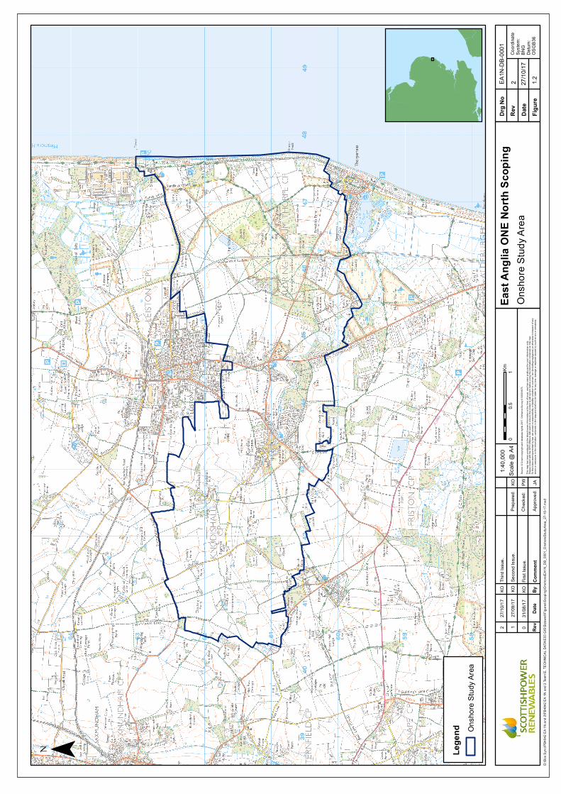
REVISION CONTROL
Revision and Approvals Rev Date Reason for Issue Originated by Checked by Approved by
0 14/08/2017 Draft for comment RHDHV JA PP 1 11/09/2017 2nd draft for comment RHDHV JA PP 2 29/09/2017 3rd draft for comment RHDHV JA PP 3 13/10/2017 4th draft for comment RHDHV JA PP 4 01/11/2017 Final for submission RHDHV JA PP
Approval Signature Role Authorised: Richard Britton
Head of Development, UK.
Authorised: Helen Walker
East Anglia ONE Senior Project Manager

East Anglia ONE North November, 2017 Scoping Report
Executive Summary This Scoping Report supports a request for a formal Scoping Opinion from the Planning Inspectorate in relation to the proposed East Anglia ONE North offshore windfarm. This Scoping Report has been prepared in accordance with Regulation 10 of the Infrastructure Planning (Environmental Impact Assessment) Regulations 2017 which enables an applicant to seek a Scoping Opinion from the Planning Inspectorate on the information to be included in an EIA.
This report presents an initial overview and description of the project and a review of the potential impacts associated with the construction, operation and eventual decommissioning of the proposed East Anglia ONE North project. Project details presented are accurate at the time of writing. This report aims to identify the likely significant effects arising from the proposed East Anglia ONE North project on the physical, human and biological environments and also outlines the approach to understanding baseline conditions and addressing environmental impacts through the EIA process.
The East Anglia ONE North project will have an anticipated capacity of up to 800MW, which has the potential to provide 650,000 homes with power. At its nearest point, the East Anglia ONE North windfarm site is 36km from shore. From the wind turbines electricity would flow via subsea inter-array cables to a number of offshore electrical platforms and then to the shore via export cables.
Offshore export cables will connect the proposed East Anglia ONE North windfarm site to shore, making landfall in the vicinity of Sizewell and Thorpeness in Suffolk. From the landfall, cables will be routed underground to an onshore substation which will in turn connect into the main transmission network via a new transmission infrastructure owned and operated by National Grid connecting into the existing overhead pylons. In addition, there may be a requirement to upgrade the existing pylons to allow for connection to the transmission network. The location of the substation and National Grid infrastructure will be finalised in early 2018.
The EIA will be undertaken by experienced and well qualified technical specialists using industry best practice and following appropriate and relevant guidance. Key topics for investigation within the EIA are expected to be offshore ornithology, marine mammals, seascape, landscape and visual amenity, traffic and transport, onshore archaeology and noise.
This Scoping Report is the first stage of the EIA process, it outlines the receptors that will be considered during the EIA and the planned approach to data gathering and characterising the existing environment, assessing potential impacts and developing mitigation measures. A programme of consultation will be ongoing with stakeholders and communities throughout the EIA and DCO application process.

East Anglia ONE North November, 2017 Scoping Report

East Anglia ONE North November, 2017 Scoping Report
Table of Contents 1 Part 1 1 1.1 Introduction 1 1.2 The Scoping Report 2 1.3 Policy and Legislation 7 1.4 Site Selection 13 1.5 Description of the Project 20 1.6 EIA Methodology 38
2 Part 2 – Offshore 50 2.1 Introduction 50 2.2 Marine Geology, Oceanography and Physical Processes 50 2.3 Water and Sediment Quality 57 2.4 Offshore Air Quality 59 2.5 Offshore Airborne Noise 60 2.6 Benthic Ecology 61 2.7 Fish and Shellfish Ecology 69 2.8 Marine Mammals 83 2.9 Ornithology 92 2.10 Commercial Fisheries 99 2.11 Shipping and Navigation 107 2.12 Civil and Military Aviation and Radar 115 2.13 Marine Archaeology and Cultural Heritage 119 2.14 Infrastructure and Other Users 129 2.15 Telecommunication and Interference 138 2.16 Summary of Offshore Topics to be Scoped In 139
3 Part 3 – Onshore 145 3.1 Introduction 145 3.2 Ground Condition and Contamination 145 3.3 Air Quality 148 3.4 Water Resources and Flood Risk 150 3.5 Land Use 156 3.6 Terrestrial Ecology 164 3.7 Archaeology and Cultural Heritage 170 3.8 Noise and Vibration 176 3.9 Traffic and Transport 180 3.10 Health 184 3.11 Summary of Onshore Topics 186
4 Part 4- Wider Scheme Aspects 189 4.1 Introduction 189 4.2 Offshore Seascape, Landscape and Visual Amenity 189 4.3 Onshore Landscape and Visual Amenity 203 4.4 Socio-Economics 213 4.5 Tourism and Recreation 216 4.6 Summary of Wider Scheme Aspects 220
5 Part 5- Consultation 222 5.1 Consultation 222
6 References 223

East Anglia ONE North November, 2017 Scoping Report
Appendix 2.1 Physical Processes Method Statement
Appendix 2.2 Benthic Ecology Method Statement
Appendix 2.3 Fish Ecology Method Statement
Appendix 2.4 Ornithology Method Statement
Appendix 2.5 Marine Mammals Method Statement
Appendix 2.6 Offshore Archaeology Method Statement
Appendix 4.1 Seascape, Landscape and Visual Impact Assessment Approach to Assessment

East Anglia ONE North November, 2017 Scoping Report
Glossary of Acronyms
AAR Air to Air Refuelling AIL Abnormal Indivisible Load AIS Automatic Identification System ALC Agricultural Land Classification Amsl Above Mean Sea Level AONB Area of Outstanding Natural Beauty AQMA Air Quality Management Areas AoS Area of Search (offshore export cable corridor) BGS British Geological Society BODC British Oceanography Data Centre BPM Best Practical Means Cefas Centre for Environment Fisheries and Aquaculture Science CFWG Commercial Fisheries Working Group CIA Cumulative Impact Assessment CIfA Chartered Institute for Archaeology CPUE Catch per unit effort cSAC Candidate Special Area of Conservation CSEMP Clean Sea Environmental Monitoring Programme CEBR Centre for Economics and Business Research CfD Contracts for Difference CIEEM Chartered Institute of Ecology and Environmental Management CION Connection and Infrastructure Options Note CoCP Code of Construction Practice COWRIE Coastal Process Modelling for Offshore Windfarm Environmental Impact Assessment CRPMEM Comité Régional des Pêches Maritimes et des Elevages Marins CWS County Wildlife Site DCO Development Consent Order Defra Department of Environment, farming and Rural Affairs DCLG Department for Communities and Local Government DECC Department of Energy and Climate Change DMRB Design Manual for Roads and Bridges DfT Department for Transport DWR Deep Water Route EAOW East Anglia Offshore Wind (ltd) EA Environment Agency EIA Environmental Impact Assessment EIR Environmental Information Report EMF Electromagnetic Field EPP Evidence Plan Process EPS European Protected Species EPUK Environmental Protection UK ES Environmental Statement ETG Expert Topic Group EU European Union

East Anglia ONE North November, 2017 Scoping Report
FLO Fisheries Liaison Officer FLOWW Fishing Liaison with Offshore Wind and Wet Renewables Group FRA Flood Risk Assessment GBS Gravity Base Structure GDP Gross Domestic Product GEART Guidelines for the Environmental Assessment of Road Traffic GIS Geographic Information System GLVIA Guidelines for Landscape and Visual Impact Assessment HDD Horizontal Direction Drilling HGV Heavy Goods Vehicle HRA Habitats Regulations Assessment HVAC High Voltage Alternating Current IAMMWG Inter-Agency Marine Mammal Working Group ICES International Council for the Exploration of the Sea IDB Internal Drainage Board IEP Industry Evidence Programme IFREMER French L’Institut Français de Recherche pour l'Exploitation de la Mer IMARES Netherlands Institute for Marine Resources and Ecosystem Studies IMO International Maritime Organisation JNCC Joint Nature Conservation Council L Litre LAQM Local Air Quality Management LAT Lowest Astronomical Tide LCA Landscape Character Assessment LEP Local Enterprise Partnership LNR Local Nature Reserve LVIA Landscape and Visual Impact Assessment LWS Local Wildlife Site MaRS Marine Resource System MCA Maritime and Coastguard Agency MCAA Marine and Coastal Access Act 2009 MCEU Marine Consents and Environment Unit MCZ Marine Conservation Zone mg Milligram mg/l Milligram per litre MHWS Mean High Water Springs m/m Mass by mass MMO Marine management organisation MoD Ministry of Defence MPS Marine Policy Statement MSFD Marine Strategy Framework Directive MSWQ Marine sediment and water quality NATS National Air Traffic Services NCA National Character Area NE Natural England NERC Natural Environment and Rural Communities Act 2006 NGO Non-Governmental Organisation nm Nautical Mile
East Anglia ONE North November, 2017 Scoping Report
NNR National Nature Reserve NO2 Nitrogen Dioxide NOx Nitrous Oxide NPPF National Planning Policy Framework NPS National Policy Statements NRHE National Record for the Historic Environment NS MU North Sea Management Unit NtM Notices to Mariners OESEA Offshore Energy Strategic Environmental Assessment O&M Operation and Maintenance PEI Preliminary Environmental Information PEIR Preliminary Environmental Information Report PINS The Planning Inspectorate PRoW Public Rights of Way PSA Particle Size Analysis REC Regional Environmental Characterisation (aggregates industry). RIGS Regionally Important Geological / Geomorphological Sites RPG Registered Parks and Gardens RSPB Royal Society for the Protection of Birds SAC Special Area of Conservation SAR Search and Rescue SCA Seascape Character Area SCADA System Control And Data Acquisition SCANS Small Cetacean Abundance in the North Sea SCDC Suffolk Coastal District Council SCOS Special Committee on Seals SLVIA Seascape, Landscape and Visual Impact Assessment SNS Southern North Sea SO2 Sulphur Dioxide SPA Special Protection Area SPR ScottishPower Renewables SPZ Source Protection Zone SSSI Site of Special Significant Interest SWT Suffolk Wildlife Trust TSS Traffic Separation Scheme TWT The Wildlife Trust UK United Kingdom UKHO UK Hydrographic Office UXO Unexploded ordinance WDC Whale and Dolphin Conservation WDC Waveney District Council WFD Water Framework Directive WSI Written Scheme of Investigation WWT Waterfowl and wetlands trust ZAP Zone Appraisal and Planning ZEA Zone Environmental Appraisal (former East Anglia Zone) ZTA Zone Technical Appraisal (former East Anglia Zone) ZTV Zone of Theoretical Visibility

East Anglia ONE North November, 2017 Scoping Report
Glossary of Terms
Applicant ScottishPower Renewables Construction consolidation sites
These are compounds which will contain laydown, storage and work areas for onshore construction works. The HDD construction compound will also be referred to as a construction consolidation site.
East Anglia ONE North Project
The project to which this Scoping Report relates being an offshore wind farm comprising the offshore and onshore infrastructure
East Anglia ONE North windfarm site
The offshore area within which wind turbines will be located.
European site Sites designated for nature conservation under the Habitats Directive and Birds Directive. This includes candidate Special Areas of Conservation, Sites of Community Importance, Special Areas of Conservation and Special Protection Areas, and is defined in regulation 8 of the Conservation of Habitats and Species Regulations 2010.
Evidence Plan Process A voluntary consultation process with specialist stakeholders to agree the approach to the EIA and information to support HRA.
Horizontal directional drilling (HDD)
A method of cable installation where the cable is drilled beneath a feature without the need for trenching.
Inter-array cables Cables which link the wind turbines to each other and the offshore substation platforms.
Interconnector cables Offshore cables which link the wind farm with other SPR projects such as East Anglia ONE and East Anglia THREE.
Interconnector cable corridor
This is the corridor within which the interconnector cables will be laid.
Jointing Bay Underground structures constructed at regular intervals along the onshore cable route to join sections of cable and facilitate installation of the cables into the buried ducts.
Landfall Where the offshore cables come ashore. Landfall zones The areas being considered within which the landfall would be located. A
landfall location will be identified prior to PEIR. Link boxes Underground chambers or above ground cabinets next to the cable trench
housing electrical earthing links. Monitoring buoys Various buoys to monitor in situ condition within the windfarm, for
example wave and metocean conditions National Grid infrastructure
East Anglia ONE North will require connection into an additional substation for ultimate connection to national electricity grid. The intention is that the required National Grid infrastructure (substation and connection to the existing electricity pylons) will be consented as part of this project but will be National Grid owned assets.
Natura 2000 site The network of site made up of Special Areas of Conservation and Special Protection Areas designated respectively under the Habitats Directive and Birds Directive.
Offshore development area The East Anglia ONE North offshore wind farm site and offshore export cable corridor area of search.
Offshore export cables The cables which would bring electricity from the offshore electrical platform(s) to the landfall.
Offshore export cable corridor area of search
This is the area that is being considered for the installation of the offshore export cables; the area of search is larger than required for cable installation and will be refined prior to submission of the Development Consent Order (DCO) application.

East Anglia ONE North November, 2017 Scoping Report
Offshore electrical platform A fixed structure located within the wind farm area, containing electrical equipment to aggregate the power from the wind turbine generators and convert it into a more suitable form for export to shore.
Offshore accommodation platform
A fixed structure providing accommodation for offshore personnel.
Offshore platform A collective term for the offshore accommodation platform and the offshore electrical platforms.
Offshore infrastructure All of the offshore infrastructure including wind turbines substations and all cable types.
Offshore electrical infrastructure
This includes offshore electrical cables between landfall and the offshore electrical platform, the offshore electrical platforms and inter-array, platform link and interconnector cables.
Onshore cable route Approximately 50m wide construction swathe which would contain buried export cables as well as temporary ground required for construction.
Onshore cables The cables which would bring electricity from landfall to the onshore substation.
Onshore infrastructure The combined name for all infrastructure associated with the East Anglia ONE North Project from landfall to grid connection.
Onshore substation Part of an electrical transmission and distribution system. Substations transform voltage from high to low, or the reverse by means of the electrical transformers.
Onshore study area All onshore areas being considered for the placement of onshore infrastructure or temporary construction consolidation sites. This includes areas being considered for National Grid infrastructure, East Anglia ONE North onshore substation, onshore cable corridor and landfall.
Onshore transmission works
The onshore area, which includes the landfall, onshore cable route and onshore substation site. This does not include temporary construction facilities such as access roads or construction consolidation sites.
Platform Link Cable This is an electrical cable which links one or more offshore platforms. Safety zones An area around a structure or vessel which should be avoided Scour protection Protective materials to avoid sediment being eroded away from the base
of the foundations as a result of the flow of water. Transition Bay Underground structures at the landfall that house the joints between the
offshore export cables and the onshore cables.

East Anglia ONE North November, 2017 Scoping Report

East Anglia ONE North November, 2017 Scoping Report
1 Part 1 1.1 Introduction
1.1.1 Background
1. This Scoping Report supports a request for a formal Scoping Opinion from the Planning Inspectorate in relation to the proposed 800MW East Anglia ONE North offshore windfarm. This Scoping Report has been prepared on behalf of ScottishPower Renewables (UK) Limited (SPR) in accordance with Regulation 10 of the Infrastructure Planning (Environmental Impact Assessment) Regulations 2017.
2. SPR is part of the Iberdrola Group, a world leader in clean energy with an installed capacity of over 28,000MW, and the leading wind energy producer worldwide. SPR is at the forefront of the development of the renewables industry through pioneering ideas, forward thinking and outstanding innovation which, in turn, drives economic success.
3. SPR is helping to drive the Iberdrola Group’s ambition of being the Utility of the Future and, by the end of 2017, will have 40 operational windfarms in the UK producing over 2,500MW of clean energy. SPR manage all of their operational sites, including their international offshore portfolio, through the innovative and world leading Control Centre at Whitelee Windfarm.
4. SPR is currently building the 714MW East Anglia ONE offshore windfarm approximately 43km off the coast of Suffolk. This £2.5 billion project is planned to deliver energy to meet the annual demand of over 580,000 homes1 and should be fully operational during 2020. This project will be followed by the 1,200MW East Anglia THREE offshore windfarm which recently received development consent. Building on these first two projects within the East Anglia portfolio SPR now seek to formally progress development of the proposed East Anglia ONE North and East Anglia TWO projects.
5. Separate Scoping Reports are being submitted for both the proposed East Anglia ONE North and East Anglia TWO projects. This report therefore forms the basis of the request for an EIA Scoping Opinion for the proposed East Anglia ONE North project. Following scoping, the projects will follow separate timelines; the proposed East Anglia TWO project will be the first to submit a DCO application. It is currently expected that the DCO application for the proposed East Anglia TWO project will be submitted in 2019. The DCO application for the proposed East Anglia ONE North project is currently expected to be submitted in 2020.
1 Calculated taking the number of megawatts (714) multiplied by the number of hours in one year (8,766), multiplied by the average load factor for offshore wind (36.7 %, published by the Digest of United Kingdom Energy Statistics), divided by the average annual household energy consumption (3,900 kWh), giving an equivalent of powering 588,981 homes.
Part 1 Page 1

East Anglia ONE North November, 2017 Scoping Report
6. Royal HaskoningDHV has been commissioned by SPR as the lead EIA consultant for all aspects of the proposed East Anglia ONE North project. Royal HaskoningDHV will be supported through the EIA process by a number of additional consultants who will be responsible for particular specialisms.
1.2 The Scoping Report
7. This Scoping Report supports a request for a formal Scoping Opinion from the Planning Inspectorate in relation to the proposed East Anglia ONE North project. This Scoping Report has been prepared in accordance with Regulation 10 of the Infrastructure Planning (Environmental Impact Assessment) Regulations 2017 which enables an applicant to seek a Scoping Opinion from the Planning Inspectorate on the information to be included in an EIA.
8. The Scoping Opinion will then be used to guide the EIA for the proposed East Anglia ONE North project.
9. This report presents an initial overview and description of the project and a review of the potential impacts associated with the construction, operation and eventual decommissioning of the proposed East Anglia ONE North project. All project details presented in this report are accurate at the time of writing. Based on this understanding, this report aims to identify the likely significant effects arising from the proposed East Anglia ONE North project on the physical, human and biological environments and outlines the proposed approach to understanding baseline conditions and addressing environmental impacts through the EIA process.
10. SPR and Royal HaskoningDHV have extensive EIA experience from other projects and intend that the EIA for the proposed East Anglia ONE North project will incorporate lessons learned from previous SPR projects, as well as lessons learned from the wider offshore renewables industry. There is a wealth of existing information from East Anglia ONE and East Anglia THREE and this Scoping Report provides an overview of all potential impacts, and where appropriate, will make a case for focusing the EIA on those issues which have the potential to be significant. As far as possible, the report will seek to scope out those issues which are increasingly shown (from repeated assessment in offshore wind EIA) to be non-significant.
11. This report also builds on and makes reference to agreements already made through discussion with stakeholders regarding selected topics which have been discussed through the Evidence Plan Process (EPP) (see section 1.5).
Part 1 Page 2

East Anglia ONE North November, 2017 Scoping Report
1.2.1 Scoping Report Structure
12. The report has the following structure:
• Part 1 1.1 Introduction – this section, which introduces the Scoping Report. 1.2 Policy and Legislative Context – a high level overview of where the
proposed East Anglia ONE North project sits within the policy and legislative context and how this project aims to fulfil policy needs and meet all environmental requirements.
1.3 Project Description – a high level description of the key elements of the project both offshore and onshore through construction, operation and decommissioning phases.
1.4 Environmental Impact Assessment Methodology – a description of how the EIA will be undertaken, the philosophy behind the assessment and key areas of consideration.
• Part 2 – Offshore
2 - Offshore Environmental Baseline and Potential Impacts – a topic by topic discussion of the baseline and potential impacts covering the physical, biological and human environment, including cumulative, transboundary and inter-related impacts as relevant
• Part 3 – Onshore
3 – Onshore Environmental Baseline and Potential Impacts – a topic by topic discussion of the baseline and potential impacts covering the physical, biological and human environment, including cumulative and inter-related impacts as relevant
• Part 4 – Wider Scheme Aspects
4 – This section considers aspects which are relevant for both the onshore and offshore assessment, including cumulative, transboundary and inter-related impacts as relevant
• Part 5 – Summary and Conclusions
Part 1 Page 3

East Anglia ONE North November, 2017 Scoping Report
1.2.2 Description of the Project
13. The East Anglia ONE North windfarm site (see Figure 1.1) is approximately 208km2 in area. At its nearest point, the East Anglia ONE North windfarm site is 36km from Lowestoft and 42km from Southwold. Within the East Anglia ONE North windfarm site it is proposed that up to 67 wind turbines and an overall installed capacity of up to 800MW would be constructed. When operational the project would have the potential to provide up to 650,0002 homes with power. From the wind turbines electricity would flow via subsea inter-array cables to a number of offshore electrical platforms and then to the shore via offshore export cables.
14. Offshore export cables will connect the offshore electrical platforms within the proposed East Anglia ONE North windfarm site to shore, making landfall between Sizewell and Thorpeness in Suffolk.
15. Once the offshore export cables reach the shore they will be joined to onshore cables via a transition bay near the point of landfall and then to a new onshore substation. From this substation the proposed East Anglia ONE North project will then be connected into the transmission network via new transmission infrastructure owned and operated by National Grid but consented as part of the East Anglia TWO windfarm DCO. There may be a requirement for part of this National Grid infrastructure to be consented as part of the East Anglia ONE North DCO application. This detail will be confirmed at the time of the application.
16. Onshore, given partial location within an Area of Outstanding Natural Beauty (AONB), SPR is committed to undergrounding the cables with the benefit of avoiding landscape and visual impacts associated with overhead lines. Furthermore, SPR is committed to exploring synergies between the proposed East Anglia ONE North and East Anglia TWO projects in the same manner as for East Anglia ONE and East Anglia THREE by proposing where possible, and subject to regulatory certainty, to install ducting for the East Anglia ONE North windfarm onshore electrical cables during the East Anglia TWO windfarm construction. This would reduce the construction impacts for the proposed East Anglia ONE North project.
17. The onshore study area (see Figure 1.2) has been identified by initial constraints and feasibility studies as set out in section 1.3.2 of this report. It includes land between Sizewell and Thorpeness at the landfall and inland approximately 7km to the north of Friston.
2 Calculated taking the number of megawatts (800) multiplied by the number of hours in one year (8,766), multiplied by the average load factor for offshore wind (36.7 %, published by the Digest of United Kingdom Energy Statistics), divided by the average annual household energy consumption (3,900 kWh), giving an equivalent of powering 659,922 homes.
Part 1 Page 4

ALDE
BURG
H
LEIST
ONSA
XMUN
DHAM
SOUT
HWOL
D
HALE
SWOR
TH
BUNG
AYBE
CCLE
S
LOW
ESTO
FT
¯
1:300
,000
Rev
Date
Comm
ent
By
Scale
@ A3
06
123
Km
08/09
/2017
0KO
First
Issue
.
East
Angli
a ONE
Nor
th Sc
oping
East
Angli
a ONE
Nort
h Wind
farm
Site &
Ex
port C
able
Corrid
or Ar
ea of
Sea
rch
Drg N
o
Date
Figur
e
2 27/10
/17Da
tum:
WGS 1
984
Proje
ction
:Zo
ne 31
N
EA1N
-DB-
0027
Sourc
e: ©
The C
rown E
state,
2017
. Cha
rts fro
m Ma
rineF
IND.
co.uk
© Li
cenc
e No E
K001
-0645
-MF0
095.
Not to
be us
ed fo
r nav
igatio
n.Th
is ma
p has
been
prod
uced
to th
e late
st kn
own i
nform
ation
at th
e tim
e of is
sue,
and h
as be
en pr
oduc
ed fo
r you
r infor
matio
n only
.Ple
ase c
onsu
lt with
the S
PR O
ffsho
re GI
S tea
m to
ensu
re the
conte
nt is
still c
urren
t befo
re us
ing th
e info
rmati
on co
ntaine
d on t
his m
ap.
To th
e full
est e
xtent
perm
itted b
y law
, we a
ccep
t no r
espo
nsibi
lity or
liabil
ity (w
hethe
r in co
ntrac
t, tort
(inclu
ding n
eglig
ence
) or o
therw
ise in
resp
ect o
f any
err
ors or
omiss
ions i
n the
infor
matio
n con
taine
d in t
he m
ap an
d sha
ll not
be lia
ble fo
r any
loss
, dam
age o
r exp
ense
caus
ed by
such
error
s or o
miss
ions.
1.1
Rev
Prep
ared:
Chec
ked:
Appro
ved:
D:\B
ox S
ync\P
B484
2 EA 1
N an
d 2\P
B484
2 EA 1
N an
d 2 Te
am\E.
TECH
NICA
L DAT
A\E03
GIS
\Size
well\F
igures
\Sco
ping\O
ffsho
re\EA
1N_D
B_00
27_W
indfar
mArea
_201
7102
7.mxd
PPKO BK
Lege
nd Expo
rt Cab
le Co
rridor
Area
of Se
arch
East
Angli
a ONE
Nort
hWi
ndfar
m Sit
e
27/09
/171
KOSe
cond
Issu
e.27
/10/20
172
KOTh
ird Is
sue.
¯
1:40,0
00
Rev
Date
Comm
ent
By
Scale
@ A4
00.5
1Km
31/08
/170
KOFir
st Iss
ue.
East
Angli
a ONE
Nor
th Sc
oping
Onsh
ore St
udy A
reaDr
g No
Date
Figur
e
2 27/10
/17Co
ordina
teSy
stem:
BNG
Datum
:OS
GB36
EA1N
-DB-
0001
Sourc
e: ©
Crow
n cop
yrigh
t and
datab
ase r
ights
2017
. Ordn
ance
Surve
y 010
0031
673.
This
map h
as be
en pr
oduc
ed to
the l
atest
know
n info
rmati
on at
the t
ime o
f issu
e, an
d has
been
prod
uced
for y
our in
forma
tion o
nly.
Pleas
e con
sult w
ith th
e SPR
Offs
hore
GIS
team
to en
sure
the co
ntent
is sti
ll cur
rent b
efore
using
the i
nform
ation
conta
ined o
n this
map
.To
the f
ulles
t exte
nt pe
rmitte
d by l
aw, w
e acc
ept n
o res
pons
ibility
or lia
bility
(whe
ther in
contr
act, t
ort (in
cludin
g neg
ligen
ce) o
r othe
rwise
in re
spec
t of a
ny
errors
or om
ission
s in t
he in
forma
tion c
ontai
ned i
n the
map
and s
hall n
ot be
liable
for a
ny lo
ss, d
amag
e or e
xpen
se ca
used
by su
ch er
rors o
r omi
ssion
s.1.2
Rev
Prep
ared:
Chec
ked:
Appro
ved:
D:\B
ox S
ync\P
B484
2 EA 1
N an
d 2\P
B484
2 EA 1
N an
d 2 Te
am\E.
TECH
NICA
L DAT
A\E03
GIS
\Size
well\F
igures
\Sco
ping\O
nsho
re\EA
1N_D
B_00
01_O
nsho
reStud
yArea
_27-1
0-17.m
xd
JAKO PW
Lege
nd Onsh
ore S
tudy A
rea
27/09
/171
KOSe
cond
Issu
e.27
/10/17
2KO
Third
Issu
e.

East Anglia ONE North November, 2017 Scoping Report
18. Diagram 1.1 illustrates the main components of the proposed East Anglia ONE North project.
Diagram 1.1 Main Components of the Proposed East Anglia ONE North Project (not to scale)
19. The DCO application for the proposed East Anglia ONE North project will include all of the new elements described above (including the associated National Grid infrastructure). In addition temporary works and ancillary infrastructure necessary for the construction and operation of the project, such as temporary construction areas onshore, and accommodation platforms offshore shall be included. More information of the nature of the infrastructure proposed is provided in section 1.4 of this report.
1.3 Policy and Legislation
1.3.1 Need for the Project
20. There are four drivers for the development of offshore wind energy:
1. The need to reduce greenhouse gas emissions Global temperature rise as a result of greenhouse gas emissions in the atmosphere is associated with potential impacts on weather, ecosystems and human health and welfare. The UK has made commitments internationally to limit global temperature increases, most recently through the 21st Conference of Parties in Paris in 2015. This commitment has been ratified and has been implemented in 2016 through the fifth UK Carbon Budget which commits the UK to a 57% reduction in carbon emissions by 2032, compared to emission levels in 1990 (HM Government 2016). The Committee on Climate Change has also recommended that the UK government should support 1-2GW of new offshore wind per year in the 2020s (Committee on Climate Change 2015). In the longer term, through the Climate Change Act 2008 (HM Government 2008) the UK made the commitment to an 80% reduction (compared to 1990 levels) in greenhouse gas emissions by 2050.
Part 1 Page 7

East Anglia ONE North November, 2017 Scoping Report
2. The need for energy security With existing fossil fuels and nuclear powered electricity generation coming to the end of their operational lives, there is a need for replacement generation as old infrastructure is decommissioned. Net import of electricity to the UK in the second quarter of 2017 was 6.9% of electricity supply (BEIS 2017). In this period generation fell by 3.3% compared with 2016, highlighting the need for new infrastructure to deliver a secure national energy supply as part of a long-term sustainable energy policy. However, renewables’ share of electricity generation was a record 29.8% in 2017 Q2, up 4.4 percentage points on the share in 2016 Q2, (reflecting both increased wind capacity and wind speeds, as well as lower overall electricity generation). Offshore wind generation for the period alone rose by 22 % (BEIS 2017).
3. The need to maximise economic opportunities from energy
infrastructure investment for the UK A key commitment within the UK’s Low Carbon Transition Plan (HM Government 2009) was to assist in making the UK a green industry centre by supporting the development and use of clean energy technologies, a commitment updated by the recent Green Paper: Building our Industrial Strategy (HM Government 2017). This Industrial Strategy consultation sets out the Government’s vision for the energy industry whereby Industry and Government work together to build a competitive and innovative UK supply chain that delivers and sustains jobs, exports and generates economic benefits for the UK, supporting offshore wind as a core and cost-effective part of the UK’s long-term electricity mix. The Centre for Economics and Business Research (CEBR 2012) estimates that by 2030, offshore wind could increase the Gross Domestic Product (GDP) value by 0.6% and support 173,000 jobs.
4. The need to produce affordable energy
As offshore wind technology has matured and developers have innovated there has been a significant reduction in the cost of energy produced by offshore wind in recent years, with a 32% reduction between 2012 and 2016 (ORE Catapult 2017). The second allocation round of the UK Government’s Contracts for Difference (CFD) scheme was notable for the greatly reduced cost of offshore wind projects to as low as £58/MWh. This demonstrates the progress being made as the cost of new offshore wind projects starting to generate electricity from 2022-23 will be 50% lower than the first allocation in 2015 (BEIS 2017b)
1.3.2 Climate Change and Renewable Energy Policy and Legislation
21. Climate change policy has been established at global, European and national level. Key aspects are presented in Table 1.1.
Part 1 Page 8

East Anglia ONE North November, 2017 Scoping Report
Table 1.1 Summary of Relevant Climate Change Policies Policy Summary
United Nations Framework Convention on Climate Change (Paris climate agreement)
• Limit global temperature increase to below 2°C, while pursuing efforts to limit the increase to 1.5°C;
• Commitments by all parties to prepare, communicate and maintain a Nationally Determined Contribution; and
• In 2023 and every five years thereafter, a global stocktake will assess collective progress toward meeting the purpose of the Agreement.
European Union Renewable Energy Directive
• A reduction of 20% in greenhouse gases by 2020 (below 1990 levels); and
• 20% of the total EU energy (electricity, heat and fuel) consumption to come from renewable sources by 2020.
The UK Climate Change Act 2008 • A reduction of 34% in greenhouse gases by 2020 (below 1990 levels); and
• A reduction of 80% in greenhouse gases by 2050 (below 1990 levels).
The UK Energy Act 2013 • Introduction of provisions to enable a statutory 2030 decarbonisation target range for the GB electricity sector; and
• Electricity Market Reform including introduction of the Contracts for Difference (CfDs) support mechanism.
1.3.3 Planning Legislation
22. The Planning Act 2008 (as amended) is the primary legislation that established the legal framework for applying for, examining, and determining applications for Nationally Significant Infrastructure Projects (NSIPs) taking into account the guidance in National Policy Statements (NPSs).
1.3.3.1 National Policy Statements
23. NPSs are produced by the UK Government and set out national policy against which proposals for major infrastructure projects will be assessed and decided on by the Planning Inspectorate. NPSs include the Government’s objectives for the development of nationally significant infrastructure. The three NPSs of relevance to the proposed East Anglia ONE North offshore windfarm are:
• EN-1 Overarching Energy (DECC 2011a); • EN-3 Renewable Energy Infrastructure (DECC 2011b), which covers
nationally significant renewable energy infrastructure (including offshore generating stations in excess of 100MW); and
• EN-5 Electricity Networks Infrastructure (DECC 2011c), which covers the electrical infrastructure associated with an NSIP.
24. In addition, the Marine Policy Statement (MPS) adopted by all UK administrations in
March 2011 provides the policy framework for the preparation of marine plans and establishes how decisions affecting the marine area should be made in order to enable sustainable development.
Part 1 Page 9

East Anglia ONE North November, 2017 Scoping Report
1.3.3.2 The EIA Directive
25. EIA was introduced under the European Union (EU) EIA Directive 85/337/EEC (as amended by Directives 97/11/EC, 2003/35/EC and 2009/31/EC). The EIA Directive was transposed into English law for NSIPs by the Infrastructure Planning (Environmental Impact Assessment) Regulations 2009. In 2011, the original EIA Directive and amendments were codified by EIA Directive 2011/92/EU (as amended by Directive 2014/52/EU).
26. Amendments were made by EIA Directive 2014/52/EU and have been transposed into English law for NSIPs by the Infrastructure Planning (Environmental Impact Assessment) Regulations 2017(the EIA Regulations) 2017. These came into force on 16 May 2017 and are the relevant EIA regulations for the East Anglia ONE North project. Key changes which are of note in the 2017 EIA Regulations relate to:
• A requirement to provide a description of the likely significant effects of the development on the environment resulting from impacts on climate change, risks to human health and use of natural resources;
• Ensuring EIA quality by requiring that those who undertake the work are competent experts;
• More detailed demonstration of the consideration of reasonable alternatives to the proposed project; and
• Further consideration of how to avoid, prevent, reduce and / or off-set significant adverse effects where possible and develop monitoring strategies.
1.3.3.3 Environmental Legislation
Table 1.2 Summary of Key Relevant Environmental Legislation Level Legislation Summary
Inte
rnat
ion
al
The OSPAR Convention • Establishes a network of Marine Protected Areas. The Convention on Wetlands of International Importance especially as Waterfowl Habitat (Ramsar Convention)
• Establishes Ramsar sites to protect important areas for waterfowl
Euro
pean
The Convention on Biological Diversity
• The conservation of biological diversity. • The sustainable use of the components of biological
diversity. • The fair and equitable sharing of the benefits arising out
of the utilisation of genetic resources. Water Framework Directive (WFD) (2000/60/EEC)
• Ensures a ‘good ecological status’ of inland, estuarine and groundwater bodies including coastal surface waters up to one nautical mile offshore.
Marine Strategy Framework Directive (MSFD) (2008/56/EC)
• Establishes measures to maintain or achieve ‘good environmental status’ in the marine environment.
Habitats Directive 92/43/EEC • Provides a framework for the conservation and management of wild fauna and flora, including protection for specific habitats listed in Annex I and species listed in Annex II of the Directive.
Part 1 Page 10

East Anglia ONE North November, 2017 Scoping Report
Level Legislation Summary
• Provides for the establishment of a Europe wide network of protected sites, known as Natura 2000 (the definition of which includes Special Areas of Conservation (SAC) and Special Protection Areas (SPA)).
Birds Directive (2009/147/EC) • Provides a framework for the conservation and management of wild birds.
• Establishment of a network of Special Protection Areas for rare or vulnerable species listed in Annex I of the Directive and for regularly occurring migratory species.
UK
Legi
slat
ion
Marine Coastal and Access Act 2009
• Enables the designation of Marine Conservation Zones (MCZs) in England, Wales and UK offshore waters.
• Introduced measures including a streamlined marine licensing system and the introduction of a marine planning system and decision-making to enable sustainable development in accordance with the MPS.
The Wildlife and Countryside Act 1981
• Enables the designation of Sites of Specific Scientific Interest (SSSI) to provide protection for flora, fauna, geological and physio-geological features.
• Enables designation of sites which are considered to be of national importance as National Nature Reserves (NNRs).
• Makes it an offence to intentionally: kill, injure, or take wild birds and to take, damage or destroy the nest of any wild bird while that nest is in use or being built.
• Makes it an offence to intentionally kill, injure or take any animal listed in Schedule 5 of the Act and protects occupied and unoccupied places used for shelter or protection.
• Makes it an offence to intentionally pick, uproot or destroy any wild plant listed in Schedule 8 and to plant or otherwise cause to grow any non-native, invasive species listed under Schedule 9 of the Act.
Conservation of Habitats and Species Regulations 2010 and Offshore Marine Conservation (Natural Habitats &c.) Regulations 2007 (together the ‘Habitats Regulations’
• Transposes the requirements of Habitats directive (see line six above) into UK law .
• Makes it an offence to kill, injure, capture or disturb European Protected Species (EPS).
Note that these two sets of regulations are currently being consolidated by the Government; however there will be no policy changes as a result of this exercise.
Countryside and Rights of Way Act 2000
• Gives Natural England the power to designate Areas of Outstanding Natural Beauty (AONBs).
Natural Environment and Rural Communities Act 2006 (NERC)
• Requires the relevant Secretary of State to compile a list of habitats and species of principal importance for the conservation of biodiversity.
The Commons Act 2006 • Protects areas of common land, in a sustainable manner delivering benefits for farming, public access and biodiversity.
Part 1 Page 11

East Anglia ONE North November, 2017 Scoping Report
1.3.3.4 Habitat Regulations Assessment
27. Under the Habitats Regulations the Secretary of State must consider whether a plan or project has the potential to have an adverse effect on the integrity and features of a European site (i.e. a SAC, SPA, candidate SAC or Site of Community Importance (SCI)). This process is known as Habitat Regulations Assessment (HRA). Under the Habitats Regulations, Appropriate Assessment is required for a plan or project, which either alone or in combination with other plans or projects, is likely to have a significant effect on a European site and is not directly connected with or necessary for the management of the site.
28. HRA can be described as a four stage process (Planning Inspectorate 2012b):
• Stage 1: Screening is the process which initially identifies the likely impacts upon a the interest features of a European site of a project or plan, either alone or in combination with other projects or plans, and considers whether these impacts may be significant. It is important to note that the burden of evidence is to show, on the basis of objective information, that there will be no significant effect; if the effect may be significant, or is not known, that would trigger the need for an Appropriate Assessment.
• Stage 2: Appropriate Assessment is the detailed consideration of the impact on the integrity of the European site of the project or plan, either alone or in combination with other projects or plans, with respect to the site’s conservation objectives and its structure and function. This is to determine whether there is objective evidence that adverse effects on the integrity of the site can be excluded. This stage also includes the development of mitigation measures to avoid or reduce any possible impacts;
• Stage 3: Assessment of alternative solutions is the process which
examines alternative ways of achieving the objectives of the project or plan that would avoid adverse impacts on the integrity of the European site, should avoidance or mitigation measures be unable to prevent adverse effects; and
• Stage 4: Assessment where no alternative solutions exist and where
adverse impacts remain. At Stage 4 an assessment is made as to whether or not the development is necessary for imperative reasons of overriding public interest and, if so, of the compensatory measures needed to maintain the overall coherence of the Natura 2000 network.
Part 1 Page 12

East Anglia ONE North November, 2017 Scoping Report
29. It is planned that HRA Screening will be undertaken for the proposed East Anglia ONE North project in early 2018 and consulted upon with the relevant stakeholders. Further assessment will be undertaken as required and presented with the DCO application in the information to support an Appropriate Assessment report. The information to support an Appropriate Assessment report will contain sufficient information to enable the competent authority to carry out an Appropriate Assessment should it determine that one is required.
1.4 Site Selection
1.4.1 Offshore Site Selection
30. Site selection for the proposed East Anglia ONE North project comprised three main stages:
• Initial zone selection, undertaken by The Crown Estate; • Zone Appraisal and Planning (ZAP); and • Site specific selection.
1.4.1.1 Initial Zone Selection
31. In 2010, The Crown Estate announced the successful bidders to the Round 3 offshore windfarm zones. A 50:50 joint venture between SPR and Vattenfall was successful in securing, what was later to be called, the East Anglia Zone, committed to developing 7.2GW of offshore wind renewable energy. After successfully obtaining consent and CfD (Contract for Difference) for East Anglia ONE, and successfully submitting the application for consent for East Anglia THREE (now consented), SPR and Vattenfall split the zone. SPR agreed to develop the southern half of the zone and Vattenfall agreed to develop the northern half of the zone. SPR are now solely responsible for East Anglia ONE, East Anglia THREE, the proposed East Anglia ONE North and East Anglia TWO projects, and the Zone is referred to as the former East Anglia Zone.
32. The former East Anglia Zone was originally identified as a suitable area offering ‘potential for offshore wind’ by The Crown Estate as part of the Round 3 Offshore Wind Zone tendering process in 2008. The Crown Estate used their Marine Resource System (MaRS) Geographic Information System (GIS) tool to identify suitable areas for offshore windfarm development. The Round 3 Zones were identified in an iterative process that took account of a number of constraints imposed by existing or future use of the sea.
Part 1 Page 13

East Anglia ONE North November, 2017 Scoping Report
33. The Crown Estate Round 3 Zones were the subject of the Offshore Energy Strategic Environmental Assessment (OESEA) undertaken in 2008/ 2009. The OESEA was prepared to assess the implications of further rounds of offshore windfarm leasing in the UK Renewable Energy Zone and the territorial waters of England and Wales, as well as the implications of other industry activities. The results of this strategic level analysis showed that the zones represent suitable ‘areas of opportunity’ for offshore wind projects, and have the ability to deliver the required capacity of offshore wind within acceptable environmental limits. It was however recognised that there may be local or regional constraints to the development of offshore wind projects within the zone boundaries.
1.4.1.2 Zone Appraisal and Planning
34. The ZAP Process was introduced by The Crown Estate as a way of managing how development is taken forward across individual zones. It is a non-statutory strategic approach to zone design, project identification and consenting for each of the Round 3 Zones. The main aims of the ZAP process were to:
• Optimise the development opportunity within each zone through identification of initial boundaries for the most technically and environmentally suitable development sites;
• Assess cumulative and in-combination impacts across the entire zone and in relation to other nearby offshore windfarm developments and marine activities; and
• Encourage wider stakeholder engagement at a strategic level to help inform the longer term development strategy.
The ZAP process for the former East Anglia Zone comprised two key elements:
• Zone Technical Appraisal (ZTA) – focusing on the key physical
characteristics of the former East Anglia Zone e.g. water depth and seabed geology; and
• Zone Environmental Appraisal (ZEA) - focusing on key environmental, social and economic characteristics of the former East Anglia Zone.
35. The ZAP Process was based upon a number of site specific surveys (for example,
ornithological surveys and benthic surveys) and desk-based assessments of publicly available and historical data. The key constraints considered in the ZEA and ZTA were:
• Civil and military radar coverage and helicopter main routes; • Infrastructure; • Benthic habitats (including those listed Annex I of the Habitats
Directive); • Seascape and visual amenity;
Part 1 Page 14

East Anglia ONE North November, 2017 Scoping Report
• Commercial and natural fisheries activity; • Ornithology; • Conservation designations; • Shipping and navigation; • Marine archaeology; • Physical processes; and • Underwater noise.
36. The ZAP Process also considered the following hard constraints to development within
the former East Anglia zone:
• Oil and gas platforms and pipelines; • Active subsea cables; • International Maritime Organisation (IMO) Deep Water Routes; and • Naval maritime graves.
37. These hard constraints were treated as barriers to development (i.e. the areas affected
were treated as unsuitable for wind turbines).
38. From the review of the initial baseline data undertaken by SPR and Vattenfall, 11 potential Development Areas were identified as the least constrained parts of the former East Anglia Zone. These areas were further assessed by SPR and Vattenfall in order to identify a smaller number of preferred development areas. The East Anglia ONE North windfarm site boundary was derived from development area F in the zonal appraisal.
39. The ZAP process identified development area F as being an area with a relatively low number of development constraints, both technical and environmental. Those constraints that were highlighted were similar to those highlighted for East Anglia ONE and East Anglia THREE. It is considered that the ZAP process did not highlight any major constraints within the East Anglia ONE North windfarm site that would prevent development. As such this site was chosen by SPR to be taken through the consenting process.
1.4.1.3 Site Specific Selection – Windfarm Boundary
40. The East Anglia ONE North windfarm site boundary has been selected on the basis of the ZAP process detailed above and further consideration of development potential carried out by SPR.
41. The East Anglia ONE North windfarm site boundary has been delineated by the Ulysses 2 sub-sea cable to the north, a deep water shipping route to the east, the East Anglia ONE boundary to the south and designations and shipping activity to the west.
42. The East Anglia ONE North windfarm site boundary can be seen in Figure 1.1.
Part 1 Page 15

East Anglia ONE North November, 2017 Scoping Report
1.4.1.4 Site Specific Selection – Offshore Export Cable Corridor
43. The proposed grid connection point in the vicinity of Sizewell and Leiston (see section 1.3.2.1) dictated the search area for the landfall. The exact location of the landfall will be determined through an assessment of constraints both offshore and onshore. The offshore export cable corridor can then be routed between the two end points of the landfall and the offshore windfarm site.
44. The offshore export cable corridor Area of Search (AoS) for the proposed East Anglia ONE North project has been developed through careful consideration of constraints in the area, in particular;
• Existing infrastructure, in particular to minimise cable and pipeline crossings;
• Wrecks; • Aggregate dredging areas; • The Southwold Oil Transhipment Area (a ship-to-ship transfer
area)3; and • Ecologically important sandbanks and reefs.
45. From the landfall the offshore export cable corridor AoS goes east and then turns north
crossing cables and avoiding Sizewell Bank sandbank. It passes to the north of the Southwold Oil Transhipment Area and an aggregates licence area and to the north of the East Anglia TWO windfarm site. The offshore export cable corridor AoS has been routed to allow it to potentially provide a joint corridor for both East Anglia ONE North windfarm site and East Anglia TWO windfarm site.
46. The offshore export cable corridor AoS is shown in Figure 1.1.
1.4.2 Onshore Site Selection
1.4.2.1 Proposed Connection Point
47. National Grid owns and operates the England and Wales electricity transmission network. This network carries electricity from generators to substations, where the voltage is lowered, ready for distribution to homes and businesses. In order to connect to the electricity transmission network, SPR requires a grid connection agreement with National Grid.
3 “Ship-to-ship transfer” is generally used to describe the transfer of oil, carried as cargo, from one tanker to another tanker. It can also be used to describe transfers of substances other than oil, but oil transfers are the most common by far.
Part 1 Page 16

East Anglia ONE North November, 2017 Scoping Report
48. The Connection and Infrastructure Options Note (CION) Process is the mechanism used by National Grid to evaluate the potential transmission options required which leads to the identification and development of the most efficient, coordinated and economical connection point in line with their obligation to develop and maintain an efficient, coordinated and economical system of the electricity transmission network. An important element of this assessment is the cost that will be passed on to the consumer (the public and businesses) as a result of the works which will be required to ensure the network can accommodate the project. As part of the economic assessment, the CION considers the total life cost of the connection – assessing both the capital and projected operational costs to the onshore network (over a project’s lifetime) to determine the most economic and efficient design option.
49. SPR had a grid connection offer in 2010 for up to 3.6GW at Bramford which would have allowed both the proposed East Anglia ONE North and East Anglia TWO projects to connect at that location. At that time, there was no connection capacity available near Sizewell. To comply with the statutory duties under Section 9 of the Electricity Act 1989, the preferred connection design should be the most economic and efficient when considering both offshore and onshore works. National Grid therefore undertook a subsequent review in 2017, which concluded that connecting both the proposed East Anglia ONE North and East Anglia TWO projects in the vicinity of Sizewell and Leiston is the most economical solution, the key factor being the much shorter onshore cable route required. Since 2010, there have been changes in the contracted generation background and transmission technology which has created connection capacity near Sizewell. As such, SPR is progressing the East Anglia ONE North project on the basis of a connection point in the vicinity of Sizewell and Leiston.
1.4.2.2 Onshore Study Area
50. At the time of writing the site selection process for onshore elements is on-going; therefore for the purposes of this Scoping Report a broad onshore study area is presented within which the location of the onshore transmission works will be defined in early 2018. The onshore study area has been identified considering physical and environmental constraints, a grid connection in the vicinity of Sizewell and Leiston, a landfall between Sizewell and Thorpeness, and space to accommodate two onshore substations (one for each project) and the electrical infrastructure National Grid requires to connect to the existing electricity transmission network.
51. A number of principles have been applied to the decision making process in defining an onshore study area:
• Shortest route preference for cable routeing to minimise potential impacts (on ecological, environmental or human receptors), by minimising the overall footprint for the onshore cable routes as well as minimising cost and transmission losses, i.e. preference for the most efficient and economic option;
• Avoidance of key sensitive features, where possible; and • Minimise the disruption to populated areas, where possible.
Part 1 Page 17
East Anglia ONE North November, 2017 Scoping Report
52. National Grid has stated that their physical connection to the electricity transmission network will be into existing pylons along the overhead lines in the vicinity of Sizewell and Leiston, with National Grid’s required infrastructure being located as close as possible to existing pylons. To ensure that the most efficient and economic option is identified and to minimise proliferation of development to new areas not part of the existing electricity grid landscape, suitable sites for the East Anglia ONE North onshore substation, East Anglia TWO onshore substation and National Grid infrastructure are being explored inland as close as possible to the existing overhead lines in the vicinity of Sizewell and Leiston.
53. The identification of the onshore study area has taken into account the following constraints:
• Designated sites for nature conservation (e.g. SSSI); • Designated sites for landscape (e.g. AONB); • Other infrastructure (e.g. Sizewell B nuclear power station and
associated infrastructure including the Detailed Emergency Planning Zone4; offshore windfarm substations; overhead electricity lines; buried cables and pipelines; roads);
• Residential properties; • Commercial interests; • Historic designations (e.g. listed building or scheduled monuments); • Flood zones; • Contaminated land; • Topography; and • Access.
54. In addition to looking at these potential constraints, SPR has also undertaken
consultation with the local planning authorities on this process.
55. SPR is satisfied that all reasonably foreseeable project options can be accommodated in the onshore study area, based on all known technical, commercial and environmental criteria.
1.4.2.3 Site Specific Selection – Landfall
56. A section of coastline between Sizewell and Thorpeness has been identified for further investigation based on a high level screening of physical constraints such as designated sites, flood defences and settlements, or technical constraints such as the feasibility of the onward onshore cable route. Constraints that are being considered as part of the detailed landfall site selection process include:
4 Where there is a potential for off-site release of radioactivity within the UK that would require implementation of countermeasures, emergency planning areas are designated.
Part 1 Page 18
East Anglia ONE North November, 2017 Scoping Report
• Infrastructure (including coastal defences and nearshore infrastructure) associated with Sizewell A and Sizewell B nuclear power stations and the proposed Sizewell C nuclear power station;
• Cables making landfall in the area (including Greater Gabbard Offshore Wind Farm, Galloper Wind Farm and Concerto and Hermes telecommunications cables); and
• Other infrastructure including residential and commercial properties.
57. The landfall site selection process will seek to reduce the length of the onshore cable route as far as possible whilst maintaining a safe buffer from existing constraints. A nearshore geophysical survey is planned for early 2018. Results from this survey will be used to inform the landfall location.
58. Offshore constraints taken into consideration when determining landfall search area and the export cable corridor AoS are presented within the technical topics presented within this Scoping Report.
1.4.2.4 Site Specific Selection – Onshore Cable Corridor
59. The onshore cable routeing process is determined by the end points (i.e. onshore substation, grid connection point and the landfall). The route between these points will be determined by undertaking a desk-based constraints assessment (including environmental considerations, existing utilities, accessibility, constructability, etc.). Where required this will be informed by site specific surveys and investigations.
1.4.2.5 Site Specific Selection – Onshore Substation and National Grid Infrastructure
60. The proposed East Anglia ONE North windfarm will require the construction of an onshore substation.
61. New electrical infrastructure is also required to connect to the existing electricity transmission network, which will be owned and operated by National Grid. The intention is for this to be consented as part of the East Anglia TWO windfarm. There may be a requirement for part, or all, of this additional National Grid infrastructure to be consented as part of the East Anglia ONE North DCO application. This detail will be confirmed at the time of the application.
62. Planning and environmental considerations in the siting of onshore substations is set out by National Grid in the ‘Horlock Rules’ (National Grid undated). The Horlock Rules are a set of guidelines produced by National Grid to assist those responsible for siting and designing substations to mitigate the environmental effects of such developments (National Grid 2003). They are still referred to and used by National Grid when undertaking planning studies for new infrastructure although they now have to be considered alongside other guidance in NPS and the National Planning Policy Framework (NPPF).
Part 1 Page 19

East Anglia ONE North November, 2017 Scoping Report
63. The principles set out in the Horlock Rules are relevant to the infrastructure at the onshore substation and have been taken into consideration in defining the onshore study area. Key considerations are set out below:
• Siting should as far as reasonably practicable seek to avoid internationally and nationally designated areas of the highest amenity, cultural or scientific value.
• Areas of local amenity value, important existing habitats and landscape features including ancient woodland, historic hedgerows, surface and ground water sources and nature conservation areas should be protected as far as reasonably practicable.
• The siting of substations etc. should take advantage of the screening provided by landform and existing features and the potential use of site layout and levels to keep intrusion into surrounding areas to a reasonably practicable minimum.
• The proposals should keep the visual, noise and other environmental effects to a reasonably practicable minimum.
• The land use effects of the proposal should be considered when planning the siting of substations or extensions.
64. In the Horlock Rules, National Grid states that it will encourage generators to adopt the guidelines when working with National Grid on proposals for substations, sealing end compounds or line entries.
65. The site selection process will continue in an iterative manner until there are clearly defined landfall, onshore cable corridor, onshore substation and required National Grid infrastructure locations. It is expected that this process will conclude in early 2018.
66. The ES will discuss consideration of alternatives and site selection in more detail.
1.5 Description of the Project
67. Detailed project design will be ongoing throughout the EIA and pre-construction phase. Therefore, the description of the project provided here is indicative at this stage and designed to provide context for the wider document. The project design envelope will be developed in parallel with the EIA process and will be influenced by the results of environmental and technical studies and in some cases stakeholder consultation.
68. It is recognised that at the time of submitting an application, offshore wind developers may not know the full or exact specifications of infrastructure that will comprise the proposed project (the Planning Inspectorate 2012a). Therefore where necessary, a range of parameters for each aspect of the project will be defined in the ES and the worst case scenario for a particular receptor and/or impact will be used in the impact assessment for that receptor/impact, this is known as the project design envelope approach or the ‘Rochdale Envelope’ approach. The project design envelope therefore provides the maximum extent of the consent sought, which allows flexibility during the refinement of the project design after consent.
Part 1 Page 20

East Anglia ONE North November, 2017 Scoping Report
69. Note that one key decision that has been made to date is the selection of High Voltage Alternating Current (HVAC) for the electrical transmission solution. This early decision means that there is more certainty around the type and extent of infrastructure required which in turn reduces the level on uncertainty in the final EIA.
1.5.1 Key Project Characteristics
70. The key offshore components of the proposed East Anglia ONE North project are expected to comprise:
• Offshore wind turbines and their associated foundations; • Offshore electrical platforms (for collecting, transforming and
exporting the power generated by the wind turbines) and associated foundations;
• Offshore accommodation platform to support the operation and maintenance of the windfarm and associated foundations;
• Subsea cables between the wind turbines and between the wind turbines and offshore electrical platforms (inter-array cables);
• Subsea cables between offshore platforms (both within East Anglia ONE North windfarm site (platform-link cables) and potentially platforms of other offshore windfarms interconnector cables),
• Subsea cables between the offshore electrical platforms and the shore (offshore export cables);
• Scour protection around foundations; • Cable protection and scour protection on unburied sections of
cables as required; and • Meteorological mast and associated foundations, monitoring buoys
(e.g. LIDAR or wave buoys) and navigational buoys and their anchors.
71. For the purpose of assessment, the key onshore components of the proposed East
Anglia ONE North project are expected to comprise:
• Landfall site with an associated transition bay to connect the offshore and onshore cables;
• Onshore underground cable ducts and cable jointing bays, into which cables will be installed;
• Onshore underground cable ducts installed for the proposed East Anglia ONE North windfarm;
• Onshore substation; and • Infrastructure required by National Grid to connect the proposed
East Anglia TWO and East Anglia ONE North projects to the electricity transmission network (if not consented as part of East Anglia TWO), expected to include:
Part 1 Page 21
East Anglia ONE North November, 2017 Scoping Report
o Onshore substation; o Sealing end compounds / gantries; and o Potential for the upgrade of up to two existing overhead pylons or minor
relocation of up to two existing overhead pylons.
72. It is proposed, subject to regulatory certainty, that where the onshore cable routeing is parallel, the proposed East Anglia TWO project will install ducting for the proposed East Anglia ONE North project as the proposed East Anglia TWO project will be constructed first. The proposed East Anglia ONE North project will then undertake a simpler cable pulling operation during its onshore construction, for the bulk of the cable installation.
73. Similarly, it is expected that the proposed East Anglia TWO project will consent all of the required National Grid infrastructure as it will be constructed first. However, the proposed East Anglia ONE North project may need to consent additional infrastructure required to connect its substation to the overhead lines, as well as parts of the National Grid substation infrastructure.
74. If the proposed East Anglia TWO offshore windfarm does not go ahead, the routeing is different, or there is regulatory uncertainty then infrastructure proposed to be included in that consent would not be built (i.e. cable ducts would not be installed and the National Grid infrastructure would not be constructed). It is therefore assumed that the EIA for the proposed East Anglia ONE North offshore windfarm will include two scenarios; one where the ducts and the National Grid infrastructure have been pre-installed and a second where the proposed East Anglia ONE North offshore windfarm lays cables directly and constructs the National Grid infrastructure.
75. Table 1.3 and Table 1.4 summarise the indicative project characteristics.
Part 1 Page 22

East Anglia ONE North November, 2017 Scoping Report
Table 1.3 Indicative Offshore Project Characteristics for the Proposed East Anglia ONE North Project Offshore
Capacity Up to 800MW
East Anglia ONE North windfarm area (offshore)
208km2
Distance from East Anglia ONE North to shore
36km Lowestoft
42km Southwold
50km Sizewell
60km Orford
Maximum offshore export cable corridor length
54.4km
Number of wind turbines Up to 67 5Proposed wind turbine capacity Up to 19MW (dependent upon available technology) and
subject to change within the dimensions ultimately assessed.
Wind Turbine rotor diameter Up to 250m
Tip height Up to 300m (LAT)
Minimum clearance above sea level 22m (MHWS)
Minimum inter-row spacing 1,386m
Number of offshore electrical platforms Up to 4
Number of accommodation platforms 1
Number of operational met masts 1
Number of export cables 2
Inter-array, platform link and inter-connector cables
The lengths and numbers required will be determined as more detailed work is undertaken and assessed in the final ES.
Water depth over wind farm site Typically -33 to -67mLAT
5 More than one wind turbine and foundation type and manufacturer could be deployed, up to a maximum of three wind turbine models will be considered for the proposed East Anglia ONE North project design envelope.
Part 1 Page 23

East Anglia ONE North November, 2017 Scoping Report
Table 1.4 Indicative Onshore Project Characteristics for the Proposed East Anglia ONE North Project Scenario 1 (East Anglia TWO
installs ducts and National Grid Infrastructure)
Scenario 2 (East Anglia TWO does not install ducts and National Grid Infrastructure)
Landfall and Onshore Cable Route
Number of ducts installed at the landfall (either by HDD or open trenching)
0 Up to 4
Number of transition bays Up to 2 Up to 2
Transition bay dimensions 21m (length) x 6m (width) x 1.8m (depth)
21m (length) x 6m (width) x 1.8m (depth)
Landfall HDD compound dimensions (if required)
175m x 50m 175m x 50m
Number of onshore export cables
Up to 6 Up to 6
Onshore cable corridor swathe width
50.1m 50.1m
Number cable trenches (between transition bay and onshore substation)
0 Up to 2
Number ducts installed within onshore cable corridor swathe
0 Up to 6
Number of jointing bays Dependent upon length of onshore cable route. One required approximately every 500m.
Dimension of jointing bays 15m (length) x 3m (width) x 2m (depth)
Number of link boxes Dependent upon length of onshore cable route. Two required for every jointing bay.
Dimension of link boxes 1.5m (length) x 1.5m (width) x 1.5m (depth)
Onshore Substation
Substation operational compound area
190m x 190m 190m x 190m
Substation construction compound area (required in addition to the operational footprint)
185m x 50m 185m x 50m
Substation buildings height Up to 21m Up to 21m
National Grid infrastructure
Substation compound area n/a 325m x 140m
Maximum height n/a Up to 13m
Part 1 Page 24

East Anglia ONE North November, 2017 Scoping Report
1.5.2 Offshore Infrastructure
1.5.2.1 Wind Turbines
76. The proposed East Anglia ONE North project is likely to consist of up to 67 wind turbines, with wind turbines having a rated capacity of up to 19MW, with a total installed capacity of up to 800MW. Note that, the actual MW capacity of the wind turbine does not drive the assessment; it is the physical parameters, for example the tip height or hub height which are important for the assessments. It is estimated that the maximum turbine tip height used would be 300m with maximum rotor diameter of 250m. It is possible that more than one, and up to a maximum of three, wind turbine models will be used. The wind turbines will incorporate tapered tubular towers and three blades attached to a nacelle housing mechanical and electrical generating equipment. Diagram 1.2 illustrates the dimensions and the design of a wind turbine.
Diagram 1.2 Dimensions and Design of a Wind Turbine
Part 1 Page 25

East Anglia ONE North November, 2017 Scoping Report
1.5.2.1.1 Wind Turbine Foundations
77. The factors influencing the choice of foundation for a specific project are; the type of wind turbine to be used, the nature of the ground conditions on the site, the water depth and sea conditions (i.e. prevailing wave and current climate), as well as supply chain constraints. Several foundation types are currently being considered for use, these are:
• 3 or 4-leg jackets on piles; • 3 or 4-leg jackets on suction caissons; • Gravity base structures; • Suction caissons; and • Monopiles.
78. Several types of foundations will be considered for the offshore platforms these are:
• Jackets on piles; • Jackets on suction caissons; and • Gravity base.
79. One metmast may be installed within the East Anglia ONE North windfarm site to
provide site specific meteorological data. Alternatively a floating LIDAR device with anchoring may be considered. The following foundation options will be considered for the metmast:
• 3 or 4-leg jackets on piles; • 3 or 4-leg jackets on suction caissons; • Gravity base structures; • Suction caissons; and • Monopiles.
80. Diagram 1.3 illustrates the different types of foundation.
81. As site conditions, in particular water depths, vary across the East Anglia ONE North windfarm site, it is also possible that more than one type of foundation type may be used for wind turbines, offshore platforms and the metmast.
82. For all the foundation options, the foundation structure is likely to extend by approximately 15 to 20m above mean sea level such that the base of the platform supporting the turbine tower is clear of the most extreme wave height. The overall size and footprint of the foundation structure depends on the type of foundation to be used. Foundation size may also vary between turbine locations as foundations will also be sized to suit the actual turbine and site specific characteristics at each location. Parameters provided in Table 1.5 represent maximum (and minimum where appropriate) sizes being considered at the time of writing. Note that floating foundations are not being considered. Further work will be undertaken in parallel with the EIA to refine the design.
Part 1 Page 26

East Anglia ONE North November, 2017 Scoping Report
Diagram 1.3 Foundation Types Table 1.5: Indicative Foundations Characteristics Type Indicative Dimensions Construction
Material 3 or 4-legged jackets on piles
Numerous design variants will be considered. Typically, lattice structure comprising tubular sections. Up to 53 by 53m footprint between pile edges (max length), 2,809m2. Pin pile diameter approximately 3 to 4.6m.
Steel jacket and piles
3 or 4-legged jackets on suction caissons
Numerous design variants will be considered. Typically, lattice structure comprising tubular sections. Up to 53 by 53m footprint between pile edges (max length), 2,809m2. Caisson diameters will be 12 to 16m.
Steel jacket and suction caissons
Gravity base structures
Numerous design variants will be considered. Typically conical shape. Up to 60m diameter footprint at base and have a footprint of up to 2,828m2
Reinforced or pre-stressed concrete shell with sand ballast fill
Suction caissons Up to 35m diameter footprint for bottom skirt with an area up to 963m2.
Primary material is steel
Monopiles Cylindrical pile with conical transitions. Pile diameter up to 15m with an area of up to 176m2) Penetration could be up to 60m depth below seabed level.
Steel pile and transition piece
Part 1 Page 27

East Anglia ONE North November, 2017 Scoping Report
1.5.2.1.2 Indicative Installation Methods
83. The foundations, wind turbines and offshore platforms are likely to be installed using specialist installation vessels using either jack-up or dynamic positioning (DP) technology.
84. Different methods will be required for installation of foundations dependent upon the type(s) chosen as listed in Table 1.6. Some of these methods may first require seabed preparation to level the area (which will require dredging) before placement of foundations or grouting and ballasting post-placement.
85. Seabed preparation will be required prior to the installation of foundations and cables, including the working construction area. Depending on the seabed conditions at any given location, a variety of seabed preparation methods may be required, including levelling and clearance of boulders and debris. Unexploded ordnance (UXO) clearance may also be required.
Table 1.6 Indicative Installation Methods for Different Foundation Types Type Installation Method Jackets on piles (or suction caissons)
• Seabed preparation as necessary • Jackets or Tripods and piles transported to site • Installation template set down on seabed • Piles stabbed and driven • Jackets or Tripods lifted and set down on piles • Jackets or Tripods levelled and pile connections grouted • Scour protection (if required)
Gravity base structure (GBS)
• Seabed preparation as necessary • GBS transported to site by vessel (or floated) • GBS lowered to seabed • Levelling and underbase grouting • Ballasting of foundation and further levelling as necessary • Scour protection (if required)
Suction caisson • Seabed preparation as necessary • Caisson transported to site by vessel (or floated) • Caisson lowered to seabed • Caisson sunk into the seabed assisted by a hydrostatic pressure
differential • Scour protection (if required)
Monopiles • Seabed preparation as necessary • Piles and transition pieces transported to site • Piles sequentially up-ended and lowered to sea bed • Piles sequentially driven • Transition pieces sequentially installed • Scour protection (if required)
86. Following foundation installation, wind turbines will be installed. Commonly, towers and nacelles are pre-erected or erected individually at the site using a suitable installation vessel. Blades are subsequently fitted to the tower nacelle structure as individual components or in a part assembled state.
Part 1 Page 28

East Anglia ONE North November, 2017 Scoping Report
1.5.2.2 Offshore Electrical Infrastructure Works
87. This section presents a description of the offshore electrical infrastructure required to connect the proposed East Anglia ONE North project to the grid connection point in the vicinity of Sizewell and Leiston, in Suffolk. The offshore electrical infrastructure will use HVAC technology.
88. It is anticipated that the offshore electrical infrastructure will comprise of the following components:
• Offshore electrical platforms within the East Anglia ONE North windfarm site to increase the distribution voltage of the inter array cables to a higher export voltage;
• Inter-array cables to export power generated at the wind turbines to the offshore electrical platforms;
• Platform link cables to transfer power between the offshore platforms prior to exporting to shore;
• Export cables to transport power from the offshore electrical platforms to shore;
• Fibre optic communications cables (either inside the export cables or laid alongside in the same trench) to allow for System Control And Data Acquisition (SCADA); and
• Interconnector cables to link the proposed East Anglia ONE North offshore windfarm to other SPR projects.
89. Engineering design work is currently ongoing to review and assess a range of different
design options for the electrical system. This process will determine the number and size of the offshore electrical platforms and electrical cabling options.
1.5.2.2.1 Offshore Electrical Platforms
90. In addition to specific components outlined above, all types of offshore electrical platform will accommodate ancillary equipment such as:
• Standby generators; • Fuel supplies; • Auxiliary and uninterruptible power supply systems and
transformers; • Accommodation or emergency shelter; • Craneage; • Metering stations; • Meteorological equipment; • Helipad (optional); and • Messing facilities.
Part 1 Page 29

East Anglia ONE North November, 2017 Scoping Report
91. As with the wind turbines themselves, the offshore electrical platforms will be mounted on foundations secured to the seabed. The foundations are likely to be of a steel jacket type. However, some of the other foundation types listed above (Section 1.3.4.2.2) will also be considered as part of the assessment.
1.5.2.2.2 Offshore Cabling – Inter Array and Platform Link Cables
92. The inter-array cables will connect the wind turbines to each other and to the offshore electrical platforms. A number of platform link cables will be required between offshore platforms.
1.5.2.2.3 Offshore Cabling – Offshore Export Cables and Interconnectors
93. Offshore export cables will be laid between the offshore electrical platform and the landfall. Cables would be buried except where ground conditions make this impossible or where there is a requirement to cross existing cables or pipelines.
94. Landfall will be achieved either by means of Horizontal Direction Drilling (HDD) from the land out to sea or potentially by open trenching. Cables will be buried to avoid exposure over the project lifetime thus preventing any impacts upon coastal processes from, for example, effects on sediment transport.
95. The requirement for interconnectors and their routeing will be determined as the project design evolves.
1.5.2.2.4 Cable Installation Methods
96. All cables are likely to be installed using a water jetting, trenching or ploughing technique with final burial depth subject to a detailed burial risk assessment (but likely to be in the range of 0.5 to 5m below seabed). Some seabed preparation (including the removal of boulders or sandwave clearance) or UXO clearance may also be required – refer to section 1.5.2.1.2.
1.5.2.3 Other Offshore Construction Components
1.5.2.3.1 Foundation Scour Protection
97. Scour could occur around the base of foundations; this is when seabed sediment is winnowed away as a result of the flow of water around the structure. A number of options for scour protection could be considered for installation at the East Anglia ONE North windfarm site, depending on the final project design, ground conditions and scour assessments.
98. Several methods of scour protection could be used, including rock dump, concrete mattresses, rock bags or frond mats. Scour protection installation may involve some seabed preparation prior to installation.
Part 1 Page 30

East Anglia ONE North November, 2017 Scoping Report
1.5.2.3.2 Cable Protection
99. All cables will be buried as far as possible. Where it is not possible to bury cable it will be necessary to install cable protection to prevent scour and minimise the risk of damage to the cable.
100. It is also conceivable that the laying of cable protection may also be necessary after burial, where sections of cables are too shallow or have otherwise become exposed over time as informed by post installation inspection or periodic maintenance surveys. Presence and volume of cable protection will be minimised as far as possible.
101. Rock dumping, rock bags, concrete mattresses, frond mats or grout bags may be used to protect the cable ends where they enter wind turbine or platform foundations and may be utilised when ground conditions result in the cable being laid near to or on the surface.
1.5.2.3.3 Cable Crossings
102. Where cable or pipeline crossings are required, the design of these crossings will be agreed with the owner or operator to ensure that integrity of all the assets is maintained. Depending on the method that is agreed, there is the potential that protection maybe required. Rock dumping, concrete mattresses and rock bags are commonly used as cable protection at cable or pipeline crossings.
1.5.2.3.4 Safety Zones
103. During construction activities SPR will seek appropriate safety zones around wind turbines and work areas. These safety zones will be based on an appropriate safety assessment and applied for to the relevant authorities and in consultation with relevant consultees.
1.5.3 Landfall
1.5.3.1 Landfall Infrastructure
104. At the landfall there will be up to two transition bays. The purpose of the transition bay is to provide housing for the joint between the heavily armoured marine cables and the onshore buried cables. The transition bay may also house the required communication equipment or alternatively up to two separate jointing bays would be provided. There will be a transition bay for each offshore cable, i.e. up to two transition bays for the East Anglia ONE North project. Typical dimensions are likely to up to 6m (width) x 21m (length) x 1.8m (depth). Each transition bay will comprise a shallow concrete structure with access by a manhole cover.
1.5.3.1.1 Landfall Installation Methods
105. Landfall installation will follow one of the three methods listed below:
• HDD from the transition bay location (in the region of 100-150m inland) exiting out at sea in the nearshore area;
Part 1 Page 31

East Anglia ONE North November, 2017 Scoping Report
• HDD from the transition bay location and exiting in the intertidal area;
• Open trench from transition bay location and across the intertidal area.
106. HDD directly out to sea would allow cables to be routed under the intertidal area minimising any interaction with that areas. HDD exiting at the intertidal area or open trenching would require direct interaction with the existing intertidal habitats. The preferred method of installation will be determined in early 2018 as part of the ongoing site selection work and will consider offshore bathymetry survey findings, engineering feasibility and existing environmental constraints, including protected species and habitats. A temporary construction consolidation site will be required to support the landfall works to house the equipment and personnel associated with either HDD or trenching works, as well as the installation of the transition bays
107. Landfall installation may also require some form of beach access for construction vehicles, depending on the preferred method of installation identified and the preferred landfall location. Where beach access is required this may be achieved by taking vehicles along the beach from Sizewell Gap Road (the approach taken by Galloper Wind Farm and Greater Gabbard Offshore Wind Farm); introducing a temporary ramp onto the beach from the transition bay location, or by delivery of construction equipment from sea onto the beach. The method of temporary beach access, where required, will also form part of the ongoing site selection work outlined above.
1.5.4 Onshore Transmission Works
1.5.4.1 Onshore Cable Route
108. The cables shall follow the prescribed route onshore directly buried or installed within a cable duct.
109. As previously discussed, the EIA will consider a scenario where the proposed East Anglia TWO installs ducting and also consider a second scenario whereby the proposed East Anglia TWO project is not constructed and therefor direct lay of the cables for the proposed East Anglia ONE North project is required.
1.5.4.1.1 Onshore Cable Installation
110. Diagram 1.4 illustrates the indicative working width associated with the installation of the onshore cable systems.
Part 1 Page 32

East Anglia ONE North November, 2017 Scoping Report
Diagram 1.4 Indicative Working Width for Onshore Cable Installation
111. Installation of the onshore cables will consist of the following stages;
1. Pre-construction work - Pre-construction activities may include the following: temporary fencing, temporary welfare facilities, compounds associated with any temporary or pre-construction works (for example pre-construction archaeology compounds), topographic surveys, ecological pre-construction work, archaeological pre-construction work (including any associated temporary access tracks), drainage surveys and mitigation works, ground investigation studies, accesses and highways improvements. Agreements for working in proximity to roads, ditches, utilities, etc., where relevant, will also be agreed in advance to works proceeding.
2. Construction consolidation sites - Construction consolidation sites will be required along the onshore cable route, to allow storage of materials and equipment and to accommodate site administration and welfare facilities.
3. Preparation of the working width - Temporary fences will be erected along
the boundaries of the working width.
4. Topsoil stripping - Once the working width at the jointing bays has been cleared of vegetation, the topsoil will be stripped and stored appropriately (the working width will include sufficient space for the appropriate storage of topsoil).
5. Temporary roads - A temporary haul road, or ‘running track’, may be required depending on the preferred option identified. This would be installed within the working width providing access between the construction consolidation sites and the construction areas. Temporary haul road construction would most likely involve the placement of a suitable imported material onto a geotextile base and / or use of temporary mats (often referred to as ‘bog mats’).
Part 1 Page 33

East Anglia ONE North November, 2017 Scoping Report
6. Transition bays and jointing bays - The installation of the transition bays and jointing bays would require:
• Mechanical excavation to the required depth; • Placement of precast components or construction of
reinforced concrete base slab, walls and cover in situ; and • Backfill (sand or similar).
7. Trench excavation (if not undertaken as part of East Anglia TWO) - Trenches
may be excavated using a standard mechanical excavator or specific trenching machine. Two trenches would be excavated. The width of the trenches and the spacing between them will vary depending on the depth of burial.
8. Cable delivery - Cables will be delivered in drums, with the cable lengths on
the drums being specified during design and procurement phases.
9. Cable pulling and installation - a cable pulling system will be installed at the jointing bays. The cables will then be pulled from the drum into the trench (either direct lay or within pre-installed ducts).
1.5.4.1.2 Jointing Bays
112. As the onshore cabling typically comes on drums of 500 to 1,000m in length, jointing bays will be required along the onshore cable route to join each section of the cable together.
113. These jointing bays (which will be approximately 15m (length) x 3m (width) x 2m (depth) will be constructed at regular intervals along the onshore cable route every 500m (assuming a conservative length). The precise location of the jointing bays will be determined during detailed design; however, wherever possible the jointing bays will be located at the edge of field boundaries or roads to allow future access. Land above the jointing bays will be reinstated. Manhole covers may need to be placed above jointing bays, for inspection access during the operational phase.
1.5.4.1.3 Link Boxes
114. Link boxes are smaller pits compared to joint bays (approximately 1.5m (length) x 1.5m (width) x 1.5m (depth)) which house connections between the cable shielding, joints for fibre optic cables and other auxiliary equipment. Two link boxes will be required at each jointing bay. Land above the link boxes will be reinstated. Manhole covers may need to be placed above link boxes, for inspection access during the operational phase.
1.5.4.1.4 Non-Trenching Techniques
115. Where an open trench approach is not possible due to significant obstructions (e.g. a major road or watercourse) non-trenching techniques will be employed. It is anticipated that HDD technique or similar will be used.
Part 1 Page 34

East Anglia ONE North November, 2017 Scoping Report
116. The HDD method comprises three stages:
• A pilot hole is drilled along the designed route; • The hole is enlarged by passing a larger cutting tool through known
as the back reamer; and • The cable duct is placed in the enlarged hole.
117. HDD is undertaken with the help of a viscous fluid known as drilling fluid. It is usually
a mixture of water and bentonite or a suitable polymer. During drilling the fluid is continuously pumped to the cutting head or drill bit to facilitate the removal of cuttings, stabilise the borehole, cool the cutting head, and lubricate the passage of the product pipe.
118. Use of any trenchless technique will also require temporary construction compounds at the entry and exit points.
1.5.4.2 Onshore Substation
119. The onshore substation will be located within a single compound with a mixture of warehouse style buildings, external gear and gantries. The onshore substation compound will be up to 190m x 190m, with a maximum building height of 21m and external equipment up to 18m high.
1.5.4.2.1 Onshore Substation Construction
120. Grading, earthworks and drainage will be undertaken initially within the onshore substation footprint. Foundations would then be installed which would either be ground-bearing or piled, based on the prevailing ground conditions.
121. The proposed building substructures are typically predominantly composed of steel and cladding materials. The structural steelwork would be fabricated and prepared off site and delivered to site for erection activities. The steelwork would be erected with the use of cranes. Cladding panels (typically composite) would also be delivered to site ready to erect and be fixed to the steelwork.
122. A key aspect of the substation installation would be the delivery of the transformers. These items are delivered sealed and would be particularly bulky, heavy items. Due to their size and weight they would be delivered via specialist means and offloaded with the use of a mobile gantry crane.
123. The majority of the remaining equipment would be erected with the use of small mobile plant and lifting apparatus.
Part 1 Page 35

East Anglia ONE North November, 2017 Scoping Report
1.5.4.3 National Grid Electrical Infrastructure
124. The National Grid infrastructure will include a substation comprising external electrical equipment and gantries. The substation compound will be up to 325m x 140m, with a maximum height of external equipment up to 13m high. The footprint represents the total area required for connecting both East Anglia TWO and East Anglia ONE North projects. However, external electrical equipment associated with East Anglia ONE North would only be installed when the second project undertakes its construction.
125. The National Grid infrastructure may also require the upgrade of up to two existing overhead pylons or minor relocation of up to two existing overhead pylons.
1.5.4.3.1 National Grid Electrical Infrastructure Construction
126. The construction works associated with the National Grid substation would be similar in nature to the works described for the East Anglia ONE North onshore substation, as described above.
1.5.5 Construction Duration
127. It is anticipated that the installation of the offshore elements will take approximately 36 to 48 months (subject to change). Construction works would be undertaken 24 hours a day and seven days a week offshore, dependent upon weather conditions.
128. It is anticipated that onshore works will take approximately 18 to 24 months (subject to change). Construction works would be undertaken between 0700 and 1900 Monday to Saturday, with no works on bank holidays or Sundays except in special circumstances6.
1.5.6 Operations and Maintenance Strategy
1.5.6.1 Maintenance Activities
129. During the operational period, scheduled and unscheduled monitoring and maintenance activities will be required. All offshore infrastructure, including wind turbines, foundations, cables and offshore platforms will be included in monitoring and maintenance programmes. The design life of the offshore infrastructure is likely to be in in the order of 25 years and therefore some refurbishment or replacement will be required during this time. The EIA will seek to assess expected maintenance activities based on experience and best practice, however during the life of the proposed East Anglia ONE North windfarm project, further consents or licences will be applied for if required.
6 For example where continual work is required such as a concrete pour or HDD bore.
Part 1 Page 36

East Anglia ONE North November, 2017 Scoping Report
130. The operation and control of the windfarm will be managed remotely, such as through a SCADA system which connects each wind turbine to the onshore control room. This system will enable the remote control of individual wind turbines, the windfarm in general, as well as remote interrogation, information transfer, storage and the shutdown and restart of any wind turbines if required.
131. There are a number of potential maintenance strategies which could be implemented for the windfarm. The windfarm could be maintained from shore using a fleet of Operation and Maintenance (O&M) vessels (e.g. crew transfer vessels, supply vessels) and / or helicopters. A number of different vessel types would be required for O&M activities.
132. The windfarm could also be maintained primarily from an offshore base, for example a mother ship or a fixed offshore platform (possibly shared with other infrastructure e.g. the offshore electrical platform or a standalone accommodation platform within the offshore development area) with transfer vessels or helicopters used to transfer personnel to or from wind turbines and platforms.
133. During the life of the project, it is not the intention to replace the subsea cables, however repairs may be required. Periodic surveys will also be required to ensure the cables remain buried and if they do become exposed, re-burial works would be undertaken. These works may require the use of cable laying vessels.
1.5.6.1.1 Vessel and Helicopter Operations
134. A number of vessel and / or helicopter visits to each wind turbine will be required each year to allow for scheduled and unscheduled maintenance.
135. There is a possibility that large components (e.g. wind turbine blades or substation transformers) would require replacement during the operational phase. Large jack-up or heavy lift vessels may be needed to carry out major maintenance activities. The EIA will consider the frequency of this for the final assessment.
136. During O&M activities SPR would establish appropriate safety zones around wind turbines and work areas. These safety zones will be based on an appropriate safety assessment and applied for to the relevant authorities and in consultation with relevant consultees.
1.5.7 Decommissioning
137. At the end of The Crown Estate lease period (50 years), it is a condition of the lease, as well as a statutory requirement (through the provisions of the Energy Act 2004 (as amended)), that the proposed East Anglia ONE North project is decommissioned. In the event that an extension or further lease of part or all of the site was granted by The Crown Estate, it is anticipated that the same decommissioning obligations would apply at the end of that term.
Part 1 Page 37

East Anglia ONE North November, 2017 Scoping Report
138. The scope of the decommissioning works will be determined by the relevant legislation and guidance at the time of decommissioning and will most likely involve removal of the accessible installed components. Offshore this is likely to include; all of the wind turbine components, part of the wind turbine foundations (down to 1m below seabed level) and the sections of the inter-array cables close to the offshore structures, as well as sections of the export cables.
139. It is anticipated that the onshore cables would be decommissioned (de-energised) and most likely left in-situ. However, where cables have been installed in ducts it may be possible to extract the cables during the decommissioning phase. It is assumed that the jointing bays and transition pits will be left in situ.
140. The onshore substation and equipment could be removed and the components reused or recycled. The foundations would be removed to below ground level and the ground covered in topsoil and re-vegetated to fully reinstate the site.
141. Under the statutory process, SPR is required to prepare a decommissioning plan at the request of the Secretary of State and, prior to construction, it is anticipated that funds will be required to be set aside for the purposes of decommissioning.
142. As an alternative to decommissioning, SPR may wish to consider repowering the windfarm. Should SPR choose to pursue this option, this would be subject to a new consent.
1.6 EIA Methodology
1.6.1 Introduction
143. The EIA will consider all relevant topics covered under the three general areas of physical environment, biological environment and human environment for both offshore and onshore elements of the proposed East Anglia ONE North project and present these in an Environmental Statement (ES).
144. The EIA will be carried out in accordance with the Planning Act 2008 and the EIA Regulations (see section 1.3.2). The approach to the EIA and the production of the resulting ES will closely follow relevant guidance including:
• Assessment of the environmental impact of offshore wind-farms (OSPAR Commission 2008);
• The Planning Inspectorate Advice Notes (the Planning Inspectorate 2012a; 2015a; 2015b;; 2016a, 2017a);
• Overarching NPS for Energy EN-1, Renewable Energy Infrastructure EN-3, and Electricity Networks Infrastructure EN-5 (DECC 2011a-c);
• Relevant guidance issued by other government and non-governmental organisations; and
• Receptor specific guidance documents.
Part 1 Page 38

East Anglia ONE North November, 2017 Scoping Report
145. It will also give due regard to the requirements of the Habitats Regulations and the Marine and Coastal Access Act 2009.
146. The outputs of the EIA will be a Preliminary Environmental Information (PEI) Report (PEIR) and thereafter the final ES in support of the DCO application. It is intended that the PEIR will be a draft ES and include full assessments for topics where possible to maximise stakeholder consultation and subsequent input. The final ES will update the assessments to take account of any final information and stakeholder feedback.
147. Consultation is a key element of the EIA process and consultation with technical consultees will be crucial to the development of this assessment. To this end a number of fora have been established, or will be established, by SPR to enable technical discussion with experts from relevant stakeholder groups, these are listed in Table 1.7.
Table 1.7 Consultation Groups Consultation Purpose and topics included Stakeholders Regular catch-up meetings
SPR has regular catch-up meetings (i.e. monthly or six-weekly) with key stakeholders to update them on the progress of all SPR projects in East Anglia
• Marine Management Organisation (MMO)
• Natural England • Local Planning
Authorities • Historic England
The Evidence Plan Process (EPP)
This process is a voluntary mechanism to help agree the information required by the Planning Inspectorate as part of a DCO application to help to ensure compliance with the EIA Regulations and Habitat Regulations. Therefore this process covers ecological receptor topics: • Marine Geology, Oceanography and Physical
Processes; • Benthic Ecology; • Fish Ecology; • Ornithology; • Marine Mammal Ecology; and • Terrestrial Ecology (not yet commenced). The EPP aims to give greater certainty to all parties on the amount and range of evidence the Applicant should collect and present to support the DCO application. The EPP for the proposed East Anglia ONE North project commenced in 2016 To date discussions have focused on survey requirements, agreeing baseline data requirements and the likely impacts from the proposed East Anglia ONE North project which will be covered by the EIA. Further discussion will cover specific details of the assessments as the EIA progresses. Agreed Method Statements for the topics discussed to date can be found in Appendices 2.1-2.7.
• MMO • Natural England, • Local Planning
Authorities (where relevant)
• Non-Governmental Organisations (NGOs)
• Whale and Dolphin Conservation (WDC)
• The Royal Society for the Protection of Birds (RSPB)
• The Wildlife Trusts (TWT)
• Suffolk Wildlife Trust (SWT)
Part 1 Page 39

East Anglia ONE North November, 2017 Scoping Report
Consultation Purpose and topics included Stakeholders Fisheries The Commercial Fisheries Working Group (CFWG)
provides a forum to consult with UK fisheries stakeholders. The CFWG covers all SPR projects in East Anglia In addition SPR will liaise with foreign fisheries stakeholders.
• UK fisheries • Foreign fisheries
Aviation and Radar
SPR is engaging with aviation and radar stakeholders
• Civil Aviation Authority
• Ministry of Defence • National Air Traffic
Services (NATS) En Route
Shipping and Navigation
SPR has begun engagement with the Maritime and Coastguard Agency (MCA) and will engagement with other stakeholders as the EIA process progresses. Further detail on this engagement can be found in section 2.9.
• MCA • Trinity House • Royal Yachting
Association • Chamber of Shipping • Shipping companies
Heritage SPR has already engaged Historic England with regard to heritage both offshore and onshore (see Appendix 2.7).
• Historic England
Onshore topics All onshore topics are discussed with the Local Planning Authorities at regular catch-ups, however it is intended that once the preferred locations for the onshore infrastructure are defined, SPR will engage in a process similar to the EPP to cover the following topics including expert stakeholders where relevant: • Onshore Ecology; • Onshore Archaeology and Cultural Heritage; • Noise and Vibration; • Traffic and Transport; • Landscape and Visual (already commenced);
and • Seascape and Visual (already commenced).
• Local Planning Authorities
• Natural England • Historic England • The Environment
Agency • NGOs
o RSPB o SWT
148. In all of the above cases the aim is for agreements on topics to be reached with
stakeholders prior to the submission of the DCO, with agreements (or disagreements) logged and used to develop a Statement of Common Ground for each.
1.6.2 Characterisation of the Existing Environment
149. The characterisation of the existing environment will be undertaken in order to determine the baseline conditions in the area covered by the proposed East Anglia ONE North offshore windfarm and relevant surrounding study areas. This will require the following steps:
• Study areas will be defined for each receptor based on the receptor-specific characteristics (e.g. mobility or range);
• Review of available information;
Part 1 Page 40
East Anglia ONE North November, 2017 Scoping Report
• Review the likely or potential impacts that might be expected to arise from the development;
• Determine if sufficient data is available to make the EIA judgements with sufficient confidence;
• If further data is required, to ensure that data gathered are targeted and directed at answering the key question and filling key data gaps; and
• Review the information gathered to ensure the environment can be sufficiently characterised in sufficient detail.
150. In addition to existing data from research, government and industry, SPR has collated a significant amount of existing data from a number of sources including:
• Data acquired as part of the ZAP process undertaken for the former East Anglia Zone;
• Data acquisition and the subsequent EIA documents undertaken for the consented East Anglia ONE and East Anglia THREE projects; and
• On-going data acquisition for the proposed East Anglia ONE North and East Anglia TWO projects.
151. Consideration will also be given to the evolution of the baseline in the absence of the proposed East Anglia ONE North offshore windfarm; this will take account of wider issues such as climate change and biodiversity loss (in line with the 2017 EIA Regulations, see section 1.3.3.2).
152. The approach to establishing a robust baseline is summarised under each topic within this Scoping Report (see sections 2 to 4), and SPR will seek to agree this via consultation e.g. from the views expressed in the Scoping Opinion and additional consultation for example through the EPP. It should be noted that for some offshore topics the approach to the baseline has already been agreed with detailed accounts provided in Appendices 2.1 to 2.7.
1.6.3 Assessment of Impacts
The approach the EIA team will take to making balanced assessments will be guided by both EIA specialists and technical specialists using available data, new data, experience and expert judgement. As discussed above, consultation will be a key tool in the development of the methodology for each topic. In order to provide a consistent framework and system of common tools and terms, where appropriate, a matrix approach will be used to frame and present the judgements made, combining elements of topic specific sensitivity and magnitude of effect to determine the impact significance. The impact assessment will consider the potential for impacts during the construction, operation and decommissioning of the proposed East Anglia ONE North project.
Part 1 Page 41

East Anglia ONE North November, 2017 Scoping Report
1.6.3.1 Impact Identification
153. The assessment will use the conceptual ‘source-pathway-receptor’ model. The model identifies potential impacts resulting from the proposed activities on the environment and sensitive receptors within it. This process provides an easy to follow assessment route between impact sources and potentially sensitive receptors ensuring a transparent impact assessment. The aspects of this model are defined as follows:
• Source – the origin of a potential impact (i.e. an activity such as cable installation and a resultant effect e.g. re-suspension of sediments);
• Pathway – the means by which the effect of the activity could impact a receptor (e.g. for the example above, re-suspended sediment could settle and smother seabed); and
• Receptor – the element of the receiving environment that is impacted (this could either be a component of the physical, ecological or human environment such as water quality or benthic habitat, e.g. for the above example, species living on or in the seabed).
154. In general, the impact assessment for each topic will use this model when considering the potential impacts arising during the construction, operation and decommissioning phases of the proposed East Anglia ONE North offshore windfarm. In some cases it is appropriate to use other models for assessment, for example for the navigation and shipping assessment where a risk assessment approach is required.
1.6.3.2 Sensitivity and Value
155. The ability of a receptor to adapt to change, tolerate, and / or recover from potential impacts will be key in assessing its sensitivity to the impact under consideration. For ecological receptors tolerance could relate to short-term changes in the physical environment, for human environment receptors tolerance could relate to displacement effects and therefore impacts upon economics or safety. It also follows that the times required for recovery will be key considerations in determining receptor sensitivity.
156. Receptor value considers whether, for example, the receptor is rare, has protected or threatened status, importance at local, regional, national or international scale, and in the case of biological receptors whether the receptor has a key role in the ecosystem function.
157. The overall receptor sensitivity is determined therefore by considering a combination of value, adaptability, tolerance and recoverability as well as applying professional judgement and / or past experience. Expert judgement is particularly important when determining the sensitivity of receptors. For instance, an Annex II species (under the Habitats Directive) would have a high value, but if it was highly tolerant of an effect or had high recoverability it would follow that the sensitivity in this instance should reflect this.
Part 1 Page 42

East Anglia ONE North November, 2017 Scoping Report
1.6.3.3 Magnitude of Effect
158. In order to predict the significance of an impact it is fundamental to establish the magnitude and probability of impact occurring through a consideration of:
• Scale or spatial extent (small scale to large scale or most of the population or a few individuals);
• Duration (short-term to long-term); • Frequency; and • Nature of change relative to the baseline.
1.6.3.4 Significance of Impact
159. Subsequent to establishing the receptor sensitivity and magnitude of effect, the impact significance will be predicted by using quantitative or qualitative criteria, as appropriate to ensure a robust assessment. Where possible a matrix such as the one presented in Table 1.8 will be used to aid assessment of impact significance based on expert judgement, latest guidance and any specific input from consultation. A description of the approach to impact assessment and the interpretation of significance levels will be provided within each section of the ES. This approach will ensure that the definition of impacts is transparent and relevant to each topic under consideration.
Table 1.8 Significance of Impacts
Negative Magnitude Beneficial Magnitude
High Medium Low Negligible Negligible Low Medium High
Sens
itivi
ty
High Major Major Moderate Minor Minor Moderate Major Major
Medium Major Moderate Minor Minor Minor Minor Moderate Major
Low Moderate Minor Minor Negligible Negligible Minor Minor Moderate
Negligible Minor Negligible Negligible Negligible Negligible Negligible Negligible Minor
160. For the purposes of the EIA, major and moderate adverse impacts are deemed to be
significant, and, as such, may require mitigation. Whilst minor impacts are not significant in their own right, these may contribute to significant impacts cumulatively or through interactions.
1.6.3.5 Embedded Mitigation, Impact and Residual Impact
161. The EIA Regulations require a description of the measures envisaged to avoid, prevent, reduce or (where possible) offset any significant adverse effects on the environment. Where possible, embedded mitigation, i.e. mitigation identified at an early stage (often using experience from operational projects), can include:
Part 1 Page 43

East Anglia ONE North November, 2017 Scoping Report
• The design elements aimed at reducing impacts; • Commitment to specific best practice; • Commitment to pre-construction surveys; and • Commitment to consultation.
162. Embedded mitigation will be incorporated into the project design, and listed where
relevant for each topic. Impacts will then be assessed with this mitigation in place. Where impacts are significant and additional mitigation is required, impacts may be reassessed and the post-mitigation or ‘residual impact’ identified. If the impact does not require mitigation (or none is possible) the residual impact will remain the same.
163. In some circumstances it may be necessary to detail monitoring requirements as part of the mitigation measures identified. Monitoring may be required to confirm the assumptions that the assessment is reliant upon (i.e. continue to monitor baseline conditions) and / or to confirm the efficacy of mitigation measures implemented. Monitoring should be proportionate and directly relevant to the findings of the impact assessment, i.e. it should not be monitoring for the sake of monitoring.
1.6.3.6 Confidence
164. Once an assessment of a potential impact has been made, it is necessary to assign a confidence value to the assessment to assist in the understanding of the judgment. This is undertaken on a simple scale of high-medium-low, where high confidence assessments are made on the basis of robust evidence, with lower confidence assessments being based, for example on extrapolation and use of proxies.
1.6.3.7 Inter-Relationships
165. The impact assessment will consider the inter-relationship of impacts on individual receptors. The objective will be to identify where the accumulation of residual impacts on a single receptor, and the relationship between those impacts, gives rise to a need for additional mitigation. When considering the potential for impacts to inter-relate it is assumed that any residual effect determined as having no impact will not result in a significant inter-relationship when combined with other effects on receptors. However, where a series of negligible or greater residual impacts are identified, they will be considered further.
1.6.3.8 Cumulative Impacts
166. Cumulative Impact Assessment (CIA) forms part of the EIA process. The Planning Inspectorate advice notes nine and seventeen provide guidance on plans and projects that should be considered in the CIA including:
• Projects that are under construction; • Permitted applications not yet implemented; • Submitted applications not yet determined; • Projects on the Planning Inspectorate's Programme of Projects;
Part 1 Page 44

East Anglia ONE North November, 2017 Scoping Report
• Development identified in relevant Development Plans, (and emerging Development Plans - with weight being given as they move closer to adoption) recognising that much information on any relevant proposals will be limited; and
• Sites identified in other policy documents as development reasonably likely to come forward.
167. Only projects which are reasonably well described and sufficiently advanced to provide information on which to base a meaningful and robust assessment will be included in the CIA. Projects which are sufficiently implemented during the site characterisation for the proposed East Anglia ONE North offshore windfarm will be considered as part of the baseline for the EIA. Where possible SPR will seek to agree with stakeholders the use of as-built project parameter information (if available) as opposed to consented parameters to reduce over-precaution in the cumulative assessment.
168. For some topics (where for example the receptors include highly mobile or migratory species, fishing or shipping) the CIA will have a large geographic scale and involve in many plans and projects, for others where receptors (or impact ranges) are more spatially fixed the CIA will be narrower. The scope of the CIA will therefore be established on a topic by topic basis with the relevant consultees as the EIA progresses.
169. Offshore cumulative impacts may come from interactions with the following activities and industries:
• Other windfarms; • Aggregate extraction and dredging; • Licensed disposal sites; • Navigation and shipping; • Commercial fisheries; • Sub-sea cables and pipelines; • Potential port and harbour development; • Oil and gas activities; and • Unexploded Ordinance (UXO) clearance.
170. Onshore plans or projects that may be considered include (but are not limited to):
• Other offshore windfarm infrastructure; • Other energy generation infrastructure; • Building and / or housing developments; • Installation or upgrade of roads; • Installation or upgrade of cables and pipelines; and • Coastal protection works.
Part 1 Page 45

East Anglia ONE North November, 2017 Scoping Report
171. Whilst it is too early in the EIA process to define a list of projects which will be included within the CIA (and each receptor topic will have its own list), given their proximity to the proposed East Anglia ONE North project it is clear that other SPR windfarms in the former East Anglia Zone, other nearby windfarms such as Greater Gabbard, Galloper and the proposed Norfolk Vanguard, telecommunications cables near the landfall and the Sizewell nuclear power stations (operational Sizewell B, planned Sizewell C and decommissioning of Sizewell A) will be considered for many topics.
172. Section 2.14 Infrastructure and Other Users includes many of the potential offshore receptors which would be relevant for the CIA for offshore topics.
1.6.3.9 Decommissioning Impacts
173. No decision has been made regarding the final decommissioning policy as it is recognised that industry best practice, rules and legislation change over time. However, offshore it is likely that decommissioning will require the removal of wind turbines and offshore platforms, foundations and some of the buried cables.
174. For the onshore infrastructure it is likely that the onshore substation and National Grid infrastructure would likely be removed and reused or recycled. It is expected the onshore cables would be removed from ducts and recycled, with the transition bays and jointing bays and ducts left in situ.
175. The detail and scope of the decommissioning works would be determined by the relevant legislation and guidance at the time of decommissioning and agreed with the regulator. A decommissioning plan would be provided.
176. It is anticipated that the decommissioning impacts would be similar in nature to those of construction, although the magnitude of effect is likely to be lower. The assessment methodology, where detailed impact assessment is carried out, would be as per the process outline in sections 1.6.3.1 to 1.6.3.6 above.
1.6.3.10 Transboundary Impacts
177. Regulation 32 of the EIA Regulations sets procedures to address issues associated with a development that might have a significant impact on the environment in another European Member State.
178. The procedures involve providing information to the Member State and for the Planning Inspectorate to enter into consultation with that State regarding the significant impacts of the development and the associated mitigation measures. Further advice on transboundary issues, in particular with regard to consultation is given in the Planning Inspectorate advice note twelve (Planning Inspectorate 2015b).
179. Transboundary impacts, like cumulative impacts are considered on a topic by topic basis for offshore topics and are not relevant to onshore topics.
Part 1 Page 46

East Anglia ONE North November, 2017 Scoping Report
1.6.4 The DCO Application Documents
1.6.4.1 Outline of the Environmental Statement
180. The ES will document the EIA process and will describe the project and the EIA process with regard to the latest legislation, policy and guidance. Subject to agreement on topics to be scoped in and out of the EIA within the Scoping Opinion, the ES is likely to comprise the following documents, parts and chapters:
• Non-Technical Summary • Environmental Statement
• Introductory chapters o Introduction o Need for the Project o Policy and Legislative Context o Site Selection and Assessment of Alternatives o Project Description o EIA Methodology
• Offshore environment o Marine Geology, Oceanography and Physical Processes o Marine Water and Sediment Quality o Benthic and Intertidal Ecology o Fish and Shellfish Ecology o Marine Mammal Ecology o Offshore Ornithology o Commercial Fisheries o Shipping and Navigation o Offshore Archaeology and Cultural Heritage o Aviation and Radar o Infrastructure and Other Users
• Onshore environment o Ground Condition and Contamination o Air Quality o Water Resources and Flood Risk o Land Use o Onshore Ecology o Onshore Ornithology o Onshore Archaeology and Cultural Heritage o Noise and Vibration o Traffic and Transport o Health
• Wider Scheme Aspects o Landscape and Visual o Seascape and Visual o Socio-economics o Tourism and Recreation
• Summary of Impacts • Technical appendices • Figures
Part 1 Page 47

East Anglia ONE North November, 2017 Scoping Report
181. With regard to the requirements of the new EIA Regulations (see section 1.3.2.2) and changes to traditional assessments the ES will incorporate these within the structure proposed adding emphasis on new elements where required. For example, climate change is already considered as a key component of the Marine Geology, Oceanography and Physical Processes and the Water Resources and Flood Risk assessments, but may be relevant to other topics, in particular ecological receptor topics (e.g. Benthic and Intertidal Ecology). Where required, SPR will work with stakeholders to determine how best to consider climate change within the assessments. Major accidents and disasters will be considered in the context of how the project is designed and the measures in place in case of emergency (e.g. such as pollution prevention and response). Biodiversity is inherently considered within ecological receptor topics of the EIA. SPR will continue to work with the stakeholders to confirm that the assessment of ecological topics and their inter-relationships are robust.
182. When considering how the EIA will be undertaken, SPR is always striving to follow best-practice and improve the transparency and accessibility of the process. To this end, SPR will take lessons learned from previous projects such as East Anglia ONE and East Anglia THREE into consideration, not only from the EIA perspective, but also how this has translated into delivery once projects go into construction. In addition, SPR is supporting industry-wide initiatives to improve the delivery of EIA.
183. One example of this is through support for The Crown Estate sponsored Industry Evidence Programme (IEP) which hopes to deliver more proportionate EIA through an evidence-based review of offshore wind EIA undertaken in the UK to date (IEMA 2017). SPR will also look at ways to improve the delivery of the EIA in more interactive ways, potentially through the use of the digital EIA. The digital EIA seeks to provide information in the form of videos, photos, maps, tables, infographics and even audio. Connectivity is a huge advantage of the digital EIA, for example linking in with baseline data to have the latest information to help accelerate decision-making and heighten stakeholder engagement.
1.6.4.2 Other DCO Documents
184. There are a number of other documents that will be produced as part of the DCO application and which support the ES; these will include draft plans outlining agreed working practices or mitigations which underpin the conclusions of the assessment. In many cases these documents will collate best practice and guidance to demonstrate how potential effects will be managed by SPR during the lifetime of the proposed East Anglia ONE North project. These draft or outline plans will be consulted upon with relevant stakeholders prior to the DCO application and further refined post-consent. Documents are likely to include:
Part 1 Page 48

East Anglia ONE North November, 2017 Scoping Report
• Plans, including: • Location Plan - Offshore and Onshore; • Land Plan - Offshore and Onshore; • Works Plan - Offshore and Onshore; • Access to Works Plan; • Temporary Stopping Up of Public Rights of Way; • Plan of Statutory or Non-Statutory Sites or Features of Nature
Conservation - Offshore and Onshore; • Plan showing statutory or non-statutory historic or scheduled
monument sites/features - Offshore and Onshore; • Crown Land - Offshore and Onshore; and • Important Hedgerows Plan.
• Documents including:
• Consultation Report and appendices; • Report to Inform Habitats Regulations Assessment; • Consents and licences required under other legislation; • Schedule of Mitigation - Offshore and Onshore; • Cable Statement; • Safety Zone Statement; • Outline Code of Construction Practice; • Planning Statement; • Design and Access Statement; • Outline Written Scheme of Investigation Archaeology and
Cultural Heritage - Offshore and Onshore; • Outline Landscape and Ecological Management Strategy; • Outline Traffic Management Plan; • Outline Travel Plan; • Outline Access Management Plan; • Outline Offshore Operations and Maintenance Plan; • Outline Navigation Monitoring Strategy; • In Principle Monitoring Plan; • Draft Great Crested Newt Licence Application; • Draft Marine Mammal Mitigation Protocol; • Offshore Construction Environmental Management Plan; and • Site Characterisation Report (for purposes of disposal licensing
offshore.
Part 1 Page 49

East Anglia ONE North November, 2017 Scoping Report
2 Part 2 – Offshore 2.1 Introduction
185. This section of the report presents the main characteristics of the offshore environment for the East Anglia ONE North windfarm site and export cable corridor Area of Search (AoS). This section covers all topics for the physical, biological and human environment.
2.2 Marine Geology, Oceanography and Physical Processes
2.2.1 Baseline
2.2.1.1 Bathymetry
186. The East Anglia ONE North windfarm site will cover an area of approximately 208km2 off the coast of East Anglia. Water depths within the site range from 33m to 67m at the Lowest Astronomical Tide (LAT) with depth generally increasing in the south-east, with some areas of irregular seabed topography. Water depth within East Anglia ONE North windfarm site is greatest in the north west of the site and topography is relatively consistent across the east of the site. Water depths within the export cable corridor AoS vary between 0m and approximately 40m LAT.
187. Figure 2.1 shows bathymetry across the East Anglia ONE North windfarm site and export cable corridor AoS.
2.2.1.2 Tides and Currents
188. The East Anglia ONE North windfarm site, and the former East Anglia Zone in general, is within a micro-tidal regime. The average spring tidal range within the regime varies between 0.1m and 2.0m (EAOW 2010) and typically weakens towards deeper areas. Within the East Anglia ONE North windfarm site, tidal currents are strongest in the west of the site.
189. The southern North Sea is prone to storm surges, with a predicted maximum surge current of 0.4m/s (HSE 2002). Whilst this is less than the typical daily current speeds recorded within the East Anglia ONE North windfarm site, surge currents can combine with tidal currents to create faster currents.
2.2.1.3 Waves
190. Waves in the East Anglia ONE North windfarm site comprise of swell waves and wind waves. The southern North Sea tends to be influenced more by wind waves which are generated locally as the southern North Sea is generally sheltered from swell waves (EAOW 2012a). The wave regime on the East Anglia ONE North windfarm site is variable and driven by meteorological conditions.
Part 2 Page 50

ALDE
BURG
H
LEIST
ONSA
XMUN
DHAM
SOUT
HWOL
D
HALE
SWOR
TH
BUNG
AYBE
CCLE
S
LOW
ESTO
FT
¯
1:300
,000
Rev
Date
Comm
ent
By
Scale
@ A3
06
123
Km
06/09
/170
KOFir
st Iss
ue.
East
Angli
a ONE
Nor
th Sc
oping
East
Angli
a ONE
Nort
h Wind
farm
Site &
Ex
port C
able
Corrid
or Ar
ea of
Sea
rch
Drg N
o
Date
Figur
e
2 27/10
/17Da
tum:
WGS 1
984
Proje
ction
:Zo
ne 31
N
EA1N
-DB-
0008
Sourc
e: ©
The C
rown E
state,
2017
. Cha
rts fro
m Ma
rineF
IND.
co.uk
© Li
cenc
e No E
K001
-0645
-MF0
095.
Not to
be us
ed fo
r nav
igatio
n.Th
is ma
p has
been
prod
uced
to th
e late
st kn
own i
nform
ation
at th
e tim
e of is
sue,
and h
as be
en pr
oduc
ed fo
r you
r infor
matio
n only
.Ple
ase c
onsu
lt with
the S
PR O
ffsho
re GI
S tea
m to
ensu
re the
conte
nt is
still c
urren
t befo
re us
ing th
e info
rmati
on co
ntaine
d on t
his m
ap.
To th
e full
est e
xtent
perm
itted b
y law
, we a
ccep
t no r
espo
nsibi
lity or
liabil
ity (w
hethe
r in co
ntrac
t, tort
(inclu
ding n
eglig
ence
) or o
therw
ise in
resp
ect o
f any
err
ors or
omiss
ions i
n the
infor
matio
n con
taine
d in t
he m
ap an
d sha
ll not
be lia
ble fo
r any
loss
, dam
age o
r exp
ense
caus
ed by
such
error
s or o
miss
ions.
2.1
Rev
Prep
ared:
Chec
ked:
Appro
ved:
D:\B
ox S
ync\P
B484
2 EA 1
N an
d 2\P
B484
2 EA 1
N an
d 2 Te
am\E.
TECH
NICA
L DAT
A\E03
GIS
\Size
well\F
igures
\Sco
ping\O
ffsho
re\EA
1N_D
B_00
08_B
athym
etry_
2017
1027
.mxd
PPKO BK
Lege
nd Expo
rt Cab
le Co
rridor
Area
of Se
arch
East
Angli
a ONE
Nort
hWi
ndfar
m Sit
eDe
pth (
m) be
low ch
artda
tum
0-9 10-19
20-29
30-39
40-49
50-59
60-69
>70
27/09
/171
KOSe
cond
Issu
e.27
/10/17
2KO
Third
Issu
e.

East Anglia ONE North November, 2017 Scoping Report
2.2.1.4 Geology and Sediments
191. Grab samples collected from within the East Anglia ONE North windfarm site suggest that seabed composition is primarily medium sand. The proportion of silt within samples tends to be higher in samples collected from deeper areas of the site, mainly in the south-east of the site (Figure 2.2). Whilst there are no project specific data currently available for inshore areas of the export cable corridor AoS, British Geological Society (BGS) data for the area suggests that this will also be predominantly coarse sediments, mainly sand with some muddy sand (McBreen et al. 2011); however, this will be confirmed through specific survey.
192. Sandbanks, sand waves and mega-ripples are common sediment formations within the former East Anglia Zone and are likely to be present to some extent within the East Anglia ONE North windfarm site and export cable corridor AoS.
2.2.1.5 Designated Sites
193. The windfarm site and export cable corridor AoS do not overlap with any international, national or local sites designated for seabed features. The export cable corridor AoS is adjacent to sandbanks which are supporting features of the Outer Thames Estuary SPA.
194. A HRA screening exercise will be undertaken to consider possible effects on designated sites.
2.2.2 Potential Effects
195. Potential effects in relation to physical processes to be considered within the EIA have been agreed with statutory advisors (MMO, Natural England and Cefas) through the Evidence Plan Process (EPP) (Expert Topic Group meeting 12th April, 2017). A briefing document outlining the export cable corridor AoS was submitted to stakeholders in July/August, 2017 detailing the approach to filling data gaps. An updated method statement combining both documents can be found in Appendix 2.1. This method statement provides a full list of impacts to be assessed as part of the EIA.
2.2.2.1 Potential Effects during Construction
196. Potential effects during construction will come from disturbance of the seabed due to the presence of plant and installation activities for cables and foundations (including seabed preparation such as sandwave clearance, boulder removal etc.) which displace sediments resulting in localised increased suspended sediments and changes to seabed levels. The effects will be considered separately for the windfarm site and for the offshore cable corridor, and potential interactions considered.
197. The EIA will also include an assessment of the effects of disposal of dredged or drilled material. A licence for disposal of dredged material within the windfarm boundary will be included within the DCO application if required.
Part 2 Page 52

BUNG
AYBE
CCLE
S
LEIST
ON
LOW
ESTO
FT
SOUT
HWOL
D
ALDE
BURG
H
HALE
SWOR
TH
SAXM
UNDH
AM
¯
1:300
,000
Rev
Date
Comm
ent
By
Scale
@ A3
06
123
Km
06/09
/170
KOFir
st Iss
ue.
East
Angli
a ONE
Nor
th Sc
oping
Sedim
ent C
harac
terist
ics w
ithin
the E
ast A
nglia
ONE
No
rth W
indfar
m Sit
e & E
xport
Cab
le Co
rridor
Area
of Se
arch
Drg N
o
Date
Figur
e
2 27/10
/17Da
tum:
WGS 1
984
Proje
ction
:Zo
ne 31
N
EA1N
-DB-
0009
Sourc
e: ©
The C
rown E
state,
2017
. © JN
CC, 2
017.
Chart
s from
Mari
neFIN
D.co
.uk ©
Lice
nce N
o EK0
01-06
45-M
F009
5. No
t to be
used
for n
aviga
tion.
This
map h
as be
en pr
oduc
ed to
the l
atest
know
n info
rmati
on at
the t
ime o
f issu
e, an
d has
been
prod
uced
for y
our in
forma
tion o
nly.
Pleas
e con
sult w
ith th
e SPR
Offs
hore
GIS
team
to en
sure
the co
ntent
is sti
ll cur
rent b
efore
using
the i
nform
ation
conta
ined o
n this
map
.To
the f
ulles
t exte
nt pe
rmitte
d by l
aw, w
e acc
ept n
o res
pons
ibility
or lia
bility
(whe
ther in
contr
act, t
ort (in
cludin
g neg
ligen
ce) o
r othe
rwise
in re
spec
t of a
ny
errors
or om
ission
s in t
he in
forma
tion c
ontai
ned i
n the
map
and s
hall n
ot be
liable
for a
ny lo
ss, d
amag
e or e
xpen
se ca
used
by su
ch er
rors o
r omi
ssion
s.2.2
Rev
Prep
ared:
Chec
ked:
Appro
ved:
D:\B
ox S
ync\P
B484
2 EA 1
N an
d 2\P
B484
2 EA 1
N an
d 2 Te
am\E.
TECH
NICA
L DAT
A\E03
GIS
\Size
well\F
igures
\Sco
ping\O
ffsho
re\EA
1N_D
B_00
09_S
edim
entD
istrib
ution
_201
7102
7.mxd
PPKO BK
Lege
nd Expo
rt Cab
le Co
rridor
Area
of Se
arch
East
Angli
a ONE
Nort
hWi
ndfar
m Sit
ePr
incipa
l Sed
imen
tCo
mpon
ents
(%)
Grav
elSa
ndSil
t
27/09
/171
KOSe
cond
Issu
e.27
/10/17
2KO
Third
Issu
e.

East Anglia ONE North November, 2017 Scoping Report
2.2.2.2 Potential Effects during Operation
198. Potential effects during operation will mostly result from the physical presence of infrastructure (i.e. foundations and any cable protection above the seabed) which may result in scour of surface sediments, and changes to waves, tides and sediment transport. In addition, the effects of maintenance activities (such as anchor footprints and remedial activities) will be assessed.
2.2.2.3 Potential Effects during Decommissioning
199. Potential effects during decommissioning will be assessed as outlined in section 1.6.3.9 and the Physical Processes Method Statement (Appendix 2.1).
2.2.2.4 Potential Cumulative Effects
200. The cumulative assessment will be based on a zone of influence which will define the extent of which effects of the wind farm are expected based on local hydro-geological conditions. The extent of effects is expected to be localised, and therefore the zone of influence is not expected to extend far beyond the boundary of the windfarm or offshore export cable corridor. The zone of influence will be defined as part of the EIA. The cumulative assessment will consider other projects and marine users within the zone of influence.
201. For further details on the approach to the cumulative assessment, see section 1.6.3.8 and Appendix 2.1.
2.2.2.5 Potential Transboundary Effects
202. As previously discussed, the zone of influence is expected to be localised and therefore there will be no transboundary receptors within the zone of influence, it is therefore proposed that transboundary effects are scoped out. This is in line with the approach agreed for other recent projects, including East Anglia THREE, Norfolk Vanguard and Norfolk Boreas (Planning Inspectorate, 2012b, 2016b, 2017b).
2.2.2.6 Summary of Potential Effects
Table 2.1 Summary of Effects - Physical Processes (scoped in () and scoped out (x)) Potential Effect Construction Operation Decommissioning Changes in suspended sediment concentrations
Changes in bed levels, morphology and sediment type
Indentations on sea bed left by vessels (vessel jack-up and anchoring operations).
Changes to coastal morphology at landfall.
Changes to the tidal regime due to the presence of the foundation structures. x x
Changes to the wave regime due to the presence of the foundation structures. x x
Part 2 Page 54

East Anglia ONE North November, 2017 Scoping Report
Potential Effect Construction Operation Decommissioning Changes to the sediment transport regime due to the presence of the foundation structures.
x x
Scour effects due to the presence of the foundation structures and cables x x
Increases in suspended sediment as a result of vertical turbulence
x x
Cumulative effects Transboundary effects x x x
2.2.3 Mitigation
203. As far as practically possible, works will be undertaken in such a way as to reduce the volume of suspended sediment released, minimise the use of cable or scour protection etc. Specific mitigation, if required will be identified through the EIA.
2.2.4 Approach to Data Gathering and Assessment
2.2.4.1 Data Sources
204. Table 2.2 outlines the primary data that have been used to inform this section, the key sources of information being the ZEA (EAOW 2012b) and subsequent survey undertaken for EIA for East Anglia ONE and East Anglia THREE.
Table 2.2 Available Site-specific Physical Environment Datasets Data set Spatial coverage Survey year Geophysical survey (Gardline Geophysical Ltd)
East Anglia Zone 2010
Benthic survey (PSA analysis of grab samples) (Marine Ecological Surveys Ltd)
East Anglia Zone 2011
Benthic survey (PSA analysis of grab samples) (Marine Ecological Surveys Ltd)
East Anglia ONE offshore cable corridor
2011
Benthic survey (PSA analysis of grab samples) (Marine Ecological Surveys Ltd)
East Anglia ONE windfarm site
2011
Geophyscial data (EMU Ltd) East Anglia THREE/East Anglia FOUR export cable corridor including approximately 50% of the East Anglia ONE North windfarm site.
2012
Metocean Survey (current speed, water levels and wave heights) (Cefas)
East Anglia Zone 2012
Benthic survey (PSA analysis) of grab samples)
East Anglia THREE offshore cable corridor
2013
Part 2 Page 55

East Anglia ONE North November, 2017 Scoping Report
205. Other data and information available to inform the EIA include:
• Marine Renewable Atlas; • Wavenet; • National Tide and Sea Level Forecasting Service; • Environment Agency (extreme sea levels database); • TotalTide (UK Hydrographic Office tidal diamonds); • British Oceanography Data Centre (BODC); • POL Class A tide gauges; • Baseline numerical model runs; • UKCP09 climate projections; • BGS 1:250,000 seabed sediment mapping; • BGS bathymetric contours and paper maps; • Admiralty Charts and UKHO raw survey data; • Southern North Sea Sediment Transport Study; • Futurecoast; • Shoreline Management Plans; • Thames Regional Environmental Characterisation; and • East Coast Regional Environmental Characterisation.
206. A full list of other relevant data sources can be found in Appendix 2.1.
207. In addition to the data listed in Table 2.2, the following data will be collected for the assessment.
Table 2.3 Site Specific Survey Data Data set Year collected Spatial coverage East Anglia ONE North windfarm; -side-scan sonar -multi-beam echo-sounder
2017 East Anglia ONE North windfarm site.
East Anglia ONE North specific offshore export cable corridor AoS -side scan sonar -multi-beam echo-sounder -sub-bottom profiler -grab samples
2018 East Anglia East Anglia ONE North export cable corridor AoS
208. A description of methods for undertaking the physical processes EIA are provided in
Appendix 2.1. It is proposed that the assessment will be based on a combination of modelling and expert based judgement.
Part 2 Page 56

East Anglia ONE North November, 2017 Scoping Report
2.3 Water and Sediment Quality
2.3.1 Baseline
2.3.1.1 Sediment Quality
209. Site specific data show that sediments within the East Anglia ONE North windfarm site are generally sand and gravel with low levels of silt (Figure 2.2). Other data (such as the East Coast Regional Environmental Characterisation (REC) (Marine Aggregate Levy Sustainability Fund 2009)) suggest that sediments within the export cable corridor AoS are similar to the windfarm site. Surface sediments tend to be mobile as is demonstrated by the formation of sand waves (EAOW 2012a).
210. Data provided within the East Anglia ONE ES (EAOW 2012a) indicate low levels of contamination within the East Anglia ONE North windfarm site and surrounding area. Surveys undertaken for East Anglia THREE in 2013 found a single site within the East Anglia THREE offshore cable corridor where Arsenic was above Cefas Action Level 27. Arsenic, Chromium, Copper and Nickel levels were above Cefas Action Level 1 in 8 of 15 sampling locations across the East Anglia THREE windfarm site and offshore cable corridor.
2.3.1.2 Water Quality
211. Suspended sediment concentrations within the former East Anglia Zone typically range between 1 and 35mg/l, with higher concentrations along the western margin (shoreward side) in winter months.
212. The closest designated bathing beaches are at Southwold, where there are two designated beaches; Southwold Pier and Southwold The Denes. Both sites have an annual classification of good (Environment Agency, 2017). The export cable corridor AoS is approximately 8km from the nearest designated beach (direct route) and 13km (at the landfall).
213. The export cable corridor AoS passes through the Suffolk Coast Water Framework Directive (WFD) water body (GB650503520002). The Suffolk Coast water body is described as heavily modified due to extensive coastal and flood protection infrastructure being present. The waterbody is of Good chemical status and Moderate ecological status (Environment Agency 2017).
7 Marine licence application chemical analysis results are assessed based on Cefas action levels and geological background levels. The action levels are used to determine the contaminant loading of material being released. They are primarily used to assess if removed material is suitable for disposal but are used in EIA to assess sediment quality and the potential effects of releasing sediment.
Part 2 Page 57

East Anglia ONE North November, 2017 Scoping Report
2.3.2 Potential Impacts
2.3.2.1 Potential Impacts during Construction
214. Potential impacts during construction will result from disturbance of the seabed due to the presence and movements of plant on the seabed as well as installation activities for cables and foundations (including seabed preparation) causing localised increases in suspended sediments and potentially remobilising contaminated sediments. In addition, there is potential for spills and leaks from vessels.
2.3.2.2 Potential Impacts during Operation
215. There is the potential for impacts to arise during routine maintenance activities from the use of plant and vessels. Potential impacts during operation will be similar to those of construction although lower in magnitude.
2.3.2.3 Potential Impacts during Decommissioning.
216. Potential impacts during decommissioning will be assessed as outlined in section 1.6.3.9.
2.3.2.4 Potential Cumulative Impacts
217. The potential effects of the proposed East Anglia ONE North project will be highly localised and small scale and cumulative impacts are unlikely to occur. It is therefore proposed that in line with the approach agreed for previous projects (e.g. East Anglia THREE and Norfolk Vanguard (Planning Inspectorate, 2012b, 2016b)) these cumulative impacts are scoped out from further consideration within the EIA.
2.3.2.5 Potential Transboundary Impacts
218. The potential effects of the proposed East Anglia ONE North project will be highly localised and small scale with limited potential for transboundary impacts. It is proposed that in line with the approach agreed for previous projects (e.g. East Anglia THREE and Norfolk Vanguard (Planning Inspectorate, 2012b, 2016b)) transboundary impacts are scoped out from further consideration within the EIA.
2.3.2.6 Summary of Potential Impacts
Table 2.4 Summary of Potential Impacts - Water and Sediment Quality (scoped in () and scoped out (x)) Potential Impacts Construction Operation Decommissioning Changes to water quality due to increased suspended sediments
Resuspension of contaminants Release/spillage of contaminants from vessels and plant
Cumulative Impacts x x x Transboundary Impacts x x x
Part 2 Page 58

East Anglia ONE North November, 2017 Scoping Report
2.3.3 Mitigation
219. As far as practically possible, intrusive works will be undertaken in such a way as to reduce the volume of suspended sediment released. Works will be undertaken in adherence to pollution prevention standards.
220. Specific mitigation, if required will be identified through the EIA.
2.3.4 Approach to Data Gathering and Assessment
2.3.4.1 Data Sources
221. Data that will be used to inform the EIA are presented in Table 2.5.
Table 2.5 Available Site-specific Physical Environment Datasets Data set Spatial coverage Survey year Benthic survey (PSA analysis of grab samples) (Marine Ecological Surveys Ltd)
East Anglia Zone 2011
Benthic survey (PSA analysis of grab samples) (Marine Ecological Surveys Ltd)
East Anglia ONE offshore cable corridor
2011
Benthic survey (PSA analysis of grab samples) (Marine Ecological Surveys Ltd)
East Anglia ONE 2011
Benthic survey (PSA analysis) of grab samples)
East Anglia THREE cable corridor
2013
Contaminant samples (15 surface grab samples collected within the East Anglia THREE windfarm site (2) and cable corridor (13).
East Anglia THREE (One sample collected near boundary to the East Anglia ONE North windfarm site).
2013
222. Contaminant samples have been obtained from the windfarm site and will be
collected from the export cable corridor AoS. The samples will supplement the information available (for example the Clean Sea Environmental Monitoring Programme (CSEMP) BODC 2014) for a desk based assessment of the impacts.
2.3.4.2 Assessment Method
223. The assessment will be informed by the above data and the results of the Marine Geology, Oceanography and Physical Processes assessment (i.e. in terms of suspended sediment behaviour and potential for dispersal).
2.4 Offshore Air Quality
224. Exhaust emissions from vessels operating offshore are expected to be the main source of atmospheric emissions with the potential to impact air quality. Pollutants emitted from vessels operating at sea are likely to be sulphur dioxide (SO2), nitrogen oxides (NOx) and particulate matter. Since 2007, sulphur emission controls have been in place in the North Sea, including the East Anglia ONE North windfarm site (IMO 2017).
Part 2 Page 59

East Anglia ONE North November, 2017 Scoping Report
225. Engine emissions from vessels active during construction, operations and maintenance and decommissioning will contribute to atmospheric emissions from shipping traffic at a small scale. However, there are important commercial shipping routes adjacent to the site with moderate numbers of vessels sailing to and from ports in the south east of the UK. The number of vessels active on site would be negligible in comparison with the number of vessels active regionally and would contribute a fractional amount to existing air quality.
226. Whilst there might be a negligible increase in background emission levels, there are no receptors nearby that are likely to be impacted by the increase.
227. It is therefore proposed that air quality (offshore) is scoped out of any further assessment as there is expected to be only a negligible increase in emissions with no nearby receptors. This is in line with previous EIA scoping opinions provided for East Anglia THREE and Norfolk Vanguard (the Planning Inspectorate 2012b, 2016b).
2.5 Offshore Airborne Noise
228. Airborne noise offshore is likely to be generated by a mix of anthropogenic and natural sources. Noise emitted by vessel traffic is expected to be the main source of anthropogenic noise within the site.
229. Wind, wave and precipitation activity offshore would be the primary sources of natural airborne noise.
230. Construction activities have the potential to increase airborne noise within the windfarm and offshore export cable corridor. The main sources of noise would be from increased vessel activity and from pile driving.
231. The East Anglia ONE North windfarm site is 36km from shore at its nearest point it is therefore unlikely that onshore receptors will be impacted by increases in noise in the East Anglia ONE North windfarm site. There are limited offshore receptors that would be impacted by in-air noise from the East Anglia ONE North windfarm site. Disturbance to biological receptors will be considered within the relevant sections for those topics.
232. Nearshore construction activities that will generate airborne noise will be limited to installation of the export cable, which will require ploughing, trenching or jetting the cable. In general, the seabed characteristics within the export cable corridor AoS are expected to be sand or sandy gravel (McBreen et al. 2011) and noise generated by cable laying vessels is generally low and unlikely to be significantly elevated above background levels. Vessel based works inshore will also be short in duration. Noise impacts due to cable installation at the land fall are considered separately in section 3.1.7.
Part 2 Page 60

East Anglia ONE North November, 2017 Scoping Report
233. During operation, movement of the turbines would be expected to cause low levels of airborne noise; however, given the distance between East Anglia ONE North windfarm site and the shore it is not considered turbine noise will be audible to onshore receptors.
234. During decommissioning, there is the potential for some offshore decommissioning activities to create airborne noise, although it is expected that this would be lower than during the construction phase and would not include piling.
235. Due to the limited pathway for offshore airborne noise to impact receptors it is proposed that offshore airborne noise is scoped out of the EIA for further consideration. This is in line with previous EIA scoping opinions such as for East Anglia THREE and Norfolk Vanguard (Planning Inspectorate 2012b, 2016b).
2.6 Benthic Ecology
2.6.1 Baseline
2.6.1.1 Subtidal Sediment and Infauna
236. Sediment data collected during the ZEA indicates that sediment within the East Anglia ONE North windfarm site is predominantly sandy with some areas of sandy gravel (Figure 2.2). Sample sites with greater proportions of gravel tend to be in the north and south east of the site. Silt was generally absent or non-significant (less than 5%) from sampling sites within the windfarm site.
237. The East Coast REC (Marine Aggregate Levy Sustainability Fund 2009), which covers the export cable corridor AoS, and data from the ZEA suggest that areas inshore of the windfarm site are predominantly sand and gravel, with isolated pockets of fine material in sheltered areas, or areas where irregular seabed topography encourages deposition.
238. Infaunal communities within the East Anglia ONE North windfarm site are dominated by the polychaete worms Nephtys cirrosa and Spiophanes bombyx (Figure 2.3). Multivariate analysis of the infaunal data8 was carried out using the PRIMER V6 software package, this analysis identified four communities within the East Anglia ONE North windfarm site:
• Group M - Characterised by Nephtys cirrosa, Spiophanes bombyx and Nemertea (25 locations);
• Group N - Characterised by Nephtys cirrosa, Spiophanes bombyx and Polinices pulchellus (1 location);
• Group O - Characterised by Nephtys cirrosa and Ophiocten affinis (1 location); and
8 A PRIMER V6 multivariate analysis was undertaken for East Anglia THREE using the ZEA samples together with the East Anglia ONE and East Anglia THREE offshore cable corridor samples and East Anglia THREE windfarm samples. This produced a characterisation of the communities across the whole of the former Zone and offshore export cable corridor.
Part 2 Page 61

East Anglia ONE North November, 2017 Scoping Report
• Group Q - Characterised by Nemetea, Ophiuroidea and Spiophanes bombyx (3 locations).
239. Infaunal abundance within the East Anglia ONE North windfarm site is low to
moderate relative to adjacent areas of the former East Anglia zone. Abundance generally increases in the west of the site. See Figure 2.4.
240. Dominant epifaunal taxa recorded within epibenthic trawls of the former East Anglia Zone were;
• Crustaceans (56% of recorded species); • Echinoderms (24%) and • Fish (18%).
2.6.1.2 Designated Sites and Protected Species and Habitats
241. The windfarm site does not overlap with any internationally, nationally or locally important sites designated for benthic ecology receptors. There are areas of sandbanks inshore of the export cable corridor AoS which are supporting features of the Outer Thames Estuary SPA which are of importance for foraging red throated diver Gavia stellata. These have been avoided through the site selection process (Figure 2.5); however the potential for indirect impacts upon these will be assessed.
242. Surveys undertaken for the ZEA indicate that ross worm Sabellaria spinulosa is present within the East Anglia ONE North windfarm site (Figure 2.5) with the potential for aggregations and potentially reef. Data collected from both the ZEA and East Coast REC indicate Sabellaria reef could be present in offshore areas of export cable corridor AoS. Geophysical survey data for the East Anglia ONE North windfarm (undertaken in 2017) and export cable corridor (planned for 2018) will be reviewed for the presence of areas of potential Sabellaria aggregations which will inform the EIA and any requirements for mitigation.
243. There are vegetated shingle habitats around the landfall area, which are considered in the Terrestrial Ecology assessment section 3.1.5.
244. A HRA screening exercise will be undertaken to consider possible impacts on designated sites.
Part 2 Page 62

^
^
^
^
^
^
^
^
!
"^
!
"#
"
#
"
"^
##
##
##
##
#"
#
"
##
##
##
##
##
#
!"
!#
##
##
""
##
""
"#
#
!
#
#
##
##
##
##
^
##
##
##
"#
##
##
"#
##
##
##
#^
"#
#"
!#
"#
^#
^#
"#
##
"#
""
#
#"
##
"
#
##
##
##
##
##
##
#^
!
##
##
#
##
#^
#
"#
##
##
##
##
##
"#
##
#
#^
##
#
##
##
#!
#
"#
##
##
"#
##
##
#
#
#
##
##
"!
##
##
##
#
##
!
##
##
#
##
##
#
#
##
^#
#
^
^
^
#
""
^#
^
#
#
"
^
^"
"
"
^
"
^
#
"
#
##
##
#^
!
##
#
BUNG
AYBE
CCLE
S
LEIST
ON
LOW
ESTO
FT
SOUT
HWOL
D
ALDE
BURG
H
HALE
SWOR
TH
SAXM
UNDH
AM
¯
1:300
,000
Rev
Date
Comm
ent
By
Scale
@ A3
06
123
Km
06/09
/170
KOFir
st Iss
ue.
East
Angli
a ONE
Nor
th Sc
oping
Benth
ic Inf
auna
Com
munit
ies w
ithin
East
Angli
a ONE
No
rth W
indfar
m Sit
e and
Expo
rt Cab
le Co
rridor
Area
of
Searc
h
Drg N
o
Date
Figur
e
2 27/10
/17Da
tum:
WGS 1
984
Proje
ction
:Zo
ne 31
N
EA1N
-DB-
0010
Sourc
e: ©
The C
rown E
state,
2017
. Cha
rts fro
m Ma
rineF
IND.
co.uk
© Li
cenc
e No E
K001
-0645
-MF0
095.
Not to
be us
ed fo
r nav
igatio
n.
2.3
Rev
Prep
ared:
Chec
ked:
Appro
ved:
D:\B
ox S
ync\P
B484
2 EA 1
N an
d 2\P
B484
2 EA 1
N an
d 2 Te
am\E.
TECH
NICA
L DAT
A\E03
GIS
\Size
well\F
igures
\Sco
ping\O
ffsho
re\EA
1N_D
B_00
10_In
fauna
lGrou
ps_2
0171
027.m
xd
PPKO BK
Lege
nd Expo
rt Cab
le Co
rridor
Area
of Se
arch
East
Angli
a ONE
North
Wind
farm
Site
Infau
nal G
roup
#A
"B
!C
^D
#E
!F
#G
^H
"I
#J
#K
^L
#M
!N
^O
#P
"Q
^R
#Ou
tlier
Benth
ic gr
ab sa
mples
deriv
ed fro
m the
follo
wing
sourc
es: c
able
corrid
or, M
ESL,
May 2
013.
East
Angli
a Zon
e, Fu
gro, M
ay 20
13.
This
map h
as be
en pr
oduc
ed to
the l
atest
know
n info
rmati
on at
the t
ime o
f issu
e, an
d has
been
prod
uced
for y
our in
forma
tion o
nly.
Pleas
e con
sult w
ith th
e SPR
Offs
hore
GIS
team
to en
sure
the co
ntent
is sti
ll cur
rent b
efore
using
the i
nform
ation
conta
ined o
n this
map
.To
the f
ulles
t exte
nt pe
rmitte
d by l
aw, w
e acc
ept n
o res
pons
ibility
or lia
bility
(whe
ther in
contr
act, t
ort (in
cludin
g neg
ligen
ce) o
r othe
rwise
in re
spec
t of a
ny
errors
or om
ission
s in t
he in
forma
tion c
ontai
ned i
n the
map
and s
hall n
ot be
liable
for a
ny lo
ss, d
amag
e or e
xpen
se ca
used
by su
ch er
rors o
r omi
ssion
s.
27/09
/171
KOSe
cond
Issu
e.27
/10/17
2KO
Third
Issu
e.

! (
! (
! (
! (
! (
! (
! (
! (
! (
!(
!(
!(
!(
!(
!(
!(
!(
!(
!(
!(
!(
!(
!(
!(
!(
!(
!(
!(
!(
!(
!(
!(
!(
!(
!(
!(
!(
!(
!(
!(
!(
!(
!(
!(
!(
!(
!(
!(
!(
!(!(
!(
!(
!(
!(
!(
!(
!(
!(
!(!(
!(
!(
!(
!(
!(
!(
!(
!(
!(!(
!(
!(
!(
!(
!(
!(
!(
!( !(!(
!(
!(
!(
!(
!(
!(
!(
!(
!(
!(
!(
!(
!(
!(
!(
!(
!(
!(
!(
!(
!(!(
!(
!(
!( !(
!(
!(
!(
!(
!(
!(
!(
!(
!(
!(
!(
!(
!(!(
!(!(
!(
!(
!(
!(
!(
!(
!(
!(
!(
!(
!(
!(
!(
!(
!(
!(
!(!(
!(
!(!(
!(!(
!(
!(
!(
!(
!(!(
!(
!(
!(
!(
!(
!(
!(
!(
!(
!(
!(
!(
BUNG
AYBE
CCLE
S
LEIST
ON
LOW
ESTO
FT
SOUT
HWOL
D
ALDE
BURG
H
HALE
SWOR
TH
SAXM
UNDH
AM
¯
1:300
,000
Rev
Date
Comm
ent
By
Scale
@ A3
06
123
Km
06/09
/170
KOFir
st Iss
ue.
East
Angli
a ONE
Nor
th Sc
oping
Benth
ic Inf
auna
Biom
ass a
nd Sa
bella
ria R
eef
Comm
unitie
s With
in Ea
st An
glia O
NE N
orth W
indfar
m Sit
e and
Expo
rt Cab
le Co
rridor
Area
of S
earch
Drg N
o
Date
Figur
e
2 27/10
/17Da
tum:
WGS 1
984
Proje
ction
:Zo
ne 31
N
EA1N
-DB-
0011
2.4
Rev
Prep
ared:
Chec
ked:
Appro
ved:
D:\B
ox S
ync\P
B484
2 EA 1
N an
d 2\P
B484
2 EA 1
N an
d 2 Te
am\E.
TECH
NICA
L DAT
A\E03
GIS
\Size
well\F
igures
\Sco
ping\O
ffsho
re\EA
1N_D
B_00
11_In
fauna
lBiom
ass_
2017
1027
.mxd
PPKO BK
Lege
nd Expo
rt Cab
le Co
rridor
Area
of Se
arch
East
Angli
a ONE
Nort
hWi
ndfar
m Sit
eInf
auna
l Biom
ass g
(AFD
W)! (
0 - 1
! (2 -
3! (
4 - 5
! (6 -
15
! (16
- 27
Sourc
e: ©
The C
rown E
state,
2017
. Cha
rts fro
m Ma
rineF
IND.
co.uk
© Li
cenc
e No E
K001
-0645
-MF0
095.
Not to
be us
ed fo
r nav
igatio
n.Be
nthic
grab
samp
les de
rived
from
the fo
llowi
ng so
urces
: cab
le co
rridor,
MES
L, Ma
y 201
3. Ea
st An
glia Z
one,
Fugro
, May
2013
.Th
is ma
p has
been
prod
uced
to th
e late
st kn
own i
nform
ation
at th
e tim
e of is
sue,
and h
as be
en pr
oduc
ed fo
r you
r infor
matio
n only
.Ple
ase c
onsu
lt with
the S
PR O
ffsho
re GI
S tea
m to
ensu
re the
conte
nt is
still c
urren
t befo
re us
ing th
e info
rmati
on co
ntaine
d on t
his m
ap.
To th
e full
est e
xtent
perm
itted b
y law
, we a
ccep
t no r
espo
nsibi
lity or
liabil
ity (w
hethe
r in co
ntrac
t, tort
(inclu
ding n
eglig
ence
) or o
therw
ise in
resp
ect o
f any
err
ors or
omiss
ions i
n the
infor
matio
n con
taine
d in t
he m
ap an
d sha
ll not
be lia
ble fo
r any
loss
, dam
age o
r exp
ense
caus
ed by
such
error
s or o
miss
ions.
27/09
/171
KOSe
cond
Issu
e.27
/10/17
2KO
Third
Issu
e.

BUNG
AYBE
CCLE
S
LEIST
ON
LOW
ESTO
FT
SOUT
HWOL
D
ALDE
BURG
H
HALE
SWOR
TH
SAXM
UNDH
AM
¯
1:300
,000
Rev
Date
Comm
ent
By
Scale
@ A3
06
123
Km
06/09
/170
KOFir
st Iss
ue.
East
Angli
a ONE
Nor
th Sc
oping
Sabe
llaria
Ree
f and
San
dban
ks W
ithin
East
Angli
a ON
E No
rth W
indfar
m Sit
e and
Expo
rt Cab
le Co
rridor
Area
of Se
arch
Drg N
o
Date
Figur
e
2 27/10
/17Da
tum:
WGS 1
984
Proje
ction
:Zo
ne 31
N
EA1N
-DB-
0012
Sourc
e: ©
The C
rown E
state,
2017
. © JN
CC, 2
017.
Char
ts fro
m Ma
rineF
IND.
co.uk
© Li
cenc
e No E
K001
-0645
-MF0
095.
Not to
be us
ed fo
r nav
igatio
n.Th
is ma
p has
been
prod
uced
to th
e late
st kn
own i
nform
ation
at th
e tim
e of is
sue,
and h
as be
en pr
oduc
ed fo
r you
r infor
matio
n only
.Ple
ase c
onsu
lt with
the S
PR O
ffsho
re GI
S tea
m to
ensu
re the
conte
nt is
still c
urren
t befo
re us
ing th
e info
rmati
on co
ntaine
d on t
his m
ap.
To th
e full
est e
xtent
perm
itted b
y law
, we a
ccep
t no r
espo
nsibi
lity or
liabil
ity (w
hethe
r in co
ntrac
t, tort
(inclu
ding n
eglig
ence
) or o
therw
ise in
resp
ect o
f any
err
ors or
omiss
ions i
n the
infor
matio
n con
taine
d in t
he m
ap an
d sha
ll not
be lia
ble fo
r any
loss
, dam
age o
r exp
ense
caus
ed by
such
error
s or o
miss
ions.
2.5
Rev
Prep
ared:
Chec
ked:
Appro
ved:
D:\B
ox S
ync\P
B484
2 EA 1
N an
d 2\P
B484
2 EA 1
N an
d 2 Te
am\E.
TECH
NICA
L DAT
A\E03
GIS
\Size
well\F
igures
\Sco
ping\O
ffsho
re\EA
1N_D
B_00
12_S
abell
ariaA
ndSa
ndba
nks_
2017
1027
.mxd
PPKO BK
Lege
nd Expo
rt Cab
le Co
rridor
Area
of Se
arch
East
Angli
a ONE
Nort
hWi
ndfar
m Sit
e
^Po
tentia
l Sab
ellari
aRe
efSa
ndba
nks
Poten
tialS
abell
aria-
REC
Data
Poten
tialS
abell
aria-
EA Zo
ne D
ata
27/09
/171
KOSe
cond
Issu
e.27
/10/17
2KO
Third
Issu
e.

East Anglia ONE North November, 2017 Scoping Report
2.6.2 Potential Impacts
245. Potential impacts to be considered within the EIA have been agreed with statutory advisors (MMO, Natural England and Cefas) through the EPP (Expert Topic Group meeting 12th April, 2017). A briefing note outlining the new cable corridor AoS and approach to EIA was provided to stakeholders in July / August 2017. An updated method statement which includes a list of the impacts which will be assessed can be found in Appendix 2.2.
246. During the Expert Topic Group meeting, SPR requested that impacts due to the re-suspension of contaminated sediments be scoped out of the EIA. Natural England and Cefas advised unless site specific data was available to demonstrate low levels of contamination are present in the windfarm site then these impacts should still be considered. Contaminant data is currently being collected and SPR may seek to scope these impacts out at a later date via the EPP.
2.6.2.1 Potential Impacts during Construction
247. Potential impacts during construction will come from disturbance to seabed communities due to the presence of plant on the seabed and installation activities for cables and foundations (including seabed preparation) which result in temporary habitat loss, increased suspended sediment and disturbance from noise and vibration. The impacts of the windfarm site will be considered separately to the offshore cable corridor, and potential interactions considered.
2.6.2.2 Potential Impacts during Operation
248. Potential impacts during operation will mostly result from the physical presence of infrastructure (i.e. foundations and any cable protection above the seabed) which will result in permanent habitat loss or a change of seabed substratum. Maintenance activities also have the potential to result in temporary impacts, similar to those seen during construction, but lower in magnitude. Potential beneficial impacts to benthic ecology, such as habitat creation, will also be considered.
249. The East Anglia ONE and East Anglia THREE impact assessments concluded that the potential impact of EMF on benthic receptors was negligible and not significant based on the value of the benthic habitat and the lack of evidence that benthic species are sensitive to EMF. Benthic habitats in the windfarm site are similar to those in the rest of the former Zone and therefore not expected to be sensitive to EMF. The impact of EMF on fish and shellfish populations would be assessed within the fish and shellfish ecology assessment which will assess impacts to species thought to be sensitive to EMF. It is therefore proposed that potential EMF impacts to benthic ecology are scoped out of further assessment. This approach is also presented in the approved Benthic Ecology Method Statement (Appendix 2.2).
2.6.2.3 Potential Impacts during Decommissioning
250. Potential impacts during decommissioning will be assessed as outlined in section 1.6.3.9 and the Benthic Ecology Method Statement (Appendix 2.2).
Part 2 Page 66

East Anglia ONE North November, 2017 Scoping Report
2.6.2.4 Potential Cumulative Impacts
251. The cumulative impact assessment will consider habitat loss and disturbance in conjunction with adjacent projects and cumulative changes to seabed habitat caused by changes in physical processes based on the results of the physical processes EIA. It is anticipated that impacts will be localised and restricted to the zone of influence defined within the physical processes assessment.
2.6.2.5 Potential Transboundary Impacts
252. Given that the likely impacts of the proposed East Anglia ONE North project will be localised and small scale, transboundary impacts are unlikely to occur or are unlikely to be significant. It is proposed that in line with the approach agreed for previous projects (e.g. East Anglia THREE and Norfolk Vanguard (Planning Inspectorate 2012b, 2016b)) transboundary impacts are scoped out from further consideration within the EIA.
2.6.2.6 Summary of Potential Impacts
Table 2.6 Summary of Potential Impacts - Benthic Habitats (scoped in () and scoped out (x)) Potential impacts Construction Operation Decommissioning Temporary physical disturbance Permanent habitat loss x x Increased suspended sediment concentrations
Re-mobilisation of contaminated sediments
Underwater noise and vibration x Colonisation of foundations and cable protection x x
Invasive species Potential impacts on sites of marine conservation importance
Impact of Electromagnetic Fields. x x x Cumulative impacts Transboundary impacts x x x
2.6.2.7 Mitigation
253. The following mitigation will be considered within the EIA;
• Minimising infrastructure footprint as far as practical as part of the project design;
• Minimising scour protection and cable armouring (export, inter-array, inter-connector and platform link cables) as far as possible; and
• Micro-siting cables and foundations where possible to avoid areas of Sabellaria spinulosa reef if pre-construction survey to confirms its presence.
Part 2 Page 67

East Anglia ONE North November, 2017 Scoping Report
2.6.3 Approach to Data Gathering and Assessment
254. The following data sources will be used to inform the EIA
Table 2.7 Summary of Survey Data and Relevant Sampling Sites. Survey Year Total Number
of Samples Samples within EA1N WF site
Export cable corridor AoS
Zone grab survey 2010 643 45 0 Zone beam trawl survey 2010 78 3 0 East Anglia ONE offshore cable corridor grab sample survey
2011 41 0 0
East Anglia THREE/FOUR export cable corridor sidescan sonar survey
2012 N/a N/a N/a
East Anglia THREE/FOUR grab sample survey
2013 49 0 0
East Anglia THREE/FOUR Beam Trawl
2013 12 1 1
East Anglia ONE North windfarm site sidescan sonar survey (for identifying potential areas of Sabellaria reef)
2017 N/a N/a N/a
East Anglia ONE North windfarm site contaminants
2017 2 2 0
East Anglia ONE North export cable sidescan sonar survey (for identifying potential areas of Sabellaria reef)
2018 N/a N/a Complete coverage of export cable corridor AoS.
East Anglia ONE North export cable corridor AoS grab samples
2018 TBC 0 TBC*
East Anglia ONE North export cable corridor AoS samples
2018 TBC 0 TBC*
*Survey sampling strategy and number of samples collected will be agreed with MMO and Cefas.
255. In addition to the data above, the EIA will be informed by the following sources;
• Publicly available information from Norfolk Vanguard and Norfolk Boreas Preliminary Environmental Information (PEIR) / Environmental Statement (ES);
• East Anglia ONE and East Anglia THREE examination material; and
• East Anglia ONE pre-construction work (if this becomes available).
Part 2 Page 68

East Anglia ONE North November, 2017 Scoping Report
256. A detailed approach to the assessment has been provided to Natural England, MMO and Cefas through the EPP (Appendix 2.2).
257. The presence of different habitats will be informed though the use of existing and new survey data. The sensitivity of habitat types will be determined through available literature based on the abundance of the habitat and its resilience to impacts.
258. As far as possible, impacts will be considered based on quantitative assessment of the area of habitat permanently or temporarily impacted during construction or operation. The results of the marine geology, oceanography and physical processes and the marine water and sediment quality assessment will be used to inform potential impacts relating to smothering and suspended sediments.
2.7 Fish and Shellfish Ecology
2.7.1 Baseline
2.7.1.1 Fish
259. Scientific beam trawl surveys undertaken for East Anglia ONE recorded a total of 33 fish species. In general terms, the species caught in greatest numbers were sand goby Pomatoschistus minutus, solenette Buglossidium luteum, Raitt’s sandeel Ammodytes marinus and lesser weever Echiichthys vipera. Greater sandeel Hyperoplus lanceolatus, sole Solea solea, pogge Agonus cataphractus, plaice Pleuronectes platessa, whiting Merlangius merlangius and lesser sandeel Ammodytes tobianus were also caught, although to a lesser extent. Elasmobranchs such as lesser spotted dogfish Scyliorhinus canicula and thornback ray Raja clavata were also found in beam trawl samples (EAOW 2012a).
260. Otter trawl surveys undertaken for East Anglia THREE indicated that dab Limanda limanda, plaice and whiting had the highest abundance (based on catch per unit effort (CPUE)). Of the other 15 species recorded, the species with the highest CPUE was herring Clupea herrangus. Results from the 4m beam trawl survey also found that dab and plaice had the highest CPUE (with whelk Buccinum undatum being the third most recorded (EAOW 2015).
261. Data sets from both East Anglia ONE and East Anglia THREE were broadly similar in terms of species composition; however, there were differences in abundance that was considered as being a result of distance offshore. It is expected that species composition of the East Anglia ONE North windfarm site will be similar to that of East Anglia ONE and the export cable route, due to the relative distance from shore and water depths.
Part 2 Page 69

East Anglia ONE North November, 2017 Scoping Report
262. The East Anglia ONE North windfarm site and export cable corridor AoS are within International Council for the Exploration of the Sea (ICES) statistical rectangles 33F2 (offshore area) and 33F1 (inshore area). Key commercial fishing species landed from rectangle 33F1 (by % catch contribution) are; sprat Sprattus sprattus (31%), cod Gadhus morhua (18%), sole Solea solea (16%, skates and rays (9%) and whelks (8%). Key commercial species from rectangle 33F2 (% catch contribution) are; plaice (45%), sprat (15%), sole (11%), horse mackerel Trachurus tracherus (8%) and cod (5%) (MMO landings data, 2004-2013).
263. Table 2.8 shows the spatial overlap of spawning and nursery grounds with East Anglia ONE North windfarm site and export cable corridor AoS and the importance of these species commercially and in terms of conservation designation. The spawning and nursery grounds are shown in Figure 2.6 a-h.
Table 2.8 Spatial Overlap between East Anglia ONE North Windfarm Site with Key Species Spawning and Nursery Areas. East Anglia ONE North
Windfarm Site Overlap
Species Spawning Nursery Commercial importance Conservation Designation
Plaice Pleuronectes plattessa
Y N High UK BAP, IUCN (least concern)
Sole Solea solea
Y (slight overlap)
N High UK BAP
Cod Gadhus morhua
Y Y Medium UK BAP, OSPAR, IUCN (vulnerable)
Sandeel sp. Y Y Low UK BAP Sprat Sprattus sprattuss
Y Y Low UK BAP
Atlantic herring Clupea harengus
N Y Low UK BAP, IUCN (least concern)
Sea trout Salmo trutta
N N Medium (targeted by licensed fisheries off the coast of East Anglia)
UK Biodiversity Action Plan (BAP), IUCN (lower risk/least concern)
Spurdog Squalus acanthias
Not defined Not defined
Medium UK BAP, OSPAR, IUCN (vulnerable)
Thornback ray Raja clavata
Not defined N Medium OSPAR, IUCN (near threatened)
Tope Galeorhinus galeus
Not defined Y Low UK BAP, IUCN (vulnerable)
Part 2 Page 70
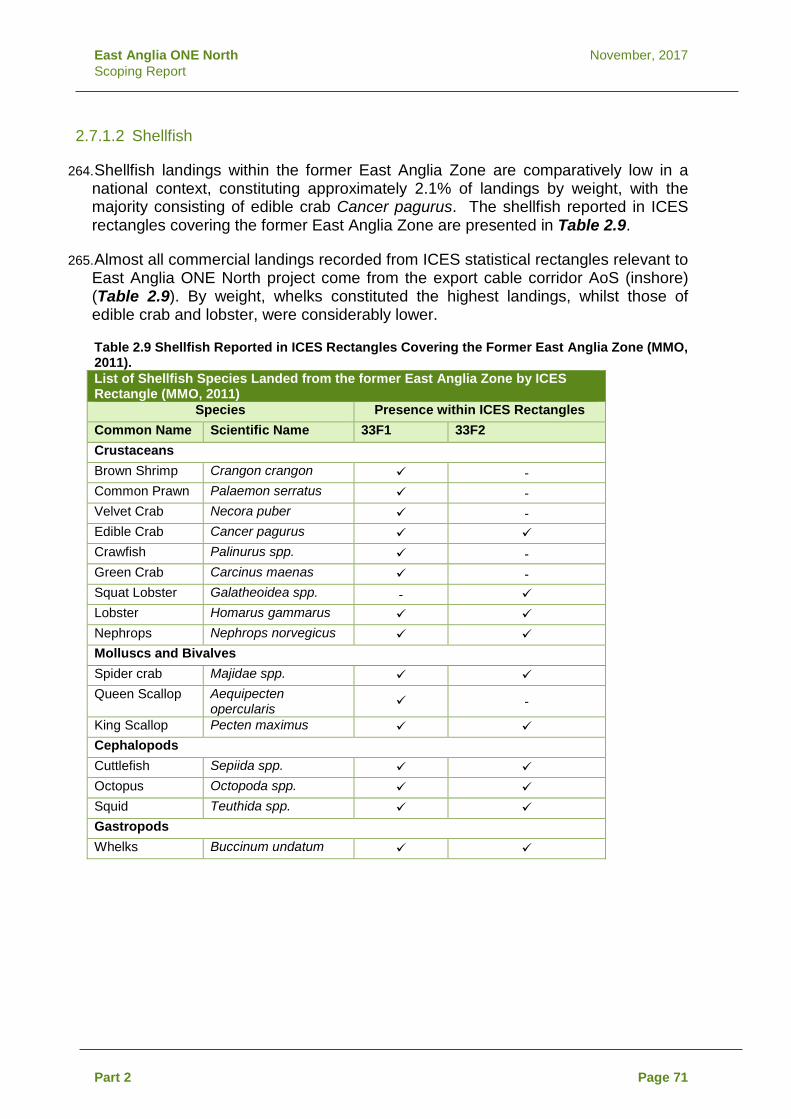
East Anglia ONE North November, 2017 Scoping Report
2.7.1.2 Shellfish
264. Shellfish landings within the former East Anglia Zone are comparatively low in a national context, constituting approximately 2.1% of landings by weight, with the majority consisting of edible crab Cancer pagurus. The shellfish reported in ICES rectangles covering the former East Anglia Zone are presented in Table 2.9.
265. Almost all commercial landings recorded from ICES statistical rectangles relevant to East Anglia ONE North project come from the export cable corridor AoS (inshore) (Table 2.9). By weight, whelks constituted the highest landings, whilst those of edible crab and lobster, were considerably lower.
Table 2.9 Shellfish Reported in ICES Rectangles Covering the Former East Anglia Zone (MMO, 2011). List of Shellfish Species Landed from the former East Anglia Zone by ICES Rectangle (MMO, 2011)
Species Presence within ICES Rectangles Common Name Scientific Name 33F1 33F2 Crustaceans Brown Shrimp Crangon crangon - Common Prawn Palaemon serratus - Velvet Crab Necora puber - Edible Crab Cancer pagurus Crawfish Palinurus spp. - Green Crab Carcinus maenas - Squat Lobster Galatheoidea spp. - Lobster Homarus gammarus Nephrops Nephrops norvegicus Molluscs and Bivalves Spider crab Majidae spp. Queen Scallop Aequipecten
opercularis -
King Scallop Pecten maximus Cephalopods Cuttlefish Sepiida spp. Octopus Octopoda spp. Squid Teuthida spp. Gastropods Whelks Buccinum undatum
Part 2 Page 71

Scale @ A4:
Figure Dwg No.DateRev Date By Comment 2.6a 27/10/17 EA1N-DB-0013 Datum: WGS 1984
Projection: Zone 31N
Cod Spawning and Nursery Grounds in and Around East Anglia ONE North Windfarm Siteand Export Cable Corridor Area of Search
East Anglia ONE North Scoping
D:\Box Sync\PB4842 EA 1N and 2\PB4842 EA 1N and 2 Team\E. TECHNICAL DATA\E03 GIS\Sizewell\Figures\Scoping\Offshore\EA1N_DB_0013_FishEcol_Cod_20171027.mxd
Prepared:Checked:Approved:
FRAMLINGHAM
WICKHAMMARKET
WOODBRIDGE
HARLESTON
ALDEBURGH
LEISTONSAXMUNDHAM
SOUTHWOLD
HALESWORTH
BUNGAY BECCLESLOWESTOFT
KOBKPP
1:500,000 0 10 205 Kilometres
FRAMLINGHAM
WICKHAMMARKET
WOODBRIDGE
HARLESTON
ALDEBURGH
LEISTONSAXMUNDHAM
SOUTHWOLD
HALESWORTH
BUNGAY BECCLESLOWESTOFT ¯
Spawning grounds
Nursery grounds
This map has been produced to the latest known information at the time of issue, and has been produced for your information only. Please consult with the SPR Offshore GIS team to ensure the content is still current before using the information contained on this map. To the fullest extent permitted by law, we accept no responsibility or liability (whether in contract, tort (including negligence) or otherwise in respect of any errors or omissions in the information contained in the map and shall not be liable for any loss, damage or expense caused by such errors or omissions.
LegendExport CableCorridor Area ofSearchEast Anglia ONENorth Windfarm SiteSpawning Ground(Coull et al. 1998)
Spawning Ground(Intensity)
High Intensity (Elliset al. 2010)Low Intensity (Elliset al. 2010)
LegendExport CableCorridor Area ofSearchEast Anglia ONENorth Windfarm SiteNursery Ground(Coull et al. 1998)
Nursery Ground (Intensity)High Intensity (Elliset al. 2010)Low Intensity (Elliset al. 2010)
Source: © Cefas, 2017. © The Crown Estate, 2017. Charts fromMarineFIND.co.uk © Licence No EK001-0645-MF0095. Not to be used fornavigation.
0 06/09/17 KO First Issue.27/09/171 KO Second Issue.27/10/172 KO Third Issue.

Scale @ A4:
Figure Dwg No.DateRev Date By Comment 2.6b 27/10/17 EA1N-DB-0014 Datum: WGS 1984
Projection: Zone 31N
Herring Spawning and Nursery Grounds in and Around East Anglia ONE North Windfarm Site and Export Cable Corridor Area of Search
East Anglia ONE North Scoping
D:\Box Sync\PB4842 EA 1N and 2\PB4842 EA 1N and 2 Team\E. TECHNICAL DATA\E03 GIS\Sizewell\Figures\Scoping\Offshore\EA1N_DB_0014_FishEcol_Herring_20171027.mxd
Prepared:Checked:Approved:
FRAMLINGHAM
WICKHAMMARKET
WOODBRIDGE
HARLESTON
ALDEBURGH
LEISTONSAXMUNDHAM
SOUTHWOLD
HALESWORTH
BUNGAY BECCLESLOWESTOFT
KOBKPP
1:500,000 0 10 205 Kilometres
FRAMLINGHAM
WICKHAMMARKET
WOODBRIDGE
HARLESTON
ALDEBURGH
LEISTONSAXMUNDHAM
SOUTHWOLD
HALESWORTH
BUNGAY BECCLESLOWESTOFT ¯
Spawning grounds
Nursery grounds
This map has been produced to the latest known information at the time of issue, and has been produced for your information only. Please consult with the SPR Offshore GIS team to ensure the content is still current before using the information contained on this map. To the fullest extent permitted by law, we accept no responsibility or liability (whether in contract, tort (including negligence) or otherwise in respect of any errors or omissions in the information contained in the map and shall not be liable for any loss, damage or expense caused by such errors or omissions.
LegendExport CableCorridor Area ofSearchEast Anglia ONENorth Windfarm SiteSpawning Ground(Coull et al. 1998)
LegendExport CableCorridor Area ofSearchEast Anglia ONENorth Windfarm SiteNursery Ground(Coull et al. 1998)
Nursery Ground (Intensity)High Intensity (Elliset al. 2010)Low Intensity (Elliset al. 2010)
Source: © Cefas, 2017. © The Crown Estate, 2017. Charts fromMarineFIND.co.uk © Licence No EK001-0645-MF0095. Not to be used fornavigation.
0 06/09/17 KO First Issue.27/09/171 KO Second Issue.27/10/172 KO Third Issue.

Scale @ A4:
Figure Dwg No.DateRev Date By Comment 2.6c 27/10/17 EA1N-DB-0015 Datum: WGS 1984
Projection: Zone 31N
Plaice Spawning and Nursery Grounds in and Around East Anglia ONE North Windfarm Site and Export Cable Corridor Area of Search
East Anglia ONE North Scoping
D:\Box Sync\PB4842 EA 1N and 2\PB4842 EA 1N and 2 Team\E. TECHNICAL DATA\E03 GIS\Sizewell\Figures\Scoping\Offshore\EA1N_DB_0015_FishEcol_Plaice_20171027.mxd
Prepared:Checked:Approved:
FRAMLINGHAM
WICKHAMMARKET
WOODBRIDGE
HARLESTON
ALDEBURGH
LEISTONSAXMUNDHAM
SOUTHWOLD
HALESWORTH
BUNGAY BECCLESLOWESTOFT
KOBKPP
1:500,000 0 10 205 Kilometres
FRAMLINGHAM
WICKHAMMARKET
WOODBRIDGE
HARLESTON
ALDEBURGH
LEISTONSAXMUNDHAM
SOUTHWOLD
HALESWORTH
BUNGAY BECCLESLOWESTOFT ¯
Spawning grounds
Nursery grounds
This map has been produced to the latest known information at the time of issue, and has been produced for your information only. Please consult with the SPR Offshore GIS team to ensure the content is still current before using the information contained on this map. To the fullest extent permitted by law, we accept no responsibility or liability (whether in contract, tort (including negligence) or otherwise in respect of any errors or omissions in the information contained in the map and shall not be liable for any loss, damage or expense caused by such errors or omissions.
LegendExport CableCorridor Area ofSearchEast Anglia ONENorth Windfarm SiteSpawning Ground(Coull et al. 1998)
Spawning Ground(Intensity)
High Intensity (Elliset al. 2010)Low Intensity (Elliset al. 2010)
LegendExport CableCorridor Area ofSearchEast Anglia ONENorth Windfarm SiteNursery Ground(Coull et al. 1998)
Nursery Ground (Intensity)High Intensity (Elliset al. 2010)Low Intensity (Elliset al. 2010)
Source: © Cefas, 2017. © The Crown Estate, 2017. Charts fromMarineFIND.co.uk © Licence No EK001-0645-MF0095. Not to be used fornavigation.
0 06/09/17 KO First Issue.27/09/171 KO Second Issue.27/10/172 KO Third Issue.

Scale @ A4:
Figure Dwg No.DateRev Date By Comment 2.6d 27/10/17 EA1N-DB-0016 Datum: WGS 1984
Projection: Zone 31N
Sandeel Spawning and Nursery Grounds in and Around East Anglia ONE North Windfarm Site and Export Cable Corridor Area of Search
East Anglia ONE North Scoping
D:\Box Sync\PB4842 EA 1N and 2\PB4842 EA 1N and 2 Team\E. TECHNICAL DATA\E03 GIS\Sizewell\Figures\Scoping\Offshore\EA1N_DB_0016_FishEcol_Sandeel_20171027.mxd
Prepared:Checked:Approved:
FRAMLINGHAM
WICKHAMMARKET
WOODBRIDGE
HARLESTON
ALDEBURGH
LEISTONSAXMUNDHAM
SOUTHWOLD
HALESWORTH
BUNGAY BECCLESLOWESTOFT
KOBKPP
1:500,000 0 10 205 Kilometres
FRAMLINGHAM
WICKHAMMARKET
WOODBRIDGE
HARLESTON
ALDEBURGH
LEISTONSAXMUNDHAM
SOUTHWOLD
HALESWORTH
BUNGAY BECCLESLOWESTOFT ¯
Spawning grounds
Nursery grounds
This map has been produced to the latest known information at the time of issue, and has been produced for your information only. Please consult with the SPR Offshore GIS team to ensure the content is still current before using the information contained on this map. To the fullest extent permitted by law, we accept no responsibility or liability (whether in contract, tort (including negligence) or otherwise in respect of any errors or omissions in the information contained in the map and shall not be liable for any loss, damage or expense caused by such errors or omissions.
LegendExport CableCorridor Area ofSearchEast Anglia ONENorth Windfarm SiteSpawning Ground(Coull et al. 1998)
Spawning Ground(Intensity)
High Intensity (Elliset al. 2010)Low Intensity (Elliset al. 2010)
LegendExport CableCorridor Area ofSearchEast Anglia ONENorth Windfarm SiteNursery Ground(Coull et al. 1998)
Nursery Ground (Intensity)High Intensity (Elliset al. 2010)Low Intensity (Elliset al. 2010)
Source: © Cefas, 2017. © The Crown Estate, 2017. Charts fromMarineFIND.co.uk © Licence No EK001-0645-MF0095. Not to be used fornavigation.
0 06/09/17 KO First Issue.27/09/171 KO Second Issue.27/10/172 KO Third Issue.

Scale @ A4:
Figure Dwg No.DateRev Date By Comment 2.6e 27/10/17 EA1N-DB-0017 Datum: WGS 1984
Projection: Zone 31N
Sole Spawning and Nursery Grounds in and Around East Anglia ONE North Windfarm Site and Export Cable Corridor Area of Search
East Anglia ONE North Scoping
D:\Box Sync\PB4842 EA 1N and 2\PB4842 EA 1N and 2 Team\E. TECHNICAL DATA\E03 GIS\Sizewell\Figures\Scoping\Offshore\EA1N_DB_0017_FishEcol_Sole_20171027.mxd
Prepared:Checked:Approved:
FRAMLINGHAM
WICKHAMMARKET
WOODBRIDGE
HARLESTON
ALDEBURGH
LEISTONSAXMUNDHAM
SOUTHWOLD
HALESWORTH
BUNGAY BECCLESLOWESTOFT
KOBKPP
1:500,000 0 10 205 Kilometres
FRAMLINGHAM
WICKHAMMARKET
WOODBRIDGE
HARLESTON
ALDEBURGH
LEISTONSAXMUNDHAM
SOUTHWOLD
HALESWORTH
BUNGAY BECCLESLOWESTOFT ¯
Spawning grounds
Nursery grounds
This map has been produced to the latest known information at the time of issue, and has been produced for your information only. Please consult with the SPR Offshore GIS team to ensure the content is still current before using the information contained on this map. To the fullest extent permitted by law, we accept no responsibility or liability (whether in contract, tort (including negligence) or otherwise in respect of any errors or omissions in the information contained in the map and shall not be liable for any loss, damage or expense caused by such errors or omissions.
LegendExport CableCorridor Area ofSearchEast Anglia ONENorth Windfarm SiteSpawning Ground(Coull et al. 1998)
Spawning Ground(Intensity)
High Intensity (Elliset al. 2010)Low Intensity (Elliset al. 2010)
LegendExport CableCorridor Area ofSearchEast Anglia ONENorth Windfarm SiteNursery Ground(Coull et al. 1998)
Nursery Ground (Intensity)High Intensity (Elliset al. 2010)Low Intensity (Elliset al. 2010)
Source: © Cefas, 2017. © The Crown Estate, 2017. Charts fromMarineFIND.co.uk © Licence No EK001-0645-MF0095. Not to be used fornavigation.
0 06/09/17 KO First Issue.27/09/171 KO Second Issue.27/10/172 KO Third Issue.

Scale @ A4:
Figure Dwg No.DateRev Date By Comment 2.6f 27/09/17 EA1N-DB-0018 Datum: WGS 1984
Projection: Zone 31N
Sprat Spawning and Nursery Grounds in and Around East Anglia ONE North Windfarm Site and Export Cable Corridor Area of Search
East Anglia ONE North Scoping
D:\Box Sync\PB4842 EA 1N and 2\PB4842 EA 1N and 2 Team\E. TECHNICAL DATA\E03 GIS\Sizewell\Figures\Scoping\Offshore\EA1N_DB_0018_FishEcol_Sprat_20171027.mxd
0 06/09/17 KO First Issue.Prepared:Checked:Approved:
FRAMLINGHAM
WICKHAMMARKET
WOODBRIDGE
HARLESTON
ALDEBURGH
LEISTONSAXMUNDHAM
SOUTHWOLD
HALESWORTH
BUNGAY BECCLESLOWESTOFT
KOBKPP
1:500,000 0 10 205 Kilometres
FRAMLINGHAM
WICKHAMMARKET
WOODBRIDGE
HARLESTON
ALDEBURGH
LEISTONSAXMUNDHAM
SOUTHWOLD
HALESWORTH
BUNGAY BECCLESLOWESTOFT ¯
Spawning grounds
Nursery grounds
This map has been produced to the latest known information at the time of issue, and has been produced for your information only. Please consult with the SPR Offshore GIS team to ensure the content is still current before using the information contained on this map. To the fullest extent permitted by law, we accept no responsibility or liability (whether in contract, tort (including negligence) or otherwise in respect of any errors or omissions in the information contained in the map and shall not be liable for any loss, damage or expense caused by such errors or omissions.
LegendExport CableCorridor Area ofSearchEast Anglia ONENorth Windfarm SiteSpawning Ground(Coull et al. 1998)
LegendExport CableCorridor Area ofSearchEast Anglia ONENorth Windfarm SiteNursery Ground(Coull et al. 1998)
Source: © Cefas, 2017. © The Crown Estate, 2017. Charts fromMarineFIND.co.uk © Licence No EK001-0645-MF0095. Not to be used fornavigation.
27/09/171 KO Second Issue.27/10/172 KO Third Issue.

Scale @ A4:
Figure Dwg No.DateRev Date By Comment 2.6g 27/10/17 EA1N-DB-0019 Datum: WGS 1984
Projection: Zone 31N
Thornback Ray Spawning and Nursery Grounds in and Around East Anglia ONE North Windfarm Site and Export Cable Corridor Area of Search
East Anglia ONE North Scoping
D:\Box Sync\PB4842 EA 1N and 2\PB4842 EA 1N and 2 Team\E. TECHNICAL DATA\E03 GIS\Sizewell\Figures\Scoping\Offshore\EA1N_DB_0019_FishEcol_Thornback Ray_20171027.mxd
Prepared:Checked:Approved:
FRAMLINGHAM
WICKHAMMARKET
WOODBRIDGE
HARLESTON
ALDEBURGH
LEISTONSAXMUNDHAM
SOUTHWOLD
HALESWORTH
BUNGAY BECCLESLOWESTOFT
KOBKPP
1:500,000 0 10 205 Kilometres
FRAMLINGHAM
WICKHAMMARKET
WOODBRIDGE
HARLESTON
ALDEBURGH
LEISTONSAXMUNDHAM
SOUTHWOLD
HALESWORTH
BUNGAY BECCLESLOWESTOFT ¯
Spawning grounds
Nursery grounds
This map has been produced to the latest known information at the time of issue, and has been produced for your information only. Please consult with the SPR Offshore GIS team to ensure the content is still current before using the information contained on this map. To the fullest extent permitted by law, we accept no responsibility or liability (whether in contract, tort (including negligence) or otherwise in respect of any errors or omissions in the information contained in the map and shall not be liable for any loss, damage or expense caused by such errors or omissions.
LegendExport CableCorridor Area ofSearchEast Anglia ONENorth Windfarm Site
LegendExport CableCorridor Area ofSearchEast Anglia ONENorth Windfarm Site
Nursery Ground (Intensity)High Intensity (Elliset al. 2010)Low Intensity (Elliset al. 2010)
Source: © Cefas, 2017. © The Crown Estate, 2017. Charts fromMarineFIND.co.uk © Licence No EK001-0645-MF0095. Not to be used fornavigation.
0 06/09/17 KO First Issue.27/09/171 KO Second Issue.27/10/172 KO Third Issue.

Scale @ A4:
Figure Dwg No.DateRev Date By Comment 2.6h 27/10/17 EA1N-DB-0020 Datum: WGS 1984
Projection: Zone 31N
Tope Spawning and Nursery Grounds in and Around East Anglia ONE North Windfarm Site and Export Cable Corridor Area of Search
East Anglia ONE North Scoping
D:\Box Sync\PB4842 EA 1N and 2\PB4842 EA 1N and 2 Team\E. TECHNICAL DATA\E03 GIS\Sizewell\Figures\Scoping\Offshore\EA1N_DB_0020_FishEcol_Tope_20171027.mxd
0 06/09/17 KO First Issue.Prepared:Checked:Approved:
FRAMLINGHAM
WICKHAMMARKET
WOODBRIDGE
HARLESTON
ALDEBURGH
LEISTONSAXMUNDHAM
SOUTHWOLD
HALESWORTH
BUNGAY BECCLESLOWESTOFT
KOBKPP
1:500,000 0 10 205 Kilometres
FRAMLINGHAM
WICKHAMMARKET
WOODBRIDGE
HARLESTON
ALDEBURGH
LEISTONSAXMUNDHAM
SOUTHWOLD
HALESWORTH
BUNGAY BECCLESLOWESTOFT ¯
Spawning grounds
Nursery grounds
This map has been produced to the latest known information at the time of issue, and has been produced for your information only. Please consult with the SPR Offshore GIS team to ensure the content is still current before using the information contained on this map. To the fullest extent permitted by law, we accept no responsibility or liability (whether in contract, tort (including negligence) or otherwise in respect of any errors or omissions in the information contained in the map and shall not be liable for any loss, damage or expense caused by such errors or omissions.
LegendExport CableCorridor Area ofSearchEast Anglia ONENorth Windfarm Site
LegendExport CableCorridor Area ofSearchEast Anglia ONENorth Windfarm Site
Nursery Ground (Intensity)High Intensity (Elliset al. 2010)Low Intensity (Elliset al. 2010)
Source: © Cefas, 2017. © The Crown Estate, 2017. Charts fromMarineFIND.co.uk © Licence No EK001-0645-MF0095. Not to be used fornavigation.
27/09/171 KO Second Issue.27/10/172 KO Third Issue.

East Anglia ONE North November, 2017 Scoping Report
2.7.1.3 Designated Sites and Protected Species
266. Designated sites with the following species as interest features will be considered within the EIA and HRA:
• Atlantic salmon Salmo salar; • Sea lamprey Petromyzon marinus; • River lamprey Lampetra fluviatilis; • Allis Shad Alosa alosa; and • Twaite Shad Alosa fallax.
267. There are no Special Areas of Conservation (SACs) designated for the above
species (either as a primary or secondary interest feature) within 50km of the proposed East Anglia ONE North project (EATL 2015b). A HRA screening exercise will be undertaken to consider possible impacts on designated sites.
268. There are 35 species of fish included in Natural England’s Priority Species List (formerly the UK BAP list). These will be considered within the EIA.
269. Whilst not a designated species, seabass Dicentrarchus labrax has been placed under special protection measures due to fishing pressure and evidence of reduced reproduction output (MMO, 2017). Whilst, there is little evidence of the windfarm site being an important environment for seabass, the EIA will consider impacts to important bass habitats.
2.7.2 Potential Impacts
270. Potential impacts to be considered within the EIA have been agreed with statutory advisors (MMO, Natural England and Cefas) through the EPP (Expert Topic Group meeting 12th April, 2017). A full description of the impacts which will be assessed can be found in Appendix 2.3.
2.7.2.1 Potential Impacts during Construction
271. Potential impacts during construction will come from physcial disturbance of the seabed habitats, suspension of sediment during cable and foundation installation work (including seabed preparation). Underwater noise generated by pile driving and other construction activities may result in disturbance and displacement of fish species. The impacts of windfarm construction will be considered separately from the export cable corridor, and potential interactions considered.
272. Potential impacts related to the resuspension of contaminants are currently scoped in for asssement; however, should the results of benthic sampling demonstrate low levels of contamination SPR would seek to scope these out of further assessment through the EPP.
Part 2 Page 80
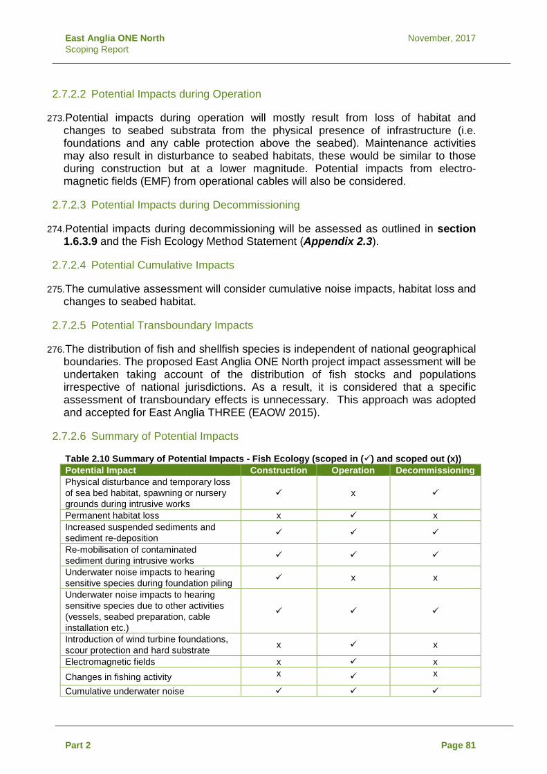
East Anglia ONE North November, 2017 Scoping Report
2.7.2.2 Potential Impacts during Operation
273. Potential impacts during operation will mostly result from loss of habitat and changes to seabed substrata from the physical presence of infrastructure (i.e. foundations and any cable protection above the seabed). Maintenance activities may also result in disturbance to seabed habitats, these would be similar to those during construction but at a lower magnitude. Potential impacts from electro-magnetic fields (EMF) from operational cables will also be considered.
2.7.2.3 Potential Impacts during Decommissioning
274. Potential impacts during decommissioning will be assessed as outlined in section 1.6.3.9 and the Fish Ecology Method Statement (Appendix 2.3).
2.7.2.4 Potential Cumulative Impacts
275. The cumulative assessment will consider cumulative noise impacts, habitat loss and changes to seabed habitat.
2.7.2.5 Potential Transboundary Impacts
276. The distribution of fish and shellfish species is independent of national geographical boundaries. The proposed East Anglia ONE North project impact assessment will be undertaken taking account of the distribution of fish stocks and populations irrespective of national jurisdictions. As a result, it is considered that a specific assessment of transboundary effects is unnecessary. This approach was adopted and accepted for East Anglia THREE (EAOW 2015).
2.7.2.6 Summary of Potential Impacts
Table 2.10 Summary of Potential Impacts - Fish Ecology (scoped in () and scoped out (x)) Potential Impact Construction Operation Decommissioning Physical disturbance and temporary loss of sea bed habitat, spawning or nursery grounds during intrusive works
x
Permanent habitat loss x x Increased suspended sediments and sediment re-deposition
Re-mobilisation of contaminated sediment during intrusive works
Underwater noise impacts to hearing sensitive species during foundation piling x x
Underwater noise impacts to hearing sensitive species due to other activities (vessels, seabed preparation, cable installation etc.)
Introduction of wind turbine foundations, scour protection and hard substrate x x
Electromagnetic fields x x Changes in fishing activity x x
Cumulative underwater noise
Part 2 Page 81

East Anglia ONE North November, 2017 Scoping Report
Potential Impact Construction Operation Decommissioning Cumulative permanent habitat loss x Cumulative changes to seabed habitat Transboundary impacts x x x
2.7.2.7 Mitigation
277. If required, appropriate mitigation will be identified and agreed with stakeholders through the EIA and the EPP.
2.7.3 Approach to Data Gathering and Assessment
278. Some existing site specific data are available from previous projects in the former East Anglia Zone; however, given that fish are highly mobile, data sets with large-scale coverage are of more relevance for characterising the natural fish and shellfish resource. A key source of information that will be used will be fisheries landings data; these provide both large spatial coverage and effort although the data have some limitations (i.e. they will be skewed towards commercial species with many non-commercial species being discarded at sea).
279. It was agreed with stakeholders through the EPP that sufficient publicly available information is available to undertake a robust assessment and that site specific fish sampling surveys are not required. The fish and shellfish ecology assessment will be based on data from the following sources:
• MMO Landings data (weight and value) by species (latest data series available at the time of writing the ES);
• Spawning and nursery grounds of selected fish species in UK waters mapped by Coull et al. (1998) and revised by Ellis et al. (2012);
• North Sea International Bottom Trawl Survey Data; • North Sea Groundfish Survey Data; • IMARES monthly ichthyoplankton surveys in the Southern North
Sea April 2010-March 2011 (van Damme et al. 2011); • East Coast REC (Limpenny 2011); • East Marine Plan documents, July 2014 (MMO 2014); • Reports, survey data and publications by organisations including
Cefas, MMO, COWRIE, ICES, IFCA and Environment Agency; • Marine Conservation Zone (MCZ) recommendations – Net Gain
and Natural England; • Existing site specific data for East Anglia ONE (EAOW 2013),
East Anglia THREE (EAOW 2015) and the East Anglia Zone appraisal (EAOW 2010);
• ORJIP study on impacts to fish from piling at offshore windfarms (to be published); and
• Other relevant peer-review publications and stock assessments.
Part 2 Page 82

East Anglia ONE North November, 2017 Scoping Report
280. The results of the Marine Geology, Oceanography and Physical Processes, Marine Water and Sediment Quality and Benthic Ecology assessments will be used to inform the assessments in this topic.
2.8 Marine Mammals
2.8.1 Baseline
2.8.1.1 Cetaceans
281. The southern North Sea, including the area of the East Anglia ONE North windfarm site, generally has a relatively low abundance of marine mammals, with the potential exception of the harbour porpoise Phocoena phocoena, white-beaked dolphin Lagenorhynchus albirostris and seasonal occurrence of minke whale Balaenoptera acutorostrata. Other cetacean species, such as bottlenose dolphin Tursiops truncatus, Risso’s dolphin Grampius griseus, common dolphin Delphinus delphis and Atlantic white-sided dolphin Lagenorhynchus acutus are typically uncommon (DECC 2016; Hammond et al. 2002, 2013, 2017; JNCC 2013; Reid et al. 2003).
282. During the SCANS-II surveys in July 2005 and SCANS-III surveys in summer 2016, the cetacean species recorded in the southern North Sea area were harbour porpoise, bottlenose dolphin, white-beaked dolphin and minke whale (Hammond et al. 2013, 2017). Of these, harbour porpoise were recorded most commonly.
283. As part of the ZEA for the former East Anglia Zone, marine mammal survey data were collected over a 17 month period from November 2009 to April 2011 (EAOW 2012b). From these surveys, a total of 108 cetaceans were positively identified; 38% were identified as harbour porpoise, 53% were identified as small cetaceans (porpoise or small dolphin), 6% as patterned dolphins (one of which was positively identified as being a white-beaked dolphin) and 3% were identified as unknown cetacean species. Given the much higher identification rate of harbour porpoise than dolphin species at a species level, it is likely that the majority of the small unidentified cetaceans were harbour porpoise (EAOW 2012b).
284. These data were used to create modelled cetacean abundancies across the former East Anglia Zone for all seasons. These modelled abundancies show higher numbers of cetaceans in autumn and winter periods, and in the south, west and north-east areas of the former East Anglia Zone. Within the proposed East Anglia ONE North windfarm site, the modelled abundancies of cetaceans were consistently low, except in autumn 2010 with a small increase in abundancies in the north and north west edges of the site (EAOW 2012b).
285. Species sighting records are consistent with the conclusions of previously modelled abundances for the former East Anglia Zone. For the site specific surveys, unidentified small cetacean and harbour porpoise being the most commonly recorded species, and the months with the highest numbers of sightings were January, February and March based on 10 months of survey data. Site specific data up to July 2017 are presented in Table 2.11.
Part 2 Page 83

East Anglia ONE North November, 2017 Scoping Report
Table 2.11 Marine Mammal Sightings Recorded during East Anglia ONE North Windfarm Site Aerial Survey Survey Number
Month Year Number of Sightings Unidentified
Small Cetacean
Harbour Porpoise
Dolphin Sp Phocid Total number
1 Sep 2016 0 0 0 0 0 2 Oct 2016 1 0 0 0 1 3 Nov 2016 3 0 0 0 3 4 Dec 2016 11 1 0 0 12 5 Jan 2017 9 0 0 1 10 6 Feb 2017 21 5 1 2 29 7 Mar 2017 26 4 1* 1 32 8 Apr 2017 1 2 0 1 4 9 May 2017 0 0 0 0 0 10 Jun 2017 5 0 0 0 5 *White beaked dolphin
286. The East Anglia ONE windfarm site is located 1.3km south of the East Anglia ONE North windfarm site. For East Anglia ONE, both boat-based (from May 2010 to April 2011) and aerial surveys (from April 2010 to October 2011) were undertaken for marine mammals across the windfarm site and 4km buffer area and overlaps with the East Anglia ONE North windfarm site. The aerial surveys positively identified 181 cetaceans, with 72% of these (130) identified as harbour porpoise, 12.5% as either a porpoise or dolphin, 0.5% as a patterned dolphin and a further 15% were recorded as unidentified cetacean species (EAOW 2012b).
287. The East Anglia ONE survey identified 83% of all cetaceans recorded as harbour porpoise. The boat-based surveys also recorded low numbers of three dolphin species: white-beaked dolphin (8%), bottlenose dolphin (6%) and Risso’s dolphin (2%), as well as unidentified dolphin species (2%). On the basis of the boat-based survey results, it was considered likely that the majority of ‘small cetaceans’ recorded from the former East Anglia Zone aerial surveys were harbour porpoise (EAOW 2012b).
288. The East Anglia THREE site specific surveys included 24 months of aerial surveys for marine mammals (from September 2011 to August 2013). In total, 341 cetaceans were positively identified, of which 44% were positively identified as harbour porpoise, with a further 55% identified as either harbour porpoise or dolphin and 1.2% white-beaked dolphin (EATL 2015).
289. The available information (including site specific surveys of offshore windfarms in the southern North Sea) confirm that the harbour porpoise is the most abundant cetacean species in the East Anglia ONE North windfarm site. Other cetaceans that could be present include any cetacean that has been previously recorded during boat and aerial survey in the area or vicinity, such as white-beaked dolphin, bottlenose dolphin, Risso’s dolphin and minke whale. However, currently available information suggests that the occurrences of these species are likely to be infrequent. It is therefore anticipated that harbour porpoise will be the focus of the assessment.
Part 2 Page 84

East Anglia ONE North November, 2017 Scoping Report
2.8.1.2 Pinnipeds
290. Grey seal Halichoerus grypus and harbour seal Phoca vitulina are both present in the southern North Sea and have been recorded in the former East Anglia Zone.
291. The nearest harbour seal haul-out site to the landfall location is Horsey Island, 41.7km south of the landfall site. Another key haul-out site for harbour seal is Scroby Sands located 49.7km north of the landfall area. The nearest key haul-out site for grey seal is Horsey, 66.5km north of the landfall area.
292. Both grey and harbour seals have wide-ranging foraging zones and are capable of travelling large distances between haul-out areas. Grey seals will typically forage within 100km from their haul-out sites (Thompson et al. 1996), although are capable of making much longer foraging trips of up to 1,000km (McConnell et al. 1992). Harbour seals generally have smaller foraging ranges of 40-50km from their haul-out sites (Special Committee on Seals (SCOS) 2016). However, tagging studies on harbour seals in The Wash have revealed large foraging ranges than for other colonies, with those foraging excursions being 75-120km offshore (Sharples et al. 2008).
293. It is possible, based on the foraging ranges of seal species and the distances from key haul-out sites, that seals may cross the windfarm site. However, the aerial surveys for the ZEA did not identify any seals. Previous surveys undertaken around the area of the former East Anglia Zone by Wildfowl and Wetlands Trust (WWT) recorded eight seals in June 2009 and ten seals in July and August 2009 (EAOW 2012b). Similarly, only three seals were recorded within the East Anglia ONE marine mammal survey area (EAOW 2012b), with six grey seals and three harbour seals within Galloper Wind Farm (GWFL 2011) and only two within the East Anglia THREE site surveys (EATL 2015).
294. While aerial surveys are not the most appropriate method to determining at sea densities of seals, the Seals at Sea dataset (Jones et al. 2016) confirms that grey seal and harbour seal use of the East Anglia ONE North windfarm site and export cable corridor AoS is low. The mean at-sea density estimates for harbour seal are zero to one individual per 25km2 around the windfarm site, rising to one to five per 25km2 around the landfall area and along the adjacent coastlines. For grey seal, the mean at-sea density estimate is zero to one individual per km2 for both the windfarm site and landfall areas.
2.8.1.3 Designated Sites and Protected Species
295. All cetacean species within UK waters are classified as European Protected Species (EPS) and are therefore of international importance. Harbour porpoise and bottlenose dolphin are afforded further protection as both are listed under Annex II of the Habitats Directive requiring Natura 2000 sites to be designated for them.
Part 2 Page 85

East Anglia ONE North November, 2017 Scoping Report
296. The Southern North Sea Candidate SAC (cSAC) has been proposed for the protection of harbour porpoise and the East Anglia ONE North windfarm site lies wholly within the cSAC. The cSAC was identified in 2015 as being within the top 10% of persistently high density areas for harbour porpoise in UK waters (JNCC 2015). The cSAC covers both winter and summer habitats of importance to harbour porpoise, with approximately 66% of the candidate site being important in the summer and the remaining 33% of the site being important in the winter period. The cSAC Site Selection Document identifies that the SNS cSAC has an estimated population of 18,500 individuals for at least part of the year, and represents approximately 17.5% of the North Sea Management Unit population (within UK waters), based on the SCANS-II surveys (JNCC 2017).
297. The Wash and North Norfolk Coast SAC is the closest SAC to the East Anglia ONE North windfarm site, at 102km away, and is designated for harbour seal. There are no designated sites for grey seal in the south-east of England.
298. A HRA screening exercise will be undertaken to consider possible effects on designated sites.
2.8.2 Potential Impacts
299. Potential impacts to be considered within the EIA were agreed with stakeholders (Natural England, MMO, Whale and Dolphin Conservation (WDC) and The Wildlife Trust (TWT)) through a Method Statement discussed at the EPP on the 30th of May, 2017. Full details of impacts to be considered are outlined in the Method Statement (Appendix 2.4) and summarised below;
2.8.2.1 Potential Impacts during Construction
300. Potential impacts during construction may arise from disturbance due to construction activities during the installation of offshore infrastructure. Underwater noise during piling, as well as disturbance associated with underwater noise from other construction activities (such as UXO clearence and cable installation) and the presence of vessels offshore will be considered. Displacement from important habitat areas and indirect impacts on prey species will also be considered. The impacts will be considered separately for the windfarm site and for the export cable corridor, and potential interactions considered.
2.8.2.2 Potential Impacts during Operation
301. Potential impacts during operation will mostly result from the presence of routine vessels within the windfarm, underwater noise and the impacts on prey species during maintenance activities. These will be similar to impacts assessed for construction, but lower in magnitude.
Part 2 Page 86

East Anglia ONE North November, 2017 Scoping Report
302. Note that effects from EMF and physical barrier effects9 were not considered within the Method Statement as these have been scoped out of consideration for recent projects as there is no evidence of impact (see the Scoping Opinion for Norfolk Vanguard and for Norfolk Boreas, (the Planning Inspectorate 2016b, 2017b)).
2.8.2.3 Potential Impacts during Decommissioning
303. Potential impacts during decommissioning will be assessed as outlined in section 1.6.3.9 and outlined in the Marine Mammal Method Statement (Appendix 2.4).
2.8.2.4 Potential Cumulative Impacts
304. The cumulative assessment will consider displacement due to cumulative underwater noise and impacts on prey species. The assessment will also consider displacement due to the presence of offshore vessels and maintenance activities during the operational phase and barrier effects due to the presence of offshore structures.
2.8.2.5 Potential Transboundary Impacts
305. There is a significant level of marine development being undertaken or planned by other EU Member States (i.e. Belgium, the Netherlands, Germany and Denmark) in the southern North Sea. Populations of marine mammals (particularly cetaceans) are highly mobile and there is potential for transboundary impacts especially with regard to noise. In addition, there is potential for the proposed East Anglia ONE North project to impact on marine mammals from international designated sites.
306. Transboundary impacts will be assessed as with the other cumulative impacts and SPR will, where possible, liaise with developers in other Member States to obtain up to date project information to feed into the assessment.
2.8.2.6 Summary of Potential Impacts
Table 2.12 Summary of Potential Impacts - Marine Mammal Ecology (scoped in () and scoped out (x)). Impacts will be assessed for all species for which there sufficient data. Potential Impacts Construction Operation Decommissioning Underwater noise during UXO clearance x x Underwater noise during piling x x Underwater noise from vessels and other activities, such as seabed preparations, cable installation and rock dumping
Underwater noise from operational wind turbines x x
Barrier effects caused by underwater noise
Water quality caused by disturbance of sediment
9 Note that although physical barrier effects are considered for Norfolk Boreas this is only with respect to floating foundations which are not being considered for the proposed East Anglia ONE North project.
Part 2 Page 87

East Anglia ONE North November, 2017 Scoping Report
Potential Impacts Construction Operation Decommissioning Electromagnetic fields x x x Vessel interactions and collision risk Disturbance at seal haul-out sites x x x Changes to prey resources Cumulative Underwater noise Cumulative Vessel and other interactions Cumulative Barrier effects Cumulative disturbance at seal haul-out sites
Cumulative changes to prey resources Transboundary impacts
2.8.3 Mitigation
307. Pile driving is likely to be the largest impact to marine mammal species. With the application of soft-start piling (whereby the energy of the hammer is gradually ramped up allowing marine mammals to move out of the immediate area of piling) it is expected to be unlikely that mammals will suffer physical or permanent auditory injuries. With regards to marine mammal prey species, the use of soft-start for piling is considered to negate the risk of injury impacts as fish will -vacate the area.
308. Pre-construction, a Marine Mammal Mitigation Plan (MMMP) including the soft-start and ramp-up procedures as well as other suitable mitigation measures to reduce the potential impacts from piling will be prepared. This will be undertaken in consultation with key stakeholders, based on the latest guidance.
309. Where possible, mitigation will be embedded in the design of the project, for example in construction methods through the use of soft-start piling in order to reduce the potential for auditory injury.
2.8.4 Approach to Data Gathering and Assessment
310. The EIA will be informed by the primary data outlined in Table 2.13. Figure 2.7 shows the East Anglia ONE North windfarm site ornithology and marine mammal survey area, and historical survey areas where data is available.
Table 2.13 Data Sets used for informing Marine Mammals Scoping Baseline Data set Spatial coverage Survey year ZEA ornithology and marine mammal survey (video, completed by Hi-Def)
Former East Anglia Zone Nov 2009- March 2010
ZEA ornithology and marine mammal survey (digital aerial, completed by APEM)
Former East Anglia Zone April 2010 - April 2011
Aerial ornithology and marine mammal surveys (digital aerial, completed by APEM)
Former East Anglia TWO windfarm site10
Sept 2011-December 2012
East Anglia THREE ornithology and marine mammal survey (digital aerial, completed
East Anglia THREE 2011-2013
10 Prior to the current work a similar area to the currently proposed East Anglia TWO windfarm site was surveyed in preparation for development but not taken forward at that time.
Part 2 Page 88

East Anglia ONE North November, 2017 Scoping Report
Data set Spatial coverage Survey year by APEM). East Anglia TWO aerial ornithology and marine mammal survey (digital aerial, completed by APEM
East Anglia TWO 2015-ongoing
East Anglia ONE North aerial ornithology and marine mammal survey
East Anglia ONE North windfarm site
2016-ongoing
311. Previously surveyed areas are provided in Figure 2.7.
312. As well as the primary sources provided in Table 2.13, the following publicly available information would be used to inform the EIA:
• Small Cetaceans in the European Atlantic and North Sea (SCANS-III): Estimates of cetacean abundance in European Atlantic waters in summer 2016 from the SCANS-III aerial and shipboard surveys (Hammond et al. 2017);
• Small Cetaceans in the European Atlantic and North Sea (SCANS-II): Cetacean abundance and distribution in European Atlantic shelf waters to inform conservation and management (Hammond et al. 2013);
• The identification of discrete and persistent areas of relatively high harbour porpoise density in the wider UK marine area (Heinänen and Skov 2015);
• Revised Phase III data analysis of Joint Cetacean Protocol (JCP) data resources (Paxton et al. 2016);
• Offshore Energy Strategic Environmental Assessment (including relevant appendices and technical reports) (Department of Energy and Climate Change (DECC) (now Department for Business, Energy and Industrial Strategy (BEIS), 2016);
• Distributions of Cetaceans, Seals, Turtles, Sharks and Ocean Sunfish recorded from Aerial Surveys 2001-2008 (WWT 2009);
• MARINElife surveys from ferry routes across the southern North Sea area (MARINElife 2017);
• Sea Watch Foundation volunteer sightings off eastern England (Sea Watch Foundation 2017);
• Atlas of Cetacean distribution in northwest European waters (Reid et al. 2008);
• Management Units for cetaceans in UK waters (Inter-Agency Marine Mammal Working Group (IAMMWG) 2015);
Part 2 Page 89

East Anglia ONE North November, 2017 Scoping Report
• Seal telemetry data (e.g. Sharples et al. 2008; Russel and McConnell 2014);
• UK seal at sea density estimates and usage maps (Jones et al. 2016); and
• SCOS annual reporting of scientific advice on matters related to the management of seal populations (e.g. SCOS 2016).
313. Consultation with key marine mammal stakeholders will be ongoing during the EIA
through the EPP and will include discussion of the best available information to use, for example, to determine species density estimates and define reference populations for the assessment. The approach to assessment is outlined in the Marine Mammals Method Statement (Appendix 2.4).
Part 2 Page 90

ATTL
EBOR
OUGH
STOW
MARK
ET
ALDE
BURG
H
LEIST
ONSA
XMUN
DHAM
FRAM
LINGH
AM
WICK
HAM
MARK
ET
SOUT
HWOL
DHA
LESW
ORTH
WOOD
BRID
GE
HARL
ESTO
N
BUNG
AY
HARW
ICH
FELIX
STOW
E
IPSW
ICH
DISS
BECC
LES
LOW
ESTO
FT
AYLS
HAM
NORW
ICH
WYMO
NDHA
M
GREA
TYA
RMOU
TH
¯
1:600
,000
Rev
Date
Comm
ent
By
Scale
@ A3
010
205
Km
07/09
/170
KOFir
st Iss
ue.
East
Angli
a ONE
Nor
th Sc
oping
Marin
e Mam
mals
Histo
ric an
d Curr
ent S
urvey
Area
s in
the vi
cinity
of E
ast A
nglia
ONE
Nort
h Wind
farm
Site
and E
xport
Cab
le Co
rridor
Area
of Se
arch
Drg N
o
Date
Figur
e
2 27/09
/17Da
tum:
WGS 1
984
Proje
ction
:Zo
ne 31
N
EA1N
-DB-
0021
Sourc
e: ©
The C
rown E
state,
2017
. © E
ast A
nglia
Offs
hore
Wind
Limi
ted 20
15. C
harts
from
Marin
eFIN
D.co
.uk ©
Lic
ence
No E
K001
-0645
-MF0
095.
Not to
be us
ed fo
r nav
igatio
n.Th
is ma
p has
been
prod
uced
to th
e late
st kn
own i
nform
ation
at th
e tim
e of is
sue,
and h
as be
en pr
oduc
ed fo
r you
r infor
matio
n only
.Ple
ase c
onsu
lt with
the S
PR O
ffsho
re GI
S tea
m to
ensu
re the
conte
nt is
still c
urren
t befo
re us
ing th
e info
rmati
on co
ntaine
d on t
his m
ap.
To th
e full
est e
xtent
perm
itted b
y law
, we a
ccep
t no r
espo
nsibi
lity or
liabil
ity (w
hethe
r in co
ntrac
t, tort
(inclu
ding n
eglig
ence
) or o
therw
ise in
resp
ect o
f any
err
ors or
omiss
ions i
n the
infor
matio
n con
taine
d in t
he m
ap an
d sha
ll not
be lia
ble fo
r any
loss
, dam
age o
r exp
ense
caus
ed by
such
error
s or o
miss
ions.
2.7
Rev
Prep
ared:
Chec
ked:
Appro
ved:
D:\B
ox S
ync\P
B484
2 EA 1
N an
d 2\P
B484
2 EA 1
N an
d 2 Te
am\E.
TECH
NICA
L DAT
A\E03
GIS
\Size
well\F
igures
\Sco
ping\O
ffsho
re\EA
1N_D
B_00
21_H
istori
cAnd
Curre
ntSurv
eyCo
verag
e_20
1710
27.m
xd
PPKO BK
Lege
nd Expo
rt Cab
le Co
rridor
Area
of Se
arch
East
Angli
a ONE
Nort
hWi
ndfar
m Sit
eEa
st An
glia T
wo W
indfar
mSit
eEa
st An
glia O
ne N
orth
Wind
farm
Site 4
km B
uffer
East
Angli
a Two
Wind
farm
Site 4
km B
uffer
Form
er Ea
st An
glia T
woWi
ndfar
mEA
One
Imag
e Cap
ture
Point
sEA
Three
plus
4km
Buffe
rIm
age C
aptur
e Poin
ts
27/09
/171
KOSe
cond
Issu
e.27
/10/20
172
KOTh
ird Is
sue.

East Anglia ONE North November, 2017 Scoping Report
2.9 Ornithology
2.9.1 Baseline
2.9.1.1 Key Species
314. The results of the surveys conducted within the former East Anglia Zone to date indicate that the key species of concern for the impact assessments are migrant and non-breeding seabirds. Although site-specific surveys of the East Anglia ONE North windfarm site are ongoing, based on the previous surveys and assessments the species which may be expected to be recorded on the East Anglia ONE North windfarm site are provided in Table 2.14 together with the potential impacts upon each. Figure 2.7 shows historical ornithology survey areas.
Table 2.14 Species Expected to be Recorded in the East Anglia ONE North Windfarm Site, Primary Period of Presence and Potential Impacts. Species Latin name Season Potential impacts Red-throated diver Gavia stellata Nonbreeding Displacement Black-throated diver Gavia arctica Nonbreeding Displacement Great northern diver Gavia immer Nonbreeding Displacement
Black-headed gull Chroicocephalus ridibundus
Nonbreeding Collision risk
Common gull Larus canus Nonbreeding Collision risk Great black-backed gull
Larus marinus Nonbreeding Collision risk
Herring gull Larus argentatus Nonbreeding Collision risk Lesser black-backed gull
Larus fuscus Year round Collision risk
Kittiwake Rissa tridactyla Nonbreeding Collision risk Little gull Hydrocoloeus minutus Passage Collision risk Sabine’s gull Xema sabini Nonbreeding Collision risk Guillemot Uria aalge Nonbreeding Displacement Little auk Alle alle Nonbreeding Displacement Puffin Fratercula arctica Nonbreeding Displacement Razorbill Alca torda Nonbreeding Displacement ‘Commic’ tern11 Unidentified tern species Passage Collision risk Arctic Skua Stercorarius parasiticus Passage Collision risk Common scoter Melanitta nigra Nonbreeding Displacement Cormorant Phalacrocorax carbo Nonbreeding Displacement Fulmar Fulmarus glacialis Year round Collision risk
Gannet Morus bassanus Nonbreeding Collision risk, Displacement
Great skua Stercorarius skua Passage Collision risk Long-tailed skua Stercorarius longicaudus Passage Collision risk Shag Phalacrocorax aristotelis Nonbreeding Displacement
11 ‘Commic tern’ is used where an arctic tern and common tern could not be distinguished at distance or from aerial survey images
Part 2 Page 92

East Anglia ONE North November, 2017 Scoping Report
315. Data analysis for the proposed East Anglia ONE North project EIA will consider seasonal differences in site usage by each key species as well as the importance of the site for the life stages of each species. Table 2.15 provides an overview of relevant seasons for each species based on information from Furness (2015), where available.
316. Reference populations for each species and population sizes will be based on the best available information at the time of undertaking the assessment and will be agreed with key stakeholders (Natural England and Royal Society for the Protection of Birds (RSPB)) during the EPP. The conservation status (Table 2.16) of each species will also be taken into consideration.
Table 2.15 Species Specific Definitions of Biological Seasons (from Furness 2015). Species Breeding Migration-
free breeding
Migration - autumn
Winter Migration - spring
Non-breeding
Red-throated diver
Mar-Aug May-Aug Sep-Nov
Dec-Jan
Feb-Apr
-
Great northern diver
- - Sep-Nov Dec-Feb Mar-May Sep-May
Great black-backed gull
Mar-Aug May-Jul Aug-Nov Dec Jan-Apr Sep-Mar
Herring gull Mar-Aug May-Jul Aug-Nov Dec Jan-Apr Sep-Feb Lesser black-backed gull
Apr-Aug May-Jul Aug-Oct
Nov-Feb
Mar-Apr
-
Kittiwake Mar-Aug May-Jul Aug-Dec - Jan-Apr - Guillemot Mar-Jul Mar-Jun Jul-Oct Nov Dec-Feb Aug-Feb Puffin Apr-Aug May-Jun Jul-Aug Sep-Feb Mar-Apr Mid-Aug-
Mar Razorbill Apr-Jul Apr-Jul Aug-Oct Nov-Dec Jan-Mar - ‘Commic’ tern May-Aug Jun Jul-Sep - Apr-May - Arctic Skua May-Jul Jun-Jul Aug-Oct - Apr-May - Cormorant Apr-Aug May-Jul Aug-Oct Nov-Jan Feb-Apr Sep-Mar Fulmar Jan-Aug Apr-Aug Sep-Oct Nov Dec-Mar - Gannet Mar-Sep Apr-Aug Sep-Nov - Dec-Mar - Great skua May-Aug May-Jul Aug-Oct Nov-Feb Mar-Apr - *Biological seasons for the following species were not included within Furness et al., 2015; Black throated diver, black headed gull, common gull, little gull, little auk, common scoter, long tailed skua and shag. Biological seasons for these species will be agreed with NE.
Part 2 Page 93

East Anglia ONE North November, 2017 Scoping Report
Table 2.16 Summary of Nature Conservation Value Species Conservation Status Red-throated diver
Birds of Conservation Concern (BoCC) Amber listed, Birds Directive Migratory Species, Birds Directive Annex 1, International Union for Conservation of Nature (IUCN) Red List ‘Least Concern’ status
Black-throated diver
BoCC Amber listed, Birds Directive Migratory Species, Birds Directive Annex 1
Great northern diver
BoCC Amber listed, Birds Directive Migratory Species, Birds Directive Annex 1
Black-headed gull
BoCC Amber listed, Birds Directive Migratory Species, IUCN Red List ‘Least Concern’ status
Common gull BoCC Amber listed, Birds Directive Migratory Species, IUCN Red List ‘Least Concern’ status
Great black-backed gull
BoCC Amber listed, Birds Directive Migratory Species, IUCN Red List ‘Least Concern’ status
Herring gull BoCC Red listed, Birds Directive Migratory Species, IUCN Red List ‘Least Concern’ status
Lesser black-backed gull
BoCC Amber listed, Birds Directive Migratory Species, IUCN Red List ‘Least Concern’ status
Kittiwake BoCC Amber listed, Birds Directive Migratory Species, IUCN Red List ‘Least Concern’ status
Little gull IUCN Red List ‘Least Concern’ status Sabine’s gull IUCN Red List ‘Least Concern’ status Guillemot BoCC Amber listed, Birds Directive Migratory Species, IUCN Red List ‘Least
Concern’ status Little auk IUCN Red List ‘Least Concern’ status Puffin BoCC Amber listed, Birds Directive Migratory Species, IUCN Red List ‘Least
Concern’ status Razorbill BoCC Amber listed, Birds Directive Migratory Species, IUCN Red List ‘Near
Threatened’ status ‘Commic’ tern BoCC Amber listed, Birds Directive Migratory Species, Birds Directive Annex 1
(Arctic & common tern) Arctic Skua BoCC Red listed, Birds Directive Migratory Species, IUCN Red List ‘Least Concern’
status Common scoter
BoCC Red listed, Birds Directive Migratory Species, IUCN Red List ‘Least Concern’ status
Cormorant Birds Directive Migratory Species, IUCN Red List ‘Least Concern’ status Fulmar BoCC Amber listed, Birds Directive Migratory Species, IUCN Red List ‘Least
Concern’ status Gannet BoCC Amber listed, Birds Directive Migratory Species, IUCN Red List ‘Least
Concern’ status Great skua BoCC Amber listed, Birds Directive Migratory Species, IUCN Red List ‘Least
Concern’ status Long-tailed skua
IUCN Red List ‘Least Concern’ status
Shag BoCC Red listed, Birds Directive Migratory Species, IUCN Red List ‘Least Concern’ status
Part 2 Page 94

East Anglia ONE North November, 2017 Scoping Report
2.9.1.2 Designated Sites
317. The East Anglia ONE North windfarm site does not overlap with any ornithological designations. However, as breeding seabirds can travel considerable distances it is necessary to give consideration to sites beyond the site boundary. The extent of connectivity between seabird Special Protection Areas (SPAs) and offshore windfarms during the breeding season is largely a function of distance and species-specific foraging ranges. Outside the breeding season patterns of migration are used to infer the origins of species recorded. There is also the potential for connectivity between the East Anglia ONE North windfarm site and designated features of the proposed Greater Wash SPA (pSPA).
318. Full consideration of SPA connectivity will be provided in the impact assessment and will also be discussed with Natural England and RSPB through the EPP.
319. The export cable corridor AoS crosses the Outer Thames Estuary SPA. The current designated features of the SPA are nonbreeding red-throated divers, although a proposed extension to cover inshore areas used for foraging by breeding little terns and common tern is currently under consideration (consultation concluded in July 2016) by the Department for Environment, Food, and Rural Affairs.
320. It is proposed that draft HRA screening will be undertaken in early 2018, to be agreed through the EPP with the inclusion of draft HRA information within the PEIR.
2.9.2 Potential Impacts
321. Potential impacts to be included within the EIA have been agreed through consultation on a Method Statement (Appendix 2.5) with stakeholders RSPB and Natural England at the EPP Expert Topic Group (19th April 2017). Full details of impacts to be considered are outlined in the Method Statement (Appendix 2.5) and summarised below.
322. RSPB requested that the EIA should also include the following specific impacts:
• Cumulative breeding season collision risk to gannet, kittiwake and lesser black-back gull;
• Potential barrier effect (including consideration of Dutch and Belgian windfarms); and
• The potential need to consider herring gull and little gull.
323. Impacts outlined in the following sections will include consideration of the above.
2.9.2.1 Potential Impacts during Construction
324. Potential impacts during construction will come from displacement and disturbance to birds due to construction activities and vessel movement during the installation of offshore infrastructure. Indirect impacts on birds through changes in habitat or prey availability will also be considered. Impacts associated with the windfarm and the cable corridor will be considered seperately and in-combination.
Part 2 Page 95

East Anglia ONE North November, 2017 Scoping Report
2.9.2.2 Potential Impacts during Operation
325. Potential impacts during operation will result from the presence of turbines and offshore infrastructure. Collision risk, displacement and barrier effects associated with the presence of turbines will be considered. Displacement and disturbance associated with vessels and maintenance activity and indirect impacts on prey and habitats will also be considered.
2.9.2.3 Potential Impacts during Decommissioning
326. Potential impacts during decommissioning will be assessed as outlined in section 1.6.3.9and the Ornithology Method Statement (Appendix 2.5).
2.9.2.4 Potential Cumulative Impacts
327. The cumulative assessment will consider cumulative displacement, collision risk, displacement and barrier effects due to the presence of offshore infrastructure when considered alongside other projects. A list of cumulative impacts that will be assessed within the EIA are provided in Appendix 2.5.
2.9.2.5 Potential Transboundary Impacts
328. Given the level of development in the southern North Sea by other EU Member States (i.e. Belgium, the Netherlands, Germany and Denmark) and that birds are highly mobile and migratory there is potential for transboundary impacts especially with regard to barrier effects and collision risk.
329. Transboundary impacts will be assessed as with the other cumulative impacts SPR will, where possible, liaise with developers in other Member States to obtain up to date project information to feed into the assessment.
2.9.2.6 Summary of Potential Impacts
Table 2.17 Summary of Potential Impacts - Ornithology (scoped in () and scoped out (x)). Impacts will be assessed for all species for which they are relevant. Potential Impacts Construction Operation Decommissioning Direct disturbance and displacement due to work activity and vessel movements.
Direct disturbance and displacement due to the presence of turbines, other infrastructure and work vessels.
Collision risk due to the presence of turbines. x x
Barrier effects due to the presence of turbines. x x
Indirect impacts through effects on habitats and prey species within the windfarm site.
Indirect impacts through effects on habitats and prey species within the offshore cable corridor.
Disturbance due to lighting. x x
Part 2 Page 96

East Anglia ONE North November, 2017 Scoping Report
Potential Impacts Construction Operation Decommissioning Cumulative disturbance and displacement due to the presence of turbines, other infrastructure and work vessels.
Cumulative collision risk due to the presence of turbines. x x
Cumulative barrier effects due to the presence of turbines. x x
Transboundary impacts. x x
2.9.3 Mitigation
330. The need for mitigation (and the feasibility of this) will be dependent on the results of site specific survey and the impact assessment. Consultation with key ornithological stakeholders through the EPP will be ongoing throughout the EIA process and will include discussion of the need for mitigation and the feasibility of potential options.
2.9.4 Approach to Data Gathering and Assessment
2.9.4.1 Data Sources
331. The former East Anglia Zone has been subject to extensive ornithology surveys, starting with 18 months of high resolution aerial survey data across the former East Anglia Zone for the purposes of ZEA, including;
• The Crown Estate Enabling Action data (video aerial survey) from November 2009 to March 2010; and
• APEM aerial survey data from April 2010 to April 2011.
332. Site specific surveys of the East Anglia ONE North windfarm site (and 4km buffer) began in September 2016 and will complete in August 2018, providing 24 months of data.
333. Between November 2009 and October 2011, 24 months of aerial survey were completed for the East Anglia ONE windfarm site (including a 4km buffer) and used for the site characterisation of the East Anglia ONE windfarm site. These surveys overlapped the East Anglia ONE North windfarm site by 46% and therefore provide valuable additional data.
334. In addition, contextual information can be drawn from the East Anglia THREE windfarm surveys which covered a region to the north-east (completed between 2011 to 2013).
2.9.4.2 Assessment Methodology
335. The methodolgy for gathering data and the general approach to EIA was discussed and agreed at an Expert Topic Group meeting on the 19th of April 2017 through discussion of the Ornithology Method Statement (Appendix 2.5).
Part 2 Page 97

East Anglia ONE North November, 2017 Scoping Report
336. The ongoing site-specific digital aerial surveys for East Anglia ONE North windfarm site will be the key data source for the ornithology site characterisation and quantification of parameters for the impact assessment (e.g. collision risk modelling), with context provided by the survey results for the nearby sites. In total there will be 24 months of site specific data collected for the East Anglia ONE North windfarm site. The quantity of site specific survey data requirement was discussed and agreed by Natural England and RSPB following an Expert Topic Group meeting on the 19th of April 2017.
337. The aerial surveys gather information about the species of bird (or groups if specific species identification is not possible), location, numbers, sex and age (where possible), flight heights and direction. The EIA will identify the nature of the use of the site by the birds recorded i.e. seasonal differences, whether foraging, overwintering, migrating or other activities in order to determine the importance of the site relative to the wider area for seabirds throughout the year.
338. Detailed analysis will include abundance and density estimates (with associated confidence intervals and levels of precision). Where possible, flight height data (collected for flying bird sightings where aerial images allow) will be used in the CRM, as will generic flight data (Johnston et al. 2014a, 2014b), subject to discussion with stakeholders.
339. Additional contextual information will come from studies undertaken for the former East Anglia Zone, East Anglia ONE, the proposed East Anglia TWO project and East Anglia THREE as well as any other relevant information available for the region. Further data will be available from the Strategic Ornithological Support Services group (SOSS) and the RSPB tagging studies from for example Flamborough Head and Bempton Cliffs SPA and Alde-Ore Estuary SPA.
340. Reference populations for each species and population sizes will be based on the best available information at the time of undertaking the assessment and will be agreed with key stakeholders during the EPP.
341. The sensitivity of each species will be determined based on the size of its population, its conservation status and its known sensitivity to offshore windfarms. Species identified as sensitive receptors will be subject to full impact assessment against the impacts listed above. Definitions for sensitivity, value and magnitude of effect were included in the Method Statement and agreed at the Expert Topic Group meeting on19th of April 2017. The impact assessment will be undertaken in line with guidance by IEEM (2010) and expert opinion with the methodology discussed throughout the pre-application period through the EPP.
Part 2 Page 98

East Anglia ONE North November, 2017 Scoping Report
2.10 Commercial Fisheries
2.10.1 Baseline
342. The East Anglia ONE North windfarm site is located within ICES rectangle 33F2 whilst the majority of the export cable corridor AoS is within rectangle 33F1. ICES rectangles are the smallest spatial unit available for the collation of fisheries data and will therefore be used to define the commercial fisheries study area (Figure 2.8) and describe the fishing activity within the study area. The commercial fisheries baseline will be informed using data held by the relevant regulatory authorities in the UK and Europe and outlined in Table 2.18).
343. In addition, to these data sources, consultation will be undertaken with key commercial fisheries stakeholders. It is recognised that consultation with fisheries stakeholders is of particular importance when defining the baseline to avoid underrepresentation of smaller vessels which are not included in some available datasets - satellite tracking Vessel Monitoring System (VMS) data are not collected for vessels under 12m, thus missing a large portion of fishing vessels. The data sources and proposed consultation which will be used to characterise the commercial fisheries baseline and inform the EIA are listed in Table 2.18.
344. Comprehensive data review and consultation has been undertaken for the East Anglia ONE and East Anglia THREE developments and more generally for the former East Anglia Zone. This has indicated that fleets from the UK, Netherlands and Belgium are the most active in areas relevant to the proposed East Anglia ONE North project commercial fisheries study area. Much lower levels of fishing effort are recorded by vessels from France, Germany and Denmark. Data from these and all other relevant nationalities will be collated and presented in the PEIR.
345. Figure 2.8 shows the distribution of fishing effort of the most active fleets in the commercial fisheries study area. Dutch registered fishing vessels are most active within the export cable AoS and East Anglia ONE North windfarm site, accounting for 53% of the fishing effort recorded within ICES rectangle 33F2. Lower activity is recorded by UK and Belgian registered vessels which represent 26% and 21% of the total recorded fishing effort respectively. Within ICES rectangle 33F1, in which the nearshore area of the export cable corridor AoS is located, UK registered fishing vessels account for almost all recorded fishing effort (>95%).
Part 2 Page 99

East
Ang
lia O
NE
Nor
th
N
ovem
ber,
2017
Sc
opin
g R
epor
t Ta
ble
2.18
Key
Com
mer
cial
Fis
herie
s D
ata
Sour
ces
and
Feat
ures
D
ata
Sour
ce
Year
C
over
age
Con
fiden
ce
Not
es
UK
Fi
sher
ies
Stat
istic
s (la
ndin
gs v
alue
s an
d fis
hing
effo
rt)
MM
O
2012
to 2
01612
U
K v
esse
ls la
ndin
g in
to U
K a
nd
Eur
opea
n po
rts.
Non
-UK
ves
sels
la
ndin
g in
to U
K p
orts
.
Hig
h
Land
ings
dat
a pr
ovid
ed b
y va
lue
(£).
Surv
eilla
nce
Sigh
tings
M
MO
20
12 to
201
6
Sig
htin
gs o
f ves
sels
by
gear
type
(a
ll na
tiona
litie
s) re
cord
ed in
UK
w
ater
s on
wee
kly
surv
eilla
nce
fly
over
s du
ring
dayl
ight
hou
rs.
Med
ium
to h
igh
May
und
eres
timat
e to
tal
exte
nt o
f fis
hing
act
ivity
du
e to
flyo
ver f
requ
ency
an
d tim
ing.
VM
S D
ata
MM
O
2012
to 2
016
Agg
rega
ted
VM
S p
ings
reco
rded
in
0.05
° by
0.0
5° g
rids
from
UK
ve
ssel
s on
ly in
Eur
opea
n w
ater
s.
Hig
h V
MS
pro
vide
d by
val
ue (£
).
VMS
Dat
a M
arin
e S
cotla
nd
2007
to 2
012
Agg
rega
ted
VM
S s
epar
ated
by
gear
ty
pe o
r fis
hery
to s
how
rela
tive
valu
e.
Hig
h V
MS
pro
vide
d on
a s
lidin
g sc
ale
of re
lativ
e va
lue.
No
actu
al fi
nanc
ial f
igur
es a
re
give
n.
Con
sulta
tion
mee
tings
with
the
insh
ore
fleet
-C
FWG
Rel
evan
t ind
ivid
ual
skip
pers
and
loca
l as
soci
atio
ns
N/A
A
ll re
leva
nt v
esse
ls u
nder
15m
H
igh
Cha
rts, p
lotte
r inf
orm
atio
n,
info
rmat
ion
on o
pera
ting
patte
rns
and
prac
tices
.
Bel
gium
Fi
sher
ies
Stat
istic
s (la
ndin
gs v
alue
an
d ef
fort
dat
a)
Bel
gian
Inst
itute
for
Agr
icul
tura
l and
Fi
sher
ies
Res
earc
h (IL
VO
)
2012
to 2
016
All
over
-10m
Bel
gian
ves
sels
re
cord
ed a
s ac
tivel
y fis
hing
, irr
espe
ctiv
e of
loca
tion.
Hig
h La
ndin
gs d
ata
prov
ided
by
valu
e (€
).
VMS
Dat
a B
elgi
an IL
VO
20
12 to
201
6 V
MS
for o
ver-
15m
Bel
gian
bea
m
traw
lers
, dem
ersa
l tra
wle
rs, s
eine
ne
tters
and
net
ters
) wer
e pr
ovid
ed
for a
ll se
a ar
eas.
The
dat
a ha
s be
en fi
ltere
d by
spe
ed.
Hig
h V
MS
pro
vide
d by
den
sity
.
12 D
ata
for 2
017
are
not y
et a
vaila
ble
for p
ublic
/priv
ate
rele
ase
by th
e M
MO
and
will
not b
e av
aila
ble
until
201
8. I
f ava
ilabl
e in
tim
e fo
r ana
lysi
s th
ese
will
be in
clud
ed in
the
PEI
R
Part
2
Page
100

East
Ang
lia O
NE
Nor
th
N
ovem
ber,
2017
Sc
opin
g R
epor
t D
ata
Sour
ce
Year
C
over
age
Con
fiden
ce
Not
es
Con
sulta
tion
mee
tings
with
R
eder
scen
tral
e
Rel
evan
t in
divi
dual
sk
ippe
rs a
nd
Red
ersc
entra
le
repr
esen
tativ
es
N/A
A
ll re
leva
nt v
esse
ls w
ithin
the
Eur
ocut
ter a
nd la
rger
sec
tor.
H
igh
Cha
rts, p
lotte
r inf
orm
atio
n,
info
rmat
ion
on o
pera
ting
patte
rns
and
prac
tices
.
Net
herla
nds
VMS
and
Inte
grat
ed
Land
ings
Dat
a
Fish
erie
s St
atis
tics
(land
ings
val
ue
and
effo
rt d
ata)
Net
herla
nds,
Inst
itute
fo
r Mar
ine
Res
ourc
es
and
Eco
syst
em S
tudi
es
(IMA
RE
S)
201
2 to
201
6 (V
MS
)
2010
to 2
014
(Lan
ding
s va
lue
and
effo
rt da
ta)
VM
S d
ata
com
bine
d w
ith lo
gboo
k da
ta b
y D
utch
ves
sels
in th
e N
orth
S
ea.
A g
rid is
def
ined
bas
ed o
n 1/
16th
of a
n IC
ES
rect
angl
e. T
he
data
is fi
ltere
d by
spe
ed.
Hig
h V
MS
is p
rovi
ded
by v
alue
(€
), ef
fort
(day
s at
sea
) and
w
eigh
t.
Fish
erie
s st
atis
tics
(land
ings
val
ues
and
effo
rt)
avai
labl
e fro
m 2
006
to
2010
for m
etho
d on
ly.
Con
sulta
tion
mee
tings
with
Vi
sNed
Rel
evan
t in
divi
dual
sk
ippe
rs a
nd V
isN
ed
repr
esen
tativ
es
N/A
A
ll re
leva
nt v
esse
ls w
ithin
the
Net
herla
nds
fleet
H
igh
Cha
rts, p
lotte
r inf
orm
atio
n,
info
rmat
ion
on o
pera
ting
patte
rns
and
prac
tices
. Fr
ance
VM
S da
ta
Fren
ch L
’Inst
itut
Fran
çais
de
Rec
herc
he
pour
l'E
xplo
itatio
n de
la
Mer
(IFR
EM
ER
)
2008
to 2
009
VM
S c
harts
pro
vide
d by
val
ue a
nd
effo
rt fo
r Cen
tral (
IVb)
and
Sou
ther
n N
orth
Sea
(IV
c) o
nly.
Hig
h V
MS
pro
vide
d by
effo
rt (d
ays)
and
val
ue (€
).
Fish
ing
Effo
rt
Dat
a C
RP
ME
M N
ord-
Pas
-de
-Cal
ais
Pica
rdie
20
12
Nor
d-P
as-d
e-C
alai
s P
icar
die
fleet
. M
ediu
m to
Hig
h B
ased
on
cons
ulta
tion
with
89
% o
f the
flee
t C
onsu
ltatio
n m
eetin
gs w
ith th
e C
omité
Rég
iona
l de
s Pê
ches
M
ariti
mes
et d
es
Elev
ages
Mar
ins
(CR
PMEM
) NO
RD
Rel
evan
t ind
ivid
ual
skip
pers
and
CR
PM
EM
re
pres
enta
tives
N/A
A
ll re
leva
nt v
esse
ls w
ithin
the
Net
herla
nds
fleet
H
igh
Cha
rts, p
lotte
r inf
orm
atio
n,
info
rmat
ion
on o
pera
ting
patte
rns
and
prac
tices
.
Ger
man
y Fi
sher
ies
Stat
istic
s (la
ndin
gs v
alue
)
Ger
man
Fed
eral
Offi
ce
for A
gric
ultu
re a
nd
Food
fish
erie
s st
atis
tics
2009
to 2
013
Land
ings
val
ues
for G
erm
an
vess
els
in th
e N
orth
Sea
. H
igh
Land
ings
dat
a pr
ovid
ed b
y va
lue
(€).
Part
2
Page
101

East
Ang
lia O
NE
Nor
th
N
ovem
ber,
2017
Sc
opin
g R
epor
t D
ata
Sour
ce
Year
C
over
age
Con
fiden
ce
Not
es
VMS
data
G
erm
an F
eder
al O
ffice
fo
r Agr
icul
ture
and
Fo
od
2009
to 2
013
VM
S p
rovi
ded
by d
ensi
ty in
the
Nor
th S
ea.
Hig
h V
MS
pro
vide
d by
den
sity
.
Emai
l and
te
leph
one
corr
espo
nden
ce
Ger
man
Fed
eral
Offi
ce
for A
gric
ultu
re a
nd
Food
fish
erie
s st
atis
tics
N/A
N
/A
Hig
h E
xpec
ted
conf
irmat
ion
of
negl
igib
le a
ctiv
ity a
nd n
o fu
rther
con
sulta
tion
requ
ired
Den
mar
k VM
S da
ta
Dan
ish
Min
iste
riet f
or
Føde
vare
r, La
ndbr
ug
og F
iske
ri
2012
to 2
016
VM
S p
rovi
ded
for a
ll U
K w
ater
s by
de
nsity
and
can
be
split
into
gea
r ca
tego
ries.
Hig
h V
MS
pro
vide
d by
den
sity
.
Fish
erie
s St
atis
tics
(land
ings
val
ue)
Dan
ish
Min
iste
riet f
or
Føde
vare
r, La
ndbr
ug
og F
iske
ri
2012
to 2
016
Land
ings
val
ues
for D
anis
h ve
ssel
s op
erat
ing
in th
e N
orth
Sea
. H
igh
Land
ings
dat
a pr
ovid
ed b
y va
lue
(Kr)
.
Emai
l and
te
leph
one
corr
espo
nden
ce
Dan
ish
Min
iste
riet f
or
Føde
vare
r, La
ndbr
ug
og F
iske
ri
N/A
N
/A
Hig
h E
xpec
ted
conf
irmat
ion
of
negl
igib
le a
ctiv
ity a
nd n
o fu
rther
con
sulta
tion
requ
ired
Nor
way
Fi
sher
ies
Stat
istic
s N
orw
ay F
ishe
ries
Mon
itorin
g C
entre
20
12 to
201
6 Th
e da
ta is
col
lect
ed in
a s
imila
r w
ay to
the
UK
dat
a, h
owev
er it
is
prov
ided
by
Nor
weg
ian
Sea
Are
a,
as o
ppos
ed to
ICE
S s
ea a
reas
. H
owev
er th
e da
ta is
com
patib
le a
s th
ese
corre
spon
d w
ith IC
ES
re
ctan
gles
.
Hig
h La
ndin
gs d
ata
prov
ided
by
valu
e (K
r).
VMS
data
N
orw
ay F
ishe
ries
Mon
itorin
g C
entre
20
12 to
201
6 V
MS
for o
ver-
15m
Nor
weg
ian
vess
els
in th
e N
orth
Sea
. H
igh
VM
S is
pro
vide
d by
de
nsity
. Em
ail a
nd
tele
phon
e co
rres
pond
ence
Nor
way
Fis
herie
s M
onito
ring
Cen
tre
N/A
N
/A
Hig
h E
xpec
ted
conf
irmat
ion
of
negl
igib
le a
ctiv
ity a
nd n
o fu
rther
con
sulta
tion
requ
ired
Part
2
Page
102

34F3
1,538
Day
s34
F21,9
81 D
ays
34F1
9,579
Day
s
33F3
1,995
Day
s33
F21,6
45 D
ays
33F1
3,716
Day
s
32F3
4,899
Day
s32
F23,4
93 D
ays
32F1
7,985
Day
s
¯
1:1,58
5,034
Rev
Date
Comm
ent
By
Scale
@ A3
030
6015
Km
31/08
/2017
0FB
First
Issue
.
East
Angli
a ONE
Nor
th Sc
opin
g
Fishin
g Effo
rt by N
ation
ality
Drg N
o
Date
Figur
e
0 31/08
/17Da
tum:
WGS
1984
Proje
ction
:Zo
ne 31
N
EA1N
-DB-
0001
This
map h
as be
en pr
oduc
ed to
the l
atest
know
n info
rmati
on at
the t
ime o
f issu
e, an
d has
been
prod
uced
for y
our in
forma
tion o
nly.
Pleas
e con
sult w
ith th
e SPR
Offs
hore
GIS t
eam
to en
sure
the co
ntent
is sti
ll curr
ent b
efore
using
the i
nform
ation
conta
ined o
n this
map
.To
the f
ulles
t exte
nt pe
rmitte
d by l
aw, w
e acc
ept n
o res
pons
ibility
or lia
bility
(whe
ther in
contr
act, t
ort (in
cludin
g neg
ligen
ce) o
r othe
rwise
in re
spec
t of a
ny
errors
or om
ission
s in t
he in
forma
tion c
ontai
ned i
n the
map
and s
hall n
ot be
liable
for a
ny lo
ss, d
amag
e or e
xpen
se ca
used
by su
ch er
rors o
r omi
ssion
s.©
Crow
n Cop
yrigh
t and
SeaZ
one S
olutio
ns Li
mited
. All r
ights
reserv
ed.Pr
oduc
t Lice
nce N
o. 08
2010
.001.
This
produ
ct ha
s bee
n deri
ved i
n part
from
mater
ial
obtai
ned f
rom th
eUK H
ydrog
raphic
Offic
e with
the
perm
ission
of th
e Con
trolle
r of H
er Ma
jesty'
s Stat
ionery
Offic
e and
UK
Hydro
graph
icOffic
e. NO
T TO
BE U
SED
FOR
NAVIG
ATIO
N.2.8
Rev
Chec
ked:
Appro
ved:
Z:\Pr
ojects
\Sco
ttish_
Powe
r_EA1
N_&_
EA2\M
XDs\0
1-Sco
ping\E
A1N-
DB-00
01_2
0170
831.m
xd
JLJL
Lege
ndW
indf
arm
Site
Expo
rt cab
le co
rridor
AoS
Study
Area
ICES
Rec
tangle
sEff
ort by
Nati
onali
ty 20
10-20
14Be
lgium
Nethe
rland
sUK

East Anglia ONE North November, 2017 Scoping Report
346. Based on information and data gathered for both East Anglia ONE and East Anglia THREE, activity by the UK, Belgian and Dutch can be summarised as follows:
• UK Fleet: Vessels are principally under 10m in length, from local ports and seasonally operate a range of gear types; including nets, pots, longlines and trawls. Most activity by this fleet occurs inside 6nm13.
• Dutch Fleet: All are large vessels up to 40m in length, almost exclusively using ‘Pulse Wing’ (electric) beam trawls with some seasonal seine netting. All activity is located outside of 12nm.
• Belgian Fleet: All vessels are in excess of 15m in length and up to 37m and use beam trawl gear. Smaller vessels operate between the 6-12nm limit due to historic rights. Larger vessels operate outside of 12nm.
2.10.2 Potential Impacts
347. Consultation with stakeholders is ongoing through the Commercial Fisheries Working Group (CFWG). Potential impacts on commercial fisheries interests associated with the proposed East Anglia ONE North project are expected to be similar to those identified for other projects within the former East Anglia Zone (East Anglia ONE and East Anglia THREE).
2.10.2.1 Potential Impacts during Construction
348. Potential impacts during construction will be associated with behavioural disturbance of fish or restricted access to fishing areas during periods of construction activites (i.e. for construction safety zones). Impacts to be assessed will include loss or restricted access to fishing areas, disturbance or displacement of commercial species and increased collision risk or risk of gear loss.
2.10.2.2 Potential Impacts during Operation
349. Potential impacts during operation will focus on the permanent presence of offshore structures and operations and maintenance activities (and any safety zones for vessels). The assessment will include impacts to commercial species stocks, permanent loss of fishing ground, effects associated with displacement of fishing activity and increased collision risk and risk of gear loss.
2.10.2.3 Potential Impacts during Decommissioning
350. Potential impacts during decommissioning will be assessed as outlined in section 1.6.3.9.
13 A nautical mile (nm) is equal to 1852m
Part 2 Page 104

East Anglia ONE North November, 2017 Scoping Report
2.10.2.4 Potential Cumulative Impacts
351. cumulative assessment for commercial fishing will consider impacts to commercial fishing activity, stocks and loss of access to fishing grounds and displacement of fishing activity. Cumulative impacts from the development of the proposed East Anglia ONE North windfarm site and other windfarms and activities are possible and will be considered as part of the EIA where consultation with the fishing industry confirms that such interactions are a concern14.
2.10.2.5 Potential Transboundary Impacts
352. International fishing fleets are known to fish in the windfarm and export cable corridor AoS, notably, Dutch and Belgian fishing fleets.
353. Given the prevalence of vessels from other countries, transboundary impacts will be assessed for each impact as part of the construction, operation, decommissioning and cumulative impact assessments. Transboundary consultation with stakeholders in other Member States will be undertaken and the most up to date information on European projects and fisheries data will be used to feed into the assessment.
2.10.2.6 Summary of Potential Impacts
Table 2.19 Summary of Potential Impacts - Commercial Fishing (scoped in () and scoped out (x)) Potential Impact Construction Operation Decommissioning Impacts on commercially fished species resulting from the temporary displacement of fish species from the area of the construction / maintenance works.
Displacement of fishing activity leading to increased use of other areas outside the windfarm site.
Loss of or restricted access to traditional fishing grounds.
Loss of or damage to fishing gear. Increased collision risk. Increased steaming times to reach fishing grounds.
Cumulative impacts with other activities including:
• Aggregate extraction and dredging;
• Navigation and shipping; • Existing and planned construction
of sub-sea cables and pipelines; • Potential port and harbour
development; • Oil and gas installations; and • The designation of Marine
14 Fishing data are not detailed enough (because of data protection requirements) to confirm cumulative pathways, therefore consultation is an essential tool in the assessment.
Part 2 Page 105

East Anglia ONE North November, 2017 Scoping Report
Potential Impact Construction Operation Decommissioning Protected Areas.
Transboundary impacts
2.10.3 Mitigation
354. SPR is committed to working closely with commercial fisheries stakeholders and has established the CFWG as a forum for engagement with the local inshore fishing industry across all East Anglia Projects. It is expected that the CFWG will also be used to discuss any mitigation necessary for the proposed East Anglia ONE North project where appropriate.
355. SPR has appointed a Fisheries Liaison Officer (FLO) to work with the fishing industry across all East Anglian projects including the proposed East Anglia ONE North project. This ensures consistency in the approach to consultation and liaison between SPR projects and the continuation of the productive working relationship established with commercial fisheries stakeholders to date.
356. Timely and efficient Notices to Mariners (NtMs), Kingfisher and other navigational warnings will be issued to the fishing industry prior to all survey and construction works.
357. The UK Hydrographic Office (UKHO) will be informed of both the progress and completion of the proposed windfarm.
358. Should a requirement for additional mitigation measures and monitoring options be identified agreement will be sought on these with local (e.g. CFWG), national and international fishing bodies. Relevant guidance may include, but is not limited to the following:
• Collaborative Offshore Wind Research Into the Environment (COWRIE) options and opportunities for marine fisheries mitigation associated with windfarms (Blyth-Skyrme 2010);
• MMO review of environmental data associated with post-consent monitoring of licence conditions of offshore windfarms (MMO 2014); and
• Fishing Liaison with Offshore Wind and Wet Renewables Group (FLOWW) Best Practice Guidance for Offshore Renewables Developments: Recommendations for Fisheries Liaison (FLOWW 2014).
2.10.4 Approach to Data Gathering and Assessment
2.10.4.1 Data
359. The key data sources and consultees that will be used to characterise the baseline and assess the potential impacts of the proposed East Anglia ONE North project on commercial fisheries receptors are summarised in Table 2.18.
Part 2 Page 106

East Anglia ONE North November, 2017 Scoping Report
2.10.4.2 Approach to Assessment
360. In accordance with Cefas guidance (Cefas 2004) the EIA will consider both direct and indirect impacts on commercial fishing activity. Direct impacts relate to potential physical obstruction as a result of the construction and operation of the proposed East Anglia ONE North project . Indirect impacts relate to the potential for the windfarm site to have adverse effects on commercially important fish and shellfish populations. The potential impacts of the windfarm on commercial fisheries receptors taken forward for assessment are as specified in the Cefas and MCEU (2004) guidelines for offshore wind developments. These are listed in section 2.10.3.
361. The assessment of impacts will be undertaken on a fleet by fleet basis for all nationalities identified through the data and consultation outlined in Table 2.19.
362. Where inter-related impacts could potentially occur the relevant assessments will be cross referenced for any applicable relevant information and assessment of related identified impacts. section 2.10 (Shipping and Navigation) and section 2.7 (Fish and Shellfish Ecology) are also of potential relevance to commercial fisheries.
2.11 Shipping and Navigation
2.11.1 Baseline
363. This section presents the shipping and navigation baseline, which has been established based on a high level review of the data sources listed in section 2.11.4.1. A detailed baseline assessment will be presented as part of the Navigation Risk Assessment (NRA), as described in section 2.11.4.1. A description of the study areas in which the baseline has been assessed, is presented in section 2.11.4.2.
2.11.1.1 Navigational Features
364. The navigational features baseline has been established following a review of UKHO Admiralty Charts and the Admiralty Sailing Directions covering the area (UKHO 2011 and UKHO 2016) (see section 2.11.4.1 for more details). An overview of the navigational features discussed in this section relative to the windfarm site is presented in Figure 2.9.
365. The key navigational features in the vicinity of the East Anglia ONE North windfarm site are the International Maritime Organization (IMO) routeing measures in place within the southern North Sea. In particular, the Deep Water Route (DWR) to the east of the windfarm site and the Sunk Traffic Separation Scheme (TSS) south-west of the site.
Part 2 Page 107

East Anglia ONE North November, 2017 Scoping Report
366. As shown in Figure 2.9, the DWR splits east of the East Anglia ONE North windfarm site into the DR1 Lightbuoy DWR, and the West Friesland DWR, which join their corresponding TSS to the north. The DWR joins the North Hinder junction approximately 22 nautical miles (nm) to the south of the East Anglia ONE North windfarm site. The Sunk TSS is positioned approximately 24nm south of the site, and borders the Greater Gabbard Offshore Wind farm and Galloper Wind Farm.
367. The Southwold Oil Transhipment Area is is approximately 1nm from the northern arm of the export cable corridor AoS. There are no other charted anchorages within 10nm of the East Anglia ONE North windfarm site. There are three marine aggregates dredging areas within the 10nm study area (with the closest positioned approximately 5.7nm to the north-west of the windfarm site). See section 2.11.1.2 for more details on marine aggregate dredging and anchoring activity recorded within the marine traffic survey data.
368. There are three other windfarms within the study area (noting that upon cumulative assessment of vessel routeing within the EIA, southern North Sea windfarms beyond 10nm will be considered):
• East Anglia ONE is under construction and located approximately 0.7nm to the south,
• The proposed East Anglia TWO project is at the pre-planning application phase and is located approximately 5nm to the west, and
• East Anglia THREE has been consented and is located approximately 9.0nm to the north-east .
369. There are no oil and gas installations within the vicinity of the East Anglia ONE
North windfarm site.
2.11.1.2 Marine Traffic
370. The marine traffic baseline will be established using Automatic Identification System (AIS) and radar data collected by a survey vessel. The survey vessel was present at the site for approximately nine full days during a marine traffic survey carried out for the East Anglia TWO windfarm site. A general overview of the AIS data collected is provided here and will be validated by a full AIS and Radar marine traffic survey for the purposes of the NRA.
Part 2 Page 108


East Anglia ONE North November, 2017 Scoping Report
371. Based on the marine traffic data collected during the marine traffic survey for the East Anglia TWO windfarm site, approximately 84 vessels per day pass within 10nm of the East Anglia ONE North windfarm site. The majority of this traffic is comprised of commercial cargo (dry bulk, containerised and liquid) vessels. This is largely due to the inclusion of the DWR traffic to the east of the windfarm site and within the study area, and the busy routes to the north and west running from United Kingdom (UK) ports to various mainland European ports.
372. Passenger ferry traffic (roll on, roll off) has also been identified within the study area, on the following regularly operated routes:
• Harwich - Hoek (the Netherlands)(Stena Britannica, passing south of windfarm site);
• Rotterdam (the Netherlands) - Harwich (Stena Hollandica, passing south of windfarm site); and
• Hull – Zeebruge (Belgium) (Pride of York, passing east of windfarm site).
373. Anchoring has been observed to occur to the west of the East Anglia ONE North
windfarm site, the majority of which (based on the information transmitted via AIS) was near shore. This area is not charted as a designated anchorage, and it is therefore assumed that it is a preferred anchorage area known by its users to provide favourable anchoring conditions. Marine aggregate dredging also occurs in one of the dredging areas within 10nm of the East Anglia ONE North windfarm site, with activity recorded in the Southwold East area aggregate production area located approximately 5.7nm to the south-west of the windfarm site). A low number of indicative marine aggregate dredging routes (provided by the British Marine Aggregates Producers Association (BMAPA)) have also been identified within the East Anglia ONE North windfarm site.
374. Recreational and fishing activity was observed within the vicinity of the East Anglia ONE North windfarm site within the marine traffic data. The level and nature of recreational and fishing activity has been determined, in the majority, by desktop resources and historical data sets. Active fishing activity which was observed from the marine traffic data was concentrated to the west and north-west of the East Anglia ONE North windfarm site, with activity occurring within the windfarm site consisting of fishing vessels in transit in the majority. It should be noted that fishing activity is highly seasonal, and can also vary on an annual basis. Further information on fishing can be found in section 2.8.
2.11.2 Potential Impacts
375. Potential impacts associated with the East Anglia ONE North windfarm site and export cable corridor AoS are expected to be in line with those considered within the East Anglia THREE EIA.
Part 2 Page 110

East Anglia ONE North November, 2017 Scoping Report
376. It is noted that following consultation with the Maritime and Coastguard Agency (MCA) in May 2017 effects on communications, navigation and radar, normally considered within the assessment (as part of Marine Guidance Note (MGN) 543 Offshore Renewable Energy Installations Safety Response), have been scoped out of the NRA (Appendix 2.6).
2.11.2.1 Potential Impacts during Construction
377. Potential impacts during construction will result from increased vessel activity and the presence of static construction vessels. The EIA will consider disruption and displacement of other marine users as well as the potential for increased navigational risk.
2.11.2.2 Potential Impacts during Operation
378. Potential impacts during operation will focus on the permanent presence of offshore structures and operations and maintenance activities. The assessment will include distruption and disturbance to other users from the presence of wind turbines and operational vessels. The EIA will also consider increased collision and allision risk and impacts on search and rescue (SAR) resources.
2.11.2.3 Potential Impacts during Decommissioning
379. Potential impacts during decommissioning will be assessed as outlined in section 1.6.3.9.
2.11.2.4 Potential Cumulative Impacts
380. The cumulative assessment will include consideration of displacement of vessels; increased collision and collision risk and the creation of navigation channels between the wind farm and adjacent sites.
2.11.2.5 Potential Transboundary Impacts
381. The areas around the East Anglia ONE North windfarm site, in particular shipping routes, are used by a variety of international users including transport, cargo, fishing and recreational users.
382. Transboundary impacts will be assessed as with the other cumulative impacts. Transboundary consultation with stakeholders in other EU Member States will be undertaken and where possible up to date project information and shipping data will be used to feed into the assessment.
Part 2 Page 111
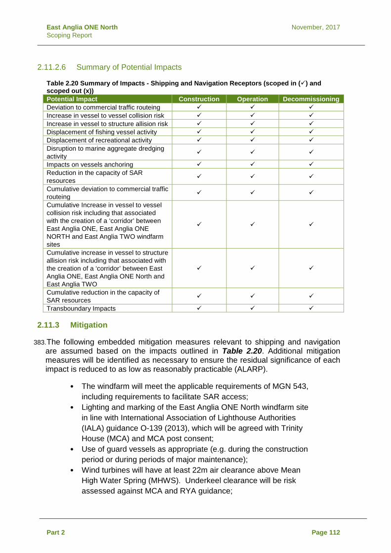
East Anglia ONE North November, 2017 Scoping Report
2.11.2.6 Summary of Potential Impacts
Table 2.20 Summary of Impacts - Shipping and Navigation Receptors (scoped in () and scoped out (x)) Potential Impact Construction Operation Decommissioning Deviation to commercial traffic routeing Increase in vessel to vessel collision risk Increase in vessel to structure allision risk Displacement of fishing vessel activity Displacement of recreational activity Disruption to marine aggregate dredging activity
Impacts on vessels anchoring Reduction in the capacity of SAR resources
Cumulative deviation to commercial traffic routeing
Cumulative Increase in vessel to vessel collision risk including that associated with the creation of a ‘corridor’ between East Anglia ONE, East Anglia ONE NORTH and East Anglia TWO windfarm sites
Cumulative increase in vessel to structure allision risk including that associated with the creation of a ‘corridor’ between East Anglia ONE, East Anglia ONE North and East Anglia TWO
Cumulative reduction in the capacity of SAR resources
Transboundary Impacts
2.11.3 Mitigation
383. The following embedded mitigation measures relevant to shipping and navigation are assumed based on the impacts outlined in Table 2.20. Additional mitigation measures will be identified as necessary to ensure the residual significance of each impact is reduced to as low as reasonably practicable (ALARP).
• The windfarm will meet the applicable requirements of MGN 543, including requirements to facilitate SAR access;
• Lighting and marking of the East Anglia ONE North windfarm site in line with International Association of Lighthouse Authorities (IALA) guidance O-139 (2013), which will be agreed with Trinity House (MCA) and MCA post consent;
• Use of guard vessels as appropriate (e.g. during the construction period or during periods of major maintenance);
• Wind turbines will have at least 22m air clearance above Mean High Water Spring (MHWS). Underkeel clearance will be risk assessed against MCA and RYA guidance;
Part 2 Page 112
East Anglia ONE North November, 2017 Scoping Report
• Cable protection via burial (or alternative methods where burial is not feasible), including maintenance and monitoring of the protection during the operational phase. A Cable Burial Management Plan will be developed post-consent;
• Safety zones around structures where construction or major maintenance is being undertaken;
• Marking of structures and cables on appropriately scaled navigational charts;
• Compliance from all vessels associated with the windfarm with international regulations as adopted by the flag state (most notably International Convention for the Prevention of Collision at Sea (COLREGS) (IMO 1972) and International Convention for the Safety of Life at Sea (SOLAS) (IMO 1974));
• Development of an Emergency Response Cooperation Plan (ERCoP) based on the standard MCA template; and
• Relevant information promulgated via Notice to Mariners and other appropriate mediums (e.g., KIS-ORCA).
2.11.4 Approach to Data Gathering and Assessment
2.11.4.1 Data Sources
384. The baseline presented within the NRA will primarily be based on an analysis of 28 days of marine traffic survey data, as summarised below. This approach to data collection has been agreed in principle with the MCA, see Appendix 2.6.
• 14 days of summer AIS and radar data recorded on site by a survey vessel during May and July 201715; and
• 14 days of winter (2017/2018) AIS data recorded via receivers installed on local offshore meteorological masts.
385. Due to the distance of the windfarm from shore, the marine traffic survey data
collected within the windfarm site is unlikely to provide good coverage of the entirety of the export cable corridor AoS. However, this will be assessed prior to undertaking the NRA. If considered necessary, the survey data will be supplemented with AIS data collected from onshore receivers to ensure comprehensive coverage of the entire export cable corridor. It is noted that the marine traffic survey data analysis within the export cable corridor AoS will be comprised of AIS only (i.e. it will not include any radar data).
15 It is noted that an initial high level analysis of this 14 day data set was used to establish the marine traffic baseline presented here.
Part 2 Page 113

East Anglia ONE North November, 2017 Scoping Report
386. In addition to the marine traffic survey data, the data sources listed below will also be used to establish the baseline and subsequently inform a Formal Safety Assessment (FSA) where appropriate. Each of these sources has also been considered at a high level in order to establish the baseline presented in this Scoping Report:
• Marine incident data from the Marine Accident Investigation Branch (MAIB) (from 2005 to 2014) and the Royal National Lifeboat Institution (RNLI) (2005 to 2014);
• UKHO Admiralty Charts; • BMAPA Routes (2016); • Admiralty Sailing Directions – North Sea (West) Pilot NP54 (2016)
and Dover Strait Pilot NP28 (2013); and • Royal Yachting Association (RYA) Coastal Atlas of Recreational
Boating (2016).
2.11.4.2 Study Areas
387. The majority of analysis of the data sources listed above will be limited to within a 10nm study area around the East Anglia ONE North windfarm site, and in a 5nm study area of the export cable corridor AoS. This will ensure the data analysis remains site specific, however it is noted that certain stages of the analysis may be required to extend beyond these thresholds if considered appropriate (for example, when assessing cumulative vessel routeing, where deviations can have impact upon routes beyond a 10nm threshold).
2.11.4.3 Assessment Methodology
388. Potential shipping and navigation impacts will be assessed for significance using the FSA process detailed by the IMO (2002) and as required by the MCA (2015). The FSA assigns each impact a “frequency” and “severity” ranking which are then used to assess the overall significance as either broadly acceptable, tolerable, or unacceptable, assuming embedded mitigation is in place. Where appropriate, additional mitigation is then introduced to reduce any impacts to ALARP levels as necessary. Rankings will be informed by quantitative modelling results, stakeholder consultation feedback, and expert opinion.
389. The key input to the FSA will be an NRA (undertaken as per MGN 543), which will establish the shipping and navigation baseline in detail. The NRA will use the data sources listed in section 2.11.4.1, and subsequently scope out impacts not required to be carried through to the FSA.
390. Impacts will also be assessed for the potential of cumulative impacts when considered with other southern North Sea offshore wind developments including renewables and oil and gas installations. In particular, the impact on vessel routeing will be considered on a cumulative basis, as this has historically been raised as a key area of shipping and navigation stakeholder concern in relation to the construction of offshore windfarms within the Southern North Sea.
Part 2 Page 114

East Anglia ONE North November, 2017 Scoping Report
2.12 Civil and Military Aviation and Radar
2.12.1 Baseline
2.12.1.1 Civil Aviation
391. The nearest airport to the East Anglia ONE North windfarm site is Norwich International Airport which is approximately approximately 74km at its nearest point.The second nearest UK airport is London Stansted, which is 152km away. The nearest European airport is Schiphol Airport, which is approximately 148km from East Anglia ONE North windfarm site.
392. The East Anglia ONE North windfarm site is within the London Flight Information Region (FIR) for air traffic control, the air space regulated by the UK Civil Aviation Authority (CAA) (Figure 2.10). The boundary of the London FIR and Amsterdam FIR is 6.5km to the east of East Anglia ONE North windfarm site boundary (at its nearest point). The airspace above the East Anglia ONE North windfarm site is uncontrolled Class G airspace.
393. NATS (En Route) plc (NERL) provides en-route civil air traffic services within the London FIR. NERL’s closest radar is based at Cromer (47km to the north west of East Anglia ONE North windfarm site) which provides en-route information to both civil and military aircraft. Preliminary analysis undertaken for the East Anglia ONE North windfarm site indicates that depending on tip height modelled, between half and all of the East Anglia ONE North windfarm site is within the Radar Line of Sight of NERL’s Cromer radar. Cromer is the only NERL radar identified as being potentially impacted by the East Anglia ONE NORTH windfarm site. Preliminary analysis indicates that the base of cover of NERL’s Debden radar over the East Anglia ONE North windfarm site is 4,000ft amsl.
394. The windfarm site is situated well clear of all Helicopter Main Routes (Figure 2.10) and south of the Anglia Radar Area of Responsibility.
Part 2 Page 115

"
"
HAVE
RHILL
HALS
TEAD
BRAI
NTRE
EBRAN
DON
WITH
AM
BURY
ST
EDMU
NDS
SUDB
URY
THET
FORD CO
LCHE
STER
ALDE
BURG
H
LEIST
ONFR
AMLIN
GHAM
WICK
HAM
MARK
ET
SOUT
HWOL
DHA
LESW
ORTH
WOOD
BRID
GE
WALT
ON-O
N-TH
E-NA
ZE
HARL
ESTO
N
BUNG
AY
BRIG
HTLIN
GSEA
ATTL
EBOR
OUGH
HADL
EIGH
WIVE
NHOE
HARW
ICH
FELIX
STOW
E
IPSW
ICH
DISS
BECC
LES
LOW
ESTO
FT
STOW
MARK
ET
HUNS
TANT
ON
FAKE
NHAM
WELL
S-NE
XT-T
HE-S
EA DERE
HAM
WATT
ON
KING
'SLY
NN
SWAF
FHAM
NORT
H WA
LSHA
M
CROM
ER
AYLS
HAM
SHER
INGH
AM NORW
ICH
HOLT
WYMO
NDHA
M
GREA
TYA
RMOU
TH
CTA 5
CTA 6
¯
1:800
,000
Rev
Date
Comm
ent
By
Scale
@ A3
010
205
Km
07/09
/2017
0KO
First
Issue
.
East
Angli
a ONE
Nor
th Sc
oping
Civil A
viatio
n and
Rad
ar in
the vi
cinity
of Ea
st An
glia O
NE N
orth W
indfar
m Sit
e and
Exp
ort C
able
Corrid
or Ar
ea of
Sea
rch
Drg N
o
Date
Figur
e
2 27/10
/17Da
tum:
WGS 1
984
Proje
ction
:Zo
ne 31
N
EA1N
-DB-
0022
Sourc
e: ©
East
Angli
a Offs
hore
Wind
Limi
ted 20
12. ©
NAT
S Lim
ited 2
012.
Chart
s from
Mari
neFIN
D.co
.uk ©
Lice
nce N
o EK0
01-06
45-M
F009
5. No
t to be
used
for n
aviga
tion.
This
map h
as be
en pr
oduc
ed to
the l
atest
know
n info
rmati
on at
the t
ime o
f issu
e, an
d has
been
prod
uced
for y
our in
forma
tion o
nly.
Pleas
e con
sult w
ith th
e SPR
Offs
hore
GIS
team
to en
sure
the co
ntent
is sti
ll cur
rent b
efore
using
the i
nform
ation
conta
ined o
n this
map
.To
the f
ulles
t exte
nt pe
rmitte
d by l
aw, w
e acc
ept n
o res
pons
ibility
or lia
bility
(whe
ther in
contr
act, t
ort (in
cludin
g neg
ligen
ce) o
r othe
rwise
in re
spec
t of a
ny
errors
or om
ission
s in t
he in
forma
tion c
ontai
ned i
n the
map
and s
hall n
ot be
liable
for a
ny lo
ss, d
amag
e or e
xpen
se ca
used
by su
ch er
rors o
r omi
ssion
s.2.1
0
Rev
Prep
ared:
Chec
ked:
Appro
ved:
D:\B
ox S
ync\P
B484
2 EA 1
N an
d 2\P
B484
2 EA 1
N an
d 2 Te
am\E.
TECH
NICA
L DAT
A\E03
GIS
\Size
well\F
igures
\Sco
ping\O
ffsho
re\EA
1N_D
B_00
22_A
viatio
n_20
1710
27(al
exan
der.b
atche
lor@
rhdhv
.com)
.mxd
XXKO BK
Lege
nd Expo
rt Cab
le Co
rridor
Area
of Se
arch
East
Angli
a One
Nort
hWi
ndfar
m Sit
e"
Trimm
ingha
m"
Crom
erHe
licop
ter m
ain ro
utes
UK Nethe
rland
sCla
cton C
ontro
l Area
sLo
ndon
Amste
rdam
Fligh
tInf
ormati
on R
egion
Boun
dary
(UKA
IP EN
R 1.6
& ENR
6-1-1
5-3)
Air to
Air R
efuell
ing Ar
ea(A
ARA)
9 (20
00ft-F
L50)
(UK
AIP EN
R 5.2
)Ne
therla
nds D
elega
ted Ai
rTra
ffic S
ervice
(ATS
)Air
spac
e (CT
A III M
OLIX
)An
glia R
adar
Area
ofRe
spon
sibility
(Surf
ace t
oFL
65) (
UK AI
P ENR
1.6 &
ENR
6-1-15
-3)La
kenh
eath
ATA N
orth
(FL60
-FL24
5) (U
K AIP
ENR
5.2)
Lake
nhea
th AT
A Sou
th(FL
60-FL
195)
(UK A
IP EN
R5.2
)
27/10
/2017
1KO
Seco
nd Is
sue.
27/10
/2017
2KO
Third
Issu
e.

East Anglia ONE North November, 2017 Scoping Report
2.12.1.2 Military Aviation
395. The nearest military radar for aviation is the MoD’s air defence radar at Trimingham which is approximately 80km from the East Anglia ONE North windfarm site. Preliminary analysis undertaken for the East Anglia ONE North windfarm site indicates that depending on tip height modelled, between half and all of the windfarm site is within Radar Line of Sight of the Trimingham radar. No other military radars have been identified as being potentially impacted by the East Anglia ONE North windfarm site.
396. Potential military aviation receptors in the East Anglia area include :
• RAF Marham; • RAF (USAF) Lakenheath; • RAF Mildenhall; and • RAF Wattisham.
397. RAF Marham, Lakenheath and Mildenhall are 115km from the East Anglia ONE North windfarm site. RAF Wattisham is 95km from the East Anglia ONE North windfarm site. Based on preliminary studies, no impacts upon radar from these sites are expected.
398. The East Anglia ONE North windfarm site overlaps with the Lakenheath South Aerial Tactics Area (ATA). The Lakenheath South ATA extends from approximately 6000ft amsl) to approximately 19,500ft amsl (Figure 2.10). ATAs are areas of intense military activity, including Air combat Training, and civilian pilots are advised to avoid these areas. The majority of the East Anglia ONE North windfarm site is located beneath Air to Air Refuelling Area (AARA) 9 (Figure 2.10) where refuelling takes place between 2,000ft amsl and approximately 5,000ft amsl. Due to the levels of AARA9, it is assumed that refuelling activities are for military helicopters. Military aircraft utilising these areas would ordinarily be receiving air traffic service from military controllers working alongside their civilian counterparts stationed at NERL Swanwick and using NERL radar infrastructure.
2.12.2 Potential Impacts
399. Consultation with the CAA, NERL and Ministry of Defence (MoD) will be ongoing throughout the EIA. Impacts considered within the EIA are as previously agreed for the East Anglia THREE EIA.
2.12.2.1 Potential Impacts during Construction
400. Potential impacts on military and civil aviation and radar during construction are associtated with the presence of high crane vessels and partially completed structures increasing collision risk.
Part 2 Page 117

East Anglia ONE North November, 2017 Scoping Report
2.12.2.2 Potential Impacts during Operation
401. Potential impacts during operation will focus on the permanent presence of offshore structures. The assessment will include the effect on civil and military aviation and radar.
2.12.2.3 Potential Impacts during Decommissioning
402. Potential impacts during decommissioning will be assessed as outlined in section 1.6.3.9.
2.12.2.4 Potential Cumulative Impacts
403. The cumulative assessment will consider the impacts in combination with other windfarms including increased collision risk and cumulative impacts on radar.
2.12.2.5 Potential Transboundary Impacts
404. The airspace around the windfarm is used by international civil aviation and is adjacent to the Amsterdam FIR, however transboundary impacts on civil aviation are not anticipated.
2.12.2.6 Summary of Potential Impacts
Table 2.21 Summary of Potential Impacts - Civil and Military Aviation and Radar (scoped in () and scoped out (x)) Potential Impacts Construction Operation Decommissioning Impacts on military and civil radar system due to high construction vessel/cranes and partially complete structures.
x
Creation of an aviation obstacle environment for military and civil aircraft due to high construction vessel/cranes and wind turbines
Impacts on military and civil radar system due to permanent structures during operational phase.
x x
Cumulative impacts on military and civil radar systems
Cumulative creation of an aviation obstacle environment to civil and military aircraft.
Transboundary Impacts x x x
2.12.3 Mitigation
405. The requirements for migitation (if any) are part of an ongoing discussion with NERL and the MoD. If mitigation is needed this will be secured through a requirement in the DCO, the wording of which will be agreed with the MoD.
Part 2 Page 118

East Anglia ONE North November, 2017 Scoping Report
2.12.4 Approach to Data Gathering and Assessment
406. The EIA process will be supported by further desk-based studies that will identify and examine in greater detail, sensitive aviation and MoD receptors. Studies will be undertaken in parallel with consultation and meetings with specific stakeholders in order to provide a detailed understanding of potential impacts. It is expected that consultation will be an iterative process, allowing for any concerns that are raised to be considered in the windfarm design optimisation process.
407. As part of this consultation process, SPR will submit a preliminary technical report to NERL and and the MoD to facilitate discussion with each of these stakeholders on potential impacts on and mitigation strategies for NERL and MoD radar infrastructure and airspace usage arising from the East Anglia ONE North windfarm site.
2.13 Marine Archaeology and Cultural Heritage
2.13.1 Baseline
408. The marine archaeology and cultural heritage assessment will include all receptors seawards of Mean High Water Springs (MHWS). All receptors landwards of MHWS will be included within terrestrial archaeology and cultural heritage assessment.
409. Interrogation of existing16 sidescan sonar, magnetometer, multibeam echosounder and sub-bottom profiler data aquired for the former East Anglia Zone and East Anglia Projects shows that there are 252 recorded seabed features within the East Anglia ONE North windfarm site. One of these has been previously assessed as a wreck, corresponding to a UKHO record for the possible wreck of Edinardue Antoinette (UKHO 10979). A further 246 features have been interpreted as being of uncertain origin but possible archaeological interest and five relate to a historic record which has not been seen in the geophysical data.
410. Landward of the East Anglia ONE North windfarm site there are 26 identified seabed features within the areas of export cable corridor AoS covered by previously acquired survey data. These comprise 16 anomalies of uncertain origin and possible archaeological interest and eight historic records which have not been seen in the geophysical data. Three of these correspond to ‘live’ wrecks charted on the current Admiralty Chart within the East Anglia ONE North export cable corridor AoS. Live wrecks are those ‘considered to exist’ by the UKHO (as opposed to ‘dead’ wrecks which have not been seen in repeated surveys and are ‘considered not to exist’, but which may potentially be buried at the previously recorded location).
16 In order to inform archaeological characterisation of the former East Anglia zone, a sample of the survey data corridors were selected for assessment by Wessex Archaeology, approximating to a third of available. The assessed corridors include three which correspond to the windfarm site.
Part 2 Page 119

East Anglia ONE North November, 2017 Scoping Report
411. Outside the areas covered by existing geophysical data there are a further six ‘live’ wrecks charted on the current Admiralty Chart within the East Anglia ONE North export cable corridor AoS.
412. The distribution of seabed anomalies identified during these assessments is shown on Figure 2.11.
413. In addition to the known seabed features, there is potential for the presence of archaeological material of a maritime nature spanning from the Mesolithic period to the present day within the development area. Similarly, there is potential for the presence of archaeological material relating to 20th century aviation. This could comprise material not seen on geophysical data (buried, for example) or unidentified geophysical anomalies which may be shown to represent maritime or aviation related material following further examination post-consent.
414. With regard to prehistoric archaeology, no known prehistoric sites have been identified within the former East Anglia Zone. It is widely recognised, however, that this scarcity of records from offshore contexts is typical across the UK and is understood to be primarily associated with the difficulties of identifying and investigating prehistoric sites. There is potential, therefore, for prehistoric sites to be present across the former East Anglia Zone although there have been no reports of prehistoric artefacts during archaeological assessments or further work associated with the consenting and development process.
415. Palaeogeographic assessment of sub-seabed features seen in the geophysical data, available geotechnical data and wider geological information has also been carried out for the ZEA and East Anglia ONE EIA. Features of probable archaeological interest have been identified within the development area, identified either because of their paleogeography or likelihood for producing palaeoenvironmental material. Previously recorded features are shown on Figure 2.11. As identified from the existing EIAs and the ZEA, the primary areas of potential within the former East Anglia Zone and along the consented cable route for East Anglia ONE are set out in Table 2.22.
Part 2 Page 120

ALDE
BURG
H
LEIST
ONSA
XMUN
DHAM
SOUT
HWOL
D
HALE
SWOR
TH
BUNG
AYBE
CCLE
S
LOW
ESTO
FT
¯
1:300
,000
Rev
Date
Comm
ent
By
Scale
@ A3
06
123
Km
07/09
/2017
0KO
First
Issue
.
East
Angli
a ONE
Nor
th Sc
oping
Exist
ing G
eoph
ysica
l Surv
ey da
ta co
verag
e and
an
omali
es fo
r Eas
t Ang
lia O
NE N
orth W
indfar
mSit
e and
Exp
ort C
able
Corrid
or Ar
ea of
Searc
h
Drg N
o
Date
Figur
e
2 27/10
/17Da
tum:
WGS 1
984
Proje
ction
:Zo
ne 31
N
EA1N
-DB-
0023
Sourc
e: ©
The C
rown E
state,
2017
. Data
prov
ided b
y Mari
neFin
d, 20
17. C
harts
from
Marin
eFIN
D.co
.uk ©
Lice
nce N
o EK0
01-06
45-M
F009
5. No
t to be
used
for n
aviga
tion.
This
map h
as be
en pr
oduc
ed to
the l
atest
know
n info
rmati
on at
the t
ime o
f issu
e, an
d has
been
prod
uced
for y
our in
forma
tion o
nly.
Pleas
e con
sult w
ith th
e SPR
Offs
hore
GIS
team
to en
sure
the co
ntent
is sti
ll cur
rent b
efore
using
the i
nform
ation
conta
ined o
n this
map
.To
the f
ulles
t exte
nt pe
rmitte
d by l
aw, w
e acc
ept n
o res
pons
ibility
or lia
bility
(whe
ther in
contr
act, t
ort (in
cludin
g neg
ligen
ce) o
r othe
rwise
in re
spec
t of a
ny
errors
or om
ission
s in t
he in
forma
tion c
ontai
ned i
n the
map
and s
hall n
ot be
liable
for a
ny lo
ss, d
amag
e or e
xpen
se ca
used
by su
ch er
rors o
r omi
ssion
s.2.1
1
Rev
Prep
ared:
Chec
ked:
Appro
ved:
D:\B
ox S
ync\P
B484
2 EA 1
N an
d 2\P
B484
2 EA 1
N an
d 2 Te
am\E.
TECH
NICA
L DAT
A\E03
GIS
\Size
well\F
igures
\Sco
ping\O
ffsho
re\EA
1N_D
B_00
23_W
recks
AndG
eoph
ysica
lData
_201
7102
7.mxdPPKO BK
Lege
nd Expo
rt Cab
le Co
rridor
Area
of Se
arch
East
Angli
a ONE
Nort
hWi
ndfar
m Sit
eFo
rmer
East
Angli
a Zon
eGe
ophy
sical
Surve
yTra
nsec
tsWr
ecks
and O
bstru
ction
s
27/09
/2017
1KO
Seco
nd Is
sue.
27/10
/2017
2KO
Third
Issu
e.
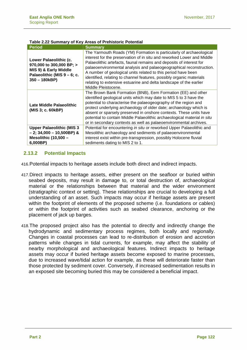
East Anglia ONE North November, 2017 Scoping Report
Table 2.22 Summary of Key Areas of Prehistoric Potential Period Summary
Lower Palaeolithic (c. 970,000 to 300,000 BP; > MIS 9) & Early Middle Palaeolithic (MIS 9 – 6; c. 350 – 180kBP)
The Yarmouth Roads (YM) Formation is particularly of archaeological interest for the preservation of in situ and reworked Lower and Middle Palaeolithic artefacts, faunal remains and deposits of interest for palaeoenvironmental analysis and palaeogeographical reconstruction. A number of geological units related to this period have been identified, relating to channel features, possibly organic materials relating to extensive estuarine and delta landscape of the earlier Middle Pleistocene.
Late Middle Palaeolithic (MIS 3; c. 60kBP)
The Brown Bank Formation (BNB), Eem Formation (EE) and other identified geological units which may date to MIS 5 to 3 have the potential to characterise the palaeogeography of the region and protect underlying archaeology of older date; archaeology which is absent or sparsely preserved in onshore contexts. These units have potential to contain Middle Palaeolithic archaeological material in situ or in secondary contexts as well as palaeoenvironmental archives.
Upper Palaeolithic (MIS 3 – 2; 34,000 – 10,500BP) & Mesolithic (10,500 – 6,000BP)
Potential for encountering in situ or reworked Upper Palaeolithic and Mesolithic archaeology and sediments of palaeoenvironmental interest exist within pre-transgression, possibly Holocene fluvial sediments dating to MIS 2 to 1.
2.13.2 Potential Impacts
416. Potential impacts to heritage assets include both direct and indirect impacts.
417. Direct impacts to heritage assets, either present on the seafloor or buried within seabed deposits, may result in damage to, or total destruction of, archaeological material or the relationships between that material and the wider environment (stratigraphic context or setting). These relationships are crucial to developing a full understanding of an asset. Such impacts may occur if heritage assets are present within the footprint of elements of the proposed scheme (i.e. foundations or cables) or within the footprint of activities such as seabed clearance, anchoring or the placement of jack up barges.
418. The proposed project also has the potential to directly and indirectly change the hydrodynamic and sedimentary process regimes, both locally and regionally. Changes in coastal processes can lead to re-distribution of erosion and accretion patterns while changes in tidal currents, for example, may affect the stability of nearby morphological and archaeological features. Indirect impacts to heritage assets may occur if buried heritage assets become exposed to marine processes, due to increased wave/tidal action for example, as these will deteriorate faster than those protected by sediment cover. Conversely, if increased sedimentation results in an exposed site becoming buried this may be considered a beneficial impact.
Part 2 Page 122

East Anglia ONE North November, 2017 Scoping Report
419. The setting of a heritage asset is the surroundings in which a heritage asset is experienced (Historic England 2015). Elements of a setting may make a positive or negative contribution to the significance of an asset, may affect the ability to appreciate that significance or may be neutral. Indirect impacts to setting may occur if a development affects the surroundings in which a heritage asset is experienced. Similarly, impacts to the character of the historic seascape may occur with the introduction of new elements causing a change in that character which may affect present perceptions of that seascape across an area.
2.13.2.1 Potential Impacts during Construction
420. Construction works such as the installation of cables and turbine foundations have the potential to impact known and unknown archaeological and cultural heritage assets. The EIA will include consideration of physical damage or degredation of assets as well as temporary disturbance of historic landscape and seacapes from the presence of construction vessels.
2.13.2.2 Potential Impacts during Operation
421. During maintenance activities, there is the potential for damage or degredation to unknown and known buried archaeology and cultural heritage assets. These effects will be similar to those considered for construction, but lower in magnitude. The effect of permanent offshore structures on historic landscapes and seascapes will also be considered within the EIA. The potential benefits for recording and protecting assets will also be included within the EIA.
2.13.2.3 Potential Impacts during Decommissioning
422. Potential impacts during decommissioning will be assessed as outlined in section 1.6.3.9 and in accordance with the process outlined in section 4.2 of the Marine Archaeology Method Statement (Appendix 2.7).
2.13.2.4 Potential Cumulative Impacts
423. The cumulative assessment will consider the potential for marine development to impact cultural heritage and archaeology assets. Impacts to be considered will include direct and indirect impacts and benefits from recording assets which are discovered during construction works.
2.13.2.5 Potential Transboundary Impacts
424. Due to the localised nature of disturbance there is a limited pathway for impacts on transboundary assets, therefore transboundary impacts are scoped out.
Part 2 Page 123

East Anglia ONE North November, 2017 Scoping Report
2.13.2.6 Summary of potential Impacts
Table 2.23 Summary of Potential Impacts - Marine Archaeology and Cultural Heritage (scoped in () and scoped out (x)) Potential Impact Construction Operation Decommissioning Physical disturbance activities resulting in damage to, or destruction of, known heritage assets
Physical disturbance resulting in damage to, or destruction of, potential heritage assets in the event of unexpected discoveries
Deterioration of heritage assets which become exposed to the effects of marine processes as a results of sediment reduction
Increased protection afforded to heritage assets which become buried as a result of sediment accretion.
Construction/maintenance activities within the setting of designated or non-designated heritage assets which temporarily affect the significance of an asset (adverse, indirect impact)
Construction/maintenance activities which temporarily affect the character of the historic seascape (adverse, indirect impact)
Permanent changes within the setting of designated or non-designated heritage assets from the presence of the built infrastructure which negatively affect the significance of an asset (adverse, indirect impact)
x x
Permanent changes to character of the historic seascape associated with the presence of the built infrastructure (adverse, indirect impact)
x X
Accumulation of published archaeologically interpreted geophysical and geotechnical data and information from chance discoveries which contributes significantly to a greater understanding of the offshore archaeological resource (beneficial, indirect impact).
Deterioration of heritage assets which become exposed to the effects of marine processes as a results of sediment reduction (including scour) associated with changes to physical processes caused by the construction and operation of multiple projects (adverse, indirect impact)
Cumulative impacts Transboundary impacts x x x
Part 2 Page 124

East Anglia ONE North November, 2017 Scoping Report
2.13.3 Mitigation
425. It is anticipated that the following mitigation will be embedded in the project design where appropriate:
• The archaeological assessment of further geophysical and geotechnical data acquired for the scheme prior to construction;
• Archaeological Exclusion Zones (AEZs) around the extents of known wreck sites within which no development related activities will take place (noting that AEZs would be removed in consultation with Historic England if pre- and post-consent geophysical survey determines that a presumed wreck site(s) and agreed buffer returns a negative result);
• Investigation of any identified geophysical anomalies or recorded sites that have not been seen in the site specific geophysical data that cannot be avoided by micro-siting of design;
• Examination of potential prehistoric deposits including geoarchaeological recording of core samples and deposit modelling;
• In the event of impact to potential sites, the establishment of a formal protocol to ensure that any finds are promptly reported, archaeological advice is obtained, and any recovered material is stabilised, recorded and conserved (i.e. the Protocol for Archaeological Discoveries: Offshore Renewables Projects (ORPAD) (The Crown Estate 2014);
• Watching briefs and / or establishment of ORPAD where seabed material is brought to the surface, for example during pre-lay grapnel runs; and
• Watching brief for any intrusive works carried out in the intertidal zone.
426. The suggested mitigations will either avoid an impact altogther or ensure that where
impact is unavoidable finds are preserved or data are recorded and add to the wider knowledge base.
427. Historic England will be consulted on the scope of all further geophysical and geotechnical surveys undertaken for the project in order to ensure that the data generated are sufficiently robust to enable professional archaeological interpretation and analysis.
Part 2 Page 125

East Anglia ONE North November, 2017 Scoping Report
428. A draft Written Scheme of Investigation (WSI) setting out the methodology for all proposed mitigation will be prepared in consultation with Historic England for submission alongside the DCO application for the proposed East Anglia ONE North project. The WSI will take account of the standards and guidance presented in Model Clauses for Archaeological Written Schemes of Investigation: Offshore Renewables Projects (The Crown Estate 2010). The draft WSI will be finalised as a point in time document in consultation with Historic England post-consent. Specific methodological requirements and any required revisions (e.g. to the nature and extent of AEZs) will be addressed through method statements, as required, to underpin the delivery of the commitments of the WSI.
2.13.4 Approach to Data Gathering and Assessment
2.13.4.1 Data Gathering
429. A detailed method statement for offshore archaeology was prepared and discussed with Historic England on 3rd May 2017, which included the approach to data gathering and assessment. The approach agreed with Historic England is outlined below.
430. The archaeological baseline for the windfarm site will take account of:
• Seabed prehistory (i.e. archaeological remains on the seabed corresponding to the activities of prehistoric populations that may have inhabited what is now the seabed when sea levels were lower);
• Maritime archaeology (i.e. the remains of boats and ships and archaeological material associated with prehistoric and historic maritime activities);
• Aviation archaeology (i.e. the remains of crashed aircraft and archaeological material associated with historic aviation activities);
• Historic seascape character (i.e. the attributes that contribute to the formation of the historic character of the seascape); and
• Buried archaeology (including palaeoenvironmental deposits) within the intertidal zone below MHWS.
431. The assessment will draw upon the existing work undertaken for the ZEA and for
East Anglia ONE, including desk-based assessment and the archaeological assessment of geophysical and geotechnical data. This will be supplemented by additional data sources including:
• Records of wrecks and obstructions held by the UKHO; • Records of heritage assets and documented losses of wrecks and
aircraft held by the National Record of the Historic Environment (NRHE) (for areas within 12nm);
Part 2 Page 126

East Anglia ONE North November, 2017 Scoping Report
• Records of designated and non-designated heritage assets below MHWS held by the Suffolk Historic Environment Record;
• Records from the National Heritage List for England maintained by Historic England, comprising data of designated heritage assets including sites protected under the Protection of Military Remains Act 1986 and the Protection of Wrecks Act 1973;
• Historic England’s Historic Seascape Characterisation for Newport to Clacton (Oxford Archaeology South 2011);
• Background BGS geological information and relevant Admiralty Charts for the study area;
• Additional archaeological studies and published sources relevant to the windfarm site;
• Post-consent archaeological and geoarchaeological assessment undertaken for East Anglia ONE (if available); and
• Archaeological assessment of existing and new geophysical data within the windfarm site.
432. The East Anglia ONE North windfarm site and export cable corridor AoS falls within the Historic Seascape Characterisation for Newport to Clacton (Oxford Archaeology South 2011). A review of the Historic Seascape Characterisation for the area will be undertaken in order to identify the key cultural processes that have shaped the historic seascape and to inform the assessment of how that seascape may change with the construction of the windfarm.
433. All existing geophysical data, collected during ZEA and previous EIAs which fall within the windfarm site and export cable corridor AoS (sidescan sonar, swath bathymetry, magnetometer and sub-bottom profiler) will be made available for archaeological assessment. Geotechnical data from East Anglia ONE and East Anglia THREE will also be used to supplement the EIA where available and relevant to do so.
434. In addition to existing data further geophysical survey of the windfarm site has been undertaken in 2017. New side scan sonar and multi-beam swath bathymetry data has been collected from within the windfarm site to supplement existing data for the ZEA study of the former East Anglia Zone. The scope of this survey was set out in the detailed method statement for offshore archaeology provided to inform agreement with Historic England.
435. A further geophysical survey is planned for 2018 to collect new data for the export cable corridor AoS. For this survey, the following data will be collected:
• For areas of the export cable corrdior AoS not already surveyed during ZEA surveys (Figure 2.11), the following data will be collected: • Multi-beam swath bathymetry (2018); • Side scan sonar (2018);
Part 2 Page 127

East Anglia ONE North November, 2017 Scoping Report
• Sub-bottom profile (2018); • Magnetometer (2018); and • Surface sediment samples (grab samples) (2018).
• For areas already surveyed as part of the ZEA, the following data will be collected: • Multi-beam swath bathymetry (2018); • Side scan sonar (2018); • ZEA magnetometer; • ZEA sub-bottom profile; and • ZEA grab samples for sediment characterisation.
436. Historic England was consulted on the scope of this survey at meetings held on
the 17th July and 2nd August 2017, and issued with a briefing note outlining this approach. Historic England has confirmed through meeting minutes that they are comfortable with the approach to collecting data and using existing data to inform the EIA as outlined in Appendix 2.7.
437. All acquired data will be assessed and interpreted by Wessex Archaeology, a suitably qualified and experienced specialist for the archaeological assessment of geophysical data.
2.13.4.2 Approach to Assessment
438. With regard to the assessment of maritime and aviation archaeology, the planned surveys will result in full coverage of the development area with sidescan sonar and swath bathymetry. Through the desk-based assessment, the results of the archaeological assessment of the sidescan sonar and bathymetry data will be integrated with the existing magnetometer data and wider research to ensure that the extent of the impact of the proposed development on the significance of any maritime or aviation heritage assets can be adequately understood.
439. With regard to seabed prehistory, the level of existing data will allow SPR to provide a description of the significance of potential prehistoric heritage assets which could be affected by the proposed development. A deposit model, as necessary to both inform the assessment of, and provide mitigation for, potential impacts, is the result of a phased programme of analysis relative to the complexity of the palaeoenvironmental sedimentary sequences encountered within any given development area. No further geotechnical surveys will be carried out prior to consent. However, the existing data will be used to prepare an initial deposit model which will inform a phased and targeted approach to further assessment to be carried out post-consent.
440. Potential impacts will be assessed using standard methodologies and in accordance with available standards and guidance including:
Part 2 Page 128

East Anglia ONE North November, 2017 Scoping Report
• Joint Nautical Archaeology Policy Committee (JNAPC) Code of Practice for Seabed Development (JNAPC and The Crown Estate 2006);
• Historic Environment Guidance for the Offshore Renewable Energy Sector (Wessex Archaeology 2007);
• Guidance for Assessment of Cumulative Impacts on the Historic Environment from Offshore Renewable Energy (Oxford Archaeology 2008); and
• Chartered Institute for Archaeologists’ Standard and Guidance for Historic Environment Desk-Based Assessments (2014a) and Code of Conduct (2014b).
441. Post-consent, advice will be sought from a suitably qualified and experienced
archaeologist or geophysicist in planning the specific scope of pre-construction geophysical and geotechnical survey to ensure that the data acquired will meet archaeological and geoarchaeological objectives to be established through consultation with Historic England. This will include targeted high resolution surveys as necessary to inform engineering design of the final scheme.
442. The methodological approach to post-consent survey and archaeological assessment of acquired data will be set out in the WSI alongside the mitigation measures for agreement with Historic England including embedded mitigation (e.g. Archaeological Exclusion Zones and micro-siting to avoid sites). This will be integrated into the project design to prevent impacts to known heritage assets and the procedures that would be put in place for unknown assets discovered during pre-construction or construction activity (e.g. ORPAD).
2.14 Infrastructure and Other Users
2.14.1 Baseline
443. This section considers other interactions with industries not already covered as EIA topics in their own right (such as Commercial Fisheries or Shipping and Navigation. Table 2.24 shows the direct overlaps with other industry infrastructure, and the following sections 2.14.1.1 to 2.14.1.7 provide further detail on relevant infrastructure and other users.
Part 2 Page 129

East Anglia ONE North November, 2017 Scoping Report
Table 2.24 Direct Infrastructure overlap with the Offshore Development Area
Sector Direct overlap with Offshore Development Area
Wind See section 2.14.1.1 Marine energy (wave / tidal) None Marine Minerals None Pipelines See section 2.14.1.2 Cables See section 2.14.1.4 Disposal Sites See section 2.14.1.5 Meteorological Equipment None Carbon capture and Natural Gas Storage None Oil & Gas Infrastructure None Oil & Gas License Blocks None
2.14.1.1 Offshore Wind Infrastructure
444. Offshore windfarm developments in the vicinity of the East Anglia ONE North windfarm site are shown in Figure 2.12. Aside from the other SPR developments within the former East Anglia Zone, the nearest UK offshore windfarm to the East Anglia ONE North windfarm site is Norfolk Vanguard East, which is a 1800MW development currently in planning and, situated 38km away. The closest international windfarm developments are Borssele 1 and 2, Borssele 3 and 4 (Netherlands) and Mermaid (Belgium) which are situated less than 50km south-east from the East Anglia ONE North windfarm site. 5 shows the distances to other offshore windfarm developments within the southern North Sea.
445. Export cables for Galloper Wind Farm and Greater Gabbard Offshore Wind Farm are adjacent to the export cable corridor AoS, making landfall to the south of the existing Sizewell Nuclear Power Station infrastructure.
Table 2.25 Offshore Windfarm Projects and Distance to East Anglia ONE North Windfarm Site within the Southern North Sea Offshore Windfarm Distance from EA1N (km) East Anglia One 1.3 East Anglia Two 10.1 East Anglia Three 16.6 Norfolk Vanguard East 38.1 Galloper 38.8 Scroby Sands 39.8 Norfolk Vanguard West 40.9 Greater Gabbard 43.2 Norfolk Boreas 50.7 London Array 1 88.5 Gunfleet Sands II 95.3 Gunfleet Sands I 97.5
Part 2 Page 130

East Anglia ONE North November, 2017 Scoping Report
2.14.1.2 Oil and Gas Pipelines and Platforms
446. There is no surface or subsurface infrastructure within the East Anglia ONE North windfarm site and export cable corridor AoS. There are seven wells within 40km of the proposed East Anglia ONE North windfarm site, with the closest being 4.6km away. However these wells are of AB3 status and will never be used or re-entered again.
447. Two gas pipelines cross the former East Anglia Zone, the BBL Balgzand-Bacton gas pipeline running east – west, 40km north of East Anglia ONE North windfarm site, and the Bacton-Zeebrugge interconnector running northwest to southeast crossing the East Anglia ONE North export cable route AoS.
2.14.1.3 Oil and Gas Licensing and Exploration
448. There are no licensed blocks that overlap the East Anglia ONE North windfarm site or the export cable corridor AoS.
2.14.1.4 Sub-Sea Cables
449. The southern North Sea has a significant number of cables, primarily telecommunication connections between the UK and continental Europe (see Figure 2.13). The Ulysses 2 telecommunications cable runs from Lowestoft to IJmuiden in the Netherlands and intersects the East Anglia ONE North windfarm site.
450. In addition, there are historic disused cables that date from over 100 years ago, many of which are now lost and represent a risk to seabed activity. Modern charts only display cables decommissioned since 1987.
2.14.1.5 Dumping and Disposal Sites
451. The East Anglia ONE North windfarm site overlaps three disposal sites:
• East Anglia THREE windfarm disposal site (HU212); • Warren Springs Environmental research Laboratory site (TH075) a
closed disposal site; and • AEA experimental site (TH026) a closed disposal site.
452. The East Anglia THREE windfarm disposal site is intended to be used to dispose of
seabed sediment dredged during the construction of the East Anglia ONE North windfarm and installation of the offshore cables.
453. Warren Springs Environmental research Laboratory site was used between 1987 and 1995 to test oil dispersants in the North Sea. Approximately 157 tonnes of material was disposed of at the site during that period (EAOW 2012a).
Part 2 Page 131

East Anglia ONE North November, 2017 Scoping Report
454. In 2010, sediment samples from within the Warren Springs site were analysed to test for the presence of residual volatile and semi-volatile organic compounds. Results indicated there was no anthropologic contamination within the study area. It is likely that activities were conducted sufficiently long ago to allow the breakdown of any contaminants by physical and chemical processes.
455. Other disposal sites in the vicinity of the export cable corridor AoS are shown on Figure 2.14 and include the following:
• Site TH026, designated for tracers, the site remains open although records indicate that it has never been used; and
• Site TH057, Galloper Wind Farm, is open for the disposal of pre-sweep material and drill arisings during construction.
456. It is proposed in upcoming offshore surveys, that sediment samples will be taken from within the windfarm site and export cable corridor AoS to determine if any contaminants from previous disposal activities are present. These data will inform the Marine Water and Sediment Quality Assessment.
2.14.1.6 Ministry of Defence Activities
457. No Military practice and exercise areas (PEXAs) overlap with the East Anglia ONE North windfarm site or the export cable corridor AoS. The nearest PEXA sites are located 34km south (North Galloper – X5121) south and 40km south west (Outer Gabbard - X5117).
458. There are currently two MoD identified explosives dumping grounds 30km and 80km south-west of East Anglia ONE North windfarm site and export cable corridor AoS. There is also potential for wartime unexploded ordinance (UXO) within the southern North Sea (EAOW 2012). Locations of any UXO would be determined post-consent and mitigation in consultation with Natural England and MMO.
2.14.1.7 Other Infrastructure
459. Cooling water outfall and intake infrastructure for EDF’s Sizewell A and Sizewell B nuclear power stations are adjacent to the export cable corridor AoS as it approaches landfall. There are also intake and outfall structures planned for EDF’s Sizewell C nuclear power station. The export cable corridor AoS has been routed so that no outfall or intake structures are within the footprint of the export cable corridor AoS, i.e. to avoid direct impacts, however, there is the potential for indirect impacts to EDF’s infrastructure, which will be considered within the EIA.
Part 2 Page 132

Gunfl
eet
Sand
s I Gunfl
eet
Sand
s II
Gunfl
eet
Sand
sDe
moLo
ndon
Array
1
Grea
terGa
bbard
Gallo
per
Gallo
per
Grea
terGa
bbard
East
Angli
aTw
o
Z5 Ea
stAn
glia
One
East
Angli
a Nort
hTra
nche
One
Wes
t(N
orfolk
Vang
uard
West)
East
Angli
aNo
rth Tr
anch
e 2(N
orfolk
Borea
s)
East
Angli
a Nort
hTra
nche
One
East
(Norf
olk Va
ngua
rd Ea
st)
East
Angli
aTh
reeSc
roby
Sand
s
WICK
FORD
RAIN
HAM
UPMI
NSTE
R
BILL
ERIC
AY CANV
EY IS
LAND
RAYL
EIGH
SOUT
HEND
-ON-
SEA
BURN
HAM-
ON-C
ROUC
H
SAFF
RON
WALD
EN
HAVE
RHILL
HALS
TEAD
GREA
T DUN
MOW
BRAI
NTRE
E
ELY
BRAN
DON
WITH
AM
MALD
ONCH
IPPIN
GON
GARNE
WMA
RKET
CHEL
MSFO
RD
BURY
ST
EDMU
NDS
SUDB
URY
THET
FORD
COLC
HEST
ER
MARC
H
ALDE
BURG
H
LEIST
ONFR
AMLIN
GHAM
WICK
HAM
MARK
ET
SOUT
HWOL
DHA
LESW
ORTH
WOOD
BRID
GE
WALT
ON-O
N-TH
E-NA
ZE
HARL
ESTO
N
BUNG
AY
BRIG
HTLIN
GSEA
ATTL
EBOR
OUGH
HADL
EIGH
WIVE
NHOE
WEST
MER
SEA
HARW
ICH
FELIX
STOW
E
IPSW
ICH
DISS
LOW
ESTO
FT
STOW
MARK
ET
HUNS
TANT
ON
FAKE
NHAM
WELL
S-NE
XT-T
HE-S
EA
DERE
HAM
WATT
ON
WISB
ECH
DOW
NHAM
MARK
ET
KING
'S LY
NN
SWAF
FHAM
NORT
H WA
LSHA
M
CROM
ER
AYLS
HAM
SHER
INGH
AM NORW
ICH
HOLT
WYMO
NDHA
MGR
EAT
YARM
OUTH
North
wind
Belwi
ndPh
ase I
North
er
Beau
fort
(form
erly
Katw
ijk)
Beau
fort
(form
erly
Katw
ijk)We
st-Rij
n
Tromp
Binne
n
Rotte
rdam
Noord
-Wes
t
Den H
elder
I
Brow
nRid
geOo
st
Seas
tar
THV
Merm
aid
RENT
ELRE
NTEL
Thorn
ton Ba
nkph
ase I
I
Bree
veert
ien II
Belwi
ndPh
ase 2
¯
1:1,00
0,000
Rev
Date
Comm
ent
By
Scale
@ A3
020
4010
Km
07/09
/2017
0KO
First
Issue
.
East
Angli
a ONE
Nor
th Sc
oping
Othe
r Wind
farm
Deve
lopme
nts in
the V
icinity
of
the E
ast A
nglia
One
Nort
h Wind
Farm
Site
an
d Exp
ort C
able
Corrid
or Ar
ea of
Sea
rch
Drg N
o
Date
Figur
e
2 27/10
/17Da
tum:
WGS 1
984
Proje
ction
:Zo
ne 31
N
EA1N
-DB-
0024
Sourc
e: ©
The C
rown E
state,
2017
. © 4C
Offsh
ore - A
WAITI
NG LI
CENC
E. Ch
arts f
rom M
arine
FIND.
co.uk
Lice
nce N
o EK0
01-0
645-M
F009
5. No
t to be
used
for n
aviga
tion.
This
map h
as be
en pr
oduc
ed to
the l
atest
know
n info
rmati
on at
the t
ime o
f issu
e, an
d has
been
prod
uced
for y
our in
forma
tion o
nly.
Pleas
e con
sult w
ith th
e SPR
Offs
hore
GIS
team
to en
sure
the co
ntent
is sti
ll cur
rent b
efore
using
the i
nform
ation
conta
ined o
n this
map
.To
the f
ulles
t exte
nt pe
rmitte
d by l
aw, w
e acc
ept n
o res
pons
ibility
or lia
bility
(whe
ther in
contr
act, t
ort (in
cludin
g neg
ligen
ce) o
r othe
rwise
in re
spec
t of a
ny
errors
or om
ission
s in t
he in
forma
tion c
ontai
ned i
n the
map
and s
hall n
ot be
liable
for a
ny lo
ss, d
amag
e or e
xpen
se ca
used
by su
ch er
rors o
r omi
ssion
s.2.1
2
Rev
Prep
ared:
Chec
ked:
Appro
ved:
D:\B
ox S
ync\P
B484
2 EA 1
N an
d 2\P
B484
2 EA 1
N an
d 2 Te
am\E.
TECH
NICA
L DAT
A\E03
GIS
\Size
well\F
igures
\Sco
ping\O
ffsho
re\EA
1N_D
B_00
24_O
therW
indDe
velop
ments
_201
7102
7.mxd
PPKO BK
Lege
nd Expo
rt Cab
le Co
rridor
Area
of Se
arch
East
Angli
a ONE
Nort
hWi
ndfar
m Sit
eOt
her O
ffsho
re W
ind Fa
rms
Activ
e/In O
perat
ionUn
der C
onstr
uctio
nIn
Plann
ingPr
e-plan
ning A
pplic
ation
Wind
Farm
Exp
ort C
able
Corrid
ors
27/09
/2017
1KO
Seco
nd Is
sue.
27/10
/2017
2KO
Third
Issu
e.

ULYS
S 2
Norse
a Com
Seg 3
Circe
Nor
thPa
ngea
2 Conc
erto S
outh
Conc
erto N
orth
Farla
nd No
rth
Remb
rand
t 1N
ALDE
BURG
H
LEIST
ONSA
XMUN
DHAM
SOUT
HWOL
D
HALE
SWOR
TH
BUNG
AYBE
CCLE
S
LOW
ESTO
FT
¯
1:300
,000
Rev
Date
Comm
ent
By
Scale
@ A3
06
123
Km
07/09
/2017
0KO
First
Issue
.
East
Angli
a ONE
Nor
th Sc
oping
Infras
tructu
re in
and a
round
East
Angli
a ON
E Nort
h Wind
Farm
Site
and E
xport
Cab
le Co
rridor
Area
of S
earch
Drg N
o
Date
Figur
e
2 27/10
/17Da
tum:
WGS 1
984
Proje
ction
:Zo
ne 31
N
EA1N
-DB-
0025
Sourc
e: ©
The C
rown E
state,
2017
. Data
prov
ided b
y Mari
neFin
d, 20
17. C
harts
from
Marin
eFIN
D.co
.uk ©
Lice
nce N
o EK0
01-06
45-M
F009
5. No
t to be
used
for n
aviga
tion.
This
map h
as be
en pr
oduc
ed to
the l
atest
know
n info
rmati
on at
the t
ime o
f issu
e, an
d has
been
prod
uced
for y
our in
forma
tion o
nly.
Pleas
e con
sult w
ith th
e SPR
Offs
hore
GIS
team
to en
sure
the co
ntent
is sti
ll cur
rent b
efore
using
the i
nform
ation
conta
ined o
n this
map
.To
the f
ulles
t exte
nt pe
rmitte
d by l
aw, w
e acc
ept n
o res
pons
ibility
or lia
bility
(whe
ther in
contr
act, t
ort (in
cludin
g neg
ligen
ce) o
r othe
rwise
in re
spec
t of a
ny
errors
or om
ission
s in t
he in
forma
tion c
ontai
ned i
n the
map
and s
hall n
ot be
liable
for a
ny lo
ss, d
amag
e or e
xpen
se ca
used
by su
ch er
rors o
r omi
ssion
s.2.1
3
Rev
Prep
ared:
Chec
ked:
Appro
ved:
D:\B
ox S
ync\P
B484
2 EA 1
N an
d 2\P
B484
2 EA 1
N an
d 2 Te
am\E.
TECH
NICA
L DAT
A\E03
GIS
\Size
well\F
igures
\Sco
ping\O
ffsho
re\EA
1N_D
B_00
25_In
frastr
uctur
e_20
1710
27.m
xd
PPKO BK
Lege
nd Expo
rt Cab
le Co
rridor
Area
of Se
arch
East
Angli
a One
Nort
hWi
ndfar
m Sit
eOf
fshor
e Cab
les an
dPip
eline
s Activ
eNo
t in us
e
27/09
/2017
1KO
Seco
nd Is
sue.
27/10
/2017
2KO
Third
Issu
e.

ALDE
BURG
H
LEIST
ONSA
XMUN
DHAM
SOUT
HWOL
D
HALE
SWOR
TH
BUNG
AYBE
CCLE
S
LOW
ESTO
FT
¯
1:300
,000
Rev
Date
Comm
ent
By
Scale
@ A3
06
123
Km
07/09
/2017
0KO
First
Issue
.
East
Angli
a ONE
Nor
th Sc
oping
Dred
ging a
nd D
ispos
al Ar
eas i
n and
arou
nd E
ast
Angli
a ONE
Nort
h Wind
farm
Site a
nd Ex
port C
able
Corrid
or Ar
ea of
Searc
h
Drg N
o
Date
Figur
e
2 27/10
/17Da
tum:
WGS 1
984
Proje
ction
:Zo
ne 31
N
EA1N
-DB-
0026
Sourc
e: ©
The C
rown E
state,
2017
. © C
efas,
2017
. Cha
rts fro
m Ma
rineF
IND.
co.uk
© Li
cenc
e No E
K001
-0645
-MF0
095.
Not to
be us
ed fo
r nav
igatio
n.Th
is ma
p has
been
prod
uced
to th
e late
st kn
own i
nform
ation
at th
e tim
e of is
sue,
and h
as be
en pr
oduc
ed fo
r you
r infor
matio
n only
.Ple
ase c
onsu
lt with
the S
PR O
ffsho
re GI
S tea
m to
ensu
re the
conte
nt is
still c
urren
t befo
re us
ing th
e info
rmati
on co
ntaine
d on t
his m
ap.
To th
e full
est e
xtent
perm
itted b
y law
, we a
ccep
t no r
espo
nsibi
lity or
liabil
ity (w
hethe
r in co
ntrac
t, tort
(inclu
ding n
eglig
ence
) or o
therw
ise in
resp
ect o
f any
err
ors or
omiss
ions i
n the
infor
matio
n con
taine
d in t
he m
ap an
d sha
ll not
be lia
ble fo
r any
loss
, dam
age o
r exp
ense
caus
ed by
such
error
s or o
miss
ions.
2.14
Rev
Prep
ared:
Chec
ked:
Appro
ved:
D:\B
ox S
ync\P
B484
2 EA 1
N an
d 2\P
B484
2 EA 1
N an
d 2 Te
am\E.
TECH
NICA
L DAT
A\E03
GIS
\Size
well\F
igures
\Sco
ping\O
ffsho
re\EA
1N_D
B_00
26_D
redgin
gAnd
Disp
osal_
2017
1027
.mxd
PPKO BK
Lege
nd Expo
rt Cab
le Co
rridor
Area
of Se
arch
East
Angli
a One
Nort
hWi
ndfar
m Sit
eAg
grega
te Dr
edgin
gDi
spos
al Si
tesClo
sed
Open
27/09
/2017
1KO
Seco
nd Is
sue.
27/10
/2017
2KO
Third
Issu
e.

East Anglia ONE North November, 2017 Scoping Report
2.14.2 Potential Impacts
2.14.2.1 Impacts to be Scoped Out
2.14.2.1.1 Potential Interference with Oil and Gas Operations
460. Through the process of site selection of the East Anglia ONE North windfarm site and export cable corridor AoS, SPR has sought to avoid existing oil and gas infrastructure. No impacts are therefore anticipated during construction, operation or decommissioning. On this basis it is proposed that these impacts are scoped out of the EIA. Any conflicts with aviation activities, including helicopter operations associated with the oil and gas industry will be addressed as part of the aviation and radar assessment.
2.14.2.1.2 Potential Interference with Aggregates Areas
461. As there is no overlap of aggregate licence areas with the East Anglia ONE North windfarm site or export cable corridor AoS there are limited pathways for impacts upon aggregate dredging activities during construction, operation or decommissioning, and it is proposed to scope this impact out of the EIA. Any vessel movement conflicts will be addressed as part of the shipping and navigation assessment.
2.14.2.2 Potential Impacts during Construction
462. Construction works such as the installation of cables or wind turbine foundations have the potential to impact on other marine infrastructure and users if within the construction footprint or adjacent. The presence of increased vessel numbers during construction may also impact on other marine users. Cable crossings will also be required. The impact on other windfarms, MoD areas, outfalls and intakes and cables during construction will be considered within the EIA.
2.14.2.3 Potential Impacts during Operation
463. The presence of permanent offshore infrastructure has the potential to impact projects either within or adjacent to the East Anglia ONE North windfarm and export cable corridor AoS. Also, vessel movements during operation and maintenance may also affect neighbouring activities. The impact on other windfarms, MoD areas, outfalls and intakesand cables during operation will be considered within the EIA.
2.14.2.4 Potential Impacts during Decommissioning
464. Potential impacts during decommissioning will be assessed as outlined in section 1.6.3.9.
Part 2 Page 136

East Anglia ONE North November, 2017 Scoping Report
2.14.2.5 Potential Cumulative Impacts
465. The potential impacts of the East Anglia ONE North windfarm site on infrastructure and other users are expected to be non-significant or able to be fully mitigated after consultation with the relevant parties i.e. through the development of crossing agreements or similar). All other parties (i.e. another windfarm operator) that interact with the same receptor will also need to demonstrate no impact or agree mitigation. Therefore it is not anticipated that there will be pathways for cumulative impacts. It is therefore proposed that these impacts are scoped out.
2.14.2.6 Potential Transboundary Impacts
466. The only potential transboundary receptors are cables, these will be covered in the cables assessment, and therefore there will be no separate transboundary assessment.
2.14.2.7 Summary of Potential Impacts
Table 2.26 Summary of Potential impacts - Infrastructure and Other Users (scoped in () and scoped out (x)) Potential Impacts Construction Operation Decommissioning Potential interference with other windfarms
Physical impacts on subsea cables Impacts on disposal sites Impacts on MoD activities Impacts on EDF Sizewell infrastructure Cumulative impacts x x x Transboundary impacts x x x
2.14.3 Mitigation
467. Where conflicts between the proposed East Anglie ONE North project and other infrastructure are identified, owners and operators will be consulted and where appropriate legal agreements will be put in place.
2.14.4 Approach to Data Gathering and Assessment
468. SPR will undertake consultation with all relevant developers, operators and marine users within the vicinity of the East Anglia ONE North windfarm site to ascertain any concerns relating to the project. Any areas of concern will be identified and considered within the EIA. However, it is likely that any impacts will either be non-significant or able to be fully mitigated after consultation with the relevant parties as discussed above.
469. The EIA will be based on existing data and information gathered through consultation. The EIA will focus on the East Anglia ONE North windfarm site and export cable corridor AoS and consider infrastructure or users that overlap with those boundaries. The assessment will consider agreed or best practice mitigation and be based on expert judgement.
Part 2 Page 137

East Anglia ONE North November, 2017 Scoping Report
2.15 Telecommunication and Interference
470. A large range of vessels operate in and around the windfarm site including: commercial passenger ferries, fishing boats, piloting activities, cargo vessels and traffic associated with oil and gas installations located outside of the site. Due to this density and diversity of traffic, the range of telecommunications in use is relatively high and varied (EAOW 2012a).
471. SPR has discussed potential impacts of the windfarm site on Very High Frequency (VHF), AIS and radar communication with the MCA. A letter was provided to the MCA17 outlining a rationale for scoping these potetnial impacts out of the EIA. The rationale is summarised below and a full copy of the letter is provided in Appendix 2.6:
• The findings with respect to marine communications, navigation and sonar systems, etc., including audible acoustic interference, research and operational experience over the past ten years indicate that there are no significant effects other than in very exceptional circumstances where a vessel is virtually alongside a turbine;
• The effects on marine radar have been discussed in some detail at historic Nautical Offshore Renewables Energy Liaison (NOREL) radar sub-group meetings. Practical experience has shown that wind turbines are easily detected by marine radar, obviating the potential for incidents due to non-detection, but remaining concerns focus on shadowing, side lobe and reflected “spurious” echo effects;
• Shadowing effects tend to be transitory except in unusual circumstances, where the turbine remains within the line of sight of both moving vessels. Even in these cases, shadowing is limited by the diffraction of the transmitted energy around the turbine bases;
• If side lobe effects are noticeable, the detection of other vessels, both within and outside the windfarm, can normally be achieved in any vessel type by modifying its radar’s gain or sea clutter controls. Supporting this view, feedback gained in various fora, including developers’ hazard workshops, NOREL, FLOWW, etc., has not highlighted any major side lobe echo stakeholder concerns; and
• To date there been no known instances where any vessel has been exposed to danger due to windfarm induced radar degradation and little evidence that the majority of vessels suffer
17 25th of April. Letter sent to N. Salter, Offshore Renewables Advisor for the MCA.
Part 2 Page 138

East Anglia ONE North November, 2017 Scoping Report
effects on their radar displays. The main industry mitigation to the possible impacts of radar is ensuring a sufficient distance between the proposed windfarm and shipping routes.
472. The MCA provided the following written response on the 11th May, 2017: ‘Your
rationale has been considered and we are content for you to scope out the impacts of turbines on VHF, AIS and Radar equipment based on previous research and the agreed approach for East Anglia THREE’.
473. On this basis, SPR propose to scope impacts on telecommunication and interference out of the EIA. This is in line with agreements made for East Anglia THREE.
2.16 Summary of Offshore Topics to be Scoped In
474. Table 2.27 provides a summary of offshore topics that will be scoped in and scoped out of the EIA. All impacts that have been scoped in for assessment are considered to represent potential likely significant effects under Regulation 10 of the Infrastructure Planning (Environmental Impact Assessment) Regulations 2017.
Table 2.27 Summary of Offshore Topics to be Scoped into the EIA Potential impacts Construction Operation Decommissioning Physical Processes Changes in suspended sediment concentrations
Changes in bed levels and sediment type Indentations on sea bed left by vessels (vessel jack-up and anchoring operations)
Changes to coastal morphology at landfall Changes to the tidal regime due to the presence of the foundation structures x x
Changes to the wave regime due to the presence of the foundation structures x x
Changes to the sediment transport regime due to the presence of the foundation structures
x x
Scour effects due to the presence of the foundation structures and cables x x
Increases in suspended sediment as a result of vertical turbulence
x x
Cumulative effects Transboundary effects x x x Water and Sediment Quality Changes to water quality due to increased suspended sediments
Resuspension of contaminants Release/spillage of contaminants from vessels and plant
Cumulative Impacts x x x Transboundary impacts
x x x
Part 2 Page 139

East Anglia ONE North November, 2017 Scoping Report
Potential impacts Construction Operation Decommissioning Offshore Air Quality x x x Offshore Airborne Noise x x x Benthic Ecology Temporary physical disturbance Permanent habitat loss x x Increased suspended sediment concentrations
Re-mobilisation of contaminated sediments
Underwater noise and vibration x Colonisation of foundations and cable protection x x
Invasive species Potential impacts on sites of marine conservation importance
Impact of Electromagnetic Fields. x x x Cumulative impacts Transboundary Impacts x x x Fish and Shellfish Ecology Physical disturbance and temporary loss of sea bed habitat, spawning or nursery grounds during intrusive works
x
Permanent habitat loss x x Increased suspended sediments and sediment re-deposition
Re-mobilisation of contaminated sediment during intrusive works
Underwater noise impacts to hearing sensitive species during foundation piling x x
Underwater noise impacts to hearing sensitive speices due to other activities (vessels, seabed preparation, cable installation etc.)
Introduction of wind turbine foundations, scour protection and hard substrate x x
Electromagnetic fields x x
Changes in fishing activity x x
Cumulative underwater noise Cumulative permanent habitat loss x Cumulative changes to seabed habitat Transboundary Impacts x x x Marine Mammals Underwater noise during UXO clearance x x Underwater noise during piling x x Underwater noise from vessels and other activities, such as seabed preparations, cable installation and rock dumping
Underwater noise from operational wind turbines x x
Barrier effects caused by underwater noise
Part 2 Page 140

East Anglia ONE North November, 2017 Scoping Report
Potential impacts Construction Operation Decommissioning Electromagnetic fields x x x Vessel interactions and collision risk Disturbance at seal haul-out sites x x x Changes to prey resources Cumulative underwater noise Cumulative vessel and other interactions Cumulative barrier effects Cumulative disturbance at seal haul-out sites
Cumulative changes to prey resources Transboundary impacts Ornithology Direct disturbance and displacement due to work activity and vessel movements
Direct disturbance and displacement due to the presence of turbines, other infrastructure and work vessels
Collision risk due to the presence of turbines x x
Barrier effects due to the presence of turbines x x
Indirect impacts through effects on habitats and prey species within the windfarm site
Indirect impacts through effects on habitats and prey species within the offshore cable corridor
Disturbance due to lighting x x Cumulative disturbance and displacement due to the presence of turbines, other infrastructure and work vessels
Cumulative collision risk due to the presence of turbines x x
Cumulative barrier effects due to the presence of turbines x x
Transboundary impacts x x Commercial Fisheries Impacts on commercially fished species resulting from the temporary displacement of fish species from the area of the construction / maintenance works
Displacement of fishing activity leading to increased use of other areas outside the windfarm site
Loss of or restricted access to traditional fishing grounds
Loss of or damage to fishing gear Increased collision risk. Increased steaming times to reach fishing grounds
Cumulative impacts with other activities including:
Part 2 Page 141

East Anglia ONE North November, 2017 Scoping Report
Potential impacts Construction Operation Decommissioning • Aggregate extraction and
dredging; • Navigation and shipping; • Existing and planned construction
of sub-sea cables and pipelines; • Potential port and harbour
development; • Oil and gas installations; and • The designation of Marine
Protected Areas Transboundary Shipping and Navigation Deviation to commercial traffic routeing Increase in vessel to vessel collision risk Increase in vessel to structure allision risk Displacement of fishing vessel activity Displacement of recreational activity Disruption to marine aggregate dredging activity
Impacts on vessels anchoring Reduction in the capacity of SAR resources
Cumulative deviation to commercial traffic routeing
Cumulative Increase in vessel to vessel collision risk including that associated with the creation of a ‘corridor’ between East Anglia ONE, East Anglia ONE NORTH and East Anglia TWO windfarm sites
Cumulative increase in vessel to structure allision risk including that associated with the creation of a ‘corridor’ between East Anglia ONE, East Anglia ONE North and East Anglia TWO
Cumulative reduction in the capacity of SAR resources
Transboundary Impacts Civil and Military Aviation and Radar Impacts on military and civil radar system due to high construction vessel/cranes and partially complete structures
x
Creation of an aviation obstacle environment for military and civil aircraft due to high construction vessel/cranes and wind turbines
Impacts on military and civil radar system due to permanent structures during operational phase
x x
Cumulative impacts on military and civil radar systems
Cumulative creation of an aviation obstacle environment to civil and military aircraft
Part 2 Page 142

East Anglia ONE North November, 2017 Scoping Report
Potential impacts Construction Operation Decommissioning Transboundary impacts x x x Marine Arcaheology and Cultural Heritage
Physical disturbance activities resulting in damage to, or destruction of, known heritage assets
Physical disturbance resulting in damage to, or destruction of, potential heritage assets in the event of unexpected discoveries
Deterioration of heritage assets which become exposed to the effects of marine processes as a result of sediment reduction
Increased protection afforded to heritage assets which become buried as a result of sediment accretion
Construction/maintenance activities within the setting of designated or non-designated heritage assets which temporarily affect the significance of an asset (adverse, indirect impact)
Construction/maintenance activities which temporarily affect the character of the historic seascape (adverse, indirect impact)
Permanent changes within the setting of designated or non-designated heritage assets from the presence of the built infrastructure which negatively affect the significance of an asset (adverse, indirect impact)
x x
Permanent changes to character of the historic seascape associated with the presence of the built infrastructure (adverse, indirect impact)
x x
Accumulation of published archaeologically interpreted geophysical and geotechnical data and information from chance discoveries which contributes significantly to a greater understanding of the offshore archaeological resource (beneficial, indirect impact)
Deterioration of heritage assets which become exposed to the effects of marine processes as a result of sediment reduction (including scour) associated with changes to physical processes caused by the construction and operation of multiple projects (adverse, indirect impact)
Cumulative impacts Transboundary impacts x x x
Part 2 Page 143

East Anglia ONE North November, 2017 Scoping Report
Potential impacts Construction Operation Decommissioning Infrastructure and Other Users Potential interference with other windfarms
Physical impacts on subsea cables and pipelines
Impacts on disposal sites Impacts on MoD activities Impacts on EDF Sizewell infrastructure Cumulative impacts x x x Transboundary impacts x x x
Part 2 Page 144

East Anglia ONE North November, 2017 Scoping Report
3 Part 3 – Onshore 3.1 Introduction
475. For the purposes of this Scoping Report an onshore study area has been presented within which the onshore development area will be defined. The onshore study area has been identified considering physical, environmental and human constraints, a grid connection agreement in the vicinity of Sizewell and Leiston, and a landfall between Sizewell and Thorpeness. The onshore study area has been refined and extended in consultation with the relevant Local Planning Authorities. Potential onshore impacts are considered at a high level based upon the project description and the onshore study area (up to mean high water springs (MWHS) at the landfall location).
476. The site selection process will continue in an iterative manner taking on board consultation responses from the Scoping Opinion and other sources to refine the onshore study area until there are clearly defined landfall, onshore cable corridor, onshore substation and required National Grid infrastructure locations. It is expected that this process will conclude in early 2018.
477. Note that as discussed in section 1.5.1 the following sections are written assuming ducts and National Grid infrastructure will not be pre-installed by the proposed East Anglia TWO project in order to capture the worst case for East Anglia One North.
3.2 Ground Condition and Contamination
3.2.1 Baseline
478. The underlying geology across the onshore study area comprises Crag Deposits (secondary aquifer), London Clay, Lower London Tertiaries (non-aquifer), and Chalk (principal aquifer). These geological features would not normally warrant special consideration but may still support locally important abstractions and dependent ecosystems which may be subject to risks associated with pollution pressures. Thorpeness Cliffs are identified as a County GeoSite (CGS) – a non-statutory designation reflecting its value as the most southerly exposure of glacial till in the cliffs of East Anglia. No Regionally Important Geological / Geomorphological Sites (RIGS) are known to be present within the onshore study area.
479. The onshore study area is largely agricultural in nature, which represents potential for both diffuse and point sources of pollution to be present in relation to current agricultural activities. Settlements within or adjacent to the onshore study area include Leiston, Aldringham, Friston, Knodishall and Coldfair Green – developed areas also have the potential for historic sources of ground contamination.
480. The data sources that will be used to inform the baseline of the ground conditions and contamination environment are provided in Table 3.1.
Part 3 Page 145

East Anglia ONE North November, 2017 Scoping Report
Table 3.1 Desk-Based Data Sources to Inform the Assessment Data Source Geological maps British Geological Survey (BGS) online viewer:
www.mapapps.bgs.ac.uk Hydrogeology: groundwater vulnerability, groundwater Source Protection Zones (SPZs), abstractions
Environmental Agency, What’s in your back yard website: www.environment-agency.gov.uk
Current and historic landfills and mines, and pollution incidents
Landmark – EnviroCheck
Water Framework Directive (WFD) Classification (ground waters)
Environmental Agency (2016) Catchment Data Explorer: www.environment.data.gov.uk /catchment-planning
Regionally Important Geological / Geomorphological Sites (RIGS)
Suffolk County Council
County GeoSites (CGS) GeoSuffolk
481. A contaminated land Phase 1 desk-based study and walkover will be undertaken to confirm land uses and identify potential sources of pollution. Any additional data sets will be identified during consultation with stakeholders following the formal submission of this Scoping Report.
3.2.2 Potential Impacts
3.2.2.1 Potential Impacts during Construction
482. Excavation activities will include directional drilling, surface excavation and earth moving during cable laying and site preparation for the substation and other onshore infrastructure. There is also the potential for deep piling of foundations for the substation and for National Grid infrastructure. These activities have the potential to disturb the local geology (and designated geological features if present) and open up pollutant pathways. This could result in potential human health impacts to construction workers and pollution risks to controlled waters (including groundwater).
3.2.2.2 Potential Impacts during Operation
483. During operation it is expected that there will be no further requirement for land to be disturbed or excavated, except in the event that cables require repair or maintenance. However, these activities would not extend beyond the previously disturbed construction footprint, and would be relatively rare and localised in occurrence. As such, it is proposed that impacts related to ground conditions and contamination during operation be scoped out of further assessment.
3.2.2.3 Potential Impacts during Decommissioning
484. Potential impacts during decommissioning will be assessed as outlined in section 1.6.3.9. It is anticipated that the decommissioning impacts would be similar in nature to those of construction, although the magnitude of effect is likely to be lower.
Part 3 Page 146

East Anglia ONE North November, 2017 Scoping Report
3.2.2.4 Potential Cumulative Impacts
485. Potential cumulative impacts will be assessed as outlined in section 1.6.3.8.
3.2.2.5 Summary of Potential Impacts
Table 3.2 Summary of Potential Impacts – Ground Conditions and Contamination (scoped in () and scoped out (x)) Potential Impacts Construction Operation Decommissioning Mobilisation of contaminants through excavation works resulting in impacts on human health of construction workers
x
Mobilisation of contaminants through excavation works resulting in pollution risks to controlled waters
x
Indirect and direct impacts on WFD designated groundwater bodies x
Indirect and direct impacts on designated geological sites x
Cumulative impacts x
3.2.2.6 Mitigation
486. Embedded mitigation is likely to include the following:
• Site selection to avoid areas with known contamination risk and avoid sensitive receptors where practicable;
• Use of alternative engineering techniques to avoid creating pollution pathways (e.g. trenchless techniques at sensitive points), where practicable; and
• Avoiding Sizewell A Magnox site (it is highly likely that decommissioning works in relation to Sizewell A will not yet be complete at the time of construction of the proposed East Anglia ONE North project).
3.2.2.7 Approach to Data Gathering and Assessment
487. For the purposes of the assessment, data will be gathered for a 500m buffer along the onshore cable corridor and up to a 1km buffer for the substation and National Grid infrastructure sites once these locations have been determined.
488. A contaminated land Phase 1 desk-based study and walkover (including review of historic and current environmental information) will be undertaken for the onshore cable corridor, onshore substation and National Grid Infrastructure sites once these locations have been selected. Following this a conceptual site model (source, pathway, and receptor contaminant linkage model) will be developed; the potential sources of contamination and sensitive receptors will be identified and considered in relation to the proposed construction activities.
Part 3 Page 147
East Anglia ONE North November, 2017 Scoping Report
489. The approach and methodologies to inform the assessment will be in accordance with the guidance contained within CLR 11: Model Procedures for the Management of Land Contamination (Defra and the Environment Agency 2004).
490. The approach to assessment and data gathering will be discussed and agreed with key stakeholders (e.g. the local authorities and the Environment Agency) once the preferred locations have been determined. Consultation will continue at key stages throughout the EIA process.
3.3 Air Quality
3.3.1 Baseline
491. The onshore study area is located wholly within Suffolk Coastal District Council’s (SCDC) jurisdiction. An initial review of the baseline air quality conditions indicates that there are no Air Quality Management Areas (AQMA) within the onshore study area, indicating that there are no current issues with air quality. The closest AQMA is at Stratford St Andrew approximately 5km west of the onshore study area.
3.3.1.1 Data Sources
492. The data sources that will be used to inform the air quality baseline are provided in Table 3.3.
Table 3.3 Desk-Based Data Sources to Inform the Assessment Data Source
Interactive AQMA Boundaries map Defra website Local Air Quality Management (LAQM) reports SCDC and Waveney District Council (WDC)
websites
493. Any additional data sources and / or information will be identified and obtained through consultation with stakeholders following the issue of this Scoping Report.
494. As the locations of the onshore infrastructure are not yet defined, identification of specific sensitive receptors has not yet been undertaken. Depending on the onshore infrastructure layout and proposed transport and access routes, receptors are anticipated to include both human and ecological receptors. It is therefore anticipated that the sensitive receptors will include:
• Human receptor locations sensitive to dust within 350m of proposed construction phase activities;
• Receptors sensitive to air pollution situated within 200m of the road network to be utilised by construction traffic; and
• Ecological receptor locations sensitive to dust within 50m of the proposed construction phase activities18.
18 Note the distances proposed are based upon Defra guidance, see section 3.3.4
Part 3 Page 148

East Anglia ONE North November, 2017 Scoping Report
3.3.2 Potential Impacts
3.3.2.1 Potential Impacts during Construction
495. Typically air quality impacts associated with the onshore construction of offshore wind farm projects are relatively limited. Dust emitted by construction activities has some potential to impact nearby receptors, such as residential properties and sensitive habitats, via soiling of surfaces. In addition, exhaust emissions from construction traffic and non-road mobile machinery have the potential to contribute to local ambient concentrations of nitrogen dioxide (NO2), and particulate matter.
3.3.2.2 Potential Impacts during Operation
496. The operation of the onshore substation and planned maintenance activities will not lead to a significant change in vehicle flows within the onshore study area. Operational air quality impacts are therefore considered to be negligible and it is proposed to scope operational air quality impacts out from further consideration in the assessment.
3.3.2.3 Potential Impacts during Decommissioning
497. Potential impacts during decommissioning will be assessed as outlined in section 1.6.3.9. It is anticipated that the decommissioning impacts would be similar in nature to those of construction, although the magnitude of effect is likely to be lower.
3.3.2.4 Potential Cumulative Impacts
498. Potential cumulative impacts will be assessed as outlined in Section 1.6.3.8 line with the project-specific assessment; it is proposed that operational impacts are scoped out. The CIA therefore would only consider construction and decommissioning impacts.
3.3.2.5 Summary of Potential Impacts
Table 3.4 Summary of Potential Impacts – Air Quality (scoped in () and scoped out (x)) Potential Impacts Construction Operation Decommissioning Direct and indirect impacts associated with the generation of dust and particulates (human and ecological receptors)
x
Direct and indirect impacts arising from exhaust emissions from construction traffic (human and ecological receptors)
x
Direct and indirect impacts arising from exhaust emissions from non-road mobile machinery (human and ecological receptors)
x
Cumulative impacts x
Part 3 Page 149

East Anglia ONE North November, 2017 Scoping Report
3.3.3 Mitigation
499. Embedded mitigation measures are anticipated to require undertaking construction and decommissioning works in accordance with best practice measures and proportional to the likely impacts.
500. Any requirement for additional air quality and dust mitigation measures will be determined through liaison with the SCDC and WDC Environmental Health Officers as part of the air quality impact assessment.
3.3.4 Approach to Data Gathering and Assessment
501. Baseline air quality conditions will be assessed by evaluating the most recent LAQM reports. The assessment will also consider the air pollution background concentration maps published by Defra.
502. A risk based approach will be used to assess the impacts of construction activities. The assessment will be carried out in accordance with guidance provided by the Institute for Air Quality Management in the ‘Guidance on the Assessment of Dusts from Demolition and Construction’ document. The dust assessment will also define the suitable level of mitigation required based upon the risk of dust impacts.
503. An initial screening assessment will be undertaken to determine positions where detailed assessment of road traffic emissions is required. The assessment will use the screening criteria provided in IAQM & Environmental Protection UK (EPUK), Planning for Air Quality (2015) guidance to determine where detailed assessment of road traffic emissions is required. The technical approach to the air quality assessment will be in accordance with Defra (2016b), Local Air Quality Management Technical Guidance.
504. The approach to assessment and data gathering will be discussed and agreed with stakeholders as part of this scoping exercise. Consultation will be undertaken at key stages throughout the EIA process.
3.4 Water Resources and Flood Risk
3.4.1 Baseline
505. There are two Main Rivers (also identified as water bodies under the WFD) located within or adjacent to the onshore study area:
• The Hundred River passes through the onshore study area through Knodishall, passing to the south of Aldringham and on towards Thorpeness; and
• A small tributary of the River Alde passes through in Friston and discharges at Ham Creek.
Part 3 Page 150

East Anglia ONE North November, 2017 Scoping Report
506. Environment Agency flood zone maps indicate that the majority of the onshore study area is located within an area of low flood risk (Flood Zone 1 - having a less than 1 in 1,000 annual probability of flooding (<0.1%). There are no formal flood defences (including coastal flood defences) within the onshore study area.
507. The location of these water bodies and flood risk areas are shown on Figure 3.1.
3.4.1.1 Data Sources
508. The data sources that will be used to inform the water resources and flood risk baseline are provided in the Table 3.5.
Table 3.5 Desk-Based Data Sources to Inform the Assessment Data Source
Environment Agency’s Flood Map for Planning Environment Agency Environment Agency’s Risk of Flooding from Surface Water
Environment Agency
Environment Agency’s Risk of Flooding from Rivers and Sea
Environment Agency
Environment Agency’s Catchment Data Explorer for WFD River Basin Districts Management Catchments, Operational Catchments and WFD water bodies
Environment Agency
509. Any additional data sets will be identified through the feedback received from stakeholders (such as East Suffolk Internal Drainage Board (IDB)) following the formal submission of this Scoping Report.
3.4.2 Potential Impacts
3.4.2.1 Potential Impacts during Construction
510. Potential impacts on water bodies will primarily be focused at points where the onshore cable corridor crosses rivers and drainage channels and the effects that construction works may have directly or indirectly on those features, for example spills and leaks and other contaminants entering surface waters as a result of construction activities, including any dewatering requirements. In addition, the construction works have the potential to affect underground land drainage features, i.e. crossing buried land drains within agricultural land which could heighten localised flood risk. Potential effects on land drains are considered separately in section 3.5.
Part 3 Page 151

¯
1:40,0
00
Rev
Date
Comm
ent
By
Scale
@ A4
00.5
1Km
31/08
/170
KOFir
st Iss
ue.
East
Angli
a ONE
Nor
th Sc
oping
Water
Res
ource
s and
Floo
d Risk
Drg N
o
Date
Figur
e
2 27/10
/17Co
ordina
teSy
stem:
BNG
Datum
:OS
GB36
EA1N
-DB-
0002
Sourc
e: ©
Envio
nmen
t Age
ncy,
2017
. © C
rown c
opyri
ght a
nd da
tabas
e righ
ts 20
17. O
rdnan
ce Su
rvey 0
1000
3167
3.
This
map h
as be
en pr
oduc
ed to
the l
atest
know
n info
rmati
on at
the t
ime o
f issu
e, an
d has
been
prod
uced
for y
our in
forma
tion o
nly.
Pleas
e con
sult w
ith th
e SPR
Offs
hore
GIS
team
to en
sure
the co
ntent
is sti
ll cur
rent b
efore
using
the i
nform
ation
conta
ined o
n this
map
.To
the f
ulles
t exte
nt pe
rmitte
d by l
aw, w
e acc
ept n
o res
pons
ibility
or lia
bility
(whe
ther in
contr
act, t
ort (in
cludin
g neg
ligen
ce) o
r othe
rwise
in re
spec
t of a
ny
errors
or om
ission
s in t
he in
forma
tion c
ontai
ned i
n the
map
and s
hall n
ot be
liable
for a
ny lo
ss, d
amag
e or e
xpen
se ca
used
by su
ch er
rors o
r omi
ssion
s.3.1
Rev
Prep
ared:
Chec
ked:
Appro
ved:
D:\B
ox S
ync\P
B484
2 EA 1
N an
d 2\P
B484
2 EA 1
N an
d 2 Te
am\E.
TECH
NICA
L DAT
A\E03
GIS
\Size
well\F
igures
\Sco
ping\O
nsho
re\EA
1N_D
B_00
02_W
aterR
esou
rcesA
ndFlo
odRi
sk_2
7-10-1
7.mxdJAKO PW
Lege
nd Onsh
ore S
tudy A
reaFlo
od Zo
ne 2
Flood
Zone
3Ma
in Riv
ers
27/09
/171
KOSe
cond
Issu
e.
27/10
/172
KOTh
ird Is
sue.

East Anglia ONE North November, 2017 Scoping Report
3.4.2.2 Potential Impacts during Operation
511. During operation of the buried cable systems it is expected that there will be no further requirement for land to be disturbed or excavated, except in the event that cables require repair or maintenance. However, these activities would not extend beyond the construction footprint, and would be relatively rare and localised in occurrence. As such, it is proposed that impacts related to water resources and flood risk during operation of the buried onshore cables be scoped out of further assessment.
512. The introduction of permanent above ground locations for the substation and National Grid infrastructure will require replacement of existing greenfield agricultural land which has the potential to result in increased flood risk during operation. The impermeable area is likely to result in increased surface water runoff from developed areas which could cause an increase in flood risk and the creation of pollutant pathways for spills and leaks that may then affect downstream surface waters.
3.4.2.3 Potential Impacts during Decommissioning
513. Potential impacts during decommissioning will be assessed as outlined in section 1.6.3.9. It is anticipated that the decommissioning impacts would be similar in nature to those of construction, although the magnitude of effect is likely to be lower.
3.4.2.4 Potential Cumulative Impacts
514. Potential cumulative impacts will be assessed as outlined in section 1.6.3.8.
3.4.2.5 Summary of Potential Impacts
Table 3.6 Summary of Potential Impacts – Water Resources and Flood Risk (scoped in () and scoped out (x)) Potential Impacts Construction Operation Decommissioning Direct impacts to groundwater and surface water resources as a result of the construction works
x
Direct and indirect impacts on surface waters as a result of spills and leaks of contaminants
Direct and indirect impacts on surface waters associated with dewatering of trenches
x
Direct and indirect impacts on flood risk to downstream receptors
Cumulative impacts
Part 3 Page 153

East Anglia ONE North November, 2017 Scoping Report
3.4.3 Mitigation
515. Embedded mitigation is likely to include the following:
• Avoidance of impact through location of the onshore infrastructure (i.e. avoiding water bodies, source protection zones and flood risk areas);
• Avoidance of impact through methodology selection (e.g. trenchless techniques to drill under water bodies and other sensitive receptors); and
• Where surface water infiltration methods at the substation are not feasible, then run-off rates will be attenuated to the existing greenfield rate.
516. In addition to embedded mitigation, potential further mitigation measures may be identified as the impact assessment is undertaken and through liaison with the Environment Agency, SCC as the Lead Local Flood Authority, and East Suffolk IDB as required.
3.4.4 Approach to Data Gathering and Assessment
517. The assessment will be informed by the findings of a desk-based assessment and review of available data from the Environment Agency, SCC and, East Suffolk IDB as required.
518. The desk-based assessment will involve a review of publicly available information sources, such as:
• Historical maps; • Geological maps; • BGS borehole records and ground water levels; • Topographical survey data; • Any previous site investigation data obtained from the local
authority and the Environment Agency; • Public sewer records; and • Flood mapping and hydrological investigations carried out by the
Environment Agency.
519. A Flood Risk Assessment (FRA) will also be undertaken in accordance with the NPPF to assess the flood risk to the development and surrounding areas. This will inform the identification of any required mitigation measures. Furthermore, a WFD compliance assessment would be undertaken to evaluate whether the proposed project is likely to cause deterioration in the WFD status of any water bodies.
Part 3 Page 154
East Anglia ONE North November, 2017 Scoping Report
520. The WFD compliance assessment will be undertaken to assess compliance with the requirements of the WFD, in line with The Water Environment (Water Framework Directive) (England and Wales) Regulations 2017. The approach is adopted from internal Environment Agency guidance (Environment Agency 2016), comprising:
• Initial screening of impacts: water bodies that could potentially be affected by the project will be identified using the Environment Agency’s online WFD mapping system (the Catchment Data Explorer tool) and baseline desk based data will be collected for those water bodies.
• Scoping: once the water bodies that could potentially be affected have been identified, a preliminary compliance assessment would be undertaken that considers the potential for non-temporary impacts, cumulative impacts or impacts on critical or sensitive habitats. Whether the scheme is likely to cause deterioration in water body status would then be determined. Water bodies can be screened out of further assessment if it can be satisfactorily demonstrated that there would be no non-temporary impacts resulting in WFD non-compliance. If impacts are predicted, it would be necessary to undertake a detailed compliance assessment.
• Detailed compliance assessment: If, based on professional
judgement, it is likely that impacts on surface water and groundwater bodies can be expected, then it would be necessary to undertake a detailed WFD compliance assessment. This would comprise: o An assessment of whether the predicted impacts are considered to
have a significant non-temporary effect on the status of one or more WFD quality element;
o Investigating and designing potential measures to avoid the potential impact or achieve improvement; and
o An assessment to determine whether the cost of any proposed measures is disproportionate, if required.
521. As part of the application the assessment would also consider:
• Detailed appraisal of river crossings (as required by the Water Resources Act (1991)); and
• Any works within nine metres of a flood defence or Main River would require Flood Defence Consent.
Part 3 Page 155

East Anglia ONE North November, 2017 Scoping Report
522. The approach to assessment and data gathering will be discussed and agreed as part of this Scoping exercise. Consultation will be undertaken at key stages throughout the EIA process.
3.5 Land Use
3.5.1 Baseline
523. The land use in the onshore study area is predominantly agricultural including a mix of arable and grazing pasture. A number of settlements are located within or adjacent to the study area including: Leiston, Aldringham, Friston, Knodishall and Coldfair Green. There are areas of ‘non-agricultural’ land, comprised of woodland areas and waterbodies (e.g. rivers and ponds).
524. The Natural England Agricultural Land Classification (ALC) system grades agricultural land from Grade 1 (best quality) through to Grade 5 (poorest quality) based on factors including climate, nature of the soil and site-based factors. The onshore study area west of Leiston comprises mainly Grade 2 (very good) and Grade 3 (good to moderate) agricultural land. Immediately east of Leiston is another band of Grade 3 land. Further east towards to coast the land is a mix of Grade 4 (poor) and Grade 5 (very poor) as soils become more sandy in nature. ALC grades throughout the onshore study area are shown on Figure 3.2.
525. Other land uses include the Suffolk Coast Path, which runs along the coastline between Felixstowe and Lowestoft and is present within the onshore study at the coast between Sizewell and Thorpeness. Inland there numerous Public Rights of Way (PRoWs), bridleways and other footpaths. These are shown on Figure 3.3.
526. Parts of the onshore study area are subject to Environmental Stewardship Schemes (ESS), which are designed to encourage environmentally beneficial land management practices. Areas subject to the various types of ESS are shown on Figure 3.4.
527. Utilities are present within the onshore study area, including telecommunications, buried and above ground electricity cables, gas and public water mains. Detailed utilities information has been obtained for the coastal areas to inform landfall feasibility. Additional utilities data will be obtained for the remainder of the onshore study area to inform wider site selection and impact assessment work. There may be unknown utilities also present; consultation with stakeholders as part of the Scoping process will inform the locations of any additional utilities. The locations of known utilities are shown on Figure 3.5.
Part 3 Page 156

¯
1:40,0
00
Rev
Date
Comm
ent
By
Scale
@ A4
00.5
1Km
31/08
/170
KOFir
st Iss
ue.
East
Angli
a ONE
Nor
th Sc
oping
Agric
ultura
l Lan
d Clas
sifica
tion
Drg N
o
Date
Figur
e
2 27/10
/17Co
ordina
teSy
stem:
BNG
Datum
:OS
GB36
EA1N
-DB-
0007
Sourc
e: ©
Natur
al En
gland
, 201
7. ©
Crow
n cop
yrigh
t and
datab
ase r
ights
2017
. Ordn
ance
Surv
ey 01
0003
1673
. Th
is ma
p has
been
prod
uced
to th
e late
st kn
own i
nform
ation
at th
e tim
e of is
sue,
and h
as be
en pr
oduc
ed fo
r you
r infor
matio
n only
.Ple
ase c
onsu
lt with
the S
PR O
ffsho
re GI
S tea
m to
ensu
re the
conte
nt is
still c
urren
t befo
re us
ing th
e info
rmati
on co
ntaine
d on t
his m
ap.
To th
e full
est e
xtent
perm
itted b
y law
, we a
ccep
t no r
espo
nsibi
lity or
liabil
ity (w
hethe
r in co
ntrac
t, tort
(inclu
ding n
eglig
ence
) or o
therw
ise in
resp
ect o
f any
err
ors or
omiss
ions i
n the
infor
matio
n con
taine
d in t
he m
ap an
d sha
ll not
be lia
ble fo
r any
loss
, dam
age o
r exp
ense
caus
ed by
such
error
s or o
miss
ions.
3.2
Rev
Prep
ared:
Chec
ked:
Appro
ved:
D:\B
ox S
ync\P
B484
2 EA 1
N an
d 2\P
B484
2 EA 1
N an
d 2 Te
am\E.
TECH
NICA
L DAT
A\E03
GIS
\Size
well\F
igures
\Sco
ping\O
nsho
re\EA
1N_D
B_00
07_A
gricu
ltural
Land
Clas
sifica
tion_
27-10
-17.m
xdJAKO PW
Lege
nd Onsh
ore S
tudy A
reaAg
ricult
ural L
and C
lassif
icatio
nGr
ade 1
Grad
e 2Gr
ade 3
Grad
e 4Gr
ade 5
Non A
gricu
ltural
Urba
n
27/09
/171
KOSe
cond
Issu
e.27
/10/17
2KO
Third
Issu
e.

¯
1:40,0
00
Rev
Date
Comm
ent
By
Scale
@ A4
00.5
1Km
31/08
/170
KOFir
st Iss
ue.
East
Angli
a ONE
Nor
th Sc
oping
Land
Use
Drg N
o
Date
Figur
e
2 27/10
/17Co
ordina
teSy
stem:
BNG
Datum
:OS
GB36
EA1N
-DB-
0003
Sourc
e: ©
Natur
al En
gland
, 201
7. ©
Fores
try C
ommi
ssion
, 201
7. Da
ta co
ntains
publi
c sec
tor in
forma
tion r
eleas
ed by
the c
ounc
il of S
uffolk
unde
r the
Open
Gov
ernme
nt Lic
ence
, 201
7. ©
Crow
n cop
yrigh
t and
datab
ase r
ights
2017
. Ordn
ance
Surve
y 010
0031
673.
Th
is ma
p has
been
prod
uced
to th
e late
st kn
own i
nform
ation
at th
e tim
e of is
sue,
and h
as be
en pr
oduc
ed fo
r you
r infor
matio
n only
.Ple
ase c
onsu
lt with
the S
PR O
ffsho
re GI
S tea
m to
ensu
re the
conte
nt is
still c
urren
t befo
re us
ing th
e info
rmati
on co
ntaine
d on t
his m
ap.
To th
e full
est e
xtent
perm
itted b
y law
, we a
ccep
t no r
espo
nsibi
lity or
liabil
ity (w
hethe
r in co
ntrac
t, tort
(inclu
ding n
eglig
ence
) or o
therw
ise in
resp
ect o
f any
err
ors or
omiss
ions i
n the
infor
matio
n con
taine
d in t
he m
ap an
d sha
ll not
be lia
ble fo
r any
loss
, dam
age o
r exp
ense
caus
ed by
such
error
s or o
miss
ions.
3.3
Rev
Prep
ared:
Chec
ked:
Appro
ved:
D:\B
ox S
ync\P
B484
2 EA 1
N an
d 2\P
B484
2 EA 1
N an
d 2 Te
am\E.
TECH
NICA
L DAT
A\E03
GIS
\Size
well\F
igures
\Sco
ping\O
nsho
re\EA
1N_D
B_00
03_L
andU
se_2
7-10-1
7.mxd
JAKO PW
Lege
nd Onsh
ore S
tudy A
reaRe
gister
ed C
ommo
n Lan
dWo
odlan
dPu
blic R
ights
of W
aySu
ffolk
Coas
t Path
Footp
athBr
idlew
ayBy
way
27/09
/171
KOSe
cond
Issu
e.27
/10/17
2KO
Third
Issu
e.

¯
1:40,0
00
Rev
Date
Comm
ent
By
Scale
@ A4
00.5
1Km
31/08
/170
KOFir
st Iss
ue.
East
Angli
a ONE
Nor
th Sc
oping
Envir
onme
ntal S
teward
ship
Sche
mes
Drg N
o
Date
Figur
e
2 27/10
/17Co
ordina
teSy
stem:
BNG
Datum
:OS
GB36
EA1N
-DB-
0029
Sourc
e: ©
Natur
al En
gland
, 201
7. ©
Fores
try C
ommi
ssion
, 201
7. Da
ta co
ntains
publi
c sec
tor in
forma
tion r
eleas
ed by
the c
ounc
il of S
uffolk
unde
r the
Open
Gov
ernme
nt Lic
ence
, 201
7. ©
Crow
n cop
yrigh
t and
datab
ase r
ights
2017
. Ordn
ance
Surve
y 010
0031
673.
Th
is ma
p has
been
prod
uced
to th
e late
st kn
own i
nform
ation
at th
e tim
e of is
sue,
and h
as be
en pr
oduc
ed fo
r you
r infor
matio
n only
.Ple
ase c
onsu
lt with
the S
PR O
ffsho
re GI
S tea
m to
ensu
re the
conte
nt is
still c
urren
t befo
re us
ing th
e info
rmati
on co
ntaine
d on t
his m
ap.
To th
e full
est e
xtent
perm
itted b
y law
, we a
ccep
t no r
espo
nsibi
lity or
liabil
ity (w
hethe
r in co
ntrac
t, tort
(inclu
ding n
eglig
ence
) or o
therw
ise in
resp
ect o
f any
err
ors or
omiss
ions i
n the
infor
matio
n con
taine
d in t
he m
ap an
d sha
ll not
be lia
ble fo
r any
loss
, dam
age o
r exp
ense
caus
ed by
such
error
s or o
miss
ions.
3.4
Rev
Prep
ared:
Chec
ked:
Appro
ved:
D:\B
ox S
ync\P
B484
2 EA 1
N an
d 2\P
B484
2 EA 1
N an
d 2 Te
am\E.
TECH
NICA
L DAT
A\E03
GIS
\Size
well\F
igures
\Sco
ping\O
nsho
re\EA
1N_D
B_00
29_E
nviro
nmen
talSte
wards
hip_2
7-10-1
7.mxd
JAKO PW
Lege
nd Onsh
ore S
tudy A
reaEn
viron
ment
al St
eward
ship
Sche
mes
Entry
Leve
l Stew
ardsh
ipEn
try Le
vel p
lus H
igher
Leve
l Stew
ardsh
ipHig
her L
evel
Stew
ardsh
ipOr
ganic
Entr
y Lev
el St
eward
ship
Orga
nic E
ntry L
evel
plus H
igher
Leve
l Stew
ardsh
ip
27/09
/171
KOSe
cond
Issu
e.27
/10/17
2KO
Third
Issu
e.

¯
1:20,0
00
Rev
Date
Comm
ent
By
Scale
@ A4
00.2
50.5Km
31/08
/170
KOFir
st Iss
ue.
East
Angli
a ONE
Nor
th Sc
oping
Utilit
iesDr
g No
Date
Figur
e
1 27/10
/17Co
ordina
teSy
stem:
BNG
Datum
:OS
GB36
EA1N
-DB-
0028
Sourc
e: ©
Emap
site,
2017
. © C
rown
copy
right
and d
ataba
se rig
hts 20
17. O
rdnan
ce Su
rvey 0
1000
3167
3.
This
map h
as be
en pr
oduc
ed to
the l
atest
know
n info
rmati
on at
the t
ime o
f issu
e, an
d has
been
prod
uced
for y
our in
forma
tion o
nly.
Pleas
e con
sult w
ith th
e SPR
Offs
hore
GIS
team
to en
sure
the co
ntent
is sti
ll cur
rent b
efore
using
the i
nform
ation
conta
ined o
n this
map
.To
the f
ulles
t exte
nt pe
rmitte
d by l
aw, w
e acc
ept n
o res
pons
ibility
or lia
bility
(whe
ther in
contr
act, t
ort (in
cludin
g neg
ligen
ce) o
r othe
rwise
in re
spec
t of a
ny
errors
or om
ission
s in t
he in
forma
tion c
ontai
ned i
n the
map
and s
hall n
ot be
liable
for a
ny lo
ss, d
amag
e or e
xpen
se ca
used
by su
ch er
rors o
r omi
ssion
s.3.5
Rev
Prep
ared:
Chec
ked:
Appro
ved:
D:\B
ox S
ync\P
B484
2 EA 1
N an
d 2\P
B484
2 EA 1
N an
d 2 Te
am\E.
TECH
NICA
L DAT
A\E03
GIS
\Size
well\F
igures
\Sco
ping\O
nsho
re\EA
1N_D
B_00
28_U
tilitie
s_27
-10-17
.mxd
JAKO PW
Lege
nd Onsh
ore S
tudy A
reaUt
ilities An
glian
Wate
rEs
sex &
Suffo
lk Wa
terNa
tiona
l Grid
/UK
Powe
r Netw
orks
Natio
nal G
rid/ES
P Utilit
ies G
roup
Fulcr
um Pi
pelin
es Li
mited
BT O
penre
ach
Intero
ute C
ommu
nicati
ons
Virgin
Med
iaVo
dafon
e
27/10
/171
KOSe
cond
Issu
e.

East Anglia ONE North November, 2017 Scoping Report
3.5.1.1 Data Sources
528. The data sources that will be used to inform the land use baseline are provided in the Table 3.7.
Table 3.7 Desk-Based Data Sources to Inform the Assessment Data Source
ALC mapping Natural England Environmental Stewardship Schemes www.magic.gov.uk Open access and common land www.magic.gov.uk Coastal Paths Natural England Regional and National Cycle Routes Sustrans PRoW Definitive Map SCC ‘A’ Roads, Railway Lines and Urban Areas Ordnance Survey Utilities Various (via emapsite) Planning policy site allocations map Suffolk Coastal District Local Plan (Adopted
January 2017)
529. Any additional data sets will be identified through feedback obtained from stakeholders and landowners as part of the EIA process.
3.5.2 Potential Impacts
3.5.2.1 Potential Impacts during Construction
530. During construction there would be disruption to agricultural land, agricultural drainage systems and to agricultural activities themselves. Construction activities have the potential to impact on the quality of the soil resource due to soil compaction or through the inappropriate handling and storage of excavated soil.
531. Other land users may also potentially experience disruption, for example, should there be any requirement for temporary footpath closures or diversions and disruption on the beach should construction activities or access be required there. In addition, depending on the alignment of the onshore cable corridor there is the potential for cable installation to cross existing buried utilities, which in turn may impact on utilities providers.
3.5.2.2 Potential Impacts during Operation
532. The majority of the onshore cable corridor footprint would return to agricultural use following construction. However, the footprint of the substation and National Grid infrastructure would result in a permanent change of land use.
533. High voltage cable systems generate electromagnetic fields (EMFs) during operation. As the cable systems for this project will be buried, EMFs experienced above ground, during operation, would be below levels with the potential to affect human health. A health impact assessment will be produced as part of the EIA, and consideration of human health effects of EMFs will also be presented within the land use chapter.
Part 3 Page 161
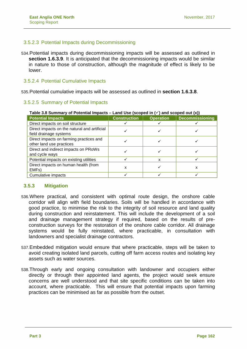
East Anglia ONE North November, 2017 Scoping Report
3.5.2.3 Potential Impacts during Decommissioning
534. Potential impacts during decommissioning impacts will be assessed as outlined in section 1.6.3.9. It is anticipated that the decommissioning impacts would be similar in nature to those of construction, although the magnitude of effect is likely to be lower.
3.5.2.4 Potential Cumulative Impacts
535. Potential cumulative impacts will be assessed as outlined in section 1.6.3.8.
3.5.2.5 Summary of Potential Impacts
Table 3.8 Summary of Potential Impacts – Land Use (scoped in () and scoped out (x)) Potential Impacts Construction Operation Decommissioning Direct impacts on soil structure Direct impacts on the natural and artificial field drainage systems
Direct impacts on farming practices and other land use practices
Direct and indirect impacts on PRoWs and cycle ways
Potential impacts on existing utilities x Direct impacts on human health (from EMFs) x x
Cumulative impacts
3.5.3 Mitigation
536. Where practical, and consistent with optimal route design, the onshore cable corridor will align with field boundaries. Soils will be handled in accordance with good practice, to minimise the risk to the integrity of soil resource and land quality during construction and reinstatement. This will include the development of a soil and drainage management strategy if required, based on the results of pre-construction surveys for the restoration of the onshore cable corridor. All drainage systems would be fully reinstated, where practicable, in consultation with landowners and specialist drainage contractors.
537. Embedded mitigation would ensure that where practicable, steps will be taken to avoid creating isolated land parcels, cutting off farm access routes and isolating key assets such as water sources.
538. Through early and ongoing consultation with landowner and occupiers either directly or through their appointed land agents, the project would seek ensure concerns are well understood and that site specific conditions can be taken into account, where practicable. This will ensure that potential impacts upon farming practices can be minimised as far as possible from the outset.
Part 3 Page 162
East Anglia ONE North November, 2017 Scoping Report
539. Permanent land loss would be limited to the operational footprint of the substation and National Grid infrastructure. During construction there would be some additional temporary loss of land where the cable swathe passes through plots of land, however this would return to agricultural use following construction. Any land lost would be extensively consulted on with landowners and the local authorities.
540. PRoWs would be identified and classified in consultation with SCC. Any PRoW that may be affected by the proposed East Anglia ONE NORTH project would be considered on a case by case basis, with alternative routes or closures agreed with the local PRoW officer. The requirement for permanent closures and alternative routes would be minimised as far as possible.
541. Potential mitigation may be required for any crossing of existing utilities. Major utilities will be covered by identifying protective provisions in the drafting of the DCO, and with the use of crossing agreements.
3.5.4 Approach to Data Gathering and Assessment
542. The assessment of effects in relation to land use would include a desk-based assessment of:
• Aerial photography; • ALC; • Environmental Stewardship Schemes; • Land drainage plans, where available; • Invasive plant species; • Natural England – Nature on the Map; • Open access and common land; • Existing utilities; • EMFs generated; • Soil resources; • Existing agricultural practices (including land quality and soil
types); • Other land uses during the construction phase; • PRoWs, roads and cycle routes; • Land Registry information; • Land subject to planning applications; • Landowner engagement; and • Public consultation events and questionnaires.
543. A site walkover will be undertaken to confirm land uses.
544. The methodology for the assessment of the effects on land use would be informed by the following current guidance and information sources:
Part 3 Page 163

East Anglia ONE North November, 2017 Scoping Report
• Design Manual for Roads and Bridges (DMRB) Volume 11, Section 3, Part 6 (Land Use);
• Defra guidance including the Construction Code of Practice for the Sustainable Use of Soils on Construction Sites (2009);
• NE124 – Look after your land with Environmental Stewardship (Natural England 2012);
• National Soil Resource Institute; and • Defra farming statistics.
545. The assessment would define the sensitivity of the identified land use receptors, assess the potential impacts and identify appropriate mitigation measures if required. This process will lead to an assessment of residual impact of the proposed project on land use receptors.
546. Consultation with stakeholders will be undertaken at key stages throughout the EIA process to confirm the approach to the land use assessment.
3.6 Terrestrial Ecology
3.6.1 Baseline
547. The onshore study area includes the coastline between Sizewell and Thorpeness, and covers an inland area that comprises an agricultural landscape including a mix of arable and grazing pasture, with hedgerows acting as field boundaries, and occasional pockets of woodland. Part of Sandlings SPA is located within the onshore study area and represents a notable area of woodland and heathland to the east of Leiston.
548. The strip of coastline includes coastal shingle / dune habitat in the northern area, and shingle leading into low sandy cliffs at the southern extent. The majority of the coastal strip within the onshore study area is designated as a Site of Special Significant Interest (SSSI) for vegetated shingle.
549. To facilitate the refinement of the onshore study area and to inform the approach to ecological surveys, the following desk-based data has been obtained.
Table 3.9 Desk-Based Data Sources to Inform the Assessment Data Data source
Internationally designated nature conservation sites (i.e. Ramsar sites)
Joint Nature Conservation Committee (JNCC). MAGIC website
European designated nature conservation sites (i.e. SPA, SAC)
JNCC. MAGIC website.
Nationally designated nature conservation sites (i.e. SSSI, National Nature Reserves (NNR), Local Nature Reserves (LNR)
JNCC. MAGIC website.
UK Habitats of Principal Importance JNCC Locally designated nature conservation sites (i.e. County Wildlife Sites (CWS), Local Wildlife Sites (LWS)
Suffolk Biodiversity Information Service
Protected Species records Suffolk Biodiversity Information Service
Part 3 Page 164

East Anglia ONE North November, 2017 Scoping Report
550. Any additional sources of data will be identified through consultation with key stakeholders.
551. The development of the onshore study area has sought to avoid sites designated for nature conservation wherever possible. Designated sites that are located within, and up to 3km from, the onshore study area are listed in Table 3.10 and shown on Figure 3.6.
Table 3.10 Statutory Designated Sites within 3km of the Onshore Study Area Designated site Key features Proximity to
onshore study area
Minsmere to Walberswick Ramsar, SPA and SAC
• Nationally important numbers of breeding and wintering birds;
• Annual vegetation of drift lines (vegetated shingle); and
• European dry heath.
1.8km
Alde-Ore Estuary Ramsar, SPA, SAC, SSSI
• Nationally important numbers of breeding and wintering birds;
• Estuaries; • Atlantic salt meadows; and • Mudflats
2km
Sandlings SPA • Breeding populations of nightjar and woodlark; and
• Acid grassland, heath, scrub, woodland (including commercial forest), fen, open water and vegetated shingle.
Within study area
Leiston to Aldeburgh SSSI • Acid grassland, heath, scrub, woodland, fen, open water and vegetated shingle.
Within study area
Sizewell Marshes SSSI • Lowland unimproved wet meadow. 400m
Minsmere to Walberswick Heath and Marshes SSSI
• Mudflats, shingle beach, reedbeds, heathland, and grazing marsh.
1.8km
Snape Warren SSSI • Lowland heathland. 2.3km
Gromford Meadow SSSI • Unimproved base-rich marsh on an alluvial soil.
2.6km
Part 3 Page 165

Sizew
ell M
arshe
s SSS
I
Le
iston
- Alde
burgh
SSSI
Sand
lings
SPA
Leist
on - A
ldebu
rgh SS
SI
Alde-O
re Es
tuary
Rams
ar/SP
A/SSS
IAld
e-Ore
& Butl
ey Es
tuarie
s SAC
Sand
lings
SPA
Snap
e Warr
en SS
SI
Leist
on - A
ldebu
rgh SS
SISa
ndlin
gs SP
A
Leist
on - A
ldebu
rgh SS
SI
¯
1:40,0
00
Rev
Date
Comm
ent
By
Scale
@ A4
00.5
1Km
31/08
/170
KOFir
st Iss
ue.
East
Angli
a ONE
Nor
th Sc
oping
Natur
e Con
serva
tion D
esign
ation
sDr
g No
Date
Figur
e
2 27/10
/17Co
ordina
teSy
stem:
BNG
Datum
:OS
GB36
EA1N
-DB-
0004
3.6
Rev
Prep
ared:
Chec
ked:
Appro
ved:
D:\B
ox S
ync\P
B484
2 EA 1
N an
d 2\P
B484
2 EA 1
N an
d 2 Te
am\E.
TECH
NICA
L DAT
A\E03
GIS
\Size
well\F
igures
\Sco
ping\O
nsho
re\EA
1N_D
B_00
04_N
atureC
onse
rvatio
nDes
ignati
ons_
27-10
-17.m
xdJAKO PW
Lege
nd Onsh
ore S
tudy A
reaSp
ecial
Prote
ction
Area
sRa
msar
Spec
ial Ar
eas o
f Con
serva
tion
Sites
of Sp
ecial
Scie
ntific
Inter
est
Ancie
nt Wo
odlan
d
Sourc
e: ©
Natur
al En
gland
, 201
7. ©
Crow
n cop
yrigh
t and
datab
ase r
ights
2017
. Ordn
ance
Surv
ey 01
0003
1673
. Th
is ma
p has
been
prod
uced
to th
e late
st kn
own i
nform
ation
at th
e tim
e of is
sue,
and h
as be
en pr
oduc
ed fo
r you
r infor
matio
n only
.Ple
ase c
onsu
lt with
the S
PR O
ffsho
re GI
S tea
m to
ensu
re the
conte
nt is
still c
urren
t befo
re us
ing th
e info
rmati
on co
ntaine
d on t
his m
ap.
To th
e full
est e
xtent
perm
itted b
y law
, we a
ccep
t no r
espo
nsibi
lity or
liabil
ity (w
hethe
r in co
ntrac
t, tort
(inclu
ding n
eglig
ence
) or o
therw
ise in
resp
ect o
f any
err
ors or
omiss
ions i
n the
infor
matio
n con
taine
d in t
he m
ap an
d sha
ll not
be lia
ble fo
r any
loss
, dam
age o
r exp
ense
caus
ed by
such
error
s or o
miss
ions.
27/09
/171
KOSe
cond
Issu
e.27
/10/17
2KO
Third
Issu
e.

East Anglia ONE North November, 2017 Scoping Report
552. Biological records within, and up to 2km from, the onshore study area have been obtained from the Suffolk Biodiversity Information Service. These have been reviewed and the following legally protected species are known to be present:
• Great crested newt Triturus cristatus (a European Protected Species (EPS));
• Reptiles (including common lizard Zootoca vivipara, grass snake Natrix natrix, adder Vipera berus and slow worm Anguis fragilis);
• Otter Lutra lutra (EPS species); • Badger Meles meles; • Water vole Arvicola amphibious; • Bats (all species – all of which are EPS); and • Birds (red kite Milvus milvus, white-tailed eagle Haliaeetus
albicilla, and goshawk Accipiter gentilis).
553. The legislation underpinning designated sites and legally protected species is provided in section 1.3.3.
554. Surveys will be undertaken to define the baseline ecology and to inform the assessment of potential impacts in the relation to the confirmed locations of the onshore infrastructure. In the first instance, this will include an Extended Phase 1 Habitat Survey. The Extended Phase 1 Habitat Survey will confirm where targeted species-specific surveys should be subsequently undertaken. Table 3.11 outlines the proposed onshore ecological surveys; the final suite of surveys will be confirmed once the onshore transmission works are defined. All surveys listed below will be undertaken in accordance with industry standard and good practice guidance.
555. It is intended that these surveys will be undertaken during spring and summer 2018 (dependent upon landowner access) with the findings available to inform the assessment presented within PEIR.
Table 3.11 Proposed Onshore Ecological Surveys Survey Proposed surveying
period Summary of survey
Extended Phase 1 Habitat Survey
March 2018 Survey will cover the onshore transmission works plus a 50m buffer. The survey will also consider waterbodies within 250m of the onshore cable corridor and 500m of the onshore substation and National Grid infrastructure. The findings of this survey will inform the requirements for further species-specific surveys (i.e. Phase 2 surveys).
Badger surveys March – April 2018 Survey will cover all badger setts identified during the Extended Phase 1 survey area (i.e. onshore infrastructure plus a 50m buffer).
Water vole and otter presence / absence surveys
March – April 2018 Surveys will focus on all suitable aquatic habitats which have the potential to be affected by the project.
Part 3 Page 167

East Anglia ONE North November, 2017 Scoping Report
Survey Proposed surveying period
Summary of survey
Breeding bird surveys
March – April 2018 Surveys will concentrate on those habitats noted as supporting breeding birds which have the potential to be affected by the project.
Great crested newt presence / absence surveys
March – June 2018 Surveys will be undertaken of those waterbodies identified as having suitability to support breeding populations of great crested newts (within 250m of the onshore cable corridor and 500m of the onshore substation and National Grid infrastructure).
Reptile presence / absence surveys
March – June 2018 Surveys will focus on all suitable habitats that may support significant populations of reptiles which have the potential to be affected by the project.
Dormice presence / absence surveys
April – May 2018 Surveys will concentrate on all suitable woodland habitats which have the potential to be affected by the project.
Invertebrate (terrestrial and aquatic) surveys
April – May 2018 Surveys of all terrestrial and aquatic habitats which may support rare or notable invertebrates and which have the potential to be affected by the project.
Bat activity surveys April – June 2018 Surveys will focus on all suitable commuting / foraging habitats which may be affected by the project.
Bat emergence / re-entry surveys
April – June 2018 Surveys will focus on those features (i.e. structures / trees) that have been assessed as having medium or high potential to support roosting bats.
Botanical surveys (including invasive species)
April – June 2018 Surveys will be undertaken of those habitats noted as containing designated habitat types or which may contain rare or notable plants which have the potential to be affected by the project.
Wintering bird surveys
November 2018 – February 2019
Surveys will cover all habitats identified as suitable for supporting wintering birds. Surveys would include observational and transect recording to understand the area’s usage by wintering bird species.
3.6.2 Potential Impacts
3.6.2.1 Potential Impacts during Construction
556. The key aspects of construction with respect to onshore ecological receptors are the construction of the onshore substation and National Grid infrastructure, the excavation works (and supporting activities) associated with the onshore cable corridor and landfall during construction. There is the potential for direct impacts where ecological receptors and the footprint of the proposed works overlap leading to potential loss or fragmentation of habitats and the risk of killing protected species, as well as indirect impacts where the proximity of the works may lead to a disturbance / displacement effect on protected species. In addition, should invasive species be present within the onshore construction footprint there is the potential risk of spreading invasive species.
Part 3 Page 168

East Anglia ONE North November, 2017 Scoping Report
3.6.2.2 Potential Impacts during Operation
557. The permanent above ground presence of the onshore substation and National Grid infrastructure has the potential to lead to the permanent loss of areas of ecological value or fragmentation of habitats depending on the preferred locations for development. Operational noise associated with the onshore substation and National Grid infrastructure has the potential to cause disturbance effects depending on their proximity to noise sensitive ecological receptors. Areas above the buried cable systems would return to their previous land use and would not respresent permanent loss or fragmentation of habitats.
558. During the operation phase the substation will be unmanned with human presence limited to planned and unplanned maintenance visits. In addition, any operational lighting (other than security lighting) at the onshore substation will be limited to those infrequent maintenance visits. Similarly there would be no requirement for operational activities along the onshore cable route other than for periodic maintenance inspections and in the event of unplanned maintenance works.
3.6.2.3 Potential Impacts during Decommissioning
559. Potential impacts during decommissioning impacts will be assessed as outlined in section 1.6.3.9. It is anticipated that the decommissioning impacts would be similar in nature to those of construction, although the magnitude of effect is likely to be lower.
3.6.2.4 Potential Cumulative Impacts
560. Potential cumulative impacts will be assessed as outlined in section 1.6.3.8.
3.6.2.5 Summary of Potential Impacts
Table 3.12 Summary of Potential Impacts – Terrestrial Ecology (scoped in () and scoped out (x)) Potential Impacts Construction Operation Decommissioning Direct and indirect impacts (noise, dust) to the qualifying features of statutory and non-statutory designated nature conservation sites
Direct impacts (permanent and temporary loss) to habitats due to footprint of the onshore works
Direct impacts as a result of fragmentation of habitats due to removal of linear habitats such as hedgerows
Direct and indirect impacts (disturbance / potential killing) to legally protected species
x
Spread of invasive species as a result of construction activities x
Direct and indirect impacts (noise, lighting) to adjacent habitats and species
Cumulative impacts
Part 3 Page 169

East Anglia ONE North November, 2017 Scoping Report
3.6.3 Mitigation
561. Avoiding known sensitive ecological receptors where practicable represents a key guiding principle in the identification of the onshore study area and will guide the eventual identification of the onshore transmission works.
562. Mitigation measures will be developed once the baseline ecological conditions are confirmed and the assessment of potential impacts has been undertaken. Mitigation measures will be discussed and agreed with stakeholders through the subsequent stages of the assessment.
3.6.4 Approach to Data Gathering and Assessment
563. On completion of all baseline ecological surveys, the ecological impact assessment will be undertaken following the guidance outlined in the Chartered Institute of Ecology and Environmental Management’s (CIEEM) Guidelines for Ecological Impact Assessment in the UK and Ireland: Terrestrial, Freshwater and Coastal (Second Edition 2016).
564. The approach to both the ecological impact assessment and data gathering (i.e. surveys) will be discussed and agreed as part of the ongoing work and prior to their commencement. Consultation with stakeholders will be undertaken at key stages throughout the EIA and development of the project.
3.7 Archaeology and Cultural Heritage
3.7.1 Baseline
565. The onshore study area predominantly comprises an agricultural landscape including a mix of arable and grazing pasture and occasional pockets of woodland. A number of settlements are located within or adjacent to the study area including: Leiston, Aldringham, Friston, Knodishall and Coldfair Green.
566. There are five Scheduled Monuments within, and up to 2km from, the onshore study area. These are summarised in Table 3.13 and are shown on Figure 3.7.
Table 3.13 Scheduled Monuments within 2km of the Onshore Study Area Scheduled Monument Proximity to onshore study
area Two bowl barrows on Aldringham Green Within onshore study area Bowl barrow on Aldringham Common, 300m east of Stone House
Within onshore study area
Two bowl barrows in Square Plantation, near Aldringham Within onshore study area Church Common and Round Barrows (near Friston) 1.5km from onshore study
area Leiston Abbey (second site) and moated site 2km from onshore study area
567. In addition, there is one Grade II* and 13 Grade II listed buildings located within the onshore study area.
Part 3 Page 170

East Anglia ONE North November, 2017 Scoping Report
568. There are no Registered Battlefields within the onshore study area or within a 20km buffer. There are no Registered Parks or Gardens within the onshore study area or within a 5km buffer.
569. The location of these features is shown on Figure 3.7.
570. Significant archaeological discoveries have been made across Suffolk and there is a high potential for further archaeological remains to be discovered within the onshore study area which will enhance our understanding of past human activity and development within Suffolk.
571. The presence of the wind turbines and onshore infrastructure has the potential to affect the setting of historic features (heritage assets, designated and non-designated). These features, and potential impacts, are considered within seascape and visual amenity – section 4.3.
3.7.1.1 Data Sources
572. A desk-based assessment will be undertaken to inform the onshore archaeology and cultural heritage baseline using the following sources of data, as a minimum.
Table 3.14 Desk-Based Data Sources to Inform the Assessment Data Source List of recorded archaeological sites and find spots within the County
Historic Environment Record maintained by Suffolk Archaeological Service
Online mapping of recorded archaeological sites and find spots within the County
Suffolk Heritage Explorer online mapping maintained by Suffolk Archaeological Service
A list of recorded archaeological sites across England
The National Record for the Historic Environment (NRHE) maintained by Historic England.
A list of designated heritage assets across England
National Heritage List online maintained by Historic England
List of Conservation Areas within the district Suffolk Coastal and Waveney District Councils Aerial Photography Google Maps Topography (LiDAR) Defra
573. In addition, a pre-application geophysical survey will be undertaken across the footprint of the onshore infrastructure and pre-application archaeological trial trenching will be undertaken within the footprint of the onshore substation site. Both of these exercises will also inform the archaeological baseline and impact assessment for the project.
574. Any additional data sets will be identified through consultation with Suffolk Archaeological Service (part of SCC) and Historic England following the issue of this Scoping Report.
Part 3 Page 171

"
"
"
"
"
¯
1:40,0
00
Rev
Date
Comm
ent
By
Scale
@ A4
00.5
1Km
31/08
/170
KOFir
st Iss
ue.
East
Angli
a ONE
Nor
th Sc
oping
Cultu
ral H
eritag
eDr
g No
Date
Figur
e
2 27/10
/17Co
ordina
teSy
stem:
BNG
Datum
:OS
GB36
EA1N
-DB-
0005
3.7
Rev
Prep
ared:
Chec
ked:
Appro
ved:
D:\B
ox S
ync\P
B484
2 EA 1
N an
d 2\P
B484
2 EA 1
N an
d 2 Te
am\E.
TECH
NICA
L DAT
A\E03
GIS
\Size
well\F
igures
\Sco
ping\O
nsho
re\EA
1N_D
B_00
05_C
ultura
lHeri
tage_
27-10
-17.m
xd
JAKO PW
Lege
nd Onsh
ore S
tudy A
reaHe
ritage
Coa
st"
Sche
duled
Mon
umen
ts"
Listed
Buil
dings
Sourc
e: ©
Histo
ric E
nglan
d, 20
17. ©
Crow
n cop
yrigh
t and
datab
ase r
ights
2017
. Ord
nanc
e Surv
ey 01
0003
1673
. Th
is ma
p has
been
prod
uced
to th
e late
st kn
own i
nform
ation
at th
e tim
e of is
sue,
and h
as be
en pr
oduc
ed fo
r you
r infor
matio
n only
.Ple
ase c
onsu
lt with
the S
PR O
ffsho
re GI
S tea
m to
ensu
re the
conte
nt is
still c
urren
t befo
re us
ing th
e info
rmati
on co
ntaine
d on t
his m
ap.
To th
e full
est e
xtent
perm
itted b
y law
, we a
ccep
t no r
espo
nsibi
lity or
liabil
ity (w
hethe
r in co
ntrac
t, tort
(inclu
ding n
eglig
ence
) or o
therw
ise in
resp
ect o
f any
err
ors or
omiss
ions i
n the
infor
matio
n con
taine
d in t
he m
ap an
d sha
ll not
be lia
ble fo
r any
loss
, dam
age o
r exp
ense
caus
ed by
such
error
s or o
miss
ions.
27/09
/171
KOSe
cond
Issu
e.27
/10/17
2KO
Third
Issu
e.
East Anglia ONE North November, 2017 Scoping Report
3.7.2 Potential Impacts
3.7.2.1 Potential Impacts during Construction
575. Any excavations associated with site preparation or groundworks associated with the onshore substation, National Grid infrastructure, cable corridor and landfall may damage and / or remove buried archaeological and palaeoenvironmental deposits where present. In addition, the temporary presence of the construction works themselves could affect the setting of historic features (heritage assets, designated and non-designated) such as Scheduled Monuments, listed buildings and the historic landscape.
3.7.2.2 Potential Impacts during Operation
576. During operation it is expected that there will be no further requirement for land to be disturbed or excavated, except in the event that cables require repair or maintenance. However, these activities would not extend beyond the construction footprint, and would be relatively rare and localised in occurrence. As such, it is proposed that direct impacts to buried archaeology during operation be scoped out of further assessment.
577. The presence of the operational onshore substation and National Grid infrastructure could affect the setting of historic features (heritage assets, designated and non-designated) such as Scheduled Monuments, listed buildings and the historic landscape, and will be considered in detail within the assessment.
578. The cable systems will be buried and will not affect the setting of historic features (heritage assets, designated and non-designated). This aspect will not be considered within the assessment of operational impacts.
579. Potential effects to the setting of historic features (heritage assets, designated and non-designated) related to the presence of the offshore wind turbines is considered within seascape and visual amenity - section 4.3.
3.7.2.3 Potential Impacts during Decommissioning
580. Potential impacts during decommissioning will be assessed as outlined in section 1.6.3.9. The demolition of buildings and infrastructure can have an impact greater than that of construction e.g. if grubbing out of foundations or remediation of contaminants is required. In addition, additional temporary work areas may be required away from those originally disturbed during construction.
581. The potential impact upon the setting of designated and non-designated heritage assets and the historic landscape would be the same as those identified at the construction phase.
Part 3 Page 173

East Anglia ONE North November, 2017 Scoping Report
3.7.2.4 Potential Cumulative Impacts
582. It is not anticipated that the physical footprint of the works will overlap with any other existing, consented or proposed projects other than the proposed East Anglia TWO project. Therefore it is expected that cumulative impacts to unknown buried archaeology would be limited to effects of the proposed East Anglia TWO and East Anglia ONE North projects.Cumulative impacts on the setting of designated and non-designated heritage assets may occur. Settings assessment will follow Historic England guidance, as part of the Archaeological DBA, using landscape and visual assessment tools such as theoretical visibility and photomontages, particularly in relation to above ground infrastructure, and identifying any connections/associations with other existing and/or planned infrastructure of relevance. Potential cumulative impacts will be assessed as outlined in Section 1.6.3.8.
3.7.2.5 Summary of Potential Impacts
Table 3.15 Summary of Potential Impacts – Archaeology and Cultural Heritage (scoped in () and scoped out (x)) Potential Impacts Construction Operation Decommissioning Direct impacts on buried archaeological remains (including palaeoenvironmental deposits)
x
Direct and/or indirect impacts on the setting of heritage assets (both designated and non-designated)
Direct and indirect impacts through alteration of the historic landscape
Cumulative impacts
3.7.3 Mitigation
583. The information obtained from the desk-based assessment and evaluation stages will inform the EIA process, and mitigation will be embedded in the design and siting of the onshore infrastructure in order to, as far as possible, avoid impacts to known heritage assets. Where impacts upon known heritage assets are unavoidable, a series of mitigation measures would be put in place to reduce (or offset) the scale of the impact. This process would also identify the potential to uncover buried archaeological remains which are, at present, unknown.
584. In consultation with the Suffolk Archaeological Service and Historic England (and where required, including the Historic England Regional Science Advisor) a mitigation strategy would be prepared. This will outline a programme of further archaeological investigations, including excavation and watching brief (archaeological monitoring) requirements as well as preservation in situ where warranted and appropriate, prior to and during the construction phase.
Part 3 Page 174

East Anglia ONE North November, 2017 Scoping Report
3.7.4 Approach to Data Gathering and Assessment
585. As part of the EIA process, an onshore historic environment (archaeology, heritage and historic landscape) baseline will be identified, including, but not limited to the following:
• Description of the known and potential past human activities that were undertaken overtime, based on available records which will be obtained from the Suffolk Historic Environment Record; Historic England’s National Record for the Historic Environment and the National Heritage List online;
• A Settings Assessment of all designated and key non-designated heritage assets; and
• An assessment of the significance (heritage value) of the assets established in the baseline assessment.
586. The scope of archaeological fieldwork would be discussed and agreed in advance with the Suffolk Archaeological Service and Historic England, where required. Any works required would be proportionate to the scale of likely impacts.
587. The assessment will be undertaken in accordance to relevant standards and guidance provided by the Chartered Institute for Archaeology (CIfA) and Historic England. Specific reference will be made to a range of guidance including, but not limited to, the following:
• CIfA (2014) Standards and guidance for historic environment desk-based assessment;
• Historic England (2015) The Setting of Heritage Assets: Historic Environment Good Practice Advice in Planning Note 3;
• English Heritage (2008) Conservation Principles: Policy and Guidance for the Sustainable Management of the Historic Environment; and
• National Planning Policy Framework polices.
588. An assessment of the setting of heritage assets on the coast from landfall and nearshore construction activities will be considered in conjunction with a settings assessment for onshore archaeology and cultural heritage and cross referenced with the landscape and visual impact assessments of the EIA. The settings assessment will be undertaken following Historic England guidance, as part of the Archaeological DBA, and also as part of the wider EIA using landscape and visual assessment type tools such as theoretcial visibility and photomontages, when and where available, particularly in relation to above ground infrastructure. This will include the assessment of both designated and non-designated heritage assets with a setting that contributes to the significance of that asset and which may be impacted by the East Anglia ONE North project.
Part 3 Page 175

East Anglia ONE North November, 2017 Scoping Report
589. The approach to assessment and data gathering will be discussed and agreed as part of this Scoping exercise. Consultation will be undertaken at key stages throughout the EIA process.
3.8 Noise and Vibration
3.8.1 Baseline
590. The onshore study area is predominantly rural and coastal in nature, with limited significant noise sources. A number of settlements are located within or adjacent to the study area including: Leiston, Aldringham, Friston, Knodishall and Coldfair Green. In addition, there are numerous individual residential properties and farms located throughout the area.
591. There are a number of B roads that pass through the onshore study area, which form part of the noise environment, including the B1122 that provides a link from the A12 through Leiston and onto to Aldeburgh, the B1353 (Aldringham to Thorpeness) and B1069 (Leiston to Coldfair Green). The closest major road is the A12 approximately 3km to the west of the onshore study area.
592. The onshore study area will be refined in order to determine the preferred locations for the onshore infrastructure. This process will be informed through ongoing consultation with stakeholders and landowners including the confirmation of noise sensitive receptors in proximity to the works (both construction and operation).
3.8.1.1 Data Sources
593. Identification of potential noise and vibration sensitive receptors would be undertaken using existing available geographical information and aerial photography to inform ongoing site selection work.
594. The data sources used to inform the initial desk-based element are shown in Table 3.16.
Table 3.16 Desk-Based Data Sources to Inform the Assessment Data obtained Data source used Date data accessed Location of noise and vibration sensitive receptors within the onshore study area
Google Maps Aerial Photography
August 2017
Local Authority Local Plans OS maps Information from other projects within the area
595. Once the preferred location of the onshore transmission works have been identified, surveys will be then undertaken to define the baseline noise environment. Table 3.17 outlines the proposed surveys. The exact locations of these surveys will discussed and agreed with the SCWC’s Environmental Health Officer prior to survey work commencing. All surveys will be undertaken in accordance with industry accepted guidance.
Part 3 Page 176

East Anglia ONE North November, 2017 Scoping Report
596. It is intended that these surveys will be undertaken during spring 2018 with the findings available to inform the assessment presented within PEIR. Noise measurements will be undertaken in accordance with BS 7445-1:2003 (Description and measurement of environmental noise. Guide to quantities and procedures). It is not proposed that a baseline vibration survey is undertaken to inform the assessment.
Table 3.17 Proposed Onshore Baseline Noise Surveys Survey Proposed surveying
period Summary of survey
Onshore cable corridor baseline noise
March - May 2018 Short term (daily) baseline noise surveys along the onshore cable corridor consisting of daytime and night-time attended noise measurements at locations representative of noise sensitive receptors.
Onshore substation and National Grid infrastructure sites baseline noise
March - May 2018 Long-term (up to a week) baseline surveys in proximity to the substation and National Grid infrastructure sites consisting of unattended, continuous noise measurements at locations representative of noise sensitive receptors.
3.8.2 Potential Impacts
3.8.2.1 Potential Impacts during Construction
597. Construction impacts will be temporary in nature and include noise and vibration generating activities associated with:
• Earthworks along the onshore cable corridor, at the landfall, at the onshore substation and at the National Grid infrastructure;
• General construction activities along the onshore cable corridor, at the landfall, at the onshore substation and at the National Grid infrastructure;
• Directional drilling works; • Heavy goods vehicles (HGVs) delivering to site; and • Piling of onshore substation and National Grid infrastructure
foundations (if required).
3.8.2.2 Potential Impacts during Operation
598. Potential operational noise impacts will be limited to the operation of the onshore substation and National Grid infrastructure and the proximity of noise sensitive receptors to the permanent above ground electrical infrastructure. An assessment will be undertaken to determine the likely environmental and health impacts due to operational noise emissions on identified noise sensitive receptors.
Part 3 Page 177

East Anglia ONE North November, 2017 Scoping Report
599. There are unlikely to be any noise and vibration impacts relating to operational or maintenance vehicular traffic due to the infrequent nature of those activities, and low level of associated traffic. As such, it is proposed that operational noise impacts from traffic are scoped out of further assessment.
600. There are no significant sources of vibration associated with the operation of the scheme. As such, it is proposed that operational vibration impacts are scoped out of further assessment.
3.8.2.3 Potential Impacts during Decommissioning
601. Potential impacts during decommissioning impacts will be assessed as outlined in section 1.6.3.9. It is anticipated that the decommissioning impacts would be similar in nature to those of construction.
3.8.2.4 Potential Cumulative Impacts
602. Potential cumulative impacts will be assessed as outlined in section 1.6.3.8.
3.8.2.5 Summary of Potential Impacts
Table 3.18 Summary of Potential Impacts – Noise and Vibration (scoped in () and scoped out (x)) Potential Impacts Construction Operation Decommissioning Direct and indirect impacts on human and ecological receptors associated with noise and vibration
x
Direct and indirect impacts on receptors (human and ecological) associated with operational substation noise
x x
Cumulative impacts
3.8.3 Mitigation
603. The footprint of the onshore substation has been determined to allow sufficient room to accommodate any potentially required operational noise mitigation measures. Embedded mitigation would include the following measures, where possible:
• Locating the onshore substation away from noise sensitive receptors where practicable;
• Designing the layout of onshore substation equipment in such a way to take advantage of screening inherent in the design;
• Inclusion of acoustic enclosures, to meet required noise reduction levels; and
• Inclusion of acoustic barriers, to meet required noise reduction levels.
Part 3 Page 178

East Anglia ONE North November, 2017 Scoping Report
604. Additional mitigation measures would be developed once the baseline conditions are confirmed and the assessment of potential construction and operational impacts undertaken. Additional mitigation measures may include:
• Selection of quieter operational substation equipment, to meet required noise reduction levels;
• Silencing of exhausts / outlets for air handling / cooling units within the operational substation; and
• Employment of best practical means (BPM) to limit construction noise impacts. These measures will be set out in the CoCP.
3.8.4 Approach to Data Gathering and Assessment
605. Potential noise and vibration impacts associated with onshore construction will be assessed using the guidance contained in BS 5228:2009+A1:2014 (Code of Practice for Noise and Vibration Control on Construction and Open Sites), which defines the accepted prediction methods and source data for various construction plant and activities.
606. Construction noise and vibration impacts will be based on the identified construction programme and associated activities and plant, including earthworks, piling (if required), directional drilling, cable trenching and associated construction traffic.
607. The spatial scope of the construction noise assessment will include the following geographic coverage:
• 400m from the onshore transmission works where significant activities could affect noise sensitive receptors; and
• Traffic routes and routes subject to significant changes in traffic flows (and / or percentage HGV) associated with construction.
608. Operational impacts will include noise generation associated with the onshore substation and National Grid infrastructure. The guidance and methodology contained in BS 4142:2014 (Rating and Assessing Industrial and Commercial Sound) will be used to assess potential noise impacts.
609. Following the identification of the preferred onshore development area, further liaison with the SCDC and WDC’s Environmental Health Officer will be undertaken to agree the approach and methodology to baseline noise surveys and the criteria to be used for the noise and vibration assessment.
Part 3 Page 179

East Anglia ONE North November, 2017 Scoping Report
3.9 Traffic and Transport
3.9.1 Baseline
610. The closest primary traffic route to the onshore study area is the north-south running A12 London to Great Yarmouth road. The A12 was de-trunked in 2001 and is the responsibility of SCC as the Local Highway Authority. The location of the A12 relative to the onshore study area is shown on Figure 3.8.
611. The route between the A12 at Yoxford and the Leiston / Sizewell area (avoiding Leiston) has previously been used for the construction of Sizewell A and Sizewell B nuclear power stations, as well as more recently for the Sizewell Dry Fuel Store and Galloper Wind Farm.
612. To facilitate the impact assessment, the following baseline data will be obtained via data gathering and surveys, once the onshore development area has been defined:
• Baseline traffic flow data within the onshore study area, including seasonal traffic fluctuations;
• Details of sensitive receptors (such as district centres, schools, leisure facilities etc.) within the onshore study area;
• Collison data within the onshore study area; • Existing pedestrian, cycle and bus routes serving the onshore
study area; • Existing PRoWs; • Details of Abnormal Indivisible Load (AIL) routes; and • Details of extant permissions and permitted movements of traffic
at the preferred port location.
613. The transport baseline will be developed to ensure a Department for Transport (DfT) compliant Transport Assessment is undertaken.
Part 3 Page 180

A12
B111
9
B112
1
B106
9
B106
9
B135
3
B112
2
Love
r's La
ne
¯
1:50,0
00
Rev
Date
Comm
ent
By
Scale
@ A4
00.5
1Km
31/08
/170
KOFir
st Iss
ue.
East
Angli
a ONE
Nor
th Sc
oping
Trans
port R
outes
Drg N
o
Date
Figur
e
2 27/10
/17Co
ordina
teSy
stem:
BNG
Datum
:OS
GB36
EA1N
-DB-
0006
Sourc
e: ©
Crow
n cop
yrigh
t and
datab
ase r
ights
2017
. Ordn
ance
Surve
y 010
0031
673.
This
map h
as be
en pr
oduc
ed to
the l
atest
know
n info
rmati
on at
the t
ime o
f issu
e, an
d has
been
prod
uced
for y
our in
forma
tion o
nly.
Pleas
e con
sult w
ith th
e SPR
Offs
hore
GIS
team
to en
sure
the co
ntent
is sti
ll cur
rent b
efore
using
the i
nform
ation
conta
ined o
n this
map
.To
the f
ulles
t exte
nt pe
rmitte
d by l
aw, w
e acc
ept n
o res
pons
ibility
or lia
bility
(whe
ther in
contr
act, t
ort (in
cludin
g neg
ligen
ce) o
r othe
rwise
in re
spec
t of a
ny
errors
or om
ission
s in t
he in
forma
tion c
ontai
ned i
n the
map
and s
hall n
ot be
liable
for a
ny lo
ss, d
amag
e or e
xpen
se ca
used
by su
ch er
rors o
r omi
ssion
s.3.8
Rev
Prep
ared:
Chec
ked:
Appro
ved:
D:\B
ox S
ync\P
B484
2 EA 1
N an
d 2\P
B484
2 EA 1
N an
d 2 Te
am\E.
TECH
NICA
L DAT
A\E03
GIS
\Size
well\F
igures
\Sco
ping\O
nsho
re\EA
1N_D
B_00
06_T
ransp
ortRo
utes_
27-10
-17.m
xd
JAKO PW
Lege
nd Onsh
ore S
tudy A
reaA R
oad
B Roa
d
27/09
/171
KOSe
cond
Issu
e.27
/10/17
2KO
Third
Issu
e.

East Anglia ONE North November, 2017 Scoping Report
3.9.2 Potential Impacts
3.9.2.1 Potential Impacts during Construction
614. The construction phase will require movement of employees and the import of materials and plant to the onshore cable corridor, substation and National Grid infrastructure. At this stage, no information is available with regards to likely material quantities and workforce numbers, however it is envisaged that daily traffic demand could be significant with a large component being HGV deliveries.
615. The importing of large AILs may also lead to delays on the highway network. The quantum of AIL deliveries has not been established at this stage. When components have been established an AIL routing study will be undertaken to inform the management measures required.
616. In addition there is also the potential for impacts associated with employee and HGV movements for the offshore construction via the construction port. The traffic impacts of the potential construction port or ports will be assessed in the context of any existing port operations.
3.9.2.2 Potential Impacts during Operation
617. During the operational phase, traffic movements would be limited to those generated by the daily operation and periodic maintenance at the substation and at link boxes along the onshore cable route.
618. The onshore substation would not be manned; however access would be required periodically for routine maintenance activities.
619. Employee and HGV movements would be required at the primary port base for the offshore windfarm O&M activities.
620. The assessment for the operational phase is expected to consider the impacts of localised driver delay and road safety impacts relating to any new permanent points of access to the onshore substation and associated with the O&M base (or potential O&M base locations if this is not known at the time of the assessment).
3.9.2.3 Potential Impacts during Decommissioning
621. Potential impacts during decommissioning will be assessed as outlined in section 1.6.3.9. It is anticipated that the decommissioning impacts would be similar in nature to those of construction.
3.9.2.4 Potential Cumulative Impacts
622. Other proposed developments with the potential to generate significant traffic will be considered within the CIA based on their projected traffic generation, location and construction and operation timescales. Potential cumulative impacts will be assessed as outlined in Section 1.6.3.8.
Part 3 Page 182

East Anglia ONE North November, 2017 Scoping Report
3.9.2.5 Summary of Potential Impacts
Table 3.19 Summary of Potential Impacts – Traffic and Transport (scoped in () and scoped out (x)) Potential Impacts Construction Operation Decommissioning Driver delay Severance x Pedestrian and cycle amenity x Road safety Cumulative impacts
3.9.3 Mitigation
623. The traffic impact assessment would determine any requirement for mitigation measures where significant impacts are identified to transport receptors. However, the following embedded mitigation is expected to form part of the project and would inform the assessment:
• Suitable access points and identification of optimum routes for construction traffic to use (minimising the impact on sensitive receptors); and
• Reducing points of construction access through the adoption of a haul road, if required.
3.9.4 Approach to Data Gathering and Assessment
624. Three key guidance documents will be utilised for the assessment of potential traffic impacts:
• DfT Circular 02/2013 entitled ‘The Strategic Road Network and the Delivery of Sustainable Development’. This was published in September 2013 replacing circular 02/2007 ‘Planning and the Strategic Road Network’. It sets out the ways in which Highways England will engage with communities and developers to deliver sustainable development and, thus economic growth, whilst safeguarding the primary function and purpose of the Strategic Road Network.
• Institute of Environmental Assessment - Guidelines for the Environmental Assessment of Road Traffic (GEART). This contains the principle guidelines for the assessment of the environmental impacts of road traffic associated with new developments. GEART was published by the Institute of Environmental Assessment in January 1993. The guidance provides a framework for the assessment of traffic borne environmental impacts, such as pedestrian severance and
Part 3 Page 183

East Anglia ONE North November, 2017 Scoping Report
amenity, driver delay, accidents and safety; and noise, vibration and air quality.
• Department for Communities and Local Government (DCLG) Planning Practice Guidance - Overarching principles on Travel Plans, Transport Assessments and Statements. This contains overarching principles on Travel Plans, Transport Assessments and Statements. Sets out the key principles, requirements and processes for the development of a Transport Assessment (and associated travel plans).
625. Details of the proposed construction traffic demand would be determined once the preferred locations of the onshore infrastructure have been identified. Once traffic demand is known further engagement will be undertaken with SCC, as Highways Authority, to refine the approach to assessment (including approach to cumulative impact assessment).
3.10 Health
3.10.1 Baseline
626. Human health will be considered within the relevant onshore topics during the EIA, including noise and vibration, flood risk, traffic and transport, air quality, and ground contamination. A review of the health interactions of the project and those in the receiving environment will be drawn from those other assessments.
627. The assessment will identify potential impacts on the health of the local population in relation to the proposed project. Receptors that are sensitive to potential health impacts will be identified within the topic specific ES chapters, and a review of these will be presented within the health impact assessment.
3.10.2 Potential Impacts
3.10.2.1 Potential Impacts during Construction
628. Potential health related effects experienced during construction would be determined through the topic specific assessments, but are expected to include:
• Noise disturbance; • Dust and other air emissions; • Hazardous waste and substances; • Temporary loss of access to green space; and • Disruption to local road network (reduced access to services and
amenities).
Part 3 Page 184

East Anglia ONE North November, 2017 Scoping Report
3.10.2.2 Potential Impacts during Operation
629. Potential health related impacts experienced during operation would be determined through the topic specific assessment, but are expected to include:
• Noise disturbance associated with the operational substation and National Grid infrastructure; and
• Generation of EMFs.
3.10.2.3 Potential Impacts during Decommissioning
630. Potential impacts during decommissioning impacts will be assessed as outlined in section 1.6.3.9. It is anticipated that the decommissioning impacts would be similar in nature to those of construction.
3.10.2.4 Potential Cumulative Impacts
631. Potential cumulative impacts will be assessed as outlined in section 1.6.3.8.
3.10.2.5 Summary of Potential Impacts
Table 3.20 Summary of Potential Impacts – Health (scoped in () and scoped out (x)) Potential Impacts Construction Operation Decommissioning Disturbance / reduced amenity value (visual, noise, traffic, public access)
Air quality x Exposure to potentially contaminated land x
EMF during operation of buried cable system x x
Cumulative impacts
3.10.3 Mitigation
632. Measures to avoid or reduce health related impacts will be identified in each topic specific assessment. These will be reported within the chapters of the ES and collated within the health impact assessment.
3.10.4 Approach to Data Gathering and Assessment
633. There are no specific guidelines for the assessment of health impacts. The National Policy Statement for Energy (EN-1) states that where the proposed project has an effect on human beings, the ES should assess these effects for each element of the project, identifying any adverse health impacts, and identifying measures to avoid, reduce or compensate for these impacts as appropriate.
634. EN-1 indicates that direct impacts on health may include:
• Increased traffic; • Air or water pollution;
Part 3 Page 185

East Anglia ONE North November, 2017 Scoping Report
• Dust; • Odour; • Hazardous waste and substances; • Noise; • Exposure to radiation; and • Increases in pests.
635. The assessment will include the identification and review of the potential public health impacts during construction, operation and decommissioning. The findings will be taken from individual chapters from the ES and collated in the health chapter. In addition feedback will be sought from consultees on potential health impacts, with particular reference to the Health and Safety Executive and Public Health England.
3.11 Summary of Onshore Topics
636. Table 3.21 summarises the potential impacts for each of the environmental receptors outlined in the sections above. All impacts that have been scoped in for assessment are considered to represent potential likely significant effects under Regulation 10 of the Infrastructure Planning (Environmental Impact Assessment) Regulations 2017.
Table 3.21 Summary of Potential Impacts (scoped in () and scoped out (x)) Potential impacts Construction Operation Decommissioning Ground conditions and contamination Mobilisation of contaminants through excavation works resulting in impacts on human health of construction works
x
Mobilisation of contaminants through excavation works resulting in pollution risks to controlled waters
x
Indirect and direct impacts on WFD designated groundwater bodies x
Indirect and direct impacts on designated geological sites x
Cumulative impacts x Air Quality Direct and indirect impacts associated with the generation of dust and particulates (human and ecological receptors)
x
Direct and indirect impacts arising from exhaust emissions from construction traffic (human and ecological receptors)
x
Direct and indirect impacts arising from exhaust emissions from non-road mobile machinery (human and ecological receptors)
x
Cumulative impacts x Water resources and Flood Risk Direct impacts to groundwater and surface water resources as a result of the x
Part 3 Page 186

East Anglia ONE North November, 2017 Scoping Report
Potential impacts Construction Operation Decommissioning construction works Direct and indirect impacts on surface waters as a result of spills and leaks of contaminants
Direct and indirect impacts on surface waters associated with dewatering of trenches
x
Direct and indirect impacts on flood risk to downstream receptors
Cumulative impacts Land use Direct impacts on soil structure Direct impacts on the natural and artificial field drainage systems
Direct impacts on farming practices and other land use practices
Direct and indirect impacts on PRoWs and cycle ways
Potential impacts on existing utilities x Direct impacts on human health (from EMFs) x x
Cumulative impacts Terrestrial ecology Direct and indirect impacts (noise, dust) to the qualifying features of statutory and non-statutory designated nature conservation sites
Direct impacts (permanent and temporary loss) to habitats due to the footprint of onshore works
Direct impacts as a result of fragmentation of habitats due to removal of linear habitats such as hedgerows
Direct and indirect impacts (disturbance and potential killing) to legally protected species
x
Direct impacts (spread) to invasive species as a result of construction activities
x
Direct and indirect impacts (noise, lighting) to adjacent habitats and species
Cumulative impacts Archaeology and cultural heritage Direct impacts on buried archaeological remains (including palaeoenvironmental deposits)
x x
Direct and indirect impacts on the setting of built heritage assets (both designated and non-designated)
Direct and indirect impacts through alteration of the historic landscape
Cumulative impacts
Part 3 Page 187

East Anglia ONE North November, 2017 Scoping Report
Potential impacts Construction Operation Decommissioning Noise and vibration Direct and indirect impacts on human and ecological receptors associated with noise and vibration
x
Direct and indirect impacts on receptors (human and ecological) associated with operational substation noise
x x
Cumulative impacts Traffic and transport Driver delay Severance x Pedestrian and cycle amenity x Road safety Cumulative impacts Health Disturbance / reduced amenity value (visual, noise, traffic, public access)
Air quality x Exposure to potentially contaminated land x EMF during operation of buried cable system X x
Cumulative impacts
Part 3 Page 188

East Anglia ONE North November, 2017 Scoping Report
4 Part 4- Wider Scheme Aspects 4.1 Introduction
637. This part of the Scoping Report considers topics which cover both the offshore and onshore aspects of the proposed East Anglia ONE North project.
4.2 Offshore Seascape, Landscape and Visual Amenity
638. A Seascape, Landscape and Visual Impact Assessment (SLVIA) will be undertaken in order to identify the likely significant effects of the proposed East Anglia ONE North project on seascape, landscape and visual amenity. This section addresses the East Anglia ONE North windfarm site and offshore electrical infrastructure. The landscape and visual aspects of the onshore infrastructure and construction works are discussed in section 4.3.
639. More detail of the proposed approach to the assessment can be found in Appendix 4.1. The following sections summarise the detail presented in that Appendix. Following the submission of this Scoping Report SPR will undertake dedicated consultation with relevant consultees to define the assessment methodology.
4.2.1 Baseline
4.2.1.1 SLVIA Study Area
640. The SLVIA study area for the proposed East Anglia ONE North project will cover a radius of 50km from the East Anglia ONE North windfarm site, as illustrated in the Blade Tip Zone of Theoretical Visibility (ZTV) in Figure 4.1, 4.2 and 4.3a-b. The ZTV shows the number of wind turbines (blade tips) that are theoretically visible around the study area (based on the maximum blade tip height of 300m).
641. It is considered that the proposed East Anglia ONE North windfarm site is unlikely to result in significant impacts at distances over 50km. Relevant guidance, professional experience, ZTV analysis (Figure 4.1 and 4.3a-b), published visibility studies and Met Office visibility frequency data all indicate that the threshold at which significant visual impacts would diminish is likely to be within this proposed 50km radius area. Significant seascape, landscape and visual impacts as a result of the East Anglia ONE North windfarm site are proposed to be scoped out beyond 50km.
642. Within the SLVIA study area, the assessment will focus primarily on the assessment of seascape, landscape and visual impacts of the proposed East Anglia ONE North windfarm site within Suffolk Coastal and Waveney District in Suffolk; and Great Yarmouth, Broadland and South Norfolk Districts in Norfolk; and their adjacent seascapes.
Part 4 Page 189

3800
00.0
0000
0
3800
00.0
0000
0
4100
00.0
0000
0
4100
00.0
0000
0
4400
00.0
0000
0
4400
00.0
0000
0
4700
00.0
0000
0
4700
00.0
0000
0
5000
00.0
0000
0
5000
00.0
0000
0
5300
00.0
0000
0
5300
00.0
0000
0
5760000.000000
5760000.000000
5780000.000000
5780000.000000
5800000.000000
5800000.000000
5820000.000000
5820000.000000
5840000.000000
5840000.000000
5860000.000000
5860000.000000
¯
1:50
0,00
0
Rev
Dat
eC
omm
ent
By
Scal
e @
A3
010
205
Km
24/0
8/20
170
TD
Drg
No
Date
Figu
re
Dat
um:
WG
S 19
84Pr
ojec
tion:
Zone
31N
EAIN
-DB-
0023
This
map
has
bee
n pr
oduc
ed to
the
late
st k
now
n in
form
atio
n at
the
time
of is
sue,
and
has
bee
n pr
oduc
ed fo
r you
r inf
orm
atio
n on
ly.Pl
ease
con
sult
with
the
SPR
Offs
hore
GIS
team
to e
nsur
e th
e co
nten
t is
still
curr
ent b
efor
e us
ing
the
info
rmat
ion
cont
aine
d on
this
map
.To
the
fulle
st e
xten
t per
mitt
ed b
y la
w, w
e ac
cept
no
resp
onsi
bilit
y or
liab
ility
(whe
ther
in c
ontra
ct, t
ort (
incl
udin
g ne
glig
ence
) or o
ther
wis
e in
resp
ect o
f any
er
rors
or o
mis
sion
s in
the
info
rmat
ion
cont
aine
d in
the
map
and
sha
ll no
t be
liabl
e fo
r any
loss
, dam
age
or e
xpen
se c
ause
d by
suc
h er
rors
or o
mis
sion
s.©
Cro
wn
Cop
yrig
ht a
nd S
eaZo
ne S
olut
ions
Lim
ited.
All
right
s re
serv
ed.P
rodu
ct L
icen
ce N
o. 0
8201
0.00
1. T
his
prod
uct h
as b
een
deriv
ed in
par
t fro
m m
ater
ial
obta
ined
from
theU
K H
ydro
grap
hic
Offi
ce w
ith th
e pe
rmis
sion
of t
he C
ontro
ller o
f Her
Maj
esty
's S
tatio
nery
Offi
ce a
nd U
K H
ydro
grap
hicO
ffice
. NO
T TO
BE
US
ED F
OR
NAV
IGAT
ION
.C
onta
ins
Ord
nanc
e S
urve
y di
gita
l dat
a ©
Cro
wn
copy
right
, All
right
s re
serv
ed 2
017
Lice
nce
num
ber 0
1000
3167
3.
Rev
Prep
ared
:
Che
cked
:
Appr
oved
:
P:\2
015\
1508
87_E
A1N
&2\G
IS\A
rcG
IS\A
rcM
ap\O
FFSH
OR
E_W
F\SC
OPI
NG
EA1
N\R
EV_2
\150
887_
FIG
4.1_
SLVI
A_St
udy_
Area
.mxd
300m
OS
T50
50m
2m Excl
uded
Incl
uded
Blad
e Ti
p:D
TM:
Obs
erve
r hei
ght:
Surfa
ce fe
atur
es:
DTM
reso
lutio
n:Ea
rth c
urva
ture
:
Gre
atYa
rmou
thD
istr
ict
Bro
adla
ndD
istr
ict
Nor
wic
hD
istr
ict
Sout
hN
orfo
lkD
istr
ict
Wav
eney
Dis
tric
t
Mid
Suf
folk
Dis
tric
t
Suffo
lkC
oast
alD
istr
ict
Ipsw
ich
Dis
tric
t
Bab
ergh
Dis
tric
t
Tend
ring
Dis
tric
t
Nor
thN
orfo
lkD
istr
ict
NORF
OLK
CO
UNT
Y
SUFF
OLK
CO
UN
TY
EAST
AN
GLI
A O
NE Ea
st A
nglia
ON
E N
orth
SLVI
A St
udy
Area
Blad
e Ti
p ZT
V (3
00m
)Fi
rst I
ssue
(OPE
N)
TD SM
1TD
Seco
nd Is
sue
(OPE
N)
SM
26/0
9/20
171 26
/09/
17
4.1
Lege
nd East
Ang
lia O
NE
Nor
th W
indf
arm
Site
SLVI
A St
udy
Area
(50k
m)
Dis
trict
Bou
ndar
y
Cou
nty
Boun
dary
Blad
e Ti
p ZT
V (3
00m
)
Theo
retic
al V
isib
ility
Mor
e Tu
rbin
es
Less
Tur
bine
s

! H
! H
! H
! H
H
H
H
H HH
H H H H H
H
HHHH
98
7
6
54
3
2
116 15 14 13
12
1110
D
C
B
A
3800
00.0
0000
0
3800
00.0
0000
0
4100
00.0
0000
0
4100
00.0
0000
0
4400
00.0
0000
0
4400
00.0
0000
0
4700
00.0
0000
0
4700
00.0
0000
0
5000
00.0
0000
0
5000
00.0
0000
0
5760000.000000
5760000.000000
5780000.000000
5780000.000000
5800000.000000
5800000.000000
5820000.000000
5820000.000000
5840000.000000
5840000.000000
¯
1:35
0,00
0
Rev
Dat
eC
omm
ent
By
Scal
e @
A3
010
205
Km
24/0
8/20
170
TD
Drg
No
Date
Figu
re
Dat
um:
WG
S 19
84Pr
ojec
tion:
Zone
31N
This
map
has
bee
n pr
oduc
ed to
the
late
st k
now
n in
form
atio
n at
the
time
of is
sue,
and
has
bee
n pr
oduc
ed fo
r you
r inf
orm
atio
n on
ly.Pl
ease
con
sult
with
the
SPR
Offs
hore
GIS
team
to e
nsur
e th
e co
nten
t is
still
curr
ent b
efor
e us
ing
the
info
rmat
ion
cont
aine
d on
this
map
.To
the
fulle
st e
xten
t per
mitt
ed b
y la
w, w
e ac
cept
no
resp
onsi
bilit
y or
liab
ility
(whe
ther
in c
ontra
ct, t
ort (
incl
udin
g ne
glig
ence
) or o
ther
wis
e in
resp
ect o
f any
er
rors
or o
mis
sion
s in
the
info
rmat
ion
cont
aine
d in
the
map
and
sha
ll no
t be
liabl
e fo
r any
loss
, dam
age
or e
xpen
se c
ause
d by
suc
h er
rors
or o
mis
sion
s.©
Cro
wn
Cop
yrig
ht a
nd S
eaZo
ne S
olut
ions
Lim
ited.
All
right
s re
serv
ed.P
rodu
ct L
icen
ce N
o. 0
8201
0.00
1. T
his
prod
uct h
as b
een
deriv
ed in
par
t fro
m m
ater
ial
obta
ined
from
theU
K H
ydro
grap
hic
Offi
ce w
ith th
e pe
rmis
sion
of t
he C
ontro
ller o
f Her
Maj
esty
's S
tatio
nery
Offi
ce a
nd U
K H
ydro
grap
hicO
ffice
. NO
T TO
BE
US
ED F
OR
NAV
IGAT
ION
.C
onta
ins
Ord
nanc
e S
urve
y di
gita
l dat
a ©
Cro
wn
copy
right
, All
right
s re
serv
ed 2
017
Lice
nce
num
ber 0
1000
3167
3.
Rev
Prep
ared
:
Che
cked
:
Appr
oved
:
P:\2
015\
1508
87_E
A1N
&2\G
IS\A
rcG
IS\A
rcM
ap\O
FFSH
OR
E_W
F\SC
OPI
NG
EA1
N\R
EV_2
\150
887_
FIG
4.2_
SLVI
A_St
udy_
Area
_VPs
.mxd
300m
OS
T50
50m
2m Excl
uded
Incl
uded
Blad
e Ti
p:D
TM:
Obs
erve
r hei
ght:
Surfa
ce fe
atur
es:
DTM
reso
lutio
n:Ea
rth c
urva
ture
:
Gre
atYa
rmou
thD
istr
ict
Bro
adla
ndD
istr
ict
Nor
wic
hD
istr
ict
Sout
hN
orfo
lkD
istr
ict
Wav
eney
Dis
tric
t
Mid
Suf
folk
Dis
tric
t
Suffo
lkC
oast
alD
istr
ict
NORF
OLK
CO
UNT
Y
SUFF
OLK
CO
UN
TY
EAST
AN
GLI
A O
NE
NO
RTH
EAIN
-DB-
0024
Ipsw
ich
Dis
tric
t
Tend
ring
Dis
tric
t
East
Ang
lia O
NE
Nor
thSL
VIA
Stud
y Ar
ea a
nd V
iew
poin
tsBl
ade
Tip
ZTV
(300
m)
Firs
t Iss
ue (O
PEN
)SMTD
1TD
Seco
nd Is
sue
(OPE
N)
26/0
9/20
17
SM
1 26/0
9/17
4.2
Blad
e Ti
p ZT
V (3
00m
)
Theo
retic
al V
isib
ility
Mor
e Tu
rbin
es
Less
Tur
bine
s
! HIll
ustra
tive
View
poin
tsA.
Sou
thw
old
Com
mon
B. N
ess
Poin
t Low
esto
ftC
. Cor
ton
Hol
iday
Villa
geD
. Sou
thw
old
Pier
HR
epre
sent
ativ
e Vi
ewpo
ints
1. L
owes
toft
2. K
essi
ngla
nd B
each
3. C
oveh
ithe
4. S
outh
wol
d5.
Gun
Hill,
Sou
thw
old
6. W
albe
rsw
ick
7. D
unw
ich
8. D
unw
ich
Hea
th &
Bea
ch
(C
oast
guar
d co
ttage
s)9.
Min
smer
e N
atur
e R
eser
ve
10. S
izew
ell B
each
11.T
horp
enes
s12
. Ald
ebur
gh13
. Hop
ton-
on-s
ea14
. Gor
leto
n-on
-sea
15. G
reat
Yar
mou
th, S
outh
Bea
ch16
. Cai
ster
-on-
sea
Lege
nd Dis
trict
Bou
ndar
y
Cou
nty
Boun
dary
East
Ang
lia O
NE
Nor
th W
indf
arm
Site
SLVI
A St
udy
Area
(50k
m)

D
1
2
3
4
5
6
13
14
15
16
A
B
C
395000.000000
395000.000000
400000.000000
400000.000000
405000.000000
405000.000000
410000.000000
410000.000000
415000.000000
415000.000000
5800
000.0
0000
0
5800
000.0
0000
0
5805
000.0
0000
0
5805
000.0
0000
0
5810
000.0
0000
0
5810
000.0
0000
0
5815
000.0
0000
0
5815
000.0
0000
0
5820
000.0
0000
0
5820
000.0
0000
0
5825
000.0
0000
0
5825
000.0
0000
0
5830
000.0
0000
0
5830
000.0
0000
0
¯
SUFFOLK COASTALDISTRICT
WAVENEYDISTRICT
300mOS T5050m
2mExcludedIncluded
Blade Tip:DTM:
Observer height:Surface features:
DTM resolution: Earth curvature:
NORFOLK COUNTY
SUFFOLK COUNTY
GREAT YARMOUTHDISTRICT
BROADLANDDISTRICT
SOUTH NORFOLKDISTRICT
East Anglia ONE NorthBlade Tip ZTV with Viewpoints (300m)Norfolk & North Suffolk Coast
Drg NoRevDate
Figure
128/09/17
4.3a
Datum:WGS84Projection:UTM Z31N
EA1N-DB-00251:50,000Scale @ A1 0 1 2 3 40.5
Km
Rev Date ByFirst Issue (OPEN)Comment
TD25/08/170This map has been produced to the latest known information at the time of issue, and has been produced for your information only.Please consult with the SPR Offshore GIS teamto ensure the content is still current before using the information contained on this map.To the fullest extent permitted by law, we accept no responsibility or liability (whether in contract, tort (including negligence) or otherwise in respect of any errors or omissions in the information contained in the map and shall not be liable for any loss, damage or expense caused bysuch errors or omissions. © Crown Copyright and SeaZone Solutions Limited. All rights reserved.Product Licence No. 082010.001. This product has been derived in part from material obtained from theUK Hydrographic Office with the permission of the Controller of Her Majesty's Stationery Office and UK HydrographicOffice. NOT TO BE USED FOR NAVIGATION.Contains Ordnance Survey digital data © Crown copyright, All rights reserved 2017 Licence number 0100031673.Approved:
Checked:Prepared:
SMSMTDSecond Issue (OPEN)TD28/09/171
Blade Tip ZTV (300m)
Theoretical VisibilityMore Turbines
Less Turbines
1. Lowestoft2. Kessingland Beach3. Covehithe4. Southwold5. Gun Hill, Southwold6. Walberswick13. Hopton-on-sea14. Gorleton-on-sea15. Great Yarmouth, South Beach16. Caister-on-sea
A. Southwold CommonB. Ness Point LowestoftC. Corton Holiday VillageD. Southwold Pier
Illustrative Viewpoints
Representative Viewpoints
Legend
SLVIA Study Area (50km)District BoundaryCounty Boundary

10
11
12
7
89
390000.000000
390000.000000
395000.000000
395000.000000
400000.000000
400000.000000
405000.000000
405000.000000
410000.000000
410000.000000
5760
000.0
0000
0
5760
000.0
0000
0
5765
000.0
0000
0
5765
000.0
0000
0
5770
000.0
0000
0
5770
000.0
0000
0
5775
000.0
0000
0
5775
000.0
0000
0
5780
000.0
0000
0
5780
000.0
0000
0
5785
000.0
0000
0
5785
000.0
0000
0
5790
000.0
0000
0
5790
000.0
0000
0
¯
300mOS T5050m
2mExcludedIncluded
Blade Tip:DTM:
Observer height:Surface features:
DTM resolution: Earth curvature:
SUFFOLK COUNTY
SUFFOLK COASTALDISTRICT
East Anglia ONE NorthBlade Tip ZTV with Viewpoints (300m)South Suffolk Coast
Drg NoRevDate
Figure
128/09/17
4.3b
Datum:WGS84Projection:UTM Z31N
EA1N-DB-00261:50,000Scale @ A1 0 1 2 3 40.5
Km
Rev Date ByFirst Issue (OPEN)Comment
TD25/08/170This map has been produced to the latest known information at the time of issue, and has been produced for your information only.Please consult with the SPR Offshore GIS teamto ensure the content is still current before using the information contained on this map.To the fullest extent permitted by law, we accept no responsibility or liability (whether in contract, tort (including negligence) or otherwise in respect of any errors or omissions in the information contained in the map and shall not be liable for any loss, damage or expense caused bysuch errors or omissions. © Crown Copyright and SeaZone Solutions Limited. All rights reserved.Product Licence No. 082010.001. This product has been derived in part from material obtained from theUK Hydrographic Office with the permission of the Controller of Her Majesty's Stationery Office and UK HydrographicOffice. NOT TO BE USED FOR NAVIGATION.Contains Ordnance Survey digital data © Crown copyright, All rights reserved 2017 Licence number 0100031673.Approved:
Checked:Prepared:
SMSMTDSecond Issue (OPEN)TD28/09/171
7. Dunwich8. Dunwich Heath & Beach (Coastguard cottages)9. Minsmere Nature Reserve 10. Sizewell11. Thorpeness12. Aldeburgh
Representative Viewpoints
Legend
SLVIA Study Area (50km)District BoundaryCounty Boundary
Blade Tip ZTV (300m)
Theoretical VisibilityMore Turbines
Less Turbines

East Anglia ONE North November, 2017 Scoping Report
643. Other offshore windfarms in proximity to the SLVIA study area are shown in Figure 4.4.
4.2.1.2 Seascape and Landscape Character
644. The baseline for the proposed East Anglia ONE North windfarm site will consider both Seascape and Landscape Character.
645. Seascape is defined by Natural England (2010) as: “An area of sea, coastline and land, as perceived by people, whose character results from the actions and interactions of land with sea, by natural and/or human factors”. A summary of what constitutes seascape is presented in ‘An Approach to Seascape Character Assessment’ (Natural England 2012).
646. A Seascape Character Area (SCA) assessment for the East Inshore and East Offshore marine plan areas (MMO 2012) covers the SLVIA study area. The East Anglia ONE North windfarm site is located within the East Anglian Shipping Waters SCA. The key characteristics of this SCA includes its dense concentration of shipping activity, designated shipping routes, large scale offshore windfarms and gas fields, consistently deep water, expansive open water character and extensive offshore commercial activities, such as fishing and dredging.
647. A seascape character assessment for the waters off the Suffolk and Norfolk coastlines within the study area is also currently being prepared by Suffolk County Council. When published, this will inform the baseline seascape characterisation in the SLVIA for the proposed East Anglia ONE North windfarm site.
648. Landscape Character principally applies to terrestrial areas lying to the landward side of the high-water mark. There is a hierarchy of published Landscape Character Assessments that describe the baseline landscape character in the SLVIA study area, at the National, County and District level.
649. The English Landscape is classified at the national level by National Character Areas (NCAs). This mapping and the associated descriptions have been revised and developed by Natural England into NCA profiles, which provide a recognised, national, spatial framework. At the National level, the SLVIA study area is characterised by the following NCAs:
• North East Norfolk and Flegg (NCA 79); • The Broads (NCA 80); • Suffolk Coast and Heaths (NCA 82); and • South Norfolk and High Suffolk Claylands NCA (NCA 83).
Part 4 Page 194

3500
00.0
0000
0
3500
00.0
0000
0
3800
00.0
0000
0
3800
00.0
0000
0
4100
00.0
0000
0
4100
00.0
0000
0
4400
00.0
0000
0
4400
00.0
0000
0
4700
00.0
0000
0
4700
00.0
0000
0
5000
00.0
0000
0
5000
00.0
0000
0
5300
00.0
0000
0
5300
00.0
0000
0
5600
00.0
0000
0
5600
00.0
0000
0
5740000.000000
5740000.000000
5760000.000000
5760000.000000
5780000.000000
5780000.000000
5800000.000000
5800000.000000
5820000.000000
5820000.000000
5840000.000000
5840000.000000
5860000.000000
5860000.000000
¯
1:60
0,00
0
Rev
Date
Com
men
tBy
Scal
e @
A3
010
205
Km
24/0
8/20
170
TD
Drg
No
Dat
e
Figu
re
Dat
um:
WG
S 19
84Pr
ojec
tion:
Zone
31N
This
map
has
bee
n pr
oduc
ed to
the
late
st k
now
n in
form
atio
n at
the
time
of is
sue,
and
has
bee
n pr
oduc
ed fo
r you
r inf
orm
atio
n on
ly.Pl
ease
con
sult
with
the
SPR
Offs
hore
GIS
team
to e
nsur
e th
e co
nten
t is
still
cur
rent
bef
ore
usin
g th
e in
form
atio
n co
ntai
ned
on th
is m
ap.
To th
e fu
llest
ext
ent p
erm
itted
by
law,
we
acce
pt n
o re
spon
sibi
lity
or li
abilit
y (w
heth
er in
con
tract
, tor
t (in
clud
ing
negl
igen
ce) o
r oth
erw
ise
in re
spec
t of a
ny
erro
rs o
r om
issi
ons
in th
e in
form
atio
n co
ntai
ned
in th
e m
ap a
nd s
hall
not b
e lia
ble
for a
ny lo
ss, d
amag
e or
exp
ense
cau
sed
by s
uch
erro
rs o
r om
issi
ons.
© C
row
n C
opyr
ight
and
Sea
Zone
Sol
utio
ns L
imite
d. A
ll rig
hts
rese
rved
.Pro
duct
Lic
ence
No.
082
010.
001.
Thi
s pr
oduc
t has
bee
n de
rived
in p
art f
rom
mat
eria
l ob
tain
ed fr
om th
eUK
Hyd
rogr
aphi
c O
ffice
with
the
perm
issi
on o
f the
Con
trolle
r of H
er M
ajes
ty's
Sta
tione
ry O
ffice
and
UK
Hyd
rogr
aphi
cOffi
ce. N
OT
TO B
E U
SED
FO
R N
AVIG
ATIO
N.
Con
tain
s O
rdna
nce
Surv
ey d
igita
l dat
a ©
Cro
wn
copy
right
, All
right
s re
serv
ed 2
017
Lice
nce
num
ber 0
1000
3167
3.
Rev
Prep
ared
:
Che
cked
:
Appr
oved
:
P:\2
015\
1508
87_E
A1N
&2\
GIS
\Arc
GIS
\Arc
Map
\OFF
SHO
RE_
WF\
SC
OPI
NG
EA1
N\R
EV_2
\150
887_
FIG
4.4_
EA1_
OFF
SHO
RE_
WF1
.mxd
SM
Gre
atYa
rmou
thD
istr
ict
Bro
adla
ndD
istr
ict N
orw
ich
Dis
tric
t
Sout
hN
orfo
lkD
istr
ict
Wav
eney
Dis
tric
t
Mid
Suf
folk
Dis
tric
t
Suffo
lkC
oast
alD
istr
ict
Ipsw
ich
Dis
tric
tB
aber
ghD
istr
ict
Tend
ring
Dis
tric
t
Nor
thN
orfo
lkD
istr
ict
NOR
FOLK
CO
UN
TY
SUFF
OLK
CO
UN
TY
EAST
AN
GLI
A O
NE
NORT
H
EAIN
-DB-
0027
Bre
ckla
ndD
istr
ict
Col
ches
ter
Dis
tric
t
Edm
unds
bury
Dis
tric
t
Offs
hore
Win
dfar
ms
NORF
OLK
BO
REAL
IS
EAST
ANG
LIA
THR
EE
NORF
OLK
VAN
GUA
RD
NORF
OLK
VAN
GU
ARD
EAST
ANG
LIA
ON
E
SCR
OB
Y SA
NDS
EAST
ANG
LIA
TWO
GA
LLO
PER
GR
EATE
R G
ABBA
RD
GA
LLO
PER
GR
EATE
R G
ABBA
RD
Lege
nd East
Ang
lia O
NE
Nor
th W
indf
arm
Site
SLV
IA S
tudy
Are
a (5
0km
)
East
Ang
lia T
WO
Win
dfar
m S
ite
Dis
trict
Bou
ndar
y
Cou
nty
Bou
ndar
y
Oth
er O
ffsho
re W
ind
Farm
s
Pre-
plan
ning
app
licat
ion
Con
sent
ed
Und
er c
onst
ruct
ion
Ope
ratio
nal
East
Ang
lia O
NE
Nor
thFi
rst I
ssue
(OPE
N)
SMTD1
TDSe
cond
Issu
e (O
PEN
)26
/09/
2017
1 26/0
9/17
4.4

East Anglia ONE North November, 2017 Scoping Report
650. Local Authorities across England have produced Landscape Character Assessments (LCAs) for their areas which subdivide the broader NCAs into more detailed Landscape Character Areas. These County Council and District Council scale landscape characterisations will be utilised in the SLVIA for the proposed East Anglia ONE North windfarm site. Descriptions of these LCAs and NCAs is provided in Appendix 4.1.
4.2.1.3 Landscape Designations
651. The East Anglia ONE North windfarm site is located outwith any areas designated to protect landscape quality, as shown in Figure 4.5.
652. A number of landscape designations occur in the wider landscape of the SLVIA study area and include the nationally important Suffolk Coast and Heaths Area of Outstanding Natural Beauty (AONB), which is located approximately 36.4km from the East Anglia ONE North windfarm site (Figure 4.5). The special characteristics and qualities of the AONB are identified in the Management Plan (Suffolk Coast and Heaths AONB 2013), which lists the special qualities of eight LCAs within the AONB, and within the Natural Beauty and Special Qualities Indicators report (Suffolk Coast and Heaths AONB 2016).
653. Although it is unlikely that the proposed East Anglia ONE North windfarm site would have significant direct impacts on the character and special qualities of the AONB, owing to its distance offshore, the potential for indirect landscape impacts on the AONB will be assessed in the SLVIA to reflect the sensitivity of this receptor.
654. The Suffolk Heritage Coast is approximately 36.3km from the East Anglia ONE North windfarm site at its closest point and is largely contained within the AONB. There are no statutory requirements or powers associated with the Heritage Coast designation. However, it is noted that it includes objectives for conserving the environmental health and biodiversity of inshore waters and beaches, and to extend opportunities for recreational, educational, sporting, and tourist activities that draw on, and are consistent with, the conservation of their natural beauty and the protection of their heritage features. The SLVIA will assess the impacts of the proposed East Anglia ONE North windfarm site on the special characteristics and qualities of the Heritage Coast as part of the assessment of the AONB.
Part 4 Page 196

3800
00.0
0000
0
3800
00.0
0000
0
4100
00.0
0000
0
4100
00.0
0000
0
4400
00.0
0000
0
4400
00.0
0000
0
4700
00.0
0000
0
4700
00.0
0000
0
5800000.000000
5800000.000000
5820000.000000
5820000.000000
5840000.000000
5840000.000000
¯
1:25
0,00
0
Rev
Dat
eC
omm
ent
By
Scal
e @
A3
07.
515
3.75
Km
24/0
8/20
170
TD
Drg
No
Date
Figu
re
Dat
um:
WG
S 19
84Pr
ojec
tion:
Zone
31N
This
map
has
bee
n pr
oduc
ed to
the
late
st k
now
n in
form
atio
n at
the
time
of is
sue,
and
has
bee
n pr
oduc
ed fo
r you
r inf
orm
atio
n on
ly.Pl
ease
con
sult
with
the
SPR
Offs
hore
GIS
team
to e
nsur
e th
e co
nten
t is
still
curr
ent b
efor
e us
ing
the
info
rmat
ion
cont
aine
d on
this
map
.To
the
fulle
st e
xten
t per
mitt
ed b
y la
w, w
e ac
cept
no
resp
onsi
bilit
y or
liab
ility
(whe
ther
in c
ontra
ct, t
ort (
incl
udin
g ne
glig
ence
) or o
ther
wis
e in
resp
ect o
f any
er
rors
or o
mis
sion
s in
the
info
rmat
ion
cont
aine
d in
the
map
and
sha
ll no
t be
liabl
e fo
r any
loss
, dam
age
or e
xpen
se c
ause
d by
suc
h er
rors
or o
mis
sion
s.©
Cro
wn
Cop
yrig
ht a
nd S
eaZo
ne S
olut
ions
Lim
ited.
All
right
s re
serv
ed.P
rodu
ct L
icen
ce N
o. 0
8201
0.00
1. T
his
prod
uct h
as b
een
deriv
ed in
par
t fro
m m
ater
ial
obta
ined
from
theU
K H
ydro
grap
hic
Offi
ce w
ith th
e pe
rmis
sion
of t
he C
ontro
ller o
f Her
Maj
esty
's S
tatio
nery
Offi
ce a
nd U
K H
ydro
grap
hicO
ffice
. NO
T TO
BE
US
ED F
OR
NAV
IGAT
ION
.C
onta
ins
Ord
nanc
e S
urve
y di
gita
l dat
a ©
Cro
wn
copy
right
, All
right
s re
serv
ed 2
017
Lice
nce
num
ber 0
1000
3167
3.
Rev
Prep
ared
:
Che
cked
:
Appr
oved
:
P:\2
015\
1508
87_E
A1N
&2\G
IS\A
rcG
IS\A
rcM
ap\O
FFSH
OR
E_W
F\SC
OPI
NG
EA1
N\R
EV_2
\150
887_
FIG
4.5_
Des
igna
tions
.mxd
Gre
atYa
rmou
thD
istr
ict
Bro
adla
ndD
istr
ict
Nor
wic
hD
istr
ict
Sout
hN
orfo
lkD
istr
ict
Wav
eney
Dis
tric
t
Mid
Suf
folk
Dis
tric
t
Suffo
lkC
oast
alD
istr
ict
Nor
thN
orfo
lkD
istr
ict
NORF
OLK
CO
UNT
Y
SUFF
OLK
CO
UN
TY
EAST
AN
GLI
A O
NE
NO
RTH
EAIN
-DB-
0030
Land
scap
e D
esig
natio
nsEa
st A
nglia
ON
E N
orth
Firs
t Iss
ue (O
PEN
)
TD SM
Dat
a So
urce
: Con
tain
s, o
r is
base
d on
, in
form
atio
n su
pplie
d by
Nat
ural
Eng
land
2017
© H
isto
ric E
ngla
nd 2
017.
Con
tain
sO
rdna
nce
Surv
ey d
ata
© C
row
n co
pyrig
htan
d da
taba
se ri
ght 2
017
Lege
nd Dis
trict
Bou
ndar
y
Cou
nty
Boun
dary
Nat
iona
l Par
k (T
he B
road
s)
Her
itage
Coa
st
Park
s an
d G
arde
ns
East
Ang
lia O
NE
Nor
th W
indf
arm
Site
SLVI
A St
udy
Area
(50k
m)
Area
of O
utst
andi
ng N
atur
al B
eaut
y
1TD
Seco
nd Is
sue
(OPE
N)
26/0
9/20
17
SM
1 26/0
9/17
4.5

East Anglia ONE North November, 2017 Scoping Report
655. The Norfolk and Suffolk Broads National Park (the Broads) is Britain's largest protected wetland and third largest inland waterway, and is located approximately 39.6km from the East Anglia ONE North windfarm site at its closest point. It is proposed that potential landscape impacts of the proposed East Anglia ONE North windfarm site on the Broads be scoped out of the assessment. Significant impacts on the landscape character of the Broads are unlikely due to the long distance of the East Anglia ONE North windfarm site from the Broads. In addition, there is limited visibility to the sea afforded from the landscapes of the Broads, which are located further inland, are very low-lying and are partially screened by surrounding landforms and intervening vegetation (woodland and hedgerows).
656. There are several Registered Parks and Gardens (RPG) in the study area (Figure 4.5), The SLVIA will prepare a baseline description of the relevant RPGs, which have sea views as part of their baseline landscape context, and assess the potential impacts of the proposed East Anglia ONE North windfarm site on the character and quality of these designed landscapes.
4.2.1.4 Visual Receptors and Views
4.2.1.4.1 Zone of Theoretical Visibility
657. Visual impacts will occur when the introduction of the East Anglia ONE North windfarm site changes or influences the visual amenity and views experienced by people in the area. The visual baseline is defined by the ZTV shown in Figure 4.1 and in more detail in Figures 4.3a-b.
658. The scope of the visual assessment will be based on the ZTV which assists with the identification of the principal visual receptors and viewpoints. The ZTV shows the main areas of theoretical visibility of the East Anglia ONE North windfarm site will be along the Suffolk and Norfolk coastlines and immediate hinterland, between Caister-on-sea in the north and Orford Ness in the south. The closest areas of theoretical visibility of the East Anglia ONE North windfarm site will be at Lowestoft, approximately 36.4 km from the coast at its closest point near Ness Point. Theoretical visibility also extends along the coast at longer distances north to Great Yarmouth; and south to Southwold, Sizewell, Thorpeness and Aldeburgh. The area of theoretical visibility becomes more fragmented from the hinterland and inland areas of the SLVIA study area, where views of the sea become increasingly screened within the main river valleys, either by adjacent rising land or coastal landforms (such as Orford Ness). Actual visibility from these hinterland and inland areas also becomes increasingly screened by vegetation, such as woodland and hedgerows, and/or built development and settlement. There are relatively few elevated areas affording wider views of the sea from inland areas of the SLVIA study area.
Part 4 Page 198

East Anglia ONE North November, 2017 Scoping Report
4.2.1.4.2 Visual Receptors
659. The principal visual receptors in the study area are likely to be focused along the closest sections of the Suffolk and Norfolk coastline. A detailed assessment will be undertaken in the SLVIA for those visual receptors that are most susceptible to changes along the Suffolk and Norfolk coastlines and immediate hinterland, including:
• Coastal settlements - including Caister-on-sea; Great Yarmouth; Gorleston-on-sea; Hopton-on-sea; Corton; Lowestoft; Kessingland; Southwold; Walberswick; Dunwich; Thorpeness; Aldeburgh; Orford; Bawdsey and Felixstowe;
• Recreational routes - including the Suffolk Coastal Path; Regional Cycle Routes 30, 31, 41, 42 and 517;
• Main road routes - such as the A12 and the various roads that lead off it to the coast such as the A1094, A1095, B1083, B1084, B1353, B1122, B1125, B1127;
• Visitors to tourist facilities - such as the sea fronts/beaches of the main coastal towns and resorts, holiday villages and nature reserves and visitor centres; and
• Visitors to historic environment assets - such as Dunwich Heath, Orford Ness, Orford Castle and the series of Martello Towers along the Suffolk coast.
4.2.2 Potential Impacts
4.2.2.1 Potential Impacts during Construction
660. The seascape, landscape and visual impacts that could arise during construction are identified as follows:
• Temporary impacts on coastal/seascape character; • Temporary impacts on landscape character; and • Temporary visual impacts on views.
4.2.2.2 Potential Impacts during Operation
661. The seascape, landscape and visual impacts that could arise during operation are identified as follows:
• Long-term impacts on coastal / seascape character - either affecting the pattern of elements that define the character or affecting the visual/perceptual characteristics of seascape character areas.
Part 4 Page 199

East Anglia ONE North November, 2017 Scoping Report
• Long-term impacts on landscape character - within terrestrial landscape types and landscape designations, primarily as a result of visibility of the offshore wind turbines during operation.
• Long-term visual impacts on views - primarily as a result of offshore wind turbine operation, experienced by visual receptors (groups of people) with visibility of the proposed East Anglia ONE North windfarm site, on specific views and on their visual amenity/experience of the landscape. In addition, there may be visual impacts on views at night-time as a result of navigational lighting and aviation lighting of offshore wind turbines.
4.2.2.3 Potential Impacts during Decommissioning
662. The impacts of the proposed East Anglia ONE North windfarm site during decommissioning will be similar to those identified during construction.
4.2.2.4 Potential Cumulative Impacts
663. Cumulative impacts may arise where two or more developments are experienced at proximity where they may have a greater incremental impact, or where they may combine to have a sequential impact. The focus of the cumulative SLVIA will be on the additional impact of the proposed East Anglia ONE North windfarm site in conjunction with other developments of the same type i.e. other offshore windfarms.
664. Potential cumulative impacts will be assessed as outlined in section 1.6.3.8. Further detail on developments proposed to be scoped in and scoped out of the assessment of cumulative impacts is provided in Appendix 4.1 and the proximity of those developments in relation to the proposed East Anglia ONE North windfarm site is shown on Figure 4.4.
4.2.2.5 Summary of Potential Impacts
Table 4.1 Summary of Potential Impacts - Seascape, Landscape and Visual Amenity (scoped in () and scoped out (x))
Potential impacts Construction Operation Decommissioning Seascape, landscape and visual impacts, of the windfarm site on seascape, landscape and visual receptors within the ZTV in the SLVIA study area (50 km radius)
Seascape, landscape and visual impacts of the windfarm site on seascape, landscape and visual receptors beyond outwith the SLVIA study area (50 km radius)
x x x
Impacts of the windfarm site on the landscape character of the Norfolk and Suffolk Broads National Park
x x x
Part 4 Page 200

East Anglia ONE North November, 2017 Scoping Report
Potential impacts Construction Operation Decommissioning Impacts of the windfarm site on the landscape character of landscape character areas within Broadland and South Norfolk Districts
x x x
Cumulative seascape, landscape and visual impacts of East Anglia ONE North windfarm site with East Anglia ONE, East Anglia THREE, Norfolk Vanguard and Norfolk Boreas offshore windfarms
x x x
Cumulative seascape, landscape and visual impacts of East Anglia ONE North windfarm site with Scroby Sands, Greater Gabbard, Galloper and East Anglia TWO offshore windfarms within SLVIA study area
4.2.3 Mitigation
665. Options for mitigation of the potential impacts which are predicted to arise from the proposed East Anglia ONE North windfarm site will be considered, iteratively alongside the assessment. The mitigation measures proposed for the project will be dependent upon the final design of the windfarm site and the potential impacts as determined by the EIA studies. Mitigation options will be discussed with the relevant stakeholders for the SLVIA.
4.2.4 Approach to Data Gathering and Assessment
4.2.4.1 Consultation
666. SPR is undertaking consultation with relevant consultees with regards to seascape, landscape and visual matters, including Suffolk County Council, Suffolk Coastal District Council, Waveney District Council, Great Yarmouth Borough Council, Suffolk Coast and Heaths AONB Unit, Natural England and Historic England, in order to define the scope of the SLVIA.
4.2.4.2 Guidance
667. The assessment will be undertaken in accordance with the methods outlined in the following best practice guidance documents:
• The Landscape Institute with the Institute of Environmental Management and Assessment (2013). Guidelines for Landscape and Visual Impact Assessment. Third Edition;
• Landscape and Seascape Character Assessments published by Natural England and the Department for Environment, Food and Rural Affairs (2014);
• Natural England (2012). An Approach to Seascape Character Assessment;
Part 4 Page 201

East Anglia ONE North November, 2017 Scoping Report
• Natural England (2014). An Approach to Landscape Character Assessment;
• Scottish Natural Heritage (2012). Assessing the Cumulative Impact of Onshore Wind Energy Developments;
• Scottish Natural Heritage (2017). Visual Representation of Windfarms: Version 2.2; and
• Landscape Institute (2017). Visual Representation of Development Proposals.
668. Data will be gathered from official, reliable and the most up-to-date sources. This would include Ordnance Survey map based data, as well as data on landscape characterisation, landscape designations and other Governmental and local authority data of relevance.
4.2.4.3 SLVIA Methodology
669. In accordance with the 2017 EIA Regulations, the SLVIA impacts will be assessed to be either significant or not significant. The methodology to undertake the SLVIA will reflect the ‘Guidelines for Landscape and Visual Impact Assessment: Third Edition’ (GLVIA3) (Landscape Institute 2013).
670. The significance of impacts will be assessed through a combination of two considerations – the sensitivity of the landscape or visual receptor/view and the magnitude of change that will result from the proposed East Anglia ONE North windfarm site. In accordance with GLVIA3, the SLVIA methodology requires the application of professional judgement, but generally, the higher the sensitivity and the higher the magnitude of change the more likely that a significant impact will arise.
671. The objective of the cumulative SLVIA is to describe, visually represent and assess the ways in which the proposed East Anglia ONE North windfarm site will have additional impacts when considered together with other existing, consented or application stage developments and to identify related significant cumulative impacts arising. The guiding principle in preparing the cumulative SLVIA will be to focus on the likely significant impacts and in particular those which are likely to influence the outcome of the consenting process.
672. The SLVIA will determine whether impacts are beneficial, neutral or adverse in accordance with defined criteria.
673. The impacts of the proposed East Anglia ONE North windfarm site will be of variable duration, and will be assessed as short-term or long-term, and permanent or temporary/reversible.
674. A full methodology for the SLVIA is provided in Appendix 4.1.
Part 4 Page 202

East Anglia ONE North November, 2017 Scoping Report
4.3 Onshore Landscape and Visual Amenity
675. A Landscape and Visual Impact Assessment (LVIA) will be undertaken as part of the EIA in order to identify the likely significant impacts of the proposed onshore infrastructure associated with the East Anglia ONE North project, on landscape and visual amenity. The onshore study area (Figure 4.6) represents the area of search within which potential substation, National Grid infrastructure, landfall and onshore cable corridor locations will be identified. The LVIA will be undertaken on the preferred locations for this onshore infrastructure.
676. Following the submission of this Scoping Report SPR will continue consultation with relevant consultees to further refine the assessment methodology.
4.3.1 Baseline
4.3.1.1 LVIA Study Area
677. The LVIA study area extends to a 3km buffer beyond the onshore study area and is shown in Figure 4.6. The LVIA study area defines a limit, based on professional judgement, beyond which it is considered unlikely for significant impacts of development within the onshore study area to arise. This judgement is based on knowledge of similar projects, an understanding of the character of the local landscape and the scale of the construction and development proposed within the onshore study area.
4.3.1.2 Landscape Character
678. The main physical landscape elements such as woodlands, trees and hedgerows within the onshore study area, which have the potential to be physically impacted, will be identified and their value assessed, as part of the baseline survey.
679. There is a hierarchy of published Landscape Character Assessments that describe the baseline landscape character of the LVIA study area, at the National, County and District level.
680. At the National level, the eastern part of the onshore study area is located within the Suffolk Coast and Heaths NCA (82) and the western part is located in the South Norfolk and High Suffolk Claylands NCA (83), as shown in Figure 4.7.
681. The Suffolk Coast and Heaths NCA (82) is located on the North Sea coast, forming a long, narrow band of coast, heath and farmland landscape that extends inland from the coast. The shingle beaches and cliffs of the coast and the lowland heaths form distinctive features, although traditional heath is now highly fragmented. Farming now utilises much of the total land area. Sizewell A and B Nuclear Power Stations are located on the coast within the NCA, immediately to the north of the onshore study area. The contrast is distinctive between these landscapes shaped by people for farming and energy generation, with areas of coast, heathland and plantation woodland that are valued highly for their ecology and wildlife.
Part 4 Page 203

¯
1:40
,000
Rev
Date
Com
men
tBy
Scal
e @
A3
01
20.
5Km
01/0
9/20
170
CL
Firs
t Iss
ue (O
PEN
)
East
Ang
lia O
NE
Nor
thO
nsho
re L
VIA
Stud
y Ar
eaD
rg N
o
Dat
e
Figu
re
1 26/0
9/17
Coo
rdin
ate
Syst
em:
BNG
Dat
um:
OSG
B36
EA1N
-DB-
0036
This
map
has
bee
n pr
oduc
ed to
the
late
st k
now
n in
form
atio
n at
the
time
of is
sue,
and
has
bee
n pr
oduc
ed fo
r you
r inf
orm
atio
n on
ly.Pl
ease
con
sult
with
the
SPR
Offs
hore
GIS
team
to e
nsur
e th
e co
nten
t is
still
cur
rent
bef
ore
usin
g th
e in
form
atio
n co
ntai
ned
on th
is m
ap.
To th
e fu
llest
ext
ent p
erm
itted
by
law,
we
acce
pt n
o re
spon
sibi
lity
or li
abilit
y (w
heth
er in
con
tract
, tor
t (in
clud
ing
negl
igen
ce) o
r oth
erw
ise
in re
spec
t of a
ny
erro
rs o
r om
issi
ons
in th
e in
form
atio
n co
ntai
ned
in th
e m
ap a
nd s
hall
not b
e lia
ble
for a
ny lo
ss, d
amag
e or
exp
ense
cau
sed
by s
uch
erro
rs o
r om
issi
ons.
© C
row
n C
opyr
ight
and
Sea
Zone
Sol
utio
ns L
imite
d. A
ll rig
hts
rese
rved
.Pro
duct
Lic
ence
No.
082
010.
001.
Thi
s pr
oduc
t has
bee
n de
rived
in p
art f
rom
mat
eria
l ob
tain
ed fr
om th
eUK
Hyd
rogr
aphi
c O
ffice
with
the
perm
issi
on o
f the
Con
trolle
r of H
er M
ajes
ty's
Sta
tione
ry O
ffice
and
UK
Hyd
rogr
aphi
cOffi
ce. N
OT
TO B
E U
SED
FO
R N
AVIG
ATIO
N.
Con
tain
s O
rdna
nce
Sur
vey
digi
tal d
ata
© C
row
n co
pyrig
ht, A
ll rig
hts
rese
rved
201
7 Li
cenc
e nu
mbe
r 010
0031
673.
4.6
Rev
Prep
ared
:
Che
cked
:
Appr
oved
:
P:\2
015\
1508
87_E
A1N
&2\
GIS
\Arc
GIS
\Arc
Map
\ON
SHO
RE\
SC
OPI
NG
EA1
N\R
EV_
2\15
0887
_FIG
4.6_
On_
LVIA
_Stu
dy_A
rea.
mxd
SMTD SM
Lege
nd Ons
hore
Stu
dy A
rea
LVIA
Stu
dy A
rea
(3km
)
26/0
9/20
171
CL
Seco
nd Is
sue
(OPE
N)

Sout
h N
orfo
lkan
d H
igh
Suffo
lkCl
ayla
nds
NC
A (8
3)
Suffo
lk C
oast
and
Heat
hs N
CA
(82)
7
1
5
3
3
4
2
6
8
9
8
4
3
9
3
9
¯
1:40
,000
Rev
Date
Com
men
tBy
Scal
e @
A3
01
20.
5Km
04/0
9/20
170
CL
Firs
t Iss
ue (O
PEN
)
East
Ang
lia O
NE
Nor
thLa
ndsc
ape
Cha
ract
er A
sses
smen
tD
rg N
o
Dat
e
Figu
re
1 26/0
9/17
Coo
rdin
ate
Syst
em:
BNG
Dat
um:
OSG
B36
EA1N
-DB-
0037
This
map
has
bee
n pr
oduc
ed to
the
late
st k
now
n in
form
atio
n at
the
time
of is
sue,
and
has
bee
n pr
oduc
ed fo
r you
r inf
orm
atio
n on
ly.Pl
ease
con
sult
with
the
SPR
Offs
hore
GIS
team
to e
nsur
e th
e co
nten
t is
still
cur
rent
bef
ore
usin
g th
e in
form
atio
n co
ntai
ned
on th
is m
ap.
To th
e fu
llest
ext
ent p
erm
itted
by
law,
we
acce
pt n
o re
spon
sibi
lity
or li
abilit
y (w
heth
er in
con
tract
, tor
t (in
clud
ing
negl
igen
ce) o
r oth
erw
ise
in re
spec
t of a
ny
erro
rs o
r om
issi
ons
in th
e in
form
atio
n co
ntai
ned
in th
e m
ap a
nd s
hall
not b
e lia
ble
for a
ny lo
ss, d
amag
e or
exp
ense
cau
sed
by s
uch
erro
rs o
r om
issi
ons.
© C
row
n C
opyr
ight
and
Sea
Zone
Sol
utio
ns L
imite
d. A
ll rig
hts
rese
rved
.Pro
duct
Lic
ence
No.
082
010.
001.
Thi
s pr
oduc
t has
bee
n de
rived
in p
art f
rom
mat
eria
l ob
tain
ed fr
om th
eUK
Hyd
rogr
aphi
c O
ffice
with
the
perm
issi
on o
f the
Con
trolle
r of H
er M
ajes
ty's
Sta
tione
ry O
ffice
and
UK
Hyd
rogr
aphi
cOffi
ce. N
OT
TO B
E U
SED
FO
R N
AVIG
ATIO
N.
Con
tain
s O
rdna
nce
Sur
vey
digi
tal d
ata
© C
row
n co
pyrig
ht, A
ll rig
hts
rese
rved
201
7 Li
cenc
e nu
mbe
r 010
0031
673.
4.7
Rev
Prep
ared
:
Che
cked
:
Appr
oved
:
P:\2
015\
1508
87_E
A1N
&2\
GIS
\Arc
GIS
\Arc
Map
\ON
SHO
RE\
SC
OPI
NG
EA1
N\R
EV_
2\15
0887
_FIG
4.7_
On_
LVIA
_LC
A.m
xd
SMTD SM
26/0
9/20
171
CL
Seco
nd Is
sue
(OPE
N)
Lege
nd
Dat
a so
urce
: Con
tain
s, o
r is
base
d on
, inf
orm
atio
n su
pplie
dby
Nat
ural
Eng
land
.
LVIA
Stu
dy A
rea
(3km
)
Nat
iona
l Cha
ract
er A
reas
82. S
uffo
lk C
oast
and
Hea
ths
83. S
outh
Nor
folk
and
Hig
h Su
ffolk
Cla
ylan
ds
Ons
hore
Stu
dy A
rea
Suffo
lk L
ands
cape
Cha
ract
er
Asse
ssm
ent,
2011
Anci
ent e
stat
e cl
ayla
nds
Coa
stal
Dun
es a
nd s
hing
le ri
dges
Coa
stal
leve
ls
Rol
ling
esta
te c
layl
ands
Rol
ling
esta
te s
andl
ands
Saltm
arsh
& in
terti
dal f
lats
Esta
te s
andl
ands
Urb
an
Valle
y m
eado
wla
nds

East Anglia ONE North November, 2017 Scoping Report
682. The Norfolk and High Suffolk Claylands (83) is located to the west and adjacent to the inland edge the Suffolk Coast and Heaths NCA (82), covering the western part of the LVIA study area to the west of Leiston. Above all, this is a farming landscape, with a strong utilitarian and rural character, evoked in its irregular field patterns. It is a long-settled landscape, with nucleated villages intermixed with dispersed hamlets and farmsteads. Large areas of woodland are relatively scarce, but the extent of scattered smaller woodlands, hedges and hedgerow trees are still notable elements in the landscape, often confining views.
683. CAs defined in the Suffolk County Council Landscape Character Assessment (Suffolk County Council, 2008/2011) will define the baseline for the LVIA study area, as mapped in Figure 4.7. The LVIA study area is located within four LCAs:
• Ancient Estate Claylands; • Coastal Dunes and Single Ridges; • Coastal Levels; and • Estate Sandlands.
684. The LVIA will prepare a baseline description of relevant LCAs within the LVIA study area and focus on assessing the likely significant impacts on the LCAs considered most susceptible to changes as a result of the development within the onshore study area. These LCAs are likely to be those, as identified above, within the LVIA study area, where development may result in physical changes to landscape elements during construction of the substation site and onshore cable corridor; and/or changes to the perception of landscape character during operation of the substation site.
4.3.1.3 Landscape Designations
685. The eastern part of the LVIA study area is located within the nationally important Suffolk Coast and Heaths the AONB (Figure 4.8). The AONB largely covers the Suffolk Coast and Heaths NCA (82) between Lowestoft and Felixstowe, but within the LVIA study area covers land along the River Alde and the coast between Aldeburgh, Thorpeness, Sizewell and Dunwich.
686. The special characteristics and qualities of the AONB are identified in the Suffolk Coast and Heaths AONB Management Plan, which lists the special qualities of eight LCAs within the AONB, and within the Natural Beauty and Special Qualities Indicators (Suffolk Coast and Heaths AONB 2016). The AONB comprises mainly farmland. Other main components of the landscape are forestry plantations, low-lying freshwater marshes, intertidal estuaries, heathland, the coast, small villages and iconic coastal market towns. The area is best known for the particularly distinctive features of the coast and lowland heath which give the AONB its name. Sizewell A and B Nuclear Power Stations are located within the AONB, immediately to the north of the onshore study area. Two high voltage overhead powerlines represent a prominent industrial presence throughout the onshore study area as they extend west from the nuclear power stations through the AONB and pass through the centre of the onshore study area.
Part 4 Page 206

¯
1:40
,000
Rev
Date
Com
men
tBy
Scal
e @
A3
01
20.
5Km
04/0
9/20
170
CL
Firs
t Iss
ue (O
PEN
)
East
Ang
lia O
NE
Nor
thLa
ndsc
ape
Des
igna
tions
Drg
No
Dat
e
Figu
re
1 26/0
9/17
Coo
rdin
ate
Syst
em:
BNG
Dat
um:
OSG
B36
EA1N
-DB-
0038
This
map
has
bee
n pr
oduc
ed to
the
late
st k
now
n in
form
atio
n at
the
time
of is
sue,
and
has
bee
n pr
oduc
ed fo
r you
r inf
orm
atio
n on
ly.Pl
ease
con
sult
with
the
SPR
Offs
hore
GIS
team
to e
nsur
e th
e co
nten
t is
still
cur
rent
bef
ore
usin
g th
e in
form
atio
n co
ntai
ned
on th
is m
ap.
To th
e fu
llest
ext
ent p
erm
itted
by
law,
we
acce
pt n
o re
spon
sibi
lity
or li
abilit
y (w
heth
er in
con
tract
, tor
t (in
clud
ing
negl
igen
ce) o
r oth
erw
ise
in re
spec
t of a
ny
erro
rs o
r om
issi
ons
in th
e in
form
atio
n co
ntai
ned
in th
e m
ap a
nd s
hall
not b
e lia
ble
for a
ny lo
ss, d
amag
e or
exp
ense
cau
sed
by s
uch
erro
rs o
r om
issi
ons.
© C
row
n C
opyr
ight
and
Sea
Zone
Sol
utio
ns L
imite
d. A
ll rig
hts
rese
rved
.Pro
duct
Lic
ence
No.
082
010.
001.
Thi
s pr
oduc
t has
bee
n de
rived
in p
art f
rom
mat
eria
l ob
tain
ed fr
om th
eUK
Hyd
rogr
aphi
c O
ffice
with
the
perm
issi
on o
f the
Con
trolle
r of H
er M
ajes
ty's
Sta
tione
ry O
ffice
and
UK
Hyd
rogr
aphi
cOffi
ce. N
OT
TO B
E U
SED
FO
R N
AVIG
ATIO
N.
Con
tain
s O
rdna
nce
Sur
vey
digi
tal d
ata
© C
row
n co
pyrig
ht, A
ll rig
hts
rese
rved
201
7 Li
cenc
e nu
mbe
r 010
0031
673.
4.8
Rev
Prep
ared
:
Che
cked
:
Appr
oved
:
P:\2
015\
1508
87_E
A1N
&2\
GIS
\Arc
GIS
\Arc
Map
\ON
SHO
RE\
SC
OPI
NG
EA1
N\R
EV_
2\15
0887
_FIG
4.8_
On_
LVIA
_Des
igna
tions
.mxd
SMTD SM
26/0
9/20
171
CL
Seco
nd Is
sue
(OPE
N)
Lege
nd Ons
hore
Stu
dy A
rea
LVIA
Stu
dy A
rea
(3km
)
Her
itage
Coa
st
Area
of O
utst
andi
ng N
atur
al B
eaut
y
Anci
ent W
oodl
and
Dat
a So
urce
: Con
tain
s, o
r is
base
d on
, in
form
atio
n su
pplie
d by
Nat
ural
Eng
land
2017

East Anglia ONE North November, 2017 Scoping Report
687. The potential for both physical impacts on landscape elements and impacts on the landscape character of the AONB, resulting from development within the onshore study area, will be assessed in the SLVIA (refer to section 4.2).The SLVIA will assess the impacts of the substation site, National Grid infrastructure, onshore cable corridor and landfall location, in the onshore study area, on the special characteristics and qualities of the AONB.
688. The Suffolk Heritage Coast is located within the onshore study area and is largely contained within the AONB. The LVIA will assess the impacts of development on the special characteristics and qualities of the Heritage Coast as part of the assessment of the AONB.
4.3.1.4 Visual Baseline
689. Views experienced within the LVIA study area are influenced by the landform and features such as woodlands and built development. Views tend to be open, but with few commanding viewpoints or longer distance views, due to the gently undulating landform. The exceptions to this are the views from the Suffolk Coastal Path, which affords panoramic views out to sea and along the coast. Within the onshore study area, these views are influenced by the contrasts between coastal features, shingle beaches, cliffs, heathlands and plantation woodlands, with distinctive built elements including Sizewell A and B Nuclear Power Stations. The domed roof of Sizewell B is a landmark in views both along the coast; and towards the coast from inland areas. The double rows of high voltage electrical pylons which extend west from Sizewell also form notable features in views across the countryside within the onshore study area. Views are often relatively contained by large woodland plantations, smaller scattered woodland, hedges and hedgerows trees, which combine to provide enclosure and containment - along with the undulating landscape and existing built development.
690. The settlement of Leiston is located adjacent to the northern edge of the onshore study area, with a ribbon of urban development extending south to Aldringham and Knodishall. Saxmundham is located on the western edge of the LVIA study area. The popular tourist destinations of Thorpeness and Aldeburgh are located on the coast to the east of the onshore study area; and the village of Friston is located to the south-west.
691. Visual impacts will occur when the introduction of the onshore infrastructure, changes or influences the visual amenity and views experienced by people in the LVIA study area. The visual baseline will be defined by a ZTV for the substation and National Grid infrastructure site and visual appraisal of the onshore cable corridor and landfall location.
Part 4 Page 208

East Anglia ONE North November, 2017 Scoping Report
692. The construction works associated with the landfall location will be viewed in a coastal context within the immediate area of coastline within the onshore study area, between Sizewell and Thorpeness. In respect of the landfall location, the principal visual receptors will be people walking on the Suffolk Coastal Path and Sandlings Walk, between Sizewell and Thorpeness; people visiting Sizewell Beach and Sizewell Hall; and potentially residents at dwellings such as Dower House, Ness House and on the northern edges of Thorpeness.
693. The construction and operation of the onshore infrastructure are also likely to be viewed by these visual receptors near the coast, between Sizewell and Thorpeness, together with visual receptors located further inland within the onshore study area. In respect of the onshore infrastructure, the principal visual receptors are likely to be people walking on the Suffolk Coastal Path, Aldringham Walks and other public rights of way in close proximity to the onshore infrastructure. Views of the onshore infrastructure may also be experienced by residents of settlements such as Leiston, Aldringham, Knodishall, Thorpeness and Friston; residents of scattered individual farm houses and estates; and by motorists travelling on the network of ‘B’ roads within the study area including the B1353, B1069 and B1122 (Figure 4.9).
4.3.2 Potential Impacts
4.3.2.1 Potential Impacts during Construction
694. The potential impacts during construction would occur in relation to the construction of the landfall, onshore cable corridor, onshore substation and National Grid infrastructure. These would include potential impacts on the landscape character and visual amenity of the site and surrounding area. The impacts would relate principally to the construction process, and presence of associated plant, materials, infrastructure and temporary structures, as well as the presence of emerging structures, where they would be visible above ground.
4.3.2.2 Potential Impacts during Operation
695. The potential impacts during operation would relate principally to the presence of the onshore substation and National Grid infrastructure. Potential impacts on landscape character and visual amenity will be assessed, with particular consideration of sensitive receptors such as valued landscapes, residents, recreational users of the countryside and road-users. It is anticipated that once operational, the potential impacts of the landfall location and onshore cable corridor would be greatly reduced by their presence underground, with a minimum amount of associated development visible above ground.
696. The potential impacts during operation would be moderated by the presence and growth of mitigation planting which is likely to be proposed around the onshore substation and National Grid infrastructure. The gradual reduction in potential impacts during operation would be considered in the LVIA.
Part 4 Page 209

B111
9
B135
3
B112
2
B112
1
B106
9
B135
3
B111
9
B106
9
A109
4
A12
¯
1:40
,000
Rev
Date
Com
men
tBy
Scal
e @
A3
01
20.
5Km
04/0
9/20
170
CL
Firs
t Iss
ue (O
PEN
)
East
Ang
lia O
NE
Nor
thVi
sual
Rec
epto
rsD
rg N
o
Dat
e
Figu
re
1 26/0
9/17
Coo
rdin
ate
Syst
em:
BNG
Dat
um:
OSG
B36
EA1N
-DB-
0039
This
map
has
bee
n pr
oduc
ed to
the
late
st k
now
n in
form
atio
n at
the
time
of is
sue,
and
has
bee
n pr
oduc
ed fo
r you
r inf
orm
atio
n on
ly.Pl
ease
con
sult
with
the
SPR
Offs
hore
GIS
team
to e
nsur
e th
e co
nten
t is
still
cur
rent
bef
ore
usin
g th
e in
form
atio
n co
ntai
ned
on th
is m
ap.
To th
e fu
llest
ext
ent p
erm
itted
by
law,
we
acce
pt n
o re
spon
sibi
lity
or li
abilit
y (w
heth
er in
con
tract
, tor
t (in
clud
ing
negl
igen
ce) o
r oth
erw
ise
in re
spec
t of a
ny
erro
rs o
r om
issi
ons
in th
e in
form
atio
n co
ntai
ned
in th
e m
ap a
nd s
hall
not b
e lia
ble
for a
ny lo
ss, d
amag
e or
exp
ense
cau
sed
by s
uch
erro
rs o
r om
issi
ons.
© C
row
n C
opyr
ight
and
Sea
Zone
Sol
utio
ns L
imite
d. A
ll rig
hts
rese
rved
.Pro
duct
Lic
ence
No.
082
010.
001.
Thi
s pr
oduc
t has
bee
n de
rived
in p
art f
rom
mat
eria
l ob
tain
ed fr
om th
eUK
Hyd
rogr
aphi
c O
ffice
with
the
perm
issi
on o
f the
Con
trolle
r of H
er M
ajes
ty's
Sta
tione
ry O
ffice
and
UK
Hyd
rogr
aphi
cOffi
ce. N
OT
TO B
E U
SED
FO
R N
AVIG
ATIO
N.
Con
tain
s O
rdna
nce
Sur
vey
digi
tal d
ata
© C
row
n co
pyrig
ht, A
ll rig
hts
rese
rved
201
7 Li
cenc
e nu
mbe
r 010
0031
673.
4.9
Rev
Prep
ared
:
Che
cked
:
Appr
oved
:
P:\2
015\
1508
87_E
A1N
&2\
GIS
\Arc
GIS
\Arc
Map
\ON
SHO
RE\
SC
OPI
NG
EA1
N\R
EV_
2\15
0887
_FIG
4.9_
On_
LVIA
_VR
.mxd
SMTD SM
26/0
9/20
171
CL
Seco
nd Is
sue
(OPE
N)
Lege
nd Ons
hore
Stu
dy A
rea
LVIA
Stu
dy A
rea
(3km
)
Exis
ting
Dev
elop
men
t
A R
oad
B R
oad
Long
Dis
tanc
e W
alki
ng R
oute
Publ
ic R
ight
of W
ay
Suffo
lk C
oast
al C
ycle
Rou
te
Nat
iona
l Cyc
le N
etw
ork
Link
Rai
lway
Dat
a So
urce
: SU
STR
ANS
UK
2014

East Anglia ONE North November, 2017 Scoping Report
4.3.2.3 Potential Impacts during Decommissioning
697. Potential impacts during decommissioning will be assessed as outlined in section 1.6.3.9. It is anticipated that the decommissioning impacts would be similar in nature to those of construction.
4.3.2.4 Potential Cumulative Impacts
698. The LVIA will consider the potential for significant cumulative impacts to arise as a result of the addition of the onshore substation and National Grid infrastructure in the context of other large scale developments that are existing, consented or at application stage, which are located or proposed within the LVIA study area.
699. In respect of the landfall location and onshore cable corridor, the relatively small scale of the construction and limited residual impacts of buried cables during the operational stage, limit the potential for significant cumulative impacts to arise, and it is proposed that cumulative landscape and visual impacts of the onshore cable route options and landfall options be scoped out of the LVIA.
700. Potential cumulative impacts will be assessed as outlined in section 1.6.3.8.
4.3.2.5 Summary of Potential Impacts
Table 4.2 Summary of Potential Impacts - Landscape and Visual Amenity (scoped in () and scoped out (x))
Potential Impacts Construction Operation Decommissioning Landscape and visual impacts of landfall options (within 3km buffer LVIA study area)
x
Landscape and visual impacts of onshore cable corridor (within 3km buffer LVIA study area)
x
Landscape and visual impacts of onshore substation and National Grid infrastructure sites (within 3km radius study area)
Cumulative landscape and visual impacts of landfall options
x x x
Cumulative landscape and visual impacts of onshore cable corridor options
x x x
Cumulative landscape and visual impacts of onshore substation and National Grid infrastructure sites (within 3km buffer LVIA study area)
x x
Landscape and visual, and cumulative impacts, of the onshore infrastructure (outwith 3km buffer LVIA study area)
x x x
Part 4 Page 211

East Anglia ONE North November, 2017 Scoping Report
4.3.3 Mitigation
701. Primary mitigation in respect of the onshore study area will involve the sensitive siting and design of the onshore infrastructure during site selection. The site selection process will consider constraints and potential impacts relating to physical landscape elements (such as woodlands, trees and hedgerows), landscape character, landscape designations and visual amenity, together with other environmental and technical constraints. The sensitivity of the surrounding landscape and of residents, road-users, workers and recreational users of the landscape will be a key consideration in the siting and design of the infrastructure within the onshore study area.
702. The capacity of the landscape to accommodate development within the onshore study area will be assessed in relation to the natural screening afforded by landform and woodlands, trees and hedgerows. An outline landscape strategy will be prepared to set out suitable mitigation proposals as required.
4.3.4 Approach to Data Gathering and Assessment
703. SPR is undertaking consultation with relevant consultees with regards to landscape character and visual matters, including consultation with Suffolk County Council, Suffolk Coastal District Council, Waveney District Council, Suffolk Coast and Heaths AONB Unit, Natural England and Historic England, in order to define the scope of the LVIA required for the proposed East Anglia ONE North project.
4.3.4.1 Guidance
704. The assessment will be undertaken in accordance with the methods outlined in guidance documents listed in section 4.2.4.2.
705. Data would be gathered from official, reliable and the most up-to-date sources. This would include Ordnance Survey map based data, as well as data on landscape characterisation, landscape designations and other Governmental and local authority data of relevance.
4.3.4.2 LVIA Methodology
706. The objective of the assessment is to predict potentially significant impacts on the landscape and visual resource associated with the proposed East Anglia ONE North project.
707. The significance of impacts will be assessed through a combination of two considerations – the sensitivity of the landscape or visual receptor/view and the magnitude of change that would result from the onshore transmission works for the proposed East Anglia ONE North project. In accordance with the Landscape Institute’s GLVIA3, the LVIA methodology requires the application of professional judgement, but generally, the higher the sensitivity and the higher the magnitude of change the more likely that a significant impact will arise.
Part 4 Page 212

East Anglia ONE North November, 2017 Scoping Report
708. The objective of the cumulative assessment is to describe, visually represent and assess the ways in which the proposed East Anglia ONE North project will have additional impacts when considered together with other existing, consented or application stage developments and to identify related significant cumulative impacts arising. The guiding principle in preparing the cumulative assessment will be to focus on the likely significant effects.
709. The LVIA will determine whether impacts are beneficial, neutral or adverse in accordance with defined criteria.
710. The impacts of the proposed East Anglia ONE North project would be of variable duration, and would be assessed as short-term or long-term, and permanent or temporary / reversible.
4.4 Socio-Economics
4.4.1 Baseline
711. The proposed East Anglia ONE North project represents the continuation of investment in the East Anglia region by SPR following the commencement of construction of East Anglia ONE and the consenting of East Anglia THREE. The proposed East Anglia ONE North project would require large-scale investment and would need to be supported by a substantial supply chain. There would be direct expenditure on key elements of the windfarm, such as wind turbines, foundations and cables as well as further expenditure throughout the supply chain for goods (e.g. fuel, paints, other consumables) and services (e.g. accommodation, catering, security, transport). Some of these would result in indirect economic impacts (e.g. training and education, day-to-day indirect spend from project employees). The likely project expenditure for the proposed East Anglia ONE North project is not yet known, however, RenewableUK estimates that capital expenditure costs of developing and constructing an offshore windfarm are around £3 million per MW (RenewableUK, 2011), and the investment on East Anglia ONE by SPR is £2.5 billion.
712. To ensure that a proportion of the capital expenditure adds to local and regional income during the lifetime of the project, SPR developed a Skills Strategy as part of the East Anglia ONE project (EAOL, 2015).
713. The East of England is the UK’s most dense area of offshore wind energy development, with projects being concentrated between the Humber, Greater Wash and Thames Estuary. SPR has invested to create offshore energy specific infrastructure, facilities and services in East Anglia. These include:
• The construction of East Anglia ONE including an agreement worth £25m with the Port of Lowestoft, to be the operations and maintenance hub for the 30-year lifespan of the project; and
Part 4 Page 213

East Anglia ONE North November, 2017 Scoping Report
• Co-investment of £5m to prepare Great Yarmouth Port for offshore windfarm construction activity, securing its long-term potential and attracting other local investment.
714. The Overarching National Policy Statement for Energy (EN-1) recommends that where the project is likely to have socio-economic impacts at local or regional levels, the applicant should undertake and include in their application an assessment of these impacts as part of the ES.
715. The baseline will be developed within the context of this larger investment to the area and the positive role of the SPR projects. However, drawing strong causal relationships between a single offshore windfarm project and national benefits would not be possible due to the scale of the offshore wind industry. Therefore, the baseline will focus on the demonstrable effects of the proposed East Anglia ONE North project on the New Anglia Local Enterprise Partnership (LEP) and council areas where direct effect is likely, considering the following Tiers:
• Tier 1 – Regional level analysis considering positive and negative impacts at the scale of the New Anglia LEP, County Councils, and District Councils such as Waveney, and Suffolk Coastal (due to be merged as East Suffolk District Council); and
• Tier 2 – Local analysis considering positive and negative effects created by job creation and in-migration.
716. The Tier 1 assessment will necessarily be high-level and generalised. The Tier 2 assessment will be more detailed and developed with other inter-related assessments such as Traffic and Transport (in particular with regard to labour resources) and Tourism and Recreation, with the aim of identifying demonstrable impacts on communities in Suffolk and Norfolk.
717. The existing socio-economic baseline would be described through a desk-based study of available data, and information from the consultation process to define:
• Population and population change; • Economic activity and wealth creation; • Employment characteristics and change; and • Unemployment.
718. The following sources of data would be used:
Table 4.3 Desk-Based Data Sources to Inform the Assessment Data Source
Official labour market statistics Nomis (www.nomisweb.co.uk) Population and social statistics Office for National Statistics Business and strategy information New Anglia LEP
Part 4 Page 214
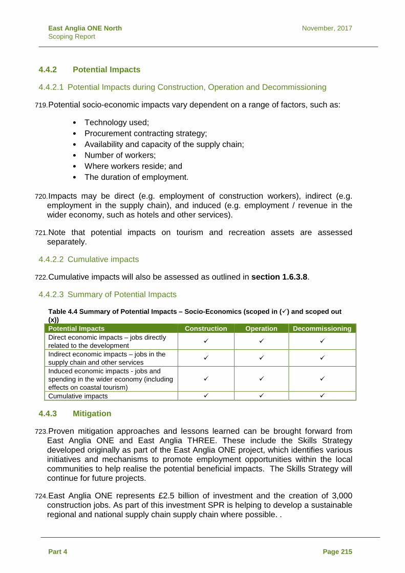
East Anglia ONE North November, 2017 Scoping Report
4.4.2 Potential Impacts
4.4.2.1 Potential Impacts during Construction, Operation and Decommissioning
719. Potential socio-economic impacts vary dependent on a range of factors, such as:
• Technology used; • Procurement contracting strategy; • Availability and capacity of the supply chain; • Number of workers; • Where workers reside; and • The duration of employment.
720. Impacts may be direct (e.g. employment of construction workers), indirect (e.g. employment in the supply chain), and induced (e.g. employment / revenue in the wider economy, such as hotels and other services).
721. Note that potential impacts on tourism and recreation assets are assessed separately.
4.4.2.2 Cumulative impacts
722. Cumulative impacts will also be assessed as outlined in section 1.6.3.8.
4.4.2.3 Summary of Potential Impacts
Table 4.4 Summary of Potential Impacts – Socio-Economics (scoped in () and scoped out (x)) Potential Impacts Construction Operation Decommissioning Direct economic impacts – jobs directly related to the development
Indirect economic impacts – jobs in the supply chain and other services
Induced economic impacts - jobs and spending in the wider economy (including effects on coastal tourism)
Cumulative impacts
4.4.3 Mitigation
723. Proven mitigation approaches and lessons learned can be brought forward from East Anglia ONE and East Anglia THREE. These include the Skills Strategy developed originally as part of the East Anglia ONE project, which identifies various initiatives and mechanisms to promote employment opportunities within the local communities to help realise the potential beneficial impacts. The Skills Strategy will continue for future projects.
724. East Anglia ONE represents £2.5 billion of investment and the creation of 3,000 construction jobs. As part of this investment SPR is helping to develop a sustainable regional and national supply chain supply chain where possible. .
Part 4 Page 215

East Anglia ONE North November, 2017 Scoping Report
725. At this stage it is not possible to commit to the location of port facilities to support construction, mobilisation, or operations and maintenance.
4.4.4 Approach to Data Gathering and Assessment
726. The Overarching NPS for Energy (EN-1) states that where a project is likely to have an impact on socio-economics at a local or national scale the assessment should consider all relevant impacts. These may include:
• The creation of jobs and training opportunities; • The provision of additional local services and improvements to
local infrastructure; • The impact on tourism (see section 4.5); • The impact of a changing influx of workers during the different
construction, operation and decommissioning phases of the energy infrastructure; and
• Cumulative impacts.
727. There is no set of recognised standards for the assessment of socio-economic impacts. In light of this, the socio-economic assessment will present a qualitative assessment of the anticipated impacts and benefits, their extent and when they are expected to occur.
728. The absolute scale of economic impacts (i.e. the number of jobs which construction, operation and maintenance, and decommissioning activity is expected to support) would be calculated using an approach consistent with methods for economic impact assessment set out in HM Treasury Green Book (2003). The socio-economic impact magnitude will be determined by consideration of the predicted deviation from baseline conditions.
4.5 Tourism and Recreation
4.5.1 Baseline
729. Tourism is an important element of the New Anglia LEP, County, and District economy. In New Anglia in 2015, tourism and culture employed about 74,000 people and was worth £1.3bn in GVA to the LEP. In the Suffolk Coastal and Waveney Districts, tourism the economy was valued at £590m and 13% of all employment in 2015. Visitors are attracted by the character, culture, festivals, music, art, food, drink, clean beaches, coastline, river valleys, countryside and wildlife.
730. Using natural divides of rivers and estuaries, the Suffolk Coast Tourism Strategy determines four Tourism Character Areas as follows:
• Suffolk Coast North - covering Southwold, Kessingland and Halesworth;
• Suffolk Coast Central - covering Aldeburgh, Thorpeness, Dunwich, Walberswick, Leiston, Saxmundham, and Framlingham;
Part 4 Page 216

East Anglia ONE North November, 2017 Scoping Report
• Suffolk Coast South - covering Woodbridge, Orford, Hollesley Bay, Bawdsey, Rendlesham Forest, and Wickham Market; and
• Stour and Orwell - covering Felixstowe, Harwich and Manningtree.
731. Key tourist features identified within the Local Plan include the Suffolk Coast and Heaths AONB, the Heritage Coast and seaside towns and villages.
732. The Suffolk Coast Ltd Destination Management Organisation lists a significant amount of recreational and tourism activities. These include outdoors activities such as walking, cycling, and horse riding throughout the AONB. Food and drink, and picturesque towns and villages are also a significant draw to the area.
733. Offshore recreation includes sailing and angling. A small number of recreational fishing boats also launch from Sizewell beach. Recreational sailing is covered separately in section 2.9.
734. The baseline environment would consider two areas:
• Areas directly affected by the construction, operation and decommissioning of the proposed East Anglia ONE North project, for example, temporary closures of footpaths, and restrictions to nearshore recreational boat movements; and
• Areas indirectly affected by the construction, operation and decommissioning of the proposed East Anglia ONE North project, for example, visibility of the wind turbines to coastal receptors and indirect effects on onshore tourist attractions, and increased construction traffic affecting routes to tourist attractions.
735. The baseline would be informed by a review of the datasets identified in Table 4.5 to characterise the area.
Table 4.5 Desk-Based Data Sources to Inform the Assessment Data Source
Tourism in Suffolk http://www.visitsuffolk.com/ Tourism in Norfolk www.visitnorfolk.co.uk Tourism in East Anglia http://www.visiteastofengland.com/ Annual Survey of Visits to Visitor Attractions Visit England Public Rights of Way (PRoW) Definitive Map SCC Accommodation Stock Audit Visit Britain Coastal Paths Natural England Regional and National Cycle Routes Sustrans Open access and common land www.magic.gov.uk Tourism policies Suffolk Coastal District Local Plan (Adopted
January 2017)
Part 4 Page 217

East Anglia ONE North November, 2017 Scoping Report
4.5.2 Potential Impacts
4.5.2.1 Potential Impacts during Construction
736. During construction local tourism and recreation assets may be temporarily disrupted during the installation of the onshore infrastructure. This may include disturbance effects such as noise and dust, and / or potential effects on access to these features through increased traffic or temporary restrictions along footpaths or at the public beach.
737. There is the potential for in-migrant workers to affect the local tourism economy by using accommodation that might otherwise be used by tourists.
738. The potential visibility of the construction activities may also affect the amenity value of tourist features, particularly those areas most valued for their landscape setting.
739. Offshore construction activities would require the introduction of navigation safety zones, which may disturb marine and coastal recreational activities.
4.5.2.2 Potential Impacts during Operation
740. A potential impact pathway from the proposed East Anglia ONE North project on the tourism industry is through visual impacts along the coast from Felixstowe to Great Yarmouth. This includes all four Tourism Character Areas and the AONB outlined in the various studies. The visibility of the wind turbines to onshore tourist and recreation receptors has the potential to affect the amenity value of the area. However, tourism perception research in rural Wales (NFO, 2003), North Devon (Aitchison, C., 2004, Scotland (Glasgow Caledonian University, 2008), and Northumberland (Northumbria University, 2014) show that the majority of people do not perceive windfarms negatively. Furthermore, economic studies of Wales (Regeneris and The Tourism Company, 2014) and Scotland (Biggar Economics, 2016) demonstrate that windfarms have no measurable effect on the tourism economy.
741. The presence of the onshore substation and National Grid infrastructure could potentially lead to the reduction of amenity value for recreational activities, such as walking and hiking, depending on their locations. This may be related to the loss of amenity land or reduced amenity value of that area as a result of the physical presence of the infrastructure and associated operational noise levels.
742. Offshore, some navigational restrictions for leisure craft are likely to continue in the immediate vicinity of the wind turbines. This is likely to be applied in the form of safety zones around each fixed structure. Recreational sailing is considered separately in section 2.9.
4.5.2.3 Potential Impacts during Decommissioning
743. Potential impacts during decommissioning will be assessed as outlined in section 1.6.3.9. It is anticipated that the decommissioning impacts would be similar in nature to those of construction.
Part 4 Page 218

East Anglia ONE North November, 2017 Scoping Report
4.5.2.4 Potential Cumulative Impacts
744. Potential cumulative impacts will be assessed as outlined in section 1.6.3.8.
4.5.2.5 Summary of Potential Impacts
Table 4.6 Summary of Potential Impacts – Tourism and Recreation (scoped in () and scoped out (x)) Potential Impacts Construction Operation Decommissioning Direct construction disturbance to tourism and recreation features (e.g. noise, dust, access, safety zones)
x
Indirect construction disturbance to tourism and recreation features (e.g. visibility, loss of amenity value)
x
Direct operational disturbance to tourism and recreation features (e.g. operational substation noise, permanent footpath closures)
x x
Indirect operational disturbance to tourism and recreation features (e.g. visibility of substation and wind turbines, change of amenity value)
x x
Cumulative impacts
4.5.3 Mitigation
745. Mitigation measures will be identified as part of the assessment, but may include the following, in consultation with relevant parties and landowners:
• Timing the peak construction programme to minimise impacts where practicable; and
• Avoiding permanent closure of PRoWs where practicable through careful siting and design.
4.5.4 Approach to Data Gathering and Assessment
746. A desk-based study will be undertaken to identify tourism and recreation features which may be affected by the proposed East Anglia ONE North project, using sources of information online and through continued consultation with statutory stakeholders.
747. Consultation with the local communities and landowners will be undertaken to further understand features of importance for local tourism and recreation.
748. The assessment will be developed with other inter-related assessments such as SLVIA, LVIA, traffic and transport (in particular with regard to labour resources) and socio-economics to ensure that inter-relationships are captured and relevant receptors are considered. The Tourism and Recreation assessment will then cross-reference these assessments as appropriate.
Part 4 Page 219

East Anglia ONE North November, 2017 Scoping Report
4.6 Summary of Wider Scheme Aspects
749. Table 4.7 summarises the potential impacts for each of the environmental receptors outlined in the sections above. All impacts that have been scoped in for assessment are considered to represent potential likely significant effects under Regulation 10 of the Infrastructure Planning (Environmental Impact Assessment) Regulations 2017.
Table 4.7 Summary of Potential Impacts (scoped in () and scoped out (x)) Potential impacts Construction Operation Decommissioning Seascape Character and Visual Amenity
Seascape, landscape and visual impacts, and cumulative impacts, of the windfarm site on seascape, landscape and visual receptors within the ZTV in the SLVIA study area (50 km radius)
Seascape, landscape and visual impacts and cumulative impacts, of the windfarm site on seascape, landscape and visual receptors outwith the SLVIA study area (50 km radius)
x x x
Impacts of the windfarm site on the landscape character of the Norfolk and Suffolk Broads National Park
x x x
Impacts of the windfarm site on the landscape character of landscape character areas within Broadland and South Norfolk Districts
x x x
Cumulative seascape, landscape and visual impacts of East Anglia ONE North windfarm site with East Anglia ONE, East Anglia THREE, Norfolk Vanguard and Norfolk Boreas offshore windfarms
x x x
Cumulative seascape, landscape and visual impacts of East Anglia ONE North windfarm site with Scroby Sands, Greater Gabbard, Galloper and East Anglia TWO offshore windfarms within SLVIA study area
Landscape Character and Visual Amenity
Landscape and visual impacts of landfall options (within 3km buffer LVIA study area)
x
Landscape and visual impacts of onshore cable corridor (within 3km buffer LVIA study area)
x
Landscape and visual impacts of onshore substation and National Grid infrastructure sites (within 3km radius study area)
Cumulative landscape and visual impacts of landfall options
x x x
Part 4 Page 220
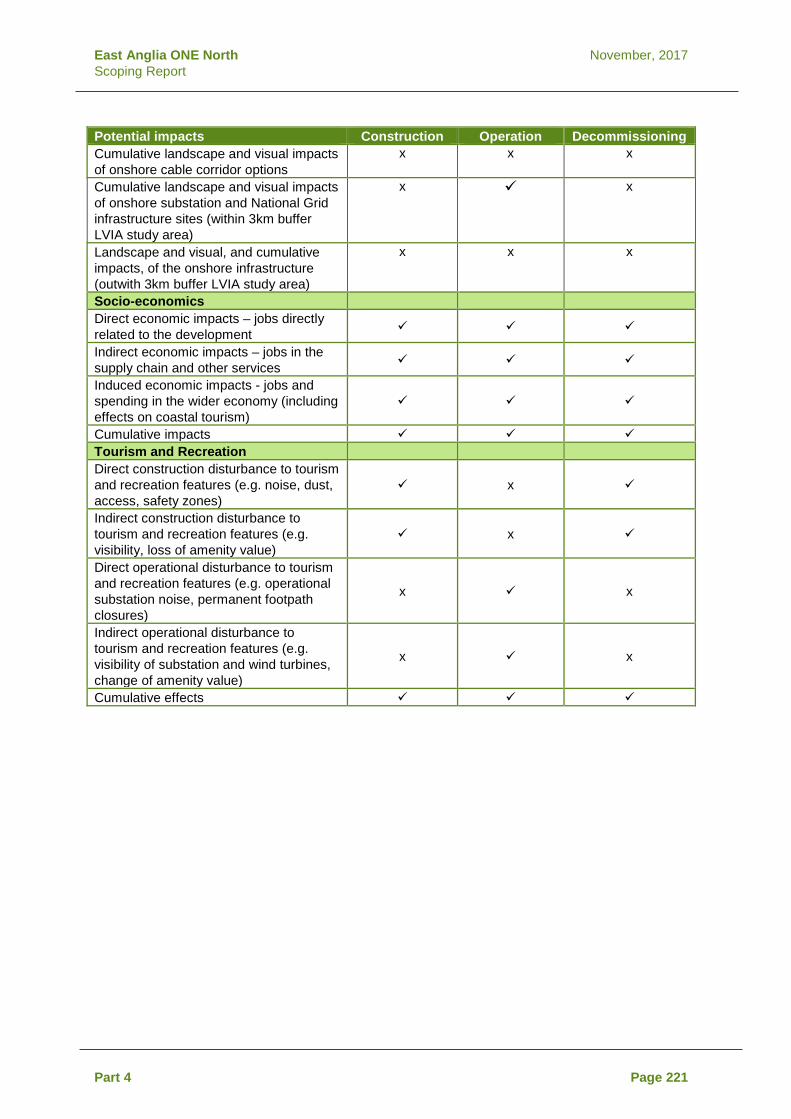
East Anglia ONE North November, 2017 Scoping Report
Potential impacts Construction Operation Decommissioning Cumulative landscape and visual impacts of onshore cable corridor options
x x x
Cumulative landscape and visual impacts of onshore substation and National Grid infrastructure sites (within 3km buffer LVIA study area)
x x
Landscape and visual, and cumulative impacts, of the onshore infrastructure (outwith 3km buffer LVIA study area)
x x x
Socio-economics Direct economic impacts – jobs directly related to the development
Indirect economic impacts – jobs in the supply chain and other services
Induced economic impacts - jobs and spending in the wider economy (including effects on coastal tourism)
Cumulative impacts Tourism and Recreation Direct construction disturbance to tourism and recreation features (e.g. noise, dust, access, safety zones)
x
Indirect construction disturbance to tourism and recreation features (e.g. visibility, loss of amenity value)
x
Direct operational disturbance to tourism and recreation features (e.g. operational substation noise, permanent footpath closures)
x x
Indirect operational disturbance to tourism and recreation features (e.g. visibility of substation and wind turbines, change of amenity value)
x x
Cumulative effects
Part 4 Page 221

East Anglia ONE North November, 2017 Scoping Report
5 Part 5- Consultation 5.1 Consultation
750. This Scoping Report supports the submission to the Planning Inspectorate for the purposes of requesting a scoping opinion under the Planning Act 2008 and associated EIA Regulations.
5.1.1 Consultation Undertaken
751. The consultation for the proposed East Anglia ONE North project will build upon consultation undertaken by SPR as part of the EIA process for East Anglia ONE and East Anglia THREE and the relationships already fostered with local, national and international stakeholders.
752. As discussed in more detail in Section 1.5, topic specific consultation has been underway since 2016, in particular through the Evidence Plan Process and the associated Expert Topic Groups, which comprise relevant statutory consultees as defined by Schedule 1 of the Infrastructure Planning (Applications: Prescribed Forms and Procedure) Regulations 2009. Regular engagement with the relevant local authorities has been undertaken.
753. In addition, four Public Information Days were undertaken between 30th October 2017 and 2nd November 2017. These took place at Lowestoft, Southwold, Leiston and Orford and provided the local community with information about the project and to outline the programme for future engagement.
5.1.2 Consultation Proposed
754. In line with the requirements of the Planning Act, SPR will undertake further consultation with local communities and non-statutory interest groups and with key statutory consultees, relevant local authorities and landowner interests. The consultee list will be developed through discussions with the Planning Inspectorate, local authorities and key stakeholders, and augmented by SPR’s existing knowledge of the area.
755. In consulting on this project it is SPR’s aim to:
• Introduce the proposed project; • Identify and discuss particular issues of concern; • Establish what existing information is available; and • Discuss with relevant stakeholders the need and scope of
studies/surveys that may be required to inform the EIA process.
Part 5 Page 222

East Anglia ONE North November, 2017 Scoping Report
6 References Aitchison, C. (2004). Evidence Gathering of the Impact of Wind Farms on Visitor Numbers and Tourist Experience. Biggar Economics (2016). Wind Farms and Tourism Trends in Scotland. Blyth-Skyrme (2010). COWRIE options and opportunities for marine fisheries mitigation associated with wind farms. BSI, (2014). British Standards Institution [BS] 5228-1:2009+A1:2014 “Code of practice for noise and vibration control on construction and open sites – Part 1: Noise”. BSI, London. BSI, (2014). British Standards Institution [BS] 5228-2: 2009+A1:2014 “Code of practice for noise and vibration control on construction and open sites – Part 2: Vibration”. BSI London. BSI, (2014). British Standards Institution BS4142:2014 Methods for rating and assessing industrial and commercial sound, BSI, London. Bureau of Ocean Energy Management, (2013) U.S. Department of the Interior Bureau of Ocean Energy Management. Centre for Economics and Business Research (CEBR) (2012). Economic Impact of Offshore Wind. Centre for Environment, Fisheries and Aquaculture Science (Cefas) (2004). Offshore Wind Farms: Guidance note for Environmental Impact Assessment in respect of FEPA and CPA requirements. Prepared by CEFAS on behalf of the Marine Consents and Environment Unit (MCEU), Version 2. Chartered Institute for Archaeologists’ (CIfA) (2014). Standard and Guidance for Historic Environment Desk-Based Assessments. Chartered Institute of Ecology and Environmental Management (CIEEM) (2016). Guidelines for Ecological Impact Assessment in the UK and Ireland. Committee on Climate Change (2015) Reducing emissions and preparing for climate change: 2015 Progress Report to Parliament. COWRIE (2009). Coastal Process Modelling for Offshore Windfarm Environmental Impact Assessment. Department for Business, Energy and Industrial Strategy (2017a) Energy Trends September 2017. Department for Business, Energy and Industrial Strategy (2017) https://www.gov.uk/government/news/new-clean-energy-projects-set-to-power-36-million-homes. Department for Communities and Local Government (DCLG) Planning Practice Guidance – Overarching principles on Travel Plans, Transport Assessments and Statements.
Page 223

East Anglia ONE North November, 2017 Scoping Report
Department for Environment Food and Rural Affairs (Defra) and the Environment Agency (2004). Contaminated Land Report 11 - Model Procedures for the Management of Land Contamination. Department for Environment, Food and Rural Affairs (Defra) (2009a). WFD Expert Assessment of Flood Risk Management Impacts guidance. Department for Environment, Food and Rural Affairs (Defra) (2009b). Construction Code of Practice for the Sustainable Use of Soils on Construction Sites. Department for Environment, Food and Rural Affairs (Defra) (2016) Local Air Quality Management Technical Guidance (TG16) LAQM.TG (16). Department for Environment and Climate Change (DECC) (2011a) Overarching National Policy Statement (NPS) for Energy (EN-1). Department for Environment and Climate Change (DECC) (2011b) National Policy Statement for Renewable Energy Infrastructure (EN-3). Department of Energy & Climate Change (DECC) (2011c). National Policy Statement for Electricity Networks Infrastructure (EN-5). Department of Energy and Climate Change (2016) UK Offshore Energy Strategic Environmental Assessment 3 (OESEA3). Design Manual for Roads and Bridges (DMRB) (1993) Volume 11, Section 3, Part 6 (Land Use). DfT Circular (02/2013) Strategic Road Network and the Delivery of Sustainable Development. DTU Aqua (2011) Effect of the Horns Rev 1 Offshore Wind Farm on Fish Communities Follow-up Seven Years after Construction. East Anglia ONE Limited (2015) East Anglia ONE Skills Strategy. East Anglia Offshore Wind (2012a) East Anglia ONE Environmental Statement. East Anglia Offshore Wind (2012b) East Anglia Offshore Wind Zonal Environmental Appraisal Report. East Anglia THREE Limited (2015) East Anglia THREE Offshore Wind Farm Environmental Statement. English Heritage (2008) Conservation Principles: Policy and Guidance for the Sustainable Management of the Historic Environment. Environment Agency (2016) Protecting and improving the water environment: Water Framework Directive compliance of physical works in rivers (internal Environment Agency guidance). Environment Agency (2017) Catchment Data Explorer, Suffolk TraC. Environment Agency - Catchment Data Explorer (Accessed July 2017).
Page 224

East Anglia ONE North November, 2017 Scoping Report
Fishing Liaison with Offshore Wind and Wet Renewables Group (FLOWW) (2014) Best Practice Guidance for Offshore Renewables Developments: Recommendations for Fisheries Liaison. Furness, R.W. (2015) Non-breeding season populations of seabirds in UK waters: Population sizes for Biologically Defined Minimum Population Scales (BDMPS). Natural England Commissioned Report Number 164. 389 pp. Galloper Wind Farm Ltd (2011) Galloper Wind Farm Environmental Statement. Glasgow Caledonian University (2008). The Economic Impacts of Wind Farms on Scottish Tourism. Gribble, J. and Leather, S. (2011) Offshore Geotechnical Investigations and Historic Environment Analysis: Guidance for the Renewable Energy Sector. Guidance prepared by Emu and issued by COWRIE. Hammond, P.S., Berggren, P., Benke, H., Borchers, D.L., Collet, A., Heide‐Jørgensen, M.P., Heimlich, S., Hiby, A.R., Leopold, M.F. and Øien, N., 2002. Abundance of harbour porpoise and other cetaceans in the North Sea and adjacent waters. Journal of Applied Ecology, 39(2), pp.361-376. Hammond P.S., Macleod K., Berggren P., Borchers D.L., Burt L., Cañadas A., Desportes G., Donovan G.P., Gilles A., Gillespie D., Gordon J., Hiby L., Kuklik I., Leaper R., Lehnert K, Leopold M., Lovell P., Øien N., Paxton C.G.M., Ridoux V., Rogano E., Samarraa F., Scheidatg M., Sequeirap M., Siebertg U., Skovq H., Swifta R., Tasker M.L., Teilmann J., Canneyt O.V. and Vázquez J.A. (2013) Cetacean abundance and distribution in European Atlantic shelf waters to inform conservation and management. Biological Conservation 164, 107-122. Hammond et al, 2017 Small Cetaceans in the European Atlantic and North Sea (SCANS-III): Estimates of cetacean abundance in European Atlantic waters in summer 2016 from the SCANS-III aerial and shipboard surveys. Heinänen, S. and Skov, H. (2015) The identification of discrete and persistent areas of relatively high harbour porpoise density in the wider UK marine area, JNCC Report No.544 JNCC, Peterborough. Historic England (2013) Marine Geophysics Data Acquisition, Processing and Interpretation. Guidance prepared by Plets, R., Dix, J., Bates, R. Historic England (2015). The Setting of Heritage Assets: Historic Environment Good Practice Advice in Planning Note 3. HM Government (2009). The UK Low Carbon Transition Plan; National strategy for climate and energy. HM Government (2016) Andrea Leadsom Speech to Utility Week Energy Summit. Available at: https://www.gov.uk/government/speeches/andrea-leadsom-speech-to-utility-week-energy-summit. HM Government (2017) Building our Industry Strategy: Green Paper.
Page 225

East Anglia ONE North November, 2017 Scoping Report
HM Treasury (2003). The Green Book. Appraisal and Evaluation in Central Government. Institute of Air Quality Management (IAQM) and Environmental Protection UK (EPUK) (2015) Land-use Planning & Development Control: Planning for Air Quality. Institute of Environmental Assessment (1993). Guidelines for the Environmental Assessment of Road Traffic’. January 1993. Institute of Ecology and Environmental Management (IEEM) (2010). Guidelines for ecological impact assessment in Britain and Ireland: Marine and Coastal. Final Version. IEEM, Winchester, UK. International Maritime Organization. Special Areas Under Marpol. http://www.imo.org/en/OurWork/Environment/SpecialAreasUnderMARPOL/Pages/Default.aspx. Johnston, A, Cook, ASCP, Wright, LJ, Humphreys, EM & Burton, NHK (2014a) Modelling flight heights of marine birds to more accurately assess collision risk with offshore wind turbines. Journal of Applied Ecology, 51, 31-41. Johnston, A, Cook, ASCP, Wright, LJ, Humphreys, EM & Burton, NHK (2014b) Corrigendum. Journal of Applied Ecology, 51, 1126-1130. Joint Nature Conservation Committee (JNCC) (2015). SAC Selection Assessment: Southern North Sea. January, 2016. Joint Nature Conservation Committee, UK. Joint Nautical Archaeology Policy Committee (JNAPC) (2006) Code for Practice for Seabed Development. Landscape and Seascape Character Assessments published by Natural England and the Department for Environment, Food and Rural Affairs (2014). Landscape Institute and Institute of Environmental Management and Assessment (2013). Guidelines for Landscape and Visual Impact Assessment: Third Edition, London: Routledge. Landscape Institute (2017). Visual Representation of Development Proposals Marine Management Organisation (2012) East Inshore and East Offshore marine plan areas. Seascape Character Area Assessment Marine Management Organisation (2013) Landings data, 2004- 2013 within ICES rectangles 33F1 and 33F2. Marine Management Organisation (MMO) (2014) Review of environmental data associated with post-consent monitoring of licence conditions of offshore wind farms. McBreen, F., Askew, N., Cameron, A., Connor, D., Ellwood, H. and Carter, A., (2011) UK SeaMap 2010 Predictive mapping of seabed habitats in UK waters, JNCC Report 446, ISBN 0963 8091.
Page 226

East Anglia ONE North November, 2017 Scoping Report
McConnell, B.J., Chambers, C., Nicholas, K.S. and Fedak, M.A. (1992) Satellite tracking of grey seals (Halichoerus grypus). Journal of Zoology, 226(2), pp.271-282. National Grid (undated) The Horlock Rules, NGC Substations and the Environment: Guidelines on Siting and Design. Natural England, (2011). Seascape Character Assessment Guidance for England and Scotland (Second Draft v2.1). Natural England (2012a). An Approach to Seascape Character Assessment. Natural England (2012b). NE124 – Look After your Land with Environmental Stewardship. Natural England (2014). An Approach to Landscape Character Assessment. NFO World Group for Wales Tourist Board (2003). Investigation into the potential of wind farms on tourism in Wales. Northumbria University (2014). Evaluation of the Impacts of Onshore Wind Farms on Tourism. Offshore Renewable Energy (ORE) Catapult (2017) Cost Reduction Monitoring Framework 2016. Summary Report to the Offshore Wind Programme Board. OSPAR Commission (2008). Assessment of the Environmental Impact of Offshore Wind-farms. Oxford Archaeology (2008) Guidance for Assessment of Cumulative Impacts on the Historic Environment from Offshore Renewable Energy. Guidance prepared by Oxford Archaeology and issued by COWRIE. Oxford Archaeology South (2011). Historic Seascape Characterisation: Newport to Clacton and Adjacent Waters. Paxton, C.G.M., Scott-Hayward, L., Mackenzie, M., Rexstad, E. and Thomas, L. (2016) Revised Phase III Data Analysis of Joint Cetacean Protocol Data Resource JNCC Report No.517. Planning Inspectorate (2012) Advice Note Nine: Rochdale Envelope (version 2). Planning Inspectorate (2015a) Advice Note Seven: Environmental Impact Assessment: Preliminary Environmental Information, Screening and Scoping (version 5). Planning Inspectorate (2015b) Advice Note Twelve: Transboundary Impacts (version 4). Planning Inspectorate (2015c) Advice Note Seventeen: Cumulative effects assessment (version 1). Planning Inspectorate (2016) Advice Note Ten: Habitat Regulations Assessment relevant to nationally significant infrastructure projects (version 7). Planning Inspectorate (2017a) Advice Note Three: EIA consultation and (version 7).
Page 227

East Anglia ONE North November, 2017 Scoping Report
Planning Inspectorate (2017b) Advice Note Eighteen: The Water Framework Directive (version 1). Regeneris and The Tourism Company (2014). Study into the Potential Economic Impact of Wind Farms and Associated Grid Infrastructure on the Welsh Tourism Sector. Reid, J.B., Evans, P.G.H., & Northridge, S.P. (2003) Atlas of Cetacean distribution in northwest European waters. SCOS (2016) SCOS Report. Scientific Advice on Matters Related to the Management of Seal Populations: 2016. Scottish Natural Heritage (2012). Assessing the Cumulative Impact of Onshore Wind Energy Developments. Scottish Natural Heritage (2017). Visual Representation of Windfarms: Version 2.2. Sharples R.J., Matthiopoulos, J. and Hammond, P.S. (2008) Distribution and movements of harbour seals around the coast of Britain: Outer Hebrides, Shetland, Orkney, the Moray Firth, St Andrews Bay, The Wash and the Thames Report to DTI July 2008. Suffolk Coast & Heaths AONB (2013) Suffolk Coast & Heaths AONB Management Plan 2013 – 2018. Suffolk Coast and Heaths AONB (2016) Natural Beauty and Special Qualities Indicators. Suffolk County Council Landscape Character Assessment (Suffolk County Council, 2008/2011). The Crown Estate (2014) Protocol for Archaeological Discoveries: Offshore Renewables Projects. Prepared by Wessex Archaeology for The Crown Estate. The East Coast 2011 Regional Environmental Characterisation, 2009 (Marine Aggregate Levy Sustainability Fund. The Landscape Institute with the Institute of Environmental Management and Assessment (2013). Guidelines for Landscape and Visual Impact Assessment. Third Edition. The Outer Thames Estuary Regional Environmental Characterisation, 2009 (Marine Aggregate Levy Sustainability Fund). The Planning Inspectorate (2012a). Advice Note Nine: Using the Rochdale Envelope. Version 2. The Planning Inspectorate (2012b) Scoping Opinion: Proposed East Anglia THREE Offshore The Planning Inspectorate (2015a). Advice Note Seven: Environmental Impact Assessment, Preliminary Environmental Information, Screening and Scoping. Version 5. The Planning Inspectorate (2015b). Advice Note Twelve: Transboundary Impacts. Version 4.
Page 228

East Anglia ONE North November, 2017 Scoping Report
The Planning Inspectorate (2016a). Advice Note Ten: Habitat Regulations Assessment (2016). Version 7. The Planning Inspectorate (2016b) Scoping Opinion: Proposed Norfolk Vanguard Offshore Wind Farm. The Planning Inspectorate (2017a) Advice note three: EIA consultation and notification. Version 7. The Planning Inspectorate (2017b) Scoping Opinion: Proposed Norfolk Boreas Offshore Wind Farm. Thomsen, F. Ludemann, K., Kafemann, R. and Piper, W (2006) Effects of offshore wind farm noise on marine mammals and fish COWRIE July 2006 Vattenfall (2009). Kentish Flats Offshore Wind Farm FEPA Monitoring Summary Report. 2008. Wessex Archaeology (2007) Historic Environment Guidance for the Offshore Renewable Energy Sector. Guidance prepared by Wessex Archaeology and issued by COWRIE.
Page 229

East Anglia ONE North November, 2017 Scoping Report
Page 230

East Anglia ONE North November, 2017 Scoping Report
Appendix 2.1 Physical Processes Method Statement

East Anglia ONE North November, 2017 Scoping Report

East Anglia ONE North and East Anglia TWO Windfarms Evidence Plan Physical Processes Method Statement Updated – November 2017
www.scottishpowerrenewables.com

East Anglia TWO and East Anglia ONE Windfarms November, 2017 Physical Processes Method Statement Rev 4
REVISION CONTROL
Document Preparer Reviewer(s) Internal Legal
External Legal
Approver – Snr PM
Physical Processes Method Statement Revision 1 13/02/2017
BK/PP TA n/a n/a CW
Revision 2 08/03/2017
BK/JA TA n/a n/a PP
Revision 3 22/03/2017
BK/PP TA n/a n/a PP
Revision 4 28/09/2017
BK TA n/a n/a PP
Physical Processes Method Statement

East Anglia TWO and East Anglia ONE Windfarms November, 2017 Physical Processes Method Statement Rev 4
Table of contents
1 Introduction 1 1.1 Background 2 1.2 Updates to the Method Statement 2 1.3 Agreements made to date 3
2 Project Description 5 2.1 Proposed East Anglia TWO Windfarm 5 2.2 Proposed East Anglia ONE North Windfarm 8
3 Context for Methodology 9
4 Approach to Assessment 13 4.1 Approach to Offshore Physical Processes 13 4.2 Review Existing Data 14 4.3 Previous Assessments 17
5 Timelines 34
6 Summary 36
7 References 37
Appendix A- CEFAS Response to ETG meeting 12th of April. 38
Appendix B – Baseline Assessment 39 1. Water Levels 39 2. Currents 40 3. Temperature, salinity and frontal systems 40 4. Wind and wave regime 40 5. Sediment regime 40 6. Process controls on sediment mobility 41 7. Morphological Regime 41
Appendix C – Summary of Zonal Cumulative Impact Assessment for former East Anglia Zone 43
1. Background 43 2. Changes to the tidal current regime 43 3. Changes to the wave regime 43 4. Consequent changes to the sediment transport regime 43 5. Summary 44
Appendix D – Summary of East Anglia ONE Environmental Statement 45
Appendix E – Summary of East Anglia THREE Environmental Statement 54
Physical Processes Method Statement

East Anglia TWO and East Anglia ONE Windfarms November, 2017 Physical Processes Method Statement Rev 4
Physical Processes Method Statement

East Anglia TWO and East Anglia ONE Windfarms November, 2017 Physical Processes Method Statement Rev 4
1 Introduction 1. This Method Statement outlines the existing data and proposed approach to the
physical processes assessment for the environmental impact assessment (EIA) for the proposed East Anglia TWO and East Anglia ONE North projects, and their associated transmission assets (i.e. substations and export cables). The aim of this method statement is to gain agreement on what data and analysis methods are appropriate for EIA given the level of existing data and work undertaken for East Anglia ONE and East Anglia THREE.
2. This is an updated version of the Physical Processes Method Statement (version 3) submitted to stakeholders in March 2017 and agreed at the Benthic Ecology ETG meeting held on the 12th of April, 2017. Project developments and agreements made with stakeholders since the Method Statement was issued have been incorporated in this revision so that this document is up to date at the time of submission. A list of changes since the original Method Statement was submitted is provided in Section 1.3.
3. The proposed East Anglia ONE North and East Anglia TWO projects will be progressed separately, when submitted, the aim of this Method Statement was to gain agreement for both projects on the following;
1. As was agreed as part of the Evidence Plan Process for East Anglia THREE, the impact assessment for East Anglia ONE North and East Anglia TWO projects will be based upon existing zone wide modelling (from the Zone Environmental Appraisal, ZEA) and modelling undertaken for East Anglia ONE. No new modelling will be undertaken for East Anglia ONE North and East Anglia TWO.
2. The data proposed for the assessment (site specific data from the Zone, East Anglia ONE EIA and East Anglia THREE EIA), other existing sources), and site specific bathymetric data (from a geophysical survey campaign) for both East Anglia ONE North and East Anglia TWO provide suitably robust data set for EIA purposes
3. The list of impacts suggested for the EIA and proposed methodology for the assessment of these are acceptable. It is intended that by gaining agreement on impacts prior to scoping (as far as possible) through the Evidence Plan process will streamline the scoping process.
4. Whilst this document presents the same approach for each project, for
auditability purposes during the evidence plan process, responses to this method statement should stipulate whether they apply to both or an individual project as applicable.
Physical Processes Method Statement Page 1

East Anglia TWO and East Anglia ONE Windfarms November, 2017 Physical Processes Method Statement Rev 4
1.1 Background
5. An overview of the programme leading up to DCO submission for the proposed East Anglia ONE North windfarm and proposed East Anglia TWO windfarm is outlined in Table 1. A scoping report for each project will be submitted in November 2017. After scoping, timescales for the two projects will diverge with East Anglia ONE North expected to follow approximately 12 months later.
Table 1 Key project programme milestones Milestone EA2 EA1N
Pre-scoping consultation March-June 2017 March-June 2017
Windfarm geophysical survey campaign
Summer/Autumn 2017 Summer/Autumn 2017
Submission of scoping report November 2017 November 2017
Cable corridor geophysical campaign
Spring 2018 Spring 2018
Submission of PEI/Section 42 Consultation
November 2018 Q4 2019
DCO Application Submission 2019 2020
1.2 Updates to the Method Statement
1.2.1 Evidence Plan Agreements
6. The Physical Processes Method Statement (version 3) was issued to the Marine Management Organisation (MMO), Natural England (NE) and Cefas (as scientific advisor to the MMO), in March 2017. The Method Statement outlined the approach to EIA and data gathering and was discussed as through the Benthic Ecology Expert Topic Group (ETG) during an Evidence Plan meeting on the 12th of April. Comments on the Method Statement, meeting minutes and an agreement log were provided by MMO, NE and Cefas, these comments are provided in Section 1.4. This version of the Method Statement has been updated to include agreements made since the 12th of April.
1.2.2 Export Cable Corridor 7. In August 2017, ScottishPower Renewables (SPR) confirmed that they would
be applying for a Grid Connection point near Sizewell in Suffolk rather than a connection at Bramford. Therefore a new offshore export cable corridor would be required. A briefing note was provided to Evidence Plan Process stakeholders in August 2017 outlining the new offshore export cable corridor and updated approach to EIA. Comments on the briefing note and cable corridor have been received from Natural England and MMO.
Physical Processes Method Statement Page 2

East Anglia TWO and East Anglia ONE Windfarms November, 2017 Physical Processes Method Statement Rev 4
8. This Method Statement has been updated to include:
• Details of the East Anglia TWO export cable corridor Area of Search (AoS) and East Anglia ONE North cable corridor AoS.
• Updated EIA methodology as outlined in the briefing note • Comments/agreements received in response to the briefing note.
1.2.3 Preliminary Project Parameters
9. In addition to the revised export cable corridor AoS, the following project parameters have been updated since the Method Statement was submitted in March 2017:
• 7MW wind turbines have been discounted. The smallest wind turbine will be 12MW
• Maximum number of turbines has been reduced from 115 to 75. • 19MW turbines have been included, although these will have the same physical
parameters as the 15MW turbines previously communicated. • The total capacity of the proposed East Anglia TWO offshore windfarm will be
900MW. The capacity of East Anglia ONE North will be 800MW.
10. The 7MW turbine previously represented the worst case scenario in terms of number of turbine foundations, as turbine foundation numbers have been reduced, impacts to benthic ecology receptors are anticipated to be less than previously considered.
11. A full list of project parameters is provided in Section 1.5 of the East Anglia TWO Offshore Windfarm Scoping Report and Section 1.5 of the East Anglia ONE North Offshore Windfarm Scoping Report.
1.3 Agreements made to date 12. The following table provides a list of agreements made to date. This Method
Statement has been updated in line with the following;
Table 2 Evidence Plan Agreement Log Comment/agreements Agreement Natural England MMO Cefas General approach to assessment (following same method as EA3 acceptable in principal, although CEFAS have requested to undertake review of EA1 and ZEA modelling parameters before confirming required approach.
Agree Agree Response provided (08/09/2017). Cefas request cumulative wave modelling see below for minor comments and Appendix A for full response.
The list of impacts outlined in the method statement to be included in the ES is
Agree – However, regarding physical impacts to the Outer Thames Estuary SPA,
Agreed Agreed
Physical Processes Method Statement Page 3

East Anglia TWO and East Anglia ONE Windfarms November, 2017 Physical Processes Method Statement Rev 4
Comment/agreements appropriate with the following caveats; • Operational
suspended sediment as a result of vertical turbulence.
• Physical impacts to nearby SPA supporting sandbanks.
Suspended sediment due to cable installation works through SPA supporting sandbanks*.
NE advise that a seasonal restriction is placed cable installation between Nov – Feb in the OTE SPA in order to mitigate impacts to RTD’
Vertical mixing does not need to be considered as this area of the north sea is generally well mixed.
Agreed Agreed Agreed
*Whilst the physical impact on SPA supporting features will be considered within the physical processes assessment, the impacts to SPA interest features will be determined through the ornithology assessment.
14. In addition to their request for cumulative wave modelling Cefas provided the
following minor comments:
1. Bullet Point 15 – Additional data is available from the Offshore Energy SEA3. Specifically, updated climatological suspended sediment are available (and the report and database suitable for ArcGIS can be found at http://data.cefas.co.uk/#/View/18133 and doi:10.14466/CefasDataHub.31)
2. Bullet Point 35 – The impact of spudcan marks on the seabed from Jackup vessels should be assessed in the Constructional phase.
3. Bullet Point 36 – The impact of Cable protection Measures should on the sediment transport patterns and pathways should be assessed in the Operational phase. Specifically, this related to rock dumping on intra-array and export cables which could stand 2m proud of the seabed over considerable distance (normally addressed in a Depth of Burial/Cable Protection Plan reports).
4. Table 4 (page 24) – Is it proposed to address Scour issues with a Scour Management plan report?
15. SPR provide the following responses to these comments;
• In response to minor comment 1 - this information is noted and will be used to inform the EIA.
Physical Processes Method Statement Page 4

East Anglia TWO and East Anglia ONE Windfarms November, 2017 Physical Processes Method Statement Rev 4
• In response to minor comment 2- the impacts of penetration by jack-up vessels is included in Table 6, this will include the impacts of spudcan marks.
• In response to minor comment 3-The impact of cable protection during the operational phase will be included in the EIA.
• In response to minor comment 4- The extent to which scour management will be required will be determined through the EIA and consultation with MMO and Cefas.
16. Natural England confirmed that they were content with the approach outlined in export cable corridor briefing note. MMO and Cefas provided the following joint comments (via MMO) on the export cable corridor briefing note “The proposed methodology for Environmental Impact Assessment (EIA) on physical processes is considered to be appropriate. However it should be noted that the substrate around Thorpeness Point is relatively hard and may require rock trenching which is different to the original cable route.”
2 Project Description 2.1 Proposed East Anglia TWO Windfarm
2.1.1 East Anglia TWO Windfarm Site
17. The East Anglia TWO windfarm site is circa 257km2 with an anticipated capacity of up to 900MW. At its nearest point, the East Anglia TWO windfarm site is 31km from Lowestoft and 32km from Southwold. The project boundary has been delineated by the Outer Thames SPA to the North, proximity to East Anglia ONE at approximately 5.5nm to the East, shipping and navigation activity, as well as the proximity to Galloper (approximately 3.5nm), to the South and the former East Anglia Zone boundary to the West. The East Anglia TWO windfarm site is shown in Figure 1.
2.1.2 East Anglia TWO Cable Corridor Area of Search 18. For both the proposed East Anglia TWO offshore windfarm and the proposed
East Anglia ONE North windfarm, an Area of Search (AoS) has been developed for the offshore export cable corridor. The AoS is wider than required for installing the export cable and will be refined once more information is available on geology, seabed characteristics and benthic habitats.
19. The East Anglia TWO cable corridor Area of Search (AoS) provides two routes for the export cable to join the East Anglia TWO windfarm site, a northern route and a southern route (Figure 1). At this stage of development, it is important to retain the flexibility to connect electrical infrastructure in both the northern and southern areas of the windfarm.
Physical Processes Method Statement Page 5

East Anglia TWO and East Anglia ONE Windfarms November, 2017 Physical Processes Method Statement Rev 4
20. The northern route is shared with the export cable corridor AoS for the East Anglia ONE North windfarm site. Additional corridor width to accommodate two sets of cables and a tie-in to the East Anglia TWO windfarm site has been added to the East Anglia ONE North export cable corridor AoS to accommodate a connection. Further information on the northern route of the East Anglia TWO export cable corridor AoS is provided in Section 2.2.2.
21. The proposed East Anglia TWO export cable corridor AoS also shares the landfall and approach to the landfall with the East Anglia ONE North export cable corridor AoS with the two export cable corridor AoS diverging to the north east of Sizewell C outfall infrastructure.
22. The southern export cable corridor AoS route allows connection to an offshore substation in the south of the East Anglia TWO windfarm site. The southern route of the export cable corridor AoS has sufficient width to contain export cables for the East Anglia TWO windfarm site only, but will include a buffer to allow flexibility for micro-siting the cable within the corridor (Figure 1).
23. The East Anglia TWO export cable corridor AoS is then routed to the south of the Southwold Oil Transhipment Area and Southwold East Aggregates area. The export cable corridor AoS joins the East Anglia TWO windfarm site at the mid-point of the western boundary and includes an extension down the southern half of the western boundary, this allows for connection at a substation within the southern half of the windfarm site where the most turbines will be located.
24. The following constraints were considered during the development of the southern section of the East Anglia TWO export cable corridor AoS;
• The Sizewell C planned offshore infrastructure area – this was avoided and a 250m buffer added1.
• Sandbanks (near Aldeburgh Napes) were avoided • Avoidance of the Southwold East Aggregates dredging area. • There is a minimum buffer of 1500m between the Southwold Oil Cargo
Transhipment Area and the AoS • Known wrecks avoided as far as practical • Cable crossings were minimised as far as possible.
25. Note that MoD receptors were also considered but these were not a constraint
as the nearest Ordinance Disposal Area is south of the East Anglia ONE / THREE export cable corridor.
26. The East Anglia TWO windfarm site and export cable corridor AoS is shown in Figure 1
1 The area used was taken from Sizewell C Stage 2 consultation (which closed in February 2017) and contains the positions of planned infrastructure which were agreed between GWL and EDF for the purposes of micro-siting Galloper cables.
Physical Processes Method Statement Page 6

East
Ang
lia T
WO
and
Eas
t Ang
lia O
NE
Nor
th W
indf
arm
s
Nov
embe
r, 20
17
Phys
ical
Pro
cess
es M
etho
d St
atem
ent
Figu
re 1
Eas
t Ang
lia T
WO
Win
dfar
m a
nd E
xpor
t Cab
le C
orrid
or A
rea
of S
earc
h
Phys
ical
Pro
cess
es M
etho
d St
atem
ent
Page
7

East Anglia TWO and East Anglia ONE North Windfarms November, 2017 Physical Processes Method Statement
2.2 Proposed East Anglia ONE North Windfarm
2.2.1 East Anglia ONE North Windfarm Site 27. The East Anglia ONE North windfarm site is circa 208km2 with an anticipated
capacity of up to 800MW. At its nearest point, the East Anglia ONE North windfarm site is 36km from Lowestoft and 42km from Southwold. The project boundary has been delineated by cables to the north, a deep water shipping route to the East, the East Anglia ONE boundary to the South and designations and shipping activity to the West (Figure 2).
2.2.2 East Anglia ONE North Export Corridor Area of Search 28. The East Anglia ONE North export cable corridor AoS and East Anglia TWO
export cable corridor AoS has a shared landfall between the Galloper landfall and Thorpeness. The export cable corridor AoS for both projects also has a shared approach to landfall to the west of the Sizewell B and Sizewell C (planned) outfall infrastructure.
29. The East Anglia ONE North and northern route of the East Anglia TWO shared export cable AoS (Figure 1 and Figure 2) passes north of the Southwold Oil Transhipment Area and Southwold East aggregates dredging area with sufficient width to accommodate export cables from both projects. The shared export cable corridor AoS then follows the northern boundary of the East Anglia TWO windfarm site. At this point the East Anglia TWO export cable corridor AoS (Figure 1) includes a tie-in option to connect to the East Anglia TWO windfarm site and the joint export cable corridor AoS concludes. The East Anglia ONE North export cable corridor AoS narrows to a width suitable for accommodating a single set of export cables and joins East Anglia ONE North at the mid-point of the eastern boundary.
30. Geophysical and benthic survey undertaken as part of the East Anglia Zone Environmental Assessment (ZEA) and North Sea aggregates industry Regional Environmental Characterisation (REC) 23 identified potential areas of Sabellaria reef to the north of the Southwold Oil Transhipment Area and Southwold East aggregates area. The export cable corridor AoS is broader at this point to allow wider geophysical survey to inform detailed cable routing design. The final cable corridor will be refined within the export cable corridor AoS once data are available to inform the refinement process.
31. The development of the East Anglia ONE North export cable corridor AoS (and joint East Anglia TWO route approach to landfall) considered the following constraints;
2 The Outer Thames Estuary Regional Environmental Characterisation, 2009 (Marine Aggregate Levy Sustainability Fund). 3 The East Coast 2011 Regional Environmental Characterisation, 2009 (Marine Aggregate Levy Sustainability Fund
Physical Processes Method Statement Page 8

East Anglia TWO and East Anglia ONE North Windfarms November, 2017 Physical Processes Method Statement
• The Sizewell C planned offshore infrastructure area – this was avoided and a 250m buffer added4.
• Sandbanks (near Aldeburgh Napes) were avoided • Southwold East Aggregates dredging area was avoided. • There is a minimum buffer of 2000m between the Southwold Oil Cargo
Transhipment Area and the AoS. • Known wrecks were avoided as far as practical. • Crossing of cables were minimised as far as possible. • Note that the waverider buoy shown on the nautical chart is to be temporarily
moved during construction as one of the conditions of the Galloper DML, therefore this was not considered a constraint at this point. However, it may need to be considered in future depending upon the confirmation of relocation and the export cable route.
32. The East Anglia ONE North export cable corridor AoS is shown in Figure 2.
3 Context for Methodology 33. Given the linkages that exist between physical processes and a range of
sensitive receptors over various spatial and temporal scales, it is vital that potential changes in those processes due to the projects during construction, operation and decommissioning phases are assessed robustly, but in a manner that is proportionate to the risks which are presented. Due to both the staggered nature of the development of the former East Anglia Zone and its relative proximity to other offshore activities, including the North Sea oil and gas fields, offshore windfarm areas and marine aggregate dredging sites, such assessments will need to consider the development both alone and cumulatively with other developments. It is also important that due to the proximity to the Suffolk banks, and their role in the sediment circulatory systems in the southern North Sea and their role in providing shelter to the adjacent coast, physical processes are considered both in the offshore areas, and nearer to and along the shoreline.
4 The area used was taken from Sizewell C Stage 2 consultation (which closed in February 2017) and contains the positions of planned infrastructure which were agreed between GWL and EDF for the purposes of micro-siting Galloper cables.
Physical Processes Method Statement Page 9

East Anglia TWO and East Anglia ONE North Windfarms November, 2017 Physical Processes Method Statement
34. Scoping Reports are being produced for both the proposed East Anglia TWO and East Anglia ONE North projects. The responses previously received in relation to East Anglia ONE and East Anglia THREE EIAs (i.e. from scoping opinion to comments upon the application documents) provide a useful indication of the type of physical process issues that will need to be considered. Additionally, industry-wide guidance exists that will need to be followed to demonstrate application of ‘best practice’ and lessons learned from Rounds 1 to Round 3 projects which have been taken forward to date . Finally, many project-related or site-related requirements will need to be addressed which are specific to the environmental and physical characteristics of the windfarms within the wider area of the former East Anglia Zone and specific to the engineering choices that will be made relating to foundations, layouts and cabling. A table of key mile stones is provided in Table 1.
Physical Processes Method Statement Page 10

East
Ang
lia T
WO
and
Eas
t Ang
lia O
NE
Nor
th W
indf
arm
s N
ovem
ber,
2017
Ph
ysic
al p
roce
sses
Met
hod
Stat
emen
t Rev
4
Figu
re 2
Eas
t Ang
lia O
NE
Nor
th W
indf
arm
Site
and
Exp
ort C
able
Cor
ridor
AoS
Phys
ical
Pro
cess
es M
etho
d St
atem
ent
Page
11

East Anglia TWO and East Anglia ONE North Windfarms November, 2017 Physical processes Method Statement Rev 4
Table 3 Key project programme milestones Milestone EA2 EA1N Pre-scoping consultation March-June 2017 March-June 2017 Windfarm site geophysical survey campaign*
April-August 2017 April – August 2017
Submission of scoping report November 2017 November 2017 Cable corridor geophysical survey campaign
March-May 2018 March-May 2018
Submission of PEI/Section 42 Consultation
November 2018 Q4 2019
DCO Application Submission 2019 2020
35. Assessment of the tidal, wave and sediment regimes, and their influences on morphological change of the seabed and adjacent shorelines, are an essential part of the EIA process associated with offshore windfarms. These assessments were typically undertaken during Round 1 and Round 2 schemes as ‘Coastal Process Studies’ but as schemes move towards deeper water in Round 3, so ‘Physical (Offshore) and Coastal (Nearshore) Process Studies’ will be required.
36. The purpose of such studies is to assess and, where necessary and practicable, mitigate the environmental impact of offshore windfarm developments on the physical marine environment. The studies consider both near-field effects (within the development site) and far-field effects (beyond the development site and across the wider regional seabed and coastline). They also consider different phases of the lifecycle of the development, such as construction, operation and decommissioning.
37. The main physical impacts on the marine environment from an offshore windfarm development are associated with fixed structures such as the turbine towers and foundations, offshore platforms and foundations, inter-connecting and export cables, and the landfall at the shoreline. Issues or concerns relating to these aspects are likely to involve the potential for:
• Wave interference and interaction; • Changes to the current regime; • Scour effects; • Changes to sediment mobility and turbidity; • Changes to sea bed and shoreline levels; • Changes to the mobility and stability of sea bed features; and • Changes to the coastal regime.
Physical Processes Method Statement Page 12

East Anglia TWO and East Anglia ONE North Windfarms November, 2017 Physical processes Method Statement Rev 4
38. During Round 1 and Round 2 schemes, coastal process impact assessments were undertaken in accordance with best practice guidance from ETSU (2002) and Cefas et al. (2004). Since many of those schemes are now operational, post-project monitoring has since been undertaken and reviewed to evaluate some of the environmental issues. This monitoring was used to develop new best practice guidance for Round 3 schemes to reflect the lessons learned from Rounds 1 and 2, and the new challenges associated with developments in deeper water environments. The resulting guidance (COWRIE 2009) highlights five key areas for consideration (Table 4). It was agreed with the regulators during preparation of the Method Statement for the East Anglia THREE project that these topics highlighted by COWRIE (2009) were the principal physical and coastal process issues to consider for the East Anglia THREE project (East Anglia Offshore Wind Ltd., 2013).
Table 4 Key physical and coastal process issues highlighted by COWRIE (2009)
Topic Issue
1 Suspended sediment dispersion and deposition patterns resulting from foundation and cable installation or decommissioning
2 Changes in coastal morphology due to cable landfall
3 Scour and scour protection
4 Wave energy dissipation and focussing for sites close to shore (typically <5km)
5 Wave and current processes controlling very shallow sandbank morphology especially with less understood foundations types
4 Approach to Assessment 39. This Method Statement is based upon the concept of maximising the value
from the considerable work previously undertaken; both for the former East Anglia Zone and for the East Anglia ONE and East Anglia THREE projects and builds upon the method statement agreed through the Evidence Plan process for East Anglia THREE (East Anglia Offshore Wind Ltd., 2013). It proposes proportionate and pragmatic approaches to investigating the issues which need to be considered for the proposed East Anglia ONE North and East Anglia TWO projects.
4.1 Approach to Offshore Physical Processes 40. The understanding of the offshore physical processes and the effects of the
windfarm development on them will follow a staged approach, involving:
• Review of existing project-relevant data; • Acquisition of additional project-specific data;
Physical Processes Method Statement Page 13
East Anglia TWO and East Anglia ONE North Windfarms November, 2017 Physical processes Method Statement Rev 4
• Formulation of a conceptual understanding of baseline conditions, drawing from previous numerical modelling exercises (especially for the East Anglia ZEA and the East Anglia ONE project);
• Consultation with regulators regarding proposed assessment approaches (via this Method Statement) building on agreements and discussions made previously during East Anglia ONE and East Anglia THREE EIA; and
• Assessment of effects using analytical tools and empirical methods as defined by this Method Statement (no new numerical modelling is proposed for either East Anglia ONE North or East Anglia TWO).
4.2 Review Existing Data 41. The data requirements for a baseline understanding of the offshore physical
processes at the East Anglia project areas that will underpin the conceptual understanding and provide input to the empirical assessments can be classified into two areas: material and process. The material data includes knowledge of the geology of the seabed and sub-seabed, bathymetry, and the lithology and distribution of mobile and non-mobile sediments. The process data includes knowledge of the forcing such as waves, tide-generated currents, their strengths, directions and variability with time, and sediment transport regime.
42. Considerable existing data and information is already in existence relating to the material and processes of the offshore physical environment and much was collated for the East Anglia ZEA, including from the following sources:
• Marine Renewable Atlas; • Wavenet; • National Tide and Sea Level Forecasting Service; • Environment Agency (extreme sea levels database); • TotalTide (UKHO tidal diamonds); • BODC; • POL Class A tide gauges; • Baseline numerical model runs; • UKCP09 climate projections; • BGS 1:250,000 seabed sediment mapping; • BGS bathymetric contours and paper maps; and • Admiralty Charts and UKHO raw survey data.
43. In addition, considerable literature exists covering the proposed East Anglia
ONE North and TWO project areas including:
• East Anglia Zone Appraisal Report; • East Anglia THREE Environmental Statement; • East Anglia ONE Environmental Statement; • Southern North Sea Sediment Transport Study;
Physical Processes Method Statement Page 14

East Anglia TWO and East Anglia ONE North Windfarms November, 2017 Physical processes Method Statement Rev 4
• Futurecoast; • Shoreline Management Plans; • Thames Regional Environmental Characterisation (REC); • East Coast Regional Environmental Characterisation (REC); • East Anglia Marine Aggregate Regional Environmental
Assessment (MAREA); and • Industry guidance.
44. Numerical modelling was undertaken as part of Metocean Conditions Study
(GL Nobel Denton 2011) to inform the East Anglia ZEA. Wind and wave data were obtained from the BMT ARGOSS WaveWatch III model covering a 10 year period (Jan 1999 – Dec 2008), including wave height, period, direction, wind speed and direction in 3hr timesteps. These data were used in a MIKE 21 Spectral Wave (SW) model to produce wave direction extremes at 7 locations, fatigue data (frequency analyses) at 3 locations and spells analyses at 2 locations across the Zone. The model was calibrated against measured wave data from the K13, West Gabbard and Southwold buoys available via WaveNet. In addition, a Mike-21 Flexible Mesh (FM) hydrodynamic model was developed. These models provide a useful basis for extracting further metocean parameters from different locations or different time periods across the Zone.
45. A further Metocean Study was undertaken to assess various sets of normal and extreme metocean parameters (winds, waves, water levels, currents) across the Zone for the purpose of engineering, construction and operation and maintenance requirements (Deltares, 2012). This involved hydrodynamic (DELFT3D-FLOW) and wave transformation (SWAN) modelling and produced outputs at a series of 20 locations across the Zone.
46. Project-specific surveys were also undertaken for the East Anglia ONE project and the East Anglia THREE project and provide a useful, detailed characterisation of those areas of the former Zone, including:
• Metocean survey data to establish critical relationships between waves, tides and sediment mobility (suspended and bedload sediment transport);
• Bathymetric survey data to ascertain the depth and form of the seabed and the presence of bedforms such as sand banks, sand waves and megaripples;
• Geophysical survey data to document underlying geology, sediment types and thicknesses, the geometry of bedforms and sediment transport directions; and
• Benthic survey data to investigate the chemical and physical composition of surface sediments.
Physical Processes Method Statement Page 15

East Anglia TWO and East Anglia ONE North Windfarms November, 2017 Physical processes Method Statement Rev 4
4.2.1 Acquisition of Additional Data 47. To specifically inform the proposed East Anglia ONE North and East Anglia
TWO projects, further geophysical survey will be undertaken within each projects windfarm site and export cable corridor using multi-beam echo sounder and side-scan sonar to characterise the sea bed bathymetry, sea bed texture and morphological features.
48. No further site specific benthic grab or drop down video surveys are proposed to be undertaken within the windfarm site, however, further benthic samples will be undertaken in cable corridor areas where data is not already available from ZEA surveys. It is believed that existing survey data, along with bathymetric survey data from the geophysical survey campaign, will provide sufficient information to characterise benthic habitat and seabed characteristics within the East Anglia ONE North and East Anglia TWO windfarm site. Justification for this is within the Benthic Ecology Method Statement for discussion at the Benthic Ecology ETG meeting on the 12th of April.
49. No further metocean surveys are planned due to the extensive availability of such data from previous surveys.
4.2.2 Conceptual Understanding of Baseline Conditions 50. Appendix G of the East Anglia ZEA presents a detailed baseline
characterisation for physical processes across the Zone. The baseline understanding was established on the basis of:
• Pre-existing published literature and available data - A large volume of published work and numerous available datasets exist relating to the baseline tidal, wave and sediment regimes and morphological features within the seabed and adjacent coastlines of the southern North Sea. This was collated and comprehensively reviewed as part of the ZEA;
• Metocean, geophysical and benthic surveys collected from the Zone and the Development Area of project East Anglia ONE (Note: the IMO Deep Water route that runs north-south through the Zone was not surveyed originally but survey was undertaken in 2013); and
• Numerical modelling of baseline tidal flow patterns.
51. Appendix 6.2 of the East Anglia ONE Environmental Statement (ES) (Volume 2 – Offshore) then further developed this baseline characterisation of physical processes specific to the East Anglia ONE windfarm site and cable corridor. This information is summarised within Chapter 6 of the East Anglia ONE ES.
52. Appendix 7.2 of the East Anglia THREE ES then further developed this baseline characterisation of physical processes specific to the East Anglia THREE site and cable corridor. This information is summarised within Chapter 7 of the East Anglia THREE ES.
Physical Processes Method Statement Page 16

East Anglia TWO and East Anglia ONE North Windfarms November, 2017 Physical processes Method Statement Rev 4
53. Key information derived from these previous assessments of relevance to East Anglia ONE North and East Anglia TWO is presented in Appendix B of this Method Statement.
4.3 Previous Assessments 4.3.1 Zone Environmental Appraisal
54. Considerable previous work has been undertaken within the former East Anglia Zone and specifically for the East Anglia ONE and East Anglia THREE projects to assess the potential effects of offshore windfarms on the physical marine environment.
55. Chapter 5 of the East Anglia ZEA presents the Zonal Cumulative Impact Assessment (CIA) for physical processes, based on a ‘Source-Pathway-Receptor’ conceptual model. It considered the effects of development of the entire former Zone with WTGs and the potential for changes to occur both within the Zone and across the wider physical processes Study Area which covers the seabed of large areas of the Southern North Sea and the adjacent shores of the UK and mainland Europe. This compares conservatively with the present situation where projects are consented, proposed or under development at East Anglia ONE (pre-construction), East Anglia ONE North (pre-application), East Anglia TWO (pre-application), East Anglia THREE (post application submission), Norfolk Vanguard (pre-application) and Norfolk Boreas (pre-application), thus collectively occupying part, but not the entirety, of the former Zone. Thus the potential effects from the Zonal CIA are likely to be greater than the effects cumulatively from all the aforementioned projects.
56. The ZEA assessment was undertaken using expert judgment, based upon an understanding of tidal excursion, sediment mobility and sediment transport pathways established through detailed baseline studies. It was also informed using an evidence-base established from ES chapters and post-construction modelling associated with operational windfarm developments. The assessment process considered issues such as the magnitude of effect, the sensitivity of the receptor, the value of the receptor and the degree of interaction to determine a regional significance level. The foundation types considered included jackets and gravity base structures (GBS).
57. The principal receptors considered in this assessment included:
• The sensitive coasts within the Study Area; • Morphological features contained within the offshore EU
designated conservation sites; • Morphological features contained within the coastal EU
designated conservation sites; and • Non-designated banks located in close proximity to the zone,
and which may afford protection to the coast by dissipating wave energy.
Physical Processes Method Statement Page 17

East Anglia TWO and East Anglia ONE North Windfarms November, 2017 Physical processes Method Statement Rev 4
58. These receptors have the potential to be directly affected by changes to the tidal currents and/or changes to the wave regime, or consequent changes to the sediment regime in terms of transport at the seabed, transport at the coast and transport within the water column. It is principally the physical disturbance during foundation or cable installation and the physical presence of the foundations that have the potential to interact with physical processes, causing the changes which may affect the receptors.
59. The findings from this Zonal CIA are presented in Appendix C of this Method Statement. It concluded that the only receptor grouping to which possible significant impacts could occur was the sensitive East Anglia coast. There were, however, recommendations for further investigations to be made at the EIA stage of the changes to the tidal current, wave and sediment regimes. These issues were further investigated specifically for East Anglia ONE project and reported in the accompanying ES for that project.
4.3.2 East Anglia ONE EIA
60. Chapter 6 of the East Anglia ONE ES (Volume 2 – Offshore) presents an assessment of the potential impacts on the marine physical processes arising from East Anglia ONE. This assessment is based on a combination of analysis of site data (including Zone-specific and East Anglia ONE project-specific geophysical, geotechnical, benthic and metocean surveys), consideration of the existing evidence base from the construction and operation phases of other windfarms, empirical evaluation using industry standard formulae, and detailed numerical modelling using the Delft3D suite hydrodynamic (FLOW), wave (SWAN) and sediment plume (PART) models. Where modelling was undertaken, it was used to quantify the impacts in terms of geographical extent and magnitude of change when compared against the baseline conditions. Further details regarding the set-up, calibration and application of the numerical modelling tools is provided in the East Anglia ONE ES (Volume 2, Appendix 6.1).
61. The assessment of potential effects of East Anglia ONE upon the physical processes was undertaken in three stages:
1. Determination of the baseline physical environment (including climate change effects over the operational lifetime of the project, namely the next 25 years);
2. Determination of the worst case scenario; and 3. Assessment of near-field and far-field effects arising from the worst case
scenario (WCS) during its construction, operation & maintenance, and decommissioning phases using a ‘Source-Pathway-Receptor’ conceptual model.
Physical Processes Method Statement Page 18

East Anglia TWO and East Anglia ONE North Windfarms November, 2017 Physical processes Method Statement Rev 4
62. The assessment process considered the magnitude of an effect in terms of its scale, duration, frequency and reversibility alongside receptor attributes such as the value of the receptor, its tolerance to an effect, its ability to adapt to or avoid an adverse effect, and its recoverability to evaluate a significance level of the effect. Significance was then evaluated ranging from ‘not significant’, through ‘moderate significance’ to ‘major significance’.
63. The findings from this detailed project-specific ES are presented in detail in Appendix D of this Method Statement. A summary overview is provided below.
4.3.2.1 Construction Phase 1. Tidal and wave regimes: Impacts upon the hydrodynamic regime, as a
consequence of the construction phase, are typically only likely to be associated with the presence of engineering equipment, for example, jack-up barges placed temporarily on site to install the wind turbine structures. As such equipment is only likely to be positioned at one site at a time for a relatively short duration (of the order of days), the consequential effects upon the hydrodynamic regime is deemed to be small in magnitude and localised in both temporal and spatial extent.
2. Sedimentological regime: it is during the construction phase that the greatest
impact upon suspended sediment concentrations and consequential sediment deposition are anticipated. However, impacts are mainly expected to arise only locally around the source of the effect and persist for short time scales (order of hours to days) during the construction period. The effects could be as a consequence of material released during the installation of the structures and/or the cable laying processes.
4.3.2.2 Operation Phase
64. The East Anglia ONE site covers approximately 300km2 within which the wind turbines would be installed. At the time of the ES the precise number of wind turbines within the area was not known and therefore an envelope was considered. This ranged from 150 8MW wind turbines to 325 3MW wind turbines. For the purposes or numerical modelling, 240 Gravity base system (GBS) foundations were assessed, each 50m in diameter at their base. Note that the final design will entail 102 7MW WTGs (i.e. lower than the lower end of the envelope assessed). During the operational phase, effects due to the presence of the foundation structures have the potential to be larger in magnitude and in temporal and spatial extents than during other phases.
1. Tidal regime: Potential effects may include changes to the naturally occurring patterns of tidal water levels, current speeds and directions.
2. Wave regime: Potential effects may include changes to the naturally occurring wave heights, periods and directions.
3. Sedimentological regime: Effects upon the sediment regime during the operational phase may occur as a result of the changes to the tidal and wave climate, as above, potentially manifesting as:
Physical Processes Method Statement Page 19

East Anglia TWO and East Anglia ONE North Windfarms November, 2017 Physical processes Method Statement Rev 4
a. The alteration of suspended and/or bed load sediment transport pathways within both the near- and far-fields;
b. Scour around the wind turbine foundations and/or the cables, with the potential for the eroded material to be transported away from the East Anglia ONE site; and
c. Changes to the littoral drift processes along adjacent coastlines.
4.3.2.3 Decommissioning Phase 65. On expiry of the lease, all structures would be removed, except cables and pin
piles deeper than 1 to 2m, and the seabed returned to a usable state in accordance with the Department of Energy and Climate Change decommissioning guidance (DECC, 2011). Impacts upon tidal, wave and sedimentological regimes as a consequence of this phase would be comparable to those identified for the construction phase.
4.3.2.4 Post-decommissioning Phase 66. Post-decommissioning, the East Anglia ONE site is expected to return to the
baseline conditions, allowing for some measure of climate change and within the range if natural variability.
67. Importantly, through all phases of the project’s development, the EIA concluded that the potential effects on identified receptors (namely eroding and sensitive coastlines, offshore sandbanks (both designated and non-designated), designated conservation sites, and seabed infrastructure) due to changes in the physical marine environment were not significant (see Appendix D of this Method Statement for further detail of assessment methods and findings).
4.3.3 East Anglia THREE EIA 68. Chapter 7 of the East Anglia THREE ES presents an assessment of the
potential impacts on the marine physical processes arising from East Anglia THREE. This assessment is based on a combination of analysis of site data (including Zone-specific and East Anglia THREE project-specific geophysical, geotechnical, benthic and metocean surveys), consideration of the existing evidence base from the construction and operation phases of other windfarms, and a predominantly judgement-based assessment of effects. These assessments were undertaken using analytical tools, empirical methods, results from previous numerical modelling (Zone-wide) and expert based interpretations.
69. The impact assessment for East Anglia THREE was informed by the following:
• Interpretation of field data specifically collected for the proposed East Anglia THREE project;
• Consideration of the existing evidence base regarding the effects of offshore windfarm developments on the physical environment;
• Empirical assessments of scour formation around WTG foundations;
Physical Processes Method Statement Page 20

East Anglia TWO and East Anglia ONE North Windfarms November, 2017 Physical processes Method Statement Rev 4
• Cross-reference to previous detailed numerical modelling studies undertaken for both the East Anglia ZEA and the ES of the East Anglia ONE project;
• Discussion and agreement with key stakeholders; and • Application of expert-based judgement.
70. It was agreed with regulators that no additional numerical modelling was
undertaken specifically for the East Anglia THREE project since the previous Zone-wide modelling was deemed comprehensive and a judgement-based approach was deemed proportionate to the potential risks by the regulators (East Anglia Offshore Wind Ltd., 2013). However, additional empirical scour assessments were performed as part of the worst case scenario assessments based on use of different foundation dimensions in areas of different water depths within the project area (when compared to the assessment undertaken for East Anglia ONE).
71. In addition, an informed ‘zone of influence’ was determined to consider the potential cumulative effects arising from both the East Anglia THREE project and the East Anglia ONE project. Determination of this zone was achieved through expert-based interpretation of previous Zone-wide modelling outputs and findings.
72. The findings from this detailed project-specific ES are presented in detail in Appendix E of this Method Statement. A summary overview is provided below.
4.3.3.1 Construction Phase 73. The following potential impacts were identified and considered within the East
Anglia THREE EIA. Impact assessments were based on Expert based assessment of potential effects predicated on a source-pathway-receptor (S-P-R) conceptual model, and verified and tested against previous numerical modelling for East Anglia ONE and the conceptual assessment for East Anglia THREE:
1. Changes in suspended sediment concentrations as a result of gravity base seabed preparation;
2. Changes in seabed level as a result of GBS seabed and preparation activities;
3. Changes in suspended sediment concentrations as a result of drilling for monopile installation;
4. Changes in seabed levels as a result of drilling for monopile installation; 5. Changes in suspended sediment concentrations as a result of array,
platform links, and interconnection cable installation activities; 6. Changes in suspended sediment concentrations as a result of export cable
installation activities; 7. Changes in seabed levels as a result of export cable installation activities; 8. Indentations on the seabed due to installation vessels; and 9. Changes in suspended sediment concentrations and coastal morphology at
the export cable landfall.
Physical Processes Method Statement Page 21

East Anglia TWO and East Anglia ONE North Windfarms November, 2017 Physical processes Method Statement Rev 4
74. All potential impacts were assessed as being non-significant, based on impacts being localised, short-term and the seabed across the East Anglia THREE site generally being resilient to potential impacts.
75. A summary of the assessment of effect for each impact is provided in Appendix E.
4.3.4 Operation Phase 76. The following potential impacts during the operational phase were identified
and assessed in the East Anglia THREE EIA. Again, the assessment was based Expert based assessment of potential effects predicated on a source-pathway-receptor (S-P-R) conceptual model, and verified and tested against previous numerical modelling for East Anglia ONE and the conceptual assessment for East Anglia THREE:
1. Changes to the wave regime due to the presence of foundation structures; 2. Changes to the tidal regime due to the presence of foundation structures; 3. Changes to the sediment transport regime due to the presence of
foundation structures; 4. Changes in suspended sediment concentrations due to scour around
foundation structures; 5. Changes to seabed morphology due to the presence of foundation
structures; 6. Morphological and sediment transport effects due to cable protection
measures for array, platform links and interconnector cables; 7. Morphological and sediment transport effects due to cable protection
measures for export cables; 8. Morphological effects due to cable protection measures at the export cable
landfall; 9. Indentations on the seabed due to maintenance vessels.
77. All potential operational impacts considered were assessed as resulting in a non-significant impact on physical processes receptors. A summary of the assessment results is provided in Appendix E.
4.3.5 Decommissioning Phase 78. As a worst case scenario, it was assessed that decommissioning would require
reverse processes of the construction phase. Therefore all potential impacts that were assessed for the construction phase were also assessed for decommissioning. It was assessed that all potential impacts would be non-significant during the decommissioning phase.
4.3.6 Cumulative Effects 79. The following cumulative effects were assessed within the EIA:
1. Effects as a result of combining East Anglia THREE and East Anglia ONE export cable installation and decommissioning.
2. Effects as a result of combining the East Anglia THREE export cable installation and decommissioning and aggregate dredging activities.
Physical Processes Method Statement Page 22

East Anglia TWO and East Anglia ONE North Windfarms November, 2017 Physical processes Method Statement Rev 4
80. Both of these impacts were assessed as being non-significant due to the localised nature of impacts and the spatial distance between sources.
4.3.7 Proposed Assessment Approaches for East Anglia ONE North & East Anglia TWO
4.3.7.1 Physical Processes
81. The findings from the Zonal Cumulative Impact Assessment, East Anglia ONE and East Anglia THREE EIAs are important in defining a suitably robust, yet proportionate assessment methodology within this Method Statement for the proposed East Anglia ONE North and East Anglia TWO projects.
82. There are considerable similarities in the WCS considerations in respect of physical processes between the previously assessed East Anglia ONE and East Anglia THREE projects and the proposed East Anglia ONE North and East Anglia TWO projects (Table 5).
83. Based on these similarities in WCS and the similarities in physical conditions between projects, the assessment approaches proposed for East Anglia ONE North and TWO are provided in Table 4. It is also important to note that the total number of WTGs within each of East Anglia ONE North and East Anglia TWO windfarm sites will be considerably fewer than the numbers assessed for East Anglia ONE and East Anglia THREE. Furthermore, when considering cumulative effects, it is important to note that the final design of East Anglia ONE includes only 102 WTGs, despite a greater number being assessed as a worst case within its ES.
84. The results of the physical processes assessment will be used to inform the following assessments;
• Impacts on designated and sensitive sites (physical processes sensitive receptors);
• Ornithology receptors (including physical features supporting SPA);
• Benthic ecology receptors (including benthic communities supporting SPA/SAC interest features);
• Marine mammal receptors; and • Fish ecology receptors.
Physical Processes Method Statement Page 23

East
Ang
lia T
WO
and
Eas
t Ang
lia O
NE
Nor
th W
indf
arm
s N
ovem
ber,
2017
Ph
ysic
al p
roce
sses
Met
hod
Stat
emen
t Rev
4
Tabl
e 5
Wor
st C
ase
Scen
ario
s fo
r Phy
sica
l Pro
cess
es fo
r Eas
t Ang
lia P
roje
cts
Para
met
er
EA O
NE
(as
asse
ssed
in E
S)
EA T
HR
EE
EA
ON
E N
orth
EA
TW
O
Area
30
0km
2 37
0km
2 20
8km
2 25
7km
2
Dis
tanc
e fro
m s
hore
43
.4km
at c
lose
st p
oint
69
km a
t clo
sest
poi
nt
(Low
esto
ft)
36km
at c
lose
st p
oint
(Low
esto
ft)
31km
at c
lose
st p
oint
(L
owes
toft)
Min
wat
er d
epth
30
.5m
35
m
33m
30
m
Max
wat
er d
epth
53
.4m
45
m
59m
72
m
Indi
cativ
e ca
paci
ty
Up
to 1
200M
W
Up
to 1
200M
W
Up
to 8
00M
W
Up
to 9
00M
W
Like
ly m
ax. n
o W
TG
325
no. (
3MW
) 24
0 no
. (5M
W)
75 (1
2MW
) 75
(12M
W)
Min
imum
spa
cing
90
0m
900m
13
86m
13
86m
Max
imum
num
ber o
f pl
atfo
rms
1 m
et m
ast
Up
to 5
pla
tform
s U
p to
2 m
et m
asts
U
p to
5 p
latfo
rms
Up
to 1
met
mas
ts
Num
ber o
f pla
tform
s TB
C
Up
to 1
met
mas
ts
Num
ber o
f pla
tform
s TB
C
Indi
cativ
e ca
ble
corr
idor
73
km
166k
m
57km
54
.4km
Cab
le la
ndfa
ll Ba
wds
ey
Baw
dsey
Th
orpe
ness
- Siz
ewel
l
Foun
datio
n op
tions
co
nsid
ered
• 50
m d
iam
eter
GBS
•
25m
suc
tion
cais
son
• 35
x 3
5m ja
cket
with
up
to 4
x
2.5m
pile
s or
4 x
5m
su
ctio
n ca
isso
n
• 40
– 6
0m d
iam
eter
GBS
•
25 –
30m
dia
met
er s
uctio
n ca
isso
n •
33.5
x 3
3.5
– 43
.5 x
43.
5 ja
cket
(3.5
m p
iles)
•
38 x
38
– 50
x 5
0 ja
cket
(c
aiss
ons)
10
- 12
m d
iam
eter
mon
opile
• 40
– 6
0m d
iam
eter
GBS
•
25 –
35m
dia
met
er s
uctio
n ca
isso
n •
33 x
33
- 53
x53
jack
et o
n pi
les
(4.6
m p
iles)
•
33 x
33
– 53
x 5
3 ja
cket
on
cais
sons
) •
15m
dia
met
er m
onop
ile
WC
S su
rface
/ sh
allo
w d
epth
m
ater
ial
GBS
(sea
bed
prep
arat
ion,
m
ater
ial r
elea
sed
at s
urfa
ce o
f w
ater
col
umn)
172
x 40
m G
BS (s
eabe
d pr
epar
atio
n, m
ater
ial
rele
ased
at s
urfa
ce o
f wat
er
GBS
(sea
bed
prep
arat
ion,
mat
eria
l rel
ease
d at
sur
face
of
wat
er c
olum
n)
Phys
ical
Pro
cess
es M
etho
d St
atem
ent
Page
24

East
Ang
lia T
WO
and
Eas
t Ang
lia O
NE
Nor
th W
indf
arm
s N
ovem
ber,
2017
Ph
ysic
al p
roce
sses
Met
hod
Stat
emen
t Rev
4
Para
met
er
EA O
NE
(as
asse
ssed
in E
S)
EA T
HR
EE
EA
ON
E N
orth
EA
TW
O
disp
lace
men
t for
fo
unda
tions
co
lum
n)
WC
S su
rface
/ sh
allo
w d
epth
m
ater
ial
disp
lace
men
t for
ca
bles
Jetti
ng o
r ver
tical
inje
ctor
(u
sing
jetti
ng) i
n sh
allo
wer
ar
eas.
All
cabl
es b
urie
d up
to
5m in
dep
th
Jetti
ng o
r ver
tical
inje
ctor
(u
sing
jetti
ng) i
n sh
allo
wer
ar
eas.
All
cabl
es b
urie
d up
to
5m
in d
epth
Jetti
ng o
r ver
tical
inje
ctor
(usi
ng je
tting
) in
shal
low
er a
reas
. Al
l cab
les
burie
d up
to 5
m in
dep
th
WC
S su
b-su
rface
m
ater
ial
disp
lace
men
t
Jack
et (d
rillin
g)
172
x 10
m m
onop
ile (d
rillin
g) J
acke
t or m
onop
ile (d
rillin
g) (T
BC)
WC
S ph
ysic
al
bloc
kage
G
BS w
ith m
inim
um W
TG
spac
ing
GBS
with
min
imum
WTG
sp
acin
g G
BS w
ith m
inim
um W
TG s
paci
ng
WC
S C
ablin
g 55
0km
inte
r arr
ay c
able
s,
13x1
0km
HVA
C in
terc
onne
ctor
ca
bles
, 4x1
00km
HVD
C e
xpor
t ca
bles
.
100%
ass
umed
bur
ied.
Up
to 5
50km
inte
r-ar
ray
cabl
es, u
p to
4 x
166
km
expo
rt ca
bles
and
up
to 4
x
95km
inte
r-co
nnec
tor c
able
Si
gnifi
cant
pro
porti
on o
f of
fsho
re in
dica
tive
cabl
e co
rrid
or s
hare
d w
ith E
A O
NE.
TBC
TB
C
WC
S La
ndfa
ll H
DD
exi
ting
belo
w L
AT in
to a
pr
e-tre
nche
d ch
anne
l.
Pre-
inst
alle
d du
cts,
no
addi
tiona
l im
pact
O
pen
trenc
hing
or H
DD
exi
ting
belo
w L
AT in
to a
pre
-tren
ched
ch
anne
l.
Ope
n tre
nchi
ng o
r HD
D
exiti
ng b
elow
LAT
into
a
pre-
trenc
hed
chan
nel.
Phys
ical
Pro
cess
es M
etho
d St
atem
ent
Page
25

East
Ang
lia T
WO
and
Eas
t Ang
lia O
NE
Nor
th W
indf
arm
s N
ovem
ber,
2017
Ph
ysic
al p
roce
sses
Met
hod
Stat
emen
t Rev
4
Tabl
e 6
Phys
ical
Pro
cess
es A
sses
smen
t Met
hods
for E
ast A
nglia
ON
E N
orth
and
TW
O
Phas
e Po
tent
ial I
mpa
ct
WC
S D
etai
ls
Prop
osed
Ass
essm
ent M
etho
d Ju
stifi
catio
n
Con
stru
ctio
n an
d D
ecom
mis
sion
ing
Cha
nges
in
susp
ende
d se
dim
ent
conc
entra
tions
as
a re
sult
of G
BS
sea
bed
prep
arat
ion
activ
ities
and
dril
ling
for j
acke
t ins
talla
tion.
GB
S: 1
foun
datio
n in
stal
led/
day
(tbc)
.
Dre
dgin
g of
sur
face
se
dim
ent (
to b
e ch
arac
teris
ed b
y gr
ab s
ampl
es) a
nd
disp
osal
by
barg
e (s
urfa
ce re
leas
e) in
cl
ose
prox
imity
to
each
foun
datio
n.
Expe
rt-ba
sed
asse
ssm
ent.
Th
is q
ualit
ativ
e as
sess
men
t will
draw
fro
m th
e re
sults
of p
revi
ous
Zona
l C
umul
ativ
e Im
pact
Ass
essm
ent (
in
the
ZEA)
and
det
aile
d m
odel
ling
prev
ious
ly u
nder
take
n fo
r the
Eas
t An
glia
ON
E p
roje
ct (i
n its
ES)
and
be
info
rmed
by
rele
vant
pro
ject
-spe
cific
su
rvey
dat
a fro
m th
e Ea
st A
nglia
O
NE
Nor
th a
nd E
ast A
nglia
TW
O
proj
ects
.
Mod
ellin
g fo
r Eas
t Ang
lia O
NE
show
s no
sig
nific
ant e
ffect
from
con
stru
ctio
n or
dec
omm
issi
onin
g ac
tiviti
es fo
r tha
t pr
ojec
t. Ph
ysic
al c
ondi
tions
and
WC
S de
tails
are
sim
ilar b
etw
een
East
Ang
lia
ON
E an
d bo
th p
ropo
sed
Eas
t Ang
lia
ON
E N
orth
and
Eas
t Ang
lia T
WO
pr
ojec
ts.
Tida
l ellip
ses
acro
ss th
e zo
ne s
how
on
ly m
inor
or m
odes
t pot
entia
l for
in
tera
ctio
n, e
ven
with
in s
ever
al
cons
ecut
ive
tidal
cyc
les,
bet
wee
n Ea
st
Angl
ia O
NE
Nor
th a
nd E
ast A
nglia
TW
O w
indf
arm
site
s an
d se
nsiti
ve
seab
ed a
nd s
hore
line
rece
ptor
s.
Whi
lst t
here
is s
ome
over
lap
likel
y in
cu
mul
ativ
e ‘z
ones
of i
nflu
ence
’ thi
s is
no
t dee
med
sig
nific
ant i
n te
rms
of
pote
ntia
l effe
cts
due
to th
e lo
w
mag
nitu
de a
nd te
mpo
rary
nat
ure
of th
e co
nstru
ctio
n an
d de
com
mis
sion
ing
impa
cts.
C
onsu
ltatio
n w
ith re
gula
tors
(Cef
as
and
Nat
ural
Eng
land
) will
be
unde
rtake
n to
iden
tify
any
pote
ntia
l si
gnifi
cant
con
cern
s fro
m th
ese
cons
truct
ion/
deco
mm
issi
onin
g ac
tiviti
es fo
r Eas
t Ang
lia O
NE
Nor
th
and
East
Ang
lia T
WO
in re
latio
n to
po
tent
ial e
ffect
s on
des
igna
ted
site
s,
Jack
et: 1
jack
et
inst
alle
d/48
hrs
(tbc)
.
Dril
l rel
ease
of s
ub-
surfa
ce s
edim
ents
(to
be
char
acte
rised
by
bor
ehol
es) p
er
jack
et.
100%
di
sagg
rega
tion
into
co
mpo
nent
par
ticle
si
zes
assu
med
(not
co
nsid
erin
g co
hesi
on a
nd
clas
tic p
rope
rties
).
Phys
ical
Pro
cess
es M
etho
d St
atem
ent
Page
26

East
Ang
lia T
WO
and
Eas
t Ang
lia O
NE
Nor
th W
indf
arm
s N
ovem
ber,
2017
Ph
ysic
al p
roce
sses
Met
hod
Stat
emen
t Rev
4
Ph
ase
Pote
ntia
l Im
pact
W
CS
Det
ails
Pr
opos
ed A
sses
smen
t Met
hod
Just
ifica
tion
fishe
ries,
orn
ithol
ogy
or b
enth
ic
ecol
ogy
in c
onju
nctio
n w
ith th
e as
sess
men
ts fo
r tho
se re
cept
ors.
Con
stru
ctio
n an
d D
ecom
mis
sion
ing
Cha
nges
in b
ed
leve
ls a
nd s
edim
ent
type
at t
he s
ea b
ed
as a
resu
lt of
GBS
se
a be
d pr
epar
atio
n ac
tiviti
es a
nd d
rillin
g fo
r jac
ket i
nsta
llatio
n.
As a
bove
. Ex
pert-
base
d as
sess
men
t. If
the
dred
ged
mat
eria
l / d
rillin
g sp
oil
is to
be
side
-cas
t an
asse
ssm
ent o
f th
e pr
esen
ce o
f ‘m
ound
s’ o
n th
e se
abed
will
be m
ade
usin
g an
alyt
ical
m
etho
ds p
revi
ousl
y de
velo
ped
for t
he
East
Ang
lia T
HR
EE p
roje
ct (a
nd
acce
pted
by
the
regu
lato
rs fo
r thi
s pu
rpos
e on
that
pro
ject
).
As a
bove
. Se
abed
sed
imen
t cha
ract
eris
tics
indi
cate
onl
y a
very
sm
all p
ropo
rtion
of
fine
bed
sedi
men
t con
tent
and
th
eref
ore
sedi
men
t plu
mes
aris
ing
from
dr
edgi
ng a
re e
xpec
ted
to b
e lim
ited
in
dura
tion
and
sedi
men
t will
fall
to th
e se
abed
in re
lativ
ely
clos
e pr
oxim
ity to
its
poi
nt o
f rel
ease
into
the
wat
er
colu
mn.
M
ater
ial (
whi
ch m
ay c
onta
in m
ore
fines
) aris
ing
from
dril
ling
is m
ore
likel
y to
con
tribu
te to
(tem
pora
rily)
incr
ease
d su
spen
ded
sedi
men
t (de
scrib
ed in
ab
ove
row
) tha
n ch
ange
s in
bed
leve
l.
Con
stru
ctio
n an
d D
ecom
mis
sion
ing
Cha
nges
in
susp
ende
d se
dim
ent
conc
entra
tions
, bed
le
vels
and
sed
imen
t ty
pe a
s a
resu
lt of
in
ter-
arra
y ca
ble
inst
alla
tion
activ
ities
.
Inte
r-ar
ray
cabl
e.
Dre
dgin
g in
are
as
of la
rge
rippl
es a
nd
sand
wav
es
(pre
senc
e tb
c by
ge
ophy
sica
l su
rvey
).
Expe
rt-ba
sed
asse
ssm
ent.
As
for c
hang
es in
sus
pend
ed s
edim
ent
conc
entra
tions
as
a re
sult
of G
BS s
ea
bed
prep
arat
ion
activ
ities
and
dril
ling
for j
acke
t ins
talla
tion.
Phys
ical
Pro
cess
es M
etho
d St
atem
ent
Page
27

East
Ang
lia T
WO
and
Eas
t Ang
lia O
NE
Nor
th W
indf
arm
s N
ovem
ber,
2017
Ph
ysic
al p
roce
sses
Met
hod
Stat
emen
t Rev
4
Ph
ase
Pote
ntia
l Im
pact
W
CS
Det
ails
Pr
opos
ed A
sses
smen
t Met
hod
Just
ifica
tion
Con
stru
ctio
n an
d D
ecom
mis
sion
ing
Cha
nges
in
susp
ende
d se
dim
ent
conc
entra
tions
, bed
le
vels
and
sed
imen
t ty
pe a
s a
resu
lt of
of
fsho
re c
able
in
stal
latio
n ac
tiviti
es.
Jetti
ng to
bur
y ca
ble
to a
dep
th o
f 5m
(tbc
) alo
ng th
e en
tire
offs
hore
ca
ble
rout
e.
Expe
rt-ba
sed
asse
ssm
ent.
As a
bove
.
Con
stru
ctio
n an
d D
ecom
mis
sion
ing
Inte
ract
ion
betw
een
bed
prep
arat
ion
and
foun
datio
n in
stal
latio
n w
ithin
the
East
Ang
lia O
NE
Nor
th /
TWO
w
indf
arm
and
se
dim
ent p
lum
es
crea
ted
by
inst
alla
tion
of th
e Ea
st A
nglia
ON
E N
orth
/ TW
O o
ffsho
re
cabl
e.
Con
stru
ctio
n pr
ogra
mm
es
over
lap
(tbc)
suc
h th
at p
lum
es
coal
esce
.
Expe
rt-ba
sed
asse
ssm
ent.
As
abo
ve.
Con
stru
ctio
n an
d D
ecom
mis
sion
ing
Inde
ntat
ions
on
sea
bed
left
by v
esse
ls
(ves
sel j
ack-
up a
nd
anch
orin
g op
erat
ions
).
Up
to 6
legs
of a
ja
ck-u
p ba
rge.
Ea
ch le
g w
ill ha
ve a
m
axim
um d
iam
eter
of
16m
and
form
fo
otpr
int b
etw
een
50 –
200
m2 .
Pene
tratio
n w
ill be
be
twee
n 0.
5 –
3m
into
the
bed.
An
chor
arr
ays
(of 4
–
6 no
. anc
hors
)
Expe
rt-ba
sed
asse
ssm
ent.
Ef
fect
s w
ill be
ver
y m
inor
and
hig
hly
loca
lised
.
Phys
ical
Pro
cess
es M
etho
d St
atem
ent
Page
28

East
Ang
lia T
WO
and
Eas
t Ang
lia O
NE
Nor
th W
indf
arm
s N
ovem
ber,
2017
Ph
ysic
al p
roce
sses
Met
hod
Stat
emen
t Rev
4
Ph
ase
Pote
ntia
l Im
pact
W
CS
Det
ails
Pr
opos
ed A
sses
smen
t Met
hod
Just
ifica
tion
will
typi
cally
be
smal
ler t
han
jack
-up
legs
. D
etai
ls
tbc.
Con
stru
ctio
n an
d D
ecom
mis
sion
ing
Dis
rupt
ion
to c
oast
al
mor
phol
ogy
at c
able
la
ndfa
ll.
Hor
izon
tal
Dire
ctio
nal D
rillin
g (H
DD
) or o
pen
trenc
hing
at l
andf
all
at T
horp
enes
s an
d Si
zew
ell.
Det
ails
tb
c.
Expe
rt-ba
sed
asse
ssm
ent.
Th
is w
ill in
volv
e a
re-a
ppra
isal
of t
he
prev
ious
ass
essm
ent w
ork
with
in th
e co
ntex
t of t
he re
spec
tive
cons
truct
ion
prog
ram
mes
for t
he p
ropo
sed
Eas
t An
glia
ON
E N
orth
and
Eas
t Ang
lia
TWO
pro
ject
s.
As th
e la
ndfa
ll ha
s no
w m
oved
from
Ba
wds
ey (E
ast A
nglia
ON
E a
nd
THR
EE l
andf
all)
to b
etw
een
Siz
ewel
l an
d Th
orpe
ness
a s
tand
-alo
ne u
pdat
e as
sess
men
t will
be p
rovi
ded
usin
g ge
omor
phol
ogic
al in
terp
reta
tion
and
anal
ysis
of h
isto
ric/c
onte
mpo
rary
sh
orel
ine
rece
ssio
n da
ta.
Ope
ratio
nal
Cha
nges
to th
e tid
al
regi
me
due
to th
e pr
esen
ce o
f the
fo
unda
tion
stru
ctur
es.
Arra
y of
WTG
s fo
unde
d on
GBS
Ex
pert-
base
d as
sess
men
t.
This
will
invo
lve
delin
eatio
n of
an
indi
cativ
e ‘z
one
of in
fluen
ce’ b
eyon
d w
hich
the
effe
cts
are
likel
y to
be
dim
inis
hed.
[N
B: T
his
‘zon
e of
influ
ence
’ will
als
o be
of a
ssis
tanc
e in
det
erm
inin
g po
tent
ial c
umul
ativ
e ef
fect
s, a
s de
scrib
ed la
ter].
Evid
ence
from
pre
viou
s w
indf
arm
as
sess
men
ts (i
nclu
ding
pos
t-co
nstru
ctio
n m
onito
ring)
, Eas
t Ang
lia
ZEA,
Eas
t Ang
lia O
NE
ES
and
East
An
glia
TH
REE
ES
iden
tify
chan
ges
will
be lo
cal t
o ea
ch fo
unda
tion,
but
ther
e w
ill be
a w
ider
ove
rall
‘zon
e of
in
fluen
ce’ f
rom
the
arra
y as
a w
hole
.
Ope
ratio
nal
Cha
nges
to th
e w
ave
regi
me
due
to th
e pr
esen
ce o
f the
fo
unda
tion
Arra
y of
WTG
s fo
unde
d on
GBS
Ex
pert-
base
d as
sess
men
t.
This
will
invo
lve
delin
eatio
n of
an
indi
cativ
e zo
ne b
eyon
d w
hich
the
Evid
ence
from
pre
viou
s w
indf
arm
as
sess
men
ts (i
nclu
ding
pos
t-co
nstru
ctio
n m
onito
ring)
, Eas
t Ang
lia
ZEA,
Eas
t Ang
lia O
NE
ES
and
East
Phys
ical
Pro
cess
es M
etho
d St
atem
ent
Page
29

East
Ang
lia T
WO
and
Eas
t Ang
lia O
NE
Nor
th W
indf
arm
s N
ovem
ber,
2017
Ph
ysic
al p
roce
sses
Met
hod
Stat
emen
t Rev
4
Ph
ase
Pote
ntia
l Im
pact
W
CS
Det
ails
Pr
opos
ed A
sses
smen
t Met
hod
Just
ifica
tion
stru
ctur
es.
effe
cts
are
likel
y to
be
dim
inis
hed.
It
will
also
qua
litat
ivel
y co
nsid
er th
e re
lativ
e ef
fect
s of
diff
eren
t fou
ndat
ion
type
s in
diff
eren
t wat
er d
epth
s ex
perie
nced
acr
oss
each
of E
ast
Angl
ia O
NE
Nor
th a
nd E
ast A
nglia
TW
O.
[N
B: T
his
‘zon
e of
influ
ence
’ will
als
o be
of a
ssis
tanc
e in
det
erm
inin
g po
tent
ial c
umul
ativ
e ef
fect
s, a
s de
scrib
ed la
ter].
Angl
ia T
HR
EE E
S id
entif
y ch
ange
s w
ill be
loca
l to
each
foun
datio
n, b
ut th
ere
will
be a
wid
er o
vera
ll ‘z
one
of
influ
ence
’ fro
m th
e ar
ray
as a
who
le.
Cef
as h
ave
requ
este
d si
te s
peci
fic
mod
ellin
g to
be
unde
rtake
n to
look
at
impa
cts
(pro
ject
and
cum
ulat
ive)
to th
e w
ave
regi
me.
SPR
is c
urre
ntly
in th
e pr
oces
s of
agr
eein
g th
e sc
ope
of th
e m
odel
ling
with
Cef
as a
nd M
MO
.
Ope
ratio
nal
Cha
nges
to th
e se
dim
ent t
rans
port
regi
me
due
to th
e pr
esen
ce o
f the
fo
unda
tion
stru
ctur
es.
Arra
y of
WTG
s fo
unde
d on
GBS
Ex
pert-
base
d as
sess
men
t.
Evid
ence
from
pre
viou
s w
indf
arm
as
sess
men
ts (i
nclu
ding
pos
t-co
nstru
ctio
n m
onito
ring)
, Eas
t Ang
lia
ZEA,
Eas
t Ang
lia O
NE
ES
and
East
An
glia
TH
REE
ES
iden
tify
chan
ges
will
be lo
cal t
o ea
ch fo
unda
tion,
but
ther
e w
ill be
a w
ider
ove
rall
‘zon
e of
in
fluen
ce’ f
rom
the
arra
y as
a w
hole
du
e to
the
chan
ges
in ti
dal c
urre
nts
and/
or w
aves
.
Ope
ratio
nal
Scou
r effe
cts
due
to
the
pres
ence
of t
he
foun
datio
n st
ruct
ures
, res
ultin
g in
ero
sion
, re-
susp
ensi
on a
nd
settl
ing
of s
edim
ents
.
Jack
ets
(no
scou
r pr
otec
tion
plan
ned)
an
d G
BS (s
cour
pr
otec
tion
prov
ided
) bo
th c
onsi
dere
d.
Empi
rical
sco
ur a
sses
smen
ts a
nd
expe
rt-ba
sed
asse
ssm
ent.
C
onsi
sten
t app
roac
h w
ith in
dust
ry b
est
prac
tice.
Ope
ratio
nal
Scou
r effe
cts
due
to
the
expo
sure
of i
nter
-ar
ray
and
offs
hore
Inte
r-ar
ray
and
offs
hore
cab
les
burie
d al
ong
90%
Eith
er:
(1)
Expe
rt-ba
sed
asse
ssm
ent –
if
the
area
s w
here
cab
le b
uria
l
Met
hod
to b
e co
nfirm
ed a
nd a
gree
d w
ith C
efas
and
Nat
ural
Eng
land
fo
llow
ing
mor
e de
taile
d en
gine
erin
g
Phys
ical
Pro
cess
es M
etho
d St
atem
ent
Page
30

East
Ang
lia T
WO
and
Eas
t Ang
lia O
NE
Nor
th W
indf
arm
s N
ovem
ber,
2017
Ph
ysic
al p
roce
sses
Met
hod
Stat
emen
t Rev
4
Ph
ase
Pote
ntia
l Im
pact
W
CS
Det
ails
Pr
opos
ed A
sses
smen
t Met
hod
Just
ifica
tion
cabl
es a
nd/o
r cab
le
prot
ectio
n m
easu
res
to u
nbur
ied
leng
ths
of c
able
. Th
is is
sue
may
be
parti
cula
rly
conc
entra
ted
at
cabl
e cr
ossi
ngs.
of th
eir c
umul
ativ
e le
ngth
. 10
% o
f cu
mul
ativ
e le
ngth
m
ay re
quire
som
e fo
rm o
r arm
ourin
g (e
.g. s
ingl
e ar
mou
r or
dou
ble
arm
our)
or
pro
tect
ion
on th
e se
abed
(roc
k be
rms,
fille
d ge
otex
tile
bags
, co
ncre
te
mat
tress
es).
D
etai
ls tb
c.
cann
ot b
e ac
hiev
ed a
re d
ista
nt
from
act
ive
seab
ed o
r sho
relin
e fe
atur
es a
nd d
o no
t int
erru
pt
activ
e se
abed
or s
hore
line
sedi
men
t tra
nspo
rt pr
oces
ses;
or
othe
rwis
e
(2)
Empi
rical
tool
s or
mod
ellin
g to
de
term
ine
the
rela
tive
effe
ct o
n se
dim
ent t
rans
port
proc
esse
s.
cons
ider
atio
ns o
f geo
phys
ical
sur
vey
data
and
iden
tific
atio
n of
whe
re c
able
bu
rial m
ay n
ot b
e ac
hiev
able
.
Cum
ulat
ive
Effe
cts
(Con
stru
ctio
n/D
ecom
mis
sion
ing)
Inte
ract
ion
of
sedi
men
t plu
mes
as
a re
sult
of th
e co
mbi
ned
activ
ities
of
pro
pose
d Ea
st
Angl
ia O
NE
Nor
th o
r Ea
st A
nglia
TW
O
proj
ects
con
stru
ctio
n (fo
unda
tions
, int
er-
arra
y ca
bles
and
ex
port
cabl
es) a
nd
cons
truct
ion
of o
ther
w
indf
arm
s.
Con
side
ratio
n of
an
y ot
her
win
dfar
ms
loca
ted
with
in o
ne s
prin
g tid
al e
xcur
sion
el
lipse
from
Eas
t An
glia
ON
E N
orth
an
d Ea
st A
nglia
TW
O w
indf
arm
si
tes.
Expe
rt-ba
sed
asse
ssm
ent.
Th
is q
ualit
ativ
e as
sess
men
t will
draw
fro
m th
e re
sults
of p
revi
ous
Zona
l C
umul
ativ
e Im
pact
Ass
essm
ent (
in
the
ZEA)
and
det
aile
d m
odel
ling
prev
ious
ly u
nder
take
n fo
r the
Eas
t An
glia
ON
E p
roje
ct a
nd th
e ex
pert-
base
d as
sess
men
t of e
ffect
s ar
isin
g fro
m E
ast A
nglia
TH
REE
. It
will
also
be
info
rmed
by
rele
vant
pro
ject
-sp
ecifi
c su
rvey
dat
a fro
m th
e Ea
st
Angl
ia O
NE
Nor
th a
nd E
ast A
nglia
TW
O p
roje
cts.
C
onsi
dera
tion
will
also
be
give
n to
th
e tim
ing
/ pha
sing
of c
onst
ruct
ion
prog
ram
mes
and
the
appr
oach
es to
sc
our m
anag
emen
t on
all s
chem
es.
The
prop
osed
Eas
t Ang
lia O
NE
Nor
th
and
East
Ang
lia T
WO
pro
ject
s w
ill
likel
y sh
ow s
ome
inte
ract
ion
betw
een
the
‘zon
es o
f inf
luen
ce’ a
risin
g fro
m
each
sch
eme
indi
vidu
ally
and
oth
er
sea
bed
activ
ities
(mos
t not
ably
the
exis
ting
Eas
t Ang
lia O
NE
proj
ect).
Con
side
ratio
n w
ill be
giv
en in
the
asse
ssm
ent t
o po
tent
ial i
nter
actio
ns
with
oth
er p
roje
cts.
, d
epen
dent
on
the
sync
hron
icity
(or o
ther
wis
e) o
r co
nstru
ctio
n pr
ogra
mm
es fo
r eac
h pr
ojec
t. E
ast A
nglia
ON
E an
d TH
REE
ar
e pl
anne
d to
be
cons
truct
ed,
ther
efor
e, th
e m
ain
inte
ract
ions
wou
ld
be a
ntic
ipat
ed to
be
betw
een
East
An
glia
ON
E N
orth
and
Eas
t Ang
lia
TWO
. C
onsu
ltatio
n w
ith re
gula
tors
(Cef
as
Phys
ical
Pro
cess
es M
etho
d St
atem
ent
Page
31

East
Ang
lia T
WO
and
Eas
t Ang
lia O
NE
Nor
th W
indf
arm
s N
ovem
ber,
2017
Ph
ysic
al p
roce
sses
Met
hod
Stat
emen
t Rev
4
Ph
ase
Pote
ntia
l Im
pact
W
CS
Det
ails
Pr
opos
ed A
sses
smen
t Met
hod
Just
ifica
tion
and
Nat
ural
Eng
land
) will
be
unde
rtake
n to
agr
ee w
hich
nea
rby
win
dfar
ms
bein
g de
velo
ped
need
to b
e ta
ken
into
acc
ount
in th
e cu
mul
ativ
e as
sess
men
t C
umul
ativ
e Ef
fect
s (C
onst
ruct
ion/
Dec
omm
issi
onin
g)
Inte
ract
ion
of
sedi
men
t plu
mes
as
a re
sult
of th
e co
mbi
ned
activ
ities
of
Eas
t Ang
lia O
NE
Nor
th o
r Eas
t Ang
lia
TWO
con
stru
ctio
n an
d m
arin
e ag
greg
ate
dred
ging
.
Con
side
ratio
n of
an
y m
arin
e ag
greg
ate
dred
ging
lo
cate
d w
ithin
one
sp
ring
tidal
ex
curs
ion
ellip
se
from
Eas
t Ang
lia
ON
E N
orth
and
Ea
st A
nglia
TW
O
Expe
rt-ba
sed
asse
ssm
ent.
Con
sist
ent w
ith a
ppro
ach
agre
ed w
ith
regu
lato
rs fo
r Eas
t Ang
lia O
NE
and
East
Ang
lia T
HR
EE.
Num
eric
al m
odel
ling
from
Eas
t Ang
lia
ON
E sh
ows
no s
igni
fican
t effe
cts
aris
ing
in c
ombi
natio
n w
ith m
arin
e ag
greg
ate
dred
ging
.
Cum
ulat
ive
Effe
cts
(Ope
ratio
nal)
Inte
ract
ion
betw
een
East
Ang
lia O
NE
Nor
th o
r Eas
t Ang
lia
TWO
win
dfar
m a
nd
othe
r win
dfar
ms
in
the
regi
on, c
ausi
ng a
ch
ange
to th
e hy
drod
ynam
ic o
r w
ave
regi
me
and
asso
ciat
ed c
hang
es
in s
edim
ent
trans
port.
Arra
y of
WTG
s fo
unde
d on
GBS
Expe
rt-ba
sed
asse
ssm
ent.
The
resu
lts fr
om e
xper
t-bas
ed
asse
ssm
ents
for e
ach
win
dfar
m
proj
ect i
ndiv
idua
lly w
ill be
inte
rpre
ted
with
in th
e co
ntex
t of p
oten
tial
cum
ulat
ive
effe
ct b
y m
eans
of
supe
rimpo
sing
‘zon
es o
f inf
luen
ce’
defin
ed b
ased
on
an u
nder
stan
ding
of
cur
rent
ellip
ses
and
wav
e co
nditi
ons
spec
ific
to e
ach
proj
ect.
Evid
ence
from
pre
viou
s w
indf
arm
as
sess
men
ts (i
nclu
ding
pos
t-co
nstru
ctio
n m
onito
ring)
, Eas
t Ang
lia
ZEA
and
East
Ang
lia O
NE
ES
iden
tifie
s ch
ange
s in
the
hydr
odyn
amic
or
wav
e re
gim
es w
ill be
rela
tivel
y lo
cal
to e
ach
foun
datio
n. N
onet
hele
ss,
ther
e m
ay b
e so
me
over
lap
in p
oten
tial
zone
s of
influ
ence
from
eac
h pr
ojec
t in
divi
dual
ly w
hen
they
are
con
side
red
cum
ulat
ivel
y.
How
ever
, effe
cts
of
deve
lopm
ent o
f the
ent
ire fo
rmer
Eas
t An
glia
Zon
e w
ere
cons
ider
ed a
s pa
rt of
the
ZEA.
Tha
t ass
essm
ent
com
pare
s co
nser
vativ
ely
with
the
pres
ent s
ituat
ion
whe
re p
roje
cts
are
cons
ente
d, p
ropo
sed
or u
nder
de
velo
pmen
t at E
ast A
nglia
ON
E, E
ast
Angl
ia O
NE
Nor
th, E
ast A
nglia
TW
O,
Phys
ical
Pro
cess
es M
etho
d St
atem
ent
Page
32

East
Ang
lia T
WO
and
Eas
t Ang
lia O
NE
Nor
th W
indf
arm
s N
ovem
ber,
2017
Ph
ysic
al p
roce
sses
Met
hod
Stat
emen
t Rev
4
Ph
ase
Pote
ntia
l Im
pact
W
CS
Det
ails
Pr
opos
ed A
sses
smen
t Met
hod
Just
ifica
tion
East
Ang
lia T
HR
EE, N
orfo
lk V
angu
ard
and
Nor
folk
Bor
eas,
thus
col
lect
ivel
y oc
cupy
ing
part,
but
not
the
entir
ety,
of
the
form
er Z
one.
Thu
s th
e po
tent
ial
effe
cts
from
the
Zona
l CIA
are
like
ly to
be
gre
ater
than
the
effe
cts
cum
ulat
ivel
y fro
m a
ll th
e af
orem
entio
ned
proj
ects
.
Cef
as h
ave
requ
este
d si
te s
peci
fic
mod
ellin
g to
be
unde
rtake
n to
look
at
impa
cts
(pro
ject
and
cum
ulat
ive)
to th
e w
ave
regi
me.
SPR
is c
urre
ntly
in th
e pr
oces
s of
agr
eein
g th
e sc
ope
of th
e m
odel
ling
with
Cef
as a
nd M
MO
.
Phys
ical
Pro
cess
es M
etho
d St
atem
ent
Page
33
East Anglia TWO and East Anglia ONE North Windfarms November, 2017 Physical processes Method Statement Rev 4
4.3.7.2 Approach to Coastal Processes 85. There has been a long history of concern along the Suffolk coast relating to
offshore activities, especially marine aggregate extraction, and their perceived effect on coastal processes at the shoreline. This particularly relates to dredging on/near sandbanks, changes in wave climates which may alter nearshore sandbank stability and direct effects from cable landfall at the shore. This concern has led to a number of detailed studies to address these issues. Particularly, the Southern North Sea Sediment Transport Study and the Shoreline Management Plan 2 provide considerable detail on the effects of marine aggregate dredging on nearshore banks. Whilst the focus of the assessment will change to consider a landfall between Thorpeness and Sizewell, much of the information and assessment used for East Anglia ONE and East Anglia THREE will be of relevance. Seabed characteristics in the nearshore area are expected to be broadly similar to those further south at Bawdsey.
86. The proposed East Anglia ONE North and East Anglia TWO projects are envisaged to have no major effects on wave climate or tidal flows (either individually or in combination with other projects and activities), therefore they will not cause significant changes to the nearshore sandbank systems. Whilst it is not anticipated that the installation and operation of the East Anglia ONE North and East Anglia TWO export cables will result in significant impacts, the methodology for assessing impacts of the export cable route has been outlined in Table 6 above.
5 Timelines 87. This section provides indicative timelines from inception to completion of the
Physical Processes Assessments for East Anglia ONE North and East Anglia TWO.
Table 7 Key dates
Task Date
Benthic Grab Samples (ZEA) Available in 2010 Preparation of Method Statement January/February 2017
1st Evidence Plan Meeting Discussion of Method Statement
12th April 2017
• Welcome and Introductions • Brief Background the East Anglia Zone Projects • Physical Processes Background • Previous Assessments of Effects • Proposed Assessment Methods for East Anglia
ONE North & East Anglia TWO • Timeline • Statement of Common Ground • Summary of Key Actions • AoB • Future Meetings
Physical Processes Method Statement Page 34

East Anglia TWO and East Anglia ONE North Windfarms November, 2017 Physical processes Method Statement Rev 4
Task Date
Confirmation of Method Statement 26th April, 2017 (2 weeks after ETG meeting) (suggest via email only unless meeting required to discuss specific issues)
Updating of project landfall- briefing note provided to stakeholders outlining updates to proposed methods
August 2017.
Scoping East Anglia Two and East Anglia ONE North
November 2017
Geophysical Data Report East Anglia Two and East Anglia ONE North windfarm site
Autumn 2017
Scoping Opinion December 2017
East Anglia ONE North and East Anglia TWO export cable corridor AoS geophysical survey
March 2018
Geophysical Data Report East Anglia Two and East Anglia ONE North export cable corridor AoS
July 2018
2nd Evidence Plan Meeting East Anglia TWO
March - July 2018 • Comments from scoping opinion • Project update/preliminary findings from
geophysical survey findings and modelling. • Discussion of proposed DML conditions
PEI Submission East Anglia TWO project
November 2018
4th East Anglia TWO PEI workshop Jan 2019
Submission of East Anglia Two DCO application
2019
East Anglia ONE North Project description 2019 Confirmation of Rochdale Envelope to be used in assessment and comments if changes from East Anglia TWO (suggest via email only unless any major changes in PDS)
PEI Submission East Anglia ONE North late 2019
3rd Evidence Plan Meeting EA1N PEI workshop
Jan 2020 • Comments from s42 consultation • Discussion of proposed DML conditions
Submission of East Anglia ONE North DCO
2020
Physical Processes Method Statement Page 35

East Anglia TWO and East Anglia ONE North Windfarms November, 2017 Physical processes Method Statement Rev 4
6 Summary 88. This method statement presents our outlined approach to the assessment of
impacts to physical and coastal processes with the East Anglia ONE North and East Anglia TWO Windfarm area and indicative cable corridor. We propose to base the assessment on existing modelling data undertaken for the East Anglia Zonal Appraisal Report and East Anglia ONE EIA, which presents data that is applicable for the East Anglia ONE North and East Anglia TWO windfarm sites. The assessment will also be informed by site specific bathymetric data collected in summer 2017 for both windfarm sites and March 2018 for both export cable corridor AoS.
89. The aim of this method statement is to outline our approach and gain agreement of the following points;
1. The impact assessment for East Anglia ONE North and East Anglia TWO would be based on existing zone wide modelling with no new site specific modelling. The assessment would be undertaken in the same way that was agreed for East Anglia THREE.
2. Existing data available for the site, as outlined above, with the inclusion of new site specific bathymetric data, will be sufficient for assessment of impacts in East Anglia ONE North and East Anglia TWO EIAs.
3. That the list of impacts outlined in Section 2.3.22.3, and the methods proposed for assessing those impacts, is fully inclusive and acceptable to inform the EIA.
90. Due to project timescales, it is proposed that the above points will be
discussed in relation to both the proposed East Anglia ONE North and East Anglia TWO projects, with the view to reaching agreement at the Expert Topic Group meeting on the 12th of April, 2017. If agreement is not made at the meeting, we would propose progressing discussions via email with a view to making a decision within two weeks of the 12th of April, 2017.
Physical Processes Method Statement Page 36

East Anglia TWO and East Anglia ONE North Windfarms November, 2017 Physical processes Method Statement Rev 4
7 References Cefas, 2004. Offshore wind farms: guidance note for Environmental Impact Assessment in respect of FEPA and Coast Protection Act requirements. COWRIE, 2009. Understanding the environmental impacts of offshore wind farms. ISBN- 978-0-9565843-8-0. Deltares, 2012. East Anglia Offshore Wind Farm Metocean Study. Report to East Anglia Offshore Wind Ltd East Anglia Offshore Wind Ltd., 2013. East Anglia THREE and East Anglia FOUR Offshore Windfarms - Evidence Plan Physical Processes Background Paper. Physical Processes Expert Topic Group. September 2013. ETSU, 2002. Potential effects of offshore wind farms on coastal processes. East Anglia Offshore Wind. 2010. Zonal Environmental Scoping Report. East Anglia Offshore Wind Ltd, 2015. East Anglia THREE Environmental Statement. GL Nobel Denton, 2011. Metocean Conditions Study. Report No. L24718.
Physical Processes Method Statement Page 37

East Anglia TWO and East Anglia ONE North Windfarms November, 2017 Physical processes Method Statement Rev 4
Appendix A- CEFAS Response to ETG meeting 12th of April.
The following was provided by Cefas on the 9th of September, via MMO. Responses to the following comments are currently being progressed. Scottish Power Renewables propose to build two windfarms within the old boundary of the East Anglia Offshore Windfarm (EAOW). East Anglia TWO wind farm site is situated approximately 31km from Lowestoft with an anticipated capacity of up to 800MW. And East Anglia ONE North wind farm site situated 36km form Lowestoft with an anticipated capacity of up to 800MW.
Major Comments My largest concern lies with methodology used to assess the impact of waves either as a single project or cumulatively on sensitive receptors. Whilst, earlier developments within the former EOAW envelope where further offshore, the latest round of developments are significantly closer to the coast. A transparent, robust and trusted approach is required that involves the parametrisation of the structures (monopiles/jackets etc), all the key wave transformation processes as well as variations in water depth. It is suggested that this should be undertaken at a regional level, involving all the approved and planned windfarms within the former EAOW zone. This approach has been very successfully used within the Aggregate sector where Regional Environment Assessment (REA) has been undertaken to assess the cumulative impacts of a ranges of extraction sites on wave dynamics using an industry standard SWAN spectral wave model. Specifically, the individual or cumulative impacts on the wave regime at sensitive receptors (shoreline, sandbanks or conservation features sensitive to changes in the wave regime) should be less than 5 %. This threshold is widely used in a number of sectors and is based on a pragmatic and risk based approach to changes in the wave climate. Minor
Bullet Point 15 – Additional data is available from the Offshore Energy SEA3. Specifically, updated climatological suspended sediment are available (and the report and database suitable for ArcGIS can be found at http://data.cefas.co.uk/#/View/18133 and doi:10.14466/CefasDataHub.31) Bullet Point 35 – The impact of spudcan marks on the seabed from Jackup vessels should be assessed in the Constructional phase. Bullet Point 36 – The impact of Cable protection Measures should on the sediment transport patterns and pathways should be assessed in the Operational phase. Specifically, this related to rock dumping on intra-array and export cables which could stand 2m proud of the seabed over considerable distance (normally addressed in a Depth of Burial/Cable Protection Plan reports). Table 4 (page 24) – Is it proposed to address Scour issues with a Scour Management plan report? Summary My main concern lies with the assessment of changes to the wave regime either at a single windfarm level or cumulatively. The key here is that wave impact regularly extend beyond the licensed boundary, can act cumulatively and have sensitive receptors along the highly erodible east Anglian coastline. Furthermore the approach in assessing these impacts needs to be transparent, trusted and tried.
Physical Processes Method Statement Page 38

East Anglia TWO and East Anglia ONE North Windfarms November, 2017 Physical processes Method Statement Rev 4
Appendix B – Baseline Assessment
1. Water Levels The former East Anglia Zone is located within an area of sea bed that is subject to a micro-tidal regime, with the average spring tidal range varying between approximately 0.1m and 2.0m. This low tidal range is due to proximity to an amphidromic point that is positioned just outside the central, eastern boundary of the former Zone. At the amphidromic point, the tidal range is near zero. Tidal range then increases with radial distance from this point. The crest of the tidal wave at high water circulates around this point once during each tidal period. As a result of this feature, the tidal range within the former Zone is largest in the north and the south of the former Zone and least towards the central eastern area of the former Zone. With progression along the indicative export cable corridor, the tidal range increases. At the shore it reaches a value of 3.6m on mean spring tides at Harwich (located approximately 7km to the south-west of the proposed cable landfall). The suite of astronomical tidal levels reported by the UK Hydrographic Office’s Admiralty Tide Tables is presented in Table A1. Table A1 – Astronomical tidal levels at Harwich
Water Level Abbreviation Level (mCD)
Highest Astronomical Tide HAT 4.4
Mean High Water of Spring Tides
MHWS 4.0
Mean High Water of Neap Tides
MHWN 3.4
Mean Sea Level MSL 2.1
Mean Low Water of Neap Tides
MLWN 1.1
Mean Low Water of Spring Tides
MLWS 0.4
Lowest Astronomical Tide LAT -0.1
Mean Spring Tidal Range MWHS - MLWS 3.6
Mean Neap Tidal Range MWHN - MLWN 2.3 Due to global climate change and local land level changes, mean sea level is expected to be between 19 and 27cm higher by 2050 than 1990 values. The North Sea is particularly susceptible to storm surges and water levels can become elevated between 1.5 and 1.7m above astronomical tidal levels under a 1 in 1 year return period surge event, and between 2.3 and 2.5m under a 1 in 100 year return period surge event. Climate change is projected to have an insignificant effect on storm surges over the lifetime of the development.
Physical Processes Method Statement Page 39

East Anglia TWO and East Anglia ONE North Windfarms November, 2017 Physical processes Method Statement Rev 4
2. Currents The tidal flow patterns as modelled using the Delft 3D FLOW software are generally to the south south-west during the peak of the flooding tide and to the north north east during the peak of the ebbing tide. Tidal current speeds show spatial variation across the former Zone, with stronger currents in the south and west during spring tides. The fastest recorded flows within the former Zone are typically associated with the ebb tide, with speeds reaching in excess of 1.2m/s. The weakest currents are observed in the northeast of the former Zone in deeper water where maximum speeds, even on the ebb tide, do not exceed 0.9m/s. Despite the low tidal range, the tidal currents within the former Zone remain strong due to the rapid, anti-clockwise circulation of the tide around the amphidrome. Further afield, tidal currents increase in the shallow waters nearer to shore, especially just offshore from Norfolk to the west of the former Zone. Storm surges elevate currents by up to 0.4m/s during a 1 in 50 year return period event, typically orientated in a south south-westerly direction.
3. Temperature, salinity and frontal systems The waters of the southern North Sea are generally well-mixed throughout the year, whereas the central North Sea, to the north of the former Zone and across the Norfolk banks, tends to be vertically-stratified during the summer. There is an intermitted current that follows a northeastwards pathway from the Outer Thames area towards the island of Texel in the Netherlands; this is called the English River.
4. Wind and wave regime The wave regime across the former Zone, which is highly episodic and exhibits strong seasonal variation, is comprised of swell waves generated offshore and locally-generated wind-waves. The dominant wind direction is from the south-west, with prevailing waves from the south-southwest in the north of the former Zone and from the north-northeast in the south of the former Zone. A general north-south reduction in maximum observed wave heights occurs across the former Zone. On the northern boundary, a 1 in 50 year return period event has a significant wave height in excess of 8m whereas on the southern boundary a corresponding event has a significant wave height below 6.5m. Across the majority of the former Zone, water depths are likely to be sufficient to limit the effect of wave action on seabed sediments, apart from during exceptionally stormy seas or over shallower areas. Closer to shore, however, water depths reduce and wave effects become more important. At shallow water locations off the East Anglian coast, waves are dominated by short period wind-waves and generally reveal a predominant wave direction from the east. Along the shore itself the wave energy varies significantly and in places is heavily influenced by the sheltering effect of nearshore banks. Climate projections indicate that wave heights in the southern North Sea will only increase by between 0 and 0.05m by 2100.
5. Sediment regime The geology within the former Zone generally consists of geologically recent superficial sand deposits overlying a series of Quaternary sands and clays. The depth of surficial sediment across the Zone varies from <1m across most of the site to greater than 20m in the sandwave fields and on the sandbanks, especially to the north of the Zone.
Physical Processes Method Statement Page 40

East Anglia TWO and East Anglia ONE North Windfarms November, 2017 Physical processes Method Statement Rev 4
The grab samples collected across the former Zone correspond well with existing BGS seabed sediment data and reveal that across 90% of the former Zone the Holocene sediments consist of either sand, slightly gravelly sand or gravelly sand. Remaining areas are primarily characterised by sandy gravel, although there are localised pockets of muddy sand and (slightly) gravelly muddy sand present. However, over 85% of the grabs contained less than 5% mud-sized material. The median grain size from over 75% of the samples was within the medium sand range (250 – 500 microns). Between 80-100% of the gravel sized fraction comprises biogenic material (e.g. shells and shell fragments). Some boulders are scattered across the seabed within the Zone. There are limited spatial variations in sediment type across the former Zone, with the western portion dominated by gravelly sand, the northeastern portion dominated by slightly gravelly sand and areas of muddy sandy gravel in the northwestern portions.
6. Process controls on sediment mobility Across the former Zone sediment transport pathways have been extensively investigated in previous studies and through analysis of the orientation of bedforms. Sandwaves present within the Zone exhibit a consistent asymmetry that implies a net direction of transport to the north. Tidal currents are the main driving force of sediment transport and, due to the tidal asymmetry, move sediments in a northerly direction across the former Zone. Suspended sediment concentrations across the former Zone are typically in the range 1 to 35mg/l and the highest values are typically found along the western margin and during winter months. The English River current can transport suspended sediments largely derived from eroding areas of cliffline along the English east coast offshore in a northeasterly direction across the former Zone towards the Netherlands, causing a sediment plume which can elevate levels of suspended sediment. During the LOIS project, measurements within the former Zone recorded a maximum turbidity value of 83mg/l, but a mean value of only 15mg/l during and 18 month deployment. Suspended sediment concentrations nearer the coast can be greater and values up to 170mg/l have been recorded in the vicinity of the coast at Great Yarmouth. During storm surges, bedload transport can be dominated by southerly drift across the former Zone and suspended sediment concentrations can become enhanced. Locally, more complex transport patterns exist around the Norfolk banks. Along the East Anglian coastline, longshore drift is generally to the south, although localised departures from this trend are apparent at the mouths of estuaries. Seaward of approximately the 20m isobath, even large waves have a very limited influence on the seabed processes.
7. Morphological Regime Within the former Zone water depths are generally over 30m LAT, although they vary from a minimum of 6m LAT on top of Smiths Knoll sandbank in the northwest of the former Zone to as much as 76m LAT in the south. The most significant bathymetric feature is the deep north-south trending Lobourg Channel located close to the western margin of the Zone. This is an early Pleistocene palaeovalley which was active during periods of lower sea level. Active bedforms are controlled principally by tidal flows and are found across the former Zone in the form of sandbanks, sandwaves and sand ribbons. The Great Yarmouth Inner Banks, found to the west of the former Zone, are valuable elements of the natural coastal protection, dissipating the energy of waves. These banks are however known to be mobile. A series of sandbanks to the northwest of the former Zone are collectively terms the North Norfolk Banks and represent the most extensive example of the offshore linear ridge sandbank type in UK waters. The sandwaves are
Physical Processes Method Statement Page 41

East Anglia TWO and East Anglia ONE North Windfarms November, 2017 Physical processes Method Statement Rev 4
present across much of the former Zone, often with mega ripples of heights between 0.2 and 2m. The sand ribbons are mainly located along the western margin of the former Zone. The Norfolk and Suffolk coasts are largely comprised of low-lying, soft rock and unlithified sedimentary geology, making them highly susceptible to erosion under wave action at the shore.
Physical Processes Method Statement Page 42

East Anglia TWO and East Anglia ONE North Windfarms November, 2017 Physical processes Method Statement Rev 4
Appendix C – Summary of Zonal Cumulative Impact Assessment for former East Anglia Zone
1. Background The Zonal CIA considered the effects of development of the entire former East Anglia Zone with WTGs and assessed the potential for changes to occur both within the Zone and across the wider physical processes Study Area which covers the seabed of large areas of the Southern North Sea and the adjacent shores of the UK and mainland Europe. This compares conservatively with the present situation where projects are consented, proposed or under development at East Anglia ONE, East Anglia ONE North, East Anglia TWO, East Anglia THREE, Norfolk Vanguard and Norfolk Boreas, thus collectively occupying part, but not the entirety, of the former Zone. Thus the potential effects from the Zonal CIA are likely to be greater than the effects cumulatively from all the aforementioned projects.
2. Changes to the tidal current regime On the basis of modelling analyses for previous OWF developments, post-construction monitoring and published guidance documents, changes to flow speeds are expected to the greatest in the immediate vicinity of the foundation structures and reduce with increased distance away. Outside of the array, it was considered that changes in flow speed would be confined to within one peak spring tidal excursion of the array boundary. The assessment concluded that the potential cumulative impacts to identified receptor groups arising from changes to the tidal current regime were not significant, but it recommended that the effect should be considered further at the EIA stage in respect of the Norfolk Natura 2000 site, the Suffolk Natura 2000 site and the nearby non-designated banks.
3. Changes to the wave regime A number of simple empirical relationships were used to determine the interactions between waves and foundation structures and then expert judgement was used alongside an analysis of the predominant wind and wave directions to determine the effect of wave blocking caused by different foundation types on the identified receptor groups. It was considered that the largest changes to individual wave heights would occur within the Zone, with wave shadowing in a down-wave direction of each foundation. The assessment concluded that the potential cumulative impacts to identified receptor groups arising from changes to the wave regime were not significant, but it recommended that the effect should be considered further at the EIA stage in respect of the Norfolk Natura 2000 site, the Suffolk Natura 2000 site, the East Anglia coastline and the nearby non-designated banks.
4. Consequent changes to the sediment transport regime Following analyses of residual tidal current vectors, residual bedload transport vectors and other regional bedload transport indicators, it was identified that across almost the entire former Zone, sediment transport is in a northerly direction across the seabed. Along the coastline of East Anglia, sediment transport is generally to the south, although local reversals to this broad pattern may occur at the mouths of estuaries and inlets. The suspended sediment transport regime was identified through a review of existing literature to be strongly influenced by the ‘English River’, an advective current along the interface between the seasonally stratified water to the north and the well-mixed
Physical Processes Method Statement Page 43
East Anglia TWO and East Anglia ONE North Windfarms November, 2017 Physical processes Method Statement Rev 4
water to the south that flows intermittently northeastwards from the Outer Thames area towards the island of Texel in the Netherlands. The assessment concluded that the potential cumulative impacts to identified receptor groups arising from changes to the sediment transport regime were not significant for all but one receptor group, but it recommended that the effect should be considered further at the EIA stage in respect of the Norfolk Natura 2000 site. The potential cumulative impacts to the sediment transport regime at the East Anglia coast were considered to be of moderate significance since at its closest point this coastline is only 15km from the boundary of the former Zone.
5. Summary Within the Zonal Cumulative Impact Assessment, the only receptor grouping to which possible significant impacts could occur was identified to be the sensitive East Anglia coast. There were, however, recommendations for further investigations to be made at the EIA stage of the changes to the tidal current, wave and sediment regimes.
Physical Processes Method Statement Page 44

East Anglia TWO and East Anglia ONE North Windfarms November, 2017 Physical processes Method Statement Rev 4
Appendix D – Summary of East Anglia ONE Environmental Statement
Physical Processes Method Statement Page 45

East
Ang
lia T
WO
and
Eas
t Ang
lia O
NE
Nor
th W
indf
arm
s N
ovem
ber,
2017
Ph
ysic
al p
roce
sses
Met
hod
Stat
emen
t Rev
4
Phas
e Po
tent
ial I
mpa
ct
WC
S D
etai
ls
Ass
essm
ent M
etho
d A
sses
smen
t of E
ffect
C
onst
ruct
ion
and
Dec
omm
issi
onin
g C
hang
es in
sus
pend
ed
sedi
men
t con
cent
ratio
ns
as a
resu
lt of
GBS
sea
be
d pr
epar
atio
n ac
tiviti
es
and
drilli
ng fo
r jac
ket
inst
alla
tion.
GB
S: 1
foun
datio
n in
stal
led/
day.
D
redg
ing
(in a
reas
of s
and
wav
es) o
f up
to 2
2,50
0m3 o
f su
rface
sed
imen
t (c
hara
cter
ised
by
grab
sa
mpl
es, w
ith 7
5% b
eing
m
ediu
m s
and
and
only
2%
be
ing
mud
) per
foun
datio
n an
d di
spos
al b
y ba
rge
(sur
face
rele
ase)
in c
lose
pr
oxim
ity to
eac
h fo
unda
tion.
• N
umer
ical
mod
ellin
g us
ing
Del
ft3D
-PAR
T (1
5 pl
ume
rele
ases
ove
r a
15 d
ay s
prin
g-ne
ap
cycl
e ru
n)
• St
anda
rd e
mpi
rical
eq
uatio
ns (m
obilis
atio
n an
d se
ttlin
g of
sed
imen
t pa
rticl
es)
• Ex
istin
g ev
iden
ce b
ase
from
mar
ine
aggr
egat
e dr
edgi
ng in
dust
ry
• C
once
ptua
l un
ders
tand
ing
of
pote
ntia
l im
pact
•
Inte
rpre
tatio
n ag
ains
t ba
selin
e S
SC v
alue
s (s
umm
er a
nd w
inte
r)
and
stor
m e
ffect
s
Shor
t ter
m a
nd lo
calis
ed in
crea
ses
in S
SC m
ay
affe
ct o
ther
rece
ptor
s (e
.g. m
arin
e w
ater
qua
lity,
fis
h, b
enth
ic e
colo
gy a
nd m
arin
e m
amm
als)
. G
iven
th
e se
dim
ent t
ypes
and
tida
l cur
rent
s co
nsid
ered
, th
e m
ajor
ity o
f sed
imen
t fro
m G
BS in
stal
latio
n w
ill
rapi
dly
(sec
onds
to m
inut
es) d
esce
nd to
the
sea
bed
as a
hig
h co
ncen
tratio
n dy
nam
ic p
hase
plu
me.
It
will
form
a m
ound
on
the
bed,
spr
eadi
ng ra
dial
ly
unde
r gra
vity
. Th
e re
mai
nder
of t
he s
edim
ent w
ill fo
rm a
pas
sive
pha
se p
lum
e an
d be
com
e di
sper
sed
by ti
dal a
ctio
n be
fore
sub
sequ
ently
fallin
g to
the
bed.
Sa
nds
with
in th
is p
lum
e w
ill s
ettle
with
in a
roun
d 20
m
inut
es o
f rel
ease
, ext
endi
ng o
ver a
n ar
ea o
f up
to
1km
. Fi
ner s
edim
ents
may
per
sist
for l
onge
r (ho
urs
to d
ays)
and
trav
el o
ver a
wid
er a
rea,
with
net
m
ovem
ent t
o th
e no
rth.
For j
acke
ts, d
ue to
the
finer
na
ture
of t
he s
ub-s
urfa
ce s
edim
ents
, mat
eria
l may
be
tran
spor
ted
over
tend
s of
kilo
met
res
from
the
rele
ase
poin
ts.
Si
gnifi
canc
e of
impa
ct o
n re
cept
ors
= N
ot
sign
ifica
nt
Jack
et: 1
jack
et
inst
alle
d/48
hrs.
50
% o
f the
325
WTG
jack
ets
wou
ld b
e dr
illed
, rel
easi
ng
982m
3 of s
ub-s
urfa
ce
sedi
men
ts (c
hara
cter
ised
by
bore
hole
s, c
lays
, silt
s an
d sa
nds)
per
jack
et.
100%
dis
aggr
egat
ion
into
co
mpo
nent
par
ticle
siz
es
assu
med
(not
con
side
ring
cohe
sion
and
cla
stic
pr
oper
ties)
.
Con
stru
ctio
n an
d D
ecom
mis
sion
ing
Cha
nges
in b
ed le
vels
an
d se
dim
ent t
ype
at th
e se
a be
d as
a re
sult
of
GBS
sea
bed
pre
para
tion
activ
ities
and
dril
ling
for
jack
et in
stal
latio
n.
As a
bove
. •
As a
bove
. Fo
r GBS
, up
to 2
m th
ickn
ess
of d
epos
ition
due
to
dyna
mic
pha
se p
lum
e ov
er a
like
ly w
orst
cas
e ar
ea
of 1
00m
x 1
00m
(10,
000m
2 ) nea
r to
each
fo
unda
tion.
Le
ss th
an 0
.2m
m th
ickn
ess
of
depo
sitio
n of
fine
r mat
eria
l ove
r a w
ider
are
a du
ring
the
pass
ive
phas
e pl
ume.
For
jack
ets,
up
to a
few
ce
ntim
etre
s of
dep
ositi
on o
f san
d w
ithin
a fe
w
hund
red
met
res
of re
leas
e, w
ith le
ss th
an 0
.025
mm
th
ickn
ess
of d
epos
ition
of f
iner
mat
eria
l ove
r a
cons
ider
ably
wid
er a
rea
durin
g th
e pa
ssiv
e ph
ase
Phys
ical
Pro
cess
es M
etho
d St
atem
ent
Page
46

East
Ang
lia T
WO
and
Eas
t Ang
lia O
NE
Nor
th W
indf
arm
s N
ovem
ber,
2017
Ph
ysic
al p
roce
sses
Met
hod
Stat
emen
t Rev
4
Phas
e Po
tent
ial I
mpa
ct
WC
S D
etai
ls
Ass
essm
ent M
etho
d A
sses
smen
t of E
ffect
pl
ume.
Si
gnifi
canc
e of
impa
ct o
n re
cept
ors
= N
ot
sign
ifica
nt
Con
stru
ctio
n an
d D
ecom
mis
sion
ing
Pote
ntia
l rel
ease
of
cont
amin
ants
from
the
War
ren
Sprin
gs
Envi
ronm
enta
l Dis
posa
l Si
te.
Pote
ntia
lly a
ffect
ed b
y G
BS
se
a be
d pr
epar
atio
n ac
tiviti
es, a
s de
scrib
ed
abov
e.
• As
abo
ve.
Fate
of c
onta
min
ants
dep
ende
nt o
n re
leas
e an
d de
posi
tion
of b
ed s
edim
ents
, as
asse
ssed
abo
ve.
Si
gnifi
canc
e of
impa
ct o
n re
cept
ors
= N
ot
sign
ifica
nt
Con
stru
ctio
n an
d D
ecom
mis
sion
ing
Cha
nges
in s
uspe
nded
se
dim
ent c
once
ntra
tions
, be
d le
vels
and
sed
imen
t ty
pe a
s a
resu
lt of
inte
r-ar
ray
cabl
e in
stal
latio
n ac
tiviti
es.
Up
to 5
50km
of i
nter
-arr
ay
cabl
e. D
redg
ing
in a
reas
of
larg
e rip
ples
and
san
d w
aves
.
• C
once
ptua
l un
ders
tand
ing
of
pote
ntia
l im
pact
Subo
rdin
ate
scal
e of
pot
entia
l im
pact
com
pare
d ag
ains
t fou
ndat
ion
inst
alla
tion,
ass
esse
d ab
ove.
Si
gnifi
canc
e of
impa
ct o
n re
cept
ors
= N
ot
sign
ifica
nt
Con
stru
ctio
n an
d D
ecom
mis
sion
ing
Cha
nges
in s
uspe
nded
se
dim
ent c
once
ntra
tions
, be
d le
vels
and
sed
imen
t ty
pe a
s a
resu
lt of
of
fsho
re c
able
inst
alla
tion
activ
ities
.
Jetti
ng to
bur
y ca
ble
to a
de
pth
of 5
m a
long
the
entir
e of
fsho
re c
able
rout
e.
• N
umer
ical
mod
ellin
g us
ing
Del
ft3D
-PAR
T •
Exis
ting
evid
ence
bas
e fro
m in
dust
ry b
est
prac
tice
guid
ance
(B
ERR
, 200
8) a
nd o
ther
w
indf
arm
s (e
.g. N
yste
d,
Kent
ish
Flat
s, C
rom
er)
• C
once
ptua
l un
ders
tand
ing
of
pote
ntia
l im
pact
•
Inte
rpre
tatio
n ag
ains
t ba
selin
e S
SC v
alue
s (s
umm
er a
nd w
inte
r)
and
stor
m e
ffect
s
Shor
t ter
m a
nd lo
calis
ed in
crea
ses
in S
SC d
ue to
in
stal
latio
n, b
ut b
asel
ine
SSC
val
ues
in s
hallo
wer
w
ater
s ne
arer
to s
hore
are
gre
ater
than
thos
e fu
rther
of
fsho
re a
cros
s th
e w
indf
arm
site
. Lo
calis
ed (<
1km
of
rele
ase)
con
cent
ratio
ns u
p to
400
mg/
l in
very
sh
allo
w w
ater
, typ
ical
ly <
100m
g/l i
n de
eper
wat
er
(>20
m w
ater
dep
th).
Dis
pers
ion
of fi
ne-g
rain
ed
mat
eria
l with
in 1
80 h
ours
of r
elea
se.
Be
d le
vel c
hang
es o
f up
to 2
mm
obs
erve
d w
ithin
a
few
hun
dred
met
res
and
up to
0.2
mm
obs
erve
d 20
km fr
om c
able
.
Sign
ifica
nce
of im
pact
on
rece
ptor
s =
Not
si
gnifi
cant
C
onst
ruct
ion
and
Dec
omm
issi
onin
g In
tera
ctio
n be
twee
n be
d pr
epar
atio
n an
d fo
unda
tion
inst
alla
tion
with
in th
e Ea
st A
nglia
O
NE
win
dfar
m a
nd
sedi
men
t plu
mes
cre
ated
by
inst
alla
tion
of th
e E
ast
Con
stru
ctio
n pr
ogra
mm
es
over
lap
such
that
plu
mes
co
ales
ce.
• C
once
ptua
l un
ders
tand
ing
of
pote
ntia
l im
pact
(bas
ed
on ti
dal e
xcur
sion
el
lipse
s)
Ther
e is
onl
y lim
ited
oppo
rtuni
ty fo
r plu
me
com
bina
tion
due
to th
e ar
rang
emen
t of t
he la
yout
an
d ca
ble
rout
e w
ith re
spec
t to
the
tidal
exc
ursi
on
ellip
ses.
The
com
bine
d pl
ume
may
cov
er a
slig
htly
la
rger
geo
grap
hica
l are
a an
d, fo
r a v
ery
shor
t per
iod
of ti
me,
loca
lly e
xhib
it hi
gher
con
cent
ratio
ns th
an
asse
ssed
for f
ound
atio
n an
d of
fsho
re c
able
plu
mes
Phys
ical
Pro
cess
es M
etho
d St
atem
ent
Page
47

East
Ang
lia T
WO
and
Eas
t Ang
lia O
NE
Nor
th W
indf
arm
s N
ovem
ber,
2017
Ph
ysic
al p
roce
sses
Met
hod
Stat
emen
t Rev
4
Phas
e Po
tent
ial I
mpa
ct
WC
S D
etai
ls
Ass
essm
ent M
etho
d A
sses
smen
t of E
ffect
An
glia
ON
E o
ffsho
re
cabl
e.
indi
vidu
ally
. H
owev
er, t
his
high
er c
once
ntra
tion
plum
e w
ould
not
be
expe
cted
to p
ersi
st fo
r muc
h lo
nger
than
a fe
w h
ours
.
Sign
ifica
nce
of im
pact
on
rece
ptor
s =
Not
si
gnifi
cant
C
onst
ruct
ion
and
Dec
omm
issi
onin
g In
dent
atio
ns o
n se
a be
d le
ft by
ves
sels
(ves
sel
jack
-up
and
anch
orin
g op
erat
ions
).
Up
to 6
legs
of a
jack
-up
barg
e. E
ach
leg
will
have
a
max
imum
dia
met
er o
f 16m
an
d fo
rm fo
otpr
int b
etw
een
50 –
200
m2 .
Pene
tratio
n w
ill be
bet
wee
n 0.
5 –
3m in
to
the
bed.
An
chor
arr
ays
(of 4
– 6
no.
an
chor
s) w
ill ty
pica
lly b
e sm
alle
r th
an ja
ck-u
p ba
rge
legs
• C
once
ptua
l un
ders
tand
ing
of
pote
ntia
l im
pact
As e
ach
leg
is in
serte
d it
will
caus
e th
e al
read
y pa
rtial
ly c
onso
lidat
ed s
edim
ents
to b
e co
mpr
esse
d do
wnw
ards
and
dis
plac
ed la
tera
lly.
This
may
cau
se
the
sea
bed
arou
nd th
e in
serte
d le
g to
be
rais
ed in
a
serie
s of
con
cent
ric p
ress
ure
ridge
s. A
s th
e le
g is
re
tract
ed, s
ome
mat
eria
l tha
t has
pre
viou
sly
been
di
spla
ced
will
aval
anch
e ba
ck in
to th
e de
pres
sion
un
til a
max
imum
sta
ble
slop
e an
gle
is a
chie
ved.
Th
e pi
ts w
ill in
fill u
nder
tida
lly-d
riven
sed
imen
t tra
nspo
rt, p
roba
bly
over
a ti
mes
cale
of m
onth
s to
ye
ars.
Fo
r anc
hors
, anc
hor s
cars
will
be c
reat
ed in
the
sea
bed.
The
se w
ill be
com
e re
wor
ked
and
flatte
ned
to a
ba
selin
e co
nditi
ons
by th
e ac
tion
of ti
dal c
urre
nts
over
a fe
w ti
dal c
ycle
s.
Sign
ifica
nce
of im
pact
on
rece
ptor
s =
Not
si
gnifi
cant
Con
stru
ctio
n an
d D
ecom
mis
sion
ing
Dis
rupt
ion
to c
oast
al
mor
phol
ogy
at c
able
la
ndfa
ll.
Hor
izon
tal D
irect
iona
l D
rillin
g (H
DD
) at l
andf
all a
t Ba
wds
ey.
• C
once
ptua
l un
ders
tand
ing
of
pote
ntia
l im
pact
Min
imal
dire
ct d
istu
rban
ce is
cau
sed
by H
DD
and
th
e co
nstru
ctio
n pr
ogra
mm
e fo
r thi
s ac
tivity
is
rela
tivel
y sh
ort i
n du
ratio
n (u
p to
a fe
w m
onth
s).
Si
gnifi
canc
e of
impa
ct o
n re
cept
ors
= N
ot
sign
ifica
nt
O
pera
tiona
l C
hang
es to
the
tidal
re
gim
e du
e to
the
pres
ence
of t
he
foun
datio
n st
ruct
ures
.
Arra
y of
WTG
s fo
unde
d on
G
BS
• N
umer
ical
mod
ellin
g us
ing
Del
ft3D
-FLO
W
• Ex
istin
g ev
iden
ce b
ase
from
oth
er w
indf
arm
s
No
mea
sure
able
cha
nge
in w
ater
leve
ls (m
axim
um
mod
elle
d ch
ange
is 0
.007
m).
Loc
alis
ed fl
ow
acce
lera
tions
aro
und
the
foun
datio
ns a
nd w
ake
effe
cts
dow
nstre
am o
f the
foun
datio
ns (w
ithin
up
to
Phys
ical
Pro
cess
es M
etho
d St
atem
ent
Page
48

East
Ang
lia T
WO
and
Eas
t Ang
lia O
NE
Nor
th W
indf
arm
s N
ovem
ber,
2017
Ph
ysic
al p
roce
sses
Met
hod
Stat
emen
t Rev
4
Phas
e Po
tent
ial I
mpa
ct
WC
S D
etai
ls
Ass
essm
ent M
etho
d A
sses
smen
t of E
ffect
•
Con
cept
ual
unde
rsta
ndin
g of
po
tent
ial i
mpa
ct
• In
terp
reta
tion
agai
nst
base
line
tidal
cur
rent
va
lues
(typ
ical
ly 1
.15
– 1.
25m
/s o
n pe
ak s
prin
g tid
es)
•
a fe
w h
undr
ed m
etre
s do
wns
tream
). M
axim
um
redu
ctio
ns m
odel
led
in th
e ra
nge
0.05
– 0
.1m
/s
with
in th
e ar
ray.
Max
imum
incr
ease
s m
odel
led
to
be 0
.05m
/s w
ithin
the
arra
y. O
nly
very
min
or
chan
ges
in fl
ow d
irect
ion
(<5°
). Si
gnifi
canc
e of
impa
ct o
n re
cept
ors
= N
ot
sign
ifica
nt
Ope
ratio
nal
Cha
nges
to th
e w
ave
regi
me
due
to th
e pr
esen
ce o
f the
fo
unda
tion
stru
ctur
es.
Arra
y of
WTG
s fo
unde
d on
G
BS
• N
umer
ical
mod
ellin
g us
ing
Del
ft3D
-SW
AN
• Ex
istin
g ev
iden
ce b
ase
from
oth
er w
indf
arm
s
• C
once
ptua
l un
ders
tand
ing
of
pote
ntia
l im
pact
•
Inte
rpre
tatio
n ag
ains
t ba
selin
e w
ave
clim
ate
valu
es (t
ypic
ally
Hs =
0.5
–
1.0m
and
Tm =
3.5
–
4.0s
) •
Max
imum
redu
ctio
ns in
wav
e he
ight
app
ear w
ithin
, or
alo
ng th
e bo
unda
ry o
f, th
e ar
ray.
The
se m
ay
reac
h up
to 2
0% d
urin
g la
rge
stor
m e
vent
s w
ithin
th
e ar
ray,
but
und
er ty
pica
l con
ditio
ns re
duct
ions
are
le
ss th
an 2
% a
t a d
ista
nce
of 4
0km
from
the
arra
y.
Ther
e is
no
mea
sure
able
effe
ct o
n w
ave
cond
ition
s at
the
shor
e.
Sign
ifica
nce
of im
pact
on
rece
ptor
s =
Not
si
gnifi
cant
Ope
ratio
nal
Cha
nges
to th
e se
dim
ent
trans
port
regi
me
due
to
the
pres
ence
of t
he
foun
datio
n st
ruct
ures
.
Arra
y of
WTG
s fo
unde
d on
G
BS
• O
utpu
ts fr
om n
umer
ical
m
odel
ling
usin
g D
elft3
D
FLO
W a
nd S
WAN
•
Stan
dard
em
piric
al
equa
tions
(mob
ilisat
ion
and
settl
ing
of s
edim
ent
parti
cles
) •
Exis
ting
evid
ence
bas
e fro
m o
ther
win
d fa
rms
and
indu
stry
gui
danc
e (K
enya
n &
Coo
per,
2005
) •
Con
cept
ual
unde
rsta
ndin
g of
po
tent
ial i
mpa
ct
Loca
l cha
nges
in ti
dal c
urre
nt a
nd w
ave
regi
mes
m
ay in
duce
sco
ur.
The
broa
der b
edlo
ad a
nd
susp
ende
d se
dim
ent t
rans
port
regi
mes
will
be
larg
ely
unaf
fect
ed a
s ch
ange
s in
tida
l and
wav
e re
gim
es a
re s
o m
inor
. Si
mila
rly, t
here
will
be n
o ch
ange
in th
e se
dim
ent t
rans
port
regi
me
at th
e sh
ore.
Si
gnifi
canc
e of
impa
ct o
n re
cept
ors
= N
ot
sign
ifica
nt
Phys
ical
Pro
cess
es M
etho
d St
atem
ent
Page
49

East
Ang
lia T
WO
and
Eas
t Ang
lia O
NE
Nor
th W
indf
arm
s N
ovem
ber,
2017
Ph
ysic
al p
roce
sses
Met
hod
Stat
emen
t Rev
4
Phas
e Po
tent
ial I
mpa
ct
WC
S D
etai
ls
Ass
essm
ent M
etho
d A
sses
smen
t of E
ffect
•
Inte
rpre
tatio
n ag
ains
t ba
selin
e se
dim
ent
trans
port
regi
mes
O
pera
tiona
l Sc
our e
ffect
s du
e to
the
pres
ence
of t
he
foun
datio
n st
ruct
ures
, re
sulti
ng in
ero
sion
, re-
susp
ensi
on a
nd s
ettli
ng
of s
edim
ents
.
Jack
ets
(no
scou
r pro
tect
ion
plan
ned)
and
GB
S (s
cour
pr
otec
tion
prov
ided
) bot
h co
nsid
ered
.
• O
utpu
ts fr
om n
umer
ical
m
odel
ling
usin
g D
elft3
D
FLO
W a
nd S
WAN
•
Stan
dard
em
piric
al
equa
tions
(em
piric
al
scou
r for
mul
ae)
• Ex
istin
g ev
iden
ce b
ase
from
oth
er w
indf
arm
s
• C
once
ptua
l un
ders
tand
ing
of
pote
ntia
l im
pact
•
Inte
rpre
tatio
n ag
ains
t ba
selin
e va
riatio
ns in
se
a be
d le
vels
Scou
r hol
e de
velo
pmen
t will
occu
r aro
und
indi
vidu
al
legs
of a
jack
et, a
nd g
roup
sco
ur u
nder
the
jack
et
may
als
o oc
cur.
With
sco
ur p
rote
ctio
n pr
ovid
ed, n
o sc
our w
ill oc
cur a
roun
d th
e G
BS.
Si
gnifi
canc
e of
impa
ct o
n re
cept
ors
= N
ot
sign
ifica
nt
Ope
ratio
nal
Scou
r effe
cts
due
to th
e ex
posu
re o
f int
er-a
rray
an
d of
fsho
re c
able
s an
d ca
ble
prot
ectio
n m
easu
res.
Cab
les
burie
d al
ong
entir
e le
ngth
.
• St
anda
rd e
mpi
rical
eq
uatio
ns (e
mpi
rical
sc
our f
orm
ulae
) •
Exis
ting
evid
ence
bas
e fro
m o
ther
win
dfar
ms
and
indu
stry
gui
danc
e (B
ERR
, 200
8)
• C
once
ptua
l un
ders
tand
ing
of
pote
ntia
l im
pact
•
Inte
rpre
tatio
n ag
ains
t ba
selin
e va
riatio
ns in
se
a be
d an
d sh
ore
leve
ls
Scou
r of a
ny e
xpos
ed c
able
leng
ths
to a
dep
th o
f 1
– 3
times
the
cabl
e di
amet
er (i
.e. 0
.1 –
0.7
m) a
nd
acro
ss a
n ar
ea o
f sea
bed
50
times
the
cabl
e di
amet
er (i
.e. 4
.5 –
12m
). Si
gnifi
canc
e of
impa
ct o
n re
cept
ors
= N
ot
sign
ifica
nt
Cum
ulat
ive
Effe
cts
Inte
ract
ion
of s
edim
ent
plum
es a
s a
resu
lt of
the
com
bine
d ac
tiviti
es o
f Ea
st A
nglia
ON
E
Con
side
ratio
n of
any
oth
er
win
dfar
ms
loca
ted
with
in
one
sprin
g tid
al e
xcur
sion
el
lipse
from
the
East
Ang
lia
• Ag
reem
ent r
each
ed w
ith
regu
lato
rs d
urin
g sc
opin
g an
d co
nsul
tatio
n ph
ases
.
No
othe
r win
dfar
ms
are
loca
ted
with
in a
dis
tanc
e of
on
e sp
ring
tidal
exc
ursi
on e
llipse
from
the
East
An
glia
ON
E O
WF.
Phys
ical
Pro
cess
es M
etho
d St
atem
ent
Page
50

East
Ang
lia T
WO
and
Eas
t Ang
lia O
NE
Nor
th W
indf
arm
s N
ovem
ber,
2017
Ph
ysic
al p
roce
sses
Met
hod
Stat
emen
t Rev
4
Phas
e Po
tent
ial I
mpa
ct
WC
S D
etai
ls
Ass
essm
ent M
etho
d A
sses
smen
t of E
ffect
co
nstru
ctio
n (in
clud
ing
offs
hore
cab
le
inst
alla
tion)
and
co
nstru
ctio
n of
oth
er
win
dfar
ms.
ON
E O
WF
• C
once
ptua
l un
ders
tand
ing
of
pote
ntia
l im
pact
•
Inte
rpre
tatio
n ag
ains
t ba
selin
e tid
al e
xcur
sion
el
lipse
s.
Sign
ifica
nce
of im
pact
on
rece
ptor
s =
Not
si
gnifi
cant
Cum
ulat
ive
Effe
cts
Inte
ract
ion
of s
edim
ent
plum
es a
s a
resu
lt of
the
com
bine
d ac
tiviti
es o
f Ea
st A
nglia
ON
E co
nstru
ctio
n (in
clud
ing
offs
hore
cab
le
inst
alla
tion)
and
in
stal
latio
n of
oth
er
offs
hore
win
d fa
rm
offs
hore
cab
les.
Con
side
ratio
n of
any
oth
er
win
dfar
ms’
offs
hore
cab
les
bein
g in
stal
led
at th
e sa
me
time
and
loca
ted
with
in o
ne
sprin
g tid
al e
xcur
sion
ellip
se
from
the
East
Ang
lia O
NE
OW
F
• Ag
reem
ent r
each
ed w
ith
regu
lato
rs d
urin
g sc
opin
g an
d co
nsul
tatio
n ph
ases
. •
Con
cept
ual
unde
rsta
ndin
g of
po
tent
ial i
mpa
ct
• In
terp
reta
tion
agai
nst
base
line
tidal
exc
ursi
on
ellip
ses.
No
othe
r win
dfar
ms’
offs
hore
cab
les
are
bein
g in
stal
led
at th
e sa
me
time
and
are
loca
ted
with
in a
di
stan
ce o
f one
spr
ing
tidal
exc
ursi
on e
llipse
from
th
e Ea
st A
nglia
ON
E O
WF.
Si
gnifi
canc
e of
impa
ct o
n re
cept
ors
= N
ot
sign
ifica
nt
Cum
ulat
ive
Effe
cts
Inte
ract
ion
of s
edim
ent
plum
es a
s a
resu
lt of
the
com
bine
d ac
tiviti
es o
f Ea
st A
nglia
ON
E co
nstru
ctio
n an
d m
arin
e ag
greg
ate
dred
ging
.
Con
side
ratio
n of
any
mar
ine
aggr
egat
e dr
edgi
ng lo
cate
d w
ithin
one
spr
ing
tidal
ex
curs
ion
ellip
se fr
om th
e Ea
st A
nglia
ON
E O
WF
• Ag
reem
ent r
each
ed w
ith
regu
lato
rs d
urin
g sc
opin
g an
d co
nsul
tatio
n ph
ases
. •
Con
cept
ual
unde
rsta
ndin
g of
po
tent
ial i
mpa
ct
• In
terp
reta
tion
agai
nst
base
line
tidal
exc
ursi
on
ellip
ses.
No
mar
ine
aggr
egat
e dr
edgi
ng s
ites
are
loca
ted
with
in a
dis
tanc
e of
one
spr
ing
tidal
exc
ursi
on e
llipse
fro
m th
e Ea
st A
nglia
ON
E O
WF.
Si
gnifi
canc
e of
impa
ct o
n re
cept
ors
= N
ot
sign
ifica
nt
Cum
ulat
ive
Effe
cts
Cha
nges
to th
e cu
rren
t re
gim
e as
a re
sult
of th
e co
mbi
ned
activ
ities
of
East
Ang
lia O
NE
oper
atio
n an
d be
d le
vel
chan
ges
from
mar
ine
aggr
egat
e dr
edgi
ng.
Cha
nges
in c
urre
nt s
peed
ar
isin
g fro
m a
n ar
ray
of
WTG
s fo
unde
d on
GBS
• O
utpu
ts fr
om n
umer
ical
m
odel
ling
usin
g D
elft3
D
FLO
W
• C
once
ptua
l un
ders
tand
ing
of
pote
ntia
l im
pact
Cha
nges
in c
urre
nt fl
ow s
peed
s do
not
ext
end
to
mar
ine
aggr
egat
e dr
edgi
ng a
reas
.
Sign
ifica
nce
of im
pact
on
rece
ptor
s =
Not
si
gnifi
cant
Cum
ulat
ive
Effe
cts
Cha
nges
to th
e w
ave
regi
me
as a
resu
lt of
the
com
bine
d ac
tiviti
es o
f
Cha
nges
in w
ave
regi
me
aris
ing
from
an
arra
y of
W
TGs
foun
ded
on G
BS
• O
utpu
ts fr
om n
umer
ical
m
odel
ling
usin
g D
elft3
D
SWAN
Cha
nges
in w
ave
regi
me
esse
ntia
lly o
ppos
e po
tent
ial c
hang
es fr
om m
arin
e ag
greg
ate
dred
ging
.
Phys
ical
Pro
cess
es M
etho
d St
atem
ent
Page
51

East
Ang
lia T
WO
and
Eas
t Ang
lia O
NE
Nor
th W
indf
arm
s N
ovem
ber,
2017
Ph
ysic
al p
roce
sses
Met
hod
Stat
emen
t Rev
4
Phas
e Po
tent
ial I
mpa
ct
WC
S D
etai
ls
Ass
essm
ent M
etho
d A
sses
smen
t of E
ffect
Ea
st A
nglia
ON
E op
erat
ion
and
bed
leve
l ch
ange
s fro
m m
arin
e ag
greg
ate
dred
ging
.
• C
once
ptua
l un
ders
tand
ing
of
pote
ntia
l im
pact
Sign
ifica
nce
of im
pact
on
rece
ptor
s =
Not
si
gnifi
cant
Cum
ulat
ive
Effe
cts
Inte
ract
ion
of s
edim
ent
plum
es a
s a
resu
lt of
the
com
bine
d ac
tiviti
es o
f Ea
st A
nglia
ON
E of
fsho
re c
able
inst
alla
tion
and
mar
ine
aggr
egat
e dr
edgi
ng.
Con
side
ratio
n of
any
mar
ine
aggr
egat
e dr
edgi
ng lo
cate
d w
ithin
one
spr
ing
tidal
ex
curs
ion
ellip
se fr
om th
e Ea
st A
nglia
ON
E O
WF
and
offs
hore
cab
le
• O
utpu
ts fr
om n
umer
ical
m
odel
ling
usin
g D
elft3
D
FLO
W a
nd S
WAN
•
Exis
ting
evid
ence
bas
e fro
m m
arin
e ag
greg
ate
dred
ging
indu
stry
(in
clud
ing
Eas
t Ang
lia
MAR
EA)
• C
once
ptua
l un
ders
tand
ing
of
pote
ntia
l im
pact
•
Inte
rpre
tatio
n ag
ains
t ba
selin
e va
riatio
ns in
se
a be
d le
vels
Cum
ulat
ive
plum
es m
ay p
oten
tially
cov
er a
slig
htly
la
rger
geo
grap
hica
l are
a an
d, fo
r a v
ery
shor
t per
iod
of ti
me,
loca
lly e
xhib
it hi
gher
con
cent
ratio
ns th
an
asse
ssed
for e
ach
oper
atio
n in
divi
dual
ly.
How
ever
, th
is h
ighe
r con
cent
ratio
n pl
ume
wou
ld b
e ex
pect
ed
to p
ersi
st fo
r a s
hort
dura
tion
only
.
Sign
ifica
nce
of im
pact
on
rece
ptor
s =
Not
si
gnifi
cant
Cum
ulat
ive
Effe
cts
Inte
ract
ion
of s
edim
ent
plum
es a
s a
resu
lt of
the
com
bine
d ac
tiviti
es o
f Ea
st A
nglia
ON
E co
nstru
ctio
n (in
clud
ing
offs
hore
cab
le
inst
alla
tion)
and
dis
posa
l of
dre
dged
mat
eria
l.
Con
side
ratio
n of
any
dre
dge
disp
osal
act
iviti
es lo
cate
d w
ithin
one
spr
ing
tidal
ex
curs
ion
ellip
se fr
om th
e Ea
st A
nglia
ON
E O
WF
and
offs
hore
cab
le
• Ag
reem
ent r
each
ed w
ith
regu
lato
rs d
urin
g sc
opin
g an
d co
nsul
tatio
n ph
ases
. •
Con
cept
ual
unde
rsta
ndin
g of
po
tent
ial i
mpa
ct
• In
terp
reta
tion
agai
nst
base
line
tidal
exc
ursi
on
ellip
ses.
No
dred
ge d
ispo
sal s
ites
are
loca
ted
with
in a
di
stan
ce o
f one
spr
ing
tidal
exc
ursi
on e
llipse
from
th
e Ea
st A
nglia
ON
E O
WF.
Si
gnifi
canc
e of
impa
ct o
n re
cept
ors
= N
ot
sign
ifica
nt
Cum
ulat
ive
Effe
cts
Inte
ract
ion
betw
een
East
An
glia
ON
E w
indf
arm
an
d ot
her w
indf
arm
s in
th
e re
gion
, cau
sing
a
chan
ge to
the
hydr
odyn
amic
regi
me
and
asso
ciat
ed c
hang
es
in s
edim
ent t
rans
port.
Arra
y of
WTG
s fo
unde
d on
G
BS
• O
utpu
ts fr
om n
umer
ical
m
odel
ling
usin
g D
elft3
D
FLO
W a
nd S
WAN
•
Exis
ting
evid
ence
bas
e fro
m o
ther
win
dfar
ms
•
Con
cept
ual
unde
rsta
ndin
g of
po
tent
ial i
mpa
ct
Mag
nitu
de o
f cha
nge
in h
ydro
dyna
mic
regi
me
from
Ea
st A
nglia
ON
E is
neg
ligib
le a
nd th
eref
ore
ther
e is
no
pot
entia
l for
inte
ract
ion
with
oth
er w
indf
arm
s in
th
e re
gion
.
Sign
ifica
nce
of im
pact
on
rece
ptor
s =
Not
si
gnifi
cant
Phys
ical
Pro
cess
es M
etho
d St
atem
ent
Page
52

East
Ang
lia T
WO
and
Eas
t Ang
lia O
NE
Nor
th W
indf
arm
s N
ovem
ber,
2017
Ph
ysic
al p
roce
sses
Met
hod
Stat
emen
t Rev
4
Phas
e Po
tent
ial I
mpa
ct
WC
S D
etai
ls
Ass
essm
ent M
etho
d A
sses
smen
t of E
ffect
•
Inte
rpre
tatio
n ag
ains
t ba
selin
e tid
al c
urre
nt
and
wav
e re
gim
es
Phys
ical
Pro
cess
es M
etho
d St
atem
ent
Page
53

East Anglia TWO and East Anglia ONE North Windfarms Physical processes Method Statement Rev 4
Appendix E – Summary of East Anglia THREE Environmental Statement
Physical Processes Method Statement

East
Ang
lia T
WO
and
Eas
t Ang
lia O
NE
Nor
th W
indf
arm
s N
ovem
ber,
2017
Ph
ysic
al p
roce
sses
Met
hod
Stat
emen
t Rev
4
Phas
e Po
tent
ial I
mpa
ct
WC
S D
etai
ls
Ass
essm
ent M
etho
d A
sses
smen
t of E
ffect
C
onst
ruct
ion
and
Dec
omm
issi
onin
g (1
) Cha
nges
in s
uspe
nded
se
dim
ent c
once
ntra
tions
du
e to
foun
datio
n in
stal
latio
n
Seab
ed a
nd s
hallo
w n
ear-
bed
sedi
men
ts -
GBS
: 1 fo
unda
tion
inst
alle
d/da
y.
Dre
dgin
g (in
are
as o
f san
d w
aves
) of u
p to
26,
000m
3 of
surfa
ce s
edim
ent
(cha
ract
eris
ed b
y gr
ab
sam
ples
, with
95%
bei
ng
med
ium
san
d an
d on
ly 4
%
bein
g m
ud, t
he re
mai
nder
be
ing
grav
el) p
er fo
unda
tion
and
disp
osal
by
barg
e (s
urfa
ce
rele
ase)
in c
lose
pro
xim
ity to
ea
ch fo
unda
tion.
• An
alys
is o
f pre
viou
s m
odel
ling
resu
lts fr
om
East
Ang
lia O
NE
(see
Ap
pend
ix C
) •
Exis
ting
evid
ence
bas
e fro
m m
arin
e ag
greg
ate
dred
ging
indu
stry
•
Con
cept
ual
unde
rsta
ndin
g of
po
tent
ial i
mpa
ct
• In
terp
reta
tion
agai
nst
base
line
SSC
val
ues
(sum
mer
and
win
ter)
an
d st
orm
effe
cts
Sign
ifica
nce
of im
pact
on
rece
ptor
s =
no im
pact
Sub-
surfa
ce s
edim
ents
- M
onop
ile: 4
,524
m3 o
f sub
-su
rface
sed
imen
ts
(cha
ract
eris
ed b
y bo
reho
les,
cl
ays,
silt
s an
d sa
nds)
per
m
onop
ile.
100%
dis
aggr
egat
ion
into
co
mpo
nent
par
ticle
siz
es
assu
med
(not
con
side
ring
cohe
sion
and
cla
stic
pr
oper
ties)
.
Con
stru
ctio
n an
d D
ecom
mis
sion
ing
(2) C
hang
es in
sea
bed
le
vels
due
to fo
unda
tion
inst
alla
tion
As a
bove
. •
As a
bove
. Si
gnifi
canc
e of
impa
ct o
n re
cept
ors
= no
impa
ct
Con
stru
ctio
n an
d D
ecom
mis
sion
ing
(3) C
hang
es in
sus
pend
ed
sedi
men
t con
cent
ratio
ns
durin
g in
ter-
arra
y ca
ble
inst
alla
tion
and
(4) C
hang
es
in s
ea b
ed le
vels
due
to
inte
r-ar
ray
cabl
e in
stal
latio
n
Up
to 5
50km
of i
nter
-arr
ay
cabl
e. D
redg
ing
in a
reas
of
larg
e rip
ples
and
san
d w
aves
.
• C
once
ptua
l un
ders
tand
ing
of
pote
ntia
l im
pact
Sign
ifica
nce
of im
pact
on
rece
ptor
s =
no im
pact
Phys
ical
Pro
cess
es M
etho
d St
atem
ent
Page
55

East
Ang
lia T
WO
and
Eas
t Ang
lia O
NE
Nor
th W
indf
arm
s N
ovem
ber,
2017
Ph
ysic
al p
roce
sses
Met
hod
Stat
emen
t Rev
4
Phas
e Po
tent
ial I
mpa
ct
WC
S D
etai
ls
Ass
essm
ent M
etho
d A
sses
smen
t of E
ffect
Con
stru
ctio
n an
d D
ecom
mis
sion
ing
(5) C
hang
es in
sus
pend
ed
sedi
men
t con
cent
ratio
ns
durin
g of
fsho
re H
VDC
ex
port
cabl
e in
stal
latio
n an
d (6
) Cha
nges
in s
ea b
ed
leve
ls d
ue to
exp
ort c
able
in
stal
latio
n
Up
to 6
20km
of e
xpor
t cab
le.
Jetti
ng to
bur
y ca
ble
to a
dep
th
of 5
m a
long
the
entir
e of
fsho
re
cabl
e ro
ute.
• An
alys
is o
f pre
viou
s m
odel
ling
resu
lts fr
om
East
Ang
lia O
NE
(see
Ap
pend
ix C
) •
Exis
ting
evid
ence
bas
e fro
m in
dust
ry b
est
prac
tice
guid
ance
(B
ERR
, 200
8) a
nd
othe
r win
dfar
ms
(e.g
. N
yste
d, K
entis
h Fl
ats,
C
rom
er)
• C
once
ptua
l un
ders
tand
ing
of
pote
ntia
l im
pact
•
Inte
rpre
tatio
n ag
ains
t ba
selin
e S
SC v
alue
s (s
umm
er a
nd w
inte
r)
and
stor
m e
ffect
s
The
over
all i
mpa
ct o
f offs
hore
cab
le in
stal
latio
n ac
tiviti
es u
nder
a w
orst
cas
e sc
enar
io o
n be
d le
vel c
hang
es fo
r the
iden
tifie
d m
orph
olog
ical
re
cept
or g
roup
s is
con
side
red
to b
e no
impa
ct,
exce
pt fo
r the
‘Suf
folk
Nat
ura
2000
’ site
(in
parti
cula
r par
ts o
f the
Out
er T
ham
es E
stua
ry
SPA
loca
ted
with
in it
) whi
ch is
ass
esse
d to
ex
perie
nce
an im
pact
of n
eglig
ible
si
gnifi
canc
e.
Con
stru
ctio
n an
d D
ecom
mis
sion
ing
(7) I
nden
tatio
ns o
n th
e se
a be
d du
e to
inst
alla
tion
vess
els
Up
to 6
legs
of a
jack
-up
barg
e. E
ach
leg
will
have
a
max
imum
dia
met
er o
f 16m
and
fo
rm fo
otpr
int b
etw
een
50 –
20
0m2 .
• C
once
ptua
l un
ders
tand
ing
of
pote
ntia
l im
pact
Sign
ifica
nce
of im
pact
on
rece
ptor
s =
no im
pact
Con
stru
ctio
n an
d D
ecom
mis
sion
ing
(8) C
hang
es to
sus
pend
ed
sedi
men
t con
cent
ratio
ns
and
coas
tal m
orph
olog
y at
th
e of
fsho
re c
able
land
fall
Hor
izon
tal D
irect
iona
l Dril
ling
(HD
D) a
t lan
dfal
l at B
awds
ey.
Wor
st c
ase
scen
ario
is a
‘sho
rt’
HD
D o
ptio
n du
e to
incr
ease
d tre
nchi
ng re
quire
d.
• C
once
ptua
l un
ders
tand
ing
of
pote
ntia
l im
pact
The
impa
ct o
n th
e ‘E
ast A
nglia
’ coa
st fr
om
inst
alla
tion
of th
e of
fsho
re c
able
at t
he la
ndfa
ll is
of
neg
ligib
le s
igni
fican
ce u
nder
a w
orst
cas
e sc
enar
io.
O
pera
tiona
l (1
) Cha
nges
to th
e tid
al
regi
me
due
to th
e pr
esen
ce
of th
e fo
unda
tion
stru
ctur
es.
Arra
y of
WTG
s fo
unde
d on
G
BS
• An
alys
is o
f pre
viou
s m
odel
ling
resu
lts fr
om
East
Ang
lia O
NE
(see
Ap
pend
ix C
) •
Exis
ting
evid
ence
bas
e fro
m o
ther
win
dfar
ms
• C
once
ptua
l
Sign
ifica
nce
of im
pact
on
rece
ptor
s =
no im
pact
Phys
ical
Pro
cess
es M
etho
d St
atem
ent
Page
56

East
Ang
lia T
WO
and
Eas
t Ang
lia O
NE
Nor
th W
indf
arm
s N
ovem
ber,
2017
Ph
ysic
al p
roce
sses
Met
hod
Stat
emen
t Rev
4
Phas
e Po
tent
ial I
mpa
ct
WC
S D
etai
ls
Ass
essm
ent M
etho
d A
sses
smen
t of E
ffect
un
ders
tand
ing
of
pote
ntia
l im
pact
•
Inte
rpre
tatio
n ag
ains
t ba
selin
e tid
al c
urre
nt
valu
es
O
pera
tiona
l (2
) Cha
nges
to th
e w
ave
regi
me
due
to th
e pr
esen
ce
of th
e fo
unda
tion
stru
ctur
es.
Arra
y of
WTG
s fo
unde
d on
G
BS
• An
alys
is o
f pre
viou
s m
odel
ling
resu
lts fr
om
East
Ang
lia O
NE
(see
Ap
pend
ix C
) •
Exis
ting
evid
ence
bas
e fro
m o
ther
win
dfar
ms
•
Con
cept
ual
unde
rsta
ndin
g of
po
tent
ial i
mpa
ct
• In
terp
reta
tion
agai
nst
base
line
wav
e cl
imat
e va
lues
Sign
ifica
nce
of im
pact
on
rece
ptor
s =
no im
pact
Ope
ratio
nal
(3)
Cha
nges
to th
e se
dim
ent t
rans
port
regi
me
due
to th
e pr
esen
ce o
f the
fo
unda
tion
stru
ctur
es.
Arra
y of
WTG
s fo
unde
d on
G
BS
• An
alys
is o
f pre
viou
s m
odel
ling
resu
lts fr
om
East
Ang
lia O
NE
(see
Ap
pend
ix C
) •
Exis
ting
evid
ence
bas
e fro
m o
ther
win
dfar
ms
and
indu
stry
gui
danc
e (K
enya
n &
Coo
per,
2005
) •
Con
cept
ual
unde
rsta
ndin
g of
po
tent
ial i
mpa
ct
• In
terp
reta
tion
agai
nst
base
line
sedi
men
t tra
nspo
rt re
gim
es
Sign
ifica
nce
of im
pact
on
rece
ptor
s =
no im
pact
Ope
ratio
nal
(4)
Cha
nges
in
susp
ende
d se
dim
ent
conc
entra
tions
due
to s
cour
ar
ound
foun
datio
n
GBS
(no
scou
r pro
tect
ion
prov
ided
) •
Anal
ysis
of p
revi
ous
mod
ellin
g re
sults
from
Ea
st A
nglia
ON
E (s
ee
Appe
ndix
C)
Sign
ifica
nce
of im
pact
on
rece
ptor
s =
no im
pact
Phys
ical
Pro
cess
es M
etho
d St
atem
ent
Page
57

East
Ang
lia T
WO
and
Eas
t Ang
lia O
NE
Nor
th W
indf
arm
s N
ovem
ber,
2017
Ph
ysic
al p
roce
sses
Met
hod
Stat
emen
t Rev
4
Phas
e Po
tent
ial I
mpa
ct
WC
S D
etai
ls
Ass
essm
ent M
etho
d A
sses
smen
t of E
ffect
st
ruct
ures
•
Stan
dard
em
piric
al
equa
tions
(em
piric
al
scou
r for
mul
ae)
• Ex
istin
g ev
iden
ce b
ase
from
oth
er w
indf
arm
s
• C
once
ptua
l un
ders
tand
ing
of
pote
ntia
l im
pact
•
Inte
rpre
tatio
n ag
ains
t ba
selin
e va
riatio
ns in
se
a be
d le
vels
Ope
ratio
nal
(5)
Cha
nges
to th
e se
a be
d m
orph
olog
y du
e to
the
pres
ence
of f
ound
atio
n st
ruct
ures
GBS
foot
prin
t plu
s sc
our h
ole
• As
abo
ve
Sign
ifica
nce
of im
pact
on
rece
ptor
s =
no im
pact
Ope
ratio
nal
(6)
Mor
phol
ogic
al a
nd
sedi
men
t tra
nspo
rt ef
fect
s du
e to
cab
le
prot
ectio
n m
easu
res
for
inte
r-ar
ray
cabl
es
Up
to 1
0% o
f the
inte
r-ar
ray
cabl
es c
anno
t be
burie
d an
d m
ust
inst
ead
be s
urfa
ce-la
id
and
prot
ecte
d in
som
e m
anne
r.
• C
onsi
der l
ocat
ion
and
mob
ility
of s
andw
aves
•
Con
cept
ual
unde
rsta
ndin
g of
po
tent
ial i
mpa
ct
• In
terp
reta
tion
agai
nst
base
line
varia
tions
in
sea
bed
and
shor
e le
vels
Sign
ifica
nce
of im
pact
on
rece
ptor
s =
no im
pact
Ope
ratio
nal
(7)
Mor
phol
ogic
al a
nd
sedi
men
t tra
nspo
rt ef
fect
s du
e to
cab
le
prot
ectio
n m
easu
res
for
offs
hore
exp
ort c
able
s
Up
to 1
0% o
f the
leng
th o
f the
ex
port
cabl
es a
t, or
ea
st o
f, th
e ca
ble
cros
sing
s w
ith th
e G
reat
er G
abba
rd
Offs
hore
Win
d Fa
rms
and
Gal
lope
r Win
d Fa
rm E
xpor
t cab
les.
U
p to
2.5
% o
f the
leng
th o
f the
ex
port
cabl
es to
the
wes
t of t
hese
cab
le
• C
onsi
der l
ocat
ion
and
mob
ility
of s
andw
aves
•
Con
cept
ual
unde
rsta
ndin
g of
po
tent
ial i
mpa
ct
• In
terp
reta
tion
agai
nst
base
line
varia
tions
in
sea
bed
and
shor
e le
vels
•
• In
are
as o
ffsho
re o
f the
cab
le c
ross
ings
th
ere
wou
ld b
e di
rect
impa
cts
of m
inor
si
gnifi
canc
e on
the
‘Suf
folk
Nat
ura
2000
’ si
te.
•
In a
reas
insh
ore
of th
e ca
ble
cros
sing
s th
ere
wou
ld b
e di
rect
impa
cts
of m
inor
si
gnifi
canc
e on
the
‘Suf
folk
Nat
ura
2000
’ si
te a
nd th
ese,
in tu
rn, w
ould
cau
se in
dire
ct
impa
cts
of m
inor
sig
nific
ance
on
the
Eas
t An
glia
coa
st d
ue to
inte
rrup
tions
to s
edim
ent
trans
port
proc
esse
s.
Phys
ical
Pro
cess
es M
etho
d St
atem
ent
Page
58

East
Ang
lia T
WO
and
Eas
t Ang
lia O
NE
Nor
th W
indf
arm
s N
ovem
ber,
2017
Ph
ysic
al p
roce
sses
Met
hod
Stat
emen
t Rev
4
Phas
e Po
tent
ial I
mpa
ct
WC
S D
etai
ls
Ass
essm
ent M
etho
d A
sses
smen
t of E
ffect
cr
ossi
ngs.
• Th
ere
wou
ld b
e no
impa
ct o
n th
e ot
her
iden
tifie
d m
arin
e ge
olog
y, o
cean
ogra
phy
and
phys
ical
pro
cess
es re
cept
or g
roup
s si
nce
thes
e ar
e lo
cate
d re
mot
ely
from
the
loca
tions
of p
oten
tial e
ffect
.
Ope
ratio
nal
(8)
Mor
phol
ogic
al
effe
cts
due
to c
able
pr
otec
tion
mea
sure
s at
the
offs
hore
cab
le la
ndfa
ll
The
offs
hore
exp
ort c
able
w
ould
rem
ain
burie
d at
the
land
fall
thro
ugho
ut th
e op
erat
iona
l life
of 2
5 ye
ars,
th
us n
o ca
ble
prot
ectio
n w
ould
be
requ
ired
• An
alys
is o
f pas
t coa
stal
ch
ange
and
futu
re
coas
tal p
roje
ctio
ns to
in
form
det
aile
d en
gine
erin
g de
cisi
ons
abou
t cab
le b
uria
l de
pths
.
Sign
ifica
nce
of im
pact
on
rece
ptor
s =
no im
pact
Ope
ratio
nal
(9)
Inde
ntat
ions
on
the
sea
bed
due
to
mai
nten
ance
ves
sels
Jack
-up
vess
els
• C
once
ptua
l un
ders
tand
ing
of
pote
ntia
l im
pact
Sign
ifica
nce
of im
pact
on
rece
ptor
s =
no im
pact
Cum
ulat
ive
Effe
cts
Pote
ntia
l cum
ulat
ive
effe
cts
asso
ciat
ed w
ith th
e w
orst
ca
se a
ssum
ptio
ns o
f cab
le
prot
ectio
n w
orks
alo
ng th
e of
fsho
re c
able
s fo
r the
Eas
t An
glia
ON
E, E
ast A
nglia
TH
REE
and
Eas
t Ang
lia
FOU
R p
roje
cts
WC
S fo
r exp
ort c
able
pr
otec
tion
for e
ach
proj
ect
• Zo
nes
of in
fluen
ce
• In
are
as o
ffsho
re o
f the
cab
le c
ross
ings
th
ere
wou
ld b
e di
rect
impa
cts
of m
inor
cu
mul
ativ
e si
gnifi
canc
e on
the
‘Suf
folk
N
atur
a 20
00’ s
ite.
•
In a
reas
insh
ore
of th
e ca
ble
cros
sing
s th
ere
wou
ld b
e di
rect
impa
cts
of m
inor
cu
mul
ativ
e si
gnifi
canc
e on
the
‘Suf
folk
N
atur
a 20
00’ s
ite a
nd th
ese,
in tu
rn, w
ould
ca
use
indi
rect
impa
cts
of m
inor
cum
ulat
ive
sign
ifica
nce
on th
e E
ast A
nglia
coa
st d
ue
to in
terr
uptio
ns to
sed
imen
t tra
nspo
rt pr
oces
ses.
•
Ther
e w
ould
be
no c
umul
ativ
e im
pact
on
the
othe
r ide
ntifi
ed m
arin
e ge
olog
y,
ocea
nogr
aphy
and
phy
sica
l pro
cess
es
rece
ptor
gro
ups
sinc
e th
ese
are
loca
ted
rem
otel
y fro
m th
e lo
catio
ns o
f pot
entia
l ef
fect
. C
umul
ativ
e Ef
fect
s Al
l oth
er p
oten
tial i
mpa
cts
Im
pact
s ar
isin
g cu
mul
ativ
ely
with
oth
er
• Zo
nes
of in
fluen
ce
Sign
ifica
nce
of c
umul
ativ
e im
pact
on
rece
ptor
s =
no c
umul
ativ
e im
pact
Phys
ical
Pro
cess
es M
etho
d St
atem
ent
Page
59

East
Ang
lia T
WO
and
Eas
t Ang
lia O
NE
Nor
th W
indf
arm
s N
ovem
ber,
2017
Ph
ysic
al p
roce
sses
Met
hod
Stat
emen
t Rev
4
Phas
e Po
tent
ial I
mpa
ct
WC
S D
etai
ls
Ass
essm
ent M
etho
d A
sses
smen
t of E
ffect
de
velo
pmen
ts/s
eabe
d ac
tiviti
es
Phys
ical
Pro
cess
es M
etho
d St
atem
ent
Page
60

East Anglia ONE North November, 2017 Scoping Report
Appendix 2.2 Benthic Ecology Method Statement

East Anglia ONE North November, 2017 Scoping Report

East Anglia TWO and East Anglia ONE North Windfarms Evidence Plan Benthic Ecology Method Statement Updated- November 2017
www.scottishpowerrenewables.com

East Anglia TWO and East Anglia ONE Windfarms November, 2017 Benthic Ecology Method Statement Rev 4
REVISION CONTROL
Document Preparer Reviewer(s) Internal
Legal External Legal
Approver – Snr PM
Benthic Ecology Method Statement Revision 1 13/02/2017
BK/PP TA n/a n/a CW
Revision 2 08/03/2017
BK/JA TA n/a n/a PP
Revision 3 22/03/2017
BK/PP TA n/a n/a PP
Revision 4 20/09/2017
BK/PP TA PP
Benthic Ecology Method Statement

East Anglia TWO and East Anglia ONE Windfarms November, 2017 Benthic Ecology Method Statement Rev 4
Table of contents
1 Introduction 1 1.1 Background 2 1.2 Updates to the Method Statement 3 1.3 Agreements made to date 4
2 Project Description 5 2.1 Proposed East Anglia TWO Project 5 2.2 Proposed East Anglia ONE North Windfarm 7
3 Data Sources 10 3.1 The East Anglia Zone 10 3.2 East Anglia ONE 11 3.3 Summary of existing samples 11 3.4 Approach to collecting new data 12
4 Summary of Previous Assessments 16 4.1 East Anglia Zone 16 4.2 East Anglia ONE and East Anglia THREE (and export cable corridor) 17 4.3 East Anglia ONE North and East Anglia TWO 18 4.4 Export Cable Corridor 20
5 Approach to Assessment 20 5.1 Baseline data 20 5.2 Proposed Sensitivity and Magnitude Indices 21
6 Potential Impacts 23 6.1 Potential impacts during construction 24 6.2 Potential impacts during operation 27 6.3 Potential impacts during decommissioning 31 6.4 Potential cumulative impacts 32 6.5 Additional impacts to be scoped in as part of EPP consultation 33
7 Evidence plan programme and strategy 33
8 Summary 34
9 References 35
Benthic Ecology Method Statement


East Anglia TWO and East Anglia ONE Windfarms November, 2017 Benthic Ecology Method Statement Rev 4
1 Introduction 1. This note is designed to provide the reader with background information on the status
of the benthic ecology environments for proposed East Anglia ONE North and proposed East Anglia TWO projects with the aim of agreeing data requirements and Environmental Impact Assessment (EIA) methodology prior to submitting scoping reports for each project in November 2017.
2. This is an updated version of the Benthic Ecology Method Statement (version 3) submitted to stakeholders in March 2017 and agreed at the Benthic Ecology ETG meeting held on the 12th of April, 2017. Project developments and agreements made with stakeholders since the Method Statement was issued have been incorporated in this revision so that this document is up to date at the time of submission of the scoping report. A list of changes since the original Method Statement was submitted is provided in Section 1.3.
3. Benthic ecology data sets are available for the East Anglia ONE North and East Anglia TWO windfarm sites and through survey and analysis undertaken for the former East Anglia Zone and previous projects (Zonal Environmental Appraisal, East Anglia ONE and East Anglia THREE).
4. Due to the amount and spatial coverage of existing data available within the former East Anglia Zone, Scottish Power Renewables (SPR) believe that there are sufficient data to characterise the benthic environmental for the East Anglia ONE North and East Anglia TWO windfarm sites for EIA purposes without the need for additional site specific survey.
5. East Anglia TWO and East Anglia ONE North will be connected to the National Grid near to Leiston/Sizewell in Suffolk. This is a change from the previous East Anglia ONE and East Anglia THREE projects that connected at Bramford. Therefore, new export cable corridors are required for the proposed East Anglia TWO project and proposed East Anglia ONE North project which will make landfall between Thorpeness and Sizewell. At this stage of development, the proposed cable corridor is larger than required for the final cable corridor. This is to allow routing flexibility once survey data is obtained for the area. The proposed cable corridors are therefore referred to as an Area of Search (AoS) in this document. Details on the development of the AoS are provided in Section 2.
6. As benthic data for the new AoS is limited, SPR propose to collect new benthic and geophysical data for sections of the AoS not included within the former Zone (further details are provided in Section 3.4)
7. This method statement is an update of the Method Statement v3 provided and agreed with Stakeholders as part of the Benthic Ecology ETG meeting on the 12th of April, 2012 which was submitted to agree EIA methodology and data requirements for Benthic Ecology assessment.
8. This method statement includes the following updates:
Benthic Ecology Method Statement Page 1

East Anglia TWO and East Anglia ONE Windfarms November, 2017 Benthic Ecology Method Statement Rev 4
• Project programme updates (as appropriate); • Updates to impacts to be included in the EIA (as agreed via agreement
logs after the ETG meeting on the 12th of April; and • Updates outlined in the East Anglia TWO and East Anglia ONE North
‘Offshore Export Cable Corridor, Area of Search Briefing Note’ (August 2017).
9. The DCO applications for the proposed East Anglia ONE North project and
proposed East Anglia TWO project will be progressed separately after scoping, with the DCO application for the proposed East Anglia TWO project being progressed first. Whilst this document presents the same approach for each project, for auditability purposes during the evidence plan process, responses to this method statement should stipulate whether they apply to both or an individual project as applicable.
10. Initial impact assessment results and potential mitigation requirements will be discussed and agreed (as far as possible) in a further ETG meeting prior to the submission of the Preliminary Environmental Information Report (PEIR).
1.1 Background 11. An overview of the programme leading up to DCO submission for the proposed
East Anglia ONE North project and proposed East Anglia TWO project is outlined in Table 1. A scoping report for each project will be submitted in November 2017. After scoping, timescales for the two projects will diverge with the proposed East Anglia ONE North project expected to be approximately 12 months behind the proposed East Anglia TWO project.
Table 1 Key project programme milestones Milestone EA2 EA1N
Pre-scoping consultation March-June 2017 March-June 2017
Windfarm geophysical survey campaign
Summer/Autumn 2017 Summer/Autumn 2017
Submission of scoping report November 2017 November 2017
Cable corridor geophysical campaign
Spring 2018 Spring 2018
Submission of PEI/Section 42 Consultation
November 2018 Q4 2019
DCO Application Submission 2019 2020
Benthic Ecology Method Statement Page 2

East Anglia TWO and East Anglia ONE Windfarms November, 2017 Benthic Ecology Method Statement Rev 4
1.2 Updates to the Method Statement
1.2.1 Evidence Plan Agreements 12. The Benthic Ecology Method Statement (version 3) was issued to the Marine
Management Organisation (MMO), Natural England (NE) and Cefas (as scientific advisor to the MMO), in March 2017. The Method Statement outlined the approach to EIA and data gathering and was discussed as through the Benthic Ecology Expert Topic Group (ETG) during an Evidence Plan meeting on the 12th of April. Comments on the Method Statement, meeting minutes and an agreement log were provided by MMO, NE and Cefas, these comments are provided in Section 14. This version of the Method Statement has been updated to include agreements made since the 12th of April.
1.2.2 Export Cable Corridor 13. In August 2017, ScottishPower Renewables (SPR) confirmed that they would be
applying for a Grid Connection point near Sizewell in Suffolk rather than a connection at Bramford. Therefore a new offshore export cable corridor would be required. A briefing note was provided to Evidence Plan Process stakeholders in August 2017 outlining the new offshore export cable corridor and updated approach to EIA. Comments on the briefing note and cable corridor have been received from Natural England, The Wildlife Trust and MMO.
14. This Method Statement has been updated to include;
• Details of the East Anglia TWO export cable corridor Area of Search (AoS) and East Anglia ONE North cable corridor AoS.
• Updated EIA methodology as outlined in the briefing note • Comments/agreements received in response to the briefing note.
1.2.3 Preliminary Project Parameters
15. In addition to the revised export cable corridor AoS, the following project parameters have been updated since the Method Statement was submitted in March 2017;
• 7MW wind turbines have been discounted. The smallest wind turbine will be 12MW
• Maximum number of turbines has been reduced from 115 to 75. • 19MW turbines have been included, although these will have the same physical
parameters as the 15MW turbines previously communicated. • The total capacity of the proposed East Anglia TWO project will be 900MW and
the capacity of East Anglia ONE North project will be 800MW.
16. The 7MW turbine previously represented the worst case scenario in terms of number of turbine foundations, as turbine foundation numbers have been reduced, impacts to benthic ecology receptors are anticipated to be less than previously considered.
Benthic Ecology Method Statement Page 3

East Anglia TWO and East Anglia ONE Windfarms November, 2017 Benthic Ecology Method Statement Rev 4
17. A full list of project parameters is provided in Section 1.5 of the East Anglia TWO Offshore Windfarm Scoping Report and Section 1.5 of the East Anglia ONE North Offshore Windfarm Scoping Report.
1.3 Agreements made to date
18. The following table provides a list of agreements made to date. This Method Statement has been updated in line with the following;
Table 2 Evidence Plan Agreement Log Comment/agreements Agreement Natural England MMO Cefas Impacts from resuspension of contaminated sediments to be scoped out.
Not prepared to scope out impact without further evidence that there is no contamination in the site (ETG meeting-12/04/2017)
As per NE As per NE
Data sources outlined in the method statement will provide sufficient baseline for robust EIA without the need for dedicated benthic faunal surveys.
Agree (04/05/2017) Agreed (19/05/2017)
Agreed (17/05/2017)*
New geophysical survey data within EA1N and EA2 will provide indicative information on Sabellaria presence which will be confirmed during pre-construction surveys.
Agree (04/05/2017) Agreed (19/05/2017)
Agreed (15/05/2017)*
The list of impacts outlined in the method statement to be included in the ES is appropriate with the following caveats; -Increases in suspended sediment due to turbine presence may need to be included (dependent upon the result of the Cefas study). -Impact of non-native species to be included in scoping/ES as a separate impact and not included in assessment of substrate colonisation.
Agree (04/05/2017) Agreed (19/05/2017)
Agreed (17/05/2017).
Approach outlined in export cable corridor briefing note is appropriate.
Agree (16/08/2017)
19. The Wildlife Trust issued the comments relating to benthic ecology in response
to the offshore cable corridor briefing note (Received 07/09/2017 and 25/09/2017). Table 3 provides comments from The Wildlife Trust and responses provided (11/09/2017).
Benthic Ecology Method Statement Page 4

East Anglia TWO and East Anglia ONE Windfarms November, 2017 Benthic Ecology Method Statement Rev 4
Table 3 Comments provided by The Wildlife Trust Comments on the offshore cable corridor briefing note and corresponding responses. Comment Response To clarify, benthic sampling will be undertaken for areas which haven’t been previously sampled. I assume this will include the export cable route? Will the ETG be involved in deciding the location of the new survey areas?
It was previously agreed with MMO, Cefas and NE that benthic survey data undertaken from within the ZEA (shown in Figure 4 of the briefing note) provided good spatial coverage and data was still valid, therefore it is proposed that the new benthic sampling will be undertaken within the sections of the offshore export cable corridor Area of Search not previously sampled as part of the ZEA campaign. Benthic sampling will be undertaken within the offshore export cable corridor AoS (depicted by the red boundary in Figure 4) to inform physical processes and benthic EIA. It is our intention to confirm a specific benthic sampling strategy with MMO, Cefas and NE. The briefing note was submitted as part of the evidence plan process (EPP) and we had not intended further consultation on the benthic survey area except to respond to comments or concerns. We are not proposing an EPP meeting to discuss benthic survey but would be happy to discuss further via a teleconference call if there are specific concerns from TWT or Suffolk Wildlife Trust.
We would be grateful if you could let us know if anything unusual is discovered as part of the additional benthic sampling. Otherwise, we look forward to reviewing the results as part of the PEIR.
Once results of the 2018 benthic survey have been received SPR would look to discuss any unexpected or interesting results with evidence stakeholders prior to PEI.
20. Natural England and the MMO confirmed they were happy with the approach to
benthic ecology outlined in the briefing note.
2 Project Description 2.1 Proposed East Anglia TWO Project
2.1.1 East Anglia TWO Windfarm Site
21. The East Anglia TWO windfarm site is circa 257km2 with an anticipated capacity of up to 900MW. At its nearest point, the East Anglia TWO windfarm site is 31km from Lowestoft and 32km from Southwold. The project boundary has been delineated by the Outer Thames SPA to the North, proximity to East Anglia ONE at approximately 5.5nm to the East, shipping and navigation activity, as well as the proximity to Galloper (approximately 3.5nm), to the South and the former East Anglia Zone boundary to the West. The East Anglia TWO windfarm site is shown in Figure 1.
Benthic Ecology Method Statement Page 5

East Anglia TWO and East Anglia ONE Windfarms November, 2017 Benthic Ecology Method Statement Rev 4
2.1.2 East Anglia TWO Cable Corridor Area of Search 22. For both the proposed East Anglia TWO offshore windfarm and the proposed
East Anglia ONE North windfarm, an Area of Search (AoS) has been developed for the offshore export cable corridor. The AoS is wider than required for installing the export cable and will be refined once more information is available on geology, seabed characteristics and benthic habitats.
23. The East Anglia TWO cable corridor Area of Search (AoS) provides two routes for the export cable to join the East Anglia TWO windfarm site, a northern route and a southern route (Figure 1). At this stage of development, it is important to retain the flexibility to connect electrical infrastructure in both the northern and southern areas of the windfarm.
24. The northern route is shared with the export cable corridor AoS for the East Anglia ONE North windfarm site. Additional corridor width to accommodate two sets of cables and a tie-in to the East Anglia TWO windfarm site has been added to the East Anglia ONE North export cable corridor AoS to accommodate a connection. Further information on the northern route of the East Anglia TWO export cable corridor AoS is provided in Section 2.2.2.
25. The proposed East Anglia TWO export cable corridor AoS also shares the landfall and approach to the landfall with the East Anglia ONE North export cable corridor AoS with the two export cable corridor AoS diverging to the north east of Sizewell C outfall infrastructure.
26. The southern export cable corridor AoS route allows connection to an offshore substation in the south of the East Anglia TWO windfarm site. The southern route of the export cable corridor AoS has sufficient width to contain export cables for the East Anglia TWO windfarm site only, but will include a buffer to allow flexibility for micro-siting the cable within the corridor (Figure 1).
27. The East Anglia TWO export cable corridor AoS is then routed to the south of the Southwold Oil Transhipment Area and Southwold East Aggregates area. The export cable corridor AoS joins the East Anglia TWO windfarm site at the mid-point of the western boundary and includes an extension down the southern half of the western boundary, this allows for connection at a substation within the southern half of the windfarm site where the most turbines will be located.
28. The following constraints were considered during the development of the southern section of the East Anglia TWO export cable corridor AoS:
• The Sizewell C planned offshore infrastructure area – this was avoided and a 250m buffer added1.
• Sandbanks (near Aldeburgh Napes) were avoided • Avoidance of the Southwold East Aggregates dredging area.
1 The area used was taken from Sizewell C Stage 2 consultation (which closed in February 2017) and contains the positions of planned infrastructure which were agreed between GWL and EDF for the purposes of micro-siting Galloper cables.
Benthic Ecology Method Statement Page 6

East Anglia TWO and East Anglia ONE Windfarms November, 2017 Benthic Ecology Method Statement Rev 4
• There is a minimum buffer of 1500m between the Southwold Oil Cargo Transhipment Area and the AoS
• Known wrecks avoided as far as practical • Cable crossings were minimised as far as possible.
29. Note that MoD receptors were also considered but these were not a constraint
as the nearest Ordinance Disposal Area is south of the East Anglia ONE / THREE export cable corridor. The East Anglia TWO windfarm site and export cable corridor AoS is shown in Figure 1.
2.2 Proposed East Anglia ONE North Windfarm 2.2.1 East Anglia ONE North Windfarm Site
30. The East Anglia ONE North windfarm site is circa 208km2 with an anticipated capacity of up to 800MW. At its nearest point, the East Anglia ONE North windfarm site is 36km from Lowestoft and 42km from Southwold. The project boundary has been delineated by cables to the north, a deep water shipping route to the East, the East Anglia ONE boundary to the South and designations and shipping activity to the West. Figure 2 shows the location of the East Anglia ONE North windfarm site.
2.2.2 East Anglia ONE North Export Corridor Area of Search 31. The East Anglia ONE North export cable corridor AoS and East Anglia TWO
export cable corridor AoS has a shared landfall between the Galloper landfall and Thorpeness. The export cable corridor AoS for both projects also has a shared approach to landfall to the west of the Sizewell B and Sizewell C (planned) outfall infrastructure.
32. The East Anglia ONE North and northern route of the East Anglia TWO shared export cable AoS (Figure 1 and Figure 2) passes north of the Southwold Oil Transhipment Area and Southwold East aggregates dredging area with sufficient width to accommodate export cables from both projects. The shared export cable corridor AoS then follows the northern boundary of the East Anglia TWO windfarm site. At this point the East Anglia TWO export cable corridor AoS (Figure 1) includes a tie-in option to connect to the East Anglia TWO windfarm site and the joint export cable corridor AoS concludes. The East Anglia ONE North export cable corridor AoS narrows to a width suitable for accommodating a single set of export cables and joins East Anglia ONE North at the mid-point of the eastern boundary.
Benthic Ecology Method Statement Page 7

East
Ang
lia T
WO
and
Eas
t Ang
lia O
NE
Nor
th W
indf
arm
s
Nov
embe
r, 20
17
Bent
hic
Ecol
ogy
Met
hod
Sta
tem
ent R
ev 4
Figu
re 1
Eas
t Ang
lia T
WO
Win
dfar
m S
ite a
nd E
xpor
t Cab
le C
orrid
or A
rea
of S
earc
h
Ben
thic
Eco
logy
Met
hod
Stat
emen
t Pa
ge 8

East
Ang
lia T
WO
and
Eas
t Ang
lia O
NE
Win
dfar
ms
Nov
embe
r, 20
17
Bent
hic
Ecol
ogy
Met
hod
Sta
tem
ent R
ev 4
Figu
re 2
Eas
t Ang
lia O
NE
Nor
th W
indf
arm
Site
and
Exp
ort C
able
Cor
ridor
AoS
Ben
thic
Eco
logy
Met
hod
Stat
emen
t Pa
ge 9

East Anglia TWO and East Anglia ONE Windfarms November, 2017 Benthic Ecology Method Statement Rev 4
33. Geophysical and benthic survey undertaken as part of the East Anglia Zone Environmental Assessment (ZEA) and North Sea aggregates industry Regional Environmental Characterisation (REC) 23 identified potential areas of Sabellaria reef to the north of the Southwold Oil Transhipment Area and Southwold East aggregates area. The export cable corridor AoS is broader at this point to allow wider geophysical survey to inform detailed cable routing design. The final cable corridor will be refined within the export cable corridor AoS once data are available to inform the refinement process.
34. The development of the East Anglia ONE North export cable corridor AoS (and joint East Anglia TWO route approach to landfall) considered the following constraints:
• The Sizewell C planned offshore infrastructure area – this was avoided and a 250m buffer added4.
• Sandbanks (near Aldeburgh Napes) were avoided • Southwold East Aggregates dredging area was avoided. • There is a minimum buffer of 2000m between the Southwold Oil Cargo
Transhipment Area and the AoS. • Known wrecks were avoided as far as practical. • Crossing of cables were minimised as far as possible. • Note that the waverider buoy shown on the nautical chart is to be temporarily
moved during construction as one of the conditions of the Galloper DML, therefore this was not considered a constraint at this point. However, it may need to be considered in future depending upon the confirmation of relocation and the export cable route.
35. The East Anglia ONE North export cable corridor AoS is shown in Figure 2.
3 Data Sources 3.1 The East Anglia Zone
36. A Zonal Environmental Appraisal (ZEA) for the former East Anglia Zone commenced in 2010 with the purpose of identifying the suitable locations of individual windfarms within the zone. The survey data collected across the former East Anglia Zone includes coverage of the East Anglia ONE North and East Anglia TWO windfarm sites. During the ZEA benthic survey 643 benthic grabs samples were analysed and 428 taxa were identified, with an average of 70 individuals and 16 taxa recorded per sample. Of these grabs, 38 were taken within East Anglia TWO and 45 within East Anglia ONE North.
2 The Outer Thames Estuary Regional Environmental Characterisation, 2009 (Marine Aggregate Levy Sustainability Fund). 3 The East Coast 2011 Regional Environmental Characterisation, 2009 (Marine Aggregate Levy Sustainability Fund 4 The area used was taken from Sizewell C Stage 2 consultation (which closed in February 2017) and contains the positions of planned infrastructure which were agreed between GWL and EDF for the purposes of micro-siting Galloper cables.
Benthic Ecology Method Statement Page 10

East Anglia TWO and East Anglia ONE Windfarms November, 2017 Benthic Ecology Method Statement Rev 4
37. Benthic sampling coverage during the ZEA campaign includes part (Figure 1a and Figure 1b) of the shared East Anglia TWO and East Anglia ONE North export cable AoS within the former zone. The ZEA survey was comprehensive (Figure 3a-b) and in total, 12 grab samples were taken within the export cable corridor AoS, with a further 4 samples within 1km of the export cable corridor AoS.
3.2 East Anglia ONE 38. A benthic sampling campaign for the East Anglia ONE site and tidal excursion
was undertaken in 2011 to inform the East Anglia ONE EIA. During that campaign, 240 grab samples were collected; along with 46 trawl samples and seabed imagery acquired from 45 stations. No sample sites from this survey correspond to the East Anglia TWO site, although there is limited overlap with the south east area of the East Anglia ONE North windfarm site.
39. A further benthic survey was undertaken to inform works on the East Anglia ONE cable corridor. During this survey, 41 grab samples were collected, one of which is in the East Anglia TWO site.
40. The EIA for East Anglia THREE was predominantly based on data collected during the ZEA survey. It was agreed as part of the East Anglia THREE EIA that the ZEA survey would be sufficient with the inclusion of additional sampling, predominantly along the export cable route with some within the wind farm site. These additional surveys covered gaps in the ZEA survey due to difficulties sampling within a shipping lane and the need to cover parts of the East Anglia THREE cable corridor where this was wider than that surveyed for East Anglia ONE.
41. 49 additional samples were acquired; and 12 further epibenthic trawls. Of these, 4 grab samples are within the East Anglia TWO export cable corridor AoS
3.3 Summary of existing samples 42. The majority of existing samples which are relevant to East Anglia TWO and
ONE North windfarm sites are from the ZEA survey, however, additional sampling of the cable corridor to inform East Anglia THREE (and the former East Anglia FOUR) and East Anglia ONE EIAs are also of relevance due to the shared export cable corridor AoS for East Anglia TWO and ONE North. A summary of relevant data is provided in Figure 3a and Figure 3b.
43. Table 3 below and sample locations, in relation to the East Anglia ONE North and TWO indicative cable corridor, is shown in Figures 1 and 2.
Benthic Ecology Method Statement Page 11

East Anglia TWO and East Anglia ONE Windfarms November, 2017 Benthic Ecology Method Statement Rev 4
Table 4 Summary of existing survey data and relevant sampling sites. Survey Year Total Number
of Samples Samples within EA2 WF site
Samples within EA1N WF site
Export cable corridor AoS
Zone grab survey 2010 643 38 45 0 Zone beam trawl survey
2010 78 3 3 0
East Anglia ONE offshore cable corridor grab sample survey
2011 41 1 0 4
East Anglia THREE/FOUR grab sample survey
2013 49 1 0 0
East Anglia THREE/FOUR Beam Trawl
2013 12 0 1 0
3.4 Approach to collecting new data
44. It was agreed at the Benthic Ecology ETG meeting on the 12th of April, 2017 that benthic ecology data coverage from the ZEA survey was sufficient to inform the EIAs for the proposed East Anglia TWO offshore windfarm and proposed East Anglia ONE North offshore windfarm.
45. New sidescan sonar and multibeam echosounder data has been collected for the windfarm sites (June/July 2017) and this data will be used to inform physical processes and benthic ecology assessments.
46. As the updated export cable corridor AoS includes areas not surveyed previously as part of the ZEA, it is recognised that data gaps need to be filled. For areas of the export cable corridor AoS not surveyed as part of the ZEA surveys, the following data will be collected and used to inform the benthic ecology EIA:
• Side scan sonar and multi-beam echo sound (including backscatter) data will be collected for all areas of the export cable corridor AoS. The export cable corridor AoS has been broadened where it has been identified there is a higher potential that Sabellaria reef is present from ZEA and REC data (Figure 4). This data will be used to identify potential areas of reef.
• Physical benthic sampling (grab sampling) will be undertaken in all
areas of the export cable corridor AoS which have not been sampled as part of the ZEA survey. The sampling strategy will also take into consideration sample data available from East Anglia ONE and East Anglia THREE surveys. Benthic sampling will collect faunal, sediment and contaminant samples. Intrusive sampling would not be undertaken in areas where geophysical survey has indicated the
Benthic Ecology Method Statement Page 12

East Anglia TWO and East Anglia ONE Windfarms November, 2017 Benthic Ecology Method Statement Rev 4
potential presence of Sabellaria reef (or any other Annex I habitat) or potential cultural heritage assets.
47. Presence of potential Sabellaria reef will be identified from geophysical data
and would represent a conservative estimate of Sabellaria reef presence at the time of EIA. Sabellaria reef presence is known to change rapidly and a drop down camera would be undertaken pre-construction to inform detailed routing/micro-siting works.
Benthic Ecology Method Statement Page 13

East
Ang
lia T
WO
and
Eas
t Ang
lia O
NE
Win
dfar
ms
Nov
embe
r, 20
17
Bent
hic
Ecol
ogy
Met
hod
Sta
tem
ent R
ev 4
Figu
re 3
a Se
dim
ent c
hara
cter
istic
s an
d be
nthi
c sa
mpl
e lo
catio
ns fo
r Eas
t Ang
lia Z
EA, E
ast A
nglia
ON
E an
d Ea
st A
nglia
TH
REE
ben
thic
su
rvey
s in
the
East
Ang
lia T
WO
win
dfar
m s
ite a
nd e
xpor
t cab
le c
orrid
or A
oS.
Ben
thic
Eco
logy
Met
hod
Stat
emen
t Pa
ge 1
4

East
Ang
lia T
WO
and
Eas
t Ang
lia O
NE
Win
dfar
ms
Nov
embe
r, 20
17
Bent
hic
Ecol
ogy
Met
hod
Sta
tem
ent R
ev 4
Figu
re 3
b Se
dim
ent c
hara
cter
istic
s an
d be
nthi
c sa
mpl
e lo
catio
ns fo
r Eas
t Ang
lia Z
EA, E
ast A
nglia
ON
E an
d Ea
st A
nglia
TH
REE
ben
thic
su
rvey
s w
ith th
e Ea
st A
nglia
ON
E N
orth
win
dfar
m s
ite a
nd c
able
cor
ridor
AoS
.
Ben
thic
Eco
logy
Met
hod
Stat
emen
t Pa
ge 1
5
East Anglia TWO and East Anglia ONE Windfarms November, 2017 Benthic Ecology Method Statement Rev 4
4 Summary of Previous Assessments
4.1 East Anglia Zone 48. The following summarises the findings from the ZEA and provides context for the
East Anglia ONE North and East Anglia TWO windfarm sites within the former Zone.
49. Across the ZEA, annelids (worms) were the most abundant taxa present (contributing to 58% of the species) and were the most diverse group, making the largest contribution to the taxonomic richness (41%) across the zone. Echinoderms (brittlestars, starfish and sea urchins) made the largest contribution to biomass (as ash-free dry weight (AFDW) in grams) in the benthic samples (37%) followed by annelids (32%) (EAOW, 2012b).
50. Within the top ten taxa recorded, the most abundant across the zone were the Ross worm Sabellaria spinulosa, brittlestars (ophiurodea) and the white furrow shell Abra alba. Together these accounted for nearly 40% of the total abundance. Abundance overall across the Zone was low with the majority of samples containing less than 210 individuals. Only 22 samples contained 701 or more individuals. The majority of samples supporting the high numbers of individuals were located in the western side of the former Zone.
51. Infaunal samples were categorised into faunal groups depending on the species composition of the samples. In total 10 faunal groups were identified across the former East Anglia Zone. These groups are all closely related and indeed, all 10 infaunal groups across the former Zone were similar (EAOW, 2012a), with overlapping characteristic fauna in many of the faunal groups.
52. In addition to the grab samples, 78 epibenthic beam trawl samples were taken as part of the ZEA. The survey identified 95 distinct taxa. The mean number of individuals recorded per trawl was 956 with a mean number of taxa per trawl of 24. Epifaunal abundance ranged from 110 to 15,252 individuals per trawl, with the majority of trawls supporting less than 565 individuals. The north west of the zone had the largest abundances of epifauna per trawl, with the east of the zone and East Anglia ONE North and East Anglia TWO windfarm sites having comparatively low epifaunal populations.
53. Epifaunal abundance was dominated by crustacea, with this major group accounting for over 56% of all recorded organisms. Echinodermata (24%) made the second greatest contribution to faunal abundance, followed by fish (18%). mollusca (1%) and annelida (<0.01%) made the least significant contributions to the abundance of epifauna across the former Zone. The distribution of taxonomic richness across the zone and was highly variable with no clear geographical patterns.
Benthic Ecology Method Statement Page 16

East Anglia TWO and East Anglia ONE Windfarms November, 2017 Benthic Ecology Method Statement Rev 4
54. Sabellaria reef was mapped as part of the ZEA. Sabellaria spinulosa individuals was identified in faunal sampling across the former zone. Aggregations and potential areas of reef were identified through geophysical and drop down camera surveys. Several potential areas of significant Sabellaria aggregation or reef were identified. These included an area of potential aggregation in the east of Development Area F, which contains the East Anglia ONE North windfarm site and a potential aggregation towards the south of Area B, which contains the East Anglia TWO windfarm site.
55. Multivariate analysis of the epi-faunal data was carried out using the PRIMER V6 software package, this analysis identified four faunal groups across the former Zone.
4.2 East Anglia ONE and East Anglia THREE (and export cable corridor)
56. Grab sampling was undertaken on the East Anglia ONE and East Anglia THREE offshore cable corridor to supplement the findings from the ZEA, which did not include a cable corridor. For the EIA, East Anglia THREE took data available from the ZEA, and combined it with data from the East Anglia ONE and East Anglia THREE cable route surveys into a single Primer analysis. A similar process will be undertaken for new data collected for the East Anglia ONE North and East Anglia TWO export cable corridor AoS.
4.2.1 Subtidal 57. The benthic survey of the East Anglia ONE cable corridor identified 270 taxa from
39 grab samples. The average number of individuals and taxa were 93 and 20 respectively. The relative abundances were made up of annelids (47%), crustaceans (11%) and echinoderms (5%). The top ten most abundant taxa contributed to 55% of the overall abundance in the samples taken. The four most abundant taxa included S. spinulosa, mussels (mostly Mytilus edulis), A. alba and the acorn barnacle Balanus crenatus. The presence of the acorn barnacle and mussels which require hard substrate in large numbers indicates that the substrate of the cable corridor is different from that of the zone. Other abundant species were the polychaetes Sphaerosyllis bulbosa and S. bombyx.
58. The majority of grab samples had fewer than 80 individuals, with 5 stations having over 250 individuals and one having over 600 individuals.
59. Multivariate analysis of the East Anglia ONE cable corridor benthic infaunal data identified seven faunal groups. The analysis showed a similarity of 15% between all faunal groups. This illustrates that there is overlap in many of the characterising fauna in many of the faunal groups. The main characterising taxa were:
• Group A S. bombyx, N. cirrosa and the bristleworm Ophelia borealis; • Group B S. spinulosa and mussels; • Group C the polychaete worm Pseudonotomastus southerni, mussels
and the spionid worm Aonides paucibranchiata; • Group D S. bombyx, and the bivalves Nucula nucleus and N. nitidosa; • Group E S. spinulosa and mussels;
Benthic Ecology Method Statement Page 17

East Anglia TWO and East Anglia ONE Windfarms November, 2017 Benthic Ecology Method Statement Rev 4
• Group F Bristleworm Mediomastus fragilis, nemertea and tubeworm Pomatoceros lamarcki; and
• Group G Mussels
60. Group A species roughly match the characterising species from the Zone surveys which cover eastern end of the cable corridor (the majority of which are Group J - N. cirrosa, S. bombyx and nemerteans). Comparisons between the distribution of abundance and taxonomic richness across the cable corridor indicate that the offshore cable corridor has a low overall diversity when compared to the former zone.
61. Overall, the infaunal groups described for the site and cable corridor are what would be expected for the substrate type, i.e. coarse sand and gravel (Figure 2 below) supporting low diversity and low abundances. The survey results are a good fit with previous studies (Heip and Craeymeersch 1995, the East Coast Regional Environmental Characterisation (REC) (Limpenny et al, 2011) and habitat groups identified by UKSeaMap 2010 (JNCC, 2013).
62. Whilst the East Anglia TWO and East Anglia ONE North export cable corridor AoS are up to 19km further north than the East Anglia ONE/East Anglia THREE export cable corridor, available data from the ZEA and the REC studies suggest similar sediment types. Therefore the results of the East Anglia ONE North/East Anglia TWO export cable corridor AoS survey are expected to show similar benthic community compositions. This will be validated once the data is available.
4.2.2 Intertidal 63. Intertidal habitat at the landfall is predominantly shingle, which runs from the mid to
low shoreline. At the southern end of the landfall site the shingle runs into larger cobbles and rock higher up the shore. There is the potential for vegetated shingle in the vicinity of the proposed landfall area.
4.3 East Anglia ONE North and East Anglia TWO 64. The following provides a high level description of East Anglia ONE North and TWO
windfarm sites that has been informed by data analysis undertaken for the ZEA and East Anglia ONE and East Anglia THREE EIAs. Data analysis of survey data to determine faunal groups, species richness and spatial distribution analysis was undertaken on the whole data set for the ZEA and for East Anglia THREE (including cable corridor) using multi-variant analysis using Primer v 6.0. New data is being collected from the export cable corridor AoS, statistical analysis of the data will be undertaken in line with what was undertaken for East Anglia ONE and East Anglia THREE. .
4.3.1 East Anglia ONE North windfarm site 65. Seabed sediment characteristics within the East Anglia ONE North windfarm site
are largely homogenous, being sand/ gravelly sand in nature. The majority of sediment samples collected were predominantly sand (greater than 25%). The proportion of gravel per sample varies across the East Anglia ONE North windfarm site but does not exceed 25%. Levels of silt across the site are low.
Benthic Ecology Method Statement Page 18

East Anglia TWO and East Anglia ONE Windfarms November, 2017 Benthic Ecology Method Statement Rev 4
66. In-faunal samples analysed across East Anglia ONE North windfarm site recorded generally low numbers of individuals per sample (1-50). Higher numbers of individuals were recorded in some samples in the east of the site. Species diversity within East Anglia ONE North windfarm site is recorded as moderate relative to the former zone, with most samples recording between 16 and 50 individuals. Biomass was low across the wind farm site, with all samples resulting in less than 3g AFDW per sample.
67. Infaunal groups (as defined from the East Anglia THREE EIA) identified within East Anglia ONE North (and East Anglia TWO), groups identified within the East Anglia ONE North windfarm site are as follows
• Group M- Characterised by Nephtys cirrosa, Spiophanes bombyx and Nemertea (26 locations)
• Group N- Characterised by Nephtys cirrosa, Spiophanes bombyx and Polinices pulchellus (1 location)
• Group O- Characterised by Nephtys cirrosa and Ophiocten affinis (1 sample) • Group Q- Characterised by Nemetea, Ophiuroidea and Spiophanes bombyx
(3 locations).
68. The zonal data indicates that whilst Sabellaria was found in samples across the East Anglia ONE North windfarm site, abundance was low in the majority of samples, with a small number of samples, to the west of the site recording higher abundances.
69. Figures showing benthic ecology data within the East Anglia TWO windfarm site are provided in Section 2.6 of the Scoping Report.
4.3.2 East Anglia TWO Windfarm site 70. Sediment type across East Anglia TWO windfarm site is predominantly sandy with
some gravel. Whilst still predominantly sand, East Anglia TWO windfarm site samples are generally more gravelly than East Anglia ONE North windfarm site samples. As with the East Anglia ONE North windfarm site, silt was recorded in low volumes per sample. Grab samples generally recorded low numbers of individuals per sample across the East Anglia TWO windfarm site. Most sample sites recorded less than 50 individuals per site, and no site recording more than 500 individuals. Sites with greater numbers of individuals tend to correspond to sites where larger proportions of gravel were recorded, typically to the northern boundary of the wind farm and discrete areas in the southern half of the wind farm. Species diversity within the site is moderate relative to the zone, with most samples recording 16 and 50 individuals with infaunal biomass being 3g Ash Free Dried Weight (AFDW) or below for all samples recorded.
71. Infaunal groups within the East Anglia TWO windfarm site consist of four groups;
• Group M- Characterised by Nephtys cirrosa, Spiophanes bombyx and Nemertea (29 locations)
• Group N- Characterised by Nephtys cirrosa, Spiophanes bombyx and Polinices pulchellus (5 location)
Benthic Ecology Method Statement Page 19

East Anglia TWO and East Anglia ONE Windfarms November, 2017 Benthic Ecology Method Statement Rev 4
• Group O- Characterised by Nephtys cirrosa and Ophiocten affinis (1 sample) • Group Q- Characterised by Nemetea, Ophiuroidea and Spiophanes bombyx
(1 location).
72. Group M were the dominant group with other groups generally being recorded in isolated samples, with the exception of the northern most area of the site, where Group Q appears to be present in a small area.
73. Sabellaria was recorded in samples across the East Anglia TWO windfarm site, generally in low numbers (1-30 individuals) Two sites had higher abundances (100-500 individuals) and two sites were identified as 2 on the ‘reefiness’ scale
74. Figures showing benthic ecology data within the East Anglia TWO windfarm site are provided in Section 2.6 of the East Anglia TWO Offshore Windfarm Scoping Report.
4.4 Export Cable Corridor
75. Benthic ecology based on known data has been outlined above. New data will be collected to inform the EIA for all areas of the export cable corridor AoS that have not been previously surveyed.
5 Approach to Assessment 5.1 Baseline data
76. Given the scale of survey conducted to date and the relatively homogeneous nature of the benthos within the East Anglia ONE North and East Anglia TWO windfarm sites (as shown by the former Zone survey), it is proposed that data gathered for the Zone Appraisal Report, together with relevant data from the East Anglia ONE Wind Farm Site, and East Anglia ONE and East Anglia THREE cable corridor surveys will be used to characterise the benthos for the purposes of the East Anglia ONE North and East Anglia TWO windfarm sites EIA. Spatial coverage within both windfarms sites is comprehensive with only minor gaps in coverage which were areas not sampled due to the presence of cables (Figure 3a and Figure 3b). The EIA for areas of the export cable corridor AoS where existing data does not exist will be based on new data.
77. All areas of the windfarm sites and export cable corridor AoS will be surveyed using swath-bathymetry and multi-beam echosounder data providing a suitable indication of seabed conditions and habitats in those areas.
Benthic Ecology Method Statement Page 20

East Anglia TWO and East Anglia ONE Windfarms November, 2017 Benthic Ecology Method Statement Rev 4
78. Sabellaria across the zone appears to be concentrated in the west of the former zone predominantly outside of East Anglia ONE North and East Anglia TWO windfarm sites but with the potential to be within the export cable corridor AoS. Due to the temporary nature of Sabellaria reef, unknown detailed design and the lead in time for construction, it is proposed that initial assessment will identify potential areas of Sabellaria based on swath-bathymetric and multi-beam echo-sounder data. Detailed mapping of Sabellaria reef across the windfarm sites is not appropriate and further survey (e.g. by drop down video) is unnecessary. Where the 2017 site specific geophysical surveys suggest the presence of Sabellaria this information will feed into the baseline. A commitment to conduct pre-construction surveys and to microsite infrastructure to avoid impacts to Sabellaria reef is proposed as the most appropriate method for minimising impacts to this Annex I habitat.
79. Contaminant sampling carried out by SPR includes:
a. East Anglia ONE sampling – 2011, 5 surface grab samples from within East Anglia ONE windfarm site.
b. East Anglia THREE and East Anglia FOUR – 2013, 15 surface grab samples collected within the windfarm site (2) and cable corridor (13). Two of these samples are on the boundary of East Anglia TWO windfarm site and one is close to the boundary of East Anglia ONE North windfarm site.
c. Collection of 2 contaminant samples from each the East Anglia ONE North and East Anglia TWO windfarm site as part of the 2017 geophysical campaign.
d. Collection of contaminant samples during the export cable corridor AoS benthic ecology survey campaign scheduled for 2018.
5.2 Proposed Sensitivity and Magnitude Indices 80. For the proposed East Anglia ONE North offshore windfarm and proposed East
Anglia TWO offshore windfarm benthic ecology EIA we propose to use the same sensitivity and magnitude definitions that were agreed and used for the East Anglia THREE EIA.
81. The sensitivity definitions for both Benthic Ecology are presented in Table 4.
Benthic Ecology Method Statement Page 21

East Anglia TWO and East Anglia ONE Windfarms November, 2017 Benthic Ecology Method Statement Rev 4
Table 5. Benthic ecology definitions of the different sensitivity levels for receptors: Sensitivity Definition
High Individual receptor (species or habitat) has very limited or no capacity to accommodate, adapt or recover from the anticipated impact.
Medium Individual receptor (species or habitat) has limited capacity to accommodate, adapt or recover from the anticipated impact.
Low Individual receptor (species or habitat) has some tolerance to accommodate, adapt or recover from the anticipated impact.
Negligible Individual receptor (species or habitat) is generally tolerant to and can accommodate or recover from the anticipated impact.
82. In addition, for some assessments the ‘value’ of a receptor may also be an element to add to the assessment where relevant, for instance if a receptor is a designated feature (i.e. ecological, geological or historic) or has an economic value. Value definitions are given in Table 5.
83. It should be noted that high value and high sensitivity are not necessarily linked within a particular impact. A receptor could be of high value (e.g. a European (Annex 1) designated habitat) but have a low or negligible physical/ecological sensitivity to an effect – it is important not to inflate impact significance simply because a feature is ‘valued’. The narrative behind the assessment is important here; the value can be used where relevant as a modifier for the sensitivity (to the effect) already assigned to the receptor.
Table 6 Value definitions Value Definition
High Internationally or nationally important
Medium Regionally important or internationally rare
Low Locally important or nationally rare
Negligible Not considered to be particularly important or rare
84. The proposed definitions for levels of magnitude are displayed in Table 6.
Table 7. Definitions of the magnitude levels for a generic receptor (which could either be a benthic receptor or a Fish and Shellfish receptor):
Magnitude Definition
High Fundamental, permanent / irreversible changes, over the whole receptor, and / or fundamental alteration to key characteristics or features of the particular receptors character or distinctiveness.
Medium Considerable, permanent / irreversible changes, over the majority of the receptor, and / or discernible alteration to key characteristics or features of the particular receptors character or distinctiveness.
Benthic Ecology Method Statement Page 22

East Anglia TWO and East Anglia ONE Windfarms November, 2017 Benthic Ecology Method Statement Rev 4
Low Discernible, temporary (throughout project duration) change, over a minority of the receptor, and / or limited but discernible alteration to key characteristics or features of the particular receptors character or distinctiveness.
Negligible Discernible, temporary (for part of the project duration) change, or barely discernible change for any length of time, over a small area of the receptor, and / or slight alteration to key characteristics or features of the particular receptors character or distinctiveness.
No change No loss of extent or alteration to characteristics, features or elements.
85. The matrix that corresponds to the above definitions is displayed in Table 7:
Table 8 Example impact assessment matrix
Sensitivity Magnitude
High Medium Low Negligible No Change
High Major Major Moderate Minor No change
Medium Major Moderate Minor Negligible No change
Low Moderate Minor Negligible Negligible No change
Negligible Minor Negligible Negligible Negligible No change
6 Potential Impacts 86. A range of potential impacts on benthic ecology may occur during the construction,
operation and decommissioning of the proposed East Anglia TWO project and the proposed ONE North project, with these being described in the following section. These are anticipated to be largely the same impacts that were agreed and assessed as part of the East Anglia THREE EIA. Sensitivities of the benthic communities have been judged for each of these impacts on the basis of expert judgement and reference to the work of the Marine Life Information network (MarLIN, eg see Budd, 2006 and 2007; Hill and Wilson 2008; Rayment, 2008; and Ager, 2009).
87. The following sections provide a brief description of impacts proposed to be included within the EIA. There is also summary of the findings of the East Anglia ONE and East Anglia THREE EIAs for each impact.
Benthic Ecology Method Statement Page 23

East Anglia TWO and East Anglia ONE Windfarms November, 2017 Benthic Ecology Method Statement Rev 4
6.1 Potential impacts during construction
6.1.1 Impact 1: Temporary physical disturbance 88. There is potential for direct physical disturbance of the seabed during foundation
and cable installation from jack-up vessel legs, piling seabed preparation (dredging) and cable installation. Areas affected by jack-up operations and cable installation will be relatively small and seabed recovery is expected quickly following cessation of installation activities given the tolerance and recoverability of the communities present.
6.1.1.1 Summary from East Anglia ONE and THREE EIAs 89. The East Anglia THREE EIA found that the impact of physical disturbance was
expected to be of minor adverse significance. Benthic habitats in the East Anglia THREE site were noted as having very low to low sensitivity to temporary disturbance of the nature likely to be received during construction. This was a pre-cautionary assessment that reflected the mobility of Sabellaria spinulosa reefs across the site, which meant it was difficult to rule out the presence of reefs within the site.
90. The East Anglia ONE EIA concluded that disturbance due to construction vessel activities would not be significant based on the longevity of impacts and the low sensitivity of seabed habitats to disturbance. The impact of disturbance and loss of seabed habitat during cable installation was assessed separately; the Environmental Statement (ES) concluded that the impact of these activities would also be non-significant due to the low extent of habitat that would be disturbed.
6.1.1.2 Proposed method for assessment • The ZEA data provides the baseline of habitats across the site(s). • Assessment of the sensitivities will be guided by the assessments
available on MarLIN. • Calculations will be made of the area of temporary disturbance using
a worst case for the activities identified above. • The duration of the disturbance will be assumed to be the length of
the construction period. • The magnitude of the impact will be quantified by calculating the
maximum area of disturbance as a percentage of the area within East Anglia TWO and East Anglia ONE North sites and export cable corridor.
• This will then be put into the context of the former zone and wider Southern North Sea
91. Sabellaria across the zone appears to be concentrated in the west of the zone, predominantly outside of East Anglia ONE North and TWO windfarm sites. However due to the temporary nature of Sabellaria reef, unknown detailed design and the lead in time for construction, it is proposed that detailed mapping of potential Sabellaria reef across the windfarm sites is not appropriate. A commitment to conduct pre-construction surveys and to microsite infrastructure to avoid impacts to Sabellaria reef is proposed as a more appropriate method for minimising impacts to this Annex I habitat. This approach was agreed for East Anglia THREE.
Benthic Ecology Method Statement Page 24

East Anglia TWO and East Anglia ONE Windfarms November, 2017 Benthic Ecology Method Statement Rev 4
6.1.2 Impact 2: Increased Suspended Sediment Concentrations 92. Sediment disturbance and deposition from construction activities, such as cable and
foundation installation could have an adverse and indirect impact on the benthic communities, through increased turbidity or as a result of smothering by sediment released during the construction process. However, given the substrate at the site and dynamic conditions, it is likely that the communities are habituated to smothering from natural events and are tolerant of smothering and evidence suggests that this is indeed the case given the dominant species and communities detailed above.
6.1.2.1 Findings from East Anglia ONE and THREE EIAs 93. The East Anglia THREE ES concluded that the impact of sediment deposition on
benthic communities as being negligible to minor and not significant as communities present within the East Anglia THREE site are relatively low sensitivity to smothering. East Anglia ONE ES also concluded that potential impacts would not be significant.
6.1.2.2 Proposed method for assessment • The information generated by the physical processes chapters will be
used to determine the magnitude of suspended sediment release both in terms of the area impacted and the thickness of deposited material.
• Assessment of the sensitivities will be guided by the assessments available on MarLIN.
6.1.3 Impact 3: Re-mobilisation of contaminated sediments 94. Sediment disturbance could lead to the mobilisation of contaminants that could be
harmful to the benthos. Work undertaken for East Anglia ONE suggests that there is little contamination in the sediments offshore and for the windfarm areas it is considered unlikely this impact will be significant.
95. During the ETG meeting on the 12th of April 2017, NE and Cefas commented that they recommend not scoping out impacts from re-suspended contaminants without site specific data to justify that contamination levels were low. SPR are currently in the process of collecting site specific data and may seek to scope out impacts from contamination at a later date via the evidence plan process.
6.1.3.1 Findings from East Anglia ONE and THREE EIAs 96. For East Anglia THREE, the Environmental Statement concluded that due to low
levels of contamination present within the site there would be no impact on benthic communities. Similarly, the East Anglia ONE EIA concluded that there would be no impact from the resuspension of contaminants.
6.1.3.2 Proposed method for assessment • The magnitude of the impact will be assessed based on the levels of
contamination within the windfarm sites and export cable routes and the maximum amount of sediment disturbance that will occur during construction.
Benthic Ecology Method Statement Page 25
East Anglia TWO and East Anglia ONE Windfarms November, 2017 Benthic Ecology Method Statement Rev 4
• Contamination levels of the sediment will be derived from existing data such as the Clean and Safe Seas Environmental Monitoring Programme (2017) and results of sampling carried out by SPR.
• Assessment of the sensitivities will be guided by the assessments available on MarLIN.
6.1.4 Impact 4: Underwater noise and vibration 97. Research into the effects of underwater noise upon benthos is on-going. However it
is likely that there is habituation to noise created by the existing shipping which occurs in the area. There may be reactions from some benthic species to episodic noise such as that from pile driving and presence of vessels in an area (Lovell et al, 2005, Whale et al., 2013a&b, Solan et al., 2016). Any impact is likely to be localised and temporary (i.e. occurring only during piling).
6.1.4.1 Findings from East Anglia ONE and THREE EIAs 98. The East Anglia THREE ES concluded that whilst impacts of underwater noise on
benthic habitats is poorly understood, ambient noise levels across the site mean that it is likely that benthic habitats would be relatively tolerant of construction noise and that any impacts would be localised and small in extent. A negligible, non-significant impact was therefore concluded.
99. The conclusion from the East Anglia ONE ES was that due to the temporary and localised nature of any effect the impact was not significant.
6.1.4.2 Proposed method for assessment 100. The qualification of the magnitude of this impact will be guided by both the results of
noise assessments and the findings of the ES chapter that will assess the impacts of underwater noise.
101. The sensitivity of relevant species will be guided by available literature such as the studies mentioned above and by the assessments of sensitivity to noise available on MarLIN. Limited information is available to assess impacts of noise on benthic receptors, therefore the assessment of sensitivity will be undertaken by expert judgement based on existing up to date information.
6.1.5 Impact 5: Potential Impacts on Sites of Marine Conservation Importance
102. Where sites of marine conservation importance overlap or are within close proximity to construction activities, there is the potential to impact on benthic receptors within those sites from physical disturbance, suspended sediment and changes in seabed characteristics.
6.1.5.1 Findings from East Anglia ONE and THREE EIAs 103. This impact was not individually assessed within the East Anglia ONE benthic
chapter. For East Anglia THREE, it was identified that there was an overlap with the Outer Thames SAC and the East Anglia THREE cable corridor. The East Anglia THREE ES concluded there would be negligible impact on sites of marine conservation interest.
Benthic Ecology Method Statement Page 26

East Anglia TWO and East Anglia ONE Windfarms November, 2017 Benthic Ecology Method Statement Rev 4
6.1.5.2 Proposed method for assessment • Potential impacts on benthic receptors and the implications on other
receptors will be assessed fully as part of HRA. • The magnitude of impact will consider temporary physical disturbance
and disturbance from suspended sediments as outlined in Impact 1 and Impact 3 above.
• Sensitivity (to either temporary disturbance or smothering) will be determined through the use of existing literature and assessments such as MarLIN.
6.2 Potential impacts during operation
6.2.1 Impact 6: Loss of habitat
104. The installation of infrastructure will result in the loss of some seabed habitat. Additionally, there may be some loss of habitat over time associated with scour around foundations. This will have a small footprint and it is not anticipated that it would be considered significant in the context of similar available habitat in the wider area.
6.2.1.1 Findings from East Anglia ONE and THREE EIAs 105. The East Anglia THREE ES stated that whilst communities were assessed as being
of moderate sensitivity to loss of habitat, overall permanent loss of habitat represented was less than 1% of the overall area and therefore the overall impact was considered minor adverse and not significant.
106. The East Anglia ONE ES identified 6 receptors of between low and high sensitivity to permanent habitat loss, although the impact to each receptor was assessed as being not significant as overall habitat loss was 0.16% of the site.
6.2.1.2 Proposed method for assessment: • Impacts relating to permanent loss of habitat will be assessed as an
operational impact, this includes installation of all permanent wind farm structures.
• The ZEA data provides the baseline of habitats across the site(s). • Assessment of the sensitivities will be guided by the assessments
available on MarLIN. • Calculations will be made of the area of habitat loss using a worst
case for the following parameters: • Foundations (Turbine, collector station, convertor station and met
mast). • Scour protection • Cable protection (including cable crossings) • The magnitude of the impact will be quantified by calculating the
maximum area of habitat loss as a percentage of the area within East Anglia TWO and East Anglia ONE North windfarm sites and export cable corridor AoS.
• Impacts relating to scour and changes in seabed characteristics will be informed by physical processes chapters.
Benthic Ecology Method Statement Page 27

East Anglia TWO and East Anglia ONE Windfarms November, 2017 Benthic Ecology Method Statement Rev 4
• This will then be put into the context of the former zone and wider Southern North Sea
6.2.2 Impact 7: Physical disturbance: 107. There is potential for physical disturbance of the seabed from jack-up vessel legs
during planned maintenance or, in the case or a cable failure, excavation of cables. In addition small localised disturbance may occur as a result of changes in physical processes instigated by the positioning of structures on the seabed. In general, the impacts from planned maintenance and changes in coastal processes should be temporary, localised and small scale and overall there would be less impact than during construction.
6.2.2.1 Findings from East Anglia ONE and THREE EIAs 108. The East Anglia THREE ES concluded that operational maintenance activity would
have a negligible magnitude of impact due to the irregular, temporary and localised nature of disturbance caused by works. Receptors were determined to have low to medium sensitivity to disturbance and it was concluded that the potential impact would not be significant. Similarly, the East Anglia ONE ES also concluded that there would not be a significant impact based on maintenance activities resulting in low levels of disturbance.
6.2.2.2 Proposed method for assessment: • The ZEA data provides provide the baseline of habitats across the
site(s). • Assessment of the sensitivities will be guided by the assessments
available on MarLIN. • Calculations will be made of the area of disturbance using realistic
worst case scenarios taking into account: • Jack up legs (although they may not be used) • Cable installation (including sediment plumes and side casting) • The information generated by the physical processes chapters will be
used to determine the magnitude physical disturbance through changes to the physical processes.
• The magnitude of the impact will be quantified by calculating the maximum area of disturbance as a percentage of the area within East Anglia TWO and East Anglia ONE North windfarm sites and export cable corridor AoS.
• This will then be put into the context of the former zone and wider southern North Sea.
6.2.3 Impact 8: Increased Suspended Sediment Concentrations: 109. Small volumes of sediment could be re-suspended during maintenance activities;
the volumes will be lower than for construction. Changes in coastal processes in the area caused by the deployment of the windfarm may also lead to increased sediment deposition on the seabed. It is not expected that there would be significant smothering effects during operation. This will also consider the impacts of vertical mixing caused by the presence of turbines.
Benthic Ecology Method Statement Page 28

East Anglia TWO and East Anglia ONE Windfarms November, 2017 Benthic Ecology Method Statement Rev 4
6.2.3.1 Findings from East Anglia ONE and THREE EIAs 110. The East Anglia THREE ES concluded that the nature of operational maintenance
work would result in a negligible to low level of smothering. Receptors were determined as being of low to medium sensitivity to smothering, and therefore, the overall impact was predicted to be minor adverse and not significant.
111. The East Anglia ONE ES assessed smothering as part of ‘habitat and community alteration or loss as a result of scour material and anthropogenic structures.’ Receptors were considered to be of low to high sensitivity, but as the magnitude of any impact was determined to be low, therefore the overall potential impact was judged to be not significant.
6.2.3.2 Proposed method for assessment • The information generated by the physical processes chapters will be
used to determine the magnitude of smothering both in terms of the area impacted and the thickness of deposited material.
• Assessment of the sensitivities will be guided by the assessments available on MarLIN.
6.2.4 Impact 9: Re-mobilisation of contaminated sediments 112. Given the likely levels of sediment contamination and the low levels of sediment
disturbance that will occur during operation, this impact is likely to have a very low magnitude. Norfolk Vanguard have scoped this impact out from their assessment, and given the likely levels of contamination on the site (and magnitude of remobilisation of sediment during operation) this is unlikely to be a significant impact. We would propose scoping this impact out also.
113. During the ETG meeting on the 12th of April 2017, NE and Cefas commented that they recommend not scoping out impacts from re-suspended contaminants without site specific data to justify that contamination levels were low. SPR are currently in the process of collecting site specific data and may seek to scope out impacts from contamination at a later date via the evidence plan process.
6.2.4.1 Findings from East Anglia ONE and THREE EIAs 114. The East Anglia THREE EIA concluded that there would be no impact as the
potential for re-suspending sediments was previously considered to be negligible.
115. This impact was not considered as part of the East Anglia ONE benthic assessment.
6.2.4.2 Proposed method for assessment (if not scoped out) • The magnitude of the impact will be assessed based on the levels of
contamination within the sites and export cable routes and the maximum amount of sediment disturbance that will occur during construction.
• Contamination levels of the sediment will be derived from existing data (for example, the Clean and Safe Seas Environmental Monitoring Programme BODC, 2017) and results of sampling carried out by SPR for previous projects (see section 3.1).
Benthic Ecology Method Statement Page 29
East Anglia TWO and East Anglia ONE Windfarms November, 2017 Benthic Ecology Method Statement Rev 4
• Assessment of the sensitivities will be guided by the assessments available on MarLIN.
6.2.5 Impact 10: Colonisation of foundations and cable protection 116. The sub-sea structures (foundations and scour protection and cable protection) are
expected to be colonised by a range of species leading to a localised increase in biodiversity. The presence of the structures will also provide habitat for mobile species and for example serve as a refuge for fish. Although potentially viewed as a positive effect, this represents a change from the baseline ecology and may also increase the potential for colonisation by non-native species. Overall, the area available for colonisation would be low and to date there is no evidence of a clear ‘reef effect’ (OES, 2009, Lindeboom et al, 2011) or significant changes of the seabed beyond the vicinity of the structures themselves.
6.2.5.1 Findings from East Anglia ONE and THREE EIAs 117. The East Anglia THREE ES concluded that whilst the introduction of anthropogenic
structures would result in a change in habitat in some areas, the overall magnitude of the impact would be low due to limited interaction between existing seabed and installed infrastructure. It was also suggested that the introduction of structures could increase species diversity. The overall impact was predicted to be minor adverse, although a low confidence was assigned due to the difficulties associated with predicting colonisation rates.
118. This impact was not assessed as part of the East Anglia ONE benthic assessment.
6.2.5.2 Proposed method for assessment • The assessment of this impact will be mostly qualitative • The magnitude of the impact will be assessed by calculating total
available area for colonisation and reviewing available literature (for example studies of short term effects of Dutch windfarms (Lindeboom et al. 2011) the monitoring programme at Kentish flats (OES, 2009) and studies at the Danish Hrons Rev windfarm (Bioconsult, 2006)) to determine which species are likely to colonise the structures and marine growth rates (if available).
• The sensitivity will be assessed by using existing studies to qualify how the surrounding habitats and species may be affected by the induction of new habitat types and subsequent colonisation by foreign species.
6.2.6 Impact 11: Potential Impacts on Sites of Marine Conservation Importance during operation
119. Where sites of marine conservation importance overlap or are within close proximity to wind farm, there is the potential to impact on benthic receptors within those sites from habitat loss or changes in seabed characteristics.
Benthic Ecology Method Statement Page 30

East Anglia TWO and East Anglia ONE Windfarms November, 2017 Benthic Ecology Method Statement Rev 4
6.2.6.1 Findings from East Anglia ONE and THREE EIAs 120. This impact was not individually assessed within the East Anglia ONE benthic
chapter. For East Anglia THREE, it was identified that there was an overlap with the Outer Thames SAC and the East Anglia THREE cable corridor. The East Anglia THREE ES concluded there would be negligible impact on sites of marine conservation interest.
6.2.6.2 Proposed method for assessment • Potential impacts on benthic receptors and the implications on other receptors
will be assessed fully as part of HRA. • The magnitude of impact will consider permeant habitat loss, physical
disturbance during maintenance activities and disturbance and changes in seabed composition in conjunction with physical processes assessments.
• Sensitivity (to either temporary disturbance or smothering) will be determined through the use of existing literature and assessments such as MarLIN.
6.2.7 Impact 12: EMF 121. Electrical infrastructure on the seabed has the potential to generate electrical fields
which can be detected by marine species. The impact of EMF on fish and shellfish populations would be assessed within the fish and shellfish ecology assessment which will assess impacts to species thought to be sensitive to EMF. We would therefore look to scope it out of the benthic ecology chapter.
6.2.7.1 Findings from East Anglia ONE and THREE EIAs 122. Both East Anglia ONE and East Anglia THREE assessments concluded that the
potential impact of EMF on benthic receptors was negligible and not significant based on the value of the benthic habitat and the lack of evidence that benthic species are sensitive to EMF.
6.2.7.2 Proposed method for assessment • Potential impacts on benthic receptors and the implications on other receptors
will be assessed fully as part of HRA. • The magnitude of impact will consider permeant habitat loss, physical
disturbance during maintenance activities and disturbance and changes in seabed composition in conjunction with physical processes assessments.
• Sensitivity (to either temporary disturbance or smothering) will be determined through the use of existing literature and assessments such as MarLIN.
6.3 Potential impacts during decommissioning
123. The potential impacts arising during the decommissioning phase are envisaged to be similar to those described for the construction phase.
6.3.1 Proposed method for assessment 124. The methods used for assessing the impacts during decommissioning will be very
similar to those used during the construction phase. The operations involved will be slightly different, however it is anticipated that the magnitude of the impacts will generally be less. Each of the impacts considered for the construction phase will also be assessed in the decommissioning phase.
Benthic Ecology Method Statement Page 31

East Anglia TWO and East Anglia ONE Windfarms November, 2017 Benthic Ecology Method Statement Rev 4
6.4 Potential cumulative impacts 125. There is potential for cumulative impacts on the benthic environment caused by the
proposed East Anglia TWO and proposed One North projects combined with marine aggregate dredging activity, the Galloper Wind Farm and Greater Gabbard Offshore Wind Farm, and from other projects within the former East Anglia Zone.
6.4.1 Findings from East Anglia ONE and THREE EIAs 126. Impacts assessed for East Anglia THREE wind farm site were considered
negligible. Impacts assessed in relation to the cable route were considered to be minor adverse. Overall, all cumulative impacts to the benthos were assessed as being negligible. The East Anglia ONE ES assessed impacts with Greater Gabbard, Galloper and future East Anglia projects and found impact to be not significant during construction or operation.
6.4.2 Proposed method for assessment 127. Potential for cumulative impacts to manifest is proposed to be considered in terms
of the East Anglia TWO and One North windfarm sites and their export cable corridor separately and together (as per the East Anglia THREE assessment). This is proposed as the export cables and wind farm impacts will be different and have different potential for cumulative interaction, in particular cumulative effects of cables upon the Outer Thames Estuary SPA.
6.4.2.1 Windfarm sites 128. The potential cumulative impacts to the benthos caused by interactions of activities
within the wind farm sites and other activities are:
• Physical disturbance and habitat loss; • Increased suspended sediment concentrations; • Re-mobilisation of contaminated sediments; • Underwater noise and vibration; and • Colonisation of foundations and cable protection.
6.4.2.2 Export cables
129. There is potential for cumulative impacts to occur through the interactions between the proposed East Anglia TWO and One North export cable and export cables from other windfarms as well as interactions with aggregate extraction sites. The impacts proposed for assessment are:
• Physical disturbance and habitat loss; • Increased suspended sediment concentrations; • Re-mobilisation of contaminated sediments; • Colonisation of cable protection; and • Impacts upon the Outer Thames Estuary SPA
Benthic Ecology Method Statement Page 32

East Anglia TWO and East Anglia ONE Windfarms November, 2017 Benthic Ecology Method Statement Rev 4
6.4.3 Transboundary impacts 130. Similarly to the case with cumulative impacts, the localised and small scale nature
of the impacts on the benthos and the distance to the other planned and proposed windfarm projects means that significant transboundary impacts are unlikely. It is proposed that transboundary impacts upon benthic receptors are scoped out of the assessment in line with recent decisions for other wind farm developments such as East Anglia THREE EIA and Norfolk Vanguard scoping opinion.
6.5 Additional impacts to be scoped in as part of EPP consultation
131. As requested by Natural England, MMO and Cefas as part of the evidence plan process, the EIA will also include an assessment of the following impacts;
• Impact of marine invasive species (construction, operation and decommissioning).
• Impact on benthic habitat due to changes to suspended sediment as a result of changes in vertical mixing caused by vertical structures during the operational phase.
• by vertical structures during the operational phase.
7 Evidence plan programme and strategy
132. The overarching programme for the Evidence Plan process is outlined below;
Table 9 Overarching Evidence Plan programme Date Event 12th April 2017 Benthic ETG meeting 1
Introduction to the project Benthic Ecology EIA Approach Physical Processes EIA Approach Fish Ecology EIA Approach
November 2017 EA1N and EA2 Scoping Report submission Feb/March 2018 Benthic ETG Meeting 2
Project update HRA screening
July 2018 Benthic ETG Meeting 3 (if required) November 2018 EA2 HRA draft report and PEI submission Feb/March 2019 Benthic ETG Meeting 4 (if required) Early 2019 DCO application EA 2 November 2019 (TBC) EA1N PEI Jan/Feb 2020 Benthic ETG Meeting 5 (EA1N only) (if required). Early 2020 DCO application EA1N
Benthic Ecology Method Statement Page 33

East Anglia TWO and East Anglia ONE Windfarms November, 2017 Benthic Ecology Method Statement Rev 4
8 Summary 133. SPR possess a large volume of benthic data relevant to the East Anglia ONE North
and East Anglia TWO offshore windfarm sites and sections of the export cable corridor AoS obtained from surveys undertaken within the former East Anglia Zone and from site specific surveys of the previous East Anglia projects and their cable routes.
134. Analysis of the zonal data, undertaken as part of the zonal appraisal report and East Anglia ONE and THREE EIAs suggests that the benthic ecology of the former zone is generally homogenous, with limited diversity and relatively low abundance across most of the zone. Sabellaria spinulosa is present within the zone, and whilst the number of Sabellaria spinulosa individuals recorded represent a significant proportion of the overall number of individuals from all species recorded, there appears to be limited presence of Sabellaria reef within the East Anglia ONE North and TWO windfarm sites and the former zone.
135. It is therefore proposed that based on the level of data held and understanding of nature of the benthic environment within the windfarm sites and areas of the export cable corridor AoS that have been previously surveyed that further intrusive (ie grab) sampling of the seabed would not be undertaken for the EIA. New benthic survey data will be collected for all areas of the export cable corridor not previously surveyed. In addition, new swath-bathymetry and multi-beam echo-sounder data will be collected from both the windfarm sites and export cable corridor AoS.
136. Within this method statement we also suggest the assessment methods for the EIA, these methods would be the same as those agreed for East Anglia THREE.
Benthic Ecology Method Statement Page 34

East Anglia TWO and East Anglia ONE Windfarms November, 2017 Benthic Ecology Method Statement Rev 4
9 References Ager, O. (2009). Spiophanes bombyx. A bristleworm. Marine Life Information Network: Biology and Sensitivity Key Information Sub-programme [on-line]. Plymouth: Marine Biological Association of the United Kingdom. [cited 15/10/2012]. Available from: <http://www.marlin.ac.uk/speciessensitivity.php?speciesID=4356>
Budd, G. (2006). Amphiura chiajei. A brittlestar. Marine Life Information Network: Biology and Sensitivity Key Information Sub-programme [on-line]. Plymouth: Marine Biological Association of the United Kingdom. [cited 15/10/2012]. Available from: <http://www.marlin.ac.uk/speciesfullreview.php?speciesID=2502>
Budd, G. (2007). Abra alba. A bivalve mollusc. Marine Life Information Network: Biology and Sensitivity Key Information Sub-programme [on-line]. Plymouth: Marine Biological Association of the United Kingdom. [cited 15/10/2012]. Available from: <http://www.marlin.ac.uk/speciessensitivity.php?speciesID=2307>
Centre for Environment, Fisheries and Aquaculture Science (Cefas) (2001) Contaminant status of the North Sea. Technical report produced for Strategic Environmental Assessment – SEA2. August 2001
East Anglia Offshore Wind (EAOW) (2012a) East Anglia ONE Offshore Windfarm Preliminary Environmental Information Report. February 2012
East Anglia Offshore Wind (EAOW) (2012b) East Anglia Offshore Wind Zonal Environmental Appraisal Report March 2012
East Anglia Offshore Wind (EAOW) (2012c) East Anglia ONE Offshore Windfarm Draft Environmental Statement
East Anglia Offshore Wind (EAOW) (2012c) East Anglia ONE Offshore Windfarm Environmental Statement
East Anglia Offshore Wind (EAOW) (2015) East Anglia THREE Offshore Windfarm Environmental Statement.
Heinisch, K. and Weise, H. (1987) Sensitivity to movement and vibration of water in the North Sea shrimp Crangon crangon L. Journal of Crustacean Biology, 7(3):401-413.
Heip, C. & Craeymeersch, J. A. (1995): Benthic community structures in the North Sea. In: The Challenge to Marine Biology in a Changing World; Helgoland (FRG). Franke, H. D. and Luening, K. Hamburg (FRG): Biologische Anstalt Helgoland: pp. 313-328. Helgoländer Meeresuntersuchungen: 49 (1-4).
Hill, J. and Wilson, E. (2008). Amphiura filiformis. A brittlestar. Marine Life Information Network: Biology and Sensitivity Key Information Sub-programme [on-line]. Plymouth: Marine Biological Association of the United Kingdom. [cited 15/10/2012]. Available from: <http://www.marlin.ac.uk/speciesfullreview.php?speciesID=2503>
Joint Nature Conservation Committee (JNCC) (2013) UKSeaMap 2010 - predictive mapping of seabed habitats. Available from URL: http://jncc.defra.gov.uk/page-5534&LAYERS=PredictedHabitats%2CUKCS
Limpenny, S.E., Barrio Froján, C., Cotterill, C., Foster-Smith, R.L., Pearce, B., Tizzard, L., Limpenny, D.L., Long, D., Walmsley, S., Kirby, S., Baker, K., Meadows, W.J., Rees, J., Hill, J., Wilson, C., Leivers, M., Churchley, S., Russell, J., Birchenough, A.C., Green, S.L., and Law, R.J. (2011). The East Coast Regional Environmental Characterisation. Cefas Open report 08/04. 287pp.
Lindeboom, H.J., Kouwenhoven ,H.J., Bergman M.J.N., Bouma, S., Brasseur,S., Daan, R., Fijn R.C., de Haan. D., Dirksen S., van Hal R., Hille Ris Lambers R., ter Hofstede. R, Krijgsveld K.L, Leopold M. and Scheidat (2011). Short-term ecological effects of an offshore windfarm in the Dutch coastal
Benthic Ecology Method Statement Page 35

East Anglia TWO and East Anglia ONE Windfarms November, 2017 Benthic Ecology Method Statement Rev 4
zone; a compilation. Environmental Research Letters 035101 (13pp)
Lovell, J.M., Findlay, M.M., Moate, R.M. and Yan, H.Y. (2005) The hearing ability of the prawn Palaemon serratus. Comp. Biochem. Physiol. 140, 89-100
OES (Offshore Environmental Solutions) (2009). Kentish Flats Offshore WindFarm FEPA Monitoring Summary Report
Rayment, W.J. 2008. Venerid bivalves in circalittoral coarse sand or gravel. Marine Life Information Network: Biology and Sensitivity Key Information Sub-programme [on-line]. Plymouth: Marine Biological Association of the United Kingdom. [cited 15/10/2012]. Available from: <http://www.marlin.ac.uk/habitatsensitivity.php?habitatid=63&code=2004
Solan. M, Hauton, C. Godbold. J.A, Wood, C.L. Leighton, T.G, White, P. (2016) Anthropogenic sources of underwater sound can modify how sediment-dwelling invertebrates mediate ecosystem properties. Sci. Rep., 6. P. 20540
Whale M.A, Simpson S.D. Radford, A.N. (2013a) size-dependent physiological responses of shore crabs to single and repeated playback of ship noise. Biol Lett 9:20121103
Whale M.A, Simpson S.D. Radford, A.N. (2013b) Noise negatively affects foraging and antipredator behaviour in shore crabs. Anim Behav 86:111-118.
Benthic Ecology Method Statement Page 36

East
Ang
lia T
WO
and
Eas
t Ang
lia O
NE
Win
dfar
ms
Nov
embe
r, 20
17
Bent
hic
Ecol
ogy
Met
hod
Sta
tem
ent R
ev 4
App
endi
x A
Eas
t Ang
lia O
NE
Ben
thic
EIA
Sum
mar
y
Asse
ssm
ent o
f the
Sig
nific
ance
of I
mpa
cts
Dur
ing
Con
stru
ctio
n
Envi
ronm
enta
l Effe
ct
Rec
epto
r Se
nsiti
vity
M
agni
tude
Im
pact
Si
gnifi
canc
e M
itiga
tion
Mea
sure
s R
esid
ual I
mpa
ct
Dire
ct d
istu
rban
ce a
nd lo
ss o
f sea
bed
habi
tat d
urin
g co
nstru
ctio
n ve
ssel
ac
tiviti
es
S. s
pinu
losa
reef
Lo
w
Low
N
ot s
igni
fican
t n/
a N
ot s
igni
fican
t C
rang
on s
pp.
Low
Lo
w
Not
sig
nific
ant
n/a
Not
sig
nific
ant
C. p
agur
us
Low
Lo
w
Not
sig
nific
ant
n/a
Not
sig
nific
ant
All b
ioto
pes
Low
Lo
w
Not
sig
nific
ant
n/a
Not
sig
nific
ant
Dire
ct d
istu
rban
ce a
nd lo
ss o
f sea
bed
habi
tat d
urin
g ca
ble
inst
alla
tion
Out
er T
ham
es S
PA
Hig
h Lo
w
Not
sig
nific
ant
n/a
Not
sig
nific
ant
Orfo
rd In
shor
e M
CZ
Hig
h Lo
w
Not
sig
nific
ant
n/a
Not
sig
nific
ant
S. s
pinu
losa
reef
H
igh
Low
N
ot s
igni
fican
t n/
a N
ot s
igni
fican
t Su
b tid
al s
ands
and
gra
vels
M
ediu
m
Low
N
ot s
igni
fican
t n/
a N
ot s
igni
fican
t C
rang
on s
pp.
Med
ium
Lo
w
Not
sig
nific
ant
n/a
Not
sig
nific
ant
Myt
ilidae
M
ediu
m
Low
N
ot s
igni
fican
t n/
a N
ot s
igni
fican
t Ve
geta
ted
shin
gle
Hig
h Lo
w
Not
sig
nific
ant
n/a
Not
sig
nific
ant
C. p
agur
us
Med
ium
Lo
w
Not
sig
nific
ant
n/a
Not
sig
nific
ant
All b
ioto
pes
Low
Lo
w
Not
sig
nific
ant
n/a
Not
sig
nific
ant
Dis
turb
ance
to s
eabe
d ha
bita
t thr
ough
in
crea
sed
Out
er T
ham
es S
PA
Hig
h N
eglig
ible
N
ot s
igni
fican
t n/
a N
ot s
igni
fican
t
Sedi
men
t sus
pens
ion
and
depo
sitio
n S
. spi
nulo
sa re
ef
Low
M
ediu
m
Not
sig
nific
ant
n/a
Not
sig
nific
ant
Myt
ilidae
Lo
w
Med
ium
N
ot s
igni
fican
t n/
a N
ot s
igni
fican
t C
rang
on s
pp.
Low
M
ediu
m
Not
sig
nific
ant
n/a
Not
sig
nific
ant
C. p
agur
us
Low
M
ediu
m
Not
sig
nific
ant
n/a
Not
sig
nific
ant
All b
ioto
pes
Low
M
ediu
m
Not
sig
nific
ant
n/a
Not
sig
nific
ant
Impa
cts
of c
lay
clas
t dep
ositi
on
Bent
hic
com
mun
ities
Lo
w
Low
N
ot s
igni
fican
t n/
a N
ot s
igni
fican
t
Ben
thic
Eco
logy
Met
hod
Stat
emen
t Pa
ge 3
7

East
Ang
lia T
WO
and
Eas
t Ang
lia O
NE
Win
dfar
ms
Nov
embe
r, 20
17
Bent
hic
Ecol
ogy
Met
hod
Sta
tem
ent R
ev 4
As
sess
men
t of t
he S
igni
fican
ce o
f Im
pact
s D
urin
g C
onst
ruct
ion
Envi
ronm
enta
l Effe
ct
Rec
epto
r Se
nsiti
vity
M
agni
tude
Im
pact
Si
gnifi
canc
e M
itiga
tion
Mea
sure
s R
esid
ual I
mpa
ct
Impa
cts
of c
hang
es to
wat
er q
ualit
y du
e to
the
rele
ase
or s
pill
of c
onst
ruct
ion
mat
eria
ls o
r che
mic
als
and
mob
ilisat
ion
of c
onta
min
ated
sed
imen
ts
Bent
hic
com
mun
ities
n/
a n/
a N
ot s
igni
fican
t n/
a N
ot s
igni
fican
t
Impa
cts
of u
nder
wat
er n
oise
and
vi
brat
ion
Bent
hic
com
mun
ities
n/
a n/
a N
ot s
igni
fican
t n/
a N
ot s
igni
fican
t
Ben
thic
Eco
logy
Met
hod
Stat
emen
t Pa
ge 3
8

East
Ang
lia T
WO
and
Eas
t Ang
lia O
NE
Win
dfar
ms
Nov
embe
r, 20
17
Bent
hic
Ecol
ogy
Met
hod
Sta
tem
ent R
ev 4
As
sess
men
t of t
he S
igni
fican
ce o
f Im
pact
s D
urin
g O
pera
tion
Envi
ronm
enta
l Effe
ct
Rec
epto
r Va
lue/
Sen
sitiv
ity
Mag
nitu
de
Impa
ct
Sign
ifica
nce
Miti
gatio
n M
easu
res
Res
idua
l Im
pact
Hab
itat a
nd c
omm
unity
alte
ratio
n or
loss
as
a r
esul
t of s
cour
mat
eria
l and
an
thro
poge
nic
stru
ctur
es
S. s
pinu
losa
reef
H
igh
Low
N
ot s
igni
fican
t n/
a N
ot s
igni
fican
t C
rang
on s
pp.
Med
ium
Lo
w
Not
sig
nific
ant
n/a
Not
sig
nific
ant
C. p
agur
us
Low
Lo
w
Not
sig
nific
ant
n/a
Not
sig
nific
ant
Subt
idal
san
ds a
nd g
rave
ls
Med
ium
Lo
w
Not
sig
nific
ant
n/a
Not
sig
nific
ant
Biot
opes
Lo
w
Low
N
ot s
igni
fican
t n/
a N
ot s
igni
fican
t N
on-n
ativ
e sp
ecie
s M
ediu
m
(ris
k)
Low
N
ot s
igni
fican
t n/
a N
ot s
igni
fican
t
Dis
turb
ance
to s
eabe
d ha
bita
t as
a re
sult
of m
aint
enan
ce v
esse
l act
iviti
es
S. s
pinu
losa
reef
H
igh
Low
N
ot s
igni
fican
t n/
a N
ot s
igni
fican
t C
rang
on s
pp.
Med
ium
Lo
w
Not
sig
nific
ant
n/a
Not
sig
nific
ant
C. p
agur
us
Low
Lo
w
Not
sig
nific
ant
n/a
Not
sig
nific
ant
Biot
opes
Lo
w
Low
N
ot s
igni
fican
t n/
a N
ot s
igni
fican
t El
ectro
mag
netic
fiel
ds fr
om in
ter-a
rray,
in
terc
onne
ctor
and
exp
ort c
able
s N
ot s
igni
fican
t
Ben
thic
Eco
logy
Met
hod
Stat
emen
t Pa
ge 3
9

East
Ang
lia T
WO
and
Eas
t Ang
lia O
NE
Win
dfar
ms
Nov
embe
r, 20
17
Bent
hic
Ecol
ogy
Met
hod
Sta
tem
ent R
ev 4
App
endi
x B
Eas
t Ang
lia T
HR
EE
Ben
thic
EIA
Sum
mar
y
Pote
ntia
l Im
pact
R
ecep
tor
Valu
e/
Sens
itivi
ty
Mag
nitu
de
Sign
ifica
nce
Miti
gatio
n R
esid
ual I
mpa
ct
Con
stru
ctio
n
Tem
pora
ry P
hysi
cal d
istu
rban
ce
Bent
hic
Hab
itats
and
spe
cies
Neg
ligib
le to
M
ediu
m
Low
M
inor
adv
erse
N
one
Min
or a
dver
se
Smot
herin
g du
e to
incr
ease
d su
spen
ded
sedi
men
t Be
nthi
c H
abita
ts a
nd s
peci
es L
ow
Low
to
med
ium
N
eglig
ible
to
Min
or a
dver
se
Non
e M
inor
adv
erse
Re-
mob
ilisat
ion
of c
onta
min
ated
sed
imen
ts
Bent
hic
Spec
ies
Low
N
eglig
ible
N
eglig
ible
N
one
Neg
ligib
le
Und
erw
ater
noi
se a
nd v
ibra
tion
Bent
hic
Spec
ies
Neg
ligib
le
Neg
ligib
le
Neg
ligib
le
Non
e
Neg
ligib
le
Pote
ntia
l im
pact
s on
site
s of
mar
ine
cons
erva
tion
inte
rest
O
uter
Tha
mes
SPA
, int
egrit
y an
d de
sign
ated
feat
ure
Low
Lo
w
Neg
ligib
le
Non
e
Neg
ligib
le
Ope
ratio
n
Perm
anen
t hab
itat l
oss
Be
nthi
c H
abita
ts a
nd s
peci
es L
ow to
M
ediu
m
Low
N
eglig
ible
N
one
Min
or a
dver
se
Phys
ical
Dis
turb
ance
thro
ugh
mai
nten
ance
ac
tiviti
es
Bent
hic
Hab
itats
and
spe
cies
Low
Lo
w
Neg
ligib
le
Non
e N
eglig
ible
Smot
herin
g th
roug
h in
crea
sed
susp
ende
d se
dim
ent
Bent
hic
Hab
itats
and
spe
cies
Low
to
Med
ium
N
eglig
ible
to
low
M
inor
adv
erse
N
one
M
inor
adv
erse
Re-
mob
ilisat
ion
of c
onta
min
ated
sed
imen
ts
Bent
hic
Hab
itats
and
spe
cies
Neg
ligib
le
Neg
ligib
le
Neg
ligib
le
Non
e N
eglig
ible
Col
onis
atio
n of
foun
datio
ns a
nd c
able
pr
otec
tion
Bent
hic
Hab
itats
and
spe
cies
Low
to
Med
ium
Lo
w
Min
or a
dver
se
Non
e
Min
or a
dver
se
Impa
cts
on s
ites
of m
arin
e co
nser
vatio
n in
tere
st
Out
er T
ham
es S
PA, i
nteg
rity
and
desi
gnat
ed fe
atur
e
Low
lo
w
Neg
ligib
le
Und
er 2
.5%
ca
ble
prot
ectio
n w
ithin
SP
A
Neg
ligib
le
Ben
thic
Eco
logy
Met
hod
Stat
emen
t Pa
ge 4
0

East
Ang
lia T
WO
and
Eas
t Ang
lia O
NE
Win
dfar
ms
Nov
embe
r, 20
17
Bent
hic
Ecol
ogy
Met
hod
Sta
tem
ent R
ev 4
EM
F Be
nthi
c Sp
ecie
s N
eglig
ible
N
eglig
ible
N
eglig
ible
N
one
Neg
ligib
le
Dec
omm
issi
onin
g
Tem
pora
ry P
hysi
cal d
istu
rban
ce
Bent
hic
Hab
itats
and
spe
cies
Neg
ligib
le to
M
ediu
m
Low
M
inor
adv
erse
N
one
Min
or a
dver
se
Smot
herin
g du
e to
incr
ease
d su
spen
ded
sedi
men
t Ben
thic
Hab
itats
and
spe
cies
Be
nthi
c H
abita
ts a
nd s
peci
es L
ow
Low
to
med
ium
N
eglig
ible
to
Min
or a
dver
se
Non
e M
inor
adv
erse
Re-
mob
ilisat
ion
of c
onta
min
ated
sed
imen
ts
Bent
hic
Hab
itats
and
spe
cies
Low
N
eglig
ible
N
eglig
ible
N
one
Neg
ligib
le
Und
erw
ater
noi
se a
nd v
ibra
tion
Bent
hic
Spec
ies
Neg
ligib
le
Neg
ligib
le
Neg
ligib
le
Non
e
Neg
ligib
le
Ben
thic
Eco
logy
Met
hod
Stat
emen
t Pa
ge 4
1

East
Ang
lia T
WO
and
Eas
t Ang
lia O
NE
Win
dfar
ms
Nov
embe
r, 20
17
Bent
hic
Ecol
ogy
Met
hod
Sta
tem
ent R
ev 4
A
PP
EN
DIX
C-F
auna
l gro
ups
acro
ss th
e E
ast A
nglia
Zon
e an
d th
e E
ast A
nglia
TH
RE
E o
ffsho
re c
able
cor
ridor
stu
dy a
rea
iden
tifie
d us
ing
clus
ter a
naly
sis
Faun
al
Gro
up
Dom
inan
t spe
cies
C
omm
on n
ame
of
grou
p
Sedi
men
t W
ater
dep
ths
(m) L
AT
Equi
vale
nt B
ioto
pe (s
)
A
Pis
ione
rem
ota
A po
lych
aete
wor
m
Gra
velly
San
d 42
.8 -
45
SS.S
CS.
CC
S (C
ircal
ittor
al c
oars
e se
dim
ent)
B
Nem
erte
a N
otom
astu
s sp
p.
Rib
bon
wor
ms
A br
istle
wor
m
Sand
with
mud
and
gr
avel
20
- 32
SS
.SC
S.C
CS
SS
.SM
U.C
SaM
u (C
ircal
ittor
al s
andy
mud
)
C
Thia
scu
tella
ta
Thum
bnai
l cra
b Sa
nd
32.9
- 41
.1
SS.S
Sa.C
FiS
a (C
ircal
ittor
al fi
ne s
and)
SS
.SSa
(Sub
litto
ral s
ands
and
mud
dy
sand
s)
D
Myt
ilidae
N
emer
tea
Mus
sels
R
ibbo
n w
orm
s
Gra
velly
san
d 12
.8 -
42.6
SS.S
CS.
CC
S
SS.S
CS.
ICS
(Infra
litto
ral c
oars
e se
dim
ent)
SS.S
Mx.
CM
x (C
ircal
ittor
al m
ixed
sed
imen
t) SS
.SM
x.IM
x (In
fralit
tora
l mix
ed s
edim
ent)
E
Sab
ella
ria s
pinu
losa
M
ytilid
ae
Asci
diac
ea
Nem
atod
a P
olyd
ora
caul
lery
i
Ros
s w
orm
M
usse
ls
Sea
squi
rts
Rou
nd w
orm
s A
bris
tlew
orm
Mix
ed s
ubst
rate
(in
clud
ing
hard
cla
ys)
3.2
- 17.
2 SS
.SC
S.IC
S
SS.S
Mx.
IMx
F C
opep
oda
Spi
o go
nioc
epha
la
A po
lych
aete
wor
m
Sand
16
.9 -
42.7
Not
ass
igne
d as
faun
al c
omm
unity
is
abse
nt fr
om p
ropo
sed
proj
ect S
A
G
Oph
elia
bor
ealis
P
olyc
irrus
S
pisu
la
A br
istle
wor
m
A po
lych
aete
wor
m
A su
rf cl
am
Sand
32
.4 -
36.3
N
ot a
ssig
ned
as fa
unal
com
mun
ity is
ab
sent
from
pro
pose
d pr
ojec
t SA
H
Goo
dalli
a tri
angu
laris
Lu
mbr
iner
is c
ingu
lata
A
biva
lve
mol
lusc
A
poly
chae
te w
orm
Sa
nd
28.7
- 39
.6
Not
ass
igne
d as
faun
al c
omm
unity
is
abse
nt fr
om p
ropo
sed
proj
ect S
A
Ben
thic
Eco
logy
Met
hod
Stat
emen
t Pa
ge 4
2

East
Ang
lia T
WO
and
Eas
t Ang
lia O
NE
Win
dfar
ms
Nov
embe
r, 20
17
Bent
hic
Ecol
ogy
Met
hod
Sta
tem
ent R
ev 4
Fa
unal
G
roup
D
omin
ant s
peci
es
Com
mon
nam
e of
gr
oup
Se
dim
ent
Wat
er d
epth
s (m
) LAT
Eq
uiva
lent
Bio
tope
(s)
I N
epht
ys h
ombe
rgii
Nuc
ula
nitid
osa
Spi
opha
nes
bom
byx
A ca
twor
m
A bi
valv
e m
ollu
sc
A br
istle
wor
m
Sand
y M
ud
2.1
- 13
SS.S
CS.
ICS
SS
.SM
u.IS
aMu
(Infra
litto
ral s
andy
mud
) SS
.Ssa
.IMuS
a (In
fralit
tora
l mud
dy s
and)
J S
piop
hane
s bo
mby
x A
bris
tlew
orm
M
uddy
fine
san
d 5.
6 - 3
8.2
SS.S
Sa.IF
iSa
(Infra
litto
ral f
ine
sand
)
K
Sco
lopl
os a
rmig
er
A br
istle
wor
m
Sand
41
.4 -
44.4
N
ot a
ssig
ned
as fa
unal
com
mun
ity is
ab
sent
from
pro
pose
d pr
ojec
t SA
L A
scle
roch
eilu
s in
term
ediu
s N
epht
ys c
irros
a O
phel
ia b
orea
lis
A po
lych
aete
wor
m
Whi
te c
atw
orm
A
bris
tlew
orm
Gra
velly
san
d 30
.3 -
52.1
SS
.SC
S.C
CS
SS
.SM
x.C
Mx
SS.S
Sa.C
FiS
a
M
Nep
htys
cirr
osa
Spi
opha
nes
bom
byx
Nem
erte
a
Whi
te c
atw
orm
A
bris
tlew
orm
R
ibbo
n w
orm
s
Sand
and
Gra
velly
sa
nd
9.2
- 62.
3 SS
.SC
S.C
CS
SS
.SSa
.CFi
Sa
SS.S
Sa.IF
iSa
N
Nep
htys
cirr
osa
Spi
opha
nes
bom
byx
Pol
inic
es p
ulch
ellu
s
Whi
te c
atw
orm
A
bris
tlew
orm
G
astro
pod
snai
l
Sand
and
Mud
dy
sand
22
.7 -
55.7
SS
.SC
S.C
CS
SS
.SSA
.CFi
Sa
O
Nep
htys
cirr
osa
Oph
ioct
en a
ffini
s W
hite
cat
wor
m
A br
ittle
star
Sa
nd
38 -
53.
5 SS
.SSa
.CFi
Sa
P
Gas
trosa
ccus
sp
inife
r O
phiu
roid
ea
A sh
rimp
Br
ittle
star
s
Sand
54
.3 -
12.4
SS
.SC
S.C
CS
SS
.SM
X.C
Mx
SS.S
Sa.C
FiS
a SS
.SSa
.IFiS
a
Q
Nem
erte
a O
phiu
roid
ea
Rib
bon
wor
ms
Britt
lest
ars
Mix
ed s
edim
ents
fro
m m
ud to
gra
vel
sand
s an
d gr
avel
20 -
52.1
SS.S
CS.
CC
S
SS.S
CS.
ICS
Ben
thic
Eco
logy
Met
hod
Stat
emen
t Pa
ge 4
3

East
Ang
lia T
WO
and
Eas
t Ang
lia O
NE
Win
dfar
ms
Nov
embe
r, 20
17
Bent
hic
Ecol
ogy
Met
hod
Sta
tem
ent R
ev 4
Fa
unal
G
roup
D
omin
ant s
peci
es
Com
mon
nam
e of
gr
oup
Se
dim
ent
Wat
er d
epth
s (m
) LAT
Eq
uiva
lent
Bio
tope
(s)
Spi
opha
nes
bom
byx
A br
istle
wor
m
w
ith h
igh
mud
co
nten
t SS
.SM
U.C
SaM
u SS
.SM
x.C
Mx
SS.S
Sa.C
FiS
a
R
Gly
cera
lapi
dum
O
phiu
roid
ea
Spi
opha
nes
bom
byx
A po
lych
aete
wor
m
Britt
lest
ars
A br
istle
wor
m
Sand
y G
rave
l 13
.5 -
45.1
SS.S
Sa.IF
iSa
Ben
thic
Eco
logy
Met
hod
Stat
emen
t Pa
ge 4
4

East Anglia ONE North November, 2017 Scoping Report
Appendix 2.3 Fish Ecology Method Statement

East Anglia ONE North November, 2017 Scoping Report

East Anglia TWO and East Anglia ONE North Offshore Wind Farms Evidence Plan Fish Ecology Method Statement Updated - November 2017
www.scottishpowerrenewables.com

East Anglia ONE North and East Anglia TWO Windfarms November 2017 Fish Ecology Method Statement
REVISION CONTROL
Document Preparer Reviewer(s) Internal Legal
External Legal
Approver – Snr PM
Fish Ecology Method Statement Revision 1 13/02/2017
BK/PP TA n/a n/a CW
Revision 2 08/03/2017
BK/JA TA n/a n/a PP
Revision 3 22/03/2017
BK/PP TA n/a n/a PP
Revision 4 30/09/2017
BK TA PP
Fish Ecology

East Anglia ONE North and East Anglia TWO Windfarms November 2017 Fish Ecology Method Statement
Table of contents
1 Introduction 1 1.1 Purpose of this document 1 1.2 Background 2 1.3 Updates to the Method Statement 2 1.4 Agreements made to date 4
2 Project Description 5 2.1 Proposed East Anglia TWO Windfarm 5 2.2 Proposed East Anglia ONE North Windfarm 6
3 Existing Data 10 3.1 Available data sources 10 3.2 Existing Data 11 3.3 Shellfish 17 3.4 East Anglia ONE North and East Anglia TWO 18
4 Approach to asessment 20 4.1 Baseline information to inform the assessment 20 4.2 Significance Criteria 21 4.3 Sensitivity 21 4.4 Ecological value 22 4.5 Impact significance 23 4.6 Cumulative Impact Assessment 24 4.7 Trans-boundary Impact Assessment 25
5 Potential Impacts 25 5.1 Potential impacts during construction 25 5.2 Potential impacts during operation 28 5.3 Potential impacts during decommissioning 32 5.4 Potential cumulative impacts 32 5.5 Additional impacts to be scoped in after EPP consultation 34 5.6 Topics to be scoped out 34
6 Evidence plan programme and strategy 36
7 Summary 36
8 References 37
Fish Ecology

East Anglia ONE North and East Anglia TWO Windfarms November 2017 Fish Ecology Method Statement
Fish Ecology

East Anglia ONE North and East Anglia TWO Windfarms November 2017 Fish Ecology Method Statement
1 Introduction 1.1 Purpose of this document
1. This note is designed to provide the reader with background information on the status of the natural fish and shellfish ecology environments for the proposed East Anglia ONE North project and proposed East Anglia TWO project with the aim of agreeing data requirements and EIA methodology prior to submitting scoping reports for each project in November 2017. Commercial fishing interests will be addressed separately.
2. This is an updated version of the Fish Ecology Method Statement (version 3) submitted to stakeholders in March 2017 and agreed at the Benthic Ecology ETG meeting held on the 12th of April, 2017. Project developments and agreements made with stakeholders since the Method Statement was issued have been incorporated in this revision so that this document is up to date at the time of submission. A list of changes since the original Method Statement was submitted is provided in Section 1.3.
3. Fish and shellfish ecology data sets are available for East Anglia ONE North and East Anglia TWO windfarm sites through publically available fisheries data as well as site specific survey and analysis undertaken for previous projects (East Anglia Zone Environmental Appraisal (ZEA), East Anglia ONE and East Anglia THREE). Due to the level and spatial coverage of existing data, Scottish Power Renewables (SPR) believe that there are sufficient data to characterise the fish and shellfish environment for Environmental Impact Assessment (EIA) purposes for both sites and the indicative cable corridor without the need for additional site specific sampling. This method statement outlines that existing data sets and proposed approach to the EIA.
4. The proposed East Anglia ONE North project and proposed East Anglia TWO project will be progressed separately after scoping, the aim of the previous Method Statement was to gain agreement for both projects on the following;
• There is a sufficient amount of existing data available for East Anglia ONE North and East Anglia TWO windfarm and indicative cable corridor for EIA purposes, without the need to collect further samples.
• The list of potential impacts and methodologies for assessment outlined in Section 4 are broadly acceptable to be presented in the Scoping Report, due to be submitted for consultation in November 2017.
5. The aim of this updated Method Statement is to communicate the agreed
methods and document changes to the EIA methodology up to the point of submission of the Scoping Report.
Fish Ecology Page 1

East Anglia ONE North and East Anglia TWO Windfarms November 2017 Fish Ecology Method Statement
6. Whilst this document refers to, and proposes the same approach for each project, for auditability purposes comments in response to this method statement should stipulate whether they apply to both or an individual project as applicable.
7. Initial impact assessment results and potential mitigation requirements will be discussed and agreed (as far as possible) in a further ETG meeting prior to the submission of the East Anglia TWO Preliminary Environmental Information Report (PEIR), which is due to be submitted for consultation in November 2018.
1.2 Background 8. An overview of the programme leading up to DCO submission for both the
proposed East Anglia ONE North project and the proposed East Anglia TWO project is outlined in Table 1. A scoping report for each project will be submitted in November 2017. After scoping, timescales for the two projects will diverge with East Anglia ONE North expected to be approximately 12 months behind East Anglia TWO.
Table 1 Key project programme milestones Milestone EA2 EA1N
Pre-scoping consultation March-June 2017 March-June 2017
Geophysical survey campaign Summer/Autumn 2017 Summer/Autumn 2017
Submission of scoping report November 2017 November 2017
Submission of PEI/Section 42 Consultation
November 2018 2019
DCO Application Submission November 2019 2020
1.3 Updates to the Method Statement
1.3.1 Evidence Plan Agreements 9. The Fish Ecology Method Statement (version 3) was issued to the Marine
Management Organisation (MMO), Natural England (NE) and Cefas (as scientific advisor to the MMO), in March 2017. The Method Statement outlined the approach to EIA and data gathering and was discussed as through the Benthic Ecology Expert Topic Group (ETG) during an Evidence Plan meeting on the 12th of April. Comments on the Method Statement, meeting minutes and an agreement log were provided by MMO, NE and Cefas, these comments are provided in Section 14. This version of the Method Statement has been updated to include agreements made since the 12th of April.
Fish Ecology Page 2

East Anglia ONE North and East Anglia TWO Windfarms November 2017 Fish Ecology Method Statement
1.3.2 Export Cable Corridor 10. In August 2017, ScottishPower Renewables (SPR) confirmed that they would be
applying for a Grid Connection point near Sizewell in Suffolk rather than a connection at Bramford. Therefore a new offshore export cable corridor would be required. A briefing note was provided to Evidence Plan Process stakeholders in August 2017 outlining the new offshore export cable corridor and updated approach to EIA. Comments on the briefing note and cable corridor have been received from Natural England, The Wildlife Trust and MMO.
11. This Method Statement has been updated to include:
• Details of the East Anglia TWO export cable corridor Area of Search (AoS) and East Anglia ONE North cable corridor AoS;
• Updated EIA methodology as outlined in the briefing note; and • Comments/agreements received in response to the briefing note.
1.3.3 Preliminary Project Parameters
12. In addition to the revised export cable corridor AoS for each project the following project parameters have been updated since the Method Statement was submitted in March 2017:
• 7MW wind turbines have been discounted. The smallest wind turbine will be 12MW;
• Maximum number of turbines has been reduced from 115 to 75; • 19MW turbines have been included, although these will have the same physical
parameters as the 15MW turbines previously communicated; and • The total capacity of the proposed East Anglia TWO project will be 900MW and
the total capacity of the proposed East Anglia ONE North will be 800MW (as previously communicated).
13. The 7MW turbine previously represented the worst case scenario in terms of number of turbine foundations, as turbine foundation numbers have been reduced, impacts to fish ecology receptors are anticipated to be less than previously considered.
14. A full list of project parameters is provided in Section 1.5 of the East Anglia TWO Offshore Windfarm Scoping Report and Section 1.5 of the East Anglia ONE North Offshore Windfarm Scoping Report.
Fish Ecology Page 3

East Anglia ONE North and East Anglia TWO Windfarms November 2017 Fish Ecology Method Statement
1.4 Agreements made to date
15. The following table provides a list of agreements made to date. This Method Statement has been updated in line with the following;
Table 2 Evidence Plan Agreement Log Comment/agreements Agreement Natural England MMO Cefas Impacts from resuspension of contaminated sediments to be scoped out.
Not prepared to scope out impact without further evidence that there is no contamination in the site (ETG meeting-12/04/2017)
As per NE As per NE
Data sources outlined in the method statement will provide sufficient baseline for robust EIA without the need for dedicated fish surveys.
Agree (04/05/2017) Agreed (19/05/2017)
Agreed (29/06/2017)*
The list of impacts outlined in the method statement to be included in the ES is appropriate with the following caveat; • increases in suspended sediment
due turbine presence may need to be included (dependent upon result of Cefas study).
Agree (04/05/2017) Agreed (19/05/2017)
Cefas recommend that impact to cod spawning ground and impacts on bass are also considered (29/06/2017)*.
Approach outlined in export cable corridor briefing note is appropriate.
Agree (16/08/2017)
*Full responses are provided in Appendix A
16. Natural England and the MMO confirmed they were happy with the approach outlined in the export cable corridor briefing note. MMO noted that the cable corridor AoS may now fall within herring spawning grounds as well as spawning and nursery grounds for sandeel, and that this should be included in the EIA.
Fish Ecology Page 4
East Anglia ONE North and East Anglia TWO Windfarms November 2017 Fish Ecology Method Statement
2 Project Description 2.1 Proposed East Anglia TWO Windfarm
2.1.1 East Anglia TWO Windfarm Site
17. The East Anglia TWO windfarm site is circa 257km2 with an anticipated capacity of up to 900MW. At its nearest point, the East Anglia TWO windfarm site is 31km from Lowestoft and 32km from Southwold. The project boundary has been delineated by the Outer Thames SPA to the North, proximity to East Anglia ONE at approximately 5.5nm to the East, shipping and navigation activity, as well as the proximity to Galloper (approximately 3.5nm), to the South and the former East Anglia Zone boundary to the West. The East Anglia TWO windfarm site is shown in Figure 1.
2.1.2 East Anglia TWO Cable Corridor Area of Search 18. For both the proposed East Anglia TWO project and the proposed East Anglia
ONE North project, an Area of Search (AoS) has been developed for the offshore export cable corridor. The AoS is wider than required for installing the export cable and will be refined once more information is available on geology, seabed characteristics and benthic habitats.
19. The East Anglia TWO cable corridor Area of Search (AoS) provides two routes for the export cable to join the East Anglia TWO windfarm site, a northern route and a southern route (Figure 1). At this stage of development, it is important to retain the flexibility to connect electrical infrastructure in both the northern and southern areas of the windfarm.
20. The northern route is shared with the export cable corridor AoS for the East Anglia ONE North windfarm site. Additional corridor width to accommodate two sets of cables and a tie-in to the East Anglia TWO windfarm site has been added to the East Anglia ONE North export cable corridor AoS to accommodate a connection. Further information on the northern route of the East Anglia TWO export cable corridor AoS is provided in Section 2.2.2.
21. The proposed East Anglia TWO export cable corridor AoS shares the landfall and approach to the landfall with the East Anglia ONE North export cable corridor AoS, diverging to the north east of Sizewell C outfall infrastructure.
22. The southern route of the export corridor AoS allows connection to an offshore substation in the southern area of the East Anglia TWO windfarm site. The southern route has sufficient width to contain export cables for the East Anglia TWO windfarm site only, but will include a buffer to allow flexibility for micro-siting the cable within the corridor.
Fish Ecology Page 5

East Anglia ONE North and East Anglia TWO Windfarms November 2017 Fish Ecology Method Statement
23. The East Anglia TWO export cable corridor AoS is then routed to the south of the Southwold Oil Transhipment Area and Southwold East Aggregates area. The export cable corridor AoS joins the East Anglia TWO windfarm site at the mid-point of the eastern boundary and includes an extension down the southern half of the eastern boundary, this allows for connection at a substation within the southern half of the windfarm site where the most turbines will be located.
24. The following constraints were considered during the development of the southern section of the East Anglia TWO export cable corridor AoS:
• The Sizewell C planned offshore infrastructure area – this was avoided and a 250m buffer added1.;
• Sandbanks (near Aldeburgh Napes) were avoided; • Avoidance of the Southwold East Aggregates dredging area; • There is a minimum buffer of 1500m between the Southwold Oil Cargo
Transhipment Area and the AoS; • Known wrecks avoided as far as practical; and • Cable crossings were minimised as far as possible.
25. Note that MoD receptors were also considered but these were not a constraint
as the nearest Ordinance Disposal Area is south of the East Anglia ONE / THREE export cable corridor.
26. The East Anglia TWO windfarm site and export cable corridor AoS is shown in Figure 1.
2.2 Proposed East Anglia ONE North Windfarm
2.2.1 East Anglia ONE North Windfarm Site 27. The East Anglia ONE North windfarm site is circa 208km2 with an anticipated
capacity of up to 800MW. At its nearest point, the East Anglia ONE North windfarm site is 36km from Lowestoft and 42km from Southwold. The project boundary has been delineated by cables to the north, a deep water shipping route to the East, the East Anglia ONE boundary to the South and designations and shipping activity to the West. The location for the East Anglia ONE North offshore windfarms are provided in Figure 2.
2.2.2 East Anglia ONE North Export Corridor Area of Search 28. The East Anglia ONE North export cable corridor AoS and East Anglia TWO
export cable corridor AoS has a shared landfall between the Galloper landfall and Thorpeness. The export cable corridor AoS for both projects also has a shared approach to landfall to the west of the Sizewell B and Sizewell C (planned) outfall infrastructure.
1 The area used was taken from Sizewell C Stage 2 consultation (which closed in February 2017) and contains the positions of planned infrastructure which were agreed between GWL and EDF for the purposes of micro-siting Galloper cables.
Fish Ecology Page 6

East Anglia ONE North and East Anglia TWO Windfarms November 2017 Fish Ecology Method Statement
29. The East Anglia ONE North and northern route of the East Anglia TWO shared export cable AoS (Figure 1 and Figure 2) passes north of the Southwold Oil Transhipment Area and Southwold East aggregates dredging area with sufficient width to accommodate export cables from both projects. The shared export cable corridor AoS then follows the northern boundary of the East Anglia TWO windfarm site. At this point the East Anglia TWO export cable corridor AoS (Figure 1) includes a tie-in option to connect to the East Anglia TWO windfarm site and the joint export cable corridor AoS concludes. The East Anglia ONE North export cable corridor AoS narrows to a width suitable for accommodating a single set of export cables and joins East Anglia ONE North at the mid-point of the eastern boundary.
30. Geophysical and benthic survey undertaken as part of the East Anglia Zone Environmental Assessment (ZEA) and North Sea aggregates industry Regional Environmental Characterisation (REC) 23 identified potential areas of Sabellaria reef to the north of the Southwold Oil Transhipment Area and Southwold East aggregates area. The AoS is broader at this point to allow wider geophysical survey to inform detailed cable routing design. The final cable corridor will be refined within the AoS once data are available to inform the refinement process.
31. The development of the East Anglia ONE North AoS (and joint East Anglia TWO route approach to landfall) considered the following constraints:
• The Sizewell C planned offshore infrastructure area – this was avoided and a 250m buffer added4;
• Sandbanks (near Aldeburgh Napes) were avoided; • Southwold East Aggregates dredging area was avoided; • There is a minimum buffer of 2000m between the Southwold Oil Cargo
Transhipment Area and the AoS; • Known wrecks were avoided as far as practical; • Crossing of cables were minimised as far as possible; and • Note that the waverider buoy shown on the nautical chart is to be temporarily
moved during construction as one of the conditions of the Galloper DML, therefore this was not considered a constraint at this point. However, it may need to be considered in future depending upon the confirmation of relocation and the export cable route.
32. The East Anglia ONE North export cable corridor AoS is shown in Figure 2.
2 The Outer Thames Estuary Regional Environmental Characterisation, 2009 (Marine Aggregate Levy Sustainability Fund). 3 The East Coast 2011 Regional Environmental Characterisation, 2009 (Marine Aggregate Levy Sustainability Fund 4 The area used was taken from Sizewell C Stage 2 consultation (which closed in February 2017) and contains the positions of planned infrastructure which were agreed between GWL and EDF for the purposes of micro-siting Galloper cables.
Fish Ecology Page 7

East
Ang
lia T
WO
and
Eas
t Ang
lia O
NE
Nor
th W
indf
arm
s
Nov
embe
r, 20
17
Fish
Eco
logy
Met
hod
Stat
emen
t
Figu
re 1
Eas
t Ang
lia T
WO
win
dfar
m s
ite a
nd E
xpor
t Cab
le C
orrid
or A
rea
of S
earc
h
Fish
Eco
logy
Pa
ge 8

East
Ang
lia T
WO
and
Eas
t Ang
lia O
NE
Nor
th W
indf
arm
s
Nov
embe
r, 20
17
Fish
Eco
logy
Met
hod
Stat
emen
t
Figu
re 2
Eas
t Ang
lia O
NE
Nor
th w
indf
arm
Site
and
Exp
ort C
able
Cor
ridor
AoS
Fish
Eco
logy
Pa
ge 9

East Anglia TWO and East Anglia ONE North Windfarms November, 2017 Fish Ecology Method Statement
3 Existing Data 3.1 Available data sources
33. To date, several fish ecology assessments have been undertaken within the former East Anglia Zone which are of relevance to East Anglia ONE North and East Anglia TWO windfarm sites and export cable corridor AoS. These include the following:
1. East Anglia Zone Environmental Appraisal (ZEA) Report (2010); 2. East Anglia ONE EIA (2013); and 3. East Anglia THREE EIA (2015).
34. A site specific fish survey was undertaken for East Anglia ONE for the
purposes of informing the EIA in November 2010 and February 2011. This survey consisted of 18 demersal otter trawl tows and 18 2m scientific beam trawl tows. A further pelagic survey was undertaken during the same period focused on identifying herring spawning grounds.
35. Demersal otter and beam trawl surveys were undertaken in February and May 2013 to inform the East Anglia THREE EIA to provide information on fish and shellfish assemblages.
36. Epi-benthic trawls were undertaken as part of benthic ecology surveys undertaken for the ZEA, East Anglia ONE and East Anglia THREE; these included fish and are available for contextual purposes.
37. With the exception of the above surveys, fish ecology assessments undertaken to date have been based on desk study using the following available data:
• Results of the North Sea International Bottom Trawl Survey (IBTS) (DATRAS, 2013);
• Marine Management Organisation (MMO) landing data by ICES rectangle, 2001-2013;
• Centre for Environment, Fisheries and Aquaculture (Cefas) publications; • Institute for Marine Resources and Ecosystem studies, Holland (IMARES)
publications; • International Council for the Exploration of the Sea (ICES) publications; • Fisheries sensitivity maps in British Waters (Coull et al. 1998 ); • Mapping spawning and nursery areas of species to be considered in Marine
Protected Areas (Marine Conservation Zones) Ellis et al., 2012; and • Relevant publically available literature.
38. The following section outlines the findings from the ZEA, which includes the
East Anglia ONE North windfarm site and East Anglia TWO windfarm site, and a summary from the East Anglia THREE EIA, which is the most up to date assessment of fish ecology within the former East Anglia zone.
Fish Ecology Page 10

East Anglia TWO and East Anglia ONE North Windfarms November, 2017 Fish Ecology Method Statement
3.2 Existing Data
3.2.1 Finfish 39. The ZEA was undertaken in 2010 with the purpose of identifying potential
sites for individual windfarms within the zone. For the East Anglia THREE EIA, data collected for the zone was updated with data available up to 2013 for ICES statistical rectangles 33F1, 33F2 and 34F2 which covers the former East Anglia Zone. The ICES statistical rectangle that contains both the East Anglia ONE North windfarm site and East Anglia TWO windfarm site is 33F2. The East Anglia ONE North and East Anglia TWO export cable corridor AoS are within ICES rectangles 33F2 and 33F1.
40. Data presented within this section are from the East Anglia THREE assessment as these represent the latest data analysed at this time Assessment summaries from both the ZEA and East Anglia ONE have been included for contextual purposes. It is worth noting, that whilst the data presented in this section are from the East Anglia THREE EIA, these include data which cover the East Anglia ONE North windfarm site and East Anglia TWO windfarm site.
41. The fish and shellfish impact assessment included in the ZEA is summarised as follows:
42. The landings data show that the principal species landed by weight from the former Zone are plaice Pleuronectes platessa and sprat Sprattus sprattus (both approximately 28%); cod Gadus morhua (approximately 13% of total landings); sole Solea solea (approximately 10% of total landings); with flounder Platichthys flesus, horse mackerel, dab, and herring each accounting for approximately 1 – 2% of the landings. Elasmobranchs (sharks and rays) make up approximately 9% of the total landings by weight with the key species caught being thornback ray Raja clavata and spurdog Squalus acanthias.
43. Of these species, plaice, sole and to a lesser extent cod are commercially important to both UK and non-UK fleets that operate within the former Zone. Other species which are of secondary importance to commercial fisheries (such as herring, sandeels and sprat) play an important role in the North Sea food web, being key prey items for marine mammals and birds.
Fish Ecology Page 11
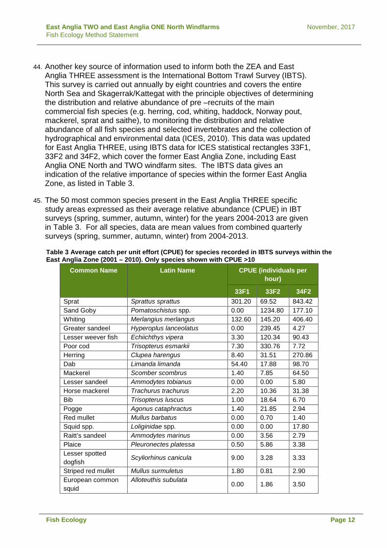
East Anglia TWO and East Anglia ONE North Windfarms November, 2017 Fish Ecology Method Statement
44. Another key source of information used to inform both the ZEA and East Anglia THREE assessment is the International Bottom Trawl Survey (IBTS). This survey is carried out annually by eight countries and covers the entire North Sea and Skagerrak/Kattegat with the principle objectives of determining the distribution and relative abundance of pre –recruits of the main commercial fish species (e.g. herring, cod, whiting, haddock, Norway pout, mackerel, sprat and saithe), to monitoring the distribution and relative abundance of all fish species and selected invertebrates and the collection of hydrographical and environmental data (ICES, 2010). This data was updated for East Anglia THREE, using IBTS data for ICES statistical rectangles 33F1, 33F2 and 34F2, which cover the former East Anglia Zone, including East Anglia ONE North and TWO windfarm sites. The IBTS data gives an indication of the relative importance of species within the former East Anglia Zone, as listed in Table 3.
45. The 50 most common species present in the East Anglia THREE specific study areas expressed as their average relative abundance (CPUE) in IBT surveys (spring, summer, autumn, winter) for the years 2004-2013 are given in Table 3. For all species, data are mean values from combined quarterly surveys (spring, summer, autumn, winter) from 2004-2013.
Table 3 Average catch per unit effort (CPUE) for species recorded in IBTS surveys within the East Anglia Zone (2001 – 2010). Only species shown with CPUE >10
Common Name Latin Name CPUE (individuals per hour)
33F1 33F2 34F2 Sprat Sprattus sprattus 301.20 69.52 843.42 Sand Goby Pomatoschistus spp. 0.00 1234.80 177.10 Whiting Merlangius merlangus 132.60 145.20 406.40 Greater sandeel Hyperoplus lanceolatus 0.00 239.45 4.27 Lesser weever fish Echiichthys vipera 3.30 120.34 90.43 Poor cod Trisopterus esmarkii 7.30 330.76 7.72 Herring Clupea harengus 8.40 31.51 270.86 Dab Limanda limanda 54.40 17.88 98.70 Mackerel Scomber scombrus 1.40 7.85 64.50 Lesser sandeel Ammodytes tobianus 0.00 0.00 5.80 Horse mackerel Trachurus trachurus 2.20 10.36 31.38 Bib Trisopterus luscus 1.00 18.64 6.70 Pogge Agonus cataphractus 1.40 21.85 2.94 Red mullet Mullus barbatus 0.00 0.70 1.40 Squid spp. Loliginidae spp. 0.00 0.00 17.80 Raitt’s sandeel Ammodytes marinus 0.00 3.56 2.79 Plaice Pleuronectes platessa 0.50 5.86 3.38 Lesser spotted dogfish
Scyliorhinus canicula 9.00 3.28 3.33
Striped red mullet Mullus surmuletus 1.80 0.81 2.90 European common squid
Alloteuthis subulata 0.00 1.86 3.50
Fish Ecology Page 12

East Anglia TWO and East Anglia ONE North Windfarms November, 2017 Fish Ecology Method Statement
Common Name Latin Name CPUE (individuals per hour)
33F1 33F2 34F2 Solenette Buglossidium luteum 0.00 0.85 6.00 Long-finned squid Loligo forbesii 0.00 0.60 0.10 Common squid Loligo subulata 0.00 0.00 4.47 Grey gurnard Eutrigla gurnardus 0.00 2.31 2.52 Cuttlefish Sepiidae 0.00 0.00 0.20 Scaldfish Arnoglossus laterna 0.00 0.30 4.94 Goby indet. Gobiidae 0.00 0.00 1.20 Dover sole Solea solea 0.30 1.10 0.20 Red gurnard Chelidonichthys cuculus 0.00 0.80 0.73 Sandeel indet. Ammodytidae 0.00 0.60 0.00 Smooth sandeel Gymnammodytes
semisquamatus 0.00 4.80 0.20
Lemon sole Microstomus kitt 2.00 0.66 2.11 Common dragonet Callionymus lyra 0.20 0.52 0.93 Cod Gadus morhua 0.40 2.04 0.88 Starry smoothhound Mustelus asterias 1.30 0.26 0.34 Blonde ray Raja brachyura 0.00 3.10 0.40 Common smoothhound
Mustelus mustelus 0.00 1.73 0.29
Flounder Platichthys flesus 0.00 0.00 0.00 European anchovy Engraulis encrasicolus 0.00 0.2 0.86 Atlantic bobtail Sepiola atlantica 0.00 0.00 0.20 Sea lamprey Petromyzon marinus 0.00 0.80 0.00 Thornback ray Raja clavata 0.20 0.20 0.23 European eel Anguilla anguilla 0.00 0.00 0.00 Pilchard Sardina pilchardus 0.00 0.00 0.00
46. Elasmobranch species such as thornback ray, blonde ray Raja brachyura, spotted ray Raja montagui, lesser spotted dogfish (also known as small-spotted catshark) Scyliorhinus canicula, smooth-hounds Mustelus sp., spurdog, undulate ray Raja undulata and tope Galeorhinus galeus have all been recorded in IBTS samples collected within the former Zone (up to 2013), see Appendix B taken from Volume 2, Chapter 11 East Anglia THREE ES EAOW, 2015).
47. Migratory species and species of conservation importance such as European eel Anguilla anguilla, river lamprey Lampetra fluviatilis and sea lamprey Petromyzon marinus, shad Alosa sp., common skate Dipturus batis, sea trout, salmon, shads and smelt have been occasionally recorded in landings data and/or in the IBTS data, and may transit the Zone as part of their migratory or foraging activity. In the particular case of sea trout, the East Anglian coast is thought to be an important feeding area for sea trout (post-smolts) originating from rivers of north-east England.
Fish Ecology Page 13

East Anglia TWO and East Anglia ONE North Windfarms November, 2017 Fish Ecology Method Statement
48. The East Anglia ONE and East Anglia THREE natural fish and shellfish ecology assessments were based on the zonal assessment summarised above however, site specific surveys were undertaken for both East Anglia ONE and East Anglia THREE to supplement publically available data. East Anglia ONE undertook site specific fish trawl (otter and beam) surveys in November 2010 and February 2011. East Anglia THREE undertook otter and beam trawl surveys which were undertaken in February and May 2013. The EIA also used the latest public data available at the time of submission (2015).
49. Otter trawl surveys undertaken for East Anglia ONE recorded 24 species, whiting, plaice, bib, dab and cod were the species caught in greatest numbers. Lesser spotted dogfish, spotted ray, blonde ray and thornback ray were the principal species of elasmobranchs caught.
50. The East Anglia ONE 2m beam trawl survey recorded a total of 33 fish species. In general terms, the species caught in greatest numbers were sand goby, solenette, Raitt’s sandeel and lesser weever. Greater sandeel, sole, pogge, plaice, whiting and lesser sandeel were also caught, although to a lesser extent. Elasmobranchs such as lesser spotted dogfish and thornback ray were also found in beam trawl samples.
51. Findings from the East Anglia THREE otter trawl survey indicated that dab, plaice and whiting had the highest CPUE (72.8, 33.9 and 34.8 respectively), suggesting they had the highest abundance. Of the other 15 species recorded, the highest species with the highest CPUE was herring with 6.9. Results from the 4m beam trawl survey also found that dab and plaice had the highest CPUE (86.2 and 68.1 respectively) with whelk Buccinum undatum being the third most recorded (CPUE 27). Generally, CPUE figures were higher in the East Anglia THREE site than the control zone.
52. Data sets from both East Anglia ONE and East Anglia THREE were broadly similar in terms of species composition, however, there were differences in abundance that was assessed as being a result of distance offshore. It is expected that species composition of the East Anglia ONE North windfarm site and East Anglia TWO windfarm site will be similar to that of East Anglia ONE, due to the relative distance from shore and water depths.
53. A summary of the results from the East Anglia THREE trawl surveys are as provided in Appendix A.
Fish Ecology Page 14

East Anglia TWO and East Anglia ONE North Windfarms November, 2017 Fish Ecology Method Statement
54. MMO Commercial species landing data collected between 2004 and 2013 within ICES rectangles 33F1, 33F2 and 34F2, which covers the former East Anglia zone, including both the East Anglia ONE North and East Anglia TWO windfarm sites and export cable corridor AoS are presented in Table 4. The fish species landed in the highest volumes are sprat, plaice, cod, sole, skates and rays, thornback rays and horse mackerel. Landings of plaice were highest in offshore rectangles, representing approximately half of total landings of the offshore cable corridor (offshore) and a third of landings in the East Anglia THREE site, but were negligible in the offshore cable corridor (inshore). Sprat landings were an order of magnitude higher in the offshore cable corridor (inshore) compared to the offshore cable corridor (offshore) and the East Anglia THREE site.
Fish Ecology Page 15

East
Ang
lia T
WO
and
Eas
t Ang
lia O
NE
Nor
th W
indf
arm
s
Nov
embe
r, 20
17
Fish
Eco
logy
Met
hod
Stat
emen
t
Tabl
e 4
Aver
age
wei
ght (
tonn
es) a
nd p
erce
ntag
e co
ntrib
utio
n of
the
prin
cipa
l com
mer
cial
spe
cies
(MM
O la
ndin
gs d
ata
2004
-201
3) w
ithin
eac
h IC
ES re
ctan
gle
rele
vant
to th
e fo
rmer
Eas
t Ang
lia z
one
site
and
the
Offs
hore
Cab
le C
orrid
or
Spec
ies
33F1
(offs
hore
cab
le c
orrid
or (i
nsho
re)
33F
2 (O
ffsho
re c
able
cor
ridor
(offs
hore
) 34
F2 (o
ffsho
re w
indf
arm
are
a)
Ave
rage
Lan
ding
s (to
nnes
) A
vera
ge c
ontr
ibut
ion
to to
tal l
andi
ngs
in
33F1
(%)
Ave
rage
Lan
ding
s (to
nnes
) A
vera
ge c
ontr
ibut
ion
to to
tal l
andi
ngs
in
33F2
(%)
Ave
rage
Lan
ding
s (to
nnes
) A
vera
ge
cont
ribut
ion
to
tota
l lan
ding
s in
34
F2 (%
)
Spr
at
134
31%
58
15
%
34
27%
P
laic
e 2
0.5%
17
4 45
%
45
35%
S
ole
69
16%
44
11
%
19
15%
C
od
79
18%
21
5%
10
8%
S
kate
s an
d R
ays
38
9%
6 2%
3
2%
Whe
lks
33
8%
2 0.
6%
0.7
0.5%
H
orse
Mac
kere
l 0.
09
0.02
%
31
8%
0.01
0.
01%
Th
ornb
ack
Ray
22
5%
3
0.7%
2
1%
Flou
nder
or F
luke
s 7
2%
5 1%
1.
2 1%
D
abs
1 0.
3%
8 2%
3
2%
Her
ring
6 1%
5
1%
0 0%
B
rill
1 0.
3%
6 2%
2
1%
Bas
s 6
1%
0.6
0.2%
0.
1 0.
1%
Edi
ble
Cra
bs
6 1%
0.
08
0.02
%
0.1
0.1%
Tu
rbot
0.
2 0.
05%
4
1%
2 1%
W
hitin
g 0.
9 0.
2%
5 1%
1
0.4%
S
purd
og
4 0.
9%
0.2
0.05
%
2 1%
Lo
bste
rs
5 1%
0.
08
0.02
%
0.02
0.
02%
S
moo
thho
und
5 1%
0.
1 0.
03%
0.
03
0.02
%
Bro
wn
Shr
imps
4
1%
0 0.
00%
0.
004
0%
Blo
nde
Ray
1
0%
1 0.
3%
2 1%
Le
sser
Spo
tted
Dog
3
0.7%
0.
3 0.
09%
0.
2 0.
2%
Bla
ck S
eabr
eam
0.
0004
0.
00%
3
0.7%
0
0%
Pou
ting
0.3
0.06
%
2 0.
4%
0.2
0.1%
O
ther
Spe
cies
4
0.9%
6
1%
2 2%
Fish
Eco
logy
Pa
ge 1
6
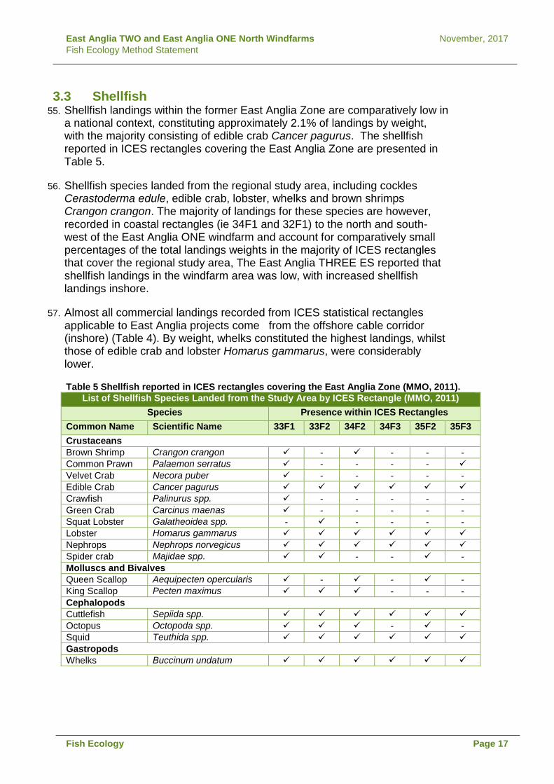
East Anglia TWO and East Anglia ONE North Windfarms November, 2017 Fish Ecology Method Statement
3.3 Shellfish 55. Shellfish landings within the former East Anglia Zone are comparatively low in
a national context, constituting approximately 2.1% of landings by weight, with the majority consisting of edible crab Cancer pagurus. The shellfish reported in ICES rectangles covering the East Anglia Zone are presented in Table 5.
56. Shellfish species landed from the regional study area, including cockles Cerastoderma edule, edible crab, lobster, whelks and brown shrimps Crangon crangon. The majority of landings for these species are however, recorded in coastal rectangles (ie 34F1 and 32F1) to the north and south-west of the East Anglia ONE windfarm and account for comparatively small percentages of the total landings weights in the majority of ICES rectangles that cover the regional study area, The East Anglia THREE ES reported that shellfish landings in the windfarm area was low, with increased shellfish landings inshore.
57. Almost all commercial landings recorded from ICES statistical rectangles applicable to East Anglia projects come from the offshore cable corridor (inshore) (Table 4). By weight, whelks constituted the highest landings, whilst those of edible crab and lobster Homarus gammarus, were considerably lower.
Table 5 Shellfish reported in ICES rectangles covering the East Anglia Zone (MMO, 2011). List of Shellfish Species Landed from the Study Area by ICES Rectangle (MMO, 2011)
Species Presence within ICES Rectangles Common Name Scientific Name 33F1 33F2 34F2 34F3 35F2 35F3 Crustaceans Brown Shrimp Crangon crangon - - - - Common Prawn Palaemon serratus - - - - Velvet Crab Necora puber - - - - - Edible Crab Cancer pagurus Crawfish Palinurus spp. - - - - - Green Crab Carcinus maenas - - - - - Squat Lobster Galatheoidea spp. - - - - - Lobster Homarus gammarus Nephrops Nephrops norvegicus Spider crab Majidae spp. - - - Molluscs and Bivalves Queen Scallop Aequipecten opercularis - - - King Scallop Pecten maximus - - - Cephalopods Cuttlefish Sepiida spp. Octopus Octopoda spp. - - Squid Teuthida spp. Gastropods Whelks Buccinum undatum
Fish Ecology Page 17

East Anglia TWO and East Anglia ONE North Windfarms November, 2017 Fish Ecology Method Statement
3.4 East Anglia ONE North and East Anglia TWO
58. The East Anglia THREE windfarm site is further offshore than the East Anglia ONE North and East Anglia TWO windfarm sites, however there is considerable overlap between East Anglia THREE export cable routes and interconnectors and both the East Anglia ONE North and East Anglia TWO windfarm sites. The export cable corridor AoS for both the East Anglia ONE North windfarm site and the East Anglia TWO windfarm site are within ICES statistical rectangle 33F1, which is the same as the previous Bramford connection, and therefore previously assessed data is applicable.
59. Results of desk studies and East Anglia ONE and East Anglia THREE surveys show that species composition is similar across the studied area, with abundance of key fish species varying seasonally and with distance from shore. Site specific surveys undertaken at East Anglia ONE and East Anglia THREE correlate with findings of other data available for the area (MMO landings data and IBTS data) and therefore it can be assumed with relatively high confidence that species composition in the East Anglia TWO windfarm site and East Anglia ONE North windfarm site and associated export cable corridor AoS are the same as for East Anglia ONE and East Anglia THREE sites.
60. Considering the proximity and overlap between the projects, data from the ZEA used to inform East Anglia ONE and East Anglia THREE will largely be relevant for the proposed East Anglia ONE North windfarm and proposed East Anglia TWO windfarm. Given the relatively homogenous nature of fish communities across the former East Anglia Zone, fish species composition and abundance in the East Anglia ONE North windfarm site and East Anglia TWO windfarm site are unlikely to vary significantly to what has previously been recorded.
61. Based on the results of previous assessments, the East Anglia ONE North and the East Anglia TWO windfarm sites are likely to be of limited importance to fish populations, although there is overlap with spawning and nursery grounds (as presented in Coull et al 1998 and Ellis et al., 2012) for some species .Nursery and spawning grounds for species which overlap with the East Anglia ONE North and TWO windfarm sites are shown in Section 2.7 (Fish and Shellfish Ecology) of the proposed East Anglia ONE North Windfarm and proposed East Anglia TWO Windfarm scoping report. Relevant data from icthyoplankton surveys are provided in Appendix B.
62. Commercial fishing activity within the former Zone tends to be more active in inshore waters. Therefore out of the two proposed projects, the East Anglia TWO windfarm site and the export cable corridor AoS for both projects are likely to be more important in terms of fishing activity. Table 6 indicates that commercial catches within ICES rectangles related to the former Zone are generally low.
63. Table 6 summarises those species which were identified as important at the former zone level and have potential overlap with the East Anglia ONE North and the East Anglia TWO windfarm sites.
Fish Ecology Page 18

East
Ang
lia T
WO
and
Eas
t Ang
lia O
NE
Nor
th W
indf
arm
s
Nov
embe
r, 20
17
Fish
Eco
logy
Met
hod
Stat
emen
t
Tabl
e 6
Spat
ial o
verla
p be
twee
n Ea
st A
nglia
ON
E N
orth
and
Eas
t Ang
lia T
WO
with
key
spe
cies
spa
wni
ng a
nd n
urse
ry a
reas
Zone
Ea
st A
nglia
ON
E N
orth
/ TW
O O
verla
p
Spec
ies
S
paw
ning
N
urse
ry
Spaw
ning
N
urse
ry
Com
mer
cial
im
porta
nce
C
onse
rvat
ion
Des
igna
tion
Plai
ce
Hig
h In
tens
ity E
A1N
, low
in
tens
ity E
A2.
Non
e Y
N
H
igh
UK
BAP,
IUC
N (l
east
con
cern
)
Sole
H
igh
Inte
nsity
gro
und
I n
sout
hern
hal
f of t
he
form
er z
one
incl
udin
g EA
1N a
nd E
A2.
Lim
ited
to th
e w
este
rn e
dge
of
the
Zone
-
Y (s
light
ov
erla
p)
N
Hig
h U
K BA
P
Cod
Lo
w in
tens
ity in
sou
th o
f Zo
ne, i
nclu
ding
EA1
N
and
2.
Low
inte
nsity
are
a co
vers
muc
h of
Zo
ne
Y
Y
Med
ium
U
K BA
P, O
SP
AR, I
UC
N
(vul
nera
ble)
Sand
eel
Low
inte
nsity
are
a
cove
rs m
uch
of Z
one
Low
inte
nsity
are
a co
vers
muc
h of
Zo
ne
Y
Y
Low
U
K BA
P
Spra
t W
hole
Zon
e So
uth
and
east
of
Zone
incl
udin
g EA
1N a
nd E
A2
Y
Y
Low
U
K BA
P
Her
ring
Low
inte
nsity
in s
outh
of
Zone
Lo
w in
tens
ity a
rea
cove
rs m
uch
of
Zone
Y
Y
Low
U
K BA
P, IU
CN
(lea
st c
once
rn)
Sea
trout
N
N
N
N
M
ediu
m (t
arge
ted
by li
cens
ed
fishe
ries
off t
he
coas
t of E
ast
Angl
ia)
UK
BAP,
IUC
N (l
ower
ris
k/le
ast c
once
rn)
Spur
dog
Not
def
ined
N
ot d
efin
ed
Not
def
ined
N
ot d
efin
ed
Med
ium
U
K BA
P, O
SP
AR, I
UC
N
(vul
nera
ble)
Th
ornb
ack
ray
Not
def
ined
Li
mite
d to
the
wes
tern
edg
e of
th
e Zo
ne
Not
def
ined
N
M
ediu
m
OSP
AR, I
UC
N (n
ear
thre
aten
ed)
Tope
N
ot d
efin
ed
Low
inte
nsity
are
a co
vers
who
le
Zone
Not
def
ined
Y
Lo
w
UK
BAP,
IUC
N (v
ulne
rabl
e)
Fi
sh E
colo
gy
Page
19

East Anglia TWO and East Anglia ONE North Windfarms November, 2017 Fish Ecology Method Statement
4 Approach to asessment 64. The potential impacts of the proposed East Anglia ONE North project and the
proposed East Anglia TWO project will consider fish and shellfish as specified in ‘Guidelines for ecological impact assessment in Britain and Ireland: Marine and coastal. (Chartered) Institute of Ecology and Environmental Management (IEEM) (2010) ‘ Potential impacts on the following ecological aspects that will be considered in the assessment include:
• Impacts on fish, shellfish, eggs and larvae; • Spawning grounds; • Nursery grounds; • Feeding grounds; • Overwintering areas for crustaceans (e.g. lobster and crab); • Migration routes; • Conservation Importance; • Importance in the food web; and • Commercial importance.
65. Assessment of the impacts on the above has been separately applied to the
construction, operational and decommissioning phases.
4.1 Baseline information to inform the assessment
66. The principle sources of data and information to inform the assessment include (though not limited to):
• MMO Landings data (weight and value) by species (latest data series available at the time of publishing)
• Spawning and nursery grounds of selected fish species in UK waters mapped by Coull et al 1998 and revised by Ellis et al 2012);
• North Sea International Bottom Trawl Survey Data (IBTS) • North Sea Groundfish Survey Data • IMARES monthly ichthyoplankton surveys in the Southern North Sea April 2010-
March 2011 (van Damme et al. 2011) • East Coast Regional Environmental Characterisation (REC) (Limpenny, 2011) • East Marine Plan documents, July 2014 (MMO, 2014) • Reports, survey data and publications by organisations including Cefas, MMO,
COWRIE, ICES, IFCA and Environment Agency • MCZ recommendations – Net Gain and Natural England • Existing site specific data for East Anglia ONE (EAOW 2013), East Anglia THREE
(EAOW 2015) and the East Anglia Zone appraisal (EAOW 2010) • Other relevant peer-review publications and stock assessments
67. In addition, the fish and shellfish ecology assessment will be informed by the outcomes of the following Environmental Statement (ES) topics:
• Marine Geology, Oceanography and Physical Processes;
Fish Ecology Page 20

East Anglia TWO and East Anglia ONE North Windfarms November, 2017 Fish Ecology Method Statement
• Marine Water and Sediment Quality; • Benthic Ecology and Chapter ; and • Commercial Fisheries.
68. As discussed previously, there is a substantial amount of existing data (publically available data and from previous studies) available within the former Zone, which encompass the East Anglia ONE North and East Anglia TWO windfarm sites and associated export cable corridor AoS. Given the similarity of results from previous surveys and the volume of available data, there is sufficient data available to characterise the areas for EIA purposes and no further site specific surveys will be undertaken.
4.2 Significance Criteria
69. The significance of potential impacts will be defined by considering receptor sensitivity in combination with the magnitude of a given impact. Where there is a lack of suitable data to quantitatively assess impacts for the species under consideration, the assessment will be informed by professional experience and judgement.
4.3 Sensitivity
70. Receptor sensitivity will be assigned on the basis of species specific adaptability, tolerance, and recoverability, when exposed to a potential impact. The following parameters will be taken into account:
• Timing of the impact: whether impacts overlap with critical life-stages or seasons (i.e. spawning, migration); and
• Probability of the receptor-effect interaction occurring (e.g. vulnerability)
71. Receptor sensitivities will be informed by thorough review of the available peer-reviewed scientific literature, and assessments available on the Marine Life Information Network (MarLIN) database. It is acknowledged that the MarLIN assessments have limitations. These limitations will be taken in to account and other information and data accessed where relevant. Definitions of receptor sensitivity are provided in Table 7.
72. With regard to noise related impacts, the criteria adopted will be based on internationally accepted peer-reviewed evidence and criteria proposed by consensus of expert committees. Fish criteria were adopted from Popper et al. (2006) and Carlson et al. (2007) in terms of injury, while behavioural criteria were devised following the work of McCauley et al. (2000) and Pearson et al. (1992). Consideration has also been given to work by Mueller-Blenkle et al. (2010), Halvorsen et al (2012) and Farcas et al. (2016).
Fish Ecology Page 21

East Anglia TWO and East Anglia ONE North Windfarms November, 2017 Fish Ecology Method Statement
Table 7 Definitions of Receptor Sensitivity Sensitivity Definition
High Individual* receptor (species or stock) has very limited or no capacity to avoid, adapt to, accommodate or recover from the anticipated impact.
Medium Individual* receptor (species or stock) has limited capacity to avoid, adapt to, accommodate or recover from the anticipated impact.
Low Individual* receptor (species or stock) has some tolerance to accommodate, adapt or recover from the anticipated impact.
Negligible Individual* receptor (species or stock) is generally tolerant to and can accommodate or recover from the anticipated impact.
* In this case individual receptor does not refer to an individual organism but refers to the population or stock of a species
4.4 Ecological value
73. In some instances the ecological value of the receptor may also be taken into account within the assessment of impacts. In these instances ‘value’ refers to the importance of the receptor in the area in terms of conservation status, role in the ecosystem, and geographic frame of reference. Note that for stocks of species which support significant fisheries commercial value is also taken into consideration. Value definitions are provided in Table 8.
Table 8 Definition of Value Value Definition
High Internationally or nationally important
Medium Regionally important or internationally rare
Low Locally important or nationally rare
Negligible Not considered to be particularly important or rare
4.4.1 Magnitude 74. The magnitude of an effect will be considered for each predicted impact on a
given receptor and is defined geographically, temporally and in terms of the likelihood of occurrence. The definitions of terms relating to the magnitude of a potential impact on fish and shellfish ecology are provided in Table 9.
75. With respect to duration of potential impacts, those associated with construction will be considered to be short term, occurring over a maximum of 2 years following construction. Impacts associated with operation will be considered longer term, occurring over the operational lifetime of the projects.
Fish Ecology Page 22

East Anglia TWO and East Anglia ONE North Windfarms November, 2017 Fish Ecology Method Statement
Table 9 Definitions of Magnitude of Effect Magnitude Definition
High Fundamental, permanent / irreversible changes, over the whole receptor, and / or fundamental alteration to key characteristics or features of the particular receptors character or distinctiveness.
Medium Considerable, permanent / irreversible changes, over the majority of the receptor, and / or discernible alteration to key characteristics or features of the particular receptors character or distinctiveness.
Low Discernible, temporary (throughout project duration) change, over a minority of the receptor, and / or limited but discernible alteration to key characteristics or features of the particular receptors character or distinctiveness.
Negligible Discernible, temporary (throughout project duration) change, over a minority of the receptor, and / or limited but discernible alteration to key characteristics or features of the particular receptors character or distinctiveness.
No Impact No loss of extent or alteration to characteristics, features or elements.
4.5 Impact significance
76. Table 10 outlines the significance criteria that will be applied to the assessment of an effect, taking into account the magnitude of effect and sensitivity of the receptor. In the context of impacts on fish and shellfish receptors, a low magnitude combined with a low sensitivity would result in a minor significance. Those effects which are moderate or major will be considered significant with respect to EIA assessments.
77. The matrix is seen as a framework to aid understanding of how a judgement has been reached from the narrative of each impact assessment and it is not a prescriptive formulaic method. To some extent defining impact significance is therefore qualitative and reliant on professional experience, interpretation and judgement.
Fish Ecology Page 23

East Anglia TWO and East Anglia ONE North Windfarms November, 2017 Fish Ecology Method Statement
Table 10 Impact Significance Matrix Sensitivity Magnitude
High Medium Low Negligible No change
High Major Major Moderate Minor No impact
Medium Major Moderate Minor Negligible No impact
Low Moderate Minor Minor Negligible No impact
Negligible Minor Negligible Negligible Negligible No impact
78. Through use of this matrix, an assessment of the significance of an impact would be made in accordance with the definitions in Table 11.
Table 11 Impact Significance Definitions Impact Significance Definition
Major Very large or large change in receptor condition, both adverse or beneficial, which are likely to be important considerations at a regional or district level
Moderate Intermediate change in receptor condition, which are likely to be important considerations at a local level.
Minor Small change in receptor condition, which may be raised as local issues but are unlikely to be important in the decision making process.
Negligible No discernible change in receptor condition.
No Impact No change in receptor condition, therefore no impact
4.6 Cumulative Impact Assessment
79. With regards to cumulative impacts, already installed infrastructure, practiced licenced activities and implemented measures will be assumed to constitute part of the existing environment to which receptors have adapted. Previous experience has shown that there is also a paucity of information on a number of planned offshore developments which could hinder a comprehensive assessment. The developments, activities and measures taken forward for cumulative assessment will be selected to be taken forward on the basis on the availability of information, probability and spatial overlap where relevant.
80. Cumulative impacts on key sensitive species such as herring and sandeel will be considered.
Fish Ecology Page 24

East Anglia TWO and East Anglia ONE North Windfarms November, 2017 Fish Ecology Method Statement
4.7 Trans-boundary Impact Assessment
81. The distribution of fish and shellfish species is independent of national geographical boundaries. The EIA for the proposed East Anglia ONE North project and the proposed East Anglia TWO project will be undertaken taking into account the distribution of fish stocks and populations irrespective of political limits. As a result, it is considered that a specific assessment of trans-boundary effects is unnecessary.
5 Potential Impacts 82. The fish and shellfish species present across the zone will be identified using
information from site specific offshore fish surveys, IBTS surveys and IMARES ichthyoplankton surveys, commercial fisheries landings data for the ICES rectangles and peer-review publications. Key receptors will be selected in consultation with the MMO, Cefas and fisheries stakeholders.
83. A range of potential impacts on fish and shellfish ecology (as described in the following sections) will be assessed separately for each of the construction, operation and decommissioning phases.
84. The sensitivity of fish and shellfish receptors to potential impacts will be informed by reference to the work of the Marine Life Information network (MarLIN), reference to monitoring results from operational offshore windfarms, peer-review publications and the findings from industry-wide studies (e.g. COWRIE funded research such as those on EMF and piling noise impacts).
85. The significance of each impact on fish and shellfish receptors, where appropriate, will be expressed in terms of the impact at a species population level. Where it is not possible to quantify impacts, and where a qualitative or semi-qualitative assessment is made, the assessment will set out the logical and robust evidence to support the assessment.
5.1 Potential impacts during construction
5.1.1 Physical disturbance and temporary loss of sea bed habitat 86. There is potential for direct physical disturbance of the sea bed during
construction from the installation of cables and foundations (through placement of jack up barge legs, spud cans and anchors/chains) and sea bed preparation (dredging). These construction phase activities have the potential to impact fish and shellfish species including species for which spawning or nursery grounds have been defined as well as those with designated conservation status. Disturbance at any particular time during the construction period will be of limited extent and duration.
5.1.1.1 Findings from East Anglia ONE and East Anglia THREE EIAs 87. For East Anglia ONE, potential for physical disturbance was assessed alongside
other impacts. Please see below for individual summaries.
Fish Ecology Page 25

East Anglia TWO and East Anglia ONE North Windfarms November, 2017 Fish Ecology Method Statement
88. The East Anglia THREE assessment concluded that the potential impact of physical disturbance was not significant, as the former East Anglia Zone has limited overlap with sandeel and plaice spawning grounds in relation to the overall area of available spawning habitat. The ES also concluded that the habitat within the former Zone is not suitable for herring spawning. In addition, impacts to shellfish will be temporary and short-term.
5.1.1.2 Proposed method for assessment • The area of impact from physical disturbance and proportion of the population
affected will be assessed using a worst case scenario for the construction activities identified.
• Sensitivities will be informed by available literature including the assessments available on MarLIN. Assessments of sensitive species and species with conservation status are guided by review of available literature including Strategic Environmental Assessments (SEAs) (including Rogers and Stocks, 2001).
• Assessments to spawning and nursery grounds are guided by the known spawning and nursery habitats mapped by Coull et al, (1998) and updated by Ellis et al, (2012).
• Magnitude will be assessed based on the information presented in the following chapters; Marine Geology, Oceanography and Physical Processes, Marine Water and Sediment Quality and Benthic Ecology. The level of impact will be quantified by calculating the maximum area of disturbance as a percentage of the total available habitat, spawning or nursery area within the East Anglia ONE North and East Anglia TWO windfarm sites and associated export cable corridors according to the worst case scenario.
5.1.2 Increased suspended sediments and sediment redeposition 89. Construction activities have the potential to cause mobilisation of sediments in
the water column and an increase in suspended sediment concentrations (SSC). Sensitive species may react to this through physical or reproductive decline or it may impact upon migration or spawning behaviour.
5.1.2.1 Findings from East Anglia ONE and East Anglia THREE EIAs 90. The assessment for East Anglia ONE concluded that the potential impacts from
increased SSC and sediment redeposition would be short term in nature and restricted to discrete areas in the immediate construction vicinity and that further from the site, SSC would not exceed the natural range of variability. In light of this, the assessment determined that impacts would not be significant.
91. The East Anglia THREE assessment concluded that the potential impact of increased SSCs on fish eggs and larvae was not significant. This is based on a low sensitivity of fish eggs to SSC and the potential benefits to larvae. In addition, low sensitivity of shellfish and pelagic fish, and the lack of suitable demersal fish spawning grounds lead the assessment to conclude that impacts would not be significant to any fish or shellfish receptors.
5.1.2.2 Proposed method for assessment • The magnitude of the potential impact will be based upon the outcomes of Marine
Geology, Oceanography and Physical Processes and Marine Water and Sediment
Fish Ecology Page 26

East Anglia TWO and East Anglia ONE North Windfarms November, 2017 Fish Ecology Method Statement
Quality. The magnitude of the effect of sediment smothering on fish and shellfish receptors will be considered in terms of a worst case scenario (i.e. maximum area impacted, the maximum duration of smothering and the maximum thickness of deposited material).
• Sensitivities will be informed by available literature including the assessments available on MarLIN and peer-review publications.
• Impacts will be assessed in relation to background SSC levels and natural variations arising from storm events and seasonal changes.
5.1.3 Underwater Noise 92. Potential sources of underwater noise include piling, vessel traffic, sea bed
preparation, rock dumping and cable installation. Of these, piling noise is considered to have the greatest environmental impact (Nedwell et al, 2007, Lindeboom et al, 2011).
93. Noise from piling during construction (particularly for installation of monopiles) has the potential to cause significant impacts to fish and shellfish species ranging from lethal trauma to behavioural changes in susceptible fish species.
5.1.3.1 Findings from East Anglia ONE and East Anglia THREE EIAs 94. The assessment of potential underwater noise impacts for East Anglia ONE
concluded that any impacts as a result of underwater construction noise would not be significant. This was based on mobility of adult and juvenile fish allowing them to move away from the noise source, wide larvae distribution, large spawning areas and a low sensitivity of migratory species.
95. The underwater noise impact assessment for East Anglia THREE found receptors to have low to medium sensitivity to noise regarding injury and behavioural disturbance. It also concluded that impacts would be short term and intermittent in nature, leading to the conclusion that impacts arising from underwater noise on fish would not be significant.
5.1.3.2 Proposed method for assessment • The potential for disturbance to spawning/nursery for fish and shellfish receptors
will be assessed in relation to the available data on defined spawning locations and the timing and duration of the noise generated by piling events.
• The qualification of the magnitude of this impact will be guided by both the results of noise assessments.
• Assessment of sensitivities of fish and shellfish species to underwater noise will be informed by available literature (such as Popper et al. 2014).
5.1.3.3 Temporary loss of sea bed habitat 96. The installation of wind turbine foundations will result in the temporary loss of
some areas of natural fish and shellfish habitat during the construction phase. The temporal and spatial extent of this effect will be limited, with the possible exception of sandeels.
Fish Ecology Page 27

East Anglia TWO and East Anglia ONE North Windfarms November, 2017 Fish Ecology Method Statement
5.1.3.3.1 Findings from East Anglia ONE and East Anglia THREE EIAs 97. Habitat loss was assessed together with physical disturbance for EA3 and was
found to be of no significance. This impact was not assessed for East Anglia ONE.
98. It is proposed that habitat loss during construction is assessed together with the physical disturbance impact.
5.1.3.4 Proposed method for assessment: • Information generated as part of the coastal processes assessment and
calculations based on the design parameters will be used to quantify the magnitude of the impact, these will include: The maximum sea bed area affected by sea bed preparation for foundations and export, interconnecting, and inter-array cables/platform/project cable installation.
• Levels of sensitivities of fish and shellfish receptors will be informed by available literature including the assessments available on MarLIN and peer-review publications.
• The assessment will be informed by results from monitoring at operational offshore windfarms to review evidence of recoverability e.g. Jensen et al, 2006.
• The impact on key receptors will be considered at the local and population level.
5.2 Potential impacts during operation
99. Monitoring studies conducted at operational wind farms indicate that perceived changes recorded are difficult to distinguish from expected natural variation (Judd, 2009, Vattenfall, 2009, Lindeboom et al, 2011). Whilst monitoring studies have been conducted over relatively short periods, the lack of evidence of gross changes to the fish and shellfish community at operational windfarms should be borne in mind when considering potential operational impacts.
5.2.1 Introduction of wind turbine foundations, scour protection and hard substrate.
100. The presence of windfarm infrastructure (including wind turbine towers and foundations, scour protection and cable protection) are expected to create new habitats within the windfarm colonised by a range of species with potential to increase biodiversity. The increased structural complexity from the introduced infrastructure may also provide habitat or foraging opportunities for mobile species and provide a refuge for fish and shellfish species (Hoffman et al, 2000). Results from monitoring at other sites suggest that there are no gross changes in local fish communities as a result operational windfarms (Leonhard and Pedersen 2005, Jensen et al 2006).
5.2.1.1 Findings from East Anglia ONE and East Anglia THREE EIAs 101. The potential impacts arising from the introduction of wind turbine foundations,
scour protection and hard substrate were assessed as part of the operational impacts for East Anglia ONE. The assessment concluded that impacts would not be significant due to their site-specific nature and low sensitivity of fish and shellfish populations to the introduction of the new substrate.
Fish Ecology Page 28

East Anglia TWO and East Anglia ONE North Windfarms November, 2017 Fish Ecology Method Statement
102. These impacts were assessed as part of the operational permanent habitat loss impact assessment for East Anglia THREE.
5.2.1.2 Proposed method for assessment • The level of magnitude of the impact will be informed by the outcomes of
monitoring studies at other offshore wind developments including studies of short term effects from monitoring reports and studies where available.
• There is uncertainty as to whether artificial reefs facilitate recruitment in the local population, or whether the effects are simply a result of concentrating biomass from surrounding areas (Inger et al., 2009). The level of sensitivity assigned to fish and shellfish receptors will reflect the potential of the receptor to colonise or aggregate in the vicinity of introduced artificial structures.
• Assessment of sensitivities of fish and shellfish species to loss of habitat will be informed by available literature including the assessments available on MarLIN and peer-review publications.
5.2.2 Permanent loss of habitat: 103. The construction of the windfarm will lead to a permanent loss of habitat in the
footprint of foundations and potential area of cable protection. There may also be some loss of habitat over time associated with scour around foundations or if cable protection employed during operation.
5.2.2.1 Findings from East Anglia ONE and East Anglia THREE EIAs 104. The assessment for East Anglia ONE concluded that the potential permanent
loss of habitat would not be significant. This is based on low sensitivity of receptors due to having extensive areas for spawning, nursery and feeding.
105. The East Anglia THREE assessment also concluded that impacts would not be significant. This was based on the area being of low importance for sandeels, no defined spawning grounds for herring and a very small loss with respect to shellfish distribution.
5.2.2.2 Proposed method for assessment • The ZEA provides known size of area of each habitat type across the East Anglia
Zone which can also be augmented by the 2017 geophysical survey data and applied to the specific sites.
• Calculations of the entire footprint of the project will be made using a worst case scenario for:
a. Foundations (of wind turbines, collector stations, convertor stations, vessel moorings and met masts)
b. Scour protection c. Cable protection (including cable crossings)
• The magnitude of the impact will be quantified by calculating the footprint as a percentage of each habitat, nursery or spawning area within the East Anglia ONE North windfarm site and the East Anglia TWO windfarm site that would be lost if the entire windfarm were to be built within each habitat (worst case scenario).
• Assessment of sensitivities of fish and shellfish species to loss of habitat will be informed by available literature including the assessments available on MarLIN and peer-review publications.
Fish Ecology Page 29

East Anglia TWO and East Anglia ONE North Windfarms November, 2017 Fish Ecology Method Statement
• The impact on key receptors will be considered at the local and population level.
106. It is recognised that the proposed calculations will present an unrealistic worst case scenario which may lead to exaggerated percentage take figures, however this is the logical way of ensuring that the absolute worst case scenario is considered.
5.2.3 Increased suspended sediments and sediment redeposition: 107. Routine maintenance activities requiring intrusive methods or use of jack-up
vessels may increase SSC levels, however this will be localised and temporary and it is anticipated that overall impacts will be lower than for construction.
5.2.3.1 Findings from East Anglia ONE and East Anglia THREE EIAs 108. The assessment of the potential impact of physical disturbance from East Anglia
THREE operation concluded that the potential impact would not be significant during operation, and there will be no change with regard to maintenance. This is based on a small magnitude of impact, with effects being short-term and temporary in nature. This impact was not assessed for East Anglia ONE.
5.2.3.2 Proposed method for assessment • The information generated by the physical processes chapters will be used to
determine the magnitude of sediment redeposition both in terms of the area impacted and the thickness of deposited material.
• The nature, type and duration of potential operational activities will be considered to determine the magnitude of impacts.
• Assessment of sensitivities of fish and shellfish species will be informed by available literature including the assessments available on MarLIN and peer-review publications.
• The impact on key receptors will be considered at the local and population level.
5.2.4 Operational Noise: 109. Potential sources of operational noise include vessel movements and wind
turbine operation.
110. Operational wind turbines will produce noise and vibration which will be transmitted into the sea bed and water column (Nedwell et al, 2007). Measurements made at four operational windfarms (North Hoyle, Scroby Sands, Kentish Flats and Barrow) indicate that operational noise is likely to only be a few decibels above background noise within the windfarm, significantly lower in magnitude than noise produced by other activities such as dredging (CMACS 2003, Nedwell et al, 2007). Although in these examples, wind turbines were smaller than those envisaged for the proposed East Anglia ONE NORTH and East Anglia TWO projects.
5.2.4.1 Findings from East Anglia ONE and East Anglia THREE EIAs 111. The assessment of the potential impact of operational noise for East Anglia ONE
concluded that receptors were of low sensitivity and noise levels would not increase significantly, leading to no significant impacts to fish or shellfish as a result of noise during operation.
Fish Ecology Page 30

East Anglia TWO and East Anglia ONE North Windfarms November, 2017 Fish Ecology Method Statement
112. The impact assessment for East Anglia THREE also concluded that the impact from operational noise would not be significant. This was based on low sensitivity of the receptors and noise levels unlikely to be dissimilar to background ambient noise levels. The assessment was also based on previous monitoring of other offshore wind farms which found little to no impact to fish or shellfish arising from operational noise.
5.2.4.2 Proposed method for assessment • The qualification of the magnitude of this impact will be guided by the results of
noise assessments. • Assessment of sensitivities of fish and shellfish species to underwater noise will be
informed by available literature including the assessments available on MarLIN and peer-review publications.
• The impact on key receptors will be considered at the local and population level.
5.2.5 Electromagnetic fields (EMF): 113. Some species of fish, such as elasmobranchs and cod, which utilise
electromagnetic fields for activities such as hunting prey and navigation are potentially vulnerable to anthropogenic sources of EMF. To date, research on the potential effects of EMF on fish and shellfish has been inconclusive (Gill et al, 2009). As part of literature review to identify potential EMF impacts for East Anglia ONE, CMACS (2012) concluded that any impacts would be limited to within a few metres of the cables and therefore would not be significant.
5.2.5.1 Findings from East Anglia ONE and East Anglia THREE EIAs 114. The assessment of potential impacts from EMFs for East Anglia ONE found that
the worst case scenario would have a small impact footprint, and behavioural reactions in the receptors would be temporary. This resulted in a conclusion that impacts would not be significant.
115. The East Anglia THREE EIA also concluded that impacts would not be significant, as they would be temporary in nature and all receptors were assessed to have low sensitivity to EMFs.
5.2.5.2 Proposed method for assessment • The level of magnitude will be informed by the design specifications of the East
Anglia East Anglia ONE North and TWO sub-sea cables. • Assessment of sensitivities of fish and shellfish species to EMF will be informed by
available literature including the assessments available on MarLIN and peer-review publications.
• The impact on key receptors will be considered at the local and population level.
Fish Ecology Page 31
East Anglia TWO and East Anglia ONE North Windfarms November, 2017 Fish Ecology Method Statement
5.2.6 Changes in Fishing Activity 116. During the operational phase of East Anglia ONE, fishing activities (including
trawling and potting) may be excluded from part of or the entire offshore windfarm site. This has the potential to enhance fish and shellfish populations by providing refuge from fishing activities for certain species targeted by commercial fisheries in the southern North Sea. Alternatively, the effect may result in increased fishing pressure outside the windfarm site. This impact would be assessed as part of the commercial fisheries assessment.
5.2.6.1 Proposed method for assessment • For the purpose of this assessment it is assumed that all fishing activity will be
excluded from the East Anglia ONE North windfarm site and East Anglia TWO windfarm site for the lifetime of the project (although it should be noted that this is likely to be over-precautionary).
• The magnitude of the effect and the level of sensitivity of the receptors will be based on the outcomes of the Commercial fisheries assessment.
5.3 Potential impacts during decommissioning
117. During decommissioning the potential impacts are anticipated to be similar to those described above for the construction phase although on a smaller scale, for example noise impacts will be lower (as there will be no piling) and if the cables are left in situ, there will be less sea bed disturbance.
5.3.1 Findings from East Anglia ONE and East Anglia THREE EIAs 118. The decommissioning impact assessment for East Anglia ONE assumed that
impacts would be no greater than those arising from construction. Piling was not envisaged to be required, so noise impacts were assessed as likely to be considerably lower than during construction.
119. For the impact assessment for East Anglia THREE, receptor sensitivity was assumed to be the same as for construction, and magnitude likely to be less, therefore it was concluded that decommissioning impact significance would be no greater (possibly less) than those assessed for construction.
5.3.2 Proposed method for assessment • The methods used for assessing the impacts during decommissioning will be very
similar to those used during the construction phase. The operations involved will be slightly different, however it is anticipated that the magnitude of the impacts will generally be less. Each of the impacts considered for the construction phase will be assessed for the decommissioning phase.
5.4 Potential cumulative impacts
120. Many of the potential cumulative impacts of offshore windfarms in the southern North Sea will be temporary, small scale and localised. Considering the recoverability of fish and shellfish receptors in the area, the cumulative impact of permanent loss of habitat during the operational phase of East Anglia windfarms and other offshore windfarms is not anticipated to be significant.
Fish Ecology Page 32

East Anglia TWO and East Anglia ONE North Windfarms November, 2017 Fish Ecology Method Statement
121. However, underwater noise could have cumulative impacts spatially (if two or more piling operations are undertaken simultaneously) or temporally (if piling operations are happening consecutively) with the potential for displacement impacts across the southern North Sea, noise ‘barriers’ blocking migration routes or consecutive piling programmes displacing sensitive fish from large areas for sustained periods. Noise modelling will be undertaken for the proposed East Anglia ONE North project and proposed East Anglia TWO project in isolation and cumulatively with other potential projects within the East Anglia Zone for sensitive fish species of relevance to the area. Furthermore, consideration will be given to the potential cumulative impacts from other developments in the southern North Sea.
122. The cables from East Anglia ONE North and East Anglia TWO projects will cross existing telecommunication cables and export cables from Greater Gabbard and Galloper offshore windfarms. The East Anglia TWO export cable will also need to cross East Anglia ONE and East Anglia THREE export cables. Depending on the method by which these cable crossings are protected there is potential for cumulative impacts including physical disturbance and temporary habitat loss during the construction phase, in addition to permanent habitat loss and colonisation of artificial structures during the operation phase.
5.4.1.1 Findings from East Anglia ONE and East Anglia THREE EIAs 123. East Anglia ONE EIA found no significant cumulative effects from SSC and
redeposition as a result of simultaneous windfarm construction. There was the potential for noise cumulative effects between Galloper and East Anglia ONE as a result of underwater noise, but the impact was not considered to be significant.
124. East Anglia THREE assessed cumulative physical disturbance, habitat loss, introduction of hard substrate and EMFs as not significant due to small scape of impacts and localised nature so no pathway for cumulative interaction. Cumulative Increases in SSCs and redeposition of sediments were considered to have no impact due to distances between sites and rapid plume dispersion. Underwater noise was also assessed as not significant.
5.4.2 Other activities 125. There is the potential for cumulative impacts from other activities occurring in the
region, these include aggregate dredging, shipping and oil and gas exploration and development. Whilst it is not considered likely that there will be significant cumulative impacts, all potential impacts (from those listed for the proposed East Anglia ONE North project and proposed East Anglia TWO project EIAs in isolation) will be assessed as part of the EIA.
5.4.3 Transboundary impacts 126. Given the level of development in the southern North Sea in other EU Member
States waters there is potential for transboundary impacts especially with regard to noise and given that populations of fish may be highly mobile.
Fish Ecology Page 33

East Anglia TWO and East Anglia ONE North Windfarms November, 2017 Fish Ecology Method Statement
127. The noise modelling for East Anglia ONE indicated that given the distance between site and other developments there would be no spatial overlap in terms of the likely underwater noise impact zones (EAOW, 2012b).
128. The distribution of fish and shellfish species is independent of national geographical boundaries. The proposed East Anglia ONE North project and East Anglia TWO impact assessment will be undertaken taking account of the distribution of fish stocks and populations irrespective of national jurisdictions. As a result, it is considered that a specific assessment of trans-boundary effects is unnecessary. This approach was adopted and accepted for East Anglia THREE (EAOW 2015).
5.5 Additional impacts to be scoped in after EPP consultation 129. As requested by Natural England, MMO and Cefas as part of the evidence plan
process, the EIA will also include an assessment of the following;
• Consideration of cod spawning and seabass habitats; • The impact on fish due to changes to suspended sediment as a result of changes
in vertical mixing caused by vertical structures during the operational phase.
130. Consideration of cod spawning and seabass habitats will be included within the EIA alongside other sensitive habitats (Impact 5.1.1).
131. The effects of changes in suspended sediment due to vertical mixing will be assessed alongside other effects of suspended sediment during operation (Impact 5.2.3)
5.6 Topics to be scoped out
5.6.1 Re-mobilisation of contaminated sediments (Construction and Operation) 132. Sediment disturbance and subsequent deposition could lead to the mobilisation
of contaminants contained in those sediments which are potentially harmful to fish and shellfish species.
5.6.1.1 Findings from East Anglia ONE and East Anglia THREE EIAs 133. Remobilisation of contaminated sediments was assessed within the benthic
ecology sections of the East Anglia ONE and East Anglia THREE Environmental Statements. Both EIAs found limited pathways and that the potential impact would be negligible.
Fish Ecology Page 34

East Anglia TWO and East Anglia ONE North Windfarms November, 2017 Fish Ecology Method Statement
5.6.1.2 Reason for scoping out 134. East Anglia ONE and East Anglia THREE EIAs both found that the impact of re-
mobilising contaminated sediment to be no impact/negligible. Contaminant samples analysed within East Anglia ONE and East Anglia THREE, including two samples in close proximity to East Anglia TWO indicated no significant contamination was present in sediments. Based on existing data, it is unlikely that East Anglia TWO or East Anglia ONE North would contain contaminated sediment which has not been detected in other areas of the zone. This being the case, there would be limited potential pathway through which impacts would result.
135. MMO, CEFAS and NE have confirmed that they would not recommend this impact be scoped out without site specific contaminant data, which is currently being acquired.
Fish Ecology Page 35

East Anglia TWO and East Anglia ONE North Windfarms November, 2017 Fish Ecology Method Statement
6 Evidence plan programme and strategy
136. Fish ecology will be covered in the benthic ecology expert topic group meetings. Table 12 shows an indicative schedule for key milestones and ETG meetings.
Table 12 Indicative Evidence Plan Timetable Date Event 12th April 2017 Benthic ETG meeting 1
Introduction to the project Benthic Ecology EIA Approach Physical Processes EIA Approach Fish Ecology EIA Approach
November 2017 EA1N and EA2 Scoping Report submission Feb/March 2018 Benthic ETG Meeting 2 (If required)
Project update HRA screening
July 2018 Benthic ETG Meeting 3 (if required) November 2018 EA2 HRA draft report and PEI submission Feb/March 2019 Benthic ETG Meeting 4 (if required) Early 2019 DCO application EA 2 November 2019 (TBC) EA1N PEI Jan/Feb 2020 Benthic ETG Meeting 5 (EA1N only) (if required). Early 2020 DCO application EA1N
7 Summary 137. Baseline fish and shellfish ecology in the East Anglia ONE North and TWO
windfarm sites and associated export cable corridor AoS is expected to be similar in nature to what has been considered previously for the former zone and previous projects within it. Fish populations are not geographically isolated and similar species are likely to be present across the whole of the former zone. Analysis of publically available data, as well as site specific data from East Anglia ONE, East Anglia THREE and the ZEA, generally supports this. Benthic habitats are broadly similar across the former East Anglia Zone and it is expected that fish populations would be similar across the former zone.
138. The former East Anglia zone as a whole generally has low abundance of fish, with dab and plaice being the two most dominant species found in site specific surveys. MMO landings data across the zone show that sprat, plaice, sole and cod are the most important commercial fish species (in terms of tonnes of landings). Whelk, edible crab and lobster are the most important shellfish species in terms of tonnes of landings.
139. As there is a significant amount of existing publically available data, it is proposed that fish and shellfish ecology EIA baseline conditions will be based on existing and publically available data.
Fish Ecology Page 36

East Anglia TWO and East Anglia ONE North Windfarms November, 2017 Fish Ecology Method Statement
8 References Centre for Marine and Coastal Studies (CMACS) (2003) A baseline assessment of electromagnetic fields generated by offshore wind farm cables.
Centre for Marine and Coastal Studies (CMACS) (2012) East Anglia One Offshore Wind Farm: electromagnetic field environmental appraisal Assessment of EMF effects on sub tidal marine ecology.
Coull, K.A., Johnstone, R. and Rogers, S.I. (1998) Fisheries Sensitivity Maps in British Waters, Published and Distributed by UKOOA Ltd, Aberdeen, pp. 63
COWRIE (2003) A baseline assessment of electromagnetic fields generated by offshore wind farm cables. CMACS/University of Liverpool & Econnect/J2733/Final_v1/07-2003.
East Anglia Offshore Wind (EAOW) (2012a) East Anglia Offshore Wind Zonal Environmental Appraisal Report March 2012
East Anglia Offshore Wind (EAOW) (2012b) East Anglia ONE Offshore Wind farm Draft Environmental Statement
Ellis, J.R., Milligan, S.P., Readdy, L., South, A., Taylor, N. and Brown, M.J. (2010) MB5301 Mapping spawning and nursery areas of species to be considered in Marine Protected Areas (Marine Conservation Zones). Report No 1: Final Report on development of derived data layers for 40 mobile species considered to be of conservation importance. Cefas Lowestoft, 89 pp.
Ellis, J.R., Milligan, S.P., Readdy, L., Taylor, N. and Brown, M.J. (2012) Spawning and nursery grounds of selected fish species in UK waters. Sci. Ser.Tech.Rep., Cefas Lowestoft, 147:56pp.
Farcas, A. Thompson, P.A. and Merchant, N. 2016. Underwater noise modelling for environmental impact assessment.
Gill, A. B., Huang, Y., Gloyne-Philips, I., Metcalfe, J., Quayle, V., Spencer, J. & Wearmouth, V. (2009). COWRIE 2.0 Electromagnetic Fields (EMF) Phase 2: EMF-sensitive fish response to EM emissions from sub-sea electricity cables of the type used by the offshore renewable energy industry. Commissioned by COWRIE Ltd (project reference COWRIE-EMF-1-06).
Hoffman, E., Astrup, J., Larsen, F. & Munch-Petersen, S. (2000) Effects of Marine Wind farms on the Distribution of Fish, Shellfish and Marine Mammals in the Horns Rev Area. Report to ELSAMPROJEKT A/S. Report No. Baggrundsrapport 24. Danish Institute for Fisheries Research, Lyngby, Denmark.
ICES (2010). Manual for the International Bottom Trawl Surveys –Revision VIII. The International Bottom Trawl Survey Working Group. ICES Copenhagen 69 pp.
IEEM (2010) Guidelines for Ecological Impact Assessment in Britain and Ireland - Marine and Coastal, Institute for Ecology and Environmental Management, Winchester, UK, 72pp.
Inger, R., Attril, M.J., Bearhop, S., Broderick, A.C., Grecian, W.J., Hodgson, D.J., Mills, C., Sheehan, E., Votier, S.C., Witt, M.J., and Godley, B.J. (2009) Marine Renewable Energy: Potential Benefits to Biodiversity? An Urgent Call for Research. Journal of Applied Ecology, 46, 1145-1153.
Jensen, B. A., Klaustrup, M. and Skov, H. (2006) EIA Report. Fish. Horns Rev 2 Offshore wind farm. Bioconsult.
Fish Ecology Page 37

East Anglia TWO and East Anglia ONE North Windfarms November, 2017 Fish Ecology Method Statement
Judd, A. (2009) Strategic Review of Offshore Wind Farm Monitoring Data Associated with FEPA Licence Conditions Fish
Leonhard, S.B., Stenberg, C. and Støttrup, J. Eds. (2011) Effect of the Horns Rev 1 Offshore Wind Farm on Fish Communities. Follow-up Seven Years after Construction. DTU Aqua, Orbicon, DHI, NaturFocus. Report commissioned by The Environmental Group through contract with Vattenfall Vindkraft A/S. Limpenny, S.E., Barrio Froján, C., Cotterill, C., Foster-Smith, R.L., Pearce, B., Tizzard, L., Limpenny, D.L., Long, D., Walmsley, S., Kirby, S., Baker, K., Meadows, W.J., Rees, J., Hill, J., Wilson, C., Leivers, M., Churchley, S., Russell, J., Birchenough, A.C., Green, S.L., and Law, R.J. (2011) The East Coast Regional Environmental Characterisation. Cefas Open report 08/04. 287pp.
Lindeboom, H.J., Kouwenhoven ,H.J., Bergman M.J.N., Bouma, S., Brasseur,S., Daan, R., Fijn R.C., de Haan. D., Dirksen S., van Hal R., Hille Ris Lambers R., ter Hofstede. R, Krijgsveld K.L, Leopold M. and Scheidat (2011). Short-term ecological effects of an offshore wind farm in the Dutch coastal zone; a compilation. Environmental Research Letters 035101 (13pp)
Nedwell., J.R., Parvin, S.J., Edwards, B., Workman, R., Borkker, A.G. and Kynoch, J.E., (2007) Measurement and interpretation of underwater noise during construction and operation of offshore wind farms in UK waters. Subacoustech Report No. 544R0738 to COWRIE Ltd. ISBN: 978-0-9554279-5-4.
OES (Offshore Environmental Solutions) (2008). Kentish Flats Offshore Wind Farm. FEPA Monitoring Summary Report. Rogers, S. and Stocks, R. 2001. North Sea Fish and Fisheries. Technical Report TR_003. Strategic Environmental Assessment-SEA2.
Vattenfall (2009). Kentish Flats Offshore Wind Farm FEPA Monitoring Summary Report. 2008 (Final).
Fish Ecology Page 38

East
Ang
lia T
WO
and
Eas
t Ang
lia O
NE
Nor
th W
indf
arm
s
Nov
embe
r, 20
17
Fish
Eco
logy
Met
hod
Stat
emen
t
App
endi
x A
Fis
h E
colo
gy E
vide
nce
Pla
n A
gree
men
t Log
Com
men
t/agr
eem
ents
A
gree
men
t N
atur
al E
ngla
nd
MM
O
Cef
as
Impa
cts
from
resu
spen
sion
of
cont
amin
ated
sed
imen
ts to
be
sco
ped
out.
Not
pre
pare
d to
sco
pe o
ut
impa
ct w
ithou
t fur
ther
ev
iden
ce th
at th
ere
is n
o co
ntam
inat
ion
in th
e si
te (E
TG
mee
ting-
12/0
4/20
17)
Agr
eed
as p
er N
E A
s pe
r NE
Dat
a so
urce
s ou
tline
d in
the
met
hod
stat
emen
t will
pr
ovid
e su
ffici
ent b
asel
ine
for
robu
st E
IA w
ithou
t the
nee
d fo
r ded
icat
ed fi
sh s
urve
ys.
Agr
ee (0
4/05
/201
7)
Agr
eed
(19/
05/2
017)
W
e ag
ree
that
a d
edic
ated
fish
erie
s su
rvey
is n
ot re
quire
d.
Giv
en th
e pr
evio
us s
urve
ys in
the
vici
nity
(und
erta
ken
as p
art o
f the
E
ast A
nglia
ZE
A a
nd E
ast A
nglia
Thr
ee a
nd E
ast A
nglia
Fou
r EIA
’s),
a de
sk b
ased
stu
dy is
like
ly to
iden
tify
the
key
spec
ies
pres
ent i
n th
e ar
ea to
geth
er w
ith n
urse
ry a
nd s
paw
ning
gro
unds
, with
out t
he n
eed
for a
new
fish
erie
s su
rvey
to b
e ca
rried
out
. Th
e da
ta s
ourc
es o
utlin
ed in
the
met
hod
stat
emen
t will
pro
vide
su
ffici
ent b
asel
ine.
The
list o
f im
pact
s ou
tline
d in
th
e m
etho
d st
atem
ent t
o be
in
clud
ed in
the
ES is
ap
prop
riate
with
the
follo
win
g ca
veat
; •
incr
ease
s in
sus
pend
ed
sedi
men
t due
turb
ine
pres
ence
may
nee
d to
be
incl
uded
(dep
ende
nt
upon
resu
lt of
Cef
as
stud
y).
Agr
ee (0
4/05
/201
7)
Agr
eed
(19/
05/2
017)
In
add
ition
to
the
impa
ct o
f in
crea
ses
in s
uspe
nded
sed
imen
t du
e tu
rbin
e pr
esen
ce, I
wou
ld re
com
men
d th
at th
e im
pact
to c
od s
paw
ning
gr
ound
s be
incl
uded
in th
e E
IA.
Cod
: Th
e E
A1N
and
EA
2 si
tes
are
loca
ted
in a
n ar
ea c
onsi
dere
d to
be
a c
od s
paw
ning
gro
und.
Cod
are
thou
ght
to b
e m
ore
sens
itive
to
nois
e th
an s
ome
fish
spec
ies
as th
e sw
im b
ladd
er te
rmin
ates
clo
se to
th
e ea
r, th
eref
ore
ther
e is
som
e co
ncer
n th
at n
oise
from
pili
ng a
ctiv
ity
may
dis
turb
spa
wni
ng a
ggre
gatio
ns o
f adu
lt fis
h.
Dur
ing
the
appl
icat
ion
proc
ess
for E
A O
ne O
WF
conc
ern
was
rais
ed b
y lo
cal
fishe
rman
reg
ardi
ng t
he p
oten
tial o
f co
nstru
ctio
n ac
tiviti
es t
o im
pact
up
on c
od s
paw
ning
. The
cur
rent
sta
te o
f cod
sto
cks
is d
eter
min
ed b
y IC
ES
. The
late
st IC
ES
adv
ice
(Nov
embe
r 20
16)
issu
ed fo
r N
orth
Sea
co
d sh
ows
that
ICE
S c
onsi
der t
he c
od s
tock
to b
e cu
rren
tly h
arve
sted
su
stai
nabl
y, h
owev
er r
ecru
itmen
t ha
s be
en p
oor
sinc
e 19
98 (
ICE
S 20
16).
Cod
is w
idel
y di
strib
uted
thr
ough
out
the
Nor
th S
ea b
ut t
here
ar
e in
dica
tions
of
subp
opul
atio
ns i
nhab
iting
diff
eren
t re
gion
s of
the
N
orth
S
ea.
The
Sout
hern
N
orth
S
ea
sub-
regi
on
has
suffe
red
a ge
nera
l de
clin
e in
bio
mas
s an
d th
ere
has
been
a l
ack
of r
ecov
ery
(ICE
S 2
016)
. T
he I
CE
S W
orki
ng G
roup
2 o
n N
orth
Sea
Cod
and
P
laic
e E
gg S
urve
ys in
the
Nor
th S
ea (W
GE
GG
S2)
car
ries
out M
IK n
et
surv
eys
dire
cted
prim
arily
at
cod
and
plai
ce a
nd d
ata
has
been
Fish
Eco
logy
Pa
ge 3
9

East
Ang
lia T
WO
and
Eas
t Ang
lia O
NE
Nor
th W
indf
arm
s
Nov
embe
r, 20
17
Fish
Eco
logy
Met
hod
Stat
emen
t
colle
cted
in
the
Nor
th S
ea i
n 20
04,
2009
, an
d an
nual
ly s
ince
201
2 w
ith s
ampl
ing
unde
rtake
n in
the
vici
nity
of t
he E
ast A
nglia
OW
F si
tes.
Th
is s
urve
y da
ta p
rovi
des
rece
nt i
nfor
mat
ion
on c
od s
paw
ning
and
co
uld
be u
sed
to d
eter
min
e th
e ex
tent
of
any
cod
spaw
ning
act
ivity
th
at m
ay b
e oc
curri
ng w
ithin
and
in p
roxi
mity
to
the
EA1
N a
nd E
A2
site
s w
hich
cou
ld b
e im
pact
ed b
y im
pact
/ p
ercu
ssiv
e pi
ling
activ
ity.
The
surv
ey
data
is
do
wnl
oada
ble
from
IC
ES
ht
tp://
ww
w.ic
es.d
k/m
arin
e-da
ta/d
ata-
porta
ls/P
ages
/Egg
s-an
d-la
rvae
.asp
x
Bas
s: a
re a
slo
w g
row
ing
spec
ies
that
hav
e su
ffere
d a
long
-term
de
clin
e in
pop
ulat
ion
due
to o
verfi
shin
g.
They
can
tak
e up
to
4 –
7 ye
ars
to m
atur
e an
d in
divi
dual
s ar
e of
ten
caug
ht b
efor
e th
ey h
ave
had
a ch
ance
to
spaw
n. J
uven
iles
will
occ
upy
dist
inct
nur
sery
are
as i
n es
tuar
ies,
whi
lst
adul
ts w
ill r
etur
n to
the
sam
e sp
awni
ng s
ites
each
ye
ar.
Sea
bass
hav
e be
en p
lace
d un
der
spec
ial
prot
ectio
n m
easu
res
as
scie
ntifi
c ad
vice
has
cle
arly
iden
tifie
d th
e ne
ed t
o dr
astic
ally
red
uce
catc
hes
of th
is s
peci
es,
follo
win
g an
incr
ease
in th
e fis
hing
pre
ssur
e an
d a
redu
ctio
n in
rep
rodu
ctio
n (M
arin
e M
anag
emen
t O
rgan
isat
ion,
20
17).
We
wou
ld e
xpec
t the
ES
to c
onsi
der b
ass
in th
e co
ntex
t of t
he
curr
ent s
peci
al m
easu
res
in p
lace
e.g
. are
exp
ort c
able
tren
chin
g an
d pi
ling
activ
ities
like
ly to
dis
turb
nur
sery
gro
unds
or j
uven
ile fi
sh.
M
arin
e M
anag
emen
t O
rgan
isat
ion,
201
7. S
tatu
tory
Gui
danc
e B
ass
Fish
ing:
Cat
ch li
mits
, cl
osur
es a
nd m
inim
um s
ize.
[O
nlin
e] A
vaila
ble
at:
ht
tps:
//ww
w.g
ov.u
k/go
vern
men
t/pub
licat
ions
/bas
s-fis
hing
-cat
ch-
limits
-clo
sure
s-an
d-m
inim
um-s
ize/
bass
-fish
ing-
catc
h-lim
its-c
losu
res-
and-
min
imum
-siz
e (A
cces
sed
21st J
une
201
7)
Add
ition
al U
sefu
l Dat
a So
urce
s:
In 2
010
the
Eas
tern
Sea
Fis
herie
s Jo
int C
omm
ittee
(ES
FJC
) com
pile
d ch
arts
sho
win
g th
e ex
tent
of i
nsho
re fi
sher
ies
for 1
7 co
mm
erci
ally
im
porta
nt fi
sh a
nd s
hellf
ish
spec
ies
in th
e di
stric
t. T
his
info
rmat
ion
may
be
a us
eful
sou
rce,
par
ticul
arly
with
rega
rd to
the
expo
rt ca
ble
rout
e in
insh
ore
wat
ers.
The
dat
a is
ava
ilabl
e th
roug
h t h
e E
aste
rn
Insh
ore
Fish
erie
s an
d C
onse
rvat
ion
Aut
horit
y (IF
CA
) web
site
: ht
tp://
ww
w.e
aste
rn-if
ca.g
ov.u
k/ab
out/f
ishe
ries/
fishe
ries-
map
ping
-pr
ojec
t/ A
dditi
onal
icht
hyop
lank
ton
surv
ey d
ata
for t
he s
outh
ern
Nor
th S
ea
may
be
obta
ined
from
van
Dam
me
et a
l. 20
11 (a
ttach
ed to
em
ail).
Fish
Eco
logy
Pa
ge 4
0

East
Ang
lia T
WO
and
Eas
t Ang
lia O
NE
Nor
th W
indf
arm
s
Nov
embe
r, 20
17
Fish
Eco
logy
Met
hod
Stat
emen
t
The
aim
of t
his
stud
y w
as to
col
lect
dat
a on
the
tem
pora
l and
spa
tial
dist
ribut
ion
of fi
sh e
ggs
and
larv
ae o
n th
e D
utch
Con
tinen
tal S
helf,
ho
wev
er, t
he s
urve
y ar
ea a
lso
cove
red
the
maj
ority
of t
he s
outh
ern
Nor
th S
ea.
A
ppro
ach
outli
ned
in e
xpor
t ca
ble
corr
idor
brie
fing
note
is
appr
opria
te.
NE
can
con
firm
that
as
per t
he
atta
ched
doc
umen
t and
pr
evio
us fa
ce to
face
mee
ting.
N
atur
al E
ngla
nd a
re c
onte
nt
with
Sco
ttish
Pow
er’s
ap
proa
ch to
sur
veyi
ng th
e ne
w
offs
hore
exp
ort c
orrid
or, a
nd
your
cur
rent
app
roac
h to
the
new
offs
hore
exp
ort c
orrid
or in
ge
nera
l (16
/08/
2017
)
Fish
Eco
logy
Pa
ge 4
1

East Anglia TWO and East Anglia ONE North Windfarms Fish Ecology Method Statement
APPENDIX B: East Anglia THREE otter and beam trawl survey results
Summary Results of the Demersal Otter Trawl Sampling (February and May 2013) Common Name Latin Name CPUE (number of individuals per hour)
Control East Anglia THREE site
Feb 2013
May 2013 Feb 2013
May 2013
Dab Limanda limanda 72.8 9.0 60.5 12.8 Plaice Pleuronectes platessa 33.9 7.5 31.3 16.6 Whiting Merlangius merlangus 3.0 32.8 34.8 11.0 Lesser spotted dogfish Scyliorhinus canicula - 13.5 - 3.8
Grey Gurnard Eutrigla gurnardus 4.0 - 3.0 2.1 Herring Clupea harengus - - 6.9 - Flounder Platichthys flesus 3.0 - 2.0 - Lesser Weever Echiichthys vipera 2.0 1.2 - 0.9 Cod Gadus morhua 1.0 - 2.0 -
Bullrout Myoxocephalus scorpius - - - 1.8
Sprat Sprattus sprattus - - 1.5 - Bib Trisopterus luscus - - 1.0 - Cuttlefish Sepia officinalis - - 0.5 - Common Dragonet Callionymus lyra - - - 0.5
Squid indet. Alloteuthis spp. - - - 0.5 Horse Mackerel Trachurus trachurus - - - 0.5 Sprat Sprattus sprattus - - - 0.4 Lemon Sole Microstomus kitt - - - 0.4
Fish Ecology

East Anglia TWO and East Anglia ONE North Windfarms Fish Ecology Method Statement
Summary Results of 4m Beam Trawl sampling in the study area (February and May 2013) Common Name Latin Name CPUE (number of individuals per hour)
Control East Anglia THREE site
Feb 2013
May 2013 Feb 2013
May 2013
Plaice Pleuronectes platessa 37.6 29.2 86.2 36.0 Dab Limanda limanda 29.0 15.0 68.1 16.5 Whelk Buccinum undatum 0.7 27.0 - - Solenette Buglossidium luteum 0.7 3.0 5.2 6.8 Velvet Crab Necora puber 0.7 3.0 5.1 - Lesser spotted dogfish Scyliorhinus canicula - 5.2 1.5 0.7 Cuttlefish Sepia officinalis 1.5 - 5.2 -
Bullrout Myoxocephalus scorpius - - 5.2 1.5
Scaldfish Arnoglossus laterna 1.5 1.5 3.0 - Common dragonet Callionymus lyra - 2.2 0.7 1.5 Grey gurnard Eutrigla gurnardus 0.7 1.5 1.5 - Lesser weever Echiichthys vipera - 0.7 - 1.5 Dover Sole Solea solea - 0.7 - 0.8 Pogge Agonus cataphractus - 0.7 - 0.7 Whiting Merlangius merlangus - 0.7 0.7 - Turbot Psetta maxima - - - 0.8 John Dory Zeus faber - - - 0.7 Sea Scorpion Taurulus bubalis - - - 0.7 Mackerel Scomber scombrus - - - 0.7 Goby indet. Gobidae 0.7 - - - Sprat Sprattus sprattus 0.7 - - -
Brill Scophthalmus rhombus - - 0.7 -
Thornback Ray Raja clavata 0.7 - - -
Fish Ecology

East
Ang
lia T
WO
and
Eas
t Ang
lia O
NE
Nor
th W
indf
arm
s
Nov
embe
r, 20
17
Fish
Eco
logy
Met
hod
Stat
emen
t
AP
PE
ND
IX C
IBTS
Sur
vey
Dat
a fro
m w
ithin
the
Form
er E
ast A
nglia
Zon
e (V
olum
e 2,
Cha
pter
11,
EA
OW
201
5)
Fish
Eco
logy
Pa
ge 4
4

East
Ang
lia T
WO
and
Eas
t Ang
lia O
NE
Nor
th W
indf
arm
s
Nov
embe
r, 20
17
Fish
Eco
logy
Met
hod
Stat
emen
t
Fish
Eco
logy
Pa
ge 4
5

East
Ang
lia T
WO
and
Eas
t Ang
lia O
NE
Nor
th W
indf
arm
s
Nov
embe
r, 20
17
Fish
Eco
logy
Met
hod
Stat
emen
t
Fish
Eco
logy
Pa
ge 4
6

East
Ang
lia T
WO
and
Eas
t Ang
lia O
NE
Nor
th W
indf
arm
s
Nov
embe
r, 20
17
Fish
Eco
logy
Met
hod
Stat
emen
t
Fish
Eco
logy
Pa
ge 4
7

East
Ang
lia T
WO
and
Eas
t Ang
lia O
NE
Nor
th W
indf
arm
s
Nov
embe
r, 20
17
Fish
Eco
logy
Met
hod
Stat
emen
t
Fi
sh E
colo
gy
Page
48

East Anglia ONE North November, 2017 Scoping Report
Appendix 2.4 Ornithology Method Statement

East Anglia ONE North November, 2017 Scoping Report

East Anglia TWO and East Anglia ONE North Windfarms Evidence Plan Ornithology (offshore) Method Statement Update- November 2017
www.scottishpowerrenewables.com

East Anglia TWO and East Anglia ONE North Offshore Windfarms November, 2017 Ornithology (offshore) Method Statement
REVISION CONTROL
Document Preparer Reviewer(s) Internal
Legal External Legal
Approver – Snr PM
Revision 1 08/02/2017
MT (MacArthur Green)
TA n/a n/a Offshore PM
Revision 2 08/03/2017
MT/BK TA n/a n/a Offshore PM
Revision 3 31/03/2017
BK/PP TA n/a n/a PP
Revision 4 05/04/2017
MT/BK TA n/a n/a PP
Revision 5 20/09/2017
BK TA PP
Ornithology (offshore) method statement

East Anglia TWO and East Anglia ONE North Offshore Windfarms November, 2017 Ornithology (offshore) Method Statement
Table of contents
1 Evidence Plan Process 1 1.1 Outline of this Document 1 1.2 Objectives of the Evidence Plan Process 2 1.3 Key Updates 2 1.4 Agreements made to date 3 1.3 Project Introduction 4
2 Existing Environment 6 2.1 Offshore Ornithology 6
3 Potential Impacts 11 3.1 Offshore Impacts 11
4 Approach to impact assessment 13 4.1 The Approach to Assessment 13 4.2 Impact Assessment Methodology 13 4.3 Rochdale Envelope 16 4.4 Worst Case Scenario (WCS) 16 4.5 Embedded Mitigation 16 4.6 Cumulative and In-combination Impacts 17 4.7 Transboundary 17 4.8 Assessment Methodologies 17
5 Habitats Regulations Assessment 17 5.1 HRA Process 17
6 Summary 18
7 References 19
Appendix 1 - Monthly Seabird Abundance Comparison for the East Anglia Zone 20
Ornithology (offshore) method statement

East Anglia TWO and East Anglia ONE North Offshore Windfarms November, 2017 Ornithology (offshore) Method Statement
Ornithology (offshore) method statement

East Anglia TWO and East Anglia ONE North Offshore Windfarms November, 2017 Ornithology (offshore) Method Statement
1 Evidence Plan Process 1.1 Outline of this Document
1. This is an updated version of the Ornithology (offshore) Method Statement (revision 4) submitted to stakeholders in March 2017 and agreed at the Ornithology Expert Topic Group (ETG) meeting held on the 19th of April, 2017. Project developments and agreements made with stakeholders since the Method Statement was issued have been incorporated in this revision so that this document is up to date at the time of submission. A list of changes since the original Method Statement was submitted is provided in Section 2.
2. This note is designed to provide the reader with background information on the status of the offshore ornithological interests for the proposed East Anglia ONE North project and the proposed East Anglia TWO project with the aim of agreeing data requirements and EIA methodology prior to submitting scoping reports for each project in September 2017. A method statement covering onshore ornithological interests will be produced separately.
3. It provides a brief overview of the objectives of the Evidence Plan process, an introduction to the project and the project timeline.
4. This document details various aspects of the approach to the ornithology baseline and impact assessment. It is hoped that the approach outlined in this document is described can be agreed at the meeting (of the 19th April), or if more information or clarification is required, then the scope of such information can be discussed and agreed, following the meeting. In a number of cases only an outline approach is described for the first meeting in recognition that the detail and discussion on it will take place at future ETG meetings.
5. In accordance with the way in which the agendas for the Ornithology ETG are organised, this document provides separate sections for offshore receptors (from low water mark out to the wind turbines) and onshore receptors (from low water mark at Bawdsey and within the Deben Estuary estuarine closing line to terrestrial along the onshore cable route).
6. Revision 4 of the Ornithology Method Statement was produced to inform the first Ornithology ETG meeting which was attended by Natural England and the Royal Society for the Protection of Birds (RSPB). The meeting was held to introduce the two windfarms and progress discussions with the aim of reaching agreement on the following:
• Survey strategy; • Key species • EIA methodology
7. This revision includes key comments and agreements made on the previous revision of
the method statement and during the ETG meeting on the 19th of April (Section 2.2).
Ornithology (offshore) method statement Page 1

East Anglia TWO and East Anglia ONE North Offshore Windfarms November, 2017 Ornithology (offshore) Method Statement
1.2 Objectives of the Evidence Plan Process 8. These are described more fully in the remainder of this document, but in brief the
objective of the Evidence Plan process is to reduce the risk of Projects being delayed by issues relating to the EIA and HRA regulations during the evolution of a proposed Development Consent Order (DCO) application, by:
• Giving greater certainty to all parties that the amount and range of evidence the Applicants collected (the surveys having been mostly completed) is sufficient and suitable for its purpose;
• Helping address and agree issues earlier on in the pre-application so that robust, streamlined decisions can be taken;
• Focusing the evidence requirements so they are proportionate to the Projects’ potential impacts and costs to the Applicant are minimised; and
• Time and resource requirements are optimised for all parties. 1.3 Key Updates
Evidence Plan Agreements 1.3.19. This is an updated version of the Ornithology (offshore) Method Statement
(revision 4) submitted to stakeholders in March 2017 and agreed at the Ornithology Expert Topic Group (ETG) meeting held on the 19th of April, 2017. The Method Statement outlined the approach to EIA and data gathering and was discussed through the Ornithology Expert Topic Group (ETG) during an Evidence Plan meeting on the 19th of April. Comments on the Method Statement, meeting minutes and an agreement log were provided by Natural England and RSPB; these comments are provided in Section 2.2. This version of the Method Statement has been updated to include agreements made since the 19th of April.
Export Cable Corridor 1.3.210. In August 2017, ScottishPower Renewables (SPR) confirmed that they would be
applying for a Grid Connection point near Sizewell in Suffolk rather than a connection at Bramford. Therefore a new offshore export cable corridor would be required. A briefing note was provided to Evidence Plan Process stakeholders in August 2017 outlining the new offshore export cable corridor and updated approach to EIA. Comments on the briefing note and cable corridor have been received from Natural England and MMO.
11. This Method Statement has been updated to include;
• Details of the East Anglia TWO export cable corridor Area of Search (AoS) and East Anglia ONE North cable corridor AoS.
• Updated EIA methodology as outlined in the briefing note • Comments/agreements received in response to the briefing note.
Preliminary Project Parameters 1.3.3
12. In addition to the revised export cable corridor AoS, the following project parameters have been updated since the Method Statement was submitted in March 2017;
Ornithology (offshore) method statement Page 2

East Anglia TWO and East Anglia ONE North Offshore Windfarms November, 2017 Ornithology (offshore) Method Statement
• 7MW wind turbines have been discounted. The smallest wind turbine will be 12MW
• Maximum number of turbines has been reduced from 115 to 75. • 19MW turbines have been included, although these will have the
same physical parameters as the 15MW turbines previously communicated.
• The total capacity of the proposed East Anglia TWO offshore windfarm will be 900MW.
13. The 7MW turbine previously represented the worst case scenario in terms of
number of turbine foundations, as turbine foundation numbers have been reduced, impacts to ornithology receptors are anticipated to be less than previously considered.
14. A full list of project parameters is provided in Section 1.5 of the East Anglia TWO Offshore Windfarm Scoping Report and Section 1.5 of the East Anglia ONE North Offshore Windfarm Scoping Report.
1.4 Agreements made to date 15. An agreements log was included in the meeting minutes from the ETG meeting
held on the 19th of April. The agreement log outlined all agreements sought either through the Method Statement or discussions within the meeting with the aim of capturing all agreements and disagreements.
16. Natural England and RSPB provided comments via an agreement log, comments are provided in Table 1.1.
Table 1.1 Ornithology Agreement Log (19/04/2017) Comment/agreements Statement Natural England RSPB Aerial survey methodology is appropriate
Agree Agree
Proposal to undertake 20 months of survey and supplement 2018 breeding season with historical data for EA2. NE/RSPB advise 2 years of data required, SPR to confirm approach to survey.
Natural England agrees that we advised 2 years of data be collected.
24 months of current survey data should be provided
The approach to EIA modelling and assessment methods outlined in the method statement is broadly acceptable.
Natural England agrees Broadly agree, but further discussion required regarding use of migration-free breeding season
The list of impacts outlined in the method statement to be included in the ES is appropriate with the following caveat; -Impact of lighting during construction and operation to be included in scoping report.
Natural England agrees Agree, with the addition of: • in-combination
breeding season collision risk to gannet, kittiwake and lesser-black backed gull
• potential barrier
Ornithology (offshore) method statement Page 3
East Anglia TWO and East Anglia ONE North Offshore Windfarms November, 2017 Ornithology (offshore) Method Statement
effect (including consideration of Dutch and Belgian windfarms)
potential need to consider little gull and herring gull
17. RSPB also provided a formal response to the meeting minutes and method statement on the 30th of May. Details of RSPBs comments and SPRs response are provided in Appendix B.
18. RSPB and Natural England confirmed that they were content with the method outlined in the offshore cable corridor briefing note. The Wildlife Trust (TWT) provided the following comment (7th of September) on the briefing note that relates to ornithology – “The Briefing Note makes reference to red throated diver in the Offshore Ornithology section. It is proposed to extend the Outer Thames Estuary SPA to also include common and little terns, which should be included in the assessment.”
19. The following response was provided to TWT (9th of September) – “The reference to Red Throated Diver (RTD) is in response to a specific issue raised by RSPB and NE as inshore sandbanks are known to be important foraging habitat for RTD. The concern raised was that disturbance to sandbanks would increase suspended sediment and reduce RTD ability to forage, and also installation works would disturb foraging. We have avoided the sandbank to minimise disturbance to RTD at the sandbanks. Little and common tern were not specifically mentioned by NE or RSPB in relation to the sandbanks. Is it disturbance to foraging for these species that is the key concern from TWT’s perspective? “
1.3 Project Introduction 20. The East Anglia ONE North windfarm site covers an area of approximately 209km2 and
is situated 36km from the port of Lowestoft. The East Anglia TWO windfarm site covers an area of approximately 257km2 and is situated approximately 31km from the port of Lowestoft. The grid connection location for the proposed East Anglia ONE North windfarm project and the proposed East Anglia TWO windfarm project will be near Sizewell in Suffolk, with the landfall for the export cables being between Thorpeness and the south of Sizewell B nuclear power station. The East Anglia ONE North windfarm and the East Anglia TWO windfarm will partially share a cable corridor. The East Anglia TWO windfarm will also have a second cable corridor to retain the option to connect to an offshore platform in the southern half of the windfarm. This second cable corridor will also share part of the cable corridor with the East Anglia ONE North cable corridor.
21. Figures 1 and 2 show the export cable corridors for East Anglia ONE North and East Anglia TWO windfarms. Currently, the cable corridors are going through a refinement process, for this reason, the redline boundaries presented on Figure 1 and Figure 2 are Areas of Search within which the final export cable corridor will be located.
22. It is anticipated that each Project would consist of the following infrastructure:
Ornithology (offshore) method statement Page 4

East Anglia TWO and East Anglia ONE North Offshore Windfarms November, 2017 Ornithology (offshore) Method Statement
• Offshore wind turbines and associated foundations, there would be up to 75 turbines (previously communicated as 115 turbines);
• East Anglia ONE North will have an installed capacity of up to 800 MW; • East Anglia TWO will have an installed capacity of up to 900MW (previously
communicated as up to 800MW). • Wind turbines for inclusion in the Rochdale envelope would be up to 19MW
(previously communicated as 15MW) with a tip height of up to 300m, • Scour protection around foundations and on inter-array and export cables as
required; • Offshore collector and converter stations platforms with foundations (up to four); • Offshore accommodation platform (up to one); • Met mast (up to one); • Subsea cables between the wind turbines and substation platforms • Subsea export cables to transmit electricity from the offshore platforms to shore;
23. An indicative timetable of key aspects in relation to the ornithology assessment is
provided in Table 1.2.
Table 1.2. Indicative project timelines with respect to ornithology. Date Event November 2015 EA2 - Aerial surveys commence September 2016 EA1 North - Aerial surveys commence April 2017 Ornithology ETG meeting 1:
• Project Introduction • Evidence Plan Process • Methodologies (survey, desk study, analyses, impact
assessment) October 2017 EA2 – Completion of 20 months of aerial survey data collection November 2017 EA1 North and EA2 scoping reports submitted Feb/March 2018 Ornithology ETG meeting 2:
• Baseline survey results • Approach to HRA screening • Approach to cumulative impact assessment • Transboundary assessment • Modelling methods • SoCG
May 2018 East Anglia TWO breeding season top up survey (May-August) June/July 2018 Ornithology ETG meeting 3- Pre-PEI (If required)
• Impact assessment criteria SoCG
August 2018 Completion of East Anglia ONE North and East Anglia TWO Ornithology survey.
November 2018 EA2 - PEI and draft HRA Jan 2019 Ornithology ETG meeting 4- post PEI workshop
• Impact assessment criteria • SoCG
2019 EA2 - DCO Submission June/July 2018 EA1N Ornithology ETG meeting 5- Pre-PEI (If required)
• Impact assessment criteria
Ornithology (offshore) method statement Page 5

East Anglia TWO and East Anglia ONE North Offshore Windfarms November, 2017 Ornithology (offshore) Method Statement
SoCG November 2019 EA1 North - PEI and draft HRA Early 2020 EA1N Ornithology ETG meeting 6- post PEI workshop (if required)
• Impact assessment criteria • SoCG
2020 EA1 North - DCO Submission
2 Existing Environment 2.1 Offshore Ornithology
Site Surveys 2.1.124. Due to the amount of data available for the former East Anglia Zone, SPRs original
proposal for undertaking ornithology aerial survey for the East Anglia TWO windfarm was based on 20 months of aerial data (November 2015-April 2016 and September 2016 to October 2017) and the use of historical breeding data to cover the data gap between May 2016 and September 2016. At the ETG meeting, and via subsequent agreement log, Natural England and RSPB recommended a full 24 months of survey data undertaken for the East Anglia TWO windfarm site. This method statement has been updated to reflect SPRs agreement of this recommendation.
25. The primary data source for each project is digital aerial surveys being conducted by APEM. These surveys are being carried out over the following periods:
• East Anglia TWO windfarm site specific aerial digital surveys: monthly surveys from; November 2015 to April 2016 (6 months); September 2016 and October 2017 (14 months and May 2018 to August 2018 (4 months). These are being conducted across the wind farm and a 4km buffer using a 500m grid. Review of the images will provide raw counts for each species. These will be analysed using spatial modelling methods to obtain density and abundance estimates of birds recorded in flight and on the water.
• East Anglia ONE North windfarm site specific aerial digital surveys: monthly, September 2016 to August 2018 (24 months). These are being conducted across the wind farm and a 4km buffer using a 500m grid. Review of the images will provide raw counts for each species. These will be analysed using spatial modelling methods to obtain density and abundance estimates of birds recorded in flight and on the water.
26. In addition to the above aerial surveys, previous surveys of the site (with a slightly different site boundary, see Figure 1) were conducted between September 2011 and December 2012. The former East Anglia Zone was also surveyed between November 2009 and March 2011 (at a lower intensity) and survey data for the nearby East Anglia ONE and East Anglia THREE wind farms will also provide valuable contextual information.
Ornithology (offshore) method statement Page 6

East Anglia TWO and East Anglia ONE North Offshore Windfarms November, 2017 Ornithology (offshore) Method Statement
27. The surveys have been primarily conducted by APEM using digital still methods. The only exception to this was surveys of the former zone and East Anglia ONE undertaken up to March 2010 which were conducted by HiDef using digital video methods. The video surveys followed a transect approach (i.e. continuous data collection along transects) while the majority of the still surveys have employed a grid method, with images taken at intervals along transects. However, since October 2016 the still surveys have used a transect method (i.e. images are taken which form a continuous transect) in order to align with other surveys being conducted in the region. Data analysis is not affected by this difference in data collection method, since the data from each survey are analysed independently. Thus, the statistical methods to be used (spatial modelling using the MRSea package developed by CREEM at The University of St. Andrews) can accommodate these data collection methods and there will be no effect on the density and abundance estimates calculated.
28. The data collected up to and including 2012 will be more than five years old by the time the proposed East Anglia ONE North offshore windfarm and the proposed East Anglia TWO offshore windfarm DCO applications are submitted and also provide only partial coverage of the current sites. Although there is no written guidance which states that survey data are only considered valid for a particular period of time, a five year limit is often applied by statutory agencies (although in some cases a 10 year threshold has been suggested by SNH). However, these data remain a very valuable source of additional information (e.g. for demonstrating consistent seasonal patterns of abundance and confirming the overall low levels of seabird activity in the region) and will be used to provide contextual and supporting data for the assessments.
Both East Anglia ONE North and East Anglia TWO windfarm assessment will be informed by the contextual data outlined above and will have 24 months of site specific survey data available.
29. Additional surveys along the offshore cable route from array to landfall are not proposed as the information available from existing survey sources was sufficient for assessment of the potential impacts of East Anglia ONE and East Anglia THREE on non-breeding red-throated diver. Whilst the proposed East Anglia ONE North and proposed East Anglia TWO offshore windfarm export cable corridor AoS follows a different route to the East Anglia ONE and East Anglia THREE export cable routes, impacts to birds will potentially arise from disturbance due to the presence of cable installation vessels, prey displacement and from reduced foraging ability due to increased suspended sediment. These impacts are expected to be temporary and localised. In addition, the export cable corridor AoS has been routed to avoid inshore sandbanks understood to be of importance to red-throated diver.
30. Impacts on birds from cable installation works will be informed by the findings of other EIA chapters including physical processes, benthic ecology and fish ecology. It is not proposed that ornithology survey be undertaken within the cable corridor AoS.
Ornithology (offshore) method statement Page 7

East
Ang
lia T
WO
and
Eas
t Ang
lia O
NE
Nor
th O
ffsho
re W
indf
arm
s N
ovem
ber,
2017
O
rnith
olog
y (o
ffsho
re) M
etho
d S
tate
men
t
Figu
re 1
Exi
stin
g of
fsho
re o
rnith
olog
y su
rvey
cov
erag
e an
d Ea
st A
nglia
ON
E N
orth
win
dfar
m s
ite a
nd e
xpor
t cab
le c
orrid
or A
rea
of S
earc
h (A
oS)
Orn
ithol
ogy
(offs
hore
) met
hod
stat
emen
t Pa
ge 8

East
Ang
lia T
WO
and
Eas
t Ang
lia O
NE
Nor
th O
ffsho
re W
indf
arm
s N
ovem
ber,
2017
O
rnith
olog
y (o
ffsho
re) M
etho
d S
tate
men
t
Figu
re 2
Exi
stin
g of
fsho
re o
rnith
olog
y su
rvey
cov
erag
e an
d Ea
st A
nglia
TW
O w
indf
arm
site
and
exp
ort c
able
cor
ridor
Are
a of
Sea
rch
(AoS
)
Orn
ithol
ogy
(offs
hore
) met
hod
stat
emen
t Pa
ge 9

East Anglia TWO and East Anglia ONE North Windfarms November, 2017 Ornithology (offshore) Method Statement
Baseline Information 2.1.2 2.1.2.1 Desk Study
31. The site specific surveys will be supplemented by published and other available data sources where appropriate.
2.1.2.2 Site Population Estimates 32. Site specific survey data will be analysed using the spatial modelling methods (MRSea).
These methods are the state of the art in spatial modelling of marine wildlife data collected in the manner used at the East Anglia wind farms. These statistical models permit the use of explanatory covariates (e.g. bathymetry and distance to coast) to improve parameter precision. Outputs will be in the form of density and abundance estimates for each species, split into birds on the water, in flight and combined for the wind farm and wind farm plus buffer. Any species-month combinations for which there are two few observations will be analysed using the next best, design based approach which employs extrapolation of the number seen from the sampled area to the total survey area.
2.1.2.3 Flight Height 33. Birds captured in flight in the survey images and which can have their body length
reliably estimated are provided with a height estimated by the survey contractor. This excludes birds not recorded in level flight (e.g. turning sharply or diving), however since both these activities tend to be of quiet short duration relative to periods spent in level flight this is not considered a significant bias.
34. Natural England have previously recommended that site specific estimates of the proportion of birds at rotor height (i.e. at risk of collision) require a minimum sample size of 100 observations. For instances where this sample size is not achieved for either the East Anglia ONE North or TWO windfarm sites, the following order of options to increase the sample size will be investigated until the minimum sample size target is reached: include buffer observations, include data from the other wind farms. For example, for the East Anglia TWO windfarm, the sequence would be, East Anglia ONE North windfarm data, East Anglia ONE data and East Anglia THREE data. These will be used to estimate collision mortality using Band Model Option 1. In addition, flight height estimates presented by Johnston et al. (2014a,b) using data pooled across many wind farms will be used to estimate collisions for Band Model Option 2.
Reference Populations 2.1.335. In order to assess impacts it is critical to know the appropriate reference population
against which effects should be considered. Reference populations are not static, but reflect species specific seasons. During the breeding season the appropriate population is generally derived from the breeding colonies within foraging range. For the nonbreeding season we will refer to the Biologically Defined Minimum Population Scale (BDMPS) review conducted on behalf of Natural England (Furness 2015). This review also lists biogeographic populations, and these may also be used in the assessment for instances when there is uncertainty in the most suitable population scale to use. Presenting assessment at both scales will ensure bracketing of impacts, with discussion of which end of the range is considered more appropriate.
Ornithology (offshore) method statement Page 10

East Anglia TWO and East Anglia ONE North Windfarms November, 2017 Ornithology (offshore) Method Statement
Biological Periods 2.1.436. As for reference population sizes, the BDMPS review (Furness 2015) provide
descriptions of the biological seasons for most species of likely concern in the East Anglia zone. The seasonal definitions will be used to assign each month to the appropriate reference population. Furness (2015) considered that the breeding season could be defined as both the ‘UK breeding season’ and also the ‘migration-free breeding season in the UK’. The former covers a wider span of months and includes overlap with migration months, while the latter has no overlap with migration. The migration periods include birds passing through UK waters to their breeding colonies further north (e.g. Iceland, Norway, etc.) at which they tend to have shorter periods of attendance. Given the location of the East Anglia ONE North and East Anglia TWO windfarm sites, very few of the birds present in the breeding season are expected to be breeding birds. Consequently, for these wind farms, where there is an overlap between seasons it is more appropriate to assign months to migration than breeding. This will ensure that reference populations reflect contributions from all the breeding populations with likely connectivity.
Species to be Assessed 2.1.537. The species to be assessed will be determined by the results of the surveys. These are
ongoing for both sites, therefore the final list is not currently known. However, on the basis of previous assessments and knowledge of the region it is expected that the list will include as a minimum: fulmar, gannet, kittiwake, lesser black-backed gull, great black-backed gull, herring gull, red-throated diver, guillemot, razorbill and puffin.
3 Potential Impacts 3.1 Offshore Impacts
38. Impacts will be assessed in relation to each phase of the developments (construction, operation and decommissioning) and divided between direct and indirect. The potential impacts are defined below. For each one a screening exercise will be presented to determine which species require assessment and which do not. Each impact will be assessed on the basis of a clearly defined worst case scenario for that impact (i.e. in keeping with the Rochdale Envelope approach to assessment).
Construction 3.1.139. The potential impacts to be considered will include:
• Direct disturbance and displacement due to construction activity and vessel movements.
• Indirect impacts through effects on habitats and prey species.
Operation 3.1.240. The potential impacts to be considered will include:
• Direct disturbance and displacement due to the presence of turbines and other infrastructure and maintenance vessels.
• Indirect impacts through effects on habitats and prey species
Ornithology (offshore) method statement Page 11

East Anglia TWO and East Anglia ONE North Windfarms November, 2017 Ornithology (offshore) Method Statement
• Collision risk with rotor blades. • Barrier effect
Decommissioning 3.1.3
41. The potential impacts to be considered will be the same as those listed for construction.
Cumulative 3.1.142. It is likely that the above impacts will be relatively small and not significant for the East
Anglia ONE North and TWO windfarms alone, but will be of greater magnitude when combined with effects from other wind farms (i.e. for the cumulative and in-combination assessments of the EIA and Habitats Regulations Assessment (HRA) respectively).
Specific Impacts to be included 3.1.243. The following impacts have been raised through the EPP and will be considered
within the EIA;
• In-combination breeding season collision risk to gannet, kittiwake and lesser black backed gull.
• Potential barrier effect (cumulative and transboundary windfarms). • Potential need to consider little gull and herring gull. • Potential need to consider impacts on the foraging and disturbance
to tern from cable installation works. • Potential impacts due to lighting.
Anticipated Ornithological Impacts 3.1.3
44. While the species and impacts which will require assessment will not be confirmed until analysis of the survey data is completed and impact screening has been undertaken, the availability of several years of survey data for this region greatly enhances the assessment of potential ornithological impacts of wind farm development in the former East Anglia Zone when compared with that available for most sites. This means that the key issues can be predicted with a high degree of confidence in advance of a full survey data set being available. These issues are expected to be:
• Gannet collision risk during autumn migration; • Kittiwake collision risk during the nonbreeding season; • Large gull (lesser black-backed gull, great black-backed gull and herring gull)
collision risk during the nonbreeding season; • Guillemot and razorbill displacement during the nonbreeding season; and • Red-throated diver displacement during the nonbreeding season.
45. With the exception of effects upon red-throated diver these effects all relate to the operational phase. Divers will also be at risk of effects during construction due to their higher sensitivity to disturbance.
Habitats Regulations Assessment 3.1.446. The designated populations which are expected to be the main ones for which HRA will
be required are:
Ornithology (offshore) method statement Page 12

East Anglia TWO and East Anglia ONE North Windfarms November, 2017 Ornithology (offshore) Method Statement
• Flamborough and Filey Coast pSPA (gannet and kittiwake); • Alde-Ore Estuary SPA (lesser black-backed gull, herring gull); • Outer Thames Estuary pSPA (red-throated diver); and • Greater Wash pSPA (red-throated diver and little gull).
4 Approach to impact assessment 4.1 The Approach to Assessment
47. The assessment approach will use the conceptual ‘source-pathway-receptor’ model. The model identifies likely environmental impacts resulting from the proposed construction, operation and decommissioning of the windfarm and its supporting transmission infrastructure. This process provides an easy to follow assessment route between impact sources and potentially sensitive receptors ensuring a transparent impact assessment. The parameters of this model are defined as follows:
• Source – the origin of a potential impact (noting that one source may have several pathways and receptors) i.e. an activity such as cable installation and a resultant effect e.g. re-suspension of sediments.
• Pathway – the means by which the effect of the activity could impact a receptor e.g. for the example above, re-suspended sediment could settle and smother the seabed.
• Receptor – the element of the receiving environment that is impacted e.g. for the above example, bird prey species living on or in the seabed.
4.2 Impact Assessment Methodology
48. A matrix approach will be used to assess impacts following best practice, EIA guidance and the approach previously agreed with stakeholders for other recent offshore wind farms (e.g. East Anglia THREE). Receptor sensitivity for an individual from each species will be defined within the Environmental Statement (ES), following definition’s set out in Table 4.1. The conservation value of each receptor species or population will be defined as per Table 4.2. The potential magnitude of effect will be described for permanent and temporary outcomes, as detailed in Table 4.3. The significance of impacts will be assessed using the matrix presented in Table 4.4. The guidance issued by IEEM for the assessment of impacts on marine and coastal receptors (IEEM, 2010) will be used as the basis for the steps in the assessment process and the definitions that are used in that process.
Sensitivity 4.2.149. The sensitivity of a receptor is determined through its ability to accommodate change
and reflects on its ability to recover if it is affected. The sensitivity level of seabirds to each type of impact is justified within the impact assessment and is dependent on the following factors:
• Adaptability – The degree to which a receptor can avoid or adapt to an effect;
Ornithology (offshore) method statement Page 13

East Anglia TWO and East Anglia ONE North Windfarms November, 2017 Ornithology (offshore) Method Statement
• Tolerance – The ability of a receptor to accommodate temporary or permanent change without a significant adverse effect;
• Recoverability – The temporal scale over and extent to which a receptor will recover following an effect; and
• Value – A measure of the receptors importance, rarity and worth (see below).
Table 4.1 Definitions of the sensitivity levels for offshore ornithology Sensitivity Definition High Bird species has very limited tolerance of sources of disturbance such as noise, light,
vessel movements and the sight of people Medium Bird species has limited tolerance of sources of disturbance such as noise, light,
vessel movements and the sight of people Low Bird species has some tolerance of sources of disturbance such as noise, light,
vessel movements and the sight of people Negligible Bird species is generally tolerant of sources of disturbance such as noise, light,
vessel movements and the sight of people
Conservation Value 4.2.250. In addition, the ‘value’ of the receptor forms an important element within the
assessment, for instance, if the receptor is a protected species or judge to be part of a protected population. It is important to understand that high conservation value and high sensitivity are not necessarily linked within a particular impact. A receptor could be of high conservation value (e.g. a component of an SPA) but have a low or negligible physical/ecological sensitivity to an effect and vice versa. Similarly, low value does not equate to low sensitivity and is judged on a receptor by receptor basis. The potential significance of an impact is not simply increased because a feature has a higher value, just as impact significance will not be decreased for species judged to be of lower value. Obviously, the basis for these determinations is important, and will be included in the assessment.
51. The conservation value of ornithological receptors is based on the population from which the individuals are drawn. This reflects the current understanding of the movements of species, with site based protection (e.g. SPAs) generally limited to specific periods of the year (e.g. the breeding season). Therefore, conservation value can vary through the year depending on the relative sizes of the number predicted to be at risk of impact and the population from which they are estimated to be drawn. Ranking therefore corresponds to the degree of connectivity which is predicted between the wind farm site and protected populations. Using this approach the conservation importance of a species seen at different times of year may fall into any of the defined categories (Table 4.2).
Ornithology (offshore) method statement Page 14

East Anglia TWO and East Anglia ONE North Windfarms November, 2017 Ornithology (offshore) Method Statement
Table 4.2 Definitions of the conservation value levels for offshore ornithology. Value Definition High A species for which individuals at risk can be clearly connected to a particular SPA. Medium A species for which individuals at risk are probably drawn from particular SPA
populations, although other colonies (both SPA and non-SPA) may also contribute to individuals observed on the wind farm.
Low A species for which it is not possible to identify the SPAs from which individuals on the wind farm have been drawn, or for which no SPAs have been designated.
Magnitude 4.2.3
52. The definitions of the magnitude levels for ornithology receptors are set out in Table 4.3. This set of definitions has been determined on the basis of changes to bird populations.
Significance 4.2.453. Following the identification of receptor sensitivity and value and the determination of the
magnitude of the effect, the impact significance will be determined using expert judgement. The matrix (provided in Table 4.4) will be used as a framework to aid determination of the impact assessment. Definitions of impact significance are provided in Table 4.5. Note that for the purposes of the EIA, major and moderate impacts are deemed to be significant. In addition, whilst minor impacts are not significant in their own right, it is important to distinguish these from other non-significant impacts as they may contribute to significant impacts cumulatively or through interactions.
Table 4.3 Definitions of magnitude levels for offshore ornithology Magnitude Definition
High A change in the size or extent of distribution of the relevant biogeographic population or the population that is the interest feature of a specific protected site that is predicted to irreversibly alter the population in the short-to-long term and to alter the long-term viability of the population and / or the integrity of the protected site. Recovery from that change predicted to be achieved in the long-term (i.e. more than 5 years) following cessation of the development activity.
Medium A change in the size or extent of distribution of the relevant biogeographic population or the population that is the interest feature of a specific protected site that occurs in the short and long-term, but which is not predicted to alter the long-term viability of the population and / or the integrity of the protected site. Recovery from that change predicted to be achieved in the medium-term (i.e. no more than five years) following cessation of the development activity.
Low A change in the size or extent of distribution of the relevant biogeographic population or the population that is the interest feature of a specific protected site that is sufficiently small-scale or of short duration to cause no long-term harm to the feature / population. Recovery from that change predicted to be achieved in the short-term (i.e. no more than one year) following cessation of the development activity.
Negligible Very slight change from the size or extent of distribution of the relevant biogeographic population or the population that is the interest feature of a specific protected site. Recovery from that change predicted to be rapid (i.e. no more than circa 6 months) following cessation of the development related activity.
No change No loss of, or gain in, size or extent of distribution of the relevant biogeographic population or the population that is the interest features of a specific protected site.
Ornithology (offshore) method statement Page 15

East Anglia TWO and East Anglia ONE North Windfarms November, 2017 Ornithology (offshore) Method Statement
54. The significance of impacts will be assessed using the matrix presented in Table 4.4. Impacts shaded red or orange represent those with the potential to be significant in EIA terms.
Table 4.4 Impact Significance Matrix
Receptor sensitivity Magnitude of effect High Medium Low Negligible
High Major Major Moderate Minor Medium Major Moderate Minor Minor
Low Moderate Minor Minor Negligible
Negligible Minor Negligible Negligible Negligible
Table 4.5 Impact Significance Definitions Impact Significance
Definition
Major Very large or large change in receptor condition, both adverse or beneficial, which are likely to be important considerations at a regional or district level because they contribute to achieving national, regional or local objectives, or, could result in exceedance of statutory objectives and / or breaches of legislation.
Moderate Intermediate change in receptor condition, which are likely to be important considerations at a local level.
Minor Small change in receptor condition, which may be raised as local issues but are unlikely to be important in the decision-making process.
Negligible No discernible change in receptor condition. No change No impact, therefore no change in receptor condition.
4.3 Rochdale Envelope
55. The ‘Rochdale Envelope’ approach to impact assessment will be used as a number of options will remain under consideration until further geotechnical investigations, economic assessments and the procurement processes have taken place.
4.4 Worst Case Scenario (WCS)
56. From within the Rochdale Envelope the WCS will be defined for each source of effect e.g. a separate WCS will be prepared and described in the ES chapter for collision mortality and barrier effect. A rationale for the selection of the WCS for each source of effect will be explained and summarised in tabular form in the offshore and onshore ornithology chapters.
4.5 Embedded Mitigation
57. Embedded mitigation (i.e. design decisions taken which avoid or reduce particular types of impact) will be described in the ES. The impact assessment will take into account all embedded and other forms of mitigation that will be delivered.
Ornithology (offshore) method statement Page 16

East Anglia TWO and East Anglia ONE North Windfarms November, 2017 Ornithology (offshore) Method Statement
4.6 Cumulative and In-combination Impacts
58. The ES will provide an assessment of the potential for cumulative impacts both within and outwith the former East Anglia Zone. The approach to the assessment of cumulative impacts on birds will follow the process that has been applied during recent assessments (e.g. East Anglia THREE). It also follows the approach set out in recent guidance from PINS (Planning Inspectorate, 2012a) and from the renewables industry (RenewableUK, 2013). Further information on methods for cumulative and in-combination assessment will be confirmed through the evidence plan process.
4.7 Transboundary
59. The potential for transboundary impacts will be identified by consideration of potential linkages to non-UK protected sites and sites with large concentrations of breeding, migratory or wintering birds (including by the use of available information on tagged birds).
4.8 Assessment Methodologies 60. It is anticipated that the following offshore topics may require further technical
discussion at later Ornithology ETG meetings in order to agree on methods for the assessment. To inform discussions a brief method statement will be submitted in advance of meetings at which these are to be discussed.
• Baseline data for site characterisation • Seasonal definitions and reference populations • Annual displacement estimation • Population modelling (species selection and model structure) • Approach to cumulative assessment • Designated sites to be included in the HRA • Transboundary assessment
5 Habitats Regulations Assessment 5.1 HRA Process
61. The approach to HRA will follow that adopted for the East Anglia THREE assessment. This will be discussed in more detail in Evidence Plan meetings and briefing notes at a later date.
Ornithology (offshore) method statement Page 17

East Anglia TWO and East Anglia ONE North Windfarms November, 2017 Ornithology (offshore) Method Statement
6 Summary 62. The ornithology EIA for the proposed East Anglia ONE North offshore windfarm
and the proposed East Anglia TWO offshore windfarm will be based on 24 months of site specific aerial survey data and contextual data available from previous surveys for East Anglia ONE, East Anglia THREE and the former East Anglia TWO site.
63. Impacts that will be considered within the EIA will focus on the disturbance and displacement of birds both during construction activities and the operational phase of the project. Collision modelling will be undertaken to determine impacts from turbines during the operational period.
64. A list of impacts to be included within the EIA (outlined above) has been agreed by Natural England and RSPB. Broad approaches to EIA and HRA methods have been agreed with Natural England and RSPB. Detailed discussions on methods will be progressed through the Evidence Plan process.
Ornithology (offshore) method statement Page 18

East Anglia TWO and East Anglia ONE North Windfarms November, 2017 Ornithology (offshore) Method Statement
7 References Furness, R.W. 2015. Non-breeding season populations of seabirds in UK waters: Population sizes for Biologically Defined Minimum Population Scales (BDMPS). Natural England Commissioned Report Number 164. 389 pp. Institute of Ecology and Environmental Management (2010). Guidelines for Ecological Impact Assessment in Britain and Ireland: Marine and Coastal. IEEM, Winchester. Johnston, A., Cook, A.S.C.P., Wright, L.J., Humphreys, E.M. and Burton, E.H.K. 2014a. Modelling flight heights of marine birds to more accurately assess collision risk with offshore wind turbines. Journal of Applied Ecology 51: 31-41. Johnston, A., Cook, A.S.C.P., Wright, L.J., Humphreys, E.M. and Burton, N.H.K. 2014b. corrigendum. Journal of Applied Ecology, 51, doi: 10.1111/1365-2664.12260. Planning Inspectorate (2012a). Advice note nine: Rochdale Envelope. Planning Inspectorate, Bristol. RenewableUK (2013). Cumulative Impact Assessment Guidelines – Guiding Principles for Cumulative Impacts Assessment in Offshore Wind Farms. renewableUK, London.
Ornithology (offshore) method statement Page 19

East Anglia TWO and East Anglia ONE North Windfarms November, 2017 Ornithology (offshore) Method Statement
Appendix 1 - Monthly Seabird Abundance Comparison for the East Anglia Zone The following graphs illustrate the average monthly abundances recorded from site specific surveys for projects across the former East Anglia Zone. East Anglia ONE and East Anglia THREE monthly averages are derived from 2 years of data each, whilst East Anglia TWO and East Anglia ONE North are based upon single surveys conducted in each surveyed month to date.
Figure A1.1: Red-throated diver average monthly abundance on former East Anglia Zone wind farm sites1.
1 EA2 Old site, this refers to the former East Anglia TWO site (See Figure 1).
Ornithology (offshore) method statement Page 20

East Anglia TWO and East Anglia ONE North Windfarms November, 2017 Ornithology (offshore) Method Statement
Figure A1.2. Gannet average monthly abundance on former East Anglia Zone wind farm sites.
Figure A1.3. Kittiwake average monthly abundance on former East Anglia Zone wind farm sites.
Ornithology (offshore) method statement Page 21
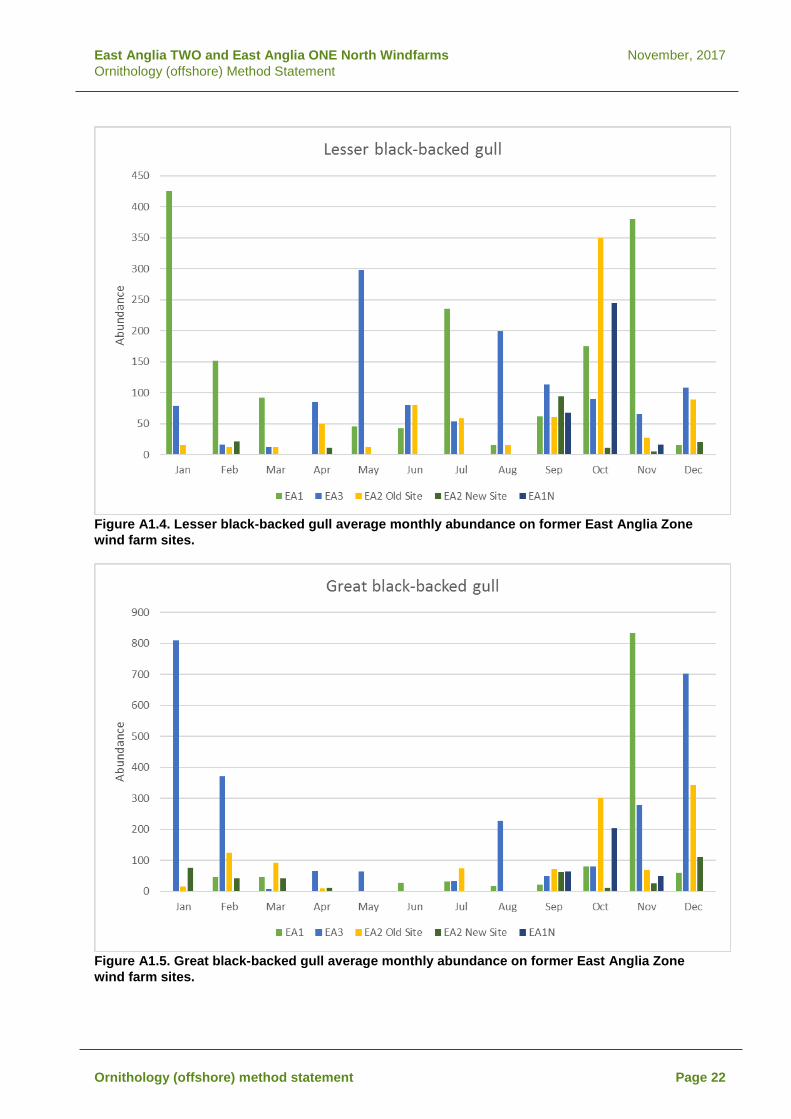
East Anglia TWO and East Anglia ONE North Windfarms November, 2017 Ornithology (offshore) Method Statement
Figure A1.4. Lesser black-backed gull average monthly abundance on former East Anglia Zone wind farm sites.
Figure A1.5. Great black-backed gull average monthly abundance on former East Anglia Zone wind farm sites.
Ornithology (offshore) method statement Page 22

East Anglia TWO and East Anglia ONE North Windfarms November, 2017 Ornithology (offshore) Method Statement
Figure A1.6. Herring gull average monthly abundance on former East Anglia Zone wind farm sites.
Figure A1.6. Guillemot average monthly abundance on former East Anglia Zone wind farm sites.
Ornithology (offshore) method statement Page 23

East Anglia TWO and East Anglia ONE North Windfarms November, 2017 Ornithology (offshore) Method Statement
Figure A1.7. Razorbill average monthly abundance on former East Anglia Zone wind farm sites.
Ornithology (offshore) method statement Page 24

East Anglia TWO and East Anglia ONE North Windfarms November, 2017 Ornithology (offshore) Method Statement
Appendix B The following table outlines comments in response to RSPBS formal response to revision 4 of the Ornithology Method Statement, received on the 30th of May. A letter containing the below table was issued to Ornithology ETG participants on the 15th of July 2017.
Question topic Aspect Proposed project response
Baseline data
One breeding season of data for EA2
Following consideration of comments received from NE and RSPB SPR have agreed that a surveys should be conducted over two breeding seasons (2017 and 2018). It is understood that this will satisfy the concerns raised on this matter.
Diving bird correction factor
Yes, the density and abundance estimates used in the assessment will incorporate the JNCC recommended adjustment
Data presentation and interpretation
Interpretation of monthly abundance of lesser black-backed gull
We accept that the seasonal patterns of abundance of lesser black-backed gull are less straightforward to interpret than for the other species recorded. However, it does appear that this species is most consistently present during the post-breeding period (Sep-Nov). Outside of this observations are generally much more variable, with occasional peaks recorded on one or other site in several months, but notably not across several sites in the same month. This indicates that breeding season activity on the sites is highly variable and suggests the sites are not of high importance for breeding season foraging.
Conclusions re data presentation
The RSPB have stated that they do not agree with the conclusion in the Baseline Data Review that there is a remarkable level of consistency across the survey data for the different sites. However, this position appears to be based solely on observations of lesser black-backed gull, since there are no comments raised on the other species in this respect in their response. Furthermore, we stand by this statement (of consistency) since a quick review of the monthly species plots in the review reveals these patterns are clearly the case. We accept that lesser black-backed gull are less clear than the other species (and this point was agreed and minuted by all parties in the EP meeting). In light of this it was agreed that a complete 24 months of surveys would be conducted for the assessment.
Assessment methods
Migration-free breeding season
We note RSPB's concerns regarding the assignment of overlap months to either migration or breeding. As stated in the documents provided before the meeting, we will consider the survey results for each species when deciding the most appropriate seasonal attribution. We are aware of the foraging ranges to breeding sites with potential connectivity and this will also factor in the determinations.
Ornithology (offshore) method statement Page 25

East Anglia TWO and East Anglia ONE North Windfarms November, 2017 Ornithology (offshore) Method Statement
Question topic Aspect Proposed project response
Potential Impacts
Anticipated ornithological impacts
The RSPB states that cumulative and in-combination impacts will also need to be considered. These will be included in the assessment.
Little gull connectivity with Gtr Wash pSPA This aspect will be discussed at future EP meetings.
Herring gulls from Alde Ore SPA
We will take advice from NE on the status of herring gull at this SPA and also consider the likelihood of impacts when determining the need to include this in the HRA.
Ornithology (offshore) method statement Page 26

East Anglia ONE North November, 2017 Scoping Report
Appendix 2.5 Marine Mammals Method Statement

East Anglia ONE North November, 2017 Scoping Report

East Anglia TWO and ONE North November, 2017 Marine Mammals Method Statement Rev 3
East Anglia TWO and East Anglia ONE North Offshore Wind Farms Evidence Plan Marine Mammal Method Statement Update- November 2017
Marine mammals EIA/HRA method statement

East Anglia TWO and ONE North November, 2017 Marine Mammals Method Statement Rev 3
REVISION CONTROL
Document Preparer Reviewer(s) Internal Legal
External Legal
Approver – Snr PM
Marine Mammal Method Statement Revision 1 28/03/2017
BK/JA TA/GS n/a n/a CW
Revision 2 08/05/2017
BK GS n/a n/a PP
Revision 3 22/09/2017
BK NA/TA PP
Marine mammals EIA/HRA method statement

East Anglia TWO and ONE North November, 2017 Marine Mammals Method Statement Rev 3
Table of contents
1 Introduction 1 1.1 Outline of this document 1 1.2 Objectives of the evidence plan process 1 1.3 Key Updates 2 1.4 Agreements made and consultation to date 3
2 Project Description 7 2.1 Indicative project timelines 8
3 Baseline Environment 11 3.1 Site specific surveys 11 3.2 Former East Anglia Zone Data 11 3.3 Other information and data sources 12 3.4 Species to be considered in the assessment 12 3.5 Reference populations 12 3.6 Species density estimates 14
4 Approach to Determining Impact Significance 15 4.1 Sensitivity 15 4.2 Value 15 4.3 Magnitude 16 4.4 Significance 16
5 Potential Impacts 19 5.1 Potential impacts during construction 19 5.2 Potential impacts during operation and maintenance 24 5.3 Potential impacts during decommissioning 26 5.4 Potential cumulative impacts 26 5.5 Potential transboundary impacts 29 5.6 Impacts to be included after ETG meeting 30
6 Information for HRA 30 6.1 HRA Screening 30 6.2 Approach to the HRA 30
7 References 33
Marine mammals EIA/HRA method statement

East Anglia TWO and ONE North November, 2017 Marine Mammals Method Statement Rev 3
Marine mammals EIA/HRA method statement

East Anglia TWO and ONE North November, 2017 Marine Mammals Method Statement Rev 3
1 Introduction 1.1 Outline of this document
1. This is an updated version of the Marine Mammals Method Statement (revision 2) submitted to stakeholders in May 2017 and agreed at the Marine Mammals Expert Topic Group (ETG) meeting held on the 30th of May, 2017. Project developments and agreements made with stakeholders since the Method Statement was issued have been incorporated in this revision so that this document is up to date at the time of submission. A list of changes since the original Method Statement was submitted is provided in Section 1.4.
2. The purpose of this document is to present background information and the proposed approach to assessing marine mammal sensitivities for the proposed East Anglia ONE North project and the proposed East Anglia TWO project Environmental Impact Assessments (EIA) and Habitat Regulations Assessments (HRA).
3. Revision 2 of this document was used to inform discussions at the marine mammal expert topic group (ETG) meeting held on 30th of May, 2017 which was attended by Natural England, The Wildlife Trust (TWT) and Whale and Dolphin Conservation Society (WDC). It provides a brief overview of the objectives of the Evidence Plan process with regard to marine mammals, introduction to the project as well as the project timelines.
4. This document also provides details of the proposed approach to gathering and analysing data for the marine mammal EIA. The aim of this document was to reach agreement that the approach outlined in this document was suitable for EIA and to highlight where further discussions maybe necessary for aspects where further information is required, prior to agreement on the approach. A list of agreements is provided in Section 1.4.
1.2 Objectives of the evidence plan process 5. The objectives of the evidence plan processes are described in the Evidence Plan
Process document previously provided to stakeholders but in brief, the aim of The Plan is to help to reduce the risk of the Project being delayed by issues relating to the EIA and HRA during the DCO application, by:
• Giving greater certainty to all parties on the amount and range of evidence that should be collected;
• Helping address and agree issues earlier on in pre-application, so robust and streamlined decisions can be taken;
• Focusing the evidence requirements so they are proportionate to the Projects’ potential impacts and costs to the Applicant are minimised; and
• Time and resource requirements are optimised for all parties.
6. An overview of the programme leading up to DCO submission for both East Anglia ONE North and East Anglia TWO is outlined in Table 1.
Marine mammals EIA/HRA method statement Page 1

East Anglia TWO and ONE North November, 2017 Marine Mammals Method Statement Rev 3
7. .Two scoping reports, one for each project, will be submitted in November 2017. After scoping, timescales for the two projects will diverge, with East Anglia ONE North expected to be approximately 12 months behind East Anglia TWO.
Table 1: Key project programme milestones Milestone EA2 EA1N
Pre-scoping consultation March-June 2017 March-June 2017
Geophysical survey campaign April-August 2017 April – August 2017
Submission of scoping reports (2x scoping reports)
November 2017 November 2017
Submission of PEI/Section 42 Consultation
November 2018 Q4 2019
DCO Application Submission 2019 2020
1.3 Key Updates 1.3.1 Evidence Plan Agreements
8. This is an updated version of the Marine Mammal Method Statement (revision 2) submitted to stakeholders in May 2017 and agreed at the Marine Mammal Expert Topic Group (ETG) meeting held on the 30th of May, 2017. The Method Statement outlined the approach to EIA and data gathering was discussed through the Marine Mammal Expert Topic Group (ETG) during an Evidence Plan meeting on the 30th of May 2017. Comments on the Method Statement, meeting minutes and an agreement log were provided by Natural England, TWT and WDC, these comments are provided in Section 1.4. This version of the Method Statement has been updated to include agreements made since the 30th of May.
1.3.2 Export Cable Corridor 9. In August 2017, ScottishPower Renewables (SPR) confirmed that they would be
applying for a Grid Connection point near Sizewell in Suffolk rather than a connection at Bramford. Therefore a new offshore export cable corridor would be required. A briefing note was provided to Evidence Plan Process stakeholders in August 2017 outlining the new offshore export cable corridor and updated approach to EIA. Comments on the briefing note and cable corridor have been received from Natural England, The Wildlife Trust and MMO.
10. This Method Statement has been updated to include;
• Details of the East Anglia TWO export cable corridor Area of Search (AoS) and East Anglia ONE North cable corridor AoS.
• Updated EIA methodology as outlined in the briefing note
• Comments/agreements received in response to the briefing note.
Marine mammals EIA/HRA method statement Page 2

East Anglia TWO and ONE North November, 2017 Marine Mammals Method Statement Rev 3
1.3.3 Preliminary Project Parameters 11. In addition to the revised export cable corridor AoS, the following project parameters
have been updated since the Method Statement was submitted in March 2017;
• 7MW wind turbines have been discounted. The smallest wind turbine will be 12MW
• Maximum number of turbines has been reduced from 115 to 75 (East Anglia TWO) and 67 (East Anglia ONE North).
• 19MW turbines have been included, although these will have the same physical parameters as the 15MW turbines previously communicated.
• The total capacity of the proposed East Anglia TWO offshore windfarm will be 900MW and the capacity of East Anglia ONE North will be 800MW.
12. The 7MW turbine previously represented the worst case scenario in terms of number of turbine foundations, as turbine foundation numbers have been reduced, impacts to marine mammal receptors are anticipated to be less than previously considered.
13. A full list of project parameters is provided in Section 1.5 of the East Anglia TWO Offshore Windfarm Scoping Report and Section 1.5 of the East Anglia ONE North Offshore Windfarm Scoping Report.
1.4 Agreements made and consultation to date 14. An agreements log was included in the meeting minutes from the ETG meeting held
on the 30th of May. The agreement log outlined all agreements sought either through the Method Statement or discussions within the meeting with the aim of capturing all agreements and disagreements.
15. Natural England, TWT and WDC provided comments via an agreement log, comments are provided in Table 2.
Table 2 Agreements log from meeting minutes from ETG meeting on the 30th of May Comment/agreements
Statement Natural England
WDC TWT MMO
Site specific survey methodology is appropriate.
Agreed (07/06/2017)
WDC agree with the methodology outlined (08/06/2017).
TWT is content with the approach (08/06/2017).
Agreed (15/06/2017)
24 months of site specific surveys are appropriate to inform the baseline.
Agreed (07/06/2017)
WDC agree that 24 months is appropriate as a minimum for baseline data. (08/06/2017).
TWT is content with 24 months of surveys (08/06/2017)..
Agreed (15/06/2017)
The approach to EIA assessment as outlined in the method statement is broadly acceptable.
Agreed (07/06/2017)
WDC have concerns over the magnitude thresholds given in the Method Statement. We are aware that these are based on guidance from JNCC; however we have yet to see the JNCC documentation and the science upon which these figures are based. As we have
TWT has not seen the JNCC et al 2010 guidance as outlined in paragraph 45. Until we have reviewed this guidance to understand the
Agreed (15/06/2017)
Marine mammals EIA/HRA method statement Page 3
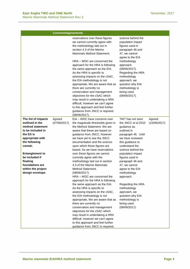
East Anglia TWO and ONE North November, 2017 Marine Mammals Method Statement Rev 3
Comment/agreements
reservations over these figures we cannot currently agree with the methodology laid out in section 4.3 of the Marine Mammals Method Statement. HRA – WDC are concerned the approach for the HRA is following the same approach as the EIA. As the HRA is specific to assessing impacts on the cSAC, the EIA methodology is not appropriate, We are aware that as there are currently no conservation and management objectives for the cSAC which may result in undertaking a HRA difficult, however we can’t agree to this approach and feel further guidance from JNCC is required. (08/06/2017).
science behind the population impact figures used in paragraph 46 and 47, we cannot agree to the EIA methodology approach. (08/06/2017). Regarding the HRA methodology approach, we question why EIA methodology is being used. (08/06/2017).
The list of impacts outlined in the method statement to be included in the ES is appropriate with the following caveat; Entanglement to be included if floating foundations are within the project design envelope.
Agreed (07/06/2017)
EIA – WDC have concerns over the magnitude thresholds given in the Method Statement. We are aware that these are based on guidance from JNCC; however we have yet to see the JNCC documentation and the science upon which these figures are based. As we have reservations over these figures we cannot currently agree with the methodology laid out in section 4.3 of the Marine Mammals Method Statement. (08/06/2017). HRA – WDC are concerned the approach for the HRA is following the same approach as the EIA. As the HRA is specific to assessing impacts on the cSAC, the EIA methodology is not appropriate, We are aware that as there are currently no conservation and management objectives for the cSAC which may result in undertaking a HRA difficult, however we can’t agree to this approach and feel further guidance from JNCC is required.
TWT has not seen the JNCC et al 2010 guidance as outlined in paragraph 45. Until we have reviewed this guidance to understand the science behind the population impact figures used in paragraph 46 and 47, we cannot agree to the EIA methodology approach. Regarding the HRA methodology approach, we question why EIA methodology is being used. (08/06/2017).
Agreed (15/06/2017)
Marine mammals EIA/HRA method statement Page 4

East Anglia TWO and ONE North November, 2017 Marine Mammals Method Statement Rev 3
16. A response to WDC and TWTs comments was provided via email on the 21/06/2017. A copy of the requested JNCC 2010 EPS guidance was provided to WDC and TWT. The following response in relation to the EIA and HRA methodology was provided – “With regard to the HRA the initial approach mirrors the EIA in terms of defining effects/impacts and determining the sensitivity, magnitude etc. The HRA then takes this a step further by looking at those effects in relation to the conservation objectives for sites and features. Thus whilst for the EIA we may make an assessment in terms of the biogeographic population for harbour porpoise (e.g. the North Sea Management Unit population), for the HRA we are looking more at the effects that can be specifically attributed or apportioned to a particular site (exactly as happens for ornithology assessments). Apportionment may also affect the projects included for in-combination effects (as there needs to be a demonstrable pathway to the site), but again the general approach remains the same as for the cumulative assessment in the EIA. We will use the most current advice on the Harbour Porpoise cSAC Conservation Objectives and management measures as available.”
17. Several further comments were received from jointly from TWT and Suffolk Wildlife
Trust (SWT) in relation to both the Revision 2 of the method statement and the offshore cable corridor briefing note. The queries and responses are provided in Table 3.
Marine mammals EIA/HRA method statement Page 5

East Anglia TWO and ONE North November, 2017 Marine Mammals Method Statement Rev 3
Table 3 Comments received from TWT and SWT Comment Response Marine Mammals Method Statement (revision 2) Please could you provide a reference for how the temporary effect population numbers have been determined in Table 7 of the Marine Mammal method statement
The definition of how magnitude has been defined if provided in the Method Statement- "The thresholds for each category defining the potential magnitude of effect that can occur from a particular impact have been determined using expert judgement, current scientific understanding of marine mammal population biology, and JNCC et al. (2010) draft guidance on disturbance to EPS species." The number of animals that can be ‘removed’ through disturbance will vary between species, but is largely dependent on the growth rate of the population; populations with low growth rates can sustain the removal of a smaller proportion of the population. For most species of cetacean there is a large amount of uncertainty as to the growth rate of the population, but JNCC et al. (2010) consider that it is generally accepted that for cetaceans the population growth rates will be lower than 10% per year. The Guidance states that: “An IWC/ASCOBANS workshop in 2000 recommended that 4% a year should be used as a conservative estimate of the maximum potential growth rate for harbour porpoise. This value is generally accepted as the default for cetaceans and in the absence of better information is considered a reasonable measure that could be used”. The JNCC et al. (2010) draft guidance provides limited consideration of temporary effects, with guidance reflecting consideration of permanent displacement. In this assessment temporary effects are considered to be of medium magnitude at greater than 5% of the reference population being affected within a year. JNCC et al. (2010) draft guidance considered 4% as the maximum potential growth rate in harbour porpoise, and the ‘default’ rate for cetaceans. Therefore, beyond natural mortality, up to 4% of the population could theoretically be permanently removed before population growth could be halted. In assigning 5% to a temporary impact in this assessment, consideration is given to uncertainty of the individual consequences of temporary disturbance. This methodology to define magnitude was used for previous OWF ESs, including Dogger Bank, EA3 and is in line with recent scoping reports for Thanet and Vanguard.
Offshore cable corridor briefing note No further marine mammal monitoring: are there plans to install any booster stations along the cable route and if so, what marine mammals data will be used for this assessment?
There are no plans to install electrical platforms within the offshore export cable route and cable installation is the only construction activity planned within the export cable corridor, there would be no requirement for piling. The marine mammal assessment of the export cable corridor will be undertaken separately from the wind farm assessment and will be based on publically available data including (but not be limited to) SCANS data, seal density maps (Jones et al., 2015) and local seal count data where available. There is also a large amount of data available for the former zone and site specific data for EA1N and EA2 which will be used to provide context for the offshore export cable area.
Marine mammals EIA/HRA method statement Page 6

East Anglia TWO and ONE North November, 2017 Marine Mammals Method Statement Rev 3
2 Project Description 18. East Anglia TWO windfarm site covers an area of approximately 257km2 with an
anticipated capacity of 600MW to 900MW. At its nearest point, East Anglia TWO is 31km from Lowestoft and 32km from Southwold. The project boundary has been delineated by the Outer Thames SPA to the North, proximity to East Anglia ONE at approximately 5.5nm to the East, shipping and navigation activity, as well as the proximity to Galloper Wind Farm (approximately 3.5nm), to the South and the former East Anglia Zone boundary to the West.
19. East Anglia ONE North windfarm site covers an area of approximately 208km2 with an anticipated capacity of 600MW to 800MW. At its nearest point, East Anglia ONE North is 36km from Lowestoft and 42km from Southwold. The project boundary has been delineated by cables to the north, a deep water shipping route to the East, the East Anglia ONE boundary to the South and designations and shipping activity to the West.
20. The following offshore infrastructure is expected to be included within the Rochdale envelope for both East Anglia One North and East Anglia TWO:
• up to 75 turbines (East Anglia TWO); 67 turbines (East Anglia One North);
• options for • jacket/tripod; • concrete gravity base; • monopile; and • steel suction caisson foundations.
• up to five offshore electrical platforms, connected by cables, consideration will be given to use of offshore transformer modules;
• Subsea cables between offshore platforms (both within East Anglia TWO windfarm site (platform-link cables) and potentially platforms of other offshore windfarms (interconnector cables)),
• high voltage electrical cables (export cables) from the windfarm are to the landfall point onshore and then from there on to the connection point to the National Grid network;
• an offshore accommodation module; and • up to one meteorological masts.
21. The location of East Anglia ONE North and East Anglia TWO windfarms is presented in Figure 1 and Figure 2. Parameters, against which the EIA will be based, for each windfarm are provided in Table 4 below:
Marine mammals EIA/HRA method statement Page 7

East Anglia TWO and ONE North November, 2017 Marine Mammals Method Statement Rev 3
Table 4: Preliminary project parameters
Parameter East Anglia TWO East Anglia ONE North
Capacity (MW) Up to 900 Up to 800
Windfarm area (km2) 257 208km2 Distance from site to shore (Lowestoft) (km)
31 36
Water depth (m) 30 - 72 33 - 59 Number of turbines Up to 75 Up to 67 Proposed turbine capacity 12 – 19MW 12 – 19MW Number of substations Up to 6 Up to 6 Number of met masts Up to 2 Up to 2 Number of export cables 2 2 Landfall Sizewell Sizewell
2.1 Indicative project timelines
22. Table 3 below provides indicative dates for project milestones as outlined in the Evidence Plan.
Table 5 Indicative project timelines
Date Event November 2015 EA2 site specific aerial ornithology and marine mammal survey
commence September 2016 EA1N site specific aerial ornithology and marine mammal survey
commence May 2017 Marine mammals ETG meeting 1
Project Introduction Evidence Plan Process Proposed approach to baseline information and impact assessment
November 2017 EA1N and EA2 Scoping report submission February/March 2018 Marine mammals ETG meeting 2:
It is anticipated the following points will be discussed, however, an appropriate agenda will be decided at the time of the meeting; EA2 Baseline survey results Approach to HRA Approach to cumulative impact assessment
August 2018 Completed Final EA2 and EA1N site specific surveys September 2018 ETG Meeting 3 (if required) – to discuss final survey data and draft
HRA November 2018 EA2 PEI and Draft HRA submitted Jan 2019 Marine mammals ETG meeting 3:
Post-PEI ETG meeting to discuss any outstanding issues for EA2 prior to submission and confirm approach for EA1N remains valid.
2019 EA2 DCO submission November 2019 EA1N PEI and draft HRA Q1 2020 EA1N DCO submission
Marine mammals EIA/HRA method statement Page 8

East
Ang
lia T
WO
and
ON
E N
orth
N
ovem
ber,
2017
M
arin
e M
amm
als
Met
hod
Sta
tem
ent R
ev 3
Figu
re 1
Eas
t Ang
lia O
NE
Nor
th w
indf
arm
site
s an
d ex
port
cab
le c
orrid
or A
rea
of S
earc
h an
d su
rvey
dat
a co
vera
ge
Mar
ine
mam
mal
s EI
A/H
RA
met
hod
stat
emen
t Pa
ge 9
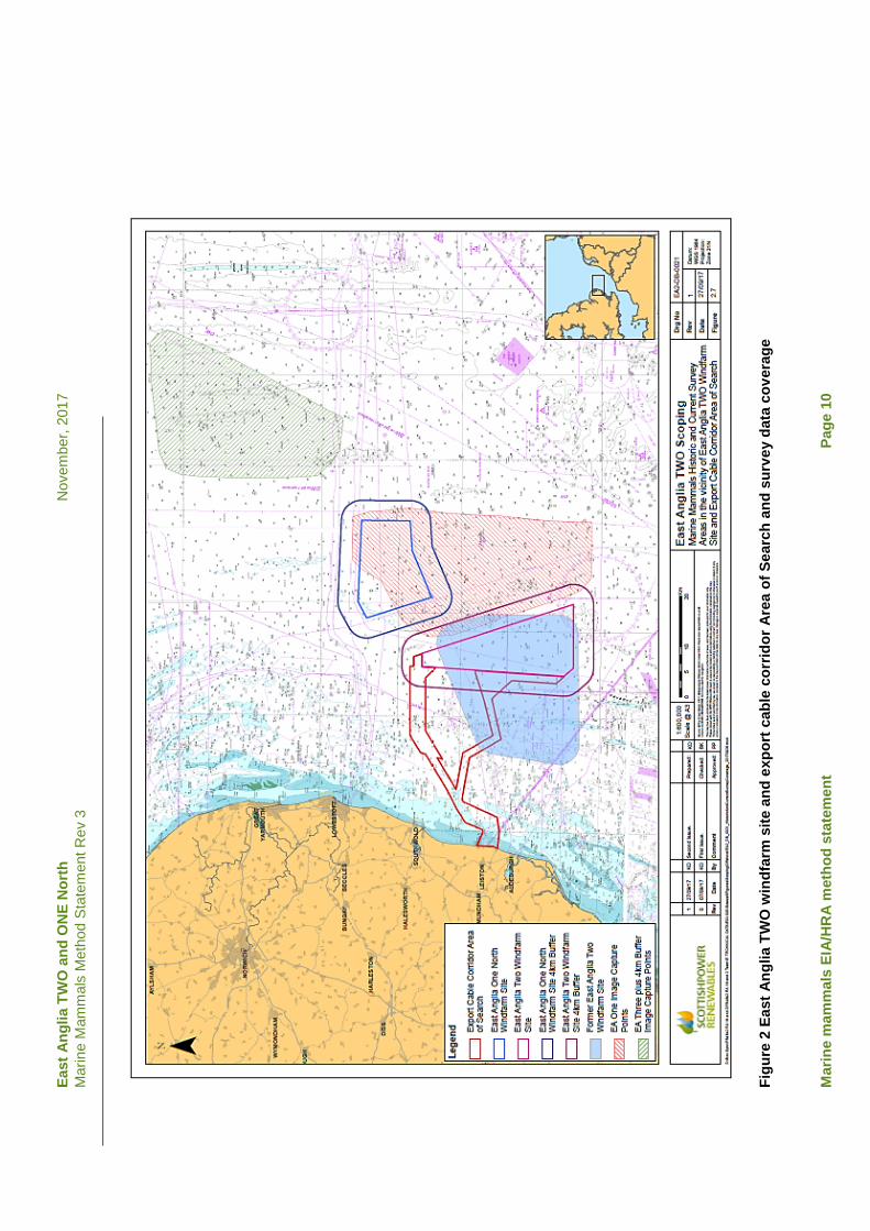
East
Ang
lia T
WO
and
ON
E N
orth
N
ovem
ber,
2017
M
arin
e M
amm
als
Met
hod
Sta
tem
ent R
ev 3
Figu
re 2
Eas
t Ang
lia T
WO
win
dfar
m s
ite a
nd e
xpor
t cab
le c
orrid
or A
rea
of S
earc
h an
d su
rvey
dat
a co
vera
ge
Mar
ine
mam
mal
s EI
A/H
RA
met
hod
stat
emen
t Pa
ge 1
0

East Anglia TWO and ONE North November, 2017 Marine Mammals Method Statement Rev 3
3 Baseline Environment 3.1 Site specific surveys
23. The primary data source for each project will be from aerial digital surveys conducted by APEM. The site specific surveys for East Anglia ONE North and TWO are:
• East Anglia TWO windfarm site: • Site specific survey aerial (digital still) from November 2015 to April
2016. • Site specific survey aerial (digital still) from September 2016 to October
2017. • Site specific survey aerial (digital still) from May 2018 to August 2018. • In total, 24 months of survey data would be used in the final ES
assessment. • East Anglia ONE North windfarm site:
• Site specific survey aerial (digital still) from September 2016 to August 2018 (24 months of survey).
24. Aerial surveys of the East Anglia ONE North and East Anglia TWO windfarm sites cover the entire windfarm area with a 4km buffer for each site.
3.2 Former East Anglia Zone Data
25. A number of surveys have been undertaken within the former East Anglia Zone since 2009. The marine mammal survey data that has been collected is summarised in Table 4 and shown in relation to East Anglia ONE North windfarm site in Figure 1 and in relation to the East Anglia TWO windfarm site in Figure 2.
Table 6: Summary of marine mammal survey data available for the East Anglia zone Time Range Spatial extent/ Project Survey Type Overlap with EA1N/EA2
windfarm sites Nov 2009-Mar 2011 Zone Aerial video (Nov 2009-March
2010) Yes- 100% (except part of EA2 4km buffer)
Aerial digital still (April 2010- March 2011)
Yes- 100% (except part of EA2 4km buffer)
Nov 2009- Oct 2011 East Anglia ONE Aerial video (Nov 2009-March 2010)
Partial overlap with EA1N (46%)
Boat based survey (May 2010-Apr 2011)
Partial overlap with EA1N
Aerial digital still (April 2010-October 2011)
Partial overlap with EA1N
Sept 2011- Dec 2012
Former East Anglia TWO Aerial digital still (Sept 2011-Dec 2012)
Partial overlap with EA2 (92%)
Sept 2011- Aug 2013
East Anglia THREE Aerial digital still (Sept 2011-Aug 2013)
No overlap
Marine mammals EIA/HRA method statement Page 11

East Anglia TWO and ONE North November, 2017 Marine Mammals Method Statement Rev 3
3.3 Other information and data sources
26. In addition to the site specific surveys and existing survey data from the former East Anglia Zone, further relevant information and other data sources will also be used to inform the marine mammal baseline for the East Anglia ONE North and TWO windfarm sites. Publications and data sources include (but will not be limited to):
• Revised Phase III data analysis of Joint Cetacean Protocol (JCP) data resources (Paxton et al., 2016);
• The identification of discrete and persistent areas of relatively high harbour porpoise density in the wider UK marine area (Heinänen and Skov, 2015);
• Small Cetaceans in the European Atlantic and North Sea (SCANS) Cetacean abundance and distribution in European Atlantic shelf waters to inform conservation and management (Hammond et al., 2013) and SCANS III data.;
• Atlas of Cetacean distribution in northwest European waters (Reid et al., 2003); • Management Units for cetaceans in UK waters (IAMMWG, 2015); • UK grey and seal usage maps (Jones et al., 2016); and • Special Committee on Seals (SCOS) annual reporting of scientific advice on
matters related to the management of seal populations (latest versions).
3.4 Species to be considered in the assessment 27. Based on previous assessment for East Anglia ONE and East Anglia THREE, the key
species that will be assessed for East Anglia ONE North and East Anglia TWO windfarm sites are:
• Harbour porpoise; • Grey seal; • Harbour seal.
28. Other marine mammal species that could be present within the East Anglia ONE
North and East Anglia TWO windfarm sites, include dolphin species, such as white-beaked dolphin and minke whale. However, currently available information suggests that the occurrences of these species are likely to be infrequent. It is therefore anticipated that these three key species will be the focus of the assessment.
3.5 Reference populations 3.5.1 Cetaceans
29. The reference populations for cetacean species in the EIA will be based on the IAMMWG agreed Management Units (MUs) and the most recent estimates of population size for these MUs (IAMMWG, 2015).
30. For harbour porpoise the proposed reference population is the North Sea Management Unit (MU) (IAMMWG, 2015; Figure 3). The North Sea MU currently has an estimated reference population of 227,298 harbour porpoise (Coefficient of Variance (CV) 0.13, 95% Confidence Interval (CI) 176,360 – 292,948; IAMMWG, 2015).
Marine mammals EIA/HRA method statement Page 12

East Anglia TWO and ONE North November, 2017 Marine Mammals Method Statement Rev 3
31. It is intended that proposed East Anglia TWO project PEI, which will be submitted for consultation in July 2018 and will provide a draft version of the marine mammals ES chapter. Any updates to the size and spatial extent of reference populations will be incorporated into the assessment until PEI consultation is completed. Any updates to size and spatial extent of reference populations after proposed East Anglia TWO Project PEI will be taken into account for the proposed East Anglia ONE North project PEI.
Figure 3: Harbour porpoise management units (IAMMWG, 2015).
3.5.2 Pinnipeds 32. In accordance with the approach agreed with Natural England for other offshore wind
farms in the former East Anglia Zone, the proposed reference population extent for grey seal will incorporate the South-east England, North-east England and East Coast IAMMWG MUs (IAMMWG, 2013) and the Waddenzee population.
33. The grey seal reference population will be based on the most recent estimate of the Dutch Waddenzee population (e.g. TSEG 2016 or the most recent publication) and the most recent counts for the South-east England MU, the north-east England MU and the east Coast Scotland MU (e.g. SCOS 2016 or the most recent publication).
34. Similarly for harbour seal and in accordance with the approach agreed with Natural England for other offshore wind farms in the former East Anglia Zone the proposed reference population extent for harbour seal will incorporate the South-east England IAMMWG MU (IAMMWG, 2013) and the Waddenzee population.
Marine mammals EIA/HRA method statement Page 13

East Anglia TWO and ONE North November, 2017 Marine Mammals Method Statement Rev 3
35. The harbour seal reference population will be based on the most recent estimate of the Dutch Waddenzee population (e.g. TSEG 2015 or the most recent publication) and the most recent counts for the South-east England MU (e.g. SCOS 2016 or the most recent publication).
3.6 Species density estimates
36. As far as possible, site specific density estimates will be calculated for the cetacean and seal species recorded during the aerial surveys of the East Anglia ONE North and East Anglia TWO windfarm sites, separately.
37. For harbour porpoise, site specific density estimates will be determined from the APEM aerial survey data for harbour porpoise sightings as well as harbour porpoise and dolphin/porpoise sightings combined. The highest harbour porpoise density estimate from the site specific surveys at each site (number of individuals / km2) will be used in the assessment.
SCANS III survey results from the 2016 North Sea aerial surveys have now been released. East Anglia ONE North and East Anglia TWO windfarm sites are within Survey Block L. Results from Survey Block L SCANS III reports are as follows ; 38. Harbour porpoise;
a. Abundance of 19,064. b. Density of 0.607.
39. White beaked dolphin (not recorded in Survey Block L, adjacent survey Block O results below) ;
a. Abundance of 143 b. Density of 0.002.
40. Minke (not recorded in Survey Block L, adjacent survey Block O results below);
a. Abundance of 603 b. Density of 0.010.
41. The latest JCP data (Paxton et al., 2016) and SCANS III data will be used to put the
harbour porpoise site specific density estimates into context for the wider area.
42. If there is insufficient data to estimate site specific density estimates for grey and harbour seal, it is proposed to use the latest SMRU seals at sea data (Jones et al., 2016) to determine grey seal and harbour seal density estimates for the East Anglia ONE North and East Anglia TWO sites, separately.
43. If required, it is proposed to use the latest SCANS III and / or JCP data to determine any dolphin species and minke whale density estimates for the for the East Anglia ONE North and East Anglia TWO sites, separately.
Marine mammals EIA/HRA method statement Page 14

East Anglia TWO and ONE North November, 2017 Marine Mammals Method Statement Rev 3
4 Approach to Determining Impact Significance
44. A matrix approach will be used to assess potential impacts following best practice, EIA guidance and the approach previously agreed with stakeholders for other recent offshore wind farms (e.g. East Anglia THREE). Receptor sensitivity for an individual from each marine mammal species will be defined within the ES, following the definitions set out in Section 4.
45. the assessment will take into account the ‘value’ of the marine mammal species based on its legislative importance as outlined in Table 6. The potential magnitude of effect will be described for permanent and temporary outcomes, as detailed in Table 7. The significance of impacts will be assessed using the matrix presented in Table 6. Impacts determined to be major or moderate represent those with the potential to be significant in EIA terms.
4.1 Sensitivity 46. The sensitivity of a receptor is determined through its ability to accommodate change
and reflects on its ability to recover if it is affected. The sensitivity level of marine mammals to each type of impact will be determined and justified within the impact assessment and is dependent on the following factors:
• Adaptability – The degree to which a receptor can avoid or adapt to an effect; • Tolerance – The ability of a receptor to accommodate temporary or permanent
change without a significant adverse effect; • Recoverability – The temporal scale over and extent to which a receptor will
recover following an effect; and • Value – A measure of the receptors importance, rarity and worth (see below).
47. The sensitivity of marine mammals to impacts from pile driving noise is currently the
impact of most concern across the offshore wind sector. The sensitivity to potential impacts of any lethal effects, physical injury, auditory injury or hearing impairment, as well as behavioural disturbance or auditory masking will be considered for each species, using available evidence including published data sources.
48. Table 7 provides definitions of the sensitivity levels to be used in the assessments for marine mammal species.
4.2 Value
49. The ‘value’ of the receptor forms an important element within the assessment, for instance, if the receptor is a protected species or habitat or has an economic value. It is important to understand that high value and high sensitivity are not necessarily linked within a particular impact. A receptor could be of high value but have a low or negligible physical/ecological sensitivity to an effect. Similarly, low value does not equate to low sensitivity and is judged on a receptor by receptor basis.
Marine mammals EIA/HRA method statement Page 15

East Anglia TWO and ONE North November, 2017 Marine Mammals Method Statement Rev 3
50. In the case of marine mammals, a large number of species fall within legislative policy; all cetaceans in UK waters are European Protected Species (EPS) and, therefore, are internationally important. Harbour porpoise, bottlenose dolphin, grey seal and harbour seal are also afforded international protection through the designation of Natura 2000 sites, which they are a primary reason for site selection. Table 8 provides definitions for the value afforded to a receptor based on its legislative importance.
51. The value will be considered, where relevant, as a modifier for the sensitivity assigned to the receptor, based on expert judgement. It is important not to inflate impact significance simply because a feature is ‘valued’.
4.3 Magnitude
52. The thresholds for each category defining the potential magnitude of effect that can occur from a particular impact have been determined using expert judgement, current scientific understanding of marine mammal population biology, and JNCC et al. (2010) draft guidance on disturbance to EPS species. The JNCC et al. (2010) EPS draft guidance suggests definitions for a ‘significant group’ of individuals or proportion of the population for EPS species. As such this guidance has been considered in defining the thresholds for magnitude of effects.
53. Temporary effects are considered to be of medium magnitude at greater than 5% of the reference population. JNCC et al. (2010) draft guidance considered 4% as the maximum level of mortality that could be sustained by a population of most species of cetacean. Furthermore, JNCC considers either 2% or 4% a suitable threshold for determine significance of disturbance in species or populations with Favourable Conservation Status (FCS). In assigning 5% to a temporary impact in this assessment, consideration is given to uncertainty of the individual consequences of temporary disturbance.
54. For permanent effects, greater than 1% of the reference population is considered to be high magnitude in this assessment. The assignment of these levels is informed by the JNCC et al. (2010) draft guidance (suggesting between 2% and 4% as being significant) but also reflects the large amount of uncertainty in the potential individual and population level consequences of permanent effects, and what may be considered as the potential rate of increase in a population.
55. Table 9 provides the definitions of the magnitude levels for marine mammals that are proposed to be used in the assessments.
4.4 Significance 56. Following the identification of receptor sensitivity, value and the magnitude of the
effect, the impact significance will be determined using expert judgement. The matrix (provided in Table 10) will be used as a framework to aid determination of the impact assessment. Definitions of impact significance are provided in Table 11.
Marine mammals EIA/HRA method statement Page 16

East Anglia TWO and ONE North November, 2017 Marine Mammals Method Statement Rev 3
57. For the purposes of the marine mammal assessment, ‘major’ and ‘moderate’ impacts are deemed to be significant. However, whilst ‘minor’ impacts would not be deemed significant in their own right, they may contribute to significant impacts cumulatively or through inter-relationships.
Table 7: Definitions of sensitivity levels for marine mammals Sensitivity Definition High Individual receptor has very limited capacity to avoid, adapt to, accommodate or
recover from the anticipated impact. Medium Individual receptor has limited capacity to avoid, adapt to, accommodate or
recover from the anticipated impact. Low Individual receptor has some tolerance to avoid, adapt to, accommodate or
recover from the anticipated impact. Negligible Individual receptor is generally tolerant to and can accommodate or recover from
the anticipated impact. Table 8: Definitions of the value levels for marine mammals Value Definition High Internationally or nationally important
Medium Regionally important or internationally rare Low Locally important or nationally rare Negligible Not considered to be particularly important or rare Table 9: Definitions of magnitude levels for marine mammals Magnitude of effect
Definition
High Permanent irreversible change to exposed receptors or feature(s) of the habitat which are of particular importance to the receptor. Assessment indicates that >1% of the reference population are anticipated to be exposed to the effect per year. OR Temporary effect (limited to stage of development (i.e. construction, operation or decommissioning)) to the exposed receptors or feature(s) of the habitat which are of particular importance to the receptor. Assessment indicates that >10% of the reference population are anticipated to be exposed to the effect per year.
Medium Permanent irreversible change to exposed receptors or feature(s) of the habitat of particular importance to the receptor. Assessment indicates that >0.01% or <=1% of the reference population anticipated to be exposed to effect per year. OR Temporary effect (limited to stage of development (i.e. construction, operation or decommissioning)) to the exposed receptors or feature(s) of the habitat which are of particular importance to the receptor. Assessment indicates that >5% or <=10% of the reference population anticipated to be exposed to effect per year.
Marine mammals EIA/HRA method statement Page 17

East Anglia TWO and ONE North November, 2017 Marine Mammals Method Statement Rev 3
Magnitude of effect
Definition
Low Permanent irreversible change to exposed receptors or feature(s) of the habitat of particular importance to the receptor. Assessment indicates that >0.001 and <=0.01% of the reference population anticipated to be exposed to effect per year. OR Intermittent and temporary effect (limited to stage of development (i.e. construction, operation or decommissioning)) to the exposed receptors or feature(s) of the habitat which are of particular importance to the receptor. Assessment indicates that >1% or <=5% of the reference population anticipated to be exposed to effect per year.
Negligible Permanent irreversible change to exposed receptors or feature(s) of the habitat of particular importance to the receptor. Assessment indicates that <=0.001% of the reference population anticipated to be exposed to effect per year. OR Intermittent and temporary effect (limited to stage of development (i.e. construction, operation or decommissioning)) to the exposed receptors or feature(s) of the habitat which are of particular importance to the receptor. Assessment indicates that <=1% of the reference population anticipated to be exposed to effect per year.
Beneficial Temporary or permeant impact where it is possible to demonstrate a benefit to the receptor.
Table 10 Impact significance matrix
Receptor sensitivity Magnitude of effect High Medium Low Negligible
High Major Major Moderate Minor Medium Major Moderate Minor Minor Low Moderate Minor Minor Negligible Negligible Minor Negligible Negligible Negligible
Marine mammals EIA/HRA method statement Page 18

East Anglia TWO and ONE North November, 2017 Marine Mammals Method Statement Rev 3
Table 11: Definitions of impact significance levels for marine mammals Impact significance
Definition
Major Very large or large change in receptor, either adverse or beneficial, which are important at a population (national or international) level because they contribute to achieving national or regional objectives, or, expected to result in exceedance of statutory objectives and / or breaches of legislation.
Moderate Intermediate or large change in receptor, which may to be important considerations at national or regional population level. Potential to result in exceedance of statutory objectives and / or breaches of legislation.
Minor Small change in receptor, which may be raised as local issues but are unlikely to be important at a regional population level.
Negligible No discernible change in receptor.
5 Potential Impacts 58. An initial assessment of the proposed developments has identified the following list of
potential impacts for marine mammals that will be considered within the Scoping Report, and where impacts are not scoped out, fully assessed within the EIAs and HRAs for proposed East Anglia ONE North Project and proposed East Anglia TWO Project.
5.1 Potential impacts during construction
5.1.1 Impact 1: Underwater noise from pile driving 59. Underwater noise from pile driving has the potential to adversely impact marine
mammals. These impacts can range from behavioural disturbance, auditory injury, physical injury and in extreme cases, to lethal effects (e.g. Nedwell et al., 2007; Southall et al., 2007).
60. The potential impacts from underwater noise during pile driving will depend on several factors, including but not limited to:
• The source levels of noise, which will vary with factors such as: o Foundation type; o Foundation size; and o Installation method.
• The spatial footprint of the impact as a feature of noise propagation conditions which will depend on:
o Sediment/sea floor composition; o Water depth; and o The sensitivity of marine mammal species present in the area.
Marine mammals EIA/HRA method statement Page 19

East Anglia TWO and ONE North November, 2017 Marine Mammals Method Statement Rev 3
5.1.1.1 Approach to assessment 61. Noise modelling will be undertaken to define the areas of potential impact that could
result from the piling of foundations. A full method statement for undertaking the underwater noise assessment will be presented to the ETG separately. A summary of parameters which will be considered in the noise modelling is presented below.
62. The underwater noise modelling will take into account the worst-case scenarios for foundation type and installation methods and will be based on the worst-case parameters, such as maximum pile diameter and maximum hammer energy that could be considered in the design envelope.
63. The underwater noise modelling will also be based on the worst-case scenarios for underwater noise propagation, which will be identified using available data including, bathymetry and an empirical database based on observed data from a large range of foundation installations.
64. Modelling of underwater noise from piling activity will be undertaken to identify the worst-case spatial footprint for underwater noise at agreed thresholds (for example Southall et al., 2007; Lucke et al., 2009; NMFS, 2016). The thresholds and criteria to be used in the assessment will be discussed and agreed through the Evidence Plan Process.
65. The worst-case temporal impacts (duration of piling) for different scenarios will also be assessed.
66. Modelling of underwater noise will consider various stages (and hammer energies) of the piling process. Increments considered will be:
• Initial hammer energy at first strike (start of soft start); • The overall ramp up process; • Hammer energy at 50% of maximum hammer energy; • Hammer energy at 75% of maximum hammer energy; and • Hammer energy at 100% of maximum hammer energy.
67. Noise modelling will also consider the following scenarios:
• Noise propagation from a single piling vessel; • Noise propagation from multiple piling vessels; • Cumulative noise exposure; and • Maximum potential overlap (single and concurrent piling) with the Southern North
Sea cSAC.
68. The noise modelling will be used to determine the maximum possible ranges for the following potential impacts:
• Permanent threshold shift (PTS); • Temporary threshold shift (TTS); and • Behavioural disturbance.
Marine mammals EIA/HRA method statement Page 20

East Anglia TWO and ONE North November, 2017 Marine Mammals Method Statement Rev 3
69. Noise modelling will also be undertaken to determine impacts to prey species where possible. These will be assessed in the Fish and Shellfish EIA.
70. The noise modelling for pile driving will provide the ranges and areas for potential impacts (PTS, TTS and disturbance) for each species group. These areas will be used to calculate the potential number of individuals for each species, based on the agreed density estimates (Section 3.6). The number of individuals for each species that could potentially be impacted will be considered as a proportion of the appropriate reference population (Section 3.5). Assessment of potential impacts on designated sites will be undertaken in accordance to best available information on management measures at the time of writing as part of the HRA.
71. Magnitudes and sensitivities for the determination of significance will be based on the best available evidence as discussed within the Marine Mammals Expert Topic Group and subject to a cut-off period after which revisions to the assessment will not be possible.
72. Assessments will be made taking into account embedded and proposed mitigation which will be discussed and agreed with the ETG.
5.1.2 Impact 2: Underwater noise from vessels and other offshore construction activities
73. Underwater noise from construction vessels, as well as construction activities such as seabed preparation, rock dumping and cable installation also have the potential to impact marine mammals.
5.1.2.1 Approach to assessment 74. The assessment of potential impacts from vessels and other construction activities
will be assessed using up to date scientific knowledge. Vessels that are likely to be used during the construction period will be identified and the noise emissions of those vessels used to determine the potential impact of vessel noise to marine mammal receptors. Consideration will also be given to existing shipping on site, which will be outlined in the EIA (shipping and navigation chapter) based on historical and new survey and AIS data.
75. The impacts from construction activities, other than pile driving, will also be based on known noise emissions for activities that will be required during offshore construction. These activities will include (but not be limited to) cable laying, rock dumping and seabed preparation activities.
76. The assessment, where possible, will determine the ranges and areas, for potential impacts (e.g. disturbance) for each species group. Impacts to the Southern North Sea cSAC will be assessed within the HRA and based on the latest methods and thresholds available (and agreed) at the time of writing. These areas will be used to calculate the potential number of individuals for each species, based on the agreed density estimates (Section 3.6). The number of individuals for each species that could potentially be impacted will be considered as a proportion of appropriate the reference population (Section 3.5).
Marine mammals EIA/HRA method statement Page 21

East Anglia TWO and ONE North November, 2017 Marine Mammals Method Statement Rev 3
77. Magnitudes and sensitivities for the determination of significance will be based on the best available evidence as discussed within the ETG and subject to a cut-off period after which revisions to the assessment will not be possible.
78. Assessments will be made taking into account any embedded and proposed mitigation which will be discussed and agreed with the ETG.
5.1.3 Impact 3: UXO clearance 79. Prior and during construction it may be necessary to clear any unexploded ordnance
(UXO) from the windfarm sites or cable corridor. A detailed survey and analysis will be undertaken to identify any possible UXO (number and location) and if the item(s) can be safely removed, relocated or will require detonation on site.
5.1.3.1 Approach to assessment 80. If UXO are detected in either East Anglia ONE North and East Anglia TWO sites or
cable corridor, a full assessment will be undertaken to determine any potential risks and impacts for marine mammals. A Marine Mammal Mitigation Plan (MMMP) will then be prepared to reduce the risk of any physical or auditory injury to marine mammals. If required, an EPS Licence application will also be submitted.
5.1.4 Impact 4: Barrier effect of underwater noise during construction 81. The impacts of underwater noise during construction, as described above, could
result in a barrier effect for cetaceans transiting north/south in the North Sea or seals moving between feeding grounds and haul out sites.
5.1.4.1 Approach to assessment 82. The assessment of any potential barrier effects will take account of the range of
potential noise impacts, in particular the predicted extent towards the coastline. The maximum duration of underwater noise impacts and the potential consequences of any barrier impacts over this period will also be considered. An expert judgement will be made to determine the significance of any potential impact.
5.1.5 Impact 5: Interactions with vessels 83. Despite the potential for marine mammals to detect and avoid vessels, ship strikes
are known to occur and can result in injury and death (Wilson et al., 2007). Distraction whilst undertaking other activities such as foraging and social interactions are possible reasons why collisions could occur (Wilson et al., 2007). Therefore, there is the potential for collisions between marine mammals and vessels working offshore during the construction of the wind farms and cable route.
5.1.5.1 Approach to assessment 84. The impact of vessel interaction will be assessed based on the number and types of
vessels used during the construction period and the number of journeys associated with offshore construction activities. The increase in the number of vessels and vessel journeys will be compared to existing vessel activity, based on shipping surveys and the results of the Shipping and Navigation EIA chapter. An expert judgement will be made using current scientific knowledge to determine any increased risk to marine mammals.
Marine mammals EIA/HRA method statement Page 22

East Anglia TWO and ONE North November, 2017 Marine Mammals Method Statement Rev 3
5.1.6 Impact 6: Disturbance at seal haul-out sites 85. Increased activity near seal haul-out sites as a result of transiting vessels could have
the potential to disturb seals.
5.1.6.1 Approach to assessment 86. The likelihood of increased vessels near to the locations of any nearby seal haul-out
sites will be used to determine the level of any potential disruption and behavioural impact to the seals, alongside any potential for human and road traffic disturbance.
87. The nearest harbour seal haul-out site to the landfall location is Horsey Island, 41.7km south of the landfall site. Another key haul-out site for harbour seal is Scroby Sands located 49.7km north of the landfall area. The nearest key haul-out site for grey seal is Horsey, 66.5km north of the landfall area. It is not expected that haul-outs are within a distance that would expect to receive disturbance and we would therefore look to scope this impact out. Expert judgement will be made using current scientific knowledge would be used to assess the impact. .
5.1.7 Impact 7: Changes to water quality 88. Accidental release of contaminants or mobilisation of any sediment contaminants
during construction could have potential to have a direct and indirect impact on marine mammals. The risk of accidental release of contaminants (e.g. through spillage) will be mitigated through appropriate contingency planning and remediation measures for the control of pollution. Contaminant samples analysed to date within the former East Anglia Zone have not indicated significant levels of contamination. It is currently being confirmed whether additional contaminant sampling will be required to characterise East Anglia ONE North and East Anglia TWO seabed conditions.
5.1.7.1 Approach to assessment 89. Based on the findings of previous EIAs from East Anglia ONE and East Anglia
THREE, and the low level of contamination found in contamination samples taken to date. If new information on the level of contamination if available at the time of writing demonstrating low levels of contamination, it is proposed that this impact would be scoped out. Full justification for this will be provided in the scoping report. If no new information is available, this will remain scoped in.
90. Should an assessment be required, an expert judgement will be made using the findings of the sediment and contaminant analysis to determine any potential risk of exposure to contaminants directly or indirectly to marine mammals.
5.1.8 Impact 8: Changes in prey availability 91. Offshore construction activities have the potential to displace or reduce the availability
of marine mammal prey species, for example as a result of underwater noise, changes or loss of habitat, sediment re-deposition and increased suspended sediment.
Marine mammals EIA/HRA method statement Page 23

East Anglia TWO and ONE North November, 2017 Marine Mammals Method Statement Rev 3
5.1.8.1 Approach to assessment 92. The assessment of potential impacts on marine mammal prey species will be
informed through the EIA fish ecology assessment. Impacts to known prey species for each marine mammal species will be assessed, taking into account the sensitivities of marine mammal species to changes in prey availability. An expert judgement will be made regarding the potential impact. If possible, the number of individuals potentially impacted will be considered against the agreed reference populations.
5.2 Potential impacts during operation and maintenance
5.2.1 Impact 9: Underwater noise from operational turbines 93. Operational turbines do generate underwater noise, for example from the gearbox
and the generator and has tonal characteristics (Madsen et al. 2006; Tougaard et al. 2009). However, underwater noise from operational wind turbines is likely to be detected by marine mammals only at short distances over background noise levels.
5.2.1.1 Approach to assessment 94. The assessment for operation turbine noise will be based on latest scientific
information on underwater noise levels generated by turbines and information on marine mammal reactions. The number of individuals that could potentially be impacted will be determined using the agreed species densities and considered against the relevant reference populations.
5.2.2 Impact 10: Underwater noise from vessels and maintenance activities 95. Underwater noise levels during operation and maintenance are typically much lower
than those generated during construction activities. However, underwater noise during operation and maintenance has the potential to disturb marine mammals.
96. The number of active vessels within the wind farms would be expected to be less during operation and maintenance than the construction phase, although there could still be the consistent presence of vessels within the windfarm areas and moving to and from the sites which have the potential to disturb marine mammals.
97. Other potential noise sources during operation and maintenance could also include (but not limited to) any additional rock dumping, cable re-burial and associated geophysical monitoring surveys
5.2.2.1 Approach to assessment 98. The assessment of potential impacts from vessels and maintenance activities will be
assessed using up to date scientific knowledge. Vessel types and numbers of vessels that are likely to be used during the operational and maintenance period will be used to determine noise emissions from vessels and any potential impacts on marine mammal receptors. Consideration will also be given to existing shipping on site, which will be outlined in the EIA (shipping and navigation chapter) based on historical and new survey and AIS data.
99. Underwater noise sources associated with operation and maintenance will be assessed using the same approach as outlined in Section 5.1.2.
Marine mammals EIA/HRA method statement Page 24

East Anglia TWO and ONE North November, 2017 Marine Mammals Method Statement Rev 3
5.2.3 Impact 11: Interactions with vessels 100. As outlined in Section 5.1.5 there is the potential for collisions between marine
mammals and vessels working offshore during the operation and maintenance of the wind farms and cable route.
5.2.3.1 Approach to assessment 101. As outlined in Section 5.1.5.1, the impact of vessel interaction will be assessed
based on the number and types of vessels used during operation and maintenance and the number of journeys associated with offshore operation and maintenance activities. The increase in the number of vessels and vessel journeys will be compared to existing vessel activity, based on shipping surveys and the results of the Shipping and Navigation EIA chapter. An expert judgement will be made using current scientific knowledge to determine any increased risk to marine mammals.
5.2.4 Impact 12: Disturbance at seal haul-out sites 102. As outlined in Section 5.1.6, any increase in activity near seal haul-out sites as a
result of transiting vessels could have the potential to disturb seals.
5.2.4.1 Approach to assessment 103. The likelihood of increased vessels near to the locations of any nearby seal haul-out
sites will be used to determine the level of any potential disruption and behavioural impact to the seals, alongside any potential for human and road traffic disturbance. Based on previous assessments from within the former East Anglia Zone, known seal haul-out locations are not within a distance that would expect to receive disturbance and we would therefore look to scope this impact out. This would be confirmed and justification provided, within the scoping report. Expert judgement will be made using current scientific knowledge would be used to assess the impact. .
5.2.5 Impact 13: Changes to water quality 104. Accidental release of contaminants or mobilisation of any sediment contaminants
during maintenance activities could have potential to have a direct and indirect impact on marine mammals. As outlined in Section 5.1.7, the risk of any accidental release of contaminants (e.g. through spillage) will be mitigated through appropriate contingency planning and remediation measures for the control of pollution.
5.2.5.1 Approach to assessment 105. An expert judgement will be made using the findings of the sediment and
contaminant analysis to determine any potential risk of exposure to contaminants directly or indirectly to marine mammals during the operational and maintenance phase.
5.2.6 Impact 14: Changes to prey availability 106. Any potential impacts to marine mammal prey species during operation and
maintenance will be assessed as part of the Fish and Shellfish Ecology EIA using the appropriate realistic worst case scenario for these receptors.
Marine mammals EIA/HRA method statement Page 25
East Anglia TWO and ONE North November, 2017 Marine Mammals Method Statement Rev 3
5.2.6.1 Approach to assessment 107. The approach outlined in Section 5.1.8.1 will be used to determine any potential
impacts of any changes in prey availability for each marine mammal species as a result of operation and maintenance activities.
5.3 Potential impacts during decommissioning
108. Impacts associated with decommissioning are anticipated to be similar ( these will generally be considered the reverse of) those associated with construction. Piling would not be considered within impacts for decommissioning, however, other activities that could result in noise will be. It is anticipated the potential impacts during decommissioning could include, but may not be limited to:
• Underwater noise; • Vessel interactions; • Disturbance at haul out sites; • Changes to water quality; and • Changes to prey resources.
5.3.1.1 Approach to assessment
109. The approach to assessing the potential impacts on marine mammals during decommissioning will be the same as for those outlined for construction in Section 5.1, taking into account the latest guidance and relevant information.
5.4 Potential cumulative impacts
110. There is the potential for cumulative impacts to arise from interactions with other projects and activities. Cumulative impacts on marine mammals will be considered in the context of the likely spatial and temporal extent of the potential impacts from these other projects and activities in conjunction with the potential impacts of East Anglia ONE North and East Anglia TWO, separately.
111. Each of the potential impacts described for the construction (Section 5.1), operation and maintenance (Section 5.2) and decommissioning (Section 5.3) of East Anglia ONE North and East Anglia TWO will be considered in the cumulative impact assessment (CIA).
5.4.1 Approach to assessment 112. The approach to the CIA will be to initially determine all potential projects and
activities that could have a cumulative impact with the construction, operation, maintenance and decommissioning phases of East Anglia ONE North and East Anglia TWO.
113. The CIA will include any projects and activities with any potential impacts occurring during the construction, operation, maintenance or decommissioning of the projects. The types of projects and activities to be taken into consideration in the CIA will include in-combination and transboundary impacts, including where possible:
• Other offshore wind farms;
Marine mammals EIA/HRA method statement Page 26

East Anglia TWO and ONE North November, 2017 Marine Mammals Method Statement Rev 3
• Wave and tidal developments; • Aggregate extraction and dredging; • Licensed disposal sites; • Shipping; • Planned construction sub-sea cables and pipelines; • UXO clearance; • Potential port/harbour developments; • Oil and gas developments and operations; and • Seismic surveys.
114. The initial screening of specific plans and projects will be based on a stepwise
approach as follows:
1) Definition of area based on receptor ecology and/or footprint of impact (temporal and spatial).
i. Spatial boundaries will take account of both the relevant spatial scales for individual receptors (foraging distances, migratory routes) and the spatial extent of environmental changes introduced by developments. These spatial boundaries will be analogous to the extent of the reference populations considered in the impact assessment.
ii. Temporal boundaries will take account of the project life cycle and the receptor life cycles and recovery times.
2) Establish a source-pathway-receptor rationale. Projects and activities will be screened out where no pathway exists, and clear justification will be provided. This screening process will be species specific.
115. These steps will lead to an initial list of potential projects which could have a cumulative impact with East Anglia ONE North or East Anglia TWO. The next stage of screening considers the plans or projects where sufficient information exists to undertake an assessment.
116. The CIA will consider projects, plans and activities which have sufficient information available in order to undertake a robust assessment. Insufficient information will preclude a meaningful quantitative assessment, and it is not appropriate to make assumptions about the detail of future projects in such circumstances. The focus of the assessment will therefore be on those projects or activities where sufficient relevant information exists. Therefore, projects and activities with insufficient information may be acknowledged within the assessment, and where possible taken into account in a qualitative assessment, it will not be possible to include them in any quantitative assessment.
Marine mammals EIA/HRA method statement Page 27

East Anglia TWO and ONE North November, 2017 Marine Mammals Method Statement Rev 3
117. The next stage of the CIA will be to take into account the stage of all projects and activities. This will follow a tiered approach analogous to that outlined by Joint Nature Conservation Committee (JNCC) and Natural England (undated) in the document ‘Suggested Tiers for Cumulative Impact Assessment’. Table 12 outlines the suggested definitions of the tiers for undertaking a staged cumulative impact assessment.
Table 12: Definitions of tiers for undertaking a staged cumulative impact assessment Tier Description
Consenting or Construction Phase Data Availability
Tier 1 Built and operational projects should be included within the cumulative assessment where they have not been included within the environmental characterisation survey, i.e. they were not operational when baseline surveys were undertaken, and/or any residual impact may not have yet fed through to and been captured in estimates of “baseline” conditions e.g. background” distribution or mortality rate for birds.
Pre-construction (and possibly post-construction) survey data from the built project(s) and environmental characterisation survey data from proposed project (including data analysis and interpretation within the ES for the project).
Tier 2 Tier 1 + projects under construction As Tier 1 but not including post-construction survey data
Tier 3 Tier 2 + projects that have been consented (but construction has not yet commenced)
Environmental characterisation survey data from proposed project (including data analysis and interpretation within the ES for the project) and possibly pre-construction
Tier 4 Tier 3 + projects that have an application submitted to the appropriate regulatory body that have not yet been determined
Environmental characterisation survey data from proposed project (including data analysis and interpretation within the ES for the project)
Tier 5 Tier 4 + projects that the regulatory body are expecting an application to be submitted for determination (e.g. projects listed under the Planning Inspectorate programme of projects)
Possibly environmental characterisation survey data (but strong likelihood that this data will not be publicly available at this stage).
Tier 6 Tier 5 + projects that have been identified in relevant strategic plans or programmes (e.g. projects identified in Round 3 windfarm zone appraisal and planning (ZAP) documents)
Historic survey data collected for other purposes/by other projects or industries or at a strategic level.
Marine mammals EIA/HRA method statement Page 28

East Anglia TWO and ONE North November, 2017 Marine Mammals Method Statement Rev 3
118. Each plan or project will be assigned a tier level. The CIA will include all projects classed as tier 1, 2, 3 and 4 in the assessment as a realistic scenario. Consideration will be given to a further assessment including tier 5 and projects, where there is more uncertainty. CIA screening will be undertaken in consultation with stakeholders.
119. A review of the impact assessments for each of the projects and activities screened in to the CIA will be conducted, where this information is publically available. All relevant and appropriate information from these impact assessments for each project or activity will be included in the CIA, where applicable. Where qualitative assessments are available, these will be used to determine the total number of individuals for each marine mammal species that could potentially be affected and this will be considered in the context of the relevant reference populations.
120. It is important to recognise that there will be an inherent level of uncertainty associated with the CIA. As required, all EIAs assess potential impacts based on worst-case scenarios and use a precautionary approach. Therefore, any significant cumulative impacts may be the result of overly precautious worst-case and unrealistic scenarios (or precaution built on precaution). Where possible, this will be highlighted within the assessment.
121. Given the uncertainty in CIA it is proposed to assess ‘worst’ worst-case scenarios as well as more ‘realistic’ worst-case scenarios, still using a precautionary approach. This proposed approach to the CIA will be further defined and presented at the relevant ETG meeting(s).
122. Following submission of the PEIR, reviews will be undertaken to ensure that any new information is incorporated into the CIA. Once issues, plans or projects have been scoped out and agreed there must be a strong justification for scoping them back in again, and this will be agreed with statutory consultees.
123. Given the fast moving nature of offshore development, it is likely that new projects relevant to the assessment will arise throughout the pre-application period. In order to finalise an assessment, it will be necessary to have a cut-off period after which no more projects will be included. A reasonable cut-off point would be the date of receipt of comments upon the PEIR. Although if required, a further updated assessment could be conducted at the examination stage of the projects.
5.5 Potential transboundary impacts 124. The highly mobile nature of marine mammal species means that there are
potential transboundary impacts.
125. For harbour porpoise the extent of the reference population (Section 3.5) includes UK, Dutch, German, French, Belgian, Danish and Swedish waters. For harbour seal the extent of the reference population includes UK, Dutch, German, Belgian and French waters. For grey seal the extent of the reference population includes UK, Dutch, German, Belgian, Danish and French waters.
Marine mammals EIA/HRA method statement Page 29

East Anglia TWO and ONE North November, 2017 Marine Mammals Method Statement Rev 3
126. Where available, all sources of transboundary impacts will be included in the assessment; this would include all activity types, such as geophysical survey, oil and gas activities and other marine activities.
127. As a result the potential transboundary impacts are embedded within the assessment of impacts on the reference populations.
5.6 Impacts to be included after ETG meeting
128. The following impacts have been discussed through the evidence plan process and will be included in the EIA;
• Entanglement of marine mammals in foundations for floating turbines (if floating turbines are included in the project description.
Since the ETG meeting, it has been confirmed that floating turbines will no longer be included in the East Anglia ONE North or East Anglia TWO project. This impact is no longer applicable.
6 Information for HRA 6.1 HRA Screening
129. Screening for the Habitats Regulations Assessment (HRA) will be undertaken
based on the connectivity between the East Anglia ONE North and East Anglia TWO windfarm sites and any Natura 2000 sites which have harbour porpoise, bottlenose dolphin, grey seal or harbour seal as a designated conservation feature compared with the predicted impact ranges of the proposed developments.
130. It is proposed that an initial list of designated sites will be considered during the Screening and the outputs will then be discussed with stakeholders through the Evidence Plan Process to determine which sites require further assessment.
131. As both the East Anglia ONE North and East Anglia TWO windfarm sites are located within the Southern North Sea candidate Special Area of Conservation (cSAC) for harbour porpoise (Figure 4), this site will be screened in and information to support HRA provided with the DCO application.
6.2 Approach to the HRA
132. The approach to the HRA will follow the approach outlined for the EIA. The HRA will then consider the potential effects on the designated sites screened into the HRA.
Marine mammals EIA/HRA method statement Page 30
East Anglia TWO and ONE North November, 2017 Marine Mammals Method Statement Rev 3
133. The HRA will consider the conservation objectives for each of the designated sites and determine if the potential impacts (outlined in Section 5) could have a Likely Significant Effect (LSE) on the site integrity. Where there is the potential for LSE or uncertainty or insufficient information to determine LSE, then the potential effect will be screened into the HRA for further assessment.
134. The assessment will determine any potential effects for the East Anglia ONE North and East Anglia TWO separately and alone, as well as in-combination with other projects and activities, following the approach outlined for the CIA in Section 5.4.
135. The approach to the HRA will be discussed and agreed through ongoing meetings of the marine mammal expert topic groups.
6.2.1 Southern North Sea cSAC
136. The approach to the assessment for the Southern North Sea cSAC designated for harbour porpoise will take into account the latest guidance and information.
137. It is currently proposed that any potential spatial and temporal effects will be assessed based on:
• The Conservation Objectives for the Southern North Sea cSAC;
• The harbour porpoise North Sea MU reference population;
• The estimated cSAC population for harbour porpoise;
• The winter and summer areas of the cSAC; and
• The overall Southern North Sea cSAC area.
138. The current guidance in the JNCC and Natural England (2016) draft Conservation Objectives and Advice on Activities for the Southern North Sea cSAC is that assessments should be assessed on the North Sea MU reference population for harbour porpoise. However, based on feedback from some stakeholders the assessment will also take into account the estimated population of harbour porpoise within the cSAC.
139. Given the ongoing development of the cSAC, it is likely that new information and guidance becomes available during the HRA process for East Anglia ONE North and East Anglia TWO. In order to finalise the information to include within the DCO application, it will be necessary to have a cut-off period after which any further developments will need to be considered during the examination phase. It is proposed that a reasonable cut-off point would be the date of receipt of comments upon the PEIR.
Marine mammals EIA/HRA method statement Page 31

East
Ang
lia T
WO
and
ON
E N
orth
N
ovem
ber,
2017
M
arin
e M
amm
als
Met
hod
Sta
tem
ent R
ev 3
Figu
re 4
Sou
ther
n N
orth
Sea
cSA
C a
nd E
ast A
nglia
ON
E N
orth
and
Eas
t Ang
lia T
WO
Win
d fa
rms
Mar
ine
mam
mal
s EI
A/H
RA
met
hod
stat
emen
t Pa
ge 3
2

East Anglia TWO and ONE North November, 2017 Marine Mammals Method Statement Rev 3
7 References Hammond P.S., Macleod K., Berggren P., Borchers D.L., Burt L., Cañadas A., Desportes G., Donovan G.P., Gilles A., Gillespie D., Gordon J., Hiby L., Kuklik I., Leaper R., Lehnert K, Leopold M., Lovell P., Øien N., Paxton C.G.M., Ridoux V., Rogano E., Samarraa F., Scheidatg M., Sequeirap M., Siebertg U., Skovq H., Swifta R., Tasker M.L., Teilmann J., Canneyt O.V. & Vázquez J.A. (2013) Cetacean abundance and distribution in European Atlantic shelf waters to inform conservation and management. Biological Conservation, 164; 107-122. Heinänen, S. and Skov, H (2015) The identification of discrete and persistent areas of relatively high harbour porpoise density in the wider UK marine area, JNCC Report No.544 JNCC, Peterborough. IAMMWG (2013) Management Units for marine mammals in UK waters (June 2013). IAMMWG (2015). Management Units for cetaceans in UK waters (January 2015). JNCC Report No. 547, JNCC Peterborough. JNCC, NE and CCW (2010) Draft Guidance - The protection of marine European Protected Species from injury and disturbance. Guidance for the marine area in England and Wales and the UK offshore marine area. October 2010. Appendix IV. JNCC and Natural England (undated) JNCC and Natural England Suggested Tiers for Cumulative Impact Assessment, East Anglia THREE Document Reference – Deadline 5/ Second Written Questions/ JNCC and NE suggested tiers for CIA/ HRA12. Available at: https://infrastructure.planninginspectorate.gov.uk/wp-content/ipc/uploads/projects/EN010056/EN010056-001638-EA3%20-%20JNCC%20and%20NE%20suggested%20tiers%20for%20CIA.pdf JNCC and Natural England (2016) Harbour Porpoise (Phocoena phocoena) possible Special Area of Conservation: Southern North Sea, Draft Conservation Objectives and Advice on Activities. Available at: http://jncc.defra.gov.uk/pdf/SouthernNorthSeaConservationObjectivesAndAdviceOnActivities.pdf Jones, E.L., Morris, C. D., Smout, S. and McConnell, B. J. (2016) Population scaling in 5 km x 5 km grey and harbour seal usage maps. Note commissioned by Marine Scotland under contract MMSS/002/15. Lucke, K., Siebert, U., Lepper, P. A. and Blanchet, M. A. (2009) Temporary shift in masked hearing thresholds in a Harbour porpoise (Phocoena phocoena) after exposure to seismic airgun stimuli, J. Acoust. Soc. Am., 125 (6), pp. 4060-4070. Madsen, P. T., Wahlberg, M., Tougaard, J., Lucke, K. and Tyack, P. (2006) Wind turbine underwater noise and marine mammals: implications of current knowledge and data needs. Mar Ecol Prog Ser, 309; 279-295.
Marine mammals EIA/HRA method statement Page 33

East Anglia TWO and ONE North November, 2017 Marine Mammals Method Statement Rev 3
National Marine Fisheries Service. (2016) Technical Guidance for Assessing the Effects of Anthropogenic Sound on Marine Mammal Hearing: Underwater Acoustic Thresholds for Onset of Permanent and Temporary Threshold Shifts. U.S. Dept. of Commer., NOAA. NOAA Technical Memorandum NMFS-OPR-55, 178 p. Nedwell, J. R., Parvin, S. J., Edwards, B., Workman, R., Brooker, A. G. and Kynoch, J. E. (2007) Measurement and Interpretation of Underwater Noise During Construction and Operation of Windfarms in UK waters, Subacoustech Report No. 544R0738, COWRIE Ltd, ISBN: 978-0-9554279-5-4. Paxton, C.G.M., Scott-Hayward, L., Mackenzie, M., Rexstad, E., and Thomas, L. (2016) Revised Phase III Data Analysis of Joint Cetacean Protocol Data Resources. JNCC Report & Advisory Note No: 517. Reid, J.B., Evans, P.G.H. & Northridge, S.P. (Ed.) (2003) Atlas of cetacean distribution in north-west European waters. Peterborough, Joint Nature Conservation Committee, 75 pp. Southall, B. L., Bowles, A. E., Ellison, W. T., Finneran, J. J., Gentry, R. L., Greene Jr., C. R., Kastak, David, Ketten, D. R., Miller, J. H., Nachtigall, P. E., Richardson, W. J., Thomas, J. A., and Tyack, P. L. (2007) Marine Mammal Noise Exposure Criteria: Initial Scientific Recommendations, Aquatic Mammals, 33 (4), pp. 411-509. SCOS (2015). Scientific Advice on Matters Related to the Management of Seal Populations. Available at: http://www.smru.st-andrews.ac.uk/documents/scos/SCOS_2015.pdf SCOS (2016). Scientific Advice on Matters Related to the Management of Seal Populations. Not currently available. Tougaard, J., Henriksen, O.D. and Miller. L.A. (2009) Underwater noise from three types of offshore wind turbines: estimation of impact zones for harbour porpoise and harbour seals. Journal of the Acoustic Society of America 125(6): 3766. TSEG (2015) Aerial surveys of harbour seals in the Wadden Sea in 2015. Available at: http://www.waddensea-secretariat.org/sites/default/files/downloads/tmap/MarineMammals/harbour_seal_report_2015.pdf TSEG (2016) Grey seals in the Wadden Sea and Helgoland in 2015-2016. Available at: http://www.waddensea-secretariat.org/sites/default/files/downloads/tmap/MarineMammals/GreySeals/grey_seal_report_2016.pdf Wilson, B. Batty, R. S., Daunt, F. and Carter, C. (2007) Collision risks between marine renewable energy devices and mammals, fish and diving birds. Report to the Scottish Executive. Scottish Association for Marine Science, Oban, Scotland.
Marine mammals EIA/HRA method statement Page 34

East Anglia ONE North November, 2017 Scoping Report
Appendix 2.6 Offshore Archaeology Method Statement

East Anglia ONE North November, 2017 Scoping Report

East Anglia ONE North and East Anglia TWO Offshore Archaeology Assessment Method Statement Update- November 2017
www.scottishpowerrenewables.com

East Anglia ONE North and Two Offshore Windfarms November, 2017 Offshore Archaeology Method Statement
REVISION CONTROL
Revision and Approvals Rev Date Reason for Issue Originated by Checked by Approved by
1 07/02/2017 First draft for SPR review Victoria Cooper PP
2 17/02/2017 SPR review KOR
3 22/02/2017 Updated draft Victoria Cooper BK PP
4 28/02/2017 Final BK KOR
5 20/09/2017 Update BK Na PP
Offshore Archaeology

East Anglia ONE North and Two Offshore Windfarms November, 2017 Offshore Archaeology Method Statement
Table of contents
1 Introduction 1 1.1 Purpose of this Document 1 1.2 Project Background 1
2 Project Description 2 2.1 Proposed East Anglia TWO Windfarm 2 2.1.1 East Anglia TWO Windfarm Site 2 2.1.2 East Anglia TWO Cable Corridor Area of Seach 2 2.2 Proposed East Anglia ONE North Windfarm 5 2.2.1 East Anglia ONE North Windfarm Site 5 2.2.2 East Anglia ONE North Export Corridor Area of Search 5 2.3 Consultation to date 7 2.4 National Policy Statement for Energy (EN-1) 10 2.5 Method Statement Aims and Objectives 10
3 Existing Archaeological Assessment 11
4 EIA assessment methodology 16 4.1 Archaeological Baseline 16 4.2 Impact Assessment and Mitigation 18
5 Pre-consent Data Acquisition and Archaeological Assessment 20
6 Post-consent Data Acquisition and Archaeological Assessment 22
7 Written Scheme of Investigation 23
8 Conclusion 24
9 References 25
Offshore Archaeology

East Anglia ONE North and Two Offshore Windfarms November, 2017 Offshore Archaeology Method Statement
Offshore Archaeology

East Anglia ONE North and Two Offshore Windfarms November, 2017 Offshore Archaeology Method Statement
Offshore Archaeology Assessment Method Statement
1 Introduction 1.1 Purpose of this Document
1. This document is an updated of the previous Method Statement provided to Historic England in February 2017. This document captures project updates and agreements made with Historic England since February, 2017 and outlines the proposed approach to data gathering and EIA for the proposed East Anglia ONE North offshore windfarm and the proposed East Anglia TWO offshore windfarm.
2. Key project updates included in this document include;
• A change in cable connection location from Bramford to near Sizewell; • A new offshore cable corridor Area of Search; • Updated project parameters ;and • An updated approach to data gathering.
1.2 Project Background
3. In December 2009, The Crown Estate awarded the consortium company East Anglia Offshore Wind (EAOW) Ltd (a 50:50 joint venture owned by Vattenfall Wind Power Ltd (VWPL) and Scottish Power Renewables (UK) Limited (SPR) the rights to develop Zone 5 of The Crown Estate’s UK Offshore Wind Round 3 tender process. These rights were granted through a Zone Development Agreement (ZDA) with The Crown Estate (TCE). The Zone is located off the coast of East Anglia and has a target capacity of 7.2GW.
4. To date two projects have been progressed in the East Anglia offshore wind zone. The first project, East Anglia ONE received its Development Consent Order (DCO) in June 2014 and is currently being progressed with a project installed capacity of 714MW. The second project, East Anglia THREE was recently awarded consent.
5. In August 2015, VWPL and SPR announced the conclusion of joint zone related activities. VWPL is now progressing two projects in the north of the East Anglia Zone (Norfolk Vanguard and Norfolk Boreas) and SPR is continuing to develop projects in the south of the Zone. Therefore, the proposed East Anglia TWO project and proposed East Anglia ONE North project will be developed solely by SPR (Figure 1).
6. Royal HaskoningDHV is leading the Environmental Impact Assessment (EIA) in support of the consenting process for both the proposed East Anglia TWO project and proposed East Anglia ONE North project on behalf of SPR. This includes consideration of both offshore and onshore archaeology and cultural heritage and the assessment of potential impacts to heritage assets.
Offshore Archaeology Page 1

East Anglia ONE North and Two Offshore Windfarms November, 2017 Offshore Archaeology Method Statement
2 Project Description 2.1 Proposed East Anglia TWO Windfarm 2.1.1 East Anglia TWO Windfarm Site
7. The East Anglia TWO windfarm site is circa 257km2 with an anticipated capacity of up to 900MW. At its nearest point, the East Anglia TWO windfarm site is 31km from Lowestoft and 32km from Southwold. The project boundary has been delineated by the Outer Thames SPA to the North, proximity to East Anglia ONE at approximately 5.5nm to the East, shipping and navigation activity, as well as the proximity to Galloper (approximately 3.5nm), to the South and the former East Anglia Zone boundary to the West. The East Anglia TWO windfarm site is shown in Figure 1.
2.1.2 East Anglia TWO Cable Corridor Area of Search
8. For both the proposed East Anglia TWO offshore windfarm and the proposed East Anglia ONE North windfarm, an Area of Search (AoS) has been developed for the offshore export cable corridor. The AoS is wider than required for installing the export cable and will be refined once more information is available on geology, seabed characteristics and benthic habitats.
9. The East Anglia TWO cable corridor Area of Search (AoS) provides two routes for the export cable to join the East Anglia TWO windfarm site, a northern route and a southern route (Figure 1). At this stage of development, it is important to retain the flexibility to connect electrical infrastructure in both the northern and southern areas of the windfarm.
10. The northern route is shared with the export cable corridor AoS for the East Anglia ONE North windfarm site. Additional corridor width to accommodate two sets of cables and a tie-in to the East Anglia TWO windfarm site has been added to the East Anglia ONE North export cable corridor AoS to accommodate a connection. Further information on the northern route of the East Anglia TWO export cable corridor AoS is provided in Section 2.2.2.
11. The proposed East Anglia TWO export cable corridor AoS also shares the landfall and approach to the landfall with the East Anglia ONE North export cable corridor AoS with the two export cable corridor AoS diverging to the north east of Sizewell C outfall infrastructure.
12. The southern export cable corridor AoS route allows connection to an offshore substation in the south of the East Anglia TWO windfarm site. The southern route of the export cable corridor AoS has sufficient width to contain export cables for the East Anglia TWO windfarm site only, but will include a buffer to allow flexibility for micro-siting the cable within the corridor (Figure 1).
Offshore Archaeology Page 2

East Anglia ONE North and Two Offshore Windfarms November, 2017 Offshore Archaeology Method Statement
13. The East Anglia TWO export cable corridor AoS is then routed to the south of the Southwold Oil Transhipment Area and Southwold East Aggregates area. The export cable corridor AoS joins the East Anglia TWO windfarm site at the mid-point of the western boundary and includes an extension down the southern half of the western boundary, this allows for connection at a substation within the southern half of the windfarm site where the most turbines will be located.
14. The following constraints were considered during the development of the southern section of the East Anglia TWO export cable corridor AoS;
• The Sizewell C planned offshore infrastructure area – this was avoided and a 250m buffer added1.
• Sandbanks (near Aldeburgh Napes) were avoided • Avoidance of the Southwold East Aggregates dredging area. • There is a minimum buffer of 1500m between the Southwold Oil Cargo
Transhipment Area and the AoS • Known wrecks avoided as far as practical • Cable crossings were minimised as far as possible.
15. Note that MoD receptors were also considered but these were not a constraint
as the nearest Ordinance Disposal Area is south of the East Anglia ONE / THREE export cable corridor.
16. The East Anglia TWO windfarm site and export cable corridor AoS is shown in Figure 1.
1 The area used was taken from Sizewell C Stage 2 consultation (which closed in February 2017) and contains the positions of planned infrastructure which were agreed between GWL and EDF for the purposes of micro-siting Galloper cables.
Offshore Archaeology Page 3

Eas
t Ang
lia O
NE
Nor
th a
nd T
wo
Offs
hore
Win
dfar
ms
Nov
embe
r, 20
17
Offs
hore
Arc
haeo
logy
Met
hod
Sta
tem
ent
Figu
re 1
Eas
t Ang
lia T
WO
Win
dfar
m a
nd E
xpor
t Cab
le C
orrid
or A
rea
of S
earc
h
Offs
hore
Arc
haeo
logy
Pa
ge 4

East Anglia ONE North and Two Offshore Windfarms November, 2017 Offshore Archaeology Method Statement
2.2 Proposed East Anglia ONE North Windfarm 2.2.1 East Anglia ONE North Windfarm Site
17. The East Anglia ONE North windfarm site is circa 208km2 with an anticipated capacity of up to 800MW. At its nearest point, the East Anglia ONE North windfarm site is 36km from Lowestoft and 42km from Southwold. The project boundary has been delineated by cables to the north, a deep water shipping route to the East, the East Anglia ONE boundary to the South and designations and shipping activity to the West. Locations for the offshore windfarms are provided in Figure 2.
2.2.2 East Anglia ONE North Export Corridor Area of Search 18. The East Anglia ONE North export cable corridor AoS and East Anglia TWO export
cable corridor AoS has a shared landfall between the Galloper landfall and Thorpeness. The export cable corridor AoS for both projects also has a shared approach to landfall to the west of the Sizewell B and Sizewell C (planned) outfall infrastructure.
19. The East Anglia ONE North and northern route of the East Anglia TWO shared export cable AoS (Figure 1 and Figure 2) passes north of the Southwold Oil Transhipment Area and Southwold East aggregates dredging area with sufficient width to accommodate export cables from both projects. The shared export cable corridor AoS then follows the northern boundary of the East Anglia TWO windfarm site. At this point the East Anglia TWO export cable corridor AoS (Figure 1) includes a tie-in option to connect to the East Anglia TWO windfarm site and the joint export cable corridor AoS concludes. The East Anglia ONE North export cable corridor AoS narrows to a width suitable for accommodating a single set of export cables and joins East Anglia ONE North at the mid-point of the eastern boundary.
20. Geophysical and benthic survey undertaken as part of the East Anglia Zone Environmental Assessment (ZEA) and North Sea aggregates industry Regional Environmental Characterisation (REC) 23 identified potential areas of Sabellaria reef to the north of the Southwold Oil Transhipment Area and Southwold East aggregates area. The export cable corridor AoS is broader at this point to allow wider geophysical survey to inform detailed cable routing design. The final cable corridor will be refined within the export cable corridor AoS once data are available to inform the refinement process.
21. The development of the East Anglia ONE North export cable corridor AoS (and joint East Anglia TWO route approach to landfall) considered the following constraints;
• The Sizewell C planned offshore infrastructure area – this was avoided and a 250m buffer added4.
• Sandbanks (near Aldeburgh Napes) were avoided
2 The Outer Thames Estuary Regional Environmental Characterisation, 2009 (Marine Aggregate Levy Sustainability Fund). 3 The East Coast 2011 Regional Environmental Characterisation, 2009 (Marine Aggregate Levy Sustainability Fund 4 The area used was taken from Sizewell C Stage 2 consultation (which closed in February 2017) and contains the positions of planned infrastructure which were agreed between GWL and EDF for the purposes of micro-siting Galloper cables.
Offshore Archaeology Page 5

East Anglia ONE North and Two Offshore Windfarms November, 2017 Offshore Archaeology Method Statement
• Southwold East Aggregates dredging area was avoided. • There is a minimum buffer of 2000m between the Southwold Oil Cargo
Transhipment Area and the AoS. • Known wrecks were avoided as far as practical. • Crossing of cables were minimised as far as possible. • Note that the waverider buoy shown on the nautical chart is to be temporarily
moved during construction as one of the conditions of the Galloper DML, therefore this was not considered a constraint at this point. However, it may need to be considered in future depending upon the confirmation of relocation and the export cable route.
22. The East Anglia ONE North export cable corridor AoS is shown in Figure 2.
Offshore Archaeology Page 6

Eas
t Ang
lia O
NE
Nor
th a
nd T
wo
Offs
hore
Win
dfar
ms
Nov
embe
r, 20
17
Offs
hore
Arc
haeo
logy
Met
hod
Sta
tem
ent
Figu
re 2
Eas
t Ang
lia O
NE
Nor
th W
indf
arm
Site
and
Exp
ort C
able
Cor
ridor
AoS
Offs
hore
Arc
haeo
logy
Pa
ge 7

East Anglia ONE North and Two Offshore Windfarms November, 2017 Offshore Archaeology Assessment Method Statement
2.3 Consultation to date 23. In December 2016 SPR wrote to Historic England in order to introduce the project
and outline the proposed approach to data gathering and analysis which will inform the EIA for East Anglia TWO and East Anglia ONE North.
24. A response was received from Historic England dated 18th January 2017 asking for the following clarifications.
• East Anglia ONE, Offshore Windfarm, Environmental Statement, Volume 2 Chapter 17 Archaeology and Cultural Heritage Appendices Document Reference – 7.3.12b Appendix 2: Archaeological Assessment of Geophysical and Geotechnical Data used to support the EA One wind farm application details that side scan sonar and sub-bottom profiling data was only considered to be of generally average quality, with some data “often affected by weather to a certain degree, increasing the difficulty of interpretation of some areas.” (para. 28). This therefore suggests that existing datasets should only be used where it is adequate and appropriate to do so, and that this geophysical strategy should consider where existing survey data needs to be supplemented by the acquisition of new survey data.
• We note from section titled ‘Offshore Archaeology Assessment to inform EIA’ that “All areas of East Anglia ONE North and TWO which have not previously been surveyed, will be included within the 2017 geophysical survey (swath-bathymetric and side scan sonar).” In light of this statement we would suggest that you consider (with reference to your other wind farm projects), what necessary coverage and specification is required for magnetometer and sub-bottom profiling data acquisition in these areas to support an adequate assessment of impacts to the historic environment from the construction, operation and decommissioning from this proposed project.
• We also recommend that you provide us with some further detail as to the specifications for all these surveys with regard to coverage (overlap) percentage and resolution, and the explanation for doing so.
• …we would like to have it clarified what measures will be taken to provide adequate and consistent levels of information for the Palaeogeographic assessment and deposit modelling, to address risks from the proposed project, without acquiring sub-bottom profiling data or geotechnical data the proposed project runs a great risk of not satisfying core principles of the EIA and consenting process as set out in section 5.8 of the Overarching National Policy Statement for Energy (EN-1) Planning (July 2011) document.
25. A detailed response to each of these clarifications is provided in this method
statement and summarised in Appendix 1
26. SPR met with Historic England on the 3rd of May, 2017 (as part of wider meeting to discuss all SPR East Anglia Zone projects) and discussed the proposed approach within the Method Statement.
Offshore Archaeology Page 8

East Anglia ONE North and Two Offshore Windfarms November, 2017 Offshore Archaeology Assessment Method Statement
27. In August 2017, SPR announced that they were changing the export cable connection location from Bramford to near Sizewell after the results of a National Grid CION process. A briefing note outlining the new offshore export cable corridor Area of Search (AoS) was provided to Historic England outlining proposed changes. A meeting between SPR and Historic England was held on the 17th August to present the project update and outline the proposed approach to data gathering and assessment. Historic England confirmed that they were content with the approach outlined in the meeting of the 17th of August.
28. To summarise discussions held to date, SPR propose to undertake impact assessment for offshore archaeology based upon:
• Existing geophysical data consisting of swath-bathymetry, side scan sonar, magnetometer and sub-bottom profiler data for areas of the East Anglia TWO and East Anglia ONE North windfarm site and export cable corridor AoS where data is held from zonal appraisal surveys and either East Anglia ONE and/or East Anglia THREE cable routes;
• New geophysical data (swath bathymetry and side scan sonar) for areas of East Anglia TWO and East Anglia ONE North where only data from the zonal appraisal exists; and
• New geophysical data (swath bathymetry, side scan sonar, magnetometer and sub-bottom profiler data) for areas of the export cable corridor AoS from which no data has previously been acquired.
• Use of available geotechnical data and core samples from East Anglia ONE and East Anglia THREE to ground truth geophysical data, and re-consideration of three cores previously determined unsuitable for archaeological assessment purposes due to sandy sediment.
• Publically available data, such as data from the UKHO civil hydrography programme and the British Geological Society will be used to characterise seabed conditions and inform the archaeological assessment.
29. Swath-bathymetry and side scan sonar data for the East Anglia ONE North and East Anglia TWO windfarm sites has been acquired during as part of a geophysical survey campaign in summer 2017. Geophysical data for the export cable corridor AoS will be collected in spring 2018.
30. Further geophysical survey and geotechnical survey, including further archaeological assessment, will be undertaken post consent.
31. Historic England confirmed that they were comfortable with the approach via the minute minutes from the 3rd of May and 17th of August.
Offshore Archaeology Page 9

East Anglia ONE North and Two Offshore Windfarms November, 2017 Offshore Archaeology Assessment Method Statement
2.4 National Policy Statement for Energy (EN-1) 32. Section 5.8 of EN-1 sets out national policy for energy infrastructure with regard to
the Historic Environment and provides the basis for decisions by the Planning Inspectorate with respect to:
…all aspects of the environment resulting from the interaction between people and places through time, including all surviving physical remains of past human activity, whether visible, buried or submerged, landscaped and planted or managed flora. (Department of Energy and Climate Change, 2011: 90).
33. With regard to an applicant’s assessment the following principles apply. As part of the Environmental Statement (ES):
• The applicant should provide a description of the significance of the heritage assets affected by the proposed development and the contribution of their setting to that significance;
• The level of detail should be proportionate to the importance of the heritage assets and no more than is sufficient to understand the potential impact of the proposal on the significance of the heritage asset;
• As a minimum the applicant should have consulted Historic England (where the development is in English waters) and assessed the heritage assets themselves using expertise where necessary according to the proposed development’s impact.
• Where a development site includes, or the available evidence suggests it has the potential to include, heritage assets with an archaeological interest, the applicant should carry out appropriate desk-based assessment and, where such desk-based research is insufficient to properly assess the interest, a field evaluation;
• Where proposed development will affect the setting of a heritage asset, representative visualisations may be necessary to explain the impact; and
• The applicant should ensure that the extent of the impact of the proposed development on the significance of any heritage assets affected can be adequately understood from the application and supporting documents.
34. An outline of how each of these requirements will be met through the ES is detailed
in this method statement and summarised in Appendix 1.
2.5 Method Statement Aims and Objectives
35. This method statement has been prepared by Royal HaskoningDHV on behalf of SPR.
36. The aim is to provide additional information on the approach to the assessment of offshore archaeology for the proposed East Anglia TWO project and proposed East Anglia ONE North project in order to demonstrate how pre- and post-consent assessment will satisfy the core principles of the EIA and consenting process as set out in section 5.8 of EN-1.
Offshore Archaeology Page 10

East Anglia ONE North and Two Offshore Windfarms November, 2017 Offshore Archaeology Assessment Method Statement
37. Specific objectives are as follows:
• To clarify the points raised by Historic England as detailed in Section 1.3 above; • To provide greater certainty as to how the level of risk to offshore archaeology
from the project will be established through the ES for the scheme; and • To present additional information on the commitment by SPR to undertake
targeted archaeological assessment, post-consent, as captured through relevant conditions of consent and Written Scheme of Investigation (WSI).
3 Existing Archaeological Assessment
38. At the same time as developing East Anglia ONE a Zone Appraisal Process (ZAP) was undertaken which examined environmental and technical characteristics of the zone based on available information including an extensive programme of zonal survey works. This provided data to undertake a Zonal Environmental Appraisal (ZEA) that informs the baseline for projects within the Zone. Geophysical data comprising sidescan sonar, magnetometer, multibeam echosounder and sub-bottom profiler data was acquired in corridors spaced 1km apart, each with three lines of data with 50m line spacing. In order to inform archaeological characterisation of the zone, a percentage of the data corridors were selected for assessment by Wessex Archaeology. The assessed corridors include four corridors which correspond to the East Anglia ONE North windfarm site and three corridors which correspond to the East Anglia TWO windfarm site.
39. For East Anglia ONE, additional data was acquired to infill the corridors already covered by the ZEA survey and further data was acquired within the export cable corridor. Further data was also acquired for EA THREE. All datasets comprised sidescan sonar, swath bathymetry, magnetometer and sub-bottom profiler data. Figure 1 and Figure 2 shows the extent of existing geophysical data coverage, as well as known targets of interest within the East Anglia ONE North windfarm site (Figure 3) and East Anglia TWO windfarm site (Figure 4). Survey data will be acquired from within the boundary of the export cable corridor AoS for areas where data coverage does not extend.
40. All the available data for East Anglia ONE was archaeologically assessed by Wessex Archaeology. Project areas for East Anglia THREE were further refined during the EIA process and only the data within these refined areas were assessed by Wessex Archaeology. Seabed anomalies identified during these assessments are shown on Figure 1 and Figure 2.
Offshore Archaeology Page 11

Eas
t Ang
lia O
NE
Nor
th a
nd T
wo
Offs
hore
Win
dfar
ms
Nov
embe
r, 20
17
Offs
hore
Arc
haeo
logy
Ass
essm
ent M
etho
d St
atem
ent
Figu
re 3
Exi
stin
g ge
ophy
sica
l dat
a co
vera
ge a
nd id
entif
ied
anom
alie
s fo
r the
Eas
t Ang
lia O
NE
Nor
th w
indf
arm
site
and
exp
ort c
able
cor
ridor
A
rea
of S
earc
h
Offs
hore
Arc
haeo
logy
Pa
ge 1
2

Eas
t Ang
lia O
NE
Nor
th a
nd T
wo
Offs
hore
Win
dfar
ms
Nov
embe
r, 20
17
Offs
hore
Arc
haeo
logy
Ass
essm
ent M
etho
d St
atem
ent
Figu
re 4
Exi
stin
g ge
ophy
sica
l dat
a co
vera
ge a
nd id
entif
ied
anom
alie
s fo
r the
Eas
t Ang
lia T
WO
win
dfar
m s
ite a
nd e
xpor
t cab
le c
orrid
or A
rea
of S
earc
h
Offs
hore
Arc
haeo
logy
Pa
ge 1
3

East Anglia ONE North and Two Offshore Windfarms November, 2017 Offshore Archaeology Assessment Method Statement
41. Wessex Archaeology uses a system of discrimination flags applied to geophysical anomalies assessed for archaeological purposes to distinguish between types of geophysical anomaly as set out in Table 1.
Table 1: Wessex Archaeology criteria for discriminating relevance of sea bed features to proposed scheme Anomaly type Discrimination Description Seabed Features
A1 Anthropogenic origin of archaeological interest A2 Uncertain origin of possible archaeological interest A3 Historic record of possible archaeological interest with no
corresponding geophysical anomaly
42. Interrogation of the existing datasets in the previously assessed areas shows that there are 326 recorded seabed features within the East Anglia TWO and East Anglia ONE North windfarm sites areas (Table 2). The distribution of these features is shown on Figure 1 and Figure 2.
Table 2: Previously identified seabed features within East Anglia TWO and East Anglia ONE North windfarm sites
43. In addition to the known seabed features, there is potential for the presence of
archaeological material of a maritime nature spanning from the Mesolithic period to the present day within the project areas. Similarly, there is potential for the presence of archaeological material relating to 20th century aviation. This could comprise material not seen on geophysical data (buried, for example) or unidentified geophysical anomalies (A2) which may be shown to represent maritime or aviation related material following further examination post-consent.
44. Palaeogeographic assessment of sub-seabed features seen in the geophysical data, available geotechnical data and wider geological information has also been carried out for the ZEA, East Anglia ONE EIA and East Anglia THREE EIA. The most recent assessment identified 31 features of probable archaeological interest along the length of the offshore cable corridor for East Anglia THREE, either because of its paleogeography or likelihood for producing palaeoenvironmental material. This includes 17 channel features of likely Devensian, post-Devensian or uncertain origin.
Wessex Archaeology Discrimination
EA1N EA2
A1 1 0 A2 246 66 A3 5 8 Total 252 74
Offshore Archaeology Page 14

East Anglia ONE North and Two Offshore Windfarms November, 2017 Offshore Archaeology Assessment Method Statement
45. The results of the archaeological assessment of geophysical and geotechnical data, as summarised above, were incorporated into full desk-based assessment (DBA) for each of the ZEA, East Anglia ONE EIA and East Anglia THREE EIA. The resultant DBAs established the nature and extent and the likely significance of known heritage assets relating to maritime and aviation archaeology (A1 and A3 in Table 2) as well as additional anomalies which may require further investigation post-consent to establish their significance if they could not be avoided through the scheme design (A2 in Table 2).
46. With regard to prehistoric archaeology, no known prehistoric sites have been identified within the former Zone. It is widely recognised, however, that this scarcity of records from offshore contexts is typical across the UK and is understood to be primarily associated with the difficulties of identifying and investigating prehistoric sites. There is potential, therefore, for prehistoric sites to be present across the former Zone although there have been no reports of prehistoric artefacts during archaeological assessments or further work associated with the consenting and development process. As identified from the existing EIAs and the ZEA, the primary area of potential within the former Zone and associated with the previous East Anglia projects is outlined in Table 3.
Table 3: Summary of Key Areas of Prehistory Potential Period Summary
Lower Palaeolithic (c. 970,000 to 300,000 BP; > MIS 9) & Early Middle Palaeolithic (MIS 9 – 6; c. 350 – 180kBP)
The Yarmouth Roads (YM) Formation is particularly of archaeological interest for the preservation of in situ and reworked Lower and Middle Palaeolithic artefacts, faunal remains and deposits of interest for palaeoenvironmental analysis and palaeogeographical reconstruction. A number of geological units related to this period have been identified, relating to channel features, possibly organic materials relating to extensive estuarine and delta landscape of the earlier Middle Pleistocene.
Late Middle Palaeolithic (MIS 3; c. 60kBP)
The Brown Bank Formation (BNB), Eem Formation (EE) and other identified geological units which may date to MIS 5 to 3 have the potential to characterise the palaeogeography of the region and protect underlying archaeology of older date; archaeology which is absent or sparsely preserved in onshore contexts. These units have potential to contain Middle Palaeolithic archaeological material in situ or in secondary contexts as well as palaeoenvironmental archives.
Upper Palaeolithic (MIS 3 – 2; 34,000 – 10,500BP) & Mesolithic (10,500 – 6,000BP)
Potential for encountering in situ or reworked Upper Palaeolithic and Mesolithic archaeology and sediments of palaeoenvironmental interest exist within pre-transgression, possibly Holocene fluvial sediments dating to MIS 2 to 1.
47. There are five Devensian or post-Devensian features identified within the data assessed for East Anglia ONE in the south of East Anglia ONE North windfarm site. Also within the East Anglia ONE North windfarm site, in the area corresponding to data previously assessed for East Anglia THREE there are six Devensian channel features, a channel of unknown date and two post-Devensian features. Within the East Anglia TWO windfarm area there is a single feature interpreted as an erosion surface overlain by later sediment, possibly a remnant of Yarmouth Roads or part of the Brown Bank Formation..
Offshore Archaeology Page 15

East Anglia ONE North and Two Offshore Windfarms November, 2017 Offshore Archaeology Assessment Method Statement
4 EIA assessment methodology 4.1 Archaeological Baseline
48. The archaeological baseline for East Anglia TWO and East Anglia ONE North will take account of:
• Seabed prehistory (i.e. archaeological remains on the seabed corresponding to the activities of prehistoric populations that may have inhabited what is now the seabed when sea levels were lower);
• Maritime archaeology (i.e. the remains of boats and ships and archaeological material associated with prehistoric and historic maritime activities); and
• Aviation archaeology (i.e. the remains of crashed aircraft and archaeological material associated with historic aviation activities).
49. The assessment will draw upon the existing work undertaken for the ZEA and for
East Anglia ONE and East Anglia THREE, including DBA and the archaeological assessment of available geophysical and geotechnical data. This will be supplemented by additional data sources including:
• Records of wrecks and obstructions held by the United Kingdom Hydrographic Office (UKHO);
• Records of heritage assets and documented losses of wrecks and aircraft held by the National Record of the Historic Environment (NRHE) (for areas within 12nm);
• Historic England’s Historic Seascape Characterisation for Newport to Clacton (Oxford Archaeology South, 2011);
• Background British Geological Survey (BGS) geological information and relevant Admiralty Charts for the study area;
• Additional archaeological studies and published sources relevant to East Anglia TWO and East Anglia ONE North;
• Post-consent archaeological and geoarchaeological assessment undertaken for EA ONE (if available); and
• Archaeological assessment of existing and new geophysical data within the East Anglia TWO and East Anglia ONE North windfarm areas and export cable corridor AoS.
50. All existing geophysical data within the East Anglia TWO windfarm and East Anglia
ONE North windfarm sites (sidescan sonar, swath bathymetry, magnetometer and sub-bottom profiler) will be made available for archaeological assessment. The extent of existing data coverage is shown on Figure 3 and Figure 4.
51. As identified in Historic England’s letter (January 2017), existing sidescan sonar and sub-bottom profiling data for the consented East Anglia ONE project was considered to be of generally average quality. All existing sub-bottom profile data and magnetometer data available for the East Anglia ONE North and East Anglia TWO windfarm sites (and part of the shared export cable corridor AoS) will be assessed. New side scan sonar and swath-bathymetry data will be collected for both the windfarm sites and export cable corridor AoS.
Offshore Archaeology Page 16

East Anglia ONE North and Two Offshore Windfarms November, 2017 Offshore Archaeology Assessment Method Statement
52. For all areas of the export cable corridor AoS where magnetometer and sub-bottom profile data is not available, this will be collected alongside the swath bathymetry and sidescan sonar data. Therefore, for all areas of the windfarm and export cable corridor AoS, data analysis will include side scan sonar, swath-bathymetry, magnetometer and sub-bottom profile data.
53. Sidescan sonar and swath-bathymetry data for the windfarm sites were collected as part of a geophysical survey campaign in 2017. Side scan sonar, swath bathymetry, sub-bottom profile and magnetometer data for the export cable corridor AoS will be collected in 2018. Sediment data for the export cable corridor AoS will also be collected in 2018 as part of a benthic ecology survey campaign,
54. Geotechnical and borehole data available from pre-construction work on East Anglia ONE and East Anglia THREE will be used to ground truth geophysical data if available.
55. With regard to the assessment of maritime and aviation archaeology, the planned surveys will result in full coverage of the project areas with sidescan sonar and swath bathymetry. Through the DBA, the results of the archaeological assessment of the sidescan sonar and bathymetry data will be integrated with the existing magnetometer data and wider research to ensure that the extent of the impact of the proposed development on the significance of any maritime or aviation heritage assets can be adequately understood, as required by EN-1.
56. With regard to seabed prehistory, it is proposed that the level of existing data provides sufficient information to allow SPR to provide a description of the significance of potential prehistoric heritage assets which could be affected by the proposed development, also in line with EN-1.
57. SPR acknowledge that there is potential for prehistoric heritage assets to be present, and that understanding the likely extent of this potential is directly associated with the assessment of palaeogeographic features and sub-surface geological deposits as necessary to inform the development of an agreed deposit model for the development site. However, also in line with EN-1, the level of detail provided in assessing heritage assets should be proportionate to, and no more than is sufficient to understand, the potential impact of the proposal on the significance of these potential heritage assets.
58. A deposit model, as necessary to both inform the assessment of, and provide mitigation for, potential impacts, is the result of a phased programme of analysis relative to the complexity of the palaeoenvironmental sedimentary sequences encountered within any given development area. Given the significant amount of existing data, and the lack of previously recorded prehistoric sites and finds within the former Zone or offshore cable corridor, it is proposed that the existing level of detail is sufficient to prepare an initial deposit model which will inform a phased and targeted approach to further assessment to be carried out post-consent as described in Section 5 below.
Offshore Archaeology Page 17

East Anglia ONE North and Two Offshore Windfarms November, 2017 Offshore Archaeology Assessment Method Statement
59. Existing consented projects demonstrate that the nature and extent of palaeoenvironments across offshore development areas for nationally significant infrastructure projects (NSIPs) have not been fully understood prior to consent. For each example, targeted post-consent survey has been required as a condition of consent to provide further detail as necessary to both understand and mitigate the impacts from development. SPRs commitment to undertaking this targeted post-consent survey will be captured through a WSI expected to be a condition of any DCO/DML granted for the proposed project. Further details are provided in Section 6.
60. In summary, as part of the EIA, it will be demonstrated that the assessed geophysical and geotechnical data are adequate to support sufficient consideration of the expected impacts to archaeology and the historic environment from construction, operation and decommissioning of the scheme. The EIA will also clearly identify requirements for post-consent survey and establish a commitment to, and requirements for, post-consent investigations to be formalised in an offshore archaeological WSI.
4.2 Impact Assessment and Mitigation
61. Potential impacts to known and potential heritage assets comprise both direct physical impacts (damage to, or destruction of archaeological material) and indirect impacts to the setting of heritage impacts or as a result of changes to the processes acting upon a site. In addition, both direct and indirect impacts, which may not be significant on their own, have the potential to be significant when considered cumulatively with other plans and projects. The assessment will also consider the potential for transboundary impacts which may occur where a planned activity results in an effect within a transboundary context (i.e. across state borders).
62. The impact assessment methodology adopted for offshore archaeology will define heritage assets, and their settings, likely to be impacted by the proposed scheme and assess the level of any resulting benefit, harm or loss to their significance. More specifically the impact assessment will present:
• The importance of any heritage assets identified as being affected; • The anticipated magnitude of effect (change) upon those assets and their
settings; • The significance of any identified impacts upon those assets and their settings;
and • The level of any harm (or benefit) and loss of heritage significance (importance).
63. The impact assessment will also consider the extent to which the accumulation of
archaeologically interpreted geophysical and geotechnical data, together with information provided by chance discoveries during the assessment and investigation process, represents a positive impact.
64. In the absence of an industry standard methodology for heritage impact assessment within the framework of EIA, the impact assessment methodology adopted will take account of overarching principles presented in policy and guidance:
Offshore Archaeology Page 18

East Anglia ONE North and Two Offshore Windfarms November, 2017 Offshore Archaeology Assessment Method Statement
• National Planning Policy Framework (NPPF) (Department for Communities and Local Government, 2012);
• Marine Policy Statement (HM Government, 2011); • The Setting of Heritage Assets: Historic Environment Good Practice Advice in
Planning Note 3 (Historic England, 2015); and • Conservation Principles: Policy and Guidance for Sustainable Management of the
Historic Environment (Historic England, 2008).
65. Although the precise methodology for assessing impacts for East Anglia ONE North and East Anglia TWO projects is yet to be defined, indicative impact significance categories are provided in Table 4.
Table 4: Indicative definitions of impact significance Impact Significance Definition Major (Substantial) Substantial harm or total loss of the significance of a designated heritage asset (or
asset worthy of designation) such that development should not be consented unless substantial public benefit is delivered by the development.
Moderate (Less than Substantial)
Less than substantial harm to the significance of a designated heritage asset (or asset worthy of designation) such that the harm should be weighed against the public benefit delivered by the development to determine consent.
Minor (Slight) Harm to a designated or non-designated heritage asset that can be adequately compensated through the implementation of a programme of industry standard mitigation measures.
Negligible Impact that is nil, imperceptible and not significant.
66. For the purposes of EIA, ‘major’ and ‘moderate’ impacts are generally deemed to be significant (in EIA terms). In addition, whilst minor impacts are not significant in their own right, it is important to distinguish these from other non-significant (negligible) impacts as they may contribute to significant impacts cumulatively or through interactions between heritage assets or elements of the historic environment (historic landscape).
67. Where uncertainty occurs, a precautionary approach will be taken to ensure that impacts are not under assessed. Where the extent of harm is uncertain, either because an asset is not fully understood (i.e. if further investigation is required to establish the significance of an asset) or the magnitude of the impact is unclear (i.e. because the design is not yet finalised) the precautionary approach is to assume the potential for major (substantial) harm.
68. Embedded mitigation will be included in the initial assessment of impacts as part of the EIA. It is anticipated that direct impacts to known heritage assets will not occur through the application of embedded mitigation (for example where potential impacts to known heritage assets are avoided through Archaeological Exclusion Zones (AEZs) and micrositing through design).
Offshore Archaeology Page 19

East Anglia ONE North and Two Offshore Windfarms November, 2017 Offshore Archaeology Assessment Method Statement
69. Based upon the precautionary approach, it should be assumed that there is potential for the development to result in major (substantial) harm to in situ heritage assets which have not yet been discovered (potential maritime, aviation or prehistoric archaeology). As the locations of such sites are unknown, it is not possible to avoid such sites until they have been discovered and after which point damage will already have occurred. For example, due to uncertainties with understanding the full extent of palaeoenvironments across a development area prior to consent, a precautionary approach to assessment is required and potential impacts will be defined as potentially resulting in major (substantial) harm, thereby requiring appropriate mitigation.
70. Where there is uncertainty, the EIA will also detail the requirements for targeted post-consent survey and analysis of data relevant to further understanding the potential for heritage assets to be present. This will include the completion of the deposit model as part of an agreed programme of mitigation, and measures such as diver or ROV investigations as necessary to ground truth and identify geophysical anomalies of uncertain origin. Further information is included in Section 5.
71. Further measures to mitigate the effect of unavoidable impacts will be identified and described in the EIA including, for example, the implementation of the Offshore Renewables Protocol for Archaeological Assessment (ORPAD) (The Crown Estate, 2014). The Protocol will ensure that any unexpected discoveries of archaeological material are addressed in a timely and appropriate manner.
5 Pre-consent Data Acquisition and Archaeological Assessment
72. As outlined above, pre-consent data acquisition will comprise sidescan sonar and swath bathymetry survey within the East Anglia ONE North and East Anglia TWO windfarm sites and area of the export cable corridor AoS previously surveyed as part of the ZEA surveys. Swath bathymetry, side scan sonar, magnetometer and sub-bottom profile data will be collected from all areas of the export cable corridors not previously surveyed. The windfarm geophysical survey has been completed in summer 2017. The survey of the export cable corridor AoS is scheduled for spring 2018. All of the data will be archaeological assessed by a suitable experienced and qualified archaeological contractor, currently anticipated to be Wessex Archaeology.
73. The geophysical survey will include multi-beam echo-sounder (and backscatter) and high-resolution dual frequency side scan sonar to provide 100% coverage of the seabed with positioning provided via high-quality USBL.
74. As part of their procurement for a geophysical contractor SPR have specified the following requirements for sidescan sonar:
• Dual frequency sidescan sonar, typically at 100 and 400 to 500kHz; • Positional accuracy better than ± 1 m absolute;
Offshore Archaeology Page 20

East Anglia ONE North and Two Offshore Windfarms November, 2017 Offshore Archaeology Assessment Method Statement
• Data submitted in the original format (e.g., Klein *.SDF, Edgetech *.JSF) and generic extended Triton (*.XTF) format;
• Data must be free from obvious measurement errors and artefacts; • During survey, the contractor will be required to maintain a QC log for the
sidescan sonar system which as a minimum contains the following: • Heading (vessel and tow fish; average, deg.); • Layback (average, meter); • Range setting (meter); • Tow altitude above seabed (meter); • Mean wind and wave height and direction; • Comments from surveyor on general observations during survey, including
weather and data quality; and • QA of line approved by contractor, y/n.
75. SPR have specified the following requirements for the multibeam echosounder:
• multibeam echosounder system with a hull-mounted transducer using a minimum frequency of 200 kHz and a maximum frequency of 450 kHz;
• 2 m + 2% of depth horizontal position accuracy (95% confidence level); • 0.5 m depth accuracy (a=0.5, b=0.013); • 100% bottom search; • Maximum line spacing to be determined by contractor in order to meet ‘100%
coverage’; and • All main survey lines shall have at least 2 cross survey lines.
76. The acquisition of multibeam echosounder seafloor backscatter is also required.
77. Following procurement of the geophysical contractor the archaeological contractor will be consulted to ensure that the final specification of the survey is suitable to meet archaeological objectives. The final specification for the windfarm geophysical survey was made available to Historic England for comment prior to the commencement of the survey. The scope for the export cable corridor AoS survey will be consistent with that of the windfarm. Historic England will be consulted prior to the commencement of the survey.
78. All data will be provided to the archaeological contractor for processing and interpretation in accordance with the following requirements:
• Multibeam bathymetry data, in the form of cleaned, de-spiked and tidally-corrected ascii text (x,y,z) files or qpd files, including navigational data;
• Sidescan Sonar data in the form of raw, unmosaiced .xtf files or similar, including navigational data and layback; and
• All relevant trackplots, survey logs and survey reports in digital (GIS) form.
79. An initial audit of the data will be made upon receipt in order to assess the data quality and to determine the scope of interpretation of existing (if adequate and appropriate to do so) and new data sets.
Offshore Archaeology Page 21

East Anglia ONE North and Two Offshore Windfarms November, 2017 Offshore Archaeology Assessment Method Statement
80. The interpreted geophysical datasets will be compared within a GIS workspace to determine any correlation between the data sets and against UKHO wrecks and obstructions data and the survey contractors interpretation. This will include integration with existing data assessments carried out for the ZEA, East Anglia ONE and East Anglia THREE where these overlap with the East Anglia TWO and East Anglia ONE North project areas.
81. A technical report including a gazetteer of identified heritage assets and additional anomalies of potential archaeological interest will be provided by the archaeological contractor. The results of the assessment will be incorporated into the DBA to establish the archaeological baseline as specified in Section 3.1 above.
82. The results of the archaeological assessment, combined with the DBA, will inform the proposed scope of post-consent survey (Section 5 below) to be set out in a draft WSI submitted by SPR as part of the DCO application (Section 6 below).
6 Post-consent Data Acquisition and Archaeological Assessment
83. Recommended post-consent data acquisition will be set out in the draft WSI based upon the results of the EIA and following consultation with Historic England.
84. Post-consent, advice will be sought from a suitably qualified and experienced archaeologist or geophysicist in planning the specific scope of pre-construction geophysical and geotechnical survey to ensure that the data acquired will meet archaeological and geoarchaeological objectives to be established in consultation with Historic England. This will include targeted high resolution surveys as necessary to inform engineering design of the final scheme.
85. With regard to maritime and aviation archaeology, the resultant analysis (combined with the results of pre-consent surveys) will inform the nature and extent of any AEZs and micrositing that may be required to prevent direct impact to identified heritage assets. This will include magnetometer survey as necessary to identify ferrous material either buried below the surface or on the surface, which may not have surface expression in the sidescan sonar or swath bathymetry data.
86. The scope of further survey to ground truth anomalies, through the use of ROV or diver investigations, for example, will also be established in conjunction with scheme wide strategies, such as those which may be required to address UXO which may be present within the development areas.
Offshore Archaeology Page 22

East Anglia ONE North and Two Offshore Windfarms November, 2017 Offshore Archaeology Assessment Method Statement
87. With regard to seabed prehistory, sub-bottom profiler data will be acquired where necessary within the project areas to establish the full stratigraphic sequence of sub-surface features and deposits. Geotechnical investigations will also be undertaken post-consent which will include targeted geoarchaeological survey as necessary to understand the palaeoenvironments present within the project areas. This may include the acquisition of additional cores for archaeological purposes and provision for monitoring of the investigations by a specialist geoarchaeologist in order to ensure that cores and samples are collected and are suitable for assessment.
88. This geophysical and geoarchaeological data will inform the further development of the initial deposit model which will be prepared as part of the EIA. This will represent the completion of a phased approach to preparing a deposit model as mitigation for potential impacts from the proposed scheme.
It is intended that these post-consent survey and mitigation commitments will be translated in to the DML consent conditions, allowing Historic England to provide advice on the application, incorporating the planned future works.
7 Written Scheme of Investigation 89. A draft WSI for offshore archaeology will be prepared and provided with the DCO
application for the proposed East Anglia TWO project and the proposed East Anglia ONE North project. The WSI will set out the following measures for agreement with Historic England and the MMO:
• methodological approach to post-consent survey and archaeological assessment of acquired data (for example, as set out in Section 5 above);
• embedded mitigation (e.g. AEZs and micrositing to avoid sites) that will be integrated into the project design to prevent impacts to known heritage assets;
• the procedures that would be put in place for unknown assets discovered during pre-construction or construction activity (e.g. ORPAD).
90. The WSI will be prepared in accordance with the Model Clauses for Archaeological Written Schemes of Investigation (Crown Estate, 2010). Through the consenting process the WSI will be agreed as a means to ensure enforcement of the agreed mitigation measures through the DCO and DML. Specific methodological requirements and any required revisions (e.g. to the nature and extent of AEZs) will be addressed through Method Statements, as required, to underpin the delivery of the WSI.
Offshore Archaeology Page 23

East Anglia ONE North and Two Offshore Windfarms November, 2017 Offshore Archaeology Assessment Method Statement
8 Conclusion 91. This method statement has been prepared to demonstrate how the planned
approach to data acquisition and archaeological assessment will meet the core principles of the National Policy Statement for Energy (EN-1). This document collates previous consultation undertaken with Historic England and provides an updated methodology for data gathering and EIA in light of changes to the cable connection location. A summary of previous comments from Historic England and how these will be addressed, and where they are covered in this document, are presented in Appendix 1.
92. The information presented in this document is intended to provide greater certainty to Historic England as to how the level of risk to offshore archaeology from the project will be established through the ES for the scheme. It is intended that the survey and mitigation commitments outlined above will be translated in to the DML consent conditions, allowing Historic England to provide advice on the application, incorporating the planned future works.
Offshore Archaeology Page 24

East Anglia ONE North and Two Offshore Windfarms November, 2017 Offshore Archaeology Assessment Method Statement
9 References Department for Communities and Local Government (2012). National Planning Policy Framework. Available at: https://www.gov.uk/government/uploads/system/uploads/attachment_data/file/6077/2116950.pdf Department of Energy and Climate (2011). Overarching National Policy Statement for Energy (EN-1). Available online at URL: https://www.gov.uk/government/uploads/system/uploads/attachment_data/file/47854/1938-overarching-nps-for-energy-en1.pdf. Historic England (2008). Conservation Principles, Policies and Guidance. Advice in Planning: https://content.historicengland.org.uk/images-books/publications/conservation-principles-sustainable-management-historic-environment/conservationprinciplespoliciesguidanceapr08web.pdf/ Historic England (2015). The Setting of Heritage Assets. Historic Environment Good Practice Advice in Planning: 3. Available at: https://content.historicengland.org.uk/images-books/publications/gpa3-setting-of-heritage-assets/gpa3.pdf/ HM Government (2011). Marine Policy Statement. Available at: https://www.gov.uk/government/uploads/system/uploads/attachment_data/file/69322/pb3654-marine-policy-statement-110316.pdf Oxford Archaeology South (2011). Historic Seascape Characterisation: Newport to Clacton and Adjacent Waters. Available online at URL: http://archaeologydataservice.ac.uk/archives/view/hscnewport_eh_2011/ The Crown Estate (2010). Model Clauses for Archaeological Written Schemes of Investigation Offshore Renewables Projects. Prepared by Wessex Archaeology on behalf of The Crown Estate. Available at: http://www.wessexarch.co.uk/system/files/WSI%20Renewables_low%20res.pdf The Crown Estate (2014). Protocol for Archaeological Discoveries: Offshore Renewables Projects. Prepared by Wessex Archaeology on behalf of The Crown Estate. Available at: https://www.thecrownestate.co.uk/media/148964/ei-protocol-for-archaeological-discoveries-offshore-renewables-projec
Offshore Archaeology Page 25
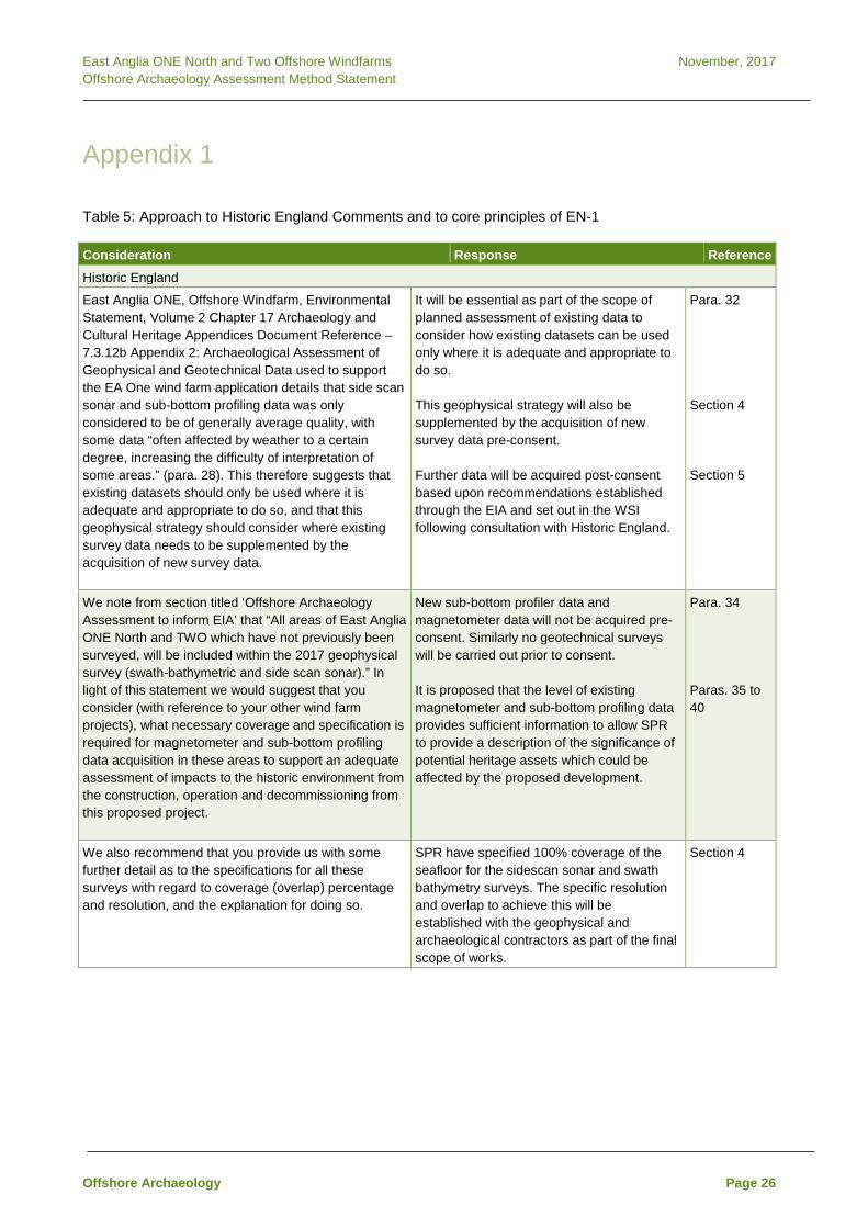
East Anglia ONE North and Two Offshore Windfarms November, 2017 Offshore Archaeology Assessment Method Statement
Appendix 1 Table 5: Approach to Historic England Comments and to core principles of EN-1
Consideration Response Reference Historic England
East Anglia ONE, Offshore Windfarm, Environmental Statement, Volume 2 Chapter 17 Archaeology and Cultural Heritage Appendices Document Reference – 7.3.12b Appendix 2: Archaeological Assessment of Geophysical and Geotechnical Data used to support the EA One wind farm application details that side scan sonar and sub-bottom profiling data was only considered to be of generally average quality, with some data “often affected by weather to a certain degree, increasing the difficulty of interpretation of some areas.” (para. 28). This therefore suggests that existing datasets should only be used where it is adequate and appropriate to do so, and that this geophysical strategy should consider where existing survey data needs to be supplemented by the acquisition of new survey data.
It will be essential as part of the scope of planned assessment of existing data to consider how existing datasets can be used only where it is adequate and appropriate to do so. This geophysical strategy will also be supplemented by the acquisition of new survey data pre-consent. Further data will be acquired post-consent based upon recommendations established through the EIA and set out in the WSI following consultation with Historic England.
Para. 32 Section 4 Section 5
We note from section titled ‘Offshore Archaeology Assessment to inform EIA’ that “All areas of East Anglia ONE North and TWO which have not previously been surveyed, will be included within the 2017 geophysical survey (swath-bathymetric and side scan sonar).” In light of this statement we would suggest that you consider (with reference to your other wind farm projects), what necessary coverage and specification is required for magnetometer and sub-bottom profiling data acquisition in these areas to support an adequate assessment of impacts to the historic environment from the construction, operation and decommissioning from this proposed project.
New sub-bottom profiler data and magnetometer data will not be acquired pre-consent. Similarly no geotechnical surveys will be carried out prior to consent. It is proposed that the level of existing magnetometer and sub-bottom profiling data provides sufficient information to allow SPR to provide a description of the significance of potential heritage assets which could be affected by the proposed development.
Para. 34 Paras. 35 to 40
We also recommend that you provide us with some further detail as to the specifications for all these surveys with regard to coverage (overlap) percentage and resolution, and the explanation for doing so.
SPR have specified 100% coverage of the seafloor for the sidescan sonar and swath bathymetry surveys. The specific resolution and overlap to achieve this will be established with the geophysical and archaeological contractors as part of the final scope of works.
Section 4
Offshore Archaeology Page 26

East Anglia ONE North and Two Offshore Windfarms November, 2017 Offshore Archaeology Assessment Method Statement
Consideration Response Reference …we would like to have it clarified what measures will be taken to provide adequate and consistent levels of information for the Palaeogeographic assessment and deposit modelling, to address risks from the proposed project. without acquiring sub-bottom profiling data or geotechnical data the proposed project runs a great risk of not satisfying core principles of the EIA and consenting process as set out in section 5.8 of the Overarching National Policy Statement for Energy (EN-1) Planning (July 2011) document.
Prior to consent all available data will be compiled to prepare and initial deposit model which will help inform understanding of data gaps and define the objectives for targeted post-consent survey. Examples of consented NSIPs, show that the full extent of palaeoenvironments have not been fully established prior to a decision. Further post-consent assessment to understand and mitigate potential impacts has been specified as a condition of consent for consented projects. Due to these uncertainties with understanding the extent of palaeoenvironments a precautionary approach to assessment is required and potential impacts will be defined as potentially resulting in major (substantial) harm.
Paras. 36 to 40 Para. 39 Para. 48
EN-1
The applicant should provide a description of the significance of the heritage assets affected by the proposed development and the contribution of their setting to that significance.
This will be achieved through the assessment of existing and new geophysical survey data combined with DBA of the known and potential archaeological baseline.
Section 3.1
The level of detail should be proportionate to the importance of the heritage assets and no more than is sufficient to understand the potential impact of the proposal on the significance of the heritage asset.
Full geophysical data coverage is provided with regard to the assessment of seabed features. It is proposed that the partial coverage of the project areas with sub-bottom profiler data, combined with DBA and including the results of extensive previous work to understand sub-surface stratigraphy within the former Zone, is proportionate and sufficient to understand the potential impact of the proposal on the significance of seabed prehistory and palaeoenvironments (i.e. potentially resulting in major (substantial) harm).
Section 3.1 Section 2, Section 3.1
As a minimum the applicant should have consulted Historic England (where the development in in English waters) and assessed the heritage assets themselves using expertise where necessary according to the proposed development’s impact.
This method statement represents an initial phase of ongoing consultation with Historic England which will be maintained throughout scoping and EIA. SPR have contracted Royal HaskoningDHV to undertake the EIA which, for offshore archaeology, will be supported by Wessex Archaeology.
Offshore Archaeology Page 27

East Anglia ONE North and Two Offshore Windfarms November, 2017 Offshore Archaeology Assessment Method Statement
Consideration Response Reference Where a development site includes, or the available evidence suggests it has the potential to include, heritage assets with an archaeological interest, the applicant should carry out appropriate desk-based assessment and, where such desk-based research is insufficient to properly assess the interest, a field evaluation.
The archaeological assessment will comprise both DBA and ‘field evaluation’ in the form of geophysical survey.
Section 3.1
Where proposed development will affect the setting of a heritage asset, representative visualisations may be necessary to explain the impact.
The potential for setting impacts from the proposed scheme will be considered initially as part of scoping for EA1N and EA2.
The applicant should ensure that the extent of the impact of the proposed development on the significance of any heritage assets affected can be adequately understood from the application and supporting documents.
As part of the EIA, specifically through the archaeological baseline and impact assessment provided in the ES, it will be demonstrated that the assessments are adequate to support sufficient consideration of the expected impacts to archaeology and the historic environment from construction, operation and decommissioning of the scheme.
Section 3
Offshore Archaeology Page 28

East Anglia ONE North November, 2017 Scoping Report
Appendix 4.1 Seascape, Landscape and Visual Impact Assessment Approach to Assessment

East Anglia ONE North November, 2017 Scoping Report

East Anglia ONE North Offshore Windfarm Scoping Report Appendix 4.1 Offshore Seascape, Landscape and Visual Impact Assessment Approach to Assessment
www.scottishpowerrenewables.com

East Anglia ONE North November 2017 Appendix 4.1
REVISION CONTROL
Revision and Approvals Rev Date Reason for Issue Originated by Checked by Approved by
0 11/09/2017 Draft for comment RHDHV JA PP 1 29/09/2017 2nd draft for comment RHDHV JA PP
SVIA Assessment Approach

East Anglia ONE North November 2017 Appendix 4.1
Table of contents
1 Offshore Seascape, Landscape and Visual Amenity – Approach to Assessment 1 1.1 Introduction 1 1.2 Baseline 1 1.2.1 SLVIA Study Area 1 1.2.2 Seascape and Landscape Character 2 1.2.3 Seascape Character 3 1.2.4 Landscape Character 4 1.2.5 Landscape Designations 7 1.2.6 Visual Receptors and Views 9 1.2.6.1 Zone of Theoretical Visibility 9 1.2.6.2 Visual Receptors 11 1.2.6.3 Viewpoints 11 1.3 Potential Impacts 14 1.3.1 Potential impacts during construction 14 1.3.2 Potential impacts during operation 14 1.3.2.1 Frequency and likelihood of visual effects 15 1.3.3 Potential impacts during decommissioning 15 1.3.4 Potential cumulative impacts 16 1.3.5 Summary of potential impacts 18 1.3.6 Mitigation 18 1.4 Approach to data gathering and assessment 19 1.4.1 Consultation 19 1.4.2 Guidance 19 1.4.3 SLVIA Methodology 20 1.5 References 21 List of Figures
A1 - Seascape Character A2 - Landscape Character A3 - Visibility Frequency
SVIA Assessment Approach

East Anglia ONE North November 2017 Appendix 4.1
SVIA Assessment Approach

East Anglia ONE North November 2017 Appendix 4.1
1 Offshore Seascape, Landscape and Visual Amenity – Approach to Assessment
1.1 Introduction
A Seascape, Landscape and Visual Impact Assessment (SLVIA) will be 1.undertaken as part of the EIA in order to identify the likely significant effects of the proposed East Anglia ONE North project on seascape, landscape and visual amenity. This section addresses the proposed East Anglia ONE North windfarm site and offshore transmission works. The landscape and visual aspects of the onshore study area are discussed in Section 4.3.
1.2 Baseline
1.2.1 SLVIA Study Area
The SLVIA study area for the proposed East Anglia ONE North project will 2.cover a radius of 50 km from the proposed East Anglia One North windfarm site, as illustrated in the Blade Tip Zone of Theoretical Visibility (ZTV) in Figure 4.1, 4.2 and 4.3a-b of Section 4.2 of the scoping report. The Blade Tip ZTV has been generated GIS software to demonstrate the number of turbines that may theoretically be seen from any point in the SLVIA study area. The ZTV shows the number of turbines (blade tips) that are theoretically visible around the SLVIA study area (based on the maximum blade tip height of 300 m). The ZTV illustrates the ‘bare ground’ situation and does not take into account the screening effects of vegetation, buildings, or other local features that may prevent or reduce visibility.
A 50 km radius study area has been selected for the SLVIA for a number of 3.reasons. Although wind turbines of the height proposed could theoretically be visible at distances beyond 50 km, the EIA regulations require assessment of the ‘likely significant effects’ of the proposed East Anglia ONE North project, therefore the SLVIA study area should extend far enough to include all areas within which significant effects are likely to occur (not all effects). It is considered that the proposed East Anglia ONE North windfarm site is unlikely to result in significant effects at distances over 50 km. Relevant guidance, professional experience, ZTV analysis (Figure 4.1 and 4.3a-b of the scoping report), published visibility studies and Met Office visibility frequency data all indicate that the threshold at which significant visual effects would diminish is likely to be within this proposed 50 km radius area.
SVIA Assessment Approach Page 1

East Anglia ONE North November 2017 Appendix 4.1
Consideration of the blade tip ZTV (Figure 4.3a-b of the scoping report) and 4.field survey verification of visibility from the ground, indicates that the visibility of the proposed East Anglia ONE North windfarm site will become very restricted and dispersed at distances beyond 50 km, with visibility from inland areas of Suffolk and Norfolk becoming fragmented by either landform, vegetation or built features/settlements that screen visibility of the sea. At distances over 50 km, the lateral spread of the proposed East Anglia ONE North windfarm site will occupy a very small portion of available views and the vertical height of the wind turbines would appear relatively small, therefore significant visual effects are unlikely to arise (even if the wind turbines are visible - in only the most excellent visibility conditions).
Significant seascape, landscape and visual effects as a result of the 5.proposed East Anglia ONE North windfarm site are proposed to be scoped out beyond 50 km. This SLVIA study area is considered to be the maximum area within which a significant effect would be likely to occur and is suitable for the purposes of assessing the likely significant effects of the offshore WTG array. In reality, significant seascape, landscape and visual effects are more likely to occur from locations in closer proximity; and less likely to occur towards the outer edges of the SLVIA study area at long distance. Consultations with relevant stakeholders have indicated that significant seascape, landscape and visual effects would be more likely to occur on visual receptors along the Suffolk coastline and a suite of representative viewpoints have been agreed with stakeholders along the coastline to assess these effects.
Within the SLVIA study area, the assessment will focus primarily on the 6.assessment of seascape, landscape and visual effects of the proposed East Anglia ONE North windfarm site within Suffolk Coastal and Waveney District in Suffolk; and Great Yarmouth, Broadland and South Norfolk Districts in Norfolk; and their adjacent seascapes.
Potential cumulative effect interactions with other offshore windfarms have 7.also influenced the study area for the SLVIA. Other offshore windfarms within the SLVIA study area are shown in Figure 4.4 of the scoping report.
1.2.2 Seascape and Landscape Character
The baseline for the proposed East Anglia ONE North project will consider 8.both Seascape and Landscape Character.
SVIA Assessment Approach Page 2

East Anglia ONE North November 2017 Appendix 4.1
In England, seascape character ‘principally applies to coastal and marine 9.areas seaward of the low-water mark’ and landscape character ‘principally applies to terrestrial areas lying to the landward side of the high-water mark’ (Natural England, 2012, p7, Box 1). Although these definitions are clear in the guidance, the importance of the interaction of sea, coastline and land as perceived by people is also highlighted in subsequent definitions of seascape in the guidance (Natural England, 2012), indicating a subtler transition between seascape and landscape than defined in the guidance.
In order to address this and avoid under-valuing the inter-tidal area between 10.the mean low and high-water mark, the SLVIA will assess seascape effects on seascape character areas (SCAs) that are seaward of the mean low-water mark - which consist of areas of coastal waters and offshore shipping channels. Landscape effects will be assessed on LCAs lying to the landward side of the mean low-water mark, which includes beaches, inter-tidal areas and coastlines within LCAs covering the coast and those LCAs covering inland terrestrial areas with views of the proposed East Anglia ONE North windfarm site.
1.2.3 Seascape Character
In England, Seascape Character principally applies to coastal and marine 11.areas seaward of the low water mark. Seascape, like landscape is about the relationship between people and place and the part it plays in forming the setting to our everyday lives. Seascape results from the way that the different components of the environment – both natural and cultural - interact together and are understood and experienced by people. Seascape is defined by Natural England in its position statement on All Landscapes Matter (2010) as: “An area of sea, coastline and land, as perceived by people, whose character results from the actions and interactions of land with sea, by natural and/or human factors”. A summary of what constitutes seascape is presented in ‘An Approach to Seascape Character Assessment’ (Natural England 2012).
SVIA Assessment Approach Page 3
East Anglia ONE North November 2017 Appendix 4.1
The coverage of published Seascape Character Assessments within the 12.SLVIA study area for the proposed East Anglia ONE North windfarm site is shown in Figure A1 of this Appendix. A Seascape Character Area assessment for the East Inshore and East Offshore marine plan areas (MMO, July 2012) covers the SLVIA study area. The proposed East Anglia ONE North offshore windfarm is located within the East Anglian Shipping Waters seascape character area (SCA). The key characteristics of this SCA includes its dense concentration of shipping activity, designated shipping routes, large scale offshore windfarms and gas fields, consistently deep water, expansive open water character and extensive offshore commercial activities, such as fishing and dredging.
A seascape character assessment for the waters off the Suffolk and Norfolk 13.coastlines within the study area is also currently being prepared by Suffolk County Council. This seascape character assessment, when published, will inform the baseline seascape characterisation in the SLVIA for the proposed East Anglia ONE North windfarm site. The SLVIA will present a baseline description of relevant SCAs from this seascape character assessment that may experience significant effects as a result of the proposed East Anglia ONE North windfarm site. The likely significant effects of the proposed East Anglia ONE North windfarm site will be assessed in the SLVIA on SCAs that are most susceptible to change. Most of the inshore SCAs will only be affected through changes to their context as a result of visibility of turbines at long distance and are likely to have a lower susceptibility to the changes proposed.
1.2.4 Landscape Character
Landscape Character principally applies to terrestrial areas lying to the 14.landward side of the high-water mark. There is a hierarchy of published Landscape Character Assessments (LCAs) that describe the baseline landscape character of the landscape in the SLVIA study area, at the National, County and District level.
The English Landscape is classified at the national level by National 15.Character Areas (NCAs). The 159 NCAs, which cover the country, were originally identified by the Countryside Agency. This mapping and the associated descriptions have been revised and developed by Natural England into NCA profiles, which provide a recognised, national, spatial framework.
At the National level, the SLVIA study area is characterised by the following 16.NCAs:
SVIA Assessment Approach Page 4

East Anglia ONE North November 2017 Appendix 4.1
• North East Norfolk and Flegg (NCA 79) • The Broads (NCA 80) • Suffolk Coast and Heaths (NCA 82) • South Norfolk and High Suffolk Claylands NCA (NCA 83)
The Suffolk Coast and Heaths NCA covers the largest part of the SLVIA 17.study area and is located approximately 36.4 km from the proposed East Anglia ONE North windfarm site, at its closest point. The Suffolk Coast and Heaths NCA lies on the North Sea coast between Great Yarmouth in the north and Harwich in the south, forming a long, narrow band that extends between 10-20 km inland. The distinctive landscape character is a product of its underlying geology, shaped by the effects of the sea and the interactions of people. It is mainly flat or gently rolling, often open but with few commanding viewpoints. In many places, and especially near the coast, wildlife habitats and landscape features lie in an intimate mosaic, providing diversity. Farming utilises much of the total land area, however the remaining land consists of coast and lowland heaths (known locally as the Sandlings) and form distinctive features, although traditional heath is now much fragmented. The coast is interrupted by five estuaries (Stour, Orwell, Deben, Alde/Ore and Blyth) with extensive intertidal areas of mudflat and salt marsh. The importance of the coast for biodiversity is recognised by its many wildlife designations. The shoreline consists of predominantly shingle beaches, often extensive in nature. Shingle structures, such as Orford Ness, form important geomorphological features.
Local Authorities across England have produced LCAs for their areas which 18.subdivide the broader NCAs into more detailed Landscape Character Areas. These County Council and District Council scale landscape characterisations will be utilised in the SLVIA for the proposed East Anglia ONE North windfarm site.
SVIA Assessment Approach Page 5

East Anglia ONE North November 2017 Appendix 4.1
The Suffolk County Council Landscape Character Assessment (Suffolk 19.County Council, 2008/2011) will define the baseline for the Suffolk section of the SLVIA study area, as mapped in Figure A2 of this Appendix. It is considered that the Suffolk County Landscape Character Assessment is the most appropriate scale for the assessment of landscape effects of the proposed East Anglia ONE North windfarm site. The LCAs identified within this character assessment are considered to be of an appropriate scale to allow assessment of the effects of the proposed East Anglia ONE North offshore windfarm over a relatively wide SLVIA study area, but at a sufficient level of detail. The SLVIA will present a baseline description of relevant LCAs from the Suffolk County Council Landscape Character Assessment and assess the likely significant effects of the proposed East Anglia ONE North windfarm site on their landscape character. In the context of the proposed East Anglia ONE North windfarm site, only the visual/perceptual characteristics of onshore LCAs in the Suffolk County Council Landscape Character Assessment that have seascape as a defining attribute are likely to be relevant when considering potential effects, given that there will be no alteration to physical features as a result of offshore development.
There are various district level landscape character assessments and other 20.reference material that may also inform the baseline description of the SLVIA study area, within the framework of the Suffolk County Council Landscape Character Assessment, including:
• Waveney District Landscape Character Assessment (Waveney District Council, 2008).
• Touching the Tide Landscape Character Assessment (Suffolk Coast and Heaths AONB, 2012)
• Shotley Peninsula and Hinterland Landscape Character Assessment (Stour and Orwell Society, 2013).
Norfolk County Council does not have an equivalent county scale landscape 21.character assessment for the region. Reference will instead be made to District Council landscape character assessments covering Great Yarmouth, Broadland and South Norfolk as follows and shown in Figure A2 of this Appendix:
• Great Yarmouth Landscape Character Assessment (Great Yarmouth Borough Council, 2008).
• Broadland District Landscape Character Assessment (Broadland District Council, 2013)
• South Norfolk Landscape Character Assessment (South Norfolk Council, 2001)
SVIA Assessment Approach Page 6

East Anglia ONE North November 2017 Appendix 4.1
The SLVIA will present a baseline description of relevant LCAs from the 22.Great Yarmouth Borough Landscape Character Assessment and assess the likely significant effects of the proposed East Anglia ONE North windfarm site on the landscape character of relevant LCAs within Great Yarmouth Borough. In the context of the proposed East Anglia ONE North windfarm site, only the visual/perceptual characteristics of onshore LCAs in Great Yarmouth with seascape as a defining attribute will be relevant when considering potential effects, given that there will be no alteration to physical features as a result of offshore development.
Potential landscape effects of the proposed East Anglia ONE North windfarm 23.site on LCAs within Broadland and South Norfolk Districts will be scoped out of the assessment. Significant effects on the landscape character of LCAs within these districts are unlikely due to the long distance of the proposed East Anglia ONE North windfarm site from Broadland District (approximately 46km) and South Norfolk (approximately 42km); and the limited visibility to the sea and the proposed East Anglia ONE North windfarm site afforded from the landscapes in these districts, which are located further inland, low-lying and partially screened by landforms and intervening vegetation (woodland and hedgerows).
1.2.5 Landscape Designations
The proposed East Anglia ONE North windfarm site is located outwith any 24.areas subject to international, national or regional landscape designation intended to protect landscape quality, as shown in Figure 4.5 of the scoping report.
A number of landscape designations occur in the wider landscape of the 25.SLVIA study area and include the nationally important Suffolk Coast and Heaths Area of Outstanding Natural Beauty (AONB), which is located approximately 36.4 km from the proposed East Anglia ONE North windfarm site (Figure 4.5 of the scoping report). The special characteristics and qualities of the Suffolk Coast and Heaths AONB are identified in the Suffolk Coast and Heaths AONB Management Plan, which lists the special qualities of eight LCAs within the AONB, and within Suffolk Coast and Heaths AONB - Natural Beauty and Special Qualities Indicators (2016).
SVIA Assessment Approach Page 7

East Anglia ONE North November 2017 Appendix 4.1
Although it is unlikely that the proposed East Anglia ONE North windfarm site 26.would have significant effects on the character and special qualities of the Suffolk Coast and Heaths AONB, owing to its distance and the relative scale of the likely changes resulting, the potential for indirect landscape effects on the Suffolk Coast and Heaths AONB will be assessed in the SLVIA to reflect the sensitivity of this landscape receptor. A landscape baseline of the Suffolk Coast and Heaths AONB will be described, referring to the following published material:
• Suffolk Coast and Heaths Area of Outstanding Natural Beauty (AONB) Natural Beauty and Special Qualities Indicators (EDF Energy, Suffolk Coast and Heaths AONB Partnership, Suffolk County Council, Suffolk Coastal District Council and Waveney District Council, 2016)
• Development in the setting of the Suffolk Coast & Heaths Area of Outstanding Natural Beauty (AONB) Suffolk Coast & Heaths Area of Outstanding Natural Beauty (AONB) Partnership (December 2015).
• Suffolk Coast & Heaths AONB Management Plan (Suffolk Coast & Heaths AONB, 2013 – 2018).
The SLVIA will assess the effects of the proposed East Anglia ONE North 27.windfarm site on the special characteristics and qualities of the Suffolk Coast and Heaths AONB, including consideration of effects relating to the contribution of the inshore waters to the character and the special qualities of the AONB, as well as its contribution to their setting.
The Suffolk Heritage Coast is located within the SLVIA study area, 28.approximately 36.3km from the proposed East Anglia ONE North windfarm site at its closest point. The Suffolk Heritage Coast was defined in 1973 and is largely contained within the AONB. It runs from Kessingland to Felixstowe and incorporates the Blyth, Alde/Ore and lower Deben estuaries. There are no statutory requirements or powers associated with the Heritage Coast definition, however it is noted that it includes objectives for conserving the environmental health and biodiversity of inshore waters and beaches, and to extend opportunities for recreational, educational, sporting and tourist activities that draw on, and are consistent with, the conservation of their natural beauty and the protection of their heritage features. The SLVIA will assess the effects of the proposed East Anglia ONE North windfarm site on the special characteristics and qualities of the Suffolk Heritage Coast as part of the assessment of the Suffolk Coast and Heaths AONB.
SVIA Assessment Approach Page 8

East Anglia ONE North November 2017 Appendix 4.1
The Norfolk and Suffolk Broads (the Broads) is Britain's largest protected 29.wetland and third largest inland waterway, with the status of a National Park and is located approximately 39.6km from the proposed East Anglia ONE North windfarm site at its closest point. The landscape baseline of the Broads National Park will be described, referring to:
• The Broads Landscape Character Assessment (Broads Authority, 2006).
• The Broads Landscape Sensitivity Study for Renewables and Infrastructure (Broads Authority / Prepared by LUC, July 2012).
Potential landscape effects of the proposed East Anglia ONE North windfarm 30.site on the Broads National Park will be scoped out of the assessment. Significant effects on the landscape character of the Broads National Park are unlikely due to the long distance of the proposed East Anglia ONE North windfarm site from the Broads (approximately 39.6km); and the limited visibility to the sea and the proposed East Anglia ONE North windfarm site afforded from the landscapes of the Broads, which are located further inland, very low-lying and partially screened by surrounding landforms and intervening vegetation (woodland and hedgerows). It is considered that the proposed East Anglia ONE North windfarm site will not have significant effects on the special qualities of the Broads National Park.
There are several Registered Parks and Gardens (RPG) in the study area 31.(Figure 4.5 of the scoping report), the closest of which to the proposed East Anglia ONE North windfarm site is Belle Vue Park, in Lowestoft (36.8km). Further RPGs are located at Henham and Somerleyton Park. The SLVIA will prepare a baseline description of the relevant RPGs, which have sea views as part of their baseline landscape context, and assess the potential impacts of the proposed East Anglia ONE North windfarm site on the character and quality of these designed landscapes.
1.2.6 Visual Receptors and Views
1.2.6.1 Zone of Theoretical Visibility
Visual effects will occur when the introduction of the proposed East Anglia 32.ONE North windfarm site changes or influences the visual amenity and views experienced by people in the area. The visual baseline is defined by the ZTV shown in Figure 4.1 and in more detail in Figures 4.3a-b of the scoping report. The ZTV shows the main area in which the proposed East Anglia ONE North windfarm site will theoretically be visible, highlighting the different groups of people who may experience views of the proposed East Anglia ONE North windfarm site and assisting in the identification of viewpoints where they may be affected.
SVIA Assessment Approach Page 9

East Anglia ONE North November 2017 Appendix 4.1
The SLVIA will assess the project envelope which has the maximum effect 33.on seascape, landscape and visual receptors. The height of the wind turbines, density of turbines and lateral spread across the skyline in the proposed East Anglia ONE North windfarm layout are the main factors which influence the maximum seascape, landscape and visual effect scenario, however the height of the wind turbines contributes most to the extent of visibility and the amount of the wind turbines visible above the sea skyline. The proposed project envelope for the SLVIA will be based on a 15MW wind turbine with a 300m blade tip height, which is likely to be most visible in coastal views and have the widest ZTV.
The ZTV shown in Figures 4.1, 4.2 and 4.3a-b of the scoping report is based 34.on a windfarm layout consisting of 15/19MW wind turbines with a 300m blade tip height, representing the maximum visibility scenario for the SLVIA. This is the highest turbine height under consideration for the project envelope, but also the lowest number of turbines and will have the least dense appearance in views.
The scope of the visual assessment will be based on the ZTV for the 35.proposed East Anglia ONE North windfarm site, which assists with the identification of the principal visual receptors and viewpoints, as illustrated in Figure 4.2 and in more detail in Figures 4.3a-b of the scoping report. The ZTV shows the main areas of theoretical visibility of the proposed East Anglia ONE North windfarm site will be along the Suffolk and Norfolk coastlines and immediate hinterland, between Caister-on-sea in the north and Orford Ness in the south. The closest areas of theoretical visibility of the proposed East Anglia ONE North windfarm site will be at Lowestoft, approximately 36.4 km from the coast at its closest point near Ness Point. Theoretical visibility extend along the coast at longer distances north to Great Yarmouth; and south to Southwold, Sizewell, Thorpeness and Aldeburgh. The area of theoretical visibility of the proposed East Anglia ONE North windfarm site becomes more fragmented from the hinterland and inland areas of the SLVIA study area, where views of the sea become increasingly screened within the main river valleys, either by adjacent rising land or coastal landforms (such as Orford Ness). Actual visibility from these hinterland and inland areas also becomes increasingly screened vegetation, such as woodland and hedgerows, and/or built development and settlement. There are relatively few elevated areas affording wider views of the sea from inland areas of the SLVIA study area.
SVIA Assessment Approach Page 10

East Anglia ONE North November 2017 Appendix 4.1
1.2.6.2 Visual Receptors
The principal visual receptors that are of likely to be most susceptible to 36.visual effects arising from the proposed East Anglia ONE North windfarm site will be identified in the SLVIA. The principal visual receptors in the SLVIA study area are likely to be focused along the closest sections of the Suffolk and Norfolk coastline, including people within settlements, driving on roads, visitors to tourist facilities or historic environment assets, and people engaged in recreational activity such as on walking and cycle routes. The SLVIA will undertake an initial baseline assessment of the principal visual receptors within the ZTV, in order to identify those that may experience significant effects as a result of the proposed East Anglia ONE North windfarm site. A detailed assessment will be undertaken in the SLVIA for those visual receptors that are most susceptible to changes, which may experience significant visual effects as a result of the proposed East Anglia ONE North windfarm site and will focus on visual receptors where the sea is a strong influence in the baseline view, along the Suffolk and Norfolk coastlines and immediate hinterland, including:
• Coastal settlements - including Caister-on-sea; Great Yarmouth; Gorleston-on-sea; Hopton-on-sea; Corton; Lowestoft; Kessingland; Southwold; Walberswick; Dunwich; Thorpeness; Aldeburgh; Orford; Bawdsey and Felixstowe;
• Recreational routes - including the Suffolk Coastal Path; Regional Cycle Routes 30, 31, 41, 42 and 517.
• Main road routes - such as the A12 and the various roads that lead off it to the coast such as the A1094, A1095, B1083, B1084, B1353, B1122, B1125, B1127.
• Visitors to tourist facilities - such as the sea fronts/beaches of the main coastal towns/resorts, holiday villages and nature reserves/visitor centres.
• Visitors to historic environment assets - such as Dunwich Heath, Orford Ness, Orford Castle and the series of Martello Towers along the Suffolk coast.
1.2.6.3 Viewpoints
Consultations with Suffolk County Council, Suffolk Coastal District Council, 37.Waveney District Council, Great Yarmouth Borough Council and the Broads National Park have been ongoing and the agreement of viewpoint locations for use in the SLVIA has been reached following consideration of their combined feedback.
SVIA Assessment Approach Page 11

East Anglia ONE North November 2017 Appendix 4.1
Representative and illustrative viewpoints proposed for the visual 38.assessment are identified in Table 1 and mapped in Figure 4.2 and 4.3a-b of the scoping report.
• Representative viewpoints – are selected to represent the experience of different types of visual receptor where larger numbers of viewpoints cannot all be included. A combination of baseline panorama, wireline and full photomontage visualisations will be produced as specified in Table 1. Full written analysis of visual effects will be undertaken in the SLVIA for those viewpoints that may experience significant visual effects, while others may be scoped out during preliminary assessment if no potential for significant effects is identified.
• Illustrative viewpoints – are chosen specifically to demonstrate a particular effect or specific issue (including restricted visibility). A baseline panorama and wirelines visualisation will be produced, but a written assessment of the visual effects from these viewpoints is not required in the SLVIA.
Viewpoints have been compiled based on consultee feedback, the potential 39.landscape and visual receptors that are described above and the ZTV for the proposed East Anglia ONE North windfarm site. Viewpoints are located along the Suffolk and Norfolk coastline in order to allow assessment of the effects of proposed East Anglia ONE North windfarm site on coastal views experienced by people. The viewpoints to be included in the SLVIA are listed in Table 1 as follows.
Table 1 Viewpoints included in the SLVIA of the proposed East Anglia ONE North project
Viewpoint Easting Northing Distance (km)
Elevation (m)
Photomontage (P) or Wireline
(W) Visualisation Representative viewpoints in Suffolk 1 Lowestoft 654446 291820 37.2 6.9 P 2 Kessingland Beach 653614 285852 38.0 4.7 P 3 Covehithe 652355 281114 40.0 3.5 P 4 Southwold 651072 276468 42.3 10.5 P 5 Gun Hill, Southwold 650828 275764 42.7 8.3 P 6 Walberswick 649932 276466 44.1 3.0 P 7 Dunwich 647961 270777 47.1 2.0 P 8 Dunwich Heath &
Beach (Coastguard cottages)
647702 267816 48.4 15.7 P
9 Minsmere Nature Reserve
647169 267232 49.1 12.6 P
10 Sizewell Beach 647543 262868 50.4 3.9 P 11 Thorpeness 647321 259643 52.0 7.3 P 12 Aldeburgh 646526 256514 55.7 3.6 P
SVIA Assessment Approach Page 12

East Anglia ONE North November 2017 Appendix 4.1
Viewpoint Easting Northing Distance (km)
Elevation (m)
Photomontage (P) or Wireline
(W) Visualisation Representative viewpoints in Norfolk 13 Hopton-on-sea 653563 299775 40.9 6.7 P 14 Gorleton-on-sea 652959 303399 42.5 6.7 P 15 Great Yarmouth,
South Beach 653131 307518 43.9 3.3 W
16 Caister-on-sea 652761 312072 46.3 4.7 W Illustrative viewpoints A Southwold Common 650460 276049 44.5 9.5 W B Ness Point
Lowestoft 655578 293737 37.8 3.5 W
C Corton Holiday Village
654530 297108 38.0 17.9 W
D Southwold Pier 651220 276670 43.7 4.6 W
A detailed assessment will be undertaken in the SLVIA for those viewpoints 40.that are most susceptible to changes, which may experience significant visual effects as a result of the proposed East Anglia ONE North windfarm site. The detailed assessment of visual effects from representative viewpoints will focus on those viewpoints where the combination of their sensitivity and potential magnitude of change resulting from the proposed East Anglia ONE North windfarm site may give rise to significant effects, which are likely to be those at closer range (albeit over 36 km away), than viewpoints located towards the edge of the SLVIA study area.
In preparing photomontages for the SLVIA, weather conditions shown in the 41.photographs for all viewpoints will, where possible, be taken in very good visibility conditions, generally during summer and in the afternoon or early evening, seeking to represent a maximum visibility scenario when the proposed East Anglia ONE North windfarm site may be most visible, when the sun has come round behind the viewpoint and is facing out to sea (when turbines would be most lit by the sun and visible in views east). Further photomontages will also be produced from five key viewpoints (Lowestoft, Kessingland, Southwold, Aldeburgh and Felixstowe) to be representative of visibility conditions in the morning, showing the period of the day with reduced visibility (when the turbines will be backlit by the sun to the east), and at night-time, showing the existing night-time view alongside a representation of the appearance of visible aviation and marine navigation lighting.
SVIA Assessment Approach Page 13

East Anglia ONE North November 2017 Appendix 4.1
1.3 Potential Impacts
1.3.1 Potential impacts during construction
The seascape, landscape and visual effects that could arise as a result of the 42.proposed East Anglia ONE North windfarm site during construction are identified as follows:
• Temporary effects on coastal/seascape character, within identified seascape character areas primarily as a result of wind turbine installation during construction, either as result of physical effects within the seascape character area, or the close range visual/perceptual characteristics of seascape character areas.
• Temporary effects on landscape character, within terrestrial landscape character areas and landscape designations, primarily as a result of visibility of wind turbine installation during construction. In the context of the proposed East Anglia ONE North windfarm site, only the visual/perceptual characteristics of onshore LCAs with seascape as a defining attribute are relevant when considering potential effects, given that there will be no alteration to physical features as a result of offshore development.
• Temporary visual effects on views, primarily as a result of visibility of wind turbine installation and offshore export cable laying during construction, experienced by visual receptors (groups of people) with visibility of the proposed East Anglia ONE North windfarm site, on specific views and on their visual amenity/experience of the landscape.
1.3.2 Potential impacts during operation
The seascape, landscape and visual effects that could arise as a result of the 43.proposed East Anglia ONE North windfarm site during operation are identified as follows:
• Long-term effects on coastal/seascape character, within seascape character areas, primarily as a result of offshore wind turbine operation, either affecting the pattern of elements that define the character or affecting the visual/perceptual characteristics of seascape character areas.
• Long-term effects on landscape character, within terrestrial landscape types and landscape designations, primarily as a result of visibility of the offshore wind turbines during operation. In the context of the proposed East Anglia ONE North windfarm site, only the visual/perceptual characteristics of onshore LCAs with seascape as a
SVIA Assessment Approach Page 14
East Anglia ONE North November 2017 Appendix 4.1
defining attribute are relevant when considering potential effects, given that there will be no alteration to physical features as a result of offshore development.
• Long-term visual effects on views, primarily as a result of offshore wind turbine operation, experienced by visual receptors (groups of people) with visibility of the proposed East Anglia ONE North windfarm site, on specific views and on their visual amenity/experience of the landscape. Visual effects on views at night-time as a result of navigational lighting and aviation lighting of offshore wind turbines.
1.3.2.1 Frequency and likelihood of visual effects
Met Office visibility frequency data has been acquired from local weather 44.stations in order to assess typical visibility conditions prevailing in the SLVIA study area. Although there are limitations to how this data can be applied to judgements about windfarm visibility, the visibility data provide some understanding and evidence basis for evaluating the visibility of the wind turbines against their background.
Met Office visibility data will be assessed from the nearest weather stations 45.that record visibility, in Weybourne and Shoeburyness (located to the north and south of the SLVIA study area). These weather stations use a visibility sensor which measures the optical range by contrast of a distant object against its background. Visibility data will be assessed to set out the frequency of visibility (over a 10 year period) at different distance ranges, based on Met Office visibility definitions: < 1km Very Poor; 1 - 4km Poor; 4 - 10km Moderate; 10 - 20km Good; 20 - 40km Very Good; 40km > Excellent. The visibility data will then be interpreted to allow some quantification of the likely frequency of visibility of the proposed East Anglia ONE North windfarm site from the coastal viewpoints (as a % and average number of days per year). From initial analysis, the proposed East Anglia ONE North windfarm site is likely to only be visible in ‘very good’ and ‘excellent’ visibility, since it is located beyond 36km from the coast (Figure A3 of this Appendix).
1.3.3 Potential impacts during decommissioning
The effects of the proposed East Anglia ONE North windfarm site during 46.decommissioning will be similar to those identified during construction.
SVIA Assessment Approach Page 15
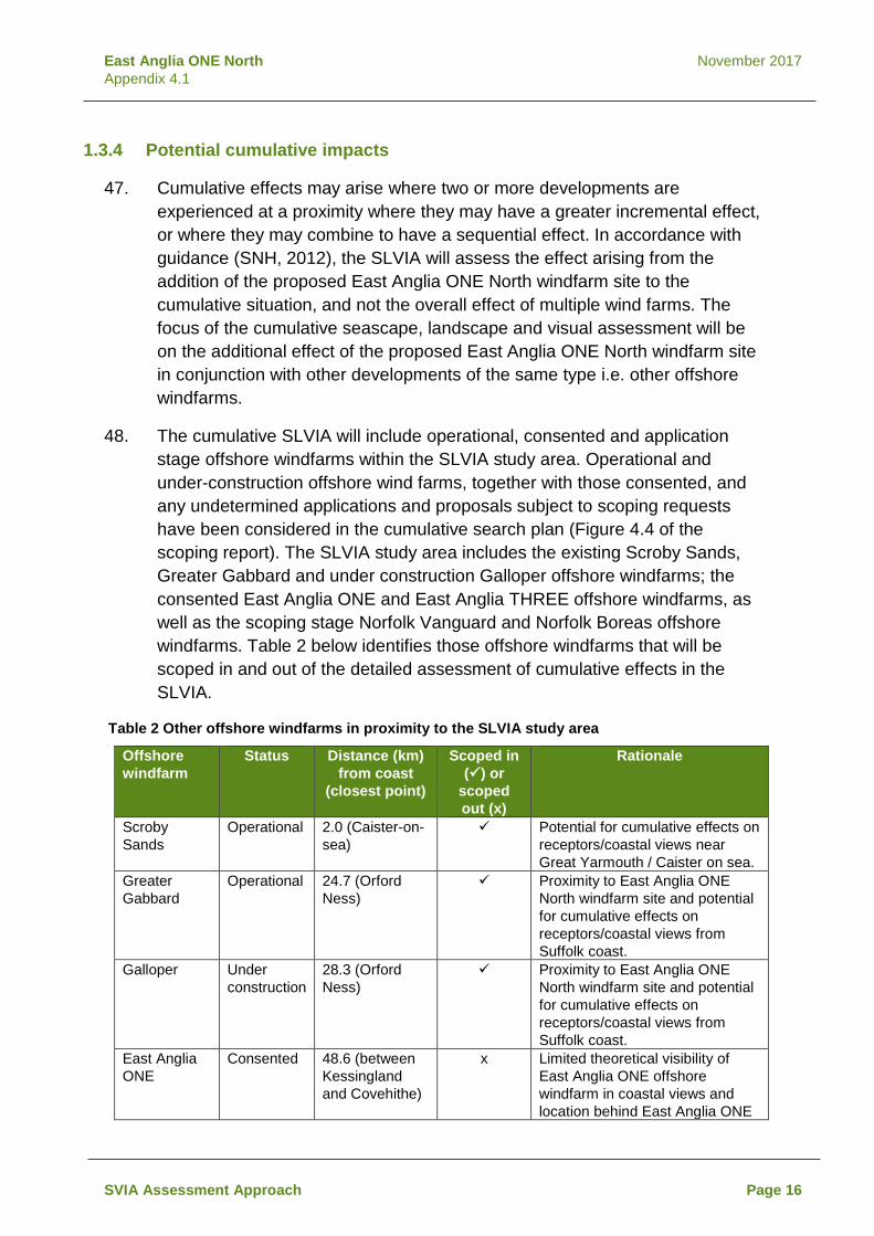
East Anglia ONE North November 2017 Appendix 4.1
1.3.4 Potential cumulative impacts
Cumulative effects may arise where two or more developments are 47.experienced at a proximity where they may have a greater incremental effect, or where they may combine to have a sequential effect. In accordance with guidance (SNH, 2012), the SLVIA will assess the effect arising from the addition of the proposed East Anglia ONE North windfarm site to the cumulative situation, and not the overall effect of multiple wind farms. The focus of the cumulative seascape, landscape and visual assessment will be on the additional effect of the proposed East Anglia ONE North windfarm site in conjunction with other developments of the same type i.e. other offshore windfarms.
The cumulative SLVIA will include operational, consented and application 48.stage offshore windfarms within the SLVIA study area. Operational and under-construction offshore wind farms, together with those consented, and any undetermined applications and proposals subject to scoping requests have been considered in the cumulative search plan (Figure 4.4 of the scoping report). The SLVIA study area includes the existing Scroby Sands, Greater Gabbard and under construction Galloper offshore windfarms; the consented East Anglia ONE and East Anglia THREE offshore windfarms, as well as the scoping stage Norfolk Vanguard and Norfolk Boreas offshore windfarms. Table 2 below identifies those offshore windfarms that will be scoped in and out of the detailed assessment of cumulative effects in the SLVIA.
Table 2 Other offshore windfarms in proximity to the SLVIA study area
Offshore windfarm
Status Distance (km) from coast
(closest point)
Scoped in () or
scoped out (x)
Rationale
Scroby Sands
Operational 2.0 (Caister-on-sea)
Potential for cumulative effects on receptors/coastal views near Great Yarmouth / Caister on sea.
Greater Gabbard
Operational 24.7 (Orford Ness)
Proximity to East Anglia ONE North windfarm site and potential for cumulative effects on receptors/coastal views from Suffolk coast.
Galloper Under construction
28.3 (Orford Ness)
Proximity to East Anglia ONE North windfarm site and potential for cumulative effects on receptors/coastal views from Suffolk coast.
East Anglia ONE
Consented 48.6 (between Kessingland and Covehithe)
x Limited theoretical visibility of East Anglia ONE offshore windfarm in coastal views and location behind East Anglia ONE
SVIA Assessment Approach Page 16

East Anglia ONE North November 2017 Appendix 4.1
Offshore windfarm
Status Distance (km) from coast
(closest point)
Scoped in () or
scoped out (x)
Rationale
North windfarm site and at greater distance offshore
East Anglia THREE
Consented 67.9 (Lowestoft) x Likelihood that there will be no visibility of East Anglia THREE offshore windfarm at distances over 67.9 km from coast.
Norfolk Vanguard
Scoping 47.8 (Winterton-on-sea)
x Limited theoretical visibility of Norfolk Vanguard in coastal views at distances of 47.8 km from coast. Separation distances from East Anglia ONE North windfarm site.
Norfolk Boreas
Scoping 73.2 (Scratby) x Likelihood that there will be no visibility of Norfolk Boreas at distances over 73.2 km from coast.
East Anglia TWO*
Scoping 29.7 (between Kessingland and Covehithe)
Although at scoping, East Anglia TWO will be included in the cumulative assessment for the proposed East Anglia ONE North windfarm site due to its proximity and potential for cumulative effects on receptors/coastal views from the Suffolk/Norfolk coast.
In line with guidance (SNH, 2012, p15) which states that ‘the focus should be 49.on the key cumulative effects which are likely to influence decision making, rather than an assessment of every potential cumulative effect’, the cumulative SLVIA will seek to focus detailed assessment on the cumulative effects of the proposed East Anglia ONE North windfarm site in addition to Scroby Sands, Greater Gabbard, Galloper, East Anglia ONE and East Anglia TWO.
The key impacts to be considered as part of the cumulative SLVIA are likely 50.to be:
• Cumulative seascape, landscape and visual effects of the proposed East Anglia ONE North windfarm site through its addition to a context containing the operational Greater Gabbard and under construction Galloper offshore windfarms, as the closest offshore windfarms to the Suffolk coast in baseline views, with which there is potential to be viewed in combination.
• Extent to which the proposed East Anglia ONE North windfarm site may either extend the ZTV, the vertical and/or lateral scale of effects, when considered in combination with the baseline offshore windfarms.
SVIA Assessment Approach Page 17

East Anglia ONE North November 2017 Appendix 4.1
• Extent to which the consented East Anglia ONE windfarm site may be visible in combination with the proposed East Anglia ONE North windfarm site.
• Extent and scale of combined effects resulting from the proposed East Anglia ONE North windfarm site together with the proposed East Anglia TWO windfarm site.
• Extent to which the addition of the proposed East Anglia ONE North windfarm site may increase the influence of windfarms as a characteristic element or create a character change to a ‘windfarm seascape/landscape’.
1.3.5 Summary of potential impacts Table 3 Summary of potential seascape, landscape and visual impacts (scoped in () and scoped out (x)
Potential impacts Construction Operation Decommissioning Seascape, landscape and visual impacts, of the windfarm site on seascape, landscape and visual receptors within the ZTV in the SLVIA study area (50 km radius).
Seascape, landscape and visual impacts of the windfarm site on seascape, landscape and visual receptors beyond outwith the SLVIA study area (50 km radius).
x x x
Impacts of the windfarm site on the landscape character of the Norfolk and Suffolk Broads National Park.
x x x
Impacts of the windfarm site on the landscape character of landscape character areas within Broadland and South Norfolk Districts.
x x x
Cumulative seascape, landscape and visual impacts of East Anglia ONE North windfarm site with East Anglia ONE, East Anglia THREE, Norfolk Vanguard and Norfolk Boreas offshore windfarms.
x x x
Cumulative seascape, landscape and visual impacts of East Anglia ONE North windfarm site with Scroby Sands, Greater Gabbard, Galloper and East Anglia TWO offshore windfarms within SLVIA study area.
1.3.6 Mitigation
Options for mitigation of the identified potential effects which are predicted to 51.
arise from the proposed East Anglia ONE North windfarm site will be considered, iteratively alongside the assessment.
SVIA Assessment Approach Page 18

East Anglia ONE North November 2017 Appendix 4.1
Potential embedded mitigation measures for effects on seascape and visual 52.effects include the site selection for the proposed East Anglia ONE North windfarm site, e.g. locating at distance from the coast and the realisation of design objectives for the development, achieved through layout and design.
The mitigation measures proposed for the development will be dependent 53.upon the final design of the site and the potential effects as determined by the EIA studies.
1.4 Approach to data gathering and assessment
1.4.1 Consultation
ScottishPower Renewables (SPR) is undertaking consultation with relevant 54.consultees with regards to seascape, landscape and visual matters, including consultations with Suffolk County Council, Suffolk Coastal District Council, Waveney District Council, Great Yarmouth Borough Council, Suffolk Coast and Heaths AONB Unit, Natural England and Historic England, in order to define the scope of the SLVIA required for the proposed East Anglia ONE North windfarm site.
1.4.2 Guidance
The assessment will be undertaken in accordance with the methods outlined 55.in the following best practice guidance documents.
• The Landscape Institute with the Institute of Environmental Management and Assessment (2013). Guidelines for Landscape and Visual Impact Assessment. Third Edition.
• Landscape and Seascape Character Assessments published by Natural England and the Department for Environment, Food and Rural Affairs (2014);
• Natural England (2012). An Approach to Seascape Character Assessment.
• Natural England (2014). An Approach to Landscape Character Assessment.
• Scottish Natural Heritage (2012). Assessing the Cumulative Impact of Onshore Wind Energy Developments;
• Scottish Natural Heritage (2017). Visual Representation of Windfarms: Version 2.2.
• Landscape Institute (2017). Visual Representation of Development Proposals.
SVIA Assessment Approach Page 19

East Anglia ONE North November 2017 Appendix 4.1
Data would be gathered from official, reliable and the most up-to-date 56.sources. This would include Ordnance Survey map based data, as well as data on landscape characterisation, landscape designations and other Governmental and local authority data of relevance.
1.4.3 SLVIA Methodology
The objective of the assessment of the proposed East Anglia ONE North 57.windfarm site is to predict the significant effects on the seascape, landscape and visual resource. In accordance with the Environmental Impact Assessment Regulations 2017, the SLVIA effects will be assessed to be either significant or not significant. The methodology to undertake the SLVIA will reflect the ‘Guidelines for Landscape and Visual Impact Assessment: Third Edition’ (Landscape Institute, 2013).
The significance of effects will be assessed through a combination of two 58.considerations – the sensitivity of the landscape or visual receptor/view and the magnitude of change that will result from the proposed East Anglia ONE North windfarm site. In accordance with the Landscape Institute’s GLVIA3, the SLVIA methodology requires the application of professional judgement, but generally, the higher the sensitivity and the higher the magnitude of change the more likely that a significant effect will arise.
The objective of the cumulative SLVIA is to describe, visually represent and 59.assess the ways in which the proposed East Anglia ONE North windfarm site will have additional effects when considered together with other existing, consented or application stage developments and to identify related significant cumulative effects arising. The guiding principle in preparing the cumulative SLVIA will be to focus on the likely significant effects and in particular those which are likely to influence the outcome of the consenting process.
The LVIA will determine whether effects are beneficial, neutral or adverse in 60.accordance with defined criteria.
The effects of the proposed East Anglia ONE North windfarm site will be of 61.variable duration, and will be assessed as short-term or long-term, and permanent or temporary/reversible.
SVIA Assessment Approach Page 20

East Anglia ONE North November 2017 Appendix 4.1
1.5 References
Broadland District Council (2013) Broadland District Landscape Character Assessment. EDF Energy, Suffolk Coast and Heaths AONB Partnership, Suffolk County Council, Suffolk Coastal District Council and Waveney District Council (2016) Suffolk Coast and Heaths AONB - Natural Beauty and Special Qualities Indicators. Great Yarmouth Borough Council (2008) Great Yarmouth Landscape Character Assessment. Landscape Institute (2017) Visual Representation of Development Proposals. Landscape Institute with the Institute of Environmental Management and Assessment (2013) Guidelines for Landscape and Visual Impact Assessment. Third Edition. Marine Management Organisation (2012) A Seascape Character Area Assessment for the East Inshore and East Offshore Marine Plan Areas. Natural England (2010) All Landscapes Matter. Natural England (2012) An Approach to Seascape Character Assessment. Natural England (2014) An Approach to Landscape Character Assessment. Scottish Natural Heritage (2012) Assessing the Cumulative Impact of Onshore Wind Energy Developments. Scottish Natural Heritage (2017) Visual Representation of Windfarms: Version 2.2. South Norfolk Council (2001) South Norfolk Landscape Character Assessment. Stour and Orwell Society (2013) Shotley Peninsula and Hinterland Landscape Character Assessment. Suffolk Coast and Heaths AONB (2012) Touching the Tide Landscape Character Assessment.
SVIA Assessment Approach Page 21

East Anglia ONE North November 2017 Appendix 4.1
Suffolk Coast & Heaths AONB (2013) Suffolk Coast & Heaths AONB Management Plan 2013 – 2018. Suffolk Coast & Heaths AONB Partnership (2015) Development in the setting of the Suffolk Coast & Heaths AONB. The Broads Authority (2006) The Broads Landscape Character Assessment. The Broads Authority (2012) The Broads Landscape Sensitivity Study for Renewables and Infrastructure. Waveney District Council (2008) Waveney District Landscape Character Assessment.
SVIA Assessment Approach Page 22

3800
00.0
0000
0
3800
00.0
0000
0
4100
00.0
0000
0
4100
00.0
0000
0
4400
00.0
0000
0
4400
00.0
0000
0
4700
00.0
0000
0
4700
00.0
0000
0
5800000.000000
5800000.000000
5820000.000000
5820000.000000
5840000.000000
5840000.000000
¯
1:25
0,00
0
Rev
Dat
eC
omm
ent
By
Scal
e @
A3
07.
515
3.75
Km
24/0
8/20
170
TD
Drg
No
Date
Figu
re
24/0
8/17
Dat
um:
WG
S 19
84Pr
ojec
tion:
Zone
31N
This
map
has
bee
n pr
oduc
ed to
the
late
st k
now
n in
form
atio
n at
the
time
of is
sue,
and
has
bee
n pr
oduc
ed fo
r you
r inf
orm
atio
n on
ly.Pl
ease
con
sult
with
the
SPR
Offs
hore
GIS
team
to e
nsur
e th
e co
nten
t is
still
curr
ent b
efor
e us
ing
the
info
rmat
ion
cont
aine
d on
this
map
.To
the
fulle
st e
xten
t per
mitt
ed b
y la
w, w
e ac
cept
no
resp
onsi
bilit
y or
liab
ility
(whe
ther
in c
ontra
ct, t
ort (
incl
udin
g ne
glig
ence
) or o
ther
wis
e in
resp
ect o
f any
er
rors
or o
mis
sion
s in
the
info
rmat
ion
cont
aine
d in
the
map
and
sha
ll no
t be
liabl
e fo
r any
loss
, dam
age
or e
xpen
se c
ause
d by
suc
h er
rors
or o
mis
sion
s.©
Cro
wn
Cop
yrig
ht a
nd S
eaZo
ne S
olut
ions
Lim
ited.
All
right
s re
serv
ed.P
rodu
ct L
icen
ce N
o. 0
8201
0.00
1. T
his
prod
uct h
as b
een
deriv
ed in
par
t fro
m m
ater
ial
obta
ined
from
theU
K H
ydro
grap
hic
Offi
ce w
ith th
e pe
rmis
sion
of t
he C
ontro
ller o
f Her
Maj
esty
's S
tatio
nery
Offi
ce a
nd U
K H
ydro
grap
hicO
ffice
. NO
T TO
BE
US
ED F
OR
NAV
IGAT
ION
.C
onta
ins
Ord
nanc
e S
urve
y di
gita
l dat
a ©
Cro
wn
copy
right
, All
right
s re
serv
ed 2
017
Lice
nce
num
ber 0
1000
3167
3.
Rev
Prep
ared
:
Che
cked
:
Appr
oved
:
P:\2
015\
1508
87_E
A1N
&2\G
IS\A
rcG
IS\A
rcM
ap\O
FFSH
OR
E_W
F\SC
OPI
NG
EA1
N\R
EV_2
_App
\150
887_
FIG
5_SE
ASC
APE.
mxd
Gre
atYa
rmou
thD
istr
ict
Bro
adla
ndD
istr
ict
Nor
wic
hD
istr
ict
Sout
hN
orfo
lkD
istr
ict
Wav
eney
Dis
tric
t
Mid
Suf
folk
Dis
tric
t
Suffo
lkC
oast
alD
istr
ict
Nor
thN
orfo
lkD
istr
ict
NORF
OLK
CO
UNT
Y
SUFF
OLK
CO
UN
TY
EAST
AN
GLI
A O
NE
NO
RTH
A1
EAIN
-DB-
0028
Seas
cape
Cha
ract
er A
rea
10
9
4
East
Ang
lia O
NE
Nor
thFi
rst I
ssue
(OPE
N)
SMTD
Lege
nd East
Ang
lia O
NE
Nor
th W
indf
arm
Site
SLVI
A St
udy
Area
(50k
m)
Dis
trict
Bou
ndar
y
Cou
nty
Boun
dary
Seas
cape
Cha
ract
er A
rea
4.Ea
st A
nglia
n Sh
ippi
ng W
ater
s
9.N
orfo
lk C
oast
al W
ater
s
10.S
uffo
lk C
oast
al W
ater
s
Dat
a So
urce
: Mar
ine
Man
agem
ent O
rgan
isat
ion
Seas
cape
cha
ract
er a
rea
asse
ssm
ent J
uly
2012
1
SM
28/0
9/20
171
TDSe
cond
Issu
e (O
PEN
)

UU
U
G3
G4
A1H1
A1
C1E1
E2
U
C1
E2
U
U
A1
U
E2
U
U
U
C2
19 7
25
18
4
16
9
20
21
3
0
0
0
0
9 3
17
9
12
8
4
6
4
9
14
14
12
7
16
3
12
6
4
2
6
14
1
6
2
12
8
10
11
15
12
6
15
14
15
5
5
5
11
2
14
5
11
3800
00.0
0000
0
3800
00.0
0000
0
4100
00.0
0000
0
4100
00.0
0000
0
4400
00.0
0000
0
4400
00.0
0000
0
4700
00.0
0000
0
4700
00.0
0000
0
5800000.000000
5800000.000000
5820000.000000
5820000.000000
5840000.000000
5840000.000000
¯
1:25
0,00
0
Rev
Dat
eC
omm
ent
By
Scal
e @
A3
07.
515
3.75
Km
0TD
Firs
t Iss
ue (O
PEN
)
Drg
No
Date
Figu
re
1D
atum
:W
GS
1984
Proj
ectio
n:Zo
ne 3
1N
This
map
has
bee
n pr
oduc
ed to
the
late
st k
now
n in
form
atio
n at
the
time
of is
sue,
and
has
bee
n pr
oduc
ed fo
r you
r inf
orm
atio
n on
ly.Pl
ease
con
sult
with
the
SPR
Offs
hore
GIS
team
to e
nsur
e th
e co
nten
t is
still
curr
ent b
efor
e us
ing
the
info
rmat
ion
cont
aine
d on
this
map
.To
the
fulle
st e
xten
t per
mitt
ed b
y la
w, w
e ac
cept
no
resp
onsi
bilit
y or
liab
ility
(whe
ther
in c
ontra
ct, t
ort (
incl
udin
g ne
glig
ence
) or o
ther
wis
e in
resp
ect o
f any
er
rors
or o
mis
sion
s in
the
info
rmat
ion
cont
aine
d in
the
map
and
sha
ll no
t be
liabl
e fo
r any
loss
, dam
age
or e
xpen
se c
ause
d by
suc
h er
rors
or o
mis
sion
s.©
Cro
wn
Cop
yrig
ht a
nd S
eaZo
ne S
olut
ions
Lim
ited.
All
right
s re
serv
ed.P
rodu
ct L
icen
ce N
o. 0
8201
0.00
1. T
his
prod
uct h
as b
een
deriv
ed in
par
t fro
m m
ater
ial
obta
ined
from
theU
K H
ydro
grap
hic
Offi
ce w
ith th
e pe
rmis
sion
of t
he C
ontro
ller o
f Her
Maj
esty
's S
tatio
nery
Offi
ce a
nd U
K H
ydro
grap
hicO
ffice
. NO
T TO
BE
US
ED F
OR
NAV
IGAT
ION
.C
onta
ins
Ord
nanc
e S
urve
y di
gita
l dat
a ©
Cro
wn
copy
right
, All
right
s re
serv
ed 2
017
Lice
nce
num
ber 0
1000
3167
3.
Rev
Prep
ared
:
Che
cked
:
Appr
oved
:
P:\2
015\
1508
87_E
A1N
&2\G
IS\A
rcG
IS\A
rcM
ap\O
FFSH
OR
E_W
F\SC
OPI
NG
EA1
N\R
EV_2
_App
\150
887_
FIG
6a_E
A1_L
CA.
mxd
SMTD SM
Gre
atYa
rmou
thD
istr
ict
Bro
adla
ndD
istr
ict
Nor
wic
hD
istr
ict
Sout
hN
orfo
lkD
istr
ict
Wav
eney
Dis
tric
t
Mid
Suf
folk
Dis
tric
t
Suffo
lkC
oast
alD
istr
ict
Nor
thN
orfo
lkD
istr
ict
NORF
OLK
CO
UNT
Y
SUFF
OLK
CO
UN
TY
EAST
AN
GLI
A O
NE
NO
RTH
A2a
EAIN
-DB-
0029
Land
scap
e C
hara
cter
Ass
essm
ent
East
Ang
lia O
NE
Nor
th05
/09/
2017
05/0
9/17
Lege
nd East
Ang
lia O
NE
Nor
th W
indf
arm
Site
SLVI
A St
udy
Area
(50k
m)
Dis
trict
Bou
ndar
y
Cou
nty
Boun
dary
See
Figu
re 6
b fo
r Lan
dsca
pe C
hara
cter
Ass
essm
ent
Lege
nd
1TD
Seco
nd Is
sue
(OPE
N)
28/0
9/20
17

Rev
Dat
eC
omm
ent
By
0TD
Firs
t Iss
ue (O
PEN
)
Drg
No
Date
Figu
re
1D
atum
:W
GS
1984
Proj
ectio
n:Zo
ne 3
1N
This
map
has
bee
n pr
oduc
ed to
the
late
st k
now
n in
form
atio
n at
the
time
of is
sue,
and
has
bee
n pr
oduc
ed fo
r you
r inf
orm
atio
n on
ly.Pl
ease
con
sult
with
the
SPR
Offs
hore
GIS
team
to e
nsur
e th
e co
nten
t is
still
curr
ent b
efor
e us
ing
the
info
rmat
ion
cont
aine
d on
this
map
.To
the
fulle
st e
xten
t per
mitt
ed b
y la
w, w
e ac
cept
no
resp
onsi
bilit
y or
liab
ility
(whe
ther
in c
ontra
ct, t
ort (
incl
udin
g ne
glig
ence
) or o
ther
wis
e in
resp
ect o
f any
er
rors
or o
mis
sion
s in
the
info
rmat
ion
cont
aine
d in
the
map
and
sha
ll no
t be
liabl
e fo
r any
loss
, dam
age
or e
xpen
se c
ause
d by
suc
h er
rors
or o
mis
sion
s.©
Cro
wn
Cop
yrig
ht a
nd S
eaZo
ne S
olut
ions
Lim
ited.
All
right
s re
serv
ed.P
rodu
ct L
icen
ce N
o. 0
8201
0.00
1. T
his
prod
uct h
as b
een
deriv
ed in
par
t fro
m m
ater
ial
obta
ined
from
theU
K H
ydro
grap
hic
Offi
ce w
ith th
e pe
rmis
sion
of t
he C
ontro
ller o
f Her
Maj
esty
's S
tatio
nery
Offi
ce a
nd U
K H
ydro
grap
hicO
ffice
. NO
T TO
BE
US
ED F
OR
NAV
IGAT
ION
.C
onta
ins
Ord
nanc
e S
urve
y di
gita
l dat
a ©
Cro
wn
copy
right
, All
right
s re
serv
ed 2
017
Lice
nce
num
ber 0
1000
3167
3.
Rev
Prep
ared
:
Che
cked
:
Appr
oved
:
P:\2
015\
1508
87_E
A1N
&2\G
IS\A
rcG
IS\A
rcM
ap\O
FFSH
OR
E_W
F\SC
OPI
NG
EA1
N\R
EV_2
_App
\150
887_
FIG
6b_E
A1_L
CA.
mxd
SMTD SM
A2b
EAIN
-DB-
0029
Land
scap
e C
hara
cter
Ass
essm
ent
Lege
nd
East
Ang
lia O
NE
Nor
th05
/09/
2017
05/0
9/17
Broa
ds A
utho
rity
Land
scap
e C
hara
cter
Asse
ssm
ent,
2012
0.Ar
able
Lan
ds, o
utsi
de o
f Bro
ads
3.Ba
rsha
m, G
illing
ham
and
Bec
cles
Mar
shes
4.Al
deby
to B
urgh
St.
Pete
r
7.Bu
rgh
to S
t Pet
er to
Had
disc
oe M
arsh
es
9.St
. Ola
ves
to B
urgh
Cas
tle
16.N
orto
n M
arsh
es to
Had
disc
oe d
ism
antle
d ra
ilway
18.H
addi
scoe
Isla
nd
19.H
alve
rgat
e M
arsh
es (e
xc B
ure
Loop
and
wes
t of T
unst
all D
yke)
20.B
reyd
on W
ater
21.C
hurc
h Fa
rm, B
urgh
Cas
tle,
Fish
er's
and
Hum
bers
tone
Mar
shes
25.L
ower
Bur
e Ar
able
Mar
shla
nds
Dat
a so
urce
: Suf
folk
Lan
dsca
pe C
hara
cter
isat
ion
Lice
nse
No.
SLC
17/0
3 B
road
s A
utho
rity
capt
ured
from
Bro
ads
Land
scap
e S
ensi
tivity
Stu
dy fo
r Ren
ewab
les
and
Infra
stru
ctur
eJu
ly 2
012
Gre
at Y
arm
outh
Bor
ough
Lan
dsca
pe
Cha
ract
er A
sses
smen
t, 20
08
A1. W
aven
ey R
ural
Woo
ded
Valle
y
C1.
Yar
e Va
lley
- Gre
at Y
arm
outh
Edg
e
E1. W
inte
rton
Dun
es a
nd C
oast
al S
trip
E2. G
reat
Yar
mou
th C
oast
al S
trip
G3.
Orm
esby
and
Filb
y Se
ttled
Far
mla
ndG
4. H
obla
nd S
ettle
d Fa
rmla
nd
H1.
Blu
ndes
ton
Trib
utar
y Va
lley
Farm
land
U. U
rban
Sout
h N
orfo
lk D
istri
ct L
ands
cape
Cha
ract
er A
sses
smen
t, 20
06
C2.
Thu
rlton
Trib
utar
y Fa
rmla
nd w
ith P
arkl
and
Suffo
lk L
ands
cape
Cha
ract
er
Asse
ssm
ent,
2011
1.O
pen
coas
tal f
ens
2.R
ollin
g va
lley
clay
land
s
3.An
cien
t est
ate
clay
land
s
4.An
cien
t pla
teau
cla
ylan
ds
5.C
oast
al D
unes
shi
ngle
ridg
es
6.C
oast
al le
vels
7.Pl
atea
u cl
ayla
nds
8.R
ollin
g es
tate
san
dlan
ds
9.R
ollin
g va
lley
farm
land
s an
d fu
rze
10.S
altm
arsh
& in
terti
dal f
lats
11.W
oode
d fe
ns
12.E
stat
e sa
ndla
nds
14.U
rban
15.V
alle
y m
eado
ws
& fe
ns
16.W
oode
d va
lley
mea
dow
land
s an
d fe
ns
17.P
late
au e
stat
e fa
rmla
nds
1TD
Seco
nd Is
sue
(OPE
N)
28/0
9/20
17

3800
00.0
0000
0
3800
00.0
0000
0
4100
00.0
0000
0
4100
00.0
0000
0
4400
00.0
0000
0
4400
00.0
0000
0
4700
00.0
0000
0
4700
00.0
0000
0
5800000.000000
5800000.000000
5820000.000000
5820000.000000
5840000.000000
5840000.000000
¯
1:25
0,00
0
Rev
Dat
eC
omm
ent
By
Scal
e @
A3
07.
515
3.75
Km
24/0
8/20
170
TD
Drg
No
Date
Figu
re
24/0
8/17
Dat
um:
WG
S 19
84Pr
ojec
tion:
Zone
31N
This
map
has
bee
n pr
oduc
ed to
the
late
st k
now
n in
form
atio
n at
the
time
of is
sue,
and
has
bee
n pr
oduc
ed fo
r you
r inf
orm
atio
n on
ly.Pl
ease
con
sult
with
the
SPR
Offs
hore
GIS
team
to e
nsur
e th
e co
nten
t is
still
curr
ent b
efor
e us
ing
the
info
rmat
ion
cont
aine
d on
this
map
.To
the
fulle
st e
xten
t per
mitt
ed b
y la
w, w
e ac
cept
no
resp
onsi
bilit
y or
liab
ility
(whe
ther
in c
ontra
ct, t
ort (
incl
udin
g ne
glig
ence
) or o
ther
wis
e in
resp
ect o
f any
er
rors
or o
mis
sion
s in
the
info
rmat
ion
cont
aine
d in
the
map
and
sha
ll no
t be
liabl
e fo
r any
loss
, dam
age
or e
xpen
se c
ause
d by
suc
h er
rors
or o
mis
sion
s.©
Cro
wn
Cop
yrig
ht a
nd S
eaZo
ne S
olut
ions
Lim
ited.
All
right
s re
serv
ed.P
rodu
ct L
icen
ce N
o. 0
8201
0.00
1. T
his
prod
uct h
as b
een
deriv
ed in
par
t fro
m m
ater
ial
obta
ined
from
theU
K H
ydro
grap
hic
Offi
ce w
ith th
e pe
rmis
sion
of t
he C
ontro
ller o
f Her
Maj
esty
's S
tatio
nery
Offi
ce a
nd U
K H
ydro
grap
hicO
ffice
. NO
T TO
BE
US
ED F
OR
NAV
IGAT
ION
.C
onta
ins
Ord
nanc
e S
urve
y di
gita
l dat
a ©
Cro
wn
copy
right
, All
right
s re
serv
ed 2
017
Lice
nce
num
ber 0
1000
3167
3.
Rev
Prep
ared
:
Che
cked
:
Appr
oved
:
P:\2
015\
1508
87_E
A1N
&2\G
IS\A
rcG
IS\A
rcM
ap\O
FFSH
OR
E_W
F\SC
OPI
NG
EA1
N\R
EV_2
_App
\150
887_
FIG
8_EA
1_VI
SIBI
LITY
.mxd
Gre
atYa
rmou
thD
istr
ict
Bro
adla
ndD
istr
ict
Nor
wic
hD
istr
ict
Sout
hN
orfo
lkD
istr
ict
Wav
eney
Dis
tric
t
Mid
Suf
folk
Dis
tric
t
Suffo
lkC
oast
alD
istr
ict
Nor
thN
orfo
lkD
istr
ict
NORF
OLK
CO
UNT
Y
SUFF
OLK
CO
UN
TY
EAST
AN
GLI
A O
NE
NO
RTH
A3
EAIN
-DB-
0031
Visi
bilit
y R
ange
East
Ang
lia O
NE
Nor
thFi
rst I
ssue
(OPE
N)
SMTD1
TDSe
cond
Issu
e (O
PEN
)26
/09/
2017
TD
1
Dat
a su
pplie
d by
the
Met
Offi
ce©
Cro
wn
copy
right
201
7, th
e M
et O
ffice
East
Ang
lia O
NE
Nor
th W
indf
arm
Site
SLVI
A St
udy
Area
(50k
m)
Dis
trict
Bou
ndar
y
Cou
nty
Boun
dary
Lege
ndM
et O
ffice
Vis
ibilit
y R
ange
< 1k
m V
ery
Poor
Vis
ibilit
y1
- 4km
Poo
r Vis
ibilit
y4
- 10k
m M
oder
ate
Visi
bilit
y10
- 20
km G
ood
Visi
bilit
y20
- 40
km V
ery
Goo
d Vi
sibi
lity
> 40
km E
xcel
lent
Vis
ibilit
y

East Anglia ONE North November, 2017 Scoping Report

East Anglia ONE North November, 2017 Scoping Report