
Eagle's View of the Front Range
572
Eagle’s View of the Front Range Aerial Photographs with Mountain Descriptions from Pikes Peak to Longs Peak and Beyond Wojtek Rychlik
-
Upload
independent -
Category
Documents
-
view
1 -
download
0
Transcript of Eagle's View of the Front Range

Eagle’s View of the Front Range Aerial Photographs with Mountain Descriptions from Pikes Peak to Longs Peak and Beyond
Wojtek Rychlik

Ⓒ 2013 Wojtek Rychlik, Pikes Peak Photo
eBook in Adobe Portable Document Format Published by Pikes Peak Photo 8685 W US Highway 24 Cascade, CO 80809, U.S.A. www.PikesPeakPhoto.com
ISBN 978-‐0-‐9842554-‐7-‐4
All rights reserved. No part of this book may be reproduced without permission in writing from the copyright owner
This eBook contains 572 pages, 574 photographs and 9 maps.
Wojtek Rychlik
Title page photo: Lake Albion and Green Lakes between Kiowa and Navajo Peaks, west of Boulder and Ward .
Acknowledgement
1. Aerial photography was made possible thanks to the courtesy of Jack Wojdyla, owner and pilot of Cessna 182S airplane.

1
Table of Contents
1. Introduction 2
2. Section S: The South Front Range. 4
3. Section 1. The Southwest Front Range and the Pikes Peak Massif. 19 Pikes Peak area 51
4. Section 2. Mountains between Highways 24 and 285 -‐ from Denver to Colorado Springs. 86 Rampart Range 90 Tarryall Mountains 113 Kenosha Mountains 131
5. Section 3. Central Front Fange: mountains north of Highway 285 and south of Interstate 70 141 Grays Peak Massif 190 Mount Evans Massif 215
6. Section 4. Mountains south of Middle Park and Indian Peaks. 242 Williams Fork Mountains 243 Vasquez Mountains 249 Indian Peaks 316
7. Section 5. Mountains in and near the Rocky Mountain National Park. 358 Longs Peak (west) 372 Longs Peak (east) 421 The Mummy Range 452
8. Section 6. North Front Range: Never Summer, Medicine Bow and Laramie Mountains. 475 Never Summer Mountains 476 Medicine Bow Mountains 504
9. The Front Range Panorama. 552
10. Index 560

2
Introduction
Front Range is the Colorado’s most eastern, loosely defined, group of mountains and hills extending from Wyoming to the north to Arkansas River Valley to the south. A more defined range, Sangre de Cristo Mountains with its Spanish Peaks, although extends even more to the east than any Front Range Mountains, is generally not considered as The Front Range. However, according to Noel and Fielder the Front Range continues south to Colorado-‐New Mexico border*. Another popular definition of the Front Range is the area where “Great Plains meets the Rockies”. When assembling images to this book it made a lot of sense to include the southern Colorado foothills in it, as the mountains and hills extend without significant interruptions towards south into New Mexico.
The highest mountain of The Front Range is Grays Peak, 14,274 feet above sea level.
Front Range mountains in this book are divided into seven sections as presented on Fig. 1. The southern Section “S” is the area south of Pueblo to the New Mexico border that covers East Wet Mountains and mountains east of LaVeta Pass and east of Culebra Range.
Fig. 1. Map of the Front Range with Sections numbered. Insert: the South Front Range with marked areas shown on the first fifteen photographs.
___________________________________________________________________________
*Colorado 1870-‐2000 Revisited: The History Behind the Images by Thomas J. Noel and John Fielder, 2001, Westcliffe Publications, Inc.

3
The following mountains belong to the Front Range: South F.R.: Fishers Peak, Raton Mesa, Spanish Peaks, mountains east of La Veta Pass and East Wet Mountains (Section S) Southwestern Front Range, east of Salida (Section 1) Pikes Peak Massif (Section 1) Puma Hills (Section 1 & 2) Rampart Range (Section 2) Tarryall Mountains (Section 2) Kenosha Mountains (Section 2) Platte River Mountains (Section 2) Central Front Range Mountains (Section 3) Williams Fork Mountains (Section 4) Vasquez Mountains (Section 4) Indian Peaks (Section 4) Longs Peak Massif (Section 5) Mummy Range (Section 5) Never Summer Mountains (Section 6) Medicine Bow Mountains (Section 6) Laramie Mountains (Section 6).
The photos of the mountains in this atlas are organized from the south to north order.
The main reference material describing the mountains and lakes in this atlas came from the USGS Topographic Maps that were published in the late 1900s, followed by the information taken from Google Earth. Some mountain names were derived from peakery.com web site.
Explanation of the mountain names on the photographs.
The summits of named mountains are labeled by their names with the height in feet above the sea level marked below. The unnamed peaks with prominence above 300 feet are marked as “UN” with the height printed below it. Mountains with prominence below 300 feet are indicated by their height only. When a peak is labeled by its height followed by its name given in parenthesis, it is a lower parent peak with a prominence below 300 feet of a named mountain.
The prominence of a mountain is the minimal vertical drop from its summit before it ascends into a higher peak. The generally accepted criterion for inclusion on lists of ranked mountains is the prominence of at least 300 feet. The 300' rule is sometimes referred to as the Colorado rule (www.peaklist.org).

4
Section S: The South Front Range. As indicated in the Introduction, mountains in this Section are not traditionally called the Front Range. Nevertheless, they mark the western end of the Great Plains.
Photo 1. View of Spanish Peaks from south. Wet Mountains and Pikes Peak Massif are in the background.

5
Photo 2. Spanish Peaks viewed from north. Hills extend south into New Mexico. Great Plains is better visible on the lower photo.

6
Photo 3. Big Dyke made of volcanic intrusion rocks is located 15 miles east of La Veta and 15 miles south of Walsenburg. Insert below: continuation of the top left portion of the main photo.

7
Photo 4. View of Mount Mestas and nearby mountains from north. West Spanish Peak is 18 miles south from Mt. Mestas, and another 27 miles to the Colorado -‐ New Mexico border. Below: Huerfano Butte, 0.5 miles east of IH 25 is a volcanic plug, about 200 feet high.
8
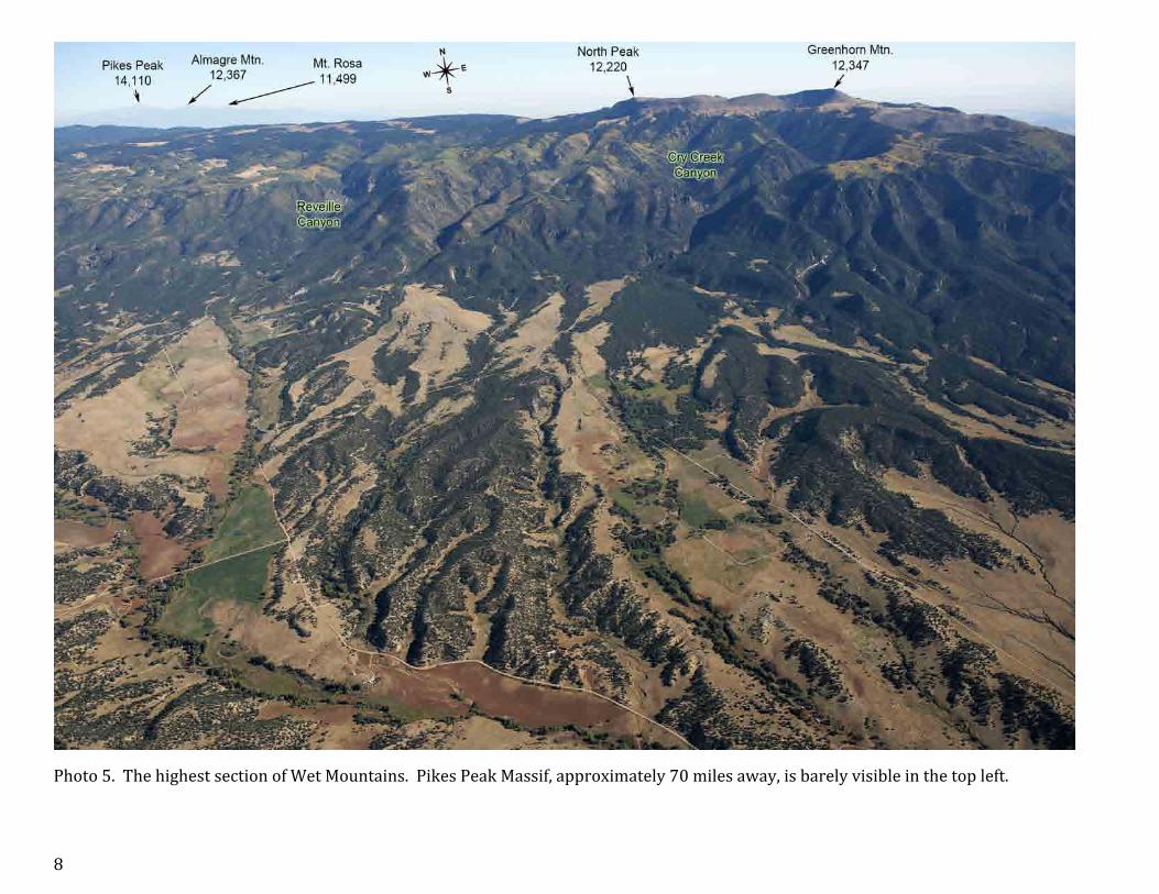
Photo 5. The highest section of Wet Mountains. Pikes Peak Massif, approximately 70 miles away, is barely visible in the top left.

9
Photo 6. The first photo of the series of 9 showing a high resolution panorama of the top portion of Wet Mountains, viewed from southwest.

10
Photo 7. Image 2 of 9. North Peak to Greenhorn Mountain.

11
Photo 8. Image 3 of 9. The North Peak. Blue Lakes surrounding provides excellent camping sites.

12
Photo 9. Image 4 of 9. Images 4 to 9 cover the best-‐known mushroom hunting spots in Colorado.

13
Photo 10. Image 5 of 9.

14
Photo 11. Image 6 of 9.

15
Photo 12. Image 7 of 9. Approximately 5 miles away from Greenhorn Mountain.

16
Photo 13. Image 8 of 9.

17
Photo 14. The last image of the series. Pole Creek Trailhead is about 6 miles away from North Peak.

18
Photo 15. The last 6 miles of Greenhorn Mountain Road, view towards Greenhorn Mountain.

19
Section 1. The Southwest Front Range and the Pikes Peak Massif.
Fig. 2. Section 1 map of the Front Range. This Section includes Southwestern Front Range with Burned Timber Mtn., Waugh Mtn., Jack Hall Mtn., Big Baldy Mtn., Aspen Ridge, Kaufman Ridge, Flat Top Ridge, Black Mtn., Thirtynine Mile Mountain, south section of Puma Hills and the Pikes Peak Massif. The enlarged fragment of the area, marked in orange, is presented on the Fig. 3, page 51.

20
Photo 16. View of the Pikes Peak Massif from Pueblo West.

21
Photo 17. View from the south of Florence on the Pikes Peak Massif.

22
Photo 18. View to the south of Cañon City. Royal Gorge is on the right.

23
Photo 19. Royal Gorge in its entirety.

24
Photo 20. The Royal Gorge Bridge was built in 1929. It hangs 955 feet above the Arkansas River and is 1,260 feet long.

25
Photo 21. Southeastern edge of Front Range. View to the south from Garden Park towards Florence.

26
Photo 22. The same area as shown on the previous photo except it was made further to the north. To the left of Wrights Reservoir you can see Cripple Creek.

27
Photo 23. Looking north from Wrights Reservoir, an opposite direction as seen on the previous photo.

28
Photo 24. It is made essentially from the same site as the two previous pictures except it’s a view of Cripple Creek from northwest.

29
Photo 25. Waugh Mountain is located about 15 miles east of Salida.

30
Photo 26. Southwest part of The Front Range borders with Wet Mountain Valley and Sangre de Cristo Mountains.

31
Photo 27 is spread out over three pages. This one, Photo 27a, covers the most southwestern part of the Front Range. South Sawatch Mountains are visible in the background.

32
Photo 27b. The middle part of the photograph. Black mountain is the largest mountain of the Front Range displayed here. Sawatch Mountains from Mt. Princeton to Mt. Massive are in the background.

33
Photo 27c. The third part of the photo covers Thirtynine Mile Mountain, Spinney Mountain and Eleven Mile Canyon Reservoirs, viewed from the southeast. In the background you can see Mosquito Range and western Front Range.

34
Photo 28. Antero Junction viewed from north. The northern tip of Sangre de Cristo Mountains and southernmost end of Sawatch Mountains are in the background. The insert shows a photo the top of the Castle Rock made from Road 187.

35
Photo 29a. This panoramic photograph was made with a 185 mm lens and it is divided into four parts. Limestone and Triad Ridges of the Front Range border the south end of Mosquito Range.

36
Photo 29b. Mosquito Range and Front Range meet at the Hoosier Pass. Castle Rock is an interesting rock formation displayed here and on page 39.

37
Photo 29c. The highest mountains of the Front Range are in the background, Kaufman Ridge is in the foreground.

38
Photo 29d. The middle part of South Park with Kenosha Mountains and Mount Evans in the background.

39
Photo 30. Western part of the Front Range Mountains blend in with the Mosquito Range east of Buena Vista. The insert shows a close up of Castle Rock, displayed also on page 36.

40
Photo 31. Black Mountain viewed from south.

41
Photo 32. Southwest end of Front Range, area southwest of Cripple Creek.

42
Photo 33. Thirtynine Mile Mountain viewed from south.

43
Photo 34a. A four page panorama from around Saddle Mountain, to Sentinel Point of Pikes Peak.

44
Photo 34b. The second part of the panorama.

45
Photo 34c. The third part of the panorama.

46
Photo 34d. The fourth part of the panorama covering the most southern area (view to the east).

47
Photo 35. South Park near Spinney Mountain Reservoir. View to the east toward Pikes Peak.

48
Photo 36. Southern view from above Stoll Mountain to Eleven Mile Canyon Reservoir and Sangre de Cristo Mountains.

49
Photo 37. Badger Mountain, Wilkerson Pass and the mountains south of the Pass.

50
Photo 38. View of Wilkerson Pass towards east.

51
Fig. 3. Areas covered by the photos of the Pikes Peak region. It is an enlarged fragment of the map shown on Fig. 2, page 19. Telephoto panoramas are labeled in orange, standard photo areas are in red, and 360° wide angle view is marked in blue.

52
Photo 39a. The southwest face of Pikes Peak panorama made from above Goldfield, split into 4 pages. This section shows view to the north.

53
Photo 39b. Pikes Peak panorama made from above Goldfield; the second section shows view to the north-‐northeast. Pikes Peak was named after Zebulon Pike whose team tried to reach the summit in November of 1806. Due to poorly chosen route and timing they reached only Mount Rosa. The Ute Indians referred to the mountain as the Sun Mountain Sitting Big.

54
Photo 39c. Pikes Peak panorama, the third section shows a view to the northeast of the area between Pikes Peak and Almagre Mountain. Cathedral Park, an impressive rock formation visible from Gold Camp Road is visible at bottom right.

55
Photo 39d. The last section of the Pikes Peak panorama shows the west and south slopes of Almagre Mountain, a view to the east.

56
Photo 40. The west face of Pikes Peak made from above the Beasley Hills (see page 27). Dome Rock, the largest rock formation in Millers State Park, is visible at the bottom left and on the insert.

57
Photo 41. Cripple Creek and Victor Gold Mine in front of Pikes Peak. Picture taken near Little Pisgah Peak.

58
Photo 42. A wide angle view of Pikes Peak taken from above Phantom Canyon Road near Nipple Mountain.

59
Photo 43. Wide angle view to the north from above East Beaver Creek of Mount Big Chief and Almagre Mountain.

60
Photo 44. The west side of Almagre Mountain. The summit is nearly 2 miles wide. Baldy is the southern summit of Almagre Mountain.

61
Photo 45. Mountains west of Hwy 115 and Fort Carson viewed from the south. The next photo shows San Luis Peak in more detail.

62
Photo 46. Southern view of San Luis Peak area. The insert below shows enlarged photo of the ridge between San Luis Peak and Mount Vigil. Note that the Devils Slide is behind the mountain.

63
Photo 47. Northwest view from above Gray Back Peak. The insert below (photo made from Almagre Mountain) shows better the relative heights of Knight-‐McKinley-‐San Luis Peaks.

64
Photo 48. Gold Camp and Old Stage Roads area. View from above Cheyenne Mountain to the northwest.

65
Photo 49. Southern view of Cheyenne Mountain made from above Manitou Springs. Greenhorn Mountain (Wet Mountains) and Spanish Peaks (Sangre de Cristo Mountains) make up the eastern edge of the mountains in south Colorado.

66
Photo 50. View to the west from Manitou Springs.

67
Photo 51a. Panoramic view of the Colorado Springs mountains from Palmer Park. Cheyenne Mountain is in the south and Garden of the Gods (the third section) in the west. The view is split into three pages, and the most notable sites are enlarged at the bottom of each page.

68
Photo 51b. The middle part of the Colorado Springs Mountains panorama.

69
Photo 51c. The third part of the Colorado Springs Mountains panorama.

70
Photo 52a. Part 1 of the 360° panorama from Mount Muscoco. It goes clockwise and starts from the northeast view of Colorado Springs.

71
Photo 52b. Part 2 of the 360° panorama from Mount Muscoco.

72
Photo 52c. Part 3 of the 360° panorama from Mount Muscoco.

73
Photo 52d. Part 4 of the 360° panorama from Mount Muscoco.

74
Photo 52e. Part 5 of the 360° panorama from Mount Muscoco.

75
Photo 52f. Part 6 of the 360° panorama from Mount Muscoco.

76
Photo 52g. Part 7 of the 360° panorama from Mount Muscoco.

77
Photo 53. The Crags and western slope of Pikes Peak.

78
Photo 54. The southern view of the west side of Pikes Peak.

79
Photo 55. The southwest view of Pikes Peak.

80
Photo 56. The south side of Pikes Peak.

81
Photo 57. The east side of Pikes Peak.

82
Photo 58. Pikes Peak view from above Rampart Range near Cascade (the northeast side).

83
Photo 59. Ute Pass from Cascade to Crystola.

84
Photo 60. View of Pikes Peak from the north, above Rampart Range Road in Woodland Park.

85
Photo 61. Woodland Park, view from north.

86
Section 2. Mountains between Highways 24 and 285 -‐ from Denver to Colorado Springs.
Fig. 4. Area coverage by the photos of the Section 2 of The Front Range Mountains.

87
Photo 62. Highway 24 area from Woodland Park to Wilkerson Pass. View towards west.

88
Photo 63. Highway 24 area from Woodland Park to Wilkerson Pass. View towards northwest.

89
Photo 64. Highway 67 area. View of Pikes Peak from north. The southeastern edge of Hayman fire area is in the foreground.

90
Photo 65. View of Palmer Lake to south. Eastern edge of Front Range near Colorado Springs.

91
Photo 66. Pikes Peak view from Monument.

92
Photo 67. Rattlesnake Butte, the first of the Butte series viewed when driving from Colorado Springs to Denver on Interstate Hwy. 25.

93
Photo 68. Best Butte, the smallest named butte in the area.

94
Photo 69. Buttes between Monument and Castle Rock.

95
Photo 70a. This series of 4 photos cover a wide view spanning from Front Range Buttes to Hayman Fire Scar captured from near Long Scraggy Peak.

96
Photo 70b. The second section of the panorama. Behind the Eagles Peak there is US Air Force Academy. Devils Head on the left.

97
Photo 70c. The third section of the panorama: Thunder Butte.

98
Photo 70d. The fourth section of the panorama, with Cheesman Lake and Sheeprock.

99
Photo 71. Rampart Range viewed from Perry Park to the south. Pikes Peak massif is in the background.

100
Photo 72a. A series of 4 photos covering Front Range area from Perry Park to Roxborough Park. View generally from east.

101
Photo 72b. The second part of the Front Range panorama with Devils Head and north part of Hayman Fire scar.

102
Photo 72c. The third part of the panorama with Long Scraggy Peak and Buffalo Creek fire scar (middle) and Hi Meadows fire scar (back).

103
Photo 72d. The fourth part of the view showing mountains near Roxborough State Park.

104
Photo 73. View to southwest from Roxborough State Park. The two fire scars, Hayman and Buffalo Creek, are well visible.

105
Photo 74a. The northern part of Section 2 panorama, spread into three pages. The edge of the Front Range.

106
Photo 74b. The second page of the view showing the highest parts of Tarryall Mountains.

107
Photo 74c. The third part of the photo showing the north end of Platte River Mountains (Peaks X, Y & Z belong to Kenosha Mountains.)

108
Photo 75. Thunder Butte viewed from south.

109
Photo 76. Cheesman Lake surrounded by the Hayman Fire burned forest.
110
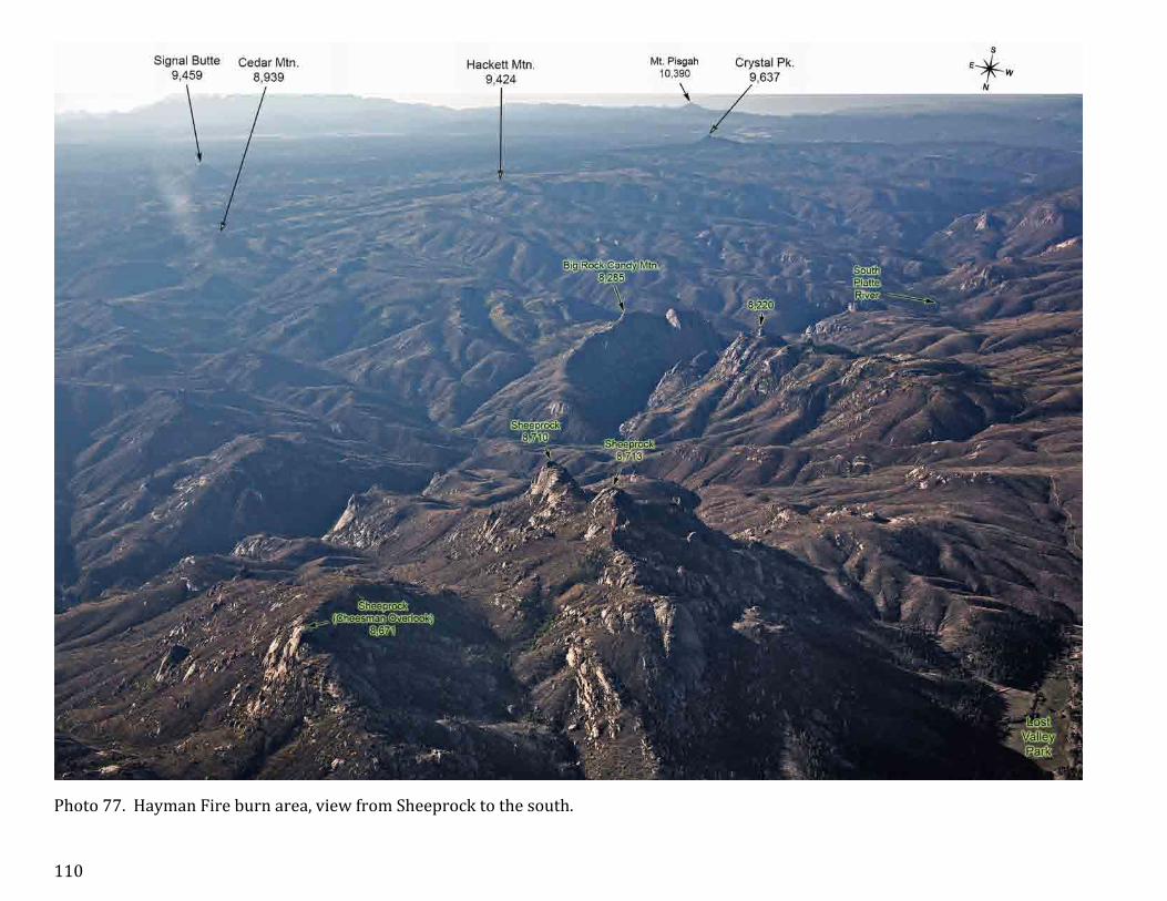
Photo 77. Hayman Fire burn area, view from Sheeprock to the south.

111
Photo 78. Big Rock Candy Mountain and the southern edge of Cheesman Lake.

112
Photo 79. Sheeprock and Big Rock Candy Mountain viewed from south.

113
Photo 80. Pilot Peak is located at the southern end of Tarryall Mountains.

114
Photo 81. Tarryall Creek Valley.

115
Photo 82. South Tarryall Peak.

116
Photo 83. Bison Peak and McCurdy Mountain viewed from southwest.

117
Photo 84. Bison Peak view from southwest. The insert below shows the 360° view from the top of Bison Peak.

118
Photo 85. McCurdy Mountain view from southwest.

119
Photo 86. View from the south of the McCurdy Park, an area between South Tarryall Peak and McCurdy Mountain.

120
Photo 87. Eastern slope of McCurdy Mountain.

121
Photo 88. Lost Creek Wilderness near McCurdy Mountain.

122
Photo 89. View to east from Tarryall Reservoir.

123
Photo 90. Southerly view from Stony Pass.

124
Photo 91. Wellington Lake view from northeast.

125
Photo 92. Devils Head views from south (bottom) and north (top).

126
Photo 93. Devils Head, view from east. The insert at the bottom shows a close up of the highest point, with observation deck.

127
Photo 94. Long Scraggy Peak, view from southeast.

128
Photo 95. View of Thunder Butte from Long Scraggy Peak.

129
Photo 96. Long Scraggy Peak view from south.

130
Photo 97. North Tarryall Mountains.

131
Photo 98. North Tarryall Peak and the highest part of Kenosha Mountains.

132
Photo 99. Peak X is the highest peak of Kenosha Mountains.

133
Photo 100. View of Kenosha and Platte River Mountains from west.

134
Photo 101. Southern part of Platte River Mountains.

135
Photo 102. Platte River Mountains with Crooked Top Mountain in the foreground.

136
Photo 103. Bishop Rock and Cathedral Spires rock formations.

137
Photo 104a. A three page view of Roxborough rock formation. Area near the State Park Visitor Center.

138
Photo 104b. Part two of the panorama, north of the State Park.

139
Photo 104c. Part three of the panorama showing entrance to the Waterton Canyon open space.

140
Photo 105. The eastern edge of Front Range from Roxborough State Park to Highway 285 with Hogback.

141
Section 3. Central Front Fange: mountains north of Highway 285 and south of Interstate 70.
Fig. 5. Areas covered by the photos of the Section 3 of The Front Range Mountains.

142
Photo 106. Southwestern edge of the Central Front Range. Mount Silverheels (9th highest in the Front Range) is on its western end.

143
Photo 107a. Panorama of the southwestern end of the Central Front Range, viewed from east. Photo 1 of 2.

144
Photo 107b. Panorama of the southwestern end of the Central Front Range, viewed from east. Photo 2 of 2.

145
Photo 108. Mount Silverheels and Red Mountain viewed from southwest (north of Alma).

146
Photo 109. View through Bald Mountain towards Square Top Mountain.
147
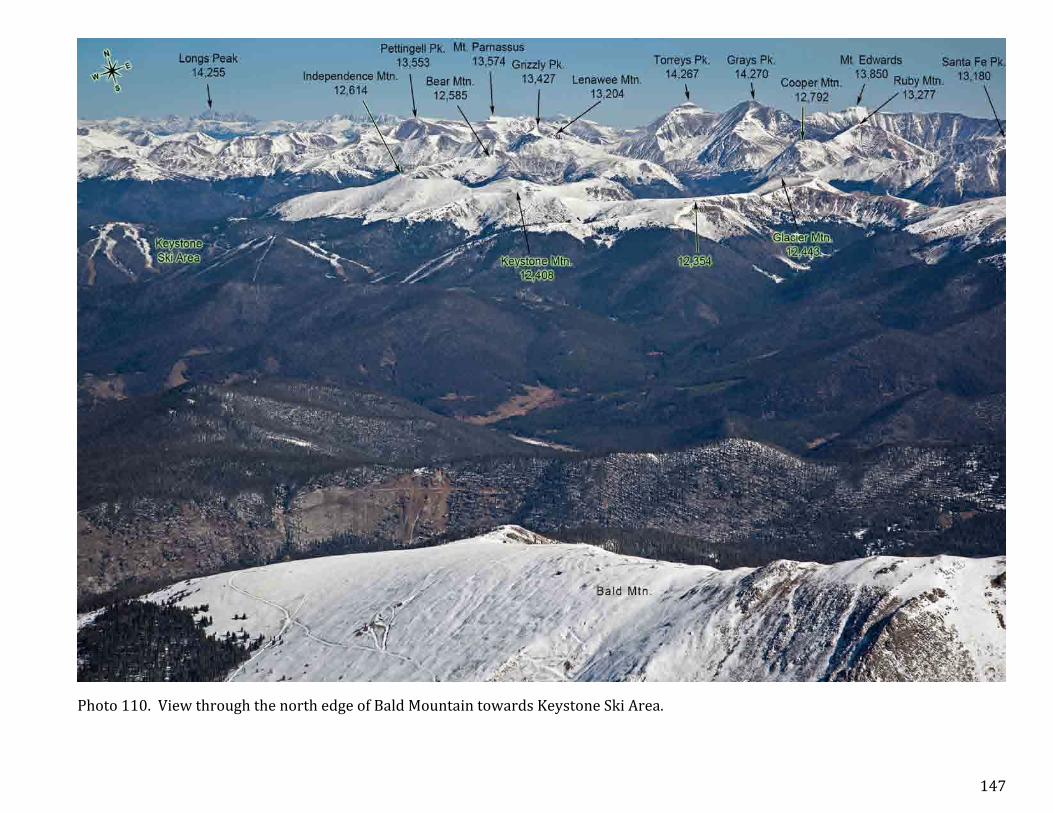
Photo 110. View through the north edge of Bald Mountain towards Keystone Ski Area.

148
Photo 111. Over a century ago South of Keystone was an active mining area.

149
Photo 112a. A four-‐page panorama of western Front Range mountains from Keystone Mountain to Hoosier Pass near Breckendridge.

150
Photo 112b. Second part of the panorama of the mountains near Breckendridge, view from northwest.

151
Photo 112c. Third part of the panorama showing Mount Guyot and Bald Mountain.

152
Photo 112d. Fourth part of the panorama with Hoosier Pass where Front Range meets Mosquito Range.

153
Photo 113a. Western edge of Central Front Range. The first of the two-‐page panorama.

154
Photo 113b. The second of two-‐page panorama showing Highway 9 from Frisco to Breckendridge.

155
Photo 114a. Dillon Reservoir and vicinity. This panorama is split into 3 pages.
156
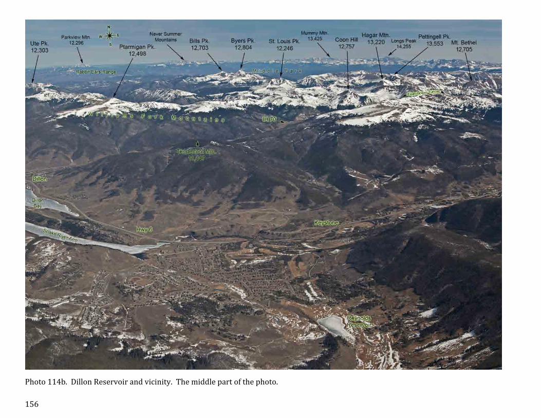
Photo 114b. Dillon Reservoir and vicinity. The middle part of the photo.

157
Photo 114c. Dillon Reservoir and vicinity. The third part of the panorama with Keystone ski area.

158
Photo 115. Jefferson Creek area viewed from south.

159
Photo 116. Mount Guyot viewed from south. Named after Swiss geologist Arnold Henry Guyot (1807-‐1884).
160
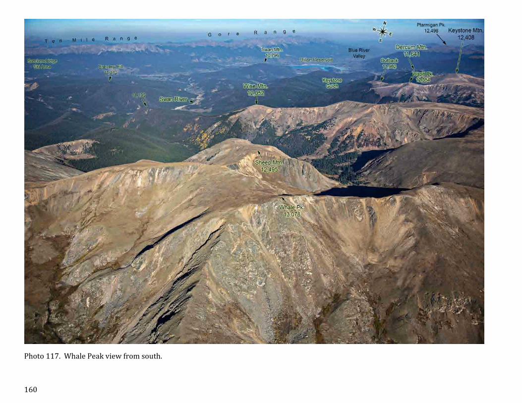
Photo 117. Whale Peak view from south.

161
Photo 118. Whale Peak view from southeast.

162
Photo 119. Mining area south of Keystone.

163
Photo 120. View of the mountains between Whale Peak and Red Cone, towards north.

164
Photo 121. Handcart Peak view from south.

165
Photo 122. Jefferson Lake and adjacent mountains view from south.

166
Photo 123. Webster Pass view from south.

167
Photo 124. Red Cone view from south.

168
Photo 125. Snake River Valley and Landslide Peak viewed from south.

169
Photo 126. Keystone Ski Area viewed from west.

170
Photo 127. Keystone Ski Area viewed from northwest.

171
Photo 128. Independence Mountain and Keystone view from north.

172
Photo 129. Unnamed chain of mountains south of Eisenhower Tunnel. The parent mountain of the Points 12,701, 12,481, 12,382, etc. is Hagar Mountain, on the north side of Interstate Hwy 70. UN 12,752 is an unnamed peak with prominence over 300 feet.

173
Photo 130. Porcupine Peak is a part of Lenawee Mountain, with prominence only 210’. In the foreground, points 12,106 and 12,382 belong to a larger unnamed mountain UN 12,752 near Loveland Pass, see photo 129.

174
Photo 131. Eisenhower Tunnel -‐ Loveland Pass view from northeast.

175
Photo 132. Loveland Pass and Lenawee Mountain view from north.

176
Photo 133. Peru Creek Valley (bottom left) and Dillon Reservoir view from the top of Ruby Mountain.

177
Photo 134. Peru Creek Valley view from around Porcupine Peak, towards east.

178
Photo 135. Lenawee Mountain view from west.

179
Photo 136. View of Peru Creek area from the top of Argentine Peak.

180
Photo 137. Grays Peak Massif viewed from west.

181
Photo 138. Loveland Pass area view from west.

182
Photo 139. Loveland Valley Ski Area.

183
Photo 140. Mount Snikatau.

184
Photo 141. Loveland Pass view from south.

185
Photo 142. Landslide Peak viewed from south.

186
Photo 143. Square Top Mountain and Geneva Creek Valley view from south.

187
Photo 144a. Revenue Mountain. Part 1 of the two page panorama.

188
Photo 144b. Square Top Mountain. Part 2 of the panorama.

189
Photo 145. Decatur Mountain view from west.

190
Photo 146. Grays Peak massif view from south.

191
Photo 147. Ruby Mountain view from west.

192
Photo 148. Grays and Torreys Peaks view from southwest.

193
Photo 149. Grizzly Peak.

194
Photo 150. Kelso Mountain and IH 70 corridor viewed form west.

195
Photo 151. A rounded shape of Stevens and Grizzly Gulch.

196
Photo 152. Stevens Gulch and trail to Grays Peak.

197
Photo 153. Grays and Torreys Peaks viewed from east.

198
Photo 154. Stevens Gulch viewed from northeast.

199
Photo 155. Grays Peak view from northeast. Named after botanist Asa Gray (1810-‐1888), a pupil of John Torrey.

200
Photo 156. Torreys Peak viewed from east. The insert shows the summit. Named after botanist and chemist John Torrey (1796-‐1873).

201
Photo 157. Grays and Torreys Peaks viewed from east. The insert shows the summit of Grays Peak.
202
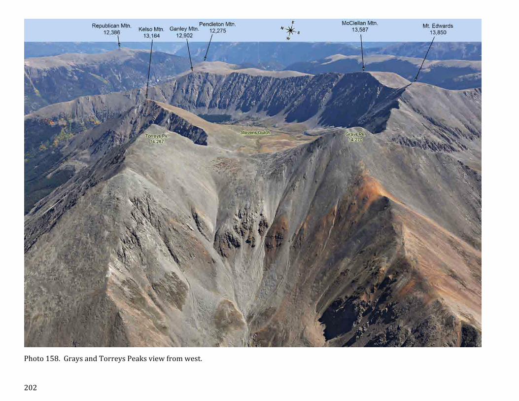
Photo 158. Grays and Torreys Peaks view from west.

203
Photo 159. A town of Jefferson view from south.

204
Photo 160. Argentine Peak and Mount Edwards view from south.

205
Photo 161. Sugarloaf Peak view from east.

206
Photo 162. The Interstate 70 corridor near Georgetown.

207
Photo 163. Pendleton Mountain near Georgetown viewed from east.

208
Photo 164. Grays and Torreys massif viewed from east.

209
Photo 165. Guanella Pass Road view from northeast.

210
Photo 166. Mount Wilcox view from northeast.

211
Photo 167a. Square Top Mountain and Mount Wilcox view from east. Part 1 of the two page panorama.

212
Photo 167b. Interstate 70 corridor view from east. Part 2 of the two page panorama.

213
Photo 168. Guanella Pass Road view towards Georgetown.

214
Photo 169. Lakes near Mount Wilcox and Guanella Pass.

215
Photo 170. Guanella Pass.

216
Photo 171. View of the mountains from Square Top Mountain to Mount Evans from South.

217
Photo 172. Mount Bierstadt view from east. Albert Bierstadt (1830 -‐ 1902) was a German-‐American painter of the American West.

218
Photo 173. Gray Wolf Mountain view from east.

219
Photo 174. Mount Evans Road.

220
Photo 175. Chicago Lakes Basin.

221
Photo 176. A closer view of Chicago Lakes.

222
Photo 177. View of Rogers Peak from Epaulet Mountain.

223
Photo 178. Mount Evans Road from Summit Lake to the top. Mount Evans was named after John Evans (1814-‐1897), second governor of the Colorado Territory.

224
Photo 179. Summit Lake and Mount Evans viewed from northeast.

225
Photo 180. Mount Evans view from east.

226
Photo 181. Mount Evans view from south.

227
Photo 182. Summit of Mount Evans.

228
Photo 183. Mount Evans and Chicago Lakes view from north.

229
Photo 184. Mount Evans and Summit Lake.

230
Photo 185. Mount Bierstadt and Mount Evans view from west.

231
Photo 186. Mount Logan view from south.

232
Photo 187. Kataka Mountain.

233
Photo 188. Mount Evans massif view from south.

234
Photo 189. Mount Evans massif.

235
Photo 190. View of the mountains from Mount Bierstadt to Mount Bancroft from southeast.

236
Photo 191. Royal Mountain and Rosedale Peak.

237
Photo 192. Hills near Black Mountain.

238
Photo 193a. A wide, 4-‐page panorama of Front Range Mountains fromShawnee Peak to Chief Mountain and North Arapaho Peak.

239
Photo 193b. Section 2 of 4 of the panorama. Mount Logan.

240
Photo 193c. Section 3 of 4 of the panorama. Mount Evans.

241
Photo 193d. Section 4 of 4 of the panorama. From Rosedale Peak to Chief Mountain.

242
Section 4. Mountains south of Middle Park and Indian Peaks.
Fig. 6. Photo numbers and areas covered in the Section 4.

243
Photo 194. Southwestern edge of Williams Fork Mountains. IH 70 from Dillon to Eisenhower Tunnel.

244
Photo 195a. Part 1 of the 2-‐page panorama of Williams Fork Mountains.

245
Photo 195b. Part 2 of the 2-‐page panorama of Williams Fork Mountains.

246
Photo 196. Blue River Valley and north end of Williams Fork Mountains.

247
Photo 197. Green Mountain Reservoir and Williams Peak.

248
Photo 198. Ptarmigan Peak in the Williams Fork Mountains.

249
Photo 199. Jones Pass in Vasquez Mountains.

250
Photo 200. Saint Louis Peak view from west.

251
Photo 201. Byers and Bills Peaks view from north. William Newton Byers (1831 -‐ 1903), the founder and editor of the Rocky Mountain News in Denver and the first deputy surveyor of the Nebraska Territory

252
Photo 202. Byers and Bills Peaks view from west.

253
Photo 203. Byers and Bills Peaks view from southwest.

254
Photo 204. Ptarmigan Peak in Middle Park. This mountain may be confused with one of the mountains bearing the same name in nearby Williams Fork Mountains (12,498’).

255
Photo 205. The south side of Vasquez Mountains.

256
Photo 206. The south end of Williams Fork Mountains.

257
Photo 207a. Part 1 of a nine page 360° panorama made from a 15,000 feet elevation, 5 miles west of Winter Park.

258
Photo 207b. Winter Park 360° panorama, part 2 of 9.

259
Photo 207c. Winter Park 360° panorama, part 3 of 9.

260
Photo 207d. Winter Park 360° panorama, part 4 of 9.

261
Photo 207e. Winter Park 360° panorama, part 5 of 9.

262
Photo 207f. Winter Park 360° panorama, part 6 of 9.

263
Photo 207g. Winter Park 360° panorama, part 7 of 9.

264
Photo 207h. Winter Park 360° panorama, part 8 of 9.

265
Photo 207i. Winter Park 360° panorama, part 9 of 9. Note two Ptarmigan Peaks on this section.

266
Photo 208. The north side of Vasquez Mountains.

267
Photo 209. Vasquez Pass viewed from north.

268
Photo 210. View to the north towards Eisenhower Tunnel.

269
Photo 211. Eisenhower–Johnson Memorial Tunnel West Entrance. The Interstate 70 crosses the Continental Divide. The Tunnel is 1.7 miles long and it is the highest vehicular tunnel in the United States. The westbound tube was opened in 1973, and eastbound in 1979.

270
Photo 212. View across Continental Divide and Eisenhower Tunnel with Loveland Pass.

271
Photo 213. Republican Mountain to Mount Parnassus ridge, view from east.

272
Photo 214. Red Mountain and Jones Pass Road viewed from west.

273
Photo 215. Mount Parnassus and Engelmann Peak viewed from west. George Engelmann (1809 – 1884) was a German-‐American botanist. He was instrumental in describing the flora of the west of North America.

274
Photo 216. Berthoud Pass view from west.

275
Photo 217. Woods Mountain view from west.

276
Photo 218. Republican Mountain to Mount Parnassus ridge view from west. Parnassus is a Greek mythology name.

277
Photo 219. Bard and Engelmann Peaks viewed from east.

278
Photo 220. Interstate Highway 70 corridor viewed from east.

279
Photo 221. Mountains west of Georgetown and Empire

280
Photo 222. Eastern slope of Engelmann Peak.

281
Photo 223. Highway 40 section from Empire to Berthoud Pass.

282
Photo 224. Highway 40 from Empire to Berthoud Pass. A broader view than the one displayed on the previous page.

283
Photo 225. Engelmann Peak, Red Mountain and Jones Pass with Gore Range in the background.

284
Photo 226. Vasquez Peak.

285
Photo 227. Unnamed mountain UN 12,763’ is one of the most massive in Vasquez Mountains. It was not named probably because of its flat and un-‐distinctive summit.

286
Photo 228. Stanley Mountain is the highest point of the Winter Park Ski area ridge.

287
Photo 229. Berthoud Pass area.

288
Photo 230. Winding Highway 40 from Berthoud Pass towards Winter Park. Parry Peak is the highest mountain in this area.

289
Photo 231. Winter Park south slopes.

290
Photo 232. James and Parry Peaks view from above Winter Park ski area.

291
Photo 233. Winter Park.

292
Photo 234. First of the series of photos showing in the background the eastern side of the ridge extending from Colorado Mines Peak to Indian Peaks. The photo was made from above Mount Edwards.

293
Photo 235. Eastern slopes of the mountains from Colorado Mines Peak to Parry Peak.

294
Photo 236. Essentially the same view as shown on the previous photo except it was made in June, as opposed to September.

295
Photo 237. November close up view of eastern slope of Witter Peak and Mount Eva.

296
Photo 238. September close up view of eastern slope of Witter Peak and Mount Eva.

297
Photo 239. Front Range view from Empire towards north.

298
Photo 240. A close up of the mountains from Breckendridge Peak to Parry Peak. The photo was made in June.

299
Photo 241. A close up of the mountains from Witter Peak to James Peak.
300
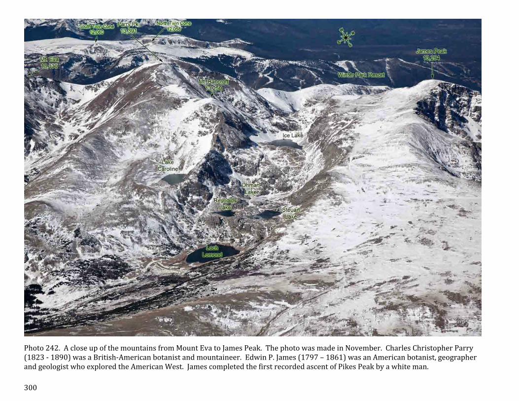
Photo 242. A close up of the mountains from Mount Eva to James Peak. The photo was made in November. Charles Christopher Parry (1823 -‐ 1890) was a British-‐American botanist and mountaineer. Edwin P. James (1797 – 1861) was an American botanist, geographer and geologist who explored the American West. James completed the first recorded ascent of Pikes Peak by a white man.

301
Photo 243. A close up of the mountains from Mount Eva to James Peak. The photo was made in September.

302
Photo 244. James Peak with Vasquez Mountains and Gore Range in the background.

303
Photo 245. A town of Alice viewed from east.

304
Photo 246. A broader view from Mount Flora to Mount Jasper.

305
Photo 247. James Peak with two eastward ridges extending to Kingston Peak and Nebraska Hill.

306
Photo 248. View from Heartbeat Peak and Mount Jasper – the lowest portion of the continuous mountain ridge extending from Interstate 70 and Mummy Mountains, west of Fort Collins.

307
Photo 249. View from Rogers Pass to Arapaho Lakes.

308
Photo 250. East and West Portals of Moffat Tunnel. Opened in 1928, it is the longest (6.2 miles) railroad tunnel in Colorado and the third longest in the USA. Its West Portal, shown on the insert, is located in Winter Park. It made Rollins Pass railroad obsolete. Likewise Eisenhower Tunnel, it also cuts through Continental Divide.

309
Photo 251. Rollins Pass Road, the former roadbed of the Denver and Salt Lake Railway. Abandoned in 1928 when the Moffat Tunnel was opened. Currently opened to 4WD vehicles only to Jenny Lake. Rollins Pass is accessible by cars from the west.

310
Photo 252. Lake Eldora Ski Area viewed from northeast.

311
Photo 253. View of the mountains from Rollins Pass to Mount Jasper.

312
Photo 254. Town of Eldora and surrounding mountains in July.

313
Photo 255. Eldora and surrounding mountains in September.

314
Photo 256. View of Nederland with North Arapaho Peak in the background.

315
Photo 257. View of the mountains from Devils Thumb to Apache Peak.

316
Photo 258. Caribou and Arapaho Peaks.

317
Photo 259. A close up view of Arapaho Peaks.

318
Photo 260. Lakes surrounding Mount Albion and Kiowa Peak.

319
Photo 261. A broad view of the mountains from Mount Jasper to Mount Audubon.

320
Photo 262. Niwot Ridge.

321
Photo 263. Lakes near Kiowa Peak.

322
Photo 264. A close up view of the mountains from Kiowa Peak to Apache Peak.

323
Photo 265. View of the mountains from from Niwot Ridge to Mount Audubon.

324
Photo 266. View of Niwot Ridge from north.

325
Photo 267. View of the mountains from Arikaree Peak to Pawnee Peak.

326
Photo 268. Navajo and Apache Peaks viewed from east.

327
Photo 269. View of the mountains from Navajo Peak to Mount Audubon.

328
Photo 270. Mount Audubon Trail.

329
Photo 271. Mount Toll viewed from east.

330
Photo 272. Mount Audubon viewed from east.

331
Photo 273. Coney Lakes.

332
Photo 274. Paiute Peak viewed from east.

333
Photo 275. Mount Audubon – Paiute Peak view from north.

334
Photo 276. View of the mountains from Pawnee Peak to Ogalalla Peak.

335
Photo 277. James Peak and Rollins Pass. This photo starts a series of the views from west.

336
Photo 278. View of the ridge from Heartbeat Peak to James Peak.

337
Photo 279. View of the ridge around Heartbeat Peak. The East Portal of Moffat Tunnel is on the left.

338
Photo 280. Riflesight Notch and Moffat Pass Road.

339
Photo 281. Rollins Pass. The city of Boulder is behind the mountains, in the background.

340
Photo 282. Part of the ridge from Skyscraper Peak to Rollins Pass.

341
Photo 283. Devils Thumb Pass. There are several features called “Devils Thumb” in this area. Interestingly, a mountain with a prominence over 300 feet remains unnamed (UN 12,650).

342
Photo 284. Mount Neva and Mount Jasper.

343
Photo 285. Mountains from Navajo Peak to Mount Neva.

344
Photo 286. Mountains around Arapaho Peaks.

345
Photo 287. North Arapaho Peak is the highest amongst Indian Peaks and it is flat at the top, similar but smaller to the summit of Longs Peak.

346
Photo 288. Mountains from Pawnee Peak to North Arapaho Peak.

347
Photo 289. A close up from Navajo Peak to North Arapaho Peak.

348
Photo 290. Apache Peak and surrounding mountains.

349
Photo 291. Mountains from Paiute Peak to Shoshoni Peak. Photo made in March.

350
Photo 292. A similar view to the one presented on the previous page except that the photo was made in September.

351
Photo 293. Mountains from Buchanan Pass to Apache Peak.

352
Photo 294. Sawtooth Mountain and Buchanan Pass.

353
Photo 295a. A five-‐page panorama of the Indian Peaks and nearby mountains of Middle Park. Part 1 of 5.

354
Photo 295b. September panorama of Indian Peaks, part 2 of 5.

355
Photo 295c. Panorama of Indian Peaks, part 3 of 5.

356
Photo 295d. Panorama of Indian Peaks and nearby mountains of Middle Park, part 4 of 5.

357
Photo 295e. Panorama of Indian Peaks and nearby mountains of Middle Park, part 5 of 5. Lake Granby, the third largest body of water in Colorado (7000 acres) was created by the erection of Granby Dam, completed in 1950.

358
Section 5. Mountains in and near the Rocky Mountain National Park.
Fig. 7. Areas covered by the photos of the Sections 5 and 6 of The Front Range Mountains.

359
Fig. 8. Areas covered by the photos of the Section 5 of The Front Range Mountains. It is an enlarged fragment shown on the previous page.

360
Photo 296a. A four-‐page panorama of the mountains from Red Deer Mountain towards north to Longs Peak. Part 1 of 4 with Mount Craig and Andrews Peak.

361
Photo 296b. A four-‐page panorama, Part 2 of 4 showing Isolation Peak with Longs Peak in the background.

362
Photo 296c. A four-‐page panorama, Part 3 of 4 with Mount Copeland and Ogalalla Peak.

363
Photo 296d. A four-‐page panorama, Part 4 of 4 showing Saint Vrain and Red Deer Mountains up to Buchanan Pass.

364
Photo 297. A wide view of the mountains made from above Lake Granby towards east, showing peaks from Longs Peak to Pawnee Peak.

365
Photo 298. View of the mountains from Ouzel Peak to Hiamovi Mountain.

366
Photo 299. Mount Copeland and Elk Tooth, view from west.

367
Photo 300. Isolation Peak view from west.

368
Photo 301. Tanima Peak and Eagles Beak view from northwest.

369
Photo 302. Eagles Beak, western view.

370
Photo 303. Mount Alice with Longs Peak in the background.

371
Photo 304. View of Grand Lake with Longs Peak in the background.

372
Photo 305. View of Longs Peak from southwest.

373
Photo 306. The summit of Longs Peak, view from southwest.

374
Photo 307. Pagoda Mountain and Longs Peak.

375
Photo 308. View from North Ridge towards Chiefs Head Peak.

376
Photo 309. View of Mount Meeker and Longs Peak from south.

377
Photo 310. Powel Peak with Longs Peak Massif in the background. Named after John Wesley Powell (1834 -‐ 1902), a U.S. soldier, geologist and explorer of the American West.

378
Photo 311. Longs Peak view from west.

379
Photo 312. Chiefs Head Peak view from southwest.

380
Photo 313. Twin Sisters Peaks.

381
Photo 314. The south end of Glacier Gorge.

382
Photo 315. Chiefs Head Peak and The Spearhead.

383
Photo 316. View of Taylor, Powell and McHenrys Peaks from southwest.

384
Photo 317. Hallet Peak and surrounding mountains view from southwest.
385
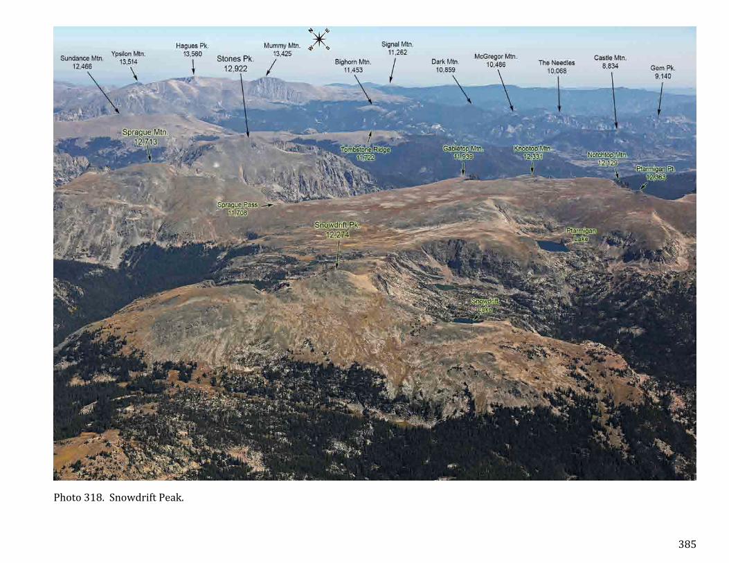
Photo 318. Snowdrift Peak.

386
Photo 319. The area between Mount Julian and Stones Peak viewed from southwest. Only the top of Hayden Spire, class 4 & 5 for climbing, is visible.

387
Photo 320. Mountains of the south side of Forest Canyon viewed from southwest.

388
Photo 321. Mountains near the west side of Forest Canyon.

389
Photo 322. Specimen Mountain view from behind Never Summer Mountains.

390
Photo 323. The north end of Kawuneeche Valley.

391
Photo 324. Specimen Mountain viewed from north. The insert shows a fragment of the new USGS map showing the origin of Colorado River.

392
Photo 325. View of the Shadow Mountain Lake from southwest.

393
Photo 326. Kawuneeche Valley and surrounding mountains viewed from south.

394
Photo 327. Grand Lake with marked west portal of Alva B. Adams Tunnel, the largest trans-‐mountain water project in Colorado finished in 1944. It is 13.1 miles long and 9.75 feet wide. The East Portal is located near Estes Park, see page 401.

395
Photo 328. Kawuneeche Valley and surrounding mountains viewed from north.

396
Photo 329. Mountains near Fall River Pass viewed from north. The insert is an enlarged fragment of a similar photo showing mountains behind the Trail Ridge.

397
Photo 330. The Front Range view to the south from Mummy Mountains.

398
Photo 331a. Panorama of the Front Range made from near Twin Sisters Mountain to the south and southwest. Part 1 of 3.

399
Photo 331b. Panorama of the Front Range made from near Twin Sisters Mountain to the south and southwest. Part 2 of 3.

400
Photo 331c. Panorama of the Front Range made from near Twin Sisters Mountain to the south and southwest. Part 3 of 3.

401
Photo 332a. Panorama of the Front Range made from near Twin Sisters Mountain to the northwest and north. Part 1 of 3.

402
Photo 332b. Panorama of the Front Range made from near Twin Sisters Mountain to the northwest and north. Part 2 of 3.

403
Photo 332c. Panorama of the Front Range made from near Twin Sisters Mountain to the northwest and north. Part 3 of 3.

404
Photo 333. Estes Park.

405
Photo 334. Mountains between Mount Audubon and Isolation Peak viewed from east. This photo starts the eastern views series of the mountains near Rocky Mountains National Park.

406
Photo 335. General view of the mountains from Meadow Mountain north to Tanima Peak.

407
Photo 336. Buchanan Pass.

408
Photo 337. Red Deer Mountain.

409
Photo 338. The Mountain ridge from Red Deer Mountain to Isolation Peak.

410
Photo 339. Ogalalla Peak and St Vrain Glaciers.

411
Photo 340. Elk Tooth and Cony Lake (do not mix up with Coney Lake that’s located less than 5 miles south from it).

412
Photo 341. Mahana Peak and lakes surrounding this mountain.

413
Photo 342. Eagles Beak view from east.

414
Photo 343. Mount Copeland and lakes surrounding Ouzel Peak. Photo made in September.

415
Photo 344. Wintery-‐like view (October) of the area depicted on the previous page.

416
Photo 345. Mountains south of Longs Peak. Photo made in March.

417
Photo 346. A similar view that is shown on a previous photo, made in September.

418
Photo 347. The flat top between Tanima Peak and Mount Alice is quarter of a mile long.

419
Photo 348. Mount Alice viewed from east.

420
Photo 349. Chiefs Head Peak viewed from southeast.

421
Photo 350. A ridge between Chiefs Head Peak and Longs Peak viewed from southeast.

422
Photo 351. The Loft is a large flat U-‐shaped area between Mount Meeker and Longs Peak. Named for Nathan Meeker (1817-‐1879), an editor of the New York Tribune, who founded the town of Greeley in 1869.

423
Photo 352. Longs Peak Massif view from southeast.

424
Photo 353. This view shows most of the East Longs Peak Trail leading through Granite Pass and the Keyhole (better seen on page 435) to the Longs Peak summit.

425
Photo 354. The names of various features of Longs Peak. Longs Peak was named after Stephen Harriman Long (1784 – 1864) who was a U.S. army explorer, topographical engineer, and railway engineer.

426
Photo 355. Chiefs Head Peak showing its face. Longs Peak is on the right. The photo was taken in March.

427
Photo 356. The Diamond of Longs Peak. The Notch on the left of the summit is clearly visible. Chiefs Head Peak is in the background.

428
Photo 357. The summit of Longs Peak viewed from south. On the insert you can see people walking the last few feet up to the summit.

429
Photo 358. September photo of the summit of Longs Peak viewed from north. Hikers are visible at the top.

430
Photo 359. The north slope of Longs Peak viewed from east.

431
Photo 360. Longs Peak Massif viewed from north.

432
Photo 361. Longs Peak and the south end of Glacier Gorge.

433
Photo 362. The northeast side of Longs Peak and Mount Meeker.

434
Photo 363. Longs Peak’s north slope is called Boulder Field.

435
Photo 364. The Diamond, the Notch, East Face and the Keyhole are well known features of Longs Peak.

436
Photo 365. Arrowhead and McHenrys Peak.

437
Photo 366. The east side of the ridge from Otis Peak to Terra Tomah Mountain.

438
Photo 367. The east side of the ridge from Taylor Peak to Bighorn Flats. A September photo.

439
Photo 368. The east side of the ridge from Otis Peak to Sprague Mountain, photo in October.

440
Photo 369. Otis and Hallett Peaks.

441
Photo 370. View from Hallett Peak to Bighorn Flats.

442
Photo 371. View from Bighorn Flats to Stones Peak.

443
Photo 372. Stones Peak and Sprague Mountain with Sprague Glacier and Rainbow Lake.

444
Photo 373a. A two page panorama of the mountains on the south side of Forest Canyon viewed from northeast. Part 1.

445
Photo 373b. A two page panorama of the mountains on the south side of Forest Canyon viewed from northeast. Part 2.

446
Photo 374. Terra Tomah Mountain.

447
Photo 375. Sundance Mountain with Never Summer Mountains in the background.

448
Photo 376. The east end of Sundance Mountain and Trail Ridge. Hayden Spire, in the back, is a challenging rock to climb.

449
Photo 377. East ascent of Trail Ridge Road.

450
Photo 378. Sundance Mountain in October.

451
Photo 379. Sundance Mountain in September.

452
Photo 380. The south end of Mummy Mountains.

453
Photo 381. Bighorn Mountain.

454
Photo 382. Mummy Mountains from Mount Chapin to Hagues Peak.

455
Photo 383. Ypsilon Mountain.

456
Photo 384. Ypsilon Mountain and Spectacle Lakes.

457
Photo 385. Mummy Mountain.

458
Photo 386. Lawn and Crystal Lakes.

459
Photo 387. Area between Fairchild and Mummy Mountains.

460
Photo 388. Area between Mummy Mountain and Mount Dunraven.

461
Photo 389. Fairchild Mountain.

462
Photo 390. View from east on the south end of Mummy Mountains.

463
Photo 391. Mummy Mountains view from northeast.

464
Photo 392. Mummy Mountains view from north. The insert below shows a crop of the same photo in higher magnification.

465
Photo 393. Hagues Peak view from northeast. Named after brothers Arnold (1840 -‐ 1917) and James Hague, surveyors and geologists.

466
Photo 394. The Skull Point and Rowe Mountain.

467
Photo 395. The lakes between Mount Dunraven and Sugarloaf Mountain.

468
Photo 396. Mummy mountain and Hagues Peak with Rowe Glacier.

469
Photo 397. The north end of Mummy Mountains viewed from south.

470
Photo 398. The Stormy Peaks and Sugarloaf Mountain.

471
Photo 399. The northwest side of Hagues Peak and Fairchild Mountain.

472
Photo 400. The origin of Cache Le Poudre River is the lake that bears the same name located on the north side of Milner Pass, best seen on page 389.

473
Photo 401. Comanche Peak view from north.

474
Photo 402. Comanche Peak view from northeast.

475
Section 6. North Front Range: Never Summer, Medicine Bow and Laramie Mountains.
Fig. 9. Areas covered by the photos of the Section 6. This is an enlarged fragment of Fig. 7, displayed on page 358.

476
Photo 403. Cascade Mountain is on the south end of Never Summer Mountains, according to US Topo maps, but in fact, the ridge that rises above timberline extends southward to Little Gravel Mountain, depicted on this photo. Radial Mountain is on the west end of Front Range in this area. Parkview Mountain is the eastern-‐most mountain of the Rabbit Ears Range.

477
Photo 404. The south side of Never Summer Mountains. The mountains were formed by volcanic and intrusive processes 24-‐29 million years ago.

478
Photo 405. Ruby Mountain, Bowen Mountain and Parika Peak.

479
Photo 406. Fairview Mountain and Parika Peak viewed from west.

480
Photo 407. Mountains from Mount Cumulus to Baker Mountain, view from west.

481
Photo 408. The same mountains as shown on the previous page, viewed from southwest.

482
Photo 409. Baker Mountain viewed from south.

483
Photo 410a. A two-‐page panorama of Never Summer Mountains from Blue Ridge to Mount Cumulus, viewed from east. Part 1.

484
Photo 410b. Part 2 of the Never Summer Mountains panorama.

485
Photo 411. A southeast view of Never Summer Mountains.

486
Photo 412. A southeast view of northern side of Never Summer Mountains.

487
Photo 413a. Never Summer Mountains from Lead Mountain to Baker Mountain. Part 1 of 3 panorama.

488
Photo 413b. Never Summer Mountains from Lead Mountain to Baker Mountain. Part 2 of 3.

489
Photo 413c. Never Summer Mountains from Lead Mountain to Baker Mountain. Part 3 of 3.

490
Photo 414. Western view of the mountains from the Lead Mountain to Mount Cumulus.

491
Photo 415. Western view of the mountains from Mount Richthofen to Howard Mountain.

492
Photo 416. The north end of Never Summer Mountains, view from west.

493
Photo 417a. A two page panorama of the north end of the Never Summer Mountains, part 1.

494
Photo 417b. The second part of the panorama. Mt. Richthofen was named after Baron Ferdinand von Richthofen (1833 -‐ 1905), a German traveller, geographer, and scientist.

495
Photo 418. The Lone Ranger and Howard Mountain.

496
Photo 419. Western view of Nokhu Crags and Mount Richthofen, made in September. The Nokhu Crags name is derived from Arapahoe, Neaha-‐no-‐xhu, meaning Eagles Nest.

497
Photo 420. Western view of Nokhu Crags and Mount Richthofen, made in October.

498
Photo 421. Mount Mahler with Nokhu Crags viewed from southwest.

499
Photo 422. Highway 14 separates Never Summer Mountains from Medicine Bow Mountains.

500
Photo 423a. A two-‐page panorama of Never Summer Mountains viewed from northeast. Part 1.

501
Photo 423b. Part 2 of the panorama.

502
Photo 424. South Diamond Peak and Nokhu Crags.

503
Photo 425. The highest point of Hwy 14 is behind the South Diamond Peak, Cameron Pass (10,276’), that separates Never Summer Mountains from Medicine Bow Mountains.

504
Photo 426. Seven Utes Mountain and Braddock Peak.

505
Photo 427. The western side of the south end of Medicine Bow Mountains.

506
Photo 428. Southwest view of Medicine Bow Mountains from South Diamond Peak to Clark Peak.

507
Photo 429. Wintery view of the south end of Medicine Bow Mountains.

508
Photo 430a. A two-‐page panorama of Iron Mountain with Never Summer Mountains in the background. The insert shows an ¼ of an acre La Poudre Pass Lake, the origin of Colorado River.

509
Photo 430b. Part 2 of the panorama of the northeastern face of the mountains.

510
Photo 431. A wider view of the same area shown on the previous photo.

511
Photo 432. Joe Wright Reservoir with Table Iron Mountain and North Diamond Peak viewed from north.

512
Photo 433. Area near Chambers Lake viewed from north.

513
Photo 434. Highway 14 leading to the Cameron Pass.

514
Photo 435. The eastern side of the south end of Medicine Bow Mountains.

515
Photo 436. The western side of the Medicine Bow Mountains near Clark Peak.

516
Photo 437. Cameron Peak with Clark Peak in the background, view from northeast.

517
Photo 438. Chambers Lake and Cameron Peak viewed from east.

518
Photo 439. Clark Peak is the highest mountain of Medicine Bow Mountains.

519
Photo 440a. A two-‐page panorama of the mountains near Clark Peak, part 1. Meriwether Lewis (1774 -‐ 1809) was an American explorer, soldier, and public administrator, best known for his role as the leader of the Lewis and Clark Expedition. William Clark (1770 -‐ 1838) was an American explorer, soldier, Indian agent, and territorial governor.

520
Photo 440b. Part 2 of the eastern side panorama of Medicine Bow Mountains.

521
Photo 441. Rawah Peaks are behind the Sheep Mountain.

522
Photo 442. Clark Peak viewed from north.

523
Photo 443. Sheep Mountain of Medicine Bow Mountains.

524
Photo 444. Upper Camp Lake.

525
Photo 445. North Rawah Peak and Rawah Lakes.

526
Photo 446. Rawah Lake Number 4 is the highest of Rawah Lakes, 11,474’.

527
Photo 447. Medicine Bow Mountains from Dodad Peak to North Rawah Peak, view from east.

528
Photo 448. South Rawah Peak.

529
Photo 449. The lakes on the north side of the Rawah Lakes complex.

530
Photo 450. Medicine Bow Mountains view to the south from Rawah Lakes complex. A September photo.

531
Photo 451. Rawah Lakes.

532
Photo 452. The north end of the highest ridge of Medicine Bow Mountains in September.

533
Photo 453. The north end of the highest ridge of Medicine Bow Mountains in October.

534
Photo 454. Big Mc Intyre Burn.

535
Photo 455. Medicine Bow Mountains view to the south from the Rawah Lakes complex. Photo made in October.

536
Photo 456. Rawah Lakes Number 3 and 4 viewed from north.

537
Photo 457. The lakes near North Rawah Peak.

538
Photo 458. The highest ridge of Medicine Bow Mountains.

539
Photo 459. The northwest side of Medicine Bow Mountains near Clark Peak.

540
Photo 460. Snowbank Peak and Clear Lake.

541
Photo 461. View of the western side of Medicine Bow Mountains from North Rawah Peak to south.

542
Photo 462. The western side of the mountains from South Rawah Peak to Clark Peak.

543
Photo 463. South Rawah Peak viewed from southwest.

544
Photo 464. The southwest view of the mountains from North Rawah Peak to Lewis Peak.

545
Photo 465. Clark and Lewis Peaks view from south.

546
Photo 466. View of Medicine Bow Mountains from South Rawah Peak to Clark Peak.

547
Photo 467. View from South Rawah Peak to Clark Peak.
548
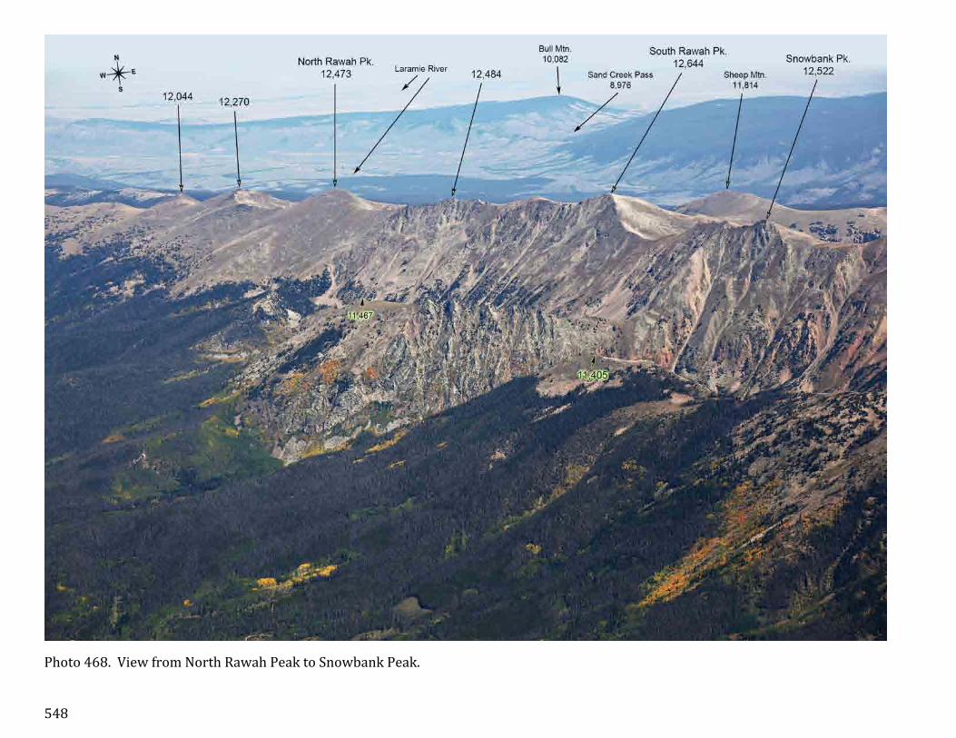
Photo 468. View from North Rawah Peak to Snowbank Peak.

549
Photo 469. General view of Medicine Bow Mountains around North Rawah Peak.

550
Photo 470. The west side of Medicine Bow Mountains north of North Rawah Peak.

551
Photo 471. Medicine Bow Mountains near Colorado-‐Wyoming border. In the north end of the Mountains, about 30 miles into Wyoming, are Medicine Bow Peak and Browns Peak.

552
The Front Range Panorama.
Photo 472a. This chapter consists of only one panoramic photo of Front Range made near Perry Park. The panorama is split into 8 pages. The mountains of Front Range are labeled in black or in black with green glow. The other mountain ranges are labeled with different colors: Sangre de Cristo Mountains are labeled in red, Wet Mountains are in light green.

553
Photo 472b. Front Range panorama, part 2 of 8. This view was made from an altitude of 14,000 feet, five miles east of Larkspur, CO.

554
Photo 472c. Front Range panorama, part 3 of 8. Sawatch Range mountains are labeled in dark green.

555
Photo 472d. Front Range panorama, part 4 of 8. Mosquito/Tenmile Range mountains are labeled in blue.

556
Photo 472e. Front Range panorama, part 5 of 8.

557
Photo 472f. Front Range panorama, part 6 of 8.

558
Photo 472g. Front Range panorama, part 7 of 8.

559
Photo 472h. Front Range panorama, part 8 of 8.

560
Section 8. Index.
Name Page Abyss Lake 217, 226, 230 Achonee Tower 328 Aguilar 5 Algonquin 253, 254, 261, 330-‐332-‐334, 351, 353,
364, 405, 407 Alice 292-‐294, 299, 303, 304 Allenspark 366, 369, 370, 377, 399 Allis Reservoir 91 Alma 142 Almagre Mountain 8, 20, 21, 54, 55, 57-‐59, 60, 63, 64, 66,
68, 75, 82, 89, 90, 91, 97, 99, 552 Alpine Peak 182, 194, 206,207, 209,212, 213, 215,
276, 278 Alva Adams Tunnel 394, 401 Andrews Glacier 438, 440 Andrews Peak 360, 371, 394, 400, 401, 406, 412, 417-‐
419, 423, 425, 436 Andrews Tarn 438, 440 Antelope Mountain 31, 48 Antero Reservoir 37, 39, 154 Antero, VABM 34 Antora Peak (S) 34, 554 Apache Peak 140, 253, 254, 261, 284, 314-‐316, 318,
319-‐321-‐323, 325-‐326-‐328, 330, 333, 346, 348, 351, 354, 399, 432, 559
Apiatan Mountain 476 Arapaho Basin 175, 178 Arapaho Lakes 306-‐309, 339 Arapaho Pass 343 Arapaho Peak, North 140, 180, 241, 253, 254, 261, 284, 314-‐
320, 322, 323, 330, 342-‐345-‐347, 354, 397, 399, 432, 522, 559
Arapaho Peak, South 261, 284, 313-‐319, 323, 333, 342-‐345 Argentine Pass 177, 178, 189-‐192, 204, 208 Argentine Peak 37, 145, 146, 149, 157, 165, 169, 177,
178, 179, 180, 185, 186, 188, 189, 191, 192, 203, 204, 205, 207-‐211, 217, 218-‐221, 225
Arikaree Peak 261, 315, 318, 319, 321-‐323, 325, 342, 343, 344, 346-‐347-‐348
Arrowhead 379, 400, 401, 430, 432, 434, 346 Arrowhead Lake 446, 447 Arrowhead Mountain 11209
234
Arvada 559 Arvada Reservoir 559 Aspen Park 106 Aspen Ridge 34, 39 Aurora Rampart Reservoir
103, 137, 138, 140, 558
Austin Bluffs 70 Azure Lake 446 Badger Mountain 40, 42, 43, 49, 50, 63, 64, 66, 81, 87, 88,
100, 104, 117, 124, 555 Baker Gulch 389, 390 Baker Mountain (Never Summer Mtns)
421
Baker Mountain (Cupid) 13117
157, 175, 180-‐184, 190, 194, 195-‐197, 201, 208, 271
Baker Mountain 12997 389, 478-‐481-‐482, 484, 485, 489, 508 Baker Pass 479, 480-‐482, 488 Baker Reservoir 335, 339-‐342, 347 Bakerville 194, 208 Bald Hill 38 Bald Mountain 10840 504, 505, 507, 510, 513 Bald Mountain 11340 314-‐316, 341 Bald Mountain 13684 33, 37, 102, 114, 120, 142, 144-‐146, 151,
154, 158, 159, 174, 209, 210, 557 Bald Mountain 7741 106 Bald Mountain 7881 54, 91-‐93, 95, 553 Bald Mountain 8620 398 Bald Mountain 9147 274, 340, 341, 345, 353, 398 Bald Mountain 9460 85, 87, 88 Bald Mountain 9611 34, 39 Bald Mountain, Middle 11002
506, 515, 544
Bald Mountain, North (10982)
543, 544
Bald Mountain, South 11003
469, 493, 506, 515, 542, 544, 549
Baldy 55, 60, 68 Baldy Peak 7872 102, 126, 557 Bandit Peak 232-‐236, 240, 557 Bandito Cone 18 Banner Peak 102, 126, 127, 136, 557 Bard Peak 103, 157, 169, 180, 181, 183, 190, 193,
196, 204, 212, 226, 240, 249, 251-‐252, 255, 264, 267, 271, 275, 276, 277-‐280, 282, 285, 286, 558
Bare Hills 31 Barnes Meadow Reservoir
504, 505, 512-‐514, 515, 536
Barr Lake 347 Base Line Reservoir 345 Battle Mountain 374, 401, 423, 424, 430, 431 Bayou Salado Reservoir 114, 115, 122 Bear Creek Lake 559 Bear Lake 383, 401, 423-‐425, 437-‐439 Bear Mountain 12585 147, 157, 162, 164, 166, 167, 171, 174,
175, 179, 198 Bear Mountain 8629 107, 237 Bear Mountain 9845 (R) 246 Bear Peak 340, 341, 380, 398
Bearpaws Peak 509, 511 Beartrack Lakes 222 Beasley Hills 27, 46, 49, 128 Beaver Creek Reservoir 90, 552 Beaver Mountain 448 Beaver Ponds 260, 437 Beaver Reservoir 349, 352, 353, 363, 365, 366, 399 Bee Rock 94, 103, 558 Bell Rock 100, 108 Belleview Mountain 213, 215, 336 Ben Lomand Mountain 90, 91, 99, 553 Bench Lake (Med. Bow) 520, 521, 527, 530, 531, 535-‐537 Bench Lake (Ptarmigan Pt.)
384
Bennett Mountain 102, 104 Bergen Peak 558 Bergen Reservoir 105, 140 Bergen Rock 101 Berrian Mountain 103, 107, 237, 558 Berthoud Pass 269, 273, 274, 287, 288, 291 Best Butte 93, 95 Betty Lake 340 Bierstadt Lake 376, 384, 401, 437 Bierstadt Moraine 401, 424 Big Baldy 128 Big Bull Mountain 26, 28, 41, 57, 58 Big Dyke 5 Big Elk Meadows 380 Big Elk Park 380 Big John Mountain 398 Big Mc Intyre Burn 534, 550 Big Meadows 392, 393, 443 Big Rainbow Lake 523, 525, 530-‐533, 535-‐537 Big Rock Candy Mountain
98, 106, 110, 111, 112, 555
Big Tooth Reservoir 82 Bighorn Flats 438, 439, 441, 442, 448 Bighorn Mountain 361, 376, 383, 385, 402, 448, 453, 464 Bighorn Reservoir 53, 79, 80 Bill Moore Lake 298 Bills Peak 156, 184, 187, 243, 245, 251, 252, 253,
265, 298, 307 Bishop Rock 102, 126, 127, 129, 136, 557 Bison Peak 40, 42, 44, 64, 88, 101, 104, 106, 115,
116, 117, 120, 122, 124, 130, 134, 150, 556
Bison Reservoir 53, 58, 63 Black Canyon 403, 404 Black Forest 55, 61, 70, 92, 93, 552 Black Hills 5 Black Lake 382, 432 Black Mountain 10125 59, 61

561
Black Mountain 10756 103, 107, 116, 119, 125-‐127, 130, 132, 133, 237, 558
Black Mountain 11654 32, 36, 40, 81, 83, 554 Black Mountain 9949 543, 544, 549 Blackfoot 331, 332, 351, 354, 364, 365, 407 Blanca Peak (SDC) 4, 98, 552 Blodgett Peak 50, 54, 59, 62, 63, 64, 89-‐91, 93, 96, 99,
552 Blue Lake (Greenhorn) 11, 12 Blue Lake (Longs) 376, 377, 379, 381, 432 Blue Lake (Mt. Toll) 320, 323, 325, 327, 328, 329 Blue Mountain 7888 362, 369, 370 Blue Mountain 9230 45, 49, 125 Blue Mountain 9420 398, 559 Blue Mountain 9856 20, 21, 61, 63, 65, 552 Blue Ridge 244, 257, 258, 299, 308, 356 Blue Ridge (Never Summer Mtns)
476, 477, 483, 500
Blue River Ranch Lakes 155 Bluebird Lake 362, 367, 412, 414, 415 Bobtail 184, 248, 249-‐252, 266, 268, 269, 280-‐
283, 285 Boehmer Reservoir 80 Booger Red Hill 26 Booth Mountain 20 Boreas Mountain 37, 114, 120, 142, 143, 145, 151, 158,
557 Boreas Pass 144, 151 Bottle Peak 251, 253, 254, 265, 298, 307, 356 Boulder 339-‐341, 345, 366, 368, 380, 381, 559 Boulder County Hill 314-‐316 Boulder Field 381, 424, 425, 430, 431, 432, 434 Boulder Mountain (S) 555 Boulder Peak, South 215, 262, 335, 337, 339-‐342, 353, 398,
559 Boulder Reservoir 343, 345, 347, 349, 366, 380 Bowen Mountain 241, 259, 412, 419, 421, 447, 477, 478,
483, 508, 522 Bowen Pass 477, 478 Box Lake 412, 417 Braddock Peak 492, 493, 496, 497-‐499, 503, 504, 506,
509, 511 Bradley Peak 114, 116, 122 Brainard Lake 320, 323, 324, 349 Breckendridge 144, 152, 154, 174, 195 Breckendridge Peak 241, 273, 274, 288-‐290, 293, 294, 297,
298, 303 Brewery Hill 160 Brind Mountain 26, 28, 41, 58 Brittle Silver Mountain 177, 179, 187, 189 Broadway Traverse 425 Browns Lake 467, 469 Browns Peak 403, 551 Bruno Mountain 30 Brush Hollow Reservoir 21 Bryan Mountain 310, 311-‐313-‐314
Buchanan Pass 334, 351, 352, 353, 363, 364, 405, 407, 408
Buckeye Mountain 324, 337, 339, 340 Buena Vista 39 Buffalo Mountain (G) 155, 161, 175, 195, 207, 208, 217, 225 Buffalo Peak 44, 78, 80, 88, 98, 101, 104, 106, 109,
113, 115-‐118, 122-‐123, 124, 133, 556 Buffalo Peak 9443 (R) 527 Buffalo Peak, East, West (M)
35, 39, 152, 555
Bull Mountain 506 Bull Mountain 10082 544-‐546, 548-‐551 Bull Ridge 30 Burgess Reservoir 87, 88 Burned Timber Mountain
30
Burning Bear Peak 203, 209, 210, 218, 222, 239 Burnt Mountain 398 Burntop 114, 117, 122, 130 Burris Mountain 29 Bushnell Peak (SDC) 554 Button Rock Reservoir 380, 398 Byers Peak 156, 184, 243, 245, 251, 252, 253, 265,
268, 298, 307, 356, 415, 522, 558 Cabin Creek Hydroelectric Res.
205, 207, 209, 210, 211, 215
Cache La Poudre Lake 500 Cameron Cone 62, 63, 64, 66, 69, 77, 82, 85, 552 Cameron Mountain 34 Cameron Pass 511 Cameron Peak 393, 478, 482, 506, 514, 515, 517-‐516-‐
519, 535-‐539, 542, 545, 547 Camp Lake 521, 523, 530, 532, 533, 535, 537 Camp Lake, Upper 521, 523, 524, 527, 530, 535, 537 Campbell Mountain 96, 101, 105, 108, 556 Cañon City 21-‐23, 25, 26 Capitol Peak (E) 179 Carey Lake 520 Caribou 314-‐316, 320, 324, 333, 345, 347, 399 Caribou Hill 314-‐316 Caribou Pass 342, 343 Carpenter Peak 103, 104, 137, 558 Cascade 63, 64, 66, 82, 83, 85 Cascade Mountain 241, 259, 316, 412, 419, 421, 439, 442,
444, 476, 477, 483, 500, 508, 536 Castle Lake 368, 370, 417 Castle Mountain 10066 125 Castle Mountain 10081 33, 41, 44, 49 Castle Mountain 8834 385, 403, 404 Castle Rock (Cañon City) 21 Castle Rock (Buena Vista)
34, 36, 39
Castle Rock (city) 559 Castle Rock (Gabletop Mtn.)
442
Castle Rocks (Walsenburg)
6
Castle, The 104, 106, 124 Catamount Reservoir 66, 83-‐85 Cathedral Park 54, 57, 58, 59 Cathedral Spires 102, 106, 125-‐127, 129, 132, 133, 136,
557 Cedar Mountain 98, 110, 123, 128, 555 Centennial 559 Centennial Ridge 551 Central City 337 Centralia Mountain 215, 262, 290, 335-‐337, 398, 559 Chair Rocks 127, 129, 136 Chambers Lake 452, 504, 512, 513, 514, 517, 535 Chaos Canyon 440 Chapin Pass 451, 452 Chase Gulch Reservoir 337 Chasm Lake 422-‐424, 433, 434 Chatfield Lake 129, 136, 559 Chautauqua Mountain 90, 91, 553 Cheesman Lake 98, 100, 104, 106, 109, 111-‐113, 123 Cheesman Mountain 97, 101, 104, 109, 112, 113, 123, 556 Cherokee 323, 327, 328, 330-‐332, 350, 351, 354 Cheyenne Mountain 20, 50, 60, 61, 63, 65, 67, 73, 85, 89-‐91,
99, 228, 552 Chicago Lakes 219-‐221 Chickadee Pond 362 Chief Cheley Peak 387, 446, 472, 479, 483 Chief Mountain 103, 125, 127, 178, 183, 193, 236, 241,
255, 256, 263, 276, 324, 558 Chiefs Head Peak 254, 260, 284, 361, 370, 374, 375, 377-‐
379, 381, 382, 416, 417, 420-‐423, 425, 426, 427, 431-‐433, 435, 436, 559
Chihuahua Lake 201 Chimney Peak 99 Chimney Rock 237 Chinns Lake 293, 295, 296, 298, 299 Chipeta Mountain (S) 31, 34, 554 Chipita Park 66, 82, 83 Chipmunk Lake 455 Chiquita Lake 454-‐456 Chittenden Mountain 311-‐313 Citadel, The 184, 187, 204, 248, 255, 269, 277 Clark Peak 402, 454, 460, 477, 478, 482, 486, 506,
514-‐519, 522, 530, 535-‐542, 545-‐547 Clayton Lake 306, 307, 338 Clear Lake (Guanella) 209, 213, 215 Clear Lake (Medicine Bow)
536-‐541
Cleaver, The 413 Clinton Peak 556 Clyde 59 Coal Creek Peak 559 Coaldale 30 Coffee Pot Hill 103, 105, 558 Coffintop Mountain 363, 366, 369, 380

562
Colorado City 9, 10, 11 Colorado Mines Peak 103, 188, 241, 263, 272-‐274, 281, 282,
286, 287, 288, 291-‐293, 295, 558 Colorado Mountain 324, 399 Colorado River Headwaters
391, 487, 508
Colorado Springs 59-‐61, 63, 67, 70, 90, 552 Columbia Mountain 282 Columbine Falls 424 Columbine Lake 392, 393, 476 Columbine Valley 559 Comanche Peak 247, 386, 387, 389, 390, 392, 393, 403,
452, 454, 459, 460, 467, 469, 470, 473, 474, 479, 491, 494, 498, 499, 502, 539, 559
Comanche Peak West 473, 474 Cone Mountain 272-‐274, 287, 289, 292-‐294, 297 Coney Island 334, 405, 407 Coney Lake 330-‐332, 333, 405, 407 Confluence Peak 472, 496 Cony Lake 362, 366, 409, 410 Cony Pass 366 Cook Mountain 398 Cooley Lake 559 Coon Hill 156, 157, 164, 167, 172, 243, 256, 264,
266, 268-‐270 Cooper Mountain 10127
257
Cooper Mountain 12792
146, 147, 167, 175, 176, 177-‐179, 185-‐187, 190, 191, 192
Cooper Mountain 9146 25, 26, 29 Cooper Peak 363, 365 Copeland Mountain 140, 254, 260, 559 Corner Mountain 94, 95 Corona 309, 311, 339, 340 Corona Lake 335, 339, 340 Corral Bluffs Corral Park 510 Corral Peak South 244, 258, 357, 500, 509 Cottonwood 244, 247, 258, 298, 299, 311, 409, 410 Cottonwood Pass 258, 311 Cottonwood Peak (SDC) 125, 553 Cover Mountain 32, 41, 48, 49, 125 Cow Mountain 52, 57, 58 Coyote Park 355 Cracktop 386, 397, 444, 446 Crags, The (Pikes Peak) 57, 77, 78, 82-‐85, 91, 93, 553 Crags, The (Estes Park) 374, 380 Crampton Mountain 29 Crater Lakes 306-‐308, 337-‐339 Crazy Mountain 551 Crescent Mountain 340, 353, 398 Crestone Peak (SDC) 4, 175, 553 Cripple Creek 26, 28, 57 Cripple Creek Reservoirs 52 Cronin Peak (S) 555
Crooked Top Mountain 107, 132, 133, 135, 232, 557 Crosier Mountain 376 Crown 389, 459, 469, 494, 498, 499, 502, 542 Crown Point 389, 469, 494, 498, 499, 502, 542 Crystal 27, 45, 50, 64, 66, 69, 82-‐84 Crystal Creek Reservoir 66, 82-‐85, 90 Crystal Lake 457-‐458-‐459, 461, 462, 468 Crystal Peak 87, 88, 98, 110, 125, 128, 554 Crystal Peak (M) 179 Crystola 83-‐85, 87 Cub Lake 437 Currant Creek Pass 42 Dakan Mountain 95 Dakota Hill 337, 399 Dark Mountain 376, 385, 403 Dawson Butte 94, 95 De Anza Peak (SDC) 553 Dead Benchmark 29, 48, 49, 125, 554 Dead Lake 60 Deadman Lake 339 Deadman Lookout 506, 543-‐546 Decatur Mountain 170, 173, 177, 179, 180, 185-‐189, 191,
198 Deer Mountain 402 Deer Ridge 362, 366, 369, 370, 380, 399 Deliah Peak 29, 31 Deming Mountain (G) 161, 175 Democrat Mountain 282 Denver 237, 559 Dercum Mountain 157, 159, 160, 169, 170, 171, 174 Deshawa 317, 318, 344-‐347 Desolation Peaks 386, 397, 452, 454, 455, 459, 461, 464,
468, 471-‐474 Devils Head 27, 42, 45, 52, 57, 63, 64, 78, 79, 96,
101, 105, 108, 127, 128, 556 Devils Nose 276 Devils Playground 50, 52, 56, 57, 66, 77, 78, 79, 80, 83-‐85,
128, 553 Devils Slide 62, 63 Devils Thumb 261, 305, 306, 311-‐315, 341, 558 Devils Thumb Lake 311, 313, 341 Devils Thumb Park 261 Devils Thumb Pass 261, 311-‐313, 341 Diamond Lake 311 Diamond Peak, North 453, 460-‐462, 482, 493, 499, 503, 504,
505-‐507, 510, 511, 513-‐515, 539, 541 Diamond Peak, South 493, 499, 502-‐504, 506 Diamond, The 425, 435 Dicks Peak 32, 40 Dillon 157, 243 Dillon Reservoir 153, 155, 156, 159-‐162, 166, 176, 179,
243 Divide 27, 46, 50, 52, 57, 66, 78, 89, 97 Dodad Peak 520, 522, 527, 530, 535, 536, 537, 539,
541, 542, 544, 547 Dog Head 27, 46
Dome Rock 27, 46, 56 Dome, The 378, 425, 435 Doublehead Mountain 103, 106, 129, 132, 136, 237, 558 Douglas Mountain 282, 279 Dragons Egg Rock 372 Dream Lake 437-‐440 Duck Lake 210, 216, 217 Duffield Meadows 62 Dundicking 403, 469 Eagle Cliff Mountain 383, 384, 402 Eagle Lake 367-‐ 369, 412, 417 Eagle Mountain 7515 94, 554 Eagle Mountain 9046 64, 66, 69, 552 Eagle Peak (SDC) 553 Eagles Beak 368, 369, 406, 412, 413, 416, 417 Eagles Nest (G) 247, 257, 277, 283 Eagles Peak 91, 93, 96, 553 Eaglesmere Lakes 247 East Face 425, 435 East Inlet 360, 371, 394, 413 East Sand Hills 478, 534, 551 Echo Lake 276 Eldora 312-‐314, 340, 341 Eldorado Mountain 262, 314, 337, 339-‐342, 347, 398 Electric Peak (SDC) 553 Electrode, The 485, 486, 501, 509 Elephant Mountain 504, 506, 507, 542 Elephant Rock 102, 557 Eleven Mile Canyon Reservoir
33, 42, 43, 47, 48, 154
Elk Mountain 11422 244, 246, 247, 258, 311, 334, 357, 405, 500
Elk Mountain 8818 550, 551 Elk Tooth 334, 362, 364-‐366-‐367, 405, 409-‐411,
414, 415 Ellingwood Point (SDC) 552 Ely Hill 206, 290, 335-‐337, 559 Emerald Lake 438-‐440 Emerald Mountain 379, 383, 401 Emma Burr Mountain (S)
555
Emmaline Lake 474 Empire 272, 279, 282, 287, 297 Engelmann Peak 240, 243, 248, 249, 251, 252, 264, 267,
269, 272, 273, 275, 277-‐280-‐283, 285, 286, 294, 310, 558
Engelwood 559 Envy Lake 408, 409, 410 Epaulet Mountain 148, 203, 222, 228, 229-‐230, 233-‐235 Epaulie 38, 148, 228, 229-‐230, 233-‐235 Estes Cone 374, 401, 471, 473, 559 Estes Park 376, 379, 383, 384, 403, 404 Ethel Lake 293 Fairburn Mountain 215, 324, 398

563
Fairchild Mountain 360, 375, 386, 403, 453-‐455, 458-‐460, 461, 462-‐465, 466, 468, 471, 473, 497, 499, 539, 559
Fairplay 36, 142 Fairview Mountain 444, 447, 478, 479, 484 Fairview Peak 8560 350, 370, 380, 398 Fairview Peak North 380, 398 Falcon 61 Falcon Lake 417, 419 Fall Mountain 459, 460, 463, 467, 469, 470, 473, 474,
497, 498, 499, 502 Fall River Pass 388, 389, 396, 451 Fall River Pass Mtn. 396, 451, 452, 456, 468, 481, 497 Fall River Reservoir 293, 295, 296, 298, 299, 304 Farncomb Hill 151 Farnum Peak 114, 130 Fay Lakes 454-‐456 Fern Lake 441 Fifth Lake 367 Finch Lake 362, 406 Fishers Peak 5, 7 Flagstaff Mountain 345 Flat Top Mountain 11355
510, 539
Flat Top Mountain 8100 105, 558 Flatiron Mountain 389, 390, 397, 452, 455, 461, 462, 464,
468, 472-‐474 Flattop Mountain 360, 384, 384, 392, 401, 423, 430, 437-‐
440-‐441, 448, 473, 502 Fletcher Mountain (M) 179 Fleur De Lis 360, 371, 413, 417, 418 Florence 21, 25 Florissant 27, 45, 50 Forest Canyon 395, 402, 424, 437, 444, 445, 447, 449-‐
451 Forest Canyon Pass 387-‐389, 447, 451, 480 Forest Lake (Forest Canyon)
445
Forest Lakes 306, 309 Fort Carson 61 Fourth of July Mountain 140 Fraser 253, 254, 355 Fremont Peak 29 French Gulch 151 French Pass 151, 159 Frigid Lake 368, 369, 412, 413, 417 Frisco 153-‐155, 161, 176, 179, 195 Frozen Lake 217, 382, 432, 434, 435 Gable, The 441, 442 Gabletop Mountain 385, 401, 441, 442 Galena Peak (SDC) 554 Ganley Mountain 178, 181-‐183, 193, 194, 195, 196, 202,
204, 208, 209, 212, 255, 279, 292 Garden of the Gods 62, 64, 69, 552 Garden Park 25 Gardner Peak 29
Garibaldi Gulch 149 Gem Peak 385, 403 Geneva Mountain 131, 148, 203, 216, 224, 231, 232, 234,
239 Geneva Park 216 Geneva Peak 37, 145, 146, 148, 149, 153, 165-‐170,
175, 185, 198, 223 Georgetown 182, 183, 194, 206, 207, 279, 282 Georgetown Lake 213, 215 Georgetown Reservoir 207, 209 Georgia Pass 144, 151, 158, 159, 171 Gianttrack Mountain 376, 402 Gibbs Peak (SDC) 553 Gibraltar Lake 409, 410 Glacier Basin 379, 383, 384, 401, 424 Glacier Gorge 379, 381, 432 Glacier Knobs 430, 438 Glacier Lake 341, 345, 347 Glacier Mountain 146, 147, 149, 157, 162, 164, 165-‐167,
169-‐172, 175, 179, 198 Glacier Peak 150, 153, 158, 164, 170-‐172, 175, 239 Glacier Ridge 424, 433 Glass Lake 438 Goat Mountain 139, 558 Goemmer Butte 4 Gold Camp Reservoir 64 Gold Lake 349, 350, 398 Golden 559 Golden Age Hill 346, 349, 350, 380, 398 Golden Bear Peak 181, 255, 256, 268, 269 Goldfield 57, 58 Goliath Peak 178, 241, 255, 276 Goose Creek Canyon 115 Goose Lake 317, 318, 319, 347, 348 Goose Pasture Tarn 152, 154 Gore Mountain (G) 246, 258, 533 Gott Mountain 102, 557 Gould Mountain 507, 510, 530 Granby 259, 331, 357, 436 Grand Ditch 388-‐390, 393, 395, 479, 481, 484-‐486 Grand Lake 259, 371, 392-‐394, 410, 413, 476 Granite Pass 424, 430 Grant 233, 234, 239 Grassy Pass 525, 531, 535, 537 Gravel Mountain 244, 259, 401, 409, 410, 412, 419, 439,
465, 476, 500 Gray Back Peak 61, 65, 73 Gray Wolf Mountain 145-‐148, 177, 178, 189, 191, 192, 213,
215, 216, 218, 219-‐222, 226 Grays Peak 37, 42, 43, 88, 102, 126, 142, 145-‐147,
149, 153, 157, 164, 167-‐169, 172, 173, 178, 180-‐182, 187, 190, 191-‐192-‐193, 195, 197, 199-‐201-‐203, 205, 207-‐209, 211, 212, 217, 225, 240, 264, 278, 279, 324, 355, 397, 399, 557
Green Knoll 389, 479-‐482, 484, 485, 489, 508
Green Lake (Guanella) 207, 209, 215, 278 Green Lake (Longs) 374, 381, 382 Green Lakes (Navajo Pk) 325, 317-‐321, 322, 347 Green Mountain 10100 59, 61, 62 Green Mountain 10313 392, 393 Green Mountain 10421 27, 39, 44, 78, 80, 98, 101, 104, 106,
108, 109, 112, 113, 115, 118, 123, 133, 556
Green Mountain 6855 559 Green Mountain 8144 262, 337, 339-‐341, 345-‐347, 363, 398,
559 Green Mountain 9245 543, 550 Green Mountain 9418 246 Green Mountain Falls 66, 83, 84, 85 Green Mtn. Reservoir 155, 246, 247 Green Ridge 11035 254, 307 Green Ridge 9012 260 Greenhorn Mountain 4, 7, 8, 9, 18, 25, 34, 65, 98, 128, 175,
552 Greenland 95 Griffith Mountain 182, 183, 186, 194, 206, 207, 209, 215,
226, 276, 278 Grizzly Peak 147, 157, 167-‐169, 175, 178, 180-‐182,
187, 190, 193, 195, 197, 201, 208, 271, 278, 279
Gross Reservoir 342, 344, 347 Grouse Mountain 10367
258
Grouse Mountain 9890 26, 28, 41, 57 Guanella Pass 38, 203, 209-‐211, 213, 214, 215, 216,
234 Guanella Pit 239, 282 Guffey 42 Guinn Mountain 311, 312 Hackett Mountain 98, 110, 123, 128, 555 Hagar Mountain 156, 181, 187, 243, 248, 255, 256, 264,
268-‐270, 277 Hagues Peak 260, 284, 360, 375, 376, 385, 386, 388,
389, 392, 403, 453, 454, 457-‐460, 462-‐466, 468, 471, 473, 491, 497, 499, 502, 539, 559
Half Mountain 376, 379, 383, 424, 430-‐ 432 Hallet Peak 371, 383, 384, 392, 394, 401, 421, 423,
424, 430, 437-‐441, 448, 480 Hammond Peak 32 Handcart Peak 37, 146, 149, 163, 164, 166, 167, 171,
175 Hang Lake 516, 518 Hankinson Reservoir 259 Harriman Lake 559 Harris Park 240 Harrison Mountain 280 Hartsel 38 Hart Ridge 487, 490, 492, 495 Hassell Peak 204, 248, 249, 251, 264, 266, 269, 280,
283, 285

564
Hayden Gorge 444-‐446, 448 Hayden Pass (SDC) 554 Hayden Peak (S) 34 Hayden Spire 386, 387, 396, 448, 464, 466 Haystack Mountain 308, 310, 336, 337 Haystack Mountain (R) 244, 246, 247, 259, 476 Heart Lake 305-‐308, 336, 337 Heartbeat Peak 262, 291, 304-‐310, 314, 335-‐337 Helms Lake 223 Hiamovi Mountain 364, 365, 409-‐411, 414, 415 Hiamovi Tower 364, 365 Hidden Valley 448 Hideaway Park 253, 262, 307, 355 High Park (Tarryall) 131 High Park (Cañon City) 26 Highest Lake 446 Highland Park 135, 232, 240 Highlands Ranch 559 Hine Lake 105, 140, 559 Hogback 105, 138, 140, 558, 559 Hoosier Pass 36, 142, 152, 174 Hoosier Ridge 143, 145, 152 Hopi 254, 261, 315, 316, 325, 327, 328, 331,
332, 346, 348, 351, 354, 399 Horns, The 59, 60, 61, 65, 67, 73, 552 Horse Ranch Pass 551 Horseshoe Mesa 5 Horseshoe Mountain (M)
33, 35, 101, 143
Horseshoe Park 402, 448, 450 Horsetooth Peak 400 Hot Sulphur Springs 258, 357 Hourglass Lake 439 Hourglass Reservoir 469 House Rock 399 Howard Mountain 421, 447, 449, 479, 482, 485, 486, 487,
490, 491, 495, 508 Huerfano Butte 6, 7 Humboldt Peak (SDC) 128, 553 Hunt Mountain 94, 95 Hunts Peak (SDC) 34, 554 Hurd 356 Huron Peak (S) 143, 555 Hutcheson Lakes 409, 410 Ice Lake 293, 300, 301, 305 Iceberg Lake (Medicine Bow)
529, 532, 533, 537, 538
Iceberg Lake (Trail Ridge)
451
Iceberg Lakes 308, 337, 338 Iceberg Pass 388, 447, 451 Icefield Pass 463, 466, 467, 469 Idaho Springs Reservoir 219, 220 Independence Mountain 12614
147, 153, 157, 161, 162, 164, 166, 167, 170-‐174, 176, 179, 197, 198
Independence Mountain 11450
212, 278
Indigo Pond 413 Inkwell Lake 446 Irene Lake 442, 443 Iron Mountain 11411 4 Iron Mountain 12265 259, 390, 393, 452, 477, 478, 486, 492,
494, 497, 498, 499, 501, 503, 505, 509, 510, 512, 539
Iron Mountain 7131 64, 66, 69 Iroquois 325, 327, 328, 331-‐333, 346, 351, 354 Island Lake (Indian Pks.) 317, 318, 319, 347 Island Lake (Medicine) 518, 519, 522 Isolation Lake 361, 412 Isolation Peak 361, 364, 371, 400, 405, 406, 409, 412,
415, 416, 423, 433, 367 J. O. Hill Reservoir 108 Jack Hall Mountain 30, 41 Jackstraw Mountain 360, 387-‐391, 395, 446, 447, 480, 481 Jacque Peak (G) 174, 179 James Peak 103, 241, 250, 263, 273, 274, 289-‐292,
297, 299-‐302-‐303-‐305, 310, 324, 335, 336, 355, 399, 558
James Peak Lake 301-‐303, 305 Jasper Lake 311, 313, 340, 341 Jefferson 37, 203 Jefferson Hill 158, 203 Jefferson Lake 158, 165 Jelm Mountain 551 Jenny Lake 309 Jewel Lake 376, 432, 545 Jims Grove 424 Joe Mills Mountain 438, 439, 441 Joe Wright Reservoir 455, 462, 493, 504, 505, 506, 510, 511,
512-‐514 Johnny Moore Mountain
525, 527
Johnson Village 39 Jones Pass 248, 249, 252, 269, 280, 281, 283 Julian Lake 387 Junco Lake 362, 412, 414, 415 Junction Butte 258 Karel Park Lake 337 Kataka Mountain 148, 203, 219, 220, 229-‐232-‐234, 239 Kaufman Ridge 34, 37, 39 Kaufman Ridge North 36, 39 Kawuneeche Valley 388-‐390, 393, 446, 477, 479, 481, 486 Keller Mountain (G) 265, 283 Kelly Lake 526, 535, 536, 538-‐541 Kelso Mountain 178, 181, 182, 193, 194, 195-‐199, 202,
204, 205, 212, 255, 271, 278 Kenny Mountain 362, 380 Kenosha Pass 203 Kenosha Peak 107, 130, 131, 133, 135, 557 Keplinger Lake 372, 375, 376, 417, 421 Keyboard of the Winds 374
Keyhole, The 378, 425, 434, 435 Keystone 153, 156, 157, 159, 169, 170, 173, 176,
179, 195 Keystone Mountain 147, 149, 153, 157, 160-‐164, 166, 169-‐
173 Kineo Mountain 60, 62, 63, 64, 68, 75, 552 King Lake 311 Kingston Peak 186, 273, 274, 292, 301, 302, 304, 305,
324, 335-‐337 Kiowa Peak 261, 316-‐318, 320-‐323, 333, 342-‐344,
346-‐348, 354, 399, 559 Kit Carson Mountain (SDC)
553
Klondike Mountain 314-‐316, 340, 341 Knights Peak 20, 21, 59, 61, 62, 63, 67, 74, 97 Knobby Crest 130-‐135 Knobtop Mountain 371, 384, 385, 392, 401, 421, 430, 437-‐
439, 441, 448 Kremmling 258 La Plata Peak (S) 32, 143, 556 La Poudre Pass 389, 391, 472, 487, 491, 494, 495, 508 La Poudre Pass Lake 391, 487, 508 La Veta 7 Lake Albion 317, 318-‐321-‐323 Lake Becktwith 9, 11, 12 Lake Caroline 293, 300-‐302, 305 Lake Dorothy 318 Lake Dunraven 463, 466, 467, 469 Lake Edith 205, 212 Lake Eldora 312 Lake Estes 374, 376, 403, 404 Lake George 44, 49, 50, 87, 88 Lake Granby 244, 259, 330, 357, 364, 391, 395, 410,
411, 439 Lake Haiyaha 430, 437, 439, 440 Lake Helene 441 Lake Husted 460, 463, 467, 469, 470 Lake Isabelle 320, 323, 325, 327 Lake Louise 463, 467, 469 Lake Merlam 6 Lake Moraine 64, 66 Lake Oehm 6 Lake of the Clouds 501 Lake Park Peak 100, 113, 115, 122, 556 Lake Pasture 380 Lake Powell 377, 379, 383 Lake Quivira 294, 304 Lake Verna 413, 417, 418 Lakes Peak (SDC) 553 Lakewood 559 Lamb Mountain (M) 152 Landslide Peak 148, 165, 167, 168, 175, 185, 186, 187,
557 Laramie Lake 504, 512, 517 Laramie Mountains Highest Point
403, 469, 478, 493, 506, 542-‐544

565
Lark Pond 367, 412, 414, 415 Larkspur 95 Larkspur Butte 54, 94, 95 Lawn Lake 453, 454, 457-‐458-‐459 Lawson Ridge 257 Lead Mountain 447, 482, 485-‐487, 490, 492, 494, 495,
501, 509 Left Hand Reservoir 320, 323, 324, 348, 349, 399 Legault Mountain 106, 132, 237 Lenawee Mountain 147, 153, 157, 164, 172, 173, 175, 176,
178, 180, 187, 190 Lewis Peak 506, 515, 518, 519, 522, 530, 535, 537-‐
542, 544-‐547 Lily Lake 374, 376, 379, 380, 401 Lily Mountain 380, 401 Limbo 333, 348, 354 Limestone Ridge 34, 35, 36, 39 Lincoln Lake 222 Lincoln Mountain 279, 280, 282 Lininger Lake 203 Lion Lake 370, 375, 382, 417-‐419 Lions Head 102, 125, 126, 230, 237, 557 Little Baldy Mountain 142, 143, 151 Little Crystal Lake 454, 457, 461 Little Echo Lake 302, 303, 305 Little Gravel Mountain 476 Little Matterhorn 401, 439, 441, 448 Little Pisgah Peak 21, 26, 28, 29, 41, 57 Little Puma Peak 114 Little Rainbow Lake 525, 530-‐532, 535, 537, 538 Little Scraggy Peak 97, 101, 104, 106, 108, 109, 112, 113,
556 Little Woolford Mountain
258
Little Yellowstone 389 Littleton 559 Lizard Rock 115 Loch Lomond 293, 297, 300-‐305 Loch Vale 431 Loch, The 383, 431, 432, 438-‐440 Loco Mountain 29, 31, 41 Loft, The 372, 374, 378, 422, 424, 425 Lone Eagle Peak 333, 348, 354 Lone Peak 107 Lone Pine Lake 413, 419 Lone Ranger, The 490-‐491-‐492, 494, 495 Lone Rock Lonesome Lake 443 Lonesome Peak 260, 355 Long Draw Reservoir 391, 452, 461, 463, 468, 472, 487, 490,
491, 494, 496, 498, 501, 510 Long Lake 319, 320, 323-‐325, 327, 348, 349 Long Meadows 387 Long Scraggy Peak 45, 52, 95, 102, 104, 105, 108, 112, 113,
115, 125, 126, 127, 128, 129, 557 Longmont 366, 369, 380
Longs Peak 130, 140, 147, 156, 186, 253, 254, 260, 284, 361, 364, 370-‐ 373, 375-‐377, 379, 381, 394, 397, 400, 421, 422, 423-‐425-‐429, 431, 432, 433, 435, 464, 473, 480, 539, 559
Lookout Mountain 369, 370, 372, 400 Loomis Lake 439, 441, 442 Lost Lake 311-‐313 Lost Lake (Chambers L.) 504, 512-‐514, 517 Lost Lake (Medicine Bow)
532
Lost Lake (Mummy) 460, 463, 467, 469, 470 Lost Platte Peak 101, 107, 130, 133, 134 Lost Ranger Peak (P) 533 Loveland 369 Loveland Pass 157, 169, 172, 174, 175, 180-‐184, 201 Lulu Mountain 390, 393-‐395, 477, 478, 486, 491, 492,
494, 496, 497, 499, 501, 502, 509, 511, 512, 522
Lunch Rock 263, 286, 289 MacFarlane Reservoir 527, 533 Madonna Dome 144, 151 Mahana Peak 361, 367, 368, 400, 406, 409, 412, 415,
416, 433 Manitou Park Lake 88, 89 Manitou Reservoir 66, 82, 83 Manitou Springs 63, 64, 66, 69 Marker Hill 261 Marmot Peak (M) 35, 39 Marmot Point 396, 397, 449, 450-‐452, 456, 474 Maroon Peak, South (E) 143, 179 Marten Peak 363, 365, 408 Martenette 364, 365, 408 Martland Peak 100, 117, 124, 555 Martson Lake 140, 230, 237, 559 Marys Lake 402 Marys Mountain 66, 69, 82 Mascot, The 39 Mason Reservoir 54, 60 Mays Peak 62-‐64, 65, 68, 76, 552 McClellan Mountain 190, 193, 194, 195, 202, 204, 208, 209,
211 McCurdy Mountain 40, 42, 88, 101, 104, 106, 115, 116, 118,
119, 120, 122, 124, 134, 556 McGregor Mountain 361, 385, 403 McHenrys Peak 361, 371, 375, 377, 379-‐383, 394, 400,
401, 417, 420-‐423, 430, 432, 436 McIntyre Lake 521, 529, 531-‐533, 537, 538 McIntyre Mountain 33, 41, 44, 49, 554 McKinley Peak 59, 61, 62, 63, 67, 74, 552 McLellan Reservoir 559 McReynolds Peak 52, 56, 57, 77, 78, 79 McReynolds Reservoir 54, 58, 59, 63 Meadow Creek Reservoir (Indian Pks)
331, 332, 355, 408
Meadow Creek Res. (Medicine Bow)
518, 525, 527, 528, 533
Meadow Mountain 363, 366, 368, 369, 377, 381, 399, 406, 431
Medicine Bow Peak 403, 469, 551 Meridian Hill 103, 116, 119, 125, 126, 130, 230, 234,
241, 263, 398, 558 Methodist Mountain (SDC)
554
Mexican Ridge 37 Michigan Hill 203 Michigan Lake 159 Midland Hill 39 Mills Lake 375, 376, 428, 431, 432 Mills Moraine 424 Milner Pass 389, 390, 472, 500 Mineral Point 483 Mirror Lake (G) 247 Mirror Lake (Mummy Mtns.)
455, 457, 472, 459
Missouri Mountain (S) 32 Mitchell Lake 319, 323-‐325, 327, 328, 330, 349 Mitre Peak 26, 28 Moffat Tunnel 308, 309 Monarch Lake 331, 356, 364 Monkey Face 94 Montana Mountain 337 Montezuma 168 Montgomery Pass 505, 507, 513-‐515 Monument 90, 91, 553 Monument Hill 91-‐93, 553 Monument Lake 91-‐93, 553 Moraine Canyon 402 Morgan Peak 177, 179, 190, 256 Morrison 559 Morse Mountain 253, 254, 356 Mosquito Pass (M) 556 Mosquito Peak (M) 35, 556 Mount Achonee 318, 320, 321, 323, 325, 327-‐332, 350,
351, 354 Mount Adams (Grand L) 364, 406, 409-‐412, 415, 416, 476 Mount Adams (SDC) 553 Mount Albion 314-‐317-‐318-‐320, 323, 342-‐348 Mount Alice 361, 370, 371, 377, 394, 416-‐418, 419,
423, 425, 431-‐433, 559 Mount Anne 125, 126, 557 Mount Antero (S) 31, 41, 104, 152, 555 Mount Argentine 152 Mount Arthur 55, 60, 62, 64, 68, 75, 77, 552 Mount Audubon 253, 254, 261, 319, 323, 327, 328, 330,
331, 333, 334, 349-‐351, 353, 364, 365, 397, 399, 405, 432, 559
Mount Bailey 133 Mount Baldy Reservoir 60 Mount Bancroft 241, 273, 274, 289-‐291, 297, 299-‐302,
305

566
Mount Belford (S) 32 Mount Bethel 156, 164, 181, 184, 196, 204, 212, 248,
255, 268-‐270, 278 Mount Bierstadt 38, 40, 102, 126, 146, 148, 149, 153,
177, 189, 191, 192, 203, 216, 217-‐225, 230, 233-‐235, 240, 263, 324, 399
Mount Big Chief 21, 58, 59, 63, 552 Mount Blaine 131, 133, 135, 238 Mount Bross (M) 33, 36, 114, 238, 556 Mount Bross 9250 247, 258 Mount Bryant 371, 392, 410-‐413, 418, 436, 441, 476 Mount Buckhorn 63-‐65, 68, 76 Mount Buckskin (M) 35 Mount Cairns 394, 418 Mount Chapin 388, 402, 449, 450, 452, 453, 454, 462,
465, 497 Mount Chauncey 244, 258, 311, 357 Mount Chiquita 388, 402, 449, 450, 452, 453, 454, 455,
456, 462, 497, 499 Mount Cindy 477, 478, 482, 485, 490, 509 Mount Cirrus 402, 421, 445, 447, 449, 461, 482, 485,
486, 487, 490, 491, 495, 501, 508, 510 Mount Columbia (S) 32, 41, 100, 104, 555 Mount Copeland 362, 364-‐366-‐368, 400, 405, 406, 409,
411, 414, 415, 431, 432 Mount Craig 360, 371, 412, 416, 417, 418, 436 Mount Cumulus 402, 421, 445, 447, 449, 474, 478-‐480-‐
482, 484, 485, 486, 488, 490, 500, 508, 510, 522
Mount Cutler 62, 64, 67, 71, 552 Mount Deception 89, 96, 99, 554 Mount Democrat (M) 33, 36 Mount Dickinson 403 Mount Dunraven 403, 460, 463, 464, 467, 469 Mount Edwards 37, 145-‐147, 149, 157, 164, 168, 178,
180, 181, 186-‐188, 190-‐195, 198, 202-‐204-‐205, 207-‐209, 217, 225, 240, 279
Mount Elbert (S) 32, 87, 143, 238, 556 Mount Enentah 371, 394 Mount Epworth 262, 30-‐306, 308, 309, 335, 339 Mount Esther 82-‐84 Mount Ethel (P) 533 Mount Eva 235, 241, 263, 272, 288, 289-‐296-‐304,
310, 558 Mount Evans 38, 39, 40, 42, 43, 80, 102, 125, 126,
130, 131, 145, 148, 149, 153, 157, 177, 191, 192, 203, 216, 219, 220, 221-‐231, 233-‐235, 240, 263, 324, 355, 397, 399, 473, 522, 557
Mount Falcon 559 Mount Flora 103, 235, 236, 241, 263, 272-‐274, 282,
286, 288-‐295, 297, 298, 303, 304, 558 Mount Garfield 55, 60, 62, 63, 64, 75, 77, 90, 552 Mount Geroge 328, 333, 346, 348, 351 Mount Glennon 559
Mount Guyot 33, 37, 102, 114, 120, 142, 144, 145, 151, 154, 158, 159, 171, 174, 209, 210, 238, 557
Mount Harvard (S) 32, 41, 87, 152, 555 Mount Helen 36 Mount Herard (SDC) 553 Mount Herman 46, 53, 64, 90, 91, 96, 99, 105, 553 Mount Hope 556 Mount Ida 260, 360, 387, 392, 393, 446, 449, 450,
464, 465, 472, 479, 480, 483, 512 Mount Irving Hale 334, 364, 405, 406, 408-‐410, 414, 415 Mount Jasper 254, 261, 284, 304-‐306, 311-‐315, 317,
319, 320, 333, 341, 342, 355, 559 Mount Judge 127 Mount Julian 360, 386, 387, 392, 393, 395-‐397, 402,
421, 444, 446, 449, 466, 472 Mount Lady Washington
370, 373, 374, 400, 422-‐424, 430, 432-‐435
Mount Lincoln (M) 33, 36, 114, 142, 143, 152, 174, 198, 238, 556
Mount Lindo 106 Mount Lindsey (SDC) 552 Mount Logan 38, 102, 130, 135, 150, 153, 173, 228,
231, 233, 234, 239, 557 Mount Machebeuf 266, 267, 275, 285 Mount Mahler 478, 482, 485, 486, 493, 496, 497, 498,
499, 501, 509, 516 Mount Manitou 66, 69, 82, 552 Mount Massive (S) 32, 143, 238, 522 Mount Meeker 253, 254, 260, 284, 361, 364, 369-‐372,
377, 378, 394, 397, 400, 416, 421-‐422-‐423, 431, 432, 433, 559
Mount Mestas 4, 7 Mount Morrison 237, 559 Mount Muscoco 62, 63, 64, 65, 67, 71, 73, 552 Mount Neota 494, 501, 508 Mount Neva 253, 254, 261, 284, 312-‐315, 317-‐319,
330, 333, 342, 343, 355 Mount Nimbus 241, 316, 402, 421, 447, 449, 477-‐481-‐
482, 484, 485, 486, 488, 500, 508, 511, 522
Mount Notabon 330, 331, 333, 334, 349, 350, 353, 365 Mount Nystrom 184, 249-‐252, 264, 266, 268-‐270, 280,
281, 285 Mt. of the Holy Cross (S) 39, 144, 175, 179, 238 Mount Olympus 372, 376, 379, 383, 384 Mount Orton 369, 370, 372, 377, 416, 417 Mount Ouray (S) 31, 34, 41, 104, 554 Mount Oxford (S) 32, 41, 143, 555 Mount Parnassus 103, 147, 157, 167, 180, 181, 183, 187,
190, 196, 204, 207, 212, 240, 243, 248, 249, 255, 264, 267, 270, 271, 273, 276, 275, 277-‐280, 285, 286, 355, 558
Mount Patterson 392, 393, 417-‐421, 438, 441-‐443 Mount Pence 127, 558 Mount Pisgah 10081 273
Mount Pisgah 10393 21, 26, 28, 41, 49, 66, 84, 85, 98, 105, 110, 128, 553
Mount Powell (G) 155, 161, 212, 225, 239, 257, 283, 557 Mount Princeton (S) 32, 41, 87, 104, 124, 555 Mount Richthofen 247, 259, 402, 421, 423, 430, 445, 449,
453, 454, 461, 463, 474, 477, 478, 482, 485, 486, 491, 492, 494, 496, 497-‐499, 501, 503, 509-‐511, 522, 536
Mount Rosa 8, 20, 21, 58, 59, 60-‐63, 68, 74, 84, 85, 91, 99, 105, 552
Mount Shavano (S) 31, 41, 555 Mount Sheridan (M) 33, 35 Mount Sherman (M) 33, 35 Mount Silverheels 33, 36, 39, 42, 43, 101, 114, 120, 142,
143, 152, 154, 174, 556 Mount Silverthorne (G) 217, 225, 246, 265, 283 Mount Sniktau 157, 175, 180-‐182, 183, 184, 187, 190,
195-‐197, 204, 208, 212, 255, 256, 271, 278, 279, 285
Mount Soprano 398 Mount Sopris (E) 144 Mount Spalding 102, 146, 148, 177, 178, 189, 191, 192,
219-‐222, 226, 557 Mount Stratus 478-‐481-‐482, 484, 485, 489, 508 Mount Tileston 453, 462 Mount Toll 261, 320, 323, 327-‐329-‐334, 349-‐351,
354, 364, 559 Mount Trelease 174, 181, 268, 270 Mount Valhalla (G) 283 Mount Vigil 59, 61, 62, 63, 65, 67, 91 Mount Warren 219, 220-‐222-‐223, 226, 228, 235, 240 Mount Wescott 371, 418 Mount White (S) 31 Mount Wilcox 146, 165, 178, 189, 194, 204, 205, 207,
209-‐211, 217, 221, 223, 225 Mount Wuh 437, 439, 441 Mount Zwischen (SDC) 552 Mout Yale (S) 32, 41, 100, 555 MsReynolds Reservoir 54 Mud Lake (Nederland) 314 Mud Lakes 230, 241 Muddy Park 538, 549, 550 Mummy Mountain 140, 156, 244, 247, 260, 284, 360, 375,
376, 385-‐389, 392, 403, 453, 457, 459, 460, 462-‐464, 466, 468, 471, 473, 497, 499, 559
Mummy Pass 463 Murphy Lake 443 Murray Lake 214, 217, 225 Nakai Peak 360, 386, 387, 392, 393, 420, 442, 444,
480 Nathrop 34, 39 Navajo Peak 253, 254, 261, 284, 318-‐321, 322, 323,
325-‐326-‐328, 330, 333, 343, 346, 348, 351, 354, 399
Naylor Lake 205, 211, 217-‐219, 221-‐223, 225

567
Nebraska Hill 263, 304, 306, 307, 310, 337 Nederland 314, 339-‐341, 347 Needles, The 361, 376, 379, 383-‐385, 403, 404 Nemnick Butte 94 Never Summer Peak 395, 421, 445, 485-‐487, 490, 491, 492,
494, 495, 501, 508, 511, 512 Ninemile Mountain 298, 311, 356 Nipple Mountain 21, 26, 28 Niwot Mountain 319, 347-‐350, 353, 399 Niwot Ridge 323, 324, 320-‐322, 333, 347, 375 No Payne 131-‐133, 134, 135 Noddle Heads 52, 95, 102, 104, 105, 108, 112, 125, 127 Nokhu Crags 402, 421, 445, 449, 461, 492, 493, 496,
498, 501-‐503, 509, 511, 513 North Inlet 360, 371, 377, 383, 394, 417-‐420, 440 North Michigan Creek Res.
518
North Middle Mountain 550 North Peak 12220 8, 10, 11, 18, 552 North Peak 11661 149, 157, 169-‐171 North Ridge 369, 370, 372, 382, 416, 417 Notch Mountain 91 Notch, The 373, 425, 428, 435 Notchtop Mountain 371, 384, 385, 401, 438, 439, 441 Nudget Hill 350, 353 Nymph Lake 438, 439 Observatory Rock 38, 114 Odessa Lake 439, 441 Ogalalla Peak 334, 362, 364-‐367, 400, 405, 406, 409-‐
411, 414, 415, 432, 433, 559 Ohman Lake 293, 300-‐302 Old Baldy 243, 245, 253, 254, 261, 284, 315-‐317,
323, 333, 342, 343 Oldman Mountain 402 Olive Peak 370, 399 Ophir Mountain 154, 159 Ormes Peak 50, 62, 63, 64, 91, 96, 552 Otis Peak 371, 383, 384, 394, 401, 421, 423, 430,
437-‐440, 448 Otter Mountain 186, 188, 205, 207, 209, 210, 211, 213,
214, 216, 218, 223, 225 Outback 149, 160, 161, 169-‐171 Ouzel Lake 362 Ouzel Peak 363, 365, 367, 400, 406, 409-‐412, 414-‐
416 Owl Mountain 510, 513, 514, 516, 517, 527 Owl Ridge 527 Oxyoke 129 Pacific Peak (M) 144, 174, 179, 557 Pagoda Mountain 361, 370, 372, 374-‐382, 397, 416, 417,
420, 422, 425, 432, 435 Pahlone Peak (S) 31, 554 Paines Mountain 207, 210, 212, 213, 278 Paiute Peak 253, 254, 261, 284, 322, 323, 330-‐334,
348-‐351, 354, 399, 405, 407, 559 Palmer Lake 90, 553
Palmer Park Hills 70 Palmer Peak 142, 143 Pancake Rocks 52, 56, 78 Paprika Peak 478, 479, 482, 484, 489 Paradise Park 411 Parika Peak 419, 421, 447, 477, 478, 479, 484, 508 Park Mountain 30 Parkview Mountain (R) 156, 164, 184, 241, 259, 316, 401, 405,
410, 419, 444, 447, 476, 501, 509 Parry Peak 103, 180, 181, 190, 241, 243, 263, 273,
274, 288, 289-‐295, 297-‐304, 310, 324, 355, 558
Pass Lake 182, 184 Pawnee Pass 349, 350 Pawnee Peak 261, 319, 320, 323, 325, 327-‐329-‐330,
334, 346, 348-‐349-‐351, 354, 364 Payne 107, 130, 133, 134 Peacock Pool 423, 424, 433 Peak 1 (M) 154 Peak 10 (M) 144, 557 Peak 4 (M) 154 Peak 8 (M) 144, 154, 174, 179 Peak 9 (M) 179 Peak C (G) 283 Peak G (G) 283 Peak Q (G) 283 Peak X 38, 101, 107, 130-‐132-‐135, 557 Peak Y 101, 107, 130-‐132, 134, 135, 557 Peak Z 38, 107, 130-‐132, 134, 135, 557 Peak Z (G) 265, 283 Pear Lake 406 Pear Reservoir 362, 409 Pendleton Mountain 183, 193, 194, 202, 205, 206, 207, 208,
209, 212, 276, 278, 279, 292 Penrose 21 Penrose-‐Rosemont Reservoir
58, 59, 61, 62
Perry Park 99-‐101, 556 Peterson Lake (Eldora) 314 Peterson Lake (Mummy)
510
Peterson Park 510 Pettingell Peak 147, 156, 157, 162, 164, 187, 204, 212,
240, 243, 245, 248, 251, 255, 264, 266, 268-‐271, 277, 283, 310, 355, 522, 558
Pikes Peak 4, 8, 20, 21, 47, 50, 53, 56-‐59, 63, 64, 66, 77, 78, 79-‐81, 82-‐85, 89, 90, 91, 93, 105, 123, 150, 154, 263, 381, 398, 473, 553
Pilot Mountain 417 Pilot Peak 40, 44, 100, 104, 106, 113, 122, 123, 555 Pipit Lake 367, 409, 411, 412, 414, 415 Platte Canyon 139, 140 Platte Canyon Reservoir 105, 139, 140 Platte Peak 107, 131, 135, 238 Poison Ridge (R) 513, 527 Pomeroy Mountain 315, 316
Porcupine Peak 153, 157, 168, 169, 172-‐174, 176, 177, 178, 180
Porphyry Mountain 350, 398 Porphyry Peaks 259, 412, 419, 476, 476, 500 Potts Puddle 459, 462 Poudre Lake 389, 390 Poudre Peak 389, 391, 396, 452, 468, 472, 479, 481,
490, 491, 495, 496, 499, 500, 510, 512 Powell Peak 361, 371, 375, 377, 383, 394, 417, 421,
432, 436 Prairie Mountain 244, 257, 265 Prospect Lake 552 Prospect Mountain 374, 376, 383, 384, 402, 404 Ptarmigan Lake 384, 385 Ptarmigan Mountain 360, 371, 394, 401, 412, 416, 417-‐420,
423, 425, 430, 438, 439, 441, 448 Ptarmigan Pass 243, 384 Ptarmigan Peak (M) 33 Ptarmigan Peak 11773 245, 254, 265, 298, 301, 306-‐308, 356,
400 Ptarmigan Peak 12498 156, 159, 160, 162-‐164, 167, 243, 245,
248, 251, 265 Ptarmigan Point 360, 371, 384, 385, 392, 430, 437-‐441,
448 Ptarmigans Beak 360, 406, 412, 418, 419, 436 Pueblo Reservoir 20, 22, 25, 65, 552 Pueblo West 20 Pulpit Rock 70, 552 Pulver Mountain 47, 49, 555 Pulverizer, The 47, 49, 50, 555 Puma Hills 43 Puma Peak 40, 43, 100, 117, 124, 556 Pyramid Peak 140 Quandary Peak (M) 33, 36, 101, 114, 142, 144, 152, 174,
209, 222-‐223, 238, 522, 556 Quarter to 5 Peak 313, 316, 343, 344, 354 Rabbit Ears Peak (R) 246, 533 Radial Mountain 259, 316, 412, 476, 483, 509, 511, 516,
530 Radical Hill 148, 162-‐164, 166, 171, 175 Railey Peak 125 Rainbow Lake 439, 442-‐444 Raleigh Peak 102, 104, 106, 112, 125, 127, 129, 557 Ramirez 5, 6 Rampart Reservoir 59, 63, 64, 90, 553 Rams Horn Mountain 376, 402 Ramsey Peak 467 Ranger Lake 506 Raspberry Butte 94, 95, 99 Raspberry Mtn. 10605 27, 46, 52, 57, 58, 63, 64, 66, 78, 83, 93,
553 Raspberry Mtn. 8634 90, 91, 93, 553 Raton Mesa 5, 7 Rattlesnake Butte 54, 92, 94, 95 Rawah Lakes 521, 525, 526, 527, 528, 530-‐533, 535,
536, 538

568
Rawah Peak, North 525, 527, 530, 532, 533, 535-‐538, 541, 543, 544, 548, 549
Rawah Peak, South 478, 482, 514, 517, 520, 521, 526, 527, 528, 530, 535-‐538, 540-‐549
Red Cone 102, 146, 148, 149, 163-‐165, 166, 167, 168, 171, 185, 203
Red Deer Lake 405, 408 Red Deer Mountain 253, 260, 334, 363, 364, 365, 399, 405,
407, 408, 409 Red Hill 37, 142, 151 Red Mountain (SDC) 554 Red Mountain 11605 389-‐391, 480, 481, 484, 488, 508 Red Mountain 12315 269, 272, 277, 280, 281, 283, 293, 294 Red Mountain 13229 142, 144, 145, 152, 154, 174, 557 Red Mountain 7361 66, 69 Red Mountain 9103 551 Red Mountain 9630 26, 28, 57 Red Peak 13189 (G) 176 Red Peak 13215 143, 145, 152 Red Ridge 26, 28 Red Rock Lake 349 Reinecker Ridge 37, 151 Republican Mountain 180-‐183, 188, 190, 193, 194, 202, 206,
207, 271, 272, 276, 277, 278, 279, 282, 292
Revenue Mountain 167, 168, 170, 173, 175, 177, 179, 185-‐187, 189, 198, 239
Reynolds Lake 293, 300-‐302 Reynolds Reservoir 156 Rhyolite Mountain 21, 28, 47, 49, 57, 84, 85, 89, 123, 128 Rice Mountain 29 Ridge Crest 82 Riflesight Notch 338 Riley Peak 103, 106, 127, 129, 136, 558 Ring Mountain 551 Rito Alto Peak (SDC) 553 Roachaburger 43 Roaring Peak 410, 411, 476 Robertson Peak 267, 275 Rockhole Lake 520, 521 Rocky Mountain 66, 69, 82 Rogers Pass 336 Rogers Pass Lake 303, 308, 337 Rogers Peak 103, 148, 177, 178, 213, 219, 222, 228,
235, 236, 240, 558 Rollins Pass 305-‐307, 309-‐312, 314, 335, 339, 340,
558 Rollinsville 324, 337 Rosalie Peak 38, 40, 130, 148, 149, 177, 189, 191,
203, 228, 230, 232-‐236, 240, 324, 399 Rosedale Peak 125, 130, 131, 230, 234, 236, 241, 557 Rough Mountain 7 Round Pond 439, 441 Rowe Glacier 465, 468 Rowe Mountain 457, 465, 466, 467, 471, 473 Rowe Peak 457, 459, 460, 464-‐468, 471
Roxborough State Park 103-‐105, 137, 140, 558 Royal Gorge 22-‐24, 29 Royal Mountain 232, 235, 236, 240 Ruby Mountain 12008 419, 421, 476, 477, 478, 483 Ruby Mountain 13277 146, 147, 149, 157, 167, 168, 176, 177-‐
180, 185-‐187, 190-‐192, 195, 198, 211, 217
Sachett Mountain 53, 57, 66, 69, 81, 82 Saddle Mountain 33, 41, 42, 43, 48, 49, 125, 151, 554 Saddle Rock 345 Saddle, The 457, 458, 461, 468, 471 Saddleback Mountain 558 Saint Luis Pass 269 Saint Luis Peak 156, 243, 245, 249-‐250-‐251, 265, 268 Saint Marys Lake 304, 305 Saint Peters Dome 59, 62, 63, 65, 67, 74, 552 Saint Vrain Glaciers 410 Saint Vrain Mountain 254, 261, 363, 364-‐366-‐368, 377, 381,
399, 405 Sampson Mountain 103, 106 San Luis Peak 59, 60, 61, 62, 63, 65, 67 Sand Creek Pass 544, 548, 550 Sandbar Lakes 523, 525, 530-‐533, 535, 537 Sandbeach Lake 369, 382 Santa Fe Mountain 103, 127, 178, 193, 206, 249, 263, 276,
336, 558 Santa Fe Peak 146, 147, 149, 153, 163, 164, 166-‐170,
173, 175, 179, 185, 557 Santana Butte 18 Satanta Peak 261, 313, 316, 342-‐344, 355 Saw Tooth, The 224, 226, 230, 231, 235, 236, 240 Sawtooth Mountain 331, 333, 334, 351, 352, 353, 364, 399,
405, 407, 408 Saxon Mountain 183, 186, 188, 191, 192, 194, 206, 213,
215, 226, 276, 278, 282 Scar Top Mountain 340, 341 Schawnee 133, 134, 238 Schoolmarm Mountain 43, 100, 124, 555 Security-‐Widefield 61 Sedalia 559 Sentinel Point 20, 21, 46, 56, 57, 58, 77, 84, 85, 97, 99,
128 Seven Utes Mountain 478, 482, 485, 492, 493, 497, 498, 499,
503, 504, 506, 509, 511, 516, 522 Shadow Mountain 371, 392, 410-‐413, 418, 441, 476 Shadow Mountain Lake 371, 392-‐394, 395, 410, 411, 413, 439-‐
443, 476 Sharkstooth, The 383, 401, 420, 421, 438 Shawnee Peak 107, 131, 134, 135, 238 Sheep Lakes 449 Sheep Mountain 10635 4, 7 Sheep Mountain 10671 254, 257, 293, 305, 311, 356 Sheep Mtn. 11361 (R) 244, 246, 258, 476, 509, 513 Sheep Mountain 11814 521, 523, 527, 528, 530, 531, 535, 537,
538, 543, 544-‐546, 548 Sheep Mtn. 11819 (R) 244, 246, 259, 483, 513, 527, 533
Sheep Mountain 12397 21, 53, 57, 58, 63, 77 Sheep Mountain 12495 146, 150, 160, 161, 171 Sheep Mtn. 12818 (M) 152 Sheep Mountain 7956 103, 129, 136, 558 Sheep Mountain 9620 403, 478, 551 Sheep Mountain 9820 66, 69, 82 Sheep Mtn. North 8283 398 Sheep Mtn. South 8282 398 Sheep Mtn. South 8300 380 Sheep Nose 52, 88, 97, 100, 108, 125, 555 Sheep Rock 27, 46 Sheeprock 27, 44, 98, 100, 104, 109, 110, 112, 113,
123, 555, 556 Shelf Lake (Decatur) 179 Shelf Lake (Longs) 375, 376, 422, 430, 434, 436 Sherman Mountain 206, 271, 276, 277, 282, 292 Sherwin Lake 293, 295, 296 Shipler Mountain 389-‐391, 393, 395, 447, 481, 495, 508,
510 Shipman Mountain 551 Shipman Park 551 Ships Prow 424, 433, 434 Shoshoni Peak 321, 323, 325, 327, 328, 330, 333, 346,
348-‐351, 354 Sierra Blanca Peak 5 Signal Butte 27, 45, 50, 88, 98, 105, 110, 125, 128,
554 Signal Mountain 372, 385, 386, 559 Signal Mountain Ridge 403 Silver Dollar Lake 205, 211, 214, 218, 222 Silver Lake (Kingston) 304, 305 Silver Lake (Mt. Albion) 314, 317, 318, 319, 320, 324, 345, 347 Silver Mtn. (La Veta) 4, 7 Silver Mountain 12849 168, 170, 172, 175, 177, 179, 187, 189 Silver Plume 212, 278 Silver Plume Mountain 103, 183, 192, 207, 212, 240, 271, 276,
277-‐279, 292 Silverthorne 155, 161, 163, 176, 243 Simmons Peak (SDC) 554 Sixmile Reservoir 345 Skagway Reservoir 41, 58 Skull Point 463, 466, 467, 469 Sky Pond 438 Skyscraper Peak 253, 262, 306, 309, 311, 312, 314, 340,
341, 558 Skyscraper Reservoir 309, 311 Slater Lake 293, 295, 296 Slide Mountain 258 Small Dyke 5, 6 Smithy Mountain 398 Snow Lake 509 Snowbank Lake 370, 371, 375, 417-‐419 Snowbank Peak 514, 517, 520, 521, 527, 530, 535, 538-‐
544, 546-‐549 Snowdrift Lake 385, 440

569
Snowdrift Peak 360, 371, 375, 385, 392, 420, 423, 430, 438, 441, 442, 448, 480
Soda Lakes 559 Soldier Mountain 554 Solitude Lake 432, 434, 436 South Platte Reservoir 559 South Ralston 559 South Suburban Reservoir
64
Spanish Peaks (SDC) 4, 5, 7, 65, 552 Spearhead Mountain 233, 234 Spearhead, The 374, 377, 381, 382, 422, 432, 434, 435 Specimen Mountain 389-‐391-‐393, 395, 461-‐464, 468, 472,
474, 479, 481, 490, 491, 495, 499, 500, 510, 512
Specimen Mountain, North
389, 391, 452, 454, 468, 479, 490, 491, 495, 497, 500
Spectacle Lakes 452, 454-‐456 Spencer Mountain 340, 341, 445 Spinney Mountain 33, 43, 47 Spinney Mountain Reservoir
33, 40, 42, 43, 47, 154
Sprague Glacier 443 Sprague Lake 437 Sprague Mountain 360, 385, 386, 396, 401, 430, 444, 448 Sprague Pass 371, 385, 392, 401, 439, 442, 443 Spring Mountain (SDC) 553 Spruce Canyon 401, 402, 437, 442, 444 Spruce Lake 439, 441, 442 Spruce Mountain 94, 99, 553 Square Top Lakes 217, 223, 225 Square Top Mountain 38, 40, 102, 131, 145, 146, 149, 153,
157, 165, 169, 170, 173, 177, 179, 185, 186, 188, 191, 203, 205, 209-‐211, 216-‐223, 225, 231, 240, 324, 355, 399, 557
Squaw Mountain 103, 125, 127, 183, 206, 213, 215, 263, 276, 290, 291, 324, 398, 558
Standley Lake 347, 380, 559 Stanley Mountain 184, 250-‐252, 264, 267-‐269, 272, 278,
280-‐283, 285, 286 Stapp Lakes 352, 353, 363, 405 Starr Peak 183, 206, 213, 215, 262, 290, 335-‐337,
33-‐341, 354, 398, 559 State Line Peak (SDC) 552 Static Peak 491, 492, 496, 497-‐499, 501, 509 Steep Mountain 402 Steuart Lake 293, 300-‐302 Stoll Mountain 40, 42, 43, 47, 49, 63, 64, 87, 88, 104,
555 Stones Peak 360, 375, 386, 392, 395-‐397, 402, 423,
424, 430, 437, 442, 443-‐444, 448, 463, 464, 466, 480
Stoney Face Mountain 30, 31 Stoney Pass 98, 109, 113, 123 Storm Lake 311, 313 Storm Mountain 372
Storm Pass 431 Storm Peak 13326 374-‐377, 379, 381, 383, 400, 422, 424,
428, 430, 431, 432, 434 Storm Peak 9199 99, 555 Stormy Peaks 403, 463, 469, 470, 559 Stormy Peaks Pass 470 Stove Mountain 59, 60, 62-‐65, 67, 74, 552 Straub Mountain 26, 28, 41, 57 Strawberry Lake 331, 356, 408 Strontia Springs Reservoir
104, 138
Sugarbowl Lake 529, 531-‐533, 537, 538 Sugarloaf Mountain 12130
459, 460, 463, 467, 469, 470
Sugarloaf Mountain 8917
274, 339-‐341, 343, 345-‐347, 353, 398
Sugarloaf Mountain 8951
114, 122, 130
Sugarloaf Mountain 9633
34, 39, 59, 61, 62, 63, 65-‐68
Sugarloaf Peak 12513 165, 186, 189, 194, 205, 209, 211, 213, 215, 216, 219, 226, 276
Sugarloaf Peak 8501 98, 101, 109, 112, 113, 115, 123, 556 Sullivan Mountain 146, 163, 166, 168, 175, 179, 198 Summerland Park 371, 394 Summit Lake 219-‐224-‐226, 228, 229 Sundance Mountain 12466
360, 375, 376, 385-‐388, 392, 396, 397, 402, 424, 445, 447, 449, 450, 451, 462-‐464, 473, 480, 481, 559
Sundance Mountain 8255
90, 91, 99, 553
Swan Mountain 153, 159, 160, 174, 176, 179 Tabeguache Peak (S) 31, 555 Tabernash 253, 254, 284, 322, 356 Table Iron Mountain 390, 486, 492, 493, 498, 499, 502, 503,
505, 509, 511, 512 Table Mountain 9185 30 Table Mountain 8830 357 Table Mountain, North 559 Table Mountain, South 559 Tanima Peak 361, 368, 369, 371, 406, 412, 413, 416-‐
418, 423, 433 Tappan Mountain 123, 555 Tarryall Peak 100, 104, 106, 115, 118, 119, 122, 124 Tarryall Peak, North 101, 120, 130, 131, 134, 556 Tarryall Peak, South 100, 104, 115, 122, 124, 555 Tarryall Reservoir 114, 122, 150 Tater Top 117, 122, 130 Taylor Mountain 362, 366, 369, 370, 375, 380, 399 Taylor Mountain (S) 31 Taylor Peak 371, 383, 394, 401, 417, 420, 421, 423-‐
425, 430, 431, 438, 448 Teller Mountain 146, 148, 149, 162-‐164, 166, 170-‐172,
175 Ten Lake Park 360, 413 Tenderfoot Mountain 156, 162, 243
Tenmile Peak (M) 154, 174, 175, 179, 239, 557 Tenney Craggs 55, 62, 63, 64, 68, 76, 552 Tepee Mountain 491, 492, 494 Terra Tomah Mountain 395-‐397, 437, 444-‐446, 449, 450, 464,
466 Thatchtop 375, 376, 379, 381, 383, 401, 421-‐424,
430-‐432 Thirtynine Mile Mountain
33, 40, 41, 42, 48, 49, 66, 81, 83, 87, 93, 151, 154, 554
Thirtyone Mile Mountain
32, 41, 48, 554
Thomas Hill 103 Thorodin Mountain 191, 192, 262, 273, 274, 290, 335-‐337,
339, 340, 398 Threemile Mountain 40, 42 Thunder Butte 27, 45, 52, 58, 63, 64, 78, 79, 80, 88, 97,
100, 105, 108, 125, 128, 555 Thunder Lake 368, 370, 382, 406, 417, 418 Thunder Mountain 486, 491, 492, 494, 496, 498, 499, 501-‐
503, 505, 508, 512, 522 Thunderbolt Peak 253, 254, 260, 323, 327, 330, 331, 351,
354, 364, 365, 407, 408 Tijeras Peak (SDC) 553 Timber Lake 516, 519, 522 Timber Mountain 20 Timberline Pass 444 Tin Cup 106 Tipperary Lake 247 Tiptop Peak 166, 177 Toll Memorial 396, 397, 445, 447, 451, 465 Tombstone Ridge 383, 385, 402, 445, 448, 449, 466 Topaz Mountain 101, 107, 130, 131, 134, 556 Torreys Peak 37, 142, 145-‐147, 153, 157, 164, 172,
178, 180-‐182, 190, 192, 193, 195, 197, 198, 200-‐202-‐203, 207-‐209, 212, 240, 255, 264, 267, 278, 279, 285, 286, 355, 522, 557
Tourmaline Lake 441 Trachyte Knob 28, 52, 57 Trail Mountain 357 Trail Ridge 396, 445, 451, 465, 472, 481, 512 Trap Park 509, 510 Tremont Mountain 262, 290, 336-‐337, 339, 398, 559 Triad Ridge 34, 35, 39 Trinchera Peak (SDC) 5, 552 Trinidad 5 Triple Lakes 317, 318 Trough, The 378 True Mountain 92, 93, 95, 552 Trumbull 128, 129 Tuckaway Mountain 63, 64 Tumblesom Lake 349 Tungsten Mountain 339, 341 Turkey Rock 98, 128, 555 Turkshead Peak 103, 138, 558, 558 Turtle Mountain 96, 100, 108, 125, 556

570
Twin Cone Peak, North 38, 102, 130, 135, 150, 219, 228, 238 Twin Cone Peak, South 38, 107, 130, 133, 135, 228, 238, 557 Twin Cones (North, South)
250, 252, 263, 284, 286, 289, 291, 292, 295, 296, 298
Twin Crater Lakes 520-‐522, 527, 530, 535, 536 Twin Lakes (Tanima Pk) 368, 369 Twin Lakes (Chambers Lake)
504, 512, 513
Twin Lakes (Medicine Bow)
529, 532, 533, 537, 538
Twin Mountain 22 Twin Mountain South 29 Twin Peaks 11957 334, 364, 405, 409-‐412, 414-‐416, 471,
473 Twin Sisters (SDC) 554 Twin Sisters Mountain 361, 400, 401, 480 Twin Sisters Peak 8738 347 Twin Sisters Peak East 260, 361, 374, 380, 400, 559 Twin Sisters Peak West 374, 379, 380, 400, 480 Two Rivers Lake 438, 439, 441 Tyler Mountain (R) 246 Tyndall Glacier 440 Tyndall Gorge 438, 440 UN 10004 260 UN 10070 261 UN 10583 399 UN 10621 506 UN 10654 113, 115 UN 10854 261 UN 10884 506, 515 UN 10965 390 UN 11356 216 UN 11667 530, 536-‐542, 546, 547 UN 11801 355 UN 11831 343, 355 UN 11859 494, 498, 499, 502, 542 UN 11987 310 UN 12088 165 UN 12210 520, 539, 542, 542, 546, 547 UN 12308 469, 470, 473, 474, 498, 499, 501 UN 12317 283 UN 12348 248, 249 UN 12364 514, 518, 519, 530, 539-‐542, 544-‐547 UN 12386 506, 507, 513-‐518, 522, 539-‐541, 545 UN 12429 256, 268 UN 12567 165 UN 12574 148 UN 12585 172, 175, 181 UN 12650 261, 311, 313, 315, 341
UN 12696 251, 252, 253, 265, 356 UN 12704 248, 249, 266, 270 UN 12752 172, 174, 181, 266, 268, 270 UN 12763 184, 245, 250, 252, 264, 266, 281, 285,
298, 355 UN 12845 293 UN 8315 370, 380, 398 UN 8708 259 UN 9082 39 UN 9118 259 UN 9328 259 UN 9385 91 UN 9889 44 Uneva Peak (G) 161, 175, 179 Union Reservoir 366 Upper Michigan Ditch 502 USLM Bullion 161-‐164, 171, 239 Ute Mountain 313 Ute Pass (Williams Fork) 244, 265 Ute Pass (Medicine Bow)
551
Ute Pass (Pikes Peak) 85, 89 Ute Peak 156, 159, 162, 164, 244, 265, 277, 280,
283, 356 Valmont Reservoir 345, 347, 366 Vasquez Pass 284 Vasquez Peak 184, 204, 245, 249-‐252, 264, 266-‐269,
280, 281, 284, 285, 355, 558 Victor 57, 58 Volz 114, 142, 143, 145 Walden 534 Walden Reservoir 533 Walker Crest 398 Walker Mountain 350, 353 Walsenburg 6 Wapiti Peak 149, 160-‐162, 164 Warren Peak 105, 129, 136, 140, 558 Warrior Mountain 206, 241, 276, 558, 558 Watanaga Lake 364, 409 Watanaga Mountain 364, 365, 406, 410, 411, 414-‐416 Waterton Canyon 105, 139 Waucondah Reservoir 101, 556 Waugh Mountain 29, 30, 31, 41, 48, 49, 83, 125, 554 Webster 234 Webster Mountain 216, 233, 234, 239 Webster Pass 148, 149, 163, 164, 166, 167, 175, 185 Wellington Lake 104, 106, 123, 124 Westcreek 108 Westminster 559
Weston Peak (M) 35, 556 Whale Hill (S) 34 Whale Peak 37, 102, 150, 153, 158, 160, 161, 163,
164, 170-‐173, 175, 239, 557 White Cliffs 244, 257, 293, 306, 308, 322 White Pine Mountain, East
498, 505
Whiteley Peak (R) 246, 258 Wichita Mountain (G) Wigwam Park Peak 101, 115, 117-‐119, 121, 124, 556 Wildcat Mountain 94, 103, 558 Wilkerson Pass 49, 50, 87, 88, 100 Williams Fork Reservoir 258 Williams Peak 155, 159, 244, 246, 247, 257, 307, 308,
356 Willow Creek Reservoir 357 Willow Gulch 130 Wilson Reservoir 53, 58, 63, 79, 80, 81 Wind River Pass 380 Windy Gap Reservoir 259, 357 Windy Peak 40, 44, 88, 101, 104, 106, 109, 113, 115,
115, 118, 119, 121, 122, 124, 133, 134, 150, 556
Winter Park 252, 263, 290, 291, 355, 395, 308 Wise Mountain 146, 150, 160-‐162, 170, 171 Witcher Mountain 34, 41, 44, 125, 554 Witter Peak 288-‐291, 293-‐296-‐299, 302, 303 Woodchuck Peak 282 Woodland Lake 311, 340 Woodland Mountain 311, 312 Woodland Park 50, 63, 64, 66, 84, 85, 87, 89, 97 Woodmoor Lake 91-‐93, 552 Woods Mountain 157, 180, 181, 184, 196, 204, 248, 255,
267, 269, 270, 273, 275, 280, 285 Woolford Mountain 258 Wrights Reservoir 26, 27, 46 X Rock 116 Yankee Duddle Lake 306 Yankee Hill 273 Ypsilon Lake 452, 454-‐456, 462 Ypsilon Mountain 260, 284, 360, 375, 376, 385, 386, 388,
397, 402, 452-‐456, 461-‐466, 471, 473, 474, 497, 499, 539, 559
Zephyr Peak 130, 134 Zimmerman Lake 504, 505, 510, 511
Representative photos are indicated in bold. Letters in parenthesis indicate mountains that belong to the following mountain ranges: SDC – Sangre de Cristo Mountains, S – Sawatch Range, M – Mosquito Range, G – Gore Range, E – Elk Range, R – Rabbit Ears Range, P – Park Range.