Organisational Change and Consultation Policy - Solent NHS ...
Upload
independentCategory
view
5download
0
The International Journal of Nautical Archaeology (2000) 29.1:86-99 doi: 10.1006/ijna.2000.0284 ®
Drowned and deserted: a submerged prehistoric landscape in the Solent, England
Gar ry M o m b e r
Hampshire and Wight Trust for Marithne Archaeology, Southampton Oceanography Centre, Empress Dock, Southampton S014 3ZH, UK
A submerged landscape containing worked flint tools has been found at - 11 m OD in the western Solent. This paper reviews coastal sites in northern Europe and suggests that many similar sites should exist around the coast of southern England; as a result of isostatic shifts and eustatic fluctuations many coastal sites of the Mesolithic will now be submerged. A need has been identified to locate, protect and record submerged sites before they are lost to erosion or development, for which outline proposes are suggested. © 2000 The Nautical Archaeology Society
Key words: Mesolithic, Solent, Holocene, lithics, sea-level.
Introduction
D iver survey of a submerged forest in the .western Solent during July 1999 revealed humanly worked and burnt flints. The site
lies in 11 m of water on a peat platform at the foot of a silty clay cliff, north-east of Yarmouth on the Isle of Wight (Fig. 1). The flints were recorded lying in lobster burrows etched into the surface of the sea.bed and a small flake was found in a core sample taken through the peat. The depth of the drowned landscape implies that the site was dry land about 7,500 years ago (Long & Tooley, 1995). Analysis of the peat identified a regime of floral colonization comparable with other sites from the same region which have been dated to the Atlantic period, c. 7,500-7,000 BP (Scaife, 1999).
The submerged landscape in the western Solent was first identified in 1976 when local fishermen dredged up timbers and peat. John Cross, Coastal Research, University of Southampton, then traced these to their source at the foot of an underwater cliff in 1985. Preli.minary investiga- tions by Drs David Tomalin and Rob Scaife recognized the significance of the find and a programme of monitoring was put in place. Tree
boles and roots were examined and active erosion of the site was noted. With the help of English Heritage, an absolute date was obtained at 6,430- 6,120 calendar years BC (GU-5420). In 1991 this section of the Solent coast was identified as a key area to be investigated by the Hampshire and Wight Trust for Maritime Archaeology (HWTMA) and in 1997 this site was adopted as a study area for a European LIFE Project. A coring programme was instigated for sampling the material composition of the cliff. This was fol- lowed by detailed survey of the basal peat for signs of human activity. The discovery of the flints suggests that a knapping site and hearth are being eroded from the cliff. Therefore, further work needs to be conducted to quantify the magnitude and nature of the site and the extent of the active erosion. There is a need to carry out this work before the site is lost.
The aim of this paper is to demonstrate the viability of an occupation site at this and other submerged locations around the southern coast of England. Human occupation along the coast in northern Europe, towards the end of the Flandrian Transgression, is assessed, and a sum- mary of the late quaternary evolution of the Solent is reviewed.
1057-2414/00/010086+ 14 $35.00/0 © 2000 The Nautical Archaeology Society

G. MOMBER: A SUBMERGED PREHISTORIC LANDSCAPE IN THE SOLENT
o ° ,
Harbou r ~ ~ ~ I ~" 3 I " ~ , ~ P f f L ~ l I
I I ~ " J I I Kent ' ~ I l F / ' ~
2 ° 1 o 0 o 1 °
Figure 1. The Isle of Wight and south-east England. (Drawing: author)
Background The Pleistocene began around two million years ago and was characterized by a sequence of Northern Hemisphere glacial fluctuations. Vast amounts of water were held in the ice caps sub- stantially reducing sea-level, leaving large tracts of the European continental shelf dry. The cold stadials of the Pleistocene were interspersed with interglacial periods enabling colonization by warmer flora and fauna. Human occupation in Britain also responded to these climatic changes. During the colder stadial epochs, the population levels on the British land mass suffered greatly while in the moderate intervening times, activity increased (Tolan-Smith, 1998). The final stadial of the Pleistocene, the Younger Dryas of c. 11,000- 10,000 radiocarbon years BP, was particularly cold (Alley et al., 1993). At this time, there appears to have been a marked reduction in the number of Upper Palaeolithic sites in Britain. To date there are only three reliable AMS (accelera- tor mass spectrometry) radiocarbon dates associ- ated with human activity that fall within this period (Barton, 1999).
The limited number of datable sites makes in- terpretation of events difficult, but it is this harsh climatic interval that appears to have witnessed the introduction of new Stone Age technologies. Finds of long blades, used extensively during the Upper Palaeolithic, diminish while smaller micro-
liths become the major component of Stone Age tool-kits. It is this technical change that distin- guishes the Mesolithic people from their predeces- sors. Mesolithic cultures span a period of great change between c. 10,000 BP and 6,000 BP when groups of hunter-gatherers spread across the north-west European plain. Towards the end of this period large tracts of land were lost to the sea, by which time populations had multiplied and a new, and apparently more sedentary, culture appears on the landscape (Whittle, 1999).
The Early Mesolithic At the close of the Younger Dryas c. 10,000 BP, temperatures increased dramatically. Early Meso- lithic groups could have wandered freely across northern Europe, locating and establishing terri- tories in choice locations. Mesolithic people subsisted by fishing, hunting and gathering. They were a semi-nomadic society, occupying terri- tories within which seasonal patterns for exploita- tion of local resources were established (Gendel, 1984). The priority was survival, so a primary aim of any group would be to locate the most produc- tive 'patch'. The largest concentrations of known Mesolithic sites in the Early Holocene are centred on Denmark and southern Sweden (Clark, 1980). From here, a commonality in technology and lithic styles radiates to England in the west and to
87

NAUTICAL ARCHAEOLOGY, 29.1
Poland in the east. The majority of finds associ- ated with these people have come from low- lying bog and marshlands; accordingly, they have been classified as the Maglemose Culture, being a common Danish place-name signifying a 'big bog' (Clark, 1936).
One of the oldest Maglemose sites in Britain is Star Carr, North Yorkshire (Clark, 1954; Day & Mellors, 1994). Although the site lies inland, adjacent to an ancient lake, it appears to have been used as a temporary hunting camp. Isotopic analysis of a dog skeleton at the site showed it had a high proportion of marine fish in its diet, implying that the animal died while away from its principal food source on the coast (Clutton-Brook & Noe-Nygaard, 1990). Simmons outlines studies that have been made of the relative richness of coastal plants and animals measured against those inland, and that a marine diet offers a distinct nutritional advantage over other subsistence re- gimes (Simmons, 1996: 25-27). These studies em- phasize the high value of protein-rich foods that are invariably more prevalent near the shore. Archaeological evidence of fishing in the Early Mesolithic includes lime-bast nets from 10,000 years ago and wooden fish-traps in Denmark dated at almost 8,000 years before present (Pedersen, 1997).
The rising sea-level
With the melting of the ice cap towards the end of the Pleistocene, sea-level began to rise sharply. As the water rose, lowland coastal regions in north- ern Europe suffered a progressive loss of land (Mathiassen, 1997). Areas with greater elevations or more robust geology would be the most resist- ant, surviving the longest in the form of islands and promontories (Coles, 1998). Consequently, while the low-lying lands diminished, there would have been an increase in coastline on the margins of the new islands and inlets. Coles reasons that despite the reduction in land mass due to inunda- tion by the North Sea, the increase in the coastal zone with its high levels of food productivity probably favoured an expansion of Early Meso- lithic population in the region. The loss of land coupled with a growing population would have invariably restricted the range within which indi- vidual groups could hunt before competing with others. Adapting to the new oonditions would have necessitated more efficient use of smaller areas with particular advantage being made of the coastline.
The importance of marine resources to the Mesolithic has been highlighted by Fischer fol- lowing the discovery of major year-round occu- pation camps on the coast of Denmark and the dugout canoes and paddles at Tybrind Vig (Fischer, 1997: 64). Site distribution analysis along the coastal fringe of Denmark and southern Sweden suggests that groups of the Ertebolle culture during the 6th and 5th millennium BC were three times as numerous in areas with access to the shoreline as those inland (Rowley-Conwy, 1983).
Recent studies in the Danish Storebaelt, ahead of the Fixed Link development, have provided a wealth of new archaeological evidence for Meso- lithic interaction with the sea. This is a very significant region for several reasons. First, con- centrations of finds in the area suggest it was a focal point for Mesolithic occupation (Fischer, 1995). Second, the submerged environment be- tween Denmark and Sweden at the entrance to the Baltic is relatively sheltered where numerous embayments in a series of low-lying islands encourage deposition. Therefore, the chances for survival of underwater sites, buried within anaerobic sediment, must be greatly increased (Larsson, 1983). Third, the dominant control on sea-level rise during the Atlantic period has been eustatic. During this time, Denmark has been near the regional axis of post glacial isostatic move- ment (Frederiksen, 1997). Here, land to the north is rising following the retreat of glaciers in Scandinavia, and land to the south is sinking due to settling of the forebulge created ahead of the Pleistocene ice sheet. The effect in the northern end of the Baltic Sea has been a calculated rise of 1 cm/year (Broadbent, 1979; Dyer, 1986), while along the south coast of Britain the land is still sinking. Consequently, the Danish Storebaelt is a good marker for sea-level rise independent of land realignment, where the Flandrian Transgression is seen to peak about 5,200 BC. This is succeeded by minor fluctuations resulting in an overall rise of under 2 m in the last 7,000 years (Christensen et al., 1997).
Knowledge of sea-level rise and its impact on a coastline, an appreciation of local settlement patterns and information of seabed sediment en- vironments provide the necessary components for models to help locate submerged settlements. The project in the Danish Storebaelt incorporated such a model when selecting areas of seabed for searching (Fischer, 1997). The model proved very successful and many sites were found as a result.
88

G. MOMBER: A SUBMERGED PREHISTORIC LANDSCAPE IN THE SOLENT
The majority of sites were from the Ertebolle Period in shallow water. All these sites revealed evidence of man's interaction with the sea (Denker, 1997; Schilling, 1997). Population pres- sures would not have been as great in the earlier Mesolithic so the density of sites may have been less, but this did not negate the importance of the coastal zone. Fischer (1997) argues that there is no reason for settlement patterns to have differed earlier in the Mesolithic Period when the sea-level was lower. And indeed, a site dating to over 8,000 years B.P. was discovered below 8-9 m of water using a model based on the most suitable fishing sites.
Coastal sites of the Mesolithic in southern England
At the outset of the Mesolithic, the sea would have been many kilometres from the modern coastline of lowland southern England. Sea-levels rose and about 8,500 years B.P. Britain was severed from mainland Europe by inundation (Mithen, 1999). By the end of the Mesolithic, about 6,000 years ago, levels were just a few metres lower than today (Scaife, 1980; Devoy, 1982).
Mesolithic communities, from the earliest cul- tures, adapted to the changing environment suc- cessfully and the exploitation of the coast played a major part in their subsistence lifestyle (Palmer, 1977). Evidence of coastal use can be seen in Scotland, which is relatively rich in coastal mid- dens, a number of which have been saved from submergence by uplift (Mellers, 1987). Scotland, however, possessing a harsher environment than England, was one of the last countries in Europe to be infiltrated by human populations (Wickham-Jones & Woodman, 1998). Studies along the coast of the Massif Armoricain, in north-west France, have identified a number of substantial sites (Prigent, 1983), yet, in southern England, large coastal sites are rare. Simmons (1996: 194) sums up the value of the coast to the Mesolithic: 'coasts exert a very strong pull force in terms of available resources, to the point where no society would ignore them unless 'prevented by other human groups from gaining access to them'. All the evidence suggests the optimum sites in southern England would have been adjacent to the coast, so where are they?
The important coastal sites at Culverwell on Portland Bill (Palmer, 1990) and the occupation
of Warren Hill, Hengistbury Head (Cunliffe, 1987), hint at the potential for coastal occupation in the south. However, these are on raised promontories, which have ensured their survival. Perhaps the remains of a midden, partially sub- merged in the intertidal zone at Westwood Ho! (Churchill, 1965), and sites found below the high water mark in the Severn Estuary (Wilson, 1998), provide a better clue to the relative dearth of major coastal sites.
Based on the above evidence it can be assumed that Mesolithic communities exploited the south- ern British coastline ahead of advancing waters. Successive camps would have been constructed as previous sites were flooded. Many would have been eroded by the elements but many more may have been buried and protected under water. For the archaeologist of the 21st century this should not present a problem; indeed it has distinct advantages. Preservation of organic material in anaerobic conditions within submerged sites can be superior to comparable dated sites on land. Where a coastal site has been inundated and quickly encapsulated in sediment, a greater spec- trum of artefacts will survive. Not only will they be well preserved, but since they rest in an en- vironment free from many of the compaction stresses experienced on land, deformation will be greatly reduced. Such a scenario has been witnessed by the discoveries in the Danish Storebaelt: however, the contemporary southern coastline of Britain would be at a greater depth due to the isostatic realignment of the forebulge. The period when the coastline played host to the greatest density of people would have been in the second half of the Mesolithic as populations grew and land mass diminished. In Denmark, many Late Mesolithic sites appear in the intertidal zone while along the British south coast, a greater proportion of similar sites would have been sub- merged by the sea. If any sites survive they must now be under water and covered by sediments. Perhaps it is not surprising, then, that so few large examples of early Mesolithic sites along the south coast of Britain have been discovered.
Evolution of the Solent and its impact on archaeological material
The Pleistocene glacial fluctuations had an im- mense impact on the regional geomorphology of the Solent where periglacial activity, isostatic shifts and eustatic sea-level fluctuations have
89
NAUTICAL ARCHAEOLOGY, 29.1
2 Submerge'd ^ f.,.....-"~'~ ~ ~ ~ ~
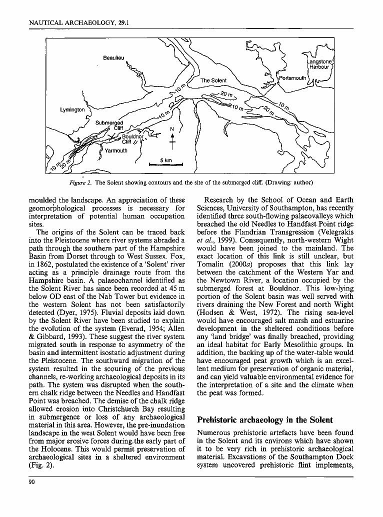
Figure 2. The Solent showing contours and the site of the submerged cliff. (Drawing: author)
moulded the landscape. An appreciation of these geomorighological processes is necessary for interpretation of potential human occupation sites.
The origins of the Solent can be traced back into the Pleistocene where river systems abraded a path through the southern part of the Hampshire Basin from Dorset through to West Sussex. Fox, in 1862, postulated the existence of a 'Solent' river acting as a principle drainage route from the Hampshire basin. A palaeochannel identified as the Solent River has since been recorded at 45 m below OD east of the Nab Tower but evidence in the western Solent has not been satisfactorily detected (Dyer, 1975). Fluvial deposits laid down by the Solent River have been studied to explain the evobation of the system (Everad, 1954; Allen & Gibbard, 1993). These suggest the river system migrated south in response to asymmetry of the basin and intermittent isostatic adjustment during the Pleistocene. The southward migration of the system resulted in the scouring of the previous channels, re-working archaeological deposits in its path. The system was disrupted when the south- ern chalk ridge between the Needles and Handfast Point was breached. The demise of the chalk ridge allowed erosion into Christchurch Bay resulting in submergence or loss of any archaeological material in this area. However, the pre-inundation landscape in the west Solent would have been free from major erosive forces during.the early part of the Holocene. This would permit preservation of archaeological sites in a sheltered environment (Fig. 2).
Research by the School of Ocean and Earth Sciences, University of Southampton, has recently identified three south-flowing palaeovalleys which breached the old Needles to Handfast Point ridge before the Flandrian Transgression (Velegrakis et al., 1999). Consequently, north-westem Wight would have been joined to the mainland. The exact location of this link is still unclear, but Tomalin (2000a) proposes that this link lay between the catchment of the Western Yar and the Newtown River, a location occupied by the submerged forest at Bouldnor. This low-lying portion of the Solent basin was well served with rivers draining the New Forest and north Wight (Hodsen & West, 1972). The rising sea-level would have encouraged salt marsh and estuarine development in the sheltered conditions before any 'land bridge' was finally breached, providing an ideal habitat for Early Mesolithic groups. In addition, the backing up of the water-table would have encouraged peat growth which is an excel- lent medium for preservation of organic material, and can yield valuable environmental evidence for the interpretation of a site and the climate when the peat was formed.
Prehistoric archaeology in the Solent
Numerous prehistoric artefacts have been found in the Solent and its environs which have shown it to be very rich in prehistoric archaeological material. Excavations of the Southampton Dock system uncovered prehistoric flint implements,
90

G. MOMBER: A SUBMERGED PREHISTORIC LANDSCAPE IN THE SOLENT
Figure 3. Lithics recovered by a fishermen, Michael White, in the West Solent. (Photo: author)
bones and the remains of trees (Shore & Elwes, 1889). More recently attention has been drawn to the high archaeological potential of inundated land surfaces which might be traced within a contour line drawn at - 5 m OD (Tomalin, 1996). Modern erosion at Woot ton and Quarr beach has exposed a wooded landscape littered with archaeological material dating back to the Meso- lithic. Here, a survey was funded by English Heritage and carried out by the Isle of Wight Archaeological Unit during the 1990s. This produced sites and artefacts ranging from the Mesolithic to the Post-Medieval Period (Loader et al., 1997; Tomalin et al., forthcoming). Walkover surveys during the 1960s in Langstone Harbour exposed a rich resource of Stone Age implements (Bradley & Hooper, 1973). The wealth of material being recovered from the harbour prompted a more comprehehsive project, instigated by Hampshire County Council. The surveys and exploratory excavations illustrated a seamless approach where methods employed on land have been extended through the intertidal and subtidal zones and underwater (Tomalin, 1993; Loader et al., 1997; Allen & Gardener,
forthcoming). This is only a selection of the known sites around the Solent, a waterway that has a vast potential. This is confirmed by the abundance of lithics dredged from peat beds in the western Solent by oyster fishermen, and the discovery of the submerged cliff off Bouldnor on the Isle of Wight (Fig. 3).
Underwater cliff at Bouldnor
In 1985 John Cross pursued the source of sub- merged peat and tree remains which had been dredged from the sea near Yarmouth. These he traced to the foot of an underwater cliff. Further investigation by the Isle of Wight Maritime Heritage Project traced the course of this cliff while measuring its height and angle of repose. In some places the cliff was a gentle slope while in others it showed a vertical face some 4 m,high. These faces were subject to undercutting, a pro- cess which was producing large blocks of fallen material on the sea floor. Organic inclusions within the cliff and laterally consistent layers of peat were also noted. At the base of the cliff, the
91

NAUTICAL ARCHAEOLOGY, 29.1
remains of trees and associated root systems lay in a narrow band of peat some 20 m wide and over 1000 m long.
Following this discovery, the County Archae- ologist, David Tomalin, instigated a survey and a regime to monitor erosion, but the results could not be fully assessed after the project was termi- nated in 1989 due to a lack of funding. Since the end of the Maritime Heritage Project, underwater fieldwork along this stretch of coast has been sparse. In 1991 the site was identified as a key area to be investigated by the H W T M A and in 1997 it was further selected as a study area for an EC LIFE Project. This European initiative gave new impetus for further research.
European Community LIFE Project In 1997 a European Communi ty L'Instrument Financ, ibre de l 'Environnement (LIFE) Project entitled 'Coastal Change, Climate and Instability' was instigated by the Isle of Wight Centre for the Coastal Environment. One of the three objectives was to assess the value of archaeological and palaeoenvironmental evidence as a means of measuring the scale and pace of coastal change. This research seeks to examine the evolution of coastal areas within the European Union, where human settlement has been subject to adverse coastal processes such as erosion, submergence, and dune advance (Tomalin, 2000b).
Submerged palaeolandscapes are a diminishing and irreplaceable resource. They represent an archive of information relating to previous glacial low sea levels, as well as sea-level rise during the Holocene. Peat deposits and evidence of human activity at known depths can reveal information about sea-level and local environments at that time. The formation processes of the deposits and spatial relationships between them can show rates of change (Scaife, 1982; Long et al., 1999). Archaeological investigation can indicate habita- tion responses to these circumstances (Flemming, 1998). In the light of rising sea-levels, this know- ledge of coastal evolution as a response to varying patterns of fluctuation may forewarn coastal managers of possible future changes. Bouldnor Cliff was identified as a site that could demon- strate a link between past environmental changes and current process, thus helping to predict future scenarios.
The archaeological task within the LIFE project has been conducted in conjunction with a
Figure 4. Diver over a vertical section of the silty/clay submerged cliff. (Photo: author)
team led by Dr Justin Dix from the School of Ocean and Earth Sciences (SOES), University of Southampton. The key objectives were to: charac- terize morphologically the submerged cliff by conducting geophysical surveys; compare the morphology and formation of the submerged cliff with the terrestrial cliff; investigate the submerged cliff stability; and explore the implications of the Holocene Transgression in the western Solent.
To aid the SOES team, HWTMA conducted a number of dives at the Bouldnor coast to collect monoli th and gouge core samples from the sub- merged landscape. A site was chosen for coring which was representative of the cliff section. Here, the cliff face consisted of silty clays interspersed with peat in a vertical section which was eroding. A seam of peat protruded from the top of the cliff and another lay 1 m below it. The total height was over 7 m, it beginning at 4"1 m below OD and dropping steeply before levelling off. Here, the cliff is truncated by a 2 m vertical drop (Fig. 4). The base of the cliff lies at about 11.1 m where the adjacent seabed is an expanse of peat and timber.
92

G. MOMBER: A SUBMERGED PREHISTORIC LANDSCAPE IN THE SOLENT
N
5
Legend ] 7
m
Tree stumps ~ Peat ~ ~ Shells and cobble a t ' - - - ' ~ ( ' ~ Lobster burrows 13N Flint r:::q L 1 3 - ~ overhangs abo.ve ~ ~k~
-=--~_ -=- ~ - _#. ~-~ ,~ -::_-- ~ f
I
tform inlaid wit ' I " l t "-~---='--~--"-"
Vertical silty/clay cliff; 2 m high with organic inclusions ~----------:---~----~-~_=_,~=
Figure 5. Plan of basal peat. (Drawing: author)
For the purpose of the LIFE Project Dr Rob Scaife, Dept of Geography, University of Southampton, has carried out pollen and diatom analyses of the cores from this site. This work seeks to determine past vegetation environments, cliff formation processes and the progression of sea-level rise.
Survey of the peat platform below the submerged cliff
On completion of the coring, an area of the basal peat seabed was surveyed, recording the larger tree remains and any archaeological fea- tures. Underwater survey in this hostile environ- ment presents many challenges. With each turn of the tide, water flows across the site at 1 to 2 knots. Slack water lasts only a few minLites. Visibility averages about 1.5 m but can be reduced to zero when the sediment load increases on the ebb tide. Visual difficulties are compounded by the dark peat seabed, which absorbs light. Consequently, several dives by many divers were necessary to complete the survey.
Five lanes 3 m wide in a 30 m long strip running east-west were searched. This covered the total width of the platform at this point, where the corridor search technique was used. The results revealed a platform inlaid with tree trunks, boles and associated root systems reaching into the underlying substrate. The deposit lies about 11"5 m below Ordnance Datum at the foot of a 1"8 m vertical section of submerged cliff. Within the area surveyed, 13 tree stumps, extensive pieces of timber and nine substantial boles were plotted (Fig. 5). One such bole, orientated south-north, measured over 12 m in length. At its southern end, where it emerged from below the cliff, its full diameter, including bark, was intact. Degradation of the timber increased with distance from the cliff. This implies that the peat had been sealed in an anaerobic environment, prior to the progres- sive erosion of the cliff. A sample of oak timber, removed from the seabed, proved to be too small for tree ring analysis, but its heartwood and sapwood provided good evidence for active biological degradation (Fig. 6).
On the northern edge of the platform, scour around tree stumps was found to be undercutting
93

BC TIj.99
NAUTICAL ARCHAEOLOGY, 29.1
Figure 6. Oak sample no, BCxx with embedded hazelnuts recovered from basal peat. (Photo: author)
the peat creating overhanging ledges up to 1"5 m high. These were subject to failure and collapse. This eroding boundary was very well defined in the survey area. Consequently a drift dive was conducted to quantify continuity. The dive traced the platform for over 1 km westwards. The band of peat was found to be unbroken in a laterally consistent deposit running roughly east-west.
Discovery of lithics
During the corridor search worked flints were discovered in the south-west corner of the site at the bot tom of the cliff. Here the flints had been excavated from the peat or underlying clay by lobsters (Fig. 7). A lack of marine growth on the flints seemed to testify to their recent exposure by these creatures.
In total, 50 flints showing signs of human industry were found in two discrete locations. These lay 5 m apart, each at the entrance to lobster burrows. Thirty-five humanly-struck flints were present, eight pieces showed evidence of burning and a further seven small flakes were those which might be produced by knapping (Fig. 8). The worked flints comprised one implement, three cores and 31 waste flakes (Fig. 9). As the flints were not found in a stratified sequence their provenance could not be verified so it was possible that they had been washed there from a deposit further up the cliff. To help resolve this question the site was searched a second time looking specifically for lithics. A sampling strategy was also undertaken where metre-square grids were defined in each corridor at evenly distributed
Figure 7. Worked flints (foreground) in the upcast of a lobster burrow beneath a submerged fallen tree. (Photo: author)
points around the site. The grids were surveyed and recorded before all the loose cobble was removed for scrutiny on dry land. However, no more worked material was found exposed on the seabed.
In addition to the surface sampling, two small 200 mm-deep cores were taken from the peat near the lobster burrows. Both cores contained small amounts of flint, one piece being a small flake. From this it appears that flint is lying in situ within the peat. Analysis of this peat by Rob Scaife indicates an environment induced by rising sea-levels causing the ponding back of the local river system. This created anaerobic conditions suited to organic accumulation. The pollen spectra demonstrate that the local vegetation of this site was wet fen with colonizing alder and oak and hazel in drier areas. The data obtained are comparable with other radicarbon dated sites from the island which span this, the Late Boreal/ Early Atlantic Period at c. 7,500-7,000 BP (Scaife, 1987).
Overview
Mesolithic sites found in Britain and Northern Europe are many and varied. This text has noted a number of coastal sites which might be related to isostatic and eustatic influences. The evidence suggests that many more would have existed offshore of the southern British coastline. These have not yet been found because they are below low water, covered by sediment and concealed. The sites that have been found are typically
94

G. MOMBER: A SUBMERGED PREHISTORIC LANDSCAPE IN THE SOLENT
Figure 8. Sample of 50 flints with negligible marine growth found during July 1999. Flints recovered from basal peat below submerged cliff: (a) three flakes; (b) flake with clearly defined bulb of percus- sion; (c) bulb of (b); (d) burnt flint. (Photo: author)
95

NAUTICAL ARCHAEOLOGY, 29.1
Figm'e 9. Flint scraper and blade recovered from basal peat below submerged cliff. (Photo: author)
chance finds discovered by divers or fishermen when the covering sediments have been eroded by wave action or currents. The discovery of the ancient submerged landscape north-east of Yarmouth clearly demonstrates the potential for preservation of such sites.
Rebecca Loader of the Isle of Wight Council Archaeological Unit conducted an assessment of the lithics recovered. The limited number and their enigmatic context has made them difficult to date. The presence of these flints attests an occu- pation on the floor of the Solent. The discovery of the small flake in the peat verifies there was human activity on this site at or before the time of inundation. The limited number of flints so far recovered, however, does not provide sufficient diagnostic evidence to verify that all the finds came from the same assemblage. Nonetheless, all the worked pieces were found in discrete locations at the mouth of lobster burrows. It could be argued that the burrows act as sinks, trapping the flints carried by the tide, but there are many other potential sinks in the area studied and none of these were found to contain flint artefacts.
What is clear, however, is that the flints on the site have been recently excavated. This is illus- trated by a lack of marine growth. It was also clear that the smaller flakes could not remain in place for long before being transported by the current. Numerous flints must have been lost from the site by this mechanism in the past. Further work needs to be conducted to quantify the magnitude and nature of the site, the range of preserved archaeological material and the extent of the active erosion. This assessment should be carried out before further loss occurs.
Conclusion
The discovery of the submerged site off Bouldnor Cliff and the possibility that there may be many more presents a very positive outlook for future studies of the Mesolithic in England. Unfortu- nately, in the past, the archaeological potential of Britain's drowned landscape does not seem to have been fully recognized; consequently safe- guards amongst regulating and sectoral bodies have been minimal (Tomalin, 1997). Many sites
96

G. MOMBER: A SUBMERGED PREHISTORIC LANDSCAPE IN THE SOLENT
below the mean low water mark are undoubtedly being lost as a result of ignorance, neglect and progressing human impacts. This is an issue that currently needs to be addressed as both archae-. ologists and coastal managers realize that many gaps in our understanding of past cultures and coastal change could be answered with the investigation of well-preserved sites underwater.
One of the key management principles laid out in the Policy Statement in England's Coastal Heritage: a survey for English Heritage and the Royal Commission on the Historic Monuments of England states: 'al though archaeological remains situated in intertidal and subtidal areas may be less visible and accessible than remains on dry land, this does not affect their relative import- ance and they should be managed in accordance with the principles which apply to terrestrial archaeological remains' (Fulford et al., 1997). Unfortunately, in England this has yet to be implemented.
As a result of the current LIFE programme coastal study groups in Europe are reviewing similar issues. These question 'whether present proposals for coastal management and protection can demonstrate wisdom drawn from a long term understanding of past natural and human events on the relevant coastline'. They also question whether 'new field information will be required on past natural and human events, before such a question can be answered'.
In the future the task should be twofold: first, to locate areas where submerged habitation sites are likely to have been located in England, identify the potential for preservation within such sites, and then find them: and second, to apply legislation
to protect the maritime heritage from needless destruction and ensure adequate recording where destructive practices are proceeding.
Acknowledgements
Without the recognition of the site's importance by David Tomalin and Rob Scaife following its discovery, the underwater work by the Hampshire and Wight Trust for Maritime Archaeology would not have been possible. Particular thanks should go to Dr Justin Dix and the School of Ocean Sciences, University of Southampton, whose pion- eering work as part of the LIFE Project will help place the site in archaeological context. Thanks for financial support must go to the Department for Culture, Media and Sport; the European Communi ty LIFE Project: 'Coastal Change, Climate and Instability'. The contributions of the Hampshire County Council, Isle of Wight Council, the Daisie Rich and Hilton Cheek Trusts, John Cross of Coastal Research and the Remote Seismology Group, School of Ocean and Earth Sciences, University of Southampton, Mathew Hosey and Andrew Colenutt of the New Forest District Council are also greatly appreciated.
I am grateful to Brian Sparks, Nic Flemming, David Tomalin, Rob Scaife, Justin Dix and Julie Satchell for their comments on the draft and their input into the final paper. I am also indebted to the many people who have been involved in the practical aspects of the project, in particular Dave Parham for survey, Roy Harold and Sophia Ex- elby for discovery of the first worked flints on the site and Stuart Leather for help with depth data.
References Allen, L. C. & Gibbard, P. L., 1993, Pleistocene evolution of the Solent River of Southern England. Quaternary Science
Reviews, 12: 503-528. Allen, M. J. & Gardener, J. (forthcoming), Our Changing Coast; an Archaeological Survey of Langstone Harbour. Hampshire
CBA Research Report. Alley, R. B., Meese, D. A., Shuman, C. A., Gow, A. J., Taylor, K. C., Grootes, P. M., White, J. W. C., Ram, M., Waddington,
E. D., Mayewski, P. A. & Zieginski, G. A., 1993, Abrupt increase in Greenland snow accumulation at the end of the Younger Dryas event. Nature, 362: 527-529.
Barton, N., 1999, The Lateglacial or Late and Final Upper Palaeolithic colonisation of Britain. In J. Hunter & I. Ralston (Eds), The Archaeology of Britain, 13-34. London.
Bradley, R. & Hooper, B., 1973, Recent di]coveries from Portsmouth and Langstone Harbours: Mesolithic to Iron Age. Procedures Hants Field Club, 30:17-27. ,
Broadbent, N., 1979, Coastal Resources and Settlement Stability. Archaeological Studies, Uppsala University. Christensen, C., Fischer, A. & Mathiassen, D. R., 1997, The great sea rise of the Storebaelt. In L. Pedersen, A. Fischer &
B. Aaby (Eds), The Danish Storebaelt since the Ice Age--Man Sea and Forest, 45-54. Storebaelt Publications. Churchill, D. M., 1965, The kitchen midden site at Westward Ho!, Devon, England: ecology, age and relation to changes in
land and sea level. Proceedings Prehistoric Society, 31: 74-84. Clark, G., 1980, Mesolithic Prelude, 49-58. Edinburgh.
97

NAUTICAL ARCHAEOLOGY, 29.1
Clark, J. G. D., 1936, The Mesolithic Settlement of Northern Europe. Cambridge. Clark, J. G. D., 1954, Excavations at Star Cart. Cambridge. Clutton-Brook, J. & Noe-Nygaard, N., 1990, New osteological and C-isotope evidence on Mesolithic dogs: companions to
hunters and fishers at Star Carr, Seamer Carr and Kongomose. Journal of Archaeological Science, 17: 643-653. Coles, B. J., 1998, Doggedand: a speculative survey. Proceedings Prehistoric Society, 64: 45-81. Cunliffe, B., 1987, Hengistbury Head, Dorset, Vol. 1. Oxford. Day, S. P. & Mellors, P., 1994, 'Absolute' dating of Mesolithic human activities at Star Carr, Yorkshire: new palaeoecological
studies and identification of the 9600 BP radiocarbon plateaux. Proceedings Prehistoric Society, 60: 417-422. Denker, J., 1997, Stone-age settlements in the middle of nature's larder. In L. Pedersen, A. Fischer & B. Aaby (Eds), The Danish
Starebaelt since the Ice Age--Man Sea and Forest, 87-92. Storebaelt Publications. Devoy, R. J., 1982, Analysis of the geological evidence for Holocene sea level change in south east England. Proceedings of the
Geological Association, 93: 65-90. Dyer, K. R., 1975, The buried channels of the 'Solent River', Southern England. Proceedings of the Geological Association, 86:
239-246. Dyer, K. R., 1986, Coastal and Estuarine Sediment Dynamics, 8-30. Chichester. Everard, C. E., 1954, The Solent River: a geomorphological study. Trans. Institute British Geographers, 20: 41-58. Fischer, A. (Ed.), 1995, Proceedings of the Man, Sea and Mesolithic Conference, Horsholm. Oxbow Monograph 53. Oxford. Fischer, A., 1997, People and the sea--settlement and fishing along the mesolithic coasts. In L. Pedersen, A. Fischer & B. Aaby
(Eds), The Danish Stolebaelt since the Ice Age--Man Sea and Forest, 63-77. Storebaelt Publications. Flemmlng, N., 1998, Archaeological evidence for vertical movement on the continental shelf during the Paleolithic, Neolithic
and Bronze Age ,Periods. In I. S. Stewart & C. Vita-Finzi (Eds), Coastal Tectonics, 129-146. Geological Society, Special Publication 14. London.
Fox, W., 1862, When and how was the Isle of Wight severed from the mainland? The Geologist, 5: 452. Frederiksen, J. K., 1997, When the landscape was formed. In L. Pedersen, A. Fischer & B. Aaby (Eds), The Danish Storebaelt
since ~he Ice Age--Man Sea and Forest, 13-21. Storebaelt Publications. Fulford, M., Champion, T. & Long, A. (Eds), 1997, England's Coastal Heritage. RCHME & English Heritage Archaeological
Report 15. London. "Gendel, P. A., 1984, Mesolithic Social Territories in North Western Europe. B.A.R. International Series 218. Oxford. Hodson, F. & West, I. M., 1972, Holocene deposits of Fawley Hampshire, and the development of Southampton Water.
Proceedings of the Geological Association, 83: 421-441. Larsson, L., 1983, Mesolithic settlement on the sea floor in the Strait of 0resund. In P. M. Masters & N. C. Flemming (Eds),
Quarternary'Coastlines and Marine Archaeology, 283-301. London. Loader, R., Westmore, I. & Tomalin, D., 1997, Time and Tide; an Archaeological Survey of the Wootton-Quarr Coast. Isle of
Wight Council, Newport. Long, A. J. & Tooley, M. J., 1995, Holocene sea-level and crustal movements in Hampshire and Southeast England, United
Kingdom. In Jr Frinkl (Ed.), Holocene Cycles: Climate, Sea Levels and Sedimentation. Journal of Coastal Research (Special Issue), 17: 299-310.
Long, A. J., Scaife, R. G. & Edwards, R. J., 1999, Pine pollen in the intertidal sediments from Poole Harbour, UK; implications for late Holocene sediment accretion rates and sea-level rise. Quarternary International, 55: 3-16.
Mathiassen, D. R., 1997, The changing landscapes of the Storebaelt, from the retreat of the ice to the sea flood. In L. Pedersen, A. Fischer & B. Aaby (Eds), The Danish Storebaelt since the Ice Age--Man Sea and Forest, 13-21. Storebaelt Publications.
Mellers, P. A., 1987, Excavations on Oronsay: Prehistoric Human Ecology on a Small Island. Edinburgh. Mithen, S., 1999, Hunter-gatherers of the Mesolithic. In J. Hunter & I. Ralston (Eds), The Archaeology of Britain, 35-57.
London. Palmer, S., 1977, Mesolithic Cultures of Britain. Poole, Dorset. Palmer, S., 1990, Culverwell--unique opportunities for studying the intra-site structure of a Mesolithic habitation site in
Dorset, England. Contributions to the Mesolithic in Europe, 87-91. Leuven. Pedersen, L., 1997, Settlement and subsistence in the late Mesolithic and early Neolithic. In L. Pedersen, A. Fischer & B. Aaby
(Eds), The Danish Storebaelt since the Ice Age-- Man Sea and Forest, 109-115. Storebaelt Publications. Prigent, D., Visset, L., Morzadec-Kerfoum, N. T. & Lautrido, J. P., 1983, Human occupation of the submerged coast of the
Massif Armoricaln and post-glacial sea level changes. In P. M. Masters & N. C. Flemming (Eds), Quarternary Coastlines and Marine Archaeology, 303-324. London.
Rowley-Conwy, P., 1983, Sedentary hunters: the Ertebolle example. In G. Bailey (Ed.), Hunter-Gatherer Economy in Pre-history. .4 European Prospective, 111-126. Cambridge.
Scaife, R. G., 1980, Late-Devensian and Flandrian Palaeoecological Studies in the Isle of Wight. Unpublished Ph.D. thesis. University of London, King's College.
Scaife, R. G., 1982, Late Devensian and early Flandrian vegetation changes in southern England. In S. Limbrey & M. Bell (Eds), Archaeological Aspects of Woodland Ecology. B.A.R. International Series, 146: 57-74.
Scaife, R. G., 1987, Late-Devensian an/l Flanddan vegetation of the Isle of Wight. In K. E. Barber (Ed.), Wessex and the Isle of Wight, Field Guide. Quarternary Research Association, 156-180. Cambridge.
Scaife, R. G., 1999, Pollen analysis of the Bouldnor submerged peats (3): the basal peat bed. Unpublished report for EC LIFE Project Coastal Change, Climate and Instability. Isle of Wight Centre for the Coastal Environment.
98

G. MOMBER: A SUBMERGED PREHISTORIC LANDSCAPE IN THE SOLENT
Shilling, H., 1997, The Korsor Nor site. The permanent dwelling place of a hunting and fishing people in life and death. In L. Pedersen, A. Fischer & B. Aaby (Eds), The Danish Storebaelt since the Ice Age--Man, Sea and Forest, 93-98. Storebaelt Publications.
Simmons, I., 1996, The Environmental lmpact of Later Mesolithic Cultures. Edinburgh. Shore, T. W. & Elwes, J. W., 1889, The New Dock excavation at Southampton. Procedures of the Hants FieM Club, 1: 43-56. Tolan-Smith, C., 1998, Radiocarbon chronology and the late glacial and early postglacial resettlement of the British Isles.
Quarternary International, 49/50: 21-27. Tomalin, D. J., 1993, Maritime archaeology as a coastal management issue. In Proceedings of the Standing Conference on the
Problems Associated with the Coastline; Seminar on Regional Coastal Groups after the House of Commons Report, SCOPA C, 93-112. Isle of Wight County Council.
Tomalin, D. J., 1996, Towards a new strategy for curating the Bronze Age landscape of Hampshire and the Solent. Archaeology in Hampshire: a Framework for the Future, 13-25. Winchester.
Tomalin, D. J., 1997, Bargaining with nature; considering the sustainability of archaeological sites in the dynamic environment of the intertidal zone. Preserving Archaeological Remains in situ: Proceedings of the Conference of lst-3rd April 1996 at the Museum of London, 144-158. Bradford.
Tomalin, D. J., 2000a, Geomorphological evolution of the Solent Seaway and the severance of Wight: a review. In M. Collins & K. Ansell (Eds), Solent Science---a Review, 9-19. Proceedings in Marine Science, 1.
Tomalin, D. J., 2000b, Wisdom of hindsight: palaeoenvironmental and archaeological evidence of long-term processual changes and coastline sustainability. In M. Collins & K. Ansell (Eds), Solent Science--a Review. Proceedings in Marine Science, 1.
Tomalin, D. J., Loader, R. & Scaife, R. G. (forthcoming), Wootton Haven: Coastal and Port Archaeology in a Dynamic Environment. English Heritage.
Velegrakis, A. F., Dix, J. K. & Collins, M. B., 1999, Late Quaternary evolution of the upper reaches of the Solent River, Southern England, based upon marine geophysical evidence. Journal of the Geological Society, 156: 73-87.
Whittle, A., 1999, The Neolithic period, c. 4000-2500/2200 BC. In J. Hunter & I. Ralston (Eds), The Archaeology of Britain, 58-76. London.
Wickham-Jones, C. R. & Woodman, P. C., 1998, Studies on the early settlement of Scotland and Ireland. Quarternary International, 49/50: 13-20.
Wilson, K., 1998, An investigation of Holocene peat and intertidal stratigraphy on Shapwick Heath, Somerset: preliminary results. Archaeology in the Severn Estuary, 9: 87-90.
99
Copyright © 2022 FDOKUMEN