Drina erosion and sedimentation study FINAL ... - UNECE
62
UNITED NATIONS ECONOMIC COMMISSION FOR EUROPE supported by the Italian Ministry for the Environment, land and the Sea SCOPING STUDY ON EROSION AND SEDIMENTATION IN THE DRINA RIVER BASIN FINAL REPORT Belgrade, November 2019
-
Upload
khangminh22 -
Category
Documents
-
view
1 -
download
0
Transcript of Drina erosion and sedimentation study FINAL ... - UNECE

UNITED NATIONS ECONOMIC COMMISSION FOR EUROPE
supported by the Italian Ministry for the Environment, land and the Sea
SCOPING STUDY ON EROSION AND SEDIMENTATION
IN THE DRINA RIVER BASIN
FINAL REPORT
Belgrade, November 2019

SCOPING STUDY ON EROSION AND SEDIMENTATION
IN THE DRINA RIVER BASIN
FINAL REPORT
TEAM LEADER: EXECUTIVE DIRECTOR:
Marina Babić Mladenović, PhD Marina Babić Mladenović, PhD
GENERAL DIRECTOR
Prof. Dejan Divac, PhD
Belgrade, November 2019

Project title: SCOPING STUDY ON EROSION AND SEDIMENTATION IN THE DRINA RIVER
BASIN
Client: Vendor:
Contract number: Purchase order nr. 2200135524, 9
May 2019
31/19/28/03, 10 May 2019
Name: United Nations (UN) in support of
UNECE
Jaroslav Cerni Water Institute
Address: Palais des Nations
Geneva 1211
Switzerland
Jaroslava Cernog 80
11226 Belgrade
Serbia
Contact person: Annukka Lipponen Zdravko Stojanovic, PhD
JCWI Project team
Team Leader: Marina Babic Mladenovic, PhD
Project team: Milutin Stefanovic
Nada Zivanovic
Renata Puzovic
Boris Krunic
Dragana Ninkovic

SCOPING STUDY ON EROSION AND SEDIMENTATION IN THE DRINA RIVER BASIN, FINAL REPORT
CONTENT:
1. PREFACE ..................................................................................................... 1
2. COLLECTION AND REVIEW OF DATA AND DOCUMENTATION ............................... 2
3. CHARACTERISTICS OF THE DRINA RIVER BASIN ............................................... 4
3.1 Relief ...................................................................................................... 4
3.2 Geology................................................................................................... 5
3.3 Land cover ............................................................................................... 6
3.4 Climate ................................................................................................... 7
3.5 Runoff ..................................................................................................... 8
3.6 River network........................................................................................... 9
4. CHARACTERISTICS OF DRINA RIVER CHANNEL ............................................... 19
4.1 General division of the DR channel ............................................................ 19
4.2 Description of river characteristics ............................................................. 19
Drina River between Sastavci and Foča (section length 23.5 km) ............... 19
Drina River stretch from Foča to Višegrad (section length 68 km) .............. 20
The Drina River stretch from Višegrad to the HPP Bajina Bašta (section length
55,4 km) ........................................................................................... 21
The Drina River stretch from the HPP Bajina Bašta to Zvornik (section length
105,1 km) ......................................................................................... 22
The Drina River from Zvornik to the confluence with the Sava River – Lower
Drina (section length 91 km) ................................................................ 23
5. ANALYSIS OF EROSION PROCESSES ............................................................. 27
5.1 Factors of erosion in DRB ......................................................................... 27
5.2 Present erosion and torrents related problems in DRB .................................. 29
Montenegro ....................................................................................... 30
Serbia ............................................................................................... 31
Republic of Srpska .............................................................................. 33
Federation Bosnia and Herzegovina ....................................................... 33
5.3 Erosion in DRB countries .......................................................................... 33
Serbia ............................................................................................... 33
Montenegro ....................................................................................... 36
Republic of Srpska .............................................................................. 37
Federation of Bosnia and Herzegovina .................................................... 42
5.4 Compilation of the erosion map for the entire DRB ....................................... 44

SCOPING STUDY ON EROSION AND SEDIMENTATION IN THE DRINA RIVER BASIN, FINAL REPORT
5.5 Present areas prone to erosion in DRB ....................................................... 45
6. SEDIMENT DEPOSITION AREAS .................................................................... 47
6.1 Sediment deposition in reservoirs .............................................................. 47
6.2 Sediment deposition on the river mouths ................................................... 49
7. IDENTIFICATION OF MEASURES ................................................................... 51
7.1 Set of possible measures ......................................................................... 51
7.2 Strategic goals and measures set in DRB countries ...................................... 52
Montenegro ....................................................................................... 52
Serbia ............................................................................................... 54
Republic of Srpska .............................................................................. 55
Federation Bosnia and Herzegovina ....................................................... 56
7.3 Proposal of key measures in DRB .............................................................. 57
SCOPING STUDY ON EROSION AND SEDIMENTATION IN THE DRINA RIVER BASIN, FINAL REPORT
1
1. PREFACE
The Scoping study on erosion and sedimentation in the Drina River Basin was prepared in the
Jaroslav Cerni Water Institute (JCWI) for UNECE Drina Nexus Follow-Up Project, supported by the
Italian Ministry for the Environment, land and the Sea.
This scoping study intends to provide a consistent picture about the occurrence of sedimentation
and erosion in the basin and related existing problems, using data available in the three basin-
sharing countries (Montenegro, Bosnia and Herzegovina and Serbia).
The Study is based on a combination geological/earth scientific and engineering expertise with
water management and hydraulic infrastructure expertise. Also, the knowledge of the regional
and the Sava River Basin level institutional and policy framework gave the direction to the
management actions and follow-up of this Study.
The study datasets and geographical information system (GIS) shapefiles are also developed as
part of the services and will be shared with the authorities and institutions concerned by erosion
and sedimentation in the riparian countries.
Preparation of the Study included the following steps:
▪ Collection of data from national authorities;
▪ Situation analysis;
▪ Identification of sources of sediment in the Drina River basin;
▪ Identification of areas with a deficit/surplus of sediment in the Drina River Basin;
▪ Analysis of the anthropogenic impact on erosion/deposition
▪ Identification of possible measures
▪ Proposal of priority measures.

SCOPING STUDY ON EROSION AND SEDIMENTATION IN THE DRINA RIVER BASIN, FINAL REPORT
2
2. COLLECTION AND REVIEW OF DATA AND DOCUMENTATION
As a first step, JCWI prepared a questionnaire which was delivered to competent authorities in
Serbia, Bosnia and Herzegovina (Federation of Bosnia and Herzegovina and Republika Srpska)
and Montenegro in order to assess the status and availability of documentation and data related
to erosion.
The result was as follows:
Montenegro: only data from Water Management Master Plan from 1997 are available. Data and
shapefiles are used for this Study, with permission of Water administration. The erosion map for
the Drina River basin in Montenegro was prepared according to the method of “Erosion
Potential”, in which erosion was classified into 5 qualitative-quantitative categories,
corresponding to the average value of the erosion coefficient - Z.
Bosnia and Herzegovina, Federation of Bosnia and Herzegovina: Competent authorities form
FB&H didn’t respond to questionnaire; therefore, data are not available for this Study.
Bosnia and Herzegovina, Republic of Srpska: erosion data were obtained from PE “Water of
Srpska” in pdf format, without accompanying text. The erosion map for this DRB part was
prepared according to the modified method of Gavrilovic, which contains 5 erosion categories
divided into subcategories. The .pdf file was digitalised to obtain shape files for GIS map of the
entire DRB basin.
Serbia: only data from Water Management Master Plan from 2001 are available. Data and
shapefiles are used for this Study, with permission of Ministry of agriculture, forestry and water
management, Directorate for Water. An erosion map was prepared according to the method of
“Erosion Potential”, in which erosion was classified into 5 qualitative-quantitative categories,
corresponding to the average value of the erosion coefficient - Z.
Other sources of information used for this Study are:
▪ Water management strategy for the territory of the Republic of Serbia by 2034
▪ Water Development Master Plan of the Republic of Serbia, 2001
▪ Water Development Master Plan of the Republic of Montenegro, 2001
▪ Water management strategy for the territory of the Montenegro
▪ General project of erosion and torrential areas in Serbia 2003-2009
▪ Water management strategy of Federation Bosnia and Herzegovina 2010-2022.
▪ Integrated water management strategy of Republic of Srpska till 2024.
▪ Support to water resources management in the Drina River Basin, Cowi, Stucky and
Jaroslav Cerni Water Institute, 2017.
▪ Towards Practical Guidance for Sustainable Sediment Management using the Sava
River Basin as a Showcase - Estimation of Sediment Balance for the Sava River, ISRBC,
2013

SCOPING STUDY ON EROSION AND SEDIMENTATION IN THE DRINA RIVER BASIN, FINAL REPORT
3
▪ Sava river basin management plan, ISRBC, 2014
▪ Different studies and designs prepared by JCWI.

SCOPING STUDY ON EROSION AND SEDIMENTATION IN THE DRINA RIVER BASIN, FINAL REPORT
4
3. CHARACTERISTICS OF THE DRINA RIVER BASIN
The Drina River is the largest tributary of the Sava River Basin, which in turn is the largest tributary
by volume of water of the Danube River Basin that drains into the Black Sea.
The Drina River Basin (DRB) has a surface area of 19,680 km2 and spreads over the territory of
three main riparian states: Bosnia and Herzegovina (BiH), which is subdivided into two entities,
Republic of Srpska (RS) and Federation of Bosnia-Herzegovina (FBiH), Montenegro (MNE), and
Republic of Serbia (RS). In addition, Albania accounts for a very small part of the DRB (<1%).
Drina River Basin as a part of the Sava River Basin
The Drina River originates in Montenegro at an altitude of 2,500 m a.s.l. between the slopes of
the Maglić and Pivska Planina mountains, between the villages of Šćepan Polje (in Montenegro)
and Hum (in Bosnia and Herzegovina), draining a substantial karst plateau that receives the
highest annual rainfall in Europe (about 3,000 mm/a), resulting also in the highest specific runoff
in Europe (up to 50 l/s/km²).
Basic characteristics of DRB that influence the sediment balance, as its relief, river network, land
cover, climate, and runoff are given below.
3.1 Relief
Terrain in DRB significantly changes from the upper part towards its confluence with the Sava
River in the north. The southern part is hilly and mountainous, particularly in Montenegro and
Northern Albania. The northern part are plains of Semberia and Macva.

SCOPING STUDY ON EROSION AND SEDIMENTATION IN THE DRINA RIVER BASIN, FINAL REPORT
5
The average altitude of the DRB is 961.6 m a.s.l., but it ranges from 75.4 m a.s.l. at the mouth to
more than 2,500 m a.s.l. on the highest mountains (e.g. Prokletije Mountain 2,694 m a.s.l.,
Komovi Mountain 2,487 m a.s.l. and Durmitor Mountain 2,522 m a.s.l.).
One of the main factors influencing the sediment yield and transport is slope gradient of the
terrain in DRB. The slope gradient was estimated using DTM based on SRTM.
Slope gradient in DRB
3.2 Geology
The very important geological characteristic of DRB, influencing the regime of water and
sediment is the presence of the karst phenomena. According to results of DIKTAS project
(diktas.iwlearn.org), Dinaric karst region spreads from the Italian to the Albanian frontier,
covering also a part of the Drina River Basin. Karst regions are present only in the southern part
of the river basin. This terrain mostly belongs to the zone of the External Dinarides. It mostly
consists from very thick layers of limestones of the Jurassic and the Cretaceous age (shaded part
of the Figure below).

SCOPING STUDY ON EROSION AND SEDIMENTATION IN THE DRINA RIVER BASIN, FINAL REPORT
6
The rest of the river basin, between the External Dinarides and the border of the Sava catchment
belongs to the Inner Dinarides zone and Pannonian basin. In this zone, limestones are much rarely
in comparison with the zone of the External Dinarides, with prevailing of following lithological
units: sandstone, marls, claystones, intrusive and extrusive igneous rocks (diabase, spilite, dacite,
andesite etc), metamorphic rocks (serpentinite, phylite, argiloshist etc). The main aquifers are
formed in alluvial deposits. The aquifers characterise large reserves of groundwater, especially
alluvial deposits.
Dinaric karst regions in the Sava River Basin
3.3 Land cover
Forests (broad-leaved forest, coniferous forest and mixed forest) cover 50.61% of the total DRB area. The
second largest category is agricultural land (non-irrigated arable land, fruit trees and berry plantations,
complex cultivation patterns and land principally occupied by agriculture, with significant areas of natural
vegetation), covering 24.14%. Scrub and/or herbaceous vegetation associations cover 17,46% of the DRB.
The following are pastures with a 3.38% share. Open spaces with little or no vegetation, bare rocks and
water areas are present at 3,48% of the total area.
CORINE percentages of land cover in the Drina river basin
CORINE type of land cover Participation (%) Artificial surfaces 0.93 Agricultural areas 24.14 Pastures 3.38 Forests 50.61 Scrub and/or herbaceous vegetation associations 17.46 Open spaces with little or no vegetation 2.25 Bare rocks 0.57
Water areas 0.67 ∑ 100.00

SCOPING STUDY ON EROSION AND SEDIMENTATION IN THE DRINA RIVER BASIN, FINAL REPORT
7
Land cover in DRB
3.4 Climate
Climate of the DRB is complex and influenced by general atmospheric circulation, its elongate
shape in north-south direction, local orography and proximity of the Adriatic Sea. The
southernmost part of the basin has a Mediterranean and a maritime temperate and humid
climate according to the Köppen climate classification. Moderately cold and humid continental
climate can be found at the altitudes above 1,000 m.
Mediterranean influence, although mild, can be found in the upper part of the basin, up to Foča.
From that point downstream a temperate continental climate prevails with warm summers and
moderately cold winters.
Generally, from south to north, along the altitude decline, accumulated annual precipitation also
decreases, from about 2,100 mm measured in Kolašin on average to 820 mm in Loznica. In the
same direction, mean annual temperature increases from 4.6 °C in Žabljak to 11 °C in Loznica.
Seasonal distribution of precipitation differs throughout the DRB. Northern parts receive the
most rain in the late spring, mainly in May and June, while winter is dry with the lowest
precipitation in February. Due to the influence of the Mediterranean climate in the southern

SCOPING STUDY ON EROSION AND SEDIMENTATION IN THE DRINA RIVER BASIN, FINAL REPORT
8
parts, maximum rain falls in the late autumn and the minimum during the summer months. The
warmest month is July and the coldest is January.
Snow cover significantly impacts the Drina River water regime due to large amounts of water
accumulated in it, with the highest flows recorded in springtime, in April and May.
3.5 Runoff
The average discharge at the confluence to the Sava River is about 370 m3/s which results in the
long-term average unit-area-runoff for the complete catchment of about 18.5 l/skm2.
The runoff in DRB is unevenly distributed – it is very high in the mountains, while the contribution
of the northern part of the catchment to the Drina River flow is less significant.
Runoff in DRB

SCOPING STUDY ON EROSION AND SEDIMENTATION IN THE DRINA RIVER BASIN, FINAL REPORT
9
3.6 River network
The Drina River basin has a dense hydrographic network. The two source-rivers of Drina River in
Montenegro are Tara River (sub-basin area of 2,006 km²), and Piva River (1,784 km²) which merge
at Šćepan Polje at the Bosnia and Herzegovina /Montenegro border. Some details on these rivers
are given bellow.
The Drina River reaches the confluence with the Sava River at an altitude of 78 m a.s.l. on the
Pannonian Plain (Semberija and Mačva) after a length of 346 km and a height difference of 350
m a.s.l. (equivalent to an average 1% slope).
Hydrographic network of DRB
SCOPING STUDY ON EROSION AND SEDIMENTATION IN THE DRINA RIVER BASIN, FINAL REPORT
10
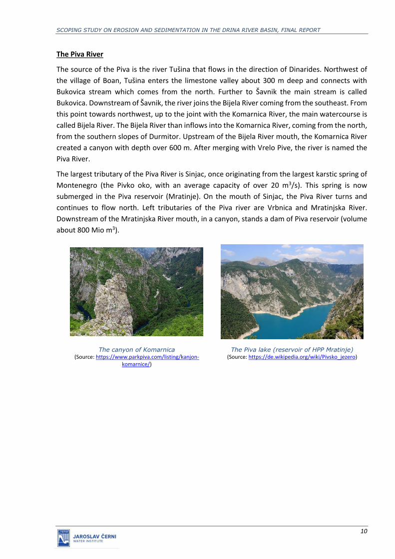
The Piva River
The source of the Piva is the river Tušina that flows in the direction of Dinarides. Northwest of
the village of Boan, Tušina enters the limestone valley about 300 m deep and connects with
Bukovica stream which comes from the north. Further to Šavnik the main stream is called
Bukovica. Downstream of Šavnik, the river joins the Bijela River coming from the southeast. From
this point towards northwest, up to the joint with the Komarnica River, the main watercourse is
called Bijela River. The Bijela River than inflows into the Komarnica River, coming from the north,
from the southern slopes of Durmitor. Upstream of the Bijela River mouth, the Komarnica River
created a canyon with depth over 600 m. After merging with Vrelo Pive, the river is named the
Piva River.
The largest tributary of the Piva River is Sinjac, once originating from the largest karstic spring of
Montenegro (the Pivko oko, with an average capacity of over 20 m3/s). This spring is now
submerged in the Piva reservoir (Mratinje). On the mouth of Sinjac, the Piva River turns and
continues to flow north. Left tributaries of the Piva river are Vrbnica and Mratinjska River.
Downstream of the Mratinjska River mouth, in a canyon, stands a dam of Piva reservoir (volume
about 800 Mio m3).
The canyon of Komarnica (Source: https://www.parkpiva.com/listing/kanjon-
komarnice/)
The Piva lake (reservoir of HPP Mratinje) (Source: https://de.wikipedia.org/wiki/Pivsko_jezero)

SCOPING STUDY ON EROSION AND SEDIMENTATION IN THE DRINA RIVER BASIN, FINAL REPORT
11
The Mratinje (Piva) dam (Source: https://www.epcg.com)
The Piva downstream of Mratinje dam (Source: https://www.bemytravelmuse.com/via-dinarica-
trail-guide/)
The largest part of the Piva River basin is on the territory of Montenegro, and only a small part in
the territory of Bosnia and Herzegovina.
The Tara River
The Tara River emerges from the confluence of the Opasnica and Veruša Rivers in the Komovi
Mountains and runs in the direction of the north to Kolašin. In this part of the basin, the riverbed
is quite wide and flat with steep sides, while the river valley is wide and mild with rare rocky and
even more rare pebbly terraces and dense river network. From Kolašin to Mojkovac, Tara still
maintains the same course of flow with the characteristic four widenings: Kolašin-Baković,
Trebaljevski, Sjorgorski and Mojkovacki, which are connected with three gorges: Trebavljeska
vrata, Vagansko-strelačka and Gradačko-Bjelasička. Significant tributaries in this part of the basin
are the right tributary Svinjača which flows from Bjelasica mountain and the left tributaries
Plašnica and Šatornica from Sinjajevina mountain. Tara changes direction from Mojkovac and
turns northwest flowing through the canyon valley until it reaches the Piva River. The most
distinct canyon characteristics of the stream are in the part from the Dobrilovine monastery to
the village of Bogomolje, where the canyon reaches a depth of 1550 m, while the altitude
difference from the riverbed to the entry of the valley is about 1080 m near Tepac village.
The canyon part of the Tara River basin is characterised by exceptional natural beauties, so that
the part of the stream from Bistrica to Šćepan Polje is a part of the Durmitor National Park.

SCOPING STUDY ON EROSION AND SEDIMENTATION IN THE DRINA RIVER BASIN, FINAL REPORT
12
The Tara River valley near Kolašin (Source: https://kolasin.me/tara-2/)
The Canyon of Tara River
(Source: https://highlandertim.com/en/destinations/tara-canyon/)

SCOPING STUDY ON EROSION AND SEDIMENTATION IN THE DRINA RIVER BASIN, FINAL REPORT
13
The Tara River near the junction with the Piva River
(Source: https://www.parkpiva.com)
The largest part of the Tara River basin is located in Montenegro, and only a small part on in
Bosnia and Herzegovina. The Tara River joins the Piva River at the border of the Bosnia and
Herzegovina - Republic of Srpska and Republic of Montenegro in the area of Šćepan Polje village,
near Hum, forming the Drina River.
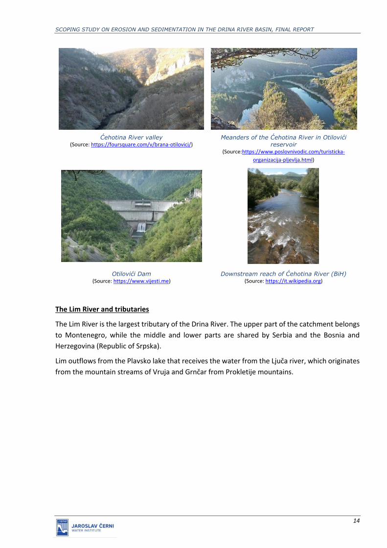
The Ćehotina River
The Čehotina River springs under the mountain of Stožer (1576 m above sea level) and as the
other right tributaries of the Drina River, flows southeast-northwest. After the Lim River, it is the
largest tributary of the Drina River. The upper part is in a narrow and deep valley, which later
spreads out of the gorge into the spacious Pljevaljsko field. Downstream from Kamenica to the
mouth of the Drina River near Foča, the Ćehotina River flows through the canyon.
The Otilovići dam was constructed upstream from Pljevlja, for the needs of the thermal power
plant. The reservoir volume is relatively small.
Right below city of Pljevlja the Ćehotina River receives the Vezišnica River at the left side and the
Voloder River above the Gradac settlement. There are several springs in the Ćehotina riverbed
that affect its water balance.
Most of the catchment area of Ćehotina is located on the territory of Republic of Montenegro
and a smaller part on the territory of Bosnia and Herzegovina. Its course in Montenegro is 100
km long, and in BiH is 25km.
SCOPING STUDY ON EROSION AND SEDIMENTATION IN THE DRINA RIVER BASIN, FINAL REPORT
14
Ćehotina River valley
(Source: https://foursquare.com/v/brana-otilovici/) Meanders of the Ćehotina River in Otilovići
reservoir (Source:https://www.poslovnivodic.com/turisticka-
organizacija-pljevlja.html)
Otilovići Dam (Source: https://www.vijesti.me)
Downstream reach of Ćehotina River (BiH) (Source: https://it.wikipedia.org)
The Lim River and tributaries
The Lim River is the largest tributary of the Drina River. The upper part of the catchment belongs
to Montenegro, while the middle and lower parts are shared by Serbia and the Bosnia and
Herzegovina (Republic of Srpska).
Lim outflows from the Plavsko lake that receives the water from the Ljuča river, which originates
from the mountain streams of Vruja and Grnčar from Prokletije mountains.

SCOPING STUDY ON EROSION AND SEDIMENTATION IN THE DRINA RIVER BASIN, FINAL REPORT
15
Lake Plav (Source: https://www.itinari.com/national-park-prokletije-pbtt)
The geological composition of the Lim River valley is diverse and consists of rocks of different
ages. The Lim River entirely runs through gorges and valleys, depending on the terrain
composition. In the limestone area, the valleys are narrow with high valley sides and in other
parts they are more extended. The river valleys are widest in the upper part of the stream,
narrowing downstream and forming the gorge at the very downstream part. The largest valleys
are: Plavsko-gusinjska, Murinska, Beranska, Zatonska and Bjelopoljska.
Significant tributaries of the Lim River are: Zlorečica, Šekularska, Trebačka, Lepešnica, Ljubovđa,
Lješnica, Bjelopoljska Bistrica, Mileševka (in Prijepolje, with the catchment area of 154.25 km2),
Seljašnica (70.28 km2), Bistrica and Uvac.
In the lower part of the catchment, just behind Prijepolje, a reservoir of about 44 Mio m3 is
formed for the Potpeć HPP. The derivation HPP Bistrica that uses water from the Radojnja
reservoir is located on the reservoir’s right bank, near the town of Bistrica. The Potpeć reservoir
is its compensation storage area.
The Lim River in Berane (MNE)
(Source: https://en.wikipedia.org/wiki/Berane) The Lim River near Bijelo Polje (MNE)
(Source: http://www.tobijelopolje.me)

SCOPING STUDY ON EROSION AND SEDIMENTATION IN THE DRINA RIVER BASIN, FINAL REPORT
16
Lim River in Prijepolje (RS)
(Source: https://prijepoljeinfo.rs/) Reservoir of HPP Potpec
(Source: http://srbijauslici.blogspot.com)
The Lim River upstream of Priboj (RS)
(Source: https://www.2bike.rs/albumi) The canyon of the Lim River near the mouth
(Source: https://commons.wikimedia.org)
Downstream of Priboj, the Lim River receives its largest tributary, the Uvac River. In its further
course it descends to the Drina River valley and enters the Drina River near Medjedja. The border
of the Republic of Serbia Bosnia and Herzegovina (Republic of Srpska) is at Rudo.
The spring part of the Uvac River is located on the eastern part of the Drina River basin, receiving
waters mainly from the mountains: Javor, Golija and Zlatar. The Uvac River catchment is
elongated in shape and has a specific character due to its different topographic and
morphological characteristics, so that the entire catchment can be divided into three separate
parts.
The upper part of the catchment extends to the town of Krstac, where the Uvac and the Vapa
Rivers are merging. This part of the catchment is mostly formed of a spacious Sjenica plateau at
an altitude of 1000-1400 m a.s.l. The plateau is mostly formed in the karstic limestone through
which most of the waters subsides and probably flows down to the spring of the Raška in the Ibar
River catchments. As a result, this part of the basin has relatively small runoff in relation to the
catchment areas of the Lim and the Drina Rivers, but the plateau has retention capabilities for
high waters mitigating, especially during the spring due to the snow melting.

SCOPING STUDY ON EROSION AND SEDIMENTATION IN THE DRINA RIVER BASIN, FINAL REPORT
17
The Vapa River
(Source: http://www.putokaz.me/u-svijetu/1839-rijeka-
vapa-okolina-sjenice-srbija)
The Uvac River within Uvac HPP reservoir (Source: http://avanturista.co)
The middle part of the catchment extends from the Radojnja River catchment to the Uvac and
Vapa confluence. It is characterized by a very deep riverbed of the Uvac River and its tributaries.
The slopes are steep, flow is rapid and fast, which gives an extremely torrential character to this
area. On the part of the stream near Sjenica the HPP Uvac was built in 1979, with a 213 Mio m3
reservoir. There are two more reservoirs downstream: Zlatarsko lake (270 Mio m3) with HPP
Kokin Brod and Radojnja (7 Mio m3), with the derivation power plant Bistrica.
Zlatarsko lake (Kokin brod) (Source: https://sr.wikipedia.org/wiki/)
Radoinja lake (Source: http://www.serbia4youth.org)
The lower part of the catchment covers the area from the confluence of the Uvac and Lim Rivers
to the Radojnja village. This part of the catchment is characterised by deep valley, without
significant tributaries. The most significant feature of this area is the large stream gradients
causing a large altitude difference of about 400 m between the Uvac and Lim riverbeds and
allowing the Uvac River flow to be impounded and transferred into the Lim River for the
hydropower production. The entire basin is located on the territory of the Republic of Serbia.
Other tributaries
The Drina river tributaries influencing its water regime are: the Sutjeska, Bistrica and Prača Rivers
(left tributaries on the territory of Bosnia and Herzegovina), the Rzav River (right tributary,
originating from confluence of two headstreams called Beli and Crni Rzav, entering into the Drina
River near the city of Višegrad, 72 km long), Drinjača (left tributary in the area of HPP Zvornik

SCOPING STUDY ON EROSION AND SEDIMENTATION IN THE DRINA RIVER BASIN, FINAL REPORT
18
reservoir), the Janja River (left tributary on the lower part of the Drina River) and the Jadar River.
All tributaries except Janja and Jadar, flow into Drina in the upper and middle part of the
watercourse and have torrential character.
The Jadar River is the largest tributary of the Drina on the lower course. Its entire catchment is
located on the territory of the Republic of Serbia (878 km2, 73 km of the total length). Significant
tributaries of the Jadar River are Lešnica (100 km2), which is connected to the Jadar River by a
channel, Korenita (66 km2), Likodra which is formed by the Bogoštica and Čađavica Rivers in
Krupanj and receives the water from the Belocrkvanska River (the area of the catchment 63 km2)
just before it enters into Jadar.
Two smaller right tributaries flow into the Drina River between the Jadar River and the city of
Loznica: the Krivaja and the Žeravija River (24 km2). Two right tributaries are flowing through the
city of Loznica: the Štira River (42,0 km2) and the Trbušnica River. Two small streams (Ciganski
and Simića stream) are entering the Drina River in Banja Koviljaca.
Canyon of Beli Rzav (Source: https://palisad.rs/)
Upper part of Drinjaca River (Source: https://mapio.net)

SCOPING STUDY ON EROSION AND SEDIMENTATION IN THE DRINA RIVER BASIN, FINAL REPORT
19
4. CHARACTERISTICS OF DRINA RIVER CHANNEL
4.1 General division of the DR channel
The total length of the Drina river is about 345 km, with an average slope of 1.03o/oo. It can be
divided into three parts based on the discharges, slopes and the catchment shape: upper, middle
and lower flow.
The Upper Drina, from Šćepan Polje (confluence of the Tara and the Piva Rivers) to the mouth of
the Lim River, is about 82 km long and has a total slope of 134 m during low water. The slopes of
the section range between 1.5 and 1.9 o/oo, and average is about 1.63 o/oo. The area of the
catchment is 13,714 km2, which makes up 68% of the total catchment size.
The Middle Drina includes a section from the mouth of the Lim River to city of Zvornik and is
about 173 km long, with a total altitude difference of 161 m. Slopes are slightly milder on this
section and range between 0.5-1.35o/oo, and the average is 0.93o/oo. The catchment area of the
middle flow is 4,172 km2 (21%).
The Lower Drina stretches from Zvornik to the confluence with the Sava River and is of about
91 km long. The riparian area are the plains called Podrinje, Mačva and Semberija. The total slope
of the section is about 60 m. Slopes range from 0.5-0.7o/oo during low flows. The catchment area
of this part is 2,195 km2 (11%).
Longitudinal profile of the Drina River with the existing HPP reservoirs
Beside this general division, there are some very specific short river stretches, presented below.
4.2 Description of river characteristics
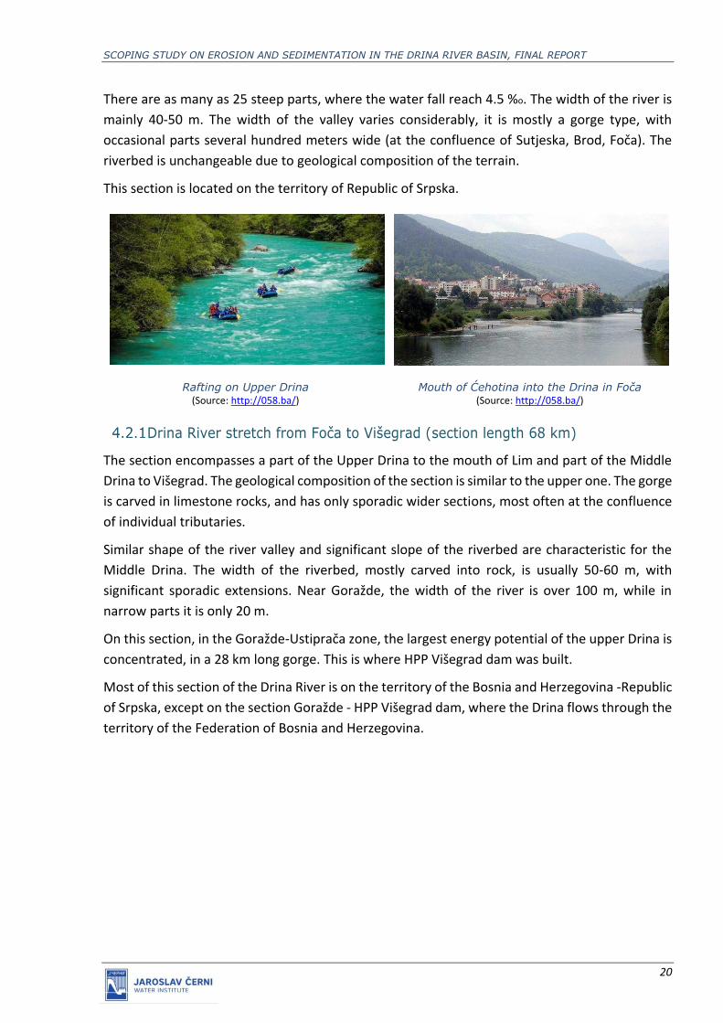
Drina River between Sastavci and Foča (section length 23.5 km)
The entire length of this section is in a gorge, cut into rocks of mostly sand and shale stones. The
river flow in the solid and rocky riverbed with numerous obstacles is irregular, with large variation
of velocities.
SCOPING STUDY ON EROSION AND SEDIMENTATION IN THE DRINA RIVER BASIN, FINAL REPORT
20
There are as many as 25 steep parts, where the water fall reach 4.5 %o. The width of the river is
mainly 40-50 m. The width of the valley varies considerably, it is mostly a gorge type, with
occasional parts several hundred meters wide (at the confluence of Sutjeska, Brod, Foča). The
riverbed is unchangeable due to geological composition of the terrain.
This section is located on the territory of Republic of Srpska.
Rafting on Upper Drina (Source: http://058.ba/)
Mouth of Ćehotina into the Drina in Foča (Source: http://058.ba/)
Drina River stretch from Foča to Višegrad (section length 68 km)
The section encompasses a part of the Upper Drina to the mouth of Lim and part of the Middle
Drina to Višegrad. The geological composition of the section is similar to the upper one. The gorge
is carved in limestone rocks, and has only sporadic wider sections, most often at the confluence
of individual tributaries.
Similar shape of the river valley and significant slope of the riverbed are characteristic for the
Middle Drina. The width of the riverbed, mostly carved into rock, is usually 50-60 m, with
significant sporadic extensions. Near Goražde, the width of the river is over 100 m, while in
narrow parts it is only 20 m.
On this section, in the Goražde-Ustiprača zone, the largest energy potential of the upper Drina is
concentrated, in a 28 km long gorge. This is where HPP Višegrad dam was built.
Most of this section of the Drina River is on the territory of the Bosnia and Herzegovina -Republic
of Srpska, except on the section Goražde - HPP Višegrad dam, where the Drina flows through the
territory of the Federation of Bosnia and Herzegovina.
SCOPING STUDY ON EROSION AND SEDIMENTATION IN THE DRINA RIVER BASIN, FINAL REPORT
21
Canyon of the Drina River (Source: http://martinmeyer.de)
The Višegrad dam (Source: https://www.akta.ba/resources)
The Drina River stretch from Višegrad to the HPP Bajina Bašta (section length
55,4 km)
The river valley at this stretch is also mountain-gorge type, and it is cut into a rock massif with
sporadic extensions. Going downstream the valley is expanding. Sporadic extensions (up to 500
m in the upper part) are wider downstream from the Klotojevci, reaching up to 2 km.
The river valley from Višegrad to the mouth of the Drinjača River is formed in very cracked
Paleozoic rocks, prone to erosion, and the river receives considerable amounts of sediment.
This section contains the longest gorge on the entire Drina River (35 km). The largest energy
potential is located here and used by HPP Bajina Bašta (located 14.5 km upstream from the Bajina
Bašta settlement). Its reservoir is impounding the entire river stretch up to Višegrad.
Drina River in Višegrad (Source: https://visegradturizam.com)
A narrow part of the Perućac lake (reservoir of HPP Bajina Bašta)
(Source: https://tara.rs/)

SCOPING STUDY ON EROSION AND SEDIMENTATION IN THE DRINA RIVER BASIN, FINAL REPORT
22
Perućac lake
(Source: https://banjeusrbiji.com/jezero-perucac/) Perućac (Bajina Bašta) Dam (Source: https://www.wikidata.org)
The Drina River stretch from the HPP Bajina Bašta to Zvornik (section length
105,1 km)
On this stretch the Drina generally maintains the characteristics it had in the upper course and
part of the middle course. It is still a mountain-type river with significant slopes, valleys cut into
rock massifs, with sporadic extensions and alluvial plains. However, all these characteristics are
gradually changing going downstream, where there are significantly different characteristics.
Widenings are more frequent and wider, slopes are declining gradually, gorges are no longer as
frequent and distinct as in the upstream stretches. The whole relief becomes milder. The river
valley on this section is mainly cut into the Palaeozoic rock mass, to the mouth of Drinjača, while
downstream to Zvornik limestone is predominant. This composition of the valley causes
significant amounts of sediment deposits from the basin and its transport to the Zvornik
reservoir. The entire river reach up to Zvornik is characterized by a clearly distinctive cutting of
the river valley and significant erosion in large parts of the catchment area, which results in
significant amounts of sediment deposits in the valley, its transport downstream and deposition
on the sections where the bottom shear stress weakens.
On this section, the river still has considerable energy potential, especially the section around
Rogačica, Ljubovija and Zvornik. A smaller part of this potential was used by the HPP Zvornik, the
first major hydropower plant on the Drina River.
Widenings of the river valley around Ljubovija and other settlements reach width of 2 km. The
last dangerous whirlpools on the Drina River are located on this section. The riverbanks in the
lower parts are particularly unstable, there is a erosion during high flows, and islands and
sediment bars are becoming more common. There is no major meandering, but the riverbanks
are sporadically endangered, especially on mouths of larger torrential tributaries. On this section,
the Drina River receives water from the Drinjača River, and from smaller ones such as the Pilica
River near Bajina Bašta, the Rogačica River, the Ljuboviđa River near Ljubovija etc. The mouths
of these tributaries are not fixed, so sometimes the torrential erosion endangers the populated
areas near the watercourse.
Larger settlements are relatively frequent on this section (Bratunac, Srebrenica and Zvornik on
the left bank and Bajina Bašta, Ljubovija and Mali Zvornik on the right bank). Bajina Basta is 1-

SCOPING STUDY ON EROSION AND SEDIMENTATION IN THE DRINA RIVER BASIN, FINAL REPORT
23
2 km away from the Drina, located on the plateau at 229,7 m asl, high above the riverbed.
Ljubovija is located at the altitude of 175,9 m asl, at the foot of the hill and at a distance of about
600 m from the Drina riverbed. This settlement was previously located 2 km downstream, on the
riverbank, but historical flood in 1896 destroyed the settlement and forced people to leave.
Drina River near Bajina Bašta town
(Source: https://mapio.net) Drina River near Ljubovija
(Source: https://peratravel.blogspot.com)
Zvornik lake
(Source: http://lakesofserbia.blogspot.com) Zvornik Dam
(Source: http://lakesofserbia.blogspot.com)
The Drina River from Zvornik to the confluence with the Sava River – Lower
Drina (section length 91 km)
The section downstream from Zvornik is fundamentally different from the upstream sections by
many parameters. A river that had a narrow valley, a relatively fixed riverbed formed in hard
materials and a significant slope, suddenly becomes a lowland river.
Instead of solid materials, as in the upper and middle sections, the riverbed is cut into the soft
deposits of former Neogene lakes, which, going downstream, gradually transforms into the Sava
River alluvial plain.
The Drina riverbed has very uneven characteristics: it is very wide in some places (up to 300 m),
with numerous river islands and sandbanks, while narrow and seemingly stable in other. The
instability of the riverbed and the fragmentation is increasing downstream.
Downstream of Banja Koviljača and Loznica all the way to the confluence with the Sava River, the
Drina River has numerous meanders, curves, river branches and temporary riverbeds often
changed by spilling out and shifting planform in a very wide area. The slope is small, the river is
SCOPING STUDY ON EROSION AND SEDIMENTATION IN THE DRINA RIVER BASIN, FINAL REPORT
24
relatively slow and shallow, full of sandbanks, shallows and gravel and sand deposits that are very
unstable.
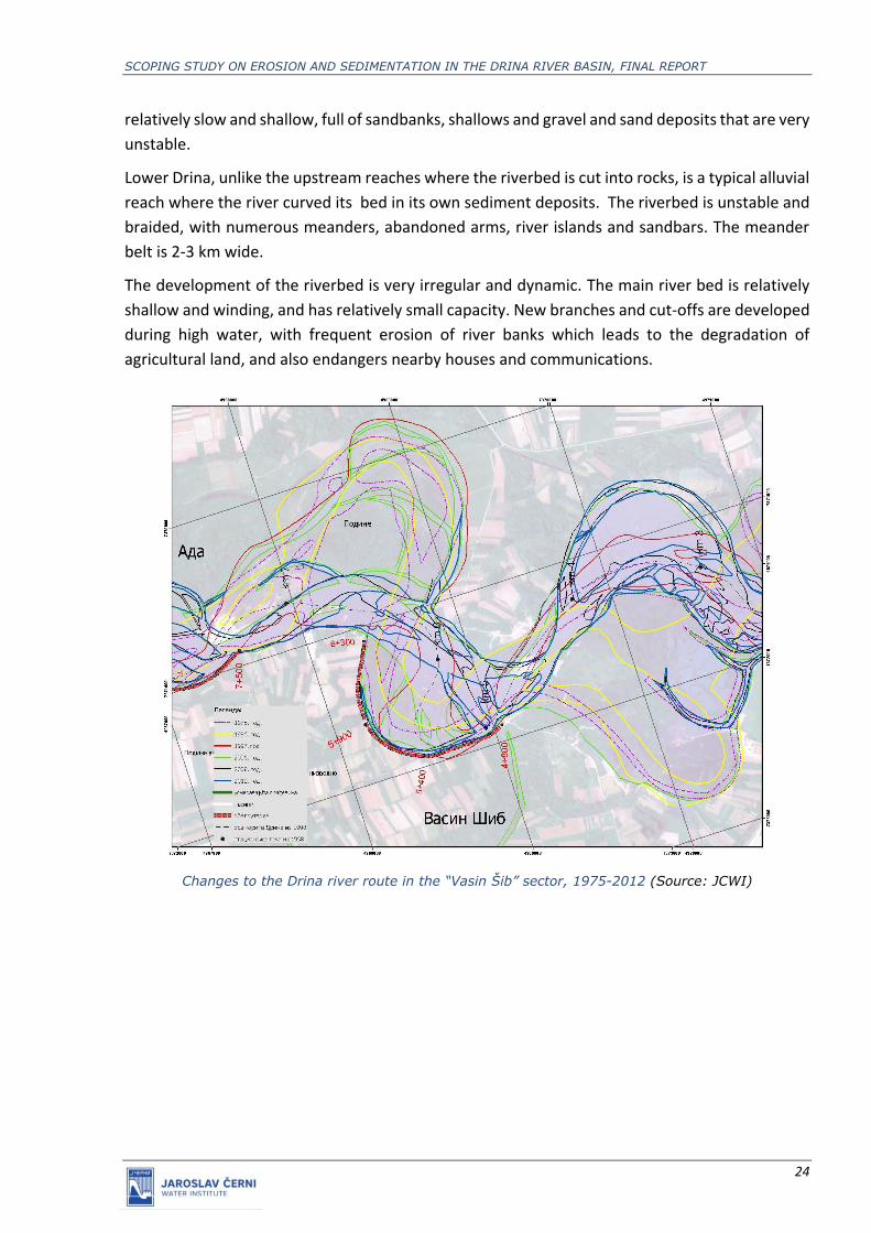
Lower Drina, unlike the upstream reaches where the riverbed is cut into rocks, is a typical alluvial
reach where the river curved its bed in its own sediment deposits. The riverbed is unstable and
braided, with numerous meanders, abandoned arms, river islands and sandbars. The meander
belt is 2-3 km wide.
The development of the riverbed is very irregular and dynamic. The main river bed is relatively
shallow and winding, and has relatively small capacity. New branches and cut-offs are developed
during high water, with frequent erosion of river banks which leads to the degradation of
agricultural land, and also endangers nearby houses and communications.
Changes to the Drina river route in the “Vasin Šib” sector, 1975-2012 (Source: JCWI)

SCOPING STUDY ON EROSION AND SEDIMENTATION IN THE DRINA RIVER BASIN, FINAL REPORT
25
Changes to the Drina river route in the “Purevine sector”, 1975-2012 (Source: JCWI)
Changes to the Drina river route in the “Kurtovica ada sector”, 1975-2012 (Source: JCWI)

SCOPING STUDY ON EROSION AND SEDIMENTATION IN THE DRINA RIVER BASIN, FINAL REPORT
26
Manifestations of fluvial erosion are very visible and intense, and banks may shift for tenth of
meters in a very short time. Erosion of outer banks is present on almost all curved reaches. The
sediment deposition in the form of large sediment bars is a parallel process on all inner banks.
Large sediment bars in the Drina riverbed (Source: JCWI)
The extreme instability and irregularity of the development of the Lower Drina riverbed is a result
of to the irregularity of hydrological and hydraulic characteristics of the stream, the geological
composition and geomechanical characteristics of the terrain (alluvial deposits 12 m thick), the
sediment regime (the upstream Zvornik dam completely interrupted the bed load inflow into this
section), the exploitation of sand and gravel from the riverbed, and various structures in the
riverbed which influence the flow pattern.
The coastal areas are wide, cultivated alluvial plains of Semberija on the left and Mačva on the
right side. It should be noted that, due to the flow direction from south to north, the right bank
is eroded in most cases.
It can be concluded that the Lower Drina is still is in the development process. This development
is significantly disturbed by the construction of reservoirs, mostly for the HPP Zvornik, which traps
considerable amounts of river sediments. Under these conditions, the river moves and takes the
sediments from the riverbed and coastal terrains, which results in significant erosion of the coast
and the drift and degradation of the riparian land complexes.
SCOPING STUDY ON EROSION AND SEDIMENTATION IN THE DRINA RIVER BASIN, FINAL REPORT
27
5. ANALYSIS OF EROSION PROCESSES
Soil erosion and torrents are two interconnected natural phenomena, each in its own way
causing enormous damage in all spheres of life and economic activity in DRB. Erosion processes
are long-term, with visible changes within a one year to several decade period, while torrents
occur and end in a relatively shorter period.
The intensity and surface distribution of certain forms of erosion in DRB have been subject to
monitoring and study for decades, but not in continuity.
The erosion map is an important document as it clearly identifies areas that, from the aspect of
threatening erosion, are erosion-prone or erosion risk areas, for which constraints and conditions
of use are defined, preventive measures are prescribed and required erosion control work is
performed as a priority, meaning that it is important to have updated maps.
5.1 Factors of erosion in DRB
The relief of the DRB surface is formed primarily by a combination of tectonic and sedimentary
processes, glacial movements and other processes. DRB geological substrate has, over time, been
the result of various combinations of the above geomorphological phenomena, which, for
convenience, are called "tectonic" and "erosion" geomorphological processes.
Soil erosion is a natural phenomenon, but also a process whose intensity is most influenced by
the overall activity of people, and this is the only area that can be controlled by changing the way
land is used to reduce the intensity of erosion to a tolerable extent.
Anthropogenic effects on erosion processes are reflected through deforestation and destruction
of forests, irregular agrotechnical measures, intensive grazing and livestock breeding,
uncontrolled urbanization and industrialization, unplanned opening of quarries, etc.
Land loss caused by erosion processes is one of the most current problems in the DRB, and land
loss assessment and anti-erosion measures are of strategic importance for ecosystems, water
management, economy, spatial planning and the environment. The erosion process can be very
quick, but the consequences are long-lasting (it takes 200-1000 years to rebuild the 2.5 cm
surface layer under vegetation conditions).
Present depopulation trends in DRB represent an indirect anthropogenic factor, which reduces
the intensity of erosion. Aging and depopulation of rural settlements, migration village to town,
marginalization of agriculture and reduction of livestock lead to land use changes and gradually
restrain erosion processes.
The products of erosion processes in the basin is an erosion deposit that reaches the river
network and is transported to the lower parts of the basin causing damage to agriculture
(removal of semi-arable land), water management, energy (reduction of useful volume of
reservoirs due to backfilling) and other branches of the economy.

SCOPING STUDY ON EROSION AND SEDIMENTATION IN THE DRINA RIVER BASIN, FINAL REPORT
28
In addition, erosion processes negatively affect the environment in two ways - directly and
indirectly. The direct (on-site) effect is reflected in the removal of land, the stripping of rocks and
the creation of rocky deserts where the development of any flora and fauna is not possible. The
indirect (off site) environmental effect of erosion processes is reflected in the washing away of
harmful substances (chemical pollutants) that are transported together with the erosion layer.
Some examples of erosion processes in the Drina river basin are presented bellow.
Erosion process as the consequence of
unregulated slopes of the road
Tearing away the area under the vineyard
Erosion deposition from the Prokletije mountain slope
Fluvial erosion in the riverbed of the Ljuča river
Rocks without vegetation on Mount Visitor as a
consequence of anthropogenic factor
Fluvial erosion in the riverbed of the Ljuča river

SCOPING STUDY ON EROSION AND SEDIMENTATION IN THE DRINA RIVER BASIN, FINAL REPORT
29
Sediment deposition at the Likodra river The riverbed of the Brštica, tributary of Likodra
river, is covered with sediment
Production of sediment in river basins and its transport in watercourses are two components of
the natural global process. High intensity of erosion processes also affects the genesis of high
water in torrential river basins, increasing the maximum flow rate.
5.2 Present erosion and torrents related problems in DRB
The present regime of sediment in DRB is conditioned by the anti-erosion measures in the basin
and the construction of structures in the river beds. The most important structures are dams
that, in the backwater area, have altered the natural conditions of water and sediment flow.
Regulation of torrents in DRB began in the early XX century, primarily with the aim of protecting
railroads. Between the two WW, a program of anti-erosion measures started, aiming not only on
protection of railroads and roads. In 1930, the Yugoslav law on the regulation of torrents came
into force. It was implemented during and after the II WW, until the enactment of new legislation
in 1952 and 1954.
In 1954, the Erosion and Torrential Protection Act came into force. For the implementation of
the planned works and measures for the regulation of torrents and erosion protection, regional
organizations - "Sections for erosion and torrents" have been established.
In the period up to 1980, a considerable amount of work was carried out, both for the immediate
protection of the reservoirs built during that period, as well as for the protection of roads and
industrial facilities. There are several groups of works by purpose:
• protection of railways and roads (the largest volume of works was performed for the
protection of the Belgrade-Bar railway line);
• protection of HPP reservoirs on the Drina;
• protection of settlements along the Drina River (Zvornik, Ljubovija, Bajina Bašta, Visegrad,
Goražde, Loznica and others);
• protection of large industrial facilities in Loznica, Zvornik, Gorazde, Visegrad, Prijepolje,
Bjelo Polje and other settlements.
Those were complex anti-erosion works and measures, combined with the regulation of
torrential flows.

SCOPING STUDY ON EROSION AND SEDIMENTATION IN THE DRINA RIVER BASIN, FINAL REPORT
30
Montenegro
Soil erosion is a natural process that in Montenegro causes environmental changes such as land
degradation, land loss, water pollution and ecosystem change. Water erosion affects 95% of
Montenegro. The rest of the area is characterized by alluvial accumulation, where sediment
deposition also affects agricultural land. The large accumulated sediment flows dominate the
river basins, and are the consequence of erosion of land, and as such create a major
environmental problem. The key to understanding the impact of land management in the future
and climate change on land degradation is in modeling the rate of soil erosion under different
land uses. The topography of the region is illustrated by the percentage of slope of land within
the river basin (Figure 1).
Water erosion is dominant in high slope terrain due to complex physical and geographical
conditions associated with tree felling activities. The average annual soil erosion intensity is
estimated to be higher than 10 tonnes per hectare (Blinkov, I. (2015)) .
Land slope in the DRB within Montenegro (%)
A study conducted in the Polimlje area (Spalević, V. et.al., 2013) concludes that vegetation cover
conditions and land use have influenced the development of erosive processes in the river basin.
The total loss of land in the area covered by this study is estimated to be 315 m3 per km2. This
indicates that they belong to the 5th erosion (Gavrilovic,1972). However, the strength of the
erosion process is considered medium, and by type of erosion, represents mixed erosion. The
change of land use in the structure for the period of 4 decades (1970-2013), in the area that was
the subject of this study, reduced the intensity of soil erosion by 3.95%.

SCOPING STUDY ON EROSION AND SEDIMENTATION IN THE DRINA RIVER BASIN, FINAL REPORT
31
The latest studies on soil erosion processes in the Danube basin (Polimlje area - 40.23 km2) were
conducted in 2016. The IntErO computer-graphic model was used to calculate the intensity of
soil erosion, taking into account the data contained in the Forest Management and Management
Plan, the Cadastre, the Landsat Program and the Statistical Yearbook. The total land loss was
calculated to be equivalent to an annual loss of 327m3 per km2.
The highest rates of erosion of the soil in the Danube basin at the end of the consequences are
(i) loss on farms, higher production costs and lower revenues at the farm, and (ii) an elevated
concentration of phosphorous in the fresh surfaces, which negatively affects the quality of the
water.
The specificity of the Drina River basin in the territory of Montenegro is that on a relatively small
surface very diverse forms of erosion forms and specific torrential flows occur. Each of these
phenomena required the adaptation of the usual methods for the erosion and torrent
remediation to the specific situation on the terrain and finding new solutions suitable for the
specific task.
Due to extremely high mountainous terrain, roads have been placed along the rivers and streams
along which settlements and towns were built.
Each tributary of the Drina, in its upper reach, and some along its entire length, is a torrent which
threatens nearby buildings and infrastructure.
Technical measures with the influence on retention and stabilization of sediment transport are
dominant, while biological measures were less represented.
A large amount of anti-erosion and torrential flood protection works was done so far in DRB in
Montenegro, and contributed to a significant reduction of torrential floods. Unfortunately, the
maintenance of these systems is lacking, and this causes their gradual degradation and even
partial destruction. Structures built in torrents are exposed to permanent destructive effects of
torrential waters. There are numerous examples of the demolition of well-constructed structures
due to poor or completely inadequate maintenance.
Works on the regulation of torrential flows have not ceased, although they have been
considerably reduced in scope and limited to solving local problems as protection of cities and
roads.
Existing registers and cadastres of torrential flows are more than thirty years old and have not
been supplemented with new data since their creation, although many facilities have been built
in the meantime, and changes in erosion intensities have occurred.
Much of the work on the regulation of torrential flows has not been registered, as they were
carried out as part of the protection of the Belgrade-Bar railway and the roads along the Tara and
Lima valleys.
Serbia
Till 1991 a large amount of work on anti-erosion land management and torrent control was done
in DRB. This led to the reduction of the average erosion intensity by one, in some areas by two

SCOPING STUDY ON EROSION AND SEDIMENTATION IN THE DRINA RIVER BASIN, FINAL REPORT
32
categories. The former erosion areas were afterwards used for highly productive agricultural
production, especially for fruit growing.
However, the investments in new anti-erosion works and maintenance were significantly
reduced in the last decades. As a consequence, frequent torrential floods occurred (Jadar, Stira,
Ljubovija, Pilica, Raca - 2005, 2007, 2011), while the one with catastrophic consequences
occurred in May 2014 on a large territory of Western Serbia.
Landslides and soil erosion during the 2014 flood
In the middle part of the Drina basin (between the Zvornik reservoir and the Bajina Bašta
reservoir, during those years, anti-erosion works were made, from technical 50-100m3/km2 and
biological 5-10ha/km2. These are very small amounts of work, given that large the amounts of
sediment run from these basins.
Over the last five years, investments in anti-aliasing work have increased significantly, so that the
effects of those investments have already emerged. In the Jadar Basin, a tributary of the Likodra,
a great deal of technical work has been done to stop the sediment. After the catastrophic floods
of 2014, the town of Krupanj was flooded with large quantities of sediment launched from the
Likodra River basin and tributary. Emergency measures and works from the projected 19, 12
landfill bulkheads were built to contain the sediment and already in 2017, after heavy rainfall and
new torrential raids, the deposition in the basin was retained and the effects of the emergency
works were successful.
Sediment retention dam in the Jadar River Basin

SCOPING STUDY ON EROSION AND SEDIMENTATION IN THE DRINA RIVER BASIN, FINAL REPORT
33
Republic of Srpska
The situation in DRB part in Republika Srpska has been in a very poor state for the last twenty
years. Neither anti-erosion works have been invested in, nor care taken to ensure that structures
that have already been built to protect against erosion and containment remain in a sustainable
condition.
In the catchments of Janja, Drinjača, Prača, Bistrica and Bjelava, as large tributaries of the Drina
River, no anti-erosion and biological and technical works have been done, which would greatly
reduce the flow of sediment into the main recipient. The sporadic regulation of the bed (eg
regulation of the Lamb in Bijeljina and Drinjaca through Šehovići) transports the sediment to the
lower parts of the basin, but its production does not stop.
Federation Bosnia and Herzegovina
The hilly-mountainous character of the Federation of BiH causes the creation of a large number
of torrents, as well as the possibility of creating new erosion processes. In the upper parts of the
Janja, Drinjača, Prača river basins, due to uncontrolled deforestation, land degradation occurs
and erosion processes occur (dredging and furrowing). Of the technical and biotechnical works,
nothing has been done in these parts of the catchments.
5.3 Erosion in DRB countries
Data on erosion were compiled in GIS map and 5 erosion categories were further distinguished:
I - Excessive erosion - deep erosion process (gullies, rills rockslides and similar);
II – Heavy erosion - milder forms of excessive erosion;
III - Moderate erosion – medium surface, deep and mixed erosion (areas of degraded
forests, degraded pastures, etc.);
IV – Slight erosion – lower intensity of erosion processes (forests, meadows and pastures on
very inclined terrains);
V – Very slight erosion – areas without erosion or with traces of erosion.
Serbia
The map is produced using “Erosion Potential Method” (EPM), developed in JCWI. It is now a
standard method for erosion mapping in water management in Serbia.
EPM method has been used to determine the erosion intensity and to calculate the erosion
sediment yield and transport needed for water resources planning and management and hasn’t
slope limitation. The method proved reliable for assessment of sedimentation that affects
reservoirs, river channels, important structures and urban areas.
The basic parameter used to define the erosion intensity is the Erosion Coefficient (Z). Since
erosion is a phenomenon occurring on the whole surface, the most rational presentation of the
surface spreading of erosion is the mapping of the erosion. The mapping procedure requires

SCOPING STUDY ON EROSION AND SEDIMENTATION IN THE DRINA RIVER BASIN, FINAL REPORT
34
investigations and computations to determine and present on a map the surfaces with the same
class Erosion Coefficient (Z).
The results of mapping revealed that in Serbian part of DRB very low and weak erosion are
represented in the northern plains, while in the central and southern part of DRB erosion
processes are of much higher intensity, with pronounced areas of strong and excess erosion. In
central and southern parts, very weak erosion occurs only in the lowland areas, in valleys of the
Drina River tributaries.
Map of erosion for DRB part in Serbia
Erosion categories in DRB part in Serbia
Category of erosion I - Excessive II - Heavy III - Moderate IV - Slight V - Very slight
Participation 1.54% 8.85% 23.51% 59.10% 7.00%

SCOPING STUDY ON EROSION AND SEDIMENTATION IN THE DRINA RIVER BASIN, FINAL REPORT
35
Erosion on major sub-basins of the Drina River in Serbia
The Jadar River Basin
The Jadar River Basin is characterized by intensive erosion processes, with dominant category III
and IV erosion, with significant participation of categories I and II. As a result of intensive erosion
processes, floods of catastrophic proportions have occurred in the Adriatic Basin over the last
two decades, especially in the municipality of Krupanj. The basic factors for the development of
such processes are: geological substrate composed mainly of erodible rocks (sandstones, clay
shales, etc.), soil composition (such as eroded pebble, brown acidic soil on sandstone, etc.)
erodible, numerous short tributaries of large longitudinal falls that is, torrential tributaries. The
most endangered part of the basin is the upper part of the basin, in the sub-basins of Likodra,
Pecka, Lopatanjska, Crna reka and Močionik.
The Pilica River Basin
The Pilica River Basin is dominated by strong and medium erosion (II and III category).
Hydrographically, the basin is very developed, with many tributaries of torrential character
concentrated in the middle part of the basin.
The Ljuboviđa River Basin
The Ljuboviđa River Basin is most represented by very slight erosion, then medium, and strong.
In hydrographic terms, the Ljuboviđa basin represents the entire system of torrential flows.
Although most of the basin is made up of forests with approximately 60%, erosion is very intense
in some locations. The most intensive erosion processes take place on agricultural land located
on sloping terrain or on degraded forest areas.
The Trešnjica River Basin
The upper part of the basin is dominated by IV and V categories, where most of it is covered with
forests. In the lower part there are agricultural areas where strong erosion processes prevail - II
erosion category.
The Rogačica River Basin
In the basin of the Rogacica river basin, II and III erosion categories are the most represented,
with significant category I participation. Brown skeletal soil on shales and intensive agriculture
on sloping terrain are the main causes of erosion processes.
The Rzav River Basin
The lower part of the Rzav River basin is located in Republica Srpska. In the Serbian part of the
basin, slight erosion (75%), medium (15%) and heavy erosion (10%) are most prevalent. Most of
the Rzav River basin is under forests (about 55% of the basin area) followed by shrubby and
herbaceous plant communities, grasslands, arable land, and pastures. Heavy erosion is present
in the area of Kršanje Mountain in the Beli Rzav Basin and in the Šargan Mountain area in the
Crni Rzav Basin.
The Lim River Basin
SCOPING STUDY ON EROSION AND SEDIMENTATION IN THE DRINA RIVER BASIN, FINAL REPORT
36
The Lim River springs in Montenegro, passes through Serbia and flows into the Drina River in RS.
Although part of the Lim River basin in Serbia according to the erosion map is characterized by V
category (65%) and IV category erosion (27%), the amount of erosion material in river beds and
reservoirs gives a completely different picture of the state of erosion. A general feature of the
watershed in the basin is the large longitudinal fall of the riverbed and the large fall of the
catchment areas.
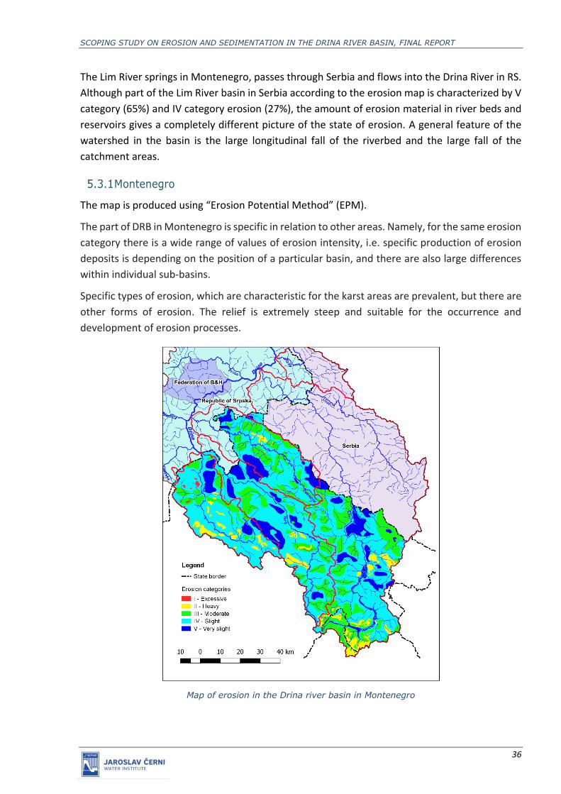
Montenegro
The map is produced using “Erosion Potential Method” (EPM).
The part of DRB in Montenegro is specific in relation to other areas. Namely, for the same erosion
category there is a wide range of values of erosion intensity, i.e. specific production of erosion
deposits is depending on the position of a particular basin, and there are also large differences
within individual sub-basins.
Specific types of erosion, which are characteristic for the karst areas are prevalent, but there are
other forms of erosion. The relief is extremely steep and suitable for the occurrence and
development of erosion processes.
Map of erosion in the Drina river basin in Montenegro
SCOPING STUDY ON EROSION AND SEDIMENTATION IN THE DRINA RIVER BASIN, FINAL REPORT
37
Erosion categories in the Drina River basin in Montenegro
Category of erosion I - Excessive II - Heavy III - Moderate IV - Slight V - Very slight
Participation 0.30% 4.63% 20.93% 59.41% 14.74%
Erosion on major sub-basins of the Drina River in Montenegro
The Lim River Basin
In the Lim River Basin in Montenegro, the largest area is occupied by IV category (56%), then III
category (25%), while the areas with II and I category are represented at 6%. However, huge
amounts of erosion sediment are transported through the Lima basin, which originates mostly
from the steep torrential tributaries of the upper part of the basin. Another significant factor in
erosion is the excessive felling of trees.
The Tara River Basin
The Tara is a typical karst river with few tributaries. The most common are IV (59%), V (20%) and
III (17%) erosion categories. Low intensity erosion processes are represented in the lower parts
of the basin, and in the upper part of the basin of slightly higher intensity.
The Piva River Basin
The Piva River is a typical karst river in which the basin is the least represented by IV and III
category with a significant share of II erosion category. High mountains, large longitudinal slopes,
the presence of bare rox (4%) and open spaces with little or no vegetation (11%) are the causes
of the highly developed erosion processes and the appearance of a large amount of sediment
reaching the riverbeds.
The Ćehotina River Basin
The Cehotina River basin covers the territory of Montenegro and RS. In the Ćehotina River basin,
weakest erosion (52%) is most prevalent, followed by very slight erosion (26%), moderate (19%),
heavy (1%) and excessive erosion (1%). The most pronounced are the processes of fluvial erosion,
which are manifested by landslides, destruction of the coasts, erosion and triggering of powerful
sediments formed by long-term sediment deposition. Intensive erosion processes have occurred
on land that has been improperly used and other natural conditions are unfavourable for the
restoration and regeneration of vegetation. Steep slopes, irregular tillage and then climatic and
soil conditions influenced both the intensity and the arrangement of erosion processes.
Republic of Srpska
The erosion map of the Drina River basin was made using the empirical method S. Gavrilovic,
modified from еrosiоn potential method.
This method are supplemented tables for determining the parameters that are part of the
erosion coefficient calculation form (Z).
Erosion intensity mapping is performed directly in the field, visually, with the help of tables of
parameters for determining the erosion coefficient (Z) and the corresponding cartographic bases:
topographic, geological, pedological, etc.

SCOPING STUDY ON EROSION AND SEDIMENTATION IN THE DRINA RIVER BASIN, FINAL REPORT
38
The modified Gavrilovic method differs from the erosion potential method by evaluating one of
the parameters for the calculation of the erosion coefficient Z. This parameter observed the
erosion process (), which in the modified Gavrilović method has values of 1.5, while by the
erosion potential method the value of the coefficient () is 1.0. Also, the term “erosion
accumulation” was introduced where erosion has a value of 0.
These are the basic differences in the classification of erosion categories, as in the example of
the lower Drina River basin (in the Janja River basin), where there is no erosion at all according
to the modified Gavrilovic method, while according to the EPM, the lower part of the river basin
belongs to the V category.
The following figures present data received from Republic of Srpska (4 maps, all in .pdf formats).
Map of erosion in the Drina river basin in Republic of Srpska (Part 1) (Source: JVP “Vode Srpske”)

SCOPING STUDY ON EROSION AND SEDIMENTATION IN THE DRINA RIVER BASIN, FINAL REPORT
39
Map of erosion in the Drina river basin in Republic of Srpska (Part 2) (Source: JVP “Vode Srpske”)
Map of erosion in the Drina river basin in Republic of Srpska (Part 3) (Source: JVP “Vode Srpske”)

SCOPING STUDY ON EROSION AND SEDIMENTATION IN THE DRINA RIVER BASIN, FINAL REPORT
40
Map of erosion in the Drina river basin in Republic of Srpska (Part 4) (Source: JVP “Vode Srpske”)
To fit these data into the DRB overall maps, 12 erosion subcategories had to be grouped into 5
erosion categories.

SCOPING STUDY ON EROSION AND SEDIMENTATION IN THE DRINA RIVER BASIN, FINAL REPORT
41
Map of erosion in the Drina river basin in Republic of Srpska
Erosion categories in DRB part within Republic of Srpska
Category of erosion I - Excessive II - Heavy III - Moderate IV - Slight V - Very slight
Participation 1.08% 0.04% 2.83% 19.02% 77.03%
Forests and IV and V erosion categories are represented in most of the Drina basin in RS. The
strongest erosion processes take place in the Janja, Tamna basin, part of the Drinjača river basin,
in the Lim, Rzav and Ćehotina basins. Fluvial or river erosion is characteristic of most streams in
this area.
Erosion on major sub-basins of the Drina River in Republic of Srpska:
The Janja River Basin
In the Janje River basin, there are mostly slight erosion categories, although the basin is classified
as a river basin producing large amounts of erosion deposits. The Mezgrajica basin is most
endangered, where excessive erosion is the most prevalent. As a result, huge amounts of
sediment are deposited, partly deposited in the valley of the Janja River and partly reaching the
stream of the Drina River.
The Sutjeska River Basin

SCOPING STUDY ON EROSION AND SEDIMENTATION IN THE DRINA RIVER BASIN, FINAL REPORT
42
The basin is mostly represented by very slight erosion, slight, moderate and excessive erosion
category. Much of the Sutjeska River basin is under forests (about 60% of the basin area) followed
by shrubby and herbaceous plant communities, agricultural land, pastures, thinned vegetation
and stripped rock.
The Drinjača River Basin
The basin is most represented by very slight erosion (78%) and a slight erosion category. The
geological base is composed of limestones, dolomites and much less volcanogenic-sedimentary
formations. Most of the Drinjača River basin is under forests (about 70% of the basin area)
followed by agricultural land, pastures and shrubby and herbaceous plant communities.
The Bistrica River Basin
The basin is most represented by very slight erosion (about 80%), slight and moderate erosion
category. Most of the Bistrica River basin is under forests (about 65% of the basin area) followed
by shrubby and herbaceous plant communities, agricultural land and pastures.
The Prača River Basin
Although very slight erosion (90%), slight and moderate erosion category is most represented in
this basin, large quantities of erosion material are produced, especially from the upper part of
the basin and sub-basins of Brnjička river and Vinčica. Most of the Prača River basin is under
forests (about 60% of the basin area) followed by agricultural land, pastures and shrubby and
herbaceous plant communities.
Federation of Bosnia and Herzegovina
The erosion map for the part of DRB in the Federation of Bosnia and Herzegovina was prepared
within this Study, according to the method of erosion potential (EMP) and based on data available
in JCWI (DTM) and from publicly available sources (Corine Land Cover 2018). The result is
presented on picture bellow.

SCOPING STUDY ON EROSION AND SEDIMENTATION IN THE DRINA RIVER BASIN, FINAL REPORT
43
Map of erosion in the Drina river basin in Federation of Bosnia and Herzegovina
Erosion categories in DRB part within Federation of Bosnia and Herzegovina
Category of erosion I - Excessive II - Heavy III - Moderate IV - Slight V - Very slight
Participation 0.43% 1.09% 46.64% 44.07% 7.78%
The territory of the Federation of BiH in the Drina River Basin is 875 km2, which is approximately
5% of the total basin territory. The territory includes part of the Prača basin, 4 smaller tributaries
of the Drina River, the upper part of the Drinjača River basin, part of the upper Janja basin, the
upper part of the Sapna basin and the upper parts of the Tavna basin, Lokanjska river and
Jasenička river.
Part of the Prača basin and smaller tributaries of the Drina
III and IV erosion categories are the most represented in this part. The most intensive erosion
processes take place on agricultural land, which is abundant here.
The upper part of the Drinjača River basin
III and IV erosion categories are the most represented in this part. In this part of the basin, forest
vegetation is most prevalent, while agricultural areas are second one. The most intense erosion
processes take place in the riverbed.
The upper part of the Janja River basin and the parts of the river basins nearby

SCOPING STUDY ON EROSION AND SEDIMENTATION IN THE DRINA RIVER BASIN, FINAL REPORT
44
In this section, the most represented are III and IV erosion categories with a significant share of I
and II categories. The most intensive erosion processes take place in the Janja basin on the
Jasikovac and Mejdan mountains.
5.4 Compilation of the erosion map for the entire DRB
Within this Study, all available data were compiled and a new erosion map for DRB prepared. It
can be seen that there are differences between the right side of the map (Montenego and
Serbia), where erosion classification is based on “Erosion potential” method (EPM) and five
erosion categories are distinguished (ranging from very low to excessive) and the left side (mainly
Republic of Srpska) where erosion classification is based on “modified Gavrilovic method” (mainly
very low erosion).
Map of erosion in the Drina river basin

SCOPING STUDY ON EROSION AND SEDIMENTATION IN THE DRINA RIVER BASIN, FINAL REPORT
45
If sub-categories defined in Republic of Srpska are merged into 5 categories (as example:
I_1+I_2+I_3=I), the percentages of erosion in DRB are as presented in the next table.
Erosion categories in the Drina River basin
Category of erosion I - Excessive II - Heavy III - Moderate IV - Slight V - Very slight
Participation 0.93% 4.27% 15.95% 44.98% 33.87%
5.5 Present areas prone to erosion in DRB
The erosion areas shown on the following map comprise the areas of the most intensive erosion
processes (I, II and partly III category).
Erosion areas are widespread in all major sub-basins of the Drina River (Jadar, Rogacica, Lim, Piva,
Tara, Sutjeska, Drinjaca, Janja). In most parts, these are steep terrains with erodible geological
substrate, as well as the areas that have been adversely affected by excessive logging, fires and
other negative effects.
It is necessary to update / determine erosion areas in the DRB, taking into account that new
erosion areas may emerge if any of the factors relevant to erosion development change in the
future.

SCOPING STUDY ON EROSION AND SEDIMENTATION IN THE DRINA RIVER BASIN, FINAL REPORT
46
Map of erosion areas in the Drina river basin

SCOPING STUDY ON EROSION AND SEDIMENTATION IN THE DRINA RIVER BASIN, FINAL REPORT
47
6. SEDIMENT DEPOSITION AREAS
The largest sediment deposition areas in the Drina River basin are: within reservoirs (most of
them used for hydro-power production), on mouths of tributaries and on the mouth to the Sava
River.
6.1 Sediment deposition in reservoirs
A number of reservoirs exist in DRB, and most of them are used for hydropower production (only
exceptions are Sniježnica and Otilovići).
No Reservoir River River basin area
[km2]
Year of construction
Total volume
Vu [106 m3]
Active volume
Vk [106m3]
1 Uvac Uvac 920 1979 200 160
2 Kokin Brod Uvac 1170 1962 250 209
3 Radojnja Uvac 3500 1959 7.6 4.1
4 Potpeć Lim 3605 1967 27.5 19.8
5 Otilovići Ćehotina 352 1981 20.7 13.3
6 Mratinje Piva 1758 1973 890 790
7 Višegrad Drina 13310 1988 161 101
8 Bajina Bašta Drina 15195 1966 340 218
9 Lazići Beli Rzav - 1984 170 150
10 Zvornik Drina 17423 1955 89 23
11 Sniježnica Rastošnica 39 1985 23.1 17.9
Data on sediment deposition in reservoirs is available only for some of them and presented
bellow in the downstream-upstream order.
Drina River, Zvornik HPP reservoir
HPP Zvornik operates from 1955. Its initial volume was 95106m3 (active volume 28106m3, and
volume for sediment deposition 67106m3). Until 1965 (when the upstream HPP Bajina Bašta was
built) the reservoir lost app. 30% of its initial volume. The latest survey was done in 2005 and
revealed that its volume is reduced to 41106 m3 which means that more than 50% is filled with
sediment. The sedimentation is clearly visible since large islands and bars are formed.

SCOPING STUDY ON EROSION AND SEDIMENTATION IN THE DRINA RIVER BASIN, FINAL REPORT
48
Visible sedimentation in the Zvornik reservoir
Drina River, Bajina Bašta HPP reservoir
HPP Bajina Bašta started the operation in 1966. It is 50-55 km long and narrow (average width is
400 m), while the water depth at the dam is 80 m. The only tributary in the reservoir range is
Rzav. Anti-erosion measures for protection of the reservoir were planned between 1953-1970
but were not implemented.
Some 25 106 m3 of sediment (2.5 106 m3/year in average) was retained in the first ten years of
reservoir operation. After that the rate of sedimentation lessened, since the upstream dams and
HPP were buit (HPP Potpeć in 1967, HPP Piva in 1976, HPP Uvac in 1979 and HPP Višegrad in
1989. The last survey was done in 1989, while an estimate from 2002 pointed out that the total
volume of the reservoir is 283 106 m3 (17.2 % less than initial). This leads to conclusion that
sedimentation in the reservoir of HPP Bajina Bašta is not very serious.
Drina River, Višegrad HPP reservoir
HPP Višegrad was built in 1989, as the most upstream reservoir on the Drina main course, at the
end of HPP Bajina Bašta backwater. The initial reservoir volume was diminished for only
6.73106m3 between 1991 and 2005 or 0.5 106m3/year, by retaining of the sediment incoming
from the upstream Drina reach and also erosion of riverbanks. Since Višegrad dam is equipped
with powerful bottom outlets which enable sediment flushing/sluicing during floods, this
reservoir is not prone to severe sedimentation.
Piva River, Piva (Mratinje) reservoir
The Piva HPP on the Piva River has the largest reservoir in DRB, built in 1973. Initial asumption,
that the sediment inflow from a rather small upstream catchment will not endanger the
reservoir, was confirmed by 2011 survey. The reservoir survey has shown that after 39 years the
reservoir volume was dimished for 75 106m3 i.e. some 8 % .

SCOPING STUDY ON EROSION AND SEDIMENTATION IN THE DRINA RIVER BASIN, FINAL REPORT
49
Lim River, Potpeć reservoir
Sediment related problems the Potpeć reservoir (as clogging of water intakes) started in 1967,
when the dam and HPP were built. After that the reservoir surveys were more frequent, and the
attempts of sediment flushing/sluicing were done. The results of sediment sluicing done in 1979
and 1980 were negative, as there was a large amount of mud being withdrawn thus destroying
the river ecosystem downstream of the dam. Till 2002, the total volume of this reservoir was
reduced for 18.5106 m3.
Uvac river, Kokin Brod i Uvac reservoirs
The Kokin Brod and Uvac reservoirs have very large volumes (relative to the basin area of about
1000 km2). Given the relatively low sediment input, it was estimated a priori that these reservoirs
would not be endangered by sediment and the issue of sedimentation was not given sufficient
attention. This assumption was proved by surveys which showed that only 3% of reservoir
volume is filled with sediment (Kokin Brod retained 7.9 106 m3, and Uvac 6-7.9106 m3).
6.2 Sediment deposition on the river mouths
Sediment deposition is present on the mouths of all tributaries, on free-flowing and impounded
sections of the Drina and other rivers. Data on the volumes of sediment accumulated are not
known.
Example of a sediment bar at the mouth on free flowing section: the mouth of Ljubovidja River
(right tributary of Drina) (Source: JCWI)
Example of a sediment bar at the mouth on impounded section: the mouth of Boscanska
River (right tributary of Drina in Zvornik reservoir)
(Source: JCWI)
Sediment deposition on the mouth of the Drina to Sava River is a well-known problem, that
influences the water and sediment regime of both rivers. The investigation of possible river
engineering activities which might solve the problem are in the initial phase.
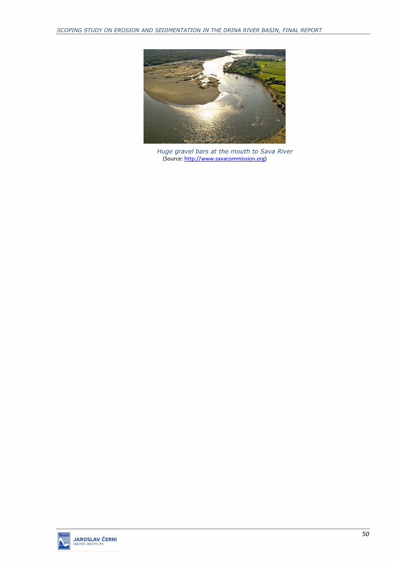
SCOPING STUDY ON EROSION AND SEDIMENTATION IN THE DRINA RIVER BASIN, FINAL REPORT
50
Huge gravel bars at the mouth to Sava River
(Source: http://www.savacommission.org)
SCOPING STUDY ON EROSION AND SEDIMENTATION IN THE DRINA RIVER BASIN, FINAL REPORT
51
7. IDENTIFICATION OF MEASURES
7.1 Set of possible measures
Land erosion and torrents create enormous and long-term damages, threatening multiple sectors
at the same time: agriculture, forestry, water management, traffic, communications, communal
infrastructure, settlements, etc.
Anti-erosion measures are actions that affect the cultivation, maintenance and management of
land, forests and water, and the ways in which they are exploited. These include various legal
regulations and administrative, economic, educational and propaganda measures, as well as
other measures that have a socio-economic character.
The following groups of works and measures can be distinguished:
Technical works - construction of longitudinal and transverse structures in torrential riverbeds
for flood protection and containment of torrential deposits. This group of works also includes the
construction of micro retentions and small reservoirs;
Biological and biotechnical works - afforestation, construction of contour trenches, terraces,
wickerwork, live belts for wind and snow protection, mud filters, reclamation of bushes,
reforestation of neglected forests and bushes, etc;
Agro-technical works - reclamation of agricultural land, repair of soil structure, introduction of
crop rotation, terracing, contour-belt tillage, irrigation, application of anti-erosion agro-
technology, application of the "sustainable agriculture", etc;
Economic and management measures – measures related to land use, exploitation of forests,
pastures, etc.;
Administrative measures – enactment and enforcing of decisions and regulations with regard to
the mandatory introduction of contour tillage, prohibition of overgrazing on pastures and forest
land, prohibitions of deciduous trees, proclamation of protective forests and pastures,
reorientation from cultivation of annual crops to perennial agricultural crops, introduction of
perennial crops rotation, planned utilization of agricultural land, planned management of forests
and similar restrictions within eroded areas or torrential catchments. The first step is designation
of erosion areas;
Educational and propaganda measures - courses, lectures, documentaries, exhibitions, printing
of popular books and brochures.

SCOPING STUDY ON EROSION AND SEDIMENTATION IN THE DRINA RIVER BASIN, FINAL REPORT
52
7.2 Strategic goals and measures set in DRB countries
All DRB countries envisaged a set of measures related to erosion and deposition of sediments in
their strategic documents.
Montenegro
An important prerequisite for ensuring the efficiency of flood protection systems and the
regulation of water flows is the erosion and torrential protection works in the upper parts of the
catchments. An integrated approach to the regulation of torrents and erosion protection in the
territory of Montenegro implies the coordination and synchronization of all activities and
measures in this domain, while respecting the needs and interests of individual stakeholders.
When it comes to protection against torrents, access to this problem depends on the size of the
watercourse. In the case of larger torrential flows, protection against the adverse effects of water
is achieved by classic measures of watercourse regulation and flood protection. In the case of
smaller torrential flows, measures for the regulation of these watercourses are treated as part of
the complex anti-erosion management of the basin. Erosion is a natural phenomenon, but also a
process whose intensity is most affected by human activity, and it is the only area that can be
brought under control and by changing the way land is used to reduce the intensity of erosion to
an acceptable extent. Within this framework, provision should also be made for the change of
use of particular surfaces. Wherever possible, the protection of watercourses against erosion
should be addressed by protective vegetation. Existing forest areas in catchments should be
maintained and expanded, especially in mountainous and mountainous areas with high erosion
risks. Planned conversion of low-productive and degraded pasture land into forest complexes, as
well as land reclamation of degraded forest land, can produce significant anti-erosion effects.
Population education can also contribute significantly to preventative protection, as erosion can
be substantially reduced by proper land use and the conservation of vegetation cover.
The Water management strategy for the territory of the Montenegro proclaimed the following
goals:
Operational goal 1: Establish the legal framework for improving the protection against erosion
and torrents. Measures for achieving the goal:
▪ Adopt a bylaw on the criteria for determining erosion-prone areas;
▪ Develop a new erosion map of Montenegro in the initial ten-year period, prepare
necessary studies and determine erosion-prone areas (obligation of the competent
bodies of local self-government), along with specific conditions for their use and
necessary works and measures, while complying with environmental requirements;
the studies must be in accordance with the water management plan for the particular
river basin district and must constitute the basis for drafting an Emergency Protection
and Rescue Plan - the part relating to the protection from erosion and torrents;
▪ Ensure the integration of erosion protection issues in urban planning and forestry and
agricultural plans.

SCOPING STUDY ON EROSION AND SEDIMENTATION IN THE DRINA RIVER BASIN, FINAL REPORT
53
Operational goal 2: Improve the conditions of protection against erosion and torrents.
Measures for achieving the goal:
▪ Implement preventive, technical and biological protective works and measures in
accordance with studies completed on determining erosion-prone areas;
▪ Create and continuously update the cadastral registers of erosion processes and
torrential flows and implemented measures, and enter updated data into the water
information system;
▪ Increase the efficiency of inspection service and other competent authorities dealing
with the state of erosion-prone areas and torrential flows;
▪ Educate the population on the consequences of improper behavior in erosion-prone
and torrential flow areas.
Operational goal 3: Monitor the situation and maintain structures and works. Measures for
achieving the goal:
▪ Ensure continuous monitoring of erosion processes and condition of torrential beds
and structures for protection against erosion and torrents;
▪ Regularly maintain the built structures and executed biotechnological and biological
protection works according to the annual programme and in accordance with relevant
standards and norms;
▪ Repair structures and executed biotechnological and biological protection works
damaged by natural and anthropogenic influences, in a manner that does not disturb
the natural balance of the watercourse/torrential flow and its catchment area.
Measures which are indicated for specific areas within DRB include:
1. Reduction of sediment from soil erosion and surface runoff in the area of the Tara River
source (Komovi massif)
Key aspects / pressure: Flushing of sediments from the surrounding mountainous areas
Description of the measure: Development of a forestry study and action plan in this region
with attention to sustainable forestry and afforestation activities to reduce soil erosion
from the surrounding mountain slopes.
Other notes: Reduction of sediment leaching from afforested areas in the surrounding
mountainous area (Forestry)
2. Sediment reduction from soil erosion, surface runoff and prevention of sediment
deposition in Plav Lake
Key aspects / pressure: Due to natural erosion processes and anthropogenic factors,
sediment and organic matter are rapidly deposited in Plav Lake
Description of the measure: Due to natural erosion processes and anthropogenic factors,
sand and gravel are rapidly deposited in Plav Lake and biomass accumulation occurs in
the shallow parts of the lake. It is necessary to protect the lake from further sanding and

SCOPING STUDY ON EROSION AND SEDIMENTATION IN THE DRINA RIVER BASIN, FINAL REPORT
54
gravel, to reduce external and internal nutrient intake as needed, and to rehabilitate parts
of the lake where sand and gravel are deposited
Other notes: This measure is very complex and depends on other measures (eg
wastewater treatment, water regulation, etc.).
3. Reduction of sediment from soil erosion and surface runoff in the municipalities of Plav
and Andrijevica
Key aspects / pressure: Flushing of sediments from the surrounding mountainous areas
Description of the measure: Development of a forestry study and action plan in this region
with attention to sustainable forestry and afforestation activities to reduce soil erosion
from the surrounding mountain slopes.
Other notes: Reduction of sediment leaching from afforested areas in the surrounding
mountainous area (Forestry)
4. Reduction of sediment from soil erosion and surface runoff in the municipalities of
Berane and Bijelo Polje
Key aspects / pressure: Flushing of sediments from the surrounding mountainous areas
Description of the measure: Development of a forestry study and action plan in this region
with attention to sustainable forestry and afforestation activities to reduce soil erosion
from the surrounding mountain slopes.
Other notes: Reduction of sediment leaching from afforested areas in the surrounding
mountainous area (Forestry)
Serbia
Water management strategy for the territory of the Republic of Serbia set 3 main goals to be
achieved till 2034 and a number of measures which are planned for the overall country area.
Operational goal 1: Establish the legal framework for improving the protection against erosion
and torrents. Measures for achieving the goal:
▪ Adopt a bylaw on the criteria for determining erosion-prone areas;
▪ Develop a new erosion map of the Republic of Serbia in the initial ten-year period,
prepare necessary studies and determine erosion-prone areas (obligation of the
competent bodies of local self-government), along with specific conditions for their
use and necessary works and measures, while complying with environmental
requirements; the studies must be in accordance with the water management plan for
the particular river basin district and must constitute the basis for drafting an
Emergency Protection and Rescue Plan - the part relating to the protection from
erosion and torrents;
▪ Ensure the integration of erosion protection issues in urban planning and forestry and
agricultural plans.
SCOPING STUDY ON EROSION AND SEDIMENTATION IN THE DRINA RIVER BASIN, FINAL REPORT
55
Operational goal 2: Improve the conditions of protection against erosion and torrents.
Measures for achieving the goal:
▪ Implement preventive, technical and biological protective works and measures in
accordance with studies completed on determining erosion-prone areas;
▪ Create and continuously update the cadastral registers of erosion processes and
torrential flows and implemented measures, and enter updated data into the water
information system;
▪ Increase the efficiency of inspection service and other competent authorities dealing
with the state of erosion-prone areas and torrential flows;
▪ Educate the population on the consequences of improper behaviour in erosion-prone
and torrential flow areas.
Operational goal 3: Monitor the situation and maintain structures and works. Measures for
achieving the goal:
▪ Ensure continuous monitoring of erosion processes and condition of torrential beds
and structures for protection against erosion and torrents;
▪ Regularly maintain the built structures and executed biotechnological and biological
protection works according to the annual programme and in accordance with relevant
standards and norms;
▪ Repair structures and executed biotechnological and biological protection works
damaged by natural and anthropogenic influences, in a manner that does not disturb
the natural balance of the watercourse/torrential flow and its catchment area.
It is estimated that at least EUR 280/ha should be invested in regulating land with low erosion
rates, where no additional afforestation is needed, while in the cases of high erosion rates
specific costs reach EUR 2,000 /ha.
Republic of Srpska
When considering the criteria for selecting the priority of erosion and torrential protection works,
the following should be taken into account:
▪ the importance of facilities for water management in Republika Srpska,
▪ the degree of vulnerability of the structures from deposition,
▪ the degree of sensitivity of the function of the objects to deposition,
▪ age of buildings (for existing buildings),
▪ planned construction time of the facilities (for future facilities).
The valorisation of priorities can be summarized as follows:
Due to the water management importance and the degree of susceptibility to deposition, the
absolute priority is given to reservoirs. In second place are water intakes for water supply and for

SCOPING STUDY ON EROSION AND SEDIMENTATION IN THE DRINA RIVER BASIN, FINAL REPORT
56
larger reclamation systems. The riverbeds are regulated in third place, especially in populated
areas.
The choice of priorities for the protection of individual reservoirs depends on the role of the
reservoir in the water management system of the Republika Srpska, as well as on the degree of
vulnerability to backfilling. Important for the water management of Republika Srpska is the
existing (or under construction) large reservoirs for water supply.
As far as the risk of reservoirs from backfilling is concerned, it depends, on the one hand, on the
natural conditions in the basin, and on the other, on the water management characteristics of
the reservoirs (purpose of the reservoir, importance in the water management system of
Republika Srpska, the size of the basin and the degree of water levelling, etc.). ). A significant
priority is the protection of settlements, industrial and energy facilities and roads from torrential
floods.
The tasks that must be accomplished in the coming period are:
▪ Upgrading the legal framework and more fully regulating erosion in the Republika Srpska
▪ Preparation of documentation on the state of erosion and lushness of streams with
regular records of all changes. (Erosion Map, Cadastre of torrents)
▪ Development of General, Preliminary and Main Designs for anti-erosion works.
▪ List of constructed facilities for anti-erosion control of torrential watersheds. (Cadastre
of performed anti-erosion works).
▪ Repair of damaged structures and completion of biological and biotechnical works is one
of the first activities in the construction of the anti-seizure protection system.
▪ The construction of new facilities, technical, biotechnical and biological, is a step that
must accompany the repair of damaged and demolished facilities.
Federation Bosnia and Herzegovina
It is necessary to develop and adopt an Erosion Protection Strategy and Program under the
coordination of the competent Ministry of Agriculture, Water Management and Forestry of the
FBiH, the Ministry of Environment and Tourism, as well as the Ministry of Spatial Planning.
Measures:
▪ Development of the Erosion Protection Program. Development of the Erosion Protection
Program.
▪ Implementation of general anti-erosion measures.
Regardless of local conditions, general anti-erosion measures are: legislative measures,
development of erosion cadastre, monitoring of erosion processes, education of the population,
integration of erosion protection issues into: spatial plans, into forest bases and, of course,
planning documentation of the water sector. Erosion can be significantly reduced by proper
tillage and conservation of plant cover.
SCOPING STUDY ON EROSION AND SEDIMENTATION IN THE DRINA RIVER BASIN, FINAL REPORT
57
Erosion damage repair
The approach to remedial measures must be analysed in detail, with emphasized priorities, in
order not to disturb the natural balance of the watercourse and the catchment area. Erosion
protection should be carried out according to the established criteria, which depend on: the
importance and priority of the protective water body, the degree of threat of the backfill, the
degree of sensitivity of the backfill, the degree of justification of the works (rates of profitability).
7.3 Proposal of key measures in DRB
Develop and update erosion maps to guide actions
▪ Prepare new erosion maps and define areas prone to erosion every 10 years, using the
common methodology in all DRB countries
▪ Integrate erosion measures into spatial plans and forestry and agricultural master
plans
▪ Integrate erosion and sedimentation map into the Sava GIS
Apply and monitor appropriate erosion control measures
▪ Apply measures to reduce erosion and torrent impact
▪ Prepare and maintain cadastre of erosion areas and structures built for anti-erosion
and torrent control purpose
▪ Regularly assess the conditions of the existing structures and maintain them properly
▪ Apply biological and biotechnical measures to reduce soil erosion, providing beneficial
results in synergy with torrential flood control and sustainable forestry
Raise awareness, promote and exchange good practice
▪ Raise awareness of sectoral actors and the population on the consequences of
inadequate land use practice and appropriate recommended anti-erosion measures
▪ Exchange experience about good practices among DRB countries
Establish sediment monitoring system in DRB
▪ Set a network of suspended and bed load monitoring stations
▪ In cooperation with HPP operators regularly survey the existing reservoirs and analyse
the sedimentation process development
▪ Investigate sediment quality, especially of sediments retained in reservoirs
▪ Regularly survey cross sections along the Drina River and the main tributaries.