Dr. Amarjeet Kumar Singh - Environmental Clearance
90
MINING PLAN & PROGRESSIVE MINE CLOSURE PLAN For M/s SHRI VINAYAK CONSTRUCTION STONE MINES & CRUSHER Area – 23.49 Acre (9.50 Ha) in Non-Forest Land, Stone Production 2450 tonne per day Mouza – Rewaratu, Thana Lessliganj District – Palamu – Jharkhand Category of Mine: B-2, FM with Blasting Type of Land: Government Land Lease Applied for: 10 years Date of Opening of Mine: New Applied Plot no – 1217 (Part) Khata No 72 Project Proponent M/s Shri Vinayak Construction Correspond At: Shantipuri, Sudna Road No 8 Village Sudna PS Medininagar, Palamu, Jharkhand 822101 Partner 1: Sri Arun Kumar Tiwari Village & PO Baidakala, PS Patan District - Palamu, Jharkhand –822101, Mob: 9631896560 Partner 2: Sri Sanjay Kumar Singh Village Barshaita, PO Kakekala, PS Patan District Palamu Mob 9973027875 Prepared by Dr. Amarjeet Kumar Singh At - Near Shiv Mandir, Lal Bangala, Bhuiphore Mandir Road, PO - KG Asharam, District - Dhanbad, Jharkhand - 828109 RQP/RNC/143/2009/A (valid upto 20.04.2020) Registered RQP by Department of Mines and Geology, Govt. of Jharkhand Mob: 9431508228/9973704020/ 7250430730, E-mail: [email protected] 2016 UNDER SUB-SECTION- 2(b) OF SECTION- 5 OF MMRD ACT 1957, RULE & CONSERVATION RULE – 2002 and JMMC RULE - 2004 & AMENDED RULE 2014
-
Upload
khangminh22 -
Category
Documents
-
view
2 -
download
0
Transcript of Dr. Amarjeet Kumar Singh - Environmental Clearance

MINING PLAN & PROGRESSIVE MINE CLOSURE PLAN
ForM/s SHRI VINAYAK CONSTRUCTION STONE MINES & CRUSHER
Area – 23.49 Acre (9.50 Ha) in Non-Forest Land,Stone Production 2450 tonne per day
Mouza – Rewaratu, Thana LessliganjDistrict – Palamu – Jharkhand
Category of Mine: B-2, FM with BlastingType of Land: Government LandLease Applied for: 10 yearsDate of Opening of Mine: New AppliedPlot no – 1217 (Part) Khata No 72
Project Proponent
M/s Shri Vinayak ConstructionCorrespond At: Shantipuri, Sudna Road No 8
Village Sudna PS Medininagar, Palamu, Jharkhand 822101Partner 1: Sri Arun Kumar TiwariVillage & PO Baidakala, PS Patan
District - Palamu, Jharkhand –822101, Mob: 9631896560Partner 2: Sri Sanjay Kumar Singh
Village Barshaita, PO Kakekala, PS PatanDistrict Palamu Mob 9973027875
Prepared by
Dr. Amarjeet Kumar SinghAt - Near Shiv Mandir, Lal Bangala, Bhuiphore Mandir Road,PO - KG Asharam, District - Dhanbad, Jharkhand - 828109
RQP/RNC/143/2009/A (valid upto 20.04.2020)Registered RQP by Department of Mines and Geology, Govt. of Jharkhand
Mob: 9431508228/9973704020/ 7250430730,E-mail: [email protected]
2016
UNDER SUB-SECTION- 2(b) OF SECTION- 5 OF MMRD ACT 1957, RULE & CONSERVATION RULE –2002 and JMMC RULE - 2004 & AMENDED RULE 2014
M/S Shri Vinayak ConstructionCorrespond At: Shantipuri, Sudna Road No 8
Village Sudna PS Medininagar, Palamu, Jharkhand 822101Partner 1: Sri Arun Kumar Tiwari Partner 2: Sri Sanjay Kumar SinghVillage & PO Baidakala, PS Patan Village Barshaita, PO Kakekala, PS PatanDistrict - Palamu, Jharkhand –822101, District Palamu , JharkhandMob: 9631896560 Mob 9973027875
CONSENT LETTER FROM LESSEEThe Mining Plan & Progressive Mine Closure Plan of M/s Shri VinayakConstruction Stone Mines & Crusher of M/s Shri Vinayak Construction, PartnerSri Arun Kumar Tiwari & Sri Sanjay Kumar Singh is located at Mouza –Rewaratu, Thana –Lessliganj, District Palamu, State – Jharkhand over theMining Lease area of 23.49 Acre (9.50 Ha) has been prepared by Dr. AmarjeetKumar Singh, At - Near Shiv Mandir, Lal Bangala, Bhuiphore Mandir Road,PO KG Asharam, District - Dhanbad, Jharkhand - 828109, Regd. No.RQP/RNC/143/2009/A. I request the District Mining officer, Palamu andDirector (Mines), Department of Mines and Geology, Government of Jharkhandfor further correspondence regarding modification etc. of the Mining Plan andProgressive Mine Closure Plan with the said Recognized person on thefollowing address:Dr. Amarjeet Kumar Singh, At - Near Shiv Mandir , Lal Bangala, BhuiphoreMandir Road, PO KG Asharam, District - Dhanbad, Jharkhand - 828109,Mob: 9431508228 / 9973704020, E-mail: [email protected] hereby undertake that all the data so made in the Mining Plan and ProgressiveMine Closure Plan prepared by the said Recognized Person be deemed to havebeen made with my knowledge and consent and shall be acceptable and bindingon me in all respect. I, hereby authorize Dr. Amarjeet Kumar Singh, At - NearShiv Mandir , Lal Bangala, Bhuiphore Mandir Road, PO KG Asharam, District- Dhanbad, Jharkhand – 828109 to collect the approved Mining Plan andProgressive Mine Closure Plan and all the papers / document on my behalf fromthe office of the Director (Mines), Department of Mines and Geology,Government of Jharkhand, Ranchi.
For,M/s Shri Vinayak Construction
Date:Place: Palamu (Sri Arun Kumar Tiwari & Sri Sanjay Kumar Singh)
Applicant
M/S Shri Vinayak ConstructionCorrespond At: Shantipuri, Sudna Road No 8
Village Sudna PS Medininagar, Palamu, Jharkhand 822101Partner 1: Sri Arun Kumar Tiwari Partner 2: Sri Sanjay Kumar SinghVillage & PO Baidakala, PS Patan Village Barshaita, PO Kakekala, PS PatanDistrict - Palamu, Jharkhand –822101, District Palamu , JharkhandMob: 9631896560 Mob 9973027875
CERTIFICATE
The Mining Plan & Progressive Mine Closure Plan of M/s Shri VinayakConstruction Stone Mines & Crusher all statutory rules, regulation, orders madeby the Central or State Government, statutory organization, court etc. have beentaken into consideration and wherever any specific permission is required, theLessee will approach the concerned authorities.
I hereby also undertake that all the measures proposed in the Progressive MineClosure Plan will be implemented in a time bound manner as proposed.
For,M/s Shri Vinayak Construction
Date:Place: Palamu (Sri Arun Kumar Tiwari & Sri Sanjay Kumar Singh)
Applicant
M/S Shri Vinayak ConstructionCorrespond At: Shantipuri, Sudna Road No 8
Village Sudna PS Medininagar, Palamu, Jharkhand 822101Partner 1: Sri Arun Kumar Tiwari Partner 2: Sri Sanjay Kumar SinghVillage & PO Baidakala, PS Patan Village Barshaita, PO Kakekala, PS PatanDistrict - Palamu, Jharkhand –822101, District Palamu , JharkhandMob: 9631896560 Mob 9973027875
CERTIFICATE
The Provisions of Mine Act, Rules & Regulations made there under have beenobserved in the Mining Plan of M/s Shri Vinayak Construction Stone Mines &Crusher at Rewaratu Mouza, Thana Lessliganj, District – Palamu, State –Jharkhand over the Mining Lease area of 23.49 Acre (9.50 Ha). The area is non-forest as per survey record of Government in Palamu district, Jharkhand stateand wherever any specific permission is required the Lessee will approach theappropriate authority for approval.
Further, standards prescribed by DGMS in respect of Miners Health will bestrictly implemented.
For,M/s Shri Vinayak Construction
Date:Place: Palamu (Sri Arun Kumar Tiwari & Sri Sanjay Kumar Singh)
Applicant
Dr. Amarjeet Kumar SinghRQP/RNC/143/2009/A
M/S Shri Vinayak ConstructionCorrespond At: Shantipuri, Sudna Road No 8
Village Sudna PS Medininagar, Palamu, Jharkhand 822101Partner 1: Sri Arun Kumar Tiwari Partner 2: Sri Sanjay Kumar SinghVillage & PO Baidakala, PS Patan Village Barshaita, PO Kakekala, PS PatanDistrict - Palamu, Jharkhand –822101, District Palamu , JharkhandMob: 9631896560 Mob 9973027875
UNDERTAKING
We do hereby undertake that:
a) If there is any change in the name/address/partnership in respect to the abovesaid mine, during the pendency of approval; the same shall be informedpromptly to the concerned authority with immediate effect.
b) The work as instructed vide CCOM circular no. 2/2010 dated 06.04.2010regarding DGPS survey of lease area of our Stone Mine by engaging theconsultant as and when authorised by state Government will be submitted thesame to Department of Mines and Geology, Government of Jharkhand.
c) The boundary Pillars will be maintained properly.
For,M/s Shri Vinayak Construction
Date:Place: Palamu (Sri Arun Kumar Tiwari & Sri Sanjay Kumar Singh)
Applicant

Dr. Amarjeet Kumar SinghRQP/RNC/143/2009/A
M/S Shri Vinayak ConstructionCorrespond At: Shantipuri, Sudna Road No 8
Village Sudna PS Medininagar, Palamu, Jharkhand 822101Partner 1: Sri Arun Kumar Tiwari Partner 2: Sri Sanjay Kumar SinghVillage & PO Baidakala, PS Patan Village Barshaita, PO Kakekala, PS PatanDistrict - Palamu, Jharkhand –822101, District Palamu , JharkhandMob: 9631896560 Mob 9973027875
Certificate
I /We, Sri Arun Kumar Tiwari and Sri Sanjay Kumar Singh, partners of Shri
Vinayak Construction the holder of M/s Shri Vinayak Construction Stone Mines
& Crusher over an area of 9.50 Ha is located Rewaratu Mouza, Thana -
Lessliganj, District – Palamu and State – Jharkhand, hereby solemnly affirm
that the plans and programmers in this mining plan will be scrupulously
implemented by me and I will be strictly held responsible for any deviation
thereof. I also hereby certify that the provisions of Mines and Minerals
(Development & Regulations) Act, 1957, and the Mines Act, 1952 and Rules
and Regulations made under these Acts, along with the provisions of Jharkhand
Minor Mineral Concession Rules, 2004 (as amended up-to-date) will be strictly
adhered to while implementing this mining plan and wherever specific
permissions will be required. I will approach the concerned authorities of
Directorate General of Mines Safety and the state government as the case may
be.
Signature of Concessionaire
Dr. Amarjeet Kumar SinghRQP/RNC/143/2009/A
CERTIFICATE
I, Dr Amarjeet Kumar Singh, Regd No RQP/RNC/143/2009/A, a dulyrecognized person to prepare the Mining Plan and Progressive Mine ClosurePlan, under Rule 12(2) & (3) of the Mineral Concession Rules, 1960 (Revised1987) of M/s Shri Vinayak Construction Stone Mines & Crusher over an area of23.49 Acre (9.50 Ha) located in Mouza Rewaratu, Thana Lessliganj, PalamuDistrict, falling under Survey of Toposheet Map no-73A/5
The various data and write up enclosed have been compiled and verified by me.The plans, sections and all the other details given in the Mining Scheme andProgressive Closure Plan have been prepared under my guidance and dulyverified by me.
The provisions of the Mines Act, Rules and Regulations made there under havebeen observed in preparing the Mining Plan and Progressive Closure Plan andalso all precautions outlined by the Directorate General of Mines Safety(DGMS).
The information provided in the Mining Plan and Progressive Closure Plan iscorrect and accurate to the best of my knowledge and belief.
(Dr. Amarjeet Kumar Singh)At - Near Shiv Mandir, Lal Bangala, Bhuiphore Mandir Road,PO - KG Asharam, District - Dhanbad, Jharkhand – 828109RQP/RNC/143/2009/A (valid upto 20.04.2020)Registered RQP by Department of Mines and Geology, Govt. of JharkhandMob: 9431508228 / 9973704020E-mail: [email protected]
Dr. Amarjeet Kumar SinghRQP/RNC/143/2009/A
CERTIFICATE
This is to certify that the provisions of Mineral Conservation and DevelopmentRules, 1988 have been observed in the Mining Plan and Progressive MineClosure Plan of M/s Shri Vinayak Construction Stone Mines & Crushercovering an area of 23.49 Acre (9.50 Ha) falling in Survey of India ToposheetNo -73 A/5 in Palamu District of Jharkhand State and wherever specificpermissions are required the applicant will approach the concerned authoritiesof Indian Bureau of Mines.
(Dr. Amarjeet Kumar Singh)At - Near Shiv Mandir, Lal Bangala, Bhuiphore Mandir Road,PO - KG Asharam, District - Dhanbad, Jharkhand – 828109RQP/RNC/143/2009/A (valid upto 20.04.2020)Registered RQP by Department of Mines and Geology, Govt. of JharkhandMob: 9431508228 / 9973704020E-mail: [email protected]
Dr. Amarjeet Kumar SinghRQP/RNC/143/2009/A
DECLARATION
Certified that the provisions of Mines Act, Rules and Regulations made thereunder have been observed in the Mining Plan and Progressive Mine ClosurePlan of M/s Shri Vinayak Construction Stone Mines & Crusher covering an areaof 23.49 Acre (9.50 Ha) falling in Survey of India Toposheet No 73A/5 inPalamu District of Jharkhand State and wherever specific permissions arerequired the applicant will approach to DGMS.
(Dr. Amarjeet Kumar Singh)At - Near Shiv Mandir, Lal Bangala, Bhuiphore Mandir Road,PO - KG Asharam, District - Dhanbad, Jharkhand – 828109RQP/RNC/143/2009/A (valid upto 20.04.2020)Registered RQP by Department of Mines and Geology, Govt. of JharkhandMob: 9431508228 / 9973704020E-mail: [email protected]

MINING PLAN OF M/S SHRI VINAYAK CONSTRUCTION STONE MINES & CRUSHERREWARATU, PALAMU: Lease Area 23.49 Acre (9.50 Ha)
Lessee: M/s Shri Vinayak Construction, Partners: Sri Arun Kumar Tiwari &Sri Sanjay Kumar Singh
Dr. Amarjeet Kumar SinghRQP/RNC/143/2009/A
CONTENT
CHAPTER DESCRIPTION PAGE
I INTRODUCTION 1
II GENERAL 4
III LOCATION AND ACCESSIBILITY 5
PART-A
IV GEOLOGY AND EXPLORATION 6
V MINING 12
VI BLASTING 18
VII MINE DRAINAGE 20
VIII USE OF MINERAL 21
IX MINERAL PROCESSING 22
X ENVIRONMENTAL MANAGEMENT PLAN 23
XI PROGRESSIVE MINE CLOSURE PLAN 48

MINING PLAN OF M/S SHRI VINAYAK CONSTRUCTION STONE MINES & CRUSHERREWARATU, PALAMU: Lease Area 23.49 Acre (9.50 Ha)
Lessee: M/s Shri Vinayak Construction, Partners: Sri Arun Kumar Tiwari &Sri Sanjay Kumar Singh
Dr. Amarjeet Kumar SinghRQP/RNC/143/2009/A
LIST OF PLATES
PlateNo.
Description Scale
1 Location Map/Environmental Monitoring Stations in Toposheet 1: 500002 Base Plan/Area Plan 1: 39603 Surface Plan with Coordinates of Boundary Pillars 1: 20004 Geological Plan and Sections 1: 20005 Excavation Plan 1st Year 1: 20006 Excavation Plan 2nd Year 1: 20007 Excavation Plan 3rd Year 1: 20008 Excavation Plan 4th Year 1: 20009 Excavation Plan 5th Year 1: 200010 Progressive Mine Closure Plan 1: 200011 Environmental Management Plan 1: 200012 Conceptual plan with section 1: 200013 Mine Closure Plan 1: 200014 Existing Land Use Plan 1: 200015 Land Use Plan After Mine Closure 1: 2000

MINING PLAN OF M/S SHRI VINAYAK CONSTRUCTION STONE MINES & CRUSHERREWARATU, PALAMU: Lease Area 23.49 Acre (9.50 Ha)
Lessee: M/s Shri Vinayak Construction, Partners: Sri Arun Kumar Tiwari &Sri Sanjay Kumar Singh
Dr. Amarjeet Kumar SinghRQP/RNC/143/2009/A
LIST OF ANNEXURES
ANNEXURES DESCRIPTIONI DMO letter for environmental clearanceII LOI LetterIII Map of the lease hold areaIV CO ReportV DFO ReportVI DMO ReportVII Gram SabhaVIII Copy of RQP CertificateIX Registered RQP by Department of Mines and
Geology, Govt. of Jharkhand
MINING PLAN OF M/S SHRI VINAYAK CONSTRUCTION STONE MINES & CRUSHER REWARATU,PALAMU: Lease Area 23.49 Acre (9.50 Ha)
Lessee: M/s Shri Vinayak Construction, Partners: Sri Arun Kumar Tiwari &Sri Sanjay Kumar Singh
1 Dr. Amarjeet Kumar SinghRQP/RNC/143/2009/A
CHAPTER-IINTRODUCTION
M/s Shri Vinayak Construction Stone Mines & Crusher is located in small hilly area ofRewaratu Mouza in Thana Lessliganj, District – Palamu, State – Jharkhand (Fig. 1). The mineis located in Toposheet no.-73 A/5 (Fig. 2) having 23° 57’13.25” to 23° 57’20.24” N latitudeand 84° 16’37.40” to 84°16’48.12” E longitude, at Plot No. 1217 (Part), Khata No 72 andlease hold area is 23.49 Acre (9.50 Ha). The proposed leasehold area is barren and rock isexposed upto the surface. The area is located in non-forest area and it is a Government land.Necessary consent has been taken for mining from Village Panchayat by conducting GeneralMeeting of Village Panchayat.The applicant for the mining lease is M/s Shri Vinayak Construction, at Shantipuri, SudnaRoad No 8, Village Sudna PS Medininagar, Palamu, Jharkhand 82210, its Partners Sri ArunKumar Tiwari and Sri Sanjay Kumar Singh, Palamu. The applicant has applied for grant of anew mining lease for 10 years durations.The mining plan is prepared under Sub-Section -2(b) of Section-5 of M.M.D.R Act 1957,Rule- 9 of M.C.D.R 1988 & Rule- 12 (1) Stone Development Conservation Rule 2002 &Progressive Mine Closure Plan under Rule-23B of M.C.D.R 1988 and JMMC (A) Rule 2014.
The development of the area will be done by Wagon drills and control blasting. Loading ofstone to dumper/tippers will be done by hydraulic excavator. Hill top will be extracted byslicing method of maximum average 6 m height and the stone below ground level will beextracted by benching method after leaving 7.5 m safety zone inside the lease boundary. Alldrilling operation will be done mechanically by compressed air operated Wagon drill ofmaximum 6 m depth. After control blasting by millisecond delay detonation technique, theblasted material will be loaded from the blasted face by hydraulic excavator on dumper.Loaded material will be directly transported to crusher located away from the mine site. Therewill not be any stock yard. Further amount of waste will be generated, which will be use forconstruction of approach in the ML area.Bench height will be restricted to 6 m and width will be 6 m or as per DGMS approval. Theproposed bench slope will be restricted to 70°. The anticipated production for 5 years willbe around 3675000 tonne with an average daily production rate of 2450 tonne. Overallpit slope will be restricted to 45°.Land Schedule of Lease Hold Area is as follows:Land Details Area Type of LandPlot No – 1217 (Part) Khata No 72 23.49 Acre
(9.50 Ha)Government Land (Khas)

MINING PLAN OF M/S SHRI VINAYAK CONSTRUCTION STONE MINES & CRUSHER REWARATU,PALAMU: Lease Area 23.49 Acre (9.50 Ha)
Lessee: M/s Shri Vinayak Construction, Partners: Sri Arun Kumar Tiwari &Sri Sanjay Kumar Singh
2 Dr. Amarjeet Kumar SinghRQP/RNC/143/2009/A
Fig. 1: Location map of M/s Shri Vinayak Construction Stone Mines & Crusher
M/s ShriVinayakConstruction StoneMine

MINING PLAN OF M/S SHRI VINAYAK CONSTRUCTION STONE MINES & CRUSHER REWARATU,PALAMU: Lease Area 23.49 Acre (9.50 Ha)
Lessee: M/s Shri Vinayak Construction, Partners: Sri Arun Kumar Tiwari &Sri Sanjay Kumar Singh
3 Dr. Amarjeet Kumar SinghRQP/RNC/143/2009/A
Fig. 2: Location of M/s Shri Vinayak Construction Stone Mines & Crusher in Toposheetand surrounding buffer zone

MINING PLAN OF M/S SHRI VINAYAK CONSTRUCTION STONE MINES & CRUSHER REWARATU,PALAMU: Lease Area 23.49 Acre (9.50 Ha)
Lessee: M/s Shri Vinayak Construction, Partners: Sri Arun Kumar Tiwari &Sri Sanjay Kumar Singh
4 Dr. Amarjeet Kumar SinghRQP/RNC/143/2009/A
CHAPTER-IIGENERALGeneral:Name of Applicant: M/s Shri Vinayak Construction Stone Mines & CrusherOffice at: Shantipuri, Sudna Road No 8, Village Sudna PS Medininagar, Palamu, Jharkhand822101, Partners Sri Arun Kumar Tiwari and Sri Sanjay Kumar Singh, Palamu.State : Jharkhand 822101Mobile : +91 9631896560/9973027875Details of the Lease Area:District & state : Palamu, JharkhandVillage : RewaratuThana : LessliganjPlot No. : Plot No. 1217 (Part)Khata : 72Extent of Mining lease area : 23.49 Acre (9.50 Ha)Latitude : 23° 57’13.25” to 23° 57’20.24” NLongitude : 84° 16’37.40” to 84°16’48.12” EToposheet : Map no. 73 A/5Whether the area is recorded to be in forest : No, it is Non-Forest area.Ownership/occupation : Government landStatus of Applicant : Partnership FirmMineral which is Occurring in the Area and which the Applicant Intends to Mine:The lessee intends to mine stone which is occurring in the area.
Period for which the Mining Lease is granted:The mining lease for Stone over an area of 23.49 Acre (9.50 Ha) in Rewaratu Mauza in thedistrict of Palamu will be granted to M/s Shri Vinayak Construction , Partners Sri Arun KumarTiwari and Sri Sanjay Kumar Singh for a period of ten years.
Name of RQP Preparing the Mine Plan : Dr. Amarjeet Kumar SinghAddress : Near Shiv Mandir, Lal BangalaP.O : KG AsharamDistrict : Dhanbad - 828109State : JharkhandE-mail : [email protected] No : RQP/RNC/143/2009/A
Period for Which the Mining Lease is Valid:Mining lease is applied for 10 years once granted will be valid for a period of ten years.
MINING PLAN OF M/S SHRI VINAYAK CONSTRUCTION STONE MINES & CRUSHER REWARATU,PALAMU: Lease Area 23.49 Acre (9.50 Ha)
Lessee: M/s Shri Vinayak Construction, Partners: Sri Arun Kumar Tiwari &Sri Sanjay Kumar Singh
5 Dr. Amarjeet Kumar SinghRQP/RNC/143/2009/A
CHAPTER-III
LOCATION & ACCESSIBILITY
Details of Area (with location Map)District & State : Palamu, JharkhandVillage : ReawaratuPlot No : 1217 (Part)Khata No : 72Extent Mining Lease Area : 23.49 Acre (9.50 Ha)Whether the area isrecorded to be in forest : The ML area is a non-forest areaOwnership/Occupancy : Government landCoordinate of boundary pillars and surface plan of proposed mining lease area are shown inPlates 3 and 4, respectively.
Existence of Public Road/Railway line if any nearby and approximate distance:The stone mine lease area situated in small hilly area of Rewaratu, Mauza of Lessliganj Thana,Palamu District and Jharkhand. The lease area is approachable from the Daltonganj. M/s ShriVinayak Construction Stone Mines & Crusher is situated 34 km north east from Daltanjganjtown in Palamu district of Jharkhand.
Airport:The nearest airport from the area is Ranchi which is 145 km from the lease area.
Nearest Railway:Daltonganj – 35 km distance
Nearest Highway:National Highway (NH-75) - 05 km distance
Land Use Pattern (Forest, Agriculture, Grazing, Barren etc)The ML area 23.49 Acre (9.50 Ha) lies within Plot No. 1217 (Part), Khata No 72 having totalarea of 23.49 Acres of Government barren land. As per the revenue record the entire plot isnon-forest land. The cadastral plan showing the ML Area in Plot No. 1217 (Part), Khata No 72there is no agriculture land in the entire plot.
MINING PLAN OF M/S SHRI VINAYAK CONSTRUCTION STONE MINES & CRUSHER REWARATU,PALAMU: Lease Area 23.49 Acre (9.50 Ha)
Lessee: M/s Shri Vinayak Construction, Partners: Sri Arun Kumar Tiwari &Sri Sanjay Kumar Singh
6 Dr. Amarjeet Kumar SinghRQP/RNC/143/2009/A
CHAPTER-IVGEOLOGY & EXPLORATION
General Description of the Area
Location & accessibility:Palamu district is located in the North-West part of Jharkhand state. The area underconsideration is well connected by road from other parts of the country.
Topography and Drainage:Topography of Palamu district is characterized by highly rugged landscape with green forestall over the area. Elevation of hill ranges in southern part of the district starts from 360 mabove mean sea level (msl). Master slope of the area in general tends towards north and east.The drainage of the area is mainly controlled by Batane River and its tributaries. Waterflow in Batane River is confined to a very narrow channel or dried during hot months.
Climate:The climate of Palamu district is mainly dry and bracing. The year can be divided in to threemain seasons. The cold seasons from November to March, the hot season from March to Mayand the monsoon season from June to September, October is a transitional month betweenmonsoon and winter seasons. Climatically, the district comes under sub-tropical zone. In Mayand early point of June the maximum temperature can be as high as 47 °C on individual days(Table 1). In general daily range of temperature is of the order of 4 to 23 °C during the winterseason. Average annual rainfall at Daltonganj is around 1200 mm covering 43 rainy days.Major rainfall occurs during south-west monsoon during June to September. The rainy seasonis from June to September when the district gets 85% of the annual rainfall.Table 1: Meteorological data of Daltonganj IMD station for last 20 years
Month Jan Feb Mar Apr May Jun Jul Aug Sep Oct Nov Dec YearRecord high
°C (°F)33.6
(92.5)36.1(97)
40.6(105.1)
43.5(110.3)
47.6(117.7)
45.9(114.6)
42.1(107.8)
40.0(104)
39.5(103.1)
39.8(103.6)
36.3(97.3)
31.3(88.3)
47.6(117.7)
Averagehigh °C (°F)
24.7(76.5)
27.2(81)
33.5(92.3)
38.8(101.8)
40.9(105.6)
38.5(101.3)
33.2(91.8)
32.5(90.5)
32.7(90.9)
32.1(89.8)
29.2(84.6)
25.5(77.9)
32.4(90.33)
Daily mean°C (°F)
16.7(62.1)
19.4(66.9)
24.6(76.3)
30.2(86.4)
33.1(91.6)
32.7(90.9)
29.2(84.6)
28.8(83.8)
28.4(83.1)
26.1(79)
21.8(71.2)
17.4(63.3)
25.7(78.27)
Average low°C (°F)
8.7(47.7)
11.6(52.9)
15.7(60.3)
21.5(70.7)
25.3(77.5)
26.8(80.2)
25.2(77.4)
24.9(76.8)
24.0(75.2)
20.1(68.2)
14.3(57.7)
9.4(48.9)
18.96(66.13)
Record low°C (°F)
2.2(36)
1.3(34.3)
7.7(45.9)
14.4(57.9)
18.2(64.8)
19.9(67.8)
21.1(70)
21.7(71.1)
18.2(64.8)
13.0(55.4)
6.8(44.2)
1.8(35.2)
1.3(34.3)
Precipitationmm (inches)
12(0.47)
29(1.14)
14(0.55)
20(0.79)
34(1.34)
158(6.22)
356(14.02)
290(11.42)
206(8.11)
66(2.6)
9(0.35)
11(0.43)
1,205(47.44)
Avg. rainydays 1.9 2.9 1.8 1.7 3.6 8.3 18.7 17.1 12.8 4.4 0.8 1.2 75.2
% Humidity 65 56 44 37 39 58 78 80 77 69 67 67 61.4
MINING PLAN OF M/S SHRI VINAYAK CONSTRUCTION STONE MINES & CRUSHER REWARATU,PALAMU: Lease Area 23.49 Acre (9.50 Ha)
Lessee: M/s Shri Vinayak Construction, Partners: Sri Arun Kumar Tiwari &Sri Sanjay Kumar Singh
7 Dr. Amarjeet Kumar SinghRQP/RNC/143/2009/A
Agriculture and Land UseThe forest is full of variety of material plants, kendu leaves, bamboo, sal, teak and othertimber species. The district has considerable flat land which provide suitable site foragricultural use. The hilly area is mostly under forest with patches of cultivation on scrapareas. Major crops grown in the district are rice, wheat and pulses. The area dependsmainly on rain and only 23.24% area of agricultural land is irrigated and major source ofirrigation are wells and canals.
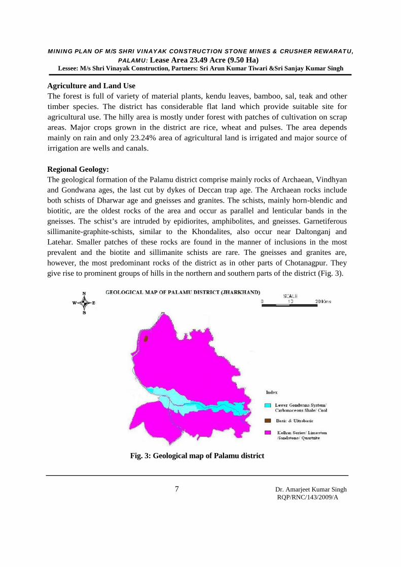
Regional Geology:The geological formation of the Palamu district comprise mainly rocks of Archaean, Vindhyanand Gondwana ages, the last cut by dykes of Deccan trap age. The Archaean rocks includeboth schists of Dharwar age and gneisses and granites. The schists, mainly horn-blendic andbiotitic, are the oldest rocks of the area and occur as parallel and lenticular bands in thegneisses. The schist’s are intruded by epidiorites, amphibolites, and gneisses. Garnetiferoussillimanite-graphite-schists, similar to the Khondalites, also occur near Daltonganj andLatehar. Smaller patches of these rocks are found in the manner of inclusions in the mostprevalent and the biotite and sillimanite schists are rare. The gneisses and granites are,however, the most predominant rocks of the district as in other parts of Chotanagpur. Theygive rise to prominent groups of hills in the northern and southern parts of the district (Fig. 3).
Fig. 3: Geological map of Palamu district
MINING PLAN OF M/S SHRI VINAYAK CONSTRUCTION STONE MINES & CRUSHER REWARATU,PALAMU: Lease Area 23.49 Acre (9.50 Ha)
Lessee: M/s Shri Vinayak Construction, Partners: Sri Arun Kumar Tiwari &Sri Sanjay Kumar Singh
8 Dr. Amarjeet Kumar SinghRQP/RNC/143/2009/A
Geology and Mineral Resources: Following geological succession has been established byGeological Survey of India covering Palamu district as follows:
(1) Recent deposits of alluvium and laterite.(2) Post Gondwana Dykes of basic.
Cretaceo-Eocene, Igneous rocksDykes of basic Jurassic and Triassicand Ultrabasic assic. Igneous rocks.Upper Panchet or Lower JurassicMahadevas Lower TriassicPanchet series. Upper PermianRaniganj seriesIronstone shales
(3) Gondwana Middle Permian system.Lower Damodar Barakar SeriesLower Permian with Karharbari stage.Upper Talchir series carboniferousWith glacial boulder bed
(4) Basic intrusives, Meta dolerite, amphibolite and epidiorites(5) Mica pegmatites and granite pegmaties(6) Chotanagpur granite gneiss.(7) Dharwars-Crushed or fault breccia, garnet-amphibole schist, Granulites, schists, phyllites,
quartzites, etc.
The Damodar Valley Gondwanas dissects the CGGC into to broad belts. The southern bouldercomprises of a few districts of Jharkhand and extends towards the Purulia district of WestBengal. The Palamu highlands immediately to the north of coal basins share the geologicalformations exposed to the south of coal belt & comprise high grade schistose formation up tothe granulite facies. Palamu (North Palamu) - Palamu belt followed immediately to the northby Palamu Santhal Pargana Plains.
The southern belt comprises metamorphosis of low grade phyllites and schists in the southto upper amphibolites to granulite facies rocks in the north. The northern boulder is moreheterogeneous compared to the southern boulders.
MINING PLAN OF M/S SHRI VINAYAK CONSTRUCTION STONE MINES & CRUSHER REWARATU,PALAMU: Lease Area 23.49 Acre (9.50 Ha)
Lessee: M/s Shri Vinayak Construction, Partners: Sri Arun Kumar Tiwari &Sri Sanjay Kumar Singh
9 Dr. Amarjeet Kumar SinghRQP/RNC/143/2009/A
Location & Accessibility of the Project:The applied area falls under the Survey of India Toposheet No. 73 A/5 having 23°57’13.25” to 23° 57’20.24” N latitude and 84° 16’37.40” to 84°16’48.12” E longitude, PlotNo. 1217 (Part), Khata No 72. The area is situated about 34 km north east of districtheadquarter Daltonganj and can be approached by NH-75 and subsequently by statehighway and village road. The nearest railway station is Daltanganj.
Topographical Plan & Geological Plan:The topographical plan of the lease area has been prepared on a scale of 1:2000 withcontour interval of 1 m (Plate 3). The plan has been taken as the base plan for preparationof geological plan (Plate 4). The details of exploration already carried out and theprocedure adopted for preparation of geological plan are described below.
Exploration Carried Out in the Area:The existence of stone in the ML area has been established based on the fieldobservations. It is found that stone is exposed upto the surface in the ML area in the formof a small hillock. A drill hole were made to establish extend of geological reserve ofstone deposit. Based on the above geological observations, proved and probablegeological reserve, and also reserve as per UNFC classification have been estimated. Thereserve of M/s Shri Vinayak Construction Stone Mines & Crusher has been estimated bycross sectional area method. A geological cross section has been taken on the grid linesfor estimating the reserve as shown in the geological plan. Geological plan and sections ofML area is shown in Plate 4. The following basic parameter has been considered forestimation of reserve of stone in the ML area.
1. Surface RL: 341 m to 320 m MSL2. Thickness of ore body 51 m3. Recovery factor (overall) - 95%4. Tonnage factor- 3 t/m3
5. Generation of waste- 5%
Method of Reserve Estimation:Considering the above parameters, the different categories of geological reserve haveestimated by cross sectional area method as follows:-
GR=A × L × RF × TF
MINING PLAN OF M/S SHRI VINAYAK CONSTRUCTION STONE MINES & CRUSHER REWARATU,PALAMU: Lease Area 23.49 Acre (9.50 Ha)
Lessee: M/s Shri Vinayak Construction, Partners: Sri Arun Kumar Tiwari &Sri Sanjay Kumar Singh
10 Dr. Amarjeet Kumar SinghRQP/RNC/143/2009/A
Where,GR- Geological Reserve (t)A- Cross sectional Area (m2)L- Length of influence (m)RF- Recovery Factor (t/m3)TF- Tonnage factor (t/m3)
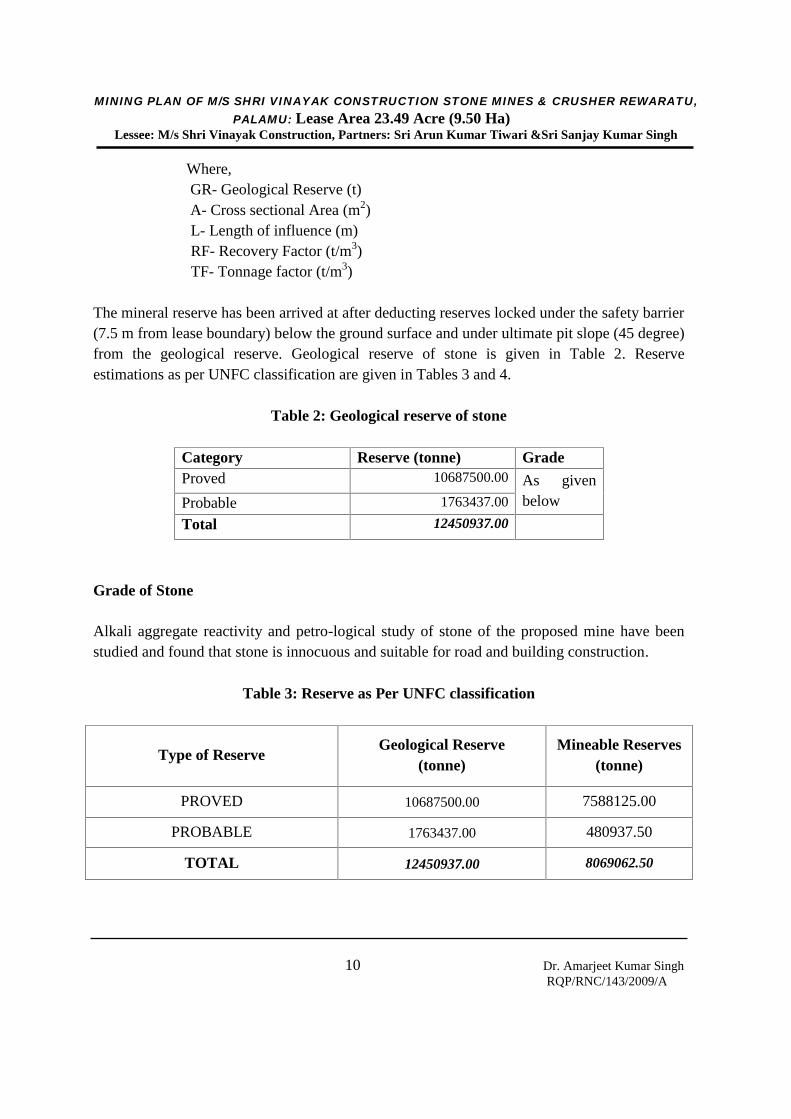
The mineral reserve has been arrived at after deducting reserves locked under the safety barrier(7.5 m from lease boundary) below the ground surface and under ultimate pit slope (45 degree)from the geological reserve. Geological reserve of stone is given in Table 2. Reserveestimations as per UNFC classification are given in Tables 3 and 4.
Table 2: Geological reserve of stone
Category Reserve (tonne) GradeProved 10687500.00 As given
belowProbable 1763437.00
Total 12450937.00
Grade of Stone
Alkali aggregate reactivity and petro-logical study of stone of the proposed mine have beenstudied and found that stone is innocuous and suitable for road and building construction.
Table 3: Reserve as Per UNFC classification
Type of ReserveGeological Reserve
(tonne)Mineable Reserves
(tonne)
PROVED 10687500.00 7588125.00
PROBABLE 1763437.00 480937.50
TOTAL 12450937.00 8069062.50

MINING PLAN OF M/S SHRI VINAYAK CONSTRUCTION STONE MINES & CRUSHER REWARATU,PALAMU: Lease Area 23.49 Acre (9.50 Ha)
Lessee: M/s Shri Vinayak Construction, Partners: Sri Arun Kumar Tiwari &Sri Sanjay Kumar Singh
11 Dr. Amarjeet Kumar SinghRQP/RNC/143/2009/A
Table 4: UNFC classificationStone reserves in Mining Lease Area of Shri Vinayak Constructions Stone Mines & Crusher
Reference section Sectionalarea(m2)
Length ofinfluence
(m)
Recovery ofStone(%)
Tonnagefactor(t/m3)
Stone reserve in Tons[2×3×5×0.95]
(t)1 2 3 4 5 6
PROVED (111)
A-B 3800 250.00 95 3.0 2707500.00C-D 6850 250.00 95 3.0 4880625.00
Reserve blocked dueto Statuary
Barrier(7.50m) andBench Slope at
Section A-B
2050 250.00 95 3.0 1460625.00
Reserve blocked dueto Statuary
Barrier(7.50m) andBench Slope at
Section C-D
2300 250.00 95 3.00 1638750.00
Total 10687500.00PROBABLE (121)
A-B 275 250.00 95 3.0 195937.50C-D 400 250.00 95 3.0 285000.00
Reserve blocked dueto Statuary
Barrier(7.50m) andBench Slope at
Section A-B
600 250.00 95 3.0 427500.00
Reserve blocked dueto Statuary
Barrier(7.50m) andBench Slope at
Section C-D
1200 250.00 95 3.0 855000.00
Total 1763437.00REMAINING MINERAL RESOURCESFeasibility Mineral Resources(221)Stone blocked due to Statuary Barrier(7.50m) and Bench Slope under provedcategory (111)
3099375.00
Pre-feasibility Mineral Resources (222)Stone blocked due to Statuary Barrier(7.50m) and Bench Slope under probablecategory (121)
1282500.00
Total Prove and Probable Stone Reserve 12450937.00
MINING PLAN OF M/S SHRI VINAYAK CONSTRUCTION STONE MINES & CRUSHER REWARATU,PALAMU: Lease Area 23.49 Acre (9.50 Ha)
Lessee: M/s Shri Vinayak Construction, Partners: Sri Arun Kumar Tiwari &Sri Sanjay Kumar Singh
12 Dr. Amarjeet Kumar SinghRQP/RNC/143/2009/A
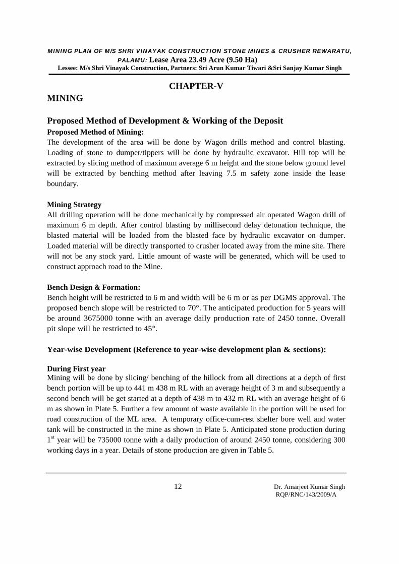
CHAPTER-VMINING
Proposed Method of Development & Working of the DepositProposed Method of Mining:The development of the area will be done by Wagon drills method and control blasting.Loading of stone to dumper/tippers will be done by hydraulic excavator. Hill top will beextracted by slicing method of maximum average 6 m height and the stone below ground levelwill be extracted by benching method after leaving 7.5 m safety zone inside the leaseboundary.
Mining StrategyAll drilling operation will be done mechanically by compressed air operated Wagon drill ofmaximum 6 m depth. After control blasting by millisecond delay detonation technique, theblasted material will be loaded from the blasted face by hydraulic excavator on dumper.Loaded material will be directly transported to crusher located away from the mine site. Therewill not be any stock yard. Little amount of waste will be generated, which will be used toconstruct approach road to the Mine.
Bench Design & Formation:Bench height will be restricted to 6 m and width will be 6 m or as per DGMS approval. Theproposed bench slope will be restricted to 70°. The anticipated production for 5 years willbe around 3675000 tonne with an average daily production rate of 2450 tonne. Overallpit slope will be restricted to 45°.
Year-wise Development (Reference to year-wise development plan & sections):
During First yearMining will be done by slicing/ benching of the hillock from all directions at a depth of firstbench portion will be up to 441 m 438 m RL with an average height of 3 m and subsequently asecond bench will be get started at a depth of 438 m to 432 m RL with an average height of 6m as shown in Plate 5. Further a few amount of waste available in the portion will be used forroad construction of the ML area. A temporary office-cum-rest shelter bore well and watertank will be constructed in the mine as shown in Plate 5. Anticipated stone production during1st year will be 735000 tonne with a daily production of around 2450 tonne, considering 300working days in a year. Details of stone production are given in Table 5.

MINING PLAN OF M/S SHRI VINAYAK CONSTRUCTION STONE MINES & CRUSHER REWARATU,PALAMU: Lease Area 23.49 Acre (9.50 Ha)
Lessee: M/s Shri Vinayak Construction, Partners: Sri Arun Kumar Tiwari &Sri Sanjay Kumar Singh
13 Dr. Amarjeet Kumar SinghRQP/RNC/143/2009/A
Table 5: Proposed stone production from M/s Shri Vinayak Construction Stone Mines& Crusher
YearSlice/Bench
AreaExcavated(in m2)
Average depthofExcavation(m)
OBDumpArea(inm2)
OB Vol.(CubicmapplyingbulkFactor(30%)
AnnualProduction( m3 )
AnnualProduction( t )
AverageProductionPer Day (T)
1st First Bench(341m to 338m)Average Heightof Bench(3.00m)Second Bench(338m to 332m)Average Heightof Bench(6.00m)
16000.00
32834.00
3.00
6.00
Nil
Nil
Nil
Nil
48000.00
197004.00
144000.00
591012.00
2450.00
2nd Third Bench(332m to 326m)Average Heightof Bench(6.00m)
40834.00 6.00 Nil Nil 245004.00 735012.00 2450.00
3rd Third Bench(332m to 326m)Average Heightof Bench(6.00m)Fourth Bench(326m to 320m)Average Heightof Bench(6.00m)
10000.00
30834.00
6.00
6.00
Nil Nil 60000.00
185004.00
180000.00
555012.00
2450.00
4th Fourth Bench(326m to 320m)Average Heightof Bench(6.00m)
40834.00 6.00 Nil Nil 245004.00 735012.00 2450.00
5th Fifth Bench(320m to 316 m)Average Heightof Bench(6.00m)
40834.00 6.00 Nil Nil 245004.00 735012.00 2450.00
6th to10th
@ 73500.00 Tonnes per Annum
MINING PLAN OF M/S SHRI VINAYAK CONSTRUCTION STONE MINES & CRUSHER REWARATU,PALAMU: Lease Area 23.49 Acre (9.50 Ha)
Lessee: M/s Shri Vinayak Construction, Partners: Sri Arun Kumar Tiwari &Sri Sanjay Kumar Singh
14 Dr. Amarjeet Kumar SinghRQP/RNC/143/2009/A
During Second YearDuring second year, third slice in whole of lease area will be excavated from 216 m to 213 mRL with 3 m depth will be excavated below the first slice and second slice as shown in Plate 6.Further, forming fourth slice from 213 m to 210 m depth with an average height of 3 m.Anticipated stone production during 2nd year will be 735000 tonne with a daily production ofaround 2450 tonne, considering 300 working days in a year.
During Third YearDuring 3rd year, remaining part of fourth slice of maximum 6 m depth will be excavated belowthe first slice, second slice and third slice in upto RL of 207 m in whole portion of lease area(Plate 7). Anticipated stone production during 3rd year will be 735000 tonne with a dailyproduction of around 2450 tonne, considering 300 working days in a year.
During Fourth YearDuring 4th year, fifth and sixth slice with a maximum 3 m depth will be excavated below in upto RL of 204 m depth in lease area (Plate 8). Anticipated stone production during 4th year willbe 735000 tonne with a daily production of around 2450 tonne, considering 300 working daysin a year.
During Fifth YearDuring 5th year, remaining part of sixth slice and first bench with a maximum 3 m depth willbe excavated below the first, second, third, fourth fifth slice in whole area up to RL of 291 min lease area (Plate 9). Further, a third bench will be started from 204 m to 198 m with anaverage height of 6 m. Anticipated stone production during 5rd year will be 735000 tonne witha daily production of around 2450 tonne, considering 300 working days in a year.
During Conceptual PeriodDuring conceptual period (6-13th year) mining will be done below ground level 198 mRL by benching method of 6 m height and 6 m width (Plate 12). A statutory/safetybarrier of 7.5 m will be left as un-mined within the lease boundary Average productionduring conceptual period (6-11th year) will be a daily production of around 2450 tonne.
Proposed Rate of Production When the Mine is fully developedDuring five years plan period the mining of saleable stone is proposed to be 2450 tonne ofROM stone per day. The life of mine at the proposed rate of production will be MineableReserve / yearly rate of production ~ 8069062.50/ (2450 x 300) = 10.97 years.
Ultimate extent & size of the pit:Ultimate extent and size of the mine is shown in Plates 12.
MINING PLAN OF M/S SHRI VINAYAK CONSTRUCTION STONE MINES & CRUSHER REWARATU,PALAMU: Lease Area 23.49 Acre (9.50 Ha)
Lessee: M/s Shri Vinayak Construction, Partners: Sri Arun Kumar Tiwari &Sri Sanjay Kumar Singh
15 Dr. Amarjeet Kumar SinghRQP/RNC/143/2009/A
Final slope angle of the closure of the mine:The individual bench slope shall be kept around 70° with the height of each bench not morethan 6 m and width minimum of 6 m. The final slope of the quarry walls at the end of the closeof the mine shall be maintained at 45o.
Life of the Mine:Total Life of the mine will be 11 years.
Ultimate capacity of the dumps:Further a few amount of waste available in the portion will be used for road construction of theML area
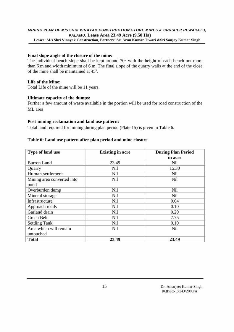
Post-mining reclamation and land use pattern:Total land required for mining during plan period (Plate 15) is given in Table 6.
Table 6: Land use pattern after plan period and mine closure
Type of land use Existing in acre During Plan Periodin acre
Barren Land 23.49 NilQuarry Nil 15.30Human settlement Nil NilMining area converted intopond
Nil Nil
Overburden dump Nil NilMineral storage Nil NilInfrastructure Nil 0.04Approach roads Nil 0.10Garland drain Nil 0.20Green Belt Nil 7.75Settling Tank Nil 0.10Area which will remainuntouched
Nil Nil
Total 23.49 23.49
MINING PLAN OF M/S SHRI VINAYAK CONSTRUCTION STONE MINES & CRUSHER REWARATU,PALAMU: Lease Area 23.49 Acre (9.50 Ha)
Lessee: M/s Shri Vinayak Construction, Partners: Sri Arun Kumar Tiwari &Sri Sanjay Kumar Singh
16 Dr. Amarjeet Kumar SinghRQP/RNC/143/2009/A
Extent of mechanization:The stone will be broken by controlled blasting technique and broken stone will beloaded through hydraulic excavator to the dumpers/tippers for transporting the stoneto a crusher located at mine site and away from the mine site. Mining will be donein 1 shift and around 40 to 45 unskilled and semi-skilled workers will be requiredfor the mine. Since, the deposit in this area is massive in nature; it is proposed tocarry out only fully open cast mechanized mining during this plan period, i.e. fiveyears.The operations like drilling of shot holes by 100 mm dia wagon drilling to drill andexcavators for loading and tippers for transporting. Blasting also carried out in thismine having burden and spacing of 3 m x 3.5 m in stagger grid pattern. Allnecessary precautions are being taken in accordance with the explosive act.Precautions are also taken as per permission given under MMR, 1961 106(2) (b) bythe Director of Mines Safety for deep hole drilling & Blasting and also for the usageof heavy earth moving machinery.
Specification of Wagon Drills: (the actual sizes of equipment may varydepending upon the model)
Hole Range Diameter: Down the hole Air Hammer (DTH) : 95 – 115 mm Drill pipe O.D. 3” (76/73mm) x 10 ft (3m) long length Top Hammer (Pneumatic Drifter) : 48 - 80 mm
Extension Rods: R32/R38Rotation unit for DTH:
BHP at 7.5 kgf/cm2(100psi) : 4.5 HP
Speed : 0- 50 RPM Torque at 7.5kgf/cm2 (100psi): 1125Nm (10.000lb.in)
Feed Unit: BHP at 7.5 kgf/cm2(100psi) : 4.5 HP
Pull up force : 0-2200 kgf Pull down force 0- 2200 kgf Max pull up speed : 0-15 m/min
Feed type : Chain
MINING PLAN OF M/S SHRI VINAYAK CONSTRUCTION STONE MINES & CRUSHER REWARATU,PALAMU: Lease Area 23.49 Acre (9.50 Ha)
Lessee: M/s Shri Vinayak Construction, Partners: Sri Arun Kumar Tiwari &Sri Sanjay Kumar Singh
17 Dr. Amarjeet Kumar SinghRQP/RNC/143/2009/A
Carrier: Pneumatic wheel drive by 4.5/6.0 HP Air motor + Gearbox with declutching
arrangement Travelling speed : 0-1.5 km/hr
Air compressor capacity:
For DTH : 450 cfm- 150 psi ( 12.7 m 3/ min – 10.5 kg / cm2
For Top Hammer Pneumatic Drifter : : 580 cfm- 100 psi ( 16.42 m 3/ min –07.03 kg / cm2
Drilling:Considering the bench height as 6 m, the burden has been calculated by using followingempirical formula:B = K x D
Where, B = Burden (m)K = Constant (35, considering medium hard rock)D = Hole charge diameter (m)
Holes required per day: Number of working days per year : 300 days Average yearly total excavation : 735000 tonne per year
Average daily excavation : 2450 tonne
Average number of holes required per day : 12 nos.
Number of drill machine required : 2 nos.
Compressor required : 2 nos.Wagon Drill
Bench height 6 mDrill hole 100 mmBurden 3 mSpacing 3.5Bulk density insitu 3.00 MT/M 3
Depth of hole including sub gradedrilling
6.6 m
Tonnage per hole 6 x 3x 3.5 x 3 = 189 tonne
MINING PLAN OF M/S SHRI VINAYAK CONSTRUCTION STONE MINES & CRUSHER REWARATU,PALAMU: Lease Area 23.49 Acre (9.50 Ha)
Lessee: M/s Shri Vinayak Construction, Partners: Sri Arun Kumar Tiwari &Sri Sanjay Kumar Singh
18 Dr. Amarjeet Kumar SinghRQP/RNC/143/2009/A
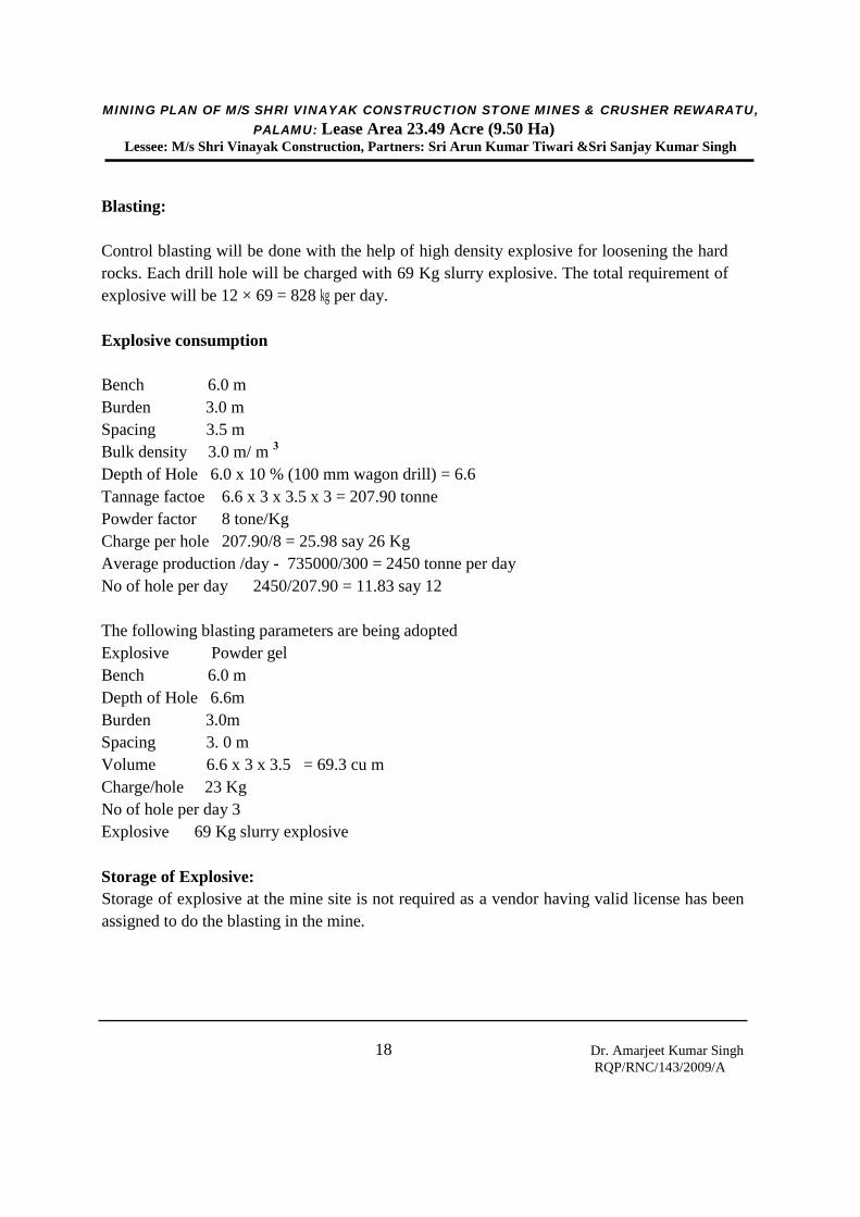
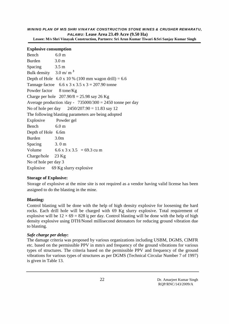
Blasting:
Control blasting will be done with the help of high density explosive for loosening the hardrocks. Each drill hole will be charged with 69 Kg slurry explosive. The total requirement ofexplosive will be 12 × 69 = 828 kg per day.
Explosive consumption
Bench 6.0 mBurden 3.0 mSpacing 3.5 mBulk density 3.0 m/ m 3
Depth of Hole 6.0 x 10 % (100 mm wagon drill) = 6.6Tannage factoe 6.6 x 3 x 3.5 x 3 = 207.90 tonnePowder factor 8 tone/KgCharge per hole 207.90/8 = 25.98 say 26 KgAverage production /day - 735000/300 = 2450 tonne per dayNo of hole per day 2450/207.90 = 11.83 say 12
The following blasting parameters are being adoptedExplosive Powder gelBench 6.0 mDepth of Hole 6.6mBurden 3.0mSpacing 3. 0 mVolume 6.6 x 3 x 3.5 = 69.3 cu mCharge/hole 23 KgNo of hole per day 3Explosive 69 Kg slurry explosive
Storage of Explosive:Storage of explosive at the mine site is not required as a vendor having valid license has beenassigned to do the blasting in the mine.
MINING PLAN OF M/S SHRI VINAYAK CONSTRUCTION STONE MINES & CRUSHER REWARATU,PALAMU: Lease Area 23.49 Acre (9.50 Ha)
Lessee: M/s Shri Vinayak Construction, Partners: Sri Arun Kumar Tiwari &Sri Sanjay Kumar Singh
19 Dr. Amarjeet Kumar SinghRQP/RNC/143/2009/A
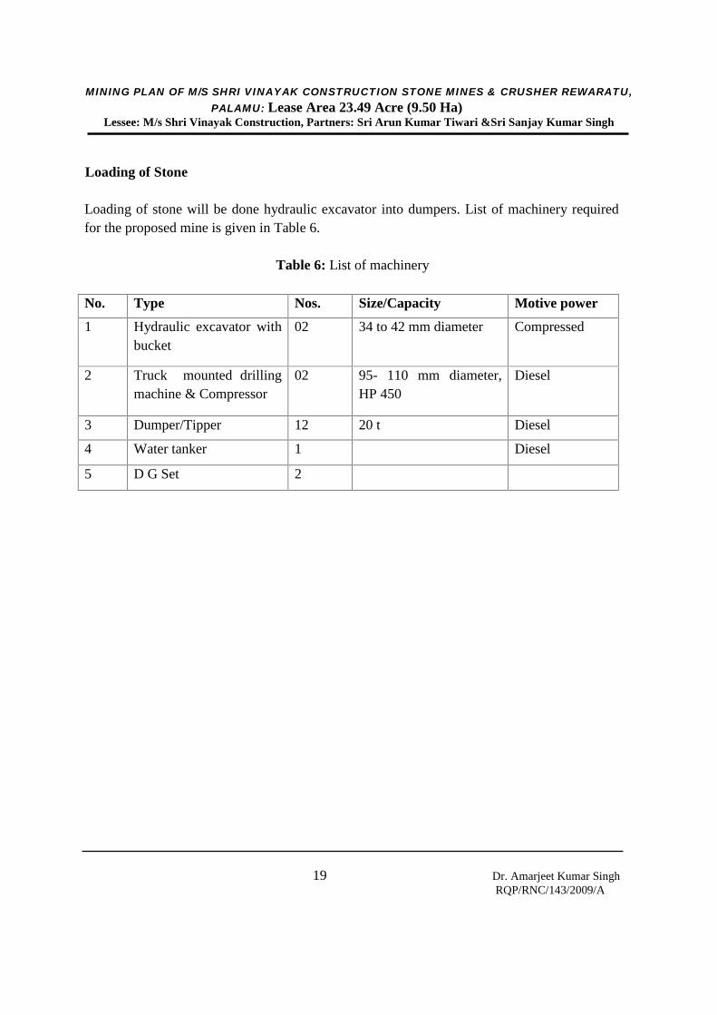
Loading of Stone
Loading of stone will be done hydraulic excavator into dumpers. List of machinery requiredfor the proposed mine is given in Table 6.
Table 6: List of machinery
No. Type Nos. Size/Capacity Motive power
1 Hydraulic excavator withbucket
02 34 to 42 mm diameter Compressed
2 Truck mounted drillingmachine & Compressor
02 95- 110 mm diameter,HP 450
Diesel
3 Dumper/Tipper 12 20 t Diesel
4 Water tanker 1 Diesel
5 D G Set 2
MINING PLAN OF M/S SHRI VINAYAK CONSTRUCTION STONE MINES & CRUSHER REWARATU,PALAMU: Lease Area 23.49 Acre (9.50 Ha)
Lessee: M/s Shri Vinayak Construction, Partners: Sri Arun Kumar Tiwari &Sri Sanjay Kumar Singh
20 Dr. Amarjeet Kumar SinghRQP/RNC/143/2009/A
CHAPTER-VIBLASTING
Broad Parameters for Drilling and Blasting of Stone
Specification of Wagon Drills: (the actual sizes of equipment may varydepending upon the model)
Hole Range Diameter: Down the hole Air Hammer (DTH) : 95 – 115 mm Drill pipe O.D. 3” (76/73mm) x 10 ft (3m) long length Top Hammer (Pneumatic Drifter) : 48 - 80 mm
Extension Rods: R32/R38Rotation unit for DTH:
BHP at 7.5 kgf/cm2(100psi) : 4.5 HP Speed : 0- 50 RPM Torque at 7.5kgf/cm2 (100psi): 1125Nm (10.000lb.in)
Feed Unit: BHP at 7.5 kgf/cm2(100psi) : 4.5 HP
Pull up force : 0-2200 kgf Pull down force 0- 2200 kgf
Max pull up speed : 0-15 m/min Feed type : Chain
Carrier: Pneumatic wheel drive by 4.5/6.0 HP Air motor + Gearbox with declutching
arrangement Travelling speed : 0-1.5 km/hr
Air compressor capacity:
For DTH : 450 cfm- 150 psi ( 12.7 m 3/ min – 10.5 kg / cm2
MINING PLAN OF M/S SHRI VINAYAK CONSTRUCTION STONE MINES & CRUSHER REWARATU,PALAMU: Lease Area 23.49 Acre (9.50 Ha)
Lessee: M/s Shri Vinayak Construction, Partners: Sri Arun Kumar Tiwari &Sri Sanjay Kumar Singh
21 Dr. Amarjeet Kumar SinghRQP/RNC/143/2009/A
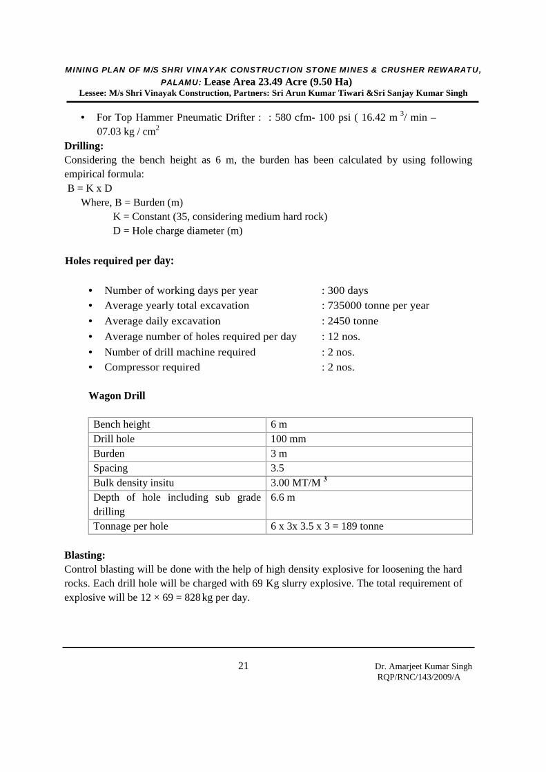
For Top Hammer Pneumatic Drifter : : 580 cfm- 100 psi ( 16.42 m 3/ min –07.03 kg / cm2
Drilling:Considering the bench height as 6 m, the burden has been calculated by using followingempirical formula:B = K x D
Where, B = Burden (m)K = Constant (35, considering medium hard rock)D = Hole charge diameter (m)
Holes required per day:
Number of working days per year : 300 days
Average yearly total excavation : 735000 tonne per year
Average daily excavation : 2450 tonne
Average number of holes required per day : 12 nos.
Number of drill machine required : 2 nos. Compressor required : 2 nos.
Wagon Drill
Bench height 6 mDrill hole 100 mmBurden 3 mSpacing 3.5Bulk density insitu 3.00 MT/M 3
Depth of hole including sub gradedrilling
6.6 m
Tonnage per hole 6 x 3x 3.5 x 3 = 189 tonne
Blasting:Control blasting will be done with the help of high density explosive for loosening the hardrocks. Each drill hole will be charged with 69 Kg slurry explosive. The total requirement ofexplosive will be 12 × 69 = 828 kg per day.
MINING PLAN OF M/S SHRI VINAYAK CONSTRUCTION STONE MINES & CRUSHER REWARATU,PALAMU: Lease Area 23.49 Acre (9.50 Ha)
Lessee: M/s Shri Vinayak Construction, Partners: Sri Arun Kumar Tiwari &Sri Sanjay Kumar Singh
22 Dr. Amarjeet Kumar SinghRQP/RNC/143/2009/A
Explosive consumptionBench 6.0 mBurden 3.0 mSpacing 3.5 mBulk density 3.0 m/ m 3
Depth of Hole 6.0 x 10 % (100 mm wagon drill) = 6.6Tannage factoe 6.6 x 3 x 3.5 x 3 = 207.90 tonnePowder factor 8 tone/KgCharge per hole 207.90/8 = 25.98 say 26 KgAverage production /day - 735000/300 = 2450 tonne per dayNo of hole per day 2450/207.90 = 11.83 say 12The following blasting parameters are being adoptedExplosive Powder gelBench 6.0 mDepth of Hole 6.6mBurden 3.0mSpacing 3. 0 mVolume 6.6 x 3 x 3.5 = 69.3 cu mCharge/hole 23 KgNo of hole per day 3Explosive 69 Kg slurry explosive
Storage of Explosive:Storage of explosive at the mine site is not required as a vendor having valid license has beenassigned to do the blasting in the mine.
Blasting:Control blasting will be done with the help of high density explosive for loosening the hardrocks. Each drill hole will be charged with 69 Kg slurry explosive. Total requirement ofexplosive will be 12 × 69 = 828 kg per day. Control blasting will be done with the help of highdensity explosive using DTH/Nonel millisecond detonators for reducing ground vibration dueto blasting.
Safe charge per delay:The damage criteria was proposed by various organizations including USBM, DGMS, CIMFRetc. based on the permissible PPV in mm/s and frequency of the ground vibrations for varioustypes of structures. The criteria based on the permissible PPV and frequency of the groundvibrations for various types of structures as per DGMS (Technical Circular Number 7 of 1997)is given in Table 13.

MINING PLAN OF M/S SHRI VINAYAK CONSTRUCTION STONE MINES & CRUSHER REWARATU,PALAMU: Lease Area 23.49 Acre (9.50 Ha)
Lessee: M/s Shri Vinayak Construction, Partners: Sri Arun Kumar Tiwari &Sri Sanjay Kumar Singh
23 Dr. Amarjeet Kumar SinghRQP/RNC/143/2009/A
Table 13: DGMS standard for permissible limit of ground vibrationType of structure Ground vibration, PPV (mm/s)
for dominant excitationfrequency< 8 Hz 8-25 Hz > 25 Hz
(A) Buildings/structures not belong to the owner
1. Domestic houses/structures (Kuchcha, brick & cement) 5 10 15
2. Industrial buildings 10 20 25
3. Objects of historical importance and sensitive structures 2 5 10
(B) Buildings belonging to owner with limited span of life
1. Domestic houses/structures 10 15 25
2. Industrial buildings 15 25 50
Study conducted by Dr. P. PalRoy, CSIR-CIMFR, Dhanbad and Prof. S. Jayanthu, NIT,Rourkela in similar conditions of the current stone mining area to estimate safe charge perdelay to limit the ground vibrations within safe limit of 5 mm/sec as the frequency was withinthe limits of 8 to 25 Hz considering the structures as sensitive and not belonging to the owner.Based on the several field observations of blast induced vibration, the predictor equation interms of the scaled distance and Peak Particle Velocity (PPV) was found to represent themeasured data (Table 14). The same predictor equation was suggested for utilization inestimation of safe explosive charge per delay to keep the vibration level within the safe limits.Accordingly, the safe charge per delay is recommended to keep the vibration level below 5mm/sec, which is presented in Table 14 for M/s Shri Vinayak Construction Stone Mines. Totalrequirement of explosive in the mine is only 828 kg per day which is much below the safecharge per delay limit; hence effect of ground vibration due to blasting in the mine will be veryless considering recommended safe charge per day as given in Table 14.
Table 14: Safe charge per delay to keep the vibration level below 5 mm/sec at variousdistances from the blast site
Distance of blast site fromhouse in village (m)
Safe charge/delay (kg) Predictor equation
300 170.8
PPV = 290.12 (Scaled distance)-1.296400 303.7
500 474.5
MINING PLAN OF M/S SHRI VINAYAK CONSTRUCTION STONE MINES & CRUSHER REWARATU,PALAMU: Lease Area 23.49 Acre (9.50 Ha)
Lessee: M/s Shri Vinayak Construction, Partners: Sri Arun Kumar Tiwari &Sri Sanjay Kumar Singh
24 Dr. Amarjeet Kumar SinghRQP/RNC/143/2009/A
CHAPTER - VII
MINE DRAINAGE
MINE DRAINAGEThere is no river or stream flowing in the leasehold. Since a major portion of the lease areacomprises of gently sloping hillock surrounded with peripheral slope all around. There will beno problem of water drainage as the area is predominantly rocky. Due to peripheral slope, thenatural flow of water will be towards valley down below the hillock. River Koel is flowingapprox 32 Km from the mine site.
To avoid surface run-off going out of the ML area during the monsoon season settlingtank/sump shall be constructed within the open pit.
MINING PLAN OF M/S SHRI VINAYAK CONSTRUCTION STONE MINES & CRUSHER REWARATU,PALAMU: Lease Area 23.49 Acre (9.50 Ha)
Lessee: M/s Shri Vinayak Construction, Partners: Sri Arun Kumar Tiwari &Sri Sanjay Kumar Singh
25 Dr. Amarjeet Kumar SinghRQP/RNC/143/2009/A
CHAPTER-VIII
USE OF MINERAL
Use of Stone
Finished Products:
Stone chunk (raw material for the production of stone chips) Hand hammered stone aggregate or stone ballast of different sizes.
Market
Stone chunk (raw material for the production of stone chips) will be sold direct to thecrusher owners located away from the mine.
Stone ballast of different size will be sold direct to the civil contractors and to thecommon person engage in construction of their own.
As all the finished product stone chunk, stone ballast and stone dust have naturalmarket so no disposal of any kind of solid waste will be done anywhere.
Marketing of all the finished product can be easily done in the radius of 50 km fromthe proposal mining site.
MINING PLAN OF M/S SHRI VINAYAK CONSTRUCTION STONE MINES & CRUSHER REWARATU,PALAMU: Lease Area 23.49 Acre (9.50 Ha)
Lessee: M/s Shri Vinayak Construction, Partners: Sri Arun Kumar Tiwari &Sri Sanjay Kumar Singh
26 Dr. Amarjeet Kumar SinghRQP/RNC/143/2009/A
CHAPTER-IX
MINERAL PROCESSING
It is proposed to sell stone to those crushers having valid NOC and Consent to operate fromJharkhand Pollution Control Board, and located away from the mine site.
MINING PLAN OF M/S SHRI VINAYAK CONSTRUCTION STONE MINES & CRUSHER REWARATU,PALAMU: Lease Area 23.49 Acre (9.50 Ha)
Lessee: M/s Shri Vinayak Construction, Partners: Sri Arun Kumar Tiwari &Sri Sanjay Kumar Singh
27 Dr. Amarjeet Kumar SinghRQP/RNC/143/2009/A
CHAPTER-X
ENVIRONMENTAL MANAGEMENT PLAN
Location
M/s Shri Vinayak Constructin Stone Mines & Crusher is located in small hilly area ofRewaratu Mauza, Thana Lessliganj in District – Palamu, State – Jharkhand. The mine islocated in Toposheet no.- 73D / 3 having having 23° 57’13.25” to 23° 57’20.24” N latitudeand 84° 16’37.40” to 84°16’48.12” E longitude, Plot No. 1217 (Part), Khata No 72 and leasehold area is 23.49 Acre (9.50 Ha). Location of the mine is depicted in toposheet (Plate 1).
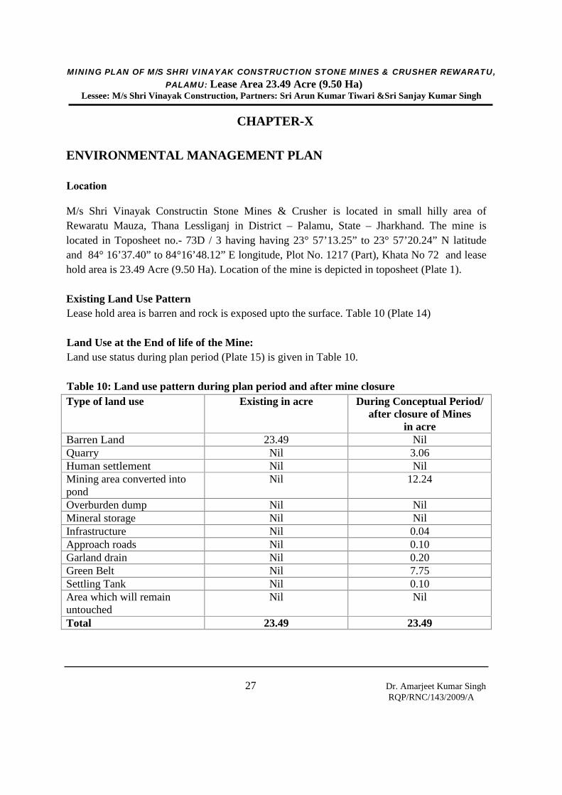
Existing Land Use PatternLease hold area is barren and rock is exposed upto the surface. Table 10 (Plate 14)
Land Use at the End of life of the Mine:Land use status during plan period (Plate 15) is given in Table 10.
Table 10: Land use pattern during plan period and after mine closureType of land use Existing in acre During Conceptual Period/
after closure of Minesin acre
Barren Land 23.49 NilQuarry Nil 3.06Human settlement Nil NilMining area converted intopond
Nil 12.24
Overburden dump Nil NilMineral storage Nil NilInfrastructure Nil 0.04Approach roads Nil 0.10Garland drain Nil 0.20Green Belt Nil 7.75Settling Tank Nil 0.10Area which will remainuntouched
Nil Nil
Total 23.49 23.49
MINING PLAN OF M/S SHRI VINAYAK CONSTRUCTION STONE MINES & CRUSHER REWARATU,PALAMU: Lease Area 23.49 Acre (9.50 Ha)
Lessee: M/s Shri Vinayak Construction, Partners: Sri Arun Kumar Tiwari &Sri Sanjay Kumar Singh
28 Dr. Amarjeet Kumar SinghRQP/RNC/143/2009/A
Details Features Existing Within 5 km of the Project Sitei. Forest:
The area does not fall in forest area (Protected/Reserved/Deemed) and it is beyond500 m distance from nearest marked forest area in all directions.
ii. River:Koel Nadi is flowing around 03 km from the mine site.
iii. Road:NH- 75 is 05 km from the mining area.
iv. Railway:The nearest railway station is Daltonganj 34 km from the mining site.
Human Settlement:The core area is devoid of any human settlement.
Public Building Station:No public buildings within 500 m from lease boundary, and no monuments, places ofhistorical importance exits in or within 10 km radius of the ML area.
Does Area (Partially or fully) fall under Notified Area under Water (Prevention &Control of Pollution), Act, 1974:This area does not fall under the act.
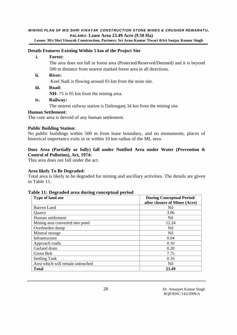
Area likely To Be Degraded:Total area is likely to be degraded for mining and ancillary activities. The details are givenin Table 11.
Table 11: Degraded area during conceptual periodType of land use During Conceptual Period/
after closure of Mines (Acre)Barren Land NilQuarry 3.06Human settlement NilMining area converted into pond 12.24Overburden dump NilMineral storage NilInfrastructure 0.04Approach roads 0.10Garland drain 0.20Green Belt 7.75Settling Tank 0.10Area which will remain untouched NilTotal 23.49
MINING PLAN OF M/S SHRI VINAYAK CONSTRUCTION STONE MINES & CRUSHER REWARATU,PALAMU: Lease Area 23.49 Acre (9.50 Ha)
Lessee: M/s Shri Vinayak Construction, Partners: Sri Arun Kumar Tiwari &Sri Sanjay Kumar Singh
29 Dr. Amarjeet Kumar SinghRQP/RNC/143/2009/A
Socio-Economy:The impact due to mining on the socio-economic front will be beneficial. About 40people will be directly benefited by mining through employment and number of indirectbeneficiaries will be of the order of 80 to 100. With continuation of mining, otherinfrastructural developments will increase the socio-economic status of local inhabitants.
Historical Monuments:As no historical monuments etc. exist within 10 km of the area, impact of mining onsuch features are nil.
I. BASELINE ENVIRONMENTAL STATUS1.2 MeteorologyThe climate of Palamu district is mainly dry and bracing. The year can be divided in to threemain seasons. The cold seasons from November to March, the hot season from March to Mayand the monsoon season from June to September, October is a transitional month betweenmonsoon and winter seasons. Climatically, the district comes under sub-tropical zone. In theDistrict, the only observatory station of Indian Meteorological Department (IMD) is located atDaltonganj. Meteorological data of this station can be taken as representative for the district
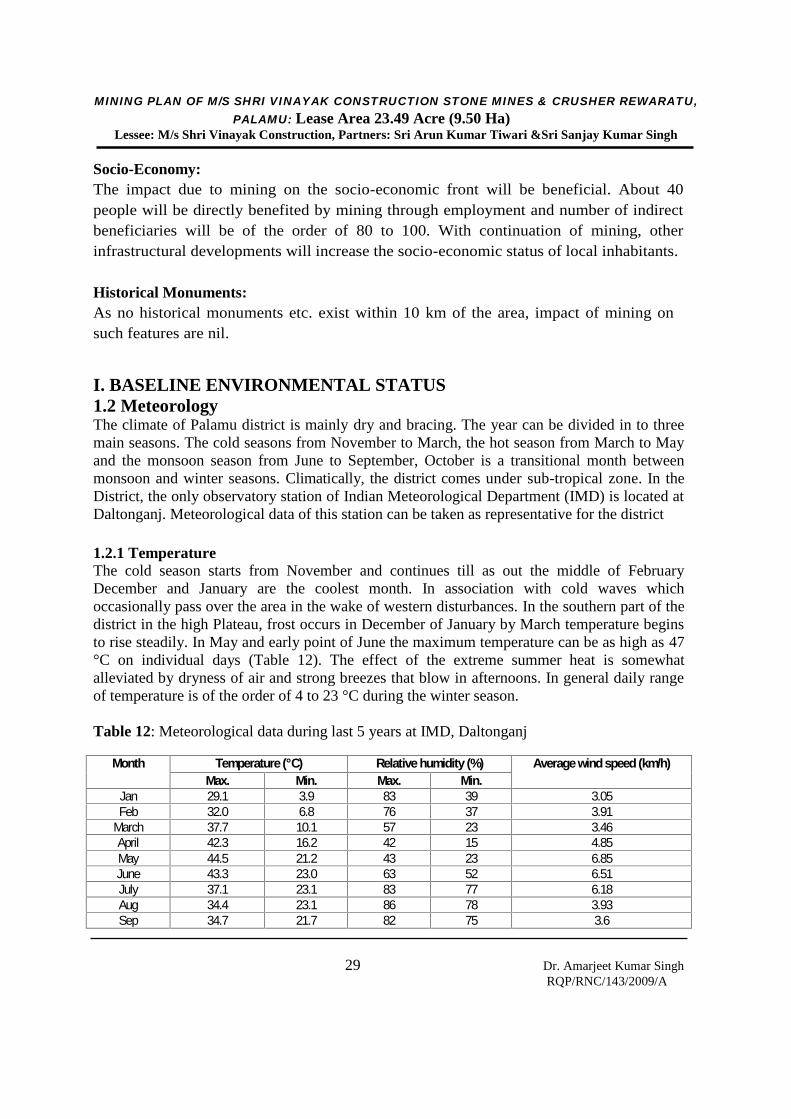
1.2.1 TemperatureThe cold season starts from November and continues till as out the middle of FebruaryDecember and January are the coolest month. In association with cold waves whichoccasionally pass over the area in the wake of western disturbances. In the southern part of thedistrict in the high Plateau, frost occurs in December of January by March temperature beginsto rise steadily. In May and early point of June the maximum temperature can be as high as 47°C on individual days (Table 12). The effect of the extreme summer heat is somewhatalleviated by dryness of air and strong breezes that blow in afternoons. In general daily rangeof temperature is of the order of 4 to 23 °C during the winter season.
Table 12: Meteorological data during last 5 years at IMD, Daltonganj
Month Temperature (°C) Relative humidity (%) Average wind speed (km/h)Max. Min. Max. Min.
Jan 29.1 3.9 83 39 3.05Feb 32.0 6.8 76 37 3.91
March 37.7 10.1 57 23 3.46April 42.3 16.2 42 15 4.85May 44.5 21.2 43 23 6.85June 43.3 23.0 63 52 6.51July 37.1 23.1 83 77 6.18Aug 34.4 23.1 86 78 3.93Sep 34.7 21.7 82 75 3.6
MINING PLAN OF M/S SHRI VINAYAK CONSTRUCTION STONE MINES & CRUSHER REWARATU,PALAMU: Lease Area 23.49 Acre (9.50 Ha)
Lessee: M/s Shri Vinayak Construction, Partners: Sri Arun Kumar Tiwari &Sri Sanjay Kumar Singh
30 Dr. Amarjeet Kumar SinghRQP/RNC/143/2009/A
Oct 34.0 14.0 79 54 3.71Nov 31.3 7.9 79 45 1.96Dec 27.9 4.2 82 41 2.9
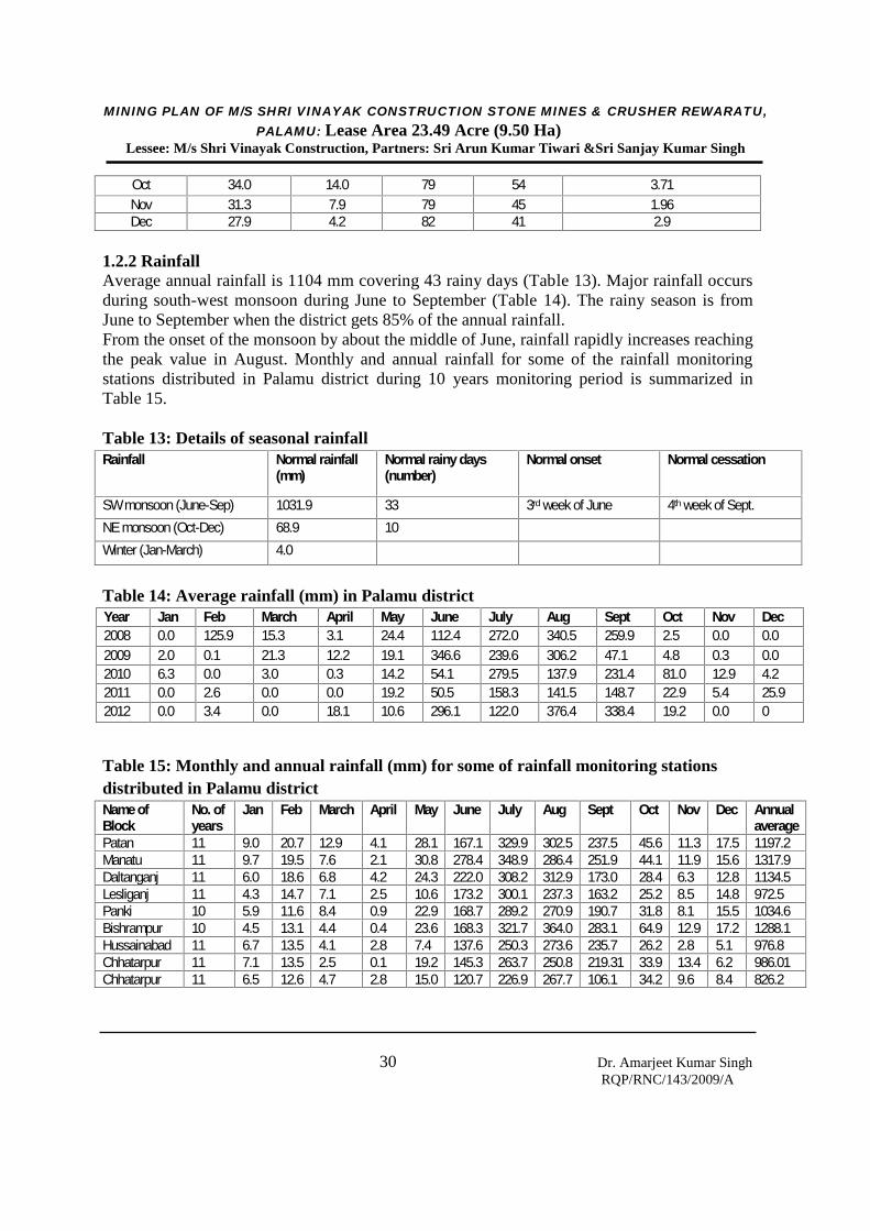
1.2.2 RainfallAverage annual rainfall is 1104 mm covering 43 rainy days (Table 13). Major rainfall occursduring south-west monsoon during June to September (Table 14). The rainy season is fromJune to September when the district gets 85% of the annual rainfall.From the onset of the monsoon by about the middle of June, rainfall rapidly increases reachingthe peak value in August. Monthly and annual rainfall for some of the rainfall monitoringstations distributed in Palamu district during 10 years monitoring period is summarized inTable 15.
Table 13: Details of seasonal rainfallRainfall Normal rainfall
(mm)Normal rainy days(number)
Normal onset Normal cessation
SW monsoon (June-Sep) 1031.9 33 3rd week of June 4th week of Sept.NE monsoon (Oct-Dec) 68.9 10Winter (Jan-March) 4.0
Table 14: Average rainfall (mm) in Palamu districtYear Jan Feb March April May June July Aug Sept Oct Nov Dec2008 0.0 125.9 15.3 3.1 24.4 112.4 272.0 340.5 259.9 2.5 0.0 0.02009 2.0 0.1 21.3 12.2 19.1 346.6 239.6 306.2 47.1 4.8 0.3 0.02010 6.3 0.0 3.0 0.3 14.2 54.1 279.5 137.9 231.4 81.0 12.9 4.22011 0.0 2.6 0.0 0.0 19.2 50.5 158.3 141.5 148.7 22.9 5.4 25.92012 0.0 3.4 0.0 18.1 10.6 296.1 122.0 376.4 338.4 19.2 0.0 0
Table 15: Monthly and annual rainfall (mm) for some of rainfall monitoring stationsdistributed in Palamu districtName ofBlock
No. ofyears
Jan Feb March April May June July Aug Sept Oct Nov Dec Annualaverage
Patan 11 9.0 20.7 12.9 4.1 28.1 167.1 329.9 302.5 237.5 45.6 11.3 17.5 1197.2Manatu 11 9.7 19.5 7.6 2.1 30.8 278.4 348.9 286.4 251.9 44.1 11.9 15.6 1317.9Daltanganj 11 6.0 18.6 6.8 4.2 24.3 222.0 308.2 312.9 173.0 28.4 6.3 12.8 1134.5Lesliganj 11 4.3 14.7 7.1 2.5 10.6 173.2 300.1 237.3 163.2 25.2 8.5 14.8 972.5Panki 10 5.9 11.6 8.4 0.9 22.9 168.7 289.2 270.9 190.7 31.8 8.1 15.5 1034.6Bishrampur 10 4.5 13.1 4.4 0.4 23.6 168.3 321.7 364.0 283.1 64.9 12.9 17.2 1288.1Hussainabad 11 6.7 13.5 4.1 2.8 7.4 137.6 250.3 273.6 235.7 26.2 2.8 5.1 976.8Chhatarpur 11 7.1 13.5 2.5 0.1 19.2 145.3 263.7 250.8 219.31 33.9 13.4 6.2 986.01Chhatarpur 11 6.5 12.6 4.7 2.8 15.0 120.7 226.9 267.7 106.1 34.2 9.6 8.4 826.2
MINING PLAN OF M/S SHRI VINAYAK CONSTRUCTION STONE MINES & CRUSHER REWARATU,PALAMU: Lease Area 23.49 Acre (9.50 Ha)
Lessee: M/s Shri Vinayak Construction, Partners: Sri Arun Kumar Tiwari &Sri Sanjay Kumar Singh
31 Dr. Amarjeet Kumar SinghRQP/RNC/143/2009/A
1.2.3 HumidityRelative humidity is generally lower in the afternoons than in the mornings, except in themonsoon months when there are little differences. The summer months are the driest withhumidity as low as 20 to 25% in the afternoon (Table 12).
1.2.4 CloudinessDuring summer and winter month’s sky is generally clear or slightly clouded. In April andMay, cloudiness increases particularly in the afternoon. During monsoon months sky isheavily clouded to overcast.
1.2.5 WindsWinds are light to moderate during the winter and summer months, the speed being higher inthe afternoons. In association with thunder storms during March to May and during themonsoon season when depressions pass west word across the central parts of the country, thearea experiences strong gusty winds. The directions from which winds blow are variableespecially during the monsoon season. Predominant wind direction was from south-west
1.3 Air Environment
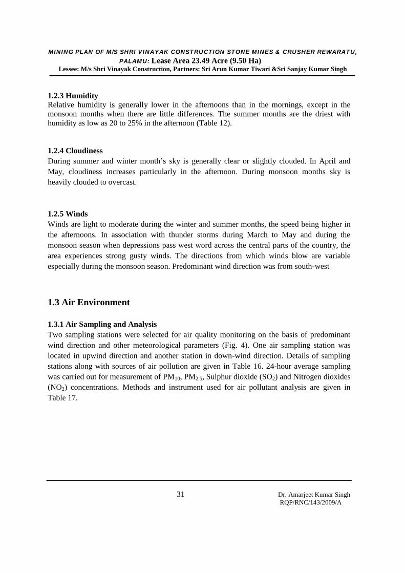
1.3.1 Air Sampling and AnalysisTwo sampling stations were selected for air quality monitoring on the basis of predominantwind direction and other meteorological parameters (Fig. 4). One air sampling station waslocated in upwind direction and another station in down-wind direction. Details of samplingstations along with sources of air pollution are given in Table 16. 24-hour average samplingwas carried out for measurement of PM10, PM2.5, Sulphur dioxide (SO2) and Nitrogen dioxides(NO2) concentrations. Methods and instrument used for air pollutant analysis are given inTable 17.
MINING PLAN OF M/S SHRI VINAYAK CONSTRUCTION STONE MINES & CRUSHER REWARATU,PALAMU: Lease Area 23.49 Acre (9.50 Ha)
Lessee: M/s Shri Vinayak Construction, Partners: Sri Arun Kumar Tiwari &Sri Sanjay Kumar Singh
32 Dr. Amarjeet Kumar SinghRQP/RNC/143/2009/A
Fig. 4: Location of air and noise monitoring stations, and water and noise samplingpoints

MINING PLAN OF M/S SHRI VINAYAK CONSTRUCTION STONE MINES & CRUSHER REWARATU,PALAMU: Lease Area 23.49 Acre (9.50 Ha)
Lessee: M/s Shri Vinayak Construction, Partners: Sri Arun Kumar Tiwari &Sri Sanjay Kumar Singh
33 Dr. Amarjeet Kumar SinghRQP/RNC/143/2009/A
Table 16: Details of sampling locations
Stn. Code Location Sources of air pollution
A1Dhobadih village(Upwind direction)
Domestic, background pollutants due to agriculturaland other domestic works.
A2Rewaratu village(Downwind direction)
Domestic, background pollutants due to agriculturaland other domestic works.
Table 17: Methodology and instrument used for air quality analysis
Parameter Method Instrument
PM10Single stage impactor matching withEuropean Union Design (EN12341)
Combo PM10 and PM2.5 sampler(Make: Ecotech, Model: AAS271)
PM2.5
Two stage impactors based on USEPAstandard design (Federal Register 40CFR part 50 Appendix L (updated inMay 2002)
Combo PM10 and PM2.5 sampler(Make: Ecotech, Model: AAS271)
SO2IS-5182 Part II (Improved West & Gaekemethod)
Gaseous pollutants sampler(Make: Ecotech, Model: AAS118)
NO2IS-5182 Part II (Jacob Hochheisermodified method)
Gaseous pollutants sampler(Make: Ecotech, Model: AAS118)
1.3.2 ResultsMonitoring results are summarized in Table 18. Average concentration of PM10 ranged from34.4 to 37.5 g/m3, which were much below the permissible limit of 100 g/m3 as perNational Ambient Air Quality Standard (NAAQS), 2009. Average concentration of PM2.5
varied between 9.5 and 12.8 g/m3 which were well below the permissible limit of 60 g/m3.SO2 values ranged from 5.4 to 6.8 g/m3 against the permissible limit of 80 g/m3 and NO2
varied between 3.4 and 4.5 g/m3 against the permissible limit of 80 g /m3.
Table 18: Average ambient air quality monitoring resultsParameters Average concentration in monitoring locations
(µg/m3) Permissible limit as perNAAQS, 2009 (µg/m3)Dhobadih village (A1
location)Rewaratu village (A2location)
PM10 49.78 47.50 100PM2.5 16.5 14.8 60SO2 23.43 26.31 80NO2 24.76 21.58 80
MINING PLAN OF M/S SHRI VINAYAK CONSTRUCTION STONE MINES & CRUSHER REWARATU,PALAMU: Lease Area 23.49 Acre (9.50 Ha)
Lessee: M/s Shri Vinayak Construction, Partners: Sri Arun Kumar Tiwari &Sri Sanjay Kumar Singh
34 Dr. Amarjeet Kumar SinghRQP/RNC/143/2009/A
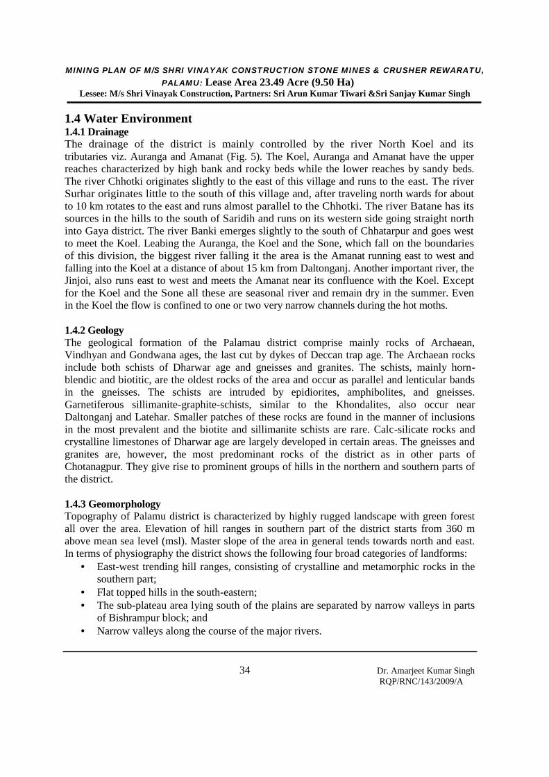
1.4 Water Environment1.4.1 DrainageThe drainage of the district is mainly controlled by the river North Koel and itstributaries viz. Auranga and Amanat (Fig. 5). The Koel, Auranga and Amanat have the upperreaches characterized by high bank and rocky beds while the lower reaches by sandy beds.The river Chhotki originates slightly to the east of this village and runs to the east. The riverSurhar originates little to the south of this village and, after traveling north wards for aboutto 10 km rotates to the east and runs almost parallel to the Chhotki. The river Batane has itssources in the hills to the south of Saridih and runs on its western side going straight northinto Gaya district. The river Banki emerges slightly to the south of Chhatarpur and goes westto meet the Koel. Leabing the Auranga, the Koel and the Sone, which fall on the boundariesof this division, the biggest river falling it the area is the Amanat running east to west andfalling into the Koel at a distance of about 15 km from Daltonganj. Another important river, theJinjoi, also runs east to west and meets the Amanat near its confluence with the Koel. Exceptfor the Koel and the Sone all these are seasonal river and remain dry in the summer. Evenin the Koel the flow is confined to one or two very narrow channels during the hot moths.
1.4.2 GeologyThe geological formation of the Palamau district comprise mainly rocks of Archaean,Vindhyan and Gondwana ages, the last cut by dykes of Deccan trap age. The Archaean rocksinclude both schists of Dharwar age and gneisses and granites. The schists, mainly horn-blendic and biotitic, are the oldest rocks of the area and occur as parallel and lenticular bandsin the gneisses. The schists are intruded by epidiorites, amphibolites, and gneisses.Garnetiferous sillimanite-graphite-schists, similar to the Khondalites, also occur nearDaltonganj and Latehar. Smaller patches of these rocks are found in the manner of inclusionsin the most prevalent and the biotite and sillimanite schists are rare. Calc-silicate rocks andcrystalline limestones of Dharwar age are largely developed in certain areas. The gneisses andgranites are, however, the most predominant rocks of the district as in other parts ofChotanagpur. They give rise to prominent groups of hills in the northern and southern parts ofthe district.
1.4.3 GeomorphologyTopography of Palamu district is characterized by highly rugged landscape with green forestall over the area. Elevation of hill ranges in southern part of the district starts from 360 mabove mean sea level (msl). Master slope of the area in general tends towards north and east.In terms of physiography the district shows the following four broad categories of landforms:
East-west trending hill ranges, consisting of crystalline and metamorphic rocks in thesouthern part;
Flat topped hills in the south-eastern; The sub-plateau area lying south of the plains are separated by narrow valleys in parts
of Bishrampur block; and Narrow valleys along the course of the major rivers.

MINING PLAN OF M/S SHRI VINAYAK CONSTRUCTION STONE MINES & CRUSHER REWARATU,PALAMU: Lease Area 23.49 Acre (9.50 Ha)
Lessee: M/s Shri Vinayak Construction, Partners: Sri Arun Kumar Tiwari &Sri Sanjay Kumar Singh
35 Dr. Amarjeet Kumar SinghRQP/RNC/143/2009/A
Fig. 5: Drainage map of Palamu district (CGWB)
M/s Shri VinayakConstruction StoneMines

MINING PLAN OF M/S SHRI VINAYAK CONSTRUCTION STONE MINES & CRUSHER REWARATU,PALAMU: Lease Area 23.49 Acre (9.50 Ha)
Lessee: M/s Shri Vinayak Construction, Partners: Sri Arun Kumar Tiwari &Sri Sanjay Kumar Singh
36 Dr. Amarjeet Kumar SinghRQP/RNC/143/2009/A
1.4.4 HydrogeologyThe district is covered by three major geological formations viz, the Precambriancrystalline, the Vindhyan and the Gondwana. Besides, the tertiary laterite and alluvium also coverpart of the district. The Alluvium cover of considerable thickness occurs in the northern part ofthe district along the Son and North Koel rivers. Ground water occurs mostly under phreaticcondition in all the lithological units and locally under semi-confined and confined condition.
1.4.5 Depth to Water levelDetailed study on ground water level, availability, quality and water resource accounting ofPalamu district has been carried out by Central Ground Water Board (CGWB), Patna. Theyhave monitored 15 wells located in plane area at different places of Palamu district for longduration. The depth to water levels in wells tapping shallow aquifer ranged from 5.1 to 12.9 mbgl during post-monsoon period and 7.1 to 16.5 m bgl during pre-monsoon period. Depth ofwater in wells located at slightly deeper aquifer ranged from 9.8 to 20.7 m bgl during post-monsoon period and 12.5 to 26.2 m bgl during pre-monsoon period. Categorization of depth towater level of post-monsoon period in Palamu district is depicted in Fig. 6. The proposedmining area is located in small hilly area where groundwater level during post-monsoonseason is 15-16 m bgl and pre-monsoon season is 18-20 m bgl.
1.4.6 Aquifer ParametersA total of 6 exploratory wells and 3 observation wells have been constructed byCGWB, Patna down to depth of 200 m in hard rock formation to decipher the potentialfracture zones with their yields. The exploratory data revealed presence of potentialfractures between 30 and 100 m below ground level (bgl). The yield of the well, ingeneral as evident from the exploratory data, was found to vary between 5 and 62 m3/hr.Piezometric level varied between 4 and 30 m bgl. Aquifers ( lying in depth range of 30-100 m) have moderate prospects of ground water development. Summarizedhydrogeological data of exploratory drilling in the district are given in Table 19.
1.4.7 Ground Water Quality of Palamu DistrictCGWB, Patna has been analyzing the water samples of 15 well for long time. Ground water inthe phreatic aquifers in Palamu district is alkaline in nature. The specific electricalconductance of ground water in phreatic zone during was in the range of 240-1340 µS/cmat 25ºC. The suitability of ground water for drinking purpose has been evaluated on thebasis of pH, Total hardness (TH), Ca, Cl, F and NO3. The chemical concentration of theseconstituents, when compared with the drinking water specification recommended byIS:10500, 1991 as given in Table 20, indicates that in two samples from HNS at Chandwaand Balumath pH exceeded the permissible limit of 8.5. Fluoride concentration above thepermissible limit of 1.5 mg/l exceeded in the samples from Bisrampur.Nitrate concentration above 45 mg/l has been found from samples at Latehar, Manika,Bhawanthpur, Patan and Daltonganj. At Bhawanthpur, Daltonganj and Manika the nitrateconcentration was found above 100 mg/l.
MINING PLAN OF M/S SHRI VINAYAK CONSTRUCTION STONE MINES & CRUSHER REWARATU,PALAMU: Lease Area 23.49 Acre (9.50 Ha)
Lessee: M/s Shri Vinayak Construction, Partners: Sri Arun Kumar Tiwari &Sri Sanjay Kumar Singh
37 Dr. Amarjeet Kumar SinghRQP/RNC/143/2009/A
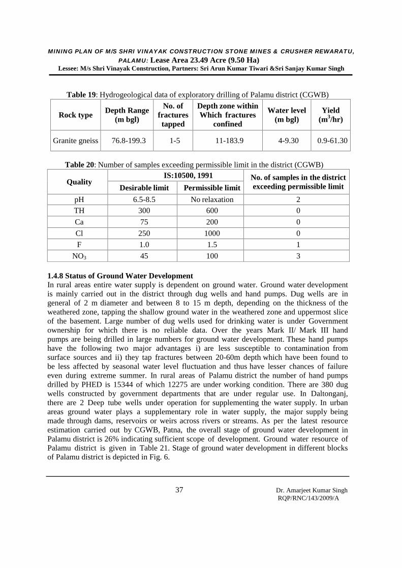
Table 19: Hydrogeological data of exploratory drilling of Palamu district (CGWB)
Rock typeDepth Range
(m bgl)
No. offracturestapped
Depth zone withinWhich fractures
confined
Water level(m bgl)
Yield(m3/hr)
Granite gneiss 76.8-199.3 1-5 11-183.9 4-9.30 0.9-61.30
Table 20: Number of samples exceeding permissible limit in the district (CGWB)
QualityIS:10500, 1991 No. of samples in the district
exceeding permissible limitDesirable limit Permissible limit
pH 6.5-8.5 No relaxation 2
TH 300 600 0
Ca 75 200 0
Cl 250 1000 0
F 1.0 1.5 1
NO3 45 100 3
1.4.8 Status of Ground Water DevelopmentIn rural areas entire water supply is dependent on ground water. Ground water developmentis mainly carried out in the district through dug wells and hand pumps. Dug wells are ingeneral of 2 m diameter and between 8 to 15 m depth, depending on the thickness of theweathered zone, tapping the shallow ground water in the weathered zone and uppermost sliceof the basement. Large number of dug wells used for drinking water is under Governmentownership for which there is no reliable data. Over the years Mark II/ Mark III handpumps are being drilled in large numbers for ground water development. These hand pumpshave the following two major advantages i) are less susceptible to contamination fromsurface sources and ii) they tap fractures between 20-60m depth which have been found tobe less affected by seasonal water level fluctuation and thus have lesser chances of failureeven during extreme summer. In rural areas of Palamu district the number of hand pumpsdrilled by PHED is 15344 of which 12275 are under working condition. There are 380 dugwells constructed by government departments that are under regular use. In Daltonganj,there are 2 Deep tube wells under operation for supplementing the water supply. In urbanareas ground water plays a supplementary role in water supply, the major supply beingmade through dams, reservoirs or weirs across rivers or streams. As per the latest resourceestimation carried out by CGWB, Patna, the overall stage of ground water development inPalamu district is 26% indicating sufficient scope of development. Ground water resource ofPalamu district is given in Table 21. Stage of ground water development in different blocksof Palamu district is depicted in Fig. 6.

MINING PLAN OF M/S SHRI VINAYAK CONSTRUCTION STONE MINES & CRUSHER REWARATU,PALAMU: Lease Area 23.49 Acre (9.50 Ha)
Lessee: M/s Shri Vinayak Construction, Partners: Sri Arun Kumar Tiwari &Sri Sanjay Kumar Singh
38 Dr. Amarjeet Kumar SinghRQP/RNC/143/2009/A
Table 21: Dynamic ground water resource (ham) of Palamu district as per CGWB, Patna
Fig. 6: Stage of ground water development in different blocks of Palamu district (CGWB)
Annual Replenishable Ground Water Resource NaturalDischarge
duringnon-
monsoonseason
Net AnnualGroundWater
Availability
Annual Ground WaterDraft
ProjectedDemand
forDomestic
andIndustrialuses upto
2025
GroundWater
Availabilityfor Futureirrigation
Stage ofGround WaterDevelopment
(%)Monsoon Season Non-monsoon TotalRecharge
fromrainfall
Rechargefromother
sources
Rechargefrom
rainfall
Rechargefrom othersources
Irrigation Domesticand
Industrialuses
Total
26470 1538 4605 1490 34103 2103 32001 5852 2380 8231 3619 22530 26
M/s ShriVinayakConstructionStone Mines
VinayakConstructionStone Mines

MINING PLAN OF M/S SHRI VINAYAK CONSTRUCTION STONE MINES & CRUSHERREWARATU, PALAMU: Lease Area 23.49 Acre (9.50 Ha)
Lessee: M/s Shri Vinayak Construction, Partners: Sri Arun Kumar Tiwari &Sri Sanjay Kumar Singh
39 Dr. Amarjeet Kumar SinghRQP/RNC/143/2009/A
1.4.8 Surface Water
The wetland area estimated is 16348 ha which accounts for about 0.2% of the geographical areaof the district (Fig. 7). River/Stream is the most dominant wetland type (12655 ha) comprisingabout 77% of wetland area (Table 22). Reservoir/barrage (2095 ha) stands next comprisingabout 13% of wetland area. Other categories like tank/pond, waterlogged areas and areinsignificant in extent.
Fig. 7: Location of wetlands in Palamu district (MOEF)
M/s ShriVinayakConstructionStone Mines
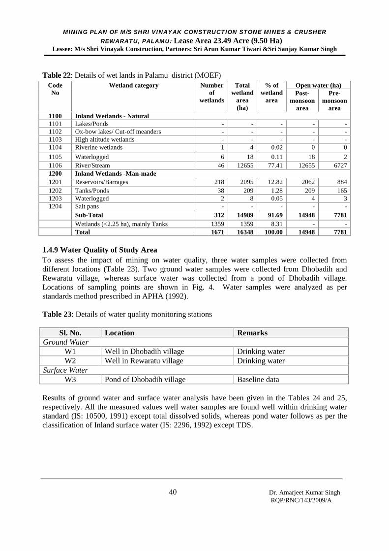
MINING PLAN OF M/S SHRI VINAYAK CONSTRUCTION STONE MINES & CRUSHERREWARATU, PALAMU: Lease Area 23.49 Acre (9.50 Ha)
Lessee: M/s Shri Vinayak Construction, Partners: Sri Arun Kumar Tiwari &Sri Sanjay Kumar Singh
40 Dr. Amarjeet Kumar SinghRQP/RNC/143/2009/A
Table 22: Details of wet lands in Palamu district (MOEF)Code
NoWetland category Number
ofwetlands
Totalwetland
area(ha)
% ofwetland
area
Open water (ha)Post-
monsoonarea
Pre-monsoon
area1100 Inland Wetlands - Natural1101 Lakes/Ponds - - - - -1102 Ox-bow lakes/ Cut-off meanders - - - - -1103 High altitude wetlands - - - - -1104 Riverine wetlands 1 4 0.02 0 0
1105 Waterlogged 6 18 0.11 18 21106 River/Stream 46 12655 77.41 12655 67271200 Inland Wetlands -Man-made1201 Reservoirs/Barrages 218 2095 12.82 2062 8841202 Tanks/Ponds 38 209 1.28 209 1651203 Waterlogged 2 8 0.05 4 31204 Salt pans - - - - -
Sub-Total 312 14989 91.69 14948 7781Wetlands (<2.25 ha), mainly Tanks 1359 1359 8.31 - -Total 1671 16348 100.00 14948 7781
1.4.9 Water Quality of Study AreaTo assess the impact of mining on water quality, three water samples were collected fromdifferent locations (Table 23). Two ground water samples were collected from Dhobadih andRewaratu village, whereas surface water was collected from a pond of Dhobadih village.Locations of sampling points are shown in Fig. 4. Water samples were analyzed as perstandards method prescribed in APHA (1992).
Table 23: Details of water quality monitoring stations
Sl. No. Location RemarksGround Water
W1 Well in Dhobadih village Drinking waterW2 Well in Rewaratu village Drinking water
Surface WaterW3 Pond of Dhobadih village Baseline data
Results of ground water and surface water analysis have been given in the Tables 24 and 25,respectively. All the measured values well water samples are found well within drinking waterstandard (IS: 10500, 1991) except total dissolved solids, whereas pond water follows as per theclassification of Inland surface water (IS: 2296, 1992) except TDS.
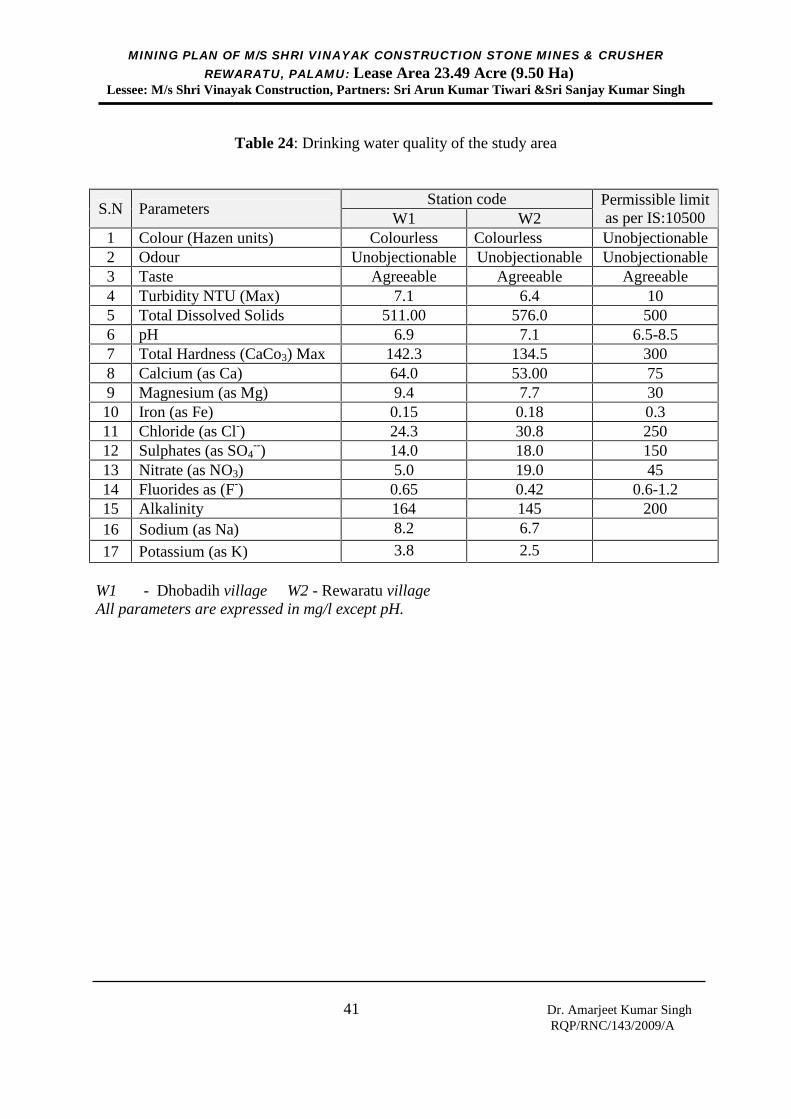
MINING PLAN OF M/S SHRI VINAYAK CONSTRUCTION STONE MINES & CRUSHERREWARATU, PALAMU: Lease Area 23.49 Acre (9.50 Ha)
Lessee: M/s Shri Vinayak Construction, Partners: Sri Arun Kumar Tiwari &Sri Sanjay Kumar Singh
41 Dr. Amarjeet Kumar SinghRQP/RNC/143/2009/A
Table 24: Drinking water quality of the study area
S.N ParametersStation code Permissible limit
as per IS:10500W1 W21 Colour (Hazen units) Colourless Colourless Unobjectionable2 Odour Unobjectionable Unobjectionable Unobjectionable3 Taste Agreeable Agreeable Agreeable4 Turbidity NTU (Max) 7.1 6.4 105 Total Dissolved Solids 511.00 576.0 5006 pH 6.9 7.1 6.5-8.57 Total Hardness (CaCo3) Max 142.3 134.5 3008 Calcium (as Ca) 64.0 53.00 759 Magnesium (as Mg) 9.4 7.7 3010 Iron (as Fe) 0.15 0.18 0.311 Chloride (as Cl-) 24.3 30.8 25012 Sulphates (as SO4
--) 14.0 18.0 15013 Nitrate (as NO3) 5.0 19.0 4514 Fluorides as (F-) 0.65 0.42 0.6-1.215 Alkalinity 164 145 20016 Sodium (as Na) 8.2 6.7
17 Potassium (as K) 3.8 2.5
W1 - Dhobadih village W2 - Rewaratu villageAll parameters are expressed in mg/l except pH.
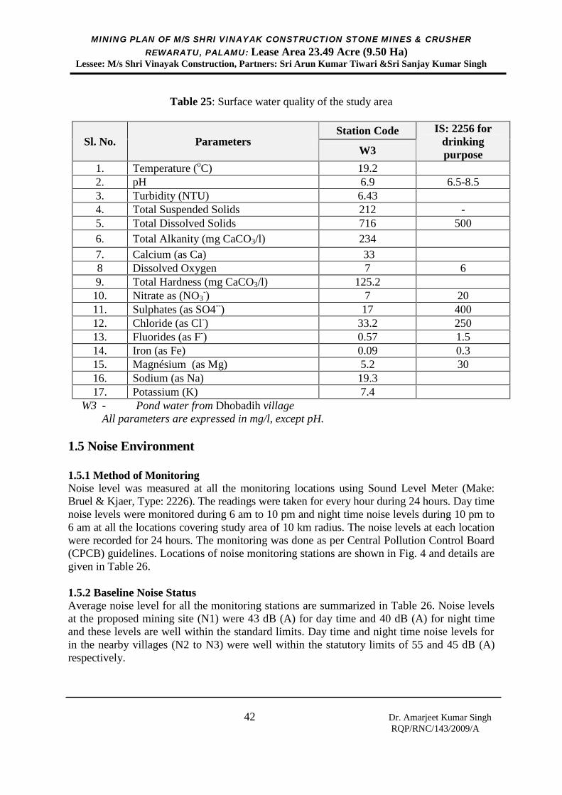
MINING PLAN OF M/S SHRI VINAYAK CONSTRUCTION STONE MINES & CRUSHERREWARATU, PALAMU: Lease Area 23.49 Acre (9.50 Ha)
Lessee: M/s Shri Vinayak Construction, Partners: Sri Arun Kumar Tiwari &Sri Sanjay Kumar Singh
42 Dr. Amarjeet Kumar SinghRQP/RNC/143/2009/A
Table 25: Surface water quality of the study area
Sl. No. ParametersStation Code IS: 2256 for
drinkingpurposeW3
1. Temperature (oC) 19.22. pH 6.9 6.5-8.53. Turbidity (NTU) 6.434. Total Suspended Solids 212 -5. Total Dissolved Solids 716 5006. Total Alkanity (mg CaCO3/l) 2347. Calcium (as Ca) 338 Dissolved Oxygen 7 69. Total Hardness (mg CaCO3/l) 125.210. Nitrate as (NO3
-) 7 2011. Sulphates (as SO4--) 17 40012. Chloride (as Cl-) 33.2 25013. Fluorides (as F-) 0.57 1.514. Iron (as Fe) 0.09 0.315. Magnésium (as Mg) 5.2 3016. Sodium (as Na) 19.317. Potassium (K) 7.4
W3 - Pond water from Dhobadih villageAll parameters are expressed in mg/l, except pH.
1.5 Noise Environment
1.5.1 Method of MonitoringNoise level was measured at all the monitoring locations using Sound Level Meter (Make:Bruel & Kjaer, Type: 2226). The readings were taken for every hour during 24 hours. Day timenoise levels were monitored during 6 am to 10 pm and night time noise levels during 10 pm to6 am at all the locations covering study area of 10 km radius. The noise levels at each locationwere recorded for 24 hours. The monitoring was done as per Central Pollution Control Board(CPCB) guidelines. Locations of noise monitoring stations are shown in Fig. 4 and details aregiven in Table 26.
1.5.2 Baseline Noise StatusAverage noise level for all the monitoring stations are summarized in Table 26. Noise levelsat the proposed mining site (N1) were 43 dB (A) for day time and 40 dB (A) for night timeand these levels are well within the standard limits. Day time and night time noise levels forin the nearby villages (N2 to N3) were well within the statutory limits of 55 and 45 dB (A)respectively.
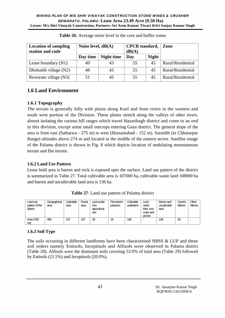
MINING PLAN OF M/S SHRI VINAYAK CONSTRUCTION STONE MINES & CRUSHERREWARATU, PALAMU: Lease Area 23.49 Acre (9.50 Ha)
Lessee: M/s Shri Vinayak Construction, Partners: Sri Arun Kumar Tiwari &Sri Sanjay Kumar Singh
43 Dr. Amarjeet Kumar SinghRQP/RNC/143/2009/A
Table 26: Average noise level in the core and buffer zones
Location of samplingstation and code
Noise level, dB(A) CPCB standard,dB(A)
Zone
Day time Night time Day NightLease boundary (N1) 49 43 55 45 Rural/Residential
Dhobadih village (N2) 48 43 55 45 Rural/Residential
Rewaratu village (N3) 51 45 55 45 Rural/Residential
1.6 Land Environment
1.6.1 TopographyThe terrain is generally hilly with plains along Koel and Sone rivers in the western andsouth west portion of the Division. These plains stretch along the valleys of other rivers,almost isolating the various hill ranges which travel Hazaribagh district and come to an endin this division, except some small outcrops entering Gaya district. The general slope of thearea is from east (Satbarwa - 275 m) to west (Hussainabad - 152 m). Saraidih (in ChhatarpurRange) altitudes above 274 m and located in the middle of the eastern sector. Satellite imageof the Palamu district is shown in Fig. 8 which depicts location of undulating mountaneousterrain and flat terrain.
1.6.2 Land Use PatternLease hold area is barren and rock is exposed upto the surface. Land use pattern of the districtis summarized in Table 27. Total cultivable area is 107000 ha, cultivable waste land 108000 haand barren and uncultivable land area is 136 ha.
Table 27: Land use pattern of Palamu district
Land usepattern of thedistrict
Geographicalarea
Cultivablearea
Forestarea
Land undernon-agriculturaluse
Permanentpastures
Cultivablewasteland
LandunderMisc. treecrops andgroves
Barren anduncultivableland
Currentfallows
Otherfallows
Area (‘000ha)
459 107 167 28 18 108 - 136 28 -
1.6.3 Soil Type
The soils occurring in different landforms have been characterised NBSS & LUP and threesoil orders namely Entisols, Inceptisols and Alfisols were observed in Palamu district(Table 28). Alfisols were the dominant soils covering 53.9% of total area (Table 29) followedby Entisols (21.5%) and Inceptisols (20.0%).
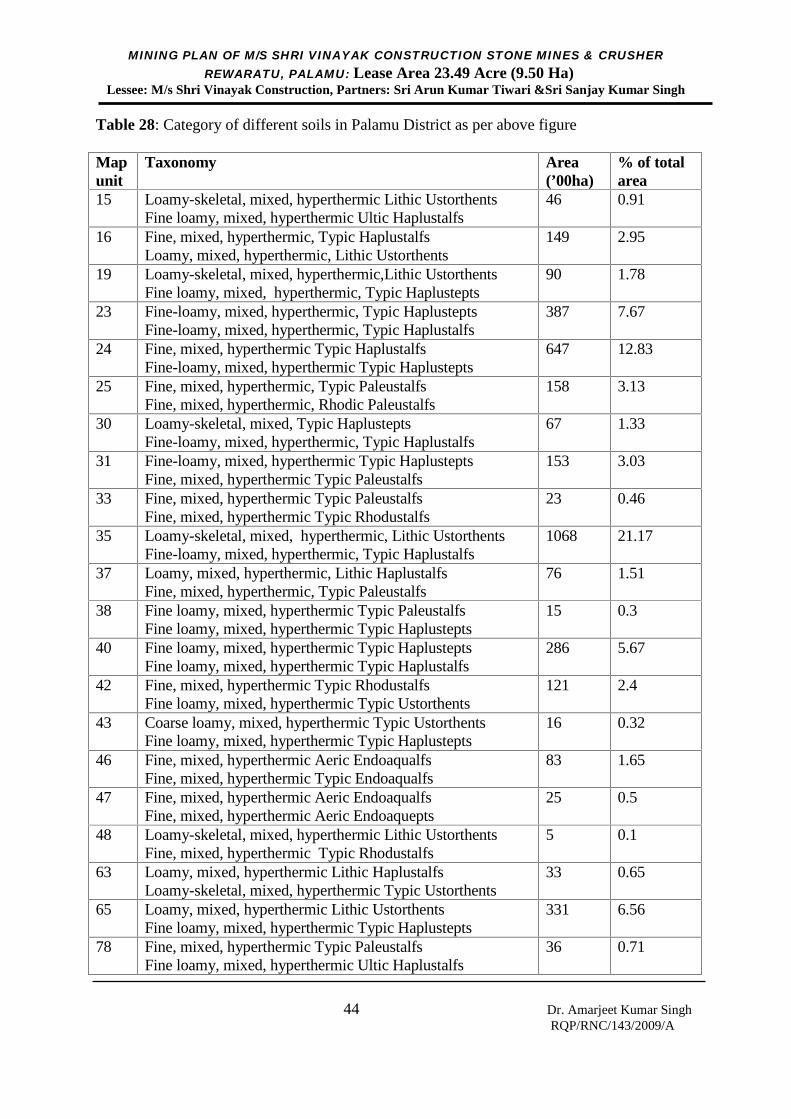
MINING PLAN OF M/S SHRI VINAYAK CONSTRUCTION STONE MINES & CRUSHERREWARATU, PALAMU: Lease Area 23.49 Acre (9.50 Ha)
Lessee: M/s Shri Vinayak Construction, Partners: Sri Arun Kumar Tiwari &Sri Sanjay Kumar Singh
44 Dr. Amarjeet Kumar SinghRQP/RNC/143/2009/A
Table 28: Category of different soils in Palamu District as per above figure
Mapunit
Taxonomy Area(’00ha)
% of totalarea
15 Loamy-skeletal, mixed, hyperthermic Lithic UstorthentsFine loamy, mixed, hyperthermic Ultic Haplustalfs
46 0.91
16 Fine, mixed, hyperthermic, Typic HaplustalfsLoamy, mixed, hyperthermic, Lithic Ustorthents
149 2.95
19 Loamy-skeletal, mixed, hyperthermic,Lithic UstorthentsFine loamy, mixed, hyperthermic, Typic Haplustepts
90 1.78
23 Fine-loamy, mixed, hyperthermic, Typic HaplusteptsFine-loamy, mixed, hyperthermic, Typic Haplustalfs
387 7.67
24 Fine, mixed, hyperthermic Typic HaplustalfsFine-loamy, mixed, hyperthermic Typic Haplustepts
647 12.83
25 Fine, mixed, hyperthermic, Typic PaleustalfsFine, mixed, hyperthermic, Rhodic Paleustalfs
158 3.13
30 Loamy-skeletal, mixed, Typic HaplusteptsFine-loamy, mixed, hyperthermic, Typic Haplustalfs
67 1.33
31 Fine-loamy, mixed, hyperthermic Typic HaplusteptsFine, mixed, hyperthermic Typic Paleustalfs
153 3.03
33 Fine, mixed, hyperthermic Typic PaleustalfsFine, mixed, hyperthermic Typic Rhodustalfs
23 0.46
35 Loamy-skeletal, mixed, hyperthermic, Lithic UstorthentsFine-loamy, mixed, hyperthermic, Typic Haplustalfs
1068 21.17
37 Loamy, mixed, hyperthermic, Lithic HaplustalfsFine, mixed, hyperthermic, Typic Paleustalfs
76 1.51
38 Fine loamy, mixed, hyperthermic Typic PaleustalfsFine loamy, mixed, hyperthermic Typic Haplustepts
15 0.3
40 Fine loamy, mixed, hyperthermic Typic HaplusteptsFine loamy, mixed, hyperthermic Typic Haplustalfs
286 5.67
42 Fine, mixed, hyperthermic Typic RhodustalfsFine loamy, mixed, hyperthermic Typic Ustorthents
121 2.4
43 Coarse loamy, mixed, hyperthermic Typic UstorthentsFine loamy, mixed, hyperthermic Typic Haplustepts
16 0.32
46 Fine, mixed, hyperthermic Aeric EndoaqualfsFine, mixed, hyperthermic Typic Endoaqualfs
83 1.65
47 Fine, mixed, hyperthermic Aeric EndoaqualfsFine, mixed, hyperthermic Aeric Endoaquepts
25 0.5
48 Loamy-skeletal, mixed, hyperthermic Lithic UstorthentsFine, mixed, hyperthermic Typic Rhodustalfs
5 0.1
63 Loamy, mixed, hyperthermic Lithic HaplustalfsLoamy-skeletal, mixed, hyperthermic Typic Ustorthents
33 0.65
65 Loamy, mixed, hyperthermic Lithic UstorthentsFine loamy, mixed, hyperthermic Typic Haplustepts
331 6.56
78 Fine, mixed, hyperthermic Typic PaleustalfsFine loamy, mixed, hyperthermic Ultic Haplustalfs
36 0.71

MINING PLAN OF M/S SHRI VINAYAK CONSTRUCTION STONE MINES & CRUSHERREWARATU, PALAMU: Lease Area 23.49 Acre (9.50 Ha)
Lessee: M/s Shri Vinayak Construction, Partners: Sri Arun Kumar Tiwari &Sri Sanjay Kumar Singh
45 Dr. Amarjeet Kumar SinghRQP/RNC/143/2009/A
79 Fine, mixed, hyperthermic Typic HaplustalfsFine, mixed, hyperthermic Ultic Paleustalfs
481 9.54
85 Fine-loamy, mixed, hyperthermic Typic HaplustalfsFine, mixed, hyperthermic Typic Paleustalfs
269 5.33
86 Fine, mixed, hyperthermic Typic RhodustalfsCoarse loamy, mixed, hyperthermic Typic Ustorthents
198 3.93
99 Fine, mixed, hyperthermic Typic HaplustalfsFine, mixed, hyperthermic Vertic Haplustepts
50 0.99
Miscellaneous 231 4.58Total 5044 100.0
Table 29: Major soil types in Palamu district
Major soil type Area (‘000 ha) Percent (%) of total areaAlfisols 282 53.9Entisols 113 21.5Inceptisols 105 20.0
1.6.4 Soil Fertility Status
Soil fertility status of Palamu district has been studied by National Bureau of Soil Survey andLand Use Planning, Kolkata in association with Birsa Agricultural University, Ranchi. Soilfertility status of Palamu district is summarized herewith.
The soil pH ranges from 4.8 to 8.9. The data reveals that soil of most of the area is acidic(47.8% of total area), in which 26.6% area is slightly acidic, 17.0% moderately acidic, 3.8%strongly acidic and 0.7% very strongly acidic in reaction. Soils of 27.1% area of thedistrict are neutral whereas 20.5% area is alkaline in reaction.
The organic carbon content in the district ranges from 0.10 to 1.64%. They are mappedinto three classes i.e., low (below 0.5%), medium (0.5-0.75%) and high (above 0.75%). It isseen that 42.6% area of the district have high organic carbon content. Medium and loworganic carbon content constitutes 37.4 and 15.4% area, respectively.
Available nitrogen content in the surface soils of the district ranges between 120 and 809kg/ha. Majority soils (68.3% of total area) of the district have medium availability status ofavailable nitrogen (280-560 kg/ha) and soils of 15.8% area have low available nitrogencontent (<280 kg/ha). Available phosphorus content in these soils ranges between 0.2 and38.2 kg/ha. Data reveals that most of the soils are low (46.8% of total area) followed bymedium (43.4% of total area) and high (5.2% of total area) content of available phosphorous.Available potassium content in these soils ranges between 76 and 1680 kg/ha and detailsabout area. The data reveals that most of the soils (55.9% of total area) have mediumavailable potassium content (108-280 kg/ha). Soils of 34.0% area are high (above 280 kg/ha)and 5.5% area are low (below 108 kg/ha) in available potassium content. The availablesulphur content in the soils ranges from 0.61 to 82.86 mg/kg and details about area. Soils of48.9% of the area are high (>20 mg/kg) whereas soils of 26.1 and 20.4% area are medium
MINING PLAN OF M/S SHRI VINAYAK CONSTRUCTION STONE MINES & CRUSHERREWARATU, PALAMU: Lease Area 23.49 Acre (9.50 Ha)
Lessee: M/s Shri Vinayak Construction, Partners: Sri Arun Kumar Tiwari &Sri Sanjay Kumar Singh
46 Dr. Amarjeet Kumar SinghRQP/RNC/143/2009/A
(10-20 mg/kg) and low (<10 mg/kg) in available sulphur content, respectively.
The soils are sufficient in available iron and manganese whereas soils of 9.7 and 1.3%area are deficient in available zinc and copper, respectively. Available boron content inthe soils ranges between 0.02 to 4.18 mg/kg and 67.7% area of district is deficient (<0.50mg/kg) in it.
1.7 Biological Environment
Proposed lease hold area is barren and rock is exposed upto the surface. There is no rare orendangered plant and animal species found in core and buffer zones of the area.
1.7.1 Flora
Forest area located far away from the mining site has different tree species, namely, Mahua(Madhuca longifolia), Palas (Butea frondosa), Karanja (Pongamia glabra), Amm (Mangiferaindica), Jamun (Eugenia jamb), Bard (Ficus benghalensis), Imli (Tamarindus indica), Arjun(Terminalia arjuna), Bair (Zizyphus mauritiana), Neem (Azadirachta indica), Piple (Ficusreligiosa), Babul (Acacia Arabica), Khatal (Artocarpus heterophyllus), Eucalyptus(Eucalyptus globulus), Sal (Shorea robusta), Khair (Acacia catechu), Asan (Terminaliatomentosa), Karam (Adina cordifolia), Sidha (Lagerstroemia parviflora), Gamhar (Gmelinaarborea), Semal (Bombax malabaricum), Medh (Litsaea semifera), Bel (Aegle marmelos),Kedar (Garuga pinnata), Galgal (Cochlospetmum gosaypium), Kend (Diospyros tomentosa),Kusum (Schlfichera trijuga), Shisham (Dalbergia latifolia), Siris (Boswellia serrata),Bamboo (Dendrocalamus strictus) etc.
1.7.2 Fauna
Animals and birds found within the adjacent area are of very general type reported by thelocal people consisting of snacks, reptiles, rabbits, wild pigs, monkeys and jackals. Birdsinclude pigeons, parrots, crows, wild fowls and owls etc.
1.8 Socio-Economic EnvironmentThere is no human settlement within the proposed lease boundary as well as within 500 mfrom the mine site. Palamu district is spreading over an area of 5043.8 sq. km. The totalpopulation of Palamu district as per the 2011 census is 19, 36,319 persons with urbanpopulation of 2,25,693 persons and rural population of 17,10,612 persons. Density ofpopulation of the district is 381 per sq. km. There is no industry in the area. Local people aredependent on agriculture which is possible only once in a year due to lack of irrigationfacility. Local people are fully dependent of daily labour job, forest products, agriculture andemployment in mines. In general, people of the region are poor and mining will help them toget job in the mine to prevent migration. SC population is 27.59% and ST population is9.03%.
MINING PLAN OF M/S SHRI VINAYAK CONSTRUCTION STONE MINES & CRUSHERREWARATU, PALAMU: Lease Area 23.49 Acre (9.50 Ha)
Lessee: M/s Shri Vinayak Construction, Partners: Sri Arun Kumar Tiwari &Sri Sanjay Kumar Singh
47 Dr. Amarjeet Kumar SinghRQP/RNC/143/2009/A
II. ENVIRONMENTAL IMPACT ASSESSMENT
2.1 Impact on Air Environment
The proposed mine site is located in barren small hilly area located in remote village wherelimited agriculture is practiced during rainy season only. Only a few household are living inthe area and population density of village is very less. The area does not have any industrialactivity in the core/ buffer zone and hence the ambient air quality of the area is good. Miningwill be carried out in a small area and loading will be done manually. Impact on air qualitydue to mining will not be significant.
2.2 Impact on Water Environment
2.2.1 Surface Water
There is no surface water body in and around lease area. Hence, effect on surface waterquality will be negligible. In order to arrest rain water flowing from the lease boundary tosurrounding area, runoff water will be accumulated in the pit sump/water harvesting pit. KoelNadi is flowing around 02 km away from the mine site and effect on water quality of the riveris not expected as no water is allowed to flow directly from the mine site. The water qualityof pond water is within the surface water quality standard IS: 2296, 1992.
2.2.2 Ground WaterThe proposed mining operation will be carried out in limited scale on a small hilly area abovegroundwater level. The mineral formation does not contain any harmful elements; hence nocontamination will take place into ground water. Moreover, settling pond and pit sump willbe constructed for rain water harvesting and ground water recharge. Final mine pit will beconverted into pond after mine closure, which will further help in ground water recharge andutilization of pond water for irrigation and other domestic uses.
Water required for different mining uses will be around 236.00 Kl per annum (Table 30).This water requirement shall be met by constructing a bore well fitted with small dieseloperated pump (3.00 HP) and partly from pit sump. Water quality of the mining area will notbe affected.
Table 30: Water requirement for the minePurpose Details of requirement Annual
requirementDrinking water 40 miners @ 3 litre per person per day for 300
working days in a year (40 ×3×300 l)36,000 l
Water spraying ontransport road
500 l per day for 200 days in a year excluding rainyseason and holidays (500×200 l)
1000,00 l
Watering of plants 500 plants @ 2 litre per plant for 100 days duringlean period (500×2×100 l)
100,000 l
Total annual water requirement for the mine 236,000 l
MINING PLAN OF M/S SHRI VINAYAK CONSTRUCTION STONE MINES & CRUSHERREWARATU, PALAMU: Lease Area 23.49 Acre (9.50 Ha)
Lessee: M/s Shri Vinayak Construction, Partners: Sri Arun Kumar Tiwari &Sri Sanjay Kumar Singh
48 Dr. Amarjeet Kumar SinghRQP/RNC/143/2009/A
2.3 Impact on Noise LevelNoise will be created by the movement of the tractors/dumpers. However, noise generated bythese will be occurring at the very low level and ambient noise level in the buffer zone shallbe within permissible limit of CPCB. Noise level in the core zone shall be maintained as perDGMS standard for continuous noise exposure level. Controlled blasting is proposed, henceeffect of ground vibration and blasting generated noise shall be within in the DGMS standard.
2.4 Impact on Land EnvironmentThe proposed mining operation will be carried out in limited scale on a small barren hillyarea. Very little amount of soil is present in small patches. Soil within the leasehold area willbe used for plantation purpose. In order to arrest siltation during rainy season, a garland drainwill be constructed around the leasehold area and overburden dump, and runoff water will beaccumulated in the settling ponds/water harvesting pits/sump. Further, plantation/green beltshall be developed along lease boundary and transport road. The open pit will be convertedinto pond after mine closure, which will further help in use of water for agriculture for localpeople. Hence, no negative impact on land environment is expected.
2.5 Impact on Biological EnvironmentThe leasehold area is barren. Hence, impact on biological environment in not expected. Asmentioned earlier, it is proposed to develop a green belt around the lease boundary and alongboth sides of transport road. This will help in improving biological environment of the area.
2.6 Impact of Socio-economic EnvironmentThere is no habitat in the lease hold area as well as within 500 m from lease boundary. Therewill be no adverse impact of mining but up to some extent socio-economic environment ofthe area will improve as, the mining activity and green belt development will create new jobopportunities for the local people. The pit pond after mine closure shall be used foragricultural purpose, growing of fish, drinking water for animal and other domestic uses.Further applicant will provide the occupational health and safety by providing regularmedical check-up and medicine distribution. Proposed mining operation will improve thefinancial status of the local people.

MINING PLAN OF M/S SHRI VINAYAK CONSTRUCTION STONE MINES & CRUSHERREWARATU, PALAMU: Lease Area 23.49 Acre (9.50 Ha)
Lessee: M/s Shri Vinayak Construction, Partners: Sri Arun Kumar Tiwari &Sri Sanjay Kumar Singh
49 Dr. Amarjeet Kumar SinghRQP/RNC/143/2009/A
III. ENVIRONMENTAL CONTROL MEASURES
3.1 Management of Air
(i) Wet drilling shall be practiced.
(ii) Fugitive dust emissions from all the sources shall be controlled. Water sprayingarrangement on transportation roads shall be made.
(iii)Transportation road from the mine to main road shall be constructed properly withbroken stone material of the mine. It shall be cleaned and maintained regularly.Transportation of material shall be limited to day time only and speed limit shall bemaintained. No overloading of minerals for transportation shall be practiced. Coveredtransportation shall be practiced.
(iv)Maintenance of nearby local roads through which transportation of minerals shall becarried out by the mine management regularly at its own expenses.
(v) Green belt around the mining lease boundary and along both sides of transportationroad shall be developed. The mine management shall involve local people forplantation program.
3.2 Management of Water and Waste Water
(i) Arrangement shall be made for rainwater harvesting by constructing rainwaterharvesting pits/sump/siltation ponds.
(ii) The used mobile from tractors shall be sold to registered recycler. There shall not beany waste water from the mine.
(iii)Mining shall be carried out above the groundwater table. Hence, effect on groundwater body due to mining is negligible. Siltation ponds/ mine sump/ pond after miningwould help in recharge of ground water.
(iv)Water body proposed at the end of mining shall be developed as designed in the mineclosure plan. Plantation shall be done on surrounding of the lease boundary and alayer soil layer shall be placed on the bottom of the pond for growing fish.
MINING PLAN OF M/S SHRI VINAYAK CONSTRUCTION STONE MINES & CRUSHERREWARATU, PALAMU: Lease Area 23.49 Acre (9.50 Ha)
Lessee: M/s Shri Vinayak Construction, Partners: Sri Arun Kumar Tiwari &Sri Sanjay Kumar Singh
50 Dr. Amarjeet Kumar SinghRQP/RNC/143/2009/A
3.3 Management of Dump and Waste Land
(i) Top soil (wherever available) shall be stacked separately with proper slope andadequate safeguards, and shall be utilized for biological reclamation and rehabilitationof mined out area in the later stage. A stone wall shall be constructed around the soildump to control erosion and grass plants (Bamboo and Kashi grasses) shall be seededin the inactive side of soil dump.
(ii) Small stone pieces from the mine shall be used for construction of gabion around thebottom of dump slope. A garland drain shall be constructed around the OB dump andsame shall be connected with a settling tank for controlling surface run-off.
(iii)The stone material shall be directly send to crushing unit located far away from themine, hence there will not be any stock yard in the mine.
(iv)Minimum 100 plants shall be planted in each year around the lease boundary and bothside of transportation road. Around 500 plants shall be planted in first five years.
(v) After care and watering of plants shall be continued until the vegetation becomes self-sustaining.
3.4 Management of Noise and Vibration
(i) Measures shall be taken for control of noise levels below 85 dB(A) in the workenvironment as per the DGMS standard. Green belt shall be developed around leaseboundary and along both sides of transport road to minimize noise level.
(ii) Tractors shall be maintained in good conditions.
(iii)Worker engaged in operations shall be provided with ear plugs / muffs.
(iv)Controlled blasting (like millisecond delay detonation) shall be practiced in the mineby a licensed third party on contract basis as per day to day requirement. Groundvibration due to blasting shall be maintained within the DGMS standard.
3.5 Health and Safety
(i) Occupational health check-up for the workers shall be carried out periodically andrecords shall be maintained. First-aid facility shall be provided at the mine site.
(ii) Awareness program for workers on impact mining on their health and precautionarymeasures, like use of helmet shall be carried out periodically. Necessary funds for thisalso shall be earmarked.

MINING PLAN OF M/S SHRI VINAYAK CONSTRUCTION STONE MINES & CRUSHERREWARATU, PALAMU: Lease Area 23.49 Acre (9.50 Ha)
Lessee: M/s Shri Vinayak Construction, Partners: Sri Arun Kumar Tiwari &Sri Sanjay Kumar Singh
51 Dr. Amarjeet Kumar SinghRQP/RNC/143/2009/A
(iii)Mine workers shall be provided with helmet and mining shoes, and they shall also beimparted adequate training and information on safety and health aspects.
(iv)Lease boundary shall be fenced with barbet wire to avoid accidents.
(v) Various amenities like drinking water, rest shelter, toilet etc. shall be provided to theworkers. A bore well shall be constructed and fitted with diesel operated pump (3.00HP) for supplying water for drinking purpose, spraying on roads and watering ofplants. A water tank of 3000 l capacity shall be provided on the elevated ground forstoring of bore well water and using it as and when required (Plate 12).
Table 31: Proposed year-wise green belt development program
Year No. of saplingproposed
Plants Location
1st year 500 Neem, Shisham, Aam, Sal,Arjun, Teak, Mahua,Ashoka, Jamun etc.
Around lease boundary in thesafety zone area (7.5 m width)and along transport road2nd year 500
3rd year 500
4th year 500
5th year 500
Total 2500

MINING PLAN OF M/S SHRI VINAYAK CONSTRUCTION STONE MINES & CRUSHERREWARATU, PALAMU: Lease Area 23.49 Acre (9.50 Ha)
Lessee: M/s Shri Vinayak Construction, Partners: Sri Arun Kumar Tiwari &Sri Sanjay Kumar Singh
52 Dr. Amarjeet Kumar SinghRQP/RNC/143/2009/A
CHAPTER-XI
PROGRESSIVE MINE CLOSURE PLANINTRODUCTIONM/s Shri Vinayak Constructin Stone Mines & Crusher is located in small hilly area ofRewaratu Mauza, Thana – Lessliganj, District – Palamu in State of Jharkhand. The mine islocated in Toposheet no. 73A/5 having 23° 57’13.25” to 23° 57’20.24” N latitude and 84°16’37.40” to 84°16’48.12” E longitude, Plot No. 1217 (Part), Khata No 72 and lease holdarea is 23.49 Acre (9.50 Ha). The proposed leasehold area is barren and rock is exposed uptothe surface. The area is located in non-forest area and it is a Government land. Necessaryconsent has been taken for mining from Village Panchayat by conducting General Meeting ofVillage Panchayat. The applicant for the mining lease is M/s Shri Vinayak Constructinauthorize Partner Sri Vikash Kumar Pathak at 81, Near Children Paradise School, Ward No22, Abadganj, Daltanganj District – Palamu, Jharkhand - 822101. The applicant has appliedfor grant of a fresh mining lease for 10 years durations.
The mine plan of the above is prepared under Sub Section -2(b) of Section-5 of M.M.D.R Act1957, Rule- 9 of M.C.D.R 1988 & Rule- 12 (i) Stone Development Conservation Rule 2002& Progressive Mine Closure Plan under Rule-23B of M.C.D.R 1988.
General:Name of Applicant: M/s Shri Vinayak Constructin Stone Mines & CrusherAddress : 81, Near Children Paradise School, Ward No 22, Abadganj, DaltanganjDistrict : PalamuState : Jharkhand 822101Mobile : +91 8409503584
Details of the Lease Area:District & state : Palamu, JharkhandVillage : ReawratuThana : LessliganjPlot No. : 1217 (Part)Khata : 72Extent of Mining lease area : 23.49 Acre (9.50 Ha)Latitude : 23° 57’13.25” to 23° 57’20.24” NLongitude : 84° 16’37.40” to 84°16’48.12” EToposheet : Map no. 73 A/5Whether the area is recorded to be in forest : No, it is Non-Forest area.Ownership/occupation : Government landStatus of Applicant : Partnership firm
MINING PLAN OF M/S SHRI VINAYAK CONSTRUCTION STONE MINES & CRUSHERREWARATU, PALAMU: Lease Area 23.49 Acre (9.50 Ha)
Lessee: M/s Shri Vinayak Construction, Partners: Sri Arun Kumar Tiwari &Sri Sanjay Kumar Singh
53 Dr. Amarjeet Kumar SinghRQP/RNC/143/2009/A
Existing and Post Mining Land Use PatternExisting land use pattern is of lease hold area is shown in Plate 14. Existing land usepattern is barren land.
Post-mining land use pattern is illustrated in Plate 15 and breakup of land use pattern ingiven below:
Area (Acre) Proposed Land Use after Mine Closure12.24 Water Body3.06 Quarry0.04 Infrastructure7.75 Green Belt0.10 Settling Tank0.20 Garland drain8.00 Total
Method of Mining:Method of mining will be opencast of category – B-2 (Fully Mechanized Mine -O.T.F.M.)
1.1 Reason for Mine Closure: Predictable: Exhaust of mineral/quarries lead to closure of mine or part of
mine. Progressive closing of quarry will be done depending upon theavailability of exhausted part of quarry.
Unpredictable: Closure may also happen due to unforeseen reasons such as naturalcalamities, mine related accident, local issue etc.
1.2 Statutory Obligation:The Central Government vide notification No GSR 329 (E) dated 10.4.2003 & No. GSR 330(E) dated 10.4.2003 amended the Mineral Concession Rules, 1960 and Mineral Conservation& Development Rules, 1988 respectively. In the notification it has been enumerated that the"Progressive Closure Plan" & "Final Closure Plan" should be in the format & as per theguidelines issued by the Indian Bureau of Mines.Mine closure operation is a continuous series activities starting from day one of the initiation
of mining project, mine closure is a continuous series of activities, it is obvious that theproposals of scientific mining have had included most of the activities to be included in theprogressive mine closure.
MINING PLAN OF M/S SHRI VINAYAK CONSTRUCTION STONE MINES & CRUSHERREWARATU, PALAMU: Lease Area 23.49 Acre (9.50 Ha)
Lessee: M/s Shri Vinayak Construction, Partners: Sri Arun Kumar Tiwari &Sri Sanjay Kumar Singh
54 Dr. Amarjeet Kumar SinghRQP/RNC/143/2009/A
1.3 Closure Plan Preparation:The names & Address of the applicant & recognized qualified persons who prepare mineplan & name of the existing agencies etc.
Name of RQP Preparing the Mine Plan : Dr. Amarjeet Kumar SinghAddress : Near Shiv Mandir, Lal BangalaP.O. : KG AsharamDist. : DhanbadState : Jharkhand 828109PIN : 828109E-mail : [email protected] No : RQP/RNC/143/2009/A
Conceptual Mining Plan at the End of 5th Year Plan PeriodOnly proved (i.e. 111 category of UNFC) reserves are taken into consideration forextraction. The mineable proved reserve is 809062.50 tonne. During five years of planperiod total production will be 3675000 tonne with a daily production rate of around2450 tonne. Huge amount of stone will be remains unexploited, which will be mined innext 6 to 11 years. Total life of the mine will be 11 years. Hence, mine closure plan isproposed after 11 years of mining.
Mining Method:Proposed Method of Mining:The development of the area will be done by Wagon drills method and control blasting.Loading of stone to dumper/tippers will be done by hydraulic excavator. Hill top will beextracted by slicing method of maximum average 6 m height and the stone below groundlevel will be extracted by benching method after leaving 7.5 m safety zone inside the leaseboundary.Mining StrategyAll drilling operation will be done mechanically by compressed air operated Wagon drill ofmaximum 6 m depth. After control blasting by millisecond delay detonation technique, theblasted material will be loaded from the blasted face by hydraulic excavator on dumper.Loaded material will be directly transported to crusher located away from the mine site.There will not be any stock yard. Little amount of waste will be generated, which will beused to construct approach road to the Mine.Bench Design & Formation:Bench height will be restricted to 6 m and width will be 6 m or as per DGMS approval.The proposed bench slope will be restricted to 70°. The anticipated production for 5years will be around 3675000 tonne with an average daily production rate of 2450tonne. Overall pit slope will be restricted to 45°.
MINING PLAN OF M/S SHRI VINAYAK CONSTRUCTION STONE MINES & CRUSHERREWARATU, PALAMU: Lease Area 23.49 Acre (9.50 Ha)
Lessee: M/s Shri Vinayak Construction, Partners: Sri Arun Kumar Tiwari &Sri Sanjay Kumar Singh
55 Dr. Amarjeet Kumar SinghRQP/RNC/143/2009/A
Year-wise Development (Reference to year-wise development plan & sections):
During First yearMining will be done by slicing/ benching of the hillock from all directions at a depth of firstbench portion will be up to 441 m 438 m RL with an average height of 3 m and subsequentlya second bench will be get started at a depth of 438 m to 432 m RL with an average height of6 m as shown in Plate 5. Further a few amount of waste available in the portion will be usedfor road construction of the ML area. A temporary office-cum-rest shelter bore well andwater tank will be constructed in the mine as shown in Plate 5. Anticipated stone productionduring 1st year will be 735000 tonne with a daily production of around 2450 tonne,considering 300 working days in a year.
During Second YearDuring second year, third slice in whole of lease area will be excavated from 216 m to 213 mRL with 3 m depth will be excavated below the first slice and second slice as shown in Plate6. Further, forming fourth slice from 213 m to 210 m depth with an average height of 3 m.Anticipated stone production during 2nd year will be 735000 tonne with a daily production ofaround 2450 tonne, considering 300 working days in a year.
During Third YearDuring 3rd year, remaining part of fourth slice of maximum 6 m depth will be excavatedbelow the first slice, second slice and third slice in upto RL of 207 m in whole portion oflease area (Plate 7). Anticipated stone production during 3rd year will be 735000 tonne with adaily production of around 2450 tonne, considering 300 working days in a year.
During Fourth YearDuring 4th year, fifth and sixth slice with a maximum 3 m depth will be excavated below inup to RL of 204 m depth in lease area (Plate 8). Anticipated stone production during 4th yearwill be 735000 tonne with a daily production of around 2450 tonne, considering 300 workingdays in a year.
During Fifth YearDuring 5th year, remaining part of sixth slice and first bench with a maximum 3 m depth willbe excavated below the first, second, third, fourth fifth slice in whole area up to RL of 291 min lease area (Plate 9). Further, a third bench will be started from 204 m to 198 m with anaverage height of 6 m. Anticipated stone production during 5rd year will be 735000 tonnewith a daily production of around 2450 tonne, considering 300 working days in a year.
During Conceptual PeriodDuring conceptual period (6-13th year) mining will be done below ground level 198 mRL by benching method of 6 m height and 6 m width (Plate 12). A statutory/safetybarrier of 7.5 m will be left as un-mined within the lease boundary Average productionduring conceptual period (6-11th year) will be a daily production of around 2450 tonne.
MINING PLAN OF M/S SHRI VINAYAK CONSTRUCTION STONE MINES & CRUSHERREWARATU, PALAMU: Lease Area 23.49 Acre (9.50 Ha)
Lessee: M/s Shri Vinayak Construction, Partners: Sri Arun Kumar Tiwari &Sri Sanjay Kumar Singh
56 Dr. Amarjeet Kumar SinghRQP/RNC/143/2009/A
Proposed Rate of Production When the Mine is fully developedDuring five years plan period the mining of saleable stone is proposed to be 2450 tonne ofROM stone per day. The life of mine at the proposed rate of production will be MineableReserve / yearly rate of production ~ 8069062.50/ (2450 x 300) = 10.97 years.
Ultimate extent & size of the pit:Ultimate extent and size of the mine is shown in Plates 12.
Final slope angle of the closure of the mine:The individual bench slope shall be kept around 70° with the height of each bench not morethan 3 m and width minimum of 3 m. The final slope of the quarry walls at the end of theclose of the mine shall be maintained at 45o.
Life of the Mine:Total Life of the mine will be 11 years.
Mineral Beneficiation:There will be no mineral beneficiation proposed during the plan period.
Review of Implementation of Mining Plan/ Scheme of Mining including five yearsprogressive closure plan up to the final closure of mine:Indicative in detail the various proposals committed with special emphasis on theproposals for protection of environment in the approved Mining Plan/ Scheme of Miningincluding five years.
Progressive Closure Plan up to the closure of mine vis-a-vis their status ofimplementation. Highlight the area, which might have been contaminated by miningactivities & type of contaminants that might be found there. The reasons for deviationfrom the proposals if any with corrective measures taken should also be given.The lease area is virgin as such there is no implementation of Mining Plan/Miningscheme previously. Thus, Mining Plan with a Progressive Mine Closure Plan is preparedby the applicant (lessee) for getting Mine approval and subsequently mining operationwill be started accordingly.
Mined Out land:Mined out land during plan period is 12.24 acre.
The Land use Pattern after Conceptual Plan Period would be as under
Area (Acre) Land Use after Conceptual Period (Plate 13)12.24 Water Body3.06 Quarry0.04 Infrastructure0.10 Approach road7.75 Green Belt

MINING PLAN OF M/S SHRI VINAYAK CONSTRUCTION STONE MINES & CRUSHERREWARATU, PALAMU: Lease Area 23.49 Acre (9.50 Ha)
Lessee: M/s Shri Vinayak Construction, Partners: Sri Arun Kumar Tiwari &Sri Sanjay Kumar Singh
57 Dr. Amarjeet Kumar SinghRQP/RNC/143/2009/A
0.10 Settling Tank0.20 Garland drain
23.49 Total
Reclamation & Rehabilitation Proposed of Mined out AreaNo reclamation is proposed as mine is not touching the ultimate pit limit during thepresent plan period. There is no habitation in the ML area, hence no rehabilitationprogram has been considered.
Water Quality ManagementThere is no river or nala flowing in the leasehold. Since a major portion of the lease areacomprises of gently sloping hillock surrounded with peripheral slope all around. Therewill be no problem of water drainage. This is all the more true as the area ispredominantly rocky. Due to peripheral slope, the natural flow of water will be towardsvalley down below the hillock.
Water Environment ManagementNo special arrangement is required to take care of ground water. To avoid surface run-offduring the monsoon season settling tank has been proposed in the lower portion of leaseboundary.
Air Quality Management:Impact on air quality: The contribution of fugitive dust generation is very marginal dueto the manual mining operations within the ML area created by digging. Loading ofmineral will be done manually and water spraying on transport road will be practiced.
Air Quality Management:Following air pollution control measures will be taken to suppress fugitive emission:
All service roads shall be boulder packed and maintained properly. Dispatch Tractors carrying stone shall be maintained and cleaned regularly. Haul roads will be compacted and water spraying arrangement shall be made to
suppress fugitive emission.Waste Management Nature of wasteSmall amount of overburden material will be generated.
Disposal & locationOverburden material will be dumped in the south-east corner of leasehold area.
Top-Soil Management:Top soil (wherever available) shall be stacked separately with proper slope and adequate
MINING PLAN OF M/S SHRI VINAYAK CONSTRUCTION STONE MINES & CRUSHERREWARATU, PALAMU: Lease Area 23.49 Acre (9.50 Ha)
Lessee: M/s Shri Vinayak Construction, Partners: Sri Arun Kumar Tiwari &Sri Sanjay Kumar Singh
58 Dr. Amarjeet Kumar SinghRQP/RNC/143/2009/A
safeguards, and shall be utilized for biological reclamation and rehabilitation of mined outarea in the later stage. A stone wall shall be constructed around the soil dump to controlerosion and grass plants (Bamboo and Kashi grasses) shall be seeded in the inactive side ofsoil dump.
Tailing Dam Management:Not applicable.
InfrastructureExistence of Public Road/Railway Line if Any Nearby And Approximate Distance:M/s Shri Vinayak Constructin Stone Mines & Crusher lease area is situated in the villageRewaratu, Thana Lessliganj, Palamu district, Jharkhand. The lease area is approachable fromthe Daltanganj railway station at a distance of 34 km, and from NH-75 around 05 km by statehighway and village road around 02 km.
AirportThe nearest airport from the area is Ranchi which is 245 km from the Stone Mine.
Nearest RailwayDaltonganj 34 km distance
Nearest HighwayNH-75, 05 km distance.
Disposal of Mining MachineryThere is no requirement of decommissioning of the mining machineries, as the miningmachineries are movable and will be used in the next mining site.
Safety and Security:The active opencast working will be properly fenced off from the surface as per DGMSstatutory provision to avoid any unforeseen accident due to unauthorized entry of person.At the end of the life of the mine when the mine will be abandon it will be properlyfenced off from all entries as per statute.
Disaster Management and Risk AssessmentThe area is hilly area. No possibility to flooding the area. Since the pits are developed onthe hard compact and medium grain rocks hence, there are no possibilities of slopefailure. The Risk Assessment & Risk Management Plan will be prepared for safety ofman & machinery deployed in the mining activities as per Mining Act, Rules, andRegulations & DGMS circulars.
Care & Maintenance during Temporary DiscontinuanceThere is no discontinuance possibility.
MINING PLAN OF M/S SHRI VINAYAK CONSTRUCTION STONE MINES & CRUSHERREWARATU, PALAMU: Lease Area 23.49 Acre (9.50 Ha)
Lessee: M/s Shri Vinayak Construction, Partners: Sri Arun Kumar Tiwari &Sri Sanjay Kumar Singh
59 Dr. Amarjeet Kumar SinghRQP/RNC/143/2009/A
Economic Repercussion of Closure of Mine and Manpower Retrenchment:Not applicable.
Number of local Residents Employed in the Mine, Status of Continuation of FamilyMember.Out of total employment of 70% about 40-45 local people will be directly employed inthe mine and they will be indirectly benefited.
Compensation given or to be given to The Employees in Connection with Sustenance ofHimself and Their Family Member:Not applicable.
Satellite Occupations Connected to the Mining Industry, Number of Persons EngagedThere in Continuance of Such Business After Mine Closure.Not applicable.
Continued Engagement of Employees in the Rehabilitated Status of Mining lease Areaand Any Other Remnant ActivitiesNot applicable.
Envisaged Repercussions on the Expectation of the Society Around Due to Closure ofMineNot applicable.
Time Scheduling for AbandonmentThe Mine will be closed after 11 years of mining operation.
Reclamation & Rehabilitation of Mine-Out landMined out area will be converted into pond by filing thin layer of soil at the bottom ofpit. Surrounding area within lease boundary will be covered into green belt. As there isno habitation in the ML area, hence no rehabilitation program has been considered.
Measure to be taken for protection of water bodies available in the lease area includingcontrol of erosion, sedimentation and siltation, water treatment, diversion of watercourses, protection of contamination of ground water from leaching, treatment of acidmine drainage etc –
There is no river or stream flowing in the leasehold. Major portion of the lease areacomprises of gently sloping hillock surrounded with peripheral slope all around. Therewill be no problem of water drainage as the area is predominantly rocky.Due to peripheral slope, the natural flow of water will be towards valley down below thehillock.No significant arrangement is required to take care of ground water as ground water willbe recharged by constructing sump/recharge pit/siltation pond. To avoid surface run-offduring the monsoon season peripheral/garland drain connected with settling tank hasbeen proposed around lower portion of lease boundary.

MINING PLAN OF M/S SHRI VINAYAK CONSTRUCTION STONE MINES & CRUSHERREWARATU, PALAMU: Lease Area 23.49 Acre (9.50 Ha)
Lessee: M/s Shri Vinayak Construction, Partners: Sri Arun Kumar Tiwari &Sri Sanjay Kumar Singh
60 Dr. Amarjeet Kumar SinghRQP/RNC/143/2009/A
Corrective Measures Taken For Prevention of Pollution of Air QualityImpact on air quality: The contribution of fugitive dust generation is very marginal dueto the manual mining operations within the ML area created by loading andtransportation.
Air Quality Management:Following air pollution control measures will be taken to suppress fugitive emission:
All service roads shall be boulder packed and maintained properly. Dispatch Tractors and tippers carrying stone shall be maintained and clean
regularly. Haul roads will be compacted and water spraying arrangement shall be made to
suppress fugitive emission.
Disposal of Waste Material and protective measures to be taken from generation of air,water and land pollutants while handling of waste materialDisposal & locationOverburden material will be dumped in the south-east corner of leasehold area.
Dump ManagementFew amount of waste will be generated, which is used for approach road constructions.
Management of Top-Soil and Protective Measures to be TakenTop soil (wherever available) shall be stacked separately with proper slope and adequatesafeguards, and shall be utilized for biological reclamation and rehabilitation of mined outarea in the later stage. A stone wall shall be constructed around the soil dump to controlerosion and grass plants (Bamboo and Kashi grasses) shall be seeded in the inactive side ofsoil dump.Protection and Stabilization of Tailing Dam Frequency of De-silting of Tailing MaterialProtective Measures to be Taken for Prevention of Water BodiesNot applicable.Decommissioning, Dismantling and Disposal of Various Infrastructure FacilitiesNot applicable.Safety Measures to be implemented to Prevent Access to Surface Opening, ExcavationsThe active opencast working will be properly fenced off from the surface as per DGMSstatutory provision to avoid any unforeseen accident due to unauthorized entry of person. Atthe end of the life of the mine when the mine will be abandon it will be properly fenced offfrom all entries as per statute.
Measures of Care, Maintenance and Monitoring of Status of Unplanned DiscontinuedMining OperationsNot applicable.
Abandonment CostExpenditure to be incurred during the plan period for various protection measures towardsprogressive mine closure are indicated below.

MINING PLAN OF M/S SHRI VINAYAK CONSTRUCTION STONE MINES & CRUSHERREWARATU, PALAMU: Lease Area 23.49 Acre (9.50 Ha)
Lessee: M/s Shri Vinayak Construction, Partners: Sri Arun Kumar Tiwari &Sri Sanjay Kumar Singh
61 Dr. Amarjeet Kumar SinghRQP/RNC/143/2009/A
Tentative Expenditure Schedule as Per the Format Given Here UnderAnnexure-I
Items Details Area (Acre) Quantity Expenditurein Rs.
Remark
Proposed Proposed Proposed(A)Reclamation&Rehabilitationof Mined outarea
(i) Backfilling - - -(ii) Afforestationon the backfilling area
- - -
(iii) Others(Please specify)
- -
(iv) Fishery Nil - -(v) Convertinginto waterreservoir
12.24 12.24 500000
(vi) Picnic Spot - - -(B)Stabilization&Rehabilitationof Dumps(with lease)
(i) Terracing - - -(ii) Pitching - - -(iii) Constructionof ParapetWalls/Retainingwall at toe ofdumps
- - -
(iv) Constructionof Check Dam
- - -
(v) Constructionof SettlingPonds, Garlanddrain etc.)
2 settlingtanks andgarlanddrain
300000
(vi) Desilting ofsettling pondschannels
- - -
(vii)Afforestation ondumps
- - -
(viii) Others(Please Specify)
- - -
(C)Rehabilitation
(i) Afforestation(Green belt
- 2500 plants 500000 Green beltdevelopment
MINING PLAN OF M/S SHRI VINAYAK CONSTRUCTION STONE MINES & CRUSHERREWARATU, PALAMU: Lease Area 23.49 Acre (9.50 Ha)
Lessee: M/s Shri Vinayak Construction, Partners: Sri Arun Kumar Tiwari &Sri Sanjay Kumar Singh
62 Dr. Amarjeet Kumar SinghRQP/RNC/143/2009/A
of Barren Areawithin Lease
building) along leaseboundary
(ii) Others(Please Specify)Construction ofgarland drainalong lowerportion of leaseboundary andsiltation pond
garlanddrain
- 300000
(iii) Fencingalong leaseboundary
Barbet wireFencing
Alongleaseboundary
400000
(iv) Digging ofbore well withdiesel operatedpump set andwater tank
Bore well,pump set 3HP &Water tankof 2000 lcapacity
1 set 200000
(D)Environmental Monitoring(Core Zone &Buffer ZoneSeparately)
MonitoringincludesAmbient AirQuality, WaterQuality, NoiseLevel etc.
200000
Total 2400000

MINING PLAN OF M/S SHRI VINAYAK CONSTRUCTION STONE MINES & CRUSHERREWARATU, PALAMU: Lease Area 23.49 Acre (9.50 Ha)
Lessee: M/s Shri Vinayak Construction, Partners: Sri Arun Kumar Tiwari &Sri Sanjay Kumar Singh
63 Dr. Amarjeet Kumar SinghRQP/RNC/143/2009/A
FINANCIAL ASSURANCE (TO BE PROVIDED ON THE BASIS OF THE DATAFILLED BY INSPECTING AUTHORITY)As per the CCOM'S Circular No-4/200G- the financial assurance has been computed on thebasis of area put to various uses. Accordingly, land uses are indicated in the table below.
Table: INDICATEING THE BREAKUP OF AREAS IN THE MINING LEASE FORCALCULATION OF FINANCIAL ASSURANCE (CCOM's CIRCULAR NO. 4/2006)
Sl.No.
Head Area puton use atstart ofplan(Acre)
Additionalrequirementduring planperiod(Acre)
Total(Acre)
Areaconsidered asfully reclaimed& rehabilitated(Acre)
Net areaconsideredforcalculation(Acre)
A B C D E=C+D F G=E-F1 Area under mining 12.24 3.06 15.30 Nil 15.302 Storage for top soil Nil Nil Nil Nil Nil3 Overburden/dump Nil Nil Nil Nil Nil4 Mineral storage Nil Nil Nil Nil Nil5 Infrastructure Nil 0.04 0.04 Nil 0.046 Roads Nil 0.10 0.10 Nil 0.107 Railways Nil Nil Nil Nil Nil8 Green belt Nil 7.75 7.75 7.75 Nil9 Settling pond Nil 0.10 0.10 Nil 0.1010 Effluent treatment
plantNil Nil Nil Nil Nil
11 Mineral separationplant
Nil Nil Nil Nil Nil
12 Garland Drain Nil 0.20 0.20 Nil 0.2013 Others to specify Nil Nil Nil Nil Nil
Grand Total 12.24 11.25 23.49 7.75 15.74
NB: Nil is mentioned above where the land is not used in those categories. Financialassurance amount in the form of the letter of credit from schedule bank or security bond willbe submitted by the lessee before executing the mining deed.
Financial assurance:
9.50 Ha x 25000 =Rs. 237500.00.
The minimum financial assurance or bank guarantee of Rs 1 lakh will be furnished tothe state authority.

MINING PLAN OF M/S SHRI VINAYAK CONSTRUCTION STONE MINES & CRUSHERREWARATU, PALAMU: Lease Area 23.49 Acre (9.50 Ha)
Lessee: M/s Shri Vinayak Construction, Partners: Sri Arun Kumar Tiwari &Sri Sanjay Kumar Singh
64 Dr. Amarjeet Kumar SinghRQP/RNC/143/2009/A
CORPORATE SOCIAL RESPOSIBILITY
The lessee shall contribute/spend Rs. 1.00 per tonne of stone production as corporate socialresponsibility (CSR).
CERTIFICATE AND UNDERTAKING
A certificate duly signed by the lessee is hereby attached to consider the closure plan toapproach the concerned authorities wherever necessary. Also, an undertaking to the effect isattached to implement progressive closure plan in a time bound manner.
PLANS, SECTIONS etc
The plans and sections of this mining plan may be referred for different purposes.

1219 1261
12211217(P)
1064
1217(P)1217
CH
API
DH
AWAD
IH
Lease Boundary
Plot
Index1217
SCALE - 1:2000
Signature
Dr. A
marjeet K
umar Singh
RQ
P/RN
C/143/2009/A
Prepared by
Lessee- M/S Sri Vinayak Construction Stone M
inesPartner - Sri Arun Kum
ar Tiwari,Vill. - Vaidakala,
P.S. - Patan, Dist - Palamu(Jharkhand) &
Sri Sanjay Singh, Vill - Barsota,Post - Kankekala,Thana - Patan, Dist - Palam
u(Jharkhand)
Lease Area 23.49 Acre (9.50ha) Lease Area at Mouza - Rewaratu, Thana - Lesliganj,
Thana No - 274 Khata - 72, Plot - 1217(P),Dist - Palamu, Jharkhand,
Sri Vinayak Construction Stone Mines
Plate 2 - Base Map / Area Plan

00
100200
300
100
200
300
100
200
400
100200
300
0
0
300
300400
500600
700
400500
600700
400
500
600
700
500
600
700
SCALE 1:2000 (1 cm = 20 m)
800900
1000
800900
1000
P1
P2
P3
P4
P5
P6
P7P8
P9
P10
P11
P12
SCALE - 1:2000
Signature
Dr. A
marjeet Kum
ar Singh RQ
P/RNC
/143/2009/A
Prepared by
Lessee- M/S Sri Vinayak Construction Stone M
inesPartner - Sri Arun Kum
ar Tiwari,Vill. - Vaidakala,
P.S. - Patan, Dist - Palamu(Jharkhand) &
Sri Sanjay Singh, Vill - Barsota,Post - Kankekala,Thana - Patan, Dist - Palam
u(Jharkhand)
Lease Area 23.49 Acre (9.50ha) Lease Area at Mouza - Rewaratu, Thana - Lesliganj,
Thana No - 274 Khata - 72, Plot - 1217(P),Dist - Palamu, Jharkhand,
Sri Vinayak Construction Stone Mines
320.00
324.00
328.00
332.00
336.00
340.00
320.00
324.00
328.00
332.00
336.00
340.00
Coordinate of PillarsPillar
CoordinatesP1P2P3P7
23° 57' 13.25 N, 84° 16' 43.10" E
Lease BoundaryContour (m)
Pillar with No.
Index
P4
290.00
Plate 3 - Surface Plan with Pillar's Coordinates
P9Road
23° 57' 13.33 N, 84° 16' 46.57" E
23° 57' 15.06 N, 84° 16' 48.12" E
23° 57' 20.24 N, 84° 16' 44.19" E
23° 57' 19.58 N, 84° 16' 37.40" E

00
100200
300
100
200
300
100
200
400
100200
300
0
0
300
300400
500600
700
400500
600700
400
500
600
700
500
600
700
SCALE 1:2000 (1 cm = 20 m)
800900
1000
800900
1000
Lease BoundaryContour (m)Approach RoadPillar with No.
Index
P4
BH
Cross SectionTransverse SectionBore HoleProved ZoneUltimate Pit LimitQuarry LimitStone
150.00
AB
XY
Plate 4 - Surface Geological Plan With Section
Bore hole log
30.00 m 84° 16' 45.30" E
Co ordinate of Bore Hole:Latitude:
23° 57' 14.20" N
Longitude:
STONE
BH
P1
P2
P3
P4
P5
P6
P7P8
P9
P10
P11
P12
X
y
C
D
A
B
SCALE - 1:2000
Signature
Dr. A
marjeet Kum
ar Singh RQ
P/RNC
/143/2009/A
Prepared by
Lessee- M/S Sri Vinayak Construction Stone M
inesPartner - Sri Arun Kum
ar Tiwari,Vill. - Vaidakala,
P.S. - Patan, Dist - Palamu(Jharkhand) &
Sri Sanjay Singh, Vill - Barsota,Post - Kankekala,Thana - Patan, Dist - Palam
u(Jharkhand)
Lease Area 23.49 Acre (9.50ha) Lease Area at Mouza - Rewaratu, Thana - Lesliganj,
Thana No - 274 Khata - 72, Plot - 1217(P),Dist - Palamu, Jharkhand,
Sri Vinayak Construction Stone Mines
AB
Cross Section A
-B (174.00m
)
310 m305 m300 m295 m290 m285 m
315 m320 m325 m330 m335 m340 m345 m
310 m305 m300 m295 m290 m285 m
315 m320 m325 m330 m335 m340 m345 m
CD
Cross Section C
-D (323.00m
)
310 m305 m300 m295 m290 m285 m
315 m320 m325 m330 m335 m340 m345 m
310 m305 m300 m295 m290 m285 m
315 m320 m325 m330 m335 m340 m345 m
XY
310 m305 m300 m295 m290 m285 m
315 m320 m325 m330 m335 m340 m345 m
310 m305 m300 m295 m290 m285 m
315 m320 m325 m330 m335 m340 m345 m
320.00
324.00
328.00
332.00
336.00
340.00
320.00
324.00
328.00
332.00
336.00
340.00
Transverse Section X
-Y (500.00m
)
BH
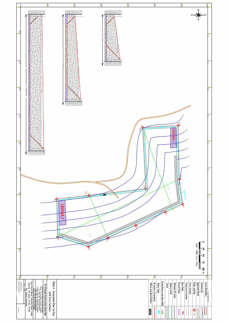
00
100200
300
100
200
300
100
200
400
100200
300
0
0
300
300400
500600
700
400500
600700
400
500
600
700
500
600
700
SCALE 1:2000 (1 cm = 20 m)
800900
1000
800900
1000
Lease BoundaryContour (m)Approach RoadPillar with No.
Index
P4
BH
Cross SectionTransverse SectionBore HoleProved ZoneUltimate Pit LimitQuarry LimitStone
150.00
AB
XY
P1
P2
P3
P4
P5
P6
P7P8
P9
P10
P11
P12
X
y
C
D
A
B
SCALE - 1:2000
Signature
Dr. A
marjeet Kum
ar Singh RQ
P/RNC
/143/2009/A
Prepared by
Lessee- M/S Sri Vinayak Construction Stone M
inesPartner - Sri Arun Kum
ar Tiwari,Vill. - Vaidakala,
P.S. - Patan, Dist - Palamu(Jharkhand) &
Sri Sanjay Singh, Vill - Barsota,Post - Kankekala,Thana - Patan, Dist - Palam
u(Jharkhand)
Lease Area 23.49 Acre (9.50ha) Lease Area at Mouza - Rewaratu, Thana - Lesliganj,
Thana No - 274 Khata - 72, Plot - 1217(P),Dist - Palamu, Jharkhand,
Sri Vinayak Construction Stone Mines
AB
Cross Section A
-B (174.00m
)
310 m305 m300 m295 m290 m285 m
315 m320 m325 m330 m335 m340 m345 m
310 m305 m300 m295 m290 m285 m
315 m320 m325 m330 m335 m340 m345 m
CD
Cross Section C
-D (323.00m
)
310 m305 m300 m295 m290 m285 m
315 m320 m325 m330 m335 m340 m345 m
310 m305 m300 m295 m290 m285 m
315 m320 m325 m330 m335 m340 m345 m
XY
310 m305 m300 m295 m290 m285 m
315 m320 m325 m330 m335 m340 m345 m
310 m305 m300 m295 m290 m285 m
315 m320 m325 m330 m335 m340 m345 m
320.00
324.00
328.00
332.00
336.00
340.00
320.00
324.00
328.00
332.00
336.00
340.00
Transverse Section X
-Y (500.00m
)
Plate 5 - Excavation Plan 1st Year with Cross Sections
Office cum Rest Shelter
Pump House cum Bore WellWater TankRL before Excavation
Settling
Tank
Settling
Tank
+332.00
+332.00+
332.00
+332.00
+332.00
CRUSHER 1
CRUSHER 2

00
100200
300
100
200
300
100
200
400
100200
300
0
0
300
300400
500600
700
400500
600700
400
500
600
700
500
600
700
SCALE 1:2000 (1 cm = 20 m)
800900
1000
800900
1000
Lease BoundaryContour (m)Approach RoadPillar with No.
Index
P4
BH
Cross SectionTransverse SectionBore HoleProved ZoneUltimate Pit LimitQuarry LimitStone
150.00
AB
XY
P1
P2
P3
P4
P5
P6
P7P8
P9
P10
P11
P12
X
y
C
D
A
B
SCALE - 1:2000
Signature
Dr. A
marjeet Kum
ar Singh RQ
P/RNC
/143/2009/A
Prepared by
Lessee- M/S Sri Vinayak Construction Stone M
inesPartner - Sri Arun Kum
ar Tiwari,Vill. - Vaidakala,
P.S. - Patan, Dist - Palamu(Jharkhand) &
Sri Sanjay Singh, Vill - Barsota,Post - Kankekala,Thana - Patan, Dist - Palam
u(Jharkhand)
Lease Area 23.49 Acre (9.50ha) Lease Area at Mouza - Rewaratu, Thana - Lesliganj,
Thana No - 274 Khata - 72, Plot - 1217(P),Dist - Palamu, Jharkhand,
Sri Vinayak Construction Stone Mines
AB
Cross Section A
-B (174.00m
)
310 m305 m300 m295 m290 m285 m
315 m320 m325 m330 m335 m340 m345 m
310 m305 m300 m295 m290 m285 m
315 m320 m325 m330 m335 m340 m345 m
CD
Cross Section C
-D (323.00m
)
310 m305 m300 m295 m290 m285 m
315 m320 m325 m330 m335 m340 m345 m
310 m305 m300 m295 m290 m285 m
315 m320 m325 m330 m335 m340 m345 m
XY
310 m305 m300 m295 m290 m285 m
315 m320 m325 m330 m335 m340 m345 m
310 m305 m300 m295 m290 m285 m
315 m320 m325 m330 m335 m340 m345 m
320.00
324.00
328.00
332.00
336.00
340.00
320.00
324.00
328.00
332.00
336.00
340.00
Transverse Section X
-Y (500.00m
)
Plate 6 - Excavation Plan 2nd Year with Cross Sections
Office cum Rest Shelter
Pump House cum Bore WellWater TankRL before Excavation
Settling
Tank
Settling
Tank
+332.00
+332.00+
332.00
+326.00
+332.00
+326.00
+326.00
+326.00
+326.00
CRUSHER 1
CRUSHER 2
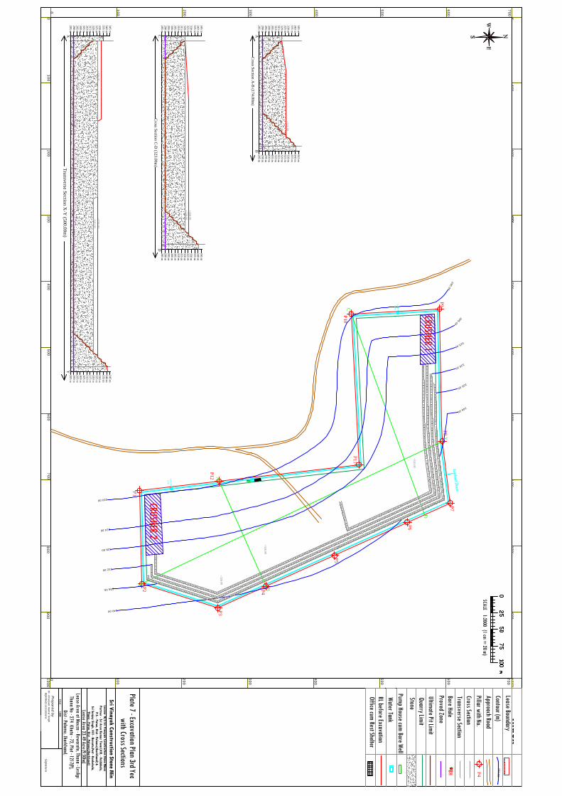
00
100200
300
100
200
300
100
200
400
100200
300
0
0
300
300400
500600
700
400500
600700
400
500
600
700
500
600
700
SCALE 1:2000 (1 cm = 20 m)
800900
1000
800900
1000
Lease BoundaryContour (m)Approach RoadPillar with No.
Index
P4
BH
Cross SectionTransverse SectionBore HoleProved ZoneUltimate Pit LimitQuarry LimitStone
150.00
AB
XY
P1
P2
P3
P4
P5
P6
P7P8
P9
P10
P11
P12
X
y
C
D
A
B
SCALE - 1:2000
Signature
Dr. A
marjeet Kum
ar Singh RQ
P/RNC
/143/2009/A
Prepared by
Lessee- M/S Sri Vinayak Construction Stone M
inesPartner - Sri Arun Kum
ar Tiwari,Vill. - Vaidakala,
P.S. - Patan, Dist - Palamu(Jharkhand) &
Sri Sanjay Singh, Vill - Barsota,Post - Kankekala,Thana - Patan, Dist - Palam
u(Jharkhand)
Lease Area 23.49 Acre (9.50ha) Lease Area at Mouza - Rewaratu, Thana - Lesliganj,
Thana No - 274 Khata - 72, Plot - 1217(P),Dist - Palamu, Jharkhand,
Sri Vinayak Construction Stone Mines
AB
Cross Section A
-B (174.00m
)
310 m305 m300 m295 m290 m285 m
315 m320 m325 m330 m335 m340 m345 m
310 m305 m300 m295 m290 m285 m
315 m320 m325 m330 m335 m340 m345 m
CD
Cross Section C
-D (323.00m
)
310 m305 m300 m295 m290 m285 m
315 m320 m325 m330 m335 m340 m345 m
310 m305 m300 m295 m290 m285 m
315 m320 m325 m330 m335 m340 m345 m
XY
310 m305 m300 m295 m290 m285 m
315 m320 m325 m330 m335 m340 m345 m
310 m305 m300 m295 m290 m285 m
315 m320 m325 m330 m335 m340 m345 m
290.00
305.00
315.00
325.00
335.00
345.00
320.00
324.00
328.00
332.00
336.00
340.00
Transverse Section X
-Y (500.00m
)
Plate 7 - Excavation Plan 3rd Year with Cross Sections
Office cum Rest Shelter
Pump House cum Bore WellWater TankRL before Excavation
Settling
Tank
Settling
Tank
+320.00
+326.00
+326.00
+326.00
+326.00
+326.00
+320.00
+326.00
+320.00
CRUSHER 1
CRUSHER 2

00
100200
300
100
200
300
100
200
400
100200
300
0
0
300
300400
500600
700
400500
600700
400
500
600
700
500
600
700
SCALE 1:2000 (1 cm = 20 m)
800900
1000
800900
1000
Lease BoundaryContour (m)Approach RoadPillar with No.
Index
P4
BH
Cross SectionTransverse SectionBore HoleProved ZoneUltimate Pit LimitQuarry LimitStone
150.00
AB
XY
P1
P2
P3
P4
P5
P6
P7P8
P9
P10
P11
P12
X
y
C
D
A
B
SCALE - 1:2000
Signature
Dr. A
marjeet Kum
ar Singh RQ
P/RNC
/143/2009/A
Prepared by
Lessee- M/S Sri Vinayak Construction Stone M
inesPartner - Sri Arun Kum
ar Tiwari,Vill. - Vaidakala,
P.S. - Patan, Dist - Palamu(Jharkhand) &
Sri Sanjay Singh, Vill - Barsota,Post - Kankekala,Thana - Patan, Dist - Palam
u(Jharkhand)
Lease Area 23.49 Acre (9.50ha) Lease Area at Mouza - Rewaratu, Thana - Lesliganj,
Thana No - 274 Khata - 72, Plot - 1217(P),Dist - Palamu, Jharkhand,
Sri Vinayak Construction Stone Mines
AB
Cross Section A
-B (174.00m
)
310 m305 m300 m295 m290 m285 m
315 m320 m325 m330 m335 m340 m345 m
310 m305 m300 m295 m290 m285 m
315 m320 m325 m330 m335 m340 m345 m
CD
Cross Section C
-D (323.00m
)
310 m305 m300 m295 m290 m285 m
315 m320 m325 m330 m335 m340 m345 m
310 m305 m300 m295 m290 m285 m
315 m320 m325 m330 m335 m340 m345 m
XY
310 m305 m300 m295 m290 m285 m
315 m320 m325 m330 m335 m340 m345 m
310 m305 m300 m295 m290 m285 m
315 m320 m325 m330 m335 m340 m345 m
320.00
324.00
328.00
332.00
336.00
340.00
320.00
324.00
328.00
332.00
336.00
340.00
Transverse Section X
-Y (500.00m
)
Plate 8 - Excavation Plan 4th Year with Cross Sections
Office cum Rest Shelter
Pump House cum Bore WellWater TankRL before Excavation
Settling
Tank
Settling
Tank
+320.00
+320.00
+320.00
+326.00
+320.00
+326.00
+320.00
+320.00
+320.00
CRUSHER 1
CRUSHER 2

00
100200
300
100
200
300
100
200
400
100200
300
0
0
300
300400
500600
700
400500
600700
400
500
600
700
500
600
700
SCALE 1:2000 (1 cm = 20 m)
800900
1000
800900
1000
Lease BoundaryContour (m)Approach RoadPillar with No.
Index
P4
BH
Cross SectionTransverse SectionBore HoleProved ZoneUltimate Pit LimitQuarry LimitStone
150.00
AB
XY
P1
P2
P3
P4
P5
P6
P7P8
P9
P10
P11
P12
X
y
C
D
A
B
SCALE - 1:2000
Signature
Dr. A
marjeet Kum
ar Singh RQ
P/RNC
/143/2009/A
Prepared by
Lessee- M/S Sri Vinayak Construction Stone M
inesPartner - Sri Arun Kum
ar Tiwari,Vill. - Vaidakala,
P.S. - Patan, Dist - Palamu(Jharkhand) &
Sri Sanjay Singh, Vill - Barsota,Post - Kankekala,Thana - Patan, Dist - Palam
u(Jharkhand)
Lease Area 23.49 Acre (9.50ha) Lease Area at Mouza - Rewaratu, Thana - Lesliganj,
Thana No - 274 Khata - 72, Plot - 1217(P),Dist - Palamu, Jharkhand,
Sri Vinayak Construction Stone Mines
AB
Cross Section A
-B (174.00m
)
310 m305 m300 m295 m290 m285 m
315 m320 m325 m330 m335 m340 m345 m
310 m305 m300 m295 m290 m285 m
315 m320 m325 m330 m335 m340 m345 m
CD
Cross Section C
-D (323.00m
)
310 m305 m300 m295 m290 m285 m
315 m320 m325 m330 m335 m340 m345 m
310 m305 m300 m295 m290 m285 m
315 m320 m325 m330 m335 m340 m345 m
XY
310 m305 m300 m295 m290 m285 m
315 m320 m325 m330 m335 m340 m345 m
310 m305 m300 m295 m290 m285 m
315 m320 m325 m330 m335 m340 m345 m
320.00
324.00
328.00
332.00
336.00
340.00
320.00
324.00
328.00
332.00
336.00
340.00
Transverse Section X
-Y (500.00m
)
Plate 9 - Excavation Plan 5th Year with Cross Sections
Office cum Rest Shelter
Pump House cum Bore WellWater TankRL before Excavation
Settling
Tank
Settling
Tank
+316.00
+320.00
+316.00
+320.00
+320.00
+320.00
+320.00
+314.00
+314.00
CRUSHER 1
CRUSHER 2
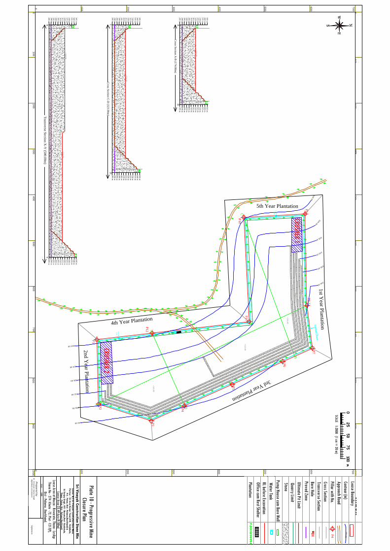
00
100200
300
100
200
300
100
200
400
100200
300
0
0
300
300400
500600
700
400500
600700
400
500
600
700
500
600
700
SCALE 1:2000 (1 cm = 20 m)
800900
1000
800900
1000
Lease BoundaryContour (m)Approach RoadPillar with No.
Index
P4
BH
Cross SectionTransverse SectionBore HoleProved ZoneUltimate Pit LimitQuarry LimitStone
150.00
AB
XY
P1
P2
P3
P4
P5
P6
P7P8
P9
P10
P11
P12
X
y
C
D
A
B
SCALE - 1:2000
Signature
Dr. A
marjeet Kum
ar Singh RQ
P/RNC
/143/2009/A
Prepared by
Lessee- M/S Sri Vinayak Construction Stone M
inesPartner - Sri Arun Kum
ar Tiwari,Vill. - Vaidakala,
P.S. - Patan, Dist - Palamu(Jharkhand) &
Sri Sanjay Singh, Vill - Barsota,Post - Kankekala,Thana - Patan, Dist - Palam
u(Jharkhand)
Lease Area 23.49 Acre (9.50ha) Lease Area at Mouza - Rewaratu, Thana - Lesliganj,
Thana No - 274 Khata - 72, Plot - 1217(P),Dist - Palamu, Jharkhand,
Sri Vinayak Construction Stone Mines
AB
Cross Section A
-B (174.00m
)
310 m305 m300 m295 m290 m285 m
315 m320 m325 m330 m335 m340 m345 m
310 m305 m300 m295 m290 m285 m
315 m320 m325 m330 m335 m340 m345 m
CD
Cross Section C
-D (323.00m
)
310 m305 m300 m295 m290 m285 m
315 m320 m325 m330 m335 m340 m345 m
310 m305 m300 m295 m290 m285 m
315 m320 m325 m330 m335 m340 m345 m
XY
310 m305 m300 m295 m290 m285 m
315 m320 m325 m330 m335 m340 m345 m
310 m305 m300 m295 m290 m285 m
315 m320 m325 m330 m335 m340 m345 m
320.00
324.00
328.00
332.00
336.00
340.00
320.00
324.00
328.00
332.00
336.00
340.00
Transverse Section X
-Y (500.00m
)
Office cum Rest Shelter
Pump House cum Bore WellWater TankRL before Excavation
Settling
Tank
Settling
Tank
+316.00
+320.00
+316.00
+320.00
+320.00
+314.00
+314.00
Plate 10 - Progressive Mine Closure Plan
Plantation
3rd Year Plantation
2nd Year Plantation
1st Year Plantation
5th Year Plantation
4th Year Plantation
CRUSHER 1
CRUSHER 2
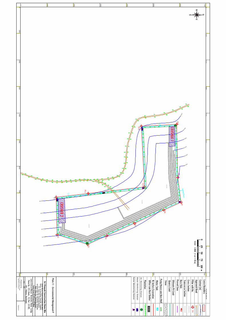
00
100200
300
100
200
300
100
200
400
100200
300
0
0
300
300400
500600
700
400500
600700
400
500
600
700
500
600
700
SCALE 1:2000 (1 cm = 20 m)
800900
1000
800900
1000
Lease BoundaryContour (m)Approach RoadPillar with No.
Index
P4
BH
Cross SectionTransverse SectionBore HoleProved ZoneUltimate Pit LimitQuarry LimitStone
150.00
AB
XY
P1
P2
P3
P4
P5
P6
P7P8
P9
P10
P11
P12
SCALE - 1:2000
Signature
Dr. A
marjeet Kum
ar Singh RQ
P/RNC
/143/2009/A
Prepared by
Lessee- M/S Sri Vinayak Construction Stone M
inesPartner - Sri Arun Kum
ar Tiwari,Vill. - Vaidakala,
P.S. - Patan, Dist - Palamu(Jharkhand) &
Sri Sanjay Singh, Vill - Barsota,Post - Kankekala,Thana - Patan, Dist - Palam
u(Jharkhand)
Lease Area 23.49 Acre (9.50ha) Lease Area at Mouza - Rewaratu, Thana - Lesliganj,
Thana No - 274 Khata - 72, Plot - 1217(P),Dist - Palamu, Jharkhand,
Sri Vinayak Construction Stone Mines
320.00
324.00
328.00
332.00
336.00
340.00
320.00
324.00
328.00
332.00
336.00
340.00
Office cum Rest Shelter
Pump House cum Bore WellWater TankRL before Excavation
Settling
Tank
Settling
Tank
+316.00
+320.00
+316.00
PlantationAir M
onitoring Station
Water M
onitoring Station
Noise M
onitoring Station
AWN
A
A
W
W
N
N
Plate 11 - Environmental Management Plan
CRUSHER 1
CRUSHER 2
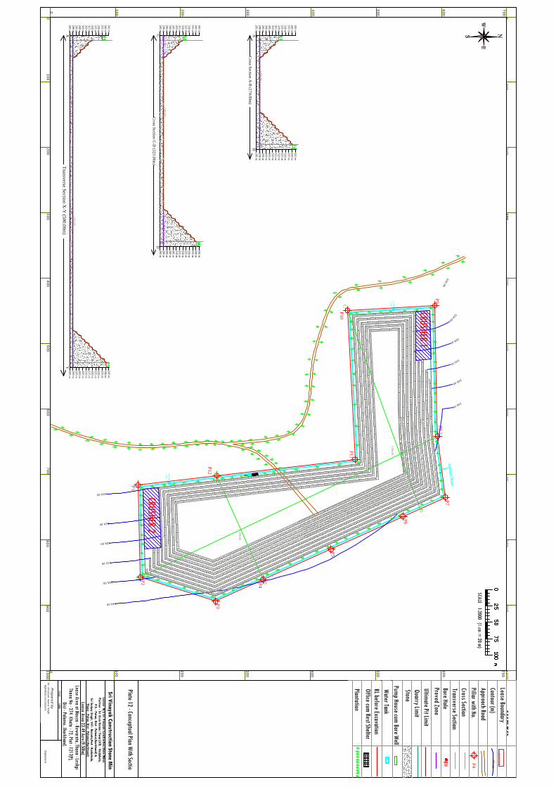
00
100200
300
100
200
300
100
200
400
100200
300
0
0
300
300400
500600
700
400500
600700
400
500
600
700
500
600
700
SCALE 1:2000 (1 cm = 20 m)
800900
1000
800900
1000
Lease BoundaryContour (m)Approach RoadPillar with No.
Index
P4
BH
Cross SectionTransverse SectionBore HoleProved ZoneUltimate Pit LimitQuarry LimitStone
150.00
AB
XY
P1
P2
P3
P4
P5
P6
P7P8
P9
P10
P11
P12
X
y
C
D
A
B
SCALE - 1:2000
Signature
Dr. A
marjeet Kum
ar Singh RQ
P/RNC
/143/2009/A
Prepared by
Lessee- M/S Sri Vinayak Construction Stone M
inesPartner - Sri Arun Kum
ar Tiwari,Vill. - Vaidakala,
P.S. - Patan, Dist - Palamu(Jharkhand) &
Sri Sanjay Singh, Vill - Barsota,Post - Kankekala,Thana - Patan, Dist - Palam
u(Jharkhand)
Lease Area 23.49 Acre (9.50ha) Lease Area at Mouza - Rewaratu, Thana - Lesliganj,
Thana No - 274 Khata - 72, Plot - 1217(P),Dist - Palamu, Jharkhand,
Sri Vinayak Construction Stone Mines
AB
Cross Section A
-B (174.00m
)
310 m305 m300 m295 m290 m285 m
315 m320 m325 m330 m335 m340 m345 m
310 m305 m300 m295 m290 m285 m
315 m320 m325 m330 m335 m340 m345 m
CD
Cross Section C
-D (323.00m
)
310 m305 m300 m295 m290 m285 m
315 m320 m325 m330 m335 m340 m345 m
310 m305 m300 m295 m290 m285 m
315 m320 m325 m330 m335 m340 m345 m
XY
310 m305 m300 m295 m290 m285 m
315 m320 m325 m330 m335 m340 m345 m
310 m305 m300 m295 m290 m285 m
315 m320 m325 m330 m335 m340 m345 m
320.00
324.00
328.00
332.00
336.00
340.00
320.00
324.00
328.00
332.00
336.00
340.00
Transverse Section X
-Y (500.00m
)
Office cum Rest Shelter
Pump House cum Bore WellWater TankRL before Excavation
Settling
Tank
Settling
Tank
+290.00
+290.00
+290.00
+290.00
+290.00
Plantation
Plate 12 - Conceptual Plan With Section
CRUSHER 1
CRUSHER 2
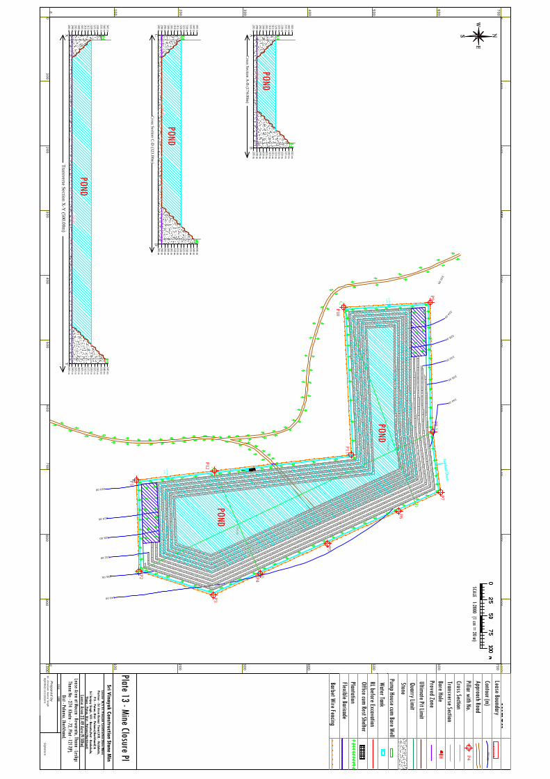
00
100200
300
100
200
300
100
200
400
100200
300
0
0
300
300400
500600
700
400500
600700
400
500
600
700
500
600
700
SCALE 1:2000 (1 cm = 20 m)
800900
1000
800900
1000
Lease BoundaryContour (m)Approach RoadPillar with No.
Index
P4
BH
Cross SectionTransverse SectionBore HoleProved ZoneUltimate Pit LimitQuarry LimitStone
150.00
AB
XY
P1
P2
P3
P4
P5
P6
P7P8
P9
P10
P11
P12
X
y
C
D
A
B
SCALE - 1:2000
Signature
Dr. A
marjeet Kum
ar Singh RQ
P/RNC
/143/2009/A
Prepared by
Lessee- M/S Sri Vinayak Construction Stone M
inesPartner - Sri Arun Kum
ar Tiwari,Vill. - Vaidakala,
P.S. - Patan, Dist - Palamu(Jharkhand) &
Sri Sanjay Singh, Vill - Barsota,Post - Kankekala,Thana - Patan, Dist - Palam
u(Jharkhand)
Lease Area 23.49 Acre (9.50ha) Lease Area at Mouza - Rewaratu, Thana - Lesliganj,
Thana No - 274 Khata - 72, Plot - 1217(P),Dist - Palamu, Jharkhand,
Sri Vinayak Construction Stone Mines
AB
Cross Section A
-B (174.00m
)
310 m305 m300 m295 m290 m285 m
315 m320 m325 m330 m335 m340 m345 m
310 m305 m300 m295 m290 m285 m
315 m320 m325 m330 m335 m340 m345 m
CD
Cross Section C
-D (323.00m
)
310 m305 m300 m295 m290 m285 m
315 m320 m325 m330 m335 m340 m345 m
310 m305 m300 m295 m290 m285 m
315 m320 m325 m330 m335 m340 m345 m
XY
310 m305 m300 m295 m290 m285 m
315 m320 m325 m330 m335 m340 m345 m
310 m305 m300 m295 m290 m285 m
315 m320 m325 m330 m335 m340 m345 m
320.00
324.00
328.00
332.00
336.00
340.00
320.00
324.00
328.00
332.00
336.00
340.00
Transverse Section X
-Y (500.00m
)
Office cum Rest Shelter
Pump House cum Bore WellWater TankRL before Excavation
Settling
Tank
Settling
Tank
+290.00
+290.00
+290.00
+290.00
+290.00
Plantation
Plate 13 - Mine Closure Plan
Barbet Wire Fencing
Flexible Baricade
POND
POND
POND
POND
POND

00
100200
300
100
200
300
100
200
400
100200
300
0
0
300
300400
500600
700
400500
600700
400
500
600
700
500
600
700
SCALE 1:2000 (1 cm = 20 m)
800900
1000
800900
1000
P1
P2
P3
P4
P5
P6
P7P8
P9
P10
P11
P12
SCALE - 1:2000
Signature
Dr. A
marjeet Kum
ar Singh RQ
P/RNC
/143/2009/A
Prepared by
Lessee- M/S Sri Vinayak Construction Stone M
inesPartner - Sri Arun Kum
ar Tiwari,Vill. - Vaidakala,
P.S. - Patan, Dist - Palamu(Jharkhand) &
Sri Sanjay Singh, Vill - Barsota,Post - Kankekala,Thana - Patan, Dist - Palam
u(Jharkhand)
Lease Area 23.49 Acre (9.50ha) Lease Area at Mouza - Rewaratu, Thana - Lesliganj,
Thana No - 274 Khata - 72, Plot - 1217(P),Dist - Palamu, Jharkhand,
Sri Vinayak Construction Stone Mines
320.00
324.00
328.00
332.00
336.00
340.00
320.00
324.00
328.00
332.00
336.00
340.00
Lease BoundaryContour (m)
Pillar with No.
Index
P4
290.00
Road
Land Use PatternUse pattern
Area (in Acre)
O.B. DumpNil
Barren23.49
Human settlementNil
Total23.49
Approach road0.00
Existing Quarry0.00
Plate 14 - Existing Land Use Plan
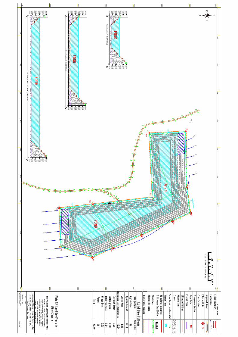
00
100200
300
100
200
300
100
200
400
100200
300
0
0
300
300400
500600
700
400500
600700
400
500
600
700
500
600
700
SCALE 1:2000 (1 cm = 20 m)
800900
1000
800900
1000
Lease BoundaryContour (m)Approach RoadPillar with No.
Index
P4
BH
Cross SectionTransverse SectionBore HoleProved ZoneUltimate Pit LimitQuarry LimitStone
150.00
AB
XY
P1
P2
P3
P4
P5
P6
P7P8
P9
P10
P11
P12
X
y
C
D
A
B
SCALE - 1:2000
Signature
Dr. A
marjeet Kum
ar Singh RQ
P/RNC
/143/2009/A
Prepared by
Lessee- M/S Sri Vinayak Construction Stone M
inesPartner - Sri Arun Kum
ar Tiwari,Vill. - Vaidakala,
P.S. - Patan, Dist - Palamu(Jharkhand) &
Sri Sanjay Singh, Vill - Barsota,Post - Kankekala,Thana - Patan, Dist - Palam
u(Jharkhand)
Lease Area 23.49 Acre (9.50ha) Lease Area at Mouza - Rewaratu, Thana - Lesliganj,
Thana No - 274 Khata - 72, Plot - 1217(P),Dist - Palamu, Jharkhand,
Sri Vinayak Construction Stone Mines
AB
Cross Section A
-B (174.00m
)
310 m305 m300 m295 m290 m285 m
315 m320 m325 m330 m335 m340 m345 m
310 m305 m300 m295 m290 m285 m
315 m320 m325 m330 m335 m340 m345 m
CD
Cross Section C
-D (323.00m
)
310 m305 m300 m295 m290 m285 m
315 m320 m325 m330 m335 m340 m345 m
310 m305 m300 m295 m290 m285 m
315 m320 m325 m330 m335 m340 m345 m
XY
310 m305 m300 m295 m290 m285 m
315 m320 m325 m330 m335 m340 m345 m
310 m305 m300 m295 m290 m285 m
315 m320 m325 m330 m335 m340 m345 m
320.00
324.00
328.00
332.00
336.00
340.00
320.00
324.00
328.00
332.00
336.00
340.00
Transverse Section X
-Y (500.00m
)
Office cum Rest Shelter
Pump House cum Bore WellWater TankRL before Excavation
Settling
Tank
Settling
Tank
+290.00
+290.00
+290.00
+290.00
+290.00
Plantation
Barbet Wire Fencing
Flexible Baricade
POND
POND
POND
POND
POND
Plate 15 -Land Use Plan after Mine Closure
Land Use PatternUse patternAgricultureApproach roadQuarry Area
Garland drain
InfrastructureSettling tank
Green belt
Mining Area Converted in to Pond
0.10Nil3.06
0.2012.24
0.100.04
Area (in Acre)
7.75Nil
ForestTotal
23.49