DISASTERS AS PRETEXT FOR SOCIAL CONTROL: THE CASE OF L'AQUILA (ITALY) Permanent derogation, smart...
18
DISASTERS AS PRETEXT FOR SOCIAL CONTROL: THE CASE OF L’AQUILA (ITALY) Permanent derogation, smart city and social engineering. GIS analysis and critical perspectives for the study of L'Aquila’s post-earthquake management Communication at the conference of the European Sociological Association (ESA) Research Network 08 “Disaster, Conflict and Social Crisis Research Network” (DCSCRN), entitled Disasters, Conflicts and Social Crises: Causes, Impacts and Responses, sept. 18/19, University of Crete, Rethimno By Dr. Gian Maria Valent, DISSGeA, University of Padova, Italy INTRODUCTION This paper examines how a natural disaster may lead to the suspension of public guarantees provided by national and local laws. Such practices are not simply the well- known practice of speculating on a literally shattered housing market, but rather social engineering to create a city that conforms its inhabitants to some particular social, ethnic and political ideal. The conditions engendered by a catastrophic event make possible conduct experiments in social engineering with the final purpose to replicate the logic of emergency in areas where it is recognized the need of radical meta-legal actions. Such practices can take shape thanks to the spatial power of strong institutional and economic players to divide territory into zones and regulate access and population movements between these areas. The case study examined is the city of L'Aquila after the earthquake of April 2009. The research method combines GIS 1 analysis of spatial and demographic data with the study of decision-making processes and the short, medium, and long term consequences of the adopted solutions on citizens and urban tissue. This article discusses the most relevant aspects of these issues, and is organized into sections on the general disciplinary framework, a description of the case study, and qualitative and quantitative analysis, ending with a brief presentation of the expected results. DISCIPLINARY FRAMEWORK This research fits into the theoretical framework of Critical Urban Theory, especially regarding the nature of contemporary Western cities, the processes of gentrification and authoritarian practices in the management and design of territories and urban realities. In 1 Geographic Information System
-
Upload
independentresearcher -
Category
Documents
-
view
5 -
download
0
Transcript of DISASTERS AS PRETEXT FOR SOCIAL CONTROL: THE CASE OF L'AQUILA (ITALY) Permanent derogation, smart...
DISASTERS AS PRETEXT FOR SOCIAL CONTROL: THE CASE OF L’AQUILA
(ITALY)
Permanent derogation, smart city and social engineering.
GIS analysis and critical perspectives for the study of L'Aquila’s post-earthquake
management
Communication at the conference of the European Sociological Association (ESA)
Research Network 08 “Disaster, Conflict and Social Crisis Research Network” (DCSCRN),
entitled Disasters, Conflicts and Social Crises: Causes, Impacts and Responses, sept.
18/19, University of Crete, Rethimno
By Dr. Gian Maria Valent,
DISSGeA, University of Padova, Italy
INTRODUCTION
This paper examines how a natural disaster may lead to the suspension of public
guarantees provided by national and local laws. Such practices are not simply the well-
known practice of speculating on a literally shattered housing market, but rather social
engineering to create a city that conforms its inhabitants to some particular social, ethnic
and political ideal. The conditions engendered by a catastrophic event make possible
conduct experiments in social engineering with the final purpose to replicate the logic of
emergency in areas where it is recognized the need of radical meta-legal actions. Such
practices can take shape thanks to the spatial power of strong institutional and economic
players to divide territory into zones and regulate access and population movements
between these areas.
The case study examined is the city of L'Aquila after the earthquake of April 2009. The
research method combines GIS1 analysis of spatial and demographic data with the study
of decision-making processes and the short, medium, and long term consequences of the
adopted solutions on citizens and urban tissue.
This article discusses the most relevant aspects of these issues, and is organized into
sections on the general disciplinary framework, a description of the case study, and
qualitative and quantitative analysis, ending with a brief presentation of the expected
results.
DISCIPLINARY FRAMEWORK
This research fits into the theoretical framework of Critical Urban Theory, especially
regarding the nature of contemporary Western cities, the processes of gentrification and
authoritarian practices in the management and design of territories and urban realities. In
1 Geographic Information System

particular, works by David Harvey2 and Saskia Sassen3 provide the basis to understand
the phenomena constituting contemporary cities, not just in the West but also on a global
scale. The functions and roles of the cities that Harvey and Sassen cover a wide range of
fields, which can be summarized as:
1. Area for the transmigration of cultural forms
2. Privileged site of flexible accumulation
3. Immaterial production:
• Business Services
• Services to persons
• Finance
• Control functions
• Annuity estate
• Culture / Entertainment
• Production of image / imaginary
Applying these concepts to analysis, the success or decline of a city no longer depends so
much on its proximity to raw materials for the manufacturing industry or other local
features as it was until the last century. A city’s lifeblood today depends on its location in
global networks that convey financial, cultural, and tourist flows. Competition among
cities is no longer limited to a nation, but embraces the entire world. Even if not all cities
can be considered “global cities”4 in Sassen’s sense, all of them, large and small, can and
do aspire to a high rank in the world. Metropolises compete with each other for
opportunities to stand the centre of global culture, such as a major event like the Olympics
or EXPO 2015. Likewise, smaller towns seek to permanently transform themselves into
node in the global network through adequate infrastructure and higher-level functions,
such, for example, two Emilian provincial capitals: Parma became headquarters of the
European Food Safety Authority, and Reggio Emilia became the location of HST
Mediopadana Station.
This kind of competition that leads to internal changes is, however, based almost entirely
on external logic: the biggest challenge is not to create a city that is a home for its
inhabitants, but to attract investment and globally networked cultural and capital.
Horacio Capel writes in “El debate sobre la construcción de la ciudad y el llamado modelo
Barcelona”:
It went from small operations to large projects, from priority for the
neighbourhoods and the quality of life of the inhabitants to the world
2 Harvey, The urban experience, Johns Hopkins, 1989
The condition of postmodernity, Blackwell, 1990
Il capitalismo contro il diritto alla città, Ombre corte, 2012 3 Sassen, Cities in a World economy, SAGE, 2012. 4 Briefly, cities that gather high-level functions and act globally.

competition. Now it's all over the city that equips itself to compete in the global
market.5
Fulfilling these new competitive goals requires a new kind of citizenship, stratified
differently than the old Fordist industrial city. The population of the new city is split into
an upper-middle class of professionals, artists, designers, and specialists in finance and
business services; and a class of low-income workers to supply the manpower for the
business services such as messengers, cleaners, and other low-skilled tasks, as well as the
whole range of human services, tourism, etc. The heightened social polarization is
reflected in a new centre-periphery dichotomy that sees city centres become increasingly
"show-cased", smart and screened at international level, while the suburban areas become
the refuge of “all the rest”.
Analyses of gentrification and urban renewal can explain how these changes are actually
happening. These works are drawn from a long period of time and diverse origins to
better understand the evolution and spread of the phenomenon. The writings of Peter
Marcuse 6 provide a useful general overview. Regarding the European continent,
enlightening authors include Manuel Castells7, Anne Clerval8 and Horacio Capel9, who
describe the transformations that have taken place in towns and cities in France and Spain.
Castells, Don Mitchell, and Neil Smith describe quite well the operations of urban renewal
in the United States. Smith’s article “New globalism, new urbanism” describes
contemporary gentrification as a process always less spontaneous and market-guided, but
instead the result of actively promoted and precise political strategies. Smith argues that
gentrification in the Global West has been marked by ongoing public-private consultation
and partnership that has filled the void left by the end of liberal urban policies.
Because of the social conflicts and protest movements these changes inspire, mainstream
urban policies have begun to change the nature of citizenship along with a city’s urban
structures. The urban centre of the city should preferably include the upper class
categories listed above, having the right professional, creative, and financial features.
Urban management should also have a fundamental goal to prevent social tensions, and
therefore dislocate the low-income classes to the suburbs. This way, the shift in citizenship
through gentrification strategies plays the dual role of tool and goal, simultaneously
making the cities more attractive and pacifying them, so that new waves of gentrification
can be promoted.
5 "Se pasó de las pequeñas actuaciones a los grandes proyectos, de la prioridad por los barrios y la calidad de
vida de los vecinos a la competencia mundial. Ahora es toda la ciudad la que se equipa para competir en el
mercado global.” Scripta Nova 11, 233, February 2007 (translated by the author). 6 In particular, see:
Marcuse, “Abandonment, gentrification and displacement: The linkages in N.Y.C.” In Smith, N. and
Williams P. (a.c.d.) Gentrification of the city, Boston: Routledge, 1986 and “Whose right(s) to what city?” In
Marcuse, Brenner and Mayer (a.c.d.) Cities for People, not for Profit, New York: Routledge, 2012. 7 Castells, La question urbaine, Paris, Maspero, 1972. 8 Clerval, “The spatial dynamics of gentrification in Paris: A synthesis map,” Cybergeo: European Journal of
Geography [En ligne], Espace, Société, Territoire, document 553. 9 Ibid.

Le Galés10 analyses the fundamental function of public and private coordination in his text
dedicated to governance processes in Europe. He describes the nature of the city, then
dissects its decision-making processes. First, states that the city cannot be considered a
collective subject, with all its components sharing the same goals, the same needs, and the
same mode of action. Such claims are often made purposefully to perpetuate an
appearance of unity so that the inner competition between classes is instead directed
outside between other cities. A relevant part of this competition consists in urban
marketing and branding strategies, including the renovation of the historic
neighbourhoods and monuments to transform the city’s physical body, and its material
and immaterial culture into objects and services to be consumed.
Such practices extend throughout the Global West without exception, even into European
countries, including Italy, for which several writings by the urbanist Edoardo Salzano11
offer detailed analyses of the role of rent as engine of growth and negotiating practices
between local governments, the formal urban policy decision makers, and private
stakeholders. Operating in this new way, rent has gradually replaced planning as the
primary tool for the design of urban and territorial layout.
The enslavement of development and urban administration to the logic of mere profit
constitutes a state of permanent derogation by which citizens have less and less control.
THE CASE STUDY: L’AQUILA
At first glance, the city of L'Aquila might seem an odd choice to analyse the emergency
model of management in urban governance. It is a medium-sized city in central Italy
without an industrial past and in a location at the crossroads of no continental networks.
Yet this case lets us observe the dynamics at play early in an emergency and extending
over the long term, the same management style that has guided the neoliberal urban
transformations of European and American cities.
L'Aquila is approximately 700 meters above sea level, in the valley of the river Aterno
between the Apennines of central Italy. The Gran Sasso and Laga mountains border the
city to the north and north-east, and the Chain of Sirente/Velino to the south. It was
founded in the mid-thirteenth century by the "castles" of the surrounding area, gathered in
the Comitatus Aquilanus in a sort of medieval synechism. Each castle possessed an area
called locale -which extension was proportional to its demographic amount- within one of
the city’s four quarters, visibly projecting the external territory inside the walls12. Over the
centuries, L’Aquila has suffered the consequences of numerous seismic events. Historical
information from the National Institute of Geophysics and Volcanology tells us that from
the beginning of the fourteenth century several earthquakes have hit the area causing
periodic collapses of most of the buildings, which were subsequently rebuilt. Those most
10 Le Galés, European cities: Social conflicts and governance, Oxford University press, 2002. 11 In particular, see: Salzano, Baioni, Boniburini La città non è solo un affare, Aemilia University Press, Reggio
E. 2012. 12 These brief historical notes are taken from the website of the Municipality of L’Aquila
http://www.comune.laquila.it/pagina7_la-storia.html

serious quakes occurred in 1315, 1461, 1703, and 176213. The city’s basic urban layout,
however, does not undergo major changes until the post-war period: from the 1950s, the
urbanized area has grown by about six-fold, from 500 to 3100 hectares, while the
population has increased by only 25%, from 54,000 to 68,000. From the previous settlement
system consisting of an urban core and several small villages, there is now a continuous
urbanization occupying most of the valley without breaks. The city’s economic activities
are characterized by a strong tertiary sector with a 69.5% of employees working in public
or private services, 16.5% in industry, 10% in construction, and 4% in agriculture14. The
functional centre of economic activities has always been the city centre, which also houses
the university and all its suppliers.
The consequences of the 2009 earthquake were particularly serious for the historic centre
of L’Aquila, rendering uninhabitable (classified in E or F Class by the Department of Civil
Protection) the majority of the buildings concentrated in the so-called “Red Zone”, which
coincides almost exactly with the ancient city wall. The Class E buildings in the city centre
make up 62.8% of all the damaged buildings, against 25% registered in the rest of seismic
crater15. In absolute terms, 1567 were buildings unusable after the earthquake. According
to the 2001 census, the population of the old town was 10,400, to which must be added
several thousand students who were not officially residents of the city centre, but lived in
university housing.
ANALYSIS
We can distinguish short and medium-long term emergency management strategies.
1. Short term
The analysis of the first period of the emergency management is directly connected with
the exercise of spatial power. The immediate management and organization of people and
spaces according to the "Augustus Method" has enabled the Civil Protection to shape all
subsequent events, included choices about the model of resettlement and reconstruction.
The Augustus method is an official document that the Department of Civil Protection
developed in 2003, setting out courses of action for emergencies.
People are always involved in situations of crisis, both emotionally (fear of being
touched by the events, taking part in the problems of those involved), both
physically (perhaps not damaged, but forced to endure hardships). This forced
"participation" is mainly associated with feelings of loss and helplessness. Few are
able to independently develop strategies to respond to the emergency, while the
majority struggles between the risk of a hysterical and irrational panic and an
anxious search for help, feedback and some points of reference. If its institutional
13 Source: I.N.G.V. http://www.mi.ingv.it/eq/090406/storia.html 14 Source: ISTAT data, 2007. 15 Data from Department of Civil Protection, 28/06/2009.
counterparty will be sufficiently authoritative and determined, most of the citizens
will be willing to abdicate their decision-making autonomy, to undergo hardships
and limitations, to obey the directives issued.16
The highlighted phrases bring out the authoritarian character of the document, which does
not uses euphemisms or mince words.
Citizens are here described in each case as minor subjects incapable of independent
decision-making, who should be treated as such. The last two lines clearly state that
citizens must be brought to abdicate their freedoms and obey. The control strategies
immediately implemented by Civil Protection concern in particular the creation of tent
camps for displaced people who remain in the area 17 . These camps are organized
according to strict rules, strictly regulating exchanges and visits between people assigned
to different camps, and rules for information management that at first glance seems to
follow the embedded model of military journalism. Interviews with witnesses will
describe in detail how people live by these rules.
From an institutional point of view, the government has centralized all emergency
management powers in the Department of Civil Protection, conferring full powers to its
Director, appointed as Special Commissioner. The national government therefore conveys
all decision-making powers over land management from elected institutions to a single
government appointee who has no clearly defined duties, obligations, or limits. Most
problematic is that this power appears to reverse the principle of subsidiarity18. This
principle assigns priority to intervene through the adequate acts and policies to those
levels of government closest to the citizen; higher institutions may only intervene when
the local government is not able to face the problem with its means. Responsibility rests
first with the municipality, then the province, region, government agencies, and only
finally the State itself. Since this principle is enshrined in the Constitution of the Republic,
it is not clear how it could have been lawfully dismissed.
The analysis of medium and long-term management regards resettlement and
reconstruction activities. The families left homeless were resettled, after staying in tent
camps, in buildings known by the acronym CASE19 grouped in nineteen so-called “New
Towns” around L'Aquila, which the authorities have labelled "durable". This term is not
randomly chosen: if they were defined as "temporary" one might expect a short stay, and if
they were classified as "permanent", one would expect the accommodation to be final. The
term "durable" is vague, and may denote a time period between four and twenty years or
much, not allowing anyone a secure foundation to plan for the future.
Reconstruction of L’Aquila’s city centre appears to be proceeding at a slow pace and
without a comprehensive plan20. What must be determined is whether this situation is
caused by a lack of programmatic capacity or if, on the contrary, the government strategy
16 Galanti, Il metodo Augustus, Department of Civil Protection, Roma 2003. 17 Some of the citizens left homeless were housed in hotels sometimes very far away, on the coast or in other
tourist areas, while the others remained in the area and were housed in tents. 18 Constitution of the Italian Republic, Art. 118. 19 Complessi Anti Sismici Ecocompatibili: Seismically Isolated and Eco-friendly Complex 20 See: Contreras D. et al., “Myths and realities about the recovery of L'Aquila after the earthquake,”
International Journal of Disaster Risk Reduction 8, June 2014: 125-142.

is to rebuild the old town along different patterns, according to the OECD vision of the
smart city. The smart city plan would relocate the old inhabitants of the city centre far
away from the centre itself and among them and transform the places where they lived
and worked into something different, creating an urbs that is no longer civitas, and much
less polis.
2. Long term reconstruction: City or smart city?
The preparatory Issue Paper for the meeting co-organized by the Italian government,
Confindustria21 and CGIL, CISL, and UIL22 for 17/03/2012, redacted by the OECD and the
Rijksuniversiteit Groningen, "Making the regions stronger after a natural disaster / Abruzzo in
2030: On the Wings of The Eagle 23 " lists the six priorities for long-term development
strategies. We report them below to evaluate their fundamental assumptions:
1. Encourage accountability and participation in decision-making. 2. Creating abilities, infrastructure and institutions to improve risk prevention and mitigating the
effects of natural disasters. 3. Develop a brand of the Abruzzo region and of the city of L'Aquila. 4. Improving the networks, skills and awareness of enterprises, and strengthen the links between
universities, research institutions and the business world. 5. Unleashing the potential of natural and sustainable resources. 6. Clarify the values of the cultural and artistic heritage to be preserved in the strategic restructuring of
the city of L'Aquila and explicitly differentiate them from the changes that need to be implemented
as part of the reconstruction plan of the capital.
At first glance, the “business oriented” character of the document stands out: there is no
mention of when the city’s inhabitants would return, while the document foregrounds the
necessity of developing a territorial brand and other considerations regarding the
exchange value of the urban and regional future. The document deplores the will to
reconstruct what was there before. It clearly expresses that the earthquake was a tragedy,
but also an opportunity to redesign the city according to these new criteria. The citizens
are mentioned briefly and only when necessary (14 times in an 11,400-word document),
while firm/companies are mentioned 41 times, and the words “branding” and “social” are
both mentioned 11 times.
The document often expresses hope that the community reinvent itself as "creative" and
the same word is used to describe the character that its living and working environments
will take on. It seems clear that the drafters of the document have been inspired by
Richard Florida’s 24 theory of the creative class, apparently without considering the
problems that this conception of urban development brings with it, especially regarding
21 The Italian association of manufacturing and service companies. 22 The three bigger Italian Trade Unions. 23 Rendere le Regioni più forti in seguito a un disastro naturale / Abruzzo 2030: sulle ali dell’Aquila (Note: the name
of the city “L’Aquila” is translated as “The Eagle” in English). 24 Florida, The rise of the creative class, New York: Basic Books, 2004.

the limited impact that a necessarily restricted group such as creative people can make in
the economy of an entire city25.
GIS ANALYSIS
GIS analysis plays a major role in this research. Quantifying the extent of the citizens’
dispersion and fragmentation after the earthquake requires incorporating all the involved
elements in a single information system to examine their positions and mutual relations.
Building a suitable GIS first required base mapping and orthophotography through the
Web Map Service (WMS) of the Abruzzo Region:
• IGM physics at the 100,000 WGS84
• ORTHOPHOTO post-earthquake WGS84
• ORTHOPHOTO L’Aquila 2010 WGS84
This aerial photo shows the areas of temporary housing units (MAP) and the CASE
project, very helpful information for the design of specific themes.
I included successive thematic layers in the GIS. After downloading the shapefiles
containing the 2001 and 2011 census data for the Abruzzo Region (WGS84) from the
institutional ISTAT website, these were superimposed on the base map. The intention was
to compare pre-earthquake with post-earthquake census datasets to quantify population
movements and the net demographic balance. The shapefile attributes are provided in a
table that shows, among other things, the number of inhabitants and the number of
households and dwellings for each section of the census subdivision at the sub-municipal
level. This creates a very detailed spatial resolution for analysis. In addition to the
shapefile, ISTAT has released a series of tables with population data, making it possible to
assign the correct number of inhabitants to each section of the map.
Unfortunately, however, data analysis revealed large gaps in the 2011 census, whose
database does not have the same fields as in 1991 and 2001 making comparison more
difficult. Combining the shapefile’s attribute tables with census data revealed that the
magnitude of these gaps is quite relevant, because of missing population data in 1648 of
the 9525 sections of the Abruzzo region, more than half of which (844) are in the province
of L'Aquila. There are also a number of sections with the placeholder code 77777777 in the
municipalities affected by the earthquake, whose families were temporarily residing in a
municipality other than their primary residence at the time of the census. A total of 3180
people went uncounted, of which 2825 (89%) were officially residents of L'Aquila and the
other 323 lived in other municipalities in the province.
The 2001 census data, inexplicably 13 years after the survey, include 1120 sections without
population values, 724 of which are in the province of L'Aquila.
The usefulness of census data resides in the specificity of their compilation: not only are
official residences recognized, but also the real number of persons present in the houses at
25 Kratke, “The new Urban Growth Ideology of ‘creative cities’” in Brenner, Marcuse and Mayer Cities for
People, not for profit, New York: Routledge, 2012.

the date of the survey. This would allow us to obtain an actual distribution of the
population and, by comparison with previous data, assess the dispersion pattern after the
earthquake. The lack of high-resolution data over the whole territory therefore forced us to
work with aggregate data released by ISTAT. While this data is less accurate, because it
comes from the same source and is organized by the same methods and at the same time
periods, a meaningful comparison is possible, even though it is less detailed than if the
data had followed more homogeneous coverage criteria.
The next step was to design a theme with the precise localization of the “New Town”
where the homeless population had been resettled. Aerial images located 19 CASE project
sites, encoded with a dot and the name of the site (Figure 1).
Figure 1. Map of the “New Towns” around the city of L'Aquila26
A spatial query selected tracts from the 2011 census, in which are included the 19 “New
Town”. Fortunately, these sections have complete data and the correct values for the field
“inhabitants”, so I was able to export a table with the total population data for residents.
In this way, I was able to establish that, according to the ISTAT census, 12,881 people are
living in these "durable" settlements outside of the city centre (see Table 1). As we have
seen, the residents of the old town before the earthquake numbered 10,800. An additional
spatial query revealed the population of the sections included in the actual Red Zone, 9973
according the 2001 census. Accounting for the shortcomings in data for some sections (28
26
Elaborated by the author.
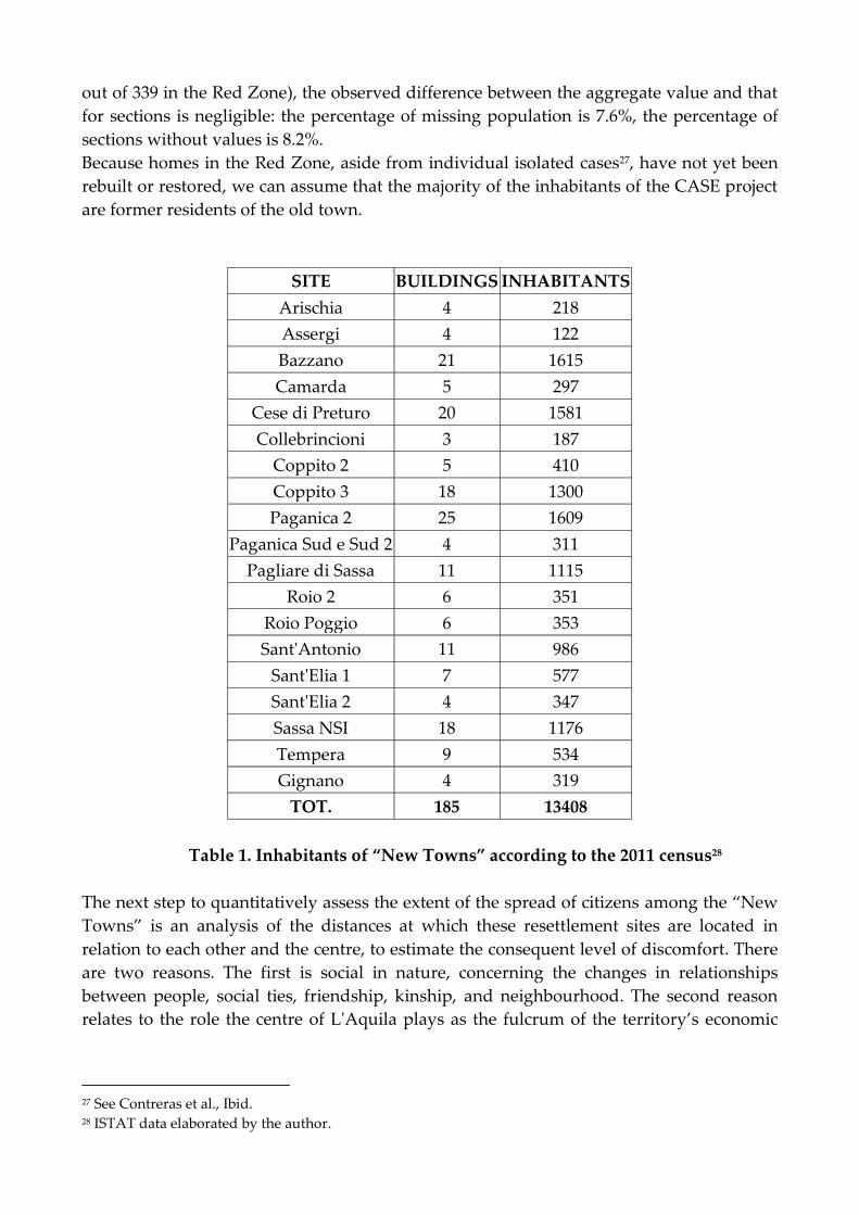
out of 339 in the Red Zone), the observed difference between the aggregate value and that
for sections is negligible: the percentage of missing population is 7.6%, the percentage of
sections without values is 8.2%.
Because homes in the Red Zone, aside from individual isolated cases27, have not yet been
rebuilt or restored, we can assume that the majority of the inhabitants of the CASE project
are former residents of the old town.
SITE BUILDINGS INHABITANTS
Arischia 4 218
Assergi 4 122
Bazzano 21 1615
Camarda 5 297
Cese di Preturo 20 1581
Collebrincioni 3 187
Coppito 2 5 410
Coppito 3 18 1300
Paganica 2 25 1609
Paganica Sud e Sud 2 4 311
Pagliare di Sassa 11 1115
Roio 2 6 351
Roio Poggio 6 353
Sant'Antonio 11 986
Sant'Elia 1 7 577
Sant'Elia 2 4 347
Sassa NSI 18 1176
Tempera 9 534
Gignano 4 319
TOT. 185 13408
Table 1. Inhabitants of “New Towns” according to the 2011 census28
The next step to quantitatively assess the extent of the spread of citizens among the “New
Towns” is an analysis of the distances at which these resettlement sites are located in
relation to each other and the centre, to estimate the consequent level of discomfort. There
are two reasons. The first is social in nature, concerning the changes in relationships
between people, social ties, friendship, kinship, and neighbourhood. The second reason
relates to the role the centre of L'Aquila plays as the fulcrum of the territory’s economic
27 See Contreras et al., Ibid. 28 ISTAT data elaborated by the author.

activities, and lacking social fibre also damages the benefits of the economy of
agglomeration.
Cost-distance analysis method quantifies these distances, a calculation that consists in a
reducing the road graph of the province of L'Aquila to raster format and using IDRISI
software to trace the shortest paths. I have previously used this method for a similar
calculation in the study of the social consequences of the sanitation in the Oltretorrente
district of Parma, which returned enlightening results29. This method has been preferred to
network analysis because it is able to return meaningful results with a much lower
expenditure of resources. In fact, network analysis, which enables high-precision research
on the shortest paths and allocation of resources and services, requires thorough
preparatory work to assign to each single segment of a graph all the topological and
dimensional attributes, as well as the characteristics regarding feasibility, such as one-way
streets and prohibitions, and any obstacles. The precision of a topological database would
not have contributed greater value to the results, given the purpose of this work.
FIRST RESULTS OF THE GIS ANALISYS
Before the earthquake and the following resettlement, the inhabitants of L’Aquila’s city
centre lived in an area of approximately 1.65 square kilometres, easily walkable for a
resident, covering about 1.8 km along the length and 1.5 km in width. The whole road
network inside the historic city measures 55 km.
The resettlement has changed the orders of magnitude for areas and linear distances: the
perimeter of the “New Towns” includes 114 square kilometres. Distances have increased
from a few hundred meters until several kilometres: distance data are summarized in
tables 2 and 3.
Table 2 shows the distance of each “New Town” from the edge of the Red Zone (the city
centre). If the site of Sant’Antonio is still included in the urban area of L'Aquila and is only
1.86 km from the centre (see also Fig. 1), for the other sites the distances are still greater.
The average distance of a “durable” settlement from the city centre is 10.79 km, while the
site of Assergi is farthest away, at 18.6 km.
Table 3 shows the average, maximum, and minimum distance of each “New Town” to all
other sites. Their general average distance from each other is 12.26 km. Specifically, the
average distance from each site to all others varies from 9.33 km for Gignano to 19.91 km
for Assergi. Between the two sites most distant from each other, Assergi and Arischia,
there are 33.33 km.
29 Valent, Objetivos de control social en el saneamiento del barrio Oltretorrente de Parma, actas del XIII Coloquio
Internacional de Geocrìtica [http://www.ub.edu/geocrit/coloquio2014/Gian%20Maria%20Valent.pdf]

SITE
DISTANCE FROM
CITY CENTRE Km.
Assergi 18.60
Camarda 13.65
Arischia 13.60
Cese di Preturo 10.30
Pagliare di Sassa 8.61
Sassa NSI 8.44
Paganica Sud e Sud 2 8.02
Paganica 2 7.99
Tempera 7.92
Coppito 3 6.86
Collebrincioni 6.83
Coppito 2 5.91
Bazzano 5.03
Sant'Elia 1 4.35
Roio 2 3.53
Sant'Elia 2 3.11
Roio Poggio 2.91
Gignano 2.65
Sant'Antonio 1.86
Table 2: distance of the “New Towns” from the City Centre30
Figure 2. Graph of the data in table 231
30 Elaborated by the author. 31 Ibid.

SITE DISTANCE FROM OTHER
“New Towns” Km.
AV. MAX. MIN.
Assergi 19.91 33.33 6.09
Arischia 17.84 33.33 8.52
Camarda 15.24 28.39 5.99
Cese di Preturo 14.22 30.03 3.64
Collebrincioni 13.11 17.87 9.49
Pagliare di Sassa 12.15 27.33 2.90
Tempera 11.86 22.65 1.34
Coppito 3 11.74 26.59 1.13
Paganica 2 11.63 23.12 2.81
Roio Poggio 11.35 22.54 2.13
Paganica Sud e Sud 2 11.33 22.75 1.34
Roio 2 11.30 23.17 2.13
Sassa NSI 11.28 27.16 1.13
Coppito 2 11.26 25.64 1.56
Bazzano 10.17 21.82 1.86
Sant'Elia 1 10.12 21.14 0.90
Sant'Antonio 9.67 21.59 4.70
Sant'Elia 2 9.59 19.90 0.90
Gignano 9.33 17.83 1.55
Table 3: distances between the “New Towns”32
32 Ibid.

Fig. 3. Graph of the data in Table 333
Figure 3. Shortest paths from “New Towns” to the Red Zone34
33 Ibid.
0
5
10
15
20
25
30
35
Distances between the "New Towns" (Km)
MAX.DIST. AVERAGE DIST. MIN. DIST.

Figure 4. Shortest paths between the “New Towns”35
From these initial results, we can assert that the dispersion and fragmentation suffered by
citizens resettled in CASE project sites are considerable: the distances are certainly not
insurmountable but to go from one “New Town” to another, or to the reopened areas of
the city centre, is essential to have access to adequate means of transport and also have the
required time. Such a situation greatly obstructs the maintenance of social relations and
limits the capacity of the resettled citizens to act as a civic community.
A significant part of the forthcoming field work will be dedicated to understanding the
ongoing implications of these new spatial relationships for the citizens.
EXPECTED RESULTS
One result that I aim for this research to achieve is demonstrating that the forces and
concepts involved in the genesis of new urban forms in the wider world also extend to the
scale of medium-sized cities and provincial capitals. The wide spreading in local field of
the global models of urban and territorial policies is enacted by practices that tend not so
much to break, but rather to overcome the law, in compliance with the priorities of
efficiency and speed in decision and action. I define these practices as "meta-legal" because
they go beyond current legislation without contravening it, through the extensive use of
34 Ibid. 35 Ibid.
governmental commissioners, exemptions, and special powers. The Italian government
has used the meta-legal practises in L’Aquila to de facto overcome law through
bureaucracy and exceptions, operating as if it were invested of a sovereign power36.
The apparent oxymoron of "permanent state of exception" proposed by Giorgio Agamben
can frame the situation in a solid theoretical framework:
The creation of a permanent state of exception (even if it is not officially
declared) has become one of the essential tasks of the modern state. This
includes states who declare themselves to be democracies. In this sense the state
of exception tends today to present itself as the dominant paradigm of
government in contemporary politics.37
Secondly, spatial and demographic analysis will quantitatively define the fragmentation of
the civic body, allowing me to draw conclusions about the effects of this fragmentation on
the abilities of the citizens to take decisions and make plans. More than this, I can theorize
how a fragmented citizenry can think and act as a collective subject. I aim to assess how
the organization and location of resettlement sites for the displaced persons, from
temporary tent camps to the “New Towns”, has influenced their identity as citizens, their
ability to control the actions of power and their ability of proposal and self-organization.
Finally, I will analyse the most experimental feature of emergency management in
L’Aquila: instruments never seen before in the Italian Republic for short and long term
coercive population control. The experiences inferred from this after-earthquake can
provide a precise model to replicate these meta-legal practices in different situations
where the emergency nature, whether or not caused by catastrophic events, can be
specifically created and imposed on the people for diverse reasons. These excuses can
include, for example, the construction of strategic or military sites, the organization of
mega-events or major government works, bypassing both local authorities and democratic
control by the citizens.
36 Concept developed by Carl Schmitt, Politische Theoligie, Munchen 1922. 37
Agamben Lecture at European Graduate School, Aug. 2003.
SOURCES
Municipality of L’Aquila http://www.comune.laquila.it/pagina7_la-storia.html
Department of Civil Protection
Earthquake in Abruzzo 2009
http://www.protezionecivile.gov.it/jcms/it/emergenza_abruzzo.wp
Il metodo Augustus, Roma 2003
ISTAT
Territorial Bases and census variables
http://www.istat.it/it/archivio/104317
2011 Census
http://www.istat.it/it/censimento-popolazione/popolazione-2011
2001 Census
http://www.istat.it/it/censimento-popolazione/popolazione-2001
Abruzzo Region
Geoportale http://www.regione.abruzzo.it/xcartografia/
BIBLIOGRAPHY
Capel H. “El debate sobre la construcciòn de la ciudad y el llamado ‘Modelo Barcelona.’”
Scripta Nova VOL. XI, n° 233, 15 febrero 2007 <http://www.ub.edu/geocrit/sn/sn-233.htm>
Castells, M. La question urbaine. Paris, Maspero, 1972.
Clerval, A. “The Spatial Dynamics of Gentrification in Paris: A Synthesis Map.” Cybergeo:
European Journal of Geography [En ligne], Espace, Société, Territoire, document 553
Contreras D. et al., “Myths and Realities About the Recovery of L'Aquila After the
Earthquake.” International Journal of Disaster Risk Reduction 8, June 2014: 125-142
Florida, R. The Rise of the Creative Class. NY, Basic Books, 2004

Harvey D. The Urban Experience. Baltimore, Johns Hopkins, 1989
Harvey, D. The Condition of Postmodernity. Oxford, Blackwell, 1990.
Harvey, D. Il capitalismo contro il diritto alla città. Verona, Ombre corte, 2012.
Kratke, S. “The New Urban Growth Ideology of ‘Creative Cities.’” In Brenner, Marcuse
and Mayer, eds. Cities for People, Not For Profit. New York: Routledge, 2012
Le Galés P. European Cities: Social Conflict and Governance. NY, Oxford University press,
2002.
Marcuse, P. “Abandonment, gentrification and displacement: the linkages in N.Y.C.” In N.
Smith and P. Williams, eds. Gentrification of the city. Boston, Allen & Unwin, 1986.
Marcuse, P. “Whose Right(s) to What City?” In Marcuse, Brenner, and Mayer, eds. Cities
for People, not for Profit. New York: Routledge, 2012.
Salzano E., Baioni M., and Boniburini I. La città non è solo un affare. Reggio Emilia: Aemilia
University Press, 2012.
Sassen S. Cities in a World Economy. SAGE, 2012.
Smith, N. New Globalism, New Urbanism: Gentrification as a Global Urban Strategy. Antipode
vol. 34, issue 3, July 2002: 427-450. doi: 10.1111/1467-8330.00249
Smith, N. The new urban frontier. London, Routledge, 1996.