Direct and Indirect Impacts of Globalization on Vernacular Architecture; A Dystopian Script Over...
14
DIRECT AND INDIRECT IMPACTS OF GLOBALIZATION ON VERNACULAR ARCHITECTURE; A DYSTOPIAN SCRIPT OVER KOCAELI / GÖLCÜK T. Gül Köksal Kocaeli University, Faculty of Architecture and Design, Department of Architecture [email protected] Emre Kishalı Kocaeli University, Faculty of Architecture and Design, Department of Architecture [email protected] Burcu Selcen Coşkun Mimar Sinan Fine Arts University, Faculty of Architecture, Department of Architecture [email protected] Abstract Globalisation whose effects constantly increase all over the world causes not only monotyped, similar-looking cities but also forces rural areas to get integrated with the urban centres in their surroundings. Turkey is a country, too, which is influenced by this process which the global world has been exposed to. However, these effects has recently become more accelerated and won a more complicated dimension due to the latest legislative regulations such as Act on Disaster Prevention (no. 6306) and Act on Integration of Local Government. In this paper, possible impacts of the abovementioned developments which directly or indirectly affect Gölcük/Kocaeli will be evaluated. Keywords: Globalization, legislative regulations, Turkey / Kocaeli / Gölcük, a Dystopian Script, anti-capitalist approach 1. INTRODUCTION Globalisation whose effects constantly increase all over the world causes not only monotyped, similar-looking cities but also forces rural areas to get integrated with the urban centres in their surroundings. The first steps in the blurring of the sharp distinction between rural and urban areas can be counted as the weakening of the earthbound production and the migration from rural areas to cities driven by the impacts of Industrial Revolution. Neoliberal policies which are later in 21st century named as the “global crisis” show that urbanization plays an important role in the process of absorbing surplus capital and this occurs in a more growing geographical scale. Turkey is a country, too, which is influenced by this process which the global world has been exposed to. However, these effects has recently become more accelerated and won a more complicated dimension due to the latest legislative regulations such as Act on Disaster Prevention (no. 6306) and Act on Integration of Local Government. Although Act No. 6306 - inured in 2012 – anticipates that the practices in areas controlled by Cultural and Natural Heritage Conservation Act (1983-no. 2863) should be realized by taking the approval of the Ministry of Culture and Tourism on protected areas, the act still allows the Ministry of Environment and Urbanism to authorize these practices. Moreover, Act on the Integration of Local Government (2013 – no.6360) states that rural areas should be accepted as new neighbourhoods using the existing administrative system of the closest city in the area. Following Istanbul and Kocaeli which were accepted as Integrated Metropolitan City Area in 2004, 30 more cities have been included into this
-
Upload
independent -
Category
Documents
-
view
2 -
download
0
Transcript of Direct and Indirect Impacts of Globalization on Vernacular Architecture; A Dystopian Script Over...

DIRECT AND INDIRECT IMPACTS OF GLOBALIZATION ON VERNACULAR ARCHITECTURE; A DYSTOPIAN SCRIPT OVER KOCAELI / GÖLCÜK
T. Gül Köksal Kocaeli University, Faculty of Architecture and Design, Department of Architecture [email protected] Emre Kishalı Kocaeli University, Faculty of Architecture and Design, Department of Architecture [email protected] Burcu Selcen Coşkun Mimar Sinan Fine Arts University, Faculty of Architecture, Department of Architecture [email protected]
Abstract Globalisation whose effects constantly increase all over the world causes not only monotyped, similar-looking cities but also forces rural areas to get integrated with the urban centres in their surroundings. Turkey is a country, too, which is influenced by this process which the global world has been exposed to. However, these effects has recently become more accelerated and won a more complicated dimension due to the latest legislative regulations such as Act on Disaster Prevention (no. 6306) and Act on Integration of Local Government. In this paper, possible impacts of the abovementioned developments which directly or indirectly affect Gölcük/Kocaeli will be evaluated.
Keywords: Globalization, legislative regulations, Turkey / Kocaeli / Gölcük, a Dystopian Script, anti-capitalist approach
1. INTRODUCTION Globalisation whose effects constantly increase all over the world causes not only monotyped, similar-looking cities but also forces rural areas to get integrated with the urban centres in their surroundings. The first steps in the blurring of the sharp distinction between rural and urban areas can be counted as the weakening of the earthbound production and the migration from rural areas to cities driven by the impacts of Industrial Revolution. Neoliberal policies which are later in 21st century named as the “g lobal crisis” show that urbanization plays an important role in the process of absorbing surplus capital and this occurs in a more growing geographical scale.
Turkey is a country, too, which is influenced by this process which the global world has been exposed to. However, these effects has recently become more accelerated and won a more complicated dimension due to the latest legislative regulations such as Act on Disaster Prevention (no. 6306) and Act on Integration of Local Government. Although Act No. 6306 - inured in 2012 – anticipates that the practices in areas controlled by Cultural and Natural Heritage Conservation Act (1983-no. 2863) should be realized by taking the approval of the Ministry of Culture and Tourism on protected areas, the act still allows the Ministry of Environment and Urbanism to authorize these practices. Moreover, Act on the Integration of Local Government (2013 – no.6360) states that rural areas should be accepted as new neighbourhoods using the existing administrative system of the closest city in the area. Following Istanbul and Kocaeli which were accepted as Integrated Metropolitan City Area in 2004, 30 more cities have been included into this

system in the scope of this act. Special provincial administration units serving these rural areas have been cancelled and services regarding the rural activities have been transferred to Metropolitan Municipalities or District Municipalities.
In this paper, possible impacts of the abovementioned developments which directly or indirectly affect Gölcük-Kocaeli will be evaluated. Throughout the province of Kocaeli, Gölcük has an important potential of natural and cultural assets with seashores, natural tissue in rural areas and historical conglomeration. Kocaeli lived a severe earthquake of 7.5 magnitudes that struck North-western Turkey on August 17th 1999. After the earthquake, settlement areas were carried to the south of city, to the slopes of Samanlı Mountains due to better load – bearing soil conditions. Twelve years after this earthquake detailed field surveys have been carried out under the project which was supported by the stakeholders of Gölcük 2023 Vision, Gölcük Municipality, Gölcük City Council and Kocaeli University (URL1). In the field survey, it is noticed that vernacular architecture cases are exposed to the risks such as pressure by post disaster permanent housings, construction activities, unplanned urbanization/industrialization, etc. Due to the act no. 6306 and act No. 6360 the existing rural texture and agricultural production areas have been considered as potential construction and settlement areas. In the website of Gölcük Municipality, some projects such as Gölcük Urban Transformation Project, production and construction of mass housings and alternative transportation projects have been announced as future projects and it shows that these impacts will probably be more serious. It is obvious that the case of Gölcük have both local/national and global dimensions and is directly related with political economy. In conclusion, it is possible to state that vernacular architecture can be re-evaluated with an anti-capitalist approach and practice. 2. APPROACHES TO RURAL AND URBAN SETTLEMENTS & ENVIRONMENT Although the rate of blurring of the sharp distinction between rural and urban areas occurred in different values, it has been developed by forming a series of spaces based on permeable relations in many regions. This process leads to rapid urbanisation of areas and abandonment of rural regions by the effects of global economic – politic systems. Hence “The report of World Urbanization Prospects 2014” published by UN Economic and Social Council states that 54 % of World population now lives in cities; this number is expected to be 66 % in 2050 (URL2). It is also emphasized that Africa and Asia – home nearly 90 % of world rural population – will become urbanized fast consequently infrastructure, education and health problems will emerge. The researchers, working on these threats nationally and internationally, pursued various researches and prepared publications. Among these publications, a prominent one - titled as “Discussions on Rural Planning 1999-2009”- indicates mainly the development of rural areas in Turkey comparing with other examples in World. Editor of the book, Öğdül summarizes the changes influencing the future of rural areas in Turkey as following; “the policies named as reorganization in agriculture, global effects and the decisions of World Trade Organization affects agricultural activities negatively. Similarly, European Union (EU) accession process affects agricultural products. There is revenue loss, poverty and loss of population in rural areas, these areas become urbanised rapidly” (Öğdül, 2010). The register of population in Turkey also indicates the aforementioned process. For example in 1950s 75% of Turkey population and in 1980s %56 of the population lives in rural areas, whereas in 2000, 35% of population and in 2006, 27% of it lives in rural regions (İyimaya, 2010). This situation indicates that the number of inhabitants in rural areas has been decreasing in other words there is no life in these areas. On the other hand, considering the decrease in population and agricultural activities, the government is trying to overcome the problems by development programmes and EU harmonization process. As Tartıcı from State Planning Organization declares that “the number of agricultural enterprises had been decreased by 25 % in 1991 - 2001 (Approximately 1 million enterprises). Structural problems of agriculture, affects level of income and life quality of rural areas. Natural sources and rural environment - main assets of rural areas – are exposed to various environmental risks” (Tartıcı, 2010). Tartıcı elucidates his final statement as following: “There is an inadequacy of infrastructure to mitigate environmental impacts of rapid urbanisation, industrialization and developing tourism activities. Besides, over and unconscious use of soil, water, forest and pasture lead to decrease resources and to lose its value. As for erosion, it is another important issue in Turkey, threatens the 60% of agricultural areas in Turkey” (Tartıcı, 2010). It is considered that

these problems can be solved by the harmonization with EU rural programmes (Tartıcı, 2010). However, the state does not pursue the scientific studies showing that international agreements at rural areas do more harm than good to local areas especially the cases in Turkey. For example as Arıkanlı and Şen states multilateral agreements and initiatives like EU common agricultural policy not only disorder internal agricultural balance of the countries but also cause thousands of people to live in starvation (Arıkanlı and Şen, 2010). Because, the main objectives of globalisation is to standardize countries, to use the sources in favour of the strong; it is not to maintain balances among various countries. Moreover international initiatives may cause existing sources to be consumed without developing national and local policies. When the Turkey case is observed, agricultural policies are in distressed condition, since they are under international pressure besides national policies are not developed for the public weal. 1980s was the liberalisation period in which agricultural policies became distanced from the commonweal (Akder, 2010). This period is an important one which causes the country not able to be self-sufficient today in terms of agricultural production. However, the experts defend that this process even at this stage can be reversed by the proposals and pilot studies related to participatory approaches in rural development and rural planning. 3. APPROACHES TO RURAL AND URBAN DEVELOPMENT IN TURKEY & LEGAL FRAMEWORK It is observed that after 2000 some new laws have been introduced regarding the regulations of rural settlements with vernacular features in Turkey. One of the most important and effective of these is the Act on Disaster Prevention (no. 6306). Act No. 6306 - inured in 2012 – anticipates that the practices in areas controlled by Cultural and Natural Heritage Conservation Act (1983-no. 2863) should be realized by taking the approval of the Ministry of Culture and Tourism on protected areas. Nevertheless, the act st ill allows the Ministry of Environment and Urbanism to authorize these practices. This act supports theoretically the renewal projects of the urban space and individual buildings. State-led urban renewal projects target the cities with dense populations which can get severely affected by an earthquake of the first level. In this scope, cities that are in the first degree earthquake region like Istanbul, Kocaeli, Bursa and İzmir are prior on the list of the government and have already been subject to the realization of the urban renewal projects earlier than others. What has aimed with the new regulations is primarily the renewal of the buildings under risk on the potentially disaster areas determined by the government. There will be cooperation with Turkish governmental institution called “Social Housing Administration” (TOKI) as has also been declared in the law. There are no exceptional circumstances regarding the conservation areas which are on planned urban renewal areas. However, the law points out, that urban renewals are applicable according to the approval of the Ministry of Culture & Tourism. Istanbul where there are many cultural assets and protected sites is a good example for this article. The negative criticism regarding the Act major mostly on the fact that the law is being applied without observing the rights of the individuals. It gives way to a state-led economic rent and disregards the social dimension which regulations for disaster areas should possess. The inhabitants and workplaces of the disaster areas are supposed to move out to other safe areas of the city. This may lead to the disappearance of the social texture there. It seems that by setting principals for renewals and rehabilitations this act can easily give way to new planning decisions on disaster areas which may negatively affect the cultural heritage values of the rural settlements. It is understood that with necessary approvals given by the responsible governing bodies’ laws concerning the coasts, forests and cultivated lands shall be unfunctional. This will probably cause in the future more problematic practices for even natural, urban and archaeological protected areas. Lately in 2013, another new law called “Act on the Integration of Local Government” (no. 6360) which directly affects the rural settlements has been endorsed. Before 2013, the borders of greater municipalities were extended to 50 km. in 2004 and later in 2009 some district and county municipalities were cancelled. These actions created deep affects and changed the economic, social and political balances of cities. The Act No. 6360 has started to be in force after the local authority elections in March 2014 and since then caused the rural settlements become neighbourhoods attached to the big cities that they are close to. Following Istanbul and Kocaeli which were accepted as Integrated Metropolitan City Area in 2004, 30 more cities have been included into this system in the scope of this act. Special provincial administration units serving these rural areas have been cancelled and services regarding
the rural activities have been transferred to Metropolitan Municipalities or District Municipalities. This means the legally registration of the rural areas to the urban settlement which they are a periphery of. Thus, the borders of the 30 cities among which there are big cities like Kocaeli, Istanbul and Bursa, become the border of the municipality of settlements of all scales. The existing villages have turned into districts of metropolitan cities. The urban population in Turkey has risen to %90 of the total population whereas it used to be %77 in 2012 before this Act was inured. Moreover, the content of the service given to villages by their previous minor authorities has changed. There is no distinction between the rural and the urban any more. This act has and will certainly have some important social and economic effects. Before the law, special provincial administration system which worked as the institution organized for the countryside as a branch of the central administration system used to bring service to the rural settlements. In this regard, the new regulations may cause the weakening of the rural’s existence. The rural will no more be socially equal to the urban land. It will continue its own problems. These problems will probably get deeper as the rural disappears and the local authorities who are more capable of managing the urban gain more power and responsibility. On the other hand, this law will have some economic effects, as well. In the rural areas the social structure is about to dissolve due to the constant increase of immigration from villages to big cities. The working class and young generations move to metropolitan areas, the rural becomes aged, unable to continue the existing production and gets poorer by time. Controlled by a more ruling economical system which is more based on urbanism than production, the effects of agricultural policies have weakened after 2002. The rural areas get effected by this reality directly (Tekeli, 2013 and Yaşar, 2014). The villages of Gölcük have become districts of Kocaeli centre with a statement in the latest law as “The villages within the borders of Kocaeli are administratively controlled by the municipality of the town which they are a part of”. This has a negative effect on both the rural lifestyle and the continuity and the preservation of the vernacular architecture that forms the texture of these villages. The changes can easily be observed from the results of the research on these villages and the publication of this research which was supported by Kocaeli Municipality (Köksal, 2013). In February 2012 another new constitutional principle adopted for the cultural heritage on earthquake regions of Turkey has been accepted. It was written by the High Council of Conservation which reports to Ministry of Culture and Tourism. This principle aims to establish the guidelines for the implementations on the areas where there are listed immovable or conservation sites affected by the hazards of an earthquake. It has also impacts on buildings on the interaction-transition zones of the conservation areas. Thus, it concerns the way rural architectural heritage is intervened. Briefly, the constitutional principle explains that severely damaged buildings due to earthquakes should be evacuated with the decisions and help of the governing body of the town (whether the municipality or governorship) and that after examining all the documents and reports of the damaged cultural heritage building, the Regional Conservation Offices (that are administratively connected to the High Council of Conservation) can decide their demolishment and even furthermore the cancellation of their official registry. It is a controversial issue that instead of a more conservation-oriented approach, the council carries the withdrawal of these traditional historic buildings or sites to the agenda and creates an unwanted atmosphere against conservation among the community. It is well proven also scientifically that these traditional construction techniques could survive many earthquakes and being damaged at a severe earthquake should not mean for a cultural heritage building that all its heritage values disappear. Decisions like demolishing damaged historic structures instead of repair and cancellations of their registrations afterwards by simple reports asserting that they are not sound, may easily lead to new constructions. These may result in the loss of heritage values, architectural and intangible, related with the historic settlements where once stood traditional buildings. Thus, it is suggested that the new principle on the interventions to the historic buildings/sites which are damaged due to the hazards of earthquakes should be reviewed once again and re-evaluated. As a matter of fact, after the entry of this principle into force, the governorship released a list about the damaged buildings in the villages of

Gölcük, Kocaeli which were bound to be demolished including some traditional listed (civil) buildings, although some have been observed to be quite sound (Köksal, 2013). National Development Plans (NDP) - engaged in planning of rural areas in Turkey - have been among the major tasks of the State Planning Office/Institution since 1963 until 2011. In 2011 the Ministry of Development was established and since then this mission was taken over. However, another ministry in Turkey which is engaged in rural settlements is the Ministry of Food, Agriculture and Livestock. Rural Development Department is an agency of the Directorate of Agricultural Reform that is tied to this ministry. Among the missions of the Rural Development Department are the rehabilitation of the level of life quality and economic diversity, making up new programmes for the establishment of the local development capacity, the implementations and the follow-ups of these programmes (URL3). The attitude of Rural Development Department for the reproduction of rural areas and its works reflecting this approach have lately been introduced in some publications. There have been some commissioned studies for constructing a model and inventory studies conducted by academicians from different Turkish universities for areas like Kayseri and Balıkesir Rural. However, these seem to reflect rather a more selective point of view than a holistic one. In the conclusion parts they suggest some model projects for these settlements. The Rural Development Department has an organic relationship with another governmental institution “Social Housing Administration” (TOKI). TOKI has lately announced its target as to constitute a design office under its administration and to produce projects appropriate for “Ottoman-Seljuk architecture and examples of traditional architecture overall in Turkey which quite seem as a historicist approach (URL 4). Another project which may affect the architectural formation of the rural areas indirectly is an architectural project competition under the title “7 Climates / 7 Regions- Setting the features and Reproducing the Traditional Texture and Architecture in Rural Areas” (URL5). Ministry of Environment and Urbanism wanted to organize this competition in collaboration with the Turkish Chamber of Architects at the end of 2012. Soon after this proposal was strongly criticized by the Turkish Chamber of Architects and Turkish Freelance Architects Foundation, the two very important institutions that gather architects together as their occupational institution. Both warned their members not to take part in this competition stating that its content contains severe sensitivities regarding rural settlements and architectural features of these areas. 4. CASE STUDY: GÖLCÜK – KOCAELİ 4.1. Brief History of Gölcük - Kocaeli Gölcük, is a town of Kocaeli Province, surrounded by Sea of Marmara on the north, Samanlı Mountains to the south, Karamürsel to the west, Başiskele to the east. Throughout the province of Kocaeli, Gölcük has an important potential of natural cultural assets with seashores, natural tissue in rural areas and historical conglomeration of the town. At the beginning of 6th century BC, Astakos was founded 6 km southeast to the current Izmit city center; nowadays the ancient city is located between the districts of Başiskele and Gölcük. The area was felt under domination by Phrygia, Lidia, Achaemenid Empire until Bthyinia Empire (297 – 274 BC) which was established by Bithyns, a branch of Thracians. Roman Empire Diocletian invaded Nicomedia in 284 and made the city capital of Roman Empire. In this period, the city became the fourth biggest city after Rome, Antioch and Alexandria in the world. Although Nicomedia - the capital city of Roman Empire - of which the traces can be seen in a limited way in modern Kocaeli, the area has deep and ancient history. Between 7th and 9th century, the area was attacked by Arabs then it was governed by Byzantine Empire until 1326 when Ottoman Empire conquered the region. In 19th century Georgian, Abkhasians and Mohti immigrants from Georgia settled down in the rural areas of today’s Gölcük. In 1927, navy yard was established and it started to shape the current Gölcük city. In 1936, the center of settlements was accepted as the county town and connected to the province of Kocaeli (Galitekin, 2005). The city has started to spread around area where the navy yard was built in east – west direction on coastal plain. On 17 August 1999 a

devastating earthquake with the magnitude of 7.5 (Mw) occurred at 03:02 a.m (local time) which struck north-eastern Marmara Region. The epicenter is latitude 40,76N and longitude 29,95E in Gölcük (Kandilli Observatory and Earthquake Research Institute). The earthquake affected city centers of Gölcük, Körfez, İzmit, Sapanca, Adapazari, Avcılar (Istanbul), Düzce and many residential buildings, industrial structures, highways and railways were destroyed or damaged. 4.2. Research on Vernacular Architecture of Gölcük In 2011 – 2012, a project titled as “The Inventory of Architectural Heritage of Gölcük, Problems and Tangible Proposals for Its Conservation” supported by the stakeholders of Gölcük 2023 Vision, Gölcük Municipality and University of Kocaeli, was performed in the area. 420 non – listed and 70 listed buildings were identified by using the inventory forms - developed during Türkiye Bilimler Akademesi - Türkiye Kültür Sektörü (TUBA – TÜKSEK) (Turkish Academy of Sciences and Turkish Cultural Sectors) Urban Cultural Assets projects - also called European Union Conservation of Natural and Cultural Assets Survey forms. During the project, Act on Integration of Local Government was not in force therefore villages and neighbourhoods were counted as separate settlement units. There are twenty villages and thirty neighbourhoods in Gölcük and every street with existing buildings including historical ones were visited to reveal architectural heritage which belongs to area. The main goal of the project is to raise awareness of architectural and archaeological heritage for the people who are living in rural and urban part of city and to integrate the sustainability of buildings and archaeological assets with the technology under Gölcük 2023 Vision Projects. Besides, civil architecture examples, constructed in the late 19th century or early 20th century and visible archaeological features in the city of Gölcük were determined by direct investigations. According to the research, 490 architectural and cultural assets were identified in urban and rural areas of Gölcük. Traditional buildings were encountered in all rural settlements of Gölcük except the villages of Panayır and Ferhadiye. In the urban part of Gölcük, buildings constructed with traditional techniques were found only in the neighbourhoods of Cumhuriyet, Yalı and Yukarı (Değirmendere); Kavaklı and Şehitler (Gölcük); Körfez (Halıdere); Merkez (Hisareyn); Merkez (İhsaniye), Yalı and Yavuz Sultan Selim (Ulaşlı). Most of the neighbourhoods do not include these cultural assets due to fact that they were established just after the earthquake or traditional buildings have not been conserved. Furthermore, twenty two other cultural visible assets including mosques and türbe (mausoleum), mills, archaeological remains, Roman grave monument, hammam, roman hot spring, two listed plane tree and a caravanserai were determined in the area (Köksal and Kishalı, 2012), (Köksal 2013).
4.3. Conservation Problems of Vernacular Architecture of Gölcük Traditional buildings of Gölcük encountered serious problems such as industrialization, unplanned urbanism, natural disasters and unconscious conservation activities. These buildings and their conservation issues should be examined thoroughly with the context of region and its development. At the end of 1940s, industrial facilities were concentrated along Marmara Sea and Golden Horn in Istanbul whereas after 30 – 40 years the industry in this region was moved to Gulf of Izmit. Between the years of 1960 – 76, Kocaeli - especially İzmit and regions along the gulf- is exposed to severe and rapid structural changes, thus existing agricultural structure is turned into industrial one in an uncontrolled way. In 1927 Gölcük Navy Yard helped to enlarge the town, in 2001 Gölcük Ford Automobile Factory, Hayat Detergent Factory and Kocaeli Free Trade Zone (KOSBAŞ) in the northeast of Gölcük – border of Başiskele - were established. Therefore, new residential buildings and factories have been constructed besides a high number of industrial plants are located however the agricultural and cultivated areas were completely transformed into urban areas. This physical change influences deeply the rural life which has organic relationship with physical environment. The urban growth causes de facto and unqualified reinforced concrete buildings to influence the traditional tissue. In turn, traditional buildings became abandoned in the settlements close to concentrated industrial zone and very limited numbers of civil architecture examples were identified. On the other hand, the regular maintenance of vernacular architecture examples and not performing any repair may create an important conservation problem thus the buildings can be abandoned. Moreover, it is realized that the consequences of especially 17 August 1999 earthquake influenced the whole rural spatial tissue. The earthquake caused the village to be surrounded by city
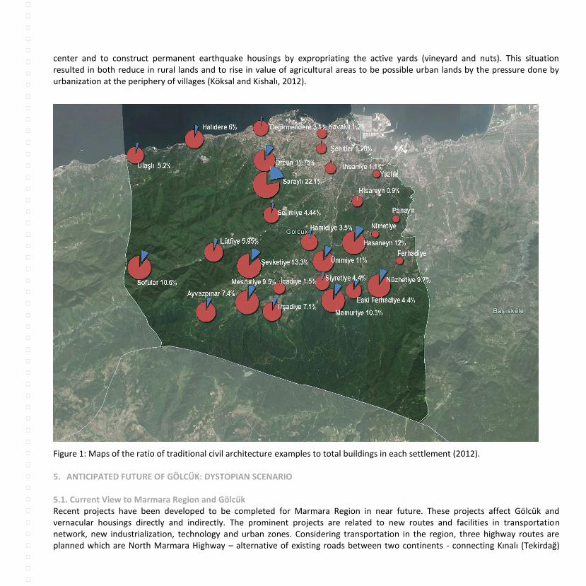
center and to construct permanent earthquake housings by expropriating the active yards (vineyard and nuts). This situation resulted in both reduce in rural lands and to rise in value of agricultural areas to be possible urban lands by the pressure done by urbanization at the periphery of villages (Köksal and Kishalı, 2012).
Figure 1: Maps of the ratio of traditional civil architecture examples to total buildings in each settlement (2012). 5. ANTICIPATED FUTURE OF GÖLCÜK: DYSTOPIAN SCENARIO 5.1. Current View to Marmara Region and Gölcük Recent projects have been developed to be completed for Marmara Region in near future. These projects affect Gölcük and vernacular housings directly and indirectly. The prominent projects are related to new routes and facilities in transportation network, new industrialization, technology and urban zones. Considering transportation in the region, three highway routes are planned which are North Marmara Highway – alternative of existing roads between two continents - connecting Kınalı (Tekirdağ)

and Akyası (Sakarya) via third bridge; new highway between İstanbul and İzmir via İzmit Gulf Bridge over Gebze and Hersek (Kocaeli) and South Marmara Highway connecting Köseköy and new İstanbul – İzmir Highway passing through the rural part of Gölcük. (URL6), (URL7). Besides, first private logistic site on 0.8 million m
2 in Köseköy is constructed which will be linked to South Marmara
Highway. It is aimed that the facilities serve to all Marmara Region and organize the logistics activities of foreign trade (URL8), (Karadeniz and Akpınar, 2011). Moreover, High-speed railway has been recently completed between Ankara and Istanbul then it will be connected to Marmaray Project via suburban line being under construction currently. The construction of third airport project of Istanbul has been recently started on the northwest of İstanbul. The airport - located on the area of 7.6 million m
2 - is surrounded by İhsaniye village on south, Tayakadın village on west, Yeniköy village and Black Sea on
north and Akpınar village on east (URL9), (URL10). Besides, within the scope of Act on Disaster Prevention new safe settlement areas are designed; two new cities in Kemerburgaz and Tuzla, located in European and Anatolian site respectively are planned to be erected. It is planned that 1.5 million people will reside in these so-called green cities including new airport of Istanbul (URL 8), (ULR 9). On the other hand, new hospital project with the capacity 4100 beds in Sancaktepe, Muallimköy Technology Development Zone in Gebze, Central Business District (MIA) in İzmit, Marmara Port Free City between Karamürsel and Yalova and Istanbul Finance Center are important public work activities which are projected or started in various areas of East Marmara Region (ULR 13), (URL 14), (URL 15), (URL 16) (Figure 2). Considering previous urbanization experiences, there is an interwoven relationship between highway transportation systems, new settlements including residential, commercial, industrial ones and threats to green areas in East Marmara Region. This statement can be supported by the aerial images taken from Google focusing on the areas where third bridge and airport are being constructed. Besides, the settlements around ring road were developed very fast after the constructions of highway and second bridge. For example the area and its surroundings for new Finance Center between Ataşehir and Ümraniye have been exposed to construction activities since the beginning of 2000 (Figure 3). The distribution of settlements in Gölcük has been changed dramatically after 1999 earthquake. Besides, new industrial facilities placed near shoreline in turn more demand of dwellings and constructions has been developed. The current view of Gölcük considering the previous statement is presented in Figure 4. Taking into account aforementioned projects which are either started or about to start, southeast settlements of İzmit Gulf would have more traffic by the new transportation routes; industrial and population load would probably increase via new zones being planned for the area. Strengthening and development of east – west axis over İstanbul and Kocaeli by the aforesaid transportation routes will take place on the other hand it will be linked vigorously to southeast Marmara region via İzmit Bay Bridge and South Marmara Highway. Therefore, the district of Gölcük will not only be changed in the future but also become a transit region pressed by various and new transportation routes, development zones and seismic actions which can be occurred at any moment. Considering traditional buildings, they are faced with aforementioned problems stated in part 4.3 besides within the scope of Disaster Prevention Law, some buildings will be destroyed by Governorship of Kocaeli and some of these buildings are traditional ones were recorded under the research project pursued in 2011 – 2012 (URL17).

Figure 2: Existing transportation network and new projects of İstanbul and Kocaeli regions.
Figure 3: The destruction of forests while the construction of third bridge (left), change in urban fabric close to new finance center area with O4 ring road.

Figure 4: Existing settlements, transportation route and industrial facilities of Gölcük
5.2. Dystopian Scenario and Vernacular Architecture The presented dystopian scenario for the area is based on potential developments of Gölcük considering seismic activities, industrialization and urbanization tendency with new transportation routes, new settlement and development zones. Moreover, economic and transportation initiatives emphasize the demographic changes indicating a shift of density to the southeast of Marmara region. Considering the past experience of region in terms of urbanization, conservation and post – earthquake policies, new construction projects would envisage the future Gölcük and its architectural heritage. According to the analysis, new settlements would probably emerge around new Southern Marmara Highway and this can be supported by the post –earthquake settlements in Figure 4. After the earthquake, new dwellings were erected inner side of Gölcük to provide safe soil conditions. Furthermore, medium damaged but being in use housings were identified after 1999 earthquake. In 2012, Kocaeli Governorship has identified the medium damaged building after the previous surveys. According to that, 681 buildings are supposed to be demolished
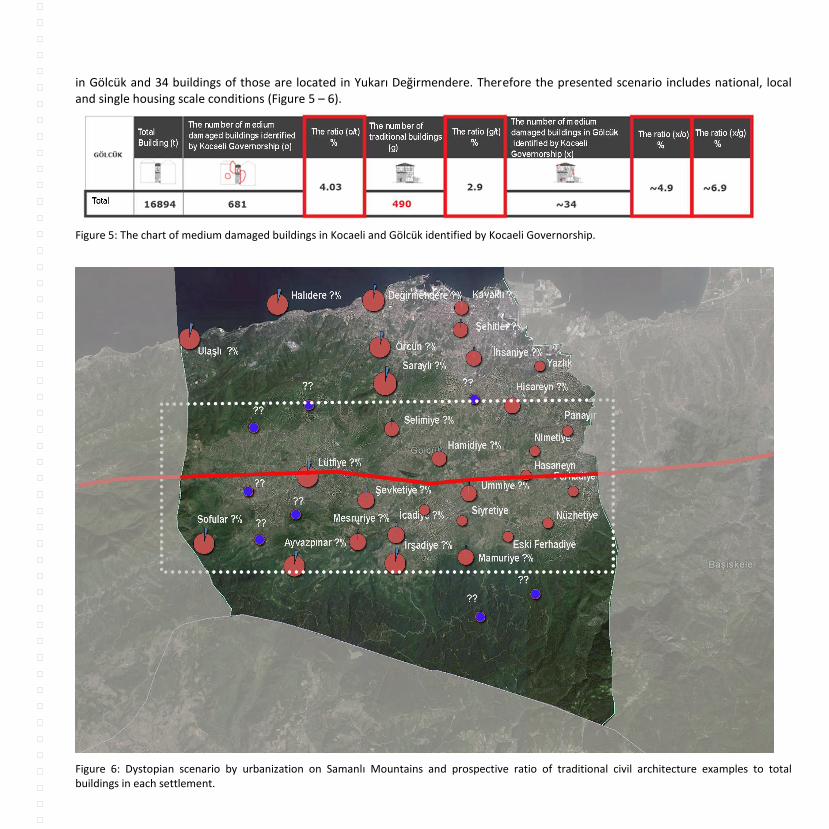
in Gölcük and 34 buildings of those are located in Yukarı Değirmendere. Therefore the presented scenario includes national, local and single housing scale conditions (Figure 5 – 6).
Figure 5: The chart of medium damaged buildings in Kocaeli and Gölcük identified by Kocaeli Governorship.
Figure 6: Dystopian scenario by urbanization on Samanlı Mountains and prospective ratio of traditional civil architecture examples to total buildings in each settlement.

CONCLUSION Rural Development Department in Ministry of Food, Agriculture and Livestock is an agency of the Directorate of Agricultural Reform. The essential missions of the Rural Development Department are the upgrading level of life quality and economic diversity, developing programmes for the local development capacity and implementing these projects. However, the perception of Rural Development Department should be modelling and planning the rural areas; the government may harm the areas by its large-scaled national projects. Moreover, the recent developments and changes in the legal framework (Act on Disaster Prevention (2012 - no. 6306) and Act on the Integration of Local Government (2013 – no.6360) displays that rural areas will be obviously transformed. For example, it is likely possible that the population inhabited in the villages migrate to cities considering the Act 6360 indicating that villages became the neighborhoods of big cities. As mentioned in earlier new constitutional principle was inured for the cultural heritage on earthquake regions. The constitutional principle explains that severely damaged buildings due to earthquakes should be evacuated. If the building is listed; examining all the documents and reports of the damaged cultural heritage building, the Regional Conservation Offices - administratively connected to the High Council of Conservation - can decide their demolishment and the cancellation of their official registry. Under the urban transformation process, Act no.6306 will influence primarily five big cities: İstanbul, Kocaeli, Sakarya, Bursa and İzmir which are located in earthquake prone zones. In Kocaeli, medium damaged but being in use buildings were identified after 1999 earthquake. These buildings were expected to be repaired until 2009. In 2012, Kocaeli Governorship has identified the medium damaged building again. According to that survey, 681 buildings are supposed to be demolished in Gölcük and 34 buildings of those are located in Yukarı Değirmendere which was registered as vernacular architecture example during the research conducted in 2011 - 2012. These buildings were identified and presented during final presentation of project. Besides 42 buildings are both in the list of demolishment by the Governorship and the inventory of architectural heritage of Gölcük. The layout registers of these housings were requested from local governors but they have not received yet thus these buildings could not be identified. It can be concluded that 468 vernacular architecture housings were identified in 2011 under Gölcük Vision 2023 project; however some of them are faced with demolishment by the recent laws. Although these buildings can be conserved by holistic restoration activities, they are exposed to cruel and one-sided activities. Moreover, national projects like highway projects, new settlement zones, development areas etc. in Marmara Region may direct some of the existing loads of Istanbul into Kocaeli and its districts in terms of urbanization, industrialization and transportation. At first glance Gölcük may not be influenced heavily by these initiatives however existing development strategies after post – earthquake; new settlement selections; new transportation routes - Southern Marmara Highway and İzmit Gulf Bridge – and potential development zones surrounding the city lead to rapid urbanization in turn transformation of rural areas. Therefore, the district of Gölcük is transformed in near future besides it become a transit region surrounded by various, new transportation routes, development zones and big cities like İstanbul, Bursa, Kocaeli and Sakarya. On the other hand the area located in seismic prone zone where devastating earthquake occurs at any time. Considering all these complicated parameters, the vernacular architecture examples – have been decreasing since 1999 – would probably be extinct in near future. The authors would like to remark the danger and threats on these issues and raise awareness to public and stakeholders.
REFERENCES
Akder, H. 2010, “Türkiye Tarım Politikasında Destekleme Reformu”, Kırsal Alan Planlaması Tartışmaları 1999-2009, Mimar Sinan
Güzel Sanatlar Üniversitesi Yayınları, İstanbul.

Arıkanlı, M. and Şen B. 2010, “Kırsal Alanda Uluslar arası Antlaşmalar ve Kurumsal Değişim”, Kırsal Alan Planlaması Tartışmaları
1999-2009, Mimar Sinan Güzel Sanatlar Üniversitesi Yayınları, İstanbul.
Galitekin, A. N. 2005, Gölcük Tarihçe ve Kültür Mirası Eserler, Gölcük Belediyesi Kültür Yayınları.
Harvey, D. 2013, Asi Şehirler, Şehir Hakkında Kentsel Evrime Doğru, Metis Yayını, İstanbul.
İyimaya, O. 2010, “Kırsal Yerleşme Planlamasında Ülke Örnekleri”, Kırsal Alan Planlaması Tartışmaları 1999-2009, Mimar Sinan Güzel
Sanatlar Üniversitesi Yayınları, İstanbul.
Karadeniz, V. and Akpınar, E. 2011, Türkiye’de Lojistik Köy Uygulamalari Ve Yeni Bir Lojistik Köy Önerisi, Marmara Coğrafya Dergisi
Sayi: 23, 49 – 71.
Köksal, T.G., and Kishalı, E. 2012, Inventory of Vernacular Architecture in Gölcük and Sustainable Solutions for its Conservation, in:
Proceedings of the ISVS – Conference, 19 – 21 April, Eastern Mediterranean University, Famagusta, Northern Cyprus.
Köksal, T.G. 2013, Gölcük Mimari Miras, Gölcük Vizyon 2023, Kültür Vizyon Serisi 3.
Öğdül, H., (editor) 2010, Kırsal Alan Planlaması Tartışmaları 1999-2009, Mimar Sinan Güzel Sanatlar Üniversitesi Yayınları, İstanbul.
Öğdül, H. 2010, “Kırsal Yerleşmeler ve Planlama Sorunları”, derleyen Hürriyet Öğdül, Kırsal Alan Planlaması Tartışmaları 1999-2009,
Mimar Sinan Güzel Sanatlar Üniversitesi Yayınları, İstanbul.
Tartıcı, N. B. 2010, “Kırsal Kalkınma Politikaları ve Avrupa Birliği’ne Uyum”, Kırsal Alan Planlaması Tartışmaları 1999-2009, Mimar
Sinan Güzel Sanatlar Üniversitesi Yayınları, İstanbul, s. 226-233.
Tekeli, İ. 2013, Büyükşehir Yasası Düzenlemeleri, Siyasi Kültürümüzün Zafiyetini Bir Kez Daha Sergiliyor, Mimarlık 369, TMMOB yayını, Ankara. Yaşar, G. 2014, Bütünşehir Yasası ve Kır: Tarım, Kentleşme ve Diğer Şeyler Üzerine, Mimarlık 376, TMMOB yayını, Ankara. URL 1. Gölcük Vizyon 2023 http://www.golcukvizyon2023.com Accessed 02 August 2014
URL 2. Yapı Dergisi, 2050'de Dünyanın Üçte İkisi Kentli Olacak, 2014 http://www.yapi.com.tr/Haberler/2050de-dunyanin-ucte-ikisi-
kentli-olacak_122394.html Accessed 14 August 2014 Accessed 02 August 2014
URL 3. Tarım Reformu Genel Müdürlüğü, Kırsal Kalkınma Dairesi Başkanlığı, 2014 http://www.tarim.gov.tr/TRGM/Sayfalar/Detay.aspx?SayfaId=21 Accessed 14 August 2014 URL 4. Başbakanlık Toplu Konut İdaresi, TOKİ Başkanı Ahmet Haluk Karabel, “TOKİ yöresel mimariye uygun projeler üretecek https://www.toki.gov.tr/TR/Genel/BelgeGoster.aspx?F6E10F8892433CFFAAF6AA849816B2EF5BE411945F89C899 Accessed 14 August 2014

URL 5. 7 İklim 7 bölge yarışması, http://7iklim7bolge.com/ Accessed 14 August 2014. URL 6. Kocaeli Lojistik Ana Planı Visum Çalışmaları - PTV Ankara User Group Meeting, Cüneyt Çetintaş, 2013
http://www.slideshare.net/Cuneyt_Cetintas/kocaeli-lojistik-ana-plan-visum-almalar-ptv-ankara-user-group-meeting Accessed 26
July 2014.
URL 7. Türkiye Cumhuriyeti, Ulaştırma, Denizcilik ve Haberleşme Bakanlığı, Projeler ve Faaliyetler 2013, 2013
http://www.ubak.gov.tr/BLSM_WIYS/UBAK/tr/dokuman_ust_menu/projeler_faaliyetler/20130319_101809_204_1_64.pdf Accessed
26 July 2014.
URL 8.Emlak Kulisi, İzmit Köseköy'de ilk özel lojistik köy kurulacak!, 2012
http://emlakkulisi.com/izmit-kosekoyde-ilk-ozel-lojistik-koy-kurulacak/136490 Accessed 7 August 2014.
URL 9.İGA Havalimanı İşletmesi Anonim Şirketi, Haberler, 2014 http://www.igairport.com/haber.html Accessed 06 August 2014.
URL 10. Türkiye Cumhuriyeti, Çevre ve Şehircilik Bakanlığı, İstanbul 3. Havalimaninin İmar Planina Esas Jeolojik-Jeoteknik Ve Jeofizik
Etütleri Tamamlandı, 2013 http://www.csb.gov.tr/gm/mpgm/index.php?Sayfa=haberdetay&Id=10088 Accessed 06 August 2014.
URL 11. Emlak Kulisi, Yeni şehir Kemerburgaz'dan başlayacak, Kayabaşı'nı da içine alacak!, 2013.
http://emlakkulisi.com/yeni-sehir-kemerburgazdan-baslayacak-kayabasini-da-icine-alacak/194019 Accessed 7 August 2014.
URL 12. Hürriyet, Yenişehir’de inşaat 6 ay sonra başlıyor, Meltem Kara, 2013
http://www.hurriyet.com.tr/ekonomi/22644949.asp Accessed 7 August 2014.
URL 13. Emlak Kulisi, Sancaktepe Askeri Havaalanı ne olacak?, 2014
http://emlakkulisi.com/sancaktepe-askeri-havaalani-ne-olacak/220793 Accessed 7 August 2014.
URL 14. Resmi Gazete, Bakanlar Kurulu Kararı, Karar Sayısı : 2011/1813
http://www.resmigazete.gov.tr/eskiler/2011/06/20110611M1-14.htm Accessed 7 August 2014.
URL 15. Vecdi Diker Çalıma Grubu, Marmara Port Serbest Şehri Projesi, Metin Küçükoğlu 2006
http://www.vecdidiker.org/rapor12.html Accessed 23 July 2014.
URL 16. Invest in Kocaeli, Kocaeli’de Büyük Ölçekli Kamu Yatirimlar
http://www.investinkocaeli.gov.tr/content_kamu-yatirimlari?mode=2&MenuId=175 Accessed 27 July 2014.
URL 17. Kocaeli Sanayi Gazetesi, Kocaelide Yıkılacak Binaların Listesi, 2012 http://www.kocaelisanayigazetesi.com/haber-1277-KOCAELIDE-YIKILACAK-BINALARIN-LISTESI.html Accessed 12 August 2014.