DICTIONARY OF ISLAMIC ARCHITECTURE
353
-
Upload
khangminh22 -
Category
Documents
-
view
0 -
download
0
Transcript of DICTIONARY OF ISLAMIC ARCHITECTURE

DICTIONARY OF
ISLAMIC ARCHITECTURE


DICTIONARY OF
ISLAMIC ARCHITECTURE
Andrew Petersen
London and New York

First published 1996by Routledge
11 New Fetter Lane, London EC4P 4EE
This edition published in the Taylor & Francis e-Library, 2002.
Simultaneously published in the USA and Canadaby Routledge
29 West 35th Street, New York, NY 10001
First published in paperback 1999
© 1996 Andrew Petersen
All rights reserved. No part of this book may be reprinted or reproduced or utilized inany form or by any electronic, mechanical, or other means, now known or hereafterinvented, including photocopying and recording, or in any information storage or
retrieval system, without permission in writing from the publishers.
British Library Cataloguing in Publication DataA catalogue record for this book is available from the British Library
Library of Congress Cataloging in Publication DataA catalogue record for this book is available from the Library of Congress
ISBN 0-415-06084-2 (hbk)ISBN 0-415-21332-0 (pbk)
ISBN 0-203-20387-9 Master e-book ISBNISBN 0-203-20390-9 (Glassbook Format)
Contents
Preface vii
Acknowledgements ix
Entries 1
AppendixThe Mediterranean World showing principal historic cities and sites 320
The Middle East and Central Asia showing principal historic cities and sites 321
Dedication
This book is dedicated to my friend Jamie Cameron (1962–95) historian of James V of Scotland.
Preface
Abu Abdallah Mahammad of Tangier, also knownas Ibn Battuta, is the most famous of the Arabtravellers. His journeys started with a pilgrimage(hajj) to Mecca and afterwards he always tried totravel within a Muslim context whether he was inTimbuktu or China. What is notable about theseaccounts is that they deal with Muslim communitieswhich are remote from the western stereotype ofMuslim society. For example most general works onIslamic architecture tend to confine themselves tothe Middle East and North Africa, neglect-ing thecenturies old Islamic heritage of South-East Asia,India, East and West Africa. It is an aim of this bookto include as many as possible of these less wellknown Muslim cultures whose populations nowoutnumber those of the central Islamic lands.
As a corollary to this approach there has been anattempt to include vernacular architecture ratherthan dealing exclusively with well knownmonumental architecture. As well as being importantin its own right vernacular architecture provides anarchitectural context for the more famous
monuments. In order to aid the reader’s appreciationof this relationship, vernacular architecture has beenincluded in regional summaries, which also discussthe geographical and cultural character of an area.As a balance to the regional approach there are alsohistorical accounts dealing with particular dynastiesor historic styles.
The encyclopedic nature of this work has meantthat there is little room for theoretical discussions ofaesthetics or meaning. This is not because these areunimportant considerations but because these areissues best discussed in a different, more selec-tiveformat. The main purpose of this book is to providebasic information which includes defini-tions ofarchitectural terms, descriptions of specificmonuments and summaries of regional and historicgroups. Attached to each entry there is a short list ofbooks for further reading which refers the user tothe principal works on the subject. It is hoped thatthe information provided will enable the reader togain some appreciation of the diversity and geniusof Muslim culture.
In one of the quarters of the city is the Muhammadan town, where the Muslimshave their cathedral, mosque, hospice and bazar. They have also a qadi and a
shaykh, for in every one of the cities of China there must always be a shaykh al-Islam, to whom all matters concerning Muslims are referred.
Ibn Battuta, Travels in Asia and Africa 1325–1354, Routledge & Kegan Paul, 1929

First, I must thank my parents who have enabled me topursue my interest in this subject. Gwendolyn Leick gaveme the idea for the book in the first place and subsequentlyencouraged me in the long process of writing.
The research that I undertook for the book wasof two kinds—library based and field work. Thelibrary research was carried out in a number ofinstitutions in Europe and the Middle East and Iwould like to thank everyone who helped me withreferences or information, in particular: MichaelGiven, Tony Grey, StJohn Simpson, Benjamin Pickles,Mark Horton, Alistair Northedge, Matt Thompsonand Jeremy Johns. The field research was usuallycarried out as an incidental part of other projects.Several individuals and institutions have beenparticularly helpful; these are: the British School ofArchaeology in Jerusalem, the British School of
Acknowledgements
Archaeology in Iraq, the British Institute at Ammanfor Archaeology and History, the British Institute inEastern Africa, the International Merv Project, DrJulian Reade and the Turkish Government.
Preparation of the manuscript and drawings washelped by a number of people including HeatherNixon, Charles Craske, Crispian Pickles, DavidMyres and Kate Cheyne. Photographs were providedby a number of people and institutions, in particularI would like to thank Kerry Abbott, Pat and CharlesAithie, Susan Bailey, Rebecca Foote, Cherry Picklesand James Allan. Here I would also like to expressmy thanks to Mark Barragry and Seth Denbo bothof Routledge for their enthusiasm and patience.
Finally, I would like to express my gratitude tomy wife Heather Nixon who tolerated and helpedwith this book for so long.

1
Abbasids
Dynasty which ruled most of the Islamic world between750 and 945.
In 750 CE there was a revolution against Umayyadrule which began in eastern Iran and rapidly spreadover the whole empire. The Umayyads were totallydestroyed except for one prince who fled to Spain andestablished the Umayyad dynasty there. The newlyestablished Abbasids decided to move the capital fromDamascus to a city further east, first Raqqa was chosenand then in 762 Baghdad was founded by the Abbasidcaliph al-Mansur. Baghdad grew to be one of thebiggest and most populous cities in the world basedaround Mansur’s famous round city. In 836 the caliphal-Mu�tassim was unhappy about clashes between thelocal population and his troops so he established anew capital further north on the Tigris at Samarra.During this period the power of the caliphate beganto decline and control over distant provinces wasloosened. Several local dynasties grew up includingthe Tulunids in Egypt, the Aghlabids in Ifriqiyya andthe Samanids in Khurassan (eastern Iran). Internaltroubles in Samarra caused the caliph al Mu�tamid tomove back to Baghdad in 889; at this time Abbasidpower outside Iraq was purely nominal. In 945 theAbbasids were replaced by the Shi�a Buwaihid amirsas rulers of Iraq and Iran. For the next two hundredyears the Abbasids remained nominal caliphs withno real authority. In the mid-twelfth century theAbbasids were able to reassert some authority whenthe Seljuk ruler Sultan Muhamad abandoned his siegeof Baghdad. During the reign of Caliph al-Nasir (1179–1225) the Abbasids were able to gain control overmuch of present-day Iraq. The Mongol invasions andsack of Baghdad in 1258 dealt a final blow to thepolitical aspirations of the Abbasids.
Although Abbasid architecture covers a vast areafrom North Africa to western India, the majority ofextant buildings are in the Abbasid homeland of Iraq.Abbasid architecture was influenced by threearchitectural traditions—Sassanian, Central Asian
(Soghdian) and later, during the twelfth andthirteenth centuries, Seljuk. Many early Abbasidstructures such as the palace of Ukhaidhir bear astriking resemblance to Sassanian architecture, asthey used the same techniques (vaults made withoutcentring) and materials (mud brick, baked brick androughly hewn stone laid in mortar), and built tosimilar designs (solid buttress towers). Central Asianinfluence was already present in Sassanianarchitecture but it was reinforced by the Islamicconquest of Central Asia and the incorporation of alarge number of Turkic troops into the army. CentralAsian influence is seen most clearly at Samarra wherethe wall paintings and some of the stucco workresemble that of the Soghdian palaces at Panjikent.The Abbasid architecture of the twelfth andthirteenth centuries is essentially Seljuk architecturebuilt with Iraqi materials.
In addition to the various influences upon it, earlyAbbasid architecture can be seen to have developedits own characteristics. One of the most notablefeatures of the Abbasid cities of Baghdad and Samarrais their vast scale. This is most clearly demonstratedat Samarra with its extensive palaces and mosquesstretched out for more than 40 km along the banks ofthe Tigris. The scale of the site led to the developmentof new forms: thus the great spiral minarets of theGreat Mosque and the Abu Dulaf Mosque were neverrepeated elsewhere (with the possible exception ofthe Ibn Tulun Mosque). Other developments had far-reaching consequences; for example, the three stuccotypes developed at Samarra rapidly spreadthroughout the Islamic world (e.g. the Abbasidmosque at Balkh in Afghanistan) and continued to beused centuries later.
See also: Aghlabids, Baghdad, Balkh, Iraq,Samarra, Tulunids, Ukhaidhir
ablaq
Term used to describe alternating light and dark coursesof masonry.
A

2
Afghanistan
It is thought that the origin of this decorativetechnique may derive from the Byzantine use ofalternating courses of white ashlar stone and orangebaked brick. The technique of ablaq seems to haveoriginated in southern Syria where volcanic blackbasalt and white limestone naturally occur in equalquantities. The first recorded use is in repairs to thenorth wall of the Great Mosque of Damascus whichare dated to 1109. In 1266 Sultan Baybars built apalace known as Qasr Ablaq which was built out ofbands of light and dark masonry. Although thebuilding has not survived, it demonstrates that theterm ablaq was used to describe masonry of this type.In the fourteenth and fifteenth centuries this becamea characteristic feature of Mamluk architecture inEgypt, Syria and Palestine. At this stage red stone isalso used so that some buildings are striped in threecolours, red, black and white. Ablaq continued to beused in the Ottoman period and can be seen inbuildings such as the Azzam palace in Damascus. Adifference between its use in the Mamluk and theOttoman periods is that earlier on it was restrictedto façades, doorways and windows whereas in theOttoman period it is used for overall decoration,sometimes including the floors. The technique wasalso used in Spain and can be seen in the voussoirsof the arcades of the Great Mosque in Córdoba whichare red and white.
The technique also seems to have been inventedin Europe in the mid-twelfth century although itis not certain whether it was inventedindependently or copied from Syria. ImportantEuropean examples are the thirteenth-century
churches of Monza, Siena and Orvieto and a four-storey palace in Genoa.
AfghanistanMountainous country located between Iran, India andCentral Asia.
Most of Afghanistan is either mountain or desertwith only 13 per cent of the land under cultivation.The country is dominated by two mountain ranges,the Hindu Kush and the Himalayas. Communica-tion between different areas is difficult and manyvillages are cut off by snow for half the year. Theclimate is extreme with temperatures varying from-26 to 50 degrees centigrade. The population is amixture of ethnic groups including Pushtun, Tajiks,Uzbeks and Turkoman.
Since earliest times Afghanistan’s importance hasbeen based on its position between the greatcivilizations of Iran to the west and India to the south-east. In addition the country formed a route betweennomadic Central Asia and the more settled regionsto the south. These diverse cultures have all left theirmark on the history and archaeology of the country.Before the second century BCE Afghanistan wasruled by the Achaemenids who traced their originsto the conquests of Alexander the Great. From thefirst century BCE the country was taken over bynomadic groups from Chinese Central Asia, the mostsignificant of which were the Kushans whoestablished a major empire with Buddhism as theofficial religion. The great Kushan Empire had
Azzam Palace, Damascus. Eighteenth-century example of ablaq masonry, ©Rebecca Foote
3
Afghanistan
broken up by the eighth century CE leaving theSassanians controlling the west and the eastern partin the hands of independent Kushan rulers.
With the fall of the Sassanian Empire the westernprovinces of Khurassan and Sistan wereincorporated into the Islamic Empire although theeastern province of Kabul did not accept Islam untilthe ninth or tenth century. The first Muslim rulersto control the entire area were the Ghaznavids whoseized power from the Samanid rulers of Khurassanin the late tenth century. Under the second ruler,Mahmud, the Ghaznavid Empire was extended toinclude the Punjab and parts of western Iran. Inthe late eleventh century the Ghaznavids werethreatened by the Seljuks who took over most ofIran and eventually reduced them to the status ofvassals. Both the Seljuks and the Ghaznavids weredefeated by a local dynasty known as the Ghuridsin the late twelfth century. The thirteenth centurysaw the arrival of the Mongols who incorporatedthe region into their vast empire. During thefourteenth century the Mongol Empire fragmentedand in 1339 Timur established his own empire.Herat was established under the Timurids as capitalof the dynasty and became the principal city of theregion. A further nomadic invasion at the beginningof the sixteenth century led to the collapse of theTimurid Empire. In 1528 Herat was occupied by theSaffavids whilst the Mughals (descendants of theTimurids) retained control of Kandahar in the south.The decline of these two empires in the eighteenthcentury led to the establishment of the kingdom ofAfghanistan which was able to main-tain itsindependence between the expanding Russian andBritish empires.
The principal building materials used inAfghanistan are mud brick and pisé, baked brickand stone; wood is fairly rare. The majority of pre-modern buildings in Afghanistan are built of mudbrick or pisé and have not survived well the ravagesof time. More important buildings are made ofbaked brick which is often decorated with stucco,painted frescos, tiles or relief brick patterns. Thereis no tradition of ashlar masonry and stoneworkusually consists of rubble masonry foundations formud-brick structures. Exceptions to this usuallyrepresent outside influence such as the mosque ofLarwand which is Indian in its design andexecution.
The oldest identifiable Islamic building inAfghanistan is the ninth-century Abbasid mosque
at Balkh. This is a square nine-domed structure witharches resting on four central piers. The north, westand south sides are solid walls whilst the east sideopposite the mihrab is an open arcade resting ontwo round piers. The distinctive feature of themosque is its stucco decoration which resemblesthat of Samarra and demonstrates the long distancetransmission of ideas and motifs during this period.A more unusual form is the eleventh-centurymosque/madrassa at Lashkari Bazar near themodern town of Bust. This is a square mud-brickand pise structure with external buttress towers anda central courtyard. On the west side of thecourtyard there is a small iwan containing a mihrab.The orientation of the building is aligned with theqibla (unlike other buildings on the site) suggestingthat it served a religious function, possibly amadrassa. Further east at Ghazni is the palacemosque of Masud III; this is a rectangular structurewith a roof supported on six pillars and three doorson the west side. The mihrab is made from marblepanels carved with Quranic calligraphy and stylizedvegetation. Contemporary descriptions of the citymention a hypostyle mosque supported withwooden columns made of trees imported fromIndia. Unfortunately no mosques of this type havesurvived although the carved wooden mihrab inthe village of Charkh-i Loghar gives an idea of thequality of woodwork of the period.
Mosques of the Ghurid period show a markedIranian influence which can be seen in buildingssuch as the mosque and madrassa of Ghiyath al-Din in the village of Ghist. The remains of thebuilding comprise two large domed units made ofbrick with semi-circular squinches. A betterpreserved example is the Shahr-i Mashad Madrassawhich forms a square courtyard building withdomed room. The most notable feature of thebuilding is the decorative brickwork façade whichcomprises five blind niches and a projectingentrance iwan or pishtaq. The façade is decoratedwith cut brickwork and stucco which form elaboratepatterns and include fifteen bands of inscription.More unusual is the mosque of Larwand which isbuilt entirely of monolithic stone panels andresembles contemporary Indian architecture. Theentrance is set within a façade of three archessupported by faceted engaged columns. Thedoorway itself is decorated with elaborate carvingwhich resembles woodwork. Inside the mosque iscovered with a dome which rests on flat corbels.

4
Afghanistan
Mosques of the Ilkhanid and Timurid periodscontinued to use the same Iranian forms although agreater variety of vaults was employed. One of themost important innovations was the double domewhich was used for tombs and memorials, thiscomprised a shallow domed ceiling inside and a tallelongated dome outside. The greatest mosque of theTimurid period is the Great Mosque of Herat whichwas rebuilt during the reign of the Timurid SultanHusain Baiqara. The mosque is built around a hugebrick-paved courtyard with the principal iwan orprayer hall flanked by twin minarets at the west end.Either side of the main iwan are shallower iwanswith doors leading to prayer and teaching rooms.Unfortunately the original glazed tilework of theGreat Mosque has mostly been replaced althoughthe smaller mosque of Hauz-i Karboz contains asuperb example of a tiled Timurid mihrab.
The minarets or memorial towers first erected bythe Ghaznavids in the eleventh century are probablythe most distinctive feature of Afghan Islamicarchitecture. The earliest examples are the minaretof Masud III and the minaret of Bahram Shah bothat the capital, Ghazni. Each of these structuresconsists of a baked brick tower standing on anoctagonal or cylindrical stone base or socle. Thebaked brick shafts have a stellate (eight-pointed, star-shaped) plan and are divided into decorative brickpanels. The tower of Masud originally stood morethan 44 m high but has now been reduced to 20 m.The upper part of both minarets was a cylindricalshaft but these have now disappeared. Other
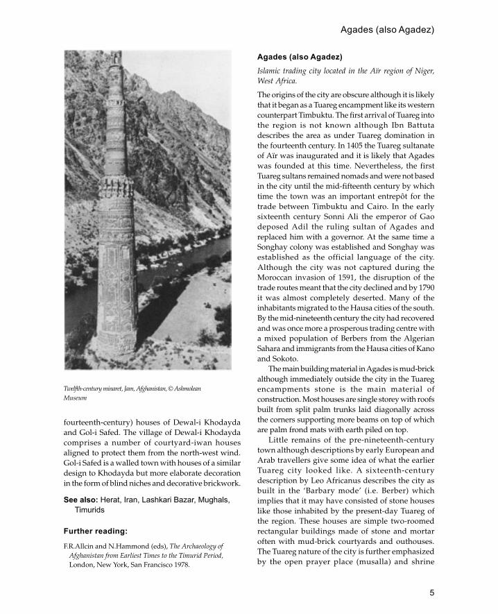
examples of a related type are the minaret of Zaranjand the minaret of Khwaja Siah Posh, both in Sistan.The Zaranj minaret had an octagonal shaft with asemi-circular flange in the centre of each side whilstthe Khwaju Siah Posh minaret comprised sixteenalternating angular and rounded flanges. Theculmination of this form is the 65-metre-high minaretof Jam built by the Ghurids in the twelfth century.The height of the structure is further emphasized byits position in a deep valley at the intersection of tworivers. The tower consists of three main sections eachin the form of a tapering cylinder. The lowest andlargest section is decorated with panels alternatingwith giant strap-work loops and terminating in amuqarnas corbel balcony. The second and thirdstoreys are each decorated with giant bands ofcalligraphy.
The first examples of Islamic domesticarchitecture occur at the site of Lashkari Bazar nearthe modern town of Bust. The site contains threepalaces, the most famous of which is the southernpalace which overlooks the Helmud river. Thiswas built around a rectangular courtyard with fouriwans (one on each side) leading into separatequarters. The palace was luxuriously decoratedwith stucco, wall paintings and carved marblepanels in a style reminiscent of Abbasid Samarra.In addition to the main palaces there were anumber of smaller mansions with a similar designbased around a courtyard and iwans. This designwas to remain a feature of later Afghan architectureand can be seen in the medieval (thirteenth- to
Plan of Lashkari Bazar, Afghanistan (after Allen)
5
fourteenth-century) houses of Dewal-i Khodaydaand Gol-i Safed. The village of Dewal-i Khodaydacomprises a number of courtyard-iwan housesaligned to protect them from the north-west wind.Gol-i Safed is a walled town with houses of a similardesign to Khodayda but more elaborate decorationin the form of blind niches and decorative brickwork.
See also: Herat, Iran, Lashkari Bazar, Mughals,Timurids
Further reading:
F.R.Allcin and N.Hammond (eds), The Archaeology ofAfghanistan from Earliest Times to the Timurid Period,London, New York, San Francisco 1978.
Agades (also Agadez)Islamic trading city located in the Aïr region of Niger,West Africa.
The origins of the city are obscure although it is likelythat it began as a Tuareg encampment like its westerncounterpart Timbuktu. The first arrival of Tuareg intothe region is not known although Ibn Battutadescribes the area as under Tuareg domination inthe fourteenth century. In 1405 the Tuareg sultanateof Aïr was inaugurated and it is likely that Agadeswas founded at this time. Nevertheless, the firstTuareg sultans remained nomads and were not basedin the city until the mid-fifteenth century by whichtime the town was an important entrepôt for thetrade between Timbuktu and Cairo. In the earlysixteenth century Sonni Ali the emperor of Gaodeposed Adil the ruling sultan of Agades andreplaced him with a governor. At the same time aSonghay colony was established and Songhay wasestablished as the official language of the city.Although the city was not captured during theMoroccan invasion of 1591, the disruption of thetrade routes meant that the city declined and by 1790it was almost completely deserted. Many of theinhabitants migrated to the Hausa cities of the south.By the mid-nineteenth century the city had recoveredand was once more a prosperous trading centre witha mixed population of Berbers from the AlgerianSahara and immigrants from the Hausa cities of Kanoand Sokoto.
The main building material in Agades is mud-brickalthough immediately outside the city in the Tuaregencampments stone is the main material ofconstruction. Most houses are single storey with roofsbuilt from split palm trunks laid diagonally acrossthe corners supporting more beams on top of whichare palm frond mats with earth piled on top.
Little remains of the pre-nineteenth-centurytown although descriptions by early European andArab travellers give some idea of what the earlierTuareg city looked like. A sixteenth-centurydescription by Leo Africanus describes the city asbuilt in the ‘Barbary mode’ (i.e. Berber) whichimplies that it may have consisted of stone houseslike those inhabited by the present-day Tuareg ofthe region. These houses are simple two-roomedrectangular buildings made of stone and mortaroften with mud-brick courtyards and outhouses.The Tuareg nature of the city is further emphasizedby the open prayer place (musalla) and shrine
Twelfth-century minaret, Jam, Afghanistan, © AshmoleanMuseum
Agades (also Agadez)

6
known as Sidi Hamada just outside the south wallsof the city. The site consists of an open area ofground with a low bank at the east side againstwhich is built a dry stone wall which rises up tothe mihrab in the centre. A nineteenth-centurydescription of the southern part of the city mentionsa large mud-brick complex surrounded by a walledenclosure crowned with pinnacles. It seems likelythat this may have been the citadel of the Tuaregcity although it has also been interpreted as a khan.Also in this area were some well-built (stone?)houses amongst which was a building interpretedas a bath house (hammam).
When the city was resettled in the nineteenthcentury a large northern extension was addedwhich was enclosed within a city wall (katanga).The houses of this period were built of mud andtheir interiors resembled those of the Hausa citiesof northern Nigeria with moulded mud decoration.
The major work of this period was the rebuildingof the minaret of the Great Mosque between 1844and 1847. The mosque consists of a large rectangularsanctuary with a mihrab in the centre of the eastwall and the huge minaret attached to the north-west corner. A nineteenth-century descriptionmentions another ruined minaret to the south ofthe mosque; this has now entirely disappeared. Thepresent minaret is over 30 m high and tapers froma square base (10 m per side) at the bottom to asquare platform (3 m square) at the top. The exteriorfaces of the minaret are characterized by thirteenlayers of projecting palm timbers which act as tiebeams for this complex structure. Inside the minaretthere is a timber-framed staircase lit by twenty-eightopenings (seven on each side). This structure isdistinguished from other monumental minarets inthe region by its base which consists of four massiveearth piers instead of a solid block. The architecturalorigins of the building are not known although ithas been suggested that it bears some similarity tothe tapering stone-built minarets of southernAlgeria.
See also: Oualata, Timbuktu, West Africa
Aghlabids
Dynasty which ruled the north African province ofIfriqiyya during the ninth century.
Although nominally under Abbasid control, theAghlabids were able to exercise a great deal ofindependence. Militarily their great achievement wasthe conquest of Byzantine Sicily.
The Aghlabids were great patrons of architectureand much of their work has survived. Their workdemonstrates a mixture of Byzantine and Abbasidbuilding styles. One of the most important projectswas the rebuilding of the Great Mosque of Qairawanand the addition of the huge three-tiered minaret/tower. The Aghlabids were also responsible for majorirrigation and water supply systems the most famousexample of which are the huge circular cisterns ofQairawan. Much of their effort was also directedtowards the development of the coastal towns asbases from which to launch the conquest of Sicily.The military nature of Aghlabid rule is furtherreflected in the large number of ribats or fortifiedmonasteries which they constructed.
See also: TunisiaPlan of the Great Mosque, Agades, Niger. Minaret shaded (afterPrussin)
Aghlabids

7
Further reading:
A.Lezine, Architecture de l’Ifriqiyya: recherche sur lesmonuments aghlabides, Paris 1966.
Agra
City in central northern India famous for its Mughalmonuments.
Agra is located on the banks of the river Jumna 160km south of Delhi. Although Agra was an ancientHindu city the present city was refounded as acapital by Sikander Lodi at the beginning of thesixteenth century. In 1505 Iskander built a mud-brick fortress by the banks of the river at the centreof his new city. However, in 1526 the Lodis weredefeated by Babur at the battle of Panipat and Agrawas incorporated into the expanding MughalEmpire. Although Agra became one of the principalMughal cities, little construction took place until1565 when the third emperor Akbar demolished theold fort of Sikander Lodi and built a new fort facedin red sandstone. For the next eighty years Agrawas the imperial capital apart from a brief periodbetween 1571 and 1585 when Akbar moved tonearby Fatehpur Sikri.
The main monuments of Agra are the fort andthe Taj Mahal which are located 1.5 km apart on thewest bank of the river. The fort consists of a roughlytriangular area enclosed by a huge red sandstonewall capped with pointed crenellations. The wallshave two main gates (the Delhi Gate and the AmarSingh Gate) and are surrounded by a deep pavedmoat. The fort is the product of several constructionphases the earliest of which belongs to the reign ofAkbar. Little of Akbar’s original palace survives,except for the enclosure walls and the JahangariMahal which is a Hindu-style pavilion in the southpart of the building. Most of the interior of the fortmay be attributed to the reign of Shah Jahan whoalso built the Taj Mahal which can be viewed acrossthe water from the private apartments of the palace.Although less rigidly planned, the interior of theAgra Fort bears a striking similarity to the Red Fortin Delhi also built by Shah Jahan. The layout isbased around a series of formal gardens andpavilions the most beautiful of which is theMussaman Burj or octagonal tower whichoverlooks the river and is capped by an octagonalcopper dome. Other important monuments in Agrainclude the Rambagh, the Chini Ka Rauza and thetomb of Itmad al-Daula. The Rambagh is a formal
four-part garden laid out by the first Mughalemperor Babur. In the centre of the garden is anopen octagonal domed pavilion standing on thirty-six columns. The Chini Ka Rauza is a Persian-styletiled tomb crowned with a bulbous dome built forthe seventeenth-century poet Afzal Khan. The tombof Iltimad al-Daula is a square structure withoctagonal domed minarets at each corner, the outersurface of the tomb is decorated with carved whitemarble and geometric marble screen. In the centreof the structure is the tomb of Iltimad al-Daulawhich is lined with yellow marble and has finepietra dura stone inlay.
See also: Delhi, India, Mughals, Red Fort, Taj Mahal
Further reading:M.Ashraf Husain, An Historical Guide to the Agra Fort
based on Contemporary Records, Delhi 1937.W.G.Klingelhofer, ‘The Jahangiri Mahal of the Agra Fort:
expression and experience in early Mughalarchitecture’, Muqarnas 5:153–69, 1988.
E.Koch, ‘The lost colonnade of Shah Jahan’s bath in theRed Fort at Agra’, Burlington Magazine 124:331–9, 1982.
—— ‘The Zahara Bagh (Bagh-i Jahanara) at Agra’,Environmental Design 1986: 30–7.
AhmadabadMain city of Gujarat in western India with a mixed Hindu,Muslim and Jain population.
The old city is located on the east bank of theSabarmati river. Ahmadabad was founded byAhmad Shah I in 1411 near to the old Hindu townof Asaval which it replaced. The Bhadra towerserected by Ahmad Shah to protect the citadel arethe oldest surviving part of the city; however, mostof the original fortifications have been destroyed.The city contains some of the best examples ofmedieval Gujarati architecture which ischaracterized by its integration of Hindu, Jain andIslamic forms.
At the centre of the city is the Jami Masjid built byAhmad Shah I and completed in 1424. The plan of thebuilding comprises a huge rectangular courtyard withentrances on three sides and a covered sanctuary tothe west. The sanctuary is divided into fifteen domedbays (five wide and three deep) supported on 260columns. In the centre of the sanctuary façade is thehuge main entrance flanked by two tall minarets (nowpartially demolished). At the end of each of the aislesthere is a mihrab made of coloured marble. The central
Ahmadabad

8
aisle is three times the height of the rest of thebuilding and contains projecting balconies lookingin to the central area. To the east of the mosque is thetomb of Ahmad Shah which consists of a squaredomed mausoleum in the centre with four smallersquare domed chambers at the corners and pillaredverandas in between.
One of the finest buildings of the city is the RaniSipri Mosque built in 1514. The building is quitesmall and has a pronounced Hindu character withelaborate carved decoration and fine perforated jalisor screens.
See also: Gujarat, India
Further reading:
G.Mitchell and S.Shah, Ahmadabad, Bombay 1988.
Ajdabiya (Roman Corniclanum)Prominent Fatimid city in Libiya.
Ajdabiya’s owed its importance to its position onthe junction of two important routes, the coastalroute from Tunisia to Egypt and the desert caravanroute from the oases of Jaly and al-Ujlah. Althoughthe site was known in Roman times, it was duringthe Fatimid period that the city achieved its greatestdevelopment.Jami Masjid, Ahmadabad, India
Plan of the tomb of Ahmad Shah, Ahmadabad, India
Ajdabiya (Roman Corniclanum)
9
Several remains of the Fatimid complex havebeen recovered including a rectangular mud-brickenclosure wall, the qasr or palace and the mosque.The palace is a rectangular stone built structureapproximately 22 by 33 m with solid circular cornertowers and semi-circular buttress towers. Thepalace has one entrance in the north wall leadinginto a courtyard enclosed by apartments. At theopposite end to the corner from the entrance thereis a large T-shaped suite of rooms which probablyfunctioned as the royal apartment. The royalapartments were once luxuriously decorated withstucco work.
The most important building at the site is themosque located in the south-west corner of thecomplex. Extensive archaeological work on themosque has defined a Fatimid and pre-Fatimidphase above an earlier Roman site, but only theFatimid phase has been investigated in any detail.In 912 the Fatimids sacked the town of Ajdabiyaand destroyed the mosque building a new one onthe site. The Fatimid mosque consists of arectangular structure (47 by 31 m) built out of mudbrick with corners, piers, jambs and otherstructurally important points built out of stone.There was one entrance in the north-west sideopposite the mihrab and several other sideentrances, all of which appear to have been plainin contrast to the monumental porches at Mahdiyaand Cairo. Inside there is a large courtyard pavedwith flagstones and a water tank in the middle atthe northern end of the mosque. The courtyard issurrounded by arcades and on the south-eastern sideis the sanctuary. The latter has a wide central aislerunning at right angles to the qibla wall where itmeets a transept running parallel to the qibla wall;all the other aisles are aligned at right angles to theqibla.
To the left of the main entrance is a large squareblock 4 m high which was the base of a minaret withan octagonal shaft. This is the earliest example ofthis type of minaret which was later developed intothe characteristic Cairene minaret form. There arealso traces of a staircase built into the wall whichhave been interpreted as the remains of a staircaseminaret used before the erection of the lateroctagonal one.
Little remains of the mihrab apart from thefoundations and some stucco fragments; however,nineteenth-century drawings depict it as a curvedrecessed niche with a horseshoe arch.
See also: Fatimids, Libiya
Further reading:
A.Abdussaid, ‘Early Islamic monuments at Ajdabiyah’,Libiya Antiqua 1: 115–19, 1964.
—— ‘The old Islamic city of Ajdabiyah’, in Some IslamicSites in Libiya, Art and Archaeology Research Papers,London 1976, 19–24.
H.Blake, A.Hutt and D.Whitehouse, ‘Ajdabiyah and theearliest Fatimid architecture’, Libiya Antiqua 8: 105–20,1970.
P.Donaldson, ‘Excavations at Ajdabiya, 1976’, LibyanStudies 7: 9–10, 1976.
D.Whitehouse, ‘The excavations at Ajdabiyah: an interimreport’, Libyan Studies 3: 12–21, 1972.
—— ‘Excavations at Ajdabiyah: second interim report’,Libyan Studies 4: 20–7, 1973.
ajimez
Spanish term for pair of windows sharing a centralcolumn. This is one of the distinctive features ofIslamic buildings in Spain and is especially noticeableon minarets.
Albania
Mountainous country in south-eastern Europe which wasincorporated into the Ottoman Empire in the fifteenthcentury.
The first Ottoman incursions into Albania in the latefourteenth and early part of the fifteenth century werefiercely resisted by the Albanians under their leaderSkanderberg who managed to unite the various feudalfactions who had previously ruled the country. Theresistance of the people together with its mountainousterrain meant that the country was not fully conquereduntil the late fifteenth century. Few Turks settled inthe country which nevertheless converted to Islam.This remained the state religion until the revolutionof 1967 when the country became officially atheist.Mosques were converted into museums and minaretswere demolished in order to destroy the distinctiveIslamic appearance of the cities. In 1991 with thecollapse of the authoritarian communist regime Islamhas again become the main religion with 72 per centof the population Muslim and 27 per cent Christian(Greek Orthodox and Catholic). As a result mosqueshave been reopened with rebuilt minarets. There aresubstantial numbers of Albanians living abroadparticularly in the USA where there are four Albanian
Albania
10
mosques (in Detroit, Chicago and Waterbury,Connecticut).
A recent survey has indicated that there may be asmany as 800 mosques surviving in Albania along with300 historical Muslim sites. The mosques in Albaniaare of two types, the classical Ottoman type derivedfrom Byzantine architecture based on a square domedarea with a triple-domed portico and the morecommon rectangular buildings with wooden paintedceilings which are typical of the Balkans. The oldestMuslim building in the country is the BeratCongregational Mosque built in 1380. Another earlymosque is the Ilias Mirahori Mosque in the town ofKorçë built in 1494 after the Ottomans had gainedcontrol of the whole country. One of the mostcelebrated mosques in Albania is at Krujë 20 km northof the capital Tiranë. The mosque, located in thegrounds of Skanderberg’s castle, was built in 1779 andhas wooden ceilings painted to look like a dome seton squinches. Another famous building is the PeqinMosque built in 1822 which incorporates a clock towerinto the design of the minaret.
Much of the secular Ottoman architecture inAlbania was destroyed in the fierce modernizingprogrammes of the 1960s and 1970s with the exceptionof the towns of Gjirokastër and Berat which have beenpreserved as museum towns. The town of Gjirokastëris built on slopes around the citadel which is locatedon a high plateau. The town is first mentioned in thetwelfth century although the majority of survivingbuildings belong to the seventeenth and eighteenthcenturies. The typical house in the city consists of atall stone block structure up to five storeys high withexternal and internal staircases, a design thought tooriginate from fortified country houses in southernAlbania. The basic form of the house consists of alower storey containing a cistern and stable with anupper storey reached by a flight of exterior stairs. Theupper storey was divided into two units: a guest room,and a winter or family room containing a fireplace.Later on more storeys were added to accommodateextended families; these upper floors were reachedby internal staircases. In the seventeenth centuryhouses were built with two wings protecting the lowerexternal staircase.
Berat is a much older city dating back to theIlyrian period. Initially conquered by the Ottomansin the fourteenth century, it was then recaptured,and not finally occupied by the Turks until 1417.The town is located on the banks of the Osun riverand like Gjirokastër is built around a citadel. The
citadel was remodelled by the Turks soon after itscapture in 1417 and again in the eighteenth andnineteenth centuries to take account of the use ofartillery. Like the fortified houses of Gjirokastër thehouses of Berat have external staircases and the mainliving area of the building is on the upper floor.However, at Berat this feature was designed toovercome the hilly nature of the ground rather thanfor defensive reasons. Thus to avoid dampness andhaving to excavate hillsides the houses are built onstone substructures which are sometimes used forstorage. The upper parts of Berat houses are builtout of timber filled in with lath and plaster and thenwhitewashed. The verandas sometimes extend alongthe whole front of the house although in many casespart of the veranda is occupied by a separate room.In the nineteenth century many of these verandaswere filled in with large glazed windows. Inside thehouses are elaborately decorated with carved andpainted woodwork.
Further reading:
R.I.Lawless, ‘Berat and Gjirokastër: two museum townsin Albania’, in Islam in the Balkans: Persian Art andCulture of the Eighteenth and Nineteenth Centuries,Edinburgh 1979, 9–18.
P.Ward, Albania, Cambridge and New York 1983.‘Albania’, Aramco World July/August 1992:38–47.
albarrani
Spanish term for a tower projecting from the wallsof a castle or city fortifications and connected bymeans of a bridge. The earliest example in Spain isat Mérida and is connected to the ninth-centuryfortress, but most other examples are later.
Further reading:
J.Zozaya, ‘Islamic fortifications in Spain: some aspects’, inPapers in Iberian Archaeology, BAR, Oxford 1984.
Aleppo (Arabic Halab)
Syria’s second city located on the river Qoueiq in north-west Syria.
Aleppo is often regarded as the oldest inhabited cityin the world because of its continous history from atleast the twentieth century BCE. Although the citywas of great significance in Roman and Byzantinetimes its importance declined during the first three
albarrani

11
Tower houses in Girokastër, Albania (after Lawless)
Aleppo (Arabic Halab)

12
centuries of Islam in favour of the nearby city ofQinnarisin. Under the Hamdanids Aleppo once morebecame powerful as capital of a dynasty rulingnorthern Syria; this was shortlived, however, and thecity was not able to recover its status until 1129 whenImad al Din Zengi was made governor. Imad al Dinwas able to consolidate his position through a seriesof victories against the Crusaders which establishedhim as premier ruler in Syria. Under Imad and hissuccessors the Zangids and later the Ayyubids thecity grew to be one of the great cities of Islam. Despitethe Mongol invasions of 1260 and 1400 Alepporemained a major city throughout the Middle Agesand the Ottoman period.
Although there are the remains of an Umayyadmosque enclosed within the Great Mosque, most ofthe monuments in Aleppo belong to the period afterthe eleventh century. During the twelfth and earlythirteenth centuries a number of important madrassaswere built including al-Zahiriyyah (1217), al-
Sultaniyyah (1223) and the Madrassa al-Firdaws whichincludes a mosque, a school and a turbah. Importantpublic buildings from the fourteenth and fifteenthcenturies include the Maristan (hospital) Arghuni andthe Hammam al-Nasiri (public baths).
In spite of the great beauty of Aleppo’s madrassasand mosques the best-known feature of the city is itsfortifications, particularly the citadel which dominatesthe old city. Although fortification on the citadel beganas early as the tenth century, the most spectacular workdates from the thirteenth century under Ghazi al Malikal-Zahir. During this period the glacis, triple entranceand most of the towers were built. Characteristicfeatures of this work are the monumental inscriptions,carved animal sculpture and massive masonry. Inaddition to the citadel the old city is enclosed withina medieval wall and gates.
Whilst the medieval period saw the developmentof Aleppo’s fortifications and religious buildings theOttoman era produced a large number of commercialand industrial buildings. Prominent amongst these areKhan al-Sabun (early sixteenth century), Khan al-Jumruk, Khan al-Wazir and Bayt Dallal (all seventeenthcentury). These buildings belong to a complex networkof suks which extend for a distance of 15 km.
Further reading:
A.Bahnassi, ‘Aleppo’, in The Islamic City, ed. R.B. Serjeant,Paris 1980. This gives a general overview of the city’smonuments.
J.Sauvaget, ‘Halab’, E.I.IV, gives a general history of thecity.
Bulletin des Études orientales, esp. 36, ‘Études sur la villed’Alep’, 1984, contains recent research.
Algeria
North African country located between Morocco andTunisia.
Algeria can be divided into three main regions, theMediterranean coast known as the Tell, the HighPlateaux immediately south of the coast and furthersouth the Sahara desert. The Tell is dominated bycoastal mountains, although there are three smallsections of coastal plain, one at Algiers, one at Oranand one at Annaba. The High Plateaux are more aridwith marginal areas for agriculture. The Saharadesert covers four-fifths of the country and links itto West Africa.
Algeria did not exist as a political unit until theOttoman occupation of the sixteenth century (the
Eleventh-century minaret of the Great Mosque, Aleppo
Algeria

13
country did not include the Sahara regions until theearly twentieth century). Before that period it isdifficult to separate the history of this area from therest of North Africa. The first Arab invasion ofAlgeria occurred in 681 and by the beginning of theeighth century the Byzantine towns of the coast hadall surrendered. The predominantly Berberpopulation was converted to Islam relatively quicklyand in the early eighth century took part in theconquest of Spain. A notable feature of Algeria atthis point was the rapid development of religioussects the most important of which were the Kharijiteswho established independent rule in the area. Theexpansion of the Fatimids in the ninth centuryattracted Berber support particularly along the coast,although those of the south remained opposed tothe Fatimid regime. During the eleventh centuryBerber groups in the south of the country emergedas a coherent political and military force known asthe Almoravids. The Almoravids were able toconquer most of Morocco and Algeria and Spainbefore the end of the eleventh century. Internaldisputes meant that the dynasty lasted only fiftyyears more before being overthrown by theAlmohads, another Berber group with similarorigins. Like their predecessors the Almohads toohad early successes, but did not last much beyondthe twelfth century. The political history of the regionfrom the thirteenth to the sixteenth century is quiteconfused, with various local dynasties trying toestablish control over the whole area. The Spanishtook advantage of this situation and invaded in 1510.There was strong local resistance to the Spanishinvasion and the Ottoman Turks were called in asallies against the Christians. The Turks formallyestablished their rule in 1587 by appointing agovernor and defining the present borders of thecountry. In the early nineteenth century the Frenchoccupied the coastal cities to prevent attacks on theirships. This temporary occupation graduallydeveloped into a virtual annexation with Frenchsettlers arriving in the country. The occupation lasteduntil 1962 when Algeria was established as anindependent state.
The principal building materials of Algeria arestone, baked brick and mud brick (toub) with woodused as a roofing material. In the coastal cities thequality of the buildings is of a very high standard withashlar masonry and ornamental stonework in a stylesimilar to North Africa and Spain. South of the coastdressed stonework is very rare and even palatial
buildings such as Qal’at Banu Hammad are built outof roughly squared stone. Baked brick is found mostlyin coastal cities such as Tlemcen and Nedroma,although is also used for houses in oasis cities in theeast such as Tamelhat where houses have decorativebrickwork panels. Roofing tiles made of baked clayare a feature of coastal cities, in particular Tlemcenwhich is heavily influenced by neighbouring Morocco.Mud brick is used in the High Plateaux regions andin the oasis towns of the desert.
The earliest Islamic architecture which hassurvived belongs to the Sanhaja Berber dynasties.Excavations at Ashir 170 km due south of Algiershave revealed the remains of a tenth-century palacebuilt by the Zirid dynasty. The palace is a rectangularenclosure (72 by 40 m) with a large central courtyardaround which were four separate residences. Acrossthe courtyard from the entrance there was an arcaderesting on columns behind which was a domedaudience hall. One hundred and fifty kilometres eastis the site of Qal’at Banu Hammad capital of theHammadid dynasty. The city is located high up inthe mountains at an altitude of 1,400 m. The city wasfounded in 1007 by Hammad the father of thedynasty and a relation of the Zirids. Excavations atthe site have revealed the Great Mosque and threepalaces. In 1015 Hammad broke his allegiance to theFatimids and pledged his support for the Abbasids.The results of this change of policy can be seen inthe architecture of the city; thus a minaret was addedto the Great Mosque and the palaces are decoratedwith carved stone screens reminiscent ofcontemporary Abbasid stucco work. To the north ofQal’at on the coast is the city of Bougie which becamethe Hammadid capital from 1060 to 1085, but thereare few standing remains of the Hammadid city withthe exception of a monumental sea gate.
The south of Algeria was a refuge for Ibadis whorebelled against both the Shi�a orthodoxy of theFatimids and the Sunni orthodoxy of the Abbasidsand their local supporters. In the eleventh century theIbadis established a capital at the oasis town of Sadrat.Excavations have revealed a number of housesdecorated with ornate stucco in the Abbasid style.
The rise of the Almoravids in the eleventh centuryled to the development of a new mosque form whichcan be seen in the Great Mosques of Tlemcen,Nedroma, Algiers and Tozeur. This new formpreserved the North African tradition of aislesrunning perpendicular to the qibla with a dome infront of the mihrab. The new development was to
Algeria

14
integrate the lateral arcades into the prayer hall ofthe mosque and incidentally reduce the size of thecourtyard. Another notable feature is that none ofthe mosques was built with minarets although thesewere added in later periods.
The breakdown of central political authority afterthe twelfth century meant that with occasional notableexceptions there were few major architectural projects.In religious architecture this meant the constructionof madrassas instead of congregational mosques andin secular architecture it meant the construction ofkhans/funduqs instead of palaces. A notableexception to this general pattern is the city of Tlemcenwhich formed the centrepiece of a contest betweenthe Zayyanid and Marinid dynasties. The mostambitious project of the period was the city of al-Mansura outside Tlemcen which was built by theMarinids in 1303 as a base for besieging Tlemcen. Afterthe failure of the first attempt a new siege city wasbuilt in 1336. At the centre of this city was the GreatMosque which still survives in its unfinished state.The mosque forms a large rectangle 85 by 60 m and,like the Almoravid mosques, the lateral arcades forman integral part of the prayer hall. The most strikingfeature of the building is the minaret, at the base ofwhich is the main entrance to the mosque. The minaretis built in a reddish stone decorated with geometricpatterns carved into it.
Ottoman architecture was confined principally tothe coastal cities with the best examples in Algierswhich became the capital at this time. Under Frenchrule Islamic architecture was rel-egated to a secondaryposition, although at the beginning of the twentiethcentury they introduced the West African ‘SudaneseStyle’ to cities such as Ardar in the southern Sahara.
See also: Algiers, Qal�at Banu Hammad
Further reading:
D.Hill and L.Golvin, The Islamic Architecture of NorthAfrica, London 1976.
Algiers
Capital city of Algeria.
Algiers is located in the middle of the north coast ofAlgeria and is built on the site of the Roman town ofIcosium. The Muslim city was founded in 944 androse to prominence under the Almoravids who builtthe Great Mosque. The city did not become thecapital until the Ottoman conquest of the sixteenthcentury. The city has two seventeenth-centuryTurkish mosques built in the classical Ottoman stylewith a large central dome and multiple-domedportico. There are also a number of Turkish mansionsin the city built on the wealth derived from attackingChristian ships.
See also: Algeria, Qal�at Banu Hammad
Further reading:
G.Marçais, ‘La vie et l’art d’Alger à l’époque Turque’,Communications of the First International Congress ofTurkish Art, Ankara 1986, 251–9.
C.Vincent, ‘L’habitation de Grande Kablylie (Algérie)’,Cahiers des Arts et Techniques d’Afrique du Nord no. 5,1955, 17–29.
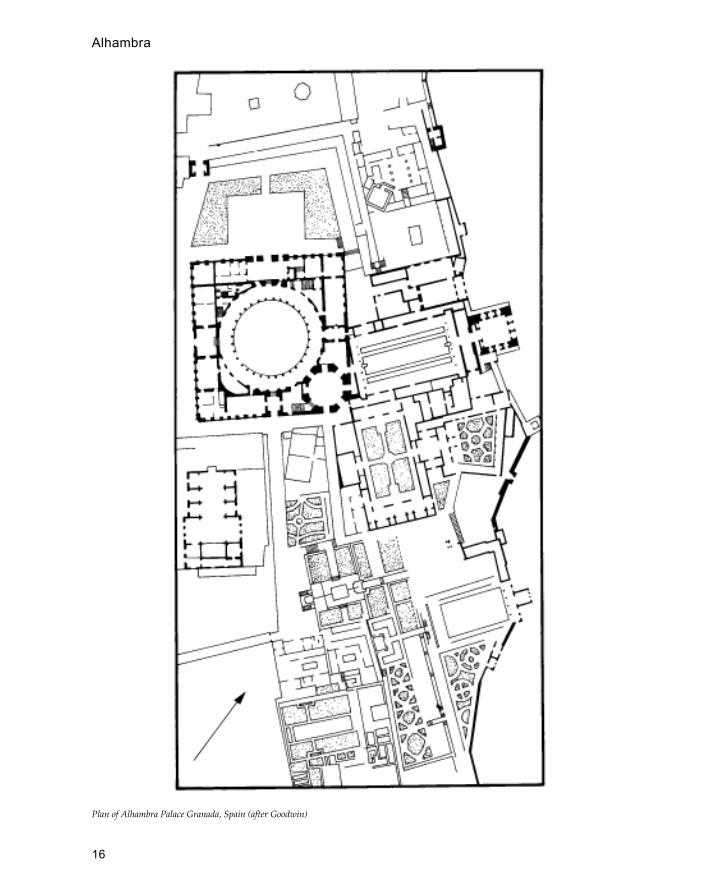
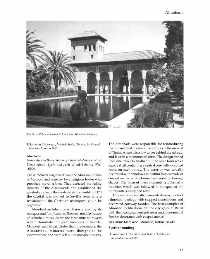
Alhambra
Palace complex in Granada in south-west Spain known
Section of Great Mosque of Timnal, Algeria (after Golvin)
Algiers
15
for being one of the most beautiful examples of Islamicarchitecture.
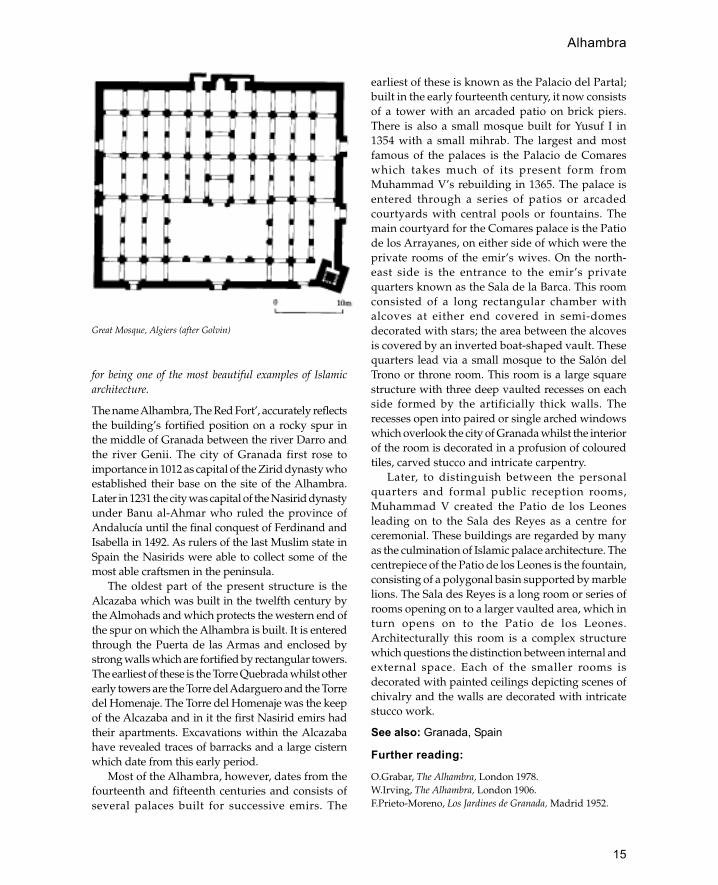
The name Alhambra, The Red Fort’, accurately reflectsthe building’s fortified position on a rocky spur inthe middle of Granada between the river Darro andthe river Genii. The city of Granada first rose toimportance in 1012 as capital of the Zirid dynasty whoestablished their base on the site of the Alhambra.Later in 1231 the city was capital of the Nasirid dynastyunder Banu al-Ahmar who ruled the province ofAndalucía until the final conquest of Ferdinand andIsabella in 1492. As rulers of the last Muslim state inSpain the Nasirids were able to collect some of themost able craftsmen in the peninsula.
The oldest part of the present structure is theAlcazaba which was built in the twelfth century bythe Almohads and which protects the western end ofthe spur on which the Alhambra is built. It is enteredthrough the Puerta de las Armas and enclosed bystrong walls which are fortified by rectangular towers.The earliest of these is the Torre Quebrada whilst otherearly towers are the Torre del Adarguero and the Torredel Homenaje. The Torre del Homenaje was the keepof the Alcazaba and in it the first Nasirid emirs hadtheir apartments. Excavations within the Alcazabahave revealed traces of barracks and a large cisternwhich date from this early period.
Most of the Alhambra, however, dates from thefourteenth and fifteenth centuries and consists ofseveral palaces built for successive emirs. The
earliest of these is known as the Palacio del Partal;built in the early fourteenth century, it now consistsof a tower with an arcaded patio on brick piers.There is also a small mosque built for Yusuf I in1354 with a small mihrab. The largest and mostfamous of the palaces is the Palacio de Comareswhich takes much of its present form fromMuhammad V’s rebuilding in 1365. The palace isentered through a series of patios or arcadedcourtyards with central pools or fountains. Themain courtyard for the Comares palace is the Patiode los Arrayanes, on either side of which were theprivate rooms of the emir’s wives. On the north-east side is the entrance to the emir’s privatequarters known as the Sala de la Barca. This roomconsisted of a long rectangular chamber withalcoves at either end covered in semi-domesdecorated with stars; the area between the alcovesis covered by an inverted boat-shaped vault. Thesequarters lead via a small mosque to the Salón delTrono or throne room. This room is a large squarestructure with three deep vaulted recesses on eachside formed by the artificially thick walls. Therecesses open into paired or single arched windowswhich overlook the city of Granada whilst the interiorof the room is decorated in a profusion of colouredtiles, carved stucco and intricate carpentry.
Later, to distinguish between the personalquarters and formal public reception rooms,Muhammad V created the Patio de los Leonesleading on to the Sala des Reyes as a centre forceremonial. These buildings are regarded by manyas the culmination of Islamic palace architecture. Thecentrepiece of the Patio de los Leones is the fountain,consisting of a polygonal basin supported by marblelions. The Sala des Reyes is a long room or series ofrooms opening on to a larger vaulted area, which inturn opens on to the Patio de los Leones.Architecturally this room is a complex structurewhich questions the distinction between internal andexternal space. Each of the smaller rooms isdecorated with painted ceilings depicting scenes ofchivalry and the walls are decorated with intricatestucco work.
See also: Granada, Spain
Further reading:
O.Grabar, The Alhambra, London 1978.W.Irving, The Alhambra, London 1906.F.Prieto-Moreno, Los Jardines de Granada, Madrid 1952.
Great Mosque, Algiers (after Golvin)
Alhambra
16
Plan of Alhambra Palace Granada, Spain (after Goodwin)
Alhambra
17
E.Sordo and W.Swaan, Moorish Spain: Córdoba, Seville andGranada, London 1963.
AlmohadsNorth African Berber dynasty which ruled over much ofNorth Africa, Spain and parts of sub-Saharan WestAfrica.
The Almohads originated from the Atlas mountainsof Morocco and were led by a religious leader whopreached moral reform. They defeated the rulingdynasty of the Almoravids and established thegreatest empire of the western Islamic world. In 1170the capital was moved to Seville from whereresistance to the Christian reconquest could beorganized.
Almohad architecture is characterized by itsmosques and fortifications. The most notable featureof Almohad mosques are the large minaret towerswhich dominate the great mosques of Seville,Marakesh and Rabat. Under their predecessors, theAlmoravids, minarets were thought to beinappropriate and were left out of mosque designs.
The Almohads were responsible for reintroducingthe minaret, first in a tentative form, as in the minaretof Timnal where it is a low tower behind the mihrab,and later in a monumental form. The design variedfrom one tower to another but the basic form was asquare shaft containing a central core with a vaultedroom on each storey. The exterior was usuallydecorated with windows set within frames made ofcusped arches which formed networks of lozengeshapes. The form of these minarets established atradition which was followed in mosques of thefourteenth century and later.
City walls are equally demonstrative symbols ofAlmohad ideology with stepped crenellations anddecorated gateway façades. The best examples ofAlmohad fortifications are the city gates at Rabatwith their complex bent entrances and monumentalfaçades decorated with cusped arches.
See also: Marakesh, Morocco, Rabat, Seville
Further reading:
H.Basset and H.Terrasse, Sanctuaires et fortressesalmohades, Paris 1938.
The Partal Palace Alhambra, © J.W.Allan, Ashmolean Museum
Almohads

18
Amman (Roman Philadelphia)
Capital of Jordan containing palace of Umayyadprinces.
The Ummayad palatial complex which probablydates from the early eighth century occupies theancient citadel area in the centre of modern Amman.The most famous part of the complex is thecruciform reception hall which stood at the entranceto the palace. This building consists of four archediwans set around a central square space which wasprobably an open courtyard rather than a roofedspace. The interior of the courtyard and iwans aredecorated with blind niches which are reminiscentof Sassanian buildings in Iraq and further east. Eachiwan comprises a tall slightly pointed arch facingthe courtyard with a semi-dome behind. In generalthe form of the building seems to represent aneastern tradition whilst the materials and methodof construction suggest a more local (Roman)ancestry.
The rest of the palatial complex forms a rough
parallelogram bisected by a central street or proces-sional way. On either side of the central street thereare separate buildings or apartments each builtaround its own courtyard. At the end of the mainstreet a gateway leads into a large courtyarddominated by a large iwan. A door at the back ofthe iwan gives access to a cruciform domedchamber which may have served as the throneroom. The other important Umayyad building inAmman was the Friday mosque which wasdemolished and completely rebuilt in 1923. Thiswas a large rectangular building measuring 60 mby 40 m with three entrances on the north sideopposite the mihrab. At some later period, probablyduring the thirteenth century, a square minaret wasbuilt at the north-east corner.
See also: Jordan, Umayyads
Further reading:
A.E.Northedge et. al., Studies on Roman and IslamicAmman, Oxford 1993.
Plan of Great Mosque of Timnal, Algeria (after Golvin)
Amman (Philadelphia)

19
�Amr, Mosque of
Mosque in Fustat, said to be the oldest mosque in Egypt
The present structure consists of a large roughlysquare enclosure measuring approximately 120 mon each side. The great variation in the thickness anddesign of the walls testifies to the building’s longhistory of development and restoration. The firstmosque on the site is said to have been built by �Amribn al— �As in 641–42. �Amr was the chief commanderof the Arab troops who won Egypt for Islam and sothe building has an historical significance beyondthe surviving architecture. Although the remains ofthis earliest mosque have not survived, there areseveral historical accounts from which the design ofthe building can be reconstructed. It consisted of arectangular structure 29 by 17 m without a concavemihrab and was probably built of mud brick andpalm trunks.
Thirty-two years later in 673 the first mosque waspulled down and a larger structure built toaccommodate the growing number of Muslims. Aswell as being larger the new mosque was equippedwith four towers which could be used for the call toprayer. These have been interpreted as the firstminarets although it is likely that they were not muchhigher than the roof of the mosque.
The earliest mosque from which any remainssurvive belongs to the reconstruction of 827 carried
out by �Abd Allah Ibn Tahir. The remains comprisethe southern wall of the present mosque whichcontains blocked-up windows alternating withround-arched niches with shell-like hoods. Bothniches and windows are framed by engagedcolonettes. Internally there are remains of woodencornices carved in late Hellenistic style which joinedthe end columns of the arcades to the wall.Descriptions of the mosque in the tenth centurydescribe it as having glass mosaics on the wall and abayt al-mal, or treasury, in the centre of the courtyardwhich together with the four towers suggest aresemblance to the Great Mosque of Damascus.
In later periods several reconstructions andrestorations were carried out. The most importantchanges include those made by Khalif Hakim whoadded two arcades in the sahn and had the mosaicsremoved, Sultan Baybars who rebuilt the north wall,the merchants whose restorations were carried outin 1401–2, Murad Bey who strengthened the buildingand added two minarets in 1797–8. In the restorationsof Muhammad Ali in the 1840s the mosque achievedits present form.
Further reading:
D.Berhens-Abouseif, Islamic Architecture in Cairo: AnIntroduction, Supplements to Muqarnas vol. 3, Leiden1989, 47–50. Contains a general summary andbibliography.
Plan of Umayyad palatial complex, Amman (after Northedge)
�Amr, Mosque of

20
K.A.C.Creswell, A Short Account of Early MuslimArchitecture, revised and enlarged ed. J.Allan, Aldershot1989, 8, 15, 17, 46, and chapter 14, 303–14. This gives adetailed account of the building.
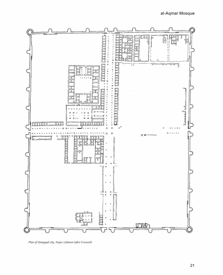
Anjar (�Ayn Jar)
Umayyad city in Lebanon.
Anjar was built by the Umayyad caliph al-Walid in714–15 CE. The city is contained within arectangular enclosure (370 m north-south and 310m east-west) supported by a series of solid semi-circular buttress towers and four hollow cornertowers. There are four principal gateways and thewalls were originally crowned with steppedmerlons (crenellation). Internally the city is built toa regular plan recalling earlier Byzantine andRoman cities. There are four principal colonnadedstreets which meet at the centre in a tetrapy-lon.Many of the buildings are built of alternatingcourses of ashlar blocks and layers of baked brick.There is a series of shop units (3.5 m wide and 5 mdeep) lining the main streets behind the colon-nades. In the south-east quadrant of the city is apalace within a rectangular enclosure (about 70 by60 m). The interior of the palace is divided into fourunits arranged symmetrically; at the south end thereis a building with with a triple aisles and an apseresembling a basilical hall, this is duplicated at thenorth end. To the north of the palace is the mosquewhich is entered from the west street. The mosqueis a rectangular structure (47 by 30 m) with a smallcentral courtyard surrounded by two aisles on thewest, east and qibla (south) sides whilst there is oneaisle on the north side. On either side of the mihrabare two entrances which lead into a narrow lanethat connects with the palace. There is a small bathhouse next to the north gate which comprises asquare vaulted hall, leading via two intermediaterooms into a hot room.
Ankara (Ancyra)
Capital of Republic of Turkey set in the centre of theAnatolian plain.
During the ninth century Anatolia was subject to anumber of Arab raids, the most serious of whichoccupied Ankara for a short period. However, thecity was not finally captured until 1071 when it fellto the Seljuk Turks. The oldest surviving mosque in
the city is the Aslan Cami built out of woodencolumns and reused classical and Byzantine stones.In 1402 the Ottomans suffered a major setback atAnkara when they were defeated by Timur. Duringthe seventeenth century the city was considered tobe one of the more important business centres withits own purpose-built bedestan (now the Museumof Anatolian Civilizations). Ankara has someinteresting examples of Ottoman domesticarchitecture with houses built out of wooden framesfilled in with brickwork. However, for most of theOttoman period the city was of minor importanceand only rose to prominence when Mustafa KemalAttatürk chose the city as the site for Turkey’s newcapital. As a planned city Ankara has some of thebest examples of Turkish Republican architecturewhich is a heavy monolithic architecture reminiscentof Eastern Europe under Communism. Thearchitecture of this period is tempered by consciousreferences to a Turkish past which include largeoverhanging eaves and simplified Seljuk-typestonework. Prominent examples of this architectureare the railway station and the offices of the Turkishhistorical society.
See also: Ottomans, Seljuks, Turkey
Further reading:
H.M.Akok, Ankari�nin Eski Evleri, Ankara 1951.R.Holod and A.Evin, Modern Turkish Architecture,
Philadelphia 1984.G.Öney, Ankara�da Türk Devri Yapilari (Turkish Period
Buildings in Ankara), Ankara 1971.
appadana
A method of construction whereby a flat roof restsdirectly on columns (i.e. without intervening arches).
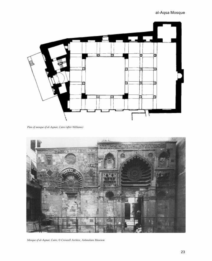
al-Aqmar Mosque
Small Fatimid mosque in Cairo noted for its design andthe decoration of the façade.
The mosque is known as al-Aqmar, ‘the moonlit’, andwas founded by Ma�mun al-Bata�ihi, vizier of theFatimid caliph al-Amir in 1125. The building consistsof a small 10-metre square courtyard surrounded byan arcade one bay deep on three sides and three baysdeep on the qibla side. Most of the building is madefrom brick except for the front which faces the mainstreet which is faced in dressed stone.
Anjar
21
Plan of Umayyad city, Anjar, Lebanon (after Creswell)
al-Aqmar Mosque

22
Architecturally the most important feature of thebuilding is the way the façade is set at a different anglefrom the rest of the mosque to reconcile the need ofhaving the mosque correctly oriented towards Meccaand the façade facing onto the main street. This is thefirst mosque in Cairo to adopt this arrangement whichbecame common in later mosques. The façade isfurther emphasized by its decoration and design. Itconsists of a projecting entrance in the centre flankedby two large niches (only one of these is now visible).The hood of each niche is composed of radiating fluteswith a central medallion. The projecting portal consistsof a central doorway also with a fluted hood. Eitherside of the doorway are two smaller niches each witha cusped arch surmounted by a muqarnas moulding.The shape of the arches, the fluted hoods with centralmedallions and the arrangement of the façade are allfeatures which later become common in Cairenearchitecture.
Al-Aqmar is also important as it is the firstinstance of a mosque which incorporates shops intoits design. The mosque was originally raised upabove street level and the shops were incorporatedinto the outside walls of the building on a lower level.
See also: Cairo, Fatimids
Further Reading:
D.Berhens-Abouseif, Islamic Architecture in Cairo: AnIntroduction, Supplements to Muqarnas, vol. 3, Leiden1989, 71–4.
K.A.C.Creswell, The Muslim Architecture of Egypt, Oxford1932–40, 1: 241 ff.
C.Williams, ‘The Cult of �Alid Saints in the FatimidMonuments of Cairo. Part I: The Mosque of Aqmar’,Muqarnas 1: 37 ff., 1983.
al-Aqsa MosqueThe principal mosque of Jerusalem which forms part ofthe sacred enclosure (haram) with the Dome of the Rockat the centre.
The Aqsa Mosque is located on the southern part ofthe Haram al-Sharif on an axis with the south doorof the Dome of the Rock. In the time of Umar amosque is known to have been built on the sitealthough it appears to have been a semi-permanentstructure made out of re-used material, hastily puttogether to form a covered prayer area with a shed
Principal street, Anjar, Lebanon
al-Aqsa Mosque
23
Plan of mosque of al-Aqmar, Cairo (after Williams)
Mosque of al-Aqmar, Cairo, © Creswell Archive, Ashmolean Museum
al-Aqsa Mosque
24
roof. During the reign of al-Walid the mosque wasrebuilt with its present alignment. Only a small partof al-Walid’s mosque survives but this indicates thatthe aisles all ran perpendicular to the qibla wall (asthey do today). This arrangement is unusual andrecalls the arrangement of Byzantine churches suchas the Church of the Nativity in Bethlehem.
The earthquake of 748 severely damaged themosque which was subsequently rebuilt by theAbbasid caliphs al-Mansur (759) and al-Mahdi (775).The mosque of al-Mahdi had a raised central aisleleading to the mihrab in front of which he built awooden dome; either side of the central aisle wereseven side-aisles. An earthquake of 1033 destroyed themosque and it was once again rebuilt by the Fatimidcaliph al-Zahir in 1035. This mosque had a total of sevenaisles, a central aisle with three aisles on either side.
See also: Damascus Great Mosque, Dome of theRock, Jerusalem, Medina, Palestine,Umayyads
Further reading:R.W.Hamilton, The Structural History of the Aqsa Mosque. A
Record of Archaeological Gleanings from the Repairs of1938–42, Government of Palestine, Jerusalem 1949.
arastaTurkish term for a street or row of shops whose income isdevoted to a charitable endowment or waqf (equivalent toa European shopping arcade).
Arastas are found in most of the regions of the formerOttoman Empire and usually form part of acommercial or religious complex which may includea han (or khan), a mosque and bath house. Manyarastas were probably made of wood but these havelargely disappeared leaving only those made of morepermanent materials. Arastas are often covered overwith a barrel vault and have a row of shops eitherside of a central street, but they can also be open tothe sky. Important examples of arastas include theMisir Çarsi in Istanbul, the arasta associated withthe Selimiye mosque in Edirne and the arastas at theSokollu complex at Lüleburgaz and the Selim Icomplex at Payas both designed by Sinan.
See also: Ottomans
Further reading:M.Cezar, Typical Commercial Buildings of the Ottoman
Classical Period and the Ottoman Construction System,Istanbul 1983.
arch
Method of vaulting area between two walls, columns orpiers.
Islamic architecture is characterized by arches whichare employed in all types of buildings from housesto mosques. One of the most common uses is inarcades where arches span a series of columns orpiers to form a gallery open on one side. Arcadesare used to line mosque courtyards although theyare also used in courtyard houses.
The earliest form of arches employed in Islamicarchitecture were the semi-circular round archeswhich were characteristic of Roman and Byzantinearchitecture. However, fairly soon after the Islamicconquests a new type of pointed arch began todevelop. Round arches are formed from acontinuous curve which has its centre at a pointdirectly below the apex and level with the springingof the arch on either side. Pointed arches are madeby forming each side of the arch from a differentcentre point, the greater the distance between thetwo points the sharper the point. In the Dome ofthe Rock built in 691 the arches supporting the domeare slightly pointed whilst in the cisterns at Ramlabuilt in 759 there is a pronounced point. The archesat Ramla are formed by a separation of the pointsby a distance of one-fifth the span of the arch; thisratio became standard in many early Islamicbuildings.
Another arch form developed during the earlyIslamic period is the horseshoe arch. Horseshoearches are those where the arch starts to curveinwards above the level of the capital or impost.Horseshoe arches were developed in Syria in pre-Islamic times and have been recorded as early asthe fourth century CE in the Baptistery of MarYa�qub at Nisibin. The earliest Islamic monumentwith horseshoe arches is the Great Mosque ofDamascus where the arches of the sanctuary wereof slightly horseshoe form. However, the areawhere horseshoe arches developed theircharacteristic form was in Spain and North Africawhere they can be seen in the Great Mosque ofCórdoba. In Tunisia the horseshoe arches of theGreat Mosque of Qairawan and the mosque ofMuhammad ibn Khairun have a slightly pointedform. Probably the most advanced arch formdeveloped in the early Islamic period is the four-centre arch. This is a pointed arch form composed
arasta

25
of four curved sections each with its own centreproducing an arch with steep curves lower downand flattened point at the apex. The earliestoccurrence of the four-centred arch is at Samarraat the Qubbat al-Sulaiybiyya. Another arch formwhich makes its first appearance at Samarra is thecusped arch which is used in the externaldecoration of the Qasr al-Ashiq. This arch formlater became one of the favourite decorative archforms used throughout the Islamic world fromSpain to India.
Arches were not used in India before Islamictimes where trabeate construction was the mainmethod of roofing an area. However, arches wereregarded as essential by the first Muslim rulers whobuilt arched screens in front of trabeate structuressuch as the Quwwat al-Islam Mosque in Delhi. Eventhe screens of the earliest Indian mosques were notcomposed of true arches but were corbelledstructures made to look like arches.
artesonado
Spanish term for wooden panelled ceiling found inIslamic and Mudéjar buildings. Some of the best
examples can be found in palaces especially theAlhambra in Granada.
�����Atshan, Khan
Small palatial building in the Iraqi western desert betweenUkhaidhir and Kufa.
Built of baked brick the design is similar toUkhaidhir although on a much smaller scale (17 mper side). Externally the building has a simpleregular plan consisting of four circular solid cornertowers with semi-round towers on three sides andan entrance set between two quarter-round towerson the north side. Internally the building appearsto have an irregular plan with long vaulted hallsalong two sides and a small courtyard decoratedwith a façade of blind niches. The structure wasprobably built in the Umayyad period although ithas previously been considered an Abbasid (post-750) construction.
See also: Ukhaidhir
Further reading:
B.Finster and J.Schmidt, Sasaidische und fruhislamischeRuinen im Iraq, Baghdader Mitteilungen 8, Berlin 1976.
�Atshan, Khan, Iraq
Ayyubids

26
avulu
Turkish term for the courtyard of a mosque whichin the summer could be used as an extension of theprayer area.
ayina kari
Mosaic of mirrored glass used in Mughalarchitecture.
Ayyubids
Medieval dynasty which ruled Syria, Palestine, Iraq,Egypt and Yemen during the twelfth and thirteenthcenturies.
The founder of the dynasty was Shirukh, a Kurdishretainer of the Zengid prince Nur al-Din. FirstShirukh secured the governorship of Aleppo andlater was appointed vizier to the Fatimid ruler ofEgypt. Shirukh was succeeded by his nephew Salahal-Din who rapidly extended his position andbecame ruler of Egypt, Syria and northern Iraq whilsthe appointed his brother ruler of Yemen. Salah al-Din’s greatest accomplishment was the defeat of theCrusaders and the reconquest of Jerusalem. Salahal-Din died in 1189 and his empire fragmented underhis successors who ruled various parts of the empireuntil the mid-thirteenth century.
Ayyubid architecture was dominated by the needto combat two enemies: the Crusaders in Palestineand the rising threat of Shi �ism and religiousdissension. To combat the Crusaders a network offortresses was built which rivalled those of theCrusaders both in size and technical sophistication.Amongst the best examples of Ayyubid militaryarchitecture are Qal�at Rabad at Ajlun in Jordan andQal�at Nimrud at Banyas in Syria. In addition thefortification of citadels was improved and thefamous gateway of the Aleppo Citadel dates fromthis period. Some of the techniques of fortificationwere learned from the Crusaders (curtain wallsfollowing the natural topography), although manywere inherited from the Fatimids (machicolationsand round towers) and some were developedsimultaneously (concentric planning).
Shi�ism was an equally dangerous threat to theAyyubids who built a large number of madrassas inboth Syria and Egypt. In Egypt the Ayyubids had toreintroduce religious orthodoxy after two centuries
of government-imposed Shi�ism. In Syria there wasa so a growing threat of Shi�ism in the form of theAssassins who had benefited from the confusion ofthe Crusader conflict. The Ayyubids tried to promoteSufism as an orthodox alternative and began to buildkhanqas and Sufi shrines to provide a focus for theseactivities.
See also: Cairo, Damascus, fortification, Syria,Yemen
Azerbayjan
Country lying south of the Caucasus and east of theRepublic of Armenia.
The present Independent Republic of Azerbayjanis the northern part of the Azeri-speaking regionwhich also includes north-western Iran. The capitalof the southern part of Azerbayjan is Tabriz whilstthe capital of the Independent Republic is Baku. TheIndependent Republic of Azerbayjan received itsname from the Turkish invasion of 1918 althoughhistorically it may be identified with the Albaniaof classical writers. The country lies to the south ofthe Caucasus and to the east of the Republic ofArmenia. More than half of the country ismountainous, though the eastern coastal stripbordering the Caspian Sea is relatively flat. Fromthe twelfth century at least Baku has been knownfor its natural oil wells which are also the basis ofits modern economy. Turkish became the mainlanguage of the country after the Seljuk invasionsof the eleventh century. Most of the population isMuslim although there are a small number ofZoroastrians with their own fire-temple.
Unlike much of Central Asia and IranAzerbayjan has its own well-developed, dressed-stone masonry tradition. This can be seen in thetombs, madrassas and mosques of Azerbayjanwhich have façades carved in relief in a stylereminiscent of Seljuk Anatolia. One of the bestexamples of this stone-working tradition is thepalace of the Shirvan Shas in Baku which hasmonolithic stone columns with austere geometriccapitals. Baked brick was also used throughoutAzerbayjan, though predominantly in south (nowwestern Iran). One of the most elegant examples ofSeljuk brickwork is found in the Gunbad-i-Surkhat Maragha which was built in 1146.
See also: Baku
avulu

27
al-Azhar
One of the main mosques in Cairo and also important asone of the oldest universities.
The name of the mosque, al-Azhar, means ‘theflourishing’. The mosque was built in 970 by theFatimid caliph al-Muciz as the main mosque of thenew city of al-Qahira. In 989 the mosque was giventhe status of theological college to teach the Isma’ilitheology. Because of its age and importance themosque has undergone many alterations anddevelopments although the core of the tenth-centurymosque is preserved. The original mosque consistedof a central courtyard with three arcades, two eitherside of the qibla and the qibla arcade itself. A raisedtransept runs from the mihrab to the courtyard andthere were originally three domes in front of the qiblawall, one above the mihrab and one at either corner.
The plan shares many features with the Fatimidarchitecture of North Africa, in particular thearrangement of the aisles and the projecting entrancesimilar to that of Ajdabiya in Libiya.
Later in the Fatimid period the size of thecourtyard was reduced by adding four extra arcadesaround the courtyard. Also a dome was added tothe courtyard end of the transept and was hiddenby a pishtaq or raised wall above the arcade. Someof the original Fatimid stucco decoration is alsopreserved, in particular the hood of the prayer nicheand on the interior of the arcades. The style is similarto stucco found at Samarra but includes scrolls andpalmettes typical of Byzantine decoration.
Further reading:
D.Berhens-Abouseif, Islamic Architecture in Cairo: AnIntroduction, Supplements to Muqarnas, Leiden 1989, 3:58–63
K.A.C.Creswell, The Muslim Architecture of Egypt, Oxford1952–60, 1: 36 ff.
azulejo
Spanish term for small glazed tiles often used asdadoes in courtyards and palaces.
azulejo
28
bab
gate.
badgir
Iranian term for wind tower. Tall chimney-likestructure which projects above the roof of a buildingto expel warm air in the day and trap cooler breezesat night.
See also: mulqaf
Badr al-Jamali, Tomb of (alsoreferred to as the Mashhad of al-Juyushi)
Important eleventh-century Fatimid tomb complex inCairo.
This complex was built by the Armenian generalBadr al-Jamali, chief vizier of the Fatimid caliph al-Mustansir, in 1085. Although it is known as amashhad or tomb complex, the name of the personburied or commemorated is not known (Badr al-Jamali is buried elsewhere).
The complex consists of a prayer room, a smalldomed room (possibly a tomb) and a tall squareminaret built around a small courtyard. Thecourtyard façade of the prayer room consists of atriple-arched arcade with a large central arch and twosmaller side arches. The prayer room is cross vaultedexcept for the area in front of the mihrab which iscovered with a large dome resting on an octagonaldrum resting on plain squinches. Both the mihraband the dome are decorated in stucco work in anIranian style.
The minaret or tower consists of a tall rectangularshaft with a two-storey structure on the top. This isa square room with a domed octagonal pavilionabove it. A significant feature of the design is that atthe top of the shaft is a muqarnas cornice which maybe one of the first occurrences of this decoration in
Egypt. On the roof of the complex are two domedkiosks containing prayer niches. The exact functionof these is not known although it has been suggestedthat they were shelters for the muezzin who wouldmake the call to prayer from the roof similar to thegoldasteh found in mosques in Iran.
The exact purpose of this unique building is notknown although there have been suggestions that itis a watchtower disguised as a mosque or that it is avictory monument commemorating the victories ofBadr al-Jamali.
Further reading:
D.Berhens-Abouseif, Islamic Architecture in Cairo: AnIntroduction, Supplements to Muqarnas, vol. 3, Leiden1989, 66 ff.
K.A.C.Creswell, The Muslim Architecture of Egypt, Oxford1952–60, 1: 155 ff.
F.Shafici, ‘The Mashhad of al-Juyushi: Archaeologicalnotes and studies’, Studies in Islamic Art and Architecturein Honour of Professor K.A.C.Creswell, Cairo 1965, 237ff .
bagh
Iranian and Mughal term for garden or gardenpavilion.
See also: chahar bagh
Baghdad (Madinat al-Salam)
Capital city of Iraq.
Baghdad was founded by the Abbasid caliph al-Mansur in 762. According to historical accounts al-Mansur built a round city with four gates and apalace and mosque at the centre. Leading from thefour gates to the centre there were streets lined withshops and markets whilst the area between thesestreets were quarters reserved for different groupsof people. The round shape of the city may bederived from Central Asian ideas of planning or mayhave some symbolic significance. In any case a roundcity wall would be both cheaper to build for a given
B

29
area and would be easier to defend (no weak cornerpoints). The defensive nature of the city is furtheremphasized by the bent entrances and the doublewall. Unfortunately nothing remains of al-Mansur’scity with the possible exception of a mihrab in theIraq museum. The round city was built on the westbank of the Tigris and shortly afterwards acomplementary settlement was founded on the eastbank known as Mu�asker al-Mahdi. In 773 al-Mansurmoved the markets outside to a place called al-Karkh.From 836 to 892 the capital was transferred toSamarra because of troubles with the caliph’s Turkishtroops in Baghdad. When Caliph al-Mu�tamidmoved back to Baghdad he settled on the east bankof the Tigris which has remained the centre of thecity to the present day.
The Buwaihids built a number of importantbuildings, such as the Bimaristan al-Aduli (hospital)and the Dar al-Alim (house of science) but the Seljukconquest found the city in a ruinous conditionbecause of the conflict between the Buwaihid amirsand their soldiers. In 1056 Tughril Beg separated hisresidence from the rest of the city by a broad wall.
Although few buildings of the Seljuk period survive,an idea of the appearance of the city in the thirteenthcentury (before the Mongol invasion) can be gainedby looking at the illustrations of al-Wasiti to theMaqamat of al-Harriri (MS Arabe 5874).
During the period of the later Abbasid caliphate(twelfth to thirteenth century) a massive defensivewall was built around east Baghdad which forcenturies marked the boundary of the city. The wallshad four gates of which only one survives, the Babal-Wastani. The gate stood in the centre of a moatand was connected to the city wall and the outsideby two brick bridges. The arch of the main entranceis decorated with geometric interlace and is flankedby two lions in relief. Other buildings which survivefrom this period are the Zummurud Khatun Tomb,the Mustansiriya Madrassa, the building known asthe Abbasid palace and two minarets. TheZummurud Khatun Tomb built in 1209 consists of aconical muqarnas dome built on an octagonal base.The sides of the base are decorated with decorativebrickwork set over a series of blind niches. Until theeighteenth century a ribat and madrassa built at the
Reconstruction of plan of eighth-century Round City of al-Mansur (Baghdad) (after Creswell)
Baghdad (Madinat al-Salam)

30
request of Zummurud Khatun (mother of the Abbasidcaliph al-Nasir) were located near the tomb. TheMustansiriya Madrassa was built between 1227 and1233 and is the most famous surviving building inBaghdad. It . was built by the caliph al-Mustansir andcontained four Sunni law schools (i.e. Sha�fi, Hanafi,Maliki and Hanbali). The madrassa is a rectangularcourtyard building with four large iwans, one for eachlaw school. The courtyards and iwans are faced withornate hazarbaf brickwork and carved interlace. Thebuilding now known as the Abbasid palace wasprobably originally the madrassa of al-Sharabiyya builtby Sharif al-Din Iqbal in 1230. The building is situatedwithin a rectangular enclosure of 430 square metresand is dominated by a vaulted hall over 9 m high. Thebrickwork decoration of the building is identical to thatof the Zummurud Khatun Tomb. The surviving pre-Mongol minarets belong to the Jami� al-Khaffin andthe �Ami Qumuriyya Mosque; both structures comprisea cylindrical shaft resting on a square base withmuqarnas corbelling supporting the balcony.
The most important remains of the Ilkhanid periodare Khan Mirjan and the Mirjaniya Madrassa. The khanwas built in 1359 to support the madrassa which wascompleted in 1357. The madrassa is mostly destroyedapart from the gateway which is a monumental portalwith carved brickwork similar to that of the Abbasidpalace. Khan Mirjan is a remarkable building builtaround a central covered courtyard. The roof of thecourtyard is made of giant transverse vaults which inturn are spanned by barrel vaults. This system made itpossible to cover a huge interior space as well asproviding light to the interior (through windows setbetween the transverse vaults).
Many buildings survive from the Ottoman period,the most significant being the shrine of al-Kadhimiyyawhich houses the tombs of the imams Musa al-Kadhim and Muhammad Jawad. The shrine has beensuccessively rebuilt and much of the structure belongsto the eighteenth or nineteenth century. The shrinesstand in the middle of a large courtyard lined withtwo storeys of arcades. The tombs are covered by tallgolden domes and flanked by four minarets, a porchruns around three sides of the tomb structure andthere is a mosque on the south side.
The traditional houses of Baghdad are built ofbrick around small central courtyards. Many houseshad projecting wooden balconies often with carvedwooden screens. Most of the houses had wind-catchers (mulqaf) which would keep the houses coolduring the oppressive summer heat.
See also: IraqFurther reading:J.Lassner, The Topography of Baghdad in the Middle Ages,
Wayne State University Press, Detroit 1970.V.Strika and J.Khalil, The Islamic Architecture of Baghdad,
Naples 1987.J.Warren and I.Fethi, Traditional Houses in Baghdad,
Horsham, UK 1982.
BahrainThe State of Bahrain comprises a small island on the westside of the Persian/Arabian Gulf located between Qatarand Saudi Arabia.
During Antiquity the island may have been knownas Dilmun and during the early Islamic period wasknown as Awal. The Islamic history of the countryis closely tied to its Persian and Arabian neighbours,a fact which is reflected in its architecture and culture.The island seems to have been an important tradingcentre in the Sassanian period but seems to havemissed out from the general economic boom of theearly Islamic period. In the tenth century the islandescaped from the control of the Abbasid dynasty andbecame one of the main bases of the IsmailiCarmathian state which controlled much of thenorthern Gulf during this period. With the collapseof the Carmathians in the tenth century the islandcame under the control of the Uyunids who wereanother local dynasty. From the twelfth centuryonwards Bahrain was under the influence of Persiandynasties who used the island as a trading base withpearls as the basic commodity. In 1504 Bahrain wascaptured by the Portuguese who controlled theisland until 1602 when the country again fell underthe influence of Iran. In the 1780s the Khalifa familycame from Arabia and established themselves asrulers of the island with British protection. In 1860Bahrain became a British de-pendency until itsindependence in 1971.
The building materials on Bahrain are similar tothose used elsewhere in the Gulf and includelimestone and coral blocks for masonry and palm treesfor wood and thatch. The country contains severalearly Islamic sites the most famous of which is Qal�atBahrain on the north coast. The Qal�at as revealed byexcavation is a small rectangular building with roundcorner towers, semi-circular buttress towers and aprojecting entrance made out of two quarter circleswith a gateway between. Next to this fort is a largefortress built in the thirteenth century which is known
Bahrain
31
as the Portu-guese fort because of its restoration inthe sixteenth century.
Bahrain contains several historical mosques, themost famous of which is the Suq al-Khamis Mosquefounded in the eleventh century. The present buildinghas two main phases, an earlier prayer hall with a flatroof supported by wooden columns dated to thefourteenth century and a later section with a flat roofsupported on arches resting on thick masonry piers(this has been dated to 1339). Another distinctivebuilding is the Abu Zaidan Mosque built in theeighteenth century which has a long transverse prayerhall with open sides and a triple arched portico.
The typical Bahrain merchant’s house is builtaround several courtyards each of which forms aseparate unit opening on to a series of shallow rooms.Upstairs the arrangement of rooms is repeated butinstead of the thick stone walls of the ground floorthe walls are built of a series of piers alternating withpanels made out of thin coral slabs. Sometimes twolayers of coral slabs were used with a cavity inbetween to provide increased thermal insulation. Thetemperature of the lower rooms is kept low by variousventilation ducts connected to wind catchers. Inaddition to coral panels plaster screens are used as ameans of ensuring privacy in the upper part of thehouse. These screens are often decorated withgeometric patterns, the most common of which is aseries of intersecting rectangles producing a steppedpattern. Most of the traditional houses of Bahrain arelocated in the Muharraq district of the capitalManama. The most famous house is the palace ofSheikh Isa built in 1830 and recently restored as anational monument. The house is built around fourcourtyards and includes some beautiful incised stuccopanels in the upper rooms.
See also: Kuwait, Oman, Qatar, Saudi Arabia,UAE
Further reading:S.Kay, Bahrain: Island Heritage, Dubai 1985.C.Larsen, Life and Land Use on the Bahrain Islands, Chicago
1983.R.Lewcock, ‘The Traditional Architecture of Bahrain’, in
Bahrain through the Ages: The Archaeology, ed. S.H.Ali al-Khalifa and M.Rice, London 1986.
BakuCapital of the Independent Republic of Azerbayjan.
Baku is located on a peninsula on the west coast ofthe Caspian Sea. The city has always been famous
for its naturally occurring oil wells although it didnot achieve political importance until the fifteenthcentury, when it was established as the capital of alocal dynasty known as the Sherwan Shahs. TheSherwan Shahs had established themselves along thewest coast of the Caspian Sea as early as thefourteenth century although they did not move toBaku until their previous capital of Shir�wan wascaptured by the Qara Qoyonulu in 1426. TheSherwan Shahs were effectively destroyed in 1500when the Saffavid ruler Isma’il killed the reigningshah. Baku remained part of the Iranian Empire fromthe sixteenth until the early twentieth century whenit was annexed by Russia.
One of the earliest Islamic monuments in Bakuis the Kiz Kallesi which is a huge round bastiontower built of brick. The tower was probably builtin the eleventh century although the precise datehas not been agreed. The tower may have formedpart of the city walls of Baku although alternativelyit may have been an independent castle orwatchtower. The majority of monuments in Bakudate from the period of the Sherwan Shahs or later.The most important monuments form part of theroyal complex which stands on a hill overlookingthe Caspian Sea. All of these buildings are madeout of large bluish-grey limestone blocks which arecarefully squared and dressed. At the centre of thecomplex is the palace which was built in the mid-fifteenth century. The layout of the palace is basedon two interconnected octagons with two storeys.A tall entrance portal opens into an octagonal hallwhich in turn leads via a passageway into a smallerhall. The palace complex includes a private mosquewhich has a cruciform plan entered frommonumental portal set to one side. One of the otherarms contained a separate women’s mosque andthere was another prayer hall upstairs. The complexalso includes a number of mausoleums the mostimportant of which is the tomb of the shahs. Thiscomprises a square central chamber leading on tofour barrel-vaulted side rooms. The dome is slightlypointed and decorated with faceting.
See also: Azerbayjan
Balkh, Hajji Piyadi Mosque (alsoknown as Masjid-i Tarikh, NuhGunbad or Masjid-i Ka’b al-Akhbar)Site of a badly damaged mosque, believed to date from theearly Islamic period.
Balkh, Hajji Piyadi Mosque

32
The mosque is situated north-east of the city wallsof Balkh in Afghanistan. Most scholars agree that themonument should be dated to the ninth century CE.Although the roof itself has collapsed the buildingis regarded as one of the earliest examples of a nine-domed mosque.
The mosque is built out of a combination of bakedand unbaked brick and pise. The extant remainsinclude massive round piers and smaller engagedcolumns typical of Abbasid architecture.
Further reading:
L.Golombeck, ‘Abbasid mosque at Balkh’, Oriental Art NS15 (3): 173–89, Autumn 1969.
J.D.Hoag, Islamic Architecture, New York 1977, 48–9.
Banbhore
Major early Islamic site in Pakistan.
Banbhore is located on the north bank of the GharroCreek near the Indian Ocean coast in the Pakistanistate of Sind. Archaeological work at the site hasrevealed a long-term occupation from the first centuryto the thirteenth century CE which includes threedistinct periods, Scytho-Parthian, Hindu-Buddhistand early Islamic. It seems probable that the site isthe ancient city of Debal referred to in early Muslimaccounts of the area and conquered by the Arabgeneral Mohammed ibn al-Qasim in 711.
The city comprises a large area enclosed by a stoneand mud wall strengthened by solid semi-circularbastions with three main gateways. The walled areais divided into two parts, an eastern and a westernsection separated by a fortified stone wall. In themiddle of the eastern sector is the congregationalmosque. The mosque has a roughly square plan, builtaround a central courtyard, two arcades on each ofthe sides except the qibla side which is three baysdeep. The mosque has been dated by an inscriptionto 727 CE, two years after the capture of Debal.Significantly there is no trace of a concave or projectingmihrab which confirms the mosque’s early date asthe first concave mihrab was introduced at Medinabetween 707 and 709 (see also Wasit and mihrab).
Remains of houses and streets have been foundboth within the walls and outside to the north andeast. Large houses were built of semi-dressed stoneor brick, the smaller houses of mud brick.
See also: Pakistan
Further reading:
S.M.Ashfaque, ‘The Grand Mosque of Banbhore’, PakistanArchaeology 6: 182–209, 1969.
M.A.Ghafur, ‘Fourteen Kufic inscriptions of Banbhore,the site of Daybul’, Pakistan Archaeology 3: 65–90, 1966.
S.Qudratullah, ‘The twin ports of Daybul’, in Sind throughthe Centuries, Karachi 1981.
bangala
Mughal and Indian term for roof with curved eavesresembling the traditional Bengali hut.
See also: char-chala, do-chala
Bangladesh
See Bengal
BasraEarly Islamic garrison town and Iraq’s principal port.
Basra was founded in 635 as a twin garrison town ofKufa. The purpose was to relieve the pressure of theconstant immigration into Iraq as well as to provide abase for the opening of a new front against the Arabsof Bahrain. The majority of Arabs in Basra, unlikethose of Kufa, had not taken part in the wars ofconquest in Iraq. The first mosque was marked outwith reeds and people prayed within the enclosedspace without any fixed building. In 665 CE a newmosque was built on the site by Ziyad, governor ofIraq. The mosque was built out of baked bricks witha flat roof supported by teak columns. Unfortunatelythe expansion of modern Basra has meant that noremains of the early period stand above ground.
See also: Iraq, khatta
baytArabic term for house. In Umayyad and Abbasidarchitecture it is used to describe the living unitswithin palaces and desert residences.
bayt al-malArabic term for treasury (literally ‘house of themoney’). In Friday mosques usually an octagonal orsquare room raised up on columns in the centre ofthe courtyard.
bazarMarket area in Turkish city.
The Turkish word bazar is derived from the Persian‘pazar’. A Turkish bazar will normally contain a
Banbhore
33
number of specialized buildings such as bedestans,bath houses (hammams), hans (khans) andcaravanserais as well as private shops, market stallsand a mosque. One of the earliest examples of aTurkish bazar is that of Bursa which was firstdeveloped in the fourteenth century. This complexincludes six mosques, three baths, seventeen khans,six madrassas and a bedestan.
See also: arasta, bedestan, Ottomans
bedestan
Special closed form of Turkish market where goods of highvalue were traded. The usual form of bedestan is a long domedor vaulted hall two storeys high with external shop units.
Originally bedestan referred to the area of a marketwhere cloth was sold or traded from the ‘bezzaz han’(cloth market). The earliest bedestans were probablyspecific areas of a general bazar or market. The earliestknown bedestan is the Beysehir Bedestan built in 1297according to an inscription above the gateway. Thebuilding consists of a closed rectangular courtyardcovered by six domes supported on two central piers.There are doorways on three sides and on the outsidethere are small open shop units, six on the east andwest sides and nine on the north and south sides.During the Ottoman period bedestans developed asa specific building type and became the centre ofeconomic life in a city. Because they could be lockedthey were often used for jewellery or moneytransactions and came to be regarded as signs ofprosperity in a city. Ottoman bedestans were built ina variety of forms and may include features such asexternal shops, internal cell units and arastas (arcades).The simplest plan consists of a square domed hall withone or two entrances like those at Amasya or Trabzon.More complicated structures like the Rüstem PashaBedestan in Erzerum consist of a central enclosedcourtyard surrounded by a closed vaulted corridorcontaining shop units.
Bengal
Low-lying delta area in the north-west corner of the Indiansubcontinent.
The character of Bengal is largely determined by theGanges and Bramaputra rivers which divide intoinnumerable branches before entering the sea.Although the area is currently divided between the two
modern states of India and Bangladesh it retains acertain homogeneity based on its language (Bangli) andculture.
In the thirteenth century the region was conqueredby Muslim Turks who occupied the city of Gaur(Lakhnaw) in north-west Bengal. From this base theareas of Satgaon (south-west Bengal) and Sonargaon(east Bengal) were conquered and incorporated intoan independent sultanate in 1352 CE by Iliyas Shah.Despite dynastic changes the area remainedindependent until the sixteenth century when it wasincorporated into the Mughal sultanate, and even thenit still retained its identity as a separate province.
Lack of suitable building stone in the area meantthat the predominant materials of construction werered clay bricks from the alluvial silts and bamboo andthatch. The majority of buildings were made ofbamboo and thatch and consist of a rectangular areawhich is roofed by a curved thatch roof (‘char-chala’and ‘do-chala’). Most of the more important buildings,however, were made out of brick. In the pre-Mughalperiod such buildings were faced either with redterracotta plaques or less frequently in stone. Fromthe sixteenth century onwards brick buildings werecoated in white plaster.
One of the achievements of Bengali building wasits translation of traditional bamboo and thatcharchitecture into more permanent stone and brickforms. One of the best examples of this is the use ofcurved roofs from the sixteenth century onwards.There are two main forms of this roof—do-chala andchar-chala. A do-chala roof consists of a central curvedridge rising in the middle with curved side eaves andgabled ends. A char-chala roof is made of crossedcurved ridges with curved eaves. The earliest survingexample of this roof type in a brick building is thetomb of Fath Khan at Gaur dated to the seventeenthcentury. This form was so successful that it was usedelsewhere in the Mughal Empire, at Agra, FatehpurSikri, Delhi and Lahore. In addition to its aestheticappeal curved roofs also have a practical purpose inan area of high rainfall.
Other characteristic features of Bengali architectureadopted by the Mughals and used elsewhere are thetwo-centre pointed arch and the use of cusped archesfor openings.
The predominant form of Islamic architecture inBengal is the mosque. In pre-Mughal Bengal themosque was virtually the only form of Islamic building,although after the sixteenth century a wide variety ofIslamic building types such as the caravanserai and
Bengal

34
madrassa were introduced. Characteristic features ofBengali mosques of all periods are multiplemihrabs, engaged corner towers and curvedcornices. Although multiple mihrabs sometimesoccur in North India, Bengal is the only place wherethey are a constant feature in mosques. The numberof mihrabs is determined by the number of
entrances in the east wall. Engaged corner towersare a constant feature of Bengali architecture andmay derive from pre-Islamic temples. Curvedcornices are probably derived from the curved roofsof bamboo huts; it is possible that they may have apractical function for draining water away from thebase of the domes.
During the pre-Mughal sultanate three types ofmosque were built, rectangular, square nine-domedand square single-domed.
Mosques built on a rectangular plan are dividedinto aisles and bays according to the number ofdomes on the roof. At the east end of each aisle is adoorway and at the west end a mihrab. There arealso openings on the south and north sides of themosque corresponding to the number of bays. Thenine-domed mosques are similar to those foundelsewhere in the Islamic world, but they differ inhaving three mihrabs at the west end. The mostpopular form of mosque in pre-Mughal Bengal wasthe single-domed chamber. It is likely that thisdesign is developed from the pre-Islamic templeof Bengal.
None of these early mosques was equipped withminarets and sahns as was common in the MiddleEast but these features were introduced with theMughal conquest in the sixteenth century. However,the Mughals were also influenced by the localarchitecture of Bengal and it is from this period thatwe have the first example of a do-chala rooftranslated into brick (the Fath Khan Tomb at Gaur,dated to the seventeenth century).
Muslim buildings can be found all over the regionof Bengal, although the largest concentra-tions canbe found at Dhaka and Gaur (Lucknow). Calcutta,the capital of Indian Bengal, was founded duringthe period of British rule in the nineteenth century.As might be expected the early mosques of the cityshow strong British influence. The descendants ofTipu Sultan built three mosques in the city all withthe same double-aisled, multi-domed rectangularplan. The most famous of these buildings, the TipuSultan Mosque built by his son Muhammad, is builtin the style of a European building with Tuscancolonettes and Ionic columns used for the windowsand central piers.
Further reading:P.Hassan, ‘Sultanate mosques and continuity in Bengal
architecture’, Muqarnas 6, 1989. This deals with pre-Mughal architecture.
Mosque of Zafar Khan, Ghazi, Bengal. Note multiple mihrabs (afterMichell)
Bengal

35
G.Michell (ed.), The Islamic Heritage of Bengal, Paris 1984.This is the best reference book on Islamic architecture inBengal.
betengIndonesian term for enclosure wall, used to refer tothe outer walls of palaces in Java.
BijapurCity in southern India famous for its sixteenth- andseventeenth-century architecture.
Bijapur is located on an arid plateau between theKrishna and Bhima rivers. The city rose to prominenceunder the Adil Shahi dynasty who ruled the city fromthe fifteenth century until its conquest by the Mughalsin 1686. Traditionally the dynasty was founded in 1490when the Turkish governor Yusuf Khan declared theindependence of Bijapur. By the sixteenth century theAdil Shahi dynasty ruled a huge area which extendedas far as Goa on the western coast.
Since the seventeenth century the city has shrunkso that the present town occupies less than half theoriginal area. The original city walls with acircumference of over 10 km survive to give someidea of the city’s original importance. These massivewalls are surrounded by a moat and protected byninety-six bastions. There are five main gateways,each of which consists of a bent entrance protectedby two large bastions. Within this huge enclosurethere is a smaller walled area known as the Arquilaor citadel which forms the centre of the moderntown. The city is supplied with water by a series ofunderground water channels interspersed withwater towers to regulate the pressure.
Water is perhaps the most distinctive element inthe architecture of Bijapur and is used for ornamentaltanks, water pavilions, bath houses and ornamentalchannels. The Mubarak Khan is one of the bestsurviving examples of a water pavilion; it consistsof a three-storey structure with a shower bath on theroof. Other notable examples include the Jal MandirPalace once located in the centre of a reservoir (nowdisappeared) and the Sat Manzili which wasoriginally a seven-storey structure enlivened withwater tanks and spouting water.
The city contains several mosques, the largest ofwhich is the Jami Masjid founded in the sixteenthcentury. The mosque has a rectangular centralcourtyard containing several fountains in the centre.The mosque sanctuary is nine bays wide and is
crowned by a large central dome. One of the moreunusual features of the mosque is the stone floorwhich is divided up into 2,250 individual prayerspaces. Other important mosques in the city are theJhangari Mosque and the Mecca Masjid which isenclosed within huge walls.
The city contains many tomb complexes the bestknown of which is the mausoleum of MuhamadAdil Shah II, known as the Gol Gumbaz. Otherimportant mausoleums include the Ibrahim Rauzabuilt between 1626 and 1633. The complex consistsof a large square area enclosed within a tall walland entered via a monumental gateway flanked bytwin minarets. In the centre of the complex is araised platform containing two large buildingseither side of a sunken rectangular tank. To the eastsurrounded by a colonnade is the domed tombchamber which has an extraordinary suspendedstone ceiling. To the west of the pool is the themosque with four thin minarets, one at each corner.The whole complex is decorated with painted,inlaid and carved ornament in the form of flowersand arabic calligraphy.
See also: Deccan, Gol Gumbaz, India
birkaArabic term for tank, reservoir or cistern.
blazonDecorative device or symbol used in Mamluk architectureto denote particular amirs or military dignitaries.
The earliest blazons were circular shields containinga simple symbol. Later these became complexdesigns divided into three fields with a variety ofsymbols used to denote different offices (i.e. a napkinrepresents the master of the robes and a pen boxrepresents the secretary). The earliest example of ablazon was found in the tomb of Sheikh Iliyas inGaza dated to 1272. Blazons are not used after theOttoman conquest of 1517.
Further reading:W.Leaf, ‘Not trousers but trumpets: a further look at
Saracenic heraldry’, Palestine Exploration Quarterly, 1982.L.A.Mayer, Saracenic Heraldry, Oxford 1933.
BosniaIndependent state in south-eastern Europe, previouslyconstituting part of the former Republic of Yugoslavia.
Bosnia
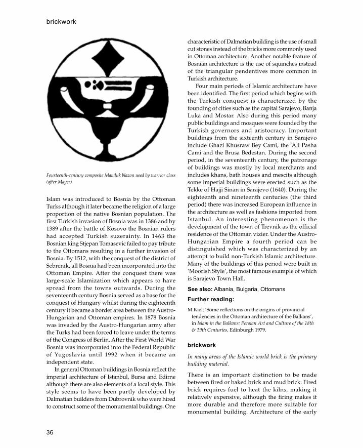
36
Islam was introduced to Bosnia by the OttomanTurks although it later became the religion of a largeproportion of the native Bosnian population. Thefirst Turkish invasion of Bosnia was in 1386 and by1389 after the battle of Kosovo the Bosnian rulershad accepted Turkish suzerainty. In 1463 theBosnian king Stjepan Tomasevic failed to pay tributeto the Ottomans resulting in a further invasion ofBosnia. By 1512, with the conquest of the district ofSebrenik, all Bosnia had been incorporated into theOttoman Empire. After the conquest there waslarge-scale Islamization which appears to havespread from the towns outwards. During theseventeenth century Bosnia served as a base for theconquest of Hungary whilst during the eighteenthcentury it became a border area between the Austro-Hungarian and Ottoman empires. In 1878 Bosniawas invaded by the Austro-Hungarian army afterthe Turks had been forced to leave under the termsof the Congress of Berlin. After the First World WarBosnia was incorporated into the Federal Republicof Yugoslavia until 1992 when it became anindependent state.
In general Ottoman buildings in Bosnia reflect theimperial architecture of Istanbul, Bursa and Edirnealthough there are also elements of a local style. Thisstyle seems to have been partly developed byDalmatian builders from Dubrovnik who were hiredto construct some of the monumental buildings. One
characteristic of Dalmatian building is the use of smallcut stones instead of the bricks more commonly usedin Ottoman architecture. Another notable feature ofBosnian architecture is the use of squinches insteadof the triangular pendentives more common inTurkish architecture.
Four main periods of Islamic architecture havebeen identified. The first period which begins withthe Turkish conquest is characterized by thefounding of cities such as the capital Sarajevo, BanjaLuka and Mostar. Also during this period manypublic buildings and mosques were founded by theTurkish governors and aristocracy. Importantbuildings from the sixteenth century in Sarajevoinclude Ghazi Khusraw Bey Cami, the �Ali PashaCami and the Brusa Bedestan. During the secondperiod, in the seventeenth century, the patronageof buildings was mostly by local merchants andincludes khans, bath houses and mescits althoughsome imperial buildings were erected such as theTekke of Hajji Sinan in Sarajevo (1640). During theeighteenth and nineteenth centuries (the thirdperiod) there was increased European influence inthe architecture as well as fashions imported fromIstanbul. An interesting phenomenon is thedevelopment of the town of Trevnik as the officialresidence of the Ottoman vizier. Under the Austro-Hungarian Empire a fourth period can bedistinguished which was characterized by anattempt to build non-Turkish Islamic architecture.Many of the buildings of this period were built in‘Moorish Style’, the most famous example of whichis Sarajevo Town Hall.
See also: Albania, Bulgaria, Ottomans
Further reading:M.Kiel, ‘Some reflections on the origins of provincial
tendencies in the Ottoman architecture of the Balkans’,in Islam in the Balkans: Persian Art and Culture of the 18th& 19th Centuries, Edinburgh 1979.
brickwork
In many areas of the Islamic world brick is the primarybuilding material.
There is an important distinction to be madebetween fired or baked brick and mud brick. Firedbrick requires fuel to heat the kilns, making itrelatively expensive, although the firing makes itmore durable and therefore more suitable formonumental building. Architecture of the early
Fourteenth-century composite Mamluk blazon used by warrior class(after Mayer)
brickwork

37
Islamic period drew on two distinct buildingtraditions each of which used fired brick as a majorcomponent. In the Mediterranean area brickworkderived from Byzantine and ultimately Romantraditions whereas in former Sassanian territoriesit dated back to the ancient civilizations ofMesopotamia and Iran.
In the Byzantine tradition brick was usually usedfor specific parts of a building such as the dome or asstring courses to level off layers of rubble wall. In thearea of Syria and Jordan the availability of goodquality stone meant that bricks were little used in theByzantine architecture of the area and consequentlywere little used in the early Islamic architecture of thearea. In the few examples—Mshatta and Qasr al-Tuba—where brickwork is employed it seems to bean import from the Sassanian east rather than acontinuation of a local tradition. It is only with theOttoman conquest of Anatolia that the Byzantinebrickwork tradition becomes fully incorporated intoIslamic architecture.
In the east (Iran and Iraq), however, brick wasemployed in the earliest Islamic buildings (i.e. KhanAtshan) as a direct continuation of Sassanian practice.It was in this area that the techniques of decorativebrickwork developed using either standard bricksarranged in patterns or specially shaped bricks. Brickscould be laid vertically, sideways, flat on or in aherringbone pattern and were used to form geometricpatterns or even inscriptions. Par-ticularly elaboratebrickwork was referred to by the Persian termhazarbaf (qv). Brickwork of the Seljuk period, fromthe eleventh to thirteenth century, in Iran and CentralAsia is particularly elaborate using speciallymanufactured bricks. A particularly good example isAisha Bibi Khanum Mausoleum at Djambul,Uzbekistan.
See also: hazarbaf, mud brick
BukharaOasis city in the Republic of Uzbekistan, Central Asia.
Bukhara is located in the valley of the Zeravshan river200 km west of Samarkand. The city was firstmentioned by its present name in a seventh-cen-turyChinese text; however the city itself is probably older.The first Arab raid on Bukhara occurred in 674 althoughit was not finally conquered until 739. During the ninthand tenth centuries the city was under the rule of theSamanids and from 900 was capital of the province ofKhurassan. During this period the city flourished and
became established as one of the greatest centres oflearning in the Islamic world.
Descriptions of Bukhara in the Samanid periodindicate that it consisted of two main parts, the citadeland the town itself. The citadel and the town wereseparate walled enclosures on a high plateau, with aspace between them which was later occupied by acongregational mosque. The citadel had acircumference of 1.5 km and contained, besides thepalace, the city’s first Friday mosque which was builton a pagan temple. The town itself was approximatelytwice the size of the citadel and was enclosed by awall with seven gates. Later the whole area of the cityand the citadel was enclosed within a wall with elevengates (visible until 1938). In addition to the city wallsthere were outer walls which enclosed the villagesaround the city to protect them from nomad attacks;traces of these walls still survive.
Little is left of the Samanid city except the tenth-century mausoleum of the Samanid rulers knownas the mausoleum of Isma�il the Samanid. This is oneof the earliest examples of Islamic funeraryarchitecture and consists of a square chamber with ahemispherical dome and decorative brickwork onboth the exterior and the interior. The corners of thebuilding are formed by engaged cylindrical brickpiers whilst the corners of the dome are marked bysmall domed finials. In the centre of each side thereis a recessed niche containing a door which acts as afocus for the surface decoration. The main form ofdecoration is small, flat, tile-like bricks laidalternately in vertical or horizontal groups of three.Another decorative technique is bricks laidhorizontally in groups of three with one cornerprojecting outwards producing a dog-tooth pattern.This dog-tooth pattern is used mainly in thespandrels of the door arch which are also decoratedwith square terracotta plaques. At the top of theexterior façade there is an arcade of small nicheswhich mask the zone of transition and also providelight to the interior. The decoration of the interior issimilar to the exterior façade although here tiles areset vertically on end producing a diaper pattern. Thedome rests on arched squinches which alternate witharched grilles which admit light to the interior.
The collapse of the Samanids at the end of thetenth century led to the gradual decline of Bukharaunder their successors the Kharakhanids. Thisdecline was reinforced by the Mongol invasions ofthe thirteenth century which twice destroyed the city.There seems to have been no recovery in the fifteenth
Bukhara

38
century and it was not until the arrival of the Uzbeksin the sixteenth that the city recovered some of itsformer splendour. There are few structures whichsurvive from the period between the Samanids andthe Uzbeks although there are a few importantbuildings which date from the twelfth century. Themost famous of these is the Kaylan Minaret which isa huge tower over 45 m high and is decorated withbands of decorative brickwork. The tower is atapering cylinder with an arcaded gallerysurmounted by an overhanging muqarnas corbel; itsform is similar to that of Seljuk towers in Iran withits band of polychrome tile decoration at the top.Another twelfth-century structure demonstratingSeljuk influence is the shrine of Chasma Ayyub withits conical dome. A few buildings survive from the
fifteenth century including the Ulugh Beg Madrassabuilt in 1417.
Most of the major monuments of Bukhara datefrom the Uzbek period and include the massiveKukeldash Madrassa, the Divan Begi Mosque andMadrassa and the Kaylan Mosque. The buildings ofthis period resemble the Timurid buildings ofSamarkand which they were clearly intended toimitate in both size and design. Another feature ofthis period is the grouping of buildings around afocal point or square such as the Lyabi Hauz or thePoi Kaylan in order to increase the visual effect. TheKukeldash Madrassa measures 80 by 60 m and isthe largest madrassa in Central Asia although itsdecoration is surprisingly austere. The Divan BegiMosque and Madrassa are equally impressive with
Tenth-century tomb of the Samanids, Bukhara, Uzbekistan (after Creswell)
Bukhara

39
tall pishtaq entrances framed by twin minarets. Thelargest mosque in the city is the Kaylan Mosque builtin the sixteenth century with the twelfth-centuryminaret nearby. The entrance to the mosque isthrough a huge entrance iwan or pishtaq decoratedwith blue glazed tiles covered with yellow flowersand turquoise stars. Within the mosque is a hugecourtyard surrounded on three sides by a deeparcaded gallery. At the south-west end is anotherlarge iwan which leads to a domed room coveredwith a mihrab.
During the eighteenth century there was a moveaway from the monumental architecture of the firstUzbek rulers towards a lighter form of architectureinspired by Saffavid Iran. One of the finest examplesof this style is the Masjid-i Jami opposite the BolaHauz which has a magnificent hypostyle woodenporch supported on twenty wooden columns withpainted muqarnas capitals.
See also: Samarkand, Timurids, Uzbekistan
Further reading:J.Lawton and F.Venturi, Samarkand and Bukhara, London
1991.G.Pugacenkova and L.Rempel, Bukhara, Moscow 1949.L.Rempel, ‘The Mausoleum of Isma�il the Samanid’,
Bulletin of the American Institute of Persian Art andArchaeology 4: 199–209, 1936.
Bulgaria
A small country located on the Danube in south-easternEurope.
Bulgaria borders Turkey, Greece, Serbia, Russia andRomania. The name of the country derives from theBulgars, a Turkic people who conquered this area in679 CE and adopted Christianity from the Byzantinesin 865. The presence of Islam in Bulgaria is almostexclusively connected with the Ottoman conquestof the region.
The first Ottoman conquest in Bulgaria took placein the mid-fourteenth century when they occupiedpart of the area now known as Bulgarian Thrace. In1396, after Sultan Bayezid’s victory at the battle of
Tenth-century mausoleum of the Samanids, Bukhara © St JohnSimpson
Minaret of the Kaylan Mosque, Bukhara © St John Simpson
Bulgaria
40
Nikeboli (Nicopolis), the Danube area of Bulgariawas incorporated into the Ottoman Empire. Fromthe end of the fourteenth century Bulgaria wasstrongly Ottomanized and new Muslim cities wereestablished especially in the south-east of thecountry. By the sixteenth century this part of thecountry was predominantly Muslim and remainedso until the nineteenth.
The main building materials used in Bulgariawere similar to those used by the Byzantines andlater the Ottomans in Anatolia. These included bakedbrick on its own, baked brick in combination withashlar masonry, ashlar masonry, coursed rubblemasonry with wood and mud brick and wood. Thechoice of material depended partly on the area andpartly on the status of a particular building.
Bulgaria can be divided into two main regionson the basis of Ottoman architecture: BulgarianThrace and the area of the Danube (Danubia).Bulgarian Thrace was the first area conquered by theOttomans and so has a higher proportion of Ottomanbuildings than the rest of the country.
Bulgarian Thrace
One of the oldest Islamic structures in Bulgaria isthe turba of Lal Sahin Pasa in Kazanlik, thought todate from the mid-fourteenth century. The turba isan open, domed canopy supported on piers; theentire structure is made out of baked brick.
Most of the surviving Ottoman buildings,however, are in the major cities. Some of the bestexamples can be found in Plovdiv (Turkish Filibeand Byzantine Philippopolis) in the south-east ofBulgaria near Turkish Thrace. Here the Ottomansfounded a new Muslim settlement outside the wallsof the Christian one. The focal points of the citywere the two mosques located at either end of thecity centre. The older of these is the Cumaya Camior Great Mosque built by Murad II in the 1420swhich is reputedly one of the largest and mostimportant mosques in the Balkans. It has nine baysroofed by three central domes and six woodenvaults, and beneath the central dome is a pool orfountain. In general the building resembles that ofthe Sehadet Cami in Bursa built in 1365. To the southof the Great Mosque is the Zaviye Cami or ImaretMosque built in 1440 which formed the core of acommercial district with a bedestan and hammam.The Ottoman town of Filibe was developed
between these two mosques and a main street wasbuilt to link the two.
To the east of Filibe is the city of Yambol whichwas established after the Ottoman conquests in1365. Probably the most important monument atYambol is the Eski Cami built between 1375 and1385. This consists of a single-domed unit built ofbrick and ashlar masonry in the Byzantine and earlyOttoman style. In the mid-fifteenth century roomswere added on to the sides and a square minaretwas also added. At Yambol too is one of the bestpreserved examples of an early Ottoman bedestan.This consists of a long hall roofed by four domesand entered through the middle of the long sides.On the outside of the building are thirty vaultedrooms or shop units.
North and West Bulgaria (Danubia)
Outside Thrace Ottoman buildings tended to havemore local characteristics. In the area of Danubia aparticular form of mosque developed consisting ofa spacious wooden rectangular hall with a flat roofor wooden ceiling (sometimes with an inset woodendome), covered by a gently sloping roof. Thisroofing system was lighter than a brick or stonedome so that walls could be made thinner and couldbe built out of coursed rubble rather than ashlarmasonry. Two examples of such mosques surviveat Vidin on the Danube; the mosque of Mustafa Pasabuilt in the early eighteenth century and the AkCami built in 1800. Both are built out of coursedrubble masonry with flat wooden ceilings undertiled roofs. Another such mosque at Belgradcik(Haci Husseyin Aga) has a carved wooden ceilingin the local Bulgarian style.
A characteristic type of building found in north-east Bulgaria is the tekke or dervish lodge. TheKizane Tekkesi near Nikopol on the Danube ischaracteristic of the Besiktasi order in the sixteenthcentury. The complex is built of wood and mud brickand was last rebuilt in 1855. The tekke comprisesseveral elements including a kitchen, guesthouse,assembly hall and the mausoleum of the saint.
Further reading:
M.Kiel, ‘Early Ottoman monuments in Bulgarian Thrace’,Belleten 37 no. 152, 1974.
—— ‘Urban development in Bulgaria in the Turkishperiod: the place of architecture in the process’ ,
Bulgaria
41
International Journal of Turkish Studies 4 no . 2: 79–158,Fall/Winter 1989.
burj
Arabic term for a fortified tower.
Bursa
Located on the slopes of the Uludag (Great Mountain) innorth-west Anatolia, Bursa became the first capital of theOttoman state after its capture from the Byzantines inthe fourteenth century.
The city first came under Turkish control in 1071 afterthe battle of Manzikert when it was captured by theSeljuk leader Alp Arslan. In 1107 the city wasrecaptured by the Byzantines who retained theircontrol until 1326, when it was finally taken by theOttomans after a ten-year siege. During theremainder of the fourteenth century Bursa wasestablished as the Ottoman capital with imperialmosques, palaces and a flourishing commercialcentre. In 1402, after the battle of Ankara, Timurmarched westwards where he plundered and burnedthe city. It quickly recovered and during thesubsequent period one of the city’s most importantmonuments, the Yesil Cami, was built. However, thecity never recovered its former importance especiallyas it had been replaced as capital by Edirne in 1366.In 1429 the city suffered a severe plague, and the fallof Constantinople in 1453 meant that it was no longerthe Asian capital of the Ottomans. During thesixteenth century Bursa was merely a provincial cityand there are no major monuments of this period incontrast to Edirne and Istanbul. In the earlynineteenth century the city was established as thecentre of the silk trade with the first silk factoryopened in 1837.
Bursa is dominated by the ancient citadel whichhad proved such an obstacle to early Turkishattacks. The early Ottoman palaces were built ofwood on the spurs of the mountain and none hassurvived. However, the commercial centre of thecity, established by Orhan in the fourteenth century,still contains a number of early buildings. The oldestOttoman building in Bursa is the Alaettin Cami builtin 1335 which consists of a square domed prayerhall and vaulted portico. Two years later Orhanbuilt the first of the Bursa T-plan mosques. Itconsists of a domed central courtyard flanked by
two student rooms and with a prayer hall to thesouth. Orhan’s mosque was part of a complexwhich included two bath houses and a soup kitchen.One of the bath houses, known as the BeyHammam, has survived in its original form and isthe oldest known Ottoman bath house. The buildinghas the same basic form as later hammams andconsists of a large domed dressing room leadingvia an intermediary room to the cruciform domedhot room. Next door on the same street is the BeyHan also built by Orhan in the early fourteenthcentury. This is a two-storey structure built arounda central rectangular courtyard with an entrance onthe north side and a stable block at the back. Thelower windowless rooms were used for storagewhilst the upper floor contained the rooms fortravellers each with its own chimney.
To the west of Bursa is an area known as Çekirgewhich was developed as a royal centre by Orhan’ssuccessor Murat between 1366 and 1385. At the centreof the complex was the Hüdavendigâr Cami, or royalmosque, which is a unique example of a madrassaand zawiya in one building. The lower floor isoccupied by the zawiya and mosque whilst the upperfloor is the madrassa. The zawiya and mosque is builtto the same T-plan as was used earlier in Orhan’smosque whilst the upper floor is built as a traditionalmadrassa modified to the shape of the buildingbelow. The arrangement is unusual because thezawiya was used by mystical dervishes hostile toreligious orthodoxy and the madrassa by studentsand teachers of orthodox Islamic law. Thecombination reflects the political situation of the timewhen the Ottomans were moving away from theirrole as leaders of frontier warriors with traditionaldervish supporters to a more centralized state systemrelying on religious orthodoxy for support. Like theHüdavendigâr Mosque, the Beyazit complex begunin 1490 includes a zawiya mosque and an orthodoxmadrassa although here the two buildings areseparate with the mosque zawiya on a hill and therectangular madrassa below. The mosque has thesame T-plan as Orhan’s original mosque althoughthe tall five-domed portico represents an advance inmosque design.
The main mosque of Bursa is the Ulu Cami (GreatMosque) built by Beyazit between 1399 and 1400.The mosque covers a large area (63 by 50 m) and isroofed by twenty domes resting on large squarepiers. The main entrance and the mihrab are on thesame central axis and there is a sunken pool
Bursa
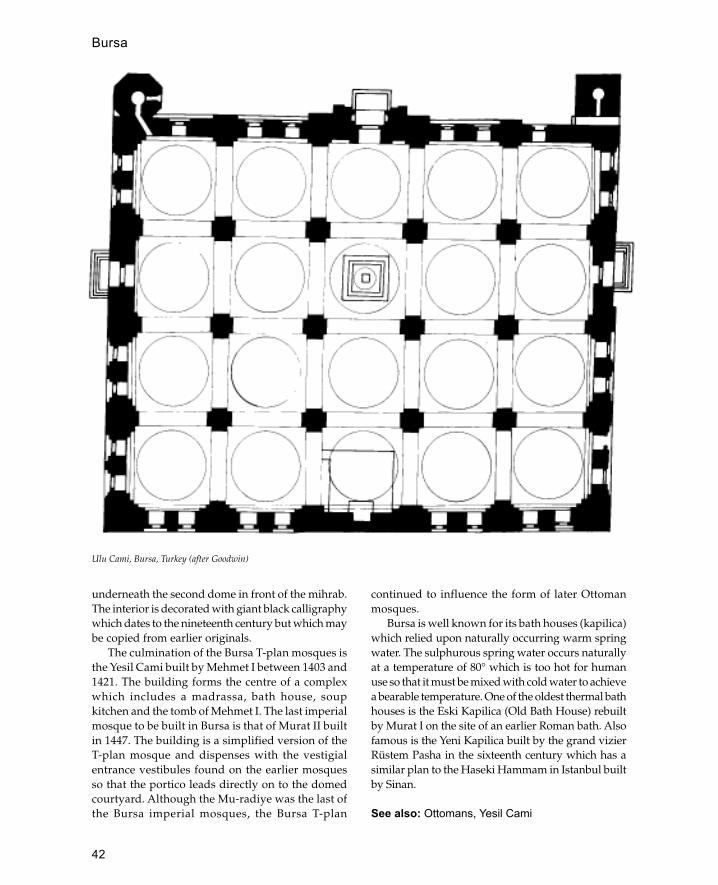
42
underneath the second dome in front of the mihrab.The interior is decorated with giant black calligraphywhich dates to the nineteenth century but which maybe copied from earlier originals.
The culmination of the Bursa T-plan mosques isthe Yesil Cami built by Mehmet I between 1403 and1421. The building forms the centre of a complexwhich includes a madrassa, bath house, soupkitchen and the tomb of Mehmet I. The last imperialmosque to be built in Bursa is that of Murat II builtin 1447. The building is a simplified version of theT-plan mosque and dispenses with the vestigialentrance vestibules found on the earlier mosquesso that the portico leads directly on to the domedcourtyard. Although the Mu-radiye was the last ofthe Bursa imperial mosques, the Bursa T-plan
continued to influence the form of later Ottomanmosques.
Bursa is well known for its bath houses (kapilica)which relied upon naturally occurring warm springwater. The sulphurous spring water occurs naturallyat a temperature of 80° which is too hot for humanuse so that it must be mixed with cold water to achievea bearable temperature. One of the oldest thermal bathhouses is the Eski Kapilica (Old Bath House) rebuiltby Murat I on the site of an earlier Roman bath. Alsofamous is the Yeni Kapilica built by the grand vizierRüstem Pasha in the sixteenth century which has asimilar plan to the Haseki Hammam in Istanbul builtby Sinan.
See also: Ottomans, Yesil Cami
Ulu Cami, Bursa, Turkey (after Goodwin)
Bursa

43
Further reading:A.Gabriel, Une Capitale Turque, Brousse, Paris 1958.A.Tuna, Bursa Yeni Kapilica (The Yeni Bath House at
Bursa), Istanbul 1987.
Byzantine architectureArchitecture characterized by brick and masonryconstruction, round arches and domes, developed within theByzantine Empire.
Byzantine architecture was of crucial importance tothe development of early Islamic architecture and laterthe architecture of the Ottoman Empire. At the timeof the Islamic conquest of Syria in the seventh centuryByzantine was essentially a continuation of Romanarchitecture. There were, however, a few majordifferences, the most significant of which was themassive church-building campaign of Justinian (sixthcentury) which made Christianity the central focus of
architecture. Also noticeable in the architecture of thisperiod was the influence of the capital Constantinopleon the rest of the empire.
During the ninth to eleventh centuries theByzantines recovered from the disastrous effects ofthe Islamic conquests, and in this period there isevidence of Islamic influence on Byzantinearchitecture, particularly in descriptions of the palacesof Constantinople.
During the fourteenth to fifteenth centuriesByzantine architecture was a major influence on thatof the Turkish principalities in Anatolia. In particularthe domed basilical church had a formative influenceon early Ottoman mosques.
See also: Hagia Sophia, Ottomans, Umayyads
Further reading:C.Mango, Byzantine Architecture, London 1986.
Byzantine architecture
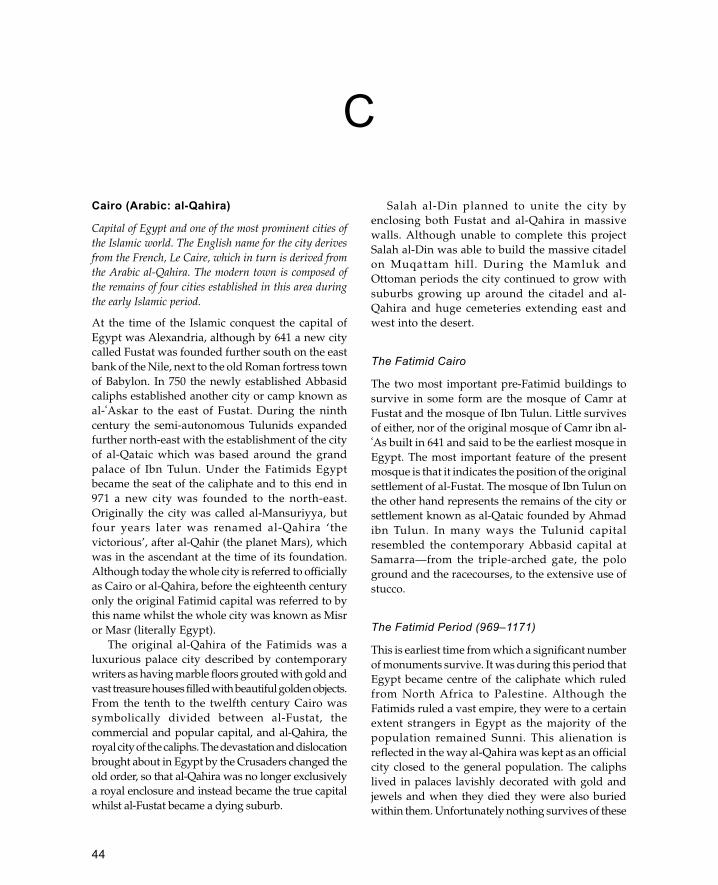
44
Cairo (Arabic: al-Qahira)
Capital of Egypt and one of the most prominent cities ofthe Islamic world. The English name for the city derivesfrom the French, Le Caire, which in turn is derived fromthe Arabic al-Qahira. The modern town is composed ofthe remains of four cities established in this area duringthe early Islamic period.
At the time of the Islamic conquest the capital ofEgypt was Alexandria, although by 641 a new citycalled Fustat was founded further south on the eastbank of the Nile, next to the old Roman fortress townof Babylon. In 750 the newly established Abbasidcaliphs established another city or camp known asal-�Askar to the east of Fustat. During the ninthcentury the semi-autonomous Tulunids expandedfurther north-east with the establishment of the cityof al-Qataic which was based around the grandpalace of Ibn Tulun. Under the Fatimids Egyptbecame the seat of the caliphate and to this end in971 a new city was founded to the north-east.Originally the city was called al-Mansuriyya, butfour years later was renamed al-Qahira ‘thevictorious’, after al-Qahir (the planet Mars), whichwas in the ascendant at the time of its foundation.Although today the whole city is referred to officiallyas Cairo or al-Qahira, before the eighteenth centuryonly the original Fatimid capital was referred to bythis name whilst the whole city was known as Misror Masr (literally Egypt).
The original al-Qahira of the Fatimids was aluxurious palace city described by contemporarywriters as having marble floors grouted with gold andvast treasure houses filled with beautiful golden objects.From the tenth to the twelfth century Cairo wassymbolically divided between al-Fustat, thecommercial and popular capital, and al-Qahira, theroyal city of the caliphs. The devastation and dislocationbrought about in Egypt by the Crusaders changed theold order, so that al-Qahira was no longer exclusivelya royal enclosure and instead became the true capitalwhilst al-Fustat became a dying suburb.
Salah al-Din planned to unite the city byenclosing both Fustat and al-Qahira in massivewalls. Although unable to complete this projectSalah al-Din was able to build the massive citadelon Muqattam hill. During the Mamluk andOttoman periods the city continued to grow withsuburbs growing up around the citadel and al-Qahira and huge cemeteries extending east andwest into the desert.
The Fatimid Cairo
The two most important pre-Fatimid buildings tosurvive in some form are the mosque of Camr atFustat and the mosque of Ibn Tulun. Little survivesof either, nor of the original mosque of Camr ibn al-�As built in 641 and said to be the earliest mosque inEgypt. The most important feature of the presentmosque is that it indicates the position of the originalsettlement of al-Fustat. The mosque of Ibn Tulun onthe other hand represents the remains of the city orsettlement known as al-Qataic founded by Ahmadibn Tulun. In many ways the Tulunid capitalresembled the contemporary Abbasid capital atSamarra—from the triple-arched gate, the pologround and the racecourses, to the extensive use ofstucco.
The Fatimid Period (969–1171)
This is earliest time from which a significant numberof monuments survive. It was during this period thatEgypt became centre of the caliphate which ruledfrom North Africa to Palestine. Although theFatimids ruled a vast empire, they were to a certainextent strangers in Egypt as the majority of thepopulation remained Sunni. This alienation isreflected in the way al-Qahira was kept as an officialcity closed to the general population. The caliphslived in palaces lavishly decorated with gold andjewels and when they died they were also buriedwithin them. Unfortunately nothing survives of these
C

45
Cairo (Arabic: al-Qahira)
palaces as they were systematically destroyed bylater rulers, although detailed descriptions can befound in the writings of Nasiri Khusraw or al-Maqrizi.
The best surviving examples of Fatimidarchitecture in Cairo are the mosques of al-Azhar(970) and al-Aqmar (1125) which demonstrate atransition from early Islamic to medieval forms.Despite later accretions, the mosque of al-Azharrepresents an early Islamic hypostyle form withthree arcades around a central courtyard. Thesanctuary is composed of five aisles parallel to theqibla and a central transverse aisle which isemphasized by being both higher and wider thanthe surrounding roof. Originally there were threedomes at the qibla end, one in front of the mihraband one on either side. Three aisles around a centralcourtyard and the arrangement of three domes areall features common in early North Africanmosques. Inside the mosque was lavishly decoratedwith stucco work, only part of which survives(around the mihrab and on parts of the arcades).The stucco has some Abbasid influence althoughthere are also Byzantine and Coptic elements in thedesigns.
Built some 150 years later, the mosque of al-Aqmar has a much more sophisticated design,reminiscent of the later medieval buildings of Cairo.It was founded by the vizier Ma�mun al Bata�ihiduring the reign of Caliph al-Amir. The interior planconsists of a small central courtyard surrounded onfour sides by triple arcades. The sanctuary consistsof a small area divided into three aisles parallel tothe qibla wall. Initially the mosque would havebeen covered with a flat hypostyle roof but it is nowcovered with shallow brick domes. Stylistically themost important feature of the plan is the way theentrance is positioned at an angle to the mainbuilding. This feature allows the mosque to beincorporated into a pre-existing street plan whilsthaving the prayer hall correctly aligned for theqibla. This is one of the earliest examples of thistype of plan which was to become morepronounced in Mamluk religious buildings. Theother important feature of the al-Aqmar Mosque isthe decoration of the façade which was developedin later mosques to be a main feature of the design.The façade is made of stone overlying a brickstructure. Today the right hand side is hidden by alater building but it is assumed that it was originallysymmetrical with a projecting portal in the middle.
The decoration of the façade is dominated bydecorated niches with fluted conch-like niches, anarrangement used in more complex forms in latermosques. The al-Aqmar Mosque is also significantas the earliest mosque to incorporate shops in itsdesign (these were below the present street leveland have been revealed by excavations). Anotherimportant mosque of Fatimid Cairo is that of thecaliph al-Hakim built between 990 and 1003. Themosque, which has recently been restored, has alarge rectangular courtyard surrounded by fourarcades. A transept aisle opposite the mihrabindicates the direction of the qibla which is furtheremphasized by three domes. The entrance to themosque is via a large projecting portal similar tothat of the mosque of Mahdiyya, the Fatimid capitalin North Africa. Probably the most famous featureof this mosque are the minarets at either end of thenorth façade. They were built in 990 and consist ofone octagonal and one cylindrical decorated bricktower; at some later date (probably 1110) the lowerparts of these minarets were encased in large brickcubes for some unknown reason.
Apart from mosques, various other types ofreligious building are known to have been builtin Fatimid Cairo including many tombs ormashads devoted to religious personalities.However, most of these have not survived or havebeen altered beyond recognition as they have beenin continuous religious use. An exception to thisis the mashad of al-Juyushi also known as MashadBadr al-Jamali.
This structure consists of two main parts, adomed prayer hall opening on to a courtyard anda large minaret. Although there is a side chamberwhich may have been a tomb, there is no positiveidentification of the person commemorated. Theprayer hall is covered with cross vaults except forthe area in front of the mihrab which is coveredwith a tall dome resting on plain squinches. Theminaret is a tall square tower capped by anoctagonal lantern covered with a dome. A notablefeature of the minaret is the use of a muqarnascornice which is the first example of this decorationon the exterior of a building. The roof of thecomplex also houses two small kiosks whosefunction has not been resolved. Other notableFatimid mashads are the tombs of SayyidaRuqayya and Yayha al-Shabih both in the cemeteryof Fustat. The first of these was built tocommemorate Sayyida Ruqayya, a descendant of
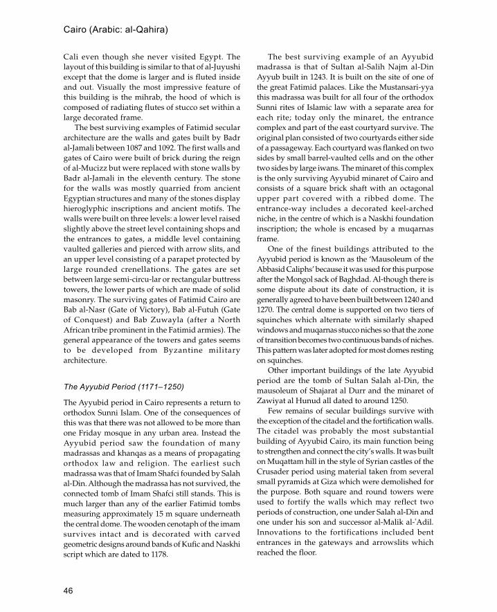
46
Cairo (Arabic: al-Qahira)
Cali even though she never visited Egypt. Thelayout of this building is similar to that of al-Juyushiexcept that the dome is larger and is fluted insideand out. Visually the most impressive feature ofthis building is the mihrab, the hood of which iscomposed of radiating flutes of stucco set within alarge decorated frame.
The best surviving examples of Fatimid seculararchitecture are the walls and gates built by Badral-Jamali between 1087 and 1092. The first walls andgates of Cairo were built of brick during the reignof al-Mucizz but were replaced with stone walls byBadr al-Jamali in the eleventh century. The stonefor the walls was mostly quarried from ancientEgyptian structures and many of the stones displayhieroglyphic inscriptions and ancient motifs. Thewalls were built on three levels: a lower level raisedslightly above the street level containing shops andthe entrances to gates, a middle level containingvaulted galleries and pierced with arrow slits, andan upper level consisting of a parapet protected bylarge rounded crenellations. The gates are setbetween large semi-circu-lar or rectangular buttresstowers, the lower parts of which are made of solidmasonry. The surviving gates of Fatimid Cairo areBab al-Nasr (Gate of Victory), Bab al-Futuh (Gateof Conquest) and Bab Zuwayla (after a NorthAfrican tribe prominent in the Fatimid armies). Thegeneral appearance of the towers and gates seemsto be developed from Byzantine militaryarchitecture.
The Ayyubid Period (1171–1250)
The Ayyubid period in Cairo represents a return toorthodox Sunni Islam. One of the consequences ofthis was that there was not allowed to be more thanone Friday mosque in any urban area. Instead theAyyubid period saw the foundation of manymadrassas and khanqas as a means of propagatingorthodox law and religion. The earliest suchmadrassa was that of Imam Shafci founded by Salahal-Din. Although the madrassa has not survived, theconnected tomb of Imam Shafci still stands. This ismuch larger than any of the earlier Fatimid tombsmeasuring approximately 15 m square underneaththe central dome. The wooden cenotaph of the imamsurvives intact and is decorated with carvedgeometric designs around bands of Kufic and Naskhiscript which are dated to 1178.
The best surviving example of an Ayyubidmadrassa is that of Sultan al-Salih Najm al-DinAyyub built in 1243. It is built on the site of one ofthe great Fatimid palaces. Like the Mustansari-yyathis madrassa was built for all four of the orthodoxSunni rites of Islamic law with a separate area foreach rite; today only the minaret, the entrancecomplex and part of the east courtyard survive. Theoriginal plan consisted of two courtyards either sideof a passageway. Each courtyard was flanked on twosides by small barrel-vaulted cells and on the othertwo sides by large iwans. The minaret of this complexis the only surviving Ayyubid minaret of Cairo andconsists of a square brick shaft with an octagonalupper part covered with a ribbed dome. Theentrance-way includes a decorated keel-archedniche, in the centre of which is a Naskhi foundationinscription; the whole is encased by a muqarnasframe.
One of the finest buildings attributed to theAyyubid period is known as the ‘Mausoleum of theAbbasid Caliphs’ because it was used for this purposeafter the Mongol sack of Baghdad. Al-though there issome dispute about its date of construction, it isgenerally agreed to have been built between 1240 and1270. The central dome is supported on two tiers ofsquinches which alternate with similarly shapedwindows and muqarnas stucco niches so that the zoneof transition becomes two continuous bands of niches.This pattern was later adopted for most domes restingon squinches.
Other important buildings of the late Ayyubidperiod are the tomb of Sultan Salah al-Din, themausoleum of Shajarat al Durr and the minaret ofZawiyat al Hunud all dated to around 1250.
Few remains of secular buildings survive withthe exception of the citadel and the fortification walls.The citadel was probably the most substantialbuilding of Ayyubid Cairo, its main function beingto strengthen and connect the city’s walls. It was builton Muqattam hill in the style of Syrian castles of theCrusader period using material taken from severalsmall pyramids at Giza which were demolished forthe purpose. Both square and round towers wereused to fortify the walls which may reflect twoperiods of construction, one under Salah al-Din andone under his son and successor al-Malik al-�Adil.Innovations to the fortifications included bententrances in the gateways and arrowslits whichreached the floor.

47
Cairo (Arabic: al-Qahira)
Bahri Mamluk Period (1250–1382)
The early Mamluk period is architecturally the mostprolific period in Cairo with a wide range of majorbuilding projects carried out. Many of thesebuildings have survived demonstrating a diverserange of styles, techniques and designs. During thisperiod some of the major forms of later Cairenearchitecture were established such as the erection of
sabils on street corners often linked to primaryschools. During this period there was alsoconsiderable foreign influence from Sicily, Iran,North Africa and Spain which was absorbed into thearchitecture of Cairo.
Congregational mosques were founded duringthis period after the strict Shafi�ite orthodoxy of theAyyubid sultans who only permitted onecongregational mosque in the city, that of al-Hakim.
Mosque of Baybars, Cairo (1266–9) (after Creswell)
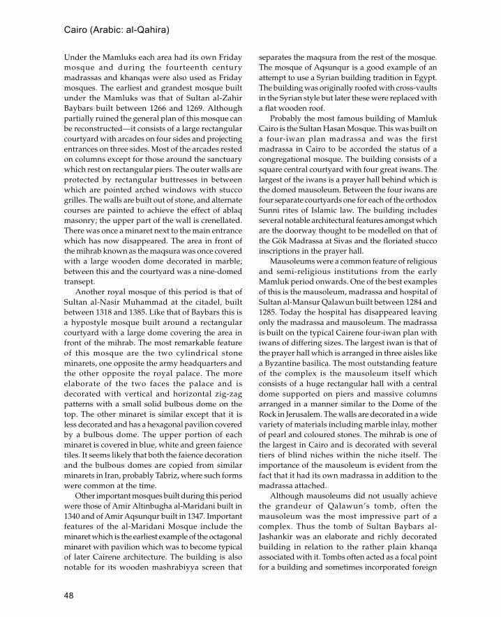
48
Cairo (Arabic: al-Qahira)
Under the Mamluks each area had its own Fridaymosque and during the fourteenth centurymadrassas and khanqas were also used as Fridaymosques. The earliest and grandest mosque builtunder the Mamluks was that of Sultan al-ZahirBaybars built between 1266 and 1269. Althoughpartially ruined the general plan of this mosque canbe reconstructed—it consists of a large rectangularcourtyard with arcades on four sides and projectingentrances on three sides. Most of the arcades restedon columns except for those around the sanctuarywhich rest on rectangular piers. The outer walls areprotected by rectangular buttresses in betweenwhich are pointed arched windows with stuccogrilles. The walls are built out of stone, and alternatecourses are painted to achieve the effect of ablaqmasonry; the upper part of the wall is crenellated.There was once a minaret next to the main entrancewhich has now disappeared. The area in front ofthe mihrab known as the maqsura was once coveredwith a large wooden dome decorated in marble;between this and the courtyard was a nine-domedtransept.
Another royal mosque of this period is that ofSultan al-Nasir Muhammad at the citadel, builtbetween 1318 and 1385. Like that of Baybars this isa hypostyle mosque built around a rectangularcourtyard with a large dome covering the area infront of the mihrab. The most remarkable featureof this mosque are the two cylindrical stoneminarets, one opposite the army headquarters andthe other opposite the royal palace. The moreelaborate of the two faces the palace and isdecorated with vertical and horizontal zig-zagpatterns with a small solid bulbous dome on thetop. The other minaret is similar except that it isless decorated and has a hexagonal pavilion coveredby a bulbous dome. The upper portion of eachminaret is covered in blue, white and green faiencetiles. It seems likely that both the faience decorationand the bulbous domes are copied from similarminarets in Iran, probably Tabriz, where such formswere common at the time.
Other important mosques built during this periodwere those of Amir Altinbugha al-Maridani built in1340 and of Amir Aqsunqur built in 1347. Importantfeatures of the al-Maridani Mosque include theminaret which is the earliest example of the octagonalminaret with pavilion which was to become typicalof later Cairene architecture. The building is alsonotable for its wooden mashrabiyya screen that
separates the maqsura from the rest of the mosque.The mosque of Aqsunqur is a good example of anattempt to use a Syrian building tradition in Egypt.The building was originally roofed with cross-vaultsin the Syrian style but later these were replaced witha flat wooden roof.
Probably the most famous building of MamlukCairo is the Sultan Hasan Mosque. This was built ona four-iwan plan madrassa and was the firstmadrassa in Cairo to be accorded the status of acongregational mosque. The building consists of asquare central courtyard with four great iwans. Thelargest of the iwans is a prayer hall behind which isthe domed mausoleum. Between the four iwans arefour separate courtyards one for each of the orthodoxSunni rites of Islamic law. The building includesseveral notable architectural features amongst whichare the doorway thought to be modelled on that ofthe Gök Madrassa at Sivas and the floriated stuccoinscriptions in the prayer hall.
Mausoleums were a common feature of religiousand semi-religious institutions from the earlyMamluk period onwards. One of the best examplesof this is the mausoleum, madrassa and hospital ofSultan al-Mansur Qalawun built between 1284 and1285. Today the hospital has disappeared leavingonly the madrassa and mausoleum. The madrassais built on the typical Cairene four-iwan plan withiwans of differing sizes. The largest iwan is that ofthe prayer hall which is arranged in three aisles likea Byzantine basilica. The most outstanding featureof the complex is the mausoleum itself whichconsists of a huge rectangular hall with a centraldome supported on piers and massive columnsarranged in a manner similar to the Dome of theRock in Jerusalem. The walls are decorated in a widevariety of materials including marble inlay, motherof pearl and coloured stones. The mihrab is one ofthe largest in Cairo and is decorated with severaltiers of blind niches within the niche itself. Theimportance of the mausoleum is evident from thefact that it had its own madrassa in addition to themadrassa attached.
Although mausoleums did not usually achievethe grandeur of Qalawun’s tomb, often themausoleum was the most impressive part of acomplex. Thus the tomb of Sultan Baybars al-Jashankir was an elaborate and richly decoratedbuilding in relation to the rather plain khanqaassociated with it. Tombs often acted as a focal pointfor a building and sometimes incorporated foreign

49
Cairo (Arabic: al-Qahira)
features or unusual techniques in order to drawattention to the building and its founder. This can beseen in the madrassa-mausoleum of AmirSarghitmish built in 1356 where the mausoleum isnot placed next to the prayer hall as was usual butinstead was built in a position so that its façade andprofile were directly on the main street. Themausoleum is covered by a double-shell dome seton an unusually high drum with an exteriormoulding of muqarnas marking the transition fromdrum to dome. This form of dome is not usual inCairo and may have been copied from similar domesin Samarkand.
Circassian Mamluk Period (1382–1517)
Several developments took place in the fifteenth-century architecture of Cairo which distinguish itfrom the earlier Mamluk period. Thesedevelopments were of two basic types: thoseconcerned with the layout and plan of buildings andthose concerned with the decoration andconstruction of buildings.
The biggest factor affecting design and layout wasthe lack of space in an increasingly crowded area.The most obvious result of this was that mosquestended to be smaller and were designed to fillawkwardly shaped plots. The size of mosques wasreduced in a number of ways, the most notable ofwhich was the reduction in size of the centralcourtyard until it became a small square area in thecentre covered by a wooden lantern to admit light.A result of this design change was that the side wallsof mosques were now pierced with many windowsto make up for the lack of light from the courtyards.Also there was a move away from the hypostylemosque towards the four-iwan plan used formadrassas. However, the form of the iwans changedfrom brick or stone vaults to flat wooden roofedunits. Another change was that now madrassas didnot include accommodation blocks for students whowere located outside.
The trend which had begun in the fourteenthcentury of using madrassas as Friday mosques wasextended so that now buildings would fulfil severalroles such as khanqa, madrassa and jami. The earliestexample of such a combination was the complex ofSultan Barquq built between 1384 and 1386.
One of the exceptions to the decreasing size ofmosques is the Khanqah of Sultan Faraj ibn Barquqbuilt between 1400 and 1411. This large complex
was deliberately built outside the main urban areain the cemetery on the eastern outskirts of Cairo.The plan adopted for this building was that of ahypostyle mosque, with a spacious centralcourtyard containing an octagonal central fountain.Despite its traditional Friday mosque layout thisstructure contained living units for Sufis as well astwo domed mausoleums flanking the sanctuary orprayer hall.
Many of the changes in the architecture of thelate Mamluk period are concerned with the buildingand decoration of domes. Among the most famousfeatures of Cairo are the carved stone domes builtduring this period. These are fairly unique to Cairoalthough occasional examples can be foundelsewhere, such as the Sabil Qaytbay in Jerusalemwhich is known to be a copy of similar Egyptiandomes. Up to the late fourteenth century mostdomes in Egypt were either built of wood or brick,and stone domes were only used for the tops ofminarets. It is thought likely that this was the originof the larger stone domes used on tombs. Theearliest stone domes had ribbed decoration similarto that seen on the tops of minarets; later this wasdeveloped into a swirled turban style as can be seenon the mausoleum of Amir Aytimish al-Bajasi builtin 1383. The next stage was zig-zag patternsfollowed by the intricate star patterns which canbe seen on the mausoleums built for Sultan Barbays.Under Sultan Qaytbay an important innovation wasmade where the star pattern would start at the top,whereas previously decoration had started at thebottom. With the increasing sophistication of domedecoration it was natural that domes were set onhigher drums so that they could be seen from faraway. The increased confidence in stone carvingexhibited in domes is also reflected in thedecoration of minarets which are now also carvedin stone. One of the earliest examples of this is theminaret belonging to the complex of Sultan Barquqbuilt between 1384 and 1386. The minaret isoctagonal throughout and has a central sectioncomposed of giant intersecting circles.
Another innovation in the architecture of thisperiod was the triangular pendentive. The earliestexamples in Cairo were used in the citadel mosqueof al-Nasir Muhammad and were made of wood.Later pendentives were used for stone domes al-though muqarnas squinches continued to be used.A related feature introduced at this time was thegroin vault used in complex arrangements for
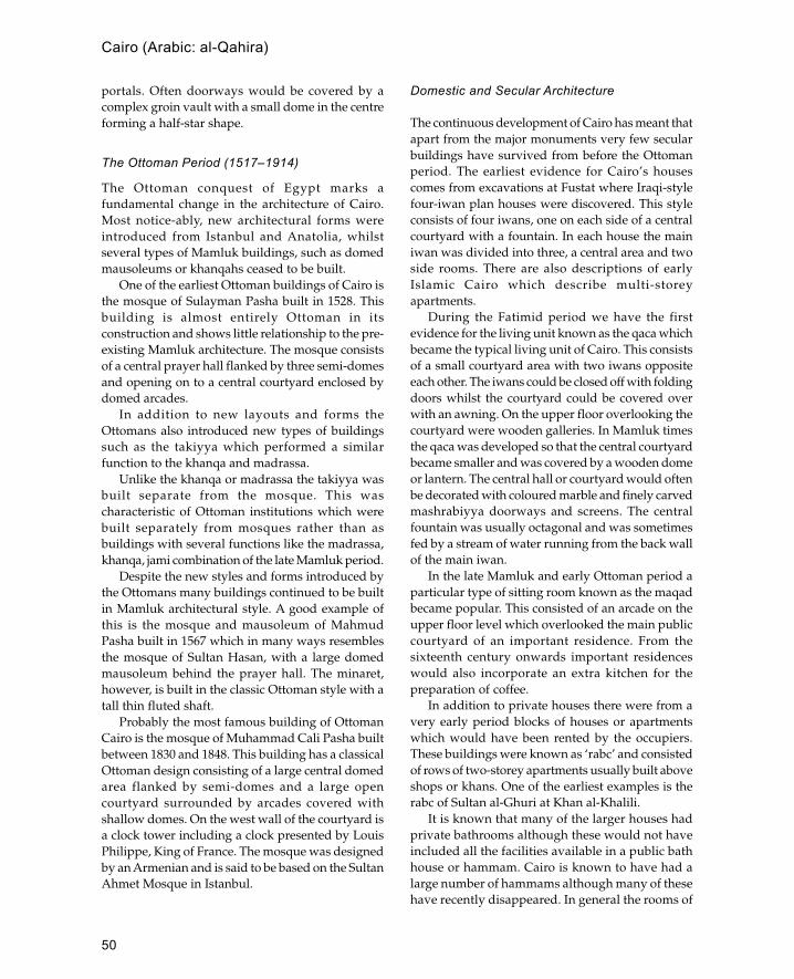
50
Cairo (Arabic: al-Qahira)
portals. Often doorways would be covered by acomplex groin vault with a small dome in the centreforming a half-star shape.
The Ottoman Period (1517–1914)
The Ottoman conquest of Egypt marks afundamental change in the architecture of Cairo.Most notice-ably, new architectural forms wereintroduced from Istanbul and Anatolia, whilstseveral types of Mamluk buildings, such as domedmausoleums or khanqahs ceased to be built.
One of the earliest Ottoman buildings of Cairo isthe mosque of Sulayman Pasha built in 1528. Thisbuilding is almost entirely Ottoman in itsconstruction and shows little relationship to the pre-existing Mamluk architecture. The mosque consistsof a central prayer hall flanked by three semi-domesand opening on to a central courtyard enclosed bydomed arcades.
In addition to new layouts and forms theOttomans also introduced new types of buildingssuch as the takiyya which performed a similarfunction to the khanqa and madrassa.
Unlike the khanqa or madrassa the takiyya wasbuilt separate from the mosque. This wascharacteristic of Ottoman institutions which werebuilt separately from mosques rather than asbuildings with several functions like the madrassa,khanqa, jami combination of the late Mamluk period.
Despite the new styles and forms introduced bythe Ottomans many buildings continued to be builtin Mamluk architectural style. A good example ofthis is the mosque and mausoleum of MahmudPasha built in 1567 which in many ways resemblesthe mosque of Sultan Hasan, with a large domedmausoleum behind the prayer hall. The minaret,however, is built in the classic Ottoman style with atall thin fluted shaft.
Probably the most famous building of OttomanCairo is the mosque of Muhammad Cali Pasha builtbetween 1830 and 1848. This building has a classicalOttoman design consisting of a large central domedarea flanked by semi-domes and a large opencourtyard surrounded by arcades covered withshallow domes. On the west wall of the courtyard isa clock tower including a clock presented by LouisPhilippe, King of France. The mosque was designedby an Armenian and is said to be based on the SultanAhmet Mosque in Istanbul.
Domestic and Secular Architecture
The continuous development of Cairo has meant thatapart from the major monuments very few secularbuildings have survived from before the Ottomanperiod. The earliest evidence for Cairo’s housescomes from excavations at Fustat where Iraqi-stylefour-iwan plan houses were discovered. This styleconsists of four iwans, one on each side of a centralcourtyard with a fountain. In each house the mainiwan was divided into three, a central area and twoside rooms. There are also descriptions of earlyIslamic Cairo which describe multi-storeyapartments.
During the Fatimid period we have the firstevidence for the living unit known as the qaca whichbecame the typical living unit of Cairo. This consistsof a small courtyard area with two iwans oppositeeach other. The iwans could be closed off with foldingdoors whilst the courtyard could be covered overwith an awning. On the upper floor overlooking thecourtyard were wooden galleries. In Mamluk timesthe qaca was developed so that the central courtyardbecame smaller and was covered by a wooden domeor lantern. The central hall or courtyard would oftenbe decorated with coloured marble and finely carvedmashrabiyya doorways and screens. The centralfountain was usually octagonal and was sometimesfed by a stream of water running from the back wallof the main iwan.
In the late Mamluk and early Ottoman period aparticular type of sitting room known as the maqadbecame popular. This consisted of an arcade on theupper floor level which overlooked the main publiccourtyard of an important residence. From thesixteenth century onwards important residenceswould also incorporate an extra kitchen for thepreparation of coffee.
In addition to private houses there were from avery early period blocks of houses or apartmentswhich would have been rented by the occupiers.These buildings were known as ‘rabc’ and consistedof rows of two-storey apartments usually built aboveshops or khans. One of the earliest examples is therabc of Sultan al-Ghuri at Khan al-Khalili.
It is known that many of the larger houses hadprivate bathrooms although these would not haveincluded all the facilities available in a public bathhouse or hammam. Cairo is known to have had alarge number of hammams although many of thesehave recently disappeared. In general the rooms of

51
a bath house were fairly plain with the exceptionof the maslakh (reception hall) which was oftendomed and sometimes was supported withcolumns.
Further reading:
D.Berhens-Abouseif, Islamic Architecture in Cairo: AnIntroduction, Supplements to Muquarnas vol. 3, Leiden1989. This is the best modern summary of Islamicarchitecture in Cairo.
K.A.C.Creswell, The Muslim Architecture of Egypt, Oxford1952–60. Contains the most comprehensive discussionand treatment of buildings from the beginning of theFatimid (969) to the end of the Mamluk (1517) periods.For domestic architecture see:
J.C.Garcin, B.Maury, J.Revault and M.Zakariya, Palais etMaisons du Caire: I. D’Époque Mamelouke (XIIIe–XVIe
siècles), Paris 1982.B.Maury, A.Raymond, J.Revault and M.Zakariya, Palais et
Maisons du Caire: II. Époque Ottomane (XVIe– XVIIIe
siècles) vol. 2, Paris 1983. For modern architecture see:M.al-Gawhury, Ex-Royal Palaces of Egypt, Cairo 1954.A.D.C.Hyland, A.G.Tipple and N.Wilkinson, Housing in
Egypt, Newcastle-upon-Tyne 1984.
cami
Turkish term for a congregational or Friday mosqueas opposed to the smaller mescit.
caravanserai
Roadside building which provides accomodation andshelter for travellers.
The term caravanserai is a composite Turkish termderived from caravan (i.e. a group of travellers) andserai (palace). Generally it refers to a large structurewhich would be capable of coping with a largenumber of travellers, their animals and goods. Theterm first seems to have been used in the twelfthcentury under the Seljuks and may indicate aparticularly grand form of khan with a monumentalentrance. During the Saffavid period in Iran(seventeenth to eighteenth century) caravanserais areoften huge structures with four iwans.
See also: khan
çarsi
Turkish term for a market.
Central Asia
Central Asia comprises the modern independent repub-lics of Khazakstan, Turkmenistan, Khirgiziya andUzbekistan.
In pre-Islamic times Central Asia was the homeof several important Turkic dynasties the mostimportant of which were the Kushans who ruledover most of the area in the fifth century CE. By theseventh century the western part of the KushanEmpire had been conquered by the Sassanians whilstthe eastern part fractured into a number ofindependent principalities. One of the mostimportant principalities was that of the Sogdianswhose art and architecture seem to have been animportant influence on Islamic architecture of theninth century and after.
Plan of Tutabeg Khatun Tomb, fourteenth century, Urgench,Uzbekistan
Central Asia

52
During the Islamic period the cities of central Asiacontinued to control the Silk Route and cities suchas Samarkand, Bukhara and Merv rose to greatprosperity.
See also: Turkmenistan, Uzbekistan
çesme
A Turkish term for a fountain or tap used to providedrinking water. These were often attached toOttoman monuments to fulfil a charitable purpose.
chahar bagh or char bagh
Iranian and Mughal term for a formal garden laidout in four plots of equal size and divided by axialpaths.
See also: gardens, Mughals
chajja
Mughal and Hindu term for projecting eaves or coverusually supported on large carved brackets.
char-chala
Indian roof form with curved eaves and curvedsurfaces. Derived from Bengali architecture.
See also: bangala, Bengal, do-chala
Char Minar
Ceremonial gateway in Hyderabad which is one of thebest examples of south Indian Islamic architecture.
When it was built in 1589 the Char Minar (literallyfour towers) formed the centre of the city and withthe charkaman (four gates) was part of theceremonial approach to the royal palaces (nowdestroyed). The building is a square structure witharched gateways in the centre of each side whichintersect at the centre. At each of the four corners isa tower or minaret nearly 60 m high and crownedwith an onion-shaped bulbous dome. The first storeyabove the arches contains a circular cistern whilston the second storey there is a small domed mosque.
See also: Deccan, Hyderabad, India
char su or char taqIranian and Mughal term for the intersection of twomarket streets where there is usually an open square
with four arched entrances. (Roughly equivalent tothe classical tetra pylon.)
chatriMughal and Hindu term for a domed kiosk on theroof of a temple, tomb or mosque. The domes areusually supported on four columns.
chauk
Indian term for an open square or courtyard.
ChinaThere are three main Muslim groups within theRepublic of China, these are the maritime communitiesof the great ports, the urban communities of northernChina and the predominantly Turkic people of CentralAsia.
Maritime Communities
The development of maritime Muslim communitiesin China is less well documented than the conquestsof Central Asia or the inland settlements of northernChina. The first coastal settlements seem to have beenmostly in southern and eastern ports and includethe cities of Canton, Chuan Chou, Hang Chou inChekiang Province and Yang Chou on the lowerYangtze. The descendants of these early Muslims areknown as Hui (a term also applied to the Muslimsof the northern inland cities) and throughintermarriage have become culturally Sinicized. Thiswas partly as the result of increased intermarriageand also missionary activity. The prominence of theMuslim communities grew under the Yuan and Mingdynasties so that in the fifteenth century the Chinesenavy was commanded by Muslims, the most famousof whom was Cheng Ho, who cleared the China seaof pirates and led an expedition to East Africa.
According to Islamic tradition the first mosquesin China belong to the maritime community andwere located in the coastal ports. Historical sourcessuggest that they may have been established in theseventh century by Sa�d bin Abi Waqqas and severalother companions of the prophet. There is littlearchaeological evidence for mosques of this periodalthough there are several mosques which may havebeen founded at an early date. Probably the oldestof these is the Huai-Shang Mosque in Canton whichis referred to as early as 1206, although a mosque
çesme

53
probably existed on the site in T�ang times (618–906).The oldest part of the building is the 36-m-highminaret with a thick tapering shaft. As minarets arerare in China it has been suggested that the minaretfunctioned as a lighthouse. The rest of the mosquewas built in the fourteenth century and is built inChinese style with green tiled wooden roofs. TheSheng Yu Mosque at Chuan Chou is surrounded bymassive granite walls and is the last of sevenmosques which once stood in the city. The buildingwas founded in 1009 although most of the buildingseems to date from the fourteenth century or later.Another early mosque is the Feng-Huan Mosque atHang Chou which is locally attributed to the T�ang
period (according to a seventeenth-centuryinscription) although it seems more likely that it wasestablished during the Yuan period.
Inland Communities
Away from the coast the Muslims of China may bedivided into two main groups, the Turkic- andPersian-speaking peoples of Xinjiang (formerlyChinese Turkestan) and the Chinese-speaking Huipeople of Yunnan, Ningxia and Gansu. Initially boththese groups were less integrated into Chinesesociety than their maritime counterparts and theirearly history is one of conflict rather than
Plan and doorway of the mosque of Chuan Chou, China
China
54
acculturation. The first direct confrontation betweenArabs and Chinese occurred in 751 at the battle ofTalas and resulted in a victory for the Arabs. Duringthe Yuan period (1270–1368) there was increasedMuslim presence in central China due to the largenumbers of Muslim soldiers introduced by theMongols. The growth of Muslim communitiescontinued during the Ming period (1368–1644) whenthere was also a certain amount of Sinicization ofthe Muslims which is reflected in the architecture.These communities established many of the usualIslamic institutions, including mosques, madrassasand caravanserais although the methods andtechniques of construction appear to have beenpredominantly Chinese.
Traditionally the oldest inland mosque in Chinais the mosque of Ch�ang-an which is supposed tohave been founded in the T �ang period although aSung or Yuan foundation is now thought morelikely. The Great Mosque of Xian at the eastern endof the Silk Route was founded by the MuslimAdmiral Cheng Ho in the fourteenth century.Contained within a huge enclosure wall measuring48 by 246 m this is the largest mosque in China.The layout of this building with its succession ofcourtyards, green tiled pavilions and tiered pagoda-like minarets resembles a Buddhist temple ratherthan any traditional mosque form. However, thereare many subtle deviations from typical Chineseforms including the east—west orientation (templeswere normally oriented east—west) and thewooden dome which is built into the flared pitchedroof of the ablutions pavilion. The flat woodenmihrab is contained within a small room whichprojects from the centre of the west side of theprayer hall. Other historical mosques in centralChina include the recently renovated Nui JeiMosque in Beijing which is reputed to have beenfounded in the tenth century although there is noarchaeological evidence for this.
In Central Asia the Muslims retained their ethnicidentity so that the Xinjian region has the largestnumber of Muslims composed of several groupsincluding Uighurs, Khazaks, Khirgiz and Tajiks. Thearchitecture of this region is similar to that of theformer Soviet Republics to the west and has little incommon with the rest of China. One of the mostfamous mosques of this region is the Imin Mosqueof Turfan built in 1779. The main features of themosque are the prayer hall and next to it the hugeminaret. The minaret is a cylindrical brick-built
structure over 44 m tall and decorated with fifteenbands of geometric brickwork. The large prayer hallis built of mud brick and entered through a largeiwan flanked by shallow arched niches. Othermosques in Turfan are more modest in scale andusually consist of a rectangular brick prayer hall witharcades supported on wooden columns. In the cityof Urumqui there is a mixture of architectural stylesreflecting the cosmopolitan nature of a city on theSilk Route. One of the largest mosques in the city isthe Beytallah Mosque which has traces of Persianand Mughal influence. The building consists of arectangular prayer hall with engaged minarets ateach corner and a tall bulbous dome in the centre.Perhaps more unusual is the Tartar Mosque whichis a small wooden building with a short squareminaret capped with a pointed wooden spire.
See also: Central Asia, Indonesia, Java, Malaysia,Philippines, Uzbekistan
Further reading:China Islamic Association, The Religious Life of Chinese
Muslims, Peking 1981.A.D.W.Forbes, ‘Masjid V. In China’, Encyclopedia of Islam
6: 702–3, 1991.J.Lawton, N.Wheeler et al., ‘Muslims in China’, Aramco
World Magazine 36 no . 4: July/August 1985.D.Leslie, Islam in Traditional China, Canberra 1986.H.Saladin, ‘Monuments musulmanes de Chine et
d’Extrème Orient’, Manuel d’art musulmans, Paris 1907.—— ‘Les mosquées de Pékin’, Revue du Monde
Musulmans, 2: 1907.
coral
Coral is used as a building material for coastal settlementsthroughout the Indian Ocean, Arabian/Persian Gulf andthe Red Sea.
Two main types of coral stone are used forconstruction: fossil coral quarried from the coastalforeshore, and reef coral which is cut live from thesea bed. Fossil corals are more suitable for load-bearing walls whilst reef corals such as porites aremore suitable for architectural features such as door-jambs or mihrab niches. Fossil corals are mostly froman order of coral known as Rugosa which is nowextinct. When quarried this coral forms roughuneven blocks known as coral rag. Although this canbe cut into rough blocks it cannot be dressed to asmooth finish and therefore has to be used in
coral

55
conjunction with another material to produce aneven surface.
Living coral from the reef is easier to cut and dressto a smooth finish although it does require hardeningby exposure to the air. The preferred type of reef coralfor building is porites because of its compact vascularstructure which means it is both strong and easy tocarve. However, this is not the only type used and,at the eleventh-century site of Ras al-Hadd in Oman,at least seven different types were noted. In theMaldives and Bahrain platy corals such as oxyporaand montipora are used for partitions.
The origins of coral-building are not wellunderstood although it is generally believed that thetechnique originated on the coasts of the Red Sea.The earliest example was discovered at the site ofal-Rih in the Sudan where a Hellenistic cornice madeof coral was found re-used in an Islamic tomb. Fromthe Red Sea the technique spread to the East Africancoast of the Indian Ocean where its was establishedas the primary building material for monumentalbuildings. In the Arabian/Persian Gulf there isanother tradition of coral stone construction althoughthe antiquity of this tradition is in doubt as suitablecoral has only grown in the area within the last 1,000years. At the present time the use of coral stoneextends over large areas of the Indian Ocean andincludes the coastline of India (Gujarat), the Maldivesand Sri Lanka. The origins of coral-building in these
areas has not been investigated although it generallyseems to be associated with Islamic traders.
See also: Bahrain, East Africa, Maldives, Qatar,Saudi Arabia, Sudan, United Arab Emirates
Córdoba
Capital of Islamic Spain (al-Andalus) from 717 until theeleventh century although it continued to be in Muslimhands until its capture by Ferdinand III of Castile.
In Arabic the city was known as Qurtabat al-Wadi al-Kabir and together with Madinat al Zahra� representedthe centre of Islamic Spain under the Umayyaddynasty of Spain. It is located on a plateau next to theGuadalquivir river (from Arabic Wadi al-Kabir) whichwas navigable from the sea in Islamic times. Abd al-Rahman I made it the capital of al-Andalus and laidout the famous Great Mosque of Córdoba (known inSpanish as ‘La Mezquita’) next to the river. The GreatMosque became the centre of the city which was saidto have had fifty mosques in the tenth century. Fewof these mosques have survived although the conventof Santa Clara and the church of San Juan are bothconverted mosques. Santa Clara has fine marblecolumns and the remains of a minaret whilst San Juanhas a minaret which retains its original pairedwindow. In the tenth century Cordoba was famousas the wealthiest city in Europe with paved streets
Section through the Great Mosque of Córdoba, Spain (after Barucand)
Córdoba
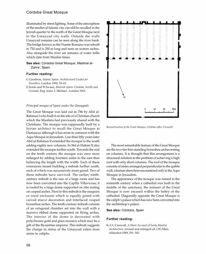
56
illuminated by street lighting. Some of the atmosphereof the medieval Islamic city can still be recalled in theJewish quarter to the north of the Great Mosque nextto the Umayyad city walls. Outside the wallsUmayyad remains can be seen along the river bank.The bridge known as the Puente Romano was rebuiltin 720 and is 250 m long and rests on sixteen arches.Also alongside the river are remains of water millswhich date from Muslim times.
See also: Córdoba Great Mosque, Madinat al-Zahra�, Spain.
Further reading:G.Goodwin, Islamic Spain: Architectural Guides for
Travellers, London 1990, 39–63.E.Sordo and W.Swaan, Moorish Spain: Córdoba, Seville and
Granada, Eng. trans. I. Michael , London 1963.
Principal mosque of Spain under the Umayyads.
The Great Mosque was laid out in 786 by Abd al-Rahman I who built it on the site of a Christian churchwhich the Muslims had previously shared with theChristians. The mosque was supposedly built by aSyrian architect to recall the Great Mosque atDamascus although it has more in common with theAqsa Mosque in Jerusalem. Less than fifty years laterAbd al-Rahman II extended the mosque to the southadding eighty new columns. In 964 al-Hakim II alsoextended the mosque further south. Towards the endon the tenth century the mosque was once moreenlarged by adding fourteen aisles to the east thusbalancing the length with the width. Each of theseextensions meant building a mihrab further south,each of which was successively more grand. Two ofthese mihrabs have survived. The earlier, ninth-century mihrab is the size of a large room and hasnow been converted into the Capilla Villavicosa; itis roofed by a large dome supported on ribs restingon cusped arches. Next to this mihrab is the maqsuraor royal enclosure which is equally grand withcarved stucco decoration and interlaced cuspedhorseshoe arches. The tenth-century mihrab consistsof an octagonal chamber set into the wall with amassive ribbed dome supported on flying arches.The interior of the dome is decorated withpolychrome gold and glass mosaics which may be agift of the Byzantine emperor. This mihrab suggeststhe change in status of the Umayyad rulers fromamirs to caliphs.
The most remarkable feature of the Great Mosqueare the two-tier free-standing horseshoe arches restingon columns. It is thought that this arrangement is astructural solution to the problem of achieving a highroof with only short columns. The roof of the mosqueconsists of aisles arranged perpendicular to the quiblawall, a feature elsewhere encountered only in the AqsaMosque in Jerusalem.
The appearance of the mosque was ruined in thesixteenth century when a cathedral was built in themiddle of the sanctuary, the minaret of the GreatMosque is now encased within the belfry of thecathedral. Diagonally opposite the Great Mosque isthe caliph’s palace which has now been converted intothe archbishop’s palace.
See also: Córdoba, Spain
Further reading:
K.A.C.Creswell, A Short Account of Early MuslimArchitecture, revised and enlarged ed. J.W.Allan,Aldershot 1989, 291–303.
Reconstruction of the Great Mosque, Córdoba (after Creswell)
Córdoba Great Mosque

57
G.Goodwin, Islamic Spain: Architectural Guides forTravellers, London 1990, 44–55.
Crusader architecture
European architecture of the Christian states establishedin Syria and Palestine during the Middle Ages; alsoarchitecture associated with those states in other parts ofthe Middle East or Europe.
The largest concentration of Crusader architectureis to be found in Palestine although Crusaderstrongholds were also built further afield from theGulf of Aqaba to Anatolia. The main territoriescomprising the Crusader dominions were: thekingdom of Jerusalem (roughly equivalent tomodern Palestine), the county of Tripoli (centred onthe Lebanese port of Tripoli), the principality ofAntioch (on the north coast of Syria) and the countyof Edessa (with its capital at Urfa).
Although the Crusades continued up until thesixteenth century, the main period of Crusaderarchitecture was from the beginning of the twelfthcentury to the end of the thirteenth, the period duringwhich the Crusaders occupied Palestine.
Crusader architecture is characterized by highquality ashlar masonry, massive construction and thefrequent use of masonry marks. Sculpturaldecoration and the extensive use of vaulting are othercharacteristic features. Although the Crusaders builta variety of buildings, including hospices, mills andharbours, their most distinctive work is found incastles and churches.
Generally Crusader castles were a developedform of European fortification with additionalfeatures learnt from Byzantine and Islamic militarytechnology. The most common form of fortificationwas the tower (tour) which is equivalent with theArabic burj. Typically these had two or three vaultedstoreys which would provide protection and a goodview of the surrounding countryside. The largercastles were all designed for a specific location sothat each building has a different plan. Neverthelesseach castle would be composed of a number ofcommon features which could include a rock-cutfosse or ditch, a glacis or stone revetment and one ormore sets of curtain wall linked by towers, withpossibly a keep in the middle. Loop-holes tended tobe very large with wide reveals.
The churches were often as strongly built as thecastles as they were an integral part of Crusader rule.
The importance of Jerusalem is notable in the factthat out of 300 churches in Palestine 66 were inJerusalem. Most Crusader churches were smallbarrel-vaulted single-cell buildings with an apse atthe west end. The larger churches were mainly builton a cross-in-square plan, although it is noticeablethat domes were rarely used.
As in other areas it is difficult to assess the relativeeffects which Crusader, Byzantine and Islamicarchitecture had on each other. It is, however, possibleto see specific areas where there was influence, thusthe Muslim castle at Ajlun is obviously similar toCrusader castles. However, the most significant wayin which the Crusades influenced Islamic architecturewas indirect, through the Venetians who provided theCrusaders with ships.
Further reading:
J.Folda (ed.), Crusader Art in the Twelfth Century, Oxford.T.E.Lawrence, Crusader Castles, new edn. withintroduction and notes by Denys Pringle, Oxford 1988.
R.C.Smail, The Crusaders in Syria and the Holy Land,London 1973.
Cyprus (Turkish: Kibris; Arabic: Qubrus)
Large island off the southern coast of Turkey and east coastof Syria with a mixed Greek- and Turkish-speak-ingpopulation.
The first Islamic conquest of Cyprus was led by theArab general Mu’awiya as part of the naval waragainst the Byzantines who had previouslycontrolled the island. In 653 Abu al-Awar establisheda garrison on the island which remained until it waswithdrawn by the caliph Yazid in 680– 83. Cyprusremained nominally under the control of Islam untilit was retaken by the Byzantine emperor NicephorusPhocas in 965. For the next 600 years Cyprus wasunder a succession of different, mostly Christianrulers, thus in 1189 Isaac Comnenus, governor of theisland, seceded from direct Byzantine control. In 1191the island was captured by Richard I of England andcame under western (Frankish) control under thehouse of Lusignan. Between 1424 and 1426 the islandbriefly came under the control of the Mamluks ofEgypt but was restored to Lusignan control throughVenetian intervention. From 1489 to 1570 Cyprus wasunder direct Venetian rule which was terminated bythe Ottoman conquest of 1571. The Ottomaninvasion, under Lala Mustapha Pasha, marks the real
Cyprus (Turkish: Kibris; Arabic: Qubrus)
58
beginning of Cyprus’s long engagement with Islam.However, in many ways the Ottoman conquest hadsimply replaced one group of rulers with another,leaving the Greek Orthodox population largelyintact. This situation was understood by the Ottomanemperor, Selim I, who after the conquest tried toimprove the prosperity of the island by populatingit with Greek families from the Kayseri region.Ottoman rule ended with the First World War andfrom 1918 the island was under British rule until itbecame independent in the 1950s.
The main building material on Cyprus is dressedlimestone although baked brick is also used. AlsoCyprus differs from its other near-easternneighbours in having a rich source of high qualitytimber, enabling buildings to be built with pitchedwooden roofs covered with tiles. Although it isknown that the early Arab conquerors of Cyprusbuilt several mosques in Nicosia most of these weredismantled or destroyed when Yazid withdrew thegarrison in 683. The only Islamic building in Cyprusconnected with this period is the tomb of UmmHaram who died near Larnaca during the early Arabinvasion. However, the earliest reference to the tombis 1683 and the main structure on the site today is atekke (Hala Sultan Tekke) built in 1797. Thus theIslamic architecture of Cyprus is all from theOttoman period and is closely linked to the Ottomanarchitecture of Anatolia. There are, however,distinctive features in Cypriot Islamic architecturewhich may be traced to the fact that the Ottomansconverted many of the existing Gothic buildings intomosques or palaces leaving the Greek Orthodoxchurches untouched. The most spectacular examplesof this are the Selimiye Cami in Nicosia and the LalaMustapha Pasha Cami in Famagusta which are bothconverted Gothic cathedrals. The Selimiye in Nicosiawas a thirteenth-century cathedral (Ayia Sofia) whichwas converted to a mosque in 1570 by removing thechoir and altars and changing the arrangement of
windows and doors so that the main entrance wasfrom the north. At some later date a cylindricalOttoman minaret was built on to the projectingcorner buttresses. The Lala Mustapha Mosque onFamagusta was built in the fourteenth century as thecathedral of St Nicholas, it was badly damagedduring the conquest of 1570 and converted into amosque in 1571 after being stripped of all its internaldecoration. Like the Selimiye, the Lala MustaphaMosque had a minaret added to its west end at alater date. The same procedure was adopted withthe Lusignan Palace which was converted into thegovernor’s palace by the addition of a new Ottomanreception room (diwan). Some buildings wereconverted for different uses, thus the fourteenth-century church of St George of the Latins wasconverted into the Büyük Hammam of Nicosia byadding an Ottoman-style porch with niches andthickening the walls.
In addition to converting Gothic churches theOttomans constructed new buildings with Gothicdetails—thus the minaret of the Cami Kebir (GreatMosque) at Larnaca is built with trefoil panels.Elsewhere Gothic influence on Ottoman buildingscan be seen in the use of round windows and thedog-tooth pattern on balcony supports.
See also: Ottomans
Further reading:
Association of Cypriot Archaeologists, Muslim Places ofWorship in Cyprus, Nicosia 1990.
E.C.Aristidou, The Tekke of Hal Sultan, Nicosia 1982.C.Enlart, The Gothic Art and the Renaissance in Cyprus,
trans. and ed. D.Hunt, London 1987.A.C.Gazioglu, The Turks in Cyprus: A Province of the
Ottoman Empire (1571–1878), London 1990.G.Jeffrey, A Description of the Historic Monuments of
Cyprus: Studies in the Archaeology and Architecture of theIsland, Nicosia 1918 and London 1983.
—— The Mosques of Nicosia, Nicosia 1935.
Cyprus (Turkish: Kibris; Arabic: Qubrus)
59
Damascus
Capital city of Syria and one of the chief cities of the MiddleEast.
Damascus is located in southern Syria on the banksof the Barada river. The area of Damascus forms anoasis on the edge of the Great Syrian desert. Thename Damascus is pre-Semitic and is mentioned inEgyptian texts of the second millen-nium BCE. Theoldest standing remains date from the Romanperiod and include parts of the city wall, columnsmarking the lines of street, and the enclosure onwhich the Umayyad mosque is built. During theUmayyad period Damascus was established ascapital of the Islamic world which stretched fromSpain to Central Asia. With the establishment of theAbbasid caliphate based in Iraq and later theFatimid caliphate in Egypt the status of the citydeclined. In 1154 Nur al-Din established it as hiscapital, and under his successors the Ayyubids itwas once again one of the principal cities of theIslamic world. The Mongol raids of the second halfof the thirteenth century reduced the city to asecondary role with Cairo established as theMamluk capital. The Ottoman conquest in 1516restored the prosperity which was reinforced by itsposition as starting point of the Ottoman Hajjcaravans. During the eighteenth century the citywas eclipsed by the commercial prosperity ofAleppo, though Damascus remained the politicalcapital. With the collapse of the Ottoman Empirein 1918 Damascus was re-established as an Arabcapital.
Mud brick and wood are the principal materialsof construction for traditional houses. The lowerparts of houses have thick walls made out of mudbrick which are strengthened at the corners withwooden stakes laid horizontally. The upper parts ofthe houses are often cantilevered over the street onwooden beams. The walls of the upper part are madeout of a wooden framework with bricks laid inbetween often in a herringbone pattern. The more
important monuments are made of stone with bakedbrick or stone rubble used for domes and vaulting.A characteristic of the monumental masonry ofDamascus is the use of ablaq (alternating courses ofdark and light masonry) made out of white limestoneand black basalt.
There are few standing remains from theUmayyad period with the exception of the GreatMosque which is the oldest major mosque stillpreserved in its original form. Little was done to alterthe pre-Islamic plan of the city and many of theByzantine buildings were simply converted; thus thecaliph’s palace, behind the Great Mosque, wasformerly the residence of the Byzantine governors.The plan of the city at this time formed a roughlyrectangular shape along the banks of the Barada river,a shape which was retained until the expansionduring the sixteenth century.
In the three centuries following the fall of theUmayyads Damascus suffered a state of nearanarchy. In 1076 strong rule was restored by theTurkoman chief Atsiz ibn Uvak and for the nexteighty years the city was ruled by Turkish chiefs orTaabegs. During this period a hospital was built andseven madrassas were established.
With Nur al-Din’s capture of Damascus in 1154the city became the centre of activity directedagainst the Crusaders who had seized Palestine.During this period there was a great deal of militaryand religious building. The walls of the city werestrengthened with new gateways such as the Babal-Seghir whilst the older gateways were reinforced.The citadel was also remodelled with a new gateand a large mosque. The number of mosques andmadrassas were increased in order to promoteorthodox Sunni Islam against both Shi�is and theChristianity of the Crusaders. Other importantbuildings included the maristan, or hospital, of Nural-Din and the madrassa and tomb of Nur al-Din.The hospital, which also functioned as a medicalschool, has a magnificent portal which is a mixtureof Roman, Iranian and Mesopotamian styles.
D
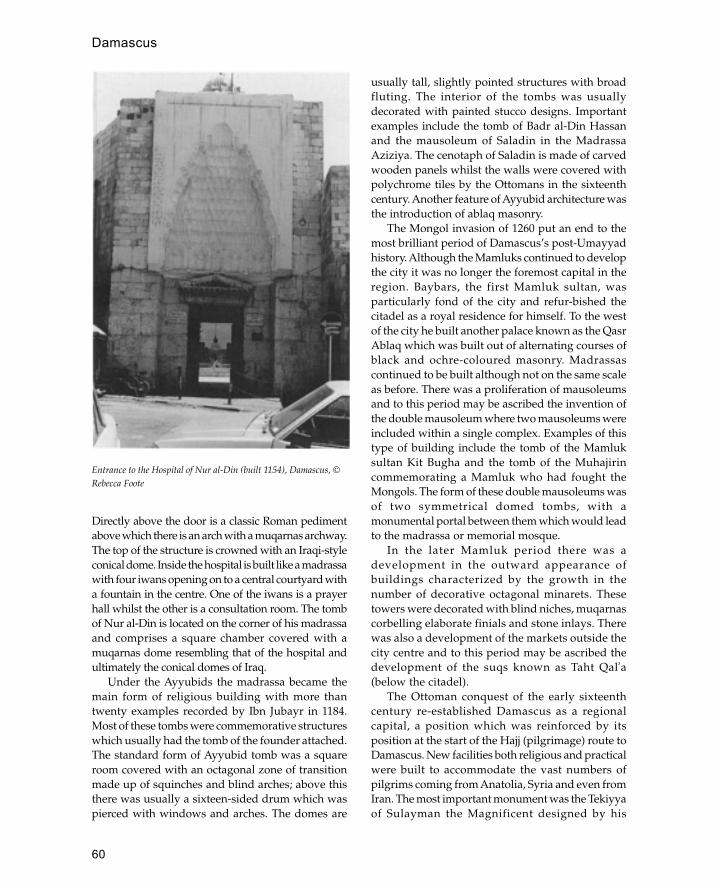
60
Directly above the door is a classic Roman pedimentabove which there is an arch with a muqarnas archway.The top of the structure is crowned with an Iraqi-styleconical dome. Inside the hospital is built like a madrassawith four iwans opening on to a central courtyard witha fountain in the centre. One of the iwans is a prayerhall whilst the other is a consultation room. The tombof Nur al-Din is located on the corner of his madrassaand comprises a square chamber covered with amuqarnas dome resembling that of the hospital andultimately the conical domes of Iraq.
Under the Ayyubids the madrassa became themain form of religious building with more thantwenty examples recorded by Ibn Jubayr in 1184.Most of these tombs were commemorative structureswhich usually had the tomb of the founder attached.The standard form of Ayyubid tomb was a squareroom covered with an octagonal zone of transitionmade up of squinches and blind arches; above thisthere was usually a sixteen-sided drum which waspierced with windows and arches. The domes are
usually tall, slightly pointed structures with broadfluting. The interior of the tombs was usuallydecorated with painted stucco designs. Importantexamples include the tomb of Badr al-Din Hassanand the mausoleum of Saladin in the MadrassaAziziya. The cenotaph of Saladin is made of carvedwooden panels whilst the walls were covered withpolychrome tiles by the Ottomans in the sixteenthcentury. Another feature of Ayyubid architecture wasthe introduction of ablaq masonry.
The Mongol invasion of 1260 put an end to themost brilliant period of Damascus’s post-Umayyadhistory. Although the Mamluks continued to developthe city it was no longer the foremost capital in theregion. Baybars, the first Mamluk sultan, wasparticularly fond of the city and refur-bished thecitadel as a royal residence for himself. To the westof the city he built another palace known as the QasrAblaq which was built out of alternating courses ofblack and ochre-coloured masonry. Madrassascontinued to be built although not on the same scaleas before. There was a proliferation of mausoleumsand to this period may be ascribed the invention ofthe double mausoleum where two mausoleums wereincluded within a single complex. Examples of thistype of building include the tomb of the Mamluksultan Kit Bugha and the tomb of the Muhajirincommemorating a Mamluk who had fought theMongols. The form of these double mausoleums wasof two symmetrical domed tombs, with amonumental portal between them which would leadto the madrassa or memorial mosque.
In the later Mamluk period there was adevelopment in the outward appearance ofbuildings characterized by the growth in thenumber of decorative octagonal minarets. Thesetowers were decorated with blind niches, muqarnascorbelling elaborate finials and stone inlays. Therewas also a development of the markets outside thecity centre and to this period may be ascribed thedevelopment of the suqs known as Taht Qal�a(below the citadel).
The Ottoman conquest of the early sixteenthcentury re-established Damascus as a regionalcapital, a position which was reinforced by itsposition at the start of the Hajj (pilgrimage) route toDamascus. New facilities both religious and practicalwere built to accommodate the vast numbers ofpilgrims coming from Anatolia, Syria and even fromIran. The most important monument was the Tekiyyaof Sulayman the Magnificent designed by his
Entrance to the Hospital of Nur al-Din (built 1154), Damascus, ©Rebecca Foote
Damascus

61
architect Sinan and completed in 1555. The Tekiyyais built on the river bank on the site of the oldMamluk palace, Qasr Ablaq. The Tekiyya comprisesa mosque, kitchens and a camping ground forpilgrims. The mosque is built in the classicalOttoman style with a prayer hall covered by a largedome and a double arcade running round it on threesides. The twin minarets are tall pencil-like structureswith sharp pointed roofs. The pure Ottomanappearance of the building is modified by the use ofalternating black and white (ablaq) masonry. OtherOttoman mosques of the period also display amixture of local and Ottoman features, thus theSinaniya (after Sinan Pasha the governor ofDamascus, not the architect) mosque has a largecentral dome in the Ottoman style but the use ofablaq masonry and the monumental muqarnasportal resemble earlier Mamluk buildings.
The Ottoman conquest also brought a freshimpetus to the trade of the city with the establishmentof numerous khans. One of the earliest Ottomanexamples is Khan al-Haria built in 1572 around asquare courtyard with stables and store rooms on theground floor and accomodation above. In eighteenth-century khans the central courtyard was often smallerand covered with domes. The most famous exampleof this later type is the As�ad Pasha Khan which is asquare building covered with eight small domes anda large central dome supported on marble columns.The eighteenth century also saw the development ofdomestic architecture influenced by buildings suchas the Azzam palace which was built around acourtyard in the traditional Syrian manner but withdecoration that recalls the mansions of Istanbul.
See also: Aleppo, Ayyubids, Mamluks, Syria
Further reading:
R.S.Humphreys, ‘Politics and architectural patronage inAyyubid Damascus’, Essays in Honour of Bernard Lewis:The Islamic World from Classical to Modern Times, ed. C.E.Bosworth, C.Issawi, R.Savory and A.L.Udovitch,Princeton, NJ 1989.
J.G.De Maussion, Damas, Bagdad, capitales et terres descalifes, Beirut 1971.
J.Sauvaget and M.Ecochard, Les Monuments Ayyubides deDamas, Damascus 1938–50.
Damascus Great Mosque
Principal mosque of Damascus founded by the Umayyadcaliph al-Walid in 706 CE.
The Great Mosque stands in the centre of the oldcity of Damascus on the site of the Roman templeplatform, or temenos. The outer walls of the temenosstill survive and are distinguished as large blocksof dressed masonry with pilasters set at intervalsinto the side. At the four corners of the temenos thereare large square towers and around the edge therewere arcades which opened into a large rectangularcourtyard. There were four axial doorways to thetemenos, that on the east being the principalentrance. At the time of the Islamic conquest theByzantine church of St John stood in the middle ofthis platform. Immediately after the conquest theMuslims shared this space with the Christians withthe Christians retaining possession of their churchand the Muslims using the southern arcades of thetemenos as a prayer area.
In 706 al-Walid destroyed the church and built amosque along the southern wall of the temenos. Thelayout of the mosque comprised three aislesrunning parallel to the south (qibla) wall cut in thecentre by a raised perpendicular aisle or transept.At the south end of this transept there was a mihrabset into one of the blocked doors of the south façade.Walls were inserted on the west and east sidesbetween the corner towers, and new two-storeyarcades were built around the east, north and westsides of the courtyard. The arcades and prayer hallwere covered with pitched wooden roofs coveredwith tiles except for the centre of the transept whichhad a wooden dome. In the north-west of thecourtyard there is an octagonal chamber raised upon eight columns with a pool beneath. Thisstructure functioned as the bayt al-mal or treasuryand is found in other early mosques such as Harranand Hamma.
Since the Umayyad period the mosque has beenrebuilt several times because of fires (1069, 1401 and1893) although its basic plan has remained the same.Originally the arcade of the sanctuary façadecomprised one pier alternating with two columnsbut this was subsequently changed to piers only. Arange of different arch forms is used in the arcadesincluding round, semi-circular horseshoe andslightly pointed arches. The walls of the mosque aredecorated with glass mosaics similar to those in theDome of the Rock, with depictions of palaces andhouses next to a river (possibly the Barada river inDamascus). The long rooms in the east and west sideswere lit by marble grilles with geometric interlacepatterns based on octagons and circles.
Damascus Great Mosque
62
The form of the mosque, particularly thesanctuary façade, was probably derived fromByzantine palatial architecture, possibly the Chalcipalace in Constantinople. Later mosques in Syriasuch as the Great Mosques of Aleppo, Hamma,Harran and Córdoba. The Great Mosque ofDiyarbakir built in the Seljuk period is also of thisform.
See also: Damascus, Diyarbakir, Harran, Syria,Umayyads
Further reading:K.A.C.Creswell (mosaics by Marguerite Van Berchem),
Early Muslim Architecture, Oxford 1969, 1 (1): 156– 210,323–72.
damDams have always been an important factor inIslamic civilization as a means of harnessing scarceor fugitive water supplies. Famous examples of pre-Islamic dams in the Middle East include the Macribdam in Yemen and the Shallalat dam in northern Iraq.The advantages of dams over cisterns or reservoirsis that a large volume of water can be stored with arelatively small amount of construction work. Thesimplest forms of dam are made of earth with a claycore whilst more imposing masonry dams are builtto contain larger volumes of water. Most dams areassociated with irrigation works and are sometimeslinked to water mills. However, some of the largestdams are built to provide drinking water for cities;one of the best examples is the Birket al-Sultan inJerusalem which consists of a large masonry dambuilt across the wadi Hinon in the sixteenth century.On top of the dam in the centre is a drinking fountainor sebil which supplied water to travellers. One ofthe greatest examples of Ottoman engineering is theValide Bend, a large masonry dam constructed in theBelgrade forest in 1769 to supply water to Istanbul.
darHouse or residence. Often implies a house of highstatus and may be roughly equivalent to mansion.
dar al-imaraGovernor’s palace. In early Islamic architecture thiswas usually located at the qibla end of the mosque(i.e. behind the mihrab). This was a safety measure toenable the govenor (or caliph) to enter the mosquewithout having to pass through other worshippers.
See also: Kufa
dargah or dukka
Covered courtyard in traditional Cairene houses.
Deccan
Region of southern India famous for its distinctive pre-Mughal Islamic architecture.
The Deccan includes the modern Indian states ofMaharashtra, northern Andhra Pradesh, northernKarnataka and Goa. Physically the Deccancomprises a plateau bordered by the Arabian Seato the west and the Bay of Bengal to the east. Eachof these coasts is bordered by a range of hills knownas the western and eastern Ghats. The centralplateau is watered by the Krishna and Godavaririvers which flow eastwards into the Bay of Bengal.The region has a long history of monumentalreligious architecture with Buddhist cave art atAjanta and numerous medieval Hindu shrines.Although the coastal regions were exposed to Islamfrom an early period it was not until the thirteenthcentury that there were any significant Islamicconquests in the area. In the early fourteenth centurythe Tughluq ruler of Delhi destroyed the power ofthe Hindu Hoysala kingdom and for the first time amajor Muslim presence was established in the area.In 1338 after his victories in the region MuhammadTughluq Shah II decided to move his capital fromDelhi to Daulatabad, and although the transfer wasunsuccessful and most of the population returnedto Delhi the conquest established permanent Muslimrule in the region.
Muslim rule in the Deccan was complex andfragmentary, with dynasties established at variouscapitals gaining the upper hand at different times,until the late seventeenth century when the area wasbrought into the Mughal Empire. From 1347 to 1422the central Deccan was ruled by the MuslimBahmani kings from the newly established fortresscity of Gulbarga. In 1424 Sultan Ahmad ShahBahmani moved the capital to another fortress cityBidar. In 1487 the Bahmani kings were overthrownby the Barid Shahi dynasty who ruled the city untilthe seventeenth century. However, in 1512 realpower passed to the Qutb Shahi sultans who ruledfrom their capital of Golconda. Although theMughal conquests effectively ended theindependence of the Deccani sultans, the city of
dam

63
Hyderabad managed to survive into the twentiethcentury as an autonomous state.
The earliest Muslim architecture of the region wasderivative of local architecture, thus the mosque ofDaulatabad incorporates many of the features of aHindu temple. However, the architecture of thenewly established fortress cities of Bidar, Golconda,Gulbaraga and Bijapur was a distinctive mixture ofIndian and Middle Eastern styles. The defensivearchitecture of the cities was highly sophisticatedusing concentric planning and bent entrances.Decoration was in the form of coloured tilesimported from Kashan (Iran), and Persiancalligraphers were used to decorate the façades oftombs and mosques. The area developed a distinctivebulbous dome form with petals around the base (ordrum) and heavy tiered finials rising from a mouldedlotus-shaped apex. Other distinctive architecturalfeatures are the use of huge decorative battlementsand complex stucco forms. The standard tomb formwas a domed square with engaged towers or minarat each corner the finest example of which is the GolGumbaz at Bijapur.
See also: Bijapur, Char Minar, Firuzabad (India),Gol Gumbaz (India), Hyderabad.
Further reading:E.S.Merklinger, Indian Islamic Architecture: The Deccan,
Warminster 1981.P.Davis, The Penguin Guide to the Monuments of India, 2:
Islamic, Rajput and European, London 1989.
Delhi
Capital city of India containing some of the finest examplesof Indian-Islamic architecture.
Delhi is located approximately in the centre of northernIndia between the mountains of the Himalayas andthe Rajasthan desert. More immediately the city islocated on the banks of the Jumna river and near theAravalli hills.
The modern city of New Delhi is only the latestin a series of eight cities which have occupied thearea of Delhi. Although there were earlier settlementson the site the oldest architectural remains can beattributed to the eleventh-century city built by theRajput Tomar king Anangpal. In 1193 the city (knownas Lal Kot) was captured by the Afghan conquerorMuhammad of Ghur who left the city in charge ofhis deputy, Qutb al-Din Aybak. By the time ofMuhammad of Ghur’s death in 1206 Qutb al-Din
Aybak had declared himself independent andestablished himself as the first Muslim ruler of Delhi.In 1304 Ala al-Din Khalji founded a second cityknown as Siri which was located to the north of thefirst city. Later on, in 1321, a third city known asTughluqabad after its founder Ghiyath al-DinTughluq was founded to the east of the first city.However, this city was only used for four years untilMuhamd Tughluq founded a fourth city known as
The seven cities of Delhi
Delhi

64
Jahanpanah which also only lasted a short time as itwas abandoned in 1328 when the ruler moved thecapital to Daulatabad in the Deccan. The move toDaulatabad was disastrous and the sultan soonreturned to Delhi. In 1354 Firuz Shah Tughluqestablished Firuzabad as the fifth city located by theriver several kilometres to the north. For the next150 years the area around Firuzabad was developedby successive dynasties although the central area fellinto ruin. In 1534 the Bengali ruler Sher Shah foundedthe sixth city on the ruins of Firuzabad. Thisremained the centre of the city until 1638 when theMughal ruler Shah Jahan established the city ofShahjahanabad. This was a huge new developmentto the north with the Red Fort at its centre. In 1911Shahjahanabad became Old Delhi when the Britishlaid out the present city of New Delhi.
Remains of all these cities have survived topresent a cross-section of the development of Islamicarchitecture in India. The first city is known as QilaRai Pithora after the Rajput ruler who built the
fortifications. The most significant remains from thefirst city are the Qutb Minar and Mosque begun byQutb al-Din Aybak in 1193. The Qutb Mosquecomplex stands inside the remains of fortificationwalls which were built by the Rajputs in the twelfthcentury. Originally the enclosure walls had thirteengates although only three have survived. Fragmentsof Hindu temples incorporated into the mosquecomplex demonstrate the abrupt transition fromHindu to Muslim rule.
Apart from fortifications there are few remains ofSiri (the second city of Delhi) because much of the stonewas taken in the sixteenth century for use in Sher Shah’scity. However, the remains of the third city,Tughluqabad, are remarkably well preserved. Theremains consist of a huge irregular four-sided enclosure1.5 by 2 km which includes a palace area, seven largecisterns, remains of a Friday mosque, the citadel and atomb complex. The enclosure walls are taperingstructures up to 30 m high, pierced with arrow slitsand crowned by massive crenellations. Outside the
Plan of Tughluqabad, Delhi
Delhi

65
enclosure walls to the south is the tomb of Ghiyath al-Din Tughluq which was originally an island set in anartificial lake and approached via a causeway from thepalace complex. The tomb is a square domed buildingset within its own enclosure and fortified with roundbastions. To the east is a similar island structure knownas Adilabad. Like the tomb complex this was a fortifiedarea connected to the rest of the city by a causeway;within it was a huge audience hall on pillars built byMuhamad Tughluq.
The remains of the fourth city, Jahanpanah arelocated to the west of Tughluqabad between Siri andQila Rai Pithora. Although much of this city has beendestroyed the mosque is still standing and has anunusual plan consisting of four open courtyards.There are even fewer remains of the fifth city,Firuzabad, which was later built over by Sher Shahin the construction of the sixth city. The centre of thesixth city is the Purana Qila or ‘Old Fort’ initiallybuilt by the Mughal emperor Humayun and laterdeveloped by Sher Shah. The Purana Qila is arectangular enclosure with huge corner bastions builton the supposed site of the city of Indraprasthamentioned in the Mahabharata. The interior of thefort is largely empty except for the Qala-i-KuhnaMosque and the octagonal three-storey pavilionknown as the Sher Mandal.
The seventh city, Shahjahanabad was founded byShah Jahan in 1638 and was completed ten years later.Located on the banks of the Jumna river, the newcity was dominated by the imperial palace knownas the Red Fort. The street plan was based on twomain avenues, the Chandni Chowk running east-west and the Faiz Bazar which runs south from theRed Fort. Near the intersection of these streets is theprincipal mosque of the city. This is one of the largestmosques in India and consists of a huge courtyardover 90 m square with three monumental gateways,a central rectangular cistern and a triple-domedsanctuary flanked by two minarets.
New Delhi is an Anglo-Indian city with fewtraditional Islamic buildings although the areaoccupied by the city includes some fine Islamictombs the most famous of which is that of the secondMughal emperor Humayun.
See also: India, Mughals, Qutb Minar andMosque, Red Fort
Further reading:R.E.Frykenberg, Delhi through the Ages: Essays in Urban
History, Culture and Society, Delhi 1986.
S.A.A.Naqvi, Delhi: Humayun’s Tomb and AdjacentBuildings, Delhi 1946.
R.Nath, Monuments of Delhi, New Delhi 1979.A.Petruccioli, ‘Modelli cultural! nell’impianto e nelle
transformazioni di Old Delhi’, Storia della città 31–2:123–44, 1985.
Y.D.Sharma, Delhi and its Neighbourhood, 2nd edn., NewDelhi 1974.
desert
The definition of desert varies with different au-thors, but it is generally agreed that any area withless than 50 mm annual rainfall may be counted asdesert. For practical purposes, however, areas withless than 200 mm (the limit of dry farming) mayreasonably be regarded as desert. Although desertsare a common feature of the Islamic world, mostcities and areas of settlement are either outside thisarea or located next to large river systems such asthe Nile, Tigris, Euphrates and Indus.
Until recently the majority of desert inhabitantshave been nomadic pastoralists keeping either sheepand goats or camels and living in some form of tent.Important exceptions to this have been oasis tradingsettlements, Hajj routes and mining centres which aregenerally dependent on outside support for theirsurvival. In certain periods, such as the early Islamic,political conditions, or more recently the exploitationof oil in Arabia, have made desert settlements moreviable.
The architecture of the desert may be divided intothree categories: permanent, semi-permanent andtemporary. Temporary structures are either portabletents or made of expendable materials such as palmfronds, requiring minimum input of labour. Semi-permanent structures may be made out of acombination of portable and non-portable materials(e.g. a tent with stone walls) or may be made ofperishable materials which need frequent renewalsuch as the palm-frond huts of the Tihama in Yemen.Permanent structures may be built of pisé, mudbrick, baked brick, stone or, more recently, cementblocks and reinforced concrete.
Any desert settlement must make some provisionfor obtaining and storing water, usually from wellsor seasonal rainfall, although occasionally sites aredependent on water brought from elsewhere (thiswas often the case with Hajj routes). Theunpredictability of rain and the high evaporationrates in the desert (in many areas of the Middle Eastthe rate of evaporation can exceed 2,000 mm
desert

66
annually) mean that elaborate water catchment andstorage facilities are developed. Sites dependent onseasonal and sometimes erratic rain usually employa system of dams, cisterns and run-off channels tomaximize the catchment area. If water needs to betransported some distance, underground channels(qanats) are built to minimize evaporation.
Further reading:E.Beazley and M.Howerson, Living with the Desert:
Working Buildings of the Iranian Plateau, Warminster1982.
S.Helms (with contributions by A.V.G. Betts, W. and F.Lancaster and C.J.Lenzen), Early Islamic Architecture ofthe Desert: A Bedouin Station in Eastern Jordan, Edinburgh1990.
dershaneTurkish term for lecture hall or studying room,literally ‘room for lessons’. Usually these are largerdomed rooms or vaulted iwans on one side of anOttoman madrassa.
diwan
Term of Iranian origin describing a reception hall,either in a house or a palace. Later on the word isalso used to describe a government ministry.
diwan-i amm
Public reception hall.
diwan-i khassPrivate reception hall.
Diyarbakir (Amida)Prominent city on the banks of the Tigris in south-eastTurkey famous for its massive black basalt walls whichare still largely intact.
Diyarbakir was captured from the Byzantines byArab armies in 693 and became one of the greatIslamic frontier fortresses. On capturing the city theByzantine cathedral was shared between Muslimsand Christians, although by 770 it was again used asa church. Later a Great Mosque was built on the siteof the present Ulu Cami which according to acontemporary description (Nasiri Khusraw, 1045)had arcades two tiers high. The Ulu Cami in itspresent form dates to between 1090 and 1155
according to two inscriptions in the name of theSeljuk leader Malik Shah. The prayer room orsanctuary of the mosque is three aisles wide andcovered with a transept in the middle on the axis ofthe mihrab. This arrangement and the similarity withthe Great Mosque in Damascus (once thought tohave been a church) has given rise to the assertionthat the building was once a church in spite ofcontradictory evidence. The similarity with the GreatMosque in Damascus is explained by the fact thatMalik Shah also carried out work there and may haveused this as a model for that of Diyarbakir.
During the fifteenth century Diyarbakir becamecapital of the Aq-qoyunulu Turkman dynasty whichwas given control of the city in return for its supportof Timur at the battle of Ankara in 1492. Buildings ofthe Aq-qoyunulu period provided a model for thoseof the Ottoman period. Several mosques of thisperiod survive, the most famous of which is that ofKasim Padisah with its large central dome. Theminaret is detached and consists of a tall squarestructure raised on four columns.
Ulu Cami, Diyarbakir, Turkey
dershane
67
After its capture from the Aq-qoyunulu theOttomans developed Diyarbakir as a regionaladministrative centre with its own mint. There areseveral notable sixteenth-century Ottoman mosquesin Diyarbakir all built in the ablaq style (striped blackand white masonry) with tall minarets with squareshafts. Several of the mosques have fine tile decorationsimilar but inferior to that of Iznik which was probablyproduced within the city. The first of these is the FatihCami built between 1518 and 1520 which consists of alarge dome supported by four semi-domes in aquatrefoil pattern. This plan, which is also used inthe Peygamber Cami built in 1524, was probably theinspiration for Sinan’s use of the plan in the SehzadeCami in Istanbul. One of the more interesting mosquesis the Melek Ahmet Pasha Cami which is built on first-floor level and is entered by a passage under themosque which leads into a courtyard from which aset of stairs leads up into the prayer room.
Several nineteenth-century konaks (palatialhouses) survive in Diyarbakir. One of the bestexamples is the Gevraniler Konak completed in 1819.The house is built around a courtyard on a vaultedsub-structure which contains cisterns, stables and abath house. The apartments face north and arearranged as separate pavilions with their own terraces.
See also: Ottomans
Further reading:
D.Erginbas, Diyarbakir eveleri, Istanbul 1954.J.Raby, ‘Diyarbakir: A rival to Iznik’, Istanbuler
Mitteilungen 26 : 429–59, 1976.
Djenné (Dienné)
City in central Mali known for its unique mud-brickarchitecture which is a blend of African and Islamic styles.
The city was founded sometime between 767 and1250 CE and was converted to Islam by KoyKunboro, the twenty-sixth chief of the city, between1106 and 1300. The prosperity of the city was basedon the long-distance trans-Saharan trade routes, themost important commodities being gold and salt.The city was conquered by the Moroccans in 1591who ruled the town until 1780. In the nineteenthcentury it was incorporated into the theocratic stateof Macina, and came under French control in 1898,after which it declined in importance. The mainbuilding material used in Djenné is mud brick,locally known as ferey. The mud bricks are plastered
with mud plaster giving buildings a smooth roundedorganic look which is offset by the use of bundles ofpalm sticks projecting from the walls (turon). Thesepalm sticks have a dual function providing bothdecoration and a form of scaffolding formaintenance. Small cylindrical bricks were used untilthe 1930s when rectangular bricks were introduced.It is thought that the cylindrical bricks providedgreater stability than modern ones, which is why somany older buildings have survived.
The city is built on a small hill between creeks anduntil recently was surrounded by a wall with elevengates. The city was divided into quarters accordingto tribal divisions. More wealthy merchants lived inlarge monumental courtyard-houses, surrounded byopen spaces. The houses were divided into male andfemale areas, with the men’s area on the first floor atthe front overlooking the street. The women’s areaby contrast was usually on the ground floor at theback of the courtyard. Traditionally these houses aredecorated with a façade known as the ‘Sudan Facade’which includes pillars and decorated entrances as itscharacteristic features.
The most famous building of the city is the GreatMosque which is said to have been originally builtby Koy Kunboro who destroyed his palace to buildit. The early mosque is known to have survived tothe 1830s when it was destroyed. The present GreatMosque was built in 1909 on the foundations of theearlier structure. It stands on a raised platformapproximately 75 m square reached sixmonumental staircases. The mosque consists of alarge internal courtyard surrounded by a corridor,and a huge prayer hall, with a wooden roofsupported by ninety rectangular piers. All four facesof the mosque are decorated with round pinnaclesor cones, engaged pillars and bundles of palm sticksset into the side. The main entrances to the mosqueare on the south and north sides (the east side isthe qibla wall). The north side is more decoratedthan that of the south reflecting its proximity to thericher areas of the city. The east side or qibla wall issupported by three large rectangular towers. On theinside of the mosque a deep recessed mihrab is builtinto each one of these towers, and the central towercontains in addition a staircase to a platform on theroof, whence the speech of the imam could berelayed to the rest of the town.
P.Maas, Aramco World, November/December 1990:18– 29,gives the best recent account of Djenné.
Djenné (Dienné)

68
L.Prussin The Architecture of Djenné: African Synthesis andTransformation, Yale 1973.
do-chala
Type of roof with curved eaves, derived from Bengalihuts (bangala). Used first in Bengali and later inMughal architecture.
dome
Circular vaulted construction used as a means of roofing.First used in much of the Middle East and North Africawhence it spread to other parts of the Islamic world,because of its distinctive form the dome has, like theminaret, become a symbol of Islamic architecture.
It seems likely that the dome originated as a roofingmethod where the absence of suitable timber meantthat it was impossible to make a flat timber roof.The earliest domes in the Middle East wereassociated with round buildings and were producedout of mud brick placed in layers which tilt slightlyinwards. Another early method of domeconstruction which can still be seen in northernSyria and Harran in Turkey is the corbelled domewhere mud bricks are placed horizontally in circularlayers of diminishing circumference producing acorbelled dome. When the Romans conquered theMiddle East the dome was incorporated into Romanarchitecture and under the Byzantines it became themain method of roofing monumental buildings.The chief advantage of domes is that large areascan be roofed without the interference of columns.At this time the wooden dome was developedwhich combined the space of dome building withthe flexibility and lightness of wood. By the seventhcentury wooden domes were a normal method ofroofing churches so that when the Arabs came tobuild the Dome of the Rock a wooden dome wasused as the most appropriate form for this majorreligious building. Wooden domes were usuallycovered with sheets of metal, either copper or lead,as protection against the weather. The exactconstruction of the domes of the Caliph’s Mosquein Baghdad is not known although the fact that itwas described as green suggests that it was coveredin copper.
Most domes, however, continued to be built ofless flexible materials such as stone, mud brick andbaked brick. One of the main problems of dome
construction was the transition from a square spaceor area into a circular domed area. Usually there wasan intermediary octagonal area from which it is easierto convert to a circular area although there is still theproblem of converting from square to octagon. Twomain methods were adopted, which are the squinchand the pendentive. The squinch is a mini-arch whichis used to bridge a diagonal corner area whilst apendentive is an inverted cone with its point set lowdown into the corner and its base at the top providinga platform for the dome. Squinches are the mainmethod of transition in pre-Ottoman architecturewhilst pendentives are more common after thesixteenth century. In India, where there was notradition of arches before the advent of Islam, domesrest on flat corbels which bridge the corners.
During the medieval period Islam developed awide variety of dome types which reflect dynastic,religious and social distinctions as much as differentconstruction techniques. One of the most extravagantdome forms is the muqarnas or conical dome whichappears as early as the eleventh century in Iraq atImam Dur. A conical dome consists of multiple tiersof muqarnas which blur the distinction betweenstructure and decoration and between circular andsquare forms. Later on the idea of the double domewas introduced as it was recognized that there wasa conflict between the external appearance of thedome and the aesthetics of the interior of the domedspace. The result was tall external domes withshallower interior domes. Increasing emphasis onthe exterior can be seen in Cairo and Egypt wheremasonry domes with intricately carved exteriorswere developed. In Iran and Central Asia tall domeswere covered in coloured (usually blue) glazed tiles,culminating in the huge bulbous fluted domes on ahigh circular drum which were characteristic of theTimurid period (fifteenth century). In pre-MughalIndia the standard dome form was derived fromHindu architecture and consisted of a squat circularform with a lotus design around the apex and acharacteristic bulbous finial. Ottoman architectureadopted the Byzantine dome form and developed itto produce vast domed areas such as that of theSelimiye in Edirne.
Dome of the Rock (Qubbat al-Sakhra)
The third most important shrine of Islam. It is located onthe Temple Mount in Jerusalem.
do-chala

69
The Dome of the Rock was built by the early caliphAbd al-Malik in 691 and is generally agreed to beone of the oldest Islamic monuments. The buildingconsists of a domed octagonal structure set in themiddle of a raised plaza or enclosure known as theHaram al-Sharif or holy place. In the immediatevicinity of the Dome of the Rock are two otherbuildings of similar antiquity, the Qubbat al-Silsilaand the Aqsa Mosque. The Qubbat al-Silsila is asmaller structure immediately to the east of theDome of the Rock; it shares the same basic plan ofan octagonal structure covered with a dome,although unlike the larger monument the sides ofthe structure are open. The purpose of the Qubbatal-Silsila is unknown although it probably had someritual function. The Aqsa Mosque has been rebuiltseveral times so that its original form is difficult todetermine although its basic form was probablysimilar to that of today. The Aqsa Mosque serves asthe main place of prayer for the Haram and is locatedto the south of the Dome of the Rock.
The plan of the Dome of the Rock is based arounda central dome resting on a circular drum supportedby an arcade. This inner arcade is enclosed by an outeroctagonal arcade and a solid octagonal wall whichsupports the shallow pitched roof around the dome.Both sets of arcades are carried on a mixture of piersand columns; the inner arcade is composed of fourpiers and twelve columns whilst the outer arcadeconsists of eight piers and sixteen columns. There arefour entrances to the building, one on each of the sidesfacing the four cardinal points. Each of the eight sidesof the outer octagon is divided into seven tall archesor bays, five of the arches on each side are open asdoors or windows whilst the two nearest the cornersare blind arches. There are twelve more windows inthe circular drum below the dome. Directly below thedome is an exposed area of natural rock enclosed bya screen or fence, under-neath this is a small cave witha mihrab reached by a set of steps.
Several forms of decoration are used includingmosaics, marble, repoussé metalwork and coloured
glass. The mosaics are particularly importantexamples of the combination of Sassanian andByzantine motifs which is a characteristic of earlyIslamic art. Another important feature of the mosaicsis that they carry an inscription dating the building to691. At present only the interior mosaics survivealthough originally they also covered the outside.
The building has been restored many times in its1,300-year history. One of the most importantrestorations was carried out during the sixteenth-century reign of the Ottoman sultan Suleyman theMagnificent. It was during this restoration that theexterior was covered with glazed ceramic tiles whichcovered the earlier mosaic coating. The tiles werethe forerunners of Iznik tiles (q.v.) which becamesuch a significant feature of Ottoman architecture.The present tiles covering the building were addedin 1968. At the same time the Dome was coveredwith gold for the first time, although the presentcovering dates from 1993.
The Dome of the Rock is generally regarded asan attempt to provide a Muslim alternative to theChurch of the Holy Sepulchre which had previouslydominated the city of Jerusalem. The plan and designof the Dome of the Rock reflect this rivalry. Inreligious terms the building is significant because itcommemorates the place where Abraham offered hisson Isaac as a sacrifice and the place from whichMuhammad made his night journey to heaven.
See also: Jerusalem
Further reading:
K.A.C.Creswell, A Short Account of Early IslamicArchitecture, ed. J.W.Allan, Aldershot 1989.
O.Grabar, The Formation of Islamic Art, Yale 1973.
domical vault
A dome which rises from a square or rectangularbase without the intervention of a drum, squinchesor pendentives.
domical vault
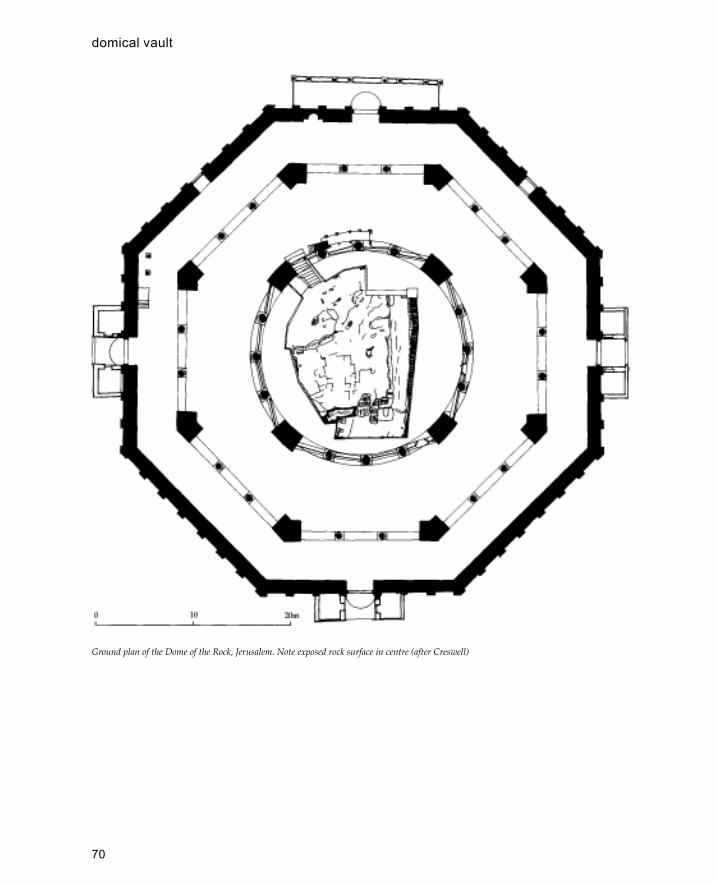
70
Ground plan of the Dome of the Rock, Jerusalem. Note exposed rock surface in centre (after Creswell)
domical vault

71
East Africa
Muslim areas of East Africa have traditionally been thecoastal strip which extends for over a thousand miles andincludes the coasts of Somalia, Kenya, Tanzania (includingZanzibar) and northern Mozambique, This area has ahomogeneous culture, known as Swahili, which is distinctfrom but related to both the Arabic Islamic world and theBantu-speaking peoples of the interior.
Historical Background
The first documentary evidence concerning the EastAfrican coast comes from the first-century CEPeriplus of the Erythraen Sea and the fourth-cen-tury geography of Ptolemy. The origins and historyof Islam on the East African coast are obscure,although historical sources have been supple-mentedrecently by information from archaeologicalexcavations to produce at least an outline picture.Historically the earliest Islamic settlements on thecoast took place during the eighth century and thishas been confirmed recently by excavations atShanga in Kenya.
The Swahili culture has traditionally been basedon Indian Ocean trade with Arabia, India and theFar East and it is probable that this is how Islamarrived in East Africa rather than by conquest or apolicy of colonization. Although it is likely thatsome Arabs and Persians may have settled on thecoast, the overwhelming majority of the populationhad African origins as is demonstrated by theSwahili language itself which is essentially a Bantulanguage with many Arabic loan words. There islittle documentary evidence of the early periodbefore the arrival of the Portuguese although thereare several early buildings which are dated byinscriptions. The earliest of these is a Kuficinscription in the Kizimkazi Mosque in Zanzibardated to 1107 CE, although the mosque was rebuiltin the eighteenth century according to anotherinscription in the building. Other early datedmonuments are in Somalia, including the Great
Mosque of Mogad-ishu built in 1238 and themosque of Fakhr al-Din in 1269.
In addition to inscriptions there are also variousearly accounts by travellers. In 1331 the coast wasvisited by Ibn Battuta who travelled as far south asKilwa in southern Tanzania and described the peopleand buildings of the coast, and also in the earlyfourteenth century a Chinese embassy visited anddescribed the coast.
Through analysis of trade goods, architecturalfeatures and local artefacts, archaeology hasprovided a more detailed model of how Swahiliculture developed in the centuries prior to thePortuguese. In the earliest phase of settlement(eighth-ninth century) the main trading partnerseemed to be the Persian Gulf; later on with thecollapse of the Abbasid caliphate trade seems tobe more connected with the Red Sea and ultimatelyEgypt. During these two early periods the townsof the Lamu archipelago such Manda and Shangaseem to have risen in wealth and importance. Laterin the thirteenth century the area around Kilwa insouthern Tanzania seems to have risen rapidly inwealth and importance along with the city ofMogadishu in Somalia. This change can partly beexplained through the history of local dynastiesand partly through the growth of the gold tradewhich originated in Zimbabwe and made its wayvia Sofala, Kilwa, Mogadishu and Yemen to theMiddle East.
In the sixteenth century the coast was opened toEuropeans when the Portuguese established a basein Mombasa as part of the sea route India. For thenext two hundred years until the mid-eighteenthcentury the Portuguese tried to control the trade ofthe coast against the rival claims of the Dutch andthe Omanis. Whilst the rivalry of the maritimepowers disrupted trade, the stability of the coastaltowns was threatened by the Galla, a nomadic tribefrom Somalia, who sacked and pillaged towns as farsouth as Mombasa. In the mid-eighteenth centurythe Omanis at last won the struggle for supremacy
E

72
East Africa
Principal Islamic sites of East Africa
73
East Africa
on the coast when they captured the Portuguese baseof Fort Jesus in Mombasa. During the next centuryOmani power was extended inland and by 1832 theirposition was so secure that Sultan Sayyid Said movedhis capital from Muscat to Zanzibar which remainedthe capital until the beginning of the twentiethcentury.
The coast of East Africa is fairly low-lying andis fringed with extensive tracts of mangrove forestsintermittently punctuated by inlets and creeks.Occasionally there are groups of islands such as atKilwa or Lamu forming small archipela-goes and afew larger offshore islands like Zanzibar, Pembaand Mafia. The coast is protected along most of itslength by substantial coral reefs which also formthe base of most of the coastal foreshore. It isimportant to note that all the Islamic settlementsso far discovered in East Africa are within four milesof the coast and most are considerably nearer. Mostsites are located slightly apart from the mainlandeither on peninsulas which are cut off at high tideor on islands, although many are also located onthe shores of creeks or inlets. The main form ofcommunication was by boats with a fairly shallowdraught, which could be brought in close to theshore at high tide.
The main building materials were coral,mangrove poles (barriti), coconut thatch (barissti)and mud which were all easily available on thecoast. In the absence of any other suitable form ofstone on the coast coral was employed as the mainbuilding material for stone houses. Two maintypes were used, reef coral quarried live from thesea and fossil coral which formed the main rockunderly-ing the coast. Usually reef coral was usedfor the finer decorative elements of a buildingwhilst fossil coral was used for the walls, althoughthere are certain variations on this. Coral was alsoburnt and used to make lime for plaster andmortar. Mangrove poles were the main type oftimber used and were available in considerablequantities as any coastal settlement would involvethe clearance of large areas of mangrove. Thestandard dimensions of mangrove poles arebetween 1.80 and 2.80 m long which imposes amaximum span on roofs without supports. Ba-rissti or coconut palm was used as a thatch to roofmud-walled houses and to build temporaryfishing shelters (bandas). Red mud earth was usedeither as a building material for walls in wattle-and-daub constructions or as floor make up within
stone houses. In most places and at most periodsthroughout the coast mud wattle-and-daubconstructions would have been the predominantform of construction whilst stone was only usedfor special purposes.
Architecture
Although East Africa has been Islamic for more than1,000 years the towns or settlements do not containall the elements usually found in a Muslim town.There are, for example, no public baths or hammams,presumably because of the hot moist climate(although the Omanis built baths on Zanzibar in thenineteenth century). Similarly there are no suqs oropen-air markets and no caravanserais or khans.Before the Portuguese period (sixteenth century)there do not seem to have been significant attemptsto fortify towns with walls and there are fewexamples of fortified buildings before this periodwith the enigmatic exception of Husuni Ndogo (seeKilwa). The reasons for this are presumablyconnected with the maritime nature of Swahilicivilization and its relative remoteness from otherMuslim areas. Nevertheless the East African coastdoes have some outstanding examples of otherIslamic building types including mosques, palaces,houses and tombs.
The earliest mosques so far discovered have allbeen in excavations at Shanga in Kenya where asequence of five superimposed mosques have beendiscovered dating from the ninth to the fourteenthcenturies. The first three of these mosques (ShangaI–III) are dated to before 900 CE and the earliestappears to have been a small open-air structuresurrounded by an enclosure made out of wattle anddaub. The structure was rectangular, measuringapproximately 5 m north-south by 3.5 m east-west,with rounded corners, an entrance on the south sideand a floor made of stamped green earth. Nomihrab could be detected in the structure and maynot have been thought necessary at this early datein such a small structure, where the orientation ofthe building and the position of the door oppositethe qibla were enough to indicate the direction ofMecca (in East Africa the qibla is due north). Thesecond mosque (Shanga II) was of a similar sizeand design although it had a more substantialstructure with a plaster floor and roof supportedon a single central timber post and ten external
74
East Africa
posts. In the centre of the north wall was a largesemi-circular post hole which may have been for awooden mihrab. The next (Shanga III) to be builton the site was largely destroyed by subsequentrebuilding but was of similar dimensions to the twoearlier mosques and had a roof supported by at leasteight large posts. The first stone mosque (ShangaIV), dated to between 850 and 890, was built directlyon top of the previous wooden building (ShangaIII) and consisted of a rectangular structure builtout of reef coral (also called porites) with arectangular antechamber at the south end. The latestmosque on the site (Shanga V) is still standing toroof height and is dated to around 1000 CE. It isalso a rectangular structure built out of fossil coral(coral rag) with an antechamber at the south endand four large posts to support the roof in thecentre. There are entrances to this building on theeast and west sides and no traces of a mihrab in thefirst phase, although this may have been a portablewooden structure.
Unfortunately there are few examples of earlymosques to compare with those at Shanga so it isnot possible to say how typical they are. However,comparison shows that many of the features atShanga were developed in later mosques, inparticular the absence of an external courtyard witharcades, the rectangular longitudinal alignment ofthe plan, the use of side rooms, the arrangement ofdoors either at the south end or from the sides andthe gradual introduction of more permanentmaterials.
Other early mosques include the KizimkaziMosque on Zanzibar, the mosque at Manda, the threethirteenth-century mosques in Mogadishu, and theGreat Mosque at Kilwa. The Kizimkazi Mosque onZanzibar was rebuilt in the eighteenth century buthas a twelfth-century foundation inscriptionconfirmed by excavations. The plan consists of anarrow rectangular structure with a row of centralcolumns supporting a roof two aisles wide and fourbays deep. Excavations at Manda in Kenya haverevealed a mosque with a similar plan which maydate to the tenth century. Although more complex,the Great Mosque in Mogadishu (1238) is builtaround the same basic plan and consists of a simplerectangular structure two aisles wide and five baysdeep. This building is also unusual for having aminaret, a feature which does not occur elsewherein the architecture of East Africa until the nineteenthcentury.
Of all the mosques on the East African coastthe Great Mosque at Kilwa is the most impressivebecause of its size and antiquity. The mosquebasically consists of two parts, an earlier northernpart and a much larger southern extension.Beneath the floors of the northern part of thebuilding remains of an earlier mosque have beenfound which was initially dated to the twelfthcentury but may well be earlier. Although thismosque was not fully excavated it seems to havehad the same design as the twelfth-century mosquewhich was later built over it. This mosque has arectangular plan measuring approximately 6 meast-west by 12 m north-south with nine columnsarranged in three rows. There is a large deeplyrecessed mihrab in the centre of the north wall anddoorways on the west and east sides. In general thisplan conforms to the general type of mosque on thecoast although it is much larger than itscontemporaries. Sometime in the sixteenth century amassive southern extension (20 m north-south by 15m east-west) was added with alternating domed andbarrel-vaulted chambers supported first on timbercolumns and later on composite octagonalmasonry columns. The whole area was five aisleswide and six bays deep and had entrances on thewest and east sides. Attached to the south-eastcorner of this area was a large masonry dome usedas a prayer room by the sultan of Kilwa. The islandof Kilwa also contains a nine-domed mosqueknown as the Small Domed Mosque which is oneof the few examples of a Middle Eastern type ofmosque in East Africa.
Before the sixteenth century most mosqueswere rectangular with a single row of columnsaligned with the mihrab and a separate room forablutions to the south. After this time, however,new forms were introduced, including the square-plan mosque as seen in the small mosques at Kuaand the main mosque at Songo Mnara. From thefifteenth century onwards it is also possible to seea development of mihrabs from simple recessedniches into much more complex forms with multi-lobed arches recessed several times. From the lateeighteenth century onwards carved plaster is usedin place of reef coral to decorate the mihrab.Another feature which becomes popular at thisperiod (except in the Lamu area) is the recessedminbar which is set into the north wall of themosque and is entered either through the mihrabitself or through a separate opening in the wall.
75
East Africa
Later on, in the nineteenth century, minaretsbecome a feature of mosques for the first time.Previously some mosques had a form of staircaseminaret which provided access to the roof fromwhich the call to prayer could be made. The reasonfor the absence of minarets until this relatively latedate is not known, although it is likely that it mayhave had a religious basis connected withIbadiism. Certainly the technology for buildingtowers was present as can be seen in the numerouspillar tombs of the coast and structures such asthe Mbraaki pillar in Mombasa built in thefourteenth century. Some of the earliest minaretsin East Africa were built on the Kenya coast suchas at Shella near Lamu and several mosques inMombasa town.
After the mosques palaces represent some ofthe best examples of Islamic architecture on thecoast. Although not many have survived from theearliest period it is likely that most settlements hadsome form of palace or great house located nextto the main mosque. Excavations at Shanga andManda (both in Kenya) have revealed earlymonumental buildings which date to before 1000CE near the congregational mosque of thesettlement. The island of Kilwa contains severalpalaces, the most famous of which is HusuniKubwa which may date from the thirteenthcentury. This is a massive complex over 100 m longwhich occupies a projecting headland away fromthe main settlement. The palace has a monumentalentrance at the south end which leads into thesouth court, roughly 40 m square with arcades androoms arranged on each side. A doorway in thenorth wall leads on to the central palace area whichis in turn divided into four courtyards which havebeen interpreted as an audience court, a domesticcourt, a palace court and a courtyard around anoctagonal pool. Other palaces on Kilwa include theMakutani Palace (eighteenth century), the GreatHouse next to the Great Mosque (fifteenth century)and Songo Mnara on a nearby island (also fifteenthcentury).
Husuni Kubwa is certainly the largest pre-nineteenth-century palace on the coast and mostsubsequent palaces were more like large houses.The fifteenth-century palace at Gedi appears as thelargest house amongst several large houses eachwith similar arrangements of courtyards, storageareas and public and private rooms. The palace wasbuilt by the Sheikh of Malindi and was
distinguished from other buildings in the town bya royal tomb adjacent to the entrance. The palaceconsists of a high-walled rectangular enclosure(approximately 35 by 25 m) with a monumentalentrance on the east side. The main area of thebuilding is the north courtyard which has beeninterpreted as an audience hall for the ruler whowould have conducted his official business fromthere. This courtyard leads on to the privatequarters of the sultan to the south. The haremcourtyard is on the west side of the audiencecourtyard but separated from it by a wall, and isonly accessible by going through the privateapartments or by a separate entrance to the palaceon the west side which opens directly into theharem area.
At the beginning of the nineteenth century theOmanis introduced a new concept of palacearchitecture with large multi-storey buildingsenclosed within gardens. The earliest of these is theMtoni Palace built in 1830 around a large squarecourtyard and with a Persian bath house attached.The largest of the Omani palaces is the MaruhubiPalace which also had a bath house and fort withinthe gardens which covered 50 hectares.
Houses of the East African coast represent acontinuous development of domestic architecturethat can be traced back over 1,000 years.Unfortunately most houses were built ofimpermanent materials such as wattle and daub,so that the surviving stone houses only represent asmall proportion of the dwellings in even thewealthiest towns. However, from the availableevidence it seems likely that the basic wattle-and-daub house retained a fairly conservative planthrough history; thus remains of wattle-and-daubhouses at Shanga, Manda and Kilwa seem to befairly consistent with present-day houses. Theseconsist of a rectangular structure with a pitched roofsupported on rafters and posts sunk into theground. The roofs would be covered in coconutpalm thatch (barissti) and the walls made of wattleand daub (thin stakes dug into the ground,interwoven with palm leaves and covered with aprotective layer of mud). Wattle-and-daubconstructions appear to be the earliest form ofhousing in Swahili settlements and predate the firststone houses by 200 years.
The earliest coral stone buildings on the coastseem to have been public buildings such as mosquesand administrative centres, and the first domestic
76
East Africa
stone buildings appear to have been palaces. Onlyin the fifteenth and sixteenth centuries did stonehouses become common in the settlements of thecoast at places like Songo Mnara and Gedi. AtTakwa, a settlement inhabited between thesixteenth and seventeenth centuries, there wereover 150 stone houses and one mosque, indicatingthat stone houses were the norm. However, it wasnot until the eighteenth and nineteenth centuriesthat stone houses became common in most of themajor settlements. The town of Lamu probablycontains the best examples of eighteenth-centurydomestic architecture on the coast: the typicalSwahili house of the period consists of a stoneenclosure wall with no outward-facing windows.The entrance to the building is usually a porch withbenches either side which forms the only generallyaccessible part of the house. The porch opens on toa small anteroom which in turn leads out into acourtyard which contains a small bathroom and awell. There is a guest room on one side of thecourtyard (usually the north) which is separate fromthe rest of the house, whilst the private quartersare on the other (south) side of the courtyard. Theseusually consist of a series of long narrow roomsarranged side by side and opening successively oneon to the other. The outer two rooms are the outerand inner living rooms which are both open toreceive light from the courtyard. There are usuallyraised areas at either end of each room which canbe curtained off and used for sleeping areas. Behindthe inner living room is the harem which is anothernarrow longitudinal room with wooden doorsseparating it from the living rooms. Behind thisroom there is an inner bathroom on one side and alarger room usually with a small blocked doorwayto the outside which is used for laying out the dead.The houses are usually decorated with stucco workin the form of niches and large decorative friezeswhich are mostly concentrated around the harem.Either side of the doorway to the harem are niches,and within the harem itself, set into the wall facingthe door, are a large array of niches. The nicheswere used for displaying valuable importedpottery although their precise significance is amatter for discussion.
Most houses were single storey and if anotherlevel was built this was usually for another houseor family unit for the children of the family on theground floor. When an upper storey was addedthere was usually an extra single room with a
thatched roof added at a higher level whichfunctioned as a kitchen (kitchens were usually inthe courtyard so that the smoke could escape). Stonehouses were only built by people of high statuswithin the community and could not be bought orsold to outsiders.
Monumental stone tombs are one of thecharacteristic features of Swahili architecture. Likestone houses tombs made of stone were notavailable to everyone and were probably reservedfor people of wealth or rank; the precise statusrequired is not known, although it has been pointedout that the tomb of the Lamu saint Habib Salihbin Alwi was built of wood as he may have beenconsidered an outsider and therefore not eligiblefor a stone tomb.
Most tombs consist of a rectangular enclosureof varying dimensions with the east side of thetomb decorated in various ways. Monumentaltombs are usually built either next to a mosque(usually the north end) or isolated in the opencountry. Often they are used as shrines whereofferings are left and prayers said on specific days.In Somalia and northern Kenya there is a group oftombs consisting of large enclosures with an aver-age size of 30 m square and a maximum of over 75m square.
Decoration takes several forms, the best knownof which is the pillar; other forms include panelleddecoration, stepped ends, and a domed or pitchedroof. Pillar tombs consist of a cylindrical or squareshafted pillar rising out of the wall of the tombwhich is usually decorated with panels. The pillarsare sometimes decorated with fluting and Chinesebowls set into the top of the pillar. Pillar tombs arewidely distributed and the earliest examples aredated to the fourteenth century. Although mosttombs have some form of panelled decoration, insome structures this becomes quite complex and isthe main form of decoration as in the Ishakani tombof north Kenya which is decorated with more thanthirty panels with various forms of geometricdesigns consisting of triangles, diamonds, squares,rectangles and chevrons. Other panelled tombs aredecorated with plain panels alternating with niches.Many tombs are decorated with stepped corners asa main feature of their decoration; this was thepredominant form of tomb until the nineteenthcentury. Although most tombs are open enclosures,occasionally they are covered over either with adome or a pitched roof. The earliest examples of
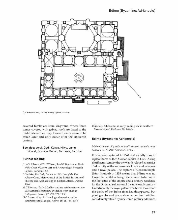
77
covered tombs are from Ungwana, where threetombs covered with gabled roofs are dated to themid-thirteenth century. Domed tombs seem to bemuch later and only occur after the sixteenthcentury.
See also: coral, Gedi, Kenya, Kilwa, Lamu,minaret, Somalia, Sudan, Tanzania, Zanzibar
Further reading:
J. de V.Allen and T.H.Wilson, Swahili Houses and Tombsof the Coast of Kenya, Art and Archaeology ResearchPapers, London 1979.
P.Garlake, The Early Islamic Architecture of the EastAfrican Coast, Memoir no.1 of the British Institute ofHistory and Archaeology in Eastern Africa, Oxford1966.
M.C.Horton, ‘Early Muslim trading settlements on theEast African coast: new evidence from Shanga’,Antiquaries Journal 67: 290–323, 1987.
H.C.Sanservino, ‘Archaeological remains on thesouthern Somali coast’, Azania 18: 151–64, 1983.
P.Sinclair, ‘Chibuene: an early trading site in southernMozambique’, Paideuma 28: 148–64.
Edirne (Byzantine: Adrianople)
Major Ottoman city in European Turkey on the main routebetween the Middle East and Europe.
Edirne was captured in 1362 and rapidly rose toreplace Bursa as the Ottoman capital in 1366. Duringthe fifteenth century the city was developed as a majorTurkish city with caravanserais, khans and mosquesand a royal palace. The capture of Constantinople(later Istanbul) in 1453 meant that Edirne was nolonger the capital, although it continued to be one ofthe first cities of the empire and a country residencefor the Ottoman sultans until the nineteenth century.Unfortunately the royal palace which was located onthe banks of the Tunca river has disappeared, butphotographs and plans show an ancient buildingconsiderably altered by nineteenth-century additions
Üç( Serefeli Cami, Edirne, Turkey (after Goodwin)
Edirne (Byzantine: Adrianople)

78
when it again was used as a residence of the sultans.The best-pre-served part of the palace seems to havebeen the kitchens which provided a model for thoseof the Topkapisarai.
The oldest surviving mosque in Edirne is knownas the Yildirim Cami which is built on the ruins ofa church. The date of construction is debated but isbelieved to be between 1360 and 1390. Other earlymosques include the Muradiye Tekke and Mosquebuilt in 1421 which includes both green tiles of theYesil Cami (Bursa) type and blue and white Chinesestyle tiles. Unfortunately the building was heavilydamaged in an earthquake of 1751 and much of theoriginal appearance of the mosque has been lost inthe eighteenth-century restoration. The largest earlymosque at Edirne is the Eski Cami completedduring the reign of Mehmet I in 1413. This is a nine-domed building with a portico of five bays on thenorth side and a minaret at the north-west corner(the second minaret was added twenty years later).The six side domes are hemispherical whilst thecentral domes on the line of the mihrab are a variety
of shapes (polygonal, octagonal and star-shapedvaults).
Of a similar period but very different style isthe Üç Serefeli Cami begun in 1437. Where theEski Cami was the last great Ottoman mosque tobe built in the multi-domed fashion the ÜcSerefeli was the first of the new type of imperialmosque. It consists of a rectangular courtyard andsmaller rectangular prayer area covered by onelarge dome and four subsidiary domes (two eitherside). The main dome rests on a hexagonal drumsupported by two large octagonal piers. This wasa revolutionary design when mosques were eithera collection of single-domed units or a large areacovered by multiple domes of equal size like theEski Cami. The Üç Serefeli was also unique forits time because of its four minarets decorated ina variety of patterns; they were placed at thecorners of the courtyard and arranged so that thetwo smallest were at the front and the tallestminarets were at the back. The tallest minaret isin the north-west corner and is distinguished by
Selimiye Complex, Edirne, Turkey (after Goodwin)
Edirne (Byzantine: Adrianople)

79
its three balconies which give the building itsname.
In 1484 Beyazit ordered the construction of amajor new mosque and hospital by the side of theTunca river. The complex covers a large area(approx. 300 by 200 m) and includes the mosque, ahospital, sanatorium and medical school. There isa stone bridge next to the complex which wasprobably built at the same time. The mosque at thecentre of the complex consists of a single-domedunit, flanked by two tabhanes (dervish hostels) andapproached via a rectangular arcaded courtyard.The most significant architectural feature of thecomplex is the hexagonal hospital hall whichencloses a central domed hexagonal court leadingoff to vaulted iwans.
Edirne’s continued importance during thesixteenth century is proved by Selim II’s choice ofthe city for his imperial mosque the Selimiye, whosecentral dome was the largest Ottoman dome and wasequal to that of Hagia Sophia with a diameter of 32m. The mosque forms part of a complex whichincludes a covered market, a madrassa and primaryschool. Like the Üç Serefeli Mosque the Selimiye hasfour minarets although here one is placed at eachcorner of the domed prayer hall rather than thecourtyard.
See also: Ottomans, Selimiye, tekke
Further reading:
A.Kuran, ‘Edirne�de Yildirim Camii’ (The Mosque ofYildirim in Edirne), Belletin, 28(3): 429–38, 1964.
R.M.Meriç, ‘Edime’nin tarihi ve mimari eserlerihakkinda’, in Türk San’ati Tarihi Arastima ve Incelemeleri,Istanbul 1963.
R.Meyer-Riefstahl, ‘Early Turkish tile revetments inTurkey’, Ars Islamica, 4: 1937.
R.Osman, Edirne sarayi, Ankara 1956.A.S.Ünver, Edirne Muradiye cami�i, Istanbul 1953.
Egypt (excluding Cairo)
Located at the north-eastern tip of Africa forming abridge between Africa and Asia. The population of theArab Republic of Egypt is 90 per cent Muslim and 10per cent Coptic Christian. Despite its vast size (1million square kilometres) most of the population livesin the region of the Nile Delta between Cairo andAlexandria. The other inhabited area is the Nile valleywhich runs the whole length of the country from Sudanin the south to the Mediterranean in the north. The
rest of Egypt is inhospitable desert with a sparsepopulation.
Egypt is fortunate in having a wealth of buildingmaterials at its disposal. The main materials arestone, baked brick, mud brick and wood. In theDelta region (which includes Cairo and Alexandria)suitable building stone is not naturally available,although Ancient Egyptian monuments containingstone imported from Upper Egypt provided aplentiful quarry for many Islamic buildings. Evenin Upper Egypt ancient structures were often themost accessible source of building stone.Nevertheless, baked brick was often the preferredmaterial because of its relative cheapness (i.e.transport costs), its versatility and standard size.Mud brick is obviously cheaper than baked brick,can be quickly produced and provides excellentthermal insulation. In pre-modern times mud brickformed the basic building material for most of thecountry but more recently it is confined to southernEgypt. Date palms form the main natural source ofwood and palm wood is used for most traditionalarchitecture. More exotic wood could be importedfrom Europe or Africa for use in the wealthierhouses of Cairo.
Several factors have combined to make theIslamic architecture of Egypt outside Cairovirtually unknown: first, the overwhelming wealthof Cairo’s architectural heritage; second, themonuments outside Cairo are often made of mudbrick and have survived less well; third,monuments of Egypt’s pharaonic past have tendedto overshadow those of later periods. In thisdiscussion I have concentrated on the architectureof Upper Egypt which generally receives lessattention.
The most important monuments of UpperEgypt are the necropolis of Aswan, the al-�AmriMosque at Qus and a group of five Fatimidminarets. The necropolis of Aswan is locatedoutside the town of Aswan in Upper Egypt. Thenecropolis consists of a long strip 500 m widestretching along the side of the road for nearly 2km. Within the necropolis there are more than 1000tombs built which originally had inscriptions datingthem to the eleventh or early twelfth century. Thetombs represent one of the best examples ofmedieval funerary architecture in the Middle East.There are several forms of tomb, from simplerectangular enclosures open to the sky to elaborate
Egypt (excluding Cairo)
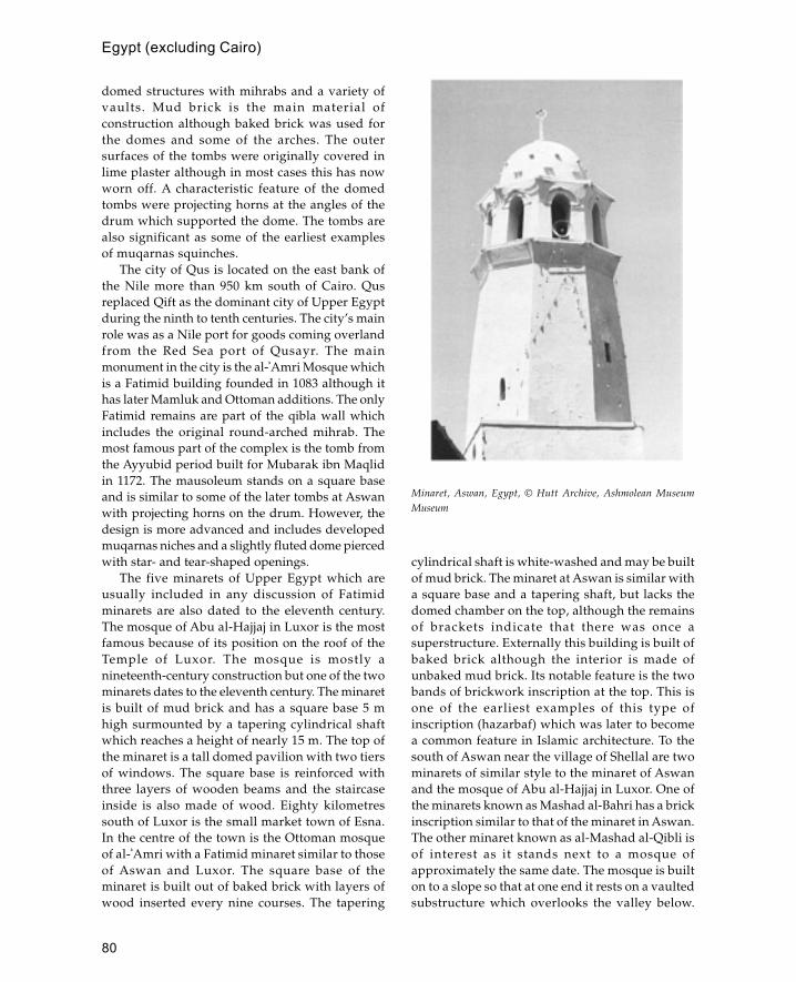
80
domed structures with mihrabs and a variety ofvaults. Mud brick is the main material ofconstruction although baked brick was used forthe domes and some of the arches. The outersurfaces of the tombs were originally covered inlime plaster although in most cases this has nowworn off. A characteristic feature of the domedtombs were projecting horns at the angles of thedrum which supported the dome. The tombs arealso significant as some of the earliest examplesof muqarnas squinches.
The city of Qus is located on the east bank ofthe Nile more than 950 km south of Cairo. Qusreplaced Qift as the dominant city of Upper Egyptduring the ninth to tenth centuries. The city’s mainrole was as a Nile port for goods coming overlandfrom the Red Sea port of Qusayr. The mainmonument in the city is the al-�Amri Mosque whichis a Fatimid building founded in 1083 although ithas later Mamluk and Ottoman additions. The onlyFatimid remains are part of the qibla wall whichincludes the original round-arched mihrab. Themost famous part of the complex is the tomb fromthe Ayyubid period built for Mubarak ibn Maqlidin 1172. The mausoleum stands on a square baseand is similar to some of the later tombs at Aswanwith projecting horns on the drum. However, thedesign is more advanced and includes developedmuqarnas niches and a slightly fluted dome piercedwith star- and tear-shaped openings.
The five minarets of Upper Egypt which areusually included in any discussion of Fatimidminarets are also dated to the eleventh century.The mosque of Abu al-Hajjaj in Luxor is the mostfamous because of its position on the roof of theTemple of Luxor. The mosque is mostly anineteenth-century construction but one of the twominarets dates to the eleventh century. The minaretis built of mud brick and has a square base 5 mhigh surmounted by a tapering cylindrical shaftwhich reaches a height of nearly 15 m. The top ofthe minaret is a tall domed pavilion with two tiersof windows. The square base is reinforced withthree layers of wooden beams and the staircaseinside is also made of wood. Eighty kilometressouth of Luxor is the small market town of Esna.In the centre of the town is the Ottoman mosqueof al-�Amri with a Fatimid minaret similar to thoseof Aswan and Luxor. The square base of theminaret is built out of baked brick with layers ofwood inserted every nine courses. The tapering
cylindrical shaft is white-washed and may be builtof mud brick. The minaret at Aswan is similar witha square base and a tapering shaft, but lacks thedomed chamber on the top, although the remainsof brackets indicate that there was once asuperstructure. Externally this building is built ofbaked brick although the interior is made ofunbaked mud brick. Its notable feature is the twobands of brickwork inscription at the top. This isone of the earliest examples of this type ofinscription (hazarbaf) which was later to becomea common feature in Islamic architecture. To thesouth of Aswan near the village of Shellal are twominarets of similar style to the minaret of Aswanand the mosque of Abu al-Hajjaj in Luxor. One ofthe minarets known as Mashad al-Bahri has a brickinscription similar to that of the minaret in Aswan.The other minaret known as al-Mashad al-Qibli isof interest as it stands next to a mosque ofapproximately the same date. The mosque is builton to a slope so that at one end it rests on a vaultedsubstructure which overlooks the valley below.
Minaret, Aswan, Egypt, © Hutt Archive, Ashmolean MuseumMuseum
Egypt (excluding Cairo)

81
The sanctuary of the mosque is covered by sixdomes and has three minarets in the qibla wall.
See also: Cairo, Fathy, Fustat, Hassan, mud brick
Further reading:J.Bloom, ‘Five Fatimid minarets in Upper Egypt’,
Journal of the Society of Architectural Historians 43: 162–7, 1984.
—— ‘The introduction of the muqarnas in Egypt’,Muqarnas 5: 1988.
K.A.C.Creswell, The Muslim Architecture of Egypt, 2vols, Oxford 1952; repr. New York 1978.
Egypt (excluding Cairo)
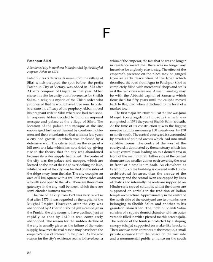
82
Fatehpur Sikri
Abandoned city in northern India founded by the Mughalemperor Akbar in 1571.
Fatehpur Sikri derives its name from the village ofSikri which occupied the spot before, the prefixFatehpur, City of Victory, was added in 1573 afterAkbar’s conquest of Gujerat in that year. Akbarchose this site for a city out of reverence for SheikhSalim, a religious mystic of the Chisti order whoprophesied that he would have three sons. In orderto ensure the efficacy of the prophecy Akbar movedhis pregnant wife to Sikri where she had two sons.In response Akbar decided to build an imperialmosque and palace at the village of Sikri. Thelocation of the palace and mosque at the siteencouraged further settlement by courtiers, noble-men and their attendants so that within a few yearsa city had grown up which was enclosed by adefensive wall. The city is built on the ridge of ahill next to a lake which has now dried up, givingrise to the theory that the city was abandonedbecause its water supply had failed. The centre ofthe city was the palace and mosque, which arelocated on the top of the ridge overlooking the lake,while the rest of the city was located on the sides ofthe ridge away from the lake. The city occupies anarea of 5 km square with a wall on three sides anda fourth side open to the lake. There are three maingateways in the city wall between which there aresemi-circular buttress towers.
The rise of the city from 1571 was very rapid sothat after 1573 it was regarded as the capital of theMughal Empire. However, after the city wasabandoned by Akbar in 1585 to fight a campaign inthe Punjab, the city seems to have declined just asrapidly so that by 1610 it was completelyabandoned. The reason for the sudden decline ofthe city is usually given as the failure of the watersupply, however the real reason may have been theemperor’s loss of interest in the place. As the solereason for the city’s existence seems to have been a
whim of the emperor, the fact that he was no longerin residence meant that there was no longer anyincentive for anybody else to stay. The effect of theemperor’s presence on the place may be gaugedfrom an early description of the town whichdescribed the road from Agra to Fatehpur Sikri ascompletely filled with merchants’ shops and stallsas if the two cities were one. A useful analogy maybe with the Abbasid capital of Samarra whichflourished for fifty years until the caliphs movedback to Baghdad when it declined to the level of amarket town.
The first major structure built at the site was JamiMasjid (congregational mosque) which wascompleted in 1571 the year of Sheikh Salim’s death.At the time of its construction it was the biggestmosque in India measuring 160 m east-west by 130m north-south. The central courtyard is surroundedby arcades of pointed arches which lead into smallcell-like rooms. The centre of the west of thecourtyard is dominated by the sanctuary which hasa huge central iwan leading on to a domed area infront of the main mihrab. Either side of the centraldome are two smaller domes each covering the areain front of a smaller mihrab. As elsewhere atFatehpur Sikri the building is covered with Hinduarchitectural features, thus the arcade of thesanctuary and the central iwan are capped by linesof chatris and internally the roofs are supported onHindu-style carved columns, whilst the domes aresupported on corbels in the tradition of Indiantemple architecture. Approximately in the centre ofthe north side of the courtyard are two tombs, onebelonging to Sheikh Salim and another to hisgrandson Islam Khan. The tomb of Sheikh Salimconsists of a square domed chamber with an outerveranda filled in with a pierced marble screen (jali).The outside of the tomb is protected by a slopingcanopy (chajja) supported on snake-like brackets.There are two main entrances to the mosque, a smallprivate entrance from the palace on the east sideand a monumental public entrance on the south
F

83
side. The public entrance is known as the BulandDarwaza and was built in 1576 to commemorateAkbar’s victory over Gujarat. The gate’s nameBuland Darwaza, Tall Gate’, refers to the gate’soutstanding height of 40 m. Like most Mughalmosques this building is raised up on a terrace sothat the entrances are approached by flights of steps;in the case of the Buland Darwaza the stairs rise upanother 12 m from ground level. The gate has aniwan plan with a large, deep central iwan flankedby two pairs of side iwans. In the middle of theback wall is a smaller gateway leading in to themosque also flanked by two blind arches of equalsize. The frame of the central iwan is surroundedby a monumental inscription and is capped bydomed chatris.
The largest building complex at Fatehpur Sikriis the palace, covering an area approximately 250m square. The layout is similar to that of otherimperial Mughal palaces with three main areas, thepublic area, the mardana or men’s area, and thezenana or women’s area. Visitors approaching thepalace first enter through a gateway to a largearcaded courtyard with the Diwan-i Amm (publicaudience hall) in the centre of the west side. In otherMughal palaces this is usually a grand, highlydecorated building, but in this case it is a smallrectangular pavilion with a central bay at the frontto accommodate the emperor. There is no directaccess from the courtyard to the pavilion which israised at least 2 m above the level of the courtyard.This arrangement suggests a greater degree ofsecurity than at other palaces, a theme which isrepeated throughout the palace particularly in thewomen’s quarters.
The overwhelming impression within is of aHindu palace, with few indications of Islamic design.Immediately behind the Diwan-i Amm is a largecourtyard in the centre of which a cross is markedout; this is a giant version of a Pachisi board whichis an ancient Indian game. To the north of thiscourtyard is the most intriguing section of the palace,called the Diwan-i Khass. This is a square two-storeybuilding with a balcony supported on heavy corbelsabove which is a chajja also supported on heavycorbels. On the roof there are domed chatris at eachcorner. Inside the building consists of a two-storeyhall with a gallery at first-floor level. Bridges whichrun diagonally from the corners of the galleryconnect to a balcony supported by a central pillar.The pillar is richly carved in the Hindu tradition with
a mass of heavy corbels supporting the circularbalcony above. This arrangement does notcorrespond to any other private audience room in aMughal palace, nor is it encountered elsewhere inMughal architecture. However, the arrangement ofa square building with a central pillar may reflectsome Hindu mandala whereby the central columnrepresents the axis of the world; in this, if this wasalso the place where the emperor sat, he would beidentifying himself as the axis of the world. In thecontext of his conquest of Gujarat Akbar may havebeen wishing to describe himself in Hindu terms ofpower.
The arrangement of a central column approachedby four bridges is repeated in a less formal setting inthe courtyard known as the Anup Talao where thereis a square pool with a central island approached bybridges from each of the four sides. The Anup Talaoforms the central area of the private residence of theemperor and the main part of the mardana, or men’sarea. To the south of the pool is a pavilion known asthe khwabagh or bedroom although its exact use isnot known.
The area to the east of the Anup Talao is thezenana, or women’s area, separated from the restof the complex by a long wall. This is the mostmagnificent part of the palace and was decoratedwith painting and rich carvings. One of the mosthighly decorated buildings of the palace is theSunahra Makan which is decorated with bothgeometric and figurative wall paintings. The mostvisible building in this area is the Panch Mahal, afive-storey pavilion crowned with a domed chatriwhich overlooks the men’s area. The heart of thewomen’s area, however, is known as Jodh Bai’sPalace, a rectangular courtyard enclosure separatefrom the rest of the palace. The enclosure is enteredthrough a single fortified gateway on the east sidewhich leads into the rectangular courtyard. Thecourtyard is surrounded by arcades on all foursides and in the middle of each is a two-storeyhouse with staircases to the upper floors andapartments. To the north of Jodh Bai’s Palace isthe Hawa Mahal or wind palace, which is a raisedpavilion designed to catch the breeze. Another ofthe residential areas for women is a structureknown as Birbal’s House which is located to thewest of Jodh Bai’s Palace and is thought to be oneof the earliest parts of the palace (it is dated by aninscription to 1571).
Fatehpur Sikri
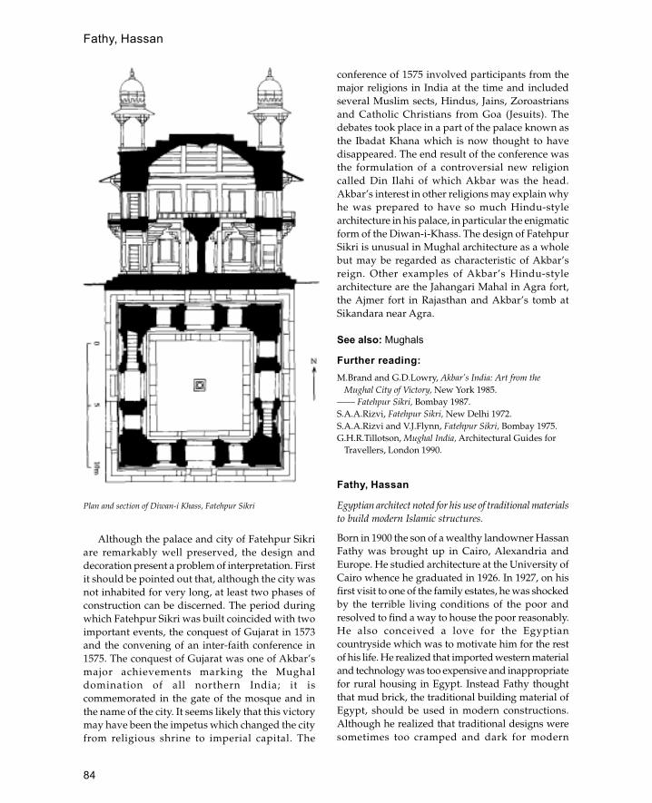
84
Although the palace and city of Fatehpur Sikriare remarkably well preserved, the design anddecoration present a problem of interpretation. Firstit should be pointed out that, although the city wasnot inhabited for very long, at least two phases ofconstruction can be discerned. The period duringwhich Fatehpur Sikri was built coincided with twoimportant events, the conquest of Gujarat in 1573and the convening of an inter-faith conference in1575. The conquest of Gujarat was one of Akbar’smajor achievements marking the Mughaldomination of all northern India; it iscommemorated in the gate of the mosque and inthe name of the city. It seems likely that this victorymay have been the impetus which changed the cityfrom religious shrine to imperial capital. The
conference of 1575 involved participants from themajor religions in India at the time and includedseveral Muslim sects, Hindus, Jains, Zoroastriansand Catholic Christians from Goa (Jesuits). Thedebates took place in a part of the palace known asthe Ibadat Khana which is now thought to havedisappeared. The end result of the conference wasthe formulation of a controversial new religioncalled Din Ilahi of which Akbar was the head.Akbar’s interest in other religions may explain whyhe was prepared to have so much Hindu-stylearchitecture in his palace, in particular the enigmaticform of the Diwan-i-Khass. The design of FatehpurSikri is unusual in Mughal architecture as a wholebut may be regarded as characteristic of Akbar’sreign. Other examples of Akbar’s Hindu-stylearchitecture are the Jahangari Mahal in Agra fort,the Ajmer fort in Rajasthan and Akbar’s tomb atSikandara near Agra.
See also: Mughals
Further reading:M.Brand and G.D.Lowry, Akbar’s India: Art from the
Mughal City of Victory, New York 1985.—— Fatehpur Sikri, Bombay 1987.S.A.A.Rizvi, Fatehpur Sikri, New Delhi 1972.S.A.A.Rizvi and V.J.Flynn, Fatehpur Sikri, Bombay 1975.G.H.R.Tillotson, Mughal India, Architectural Guides for
Travellers, London 1990.
Fathy, Hassan
Egyptian architect noted for his use of traditional materialsto build modern Islamic structures.
Born in 1900 the son of a wealthy landowner HassanFathy was brought up in Cairo, Alexandria andEurope. He studied architecture at the University ofCairo whence he graduated in 1926. In 1927, on hisfirst visit to one of the family estates, he was shockedby the terrible living conditions of the poor andresolved to find a way to house the poor reasonably.He also conceived a love for the Egyptiancountryside which was to motivate him for the restof his life. He realized that imported western materialand technology was too expensive and inappropriatefor rural housing in Egypt. Instead Fathy thoughtthat mud brick, the traditional building material ofEgypt, should be used in modern constructions.Although he realized that traditional designs weresometimes too cramped and dark for modern
Plan and section of Diwan-i Khass, Fatehpur Sikri
Fathy, Hassan

85
housing, Fathy argued that this was not the fault ofthe material.
In 1937 Fathy held exhibitions of his work atMansoura and Cairo which resulted in severalcommissions from wealthy patrons. However, thesebuildings were quite expensive and relied on timberfor their flat roofs. With the outbreak of the SecondWorld War and the resulting shortage of timber, hehad to find a new method of roofing his houses. Ona visit to Upper Egypt Fathy noticed that the Nubianvillages were roofed with mud brick vaults producedwithout wooden centring. The method used was tolean the bricks against an end wall so that all thebricks leant against each other. Fathy employed thelocal Nubian builders and undertook several projectsusing these workers. The most important of theseprojects was the Nasr House in Fayyum and thetourist rest-house at Safaga.
In 1946 Fathy was approached by theDepartment of Antiquities who wanted to move thepeople of Gurna in western Luxor out of the ruins
of ancient Thebes where they had been living. TheGurnis had been living in the ancient Necropolisfor several generations and some lived in the tombsthemselves. Nevertheless, the Department ofAntiquities issued a decree stating that they wantedthe 7,000 people moved to a new settlement whichwas to be designed by Fathy. The settlement was tocontain homes for 1,000 families and include publicbuildings like a mosque, a covered market, schoolsand a theatre. The houses were built aroundcourtyards and arranged in neighbourhood groupswhich had access to the main streets. Although builtwith traditional materials Fathy made use of earthscientists and structural and mechanical engineersto improve his designs and ensure that theyworked. Part of the project was to involve the futureinhabitants in the construction, both as a cost-savingmeasure and so that they were not alienated fromtheir new housing.
However, the project faced considerabledifficulties in implementation through the
Mosque designed by Hassan Fathy, New Gurna, Egypt
Fathy, Hassan
86
opposition of some of the Gurni Sheikhs and theslow-moving bur-eaucracy of the EgyptianAntiquities Department.
In addition there was general suspicion of aproject which involved traditional materials at a timewhen Modernism was seen as the only way to build.In the end only one-fifth of the project was completedand some parts of the village like the khan and thecraft centre remain unused. Nevertheless, themosque is well used and maintained and theDepartment of Antiquities has restored the theatre,belatedly realizing the value of Fathy’s work. Despitethe difficulties New Gurna showed the potential ofmud-brick architecture and the value of trainingpeople in traditional techniques.
Other important projects carried out by Fathy inthe 1950s were at Lu�luat al-Sahara in the Nile Deltaand the village schools project. At Lu�lat al-Saharahouses were built in pairs, together with a mosqueand a school. The village schools project involvedFathy in designing a school which was to be theprototype for village schools throughout Egypt. Thedesign consisted of domed rooms opening on tocourtyards with ventilation shafts to cool theinterior during the summer. Unfortunately only twoof the schools were built, one at Fares and the otherat Edfu.
In 1957 Fathy left Egypt for several years to workfor an architectural firm in Athens specializing inthe Middle East, and during this time he designed atraditional housing scheme in Iraq. In the early 1960sFathy returned to Egypt where he undertook twofurther major projects, a training centre in the NileValley and a new town in the Kharga oasis.Unfortunately the training centre was subsequentlydestroyed because of its bad location and the townknown as New Bariz was abandoned because of the1967 war.
In the 1970s Fathy began writing books about hiswork which were highly successful in universitiesthroughout the world where the appeal ofModernism was wearing off. He showed that it waspossible to design and build desirable residences andfunctional buildings which respected the traditionalvalues of a culture and were also cheap. Since the1970s Fathy’s work in Egypt was concentrated onprivate houses and commissions. These buildingswere constructed with increasingly sophisticateddesigns based on harmonic units of measurementderived from the dimensions of the human body.Probably the most important recent commission was
for a Muslim community in New Mexico known asDar al-Salam and built in 1981.
Further reading:
H.Fathy, The Arab House in the Urban Setting: Past, Presentand future, Fourth Arab Carreras Lecture,
University of Essex, November 1970. London 1972.—— Architecture for the Poor, Chicago and London 1973.—— Natural Energy and Vernacular Architecture, Chicago
1985.G.Leick, ‘Hassan Fathy, architect for the poor’, Egyptian
Bulletin May 1988:4–8. Fathy, London 1985.J.M Richards, I.Serageldin and D.Rastorfer, HassanA.Schkifer, ‘Hassan Fathy: a voyage to New Mexico’, Arts
and the Islamic World 1(1): 1982/3.
Fatimids
Caliphs who ruled North Africa, Egypt and Palestine fromthe tenth to the twelfth century.
The Fatimids were a religious dynasty who claimeddescent from the prophet’s daughter Fatima. Inhistorical terms the Fatimids belonged to an extremesect of Shi�a known as Ismailis who emerged as rivalsto both the Umayyads of Spain and the Abbasidcaliphate in Baghdad. The Fatimids’ first successeswere amongst the Berber tribes of North Africa whoadopted the Fatimids as leaders. Their first conquestdestroyed the Aghlabid rulers of Ifriqiyya (Tunisia)in 909 and replaced them with the Fatimid caliphthe Mahdi Ubaid Allah. In the following years theFatimids pursued an aggressive expansionist policy,conquering Tripoli and making raids on the Frenchand Italian coasts. During the reign of the Caliph al-Mu�iz the empire was expanded westwards toinclude the whole of North Africa to the AtlanticOcean and eastwards to Egypt and Palestine in 969.The conquest of Egypt began a new phase in Fatimidhistory with the foundation of Cairo as the imperialcapital.
The architecture of the Fatimids can be dividedinto two periods, the North African period from 909to 969 and the Egyptian period from 969 to 1171. TheNorth African period was a time of expansion andreligious extremism which can be seen in thearchitecture of the mosques. Examples of earlyFatimid mosques are at Ajdabiya in Libiya andMahdiya in Tunisia. The first of these was themosque of Mahdiya, which was built like a fortresswith two square corner towers flanking a single
Fatimids

87
projecting monumental entrance. The mosque atAjdabiya had a similar plan but lacks themonumental entrance façade. For ideological reasonsneither of these mosques had a minaret, a featurewhich remained absent until the last years of Fatimidrule in Egypt.
See also: Ajdabiya, Cairo (The Fatimid Period),Libiya, Mahdiya, Tunisia
Fez
Moroccan city noted for its Islamic architecture.
Fez is located in the north-east of Morocco on eitherside of the Wadi Fez. The city was founded in thelate eighth and early ninth century by Moulay Idristhe Younger. It was divided into two halves, the eastbank representing the late eighth-century city andthe west bank representing the city of Moulay Idris.Each of the districts had its own congregationalmosque, that on the west bank is known as theQarawiyyin Mosque and that on the east is knownas the mosque of the Andalusians.
The Qarawiyyin Mosque, founded in 859, is themost famous mosque of Morocco and attractedcontinuous investment by Muslim rulers. Therewere extensive renovations in 956 by the Umayyadcaliph of Spain who also added the minaret. Thebuilding did not reach its present form and size (85by 44 m) until 1135. The prayer hall comprises tenaisles running parallel to the qibla wall and a raisedtransverse aisle leading to the mihrab. The aislesare covered with gabled wooden roofs covered withroof tiles. There is a dome over the mihrab and theentrance porch in addition to the seven domeswhich cover the north arcade of the courtyard. Thedomes are made of elaborate muqarnas vaultingwith zig-zag ribbing on the exterior. Inside themosque is decorated with stucco, the most elaboratebeing reserved for the area in front of the mihrab.The mosque preserves its twelfth-century minbarwhich is regarded as one of the finest in the world.The courtyard is decorated with tile mosaic (zilij)dadoes and has a magnificent ablutions pavilion atthe west. The pavilion, built in the sixteenth century,rests on eight marble columns and has a tile-coveredwooden roof with overhanging eaves. Thewoodwork of the eaves is of exceptional qualitywith carved muqarnas mouldings and miniatureengaged piers forming blind niches decorated withgeometric interlace.
The mosque of the Andalusians has a similar planto the Qarawiyyin Mosque although it is less wellendowed. Like its twin this mosque had a minaretadded by the Umayyad caliph Abd al-Rahman,although subsequent restorations were lesssuccessful. The other Great Mosque of Fez, the Jama�al-Hamra, was built in 1276 and has aisles alignedperpendicular to the qibla wall in the typical NorthAfrican style.
From the thirteenth to the seventeenth centuriesthe madrassa became the principal form of religiousarchitecture. The madrassas of Fez have a standardform of a two-storey courtyard building, withstudents’ cells above and a mosque and teachingrooms below. The courtyards were usually decoratedwith tile mosaic and had a central pool. The mostfamous examples are the Saffarin, the Sahrij, the�Attarin and the Bu �Inaniya each of which has specialfeatures to distinguish it from its neighbours. TheBu �Inaniya is the most unusual as it has a minaretand an early mechanical clock with gongs.
Most of the houses in Fez date from theseventeenth century or later although they preserveearlier plans. The standard construction material iseither rubble stone or baked brick, with wood usedfor the roofs and decorative details. The usual planis similar to the madrassas, with a rectangularcourtyard and two storeys although the houses areusually less spacious.
See also: Morocco
Further reading:
D.Hill and L.Golvin, Islamic Architecture in North Africa,London 1976.
R.Le Tourneau, Fez in the Age of the Marinides, tr.B.A.Clement, Norman, USA 1961.
H.Terrasse, La Mosquée al-Qaraouiyin à Fes, Paris 1968.—— La Mosquée des Andalous à Fes, Paris (n.d.).
Firuzabad (India)
Deserted fifteenth-century palace city in the Deccan,southern India.
The city was founded in 1400 by the Bahmani rulerTaj-al-Din Firuz Shah. The site is located on the banksof the Bhima river and consists of massivefortification walls which enclose the city on threesides. In the centre of each side are huge vaultedgateways which lead into the ruined central area.
Firuzabad (India)
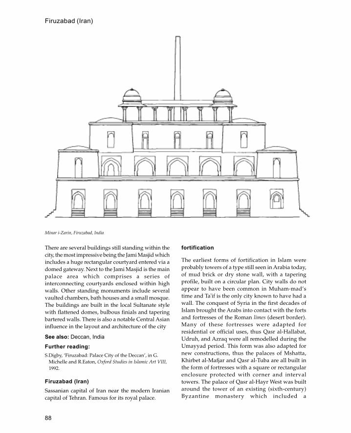
88
There are several buildings still standing within thecity, the most impressive being the Jami Masjid whichincludes a huge rectangular courtyard entered via adomed gateway. Next to the Jami Masjid is the mainpalace area which comprises a series ofinterconnecting courtyards enclosed within highwalls. Other standing monuments include severalvaulted chambers, bath houses and a small mosque.The buildings are built in the local Sultanate stylewith flattened domes, bulbous finials and taperingbartered walls. There is also a notable Central Asianinfluence in the layout and architecture of the city
See also: Deccan, India
Further reading:S.Digby, ‘Firuzabad: Palace City of the Deccan’, in G.
Michelle and R.Eaton, Oxford Studies in Islamic Art VIII,1992.
Firuzabad (Iran)Sassanian capital of Iran near the modern Iraniancapital of Tehran. Famous for its royal palace.
fortification
The earliest forms of fortification in Islam wereprobably towers of a type still seen in Arabia today,of mud brick or dry stone wall, with a taperingprofile, built on a circular plan. City walls do notappear to have been common in Muham-mad’stime and Ta�if is the only city known to have had awall. The conquest of Syria in the first decades ofIslam brought the Arabs into contact with the fortsand fortresses of the Roman limes (desert border).Many of these fortresses were adapted forresidential or official uses, thus Qasr al-Hallabat,Udruh, and Azraq were all remodelled during theUmayyad period. This form was also adapted fornew constructions, thus the palaces of Mshatta,Khirbet al-Mafjar and Qasr al-Tuba are all built inthe form of fortresses with a square or rectangularenclosure protected with corner and intervaltowers. The palace of Qasr al-Hayr West was builtaround the tower of an existing (sixth-century)Byzantine monastery which included a
Minar i-Zarin, Firuzabad, India
Firuzabad (Iran)

89
machicolation above the gateway. This feature waslater included in the gate of the palace at Qasr al-Hayr East 40 km east of the earlier one.
The influence of Sassanian architecture in thisearly period should also be noted—thus QasrKharana in Jordan is purely Sassanian in formalthough it is certainly an Umayyad construction.Further east in Iraq is the palace of Ukhaidhir whichis the most complete example of early Islamicfortification. The palace forms a large rectangularenclosure with round corner towers and semi-circular buttresses at regular intervals. The areabetween each buttress comprised two tall arches builtflat against the wall, above the arches there is anenclosed parapet containing vertical arrow slits anddownward openings between the arches. This is thefirst example of continuous machicolation, a featurewhich did not appear in Europe until the fourteenthcentury.
The eighth-century walls of Baghdad were one ofthe greatest feats of military engineering in the Islamicworld. Although there are no physical remains,descriptions indicate that the city was a vast circleenclosed within a moat and double walls. There werefour gates each approached through a bent entrance.The bent entrance and the circular shape of the cityare both features which appear to be copied fromCentral Asian architecture and were not found incontemporary Byzantine architecture.
The best surviving examples of pre-Crusader cityfortifications are the wall and gates of Fatimid Cairobuilt in the eleventh century. There are three gates—the Bab al-Futuh, the Bab Zuwayla and the Bab al-Nasr—each of which is supposed to have been builtby a different architect. Each gate consists of twotowers either side of a large archway which leadsinto a vaulted passageway 20 m long with concealedmachicolation in the roof. The lower two thirds ofeach gateway is solid whilst the upper part containsa vaulted room with arrow slits. Another feature ofthe tenth and eleventh centuries is the developmentof coastal forts or ribats which were designed toprotect the land of Islam from Byzantine attacks.These forts have a similar design to the early Islamicpalaces comprising a square or rectangular enclosurewith solid buttress towers.
The arrival of the Crusaders at the end of theeleventh century revolutionized militaryarchitecture. During this period there is a fusion ofEuropean, Byzantine and Islamic principles offortifica-tion which produced castles of enormous
size and strength. European introductions were thecentral keep, curtain walls which follow thecontours of a site and massive masonry. Althoughthe majority of castles of the period were built bythe Crusaders there are some outstanding examplesof twelfth-century Ayyubid castles such as Qal�atNimrud (Subeibe) and Qal�at Rabad (Ajlun). Thisnew sophistication was also applied to cityfortifications, thus the gateway to the citadel ofAleppo has a bent entrance with five right-angleturns approached by a bridge carried on sevenarches. Elsewhere in the Islamic world fortificationswere also developed in response to the increasedChristian threat, thus the Almohads developedsophisticated fortifications with elaborate bententrances.
With the defeat of the Crusaders in the East theimpetus for fortress-building declined andarchitecture of the Mamluk period was directedmainly to civil purposes. The castles andfortifications which were built tended to be archaicin their military design although elaborate in their
Plan of Ayyubid-period bent entrance to citadel, Aleppo
fortification
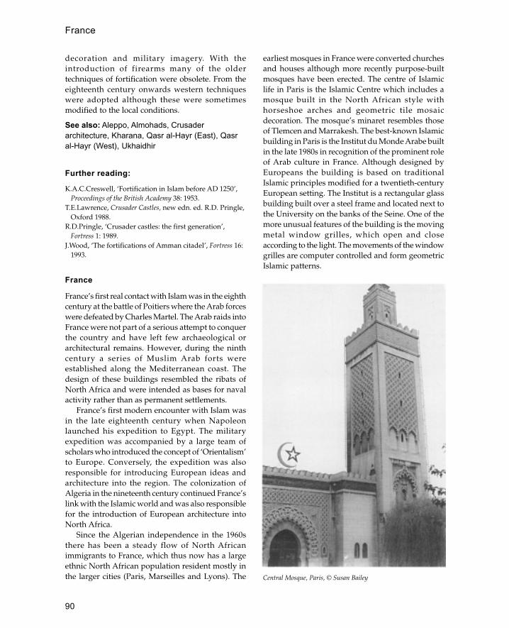
90
decoration and military imagery. With theintroduction of firearms many of the oldertechniques of fortification were obsolete. From theeighteenth century onwards western techniqueswere adopted although these were sometimesmodified to the local conditions.
See also: Aleppo, Almohads, Crusaderarchitecture, Kharana, Qasr al-Hayr (East), Qasral-Hayr (West), Ukhaidhir
Further reading:
K.A.C.Creswell, ‘Fortification in Islam before AD 1250’,Proceedings of the British Academy 38: 1953.
T.E.Lawrence, Crusader Castles, new edn. ed. R.D. Pringle,Oxford 1988.
R.D.Pringle, ‘Crusader castles: the first generation’,Fortress 1: 1989.
J.Wood, ‘The fortifications of Amman citadel’, Fortress 16:1993.
France
France’s first real contact with Islam was in the eighthcentury at the battle of Poitiers where the Arab forceswere defeated by Charles Martel. The Arab raids intoFrance were not part of a serious attempt to conquerthe country and have left few archaeological orarchitectural remains. However, during the ninthcentury a series of Muslim Arab forts wereestablished along the Mediterranean coast. Thedesign of these buildings resembled the ribats ofNorth Africa and were intended as bases for navalactivity rather than as permanent settlements.
France’s first modern encounter with Islam wasin the late eighteenth century when Napoleonlaunched his expedition to Egypt. The militaryexpedition was accompanied by a large team ofscholars who introduced the concept of ‘Orientalism’to Europe. Conversely, the expedition was alsoresponsible for introducing European ideas andarchitecture into the region. The colonization ofAlgeria in the nineteenth century continued France’slink with the Islamic world and was also responsiblefor the introduction of European architecture intoNorth Africa.
Since the Algerian independence in the 1960sthere has been a steady flow of North Africanimmigrants to France, which thus now has a largeethnic North African population resident mostly inthe larger cities (Paris, Marseilles and Lyons). The
earliest mosques in France were converted churchesand houses although more recently purpose-builtmosques have been erected. The centre of Islamiclife in Paris is the Islamic Centre which includes amosque built in the North African style withhorseshoe arches and geometric tile mosaicdecoration. The mosque’s minaret resembles thoseof Tlemcen and Marrakesh. The best-known Islamicbuilding in Paris is the Institut du Monde Arabe builtin the late 1980s in recognition of the prominent roleof Arab culture in France. Although designed byEuropeans the building is based on traditionalIslamic principles modified for a twentieth-centuryEuropean setting. The Institut is a rectangular glassbuilding built over a steel frame and located next tothe University on the banks of the Seine. One of themore unusual features of the building is the movingmetal window grilles, which open and closeaccording to the light. The movements of the windowgrilles are computer controlled and form geometricIslamic patterns.
Central Mosque, Paris, © Susan Bailey
France
91
Further reading:
J.Fremeaux, La France et l’Islam depuis 1789, Paris 1991.G.Keppel, Les Banlieus de l’Islam, Naissance d’une religion en
France, Paris 1991.J.Novel and H.Tokka, Institut du Monde Arabe: Une
Architecture, Paris 1990.
Fulbe
Name of West African people speaking Fulbe-relatedlanguages.
The Fulbe originated as a nomadic people inhabit-ing the Sahara areas of West Africa. From the fifteenthcentury onwards groups of Fulbe began settling inthe more fertile regions south of the Sahara andintegrating with resident groups. Since theseventeenth century the Fulbe were associated withorthodox Islam and inaugurated jihads in severalparts of West Africa. The main areas of Fulbesettlement were the Hausa region of northernNigeria, the Adamawa region of Cameroon and theFuta-Djallon region of Guinea.
The architectural tradition of the Fulbe originatedin the circular wooden-framed tents of their nomadiclifestyle. Elements of this nomadic style are said tohave been incorporated into the Hausa architectureof northern Nigeria which is a mixture Fulbe andindigenous Hausa style.
See also: Futa-Djallon, Hausa, West Africa
funduq
North African term for a small, urban shop complex.A typical funduq is a square two-storey structurebuilt around a central courtyard with shops on onefloor and store rooms on the other. Equivalent to akhan in the Middle East.
Fustat
The first Islamic capital of Egypt, now within the moderncity of Cairo.
Fustat was built on the east bank of the Nile oppositethe pre-Islamic Coptic settlement of Babylon. Thefirst permanent settlement on the site was establishedby the Muslim general �Amr ibn al-�As in 643. Thisfirst settlement appears to have been a hugeencampment of tents arranged into tribal groupsseparated by open ground. In the centre of the campwas the mosque of �Amr which is known as the oldest
mosque in Egypt. Little of the original fabric of themosque survives and in its present form it dates to827. The settlement was not fortified until 684 whena ditch was dug around the camp in order to defendit against the Umayyad army under Marwan. Duringthe Abbasid period Fustat was no longer the centreof government, although it was still the maincommercial centre. The Fatimid conquest and theestablishment of Cairo did little to alter this situationand during the tenth century Fustat was known asone of the wealthiest cities of the world. A series offamines and fires during the eleventh and earlytwelfth century led to the decline of the city. TheCrusader siege of 1168 dealt a further blow to thecity and in later periods the area of Fustat wasredeveloped as a suburb of Cairo within a new wallbuilt on the orders of Salah al-Din.
Excavations in Fustat have revealed complexstreet and house plans which indicate a high degreeof sophistication. The basic unit appears to have beenof rooms built around a square or rectangular centralcourtyard with a central basin. On one or two sidesof the courtyard there was an open arcade of threearches, with a wide central arch and two side arches.Behind the central arch there was usually an openiwan flanked by two side rooms. On the other sidesof the courtyard there was either an iwan openingdirectly on to the courtyard or a door to anotherroom. In general there were few connections fromone room to another and the courtyard remained theprincipal means of access.
See also: �Amr, Mosque of, Cairo, Egypt
Further reading:
A.Baghat, ‘Les Fouilles d’al-Foustat’, Syria 4: 59–65, 1923.W.B.Kubiak, Al-Fustat: Its Foundation and Early
Development, American University in Cairo, 1987.A.A.Ostrasz, ‘The archaeological material for the study of
the domestic architecture at Fustat’, African Bulletin 26:57–86, 1977.
G.T.Scanlon, ‘Fustat expedition preliminary report 1968.Part II’, Journal of the American Research Centre in Egypt13: 69–89, 1976.
Futa-Djallon
Islamic region in the highlands of north-west Guinea onborder with the Ivory Coast in West Africa.
Before the fifteenth century the primary residentswere the Djallonke people who were sedentaryagriculturalists. During the fifteenth century
Futa-Djallon

92
various groups of nomadic Fulbe arrived in the areaand were absorbed into Djallonke society. Duringthe seventeenth century more Fulbe groups with astrong attachment to Islam arrived from the Muslimstate of Macina in the north-east. These newlyarrived Fulbe organized themselves into atheocratic state under the direction of the religiousleader Karamoko Alfa. During the nineteenthcentury a jihad was instigated against the non-believ-ers of the area until the whole area was underIslamic control. The new state was divided into nineprovinces each under a different leading familywith a capital at Timbo.
Despite the strongly orthodox beliefs of the newstate, the integration of previous generations ofFulbe into the resident pagan society meant thatthe architecture was essentially that of the Djallonkemodified to fit the requirements of Islam. Theessential architectural unit of the pre-IslamicDjallonke is the sudu, or roundhouse, a form whichwas also adopted for religious shrines and burials.The basic form of the sudu consists of a thatchedroundhouse enclosed by concentric walls with twoopposed entrances. Each entrance gives access to asemi-circular vestibule and the main central spaceof the building. Beds consist of moulded mudplatforms set against the walls of the central innerspace. Several sudu, or house units, form a familycompound with a separate one for each wife. Theentrance to a compound was through an entrancevestibule which was a round sudu-like constructionwith a doorway either side. Such vestibules wereused to receive visitors in a similar manner to themore familiar entrance rooms of Islamic courtyardhouses (compare for example the houses ofTimbuktu). The houses of Timbo have the samebasic form as traditional Djallonke housing exceptthat the bed is placed opposite the entrance ratherthan to one side; they also have rectangular storageplatforms supported on four posts in the centre ofthe room. During construction a piece of papercontaining a verse of the Quran is buried under eachpost.
The mosques of Futa-Djallon have the samebasic form as the houses although they are builton a larger scale. The earliest mosques were copiesof the traditional village meeting-houses whichconsisted of a raised circular floor enclosed withina low mud wall above which is a steep conicalthatched roof made of rafters supported by postsembedded into the wall. When a new mosque is
built the older mosque is often converted into awomen’s area or a Quranic reading room andincluded within the compound of the newbuilding. As elsewhere in the Islamic worldmosques are often associated with the palace ofthe local ruler, thus at Fougoumba the royalaudience hall was directly opposite the mosque.In the mid-nine-teenth century a new concept inthe architecture of mosques in the region wasintroduced by al-Hajj Umar who establishedhimself as the ruler of Dingueraye. Educated as astrict Sufi, the new leader attracted a largefollowing which transformed Dingueraye from asmall village into a town of 8,000 people. As aresult of this huge influx of people a city wall wasbuilt to enclose the entire settlement and a newmosque was erected. Although this mosque hasnot survived, its replacement built on the samesite in 1883 is thought to have essentially the samedesign. Like earlier mosques in the region theGreat Mosque at Dingueraye consists of a largethatched roundhouse with a diameter of 30 m andenclosed within a wooden fence. The thatchreaches down almost to the ground so that the tenentrances are only marked by gaps in the woodenfence. The outer wall of the mosque consists of amud wall containing posts supporting the roofrafters. Immediately inside the outer wall there iscircular arrangement of wooden pillars which alsosupports the roof rafters. The extraordinaryarrangement of the interior consists of a square,mud-brick, box-like building in the middle whichforms the sanctuary of the mosque. This mud-brickstructure has three entrances on each side exceptfor the qibla side where there is only one. Theentrance on the qibla side is through an openingin the side of the mihrab and is reserved for theimam. The flat ceiling of the box is supported byrafters resting on sixteen wooden pillars arrangedin four rows. In the centre there is a mud-brickpier which protrudes through the roof of the boxto support a series of radiating rafters holding upthe steep conical thatched roof. This design waslater copied in other parts of Futa-Djallon and hasnow become the typical mosque form of the area.The rationale behind the Dingueraye Mosquedesign can be deduced from a drawing of thedesign by al-Hajj Umar. The drawing depicts amagic square and appears to refer only to thecentral square box and makes no reference to theouter circle of the thatched roof. Local religious
Futa-Djallon
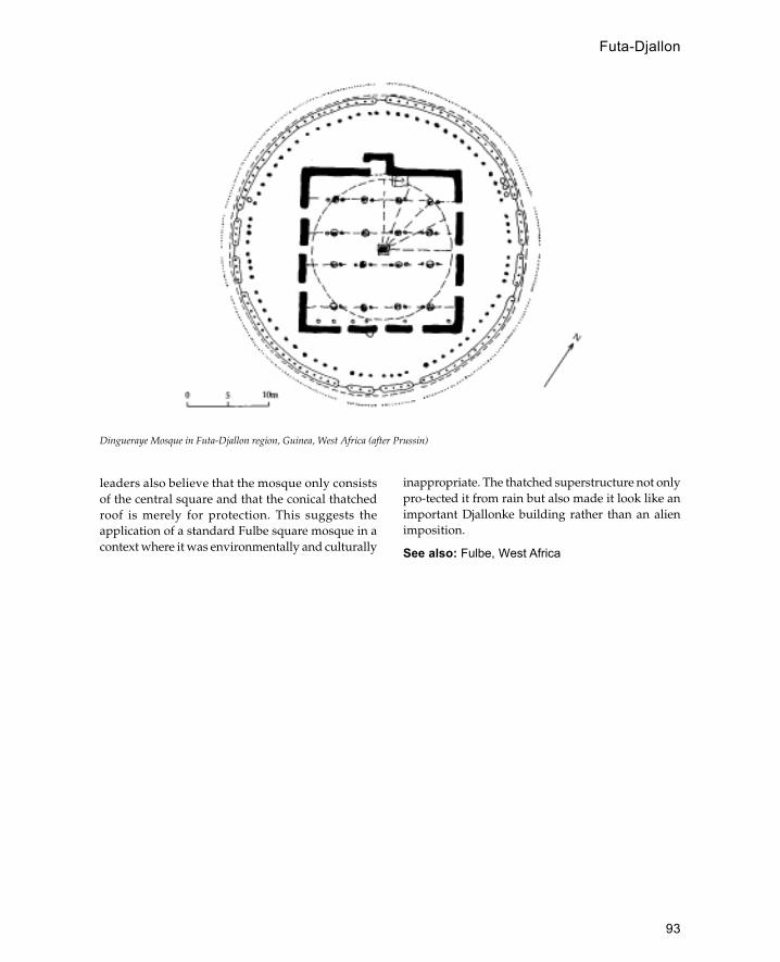
93
inappropriate. The thatched superstructure not onlypro-tected it from rain but also made it look like animportant Djallonke building rather than an alienimposition.
See also: Fulbe, West Africa
Dingueraye Mosque in Futa-Djallon region, Guinea, West Africa (after Prussin)
leaders also believe that the mosque only consistsof the central square and that the conical thatchedroof is merely for protection. This suggests theapplication of a standard Fulbe square mosque in acontext where it was environmentally and culturally
Futa-Djallon

94
Gao
West African empire, which flourished in the fifteenthand sixteenth centuries, referred to by contemporaryArabic writers as Kawkaw.
The empire was founded by the Songhay groupswho inhabited the banks of the Niger river in theeastern part of the present-day state of Mali. As withthe other empires in the region the origin of thekingdom is shrouded in myths and legends,although there seems to be some evidence that theoriginal capital of Gao was 100 km further south.The earliest record of Gao is from the eighth centurywhen it is mentioned as one of the towns in contactwith the Algerian city of Tahert. A tenth-centurydescription describes the capital as composed of twincities like the contemporary capital of Ghana andalso describes the ruler as a Muslim.
Despite its strategic position on the trade routesGao did not achieve imperial status until thefifteenth century when the empire of Mali was indecline. The first ruler to begin the expansion wasAli (1464–92) who conquered Timbuktu from theBerbers and Djenné from the disintegrating empireof Mali. Ali was followed by the most famous rulerof Gao, Askiya Muhammad, who usurped thethrone from Ali’s son. Askiya Muhammadconsolidated the conquests of Ali and centralizedthe administration of the empire. He was a morecon-vinced Muslim than Ali and made Islam thestate religion as well as promoting Timbuktu as acentre of learning. In 1528 at the age of 85 Askiawas deposed by his son and died ten years later in1538. Following Askia there were a succession ofshort reigns between 1528 and 1591 which endedwith the Moroccan invasion and the destruction ofthe Songhay Empire of Gao.
Fortunately the ancient capital of Gao hassurvived to provide some of the best examples ofmedieval architecture in West Africa. Three maingroups of remains can be identified, Gao, Old Gaoand Gao-Sané. It has been suggested that the twin-
city configuration referred to in early accounts ofGao may be confirmed by the location of Gao-Sané6 km east of the rest of the city. It is believed thatGao-Sané represents the Muslim quarter of thetown due to its position facing the trade routes toNorth Africa. Old Gao probably represents theremains of the fourteenth-century city during theperiod when it was ruled by the empire of Mali.Excavations in Old Gao have revealed a largerectangular mosque (approximately 40 m wide)built of mud brick which was dated to 1325. In thecentre of the west side is a deep circular mihrab(about 3 m in diameter) built of baked brick with asmall doorway (a half-metre wide) on the northside. Behind the mihrab on the outside are threerectangular tombs one of which contains a head-stone dated 1364. South of Old Gao is the main townwhich was the city of Askiya Muhhamad with itsfamous mausoleum contained within the courtyardof the Great Mosque. The Great Mosque is locatedwithin an area of cemeteries containing Kufic-inscribed tombstones dating from the early twelfthcentury. Some of the oldest tombstones were foundwithin a subterranean vault made of baked bricksimilar to that used in the mihrab of the excavatedmosque at Old Gao. The use of baked brick issignificant in a context where they would have beenvery difficult to produce.
Undoubtedly the most important monument inGao is the Great Mosque containing the tomb ofAskiya Muhammad. The mosque consists of a largerectangular enclosure (45 by 50 m) with a sanctuaryfour bays deep. In the middle of the east wall of thesanctuary is a pair of niches one of which is themihrab whilst the other contains a fixed minbar. Thecentre of the courtyard is occupied by the tomb ofAskiya Muhammad, a huge pyramidical earthconstruction resting on a base measuring 14 by 18m. The tomb consists of three steps or stages reachinga height of just over 10 m above ground level. A stairramp made of split palms leads up the east side ofthe structure to reach the top. The appearance of the
G

95
tomb is enhanced by the many toron, or stakes, madeof acacia wood which project from each side. Adescription of the monument from 1852 mentionedanother eastern tower which was in ruins at the time;this may have been the mihrab tower which alsofunctioned as a minaret. It seems likely that with thecollapse of the eastern mihrab/minaret tower stairswere cut into the tomb of Askiya Muhammad so thatthis could function as the place for the call to prayer.In view of Askiya Muhammad’s strong attachmentto Ibadi teachings it is thought that the architecturalorigins of this tomb may be found in various Ibadizawiyas in the Mzab region of southern Algeria. The
design of these three-tier construc-tions is said toderive ultimately from the minaret of the GreatMosque at Qairawan. One of the best examples is atTidikelt in southern Algeria and consists of threesuperimposed stages each with a crenellated parapet.In addition to the orthodox Muslim influences onthe design of the tomb, it should be noted that it alsoresembles the ancestral tumuli of the pre-IslamicSonghay past. This connec-tion is reinforced by thetoron projecting from the sides of the tomb.
In addition to Gao itself, there are a number oftowns which contain monumental remains of theSonghay Empire. One of the best examples is the
Plan of mosque and tomb of Askiya Muhammad, Gao, West Africa (after Prussin)
Gao
96
city of Tendirma in Mali built for Amar-Komdiagothe brother of Askiya Muhammad in 1497. Theconstruction of the city was carried out by Mandingcraftsmen under the direction of Ouahab Bari.Standing remains at Tendirma include the massivepalace walls and the Great Mosque which is sub-stantially unchanged since the Moroccan invasionof the sixteenth century. The mosque is built out ofspherical mud bricks with the use of split palm andacacia wood for roof timbers. The most remarkablefeature of the mosque is the mihrab tower whichconsists of a sloping cone with a flat surface on theside facing the mosque. Like the mausoleum ofAskiya Muhammad the outer surface of the minaretis covered with projecting toron made of acaciawood. Other examples of Songhay imperialarchitecture can be seen in the mosques of Katsinaand Birni in northern Nigeria. The Katsina minaretis particularly unusual and consists of a centralsquare shaft with stair ramps ascending around thefour sides. The minaret bears a striking similarity tothe Malwiyya in Samarra although stylistically it ismore closely related to the minaret of the GreatMosque in Qairawan.
See also: Songhay, West Africa
Further reading:
T.Insol, ‘Looting the antiques of Mali: the story continuesat Gao’, Antiquity 67: 628–32, 1993.
——, ‘A preliminary reconnaisance and survey at Gao,the Republic of Mali’, Nyame Akuma 39; 40–3, 1993.
R.Mauny, ‘La Tour et la mosquée de l’Askia Mohammedà Gao’, Notes Africaines 47: 66–7, 1950.
—— ‘Notes archéologiques au sujet de Gao’, BulletinIFAN 13: 837–52, 1951.
J.Sauvaget, ‘Les Epitaphes royales de Gao’, Bulletin IFAN12: 418–40, 1950.
M.-M. Vire, ‘Notes sur trois epigraphes royales de Gao’,Bulletin IFAN 20B (3–4): 459–600, 1958.
gardens
Gardens have often been an integral feature of Islamicarchitectural design, particularly for palaces.
Several Umayyad palaces seem to have incorporatedgardens as part of their design. At Khirbet al-Mafjarin the Jordan valley there is a large square pool witha central pavilion on columns which would haveformed the centrepiece of a garden. At Qasr al-HayrWest it is likely that the immediate vicinity of thepalace had a garden whilst there was a large walled
garden enclosure to the west of the main building.The exact function of some of the early Islamicgardens is not always clear and some may have beenpurely for producing vegetables. In Islamic Spainthe garden was an integral part of the palatial designof Madinat al Zahra and reached its peak in thegardens of Granada. The development of formalgardens became an art form in Iran from at least thefourteenth century as can be seen from their frequentdepiction in miniature paintings of the period. Underthe Timurids gardens became a priority for royalresidences which were often no more than pavilionsin large formal gardens. The Mughals of Indiaacquired their interest in gardens from the Timuridsand developed the idea of a memorial garden whichwould surround a tomb.
From the sixteenth century garden cities becamefashionable throughout the Islamic world with citiessuch as Isfahan in Iran or Meknes in Morocco.Further east in Java and Indonesia gardens were anessential part of the pre-Islamic Hindu tradition andcontinued to be built by the Muslim sultans.
Further reading:
A.Petruccioli (ed.), The Garden as a City: The City as aGarden, Journal of the Islamic Environmental DesignResearch Centre, Rome 1984.
N.Titley and F.Wood, Oriental Gardens, BL Humanities,1991.
Gedi
Ruined Islamic city near Malindi in Kenya, one of thefirst Islamic settlements in East Africa to be systematicallyinvestigated by archaeologists starting in 1945.
Gedi is unusual as it is the only major settlement onthe East African coast not to be built directly on thesea-shore—instead it is located 6 km inland and 3km from the nearest navigable creek. The city seemsto have been founded in the thirteenth centuryalthough most of the standing remains date from thefifteenth century. By the sixteenth century the cityseems to have been abandoned, although it wasbriefly resettled in the seventeenth only to be finallyabandoned after the attacks of the migrating Gallatribesmen.
The site stands on a rocky spur which dominatesthe surrounding countryside. The city covers an areaof 45 acres and was contained within a town wallwhich enclosed a Great Mosque, seven smallermosques, a palace and several private mansions, in
gardens
97
addition to many smaller houses which must havebeen made of wattle and daub. The ruins also containthe remains of substantial coral stone tombs one ofwhich carries an inscription dated to 1399-
The Great Mosque is one of the best-preservedexamples of its type in East Africa. It is constructed inthe typical East African style with a flat concrete roofsupported on rectangular stone piers and doorwayson the west and east sides. There are three rows of sixpiers with the middle row aligned on the central axisin line with the mihrab. The mosque has a fairly wideplan achieved by placing transverse beams betweenpiers and spanning the distance between beams bylongitudinally placed rafters. This differs from themore usual technique of placing beams longitudinallywith transverse rafters as was used in the smallermosques at Gedi and elsewhere on the coast. Themihrab is a fine example of the developed form ofthe early type of coastal mihrab. It is built out ofdressed undersea or reef coral and set in a rectangularpanel surrounded with an architrave carved in a cablepattern. The mihrab is decorated with eleven insetblue and white porcelain bowls, five in the spandrelabove the niche, two in the pilasters and six in theniche itself. The edge of the mihrab is recessed fivetimes before the niche itself which is a plain,undecorated semi-circular apse. Immediately to theeast is a built-in stone minbar.
Sometime in the sixteenth century a separate areafor women was screened off at the back of the mosque.To the east of the prayer hall is a veranda openingonto the ablutions court which contains a tank fed bya well, footscrapers, a latrine and a staircase to theroof. The other mosques at Gedi are all much smaller,narrower structures consisting of a simple prayerroom and ablutions area to the east.
The palace of Gedi is a large complex probablybuilt for the Sultan of Malindi. It stands amongstseveral other grand houses which probably housedministers or other members of the royal family. Thepalace essentially consists of two main areas, theoriginal palace and the northern annexe. It has amonumental entrance leading via a small courtyardinto the main reception area, which is a long opencourtyard aligned east-west. The sultan’s privateresidence was to the south of this whilst the haremwas located on the west side, although it only connectswith the main palace via a small doorway from acourtyard at the back of the sultan’s quarters.
The houses at Gedi are of interest because theyshow a development in form from the fourteenth to
the sixteenth centuries and are the prototype for themore famous Swahili houses of the eighteenthcentury. The earliest houses consist of en-trances intoa long, narrow sunken courtyard from which a singleentrance would lead into a reception room behindwhich were bedrooms and a store room. In laterhouses the courtyards became bigger and often anextra ‘domestic’ courtyard was added at the back.
See also: coral, East Africa, Kenya, Lamu
Further reading:
J.Kirkman, The Arab City of Gedi: Excavations at the GreatMosque. Architecture and Finds, Royal National Parks ofKenya, Oxford 1954.
—— Gedi: The Tomb of the Dated Inscription H.802/AD 1399,Royal Anthropological Society of Great Britain andIreland, Occasional Paper no. 14, London 1960.
—— Gedi: The Palace, Studies in African History no.1, TheHague 1963.
Germany
Before the Second World War there were few Muslimsin Germany although during the nineteenth centurythe Ottoman ambassador in Berlin established amosque and cemetery. There were, however, a numberof Islamic-type buildings in Germany influenced bythe growing interest in Orientalism. The most famousexample is the water-pumping station at Potsdam(1841–5) built in the form of an Egyptian Mamlukmosque. Perhaps a more suprising example is thetobacco factory at Dresden where the minarets areused as factory chimneys.
After the Second World War the Germangovernment made an arrangement with Turkey forTurks to come to Germany as temporary ‘Guestworkers’. By the 1970s many of these Turkishworkers had become established as permanentresidents although with no official status. Presentestimates suggest that Germany has a Turkishminority of two to three million, many of whom livein the industrial towns of the Ruhr valley. The firstmosques were usually converted houses and werearchitecturally indistinct from the surroundingbuildings. More recently purpose-built mosqueshave been erected, usually in a modern Turkish style.
See also: France, Great Britain, USA
Further reading:S.Koppelkamm, Der imaginaire Orient: Exotische Bauten des
achtzen und neunzen Jahrhunderts in Europa, Berlin 1987.
Germany
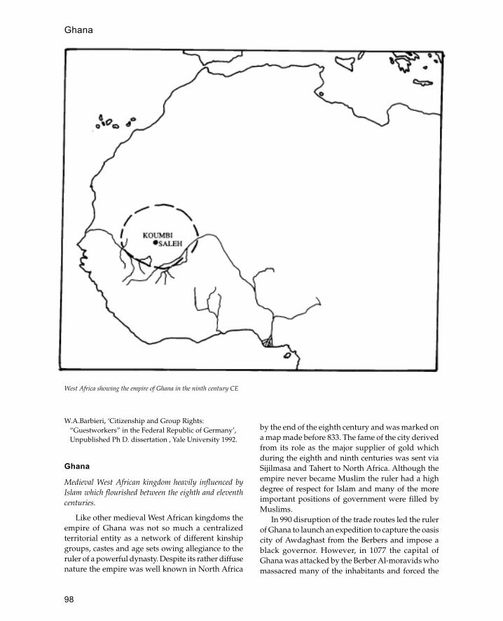
98
W.A.Barbieri, ‘Citizenship and Group Rights:“Guestworkers” in the Federal Republic of Germany’,Unpublished Ph D. dissertation , Yale University 1992.
Ghana
Medieval West African kingdom heavily influenced byIslam which flourished between the eighth and eleventhcenturies.
Like other medieval West African kingdoms theempire of Ghana was not so much a centralizedterritorial entity as a network of different kinshipgroups, castes and age sets owing allegiance to theruler of a powerful dynasty. Despite its rather diffusenature the empire was well known in North Africa
by the end of the eighth century and was marked ona map made before 833. The fame of the city derivedfrom its role as the major supplier of gold whichduring the eighth and ninth centuries was sent viaSijilmasa and Tahert to North Africa. Although theempire never became Muslim the ruler had a highdegree of respect for Islam and many of the moreimportant positions of government were filled byMuslims.
In 990 disruption of the trade routes led the rulerof Ghana to launch an expedition to capture the oasiscity of Awdaghast from the Berbers and impose ablack governor. However, in 1077 the capital ofGhana was attacked by the Berber Al-moravids whomassacred many of the inhabitants and forced the
West Africa showing the empire of Ghana in the ninth century CE
Ghana

99
remainder to convert to Islam. Whilst this conquestdestroyed Ghana as an empire, a reduced kingdomof this name continued to survive into the twelfthcentury; al-Idrisi writing in 1154 described the capitalas the most extensive and thickly populated townof the blacks with the most widespread commerce.However, in 1204 there was another disaster whenthe town was sacked by the Sonnike ruler SumaguruKante. This led to the dispersion of a large numberof Ghana’s inhabitants and the foundation of a newsettlement known as Oualata which replaced Ghanaas the main caravan terminal. However, Ghanarecovered and continued to function as an importanttrade centre until 1240 when it was conquered andincorporated into the empire of Mali. Nevertheless,Ghana continued to function as a semi-independentstate within the Mali Empire and its ruler evenretained the title of king.
An eleventh-century description by theAndalusian writer al-Bakri describes the capital asdivided into two cities, a Muslim city and a royalcity. The Muslim city had twelve mosques includinga Friday mosque each with its own imam andmuezzin (one who announces the call to prayer). Theroyal city was a pagan city containing the palace ofthe king within a sacred grove or wood. The housesin the city are described as being built with stoneand acacia wood. The exact location of the capital isnot known and there is some dispute about whetherthe state had a fixed capital in the modern sense.However, the site of Koumbi Saleh in Mauritania isregarded as one of the principal capitals if not themain capital.
Excavations at Koumbi Saleh, begun in 1914, haverevealed a vast set of stone ruins which are still inneed of full interpretation although the evidencesuggests a period of occupation from the seventh tothe seventeenth century. One of the most interestingdiscoveries is a square tomb chamber measuring justover 5 m on each side with a column recessed intoeach of the external corners. There were originallyfour openings into the chamber but three of thesewere subsequently blocked up leaving a singleentrance on the east side. Just inside the entranceare a set of steps made of fired brick which lead downinto a subterranean chamber containing spaces forthree sarcophagi. Parallels have been suggested withIbadi tombs in North Africa and the Bab LallaRayhana entrance to the Great Mosque of Qairawanwhich also employs engaged corner columns.Elsewhere excavation has revealed a row of shops
connected to houses. The shops are open onto thestreet front whilst every other unit opens at the backonto an entrance vestibule lined with triangularniches. These vestibules consist of long narrowrooms with a bed platform at one end and stairs toanother floor at the opposite end. The rooms (7 to 8m long and 1.5 to 2 m wide) are placed side by sidewith two doorways in each side either side of acentral pillar. The other Ghanaian city which has beenexcavated is the oasis city of Awdaghast also inMauritania. The architecture here is similar to thatat Koumbi Saleh with triangular niches and longnarrow rooms. Although the evidence fromarchaeology is limited it appears that Awdaghast wasinhabited from the seventh to the thirteenth century.
See also: West Africa
Gok Madrassa
The Gok Madrassa is one of the most famousbuildings in the north-east Anatolian city of Sivas.Built in 1271 the building has a cruciform plan witha central open court opening onto two-storeycloisters. The most significant part of the design isthe façade which comprises two corner buttresstowers with a central entrance flanked by two tallminaret towers. The portal itself is recessed within atall muqarnas niche which itself is set within a carvedstone frame. Both the entrance portal and the cornerbuttress towers are decorated in deep relief stonecarving which is characteristic of the thirteenth-century architecture of the city. The twin minaretsabove the entrance are built of baked brick withvertical flutes and large muqarnas corbelledbalconies.
Gol Gumbaz
Mausoleum of Muhammad Adil Shah II (1627–57), oneof the major Islamic monuments of India.
The tomb, located in the city of Bijapur, southernIndia, was built in 1659 by the famous architect, Yaqutof Dabul. The structure consists of a massive squarechamber measuring nearly 50 m on each side andcovered by a huge dome 37.9m in diameter makingit the largest dome in the Islamic world. The domeis supported on giant squinches supported bygroined pendentives whilst outside the building issupported by domed octagonal corner towers. Eachtower consists of seven storeys and the upper floor
Gol Gumbaz
100
of each opens on to a round gallery which surroundsthe dome.
In the centre of the chamber is a square raisedpodium approached by steps in the centre of eachside. In the centre of the podium are the tombs ofMuhammad Adil Shah II and his relations. To thewest of the podium in a large apse-like projection isthe mosque, also raised slightly above the floor levelof the chamber.
See also: Bijapur, Deccan, India
Granada
City in south-west Spain famous as the capital of the lastMuslim state in Spain.
Granada is located high up in the mountains nearthe Sierra Nevada and rose to prominence after theother Muslim states were defeated in the thirteenthcentury. During this time from 1231 to 1492 Granadawas ruled by the Nasirid dynasty who survived bymaintaining alliances with Christian dynasties.
Undoubtedly the most famous building in thecity is the Alhambra which has a claim to being oneof the most beautiful buildings of the Islamic world.The palace is located on a rocky spur whichdominates the rest of the city. Although containedwithin a single enclosure the Alhambra is not asingle palace but a complex of palaces built overhundreds of years. The earliest parts of the complexdate from the twelfth century although most of thebuildings were erected in the fourteenth or fifteenthcenturies. On the opposite side of the valley fromthe Alhambra is the Generalife palace which issometimes erroneously thought to be part of theAlhambra. Although now covered with gardens theGeneralife was originally a country estate for theNasirids.
Some remains of the eleventh-century walls arestill standing together with five of the city gates, thePuerta Nueva, the Puerta de Elvira, the Puerta deFajalauza and the Puerta Hizna Roman.Architecturally the most interesting of these gates isthe Puerta Nueva which combines a bent entrancewith an upward sloping ramp to slow downpotential attackers. Within the walls several publicbuildings survive including the hammam (BañueloCarrera del Darro) which is one of the best examplesremaining in Spain. Also within the city is the Casadel Carbón (coal exchange) formerly known as theFunduq al-Yadida (new market) which is one of thefew surviving khans in Spain. It has a monumental
portico decorated with plaster and decorativebrickwork within which the entrance is set below aset of paired windows. The interior of the buildingconsists of a square courtyard with three storeys ofarcades on each of the four sides containing sixtyrooms. In addition to public buildings severalMuslim houses survive in the Albaicín Quarter ofthe city.
With the exception of the one in the Alhambrathere are few remains of Granada’s many mosques,although traces can be found in some of the churches.The church of San Salvador is built over a tenth-century mosque and remains of the ablutions courtand the minaret can still be seen. The church of SanSebastian is a converted rabita, or hermitage, and isthe only example of its type in Spain. It consists of asquare courtyard covered with a ribbed domesupported on squinches.
See also: Alhambra, Spain
Further reading:
F.Prieto-Moreno, Los Jardines de Granada, Madrid 1952.E.Sordo and W.Swaan, Moorish Spain: Córdoba, Seville and
Granada, London 1963.
Great Britain (United Kingdom)
Britain’s main source of contact with the Islamicworld has been through the British Empire and inparticular the Indian subcontinent. India wasacquired by Britain in the eighteenth century andwas one of Britain’s earliest colonial acquisitions. Aswith most colonial encounters each side wasinfluenced by the culture and architecture of theother. In India the British built the city of Calcutta ascapital complete with Anglo-Indian mosques. InBritain the architecture of India was evoked in severalbuildings, the most famous of which is the RoyalPavilion at Brighton. Externally the buildingresembles a late Mughal palace with bulbous domes,chajjas and chatris, although internally it is decoratedlike a Chinese palace.
With the Independence of India in 1948 and thedivision of the subcontinent into Pakistan andBangladesh a large number of immigrants came toBritain. Indians now make up the majority ofBritain’s Muslim population although they aremostly concentrated in cities and the larger towns.The first mosques in Britain were converted churchesor houses although more recently (since 1980) many
Granada

101
new mosques have been built, financed partly byBritish Muslim communities and partly by donationsfrom oil-rich Arab countries. The best-knownmosque in Britain is in Regents Park in Londonalthough other cities like Bradford also haveprominent new mosques. In the typical modernBritish mosque there is usually an emphasis on thedome which is often covered in metal. Minarets areusually quite small and are often non-functional (i.enot used for the call to prayer).
Greece
Mountainous country in south-eastern Europe which forover 400 years formed a part of the Ottoman Empire.
The position of Greece opposite Libiya and Egyptand its exposure to the east Mediterranean sea meantthat it was exposed to Muslim raids from thebeginnings of Islam. Crete in particular was open toattack and was briefly occupied by Muslim forces asearly as 674. Between 827 and 961 Crete was againcaptured by Muslim forces who used the island as abase for pirate raids against the rest of Greece. At
some time during the tenth century Athens seemsto have had an Arabic settlement with its ownmosque, traces of which have been excavated.
It was not, however, until the rise of the Ottomansthat Greece was fully brought under Islamic rule.Different parts of Greece were incorporated into theOttoman Empire at different times and for varyingdegrees of time. Thus the south and central part ofthe country (Peleponnesus and lonnia) wereconquered in 1460 but lost to the Venetians between1687 and 1715 after which they were recaptured andremained part of the empire for another 100 yearsuntil the Greek War of Independence in 1821–9. Partsof northern Greece, however, were conquered by theOttomans as early as 1360 and by 1430 the whole ofthe northern part of the country was under Turkishrule which lasted until 1912. There was little Turkishsettlement in Greece with the exception of Thracewhere colonists were brought in soon after theconquest.
There are comparatively few remains of Turkishrule in central and southern Greece although Athenscontains a few notable examples. The oldest standing
Fethie Cami, Athens © Cherry Pickles
Greece

102
mosque in Athens is the Fethie Cami built in the latefifteenth century; the building is unusual because inplan it closely resembles an Orthodox church. Thelast Ottoman mosque built in Athens is the DjisdarakiCami erected in 1759, a building with a distinctiveOttoman form, consisting of a triple-domed porticoand a square domed prayer hall. In addition tomosques the Ottomans also built baths andmadrassas in Athens none of which has survivedalthough remains of the city wall built in 1788 by AliHadeski can still be seen. The islands of Greece, inparticular Crete and Rhodes, have traces of theOttoman occupation although as with southernmainland Greece there was no substantial Turkishsettlement.
Northern Greece can be divided into three mainareas, Epirus in the west near Albania, Macedoniain the middle and Thrace on the east side borderingTurkey. The area of Epirus has few traces of Turkishrule outside its capital at Ioannina and the city ofArta. At the centre of Ioannina is the fortress ofFrourion which was substantially repaired in theeighteenth century by the famous Ottoman governorAli Pasha. Within the citadel is the mosque of AsianPasha built in 1688 which, with its positionoverlooking the lake, is one of the most romanticTurkish buildings in the Balkans. Whilst Turkishsettlement in Ioannina was limited to the governorand his garrison, the town of Arta had a new Muslimsuburb added to it. This suburb, now in a state ofdisrepair, is one of the best examples of Ottomantown planning with its mosque, imaret andhammam.
Macedonia has the highest concentration ofOttoman monuments in Greece in the five cities ofThessaloniki, Seres, Kavalla, Yenice-i Vardar andVerria. In the regional capital, Thessaloniki, the mostsignificant remains are the Hamsa Beg Cami and theImaret Cami both of which date to the fifteenthcentury. In addition the city has three large hammamsand a bedestan still standing. The other towns ofMacedonia are less well known although eachcontains important monuments such as the aqueductof Suleyman the Magnificent in Seres.
The oldest Ottoman monuments in Greece are tobe found in the region of Thrace where there is stilla significant Muslim population. One of thebuildings still in use is the Komotini Mosque builtin 1610 which is the only Balkan mosque to havelarge-scale Iznik tile decoration. Other monumentsin the area include the Oruc Beg Hammam in
Dimetoka built in 1398 and the Munschi FeridunAhmed Pasha Hammam built in 1571.
See also: Ottomans
Further reading:
K.W.Arafat, ‘Ottoman Athens’, Arts and the Islamic World 4no . 4: 1987/8.
—— ‘Ottoman Ioannina’, Arts and the Islamic World no. 20: 1991.
E.H.Ayverdi, ‘Yunanistan’, in Avrupa’da Osmanli MimariEserleri 4 book 5, Istanbul 1981.
M.Kiel, ‘Islamic Architecture in the Balkans’, Arts and theIslamic World 4 no . 3: 1987.
G.Soteriou, ‘Arabic remains in Athens in Byzantinetimes’, Social Science Abstracts 2 no . 2 360 : 1930.
Gujarat
Predominantly Hindu coastal region of western India withdistinctive Islamic architecture.
Gujarat is a fertile low-lying region located betweenPakistan, Rajasthan and the Indian Ocean. Theposition of the region on the Indian Ocean has meantthat it has always had extensive trading contactsparticularly with the Arabian peninsula. It is likelythat the first Muslims in Gujarat arrived sometimein the eighth century although there is littlepublished archaeological evidence of this. The oldeststanding mosques in the area are located at the oldseaport of Bhadresvar in western Gujarat and havebeen dated to the mid-twelfth century although theymay stand on older foundations.
The first Muslim conquest of the area took placeat the end of the thirteenth century under the Alaal-Din the Khaliji sultan of Delhi. The earliestmonument from this period is the Jami Masjid atCambay which includes columns taken from ruinedHindu and Jain temples. The form of the mosqueresembles that of the Quwwat al-Islam Mosque inDelhi with a rectangular courtyard with gatewayson three sides and an arched screen in front of thesanctuary on the west side. Other early mosquesbuilt in a similar style include those of Dholka Patanand Broach all of which are located close to thecoast. During the fifteenth century many mosques,tombs and other monuments were built in theregional capital Ahmadabad, the most significantof which are the Jami Masjid and the tomb ofAhmad Shah. These buildings incorporate manyfeatures from Hindu temple architecture including
Gujarat
103
projecting balconies, perfo-rated jali screens andsquare decorated columns. Monuments of thesixteenth century contain the same Hindu andIslamic elements combined in a more developedfashion as can be seen in the Jami Masjid ofChampaner built in 1550. The Mughal conquest inthe mid-sixteenth century brought Gujarat into themainstream of architectural development.However, the architecture of the region exerted aconsiderable influence on the Mughal emperorAkbar, who built the city of Fatehpur Sikri inGujarati style.
The secular architecture of Gujarat is mostly builtof wood and characterized by elaborately carvedscreens and overhanging balconies. Anothercharacteristic feature of the region is the use of stepwells, or vavs, which consist of deep vertical shafts,approached via recessed chambers and steps.Sometimes these were very elaborate structures withmultiple tiers of steps.
See also: Ahmadabad, India, Mughals, Qutb Minar
Further reading:
Z.A.Desai, ‘Some Mughal inscriptions from Gujarat’,Epigraphia Indica: Arabic and Persian Supplement, 1970,63–92.
J.Jain-Neubauer, The Stepwells of Gujarat in Art HistoricalPerspective, New Delhi 1981.
E.Koch, ‘[The] Influence [of Gujarat] on Mughalarchitecture’, in Ahmadabad, ed. G.Michell and S.Shah,Bombay 1988, 168–85
M.Shokooy, M.Bayani-Wolpert and N.H.Shokooy,Bhadresvar: The Oldest Islamic Monuments in India, part ofStudies in Islamic Art and Architecture, Supplements toMuqarnas, vol. 2, Leiden 1988.
guldasta
An ornamental pinnacle in the shape of flowers.
gunbad
An Iranian and Mughal term for dome, usually usedfor a domed tomb.
gunbad

104
Hadramawt
A large wadi in Yemen with distinctive mud-brickarchitecture. It runs from west to east and meets the IndianOcean at Qishn.
The wadi is exceptionally fertile and has been settledsince ancient times. The tall mud-brick tower houses,which from a distance resemble sky-scrapers are themost characteristic feature of the architecture. Theform of these houses is probably derived from thestone-built tower houses of the highlands adaptedinto a mud-brick form for the plains at the bottomof the wadi. The best example of this architecture isthe city of Shibam which has houses over eightstoreys high. The exceptional height of the Shibamhouses may partly be due to the wall which enclosesthe city, for whilst this provides protection it limitsthe available building land. The houses are usuallybuilt on stone foundations with mud-brick wallstapering from one metre at the bottom to a quarterof a metre at the top. The strongest part of the houseis the stair-well which is often built of stone to thefull height of the house. The exteriors have woodenwindow screens and ornamental relieving arches,and the upper parts of the houses are generallywhite-washed.
The main door for each house has a woodenlatch attached to a cord enabling the door to beopened from the apartments above. The groundfloors of the houses are either storerooms or shopswhilst the first-floor rooms may be used for animalstalls. The second floor was used a reception areafor business, and the rooms above were privateapartments; the lower parts of the private roomswere functional whilst those at the top werereception rooms and open-air terraces. Thereception room or majlis is usually a tall roomdecorated with carved plaster designs which mayinclude a mihrab niche. At the upper levels thereare often doorways to neighbouring houses so thatwomen may visit each other without having to goout on to the streets. There are efficient waste-
disposal systems with separate chutes for water andsewage. The age of the houses is difficult todetermine although locally they are thought to last300 years or more after which they will be replacedwith another house on the same spot.
See also: Yemen
Further reading:
J.F.Breton, L.Badre, R.Audouin and J.Seigne, ‘Le WadiHadramout’, Prospections, 1978–9.
R.Lewcock, Wadi Hadramawt and the Walled City of Shibam,UNESCO , Paris 1986.
M.Raemakers, ‘Towns and architecture in theHadramaut’, Journal of the Royal Central Asian Society(London) 40 : 246 ff., 1953.
Hagia Sophia (Aya Sophia; Church ofHoly Wisdom)
Central church of Constantinople turned into a mosqueafter the Ottoman conquest and now a museum.
The first Hagia Sophia built in 360 by ConstantineII had a timber roof and was burnt down in 404.This was replaced by a second building which wasalso burnt down a hundred years later. The presentstructure was founded in 537 although the hugecentral dome fell down and was replaced by thepresent construction in 558. The plan of the buildingconsists of a large central dome (32 m diameter)flanked by two huge semi-domes supported bysmaller subsidiary domes; the two aisles areseparated from the main area by a marblecolonnade.
In 1453 the building was converted into a mosqueby the addition of a wooden minaret; by the end ofthe sixteenth century the building was adorned withfour tall pointed stone minarets. During the sixteenthcentury Selim II had his tomb built next to thebuilding and in the seventeenth century SultanAhmet added a madrassa. The cathedral is importantto Islamic architecture because its grandeur inspiredOttoman architects. The huge dome in particular
H
105
impressed the Ottomans who, during the sixteenthcentury, built a number of mosques to rival thechurch of St Sophia, the most notable of which werethe Süleymaniye and the Selimiye.
See also: Istanbul, Ottomans
Further reading:
W.S.George, The Church of St Eirene at Constantinople,Oxford 1912.
R.L.Van Nice and W.Emerson, ‘Hagia Sophia and the firstminaret erected after the conquest of Istanbul’, AmericanJournal of Archaeology 54, 1950.
Hajj routes
Special roads or routes which are taken by pilgrims ontheir way to Mecca.
Hajj, or pilgrimage, is one of the five pillars of Islamalong with prayer five times a day, fasting, the givingof alms, and bearing witness that there is only onetrue God. Each Muslim is required to attempt at leastonce in a lifetime to visit the holy cities of Medinaand Mecca. It is well known that Mecca was animportant ritual centre before Islam and that it wouldhave been visited as a shrine. Under Islam, however,the importance of visiting Mecca was greatlyincreased especially as the numbers of Muslimsincreased around the world.
Until the advent of rail and more recently airtravel, the Hajj was a very arduous and risky under-taking requiring considerable preparation.Although coming from diverse locations, mostpilgrims would have to make the last part of theirjourney through Arabia on one of several major Hajjroutes. The main routes were Damascus to Mecca,Cairo to Mecca via the Sinai, Basra to Mecca, Sancato Mecca coastal route, Sanca to Mecca inland routeand Oman to Mecca via one of the Yemeni routes.Of these routes the most important were those thatled from Damascus, Baghdad and Cairo. Over thecenturies each of these routes developed variousfacilities for travellers which included wells,cisterns and dams, bridges, paved roads, markersand milestones, khans and forts. Of all the routesthe Damascus route appears to be the oldest,following pre-Islamic trade routes. One of the mostimportant stations on this route is the city ofHumayma in southern Jordan where the Abbasidsplanned their revolution. Other early sites on thisroute are Khan al-Zabib, Jize and Macan, all of
which contain remains of early Islamic structuresassociated with the Hajj. At Jise there is a hugeRoman reservoir and nearby are the remains of therecently excavated Umayyad palace of Qastal whichmay have functioned as a royal caravanserai toreceive important officials on the Hajj. Khan al-Zabib consists of a large square fortress-likebuilding with a central courtyard and a mosquebuilt to one side. At the oasis town of Macan thereis also a huge Roman reservoir and there are signsthat the nearby Roman fortress at Udruh wasconverted into an official Umayyad residence at thistime. With the move of the caliphate from Syria toIraq the Damascus route declined in importance,but the route was still used throughout the Ayyubidand Mamluk periods, as testified by the fourteenth-century pilgrimage itinerary of Ibn Battuta and theexistence of several Mamluk forts on the route suchas those at Jize and Zerka. With the Ottomanconquest of the Mamluk Empire in the sixteenthcentury the Hajj route was provided with newfacilities and provided with fortified garrisonsstationed in small forts along the route. The fortswere built not only to protect the water cisterns andwells (which were repaired at the same time) butalso to provide an efficient postal service for theHajj. The forts had a simple square plan basedaround a central courtyard with a well in the centre.They were mostly two-storey structures with acrenellated parapet above and projectingmachicolations (structures protecting openingsthrough which to attack the enemy) on one or moresides. The forts were built to overlook the waterreservoirs which were filled each year inpreparation for the Hajj. It should, however, beremembered that the pilgrims would have stayedin vast encampments of tents next to the cisterns.By the eighteenth century the facilities had falleninto disrepair and the forts were inadequateprotection against increased bedouin raids. Inconsequence the number of forts was augmentedto cover most of the stops between Damascus andMecca, and new wells, cisterns and bridges wereprovided. The design of the eighteenth-centuryforts was slightly different, with square projectingcorner turrets and small gun slits. At the beginningof the twentieth century a narrow-gauge railwaywas built to replace the camel caravans; it usedmany of the same stops as the caravan route andforts were erected to protect the stations.
The decline of the Syria-Damascus Hajj route in
Hajj routes
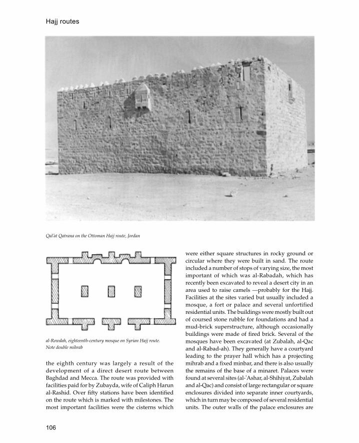
106
the eighth century was largely a result of thedevelopment of a direct desert route betweenBaghdad and Mecca. The route was provided withfacilities paid for by Zubayda, wife of Caliph Harunal-Rashid. Over fifty stations have been identifiedon the route which is marked with milestones. Themost important facilities were the cisterns which
were either square structures in rocky ground orcircular where they were built in sand. The routeincluded a number of stops of varying size, the mostimportant of which was al-Rabadah, which hasrecently been excavated to reveal a desert city in anarea used to raise camels —probably for the Hajj.Facilities at the sites varied but usually included amosque, a fort or palace and several unfortifiedresidential units. The buildings were mostly built outof coursed stone rubble for foundations and had amud-brick superstructure, although occasionallybuildings were made of fired brick. Several of themosques have been excavated (at Zubalah, al-Qacand al-Rabad-ah). They generally have a courtyardleading to the prayer hall which has a projectingmihrab and a fixed minbar, and there is also usuallythe remains of the base of a minaret. Palaces werefound at several sites (al-�Ashar, al-Shihiyat, Zubalahand al-Qac) and consist of large rectangular or squareenclosures divided into separate inner courtyards,which in turn may be composed of several residentialunits. The outer walls of the palace enclosures are
Qal�at Qatrana on the Ottoman Hajj route, Jordan
al-Rowdah, eighteenth-century mosque on Syrian Hajj route.Note double mihrab
Hajj routes

107
supported by solid semi-circular and circularbuttresses. On a smaller scale are the small fortsdiscovered on the northern part of the route whichare simple square structures built around a centralcourtyard with circular and semi-circular buttresstowers on the outside. The houses on the routeresemble the palaces in the variety of their internalarrangements; however, the basic unit seems toconsist of a courtyard leading on to one or moregroups of three rooms.
In more recent times the Hajj has been made byrail, sea and air and appropriate facilities have beenbuilt to accommodate modern pilgrims. One of themore famous recent buildings connected with theHajj is the Hajj terminal at Jeddah which has won anaward from the Agha Khan foundation.
Further reading:
J.S.Birks, Across the Savannas to Mecca: The OverlandPilgrimage Route from West Africa, London 1978.
A.D.Petersen, ‘Early Ottoman forts on the Darb al-Hajj’,Levant XXI, 97–118, 1989.
—— ‘Two medieval forts on the Hajj route in Jordan’,Annual of the Department of Antiquities of Jordan, Vol 35,1991.
S.A. al-Rashid, Darb Zubaydah, Riyadh 1980.J.Sauvaget, ‘Les Caravanserais syriens du Hadjdj de
Constantinople’, Ars Islamica 4, 1937.
al-Hakim, Mosque of
One of the principal mosques of Cairo named after theFatimid Caliph al-Hakim bi Amr Allah.
This mosque, also known as al-Anwar, ‘theilluminated’, was begun in 990 under the Caliph al-�Aziz but was not completed until 12 years laterunder the Caliph al-Hakim. At the time of itsconstruction this mosque was outside the city butwas later incorporated within the city walls of Badral-Jamali.
In its general design the mosque resembles thoseof Ibn Tulun and al-Azhar. It has a central rectangularcourtyard surrounded by an arcade of pointed archesresting on brick piers. A raised transept runs fromthe courtyard to the mihrab. There were three domeson the qibla side, one in front of the mihrab and onein either corner. The front façade has a projectingentrance flanked by two cylindrical minaretsdecorated with inscriptions and carved bands. Laterin 1010 the minarets were enclosed by giant brick
cubes possibly because the minarets contravened along-established Fatimid rule that the call to prayerwas not to be made from a place higher than themosque roof. The present minarets on top of the brickcubes belong to the Mamluk period.
Some of the original decoration has survived, inparticular the stucco work with bands of Kuficinscriptions and stylized tree motifs. In the 1020s aziyada was added to the south side by the caliph al-Zahir. During the Ayyubid period this mosque wasthe only congregational mosque in the city as theAyyubids did not permit more than onecongregational mosque within the city.
Further reading:
D.Berhens-Abouseif, Islamic Architecture in Cairo: AnIntroduction, Supplements to Muqarnas, vol. 3, Leiden1989, 63–5.
J.M.Bloom, ‘The mosque of al-Hakim in Cairo’, Muqarnas1: 15 ff., 1983.
K.A.C.Creswell, The Muslim Architecture of Egypt, Oxford1952–60, 1: 68 ff.
hammam (‘Turkish bath’; bath house)General term used to describe both private and public bathhouses. Public hammams are found throughout the Islamicworld and together with the mosque are regarded as oneof the essential features of an Islamic city. Private bathhouses are less well known although it is known that theyexisted from the early Islamic period where they have beenfound in palaces such as Qasr al-Hayr and Ukhaidhir.
Hammams developed directly out of Byzantine bathhouses such as those discovered at Avdat, andYotvata in the Negev. One of the earliest and certainlythe most famous early Islamic bath house is QusayrAmra located in the north-eastern Jordanian desert.The building was heated by a hypocaust systemsupported on short brick pillars and supplied withwater raised from a deep well by an animal-poweredmechanism. Like other early Islamic baths QusayrAmra does not have the frigidarium common inRoman baths although it does have an enlargedreception room, or apodyterium, decorated withfrescoes in late Antique style. Other early Islamicbath houses such as Hammam al-Sarakh, �Ayn al-Sinu and Jabal Usays have the same arrangement asQusayr Amra with no frigidarium. The oneexception to this pattern is the bath house at Khirbetal-Mafjar where the heated rooms are approachedvia a large hall (30 m square) resembling the classical
hammam (‘Turkish bath’; bath house)
108
frigidarium, with a long pool approached by stepsand a mosaic floor.
There are few remains of bath houses from theperiod between the ninth and twelfth centuriesalthough excavations at Nishapur have uncovered abath house with hypocaust heating dated to the tenth/eleventh century. Sometime after the tenth centuryhypocausts seem to have been abandoned (in Syriaat least) in favour of a system where the chimney ofthe furnace runs under the floor of the rooms to beheated. The effect of this innovation was that thelayout of rooms was dictated by the axis of thechimney flue, and led to the warm room becomingthe central room of the hammam. The typical Ayyubidhammam as it is known from Syria consists of anentrance room leading to the warm room via anintermediate unheated room. The warm room isusually octagonal with smaller hot rooms leading offat the sides. In baths built after the fifteenth centurythere is no intermediate room between the warm roomand the changing room. As a corollary of this the sizeof the warm room is increased in later baths, until ineighteenth-century baths it becomes the main room.The octagonal warm room often has a centraloctagonal platform for massages whilst the smallerwarm rooms have stone basins for washing. The warmand hot rooms never have windows but are lit insteadby thick glass roundels set into the dome. A furtherdevelopment of the Ottoman period are twinhammams where a bath house for women and a bathhouse for men were set back to back to avoid theprohibition of mixed bathing. This problem is usuallydealt with by having different bathing times for menand women.
See also: Khirbet al-Mafjar, Qusayr Amra
Further reading:
M.Dow, Hammams of Palestine, Oxford 1993. M.Ecochardand C.Le Coeur, Les Bains de Damas, Beirut 1943.
E.Pauty, Les Hammams du Caire, Cairo 1963.H.Terrasse, ‘Trois Bains marinides du Maroc’, Mélanges,
311–20, 1950.
haramThe private quarters of a house, sanctuary of amosque or more generally an area set apart.
HaramaynTerm used to refer to the two holy places of Meccaand Medina. In Mamluk and Ottoman times this
term was sometimes also used to refer to Jerusalemand Hebron.
haremlik
Turkish term for the private part of an Ottomanhouse which is only open to members of the family(from Arabic hareem).
Harran
Ancient city in south-eastern Turkey important as a centreof learning and Umayyad capital.
Harran is located in the flat plain between the Tigrisand Euphrates rivers. The city was famous in earlyIslamic times as the centre of the pagan Sabians whoworshipped the stars and achieved protected(dhimini) status in return for their astro-logical andscientific advice. The last Sabian temples weredestroyed by the Mongol invasion of the mid-twelfthcentury. In 744 Caliph Marwan II established himselfat Harran and made it the Umayyad capital.
The site includes the remains of a city wall, acastle and a congregational mosque. The mostimportant monument is the Great Mosque foundedby Marwan II between 744 and 750. Majormodifications were carried out during the twelfthcentury under Salah al-Din who also fortified thecitadel. The building is badly ruined, so that onlythe rough outline of the plan can be traced and thedate of different phases is not clear. The mosque isroughly square measuring approximately 100 m perside with a rectangular courtyard to the north andthe sanctuary to the south. There are two mainentrances to the complex, one on the east side andone in the centre of the north side. The façade ofthe sanctuary consisted of nineteen arches restingon piers with engaged columns. In the centre of thefaçade is a wide central arch approximately in linewith the deeply recessed mihrab in the south wall.Roughly in the centre of the courtyard there is anoctagonal basin, above which there may have beena domed chamber supported on columns whichfunctioned as the treasury (bayt al-mal). To the eastof the north entrance is a tall square tower orminaret built in two distinct phases, the lower partis built of stone whilst the upper part is made ofbrick. The destruction of the mosque can beattributed to the Mongol invasion in the mid-twelfth century.
haram

109
Harran is also noted for its characteristicarchitecture which consists of houses and storeroomscovered with conical mud-brick domes.
haud or hauz
A pool or tank, often in the centre of the courtyardof a mosque.
Hausa
West African people living in northern Nigeria with along-established distinctive architectural tradition.
Modern Hausa society is a combination of twogroups of people, the Hausa themselves and theFulbe-speaking Fulani people. The Fulani firstmoved into the area in the fifteenth centuryalthough it was not until the nineteenth that large-scale migrations took place. The Fulani constitutea literate Muslim class attached to the ruling élitein Hausa society. In addition to the Muslim urbanpopulations there is also a rural population of non-Muslim Hausa known as Maguzawa. The Hausacivilization is generally agreed to have formed inabout 1000 CE and comprised the cities of Daura,Kano, Gobir, Katsina, Zaria, Biram and Rano. In thenineteenth century a Fulani-led jihad established acaliphate in Hausaland with the new city of Sokotoas its capital. The main materials of Hausaarchitecture are oval mud bricks (tubali) and palmwood (deleb). Walls are built out of mud brickwhilst palm trunks split into beams (azarori) areused for roofing. Unlike most other areas of WestAfrica, Hausa architecture is in the hands of ahereditary group of trained masons who areorganized into guilds. These trained masons havebeen responsible for some of the most celebratedarchitecture in West Africa.
The traditional layout of a Hausa city consists ofnarrow winding streets set within a thick outerenclosure wall. In the older cities the outer walls havean irregular/organic shape but the walls of Sokoto,established in the nineteenth century, are square asan expression of Islamic conformity and bordered byhouses which consist of courtyard compounds. In thepast the street façades of the houses were leftunadorned although in recent times there has been atendency to decorate the outer façade of the entrancevestibule with em-bossed designs. Circular roomswith two entrances are traditionally used as entrancevestibules and are known as zaure. Square or
rectangular rooms, called sigifa, are usually used forinternal reception rooms. In recent times circularrooms have become less common and have beenreplaced with rectangular rooms with the morecomplex daurin guga dome form.
The characteristic feature of Hausa architectureis the domed room formed by a number ofintersecting arches projecting from the walls of thebuilding. The arches are made of lengths of palmwood set into the wall and projecting at increasingangles until they are horizontal at the apex of thearch where they are joined to a similar constructionprojecting from the opposite wall. The palm-woodframe is then covered with mud to produce smoothfree-standing arches which support a ceiling madeof palm-wood panels and covered with rush matsand then with a water-resistant layer of plaster, likematerial made out of the residue of indigo dye pits.Two main types of arch configuration are useddepending on the shape of the room to be covered.The simplest form, known as the kafin laima vault, isused for a circular room and has all the arches orribs meeting at a central point which is oftendecorated with an inset metal or ceramic bowl. Themore complex vault form, known as daurin guga, isused for rectangular or square rooms and consistsof two sets of parallel arches or ribs which intersectat the centre to form square com-partments. Thesoffits of the arches are often decorated with abstractdesigns which may either be relief mouldings orpainted in bright, locally produced colours.
See also: Kano, West Africa
Further reading:
S.B.Aradeon, ‘Traditional Hausa architecture: theinterface between structure and decoration’, Arts of theIslamic World 5(1) : 19–23 , 1988.
A.Leary, ‘A decorated palace in Kano’, Art and ArchaeologyResearch Papers 12 : 11–17 , 1977.
J.C.Moughtin, ‘The traditional settlements of the Hausapeople’, Town Planning Review 35(1) : 21–34, 1964.
—— ‘The Friday mosque at Zaria city’, Savanah, 1(2) :143–63, 1972.
L.Prussin, ‘Fulani-Hausa architecture’, African Arts 10(1),1976.
——, ‘Fulani-Hausa architecture: genesis of a style’,African Arts 13(2): 57–65, 79–82, 85–7, 1976.
F.Schwerdtfeger, ‘Housing in Zaria’, Shelter in Africa, NewYork 1971.
M.G.Smith, The beginnings of Hausa society, AD 1000–1500’, in The Historian in Tropical Africa, ed. J.Vanisa etal., London 1964.
Hausa
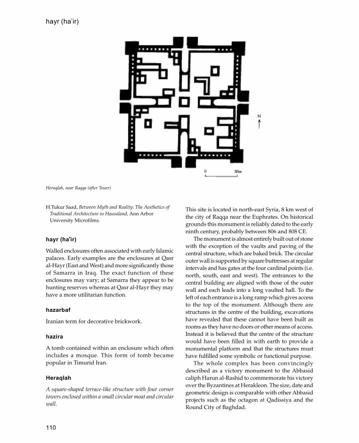
110
H.Tukur Saad, Between Myth and Reality: The Aesthetics ofTraditional Architecture in Hausaland, Ann ArborUniversity Microfilms.
hayr (ha�����ir)
Walled enclosures often associated with early Islamicpalaces. Early examples are the enclosures at Qasral-Hayr (East and West) and more significantly thoseof Samarra in Iraq. The exact function of theseenclosures may vary; at Samarra they appear to behunting reserves whereas at Qasr al-Hayr they mayhave a more utilitarian function.
hazarbaf
Iranian term for decorative brickwork.
hazira
A tomb contained within an enclosure which oftenincludes a mosque. This form of tomb becamepopular in Timurid Iran.
Heraqlah
A square-shaped terrace-like structure with four cornertowers enclosed within a small circular moat and circularwall.
This site is located in north-east Syria, 8 km west ofthe city of Raqqa near the Euphrates. On historicalgrounds this monument is reliably dated to the earlyninth century, probably between 806 and 808 CE.
The monument is almost entirely built out of stonewith the exception of the vaults and paving of thecentral structure, which are baked brick. The circularouter wall is supported by square buttresses at regularintervals and has gates at the four cardinal points (i.e.north, south, east and west). The entrances to thecentral building are aligned with those of the outerwall and each leads into a long vaulted hall. To theleft of each entrance is a long ramp which gives accessto the top of the monument. Although there arestructures in the centre of the building, excavationshave revealed that these cannot have been built asrooms as they have no doors or other means of access.Instead it is believed that the centre of the structurewould have been filled in with earth to provide amonumental platform and that the structures musthave fulfilled some symbolic or functional purpose.
The whole complex has been convincinglydescribed as a victory monument to the Abbasidcaliph Harun al-Rashid to commemorate his victoryover the Byzantines at Herakleon. The size, date andgeometric design is comparable with other Abbasidprojects such as the octagon at Qadissiya and theRound City of Baghdad.
Heraqlah, near Raqqa (after Touer)
hayr (ha�ir)

111
See also: Abbasids
Further reading:
F.Sarre and E.Herzfeld, Archäologische Reise im Euphrat undTigris, Gebeit I, Berlin 1911, 161–3.
K.Touer, ‘Heraqlah: a unique victory monument of Harunal-Rashid’, World Archaeology 14(3) : 1973.
Herat
City in north-west Afghanistan which became capital ofthe Timurid Empire in the fourteenth and fifteenthcenturies.
Herat has existed since ancient times and wasreferred to in Greek as Aria. It was conquered bythe Arabs in the seventh century but does not seemto have been fully subdued until the early eighthcentury. In the tenth century it was described ashaving four gates, a strong citadel and extensivesuburbs. In the twelfth and early thirteenth centurythe city was developed by the Ghurids whoestablished the Great Mosque. The city sufferedunder the Mongols in the thirteenth centuryalthough it began to be redeveloped by thefourteenth. In 1380 Timur entered Herat and laterexpelled the local ruler, this was the beginning ofHerat’s greatest period which lasted until the Uzbekconquest in 1508.
Timurid buildings in Herat include the GreatMosque, the madrassa and tomb of Gauhar Shad,the mausoleum of Sheikh Zadeh Abdallah and thefamous shrine of Gazur Gah. The Great Mosque wasestablished under the Ghurids in the twelfth centuryand contains the tomb of the Ghurid ruler SultanGhiyath al-Din. Although a few traces of twelfth-century stucco decoration remain, the design of thecomplex is mostly Timurid modified by more recentrenovations. The mosque is built on a four-iwan planwith a central courtyard and an enlarged westerniwan flanked with twin minarets which serves as themain prayer hall. The whole complex was decoratedwith polychrome tiles but these have mostlydisappeared to be replaced by modern copies. Themadrassa and tomb of Gauhar Shad form part of alarge complex built around a musalla, or open airprayer area, measuring 106 by 64 m. The inner courthad a two-storey arcade built around four iwans. Themausoleum of Gauhar Shad has a cruciform planwith the centre covered by a shallow convex domesupported by a network of pendentives and semi-
domes. Above the inner dome there is a tall, ribbedouter dome resting on a cylindrical collar andcovered with polychrome tiles on a blue background.Opposite the tomb of Gauhar Shad is the tomb ofSheikh Zadeh Abdallah which has a dome of similardesign. The building has an octagonal plan with anlarge frontal iwan and side iwans added on to thesouth, west and east sides. The most celebratedbuilding in Herat is the shrine of Gazur Gahdedicated to an eleventh-century Sufi poet, Khwajeh�Abdallah Ansari. The complex is a high-walledenclosure with a large iwan, above which is an arcadeof five arches capped with two domes. The brillianceof the shrine is its original tiled decoration whichconsists of square geometric panels, monumentalcalligraphy and abstract designs.
See also: Afghanistan, Timurids
Further reading:
T.Allen, Timurid Herat, Wiesbaden 1983.H.Gaube, Iran ian Cities, New York 1979, 31–64.F.J.Hecker, ‘A fifteenth-century Chinese diplomat in
Herat’, Journal of the Royal Asiatic Society, 3rd series 3 (1):85–91, 1993.
hosh
The courtyard of a house in Egypt or, in Palestine,used to describe houses built around a courtyard.
hujra
Small chamber or cell.
Hungary
The earliest recorded presence of Muslims inHungary is during the ninth century of Khazars.Some of these converted to Christianity during thereign of King Stephen in the tenth century althoughmany remained Muslim. Another Muslim (Turkic)group known as the Pecheneg was also present fromthe tenth century onwards. Many of these werelocated on the western frontier of Hungary as adefensive force for the Magyar kingdom. During thethirteenth century the Pecheneg seem to have beenprosperous with large settlements the size of townsbut without walls as these were forbidden to Muslimcommunities to prevent rebellion. By the end of thefourteenth century most Pecheneg had been forcedto convert to Christianity although some remainedMuslim until the beginning of the sixteenth century.
Hungary
112
The Ottoman victory at the battle of Mohacs in1526 renewed the Muslim presence in Hungary. Forthe next 150 years, until its reconquest at the end ofthe seventeenth century, Hungary was a province ofthe Ottoman Empire. There are few buildingsremaining from the period of Turkish rule althoughthe reasons for this are unclear. One of the best-known Ottoman monuments is the tomb of Gul Babain Buda erected between 1543 and 1548. The buildingis an octagonal mausoleum with a shallow domedroof covered in lead. There was once a mosqueassociated with the tomb but this has nowdisappeared. This tomb is now to be the centrepieceof an Islamic cultural centre incorporating a mosqueand library.
See also: Albania, Bosnia, Bulgaria, Ottomans
Further reading:G.Fehevari, ‘A centre for Islamic culture in Hungary’,
Arts of the Islamic World 5(2) 18 : 46–8, 1990.
hunkar mahfil
A royal lodge or gallery in an Ottoman mosque.
Hyderabad
Fifth largest city in India and capital of the second largestnative state in British India.
The state of Hyderabad was ruled over by theNizams of Hyderabad who were Muslims althoughthe majority of the population was Hindu. Althoughconquered by the Mughals in the late seventeenthcentury the Nizams managed to retain theirindependence until 1947 when the state was takenover by Indian government troops.
The city was founded in 1591 by the fifth ruler ofGolconda, Quli Qutb Saha. The city was originallyknown as Baghnagar (city of gardens) and lateracquired the name Hyderabad. It is located on thebanks of the river Musi and was laid out on a planwith the two main roads intersecting at the CharMinar at the centre of the city. To the north of the
Char Minar were the palaces of the Nizam rulerswhich were destroyed during the Mughal conquestof 1687. Between 1724 and 1740 Mubariz Khan, theMughal governor, supervised the construction of thecity walls with fourteen gates, only two of whichhave survived.
Several buildings survive from the pre-Mughalperiod the most famous of which is the Char Minarwhich dominates the centre of the city. To the north-east of the Char Minar is the Mecca Masjid builtout of local granite between 1614 and 1693. This isone of the largest mosques in India and the mainentrance consists of five arches and four minarswhilst the interior of the mosque contains two hugedomes supported on monolithic columns. Directlyto the north of the Char Minar is the Jami Masjidwhich was built in 1598 and is one of the oldestmosques in the city. This mosque forms part of acomplex that included a bath house and madrassawhich have survived as ruins. A better preservedcomplex is the Danish Shifa hospital and medicalcollege (built in 1535) which consists of a two-storeysquare courtyard building with a mosque attached.Also from this early period is the BadshahiAshurkhana which was built in 1592 as a royalhouse of mourning. The building is decorated withPersian-style tile mosaics and has an outer timberporch added in the late eighteenth century. Littleremains of the original royal palaces although theCharkaman (Four arches) built in 1594 wasoriginally a monumental gateway opening on tothe palace grounds.
See also: Char Minar, Deccan, India
Further reading:
A.Bakshian and G.D.Schad, ‘Hyderabad: shadow ofempire’, History Today 39: 19–28, Jan. 1989.
hypostyle
A flat-roofed structure supported by columns.
See also: appadana
hunkar mahfil

113
Ibn Tulun Mosque
One of the oldest mosques in Egypt to have survivedrelatively intact. It was built by Ahmad ibn Tulun thesemi-independent ruler of Egypt in 870.
The mosque formed part of the new suburb of al-Qata�ic which ibn Tulun added on to the two townsof Fustat and al-�Askar which were later incorporatedinto the city of Cairo. Ahmad ibn Tulun was born inIraq and brought up at the caliph’s court in Samarraand the new city of al-Qata�ic bore some resemblanceto Samarra.
The mosque was begun in 876 and completed in879. The building consists of a large rectangularenclosure with a central courtyard measuring 92 msquare. Arcades two-aisles deep are ranged aroundthree sides of the courtyard whilst on the qibla side(south-east) there are five rows of arcades. Thecentral building is enclosed by an outer enclosure,or ziyada, on the three sides adjoining the qibla.Almost directly opposite the central mihrab is aminaret consisting of a square tower with a spiralsection on the top. Access to the top of minaret is byan external staircase. At the top there is a two-storeyoctagonal kiosk. Whilst the octagonal kiosk and thewindows on the side of the square shape appear tobe of a later (thirteenth century) date there is somedebate about whether the minaret is an originalninth-century structure or a later copy.
Due to its good state of preservation the IbnTulun Mosque provides an excellent example ofninth-century decoration and structural techniques.The most notable feature of the outer walls is thedecorative openwork crenellations which resemblepaper cut-outs. The courtyard façades consist ofslightly pointed arches resting on rectangular pierswith engaged colonettes, which is an unusualarrangement for Cairo where marble columns wereusually used. Between the arches are rectangulararched niches also with engaged colonettes. Eitherside of each niche is a sunken rosette divided intoeight lobes. A band of similar rosettes forms a
cornice running around the four faces of thecourtyard. Probably the most remarkable featureof the decoration is the carved stucco work whichdeco-rates the interior of the mosque. The bestexamples are in the soffits of the arches of thesanctuary where geometric interlace patterns arefilled with stylized leaf ornament similar to Samarrastucco style B. The edges of the arches and thecapitals are decorated with stucco resemblingSamarra style A.
Many elements of the Ibn Tulun Mosque recallthe architecture of Samarra, in particular the ziyadas,the rectangular piers and the stucco work. Theminaret recalls the spiral minarets of the GreatMosque and the Abu Dulaf Mosque both because ofthe spiral shapes used and the positioning of theziyada opposite the mihrab.
See also: stucco
Further reading:
K.A.C.Creswell, A Short Account of Early MuslimArchitecture, revised a nd enlarged edn . J.W.Allan,Aldershot 1989, 392–406.
D.Berhens-Abouseif, Islamic Architecture in Cairo: AnIntroduction, Supplements to Muqarnas vol. 3,Leiden1989, 51–7.
idgah
Indian term for an open-air prayer area, particularlyused during festivals.
See also: musalla, namazgah
Ilkhanids
Mongol dynasty which ruled much of the eastern Islamicworld from the mid-thirteenth to the mid-four-teenthcentury.
In 1258 Hulagau ibn Kublai Khan sacked Baghdadand killed the last Abbasid caliph al-Mu’tassimmaking Iraq part of the great Mongol Empire. Thisempire was divided into four parts of which Hulagau
I

114
ruled one. Hulagau’s dominions included Iran,Khurassan, Azerbayjan, Georgia, Armenia and Iraq.Although the Ilkhanids rebuilt much of Baghdad,most imperial building was confined to Iran.
There are few Ilkhanid monuments whichsurvive from before the fourteenth century.Characteristic features of Ilkhanid architecture arethe massive size of monuments (which anticipatesthose of the Timurids), the extensive use of stucco
work and the development of the transverse arch.The transverse arch was a method of covering largeopen areas without the use of piers or columns. Theprinciple of the technique was to have a series ofwide arches spanning the short axis of a room, thesearches would then form the base for transversevaults. Although the technique had been used before,this was the first time it was used in baked-brickarchitecture. One of the best examples is Khan Mirjan
Plan of Ibn Tulun Mospue, Cairo (after Creswell)
Ilkhanids

115
(1359) in Baghdad where a two-storey rectangularcourtyard is covered with seven huge transversearches.
The extant examples of imperial Ilkhanidarchitecture are few, although the ruins of theMongol capital at Sultaniya give some idea of thescale of their buildings. The city was founded in 1306and contained a huge citadel surrounded by a stonewall. Little survives of the city with the exception ofthe massive tomb complex of Oljetu. This is a hugeoctagonal building with a diameter of more than 30m, surmounted by a massive dome covered withblue tiles. Other imperial projects were the GreatMosques of Tabriz and Varamin. The Tabriz Mosquewas based around a prayer hall consisting of a singlemassive iwan 40 m wide and more than 80 m deep.In front of the iwan there was a courtyard whichcontained a madrassa and a khanqa. The VaraminMosque is equally huge and is dominated by thestrict symmetry of its axial iwans.
See also: Iran, Iraq
imamzadeh
Iranian term for venerated tomb of holy man.
imaret
Ottoman Turkish term for a kitchen which dispensessoup and bread free to the poor, students andwandering mystics (dervishes). Imarets usually formpart of a larger religious complex which normallyincludes a mosque, madrassa and bath house(hammam).
India
The Republic of India is the largest country in south Asiaand occupies the greater part of the Indian subcontinentwhich it shares with Pakistan and Bangladesh.
The present population of India is nearly 800 millionof which almost 80 million (10 per cent) are Muslim,making it the second largest Muslim country in theworld after Indonesia. Geographically India is fairlywell defined, with the Himalayas to the northisolating it from the rest of Asia, whilst the IndianOcean surrounds the country to the south. Withinthis vast area there are many regions each with itsown languages, traditions, climate and environment,varying from the cool mountains of Kashmir to thetropical heat of the Deccan.
India differs from other parts of the Islamic worldas it does not share the Roman and Sassaniantraditions of the Middle East and North Africa,instead it has its own complex history which includesmany different religions, cultures and ethnic groups.The most significant of these is the Hindu religionwhich was a highly developed culture well beforethe Muslim conquest and continues to be the majorreligion of the country. The effect of this onarchitecture means that Indian buildings havedistinct design and building characteristics whichdistinguish them from Islamic buildings elsewhere.The most significant influence on architecture wasthe Hindu temple. Initially Hindu temples weredestroyed and the remains were used to buildmosques, such as the Quwwat al-Islam Mosque inDelhi which was built out of the remains of twenty-seven temples; later, however, Hindu features werecopied for use in mosques and have now becomecharacteristic of Indo-Islamic architecture. Examplesof Hindu features incorporated into Islamicbuildings include domed chatris, projecting chajjasand bulbous dome finials. Later on the influence ofIndia can be seen in the mosques of south-east Asia,many of which are Indian in form.
Islam arrived in India by two routes, the overlandroute through Central Asia and the maritime coastalroute. In general the overland route was used byTurkic and Afghan peoples who arrived in India aswarriors and conquerors. These peoples establishedthe first Muslim states in India starting in the northand later expanding to the south and east. The coastalroute is less well documented and consists of thegradual development of independent Muslim tradingcommunities along the coast in a similar manner tothe establishment of Islam in East Africa. Some of theoldest established coastal communities are in Gujaratand the Malabar coast from where Islam eventuallyspread to south-east Asia as testified by the Gujaratigravestones found in Malaysia and Indonesia. Thecoastal communities were usually fairly small withno territorial or dynastic ambitions and consequentlyproduced little monumental architecture apart fromsmall local mosques. Occasionally there was some co-operation between the inland Muslim dynasties andthe coastal Muslims as can be seen in Gujarat and theDeccan.
There are few documented remains of earlyMuslim coastal communities. This is partly becauseof the lack of archaeological work and partly becausethe monumental character of inland sites has taken
India

116
Principal sites and cities of the Islamic period in India
India
117
up most of the attention of scholars. There is,however, significant historical information ofMuslim coastal communities from as early as theninth century at Quilon on the Malabar coast. Oneof the few coastal sites with early standing remainsis the old seaport of Bhadresvar which has two mid-twelfth-century mosques which pre-date the Muslimconquest of Gujarat.
The Muslim conquest of India started in the latetwelfth century with the Afghan invasion led byMuhammad of Ghur who captured the Hindustronghold of Rai Pithora, later known as Delhi (seebelow Pakistan for the early Islamic conquest ofSind). The death of Muhammad in 1206 left hislieutenant Qutb al-Din Aybak in control of the newIndian Muslim state. During the next 300 years muchof northern India and the area of modern Pakistanwas ruled by a succession of five dynasties based atDelhi. The first of these dynasties comprised thedescendants of Qutb al-Din and collectively wasknown as the Slave dynasty. In 1290 power wasseized by Jalal al-Din Firuz Shah II who was founderof the second dynasty known as the Khaliji sultans.In 1296 Jalal al-Din was murdered by his nephewwho replaced him as sultan. The new sultan, Ala al-Din Muhamad Shah, reigned for seventeen yearsduring which time he made extensive conquests inGujarat, Rajasthan and the Deccan. However, theKhaliji dynasty was short-lived and in 1320 it wasreplaced by the Tughluq, named after its founderGhiyath al-Din Tughluq. For a brief period in themid-fourteenth century Ghiyath al-Din’s successormoved the capital to Daulatabad in the Deccan, butfamine and disease forced him to return to Delhi.The invasion of Timur at the end of the fourteenthcentury brought about the destruction of Delhi anddealt a deathly blow to the Tughluqid sultans. Thelast Tughluqid sultan died in 1414 leaving Delhiunder the control of the Sayyid sultans who ruled asTimur’s deputies. The Sayyid sultans ruled for lessthan forty years until 1451 when they were replacedby the Lodi kings. The end of the Delhi sultanatecame in 1526 when the last Lodi king was defeatedby Babur the first Mughal emperor.
The architecture of the Delhi sultanate representsa gradual evolution from an imported Afghan styleusing unfamiliar materials to a developed Indo-Islamic style which formed the basis of later Mughalarchitecture. The first building of the Delhi sultanatewas the Quwwat al-Islam Mosque complex built byQutb al-Din Aybak out of the remains of twenty-
seven destroyed Hindu temples. The arcades weresupported by two tiers of Hindu temple pillarsplaced one on top of the other to achieve the desiredheight. They were built in a trabeate constructionand in 1199 an arched façade was added to the eastside of the sanctuary to give it the familiarappearance of a mosque. However, the arches of thescreen were built out of corbels rather than voussoirswhilst the decoration consisted of Quranicinscriptions contained within dense Hindu-stylefoliage. In the same year Qutb al-Din began thefamous Qutb Minar which has become one of thepotent symbols of Islam in India. Other work carriedout at this time was the construction of the GreatMosque of Ajmer which like the Delhi Mosqueemployed re-used Hindu columns and later had anarched screen added to the front. Other notablemonuments of the Slave dynasty include the tombof Iltumish built in 1236 which includes the first useof squinches to support a dome.
Work on the Delhi Mosque continued under theKhaliji dynasty. Ala al-Din in particular devoted agreat deal of attention to the mosque by extendingthe area of the sanctuary as well as beginning a newminaret on the same design as the Qutb Minar butmore than twice the size. Unfortunately Ala al-Dinwas unable to finish his work and the only partcompleted is a monumental gateway. Other workcarried out by Ala al-Din was the foundation of Siri,the second city of Delhi.
The real expansion of Sultanate architecture cameduring the rule of the Tughluqids in the fourteenthcentury. Several new cities were founded includingFathabad, Hissar and Jaunpaur as well as the third,fourth and fifth cities of Delhi. Also at this time theinfluence of Sultanate architecture was felt in theDeccan when Muhammad Tughluq II moved hiscapital to Daulatabad. Characteristic features of thisarchitecture are massive sloping fortification wallswith pointed crenellations and the development ofthe tomb as the focus of architectural design. One ofthe more important tombs is that of Khan Jahan builtin 1369 which incorporates Hindu features into anIslamic form. The tomb has an octagonal domedform with chajjas, or projecting eaves, on each sideand domed chatris on the roof. Another notablefeature of Tughluqid architecture is the restraineduse of epigraphy unlike earlier Sultanatearchitecture.
The monuments of the Sayyid and Lodi sultansare distinguished by their severity and lack of
India
118
decoration. Nevertheless, many of the buildings aresophisticated structures like the tomb of Sikander Lodiwhich uses a double dome form so that the dome mayhave a significant form on the outside withoutdisrupting the proportions of the interior (a techniquelater used in the Taj Mahal). The tomb is also the firstIndian tomb to form part of a formal garden whichbecame the established format under the Mughals.In addition to the centralized architectural stylesdeveloped during the Delhi sultanate several vigorousregional traditions also developed. The four mostsignificant styles are those of Gujarat, Kashmir, theDeccan and Bengal. The style of Gujarat developedindependently for over 200 years from its conquestby the Khaliji sultan Ala al-Din Shah in the earlyfourteenth century to its incorporation in the MughalEmpire in the late sixteenth century. Characteristicfeatures of Gujarati architecture are the use of Hindumethods of decoration and construction for mosqueslong after they had ceased to be fashionable in Delhi.After the conquest of Gujarat, the Mughal emperorAkbar adopted this style for his most ambitiousarchitectural project, Fatehpur Sikri. Less well knownbut equally distinctive is the architecture of Kashmirwhere the first Islamic conquest was in the mid-fourteenth century. The significant features ofKashmiri architecture are the use of wood as the mainbuilding material and tall pyramid-shaped roofs onmosques. The third major regional style is thearchitecture of the Deccan in southern India. Deccaniarchitecture is characterized by massive monumentalstonework, bulbous onion-shaped domes andelaborate stone carving, including vegetal forms,arched niches and medallions. Far to the east, in theregion of Bengal and modern Bangladesh, a distinctivearchitecture developed using baked brick as the mainbuilding material. Other characteristic features ofBengal include the use of the curved do-chala andchar-chala roofs which were later incorporated intoimperial Mughal architecture under Shah Jahan.
See also: Bengal, Deccan, Delhi, Gujarat,Mughals
Further reading:P.Andrews, ‘The architecture and gardens of Islamic
India’, in The Arts of India, ed. B.Gray, Oxford 1981, 95–124.
P.Davies, The Penguin Guide to the Monuments of India, vol.2: Islamic Rajput and European, London 1989.
Z.A.Desai, Indo-Islamic Architecture, 2nd edn. New Delhi1986.
S.Grover, The Architecture of India: Islamic, New Delhi1981.
R.Nath, Islamic Architecture and Culture in India, Delhi1982.
M.Shokoohy and N.H.Shokoohy, Hisar-i Firuza: Sultanateand Early Mughal Architecture in the District of Hisar India,Monographs on Art and Archaeology, London 1988.
M.Shokoohy, M.Bayani-Walpert and N.H.Shokoohy,Bhadresvar: The Oldest Islamic Monuments in India,Studies in Islamic Art and Architecture, Supplements toMuqarnas vol. 2, Leiden 1988.
K.V.Soundara Rajan, Islam Builds in India: Cultural Study ofIslamic Architecture, Delhi 1983.
F.Watson, A Concise History of India, London 1979.A.Welch and H.Crane, ‘The Tughluqs: master-builders of
the Delhi Sultanate’, Muqarnas 1:123–66, 1983.A.Volwahsen, Living Architecture: Islamic Indian, London
1970.
Indonesia
Large country in south-east Asia comprising anarchipelago of over 17,000 islands stretching for over 5,000km along the equator. The country has a large populationof over 180 million of whom more than 80 per cent areMuslim, making it the most populous country in theIslamic world.
Islam reached separate parts of Indonesia at differenttimes; it arrived in Sumatra in the thirteenth century;in the fourteenth century it was established in Java,southern Celebes, northern Moluccas and southernBorneo (Kalimantan). By the fifteenth century; it hadreached the smaller islands to the east of Bali (thisremained Hindu) including Lombok, Sumbawa andthe northern coast of Flores.
With the exception of the mosque at Demakthere are few examples of early mosques inIndonesia because they were mostly wooden andwere replaced by brick or stone structures in thenineteenth century. What the wooden mosques dodemonstrate is a continuity with the pre-IslamicHindu and Buddhist past and it seems likely thatfor this reason they were later replaced withbuildings which look more traditionally Islamic.The modern Islamic buildings of Indonesia oftenhave more in common with India and Europe thanwith any indigenous Indonesian architecture.Recently, however, there have been attempts torevive traditional mosque forms by the ‘Amal BaktiMuslim Pancasila’ foundation which buildswooden mosques similar to the historical mosqueat Demak.
Indonesia

119
Principal Islamic sites of south-east Asia and Indonesia
Indonesia

120
See also: Java, Sumatra
Further reading:
H.I.Jessup, ‘Princely pavilions: architecture as an index tocourt and society’, Court Arts of Indonesia, New York1990, chap. 3.
A.H.Johns, ‘From coastal settlement to Islamic school andcity: Islamization in Sumatra, the Malay Peninsula andJava’, in Indonesia: Australian Perspectives. I: Indonesia:The Making of a Culture, ed. J.J.Fox, Canberra 1980.
N.Madjid, ‘Islam on the Indonesian soil: an ongoingprocess of acculturation and adaptation’, Arts and theIslamic World, 20: 67–8, 1991.
A.A.Nanji, ‘Space and spirit: the contemporaryexpressions of buildings in Islam’, Arts and the IslamicWorld 2: 63–5, 1991.
Y.Saliya, ‘Mosque architecture in Indonesia: variations ona theme’, Arts and the Islamic World 21, 1992.
Iran (Islamic Republic of Iran, formerlyPersia)
Large Middle-Eastern country containing some of themost celebrated examples of Islamic architecture.
Iran is bordered on the west by Iraq and Turkey, onthe east by Pakistan and Afghanistan and on thenorth by the former Soviet Republics of Turkmeniyaand Azerbayjan. To the south the country is open tothe Persian/Arabian Gulf and the Indian Ocean. Thecentre of the country comprises a high plateausurrounded by mountains, to the south and west arethe Zagros mountains whilst to the north along theshores of the Caspian Sea are the Elbruz mountains.The majority of the population lives on the edges ofthe central plateau as much of the interior is fairlybarren, consisting of kavir (salt marsh) and dasht(stony desert). Most of the country is fairly aridexcept for the north-west on the borders of theCaspian Sea where there are forests.
In addition to the present state of Iran, Iranianculture has traditionally extended into theneighbouring regions comprising the modern statesof Afghanistan, Turkmeniya, Uzbekistan andTajikistan.
History
Iran has a long history as a unified state starting withthe conquests of Cyrus the Great, founder of theAchaemenid Empire in the sixth century BCE. By525 BCE Cyrus’s successor Cambyses had captured
Egypt and was in control of most of the Middle East.The Achaemenid Empire was eventually destroyedby Alexander the Great in 331 BCE after which Iranwas ruled by his successors known as the Seleucids.The Seleucids were in turn overthrown by theSassanians who ruled an empire which includedmost of modern Iran as well as Mesopotamia. Theearliest Arab attacks on the Sassanian Empire tookplace in the 630s and by 637 CE the Arabs had won amajor victory at the battle of Qadisiyya. Althoughthe Sassanians were deci-sively defeated at the battleof Nihavand in 642 the Arab conquest was notcompleted until 651 when the last Sassanian emperor,Yazdigrid, was killed near Murghab in Transoxiana.However, even after the emperor’s death, resistancecontinued whilst many parts of the countryconquered by the Arabs remained under the controlof Persian princes. The Arab conquest was carriedout mostly by troops from the Iraqi garrison citiesof Basra and Kufa, a factor which subsequently hadprofound influence on the politics and religion ofearly Islamic Iran.
For the next hundred years Iran was ruled by aseries of governors appointed by the Umayyadcaliphs based in Syria. The rule of the Umayyadswas resented by many of the Arab troops in Iran,many of whom were influenced by the emergingKharjirism (opposition to religious claims of thecaliphate) and Shi�ism (supporters of �Ali) of Basraand Kufa. In addition a large number of Iranianconverts to Islam were unhappy about their statusin relation to the Arab rulers. The result of thegrowing opposition to the Umayyads was theAbbasid revolution which began in eastern Iran andeventually spread to most of the Islamic world. Oneof the consequences of the Abbasid revolution wasincreased Iranian influence in both the culture andadministration of the caliphate. During the ninthcentury independent local dynasties began toemerge as rulers in several parts of Iran, the mostsignificant of which were the Buwaihids. TheBuwaihids were a Shi�a group originating from theCaspian region who eventually dominated even theAbbasid caliphs. In the ninth century eastern Iran(including the modern states of Afghanistan andUzbekistan) was under the control of the Samanidsbased at Bukhara and Samarkand. In 1040 the SeljukTurks conquered the whole of Iran and establishedthe great Seljuk Empire. For a short period in theeleventh century a huge area from Syria to easternIran was nominally under the control of the Seljuks
Iran (Islamic Republic of Iran, formerly Persia)

121
who as a Sunni group were endorsed by thereligious orthodoxy and the caliphate in Baghdad.However, the unity of the Seljuks was short livedand by the end of the eleventh century the empirewas divided into a number of independentprincipalities. In the mid-thirteenth century Iranwas conquered by the Mongols who dominated thecountry for the next hundred years. In the latethirteenth century the Mongol leader Ghazan Khanconverted to Islam and broke away from centralMongol control. Between 1381 and 1404 Iran wassubjected to another devastating Mongol invasionunder the legendary Timur. The Timurid state inwestern Iran did not last long after Timur’s deathin 1405 and was replaced by the Turkomandynasties who ruled until 1501 when they weredefeated by the forces of the Saffavids under ShahIsma�il. However, in eastern Iran Timurid rulecontinued until 1510 when the last Timurid sultanwas defeated by the Saffavids.
The Saffavids ruled Iran for more than 200 yearsestablishing it as a unified modern state. Unlike theirpredecessors, the Saffavids were Shi�a and convertedmost of Iran to this form of Islam. By the 1730s theSaffavids were no longer able to control large areasof the country which was subjected to increasingAfghan attacks. In the 1740s the Afghans wererepulsed by a Nadir Shah, ruler of a local north-eastern dynasty known as the Zands. Nadir Shah’ssuccess against the Afghans enabled him to takecontrol of the whole of Iran, though the Saffavidsremained nominally in control. In 1779 the Zandswere overthrown by the leader of a Turkish dynastyknown as the Qajars who ruled the country until 1924when they were replaced by the modernizing Pahvlidynasty. In 1979 the last Pahvli ruler was overthrownand Iran became an Islamic republic.
Architecture
The building materials vary from place to place andaccording to the period although certain materialsand techniques tend to remain predominant. Formost of the Islamic period the shortage of suitablestone has meant that brick (baked or unbaked) hasbeen the main construction material. Unbaked mudbrick or pisé is generally the cheap-est buildingmaterial and has been used for most Iranian housessince early times. In many buildings mud brick isused in conjunction with baked brick which isemployed for the more important parts of the
structure. Baked (or fired) bricks were used for moreimportant monuments in the early Islamic periodalthough later they were adopted for a wider rangeof building types. In the earliest monumentsbrickwork is undecorated with large expanses ofplain wall in the Sassanian tradition. In laterbuildings decorative patterns are introduced whichreach their culmination under the Seljuks withcomplex geometric patterns and inscriptions. Twotechniques of brickwork decoration (hazarbaf) areused, one employing bricks of standard sizearranged in simple patterns and the other usingbricks specially cut or manufactured for thepurpose. The latter technique was more suitable forinscriptions and complex motifs. Also during theSeljuk period buildings began to be decorated withglazed bricks and coloured ceramic tile inlays.During the Seljuk and Ilkhanid periods thepreferred colours were turquoise, light blue anddark blue. In earlier buildings glazed tiles andbricks were set into the exterior walls of buildingsto enliven the uniform earth colours of the brickand dark blue; however, during the fourteenthcentury the technique of tile mosaic was developedwhereby large areas would be covered by tilesspecially cut or shaped to form geometric and floraldesigns. Under the Timurids new colours wereintroduced including green, yellow and terracotta.The technique of tile mosaic was perfected in thefifteenth century under the Timurids who alsointroduced new colours including green and yellow.During the sixteenth century the Saffavidsintroduced overglaze painted panels using atechnique known as haft-rangi (i.e. seven colours).The advantage of this technique was that it waspossible to cover large areas fairly cheaply, althoughthe quality of the colours was inferior to thatproduced in tile mosaics.
Cut stone architecture is rare in Iran which hasno tradition of ashlar masonry to compare with thatof the eastern Mediterranean. There are, however,several notable exceptions to this such as the KhudaKhana of the Friday mosque in Shiraz built in 1351.However, most stone buildings in Iran were madeout of rubble stones set within a thick mortar andcovered with plaster. The lack of a stone carvingtradition in Iran led to the development of decorativeplasterwork or stucco. The technique of stuccodecoration was developed under the Sassanians, butachieved its definitive Islamic form at the Abbasidcapital of Samarra in Iraq. Subsequently stucco
Iran (Islamic Republic of Iran, formerly Persia)
122
decoration in Iran developed its own form and wasused in particular for decorating mihrabs.
Wood is rarely used in Iran except in the north-west region on the borders of the Caspian Sea.Unfortunately few wooden structures survive fromthe earlier periods although there are severalnotable examples from the Saffavid period. Themost famous example of wooden architecture is theporch of the Ali Qapu Palace in Isfahan whichconsists of a flat roof supported on huge woodencolumns with muqarnas capitals. Although fairlyunique because of its size the porch of the Ali QapuPalace represents a traditional form in Iranianarchitecture.
Two types of building are particularlycharacteristic of Islamic architecture in Iran, theseare mosques and tombs. In addition there is arange of secular buildings which gives some ideaof the diversity of Iranian architecture.Unfortunately very little survives of Iran’s Islamicarchitecture from before the Seljuk period so thatit is difficult to trace the origin of particularbuilding types and their relationship to Islamicarchitecture elsewhere.
The earliest Iranian mosques were hypostylestructures with the sanctuary located on the south-western (qibla) side of an open courtyard which waslined by arcades on the other three sides. In theabsence of the marble columns used in Syria andEgypt the roof was usually supported by baked-brick piers or wooden columns. Only a few earlymosques have been discovered, the most importantof which are Siraf, Susa, Isfahan, Fahraj, Damghanand Nayin. The first three buildings were coveredby a flat wooden roofs whilst the latter three wereroofed with a system of barrel vaults supported onsquat octagonal or round brick piers. The walls ofthese structures were initially built out of mud brickor rubble stone set in mortar and decorated withstucco.
Sometime during the eleventh century a newmosque form was introduced based on the four-iwanplan. The advent of this new building type seems tobe associated with the arrival of the Seljuks.Examples of this form are found mostly in westernand central Iran and include Isfahan, Basian,Zavareh, Qazvin, Yazd, Kirman and Rayy. One ofthe clearest examples of this new form is the mosqueof Zavareh (dated to 1136) which consists of a squarecentral courtyard with iwans in the centre of eachside, behind the qibla iwan is a square domed
chamber containing the mihrab. From the Seljukperiod onwards the four-iwan plan became thestandard format for mosques and later developmentstook place within the context of this plan. Ilkhaniddevelopments in mosque architecture wereconcerned with a refinement of the four-iwan planand the increased use of decorative techniques. Theproblem of the four-iwan plan is that it detracts fromthe directional emphasis of the mihrab. One methodused to strengthen this axis is the enlargement ofthe qibla iwan which can be seen in its mostexaggerated form in the mosque of Ali Shah in Tabrizbuilt between 1310 and 1320 where the qibla iwanwas over 48 m deep and 30 m wide. Another methodof strengthening the orientation is the decorativeelaboration of the qibla iwan and façade (pishtaq).In the Great Mosque of Varamin built in 1322 themonumental qibla iwan is decorated with giantmuqarnas, stucco inscriptions and decorativebrickwork.
The collapse of Ilkhanid power in 1335 left Iranunder the control of competing dynasties the mostimportant of which was the Muzaffarids who ruledthe area of Fars and Kirman. Several innovations inmosque architecture were introduced at this timewhich collectively have been called the Muzaffaridstyle. One of the most distinctive features is the useof large transverse arches which support transversebarrel vaults. This system was used in an extra prayerhall added to the Great Mosque at Yazd and themadrassa attached to the Masjid-i Jami at Isfahan.The advantage of this innovation is that large areascan be covered without intervening pillars. Thisperiod is also characterized by the growing use oftile mosaic as decoration both for the interior ofmosques and for the portal façades.
In 1393 the conquests of Timur brought anabrupt end to Muzaffarid rule and marked thebeginning of a period during which monumentalbuilding activity was confined to the eastern partof the Iranian world outside the borders of thepresent state of Iran. However, it is notable thatmany of the buildings erected by Timur and hissuccessors in Samarkand and Bukhara resemble theearlier buildings of western Iran. One of the reasonsfor this situation is that Timurids employedcraftsmen from western Iran, a fact which may alsoexplain the comparative dearth of building activityin the west. The situation in western Iran laterimproved under the Qara Qoyunlu dynasty whoestablished their capital at Tabriz. The most
Iran (Islamic Republic of Iran, formerly Persia)
123
significant monument of the period is the BlueMosque of Tabriz which consists of a domed centralcourtyard opening on to four iwans. The plan issimilar to that of the early T-plan mosques of Bursaand was probably influenced by contemporaryOttoman architecture.
With the exception of Isfahan there were fewmajor new mosques built during the Saffavid periodalthough extensive restorations were carried out toolder mosques and shrines. In particular there wasan increased emphasis on the shrines of Mashad andArdabil which were adapted for large numbers ofpilgrims. At Isfahan the Saffavids built a new citybased on a huge central maidan which functionedas the centre of the city. Opening on to the maidanare two mosques, the Masjid-i Shah and the Masjid-i Sheikh Luft �Allah, one on the east and one on thesouth side. The maidan is aligned north—southwhilst the mosques are built on a qibla axis (i.e. north-east-south-west), thus the junction between themosques and the maidan form entrances bent to anangle of 45 degrees. The Masjid-i Sheikh is thesmaller and also the more unusual mosque andcomprises a single-domed chamber approached viaan L-shaped corridor. The plan of the building lacksthe central courtyard found in most earlier mosquesand has more in common with domed mausoleumsthan the typical Iranian mosque. The Masjid-i Shahwith its four-iwan plan appears more conventionalalthough it has several unusual features includingminarets either side of the qibla iwan, domed hallsleading off the side iwans and two eight-domedprayer halls either side of the domed sanctuary area.Perhaps more surprising are the twin madrassaswhich flank the central prayer area creating a unifiedreligious complex. The architectural unity of thecomplex is cleverly reinforced by the bent axis whichallows a person standing in the maidan to see theentrance portal, the qibla iwan and the large centraldome at the same time. The impact of this view isreinforced by the blue and turquoise glazed tileworkand the twin sets of minarets flanking the entranceportal and the quibla iwan. Other mosques builtunder the Saffavids were generally less adventurousin their design and were built on the standard four-iwan plan.
Mosques built during the period of Zand andQajar rule continued to be built in the classicSaffavid style but with increased emphasis ondecoration. The most famous building attributableto the Zands is the Vakil Mosque in Shiraz, which
is characterized by its vivid yellow and pink tiledecoration. Several nineteenth-century Qajarmosques begin to show variations in the standardformat such as entrances placed to one side andmultiple minarets.
The development of commemorative tombstructures mirrors that of mosques with fewstructures from before the eleventh century and awide range of structures produced before thesixteenth century after which there is littleinnovation. Two distinct traditions of monumentaltombs developed which may be described as domedmausoleums and tomb towers.
Tomb towers were generally reserved for rulersor prominent local princes and were probably acontinuation of pre-Islamic Iranian practices. Thedegree of continuity can be seen in the tomb towerof Lajim where the commemorative inscription is inArabic and Pahlavi. The earliest and probably themost famous commemorative tomb in Iran is theGunbad-i Qabus built between 1006 and 1007. Thetomb consists of a tall cylindrical tower 55 m highwith ten angular buttresses and a conical roof. Thereis no decoration to relieve the stark simplicity of thebrickwork except for two lines of inscription, onenear the base and one below the roof. Althoughunusual, the monument is related to a group ofGhaznavid tomb towers produced further east inAfghanistan. During the Seljuk period the tombtower became established as the principal type offunerary monument. Other important tomb towersinclude the Pir-i �Alamdar tower (1026–7) and theChihil Dukhtaran tower (1054–5) both in Damghan.The significance of the Damghan towers is theirdecorative brickwork which later became one of thestandard decorative techniques on tomb towers. Alsoduring the Seljuk period tile inlay and glazed bricksbecame increasingly popular as a form of decoration.During the Ilkhanid period the standard smoothround form of tomb towers was modified by theaddition of semi-circular or angular flanges seen inbuildings such as the �Ala al-Din tomb tower inVaramin (1289). In the �Aliabad Kishmar tomb towersemi-circular and angular flanges are combinedcreating a complex interplay of shadows. During thefourteenth and fifteenth century the smooth conicalroof form is replaced by a pyramid form in whichthe conical form is made of a number of flat planeswhich meet at the apex.
Domed mausoleums are probably the earliestform of commemorative tomb and can be traced back
Iran (Islamic Republic of Iran, formerly Persia)

124
to structures such as the Qubbat al-Sulaybiyya atSamarra. These structures usually have a square oroctagonal base and hemispherical dome, one of theearliest Iranian examples being the Arslan Jadhibtomb built in 1028. Another early example is theDavazdah Imam at Yazd (1036–7) which consists ofa massive square chamber covered by a domeresting on an octagonal drum. During the Ilkhanidperiod the principle of the double dome developedwith a tall outer dome concealing a lower innerdome. The purpose of the double domearrangement was that a tall dome may attractattention to a building from the outside but isunsuitable for the smaller proportions of theinterior. Under the Timurids a bulbous dome shapewas developed which became characteristic ofIranian architecture and was used on many of thetombs built after the fifteenth century. In additionto the standard dome form a regional variantdeveloped in western Iran which is linked to theIraqi muqarnas domes.
As well as tomb towers and domed octagonalmausoleums, a third category of tomb is representedby the great shrines of Mashad, Qum and Mahan.Probably the greatest of these is the shrine of ImamRiza at Mashad which was built by the Timurids in1418 and subsequently adorned by later Iraniandynasties. At the centre of the shrine is a greatchamber covered by a bulbous glazed dome. Aroundthe sides of the building are two tiers of glazed iwansand a monumental iwan flanked by twin minaretsat the front.
Secular architecture in Iran is represented by awide range of buildings including palaces,caravanserais, bridges, city walls, bazars, icehouses, pigeon towers and bath houses.Unfortunately most secular buildings date from thefairly recent past and their are few examples frombefore the Saffavid period. This is particularly trueof palaces; thus the Ali Qapu Palace in Isfahan isone of the few imperial palaces to survive. Remainsof earlier palaces have been found but these aremostly ruins of buildings destroyed by war ornatural disasters. The Ali Qapu forms part of theimperial complex at Isfahan built by Shah Abbas inthe seventeenth century. The palace is located onthe west side of the central maidan and consists ofa tall square building with a monumental porch atthe front overlooking the maidan. The porch is morethan two storeys high and is raised above theground on a vaulted substructure so that it
functions as a huge covered viewing platform.Behind the main building of the Ali Qapu there area series of gardens and pavilions which recall thegarden palaces depicted in Persian miniaturepainting. However, most secular buildings such ascaravanserais or bazars tend to be of moreutilitarian form although sometimes they areenriched by decorative details derived fromreligious architecture. This process can be seen veryearly on in Iranian architecture in buildings suchas the Seljuk caravanserai of Robat Sharaf wherethe entrance is decorated with elaborate brickworkand incorporates a mihrab for the use of travellers.This process continued into the nineteenth centuryas can be seen in the bazar entrance at Yazd whichconsists of three-storey triple iwans flanked by twinminarets and covered with glazed tiles. However,most caravanserais and bazars contained very littledecoration beyond a foundation inscription abovethe gateway.
See also: badgir, Isfahan, Saffavid s, Seljuks,Timurids
Further reading:
T.Allen, ‘Notes on Bust’, Iran 27:57–66, 1989, and Iran 28:23–30, 1990.
E.Beazley, ‘Some vernacular buildings of the IranianPlateau’, Iran 15: 89–108, 1977.
—— ‘The pigeon towers of Isfahan’, Iran 4: 1–20, 1966.L.Bier, ‘The Masjid-i Sang near Darab and the Mosque of
Shahr-i Ij: rock cut architecture of the Ilkhanid period’,Iran 24: 117–30, 1986.
S.S.Blair, ‘The Mongol capital of Sultaniyya, “TheImperial’”, Iran 24: 139–52, 1986.
W.M.Clevenger, ‘Some minor monuments in Khurassan’,Iran 4: 57–64, 1966.
H.Gaube, Iranian Cities, New York 1979.O.Grabar, ‘The visual arts from the Arab invasions to the
Saljuks’, in Cambridge History of Iran, 1993.—— ‘The visual arts 1050–1350’, in Cambridge History of
Iran, 1993.R.Hillenbrand, ‘Saljuk dome chambers in north-west
Iran’, Iran 14: 93–102, 1976.—— ‘Safavid architecture’, in Cambridge History of Iran
1993.—— ‘Saljuk monuments in Iran V: the Imamzada Nur
Gurgan’, Iran 25: 55–76, 1987.L.Horne, ‘Reading village plans: architecture and social
change in north-eastern Iran’, Expedition (The UniversityMuseum Magazine of Archaeology and Anthropology,University of Pennsylvania) 33(1) 1991.
A.Hutt and L.Harrow, Islamic Architecture: Iran 1, London1977.
Iran (Islamic Republic of Iran, formerly Persia)

125
—— Islamic Architecture: Iran 2, London 1978.A.K.Lambton and R.M.Savory, ‘Iran (v. History)’, inEncyclopedia of Islam (new edn. ), 1954.
C.Melville, ‘Historical monuments and earthquakes inTabriz’, Iran 19: 1981.
B.O’Kane, ‘The Imamzada Husain Rida at Varamin’, Iran16: 175–7, 1978.
R.Finder Wilson, Timurid architecture’, in CambridgeHistory of Iran, 6: 728–58, 1993
R.Shani, ‘On the stylistic idiosyncracies of a Saljuk stuccoworkshop from the region of Kashan’, Iran, 27: 67–74,1989.
O.Watson, ‘The Masjid-i Ali Quhrud: an architectural andepigraphic survey’, Iran, 13: 59–74, 1975.
Iraq
Large country to the north-east of Arabia and west of Iran,dominated by the twin rivers of the Tigris and Euphrates.
The present state of Iraq more or less coincides withthe historical term Mesopotamia which refers to theland between the two rivers. The country may bedivided into three main geographical regions: theKurdish areas of the north, the central area betweenMosul and Baghdad and the desert areas to thesouth and west. The Kurdish areas of the north-eastare dominated by high mountains which continueinto Turkey and Iran. The central area between therivers is extremely flat, especially the southern areasand it is here that the remains of the ancientcivilizations (Sumerians, Babylonians, Assyrians)have been found. The desert areas to the west aresparsely populated and have connections with theArabic countries to the west and south.
Before the Arab conquests in the seventh centuryIraq was ruled by the Sassanians from their capital atal-Mada�in or Ctesiphon. In 633 CE the Muslim Arabscrossed the Euphrates and occupied Hira; four yearslater at the battle of Qadisiyya the Sassanians weredefeated. Initially the Arabs ruled from the oldSassanian capital but later moved to the newlyestablished garrison town of Kufa. Basra, the othergarrison city, was later built to cope with the increasingnumber of immigrants. Under the Umayyads theIslamic empire continued to expand, which led to thecontinued development of the garrison cities. In orderto retain order a third, Wasit, was established midwaybetween Kufa and Basra.
With the Abbasid revolution of 750 Iraq wasestablished as the home of the caliphate. This shiftin political power is symbolized by the building ofBaghdad as a new capital in 762. Conflict between
the caliph’s soldiers and the local population inBaghdad resulted in the al-Mu�tassim founding anew capital further north at Samarra. For a little overfifty years Samarra was capital of the Islamic worldbut in 889 Caliph Mu�tamid moved back to Baghdad.Abbasid power in Iraq was smashed in 946 by theBuwaihids, a Sh�ite Persian dynasty who ruled in thename of the Abbasid caliphs. The Buwaihids spentconsiderable sums on building activity in Iraq, theirmost famous construction being the Bimaristan(hospital) built in 978 at a cost of 100,000 dinars. TheBuwaihids were replaced as rulers by the Seljukswho ruled until 1154 when the long-dormantAbbasid caliphs were able to reassert their powerover much of Iraq. In 1258 the Mongols sackedBaghdad putting an end to further hopes of Abbasidrevival. Under the Ilkhanids Iraq was ruled by localgovernors, a situation which was changed when theJalairids took over in the fourteenth century andruled from Baghdad. In the sixteenth century Iraqwas conquered by the Ottomans who incorporatedit into the Ottoman Empire.
The principal building material of Iraq is mudbrick whilst baked brick is used for more permanentor important structures. The abscence of suitablewood led to the development of vaults, arches anddomes that could be built without wood. In theKurdish areas of the north hewn stone set into a thicklimey mortar (juss) is used as a building material.This method is also used in the desert areas of thewest although mud brick is also used. The only formof wood available is the palm tree and split palmtrunks are sometimes used for roofing. In thesouthern area near the entrance to the Gulf is aunique marshy environment where reeds are themain building material.
Architecturally the most significant time is theearly Islamic period up until the tenth century.During this period five major cities were established(Kufa, Basra, Wasit, Baghdad and Samarra) whichhad an effect on the art and architecture of the wholeIslamic world. During the medieval period Iraqiarchitecture generally follows that of Iran with fewinnovations or great monuments. One exception tothis is the Harba bridge near Samarra which has along brick inscription which is one of the finestexamples of its type. Another exception is a buildingtype known as the conical-domed mausoleum whichhas its origin in Iraq. The conical dome comprises atall dome made of interlocking muqarnas vaultswhich has the appearance of a honeycomb. The
Iraq
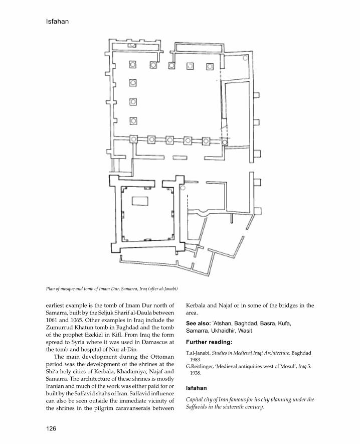
126
earliest example is the tomb of Imam Dur north ofSamarra, built by the Seljuk Sharif al-Daula between1061 and 1065. Other examples in Iraq include theZumurrud Khatun tomb in Baghdad and the tombof the prophet Ezekiel in Kifl. From Iraq the formspread to Syria where it was used in Damascus atthe tomb and hospital of Nur al-Din.
The main development during the Ottomanperiod was the development of the shrines at theShi‘a holy cities of Kerbala, Khadamiya, Najaf andSamarra. The architecture of these shrines is mostlyIranian and much of the work was either paid for orbuilt by the Saffavid shahs of Iran. Saffavid influencecan also be seen outside the immediate vicinity ofthe shrines in the pilgrim caravanserais between
Kerbala and Najaf or in some of the bridges in thearea.
See also: �Atshan, Baghdad, Basra, Kufa,Samarra, Ukhaidhir, Wasit
Further reading:
T.al-Janabi, Studies in Medieval Iraqi Architecture, Baghdad1983.
G.Reitlinger, ‘Medieval antiquities west of Mosul’, Iraq 5:1938.
Isfahan
Capital city of Iran famous for its city planning under theSaffavids in the sixteenth century.
Plan of mosque and tomb of Imam Dur, Samarra, Iraq (after al-Janabì)
Isfahan
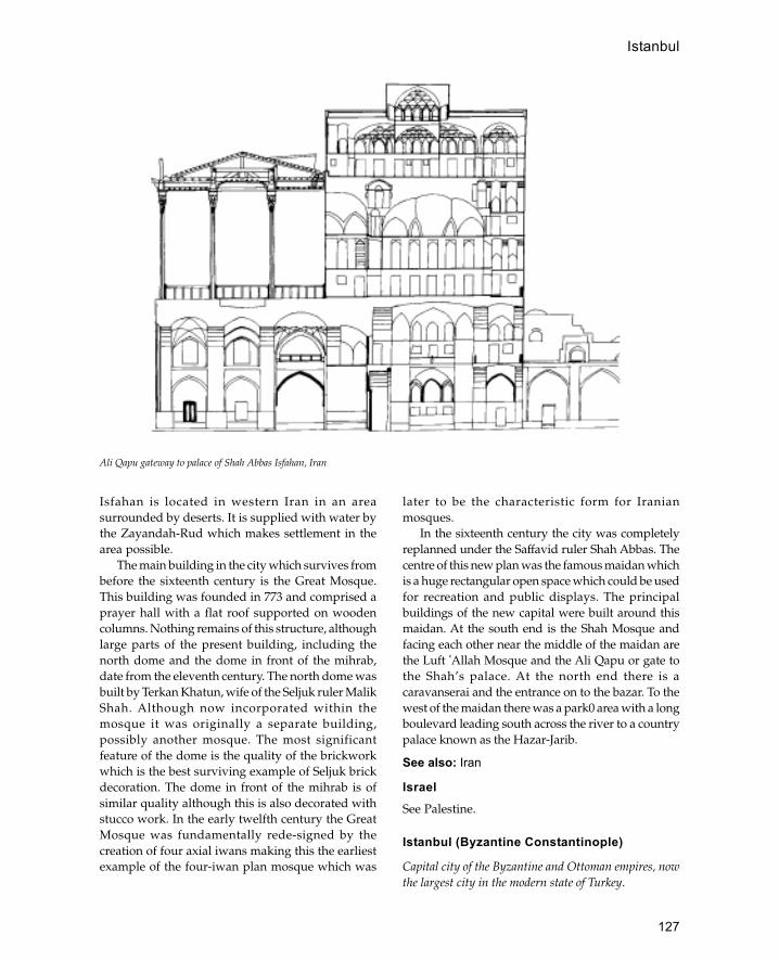
127
Isfahan is located in western Iran in an areasurrounded by deserts. It is supplied with water bythe Zayandah-Rud which makes settlement in thearea possible.
The main building in the city which survives frombefore the sixteenth century is the Great Mosque.This building was founded in 773 and comprised aprayer hall with a flat roof supported on woodencolumns. Nothing remains of this structure, althoughlarge parts of the present building, including thenorth dome and the dome in front of the mihrab,date from the eleventh century. The north dome wasbuilt by Terkan Khatun, wife of the Seljuk ruler MalikShah. Although now incorporated within themosque it was originally a separate building,possibly another mosque. The most significantfeature of the dome is the quality of the brickworkwhich is the best surviving example of Seljuk brickdecoration. The dome in front of the mihrab is ofsimilar quality although this is also decorated withstucco work. In the early twelfth century the GreatMosque was fundamentally rede-signed by thecreation of four axial iwans making this the earliestexample of the four-iwan plan mosque which was
later to be the characteristic form for Iranianmosques.
In the sixteenth century the city was completelyreplanned under the Saffavid ruler Shah Abbas. Thecentre of this new plan was the famous maidan whichis a huge rectangular open space which could be usedfor recreation and public displays. The principalbuildings of the new capital were built around thismaidan. At the south end is the Shah Mosque andfacing each other near the middle of the maidan arethe Luft �Allah Mosque and the Ali Qapu or gate tothe Shah’s palace. At the north end there is acaravanserai and the entrance on to the bazar. To thewest of the maidan there was a park0 area with a longboulevard leading south across the river to a countrypalace known as the Hazar-Jarib.
See also: Iran
IsraelSee Palestine.
Istanbul (Byzantine Constantinople)
Capital city of the Byzantine and Ottoman empires, nowthe largest city in the modern state of Turkey.
Ali Qapu gateway to palace of Shah Abbas Isfahan, Iran
Istanbul

128
History
Constantinople was founded by the Roman emperorConstantine in 330 CE on the site of an earlier townwhich traced its origins back to the Iron Age. At thecentre of Constantine’s city was the hippodrome, theimperial palace and the first cathedral of St Sophia(Hagia Sophia). By the fifth century the populationof the city had grown so fast that Theodosiusexpanded the circuit of the city wall to include a largearea to the west; these walls remain the boundary ofthe city. In 1453 the city finally fell to the OttomanTurks after centuries of gradual Turkish advances.By the time of the final conquest the Ottomanscontrolled the land on both sides of the city so that itwas in effect under permanent siege. The Ottomanconquest was a well-ordered operation which tookseveral years and involved the construction of twolarge fortresses (Rumeli and Anadolu Hisarlar) oneither side of the Bosphorus and two either side ofthe Dardenelles (Sultan Kale and Kilidbahir Kale) toenforce a blockade of the besieged city. The citywhich the Ottomans took over was in a dilapidatedstate with a declining population and and had littleof the grandeur associated with the early Byzantinecity. Much of the damage had been caused by the
Fourth Crusade in the twelfth century which hadbeen diverted from its objective and sackedConstantinople instead.
The city has a unique position on a peninsula atthe point where the Bosphorus joins the Sea ofMarmara. Surrounded by water on three sides, it haseasy access to the Black Sea, the Aegean and theMediterranean making it ideal as an imperial capital.
During the Ottoman period the city rapidlyexpanded to include the area of Galta on the oppositeside of the Golden Horn and the various towns onthe Asian side like Üskudar. Also during this periodthe banks of the Bosphorus up towards the BlackSea were gradually developed as residential areasand during the eighteenth and nineteenth centuriesthis became the fashionable area.
After the conquest the hippodrome (Turkish:Atmeydan) and cathedral of St Sophia remained thecentre of the city with the cathedral converted into amosque by the addition of a wooden minaret to oneof the turrets. The first Ottoman palace (Eski Sarai)begun in 1454 was built between the old forum andthe market area overlooking the Golden Horn. Thepalace was located in the middle of a parksurrounded by high walls and was later abandonedas imperial residence in favour of the Topkapisarai.
Plan of seventeenth-century mosque of Luft �Allah, Isafahan, Iran
Istanbul

129
The new palace built on the site of the formeracropolis was completed in 1472 and remained thecentre of the empire until the twentieth century. Inaddition to the royal palace there were also a numberof smaller palaces for notables, the most importantof which is the palace of Ibrahim Pasha (now theIslamic Art Museum) located on the north side ofthe Atmeydan.
Architecture
The first major mosque, the Fatih Cami, was begunin 1463 although smaller mosques were built beforethat date and some date from before the conquest.Like the Hagia Sophia some of the earliest mosqueswere converted churches and those that were not(like the Yarhisar Cami) were mostly square domedunits with a portico. Despite the conversion ofchurches in 1459 the Ottomans encouraged theformer Christian inhabitants of the city to return andthey were offered land grants as an incentive.
With the completion of the Fatih Cami in 1470the city had its first imperial mosque which wasfollowed forty years later by the Beyazit complexand sixty years later by Selim I�s mosque. For nearly100 years, until the completion of Sinan’smasterpiece, the mosque of Suleyman in 1557, theFatih Cami remained the largest and most importantmosque. The Süleymaniye became most importantof the imperial mosques for the rest of the Ottomanperiod, although the Sultan Ahmet Cami (BlueMosque) with its position next to the Atmeydan(Hippodrome) and its six minarets attracted a lot ofattention. Each of the imperial mosques wasaccompanied by a complex consisting of madrassas(colleges), hospices, bath houses and shops. Therevenue from the shops, hammams and any otherendowments was used to pay for the upkeep of themosque and its charitable dependencies. Therevenue from the Süleymaniye foundation was stilllarge enough to pay for the upkeep of over 300people in 1900.
The key to Istanbul’s success was its manymarkets or bazars which continue to be some of thebusiest in the Islamic world. Soon after the conquestthe city was provided with two bedestans and latera third at Galata. These formed the centre ofcommercial life in the city with bazars growing uparound each bedestan. The commercial centre of thecity during the Byzantine period had been the areaaround Hagia Sophia but during the Ottoman periodit moved to its present position near Eminönü andSirkeci. The centre of this bazar is the bedestanestablished by Mehmet II which consists of a centralhall covered by fifteen domes. In 1701 the bazaararound this bedestan was roofed over to become thecovered bazar.
Throughout its history most of the houses ofIstanbul were built of wood with stone or brickfoundations and tiled roofs. The houses were builtout of a wooden frame and then covered withweather boarding on the outside with shallowdouble pitched roofs. Houses were usually twostoreys high and often had cantilevered windowsprojecting out over the street. The predominant useof wood caused great danger from fires and therewere frequent regulations which tried to makepeople build in brick or stone. Before the twentiethcentury the skyline of Istanbul was punctuated withfrequent water towers which were to be used inthe event of fire.
Masjid Luft �Allah, Isfahan, Iran, © J.W.Allan,Ashmolean Museum
Istanbul

130
Since Byzantine times water had come into thecity along a network of channels and aqueducts fromthe Belgrade forest. On taking over the city theOttomans repaired the water system building newaqueducts and dams. During his time as architect ofIstanbul Sinan was in charge of the repairs to thewater system and built great two-tier aqueducts, thelongest of which is three-quarters of a kilometre.Later on during the eighteenth century the reservoirswere used as a place of recreation reflected in theelegant curved design of the dam known as theValide Bend. Connected to the water system were arange of sebils (fountains) which from the eighteenthcentury had roofs with huge projecting eaves whichcame to be regarded as a characteristic feature ofTurkish architecture.
See also: Ottomans
Further reading:N.Atasoy, Ibrahim Pasa Sarayi, Istanbul 1972.B.Y.Berry, ‘The development of the bracket support in
Turkish domestic architecture in Istanbul’, Ars Islamica5: 1938.
W.B.Denny, ‘A sixteenth-century architectural plan ofIstanbul’, Ars Orientalis 7: 49–63, 1970.
O.Erdenen, Istanbul çarsilari ve kapaliçarsi, Istanbul 1965.S.Eyice, ‘Istanbul minareleri’, in Türk San�ati Tarihi ve
Incelemereli, Istanbul 1963.J.Freely and H.Sumner-Boyd, Strolling through Istanbul,
London 1972.G.Goodwin, A History of Ottoman Architecture, London
1971.R.L.Van Nice and W.Emerson, ‘Hagia Sophia and the first
minaret erected after the conquest of Istanbul’, AmericanJournal of Archaeology 54: Jan. 1950.
iwanA vaulted hall, walled on three sides, with one end entirelyopen.
Iwans were common in the Sassanian world beforeIslam and rapidly became incorporated into Islamicarchitecture. The greatest period of diffusion wasunder the Seljuks in the tenth century when iwans
became established as one of the basic units of Islamicarchitecture. One of the most typical iwanarrangements is to have four iwans opening on to acentral courtyard. The first occurence of this plan isat the Assyrian site of Ashur in Iraq although thislater became a typical arrangement for mosques,madrassas and palaces.
Iznik tilework
Ottoman tiles produced from the mid-sixteenth centurywill have a distinctive under-glaze blue colour and design.
Iznik is a town in north-west Anatolia famed for itspottery production during the Ottoman period.Under the Byzantines the town was known as Niceaand enclosed within a large circuit wall which stillsurvives. The city was one of the first towns to beconquered by the Ottoman Turks and contains theearliest dated Ottoman mosque known as the HaciÖzbek Cami.
Before 1550 the kilns of Iznik seem to have beenmostly concerned with making pottery rather thantiles. Sometime around 1550 there was a change totile production which was induced by the tiling ofthree great monuments, the Dome of the Rock inJerusalem, the Süleymaniye Mosque in Damascusand the Süleymaniye complex in Istanbul. Before1550 Ottoman tiles were hexagonal with bold cuerdasec designs, the new Iznik tiles were square andcarried underglaze designs. The new shape and useof underglaze painting enabled large multi-tilecompositions to be made. Another innovation of thisperiod was the use of thick red slip as an underglazecolour which gave Iznik pottery its distinctiveappearance.
See also: Istanbul, Ottomans, SüleymaniyeFurther reading:J.Raby, ‘A seventeenth-century description of Iznik-
Nicea’, Istanbuler Mitteilungen, 149–88, 1976.J.Raby and N.Atasoy, Iznik: The Pottery of Ottoman Turkey,
London 1989.
iwan

131
jali
An Indian term for a perforated stone screen, usually withan ornamental pattern.
jami or jami masjid
A congregational mosque which can be used by allthe community for Friday prayers.
jarokha
A Mughal term for a projecting covered balcony,often used for ceremonial appearances.
Java
Large island in south-east Indonesia located betweenSumatra and Borneo, now forming the main island of theState of Indonesia.
The earliest traces of Islam in Java may be from asearly as the eleventh century in the form of aninscribed tombstone found at Leran. However, itwas not until the late fourteenth century that Islambecame a major force in the politics of the island.Before the fourteenth century Islam had been aminority religion spread by Muslim sea tradersfrom Malaysia and India. The predominant religionbefore the arrival of Islam was Hinduism, thoughsome Buddhism also existed there. Central Java iscovered with the remains of Hindu temples fromthis period, the most famous of which is Borabadur.The most important of the states in pre-Islamic Javawas the kingdom of Majapahit (founded in 1293)which in the fourteenth century controlled thegreater part of Indonesia and large parts of theMalay Peninsula. After the death of KingRajasanagara in 1389 the Majapahit declined rapidlymostly due to the rising power of the Malaysianstate of Malacca which by this time had beenconverted to Islam. The Majapahit kingdomcontinued until the early sixteenth century when itwas finally replaced by Islamic kingdoms.
Despite the political and religious defeat of theOld Javanese state, the culture of Java continued inthe Islamic states that replaced it, including theirarchitecture. The centre of Javanese cult life hadalways been the mountain, often surrounded by thesea. In architecture this was symbolized by artificialhills surrounded by moats, a feature found in thepalaces and mosques of the new Islamic states. Threemain types of monument have been identified fromthe Islamic period, these are palaces (kraton),mosques and gardens (taman).
Palaces
The palaces of the Islamic states developed fromthose of their Javanese predecessors although it islikely that the Islamic buildings also drew on someother traditions. The Javanese kratons haveparticular ritual significance and were built assymbolic representations of the cosmos with the kingat the centre. The typical layout of the complexesreflects this symbolism with a central areasurrounded by symmetrically arranged courtyards.The design of the palaces was fairly conservative andnew palaces were built as copies of older palacesand were called ‘putra’, sons of the old palace. Thepalace of a particular dynasty formed the capital ofa state — when the palace was abandoned andmoved elsewhere the status of capital moved withit, and the former site reverted to the status of village.The Islamic palaces may be classified into two maingroups: the six palaces of the Mataram dynasty, whoreplaced the Majapahit kings in the sixteenth century;and the palaces of the earlier Islamic kingdoms ofBanten and Cirebon. In addition there were a fewpalaces and lesser palatial centres including the rebelpalaces at Kediri and Pasuruhan and the courts atDemak and Giri.
The oldest Islamic palace in Java is the KratonKasepuhan (Palace of the Senior Sultan) built in 1529by the Cirebon dynasty. This palace has a circularouter enclosure (beteng) which together with its
J
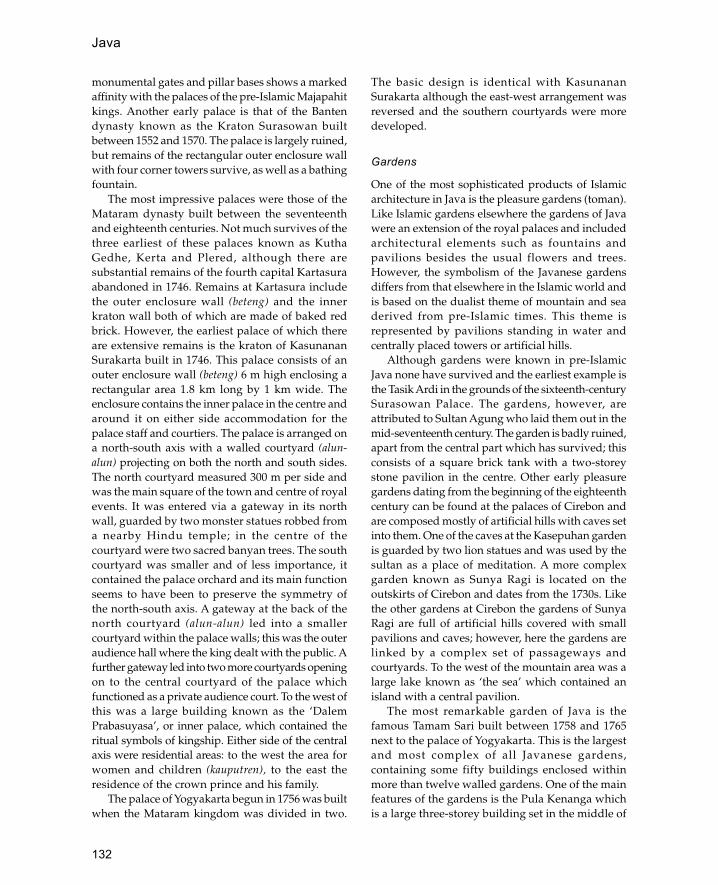
132
monumental gates and pillar bases shows a markedaffinity with the palaces of the pre-Islamic Majapahitkings. Another early palace is that of the Bantendynasty known as the Kraton Surasowan builtbetween 1552 and 1570. The palace is largely ruined,but remains of the rectangular outer enclosure wallwith four corner towers survive, as well as a bathingfountain.
The most impressive palaces were those of theMataram dynasty built between the seventeenthand eighteenth centuries. Not much survives of thethree earliest of these palaces known as KuthaGedhe, Kerta and Plered, although there aresubstantial remains of the fourth capital Kartasuraabandoned in 1746. Remains at Kartasura includethe outer enclosure wall (beteng) and the innerkraton wall both of which are made of baked redbrick. However, the earliest palace of which thereare extensive remains is the kraton of KasunananSurakarta built in 1746. This palace consists of anouter enclosure wall (beteng) 6 m high enclosing arectangular area 1.8 km long by 1 km wide. Theenclosure contains the inner palace in the centre andaround it on either side accommodation for thepalace staff and courtiers. The palace is arranged ona north-south axis with a walled courtyard (alun-alun) projecting on both the north and south sides.The north courtyard measured 300 m per side andwas the main square of the town and centre of royalevents. It was entered via a gateway in its northwall, guarded by two monster statues robbed froma nearby Hindu temple; in the centre of thecourtyard were two sacred banyan trees. The southcourtyard was smaller and of less importance, itcontained the palace orchard and its main functionseems to have been to preserve the symmetry ofthe north-south axis. A gateway at the back of thenorth courtyard (alun-alun) led into a smallercourtyard within the palace walls; this was the outeraudience hall where the king dealt with the public. Afurther gateway led into two more courtyards openingon to the central courtyard of the palace whichfunctioned as a private audience court. To the west ofthis was a large building known as the ‘DalemPrabasuyasa’, or inner palace, which contained theritual symbols of kingship. Either side of the centralaxis were residential areas: to the west the area forwomen and children (kauputren), to the east theresidence of the crown prince and his family.
The palace of Yogyakarta begun in 1756 was builtwhen the Mataram kingdom was divided in two.
The basic design is identical with KasunananSurakarta although the east-west arrangement wasreversed and the southern courtyards were moredeveloped.
Gardens
One of the most sophisticated products of Islamicarchitecture in Java is the pleasure gardens (toman).Like Islamic gardens elsewhere the gardens of Javawere an extension of the royal palaces and includedarchitectural elements such as fountains andpavilions besides the usual flowers and trees.However, the symbolism of the Javanese gardensdiffers from that elsewhere in the Islamic world andis based on the dualist theme of mountain and seaderived from pre-Islamic times. This theme isrepresented by pavilions standing in water andcentrally placed towers or artificial hills.
Although gardens were known in pre-IslamicJava none have survived and the earliest example isthe Tasik Ardi in the grounds of the sixteenth-centurySurasowan Palace. The gardens, however, areattributed to Sultan Agung who laid them out in themid-seventeenth century. The garden is badly ruined,apart from the central part which has survived; thisconsists of a square brick tank with a two-storeystone pavilion in the centre. Other early pleasuregardens dating from the beginning of the eighteenthcentury can be found at the palaces of Cirebon andare composed mostly of artificial hills with caves setinto them. One of the caves at the Kasepuhan gardenis guarded by two lion statues and was used by thesultan as a place of meditation. A more complexgarden known as Sunya Ragi is located on theoutskirts of Cirebon and dates from the 1730s. Likethe other gardens at Cirebon the gardens of SunyaRagi are full of artificial hills covered with smallpavilions and caves; however, here the gardens arelinked by a complex set of passageways andcourtyards. To the west of the mountain area was alarge lake known as ‘the sea’ which contained anisland with a central pavilion.
The most remarkable garden of Java is thefamous Tamam Sari built between 1758 and 1765next to the palace of Yogyakarta. This is the largestand most complex of all Javanese gardens,containing some fifty buildings enclosed withinmore than twelve walled gardens. One of the mainfeatures of the gardens is the Pula Kenanga whichis a large three-storey building set in the middle of
Java
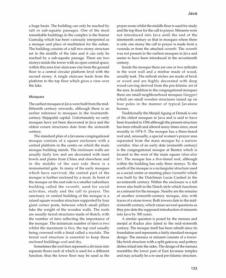
133
a huge basin. The building can only be reached byraft or sub-aquatic passages. One of the mostremarkable buildings in the complex is the SumurGumulig which has been variously interpreted asa mosque and place of meditation for the sultan.The building consists of a tall two-storey structureset in the middle of the lake and it can only bereached by a sub-aquatic passage. There are twostoreys inside the tower with an open central space;within this area four staircases rise from the groundfloor to a central circular platform level with thesecond storey. A single staircase leads from theplatform to the top floor which gives a view overthe lake.
Mosques
The earliest mosques in Java were built from the mid-fifteenth century onwards, although there is anearlier reference to mosques in the fourteenth-century Majapahit capital. Unfortunately no earlymosques have yet been discovered in Java and theoldest extant structures date from the sixteenthcentury.
The standard plan of a Javanese congregationalmosque consists of a square enclosure with acentral platform in the centre on which the mainmosque building stands. The enclosure walls areusually fairly low and are decorated with insetbowls and plates from China and elsewhere andin the middle of the east side there is amonumental gate. In many of the early mosqueswhich have survived, the central part of themosque is further enclosed by a moat. In front ofthe mosque on the east side is a smaller subsidiarybuilding called the surambi, used for socialactivities, study and the call to prayer. Thesanctuary or central building of the mosque is araised square wooden structure supported by fourgiant corner posts, between which small pillarstake the weight of the wooden walls. The roofsare usually tiered structures made of thatch, withthe number of tiers reflecting the importance ofthe mosque. The minimum number of tiers is twowhilst the maximum is five, the top roof usuallybeing crowned with a finial called a mustaka. Thetiered roof structure is essential to keep theseenclosed buildings cool and dry.
Sometimes the roof tiers represent a division intoseparate floors each of which is used for a differentfunction; thus the lower floor may be used as the
prayer room whilst the middle floor is used for studyand the top floor for the call to prayer. Minarets werenot introduced into Java until the end of thenineteenth century so that in mosques where thereis only one storey the call to prayer is made from averanda or from the attached surambi. The surambiwas not present in the earliest mosques in Java andseems to have been introduced in the seventeenthcentury.
Inside the mosque there are one or two mihrabsin the west wall and a minbar made of wood,usually teak. The mihrab niches are made of brickor wood and are highly decorated with deepwood-carving derived from the pre-Islamic art ofthe area. In addition to the congregational mosquesthere are small neighbourhood mosques (langgar)which are small wooden structures raised up onfour poles in the manner of typical Javanesehouses.
Traditionally the Mesjid Agung at Demak is oneof the oldest mosques in Java and is said to havebeen founded in 1506 although the present structurehas been rebuilt and altered many times since, mostrecently in 1974–5. The mosque has a three-tieredroof and, unusually, a special women’s prayer areaseparated from the main mosque by a narrowcorridor. Also of an early date (sixteenth century)is the congregational mosque at Banten which islocated to the west of the main square (alun-alunlor). The mosque has a five-tiered roof, althoughwithin the building has only three storeys. To thesouth of the mosque is a rectangular structure usedas a social centre or meeting place (surambi) whichwas built by the Dutchman Lucas Cardeel in theseventeenth century. Within the enclosure is a talltower also built in the Dutch style which functionsas a minaret for the mosque. Nearby are the remainsof another sixteenth-century mosque, also withtraces of a stone tower. Both towers date to the mid-sixteenth century, which raises several questions asthey pre-date the supposed introduction of minaretsinto Java by 300 years.
A similar question is posed by the menara andmesjid at Kudus also dated to the mid-sixteenthcentury. The mosque itself has been rebuilt since itsfoundation and represents a fairly standard mosquedesign. The menara or minaret consists of a tower-like brick structure with a split gateway and potterydishes inlaid into the sides. The design of the menararesembles the lower part of East Javanese templesand may actually be a re-used pre-Islamic structure.
Java

134
Jerusalem (al Quds)
However, it should be pointed out that many of theearliest mosques were built with pre-Islamicfeatures. The remains of the sixteenth-centurymosque of Sendhang Dhuwur incorporate manyHindu Indonesian features in its stone- and wood-relief carving. The winged gateways present aparticularly striking image of this style.
See also: Indonesia
Further reading:
H.M.Ambary, Historical Monuments: Cerbon, Jakarta1982.
—— ‘Laporan penelitian kepurbakalaan di Pajang (JawaTengah)’, Archipel 1983, 75–84.
T.E.Behrend, ‘Kraton, taman and mesjid: a brief surveyand bibliographic review of Islamic antiquities inJava’, Indonesia Circle 35: 29–55, Nov. 1984.
L.F.Brakel and H.Massarik, ‘A note on the PanjuanMosque in Cirebon’, Archipel 23: 119–34, 1982.
K.P.H.Brongtodiningrat, Arti Kraton Yogyakarta (trans.R.Murdani), Yogyakarta 1978.
H.D.de Graaf, ‘The origin of the Javanese mosque’,Journal of Southeast Asian History 4(i): 1–5, 1963.
D.Lombard, ‘Jardins à Java’, Arts Asiatiques 20: 135–83,1969.
—— ‘A travers le vieux Djakarta: I.La Mosquée desBalinais’, Archipel 3: 97–101, 1972.
T.G.T.Pigeaud, Java in the 14th Century: A Study inCultural History. The Nagra-Kertagama by RakawiPrapanca of Majapahit 1365 (3 edn.), 5 vols., The Hague1960–3.
G.F.Pijper, The minaret in Java’, in India Antiqua: AVolume of Studies Presented to J.P.Vogel, Leiden 1947,274–83.
M.C.Ricklefs, Jogyakarta under Sultan Mangkubumi, 1749–1792: A History of Division in Java (London OrientalSeries 30), London 1974.
U.Tjandrasasmita, Islamic Antiquities of Sendag Duwur,Jakarta 1975.
—— ‘The introduction of Islam and the growth ofMoslem coastal cities in the Indonesian Archipelago’,in Dynamics of Indonesian History, ed. H.Soebadio andM.Sarvas, Amsterdam 1978.
Jerusalem (al Quds)
Major religious city in Palestine sacred to Muslims, Jewsand Christians.
Within the Muslim faith Jerusalem is regarded as thethird holiest shrine and the second most importantplace of pilgrimage after Mecca. Muslims knowJerusalem as the city of the prophets and the placeof Muhammad’s night journey. The importance of
the site to the Jews is that it was the site of the Templebuilt by Solomon in the 10th century BCE, whilstthe Christians know it as the place where Christ wascrucified and resurrected.
The first walled town on the site dates from theMiddle Bronze Age (1800 BCE). The earliest literaryreference is also from the same period when thecity is mentioned as one of the enemies of Egypt.The next mention of the city is from the Amarnaletters in the fourteenth century BCE. The mainsource for the subsequent history of the city is theBible which describes its capture from the Jebusitesunder David, and the building of the Temple underSolomon.
In 70 CE the Romans destroyed the city inresponse to the Jewish Revolt. The site lay uninhab-ited for the next seventy-five years until theemperor Hadrian founded a new city known asAelia Capitolina. Jews were specifically excludedfrom this new city and the area of the Temple wasleft undeveloped (and remained so until the Arabconquest). The layout of the present Old City ofJerusalem is approximately the same as that of theRoman town. In 324 Palestine became part of theChristian Eastern Roman Empire (Byzantium)under Constantine who founded the Church of theHoly Sepulchre in 325–6 CE. Constantine’s mothertook an active part in promoting the building ofChristian places of worship during this period. Adepiction of the city in the Madaba Mosaic Mapshows it in the sixth century before the Muslimconquest. From 614 to 629 the city was in thepossession of the Sassanians under Chosroes II whodestroyed many Christian buildings. In 629 the citywas recaptured by the Byzantines under Heracliusonly to be conquered by the Muslim Arab armiesten years later. For the following 1,200 years (withthe exception of the Crusader occupation)Jerusalem developed as major Islamic city althoughit never developed into a great commercial oradministrative centre.
The main building material used for Jerusalemwas stone, as wood has always been fairly scarce.The main types of stone available were limestoneand Dolomite. Four types of limestone can be foundin the Jerusalem region, of which two were used forbuilding in the Islamic period, (i) Mizzi, is a hardfine-grained stone sometimes known as ‘PalestinanMarble’. This occurs in two varieties, a reddish typeknown as mizzi ahmar from near Bethlehem and ayellowish variety from Dayr Yasin 5 km east of the

135
Jerusalem (al Quds)
city, (ii) Malaki which is less hard than mizzi but isstill hard and fine grained. Outcrops were quarriedto the north of the city at Solomon’s Quarries and inthe Kidron valley.
The development of Islamic Jerusalem can bedivided into four main periods: (i) the early Islamicperiod from the Arab conquest to the first Crusade,(ii) the Crusader period, (iii) the Ayyubid andMamluk periods and (iv) the Ottoman period.
Early Islamic Period
During the early Islamic period the area of theTemple Mount (Haram) was developed for the firsttime since Hadrian’s destruction in 70 CE. The firstmosque known to have been built in Jerusalem waserected by the caliph �Umar and was described bythe Christian pilgrim Arculf as ‘a rectangular placeof prayer…roughly built by setting big beams on theremains of some ruins’. However, nothing of thisearly structure remains so that the earliest survivingstructure in the city is the Dome of the Rock built byAbd al-Malik in 691. This is a large, domed octagonalstructure built over the bare rock of the Templeplatform, below which is a cave. Related to the Domeof the Rock is the Qubbat al-Silsila which wasprobably built at the same time.
To the south of the Dome of the Rock is the AqsaMosque which may have been started under Abdal-Malik although most of the construction wascarried out under al-Walid. The mosque has beenrebuilt several times subsequently although it isbelieved that the present structure maintains thebasic layout of al-Walid’s mosque. It has recentlybeen demonstrated that the walls of the Haramwere probably rebuilt at this time and providedwith gateways, thus suggesting that the area wassystematically developed by the Umayyadsprobably as a rival to the Church of the HolySepulchre. Further evidence for this comes from theexcavations to the south of the Haram which haverevealed a large Umayyad palace located at the backof the Aqsa Mosque. This follows the patternestablished at other early Islamic cities such as Kufa,where the royal palace Dar al Imara is placed behindthe mihrab.
Although it is known that many repairs andrebuildings were carried out during the Abbasid andFatimid periods there was no major buildingprogramme similar to that carried out under theUmayyads.
Crusader Period
The capture of Jerusalem by the Crusaders markedan abrupt end to four and a half centuries of Muslimrule. The Crusader occupation completely changedthe character of the city as the Muslim inhabitantshad either been killed, fled or sold for ransom. Evenmost of the Christian inhabitants had fled and theCrusaders had problems repopulat-ing the city withEuropeans.
One of the first priorities of the Crusaders was torebuild Christian churches and monuments andconvert Islamic buildings to other uses. Thus theChurch of the Holy Sepulchre was expanded byadding a Romanesque transept to the east side ofthe Rotunda. Elsewhere in the city over sixtychurches were built or renovated, whilst mosqueswere converted into churches. The Dome of the Rockwas given to the Augustinians who made it into achurch whilst in 1104 Baldwin I made the AqsaMosque into a royal palace.
Some of the houses built during this period weresimilar to southern European town houses with twoor three storeys above a shop or store room.However, other houses were built with courtyardsin a style more familiar to the Middle East. Severalsuqs were built during this period and the main suqin the centre of the Old City was largely built duringthis period. This is a covered street with shop unitseither side and light openings in the roof.
The Crusades influenced the subsequentarchitecture of Jerusalem in several ways includingthe introduction of the folded cross vault and theuse of cushion-shaped voussoirs.
Ayyubid and Mamluk Period
In 1188 Jerusalem was recaptured by Salah al-Dinand reconverted into a Muslim city. The Haram wascleared of its Christian accretions and reconse-crated as Muslim sanctuary. The cross was removedfrom the top of the Dome of the Rock and replacedwith a golden crescent and a wooden screen wasplaced around the rock below. Also at this time thefamous wooden minbar of Salah al-Din was placednext to the new mihrab in the Aqsa Mosque.However, the major building projects of theAyyubid period date mostly to the time of Salah al-Din’s nephew al-Malik al-Mu�az-zam Isa. Duringthis period the most important project wasrebuilding the city walls. Within the Haram certain

136
Jerusalem (al Quds)
restorations were carried out and at least twomadrassas were founded, the Nahawiyya and theMu�azzamiyya. Also the porch of the Aqsa Mosquewas built during this period.
In the later Ayyubid period (first half of thethirteenth century) Jerusalem was again subjectedto invasions first by the Crusaders and later by theKhwazmian Turks so that no substantial buildingwork was carried out.
The Mamluk period lasted from 1250 to 1516and has provided Jerusalem with some of its mostbeautiful and distinctive architecture. Over sixty-four major monuments survive from this periodand testify to the city’s wealth and confidence. TheHaram in particular received a great deal ofattention from the Mamluk sultans who regardedthe patronage of building in this area as a royalprerogative. During this period the walls of theHaram were repaired and the interior of the westwall was provided with an arcaded portico.Several major buildings were built within theHaram, one of the more important of which is theAshrafiyya Madrassa built on the west side.Several attempts were made to build this structurealthough the final attempt only took two yearswith masons sent from Cairo. The most impressivepart is the open-sided porch, roofed with acomplex folded cross vault, with alternate stonespainted red to resemble ablaq.
Elsewhere within the Haram various sebils,tombs and monuments were erected. One of themost beautiful of these is the Sebil Qaitbay (builtin 1482) which consists of a small three-tieredstructure. The tallest part is the square base (about5 m high), above which is a complex zone oftransition (about 2 m), surmounted by a tall dome(about 3.5 m high). The exterior of the dome iscarved in low relief with arabesque designs andresembles the carved masonry domes ofmausoleums in Cairo, although the form of thecarving suggests local workmanship.
One of the most productive reigns was that ofSultan al-Nasir Muhammad during which time theSuq al-Qattinin was built. This is the largest Mamlukcomplex in Jerusalem and consisted of over fiftyshops with living quarters above, two bath housesand a khan.
Characteristic features of Mamluk architecture inJerusalem include ablaq masonry in a variety ofcolours (black, yellow, white and red), muqarnasused in corbels, squinches and zones of transition,
joggled voussoirs used for supporting arches,composite lintels and relieving arches.
Ottoman Period
One of the best-known buildings of Jerusalem is theDamascus Gate with its monumental bent entrance,crenellated parapet, machicolations, arrow slits andinscriptions. It forms part of the city wall erected bySuleyman the Magnificent between 1538 and 1541.This was one of the many building projects begunin Jerusalem at this time to renew the city’sinfrastructure and demonstrate that Jerusalem wasnow part of the Ottoman Empire. By the end ofSuleyman’s reign the population of Jerusalem hadgrown to three times its size at the beginning.Another project initiated during this period was thecovering of the outside of the Dome of the Rock withIznik tiles. This took a period of at least seven yearsduring which several techniques of tiling were used,including cut tilework, cuerda seca, polychromeunderglaze, and blue and white underglaze. Alsoduring this period the water system of the city wasoverhauled with repairs carried out to the Birket al-Sultan and Solomon’s pools. Within the city this wasreflected in the erection of a series of sebils (drinkingfountains).
The later Ottoman period in Jerusalem has notbeen studied in any detail although a number ofinscriptions refer to repairs and rebuilding. Duringthe nineteenth century new suburbs grew up aroundthe old city and there was increased Europeaninfluence in the architecture.
Further reading:
M.Burgoyne, The Architecture of Islamic Jerusalem,Jerusalem 1976.
M.Burgoyne and D.Richards, Mamluk Jerusalem: AnArchitectural Study, London 1987.
A.Cohen, ‘The walls of Jerusalem’, in Essays in Honour ofBernard Lewis: The Mamie World from Classical to ModernTimes, ed. C.E.Bosworth, C.Issawi, R.Savory and A.Udovitch, Princeton, N.J., 1989, 467–78.
K.Prag, Jerusalem Blue Guide, London 1989.D.Pringle, ‘Crusader architecture in Jerusalem’, Bulletin
of the Anglo-Israel Archaeological Society 10: 105–13,1990–1.
M.Rosen-Ayalon, ‘Art and architecture in AyyubidJerusalem’, Israel Exploration Journal 40(4): 305–14,1990.
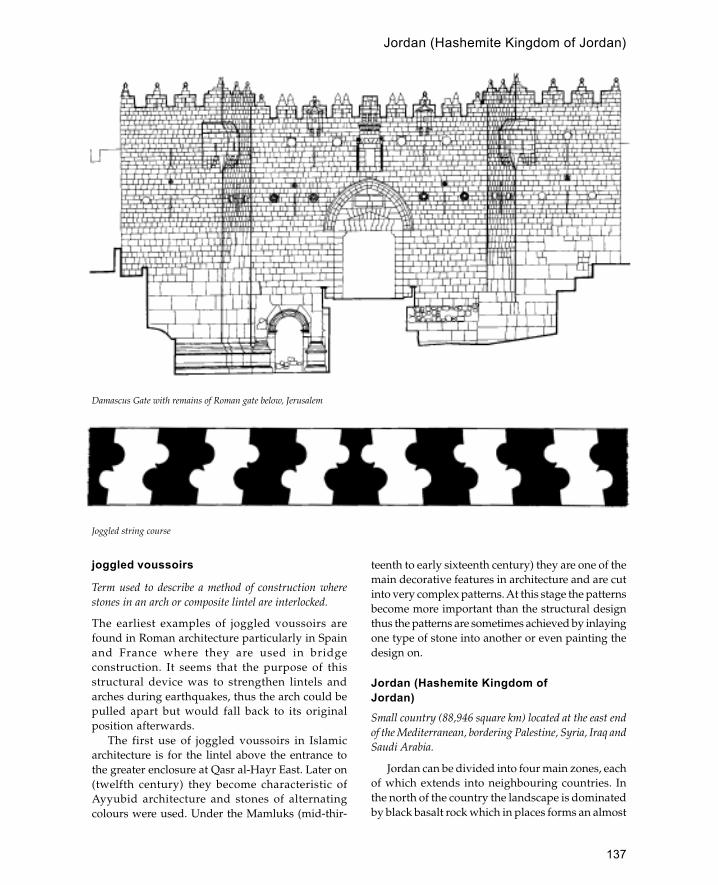
137
joggled voussoirs
Term used to describe a method of construction wherestones in an arch or composite lintel are interlocked.
The earliest examples of joggled voussoirs arefound in Roman architecture particularly in Spainand France where they are used in bridgeconstruction. It seems that the purpose of thisstructural device was to strengthen lintels andarches during earthquakes, thus the arch could bepulled apart but would fall back to its originalposition afterwards.
The first use of joggled voussoirs in Islamicarchitecture is for the lintel above the entrance tothe greater enclosure at Qasr al-Hayr East. Later on(twelfth century) they become characteristic ofAyyubid architecture and stones of alternatingcolours were used. Under the Mamluks (mid-thir-
teenth to early sixteenth century) they are one of themain decorative features in architecture and are cutinto very complex patterns. At this stage the patternsbecome more important than the structural designthus the patterns are sometimes achieved by inlayingone type of stone into another or even painting thedesign on.
Jordan (Hashemite Kingdom ofJordan)Small country (88,946 square km) located at the east endof the Mediterranean, bordering Palestine, Syria, Iraq andSaudi Arabia.
Jordan can be divided into four main zones, eachof which extends into neighbouring countries. Inthe north of the country the landscape is dominatedby black basalt rock which in places forms an almost
Damascus Gate with remains of Roman gate below, Jerusalem
Joggled string course
Jordan (Hashemite Kingdom of Jordan)
138
Jordan (Hashemite Kingdom of Jordan)
impenetrable barrier to travel. The oasis of Azraq islocated on the southern edge of this region andfunctions as a station for eastbound traffic to Iraq.The western edge of the country lies within theJordan valley where it borders Palestine; this area isknown locally as the Ghor and includes both the areaof the Dead Sea and the east side of the wadi Arabah.The highland area to the east of the Dead Sea andthe Jordan river is the most densely populated areaof the country and includes the main cities ofAmman, Irbid and Zerka. To the south and east ofthis region is the desert known as the Badiyya; thisincludes a variety of landscapes ranging from drysteppe in the north to large expanses of sandy desertin the south around Wadi Rum.
Jordan was not a fully independent state until1946; before this period it formed part of variousempires, kingdoms and lordships. Nevertheless,Jordan has one of the longest and richestarchaeological sequences in the Middle East, whichis reflected in architecture such as the 9,000-year-old Neolithic houses of Beidha. Probably the best-known architecture of Jordan is that of the Nabateancity of Petra which dates mostly from the periodbetween the first century BCE and the third centuryCE. Here a series of magnificent façades are carvedinto the rose-coloured rock reflecting the wealth andconnections of the Nabatean kingdom. Furthernorth a series of cities known as the Decapolis(including Jerash, Umm Qeis, Umm al-Jemal, Pellaand Amman) testify to the prosperity of this areaduring the Classical and Byzantine period. Duringthe Byzantine period numerous churches withmosaics were built, the most famous of which isone at Madaba which includes a mosaic map ofPalestine.
In 631 the first Arab armies invaded theprosperous lands of the Byzantine Empire. After aninitial defeat at Mu �tah the Arabs eventuallytriumphed over the Byzantines at the battle ofYarmouk near the city of Pella. During the next 120years Jordan was enriched with some of the finestexamples of early Islamic architecture foundanywhere, including the painted bath house ofQusayr Amra and the palace of Mshatta. Subsequentperiods in the history of Jordan are not so wellknown, with the exception of the Crusader period,when magnificent strongholds were built by bothArabs and Crusaders.
The main building materials in Jordan are basaltin the north, limestone and sandstone in the central
highlands and mud brick in the Jordan valley and inareas of the desert. Occasionally in the early Islamicperiod baked brick was employed for vaulting,although this was not repeated in the later periods.The best examples of basalt construction can be seenat Umm al-Jemal where a system of corbelssupporting basalt beams was employed. Limestonewas used in some of the finer architecture of Romanand early Islamic Jordan because it can be dressedto a fine finish. Mud brick does not survive well, butrepresentative examples of mud-brick architecturecan be seen in the oasis town of Ma�an.
Umayyad architecture in Jordan contains amixture of eastern and western influences with theresult that the surviving buildings represent a varietyof different architectural types some of which werenever repeated (i.e. the use of baked brick and stoneat Mshatta and Tuba). Generally buildings from thisperiod may be grouped into three categories: (i) thosewhich are purely developments of Roman Byzantinearchitecture, (ii) those which are heavily influencedby Persian (Sassanian) architectural concepts and (iii)buildings which combine both eastern and westerntraditions.
Roman-Byzantine Influence
Probably the most famous Islamic building inJordan is the bath house of Qusayr Amra located inthe desert approximately 60 km west of Amman.The building stands alone apart from a small fortor caravanserai several kilometres to the north.Inside the building the walls and ceilings aredecorated with a remarkable series of frescoes,including depictions of bathing women, a series ofroyal portraits, a hunting scene and the zodiac.Although the choice of pictures is certainlyUmayyad the style of painting and the design ofthe bath house is purely Byzantine.
Some of the best-known Umayyad castles arere-used Roman forts or fortresses, whilst others arebuilt in the style of Roman forts with moreluxurious fittings. Qasr Hallabat is a square Romanfort 44 m per side with square corner towers. It wasoriginally built in the second century CE to protectthe Via Nova Traiana and later expanded in 212–215 CE and restored in 529. Careful excavation andanalysis of the fort show that it was subsequentlychanged into an Umayyad residence with mosaics,painted plaster (frescoes), carved and painted woodand finely carved stucco with geometric, floral and

139
Jordan (Hashemite Kingdom of Jordan)
animal motifs. To the east of the castle is a tallrectangular mosque with three entrances and amihrab in the south wall; this building was alsodecorated with stucco work. Outside the forts,remains of an Umayyad agricultural settlementhave been found including small houses.Approximately 3 km to the south of Hallabat is abath house also of the Umayyad period whichprobably served Qasr Hallabat. The bath house issimilar to that of Qasayr Amra and was decoratedwith painted plasterwork and stucco. Whilst theparticular combination of structures and theirdesign is characteristic of the Umayyad period (afort converted to palace, bath house and mosque),the individual elements and building style atHallabat are all Byzantine.
A similar structure to Hallabat is the Umayyadcomplex at Qastal (25 km south of Amman) whichuntil recently was thought to have been built as aRoman or Byzantine fort. However, recent researchhas shown that all the main structures date fromthe Umayyad period. The main structure are a fort-like palace, a mosque, a bath house, reservoir, dams,cisterns, a cemetery and domestic houses. Thecentral palace complex consists of a square fort-likebuilding (about 68 m per side) with four roundcorner towers and intermediate semi-circularbuttress towers. The decoration within the palaceis similar to that found at Hallabat and includesmosaics, stucco work and carved stonework.Internally the building consists of a centralcourtyard opening on to six buyut (pl. of bayt) or
houses. Probably the most impressive feature of thebuilding was the large triple-apsed audience hall,located directly above the entrance.
Sassanian Influence (‘Eastern’)
Structures representing strong Sassanian or easterninfluences are less numerous although perhapsmore striking because of their obviously foreignderivation. Perhaps the best-known building of thistype is Qasr Kharana (located 50 km east of Ammanon the present Baghdad-Amman high-way).Kharana consists of a two-storey square-planstructure, 35 m per side, with small projectingcorner towers and a projecting rounded entrance.The building is remarkable for its superb state ofpreservation, which includes in situ plasterwork onthe upper floor. The building is made out of roughlyshaped blocks set in a mud-based mortar withdecorative courses of flat stones placed in bandsrunning around the outside of the building. Thereare also small slits set within the wall which wereprobably for ventilation (their size and positioningmeans that they could not have been used as arrowslits). Internally the building is decorated withpilasters, blind niches and medallions finished inplaster. The whole appearance of the building is sodifferent from other Umayyad structures in Jordanthat scholars have tried to attribute it to the periodof Sassanian occupation of the area despite aneighth-century inscription. The best parallels forKharana are to be found in early Islamic buildingsin Iraq such as Khan �Atshan (similar size anddecoration) and Qasr Khubbaz which is built usingthe same materials (i.e. rough stone blocks set inmud mortar).
Another building erroneously attributed to theSassanian period is the palace on the citadel inAmman. Like Kharana the Amman citadel buildingexhibits unmistakable eastern influence in itsarchitecture and layout. The best preserved part ofthe palace is the building known as the kiosk. This isconstructed on a four-iwan plan and decorated withblind niches lined with plaster, a common feature ofSassanian and Umayyad architecture in Iraq (e.g.Ctesiphon and Ukhaidhir). The layout of the palacewas huge with at least twelve courtyards arrangedon a linear plan. At the opposite end of the complexfrom the kiosk was a large iwan leading to acruciform-plan audience hall. All of these featuresare reminiscent of Mesopotamian palace arcitecture,Interior of Qasr Kharana, Jordan

140
Jordan (Hashemite Kingdom of Jordan)
where palaces are like small cities, containing bothadministrative and residential areas.
East-West Influence
Two buildings dated to the later Umayyad period(probably the reign of Walid II 743–4) represent acombination of eastern and western influences. Themost obvious demonstration of these mixedinfluences is the use of baked brick for vaults andwalls and dressed stone masonry for foundationsand architectural details. The most famous of thesebuildings is Qasr Mshatta located 25 km to the southof Amman. This consists of a large square enclosurewith four semi-circular buttress towers. The best-known feature of this palace is the southern façadewhich consists of a delicately carved stone friezeincorporating animals and plant motifs within ageometric scheme of giant triangles. Internally thebuilding is divided into three longitudinal strips;only the central strip (running north-south) wasdeveloped and contains within it the entrance, thecentral courtyard and the audience hall. Theaudience hall consists of a triple-apsed roomcovered by a large brick dome. The layout of thepalace immediately recalls that of the Abbasidpalaces of Iraq such as Ukhaidhir and has led somescholars to suggest an Abbasid date for thestructure. Byzantine elements are also present,however, most notably in the basilical arrangementof the approach to the triple-apsed room and in themotifs of the stonework
Although Qasr al-Tuba is in many respects similarto Mshatta it is much simpler in its decoration and isgenerally thought to be closer to a caravanserai thana palace. Qasr al-Tuba is the largest of the desertcastles and consists of two identical halves, thesouthern half of which appears never to have beenbuilt. Stacks of bricks on the floor testify to theunfinished nature of the building, although it ispossible that some of the structure was originallybuilt out of mud brick. Originally there were somefine carved stone lintels at Tuba but these have nowdisappeared.
Medieval Period
Standing remains of the Abbasid and Fatimid periodin Jordan are rare and architectural remains aremostly limited to archaeological excavations. Thereasons for this are complex and related to the fall of
the Umayyads and Jordan’s peripheral position inrelation to the Abbasid and Fatimid caliphates. Theonly place where significant architectural remainsfrom this period have been uncovered are at Aqabaon Jordan’s Red Sea coast. This town seems to havereached its peak of prosperity during the Abbasidand Fatimid periods, when it was a trading port incontact with Iraq, Yemen, Egypt and China.Excavations at the site have revealed a walled town(160 by 120 m approximately) with rounded buttresstowers and four gateways providing access to thetwo main streets. Sometime during the Fatimidperiod mud brick replaced cut stone as the buildingmaterial for many of the houses.
The Ayyubid and Mamluk periods are markedby the intrusion of the Crusaders who built castlesat Karak, Shawbak and Petra to control movementbetween Egypt and Syria. As a result of the Crusaderpresence most of the well-known buildings from thisperiod are castles and forts. Examples of Islamic fortscan be seen at Azraq, Ajlun, Jise and Qasr Shebib(the Crusader castles at Karak and Shawbak werealso remodelled during this period). The bestexample of medieval fortification can be seen atQal�at Rabad (Ajlun) built in 1184–5. This consists ofseveral thick walled towers with V-shaped arrowslits linked by curtain walls. The masonry of thecastle consists of large blocks similar to those usedby the Crusaders at Karak and Shawbak.
In addition to the large castles several smallerforts survive from the medieval period. These wereeither built to protect the road system or as signalposts. Probably the most important route in Jordan
Mamluk mosque at Pella, Jordan (after Bishe)
141
Jordan (Hashemite Kingdom of Jordan)
was the pilgrimage route from Damascus to Mecca;several forts on this route have survived, notablythe forts at Jise and Qasr Shebib in Zerka. Related tothese forts is the Mamluk fortified khan at Aqaba.This is a rectangular structure with circular cornertowers and a deep protected entrance. The form ofthe arch above the entrance recalls the architectureof Mamluk Egypt with its ablaq masonry andhorseshoe arch.
Later Islamic Architecture
The best-known examples of early Ottomanarchitecture in Jordan are the Hajj forts which werebuilt to protect the pilgrimage route from Damascusto Mecca. The earliest of the these forts were built inthe sixteenth century during the reign of Suleymanthe Magnificent. These were small square structureswith large decorated arrow slits, projectingmachicolations and large crenellated parapets. In thelate eighteenth century the fort network wasexpanded to counter increased bedouin raids. Fortsof this period are more functional and have smallgun slits instead of large arrow slits, with projectingcorner towers to increase the field of fire.
Other early Ottoman buildings in Jordan aredifficult to date so precisely, although the fortifiedfarmsteads at Yadudeh and Udruh probably bothdate from the eighteenth century.
The best examples of nineteenth-centuryarchitecture in Jordan can be seen at al-Salt west ofAmman and at Umm Qeis north of Irbid. Thearchitecture of both towns shows strong Palestinian
influence. Salt in particular shares many featureswith Nablus. Amman, however, differs from theother cities in north Jordan as it was settled byCircassian refugees. Characteristic features ofCircassian houses are the use of wood, theintroduction of chimneys and small rooms.
Several mosques of the medieval period areknown in Jordan, the finest of which was the twelfth-century structure at Mazar, near Mut’ah (this has nowbeen destroyed). Mamluk mosques can also be seenat Pella and in the fort at Azraq; these are rectangularstructures with flat roofs resting on arches supportedby columns.
Further reading:
G.L.Harding, The Antiquities of Jordan, London 1967.S.Helms, with A.V.G.Betts, W. and F.Lancaster and
C.J.Lenzen, Early Islamic Architecture of the Desert: ABedouin Station in Eastern Jordan, Edinburgh 1990.
A.Khammash, Notes on the Village Architecture of Jordan,Louisiana 1986.
R.G.Khoury, Pella: A Brief Guide to the Antiquities, Ammanand Sydney 1988.
—— Amman: A Brief Guide to the Antiquities, Amman 1988.—— The Desert Castles: A Brief Guide to the Antiquities,
Amman 1988.—— Petra: A Brief Guide to the Antiquities, Amman 1988.A.McQuitty, ‘An architectural study of the Irbid region
with particular reference to a building in Irbid’, Levant21: 119–28, 1989.
A.D.Petersen, ‘Early Ottoman forts on the Darb al-Hajj’,Levant 21: 97–117, 1989.
—— Two medieval forts on the medieval Hajj route inJordan’, Annual of the Department of Antiquities of Jordan35: 347–89, 1991.

142
Ka�����ba
Most sacred building of Islam located in the centre of theHoly Mosque in Mecca.
In its present form the Ka�ba consists of a tall,rectangular, box-like structure 15 m high with sidesmeasuring 10.5 m by 12 m. The building is oriented30 degrees off the north-south axis so that the cornersface the cardinal points. The flat roof has a gentle
slope towards the north-west where there is a waterspout (mizab al-rahman, or spout of mercy). TheBlack Stone (possibly derived from a meteorite) isbuilt into the eastern corner of the structure. Alsoat the east corner is another stone known as Hajaras’ad (the lucky stone) which is touched during thecircumambulation. Outside the north-west sidethere is a low semi-circular wall which encloses anarea known as the Hijr which is believed to markthe burial place of Ismail and his mother Hajar. TheKa�ba is built of large blue-grey granite blocks setin mortar resting on a base of marble. The entranceis on the north-east side and is 2 m above groundlevel (it is reached by a portable set of woodensteps). Inside the Ka�ba there are three tall woodenpillars which support the wooden roof which canbe reached by a wooden ladder. The floor is madeof marble and the ceiling is covered with clothhangings.
According to Muslim tradition the Ka�ba wasbuilt by Ibrahim and Ismail and was the firstsanctuary established on earth. This early buildingwas simply a rectangular unroofed enclosure theheight of a man. Idols were housed within the Ka�ba,the most prominent of whom were al-Lat, al-Uzzaand al-Manat. Three hundred and sixty idols werearranged in a circle outside the Ka�ba forming asacred area (Haram) where no blood could be shed.In the time of Muhammad the old Ka�ba was burntdown and it was rebuilt with the help of a mancalled Baqum. This new Ka�ba was built of alternatelayers of stone and wood, possibly in a similarfashion to traditional Meccan houses. The heightof the building was doubled and it was coveredwith a roof. The entrance to the building was somedistance from the ground and a ladder was neededto enter it. Muhammad is said to have placed theBlack Stone in its position with the help of the maintribal leaders.
In 629 after a period of exile Muhammadconquered Mecca but left the form of the Ka�baunaltered (except for the removal of idols). In 683
K
Ka�ba in the eleventh century (after Jairazbhoy)

143
during the conflict between Abd Allah Ibn Zubayrand the Umayyads the Ka�ba was destroyed bystones hurled by catapults. After the Umayyadswithdrew the Ka�ba was rebuilt on a larger scale withtwo doors. This Ka�ba was subsequently destroyedby the Umayyad general Hajjaj bin Yusuf who rebuiltit in its previous form with only one door. This isessentially the form of the present Ka�ba althoughthe Black Stone was removed for a period of twentyyears by the Qarmathians in 929. Flood damage in1611 necessi-tated its rebuilding in 1630, althoughthe old form of the building was retained. Acontinuous feature of the Ka�ba’s history, at least fromMuhammad’s time, is that the outside of thestructure is covered with a huge cloth of fabric(kiswa) which is replaced annually. During the firstyears of Islam the old covers were not removed andnew covers were placed on top. This practice wasstopped in the Umayyad period as the weight ofcloths was thought to threaten the stability of theKa�ba.
See also: Mecca
Further reading:
H.A.A.Ba Salama, Tarikh al-kab�a al mu�azzama, 2ndprinting, Jeddah 1982.
R.A.Jairazbhoy, ‘The architecture of the Holy Shrine inMakkah’, in Hajj in Focus, ed. Z.I.Khan and Y.Zaki,London 1986.
V.Strika, ‘A Ka’bah picture in the Iraq Museum’, Sumer32: 195–201, 1976
A.J.Wensinck and J.Jomier, ‘Ka�ba’, in Encyclopedia ofIslam, new edn . 4: 317–22, 1978.
KanoMajor Islamic city in the Hausa region, northern Nigeria.
Kano is the most famous of a group of citiesincluding Zaria, Katsina, Gobir, Daura, Biram andRano which trace their origins back to the eleventhcentury. At this time Kano was probably pagan,although Muslim traders may have been living there.During the fourteenth century the city was at leastsuperficially Muslim but it was not until the end ofthe fifteenth century that Kano was firmlyestablished as an Islamic town. The Kano Chroniclerecords how an Egyptian, Cabd al-Rahman, came toKano to confirm Islam in the town and build a Fridaymosque with a minaret there. During the eighteenthcentury there was a large migration of people to Kanofrom the city of Agades in present-day Mali. This
influx had a great effect on the culture andarchitecture of Kano making it into a centre ofscholarship and trade.
The city is surrounded by mud-brick wallswhich at their maximum extent enclose an areamore than 15 km in circumference. The area withinthe walls includes not only the city itself butagricultural and grazing land as well. The city wallis pierced by several monumental gateways,including the massive triple-arched Nasarawa Gate.Inside the city are narrow streets leading on tohouses which consist of square or irregular-shapedcompounds. A typical compound (or gida) isentered via a circular entrance vestibule that leadsinto an outer courtyard which may contain huts forunmar-ried sons and a reception room. At the backof the rectangular reception room is a door leadingto the inner courtyard which contains the owner’shouse, huts for his wives, granaries, a well and abathroom. The best houses are located within thefifteenth-century palace compound of the emirknown as the Gidan Rumfa which is a large area ofover 30 acres. This compound is entered via anancient gatehouse known as the Kofar Kwaruwhich, with an internal height of 9 m, is the highestinternal space in Kano. Within the com-pound aregrazing land for the royal cattle, houses of retainersand public reception rooms, as well as theapartments of the ruler himself. Since the earlytwentieth century the internal layout of the palacehas changed with circular entrance vestibules(zaure) replaced with rectangular rooms (thisreflects a wider development in Hausa architecturewhere rectangular buildings are replacing roundconstructions). The most elaborately decorated partof the palace is the royal audience chamber whichconsists of rectangular rooms covered with domedroofs supported on intersecting arches. Both thesoffits of the arches and the ceiling panels inbetween are decorated with brightly paintedmoulded abstract designs.
The famous Great Mosque of Kano (nowdestroyed) may be the mosque erected by Cabd al-Rahman in the fifteenth century although little ofthe structure remains to confirm this. One of thebetter known mosques of the town is the YangoroMosque built by the famous master-mason BalaGwani. The mosque is divided into a series of smallrectangular domed bays (2.75 by 3.35 m) resting ontwo-tier arches.
Kano
144
See also: Fulbe, Hausa, West Africa
Further reading:
D.Heathecote, ‘The Princess’s apartments in Kano OldTreasury’, Savanna 2(1), 1973.
A.Leary, ‘A decorated palace in Kano’, Art and ArchaeologyResearch Papers 12: 1–17, 1977.
H.Palmer, ‘The Kano Chronicle’, in Sudanese Memoirs, vol.3, 1928.
kapilica
Turkish term for a specialized form of bath house,or hammam, where the building is provided withhot water from a thermal spring. Kapilicas usuallyhave swimming pools unlike the usual Ottoman bathhouse.
Karaman (Laranda)
City in Konya region of Anatolia noted for its medievalarchitecture.
In 1071 the Byzantine city of Laranda fell to the Seljuksand remained under Muslim control until the presentday, except for a brief period when it was controlledby the German emperor Frederick Barbarossa. In 1256the city became the capital of the Karaman Oghuluwho established many fine buildings in the city. In1300 the name of the city was changed to Karamanalthough by 1321 the capital was moved to Konya. In1397 the city was briefly occupied by the Ottomansbut managed to regain its independence after 1402until it was finally incorporated into the OttomanEmpire in 1415.
Undoubtedly the most famous building inKaraman is the Hatuniye Madrassa built in 1381–2by Sultan Khatun, the wife of the Karamanid �Alaal-Din Beg. The building has a projecting entranceportal carved in high relief and flanked by two smalldomed rooms. The coloured marble doorway isrecessed within the portal frame and covered by atall muqarnas hood in the Seljuk tradition. Insidethere is a rectangular courtyard with a vaulteddershane and three cells on each side with an iwanflanked by two domed rooms opposite the entrance.The entrance to the domed rooms flanking the iwanare richly carved with vegetal, epigraphic andabstract motifs. Originally the interior of themadrassa was covered in hexagonal dark turquoise-green tiles although most of these havedisappeared.
Other important monuments in the city includethe khanqah of Sheikh �Ala al-Din built in 1460 theimaret of Ibrahim Beg and the turbe of �Ala al-Din.The citadel and city walls of Karaman seem to havebeen destroyed in the fifteenth century and thepresent fortifications were probably erected in thesixteenth. The present Great Mosque has beenradically restored and also seems to date from thelate sixteenth century.
See also: Kenya, Ottomans, Seljuks, Turkey
Further reading:
J.M.Rogers, ‘Laranda [Karaman] 2. Monuments’, inEncyclopedia of Islam, 5: 678–82, 1954.
KashmirIsolated region of northern India famous for its woodenarchitecture.
Islam arrived in Kashmir in the mid-fourteenthcentury although it did not really become a majorforce until the Mughal conquest of the late sixteenthcentury. Wood is the standard building material withdeodar (a relation of cedar) being the preferredmaterial for monumental structures. The traditionalmosque form consists of a square or rectangulartimber hall covered with a pyramid-shaped roof witha pointed spire or finial. The walls are built of logslaid horizontally and intersecting at the corners.Often there was a small gallery or pavilion belowthe spire which could be used by the muezzin forthe call to prayer. This form was also used for saints’shrines which locally are known as ziarat. After theMughal conquest extensive royal gardens were builtaround Lake Dal; these were equipped with greylimestone pavilions built in the form of woodenKashmiri mosques.
See also: India, Mughals
Further reading:
W.H.Nichols, ‘Muhammadan architecture in Kashmir’,Archaeological Survey of India Annual Report, 1906–7: 161–70.
KenyaCountry in East Africa with a significant Muslimpopulation on the coast.
The coastal population of Kenya are part of theSwahili people who occupy the coast from Somaliato Mozambique. The origins of the Swahili culture
kapilica

145
are problematic although it has recently been shownthat the Swahili are an indigenous people whoconverted to Islam rather than Arab colonists. Mostof the settlements have their basis in the IndianOcean trade to Arabia, India and the Far East andare consequently located next to the sea. There was,however, a strong local economy with connectionsto the interior which has not yet been investigatedin any great detail. For example the walled city ofGedi is 6 km inland and presumably had somecontact with inland tribes. It is known, too, thatKenya’s fertile coast was attractive to nomadicherders and tribesmen from the north, whoperiodically raided and migrated southwards intoKenya causing large-scale desertion of mainland siteson the northern coast. The most famous of thesenomadic groups were the Galla who raided as farsouth as Mombasa in the sixteenth and seventeenthcenturies.
The Kenya coast contains the remains of manysettlements dating from the eighth to the nineteenthcentury. The remains can be divided into twogeographical groups—a northern group basedaround the Lamu archipelago, and a southern groupbetween Gedi and Mombasa. Between these twoareas there are few remains of earlier settlement,probably because there are no useful creeks oranchorages.
The Lamu archipelago is a complex series ofislands and creeks which probably represents theremains of the Tana river delta before it movedfurther south. This heavily indented coastlineprovided an ideal area for coastal settlement andsome of the earliest remains of Islamic trading siteshave been found here. The main islands in thisgroup are Pate, Manda and Lamu. Pate is the largestisland of the group and contains the walled city ofPate which under the Nabhani kings ruled a largearea of the coast during the seventeenth century.Other important sites on Pate are Faza, Siu, Tundwaand Shanga. The ruins at Shanga are mostlyfourteenth century, but excavations have revealeda dense continuity of occupation which stretchesback to the eighth century and includes the earliestremains of a mosque in sub-Saharan Africa. Thenearby island of Manda also contains an early site(known as Manda) which is dated to the ninthcentury and is one of the only sites on the coast touse baked brick for construction. As well as theimportant early site of Manda, the island alsocontains the ruins of Takwa and Kitao. The island
of Lamu contains the settlements of Lamu andShella which have in recent times domi-nated thisarea of the coast. To the north there are a few siteson the mainland like Ishikani, Omwe, Mwana,Dondo and Kiunga noted for their monumentaltombs. On the mainland to the south, at the mouthof the Tana river, are the sites of Mwana, Shaka andUngwana. The site of Ungwana is famous for itscongregational mosque with two parallel prayerhalls which was built in several phases between thefifteenth and sixteenth centuries. The early mosquewas built in the fifteenth and later in the samecentury a second prayer hall with three rows ofpiers and a domed portico was added.
The southern group of settlements are locatedsouth of the Sabaki river and are mostly mainlandsites based around creeks. Immediately to the southof the Sabaki river is the town of Malindi which,although largely modern, is built over the remainsof one of the main towns on the coast that flourishedin the sixteenth century under Portugueseprotection. Nearby is the walled city of Gedi wherethe Sheikh of Malindi had his residence during thefifteenth and sixteenth centuries. To the south ofGedi are the three ruined settlements of Kilifi,Mnaarani and Kitoka which collectively formed thecity-state of Kilifi during the sixteenth century.Several other ancient settlements can be found nextto creeks further south towards Mombasa. One ofthe best-known sites is Jumba La Mtwana datingmostly from the fourteenth century. Mombasa itselfwas an important early settlement with its deepwater anchorage at Kilindi although little remainsof the early settlement with the exception of a smallmosque in the harbour. Mombasa island isdominated by Fort Jesus built by the Portuguese astheir base on the coast and later captured andremodelled by the Omanis. One of the mostintriguing monuments in Mombasa is the MbraakiPillar which has been dated to the eighteenthcentury. The pillar is a hollow cylindrical structureresembling a minaret, an idea which is reinforcedby its position next to a small mosque. However,the pillar has no internal staircase and minarets areunknown in the area before the nineteenth centuryimplying some other function. South of Mombasatowards the Tanzania border there are few earlysites although there are ruined early mosques atTiwi and Diani.
In addition to the pre-colonial Islamic architectureKenya also contains Muslim buildings dating from
Kenya
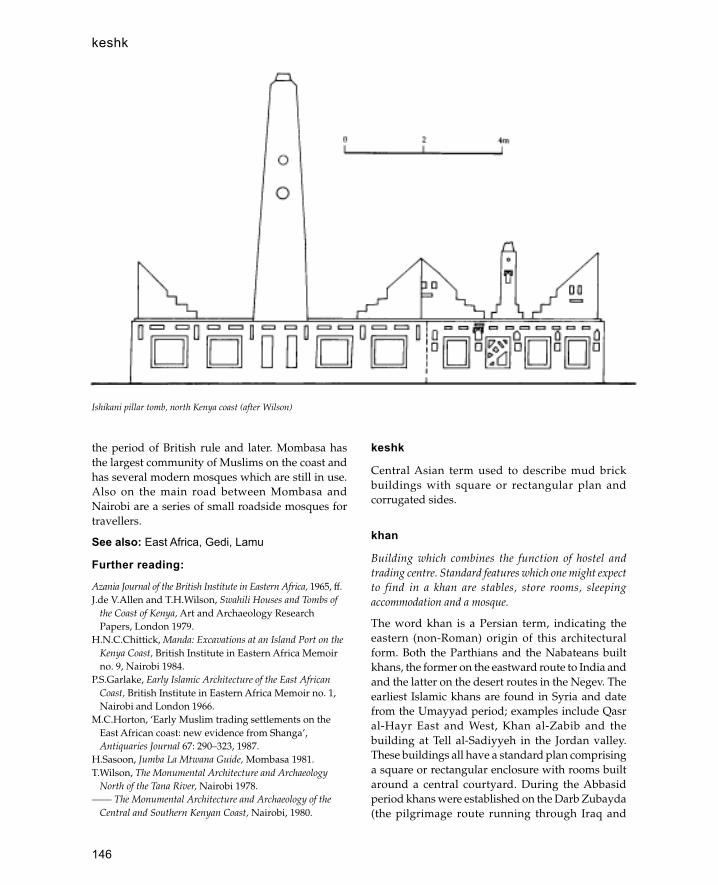
146
the period of British rule and later. Mombasa hasthe largest community of Muslims on the coast andhas several modern mosques which are still in use.Also on the main road between Mombasa andNairobi are a series of small roadside mosques fortravellers.
See also: East Africa, Gedi, Lamu
Further reading:
Azania Journal of the British Institute in Eastern Africa, 1965, ff.J.de V.Allen and T.H.Wilson, Swahili Houses and Tombs of
the Coast of Kenya, Art and Archaeology ResearchPapers, London 1979.
H.N.C.Chittick, Manda: Excavations at an Island Port on theKenya Coast, British Institute in Eastern Africa Memoirno. 9, Nairobi 1984.
P.S.Garlake, Early Islamic Architecture of the East AfricanCoast, British Institute in Eastern Africa Memoir no. 1,Nairobi and London 1966.
M.C.Horton, ‘Early Muslim trading settlements on theEast African coast: new evidence from Shanga’,Antiquaries Journal 67: 290–323, 1987.
H.Sasoon, Jumba La Mtwana Guide, Mombasa 1981.T.Wilson, The Monumental Architecture and Archaeology
North of the Tana River, Nairobi 1978.—— The Monumental Architecture and Archaeology of the
Central and Southern Kenyan Coast, Nairobi, 1980.
keshk
Central Asian term used to describe mud brickbuildings with square or rectangular plan andcorrugated sides.
khan
Building which combines the function of hostel andtrading centre. Standard features which one might expectto find in a khan are stables, store rooms, sleepingaccommodation and a mosque.
The word khan is a Persian term, indicating theeastern (non-Roman) origin of this architecturalform. Both the Parthians and the Nabateans builtkhans, the former on the eastward route to India andand the latter on the desert routes in the Negev. Theearliest Islamic khans are found in Syria and datefrom the Umayyad period; examples include Qasral-Hayr East and West, Khan al-Zabib and thebuilding at Tell al-Sadiyyeh in the Jordan valley.These buildings all have a standard plan comprisinga square or rectangular enclosure with rooms builtaround a central courtyard. During the Abbasidperiod khans were established on the Darb Zubayda(the pilgrimage route running through Iraq and
Ishikani pillar tomb, north Kenya coast (after Wilson)
keshk

147
central Arabia), although the commercial importanceof these installations is not known. From the twelfthcentury onwards khans became a standard featureof Islamic architecture and were particularly popularunder the Seljuks. During this period khans beganto be established in towns where they would becomecentres for trade. Also at this time the caravanseraiis established as a more specialized form of khancatering specifically for caravans.
During the sixteenth century Ottoman khansdeveloped a variety of forms where the centralcourtyard is enclosed; some of the best examples arein Damascus and Aleppo. Also at this time khansbecome part of larger complexes that included amosque, fort and bath house, as at the village of Payasnear Iskenderun in Turkey.
khanqah
A monastery or hostel for sufis or dervishes.
Kharana
Early Islamic or Sassanian building in the Jordanian desert60 km east of Amman.
Kharana is a remarkably preserved square two-storey structure with solid semi-circular andcircular buttress towers. The building is made outof roughly hewn stone blocks laid in coursescovered with successive layers of plaster. There arethree rows of vertical slits in the walls which havebeen interpreted as arrow slits, although theirheight above the inside floor level makes thisunlikely. The gateway is set between two quarter-round towers which lead into an entrance passageflanked with two long vaulted rooms thatfunctioned as stables. Inside the building is a squarecourtyard with a series of undecorated rooms (forstorage?) whilst on the upper floor the rooms aredecorated with plaster/stucco designs similar tothose at Ukhaidhir in Iraq. These include engagedpilasters, blind niches and decorative bosses. Twoof the upper rooms have semi-domes resting onwide squinches at the end.
Although it was built before 710 (according to aninscription) and is Sassanian in style, the building isnow generally believed to be early Islamic.
Further reading:S.Urice, Qasr Kharana in the Transjordan, Durham, NC:
AASDR , 1987.
khatta
An Arabic term meaning marked out (from khatt aline). This term was used by historians of the earlyIslamic period to describe the process of marking outnew settlements or camps (amsar) such as Basra, Kufaand Fustat. The word also conveys a sense of claimingpossession of a piece of land by marking out.
Further reading:
J.Akbar, ‘Khatta and the territorial structure of earlyMuslim towns’, Muqarnas 6: 22–32, 1989.
Khirbet al-Mafjar (Qasr Hisham)
Umayyad palace located in the Jordan valley near theancient city of Jericho.
The palace at Khirbet al-Mafjar is a large complexcomprising three main architectural elements: themosque, the palace, and the bath house or audiencehall. These are all set within a large enclosure enteredby a main gateway in the outer enclosure wall. Thisgateway projects outwards from the enclosure wall andis set between two quarter-circular solid buttresstowers. The gateway leads into a long rectangularcourtyard which runs the whole length of the westernside of the palace. In the centre of the courtyard is a
Merlon at Khirbet al-Mafjar
Khirbet al-Mafjar (Qasr Hisham)

148
square pool or fountain whilst towards the south endof the west wall there is another gateway leadinginto the central palace complex. This consists of aroughly square enclosure with solid round cornertowers and semi-circular buttress towers in themiddle of the south, west and north walls. In thecentre of this palace area is a square colonnadedcourtyard with access to the ground-floor rooms. Thenorth range consists of one large rectangular roomdivided into fourteen bays (two bays wide and sevenlong). The south range consists of five long roomsoriented north—south; in the south wall of thecentral room is a large concave niche which may havefunctioned as a mihrab. Approximately in the middleof the west colonnade is a staircase descending intoa small serdab, or cellar.
In the north-west corner of the central palace is astaircase leading to a gateway which gives access to arectangular courtyard connecting the palace to thebath house or audience hall. In the west wall there isa small opening to the outside, whilst on the east side
there is a mosque. The mosque is a fairly simplerectangular structure aligned north-south and enteredvia a rectangular entrance vestibule on the north side.The sanctuary at the south end is three aisles wideand two bays deep with a concave mihrab niche inthe centre of the south wall. In addition there is anotherentrance to the mosque via a staircase leading downfrom the upper floor of the palace to a position in thesouth wall of the mosque next to the mihrab.
Probably the most famous part of the palace isthe audience hall or bath house which stands at thenorth-west corner of the complex. This was a highlysophisticated building consisting of a nine-domedhall supported on sixteen piers and flanked on allfour sides by barrel-vaulted exhedrae terminatingin semi-circular apses. At the south end of the hall isa pool three aisles wide and filling the three southernapses. In the centre of the east wall is a monumentaldoorway which leads from a small courtyard in frontof the mosque. Directly opposite this doorway in thecentre of the west wall is the principal apse
Stone decoration of Khirbet al-Mafjar, near Jericho
Khirbet al-Mafjar (Qasr Hisham)

149
distinguished by a huge stone chain which hungdown from the arch above. At the end of the chainwas a tall conical pendant which has been interpretedas a representation of an imperial Sassanian crown.In the western most apse of the north wall is adoorway into the actual bath complex which isheated by an underfloor hyper-caust system. In thenorth-west corner of the hall is a doorway leadinginto a small rectangular room with an apse at theend. This room has been interpreted as the caliph’sprivate audience room and is decorated with thefamous mosaic of a lion bringing down a gazelle infront of a large tree.
The complex is mostly built out of finely dressedashlar blocks although baked brick is usedoccasionally as in the bath complex. One of the mostsignificant features of the palace is its decorationwhich consists of elaborately carved and paintedthree-dimensional stucco as well as extensive carpet-like mosaics. The stucco decoration includesrepresentations of semi-naked women as well as
male statues which are thought to represent thecaliph himself.
There has been much discussion of the purposeof the palace and the function of the various rooms,most of which emphasize the evidently luxuriousnature of life in the palace. It is not known exactlywhen the complex was built and there is no specificidentification of it in early Islamic texts. The onlyhistorical evidence comes from a piece of graffitiwhich mentions the caliph Hisham (724–43);however, it is now generally agreed that in its final(unfinished) form the palace represents the tastes andlifestyle of al-Walid II (mid-eighth century). Thesolution may be that the core of the palacerepresented by the courtyard palace structure wasbuilt during the rule of Hisham whilst the ‘bath hall’was added by his more exuberant nephew.
See also: Khirbet al-Minya, Palestine, stucco,Umayyads
Carved stone balustrade next to pool, Khirbet al-Mafjar
Khirbet al-Mafjar (Qasr Hisham)
150
Further reading:
R.Ettinghausen, From Byzantium to Sassanian Iran and theIslamic World, Leiden 1972.
R.W.Hamilton, Khirbat al-Mafjar: An Arabian Mansion inthe Jordan Valley, Oxford 1959.
—— ‘Who built Khirbet al-Mafjar?’, Levant 1: 61–7, 1969.—— ‘Khirbet al-Mafjar: the bath hall reconsidered’,
Levant 10: 126–38, 1978.
Khirbet al-Minya (Hebrew: Horvat Minim;�����Ayn Minyat Hisham)
Small Umayyad palace located on the north-western shoreof the Sea of Galilee (Lake Tiberias).
The palace is contained within a rectangularenclosure (66 by 73 m) oriented north-south withround corner towers and semi-circular intervaltowers on the south-west and north sides. In themiddle of the east side is the main gate formed bytwo projecting half-round towers separated by thearch of the gateway. The centre of the building isoccupied by a colonnaded courtyard with twinstaircases giving access to an upper floor level. Inthe south-east corner is the mosque which is dividedinto twelve bays supported on piers. Next to themosque is a triple-aisled basilical hall, whilst to thenorth are the residential quarters.
The buildings is built out of finely dressedlimestone blocks laid in regular courses with a lowercourse of black basalt blocks. The top of the wallswere decorated with giant stepped merlons whilstthe interior was decorated with a variety of glassand stone mosaics as well as marble panels.
The building of the palace is attributed to al-Walid(705–15) on the basis of a re-used inscription set intothe gateway. There is evidence that the palacecontinued in use at least until the end of theUmayyad period and probably, on the basis ofMamluk pottery found at the site, later. Nearby arethe remains of the medieval and Ottoman site ofKhan Minya which was an important post on theDamascus-Cairo trade route.
See also: Palestine, Umayyads
Further reading:
K.A.C.Creswell, Early Muslim Architecture, 1(2), Oxford1969.
O.Grabar, J.Perrot, B.Ravani and M.Rosen, ‘Sondages àKhirbet el-Minyeh’, Israel Exploration Journal 10(4): 226–43, 1960.
Kilwa
Trading city on the southern coast of Tanzania which hasthe largest group of pre-colonial ruins in East Africa.
The name Kilwa today is used for threesettlements: Kilwa Kiswani, Kilwa Kivinje andKilwa Masoko. The ruins are confined almostexclusively to Kilwa Kiswani (on the island),whilst Kivinje and Masoko are both latersettlements on the mainland.
The history of Kilwa is known from the KilwaChronicle which relates the history of the city fromits foundation to the beginning of the Portugueseperiod in the sixteenth century. The earliestsettlement at the site seems to have been in the eighthcentury although there are few standing remainsfrom this period. At some time between the ninthand the twelfth century the settlement was takenover by a new dynasty from Shiraz in Iran whoestablished themselves as sultans of Kilwa. The firstsultan was Ali bin al-Hasan who is said to havebought the town from a pagan. The sultans of Kilwacontinued to rule the town until the nineteenthcentury when the last sultan was deported toZanzibar.
The wealth of the town depended on trade in ivoryand other goods, but the most important commoditywas gold. Gold was mined in the area of the Africancity of Great Zimbabwe and taken to the coast at Sofala(present-day Beira), from which it was shipped upthe coast via Kilwa. There was also an overland routefrom Kilwa to Lake Nyasa and the Zambezi but thiswas always secondary to the sea routes. Sometime inthe thirteenth century the sultans of Kilwa seem tohave gained direct control of Sofala.
The wealth brought in by the gold trade meantthat Kilwa had its own mint and was the only placein sub-Saharan Africa to issue coins. In 1332 the citywas visited by Ibn Battuta who decribed it as oneof the most beautiful and best-constructed townshe had visited. The wealth of Kilwa was legendaryand it was mentioned by Milton in ‘Paradise Lost’where it is called ‘Quiloa’. However, the arrival ofthe Portuguese at the beginning of the sixteenthcentury brought an abrupt end to the prosperity ofthe city. During the seventeenth century the cityseemed to have declined, and to have become a verysmall settlement, and it was only with theestablishment of an Omani base there in theeighteenth century that the city again rose toprosperity. By the nineteenth century the city had
Khirbet al-Minya (Hebrew: Horvat Minim; �Ayn Minyat Hisham)
151
again declined to a point where the administrativecentre was moved to the mainland settlement ofKilwa Kivinje.
The history of the city is reflected in the survivingbuildings, although it should be remembered thatthe number of stone buildings was small comparedto a majority made out of less permanent materials.The main building materials on the island were thesame as elsewhere on the coast and included reefand fossil coral used as stone, mangrove poles forwood and coconut palms for roofing. A notablefeature of the medieval architecture of Kilwa is theuse of domes which is not paralleled anywhere elseon the East African coast at this early period. Withthe exception of some domes in the palace of HusuniKubwa all of the domes in the Kilwa area aresupported on squinches. Elsewhere on Kilwabuildings are covered either with barrel vaults or flatroofs made out of wood and concrete. The MakutaniPalace may be an exception to this as it seems to havehad a wooden roof covered with palm thatch(makuti).
The main buildings on Kilwa are the GreatMosque and the Great House, the Small DomedMosque, the Jangwani Mosque, the palace of HusuniKubwa and the nearby Husuni Ndogo, the Makutanipalace and the Gereza fort. There are also importantruins on nearby islands including Songo Mnara,Sanje Majoma and Sanje ya Kate.
The best-known building in Kilwa is the GreatMosque which is a large complex structure datingfrom several periods. The building consists of twomain parts, a small northern part divided into sixteenbays and a larger southern extension divided intothirty bays. The earliest phase evident at the mosqueis dated to the tenth century although little survivesof this above foundation level. The earliest standingarea of the mosque is the northern part which datesto the eleventh or tenth century and was modifiedat the beginning of the thirteenth. This area wasprobably covered with a flat roof supported on ninetimber columns. The next phase included theaddition of a large cloistered courtyard to the southsupported on monolithic coral stone columns and asmall chamber to the south-west covered by a largedome. This was probably the sultan’s personalprayer room and the dome is the largest dome onthe East African coast, with a diameter of nearly 5m. Also belonging to this period is the southernablutions courtyard which included a well, latrinesand at least three water tanks. Sometime in the
fifteenth century this arcaded southern courtyardwas rebuilt and covered over with the presentarrangement of domes and barrel vaults supportedon composite octagonal columns, making this thelargest pre-nineteenth-century mosque in EastAfrica.
Adjacent to the Great Mosque on the south sideis the Great House which mostly dates to the sameperiod as the latest phase of the mosque (i.e.eighteenth century). The Great House actuallyconsists of three connected residential units each witha sunken central courtyard. Most of the complexwould have been a single storey although a secondfloor was added to some of the central area. Thepurpose of the Great House is not known, but it islikely that at some stage it served as the sultan’sresidence judging from a royal tombstone foundduring excavations.
To the south-west of the Great Mosque is theSmall Domed Mosque which together with theJangwani Mosque are the only two examples of anine-domed mosque in this area. This buildingprobably dates from the mid-fifteenth century (it isbuilt on an earlier structure) and contains anarrangement of vaults and domes similar to the laterphase of the Great Mosque. There are only twoentrances, one on the south side opposite the mihraband one in the centre of the east side. Domes covermost of the area of the mosque except for two bayscovered with barrel vaults, one next to the entranceand one in front of the mihrab. The central bays aredifferentiated from the side bays by being wider andby the use of barrel vaults at either end, emphasizingthe north-south axis. The dominant feature of themosque is the central dome which is crowned withan octagonal pillar and internally contains threeconcentric circles of Islamic glazed bowls set withinthe dome. The two vaults to the north and south ofthe central dome are also decorated with inset bowlsof glazed ceramics whilst the two domes either sideof it are fluted internally; the other four domes areplain internally.
The other nine-domed mosque is ofapproximately the same date and is known as theJangwani Mosque; it is located to the south of theSmall Domed Mosque. Although more ruinous,excavation has shown this mosque to be similar, withthe same use of fluted and plain domes, andentrances only on the south and east sides.
To the east of the main group of buildings are theremains known as Husuni Kubwa (large Husuni)
Kilwa

152
Plan of Great Mosque, Kilwa, Tanzania. Original mosque in black (after Chittick and Garlake)
Kilwa

153
and Husuni Ndogo (small Husuni). The termHusuni derives from the Arabic term husn meaningfortified enclosure or fortress. Whilst this term maybe appropriate for the the latter, its application toHusuni Kubwa seems unlikely for a palace complex.Husuni Kubwa is located on a coastal headlandoverlooking the Indian Ocean. It seems to datemostly from the late thirteenth or early fourteenthcentury and may well have never been completed.The complex consists of three main elements, thegateway or monumental entrance, the large southcourt and a complex of four courtyards which formthe core of the palace. Also at the northern end ofthe complex there is a separate private mosquelocated on rocks next to the sea and reached by astaircase. The four courtyards at the northern end ofthe complex comprise an audience court, a domesticcourt, a bathing pool and a palace court. On the eastside of the audience court are a flight of steps leadingup to a flat-roofed pavilion which has beeninterpreted as the sultan’s throne room. To the eastof this is the domestic court which opens on to acomplex of residential rooms, or beyts. The bathingpool consists of a sunken octagonal structure withsteps and lobed recesses on each side. The palacecourt at the northern end of the palace is a sunkenrectangular structure aligned north—south withsteps at either end. The north set of steps leads to afurther residential unit which overlooks the sea andthe small mosque. It is possible that the sea mosqueand the staircase represent the sultan’s private entryto the palace. The royal nature of the palace isconfirmed by a floriated Kufic inscription foundduring excavations which mentioned Sultan al-Hasnbin Sulayman.
By contrast Husuni Kubwa is a severe-lookingbuilding which fits the name Husuni (fort). Itconsists of a rectangular structure aligned north—south and measuring over 70 m long by more than50 m wide. Thirteen evenly spaced, solid, semi-circular bastions protect the outside of the wallwith one rectangular tower on the west side. Theonly entrance is in the middle of the south sideand consists of a wide gateway leading into agateway with the exit on the east side thus forminga bent entrance. Excavations have revealed thetraces of a few structures inside but these may belater and do not give any indication of the functionof the building which is unparalleled elsewherein East Africa and suggests an outside influence.There is little evidence for dating this structure
although it is thought to be contemporary withHusuni Kubwa.
The other two important buildings on Kilwaisland are also defensive structures although theyseem to date mostly to the eighteenth century. Thelargest of these is the Makutani palace which wasthe residence of the sultan in the eighteenth century.This building is contained within a fortifiedenclosure known as the Makutani, which consists oftwo curtain walls fortified by square towers withembrasures. The wall was originally approximately3 m high and crenellated. Although there is no traceof a parapet this could have been built of wood likemany other features of the eighteenth-centuryremains at Kilwa. The palace occupies a positionbetween the two enclosure walls and appears to bebuilt around one of the earlier towers. It is the onlybuilding on the island still to have an upper floorwhich contained the main residential area of thepalace.
The Gereza or fort is located between theMakutani palace and the Great Mosque. It consistsof a roughly square enclosure with two towers atopposite corners. Although there is some evidencethat the original structure was Portuguese, thepresent form of the building seems to be typical ofOmani forts.
In addition to sites on Kilwa island there areimportant sites on nearby islands. The earliest ofthese sites is Sanje ya Kate, an island to the southof Kilwa where there are ruins covering an area of400 acres, including houses and a mosque. Themosque is of an early type with a mihrab nichecontained in the thickness of the wall rather thanprojecting out of the north wall as is usual in laterEast African mosques. Excavations have shownthat the settlement was abandoned before 1200 andmost of the ruins date to the tenth century or evenearlier.
To the east of Sanje ya Kate is the larger island ofSongo Mnara which contains extensive ruins on itsnorthern tip. The remains date to the fourteenth andfifteenth centuries and consist of thirty-three housesand a palace complex, as well as five mosquescontained within a defensive enclosure wall. Theremains at Songo Mnara are informative as they areone of the few places in East Africa where pre-eighteenth-century houses survive in any numbers.The houses have a standardized design with amonumental entrance approached by a flight of stepsleading via an anteroom into a sunken courtyard, to
Kilwa
154
the south of which are the main living quarters ofthe house.
See also: coral, East Africa, nine-domed mosque,Tanzania
Further reading:
H.N.Chittick, A Guide to the Ruins of Kilwa with Some Noteson the Other Antiquities of the Region, Dar es Salaam 1965.
—— Kilwa: An Islamic City on the East African Coast,British Institute in Eastern Africa Memoir No. 5, Nairobi1974.
P.S.Garlake, The Early Islamic Architecture of the EastAfrican Coast, British Institute in Eastern Africa MemoirNo. 1, Nairobi and London 1966.
kiosk (köshk)
Turkish term for a small pavilion not intended forpermanent residence.
konak
Palatial Ottoman Turkish house.
The traditional Ottoman konak in western Anatoliaand the Balkans is based on a four-iwan plan whichis said to derive ultimately from the Cinili Kiosk inIstanbul. The plan consists of a central hall leadingoff to four iwans between which are enclosedrooms, often the plan is varied from this but thebasic principal of a central hall with iwans isretained.
Most konaks are built of wood and have theirmain rooms on the upper floor with the lower floorused as a basement. The central hall is often coveredwith a wooden dome or a two-dimensionalrepresentation of a dome made of carved wood orpaint. Sometimes the central hall is open on oneside and functions as a veranda. The walls of therooms are usually lined with sofas or long bencheswhich are the main form of furniture. The mostcommon form of decoration is painted ceilings,although shallow relief carving is also used. Ineastern Anatolia konaks are built of stone and arebuilt around open courtyards in the Syrian fashion;there is also a more strict division between themen’s area (selamlik) and the women’s area(harem).
See also: Istanbul, Ottomans, Topkapi Palace
Further reading:
N.Sakiroglu, Kayseri Evleri, Istanbul 1952.D.Erginbas;, Diyabakir Evleri, Istanbul 1954.L.Eser, Kütahya Evleri, Istanbul 1955.E.Esin, ‘An eighteenth century yali’, in Second
International Congress of Turkish Art, Naples 1965.G.Goodwin, A History of Ottoman Architecture, London
1971: chap. 11, ‘The Ottoman House’, 428–53.E.Kömürcüoglu, Ankara Evleri, Istanbul 1950.
Konya (Byzantine: Iconium)City in southern Anatolia (Turkey) which was the capitalof the Anatolian Seljuks now famous as the home of thewhirling Dervishes.
Konya was established as capital in 1084 after thedefeat of the Byzantines at Myriakefalon and justbefore the recapture of Iznik from the Crusaders.During the Byzantine period Iconium had been oneof the richest Anatolian cities, a prosperity whichwas continued under Seljuk rule. In 1258 Konya wastaken by the Mongols although it was laterrecaptured by the Karramanli Turks who continuedto build in the Seljuk tradition. In the fifteenthcentury Konya was incorporated into the growingOttoman Empire and became a regional capital.
The oldest mosque in Konya is the AlaeddinCami built by the Seljuk sultan Alattin Keykubatbetween 1219 and 1221. This building stands on ahill in the centre of the city next to the remains ofthe Alaeddin palace. Within the mosque courtyardis an octagonal mausoleum with a tall conical(pyramid-shaped) dome which contains theremains of eight Seljuk sultans. In common withother Seljuk buildings in Konya, the entrances tothe courtyard and prayer hall are surrounded byelaborate marble interlace patterns. The prayer hallis covered with a flat wooden roof supported byover forty Byzantine and classical columns. Otherimportant Seljuk mosques in Konya include theSahib Ata Mosque, the Iplikçili Mosque and the InceMinareli. The Ince Minareli Mosque also has amadrassa with one of the most striking entrancefaçades in Seljuk architecture. This consists of asmall pointed-arched doorway recessed within ahuge stone frame which is covered with ornamentalcalligraphy. Two bands of calligraphy start eitherside of the doorway arch, cross over, run parallelup the centre of the portal and again cross over atthe top. The edges of the frame are also decorated
kiosk (köshk)

155
with calligraphic ornament whilst the areas inbetween are covered with stylized vegetal motifs.The Sahib Ata Cami also has a monumental portalconsisting of a small pointed doorway set within adeep recess covered within a fourteen-tier muqarnashood and flanked by bands of geometric motifs andcalligraphic bands. The doorway is set between thebases of two minarets only one of which has survivedas a fluted stump decorated with star patterns. Littleremains of the Seljuk palaces of Konya althoughexcavations have recovered architectural fragmentsindicating a rich artistic reper-toire, including glazedtiles, stucco work and carved stone ornament. Thedecoration is noticeable for its rich figural contentincluding depictions of birds, horses, mythicalbeasts and human figures. The tiles consist of eight-pointed star-shaped panels set between cross-shaped tiles.
The city’s religious importance can be traced tothe Sufi mystical poet Jalal al-Din Rumi who diedin Konya in 1273. Jalal al-Din’s tomb is the most
famous building in Kenya and forms part of acomplex known as the Mevlana Masjid whichincluded a mosque, madrassa, kitchen andsemahane, or dance hall. The tomb itself is coveredwith a conical dome resting on a tall flutedcylindrical drum. The outside of the tomb and drumare covered in green tiles which distinguish it fromthe lead-covered roofs of the rest of the complex.Most of the complex with the exception of the tombitself dates from the reign of Suleyman theMagnificent who added the mosque and dance hall.Next to the Mevlana complex is the Selimiye Camicommissioned by Sultan Selim II and designed bythe famous architect Sinan. The mosque is unusualfor the period as it has no courtyard.
See also: Ottomans, Seljuks, Turkey
kratonGeneral term for Javanese palaces. Derived from theJavanese root ratu meaning ‘king’, the term thus
Mosque of Alaeddin, Konya, Turkey
kiosk (köshk)

156
means ‘residence of the king’. Sometimes the termkadhaton is also used which has a more specializedmeaning referring to the royal quarters.
See also: Java
Kubadabad Palace
Seljuk palace famous for its glazed tilework and stuccodecoration.
Kubadabad is located on the south-western shore ofLake Beyshehir in central Turkey. The settlement isdated by an inscription to the first half of the thirteenthcentury and is known to have been used by the Seljuksultans Keykavus II and Keyhusrev III. The remainsconsist of more than sixteen buildings on the mainlandand a separate castle or palace on an island known asMaidens’ Castle. The tilework included underglazepainted star-shaped tiles with figurative scenes.
See also: Konya, Seljuks, Turkey
Further reading:
R.Arik, ‘Kubad-Abad Excavations (1980–91)’, Anatolica 18:101–18, 1992.
K.Otto-Dorn, ‘Kubadabad Kazilari 1965 On Raporu’, TurkArkeoloji Degesi 5.14(1–2): 237–43, 1967.
Kufa
Southern Iraqi city founded in the early Islamic period,
Kubadabad Palace, Beyshehir, Turkey (after Arik)
Dar al-Imara, Kufa,
Kubadabad Palace
157
Kufa is located on the west bank of the Eurphratesnear the Shi�a shrine city of Najaf. Like Baghdad, Kufawas a purely Islamic foundation, although it stoodclose to the Lakhimid capital of al-Hira. After thebattle of Ctesiphon and the capture of al-Mad�ain(Ctesiphon and Seleucia) the Arab armies settled inthe old Sassanian capital. Soon afterwards, the armiesmoved to Kufa because of its pleasanter climate andstrategic location on the west bank of the Euphrates(i.e. easy access to Syria and the Hijaz). In 645 Alitransferred the seat of government to Kufa. Theassassination of Ali in the Great Mosque of the cityin 645 brought an end to the city’s role as capital.
The original city had no walls and was simplysurrounded by a ditch. The principal monuments inKufa are the Great Mosque and the Dar al-Imara, orGovernor’s Palace. The Great Mosque consists of anumber of different phases from the early Islamicperiod to the present day. The first mosque on thesite was laid out by a man who threw spears to eachof the cardinal points to delineate a square two-spearthrows long. The area was enclosed by a ditch andthe only permanent architectural feature was amarble colonnade 20 m long. The columns weretaken from the nearby city of al-Hira. In 670 CE themosque was expanded and covered with a flat roofresting on stone columns. The mosque visible todayhas a beautiful golden dome and contains the tombsof the two saints Muslim ibn Aqeel and Hani ibnArwa. The golden dome and tilework date to theSaffavid period (seventeenth and eighteenthcenturies), although the outer wall of the mosquewhich is supported by twenty-eight semi-circularbuttress towers probably originates in the earlyIslamic period.
To the south of the Great Mosque is the Dar al-Imara which was excavated by the Iraqi AntiquitiesAuthority. The palace is enclosed by a squareenclosure 170 m per side with walls 4 m widesupported by twenty semi-circular buttress towersand four round corner buttresses. In the centre ofthe palace there is a square (domed?) chamberapproached by a vaulted hall which was probablythe throne room.
See also: Dar al-lmara, Iraq
Further reading:S.Ahmad, ‘Survey of the Kufa area’ (in Arabic), Sumer 21:
229–252, 1965.M.A.Mustafa, ‘Dar al Imara at Kufa’, Sumer 21: 229–252,
1965.
——, ‘Preliminary report on the excavations in Kufaduring the third season’, Sumer 19: 36–65, 1963.
kuliyyeOttoman term used to describe large complexesaround mosques, which might include madrassas,libraries, khanqas, bath houses and a kitchen for thepoor.
KuwaitSmall desert country located in the northern Arabia/Persian Gulf.
The first Islamic settlements in the Kuwait area wereon the island of Failika and at the small port ofKathima near the modern town of Jahra. The presentstate of Kuwait was founded in the eighteenthcentury when descendants of the ruling al-Sabahfamily established themselves as rulers in alliancewith local merchants. The prosperity of the town ofKuwait rapidly increased attracting a growingpopulation. In 1793 the British moved theircommercial base from Basra to Kuwait and in 1899Kuwait ended its formal ties to the Ottomanauthorities by signing a protection treaty with Britain.In the early part of the nineteenth century Kuwaitwas relatively poor with an economy reli-ant on adeclining dhow trade and pearl fishing. After theSecond World War the economy was transformedby the discovery of oil (it had actually beendiscovered before the war) and since then the countryhas seen unprecedented economic growth.
Little has survived of Kuwait’s traditionalarchitecture because of its high-speed development.The traditional building materials were rubble stonecovered with thick mud plaster, mud brick and somecoral stone. With the exception of date palms woodwas rare, although mangrove poles imported fromEast Africa were used for the roofs.
Kuwait city was surrounded by a wall with fivegates in the eighteenth century but this has nowdisappeared. Apart from the city wall Kuwait wasprotected by two forts, one in the city and the otheron the end of the peninsula known as the Red Fort.Within the city there were a number of mosques mostof which have been rebuilt several times. The oldestmosques in Kuwait are the Masjid al-Khamis builtbetween 1772 and 1773 and the Masjid Abd al-Razzaqbuilt in 1797. Before the nineteenth century minaretswere rare and where they did exist consisted of smallsquare towers covered with a small roof canopy.
Kuwait

158
A typical Kuwaiti merchant house was built inthe Ottoman style which reached the city from Basra.Ottoman features included projecting woodenbalconies enclosed with wooden screens, ormashrabiyya, and carved wooden doorways whichsometimes included European motifs. The extremeheat of the city made wind-catchers and ventilatorsa necessity for most houses.
Modern architecture in Kuwait is mostly in themodern international style, although there are
several buildings which demonstrate some relation-ship to Islamic themes. The best-known example ofKuwaiti modern architecture is the water towers,consisting of tall pointed conical spires on whichspherical water tanks are skewered.
See also: Bahrain, Qatar, United Arab Emirates
Further reading:R.Lewcock and Z.Freeth, Traditional Architecture in Kuwait
and the Northern Gulf, London 1978.
Kuwait

159
Lahore
Imperial Mughal capital located in the Punjab region ofPakistan.
Lahore is located in the eastern Punjab close to theIndian border and the Sikh city of Amritsar. Theorigins of the city are obscure although it is knownthat it existed as early as the tenth century. In 1021the city was captured by Mahmud of Ghazni whodemolished the fort and appointed Malik Ayaz asgovernor. In 1037 Malik Ayaz began construction ofa new fort on the remains of the old one, which wascompleted in 1040. Excava-tion of the old fort hasrecently revealed a section which consists of a mud-brick wall approximately 4 m high. The new fort wasalso built of mud brick and consisted of a largerectangular enclosure by the banks of the river. In1556 this fort was demolished by the Mughalemperor Akbar and replaced with a baked-brickenclosure fortified with semi-circular bastions. Akbarextended the area of the fort to the north to enclosethe low lying area next to the river which wassupported on vaulted sub-structures. Akbar’sconstruction forms the core of the present fort whichwas added to by later Mughal emperors, as well asSikh and British rulers of the area. The basic designof the fort is similar to the Red Fort at Delhi and thefort at Agra and consists of a huge public courtyardto the south with the private apartments and gardensto the north overlooking the river. The publiccourtyard known as Jahangir’s Quadrangle containssome of the best examples of Akbar’s architecturebuilt in the characteristic red sandstone. Thecourtyard is lined by pavilions supported by massivebrackets resting on twin columns. Most of the fort,however, is attributed to Akbar’s successors, inparticular Jahangir and Shah Jahan. Jahangir wasresponsible for the most magnificent example ofceramic art in Pakistan which is the ‘Picture Wall’.This is an area of more than 6,000 m square decoratedwith human and animal figures besides the moreusual geometric and figural designs. Areas of the
palace built by Shah Jahan are characterized by theuse of white marble and intricate decoration. One ofthe most extravagant rooms in the building is theSheesh Mahal, is a half-octagonal room decoratedwith mirror tiles. Outside the fort, Lahore contains anumber of important Mughal buildings includingthe Badshahi Mosque, Ja-hangir’s tomb, the ShalimarBagh and the Shahdara complex. In addition to theimperial Mughal buildings there are a number ofMughal period buildings which exhibit a mixture ofMughal, Persian and local design. One of the mostfamous examples is the mosque of Wazir Khan builtin 1634 which is profusely decorated with brightlycoloured tile mosaic. At each corner of the courtyardis a thick octagonal minaret of a type which laterbecame characteristic of Lahore. Several mosques ofthe late eighteenth and early nineteenth centuryexhibit the influence of Sikh architecture from nearbyAmritsar. One of the best examples is the SonehriMasjid (Golden Mosque) built by Bhikari Khan in1753 which has bulbous gilded copper domes withminiature domed chatris.
See also: Mughals, Pakistan
Further reading:
M.A.Chughtai, Badshahi Mosque, Lahore 1972.—— Tarikhi Masjid, Lahore 1974.—— The Wazir Khan Mosque, Lahore 1975.S.R.Dar, Historical Gardens of Lahore, 1972.M.W.U.Khan, Lahore and its Important Monuments, Karachi
1964.S.M.Latif, Lahore: Its History, Architectural Remains and
Antiquities, Lahore 1956.
Lamu
Town on an island off the north Kenya coast, noted for itsfine eighteenth- and nineteenth-century houses.
The origins of Lamu are uncertain althougharchaeological evidence suggests that there has beena settlement on the site since well before the sixteenthcentury. However, the present town of Lamu
L

160
developed largely in the eighteenth and nineteenthcentury, eventually taking over from its rival city ofPate. Like all Swahili towns the wealth of Lamu wasbuilt on the Indian Ocean dhow trade and the mainfocus of the town is still the sea front or quay. Thetown is built on a gentle slope which runs downtowards the sea and at its centre is the old fortconstructed by the Omanis, who controlled the areafrom the eighteenth century onwards. Unlike mostother towns Lamu has survived as a traditionalSwahili town with a dense network of streetsbetween tall stone mansions and over twenty-twomosques. In addition to the stone buildings of thetown are suburbs of mud and thatch houses in whichmany of the population of Lamu live, as wasprobably the case in the past. The stone houses arebuilt of out of coral stone and mangrove poles in themanner typical of East Africa until the twentiethcentury. Most were originally single storey, andupper floors were added subsequently as separateliving units. The typical eighteenth-century Lamuhouse has a small entrance porch, or daka, with stonebenches either side which forms the main reception
area of the house. The outer porch opens on to a smallinner porch (tekani) and at right angles to this is themain courtyard of the house (kiwanda) thus forminga bent entrance to ensure privacy. Next to the innerporch, on the same side of the courtyard, is the guestroom (sabule). Also contained within the courtyardis a bathroom or toilet, stairs to the upper floor anda semi-open kitchen covered with thatch. The mainresidential part of the house is located on the side ofthe courtyard away from the entrance and consistsof a series of rooms of increasing privacy. Thus nextto the courtyard is an outer living room followed byan inner living room behind which is the harem. Theinner and outer living rooms are open to each otherand the courtyard, whilst access to the women’s areaor harem (ndani) is via a pair of doors. The remarkablefeature of these rooms is the use of decorative carvedplaster and wall niches on the outward-facing wallsof the living rooms and harem. The most elaboratelydecorated area is the harem, followed by the innerand outer living rooms. The wall niches are usuallyarranged in tiers and may cover the entire wall ofthe harem. The purposes of the niches is not fully
Wall panels and niches in eighteenth-century house, Lamu, Kenya (after Allen)
Lamu
161
understood although they are often used to displayvaluable pottery. Behind the harem are the innerbathroom and a room known as nyumba ya kati whichmay be for laying out and washing the dead.
Access to the upper floor is via a staircase whichalso has its own porch which may be used forreceiving visitors. The arrangement of the upperfloor is similar to downstairs except that there is noroom for the dead and the kitchen is raised abovethe rest of the building on one side of the courtyard.
See also: coral, East Africa, Kenya
Further reading:
J.de V.Allen, Lamu Town: A Guide, Mombasa 1974.J.de V.Allen and T.H.Wilson, Swahili Houses and Tombs of
Kenya, Art and Archaeology Research Papers, London1979.
R.L.Flemming, ‘Lamu: a special Islamic townscape withno conservation plan and no policy’, Monumentum 71–7, 1983.
U.Ghaidan, Lamu: A Case Study of the Swahili Town,Nairobi 1975.
U.Ghaidan and H.R.Hughes, ‘Lamu, a lesson intownscape’, Architectural Review Nov. 1973.
M.Ylvisaker, Lamu in the Nineteenth Century: Land, Tradeand Politics, Boston 1979.
Lashkari Bazar
Ruined eleventh-century city in Afghanistan.
Lashkari Bazar is located to the north of the moderncity of Bust on the east side of the Helmud river insouth-west Afghanistan. The principal ruins at thecity date from the Ghaznavid period in the eleventhcentury although there are both earlier remains fromthe Parthian period and later remains from theGhurid period (twelfth to thirteenth century). Inmany ways the site resembles the Abbasid site ofSamarra with its monumental size, its palaces, itsmud-brick architecture and its elongateddevelopment alongside the river.
The citadel of Bust to the south seems to havebeen the first area of settlement and Lashkari Bazarseems to have been developed as a suburb or campreferred to as al-�Askar. The three principal structuresat the site are the North, Centre and South palaces.The earliest of these is the Centre Palace which wasprobably built in the Samanid period. This is arectangular building (32 by 52 m) with circularbuttress towers at the corners. There are twostoreys—a ground floor and an upper floor—
although it appears that these were not connected.The largest building at the site is the South Palacewhich has been identified as the palace of Mahmudof Ghazni. This is a huge structure (170 by 100 m)built around a central courtyard which opens on tofour main iwans. The building is entered from thesouth which leads into the courtyard via a cruciformhall. At the opposite end of the courtyard is a largeiwan which leads, via a passageway, into a largerone overlooking the river. This iwan which has astaircase leading down to the river has beencompared to the Bab al-Amma at Samarra althoughit has a different form. The private quarters werearranged down the west side of the courtyard andinclude a small mosque at the south end (this wasnot accessible from the rest of the palace). The interiorof the palace was richly decorated with stucco work,frescoes and carved marble panels. To the east of thepalace was a large walled garden which may havecontained animals.
In addition to palaces there are remains of smallerprivate mansions built in the same style, with iwansopening on to a courtyard. One of the moreinteresting features of the site is the bazar from whichthe site gets its name. This is a street more than 100m long lined with small shop units (3–5 by 5 m). Onone side of this street, approximately in the middle,there is courtyard building with store rooms, whichwas probably the office of the market inspector(muhtasib).
See also: Afghanistan, Samarra
Further reading:T.Allen, ‘Notes on Bust’, Iran. Journal of the British Institute
of Persian Studies, 26: 55–681988; 27: 57–66, 1989; 28: 23–30, 1990.
D.Schlumberger, M.Le Berre, J.C.Garcin and G.Casal,Lashkari Bazar, une residence royale ghaznevide et ghoride,Memoires de la Delegation Archéologique Française enAfghanistan, Part 1A ‘L’Architecture’, 1978.
LebanonThe republic of Lebanon is located on the east coast of theMediterranean between Palestine and Syria.
Lebanon is dominated by two geographical features,the sea and the Lebanon and Anti Lebanonmountains. The principal cities of the country arelocated on the coast and include the old Phoeniciansettlements of Tyre, Sidon, Beirut and Tripoli. Thehistory of Lebanon in the Islamic period is similar to
Lebanon

162
that of Syria with some minor variations. The mainconsideration is that the Lebanon mountains cut off
Lebanon from the rest of Syria whilst the sea openedit up to European contact. One of the first indications
The South Palace, Lashkari Bazar, Afghanistan (after Allen)
Lebanon
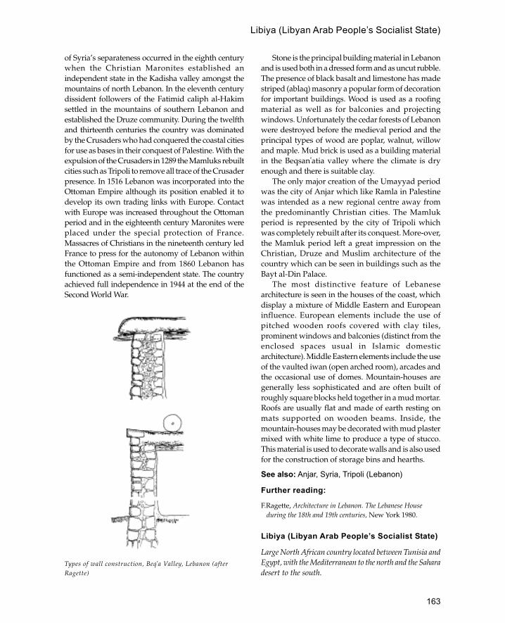
163
Libiya (Libyan Arab People’s Socialist State)
of Syria’s separateness occurred in the eighth centurywhen the Christian Maronites established anindependent state in the Kadisha valley amongst themountains of north Lebanon. In the eleventh centurydissident followers of the Fatimid caliph al-Hakimsettled in the mountains of southern Lebanon andestablished the Druze community. During the twelfthand thirteenth centuries the country was dominatedby the Crusaders who had conquered the coastal citiesfor use as bases in their conquest of Palestine. With theexpulsion of the Crusaders in 1289 the Mamluks rebuiltcities such as Tripoli to remove all trace of the Crusaderpresence. In 1516 Lebanon was incorporated into theOttoman Empire although its position enabled it todevelop its own trading links with Europe. Contactwith Europe was increased throughout the Ottomanperiod and in the eighteenth century Maronites wereplaced under the special protection of France.Massacres of Christians in the nineteenth century ledFrance to press for the autonomy of Lebanon withinthe Ottoman Empire and from 1860 Lebanon hasfunctioned as a semi-independent state. The countryachieved full independence in 1944 at the end of theSecond World War.
Stone is the principal building material in Lebanonand is used both in a dressed form and as uncut rubble.The presence of black basalt and limestone has madestriped (ablaq) masonry a popular form of decorationfor important buildings. Wood is used as a roofingmaterial as well as for balconies and projectingwindows. Unfortunately the cedar forests of Lebanonwere destroyed before the medieval period and theprincipal types of wood are poplar, walnut, willowand maple. Mud brick is used as a building materialin the Beqsan�atia valley where the climate is dryenough and there is suitable clay.
The only major creation of the Umayyad periodwas the city of Anjar which like Ramla in Palestinewas intended as a new regional centre away fromthe predominantly Christian cities. The Mamlukperiod is represented by the city of Tripoli whichwas completely rebuilt after its conquest. More-over,the Mamluk period left a great impression on theChristian, Druze and Muslim architecture of thecountry which can be seen in buildings such as theBayt al-Din Palace.
The most distinctive feature of Lebanesearchitecture is seen in the houses of the coast, whichdisplay a mixture of Middle Eastern and Europeaninfluence. European elements include the use ofpitched wooden roofs covered with clay tiles,prominent windows and balconies (distinct from theenclosed spaces usual in Islamic domesticarchitecture). Middle Eastern elements include the useof the vaulted iwan (open arched room), arcades andthe occasional use of domes. Mountain-houses aregenerally less sophisticated and are often built ofroughly square blocks held together in a mud mortar.Roofs are usually flat and made of earth resting onmats supported on wooden beams. Inside, themountain-houses may be decorated with mud plastermixed with white lime to produce a type of stucco.This material is used to decorate walls and is also usedfor the construction of storage bins and hearths.
See also: Anjar, Syria, Tripoli (Lebanon)
Further reading:
F.Ragette, Architecture in Lebanon. The Lebanese Houseduring the 18th and 19th centuries, New York 1980.
Libiya (Libyan Arab People’s Socialist State)
Large North African country located between Tunisia andEgypt, with the Mediterranean to the north and the Saharadesert to the south.
Types of wall construction, Beq�a Valley, Lebanon (afterRagette)
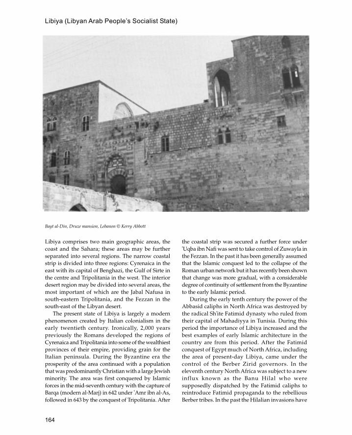
164
Libiya (Libyan Arab People’s Socialist State)
Libiya comprises two main geographic areas, thecoast and the Sahara; these areas may be furtherseparated into several regions. The narrow coastalstrip is divided into three regions: Cyrenaica in theeast with its capital of Benghazi, the Gulf of Sirte inthe centre and Tripolitania in the west. The interiordesert region may be divided into several areas, themost important of which are the Jabal Nafusa insouth-eastern Tripolitania, and the Fezzan in thesouth-east of the Libyan desert.
The present state of Libiya is largely a modernphenomenon created by Italian colonialism in theearly twentieth century. Ironically, 2,000 yearspreviously the Romans developed the regions ofCyrenaica and Tripolitania into some of the wealthiestprovinces of their empire, providing grain for theItalian peninsula. During the Byzantine era theprosperity of the area continued with a populationthat was predominantly Christian with a large Jewishminority. The area was first conquered by Islamicforces in the mid-seventh century with the capture ofBarqa (modern al-Marj) in 642 under �Amr ibn al-As,followed in 643 by the conquest of Tripolitania. After
the coastal strip was secured a further force under�Uqba ibn Nafi was sent to take control of Zuwayla inthe Fezzan. In the past it has been generally assumedthat the Islamic conquest led to the collapse of theRoman urban network but it has recently been shownthat change was more gradual, with a considerabledegree of continuity of settlement from the Byzantineto the early Islamic period.
During the early tenth century the power of theAbbasid caliphs in North Africa was destroyed bythe radical Sh�ite Fatimid dynasty who ruled fromtheir capital of Mahadiyya in Tunisia. During thisperiod the importance of Libiya increased and thebest examples of early Islamic architecture in thecountry are from this period. After the Fatimidconquest of Egypt much of North Africa, includingthe area of present-day Libiya, came under thecontrol of the Berber Zirid governors. In theeleventh century North Africa was subject to a newinflux known as the Banu Hilal who weresupposedly dispatched by the Fatimid caliphs toreintroduce Fatimid propaganda to the rebelliousBerber tribes. In the past the Hilalian invasions have
Bayt al-Din, Druze mansion, Lebanon © Kerry Abbott

165
Libiya (Libyan Arab People’s Socialist State)
been seen as the cause of North Africa’scomparative backwardness in the Middle Ages.More recently this view has been modified, but theidea of the political weakness of the area cannot bedispelled. During the twelfth century this weaknesswas exploited by Roger, the Norman king of Sicily,who established a Norman kingdom in Ifriqiyawhich included the area of Libiya. After theexpulsion of the Normans the history of Libiya isfragmented into successive dynasties controllingindividual cities. For a brief period in the earlysixteenth century part of Libiya was occupied bythe Spanish, but they were soon displaced by theOttomans who established naval bases on the coastto harass European shipping in the Mediterranean.During the eighteenth century Libiya was brieflyruled by the semi-independent Qarahmanlidynasty. In 1911 Libiya was again brought underEuropean rule when the Italians invaded andestablished the country as an Italian colony.
The main building materials in Libiya are stoneand mud brick. Re-used Roman or Byzantine stonehas always been in plentiful supply so that many ofthe older buildings in Tripoli, Adjdabiyah orelsewhere use Roman columns and capitals. Mud
brick was employed as a cheap alternative whendressed stone was not readily available, althoughbaked brick was also sometimes used. In thesouthern desert areas where Roman material was notso plentiful the main building material is roughlyhewn stones set within a mud mortar. This use ofmaterial determined architectural forms, thus in theJabal Nafusa area tall triangular arches were used asthere was no suitable material for normal archconstruction.
With the exception of the occasional building inthe old Byzantine coastal cities, the first distinctiveIslamic architecture in Libiya dates from the Fatimidperiod. During the later tenth century the Fatimidswere increasingly interested in Egypt and to this enddeveloped a number of garrison cities or stagingposts on the route between Mahdiya and Egypt.Probably the best-known site is the garrison city ofAjdabiya, south-west of Benghazi, which had both alarge mosque and a palace. The palace is arectangular stone-built structure with a centralcourtyard flanked by suites of rooms. Directlyopposite the entrance is a monumental portico whichgives access to the principal rooms of the palacewhich are arranged in a T-plan. The mosque was amud-brick building with stone used for the corners,piers and jambs. The mosque had a main entrancein the north-west side opposite the mihrab as wellas several lateral entrances. The aisles run at rightangles to the qibla wall, with the exception of thetransept adjacent to the qibla wall which runs parallel(an arrangement frequent in Fatimid mosques). Themosque is important for its early evidence of aminaret which consists of a square base with anoctagonal shaft, a design which later became the basisfor the Mamluk minarets of Cairo.
Another early Fatimid site is the city of MadinahSultan (Surt or Sirt) which is approximately midwaybetween Benghazi and Tripoli. The city was enclosedby a large oval-shaped town wall with at least threegateways. One of the larger buildings uncoveredduring excavations was the Friday mosque which isoriented south-east (an incorrect qibla). The mosquehad four gates, the most prominent of which wasthe monumental north gate which is of double width.Monumental gateways are a characteristic feature ofFatimid mosques and can also be seen at Mahdiyain Tunisia and in Cairo. The Madinah Sultan Mosquehas a central aisle running at right angles to the qiblawall, although unusually for North Africa the restof the aisles run parallel to the qibla wall. Some
Beirut house, Lebanon © Kerry Abbott

166
Libiya (Libyan Arab People’s Socialist State)
remains of the original decorative scheme of themosque have been recovered including stucco framesfor coloured glass windows, red and green colouredbricks. There are traces of a subsidiary mihrab in thearcade facing the courtyard which may possibly bethe remains of an eighth-century mosque which wasrebuilt in 952 by the Fatimid caliph al-Muciz. Severalother Fatimid establishments are known but have notyet been investigated in detail; one of the better knownexamples is Qasr al-Hammam near the ancient site ofLeptis Magna.
Few early Islamic remains survive in Tripolialthough traces of the rebuilt Umayyad fortificationwalls have been excavated. These were made of stoneand mortar and vary between 6 and 7 m in thickness.The oldest mosque in Tripoli is the al-Naqah Mosquewhich was probably built by the Fatimid caliph al-Muciz in 973 although some suggest that it may beolder. The present shape of the mosque is irregularindicating numerous alterations throughout historyalthough the basic plan consists of a rectangularcourtyard and a sanctuary or prayer hall coveredwith forty-two brick domes. Although many of theother mosques in Tripoli may have medieval originstheir remains mostly date from the Ottoman period.Few important monuments of the post Fatimidmedieval period in Libiya have survived althoughmany small mosques may date to the medievalperiod. At the oasis site of Ujlah (Awjlah) 200 kmto the south of Ajdabiya is a small twelfth-centurymosque built of stone and brick. The mosqueconsists of at least twelve bays covered with pointedconical domes, although the most interestingfeature of the building is the recessed minbar nicheto the side of the mihrab (this feature is also foundin East Africa and Arabia and may represent anIbadi tradition). South of Tripoli in the area of JabalNafusa is a region with a high concentration ofancient mosques, many of which date from before
the thirteenth century. Many of these mosques arebuilt partially underground giving them a lowprofile and an organic feel accentuated by theabsence of minarets. The area is also characterizedby fortified store houses, known as qusur (pluralof qasr), which consist of agglomerations of barrel-vaulted units contained within a defensive wall. Thebarrel-vaulted units are often stacked one on topof the other and are reached by ladder or ropes.During peaceful times each qasr functions as acentral storage area and in times of attack thepopulation of the village retreats into the qasr whereit can withstand a long siege.
See also: Ajdabiya, Fatimids, Tripoli (Libiya)
Further reading:
A.Abdussaid, ‘Early Islamic monuments at Ajdabiyah’,Libiya Antiqua 1: 115–19, 1964.
—— ‘An early mosque at Medina Sultan (Ancient Sort)’,Libiya Antiqua 3–4 : 155–60, 1967.
—— ‘Barqa, modern al-Merj’, Libiya Antiqua 8: 121–8,1971.
J.W.Allan, ‘Some mosques on the Jabal Nefusa’, LibiyaAntiqua 9–10 : 147–69, 1973.
J.M.Evans, ‘The traditional house in the Oasis ofGhadames’, Libyan Studies 7: 31–40, 1976.
A.Hutt, ‘Survey of Islamic sites’, Libyan Studies 3: 5–6,1972.
—— Islamic Architecture: North Africa, London 1977.G.R.D.King, ‘Islamic archaeology in Libiya 1969–1989’,
Libyan Studies 20: 193–207, 1989.N.M.Lowick, ‘The Arabic inscriptions on the mosque of
Abu Macruf at Sharwas (Jebel Nefusa)’, Libyan Studies,5: 14–19, 1974.
A.M.Ramadan, Reflections on Islamic Architecture in Libiya,Tripoli 1975.
M.Shagluf, ‘The Old Mosque of Ujlah’, Some Islamic Sitesin Libiya, Art and Archaeology Research Papers,London 1976, 25–8.
H.Ziegert and A.Abdussalam, ‘The White Mosque atZuila’, Libiya Antiqua 9–10 : 221–2, 1973.

167
ma�����adhana
Place for the call to prayer, often identified with theminaret.
machicolation
Downward openings or slits used defending a castle orfortification.
There are three types of machicolation, a boxmachicolation, concealed machicolation andcontinuous machicolation.
A box machicolation resembles a projectingwindow or gallery and may also be used for thispurpose. There are usually one or more slits in thefloor and the box is normally located over a gate ordoorway. Box machicolations were used in Romantimes and their first use in Islamic structures is atQasr al-Hayr (East and West).
Concealed machicolations are usually set into theroof above a vaulted passage leading from a gatewayand are often used in conjunction with a portcullis.The first example in Islamic architecture comes fromthe eighth-century palace of Ukhaidhir in Iraq. Thesewere frequently used in medieval Islamicfortifications.
Continuous machicolation consists of a parapetwhich is cantilevered over the front face of a wallwith a series of downward openings. The earliestexample of this is also at Ukhaidhir although it isnot used later on in Islamic architecture.
See also: fortification
madafaArabic term for guest house, or room for guests.
Madinat al-Zahra�Tenth-century palace city (now in ruins) 6 km west ofCórdoba in southern Spain.
The complex was begun by Abd al-Rahman II andcompleted by his son al-Hakim II. The complex
was named after Abd al-Rahman’s favourite wifeZahra� and located near springs at the foot of theSierra Morena. The complex was founded as apalatial residence and administrative centre awayfrom the crowded capital at Córdoba and had astaff of 20,000 people including guards, officialsand families. It was finally destroyed by fire in1010 by the caliph’s vizier al-Mansur who resentedthe caliph’s personal residence. Material from thepalace was re-used by Pedro the Cruel to buildhis palace in Seville.
The complex was built on three terracessurrounded by gardens with pools and waterchannels. On the lowest terrace is a garden pavilionbuilt for Abd al-Rahman as a formal reception andceremonial centre. This consisted of four pools andthe pavilion itself known as the Salón Rico whichhas intricate decoration carved in stone to match thestucco work of the maqsura at the Great Mosque inCórdoba. This pavilion is associated with a hammamin an arrangement common to the desert palaces ofSyria. Across a bridge from the Salón Rico is the mainmosque of the complex with an arcaded courtyardleading on to the sanctuary five aisles deep. Next tothe mosque is the Dar al-Yund (army headquarters)which consists of a cruciform basilical hall withtriple-arched arcades and a ramp leading out on tothe parade ground.
The upper part is occupied by the caliph’spersonal residence known as the Dar al-Mulk. Thisconsisted of several apartments based aroundcourtyards which in turn enclosed a central hall.It is likely that these apartments were at least fourstoreys high although they are now muchdamaged.
The complex is a useful example of how theSpanish Umayyads tried to copy the architectureand protocol of their more powerful ancestors. Inparticular the complex is thought to recall thecountry residence of Abd al-Rahman, the firstSpanish Umayyad, at Rusafa in Syria.
See also: Córdoba, Córdoba Great Mosque, Spain
M
168
Further reading:
F.Hernandez Gimenéz, Madinat al Zahra�: Arquitectura yDecoración, Granada 1985.
B.Pavon Malddonao, Memoria de la Excavatión de laMezquita de Medinat al-Zahra, No. 50 of ExcavacionesArqueologicas en Espagne, Madrid 1966.
madrassa
Building which functions as a teaching institutionprimarily of Islamic sciences.
It is thought that the earliest madrassas were builtby the Seljuks in eleventh-century Iran and that thedesign was derived either from contemporary houseplans or Buddhist teaching structures, known asviharas, which survived in Afghanistan and CentralAsia. The oldest extant madrassa is theGumushtutigin Madrassa in Bosra built in 1136. Thisis a small structure (20 by 17 m) with a domedcourtyard and two lateral iwans. However, themajority of early madrassas are found in Anatoliawhere two main types occur, based either on an openor a closed courtyard building. The domedmadrassas are usually smaller buildings whilst thosewith an open courtyard are generally larger and havecentral iwans surrounded by arcades. The firstEgyptian madrassas date from after 1160 when Sunniorthodoxy was returned to the country. Thesignificance of the Egyptian madrassas is the four-iwan plan where each iwan represented one of thefour orthodox schools of law. This design later spreadto other countries and can be seen in the MustansriyaMadrassa in Baghdad. Another significantdevelopment which took place in Egypt is themadrassa becoming the dominant architectural formwith mosques adopting their four-iwan plan.
Although it is traditionally thought that madrassasprovide sleeping and working accommodation forstudents, the extant examples show that this was nota rule and it is only later on that student facilitiesbecame an accepted part of a madrassa.
mahalArabic term for place or location. In Mughalarchitecture it is used to describe the palace pavilion,or more specifically the women’s quarters.
MahdiyaFatimid capital of North Africa located on the east coastof Tunisia.
The city of Mahdiya occupies a defensive positionon the peninsula of Ras Mahdi. The city wasestablished in 913 by the Fatimid Mahdi (leader)�Ubaid Allah on the site of the destroyed Carthigin-ian port of Zella. The city functioned as a port fromwhich the Fatimids were able to launch theircampaign to conquer Egypt.
Architecturally the most significant building inthe town is the Great Mosque built in 916. This isthe earliest surviving example of a Fatimid mosque.The design of the mosque differs considerably fromearlier North African mosques as it had no minaretsand only one monumental entrance giving it theappearance of a fortress rather than a mosque. Thisview is reinforced by the massive square cornerbuttresses and the stark simplicity of the design.The internal layout of the mosque is similar toearlier mosques of the region with nine aislesrunning perpendicular to the qibla wall and atransverse aisle parallel with the qibla wall. In theeleventh century erosion by the sea destroyed theoriginal qibla wall which was subsequently rebuiltfurther back thus reducing the space of the prayerhall.
See also: Ajdabiya, Fatimids, Tunisia
Further reading:
A.Lezine, Mahdiyya: Recherches d’Archéologie Islamiques,Paris 1965.
maidan
A large open space, or square, for ceremonialfunctions.
MalaysiaPredominantly Muslim country in south-east Asiadivided into two parts, the southern half of the Malaypeninsula and the northern part of Borneo.
It seems likely that Islam came to Malaysia as earlyas the ninth century although at present there is noarchaeological confirmation of this. The earliestrecord of Islam in Malaysia is the Treng-ganu Stonedated to 1303 or 1386. The stone is written in Malaywith Arabic script and records various regulationsof Islamic law.
Before the fourteenth century the southern halfof the Malay peninsula was home to a series of smallweak states which were dominated by their northernneighbours of Cambodia and Thailand and later by
madrassa

169
the Indonesian kingdom of Majapahit. By 1403,however, the first king of Malacca had establishedhimself as ruler of the southern Malay peninsulawith the support of the Chinese emperor. The kingof Malacca made several friendly visits to the Chineseemperor in return for support against the Thaikingdom of Ayudhya which was encroaching on thenorthern part of the peninsula. At this time (in the1420s) the king of Malacca converted from Hinduismto Islam making Malacca the main centre of Islamicculture in south-east Asia. Under Chinese protectionthe state of Malacca grew to become the mostpowerful in the area with its control of the strategicstraits of Malacca which were the main route forcommerce between China and the west. By the endof the fifteenth century Malacca’s position wasthreatened by the Portuguese who saw it as a threatto their further eastward expansion. In the earlysixteenth century China withdrew its naval supportof Malacca and in 1511 the sultanate of Malacca wasfinally defeated.
The Portuguese victory was the start of a longperiod of colonial rule first by the Portuguese,followed by the Dutch after 1641 and finally by theBritish from 1824 until 1957. Despite the crusadingzeal of the Portuguese the Malay inhabitantsremained Muslim throughout the colonial period.Unfortunately there are few architectural remainsfrom the pre-Portuguese period and these aremostly Buddhist or Hindu, although the survivingfortifications of Malacca may be Islamic. Most pre-nineteenth-century mosques in Malaysia were builtof wood and have not survived very well. Theoldest mosque in Malaysia is generally agreed tobe the Masjid Kampaung Laut in the state ofKelantan built in the sixteenth century. The mosquewas moved from its original location in 1970 afterserious floods damaged its structure. The mosquestands on a square raised platform and has a three-tier pyramid roof with each tier separated by a gapto allow air circulation. A similar mosque was builtat Demak in Indonesia by the same group ofMuslim traders. Another early mosque is the MasjidTrengkera in Malacca built in the early eighteenthcentury (1728). This is a four-tier structure on asquare base with a polygonal six-storey minaret.The form of the minaret resembles a pagoda andsuggests strong Chinese influence. Most earlyMalaysian mosques have neither minarets normihrabs although these were often added in thenineteenth century. The window frames were
usually decorated with bands of Quraniccalligraphy and there are often elaborately carvedminbars and Quran stands.
The colonization of Malaysia by Britain in thenineteenth century introduced a new Anglo-Indianstone- and brick-built mosque form. These mosquesare characterized by the use of domes, crenellationsand arched windows which locally are characterizedas ‘Moorish architecture’. One of the best examplesof this architecture is the Headquarters of the MalayanRailway Company which is covered with oniondomes with arched windows and striped masonry.This architecture which can also be seen in Singaporeseems to be derived primarily from south India.
Since Independence in 1957 there have beenattempts to move away from this Anglo—Indianarchitecture to buildings that are more traditionallyMalay. The model for such buildings is usually thetraditional form of Malay houses—wooden buildingswith tall thatched roofs in three or more tiers. One ofthe earliest examples of this post-colonial architectureis the National Museum at Kuala Lumpur which usestraditional roof forms, although many of the otherelements are built in a modern international style.More successful as an evocation of the traditional styleis the Bank of Bumipatra which is based on thetraditional Kelantan house design. The building hasa huge three-tiered roof on a rectangular base.
See also: Indonesia, Java, Singapore
Further reading:G.Haidar, ‘On the crest of the hill: The International
Institute of Islamic Thought and Civilization, KualaLumpur’, Arts and the Islamic World 21: 14–18, 1992.
A.Lamb, ‘Miscellaneous papers on early Hindu-Buddhistsettlement in northern Malaya and southern Thailand’,Federation Museums Journal NS 6 : 1961.
Wan Hussein Azmi, ‘Islam di Malaysia-Kedatangan danPerkembangan (Abad 7–20 m)’, Tamadun Islam diMalaysia, Kuala Lumpur 1980.
O.bm. Yatim, ‘Islamic arts in Malaysia’, Arts and theIslamic World 1(2): 1993.
Zainal Abidin Wahid (ed.), Glimpses of Malaysian History,Kuala Lumpur 1980.
S.S.Zubir, ‘Identity and architecture in Malaysia’, Arts andthe Islamic World 5(1): 74–6, 1988.
MaldivesA group of over 2,000 islands off the south-west coast ofSri Lanka which now forms an independent republic withits capital at Male.
Maldives

170
The inhabitants of the Maldives have been Muslimsince 1153 when they were converted by a Berberknown as Abu al-Barakat. The language of the islandsis Dihevi which is related to Sinhalese although it iswritten in a script based on Arabic numerals.
The houses are made out of coral stone andcoconut wood; the stone is used to build a platformand the wood is used for the superstructure. Asexperienced boat builders the Maldivians were ableto build wooden houses without nails and make verytight joints. Ibn Battuta visited the islands twice in1343 and 1346 and gave an account of theconstruction of houses. The house was built arounda hall which opened on to the reception room, knownas the malem, where the owner of the house wouldreceive his male friends. At the back of the malemwas another door which opened on to the rest of thehouse forbidden to guests.
There are many mosques on the islands; at presentMale has thirty-three including the main mosqueknown as the Hukuru Meskit (Great Mosque). Thestandard mosque plan which seems to have remainedthe same since the seventeenth century consists of astone building raised on a rectangular platform withan entrance at the east end and a rectangular recess atthe west end. Near the entrance is a well set within apaved area with a path leading to the mosque entranceto keep feet clean after washing. Many of the mosquesare built of stone although some are built out of woodlike the houses. Each mosque is surrounded by agraveyard on three sides with tombstones made offinely dressed coral blocks (rounded stones representwomen and pointed stones represent men). In generalMaldivian mosques do not have mihrabs althoughthey are oriented towards Mecca and have a squarerecess at the qibla end. Minarets are also unusualalthough the Hukuru Meskit has a thick cylindricaltower which functions as a minaret.
See also: coral
Further reading:J.Carswell, ‘Mosques and tombs in the Maldive Islands’,
Art and Archaeology Research Papers 9: 26–30, 1976.—— ‘China and Islam in the Maldive Islands’,
Transactions of the Oriental Ceramic Society 41: 121–98,1975–6.
MaliIslamic West African empire which flourished during thethirteenth and fourteenth centuries.
The date of the first emergence of the kingdomof Mali is not known although there are referencesto it as early as the ninth century. However, it wasnot until the thirteenth century that the kingdomachieved the status of empire through the conquestof a number of rival states. The medieval empire ofMali was formed out of the unification of two distinctManding groups, an established northern group anda more recent southern group. The unification wasachieved by the famous Mali hero Sundiata whodefeated Sumaguru Kante, lord of Susu in 12.34 andthen went on to conquer Ghana, Gangaran and thegold-producing area of Bambuko. The ruling clan,from which the king was selected, was the Keita clanof the northern group which traced its ancestry backto Bilal, the first black follower of the prophet. Theempire had two distinct capitals: Kangaba, thereligious capital, and Niani, capital of the Keita clanand birthplace of Sundiata. Although some branchesof the Mali dynasty were Muslim fairly early on, itwas not until the thirteenth century that the kingswere Muslim.
After Sundiata the most famous king of Mali wasMansa Musa who made a legendary pilgrimage toMecca in 1324–5. Although previous kings of Malihad made the pilgrimage to Mecca the journey ofMansa Musa made a particularly big impressionbecause he dispersed large quantities of gold on theway. The amount of gold given away was so largethat a contemporary account said that the value ofgold in Egypt depreciated considerably after hisarrival. In consequence of this the fame of MansaMusa and Mali spread all over the Islamic world andbeyond, so that Mali even appeared oncontemporary European maps for the first time.When Mansa Musa returned to Mali he wasaccompanied by several North African travellersamongst whom was Abu Ishaq al-Saheli a poet fromAndalu-sia who is credited with the introduction ofa new style into West African architecture.
Mansa Musa was succeeded by Maghan I (1337–41) about whom little is known except that he hadacted as regent for Mansa Musa during his absenceon pilgrimage. In 1341 Maghan was succeeded byMansa Musa’s brother Sulayman who reorganizedthe empire and financial system in order to recoverfrom the excessive expenditure of his brother.Sulayman was the ruler at the time of Ibn Battuta’svisit in 1353 so that there is quite a detaileddescription of his rule including the king’s friendlyrelations with the Marinid sultans of Morocco. Ibn
Mali

171
Khaldun traced the careers of the next five kings untilthe beginning of the fifteenth century, when thekingdom had been seriously weakened by civil warsand was no longer in a position to control all itsdependencies which gradually were lost to rivalkingdoms. One of the most formidable of these rivalswas the Songhay kingdom of Gao or Kawkaw basedon the banks of the Niger east of Mali. The arrival ofthe Portuguese during the fifteenth centuryintroduced another new factor into the politics ofthe region. The ruler of Mali sought the assistanceof these newcomers to fight off African rivals butthey were unable to prevent the continuing dis-integration of Malian power. In the 1590s theMoroccans occupied Djenné and the rulers of Mali
were unable to retake the town. However, the greatlyreduced kingdom of Mali continued to survive until1670 when it was finally destroyed.
Despite its fame there are few architecturalremains of the empire of Mali and one is forced torely mostly on contemporary Arabic descriptionsand rather complex oral traditions. At the spiritualcapital of Kangaba there is little that remains fromthe medieval period with the exception of the giantlinke (baobab) tree which marks the ancestral centreof the Mali Empire. There are several descriptionsof the political capital at Niani, one of the best is thatof the fourteenth-century writer al-Umari.
‘[The capital] extends in length and breadth to adistance of approximately one barid (postal stage).
West Africa, showing the empire of Mali in the fourteenth century CE
Mali

172
It is not surrounded by a wall and most of it isscattered…. The town is surrounded on four sidesby the “Nile”…. The buildings of this town are madeof iwad or clay like the walls of the gardens ofDamascus. This consists of building two thirds of acubit (approximately 30 cm) in clay, then leaving itto dry, then building above it in the same way…andso on until it is complete. The roofs are of wood andreeds and are generally domed or conical, in the formof cupolas of camel-backs, similar to the arch-shapedopenings of vaults.’
Ibn Battuta’s description of 1353 is not so fullalthough he does indicate that he reached the cityby boat and that it had a separate quarter for whitemerchants. He then describes the king’s palace insome detail, in particular the audience hall whichmay be the same as that built by Abu Ishaq al-Sahelia decade or two earlier. The audience hall iscontained within the palace and consists of a squaredomed chamber with triple-arched windows in eachside. The windows are filled with wooden latticework or grilles covered in silver and gold leaf(mashrabiyya?). Ibn Khaldun probably describingthe same building notes that it was ‘solidly built andfaced with plaster; because such buildings areunknown in his [the sultan’s] country’. Obviousparallels for this building can be found in thearchitecture of fourteenth-century North Africa andSpain (compare for example the Salón del Trono inthe Alhambra). Next to the palace was a large openarea used as a mosque or place of prayer.
The location of Mali’s capital is unknownalthough it may be the site of Niani-en-Sankrani inGuinea occupied between the sixth and seventeenthcenturies. Archaeological work at the site hasrevealed a large complex with a fortified royalcompound, several residential areas, a metal-work-ing centre and many cemeteries. A possible mosquesite and Muslim cemetery have been identified nearthe royal complex which consists of a large squarecourtyard (20 m per side) and a smaller circularstructure. The residential structures at the siteconsist of roundhouses built of mud with stonefoundations.
See also: Djenné, Manding, West Africa
Further reading:H.Haselberger, ‘Architekturskizzen aus der Republic
Mali Ergebnisse der DIAFE 190709 des FrobeniusInstitut’, International Archives of Ethnography 50(1): 244–80, 1966.
J.Hunwick, ‘The mid-fourteenth-century capital of Mali’,Journal of African History 14(2): 195–206, 1973.
Mamluks
Term applied to the architecture of Greater Syria and Egyptbetween 1250 and 1516. During this period the area wasruled by the Mamluk sultans based in Cairo.
The word ‘mamluk’ is an Arabic term for slave andwas applied to soldiers who, although non-Muslimby birth, had been captured as children, converted toIslam and trained to fight on behalf of their owners.The Mamluk sultanate had its origins in such slavesoldiers, usually of Turkic or Mongol origin, who wereused as guards by the Ayyubid sultans and princes.Gradually the Mamluks increased their power andby 1250 their position was so strong that they wereable to depose and appoint sultans. In 1260 one ofthese soldiers, Baybars, became the first Mamluksultan starting a tradition that was to endure for thenext 250 years.
The Mamluk sultanate can be divided into twoperiods; the first lasted from 1250 to 1382 and isknown as the Bahri (sea-based) Mamluk periodbecause the dominant Mamluks were based on Rodaisland in the Nile delta. The second period from 1382to 1517 is known as the Burji Mamluk period becausethose in power came from the Citadel in Cairo (burjis Arabic for tower). This period is sometimes alsocalled the Circassian period, as most of the sultanswere of Circassian origin.
The Mamluks were able to seize and retain powerprimarily through their superior militaryorganization and training. This was demonstratedin 1260 when Sultan Baybars was able to halt thewestward advance of the Mongols at the battle of�Ayn Jalut in Palestine. Similarly the Mamlukscontinued to fight the Crusaders who by this timewere confined to the coast of Syria. The main battlesagainst the Crusaders took place under SultanQalaoun and his son Khalil, who in 1291 capturedthe cities of Acre, Tyre, Sidon, Beirut and Tripoliending the Crusader presence in the Levant.
Mamluk architecture reflects the confidencederived from its military successes and is one of themost distinctive Islamic styles of building. The mainsource for Mamluk architecture was the buildingsof the Ayyubids and in some senses the Mamluk styleis simply a development of that of the Ayyubids.However, the Mamluks were also influenced by
Mamluks
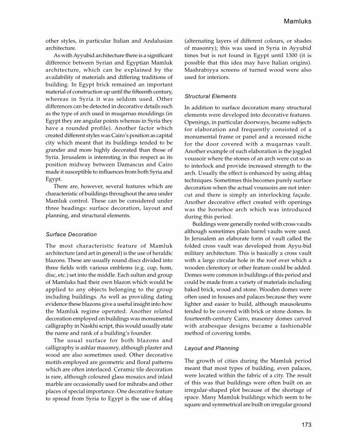
173
other styles, in particular Italian and Andalusianarchitecture.
As with Ayyubid architecture there is a significantdifference between Syrian and Egyptian Mamlukarchitecture, which can be explained by theavailability of materials and differing traditions ofbuilding. In Egypt brick remained an importantmaterial of construction up until the fifteenth century,whereas in Syria it was seldom used. Otherdifferences can be detected in decorative details suchas the type of arch used in muqarnas mouldings (inEgypt they are angular points whereas in Syria theyhave a rounded profile). Another factor whichcreated different styles was Cairo’s position as capitalcity which meant that its buildings tended to begrander and more highly decorated than those ofSyria. Jerusalem is interesting in this respect as itsposition midway between Damascus and Cairomade it susceptible to influences from both Syria andEgypt.
There are, however, several features which arecharacteristic of buildings throughout the area underMamluk control. These can be considered underthree headings: surface decoration, layout andplanning, and structural elements.
Surface Decoration
The most characteristic feature of Mamlukarchitecture (and art in general) is the use of heraldicblazons. These are usually round discs divided intothree fields with various emblems (e.g. cup, hom,disc, etc.) set into the middle. Each sultan and groupof Mamluks had their own blazon which would beapplied to any objects belonging to the groupincluding buildings. As well as providing datingevidence these blazons give a useful insight into howthe Mamluk regime operated. Another relateddecoration employed on buildings was monumentalcalligraphy in Naskhi script, this would usually statethe name and rank of a building’s founder.
The usual surface for both blazons andcalligraphy is ashlar masonry, although plaster andwood are also sometimes used. Other decorativemotifs employed are geometric and floral patternswhich are often interlaced. Ceramic tile decorationis rare, although coloured glass mosaics and inlaidmarble are occasionally used for mihrabs and otherplaces of special importance. One decorative featureto spread from Syria to Egypt is the use of ablaq
(alternating layers of different colours, or shadesof masonry); this was used in Syria in Ayyubidtimes but is not found in Egypt until 1300 (it ispossible that this idea may have Italian origins).Mashrabiyya screens of turned wood were alsoused for interiors.
Structural Elements
In addition to surface decoration many structuralelements were developed into decorative features.Openings, in particular doorways, became subjectsfor elaboration and frequently consisted of amonumental frame or panel and a recessed nichefor the door covered with a muqarnas vault.Another example of such elaboration is the joggledvoussoir where the stones of an arch were cut so asto interlock and provide increased strength to thearch. Usually the effect is enhanced by using ablaqtechniques. Sometimes this becomes purely surfacedecoration when the actual voussoirs are not inter-cut and there is simply an interlocking façade.Another decorative effect created with openingswas the horsehoe arch which was introducedduring this period.
Buildings were generally roofed with cross vaultsalthough sometimes plain barrel vaults were used.In Jerusalem an elaborate form of vault called thefolded cross vault was developed from Ayyu-bidmilitary architecture. This is basically a cross vaultwith a large circular hole in the roof over which awooden clerestory or other feature could be added.Domes were common in buildings of this period andcould be made from a variety of materials includingbaked brick, wood and stone. Wooden domes wereoften used in houses and palaces because they werelighter and easier to build, although mausoleumstended to be covered with brick or stone domes. Infourteenth-century Cairo, masonry domes carvedwith arabesque designs became a fashionablemethod of covering tombs.
Layout and Planning
The growth of cities during the Mamluk periodmeant that most types of building, even palaces,were located within the fabric of a city. The resultof this was that buildings were often built on anirregular-shaped plot because of the shortage ofspace. Many Mamluk buildings which seem to besquare and symmetrical are built on irregular ground
Mamluks

174
plans. The architects were able to make the buildingsappear square by a variety of techniques such ashorizontal lines (ablaq) and controlled access(passageways) which distort per-spective. A relatedproblem was that narrow streets tend to detractfrom the visual impact of a building façade. This
was overcome by use of recessed entrances, domes,and projecting corners which have a cumulativeeffect of a staggered façade which can be viewedfrom the side.
The military nature of Mamluk rule affectedsociety in many ways although it did not have much
Doorway of Serai al-Takiyya. Mamluk period, Jerusalem (after Burgoyne)
Mamluks
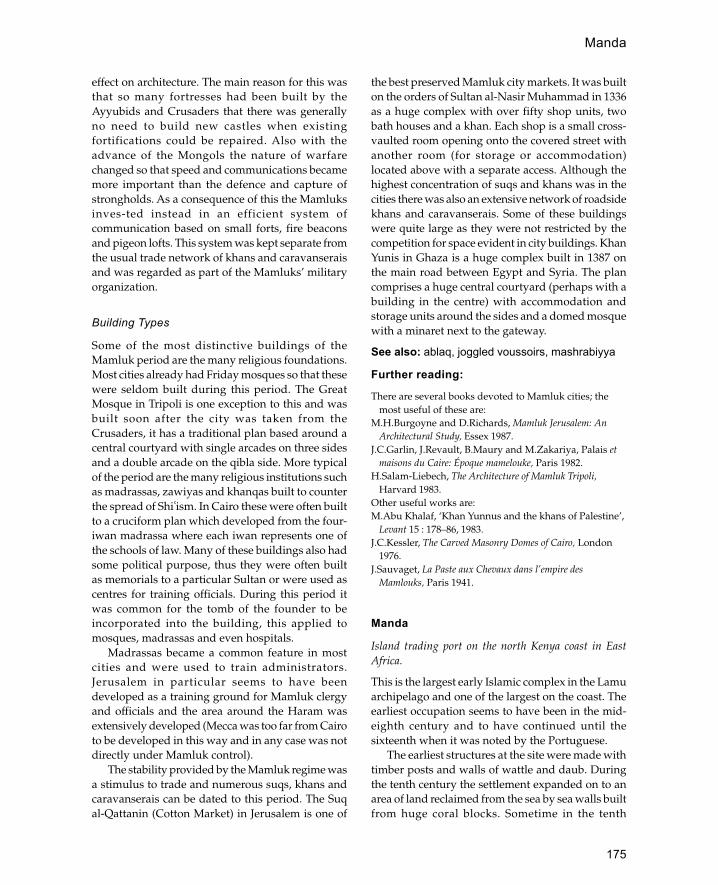
175
effect on architecture. The main reason for this wasthat so many fortresses had been built by theAyyubids and Crusaders that there was generallyno need to build new castles when existingfortifications could be repaired. Also with theadvance of the Mongols the nature of warfarechanged so that speed and communications becamemore important than the defence and capture ofstrongholds. As a consequence of this the Mamluksinves-ted instead in an efficient system ofcommunication based on small forts, fire beaconsand pigeon lofts. This system was kept separate fromthe usual trade network of khans and caravanseraisand was regarded as part of the Mamluks’ militaryorganization.
Building Types
Some of the most distinctive buildings of theMamluk period are the many religious foundations.Most cities already had Friday mosques so that thesewere seldom built during this period. The GreatMosque in Tripoli is one exception to this and wasbuilt soon after the city was taken from theCrusaders, it has a traditional plan based around acentral courtyard with single arcades on three sidesand a double arcade on the qibla side. More typicalof the period are the many religious institutions suchas madrassas, zawiyas and khanqas built to counterthe spread of Shi�ism. In Cairo these were often builtto a cruciform plan which developed from the four-iwan madrassa where each iwan represents one ofthe schools of law. Many of these buildings also hadsome political purpose, thus they were often builtas memorials to a particular Sultan or were used ascentres for training officials. During this period itwas common for the tomb of the founder to beincorporated into the building, this applied tomosques, madrassas and even hospitals.
Madrassas became a common feature in mostcities and were used to train administrators.Jerusalem in particular seems to have beendeveloped as a training ground for Mamluk clergyand officials and the area around the Haram wasextensively developed (Mecca was too far from Cairoto be developed in this way and in any case was notdirectly under Mamluk control).
The stability provided by the Mamluk regime wasa stimulus to trade and numerous suqs, khans andcaravanserais can be dated to this period. The Suqal-Qattanin (Cotton Market) in Jerusalem is one of
the best preserved Mamluk city markets. It was builton the orders of Sultan al-Nasir Muhammad in 1336as a huge complex with over fifty shop units, twobath houses and a khan. Each shop is a small cross-vaulted room opening onto the covered street withanother room (for storage or accommodation)located above with a separate access. Although thehighest concentration of suqs and khans was in thecities there was also an extensive network of roadsidekhans and caravanserais. Some of these buildingswere quite large as they were not restricted by thecompetition for space evident in city buildings. KhanYunis in Ghaza is a huge complex built in 1387 onthe main road between Egypt and Syria. The plancomprises a huge central courtyard (perhaps with abuilding in the centre) with accommodation andstorage units around the sides and a domed mosquewith a minaret next to the gateway.
See also: ablaq, joggled voussoirs, mashrabiyya
Further reading:
There are several books devoted to Mamluk cities; themost useful of these are:
M.H.Burgoyne and D.Richards, Mamluk Jerusalem: AnArchitectural Study, Essex 1987.
J.C.Garlin, J.Revault, B.Maury and M.Zakariya, Palais etmaisons du Caire: Époque mamelouke, Paris 1982.
H.Salam-Liebech, The Architecture of Mamluk Tripoli,Harvard 1983.
Other useful works are:M.Abu Khalaf, ‘Khan Yunnus and the khans of Palestine’,
Levant 15 : 178–86, 1983.J.C.Kessler, The Carved Masonry Domes of Cairo, London
1976.J.Sauvaget, La Paste aux Chevaux dans l’empire des
Mamlouks, Paris 1941.
Manda
Island trading port on the north Kenya coast in EastAfrica.
This is the largest early Islamic complex in the Lamuarchipelago and one of the largest on the coast. Theearliest occupation seems to have been in the mid-eighth century and to have continued until thesixteenth when it was noted by the Portuguese.
The earliest structures at the site were made withtimber posts and walls of wattle and daub. Duringthe tenth century the settlement expanded on to anarea of land reclaimed from the sea by sea walls builtfrom huge coral blocks. Sometime in the tenth
Manda
176
century the wooden structures were replaced withstone buildings made out of reef coral. Also duringthe tenth century some buildings were made out oftwo types of baked brick, a locally made variety andrarer imported brick (possibly from Oman). The onlytenth-century building completely excavated isknown as the ‘House of Cisterns’ and consists of alarge courtyard building entered via a flight of sevensteps.
Buildings erected after the thirteenth centuryused fossil coral instead of the reef coral of earlierstructures. Ruins surviving from the later period ofoccupation include several houses, a town wall, twomosques and several monumental tombs.
See also: coral, East Africa, Kenya, Shanga
Further reading:
H.N.Chittick, Manda: Excavations at an Island Port on theKenya Coast, British Institute in Eastern Africa Memoir9, in 2 vols., Nairobi 1984.
M.C.Horton, ‘Asiatic colonization of the East Africancoast: the Manda evidence’, Journal of the Royal AsiaticSociety pt. 2: 201–12, 1986.
mandalMughal term for a pavilion or house.
manding (Mande)
West African language group which formed the rulingclass of the empire of Mali, now used to describe one ofthe dominant urban architectural styles of the region.
The current distribution of the Manding peoplescovers an area including southern Mali, Burkina Fasoand the Ivory Coast. Prominent cities with Mandingarchitecture include Mopti, Djenné, Ségou, BoboDioulasso, Wa and Kong.
Characteristic features of Manding architectureare the use of mud brick, conical towers withprojecting toron, and elaborate decorated entrancefaçades. Mud is the traditional building material ofthe area and is used in several forms, either asspherical hand-rolled lumps or as rectangular orcylindrical bricks. Conical towers may either occuras buttresses or as towers marking the position of amihrab in a mosque. It is thought that the conicaltowers derive from the pre-Islamic ancestral pillarsof the region whilst the use of toron traditionallysuggests continual rebirth. Whilst the façades ofmosques and palaces are often decorated with
earthen pillars and projecting toron, the decorationof house façades is normally restricted to theentrances. Some of the most elaborate entrancefaçades can be found at Djenné in Mali which isusually considered the birthplace of the Mandingstyle. A traditional façade will consist of three levelscontained within two parallel buttresses. The firsttwo levels correspond to the two storeys inside thehouse whilst the third level corresponds to the rooflevel parapet. The first level consists of the doorwaycovered by a steep sloping sill above which is thesecond level containing a rectangular panel with asquare window in the middle. The third level consistsof a line of projecting toron made of split palm, apanel containing four pillared niches and fourpointed crenellations on the top.
See also: Djenné, Mali, Sudan, West Africa
Further reading:
L.Prussin, ‘ Sudanese architecture and the Manding’,African Arts 3(4): 12–19 and 64–7, 1970.
manzilArabic term for house or way station (literally ‘aplace to stay’).
maq�����ad
Projecting balcony overlooking a courtyard inEgyptian houses.
maqbaraGraveyard.
maqsuraScreen which encloses the area of the mihrab and minbarin early mosques.
The origin of the screens was to protect the caliphfrom assassination attempts during praying. Therealso may have been some spiritual connotationsimilar to the chancel screen in churches. They wereoften wooden screens decorated with carvings orinterlocking turned pieces of wood (mashrabiyya).
Marakesh
Southern capital of Morocco.
Marakesh is on a wide plain located 40 km from theHigh Atlas. It was founded by the Almoravid ruler
mandal

177
Yusf ibn Tashfin in 1062, although there are fewbuildings which have survived from this period. Thebest surviving example is the dome of the Almoravidpalace; built of baked brick covered with plaster, thedome rests on a square brick base. The areaimmediately below the drum is pierced with twenty-four multifoil niches, whilst the dome itself isdecorated with interlaced arches in relief and zig-zag patterns on the top. Inside the dome has anentirely different configuration and consists of aneight-pointed star rising to a muqarnas dome.
Remains from the Almohad period (twelfth tothirteenth century) include the Kutubiyya Mosque,the Kasba Mosque and the Bab Agnau. TheKutubiyya Mosque is built in the traditionalAlmohad style with the lateral arcades of thecourtyard forming an integral part of the prayerhall. The mosque has a minaret more than 60 mhigh, decorated with windows and blind nicheswith interlaced arches; at the top there is a smallkiosk covered with a fluted dome. The parapet isdecorated with ceramic tile inlays and steppedmerlons. The minaret is ascended by a ramp whichis built around a hollow square core. The corecontains a series of six vaulted rooms, one on eachstorey and each with a different form of vault (thedesign is similar to the Giralda tower in Seville).The Kasba Mosque is a square building containingfive courtyards, four subsidiary and one central.The minaret is decorated in a similar style to theKutubiyya and inside there is a staircase builtaround a central core. The Bab Agnau is part of themassive Almohad fortifications which stretcharound the city for a distance of over 10 km. Thegateway is built of brick and comprises a wideopening covered with a pointed horseshoe arch. Theinner arch is framed by a magnificent roundhorseshoe arch decorated with a bold interlacedpattern. The intrados of the arch is decorated withbold stylized flora, and the whole is enclosed withina giant rectangular frame with a Kufic inscription.
The city has three madrassas the oldest of whichis the Bin Yusuf Madrassa built as a mosque in thetwelfth century and converted in the sixteenth. Thetown also contains the tombs of various Moroccanrulers, including that of Yusuf ibn Tashfin founderof the Almoravid dynasty, and the tomb of the sevensaints which is still the object of an annualpilgrimage.
There are several palaces within the city, the oldestof which is the Dar al Makhzan founded by the
Almohads but considerably altered in the sixteenthcentury. The city also contains historic gardens, themost important being the Mamounia, originally laidout in the seventeenth century.
See also: Morocco
MardinCity in south-east Anatolia (Turkey) associated with theArtukid dynasty during the medieval period.
Mardin is located in a strategic position on a rockyspur overlooking the crossroads between east—westand north-south routes. The city is dominated by thefortress which has stood on this site since Romantimes. During the Islamic period the castle has beenextensively repaired several times, first by theHamdanids in the ninth century, later by the Artukidsand more recently by the Ottomans. From 1104 to1408 the city became the principal stronghold of theArtukids who resisted successive attacks by theAyyubids, the Mongols and the Timurids.
The buildings of the town are terraced into thehillside and all have magnificent views over theMesopotamian plain. The main building stone isbrilliant white limestone which provides a dazzlingcontrast to the grey-black basalt which character-izesthe surrounding region.
Several important buildings survive from theArtukid period including the Great Mosque, ahammam and several madrassas. The prayer hall ofthe Great Mosque is a multi-domed unit in the usualArtukid style whilst the minaret is a tall cylindricaltower with elaborately carved car-touches. One ofthe most striking buildings in the city is the KasimPasha Madrassa built in 1445 by the Aq-qoyunuluruler Kasim b. Jahangir. There are also severalimportant churches and monasteries in the region.
See also: Turkey
maristanHospital.
marqadTombstone.
mashhadShrine, or commemorative mosque.
mashrabiyyaWooden grille or grate used to cover windows or balconies.
mashrabiyya

178
The word is derived from the niches used to storevessels of drinking water. The grilles are traditionallymade from short lengths of turned wood joinedtogether through polygonal blocks so that they formlarge areas of lattice-like patterns. The patternsformed by the lattice work vary from place to placealthough commonly the main lines of the grille areat a 45 degree angle. Mashrabiyya can also be madeof metalwork although this is more rare and wasusually reserved for the houses of the very rich orpublic buildings.
masjidMosque.
mastabaBench or platform.
matharaPlace of ritual ablution.
mazarMausoleum or shrine.
Mecca (Makka)
The most sacred city of Islam located in western SaudiArabia.
The city of Mecca lies about 70 km inland from theRed Sea port of Jeddah. It is built in a hollow in themountains known as Batn Mecca. The oldest part ofthe city contains the Holy Mosque and the Ka�ba andis known as al-Batha. Rainfall is extremely scarce andunpredictable; in ancient times water was suppliedby a series of wells, the most important of which isthe well of Zamzam within the holy precinct. Despitethe aridity of the area the city’s position makes itprone to flash floods which are diverted by a seriesof dams and channels which deflect water away fromthe city centre.
History
In pre-Islamic times Mecca was known as a sacredsite and was referred to as Maccorba in the time ofPtolemy. The first permanent settlements on the sitewere made in the fifth century CE by the Qurayshtribe. By the sixth century the city appears to havebecome a great trading centre profit-ing from thecaravan trade between the Mediterranean and theIndian Ocean. In 570 the prophet Muhammad wasborn in Mecca, by the year 610 he had begun topreach the message revealed to him as Quran.Muhammad’s teaching annoyed the prominentmerchants of the town so that in 622 he wascompelled to leave for the city of Medina. (This eventis known as the Hejira or migration and is the startingpoint for the Muslim calendar.) In MedinaMuhammad attracted a large following who wereable to attack the Meccan caravans. By 630Muhammad and his followers (the Muslims) haddefeated Mecca and converted most of its inhabitantsto Islam. In the following years Medina becamecapital of the new Islamic state whilst Mecca retainedits position as religious centre and centre ofpilgrimage.
For a brief period between 680 and 692 Meccabecame the capital of a rival caliphate establishedby Abd Allah Ibn Zubayr who controlled most ofArabia and Iraq. During the Abbasid period hugesums of money were spent on developing the city.
Star-shaped mashrabiyya
Masjid

179
The Haram, Mecca (after Jairazbhoy)
Mecca (Makka)

180
In the tenth century the decline of the caliphateallowed the Qarmathians (a radical anti-establish-ment group) to sack Mecca and carry off the BlackStone to their base in Bahrain. The Black Stone waslater returned and Mecca continued to develop as areligious centre.
From the late tenth century to the beginning ofthe nineteenth century Mecca was ruled by theSharifs of Mecca who attempted to remainindependent of the dominant powers of the time. In1929 Mecca became part of the Kingdom of SaudiArabia.
Architecture
The most important building in Mecca is the HolyMosque of Mecca which contains the Ka�ba, a tallbox-like structure which stands in a courtyard in thecentre of the mosque. The Ka�ba is pre-Islamic inorigin although at the beginning of the Islamic periodit became established as the main object ofpilgrimages to Mecca.
The area around the Ka�ba was first enclosed by awall in 638 in order to create an open space for thetawaf (circumambulation). In 646 the area wasenlarged with a new enclosure wall with arcadesopening on to the courtyard. In 684 under Abd AllahIbn Zubayr the mosque was further enlarged anddecorated with marble and mosaic decoration. In 709the Umayyad caliph al-Walid covered the arcades ofthe mosque with a teak roof resting on marblecolumns. A further enlargement was carried out bythe Abbasid caliph al-Mansur between 754 and 757,and it was at this time that the first minaret was built.For the next 700 years numerous modifications werecarried out although no major alterations to the formof the building occurred until the Ottoman period inthe sixteenth century. The best medieval descriptionof the mosque is by Ibn Jubayr who visited it in 1183.He describes a roofed arcade around a centralcourtyard decorated with large merlons and stuccodecoration.
Major renovations were carried out in 1564 underthe direction of the Ottoman sultan Suleyman theMagnificent who replaced the flat roofs of the arcadeswith stone domes and rebuilt the minarets. The nextmajor rebuilding took place in the twentieth centuryunder Saudi rule and made the Holy Mosque ofMecca the largest mosque in the world. In its presentform the mosque has seven minarets, two-storeyarcades around the enlarged courtyard and a covered
street (Ma�sa) between the hills of al-Safa and al-Marwa (1920s).
Other features within the Holy Mosque includethe well of Zamzam and the Maqam Ibrahim.According to Muslim tradition the well of Zamzamsprang up when Hajar (the wife of Ibrahim) waslooking for water for her child Ishmael. In the ninthcentury the well was covered with a vaulted roof bythe Abbasid caliph al-Mu�tassim. The form of thebuilding was changed several times in the followingcenturies the most enduring of which was that builtby the Ottomans in the seventeenth century. Inaddition to its function as a cover of the well theMaqam Zamzam also functioned as a base for Shafitheologians. Hanbali, Hanafi and Malaki theologianseach had their own maqam within the courtyardwhich were also rebuilt at this time. In the 1950s allthese maqams were removed by the Saudiauthorities to make more space for thecircumambulation of the Ka�ba. The Maqam ofZamzam was replaced by two undergroundablutions rooms fed by the well of Zamzam. TheMaqam Ibrahim contains a stone with two footprintswhich are thought to be those of Ibrahim. Thisbuilding was restored by the Saudi authorities in the1950s.
In its present form Mecca is predominantly amodern city although it does contain a few housesfrom the Ottoman period (eighteenth century orlater). Traditional Meccan houses are generally tall(three to four storeys) with projecting woodenwindows (mashrabiyya) and flat roofs enclosed bywalls 2 m high. The extreme heat of the city in thesummer (50 degrees celsius) means that the housesare equipped with airshafts which allow hot air toescape. Most of the houses in Mecca are dualpurpose, serving as family homes and as pilgrimhostels during the season of the Hajj.
The main building materials used in Meccanhouses are stone, brick and wood. Two types of stoneare used, finely dressed stone and rubble stone. Thedressed stone (sandstone or granite) is used fordecorative panels around doorways and windowsthat often incorporate decorative niches. Rubblestone is used for load-bearing walls which areusually two stones wide and laid in rough coursesof mud-based mortar. At regular intervals (between50 and 70 cm) there are layers of wood (usually palmor mangrove) which improves the load-bearingcapacity of the walls. The windows are made ofhardwood (usually teak) and are highly decorated.
Mecca (Makka)

181
Eighteenth-century house in Mecca (after Uluenegin)
Mecca (Makka)
182
Windows may be either flat panels with openingsprotected by screens or elaborated structures restingon carved brackets. Brick is used in walls whichenclose the terraces or roof gardens on the top ofeach house. The brick is locally made and laid in adecorative pattern which leaves holes for ventilation.
See also: Hajj routes, Ka�ba, Medina, SaudiArabia
Further reading:E.Esin, Mecca the Blessed, Medinah the Radiant, London
1963.R.A.Jairazbhoy, ‘The architecture of the Holy Shrine in
Makkah’, in Hajj in focus, ed. Z.I.Khan and Y.Zaki,London 1986, 151–70.
G.R.D.King, The Historical Mosques of Saudi Arabia,London and New York 1986, 19–26.
N. and B.Uluenegin, ‘Homes of Old Makkah’, AramcoWorld 44(4): 20–9, 1993.
M.Watt, A.J.Wensinck, C.E.Bosworth, R.B.Winder andD.King, ‘Makka’, Encyclopedia of Islam 6: 144–87, 1991.
A.Yusef, ‘Al-Haramain: a development study’, Hajj inFocus, ed. Z.I.Khan and Y.Zaki, London 1986, 171– 80.
medinaLiterally ‘city’. This term is often used in North Africato describe the older part of the city.
Medina (Madina al-Monawwara)Second most sacred city of Islam located in the Hijaz regionof Saudi Arabia.
The city of Medina stands in a fertile oasis 360 kmnorth of Mecca and 160 km east of the Red Sea. Inpre-Islamic times the city was known as Yathribalthough by the early years of Islam it was alsoreferred to as Medina. The original city of Medinacomprised a series of small settlements dispersedover a wide plain. The spaces between thesettlements were filled with fruit gardens, fields anddate-palm groves. Each settlement was protected bya number of forts or towers which at the beginningof Islam are said to have numbered more than 200.At the time of Muhammad’s arrival in Medina (thefirst year of the Hejira) the town had a large Judaeo-Arabic population in addition to the pagan Arabpopulation. The first Muslim converts in Medinawere converted by Muhammad whilst they were ona pilgrimage to Mecca. In 622 Muslim pilgrims fromMedina invited Muhammad to come to their city to
escape the growing hostility of the Meccan hierarchy.With Muham-mad’s arrival in Medina the citybecame the capital of an expanding Muslim Empire.After Muham-mad’s death Abu Bakr was appointedas caliph and continued to rule from Medina as didhis two successors Umar and Uthman. Under Ali thenewly established town of Kufa replaced Medina asthe capital. Medina remained in a secondary positionunder the Umayyads although they did develop itas a religious centre.
The first city wall was built around the centre ofMedina in 974 in preparation for a Fatimid attack. In1162 a larger area was enclosed by a wall with towersand gates erected by Nur al-Din Zangi. After theOttoman conquest of the Hijaz in the sixteenthcentury the Ottoman sultan Suleyman theMagnificent enclosed the city in a new wall 12 mhigh made of granite and basalt blocks. Suleymanwas also responsible for building an aqueduct whichbrought water into the city from the south. In the1860s the Ottoman sultan Abd al-Aziz increased theheight of the walls to 25 m. During the twentiethcentury the walls were gradually removed as theywere thought to be of no further use.
The most important building in Medina is theMosque of the Prophet Muhammad. WhenMuhammad arrived in 622 he was given a plot ofland on which to build his house and prayer area(the first mosque). The mosque was a rectangularenclosure (35 by 30 m) with covered areas at the southand north ends. The house of Muhammad and hiswives was built on the outside of the east wall.Originally Muhammad and his followers prayedtowards Jerusalem but after a revelation the directionof prayer was changed to Mecca in the south. In 629the mosque was extended on the north, south andwest sides to form a square enclosure. In its earliestform the mosque had no mihrab although there wasa wooden minbar of three steps which was used bythe prophet for preaching the Quran. After his deathMuhammad was buried in his house in the room ofone of his wives. Subsequently the caliphs Abu Bakrand Umar were buried in the same place. Duringthe reign of Umar the palm trunks were replacedwith stone columns and a new roof of teak wasadded.
The first major rebuilding of the mosque wascarried out during the reign of the Umayyad caliphal-Walid. Walid more than doubled the size of themosque and incorporated the room contain-ing thegraves into the body of the mosque. To prevent any
Medina
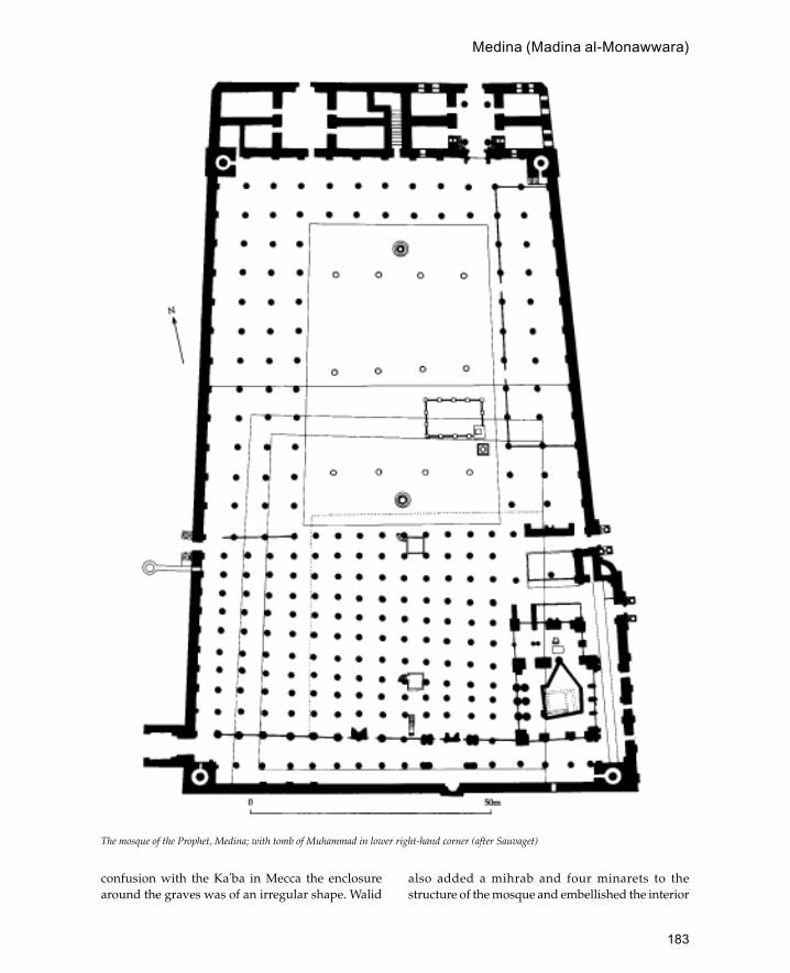
183
confusion with the Ka�ba in Mecca the enclosurearound the graves was of an irregular shape. Walid
also added a mihrab and four minarets to thestructure of the mosque and embellished the interior
The mosque of the Prophet, Medina; with tomb of Muhammad in lower right-hand corner (after Sauvaget)
Medina (Madina al-Monawwara)
184
of the mosque with mosaic and marble decoration.The mosque was further enlarged under the Abbasidcaliphs in 781 by al-Mahdi and in 862 by al-Muawakkil. In 1256 the mosque suffered from amajor fire which destroyed the roof, the Quran ofUthman and the minbar of the prophet. The mosquewas rebuilt by the Egyptian Mamluk sultan Baybarswho established a tradition of Mamluk restorationwork on the mosque. In 1279 the Mamluk sultanQala�un added a wooden dome over the tomb of theprophet. In 1467 this was replaced by a stone domeunder the directions of Qayt Bay who also replacedthe maqsura.
The Ottoman conquest of the city in the sixteenthcentury introduced a new architectural style intothe Medina Mosque. One of the first modificationswas the mihrab Suleymani added by Suleyman theMagnificent. Later on in the sixteenth century themosque was extended to the west and a newminaret was added. The present green dome overthe tomb of the prophet was added in 1818 underthe Ottoman sultan Mahmud II. In the 1920s themosque became the responsibility of the Saudirulers who undertook various repairs andrestorations. In 1951 the Saudi government initiatedthe largest programme of expansion in themosque’s history making the total mosque area22,955 m square. In 1973 a huge new court wasadded on to the west side of the mosque to copewith the increasing number of pilgrims.
Like Mecca, the city of Medina is mostly a modernconcrete construction. By analogy with the Prophet’smosque it is known that in the early days of Islamthe houses were built of mud brick with palm woodused for roofing and pillars. The advent of Islambrought new wealth to the city and may haveencouraged the development of stone architecture.Certainly by the beginning of the Ottoman periodstone was in use on a large enough scale to beemployed for the city walls. The traditional houseform in Mecca appears to have been a courtyardhouse three or four storeys high built out of graniteor basalt. Water was relatively more plentiful thanat Mecca and each house had its own well. Accordingto reports, some of the houses had columned hallsopening on to bathing pools.
Further reading:
G.R.D.King, Historical Mosques of Saudi Arabia, Londonand New York 1986.
J.Sauvaget, La Mosauée Omeyyade de Medine. Études sur lesorigines architecturales de la mosquée et de la basilique, Paris1947.
W.M.Watt and R.B.Winder, ‘Al-Madina’, Encyclopaedia ofIslam, new edn. , 5: 994–1007, 1986.
A.Youssef, ‘Al Haramain: a development study’, in Hajjin focus, ed. Z.I.Khan and Y.Zaki, London 1986.
Meknes
Former capital of Morocco located on a high plateaubetween Fez and Rabat.
The city of Meknes was founded by the Al-moravidsin the eleventh century, before that period the site wasoccupied by a cluster of small villages. The citysuffered from the Almohad conquest in 1150, althoughit was later restored and in the thirteenth century wasprovided with an aqueduct, bridges and a madrassa.The city reached its peak under the Sa�adians whoadopted it as their capital in the seventeenth century.Under the sultan Moulay Ismail the city was enclosedby a triple wall with a perimeter of more than 30 kmpierced by twenty gates. To the south of the city is ahuge separate enclosure reserved for the sultan whichcontains two palaces, one for the sultan and one forhis wives and 500 concubines. The palaces were builtas a series of gardens connected by pavilionssupported on marble columns. There are a total offorty-five separate pavilions within the grounds, aswell as four mosques and twenty domed tombscontaining the graves of sultans and their families. Tosupport the palace there was a huge granary, storehouse, stables, an army camp and palatial residencesfor the officials.
See also: Morocco
Mérida
City in south-west Spain noted for its Roman ruins andearly Islamic fortress.
The fortress is located next to the river Guadiana andthe famous Roman bridge. It is probably acontinuation of an older structure, although it wassubstantially altered to its present form in 835according to an inscription found in the fortress (nowin the local museum). It is similar to sixth- andseventh-century Byzantine forts of North Africaalthough the arches above the gateways arehorseshoe-shaped indicating their Islamicprovenance.
Medina (Madina al-Monawwara)

185
The fortress is essentially a large square enclo-sure (130 m per side) with solid rectangular buttresstowers and three gateways. The gateway leadingfrom the Roman bridge is in the form of a gate-houseflanked by two massive towers. The onlycontemporary structure within the fortress is a cisternwhich took water directly from the river via a tunnel.Entry to the cistern is from a barrel-vaulted corridorwith staircases at either end and doorways in theside which lead to the cistern. The jambs of thedoorways and other parts of the cistern include re-used Visigothic building stones.
See also: Spain
Further reading:K.A.C.Creswell, A Short Account of Early Muslim
Architecture, revised and enlarged ed. J.W.Allan,Aldershot 1989, 302.
G.Goodwin, Islamic Spain, Architectural Guides forTravellers, London 1990, 125–6.
Merv (also Marw or Marv)Ancient city in the Central Asian republic ofTurkmenistan. Also called Merv al-Shahijan or RoyalMerv to distinguish it from the city of the same name inmodern Afghanistan.
The city is located in the Merv oasis fed by theMurghab river. During the early Islamic period itfunctioned as one of the chief cities of Khurassanand under the Abbasids was capital of the east.During the eighth century the centre of the towngradually moved from its old Sassanian site of GyaurKala to a new site which is now known as SultanKala. In 1070 the Seljuk sultan Malikshah rebuilt thecity wall which remains as one of the finest examplesof medieval fortification. Other remains from theSeljuk period include the mausoleum of SultanSanjar which is a domed structure standing on asquare base measuring 27 m per side. The Mongolinvasions caused severe damage to the city which
Tomb of Sultan Sanjar, Merv, Turkmenistan (after Pugachenkara)
Merv (also Marw or Marv)

186
never fully recovered. Under the Timurid sultanShah Rukh attempts were made to revive thefortunes of the city. The city dam was rebuilt torestore the irrigation system but this was onlypartially successful. Also the city of this period wasbuilt on a different site known as Abd Allah KhanKalla.
Further reading:G.Hen-man, V.Masson, K.Kurbansakhatov, et. al., The
International Merv Project, preliminary report on theFirst Season’, Iran 31: 39–62, 1993.
E.O’Donovan, The Merv Oasis and Adventures East of theCaspian During the Years 1879–81, London 1882.
G.A.Pugachenkava, ‘Puti razvitiya arkhitekturi IuzhnogoTurkmenistana pori rabovladeniya’, Trudi Iuzhno
Turkmenistanskoi Arkheologicheskoi Ekspeditsii 6: Moscow,1958.
mescitTurkish term for a small mosque without a minbar,equivalent to the Arabic term masjid.
mihrab
Niche or marker used to indicate the direction ofprayer usually in a mosque.
A mihrab is usually a niche set into the middleof the qibla wall of a building in order to indicatethe direction of Mecca. The earliest mosques donot appear to have had mihrabs and instead thewhole qibla wall was used to indicate the directionof Mecca. Sometimes a painted mark or a treestump would be used to reinforce the direction.In the cave beneath the rock in the Dome of theRock there is a marble plaque with a blind nichecarved into it which, if contemporary with the restof the structure, may be dated to 692 making it theoldest surviving mihrab. The first concave mihrabappears to have been inserted into the Prophet’sMosque at Medina during some restorationscarried out by the Umayyad caliph al-Walid I in706. Excavations at Wasit in Iraq have confirmedthis date for the introduction of the first concavemihrab where there are two superimposedmosques; the lower one datable to the seventhcentury has no mihrab whilst the upper mosquehas a concave mihrab.
Mihrab built in 1227 of dressed limestone, Great Mosque, Silvan
mescit
Pre-thirteenth-century house, Merv, Turkmenistan
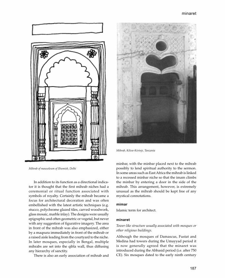
187
In addition to its function as a directional indica-tor it is thought that the first mihrab niches had aceremonial or ritual function associated withsymbols of royalty. Certainly the mihrab became afocus for architectural decoration and was oftenembellished with the latest artistic techniques (e.g.stucco, polychrome glazed tiles, carved woodwork,glass mosaic, marble inlay). The designs were usuallyepigraphic and often geometric or vegetal, but neverwith any suggestion of figurative imagery. The areain front of the mihrab was also emphasized, eitherby a maqsura immediately in front of the mihrab ora raised aisle leading from the courtyard to the niche.In later mosques, especially in Bengal, multiplemihrabs are set into the qibla wall, thus diffusingany hierarchy of sanctity.
There is also an early association of mihrab and
minbar, with the minbar placed next to the mihrabpossibly to lend spiritual authority to the sermon.In some areas such as East Africa the mihrab is linkedto a recessed minbar niche so that the imam climbsthe minbar by entering a door in the side of themihrab. This arrangement, however, is extremelyunusual as the mihrab should be kept free of anymystical connotations.
mimarIslamic term for architect.
minaretTower-like structure usually associated with mosques orother religious buildings.
Although the mosques of Damascus, Fustat andMedina had towers during the Umayyad period itis now generally agreed that the minaret wasintroduced during the Abbasid period (i.e. after 750CE). Six mosques dated to the early ninth century
Mihrab of mausoleum of Iltumish, Delhi
Mihrab, Kilwa-Kivinje, Tanzania
minaret
188
minaret
all have a single tower or minaret attached to thewall opposite the mihrab. The purpose of the minaretin these mosques was to demonstrate the power ofAbbasid religious authority. Those opposed toAbbasid power would not adopt this symbol ofconformity, thus Fatimid mosques did not havetowers. Although later minarets appear to havebecome synonymous with Islamic architecture theyhave never been entirely universal. In parts of Iran,East Africa, Arabia and much of the Far East manymosques were built without them. In such placesthe call to prayer is either made from the courtyardof the mosque or from the roof.
The form of minarets differs throughout theIslamic world. A brief summary of the form in eacharea is required.
Egypt
In post-Fatimid Egypt minarets developed into acomplex and distinctive form. Each tower iscomposed of three distinct zones: a square sectionat the bottom, an octagonal middle section and adome on the top. The zone of transition between eachsection is covered with a band of muqarnasdecoration. In earlier structures the square shaft wastall and the dome was ornate, later the centraloctagonal section became longer whilst the squareshaft was reduced to a square socle at the base.During the fourteenth century the dome at the topwas modified into the form of a stone bulb.
Another feature of the post-Fatimid period (afterthe twelfth century CE) is the increase in the numberof buildings which had minarets. Whereas underthe Abbasids minarets had been restricted tocongregational mosques, during the Mamlukperiod all kinds of buildings could have minaretsincluding smaller mosques, tombs, khanqas andmadrassas.
Syria
The traditional Syrian minaret consists of a squareplan tower built of stone. The form is thought toderive from the traditional Syrian church tower ofthe Byzantine period. The tower standing oppositethe mihrab in the Great Mosque of Damascus is theoldest minaret in Syria, dating from the early ninthcentury, although the upper part may have beenrebuilt several times. Another early Syrian minaretis that of the Great Mosque at Harran (now in
modern Turkey) built sometime between the eighthand eleventh centuries. It is built of large dressedashlar blocks with a cyma reversa moulding at 16 mabove ground level. Generally during the Ottomanperiod the square tower was abandoned in favourof the octagonal or cylindrical minaret.
North Africa and Spain
North Africa and Spain share the square tower formwith Syria and are thought to derive from the samesource—Syrian church towers. In time this designwas adapted by Christians in Spain for use as churchbell towers.
The earliest minaret in North Africa is that of theGreat Mosque of Qayrawan built in 836. This massivetower with battered walls is over 31 m high with asquare base 10.6 m per side. The lower 4 m are builtof large re-used stone blocks whilst the uppersections are built of smaller long slabs whichresemble baked bricks. The smaller minaret at Sfaxalso dated to the ninth century was probablymodelled on that at Qayrawan.
Several early minarets survive in Spainincluding that belonging to the congregationalmosque in Seville and that of the mosque at Medinaal-Zahra. However, the most impressive earlyminaret is that of Abd al-Rahman of Córdobacompleted in 968 and now encased within thechurch tower. The minaret is 8.5 m square at thebase, 47 m high and contains two independentstaircases. Related minarets are those of theQarawiyyin Mosque in Fez (built 955) and themosque of the Andalusians at Fez (built 956)although both are smaller than that at Córdoba.
The Almoravids and early Almohads followedFatimid precedent in not building minarets. Theearliest Almohad tower is at the mosque of Timnalwhich is unusual both for its positioning (behind themihrab) and its relatively short height of 15 m. Itappears that the architect sought to make it appeartall from outside without it being visible from thecourtyard of the mosque. However, later Almohadminarets were tall, impressive structures such as thatof the Kutubiyya Mosque which is 67 m tall and 12.5m per side at the base. The exterior is decorated withpanels of decorative motifs around paired sets ofwindows. The top is decorated with with serratedcrenellations, a band of polychrome tilework andthree gilded copper balls.

189
minaret
In the same tradition are the minarets of the GreatMosque of Seville (built 1184), the unfinished minaretof the mosque of Hassan at Rabat and the minaret ofthe Qasaba Mosque in Marrakesh.
Iran
The oldest known minaret in Iran is that of thecongregational mosque at Siraf dated to the ninthcentury. It is known that many minarets were builtduring the tenth century although the only thesurvivors are the minarets at Fahraj and Nayin. Theminaret at Fahraj has a tapering cylindrical form anda projecting balcony. The minaret attached to theFriday mosque at Nayin consists of a tall taperingbrick shaft, the lower part of which is octagonal inplan whilst the upper part is cylindrical. The shaft isdecorated with a simple chevron pattern usingdiagonally laid bricks. A similarly ancient miharet isattached to the Tarik-Khana in Damghan built in1026. Like the minaret at Nayin it is decorated withbricks bonded in different ways, although here thedecoration is more complex containing seven bandsof diamond patterns.
The cylindrical minaret form, which wasdeveloped in Iran, spread over a huge area with theSeljuk conquests of Syria, Anatolia, Iraq, Afghanistanand India. Some of the structures were severe plainbrick shafts whilst others were highly decorated withcomplex brick patterns. A variation of the standardfrom was the introduction of various forms ofcylindrical fluting. The Jar Kurgan minaret has semi-circular fluting whilst the minaret of Ghaznaattributed to Masud II has angular flutes. Minaretsof this type may be interpreted as victory towersrather than as religious towers in the strict sense.Probably the most surprising example of this typeof tower is the Jam minaret. This 60 m high towerstands in a secluded valley in Afghanistan and isdecorated with monumental calligraphy celebratingthe victory of the Ghurid sultan. It is significant thatthe Qutb Minar in Delhi was built by a Turkishgeneral who served in the army of the Ghurid sultanwho built the Jam minaret.
Iraq
Probably the earliest standing minaret in Iraq is themanar al-Mujida located in the desert north-west ofKufa. This has a cylindrical shaft 7 m high on a squarebase with a spiral staircase inside. The structure is
not associated with any mosque but is dated to theUmayyad period (before 750 CE) on the basis of itsplain brick decoration and association with nearbystructures.
The most famous minarets in Iraq are the giantspiral minarets of Samarra both of which are datedto the ninth century. The larger of these, known asthe Malwiyya, stands away from the rear of theGreat Mosque at Samarra. The other minaret standsin the same position near the Abu Dulaf Mosque.Although it is generally believed that the form ofthese minarets is derived from the ziggurat (e.g.Khorsabad) their relationship to the topography ofSamarra is often not considered. As the GreatMosque at Samarra was the largest mosque in theworld it would have needed a correspondingly tallminaret. To have built a cylindrical minaret 50 mhigh would have been both impractical and visuallyunimpressive within the vast horizontal spaces ofSamarra. However, a giant spiral minaret containsenough mass in relation to its height to make asignificant visual impact.
The spiral minarets of Samarra were nevercopied, except in the mosque of Ibn Tulun in Egyptwhich copies many other features from Samarra.In the Ibn Tulun minaret the top part has a smallspiral ramp reminiscent of the minarets ofSamarra.
Later minarets in Iraq are versions of IranianSeljuk minarets although Iraq seems to havedeveloped its own local schools. Thus, the minaretof the Friday mosque in Mosul (known locally as al-Hadba) is decorated with complex geometricpatterns and seems to be related to other minaretsin the vicinity such as Mardin, Sinjar and Irbil.
India
Minarets were never universally adopted in Indiaand where they were built they were not necessarilyused for the call to prayer.
The most famous minaret in India is the QutbMinar attached to the Kuwwat al-Islam Mosquein Delhi which was begun in 1189. This tower hasfour storeys marked by balconies supported onbands of muqarnas corbels. The upper storey wasrebuilt in 1368. An interesting feature is the alterna-tion of circular and angular flutes which relates itto similar minarets of Jam and Ghazna inAfghanistan.
190
minaret
With the exception of Gujarat and Burhanpur inKhandesh functional minarets attached to mosquesdid not become popular until the Mughal period. InGujarat and Burhanpur minarets were always builtin pairs flanking the central iwan as in Iran. Theseminarets were cylindrical constructions with internalstaircases with intermediate balconies leading toconical roofs. Elsewhere before the Mughal periodsolid tower-like buttresses were attached to thecorners of mosques.
The first minarets of the Mughal period are thefour seventeenth-century towers flanking Akbar’stomb at Sikandara. These are tapering white marbleconstructions with two intermediate balconies andan open canopy on top. The lower stages of thesetowers are fluted. Later Mughal minarets copied thisform with some variation in the decoration of theshaft.
Ottoman Minarets
The earliest minarets in Anatolia were built by theSeljuks. Often these were pairs of towers with a stonebase and a brick shaft. Some mosques however werebuilt with single minarets such as the AlaeddinMosque at Konya.
The combination of tall pointed minarets andlarge lead covered domes gives Ottomanarchitecture its distinctive form. In most mosquesin the Ottoman Empire this was achieved with asingle minaret attached to the corner of a mosque.However, in the major cities of the empire mosqueswere built with two, four or even six minarets. Atsome point it seems to have been established thatonly a reigning sultan could erect more than oneminaret per mosque. A characteristic feature ofthese minarets is the use of multiple balconieswhich was first developed in the Uç SerefeliMosque in Edirne which was built in 1447.
Arabia
Outside Mecca and Medina minarets were fairly rarebefore the nineteenth century. The few minarets thatdo survive are either square or circular in plan oftenwith a slightly tapering profile. In southern Yementhe larger mosques occasionally have large minaretsto distinguish them from the tall tower houses. Innorthern Yemen minarets are rare outside the capitalSan�a. The minarets of San�a are similar to those of
medieval Cairo although the external decoration ischaracteristi-cally Yemeni.
East Africa
With the exception of the thirteenth-centurymosque of Fakhr al-Din in Mogadishu (Somalia)minarets dating from before the nineteenth centuryare rare. Nineteenth-century minarets includethose of Mombasa and the Shella minaret on Lamuisland.
One of the most curious structures in the area isthe Mbraaki pillar dated to circa 1700. This 14 m-high structure has no means of access to the interioralthough it is believed to be hollow. At the foot ofthe minaret a mosque was excavated which isbelieved to be of the same period making this theoldest minaret in Kenya.
West Africa
The earliest minarets are those of the ninth- tothirteenth-century settlements at Koumbi Saleh andTegadoust. Excavated remains indicate that thesehad large square minarets. During the thirteenthand fourteenth centuries the characteristic WestAfrican minaret developed. These minarets have amassive square structure with tapering sides andprojecting wooden beams (torons). One of the mostfamous minarets is that of the Kano Great Mosque(destroyed 1937) which was over 20 m high on asquare base with battered sides. The Fulanireformers of the nineteenth century objected to theuse of minarets and replaced many of them withstaircase minarets.
Far East
Minarets are not a traditional feature of Far EasternIslamic architecture and have only recently beenintroduced on a large scale. In western Chinaminarets usually take the form of squat pagoda-likestructures, with a few exceptions such as the minaretof the Huaisheng Mosque in Guangzhou which is atall tapering cylinder 20 m high.
See also: East Africa, Cairo, India, Iran, Iraq,Mosque, Syria, West Africa.
Further reading:D.Berens-Abouseif, The Minarets of Cairo, Cairo 1985.J.Bloom, Minaret: Symbol of Islam, Oxford 1989.

191
K.A.C.Creswell, ‘The evolution of the minaret withspecial reference to Egypt’, Burlington Magazine 48,1926: 134–40, 252–8, 290–8.
R.Hillenbrand, Islamic Architecture: form, Function andMeaning, Edinburgh 1994.
B.O’Kane, ‘Seljuk minarets: some new data’, Annalesislamologiques 20, 1994: 85–101.
G.F.Pijper, ‘The Minaret in Java’, India Antiqua: A Volumeof Essays Presented to Jean Phillipe Vogel, Leiden 1947.
minbarType of pulpit usually found in mosques from whichprayers, speeches and religious guidance are given. Theminbar is situated to the right of the mihrab and consistsof a raised platform reached by a set of steps, often there isa door at the entrance to the steps and a dome or canopyabove the platform.
The minbar is one of the earliest architectural featuresto be identified with Islam. The earliest historicalreference to a minbar states that in 629 the Prophetmade a minbar from which he used to preach to thepeople. This minbar consisted of two steps and aseat (mak�ad) and resembled a throne. After the deathof the Prophet the minbar was used by caliphs and
governors as a symbol of authority. This continuedunder the last few years of Umayyad rule until in750 CE the caliph Mu’Awiya ordered that all themosques of Egypt be provided with minbars. Thisprocess was repeated in other Islamic lands so thatby the beginning of the Abbasid period the minbar’sfunction as a pulpit was universally established.
Most minbars are made of wood and are highlydecorated whilst those made of stone or brick tendto be much simpler and often comprise a bareplatform reached by three to five steps. The earliestextant wooden minbar is that in the Great Mosquein Qairawan which is said to have originated inBaghdad. It is a fairly simple design without a gateor canopy and consists of seventeen steps leadingup to a platform. This minbar is made of plane treeand decorated with 200 carved panels and strips ofunequal size. Although it has been restored severaltimes most of the decoration seems to be Umayyad,consisting of diverse motifs held together within arigid framework in a manner similar to that used atMshatta.
In the Fatimid period minbars are built with adoorway at the entrance to the stairway and a domedcanopy above the platform. The best example of thistype is that in the Aqsa mosque in Jerusalem builtfor Nur al-Din in 1168. An example of this style instone is the minbar in the mosque of Sultan Hasan(1356–63). Over the doorway to the minbar and alsoin the mihrab of this mosque muqarnas carving isused. Later on muqarnas remains an importantdecorative element in minbar design and is usedparticularly on minbar domes.
Most early minbars in Persia and Afghanistanwere destroyed by the Mongol invasions; however,from the Timurid period we have several examples.One of the most impressive of these is that in theDjawahr Shah Agah in Meshed (constructed between1436 and 1446). Structural elements in this minbarare subordinated to the covering of pentagonal andstar-shaped panels with tendrils in relief, which hasthe overall effect of a woven carpet.
In Ottoman Turkey although most minbarswere made of wood some of the most importantwere built of marble. Thus in the Selimiye Camiin Edirne there is a tall minbar of Marmara marblewhich is widely regarded as the finest in Turkey.The form of this minbar with its solid portal, itssteep stairs and tall hood are all characteristicOttoman features.
Umayyad minbar in the mosque of the Prophet, Medina (afterSauvaget)
Minbar
192
In India almost all minbars are built of stone andare often elaborately carved. In Gujarat andAhmadabad minbars are in the form of pavilionson four piers. In Hyderabad, to the south, theminbars are heavier and plainer, with no canopiesor portals.
The Swahili mosques of the East African coastusually have simple stone mihrabs. At Sanje YaKate in southern Tanzania there is a sixteenth-century mosque with a unique minbar set into thewall. This is entered through an opening in theqibla wall from which the stairs lead to a nichenext to the mihrab.
Mogadishu
Capital of Somalia located on the southern coast.
Mogadishu was established as a trading citysometime before the twelfth century although noearly remains have yet been discovered. There are anumber of historic mosques in the old quarter of thecity which mostly date from the nineteenth centuryor later. The principal mosque of the town is themosque of Fakhr al-Din dated to the thirteenthcentury. This is the most sophisticated example ofmosque architecture in East Africa and demonstratesarchitectural planning. The mosque has a narrowcourtyard which opens on to a portico of five bays,the central bay of which is covered with a fluteddome. Entry into the prayer hall is through doorwaysdecorated with marble panels. The prayer hall isdivided into nine bays covered with a panelledceiling with a central dome. The mihrab is carvedout of north Indian marble and carries a date of 1269.The mosque also has a minaret which is the earliestoccurrence of this feature in East Africa (minaretsonly become widespread from the nineteenthcentury).
See also: East Africa, Somalia
Monastir
Important medieval city on the east coast of Tunisia.
At present Monastir is on the coast, but in earlyIslamic times it was probably a peninsula or island.Monastir was one of the coastal cities developed bythe Aghlabids during the ninth century. The citycontains the remains of three ribats or fortifiedmonasteries the earliest of which is the great ribat of
Harthma ibn A�iyan founded in 796. The GreatMosque of the city was built in the ninth centuryalthough most of the structure dates to the tenthcentury or later.
See also: Aghlabids, Tunisia
Morocco (Arabic: Maghrib)
Country at the north-west corner of Africa with anAtlantic and Mediterranean coast.
The country may be divided into three mainregions, the coastal plains, the Atlas mountains andthe Sahara desert. The majority of the populationlives on the plains with a smaller, more ruralpopulation in the mountains. The Sahara is sparselyinhabited.
Traditionally Islam first reached Morocco duringthe conquest of the Arab general �Uqba who reachedthe shores of the Atlantic in 684. However, it seemslikely that the first real conquest, as opposed to atemporary raid, took place at the beginning of theeighth century under the general Musa ibn Nusayr.The predominantly Berber population was quicklyconverted to Islam and took part in the Muslimconquest of Spain. After the initial success of theSpanish conquest the Berbers were disappointedwith their share of the land allocations, in additionmany were affected by the doctrines of Kharijismwhich represented a devia-tion from orthodoxIslam. By 740 the situation had become critical andthere was a rebellion against the Umayyads. ASyrian army sent to restore order was defeated in742 leaving Morocco independent of central control.For the next forty years there was a period ofanarchy with several Berber groups vying forpower. In 788 the Idrissids emerged as the victorsand were able to establish an independentmonarchy which lasted until the end of the tenthcentury when it became a victim of Fatimid andUmayyad (Spanish) rivalry. During the eleventhcentury the country was taken over by theAlmoravids who ruled an empire which includedsouthern Spain and much of north-west Africa. Inthe mid-twelfth century the Almoravids weredisplaced by the Almohads who conquered a vastterritory from the southern Sahara to central Spain.The Almohad Empire collapsed in the mid-thirteenth century to be replaced by the Marinidswho ruled an area roughly equivalent to modernMorocco although there were constant attempts to
Mogadishu

193
expand eastward. Local unrest and increasingEuropean interest in Morocco led to the collapse ofthe Marinids in the fifteenth century. A period ofanarchy was followed by a reaction against Christianoccupation of the coast which was embod-led in theSa�dian dynasty. The Sa�dians who claimed descentfrom the Idrisids lasted until the mid-seventeenthcentury when they were defeated by the �Alawids.The �Alawids also had a semi-religious basis claimingtheir descent from �Ali, members of this dynasty stillrule the country.
A large variety of materials are used in historicand traditional Moroccan architecture. This partlyreflects the variety of the natural landscape whichincludes extremely high mountains, fertile plains andarid desert. Another important factor is the influenceof Spanish architecture which was reinforced by theChristian reconquest which drove Muslimssouthwards into Morocco. The coastal cities of thenorth inherited the Byzantine system of constructionin stone and baked brick. In the Atlas mountains mudpisé and rubble stone construction were thepredominant materials although these were oftencovered with plaster. Overlapping gutter-shaped
tiles with a characteristic blue-green colour wereused for the roofs of important buildings and mayrepresent Spanish influence. Small monochrome tileswere used for floors, as dadoes for courtyards andsometimes as decoration for whole façades. Woodwas relatively plentiful, cedar, cork and oak fromthe Atlas mountains was used for a variety offunctions including roofing timber, supports forprojecting windows, panelled ceilings and decorativemashrabiyya screens. The quality of wood carvingis extremely high and resembles that of MuslimSpain. Stucco was extensively used for decorativefeatures such as multifoil arches and decorativepanels.
There are few examples of Moroccan Islamicarchitecture from before the eleventh century andthose which do survive have been extensivelyaltered. The most important city for the early periodis Fez which was established as a capital in 807 byMoulay Idris the Younger. Very little survives ofthe early city although it is known that it had anadvanced water system which supplied water fordomestic use. Architecturally the most significantbuildings in the town are the Qarawiyyin and theAndalusian mosques which were both built in theninth century. The form of these mosques withaisles running parallel to the qibla wall cut by anaxial aisle is a Syrian—Umayyad plan. Latermosques in Morocco follow the more usual NorthAfrican practice of aisles perpendicular to the qibla.No mosques of the Almoravid period havesurvived with the exception of the Great Mosqueof Taza which was considerably remodelled in laterperiods.
Remains of the Almohad period are moreplentiful and include the Kutubiya and Kasbamosques in Marakesh, the Hassan Mosque in Rabatand the Great Mosque of Timnal. The earliest of theseis the mosque of Timnal which is built out of mudpisé and baked brick. The prayer hall has nine aislesperpendicular to the qibla wall and one aisle parallelto the qibla wall, an arrangement which was tobecome standard. The unusual feature of thebuilding is the incorporation of the mihrab into thebase of the minaret. This arrangement was not usedin subsequent mosques although huge decorativeminarets became one of the characteristic featuresof Almohad architecture. The most impressiveexample is the unfinished mosque of Hassan in Rabatbegun in 1196. This vast mosque measures 140 by185 m and includes three rectangular courtyards. The
Dome of Baru Din, Great Mosque, Marakesh, Morocco
Morocco (Arabic: Maghrib)
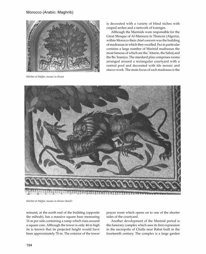
194
minaret, at the north end of the building (oppositethe mihrab), has a massive square base measuring16 m per side containing a ramp which rises arounda square core. Although the tower is only 44 m highits is known that its projected height would havebeen approximately 70 m. The exterior of the tower
is decorated with a variety of blind niches withcusped arches and a network of lozenges.
Although the Marinids were responsible for theGreat Mosque of Al-Mansura in Tlemcen (Algeria),within Morocco their chief concern was the buildingof madrassas in which they excelled. Fez in particularcontains a large number of Marinid madrassas themost famous of which are the �Attarin, the Sahrij andthe Bu �Inaniya. The standard plan comprises roomsarranged around a rectangular courtyard with acentral pool and decorated with tile mosaic andstucco work. The main focus of each madrassa is the
prayer room which opens on to one of the shortersides of the courtyard.
Another development of the Marinid period isthe funerary complex which sees its first expressionin the necropolis of Challa near Rabat built in thefourteenth century. The complex is a large garden
Khirbet al-Mafjar, mosaic in diwan
Khirbet al-Mafjar, mosaic in diwan (detail)
Morocco (Arabic: Maghrib)

195
enclosed by a high wall fortified with buttress towersand an Almohad-style gateway. Within the complexthere are tombs set within extensive areas ofvegetation. There are two funerary mosques withinthe complex both with square decorated minaretsin the Almohad style. In the sixteenth andseventeenth centuries the Sa�adians built a similartype of complex but on a grander scale withdecoration of unparalleled ornateness. A differenttype of funerary-memorial complex is representedby the city of Moulay Idriss built by the Sa�adianruler Moulay Ismail in the seventeenth century.Here the tomb of Idris I forms the centre of a sacredcity which is restricted to Muslims.
The domestic architecture of Morocco representsa wide va riety of architectural forms from semi-permanent camps to the luxurious courtyard villasof Fez, Rabat, Marakesh and Meknes. The simplestform of dwelling is the thatched hut or gourbi whichmay either be rectangular with a pitched roof orcircular in plan with a conical roof. In the Atlasmountains there are villages of semi-permanent hutsbuilt around a central keep, or kasba. Sometimes theseare purely for storage (tiremt) and have noaccommodation although there is usually a guard’shouse. Some of the more developed villages formedwalled enclosures with the keep functioning as aresidence for the ruling family. City houses wereenclosed courtyard structures with little externaldecoration. Inside the wealthier houses contain someof the most elo-quent examples of Islamic decorationand recall the splendour of Muslim Spain.
See also: Almohads, Fez, Marakesh, Meknes,Rabat
Further reading:R.Landau, The Kasbas of Southern Morocco, London 1969.
mosaicsInlay of small tiles or stones used for decoration of wallsor floors.
The use of mosaics in Islam is derived directly fromRoman and Byzantine architecture where their mostcommon function was to decorate churches and publicbuildings. It is known that many mosaics in the earlyIslamic period were carried out by Byzantinecraftsmen and artists. Two main types of mosaic canbe distinguished, those used for floors and those usedfor walls. Floor mosaics were made out of colouredfragments of stone or marble and were often arranged
as patterns. Wall mosaics were often made out ofspecially manufactured tesserae of glass and wereusually arranged as illustrative scenes.
Examples of floor mosaics have been found inexcavations of the earliest Islamic structures in Syriaand Palestine which were often converted Byzantinebuildings. Floor mosaics usually lack any figuraldepictions of animals or humans and it is noticeablethat many churches had the figural parts of themosaics removed or scrambled during the Islamicperiod. Nevertheless, private palaces such as Qasr al-Hayr in Syria and Khirbet al-Mafjar had figuralmosaics on the floor. It has been argued that figuralrepresentation on the floor was permitted as it wasnot in a respectful situation and could be walked over.The most famous example is the apse of the audiencehall at Khirbet al-Mafjar which has a depiction of alion attacking a deer in front of a tree.
Wall mosaics are more elaborate than those onthe floor and are often gilded with gold leaf. Theoldest example of wall mosaics in Islamicarchitecture is the decoration of the Dome of the Rockin Jerusalem, dated by an inscription to 691 CE. Themotifs used include both Sassanian (winged crowns)and Byzantine (jewelled vases) themes held togetherwithin an arabesque foliage. Other early Islamic wallmosaics are those of the Great Mosque in Damascuswhich depict houses and gardens next to a river butsignificantly no people or animals. Although mosaicwas primarily a technique employed in theMediterranean area it was occasionally used furthereast in Iraq and Iran. Some of the best examples havebeen found at the palace of al-Quwair in Samarra.Generally mosaics declined in importance after thetenth century, although in Egypt glass mosaics wereused for the decoration of mihrabs as late as thethirteenth century (see for example the mausoleumof Shajarat al Durr in Cairo). From the eleventhcentury onwards mosaics were replaced by glazedtilework in most parts of the Islamic world.
See also: pietra dura, tilework, Umayyads
mosqueBuilding used for Muslim prayer, the principal unit ofIslamic architecture.
The first mosque was the house of the ProphetMuhammad in Medina. This was a simplerectangular (53 by 56 m) enclosure containing roomsfor the Prophet and his wives and a shaded area on
Mosque
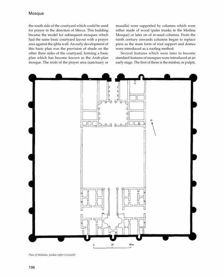
196
the south side of the courtyard which could be usedfor prayer in the direction of Mecca. This buildingbecame the model for subsequent mosques whichhad the same basic courtyard layout with a prayerarea against the qibla wall. An early development ofthis basic plan was the provision of shade on theother three sides of the courtyard, forming a basicplan which has become known as the Arab-planmosque. The roofs of the prayer area (sanctuary or
musalla) were supported by columns which wereeither made of wood (palm trunks in the MedinaMosque) or later on of re-used columns. From theninth century onwards columns began to replacepiers as the main form of roof support and domeswere introduced as a roofing method.
Several features which were later to becomestandard features of mosques were introduced at anearly stage. The first of these is the minbar, or pulpit,
Plan of Mshatta, Jordan (after Creswell)
Mosque

197
which was used by Muhammad to give sermons. Alater introduction was the mihrab or prayer nichewhich was first introduced by the Umayyad caliphal-Walid in the eighth century. Other features includethe ablutions facilities and a central pool or fountainand the minaret which seems to make its firstappearance in the Abbasid period. Also during thisformative period the maqsura was introduced whichwas designed to provide privacy and protection tothe ruler and also possibly to give him addedmystery. This sense of mystery may have beenreinforced by the placing of the royal palace or Daral-Imara at the back of the mosque behind the qiblawall often with a connecting door.
The details of mosques in different areas of theIslamic world were dictated by local buildingtraditions and materials, although the basic formremained the same until the eleventh century whenthe Seljuks introduced new architectural forms basedspecifically on the dome and the iwan. Although thesehad been known in Sassanian times and had been usedin mosque architecture, they had not been used to alterthe basic plan of the mosque. However, the Seljuksintroduced the idea of four iwans set into the middleof each courtyard façade, as seen in the twelfth-century mosques of Isfahan, Zawara and Simnan. Thisarrangement became the standard form for the Iranianmosque and was later adopted for madrassas.
See also: Aqsa, Cairo, China, Damascus, EastAfrica, Fatimids, India, Indonesia, Iran, Iraq,Java, Malaysia, Mughals, nine-domedmosques, Ottomans, Spain, Turkey, WestAfrica
MshattaOne of the most famous desert castles of the early Islamicperiod.
The palace of Mshatta is located on the border of thedesert in Jordan (about 25 km south-west ofAmman). It is generally dated to the late Umayyadperiod (the reign of Walid II) although an Abbasiddate has also been suggested.
The palace consists of a large square enclosurewith four semi-circular buttress towers. Outside theenclosure are the remains of a large bath house whichhas recently been excavated. The best-known featureof this palace is the southern façade which consistsof a delicately carved stone frieze incorporatinganimal and plant motifs within a geometric schemeof twenty giant triangles (this façade is now in Berlin).
Internally the building is divided into threelongitudinal strips of equal size; only the central strip(running north-south) was developed, and containswithin it the entrance, the central courtyard and theaudience hall. The area immediately inside theentrance has only foundations to mark the positionsof rooms which were arranged symmetrically oneither side of a central axis. This consists of a narrowvaulted passageway leading to a small squarecourtyard, on one side of which is the small palacemosque. This courtyard opens on to a large centralcourtyard (including a rectangular pond) at the otherside of which is the heart of the palace. This consistsof three iwans, the central iwan leading to the throneroom (audience hall) and the side iwans leading tohousing units (buyut—pl. of bayt) either side of theaudience hall. The audience hall consists of a triple-apsed room covered by a large brick dome.
The importance of the palace for architecturalhistorians is that it combines western (Roman andByzantine) elements with features derived from the artof the Sassanians. The decorative frieze at the front ofthe building is one of the best examples of thiscombination. The vine leaves and naturalisticdepictions of animals resembles Byzantine art althoughthe decoration also includes popular Sassanian motifssuch as the senmurv, a dragon-like mythological beast,and griffin. The most significant eastern feature of thedesign is thought to be the way the geometric patternof giant triangles dic-tates the nature and space of themore naturalistic ornament.
Other eastern features found at Mshatta includethe use of brickwork for vaults and the layout of thepalace which resembles that of early Islamic buildingsin Iraq (cf. Abbasid palaces at Ukaidhir and Samarra).However, Byzantine elements are also present, mostnotably in the basilical arrangement of the approachto the triple-apsed room and in the motifs of thestonework.
Further reading:
K.A.C.Creswell, E.M.A. Vol 1Part 2, 578–622O.Grabar, ‘The date and meaning of Mshatta’, Dumbarton
Oaks Papers, 41: 243–8, 1987.R.Hillenbrand, ‘Islamic art at the crossroads; East versus
West at Mshatta’, in Essays in Honour of KatharinaOttoDorn, Malibu 1981, 63–86.
mud brickTraditional building material in much of the Middle East,India and North Africa. It is likely that in the past the
mud brick

198
Mughals
majority of buildings in an Islamic city were made of thismaterial. Mud brick has only recently been superseded byconcrete as a cheap and versatile building material and isstill used in many areas.
The traditional form of a mud brick is a large flatsquare slab produced by filling a wooden mouldwith mud or clay of the preferred type. In some areasthe shape of the bricks is varied; thus in Djenné, WestAfrica, conical bricks were used until quite recently.Often some additional material (temper) such asstraw is added to the brick to give it increasedstrength. The brick is then left to bake in the sun forseveral days until it is very hard and can be used forbuilding. The bricks are laid in the normal manner,with layers of mud mortar used to bind the brickstogether. When a mud-brick wall is completed it isusually coated with a layer of water-resistant mudplaster. In order to avoid the problems of watererosion mud-brick buildings are often built on stonefootings or have overhanging roofs with water run-off directed into special channels. Mud brick alsorequires a certain amount of maintenance usually inthe form of annual replastering.
Mud brick has several advantages over moremodern materials: it has better thermal insulation(warmer in winter and cooler in summer), it ischeaper, it can be produced locally and it isenvironmentally less harmful. Recently there havebeen attempts to revive the use of mud brick throughspecial projects such as those instigated by HassanFathy in Egypt.
See also: Djenné; Fathy, Hassan
Mughals
The Mughals were an Indian Islamic dynasty which ruledmost of northern India (including the area of present-dayPakistan) from the beginning of the sixteenth to the mid-eighteenth century. As patrons of architecture theMughals commissioned some of the finest buildings knownto the world including the Red Fort at Delhi and the TajMahal.
History
The earliest Muslim presence in India dates from 712with the Arab conquest of Sind which was a part ofthe original eastward expansion of Islam. However,it was not until the eleventh century that Muslimwarriors first penetrated to the Indian heartland
under the leadership of Mahmud of Ghazni. For thenext 150 years the Punjab and Lahore were part ofthe Ghaznavid Empire although the Rajput princesof Rajasthan prevented further penetration into thesubcontinent. In 1192 an Afghan sultan, Mahmud ofGhur, defeated an alliance of Rajput princes andcaptured Delhi, one of their principal cities. AlthoughMahmud soon left India he made his Mamluk (slave)general Qutb al-Din Aibak governor of Delhi. Forthe next 300 years this part of India was ruled byvarious competing Islamic dynasties including theTimurids.
The first Mughal ruler was Babur who tracedhis descent on his mother’s side from Chengiz Khanand on his father’s side from Timur (Tamu-ralne).Babur was a Central Asian prince who ruled thearea of Fargahna but had some claim to Samarkandwhich he repeatedly tried to capture. In addition tohis dream of taking Samarkand Babur also believedhe had some claim to the Delhi sultanate throughhis Timurid ancestors. At the battle of Paniput in1526 Babur defeated Ibrahim Lodi, the Muslimsultan of Delhi, with a small force which had,however, the additional advantage of artillery andgunpowder. A year later this victory wasconsolidated by Babur’s defeat of the combinedforces of the Rajput princes at Khanuna. Three yearslater, in 1530, Babur died at Agra leaving thesultanate to his son Humayun. Despite theenormous advantages bequeathed by his fatherHumayun did not have his father’s ruthlessness andin 1540 lost the throne to the Bengali ruler SherKhan. For the next fifteen years Delhi was ruled bySher Khan and after his death by his son Islam SherSur. Humayun had lost the throne mostly throughthe treachery of his brothers and it was only afterhe had defeated them by recapturing Kabul andKandahar in 1545 that he was in a position to retakeDelhi which he did in 1555 defeating Sher Sur.Unfortunately Humayun was only able to enjoy hisposition for a year as he died in 1556 falling downa stairway in his library in Delhi.
Humayun left the empire to his 13-year-old sonAkbar and his Turcoman guardian Bairam Khan.For the next four years the prince and his guardianhad to fight off rival claims to the throne whilstsecuring the boundaries of the kingdom. Akbar’sfirst concern on assuming full power was thepacification of the Rajput princes who constantlythreatened the Delhi sultanate. In 1562 Akbarmarried the daughter of the Raja of Amber (the
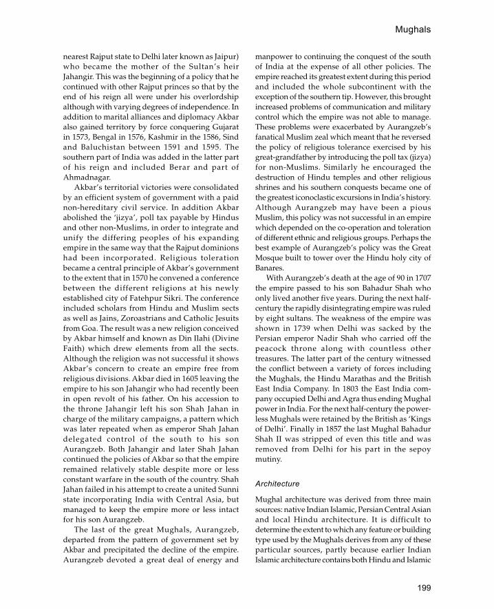
199
Mughals
nearest Rajput state to Delhi later known as Jaipur)who became the mother of the Sultan’s heirJahangir. This was the beginning of a policy that hecontinued with other Rajput princes so that by theend of his reign all were under his overlordshipalthough with varying degrees of independence. Inaddition to marital alliances and diplomacy Akbaralso gained territory by force conquering Gujaratin 1573, Bengal in 1576, Kashmir in the 1586, Sindand Baluchistan between 1591 and 1595. Thesouthern part of India was added in the latter partof his reign and included Berar and part ofAhmadnagar.
Akbar’s territorial victories were consolidatedby an efficient system of government with a paidnon-hereditary civil service. In addition Akbarabolished the ‘jizya’, poll tax payable by Hindusand other non-Muslims, in order to integrate andunify the differing peoples of his expandingempire in the same way that the Rajput dominionshad been incorporated. Religious tolerationbecame a central principle of Akbar’s governmentto the extent that in 1570 he convened a conferencebetween the different religions at his newlyestablished city of Fatehpur Sikri. The conferenceincluded scholars from Hindu and Muslim sectsas well as Jains, Zoroastrians and Catholic Jesuitsfrom Goa. The result was a new religion conceivedby Akbar himself and known as Din Ilahi (DivineFaith) which drew elements from all the sects.Although the religion was not successful it showsAkbar’s concern to create an empire free fromreligious divisions. Akbar died in 1605 leaving theempire to his son Jahangir who had recently beenin open revolt of his father. On his accession tothe throne Jahangir left his son Shah Jahan incharge of the military campaigns, a pattern whichwas later repeated when as emperor Shah Jahandelegated control of the south to his sonAurangzeb. Both Jahangir and later Shah Jahancontinued the policies of Akbar so that the empireremained relatively stable despite more or lessconstant warfare in the south of the country. ShahJahan failed in his attempt to create a united Sunnistate incorporating India with Central Asia, butmanaged to keep the empire more or less intactfor his son Aurangzeb.
The last of the great Mughals, Aurangzeb,departed from the pattern of government set byAkbar and precipitated the decline of the empire.Aurangzeb devoted a great deal of energy and
manpower to continuing the conquest of the southof India at the expense of all other policies. Theempire reached its greatest extent during this periodand included the whole subcontinent with theexception of the southern tip. However, this broughtincreased problems of communication and militarycontrol which the empire was not able to manage.These problems were exacerbated by Aurangzeb’sfanatical Muslim zeal which meant that he reversedthe policy of religious tolerance exercised by hisgreat-grandfather by introducing the poll tax (jizya)for non-Muslims. Similarly he encouraged thedestruction of Hindu temples and other religiousshrines and his southern conquests became one ofthe greatest iconoclastic excursions in India’s history.Although Aurangzeb may have been a piousMuslim, this policy was not successful in an empirewhich depended on the co-operation and tolerationof different ethnic and religious groups. Perhaps thebest example of Aurangzeb’s policy was the GreatMosque built to tower over the Hindu holy city ofBanares.
With Aurangzeb’s death at the age of 90 in 1707the empire passed to his son Bahadur Shah whoonly lived another five years. During the next half-century the rapidly disintegrating empire was ruledby eight sultans. The weakness of the empire wasshown in 1739 when Delhi was sacked by thePersian emperor Nadir Shah who carried off thepeacock throne along with countless othertreasures. The latter part of the century witnessedthe conflict between a variety of forces includingthe Mughals, the Hindu Marathas and the BritishEast India Company. In 1803 the East India com-pany occupied Delhi and Agra thus ending Mughalpower in India. For the next half-century the power-less Mughals were retained by the British as ‘Kingsof Delhi’. Finally in 1857 the last Mughal BahadurShah II was stripped of even this title and wasremoved from Delhi for his part in the sepoymutiny.
Architecture
Mughal architecture was derived from three mainsources: native Indian Islamic, Persian Central Asianand local Hindu architecture. It is difficult todetermine the extent to which any feature or buildingtype used by the Mughals derives from any of theseparticular sources, partly because earlier IndianIslamic architecture contains both Hindu and Islamic

200
Mughals
elements. What is clear, however, is that Mughalarchitecture does incorporate many elements fromlocal Hindu architecture, in particular the art of theRajput palaces. Distinctive Hindu featuresincorporated into Mughal architecture includetrabeate stone construction, richly orna-mentedcarved piers and columns, and shallow arches madeout of corbels rather than voussoirs. In additionthere are particular constructions usually associatedwith Hindu buildings, including chatris, chajjas andjarokhas, which became characteristic of Mughalarchitecture. A chatri is a domed kiosk resting onpillars which in Hindu architecture is used as acenotaph but in Islamic architecture is placed asdecoration on top of mosques, palaces and tombs.A chatri is a sloping stone overhang at roof level,used to deflect rain water away from the walls of abuilding and usually supported on heavy carvedcorbels. A jarokha is a projecting balcony supportedon corbels with a hood resting on columns. Whilstall of these features may be paralleled elsewhere inIslam, the particular form which they assume inMughal architecture shows a clear derivation fromlocal Hindu architecture. In addition to Hindufeatures there are some elements derived from thepre-existing Islamic architecture of India. The bestexample is the curved do-chala roof derived fromBengali huts which was first used in this stone formin the sultanate architecture of Bengal. AnotherIndo-Islamic feature is the cusped arch which canbe found in the pre-Mughal architecture of Delhiand Gujarat.
Obvious Persian influences in Mughalarchitecture are the extensive use of tilework, theiwan as a central feature in mosques, the use ofdomes, the charbagh, or garden, divided into fourand the four-centrepoint arch. The form of buildingsand some of the decorative motifs also suggestsobvious Persian influence.
The materials used for Mughal architecturevaries widely depending on the region and thetype of construction. As with most other areas,many of the original buildings have not survivedbecause they were made of less permanentmaterials such as wood, as well as having beensubject to deliberate destruction as a result of warsor rebuilding. However, the material which standsout as characteristic of Mughal architecture is theuse of a hard, deep-red sandstone. This materialis very strong under compression and so can beused for trabeate construction where roofs are
made of flat stone slabs supported on stonecolumns. When domes were built these weresometimes constructed in the Persian traditionusing squinches or pendentives, but morecommonly they rested on horizontal flat beamslaid over the corners of the structure. Despite itsstrength and hardness the Indian masons trainedin the Hindu tradition of building ornate templeswere able to carve this sandstone with intricatedetails as seen in the columns of the Jami Masjidin Delhi. White marble is the other type of stoneoften associated with Mughal architecture. It isfirst used in conjunction with red sandstone as astone cladding for the front of monumentalbuildings such as the tomb of Humayun in Delhiwhere it is used as an inlay and outline for the redsandstone ground. Later, during the reign of ShahJahan in the seventeenth century, white marblefacing was used to cover entire buildings, the best-known example of which is the Taj Mahal. Inaddition to the fine-cut stone masonry used forfaçades coursed rubble stone construction wasused for the majority of walls. Baked brick wasalso used for some elements of the constructionlike domes and arches although this was usuallycovered with plaster or facing stones.
Decoration of buildings was carried out using avariety of techniques including ceramic tilework,carved and inlaid stonework, pietra dura inlay withcoloured and semi-precious stones. Tilework wasapplied to the exterior of buildings in the Persianmanner using Chinese, Persian and Indian tiles. Twomain types of tile were used—cuerda sec usingcoloured glazes, and tile mosaic which used cut piecesof monochrome tiles to produce a pattern. Mughalarchitecture excels in the quality of its carvedstonework, from shallow relief depictions of flowersto intricate pierced-marble screens known as jalis. Ithas previously been thought that the pietra dura workin Mughal architecture was an Italian introductionbecause Shah Jahan used some Italian examples ofthe technique in his palace in Delhi, however thistechnique had an independent development in Indiawhich is obvious when the Italian panels arecompared with Indian examples. The main types ofbuilding designed for the sultans included palaces andforts, mosques, tombs and gardens. The range ofbuildings indicates the image the emperors wishedto project of themselves as all-powerful rulers closeto heaven. One of the most important types ofbuilding was the fortified palace as seen at Delhi, Agra,

201
Mughals
Ajmer, Fatehpur Sikri and Lahore. Although differingsubstantially in details the palaces share a commonoverall design where severe external walls conceal aseries of courtyards, pavilions and gardens whichconvey an impression of paradise on earth. Thestandard plan was of a monumental outer gate whichleads inside to another gate known as the ‘Hathai Pol’where visitors dismount from elephants. From herethere was access to the Diwan-i Amm or publicaudience hall behind which were the private areas ofthe palace. The private areas of the palace were usuallyraised up above the rest of the complex for increasedprivacy and to catch any breezes in the summer heat.This part of the palace usually included a privateaudience hall, a bath house, several courtyards withpavilions based around pools and a separate area forthe women, known as the zenana. On one side of this
private area was a tower projecting from the outerwalls known as the Mussaman Burj (octagonal tower)from which the emperor appeared once a day to showthat he was still alive.
Babur, the first Mughal emperor, only reigned forfour years, during which time he was too busysecuring his empire to spend time on major buildingprojects like palaces and instead governed fromtented encampments. The earliest Mughal palace isthe Purana Qila in Delhi built by Humayun andcontinued by the Bengali usurpers Sher Sur andIslam Sur. The palace is surrounded by a huge wall1.5 km long with three huge gateways. Each gatewayconsists of an arched opening flanked by two hugesemi-circular bastion towers with battered walls,arrow slits and pointed crenellations. Little remainsof the original structures inside the fort with the
Elevation and section of Hashtsal Minar (1634), India (after Koch)
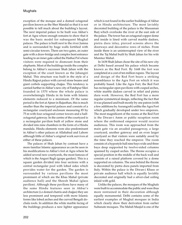
202
Mughals
exception of the mosque and a domed octagonalpavilion known as the Sher Mandal so that it is notpossible to tell much about the building’s layout.The next imperial palace to be built was Akbar’sfort at Agra where enough remains to show that itwas the basic model for subsequent Mughalpalaces. The palace is built next to the river Jumnaand is surrounded by huge walls fortified withsemi-circular towers. There are two gates, an outergate with a draw-bridge and complex bent entranceleading to an inner gate called the Hathai Pol wherevisitors were required to dismount from theirelephants. Most of the buildings inside the complexbelong to Akbar’s successor Shah Jahan with theexception of the court known as the JahangiriMahal. This structure was built in the style of aHindu Rajput palace with carved stone beams andgiant corbels supporting chajjas. This tendency iscarried further in Akbar’s new city of Fatehpur Sikrifounded in 1570 where the whole palace isoverwhelmingly Hindu in its form with Islamicelements reduced to a minimum. Of the sameperiod is the fort at Ajmer in Rajasthan, this is muchsmaller than the imperial palaces and consists of arectangular courtyard enclosure measuring 85 by75 m with four octagonal corner towers and a half-octagonal gateway. In the centre of the courtyard isa rectangular pavilion built of yellow stone anddivided into nine chambers in the form of a Hindumandala. Hindu elements were also predominantin Akbar’s other palaces at Allahabad and Lahorealthough little of Akbar’s original work survives ateither of these palaces.
The palaces of Shah Jahan by contrast have amore familiar Islamic appearance as can be seen inhis modifications to Akbar’s fort at Agra where headded several new courtyards, the most famous ofwhich is the Anguri Bagh (grape garden). This is asquare garden divided into four sections with acentral rectangular pool with lobed sides whichprovides water for the garden. The garden issurrounded by various pavilions the mostprominent of which are the Khas Mahal (privateaudience hall) and the Sheesh Mahal (glasspavilion). Although these pavilions have many ofthe same Hindu features seen in Akbar’sarchitecture (i.e domed chatris and chajjas) they areless prominent and tempered with more Islamicforms like lobed arches and the curved Bengali do-chala roofs. In addition the white marble facing ofthe buildings produces a new lighter appearance
which is not found in the earlier buildings of Akbaror in Hindu architecture. The most lavishlydecorated building of the palace is the MussamanBurj which overlooks the river at the east side ofthe palace. The tower has an octagonal copper domeand inside is lined with carved marble dadoes,pietra dura inlay, pierced screens above thedoorways and decorative rows of niches. Frominside there is an uninterrupted view of the riverand the Taj Mahal built by Shah Jahan for his wifeMumtaz Mahal.
In 1638 Shah Jahan chose the site of his new cityat Delhi based around his palace which becameknown as the Red Fort. By 1648 the fort wascompleted at a cost of ten million rupees. The layoutand design of the Red Fort bears a strikingresemblance to the Agra Fort on which it wasprobably based. Like the Agra Fort, the Red Forthas rectangular open pavilions with cusped arches,white marble dadoes carved in relief and pietradura work. However, the Red Fort has a moreregular symmetrical design, reflecting the fact thatit was planned and built mostly by one patron (witha few additions by Aurangzeb) unlike the Agra Fortwhich gradually developed under two emperors.The most magnificent of the rooms at the Red Fortis the Diwan-i Amm or public reception roomwhere the enthroned emperor would receiveaudiences. This room was approached from themain gate via an arcaded passageway, a largecourtyard, another gateway and an even largercourtyard so that visitors were suitably awed bythe time they reached the emperor. The roomconsists of a hypostyle hall nine bays wide and threebays deep supported by twelve-sided columnsspanned by cusped arches. The throne occupies aspecial position in the middle of the back wall andconsists of a raised platform covered by a domesupported on columns. The area behind the throneis decorated by pietra dura panels imported fromItaly. Within the palace is the Diwan-i Khass orprivate audience hall which is equally lavishlydecorated and originally had a silver-clad ceilinginlaid with gold.
Unlike the palaces, the mosques of the Mughalswere built to accommodate the public and were thusmore restrained in their decoration althoughequally monumental. Delhi contains some of theearliest examples of Mughal mosques in Indiawhich clearly show their derivation from earlierSultanate mosques. The Mahdi Masjid is one of the

203
Mughals
earliest examples of a Mughal mosque and itsarchitecture resembles that of the Lodi sultanatewhich preceded the Mughals. The mosque is builtlike a small fort with corner turrets and amonumental gateway built in the style of Loditombs. The arrangement inside is unique andconsists of a rectangular courtyard with two prayerhalls at the qibla end either side of a central pieceof blank wall. Nearby is the Jamali Kamali Masjidbuilt between 1528 and 1536 which has a moredistinctively Mughal appearance. The building isfaced in red sandstone with white stone outliningthe details to relieve the intensity of the red. Thesanctuary façade consists of an arcade of fourcentrepoint arches resting on thick piers; theheaviness of the façade is relieved by rosettes inthe spandrels of the arches, two-tier blind archeson the piers and a row of smaller blind archesrunning in a line above the arches. The central archleading on to the mihrab is the same size as the otherarches but is emphasized by a tall pishtak-likefaçade with engaged columns. The area behind thisarch is covered by a squat masonry dome typicalof Rajput and earlier Sultanate architecture.
The earliest surviving imperial Mughal mosqueis the Qala-i-Kuhna Masjid in the Old Fort (PuranaQila) in Delhi although ironically it was begun in1541 during the Shah Sur period. Like the JamaliKamali Masjid the sanctuary of this mosque consistsof five bays running north—south parallel to theqibla with the central bay emphasized by a dome.The arrangement of the arcade is the same althoughhere the arches are set within taller pointed archesof differing sizes to lighten the appearance of thefaçade. The next imperial mosque is attributable toAkbar’s reign and rather surprisingly shows moresigns of Hindu influence than mosques of the earlierperiod. This is the mosque of Fatehpur Sikri, thepalace city built by Akbar in the 1570s, where Hinduinfluence was at its most pronounced. The basic planof the mosque conforms to the established patternof Mughal mosques with a large courtyardsurrounded by an arcade and a centrally placed iwanset into the arcade of the sanctuary on the west sideof the courtyard. However, the details of the mosqueare mostly Hindu in their associations, from therichly carved columns and corbelled arches in thearcades and the sanctuary to the domed chatris liningthe roof. With the reign of Jahangir and later ShahJahan the appearance of mosques returns to a moreovertly Islamic form. In the Jami Masjid of
Shahjahanabad built in 1650 the use of Hinduelements is drastically reduced to two chatris on theroof whilst other more Islamic feature such as theminarets, the central iwan and cusped arches assumea higher prominence. The domes have a tallerpointed appearance familiar in Islamic buildingselsewhere instead of the squat Hindu style domesused in earlier Mughal mosques. The design of theShahjahanabad Jami Masjid was a major influenceon later Indian mosque architecture with its use ofthree domes over the sanctuary in conjunction witha raised central arch, or iwan, and engaged minarets.During the reign of Aurangzeb this form wasdeveloped as the standard mosque form. The MotiMasjid (Pearl Mosque) built by Aurangzeb in the RedFort at Delhi was too small to incorporate all thefeatures found at the Jami Masjid but incorporateda three-domed sanctuary with a raised central archand mini-domed pillars projecting out of the roof toresemble minarets. In the Badshahi Mosque inLahore built by Aurangzeb in 1674 the pattern of theJami Masjid was copied with the addition of moreminarets making a total of eight.
An important function of imperial Mughalarchitecture was to overawe people with the power,wealth and sophistication of the sultans; in no areawas this more effective than in the design andconstruction of the sultans’ tombs. The earliesttombs of the Mughal period resemble those of theprevious Muslim sultans of Delhi and typicallyconsist of an octagonal domed structure sometimessurrounded by an open veranda. One of the firstMughal examples is the tomb of Adham Khan builtby Akbar for his wet nurse and her son who waskilled in a palace dispute. Another example of thistomb type is the mausoleum of Sher Shah Sur atSasaram built before 1540. This has the same basicplan as the Adham Khan tomb with a central domedoctagonal chamber surrounded by an octagonalarcade with three arches per side. The tomb is mademore elaborate, however, by its location in themiddle of a specially made moat and its use ofdomed chatris to mark the corners of each side ofthe octagon. Other related tombs with a similardesign include the tomb of Sayyid Lodi (1517), thetomb of Isa Khan in Delhi.
Later Mughal tombs were also based on anoctagonal form but instead of sides of equal lengthfour of the sides were shortened thus producing asquare shape with cut off corners. An early exampleof this type is the Afsarwala tomb in Delhi, situated
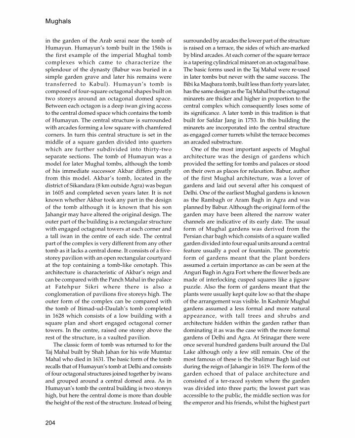
204
Mughals
in the garden of the Arab serai near the tomb ofHumayun. Humayun’s tomb built in the 1560s isthe first example of the imperial Mughal tombcomplexes which came to characterize thesplendour of the dynasty (Babur was buried in asimple garden grave and later his remains weretransferred to Kabul). Humayun’s tomb iscomposed of four-square octagonal shapes built ontwo storeys around an octagonal domed space.Between each octagon is a deep iwan giving accessto the central domed space which contains the tombof Humayun. The central structure is surroundedwith arcades forming a low square with chamferedcorners. In turn this central structure is set in themiddle of a square garden divided into quarterswhich are further subdivided into thirty-twoseparate sections. The tomb of Humayun was amodel for later Mughal tombs, although the tombof his immediate successor Akbar differs greatlyfrom this model. Akbar’s tomb, located in thedistrict of Sikandara (8 km outside Agra) was begunin 1605 and completed seven years later. It is notknown whether Akbar took any part in the designof the tomb although it is known that his sonJahangir may have altered the original design. Theouter part of the building is a rectangular structurewith engaged octagonal towers at each corner anda tall iwan in the centre of each side. The centralpart of the complex is very different from any othertomb as it lacks a central dome. It consists of a five-storey pavilion with an open rectangular courtyardat the top containing a tomb-like cenotaph. Thisarchitecture is characteristic of Akbar’s reign andcan be compared with the Panch Mahal in the palaceat Fatehpur Sikri where there is also aconglomeration of pavilions five storeys high. Theouter form of the complex can be compared withthe tomb of Itimad-ud-Daulah’s tomb completedin 1628 which consists of a low building with asquare plan and short engaged octagonal cornertowers. In the centre, raised one storey above therest of the structure, is a vaulted pavilion.
The classic form of tomb was returned to for theTaj Mahal built by Shah Jahan for his wife MumtazMahal who died in 1631. The basic form of the tombrecalls that of Humayun’s tomb at Delhi and consistsof four octagonal structures joined together by iwansand grouped around a central domed area. As inHumayun’s tomb the central building is two storeyshigh, but here the central dome is more than doublethe height of the rest of the structure. Instead of being
surrounded by arcades the lower part of the structureis raised on a terrace, the sides of which are-markedby blind arcades. At each corner of the square terraceis a tapering cylindrical minaret on an octagonal base.The basic forms used in the Taj Mahal were re-usedin later tombs but never with the same success. TheBibi ka Maqbara tomb, built less than forty years later,has the same design as the Taj Mahal but the octagonalminarets are thicker and higher in proportion to thecentral complex which consequently loses some ofits significance. A later tomb in this tradition is thatbuilt for Safdar Jang in 1753. In this building theminarets are incorporated into the central structureas engaged corner turrets whilst the terrace becomesan arcaded substructure.
One of the most important aspects of Mughalarchitecture was the design of gardens whichprovided the setting for tombs and palaces or stoodon their own as places for relaxation. Babur, authorof the first Mughal architecture, was a lover ofgardens and laid out several after his conquest ofDelhi. One of the earliest Mughal gardens is knownas the Rambagh or Aram Bagh in Agra and wasplanned by Babur. Although the original form of thegarden may have been altered the narrow waterchannels are indicative of its early date. The usualform of Mughal gardens was derived from thePersian char bagh which consists of a square walledgarden divided into four equal units around a centralfeature usually a pool or fountain. The geometricform of gardens meant that the plant bordersassumed a certain importance as can be seen at theAnguri Bagh in Agra Fort where the flower beds aremade of interlocking cusped squares like a jigsawpuzzle. Also the form of gardens meant that theplants were usually kept quite low so that the shapeof the arrangement was visible. In Kashmir Mughalgardens assumed a less formal and more naturalappearance, with tall trees and shrubs andarchitecture hidden within the garden rather thandominating it as was the case with the more formalgardens of Delhi and Agra. At Srinagar there wereonce several hundred gardens built around the DalLake although only a few still remain. One of themost famous of these is the Shalimar Bagh laid outduring the reign of Jahangir in 1619. The form of thegarden echoed that of palace architecture andconsisted of a ter-raced system where the gardenwas divided into three parts; the lowest part wasaccessible to the public, the middle section was forthe emperor and his friends, whilst the highest part
205
Mughals
(which was totally out of view) contained thezenana, or women’s private area. In the centre ofthe women’s area, in the middle of a formal pool,is the Black Pavilion built by Shah Jahan. Thebuilding has a three-tiered tiled roof and is built inthe style of local Kashmiri wooden mosques.
Like his ancestor Babur, Aurangzeb was moreconcerned with garden architecture than theconstruction of palaces. One of the most impressiveof these gardens was that of Fatehbad near Agrawhich although now largely derelict contains acentral arcaded pavilion surrounded by a crenellatedwall with a monumental entrance.
Public buildings of the Mughal period wereusually of a utilitarian design with very little embel-lishment. The roads were one of the primaryconcerns of the Mughal administration and duringthe 1570s Akbar initiated a programme of roadimprovements including the provision of milestones,wells, reservoirs and caravanserais. The bestexamples of this are the caravanserais built at Chatanear Mathura and Chaparghat. These buildings havea fairly uniform design consisting of a largerectangular enclosure with octagonal corner towers.Inside there are iwans leading on to cells along theside of the walls. The cells are usually arranged inpairs with a connecting door in between, thusforming units of four (two iwans and two closedrooms). In addition to the standard rooms there areusually at least two larger sets of rooms for moreimportant travellers. Most caravanserais have oneentrance; where there are two these are usuallyopposite each other. Sometimes the central axis ofthe caravanserais are built as bazars for the visitingmerchants. The only areas of architecturalelaboration are the gates or mosques which wereattached to the buildings. One of the mostmagnificently decorated gateways is that of the NurMahal caravanserai by Nur Jahan between 1618 and1620. Its design resembles funerary and mosquearchitecture of the period, with a central iwan flankedby three tiers of side iwans; however, the decoration,which consists of carved human, animal andmythical figures, is more reminiscent of palatialarchitecture of the period.
Milestones, known as kos minar (small towers),were used to mark the roads. These are usually veryplain structures with an octagonal base and atapering cylindrical shaft. One of the main routeswhich received attention during Akbar’s reign wasthe Agra to Ajmer pilgrimage route which was
provided with road markers and small resthouses.Under Jahangir the improvement of roads continuedwith trees planted on the road from Agra to Bengal,the construction of wells and kos minar on the roadfrom Agra to Lahore and the provision of smallstations on the Pir Panjal pass into Kashmir. Duringthe reign of Aurangzeb the roadside facilities wereextended and improved, with particular attentionpaid to the roads between Agra and Aurang-bad andLahore to Kabul. Repairs carried out on bridges,caravanserais and roadside mosques were paid forout of the emperor’s private income.
See also: Fatehpur Sikri, Taj Mahal
Further reading:C.Ascher, ‘The Mughal and post-Mughal periods’, in The
Islamic Heritage of Bengal, G.Michell, Paris 1984.H.Crane, ‘The patronage of Zahir al-Din Babur and the
origins of Mughal architecture’, Bulletin of the AsiaInstitute NS 1: 95–110, 1987.
S.Crowe, S.Haywood and S.Jelicoe, The Gardens ofMughal India, London 1972.
Z.A.Dessai, ‘Mughal architecture in the Deccan’, inHistory of Medieval Deccan: 1295–1724 2, ed. H.K.Sherwani and P.M.Joshi, Hyderabad 1974, 305–14.
J.Dickie, ‘The Mughal garden: gateway to paradise’,Muqarnas 3: 128–37, 1985.
A.N.Khan, The Hiran Minar and Baradari Shaikhpura: AHunting Resort of the Mughal Emperors, Lahore 1980.
I.A.Khan, ‘New light on the history of two early Mughalmonuments of Bayana’, Muqarnas 6: 55–82, 1990.
W.G.Klingelhofer, ‘The Jahangari Mahal of the AgraFort: expression and experience in early Mughalarchitecture’, Muqarnas 5: 153–69, 1988.
E.Koch, Mughal Architecture, Munich 1991. —— TheHunting Palaces of Shah Jahan (forthcoming).
G.D.Lowry, ‘Humayun’s Tomb: form, function andmeaning in early Mughal architecture’, Muqarnas 4:133–48, 1987.
K.K.Muhammad, ‘The houses of the nobility in MughalIndia’, Islamic Culture 60(3): 81–104, 1986.
R.Nath, History of Mughal Architecture (i) (Babur toHumayun), New Delhi 1982.
—— History of Mughal Architecture (ii) (Akbar), NewDelhi 1982.
S.Parihar, Mughal Monuments in the Punjab and theHaryana, New Delhi 1985.
G.H.R.Tillotson, The Rajput Palaces: The Development of anArchitectural Style 1450–1750, New Haven, Conn., andLondon 1987.
—— Mughal India, Architectural Guides for Travellers,London 1990.
F.Watson, A Concise History of India, London 1979.

206
muhtasibA municipal officer responsible for public morals andregulation of markets.
An important duty of the muhtasib was the supervi-sion of building construction which involvedregulation and inspection of materials. The uniformsize of materials used in construction was ensuredby the use of wooden templates which were kept inthe mosque. The muhtasib was also responsible forchecking mould boxes used for baked bricks andmud bricks to check that these were not distorted.Raw mud bricks were not allowed to be used untilthey had whitened. Also the muhtasib ensured thatbuilders kept stockpiles of the correct spare materialssuch as bricks for lining wells, floor bricks, and firebricks for ovens.
mulqafArabic term for wind-catcher.
See also: badgir
muqarnasSystem of projecting niches used for zones of transitionand for architectural decoration.
Muqarnas is one of the most characteristic featuresof Islamic architecture and is used throughout mostof the Muslim world (in North Africa a related
system known as muqarbaras is also used).Muqarnas is usually associated with domes,doorways and niches, although it is often applied toother architectural features and is sometimes usedas an ornamental band on a flat surface.
The earliest examples of muqarnas so fardiscovered were found at Nishapur in eastern Iranand date to the late ninth or early tenth century. Theseconsist of fragments of stucco niches with carved andpainted decoration which were found withindomestic buildings. Of a similarly early date arefragments of painted stucco muqarnas belonging toa bath house of the Abbasid or Fatimid period atFustat in Egypt. The wide dispersion of muqarnasat this early date (ninth—tenth century) suggests thatits origin was somewhere in the centre of the Islamicworld, probably Baghdad.
During the eleventh century muqarnas spread tomost parts of the Middle East (from Egypt to CentralAsia) whilst in the western Islamic World a similardevice called muqarbaras was also used. The earliestuse of muqarnas seems to have been on the inside ofbuildings in association with domes and vaults. Thefirst use of muqarnas on the exterior of a building ison the tomb of Ladjin in Mazandaran built in 1022where two superimposed rows are used as decoration.Some of the most impressive examples of muqarnason the exterior of buildings are where it is used ascorbelling for balconies on minarets. One of the best
Types of mulqaf (wind-catchers) (after Kay and Zandi)
muhtasib

207
the thirteenth century. The base of the minaret isencased in a thick sleeve of muqarnas corbelling abovewhich there is a short shaft which supports a giantsix-tiered band of muqarnas corbelling which formsa platform for the balcony.
Generally, however, the most elaborate muqarnasare associated with domes. Some of the earliest andsimplest forms of muqarnas can be found in theeleventh-century mausoleums at Aswan in Egypt.One example consists of an arched squinch dividedinto three lobes on the bottom with a small singleniche on top. In Iraq the same device was taken toits most extreme form with the development ofconical domes made of muqarnas. The oldestsurviving example is the mausoleum of Imam Durnorth of Samarra. This dome is extraordinary bothfor its height (over 25 m) and its profuse, almostorganic, muqarnas plaster decoration.
One of the most common uses of muqarnas wasfor column capitals. Before the eleventh centuryIslamic buildings would rely on re-used classical andByzantine capitals or copies of these forms.Muqarnas was particularly suited for use in capitalsas it lends itself to the transition from circular columnto the square section of an arch and was uniquelyIslamic in form. In Ottoman architecture, whereTurkish triangles performed the same function asmuqarnas pendentives and squinches, muqarnaswas still employed for portals, niches, columncapitals and other decorative features.
examples of such muqarnas corbelling is found onthe minaret of Suq al-Ghazzal in Baghdad dated to
Interior of muqarnas dome, Mashad al-Shams, Hilla, Iraq
Exterior of muqarnas dome, Mashad al-Shams, Hilla, Iraq
muqarnas

208
It is in its use for domes and vaults thatmuqarnas was to have its most significant impact.By providing a diffused method of transition fromflat to curved, muqarnas zones of transition wereable to break down the distinction between verticaland curved, domed and horizontal. The bestexamples of this can be seen in conical domes suchas that at Natanz in Iran where the roof emergesnot as a hemispherical dome but as a multi-facetedprism-like series of surfaces.
The almost universal adoption of muqarnas asarchitectural decoration meant that it was alsoadapted for woodwork such as mosque furniture.The minbar of Nur al-Din built for the Aqsa Mosquein Jerusalem had three bands of tiered muqarnas ona canopy above the foot of the stairs.
In Iraq, Iran and the eastern Islamic world themost suitable materials for muqarnas constructionwere plaster and baked brick. Both materials havethe advantage of being light whilst bricks have theadditional advantage of being made to a standarddimension which is useful when repeating thecomplex geometric alignments necessary formuqarnas. Plaster also has the advantage that it caneasily be decorated by carving or painting. In Syriaand Egypt the first muqarnas domes were made fromplaster suspended from a wooden frame within anouter dome made out of stone. The most famousexample of this technique is the dome in Nur al-Din’smaristan built in 1154. Later muqarnas stone domeswere made, the best examples of which belong tofifteenth-century Egypt.
The first muqarnas was made purely out ofinterlocking cut niches but fairly early on ‘dripping’stalactites were developed. These are thin downwardprojections from the cut side of the niche which givethe illusion of arches suspended in mid-air. Thesestalactite niches are some of the most elaborate formof muqarnas which defy attempts at two-dimensional representation.
There are several theories about the origins ofmuqarnas. Generally the decorative origin andfunction is favoured over the suggestion thatmuqarnas was the solution to a particular structuralproblem. The reason for this conclusion is that someof the earliest examples of muqarnas found weredecorative plaster bands, although equally early areexam-pies of muqarnas squinches from Egypt.Whilst certainly muqarnas did have a decorative
function, from the beginning its early and frequentassociation with domes and pendentives suggeststhat the form had structural associations. The tieredform of muqarnas means that the thrust of the domecould be directed downwards into the corner of abuilding without adding the extra weight of apendentive. On the other hand muqarnas squinchesare a way of providing a greater span without havingto build large heavy arches. In general muqarnastends to blur the distinction between squinch andpendentive and provides a more subtle transitionfrom square to octagon. A view which combines bothdecorative and structural functions suggests that theorigins of muqarnas may be found in Islamictheology which promotes an occasionalist view ofthe universe whereby the continued existence of any-thing is dependent on the will of God. Muqarnas isthen a way of expressing this view of the universewhere the dome appears to stand without visiblesupport.
Further reading:
J.Bloom, ‘The introduction of the muqarnas in Egypt’,Muqarnas 5, 1988.
O.Grabar, The Formation of Islamic Art (revised andenlarged edition), Yale University Press: New Havenand London 1987.
musalla
Literally a place where prayer is performed, although inpractice it has come to refer to large open spaces outsidecities for that purpose.
The prime function of a musalla is to provideadditional space for prayer during festivals such asRamadhan. Sometimes they are referred to as‘Festival Mosques’, and in India, Iran and OttomanTurkey they are referred to by the term namazgah.Sometimes a musalla is no more than an open spacemarked out with a line which indicates the directionof Mecca (the qibla), although more often it willinclude a long wall on the qibla side which mayinclude a mihrab. Sometimes musalla reachedadvanced stages of building with an arcade coveringthe qibla wall (as recorded at Bahrain) and elaboratelydecorated mihrabs such as that of Mashad. The usualposition of a musalla was outside the city gatesalthough they are occasionally within the city as inAbbasid Samarra.
musalla
209
nahr
Canal or river.
namazgah
Turkish and Persian term for an open-air prayer placeoften used by the army. Sometimes these are quiteelaborately built with a minbar and a standingmihrab.
naqqar khana
Mughal term for a drum house or place for anorchestra during ceremonies.
Natanz, shrine of Abd al-Samad
Sufi funerary complex at Natanz in western Iran.
Natanz is located on the edge of the Dasht-i Kavirdesert 60 km south-east of Kashan. This is a largefunerary complex which has grown up organicallyaround the tomb of Abd al-Samad, a follower of thefamous Sufi saint Abu Said who died in 1049. Thecentral feature of the site is the octagonal tombaround which is built a four-iwan congregationalmosque dated to 1309. Internally the tomb is acruciform chamber which is converted to an octagonat roof level. The roof is a blue-tiled octagonalpyramid dome outside and internally comprises atall muqarnas vault. Another important structure atthe site is the khanqa or dervish hostel built in 1317which is located to the south-west of the tomb. Onlythe portal of this structure survives with a largemuqarnas semi-dome.
Nilometer
Device located on Roda island, Egypt for measuring therise of the Nile during the period of inundation.
This structure was built in 861–2 CE during the reignof Caliph al-Mutawakil. The purpose of the deviceis to measure the level of the flood to work out the
amount of tax due to the government (a higher floodlevel indicates a higher yield). The structure consistsof a ·2 m square stone-lined pit 13.14 m deepconnected to the Nile by three tunnels. In the centreof the square pit is a tall octagonal column dividedinto cubits each of which is subdivided into twenty-four smaller units. A staircase runs down the foursides so that the central column could be read. Thefloor at the bottom was made of cedar beams.Approximately halfway up there are four pointedrelieving arches, one on each side of the pit. Thearches are of a two-centred type used in Gothicarchitecture in Europe during the fourteenth century.The curves of the arches are emphasized by twobands of moulding whilst above there are foliatedkufic inscriptions which contain Quranic passagesreferring to crops and harvests.
Further reading:
K.A.C.Creswell, A Short Account of Early MuslimArchitecture, revised and enlarged edn. J.W.Allan,Aldershot 1989, 383–5.
nine-domed mosque
This is a type of mosque roofed by nine domes of equalsize.
Although the distribution of this building type isvery wide (it is found as far apart as East Africa,Bangladesh, Central Asia and North Africa) it doesnot occur in great numbers in any one area. Theearliest extant examples date from the ninth centuryCE, whilst there are few buildings of this type laterthan the sixteenth century.
Most nine-domed mosques are fairly small(usually 10–15 m square) though substantially built.It is common for these buildings to be open on two,three or even four sides but it is rare for them to havea sahn or minaret. Sometimes the central row of domesis raised to emphasize the mihrab axis.
There are two theories about the origin of this typeof mosque. The older theory originated by Creswell
N

210
asserts that the mosque is derived from the earliestforms of Islamic funerary monuments, such as the
Qubbat al-Sulaybiyya at Samarra, which weredomed and had open sides. More recently it has been
Nine-domed mosque, Kilwa (after Garlake)
nine-domed mosque
211
suggested that the type derives from honorificbuildings such as Khirbet al-Mafjar. Whilst the originof the design may be disputed it is clear that manyof the mosques were associated with tombs or burialsso that it is reasonable to suggest that they shouldbe regarded as memorial mosques. Importantexamples can be found at Kilwa, Fustat, and Toledo.
Further reading:
K.A.C.Creswell, Muslim Architecture of Egypt I, Oxford1952, 11–13.
R.Ettinghausen, From Byzantium to Sassanian Iran and theIslamic World, London 1972, 57–8.
G.R.H.King, ‘The nine bay domed mosque in Islam’,Madrider Mitteilungen 30: 1989.
Nishapur
Famous medieval city located in the Khurassan region ofeastern Iran.
Nishapur was founded in Sassanian times as ‘NewShapur’ and rose to prominence in early Islamic timesas capital of the Tahirid dynasty in the ninth century.The city was at the height of its prosperity andimportance under the Samanid dynasty in the tenthcentury. In 1037 the city was captured by the Seljuksand remained a part of that empire until 1153 when itwas sacked by the Ghuzz. Despite the sacking andseveral earthquakes the city continued to functionuntil 1221 when it was sacked by the Mongols. Amodern city of the same name has grown up near thesite based around an eighteenth-century shrine.
Although no standing architecture remains at thesite, excavation has revealed extensive architecturalremains together with a large number of finds
making this one of the best examples of a medievalIslamic city. The remains were found mostly withinthree mounds known as Tepe Madrasseh, SabzPushan and Qanat Tepe. There is no evidence ofoccupation at any of the sites before the eighthcentury indicating that the Sassanian city may havebeen elsewhere. The main materials of constructionwere mud brick (khist) and trodden earth or pisé(chineh) and baked brick. Wood was used as astrengthening material in walls as well as forcolumns. Many of the walls were covered with stuccoand painted plaster panels (frescoes). The remainsof several mosques were found on the site all withrectangular recessed mihrabs. At Tepe Madrassehremains of a prayer-hall iwan were found togetherwith the base of a minaret. The minaret had anoctagonal shaft and was built of yellow fired brickswith decorated with shallow vertical slots. Elsewhereon the site columns built of baked brick were alsodecorated with slots. At Qanat Tepe remains of amosque were found close to the remains of a bathhouse. The bath house had hypocaust heating, aplunge pool and a nine-sided octagonal basin in thecentre. The most remarkable feature of the bathhouse was the frescoes which includedrepresentations of human figures. At Sabz Pushanremains of small houses were found which includedcentrally placed sunken fireplaces made fromearthenware jars set into the ground. Among themost important finds at the site were the remains ofeleven muqarnas panels excavated from a cellar.These were prefabricated plaster panels whichwould have been attached to the zone of transitionin the roof of the cellar and are some of the earliestevidence for the use of muqarnas.
Nishapur
212
ocak
Turkish word for a chimney hood, also used todesignate a unit of Ottoman troops of Janissaries.The typical Ottoman ocak consists of a tall conicalhood set against the inside wall of a building. Someof the best examples can be found in the kitchens inthe Topkapisarai.
See also: Ottomans
Oman
The sultanate of Oman is located in the south-east cornerof the Arabian peninsula and borders on the IndianOcean.
It is the third largest country in Arabia after SaudiArabia and Yemen and comprises five distinctgeographical regions, the Musandam peninsula, theBatinah coastal strip, the Hajjar mountains, the Najdesert and Dhofar. The Musandam peninsula isseparate from the rest of the country and comprisesa rocky headland adjacent to the straits of Hormuz.The Batinah coastal strip is located between the seaand the mountains in the northern part of thecountry and varies between 20 and 25 km wide, thisis the most densely populated region of Oman. TheHajjar mountains are a very distinctive feature;running in a belt parallel to the coast in the northernpart of the country, they are the source of most ofOman’s water. The Naj desert, comprising severalareas including the Wahiba sands, separates thenorthern mountains from those of the south andits population is mostly nomadic. Dhofar is amountainous region in the south of the country witha tropical climate and is the only part of Arabia toexperience a summer monsoon.
Until the discovery of oil Oman’s economy wasbased upon a number of natural resources, the mostimportant of which were copper from the mountainsin the north and frankincense from Dhofar. AlsoOman’s position on the Indian Ocean meant that itwas able to establish a long-distance maritime trade
based on the monsoons of the Indian Ocean. Inaddition, fishing and dates have remained importantcomponents of Oman’s economy even after thediscovery of oil.
The earliest settled communities in Oman havebeen dated to 3000 BCE and by 2000 BCE copperwas being exported to Mesopotamia. In the fourthcentury BCE Oman was occupied by the Persianswho remained in control of the country until theadvent of Islam in 630 CE. Under Islam Oman’strading network flourished and included EastAfrica, India and the Far East. During this periodvarious coastal towns grew up, the most importantof which were Sohar, Qalhat and Dhofar (al-Balid).In 1503 the coastal towns were captured andoccupied by the Portuguese. As a result the townsof the interior, the most important of which wereNizwa and Bahla, grew in power and influence. By1650 the Portuguese had been expelled by theYa�ariba leader, Sultan bin Sayf, who rebuilt the fortat Nizwa. Internal conflicts allowed a Persianinvasion in 1743 but this was brought to an end byAhmad ibn Sa�id governor of Sohar who was electedimam in 1743. He was the founder of the Al Bu Sa�iddynasty which continues to rule Oman today. In1730 Oman had acquired the island of Zanzibar andby the 1830s Sultan Sa�id ibn Sultan had built a newcapital in Zanzibar. From 1856 Oman and Zanzibarwere ruled by two branches of the same family.
For various reasons Oman was not modernizeduntil the 1970s, which has meant that traditionalarchitecture has survived here better than in most ofthe other Gulf states. The main building materialsemployed in Oman are mud brick, baked brick,stone, mangrove poles, palm trees and lime (usedfor mortar and plaster). The particular combinationof materials employed depends on the region andtype of building.
Baked brick is used fairly infrequently in Omanand is confined mostly to the port of Sohar. Bakedbricks were first used in the early Islamic city andwere also used in houses of the nineteenth century
O
213
although it is not certain if bricks were still madein nineteenth-century Oman or imported fromelsewhere. Occasionally baked bricks are foundincorporated into buildings outside Sohar such asthe arches of the Great Mosque in Bahla or in thecolumns of the mosque of the Samad quarter inNizwa. Mud brick on the other hand is morecommon and is frequently used in the oasis townsof the interior. It is usually used in conjunction withmud mortar and plaster sometimes mixed withlime. Mangrove poles imported from East Africaare frequently used for roofing in the houses of thecoast. Palm trunks are also used for roofing thereand for inland parts of the country. Palm frondsand trunks are also used for less permanentstructures on the coast. Several types of stone areused for building in Oman; amongst the morecommon types are coral blocks on the north coast,coastal limestone in Dhofar and roughly hewnblocks of igneous rock in the mountains. Lime foruse in mortars is either made from burninglimestone or coral blocks.
The architecture of Oman can be divided intoseveral types based on the type of building, thematerials used and the location. The main groupsare houses, mosques, forts and mansions.
Until recently the most common form ofarchitecture on the coast was the palm-frond housewhich may take several forms from a single-roomtemporary dwelling used for the date harvest to alarge enclosure incorporating winter and summerrooms. The basic unit of construction is a rectangularroom measuring approximately 3 by 5.5 m. The wallsare made from stems (zur) tied together to form apanel whilst the main form of support are palmtrunks placed externally. The winter houses have flatroofs whereas the summer houses have pitched roofsand are called Khaymah (tent). Often houses madeof other materials have palm-frond roofs orverandas.
Mud-brick houses are found throughout Oman,although they are most common in oasis towns.They are usually built with very shallowfoundations or directly on to the ground, and thefirst metre or so is often built out of irregular stonesto serve as a base for the mud-brick superstructure.Simple mud-brick houses have pitched palm-frond(barristi) roofs whilst the larger houses have flatearth roofs supported by palm trunks or mangrovepoles. Some of the larger mud-brick houses arethree storeys high.
Stone-built houses are common on the coast orin the mountains. One of the simplest forms is a typeof coral house found in the Batinah. These are builtout of rough lumps of coral rag which are plasteredover with mud; the roofs are usually made of palmfronds; locally these are called kerin. In Salalah andthe Dhofar coast houses are made out of roughlysquared limestone blocks which are laid in coursesand interspersed with wooden tie-beams. Usually,however, stone buildings in Oman are made out ofrough-hewn stones laid in successive bandsapproximately half a metre high and covered with aplaster surface, producing walls with layers ofoverlapping plaster coats.
Mosques are mostly built out of stone or mudbrick with flat roofs. Minarets are rare in Omanbefore the nineteenth century. A fairly commonfeature in Omani mosques is the combination ofmihrab and minbar, where the minbar is enteredthrough an opening in the mihrab (this feature is alsofound in other parts of the Indian Ocean littoral suchas East Africa and Yemen). In the north of Omanmosque roofs are usually supported by arches restingon cylindrical columns, in Dhofar the columns areusually octagonal. Built shrines do not occur in theIbadi region of the north but are fairly common inthe predominantly Sunni region of Dhofar wherethey usually have pointed domes.
Fortified buildings are one of the most noticeablefeatures of Omani architecture. Most settlements,however small, have some form of fortifiedstructure. There are two main types of fortifiedbuilding in Oman, the sur or fortified enclosure andthe citadel. A sur is a fortified enclosure which isused on a temporary basis during raids or otherdistur-bances, consequently the design of suchenclosures is fairly simple and consists of a roughlysquare enclosure which may or may not have atower. On the other hand the citadels or forts of themain towns are fairly sophisticated structuresdesigned for use with artillery. The most famousforts in Oman are at Nizwa, Ibra, Izki, Mudhairiband al-Rustaq. These buildings were influenced bythe Portuguese forts of the sixteenth andseventeenth centuries, although they also includedlocal developments such as the use of twodiagonally opposed towers linked by thick curtainwalls.
One of the consequences of Oman’s vast tradinglinks was the growth of a wealthy mercantile classwho were able to build mansions. Some of these are
Oman

214
located within coastal cities such as Sur or Muscat,whilst others are rural dwellings set in their owngrounds such as Bayt Na�man on the Batinah plain.Common features found in mansions and in moreimportant houses include elaborately carveddoorways, pre-cast stucco mouldings arounddoorways and recesses, and painted woodenceilings. Such buildings often have a private prayerroom, a light well (shamsiya) and ventilation slitsabove the windows.
Further reading:
The most useful works on the architecture andarchaeology of Oman can be found in the Journal ofOman Studies, including those listed below.
P. and G.Bonnenfant and Salim ibn Hamad ibn Sulaimanal-Hathri, ‘Architecture and social history at Mudayrib’,3: 107–35, 1977.
P.M.Costa, The study of the city of Zafar (al-Balid)’, 5:111–50, 1979.
—— ‘Studies on the built environment of the Batinah’,8(2): 1985.
—— ‘Bayt Na�man, a seventeenth-century mansion of theBatinah’, 8(2): 195–210, 1985.
P.M.Costa and S.Kite, ‘The architecture of Salalah and theDhofar littoral’, 7: 131–53, 1985.
E.Enrico, ‘Introduction to Omani architecture of thesixteenth, seventeenth and eighteenth centuries’, 6(2):291–306, 1983.
E.Galdieri, ‘A masterpiece of Omani 17th-centuryarchitecture. The palace of Imam Bilarab SultanalYaariba at Jabrin’, 1: 167–79, 1975.
M.Kerveran, C.LeCouer-Grandmaison, M.Soubeyran andA.Vialatte de Pemille, ‘Suhari houses’, 6(2): 307– 16,1983.
Ottomans (Turkish: Osmanli)
Major Islamic dynasty based in Turkey which at itsheight controlled a vast area including all of modernTurkey, the Balkans and much of the Middle East andNorth Africa.
The origins of the Ottoman dynasty can be tracedback as far as their thirteenth-century founderOthman (Osman). Othman was a leader of a branchof the Qayïgh clan which was part of the TurkicÖghuz tribe originally from Central Asia. TheÖghuz was amongst those Turkic groups who hadfled west with the Mongol invasions of thethirteenth century and now threatened the ailingByzantine Empire. Originally the Ottomans hadbeen based around the southern city of Konya butlater moved north-west to the area of Bursa laterknown in Turkish as the Hüdavendigâr (royal)region. The position of the Ottomans on the borderwith Byzantine territory meant that they constantlyattracted fresh Turkic warriors (ghazis) willing tofight the Christians. The constant warfare andarrival of new soldiers meant that the emergingOttoman state developed a strong militaryorganization and tradition which enabled itgradually to take over rival Turkish states in thevicinity. In 1357 a new phase in Ottoman expansionwas achieved by crossing the Dardanelles intoEurope and fighting the divided Balkan Christians.By 1366 the Balkan provinces had become soimportant to the Ottoman state that the capital wasmoved from Bursa to Edirne. Another result of themove into Europe was that instead of relying onthe Turkic warriors the army was now formed byChristians who had been captured as children andconverted to Islam. The advantage of this newmethod was that the religious orthodoxy andabsolute allegiance of the soldiers could be ensured.
Traditional mosque, Banu Bu Ali, Oman
Ottomans (Turkish: Osmanli)

215
The new troops known as Janissaries were the éliteforce of the growing empire; at the same time asystem of feudal land grants was adopted for theOttoman cavalry. In 1394 Ottoman control of theBalkan provinces was recognized when Bayazit wasgranted the title Sultan of Rum by the Abbasidcaliph in Cairo. A major setback occurred in 1402when a second Mongol invasion led by Timur(Tamurlane) conquered much of Anatolia anddefeated the Ottoman sultan at Ankara. However,Timurid success was short lived and soon theOttomans were able to regain control of much oftheir territory in Anatolia. The major event of thefifteenth century was the capture of Constantinople(later known as Istanbul) and the defeat of theByzantine Empire by Mehmet the Conqueror in1453.
Having consolidated their position in Anatoliaduring the fifteenth century by the beginning of the
sixteenth century the Ottomans were able to launcha major offensive in Europe and the Middle East.In 1517 the defeat of the Mamluks brought Syriaand Egypt into the Ottoman Empire and in 1526Hungary was brought under Ottoman control. Forthe next century and a half the Ottomans were theworld’s foremost Islamic power and undis-putedrulers of most of the eastern Mediterranean. Asorthodox Sunnis the Ottomans established contactswith their co-religionists the Mughals of Indiaalthough the distance was too great for anymeaningful co-operation beyond sending a fewTurkish ships against the Portuguese in the IndianOcean.
The siege of Vienna in 1683 marked the highpoint of their military power in Europe and theirdefeat marked the beginning of an irreversibledecline which continued into the eighteenthcentury. Nevertheless, Turkey remained a major
Open-air mosque, Ras al-Junayz, Oman
Ottomans (Turkish: Osmanli)
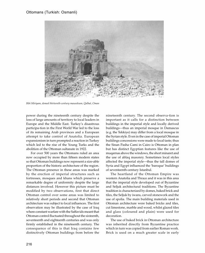
216
Ottomans (Turkish: Osmanli)
power during the nineteenth century despite theloss of large amounts of territory to local leaders inEurope and the Middle East. Turkey’s disastrousparticipa-tion in the First World War led to the lossof its remaining Arab provinces and a Europeanattempt to take control of Anatolia. Europeanexpansionism in turn prompted a reaction in Turkeywhich led to the rise of the Young Turks and theabolition of the Ottoman sultanate in 1922.
For over 500 years the Ottomans ruled an areanow occupied by more than fifteen modern statesso that Ottoman buildings now represent a size-ableproportion of the historic architecture of the region.The Ottoman presence in these areas was markedby the erection of imperial structures such asfortresses, mosques and khans which preserve aremarkable degree of uniformity despite the largedistances involved. However this picture must bemodified by two observations, first that directOttoman control over some areas was limited torelatively short periods and second that Ottomanarchitecture was subject to local influences. The firstobservation may be illustrated by the case of Iraqwhere constant warfare with the Saffavids meant thatOttoman control fluctuated throughout the sixteenth,seventeenth and eighteenth centuries and was onlyfirmly established in the nineteenth century. Theconsequence of this is that Iraq contains fewdistinctively Ottoman buildings from before the
nineteenth century. The second observa-tion isimportant as it calls for a distinction betweenbuildings in the imperial style and locally derivedbuildings—thus an imperial mosque in Damascus(e.g. the Tekkiye) may differ from a local mosque inthe Syrian style. Even in the case of imperial Ottomanbuildings concessions were made to local taste; thusthe Sinan Pasha Cami in Cairo is Ottoman in planbut has distinct Egyptian features like the use ofmuqarnas above the windows, the short minaret andthe use of ablaq masonry. Sometimes local stylesaffected the imperial style—thus the tall domes ofSyria and Egypt influenced the ‘baroque’ buildingsof seventeenth-century Istanbul.
The heartland of the Ottoman Empire waswestern Anatolia and Thrace and it was in this areathat the imperial style developed out of Byzantineand Seljuk architectural traditions. The Byzantinetradition is characterized by domes, baked brick andtiles, the Seljuk by iwans, carved stonework and theuse of spolia. The main building materials used inOttoman architecture were baked bricks and tiles,cut limestone, marble and wood, whilst glazed tilesand glass (coloured and plain) were used fordecoration.
The use of baked brick in Ottoman architecturewas inherited directly from Byzantine practicewhich in turn was copied from earlier Roman work.Brick is used on a much greater scale in early
Bibi Miriyam, domed thirteenth-century mausoleum, Qalhat, Oman

217
Ottomans (Turkish: Osmanli)
Ottoman buildings than those of the later periodpossibly in imitation of contemporary Byzantinepractice which used bricks until the beginning ofthe fourteenth century when they were no longeravailable. The usual brick form was a flat square ofvarying dimensions, the Ottomans had a muchwider range of brick sizes than the Byzantineswhose bricks were of a standard size although betterin quality. The standard Byzantine constructiontechnique, copied in early Ottoman buildings, wasrubble and brick construction where the size ofbricks determined the thickness of the walls. Oftenlayers of brick alternate with layers of cut stone thusthe Haci Özbek Cami at Iznik is built of triplelayers of brick alternating with layers of individualcut stone blocks separated by single vertically laidbricks. The ratio of layers of brick to layers of stonedoes not seem to have been standard for everybuilding and in some cases the thickness of layersvaries in the same building. In general, however,three layers of brick to one of stone was fairly usualduring most periods. The standardized size ofbricks and their lightness compared with stonealso made them ideal material for the constructionof domes, barrel vaults and arches. When stonereplaced brick and stone as the main facingmaterial, bricks continued to be used for arches,domes and vaults. In early Ottoman buildings tileswere used to cover the outside of the domealthough from the sixteenth century onwards leadwas increasingly used.
The walls of Ottoman buildings were built witha rubble stone core enclosed by a facing of stone orbrick and stone. In some of the earlier buildingsrubble stone was used on the exterior of buildingseither contained within layers of brick or plasteredover. Later on the use of cut limestone became moreusual, first in conjunction with brick and later on itsown. Immediately after the conquest ofConstantinople there seems to have been a rever-sion to brick and stone due to a shortage of cutlimestone. However, from the beginning of thesixteenth century onwards most important buildingswere faced in cut stone, although subsidiarystructures continued to use brick and stone. Thequality of masonry in Ottoman buildings isextraordinary due to its precision and smoothnesswhich gave buildings a monumentality not easilyachieved with brick and stone.
In addition to limestone Ottoman buildings usedlarge quantities of antique and Byzantine marble
both as columns and for decoration. During thesixteenth century there were large numbers ofdisused Byzantine churches which were used asquarries for marble columns thus the Ottomanbuildings of this period tend to use more columnsthan earlier or later periods. The hardest form ofmarble available was porphyry, which is twice ashard as granite, although this was only used rarelyas it tended to crack. New marble seems only to havebeen available from the quarries at Marmaraalthough there was enough ancient marble availableto fulfil most needs. Sometimes, however, thereseems to have been an acute shortage of marble; thusthe tomb of Suleyman was built using fake red andgreen marble. Fake marble was often used forvoussoirs of arches where the weight of real marblewould cause structural problems. Fake marblevoussoirs were usually made of brick and coveredwith plaster which was then painted.
Wood was essential in the construction ofOttoman buildings and was used for the centringof vaults and domes, for tie-beams and asscaffolding. In addition wood was used forprojecting galleries and also for pitched woodenroofs, although these were less common than brickdomes in monumental buildings. In domesticarchitecture, however, wood was the predominantmaterial and most of the houses of Istanbul werebuilt entirely out of wood.
One of the most distinctive features of imperialOttoman architecture is its use of polychromeglazed tiles as wall decoration. Glazed tiles wereused by the Ottomans as early as thirteenth centuryat the Yesil Cami at Iznik although it was not untilthe fifteenth century that the first of the famousIznik tiles were produced. During the sixteenthcentury Iznik tiles replaced marble as the main formof decoration in mosques thus in the Ivaz EfendiCami in Istanbul tilework columns are placed eitherside of the mihrab instead of the usual marblecolumns.
The windows of mosques were often decoratedwith stained glass set into thick plasterwork frames.Coloured glass made with a high proportion of leadwas mostly imported from Europe and clipped tothe sizes required. Although coloured glass was usedmore often, the architect Sinan preferred to use clearglass and altered the structural arrangement ofbuildings to introduce the maximum amount of lightinto the interior. Ottoman architecture can be dividedinto three major periods which roughly correspond

218
Ottomans (Turkish: Osmanli)
to historical developments. The early period betweenthe thirteenth and mid-fifteenth century was theperiod before the capture of Constantinople in 1453and characterized by the transition from a smallprincipality to a sultanate. The second period fromthe capture of Constantinople (Istanbul) to the mid-sixteenth century is regarded as the classical Ottomanperiod and saw the most brilliant developments inarts and technology to match the spectacularOttoman victories in Europe, North Africa and theMiddle East. The third period from the end of thesixteenth century to the twentieth century is knownfor political and economic decline, matched inarchitecture by weaker forms on a smaller scale andthe increasing influence of Europe.
Early Period
Possibly the oldest Ottoman building is the EtrugrulMescit in Sögüt 40 km south-east of Iznik whichdates from the first years of the fourteenth century.The mosque has been significantly altered by theaddition of a minaret and tall arched windowsalthough its essential form of a tall cube capped bya dome remains unchanged. More au-thentic andbetter dated is the Haci Özbek Cami at Iznik whichis dated to 1333, two years after the capture of thecity from the Byzantines. Like the mosque at Sögüt
the Haci Özbek Cami is a small cube covered withan almost hemispherical dome (radius 4 m) restingon a zone of Turkish triangles. The original porticowas on the west side (i.e. at right angles to the qibla)and consisted of three bays resting on two marblecolumns. Two of the bays were covered by barrelvaults, whilst that above the entrance was coveredwith a cross vault; the north and south sides of theportico were walled in as protection against thewind. Other early Ottoman mosques include theAlaettin Cami at Bursa and the Orhan Ghazi Camiat Bilecik. The Aleattin Cami was built in 1335 afterthe Ottoman capture of Bursa and is of a similarform and size to the Haci Özbek Cami except thatthe portico and entrance is on the north side in linewith the mihrab. The Orhan Ghazi also has a similarplan but here the size of the prayer hall is increasedby four large (approximately 9 by 2.5 m) archedrecesses which make it twice as large as the HaciÖzbek Cami whose dome is approximately thesame size. The walls are pierced with windows andthe mihrab is flanked by two large windows in anarrangement which became standard in laterOttoman mosques. The Orhan Ghazi Mosque alsohas a detached minaret which may be the oldestsurviving Ottoman minaret.
The next major development in Ottoman mosquearchitecture is the Yesil Cami at Iznik built in the late
Sixteenth-century Ottoman fortress at Ras al-�Ayn, Israel/Palestine
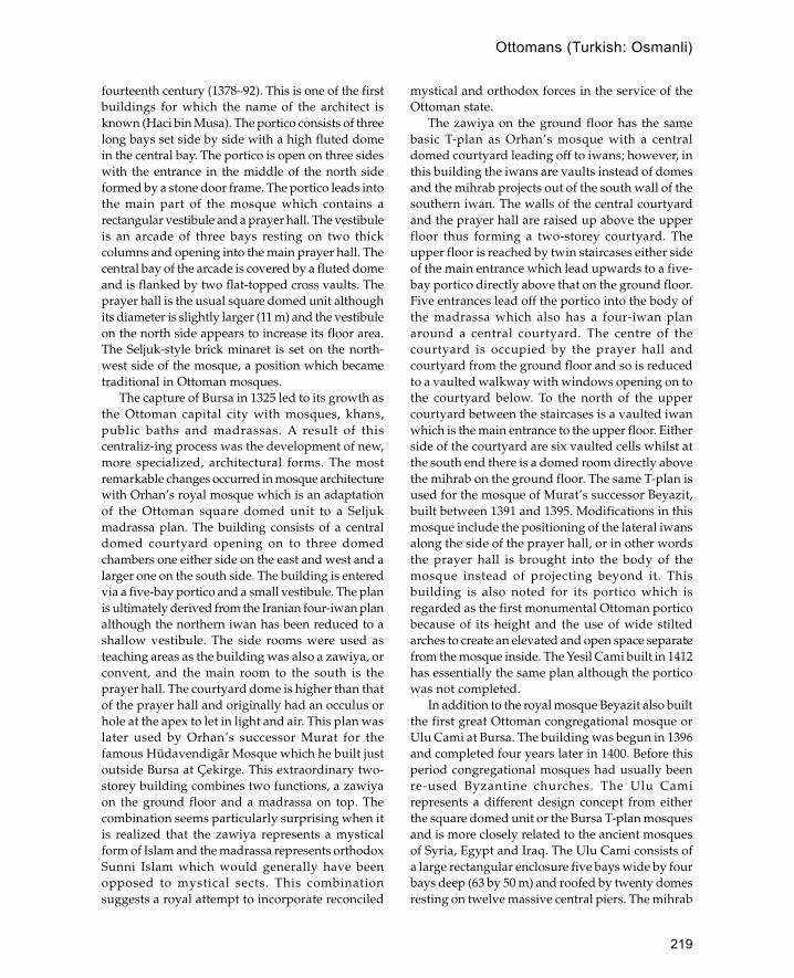
219
Ottomans (Turkish: Osmanli)
fourteenth century (1378–92). This is one of the firstbuildings for which the name of the architect isknown (Haci bin Musa). The portico consists of threelong bays set side by side with a high fluted domein the central bay. The portico is open on three sideswith the entrance in the middle of the north sideformed by a stone door frame. The portico leads intothe main part of the mosque which contains arectangular vestibule and a prayer hall. The vestibuleis an arcade of three bays resting on two thickcolumns and opening into the main prayer hall. Thecentral bay of the arcade is covered by a fluted domeand is flanked by two flat-topped cross vaults. Theprayer hall is the usual square domed unit althoughits diameter is slightly larger (11 m) and the vestibuleon the north side appears to increase its floor area.The Seljuk-style brick minaret is set on the north-west side of the mosque, a position which becametraditional in Ottoman mosques.
The capture of Bursa in 1325 led to its growth asthe Ottoman capital city with mosques, khans,public baths and madrassas. A result of thiscentraliz-ing process was the development of new,more specialized, architectural forms. The mostremarkable changes occurred in mosque architecturewith Orhan’s royal mosque which is an adaptationof the Ottoman square domed unit to a Seljukmadrassa plan. The building consists of a centraldomed courtyard opening on to three domedchambers one either side on the east and west and alarger one on the south side. The building is enteredvia a five-bay portico and a small vestibule. The planis ultimately derived from the Iranian four-iwan planalthough the northern iwan has been reduced to ashallow vestibule. The side rooms were used asteaching areas as the building was also a zawiya, orconvent, and the main room to the south is theprayer hall. The courtyard dome is higher than thatof the prayer hall and originally had an occulus orhole at the apex to let in light and air. This plan waslater used by Orhan’s successor Murat for thefamous Hüdavendigâr Mosque which he built justoutside Bursa at Çekirge. This extraordinary two-storey building combines two functions, a zawiyaon the ground floor and a madrassa on top. Thecombination seems particularly surprising when itis realized that the zawiya represents a mysticalform of Islam and the madrassa represents orthodoxSunni Islam which would generally have beenopposed to mystical sects. This combinationsuggests a royal attempt to incorporate reconciled
mystical and orthodox forces in the service of theOttoman state.
The zawiya on the ground floor has the samebasic T-plan as Orhan’s mosque with a centraldomed courtyard leading off to iwans; however, inthis building the iwans are vaults instead of domesand the mihrab projects out of the south wall of thesouthern iwan. The walls of the central courtyardand the prayer hall are raised up above the upperfloor thus forming a two-storey courtyard. Theupper floor is reached by twin staircases either sideof the main entrance which lead upwards to a five-bay portico directly above that on the ground floor.Five entrances lead off the portico into the body ofthe madrassa which also has a four-iwan planaround a central courtyard. The centre of thecourtyard is occupied by the prayer hall andcourtyard from the ground floor and so is reducedto a vaulted walkway with windows opening on tothe courtyard below. To the north of the uppercourtyard between the staircases is a vaulted iwanwhich is the main entrance to the upper floor. Eitherside of the courtyard are six vaulted cells whilst atthe south end there is a domed room directly abovethe mihrab on the ground floor. The same T-plan isused for the mosque of Murat’s successor Beyazit,built between 1391 and 1395. Modifications in thismosque include the positioning of the lateral iwansalong the side of the prayer hall, or in other wordsthe prayer hall is brought into the body of themosque instead of projecting beyond it. Thisbuilding is also noted for its portico which isregarded as the first monumental Ottoman porticobecause of its height and the use of wide stiltedarches to create an elevated and open space separatefrom the mosque inside. The Yesil Cami built in 1412has essentially the same plan although the porticowas not completed.
In addition to the royal mosque Beyazit also builtthe first great Ottoman congregational mosque orUlu Cami at Bursa. The building was begun in 1396and completed four years later in 1400. Before thisperiod congregational mosques had usually beenre-used Byzantine churches. The Ulu Camirepresents a different design concept from eitherthe square domed unit or the Bursa T-plan mosquesand is more closely related to the ancient mosquesof Syria, Egypt and Iraq. The Ulu Cami consists ofa large rectangular enclosure five bays wide by fourbays deep (63 by 50 m) and roofed by twenty domesresting on twelve massive central piers. The mihrab

220
Ottomans (Turkish: Osmanli)
is centrally placed and is on the same axis as themain doorway. In the second bay in front of themihrab is the courtyard represented by an opendome above a sunken pool. The mosque has twominarets, one on the north-east and one on thenorth-west corner of the mosque; the north-eastminaret was added later by Mehmet I, some timeafter 1413. Mehmet also built a smaller version ofthe Bursa Ulu Cami at Edirne known as the Eski(old) Cami which consists of nine domes.
The climax of the first period of Ottomanarchitecture was the Yesil Cami at Bursa which waspart of a complex built for Mehmet I. The complexconsists of a mosque, madrassa, bath house(hammam), an imaret, or kitchen, and the turba (tomb)of Mehmet. Earlier sultans had built complexes suchas that of Beyazit or Orhan, but this is the bestpreserved example of its type. The madrassa has astandard form consisting of cells on three sides and adomed prayer hall on the south side. The kitchen andbath house are both rectangular domed structureswhilst the turba is an octagonal domed buildinglocated high up above the rest of the complex. Themosque is of the familiar Bursa T-plan design andclosely resembles that of the Beyazit complex. Thechief differences are the use of brilliant green tiles todecorate the interior and royal boxes or loggias whichoverlook the internal domed courtyard.
The development of mosques and religiousbuildings is paralleled in secular architecture by theevolution of classical Ottoman forms from the Seljukperiod. The clearest examples of this are bridges,which in the early period are graceful structures witha high central arch flanked by two lower arches,whereas those of the later period are more heavilybuilt in the Roman style, with a succession of evenlyspaced arches resting on massive piers. Several bathhouses survive from this period particularly in Bursawhich contains simple structures like the ÇekigeHammam and complex double-domed structureslike the Bey Hammam. The plan of these bath housesdevelops from a single-domed area leading off totwo or three smaller domed or vaulted chambers toa building consisting of one or two large domed areaswhich open on to a series of small cells arrangedaround a cruciform covered courtyard.
Classical Period
The second period of Ottoman architecture, oftenreferred to as the ‘Classical’ period, has its origins in
the Üç Serefeli Cami in Edirne built by Murat II andcompleted in 1447 six years before the conquest ofConstantinople. The Üç Serefeli Mosque had itsorigins in the fourteenth-century Ulu Cami of Manisawhich was visited by Murat II sometime before 1437.The Ulu Cami of Manisa differs from others of thetime in having a large central dome in front of themihrab covering a space equivalent to nine bays. TheManisa Ulu Cami is also unusual because the centralcourtyard is separated from the main body of themosque and is not covered by a dome as in the Bursatradition. Both of these features were found in theÜç Serefeli Mosque built over seventy years later.However, the dome of the Edirne mosque is muchlarger and measures over 24 m in diameter, morethan double that of its Manisa prototype. Also in theEdirne mosque, the size of the central courtyard isincreased so that it resembles those of Syria andEgypt rather than the internal courtyards of the Bursatradition. However, the arcade on the south side ofthe courtyard adjacent to the sanctuary of the mosqueis raised up in the manner of earlier Ottomanporticoes (e.g. Beyazit Cami in Bursa). The exteriorof the building is distinguished by four minaretsplaced outside each corner of the courtyard. The twonorth minarets have one balcony (seref) each whilstthe south-east minaret has two balconies and themassive north-west minaret (from which the mosquegets its name) has three balconies each with its ownspiral staircase.
The conquest of Constantinople in 1453exposed Ottoman architects to a whole new rangeof buildings, the most important of which is theHagia Sophia (Aya Sophia) which wasimmediately converted into a mosque by theaddition of a wooden minaret to one of the cornerturrets. The new concepts introduced by the ÜçSerefeli were not immediately incorporated intoOttoman buildings, and the first mosques wereeither converted churches or single-domed unitsin the traditional style. The first major complex toinclude these features was the Mehmet Fatih Camibuilt for Murat II between 1463 and 1470.Unfortunately the complex suffered an earthquakein 1766 and the main part of the mosque collapsedso that the present building is an eighteenth-century replica built on the same foundations. Themost notable feature of the Fatih Cami was its 26m dome which for the next hundred years was thelargest dome in the empire with the exception ofthe Hagia Sophia dome of 32 m. The internal
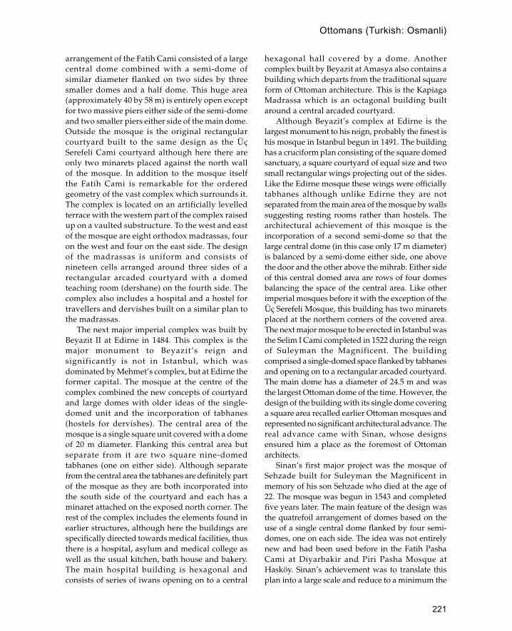
221
Ottomans (Turkish: Osmanli)
arrangement of the Fatih Cami consisted of a largecentral dome combined with a semi-dome ofsimilar diameter flanked on two sides by threesmaller domes and a half dome. This huge area(approximately 40 by 58 m) is entirely open exceptfor two massive piers either side of the semi-domeand two smaller piers either side of the main dome.Outside the mosque is the original rectangularcourtyard built to the same design as the ÜçSerefeli Cami courtyard although here there areonly two minarets placed against the north wallof the mosque. In addition to the mosque itselfthe Fatih Cami is remarkable for the orderedgeometry of the vast complex which surrounds it.The complex is located on an artificially levelledterrace with the western part of the complex raisedup on a vaulted substructure. To the west and eastof the mosque are eight orthodox madrassas, fouron the west and four on the east side. The designof the madrassas is uniform and consists ofnineteen cells arranged around three sides of arectangular arcaded courtyard with a domedteaching room (dershane) on the fourth side. Thecomplex also includes a hospital and a hostel fortravellers and dervishes built on a similar plan tothe madrassas.
The next major imperial complex was built byBeyazit II at Edirne in 1484. This complex is themajor monument to Beyazit’s reign andsignificantly is not in Istanbul, which wasdominated by Mehmet’s complex, but at Edirne theformer capital. The mosque at the centre of thecomplex combined the new concepts of courtyardand large domes with older ideas of the single-domed unit and the incorporation of tabhanes(hostels for dervishes). The central area of themosque is a single square unit covered with a domeof 20 m diameter. Flanking this central area butseparate from it are two square nine-domedtabhanes (one on either side). Although separatefrom the central area the tabhanes are definitely partof the mosque as they are both incorporated intothe south side of the courtyard and each has aminaret attached on the exposed north corner. Therest of the complex includes the elements found inearlier structures, although here the buildings arespecifically directed towards medical facilities, thusthere is a hospital, asylum and medical college aswell as the usual kitchen, bath house and bakery.The main hospital building is hexagonal andconsists of series of iwans opening on to a central
hexagonal hall covered by a dome. Anothercomplex built by Beyazit at Amasya also contains abuilding which departs from the traditional squareform of Ottoman architecture. This is the KapiagaMadrassa which is an octagonal building builtaround a central arcaded courtyard.
Although Beyazit’s complex at Edirne is thelargest monument to his reign, probably the finest ishis mosque in Istanbul begun in 1491. The buildinghas a cruciform plan consisting of the square domedsanctuary, a square courtyard of equal size and twosmall rectangular wings projecting out of the sides.Like the Edirne mosque these wings were officiallytabhanes although unlike Edirne they are notseparated from the main area of the mosque by wallssuggesting resting rooms rather than hostels. Thearchitectural achievement of this mosque is theincorporation of a second semi-dome so that thelarge central dome (in this case only 17 m diameter)is balanced by a semi-dome either side, one abovethe door and the other above the mihrab. Either sideof this central domed area are rows of four domesbalancing the space of the central area. Like otherimperial mosques before it with the exception of theÜç Serefeli Mosque, this building has two minaretsplaced at the northern corners of the covered area.The next major mosque to be erected in Istanbul wasthe Selim I Cami completed in 1522 during the reignof Suleyman the Magnificent. The buildingcomprised a single-domed space flanked by tabhanesand opening on to a rectangular arcaded courtyard.The main dome has a diameter of 24.5 m and wasthe largest Ottoman dome of the time. However, thedesign of the building with its single dome coveringa square area recalled earlier Ottoman mosques andrepresented no significant architectural advance. Thereal advance came with Sinan, whose designsensured him a place as the foremost of Ottomanarchitects.
Sinan’s first major project was the mosque ofSehzade built for Suleyman the Magnificent inmemory of his son Sehzade who died at the age of22. The mosque was begun in 1543 and completedfive years later. The main feature of the design wasthe quatrefoil arrangement of domes based on theuse of a single central dome flanked by four semi-domes, one on each side. The idea was not entirelynew and had been used before in the Fatih PashaCami at Diyarbakir and Piri Pasha Mosque atHasköy. Sinan’s achievement was to translate thisplan into a large scale and reduce to a minimum the
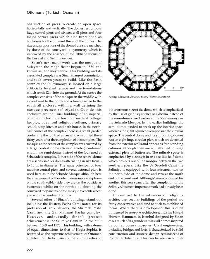
222
Ottomans (Turkish: Osmanli)
obstruction of piers to create an open spacehorizontally and vertically. The domes rest on fourhuge central piers and sixteen wall piers and fourmajor corner piers which also functioned asbuttresses for the outward thrust of the domes. Thesize and proportions of the domed area are matchedby those of the courtyard, a symmetry which isimproved by the absence of the tabhane rooms ofthe Beyazit and Selim mosques.
Sinan’s next major work was the mosque ofSuleyman the Magnificent begun in 1550 andknown as the Süleymaniye. This building and itsassociated complex was Sinan’s largest commissionand took seven years to build. Like the Fatihcomplex the Süleymaniye is located on a largeartificially levelled terrace and has foundationswhich reach 12 m into the ground. At the centre thecomplex consists of the mosque in the middle witha courtyard to the north and a tomb garden to thesouth all enclosed within a wall defining themosque precincts (cf. ziyada). Outside thisenclosure are the usual buildings of an imperialcomplex including a hospital, medical college,hospice, advanced religious college, primaryschool, soup kitchen and bath house. In the north-east corner of the complex there is a small gardencontaining the tomb of Sinan who was buried therethirty years after the completion of this complex. Themosque at the centre of the complex was covered bya large central dome (26 m diameter) containedwithin two semi-domes instead of the four used atSehazade’s complex. Either side of the central domeare a series smaller domes alternating in size from 5to 10 m in diameter. The same principal of fourmassive central piers and several external piers isused here as in the Sehzade Mosque although herethe arrangement of the outer piers is more complex—on the south (qibla) side they are on the outside asbuttresses whilst on the north side abutting thecourtyard they are inside the mosque to enable a neatjoin with the courtyard portico.
Several other of Sinan’s buildings stand outincluding the Rüstem Pasha Cami noted for itsprofusion of Iznik tilework, the Mirimah PashaCami and the Zal Mahmut Pasha complex.However, undoubtedly Sinan’s greatestachievement is the Selimiye Cami in Edirne builtbetween 1569 and 1575. This building, with a domeof equal dimensions to that of Hagia Sophia, isregarded as the supreme achievement of Ottomanarchitecture. The brilliance of the building relies on
the enormous size of the dome which is emphasizedby the use of giant squinches or exhedra instead ofthe semi-domes used earlier at the Süleymaniye orthe Sehzade Mosque. In the earlier buildings thesemi-domes tended to break up the interior spacewhereas the giant squinches emphasize the circularspace. The central dome and its supporting domesrest on eight huge circular piers which are detachedfrom the exterior walls and appear as free-standingcolumns although they are actually tied to hugeexternal piers of buttresses. The mihrab space isemphasized by placing it in an apse-like half-domewhich projects out of the mosque between the twosouthern piers. Like the Üç Serefeli Cami theSelimiye is equipped with four minarets, two onthe north side of the dome and two at the northend of the courtyard. Although Sinan continued foranother thirteen years after the completion of theSelimiye, his most important work had already beendone.
In contrast to the advances of religiousarchitecture, secular buildings of the period arefairly conservative and tend to stick to establishedforms. Where there is development this is ofteninfluenced by mosque architecture; thus the HasekiHürrem Hammam in Istanbul designed by Sinanowes much of its grandeur to its tall domes inspiredby contemporary mosques. Civil engineering,including bridges and forts, is characterized by solidconstruction and austere design reminiscent ofRoman architecture. This can be seen in Rumeli
Kapiaga Madrassa, Amasya, Turkey (sixteenth century)

223
Ottomans (Turkish: Osmanli)
Hisar, the fortress built by Mehmet II to control theBosphorus before the conquest of Constantinople.The building consists of a huge enclosure(approximately 220 by 100 m) formed by three hugetowers (two semi-circular and one polygonal)linked by a tall crenellated wall strengthened byinterval towers or bastions. The interior was filledwith a mosque and a large number of woodenbuildings which have now disappeared. Thebastions and towers represent a variety of differentshapes and designs which suggest that the fortresswas built by a number of individuals working to abroad general design rather than a detailedarchitect’s plan. Bridges on the other hand tendedto be built to a standard plan which was applied toa variety of situations. The most famous bridge ofthe period is that of Büyük-sekmice to the west ofIstanbul; built by Sinan in 1566, it consists of a seriesof four humped bridges resting on three artificialislands. At the west end of the bridge there is arectangular caravanserai covered with a woodengabled roof. Other important caravanserais of theperiod include the Sokollu Mehmed PashaCaravanserai at Lüleburgaz and the Selim IIcomplex at Payas in eastern Anatolia both built bySinan. One area where secular architecture wasinnovative and influential was in the imperialpalace or Topkapisarai. This building wasestablished as the centre of imperial power soonafter Mehmed II entered Istanbul and remained thecentre until the collapse of Ottoman power in thetwentieth century. Several parts of the fifteenth-century palace remain, the most important of whichis the Sinili Kiosk built in 1473. This pavilion, basedon a four-iwan plan, was designed by a Persianarchitect and decorated with blue glazed bricks inTimurid style. The building influenced much of thesubsequent domestic architecture of Istanbul, inparticular some of the Bosphorus mansions.
Later Period
In the last years of the sixteenth century and the firstyears of the seventeenth century Ottomanarchitecture continued to use the forms and styledeveloped by Sinan during the Classical period. Thusthe Yeni Valide complex built by Sinan’s successorDavut is a copy of the Sehzade Mosque with a fewalterations to the size and shape of the courtyard.The most famous building in this late classical styleis the Sultan Ahmet Cami in Istanbul also known as
the Blue Mosque begun in 1609 and completed in1617. The most distinctive feature of this building isthe use of six minarets instead of the previousmaximum of four. It is roofed with the quatrefoildesign used in the Sehzade Cami with four hugecylindrical fluted piers supporting the 23.5 m dome(considerably smaller than the Selimiye). The planhas several weaknesses, the most notable of whichis the way the mihrab is placed in the middle of aflat wall without any architectural emphasis. Alsothe portico is not raised to the level of the centraldomed area thus making the mosque and courtyardseem like two independent units rather than agradual development of mass.
From the end of the sixteenth century slavishcopying of the Classical style was graduallyreplaced; characteristic features of the new style areflamboyant decoration, increased use of windowsand curves, and growing European influences. Themost famous example is the Nuruosmaniye Camiin Istanbul completed in 1755. The plan of thisbuilding is still based on the square covered by adome but the strict geometry of the Classical periodis modified, thus there are small projecting wingseither end of the qibla wall and the mihrab is locatedin a curved apse in a manner similar to that of theSelimiye in Edirne although here the apse is curved.The recessed porches, which in earlier mosqueswould have been filled with muqarnas mouldings,are here filled with carved acanthus leaves. Themost striking feature of the building is the courtyardwhich is built in a curved D-shape with the straightside forming the portico of the mosque. Thecourtyard is also unusual because the domes abovethe two north entrances are pierced with a series ofarched windows which add to the light comingfrom the trefoil arched windows at the sides. Theabsence of a central fountain and the positioningof the mosque on an irregular-shaped terrace addto the surprise of this building. Other eighteenth-and nineteenth-century mosques, however,retained the strict square geometry which was nowprescribed by the religious orthodoxy as thenecessary form for a mosque. Thus the Laleli Camiand complex built ten years later in 1783 has aconventional plan, although this is modified bymaking the prayer hall rectangular instead ofsquare, by cutting off the two side aisles either sideof the main dome and making them into externalarcades. The apse form of the mihrab area used inthe Nuruosmaniye is retained although here it has

224
a square form similar to the Selimiye in Edirneinstead of the curved form of the Nuruosmaniye.The Laleli is also noticeable for its use of Ionic capitalsinstead of the muqarnas capitals preferred in theClassical period.
Several methods were used to break away fromthe enforced geometry of the square domed unit; onemethod was to give an undulating curved form tothe outer edges of domes. This was a techniquewhich was first used on the wooden roofs of sebils(fountains) and kiosks such as that on the tomb ofMehmet II rebuilt in 1784. The use of this techniqueon mosque domes can be seen on the Beylerbey Camiof 1778 and in an extravagant form at the Iliyas BeyCami built in 1812. Similar techniques were used forwindows and arches which had undulating curveshung as drapery in the European manner. Outsidethe strict boundaries of orthodoxy there was moreroom for experimentation, thus the Küsük Efendicomplex in Istanbul was built for dervishes and hasa radical plan. The building, completed in 1825,consists of an oval structure which combines amosque and dervish dance hall.
The nineteenth century saw the emergence of newbuilding forms and types influenced by Europe. Themost successful of these new forms was the clocktower which by the beginning of the First World Warhad been established in Ottoman cities throughoutthe empire. The earliest example was a three-storeywooden tower outside the Nusretiye Cami inIstanbul, other early examples are at Yozgat andAdana. The extent of European influence can be seenin the decision to move the royal residence from theTopkapisarai in old Istanbul to the newly fashionablebanks of the Bosphorus. The new residence knownas the Dolmabahse Palace was built in 1853 in theEuropean Classical style with a colonnaded façadelooking out over the water. The palace stretches outalong the side of the Bosphorus in a series of blocksor wings, the most famous of which is the throneroom measuring 44 by 46 m.
Increased European interest in Ottoman andSeljuk architecture also stimulated an interest inrevivalist architecture. One of the earliest examplesof revivalism in Turkish architecture is the palaceof Ishak Pasha at Dogubayazit in eastern Anatoliacompleted in 1784. This imposing building, setagainst the backdrop of Mount Ararat, recalls theSeljuk architecture of eastern Anatolia with carvedanimals and huge monumental doorways.However, this building is exceptional and it is not
until the late nineteenth and early twentiethcenturies that revivalism becomes established as astyle in Ottoman art. Notable examples are the VakifHan built by Kemalettin in 1914 and the Istanbulmain post office built in 1909. Both these buildingsincorporate medieval and early Ottoman featuresin buildings made using modern methods andmaterials.
See also: Albania, Bosnia, Bulgaria, Bursa,Byzantine architecture, Cairo, Cyprus, Edirne,Greece, Iraq, Istanbul, Iznik, Jordan, Lebanon,Palestine, Sinan, Syria, Turkey
Further reading:O.Aslanapa, Turkish Art and Architecture, London 1971.Y.Bingöl, Der Ishak Pascha Palast in Dogubayazit am Berg
Ararat, Berlin 1982.M.Cezar, Typical Commercial Buildings of the Ottoman
Classical Period and the Ottoman Construction System,Istanbul 1983.
A.Gabriel, Les Monuments turcs d’anatolie, 2 vols., Paris1931–4.
—— Châteaux turcs du Bosphore, Paris 1943.—— Une Capitale turque, Brousse, Paris 1958.G.Goodwin, A History of Ottoman Architecture, London
1971.—— Ottoman Turkey, London 1977.A.Kuran, The Mosque in Early Ottoman Architecture,
Chicago 1968.J.M.Rogers and R.M.Ward, Suleyman the Magnificent,
London 1988.I.Utkular, Çanakkale Bogazinda Fatih Keleleri, Istanbul 1954.
Oualata (also known as Walata,Iwalatan and Birou)
Important trading city in south-west Mauritania.
The collapse of the empire of Ghana in 1224 ledrefugees from Awdaghast to found a new city in thesmall village of Birou. The new city was calledOualata and contained immigrants from severalethnic groups including Berbers, Islamized Soninkeand Massufa nomads. The Berbers were the reli-gious leaders as well as the merchants whilst theSoninke provided craftsmen and the Massufanomads acted as caravan leaders and guides. Therise of the empire of Mali and the subsequent shiftof political power to the south strengthened theposition of Oualata as a regional centre and as aterminus for trans-Saharan caravans. The mainpartner for this desert trade was the city of Sijimassa
Oualata (also known as Walata, Iwalatan and Birou)
225
from which goods would be traded to Fez andTlemcen in Morocco.
During the fourteenth century Mansa Musastarted his famous pilgrimage from Oualata and onhis return brought with him the famous architect andpoet al-Saheli who built an audience hall there. In1352 the city was visited by Ibn Battuta who stayedthere for seven weeks. He described the city as acosmopolitan trading and intellectual centre underthe administration of the empire of Mali. In thesixteenth century a new component was added tothe city’s ethnic composition with the arrival of theArabic Beni Hassan tribe. The lasting result of thiswas the adoption of Hassaniya, a mixed ArabicBerber language which became the main languageof commerce in the city. The other main language ofOualata is the Soninke language of Azer.
The buildings of Oualata are made of stone withroofs made of split-palm beams and palm-frondmatting overlaid with earth. The houses consist of acentral courtyard entered through an inner and outervestibule. There are often two storeys in the houseswith the upper floor reached by an external staircasein the courtyard. All the rooms lead directly off fromthe courtyard which is the centre of activity andcontains beds for the servants. The stone walls of thehouses are covered with a thick layer of mud plaster(banco) on both the outside and the inside. Thistechnique is unique to Oualata and distinguishes itfrom other Berber towns of Mauritania suggesting theinfluence of non-Berber architecture from furthersouth. This idea is strengthened by the fact that the
mud rendering is carried out by the women of thesociety. The most remarkable feature of the earthenrendering is the application of striking white-painteddesigns around the doorways, windows and nichesof the courtyard. It is noticeable that the designs arerestricted to the interior of the courtyards and are notvisible from the outside, consisting of arabesquemedallions and chain motifs executed in thick butprecise white lines. The most elaborate decoration isreserved for the doorway of the senior wife’s roomwhere a number of different motifs are used toproduce a highly ornate design. The doorways aremade of wooden planks with wooden locks and aredecorated with Moroccan brass medallions. Eitherside of the doorway are elaborately carved woodenpillars, or asnads, which are used as calabash supports.The pillars are set into an earthen base made in theshape of a small stepped pyramid but at the top divideinto three branches. Similar pillars are found in Berbertents and their presence in these houses are remindersof a nomadic past. Inside, the rooms are fairly bareexcept for a large canopied platform bed hung withtapestries and mats.
See also: Agades, Timbuktu, West Africa
Further reading:G.J.Duchemin, ‘A propos des decorations murales des
habitations de Oualata (Mauretanie)’, Bulletin IFAN12(4): 1095–110, 1950.
O.Du Puigaudeau, ‘Contribution à l’étude dusymbolisme dans le décor mural et l’artisanat de Walat’,Bulletin IFAN 19(1–2): 137–83, 1957.
Oualata (also known as Walata, Iwalatan and Birou)
226
Pakistan
Predominantly Muslim country in the north-west cornerof the Indian subcontinent.
Pakistan is located in a strategic position withAfghanistan and Iran to the west, India to the east,the Sinkiang region of China to the north and theIndian Ocean to the south. Running down the centreof the country from the Chinese border to the IndianOcean is the Indus river which unites the diverseregions and cultures through which it passes. In thenorth and west the country is dominated by thehighest mountains in the world and includes partsof Himalayas, the Hindu Kush and the Karakorammountain ranges. Officially the country is dividedinto five regions, the Northern Areas, the North-West Frontier, the Punjab, Baluchistan and Sind.Each region has its own languages and culturesreflecting a complex historical development. Mostof the population lives in the Indus valley whichcomprises the states of Punjab and Sind. The valleyis home to one of the world’s oldest civilizationsbased on the cities of Mohenjodaro and Harrapawhich flourished more than 4,000 years ago. Duringthe fourth century BCE the northern part of thecountry was conquered by Alexander the Great whoestablished a Macedo-nian garrison at Taxilla. TheGreeks were soon defeated by the Mauryans wholater introduced Buddhism as the state religion. Forthe next 400 years or more the region was the centreof a Graeco-Indian Buddhist culture illustrated bythe great stupas of Taxilla. During the fifth centuryCE there was a period of Hindu revival under theGupta dynasty, remains of which can be seen inHindu and Jain stone shrines.
The first Muslims in Pakistan were probablyArab seafarers taking part in the extensive IndianOcean trade network. However, the first Muslimconquest of the area was by Mohammad ibn al-Qasim who captured the region of Sind in 711. Forthe next one and a half centuries Sind was ruled byUmayyad and later Abbasid governors until 873
when the province broke away from the caliphate.The province was now divided into severalindependent city states the most important of whichwere Multan and Mansurah. During the tenthcentury Sind developed as an important centre ofIsmaili and Khariji thought which was brought toan abrupt end by the invasions of Mahmud ofGhazni between 1004 and 1008. Several years laterthe province of Punjab, then under Hindu control,was captured by Mahmud who established a fortand mint at Lahore. For the next 150 years much ofthe present area of Pakistan was under Ghaznavidcontrol, until the invasions of Mahmud of Ghur atthe end of the twelfth century. Mahmud’s deputyQutb al-Din Aybak soon took over and ruled thePunjab from his Indian capital of Delhi. For thefollowing 300 years with a few exceptions Pakistanwas under the control of the various dynastiesruling from Delhi the most significant of which wasthe Tughluqs. In the sixteenth century the Punjabwas incorporated into the Mughal Empire andLahore became one of the three main cities of theempire. For a period of about fifty years in the earlynineteenth century the Punjab was under thecontrol of the Sikhs although by the end of thecentury it was firmly incorporated into BritishIndia. In 1947 the Muslim parts of India comprisingthe modern states of Pakistan and Bangladesh weremade independent as one country despite the greatdistances separating them. In 1970 the countryseparated into two independent states, Pakistan andBangladesh.
The range of building materials and techniquesused in Pakistan reflects both the variety of itsnatural environment and its long cultural history.The scarcity of suitable building stone in the Indusvalley has meant that mud or clay has always beenthe main building material. Mud may be used inseveral forms: as mud brick, baked brick or pisé.Mud brick was first used in the cities of Harrapaand Mohenjodaro over 4,000 years ago andcontinues to be used in many of the villages of the
P

227
Punjab today. Baked brick is used for morepermanent structures such as wells, importanthouses or mosques whilst pisé is used for structureswhich need to be built cheaply and quickly. On thecoast of Sind mud is used as a thick plaster over awooden frame to produce wattle-and-daubconstructions. In the mountains of the North-WestFrontier the typical form of construction consistsof rubble stone walls set in mud mortar and coveredover with a mud-plaster finish. These buildings arecovered with flat roofs made of timber branchesoverlaid with matting and then covered with earth.The only region where timber is plentiful is in thenorthern region of the Swat valley where there aredense pine forests. The architecture of this regionis similar to its Indian neighbour, Kashmir withfinely carved wooden mosques covered by pagoda-style roofs.
Archaeological work in Sind has revealed theremains of several early Islamic sites, the mostsignificant of which is Bhambore, thought to be theancient city of Debal. The city was divided into twoparts and enclosed with a defensive wall fortifiedwith semi-circular buttress towers. Probably themost important discovery is the congregationalmosque with a large central courtyard and nomihrab. The absence of a mihrab confirms the early
date of the building given by an inscription datedto 727.
Medieval architecture in Pakistan is bestrepresented by the funerary and religious buildingsof Multan and Uchch in the Punjab. There are fewremains from the Ghaznavid period apart from thetwelfth-century tomb of Khaliq Walid or KhalidWalid near Multan. The tomb consists of arectangular baked-brick enclosure containing asquare domed chamber. The outer enclosure wall isstrengthened with semi-circular buttress towers andincludes a rectangular projection marking theposition of the mihrab in the west wall. Inside, themihrab consists of a rectangular recess covered withan arched hood and framed by bands of inscriptionscut into the brickwork. In the centre of the recess is ablind niche set between pilasters and crowned witha trefoil arch. The design of this mausoleumrepresents the first stage in the evolution of themedieval tombs of Multan which culminated in thetomb of Shah Rukn-i Alam built during the reign ofGhiyas al-Din Tughluq. In the latter tomb the outerwalls no longer form an enclosure but are wrappedaround the central octagonal tomb. Externally thewalls slope inward and are strengthened at thecorners by tapering domed turrets providing acounter thrust to the weight of the dome. Thedistinctive sloping walls and corner turrets of thistomb were later repeated in the Tughluqidarchitecture of Delhi.
Another architectural tradition is represented bythe flat-roofed tombs and mosques of Uchch a smallcity to the south of Multan. A typical Uchch mosqueconsists of a rectangular hall with wooden pillarssupporting beams resting on carved brackets. Theareas between the beams are covered with woodenboards which are usually painted in yellow or whiteagainst a bright orange or red ground. The walls ofthe buildings are usually made of baked brickcovered in decorative cut plaster. Most buildingsof this type are entered via a projecting woodenporch also supported on wooden columns.Prominent buildings of this type are the tombs ofJalal Din Surkh Bukhari, Abu Hanifa and RajanQattal.
During the sixteenth century most of the area ofmodern Pakistan was brought under Mughal rule.In general imperial Mughal architecture was
Plan of tomb of Khalid Walid at Kabriwala, Pakistan (after Mumtaz)
Pakistan

228
restricted to Lahore, whilst the rest of the countrydeveloped its own regional style. One exception tothis general rule is the fort at Attock in the North-West Province built by Akbar as a defence againstinvasion from the west. The fort is built on a hillsidebetween the Indus and Kabul rivers and consists ofa huge enclosure wall fortified by projectingmachicolations and large round bastions. Otherbuildings at Attock include the garden and palaceof Akbar which are small structures hiddenamongst the hills. Certainly the most developedexpression of Mughal architecture in Pakistan is thefort at Lahore built by Akbar in 1556 on the banksof the river Ravi. The plan of the Lahore fortresembles those of Agra and Delhi with its riversideposition and its arrangement of gardens andpavilions. The fort is entered via a main gatewayleading into a large rectangular courtyard with theimperial reception hall (diwan-i amm) in the centreof the wall opposite the entrance. Behind thereception hall is the private area of the palacedivided into courtyards and gardens overlookingthe river. Apart from the fort the most importantimperial building in the city is the Badshahi Mosquebuilt by Aurangzeb in 1674. The mosque has the
same general plan as that of the Jami Masjid in Delhialthough the Badshahi Mosque is much larger.Other imperial Mughal buildings in Lahore includethe tomb of Jahangir, the Shahdara complex and theShalamar Bagh.
In addition to the imperial Mughal complexes,Lahore also contains some of the finest examples ofthe regional Mughal style which is a mixture ofMughal forms with local and Persian modifications.Characteristic features of this style are the use ofbrightly coloured tile mosaics, thick octagonalminarets, wide flattened domes and arches. Probablythe finest example of tile mosaic (kashi) is the PictureWall in the fort at Lahore which includes both animaland human figures. Probably more representativeof the local style is the tilework of the Wazir KhanMosque, where all surfaces are covered with floraland geometric designs in coloured tiles. This mosquealso has the earliest examples of the thick octagonalminarets which later became characteristic featuresof Lahore architecture.
Outside Lahore, Mughal-period architecture maybe divided into a number of local styles, the mostsignificant of which is that of Sind. The architectureof Sind was heavily influenced by the neighbouring
Seventeenth-century Mosque of Wazir Khan, Lahore, Pakistan (after Mumtaz)
Pakistan

229
state of Gujarat in India which consists of heavilycarved trabeate stone buildings. Some of the finestexamples can be found in the Makli cemetery inlower Sind, where exuberantly carved tombs arecovered by corbelled domed canopies resting onsquare carved monolithic columns. Sind is also notedfor its geometric tile mosaics which may have beenthe inspiration for the more naturalistic tilework ofLahore. Some of the best examples of tilework canbe seen in the monuments of Hyderabad and Thattain upper Sind. Other characteristic features ofarchitecture in this region are the use of multipleblind niches on outer walls and elaborately shapedcrenellations. During the period of British rule thearchitecture of Pakistan was represented by aneclectic mixture of European, Hindu and Mughalstyles. Immediately after Independence, Pakistaniarchitecture developed under the influence ofModernism which saw its culmination in theestablishment of a new capital at Islamabad in 1960.Although the design of Islamabad was based onreligious and national criteria it did not includeprovision for a national mosque. This situation wasrectified in 1970 when work began on the Shah FaisalMasjid which is a huge structure covered with a roofin the form of a truncated pyramid flanked by fourtall pointed minarets.
See also: Banbhore, India, Lahore, mihrab,Mughals
Further reading:
A.H.Dani, Thatta-Islamic Architecture, Islamabad 1982.J.Kalter, The Arts and Crafts of the Swat Valley: Living
Traditions in the Hindu Kush, London 1991.A.N.Khan, Uchch History and Architecture, Islamabad
1983.F.A.Khan, Architecture and Art Treasures in Pakistan,
Karachi.K.K.Mumtaz, Architecture in Pakistan, London 1985.A.B.Rajput, Architecture in Pakistan, Karachi 1963.N.I.Siddiqui, Thatta, Karachi 1963.
PalestineSmall country on the eastern shore of the Mediterraneancomprising an area of 26,650 square km.
Physically it is divided into four main regions; a low-lying coastal strip along the Mediterranean, a centralhilly or mountainous area running north to souththrough the centre of the country, the Jordan RiftValley containing the Sea of Galilee and the Dead
Sea, and the Negev desert which covers most of thesouthern part of the country.
Until 1918, when it was conquered by Britain,the country was part of the Ottoman Empire. Atpresent the land is divided between the state ofIsrael and the occupied territories of Gaza and theWest Bank. Israel is a new state created in 1948 witha largely immigrant population, whose architectureis alien to the region. However the people of Gazaand the West Bank are mostly the indigenousinhabitants of the country, whose architecture hasdeveloped within the landscape for at least the lasttwo thousand years.
Palestine was one of the first areas to beconquered by the Arab armies of Islam in 637 andfrom that point onwards has remained one of themain centres of Islamic culture. For some timeduring the seventh century Muslims were expectedto pray towards Jerusalem rather than Mecca, thusestablishing Jerusalem’s position as one of theholiest sites of Islam. However, throughout theUmayyad period the culture of the area remainedpredominantly Byzantine and there was onlygradual change to a new Islamic culture. With theAbbasid revolution in 750 Palestine was no longernear the centre of the empire and consequently wasexposed to a number of competing forces includingthe Tulunids and Ikhshids. In the tenth centuryPalestine came under the control of the Fatimidswho ruled the area from their newly foundedcapital at Cairo. During the following century thecountry was fought over by Byzantines and theFatimids, but it was eventually conquered by theEuropean Crusaders at the end of the eleventhcentury. For the next two hundred years, parts ofPalestine were ruled by a series of Crusader kings.The Crusaders were gradually expelled through aseries of wars conducted first by the Ayyubidsunder Nur al-Din and Salah al-Din, and later bythe Mamluks under Baybars and his successors.Cultural, spiritual and commercial life flour-ishedunder the Mamluks until the late fifteenth centurywhen internal problems and external pressuresallowed the conquest of the area by the OttomanTurks in 1516. For the next four hundred yearsPalestine was part of the Ottoman province ofDamascus. However, during this period variouslocal governors were able to achieve semi-independent status. During the eighteenth centuryDhahir al �Umar ruled a large area of northernPalestine and amassed a great deal of wealth from
Palestine
230
the cotton trade. Dhahir was succeeded by Ahmadal-Jazzar Pasha the governor of Sidon whoreestablished the city of Acre as one of the majorports of the Mediterranean. During the nineteenthcentury the country was subjected to increasingEuropean influence with colonies established inHaifa and Jerusalem. The British defeat of theOttomans in 1918 led to the establishment of theBritish Mandate which ruled the country until 1948.In 1948 Palestine was divided between Jordan,Israel and Egypt; in 1968 Israel occupied the entirecountry.
The main building materials in Palestine arestone and unbaked mud brick. Wood and bakedbrick are hardly ever used. Three main types ofstone are used, depending on the region of thecountry. Along the Mediterranean coast kurkar, asilicous limestone, is used for building. This hasthe property that it can easily be cut from theoutcrops near the seashore, although it alsoweathers easily and is difficult to dress to a finefinish. Both the cities of Acre and Jaffa are built ofthis material. In the northern part of the JordanRift Valley and around the Sea of Galilee, basaltblocks are used in construction. Basalt is extremelyhard and is consequently difficult to cut or carve,although once shaped it does not weather much.As a consequence basalt is often used incombination with limestone which is used forarchitectural details. The cities of Tiberias andBeisan (Bet Shean) have the best examples of basaltarchitecture. The best-quality building stone comesfrom the central hilly region. In this area varioustypes of limestone can be found. Limestone isfairly easy to cut and does not erode as much askurkar stone. Limestone cut and dressed to a finefinish is known as ashlar masonry and is used insome of the finest buildings in the country.Limestone occurs in a variety of colours fromwhite to honey yellow and pink; some of the bestexamples can be found in Jerusalem, Hebron andRamla. In addition various types of marble areobtained from the hills around Jerusalem, whilstDolomite (hard limestone with magnesium) isused in areas of Galilee.
Until recently a large number of buildings weremade out of mud brick and pisé particularly in theJordan valley and the coastal plain where buildingstone was not so readily available as in the hills. Mudbrick has the advantages of being cheap, easy to workwith good thermal insulating properties.
Unfortunately mud brick also requires a high degreeof maintenance and it has mostly been replaced withreinforced concrete which has some of the sameplastic qualities. The best examples of mud-brickarchitecture still surviving are in Jericho, where awide variety of buildings, including mosques andcinemas, are built out of this material.
Early Islamic Period
Undoubtedly the most famous building in Palestineis the Dome of the Rock built by the caliph Abd al-Malik in 691. The significance of this building extendsbeyond its immediate architectural design to itssymbolic function of demonstrating the presence ofIslam and its status as a major religion in Jerusalem,home to both Christianity and Judaism. Togetherwith the Aqsa Mosque and the Royal Palace to thesouth of the Haram, Jerusalem’s place as a religiousand cultural centre of Islam was established.
However, the capital of Palestine during theUmayyad and Abbasid periods was not Jerusalembut Ramla. Like Basra, Kufa and Wasit, Ramla wasone of the new towns established in the first yearsof the Arab conquests. Today little survives of theearly Islamic city with the exception of two largeunderground cisterns, one below the congregationalmosque (Jami�al-Abiyad) and one outside the city tothe west. Generally, however, the major cities of theByzantine period continued to be the majorsettlements; thus archaeology has demonstrated thecontinued occupation of Lydda, Beisan, TiberiasGaza, Caesarea and Acre into the Umayyad andAbbasid periods. As much of the populationremained Christian, churches continued to be builtduring the period.
Outside the cities and in the Negev a number ofnew settlements were built in the early Islamicperiod. Some of these were agricultural centres,whilst others were palaces and mansions for thenew élite. The best known of these is the Umayyadpalace of Khirbet al-Mafjar near Jericho in theJordan valley (known locally as Hisham’s palacealthough it has now been reliably attributed toWalid II). This building was modelled on a Romanbath house and was lavishly decorated with mosaicsand stucco. The stucco includes representations ofsemi-naked women and is unique in Islamic art. Asimilar but smaller structure was built at the southend of Lake Tiberias (the Sea of Galilee) in an areaof hot springs. The original building was a Roman
Palestine
231
fort although this was substantially rebuilt duringthe Umayyad period to resemble a palace, withmosaics etc.
In the Negev large numbers of early Islamic siteshave been found, which indicate a growth in thesettlement of the area. This parallels the increasedbuilding activity in the deserts of Jordan, Iraq andSaudi Arabia and may be linked to a shift in emphasistowards Arabia in the early Islamic period.
Increasing political tension and fragmentation inthe later Abbasid and Fatimid periods meant thatfew major monuments can be dated to this period.Significantly two large monuments in Palestinewhich can be dated to this period (tenth and eleventhcenturies) are fortified structures built to guardagainst an impending Byzantine invasion. One ofthese buildings, Kefar Lam is built on the north coastsouth of Haifa and the other, Mina al-Qal�a (nowknown as Ashdod Yam) is located on the southerncoast near Ashdod. Both are built of thin slabs ofkurkar stone (laid in a manner resembling brickconstruction) forming large rectangular enclosureswith solid corner towers and semi-circular buttresses.The fort at Ashdod was fairly luxurious and includesa line of marble columns in the centre re-used fromthe classical site of Ashdod. Outside the fort atAshdod there are the remains of a domed buildingwhich has been interpreted as a bath house. Thedomes are supported on shell-like squinches(characteristic of the Fatimid period) with piercedholes for light.
Crusader Period
The Crusader conquest of Palestine had a profoundinfluence on the appearance of the country. InJerusalem the Aqsa Mosque was converted into apalace by Baldwin I and the Dome of the Rock wasconverted into an Augustinian church. In thecountryside numerous castles, tower houses andchurches testify to the Crusader presence. The castlesguarding prominent positions are perhaps the best-known architectural legacy of the Crusades. Themost famous in Palestine are Monfort and Belvoir,although there are numerous smaller fortressesthroughout the area. Typically a Crusader castleconsisted of a square or rectangular tower surroundedby thick enclosing walls. The enclosure walls wouldfollow the shape of the land unlike the regular shapesof the earlier Islamic forts. Many of the featuresfound in Crusader fortification were later re-used in
Arab castles such as Ajlun (Qal�at Rabad) andNimrud.
Whilst the Crusader castles controlled the landphysically, the spiritual possession of the holy landwas marked by the construction of hundreds ofchurches. In Jerusalem alone there were sixty, someof which were built on the ruins of Byzantinechurches. The churches were distinguished with finecarved capitals and sculptures.
With the Muslim reconquest of Jerusalem in 1187the Crusader presence was reduced to the areaaround Acre, which for the next hundred years (untilit too fell in 1191) was the centre of the Crusaderkingdoms, and was enriched with some of the finestCrusader architecture in the Middle East.
The Crusades influenced the architecture ofPalestine in two ways: directly through the copyingof techniques and the re-use of buildings, andindirectly through the development of the counter-Crusade. The direct influence is seen in theadaptation of certain techniques for Islamicbuildings such as cushion-shaped voussoirs andfolded cross vaults, all of which can be found inthe Mamluk buildings of Jerusalem. One of the bestexamples of this influence can be seen in the minaretof the Great Mosque of Ramla, which resembles aCrusader church tower. The indirect influence canbe seen in the development of a propagandaexpressed through monumental inscriptions andcarved devices. One of the most famous examplesof the latter, of the lion of Baybars catching a mouse,is depicted on the Lion Gate in Jerusalem (this canalso be seen at Jisr Jindas between Ramla andLydda).
Mamluk Era
Mamluk rule in Palestine produced some of the bestexamples of medieval architecture in the MiddleEast, with a proliferation of religious buildingsincluding mosques, madrassas, khanqas andcommemorative mausoleums. Jerusalem inparticular was provided with a large number ofreligious buildings as befitted Islam’s holiest shrineafter Mecca and Medina. Mamluk architecture inJerusalem was characterized by the use of joggledvoussoirs, ablaq masonry, muqarnas mouldings andcoloured marble inlays. In Ramla, the Great Mosquewas rebuilt and the Crusader church was convertedinto a mosque.
One of the more beautiful Mamluk buildings of
Palestine

232
Palestine is the tomb of Abu Hoeira near Yabne(modern Yavne). This consists of a triple-domedportico and a central area covered by a large domeset on squinches. The decoration is restrained andrestricted to the areas around the doorway andmihrab which are decorated with inlaid marble andinscriptions.
A characteristic feature of the Mamluk period wasthe revitalization of the road systems which wereprovided with khans, mosques and bridges. Examplesof Mamluk khans include Khan al-Tujjar, Khan al-Minya, Jaljuliyya, Ramla and Lydda. Probably the mostimpressive of these is Khan Yunis at Ghaza built out ofablaq masonry with a mosque and minaret includedin its design. Several Mamluk bridges survive inPalestine, the most impressive of which is Jisr Jindas,decorated with an inscription flanked by two lions(other bridges include Jisr Banat Yaqub and a bridge atBeisan).
Ottoman Conquest
The Ottoman conquest of Palestine in 1516introduced new architectural concepts, althoughthese were only gradually adopted and neverbecame universal. The most obvious symbol of theOttoman conquest was the redevelopment ofJerusalem; this included rebuilding the walls, tilingthe Dome of the Rock and renovating the city’swater supply.
The city of Acre, rebuilt in the eighteenth century,is the best example of a complete Ottoman city inPalestine. It has several khans, at least two bathhouses, three main suqs, at least ten mosques and acitadel. The wealth of the city was expressed in themosque of al-Jazzar Pasha and the large bathcomplex known as Hammam al-Basha. The mosquewas modelled on those of Istanbul with a largecentral dome and a pencil-like minaret. The bathswere extensively decorated with Armenian tiles andinlaid marble floors. The houses of Acre were two,three- or even four-storeyed structures with paintedwooden ceilings.
Important cities during the Ottoman periodincluded Hebron, Nablus, Ramla, Jaffa, Safed,Tiberias and Acre (from the eighteenth centuryonwards). Most of the cities were surrounded bywalls, the best surviving example of which are thewalls of Tiberias rebuilt by Dhahir al �Umar. The wallsof Acre date mostly from the late eighteenth centuryand are of Italian design.
The houses of Ottoman Palestine varieddepending on the region in which they were located.There are few or no remains of the mud-brick housesof the coastal plain although the stone houses of thevillages have survived well until recent times. Thepredominant form of roofing for stone houses wasthe dome made by filling a room with earth, coveringthis with a reed mat and then building the dome overthe top. During the eighteenth century domes wereoften decorated with carved plaster usually in theform of swirls, rosettes and semi-circles. In Galilee,buildings were roofed by using transverse stonearches to support short beams over which a roofcould be laid.
Outside Jerusalem Ottoman control wasestablished through a series of forts garrisoned byJanissaries (imperial Ottoman troops). Thesefortresses were large square or rectangular structureswith square corner towers; surviving examples canbe seen at Ras al-Ain near Tel Aviv, Khan al-Tujjarnear Kefar Kanna and Qal �at Burak south ofJerusalem.
See also: Abbasids, al-Aqsa Mosque, Dome of theRock, Fatimids, Jersalem, Khirbet al-Mafjar,Khirbet al-Minya, Mamluks, Ottomans, Ramla,Umayyads
Further reading:
S.Amiry and V.Tamari, Palestinian Village Architecture,London 1990.
T.Canaan, Mohammedan Saints and Santuaries inPalestine, Jerusalem 1927.
—— The Palestinian Arab House, Jerusalem 1933.L.Mayer, Some Principal Muslim Religious Buildings in
Israel, Jerusalem 1950.
Persia
See Iran.
Philippines
Country composed of a group of islands on the east side ofthe South China Sea between Taiwan, Indonesia andMalaysia.
The country consists of two main islands, Mindanaoin the south and Luzon in the north and more thantwenty smaller islands. The south-western islandshave a large Muslim population whereas the
Persia

233
northern ones are predominantly Roman Catholic.Filipino Muslims share much in common with theirIndonesian and Malaysian neighbours who firstintroduced Islam to the Philippines. The first areasto be converted to Islam were the islands of the Suluarchipelago between the fourteenth and fifteenthcenturies. By the mid-sixteenth century Muslimmissionaries from Borneo were working on theisland of Luzon. However, earlier in 1522 the islandswere discovered by the Spanish who establishedtheir first permanent settlement in 1565 and in 1571founded the capital of Manila. There was someconflict with the newly established Muslimsultanates of Luzon but the Spanish won with theirsuperior firepower. Nevertheless, the south-western part of the Philippines remained Muslimdespite constant attempts to defeat them by theSpanish. The Muslims of the islands were given thename Moros by the Spanish who associated themwith the Muslims of North Africa. Throughout theseventeenth, eighteenth and nineteenth centuriesthe Spanish tried unsuccessfully to conquer theMoro people. When the Philippines passed intoAmerican control in 1898 the Americans continuedthe Spanish policy of trying to subdue the Muslimsof the south-west. In 1913 the Moros were finallydefeated by superior American arms and a peacetreaty was signed. The peace treaty was a successas it allowed the Muslims complete control overtheir own affairs and equality with the CatholicFilipinos.
The earliest physical evidence of Islam in thePhilippines is a tombstone on the island of Jolo whichhas been provisionally dated to 1310. Oral historyrecounts how Islam was brought to the island of Joloby Tuan ul Makdum (later called Sharif Aulia) whobuilt ‘a house for religious worship’. Later, in 1380he built another mosque at Tubig Indangan onSimunul island south of Jolo. This mosque,considerably altered, is now known as the oldestmosque in the Philippines. A photograph of thebuilding taken in 1923 shows a square woodenstructure open on one side with remains of a two-tier coconut-palm thatch roof. The mosque wascomprehensively rebuilt in the 1970s with concretewalls and a two-tier tin roof.
Islam came to the island of Mindanao in thefifteenth century and several mosques on the shoresof Lake Lanao may have been founded in this earlyperiod, although no early remains seem to havesurvived. One of the oldest mosques is the Taraka
Mosque in Lanao del Sur which is a square structurewith a three-tier tin roof and painted abstractdesigns on the walls. Another early mosque is theRanggar in Karigongan which consists of a simplesquare room with bamboo walls and a pyramidroof. A later development is represented by theinsertion of an onion-shaped dome on an octagonaldrum in the centre of the roof also found in one ofthe Lake Lanao mosques. This design reaches itsclimax in one of the Lanao mosques where there isa central onion dome flanked by four pagoda-likeminarets. It is generally assumed that the use ofdomes reflects Indian influence via Malaysia andIndonesia, although it may also be through Chineseinfluence. After the Second World War, sinceFilipinos have been able to travel to Mecca, a newMiddle-Eastern mosque style is noticeable in thePhilippines. One of the more notable examples isthe mosque of Jolo town on Jolo island whichconsists of a large rectangular prayer hall with acentral dome and four flanking minarets. Probablythe most famous mosque in the Philippines is theQuiapo Mosque in Manila which has an arcadedcourt-yard containing a fountain and a domedprayer hall.
Other examples of Islamic architecture in theMaranao area include royal residences andfortifications. Royal residences are known as‘torogan’ and consist of raised platforms with tallsloping roofs. Inside, a torogan consists of one roomwith the king’s bed in the centre and a small bedroomfor the royal daughters. Sometimes the daughters’room (known as a lamin) is located in a separateroom above the main roof of the torogan. Islamicforts (kota) were used to resist the Spanish and laterAmerican attempts to convert the Maranao Muslimsto Christianity. Kotas consist of earthworksreinforced with wooden stakes.
See also: Indonesia, Java, Malaysia, Sumatra
Further reading:
A.Abbahil, ‘The Maranao Mosque: its origins, structureand community role’, Danslan Quarterly 1(20): 85–103,1980.
E.G.Giron, ‘A mosque in Quiapo’, in Philippine Panorama,1977, 5–6.
P.Gowing, Muslim Filipinos: Heritage and Horizon, QuezonCity, Philippines 1979.
W.Klassen, Architecture in the Philippines, Cebu,Philippines 1986, 125–52.
Philippines

234
pisé
A form of mud brick where the brick is moulded in situ ona wall.
This technique is quicker than mud-brick constructionbecause larger bricks can be produced which couldnot be transported under normal circumstances.Because pisé allows high-speed (and thereforecheaper) construction it was often used for large-scaleworks such as enclosures or city walls.
pishtaq
Iranian term for a portal projecting from the façade of abuilding.
This device is most common in Anatolian and Iranianarchitecture although it also occurs in India. In itsmost characteristic form this consists of a high archset within a rectangular frame, which may bedecorated with bands of calligraphy, glazed tilework,geometric and vegetal designs.
pisé

235
qa�����aA reception hall in Cairene houses.
qabrA grave. It may also refer to the structure erectedabove the grave.
qabrstanAn Iranian term for a cemetery, equivalent tomaqbara.
QairawanCity in north-west Tunisia which functioned as the
capital of the province of Ifriqiyya (roughly equivalent tomodern Tunisia) during the early Islamic period.
Qairawan was founded in 670 by ‘Uqba ibn Nafi,the Arab general in command of the Muslimconquest of North Africa. The principal monumentin the city is the Great Mosque also known as themosque of Sidi ‘Uqba after the general who foundedit. The first mosque on the site was begunimmediately after the Arab conquest and consistedof a square enclosure containing a courtyard andprayer hall or sanctuary. This first building was madeof mud brick and had to be restored in 695. Therewas another major reconstruction in 724–43 when a
Q
Great Mosque, Qairawan, Tunisia, © Creswell Archive: Ashmolean Museum
236
minaret was added. The present minaret was addedby the Aghlabids in 836. It is a giant three-tierstructure built of baked bricks on a base of reusedashlar blocks. At present the minaret stands on thenorth wall of the courtyard but in the ninth centuryit would have been outside the mosque courtyardin a manner similar to the contemporary Abbasidmosques of Samarra.
The mosque took its present form from the majorrebuilding which took place under the Aghlabidswhich was completed in 862. The present mosqueenclosure forms a large rectangle measuring 125 by85 m. The prayer hall is one third of the mosquearea and comprises seventeen aisles perpendicularto the qibla wall with another aisle parallel to thewall. Aghlabid modifications included the presentmihrab, the dome in front of the mihrab and theminbar. The mihrab niche is lined with perforatedmarble panels decorated with vegetal designs.Surrounding the mihrab are a series of polychromelustre tiles which are believed to have beenimported from Baghdad. The dome covering thearea in front of the mihrab is built of stone and restson a drum supported by large shell-shapedsquinches. The dome has a gadrooned form whichinternally takes the form of thin radiating ribs. Theinside of the drum is circular and decorated with aseries of sixteen blind niches and eight archedwindows. The minbar is the oldest in existence andconsists of a high staircase with a series of intricatelycarved panels on the side decorated with geometricand stylized vegetal designs. The present maqsura(screen) was added in restorations of the eleventhcentury. Further restorations were carried out in1294 when the arches of the arcades wereremodelled and the projecting portal of Bab LallaRayhana was added. Other Aghlabid monumentsat Qairawan include the Mosque of the Three Gates,and the famous polygonal cisterns or artificial lakes.Outside Qairawan three satellite cities wereestablished known as al-Abbasiya, Raqqada andSabra al-Mansuriyya. Nothing remains of Abasiyya,although at Raqqada there are huge reservoirs andthe remains of a large palace built of baked brick.Other cities with Aghlabid monuments includeTunis, Susa, Sfax and Monastir. In 1052 the city wasenclosed with a crenellated brick wall which wasextensively restored in the eighteenth century.
See also: Aghlabids, Monastir, Sfax, Susa, Tunis,Tunisia
Further reading:
L.W.Boothe, ‘The Great Mosque of Qirouan’, Oriental ArtNew Series 16: 321–36, 1970.
L.Golvin, ‘Quelques réflexions sur la Grande Mosquée deKairouan à la période des Aghlabides’, Revue del’Occident musulmans et de la Méditerranée, 1968.
qal�����a
Castle, fortress or citadel.
Qal�����at Banu Hammad
Eleventh-century capital of the Hammadids located in themountains to the south of Algiers.
The city was founded in 1007 by Hammad ibnBuluggin, although it did not become capital until1015 when Hammad withdrew his allegiance fromthe Fatimids. Excavations at the site have revealedthe plan of the Great Mosque and three palaces. Thebuildings were constructed of roughly squaredstones laid in courses which were originally coveredin plaster. The Great Mosque was built in the NorthAfrican style with its aisle running perpendicularto the qibla wall. Opposite the qibla wall is a squareminaret 25 m high, with large blind niches whichwere originally decorated with coloured glazedtiles. The remains of the palaces indicate a highdegree of wealth and probably an elaborateceremonial function. One of the palaces is builtaround a cruciform tower containing ramps whichled to a domed pavilion on the top. Another palacewas built around a rectangular pond or lakemeasuring 65 by 45 m. The palaces were decoratedwith stucco which included early examples ofmuqarnas decoration.
See also: Algeria
Further reading:
L.Golvin, Recherches Archéologiques à la Qal�a des BanuHammad, CNRS , Paris 1965.
A.Lezine, ‘Le Minaret de la Qal�a des Banu Hammad’,Bulletin d’Archéologie Algérienne 2: 261–70, 1966–7.
qanatSubterranean canal system usually used to bringwater some distance from a river or mountains.Access to the qanat is by vertical shafts at regulardistances.
Qairawan
237
qasabaCentral part of a town or citadel.
qasrPalace or mansion.
Qasr al-Hayr East (Qasr al-Hayr al-Sharqi)
Settlement in the Syrian desert built by the Umayyads in730 CE.
Qasr al-Hayr East is located 80 km east of Palmyraand 80 km south of Dayr al-Zor on the Euphrates.The Qasr represents a large complex which may bedivided into four main groups: the small enclosure,the large enclosure, the bath house and the outerenclosure.
The small enclosure is a square building,approximately 70 m per side, with two solid semi-circular buttress towers on each side and four roundtowers at the corners. The entrance is on the westernside through a monumental gateway flanked by twohalf-round towers. The lintel of the gateway is madeof joggled voussoirs above which there is a relievingarch outlined by a continous moulding which alsoruns along the front of the towers. Either side of therelieving arch there are shallow recessed niches withengaged side columns. At the top of the gateway isa panelled frieze, in the centre of which there is aprojecting machicolation. Inside there is a courtyardwith a central pool around which there is a columnedarcade or portico. On the north, east and south sidesthe rooms are arranged in groups of three with acentral room and two rooms either side. At the north-and south-east corners there are small rooms withlatrines set into the wall. On the west side there aretwo long vaulted rooms either side of the gatewaywhich includes a mihrab in its south wall. The patternof the upper floor is similar to the ground floor. Thebuilding probably funtioned as a khan.
The large enclosure has a similar plan to the smallenclosure but is much larger, measuring 167 m perside. This building also differs in having four axialentrances leading into a large central courtyard linedwith an arcade. The internal plan comprises twelvestructural units, eight of which (two per side) arecourtyard buildings. Three of the four corner unitsseem to have been open areas, whilst the south-eastcorner contains a small mosque with a raised centralaisle. One of the courtyard buildings on the east sideappears to have been an industrial building for the
production of olive oil (i.e. presses and vats). Thefunction of the building is not clear although it mayhave been a governor’s residence.
The bath house comprises a triple-aisled hall withcold plunge pools, a series of three hot rooms and awarm room with a heated pool. The complexincluded a furnace, latrines and two service rooms.There were two separate sets of latrines and twoentrances which implies there may have been somesexual segregation.
The outer enclosure from which the complexderives its name (Hayr) is a vast wall of irregularshape which stretches for more than 15 km. The wallis approximately 1 m wide and is buttressedinternally and externally with solid semi-circularbuttresses. Four gates were discovered, eachcontained within pairs of circular buttress towers.The purpose of the enclosure is debated, although itmay have been partially for water conservation, foragriculture and animals (domestic or wild?).
See also: Qasr al-Hayr West, Syria, Ummayads
Further reading:
O.Grabar, R.Holod, J.Knutstad and W.Trousdale, A City inthe Desert: Qasr al-Hayr East, Harvard Middle EasternMonographs 22/24, 1978.
Qasr al-Hayr West (Qasr al-Hayral-Gharbi)
Umayyad palace and settlement in the Syrian desert.
Qasr al-Hayr was built by the Umayyad caliph al-Walid in 728. It is located in the Syrian desert 40 kmeast of Palmyra and 40 km west of Qasr al-Hayr East.The complex comprises a khan, a palace, a bathhouse, mills and various hydraulic installations.
The khan is a square courtyard structure with twoprojecting wings to the east, on the side of theentrance. The foundations of the building were ofstone but the upper parts (with the exception of thestone doorway) were of mud brick and have notsurvived. The southern wing on the outside is a smallmosque with the mihrab in the centre of the southwall; the north wing has a water trough against thewall and may have been a stable or place for wateringanimals. The entrance to the khan is through a largerectangular doorway above which is an Arabicinscription with the date of construction 727.Internally the khan comprises a series of roomsaround a colonnaded central courtyard.
Qasr al-Hayr West (Qasr al-Hayr al-Gharbi)
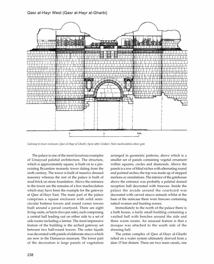
238
The palace is one of the most luxurious examplesof Umayyad palatial architecture. The structure,which is approximately square, is built on to a pre-existing Byzantine monastic tower dating from thesixth century. The tower is built of massive dressedmasonry whereas the rest of the palace is built ofmud brick on stone foundation. Above the entranceto the tower are the remains of a box machicolationwhich may have been the example for the gatewayat Qasr al-Hayr East. The main part of the palacecomprises a square enclosure with solid semi-circular buttress towers and round corner towersbuilt around a paved courtyard. There are eightliving-units, or bayts (two per side), each comprisinga central hall leading out on either side to a set ofside rooms including a latrine. The most impressivefeature of the building is the arched gateway setbetween two half-round towers. The outer façadewas decorated with panels of elaborate stucco whichare now in the Damascus museum. The lower partof the decoration is large panels of vegetation
arranged in geometric patterns, above which is asmaller set of panels containing vegetal ornamentwithin squares, circles and diamonds. Above thepanels is a row of blind niches with alternating roundand pointed arches; the top was made up of steppedmerlons or crenelations. The interior of the gatehouseabove the entrance was probably a palatial domedreception hall decorated with frescoes. Inside thepalace the arcade around the courtyard wasdecorated with carved stucco animals whilst at thebase of the staircase there were frescoes containingnaked women and hunting scenes.
Immediately to the north of the palace there isa bath house, a fairly small building containing avaulted hall with benches around the side andthree warm rooms. An unusual feature is that amosque was attached to the south side of thedressing hall.
The entire complex of Qasr al-Hayr al-Gharbirelied on a water system ultimately derived from adam 15 km distant. There are two main canals, one
Gateway to lesser enclosure, Qasr al-Hayr al-Gharbi, Syria (after Grabar). Note machicolation above gate
Qasr al-Hayr West (Qasr al-Hayr al-Gharbi)

239
leading to the palace and bath house and the otherleading via a cistern to the khan, some mills and thena huge rectangular enclosure containing a networkof small irrigation channels. The irrigation channelsare also fed by a large semi-circular barrage whichcollects water from the hill.
See also: Qasr al-Hayr East, Syria, Umayyads
Further reading:
D.Schlumberger (ed.), Qasr el-Heir el Gharbi, Paris 1986.
Qasr al-Tuba
Unfinished Umayyad complex in south-east Jordan.
Qasr al-Tuba is a large rectangular enclosure dividedinto three strips; only the west wing appears to havebeen completed, although there are traces of mud-
brick structures elsewhere in the complex. LikeMshatta the remaining parts of the building are madeof ashlar masonry with baked brick used for thebarrel-vaulted roofs. There is a dam and several wells
Qasr al-Tuba, Jordan
Stone and brick construction, Qasr al-Tuba, Jordan Slightly pointed doorway arches, Qasr al-Tuba, Jordan
Qasr al-Tuba
240
associated with the qasr but no other structures havebeen identified. The purpose of the building is notclear but it may have been connected with the WadiSirhan caravan route.
Qatar
A peninsula on the east coast of Arabia projectingnorthwards into the Gulf.
Although it used to be dependent on pearl divingand fishing, today the main economy of the State ofQatar is oil. The country is predominantly desertwith few natural water resources. It is ruled by theAmir of Qatar from the capital Doha.
Until recently permanent architecture has beenconfined to one or two towns and several semi-permanent encampments. Archaeologicalexcavations at Ras Abrak has revealed the presenceof several semi-permanent seasonal encampments.One of these has been interpreted as a fish-curingcomplex and consisted of two roughly rectangularrooms linked by a sheltered courtyard containingfireplaces and a cairn. The entire complex was builtout of thin limestone slabs laid without mortaralthough there may have been a superstructure builtout of some less durable material.
On the northern tip of the country are the remainsof a small town, al-Huwailah. At present the site islargely in ruins but the main features can bedistinguished, including a fort surrounded by severalstone houses. Around this central complex are theremains of further structures which were probablyhuts built of palm fronds and were the main form ofaccommodation in the town.
Recent development has meant that little survivesof the traditional town of Doha with the exception ofthe Old Amiri Palace which has recently been restoredand is now used as a museum. This is a large complexcontaining quarters for several families. There arethree gatehouses and two public reception rooms (aninner and outer majlis). The main material forconstruction is coral blocks (both in the form of lumpsand thin slabs) used in conjunction with mangrovepoles in a panel-and-frame construction. Forornamental purposes carved teak and mahogany fromIndia were used.
Further reading:B.DeCardi, Qatar Archaeological Report: Excavations,
Oxford 1973.
G.R.H.Wright, The Old Amiri Palace Doha, Qatar, Qatar1975.
qibla
Direction of Mecca which determines the direction ofprayer.
The qibla is the prime factor in the orientation ofmosques and is usually marked by a mihrab (or morein India). Many early mosques were not built to acorrect qibla orientation, as has been demonstratedin the excavations of the Great Mosque of Wasit,where three different qibla orientations are recorded.It is believed that idea of qibla orientation is derivedfrom the Jewish practice of indicating the directionof Jerusalem in synagogues.
qubba
Literally ‘dome’, often used to refer to a domed mausoleumwhich contains the grave of a saint or some importantpersonage.
The earliest surviving example of this type ofstructure is the Qubbat al-Sulaybiyya at Samarrawhich is octagonal. Another early example is thetomb of Ismail the Samanid in Balkh which is asquare structure with a hemispherical dome. Alsodated to the ninth century are large numbers ofdomed mausoleums at Aswan in southern Egypt.From the eleventh century this type of structurebecomes widespread in the Islamic world and is nowone of the most common building types.
Qusayr Amra
Umayyad bath house complex in the eastern desert ofJordan famous for its painted frescoes.
The building was probably built by the Umayyadcaliph al-Walid between 712 and 715. It comprisesthree main parts, a hall or undressing room, threeheated rooms and a well-house to the-north. The hallis divided into four parts, the main hall, an alcoveand two small rooms either side. The entire hall(including the two side rooms) is roofed by threebarrel vaults resting on transverse arches. The wallsof both the main hall and the two side rooms arecovered in frescoes whilst the floors were coveredwith marble, except in the side rooms where therewere floor mosaics. The subjects of the frescoes differaccording to their position; thus the main hall is
qibla
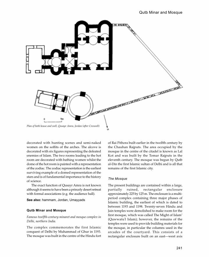
241
decorated with hunting scenes and semi-nakedwomen on the soffits of the arches. The alcove isdecorated with six figures representing the defeatedenemies of Islam. The two rooms leading to the hotroom are decorated with bathing women whilst thedome of the hot room is painted with a representationof the zodiac. The zodiac representation is the earliestsurviving example of a domed representation of thestars and is of fundamental importance to the historyof science.
The exact function of Qusayr Amra is not knownalthough it seems to have been a princely desert retreatwith formal associations (e.g. the audience hall).
See also: hammam, Jordan, Umayyads
Qutb Minar and Mosque
Famous twelfth-century minaret and mosque complex inDelhi, northern India.
The complex commemorates the first Islamicconquest of Delhi by Muhammad of Ghur in 1193.The mosque was built in the centre of the Hindu fort
of Rai Pithora built earlier in the twelfth century bythe Chauhan Rajputs. The area occupied by themosque in the centre of the citadel is known as LalKot and was built by the Tomar Rajputs in theeleventh century. The mosque was begun by Qutbal-Din the first Islamic sultan of Delhi and is all thatremains of the first Islamic city.
The Mosque
The present buildings are contained within a large,partially ruined, rectangular enclosureapproximately 225 by 125 m. The enclosure is a multi-period complex containing three major phases ofIslamic building, the earliest of which is dated tobetween 1193 and 1198. Twenty-seven Hindu andJain temples were demolished to make room for thefirst mosque, which was called The Might of Islam’(Quwwatu�l Islam); however, the remains of thetemples were used to provide building materials forthe mosque, in particular the columns used in thearcades of the courtyard. This consists of arectangular enclosure built on an east—west axis
Plan of both house and well, Qusayr Amra, Jordan (after Creswell)
Qutb Minar and Mosque

242
with the qibla pointing west towards Mecca. Thecourtyard is entered from two entrances on thenorth—south sides and a larger domed entrance tothe east. Inside, the courtyard is bordered on threesides by arcades whilst on the west side is thesanctuary separated from the courtyard by a screen.The screen contains five arches, of which the centralarch is the highest; it is framed by a decorative borderwhich combines Quranic inscriptions with densevegetal carving and the spandrels of the arches aredecorated with interlocking pierced discs. Standingin the courtyard directly in front of the central arch isan iron pillar 12 m high which was made for the Hindugod Vishnu in the fourth century CE. The columnssupporting the arcades are made of finely carved redsandstone and consist of alternate square and roundsections carved with various Hindu motifs, such asthe bell and chain, as well as some figural sculpture.Because the columns were not sufficiently tall for themosque they were placed one on top of the other todouble the height. The arcades and sanctuary arecovered with a trabeate roof where the columnssupport flat beams resting on brackets. The areaimmediately in front of the mihrab was covered by alarge dome although this has now disappeared. Thefirst stage of the Qutb Minar can also be attributed tothis initial phase of construction.
The second stage of the mosque was carried outin the early thirteenth century by Iltumish, whoextended the mosque laterally and completed thework of his father on the Qutb Minar. The lateralextension of the mosque was carried out by extendingthe screen north and south and adding an outerenclosure, or courtyard, which included the QutbMinar in the south-east corner. The arcades of theextension were built in the same way as the innerenclosure and used columns which were speciallycarved to resemble the two-tier Hindu templecolumns used in the first mosque. Iltumish was alsoresponsible for commissioning his own tomb, whichwas begun the year before his death. The tomb islocated outside the mosque to the west and consistsof a square chamber covered with a dome, nowcollapsed. The interior is extravagantly decorated withcarvings in red sandstone which included Hindumotifs intertwined with passages of Quraniccalligraphy. In the centre of the building is Iltumish’stomb whilst to the west are three mihrab niches.
The third major phase of the mosque complexwas carried out by Ala al-Din Khaliji, the fourteenthsultan of Delhi, between 1296 and 1316. Like his
predecessor Ala al-Din decided to increase the areaof the original mosque by extending the length ofthe screen to the north thus enclosing an area morethan double the size of the previous extension. Atthe same time Ala al-Din also began work on anotherminaret on the same pattern as the Qutb Minar whichis known as the Alai Minar. For various reasons Alaal-Din was not able to complete either of theseambitious projects leaving the stump of a minaretand in the north part of the unfinished newcourtyard. However, in 1311 he was able to completea new monumental gateway to the complex knownas the Alai Darwaza which linked the west wall ofIltumish’s complex with the completed west wall ofhis new courtyard. The gateway consists of a largesquare domed chamber with a tall pointed arch inthe north and south sides. The gateway is faced inred sandstone inlaid with bands of white marble andis completely covered in carved designs andepigraphic bands. The south façade of the chamberconsists of a tall pointed arch in the centre, flankedon each side by a window covered with a piercedstone screen (jalis) and a blind arch of similar design.Above the two arches either side of the main archare two flat rectangular panels each divided in twoand containing a small square blind niche. The archesof the façade are decorated with spiky projectingtassels whilst the jambs of the arches are made up ofengaged columns similar to those used to supportthe arcades.
East of the Alai Darwaza is a small square domedtomb built by the Turkestani Imam Zamin. This isthe latest building at the site dating to 1538.
The Minar
Although subsequently copied in various ways, theQutb Minar is a unique building which announcesthe arrival of Islam in India. The minar comprises atall tapering cylindrical tower standing on a circularbase with five storeys which together reach a heightof 72.5 m. Each of the storeys is reached by an internalspiral staircase which leads to the balconies whichare supported on muqarnas corbels. The mostcharacteristic feature of the building is the corrugatedangular and rounded fluting on the shaft whichforms the basis for many later imita-tions. The firstpart of the tower was built by Qutb al-Din who diedin 1210 leaving only one storey completed. This isthe thickest part of the tower with a base diameterof 14 m tapering to 9 m at the first balcony. This part
Qutb Minar and Mosque
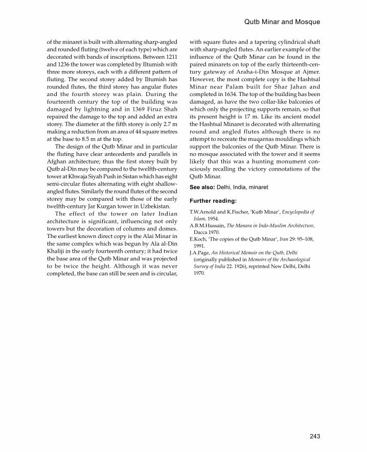
243
of the minaret is built with alternating sharp-angledand rounded fluting (twelve of each type) which aredecorated with bands of inscriptions. Between 1211and 1236 the tower was completed by Iltumish withthree more storeys, each with a different pattern offluting. The second storey added by Iltumish hasrounded flutes, the third storey has angular flutesand the fourth storey was plain. During thefourteenth century the top of the building wasdamaged by lightning and in 1369 Firuz Shahrepaired the damage to the top and added an extrastorey. The diameter at the fifth storey is only 2.7 mmaking a reduction from an area of 44 square metresat the base to 8.5 m at the top.
The design of the Qutb Minar and in particularthe fluting have clear antecedents and parallels inAfghan architecture; thus the first storey built byQutb al-Din may be compared to the twelfth-centurytower at Khwaja Siyah Push in Sistan which has eightsemi-circular flutes alternating with eight shallow-angled flutes. Similarly the round flutes of the secondstorey may be compared with those of the earlytwelfth-century Jar Kurgan tower in Uzbekistan.
The effect of the tower on later Indianarchitecture is significant, influencing not onlytowers but the decoration of columns and domes.The earliest known direct copy is the Alai Minar inthe same complex which was begun by Ala al-DinKhaliji in the early fourteenth century; it had twicethe base area of the Qutb Minar and was projectedto be twice the height. Although it was nevercompleted, the base can still be seen and is circular,
with square flutes and a tapering cylindrical shaftwith sharp-angled flutes. An earlier example of theinfluence of the Qutb Minar can be found in thepaired minarets on top of the early thirteenth-cen-tury gateway of Araha-i-Din Mosque at Ajmer.However, the most complete copy is the HashtsalMinar near Palam built for Shar Jahan andcompleted in 1634. The top of the building has beendamaged, as have the two collar-like balconies ofwhich only the projecting supports remain, so thatits present height is 17 m. Like its ancient modelthe Hashtsal Minaret is decorated with alternatinground and angled flutes although there is noattempt to recreate the muqarnas mouldings whichsupport the balconies of the Qutb Minar. There isno mosque associated with the tower and it seemslikely that this was a hunting monument con-sciously recalling the victory connotations of theQutb Minar.
See also: Delhi, India, minaret
Further reading:
T.W.Arnold and K.Fischer, ‘Kutb Minar’, Encyclopedia ofIslam, 1954.
A.B.M.Hussain, The Manara in Indo-Muslim Architecture,Dacca 1970.
E.Koch, ‘The copies of the Qutb Minar’, Iran 29: 95–108,1991.
J.A.Page, An Historical Memoir on the Qutb, Delhi(originally published in Memoirs of the ArchaeologicalSurvey of India 22. 1926), reprinted New Delhi, Delhi1970.
Qutb Minar and Mosque

244
Rabat
Capital of Morocco located on the Atlantic coast.
The city of Rabat is located at the mouth of the BouRegreg river. Rabat stands on the south side of theriver and the twin city of Sale occupies the northbank. Although there was probably a Romansettlement on the site, the present city of Rabat wasfounded in the twelfth century by the Almohadruler Sultan Abd al-Mumin as a depot andlaunching point for the Almohad conquest of Spain.The city still retains parts of its twelfth-centurywalls including two monumental Almohadgateways. The façade of the gateways consists of acentral entrance with a slightly pointed horseshoearch with spandrels decorated with bold interlacedesigns. Both gateways form bent entrances, theUdayya gate has a passage which runs along theside of the wall before opening into the town, whilstthe Bab Ruwah has a complicated zig-zag patternwith blind passages.
The most famous monument in Rabat is themosque of Hassan begun in 1196 after theAlmohad victory over Alfonso VIII at Alarcos inSpain. The mosque would have been one of thelargest in the Islamic world but constructionceased after the death of Ya�qub al-Mansur in 1199.The plan of the mosque can still be discerned andconsists of a huge rectangle 140 by 185 m with threecourtyards and a huge minaret in the middle ofthe north side opposite the qibla wall. Theunfinished minaret is 40 m high, but if completedit would have reached a height of over 70 m. Thetower is built in the characteristic Almohad stylewith a square central core around which a ramprises to reach the top. Within the central core are aseries of vaulted rooms, one on each storey, eachwith a different form of vault. The exterior of thetower is decorated with windows set within blindniches with multi-foil and cusped arches, theupper part of the tower is covered with a networkof interlaced arches.
The current main mosque of the city was built bythe Marinids in the thirteenth century and standsopposite a madrassa built in the same period. TheKasba des Ouadias forms an enclosure within thecity which contains houses and a twelfth-cen-turymosque. To the south of the city is the fortifiednecropolis of Challa built by the Marinids in thefourteenth century.
See also: Almohads, Morocco
Ramla
Capital of Palestine in the early Islamic period.
R
Tower of White Mosque, Ramla, Israel/Palestine

245
Ramla is located in the southern coastal plain ofPalestine roughly equidistant between Gaza andJerusalem. The city was founded in 712 by theUmayyad caliph Sulayman as an alternative tonearby Lydda which had a predominantly Christianpopulation.
Little remains from the early Islamic period,although the White Mosque to the north-east of themodern town preserves the shape of the Umayyadmosque, whilst the cistern known as Birket al-�Anaziya was built during the reign of the Abbasidcaliph Harun al-Rashid. The city suffered from aseries of earthquakes and the Crusader occupationof the twelfth century so that by the Mamluk period(1250s) it was at least a quarter of its former size.Although the White Mosque was rebuilt by SultanBaybars, this area of the town never recovered.Instead, the south-east part of the city became thecentre of the town with the Crusader church of StJohn functioning as the Great Mosque. This hasremained the town centre to the present day andcontains a number of interesting Mamluk andOttoman buildings.
See also: Mamluks, Palestine
Further reading:
M.Ben-Dov and M.Rosen Ayalon, ‘Ramla’, in NewEncyclopaedia of Excavations in the Holy Land, Jerusalem1993.
A.D.Petersen, ‘A preliminary report on a survey ofhistoric buildings in Ramla’, Levant 25: 1995, 75–101.
RaqqaProminent Abbasid and medieval city located on theEuphrates river in Syria.
Raqqa was founded by Alexander the Great andwas known as Leontopolis in the Byzantine period.In 639 the town was captured by the Arabs andrenamed Raqqa. In 772 the Abbasid caliph al-Mansur founded a new city, west of the old one,which he enclosed with a wall similar to that ofBaghdad, with an inner and an outer wall and amoat or ditch. The remains of the walls can still beseen and form a rounded enclosure with a straightwall on the south side. The inner wall still survivesto a height of 10 m in places and is studded withhalf-round towers at regular intervals. There is agap of 20 m between this and the outer wall ofwhich little survives. In the middle of the enclosureare the remains of the Great Mosque which was
built in 772. This is a huge rectangular enclosuremeasuring 90 by 110 m, with a large centralcourtyard containing a minaret of later date (twelfthcentury). The outer walls of the mosque are madeof mud brick supported by solid semi-circularbuttress towers. The prayer hall consisted of threearcades supported on cylindrical piers, whilst theother three sides were lined with double arcades.The building was decorated with stucco, traces ofwhich survive.
The famous Baghdad gate which stands at thesouth-east corner of the city is now thought to dateto the twelfth century. It is a baked-brickconstruction with a main gateway set below a rowof two-tier blind niches separated by engagedcolumns. The gateway itself and the upper tier ofarches are of a four-centrepoint design which makesits first appearance in the late ninth century atSamarra.
See also: Abbasids, Baghdad, Samarra, Syria
Further reading:
J.-C.Heusch and M.Meinecke, ‘Grabungen imabbasidischen Palastareal von ar-Raqqa/ar-Rafiqa’,Damaszener Mitteilungen 2: 85–105, 1985.
M.al-Khalaf, ‘Die abbasidische Stadtmauer von ar-Raqqa/ar Rafiqa’, Damaszener Mitteilungen 2: 122–31, 1985.
J.Warren, The date of the Baghdad Gate at Raqqa’, Art andArchaeology Research Papers XIII: 22–3, 1978.
rauza
Persian term for mausoleum.
Red Fort (Lal Qila)Mughal palace in Delhi built by the Mughal emperor ShahJahan between 1638 and 1648.
The building derives its name from the use of redsandstone as the main building material. The palaceforms the core of Shah Jahan’s new city ofShahjahanabad. The fort is located next to the Jumnariver and surrounded on all four sides by a highcrenellated wall which on the landward side isenclosed within a moat. The two main entrances tothe palace are the Lahore and Delhi gates both ofwhich were enlarged by Jahan’s successorAurangzeb. The internal layout of the palace issymmetrical and was probably based on that of theAgra fort. The Lahore gate was the main form ofpublic access and leads into a large square with the
Red Fort (Lal Qila)
246
imperial audience hall on the opposite side. Theprivate apartments were made up of a series ofpavilions and gardens arranged in a rigid geometry.The decoration of the palace is of outstanding qualityand refinement and with the Alhambra is one of thefinest examples of Islamic palatial architecture.Decorative techniques include painting, gilding,pietra dura (stone inlay) gilding and white marblecarved in shallow relief.
See also: Agra, Delhi, India, Lahore, Mughals, TajMahal
riad
North African term for a walled garden.
ribat
Fortified enclosure for religious warriors, common inNorth Africa in the early Islamic period.
A typical ribat is located near the coast and partiallyfunctions as a look-out post. Usually ribats are squareor rectangular courtyard structures, two storeys high,with storage rooms and stables on the ground floorand sleeping accomodation and a mosque on the
upper floor. Later ribats seem to have lost theirmilitary function. Important examples are at Sfax,Monastir and Sousse in Tunisia.
See also: Tunisia
Ribat-i Sharaf
Royal Seljuk caravanserai on the road between Nishapurand Merv.
This building was founded in 1114 as a royalcaravanserai and expanded in 1156 when it wasused as a semi-permanent residence for SultanSanjar and his wife who were held under housearrest by the Öghuz Turks. The first part of thestructure is a square enclosure built around a centralcourtyard with a central iwan in each side leadingto a domed room. The extension is half the size andis built on to the front of the original structure. Thebuilding was decorated with elaborate stucco workand a monumental entrance pishtaq flanked withtwin blind niches.
riwaq
Arcade or portico open on at least one side.
riad
247
sabil
See sebil.
Saffavid
Dynasty of Kurdish origin which ruled Iran during thesixteenth and seventeenth centuries.
Although the founder of the dynasty was probablya Sunni, the Saffavids later became Shi�a andadopted this as a state religion. Little remains ofthe early architecture of the Saffavids whoestablished capitals first at Tabriz and later atQazvin. The little that does survive indicates thatthey continued the architectural forms establishedby their predecessors the Timurids. Thus theSaffavids continued to use the complex vaultingforms, with networks of arches, squinches andpendentives, developed under the Timurids. Anearly example of a Saffavid building is the tomb ofHarun-i Vilayat which although Timurid in formhas an emphasis on exterior tile decoration. Thiswas a feature which was developed in later Saffavidarchitecture where the architectural form seems tobe subordinated to the tile patterns.
The most productive period of Saffavidarchitecture began in 1598 with Shah Tahmasp’sdecision to redesign Isfahan as an imperial capital.The centre of the new developments was the Maidan-i-Shah which is a rectangular square or park aroundwhich was built the palace, the principal mosquesand the principal bazar of the city. The maincharacteristics of this architecture was the layout andplanning with the mosques built at a deliberate angleto the maidan to show off both their monumentalportals (pishtaq iwans) and their glazed domes.Similarly the main gate of the palace, the Ali Qapu,was made into a pavilion overlooking the Maidan-i-Shah from which the shah’s palace could be seen.The emphasis on accessibility is also demonstratedin the tomb complexes, where the outside faces arepierced with arches instead of forbidding walls. This
is also seen on utilitarian structures such as thefamous Pol-i-Khaju bridge built in 1650. This bridge,which links Isfahan to the southern palace, is 110 mlong and has two tiers of arcades which provideshelter from the summer heat. Another characteristicof the architecture is the use of lighter materials suchas wood, stucco, paint and tiles, and an increasingemphasis on gardens. However, this may appear tobe a development simply because earlier structuresof this type have not survived.
Outside Isfahan buildings such as caravanseraisare generally larger and plainer than their pre-decessors indicating the growth of commercialtraffic.
See also: Iran, Isfahan
sahn
Courtyard of a mosque.
Samarkand
Timurid capital located in the Central Asian state ofUzbekistan.
Samarkand is located on the banks of the Zeravshanriver approximately 200 km east of Bukhara. Nextto the present city are the ruins of Afrasiyab whichwas the site of the city from 500 BCE until the Mongoldestruction of 1220 CE. In the eighth century the citywas sacked by the Arab general Qutaiba bin Muslim.After the Arab conquest a new city was built to thesouth-west with Afrasiyab remaining as an industrialquarter specializing in the production of paper forwhich it was famous. Excavations have revealedwork-shops for pottery and glass in addition to alarge mosque which was burnt during the Mongolinvasion.
Samarkand once again rose to internationalprominence in 1369 when it was captured by theMongol emperor Timur and chosen as his capital.Timur enclosed the city with a wall 7 km long and
S
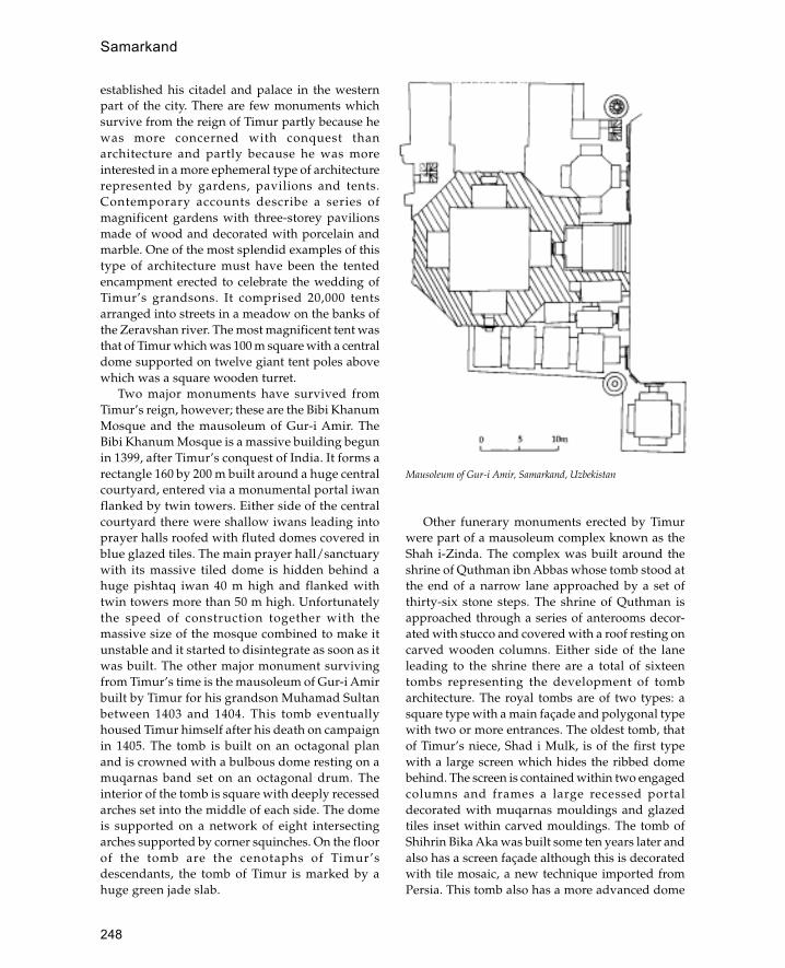
248
established his citadel and palace in the westernpart of the city. There are few monuments whichsurvive from the reign of Timur partly because hewas more concerned with conquest thanarchitecture and partly because he was moreinterested in a more ephemeral type of architecturerepresented by gardens, pavilions and tents.Contemporary accounts describe a series ofmagnificent gardens with three-storey pavilionsmade of wood and decorated with porcelain andmarble. One of the most splendid examples of thistype of architecture must have been the tentedencampment erected to celebrate the wedding ofTimur’s grandsons. It comprised 20,000 tentsarranged into streets in a meadow on the banks ofthe Zeravshan river. The most magnificent tent wasthat of Timur which was 100 m square with a centraldome supported on twelve giant tent poles abovewhich was a square wooden turret.
Two major monuments have survived fromTimur’s reign, however; these are the Bibi KhanumMosque and the mausoleum of Gur-i Amir. TheBibi Khanum Mosque is a massive building begunin 1399, after Timur’s conquest of India. It forms arectangle 160 by 200 m built around a huge centralcourtyard, entered via a monumental portal iwanflanked by twin towers. Either side of the centralcourtyard there were shallow iwans leading intoprayer halls roofed with fluted domes covered inblue glazed tiles. The main prayer hall/sanctuarywith its massive tiled dome is hidden behind ahuge pishtaq iwan 40 m high and flanked withtwin towers more than 50 m high. Unfortunatelythe speed of construction together with themassive size of the mosque combined to make itunstable and it started to disintegrate as soon as itwas built. The other major monument survivingfrom Timur’s time is the mausoleum of Gur-i Amirbuilt by Timur for his grandson Muhamad Sultanbetween 1403 and 1404. This tomb eventuallyhoused Timur himself after his death on campaignin 1405. The tomb is built on an octagonal planand is crowned with a bulbous dome resting on amuqarnas band set on an octagonal drum. Theinterior of the tomb is square with deeply recessedarches set into the middle of each side. The domeis supported on a network of eight intersectingarches supported by corner squinches. On the floorof the tomb are the cenotaphs of Timur’sdescendants, the tomb of Timur is marked by ahuge green jade slab.
Other funerary monuments erected by Timurwere part of a mausoleum complex known as theShah i-Zinda. The complex was built around theshrine of Quthman ibn Abbas whose tomb stood atthe end of a narrow lane approached by a set ofthirty-six stone steps. The shrine of Quthman isapproached through a series of anterooms decor-ated with stucco and covered with a roof resting oncarved wooden columns. Either side of the laneleading to the shrine there are a total of sixteentombs representing the development of tombarchitecture. The royal tombs are of two types: asquare type with a main façade and polygonal typewith two or more entrances. The oldest tomb, thatof Timur’s niece, Shad i Mulk, is of the first typewith a large screen which hides the ribbed domebehind. The screen is contained within two engagedcolumns and frames a large recessed portaldecorated with muqarnas mouldings and glazedtiles inset within carved mouldings. The tomb ofShihrin Bika Aka was built some ten years later andalso has a screen façade although this is decoratedwith tile mosaic, a new technique imported fromPersia. This tomb also has a more advanced dome
Mausoleum of Gur-i Amir, Samarkand, Uzbekistan
Samarkand

249
design which has a slightly bulbous form restingon a sixteen-sided drum.
The centre of the city was the Registan, althoughno buildings of Timur’s period survive in thissquare, considered the finest in Central Asia. Theoldest building in the Registan is the madrassa ofUlugh Beg built between 1417 and 1420. Themadrassa has the typical Timurid form with a hugeentrance iwan (pishtaq) set into an entrance façadeflanked with twin minarets. The entire surface ofthe façade and minarets is decorated with blue,turquoise and yellow tile mosaic against abackground of yellow/buff baked brick. One of thenotable features of the decoration is the use of giantcalligraphic patterns in complex geometricarrangements. The interior of the madrassaconsisted of a courtyard surrounded by two storeysof cells and teaching rooms designed toaccommodate 100 students. Ulugh Beg’s love oflearning is further demonstrated by his observatorywhich was a three-storey tiled structure nearly 50m in diameter cut into the hillside. In the middle ofthe building was a deep slit 40 m long whichcontained a sextant with an arc of 63 m. With thisinstrument Ulugh Beg was able to produce the firstprecise map of the stars and planets.
Opposite the Ulugh Beg Madrassa in the Registanis the Shirdar Madrassa which has the same generalform even though it was built 200 years later in theseventeenth century. On the third side of the squareis the Tilakar Mosque and Madrassa also built in theseventeenth century. This building has the largestfaçade, which is over 120 m long with a massiveentrance iwan (pishtaq) flanked on either side by twostoreys of open arches facing on to the square anddomed cylindrical corner turrets. Inside, the mosqueis decorated with multiple layers of gold painted onto a blue background.
See also: Bukhara, Timurids, Uzbekistan
Further reading:
J.Lawton and F.Venturi, Samarkand and Bukhara, London1991.
A.L.Mongait, Archaeology in the U.S.S.R., trans. M.W.Thomson , Pelican, London 1961.
N.B.Nemtseva, ‘The origins and architecturaldevelopment of the Shah i Zinda’, trans. with additionsby J.M.Rogers and A.Yasin, Iran 15: 51–74, 1977.
R.Pinder-Wilson, ‘Timurid architecture’, in CambridgeHistory of Iran 6, 1993.
D.N.Wilber, ‘The Timurid court: life in gardens and tents’,Iran 27: 127–134, 1979.
SamarraAbbasid capital in central Iraq.
Samarra is now recognized as the largestarchaeological site in the world and stretches for over40 km along the banks of the Tigris. Although therewere settlements in the area of Samarra before theAbbasid period, it was not established as capital until836 CE when the Abbasid caliph al-Mu�tassimdecided to set up a new city following clashesbetween his troops and the local population ofBaghdad. The city remained capital for fifty-six yearsand was home to eight caliphs, until 892 when thecapital was moved back to Baghdad.
The predominant building material in Samarrawas mud brick and pisé with baked brick reservedfor more important structures (i.e. the Great Mosqueand the Bab al-Amma). Houses and palaces weredecorated with carved and moulded stucco panels,and Samarra provides the earliest examples ofbevelled stucco decoration. Some of the palaces werealso decorated with wall paintings and glass mosaicalthough none of this remains in situ.
The modern town of Samarra is locatedapproximately in the centre of the Abbasid city.Immediately to the north-west of the city, on the westbank of the Tigris, is the Jausaq al-Khaqani whichfor most of the time was the caliph’s palace and wasalways his official residence. It was built by one ofal-Mu�tasim’s Turkish generals and reflects featuresof Central Asian influence such as wall paintingswith Bactrian camels. The palace is a vast complex,including a mosque, a polo ground and a horse-racing track. On the west side of the palace, facingthe river, there is a monumental gateway or portalknown as the Bab al-Amma, or public gate. Thisstructure was probably an official entrance and aplace for public audiences. Directly to the east of thepalace is the Great Mosque of Samarra with its spiralminaret (the Malwiyya). Measuring over 240 by 160m this is one of the largest mosques in the world. Itis built entirely of baked brick although marblecolumns on brick piles originally supported the roof.The outer wall of the mosque is supported by fourcorner towers and twenty semi-circular bastionsresting on square bases. The curtain wall is entirelyplain except for a frieze which runs between thebastions, each section consisting of six bevelled
Samarra

250
squares with shallow concave discs in the centre. TheMalwiyya, or spiral minaret, is 52 m high and mayhave been influenced by earlier Mesopotamianziggurats.
In the north of Samarra are the remains of anextension to the city built by Caliph al-Mutawakkilin an attempt to found a new city. This new area had
a palace, garrisons and a congregational mosqueknown as the Abu Dulaf. The Abu Dulaf Mosque isa smaller version of the Great Mosque and has aspiral minaret 19 m high. On the west bank of theTigris is the Ashiq Palace, one of the last buildingsmade before the capital was relocated in Baghdad.The palace is built on a vaulted substructure or
Qubbat al-Sulaybiyya, Samarra, Iraq
Great Mosque above and smaller mosque in foreground, Samarra, Iraq
Samarra
251
terrace so that it can overlook the Tigris. The buildingforms a high rectangle with the outer walls decoratedby a series of blind niches. One of the distinctivefeatures of the palace is the use of the four-centrepoint arch for the first time in Islamicarchitecture.
South of the modern town of Samarra are anumber of major structures, including the palacesof al-Istabulat, al-Balkuwara and Musharrahat. Inaddition, there is a huge octagonal enclosure, eachside of which is half a kilometre long, known as theoctagon of Qadisiyya. This probably represents theremains of an unfinished city started by Harun al-Rashid in the eighth century.
See also: Abbasids, Baghdad, Iraq
Further reading:
A.Northedge, ‘Planning Samarra’, Iraq 47: 109–28, 1985.—— ‘The Palace of Istabulat’, Archéologie islamique 4: 1993.A.Northedge and R.Falkner, ‘The 1986 survey season at
Samarra’, Iraq 49: 143–74, 1987.A.Northedge, T.J.Wilkinson and R.Falkner, ‘Survey and
excavations at Samarra 1989’, Iraq 52: 121–48.
San�����a
Capital city of Yemen.
The city is located on a high plateau 2,200 m abovesea level. Above the city is Jabal Nuqum which actsas a collecting point for clouds and consequentlyprecipitation. San�a seems to have risen toprominence in the third century CE although anearlier settlement probably existed on the site.
San�a has thirty-four historic mosques, the oldestof which is the Great Mosque which is said to havebeen founded on the orders of Muhammad duringhis lifetime. This early mosque was extendednorthwards during the Umayyad period on theorders of Caliph al-Walid. Subsequent restorationswere carried out in the twelfth, thirteenth andsixteenth centuries, although the basic form of thebuilding appears to have remained the same. In itspresent form the mosque consists of a largerectangle measuring 66 by 78 m with six gateways,one at the south, four on the east and west sidesand one in the north wall next to the mihrab. Theexternal walls are built of large blocks of squaredbasalt with a central core of rubble. The courses ofthe wall are marked by narrow ridges (approxi-mately 0.5 cm wide) formed by the faces of the
stones leaning outwards. This is a masonrytechnique characteristic of pre-Islamic Yemeniarchitecture. In the centre of the mosque there is asquare courtyard surrounded by arcades, four onthe south side, three on the east and west sides andfive on the north (qibla) side. The arcades have aflat wooden roof supported by arches resting eitheron columns or on circular stone piers. In the centreof the courtyard is a square box-shaped structurecovered with a dome known as Sinan PashasQubbah. Although it was built in the earlyseventeenth century, its form and position suggestit may have earlier antecedents. There are twominarets, one in the south-east corner of thecourtyard and the other at the east side of themosque next to the outer wall. They both seem todate from the thirteenth century but may have beenrestored later. The mosque has four mihrabs, threesubsidiary ones at its south end and a main mihrabto the left of centre in the north wall. The area abovethe mihrab is roofed by five corbelled woodendomes, a central dome and four smaller side domes.In the centre of each dome is a block of alabasterwhich would have functioned as a skylight.
Other early mosques in San �a include theJabbanah Musalla, the Tawus Mosque, the mosqueof al-Jala and the Jami al-Tawashi. The JabbanahMusalla is an open-air prayer area which is saidto date from the time of Muhammad, although ithas been extended in later times. The other earlymosques are rectangular box-like structures withhypostyle roofs and recall pre-Islamic Yemenitemples. Mosques of the twelfth century and laterare influenced by the architecture of Egypt andSyria. This influence can be seen in the use ofarches and domes, which are rare features in thetraditional architecture of Yemen. After theOttoman occupation of the sixteenth century,mosques were built with large central domes anddomed arcades.
The domestic architecture of San�a is representedby tall tower houses built of stone and decoratedwith white plasterwork around the windows andcoloured glass in the reception rooms (mafraj) at thetop of the house.
See also: Yemen
Further reading:R.B.Serjeant and R.Lewcock (eds.), San�a. An Arabian
Islamic City, World of Islam Festival Trust, London1983.
San�a
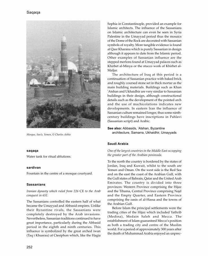
252
saqaqaWater tank for ritual ablutions.
sardivanFountain in the centre of a mosque courtyard.
Sassanians
Iranian dynasty which ruled from 226 CE to the Arabconquest in 651.
The Sassanians controlled the eastern half of whatbecame the Umayyad and Abbasid empires. Unliketheir Byzantine rivals, the Sassanians werecompletely destroyed by the Arab invasions.Nevertheless, Sassanian traditions continued to havegreat importance, particularly during the Abbasidperiod in the eighth and ninth centuries. Thisinfluence is symbolized by the great arched iwan(Taq i Khusrau) at Ctesiphon which, like the Hagia
Sophia in Constantinople, provided an example forIslamic architects. The influence of the Sassanianson Islamic architecture can even be seen in SyriaPalestine in the Umayyad period thus the mosaicsof the Dome of the Rock are decorated with Sassaniansymbols of royalty. More tangible evidence is foundat Qasr Kharana which is purely Sassanian in designalthough it appears to date from the Islamic period.Other examples of Sassanian influence are thestepped merlons found at Umayyad palaces such asKhirbet al-Minya or the stucco work of Khirbet al-Mafjar.
The architecture of Iraq at this period is acontinuation of Sassanian practice with baked brickand roughly coursed stone set in thick mortar as themain building materials. Buildings such as Khan�Atshan and Ukhaidhir are very similar to Sassanianbuildings in their design, although constructionaldetails such as the development of the pointed archand the use of machicolations indicates newdevelopments. In eastern Iran the influence ofSassanian culture remained longer, thus some ninth-century buildings have inscriptions in Pahlavi(Sassanian script) and Arabic.
See also: Abbasids, �Atshan, Byzantinearchitecture, Samarra, Ukhaidhir, Umayyads
Saudi Arabia
One of the largest countries in the Middle East occupyingthe greater part of the Arabian peninsula.
To the north the country is bordered by the states ofJordan, Iraq and Kuwait, whilst to the south areYemen and Oman. On the west side is the Red Seaand on the east the coast of the Arabian Gulf, withthe Gulf states of Bahrain, Qatar and the United ArabEmirates. The country is divided into threeprovinces: Western Province comprising the Hijazand the Tihama, Central Province comprising Najdand the Empty Quarter, and Eastern Provincecomprising the oasis of al-Hassa and the towns ofthe Arabian Gulf.
Before Islam the principal settlements were thetrading cities of the Hijaz which included Yathrib(Medina), Medain Saleh and Mecca. Theestablishment of Islam guaranteed Mecca’s positionas both a trading city and centre of the Muslimworld. For a period of approximately 300 years afterthe death of Muhammad Arabia enjoyed an unprec-
Mosque, San�a, Yemen, © Charles Aithie
Saqaqa
253
edented economic growth and settlements like al-Rabadah grew from small settlements into majortowns. During this time Arabia had the largest areaof settlement until modern times. During theMiddle Ages (1000–1500) the lack of centralauthority meant that Arabia was again a marginalarea, only enlivened by pilgrim routes andsecondary trade routes. With the growth of theOttoman Empire in the sixteenth century Arabiabecame strategically important both for religiousreasons (Mecca and Medina) and strategic reasons(growing European presence in the Indian Ocean).The increasing involvement of the Turks in the areaprovoked a reaction both within Arabia and fromoutside. The reaction from within Arabia led to thecreation of the first Saudi state by Muhammad ibnSaud and Muhammad ibn Abd al-Wahhab. Thestate began in Najd in the 1740s and graduallyexpanded so that by the beginning of the nineteenthcentury successful attacks had been mountedagainst Kerbala in Iraq and Mecca in the Hijaz. Thegrowing power of the Saudis was viewed withalarm by the Ottomans, who launched a campaignwhich led to the execution of the Saudi ruler. Duringthe nineteenth century the Saudis graduallyreasserted themselves spreading over large areasof Arabia. With the defeat of the Turks in the FirstWorld War the Saudis were able to make great gainsand in the 1920s were able to take control of theHijaz. Oil wealth has added to the strength of thekingdom which is now one of the oldest monarchiesin the Middle East.
A variety of materials are employed in thetraditional architecture of Saudi Arabia, these maybe divided into three groups, stone, wood and mud.Mud is the commonest building material and mayeither be used as mud brick, pisé or as mud plasterfor stone walls. Mud brick is the principalconstruction material in central Arabia as well as inthe oasis towns of the eastern and western provinces.In northern Najd mud brick has recently replacedstone as the principal material of construction; thereasons for this are not known, although mud brickmay be more versatile.
Stone is predominantly used in the mountainousregions of the Hijaz and �Asir province and formerlyin the northern Najd. Dressed stonework and ashlarmasonry are uncommon in most of Saudi Arabiawith the exception of the older cities of the Hijaz.The usual method of stone construction in most ofthe country is stone slabs laid in rough courses
without mortar. True arches are rare in traditionalstone architecture and the usual means of coveringan opening are with a lintel or corbelled arch.Sometimes the outer surfaces are plastered with mudplaster or lime plaster where it is available. In themountains of �Asir layers of projecting flat stonesare set into the walls to deflect rainfall away fromtheir coating of mud plaster.
On the east and west coasts coral forms theprincipal building material. This may either be fossilor reef coral depending on preference andavailability. Coral walls are usually coated with ahard white lime plaster, which is sometimes carvedinto elaborate stucco patterns.
Wood is an essential component of traditionalarchitecture despite its natural scarcity in the ariddesert environment. The date palm is the mainsource of wood in much of the country and is usedfor roofing and lintels. Tamarisk wood is also usedbut is more scarce and difficult to find in suitablelengths. On the coasts imported mangrove wood isused for roofs and strengthening in walls.
Hijaz
Historically the cities of the Hijaz have been the maincultural centres of Arabia, but recently Riyadh hasgrown in significance. The principal towns of theHijaz are Mecca, Medina and Jeddah, in additionthere are a number of smaller towns such as Tabukand al-�Ula. As religious cities Mecca and Medinaare responsible for bringing a large number ofpilgrims to the area and have a cosmopolitanpopulation. However, Jeddah as the port of Meccahas grown to be the main city of the Hijaz and untilrecently has been the main commercial centre ofSaudi Arabia. The architecture of the Hijaz isparticularly subject to outside influences, thussettlements of al-�Ula, Tabuk and al-Wajh developedas a result of the pilgrim routes. The medieval khanof Qasr Zurayb near al-Wajh is a clear example ofthis external influence.
Tihama and �Asir
The Tihama is located in the south-west corner ofSaudi Arabia and comprises two distinct regions,the hot humid coastal plain and the highmountains of �Asir. The architecture of the coastalplain is of two types, town houses and ruralhouses. The town houses are built of coral and are
Saudi Arabia
254
usually rectangular single-storey buildings witha courtyard. Rural houses are made of wood andthatch and are related to the architecture of nearbyEast Africa. The architecture of the mountains isbuilt of stone and is related to the mountainarchitecture of Yemen.
Najd
The Najd is a plateau in the centre of Arabia southof the Nafud desert. The principal areas ofoccupation are clustered around the Jabal Tuwayqand include Riyadh, the present capital of the countryas well as Ha�il, the nineteenth-century capital. Northof the Nafud desert is the oasis town of Dumat al-Jandal which has a mosque attributed to the secondcaliph, �Umar ibn al-Khattab (634–44).
Al-Hassa
The great oasis of al-Hassa stands about 60 km fromthe coast of the Arabian Gulf. The architecture of thearea is predominantly stone and mud, although itsposition near the coast means that it is open tooutside influences, the most obvious of which is thewhite plaster decoration used to create stucco panelsand decorative arches. During the sixteenth centurythe oasis was occupied by the Ottoman Turks in anattempt to curb Saffavid or Portuguese ambitions inthe area, and Ottoman influence may still be seen inHufuf, the principal town of the oasis. The mosqueof Ibrahim has a large central dome resting on fourlarge squinches and a domed portico similar toclassical Ottoman mosques. Nevertheless, themosque is not Ottoman in details such as themuqarnas hood of the mihrab or the use of polylobedarches.
The Gulf Coast
The Gulf coast includes the towns of al-Jubayl, al-Qatif and the modern city of Dhahran. As on thewest coast coral is the traditional building materialalthough it is used in a different form. One of thenotable features of this architecture is the use ofthin coral panels held between piers. Also thebuildings of this region are distinguished by theiruse of decorative arches and ornamentalplasterwork.
See also: Ka�ba, Mecca, Medina
Further reading:
G.R.D.King, ‘Traditional architecture in Najd, SaudiArabia’, Proceedings of the Tenth Seminar for ArabianStudies, London 1976, 90–100.
—— ‘Islamic architecture in Eastern Arabia’, Proceedingsof the Eleventh Seminar for Arabian Studies, London 1977,15–28.
—— Historical Mosques of Saudi Arabia, London and NewYork 1986.
—— ‘Building methods and materials in western SaudiArabia’, Proceedings of the Seminar for Arabian Studies,vol. 191989.
T.Prochazka, The architecture of the Saudi Arabian southwest’, Proceedings of the Tenth Seminar for Arabian Studies,London 1976, 120–33.
Sawma�����a
Minaret.
sebil
Turkish term for a drinking fountain. Also used torefer to a small kiosk with attendant who dispenseswater, or sherbet, from behind a grille.
Selimiye
Ottoman mosque at Edirne in European Turkeyconsidered to be the culmination of Ottomanarchitecture.
The mosque forms the centre of a complex whichincludes a madrassa (college), a Quran readingroom and a huge covered market, the proceeds ofwhich paid for the upkeep of the mosque. Thiscomplex, built by the famous architect Sinan, isgenerally considered to be his greatest work. Themosque consists of two rectangular areas of equalsize placed side by side; the northern area is thecourtyard and portico and the southern areacomprises the prayer hall of the mosque coveredby a huge dome, 32 m in diameter. The dome is thesame size as that of the Hagia Sophia, thusachieving the Ottoman ambition of building amosque of equal size and brilliance to the Ottomanmasterpiece. Instead of using half-domes of thesame radius placed at the sides of the central domeas was usual in earlier mosques, Sinan used smallercorner domes which function as giant squinches.The dome rests on an octagon formed by eight
Sawma�a

255
massive cylindrical fluted piers which projectthrough the roof to act as stabilizing turrets for thefenestrated drum. The significance of the design isthat it breaks away from the square domed areawhich had remained the dominant principal inOttoman mosque architecture.
Like the Süleymaniye and the Üç SerefeliMosque, the Selimiye has four minarets, but herethey are placed at each corner of the mosque ratherthan at the corners of the courtyard as hadhappened previously. At 68 m these are the tallestOttoman minarets and with their centralpositioning emphasize the pyramid-like mass of thedome.
The mosque is built mainly of yellow sandstonealthough red sandstone is also used for voussoirs inarches and for outlining architectural details. Theinterior of the building is provided with traditionalmosque furniture, the most impressive of which isthe tall marble minbar. The sides of the minbar aredecorated with a carved geometric interlace patternbased on a twelve-pointed star and circle. Directlybelow the dome is the square muezzin’s galleryresting on an arcade of wide-lobed arches, and belowthis is a small marble fountain emphasizing thecentral axis of the dome. The mihrab is containedwithin a square, apse-like area and covered by asmall semi-dome which emphasizes its position. Theroyal prayer room is located on an upper gallery inthe north-west corner of the mosque as wastraditional in Ottoman architecture. The royal areais heavily decorated with Iznik tile panels andstained-glass windows, whilst the south windowforms the mihrab niche.
See also: Edirne, Ottomans, Sinan, Süleymaniye
Seljuks
Turkish dynasty which ruled much of Anatolia, Syria, Iraq,Iran and Central Asia during the eleventh century.
The Seljuks were a division of the Kiniq clan ofÖghuz Turks who originated in the steppes north ofthe Aral Sea. Originally they were hired as soldiersto take part in the internal feuding of Khurassan andeastern Iran. In 1038 the leader Tughril Beg gainedcontrol of all Khurassan and had himself proclaimedsultan at Nishapur. As Sunni Muslims the Seljukswanted to restore orthodoxy to the central Islamiclands and in 1055 Tughril defeated the Sh �iaBuwaihids who ruled from Baghdad. Further
victories followed with the defeat of the Byzantinesat Manzikert in 1071 and the defeat of theQarakhanids in Central Asia in the late eleventhcentury. The unified Seljuk state did not last muchbeyond the beginning of the twelfth century, partlyowing to its pattern of inheritance and partly becausethe areas covered were too diverse.
During the twelfth century the empire broke upinto a number of independent principalities whichcan be classified into three main groups: a westerngroup comprising Anatolia, a central group coveringSyria and Iraq, and an eastern group including Iranand and Central Asia.
Seljuk architecture is characterized by the rapidtransmission of ideas and forms. During this periodmany of the characteristic forms of Islamic architecturebecome common everywhere, thus madrassas,memorial tombs and khans were built from CentralAsia to western Anatolia. Iwans became one of theprincipal architectural units and were used both forreligious and secular buildings. In Iran and the easternareas decorative brickwork and elaborate stuccoornamentation are common, whilst in Anatolia thesedecorative themes were translated into stone.
The homeland of Seljuk architecture was Iran,where the first permanent Seljuk structures werebuilt. Unfortunately the Mongol invasionsdestroyed most of these buildings and only a fewremain. In 1063 Isfahan was established as capitalof the Great Seljuk Empire under Alp Arslan andparts of the Great Mosque date to this period. Themost significant alteration carried out in the earlytwelfth century was the conversion of the buildinginto a four-iwan plan mosque. Anothermosquetype introduced at this time was the kioskmosque, consisting of a domed space with threeopen sides and wall containing a mihrab on theqibla side. The architecture of this period was alsocharacterized by memorial tombs which wereusually octagonal structures with domed roofs.The most impressive example of tomb architectureis the mausoleum of Sultan Sanjar at Merv, amassive building measuring 27 m square with ahuge double dome resting on squinches andmuqarnas pendentives.
In Syria and Iraq the surviving monuments arerepresented by madrassas and tombs. Themadrassas such as the Mustansiriya in Baghdad orthe Muristan in Damascus were built to a four-iwanplan, while the tombs were characterized by conicalmuqarnas domes.
Seljuks
256
The greatest number of surviving Seljukmonuments are in Anatolia. Characteristic featuresof Seljuk architecture in the region are elaborate stoneportal façades carved in deep relief, small courtyardswhich are sometimes covered (to cope with the coldclimate), and the introduction of tiles as architecturaldecoration.
The first mosques built in Anatolia copied thelayout of Syrian mosques thus the mosques ofDiyarbakir (1091), Dunaysir (1204) and Silvan (1152)have a design based in that of the Great Mosque inDamascus. Later on the design changes, so that inbuildings such as the Great Mosque at Harout andthe Kolluk Mosque at Kayseri the courtyard isreduced to a small area in the centre of a large prayerhall. Other mosques were built with an iwan onthe qibla side of the courtyard which leads into adomed prayer hall. Another development of theperiod is the introduction of wooden mosqueswhich may have been common in Central Asia atthe time (no examples survive from there). Theseare large halls with flat roofs supported on woodencolumns with muqarnas capitals. The EshrefogluMosque at Beyshehir has this form but has aseparate brick dome resting on columns in front ofthe mihrab and an open bay in the centre recallingthe courtyard of earlier mosques.
Like the mosques, the Seljuk madrassas of Anatoliawere built around small courtyards which weresometimes roofed with domes or vaults. The centralcourt was often surrounded with arcades, with aniwan on the qibla side functioning as the prayer hall.The mausoleums were like those of Central Asia withan octagonal plan and conical roofs.
See also: Baghdad, Damascus, Iran, Iraq,Isfahan, Merv, Nishapur, Syria
semahane
Literally ‘dance hall’; an Ottoman Turkish term for aroom used for dervishes to dance. The typicalOttoman semahane was an octagonal domed roomoften attached to a mosque. The most famous is theMevlana dervish centre in Kenya.
seraiTurkish term for a palace.
serdabSunken courtyard opening on to underground
rooms used to escape the heat of the day. Serdabsare of pre-Islamic Iranian origin but were rapidlyincorporated into Islamic architecture. One of theearliest examples is in the palace of Khirbet al-Mafjar.
seref
Ottoman term for the balcony on a minaret. Mostminarets only have one balcony, although some ofthe more important mosques have minarets with upto three, the most famous example being the ÜçSerefeli Mosque in Edirne.
Seville (Arabic: Ishbiliyya)
City in south-west Spain originally capital of the Muslimprovince of al-Andalus (Spain) and later one of maincentres of Islamic culture in Spain.
Before the coming of Islam, Seville was the firstcapital of the Visigoths until they moved to Toledo.It was captured by the Arabs in the eighth centuryand remained a Muslim city until the early thirteenthcentury when it was taken by the Christian armiesof Ferdinand III. Despite this change Sevilleremained an important centre of Mudéjararchitecture throughout the Middle Ages.
During the Islamic period the city was knownfor silk weaving and scholarship and was the hometo the famous physician and philosopher Averroës.Unfortunately little remains of the early Islamic city,although traces of the Almohad and Al-moravid cityremain along with fine examples of Mudéjarcraftsmanship.
Parts of the first Umayyad mosque founded in859 can be found in the church of San Salvador. Theseremains include arcades resting on columns (nowsunk deep into the ground) and the minaret whichmay be the oldest surviving Muslim building inSpain. The present cathedral of Santa Maria de laSede is built on the site of the Almohad Great Mosquebuilt in 1172. The mosque itself no longer exists butthe minaret known as La Giralda still dominates thecity’s main square. The tower took fourteen years tobuild and is over 50 m high. The tower has a squarebase and shaft (like all minarets in Spain) and hasramps inside instead of staircases. The interiorcontains seven chambers, one on each storey, eachwith a different type of vault. Each face of the exterioris divided into three vertical strips or decorative
semahane

257
panels. Each floor has a centrally placed pair ofwindows with a single column in the middle andeither side of the windows are paired niches ofsimilar design. Above the windows and niches is adelicate net-like diamond pattern executed inelaborate brickwork. The tower bears a strongresemblance to the Kutubiyya minaret in Marakeshalso built by the Almohads.
Little remains of the original defences of the citywhich contained twelve gates and 116 interval towers,although the remaining parts have been recentlyrestored. The Torre del Oro, a twelve-sided tower,represents the latest phase of Muslim fortifications.The best example of Mudéjar architecture in Seville isthe Alcazar which was rebuilt as the palace of Pedrothe Cruel in the fourteenth century. Many of themasons and carpenters were hired from Granada thusexplaining some of the similarity between the lavishdecoration and intricate design of this palace andthe Alhambra. The palace also re-used some of thecolumns and other building materials taken fromMadinat al-Zahra� after its destruction in 1010. Thepalace contains a series of courtyards or patios whichare decorated with intricate carved stoneworkarcades and polychrome tile dadoes. The mostfamous of these courtyards is the Patio de lasDoncellas which has an arcade composed of multi-lobed arches resting on twin columns, above whichis a diaper pattern similar to that of the GiraldaMinaret. The highlight of the palace is the Salón delos Embajadores which is covered with an amazingwooden dome decorated with star patterns andsupported on intricate wooden muqarnas squinches.
See also: Alhambra, Córdoba, Mudéjar, Spain
SfaxWalled city located on the east coast of Tunisi.
Sfax rose to prominence under the Aghlabids in theninth century. The city walls, built in the late seventhcentury, were renewed in the ninth and providedwith huge square and polygonal towers. The GreatMosque is similar to that of Qairawan and is the onlymosque to have the same arrangement of a squareminaret on the north side aligned with the mihrab.
See also: Aghlabids, Tunisia
Shanga
Islamic trading city in the Lamu archipelago off the northKenya coast, East Africa.
Shanga is one of the most intensively investigatedearly Islamic sites in East Africa with an occupationstretching from the mid-eighth to the fourteenthcentury. It is not mentioned in any major historicalsources except for a passing reference in the PateChronicle, so that all information comes fromexcavations carried out in recent years.
The earliest phase, dated to the eighth century,is represented by a large rectangular woodenenclosure containing a well and surrounded byroundhouses made of wattle and daub on timberframes. In the second period (ninth-tenth century)a rectangular wooden mosque was built in thecentral area. Whilst roundhouses continued to bebuilt on the west, on the east side the houses werenow rectangular. In the third phase (tenth-eleventhcentury) the enclosure and mosque were rebuilt incoral stone and a monumental stone building waserected in the centre. At this same time many of thehouses outside were also built out of coral stone.The fourth and fifth periods, lasting from theeleventh to the end of the twelfth century, is markedby the decline of the settlement and thereintroduction of wooden architecture in the centre
Plan of ninth-century monumental buildings, Shanga, Kenya (after Horton)
Shanga

258
of the site. The sixth phase of occupation (earlyfourteenth to fifteenth centuries) is represented bythe reintroduction of stone buildings using a newtechnique of fossil coral instead of the previous reefcoral. Many of the ruins of this period still survive,and consist of remains of over 200 houses, threemosques and a large number of tombs.
See also: coral, East Africa, Kenya, Manda
Further reading:
M.C.Horton, Shanga: An Interim Report, NationalMuseums of Kenya, Nairobi 1981.
—— ‘Early Muslim trading settlements on the EastAfrican coast: new evidence from Shanga’, AntiquariesJournal 67: 290–323, 1987.
Shahr-i Sabz
Town in Uzbekistan, Central Asia, which Timur tried tomake his capital in the fourteenth century.
The city or town forms a rectangular enclosuresurrounded by a wall approximately 4 km incircumference and in places up to 5 m thick. The mainruins at the site are the monumental entrance toTimur’s palace (the Ak Saray, ‘White Palace’) and theDar al-Siyadat. Although incomplete it can be seenthat the entrance arch would have been more than 50m high and 22 m wide, making it one of the largestarchways in the Islamic world. The interior of the iwanand the towers flanking it are decorated with lightand dark blue-glazed bricks forming a geometriccarpet-like pattern which includes the names Allah,Muhammad, Ali and Othman in large squarecalligraphy. An archaeological analysis of the site hasshown that the portal would have been preceded bya huge open space 70–80 m long which would haveemphasized the massive proportions of the building.Inside the entrance, the palace would have compriseda large courtyard with a central pool and audiencehall on the same axis as the entrance. The royalcemetery known as the Dar al-Siyadat contained thetomb of Jahangir (with a tall domed roof) and the tombintended for Timur himself (this had a conical roofon a cruciform plan). Other buildings preserved atthe site include the baths and the bazar. The bazarcomprises four main streets which converge on acentral crossroads covered with a dome.
shish mahalMughal term for a room decorated with mirrormosaics.
Sicily
Large island south of Italy, occupied by Muslim Arabsfor 200 years.
The first Arab conquest in Sicily was the capture ofMazara in 827 by the Aghlabid governors ofIfriqiyya (roughly equivalent to modern Tunisia).The conquest of the island was not complete until75 years later, although immigration beganimmediately. In 1061 the island was captured bythe Normans and became the centre of a flourishingByzantine, Islamic and Norman culture.
There are few architectural remains of theIslamic period because most buildings were rebuiltor remodelled later under the Normans. Indeed,many of the most important Arab buildings werethemselves converted Byzantine structures; thus thecathedral of the capital at Palermo was convertedinto the Great Mosque by the Arabs andsubsequently became a Norman cathedral. Thereare only two entirely Muslim structures which havesurvived. These are La Favara Castle (Arabic al-Fawwara) and the eleventh-century baths of Cefala30 km outside Palermo.
Probably the most significant traces of Islamicarchitecture are found in the buildings of theNorman kingdom, when Arab craftsmen anddesigns continued to be used. Probably the moststriking example of this is the Cappella Palatinawith its painted wooden ceiling. To the south ofPalermo the Norman king built a royal park in theIslamic style, with palaces and hunting lodges. Oneof the best preserved palaces is the Ziza Palace builtby William II (1166–89). This rectangular structureis built in the form of an Islamic reception hall witha central cruciform reception room flanked bysmaller rooms. The building is decorated withmuqarnas corbels, rows of blind niches and afountain which runs in a narrow channel throughthe palace.
See also: Aghlabids
Further reading:
G.Marçais, L’architecture musulmane d’Occident: Tunisie,Algerie, Maroc, Espagne et Sicile, Paris 1955.
Sinan (Koca Sinan; 1491–1588)
Famous Ottoman architect responsible for transformingOttoman architecture from a traditional discipline into aconscious art form.
Shahr-i Sabz

259
Sinan was born a Christian in the Karaman regionof south-east Anatolia and at the age of 21 wasrecruited into the Janissaries (special Ottomanforce selected from subject Christian populations).As part of his training Sinan worked as a carpenterand engineer on building sites in Istanbul. As asoldier Sinan fought for the emperor in Rhodes,Belgrade, Baghdad and Moldavia, rising rapidlyto the position of Commander of the Royal Guard.During this period Sinan may have worked as amilitary engineer converting churches intomosques and building bridges. Sinan’s firstrecorded building is the Hüsrev Pasha Cami inAleppo built between 1536 and 1537. This complexconsists of a single-domed mosque with a smallrectangular courtyard and two madrassas locatedon an irregular-shaped site. The mosque’s talldome is pierced by sixteen windows andsupported by buttresses. In order to compensatefor the height of the dome Sinan built the porticowider than the mosque adding an extra bay at eachend. This solution causes problems for thepositioning of the windows and the pendentivesof the portico domes which clash.
In 1538 at the age of 47 Sinan was appointed asthe chief architect of Istanbul by Suleyman theMagnificent. During the next fifty years Sinan builtover 300 buildings, recorded by his friend andbiographer Mustafa Sâ�i. Sinan’s first task as chiefarchitect was the construction of a women’shospital for Suleyman’s Russian wife. The complexknown as the Haseki Hürrem was built on anirregular site and consisted of a hospital, hostel,mosque and medical school (Tip medrese).Although the building may not have been startedby Sinan and has been subsequently altered, itconveys an impression of his ability to manage adifficult site and produce an impressive,functioning building. This ability is more clearlyexpressed in the tomb of the Grand AdmiralHayrettin Barbaros built in 1541. This is a talloctagonal chamber covered with a dome andpierced by two sets of windows, an upper leveland a lower level. The lower-level windows arerectangular, covered with lintels under relievingarches, whilst those of the upper level are coveredwith shallow four-pointed arches. The exterior ofthe building is very plain, except for the windowsand two plain mouldings marking the transitionfrom wall to drum and from drum to dome. Thesevere impression created is modified by the high
quality of workmanship and the harmonicproportions.
Sinan’s first major work is the Sehzade Cami inIstanbul built in memory of Suleyman’s son andthe heir to the throne who died at the age of 22. Thecomplex, begun in 1543 and completed five yearslater, contains a madrassa, an imaret (hospice) anda Quran school besides the mosque and the tombof Sehzade. The mosque consists of two equalsquares comprising a courtyard and domed prayerroom. The most notable feature of the design is theuse of four semi-domes to expand the interiorspace, for although this plan had been used earlierat Diyarbakir this was the first time it had been usedin an imperial mosque. The arches carrying the largecentral dome rest on four giant piers which rise upabove roof level to act as buttresses for the drum ofthe dome. This design later became a standardsolution to the limitations imposed by the size ofdomes in Ottoman mosques. Another importantinnovation was the development of the façades atthe side of the mosque and courtyard. This wasachieved by placing doorways at the side of thebuilding thus giving the it a cross-axialarrangement. This was important in largecomplexes where the north façade was notnecessarily the most important and certainly notthe longest side of the building. The tomb ofSehzade stands alone in a garden to the south ofthe mosque. This tomb has the same basic form asthe Admiral Barbaros tomb although here theausterity is replaced with intense beauty. The domeis composed of fluted ribs, whilst the top of theoctagon is marked by ornate crenellationssupported on muqarnas corbelling. The interior ofthe tomb is covered with yellow, blue and greenIznik tiles and light is filtered through stained-glasswindows.
Sinan’s next important commission was themosque of Suleyman’s daughter Mirimah atÜsküdar known as the Iskele Cami (HarbourMosque). This was the first of three commissions forMirimah and her husband Rüstem Pasha the GrandVizier. The Iskele Cami is built on a raised platformto protect it from the water and has a double porticoinstead of a courtyard because of lack of space. Thedouble portico is an idea which was also used at theRüstem Pasha mosques at Tekirdag and Eminönü,both in Istanbul, and later became a standard formatfor lesser mosques.
Sinan’s largest project at this time was the mosque
Sinan (Koca Sinan; 1491–1588)
260
complex of Suleyman which was to be the largestpurpose-built mosque in Istanbul. This buildingknown as the Süleymaniye established Sinan’sreputation as the foremost of Ottoman architectsand is the place which he chose for his own tomb.The complex covers a huge area (about 330 by 200m) of sloping ground overlooking the Bosphoruswith the mosque at the centre. Characteristi-callySinan was able to turn the difficulties of the terrainto his advantage by building the complex on severallevels. Thus the two madrassas on the east side ofthe complex are built in steps down the hillside,whilst the mosque itself is built on a huge artificialplatform with vaulted substructures on the eastside. The mosque itself uses many of the featuresof the Sehzade Cami such as the lateral entrances,but in place of the cruciform plan there is a centraldome between two semi-domes. The mass of thecentral dome is emphasized by the four minarets, afeature only previously seen at the Üç Serefeli Camiin Edirne.
Although the Süleymaniye was probably Sinan’slargest building complex, it was not his greatestwork; this was the Selimiye Cami in Edirne begunnearly twenty years later. The Selimiye builtbetween 1569 and 1575 incorporates many of thefeatures of the Süleymaniye but abandons thesystem of large semi-domes at the side of the domein favour of giant squinches placed at the corners.Also the system of four central piers is replaced byeight piers arranged in an octagon with the resultthat the building has an airiness and spaceunparalleled in Islamic or Western architecture. Themain dome has the same diameter as that of HagiaSophia and thus achieves the Ottoman ambition ofconstructing a building equal to the highestachievement of the Byzantines.
Whilst working on the Selimiye Sinan continuedto produce a variety of smaller buildings, forexample the Sokollu Mehmet Pasha Cami in Istanbulwhich, like many of his other famous works, wasbuilt on a steep hillside. Again Sinan was able toexploit the site by building the courtyard out on toan artificial terrace with an entrance from below. Thistechnique had been used before at the Iskele Camiand the Rüstem Pasha Cami, but not as effectivelyas here, where a wide staircase leads up into themiddle of the courtyard facing the sardivan(fountain).
After the completion of the Selimiye in 1575 Sinanlived for a further thirteen years and continued to
design buildings, though is likely that many of thesewere not visited by him. When he died at the age of97 Sinan was interred in the tomb he had built forhimself next to the Süleymaniye. This is an opencanopy covered by a vault set in a garden whichoriginally contained his house. At the end of thegarden is a small octagonal domed fountain whichhad earlier been the cause of a dispute. Sinan’sepitaph was written by his friend Mustapha Sâ’i andonly mentions one of his works, the four-humpedbridge at Büyükçekmice.
Art historians have spent a considerable amountof time discussing Sinan’s contribution toarchitecture and particular his relationship to theRenaissance. There was a considerable amount ofcontact between Italy and the Ottoman Empire atthis stage, as can be seen from invitations to Leonardoda Vinci and later Michelangelo to build a bridgeacross the Golden Horn. Despite this contact and thesimilarities between the work of Alberti and Sinanit should be noted that their objectives were different.In Renaissance buildings there was a tension betweenhumanity and God; in those of Sinan there was asingle purpose—to mirror a single and infiniteDivinity.
See also: Ottomans, Selimiye, Süleymaniye
Further reading:
Ahmet Refik, Mimar Sinan, Istanbul 1931.A.Gabriel, ‘Le maître-architecte Sinan’, in La Turquie
Kemaliste 16, Ankara 1936. G.Goodwin , A History ofOttoman Architecture, London 1971.
—— Sinan, London 1992.A.Güler, J.Freely and A.R.Burrelli, Sinan: Architect of
Süleyman the Magnificent and the Ottoman Golden Age,London 1992.
A.Kuran, M.Niksarli and A.Güler, Sinan: The Grand OldMaster of Ottoman Architecture, Istanbul 1987.
A.Petruccioli (ed.), Mimar Sinan: The Urban Vision (Journalof the Islamic Environmental Design Research Centre),Rome 1988.
A.Stratton, Sinan, London 1972.
Singapore
City-state on southern tip of the Malay peninsular with amixed population of Malays, Chinese and Indians, as wellas a small Arab minority.
The earliest mosques in Singapore were built ofwood and thatch; during the nineteenth centurythese were replaced with brick structures. The most
Singapore

261
important mosque in Singapore is known as theSultan Mosque and was originally built between 1823and 1824 with a grant of $3,000 from the British EastIndia Company. The original mosque wasdemolished in the 1920s to make way for the presentstructure built by the British firm Swan and Maclarenin 1928. The building has two large onion-shapeddomes, a polygonal minaret and crenellations toenliven the façade. Either side of the prayer hall areseparate areas for women.
The oldest surviving mosque in Singapore is theJamae Mosque, which was built on the site of anearlier structure between 1826 and 1835. Its mainfeature is the façade, which is flanked by two squaretowers. Each tower is divided into seven mini-storeys linked by decorative crenellations in the formof a mini-gateway. Of similar design is the NagoreDurgha shrine built between 1828 and 1830 whichalso has two miniature towers either side of aminiaturized entrance façade located on top of thereal entrance. It seems likely that these mosquefaçades may derive from the Char Minar inHyderabad, south India. A simpler design isrepresented by the Tamil al Abrar Mosque built inthe 1850s where the entrance is flanked by twopillars. Other early mosques include the AbdulGafoor Mosque (1850s) and the Hajjah FatimahMosque (1930) both of which combine European(British) elements with Indian design.
See also: India, Indonesia, Malaysia
Further reading:
J.Beamish and J.Ferguson, A History of SingaporeArchitecture: The Making of a City, Singapore 1985.
Monuments Board of Singapore, Preservation of SingaporeNational Monuments, Singapore 1985.
Siraf
Major early Islamic port city located on the Iranian sideof the Arabian/Persian Gulf.
The city contains some of the earliest examples ofIslamic architecture excavated in Iran. The mostsignificant discovery is the congregational mosque,a huge rectangular structure with a central courtyardset on a raised podium. There is a single entrancereached by a set of steps on the east side oppositethe qibla, next to which is the square base of a mihrab.The first phase of the mosque, dated to the earlyninth century, has three arcades parallel to the qibla
wall forming the prayer hall, and a single arcade onthe other three sides. In the second phase (dated to850) two more arcades were added to the prayer halland the single arcades on the other three sides weremade double. In both phases the mihrab was asimple rectangular niche set into the middle of theqibla wall. Several smaller mosques were alsodiscovered, each with a rectangular mihrabprojecting on to the outside of the building.
See also: Abbasids, Iran, Iraq, Samarra
Further reading:
D.Whitehouse, Siraf II. The Congregational Mosque andOther Mosques from the Ninth to the Twelfth Centuries, TheBritish Institute for Persian Studies.
Somalia
Somalia is located on the coast of East Africa directly belowthe Arabian peninsula.
The landscape of the country is predominantly semi-arid bush with mountains in the north near theborder with Ethiopia. The coastal plain is similar tothat of Kenya further south, with man-groves andcoastal reefs.
Islam seems to have spread to Somalia throughMuslim traders who established trading stationsand urban centres along the coast between theseventh and the twelfth centuries CE. From thetwelfth century the coastal towns had becomeindependent Muslim sultanates fighting theEthiopian Christians who controlled the interior.From the tenth century the Somalis of the interiorgradually adopted Islam and became attached tothe coastal towns. During the nineteenth andtwentieth centuries Somalia was divided betweenItalian, British and French administrations beforeachieving independence in 1960.
The Islamic architecture of Somalia is similar tothat of Kenya, with coral used as the main materialfor permanent buildings. The principal urban centreis Mogadishu which also has some of the oldestmosques, the most famous of which is the mosqueof Fakhr al-Din built in the thirteenth century. Furthersouth are a number of ancient urban settlements, themost important of which are Merka, Munghia,Barawa and Bur Gao. Most of the mosques of Merkaare eighteenth century or later, although the tomb ofSheikh Uthman Hassan may date to the thirteenthcentury. Munghia consists of a large roughly square
Somalia
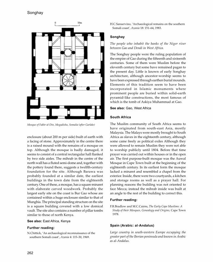
262
enclosure (about 200 m per side) built of earth witha facing of stone. Approximately in the centre thereis a raised mound with the remains of a mosque ontop. Although the mosque is badly damaged, itseems to consist of a central rectangular hall flankedby two side aisles. The mihrab in the centre of thenorth wall has a fluted semi-dome and, together withthe pottery found there, suggests a twelfth-centuryfoundation for the site. Although Barawa wasprobably founded at a similar date, the earliestbuildings in the town date from the eighteenthcentury. One of these, a mosque, has a square minaretwith elaborate carved woodwork. Probably thelargest early site on the coast is Bur Gao whose arecontained within a huge enclosure similar to that ofMunghia. The principal standing structure on the siteis a square building covered with a low domicalvault. The site also contains a number of pillar tombssimilar to those of north Kenya.
See also: East Africa, Kenya
Further reading:N.Chittick, ‘An archaeological reconnaissance of the
southern Somali coast’, Azania 4: 115–30, 1969.
H.C.Sanservino, ‘Archaeological remains on the southernSomali coast’, Azania 18: 151–64, 1983.
Songhay
The people who inhabit the banks of the Niger riverbetween Gao and Dendi in West Africa.
The Songhay people were the ruling population ofthe empire of Gao during the fifteenth and sixteenthcenturies. Some of them were Muslim before theeleventh century but some have remained pagan tothe present day. Little is known of early Songhayarchitecture, although ancestor-worship seems tohave been expressed through earthen burial mounds.Elements of this tradition seem to have beenincorporated in Islamic monuments whereprominent people are buried within solid-earthpyramid-like constructions, the most famous ofwhich is the tomb of Askiya Muhammad at Gao.
See also: Gao, West Africa
South Africa
The Muslim community of South Africa seems tohave originated from south-east Asia, mostlyMalaysia. The Malays were mostly brought to SouthAfrica as slaves in the eighteenth century, althoughsome came freely as political exiles Although theywere allowed to remain Muslim they were not ableto worship publicly until 1804. Before that timeprayer was carried out within houses or in the openair. The first purpose-built mosque was the AuwalMosque in Cape Town built at the beginning of theeighteenth century. In its earliest form the mosquelacked a minaret and resembled a chapel from theexterior. Inside, there were two courtyards, a kitchenand storage rooms as well as a prayer hall. Forplanning reasons the building was not oriented toface Mecca; instead the mihrab inside was built atan angle to the rest of the building to correct this.
Further reading:
F.R.Bradlow and M.C.Cairns, The Early Cape Muslims: AStudy of their Mosques, Genealogy and Origins, Cape Town1978.
Spain (Arabic: al-Andalus)
Large country in south-western Europe occupying thegreater part of the Iberian peninsula and known in Arabicas al-Andalus.
Mosque of Fakhr al-Din, Mogadishu, Somalia (after Garlake)
Songhay

263
Large parts of this country were Muslim from thearrival of the Arab armies in 711 to the fall of theamirate of Granada in 1492. Before the arrival of thefirst Arab armies Spain was ruled by the Visigoths,warrior nomads from east of Europe who hadrecently been converted to Christianity. They in turnhad taken over the country after the collapse of theByzantine rule which was a direct continuation ofRoman suzerainty in the country. At the time of theArab invasions the Visigothic kingdom was weakand their king Roderick was not universallyacknowledged.
The Arab conquest was carried out by Musa thecommander of North Africa and his semilegendarylieutenant Tariq. Within a year Toledo, the Visigothiccapital, had been captured. The speed of the conquest
alarmed the caliph who in 716 summoned thecommander and his general to return. Nevertheless,the conquest continued northwards and by the 730shad reached central France where it was finallychecked by Charles Martel at a battle betweenPoitiers and Tours. The only area of Spain whichwithstood the invasion was the region of Asturias inthe Cantabrian mountains of the north-west. Untilthe 750s the province was ruled by governors sentby the Umayyad caliphs. The Abbasid revolution hadled to the killing of all members of the Umayyaddynasty with the exception of Abd al-Rahman whoescaped via North Africa to Spain where he defeatedthe resident governor Yusuf in a battle near Toledo.For the next 270 years the country was ruled by theUmayyad descendants of Abd al-Rahman. The most
West Africa showing extent of Songhay empire in the sixteenth century
Spain (Arabic: al-Andalus)
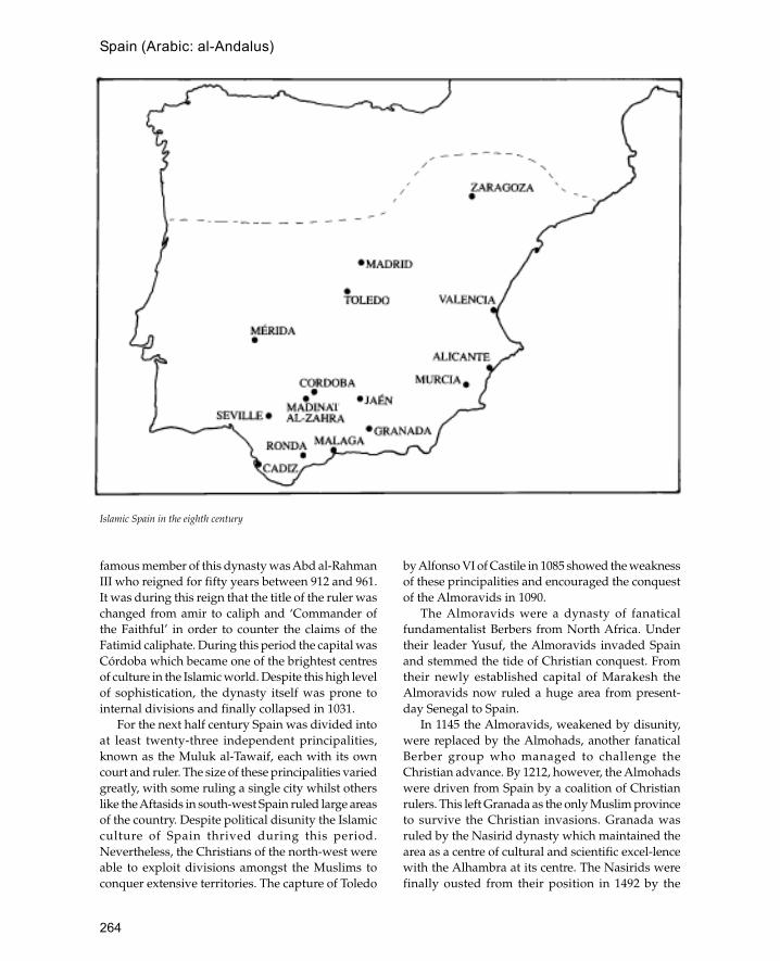
264
Spain (Arabic: al-Andalus)
famous member of this dynasty was Abd al-RahmanIII who reigned for fifty years between 912 and 961.It was during this reign that the title of the ruler waschanged from amir to caliph and ‘Commander ofthe Faithful’ in order to counter the claims of theFatimid caliphate. During this period the capital wasCórdoba which became one of the brightest centresof culture in the Islamic world. Despite this high levelof sophistication, the dynasty itself was prone tointernal divisions and finally collapsed in 1031.
For the next half century Spain was divided intoat least twenty-three independent principalities,known as the Muluk al-Tawaif, each with its owncourt and ruler. The size of these principalities variedgreatly, with some ruling a single city whilst otherslike the Aftasids in south-west Spain ruled large areasof the country. Despite political disunity the Islamicculture of Spain thrived during this period.Nevertheless, the Christians of the north-west wereable to exploit divisions amongst the Muslims toconquer extensive territories. The capture of Toledo
by Alfonso VI of Castile in 1085 showed the weaknessof these principalities and encouraged the conquestof the Almoravids in 1090.
The Almoravids were a dynasty of fanaticalfundamentalist Berbers from North Africa. Undertheir leader Yusuf, the Almoravids invaded Spainand stemmed the tide of Christian conquest. Fromtheir newly established capital of Marakesh theAlmoravids now ruled a huge area from present-day Senegal to Spain.
In 1145 the Almoravids, weakened by disunity,were replaced by the Almohads, another fanaticalBerber group who managed to challenge theChristian advance. By 1212, however, the Almohadswere driven from Spain by a coalition of Christianrulers. This left Granada as the only Muslim provinceto survive the Christian invasions. Granada wasruled by the Nasirid dynasty which maintained thearea as a centre of cultural and scientific excel-lencewith the Alhambra at its centre. The Nasirids werefinally ousted from their position in 1492 by the
Islamic Spain in the eighth century
265
Spain (Arabic: al-Andalus)
united forces of Castile and Aragon under Ferdinandand Isabella.
Despite the political defeat of Islam in SpainMuslims continued to live in the country until theseventeenth century when they were all expelled.Nevertheless, traces of Islamic presence survive inthe culture and architecture of Spain.
In many ways the landscape of Spain is similarto that of North Africa with its aridity, high mountainsand endless desert-like plains. Communi-cation fromone part to another is hindered by precipitousvalleys, high mountains and the three major riversof the Ebro, Tagus and the Duero.
The building materials of Islamic Spain reflect theavailability of natural resources and the diversity ofcultural influences. The main materials used arewood, stone and baked brick, although mud brickwas also used. Unlike many parts of the Middle East,Spain had plentiful supplies of timber suitable forbuilding including both pine and oak. Wood wasusually used for roofs which were normally gabledand covered with baked clay tiles, althoughoccasionally wooden domes were also used. The pineroofs of the Great Mosque in Córdoba reflect theplentiful supplies of wood in medieval Spain. Stonewas used for walls either in the form of ashlarmasonry or in the form of coursed rubble. Oftenmasonry was re-used from earlier Roman orVisigothic structures, although fine stone carvingcontinued. One of the most distinctive features ofSpanish Islamic architecture is the use of brick which,like ashlar masonry, was a direct continuation ofRoman building methods. Sometimes stone wasencased in brick in the same manner as Byzantinefortifications.
Notable features of Spanish Islamic architectureinclude horseshoe arches, paired windows with acentral column, construction in brick and stone,polychrome tiles, intricate carved stucco work andoverlapping arches. Several terms are used todescribe Islamic-type architecture in Spain each ofwhich has a particular meaning. The best-knownterm is ‘Moorish’ which is often used to refer toIslamic architecture in general although it moreproperly should be used to describe the architectureof the Moors or Berbers of North Africa. The lesswell-known term Mudéjar refers to architecturecarried out for Christian patrons by Muslimcraftsmen. Mudéjar architecture uses many of themost characteristic features of Islamic architectureincluding Arabic calligraphy and the horseshoe arch.
Many of Christian Spain’s most beautiful churchesand palaces were built by Mudéjar craftsmen andthe tradition was carried on into the new world. Arelated style is known as Mozarabic which refers tothe architecture of Christian buildings under Muslimrule. In addition to its influence on Christianbuildings, Islamic architecture also influenced thesubstantial Jewish community in Spain so that manysynagogues in Spain were built in an Islamic style(the best examples are in Toledo, see below).
The range of buildings surviving from theIslamic period in Spain is quite large and includescastles, fortifications, mosques, churches andsynagogues, palaces, bridges, hammams, mills,villages and towns. The most numerous remainsare castles and fortifications which can be foundthroughout the country and from all periods fromthe eighth to the fifteenth century. These are oftendifficult to date precisely and most weresubsequently re-used after the Christian reconquest.One of the best examples of early fortification arethe walls and square battered towers of the castleknown as Baños de la Encina near Jaén in Andalusía.Here the gate is sandwiched between two towersand protected by machicolation and a portcullis.Later on fortifications were protected by bententrances where the gateway was perpendicular tothe walls, thus exposing attackers to fire from threesides. A later development of fortifications was thealbarrani tower which was located outside the citywalls but connected to it by a bridge so thatdefenders were able to outflank their attackers. Oftenalbarrani towers were built to protect buildingsoutside the walls without the added expense andinconven-ience of changing the line of the city wall;thus at Calatrava la Vieja the tower was built toprotect a nearby watermill. In addition to the majorfortifications hundreds of small towers and fortswere built all over the peninsula to defend bordersand coasts. These were often small isolated towersbuilt of cheap local materials such as mud brick orcoursed rubble, although sometimes they weresophisticated structures dominating the countrysidelike the castle of Belmez near Córdoba.
Most of the mosques of Spain were converted intochurches after the reconquest, some with very littlealteration and others where the architecture wasprofoundly damaged as in the case of the GreatMosque of Córdoba where a cathedral was built inthe middle of the structure in the sixteenth century.Characteristic features of Spanish mosques are

266
Spain (Arabic: al-Andalus)
square minarets and large mihrabs which aresometimes like a separate room. Where decorationhas survived intact it is usually very elaborate andincludes carved plaster and woodwork.
Palaces fared better after the reconquest andsome of the finest examples of Islamic palaces canbe found in Spain such as the Alhambra and theGeneralife. The Islamic palatial tradition wascontinued after the reconquest with palaces whichare almost entirely Islamic in conception, like thatof Pedro the Cruel in the Alcazar at Seville. Anothertype of Islamic building often associated withpalaces is the hammam. Few of these have survivedin Spain although fine examples can be seen atRonda and Granada. Bridges and mills are less easyto distinguish as Muslim work, although manyexamples survive. It is thought that some of the
water mills near Córdoba may be related to the greatwater wheels of Syria. In addition to specificbuildings and monuments many towns and villagesretain the layout and appearance of Islamic times.Some of the more important cities with substantialtraces of Islamic architecture are Córdoba, Seville,Granada, Toledo and Zaragoza, but many othertowns and cities contain traces of Islamic buildingsincluding Madrid and Asturias (starting-point ofthe reconquest).
The area conquered by the Arabs in the eighthcentury still contained many remains of the Romanand Byzantine civilizations which proceeded theVisigothic conquest, and many of the basictechniques of construction remained the samethroughout the Islamic period. The contribution ofthe Visigoths to Islamic architecture is poorly
Thirteenth-century house at Siyasa (after Palazon)
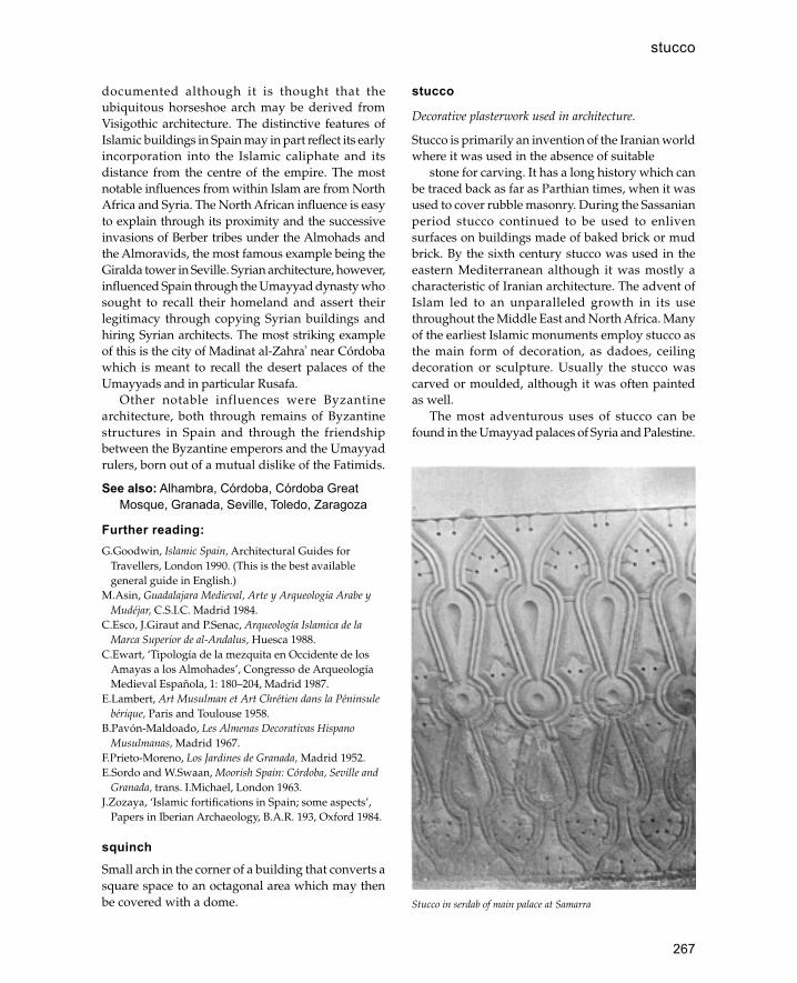
267
documented although it is thought that theubiquitous horseshoe arch may be derived fromVisigothic architecture. The distinctive features ofIslamic buildings in Spain may in part reflect its earlyincorporation into the Islamic caliphate and itsdistance from the centre of the empire. The mostnotable influences from within Islam are from NorthAfrica and Syria. The North African influence is easyto explain through its proximity and the successiveinvasions of Berber tribes under the Almohads andthe Almoravids, the most famous example being theGiralda tower in Seville. Syrian architecture, however,influenced Spain through the Umayyad dynasty whosought to recall their homeland and assert theirlegitimacy through copying Syrian buildings andhiring Syrian architects. The most striking exampleof this is the city of Madinat al-Zahra� near Córdobawhich is meant to recall the desert palaces of theUmayyads and in particular Rusafa.
Other notable influences were Byzantinearchitecture, both through remains of Byzantinestructures in Spain and through the friendshipbetween the Byzantine emperors and the Umayyadrulers, born out of a mutual dislike of the Fatimids.
See also: Alhambra, Córdoba, Córdoba GreatMosque, Granada, Seville, Toledo, Zaragoza
Further reading:G.Goodwin, Islamic Spain, Architectural Guides for
Travellers, London 1990. (This is the best availablegeneral guide in English.)
M.Asin, Guadalajara Medieval, Arte y Arqueologia Arabe yMudéjar, C.S.I.C. Madrid 1984.
C.Esco, J.Giraut and P.Senac, Arqueología Islamica de laMarca Superior de al-Andalus, Huesca 1988.
C.Ewart, ‘Tipología de la mezquita en Occidente de losAmayas a los Almohades’, Congresso de ArqueologíaMedieval Española, 1: 180–204, Madrid 1987.
E.Lambert, Art Musulman et Art Chrétien dans la Péninsulebérique, Paris and Toulouse 1958.
B.Pavón-Maldoado, Les Almenas Decorativas HispanoMusulmanas, Madrid 1967.
F.Prieto-Moreno, Los Jardines de Granada, Madrid 1952.E.Sordo and W.Swaan, Moorish Spain: Córdoba, Seville and
Granada, trans. I.Michael, London 1963.J.Zozaya, ‘Islamic fortifications in Spain; some aspects’,
Papers in Iberian Archaeology, B.A.R. 193, Oxford 1984.
squinchSmall arch in the corner of a building that converts asquare space to an octagonal area which may thenbe covered with a dome.
stucco
Decorative plasterwork used in architecture.
Stucco is primarily an invention of the Iranian worldwhere it was used in the absence of suitable
stone for carving. It has a long history which canbe traced back as far as Parthian times, when it wasused to cover rubble masonry. During the Sassanianperiod stucco continued to be used to enlivensurfaces on buildings made of baked brick or mudbrick. By the sixth century stucco was used in theeastern Mediterranean although it was mostly acharacteristic of Iranian architecture. The advent ofIslam led to an unparalleled growth in its usethroughout the Middle East and North Africa. Manyof the earliest Islamic monuments employ stucco asthe main form of decoration, as dadoes, ceilingdecoration or sculpture. Usually the stucco wascarved or moulded, although it was often paintedas well.
The most adventurous uses of stucco can befound in the Umayyad palaces of Syria and Palestine.
Stucco in serdab of main palace at Samarra
stucco
268
At Khirbet al-Mafjar in the Jordan valley the lavishdecoration includes painted stucco statues of semi-naked bathing girls and stucco representation of thecaliph himself. However, usually stucco wasrestricted to its original function of covering walls andceilings with carved or moulded patterns. The largestcorpus of stucco work from the early Islamic periodhas been found at the Abbasid capital of Samarra inIraq. The stucco from this site has been divided intothree groups or styles which may represent achronological development. Style ‘A’ consists of vineleaves and vegetal forms derived from the Byzantinearchitecture of Syria-Pal-estine; style ‘B’ is a moreabstract version of this; and style ‘C’ is entirelyabstract with no recogniz-able representationalforms. The first two styles appear to be carved, butthe third style was produced by wooden moulds.The Samarra styles are significant as they reappearlater in buildings such as the Ibn Tulun Mosquewhere the soffits of the arches are decorated withstyle ‘B’ ornament. After the collapse of the Abbasidcaliphate stucco continued to be one of the mainforms of decoration and spread throughout theIslamic world to India, Anatolia and Spain.
See also: Khirbet al-Mafjar, Samarra
Sudan
The Republic of Sudan is the largest country in Africaand spans the area between North Africa and sub-SaharanAfrica.
Like Egypt, Sudan owes its existence to the Nile,which flows through the country from Kenya in thesouth to Egypt in the north. The western part of thecountry forms part of the Sahara desert whilst thearea east of the Nile is divided between the EthiopianHighlands and the Red Sea.
Although Islam is the official religion, Muslimsonly make up two-thirds of the population, the restof whom are either Christian (4 per cent) or havetribal religions. Historically northern Sudan hasalways been dominated by its Egyptian neighbourto the north, nevertheless, throughout the medievalperiod (seventh to sixteenth centuries) a number ofChristian urban centres such as Meroe and Kush haveflourished. Islam became the principal religion ofnorth Sudan in the early nineteenth century after theinvasions of the Egyptian ruler Muhammad Ali. Inthe late nineteenth century there was a revolt againstTurkish Egyptian rule which led to the establishment
of a quasi-religious state ruled by the Mahdi. Thisstate lasted for sixteen years until 1898 when thecountry was incorporated into the British Empire.
The materials of construction used in the Sudanvary greatly depending on the region and the people.On the Red Sea coast in the north of the country coralis the traditional material for permanent buildings,whereas in those parts bordering on the Nile,including Khartoum, mud is principally used.
There are few Islamic buildings in Sudan whichdate from before the nineteenth century, except inthe Red Sea port of Suakin. This city which lies tothe south of Port Sudan flourished under theOttomans from the sixteenth century. Now almostentirely abandoned, Suakin provides a usefulindication of the historic urban architecture of theRed Sea coast which has elsewhere mostlydisappeared. The houses, many of them up to threestoreys high, are built of coral slabs taken from thecoastal foreshore.
In the Nile valley houses are traditionally builtaround two or three sides of a large central courtyardor compound. The standard method of constructionis horizontal courses of mud and dung mixed withsmall stones and later covered with a plaster ofsmooth mud (jalus). The most striking feature oftraditional houses in the area is the painteddecoration made of mud- and lime-based pigments.Usually the outer façades of the houses are decoratedwith particular emphasis on the doors, whilst insidea principal reception room is also decorated.
See also: East Africa, Egypt, Somalia
Süleymaniye
Ottoman mosque complex in Istanbul built for Suleymanthe Magnificent between 1550 and 1557.
The complex consisted of a hospital, medical school,hospice, soup kitchen, primary school, fourmadrassas (colleges), shops and coffee houses inaddition to the mosque itself. The complex is builton an artificial platform on top of a hill that overlooksthe Bosphorus; to the east the ground slopes awayrapidly. The mosque precinct contains three mainareas, the mosque itself in the centre, a courtyard tothe north and a tomb garden to the south whichcontains the tomb of Suleyman and his wife. Themosque is covered with a large central dome (25 mdiameter) with two large semi-domes of equalradius, one above the north entrance and one above
Sudan

269
the mihrab. The central area is flanked by side aislescovered by small domes of alternating size. Like thatof its predecessor the Sehzade Cami, the centraldome rests on four huge central piers placed in asquare. The whole building is illuminated with morethan a hundred windows and grilles, many of whichare filled with stained glass made by the celebratedOttoman glass-maker Ibrahim Sarhos. Outside ateach corner of the courtyard are four minarets withbalconies supported on muqarnas corbels. This is thefirst Ottoman building in Istanbul to have fourminarets, although previously the Üç Serefeli inEdirne also had four. The sides of the building areenlivened with several entrances (three on each side)approached by steps and two-tier arcaded galleriesplaced between the outer corner buttresses.
The tomb garden behind the mosque contains alarge cemetery which has grown up around thetombs of Suleyman and Roxelane. Both tombs areoctagonal structures in the traditional Ottomanfashion, although Suleyman’s tomb unusually faceseast instead of north. Roxelane’s tomb is smaller andplaced to one side of Suleyman’s tomb which standsin the middle of the garden. The interiors of bothtombs are decorated with Iznik tiles, althoughRoxelane’s tomb is significantly less grand. Suley-man’s tomb is surrounded by a colonnaded verandawith a porch on the east side. This arrangement isechoed internally where Suleyman’s sarcophagus issurrounded by a circular colonnade.
The arrangement of the complex outside themosque precinct consists of an L-shapedarrangement of buildings on the north-west side anda smaller group to the east. The eastern complex isbuilt on a steep hill so the madrassas are steppedinto the hillside. On the north-west corner of thecomplex is the tomb of the architect Sinan.
See also: Istanbul, Ottomans, Sinan
Sultan Hasan Mosque
Large madrassa, mosque and tomb complex in Cairo builtby the Mamluk sultan Hasan.
This building was erected between 1356 and 1361 nextto the Citadel of Cairo. The cost of the project was sohigh that it was never fully completed and SultanHasan himself was murdered and his body hidden,so that he was never buried in the mausoleum. It is ahuge complex, measuring 65 by 140 m, and fourstoreys high, making it one of the largest mosques in
Cairo. The main function of the building was as amadrassa with tomb attached but its size and thebeauty of its prayer hall meant that it was recognizedas a congregational mosque as well.
The basic plan of the building consists of a centralcourtyard leading off into four large iwans. Thelargest iwan is the prayer hall and behind this is thedomed mausoleum. As this was a madrassa for thefour rites of Sunni law there were four separatecourtyards, one for each of the rites. Around each ofthese courtyards were the students’ rooms arrangedin four tiers. Many of the rooms were equipped withlatrines and those facing the street had largewindows.
The arch of the main iwan, or prayer hall, is verylarge and certainly the largest of its kind in Cairo. Aninscription runs around the three walls of the iwan inan ornate Kufic on a background of floral scrolls whichincludes Chinese lotus flowers. The mausoleum isentered through a doorway to one side of the mihraband consists of a domed chamber 21 m square and 30m high. The original dome was wooden and has notsurvived, although the muqarnas woodenpendentives which carried it remain.
One of the most important aspects of the SultanHasan complex is the treatment of the externalfaçades. Given its prominent position next to thecitadel and the size of the complex it was importantthat its exterior reflected this. Each of the three sidesof the mausoleum which projects on the south-eastside of the complex consists of a central medallionaround which are ranged four sets of windows, twoabove and two below. The most famous façade ofthe structure is that containing the entrance on thenorth side. The entrance-way itself consists of a largerecess covered with an extravagant muqarnas vaultwhich is comparable with that of the Gök Madrassain Turkey. The doorway is set at an angle to the restof the façade so that it can be seen when approachingalong the street. The façade to the right of thedoorway consists of long rectangular recessesextending four storeys from the base of the buildingto the top, each recess containing windows from thestudents’ rooms. The height of this arrangement andits simplicity give this façade a strangely modernappearance.
Further reading:
D.Berhens-Abouseif, Islamic Architecture in Cairo: AnIntroduction, Supplements to Muqarnas, 3: 122–8,Leiden 1989.
Sultan Hasan Mosque

270
J.M.Rogers, ‘Seljuk influence in the monuments of Cairo’,Kunst des Orients 7: 40 ff., 1970–1.
Sumatra
Most westerly large Indonesian island located west of theMalay peninsula and east of Java.
The first evidence for Islam in Indonesia comes fromlate thirteenth-century accounts of Marco Polo andChinese documents which state that the region ofAceh on the northern tip of Sumatra was ruled byMuslim kingdoms. At this time the southern part ofSumatra was ruled by the Javanese kingdom ofMajpahit which came to control most of the area ofpresent-day Indonesia. Nevertheless, the Muslimstates in the north of Sumatra began to spread,converting first the coastal peoples and only laterthe central area of Melayu. It was from Sumatra thatIslam reached the Malay peninsula and graduallyspread into Java itself. The Portuguese victory overMalacca in the early sixteenth century meant thatAceh once again became the main centre of Islam inthe area. During the seventeenth century Sumatrawas dominated by the ruler of Aceh, Iskandar Muda(1607–36) who had artillery, elephant and horsecavalry and a navy capable of carrying 700 men. Therule of Iskandar Muda’s successor Iskandar ThaniAlauddin Mughayat Syah (1636–41) was a period ofcultural renaissance with several books written aboutthe life of the court.
Unfortunately few early Islamic buildingssurvive in Sumatra probably because they were builtof wood and frequently replaced. The earliestmosque of which records survive is the MasjidAgung Baiturrahman at Banda Aceh on the northerntip of Sumatra. It is likely that the present buildingstands on the site of one of the earliest mosques inIndonesia; however, the first records of the building(1612) describe an Indo-Islamic structure designedwith the help of Dutch engineers. The building hadthree domes which were increased to five after a fire.However, it is likely that most early mosque formswere related to the traditional Sumatran housedesign. A recent example is the Rao-Rao Mosque inBatu Sangkar (west Sumatra) with an Indo-Islamicfaçade behind which is wooden mosque with acomplex Sumatran roof-type known as rumah-adhat. This consists of a three-tiered pyramid roofconstruction with a small kiosk on top crowned witha tall finial.
The houses of Sumatra are one of the mostdistinctive features of the island and are worldfamous as examples of vernacular architecture. Thereare many regional house forms representing differentcultural traditions, many of which predate Islam. Thebasic form of a Sumatran house consists of a building,set on upright piles driven into the ground, abovewhich is a huge pitched roof. Wood is used for thepiles and framework of the house, bamboo poles forthe roof and the walls. Distinc-tively Islamic housetypes include the houses of Aceh, Minangkabu, BatakMandailing and Lampung regions. The traditionalAceh house has a fairly basic design consisting of arectangular platform resting on piles with alongitudinal gabled roof. Aceh houses are usuallydivided into three with the central area reserved forsleeping. The entrance is usually in the middle ofone of the long sides and the gable ends are oftendecorated with geometric or other non-representational designs. The designs are eitherpainted or carved, sometimes as fretwork panels. Themost celebrated Sumatran house type is that ofMinangkabu which has the entrance set in the middleof the long side. The roofs of the house are made upof a succession of pointed gables resembling theprow of a ship; the decoration is similar to that ofthe Aceh houses but may also include inset mirrorwork. The Batak Mandailing houses are similar tothose of Minangkabu with roof ridges that sag inthe middle and point upwards at the ends. Thesouthern part of Sumatra, the Lampung area, isheavily influenced by neighbouring Java andMalaysia, and its houses are mostly of the coastaltype.
Several palaces survive on Sumatra, the oldest ofwhich is the seventeenth-century Aceh palace knownas Dar al-Dunya. The building shares manycharacteristics with the Javanese palaces, or kratons,with many references to Hindu cosmology and littlerelationship to Islamic design. The Dar al-Dunyapalace has the same north-south axis and threesuccessive courtyards found in Java and, like thepalaces of Yogyakarta and Surakarta, has a largeformal garden. In the centre of the garden is amountain-shaped structure with caves and ledgesfor meditation similar to the mountainrepresentations of Java (e.g. Sunya Ragi). Nineteenth-century palaces show increasing Islamic andEuropean influence, although there is still littlerelationship to the traditional wooden architectureof the island. The palace of Istana Maimun at Medan
Sumatra

271
is laid out in a formal European style enlivened witharcades of horseshoe arches and crenellations.
See also: Indonesia, Java
Further reading:
E.M.Loeb, Sumatra its History and People, Oxford 1935.D.Lombard, Le Sultunat d’atjéh au temps d’iskandar Muda
1607–1636, Publications de l’École Françaised’extrêmeOrient, 51, Paris 1967.
G.Serjeant, ‘House form and decoration in Sumatra’, Artand Archaeology Research Papers no. 12, 1977.
Susa
Tunisian coastal city noted for its ninth-century Aghlabidbuildings.
Under the Byzantines the city was known asJustinianopolis in honour of Justinian who rebuilt itafter the Vandal destruction. In 689 CE it wascaptured by the Arabs and became one of theprincipal ports for the Aghlabid conquest of Sicily.In 827 the city was refortified with ramparts and
walls built in the Byzantine style. ImportantAghlabid buildings within the city include the ribatbuilt or restored by Ziyadat Allah in 821, the BuFatata Mosque built in 840 and the Great Mosqueestablished in 859.
See also: Aghlabids, Tunisia
Syria (Arabic: al-Sham)
Geographically Syria may be defined as the northernpart of Arabia between the Mediterranean and theEuphrates river. This area includes Lebanon,Palestine and Jordan as well as the modern state ofSyria. Politically Syria refers to the modern state ofSyria which roughly corresponds to the northern partof the geographical area of Syria excluding themountains of Lebanon and including parts of theJazira between the Euphrates and the Tigris. (Herethe term Syria will be used to identify the area of themodern Arab Republic.) The majority of Syria’spopulation lives within 100 km of the Mediterraneanwhilst there is lesser concentration of people along
Ribat at Susa, Tunisia (after Creswell)
Syria (Arabic: al-Sham)
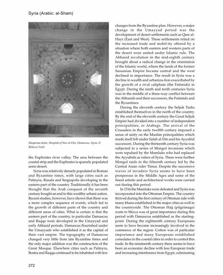
272
the Euphrates river valley. The area between thecoastal strip and the Euphrates is sparsely populatedsemi-desert.
Syria was relatively densely populated in Romanand Byzantine times, with large cities such asPalmyra, Rusafa and Sergiopolis developing in theeastern part of the country. Traditionally it has beenthought that the Arab conquest of the seventhcentury bought an end to this wealthy urbani-zation.Recent studies, however, have shown that there wasa more complex sequence of events, which led tothe growth of different parts of the country anddifferent areas of cities. What is certain is that theeastern part of the country, in particular Damascusand Raqqa were developed in the Umayyad andearly Abbasid periods. Damascus flourished underthe Umayyads who established it as the capital oftheir vast empire. The topography of Damascuschanged very little from late Byzantine times andthe only major addition was the construction of theGreat Mosque. Elsewhere cities such as Palmyra,Bostra and Raqqa continued to be inhabited with few
changes from the Byzantine plan. However, a majorchange in the Umayyad period was thedevelopment of desert settlements such as Qasr al-Hayr (East and West). These settlements relied onthe increased trade and mobil-ity offered by asituation where both eastern and western parts ofthe desert were united under Islamic rule. TheAbbasid revolution in the mid-eighth centurybrought about a radical change in the orientationof the Islamic world, where the lands of the formerSassanian Empire became central and the westdeclined in importance. The result in Syria was adecline in wealth and urbaniza-tion exacerbated bythe growth of a rival caliphate (the Fatimids) inEgypt. During the ninth and tenth centuries Syriawas in the middle of a three-way conflict betweenthe Abbasids and their successors, the Fatimids andthe Byzantines.
During the eleventh century the Seljuk Turksestablished themselves in the north of the country.By the end of the eleventh century the Great SeljukEmpire had divided into a number of independentprincipalities, or Atabegs. The arrival of theCrusaders in the early twelfth century imposed asense of unity on the Muslim principalities whichmade itself felt under Salah al-Din and his Ayyubidsuccessors. During the thirteenth century Syria wassubjected to a series of Mongol invasions whichwere repulsed by the Mamluks who had replacedthe Ayyubids as rulers of Syria. There were furtherMongol raids in the fifteenth century led by theCentral Asian ruler Timur. Despite the successivewaves of invaders Syria seems to have beenprosperous in the Middle Ages and some of thefinest artistic and architectural works were carriedout during this period.
In 1516 the Mamluks were defeated and Syria wasincorporated into the Ottoman Empire. The countrythrived during the first century of Ottoman rule withmany khans established in the major cities as well inthe countryside. The Ottoman Hajj (pilgrimage)route to Mecca was of great importance during thisperiod with Damascus established as the starting-point. During the eighteenth century Europeansseem to have become increasingly involved in thecommerce of the region. Cotton was of particularimportance and many Europeans establishedconsulates in the coastal cities in order to control thistrade. In the nineteenth century there seems to havebeen an economic decline with less European tradeand increasing interference from Egypt, culminating
Muqarnas dome, Hospital of Nur al-Din, Damascus, Syria, ©Rebecca Foote
Syria (Arabic: al-Sham)

273
in the invasion of 1831. Administrative reforms wereintroduced in the latter part of the nineteenth centurywhich led to Syria being regarded as one of the mostadvanced parts of the Ottoman Empire. The collapseof Turkish rule in 1918 led to the creation of a Frenchprotectorate which formed the basis of the modernindependent republic.
The building materials used in Syria varydepending on the area and type of settlement. Onthe Mediterranean coast houses are generally stonebuilt, often of ashlar masonry; their generalappearance is that of Lebanese houses. In themountains buildings are made out of rubble stonewith mud mortar, their roofs made of wooden beamscovered with matting and an exterior coating ofearth. The region of the Hauran in the south-east ispredominantly basalt desert with no trees. Basalt hasbeen the main material of construction since ancienttimes and many traditional houses re-use ancient
material because of its indestructibility and thedifficulty of carving new basalt blocks. One of theprincipal forms of house construction is to havetransverse arches carrying short basalt beams whichform the roof. Houses in the Aleppo region are builtof mud brick with conical mud domes resemblingbeehives. Several buildings joined together within acourtyard form a single house. In central Syria thetraditional house is a rectangular mud-brick buildingwith a flat roof. These houses are usually surroundedby a courtyard wall which may also include animalpens. In addition to permanent settlements manypeople are traditionally nomadic or semi-nomadic.Black goat-hair tents are the principal form ofbedouin tent used in the region. The main cities alsohave their own methods of construction which differfrom those of the countryside.
See also: Aleppo, Basra, Damascus, Lebanon,Qasr al-Hayr East, Qasr al-Hayr West, Raqqa
Syria (Arabic: al-Sham)

274
tabhaneTurkish term for the hostel attached to a mosquewhere travellers (usually dervishes and mystics)could live free for three days. In early Ottomanmosques these formed separate chambers althoughthey were later incorporated into the main body ofthe mosque.
Taj Mahal
Major Islamic tomb complex built by the Mughal emperorat Agra in India.
The Taj Mahal was begun by Shah Jahan in 1631 andtook over twenty years to build. The tomb was builtfor Shah Jahan’s wife Arjumand Banu Begam (alsoknown as Mumtaz Mahal) who he married in 1612before he was made emperor. She was the niece ofJahangir’s wife Nur Jahan and granddaughter of hisfamous Persian minister Iltimad al-Daulah. MumtazMahal was the emperor’s favourite wife and duringnineteen years of mar-riage she bore him fourteenchildren. Her death whilst accompanying him on acampaign in the Deccan caused the emperor greatsorrow and inspired him to build the most beautifultomb complex in the world.
Although unique in its size and beauty, the TajMahal forms part of a series of imperial Mughaltombs of which it is undoubtedly the greatest. Theearliest Mughal tombs copied those of their Islamicpredecessors the Lodi sultans of Delhi and wereoctagonal domed structures surrounded by arcades.Another popular tomb form in the early Mughalperiod was the square chamber-tomb as seen in the‘Barber’s tomb’ in Delhi. Later on in the Mughalperiod the two forms were combined to produceoctagonal tombs with four sides shorter than theothers, thus producing a square with the cornerscut off. In the tomb of Humayun at Delhi four ofthese ‘square’ octagons were assembled around acentral octagonal space which was then coveredwith a dome. The area between the octagons wasbridged by iwans which formed the main access
points to the central domed area. This is essentiallythe same design that was used in the Taj Mahal. InHumayun’s tomb, however, the central area issurrounded on four sides by an arcade of pointedarches at ground level and is made of red sandstonewith marble inlay, neither of which features arefound in the Taj Mahal. Similarly the dome on theroof is lower set than in the Taj Mahal so that itdoes not produce a dominant upright form butrather a pyramidal one.
The Taj Mahal is located on a terrace on the banksof the Jumna river and can be seen from theemperor’s palace in the Agra Fort. The building ispart of a complex which included many buildingsbeside the central tomb and garden; to the south is acomplex known as the ‘chauk-i jilau khana’, orceremonial forecourt, which was flanked by fourcourtyards (two on each side) containing apartmentsfor the tomb attendants; directly south of these is afurther area divided into four caravanserais by twointersecting streets, and south of this are two morecaravanserais and a bazar built around a square. Aresidential area grew up around this complex whichwas known as Mumtazabad. The revenue of thisvillage together with that of thirty other villages inthe vicinity was devoted to the upkeep of thebuilding.
Like many other Mughal memorial tombs the TajMahal was incorporated into a formal garden of thePersian char bagh form where a square garden wallencloses a garden divided equally into four. In mosttomb complexes the tomb forms the centre of thegarden with the four parts arranged equally aroundit. In the case of the Taj Mahal, however, a square poolforms the centre of the garden whilst the tombbuilding was located at the far end of it, overlookingthe river. The walls of the garden tomb complex arestrengthened by six octagonal towers capped withdomed chatris. The gate to the complex consists of alarge rectangular structure with engaged cornerturrets placed in the middle of a tall wall whicheffectively screens the Taj Mahal from view until the
T

275
visitor has passed through the gate. The effect of thisis enhanced by the fact that the outer buildings of thecomplex and the gateway are built and faced in redsandstone whereas the tomb and minarets are facedin white marble.
The central part of the complex is raised on arectangular podium decorated with arcades of blindniches. At each corner of the podium is an octagonalbase for a minaret whilst the tomb stands in thecentre. The gate is directly in line with the centre ofthe dome on the tomb, a symmetry which isemphasized by the minarets, two either side of thetomb. Each minaret is a tall (42 m), slightly tapering,cylindrical structure with two intermediate balconiesand an open domed pavilion (chatri) on the top. Longpools divide the garden into four parts, one runningeast-west and the other running north-south fromthe gate to the Taj Mahal. At either end of the east-west axis are large triple-domed buildings with acentral iwan. The building on the west side is amosque whilst that to the east is known as the‘jawab’, or echo, as it has no other function than to
balance the view with the mosque on the other side.The north-south pools further emphasize the centralaxis of the gateway and dome.
The Taj Mahal has the same basic form asHumayun’s tomb and consists of four octagonsarranged around a central domed space. The façadeof the tomb consists of a tall central iwan framedby a pishtaq which contains a frame of Quraniccalligraphy flanked on each side by four smalleriwans, two on each storey. The iwans are allcomposed of four centre-pointed arches with pietradura decoration in the spandrels. The corners of thebuilding are cut off or chamfered with projectingpillars marking the change from one face to another.The central dome is flanked by four large domedchatris supported on piers between lobed arches.The domes on the chatris and the central domerepresent a synthesis of Persian and Indianarchitecture where the bulbous form of the domeis derived from Persian Timurid architecture andthe finial and its lotus base derive ultimately fromHindu temple architecture.
Section through Taj Mahal (after Tillotson)
Taj Mahal

276
The central dome of the Taj Mahal is very tall (thefinial is 73 m above ground level) and is raised upabove the pishtaqs of the surrounding iwans by atall circular drum about 15 m high. The dome iscomposed of two parts, an inner dome and an outershell. The inner dome is approximately the sameheight as the iwans whilst the outer dome towersabove. The use of an inner dome keeps the height ofthe inner space in proportion whilst the outer domemakes the height of the building correspond to itsmass and with the minarets makes building standout visually. Directly below the centre of the domeis the cenotaph of Mumtaz Mahal and next to it thatof her husband Shah Jahan. The actual tombs,however, are in a vault or cave directly beneath thecenotaphs. The cenotaphs in the main chamber aresurrounded by an octagonal pierced screen with twogates with pietra dura inlay on the posts. The wallsof the interior are divided into blind archesalternating with arched doorways which give accessto the four circular side chambers. Around each ofthe arches is a frame of Quranic inscriptions whilst
the marble dadoes are also lavishly decor-ated withnaturalistic depictions of flowers in low relief. Thewhole arrangement of the tomb, in particular theoctagonal screen and the cave beneath, recalls thearrangement of the Dome of the Rock in Jerusalem.The reasons for this are probably coincidental andmay simply reflect the fact that whilst octagonalmausoleums are rare in the Middle East they werecommon in India and there was no religiousawareness of its significance.
As the finest example of Mughal funeraryarchitecture it is not surprising that the design of theTaj Mahal was subsequently copied and developed inlater tombs. The most obvious copy is the tomb ofRabi‘a Daurani in Aurangabad built in 1660 which hasthe same arrangement of a central tomb on a podiumwith minarets at each corner. The Aurangabad tomb,however, is different because the central building issquare instead of octagonal and the minarets are thickerand taller in proportion to the central structure. A moreinteresting version of this design is the tomb of SafdarJang in Delhi built in 1753. This building is also squarelike the tomb at Aurangabad, but here the minarets areattached to the central structure instead of standingapart at the corners of the terrace. Instead of whitemarble the building is faced in red sandstone with whitemarble inlay.
See also: Mughals
Further reading:W.F.Begley, ‘Amanat Khan and the calligraphy on the Taj
Mahal’, Kunst des Orients 12: 5–39, 1978–9.—— ‘The myth of the Taj Mahal and a new theory about
its symbolic meaning’, The Art Bulletin 61: 7–37, 1979.W.E.Begley and Z.A.Desai, Taj Mahal: The Illumined
Tomb: An Anthology of Seventeenth Century Mughal andEuropean Documentary Sources, The Agha KhanProgram for Islamic Architecture, Cambridge, Mass.1989.
D.Brandenburg, Der Taj Mahal in Agra, Berlin 1969.S.Gole, ‘From Tamerlane to the Taj Mahal’, in Islamic Art
and Architecture: Essays in Honour of of KatherinaOttoDorn 1, ed. A.Daneshavari, 1981, 43–50.
R.A.Jairazbhoy, ‘The Taj Mahal in the context of East andWest: a study in comparative method’, Journal of theWarburg and Courtauld Institutes 24: 59–88, 1961.
R.Nath, The Immortal Taj Mahal: The Evolution of the Tombm Mughal Architecture, New Delhi 1972.
talarIranian term for a hypostyle wooden hall whichproceeds through the main part of a building.
Plan of Taj Mahal and gardens (after Tillotson)
talar

277
taman
Indonesian term for a pleasure garden, usuallyassociated with the royal palaces, or kraton. Tamangardens usually have a central tower, or artificialmountain, surrounded or approached by water,which in pre-Islamic tradition symbolizes mountainand sea.
See also: Java, kraton
TanzaniaCountry in East Africa bordering on the Indian Oceanwith a substantial Swahili-speaking Muslim populationon the coast.
Tanzania forms part of the Islamic coast of East Africawhich stretches from Somalia in the north toMozambique in the south. Before 1970 the countrywas known as Tanganyika but followingindependence it united with Zanzibar to form thepresent state of Tanzania with its capital at Dar esSalaam. However, the two former countries retainautonomy and only the former territory ofTanganyika will be dealt with here (see separate entryfor Zanzibar).
The earliest Islamic settlements in Tanzania canbe traced back to at least the eighth century CE andappear to be related to the Indian Ocean dhow trade.The famous site of Kilwa on an island off the southcoast contains traces of ninth-century Islamicstructures, but unfortunately these are toofragmentary to reconstruct their form beyondestablishing that they were built of mud over woodenframes. However, from the tenth-century levels of thesite remains were found of an early stone mosquewhich, although not fully excavated, appears toconform to the same plan as early mosqueselsewhere on the coast (e.g. the use of coursed coralblocks). Apart from archaeological sites the majorityof Islamic monuments on the coast date from theperiod before 1200. The earliest standing monumentson the coast are the early mosque at Kaole and themosque at Sanje ya Kati.
The ruins at Kaole consist of about fifteen tombs,two of which have pillars, and two mosques. Theearly mosque dates from the thirteenth centurywhilst the later one was probably built sometimein the sixteenth century. The early mosque hasseveral unusual features not found later. It consistsof a rectangular hall approximately 4 by 6 m north-south. Originally there was a set of masonry
columns running down the centre of the structurewhich would have supported a flat roof. Access tothe flat roof is by means of a staircase at the southend of the building. Either side of the central prayerhall were narrow side aisles (about 1 m wide) whichwere later enlarged. Architecturally the mostinteresting feature of the building is the mihrab. Themihrab arch consists of a plain borderapproximately 20 cm wide with a round archcontaining a pointed niche at the apex. The panelledapse of the mihrab which projects out of the wall isprobably a later fourteenth-century addition and itis likely that the original mihrab was set within thethickness of the wall. The mihrab arch is built outof roughly squared blocks covered with plaster toproduce a smooth finish. This is an unusualtechnique which is not found in later mosqueswhere the mihrab is usually made out of dressedcoral blocks. The ablution area of the mosque issituated to the south of the prayer hall rather thanto the east which became more usual later. Theablution area consists of a square well next to arectangular tank covered with a barrel vault and arectangular foot scraping area. Both the barrel vaultand the footscraper consist of raw blocks of coralset in mortar, features which are unusual and maybe a sign of early mosques.
The later mosque of Kaole is larger than its earlierneighbour and consisted of a central prayer hallsupported by two rows of wooden columns. Eachcolumn was sunk deep into the ground and wasencased in an octagonal masonry collar where it metthe plastered floor of the mosque. Like the earlymosque, the ablutions area is at the south end of thebuilding which is unusual in mosques of this dateand may well result from the influence of the earlierstructure.
Other important medieval sites in Tanzaniainclude the ruins at Kilwa, Tongoni, Kunduchi andMafia island. The ruins of Kilwa form a group ontheir own noted for the dense concentration ofbuildings and independent architecturaldevelopment. Kilwa is the only place on the coastwhere dome construction was widespread and theonly place where a significant continuity ofoccupation can be traced from the thirteenth to thesixteenth century.
Tongoni (from Swahili meaning ‘ruins’) islocated on the north coast of Tanzania near themouth of the Pangani river. The settlement,originally known as Mtangata, was founded in the
Tanzania
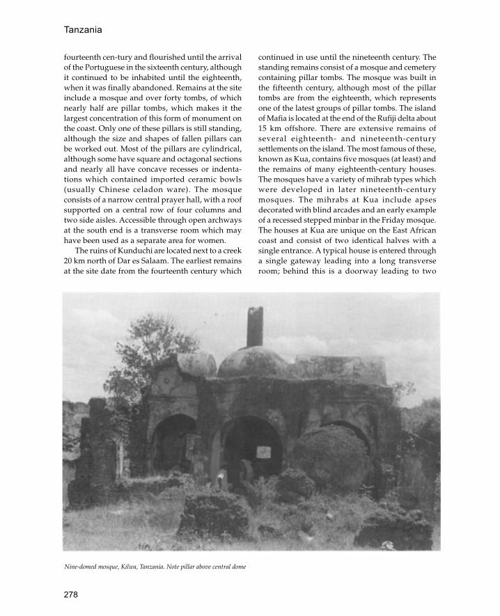
278
fourteenth cen-tury and flourished until the arrivalof the Portuguese in the sixteenth century, althoughit continued to be inhabited until the eighteenth,when it was finally abandoned. Remains at the siteinclude a mosque and over forty tombs, of whichnearly half are pillar tombs, which makes it thelargest concentration of this form of monument onthe coast. Only one of these pillars is still standing,although the size and shapes of fallen pillars canbe worked out. Most of the pillars are cylindrical,although some have square and octagonal sectionsand nearly all have concave recesses or indenta-tions which contained imported ceramic bowls(usually Chinese celadon ware). The mosqueconsists of a narrow central prayer hall, with a roofsupported on a central row of four columns andtwo side aisles. Accessible through open archwaysat the south end is a transverse room which mayhave been used as a separate area for women.
The ruins of Kunduchi are located next to a creek20 km north of Dar es Salaam. The earliest remainsat the site date from the fourteenth century which
continued in use until the nineteenth century. Thestanding remains consist of a mosque and cemeterycontaining pillar tombs. The mosque was built inthe fifteenth century, although most of the pillartombs are from the eighteenth, which representsone of the latest groups of pillar tombs. The islandof Mafia is located at the end of the Rufiji delta about15 km offshore. There are extensive remains ofseveral eighteenth- and nineteenth-centurysettlements on the island. The most famous of these,known as Kua, contains five mosques (at least) andthe remains of many eighteenth-century houses.The mosques have a variety of mihrab types whichwere developed in later nineteenth-centurymosques. The mihrabs at Kua include apsesdecorated with blind arcades and an early exampleof a recessed stepped minbar in the Friday mosque.The houses at Kua are unique on the East Africancoast and consist of two identical halves with asingle entrance. A typical house is entered througha single gateway leading into a long transverseroom; behind this is a doorway leading to two
Nine-domed mosque, Kilwa, Tanzania. Note pillar above central dome
Tanzania

279
separate L-shaped passages which lead into a longreception room that opens on to a courtyard on oneside and a small private room (harem) on the innerside. Sometimes there are additional buildings inthe courtyard and sometimes there are two separateentrances. It is thought that the two identical halvesmay represent the family houses of two wivesrather than a men’s and a women’s section.Nineteenth- and twentieth-century Islamicarchitecture in Tanzania is best represented in thecities of Bagamoyo and Dar es Salaam. Bagamoyowas the capital of German East Africa before theFirst World War and contains the various elementsassociated with a small colonial capital. Thearchitecture is an interesting mixture of stylesincluding Omani Arab, German, GermanOrientalist (i.e. Ottoman) and Swahili. Many of themore important government buildings are built inthe style of Omani palaces with external verandasand carved wooden doors—the important additionof steel girders enabling larger spaces to be coveredwithout support. After the defeat of the Germansin the First World War, Dar es Salaam replacedBagamoyo as capital. Like the Germans inBagamoyo the British in Dar es Salaam built officialbuildings in an Oriental style with modernmaterials; some of the more notable ones are theNational Museum with its Turkish tiles and the oldhospital.
See also: East Africa, Kilwa, Zanzibar
Further reading:
H.N.Chittick, Annual Reports of the Department ofAntiquities, Dar es Salaam 1958–64.
G.S.P.Freeman-Grenville, The Medieval History of the Coastof Tanganyika, London 1962.
P.S.Garlake, The Early Islamic Architecture of the EastAfrican Coast, Memoir No. 1 of the British Institute inEastern Africa, London and Nairobi 1966.
Tanganyika Notes and Records, Dar es Salaam 1959onwards.
taq
Iranian term for an arch.
tekke
Also known as a dergah, a tekke is a lodge fordervishes. Tekkes are a frequent occurrence inTurkish architecture and are usually part of acomplex which includes a mosque and memorial
tomb. They may be regarded as the counterpart ofthe more orthodox madrassa. A tekke often consistsof a number of individual cells which are used asshelters for the dervishes.
See also: Edirne, Ottomans, Turkey
tilework
Glazed tiles are one of the most characteristic features ofIslamic architecture.
Three distinct tile formats were developed whichmay be characterized as single tiles, composite tilepanels and tile mosaics. Single tiles are completecompositions which may include abstract designsor figural representation but are independent ofother tiles. Composite tile panels consist of severaltiles carrying a design or picture which togetherform a complete composition. Tile mosaics aremade of many pieces of monochrome coloured tilewhich are joined together to form a picture. Thereis also a fourth category which consists of three-dimensional glazed ceramics which are used toform architectural features such as mihrabs. Thedecoration of tiles may be classified according tothe various techniques used, which are similar tothose used on pottery. The simplest technique is topaint a tile with a monochrome glaze before firing.Extra colours may be added by coating the glazewith lustre after the first firing and then firing thetile a second time at a lower temperature. Morecomplex polychrome tiles may be produced byusing a technique known as ‘cuerda seca’ whichuses coloured glazes separated by outlines madeof a greasy substance which burns away after firing.Other techniques include overglaze painting(known as ‘minai’), underglaze painting and reliefmoulded designs.
The earliest dated examples of Islamic tiles arethose around the mihrab of the Great Mosque ofQairawan which were produced in Iraq sometimebefore 862 CE. These are square tiles (21 cm per side)decorated with abstract and vegetal forms inpolychrome and monochrome lustre on a whiteground. From the eleventh century onwards tilesreplaced mosaics as the main form of wall decorationin many parts of the Islamic world. Three maintilemaking traditions can be distinguished: these areSpain and North Africa, Turkey and Iran.
In Seljuk Iran the exterior surfaces of brickbuildings were enlivened by blue-green glazed
tilework

280
bricks or tiles whilst alternating star- and cross-shaped minai tiles were used to decorate interiors.Other techniques developed during the Seljukperiod include tile mosaics and decorativeinscriptions which were generally restricted to blue,black, turquoise and green as the main pigments.In the fourteenth century potters working in Tabrizdeveloped the cuerda seca technique which enabledthem to adopt complex Chinese patterns. Thistechnique continued to be used during the Saffavidperiod and it was not until the nineteenth centurythat underglaze painting was introduced to Iraniantilework. The tilework of Iran also influenced thearchitecture of India to the east, in particular thearea of present-day Pakistan. Generally Indianglazed tilework was restricted to tile mosaics andcan be seen in the magnificent ‘Picture Wall’ atLahore Fort. Indian craftsmen took the tile mosaicone stage further when they developed thetechnique of mirror mosaics which was lateradopted in Iran.
In Spain and North Africa a technique of tilemosaic, known as zilij, was developed using yellow,green, blue and turquoise tiles. In the eighteenthcentury the Ottomans introduced the techniques ofpolychrome panels made of square or rectangulartiles. One of the main centres of production wasTunis, where tiles were decorated with green, yellowand blue designs. Before the fifteenth century severaldifferent formats of tile decoration were used inAnatolia which included tile mosaic, hexagonal,octagonal, star- and cross-shaped tiles. In thefourteenth century the Ottomans adopted the Persiantechnique of cuerda seca for the brilliant green tileswhich characterize early Ottoman mosques such asthe Yesil Cami in Bursa. However, the mostsignificant development came in the sixteenthcentury when the potteries of Iznik began producingtilework for imperial use. The achievement of Iznikpotters was to produce tiles with underglaze colourswhich remained stable under the glaze.Characteristic colours of Iznik tiles are blue,turquoise and red against a white background.
See also: Iznik, tilework
Further reading:J.Hedgecoe and S.S.Damulji, Zillij: The Art of Moroccan
Ceramics, New York, NY 1993.J.M.Scarce, ‘Function and decoration in Qajar tilework’,
Persian Art and Culture of the 18th and 19th Centuries,Edinburgh 1979.
Timbuktu (also known as Tombouctou)
Famous Islamic trading city in Mali, West Africa.
Timbuktu is located on the southern edge of theSahara several kilometres north of the Niger river.According to tradition the city originated as anomadic Tuareg encampment in the twelfth century.The encampment would have consisted of tentsmade out of acacia wood frames covered over withmats and animal-skin canopies. In 1325 the city wasconquered by Mansa Musa who incorporated it intothe empire of Mali. During this period the famousAndalusian poet and architect Abu Ishaq al-Sahelivisited the city and built a mosque there. Severalyears later in 1333 the city was burnt and pillaged inan attack by Mossi tribesmen from Yatenga (present-day Upper Volta) although it was later rebuilt bySulayman the emperor of Mali. The rule of Maliended in the fifteenth century and for the next fortyyears the city was controlled by Tuareg nomads untilits annexation by Ali the ruler of Gao in 1468. Duringthis time Timbuktu became the main centre for thetrade with North Africa and enjoyed its greatestperiod of prosperity. This was brought to an abruptend with the Moroccan invasion of 1591, althoughthe city managed to remain more or less independentuntil 1787 when it passed into the control of theTuareg. In the nineteenth century the city wasincorporated into the Fulbe state of Massina andremained under nominal Fulbe control until theadvent of French colonialism in the late nineteenthcentury. Despite these conquests by various groupsand dynasties, Timbuktu remained substantiallyindependent for most of its history due to its positionon the border of the desert.
The first known European visitor was Caillié whowrote the following description of the city in 1828:‘The city of Timbuktu forms a sort of trian-gle,measuring about three miles in circuit. The housesare large, but not high, consisting entirely of a groundfloor. In some a sort of water closet is constructedabove the entrance.’ The city has retained thistriangular configuration into recent times althoughnew houses have been built around the central core.The city is divided into five districts, or quarters,traditionally inhabited by different ethnic groups—the Ba Dinde, the Saré-kaina, the Bella Faraji, theSankoré and the Dijingueré Ber. The Dijingueré Berquarter is generally thought to be the oldest Muslimpart of the city and in earlier times may have beenseparated from the rest of the town with its own city
Timbuktu (also known as Tombouctou)

281
wall. The Saré-kaina quarter, also known as the Sané-gungu quarter, is the area inhabited by the rulersand political élite; in this area are the largest housesand also the remains of the Moroccan kasbah builton the site of the Songhay royal palace. The Sankoréquarter in the north-west tip of the city is the areaformerly inhabited by the Berber tribes and is said tohave been founded by Sidi Mahmoud a sixteenth-century immigrant from Oualata. The main materialof construction in Timbuktu is mud brick, althoughstone is used for strengthening the walls and inimportant places such as doorways. Early nineteenth-century descriptions of the city describe the makingof hand-rolled round bricks which are then baked inthe sun. Roofs are made of split palm beams and palm-frond matting which is then covered with earth.Construction is in the hands of a group of Songhay-speaking people known as the ‘gabibi’ who are alsoresponsible for gravedigging.
The major monuments of the city are the threeancient mosques each located in a different quarterof the city. Reputedly the oldest building is theSankoré Mosque, which was founded by a womanduring one of the periods of Tuareg rule, possiblyduring the thirteenth century. The building wassubsequently repaired, rebuilt and developed so thatin its present form it consists of an irregular formbased around a square central courtyard. Thiscourtyard seems to represent an early phase of themosque’s development as it conforms to thedimensions of the courtyard built by Qadi al-Aqibin 1581. On the south-east corner of the mosque is asmall, square, entrance vestibule built during Fulberule in the nineteenth century to serve as a Shar�iacourt. The mosque contains two mihrabs, a small onein the east wall of the interior courtyard and a largerone in the east wall of the sanctuary. The largermihrab is located north of the centre of the east wall
Great Mosque, Timbuktu, Mali (after Prussin)
Timbuktu (also known as Tombouctou)

282
and externally consists of a tower-like conicalprojection similar to that of the Dijingueré BerMosque. The dominant feature of the building is theminaret on the south side of the courtyard, consistingof a large stepped pyramid similar to that of themausoleum of Askiya Muhammad at Gao. However,the Sankoré minaret is slightly smaller and has aninternal staircase instead of external stair ramps asat Gao.
The most famous mosque in Timbuktu is theDijingueré Ber Mosque, which was built between1324 and 1327 by Mansa Musa emperor of Mali afterhis return from the Hajj. The mosque is attributed tothe architect Abu Isahq al-Saheli who built a royalaudience chamber at the same time. Today there isno trace of the audience chamber which may haveresembled that of the capital at Niani described bycontemporary Arab travellers. Like most otherancient buildings in the city the mosque underwentseveral successive stages of construction and repairs.As it stands at present the plan of mosque consistsof a roughly rectangular sanctuary with a smallinternal courtyard at the northern end and a largedouble-walled external courtyard on the westernside. The oldest part of the mosque is generallyagreed to be the western part of the sanctuary. Inthis part there are round arches made of dressedlimestone supporting the roof, a feature not foundelsewhere in West Africa until the colonial period.Like the Sankoré Mosque the Dijingueré Ber has twotowers, a conical mihrab tower with projecting toron(acacia wood stakes) and a tapering square minaretadjacent to the interior courtyard.
The third ancient mosque in Timbuktu is thesmall complex in the centre of the city known as themosque of Sidi Yahyia built in the mid-fifteenthcentury. This consists of a rectangular sanctuaryattached to a short, square, tapering minaret enclosedwithin a large outer courtyard. The sanctuary is fourbays deep and has three entrances on the shortnorthern side and two entrances in the eastern walleither side of the wide shallow central mihrab.According to tradition, the first imam of the mosqueis buried under the minaret, a concept that parallelsthe stepped pyramid minarets of the Gao andSankoré mosques.
The houses of Timbuktu are either single-storeyor two-storey courtyard houses. The two-storeyhouses tend to be more elaborate and are mostlyconfined to the Sané-gungu quarter inhabited by thechief merchants. From the outside the houses are
generally quite plain with shallow square buttressesdividing the wall into panels. The doorways are fairlysimple with wooden doors decorated with Moroccanbrass bosses, although this has been superseded bysnipped tin decoration. Above the main doorway isa single window, decorated, containing a Moroccan-style hardwood grille. Each grille consists of twoparts, opening shutters recessed within a horseshoearch on the top and the wooden grille below madeof intersecting wooden strips (cf. mashrabiyya). Thehouses are entered via an outer and inner vestibulewhich leads out on to a square courtyard from whichthe other rooms of the house can be reached. In atwo-storey building there are men’s rooms either sideof the courtyard, whilst in a single-storey house thesingle men’s room is to the right of the entrance. Inlarger houses there is usually a secondary courtyardfor women behind the main courtyard. In two-storeyhouses latrines are usually on the upper floor abovea sealed latrine shaft (sekudar).
See also: Agades, Oualata, West Africa
Further reading:
R.J. and S.K.McIntosh, ‘Archaeological reconnaisance inthe region of Timbuktu, Mali’, National GeographicResearch 2: 302–19, 1986.
L.Prussin, Hatumere: Islamic Design in West Africa,Berkeley 1986.
Timurids
Central Asian dynasty founded by Timur which flourishedfrom the end of the fourteenth century to the end of thefifteenth.
Timur was born a member of the Barlas tribe andclaimed descent from the Mongol Khan Chatagay.By 1370 Timur had gained control of Samarkandand Balkh after which he spent ten years consolidat-ing his control of Central Asia. From 1381 Timurextended the range of his operations and managedto gain control of Iran, Iraq, Syria, the Caucasus andDelhi. In 1402 Timur’s excursions into Anatoliabrought him into conflict with the Ottoman sultanBayazit whom he defeated and captured at thebattle of Ankara. One of the results of these wide-ranging conquests was the collection of skilledcraftsmen from all over the Middle East who wereused to enrich the new capital at Samarkand. Timurdied in 1405 and was succeeded by his son ShahRukh who ruled the empire from Herat where he
Timurids

283
had been governor during the reign of Timur.Samarkand was ruled by Shah Rukh’s son UlughBeg whilst Fars was ruled first by his nephewIbrahim. By the mid-fifteenth century the westernprovinces were mostly lost to the Turkmans leavingHerat as capital of a much diminished empire whichcontinued until 1507 when it was taken over by theTurkmans.
The main building material employed forimperial monuments was baked brick althoughdressed stone was used in Azerbayjan. The standardbrick form was square (24–27 cm per side and 4–7cm thick) whilst cut or moulded bricks wererelatively rare compared with earlier periods.Mortar was usually quick-setting gypsum plasterrather than the more common lime plaster. Thestandard method of exterior decoration was tilerevetments which were on a larger scale than inprevious periods. Two main forms of tilework wereused, tile mosaic, with individual coloured piecescut to form patterns, and underglaze-painted tilesknown as ‘haft rangi’ (seven colours). Theunderglaze-painted tiles tended to be of a lowerquality but were useful for covering large areas. Alarge variety of arch forms were used includinground, two-, three-, and four-centre arches,although the most common was the three-centredarch with a high crown, where the height of the archwas more than half the height of the entire opening.A large variety of domes and vaults were employedwhich displays the wide range of influences inTimurid architecture. One of the most significantvaulting forms employed was based on the use ofwide transverse arches spanning between parallelwalls. Vaults of various forms were then built tocover the area between each transverse arch toproduce a large vaulted area. The vaults used tospan the arches included tunnel or barrel vaults,stellar vaults and cross vaults, all of which producecharacteristic humps on the roofs of buildings.
Dome forms became increasingly distinctiveunder the Timurids with the development of double-shell domes where there is an outer dome and ashallower inner dome. The characteristic outer domeform consists of a tall ‘melon-shaped’ structure seton a high drum and decorated with ribs covered indecorative tilework.
The most characteristic feature of Timuridimperial buildings is their massive scale, emphasizedby huge entrance portals and thick minarets coveredin tile decoration. Internally the buildings are slightly
less well organized and they often have a largevariety of smaller rooms whose relationship to theoverall plan is not always evident. The most famousof the Timurid monuments are the shrine of AhmedYasavi at Turkestan (Yasi) in Khazakstan and theMasjid Jami� at Samarkand. The monuments arequite similar in their scale and conception with hugeportal iwans behind which rise characteristic melon-shaped domes on high collars or drums. The AhmedYasavi tomb was built by Timur for his son Jahangirwhilst the Masjid Jami� at Samarkand was built tocommemorate the Timurid capture of Delhi. Othermonumental projects carried out by Timur includethe mausoleums at Shahrisbaz (his first capital) forhis father Taraghay and the Gur-i-Amir for his sonMuhammad Sultan at Samarkand. In addition Timurundertook massive civil engineering projectsincluding building the towns of Baylaqan,Shahrukhiya and Iryah, the citadels and walls ofGhazui, Balkh and Samarkand.
The later Timurid buildings of Herat inAfghanistan mirror those of the early TimuridEmpire, although many were destroyed in thenineteenth century. One of the most celebratedbuildings in Herat was the mosque and madrassabuilt by the architect Qavam al-Din for the wife ofShah Rukh. Little is left of the complex except fortwo minarets at diagonally opposite corners of themosque and a minaret and iwan from the madrassa.The best preserved Timurid structure in Herat is theshrine of the mystic of Khwajeh �Abdallah Ansari atGazur Gah. The complex is built on the plan of afour-iwan madrassa and oriented to the qibla (i.e.east-west) with the entrance in the centre of the westfaçade. The entrance portal consists of a large iwan,half-octagonal in plan, leading into the rectangularcentral courtyard. There is a mosque and cells formystics at the western end, whilst at the eastern endis a shallow iwan set into a tall pishtaq.
See also: Herat, Iran, Samarkand
Further reading:
L.Golombek and D.L.Wilber, The Timurid Architecture ofIran and Turan, Princeton, NJ 1988.
B.O’Kane, Timurid Architecture in Khurassan, Costa Mesa,CA 1987.
TlemcenCity in western Algeria noted for its medievalarchitecture.
Tlemcen

284
Tlemcen was founded in the eighth century on theruins of the Roman city of Pomaria although it didnot rise to prominence until the Almoravid period inthe eleventh century. The most important Al-moravidcontribution to the city was the Great Mosque whichsurvives in the centre of the town. The prayer hallconsists of thirteen aisles running perpendicular tothe qibla wall and covered with pitched tile roofs. Likeother Almoravid mosques the courtyard arcades ofthe Great Mosque open directly into the prayer hall.The minaret which stands opposite the qibla wasadded in 1136. The most astonishing feature of themosque is the lavish decoration in the area of themihrab which includes stone panels with intricatelycarved stylized flora. Covering the area in front of themihrab is a magnificent perforated dome carried onsixteen brick ribs and four small squinches. Betweenthe ribs there is an intricate stucco latticework ofstylized floral motifs whilst at the apex of the dome isa small muqarnas cupola. The entire dome is coveredby a tiled roof on the exterior.
The other important mosque in Tlemcen is the al-�Ubbad Mosque built by the Marinid sultan Abu al-Hasan in 1339. The mosque is raised on a plinth andapproached by a monumental staircase leading to aceremonial projecting porch with an entrance hallbehind it. The entrance hall leads on to a smallcourtyard behind which is the prayer hall. The wholestructure is covered with opulent decoration in theform of carved stucco work, glazed tiles and delicatelycarved stone.
See also: Algeria
ToledoCity in central Spain famous as first Arab capital of Spainand later major Islamic and Christian city,
Toledo was the capital of the Visigoths until itscapture in 712 CE by the Arabs, who used the city astheir capital until they moved to Córdoba in 717. Thecity remained an important frontier city until itscapture by the Christians in 1085, and even after thisMuslims and Jews continued to make importantcontributions to the intellectual life of the city withtranslations of scientific treatises.
Despite its fairly early conquest by the Christians,substantial remains of the Islamic period are stillstanding, together with some notable examples ofMudéjar architecture. The walls of the city containmany early sections including the Bab al-Qantara (c.
850) which is thought to be the earliest use of a bententrance in Spanish fortifications. Access to this gateis via a bridge known as the Puente de Alcantara (866–71) which has a magnificent high-sprung central archsimilar to those of Seljuk bridges in Anatolia. Probablythe most famous gate of the city is the Old BisagraGate (also known as Puerta de Alfonso VI) throughwhich El Cid entered the city in 1085. The gate is amonumental structure built out of huge uneven blocksnear the ground and smaller pieces of coursed rubblenear the top. The gateway is flanked by two blindniches with pointed horseshoe arches resting onengaged columns. The gateway itself is recessedbehind a wide arched machicolation and consists of around horseshoe arch with a huge stone lintelspanning the width between the two imposts.
Within the city there are several importantreligious buildings which are Cristo de la Luz(mosque of Bab al-Mardum), Santa María La Blanca(a former synagogue), the Sinagoga del Transito andthe cathedral. The mosque of Bab al-Mardum is anine-domed mosque with a raised central dome builtin 999. Originally there were triple entrances on threesides with a mihrab on the south side. Three of theouter faces are made of brick and decorated with aband of Kufic inscriptions, below which is ageometric panel above decorative intersecting roundhorseshoe arches.
The church of Santa María La Blanca was built asa synagogue in 1250 and contains four rows of archessupported on octagonal brick piers with capitalsdecorated with fir cones and punctuate scrolls. Morewell known is the Sinagoga del Transito built in 1357during the reign of Pedro the Cruel. The building islavishly decorated with carved plaster andwoodwork, with Arabic and Hebrew inscriptionsand coloured tiles. The cathedral of Toledo was oncethe Great Mosque of the city and possibly containsthe remains of a large Córdoba-style mihrab, nowthe octagonal chapel of Ildefonso.
See also: Córdoba, Granada, Mudéjar, Seville,Spain, Zaragoza
Tomb of the Abbasid caliphs (Cairo)Mid-thirteenth-century tomb in Cairo containing tombsof the Abbasid caliphs who were taken there after theMongol sack of Baghdad.
The date of the tomb is not known; some attribute itto the Ayyubid period whilst others believe it was
Toledo

285
built by the Mamluk sultan Baybars in the 1260s. Thecomplex is one of the most highly decoratedbuildings to have survived in Cairo with finelycarved stucco and painted Kufic inscriptions. Themihrab is a keel-arched niche, with a centralmedallion from which lines radiated to form amuqarnas frame to the opening. The dome issupported on two-tier muqarnas squinches betweenwhich are carved niches and windows.
Topkapi PalaceImperial Ottoman palace in Istanbul founded by MehmetII in 1459.
The Topkapi replaces an early royal palace that wasestablished between the old forum and the GoldenHorn. This early palace was built pre-dominantly ofwood and surrounded by a high wall.
The Topkapi Palace is located on the oldByzantine acropolis and overlooks the Sea ofMarmara and the Bosphorus. The building consistsof four great courtyards built over a period of fourhundred years. Most of the early buildings in thepalace were probably built of wood and have notsurvived the great fires of 1574 and 1665. Fifteenth-century buildings which have survived include thekitchens, the treasury, the physician’s building andthe Çnili Kiosk. The kitchens on the south side ofthe second court consist of a long building coveredwith huge domed chimneys and ventilators. Thereare several other kitchens in the palace including aseparate women’s kitchen, a hospital kitchen andseveral smaller private ones. The treasury is built asa long six-domed hall in the form of a small bedestanand is located in the second court. One of the mostunusual buildings of this period is the Physician’sTower, a square building with extremely thick wallsand a small chamber on the top. It has been suggestedthat the lower building was a drug store whilst theupper room was the doctor’s office. Outside the mainarea of the palace but within the outer walls is thecelebrated Cinili Kiosk. Designed by a Persianarchitect, this has many Persian features such as thewide arches. It is set on a raised platform reached byexternal steps and has a four-iwan plan with a talldome above the centre.
During the sixteenth century the architect Sinancarried out extensive work at the palace includingbuilding (or rebuilding) the vaults supporting the eastend. Other work carried out at this period was thebuilding of Murat III’s bedchamber next to a heated
outdoor pool. Unfortunately another fire in 1574destroyed large areas of the palace which had to berebuilt. This was taken as a chance to remodel muchof the palace including the kitchens and the woodenquarters of the Halberdiers (halberd carriers) whichwere completely rebuilt at this time. A second fire in1665 led to another period of rebuilding andrefurbishment particularly of the harem area.Important buildings from the seventeenth centuryinclude the Baghdad Kiosk erected to celebrate thereconquest of that city.
During the early eighteenth century the palacewas redecorated in the Ottoman baroque style. Anew bath house for the sultan and a palace schoolwere built at this time, both of which include lavishdecoration in the European style. In 1789 Selim IIIbecame sultan and instituted a series of apartmentsor salons in the French Rococo style. Thesebuildings had large European glazed windows andwere decorated in ornate painted plasterwork. Inthe mid-nineteenth century the sultans moved to anew palace (the Dolmabahçe) on the banks of theBosphorus which was more fashionable and notcluttered with associations of the past.
See also: Istanbul, Ottomans
Further reading:
F.Davis, The Palace of Topkapi in Istanbul, New York 1971.B.Miller, Beyond the Sublime Porte; The Grand Seraglio of
Stamboul, New York 1970.
toron
West African term for projecting wooden stakes used inmud-brick architecture especially in minarets.
The preferred material is acacia wood althoughsplit palm is sometimes also used. It is generallyagreed that toron have a practical purpose as fixedscaffolding for mud-brick structures which needconstant maintenance, although they may alsohave a symbolic and aesthetic function. Symboli-cally the use of projecting wooden branches relatesthe structure to a tree which in West Africantradition is a symbol of renewal and rebirth, anidea strengthened by the fact that toron areprimarily associated with religious structures.Aestheti-cally toron may be compared to the hornsused in hunting towers (as in e.g. Manara Umm al-Qaroun in Iraq, or the Hiran Manar at FatehpurSikri).
toron
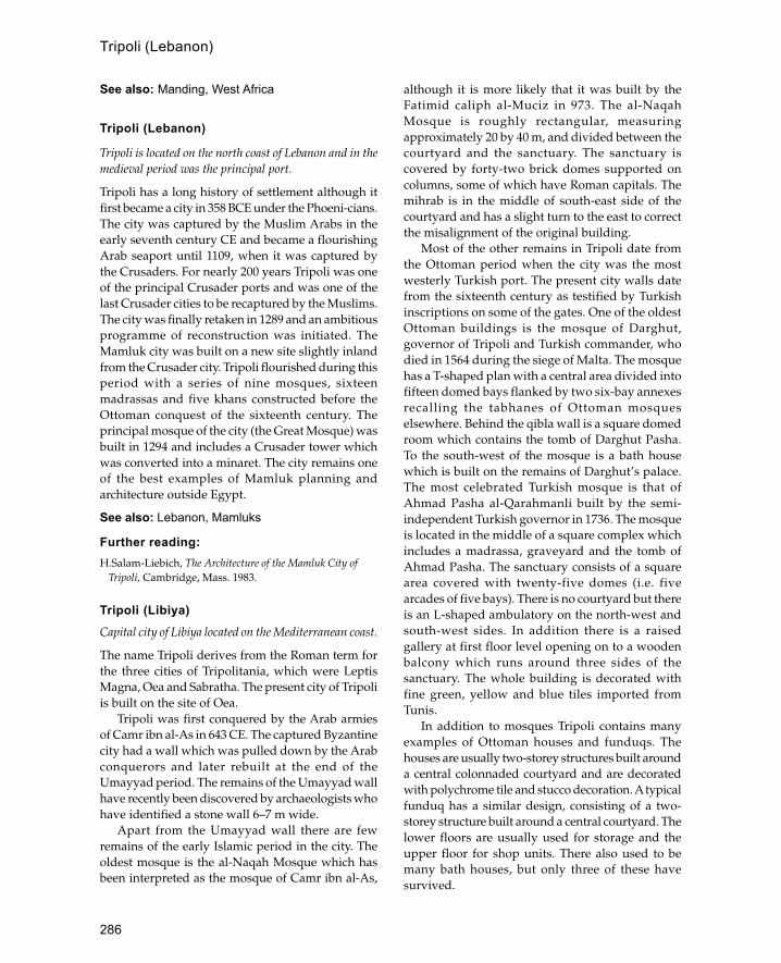
286
See also: Manding, West Africa
Tripoli (Lebanon)
Tripoli is located on the north coast of Lebanon and in themedieval period was the principal port.
Tripoli has a long history of settlement although itfirst became a city in 358 BCE under the Phoeni-cians.The city was captured by the Muslim Arabs in theearly seventh century CE and became a flourishingArab seaport until 1109, when it was captured bythe Crusaders. For nearly 200 years Tripoli was oneof the principal Crusader ports and was one of thelast Crusader cities to be recaptured by the Muslims.The city was finally retaken in 1289 and an ambitiousprogramme of reconstruction was initiated. TheMamluk city was built on a new site slightly inlandfrom the Crusader city. Tripoli flourished during thisperiod with a series of nine mosques, sixteenmadrassas and five khans constructed before theOttoman conquest of the sixteenth century. Theprincipal mosque of the city (the Great Mosque) wasbuilt in 1294 and includes a Crusader tower whichwas converted into a minaret. The city remains oneof the best examples of Mamluk planning andarchitecture outside Egypt.
See also: Lebanon, Mamluks
Further reading:H.Salam-Liebich, The Architecture of the Mamluk City of
Tripoli, Cambridge, Mass. 1983.
Tripoli (Libiya)Capital city of Libiya located on the Mediterranean coast.
The name Tripoli derives from the Roman term forthe three cities of Tripolitania, which were LeptisMagna, Oea and Sabratha. The present city of Tripoliis built on the site of Oea.
Tripoli was first conquered by the Arab armiesof Camr ibn al-As in 643 CE. The captured Byzantinecity had a wall which was pulled down by the Arabconquerors and later rebuilt at the end of theUmayyad period. The remains of the Umayyad wallhave recently been discovered by archaeologists whohave identified a stone wall 6–7 m wide.
Apart from the Umayyad wall there are fewremains of the early Islamic period in the city. Theoldest mosque is the al-Naqah Mosque which hasbeen interpreted as the mosque of Camr ibn al-As,
although it is more likely that it was built by theFatimid caliph al-Muciz in 973. The al-NaqahMosque is roughly rectangular, measuringapproximately 20 by 40 m, and divided between thecourtyard and the sanctuary. The sanctuary iscovered by forty-two brick domes supported oncolumns, some of which have Roman capitals. Themihrab is in the middle of south-east side of thecourtyard and has a slight turn to the east to correctthe misalignment of the original building.
Most of the other remains in Tripoli date fromthe Ottoman period when the city was the mostwesterly Turkish port. The present city walls datefrom the sixteenth century as testified by Turkishinscriptions on some of the gates. One of the oldestOttoman buildings is the mosque of Darghut,governor of Tripoli and Turkish commander, whodied in 1564 during the siege of Malta. The mosquehas a T-shaped plan with a central area divided intofifteen domed bays flanked by two six-bay annexesrecalling the tabhanes of Ottoman mosqueselsewhere. Behind the qibla wall is a square domedroom which contains the tomb of Darghut Pasha.To the south-west of the mosque is a bath housewhich is built on the remains of Darghut’s palace.The most celebrated Turkish mosque is that ofAhmad Pasha al-Qarahmanli built by the semi-independent Turkish governor in 1736. The mosqueis located in the middle of a square complex whichincludes a madrassa, graveyard and the tomb ofAhmad Pasha. The sanctuary consists of a squarearea covered with twenty-five domes (i.e. fivearcades of five bays). There is no courtyard but thereis an L-shaped ambulatory on the north-west andsouth-west sides. In addition there is a raisedgallery at first floor level opening on to a woodenbalcony which runs around three sides of thesanctuary. The whole building is decorated withfine green, yellow and blue tiles imported fromTunis.
In addition to mosques Tripoli contains manyexamples of Ottoman houses and funduqs. Thehouses are usually two-storey structures built arounda central colonnaded courtyard and are decoratedwith polychrome tile and stucco decoration. A typicalfunduq has a similar design, consisting of a two-storey structure built around a central courtyard. Thelower floors are usually used for storage and theupper floor for shop units. There also used to bemany bath houses, but only three of these havesurvived.
Tripoli (Lebanon)

287
See also: Libiya, Ottomans, Tunis
Further reading:
M.Brett, ‘Tripoli at the beginning of the fourteenthcentury AD/eighth century A.H.’, Libyan Studies 9: 55–9, 1978.
K.McLachlan, ‘Tripoli—city, oasis and hinterland—reflections on the old city 1551 to the present’, LibyanStudies 9: 53–4, 1978.
M.Warfelli, ‘The old city of Tripoli’, in Some Islamic Sites inLibiya: Tripoli Ajdabiyah and Uljah, Art and ArchaeologyResearch Papers, London 1976.
Tulunids
Dynasty which ruled over Egypt and Syria in the lateninth and early tenth century.
The dynasty was founded by Ahmed ibn Tulun theson of a Turkic soldier from Bukhara who was basedat the Abbasid capital of Samarra. Ahmed wasoriginally sent to Egypt as deputy to the governorbut soon acquired the governorship himself. Asgovernor of Egypt Ahmed soon extended his powerto Syria and Palestine whilst the Abbasids weredistracted by rebellions in lower Iraq.
Ahmed’s son and successor Khumarawayahreceived official recognition of his position from thecaliph when he was granted Syria and Egypt inreturn for an annual tribute of 300,000 dinars. By thetime of Khumarawayah’s death in 896 the empirewas weakened by extravagance and internal revolts.Three more Tulunid rulers followed but in the nextten years their situation was so weakened that in 906an Abbasid general was able to take over Egypt andput an end to Tulunid rule.
Architecturally the most significant member ofthe dynasty is Ahmed ibn Tulun who established anew city as his capital in Egypt. This city was knownas al-Qat�ic and was effectively an addition to Fustat.The city was famous for its similarity to the greatAbbasid capital of Samarra. Not much remains ofAhmed’s city but it is known to have had a triple-arched public entrance like the Bab al-Amma atSamarra, a polo ground, race track and park for wildanimals. Ahmed also built structures useful to thegeneral population such as a 60,000-dinar hospital.However, the only monuments remaining are thecongregational mosque of Ibn Tulun and anaqueduct. The mosque displays certain similaritiesto the congregational mosques of Samarra, inparticular the minarets. The aqueduct is built of brick
and has a large inlet tower at the village of Basatinabout two miles south of the citadel.
Ahmed’s son Khumarawayah is known to havebuilt a beautiful palace with a golden hall decoratedwith sheets of gold carrying representations ofhimself and his wife. Not surprisingly the palace hasnot survived.
Further reading:
K.A.C.Creswell, A Short Account of Early MuslimArchitecture, ed. by J.Allen, Aldershot 1989.
P.K.Hitti, History of the Arabs, 10th edn., London 1970,452–5.
C.E.Bosworth, The Islamic Dynasties, revised paperbackedn. , Edinburgh 1980, 43–4.
Tunis
Capital city of Tunisia since the thirteenth century.
Although smaller than that of Qairawan, the GreatMosque of Tunis (known as the Zaituna Mosque)has a similar history and design. The first mosqueon the site was built in 732 to be replaced in 863with the Aghlabid structure which forms the coreof the present mosque. The prayer hall consists offifteen aisles running east-west (i.e. perpendicularto the qibla wall) with the mihrab at the end of thecentral aisle, which is both wider and taller thanthe other aisles and surmounted by a dome at theend next to the mihrab; there is also a dome overthe entrance, but this was added later, in theeleventh century. Both domes are ribbed and reston shell squinches like the domes of the GreatMosque of Qairawan. The Tunis mosque is alsofamous for its role as a university. Next to it is anablutions courtyard constructed by the Hafisidrulers in the fourteenth century which is one of thebest examples of Tunisian decorative architecture.In the centre of the courtyard is an octagonalfountain and the whole area is decorated with whitemarble with black marble inlay.
Other important mosques in Tunis are the QasrMosque built in the twelfth century and the mosqueof the Kasba built in the thirteenth century. The latteris interesting as one of the best examples ofAndalusian influence in Tunisian architecture withits decorated minaret and ornate stucco decoration.
Tunis also contains a number of eighteenth-cen-tury palaces.
See also: Aghlabids, Tunisia
Tunis

288
Further reading:J.Revault, Palais et demeurres de Tunis (XVIe et XVIIe
siècles), Paris 1967.—— Palais et demeurres de Tunis (XVIIIe et XIXe siècles),
Paris 1971.
TunisiaNorth African country named after its capital Tunis.
Tunisia is a predominantly coastal country locatedbetween Algeria and Libiya. Northwards, a shortdistance across the sea, is the island of Sicily.Physically the country can be divided into threeregions, a forested mountainous area to the north, acentral plain watered by the Wadi Mejerda and adrier mountainous region to the south.
Tunisia has a long history of settlement startingwith the Phoenician ports of the ninth centuryBCE. The greatest of these ports developed intothe city of Carthage which dominated the trade ofthe Mediterranean until it was destroyed by theRomans in 146 CE. For a short period after thecollapse of Roman rule the country was taken overby the Vandals until they were expelled by theByzantines who ruled the country up to the timeof the Arab conquest in 640. During the earlyIslamic period the country was known as Ifriqiyyawith its capital at Qairawan. In the ninth centurythe country was ruled by the semi-autonomousAghlabid dynasty who undertook the conquest ofSicily. During the tenth century the countrybecame a base for the Fatimids before they movedto Egypt in 969. Tunisia’s prominent position inIslamic history was brought to an end in the mid-eleventh century by the invasions of the Banu Hilalfrom northern Egypt. In a reversal of history theNormans of Sicily occupied the country for a shortperiod in the mid-twelfth century until they wereexpelled by the Almohads. Following the Almohadvictory Tunisia was ruled by a local dynastyknown as the Hafisids who remained in poweruntil the sixteenth century. In 1574, after a strugglebetween the Turks and the Spanish, the Turksgained the upper hand and Tunisia wasincorporated into the Ottoman Empire. During theeighteenth century the country was ruled by a localdynasty known as the Husseinis, who, withincreasing French help, ruled the country up to1945 when Tunisia became an independentrepublic. The main building material in Tunisia isstone
which may either be finely dressed ashlar orsmaller squared blocks. Baked brick was used,particularly in the early Islamic period for buildingslike the Great Mosque at Qairawan. Roman andByzantine material, in particular columns, formedone of the major building materials for early Islamicbuildings. As elsewhere in North Africa the horshoearch was the dominant arch form in monumentalarchitecture. A certain amount of wood wasavailable for roofs although generally buildingswere covered with stone vaults. From the fifteenthcentury onwards glazed tiles became a commonarchitectural feature which has survived until thetwentieth century.
Tunisia is noted for the large number of religiousbuildings surviving from before the tenth century.The oldest Islamic monument in Tunisia is the GreatMosque of Qairawan which was built in 670 by�Uqba ibn Nafi. Little remains of this early mosquewhich was rebuilt more than three times until 862when it reached its present form under the Aghlabidruler Abu Ibrahim Ahmad. The plan of this buildingbecame a model for later Tunisian mosques. The
Ribal of Tunisia © Creswell Archive, Ashmolean
Tunisia

289
standard form comprises aisles runningperpendicular to the qibla wall with a raised aislein the centre leading to a domed cupola in front ofthe mihrab. In addition there is usually one (ormore) aisle running parallel to the qibla wallforming a T-plan. Examples of this style include theGreat Mosques of Tunis, Susa, Mahadi-ya, Monastirand Sfax—only the Great Mosque of Tozeur differsfrom it, with aisles running parallel to the qibla wall.This mosque form remained remarkably constantand even continued after the Ottoman conquestalthough there are examples of mosques of pureOttoman form such as the Sidi Mahriz Mosque inTunis.
Other religious structures include the ribat orfortified convent, an architectural form particularlycharacteristic of Tunisia. One of the best examplesis the Ribat of Susa which was built by the Aghlabidruler Ziyadat Allah in 821. This consists of a squarebuilding (95 m per side) with a central courtyard,towers at the corners and a monumental entrance.Three of the corner towers are circular whilst thefourth is square and forms a base for a cylindricalwatchtower. The ground floor contains numerousrooms opening from the courtyard whilst on thefirst floor above the entrance there is a large prayerhall covered with barrel-vaulted aislesperpendicular to the mihrab. Other examplesinclude the three ribats of Monastir, the oldest ofwhich was founded in 796.
There is a wide variety of traditional housetypes in Tunisia from the bedouin tent tosophisticated courtyard villas. In southern Tunisiathere are fortified settlements (qusur) whichcontain several tiers of barrel-vaulted rooms(ghorfas) arranged around a courtyard. Theappearance of these structures is quite organic andresembles a beehive. Most of the time they are usedfor storage, but they could be used as dwellingsin times of trouble. The standard form of villagehouse is a windowless, flat-roofed structure, witha central courtyard used for animals. Town housesare a developed form of the village house; theyare often two storeys high and decorated withpolychrome glazed tiles. The houses of Tozeur arenoted for their decorative brickwork façades. InTunis there are a number of eighteenth-centuryOttoman palaces and mansions. These are usuallymultiple courtyard structures with extrava-gantdecoration which is a mixture of Islamic andEuropean style.
See also: Aghlabids, Qairawan, Tunis
Further reading:
A.Lezine, Architecture de l’Ifriqiyya: recherche sur lesmonuments aghlabides, CNRS , Paris 1966.
G.Marçais, ‘Recherches d’archéologie musulmane enTunisie’, Bulletin de la Société Française des FouillesArchéologiques 5: 38–46, 1923–4.
turba (or turbe)
Mausoleum.
Turkey
The Republic of Turkey occupies a position betweenAsia and Europe and comprises Anatolia and TurkishThrace.
Turkey is a large country open to the sea on threesides with the land route to the Middle East andAsia on the fourth side. The country may bedivided roughly into five areas, each with adifferent environment and culture. West ofIstanbul is Turkish Thrace, a green area with manyconnections with the Balkans. The northern partof the country stretching along the Black Sea coastis heavily wooded, with a high rainfall and culturalconnections with Russia, Ukraine and other formerSoviet Republics. The central area, where thecapital Ankara is situated, is known as theAnatolian plain and has an extreme climate whichproduces snow in the winter and very hotsummers. This area is largely inhabited by ruralfarmers although there are also Turkish nomadswith tents. To the south and west is the Aegeanand Mediterranean coast which has a mild climateand rich classical heritage. To the east, on theborders of Iraq and Iran, is a harsh mountainousarea with a mixed population of Kurds, Armeniansand Turks. Historically Turkey’s position hasmeant that it has often been the scene of conflictbetween East and West, although the corollary ofthis is that it has also become extremely wealthythrough East-West trade. Until the eleventhcentury most of Turkey was controlled by theByzantine Empire which ruled from its capital atConstantinople (later Istanbul). During the ninthcentury there were regular Muslim raids whichwere sometimes quite successful. One of thelargest raids was that of 838 when the city ofAmorium was occupied and marble columns were
Turkey

290
taken back and used at Samarra. However, notuntil the eleventh century did the Byzantines, whohad already lost the Middle East and North Africato Islam, begin to lose large amounts of territoryto the recently converted Seljuk Turks. In the earlythirteenth century the Byzantines suffered afurther blow when Constantinople was sacked bythe soldiers of the Fourth Crusade. By thebeginning of the fourteenth century Byzantinecontrol was reduced to the area aroundConstantinople and Trabzon to the east on theBlack Sea. In 1453 Constantinople was taken bythe Ottomans who by the early sixteenth centurycontrolled all of modern Turkey as well as largeareas beyond its borders. In 1922 the Ottomansultanate was abolished and replaced by theTurkish Republic under Mustafa Kemal Attaturkwho instituted a policy of modernization andsecularism.
The traditional architecture of Turkey reflects thisvaried landscape and rich history with many regionalstyles. A large range of building materials areemployed including mud and baked brick, wood,stone and nomad tents.
The traditional Turkic nomad tent is known as ayurt and consists of a round wooden frame coveredwith a skin or hair tent. In south-western Anatoliathe traditional Arabic type is found, comprising ablack goat-hair tent which is supported with woodenpoles and long ropes anchored with pegs. Mud brickis employed predominantly in the south-east of thecountry and in central Anatolia. At the town ofHarran near the Syrian border houses are built outof one or more square mud-brick units, capped withflat-topped or pointed conical domes. In centralAnatolia rectangular houses are built out of mudbrick with stone foundations and roofs of wood andmud. The houses have thick walls with few windowsto conserve heat in the winter and remain cool in thesummer. Rooms are heated by open dung fires witha hole in the roof or an earthenware jar as a chimney.The roofs are built with roughly shaped timberbranches up to 4 m long laid perpendicular to thewalls of the house and covered with a layer of thatchwhich is then covered with mud. The mud on theroof is kept flat and waterproof with a section ofcolumn or other cylindrical stone which is rolled overthe roof.
Baked brick in Turkey derives from twoindependent traditions, the Byzantine and thePersian Seljuk tradition. During the Byzantine era
baked brick was one of the main building materials,especially in the cities of western Anatolia. Thistradition continued into the Ottoman period andbricks are still one of the main building materialsalongside the ubiquitous concrete. The usual methodof using the flat tile-like bricks was in combinationwith rubble stone or dressed stone construction inalternate layers. Seljuk Persian brickwork wasrestricted in its impact on eastern Anatolia becauseof the strong stone-carving tradition alreadyprevalent there. However, baked brick was oftenused in minarets in the west where it was sometimesarranged in decorative patterns in a manner alien toByzantine practice. Glazed bricks are anothertechnique imported into Anatolia by the Seljuks,although the most famous example is the Çnili Kioskin the Topkapi Palace which was built by a Timuridarchitect.
In north-western Turkey and on the coast of theBlack Sea wood is fairly plentiful and is the mainbuilding material. It is used in a number of waysfrom all-timber constructions to buildings withstone or brick walls and a wooden superstructure.Some of the oldest surviving wooden structures areSeljuk-period mosques which have been preservedbecause of their religious importance. A goodexample is the Asian Cami in Ankara which haswalls built of re-used stone and brick and an interiormade of wooden columns supporting a flat roofmade of wooden beams. However, most woodenstructures are not more than 250 years old so that alarge part of the architectural tradition is lost. Thestandard form of a traditional wooden town houseconsists of a stone basement, on top of which is builta rectangular platform cantilevered to project outabove the street. Although the basement may beirregular, this is corrected on the upper floors wherethe cantilevering is used to produce a rectangularshape. Windows are often built to project an extrahalf-metre or more beyond the façade to give viewsalong the street. Many houses are three storeys highincluding the basement, although it is likely that inthe past most were one or two storeys high. InIstanbul many of the houses are clad in externalweather-boarding, but elsewhere the walls of thehouses are made of lath and plaster. Inside thegrander houses the ceilings are often decorated withpainted scenes on plaster or wood.
Stone buildings represent the largest group ofhistorical buildings in Turkey from the eighth-cen-tury mosque at Harran to the eighteenth-century
Turkey
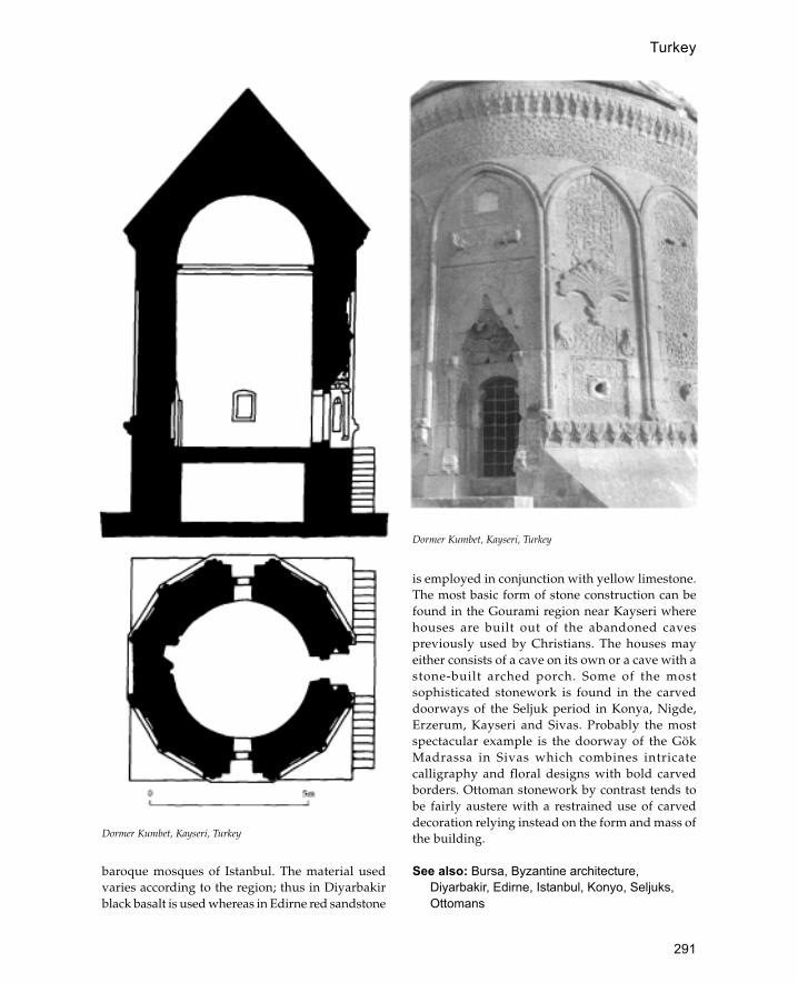
291
baroque mosques of Istanbul. The material usedvaries according to the region; thus in Diyarbakirblack basalt is used whereas in Edirne red sandstone
is employed in conjunction with yellow limestone.The most basic form of stone construction can befound in the Gourami region near Kayseri wherehouses are built out of the abandoned cavespreviously used by Christians. The houses mayeither consists of a cave on its own or a cave with astone-built arched porch. Some of the mostsophisticated stonework is found in the carveddoorways of the Seljuk period in Konya, Nigde,Erzerum, Kayseri and Sivas. Probably the mostspectacular example is the doorway of the GökMadrassa in Sivas which combines intricatecalligraphy and floral designs with bold carvedborders. Ottoman stonework by contrast tends tobe fairly austere with a restrained use of carveddecoration relying instead on the form and mass ofthe building.
See also: Bursa, Byzantine architecture,Diyarbakir, Edirne, Istanbul, Konyo, Seljuks,Ottomans
Dormer Kumbet, Kayseri, Turkey
Dormer Kumbet, Kayseri, Turkey
Turkey
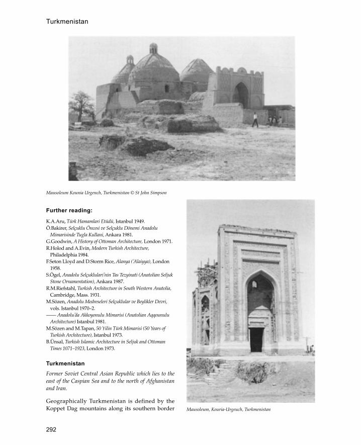
292
Further reading:
K.A.Aru, Türk Hamamlari Etüdü, Istanbul 1949.Ö.Bakirer, Selçuklu Öncesi ve Selçuklu Dönemi Anadolu
Mimarisinde Tugla Kullani, Ankara 1981.G.Goodwin, A History of Ottoman Architecture, London 1971.R.Holod and A.Evin, Modern Turkish Architecture,
Philadelphia 1984.F.Seton Lloyd and D.Storm Rice, Alanya (�Alaiyya), London
1958.S.Ögel, Anadolu Selçuklulari�nin Tas Tezyinati (Anatolian Seljuk
Stone Ornamentation), Ankara 1987.R.M.Riefstahl, Turkish Architecture in South Western Anatolia,
Cambridge, Mass. 1931.M.Sözen, Anadolu Medreseleri Selçuklular ve Beylikler Devri,
vols. Istanbul 1970–2.—— Anadolu�da Akkoyonulu Mimarisi (Anatolian Aqqounulu
Architecture) Istanbul 1981.M.Sözen and M.Tapan, 50 Yilin Türk Mimarisi (50 Years of
Turkish Architecture), Istanbul 1973.B.Ünsal, Turkish Islamic Architecture in Seljuk and Ottoman
Times 1071–1923, London 1973.
TurkmenistanFormer Soviet Central Asian Republic which lies to theeast of the Caspian Sea and to the north of Afghanistanand Iran.
Geographically Turkmenistan is defined by theKoppet Dag mountains along its southern border
Mausoleum Kounia Urgench, Turkmenistan © St John Simpson
Mausoleum, Kouria-Urgeuch, Turkmenistan
Turkmenistan
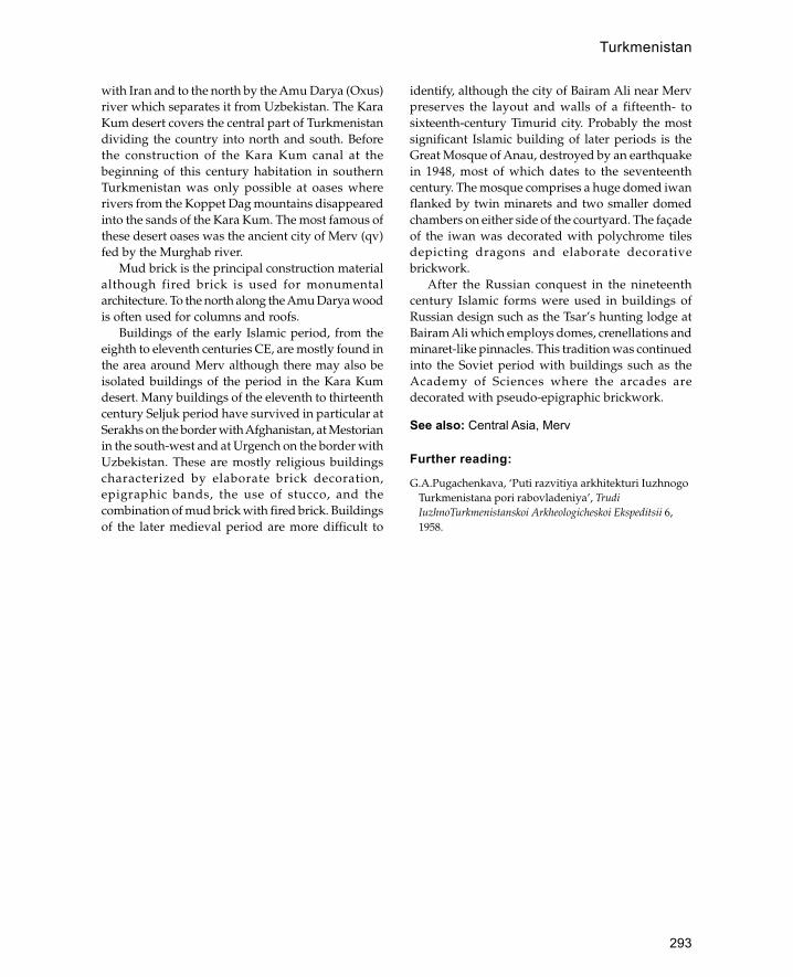
293
with Iran and to the north by the Amu Darya (Oxus)river which separates it from Uzbekistan. The KaraKum desert covers the central part of Turkmenistandividing the country into north and south. Beforethe construction of the Kara Kum canal at thebeginning of this century habitation in southernTurkmenistan was only possible at oases whererivers from the Koppet Dag mountains disappearedinto the sands of the Kara Kum. The most famous ofthese desert oases was the ancient city of Merv (qv)fed by the Murghab river.
Mud brick is the principal construction materialalthough fired brick is used for monumentalarchitecture. To the north along the Amu Darya woodis often used for columns and roofs.
Buildings of the early Islamic period, from theeighth to eleventh centuries CE, are mostly found inthe area around Merv although there may also beisolated buildings of the period in the Kara Kumdesert. Many buildings of the eleventh to thirteenthcentury Seljuk period have survived in particular atSerakhs on the border with Afghanistan, at Mestorianin the south-west and at Urgench on the border withUzbekistan. These are mostly religious buildingscharacterized by elaborate brick decoration,epigraphic bands, the use of stucco, and thecombination of mud brick with fired brick. Buildingsof the later medieval period are more difficult to
identify, although the city of Bairam Ali near Mervpreserves the layout and walls of a fifteenth- tosixteenth-century Timurid city. Probably the mostsignificant Islamic building of later periods is theGreat Mosque of Anau, destroyed by an earthquakein 1948, most of which dates to the seventeenthcentury. The mosque comprises a huge domed iwanflanked by twin minarets and two smaller domedchambers on either side of the courtyard. The façadeof the iwan was decorated with polychrome tilesdepicting dragons and elaborate decorativebrickwork.
After the Russian conquest in the nineteenthcentury Islamic forms were used in buildings ofRussian design such as the Tsar’s hunting lodge atBairam Ali which employs domes, crenellations andminaret-like pinnacles. This tradition was continuedinto the Soviet period with buildings such as theAcademy of Sciences where the arcades aredecorated with pseudo-epigraphic brickwork.
See also: Central Asia, Merv
Further reading:
G.A.Pugachenkava, ‘Puti razvitiya arkhitekturi IuzhnogoTurkmenistana pori rabovladeniya’, TrudiIuzhnoTurkmenistanskoi Arkheologicheskoi Ekspeditsii 6,1958.
Turkmenistan

294
Ukhaidhir
Early Abbasid palace in the desert of south-western Iraq.
The palace stands in the desert west of the city ofKerbala and east of the oasis of Shithatha. The buildingis made out of rough-hewn limestone blocks and mudplaster with baked brick used for roofing vaults,resembling earlier Sassanian structures (cf. Kharanain Jordan). The palace may be divided into twostructural phases, a central palace core and an outerenclosure wall added slightly later. The exteriorcurtain wall is composed of tall blind nichesalternating with solid semi-circular buttress towers.On top of the wall there was a parapet which wascantilevered over the niches allowing a continuousseries of slits (machicolation) which could protect thelower parts of the wall from attack. The main gatewayis set between two quarter-round towers and containsa slot for a portcullis. To the right of the entrance onthe outside there is a large stable block. The central
core of the palace contains a mosque, a bath houseand a main reception hall. The upper floor is reachedby ramps running up at right angles to the axis ofthe main gateway. There are small tunnels runningover the main vaults which provided cool-ing andventilation.
Recent survey work in the vicinity of Ukhaidhirhas demonstrated the development of the areaduring the early Isalmic period, starting with thesmall palace at Tulul Ukhaidhir several kilometresto the north of the main palace. In addition there isan outer mud-brick enclosure containing a varietyof mud-brick buildings which are now only visibleas humps.
See also: Abbasids: Atshan, Khan; Iraq;Sassanians
Further reading:
G. Bell, Palace and Mosque at Ukhaidhir: A Study in EarlyMuhammadan Architecture, Oxford 1914.
U
Plan of Ukhaidhir Palace, Iraq (after Mehdi)

295
B. Finnster and J. Schmidt, Sasaidische und fruhislamischeRuinem im Iraq, Baghdader Mitteilungen 8, Berlin 1976.
ulu cami
Turkish term for a congregational or Friday mosque.
Umayyads
The dynasty of Umayyad caliphs was based in Syria andruled the Islamic world from 660 to 750 CE.
Under the Umayyads the Islamic state wastransformed from a theocracy to an Arab monarchy.In 661 Ali, the last Orthodox caliph was murderedand Mu�awiya, the governor of Syria, became thefirst Umayyad caliph. Mu�awiya provided the cen-tralization essential for the survival and continuingexpansion of the Arab Empire. At its heightUmayyad rule extended from the Atlantic coast ofNorth Africa to India and from Central Asia to theYemen. The administration of conquered provinceswas usually left intact, so that the tax accounts forSyria, for example, continued to be kept in Greek.Socially, however, Umayyad rule was characterizedby the domination of Arabs.
The success of the Umayyad caliphate carriedwithin it the seeds of its own destruction. Becausethe economic and social structure of the empire wasdependent on the conquest of new lands, anysetbacks or reverses caused resentment and dissat-isfaction throughout the regime. Similarly the secularnature of the dynasty aroused opposition amongstthose in favour of a more theocratic state. In 747 arevolution against the Umayyads began inKhurassan and soon spread throughout the easternpart of the empire. By 750 the Umayyad regime hadbeen defeated to be replaced by the Abbasids whoruled from Iraq. Only one branch of the Umayyadssurvived by fleeing to Spain where the dynastycontinued to rule until 1051 CE.
Almost all surviving Umayyad monuments arein Syria and Palestine whence the dynasty derivedmost of its support. As the Arabs did not have anarchitectural tradition suited to the needs of a greatempire, they adopted the building methods of thedefeated Sassanian and Byzantine empires. Becausethey ruled from Syria, Byzantine influence wasstronger, although Sassanian elements becameincreasingly important. In many cases Byzantine oreven Roman buildings were simply taken over withlittle or no modification. However, the conquests did
provide some innovation both in terms of buildingtypes and in the prominence given to decoration.
The most important building projects under-taken during the Umayyad era included mosques,palaces and cities. Mosques were obviously animportant element in the expansion of the Islamicstate although the speed of the conquests meant thatthese were often temporary structures or convertedchurches. New cities were built in answer to specificrequirements, such as the need for an administrativecentre rather than for dynastic propaganda as in theAbbasid period. The most characteristic type ofbuilding is the ‘Desert Palace’ built as a residencefor the ruling élite.
The earliest Islamic cities were garrison townssuch as Basra and Kufa, built as centres for theconquest of Khurassan and Central Asia. TheUmayyads continued this policy of building citieswhich were little more than giant military camps,although significantly these were unfortified. Themost important city of this type was Wasit built in701 by Yussuf ibn al-Hajjaj the Umayyad governorof Iraq. Architecturally these cities were importantbecause they were divided according to tribalgroups, each with its own masjid, which prefiguressimilar divisions in later Arab cities. Trade was alsoa powerful stimulus for the foundation and growthof cities in the early Islamic period. The frontiers ofthe Islamic state were particularly con-ducive to thegrowth of cities in North Africa and in eastern Iranmilitary camps quickly grew into trading cities.
Mosques were an essential part of early Islamicgovernment as they provided a meeting place atwhich important announcements could be made.Early on two separate mosque-building traditionsdeveloped; in Syria this was based on the conversionof churches whilst in Iraq mosques developed outof square enclosures used for prayer. The earliestIraqi mosque for which we have archaeologicalevidence is the Friday mosque at Wasit built to asquare plan with a hypostyle roof. The oldest Islamicbuilding in the west is the Dome of the Rock builtby Abd al-Malik in 691. However, this building is asanctuary rather than a mosque and its influence onlater Islamic architecture is limited.
More important in terms of mosquedevelopment is the Great Mosque in Damascusbuilt by the caliph al-Walid in 705 CE. This buildingis modelled on Syrian churches, which after theconquest were used as mosques. Churches wereconverted to mosques by blocking up the west door
Umayyads
296
and piercing the north wall with doorways, creatinga building with a lateral axis perpendicular to thedirection of prayer. Mosques built in the same styleas Damascus include Qasr al-Hayr, QusayrHallabat, Raqqa, Balis, Diyarbakir and Der�a. Otherdevelopments in religious architecture in theUmayyad period include the introduction of themihrab and the minaret.
In secular building the most importantconstructions of the Umayyad period were thedesert palaces of Syria and Palestine. Some of thesebuildings were new foundations, whilst others wereRoman or Byzantine forts converted to meet theneeds of the new Arab rulers. Significantly, most ofthese buildings were abandoned soon after the fallof the Umayyad regime and they remain asmonuments to the wealth and tastes of the dynasty.Their size and scale vary enormously, from thesmall and lavishly decorated bath house of QusayrAmrah to the great fortified city-palace of Qasr al-Hayr al-Sharqi. From the outside most of thesebuildings resemble fortresses; thus the mainentrance of Qasr al-Hayr al-Sharqi is protected bytwo tall semi-circular towers and a machicolice. Insome of the palaces the effect of the fortifications issoftened by great decorative friezes, as at Mshatta,Qasr al-Hayr al-Gharbi and Khirbet al-Mafjar. Mostof these palaces include a bath house and a mosqueas well as living accommodation arrangedaccording to the bayt system. Each palacecomprised a number of bayts, each of which wouldhouse a family or tribal unit. There is very littledifferentiation between the rooms within each bayt,so they were probably used simply as shelters in asimilar manner to a bedouin tent with no permanentfixtures.
The building techniques employed by theUmayyads were as diverse as the regions theyconquered, so that major projects would employworkmen of several different nationalities. At itsmost conservative Umayyad architecture is indistin-guishable from either Byzantine or Sassanian workbut usually there is a combination of eastern andwestern elements which produce an unmistakablyIslamic building. One of the best examples of thismixture is to be found at Mshatta where the wallsare of cut stone in the Syrian tradition, the vaults areconstructed in the Mesopotamian fashion and thedecorative carving is a mixture of Byzantine andCoptic motifs.
The most common building materials used in
this period were stone, wood and brick. In Syriathe majority of buildings were constructed out ofcut stone or ashlar masonry. The quality ofUmayyad masonry is generally very high withsharp edges, tight joins and large blocks producingbuildings with a monumentality unsurpassed inlater Islamic building. Ashlar masonry isparticularly suited to the construction of largevertical surfaces which can be enlivened by carving,as on the entrance façade at Mshatta. With theexception of basalt most stone is unsuitable forroofing large areas and only small spans could beroofed with barrel vaulting. In general Umayyadarchitecture avoided the problem of intersectingvaults so that most buildings were either made upof small units or roofed in wood.
In Syria, timber from the forests of Lebanon wasoften used for roofing. Roofs were either shallow,pitched structures supported by wooden trusses, asin the Great Mosque of Damascus, or occasionallywooden domes, as in the Dome of the Rock or theAqsa Mosque. Timber was also used for centring,scaffolding, tie-beams and mosque furniture such asminbars.
Although brick architecture was common toboth the Byzantine and Sassanian empires its usein Umayyad architecture was limited to the easternpart of the empire. The availability of suitable stonein Syria meant that bricks were rarely used thereeven in Byzantine times. When bricks were used inSyria it is significant that the Mesopotamian stylewas used with thin joints, rather than the thicklayers of mortar used in the Byzantine tradition.Examples of this are found at Qasr al-Tuba andMshatta. In Iraq both baked brick and mud brickwere used extensively. Often baked brick was usedfor pillars, vaults and the lower courses of wallswhilst mud brick was used for the upper parts.Examples can be seen at Wasit and Usqaf BaniJunayd.
Umayyad architecture can be distinguished fromthat of earlier periods by its use of decorativetechniques. None of these was new but the varietyand scale of decorative effects was far greater thanever before. The most important decorative methodsemployed were mosaic, wall painting, sculpture andrelief carving.
Although it is probable that most Umayyadmosaics were made by Byzantine craftsmen, themotifs used and the choice of designs usuallyindicate an Islamic influence. The earliest Islamic
Umayyads
297
mosaics are those in the Dome of the Rock, whichconsist of gold and polychrome tesserae inrepresentations of Byzantine and Sassanian royaljewels. The Great Mosque in Damascus contains avery important group of mosaics depicting an idealcity which, significantly, is devoid of people. This isdue to the ban on figural representation in mosquesand is a good example of Byzantine art adapted forIslamic purposes. Even in the desert palaces mosaicsusually avoided figures, although occasionally, as atKhirbet al-Mafjar, there are representations ofanimals.
In addition to floor mosaics most Umayyadpalaces were decorated with frescoes, usually onwalls, although occasionally on floors, as at Qasral-Hayr al-Gharbi. The best preserved paintingsare those at Qusayr Amrah which includerepresentations of a great hunt, half-naked dancinggirls and a famous portrait of six rulers of theworld.
Sculptures are found at a number of desertpalaces, most notably Khirbet al-Mafjar and Qasr al-Hayr al-Gharbi. Both eastern and western sculpturaltraditions were used, although the medium wasusually stucco rather than stone. Because stucco isnot free-standing, sculptures were usuallyincorporated into some structural feature of abuilding such as the entrance.
See also: bayt, masjid, mihrab, minaret
Further reading:
K.A.C.Creswell, A Short Account of Early MuslimArchitecture, ed. by J.Allen, Aldershot 1989.
R.Ettinghausen, From Byzantium to Sassanian Iran and theIslamic World, Leiden 1976.
R.Hillenbrand, ‘La dolce vita in Early Islamic Syria: theevidence of later Umayyad palaces’, Art History 5(1): 1–35, 1982.
H.N.Kennedy, The Prophet and the Age of the Caliphates: TheIslamic Near East from the Sixth to the Eleventh Century,London and New York 1986.
United Arab Emirates (UAE)Federation composed of the seven emirates of Fujairah,Ajman, Ras al-Khaimah, Abu Dhabi, Dubai, Umm al-Quwain and Sharjah. The country previously known asthe Trucial Coast is located on the Arabian side of theGulf between Qatar and Oman. The eastern part of thecountry bordering on Oman is mountainous whilst thewestern part is flat sandy coastal plain.
The traditional materials of construction in theemirates are coral, mud brick, dry stone and woodand thatch. Coral obtained from the coastal reefs isthe prime building material on the coast. Two formsare used, irregular rubble blocks set into a thickmortar known as ‘sarooj’ and thin coral slabs usedas panels between load-bearing pillars. Mangrovewood obtained from East Africa is used both asstrengthening for walls and for roof beams. Themaximum length of mangrove poles is 3.5 m whichimposes a rigid geometry on the coastal houses.Ceilings resting on the mangrove beams are madeof planks of date-palm wood and are sometimespainted.
In oasis towns, such as al-Cain on the Omaniborder, houses are built out of mud brick with split-palm beams used for roofing in a manner commonthroughout the Arabian peninsula. Often the lowerparts of the walls are built from large stone blocks tostrengthen the buildings against water and winderosion. The most ephemeral buildings are thosebuilt of palm fronds and wood, although it is likelythat in the past these may have been the commonestform of dwelling. Palmfrond, or barasti, houses areusually built on a wooden frame made out ofmangrove poles, split-palm trunk or any otheravailable wood. The palm fronds are used in twoforms, either as straight poles (approximately 1 mlong) stripped of their leaves used for creatingscreens or with the leaves still on for roof thatch.The shape of palm-frond houses varies from squareor rectangular flat-roofed buildings to triangulartent-like structures.
In the mountains in the east of the countryhouses are built out of irregular-shaped blocks laidwithout mortar; inside, the walls of the houses maybe plastered with mud. The flat roofs are made outof palm fronds or any other locally available wood.Sometimes the houses are built into the ground,with triangular pitched roofs made of palm wood.Most of the stone houses are rectangular, althoughin the central mountains of the UAE round stonehouses are also found, with roofs made of mountainbushes.
Before the twentieth century the emiratesdepended on trade and fishing for their primaryincome. Each town was located on a creek orpeninsula with easy access to the sea and a hinterlandused for agriculture. The most famous of these towns(now disappeared) is Julfar which had extensivetrade links with East Africa, India and the Far East
United Arab Emirates (UAE)
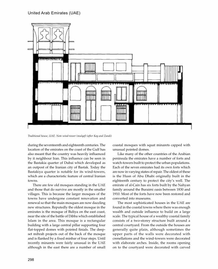
298
during the seventeenth and eighteenth centuries. Thelocation of the emirates on the coast of the Gulf hasalso meant that the country was heavily influencedby it neighbour Iran. This influence can be seen inthe Bastakia quarter of Dubai which developed asan outpost of the Iranian city of Bastak. Today theBastakiya quarter is notable for its wind-towers,which are a characteristic feature of central Iraniantowns.
There are few old mosques standing in the UAEand those that do survive are mostly in the smallervillages. This is because the larger mosques of thetowns have undergone constant renovation andrenewal so that the main mosques are now dazzlingnew structures. Reputedly the oldest mosque in theemirates is the mosque of Bidiya on the east coast,near the site of the battle of Dibba which establishedIslam in the area. This mosque is a rectangularbuilding with a large central pillar supporting fourflat-topped domes with pointed finials. The deep-set mihrab projects out of the back of the mosqueand is flanked by a fixed minbar of four steps. Untilrecently minarets were fairly unusual in the UAEalthough in the east there are a number of small
coastal mosques with squat minarets capped withunusual pointed domes.
Like many of the other countries of the Arabianpeninsula the emirates have a number of forts andwatch-towers built to protect the urban populations.Each of the seven emirates had its own forts whichare now in varying states of repair. The oldest of theseis the Husn of Abu Dhabi originally built in theeighteenth century to protect the city’s well. Theemirate of al-Cain has six forts built by the Nahyanfamily around the Buraimi oasis between 1830 and1910. Most of the forts have now been restored andconverted into museums.
The most sophisticated houses in the UAE arefound in the coastal towns where there was enoughwealth and outside influence to build on a largescale. The typical house of a wealthy coastal familyconsists of a two-storey structure built around acentral courtyard. From the outside the houses aregenerally quite plain, although sometimes theupper parts of the walls were decorated withcrenellations and the wind-towers were decoratedwith elaborate arches. Inside, the rooms openingon to the courtyard were decorated with carved
Traditional house, UAE. Note wind-tower (mulqaf) (after Kay and Zandi)
United Arab Emirates (UAE)
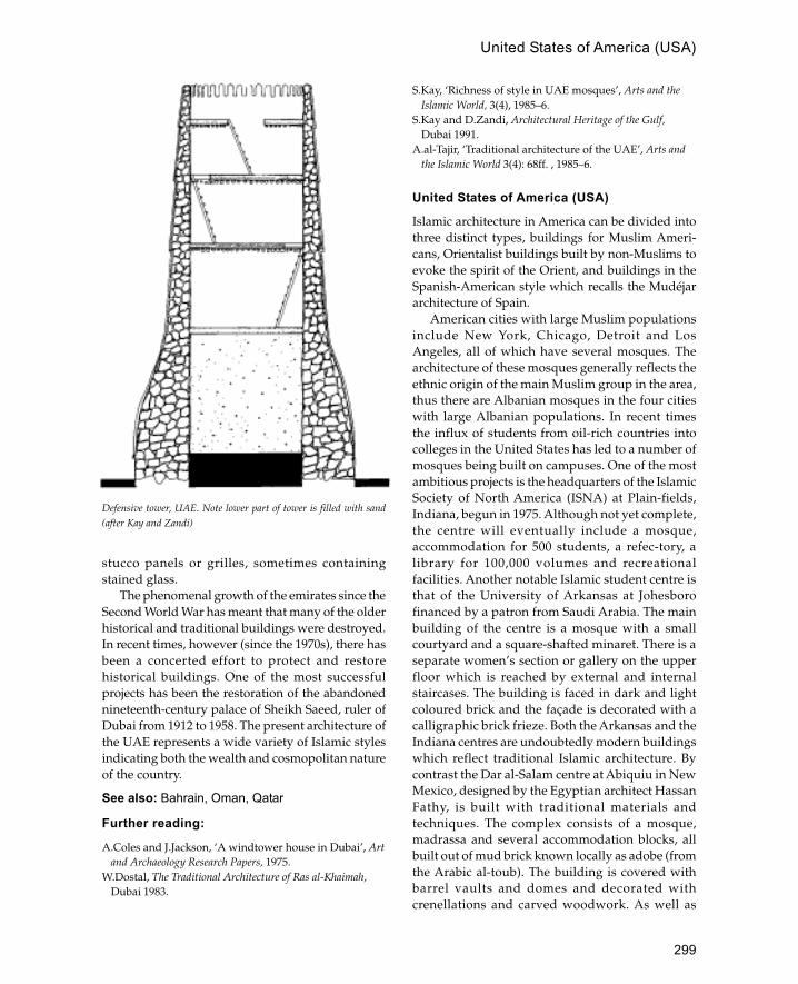
299
stucco panels or grilles, sometimes containingstained glass.
The phenomenal growth of the emirates since theSecond World War has meant that many of the olderhistorical and traditional buildings were destroyed.In recent times, however (since the 1970s), there hasbeen a concerted effort to protect and restorehistorical buildings. One of the most successfulprojects has been the restoration of the abandonednineteenth-century palace of Sheikh Saeed, ruler ofDubai from 1912 to 1958. The present architecture ofthe UAE represents a wide variety of Islamic stylesindicating both the wealth and cosmopolitan natureof the country.
See also: Bahrain, Oman, Qatar
Further reading:
A.Coles and J.Jackson, ‘A windtower house in Dubai’, Artand Archaeology Research Papers, 1975.
W.Dostal, The Traditional Architecture of Ras al-Khaimah,Dubai 1983.
S.Kay, ‘Richness of style in UAE mosques’, Arts and theIslamic World, 3(4), 1985–6.
S.Kay and D.Zandi, Architectural Heritage of the Gulf,Dubai 1991.
A.al-Tajir, ‘Traditional architecture of the UAE’, Arts andthe Islamic World 3(4): 68ff. , 1985–6.
United States of America (USA)
Islamic architecture in America can be divided intothree distinct types, buildings for Muslim Ameri-cans, Orientalist buildings built by non-Muslims toevoke the spirit of the Orient, and buildings in theSpanish-American style which recalls the Mudéjararchitecture of Spain.
American cities with large Muslim populationsinclude New York, Chicago, Detroit and LosAngeles, all of which have several mosques. Thearchitecture of these mosques generally reflects theethnic origin of the main Muslim group in the area,thus there are Albanian mosques in the four citieswith large Albanian populations. In recent timesthe influx of students from oil-rich countries intocolleges in the United States has led to a number ofmosques being built on campuses. One of the mostambitious projects is the headquarters of the IslamicSociety of North America (ISNA) at Plain-fields,Indiana, begun in 1975. Although not yet complete,the centre will eventually include a mosque,accommodation for 500 students, a refec-tory, alibrary for 100,000 volumes and recreationalfacilities. Another notable Islamic student centre isthat of the University of Arkansas at Johesborofinanced by a patron from Saudi Arabia. The mainbuilding of the centre is a mosque with a smallcourtyard and a square-shafted minaret. There is aseparate women’s section or gallery on the upperfloor which is reached by external and internalstaircases. The building is faced in dark and lightcoloured brick and the façade is decorated with acalligraphic brick frieze. Both the Arkansas and theIndiana centres are undoubtedly modern buildingswhich reflect traditional Islamic architecture. Bycontrast the Dar al-Salam centre at Abiquiu in NewMexico, designed by the Egyptian architect HassanFathy, is built with traditional materials andtechniques. The complex consists of a mosque,madrassa and several accommodation blocks, allbuilt out of mud brick known locally as adobe (fromthe Arabic al-toub). The building is covered withbarrel vaults and domes and decorated withcrenellations and carved woodwork. As well as
Defensive tower, UAE. Note lower part of tower is filled with sand(after Kay and Zandi)
United States of America (USA)

300
being a religious centre Dar al-Salam will alsofunction as a centre for traditional architecture andtechnology.
Orientalist architecture in the USA is primarily afeature of the early twentieth century and is a productof the incredible wealth of America combined withcinema-inspired fantasy (e.g. The Thief of Baghdad).This can be seen in the numerous cinemas built inthe Moorish palace style with names like theAlhambra. The most complete examples of thisIslamic fantasy architecture is the city of Opa-Lockaconceived as ‘the Baghdad of south Florida’. Thebuildings have horseshoe-shaped windows,minarets, domes and crenellations. The mostimportant building is the city hall, built as a fortifiedcitadel with thick crenellated enclosure walls. Thisbuilding is covered with five large domes and framedby four minarets (three small cylindrical towers andone huge octagonal tower). Other Islamic-stylebuildings in the city include the railway station, thearchery club, the archaeological museum and theOpa Locka hotel.
The discovery of the New World and theexpulsion of Muslims from Spain occurred in thesame year, 1492. The result was that a large numberof Muslims converted to Christianity and emigratedto the New World where their skills were used inthe development of New Spain. Mudéjar (forcedMuslim converts to Christianity) style architecturein America is found mostly in Mexico and CentralAmerica, although it can also be seen in the southand west of the USA in Texas, New Mexico andCalifornia.
See also: Mudéjar, Spain
Further reading:
N.Ardalan, ‘Architects in America design for Islamiccultures’, Arts and the Islamic World 3(3): 46–50, 1985.
F.S.Fitzgerald Bush, A Dream of Araby (n.d.).C.Hotchkiss Malt, ‘Opa-Locka: American city with
Islamic design’, Arts and the Islamic World, 1(3): 33–6,1983.
A.Schleifer, ‘Hassan Fathy: a voyage to New Mexico’,Arts and the Islamic World 1(1): 1982/3.
UrgenchAncient capital of Khorezm in western Uzbekistan.
Urgench was established as the Mongol capital inthe early fourteenth century. The most prominentremains at the site is the tomb of Turabek Khanum
dated to 1320. This has a massive portal with amuqarnas vault. Outside, the tomb has a polygonalplan whilst the interior is hexagonal.
Uzbekistan
Independent Central Asian Republic with apredominantly Muslim population.
Uzbekistan occupies a vast area between Afghanistan,Turkmenistan and Khazakstan; most of this area isdesert, semi-desert or steppe. The main areas ofoccupation are the western area of Khorezm, wherethe river Amu Dar�ya enters the Aral Sea, and thecities of Bukhara and Samarkand on the Zeravshanriver. The population of the Republic ispredominantly Uzbek (Turkic) although Persian wasthe main language in the early Islamic period.
The main source of prosperity for this region isthe trans-continental trade route between China,India, the Middle East and Europe known as the SilkRoute. The trade led to the establishment of urbancentres on the edge of the deserts of Central Asia.From the second century this trade was controlledby the Kushans, a semi-nomadic people fromChinese Central Asia. The Kushans built up a vastempire which controlled most of the trade passingthrough Central Asia. In the fourth century theSassanians took control of the western part of thetrade routes and reduced the Kushans to a series ofindependent principalities. The central part of theroute was controlled by the Soghdians who occupiedSamarkand and Bukhara. The first Arab raidsoccurred in the mid-seventh century, although it wasnot until the beginning of the eighth century thatany real conquests were made with the capture ofBukhara and Samarkand. By the mid-eighth centurymost of the region was under Arab control. By theninth century a Persian dynasty known as theSamanids was in control of both Bukhara andSamarkand. The Samanids were nominally vassalsof the Abbasids although they acted independently.During this period Islam gradually replacedBuddhism, Manichaeism and Zo-rastrianism as themain religion of the area. At the end of the tenthcentury the Samanids were replaced by theKarakhanid Turks who established Samarkand astheir capital. During the eleventh century the SeljukTurks rapidly expanded west-wards from their basein the region of Khorezm in western Uzbekistan. Theregion of Khorezm was left under the rule of theKhorezmshas who were vassals of the Seljuks. In
Urgench
301
1077 the Khorezmshas declared themselvesindependent, establishing their capital at Urgench.By the twelfth century the Khorezmshas had gainedcontrol of most of Central Asia. This period of greatprosperity was inter-rupted by the Mongol invasionsof the early thirteenth century. The earliest period ofMongol rule in the region was not characterized assuccessful, although under the Timurids in thefourteenth and fifteenth centuries it entered one ofthe most brilliant periods of history. In the sixteenthcentury the region was conquered by the Uzbekswho now form the majority of the population.
The main building materials are mud brick andpisé, baked brick and wood. Stone is generally notavailable for use as a building material. In addition tothe fixed buildings temporary or mobile dwellings(yurt) are made of felt over a wooden frame. Fortraditional houses throughout the region mud brickand pisé are most commonly used. Some of the bestexamples of mud architecture are the fortified wallswhich surround most settlements from small villagesto major cities such as Bukhara. Important buildingssuch as mosques, madrassas and mausoleums weresometimes built of baked brick. In pre-modern times
the standard brick form was a square tile 5–7 cm thick.These were used in a variety of decorative patternsproduced by placing bricks in alternating groupsvertically and horizontally. From the twelfth centuryglazed bricks were used and eventually becamecommon in the fifteenth century under the Timurids.Although wood has always been rare, especially inthe eastern parts of Uzbekistan, it was used for roofsand occasionally for columns, especially in mosquesand palaces. Some of the best examples of woodenarchitecture are in Khiva and include carved woodencolumns with muqarnas capitals and bulbous lotusbases resembling lotus buds. Wooden ceilings areoften painted.
The majority of Islamic monuments inUzbekistan are found in Bukhara and Samarkandwhilst Khiva is a good example of traditionalnineteenth-century architecture. Outside these citiesthe most important monuments in the country areat Shahr-i Sabz, the village which Timur tried to makehis capital.
See also: Bukhara, Samarkand, Shahr-i Sabz,Timurids
Uzbekistan

302
wakala
Urban building combining the functions of khan,warehouse and market.
waqf
A charitable endowment often intended for theupkeep of a religious building, educationalestablishment or hospital.
Wasit
Capital of Iraq during the Umayyad period.
Wasit lies south-east of the modern town of Kut insouthern Iraq. It was founded in 701 CE by al-Hajjaj,governor of Iraq, as a garrison town to replace Kufaand Basra which had been demilitarized after a revoltagainst the Umayyads. In 874 another Friday mosquewas built by the Turkish general Musa ibn Bugha inthe eastern part of the city. The devastation wroughtby the Mongols in the thirteenth century and byTimur in the fourteenth hastened the decline of acity that was no longer on the main trade routes dueto a change in the course of the Tigris.
The first mosque on the site was built by al-Hajjajin 703; measuring 100 m per side, it was located nextto the governor’s residence. Iraqi excavationsrevealed two superimposed mosques, the earlier ofwhich had no mihrab. This confirms the early dateof the mosque, as the first concave mihrab wasintroduced by al-Walid in 707–9 in the mosque ofMedina.
There are also the remains of a thirteenth-cen-turymadrassa on the site, consisting of a monumentalportal flanked by twin minarets with fluted brickdecoration.
West Africa
Region of Africa comprising the modern states of Mali,Mauritania, Senegal, Niger, Nigeria, Cameroon, BurkinaFaso, Guinea and Ghana.
Known to medieval geographers as the Sudan,this area extends from the Sahara desert in the northto the mouth of the Niger river in the south, andfrom Atlantic in the west to Lake Chad in the east.The region was subject to the influence of Islam fromthe eighth or ninth century onwards and by thenineteenth century large areas were Islamicized.
West Africa can be divided into four main zones,the Sahara, the Sahel, the Savannah and the rainforests. The largest zone is the Sahara desert whichextends from the Atlas mountains in Morocco andAlgeria to the Senegal river. Until recent times thevast dunes and extreme temperatures of this deserthave formed an impenetrable barrier to all exceptthe nomadic tribes which inhabit the area. South ofthe desert is band of semi-arid country known asthe Sahel (Arabic for ‘coast’) where there is anintermittent vegetation of scrub and occasionalsmall trees. Below this is the Savannah regioncharacterized by a rich growth of grass and plentifulseasonal rainfall. Further south near the coast,especially in Nigeria, Benin, Togo and Ghana, arethe dense rain-forests. In recent times the area ofthe Sahara and the Sahel have been increasing atthe expense of the Savannah, probably due tohuman activity. The best example of thisphenomenon is the area occupied by the empire ofGhana which in medieval times was rich grasslandand is now desert.
History
The means by which Islam penetrated into WestAfrica was via the trade routes from North Africa.The main goods involved in the trade includedgold, slaves, ivory and gum from West Africa andmanufactured goods from the Mediterranean area.This trade was a continuation of pre-Islamic Romanand Byzantine trade routes and was in the hands ofthe Berber tribes of the Sahara. Already by the endof the seventh century there are accounts of Muslimtraders from North Africa and Egypt in the markets
W
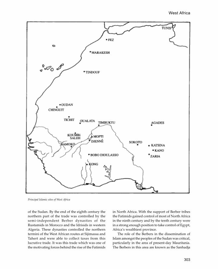
303
West Africa
of the Sudan. By the end of the eighth century thenorthern part of the trade was controlled by thesemi-independent Berber dynasties of theRustamids in Morocco and the Idrisids in westernAlgeria. These dynasties controlled the northerntermini of the West African routes at Sijimassa andTahert and were able to collect taxes from thislucrative trade. It was this trade which was one ofthe motivating forces behind the rise of the Fatimids
in North Africa. With the support of Berber tribesthe Fatimids gained control of most of North Africain the ninth century and by the tenth century werein a strong enough position to take control of Egypt,Africa’s wealthiest province.
The role of the Berbers in the dissemination ofIslam amongst the peoples of the Sudan was critical,particularly in the area of present-day Mauritania.The Berbers in this area are known as the Sanhadja
Principal Islamic sites of West Africa
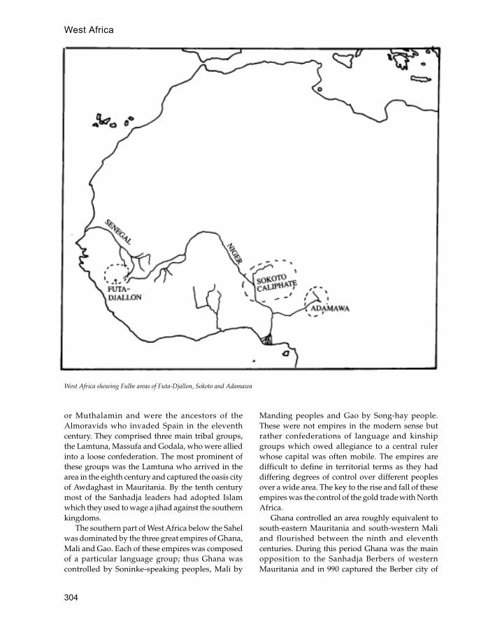
304
West Africa
or Muthalamin and were the ancestors of theAlmoravids who invaded Spain in the eleventhcentury. They comprised three main tribal groups,the Lamtuna, Massufa and Godala, who were alliedinto a loose confederation. The most prominent ofthese groups was the Lamtuna who arrived in thearea in the eighth century and captured the oasis cityof Awdaghast in Mauritania. By the tenth centurymost of the Sanhadja leaders had adopted Islamwhich they used to wage a jihad against the southernkingdoms.
The southern part of West Africa below the Sahelwas dominated by the three great empires of Ghana,Mali and Gao. Each of these empires was composedof a particular language group; thus Ghana wascontrolled by Soninke-speaking peoples, Mali by
Manding peoples and Gao by Song-hay people.These were not empires in the modern sense butrather confederations of language and kinshipgroups which owed allegiance to a central rulerwhose capital was often mobile. The empires aredifficult to define in territorial terms as they haddiffering degrees of control over different peoplesover a wide area. The key to the rise and fall of theseempires was the control of the gold trade with NorthAfrica.
Ghana controlled an area roughly equivalent tosouth-eastern Mauritania and south-western Maliand flourished between the ninth and eleventhcenturies. During this period Ghana was the mainopposition to the Sanhadja Berbers of westernMauritania and in 990 captured the Berber city of
West Africa showing Fulbe areas of Futa-Djallon, Sokoto and Adamawa
305
West Africa
Awdaghast. Although it was a pagan country therewere large numbers of Muslims in Ghana’sadministration and by the eleventh century thecapital was divided into two cities, a Muslim cityand a pagan royal city. In spite of this the AlmoravidBerbers launched a jihad against the empire and in1077 destroyed the capital and forced the survivorsto convert to Islam. A reconstituted kingdom ofGhana managed to survive until 1240 when it wasincorporated into the empire of Mali.
The rise of Mali was due to a number of factorsincluding the decline of the empire of Ghana andthe discovery of a new oriferous (gold producing)region on the Niger river. The Mali Empire wasformed by the unification of two groups of Mandingpeoples in the thirteenth century, and was locatedsouth of Ghana on the banks of the Niger, althoughit later took control of much of the former empireof Ghana. Unlike Ghana’s, the ruler of Mali was aMuslim although most of the people within theempire remained pagan. The most famous of Mali’srulers was Mansa Musa who made a pilgrimage toMecca in 1324 during which he gave away largequantities of gold. By the end of the fifteenthcentury Mali was in decline due to the devastatingeffects of rival claimants to the throne, a shift intrade patterns and increasing attacks from theTuareg and Mossi. The empire which grew toreplace the power of Mali was the Songhay Empireof Gao, with its centre on the banks of the Niger inthe east of the modern state of Mali. Gao had a longhistory stretching back to the ninth century whenit was an important kingdom on the route to Tahertin Algeria and Ghana and Silgilmasa to the west.By the ninth century the ruler of Gao was Muslim,although it is probable that this was merely one ofthe king’s religions. During the thirteenth andfourteenth centuries Gao became subject to theempire of Mali; when this declined at the end ofthe fourteenth century Gao began taking over someof the outer dependencies of Mali. By the end ofthe 1460s Ali, the founder of the Songhay Empire,had taken Djenné and Timbuktu thus gainingcontrol of some of the principal trading towns ofthe Sahel. Ali was succeeded by Askiya Muhammadwho consolidated his territorial conquests andintroduced Islam as the state religion. The empireflourished for the next hundred years until theMoroccan conquest of 1591.
In addition to the medieval empires whichdominated West Africa there are a number of
trading cities on the border of the Sahara desertwhich, although sometimes incorporated intoempires, were essentially independent. The mostimportant of these cities were, from east to west,Oualata, Timbuktu and Agades. Oualata in westernMauritania rose to prominence in the thirteenthcentury after the collapse of Ghana when it waspopulated by refugees from Awdaghast and othercities. The city was predominantly Ibadi with amixed Arab Berber population and was one of theprincipal towns trading with Sijilmasa in Morocco.Further west, in the modern state of Mali, is thefamous city of Timbuktu, established as a nomadicTuareg encampment in the twelfth century. Duringthe fifteenth century under Songhay rule the citybecame the principal intellectual and religiouscentre in West Africa. The city has a mixedpopulation of predominantly Berber originalthough there are significant numbers of Soninkeand Manding.
Whilst the medieval period in West Africa wasdominated by the great empires the period after thesixteenth century was characterized by theemergence of smaller independent cities andkingdoms. The post-medieval period is also notablefor the integration of Islam into local culture.Whereas Islam had previously been the religion offoreign traders and local rulers who adopted Islamas another attribute of kingship, it now became thereligion of whole groups and villages. In thenineteenth century this was partially achievedthrough jihads or holy wars, but the more commonmethod of diffusion was through the urbanizedtrade networks. The widespread adoption of Islamthroughout West Africa meant that the nature ofthe religion itself was modified to conform to localritual requirements. In most cases this meant thatlocal rituals and cultures were adapted to serveIslamic requirements, although in other cases (suchas among the Ashante) this meant the adaptationof Islamic forms for use in essentially pagansocieties.
Islamic West Africa south of the Sahel can bedivided into two main language groups, theMande-speaking peoples of Mali, Burkina Faso,Ivory Coast and Ghana, and the Fulbe-speakingpeoples of northern Nigeria and Futa-Djallon inGuinea. The Mande-speaking peoples occupyroughly the same area as the empire of Mali,although the main cities of the post-medieval eraare further east than the old capitals of Kangaba

306
West Africa
and Niani. The main Manding cities are Mopti,Djenné, Ségou, Bobo Dioulasso, Wa and Kong, eachof which functioned as independent or semi-independent states in the eighteenth and nineteenthcenturies. The most famous of these cities is Djennéwhose origins may be traced back to the thirteenthcentury. Although the city did not rise toprominence until the sixteenth century, by thenineteenth century it was one of the main towns inWest Africa. Less well known but equally importantin the propagation of Islam was the city of Kongestablished by immigrants from Ségou and Djennéin the eighteenth century. Kong was located furthersouth on the edges of the equatorial forest (present-day Ivory Coast) and developed as a centre ofIslamic scholarship and commerce for thesurrounding area.
The Fulbe-speaking people occupy two distinctareas either side of the area dominated by theMande peoples. First to be settled by Fulbe-speak-ing people was the Hausa area of north Nigeriawhere they arrived as Muslim clerics in the fifteenthcentury. Hausaland already had an established,partially Muslim, society dating from the beginningof the eleventh century, comprising sevenindependent city-states. These cities, known asbakwoi, were Dauro, Kano, Gobir, Katsina, Zaria,Biram and Rano. Kano and Katsina already had anIslamic tradition and it was these cities that theFulbe developed into a seat of Islamic learning andculture. Although Hausaland was subjected tosubsequent waves of influence, most notablySonghay rule in the sixteenth century and large-scale immigration from Agades in the eighteenth,the Fulbe continued to arrive both as clerics andpastoralists. In the nineteenth century the urbanizedFulbe instigated a jihad for Islamic reform in theHausa states. The result was a new state based onthe recently founded capital of Sokoto, known asthe Sokoto caliphate. The success of the Sokotocaliphate encouraged Fulbe in the neighbouringregion of Adamawa (present-day Cameroon) tocarry out a similar jihad from their newlyestablished capital of Yolo. The jihad was similarlysuccessful and Adamawa was eventually includedwithin the Sokoto caliphate.
Two thousand kilometres further west is the otherarea of Fulbe domination in the Futa-Djallon regionof Guinea. The early Fulbe migrations into this areawere peaceful and were accompanied withintermarriage with the native Djallonke people.
From the late seventeenth century onwards there wasan intensification of the immigration until theeighteenth century when it was organized into ajihad. By the end of the eighteenth century Fulbecontrol of the area was complete with a capitalestablished at Timbo.
Architecture
The Islamic architecture of West Africa reflects thecomplexities and diversities of its history as well asthe differing natural environments. In the past,analysis of the architecture of the area has tended toconcentrate on the influence of North Africa and theMiddle East rather than to examine the indigenouscultures and architecture of the area. Three mainsources of influence were identified each of whichignored the possibility of local invention ordevelopment. The most far-fetched idea was that themonumental architecture of the region wasdeveloped from the dynastic architecture of Egyptand was transmitted by the migration of Songhaypeople from the upper Nile to the Niger. The secondexplanation attributes the entire West Africanarchitectural tradition to the Andalusian poet andarchitect al-Saheli who accompanied Mansa Musaon his return from the Hajj in 1324. Whilst there issome information that al-Saheli did design anaudience hall it is unlikely that this or any other workhe may have carried out created an architectural stylefor the whole region. The third suggestion is thatthe Moroccan invasion of 1591 was the primaryinfluence on the subsequent architecture of theregion. Whilst the Moroccan invasion was certainlyaccompanied by builders and craftsmen and mayhave had some influence this was not sufficient tocreate a complex and distinct architectural style.More recently scholars have emphasized thearchitectural styles and beliefs of indigenous pagancultures as influences on the later Islamic architectureof the region.
A wide variety of building materials andtechniques are used over this vast region. Thetechniques are largely defined by the material, whichmay be grouped into three basic types, stone, mudand wood. Stone predominates in the western Saharaand Sahel and tends to be associated with Berberarchitecture. The best examples of stone cities arefound in Mauritania at sites like Chinguit, Oudan,Tijika, Qasr el Barka and Tichit. Excavation hasshown that Koumbi Saleh, the capital of ancient
307
West Africa
Ghana, and its sister city Awdaghast were also builtof stone. Many of these sites were originally foundedas ribats, although they later grew into large tradingcities. The commonest method of building in stonein the area uses split limestone in dry-stone wallconstructions. The limestone used in the buildingscomes in several colours from green and yellow torose, depending on local availability. The outer facesare usually left unplas-tered although at Tichit theinner surfaces are coated in clay and a mud mortaris used for some of the walls (at Oualata both theinner and outer surfaces are covered in mud plaster).A characteristic feature of this masonry is the use oftriangular niches sometimes arranged to formcomposite triangular features. Also common areprojecting corbels, bands of triangular nichesforming chevron patterns and battered walls. Theroof and ceilings are usually built of split date-palmtrunks arranged diagonally over the corners, forminga square shape in the centre which is then coveredby further split-palm beams arranged longitudinally.Above the beams, is placed a woven matting of splitpalm fronds, on top of which a layer of earth isspread. Although in the cities the buildings are builtto a rectangular or square plan, many of the buildingsin villages are built with a round plan or withrounded corners. Even in Chinguit itself many ofthe houses are built with the external cornersrounded off.
Whilst stone is the building material of thewestern Sahara, mud is the characteristic buildingmaterial of the southern Sahel and the Savannahareas. Sometimes mud is used in combination withstone as at Timbuktu and Oualata, suggesting eitherthe integration of two cultural traditions or theinterface between two different environments. AtOualata the buildings are essentially dry-stoneconstructions covered with layers of mud plasterwhich serve no structural function. The effect of themud-plaster coverings is to make the buildings looklike mud-brick structures suggesting a culturaltradition originating from the southern Savannahregions grafted on to an existing Berber architecture.This suggestion is strengthened by the make-up ofthe population, a mixture of Berber and Soninkepeople. Inside the houses of Oualata, the areasaround doorways and niches are decorated withbrilliant white wall paintings in the form ofarabesque medallions. The use of the mixture ofmud and stone at Timbuktu is very different fromthe practice at Oualata; thus the buildings have a
rubble-stone core held together by mud mortar andplaster. The quality of the stones used at Timbuktumean that it would not be possible to build housessolely out of stone, thus the mud plaster and mortarhere perform a structural function whilst the stoneis used for strength. In many Timbuktu housesexposed limestone is used for corner quoins anddoor jambs and the building of any house startswith the laying out of four corner stones. Thedecoration of buildings at Timbuktu suggests aclose relationship with the stone-built Berber citiesof Mauritania; thus the triangular niches andchevron bands are here executed in mud brick. Thisarchitectural similarity is paralleled in the ceilingsand roofs which employ the same method ofdiagonally split palm beams. The preference forstone architecture is most clearly expressed on theinterior of the oldest part of the Djingueré BerMosque where round ‘Roman’ arches made ofdressed limestone are used to support the roof. Thedistinction between stone and mud-brickarchitecture in Timbuktu is observed by the builderswho are divided into two castes depending onwhich material they use. It seems likely that therewas a pre-existing mud-architecture tradition in thearea which was developed by the incoming Berberpopulation who were unable to find their normalbuilding materials. The city of Agades was foundedas a Berber city and one might expect it to be builtof stone especially as the surrounding Berbervillages consist of rectangular stone structures withOualata-style ceilings. However, the city itself ismade almost entirely of mud and resembles theHausa architecture of north Nigeria. The reason forthis could perhaps be attributed to the city’sabandonment in the eighteenth century and itshould be noted that a sixteenth-century travellerdescribed the city as built in the Berber style. Thesubsequent rebuilding of the city in the nineteenthcentury was by people from north Nigeria whichmay explain its close relationship to Hausaarchitecture.
Mud either as brick or as pisé is associated withthe greatest examples of West Africa’s monumentalarchitecture such as the mosque of Djenné or theminaret of Agades. The area most suited to mud-brick architecture is the Savannah region where thereis enough water to make bricks, plaster and pisé yetnot too much rain to dissolve the dried mud walls.Mud architecture lends itself to the creation of plasticsculptural forms on fairly simple structures, thus a
308
West Africa
simple rectangular façade can be enlivened by theaddition of crenellations, engaged pillars anddecorative panels. The traditional methods of mudarchitecture vary from one town to another; thus inDjenné cylindrical mud-bricks are used whereas inother towns simple dried-earth lumps will be usedas the building material. Stylistically there are twomain groups of mud architecture, a western traditionoriginating in the Manding cities of modern Mali anda more easterly tradition in the Hausa cities of northNigeria.
The western style, often referred to as the ‘Sudanstyle’, can trace its origins to the city of Djenné inMali. This architecture is characterized by theelaborate decorated façades of houses whichemphasize verticality by the use of crenellations,engaged pillars and division into several registers.Mosques are distinguished by large minaret-liketowers above the mihrab and tapering buttressesterminating in cone-shaped pinnacles. The mihrabtowers are usually covered with projecting woodenstakes, known as ‘toron’. These stakes were oftenfound all around the walls of a mosque andfunctioned as scaffolding although they may alsohave some ritual significance. The most famousbuilding in Djenné is the Great Mosque built in 1909on the ruins of the previous mosque. It was meantto be a replica but differed considerably from theruined original which had been recorded before itsdestruction. The new mosque was built with Frenchfund-ing and guidance from French militaryengineers and was used by the French as a basis fora neo-Sudanese style. Thus in 1935 the FrenchAdminis-tration at Mopti built a new Fridaymosque, using the new Great Mosque of Djenné asa model. Although the new Sudan style was basedon the pre-colonial style it emphasized symmetryand monumentality at the expense of tradition andritual.
Like the western tradition of mud architecturethe origin of the eastern tradition can be traced toone main town, which in the case of Hausaarchitecture is Kano. Externally Hausa architectureis plainer than its western counterpart, althoughinside it displays a wide variety of decorativemotifs. Hausa buildings are distinguished by theirextensive use of wood and may be regarded astimber-frame buildings as opposed to the morepure mud-brick architecture in the west. The originsof this style are thought to derive from mat-frametents where the mat-walls are gradually replaced
with earth walls. The advantages of this can be seenin the use of one of the most characteristic featuresof Hausa architecture, the ribbed dome. Thisconsists of a number of ribs converging in the centreand covered over with palm-frond matting. Thesedomes may be set on a square or circular baseproducing either a single central point or a centralsquare at the intersection of the ribs. The woodenribs (usually acacia wood) are then plastered withmud to produce free-standing arches which aredecorated with abstract designs. Flat roofs areachieved by building light mud walls on top of theribs between the centre and the outer wall, makingthe ribs into giant armatures or brackets with acurved inner profile. South of the Hausa area in theregion of Adamawa the concept of mud-brickarchitecture with flat roofs is modified by the useof conical thatched roofs. This adaptation isnecessary in a region where high rainfall makes flatroofs impracticable. One of the more interestingresults of this is that in order to preserve theappearance of an Islamic rectangular or squarehouse façades are built on to the front of thatchedbuildings. These stage-like façades built of mud areenlivened by the use of elaborate arabesque designsabove projecting doorways.
Further west, in the Futa-Djallon region ofGuinea, wood and thatch replaces mud as the mainbuilding material. The buildings of this region consistof circular huts covered with huge conical thatchedroofs supported by large central poles. The lowerpart of the roof is supported by shorter polescontained within a circular outer wall. The eaves ofthe thatched roof project beyond the line of the outerwall so that from the outside the walls and entrancesare barely visible. Mosques in the region are built inthe same manner as the houses, but inside the hutthere is a flat-roofed rectangular mud-walledbuilding with a mihrab in the east wall. Accordingto local tradition the mosque is only the squarebuilding inside whilst the outer thatched building ismerely for protection. This arrangement furtherstrengthens the idea that in West Africa Islam canonly be represented by rectangular or squarearchitecture of mud or stone.
Further reading:R.M.A.Bedaux, ‘Tellem, reconnaissance d’une culture de
l’ouest african au moyen âge: recherchesarchitectoniques’, Journal de la Société des Africanistes 42:103–85, 1972.

309
West Africa
R.Bravmann, Islam and Tribal Art in West Africa,Cambridge 1974.
N.David, ‘The Fulani compound and the archaeologist’,World Archaeology 3: 111–31, 1971.
S.Denyer, African Traditional Architecture, New York 1978.A.D.Hyland, Traditional Forms of Architecture in Ghana,
Kumasi 1975.D.Jacques-Meunie, Cités anciennes de Mauritanie, Paris
1961.R.J.McIntosh, ‘Archaeology and mud wall decay in a
West African village’, World Archaeology 6: 154–71,1974.
B.Mallen and C.Benedetti, ‘Afro-Brazilian mosques’,Mimar 29: 1988.
L.Prussin, ‘The architecture of Islam in West Africa’,African Arts 1(2): 32–25 and 70–4, 1968.
—— ‘Sudanese architecture and the Manding’, AfricanArts 3(4): 12–19 and 64–7, 1970.
—— ‘Contribution à l’étude du cadre historique de latechnologie de la construction dans l’Ouest africain’,Journal de la Société des Africanistes 40: 175–8, 1970.
—— ‘West African mud granaries’, Paideuma 18: 144–69,1972.
—— ‘Building technologies in the West Africansavannah’, Le Sol, la parole et l’écrit, mélanges en hommageà Raymond Maury, Paris 1981.
—— Hatumere: Islamic Design in West Africa, Berkeley1986.
J.Sacht, ‘Sur la diffusion des formes d’architecturereligieuse musulmane à travers le Sahara’, Travaux del’Institut de Recherches Sahariennes 11(1): 11–27, 1954.
M.-M.Vire, ‘Stèles funéraires musulmanes soudano-sahariennes’, Bulletin IFAN 21 B (3–4): 459–600, 1959.
310
Yasavi (Shrine of Ahmed Yasavi)
Shrine built by Timur for his son Jahangir between 1397and 1399.
The shrine is located in the city of Turkestan(modern Yasi) in the Republic of Kazakhstan. Thebuilding is oriented north-south on a rectangularground plan (65.5 by 46.5 m) with portals at thesouth and north ends. The main doorway is themagnificent south portal which is flanked by hugecylindrical corner towers or minarets over 20 mhigh. Behind the portal is the dome of the prayerhall rising to a height of over 37 m. At the otherend of the structure is the north façade in the centreof which is the entrance to the mausoleum. Themausoleum is capped by a tall ‘melon-shaped’ribbed dome set on a high cylindrical drum.Externally the building is well articulated with itstwo entrance façades, domes and an extensivecovering of tilework. Internally, however, there isless feeling of unity beyond the principal rooms:leading off from the prayer hall and mausoleumare many smaller rooms with different vaultingsystems which do not seem integrated in an overalldesign.
Yemen
Second largest country in Arabia located in the south-west of the Arabian peninsula.
The country comprises three main inhabited regions,the highlands, the coastal plain and the WadiHadramat. The mountains of the highlands areextremely high (up to 4,000 m) giving the region amoderate temperature and relatively high rainfall.The favourable climate makes this the most fertilepart of southern Arabia with intensive cultivationof tropical plants in the wadis and in steep mountainterraces. The coastal plain is extremely hot and fairlyarid, with little potential for agriculture; traditionallythe main occupations have been fishing and trade.The Wadi Hadramat is a wide valley 160 km long
which runs from west to east, roughly parallel withGulf of Aden. The valley is very fertile with a systemof dams and terraces which catch the water from thetwice-yearly monsoon.
In pre-Islamic times Yemen was the home toadvanced cultures which traded with the greatcivilizations of Mesopotamia, Egypt and Syria. Thebest known are the Sabeans who flourishedbetween the tenth and the first centuries BCE. TheSabeans were responsible for the Marib Dam, oneof the greatest engineering feats of the ancientworld. In the first century BCE the Sabeans werereplaced by the Himyarite clan who ruled the areauntil the sixth century CE. By the early sixth centuryJudaism had become established as the officialreligion as a counter to the missionary activity ofthe Byzantines. In 575 Sassanian interest in thecountry culminated in its conquest and annexationas a Persian satrapy.
The history of Yemen under the first caliphs isconfused but it is clear that there was someconversion to Islam during the seventh century.During the Abbasid period (eighth to ninth centuries)there appears to have been a division with Shaftorthodox Sunnis on the coast and Zayidi Shi�a in thehighlands. This division reflected older tribalrivalries and does not exactly mirror similarmovements elsewhere in the caliphate. During theninth century Yemen was ruled by a number ofcompeting dynasties the most prominent of whichwere the Zayidis, the Rassids and the Yafurids. TheRassids were a dynasty of imams claiming descentfrom the prophet and they continued to rule partsof the country until 1962. In 1174 Yemen wasconquered by the Ayyubids seeking a haven fromthe turmoil of northern Arabia brought about by theCrusaders. In 1230 Nur al-Din �Umar the deputy ofthe Ayyubid ruler declared himself independent andstarted a new dynasty known as the Rasulids, whoruled until the mid-fifteenth century when they werereplaced by the Tahirids.
The Tahirids remained in power till the early
Y

311
sixteenth century when increasing European interestin the area resulted in two successive invasions byMuslim powers determined to prevent a Christianpresence in the land of Islam. The first invasion bythe Mamluks was of short duration and achievedlittle. A year later after their defeat of the Mamluksthe Ottomans launched an invasion and by 1547 theywere established in the capital, San�a. Ottoman rulelasted until 1602 when the Zayidi imams once againestablished themselves as rulers of San�a. TheOttomans invaded for a second time in 1872 andremained in at least partial control until their defeatat the end of the First World War. With the defeat ofthe Turks the Zayidi imams once again took poweruntil they were deposed in 1962. The post-sixteenth-century history of south Yemen is slightly differentand is dominated by the rivalry of two tribal groups,the Kathiris and the Qu�aitis.
The traditional building materials in Yemen arestone, coral, mud brick, baked brick, wood andstucco. Stone is the principal building material inthe highland regions, although mud brick andbaked brick are also used for the upper parts of thetall houses. The quality of stonework varies frommassive dressed sandstone blocks used in the moreimportant buildings of San�a to roughly squaredblocks of stone laid in rough courses for villagehouses. Coral is the principal building material in
coastal towns where it is used in conjunction withhard white lime plaster. Mud brick is usedthroughout the country but is employed to itsgreatest effect in the Wadi Hadramat wherestructures over eight storeys high are built of mudbrick. Baked brick is comparatively more rare andis used for the upper parts of buildings in theprincipal cities of San�a and Zabid. Decorativebrickwork appears to have been introduced toYemen during the Ayyubid period (twelfth century)as can be seen from the brick minaret of the GreatMosque in Zabid. As in the rest of Arabia suitablebuilding wood is very scarce and is usuallyimported from Africa or India. Yemeni woodworkis of extremely high quality and the panelledceilings are some of the best in the Islamic world.Stucco work is also highly developed with elaboratearches, decorative panels and delicate calligraphyall executed in fine white stucco. One of the mostimportant uses of stucco is for the elaboratewindows of coloured glass which characterizeYemeni houses.
The religious architecture of Yemen may bedivided into three types of building, mosques,madrassas and tombs. The earliest mosques inYemen are cubical mosques and hypostyle halls, bothof which may be directly related to pre-Is-lamictemple architecture in the country. The typical cubicalmosque consists of a tall rectangular chamber witha flat wooden roof supported by two rows of threecolumns. These mosques are usually windowless,although they may have windows placed high upnear the ceiling. Some of the earliest examples of thistype of mosque may actually be converted temples,as seems to be the case with the mosque of Tamurrestored in 1089. Hypostyle halls also appear inYemeni temple architecture and appear to form anearly mosque type. Early examples include the GreatMosque of Zabid and the mosque of Sulayman ibnDaud in Marib. These buildings differ from the earlymosques of the Hijaz and Syria-Palestine whichopened on to large open courtyards. The earliestexample of the courtyard mosque in Yemen is theGreat Mosque of San�a which traditionally wasplanned by Muhammad although in its present formseems to date from the time of Abd al-Malik (earlyeighth century).
The Ayyubid invasion of the twelfth centuryintroduced many new features into Yemeniarchitecture, the most significant of which was thedome. The earliest domed mosques had a large
Mosque near Ta�iz, Yemen, © Charles Aithie
Yemen
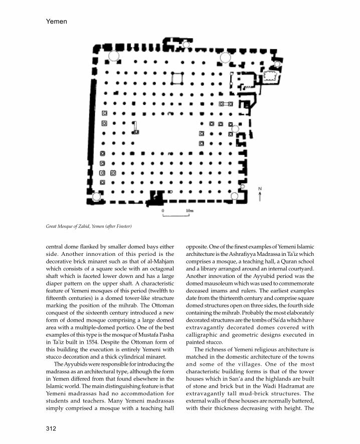
312
Yemen
central dome flanked by smaller domed bays eitherside. Another innovation of this period is thedecorative brick minaret such as that of al-Mahjamwhich consists of a square socle with an octagonalshaft which is faceted lower down and has a largediaper pattern on the upper shaft. A characteristicfeature of Yemeni mosques of this period (twelfth tofifteenth centuries) is a domed tower-like structuremarking the position of the mihrab. The Ottomanconquest of the sixteenth century introduced a newform of domed mosque comprising a large domedarea with a multiple-domed portico. One of the bestexamples of this type is the mosque of Mustafa Pashain Ta�iz built in 1554. Despite the Ottoman form ofthis building the execution is entirely Yemeni withstucco decoration and a thick cylindrical minaret.
The Ayyubids were responsible for introducing themadrassa as an architectural type, although the formin Yemen differed from that found elsewhere in theIslamic world. The main distinguishing feature is thatYemeni madrassas had no accommodation forstudents and teachers. Many Yemeni madrassassimply comprised a mosque with a teaching hall
opposite. One of the finest examples of Yemeni Islamicarchitecture is the Ashrafiyya Madrassa in Ta�iz whichcomprises a mosque, a teaching hall, a Quran schooland a library arranged around an internal courtyard.Another innovation of the Ayyubid period was thedomed mausoleum which was used to commemoratedeceased imams and rulers. The earliest examplesdate from the thirteenth century and comprise squaredomed structures open on three sides, the fourth sidecontaining the mihrab. Probably the most elaboratelydecorated structures are the tombs of Sa�da which haveextravagantly decorated domes covered withcalligraphic and geometric designs executed inpainted stucco.
The richness of Yemeni religious architecture ismatched in the domestic architecture of the townsand some of the villages. One of the mostcharacteristic building forms is that of the towerhouses which in San’a and the highlands are builtof stone and brick but in the Wadi Hadramat areextravagantly tall mud-brick structures. Theexternal walls of these houses are normally battered,with their thickness decreasing with height. The
Great Mosque of Zabid, Yemen (after Finster)
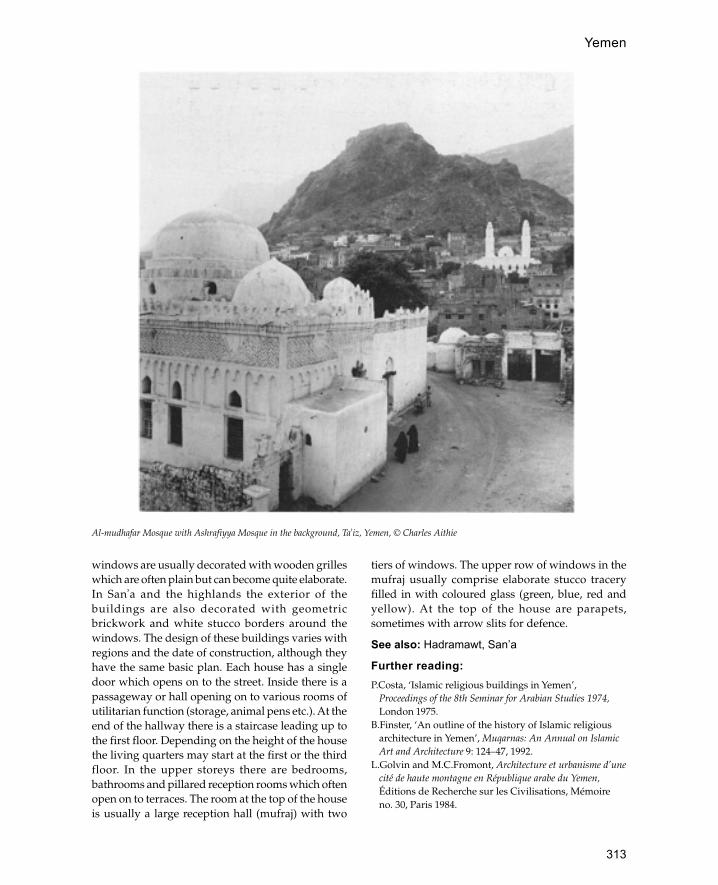
313
Yemen
windows are usually decorated with wooden grilleswhich are often plain but can become quite elaborate.In San�a and the highlands the exterior of thebuildings are also decorated with geometricbrickwork and white stucco borders around thewindows. The design of these buildings varies withregions and the date of construction, although theyhave the same basic plan. Each house has a singledoor which opens on to the street. Inside there is apassageway or hall opening on to various rooms ofutilitarian function (storage, animal pens etc.). At theend of the hallway there is a staircase leading up tothe first floor. Depending on the height of the housethe living quarters may start at the first or the thirdfloor. In the upper storeys there are bedrooms,bathrooms and pillared reception rooms which oftenopen on to terraces. The room at the top of the houseis usually a large reception hall (mufraj) with two
tiers of windows. The upper row of windows in themufraj usually comprise elaborate stucco traceryfilled in with coloured glass (green, blue, red andyellow). At the top of the house are parapets,sometimes with arrow slits for defence.
See also: Hadramawt, San’a
Further reading:P.Costa, ‘Islamic religious buildings in Yemen’,
Proceedings of the 8th Seminar for Arabian Studies 1974,London 1975.
B.Finster, ‘An outline of the history of Islamic religiousarchitecture in Yemen’, Muqarnas: An Annual on IslamicArt and Architecture 9: 124–47, 1992.
L.Golvin and M.C.Fromont, Architecture et urbanisme d’unecité de haute montagne en République arabe du Yemen,Éditions de Recherche sur les Civilisations, Mémoireno. 30, Paris 1984.
Al-mudhafar Mosque with Ashrafiyya Mosque in the background, Ta�iz, Yemen, © Charles Aithie

314
Yemen
A funduq in Thula, Yemen (after Golvin and Fromont)
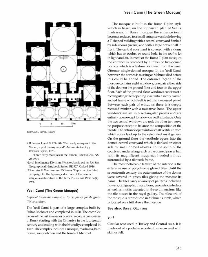
315
R.B.Lewcock and G.R.Smith, ‘Two early mosques in theYemen, a preliminary report’, Art and ArchaeologyResearch Papers, 1973.
—— ‘Three early mosques in the Yemen’, Oriental Art, NS20: 1974.
Naval Intelligence Division, Western Arabia and the Red Sea,Geographical Handbook Series, BR 527, Oxford 1946.
U.Scerrato, G.Ventrane and P.Cuneo, ‘Report on the thirdcampaign for the typological survey of the Islamicreligious architecture of the Yemen’, East and West, 36(4):1986
Yesil Cami (The Green Mosque)
Imperial Ottoman mosque in Bursa famed for its greentile decoration.
The Yesil Cami is part of a large complex built bySultan Mehmet and completed in 1420. The complexis one of the last in a series of royal mosque complexesin Bursa starting with the Orhaniya in the fourteenthcentury and ending with the Muradiye completed in1447. The complex includes a mosque, madrassa, bathhouse, soup kitchen and the tomb of Mehmet.
The mosque is built in the Bursa T-plan stylewhich is based on the four-iwan plan of Seljukmadrassas. In Bursa mosques the entrance iwanbecomes reduced to a small entrance vestibule leavinga T-shaped building with a central courtyard flankedby side rooms (iwans) and with a large prayer hall infront. The central courtyard is covered with a domewhich has an oculus, or round hole, in the roof to letin light and air. In most of the Bursa T-plan mosquesthe entrance is preceded by a three- or five-domedportico, which is a feature borrowed from the usualOttoman single-domed mosque. In the Yesil Cami,however, the portico is missing as Mehmet died beforethis could be added. The entrance façade of themosque contains eight windows, one pair either sideof the door on the ground floor and four on the upperfloor. Each of the ground-floor windows consists of arectangular grilled opening inset into a richly carvedarched frame which itself is set into a recessed panel.Between each pair of windows there is a deeplyrecessed minbar with a muqarnas hood. The upperwindows are set into rectangular panels and areentirely open except for a low carved balustrade. Onlythe two central windows are real; the other two serveno purpose except to balance the composition of thefaçade. The entrance opens into a small vestibule fromwhich stairs lead up to the celebrated royal gallery.On the ground floor the vestibule opens into thedomed central courtyard which is flanked on eitherside by small domed alcoves. To the south of thecourtyard under a large arch is the domed prayer hallwith its magnificent muqarnas hooded mihrabsurrounded by a tilework frame.
The most noticeable feature of the interior is theextensive use of polychrome glazed tiles. Until theseventeenth century the outer surface of the domeswere covered in green tiles giving the mosque itsname. The tiles carry a variety of patterns includingflowers, calligraphic inscriptions, geometric interlaceas well as motifs executed in three dimensions likethe tile bosses in the royal gallery. The tilework ofthe mosque is reproduced in Mehmet’s tomb, whichis located on a hill above the mosque.
See also: Bursa, Ottomans
yurt
Circular tent used in Turkey and Central Asia. It ismade out of a portable wooden frame covered withskin or felt.
Yesil Cami, Bursa, Turkey
Yesil Cami (The Green Mosque)
316
zanana
Mughal term used to describe the women’s quartersin a palace or house.
Zanzibar
Large island off the east coast of Africa; together with theisland of Pemba it forms an autonomous part of Tanzania.The capital of Zanzibar is Zanzibar town and the capitalof Pemba is Chake.
Zanzibar is a low-lying coral island covered withcoconut palms and famed for its cultivation of spices,in particular cloves. Pemba on the other hand is atrue island lying on rock away from the continentalshelf. The island rises much higher out of the waterand has a deeply indented coastline with manyremains of ancient settlement. Remains of pre-Islamic sites have been found on both Zanzibar andPemba although the nature of settlement at thesesites has yet to be clarified.
Zanzibar
Zanzibar has a long history of Islamic settlementstarting in the eighth century at the trading site ofUnguja Ukuu on the southern part of the islandwhere a hoard of gold Abbasid coins was found.Unfortunately no traces of early structures havebeen discovered at this site although there is a latermosque there. The earliest known structure on theisland is the Kizimkazi Mosque which is dated byan inscription to 1107 CE and consists of arectangular structure with three columns runningdown the centre to support the roof, which wouldhave been flat. Although it was restored in theeighteenth century, excavations have shown that thebasic form of the mosque dates back to the twelfth.South of the mosque are traces of domesticoccupation and a stone tomb within an enclosurewall. Jongowe on Tumbatu island north-west ofZanzibar island contains one of the largest groups
of remains on the island, covering an area of 25hectares. The site has a long history with its ownchronicle and was mentioned by Yakut. The presentremains consist of a mosque and a group of housesdated to the twelfth and thirteenth centuries. Thebest-preserved building is the mosque which standsin an irregular enclosure next to the sea. It has arectangular shape with a deep mihrab projectingfrom the north end and eight arched doorways, fouron the west and four on east side. On the east sidethere is a side aisle next to the sea with its ownmihrab. Both mihrabs are fairly plain structuresbuilt of cut reef coral. Also on Tumbatu island isthe site of Gomani which has important examplesof local tombs dated to 1400 CE. In the sixteenthcentury Zanzibar was occupied by the Portuguesewho established farmsteads on the island and builta church in Zanzibar town which was laterconverted into an Omani fort. There are a fewremains of Islamic buildings from the eighteenthcentury with the exception of some of the Kizimkaziruins and the mosque and tombs of Shakani. Fromthe beginning of the eighteenth century Portuguesepower in the area declined in favour of the Omaniswho took over many of the former Portuguesebases. By 1832 the Omani position in Zanzibar wasso secure that Sultan Sayyid Sa�id moved his capitalfrom Muscat to Zanzibar. This move meant that awhole new series of buildings were erected to housethe new sultans and their administration. One ofthe first Omani buildings in Zanzibar was the MtoniPalace built for Sayyid Sa�id in 1830 which is about5 km north of Zanzibar town. Although the palaceis much ruined, substantial remains are stillstanding including the harem, the domed bath blockcontaining hot and cold water plunges and thesultan’s personal mosque on the beach. Nearby isthe Marhubi Palace, built in 1880 by SayyidBarghash and enclosed in over 50 hectares ofgardens. Although the palace was burnt down in1890 the bath complex still stands which includesdomed baths, pavilions, water storage tanks and
Z
317
an aqueduct. Other buildings with bath complexesare the country houses of Kidichi and Kizimbai—the Kidichi baths have beautiful examples ofPersian stucco work on the interior. Approximately10 km north of Zanzibar town are the ruins ofChuini Palace also built by Sayyid Barghash. Thebuilding is several storeys high and consists of acentral core containing rooms opening out tobalconies on each side which are supported withmassive cylindrical columns. Other Omani palaceson Zanzibar are Beit al-Ras and the Dunga Palaceboth built around 1850.
The town of Zanzibar is known as the ‘StoneTown’ to distinguish it from the newer suburbs.Most of the buildings in the old town date to thenineteenth century and are notable for their highlydecorative wooden doorways. The centre of thetown contains the various ministries of the sultanatebuilt in the eighteenth and nineteenth centuries.These buildings have the same form of some of thepalaces with a multi-storey central blocksurrounded on all sides by extensive verandas. Oneof the more recent palaces, the Beit al-Ajcib, is builtin the same style but the verandas are supportedwith imported iron columns. The Portuguesechurch in the centre was converted into a fort withfour towers by the Omanis in 1800. One of the moreunusual buildings is the public baths (Hamani) builtout of brick and coral stone by Sayyid Barghash in1880 which are the only known public baths of thistype in East Africa. Another notable building inZanzibar town is the National Museum completedin 1925 to the design of a British architect workingin the Oriental style, which resembles the HagiaSophia in Istanbul.
Pemba
Pemba has many more archaeological sites thanZanzibar and even today it is more populous thanits neighbour. The earliest site so far discovered isat Mtambwe Mkuu dated to the eleventh century,although this has no early standing structures. Someof the earliest structures on the island are found atRas Mkumbuu which is one of the largest sites onthe East African coast. The remains date to thefourteenth century and consist of a mosque, anumber of pillar tombs and many houses, of whichfour are still standing. The mosque is a largestructure four aisles wide and five bays deep,supported on three rows of four rectangular piers.
The mihrab is centrally placed and aligned with thecentral row of columns and there is a tower enteredfrom a doorway to the east of the mihrab. This isone of the few pre-nineteenth-century examples ofa minaret in East Africa, although it seems likelythat the tower was not very tall. (Other fourteenth-century mosques on Pemba include Shamiani,Mtangani, Mduni and Mkia wa Ngombe.) On theeast coast of Pemba are the remains of Pujini whichare famous as the only pre-Portuguese fortificationson the East African coast. The fortifications date toapproximately 1400 CE and comprise a square areaenclosed by walls and ramparts containing housesand a barrack block.
The capital, Chake, contains a nineteenth-cen-turySwahili fort and the Bohra Mosque. The BohraMosque dates to the early twentieth century and wasbuilt by the Bohra Indians of Pemba. The mosque isa two-storey structure containing a prayer hall belowand a Quran school above and is one of the fewexamples of Indian Muslim architecture in EastAfrica.
See also: coral, East Africa, Tanzania
Further Reading:
F.Aalund, ‘Zanzibar old stone town’, Monumentum 143–59, 1983.
M.C.Horton and C.M.Clark, Zanzibar ArchaeologicalSurvey 1984–5, Zanzibar 1985.
M.C.Horton, C.M.Clarke and Y.Staelens, ZanzibarMuseums Project 1986, Zanzibar 1986.
J.S.Kirkman, ‘Excavations at Ras Mkumbuu on the islandof Pemba’, Tanjanyika Notes and Records 1: 94–101, 1959.
A.Prins, The Swahili-Speaking Peoples of Zanzibar and theEast African Coast, London 1964.
Zaragoza
City in north-west Spain which was Muslim from theeighth to the twelfth century and which continued as acentre of Mudéjar culture.
During the Islamic period the town was settled byBerbers from North Africa who in the eleventhcentury were ruled over by their own Dhu Nunidamirs. The city finally fell to Alfonso VI of León andCastile in 1085.
Few remains of the Islamic period survive withthe exception of Parts of the city walls and parts ofthe Aljafería palace. The Islamic parts of the city wallshave been dated to the late ninth century whilst themost visible parts are Mudéjar work.
Zaragoza

318
The most well-known part of Zaragoza is thefortified palace complex known as the Aljafería. Theouter walls of this structure have recently been restoredand may be Islamic, the main gate is a round horseshoearch between two semi-circular bastions. Remains ofthe mosque can be found incorporated into a laterchurch. Inside, there is a square room covered by adome and a mihrab with a horseshoe arch covered bya semi-dome as in the mosque at Córdoba.
Within the palace most of the building is Mudé-jar and consists of a series of courtyards decoratedwith arches and pools leading to the royal hall. Thearches are cusped and rest on pairs of columns withre-used Islamic capitals. Between the arches thebuilding is decorated with ornate interlacingstrapwork and vegetal motifs.
Many of the churches of the city also containmuch Mudéjar work. The cathedral, known as LaSeo, has an interesting mixture of Islamic-style blindniches and diaper-patterned brickwork with Gothicwindows.
See also: Córdoba, Granada, Seville, Spain
Further reading:G.Goodwill, Islamic Spain, Architectural Guides for
Travellers, London 1990, 131–7.
zawiyaLiterally ‘a corner’: often the place where a holy manboth lived and was buried.
zigara
Mausoleum (literally ‘place of visitation’).
zilijNorth African term for glazed tiles, usually appliedto tile mosaics used for dadoes in houses andmosques. Predominant colours are orange, green andwhite.
ziyadaOuter enclosure or extension of mosque common tocongregational mosques in the early Islamic period.
The name is derived from an Arabic term meaningan addition or increase in size. The best survivingexamples of ziyadas can be found in Samarra at theGreat Mosque (847) and the Abu Dulaf Mosque(861) and also at the mosque of Ibn Tulun in Cairo.The earliest example is at the Great Mosque atSamarra where an outer enclosure surrounds themosque on the east, north and west sides (i.e. noton the qibla side). This enclosure is surrounded byan even larger rectangle which encloses all foursides of the mosque although the south side isnarrower than the other sides. The area covered bythe mosque and its ziyadas amounts to 17 hectares.Likewise the mosque of Abu Dulaf which copiesthe Great Mosque in many ways also has twoziyadas or enclosures.
The mosque of Ibn Tulun provides the best-preserved example of a ziyada. Like the mosques atSamarra the ziyada encloses the mosque on the threesides away from the qibla. The enclosure wallresembles that of the mosque itself with its nichesand crenellations. Each wall is pierced with severaldoorways which led from adjoining markets.Although no remains have been traced, fourhistorical sources imply that latrines and places forablution were located within the ziyada.
The origin of the ziyada is likely to have been theouter temenos of pre-Islamic shrines or sanctuar-ieswhere the temple was separated from the secular cityby an outer enclosure. Ziyadas are not usually foundon the qibla side of a mosque as this position wasreserved for the Dar al-Imara.
Further reading:K.A.C.Creswell, A Short Account of Early Muslim
Architecture, revised a nd enlarged edn . J.W.Allan,Aldershot 1989, 395–6.
ziyaretVenerated shrine or mausoleum.
zullaArabic term for shaded area. Used to refer tosanctuary or covered part of mosque.
zawiya

Appendix

320
The
Med
iter
rane
m W
orld
sho
win
g pr
inci
pal h
isto
ric
and
site
s
Appendix

321
The
Mid
dle
Eas
t and
Cen
tral
Asi
a sh
owin
g pr
inci
pal h
isto
ric
citi
es a
nd s
ites
Appendix


323
Abbasid Caliphs, Tomb of the, Cairo, 46, 284–5Abbasids, 1, 120, 125al-Abbasiya, 236Abd al-Aziz, 182Abd al-Malik, 69, 135, 230, 205, 311Abd al-Mumin, Sultan, 244Abd al-Rahman I, 55, 56, 87, 263Abd al-Rahman II, 56, 167Abd al-Rahman III, 263Abd al-Rahman minaret, Cordoba, 188Abd al-Samad shrine, Natanz, 208, 209Abd Allah Khan Kala, 186Abdul Gafoor Mosque, Singapore, 261Abraham, 69Abu al-Awar, 57Abu al-Barakat, 170Abu al-Hajjaj mosque, Luxor, 80Abu al-Hasan, 284Abu Bakr, 182Abu Dhabi, 297Abu Dulaf Mosque, Samarra, 1, 113, 189, 250, 318Abu Hanifa, tomb of, Pakistan, 227Abu Hoeira, tomb of, nr. Yabne, 231–2Abu Ibrahim Ahmad, 289Abu Ishaq al-Saheli, 170, 172, 280, 282Abu Said, 209Abu Zaidan Mosque, Bahrain, 31Academy of Sciences, Turkmenistan, 293Aceh, 270Achaemenids, 2, 120Acre, 229–30, 231, 232Adamawa, 91, 306, 308Adana, clock tower, 224Adham Khan, tomb of, 203Adil, sultan of Agades, 5Adil Shah dynasty, 35Adilabad, 65adobe, 299Adrianople see EdirneAelia Capitolina, 134Afghans, 121Afrasiyab, 247Afsarwala tomb, Delhi, 203Aftasids, 264Afzal Kahn, 7Agades, 5–6, 143, 305, 306, 307 Great Mosque 6 ill, minaret
of, 307Agha Khan Foundation, 107Aghlabids, 6, 86, 236Agra, 7, 202Agung, Sultan, 132Ahmad al-Jazzar Pasha, 229
Ahmad ibn Sa�id, 212Ahmad ibn Tulun see Ibn Tulun, AhmadAhmad Pasha al-Qarahmanli mosque, Tripoli (Libiya), 286Ahmad Shah, 7tomb at Ahmadabad 8 ill., 102Ahmad Shah Bahmani, Sultan, 62Ahmadabad, 7–8, 192 Great Mosque 7, 8 ill., 102Ahmet, Sultan, 104Aïr, 5Aisha Bibi Khanoum, Mausoleum,
see Djambul mausoleumAjanta, Buddhist cave art, 62Ajdabiya 8–9, 27, 165Ajdabiya, Fatimid mosque, 9, 86Ajlun, Muslim castle, 57, 140Ajman, 297Ajmer fortified palace, 84, 200–2 Great Mosque, 117Ak Cami, Vidin, 40Ak Saray, Shar-i Sabz, 258Akbar, 7, 82, 83, 84, 103, 118, 159, 198, 202, 203, 228Akbar’s fort, Agra, 7, 202Akbar’s garden and palace, Attock, 228Akbar’s palace
Allahabad, 202Lahore, 201, 202
Akbar’s tomb, Sikandara, 84, 190, 204(Al) Bu Sa�id dynasty, 212Ala al-Din, 102Ala al-Din Beg, 144Ala al-Din Khaliji, 63, 242, 243Ala al-Din Muhamad Shah, 117Ala al-Din Shah, 118�Ala al-Din tomb tower, Varamin, 123�Ala al-Din turbe, Karaman, 144Alaeddin Cami, Konya 154, 155 ill., 190Alaettin Cami, Bursa, 41, 218Alai Darwaza, Delhi, 242Alai Minar, Delhi, 242, 243Alamo Fort, Texas, 300Alattin Keykubat, 154�Alawids, 193Albaicín Quarter of Granada, 100Albania see Azerbayjan, Independent Republic of, 26albarrani towers, 265Alberti, Leon Battista, 260Alcazaba, Alhambra, Granada, 15Alcazar, Seville, 257, 266Aleppo, 10–12, 273
gateway to the citadel 26, 89 ill.Great Mosque, 12, 62khan, 147
Alexander the Great, 2, 120, 226, 245
Index
324
Index
Alfonso VI of Leon and Castile, 264, 317Alfonso VIII, 244Algeria, 12–14, 90AlgiersGreat Mosque 13, 14, 15 ill.
Turkish mosques and mansions, 14Alhambra, Granada, 14–17, 100, 266
Aliof Songhay empire, 94, 280, 305Umayyad caliph, 157, 182, 295
Ali bin al-Hasan. 150Ali Hadeski, 102Ali Pasha, 102�Ali Pasha Cami, Sarajevo, 36Ali Qapu Palace, Isfahan, 122, 124, 127, 247Ali Shah mosque, Tabriz, 122�Aliabad Kishmar tomb tower, 123Aljafería palace, Zaragoza, 317–18Almohads, 13, 15, 17, 89Almoravids, 13, 17, 98, 192, 264Alp Arslan, 41, 255‘Amal Bakti Muslim Pancasila’ Foundation, 118Amar Singh Gate, Agra, 7Amar-Komadiago, 95Amarna Letters, 134Amasya bedestan, 33�Ami Qumuriyya Mosque, Baghdad, 30Amida see Diyarbakiral-Amir, 20, 45Amman, 18, 138, 141
palace on the citadel, 139Umayyad palatial complex 18, 19 ill.
Amorium, 289–90�Amr ibn al-�As, 164
mosque of, Fustat, 91al-�Amri mosque
Esna, 80Qus, 79, 80
Amritsar, 159Anadolu Hisarlar, Constantinople, 128Anangpal, 63Anatolia, 43Anau, Great Mosque, 293Ancyra see Ankaraal-Andalus see SpainAndalusian architecture, 173Andalusians, mosque of the, Fez, 87, 188, 193Anguri Bagh, Agra Fort, 202, 204Anjar, 20, 163Antioch, 57Anup Talao, Fatehpur Sikri, 83al-Anwar mosque see al-Hakim Mosque, CairoAq-qoyunulu dynasty, 66, 177Aqaba, 140, 141al-Aqmar mosque, Cairo, 20–2, 45al-Aqsa Mosque, Jerusalem, 22–4, 56, 69, 135, 136, 191, 208
230, 231, 296Aqsunqur, Mosque of Amir, Cairo, 48Arabia, minarets in, 190Araha-i Din Mosque, Ajmer, 243Aram Bagh, Agra, 204Arculf, 135
Ardabil, shrine of, 123Ardar, 14Arghuni, Aleppo, 12Aria see HeratArjumand Banu Begam see Mumtaz MahalArquila, Bijapur, 35Arslan Jadhib tomb, 124Arta, 102As�ad Pasha Khan, Damascus, 61al-�Ashar, 106Ashdod, fort, 231Ashdod Yam, 231Ashiq Palace, Samarra, 250–1Ashir, Zirid palace, 13Ashrafiyya Madrassa
Jerusalem, 136Ta�iz, 312
Ashur, 130�Asir, 253–4al-�Askar, 44, 113, 161Askiya Muhammad, 305
tomb of, Gao 94, 95 ill., 262, 282Aslan Cami, Ankara, 20, 290Aslan Pasha mosque, Ioannina, 102Assassins, 26Assyrians, 125Asturias, 266Aswan
11th C mausoleums, 207domed mausoleums at, 240minaret, 80necropolis of, 79–80
Athens, 101Atlas Mountains, 193, 195Atmeydan, Istanbul, 128, 129�Atshan, Khan, Iraq, 25, 37, 139, 252Atsiz ibn Uvak, 59�Attarin madrassa, Fez, 87, 194Attatürk, Mustafa Kemal, 20, 290Attock, fort, 227–8Augustinians, 135Aurangzeb, 199, 202, 203, 205, 228, 245Auwal Mosque, Cape Town, 262Avdat, 107Averroës, 256Awal see BahrainAwdaghast, 98, 99, 304, 306Awjlah, 166Aya Sophia see Hagia Sophia, ConstantinopleAyia Sofia, Nicosia, 58�Ayn al-Sinu, 107�Ayn Jalut, battle of, 172�Ayn Minyat Hisham see Khirbet al-MinyaAytimish al-Bajasi, mausoleum of Amir, Cairo, 49Ayyubids, 26, 46, 59–60, 89, 135–6, 311–12Azerbaijan, 26, 283al-Azhar mosque, Cairo, 27, 45, 107al-�Aziz, 107Azraq fort, 88, 140, 141Azraq oasis, 137Azzam Palace, Damascus 2 ill., 61

325
Index
Ba Dinde, 280Bab Agnau, Marakesh, 177Bab al-Amma, Samarra, 161, 249, 287Bab al-Futuh, Cairo, 46, 89Bab al-Mardum mosque, Toledo, 284Bab al-Nasr, Cairo, 46, 89Bab al-Qantara, Toledo, 284Bab al-Seghir, Damascus, 59Bab al-Wastani, Baghdad, 29Bab Lalla Rayhana, Qairawan, 99, 236Bab Ruwah, Rabat, 244Bab Zuwayla, Cairo, 46, 89Babur, 7, 117, 198, 201, 204, 205Babylon, 91Babylonians, 125Badiyya, 138Badr al-Din Hassan, tomb, Damascus, 60Badr al-Jamali, 45, 46, 107
Tomb of, Cairo, 28, 45Badshahi Mosque, Lahore, 159, 203, 228Badshani Ashurkhana, Hyderabad, 112Bagamoyo, 279Baghdad, 1, 28–30, 105, 125, 249
Abbasid palace, 29, 30sack of (1258), 1, 113, 125walls of, 89
Baghdad Gate, Raqqa, 245Baghdad Kiosk, Topkapisarai, Istanbul, 285Baghnagar, 112Bahadur Shah, 199Bahadur Shah II, 199Bahla, Great Mosque, 213Bahmanis, 62, 87Bahram Shah, minaret at Ghazni, 4Bahri Mamluks, 47–9, 172Bairam Ali, Tsar’s Hunting Lodge, 293Bairam Khan, 198al-Bakri, 99Baku, 26, 31Bala Gwani, 143Baldwin, 135, 231al-Balid see DhofarBalis, 296Balkh, 31, 283
Abbasid mosque at, 1, 3al-Balkuwara palace, 251Banares, Great Mosque, 199Bangladesh see BengalBanja, 36Baños de la Encina, nr. Jaén, 265Banten, 131, 132Banten mosque, Java, 133Banu al-Ahmar, 15Banu Bu Ali mosque, Oman 214 ill.Banu Hilal, 164, 288Bañuelo Carrera del Darro, Granada, 100Baptistery of Mar Ya�qub, Nisibin, 24Baqum, 142Barawa, 261, 262Barbarossa, Frederick, 144Barber’s Tomb, Delhi, 274Barid Shahi dynasty, 62
Barqa, 164Barquq, complex of Sultan, Cairo, 49basalt, 230Basian, 122Basra, 32, 105, 120, 125, 147, 158, 295Bastak, 298Bastakia quarter, Dubai, 298Batak Mandailing, 270bath house see hammamal-Batha, 178Batinah coastal strip, 212, 213Bayazit, 215, 282Baybars, 2, 19, 49, 60, 172, 184, 229, 245, 284Baybars al-Jashankir, tomb of Sultan, Cairo, 48Bayezid, Sultan, 40Baylaqan, 283Bayt al-Din Palace, Lebanon, 163Bayt Dallal, Aleppo, 12Bayt Na�man, 214bedouin tents, 273Beidha, 138Beirut, 161Beisan, 230
bridge at, 232Beit al-Ajcib, Zanzibar town, 317Beit al-Ras, Zanzibar, 317Bella Faraji, 280Belmez, castle of, nr. Córdoba, 265Belvoir castle, Palestine, 231Bengal, 33–4, 118, 226Benghazi, 164Beni Hassan tribe, 225Berat
Congregational Mosque, 10museum town, 10
Berbers, 13, 86, 98, 164, 192, 224–5, 264, 302–4, 317Besiktasi dervishes, 40Bet Shean, 230Bethlehem, 134Bey Hammam, Bursa, 41, 220Bey Han, Bursa, 41Beyazit, 79, 219Beyazit Cami, Bursa, 220Beyazit complex
Bursa, 41Istanbul, 129
Beyazit II, mosque of Istanbul, 221Beyazit II complex Amasya, 221 Edirne, 221Bey�ehir Bedestan, 33Beylerbey Cami, 224Beytallah mosque, Urumqui, 54Bhadra towers, Ahmadabad, 7Bhadresvar, 102, 115–17Bhambore, 227Bhikari Khan, 159Bibi ka Maqbara tomb, 204Bibi Khanum Mosque, Samarkand, 248Bibi Miriyam, Qalhat 216 ill.Bible, 134Bidar, 63Bidiya, mosque of, nr. Dibba, 298

326
Index
Bijapur, 35, 63Great Mosque, 35
Bilal, 170Bímaristan, Iraq, 125Bimaristan al-Aduli, 29bin Sayf, Sultan, 212Bin Yusuf Madrassa, Marakesh, 177Biram, 109, 143, 306Birbal’s House, Fatehpur Sikri, 83Birket al-Sultan, Jerusalem, 62, 136Birket al�Anaziya, Ramla, 245Birni, mosques of, 96Birou see OualataBlack Pavilion, Srinagar, 205Black Stone, Ka�ba, Mecca, 142, 143, 178blazons, 35, 173Blue Mosque see Sultan Ahmet Cami, IstanbulBlue Mosque, Tabriz, 122–3Bobo Dioulasso, 176, 305Bohra Mosque, Chake, 317Borabadur, 131Borneo, 118Bostra, 272Bougie, 13Bradford, 100–1Brighton, Royal Pavilion, 100British, 30, 58British East India Company, 199, 261British Empire, 100, 226British Mandate in Palestine, 230Broach mosque, 102Brousse see BursaBrusa Bedestan, Sarajevo, 36Bu Fatata Mosque, Susa, 271Bu �Inaniya madrassa, Fez, 87, 194Buddhist culture, 226Bukhara, 37–9, 120, 122, 300, 301Buland Darwaza, Fatehpur Sikri, 83Bulgaria, 39–40Bulgarian Thrace, 40Bumipatra, Bank of, 169Bur Gao, 261, 262Buraimi oasis, 298Burhanpur, 190Burji Mamluks, 172Burkina Faso, 305Bursa, 41–3, 219
Turkish bazar, 33Ulu Cami 41–2 ill., 219–20
Bust, 161Buwaihids, 1, 29, 125Buyids, 120Büyük Hammam, Nicosia, 58Büyükçemice bridge, nr. Istanbul, 223,
260Byzantine, 43, 68, 134, 216–17, 289, 295
Cabd al-Rahman, 143cAbd Allah Ibn Tahir, 19Caesarea, 230Caillié, René, 280al-Cain, 297, 298
Cairo, 44–51, 86, 105, 113, 173Calatrava la Vieja tower, 265Calcutta, 34, 100Cali, 45California, 300Caliph’s Mosque, Baghdad, 68calligraphy, 173Camares palace, Alhambra, 15Cambay, Great Mosque, 102Cambyses, 120Cami Kebir, Larnaca, 58Camr ibn al-�As mosque
al-Fustat, 18–19, 44Tripoli (Libiya), 286
Canton, 52Capilla Villavicosa, Córdoba, 56Cappella Palatina, Sicily, 258caravanserais, 51, 205Cardeel, Lucas, 133Carmathians, 30Carthage, 288Casa del Carbon, Granada, 100cave houses, 291Cefala, 11th C baths, 258Çekige Hammam, Bursa, 220Çekirge, Bursa, 41Celebes, 118Central America, 300Central Asia, 51–2
cities and sites 321 maptradition, 51
Centre Palace, Lashkari Bazar, 4, 161chajja, 52, 200Chake, 316, 317Chalci palace, Constantinople, 62Challa, necropolis of, 194, 244Champaner, Great Mosque, 103Ch�ang-an mosque, China, 54Chaparghat caravanserai, 205char-chala, 33, 52Char Minar, Hyderabad, 52, 112, 261charbagh, Persian, 204, 274Charkaman, Hyderabad, 112Charkh-i Loghar, mihrab, 3Charles Martel, 90, 263Chasma Ayyub shrine, Bukhara, 38Chata caravanserai, 205Chatagay, 282chatri, 52, 200Chauhan Rajputs, 241Cheng Ho, 52, 54Chengiz Khan, 198Chicago, Albanian mosque, 9, 299Chihil Dukhtaran tower, Damghan, 123China, 52–4
minarets, 190Chinguit, 306, 307Chini Ka Rauza, Agra, 7Chisti order, 82Chosroes II, 134Christianity, 43, 134Chuan Chou, 52
327
Index
Chuini Palace, Zanzibar, 317Church of the Holy Sepulchre, Jerusalem, 69, 134, 135Church of Holy Wisdom see Hagia Sophia, ConstantinopleCid, El 284Çinili Kiosk, Topkapi Serai, Istanbul, 154, 223, 285, 290Circassians, 49, 172Cirebon, palaces of, 131, 132clock towers, 224conical-domed mausoleum, 125–6Constantine, 127, 134Constantine II, 104Constantinople, 43Constantinople, sack of, 220, 290
see also IstanbulCórdoba, 55–6, 264
Great Mosque, 2, 24, 55, 56, 62, 265Corniclanum see AjdabiyahCreswell, K.A.C., 209–10Crete, 101, 102Cristo de la Luz, Toledo see Bab al-MardumCrusader castles, 140, 231Crusaders, 26, 57, 89, 134, 135, 163, 229, 231Ctesiphon, 125, 139cuerda seca, 200, 279, 280Cumaya Cami, Plovdiv, 40cusped arches, 25Cyprus, 57–8Cyrenaica, 163Cyrus the Great, 120
Dalmatian building, 36Damascus, 59–61, 105, 229, 272
caliph’s palace, 59Great Mosque, 2, 24, 59, 61–2, 66, 188, 195, 295, 296,
297khan, 147
Damascus Gate, Jerusalem, 136, 137 ill.Damghan, 122Danubia, 40Dar al Makhzan palace, Marakesh, 177Dar al-Alim, 29Dar al-Dunya, Aceh, 270Dar al-Imara, Kufa, 135, 157dar al-imara (royal palace), 195, 318Dar al-Islam centre, Abiquiu, New Mexico, 299–300Dar al-Mulk, Madinat al-Zahra, 167Dar al-Salam, New Mexico, 86Dar al-Siyadat, Shar-i Sabz, 258Dar al-Yund, Madinat al-Zahra, 167Dar es Salaam, 279Darb Zubayda, 146Darghut Pasha, tomb of, Tripoli (Libiya), 286Darush Shifa hospital and medical college, Hyderabad,
112Daulatabad, 63–4, 117
mosque of, 62Daura, 109, 143, 306daurin guga, 109Davazdah Imam, Yazd, 124David, 134Davut, 223Dayr Yasin, 134
Debal, 32, 227Decapolis, 138Deccan, 62–3, 115, 117, 118Delhi, 63–5, 198, 226
Great Mosque, 200Delhi Gate, Agra, 7Demak
mosque at, 118, 169palace at, 131
Der�a, 296dervishes, 154, 209, 279Desert Palaces, Umayyad, 295, 296Detroit, Albanian mosque, 9, 299Dewal-i Khodayda, 14th C houses, 5Dhahir al �Umar, 229, 232Dhahran, 254Dhargut, mosque of, Tripoli (Libiya), 286Dhofar, 212, 213Dholka Patan mosque, 102Dhu Nunid amirs, 317Diani, 145Dienne see DjennéDijingueré Ber, Timbuktu, 280–1
Mosque, 282Dilmun see BahrainDin Ilahi religion, 84, 199Dingueraye, Great Mosque 92–3 ill.Divan Begi Mosque and Madrassa, Bukhara, 38–9Diwan-i Amm, 66, 201
Fatehpur Sikri, 83Red Fort, Delhi, 202
diwan-i Khass, 66Fatehpur Sikri 83, 84 ill.Red Fort, Delhi, 202
Diyarbakir, 66–7, 256, 291, 296Great Mosque, 62, 66Ulu Cami, 66
Djallonke people, 91, 306Djambul mausoleum, Uzbekistan, 37Djawahr Shah Agah, Meshed, 191Djenné, 67, 94, 171, 176, 305, 306
Great Mosque, 67, 307, 308Djisdaraki Cami, Athens, 102do-chala, 33, 68Doha, 239Dolmabahçe Palace, Istanbul, 224, 285Dolomite, 230Dome of the Rock, Jerusalem, 24, 61, 68, 69–70, 130, 135, 136,
186, 230, 231, 232, 252, 295, 296mosaics, 195, 297
domed mausoleums, 123–4Dondo, 145Dresden, Tobacco factory, 97Druze, 163Dubai, 297Dumat al-Jandal, 254Dunaysir mosque, 256Dunga Palace, Zanzibar, 317Dutch influence, 133, 169, 270 East Africa, 71–7
minarets in, 190principal Islamic sites 72 map

328
Index
Edessa, 57Edfu, schools, 86Edirne, 41, 77–9, 214, 291
royal palace, 77–8Egypt 79–81
minarets in, 188Epirus, 102Erzerum, 291Eshrefoglu Mosque, Beyshehir, 256Eski Cami
Edirne, 78, 220Yambol, 40
Eski Kapilica, Bursa, 42Eski Sarai, Istanbul, 128Etrugrul Mescit, Sögüt, 218European architecture, 90, 224Ezekiel, tomb of, Kifl, 126
Fahraj
minaret, 189mosque, 122
Failika island, 157Fakhr al-Din, mosque of, Mogadishu 71, 190, 192, 261, 262 illFares, schools, 86Fars, 122Fatehbad gardens, 205Fatehpur Sikri, 82–4, 103, 118, 199
Great Mosque, 82mosque of, 203palace, 83, 201, 204
Fath Khan, tomb at Gaur, 33, 34Fathabad, 117Fathy, Hassan, 84–6, 198, 299Fatih Cami, Istanbul, 129Fatih Pasha Cami, Diyarbakir, 67, 222Fatima, 86Fatimids, 8–9, 13, 26, 27, 44–6, 86–7al-Fawwara see La Favara Castle, PalermoFaza, 145Feng-Huan mosque. Hang Chou, 53Ferdinand III of Castile, 55, 256Ferdinand and Isabella, 15, 264ferey, 67Festival Mosques, 208Fethie Cami, Athens 101 ill., 102Fez, 87, 193, 194, 195Fezzan, 164Filibe see Plovdival-Firdaws Madrassa, Aleppo, 12Firuz Shah, 243Firuz Shah Tughluq, 64Firuzabad, 64, 65, 87–8
Great Mosque, 87–8Flores, 118Fort Jesus, Mombassa, 73, 145fortified palaces, Mughal, 200fossil coral, 54–5Fougoumba, 92four-centre arches, 24–5four-iwan plan of mosques, 122, 197French influence, 90, 280French Roccoco, 285
Frourion fortress, 102Fujairah, 297Fulani tribe, 109, 190Fulbe, 91, 92, 109, 280, 304, 305, 306Funduq al-Yadida see Casa del Carbon, GranadaFustat, 44, 50, 91, 113, 147, 287
bath house, 206nine-domed mosque 210 ill., 211
Futa-Djallon, 91–3, 305, 306, 308
Galata bedestan, 129Galilee, 232Galla, 71, 96, 145Galta, 128Gansu, 53Gao, 94–6, 171, 304, 305Gao-Sané, 94garden cities, 96gardens, 96
Javanese (tamnn), 131, 132–3Mughal, 205
Gauhar Shad tomb, Herat, 111Gaur, 33Gavur Kala, 185Gaza, 229, 230Gazur Gah shrine, Herat, 111Gedi, 76, 96–7, 145
Great Mosque, 96–7palace of, 75, 97
Generalife palace, Granada, 100, 266Genoa, palace, 2Gereza fort, Kilwa, 151, 153Germany, 97Gevraniler Konak, Diyarbakir, 67Ghana 98–9 map, 302, 304–5Ghazan Khan, 121Ghazi al Malik al-Zahir, 12Ghazi Khusraw Bey Cami, Sarajevo, 36Ghazna, minaret of Masud II, 189Ghaznavids, 3, 4, 198Ghazni, 283
palace mosque of Masud III, 3Ghist, mosque and madrassa of Ghiyath al-Din, 3Ghiyath al-Din
mosque and madrassa, 3tomb of Sultan, Herat, 111
Ghiyath al-Din Tughluq, 63, 117, 227tomb of, Delhi, 64
Ghor, 138al-Ghuri, rabc of Sultan, at Khan al-Khalili, 50Ghurids, 3, 4, 111Ghuzz, 211Gidan Rumfa, Kano, 143Gir-i-Amir, Samarkand, 283Giralda Minaret, Seville, 257, 267Giri, 131Giza pyramids, 46Gjirokastër 10, 11 ill.glass, coloured, 217glazed tiles, 217Gobir, 109, 143, 306Godala, 304

329
Index
Gok Madrassa, Sivas, 48, 99, 269, 291Gol Gumbaz, Bijapur, 63, 99–100Gol-i Safed, 14th C houses, 5Golconda, 63, 112Gomani, 316Gothic, 58Granada, 100, 264
gardens, 96hammam, 266
Great Britain, 100–1Great House, Kilwa, 75Green Mosque see Yesil Cami, BursaGudjarat, 191Guinea, 305, 306, 308Gujarat, 7, 82, 102–3, 115, 190Gul Baba, tomb of, Buda, 112Gulbarga, 63Gulf Coast, 254Gulf of Sirte, 164Gumushtutigin Madrassa, Bosra, 168Gunbad-i Qabus tomb, 123Gunbad-i Surkh, Maragha, 26Gupta dynasty, 226Gur-i Amir mausoleum, Samarkand, 248Gurna, 85
Habib Salih bin Alwi tomb, Lamu, 76Haci Husseyin Aga mosque, Belgradcik, 40Haci bin Musa, 219Haci Özbek Cami, Iznik, 130, 217, 218Hadrian, 134, 135Hafisids, 287, 288Hagia Sophia, Istanbul, 79, 104–5, 128, 129, 220Ha�il, 254Hajar, 142, 180Hajar as�ad, Ka�ba, Mecca, 142Hajj forts, Jordan, 141Hajj routes, 60, 65, 105–7, 272al-Hajj Umar, 92Hajjah Fatimah Mosque, Singapore, 261al-Hajjaj, 302Hajjaj bin Yusuf see Yusuf ibn al-HajjajHajjar mountains, 212Hajji Piyadi Mosque, Balkh, 31–2al-Hakim
Fatimid caliph, 162mosque of, Cairo, 45, 47, 107
al-Hakim bi Amr Allah, Fatimid caliph, 107al-Hakim II, 56, 167Hala Sultan Tekke, Cyprus, 58Halab see AleppoHalberdiers, 285Hamdanids, 10Hamma, Great Mosque, 61, 62Hammad ibn Buluggin, 13, 236Hammadids, 13, 236Hammam al-Basha, Acre, 232Hammam al-Nasiri, Aleppo, 12Hammam al-Sarakh, 107Hamsa Beg Cami, Thessaloniki, 102Hanafi theologians, 30, 180Hanbali theologians, 30, 180
Hang Chou, 52Hani ibn Arwa, 157Haram (al-Sharif), Jerusalem, 22, 69, 135, 136, 175, 230Harba bridge, nr. Samarra, 125Harout, Great Mosque, 256Harran, 68, 108, 290, 291
Great Mosque, 61, 62, 108, 188Harrapa, 226al-Harriri, Maqamat of, 29Harthma ibn A�iyan, ribat of, Monastir, 192Harun al-Rashid, 106, 110, 245, 251Harun-i Vilayat tomb, 247Hasan, Sultan, 190, 269Haseki Hürrem Hammam, Istanbul, 42, 223, 259Hashemite Kingdom of Jordan see JordanHashtsal Minar, nr. Palam, 243al-Hasn bin Sulaiman, Sultan, 153al-Hassa, 254Hassan, mosque of, Rabat, 188–9, 193, 244Hathai Pol, Akbar’s Palace, Agra, 201Hauran, 273Hausa, 5, 91, 109, 306, 308Hausaland, 306Hauz-i Karoz, mosque of, 4Hawa Mahal, Fatehpur Sikri, 83Hayrettin Barbaros, tomb of, Istanbul, 259Hayuniye Madrassa, Karaman, 144Hazar-Jarib palace, Isfahan, 127Hebron, 108, 230, 232Hejira, 178Heraclius, 134Herakleon, 110Herat, 3, 111, 282, 283
Great Mosque, 4, 111Hijaz, 253Hijr, Ka�ba, Mecca, 142Himyarite clan, 310Hindu architecture, 68, 115, 131, 199–203Hira (al-Hira), 125, 157Hiran Manar, Fatehpur Sikri, 285Hisham, caliph, 149Hisham’s palace see Khirbet al MafjarHissar, 117Holy Mosque, Mecca, 178–80horseshoe arches, 24Horvat Minim see Khirbet al-MinyaHouse of Cisterns, Manda, 176Hoysala kingdom, 62Huai-Shang Mosque, Canton, 52Huaisheng mosque, Guangzhou, 190Hüdavendigâr mosque, Çekirge, 41, 219Hüdavendigâr region, Bursa, 214Hufuf, 254Hui, 52, 53Hukuru Meskit, Male, 170Hulagau, ibn Kublai Khan, 113Humayma, 105Humayun, 198, 200 tomb of, Delhi, 65, 200, 204, 274Hungary, 111–12, 215Husain Baiqara, Timurid Sultan, 4husn, 153Husn of Abu Dhabi, 298

330
Index
Hüsrev Pasha Cami, Aleppo, 259Husseins, 288Husuni Kubwa palace, Kilwa, 75, 151, 153Husuni Ndogo, Kilwa, 73, 151, 153al-Huwailah, 239Hyderabad, 62, 112, 192, 229
Great Mosque, 112hypostyle, 112, 311
Ibadat Khana, Fatehpur Sikri, 84Ibadis, 13, 75, 95, 99, 213, 305Ibn Battuta vii, 5, 71, 105, 150, 170, 172, 225Ibn Jubayr, 60, 180Ibn Khaldun, 170, 172ibn Majid, Ahmad viiIbn Tulun, Ahmad, 44, 113, 287Ibn Tulun Mosque, Cairo, 1, 44, 107, 113, 189, 268, 318Ibra, 213Ibrahim, 142, 180
mosque of, Hufuf, 254nephew of Shah Rukh, 283
Ibrahim Beg imaret, Karaman, 144Ibrahim Çarhoç, 269Ibrahim Lodi, 198Ibrahim Pasha palace, Istanbul, 129Ibrahim Rauza mausoleum, Bijapur, 35Iconium see KonyaIcosium, 14Idris I, 195al-Idrisi, 98Idrisids, 192, 303Ifriqiyya, 86, 235, 258, 288Ikhshids, 229Ildefonso chapel, Toledo, 284Ilias Mirahori Mosque, Korçë, 10Iliyas Bey Cami, 224Iliyas Shah, 33, 35Ilkhanids, 4, 30, 113–15, 121, 122, 124, 125Iltimad al-Daulah, 274
tomb of, Agra, 7, 204Iltumish, 242, 243
mausoleum of, Delhi 117, 187 ill.Imad al Din Zengi, 12Imam Dur, tomb of, Samarra 68, 126 ill., 207Imam Riza shrine, Mashad, 124Imam Shafci madrassa, Cairo, 46Imaret Cami, Thessaloniki, 102Imaret Mosque, Plovdiv, 40Imin Mosque, Turfan, 54Ince Minareli, mosque, Konya, 154–5India, 115–18
minarets in, 189Indian Islamic architecture, 199–200Indonesia, 118–20
principal Islamic sites 119 mapIndraprastha, 65Institut du Monde Arabe, Paris, 90Ioannina, 102Ionnia, 101Iplikçili mosque, Konya, 154Iran, 120–5Iranian architecture, 120, 121–4, 188
Iraq, 125–6, 295minarets in, 189
Irbid, 138Irbil, 189Iryah, 283Isa Khan, tomb of, Delhi, 203Isaac, 69Isaac Comnenus, 57Isfahan, 96, 123, 126–7, 247
Great Mosque, 127, 197, 255Ishak Pasha palace, Dogubayazit, 224Ishbiliyya see SevilleIshikani, tomb, Kenya 76, 145, 146 ill.Iskandar Muda, 270Iskandar Thani Alauddin Mughayat Syah, 270Iskele Cami, Üsküdar, 259Islam Khan, 82Islam Shah Sur, 198Islam Sur, 201Islamabad, 229Islamic Centre, Paris, 90Islamic Society of North America (ISNA), 299Ismail, 142Isma�il, Saffavid ruler, 31, 121Isma�il the Samanid, mausoleum of, Bukhara 37, 38,
39 ill.Ismail the Samanid, tomb of, Balkh, 240Isma�ili theology, 27, 86, 226Israel, 229al-Istabulat palace, 251Istana Maimun palace, Medan, 270–1Istanbul 127–30;see also ConstantinopleItalian influence, 164, 173, 200Ivaz Efendi Cami, Istanbul, 217Ivory Coast, 305Iwalatan see OualataIzki, 213Iznik tiles, 102, 130, 136, 217, 222, 255, 269, 280
Jabal Nafusa, 164, 165, 166Jabal Nuqum, San�a, 251Jabal Tuwayq, 254Jabal Usays, 107Jabbanah Musalla, San�a, 251Jaffa, 230, 232Jahangir, 199, 204, 274, 283, 310Jahangiri Mahal, Agra, 7, 84, 202Jahangir’s Quadrangle, Lahore, 159Jahangir’s tomb, Lahore, 159, 228Jahanpanah, 63, 65Jahra, 157Jal Mandir Palace, Bijapur, 35al-Jala, mosque of, San‘a, 251Jalairids, 125Jalal al-Din Firuz Shah II, 117Jalal al-Din Rumi, 155Jalal Din Surkh Bukhari’s tomb, 227Jaljuliyya, Palestine, 232Jam minaret 4, 5 ill., 189Jama� al-Hamra, Fez, 87Jamae Mosque, Singapore, 261

331
Index
Jamali Kamali Masjid, Delhi, 203Jami� al-Abiyad, Ramla, 230Jami� al-Khaffin, Baghdad, 30Jami al-Tawashi, San�a, 251Jami Masjid see Great Mosque under place namesJangwani Mosque, Kilwa, 151Janissaries, 214, 259Jar Kurgan tower, Uzbekistan, 189, 243jarokha, 131, 200Jaunpaur, 117Jausaq al-Khaqani, Samarra, 249Java, 118, 131–4, 270Javanese mosques, 133–4al-Jazzar Pasha mosque, Acre, 232Jebusites, 134Jeddah, 107, 253Jerash, 138Jericho, 230Jerusalem, 57, 108, 134–7, 173, 229, 230
Old City, 134Jhangari mosque, Bijapur, 35Jihangir’s tomb, Shar-i Sabz, 258Jise, 140, 141
Roman reservoir, 105Jisr Banat Yaqub, Palestine, 232Jisr Jindas, Palestine, 231, 232Jize, Mamluk fort, 105Jodh Bai’s palace, Fatehpur Sikri, 83Johesboro, University of Arkansas, 299Joho mosque, Jolo island, 233Jolo, early tombstone, 233Jongowe, Tumbatu island, 316Jordan, 137–41al-Jubayl, 254Judaism, 134, 240Julfar, 297Jumba La Mtwana, 145Justinian, 43, 271Justinianopolis, 271
Ka�ba, Mecca, 142–3, 178, 180Kabul, 3, 204kadhaton, 156al-Kadhimiyya, shrine of, Baghdad, 30Kadisha valley, 162Kairouan see QairawanKalimantan, 118Kalyan minaret, Bukhara, 38Kandahar, 3Kangaba, 170, 171, 305Kano, 5, 109, 143–4, 306, 308
Great Mosque, 143, 190Kano Chronicle, 143Kaole, early mosque, 277Kaoumbi Saleh, 306Kapiaga Madrassa, Amasya 221, 222 ill.Kara Kum desert, 293Karak, 140Karakhanid Turks, 300Karaman, 144
Great Mosque, 144Karamoko Alfa, 92
al-Karkh, 29Kartasura, 132Kasba, mosque of the, Tunis, 287Kasba des Ouadias, Rabat, 244Kasba Mosque, Marakesh, 176, 193Kashmir, 118, 144, 204, 227Kasim b. Jahangir, 177Kasim Padisah mosque, Diyarbakir, 66Kasim Pasha Madrassa, Mardin, 177Kathima, 157Kathiris, 311Katsina, 109, 143, 306
mosques of, 96Kavalla, 102Kawkaw, 94, 171Kaylan Mosque, Bukhara, 38, 39Kayseri, 291Kediri palace, 131Kefar Lam, nr. Haifa, 231Kemalettin, 224Kerbala shrine, 126Kerta, 132Keyhusrev III, 156Keykavus II, 156Khadamiya shrine, 126Khalid (or Khaliq) Walid tomb, nr. Multan, 227Khalif Hakim, 19Khalifa family, 30Khaliji sultans, 102, 117Khalil, 172Khan al-Haria, Damascus, 61Khan al-Jumruk, Aleppo, 12Khan al-Khalili, 50Khan al-Minya, Palestine, 232Khan al-Sabun, Aleppo, 12Khan al-Tujjar, nr. Kefar Kanna, 232Khan al-Wazir, Aleppo, 12Khan al-Zabib, 105, 146Khan Jahan, tomb of, 117Khan Minya, 150Khan Mirjan, Baghdad, 30, 114Khan Yunis, Ghaza, 175, 232khanqa, 147, 209Khanqah of Sheikh Ala al-Din, Karaman, 144Kharakhanids, 37Kharga oasis, 86Kharijism, 13, 120, 192, 226Khartoum, 268Khas Mahal, Agra, 202Khatun, Sultan, 144Khaymah, 213Khazaks, 54Khazars, 111Khirbet al-Mafjar, Jordan 88, 96, 107, 147–50, 194 ill., 195, 210,
230, 252, 256, 267, 296, 297Khirbet al-Minya, 150, 252Khirgiz, 54Khiva, 301Khnaqah of Sultan Faraj ibn Barquq mosque, Cairo, 49Khorezm, 300–1Khuda Khan, Shiraz, 121Khumarawayah, 287

332
Index
Khurassan, 3, 37, 185, 295Khvajeh Ahmad Yasavi shrine, Turkestan, 283Khwaja Siyah Push tower, Sistan, 4, 243Khwajeh �Abdallah Ansari, 111
shrine of, Gazur Gah, 283Khwazmian Turks, 136Kibris see CyprusKidichi, 317Kilidbahir Kale fortress, Constantinople, 128Kilifi, 145Kilindi, 145Kilwa, 71, 73, 74, 150–4, 277
Great House, 151Great Mosque 74, 151, 152 ill.mint, 150nine-domed mosque 210 ill., 211, 278 ill.Small Domed Mosque, 74, 151
Kilwa Chronicle, 150Kilwa Kiswani, 150Kilwa Kivinje, 150, 187Kilwa Masoko, 150kiosk mosques, 255Kirman, 122Kit Bugha tomb, Damascus, 60Kitao, 145Kitoka, 145Kiunga, 145Kiz Kallesi, Baku, 31Kizane Tekkesi, nr. Nikopol, 40Kizimbai, 317Kizimkazi Mosque, Zanzibar, 71, 74, 316Koca Sinan see SinanKofar Kwaru, Kano, 143Kolluk Mosque, Kayseri, 256Komotini Mosque, Thrace, 102Kong, 176, 305, 306Konya, 144, 154–5, 291kos minar, 205kotas, 233Koumbi Saleh, Mauritania, 99, 190Kouria-Urgeuch mausoleum, Turkmenistan 292 ill.Koy Kunboro, 67kraton, 131–2, 155–6Kraton Kasepuhan, Java, 131, 132Kraton of Kasunanan Surakarta, Java, 132Kraton Surasowan, Java, 132Krujë, mosque at, 10Kua, 74, 278–9Küçük Efendi complex, Istanbul, 224Kudus mosque, Java, 133Kufa, 32, 120, 125, 135, 147, 156–7, 182, 295
Great Mosque, 157Kukeldash Madrassa, Bukhara, 38Kunduchi, 277, 278kurkar, 230Kush, 268Kushans, 2–3, 51, 300Kutha Gedhe, Java, 132Kutubiyya Mosque, Marakesh, 177, 188, 193, 257Kuwait, 157–8
water towers, 158Kuwwat al-Islam mosque, Delhi, 188, 189
La Favara Castle, Palermo, 258La Giralda minaret, Seville, 256La Mezquita see Córdoba, Great MosqueLa Seo Cathedral, Zaragoza, 318Ladjin’s tomb, Mazandaran, 206Lahore, 159
fort and Picture Wall, 159, 226, 228, 280mint, 226
Lajim, tomb tower of, 123Lake Dal gardens, Kashmir, 144, 204Lake Lanao mosques, 233Lakhnaw see GaurLal Kot, 63, 241Lal Mustapha Pasha Cami, Famagusta, 58Lal Qila see Red Fort, DelhiLal Sahin Pasa, turbe of, Kazanlik, 40Lala Mustapha Pasha, 57–8Laleli Cami, Istanbul, 224Lampung, 270Lamtuna, 304Lamu, 73, 76, 145, 159–61langgar, 133Laranda see KaramanLarwand, mosque of, 3Lashkari Bazar, 161
mosque at 3, 4 ill.palaces, 4, 161, 162
Lasjid al-Khamis, Kuwait, 157al-Lat, 142Leo Africanus, 5Leonardo da Vinci, 260Leontopolis, 245Leptis Magna, 286Leran, 131Libiya, 163–6Libyan Arab People’s Socialist State see Libiyalimestone, 230Lion Gate, Jerusalem, 231Lodis, 7, 117, 202–3, 274Lombok, 118Los Angeles, 299Louis Philippe, king of France, 50Luft �Allah Mosque, Isfahan 127, 128 ill.Luka, 36Lu�luat al-Sahara, 86Lusignan Palace, Famagusta, 58Lusignans, 57Luxor, Temple of, 80Luzon, 232, 233Lyabi Hauz, Bukhara, 38Lydda, 230
khan, 232
Maajid-i Ka�b al-Akhbar see Hajji Piyadi Mosque, BalkhMa�an, 138Macan, Roman reservoir, 105Maccorba, 178Macedonia, 102Machicolation, 105, 236Macina, 67, 92
333
Index
Macrib dam, Yemen, 62Madaba Mosaic Map, 134, 138al-Mada�in, 125Madina, 32Madinah al-Monawarah see MedinaMadinah Sultan mosque, 165–6Madinat al-Salam see BaghdadMadinat al-Zahra�, 55, 96, 167–8, 257, 267madrassa, 168, 175Madrid, 266Mafia island, 73, 277, 278–9Maghan I, 170Maghrib see MoroccoMaguzawa, 109Mahabharata, 65Mahan shrine, 124Mahdi, 268al-Mahdi, Abbasid caliph, 24, 184Mahdi Masjid, Delhi, 202–3Mahdi Ubaid Allah, Fatimid caliph, 86Mahdiya, 168
Great Mosque, 45, 86, 165, 168, 289al-Mahjam minaret, Yemen, 312Mahmud of Ghazni, 3, 159, 161, 197, 226Mahmud of Ghur, 198, 226Mahmud II, 184Mahmud Pasha, mosque and mausoleum, Cairo, 50Maidan-i-Shah, Isfahan, 247al-Maidani, Mosque of Amir Altinbugha, Cairo, 48Maidens’ Castle, Lake Beyshehir, 156Majapahit, 131, 270Makkah see MeccaMakli cemetery, Sind, 228–9Makutani Palace, Kilwa, 75, 151Malabar coast, 115Malacca, 131
king of, 168–9Malaki limestone, 134–5Malaki theologians, 180Malayan Railway Company Headquarters, 169Malaysia, 168–9, 262Male, 170Mali 99, 170–2 map, 225, 280, 304, 305al-Malik al Mu�azzam Isa, 135al-Malik al-�Adil, 46Malik Ayaz, 159Malik Shah, 66, 127, 185Malindi, 145
Sheikh of, 75, 97, 145Malwiyya, Samarra, 96, 189, 249–50Mamluks, 2, 49, 60, 89–90, 136, 171–5, 231–2Mamounia gardens, Marakesh, 176Ma�mun al Bata�ihi, 20, 45Manama, Muharraq district, 31Manar al-Mujida, nr. Kufa, 189Manara Umm al-Qaroun, Iraq, 285al-Manat, 142Manda, 71, 74, 75, 145, 175Mande see MandingManding, 176, 304, 305Manila, 233Manisa, Ulu Cami, 220
Mansa Musa, 170, 225, 280, 282, 305, 306al-Mansur, 1, 24, 28, 167, 180, 245al-Mansura
Great Mosque, 194round city of 14, 28–9 ill.
Mansurah, 226al-Mansuriyya, 44Maqam Ibrahim, Mecca, 180Maqamat, of al Harriri, 29maqcab, 50al-Maqrizi, 45maqsura, 176, 197Marakesh, 176, 195, 264
Almohad mosque, 17Marathas, Hindu, 199Marco Polo, 270Mardin, 177, 189
Great Mosque, 177Marhubi Palace, Zanzibar, 75, 316Marib Dam, Yemen, 310Marinids, 14, 192, 194, 244, 284Maristan, Aleppo, 12al-Marj, 164Marmara, 217Maronites, 161, 163Marwan, 91Marwan II, Umayyad caliph, 108Mashad, shrine of, 123, 124Mashad al-Bahri, nr. Shellal, 80Mashad of al-Juyushi see Badr al-Jamali, Tomb ofal-Mashad al-Qibli, nr. Shellal, 80Mashad al-Shams, Hilla 207 ill.Masjid Abd al-Razzaq, Kuwait, 157Masjid Agung Baiturrahman, Banda Aceh, 270Masjid Jami�, Samarkand, 283Masjid Kampaung Laut, Kelantan, 169Masjid Trengkera, Malacca, 169Masjid-i Jami
Bukhara, 39Isfahan, 122
Masjid-i Shah, Isfahan, 123Masjid-i Sheikh Lutf-Allah, Isfahan, 123Masjid-i Tarikh, Nuh Gunbad see Hajji Piyadi Mosque, BalkhMasr, 44Massina, 280Massufa nomads, 225, 304Masud II, 189Masud III, 3
minaret at Ghazni, 4Mataram dynasty, 131, 132Mauritania, 303Mausoleum of the Abbasid Caliphs, Cairo, 46, 284–5M�Awiya, Umayyad caliph, 190al-Maydan, Mosque of see Ibn Tulun, Mosque ofMazar mosque, 141Mazara, 258Mbraaki Pillar, Mombassa, 75, 145, 190Mduni mosque, Pemba, 317Mecca, 105, 108, 178–80, 252, 253Mecca Masjid
Bijapur, 35Hyderabad, 112

334
Index
Medain Saleh, 252Medina, 105, 108, 178, 182–4, 252, 253Medina al-Zahra mosque, 188Mediterranean cities and sites 320 mapMehmet Fatih Cami, Istanbul, 220–1Mehmet I, 42, 78, 215, 220, 315
tomb of, Bursa, 315Mehmet II, 129, 223, 285
tomb of, Istanbul, 224Meknes, 96, 185, 195Melayu, 270Melek Ahmet Pasha Cami, Diyarbakir, 67Merka, 261Meroe, 268Merv, 185, 293Merv al-Shahijan see MervMesjid Agung, Demak, 133Mesopotamia, 125Mestorian, 293Mevlana Masjid, Konya, 155, 250Mexico, 300Michelangelo, 260Middle Bronze Age, 134Middle East, cities and sites 321 mapmihrab, 186–7, 196milestones, 205Milton, John, 150Mina la-Qal�l see Ashdod YamMinangkabu, 270minar, 63, 204, 241Minar Izarin, Firuzabad 88 ill.minarets, 187–90minbar, 191–2, 196Mindanao, 232, 233Ming dynasty, 52, 54Mirimah Pasha Cami, 222Mirimah’s mosque, Üsküdar see Iskele Cami, ÜsküdarMirjaniya Madrassa, Baghdad, 30Misir Çarsi, Istanbul, 24Misr, 44Mizzi, 134mizzi ahmar, 134Mkia wa Ngombe, Pemba, 317Mnaarani, 145Modernism, 86, 229Mogadishu, 192
Great Mosque, 71, 74Mohammad ibn al-Qasim, 32, 226Mohenjodaro, 226Moluccas, 118Mombasa, 71, 145
minaret, 190Monastir, 192, 246
Great Mosque, 192, 289ribats of, 289
Monfort castle, Palestine, 231Mongols 1, 3, 12, 121, 125, 211, 247–8; see also Ilkhanidsmontipora, 55Monza, 13th C church, 2“Moorish style”, 36, 169, 265Mopti, 176, 305Morocco, 192–5
Moros, 233mosaic tiles, 200mosaics, 195, 296–7Mosque of the Three Gates, Qairawan, 236Mostar, 36Mosul, minaret, 189Moti Masjid (Pearl Mosque), Red Fort, Delhi, 203Moulay Idriss, city of, 195Moulay Idriss the Younger, 87, 193Moulay Ismail, 184, 195Mozarabic style, 265Mshatta, 37, 197, 296Mtambwe Mkuu, 317Mtangani mosque, Pemba, 317Mtangata see TongoniMtoni Palace, Zanzibar, 75, 316Mu�asker al-Mahdi, 29al-Muawakkil, 184Mu�awiya, 57, 295Mu�azzamiyya madrassa, Jerusalem, 136Mubarak ibn Maqlid tomb, Qus, 80Mubarak Khan, Bijapur, 35Mubariz Khan, 112al-Muciz, 27, 46, 166, 286mud-bricks, 197, 206, 230Mudéjar architecture, 256, 265, 284, 300, 317Mudhairib, 213Mughal architecture, 190–205Mughals, 3, 7, 82, 96, 103, 112, 198–205Muhajirin, tomb of the, Damascus, 60Muhamad ibn Saud, 253Muhammad, 69, 134, 142, 178, 182, 251, 311
Mosque of the Prophet, Medina 182, 183 ill., 185, 195Seljuk Sultan, 1son of Tipu Sultan, 34
Muhammad Adil Shah II, 90–100mausoleum, Bijapur see Gol Gumbaz
Muhammad Ali, 19, 268Muhammad cali Pasha, mosque of, Cairo, 50Muhammad V, 15Muhammad of Ghur, 63, 117, 241Muhammad ibn Abd al-Wahhab, 253Muhammad ibn Khairun, mosque of, 24Muhammad Jawad, tomb of, Baghdad, 30Muhammad Sultan, 248, 283Muhammad Tughluq, 63, 65Muhammad Tughluq II, 62, 117al-Mu�iz, caliph, 86Multan, 226, 227Muluk al-Tawaif, 264Mumtaz Mahal, 202, 204, 274, 276Mumtazabad, 274Munghia, 261Munschi Feridun Ahmed Pasha Hammam, 102muqarbaras, 206muqarnas, 68, 206–8Muqattam hill citadel, Cairo, 44, 46Murad Bey, 19Murad II, 40Muradiye mosque, Bursa, 42, 315Muradiye Tekke and Mosque, Edirne, 78Murat I, 41, 42, 219
335
Index
Murat II, 220mosque of, Bursa, 42
Murat III, 285Muristan, Damascus, 255Musa, 263Musa al-Kadhim, tomb of, Baghdad, 30Musa ibn Bugha, 302Musa ibn Nusayr, 192Muscat, 73, 214Museum of Anatolian Civilizations, Ankara, 20Musharrahat palace, 251Muslim ibn Aqeel, 157Muslims, in China, 52–4Musnadam peninsula, 212Mussaman Burj, Agra, 7, 201, 202Mustafa Pasa mosque, Vidin, 40Mustafa Pasha mosque, Ta�iz, 312Mustafa Sâ�i, 259, 260mustaka, 133Mustansriya Madrassa, Baghdad, 29–30, 168, 255al-Mustansir, 28, 30al-Mu�tamid, 1, 29, 125al-Mu�tassim, 1, 113, 125, 180, 249al-Mutawakil, 209, 250Muthalamin, 303–4Muzaffarids, 122Mwana, 145Mzab, 95
Nabateans, 146Nabhani kings, 145Nablus, 141, 232Nadir Shah, 121, 199Nagore Durgha shrine, Singapore, 261Nahawiyya madrassa, Jerusalem, 136Nahyan family, 298Naj desert, 212Najaf shrine, 126Najd, 253, 254namazgah, 208Napoleon, 90al-Naqah Mosque, Tripoli (Libiya), 166, 286Nasarawa Gate, Kano, 143Nashki script, 173al-Nasir, 1, 29al-Nasir Muhammad, Sultan, 136
mosque of, Cairo, 48, 49Nasiri Khusraw, 45, 66Nasirids, 15, 100, 264Nasr House, Fayyum, 85Natanz, Shrine of Abd al-Samad, 208, 209National Museum
Dar es Salaam, 279Kuala Lumpur, 169Zanzibar town, 317
Nayin, 122minaret, 189
Necropolis, Thebes, 85Nedroma, Great Mosque, 13Negev, 146, 231New Bariz, 86New Delhi, 63, 65
New Gurna, 86New Mexico, 86, 209, 300New Shapur see NishapurNew Spain, 300New Valley, training centre, 86New York, 299Niani, 170, 171–2, 282, 305Niani-en-Sankrani, Guinea, 172Nicea see IznikNicephorus Phocas, Byzantine emperor, 57Nicosia, 58Nigde, 291Nigeria, 305Nihavand, battle of, 120Nile, 209Nimrud, 231nine-domed mosque, 209–11Ningxia, 53Nishapur, 107–8, 206, 211Nizams of Hyderabad, 112Nizwa, 212, 213Normans, 258, 288North Africa, minarets in, 188–9Nui Jei Mosque, Beijing, 54Nur al-Din, 26, 59, 191, 229
tomb and hospital of, Damascus, 50–60, 126, 208Nur al-Din minbar, Aqsa Mosque, Jerusalem, 208Nur al-Din �Umar, 310Nur al-Din Zangi, 182Nur Jahan, 205, 274Nur Mahal caravanserai, 205Nuruosmaniye Cami, Istanbul, 223, 224Nusretiye Cami, Istanbul, 224
Oea, 286Oghulu, 144Öghuz tribe, 214, 246, 255Old Amiri Palace, Doha, 239Old Bisagra Gate, Toledo, 284Old Delhi, 64Old Gao, Great Mosque, 94Old Javanese state, 131Oljetu tomb complex, 115Oman, 105, 212–14Omanis, 71, 73, 75, 145, 150, 316Opa-Locka, 300Orhan Ghazi Cami, Bilecik, 218Orhaniya, Bursa, 41, 219, 315“Orientalism”, 90, 97, 299Oruc Beg Hammam, Dimetoka, 102Orvieto, 13th C church, 2Osman see OthmanOsmanli see OttomansOthman, 214Ottoman architecture, 68, 190, 216–24
classical period, 220–3Ottomans, 125, 128, 214–24
in Egypt, 50in Greece, 101–2in Jerusalem, 136in Palestine, 232
Ouahab Bari, 96

336
Index
Oualata, 99, 224–5, 305, 307Oudan, 306oxypora, 55
Pahvli dynasty, 121Pakistan, 226–9Palacio del Partal, Alhambra, 15Palermo
Cathedral, 258Great Mosque, 258
Palestine, 57, 134, 229–32, 295mosaic map, 138
“Palestinian Marble”, 134Palmyra, 272Panch Mahal, Fatehpur Sikri, 83, 204Panjikent, Soghdian palaces at, 1Parthians, 146Pasuruhan palace, 131Pate, 145Pate Chronicle, 257Patio de las Doncellas, Seville, 257Payas khan, 147peacock throne, Delhi, 199Pecheneg, 111Pedro the Cruel, 167, 257, 266, 284Pella, 138
Mamluk mosque 140 ill, 141Pelleponnesus, 101Pemba, 73, 316, 317pendentive dome, 68Peqin Mosque, 10Periplus, 71Persia see IranPersian Central Asian architecture, 200Persians, 212Petra, 138, 140Peygamber Cami, Diyarbakir, 67Philadelphia see AmmanPhilippopolis see PlovdivPhysician’s Tower, Topkapiserai, Istanbul, 285“Picture Wall”, Lahore fort, 159, 228, 280Pir-i �Alamdar tower, Damghan, 123Piri Pasha mosque, Haskly, 222pisé, 121, 234Plered, 132Plovdiv, 40Poi Kaylan, Bukhara, 38pointed arches, 24Pol-i-Khaju bridge, Isfahan, 247Pomaria, 283porphyry, 217Portuguese, 71, 145, 150, 169, 212, 316Portuguese fort, Bahrain, 30Post Office, Istanbul, 224Potsdam, water-pumping station, 97Prophet’s Mosque, Medina 182, 183 ill., 186, 195Ptolemy, 71, 178Puente de Alcantara, Toledo, 284Puente Romano, Córdoba, 56Puerta de Alfonso VI see Old Bisagra Gate, ToledoPuerta de Elvira, Granada, 100Puerta de Fajalauza, Granada, 100
Puerta de las Armas, Alcazaba, 15Puerta Hizna Roman, Granada, 100Puerta Nueva, Granada, 100Pujini fortifications, Pemba, 317Pula Kenanga, Java, 132–3Punjab, 226Purana Qila, Delhi, 65, 201, 203
qa’a, 235al-Qac, 106qabr, 235quabrstan, 235qul’a, 236qaca, 50Qadi al-Aqib, 281Qadisiyya
battle of, 120, 125octagon of, 110, 251
al-Qahira see CairoQairawan, 235–37
cisterns, 6Great Mosque, 6, 24, 95, 96, 99, 188, 191, 236, 279, 288–9
Qajars, 121, 123Qala-i Kuhna Masjid, Old Fort, Delhi, 65, 203Qalaoun, Sultan, 172Qal�at Rabad, Ajlun, 26, 89, 140, 231Qal�at Bahrain excavation, 30Qal�at Banu Hammad, Great Mosque, 13, 236Qal�at Burak, nr. Jerusalem, 232Qal�at Nimrud, Baniyas, 26, 89Qala�un, Mamluk sultan, 184Qalawun, mausoleum, madrassa and hospital of Sultan al-
Mansur, Cairo, 48quanat, 236Qanat Tepe, Nishapur, 211Qara Qoyunlu, 31, 122Qaramanli dynasty, 165Qarawiyyin Mosque, Fez, 87, 188, 193Qarmathians, 143, 178qanat, 236qasaba, 236Qasaba mosque, Marakesh, 188–9qasr, 237Qasr Ablaq palace, Damascus, 2, 60, 61Qasr al Barka, 306Qasr al-Ashiq, Samarra, 25Qasr al-Hallabat fortress, Jordan, 88, 138, 139, 296Qasr al-Hammam, nr. Leptis Magna, 166Qasr al-Hayr, 107, 195, 296Qasr al-Hayr al-Gharbi see Qasr al-Hayr WestQasr al-Hayr al-Sharqi see Qasr al-Hayr EastQasr al-Hayr East, 88, 110, 146, 167, 237, 272, 296Qasr al-Hayr West, 88, 96, 110, 146, 167, 237–8, 272, 206,
297Qasr al-Tuba, Jordan 37, 88, 140, 239–40, 239 ill., 296Qasr Hisham see Khirbet al-MafjarQasr Kharana, Jordan, 89, 139, 252Qasr Khubbaz, 139Qasr Mosque, Tunis, 287Qasr Mshatta, Jordan, 88, 138, 140Qasr Shebib, Zerka, 140, 141Qasr Zurayb, nr. al-Wajh, 253
337
Index
Qastal, Umayyad complex, Jordan, 105, 139Qatar, 240al-Qata�ic, 44, 113, 287al-Qatif, 254Qavam al-Din, 283Qayïgh clan, 214Qayrawan see QairawanQayt Bay, Sultan, 49, 184Qazvin, 122, 247qibla, 208, 240Qift, 80Qila Rai Pithora, 64Qinnarisin, 10Qu�aitis, 311qubba, 240Qubbat al-Sakhra see Dome of the Rock, JerusalemQubbat al-Silsila, Jerusalem, 69, 135Qubbat al-Sulaybiyya, Samarra 25, 124, 210, 240, 250 ill.Qubrus see Cyprusal-Quds see JerusalemQuiapo Mosque, Manila, 233“Quiloa” see KilwaQuilon, 115Quli Qutb Saha, 112Qum shrine, 124Quniyah see KonyaQurtabat al-Wadi al-Kabir see CórdobaQus, 80Qusayr, 80Qusayr Amra, Jordan, 107, 138, 240–1, 296, 297Qutaiba bin Muslim, 247Qutb al-Din, 241, 242Qutb al-Din Aybak, 63, 64, 117, 198, 226Qutb Minar and Mosque, Delhi, 64, 117, 189, 241–3Qutb Shahi sultans, 62Quthman ibn Abbas shrine, Samarkand, 248al-Quwair, palace of, Samarra, 195Quwwat al-Islam Mosque, Delhi, 25, 102, 115, 117, 241
al-Rabadah, 106Rabat, 193, 244
Almohad mosque, 17city gates, 17
rabc, 50Rabi�a Daurani, tomb of, Aurangabad, 276Ragga, 272Rai Pithora, 64, 117
Hindu fort, 241Rajan Qattal, tomb of, 227Rajasanagara, King, 131Raja of Amber, 199Rajputs, 63, 64, 198, 199, 200, 241Rambagh, Agra, 7, 204Ramla, 230, 232, 244–5
cisterns at, 24Great Mosque, 231, 245khan, 232
Ranggar mosque, Karigongan, 233Rani Sipri Mosque, Ahmadabad, 8Rano, 109, 143, 306Rao-Rao Mosque, Batu Sangkar, 270
Raqqa, 1, 110, 245, 296Great Mosque, 245
Raqqada, 236Ras Abrak, 239Ras al-Ain, nr Tel Aviv, 232Ras al-Aya fortress, Israel/Palestine 218 ill.Ras al-Hadd, Oman, 55Ras al-Junayz mosque, Oman 215 ill.Ras al-Khaimah, 297Ras Mkumbuu, 317Rassids, 310Rasulids, 310Rayy, 122Red Fort
Delhi, 7, 64, 65, 198, 202, 203, 245Kuwait, 157
reef coral, 54Regents Park mosque, London, 100Registan, Samarkand, 249Renaissance architecture, 260Rhodes, 102Ribat of Susa, 289al-Rih, Sudan, 55Riyadh, 253, 254roads, Mughal, 205Robat Sharaf 124, 246Roderick, king of the Visigoths, 263Roger, king of Sicily, 165Roman architecture, 43, 68, 137, 138–9, 216Roman baths, 107Roman bridge, Mérida, 184Roman Empire, Christian Eastern, 134Romans, 134, 288Ronda hammam, 266round arches, 24Round City of Baghdad, 110Roxelane’s tomb, Istanbul, 269Royal Palace, Jerusalem, 230Rugosa, 54rumah-adhat, 270Rumeli Hisar, Constantinople, 128, 223Rusafa, 272Rustamids, 303al-Rustaq, 213Rüstem Pasha, 42, 259Rüstem Pasha bedestan, Erzerum, 33Rüstem Pasha Cami, Istanbul, 222Rüstem Pasha mosques, Eminönü and Tekirdag, Istanbul, 259
Sa�adians, 184, 193, 195Saah al-Din, 46Sabeans, 310Sabians, 108Sabil Qaytbay, Jerusalem, 49Sabra al-Mansuriyya, 236Sabratha, 286Sabz Pushan, Nishapur, 211Sa�d bin Abi Waqqas, 52Sa�da, tombs of, 312Sadrat, 13Safaga, tourist rest house, 85Safdar Jang, tomb of, Delhi, 204, 276
338
Index
Safed, 232Saffarin madrassa, Fez, 87Saffavids, 3, 121, 123, 126, 247Sahara, 302Sahel, 302al-Saheli, 225, 306Sahib Ala Mosque, Konya, 154, 155Sahrij madrassa, Fez, 87, 195Sa�id ibn Sultan, Sultan, 212St George of the Latins Church, ?Famagusta, 58St John, Byzantine Church of, Damascus, 61St Nicholas Cathedral, Famagusta, 58Saladin, mausoleum in the Madrassa Aziziya,
Damascus, 60Salah al-Din, 26, 44, 46, 91, 108, 135, 229, 272
tomb of Sultan, Cairo, 46Salalah, 213Sale, 244al-Salih Najm al Din Ayyub, Sultan, 46Salón de los Embajadores, Alcazar Seville, 257Salón Rico, Madinat al-Zahra, 167Samanids, 1, 37, 120, 211, 300Samarkand, 120, 122, 247–9, 283, 300Samarra, 1, 82, 125, 249–51
Great Mosque 1, 113, 189, 318, 249–50 ill.minarets of, 189shrine, 126stucco Style A and B, 113, 268walled enclosures, 110
San Juan Church, Córdoba, 55San Salvador Church
Granada, 100Seville, 256
San Sebastian Church, Granada, 100San�a, 190, 251–2, 311, 313
Great Mosque, 251, 311Sanca, 105Sanégungu quarter see Saré-kaina quarterSanhadja Berbers, 13, 303–4Sanjar
Sultan, 246mausoleum of, Merv 185, 255
Sanje Majoma, 151, 153Sanje ya Kate, 151, 153, 192
mosque, 277Sankoré Mosque, Timbuktu, 281Sankoré quarter of Timbuktu, 280, 281Santa Clara Convent, Córdoba, 55Santa Maria de la Sede Cathedral, Seville, 256Santa María La Blanca, Toledo, 284Sarajevo, town hall, 36Saré-kaina quarter of Timbuktu, 280, 281Sarghitmish, madrassa-mausoleum of Amir, Cairo, 48–9Sassanians, 1, 2–3, 51, 120, 125, 134, 139–40, 252Sat Manzili, Bijapur, 35Saudi Arabia, 252–4Sayyid Barghash, 316, 317Sayyid Lodi, tomb of, ?Delhi, 203Sayyid Sa�id, Sultan, 73, 316Sayyid sultans, 117Sayyida Ruqayya, tomb of, Fustat, 45–6Sebil Qaitbay, Jerusalem, 136
sebils, 130, 136Sebrenik, 36Ségou, 176, 305Sehadet Cami, Bursa, 40Sehzade Cami, Istanbul, 67, 221–2, 259Seleucids, 120Selim I, 58Selim I Cami, Istanbul, 129, 221Selim II, 79, 104, 155
complex, Payas, 24, 223tomb of, Istanbul, 104
Selim III, 285Selimiye Cami
Edirne 24, 68, 78 ill., 79, 105, 191, 222, 254–5, 260Konya, 155Nicosia, 58
Seljuks, 1, 3, 20, 120–1, 125, 255–6, 300Sendhang Dhuwur mosque, Java, 134Serai al-Takiyya, Jerusalem 174 ill.Serakhs, 293Seres, 102Sergiopolis, 272Seven Saints, Tomb of the, Marakesh, 176Seville, 256–7
Great Mosque, 17, 188–9, 256Sfax, 246
Great Mosque, 188, 257, 289Shad i Mulk’s tomb, Samarkand, 248Shaficite orthodoxy, 30, 47Shah Abbas, 124, 127Shah Faisal Masjid, Islamabad, 229Shah i-Zinda mausoleum complex, Samarkand, 248Shah Jahan, 7, 64, 65, 118, 159, 199, 200, 202, 203, 205, 243,
245, 274, 276Shah Rukh, 186, 282Shah Rukn-i Alam’s tomb, Multan, 227Shah Sur, 203Shahdara complex, Lahore, 159, 228Shahjahanbad, 64, 65, 245 Great Mosque, 203Shahr-i Mashad Madrassa, 3Shahrukhiya, 283Shajarat al Durr mausoleum, Cairo, 46, 195Shaka, 145Shalimar Bagh, Lahore, 159, 228Shakani, tombs of, Zanzibar, 316Shalimar Bagh garden, Srinigar, 204Shallalat dam, northern Iraq, 62al-Sham see SyriaShamiani mosque, Pemba, 317Shanga, 71, 75, 145, 257–8
excavations, 73–4, 75Shar-i Sabz, 258, 301al-Sharabiyya, madrassa of, Baghdad, 30Sharif al-Daula, 126Sharif al-Din Iqbal, 30Sharif Aulia, 233Sharjah, 297Shawbak, 140Sheesh Mahal
Agra, 202Lahore, 159
Sheikh Iliyas, tomb in Gaza, 35
339
Index
Sheikh Isa palace, Manama, 31Sheikh Saeed palace, Dubai, 299Sheikh Salim tomb, Fatehpur Sikri, 82Sheikh Uthman Hassan tomb, Merka, 261Sheikh Zadeh Abdallah, mausoleum of, Herat, 111Shella, 145
minaret, 75, 190Shellal, 80Sheng Yu Mosque, Chuan Chou, 53Sher Khan, 198Sher Mandal, Purana Qila, Delhi, 65, 201Sher Shah, 64, 65Sher Shah Sur, mausoleum of, Sasaram, 203Sher Sur, 198, 201Sherwan Shahs complex, Baku, 31Shi�a, 1, 13, 86Shibam, 104al-Shihiyat, 106Shihrin Bika Aka, tomb of, Samarkand, 248Shi�ism, 26, 120, 121Shiraz, 150Shirdar Madrassa, Samarkand, 249Shirukh, 26Shirvan Shas palace, Baku, 26Shir�wan, 31Sicily, 258, 288Sidi Hamada, shrine at Agades, 6Sidi Mahmoud, 281Sidi Mahriz Mosque, Tunis, 289Sidi �qba mosque see Qairawan, Great MosqueSidi Yahyia Mosque, Timbuktu, 282Sidon, 161Siena, 13th C church, 2sigifa, 109Sijimassa, 225, 303Sikander Lodi, 7
tomb of, 118Sikhs, 226Sikri, 82Silk Route, 52, 300Silvan, Great Mosque 186 ill., 256Simnan, mosque, 197Sinagoga del Transito, Toledo, 284Sinan, 24, 42, 60, 67, 129, 130, 155, 217, 221–3, 254, 258–60,
285tomb of, Istanbul, 222, 260, 269
Sinan Pasha, 61Sinan Pasha Cami, Cairo, 216Sinan Pashas Qubbah, San‘a, 251Sinaniya mosque, Damascus, 61Sind, 32, 198, 226, 227, 228–9Sinjar, 189Siraf, mosque of, 122, 189, 261Siri, 63, 64, 117Sirt, 165Sistan, 3Siu, 145Sivas, 99, 291Skanderberg, 9al-Salt, 141Slave dynasty, 117Soghdian see Central Asian tradition
Sohar, 212Sokollu Mehmed Pasha Caravanserai, Lüleburgaz, 24, 223Sokollu Mehmet Pasha Cami, Istanbul, 260Sokoto, 5, 109, 306Solomon’s pools, Jerusalem, 136Solomon’s temple, Jerusalem, 134Somalia, 261–2Sonehri Masjid, Lahore, 159Songhay 5, 94, 304, 305, 262, 263 mapSongo Mnara, 74, 75, 76, 151, 153–4Soninke, 225, 304Sonni Ali, emperor of Gao, 5Sousse, 246South Africa, 262South Palace, Lashkari Bazar 4, 161, 162 ill.South-east Asia, principal Islamic sites 119 mapSpain, 262–7, 295
Islamic 8th C 264 ill.minarets in, 188–9
Spanish Islamic architecture, 192, 233, 265–7squinch, 68, 267Sri Lanka, 55Srinagar, 204Stephen, King, 111Stjepan Tomasevic, Bosnian king, 36stucco, 121, 267–8
Samarra, Style A, B and C, 113, 268Suakin, 268“Sudan Style”, 14, 67, 308Sufism, 26Sulayman
emperor of Mali, 170, 280Umayyad caliph, 245
Sulayman ibn Daud mosque, Marib, 311Sulayman Pasha, mosque of, Cairo, 50Suleyman the Magnificent, 69, 141, 155, 180, 182, 184, 221, 259
aqueduct in Serres, 102city wall of Jerusalem, 136Tekiyya of, Damascus, 60–1, 216tomb of, Istanbul, 217, 268, 269
Süleymaniye complex, Istanbul, 104, 129, 130, 222, 260, 268–9Suleymaniye mosque, Damascus, 130Sultan Ahmet Cami (Blue Mosque), Istanbul, 50, 129, 223Sultan Hasan Mosque, Cairo, 48, 191, 269Sultan Kala site, 185Sultan Kale fortress, Constantinople, 128Sultan Mosque, Singapore, 261Sultaniya, ruins at, 114al-Sultaniyyah madrassa, Aleppo, 12Sulu archipelago, 233Sumaguru Kante, 99, 170Sumatra, 118, 270–1Sumbawa, 118Sumerians, 125Sumur Gumulig, Java, 133Sunahra Makan, Fatehpur Sikri, 83Sundiata, 170Sunni Islam, 13, 44, 46, 120, 213, 215Sunni law schools, Baghdad, 30Sunya Ragi, Cirebon, 132Suq al-Ghazzal, Baghdad, 207Suq al-Khamis Mosque, Bahrain, 31

340
Index
Suq al-Qattanin, Jerusalem, 136, 175suq, 60, 135Sur, 213Surakarta palace, 270surambi, 133Surt, 165Susa, 271 Great Mosque, 122, 271, 289Swahili culture, 71, 97, 144–5, 192Swahili fort, Chake, 317Swan and Maclaren, 261Syria, 271–3
minarets in, 188Umayyad monuments, 295
T-plan mosques, 315Tabriz, 26, 122, 247, 280
Great Mosque, 115Tabuk, 253Tahert, 94, 303Tahirids, 211, 310Tahmasp, Shah, 247Taht Qal�a, Damascus, 60Ta�if, 88Taj Mahal, Agra, 7, 198, 200, 202, 204, 274–6Taj-al-Din Firuz Shah, 87Tajiks, 54takiyya, 50Takwa, 76, 145Tamam Sari, 132taman, 131, 132–3, 277Tamelhat, 13Tamil al Abrar Mosque, Singapore, 261Tamur, mosque of, Yemen, 311Tamurlane see TimurT�ang dynasty, 52, 53Tanganyika see TanzaniaTanzania, 277–9Taq i Khusrau, Ctesiphon, 252Taraghay, 283
mausoleum of, Shahrisbaz, 283Taraka Mosque, Lanao del Sur, 233Tarik-Khana, Damghan, 189Tariq, 263Tartar mosque, Urumqui, 54Tasik Ardi, Kraton Surasowan, Java, 132Tawus Mosque, San‘a, 251Taxilla, 226Taza, Great Mosque, 193Tegadoust, 190Tekiyya of Sulayman the Magnificent, Damascus, 60–1, 216tekke, 40, 279Tekke of Hajji Sinan, Sarajevo, 36Tell al-Sadiyyeh, Jordan, 146temenos, 61, 318Tendirma, Great Mosque, 95–6Tepe Madrasseh, Nishapur, 211Terkan Khatun, 127Texas, 300Thatta, 229Thebes, 85Theodosius, 128Thessaloniki, 102
Thrace, 40, 101, 102Tiberias, 230, 232Tichit, 306, 307Tidikelt, 95Tihama, 65, 253–4Tijika, 306Tilakar Mosque and Madrassa, Samarkand, 249tile mosaics, 279, 280tilework, 279–80Timbo, 92, 306Timbuktu, 94, 280–2, 305, 307Timnal, Great Mosque 17, 18 ill., 188, 193Timur, 3, 20, 41, 66, 111, 117, 121, 122, 198, 215, 247–8, 258,
272, 282, 283, 301, 310palace of, Shar-i Sabz, 258
Timurids, 3, 4, 96, 121, 124, 282–3Tipu Sultan Mosque, Calcutta, 34Tiwi, 145Tlemcen, 283–4
Great Mosque, 13, 14, 283–4Toledo, 263, 284
Cathedral, 284nine-domed mosque 210 ill., 211
Tomar Rajputs, 241tomb towers, 123Tombouctou see TimbuktuTongoni, 277–8Topkapisarai, Istanbul, 78, 128–9, 212, 223, 224, 285torogan, 233Torre del Adarguero, Alcazaba, 15Torre del Homenaje, Alcazaba, 15Torre del Oro, Seville, 257Torre Quebrada, Alcazaba, 15Tozeur, Great Mosque, 13, 289Trabzon, 290
bedestan, 33transverse arch, 114Trenganu stone, Malaysia, 168Trevnik, 36Tripoli (Lebanon), 57, 161, 163, 286
Great Mosque, 175, 286Tripoli (Libiya), 86, 165, 166, 286–7Tripolitania, 164, 286Trucial Coast see United Arab EmiratesTsinon-Tschou mosque, China 53 ill.Tuan ul Makdum, 233Tuaregs, 5–6, 280, 305Tuba, 138Tubig Indangan mosque, Simunul island, 233Tughluqabad 63, 64 ill.Tughluqs, 62, 117, 226Tughril Beg, 29, 255Tulul Ukhaidhir palace, Ukhaidhir, 294Tulunids, 44, 229, 287Tundwa, 145Tunis, 280, 287–8
Great Mosque, 289Turabek Khanum, tomb of, Urgench, 300Turkey, 289–92Turkish bath see hammamTurkish “guest workers” in Germany, 97Turkish Republican architecture, 20
341
Index
Turkish Triangles, 208Turkmenistan, 292–3Turkoman dynasties, 121Tutabeg Khatun tomb, Urgench, Uzbekistan 51 ill.Tyre, 161
�Ubaid Allah, Mahdi, 168al-�Ubbad mosque, Tlemcen, 284Üç Serefeli Cami, Edirne 77 ill., 78, 190, 220, 256, 260Uchch, 227Udayya Gate, Rabat, 244Udruh fortress, 88, 105, 141Uighurs, 54Ujlah, 166Ukhaidhir, 139, 140, 147, 167, 294
palace of, 1, 89, 107, 252al-�Ula, 253ulu cami see under place namesUlugh Beg, 283Ulugh Beg madrassa, Samarkand, 38, 249�Umar, caliph, 22, 135, 182�Umar ibn al-Khattab, 254al-Umari, 171–2Umayyads, 1, 59, 120, 125, 135, 143, 295–7Umm al-Jemal, 138Umm al-Quwain, 297Umm Haram, tomb of, Cyprus, 58Umm Qeis, 138, 141Unguja Ukuu, 316Ungwana, 77, 145United Arab Emirates, 297–9United Kingdom see British; Great BritainUnited States of America, 299–300Upper Egypt, 70–80, 85�Uqba ibn Nafi, 164, 192, 238–9, 288Urgench, 293, 300, 301Urumqui, 54Üskudar, 128Usqaf Bani Junayd, 296Uthman, 182Uzbekistan, 300–1Uzbeks, 38, 111al-Uzza, 142
Vakif Han, 224Vakil Mosque, Shiraz, 123Valide Bend dam, Belgrade forest, Istanbul, 62, 130Vandals, 288Varamin, Great Mosque, 115, 122Venetians, 57, 101Verria, 102Via Nova Traiana, 138Visigoths, 263, 266, 284voussoirs, joggled, 137
Wa, 176, 305Wadi Hadramat, 310, 311, 312al-Wajh, 253Walata see Oualataal-Walid, 20, 22–4, 61, 135, 150, 180, 182, 186, 196, 237, 240,
251, 295, 302
al-Walid II, 140, 149, 197, 230Wasit, 125, 186, 296, 302
Great Mosque, 240, 295al-Wasiti, 29Waterbury, Connecticut, Albanian mosque, 9Wazir Khan mosque, Lahore 159, 228 ill.West Africa, 302–9
architecture, 306–8Fulbe areas 304map minarets in, 190principal Islamic sites 303 map
West Bank, 229White Mosque, Ramla 244 ill., 245White Palace, Shar-i Sabz, 258William II, 258
Xian, Great Mosque, 54Xinjiang, 53, 54
Yadudeh, 141Yafurids, 310Yakut, 316Yambol bedestan, 40Yang Chou, 52Yangoro Mosque, Kano, 143Ya�qub al-Mansur, 244Yaqut of Dabul, 99Yarhisar Cami, Istanbul, 129Yarmouk, battle of, 138Yasavi, Shrine of, Turkestan, 310Yasi see TurkestanYathrib, 182, 252Yayha al-Shabih, tomb of, at Fustat, 45Yazd, 124
Great Mosque, 122Yazdigrid, 120Yazid, caliph, 57, 58Yemen, 310–15Yeni Kapilica, Bursa, 42Yeni Valide complex, 223Yenice-i Vardar, 102Yesil Cami
Bursa, 41, 42, 78, 220, 280, 315Iznik, 217, 219
Yidirim Cami, Edirne, 78Yolo, 306Yotvata, 107Young Turks, 216Yogyakarta palace, 132, 270Yozgat, clock tower, 224Yuan dynasty, 52, 53–4Yunnan, 53yurt, 290Yusuf, 263, 264Yusuf I mosque, Alhambra, 15Yusuf ibn al-Hajjaj, 143, 295Yusuf ibn Tashfin, 176–7
tomb of, Marakesh, 177Yusuf Khan, 35
Zabid, Great Mosque 311, 312 ill.
342
Index
Zafar Khan, mosque of, Ghazi 34 ill.al-Zahir, 24, 107al-Zahir Baybars, mosque of, Cairo 47, 48 illal-Zahiriyyah madrassa, Aleppo, 12Zaituna Mosque, Tunis, 287Zal Mahmut Pasha complex, 222Zamin, Imam, 242Zamzam, well of, Mecca, 178, 180Zands, 121, 123Zangids, 12Zanzibar, 73, 212, 316–17Zanzibar town, 316–17Zaragoza, 317–18Zaranj, minaret at Sistan, 4Zaria, 109, 143, 306zaure, 109Zavareh, mosque of, 122Zaviye Cami, Plovdiv, 40
Zawara, mosque, 197zawiya, 219, 318Zawiyat al Hunud minaret, Cairo, 46Zayidi Shida, 310Zayidis, 310, 311Zella, 168Zerka, 138
Mamluk fort, 105Zhara�, 167ziarat, 144zilij, 280, 318Zirids, 15, 164Ziyad, mosque of, Basra, 32Ziyadat Allah, 271, 289Ziza Palace, Sicily, 258Zoroastrians, 26Zubalah, 106Zubayda, 106Zumurrud Khatun Tomb, Baghdad, 29, 126