DEVELOPMENT ASSESSMENT UNIT - NSW Government
52
DEVELOPMENT ASSESSMENT UNIT Tuesday, 15 May 2018 TO STRIVE FOR BETTER THINGS
-
Upload
khangminh22 -
Category
Documents
-
view
2 -
download
0
Transcript of DEVELOPMENT ASSESSMENT UNIT - NSW Government

DEVELOPMENT ASSESSMENT UNIT
Tuesday, 15 May 2018
TO
ST
RIV
E F
OR
BE
TT
ER
TH
ING
S

DEVELOPMENT ASSESSMENT UNIT MEETING 15 MAY, 2018
ITEM SUBJECT PAGE ITEM-1 CONFIRMATION OF MINUTES
ITEM-2 360/2018/ZE - SMALL LOT HOUSING DEVELOPMENT AND SUBDIVISION CREATING SIX RESIDENTIAL LOTS/ FIVE DWELLING HOUSES - LOT 90 DP 1206860, TIMBERCREST STREET, BOX HILL
5

PAGE 1
MINUTES OF THE DEVELOPMENT ASSESSMENT UNIT MEETING HELD AT THE
HILLS SHIRE COUNCIL ON TUESDAY, 8 MAY 2018
PRESENT
Paul Osborne Manager Development Assessment (Chair)
Andrew Brooks Manager Subdivision & Development Certification
Craig Woods Manager Development Monitoring
Stewart Seale Manager Forward Planning
Kristine McKenzie Principal Executive Planner
Daniel Giffney Environmental Health Co-Ordinator
APOLOGIES
Cameron McKenzie Group Manager Environment & Planning
Mark Colburt Manager Environmental Health & Sustainability
TIME OF COMMENCEMENT
8.30am
TIME OF COMPLETION
8.35am
ITEM-1 CONFIRMATION OF MINUTES
RESOLUTION
The Minutes of the Development Assessment Unit Meeting of Council held on 1 May 2018
be confirmed.
ITEM-2 DA 1880/2017/HA - DEMOLITION OF EXISTING
STRUCTURES AND CONSTRUCTION OF IN-FILL
MULTI DWELLING HOUSING UNDER THE
PROVISIONS OF SEPP (AFFORDABLE RENTAL
HOUSING) 2009 LOT 201 DP 1001460, NOS. 37-39
CRANE ROAD, CASTLE HILL
RESOLUTION
The Development Application be refused for the following reasons:
1. The proposed development is not sympathetic to its surrounds and will impact upon
surrounding properties and the character of the locality as a whole.
(Clause 16A of State Environmental Planning Policy (Affordable Rental Housing)
2009 and Section 4.15 (1)(a)(i), (b), (c) and (e) of the Environmental Planning and
Assessment Act, 1979)
2. The proposed development conflicts with aim 1.2(2)(a) of Local Environmental Plan
2012, as it does not contribute to the orderly and sustainable development of the
PAGE 2
locality. The proposed development is not sympathetic to its surrounds and will
impact upon surrounding properties and the locality as a whole.
(Section 4.15 (1)(a)(i), b) of the Environmental Planning and Assessment Act, 1979)
3. The proposed density, setbacks and building separation are not considered
satisfactory and will not result in the development blending in with its surroundings
or the immediate streetscape. The proposal is an overdevelopment of the site.
(Section 4.15 (1)(a)(iii), b), (c) and (e) of the Environmental Planning and
Assessment Act, 1979)
4. The proposed built form will result in unsatisfactory impacts on the streetscape of
the locality and does not provide a satisfactory communal open space and
landscaped area, resulting in it being inconsistent with surrounding development.
(Section 4.15 (1)(b), (c) and (e) of the Environmental Planning and Assessment Act,
1979)
5. The proposed development will result in a poor level of amenity for future residents,
due to unsatisfactory unit size and layout and inadequate communal and private
open space provision.
(Section 4.15 (1)(a)(i, iii), (b), (c) and (e) of the Environmental Planning and
Assessment Act, 1979)
DEVELOPMENT ASSESSMENT UNIT MEETING 15 MAY, 2018
PAGE 5
ITEM-2 360/2018/ZE - SMALL LOT HOUSING DEVELOPMENT AND SUBDIVISION CREATING SIX RESIDENTIAL LOTS/ FIVE DWELLING HOUSES - LOT 90 DP 1206860, TIMBERCREST STREET, BOX HILL
THEME: Balanced Urban Growth
OUTCOME: 7 Responsible planning facilitates a desirable living environment and meets growth targets.
STRATEGY: 7.2 Manage new and existing development with a robust framework of policies, plans and processes that is in accordance with community needs and expectations.
MEETING DATE: 15 MAY 2018
DEVELOPMENT ASSESSMENT UNIT
AUTHOR: SUBDIVISION PLANNER
HARRISON DEPCZYNSKI
RESPONSIBLE OFFICER: MANAGER – SUBDIVISIONS AND DEVELOPMENT CERTIFICATION
ANDREW BROOKS
Applicant Dallas Investments Pty Ltd
Owner Dallas Investments Pty Ltd
Notification 30 days
Number Advised 45
Number of Submissions 2
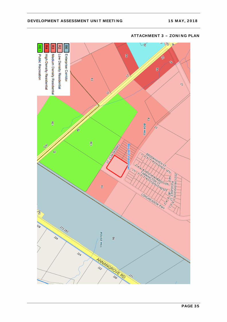
Zoning R2 Low Density Residential
Site Area 4,928m2
List of all relevant s4.15(1) matters
Section 4.15 (EP&A Act 1979) – Satisfactory SEPP Growth Centres – Satisfactory SEPP BASIX – Satisfactory State Environmental Planning Policy No 55 – Remediation of Land – Satisfactory Box Hill Growth Centre Precincts DCP 2018 – Satisfactory Section 7.11 Contribution: $175,000
Political Donation None Disclosed
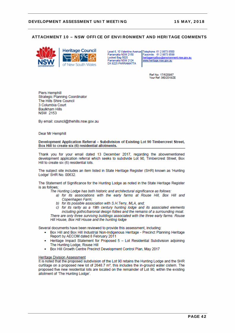
Reason for Referral to DAU 1. Submission/s received 2. Subdivision of State Heritage Listed Item
Recommendation Approval subject to conditions.

DEVELOPMENT ASSESSMENT UNIT MEETING 15 MAY, 2018
PAGE 6
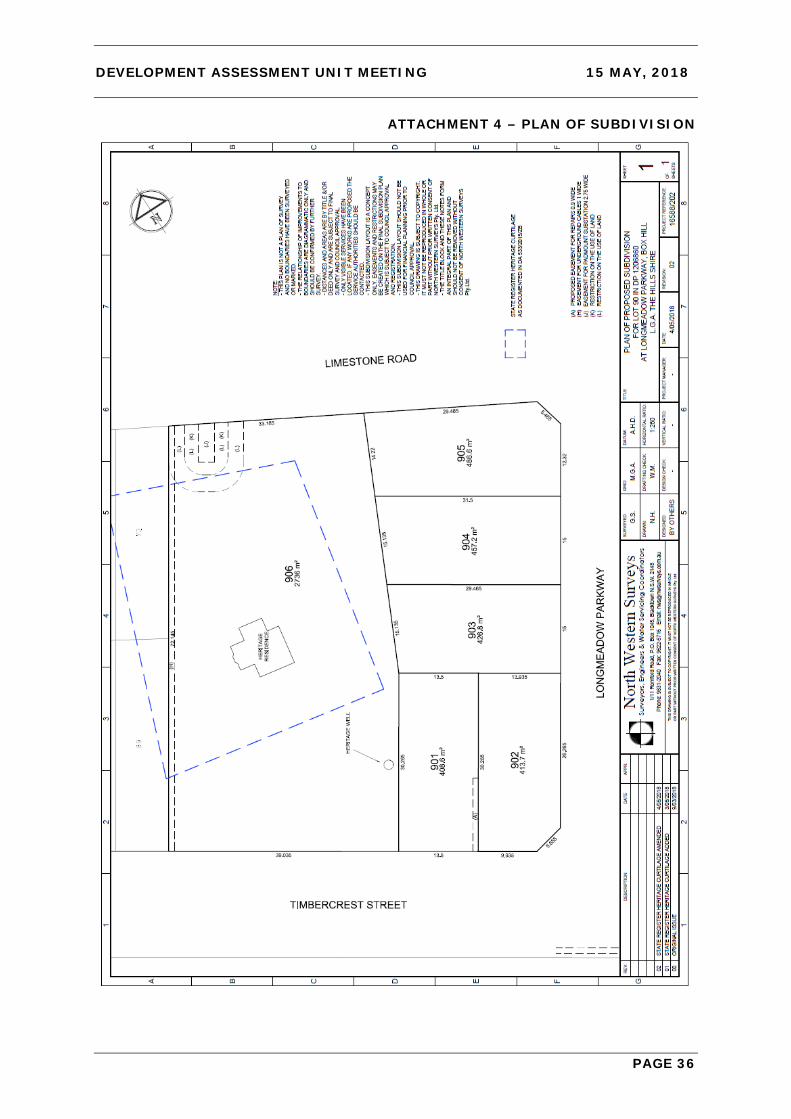
EXECUTIVE SUMMARY The development application is for a small lot housing development and subdivison of the site to create six residential lots and five dwelling houses. The site is located in the NSW Government North West Growth Area (Box Hill Precinct) and contains a heritage item known as ‘The Hunting Lodge’, which is listed on the State Heritage Register as an item of State significance under Schedule 5, Appendix 11 – The Hills Growth Centre Precincts Plan, State Environmental Planning Policy (SEPP) (Sydney Region Growth Centres) 2006. The Hunting Lodge is also listed on the register of the National Trust of Australia (NSW). The proposal seeks to subdivide the existing 4,928m2 site to create five conventional residential lots each containing a single storey dwelling fronting Longmeadow Parkway and Timbercrest Street, along with a sixth larger residential lot with an area of 2,736m2 whhich is proposed to contain the Hunting Lodge heritage item. The application does not vary the SEPP (Sydney Region Growth Centres) 2006 Appendix 11 – The Hills Growth Centre or the Box Hill Growth Centre Precincts Development Control Plan 2018, however it does propose an alternate subdivision layout within ‘The Hunting Lodge’ Precinct Plan Control Area compared to that shown in the Box Hill Growth Centre Precincts Development Control Plan 2018. The application was advertised and notified locally and two submissions were received. The submissions raise concern regarding the impacts of the development on the ‘Hunting Lodge’ heritage item. The proposal is not Integrated Development as defined under the Act because the development does not encroach into the State Heritage Register curtilage, which would require concurrence from the NSW Office of Environment and Heritage. The NSW Office of Environment and Heritage have however provided comment on the proposal, at the request of Council staff, advising that they do not support the application on the basis that it will have adverse impact on the wider setting of the Hunting Lodge and the landscape character of the area including the Hunting Lodge’s visual setting. In response it is noted that there is no physical work on the heritage item proposed, nor does the proposal encroach on the State Heritage Register curtilage. Further, the proposal provides sufficient mitigation measures to protect and preserve the heritage value of the item. It is recommended that the application be approved subject to conditions. BACKGROUND The subject site (Lot 90 DP 1206860) was created under a preceding subdivision approved via DA 533/2015/ZB over the original parent site (refer Attachment 12). The subject site was created in accordance with the Indicative Layout Plan contained within the Box Hill Development Control Plan. It is bound by Limestone Road to the north, Longmeadow Parkway to the east, Timbercrest Street to the south and R3 Medium Density Residential zoned land to the west. Lot 90 and surrounding subdivision occurred in accordance with DCP Figure 72 Precinct Plan Control Area for the Hunting Lodge (refer Attachment 6). At the time, there was no indication that a development application would be lodged to further subdivide the heritage lot later. On 18 May 2016, a Section 60 Application under the Heritage Act 1977 was approved (subject to conditions) by the Heritage Council of NSW to undertake conservation works on the Hunting Lodge. Advice from NSW Office of Environment and Heritage (OEH) has confirmed the s60 approval is confined to the limits of the State Heritage Curtilage of the ‘Hunting Lodge’ which is not impacted by this proposal.

DEVELOPMENT ASSESSMENT UNIT MEETING 15 MAY, 2018
PAGE 7
The Heritage Impact Statement submitted in support of this development application states:
“The owners of The Hunting Lodge have tried unsuccessfully to find buyers prepared to purchase the building and adapt it and its curtilage for a sympathetic new use.”
The Heritage Impact Statement states that this involved consultation with two child care centre operators of which the second withdrew interest after consultation with NSW OEH’s Heritage Division who suggested their proposal was “over-development and unlikely to be approved by the Heritage Council”. As a result the subject subdivision application has been lodged. PROPOSAL The development application is for the subdivision of the site into six residential lots and the construction of five single storey dwelling houses, one on each of lots 901 to 905. Proposed lot 906 will contain the existing heritage item the ‘Hunting Lodge’. The residential lots with dwelling houses range in size from 408.6m2 to 486.6m2 whilst lot 906 containing the heritage item is 2,736m2. The proposed plan of subdivision is provided in Attachment 4. The State Heritage Curtilage of the Hunting Lodge is also wholly contained within lot 906 and is not impacted by any proposed works under this application. The dwelling houses on lots 901 and 902 are orientated to front Timbercrest Street facing onto RE1 Public Recreation zoned land to the south which is intended for future sports fields. The other three dwelling houses face Longmeadow Parkway. Heritage considerate fencing has been proposed along the boundary between proposed residential lots 901 to 905 and lot 906 (containing the heritage item). The Heritage Impact Statement also recommends landscape planting along this boundary to provide additional screening of views to and from the Hunting Lodge and the proposed residential development. ISSUES FOR CONSIDERATION 1. SEPP (Sydney Region Growth Centres) 2006 Appendix 11 – The Hills Growth
Centre
(i) Permissibility The land is zoned R2 Low Density Residential under SEPP (Sydney Region Growth Centres) 2006 Appendix 11 – The Hills Growth Centre (SEPP (SRGC) 2006). Subdivision is permitted with consent pursuant to clause 2.6 of SEPP (SRGC) 2006. Dwelling houses are permitted with consent in the R2 Low Density Residential Zone.
(ii) Zone Objectives The site is zoned R2 Low Density Residential. The objectives of the zone are: • To provide for the housing needs of the community within a low density residential
environment.

DEVELOPMENT ASSESSMENT UNIT MEETING 15 MAY, 2018
PAGE 8
• To enable other land uses that provide facilities or services to meet the day to day needs of residents.
• To allow people to carry out a reasonable range of activities from their homes, where such activities are not likely to adversely affect the living environment of neighbours.
• To support the well-being of the community, by enabling educational, recreational, community, religious and other activities where compatible with the amenity of a low density residential environment.
The proposal is considered to be consistent with the zone objectives, in that the proposal will provide additional low density housing that will allow people to carry out a range of reasonable activities from their homes not adversely affecting the living environment of neighbours.
(iii) Development Standards The following table addresses the principal development standards of SEPP (SRGC) 2006 relevant to the subject proposal:
CLAUSE REQUIRED PROVIDED COMPLIES 4.1A Minimum Subdivision Lot Size
300m2 408.6m2 to 2,736m2 Yes
4.1B Residential Density
15 dw/ha minimum 19.3 dw/ha Yes
4.3 Building Height 8.5m maximum <6m height Yes The proposed changes to the North West Priority Growth Area Land Use and Infrastructure Implementation Plan see density ranges introduced. This site is proposed to have a density range of 15-20 dw/ha. The density calculation for the site was considered in the context of the preceding parent subdivision (DA 533/2015/ZB) where the creation of five additional lots/ dwellings will still fall within the proposed 15-20 dw/ha density range of that subdivision (19.3dw/ha). The development complies with the proposed changes. Clause 5.10 Heritage Conservation Clause 5.10 seeks to conserve the environmental heritage of precinct, including the heritage significance of heritage items and heritage conservation areas and their associated fabric, settings and views. Subclause 2(f) requires development consent for the subdivision of land on which a heritage item is located. Subclause (4) requires:
“The consent authority must, before granting consent under this clause in respect of a heritage item or heritage conservation area, consider the effect of the proposed development on the heritage significance of the item or area concerned. This subclause applies regardless of whether a heritage management document is prepared under subclause (5) or a heritage conservation management plan is submitted under subclause (6).”

DEVELOPMENT ASSESSMENT UNIT MEETING 15 MAY, 2018
PAGE 9
The effect of the proposed development on the ‘Hunting Lodge’ heritage item has been the primary consideration in the assessment of this application. It has been concluded that the effect of the proposed development is considered acceptable subject to recommended conditions specified at the end of this report. Subclause (5) states:
“The consent authority may, before granting consent to any development require a heritage management document to be prepared that assesses the extent to which the carrying out of the proposed development would affect the heritage significance of the heritage item or heritage conservation area concerned.”
A Heritage Impact Statement assessing the impacts of the proposal on the ‘Hunting Lodge’ heritage item was prepared and submitted with the application. Subclause (6) states:
“The consent authority may require, after considering the heritage significance of a heritage item and the extent of change proposed to it, the submission of a heritage conservation management plan before granting consent under this clause.”
A draft Conservation Management Plan (CMP) for the ‘Hunting Lodge’ was prepared in October 2014. The Hunting Lodge is also subject to a separate Section 60 approval issued on 18 May 2016 under the Heritage Act 1977, granted by the Heritage Division, OEH, to undertake conservation works on the heritage item. 2. Box Hill Growth Centre Precincts Development Control Plan The proposal has been assessed against the provisions of the Box Hill Growth Centre Precincts Development Control Plan (DCP). The proposed development, both subdivision and dwelling houses, achieves compliance with all relevant controls in the DCP. The proposed dwellings provide compliant side and rear setbacks and private open spaces complying with the minimum recommended in the DCP. The single storey dwellings provide an acceptable streetscape presentation, which includes the dwellings on lots 901 and 902 specifically being orientated towards the planned park on the opposite side of Timbercrest Street as required by the DCP. DCP Section 8.1.8 The Hunting Lodge Special Area Controls is assessed below.
CONTROL COMMENT 1. Development in and around The
Hunting Lodge should be in accordance with the requirements of the NSW Heritage Act 1977 and will require concurrent approval from the Heritage Council. Additionally, development should take into account the heritage provisions of the Growth Centres SEPP.
No works are proposed on the heritage item or within the State Heritage Register curtilage. The provisions of the Heritage Act 1977 are confined to the State Heritage Register curtilage. The application was referred to OEH who confirmed in their letter dated 15 November 2017 that concurrence/ approval from the Heritage Council was not required.
2. Development within the State Heritage Register curtilage and
A Heritage Impact Statement was submitted with the application which addresses the listed matters

DEVELOPMENT ASSESSMENT UNIT MEETING 15 MAY, 2018
PAGE 10
CONTROL COMMENT the Precinct Plan Control Area should be accompanied by a Heritage Impact Statement addressing the impact to the significance of The Hunting Lodge. The following matters must be considered in the Heritage Impact Statement: • The character, siting, bulk,
height and external appearance of the development;
• The visual relationship between the proposed development and the Hunting Lodge;
• The potential for overshadowing of the Hunting Lodge;
• The colours and textures of materials proposed to be used in the development;
• The landscaping and fencing of the proposed development;
• The location of car parking spaces and access ways into the development;
• The impact of any proposed advertising signs or structures;
• The impact the proposed use would have on the amenity of the Hunting Lodge; and
• The effect the construction phase will have on the Hunting Lodge.
to be considered in the assessment of impacts on the significance of the Hunting Lodge.
3. Housing to the north and east of the Hunting Lodge, across the proposed road, should be set back 5m from the property boundary.
This is not applicable as the application proposes lots/ dwellings within Lot 90 and not across the proposed road (Limestone Road) where this control specifically applies. It is noted that this recommendation has not been complied through approved dwellings using Complying Development located on Lots 54 and 58 DP1206860 opposite the heritage item to the north on Limestone Road (746/2018/PCDD and 603/2018/PCDD). For those dwellings, the approved front setbacks are 3.67m and 4.5m respectively:

DEVELOPMENT ASSESSMENT UNIT MEETING 15 MAY, 2018
PAGE 11
CONTROL COMMENT
4. The visual impact of structures
within the Precinct Plan Control Area of The Hunting Lodge should be minimised through appropriate siting, landscaping and use of materials.
Section 2.4 of the Heritage Impact Statement assesses the visual impacts of the proposal. The primary view corridor to the south/ southwest across future public open space to The Water Lane is maintained. Screen landscaping with heritage fencing has been proposed along the boundary between the residential lots and the Hunting Lodge in accordance with recommendations in the Heritage Impact Statement. Section 4.6.3 of the Heritage Impact Statement and the colour palettes submitted with the application detail the external finishes of the development which utilise materials and finishes that are of low reflectivity and blend naturally with the surrounding landscape.
5. Consideration will be given to applications to alter the use of The Hunting Lodge to allow for commercial, retail or community uses.
Not applicable as approval of the proposed future use of the Hunting Lodge has not been included or sought as part of this application.
6. Development, including subdivision within the Precinct Plan Control Area of The Hunting Lodge must comply with that outlined in Figure 72, unless accompanied by a Heritage Impact Statement demonstrating the merits of the proposed alternative.
This control is discussed in Section 4 – Heritage Considerations below. The application proposes an alternative to subdivision layout of the Precinct Plan Control Area outlined in Figure 72 and is accompanied by a Heritage Impact Statement demonstrating the merits of the proposed alternative, complying with the DCP.

DEVELOPMENT ASSESSMENT UNIT MEETING 15 MAY, 2018
PAGE 12
3. Figure 72 of the Box Hill Development Control Plan The Precinct Plan Control Area of the Hunting Lodge heritage item, illustrated in Figure 72 (Attachment 6) of the DCP, has been considered as part of this application. Figure 72 was originally prepared as part of the non-indigenous heritage reporting conducted at the Precinct planning stage for the entire Box Hill Growth Centre Precinct. It was first published in the Box Hill and Box Hill Industrial Non-Indigenous Heritage – Precinct Planning Heritage Report prepared by AECOM dated February 2011. The Figure was adopted into the DCP at the time and has remained unchanged since being first published. The Figure, due to its dating back to 2011, does not reflect the current status of the Hunting Lodge Precinct Plan Control Area in terms of subdivision, surrounding zoning and the existence of an ‘LEP curtilage’. For the purposes of this report, a plan has been prepared by Council staff (refer below and Attachment 6) to provide clarity on the current layout and details of the Precinct Plan Control Area and surrounding land. The footprint of the proposed development has also been shown.
DCP Figure 72 – Precinct Plan Control Area for the Hunting Lodge

DEVELOPMENT ASSESSMENT UNIT MEETING 15 MAY, 2018
PAGE 13
Plan Showing Current Layout with Proposed Lots (April 2018) 4. Heritage Considerations The development application was initially processed as Integrated Development and referred to OEH on 11 September 2017 for concurrence under Section 4.46 of the Act. A response was received from OEH on 15 November 2017. The response revealed that because the application did not propose any works within the State Heritage Curtilage of the ‘Hunting Lodge’, it did not require consent under s57 of the Heritage Act 1977 and therefore did not trigger the Integrated Development provisions under the Act. The response further stated:
“.. we cannot provide general terms under an IDA [integrated development application] for works outside the curtilage of an SHR item and therefore no further correspondence will be forthcoming. Council could refer the application to the Heritage Council for comment as a DA Referral (DAR) should heritage input be required.”
Upon this advice, the DA was re-referred to OEH on 23 November 2017 as a general DA referral or ‘DAR’ seeking their comments (and not concurrence). OEH provided comments on 19 January 2018 which were not supportive of the application (refer Attachment 10). The OEH letter was forwarded to the applicant who submitted a detailed response to Council and OEH on 30 January 2018 (refer Attachment 11). Further correspondence from OEH reiterated that the application relates to works outside the State Heritage Register curtilage and therefore the Council was the consent authority but noted:
“While we [OEH] are happy to discuss our response with the Council, it would be up to the Council on how they would like to proceed with it.”

DEVELOPMENT ASSESSMENT UNIT MEETING 15 MAY, 2018
PAGE 14
The applicant’s response raised a number of concerns with the comment from OEH, namely:
“The proposal does not encroach in any fashion on the mapped State Heritage Register Curtilage adopted by the Heritage Council.
There is a misinterpretation of the legislative purpose of the adopted SEPP heritage map and the mapped State Heritage Register curtilage. The Growth Centres SEPP does not contain any heritage curtilage for the “Hunting Lodge”.
The Development Referral (17/620937) provided by the OEH incorporates comments which appear to misinterpret the heritage report prepared by AECOM in association with the rezoning of the precinct. The ILP does not specify or require that the whole of the Large Lot Residential area be retained as a single allotment.
The comments provided appears inconsistent with previous advice provided by the OEH in assessment of Development Application 533/2015, which approved the creation of Lot 90.
The detailed Heritage Impact Statement submitted with the application supports the proposal and provides appropriate mitigation measures, included in the proposal.”
NSW Office of Environment and Heritage Comments The OEH comments have been grouped into points and considered below:
1. “The SHR curtilage around the Hunting Lodge protects the immediate setting of the structure but is smaller than the curtilage of the ‘The Hunting Lodge’ identified in the ‘Schedule 5 Environmental heritage’ of Appendix 11 of State Environmental Planning Policy (SEPP) (Sydney Region Growth Centres) 2006.
2. The existing larger allotment for ‘Hunting Lodge’ was recommended in the
heritage report prepared by AECOM which informed the Indicative Layout Plan for the Box Hill and Box Hill Industrial Priority Growth Area.
3. The recommended larger allotment for ‘Hunting Lodge’ was to aid in the conservation of the Lodge’s significance as a building set in a rural landscape.
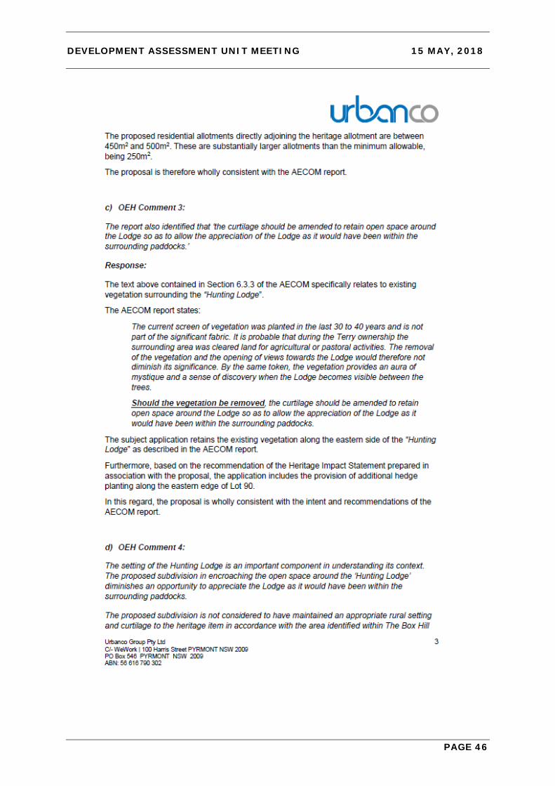
4. The report also identified that ‘the curtilage should be amended to retain open space around the Lodge so as to allow the appreciation of the Lodge as it would have been within the surrounding paddocks.’
5. The setting of the Hunting Lodge is an important component in understanding its
context. The proposed subdivision in encroaching the open space around the ‘Hunting Lodge’ diminishes an opportunity to appreciate the Lodge as it would have been within the surrounding paddocks.
The proposed subdivision is not considered to have maintained an appropriate rural setting and curtilage to the heritage item in accordance with the area identified within The Box Hill Development Control Plan DCP and does not comply with the heritage provisions of the Growth Centres SEPP.

DEVELOPMENT ASSESSMENT UNIT MEETING 15 MAY, 2018
PAGE 15
6. The proposed residential subdivision will have additional adverse permanent impact on the wider setting of the Hunting Lodge and the landscape character of the area including the item’s visual setting.
7. The Heritage Impact Assessment submitted with the proposal also states that the proposed 5-lot residential subdivision within the SEPP curtilage of the Hunting Lodge will result in visual impacts on the SHR curtilage and changes to the perception of the building. Therefore, the proposal to subdivide Lot 90, Timbercrest Street, Box Hill to create six (6) residential lots is not supported.”
Point 1: There is no heritage curtilage identified for ‘The Hunting Lodge’ under Schedule 5 ‘Environmental heritage’ of SEPP (SRGC) 2006 nor was there under the previous Local Environmental Plan that applied to the site. As raised by the applicant, SEPP (SRGC) 2006 and the associated Heritage Map Sheet simply identifies cadastral boundaries of land parcels within which heritage items are located. It is noted that proposing development outside of the defined State Heritage Curtilage does not mean the proposal will not have an impact on the heritage significance of a heritage item and its associated fabric, settings and views. Point 2: This comment is correct in that the existing larger allotment for ‘Hunting Lodge’ was recommended in the heritage report prepared by AECOM. However, clause 8.1.8(6) contained within the ‘Hunting Lodge’ special area controls of the DCP states:
“Development, including subdivision within the Precinct Plan Control Area of The Hunting Lodge must comply with that outlined in Figure 72, unless accompanied by a Heritage Impact Statement demonstrating the merits of the proposed alternative.”
A Heritage Impact Statement was submitted with the development application in support of the proposal as per this clause. The applicant in their response letter also offers the following:
“The adopted Indicative Layout Plan shows the “Hunting Lodge” being situated within a Large Lot Residential area. The ILP does not specify or require that the whole of the Large Lot Residential area be retained as a single allotment. Rather, the AECOM report referred to above states:
‘The allowance for a larger allotment around the Hunting Lodge will aid in the conservation of the Lodge’s significance as a building set in a rural landscape. The allotments around the Lodge are also larger, which will create a more rural feel around the Lodge.’ The proposal maintains “The Hunting Lodge” within a larger allotment consistent with the recommendations of the AECOM report and the adopted ILP and is consistent with the lot sizes for other Large Lot Residential areas under the ILP. The proposed residential allotments directly adjoining the heritage allotment are between 450m2 and 500m2. These are substantially larger allotments than the minimum allowable, being 250m2. The proposal is therefore wholly consistent with the AECOM report.”

DEVELOPMENT ASSESSMENT UNIT MEETING 15 MAY, 2018
PAGE 16
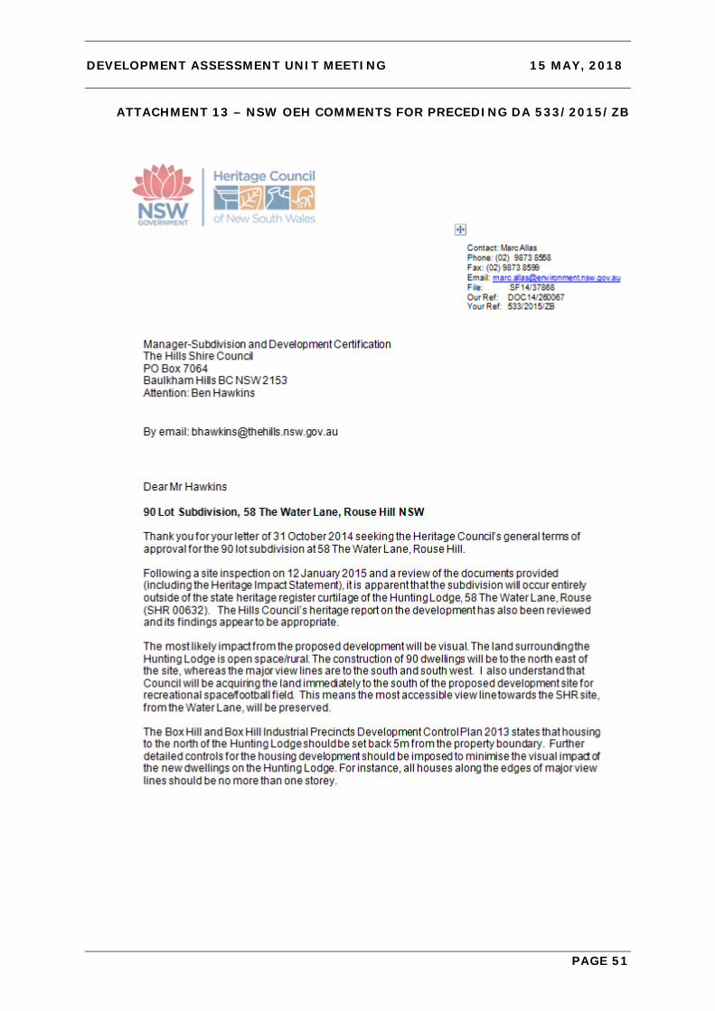
Point 3 (noted) Point 4: OEH’s reference to the AECOM Report’s recommendation that the curtilage be amended “.. to retain open space around the Lodge ..” was not implemented at the Box Hill Precinct planning stage by the NSW Department of Planning and Environment when OEH was consulted and had the opportunity to see it realised. The State Heritage Curtilage of the Hunting Lodge, as previously mentioned, has remained unchanged since 1986. The original 8ha parcel, on which the ‘Hunting Lodge’ was constructed, was subject to a prior subdivision application (533/2015/ZB) where the ‘Hunting Lodge’ was reduced to the current lot 90. In fact, under the preceding DA (533/2015/ZB) the OEH raised no objections to the creation of 323m2 lots within the State Heritage Curtilage bordering lot 90 to the north-west (see Attachment 13 which shows this encroachment). At no stage has OEH amended the State Curtilage of the ‘Hunting Lodge’ as per the AECOM Report recommendation which would have given greater statutory protection (via Heritage Act 1977) to open space around the Hunting Lodge. Instead it has relied on a DCP figure that incorrectly refers to the existence of an LEP curtilage and which can be varied via DCP clause 8.1.8(6) above. Point 5: The point considers an appropriate curtilage has not been maintained to the heritage item in accordance with the DCP (Figure 72). As previously mentioned, there is no defined curtilage (SEPP/ LEP) other than the State Heritage Curtilage which is retained to lot 906, despite Figure 72 showing otherwise. In addition, DCP clause 8.1.8(6) allows for the subdivision layout of the Hunting Lodge Precinct Plan Control Area to be varied subject to a Heritage Impact Statement “demonstrating the merits of the proposed alternative.” It is also unclear what heritage provisions of the SEPP the proposal does not comply with. As detailed in this report, SEPP Clause 5.10 Heritage Conservation subclause (4) requires the consent authority (Council) to “consider the effect of the proposed development on the heritage significance of the item or area concerned.” A Heritage Impact Statement has been submitted in accordance with subclause (5) and a draft conservation management plan was submitted in accordance with subclause (6) under the preceding development application 533/2015/ZB which created the subject lot. Point 6: As raised by the applicant, consultation with OEH under the preceding DA 533/2015/ZB (letter dated 19 January 2015) confirmed major view lines to the Hunting Lodge are to the south and south-west across the RE1 zoned land towards The Water Lane. The proposed residential development is to the east of the Hunting Lodge and does not obstruct these major view lines as shown in the following diagram:
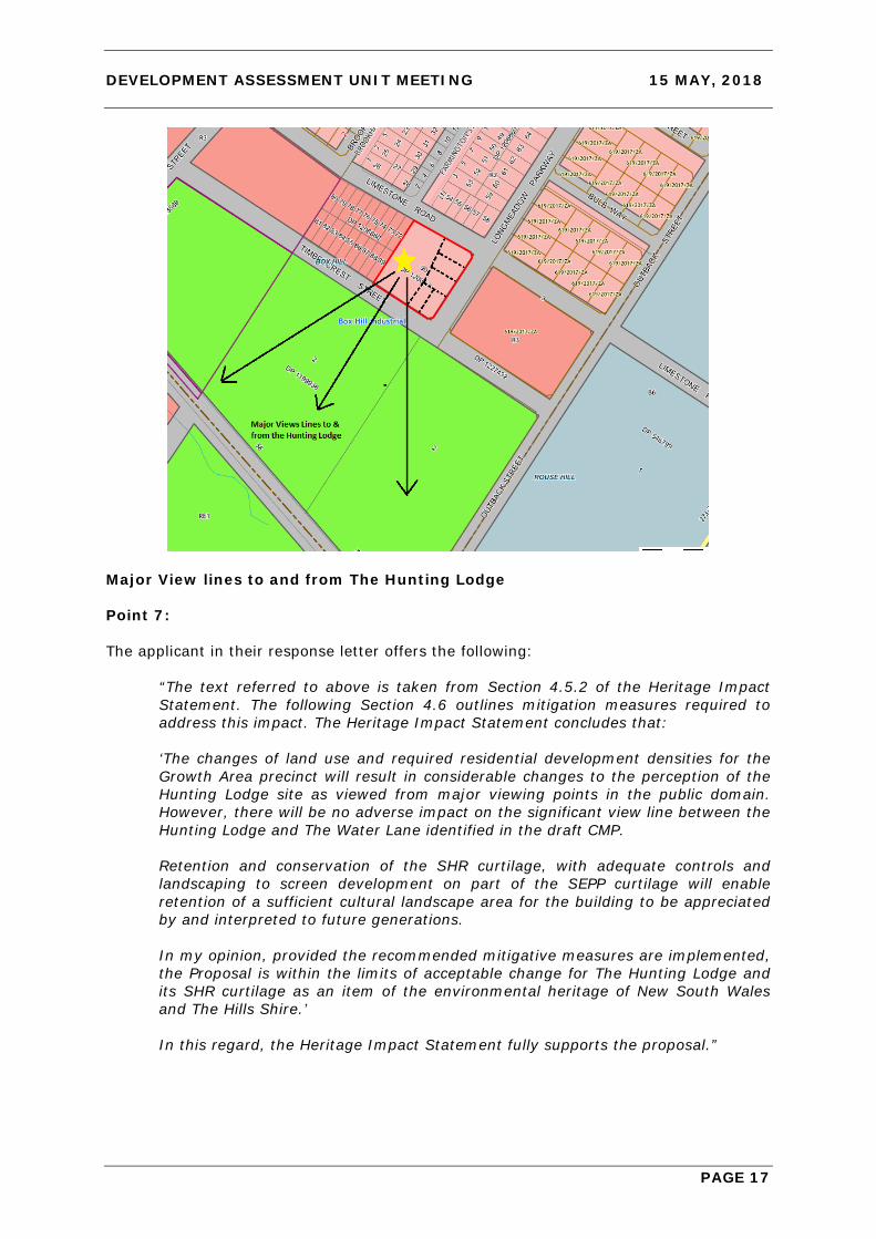
DEVELOPMENT ASSESSMENT UNIT MEETING 15 MAY, 2018
PAGE 17
Major View lines to and from The Hunting Lodge Point 7: The applicant in their response letter offers the following:
“The text referred to above is taken from Section 4.5.2 of the Heritage Impact Statement. The following Section 4.6 outlines mitigation measures required to address this impact. The Heritage Impact Statement concludes that: ‘The changes of land use and required residential development densities for the Growth Area precinct will result in considerable changes to the perception of the Hunting Lodge site as viewed from major viewing points in the public domain. However, there will be no adverse impact on the significant view line between the Hunting Lodge and The Water Lane identified in the draft CMP.
Retention and conservation of the SHR curtilage, with adequate controls and landscaping to screen development on part of the SEPP curtilage will enable retention of a sufficient cultural landscape area for the building to be appreciated by and interpreted to future generations.
In my opinion, provided the recommended mitigative measures are implemented, the Proposal is within the limits of acceptable change for The Hunting Lodge and its SHR curtilage as an item of the environmental heritage of New South Wales and The Hills Shire.’ In this regard, the Heritage Impact Statement fully supports the proposal.”

DEVELOPMENT ASSESSMENT UNIT MEETING 15 MAY, 2018
PAGE 18
Comment from Council’s Forward Planning Team (Heritage) Council’s Forward Planning team have reviewed the proposal from a heritage perspective and support the views of the OEH; however it has been acknowledged that the proposal is compliant with the SEPP and DCP. Accordingly, the concerns are not considered significant enough to warrant or justify refusal of the application on heritage grounds. Heritage conditions were recommended by Forward Planning should the application be considered for approval. These have been included below. 5. Issues Raised in Submissions The proposal was exhibited and notified locally for 30 days. There were two submissions received from the Hills District Historical Society (HDHS). No other submissions were received. The issues raised in the submissions from the HDHS are summarised below.
ISSUE/ OBJECTION COMMENT “Our greatest concern is adherence to the heritage curtilage which seems to shrink every time an application for a development is made. We have seen too many heritage sites lose their value and importance or just been demolished in favour of development. We do note that the former hunting lodge is or has been restored which is good. We hope that it can be for a good purpose. We are extremely concerned that the larger population in this area highlights its existence to the wrong elements of society and therefore graffiti and vandalism.”
The submission is correct in that the lot on which the Hunting Lodge is situated has been reduced in size since the establishment of the Box Hill Growth Centre. However, the State Heritage Curtilage around the Hunting Lodge has remained unchanged since the 1980’s. The Hunting Lodge is also subject to a s60 approval under the Heritage Act 1977 for restoration works which may increase its potential for adaptive reuse.
“The proposal of subdividing and construction of further residences so close to the Heritage item does not do justice to the visual and spatial setting, the surroundings, or the integrity of The Hunting Lodge. Indeed, in leaving it in its current form, preserves the open space around it - again, giving the Lodge the "origins of its beginnings". Again, the reasons for the State Significance registration/ listing would be compromised and breached if this proposed development is allowed to go ahead or is approved. In accordance with the Statement of Significance, and the requirements of the Heritage Act and the Office of the Environment and Heritage (Heritage Branch) the following must be maintained: visual absorption and dominance must be maintained;
The proposal is considered to maintain an appropriate spatial setting to the Hunting Lodge. The proposal maintains the major view lines to the Hunting Lodge to the southwest from the future public domain. The State significance of the item is protected by the State Heritage Register curtilage surrounding the Hunting Lodge which is covered under the Heritage Act 1977. OEH has not amended this curtilage despite the introduction of the Box Hill Growth Centre Precinct and the master planning of the precinct for residential land uses. The proposal is not considered to adversely impact on the State significance of the heritage item.

DEVELOPMENT ASSESSMENT UNIT MEETING 15 MAY, 2018
PAGE 19
ISSUE/ OBJECTION COMMENT sensitivity of the interface must be maintained with no distraction from the Heritage item; the associated fabric of early farms and its context/ purpose within the setting surrounding the Heritage item.” 6. Internal Referrals The application was referred to following sections of Council: • Engineering • Environmental Health • Tree Management • Resource Recovery • Forward Planning (Heritage) The heritage comments have been considered in Section 4 of this report. The other internal referrals raised no objections to the proposal subject to conditions, which have been included below. 7. External Referrals Development Application Referral (DAR) – OEH The proposal was referred to OEH initially as Integrated Development however OEH responded on 15 November 2017 confirming that because the application did not propose any works within the State Heritage Curtilage of ‘The Hunting Lodge’, it did not require consent under s57 of the Heritage Act 1977 and therefore did not trigger the integrated development provisions under the Act. The response further stated:
“.. we cannot provide general terms under an IDA [integrated development application] for works outside the curtilage of an SHR item and therefore no further correspondence will be forthcoming. Council could refer the application to the Heritage Council for comment as a DA Referral (DAR) should heritage input be required.”
Upon this advice, the application was then re-referred to OEH on 23 November 2017 as a general DA referral or ‘DAR’ seeking their comments (and not concurrence). OEH provided comments on 19 January 2018 which were not supportive of the application (refer Attachment 10). This response has been considered in Section 4 of this report. CONCLUSION The Development Application has been assessed against the relevant matters for consideration under Section 4.15 of the Environmental Planning and Assessment Act 1979, SEPP (Sydney Region Growth Centres) 2006 Appendix 11 – The Hills Growth Centre and Box Hill Growth Centre Precincts Development Control Plan 2018 and is considered satisfactory. The comments provided by the NSW Office of Environment and Heritage, and the concerns raised in the submissions, have been addressed in the report and do not warrant refusal of the application.

DEVELOPMENT ASSESSMENT UNIT MEETING 15 MAY, 2018
PAGE 20
Approval is recommended subject to conditions. IMPACTS Financial This matter has no direct financial impact upon Council’s adopted budget or forward estimates. Strategic Plan - Hills Future The proposed development is consistent with the planning principles, vision and objectives outlined within “Hills 2026 – Looking Towards the Future” as the proposed development provides for satisfactory urban growth without adverse environmental or social amenity impacts and ensures a consistent built form is provided with respect to the streetscape and general locality. RECOMMENDATION The Development application be approved subject to the following conditions of consent: GENERAL MATTERS 1. Approved Plan The development must be carried out in accordance with the approved plans and other supporting documentation listed below, except where amended by other conditions of consent:
Drawing: Description: Prepared: Sheet: Revision: Date:
16588/202 Subdivision Plan North Western Surveys
1 of 1 2 04/05/2018
900.1 Site Plan Zac Homes
900.1 L 12/03/2018
900.2 Street Elevations Zac Homes
900.2 L 12/03/2018
900.6 Landscape Plan Zac Homes
900.6 L 12/03/2018
900.8 Heritage Fence Detail Zac Homes
900.8 L 12/03/2018
901.2 Lot 901 Floor Plan Zac Homes
901.2 C 19/02/2016
901.3 & 901.4
Lot 901 Elevations Zac Homes
901.3 & 901.4
C 19/02/2016
902.2 Lot 902 Floor Plan Zac Homes
902.2 D 12/03/2018
902.3 & 902.4
Lot 902 Elevations Zac Homes
902.3 & 902.4
D 12/03/2018
903.2 Lot 903 Floor Plan Zac Homes
903.2 C 19/02/2016
903.3 & 903.4
Lot 903 Elevations Zac Homes
903.3 & 903.4
C 19/02/2016

DEVELOPMENT ASSESSMENT UNIT MEETING 15 MAY, 2018
PAGE 21
904.2 Lot 904 Floor Plan Zac Homes
904.2 C 19/02/2016
904.3 & 904.4
Lot 904 Elevations Zac Homes
904.3 & 904.4
C 19/02/2016
905.2 Lot 905 Floor Plan Zac Homes
905.2 D 12/03/2018
905.3 & 905.4
Lot 905 Elevations Zac Homes
905.3 & 905.4
D 12/03/2018
Where a Construction Certificate is required, no work is to be undertaken before it has been issued.
2. Colours and Materials
All colours and materials shall be in accordance with the plans provided in Elevations prepared by Zac Homes dated 12/03/2018. Any change to colours or materials will require a modification application.
3. Fencing All fencing shall be in accordance with the Landscape Plan prepared by Zac Homes dated 12/03/2018. Any change to fencing design, colours or materials will require a modification application.
4. Subdivision Certificate Preliminary Review Prior to the submission of a Subdivision Certificate application a draft copy of the final plan, administration sheet and Section 88B instrument (where included) must be submitted in order to establish that all conditions have been complied with.
Street addresses for the lots within this subdivision will be allocated as part of this preliminary check process, for inclusion on the administration sheet.
5. External Finishes External finishes and colours must comply with the details submitted with the development application and approved with this consent.
6. BCA Compliance All building work must be carried out in accordance with the provisions of the Building Code of Australia.
7. Zero Lot Line Dwellings – Easement Encroachment No element of those dwellings located on the boundary line with an adjoining lot (zero lot line dwellings) can be located within that adjoining lot. Construction tolerances should be accounted for when surveying and constructing these dwellings.
Similarly, the dwellings on the lots adjacent, being those lots burdened by an easement for repair; must be located wholly outside of the easement except where it is shown on the approved plans that the encroaching eaves/ guttering does not impede maintenance access to either dwelling and that the encroachment is no closer than 450mm to the boundary.
8. Contamination Any new information, that may come to light during construction works, which has the potential to alter previous conclusions about site contamination, shall be immediately notified to Council’s Manager – Environment and Health.
9. Adherence to Waste Management Plan All requirements of the Waste Management Plan submitted as part of the development application must be implemented except where contrary to other conditions of consent. The information submitted can change provided that the same or a greater level of reuse and recycling is achieved as detailed in the plan. Any material moved offsite is to be

DEVELOPMENT ASSESSMENT UNIT MEETING 15 MAY, 2018
PAGE 22
transported in accordance with the requirements of the Protection of the Environment Operations Act 1997 and only to a place that can lawfully be used as a waste facility. Receipts of all waste/ recycling tipping must be kept onsite at all times and produced in a legible form to any authorised officer of the Council who asks to see them.
10. Management of Construction and/ or Demolition Waste Waste materials must be appropriately stored and secured within a designated waste area onsite at all times, prior to its reuse onsite or being sent offsite. This includes waste materials such as paper and containers which must not litter the site or leave the site onto neighbouring public or private property. A separate dedicated bin must be provided onsite by the builder for the disposal of waste materials such as paper, containers and food scraps generated by all workers. Building waste containers are not permitted to be placed on public property at any time unless a separate application is approved by Council to locate a building waste container in a public place.
Any material moved offsite is to be transported in accordance with the requirements of the Protection of the Environment Operations Act 1997 and only to a place that can lawfully be used as a waste facility. The separation and recycling of the following waste materials is required: metals, timber, masonry products and clean waste plasterboard. This can be achieved by source separation onsite, that is, a bin for metal waste, a bin for timber, a bin for bricks and so on. Alternatively, mixed waste may be stored in one or more bins and sent to a waste contractor or transfer/ sorting station that will sort the waste on their premises for recycling. Receipts of all waste/ recycling tipping must be kept onsite at all times and produced in a legible form to any authorised officer of the Council who asks to see them.
11. Disposal of Surplus Excavated Material The disposal of surplus excavated material, other than to a licenced waste facility, is not permitted without the previous written approval of Council prior to works commencing on site. Any unauthorized disposal of waste, which includes excavated material, is a breach of the Protection of the Environment Operations Act 1997 and subject to substantial penalties. Receipts of all waste/ recycling tipping must be kept onsite at all times and produced in a legible form to any authorised officer of the Council who asks to see them.
12. Commencement of Domestic Waste Service A domestic waste service for each property must be commenced with Council. The service must be arranged no earlier than two days prior to occupancy and no later than two days post occupancy. All requirements of Council’s domestic collection service must be complied with at all times. Please telephone Council on (02) 9843 0310 for the commencement of waste services.
13. Provision of Domestic Waste Storage Area Sufficient space must be allocated within the property boundary of each lot to store a minimum of three 240 litre bins. Bins must not be visible from any adjoining property or public place. The bins must be easily accessible by future occupants and must be able to be wheeled to the street over flat or ramped surfaces, and not over steps, kerbs, landscape edging or through the dwellings.
14. Construction Certificate Prior to construction of the approved development, it is necessary to obtain a Construction Certificate. A Construction Certificate may be issued by Council or an Accredited Certifier. Plans submitted with the Construction Certificate are to be amended to incorporate the conditions of the Development Consent.
15. Building Work to be in Accordance with BCA All building work must be carried out in accordance with the provisions of the Building Code of Australia.
DEVELOPMENT ASSESSMENT UNIT MEETING 15 MAY, 2018
PAGE 23
16. Street Trees Street trees must be provided for the section of Timbercrest Street, Longmeadow Parkway and Limestone Road within or fronting the development site spaced between 7m and 10m apart and with a minimum of one tree per lot frontage. The location of street trees must be considerate of driveways, services, drainage pits and sight lines at intersections. The species and size of street trees must comply with the requirements of Council (including Council’s street tree master plan for Box Hill). Details demonstrating compliance with the above must be submitted for approval before any street trees are planted.
The establishment of street tree planting is included in the maintenance bond required to be paid. Alternatively, street trees can be planted by Council subject to payment of the applicable fee as per Council’s Schedule of Fees and Charges.
17. Minor Engineering Works The design and construction of the engineering works listed below must be provided for in accordance with Council’s Design Guidelines Subdivisions/ Developments and Works Specifications Subdivisions/ Developments.
Works on existing public roads or any other land under the care and control of Council must be approved and inspected by Council in accordance with the Roads Act 1993 or the Local Government Act 1993. A separate minor engineering works application and inspection fee is payable as per Council’s Schedule of Fees and Charges.
a) Driveway Requirements
The design, finish, gradient and location of all driveway crossings must comply with the above documents and Council’s Driveway Specifications.
The proposed driveways must be built to Council’s residential standard.
A separate driveway application fee is payable as per Council’s Schedule of Fees and Charges.
b) Disused Layback/ Driveway Removal
All disused laybacks and driveways must be removed and replaced with kerb and gutter together with the restoration and turfing of the adjoining footpath verge area.
c) Site Stormwater Drainage
The entire site area must be graded, collected and drained by pits and pipes to a suitable point of legal discharge.
The stormwater connections to the kerb shown for the individual lots must be located at least 500mm from the edge of the driveway, contrary to the submitted stormwater plan prepared by ZAC Homes.
d) Earthworks/ Site Regrading
Earthworks are limited to that shown on the approved plans. Where earthworks are not shown on the approved plan the topsoil within lots must not be disturbed.
e) Service Conduits
Service conduits to each of the proposed new lots, laid in strict accordance with the relevant service authority’s requirements, are required. Services must be shown on the engineering drawings.
18. Street Light Relocation The driveway for the dwelling on lot 905 conflicts with the existing street light. The street light must be relocated as part of this development.

DEVELOPMENT ASSESSMENT UNIT MEETING 15 MAY, 2018
PAGE 24
Prior to the issue of a Construction Certificate the relocation of this street light must be approved by Endeavour Energy and written evidence of this approval submitted to Council.
Prior to the issue of an Occupation Certificate the relocation of this street light must be completed and the works signed off by Endeavour Energy. Written evidence of this sign off must be submitted to Council.
19. Road Opening Permit Should the subdivision/ development necessitate the installation or upgrading of utility services or any other works on Council land beyond the immediate road frontage of the development site and these works are not covered by a Construction Certificate issued by Council under this consent then a separate road opening permit must be applied for and the works inspected by Council’s Maintenance Services team.
The contractor is responsible for instructing sub-contractors or service authority providers of this requirement. Contact Council’s Construction Engineer if it is unclear whether a separate road opening permit is required.
20. Rainwater Tanks Each of the dwellings on lots 901 to 905 must include a 3,000 litre (minimum) rainwater reuse tank as required by the DCP. The Construction Certificate drawings must reflect this and no Occupation Certificate is to be issued before the tank has been installed.
21. Planting Requirements All trees planted as part of the approved landscape plan are to be minimum 75 litre pot size. All shrubs planted as part of the approved landscape plan are to be minimum 200mm pot size. Groundcovers are to be planted at 5/m2.
PRIOR TO THE ISSUE OF A CONSTRUCTION CERTIFICATE 22. Western Sydney Growth Areas – Payment of Special Infrastructure Contribution A special infrastructure contribution is to be made in accordance with the Environmental Planning and Assessment (Special Infrastructure Contribution – Western Sydney Growth Areas) Determination 2011, as in force when this consent becomes operative.
Information about the special infrastructure contribution can be found on the Department of Planning and Environment website:
http://www.planning.nsw.gov.au/
Please contact the Department of Planning and Environment regarding arrangements for the making of a payment.
23. Section 7.11 Contribution The following monetary contributions must be paid to Council in accordance with Section 7.11 of the Environmental Planning and Assessment Act, 1979, to provide for the increased demand for public amenities and services resulting from the development.

DEVELOPMENT ASSESSMENT UNIT MEETING 15 MAY, 2018
PAGE 25
Payments comprise of the following:
The contributions above are applicable at the time this consent was issued. Please be aware that Section 7.11 contributions are updated quarterly.
Prior to payment of the above contributions, the applicant is advised to contact Council’s Development Contributions Officer on 9843 0268. Payment must be made by cheque or credit/ debit card. Cash payments will not be accepted.
This condition has been imposed in accordance with Contributions Plan No. 15.
Council’s Contributions Plans can be viewed at www.thehills.nsw.gov.au or a copy may be inspected or purchased at Council’s Administration Centre.
24. Security Bond Requirements A security bond may be submitted in lieu of a cash bond. The security bond must:
• Be in favour of The Hills Shire Council;
• Be issued by a financial institution or other accredited underwriter approved by, and in a format acceptable to, Council (for example, a bank guarantee or unconditional insurance undertaking);
• Have no expiry date;
• Reference the development application, condition and matter to which it relates;
• Be equal to the amount required to be paid in accordance with the relevant condition;
• Be itemised, if a single security bond is used for multiple items.
Should Council need to uplift the security bond, notice in writing will be forwarded to the applicant 14 days prior.
25. Erosion and Sediment Control/ Soil and Water Management Plan The detailed design must be accompanied by an Erosion and Sediment Control Plan (ESCP) or a Soil and Water Management Plan (SWMP) prepared in accordance with the Blue Book and Council’s Works Specification Subdivision/ Developments.
A SWMP is required where the overall extent of disturbed area is greater than 2,500 square metres, otherwise an ESCP is required.
An ESCP must include the following standard measures along with notes relating to stabilisation and maintenance:
• Sediment fencing.
• Barrier fencing and no-go zones.
• Stabilised access.
• Waste receptacles.
Integrated housing development and subdivision creating six residential lots/ five dwelling houses
Purpose: Subdivision
Purpose: Integrated
HousingPurpose:
Credit No. of Lots: 1
No. of Integrated Housing: 5
No. of Credits: 1 Total S94
Open Space - Land $13,151.76 $13,151.76 $13,151.76 13,151.76$ 65,758.81$ 13,151.76$ 65,758.81$ Open Space - Capital $6,378.84 $6,378.84 $6,378.84 6,378.84$ 31,894.21$ 6,378.84$ 31,894.21$ Transport Facilities - Land $1,013.06 $1,013.06 $1,013.06 1,013.06$ 5,065.31$ 1,013.06$ 5,065.31$ Transport Facilities - Capital $3,583.43 $3,583.43 $3,583.43 3,583.43$ 17,917.16$ 3,583.43$ 17,917.16$ Water Management - Land (KCP) $5,796.61 $5,796.61 $5,796.61 5,796.61$ 28,983.06$ 5,796.61$ 28,983.06$ Water Management - Capital (KCP) $4,884.24 $4,884.24 $4,884.24 4,884.24$ 24,421.21$ 4,884.24$ 24,421.21$ Administration $192.05 $192.05 $192.05 192.05$ 960.26$ 192.05$ 960.26$ Total 35,000.00$ 35,000.00$ 35,000.00$ 35,000.00$ 175,000.00$ 35,000.00$ 175,000.00$
DEVELOPMENT ASSESSMENT UNIT MEETING 15 MAY, 2018
PAGE 26
• Stockpile site/s.
A SWMP requires both drawings and accompanying commentary (including calculations) addressing erosion controls, sediment controls, maintenance notes, stabilisation requirements and standard drawings from the Blue Book.
An ESCP is required for this development.
26. Security Bond – Road Pavement and Public Asset Protection In accordance with Section 80A(6)(a) of the Environmental Planning and Assessment Act 1979, a security bond of $50,000.00 is required to be submitted to Council to guarantee the protection of the road pavement and other public assets in the vicinity of the site during construction works. The above amount is calculated at the rate of $85.00 per square metre based on the road frontage of the subject site plus an additional 50m on either side multiplied by the width of the road but has been reduced to account for the scale of development and amount of road frontage present now.
The bond must be lodged with Council before a building works Construction Certificate is issued.
The bond is refundable upon written application to Council and is subject to all work being restored to Council’s satisfaction. Should the cost of restoring any damage exceed the value of the bond, Council will undertake the works and issue an invoice for the recovery of these costs.
PRIOR TO WORK COMMENCING ON THE SITE 27. Builder and PCA Details The builders name, address, telephone and fax numbers must be submitted to the Principal Certifying Authority (PCA) before building works commence. Where Council is not the PCA, Council must be notified of the PCA in writing two days before building works commence in accordance with the Regulations.
28. Demolition Works and Asbestos Management The demolition of any structure is to be carried out in accordance with the Work Health and Safety Act 2011. All vehicles transporting demolition materials from the site are to have covered loads and are not to track any soil or waste materials on the road. Should demolition works obstruct or inconvenience pedestrian or vehicular traffic on adjoining public road or reserve, a separate application is to be made to Council to enclose the public place with a hoard or fence. All demolition works involving the removal and disposal of asbestos (of an area more than 10 square metres) must only be undertaken by a licenced asbestos removalist who is licenced to carry out the work. Transporters of asbestos waste (of any load over 100kg of asbestos waste or 10 square metres or more of asbestos sheeting) must provide information to the NSW EPA regarding the movement of waste using their WasteLocate online reporting tool:
www.wastelocate.epa.nsw.gov.au
Asbestos removal must be carried out in accordance with the WorkCover, Environment Protection Authority and Office of Environment and Heritage requirements. Asbestos to be disposed of must only be transported to waste facilities licenced to accept asbestos. No asbestos products are to be reused on the site.
29. Erection of Signage – Supervision of Work In accordance with Clause 98A(2) of the Environmental Planning and Assessment Regulations 2000, a sign is to be erected in a prominent position displaying the following information:

DEVELOPMENT ASSESSMENT UNIT MEETING 15 MAY, 2018
PAGE 27
• The name, address and telephone number of the Principal Certifying Authority;
• The name and telephone number (including after hours) of the person responsible for carrying out the works;
• That unauthorised entry to the work site is prohibited.
This signage must be maintained while the subdivision work is being carried out and must be removed upon completion.
30. Erosion and Sediment Control/ Soil and Water Management The approved ESCP or SWMP measures must be in place prior to works commencing and maintained during construction and until the site is stabilised to ensure their effectiveness. For major works, these measures must be maintained for a minimum period of six months following the completion of all works.
31. Service Authority Consultation – Subdivision Works Before subdivision works commence documentary evidence must be submitted confirming that satisfactory arrangements have been made for:
• The provision of electrical services for the non-residue lots created by the subdivision. This includes the undergrounding of existing overhead services, except where a specific written exemption has been granted by Council.
• The provision of water and sewerage facilities.
• The provision of telecommunication services for the non-residue lots created by the subdivision, typically requiring the installation of pits and pipes complying with the standard specifications of NBN Co current at the time of installation. This includes the undergrounding of existing overhead services, except where a specific written exemption has been granted by Council. The Telecommunications Act 1978 (Cth) specifies where the deployment of optical fibre and the installation of fibre-ready facilities is required.
32. Builder and PCA Details The builders name, address, telephone and fax numbers must be submitted to the Principal Certifying Authority (PCA) before building works commence. Where Council is not the PCA, Council must be notified of the PCA in writing two days before building works commence in accordance with the Regulations.
33. Public Infrastructure Inventory Report A public infrastructure inventory report must be prepared and submitted to Council recording the condition of all public assets in the direct vicinity of the development site. This includes, but is not limited to, the road fronting the site along with any access route used by heavy vehicles. If uncertainty exists with respect to the necessary scope of this report, it must be clarified with Council before works commence. The report must include:
• Planned construction access and delivery routes; and
• Dated photographic evidence of the condition of all public assets.
34. Protection of Existing Trees The trees that are to be retained are to be protected during all works strictly in accordance with AS4970- 2009 Protection of Trees on Development Sites.
At a minimum a 1.8m high chain-wire fence is to be erected at least three (3) metres from the base of each tree and is to be in place prior to works commencing to restrict the following occurring:
• Stockpiling of materials within the root protection zone,
• Placement of fill within the root protection zone,

DEVELOPMENT ASSESSMENT UNIT MEETING 15 MAY, 2018
PAGE 28
• Parking of vehicles within the root protection zone,
• Compaction of soil within the root protection zone.
All areas within the root protection zone are to be mulched with composted leaf mulch to a depth of not less than 100mm.
A sign is to be erected indicating the trees are protected.
The installation of services within the root protection zone is not to be undertaken without prior consent from Council.
35. Trenching within Tree Protection Zone Any trenching for installation of drainage, sewerage, irrigation or any other services shall not occur within the Tree Protection Zone of trees identified for retention without prior notification to Council (72 hours notice) or under supervision of a project arborist.
If supervision by a project arborist is selected, certification of supervision must be provided to the Certifying Authority within 14 days of completion of trenching works.
DURING CONSTRUCTION 36. Aboriginal Archaeological Sites or Relics If, during activities involving earthworks and soil disturbance, any evidence of an Aboriginal archaeological site or relic is found, all works on the site are to cease and the Office of Environment and Heritage must be notified immediately.
37. European Sites or Relics If, during the earthworks, any evidence of a European archaeological site or relic is found, all works on the site are to cease and the Office of Environment and Heritage be contacted immediately. All relics are to be retained in situ unless otherwise directed by the Office of Environment and Heritage.
38. Protection of Heritage Item during Construction The Former Hunting Lodge and associated Well shall be protected during construction on the site. The items are to be fenced during the construction process by a 1.8m high chain wire mesh fence. The items and their immediate surroundings is not to be used for storage of building materials or waste.
39. National Parks and Wildlife Act 1974 Should any artefacts be uncovered in the course of any works, all works should cease and comply with Part 6 of the National Parks and Wildlife Act 1974, in particular section 90 regarding permits to destroy.
40. Compliance with BASIX Certificate Under Clause 97A of the Environmental Planning and Assessment Regulation 2000, all commitments listed in the following BASIX Certificates (and any subsequent revisions of the same certificate number) submitted with the application must be complied with:
Lot/ Dwelling No. BASIX Certificate No.
901 705580S
902 705609S
903 705615S
904 705617S
905 705639S

DEVELOPMENT ASSESSMENT UNIT MEETING 15 MAY, 2018
PAGE 29
41. Confirmation of Compliance with Zero Lot Line Prior to the installation of the external roof tiles or sheeting, written advice from a registered surveyor must be provided to the Principal Certifying Authority confirming that the constructed guttering and fascia to the wall for each property using a zero lot line, is located wholly within the property boundary.
42. Location of Dwelling The dwellings on lots burdened by an easement for repair in response to an adjacent zero lot line dwelling must be located wholly outside of the easement except where Council has permitted an encroachment (limited to eaves/ guttering). This includes all services, equipment and utilities.
43. Critical Stage Inspections/ Inspections Nominated by the PCA Section 6.5 of the Environmental Planning and Assessment Act 1979 requires critical stage inspections to be carried out for building work as prescribed by Clause 162A of the Environmental Planning and Assessment Regulation 2000. Prior to allowing building works to commence the PCA must give notice of these inspections pursuant to Clause 103A of the Environmental Planning and Assessment Regulation 2000.
An Occupation Certificate cannot be issued and the building may not be able to be used or occupied where any mandatory critical stage inspection or other inspection required by the PCA is not carried out. Inspections can only be carried out by the PCA unless agreed to by the PCA beforehand and subject to that person being an accredited certifier.
44. Standard of Works All work must be carried out in accordance with Council’s Works Specification Subdivisions/ Developments and must include any necessary works required to make the construction effective. All works, including public utility relocation, must incur no cost to Council.
45. Subdivision Earthworks – Lot Topsoil Where earthworks are not shown on the engineering drawings, the topsoil within lots must not be disturbed. Where earthworks are shown, a 150mm deep layer of topsoil must be provided, suitably compacted and stabilised in accordance with Council’s Works Specification Subdivisions/ Developments.
46. Aboriginal Archaeological Sites or Relics If, during activities involving earthworks and soil disturbance, any evidence of an Aboriginal archaeological site or relic is found, all works on the site are to cease and the NSW Office of Environment and Heritage must be notified immediately.
47. National Parks and Wildlife Act 1974 Should any artefacts be uncovered in the course of any works, all works should cease and comply with Part 6 of the National Parks and Wildlife Act 1974, in particular Section 90 regarding permits to destroy.
48. European Sites or Relics If, during the earthworks, any evidence of a European archaeological site or relic is found, all works on the site are to cease and the NSW Office of Environment and Heritage must be contacted immediately. All relics are to be retained in situ unless otherwise directed by the NSW Office of Environment and Heritage.
49. Working Hours All work must be restricted to between the hours of 7:00am and 5:00pm, Monday to Saturday. No work can occur outside the hours specified above on Sundays or public holidays. The contractor must instruct sub-contractors regarding the hours of work.

DEVELOPMENT ASSESSMENT UNIT MEETING 15 MAY, 2018
PAGE 30
PRIOR TO ISSUE OF AN OCCUPATION AND/ OR SUBDIVISION CERTIFICATE 50. Subdivision Certificate Application When submitted, the Subdivision Certificate application must include:
• One copy of the final plan.
• The original administration sheet and Section 88B instrument.
• All certificates and supplementary information required by this consent.
• An AutoCAD copy of final plan (GDA 1994 MGA94 Zone56).
51. Landscaping The landscaping of the site must be finalised as per the approved plan. Landscaping must be maintained at all times.
52. Satisfactory Final Inspection A final inspection must be carried out before an Occupation Certificate if issued. An Occupation Certificate must be issued before the dwellings are occupied.
53. Maintenance of BASIX Commitments All BASIX requirements must be implemented before an Occupation Certificate is issued and maintained throughout the life of the proposed development in accordance with the approved BASIX Certificates.
54. Completion of Subdivision Works/ Satisfactory Final Inspection A Subdivision Certificate cannot be issued prior to the completion of all subdivision works covered by this consent. A satisfactory final inspection by Council’s Construction Engineer is required.
55. Completion of Engineering Works An Occupation Certificate must not be issued prior to the completion of all engineering works covered by this consent, in accordance with this consent.
56. Public Infrastructure Inventory Report - Post Construction Before an Occupation Certificate is issued, an updated public infrastructure inventory report must be prepared and submitted to Council. The updated report must identify any damage to public assets and the means of rectification for the approval of Council.
57. Section 73 Compliance Certificate A Section 73 Compliance Certificate issued under the Sydney Water Act 1994 must be obtained from Sydney Water confirming satisfactory arrangements have been made for the provision of water and sewer services. Application must be made through an authorised Water Servicing Coordinator. The certificate must refer to this development consent and all of the lots created.
58. Provision of Electrical Services Submission of a notification of arrangement certificate confirming satisfactory arrangements have been made for the provision of electrical services. This must include the under-grounding of the existing electrical services fronting the site and removal of all redundant poles and cables, unless otherwise approved by Council in writing. The certificate must refer to this development consent and all of the lots created.
59. Provision of Telecommunication Services Prior to the issue of a Subdivision Certificate the developer (whether or not a constitutional corporation) is to provide evidence satisfactory to the Certifying Authority that arrangements have been made for:
The installation of fibre-ready facilities to all individual lots and/ or premises in a real estate development project so as to enable fibre to be readily connected to any premises that is being or may be constructed on those lots. Demonstrate that the carrier has

DEVELOPMENT ASSESSMENT UNIT MEETING 15 MAY, 2018
PAGE 31
confirmed in writing that they are satisfied that the fibre ready facilities are fit for purpose; and
The provision of fixed-line telecommunications infrastructure in the fibre-ready facilities to all individual lots and/ or premises in a real estate development project demonstrated through an agreement with a carrier.
Real estate development project has the meanings given in Section 372Q of the Telecommunications Act 1978 (Cth).
For small developments, NBN Co will issue a Provisioning of Telecommunications Services – Confirmation of Final Payment. For medium and large developments, NBN Co will issue a Certificate of Practical Completion of Developers Activities.
For non-fibre ready facilities, either an agreement advice or network infrastructure letter must be issued by Telstra confirming satisfactory arrangements have been made for the provision of telecommunication services. This includes the undergrounding of existing overhead services, except where a specific written exemption has been granted by Council.
A copy of the works as executed (WAE) plans for the telecommunications infrastructure must also be submitted.
60. Site/ Lot Classification Report A site/ lot classification report prepared by a suitably qualified geotechnical engineer must be prepared and submitted following the completion of all subdivision works confirming that all residential lots are compliant with AS 2870 and are suitable for development. The report must be accompanied by a table which summarises the classification of all lots created as part of the subdivision.
61. Building Adjacent to Proposed Boundary Where any part of an existing/ partially constructed building is located within 2m of a proposed boundary the location of such must be determined by a registered surveyor and shown on the final plan.
62. Building Services A letter from a registered surveyor must be submitted certifying that all facilities servicing the existing/ partially constructed buildings are located wholly within their respective lot or are otherwise contained within a suitable easement.
63. Final Plan and Section 88B Instrument The final plan and Section 88B Instrument must provide for the following. Council’s standard recitals must be used.
a) Restriction – Rainwater Tanks
Lots 901 to 905 must be burdened with a restriction using the “rainwater tanks” terms included in the standard recitals.
b) Restriction – Bedroom Numbers
All lots that contain a new dwelling home must be burdened with a restriction using the “bedroom numbers” terms included in the standard recitals.
c) Easement – Repairs/ Zero Lot Line Dwellings
A 900mm wide (minimum) easement for repairs is required over those lots adjacent to the zero-lot line dwellings identified on the approved plan using the “zero lot line dwellings” terms included in the standard recitals.
64. Landscaping Prior to Issue of any Occupation Certificate Landscaping of the site shall be carried out prior to issue of any Occupation Certificate (within each stage if applicable). The Landscaping shall be either certified to be in accordance with the approved plan by an Accredited Landscape Architect or be to the

DEVELOPMENT ASSESSMENT UNIT MEETING 15 MAY, 2018
PAGE 32
satisfaction of Council’s Manager Environment and Health. All landscaping is to be maintained at all times in accordance with the DCP and the approved landscape plan.
ATTACHMENTS 1. Locality Plan (1 page) 2. Aerial Photograph (1 page) 3. Zoning Plan (1 page) 4. Plan of Subdivision (1 page) 5. Site Plan (1 page) 6. DCP Figure 72 and Plan Showing Current Layout with Proposed Lots (April 2018)
(1 page) 7. Elevations (1 page) 8. Landscape Plan (1 page) 9. Heritage Fencing (1 page) 10. NSW OEH Comments (2 pages) 11. Applicant Response to OEH Comments, (6 pages) 12. Preceding DA 533/2015/ZB Plan of Subdivision (1 page) 13. NSW OEH Comments for Preceding DA 533/2015/ZB (2 pages)
DEVELOPMENT ASSESSMENT UNIT MEETING 15 MAY, 2018
PAGE 33
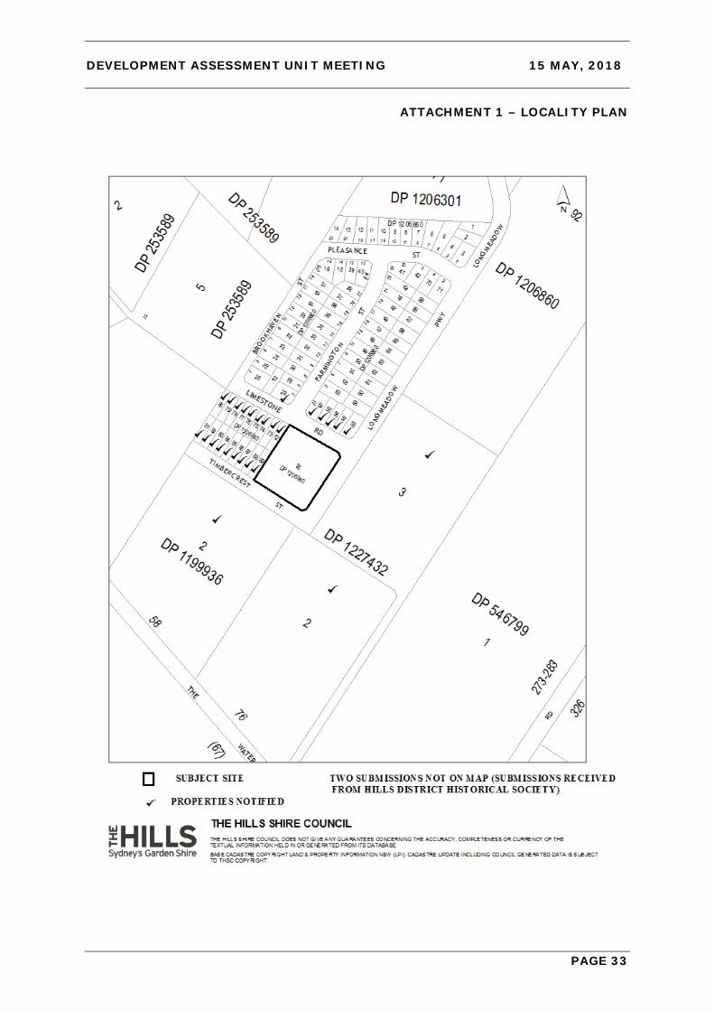
ATTACHMENT 1 – LOCALITY PLAN

DEVELOPMENT ASSESSMENT UNIT MEETING 15 MAY, 2018
PAGE 34
ATTACHMENT 2 – AERIAL PHOTOGRAPH
DEVELOPMENT ASSESSMENT UNIT MEETING 15 MAY, 2018
PAGE 35
ATTACHMENT 3 – ZONING PLAN
DEVELOPMENT ASSESSMENT UNIT MEETING 15 MAY, 2018
PAGE 36
ATTACHMENT 4 – PLAN OF SUBDIVISION

DEVELOPMENT ASSESSMENT UNIT MEETING 15 MAY, 2018
PAGE 37
ATTACHMENT 5 – SITE PLAN

DEVELOPMENT ASSESSMENT UNIT MEETING 15 MAY, 2018
PAGE 38
ATTACHMENT 6 – DCP FIGURE 72 AND PLAN SHOWING CURRENT LAYOUT WITH PROPOSED LOTS APRIL 2018
DCP Figure 72 - Precinct Plan Control Area for the Hunting Lodge
Plan Showing Current Layout With Proposed Lots (April 2018)

DEVELOPMENT ASSESSMENT UNIT MEETING 15 MAY, 2018
PAGE 39
ATTACHMENT 7 – ELEVATIONS

DEVELOPMENT ASSESSMENT UNIT MEETING 15 MAY, 2018
PAGE 40
ATTACHMENT 8 – LANDSCAPE PLAN

DEVELOPMENT ASSESSMENT UNIT MEETING 15 MAY, 2018
PAGE 41
ATTACHMENT 9 – HERITAGE FENCING
DEVELOPMENT ASSESSMENT UNIT MEETING 15 MAY, 2018
PAGE 42
ATTACHMENT 10 – NSW OFFICE OF ENVIRONMENT AND HERITAGE COMMENTS

DEVELOPMENT ASSESSMENT UNIT MEETING 15 MAY, 2018
PAGE 43

DEVELOPMENT ASSESSMENT UNIT MEETING 15 MAY, 2018
PAGE 44
ATTACHMENT 11 – APPLICANT RESPONSE TO NSW OEH COMMENTS

DEVELOPMENT ASSESSMENT UNIT MEETING 15 MAY, 2018
PAGE 45
DEVELOPMENT ASSESSMENT UNIT MEETING 15 MAY, 2018
PAGE 46

DEVELOPMENT ASSESSMENT UNIT MEETING 15 MAY, 2018
PAGE 47

DEVELOPMENT ASSESSMENT UNIT MEETING 15 MAY, 2018
PAGE 48

DEVELOPMENT ASSESSMENT UNIT MEETING 15 MAY, 2018
PAGE 49

DEVELOPMENT ASSESSMENT UNIT MEETING 15 MAY, 2018
PAGE 50
ATTACHMENT 12 – PRECEDING DA 533/2015/ZB PLAN OF SUBDIVISION
DEVELOPMENT ASSESSMENT UNIT MEETING 15 MAY, 2018
PAGE 51
ATTACHMENT 13 – NSW OEH COMMENTS FOR PRECEDING DA 533/2015/ZB

DEVELOPMENT ASSESSMENT UNIT MEETING 15 MAY, 2018
PAGE 52