Design of Roads in the State of Meghalaya (EAST) under ...
184
Public Works Department Government of Meghalaya Design of Roads in the State of Meghalaya (EAST) under Meghalaya Integrated Transport Project • Umling - Patharkhamah Road Environmental Assessment Report Prepared : USS Checked : RP / RP Approved : RBS Date of Release : 16. 01. 2020 : June 2020 Revised on Public Disclosure Authorized Public Disclosure Authorized Public Disclosure Authorized Public Disclosure Authorized
-
Upload
khangminh22 -
Category
Documents
-
view
1 -
download
0
Transcript of Design of Roads in the State of Meghalaya (EAST) under ...

Public Works Department
Government of Meghalaya
Design of Roads in the State of Meghalaya (EAST)
under Meghalaya Integrated Transport Project
• Umling - Patharkhamah Road
Environmental Assessment Report
Prepared : USS
Checked : RP / RP
Approved : RBS
Date of Release : 16. 01. 2020
: June 2020Revised on
Pub
lic D
iscl
osur
e A
utho
rized
Pub
lic D
iscl
osur
e A
utho
rized
Pub
lic D
iscl
osur
e A
utho
rized
Pub
lic D
iscl
osur
e A
utho
rized

Environmental Assessment Report
i
LIST OF ABBREVIATIONS
CPCB - Central Pollution Control Board EA - Executing Agency EIA - Environmental Impact Assessment EMP - Environmental Monitoring Plan ESZ - Eco-Sensitive Zone GoI - Government of India IFC - International Finance Corporation IRC - Indian Road Congress MDR - Major District Road MoEF&CC - Ministry of Environment and Forests & Climate Change MoRT&H - Ministry of Road Transport and Highways MPWD - Meghalaya Public Works Department NBWL - National Board for Wildlife NGO - Non-government Organization NH - National Highway OP - Operational Policy PAF - Project Affected Person PMGSY - Pardhan Mantri Gram Sadak Yojana RF - Reserve Forest ROW - Right of Way SPCB - State Pollution Control Board SPM - Suspended Particulate Matter TOR - Terms of Reference

Environmental Assessment Report
ii
TABLE OF CONTENTS
Page
EXECUTIVE SUMMARY ................................................................................................................................ 6
1. INTRODUCTION ............................................................................................................................... 10
1.1 PROJECT BACKGROUND ...................................................................................................................... 10 1.2 PURPOSE OF EIA REPORT ...................................................................................................................... 2 1.3 OBJECTIVE AND SCOPE OF THE EIA STUDY ................................................................................................ 2 1.4 APPROACH AND METHODOLOGY ADOPTED FOR EIA STUDY ......................................................................... 3 1.5 CAVEATS TO EIA STUDY ........................................................................................................................ 6 1.6 STRUCTURE OF EIA REPORT .................................................................................................................. 6
2. PROJECT DESCRIPTION....................................................................................................................... 9
2.1 TYPE OF PROJECT ................................................................................................................................ 9 2.2 LOCATION AND FEATURES OF THE PROJECT ROAD ...................................................................................... 9 2.3 PROJECT FEATURES ............................................................................................................................ 11 2.3.1 RIGHT OF WAY ................................................................................................................................. 11 2.3.2 EXISTING ROAD ................................................................................................................................. 11 2.3.3 EXISTING CROSS DRAINAGE STRUCTURES ............................................................................................... 12 2.3.4 JUNCTIONS AND INTERSECTIONS ........................................................................................................... 12 2.3.5 TREES CUTTING ................................................................................................................................. 12 2.4 IMPROVEMENT PROPOSALS ................................................................................................................. 12 2.5 PROJECT ENVIRONMENTAL SETTING ...................................................................................................... 19 2.6 COMPONENTS & ACTIVITIES OF THE PROPOSED PROJECT .......................................................................... 19 2.7 INFRASTRUCTURE REQUIREMENT FOR ROAD DEVELOPMENT ...................................................................... 19 2.8 RESOURCE REQUIREMENTS FOR THE PROJECT ......................................................................................... 20 2.9 POLLUTANT SOURCES & CHARACTERISATION .......................................................................................... 21 2.10 PROJECT BENEFITS ............................................................................................................................. 22
3. POLICY, LEGAL AND ADMINISTRATIVE FRAMEWORKS ..................................................................... 23
3.1 INTRODUCTION ................................................................................................................................. 23 3.2 GOVERNMENT (INDIA) ENVIRONMENTAL LEGAL FRAMEWORK ................................................................... 23 3.3 SOCIAL REGULATORY REQUIREMENTS OF INDIA AND STATE ....................................................................... 27 3.4 OPERATIONAL POLICIES OF WORLD BANK .............................................................................................. 29 3.5 CATEGORY OF THE PROJECT ................................................................................................................. 32
4. ENVIRONMENTAL BASELINE STATUS ............................................................................................... 34
4.1 INTRODUCTION ................................................................................................................................. 34 4.2 METHODOLOGY ................................................................................................................................ 34 4.2.1 STUDY AREA ..................................................................................................................................... 34 4.2.2 ENVIRONMENTAL SURVEYS AND STUDIES ............................................................................................... 36 4.3 LAND ENVIRONMENT ......................................................................................................................... 36 4.3.1 TOPOGRAPHY ................................................................................................................................... 36 4.3.2 GEOLOGY ......................................................................................................................................... 38 4.3.3 SEISMICITY ....................................................................................................................................... 40 4.3.4 SOIL TYPE AND QUALITY ..................................................................................................................... 41 4.3.5 LAND USE ........................................................................................................................................ 43 4.4 AIR ENVIRONMENT ............................................................................................................................ 44 4.4.1 CLIMATE & METEOROLOGY ................................................................................................................. 44 4.4.2 AMBIENT AIR QUALITY ....................................................................................................................... 46 4.4.3 AMBIENT NOISE QUALITY ................................................................................................................... 47 4.5 WATER ENVIRONMENT ...................................................................................................................... 48 4.5.1 HYDROGEOLOGY ............................................................................................................................... 48 4.5.2 GROUNDWATER QUALITY ................................................................................................................... 50 4.5.3 HYDROLOGICAL FLOW & DRAINAGE ...................................................................................................... 50 4.5.4 SURFACE WATER QUALITY ................................................................................................................... 50 4.6 BIOLOGICAL ENVIRONMENT................................................................................................................. 52

Environmental Assessment Report
iii
4.6.1 FOREST............................................................................................................................................ 52 4.6.2 FOREST TYPE AND DENSITY .................................................................................................................. 53 4.6.3 FLORA ............................................................................................................................................. 54 4.6.4 FAUNA ............................................................................................................................................ 55 4.6.5 PROTECTED AREA NETWORK ............................................................................................................... 55 4.7 ASSESSMENT OF WILDLIFE ALONG THE PROJECT ROAD SECTIONS ................................................................ 60 4.7.1 NONGKHYLIEM WILD LIFE SANCTUARY (NWLS) ECO-SENSITIVE ZONE ........................................................ 60 4.8 SOCIOECONOMIC ENVIRONMENT ......................................................................................................... 61
5. ANALYSIS OF ALTERNATIVES ............................................................................................................ 63
5.1 WITH OR WITHOUT PROJECT SCENARIO ................................................................................................ 63 5.2 LOCATION AND ALIGNMENT ALTERNATIVES ............................................................................................ 64
6. ANTICIPATED ENVIRONMENTAL IMPACTS AND MITIGATION MEASURES ........................................ 65
6.1 IMPACT ASSESSMENT AND MITIGATION MEASURES ................................................................................. 65 6.2 POTENTIAL IMPACT ON LAND USE ........................................................................................................ 65 6.3 POTENTIAL IMPACT ON SOIL ................................................................................................................ 66 6.4 POTENTIAL IMPACT ON SURFACE WATER RESOURCES ............................................................................... 67 6.5 POTENTIAL IMPACT ON SURFACE WATER QUALITY ................................................................................... 68 6.6 POTENTIAL IMPACT ON AMBIENT AIR QUALITY ....................................................................................... 69 6.7 POTENTIAL IMPACT ON NOISE QUALITY ................................................................................................. 70 6.8 POTENTIAL IMPACT ON PHYSIOGRAPHY AND DRAINAGE ............................................................................ 71 6.9 POTENTIAL IMPACT ON BIOLOGICAL ENVIRONMENT ................................................................................. 71 6.10 POTENTIAL IMPACT ON SOCIO-ECONOMIC ENVIRONMENT ......................................................................... 74 6.11 COMMUNITY HEALTH AND SAFETY ISSUES .............................................................................................. 74 6.12 OCCUPATIONAL HEALTH AND SAFETY ISSUES .......................................................................................... 75 6.13 CUMULATIVE IMPACTS ....................................................................................................................... 79
7. PUBLIC CONSULTATIONS AND DISCLOSURE ..................................................................................... 81
7.1 LOCAL LEVEL CONSULTATION ............................................................................................................... 81 7.2 CONCLUSION OF STAKEHOLDER CONSULTATIONS ..................................................................................... 84 7.3 INFORMATION DISCLOSURE ................................................................................................................. 84
8. ENVIRONMENT MANAGEMENT PLAN .............................................................................................. 85
8.1 ENVIRONMENT MANAGEMENT PLANS ................................................................................................... 85 8.2 ENVIRONMENTAL MONITORING PROGRAM .......................................................................................... 114
9. IMPLEMENTATION ARRANGEMENT ............................................................................................... 120
9.1 ESTABLISHMENT OF AN ENVIRONMENTAL AND SOCIAL CELL WITHIN THE PWD............................................ 120 9.2 ENVIRONMENT MANAGEMENT BUDGET .............................................................................................. 124
APPENDICES ............................................................................................................................................ 128
LIST OF TABLES
Table 1: List of roads in Meghalaya East under the project ........................................... 2 Table 2:Source of information collected on environment features in the project area 4 Table 3:Break-up of water requirement for project road sections construction ........ 21 Table 4: Applicable Environmental National and State Requirements ....................... 24 Table 5: Applicable World Bank Environmental Safeguards Policies for project ..... 29 Table 6: Soil sample collection location in the project area .......................................... 42 Table 7: Results of soil quality in the project area ......................................................... 42 Table 8:District-wise Land Use Classification, (2015 – 2016, Area in Ha) .................. 43 Table 9: Landuse details along the project alignment ................................................... 44 Table 10:District wise rainfall in the State (2004-2012) ................................................. 45 Table 11:Average Seasonal Temperature of the State ................................................... 45

Environmental Assessment Report
iv
Table 12:Ambient air quality locations along the project road section ....................... 46 Table 13: Results of ambient air quality monitoring ..................................................... 46 Table 14:Noise level monitoring locations along the project road section ................... 47 Table 15: Result of noise level monitoring ...................................................................... 47 Table 16:Water quality sampling location along the project road section .................. 50 Table 17: Ground (Drinking) & Surface water Characteristics in the project area ... 51 Table 18: Forest Cover of the State ................................................................................. 52 Table 19: Details of district wise forest cover in Meghalaya State ............................... 54 Table 20: Protected Area Network in the State of Meghalaya ...................................... 55 Table 21: List of Wild Animals reported in the Project affected Forest Area listed in IUCN
............................................................................................................................................. 60 Table 26: Physical /Sensitive Features along the project road section ......................... 62 Table 24: Summery of public consultation for project road sections in East
Meghalaya .......................................................................................................................... 82 Table 27: Roles and Responsibilities for implementation of Environmental
Safeguards ........................................................................................................................ 122
LIST OF FIGURES
Figure 1: Road network on Meghalaya State Map .............................................................. 8 Figure 2: Index Map Umling - PatharkhamahRoadsection ............................................... 10 Figure 3: Photo of start and end point of the road section ............................................... 11 Figure 4: Photo showing pavement conditions of the road .............................................. 11 Figure 6: Project alignment on toposheet showing study area and corridor of impact .. 35 Figure 7:Topographical Map of the State .......................................................................... 37 Figure 8:Geological and Tectonic Map of Meghalaya ....................................................... 39 Figure 9: Seismic Zoning Map of India showing Project Location ..................................... 40 Figure 10: Seismotectonic Map of Project area ................................................................. 41 Figure 11: Wind-rose diagram of the state capital (Shillong) ........................................... 46 Figure 12: Brahmaputra and Meghna, and their sub-basins............................................. 48 Figure 13: Area for Groundwater Development at Major Aquifers of the State ............. 49 Figure 14: Forest cover type in Meghalaya ........................................................................ 53 Figure 15: Protected Area Map of Meghalaya State showing project area location ....... 58 Figure 16: Map showing Eco-sensitive zone around Nongkhyllem Wildlife Sanctuary ... 59 Figure 16: Institutional arrangement for implementation of the project ...................... 120

Environmental Assessment Report
v
Road network Map of Meghalaya State

Environmental Assessment Report
6
EXECUTIVE SUMMARY
1. Meghalaya Integrated Transport Project (MITP) is an ambitious project of the Government of Meghalaya (hereinafter refer to as GoM) under which it intends to strategically transform the Core Road Network of 2000 km road length. In the project, State Road Network roads of 650 km road length will be widened, and 1350 km road length will be provided periodic maintenance besides other institutional, development activities. The Project shall follow a Multiphase Programmatic Approach (MPA). Up-gradation of 266.82 km road length will be carried out in Phase-I. The Department of Economic Affairs (DEA) and The World Bank (WB) has accorded in-principle approval of Tranche-I of MITP for US$ 110 million (loan assistance of US$ 82 million and State Share of US$ 28 million), under which State Road Network roads measuring 128 km length will be upgraded along with certain other institutional development activities. There are total 10 road sections selected under Phase-I, 5 road sections in East Meghalaya and 5 road sections in West Meghalaya.
2. The main objective of the proposed consultancy assignment is to carry out Environmental Impact Assessment and preparation of Environmental Monitoring Plans for construction of 122.74km of major district roads in East Meghalaya State under Phase-I of MITP as listed in below Table.
List of roads in Meghalaya East under the project
3. This MDR takes off from NH 06 and ends at junction of MMR Road (MawmgapMairangRanigodown). The total length of MDR is 40 km. The Scope of Study includes 31.12 km of Length starting from Km 8.00 of MDR to the end point of MDR. The stretch of MDR from km 0.00 to km 8.00 has been developed. The road is running on the bank of small stream from approx. 15 .00 km to 17.00 km and from 17.00 to 21.00 Km on the right and left bank of River Umtru and the road crosses the river Umtru at km 18.00. The carriageway width varies from 3.0 to 3.5m and Right of Way varies from 6.0 to 8.2m.
4. At present most of the length of project road is single lane carriageway throughout the length. The project road is having poor to fair pavement condition in general, with few stretches having very poor pavement condition. The proposed formation width is 6.000 m in rural areas and 6.6m for both side built-up areas. No widening is proposed and road improvements are proposed in the single lane carriageway.
5. This Environmental Impact Assessment Report is prepared for Umling – Patharkhamah Road section in order to identify all relevant direct, indirect and cumulative environmental and social risks and impacts for construction and operational phase. For environmental studies and subsequently the assessment the Corridor of Impact is considered of 500m on either side of the proposed road and project influence zone is taken 10km on either side (Arial distance) from boundary of road.
S.No. Division Name of Road Category Total
Length (km)
Proposed Length (km)
1 N.H. Bye Pass Shillong - Diengpasoh Road MDR 21.73 11.769
2 North Jowai Pasysih - Garampani Road SH 48 26.96
3 Shillong South Mawmaram - NongthliewMawmih- Mawlyndep Road
MDR 44 41.527
4 N.H. Bye Pass Laitkor-Pomlakrai - Laitlyngkot Road (5th -16th km)
MDR 15.52 11.358
5 Nongpoh Umling- Patharkhmah Road MDR 40 31.126
Total 169.25 122.74
Environmental Assessment Report
7
6. The environmental assessment study was prepared between the months of October-December 2019 as part of detailed project report. This is draft Environmental Impact Assessment (EIA) report prepared to fulfil requirements of the Operational Policy 4.01 for World Bank funded Project.
7. The baseline environment parameter within the Corridor of Impact, was conducted by the consultants during November-December 2019. Primary data for ambient air quality, ambient noise status, water quality (Ground and surface) and soil quality was collected and analysed through an NABL accredited laboratory. The monitoring results are found within the prescribed limits for air and noise level at the monitored locations in the project area.
8. Climate of Meghalaya plateau is influenced by elevation and distribution of physical relief.. The project road is within the Ri-Bhoi District of Meghalaya state. The general topography of Ri-Bhoi district is hill/rolling. The proposed project Road section is located in north-eastern part of the District, mostly elevation is in range of 147-349m.
9. The proposed project road falls under the Seismic Zone V, which is susceptible to major earthquakes as per the seismic zone map of India (IS 1893 - Part I: 2002). Considering high hazard seismic zone of the project road section area, design standards for structures stipulated in the clause under IRC: 6-2014 has been taken into account.
10. Land use pattern abutting the project road section is mainly open vegetation, agriculture fields, built up areas and community forests in between including Umling, Umdu, Umladoh, Lailad, Umsohma, Old Tasku, New Tasku, Mawpnar, Jali, Them, Nongladew, Umsong, Nongbirthem, Umtasen & Umrit habitation areas.
11. The proposed Umling-Patharkama Road section passes through through ESZ of Nongkhyliem Wild Life Sanctuary (NWLS) in the State of Meghalaya. About 3 km length of Umling-Patharkama Road project section is bordering ESZ of Nongkhyllem Wild Life Sanctuary (NWLS). The road has been in existence since the year 1992 and the ESZ was notified in the year 2017. The notification recognized the area for its species richness and endemism. It is classified as a global bio-diversity hot spot under the Eastern Himalayan Endemic Bird Area (http://www.megforest.gov.in/docs/wildlife_ESZ_of_NWLS.pdf). The area harbors over 50 species of mammals and 25 species of reptiles and over 400 species of birds. As per the notification, some species have been recorded for the first time in Meghalaya in this site
12. The notification of Eco-sensitive zone call for all development activity to be governed by by a Zonal Master Plan in consultation with multiple departments - Environment; Forest and Wildlife; Agriculture and Horticulture; Revenue; Urban Development; Tourism including eco-tourism; Rural Development; Irrigation and Flood Control; Municipal and urban development; Panchayati Raj; and Public Works Department. The Zonal Master Plan shall not impose any restriction on the approved existing land use, infrastructure and activities, unless so specified in this notification and the Zonal Master Plan shall factor in improvement of all infrastructure and activities to be more efficient and eco-friendly. It thus, does permit conversion, on the recommendation of the Monitoring Committee and with the approval of State laws to meet the needs of local residents, the widening and strengthening of existing roads and construction of new roads and the construction and renovation of infrastructure and civic amenities
13. The EIA has recommended that a Site Specific Biodiversity Assessment and Biodiversity Management Plan be developed by independent Regional Biodiversity Experts, in consultation with species specialists for the 3km road section along the ESZ of Nongkyllem Wildlife Sanctuary. The Assessment would ascertain if the ESZ comprises critical habitat, and if so, if the road improvements works can be carried out without significant conversation or degradation of this habitat. This assessment can draw on and further inform the Zonal Master Plan to manage any direct, indirect and cumulative impacts on habitat abutting the road. The TOR for the assessment is included as an Annex.

Environmental Assessment Report
8
14. The Environment Impact Assessment has outlined management and mitigation measures to be undertaken by the PIU and the Contractor and a detailed Environmental Management Plan has been prepared The Social Impact Assessment and Social Management Plan for the road have been prepared separately. The EMP covers issues of Environmental Health and Safety, including Occupational Health and Safety and Community Health and Safety that have some overlaps with SIA and SMP.
15. A summary of the significant points from the EMP are summarized below:
i) Preparation of Environmental Health and Safety Documents including Occupational Health and Safety Plan and associated documents in adherence with World Bank EHS Standards http://documents.worldbank.org/curated/en/157871484635724258/pdf/112110-WP- Final-General-EHS-Guidelines.pdf; This should include a Site Establishment Plan, Health and Safety Plan, Emergency Preparedness Plan, Chance finds procedures and Traffic Management Plan.
ii) Water Use: It is estimated for the road section that approximately an average of 90-110 KLD of water would be required during the peak construction period for construction purpose and 15KLD for domestic purpose. Due to non-availability of ground water source in the hilly terrain, the people are dependent on surface for drinking and domestic purpose. The sourcing of water for construction from surface ground water would also put stress on the water resource. Thus, for sourcing construction water, the Contractor has to either undertake permission from local community or construct concrete drain and tanks with community consent for use of water for construction and drinking purpose.The drainage and the contour maps indicate that the alignment passes through the hilly the topography so the contractor can identify channel along the corridor and create water tanks at appropriate location would to store water for construction purpose. During the construction design the Contractor shall identify these locations. The entire exercise would be conducted in consultation with the local community. The PIU can enter into an agreement with the panchayat for development of the tanks and using the water stored in it for construction purpose. These tanks would be handed over to the community for use and maintenance after the completion of construction.
iii) All Material Sources should adhere to World Bank EHS Standards and Operational Policies. The PIU and Contractor should identify and authorized Quarries for Construction Materials such as Stone and Sand ensuring that they are not operating in sites of critical or valued natural habitat, or operating during breeding season (relevant to river bank sand mining). They should adhere to the Meghalaya Minor Minerals Concession Rules, 2016 and have an environmental clearance from the State Impact Assessment Authority (SEIAA), necessary permissions from Pollution Control Board and Forest Departments. Quarries should not be operating in erosion or landslide prone zones, disrupting drainage patterns or causing water pollution, disrupting traffic or posing safety risks. Quarry workers must have access to necessary personal protective equipment.
Iv) It is estimated 73 trees need to be felled for this project. All cut trees will be compensated at the rate of 1:10 with preference to native species. No endangered floral species exist within the project corridor.
v) Construction Waste and Debris Disposal: 39913 cum of excavated soil from hill cutting and
about 5370 cum of BT and Non-BT material will be scarified from existing carriageway are
expected to be generated form scarified bitumen, dismantling and excavation of existing
culvert. The excavated material will used in backfilling in the project and balanced quantity
will be disposed of at approved designated sites. Muck disposal sites have been identified in
the DPR and disposal sites for bituminous wastes need to be identified by the contractor as
part of their site management plan and approved by the engineer-in-charge prior to
commencing construction.
vi) Construction Camp Management should adhere to World Banks Worker
Accommodation Processes and Standards -

Environmental Assessment Report
9
http://documents.worldbank.org/curated/en/604561468170043490/pdf/602530WP
worke10Box358316B01PUBLIC1.pdf, the Labor Management Plan and EIA Appendix
4 on Construction Camp Management.
vii) All Biodiversity related guidelines and measures as identified from the detailed biodiversity assessment must be included in the bid document and followed by the contractor. This includes implementation of measures identified in the Elephant Management Plan, measures to reduce risks to labour from wildlife, prohibiting the hunting of wild animals, and good practices to conserve biodiversity such carrying out clearing activities outside of bird breeding /nesting periods.
viii) All necessary measures for Road Safety of traffic and pedestrians and workers must be taken by the contractor. Contractors must familiarize themselves with World Banks Good Practice Note on Road Safety http://pubdocs.worldbank.org/en/648681570135612401/Good-Practice-Note- Road- Safety.pdf
16. Climate resilient measures are also considered for designing of the road section such as Design of cross-drainage structures (280 nos.) based on rainfall data of the project area, accommodation of improvement proposal within existing right of way following existing alignment, to avoid impacts on trees, land and existing structures, tree plantation on valley side and application of Bio-engineering and bio technology on identified landslide zones locations (11 locations along the road section about 100m in length) , dumping areas for muck disposal has been identified, protection and breast walls has been proposed at required locations and construction of side drains to minimize soil erosion and water pollution.
17. The area Ri-Bhoi district, experience high rainfall in monsoon season as the characteristic of the Sate. Along the road section in the region there are many landslides locations. People along the alignment faces road blockages due to landslide in rainy season due to narrow carriageway width. Landslide locations along the road section identified and engineering measures provided to provide all season connectivity to the areas in the project road section. Longitudinal drains have been provided along the carriageway in the design in selected habitation locations.
18. The key Environmental Monitoring Reports for this road section include a Pre-Bid Clearence Report that incorporates the recommendations of regional biodiversity experts and species specialists into the bid documents and EMP, to be approved by the engineer in-charge and shared with the World Bank, a pre-construction clearance report including Contractors EMP, OHS plan and associated documents, Construction Camp establishment plan, list of authorized sources for raw materials, and plans and permissions for water for construction and project related domestic use, to be approved by the engineer in-charge and shared with the World Bank. Bi-weekly reports by the contractor will be prepared during the construction phase on parameters identified in the monitoring plan, and consolidated quarterly reports will be prepared by the environmental expert, PIU and approved by Engineer in-charge.
19. The Contractor‘s Environmental Engineer and Health Safety Officer would be responsible for the implementation of environmental safeguards and supported by the Environmental Expert of the PIU. The Environmental and Social Cell of the PWD will be responsible for training and capacity building of PIU staff as well as contractors on environmental and social safeguards.

Environmental Assessment Report
x
1. INTRODUCTION
1.1 Project Background
20. Meghalaya is a hilly state in northeastern India, bounded by another state Assam in the North and the East, and Bangladesh in the South and the West sharing a 443 kms international border.
21. The Road transport is the backbone of the state’s socio-economic development. More than 80 percent of freight and almost cent percent of passenger movement within the state depends on roads. Yet, about half of the habitations lack all-weather road access. Further, many semi-permanent timber bridges are in dilapidated condition, limiting maximumallowable axle load on them. The problem is further compounded by difficult terrain and extreme climatic condition, leading to high maintenance cost of the roads.
22. Similarly, rapid urbanisation has created a huge gap between demand and supply of urban services and infrastructure. It has been assessed that other than Shillong, urban mobility at other cities and towns of the state are less than satisfactory1. In most of the towns due to narrow roads, lack of parking facilities and yearly growth of vehicles, traffic congestion is often evident. Further, in most cases the major highway passes through the city center as a result of which regional traffic comes in conflict with the local traffic.
23. To overcome the abovementioned challenges in a holistic and all-inclusive manner, the Government of Meghalaya, with financing and technical support from the World Bank, is preparing a project titled “Meghalaya Integrated Transport Project”. The objective of the project is to “provide a well-connected efficient, good quality and safe transport network on long-term basis in a cost-effective manner maximizing economic and social outcomes”. This will involve taking a whole-of-the-state approach of the entire transport sector and introduce innovations, efficiency, and new ways of doing business at various stages of service delivery, ensuring value for money. This will involve:
• Integrating transport and development agenda thus resulting in more job-creation, better incomes, and realization of the SDGs;
• Integrating various modes of transport – such as roads, ropeways, waterways, and urban transport to operate as part of one system for optimal performance;
• Integrating climate resilience, green growth, asset management, and safety in the transport sector thus making the sector more resource efficient, reducing carbon footprint, minimizing GHG and contributing to health outcomes.
24. MITP is an ambitious project of the Government of Meghalaya (hereinafter refer to as GoM) under which it intends to strategically transform the Core Road Network of 2000 km road length. In the project, State Road Network roads of 650 km road length will be widened, and 1350 km road length will be provided periodic maintenance besides other institutional, development activities. The Project shall follow a Multiphase Programmatic Approach (MPA). Up-gradation of 266.82 km road length will be carried out in Phase-I. The Department of Economic Affairs (DEA) and The World Bank (WB) has accorded in-principle approval of Tranche-I of MITP for US$ 110 million (loan assistance of US$ 82 million and State Share of US$ 28 million), under which State Road Network roads measuring 128 km length will be upgraded along with certain other institutional development
1Planning Department, GoM, http://megplanning.gov.in/MSDR/urban_development.pdf

Environmental Assessment Report
2
activities. There are total 10 road sections selected under Phase-I, 5 road sections in East Meghalaya and 5 road sections in West Meghalaya.
1.2 Purpose of EIA report
The main objective of the proposed consultancy assignment is to carry out the DPR for Construction of 122.74km of major district roads in East Meghalaya State under Phase-I of MITP. The Consultancy service for preparation of Detailed Project Report have been entrusted to M/s. Projects Consulting India Pvt. Ltd., for total design length of 122.74km of major road sections as listed in below Table-1.
Table 1: List of roads in Meghalaya East under the project
25. The project road section on road network map of the state is shown in Figure 1.
26. This Environmental Impact Assessment Report is prepared for Umling - Patharkhamah Road section in order to identify all relevant direct, indirect and cumulative environmental and social risks and impacts for construction and operational phase. Preparation Environment and Social Management Plan for each road section to mitigate the potential impacts on the physical, biological and socio-economic parameters.
27. The environmental assessment study was prepared between the months of October-December 2019 as part of detailed project report. This is draft Environmental Impact Assessment (EIA) report prepared to fulfil requirements of the Operational Policy 4.01 for World Bank funded Project.
1.3 Objective and Scope of the EIA Study
28. The objective of the present, EIA study is to identify potential environmental impacts of the proposedUmling - Patharkhamah Road section improvement measures and formulate strategies to avoid / mitigate the same. The scope of work to accomplish the above objective, comprise the following.
• Collecting primary and secondary environmental baseline data within the project boundary and surrounding areas;
• Assessing potential adverse environmental impacts that might arise during operation of the Project after reviewing Project information and using the environmental baseline study conducted during the feasibility study;
• Suggesting appropriate mitigation measures to effectively manage potential adverse impacts; and
S.No. Division Name of Road Category Total
Length (km)
Proposed Length (km)
1 N.H. Bye Pass Shillong - Diengpasoh Road MDR 21.73 11.769
2 North Jowai Pasysih - Garampani Road SH 48 26.96
3 Shillong South Mawmaram - NongthliewMawmih- Mawlyndep Road
MDR 44 41.527
4 N.H. Bye Pass Laitkor-Pomlakrai - Laitlyngkot Road (5th -16th km)
MDR 15.52 11.358
5 Nongpoh Umling- Patharkhmah Road MDR 40 31.126
Total 169.25 122.74

Environmental Assessment Report
3
• Analyse the alternatives in terms of alternative alignment, technology, design and operation, including the “with project” and "without project" situation were carried out to analyse the feasibility
• Consultation with the Public/Stakeholders and incorporate their concerns into the project design;
• Developing an Environmental Management Plan (EMP) to implement suggested mitigation measures and management plans to minimise adverse impacts through effective management systems including formulation of monitoring and reporting requirements;
• Conducting additional studies for the enhancement of the benefit to the local community and the road users;
29. The environmental studies have been confined to the situation around the deemed areas of direct influence caused by constructional and operational facilities along Umling - Patharkhamah Road, the proposed major district road section in the state of Meghalaya. The following sections of the report, discusses the methodology adopted by the consultant in conducting the study and presents the results of the same.
1.4 Approach and Methodology Adopted for EIA Study
30. The Environmental Impact Assessment has been carried out, in accordance with the requirements of the World Bank’s Operational Policy 4.01. The Government of India guidelines for Rail/Road/Highway project; EIA notification 2006 and its amendment of MoEFCC and Highway Sector EIA guidance manual 2010 has also been followed in the process of this environmental assessment. The study methodology has been adopted in such a manner to ensure that environmental concerns are given adequate weightage in the selection of alignment and design of proposed road improvements. The study in the road section project employ an iterative approach in which potential environmental issues have been examined at successive levels in detail and specificity, at each step in the process.
31. The Environmental impact assessment is based on the information collected from secondary as well as primary sources on various environmental attributes. Monitoring of air, water, noise and soil quality was also carried out along the road section alignment and significant issues were examined during field surveys to determine the magnitude of significant environmental impacts.
32. The major steps in the EIA process for the project were as follows:
(i) Screening of Project Road
33. As a part of the project feasibility study, Environmental Screening is undertaken in parallel with the Preliminary Economic and Engineering studies to determine any significant social or environmental issues which could require further analysis (including the analysis of alternative options, improvement of junctions etc.) to resolve such issues.
34. The environmental screening typically identifies the natural habitats (e.g. national parks, wildlife reserves, sanctuaries, sacred groves, protected areas, forests, water bodies etc.), major rivers and waterways, notified cultural heritage sites and any other potentially sensitive areas. The information available from secondary sources along with the inputs from the site visits and consultation with local people are used to identify these issues and sensitive receptors which might be located along the corridor. The results of this analysis are communicated to the design team to resolve them (including recommendation for exclusion, analysis of alternative alignment and/or mitigation) as a precursor to preliminary engineering design and undertaking the required for environmental assessment studies.
(ii) Delineation of Project Impact Zone

Environmental Assessment Report
4
35. For carrying out further environmental studies and subsequently the assessment it was required to delineate the project influence zone. Depending on the severity of impact the Project influence zone has been classified as:
36. Corridor of Impact (CoI): The area of 500 m on either side of the proposed road centreline is considered as the corridor of impact. The proposed formation width i.e. 8 m is thus included within the CoI. This area is more vulnerable to the project’s direct impacts.
37. Project Influence Area (PIA):In accordance with MoEF&CC’s EIA Guideline Manual for Highways and as per guidelines of EIA Notification-2006, the Project Influence Area has been defined as 10 km on either side (Arial distance) from boundary of road for collection of secondary data, including impacts due to ancillary sites like borrow areas, quarry, material storage, disposal areas, etc.
(iii) Preliminary Engineering Surveys
38. With the information available from the screening the design team took the preliminary surveys of the project site to assess the engineering aspects of the road including the likely environmental issues associated with the project. The survey carried out as part of the detailed design data collection also provided valuable information regarding area adjacent to the proposed project corridor.
(iv) Collection of Secondary Environmental Data
39. Secondary data was collected from various verifiable sources about different components e.g. Climate, Physiography, Soil type, Ecology, etc. The sources from which information is gathered is presented in Table-2.
Table 2:Source of information collected on environment features in the project area
S.No.
Aspects Parameters Source of Information
1 Climatic Conditions in the Project Influence Area
Climate, Temperature, Rain fall Indian Metrological Department
2 Soil & Geology Soil type and its stability, Fertility of the soil potentiality for soil erosion
Geological Survey of India, State Mining Department
3 Slopes Direction of slope, Percentage of slope
Contour Survey, satellite image and Survey of India topographic sheets
4 Drainage/ Flooding Existing drainage map and flooding level including its extent of water spread. Identification of drainage channel and its catchments area around the Project stretch
Satellite Imagery/ Topo sheet/Hydrology study / State Water Resource Department.
5 Water Bodies and Water Quality
Identification of water bodies / canal / drainage channels where the run off surface water will flow/due to erosion and also due to spillage oil and other hazardous materials. Status of surface water and ground water quality
Topography sheets /field study. Hydrological data from the CGWB Reports
6 Forest within Proposed ROW Legal Status –
Status of the forests, Department of Forest, Govt.of Meghalaya, DFOs,
Environmental Assessment Report
5
Protected Areas, Endangered Plant and Animal, Ecological Sensitive Area, Migratory Corridor / Route,
Conservation of forest area, &endangered plant and animal and any other species
Discussion with local community and local DFO officers
7 Trees and Vegetation Cover
Identification of existing tree species in the project influence area
Forest Department, Research Institution, Field Survey.
8 Settlements along the PROW
Settlements & its population along the corridor. Its location & numbers
Population/ District Census report 2011. Topographic survey
9 Cultural / Heritage and Ancient Structures
Conservation areas if any, Protected structures, monuments and heritagestructures.
Archaeological Survey of India, State Archaeological Department
(v) Collection of Primary Baseline Information
40. For gathering the baseline environmental condition along the project corridor baselines studies were conducted. These baseline studies carried out included:
• Baseline environmental surveys for assessing the ambient air, water and noise quality; • Enumeration of trees to identify the Location, number of the trees within the proposed
RoW; • Ecological surveys to identify the habitats and the flora and fauna; • Structure enumeration to identify the one likely to be impacted; • Socio-economic surveys to identify the condition of the impacted persons.
41. In addition to the above survey interactions are carried out with the populations along the project corridor to gather local level information on the following:
• Local practices and traditions with respect to conservation and use of natural resources; • Farming practices and Cropping pattern; • Perception of the people about the project • Traffic surveys were used to estimate the present and future traffic • Preliminary engineering surveys to identify the topographical features
42. This information was used to develop the baseline environmental condition in the project area and identify the environmental sensitivities which might still get affected by the proposed alignment
(vi) Public consultation
43. At the beginning of the EIA process, a preliminary identification of probable stakeholders was carried out. An inventory of actual / potential stakeholders, including local groups and individuals, local institutions like the panchayats which may be directly or indirectly affected by the project or with interest in the development activities in the region was made at a preliminary stage. This inventory was arrived through discussions with local PWD official and also in consultation with members of the local community.
44. Consultations with the community is a continual process that was carried out during the EIA study and would also be continued during the construction and operation phases of the project. Issues like disturbance during the construction, severance and increased congestion, noise and air

Environmental Assessment Report
6
pollution, employment opportunities, need for development of basic infrastructure, safe drinking water, sanitation facilities in the villages adjoining to the corridor were discussed during the consultations so that they can be adequately addressed through the environment management plans. The consultations with community and local institution like panchayat also helped in developing preliminary understanding of the requirement of people in the area and identification of the enhancement proposals.
(vii) Impact Identification and Evaluation
45. Potential significant impacts were identified on the basis of: analytical review of baseline data; review of environmental conditions at site; analytical review of the underlying physical, biological and socio-economic conditions within the project influence area.
(viii) Environmental Management and Monitoring
46. The final stage in the EIA Process is definition of the management and monitoring measures that are needed to ensure: a) impacts and their associated Project components remain in conformance with applicable regulations and standards; and b) mitigation measures are effectively implemented to reduce the effects to the extent predicted.
47. An Environmental Management Plan, which is a summary of all actions which the Project has committed to execute with respect to environmental/social/health performance for the Project, is also included as part of the Bidding Documents. The Environmental Management Plan includes mitigation measures, compensatory measures and offsets and management and monitoring activities.
1.5 Caveats to EIA Study
48. This report is based on the Detailed Project Report (DPR) and engineering designs of the road section and was used to inform the DPR. In case, of any changes to the design undertaken by the contractor the EIA report will need to be revisited. In case of minor changes, PWD will review social and environmental impacts, and add the necessary environment management actions to be taken to the ESMP and bid document. In case of any major changes to design, this being a Category A project, the PWD will seek a no objection from the World Bank and process of EIA for the change proposed could apply.
49. The report has been developed on certain information available at this point of time, scientific principles and professional judgement to certain facts with resultant subjective interpretation. Professional judgement expressed herein is based on the available data and information. Further, the report has been developed on certain information available at this point of time, scientific principles and professional judgment to certain facts with resultant subjective interpretation.
1.6 Structure of EIA Report
50. This EIA report has been presented as per requirements of the World Bank’s Operational Policy 4.01. The report is organised into following ten chapters, a brief of each chapter is described below:
• An Executive Summary summarizing the key impacts and main points of the Environmental Management Plan
• Chapter 1 - Introduction: This section describes the background information about the project and EIA study
• Chapter 2 - Project Description: This section presents the key features and components of the proposed project.

Environmental Assessment Report
7
• Chapter 3 - Policy, Legal, and Administrative Frameworks: this section summarizing the national and local legal and institutional frameworks that guided the conduct of the assessment.
• Chapter 4 - Environmental Baseline Status: This section discussing the relevant physical, biological, and socioeconomic features that may be affected by the proposed project.
• Chapter 5- Analysis of Alternatives: This section covers analysis of various alternatives considered to minimise the overall impacts of proposed development and suggest most appropriate alternatives based of detailed analysis of impact and risk associated with each alternative.
• Chapter 6– Impact Assessment and Mitigation: This section presents the environmental assessment of likely positive and adverse impacts attributed to the proposed project and concomitant mitigation measures.
• Chapter 7– Public Consultation and Discussion: This section describing the consultation process undertaken during the environmental examination and its results, their consideration in the project design, and manner of compliance to the Bank’s Publication Policy and related national laws.
• Chapter 8 - Environmental Management Plan: This section discussing the lessons from the impact assessment and translated into action plans to avoid, reduce, mitigate or compensate adverse impacts and reinforces beneficial impacts. This plan is divided into three sub-sections; mitigation, monitoring, and implementation arrangements.
• Chapter 9–Implementation Arrangements: This section brief the institutional set up in the executing & implementation agency and contract for the execution of the project along with responsibilities on environmental management.

Environmental Assessment Report
8
Figure 1: Road network on Meghalaya State Map

Environmental Assessment Report
9
2. PROJECT DESCRIPTION
2.1 Type of Project
51. The project road is located in Eastern part of Meghalaya State traverse through hill-rolling terrain in the district of Ri-Bhoi. The project of widening and improvement of about 31.12 km road section of Umling – Patharkhamah major district road. The chapter describes the salient features of the road corridor.
2.2 Location and Features of the Project Road
52. This MDR takes off from NH 06 and ends at junction of MMR Road (Mawmgap Mairang Ranigodown). The total length of MDR is 40 km. The Scope of Study includes 31.12 km of Length starting from Km 8.00 of MDR to the end point of MDR. The stretch of MDR from km 0.00 to km 8.00 has been developed. The road is running on the bank of small stream from approx. 15 .00 km to 17.00 km and from 17.00 to 21.00 Km on the right and left bank of River UMTRU road crosses the river Umtru at km 18.00. In the last stretch of road, it is also running very near to the road. The carriageway width varies from 3.0 to 3.5m and Right of Way varies from 6.0 to 8.2m.
53. At present most of the length of project road is single lane carriageway throughout the length. The project road is having poor to fair pavement condition in general, with few stretches having very poor pavement condition. The proposed formation width is 6.000 m in rural areas and 6.6m for both side builtup areas.
54. The proposed project road lies entirely in the Ri-Bhoi district. The road section lies between Umling (25°58'12"N 91°51'E) and Umrit (25°51'N 91°39'E). The existing alignment on the Google Imagery is presented in Figure 2. Photos of the road section are also presented in Figure 3.

Environmental Assessment Report
10
Figure 2: Index Map Umling - PatharkhamahRoadsection

Environmental Assessment Report
11
Figure 3: Photo of start and end point of the road section
Photo: Road section at 20+851 Photo: Road section at (km 13+000)
2.3 Project Features
55. The features of the exiting road and the proposed road is presented in the following section.
2.3.1 Right of Way
56. The carriageway width in the road section varies from 3.0m to 3.5m with unpaved shoulders of 0.5 to 1.0 m width on each side and right of way as was observed varies from 6.0m to 8.2m.
2.3.2 Existing Road
57. Carriageway: The detailed inventory on existing carriageway reveals that the project road stretch comprises of mainly single lane carriageway with 0.5 m to 1.0m earthen shoulder configuration. The existing pavement is flexible throughout the road section.
58. Pavement Conditions: The existing pavement of project road is bituminous surface with earthen shoulders of width 0.5 m to 1.0 m exist predominantly on both sides throughout the project stretch. The pavement is flexible type having earthen/gravel shoulders. Pavement condition is fair except few locations where it has been badly damaged. The pavement is showing signs of distress at some locations. The defects noticed include Cracking (alligator, transverse, longitudinal, edge cracks), Rutting and edge breaking. The shoulders are earthen/gravel with fair to poor condition. The road surface is black topped with Bituminous Macadam (BM); Semi Dense Bituminous Concrete (SDBC); except few locations in habitation area. The pavement conditions are shown in figure-4.
Figure 4: Photo showing pavement conditions of the road

Environmental Assessment Report
12
Photo: Road conditions& curve at km 6+10 Photo: Road conditions at km 10+000
2.3.3 Existing Cross Drainage Structures
59. There is one minor bridge. Total 250nos. of existing pipe culverts and 29 slab culverts are proposed for retain with increase in width in the present alignment.
2.3.4 Junctions and Intersections
60. There are 12 nos. minor of junction in the project road section. All the junctions are with internal roads and village roads only.
2.3.5 Trees Cutting
61. The preliminary engineering surveys conform that felling of 73 is required for the improvement of road section.
2.4 Improvement Proposals
62. As part of the road improvement for the road section the existing single-lane road would be developed in single lane corridor with carriageway of 3.750m,0.525 m wide hard shoulder on either side, Trapezoidal-type Drain / Crash Barrier Hill / Valley side with 0.6m on each side. The total width required will be minimum 6.000mfor rural areas and maximum 6.6m for built-up areas with both side drains.
63. In addition, provisions the following provision for improvement have been made:
• Geometric Improvements • Pavement – strengthening and reconstruction • Cross-Drainage Structures • Safety and • Road Appurtenances
64. The design standards proposed for this project road are based on IRC: SP:73 2007, Manual of Standards & Specifications for intermediate lane. The design standards are presented below:
(i) Design Life
65. Geometry: The geometry of a highway is difficult to improve at frequent intervals because of inherent difficulties in availability of land and inconvenience and hazards to running traffic during improvement works. Thus, a design life of pavement has been taken for 15 years.

Environmental Assessment Report
13
66. Structures: Structure, like bridges are costly. It is difficult and uneconomical to augment/ widen these structures later. These structures have therefore to be designed for longer life, that is, 75-100 years. Culverts are designed for a design life of 25 years.
(ii) Design Speed
67. It was proposed that the design speeds tabulated in Table be adopted, in general, for the Project Road as recommended by IRC. Wherever it becomes necessary to impose short sections of geometry over which operating speeds will have to be lower than 30 km/h, (R<35 m), these will be adequately marked with appropriate warning road signs.
Road Classification Design Speed (km/h)
Mountainous Terrain Steep Terrain
Ruling Min. Ruling Min.
National/State
Highway 50 40 40 30
Major District Roads 40 30 30 20
68. Traffic Surveys & Projections: The traffic survey has been conducted at selected location for the road section to calculate traffic load and type of vehicles on the project road. The summary of ADT by vehicles numbers and PCU’s of classified traffic volume count is given below:
Average Daily Traffic
Fast Power-Driven Vehicles Slow
Vehicles
1 2 3 4 5 6
Car/Taxi/Van/Three Wheeler/Auto Rickshaw
Two Wheeler/Motor Cycle/ Scooter
Light Commercial Vehicle/ Mini Bus
Two Axle Truck/Tanker
Multi Axle Truck/Tanker
Bicycles
254 66 5 140 0 14
PCU Calculations
Factor PCUs ADT % AADT
Fast vehicles
TW 0.50 66 66 14.2 80
Car 1.00 254 254 54.6 305
LCV 1.50 5 5 1.1 6
Bus/Truck 3.00 140 140 30.1 168
Total Vehicle 465 465 100.0 558
Total PCUs 715 715 100.0 858
69. The traffic projections are based on IRC guidelines and the assumed growth rate is 7.5%. From the traffic count it is seen that project road section is qualify for intermediate lane as per MoRT&H specification.
70. Terrain and Topography: This is determined by the general ground slope, and categorised as below:

Environmental Assessment Report
14
Ground Slopes for Different Terrain
Terrain Percent cross slope of the country
Plain 0-10
Rolling 10-25
Hilly 25-60
Mountainous Greater than 60
71. Sight Distance: As per IRC recommendations, the minimum sight distance (Stopping sight distance) is absolutely minimum from safety angle and must be ensured regardless of any other considerations. It would be good practice if this value can be exceeded and visibility corresponding to intermediate sight distance in as much length of road as possible. The following stopping and intermediate sight distance for various design speeds are adopted:

Environmental Assessment Report
15
Design Speed (kmph) Sight Distance (m)
Stopping Intermediate
20 20 40
25 25 50
30 30 60
35 40 80
40 45 90
50 60 120
60 80 160
65 90 180
80 120 240
100 180 360
72. Soil Characteristics: The soil characteristics along the alignment are determined in terms of CBR, both under soaked and un-soaked conditions. The design of pavement is based on the traffic load and on the soil characteristics available.
73. Earth Work Slopes: The recommended earthwork side slopes are tabulated in Table as shown-
Material Cut Fill Slope from shoulder break point to side ditch
Soil 0.5:1 2:1 2:1
Rock 0.25:1 Not Applicable
74. For'rock' cuttings of height > 6.0 m in occurrences of friable material the consultants have considered the practical issue of inserting horizontal benches into the side slopes to reduce the load on the lower section of the cutting and to intercept occasional falls of soil, rocks fragments, and other debris.
(iii) Design Elements
75. Various design elements, which govern functioning of the project road, are broadly grouped under the following-
➢ Geometric Design
➢ Pavement Design
➢ Cross Drainage structure
76. Geometric Design: Geometric design features include individual components like Cross-sectional Elements, Sight Distances, Horizontal Alignment and Vertical Alignment. These elements are geometrically combined to generate an efficient road layout.
(iv) Cross Sectional Elements for Umling – Patharkhamah Road
Existing single lane is proposed to be widened to double lane.
Carriageway width 3.750m
Hard shoulder 0.525m (each side)
Trapezoidal-type Drain / Crash Barrier [Hill / Valley side] 0.6m (each side)
Total width 6.000m for rural areas
6.6m for both side built-up

Environmental Assessment Report
16
Road Structure Width
Carriageway width 3.750m
Hard shoulder 0.525m (each side)
Trapezoidal-type Drain / Crash Barrier [Hill / Valley
side]
0.6m (each side)
Total width 6.000m for rural areas
6.6m for builtup with drains
77. Super elevation has been retained to maximum of 7.0%. Curve widening has been done on inner side wherever applicable. The surface cross fall of 2.5% is provided on main carriageway.
78. Components of Horizontal Alignment: Horizontal alignment has several components, all inter-dependent on each other. They are super-elevation, side Friction, radius of curvature, length of spiral, and attainment of super elevation. All the above elements are functions of design speed.
79. Horizontal Curves: The tangent sections, circular curve and transition curve elements are the major component of Horizontal alignment. A balanced control on the above elements is required to provide safe and continuous flow of vehicles under the general traffic conditions.
80. Transition curves in the form of spiral between the tangent sections and circular curve element are designed to satisfy the requirements of allowable rate of change in experiencing centrifugal acceleration by the user and attaining super-elevation on carriageway for the circular curve. The minimum transition lengths suggested in the IRC guideline are indicated in the following sections. However, in unavoidable cases, where transition curves cannot be provided, super-elevation should be achieved by two-third being attained on the straight section before start of circular curve and one-third on the curve. The radii for horizontal curves corresponding to ruling minimum and absolute minimum design speed and the minimum transition lengths suggested in the IRC guideline are indicated in the below Tables.
Minimum Radii of Horizontal Curves for Various Classes of Hill Roads
S. No. Road Classification Mountainous Terrain
Ruling Min. Absolute Min.
1 National and State Highways 80 50
2 Major District Roads 50 30
3 Other District Roads 30 20
4 Village Roads 20 14
Minimum Transition Length for Different Speeds & Curve Radii for Mountainous Terrain
Curve Radius
(m)
Design Speed (kmph)
50 40 30 25 20
15 NA 30
20 35 20
25 NA 25 20
30 30 25 15
40 NA 25 20 15
50 40 20 15 15
55 40 20 15 15
70 NA 30 15 15 15
80 55 25 15 15 NR
90 45 25 15 15
100 45 20 15 15

Environmental Assessment Report
17
Curve Radius
(m)
Design Speed (kmph)
50 40 30 25 20
125 35 15 15 NR
150 30 15 15
170 25 15 NR
200 20 15
300 15 NR
400 15
500 NR
81. Horizontal Transition Curves: Transition curves have not been used due to geometry in this terrain generally does not find sufficient straight lengths in between curves to accommodate spiral lengths for transition.
82. Broken Back Curves: It is recommended to adopt a minimum 15-20 m minimum length of straight between curves of the same turning direction within the flat and rolling terrain sections; and in the hilly and mountainous terrain sections make every attempt to avoid the incorporation of short straight elements. In these latter sections each situation is considered individually and, if deemed appropriate, suitable warning signage will be installed.
83. Curve Widening: Recommended curve widening for single lane road as per IRC: SP: 48-1998 are indicated in Table below:
Radius (m) Widening (m)
< 20 0.9
20-60 0.6
>60 No Widening Required
84. Components of Vertical Profile: Various components of vertical profile are longitudinal gradient and vertical curves. These elements are functions of design speed.
Longitudinal Gradient
Maximum Gradient:
The maximum grades allowed in steep terrain upto 3000 m above MSL are
Ruling gradient – 6.0% (1 in 16.7)
Limiting gradient – 7.0% (1 in 14.3)
Exceptional gradient – 8.0% (1 in 12.5)
85. However, in view of the existing steep hills and necessary economy in the project it has been proposed to limit the gradient to 7%.
86. Vertical Curve: The vertical curves are classified into two categories: Summit or Crest Curves and Valley or Sag Curves. Crest curves are designed to provide visibility corresponding to safe stopping sight distance (SSD). Length of sag curves is based on headlight sight distance and comfort criteria.
87. The “K” value, the ratio of length of curve and the algebraic difference between the intersection tangent grades, adopted for different speeds are given below.
Environmental Assessment Report
18
“K” Values for Vertical Curve
Design Speed (kmph) V
Rate of Vertical Curvature “K” (length (m) per % of grade difference)
Crest Curve Sag Curve
30 2 3.5
50 9 8
65 19 16
88. Below mentioned Typical Pavement Cross sections are proposed for the road section:
• TCS-1A Typical Pavement Cross Section for Strengthening (with WMM 200mm) • TCS-1B Typical Pavement Cross Section for Raising (with GSB)/Cutting • TCS-2A Typical Pavement Cross Section for Strengthening (with WMM) in built-up area, both
side drains • TCS-2B Typical Pavement Cross Section for Raising (with GSB)/Cutting in built-up area, both
side drain • TCS 3A Typical Pavement Cross Section for Strengthening (with WMM) in built-up area, one
side drain • TCS 3B Typical Pavement Cross Section for Raising (with GSB)/Cutting in built-up area, one side
drain

Environmental Assessment Report
19
Bridge & Cross Drainage Structures 89. Of the 280 present CD structures, one minor bridge, 250 nos. of pipe culverts and 29 nos. of slab/box culverts would be retained and widened.
2.5 Project Environmental Setting
90. The proposed Umling – Patharkhamah Road starts near Umling and traverses in a South–western direction till Umrit.
• The project road section is in Ri-Bhoi district and traverses through Umling and Jirang blocks.
• The road section transverse through builtup and vegetation area with available right of way, no additional land acquisition for proposed.
• The road section length of 3km (from km 18 to 21) is passing through eco-sensitive zone of Nongkhyliem Wild Life Sanctuary (NWLS).
• The alignment passes through built up villages including Umling, Umdu, Umladoh, Lailad, Umsohma, Old Tasku, NewTasku, Mawpnar, Jali, Them, Nongladew, Umsong, Nongbirthem, Umtasen & Umrit.
2.6 Components & Activities of The Proposed Project
91. The development of the road would necessarily entail the following three stages. Each of the stages would have several activities and sub-activities. The three stages are
• Detailed design and Pre-Construction Stage
− Carrying out EIA studies & preparation of EMP
− Development of Forest Proposal, if forest land is involved
− Finalization of alignment with incorporation of environmental and community concerns in addition to the design and safety aspects
− Relocation of utilities and private & community structures
− Community consultation for land identification for borrow areas, water availability, siting of camps, tree felling permission
− Identification of sources of material
− Contractor mobilization • Construction Stage
− Site clearing & construction camp sitting
− Material procurement & transportation
− Earthwork, hill side cutting, if required, embankment construction, GSB, WBM, operation of equipment, plant and machinery.
− Structure demolition & construction work
− Surfacing and shoulder protection & road furniture • Post-Construction, Operations & Maintenance Stage
− Decommissioning of camp, removal of Construction &demolition waste
− Operation of vehicles and safety of road users
2.7 Infrastructure Requirement for road Development
92. During the construction and operations of the highway the following infrastructure would be developed and maintained by the Contractor:
93. Construction Camp: Even though local labour would be employed to the extent possible number of activities would require specialised skilled labour e.g. operator of the vehicle and

Environmental Assessment Report
20
machinery, skilled crews for specialised operations e.g. bar-bending and casting. At its peak, 50 labour will be required in the construction phase, of which 60% will be unskilled labour. These labours in most cases would be migrant from other parts of Meghalaya or other states. The Contractor would setup a construction camp for the accommodation of the workers.
94. Hot Mix Plant: For the manufacturing of the Bituminous material the Contractor would setup a Hot mix Plant. The plant would be setup considering the siting guidelines specified by regulatory authorities.
95. Batching Plant: The Concrete batching plant would also be installed for concrete casting of structures i.e. Minor bridges, box and Hume pipe culverts. The Batching plant in addition to cylos for cement, aggregates and sand would also have an area for storage of cement and additives.
96. Laydown Areas: The contractor would identify an area for storage of the raw-material required for construction including soil, sand GSB and aggregates. These would be stored as open heaps within the laydown area. The laydown area might also be sued as a maintenance yard for the vehicles and machinery.
97. The excavate material from the pavement and hill side cutting would have to be stored at some places before it can be utilised or disposed of at a permanent approved disposal site. Total three locations for muck disposal has been identified and consent processes at community level. The identified locations are mentioned below, and consents are given in Appendix -8.
a. At village new Tasku (approx. 21,730 sq.m. area) at km 22+000 b. At village Umladoh at km 14+000 c. At km 25+000 in village Nongwah
2.8 Resource Requirements for The Project
98. Soil for the embankment, sub grade and shoulders: The approx. 10825 cum of earth would be required for the embankment. This used from soil generated from soil cut from the alignment or would be sourced from borrow areas which would be identified by the Contractor at the time of construction. The locations of the borrow area would not only satisfy the requirements of MoRTH specifications but also meet the environmental health safety requirement.
99. Granular material for sub-base: The estimated 49821cum of granular sub-base and WMM would be required. These would be sources from local sources in the proximity to the project location. The facilities which operate with valid environmental clearance would only be selected by the contractor during the Pre- Construction stage.
100. Stone aggregate for use in pavement course and cement concrete: The preliminary design estimates that 3695 cum of bituminous concrete and 5370 cum of would be used for the project. The aggregate required for these works would be sources from licensed quarriers. The Contractor shall identify these during the preconstruction stage.
101. Power: Power required at the construction camp would be drawn from the grid where it is available else DG sets would be used to supply the power to the Camp. 2 no. of 250 KVA DG set would be used for the supply of power. 1 DG would be in running condition and 1 on standby. In addition, one no. of 100 KVA DG set would be used for domestic purpose.
102. Manpower: The manpower requirement would vary over the construction period depending on the quantum and type of work involved. The peak manpower requirement would be approximately 50. The skilled manpower, primarily the machine operators and concrete casting crew would be migrant labour and would be housed in the construction camp. On an average the

Environmental Assessment Report
21
crew in the construction camp is likely to be around 50 persons at any given point of time. The remaining 25 workmen would be local labour who would be working as day labours.
103. Time Frame: The construction period would be 36 months and the earth work and GSB would be completed within the 9-12 months.
104. Water: The project would require water for both construction activities and domestic purpose during the construction period. The operations period of the project would have no water requirement.
105. For up-gradation of the project road sections, approx. 75-90 kl per day water is likely to be needed for construction purpose depending upon construction activities. Water for construction of the road will be extracted from river water /ground water sources after obtaining necessary permission. The break up of water tentative requirement is given in Table 3.
Table 3:Break-up of water requirement for project road sections construction
S.No. Purpose Average Demand (KLD)
Peak Demand (KLD)
Source
1. Road construction 75 90 Surface/ Ground water 2. Dust Suppression 30 30
3. Domestic (drinking & washing etc)
25 25
Total 130 155
2.9 Pollutant Sources & Characterisation
106. During construction phase environmental impacts are likely to result primarily from operation of heavy machinery and equipment, vehicular movement and from influx of workforce. The potential pollutant sources for construction phase and their characterisation has been discussed in the subsequent section.
107. Operations of Heavy Machineries & Vehicular Movement: The operations of construction vehicles, diesel generators and machineries would contribute to Suspended Particulate Matter (SPM), Sulphur and Nitrogen dioxides (SO2 and NOx), Carbon monoxide (CO) and other hydrocarbons (HC).
108. In addition, fugitive emissions are envisaged from plying of vehicles and also from storage, handling and transportation of materials during the construction phase. Mainly dust will be emitted during material transport and during loading-unloading activities which is planned to be controlled by periodic water sprinkling and by adopting adoption of good engineering practices.
109. Also, during construction phase, noise will be generated from operating heavy machineries to be used and from vehicular movement. All the generator sets will be equipped with exhaust mufflers and acoustic enclosures and subjected to periodic preventive maintenance.
110. Generation of Construction waste: It has been estimated in that approximately 36083 cum of earth would be excavated out this volume 10825 cum will be used in road construction. About 44670 cum of scarified bitumen would be generated from the existing carriageway. In addition, there would be waste from the batching plant, hot mix plant and from the demolition of existing cross drainage structures on the road. Some of the material would be recycled and used for back filling. Material which cannot be recycled would be considered as Construction and Demolition waste and has to be disposed of as per the existing rules.

Environmental Assessment Report
22
111. Influx of Workforce: Sewage effluent will be to be generated during this phase from construction camps. Solid waste generated during the construction phase from the camps is expected to comprise of food waste and recyclables viz. packaging material, etc.
112. One construction camp will be set up by the contractor at a suitable location along the project road section in consultation with the Project Director and Meghalaya State Pollution Control Board.
2.10 Project Benefits
113. The proposed road sections under the project will have many positive impacts on the region and the people. The various direct impacts of the proposed project and their consequential impacts on the life and livelihood of people are discussed below.
• Improved Connectivity in Area: The project road section is important district road for Meghalaya state and connect major habitation areas including Umling, Umdu, Umladoh, Lailad, Umsohma, Old Tasku, NewTasku, Mawpnar, Jali, Them, Nongladew, Umsong, Nongbirthem, Umtasen & Umritwith national highway, thus improvement of these road sections will improve the connectivity in the area, which will remove a critical bottleneck in the movement of freight and passengers within the State.
• Carriageway and Road Quality - The width of the carriageway for road section will be increased with hard shoulders. The quality of road as well as riding quality will significantly improve. Also, the improvement in road infrastructure will lead to saving of precious fuel, as there will be fewer stoppages due to congestion.
• Traffic Congestion - Traffic movement will improve and congestion will be reduced once the road is widened to intermediate-lane. Bottlenecks along the road will be removed. The traffic congestion will ease at all the major and minor junctions.
• Road Safety - There will be a decrease in the number of road accidents after widening of the highway, as there will be adequate space for plying vehicles to cross and overtake. Also, proper road signage will be provided for safety and convenience of people.
• Environmental Quality - The free flow of traffic on the improved road sections will improve the environmental quality as the emissions from the plying vehicles will reduce. The compensatory plantation done will further improve the air quality and aesthetics of the region.
• Transportation Facilities –The project road section will add in transport convenience of people and to provide better transportation infrastructure to local communities. The travel time will be reduced due to widening and up-gradation of road.
• Economic Development - The project road section the lifeline between major habitation within district of the State. Economic activities will gradually improve once the road is widened. It will also benefit farmers, as they will be able to sell their agricultural produce in distant markets due to improved transportation. It will also bring other employment opportunities to the region.
• Development Potential - There will be higher potential for development in this area due to improvement in access and consequent growth in economic activities. Essential community infrastructures like drainage system, water supply, electricity, transportation etc will come as consequence of proposed development.

Environmental Assessment Report
23
3. POLICY, LEGAL AND ADMINISTRATIVE FRAMEWORKS
3.1 Introduction
114. To address environmental risks of the project and its associated components and to protect and conserve the environment from any adverse impacts, the regulations, policy and guidelines enacted by the Government of India and Government of Meghalaya which must be followed are presented in the sections below. In addition, The World Bank have their own set of requirements i.e. the Operational Policy to which any project funded by them must also ensure compliance.
115. This Section focuses on the administrative framework under the purview of which the Project will fall and the EIA study will be governed, namely:
• The national and local, legal and institutional framework; • World Bank Policies and framework; and • International Safeguard Requirements.
3.2 Government (India) Environmental Legal Framework
116. The national legal framework of India consists of several acts, notifications, rules and regulations to protect environment and wildlife. In 1976, the 42nd Constitutional Amendment created Article 48A and 51A, placing an obligation on every citizen of the country to attempt to conserve the environment.
117. The environmental impact assessment requirement in India is based on the Environment (Protection) Act, 1986, the Environmental Impact Assessment Notification, 2006 (amended 2009), all its related circulars, MOEF&CC’s Environmental Impact Assessment Guidance Manual for Highways 2010 and IRC Guidelines for Environmental Impacts Assessment (IRC:104-1988) of highway projects. In addition to road widening and rehabilitation including establishment of temporary workshops, construction camps, hotmix plants, and opening of quarries for road construction work require to comply with provisions of The Forest (Conservation) Act 1980 (Amended 1988) and Rules 1981 (Amended 2003): The Wildlife (Protection) Act, 1972 (Amended 1993); The Water (Prevention and Control of Pollution) Act 1972 (Amended 1988) and Rules 1974; The Air (Prevention and Control of Pollution) Act, 1981 (Amended 1987) and Rules 1982; The Noise Pollution (Regulation and Control) Rules, 2000 (Amended 2002) and Hazardous Waste (Management, Handling and Trans-boundary Movement) Rules 2008 (Amended 2009).
118. The Acts and Regulations require project to comply with the following:
a) As per provisions of Environmental Impact Assessment Notification 2006 (amended in 2009, 2011 and 2013), all major district road does not require environmental clearance from the Ministry of Environment and Forests & climate change. Since; all project road sections in the study are of category major district road, these do not fall under the purview of EIA notification. Therefore; Environmental Clearance from MoEF is not required for these project road sections.
b) As per the Wildlife Protection Act, 1972 clearance from National Board for Wildlife (NBWL) is required for projects requiring Environmental Clearance, Umling-Patharkama Road, being a Major District Road is exempt from seeking Environmental Clearance. The section of 3 kms (from km 18 to km 21) passing through eco-sensitive zone of Nongkhyliem Wild Life Sanctuary (NWLS) is subject to the rules and regulations of the ESZ Gazette Notification- [F. No. 25/24/2015-ESZ]. The decisions and progress on regulatory clearances are provided in Appendix-10.

Environmental Assessment Report
24
c) Forest Clearance from Department of Forest is required for diversion of forest land to non-forest purpose. Prior permission is required from Forest Department to carry out any work within the forest areas and felling of road side trees. Cutting of trees need to be compensated by compensatory afforestation as required by the Forest Department.2
d) As per Office Memorandum (OM) issued by MOEFCC on 19 March 2013 the grant of environmental clearance for linear projects including roads has been delinked from the forestry clearance procedure. Hence, after receipt of environmental clearance construction works may commence on sections/parts of a linear project that do not require forestry clearance. Construction works may commence on sections requiring forestry clearance only after receipt of the respective clearance.
e) Placement of hot-mix plants, quarrying and crushers, batch mixing plants, discharge of sewage from construction camps requires No Objection Certificate (Consent to Establish and Consent to Operate) from State Pollution Control Board prior to establishment.
f) Permission from Central Ground Water Authority is required for extracting ground water for construction purposes, from areas declared as critical or semi critical from ground water potential prospective by them.
119. Specifically, for the proposed Major District Road section Project in Meghalaya, the following (Table 4) environmental laws and regulations are applicable:
Table 4: Applicable Environmental National and State Requirements
Sl. No.
Policy/Act/Rule Project relevance Requirement Competent Authority
Responsible Agency for Obtaining
Clearance
1. Environmental (Protection) Act, 1986 amended 1991 and associated rules / notifications
The Environment (Protection) Act is an umbrella legislation on control of pollution (the Water Act and the Air Act) by enacting a general legislation for environment Protection.
The Act and the Rules framed under the act defines the standards for emission and discharges. All the equipment machinery which would be used in the project has to comply with the emission and or discharge standards specified.
MoEFCC Contractor
2. Notification on Environment Impact Assessment of Development projects, 2006 as amended in
Sand borrow soil and aggregate used for road construction has been classified as a minor mineral as per
The quarry sites borrow areas and the sand mines would require a prior environmental
District Level Expert Appraisal Committee/ District Level Impact Assessment
The Contractor has to obtain necessary clearance before use of any borrow area and quarry.
2For the proposed Road Project Sections, since no forest land is involved in these project road section, permission would
be required for cutting of road side trees from District authorities as project road sections do not pass through any forest area.

Environmental Assessment Report
25
Sl. No.
Policy/Act/Rule Project relevance Requirement Competent Authority
Responsible Agency for Obtaining
Clearance
2009 and 2013, 2016
The Meghalaya Minor Mineral Concession Rules, 2016.
clearance under the EIA Notification 2006.
Authority
3 The Forest Conservation Act 1980 and The Forest Conservation Rules 1981
The central government enacted The Forest (Conservation) Act in1980 to stop largescale diversion of forestland for non-forest use.
The proposed alignment does not pass through any forest area hence no clearance is required.
The Forest Department, Government of Meghalaya and MoEF&CC
MPWD
4 Wildlife (Protection) Act, 1972 amended 1993 and Rules 1995; Wildlife (Protection) Amendment Act, 2002
The act was enacted to protect wild animals and birds through the creation of National Parks, Sanctuaries, Conservation Reserve, Tiger Reserve.
The present alignment passes through eco-sensitive zone of Nongkhyliem Wild Life Sanctuary (NWLS). Applicable, NOC from National Board for Wildlife (NBWL) would be required to work within existing RoW.
Wildlife Division, Government of Meghalaya/ MoEF&CC
MPWD
5. Cutting of road side trees
The Forest (Conservation) Act 1980 (Amended 1988) and Rules 1981 (Amended 2003) and Environmental Protection Act of 1986 and as amended Meghalaya Forest Regulation (Application and Amendment) Act, 1973 The Meghalaya Tree (Preservation) Act, 1976
Permit from Autonomous District Councils Garo/Khasi/Jaintia Hills / Forest Department
Autonomous District Councils / State Department of Forests
MPWD
6. Ancient Monuments &
The act has been enacted to prevent
The present alignment does
Archaeological
MPWD

Environmental Assessment Report
26
Sl. No.
Policy/Act/Rule Project relevance Requirement Competent Authority
Responsible Agency for Obtaining
Clearance
Archaeological Sites and Remains Act, 1958
damage to archaeological sites identified by Archaeological Survey of India
not encroach within legally marked boundary of any national and state protected heritage sites. Not Applicable
Dept. GOI and GoM
7. Construction and Demolition Waste Management Rules, 2016
Rules to manage construction waste resulting from construction, remodeling, repair and demolition of any civil structure.
Construction and demolition waste generated from the project construction shall be managed and disposed as per the rules.
State Pollution Control Board
The Contractor
8. Municipal Solid Wastes Management Rules, 2016
Rules to manage municipal solid waste generated; provides rules for segregation, storage, collection, processing and disposal.
Solid waste generated during construction stage at construction camp shall be managed and disposed in accordance with the Rules.
State Pollution Control Board
The Contractor
9. Establishing stone crusher, hot mix plant, wet mix plant and Diesel Generator Sets and construction vehicles
Water Act of 1974, Air Act of 1981, Noise Rules of 2000 and Environmental Protection Act of 1986 and as amended Central Motor Vehicle Act, 1988 and Central Motor Vehicle Rules,1989
Consent-for-establishment
State Pollution Control Board
The Contractor
10. Operating stone crusher, hot mix plant, wet mix plant and Diesel Generator Sets
Water Act of 1974, Air Act of 1981, Noise Rules of 2000 and Environmental Protection Act of 1986 and as amended
Consent-for-operation
State Pollution Control Board
The Contractor
11. Use and storage of explosive for
India Explosive Act 1984
Explosive licence for use and storage
Chief Controller of Explosives
The Contractor

Environmental Assessment Report
27
Sl. No.
Policy/Act/Rule Project relevance Requirement Competent Authority
Responsible Agency for Obtaining
Clearance
quarry blasting work
12. Storage of fuel oil, lubricants, diesel etc. at construction camp
Manufacture storage and Import of Hazardous Chemical Rules 1989 Hazardous and other Wastes (Management and Transboundary Movement) Rules, 2015
Permission for storage of hazardous chemical
State Pollution Control Board or Local Authority (DM/DC)
The Contractor
13. Quarry operation
State Minor Mineral Concession Rules, The Mines and Minerals (Regulation and Development) Act (MMRD Act), 1957, The Meghalaya Minor Minerals Concession Rules 2016
Quarry Lease Deed and Quarry License
State Department of Mines and Geology
The Contractor
14. Extraction of ground water
Ground Water Rules of 2002
Permission for extraction of ground water for use in road construction activities
State Ground Water Board
The Contractor
15. Use of surface water for construction
- Permission for use of water for construction purpose
Irrigation Department
The Contractor
16. Engagement of labour
Labour Act Labour license Labour Commissioner
The Contractor
3.3 Social Regulatory Requirements of India and State
120. There are many rules and regulations framed by the Government of India for the protection of workers. Most of these legislations will be applicable to contractors in charge of construction. EA will ensure compliance to these social legislations through contractual obligation and regular checks & penalties. These legislations include Contract Labour (Regulation and Abolition) Act, 1970;The Building and Other Construction Workers (Regulation of Employment and Conditions of Service) Act, 1996 and the Cess Act of 1996, The Inter-State Migrant Workmen (Regulation of Employment and Conditions of Service) Act, 1979, The Child Labour (Prohibition and Regulation) Act, 1986, Minimum Wages Act, 1948, Workmen Compensation Act, 1923 and Equal Remuneration Act, 1979; Payment of Gratuity Act,

Environmental Assessment Report
28
1972; Employee State Insurance Act; Employees P.F. and Miscellaneous Provision Act, 1952; Maternity Benefit Act, 1951 etc

Environmental Assessment Report
29
3.4 Operational Policies of World Bank
121. As part of the review of environmental and social risks and impacts of a proposed investment, World Bank as part of IFC uses a process of environmental and social categorization to reflect the magnitude of risks and impacts. The resulting category also specifies IFC’s institutional requirements for disclosure in accordance with IFC’s Access to Information Policy.
122. The World Bank has 10 safeguard policies. The details and applicability of the safe guard policies to the project road are provided in the Table-5.
Table 5: Applicable World Bank Environmental Safeguards Policies for project
Safeguard Policy
Triggered Gaps between National Policy and OPs Measures Taken
OP 4.01 Environmental Assessment
Yes
In undertaking, Environmental Impact Assessment, the project will adhere to World Banks OP 4.01 and the Notification of Environmental Impact Assessment of Development Projects, 2006 and related amendments. As per national law, as the road passes through an Eco-Sensitive Zone, the project requires clearance from the State Wildlife Board (SWLB) and environmental clearance (EC) from the State Environment Impact Assessment Authority (SEIAA).
The Environmental Impact Assessment is based on the suggested content of OP 4.01 for EIA and has been undertaken for a corridor specific sub-project. The findings of the community consultations and assessment were integrated into the Detailed Project Report (DPR) for the road and an Environmental Management Plan (EMP) to manage and mitigate impacts was prepared.
OP 4.04 Natural Habitats
Yes
123. The provisions of the laws - Biological Diversity Act, 2002, Wildlife Protection Act 1972 (WLPA) largely meet the requirements of the OP within Protected Areas, Wildlife Sanctuaries and govern the protection of Schedule 1 species; A Gazette Notification of 2017, notifies a section of the project area as an Eco-sensitive zone (ESZ) in recognition of
The project road is an existing road passing through and operating in critical habitat – a nationally recognized Eco-sensitive zone of a notified wildlife sanctuary and reserved forest. The project will undertake the necessary measures to meet OP 4.04 requirements on natural habitat to ensure that there is no significant impact or conversion of natural habitats.

Environmental Assessment Report
30
Safeguard Policy
Triggered Gaps between National Policy and OPs Measures Taken
high endemism and vulnerable, endangered and threatened species richness; the ESZ notification calls for a Zonal Plan that places restrictions on commercial and industrial development, but permits road widening and strengthening and the construction and renovation of infrastructure and civic amenities to meet the needs of local residents. OP 4.04 does not support projects that may lead to significant conversion or degradation of critical natural habitats.
OP 4.36 Forestry
Yes
The Forest (Conservation) Act 1980 (Amended 1988) and Rules 1981 (Amended 2003) and Environmental Protection Act of 1986 Meghalaya Forest Regulation (Application and Amendment) Act, 1973 and The Meghalaya Tree (Preservation) Act, 1976 are the National and State laws in place governing the diversion of forest land for non-forest purposes and removal of trees and meet the requirements of OP 4.36. There is community forest along the road section.
No Forest Land will be diverted for the project. Permissions for Tree cutting along the road section will be taken under the Meghalaya Tree Preservation Act, 1976 and compensatory afforestation undertaken.
OP 4.11 Physical
Ancient Monuments and Archaeological Sites and Remains Act, 1958 and The
There are no archaeological, paleontological, historical, architectural, religious (including graveyards and burial sites), aesthetic, or other cultural significance within

Environmental Assessment Report
31
Safeguard Policy
Triggered Gaps between National Policy and OPs Measures Taken
Cultural Resources (PCR)
Yes Meghalaya Ancient and Historical Monuments and Archaeological Sites and Remains Act, 1976; Provisions form the act meets the ESS requirements.
proposed RoW that require rehabilitation. Social Impact Assessment report is prepared; However, this policy is triggered in case contractors become aware of any previously undocumented physical cultural resources during construction or should there be any chance finds excavated during road work. Chance find procedures are included in EMSP.
OP/BP 4.37 Safety of Dams
No
OP 4.09 Pest Management
No
EHS General Guidelines and Guidelines for Construction Materials Extraction, April, 2007, IFC
Applicable Several Acts govern EHS including Occupational Health and Safety and Community Health and Safety; While the Project will comply with all national and state laws and regulations, it will adhere to the EHS guidelines and other best practice documents to maintain the highest EHS standards. The national laws applicable are: Air (Prevention and Control of Pollution) Act, 1981; Water (Prevention and Control of Pollution) Act, 1974, for Pollution- Prevention-and-Management; The Noise Pollution (Regulation And Control) Rules, 2000, Notification for use of fly ash, 2003 and MoEF&CC notification dated 25th March 2015, Municipal Solid Waste (Management & Handling), Rules, 2000 (MSW Rules), Hazardous Wastes (Management, Handling and Trans-boundary
World Bank EHS and Best Practice Guidelines that will be followed are:
• IFC General Environmental Health and Safety Guidelines and Guidelines for Construction Materials Extraction: http://documents.worldbank.org/curated/en/157871484635724258/ pdf/112110-WP-Final-General-EHS-Guidelines.pdf
• For labor camp establishment, adherence to World Banks Worker Accommodation Processes and Standards: http://documents.worldbank.org/curated/en/604561468170043490/ pdf/602530WP0worke10Box358316B01PUBLIC1.pdf
• World Banks Good Practice Note on Road Safety: http://pubdocs.worldbank.org/en/648681570135612401/Good-Practice-Note-Road-Safety.pdf

Environmental Assessment Report
32
Safeguard Policy
Triggered Gaps between National Policy and OPs Measures Taken
Movement) Rules, 2008, Batteries (Management and Handling) Rules, 2001, Central Motor Vehicle Act 1988 and Central Motor Vehicle Rules 1989, The E-Waste (Management) Rules, 2016, Plastic waste Management Rules, 2016, Construction & Demolition, Waste Management Rules, 2016, The Mines and Minerals (Development and Regulation) Act 1957, State Minor Mineral Concession Rules, The Meghalaya Minor Minerals Concession Rules 2016;
3.5 Category of the Project
124. Internally World Bank (WB) classified the project in to ‘Category A’ requiring Environmental Assessment. This classification is based on the type, location, sensitivity, and scale/magnitude of the project road. This could be largely due to anticipated impacts on socio-economic & physical and biological environmental attributes. In other words, the World Bank Classification is based on the anticipated cumulative environmental and social impacts due to the construction and operation of the project road sections.
The Operational Policy 4.04 governs for presence of Natural Habitats in the project area. The road section is an existing road section, passing through ESZ of protected area of Nongkhyllem WLS. The World Bank supports the protection, maintenance, and rehabilitation of natural habitats and their functions and does not support any projects that lead to significant conversion or degradation of critical habitats. The treatment of the road as regards to a site of critical habitat is detailed in Section 4.7. 125. The Operational Policy 4.36 takes care of forestry in the project areas, in this road section there is reserve forest (ESZ portion of protected area) and patches of community/private forest along the road. Right of way is available for proposed widening of road and no additional land acquisition is proposed. However, tree cutting permission will be required for community forest areas, hence this policy is triggered.

Environmental Assessment Report
33
126. The Banks Operational Policy 4.303 describes policy and procedures for project that involve involuntary resettlement. The policy requires that project minimize the need for involuntary resettlement. Banks policy aims to improve, or at a minimum, sustain the same standard of living of the people who will be displaced because of a development project. Where displacement is unavoidable, resettlement plans should pay particular attention to the vulnerable groups.

Environmental Assessment Report
34
4. ENVIRONMENTAL BASELINE STATUS
4.1 Introduction
127. This section describes the existing environmental and social baseline of the study area around the Project Road. It includes relevant components of physical, biological and socio-economic environment.
128. The purposes of describing the environmental settings of the study area are:
• To understand the project needs and environmental characteristics of the area; and • To assess the quality of the existing environment, as well as the environmental impacts of
the future developments being studied.
129. The baseline environment for the EIA was studied through primary survey, information collected from secondary sources and discussion with local stakeholders.
4.2 Methodology
4.2.1 Study Area
130. As discussed in section -1. the study area has been defined as follows:
131. Corridor of Impact (CoI): The area of 500 m on either side of the proposed road centreline is considered as the corridor of impact. The proposed RoW i.e. 8 m is thus included within the CoI. This area is more vulnerable to the project’s direct impacts.
132. Project Influence Area (PIA): In accordance with MoEF&CC’s EIA Guideline Manual for Highways and as per guidelines of EIA Notification-2006, the Project Influence Area has been defined as 10 km on either side (Arial distance) from boundary of road. Collection of secondary data, including likely impacts due to ancillary sites like borrow areas, quarry, material storage, disposal areas, etc. are done within this influence area. The project influence area is marked on toposheet is given in Figure-6.

Environmental Assessment Report
35
Figure 5: Project alignment on toposheet showing study area and corridor of impact
Start Point
End Point

Environmental Assessment Report
36
4.2.2 Environmental Surveys and Studies
133. Collection of baseline information on bio-physical, socio-economic aspects of the project area is the most important reference for environmental assessment studies. The description of environmental settings includes the characteristic of area in which the activity of project road section would occur, and cover area affected by all environmental impacts. Thus, for conducting EIA, existing environmental conditions along the project road have been obtained by primary data collection, monitoring, sampling and secondary data collection from published source and various government agencies. The primary studies are focused on the Corridor of influence but the sensitivities in the project influence area has been collected through secondary literature review.
134. To assess the baseline environmental status of the Corridor of Impact, monitoring of various environmental attributes was conducted by the consultants during November-December 2019. Primary data for ambient air quality, ambient noise status, water quality (Ground and surface) and soil quality was collected and analysed through an NABL accredited laboratory. The detailed results of baseline monitoring and photographs are given in Appendix-1.
135. Information of various physical parameters was collected from the Shillong Centre of Indian Meteorological Department, Statistical Department, Gazetteer of Meghalaya, Forest Department, Department of Environment and other concern Government Departments and discussions with the officials from these agencies.
4.3 Land Environment
4.3.1 Topography
136. Meghalaya state is also known as Meghalaya plateau. The state can, broadly, be divided into three physiographic zones, namely:
• Central Plateau Region comprising the Khasi Hills and has the highest elevations between 900-2000m,
• Sub-montane region in continuation with the Central Plateau below 900m which gradually merges with the plains in the West and North, namely the Jaintia Hills, and
• Border region which stretches south-wards abruptly from the Central Plateau to the plains in Bangladesh, mainly the Garo Hills region, and is nearly plain.
137. The highest point in the state is the Shillong Peak with an altitude of 1961 meters. Figure 7 depicts the elevation across the state.
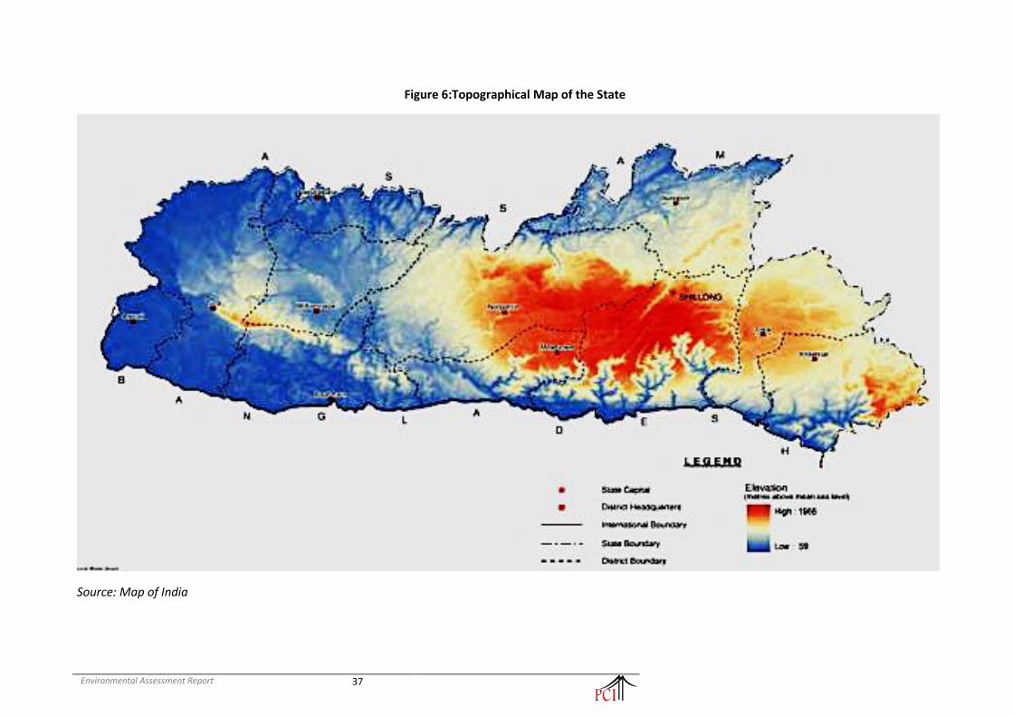
Environmental Assessment Report
37
Figure 6:Topographical Map of the State
Source: Map of India

Environmental Assessment Report
38
138. The project road is within Ri-Bhoi District of Meghalaya state. The general topography of Ri-Bhoi district is proportional to elevation from 100 m to 1000 m with the presence of sharp hill-tops of highlands situated in the south. The low elevation areas surround the neighbouring plains of Assam in the north and in the north-east, it reaches an elevation of 600 m bounded by the Karbi-Anglong (Mikir hills). The highest point is 1,350 m i.e., the Sohpetbneng Peak which lies in the south area of the district. From the south towards the north in the district, the elevation of the land decreases gradually till it reaches the low contour lines of 100 m, the terrain here is highly dissected and irregular in the northern part bordering Assam plains. There is also observed a variation in the elevation between the western part and the eastern part of the district, in the western border, the elevation is as low as 100 m, whereas in the north-eastern part the lowest elevation rises to a height of 700 m.
139. The proposed Umling - Patharkhamah Road section is located in north-eastern part of Ri-Bhoi District, mostly elevation is in range of 147-349m.
4.3.2 Geology
140. Geologically the Meghalaya plateau comprises of rocks from the oldest Precambrian gneissic complex to the Recent alluvium formations. The stratigraphic sequence is as follows.
• Cretaceous –Tertiary sediments
• The Sylhet trap
• Lower Gondwana rocks
• Shillong Group of rocks
• Precambrian gneissic complex (Basement gneiss)
141. The Precambrian gneissic complex comprising para and orthogneisses, migmatites and the Shillong Group of rocks comprising mainly quartzytes are exposed in the central, eastern and northern parts of the Meghalaya plateau. They are intruded by basic and ultrabasic intrusive and late techtonic granite plutons.
142. The lower Gondwana rocks of Permo-Carboniferous age are recognized at the western part of Garo Hills and consists of pebble bed, sandstone, and carbonaceous shale. The Sylhet trap of middle Jurassic age comprising mainly of basalt, rhyolites, acid tuffs, is exposed in a narrow E-W strip along the southern border of Khasi Hills.
143. The Cretaceous – Tertiary sediments occupying southern part of the Meghalaya plateau comprises of the Khasi Group (arenaceous facies), the Jaintia Group (calcareous facies) and the youngest formation the Garo Group which is represented as Simsang, Bagmara and Chengapara formations.
144. Besides these the DupiTilla group of mid-Pliocene age occurs in the western part of Garo Hills and towards south of Khasi Hills. Isolated patches of older Alluvium overlie the Tertiary rocks along the southern and western borders of the State. The recent Alluvium formation is mostly found in the river valleys of Garo & Khasi Hills Districts.

Environmental Assessment Report
39
Figure 7:Geological and Tectonic Map of Meghalaya
Source: GoM, Department of Mining and Geology
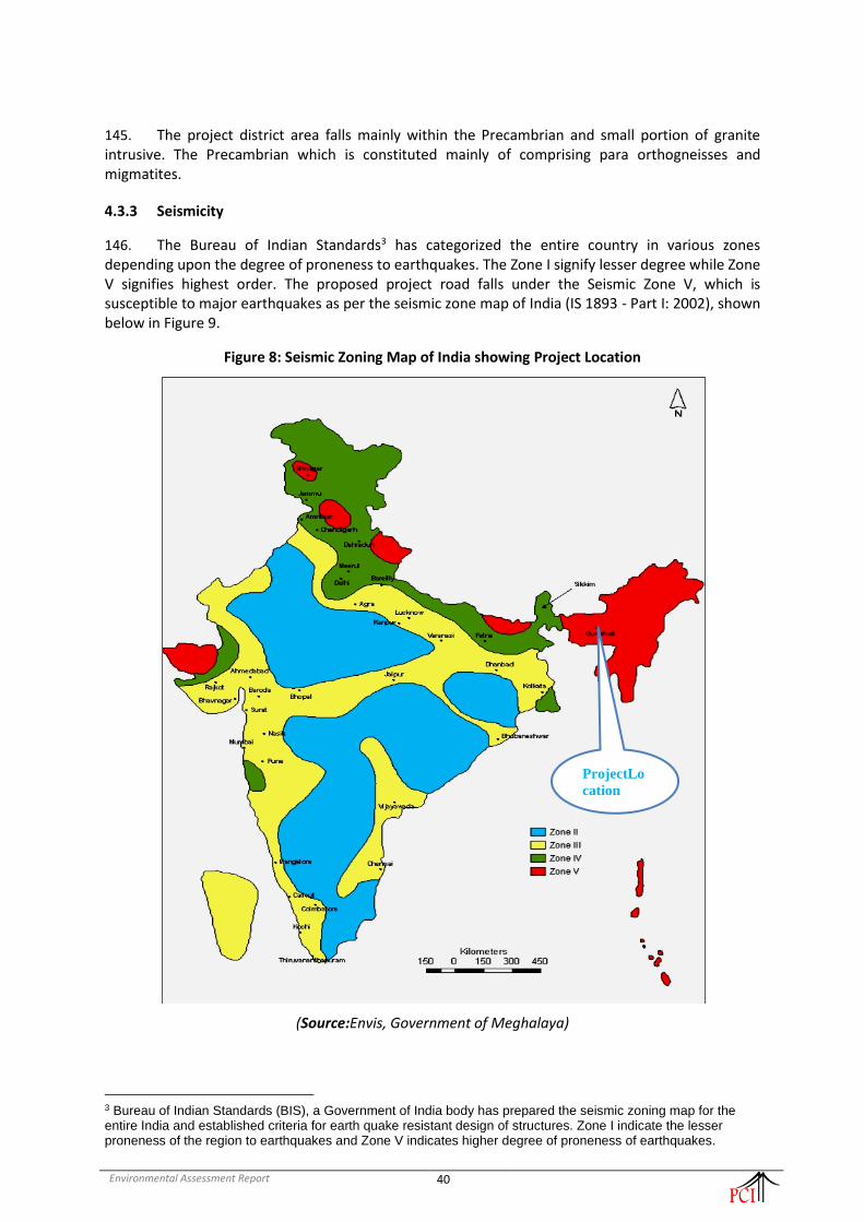
Environmental Assessment Report
40
145. The project district area falls mainly within the Precambrian and small portion of granite intrusive. The Precambrian which is constituted mainly of comprising para orthogneisses and migmatites.
4.3.3 Seismicity
146. The Bureau of Indian Standards3 has categorized the entire country in various zones depending upon the degree of proneness to earthquakes. The Zone I signify lesser degree while Zone V signifies highest order. The proposed project road falls under the Seismic Zone V, which is susceptible to major earthquakes as per the seismic zone map of India (IS 1893 - Part I: 2002), shown below in Figure 9.
Figure 8: Seismic Zoning Map of India showing Project Location
(Source:Envis, Government of Meghalaya)
3 Bureau of Indian Standards (BIS), a Government of India body has prepared the seismic zoning map for the entire India and established criteria for earth quake resistant design of structures. Zone I indicate the lesser proneness of the region to earthquakes and Zone V indicates higher degree of proneness of earthquakes.
ProjectLo
cation

Environmental Assessment Report
41
147. According to GSHAP data, the state of Meghalaya falls in a region of high to very high seismic hazard. As per the 2002 Bureau of Indian Standards (BIS) map, this state also falls in Zone V. Historically; parts of this state have experienced seismic activity greater than M6.0 including an M8.1 in 1897. Figure-10 shows the seismotectonic map of Project location.
Figure 9: Seismotectonic Map of Project area
(Source: ASC, Pune) 148. Considering high hazard seismic zone of the project road section area, design standards for structures stipulated in the clause under IRC: 6-2014 has been taken into account.
4.3.4 Soil Type and Quality
149. The soils of the hills are derived from gneissic complex parent materials; they are dark brown to dark reddish-brown in colour, varying in depth from 50-200 cm. The texture of soils varies from loamy to fine loamy.
150. Broadly, the central part of Garo hills and central upland of Khasi and Jaintia hills have read loamy soils formed as a result of weathering of granite, gneisses, diorites, etc. Red and yellow fine textured soils raining from loam to silty loam are found along the southern fringes of read loamy soils. Lateritic soils are present in the southern part of the State. Alluvial soils are found all along the southern, western and northern fringes of the State, with sandy to clay loam texture.
151. Soils are by and large highly leached, rich in organic carbon with high nitrogen supplying potential, but deficient in phosphorus and potassium. Soil reaction varies from acidic (pH 5.0 to 6.0) to strongly acidic (pH 4.5 to 5.0).

Environmental Assessment Report
42
152. There is not much difference in fertility classes of soils across the State. Soils occurring on higher altitudes under high rainfall belt are strongly acidic due to intense leaching. These tend to be excessively drained and erosion-prone.
153. Soil of Ri-Bhoi district has been divided into four types under the thermic regime(ranging from deep-fine mixed thermic soils to moderately-deep loamy skeletalthermic soils) and five types of soils under the hyperthermic regime (ranging from moderately deep-fine loamy soil of moderate erosion to deep-loamy skeletal with slight erosion).
154. The hill slopes of the district are included under deep-loamy skeletal hyperthermic soils of moderate and slight erosion. However, the areas of north situated hilltops are covered under deep-fine loamy thermic soils. On the whole, the district has deep-loamy with the process of laterisation (red soils), which are fertile in the valley-flats and also suitable for intensive crop-cultivation.
155. Soil samples were collected from 4 locations in project influenced area and analyzed to find physio-chemical properties. The soil sample locations are given in below Table-6.
Table 6: Soil sample collection location in the project area
S. No. Location Code Chainage Location Name Source
1 SS1 8+145 Umdu Crossing From Agriculture field
2 SS2 13+750 Umladoh Village From Agriculture field
3 SS3 18+250 Lailad Village From Agriculture field
4. SS4 31+600 Nongladew Village From Agriculture field
156. The summary of soil quality results for the project stretch is presented in Table-7.
Table 7: Results of soil quality in the project area
S. No. Parameter(S) Unit Test Result
SS1 SS2 SS3 SS4
1 Soil Texture - Silty Clay
Soil Silty Clay
Soil Silty Clay
Soil Silty Clay
Soil
2 Soil Colour Greyish Brown
Reddish Brown
Reddish Brown
Yellowish Brown
3 pH Value at 25°C - 7.67 7.88 7.97 8.11
4 Conductivity at 25°C µS/cm 702 641 655 687
5 Moisture % by mass 9.2 8.4 8.1 7.5
6 Bulk Density gm/cc 1.31 1.32 1.28 1.29
7 Water Holding Capacity Inches/foot 1.16 1.15 1.14 1.17
8 Nitrogen as N mg/Kg 23.4 24.4 23.8 24.1
9 Phosphorus mg/Kg 3.14 3.28 3.44 3.64
10 Potassium (as K) mg/Kg 68.4 70.4 71.2 73.2
11 Calcium as Ca mg/Kg 58 61 67 64
12 Nitrate as NO3 mg/Kg 98 101 104 92
13 Sulphate as SO4 mg/Kg 14.2 15.1 14.8 14.2
14 Chloride mg/Kg 6.2 5.7 5.4 5.1
15 Organic Carbon % by mass 4.3 4.5 4.6 4.1
16 Organic Matter % by mass 5.3 4.8 4.9 5.2
17 Total Soluble Solids mg/Kg 12.4 14.2 13.2 14.7
18 Soil Texture
a Sand % by mass 20.4 23.4 22.4 22.1
b Silt % by mass 36.1 34.2 34.5 34.2

Environmental Assessment Report
43
c Clay % by mass 43.5 42.4 43.1 43.7
157. The results show soil texture of clay and silt in almost equal proportion in the project area. There is higher value of organic matter and nitrate can be observed from the chemical analysis of the soil samples.
4.3.5 Land Use
158. Meghalaya lies between 240 58’ North to 260 07’ North latitudes and 890 48’ East to 920 51’ East longitudes. It covers an area of 22,429 sq. km. of which about 70% is endowed with dense forests and rivers cascading down undulating terrain. The State has most of its land covered by hills interspersed with gorges and small valleys.
159. Most of the land is under rural areas, with Shillong being predominately the main urban settlement. Only 12.74% is net sown area. The principal crop grown in the state is rice covering atleast 80% of the cultivated land, followed by maize and wheat. About 17.4% of the land is under wasteland category, (comprising of scrubland, jhum, abandoned jhum lands and degraded scrub forest, with the highest proportion in the west Khasi hills and Jaintia hills.
160. The state of Meghalaya is a resource rich state. There are a variety of landholdings, water resources and forests under different classifications. The table-8 below provides district wise data on land use and forest cover:
Table 8:District-wise Land Use Classification, (2015 – 2016, Area in Ha)
District Area
under forest
Land not available
for cultivatio
n
Other un-cultivated
land excluding
Fallow land
Fallow Land
Net Sown Area
Total
Area Sown More than Once
Gross Cropped
Area
East Khasi Hills
106964 53731 65508 10720 37866 274789 11127 48993
Ri - Bhoi 87141 33277 86290 15036 22751 244495 2983 25734
West Khasi Hills
156012 50284 110241 47802 20260 384599 4724 24984
South West Khasi Hills
50508 24818 34889 18865 11010 140090 2122 13132
East Jaintia Hills
84077 15565 78288 14642 25169 203643 48 11119
West Jaintia Hills
69886 17290 52797 12618 11071 177760 388 25557
North Garo Hills
55455 5063 35892 11445 17778 115981 2576 20354
East Garo Hills
69122 6364 26240 13596 19311 144285 2677 21988
West Garo Hills
126265 15809 29997 13596 73241 281090 18668 91909
South West Garo Hills
38526 6592 8900 10162 22406 86586 6699 29105
South Garo Hills
102292 11167 25382 24381 25462 188684 5264 30726
Total 946248 239960 554424 215045 286325 2242902 57276 343601
Source: Directorate of Economics & Statistics, Meghalaya (Statistical Abstract 2018)

Environmental Assessment Report
44
161. The land utilization in the Ri-Bhoidistrict varies in many respects. Forest cover which constitutes 87141 ha. of the total geographical area of the district and is higher compared to other category of land use. Cultivable waste land and fallow land of 86290 ha. indicating there is high degradation of land resulting from faulty agricultural practice and due to large-scale deforestation. The net sown area constitutes 25734 ha. of the total area, see Table-8.
162. Land use pattern abutting the project road section is mainly community open vegetation and built up areas in between including Umling, Umdu, Umladoh, Lailad, Umsohma, Old Tasku, New Tasku, Mawpnar, Jali, Them, Nongladew, Umsong, Nongbirthem, Umtasen & Umrit habitation areas. The land use within the project influence area and the settlement along the project corridor is presented in Table-9.
Table 9: Landuse details along the project alignment
Chainage (Km) Length (m) Landuse Remark
From To
8+000 18+400 10400 OP/VG Open and Vegetation
18+400 20+200 1800 BU Built up
20+200 23+200 3000 OP/VG Open and Vegetation
23+200 25+000 1800 BU Built up
25+000 31+800 6800 OP/VG Open and Vegetation
31+800 32+800 1000 BU Built up
32+800 39+000 6200 OP/VG Open and Vegetation
39+000 40+000 1000 BU Built up
Source: Environmental features survey along the project alignment October-December 2019
4.4 Air Environment
4.4.1 Climate & Meteorology
163. Climate of Meghalaya plateau is influenced by elevation and distribution of physical relief. On the basis of weather condition, the Meghalaya plateau has 4 distinct seasons. The seasons are:
(a) The rainy season from May to early October. (b) The cool season from early October to November. (c) The cold season from December to February. (d) The warm season or hot season from March to April.
164. The salient climatic features of the state are as fallow:
• Average Annual Rainfall - 2000-4000 mm
• Concentration of precipitation - May to October
• Humidity - 67 to 94%
• Cloudiness - Heavily clouded
• Wind - Generally light except rainy season
• Temperature - Summer 23C to 25C
Winter 7C to 11C
165. Garo hills experienced higher temperature conditions and humidity from February to October. April and May are the warmest months and January is the coldest month. The Khasi and Jaintia hills experience a moderate climate because of higher elevation. Warm and humid conditions are prevalent in the foothill region in the south and sub-montane region in the north and central uplands. The plateau experiences a temperature of 24oC throughout the year. The southern parts of the plateau

Environmental Assessment Report
45
have the Cherrapunji -Mawsynram region which receives the heaviest rainfall, an annual average of 12670mm which is the highest amount of rainfall in the world. The Khasi and Jaintia hills receive an average of 7700mm of rainfall and lies in the rain shadow area.
Table 10:District wise rainfall in the State (2004-2012)
District/Centers 2004 2005 2006 2007 2008 2009 2010 2011 2012
East Khasi Hills
(a)Mawsynram
14026 10072 8082 13302 10722 8952 11069 8927 12327
(b)Sohra NA NA NA 12647 11415 9000 13472 8732 13350
West Khasi Hills
(a)Nongstoin
4036 3097 2366 4778 NA *3507 3316 2982 NA
Jaintia Hills
(a)Jowai
5374 3042 2898 5379 3094 3025 3404 2964 4254
East Garo Hills
(a)Willliamnagar
3837 3612 2098 3899 3317 3252 3183 NA 3109
West Garo Hills
(a)Tura
4107 4652 2528 4265 3632 3355 3278 4003 3580
Ribhoi
(a)Nongpoh
1147 1792 1274 3086 3853 3354 1156 6278 NA
South Garo Hills
(a)Baghmara
1811 2347 1405 2589 2392 1532 1161 2147 1841
Source: District Agriculture office, Meghalaya, District and local Research Station and laboratories, West Garo Hills, Tura, S.D.O, PWD, Mawsynram, Sub-Divisional Agriculture Officer – Sohra (*February to December)
166. Throughout the year, temperatures vary by 10.8 °C.
Table 11:Average Seasonal Temperature of the State
Jan Feb Mar Apr May Jun Jul Aug Sep Oct Nov Dec
Avg. Temp. (°C) 10.4 12.3 16.4 18.9 19.6 20.8 21.2 21.1 20.5 18.1 14.4 11.4
Min Temp (°C) 4.9 7.3 11.2 14.4 15.9 17.9 18.5 18.2 17.3 14.1 9.3 5.9
Max Temp (°C) 15.9 17.4 21.6 23.5 23.4 23.7 23.9 24.1 23.7 22.2 19.5 16.9
Source: https://en.climate-data.org/asia/india/meghalaya/shillong-24618/
167. The below (Figure -11) wind-rose diagram indicates the distribution of wind direction and its speed over the monitoring period at Shillong. From the diagram it is shown that around 17% wind direction is from South-East with a wind speed of 0.1 to 1.5 m/s. Similarly, around 14% wind direction has been observed from North/North-West with 2-0-2.5 m/s wind speed. From the diagram the resultant vector has been obtained at 80 degree. The predominant wind direction was observed to be from East-North-East with an average wind speed value of 1.08 m/s. The highest wind speed frequency was generally observed in the range of 0.5-1.5 m/s with calm frequency being recorded at 2.70%.

Environmental Assessment Report
46
Figure 10: Wind-rose diagram of the state capital (Shillong)
4.4.2 Ambient Air Quality
168. Four ambient air-sampling locations has been selected for assessment of the existing status of air environment within the study zone, details are in Table -12. The selection of monitoring locations has been distributed throughout the study area so as to get representative baseline of any variation in land use as well as road geometrics and traffic conditions across the project road including the baseline at Sensitive Receptors along the project. The heights of the sampling locations were kept between 1.0 to 1.5 m in all the locations. The monitoring of the Ambient Air Quality (AAQ) for the various land uses along the project corridor was carried out at each selected location as per guidelines of Central Pollution Control Board (CPCB) and the requirements of MoEF&CC.
Table 12:Ambient air quality locations along the project road section
S.No. Location
Code Chainage Location Name
Category as per AAQ standards
Distance from
project road
Environmental Setting
1 AAQM-I 8+145 Umdu Crossing Rural 10 m Residential
2 AAQM-II 13+750 Umladoh Rural 11 m Residential
3. AAQM-III 17+050 Lailad Village ESZ 11m WLS
4. AAQM-IV 31+600 Nongladew Village Rural 11 m Residential
169. The summary of ambient air quality results for the project stretch is presented in Table-13.
Table 13: Results of ambient air quality monitoring
S.No. Location PM10
(μg/m3) PM2.5
(μg/m3) Sox
(μg/m3) NOx
(μg/m3) CO
(μg/m3)
1 Umdu Crossing 62 32 5.6 8.7 BDL
2 Umladoh 58 28 3.9 6.9 BDL

Environmental Assessment Report
47
3 Lailad Village 48 20 3.4 6.4 BDL
4 Nongladew Village 53 26 4.2 8.9 BDL
NAAQS Limits 100 60 80 80 04
170. All the pollutant levels along the project road are within the permissible limits. In case of gaseous pollutant, the however the measured levels are lower than standards. Overall the air quality of the project area is not a problem.
4.4.3 Ambient Noise Quality
171. Noise is an important environmental attribute in all road projects because vehicular traffic is a source of noise pollution. Four monitoring sites were identified for noise monitoring to characterise the baseline noise levels in the project area. Locations for noise monitoring along the corridor are identified based on the criteria same as those used for air monitoring. The description of environmental settings of noise given in Table -14.
Table 14:Noise level monitoring locations along the project road section
S.No. Location
Code Chainage Location Name
Category as per AAQ standards
Distance from
project road
Environmental Setting
1 NQ-I 8+145 Umdu Crossing Rural 10 m Residential
2 NQ-II 13+750 Umladoh Rural 11 m Residential
3 NQ-III 18+250 Lailad Village ESZ 11m WLS
4 NQ-IV 31+600 Nongladew Village Rural 11 m Residential
172. The main objective of noise monitoring in the study area is to establish the baseline noise levels, which was used to assess the impact of the total noise generated by the proposed project activities. Noise level monitoring was carried out continuously for 24 - hours with one-hour interval at each location using Sound level meter (HTC made in Taiwan Model No. SL-1350) capable of measuring the Sound Pressure Level (SPL) in dB (A). Hourly Leq values were computed by the noise integrating sound level meter and statistical analysis was done for measured noise levels at 4 locations in the study area. The Leq day, and Leq night calculated for various locations in the area are presented below which are compared with the standards prescribed by CPCB for various zones. The Noise quality results presented in Table 15 show Leq Day time is in the range of 48.1 to 51.5 dB(A) and Leq Night time is in between 37.4 to 40.1dB(A).
Table 15: Result of noise level monitoring
S.No. Monitoring Location
Chainage Leq dB(A) day
Leq dB(A) night
Limits in Leq dB(A)
Day Night
1 8+145 Umdu Crossing 51.2 40.1 55 45
2 13+750 Umladoh 48.6 38.4 55 45
3 18+250 Lailad Village 45.2 36.7 50 40
4. 31+600 Nongladew Village
47.2 37.4 55 45
173. The noise levels are within the standards are almost comparable to the standards.

Environmental Assessment Report
48
4.5 Water Environment
4.5.1 Hydrogeology
174. One of the world's wettest regions is found in Meghalaya. Mawsynram and Cherrapunji (Sohra) in the East Khasi Hills district are geographically considered as the rainiest places in the World, with Cherrapunjee, receiving close to 12000 mm of annual rainfall and and Mawsynram, a village directly west of Cherrapunji, where rainfall of around 17,800 mm (700 inches) per year. These areas receive rainfall on an average for 160 days in a year, spread over six to eight months between March to October. Paradoxically, even then the state of Meghalaya is water stressed in some regions during summer months. This is mainly due to topographical and geomorphological conditions apart from alterations of the natural land surface by way of development, mining and urbanization. Moreover, the characteristic hilly and steep sloping terrain condition in the area with localized small valleys results in very high surface run-off during the monsoon.
175. The rivers of the State are rainfed and therefore their discharge dwindles during summer. Important rivers in Garo Hills region are Daring, Sanda, Bugi, Dareng and Simsang. In the central and eastern part of the plateau are Umkhri, Digaru, Umngot and Myntdu rivers. The surface water resource is tapped in a number of places by constructing dams across the rivers. The reservoirs, like the Umiam and Kopili, so developed are not only used for irrigation and drinking water but also for generating electricity.
176. The surface water available in Meghalaya on annual basis is roughly estimated at 63.204 billion cubic metres (BCM) and the estimated replenishable ground water resources estimated as 1.15BCM. According to the Central Ground Water Board (CGWB) 1.04BCM of ground water is potentially available for utilization. Figure shows spread to two major river basins Brahmaputra and Meghna, and their sub-basins, refer Figure-12.
Figure 11: Brahmaputra and Meghna, and their sub-basins
Source: Central Water Board

Environmental Assessment Report
49
177. In Meghalaya, groundwater is generally extracted through dugwells and springs (or seepage wells in valley areas/topographic depressions) and bore wells. Apart from this, tubewells are in use in West Garo Hills district. Dugwells are generally shallow in depth. The level of ground water development in the state is 0.15%. The annual gross dynamic ground water recharge of Meghalaya has been estimated as 1.234BCM. Annual allocation for domestic & industrial water requirement upto year 2025 is estimated as 0.096 BCM as per census 2001. 1.014 BCM of ground water potential may be utilized for irrigation. The importance and contribution of groundwater is felt in the recent years, particularly to meet the drinking water needs.
178. Meghalaya's economy is primarily agricultural engaging around 80 per cent of its total work force. Thus, major part of water consumption in the state is under irrigation followed by utilization of water in household and industrial needs. The State is mostly dependent on rain and surface water resources for irrigation purposes. Surface water is abundant but limited during non-rainy season. According to the CGWB, 18% of the available groundwater is currently utilized and there is ample potential for further increase in ground water exploitation.
Figure 12: Area for Groundwater Development at Major Aquifers of the State
Source: Central Water Board
179. Ri-Bhoi district is a hilly one with intermontane valleys. The western and northern part of the district comprises of the denudational high hills with deep, narrow intermontane valleys covered with or without colluvium. In the central and eastern parts, denudational high hills with deep valleys are found to exist which comprise intrusive Granites. Further in the southeastern part, denudational low hills are found to occur with valleys and comprise granite with fracture zones. In the gneissic formation, majority of the well-recorded depth to water level in the range of 2 m bgl to 4 mbgl.
180. Springs play a major role to cater water requirement of the people throughout the year. Most of the springs are gravity springs. It is observed that discharge of most of the springs lie within the range of 5000-25000 lpd in pre- & post monsoon period.
181. The water resource in the state are currently threatened with contamination, siltation and pollution primarily contributed from coal mining and domestic effluents. The water in coal mining

Environmental Assessment Report
50
areas is highly acidic with silt and suspended solids deposited at the bottom of these water bodies. The agricultural fields in the coal mining affected areas have turned into unusable infertile land from use and infiltration of the highly-polluted water. According to an estimate, the State has over 60,000 springs. A sample survey of 714 springs (MINR, 2015) has revealed that more than half of the total springs have either dried or water discharge from them has significantly reduced. Impaired springs have caused widespread water stress in the rural landscape, adversely affecting agriculture, livestock and other allied livelihood activities of the people and causing hardship and drudgery. Despite heavy rainfall, many areas are water-stressed due to increase in demand-supply gap leading to a surge in the use of ground water. Further, ground water data shows that the depletion rate between pre-and post-monsoon period is about 40 to 80% depending on the landscape. Changing land use, deforestation, quarrying, mining and climate change are perceived to be the main causes for deterioration of springs and ground water.
4.5.2 Groundwater Quality
182. The ground water quality analysis conducted by CGWB on sample collected fromvarious dug wells, springs, bore and tube wells in Ri-Bhoi district. According to Bureau of Indian standards (BIS:IS:10500, 1991) the chemical constituents present in the ground water of the district are all within the desirable limits set for drinking and irrigation water standards except Fe which is slightly higher by drinking water standards. In the pockets where high concentration of Fe is detected.
4.5.3 Hydrological Flow & Drainage
183. The drainage pattern of the State represents a most spectacular feature revealing extraordinary straight courses of the rivers and streams evidently along the joints and faults. The magnificent gorges scooped out by the rivers in the southern Khasi and Jaintia Hills are the result of massive headward erosion by antecedent streams along joints of the sedimentary rocks over the block, experiences relatively great uplift. Westward in the Garo Hills, the consequent streams are mostly controlled by the structures, faults and monoclines in the sedimentary rock. The northern part of the plateau devoid of any sedimentary cover is marked by long incisive valley formed due to head ward erosion along joints in the gneissic rocks and granites. The limestone-covered country over southern Garo, Khasi and Jaintia Hills represent typical karst topography. The present physiographic configuration of the plateau was attained through different geological events since Melozonic to present day as indicated by polycyclic surface at various levels.
184. Eight main rivers in the north and five main rivers in the south drain the State. Rivers of north and south are tributaries of Brahmaputra and Meghna; respectively.
185. The drainage system of the district is controlled by topography. The drainage pattern shows annular, trellis, sub-dendritic types, which also indicate the structural control. The important river includes the Umtrew, Umsiang, Umran and Umiam rivers.
186. The project road section crosses Umtrew river at km 18+524, the existing bridge is in good conditions and is proposed to retain. However; there are number of small streams and tributary rivers crossing the project road section. There are total 280 no. of cross drainage structures are in this rod section. All structures are old and proposed for reconstruction or retained with widening.
4.5.4 Surface water quality
187. Total four water samples were collected from the project road section influenced are to monitor the water quality, one each from ground water and surface source. The sample details are given in below table-16.
Table 16:Water quality sampling location along the project road section

Environmental Assessment Report
51
S. No. Location
Code Chainage Location Name Source
1 SW1 8+145 Umdu Nallah Nallah, Surface Water
2 SW2 13+750 Umladoh Village River, Surface Water
3. SW3 18+250 Umtrew River Lailad Village Umtrew River, Surface Water
4. GW1 31+600 Nongladew Village Water Supply
188. The water was analysed in a laboratory as per the methods prescribed in “Standard Methods for the Examination of Water and Wastewater (American Public Health Association)” and the result was compared against IS 10,500: 2012 for drinking water standards. The results are presented in Table-17.
Table 17: Ground (Drinking) & Surface water Characteristics in the project area
Sl. No.
Parameter Prescribed Limit as per IS:10500 &
IS:2296
Monitored Value
Surface water
Surface water
Surface water
Ground water
SW1 SW2 SW3 GW1
1 Colour, Hazen units 5 Max <1 <1 < 1 <1
2 Odour Agreeable Agreeable Agreeable Agreeable
3 Turbidity, NTU 1 Max 5.6 4.1 3.4 <1
4 Electrical Conductivity at 25°C - 269 242 194 134
5 pH Value at 25°C 6.5 - 8.5 7.55 7.47 7.61 7.42
6 Total Dissolved Solids, mg/l 500 Max 175 157 126 88
7 Total Alkalinity (as CaCO3) ,mg/l
200 Max 78 62 46 36
8 Total Hardness (as HCaCO3) ,mg/l
200 Max 97 90 62 42
9 Calcium (as Ca),mg/l 75 Max 20.1 19.4 14.6 11.4
10 Magnesium (as Mg) , mg/l 30 Max 11.8 10.2 6.2 3.1
11 Sodium (as Na) ,mg/l - 12 12 12 10
12 Potassium (as K) ,mg/l - 5 4 6 3
13 Bicarbonate (as HCO3),mg/l 200 Max 64 58 51 30
14 Sulphate (as SO4) ,mg/l 200 Max 47 41 31 19
15 Chloride (as Cl),mg/l 250 Max 13 14 13 11
16 Nitrate (as NO3) ,mg/l 45 Max 4 5 4 5
17 Fluoride (as F),mg/l 1 Max 0.08 0.06 0.05 0.04
18 Phenolic Compound (as C6H5OH) ,mg/l
0.001 Max BDL BDL BDL BDL
19 Cyanide, mg/l 0..05 BDL BDL BDL BDL
20 Aluminum, mg/l 0.03 BDL BDL BDL BDL
21 Arsenic, mg/l 0.05 BDL BDL BDL BDL
22 Cadmium (as Cd) , mg/l 0.003 Max BDL BDL BDL BDL
23 Chromium as Cr,mg/l 0.05 BDL BDL BDL BDL
24 Iron (as Fe),mg/l 0.3 Max 0.06 0.06 0.07 0.06
25 Copper (as Cu),mg/l 0.05 Max BDL BDL BDL BDL
26 Lead (as Pb) , mg/l 0.01 Max BDL BDL BDL BDL
27 Manganese (as Mn) , mg/l 0.1 Max BDL BDL BDL BDL
28 Zinc (as Zn) , mg/l 5 Max BDL BDL BDL BDL
29 Mercury as Hg,mg/l 0.001 BDL BDL BDL BDL
30 Dissolve Oxygen, mg/l - 6.3 6.9 7.4 -

Environmental Assessment Report
52
31 Biochemical Oxygen Demand, mg/l
- 7.9 7 6 -
32 Chemical Oxygen Demand, mg/l
- 24.6 21.7 19.5 -
33 Oil &Grease, mg/l - BDL BDL BDL -
189. Analysing the tests result of water samples analysis it was observed that the nitrates and iron are high in both ground water and surface water in the project area. The other parameters are all within the desired limits.
4.6 Biological Environment
4.6.1 Forest
190. As per the Forest Survey of India report, Meghalaya rank seventh amongst the Indian states in respect of percentage of geographical area uder forest cover. The forests of Meghalaya are rich in biodiversity and endowed with rare species of orchids and medicinal plants. The forest types in Meghalya are Subtropical Pine, Subtropical Broadleaf, Tropical Wet Evergreen, Tropical Semi-Evergreen, and Tropical Moist Deciduous Forests. Scared groves mostly located in the Khasi and the Jainita Hills represent the climax vegetation of the area. According to Haridasaan and Rao (1985), the forest vegetation of Meghalaya consisits of Tropical Evergreen Forest in the low-lying areas with high rainfall; Tropical Semi-Evergreen Forest up to the elevation of about 1,200 m with annual rainfall between 1,500 to 2,000 mm; Tropical Moist Deciduous Forest in the areas with less than 1,500 mm rainfall; Grassland on the tops of Khasi, the Jaintia and the Garo Hills; isolated patches of Temperate Forest along the sothern slopes of the Khasi and Jainita Hills; and Subtropical Pine Forest with pure stands of Pinus kesiya confined to the Higher reaches of the Shillong Plateau. Bamboo and canes are found in undisturbed forests. Meghalaya has many endemic plant species, the most famous being the carnivore pitcher plant Nepenthes khasiana.
191. The Forest and Tree cover in the State is 79.37 % covering 17,803 Sq.km. Out of total forest area of 17,146 sq km (76.44% of the state’s geographical area) only 1145.19 sq km of Forest areas (5.10 % of geographical area ) comes directly under the control of the State Forest Department in the form of reserved forest, protected forest, national parks, wildlife sanctuaries and parks & gardens. The rest of the forest areas belong to communities, clan and private people and District Councils. There are three Autonomous District Councils (ADCs) i.e., Khasi Hills Autonomous District Councils, Jaintia Hills Autonomous District Councils and Garo Hills Autonomous District Councils, which have been set up under the provisions of the Sixth Schedule to the Constitution of India. These ADCs have the power to make laws with respect to, among others, the management of any forest not being a reserved forest.
Table 18: Forest Cover of the State
Class of Forests Area (sq. km.)
Reserved Forests 626.55
Protected Forests 12.39
National Parks (including proposed) 399.48
Wildlife Sanctuary (including proposed) 100.74
Parks and Gardens 295.39
Non-Forest Land transferred to the Department and
Exchanged lands
3.08
Sub-total 1145.19
Unclassified 1600.81
Total 17146
Source: Department of Forest, GoM

Environmental Assessment Report
53
192. The Khasi Hills Autonomous District Council, Garo Hills Autonomous District Council and the Jaintia Hills Autonomous District Council. Under the Sixth Schedule of the Constitution, these District Councils have been vested with legislative, executive and judicial functions in many subjects. In terms of canopy density classes, the total forest area is classified under Very dense forests (VDF), moderately dense forests (MDF), open forests (OF) and scrub land.
Figure 13: Forest cover type in Meghalaya
Source: GoM, Department of Forest and Environment
193. In addition to providing an economic and cultural backdrop for the lives of people, forests in Meghalaya deliver an array of essential local and global environmental services, including water storage and filtration, soil stabilisation and carbon sequestration, prevention and reduction of floods, provide food, fodder, fuel, medicines, and materials for construction.
4.6.2 Forest type and density
194. The forests of Meghalaya can broadly be grouped under the tropical type and the temperate type, mainly based on the altitude, rainfall and dominant species composition.
• Tropical Forests: These forests are met within areas upto an elevation of 1200m and with an average rainfall of about 100-250cm. There are numerous subtypes within this category such as evergreen, semi-evergreen, moist and dry deciduous forest, etc.
• Tropical evergreen forests: These forests usually occur in high rainfall areas as well as near catchment areas. They seldom form continuous belts due to various exogenous factors. But still, they harbour very rich species diversity, where nature is at its extravaganza forming a closed evergreen canopy. The trees exhibit clear zonation with dense and impenetrable herbaceous undergrowth.
• Tropical semi-evergreen forests: This category of forests occupies the north-eastern and northern slopes of the State, typically upto elevations of 1200m, where annual rainfall is 150-200cm with a comparatively cooler winter. The numbers of species here are fewer than the evergreen zone. There are also a few species in these forests which are deciduous in nature, such as Careyaarborea, Dilleniapentagyna and Callicarpa arborea. Again, there is a clear stratification of the trees in these forests.
• Tropical moist and dry deciduous forests: This type of forests occurs where annual rainfall is below 150cm and at comparatively low elevations. Typical natural deciduous forests do not occur anywhere in Meghalaya but are only subclimax or man-made forests. These forests are characterised by seasonal leaf shedding and profuse flowering of the trees. Recurrent forest fires are a common phenomenon here. Deciduous forests are much more extensive in their distribution in the State and include a host of economically important trees like Shorearobusta, Tectonagrandis, Terminalia myriocarpa, Sterculia villosa, Logerstroemiaflos-reginae, L. Porviflora, Moruslaevigatus, Artocarpuschaplasha, and Gmelina arborea both as

Environmental Assessment Report
54
natural and as plantations. Schimawallichii, Artocarpusgameziana, Tetramelesmudiflora, Lanneacoromandelica, Salmaliamalabarica Erythrina stricta, Premnamilliflora, Vitex peduncularis, Albizialebbeck. Lucida, Terminalia bellirica etc is also in abundance. These trees of the deciduous canopy are always lofty and straight bole and with spreading crown.
• Grass and Savannas: Grasslands of Meghalaya are also not a climax type but are only as a result of removal of original forest cover. The rolling grasslands covering large areas can be seen throughout the Shillong plateau, around Riangdo, Ranikor, Weiloi, Mawphlang, Mawsynram, Cherrapunji, Shillong, Jowai, Jarain, and Sutnga in Khasi and Jaintia Hills and major parts of west Garo Hills.
• Temperate Forests: The temperate forests occupy the higher elevations about 1000m, mostly along the southern slope of Khasi and Jaintia Hills. The rainfall here is very high 200-500cm with a severe winter during November to March. Ground frost is also common during December to January.
• Sacred Groves: The scared groves of Meghalaya largely fall under the temperate type and are the relic type evolved through millions of years. These are rich storehouse of vegetation wealth incomparable to any other type of forests in the State. These isolated pockets are untouched due to the religious beliefs and myths attributed to them. Many of the endangered species of the State are presently confined to these pockets only. Fagacaea members dominate over others in these sacred forests. Epiphytic flora is quite abundant and again dominated over by ferns and orchids.
Table 19: Details of district wise forest cover in Meghalaya State
District
Geo graphical area (In Sq.Km)
Area In Sq.Km Percent of GA
Very dense forest
Mod, Dense forest
Open forest
Total
East Garo Hills 2603 68 1104 1045 2117 85.17
East Khasi Hills 2820 0 1084 716 1800 63.83
Jaintia Hills 3819 99 1578 839 2516 65.88
Ri Bhoi 2376 131 1092 898 2121 89.27
South Garo Hills 1849 44 1005 590 1639 88.64
West Garo Hills 3715 0 1361 1613 2974 80.05
West Khasi Hills 5247 91 2551 1366 4008 76.39
Total 22429 433 9775 7067 17275 77.02
Source:FSI, State Forest Report, Meghalaya, 2011-12
195. The project road section is passing through hill/rolling terrain with land use being agriculture, community open vegetation and builtup area. There are patches of individual/community forest along the road section proposed for improvement works. Details of biodiversity found within Nongkyliem Wildlife Sanctuary are provided in Section 4.7.
4.6.3 Flora
196. The prevailing and pre-dominant floral species observed in the direct area of influence and in the study areas of the project road are Pinus kesiya (pine),schimawallichii (Diengshyrngan), Myrica esculenta (Diengsohphie), Quercus spp. (DiengShahdngiem) Shorearobusta (Sal, DiengBlei), Tectonagrandis (Teak)Albizzia lebbeck, Dilleniaindica (Diengsohkyrbam). Shrubs include Rubus, Osbeckia, Spirea and Artemesia.
197. The trees to be cut in corridor of impact of road section are along the existing road alignment and thinly distributed. Trees being next to existing road, these are less preferred for habitat or shelter by birds and animals due to human activities.

Environmental Assessment Report
55
198. Field survey has been carried out to identify the number of trees to be affected by the proposed improvement work of road alignment. It is envisaged that about 73 number of trees are likely to be cut for the implementation of the improvements proposed under the project list of trees in COI of the project road is given in Appendix-7.
4.6.4 Fauna
199. Meghalaya is a part of Indo-Burma biodiversity hot spot and identified as key area for biodiversity conservation due to high species diversity and high level of endemism. It has attracted the attention of wildlife enthusiasts and research scholars from all over the country.
200. The Clouded leopard (Neofelis nebulosi) is a Schedule – I animal, according to wildlife (Protection) act, 1972 and classified as Vulnerable (VU) by the IUCN which is found within Meghalaya. The globally endangered Indian Wild Water Buffalo (Bubalusarnee) is still found in small groups of 10 to 20 in the Balpakram-Siju-Baghmara belt and adjacent areas including parts of the West Khasi Hills. Shalyni barb (Pethiashalynius), is a species of cyprinid fish found in hill streams of Meghalaya, and spawns in rice paddies is currently on IUCN list of vulnerable species as with the increase in coal mining there are reports of heavy metals affecting to this species affecting the quality of habitat, which is declining. The Khasi Hill Rock Toad, Mawblang Toad Bufoidesmeghalayanus (IUCN Engaged species) is found in Cherrapunjee area, East Khasi Hills, usually occurs in forest areas dominated by screw pine trees, however the habitat has been affected due to extensive rock-blasting and stone quarrying near Cherrapunjee and the Mawblang plateau area. Other schedule -1 species found in Meghalaya include Black Spotted Turtle, Assam Roofed Turtle, Bengal Slow Loris, Guar, four horned Antelope, Capped Langur, Western Hoolock Gibbon, Chinese Pangolin, Sun Bear, Sloth Bear, Red Panda, Hedged badger, Oriental Small-clawed Otter, Large Indian Civet, Marbled Cat, Asiatic Golden Cat Leopard, Tiger and Asiatic Elephant.
4.6.5 Protected Area Network
201. The protected area network in Meghalaya occupies 512.61 Sq.km area The Protected Area Network includes two National Parks, four Wildlife Sanctuaries and one Biosphere Reserve playing an important role in in-situ conservation of biodiversity. The Protected Area Network still support viable population of one of the two closely related Apes found in India, the endangered Western Hoolock Gibbon (Hoolock hoolock), and the Bengal Slow Loris (Nycticebusbengalensis). Other primates including Stumped-tailed Macaque (Macacaarctoides), Assamese Macaque (Macacaassamensis), Northern Pig-tailed Macaque (Macacaleonina), Rhesus Macaque (Macaca mulatta), Capped Langur (Trachypithecuspileatus) are also found in these areas. Among the carnivores, the Bengal Tiger (Panthera tigris) and the Clouded Leopard (Neofelisnebulosa) have become extremely rare while the adaptable Common Leopard (Panthera pardus) is still widely distributed. Bears including Sun Bear (Helarctosmalayanus), Asiatic Black Bear (Ursusthibetanus) and the Sloth Bear (Melursus ursinus) are found as well. Smaller cats like the Jungle Cat (Felischaus), Marbled Cat (Pardofelis marmorata) and Leopard Cat (Prionailurusbengalensis) are still found in these protected areas. Smaller carnivores are also abounding, among them mongoose, badger, binturong, dhole, jackal, weasel, otter, fox and marten.
202. The details of sites are given in Table 20. Figure 15 shows the protected area map of Meghalaya. The total area under the protected area network is 5.06 percent of total geographical area of state.
Table 20: Protected Area Network in the State of Meghalaya
Sl. Protected Area Location (District) Area in sq.km
1 Siju Wildlife Sanctuary South Garo Hills 5.81

Environmental Assessment Report
56
Sl. Protected Area Location (District) Area in sq.km
2 Nongkhyllem Wildlife Sanctuary Ri-Bhoi District 29
3 Baghmara Pitcher Plant Sancturay South Garo Hills 0.02
4 Balpakram National Park South Garo Hills 220
5 Nokrek Ridge National Park East Garo Hills 47.78
6. Nokrek Biosphere Reserve East, West and South Garo Hills 820
7. Narpuh Wildlife Sanctuary East Jaintia Hills 59.90
Source: Meghalaya Biodiversity Board
203. Informal interviews were held with the local villagers, livestock herders to gather information on the presence of wildlife and their habitats along the project road. Officials from local forest department were also consulted, please refer Appendix -9 for details. Local communities and local forest officials informed that the small section of the road (3 km length) is transverse through eco-sensitive zone of through eco-sensitive zone of Nongkhyliem Wild Life Sanctuary (NWLS). It can be seen from the map (Figure 15) of the protected (notified) areas in State of Meghalaya.
204. Nongkhyliem Wild Life Sanctuary (NWLS): The extent of Eco-sensitive Zone varies from 335.07 meters to 8.43 kilometers from the boundary of the Nongkhyllem Wildlife Sanctuary and its total area is 202.87 square Kilometer. The Eco-sensitive Zone for the Nongkhyllem Wildlife Sanctuary has been notified by the Ministry of Environment, Forest and Climate Change (MoEF & CC) in the year 2017.
205. It can be seen from the map (figure 15 and 16) that the project road section from km 18 to km 21 is passing through eco-sensitive zone of Nongkhyllem Wildlife Sanctuary. It can be seen from the eco-sensitive map (Figure 16) of the NWLS that total 3 km length of the proposed project road passes through ESZ of NWLS area on one side of road.
206. The Nongkhyllem Wildlife Sanctuary has a diverse assemblage of wild life harbouring many species of mammals, birds, reptiles & amphibian, fishes and insects. There are about 30 notable species including Clouded Leopard, Leopard, Hoolock gibbon, Elephant, Gaur, Binturong and Great Indian Hornbill; many water bodies and streams in and around the area are good breeding sites for endangered species of fish such as the Hill Mahseer, Chocolate Mahseer and reptiles such as the Khasi Hills Water Tortoise and the Water monitor lizard, which have become very rare. More than 400 species of birds in less than 200 square kilometre area of Nongkhyllem Wildlife Sanctuary and adjacent areas including the Nongkhyllem Reserved Forest and Umiam reservoir.
207. The floral species which are noted in the protected area include Mesuaferea, Lagerstroemiaparvifora, Schimawallichii, Acrocarpus fraxinifolius, Alstoniascholaris, Bombaxceiba, Artocarpuschaplasha, Bischofiajavanica, Castanopsishistrix, C. indica C. tribuloides, Cinnamommumtamala, Elaeocarpusfloribundus, Lanneacoromandelica, Garugapinnata, Anthocephaluscadamba, Tetramelesnudiflora, Toonaciliata, Syzygiumspp. Callicarpaarborea, Careyaarborea, Emblicaofficinalis, Gmelinaarborea, Gynocardiaodorata, Mallotusphilippensis, Sapiumspp, Alpiniamalaccensis, Hollarhenaantidisentrica, Amomumspp., Colocasiaesculenta, Costusspeciosus, Globbamultiflora, Oxaliscorniculata, Phragmiteskarka, Zinggiberzerumbet, Z. capitatum, Z. cassununen, Cyperusspp. etc. The common large woody shrub sareAbromaaugusta, Allophylluscobbe, Antidesmaacuminatum, Aporosaboxburghii, Bochmeriaplatyphvlla, Caseariavareca, Clerodendrumbracteatum, Crotoncaudatus, Euryaacuminata, Glycosmismauritiana, Holmskoldiasanguinea, Iteamacrophvlla, Ixoraacuminata, Leeaasperaworthii, Maoutiapuya,

Environmental Assessment Report
57
Mussaendamacrephvlla, M.rexburghii, Pavettaindica etc.; the common herbs are Achyranthesaspera, Amaranthusspinosus, Celossiaargentica, Cyathulaprostrata, Echinochloahirta, Comphostemmaparviflorum, Orthosiphenincurvus, Phyllanthusdebilis, Houttyniacordataetc. The gregarious grasses are Arundineriabengalensis, A. nepalensis, Centeheccalappacea, Digitariascendens, Echinecleacruspavenis, Ichnanthusvicinus, Lapthatherumgracile, Oplismenuscompositus, Panicumbrevifelium. P.paludesum, P.flavidunand Lianas and climbers are Buteaparvi flora, Derriseliptica, Entadapurseatha, Millettiacinerea, M.pachycarpa; and the common shrub by twiners are Mucunamacrocarpa, As pidepteriselliptica, Bvttneriagrandifolia, Combretumpunctatum, Dalhduseabracteata, Iodeshaokeriana, Natsiatumherpeticum and Roydsiasuaveglens, and Uncariapilosa and U.sessilifructus are two weak climbers on large shrubs in the dense Forest.

Environmental Assessment Report
58
Figure 14: Protected Area Map of Meghalaya State showing project area location
1. Dribruhills RF, 2. Tura peak RF, 3. ChimaBangshi RF, 4. Dhima RF, 5. Rajasimla RF, 6. Iidek RF, 7. Songsak RF, 8. Darugiri RF, 9. DambuRF, 10. Rongrengiri RF, 11. Siju WLS/RF, 12. Emanggiri RF, 13. Angratoli RF, 14. Baghmara WLS/RF, 15. RaitKhawn RF, 16. Shyrwat RF, 17. Upper Shillong RF, 18. Rait Laban RF, 19. Nongkhyllem WLS/ RF, 20. Umsaw RF, 21. Saipung RF, 22. Saipung RF, 23. Narphu RF, 24. Nokrek NP, and 25. Balphakram NP. Source: GoM, Department of Forest &Environment
Project road
location

Environmental Assessment Report
59
Figure 15: Map showing Eco-sensitive zone around Nongkhyllem Wildlife Sanctuary

Environmental Assessment Report
60
4.7 Assessment of Wildlife along the Project Road Sections
4.7.1 Nongkhyliem Wild Life Sanctuary (NWLS) Eco-sensitive Zone
208. The proposed Umling-Patharkama Road section passes through through ESZ of Nongkhyliem Wild Life Sanctuary (NWLS) in the State of Meghalaya. About 3 km length of Umling-Patharkama Road project section is bordering ESZ of Nongkhyllem Wild Life Sanctuary (NWLS).
209. The Wildlife Sanctuary and Reserved Forests area are rich in endemic biodiversity and constitute Critical Habitat. The Eco-sensitive Zone was notified in the year 2017, by the Ministry of Environmental Forest in recognition of the important biodiversity in the Nongkyllem WLS and Reserve Forest, classified as a global bio-diversity hot spot under the Eastern Himalayan Endemic Bird Area (http://www.megforest.gov.in/docs/wildlife_ESZ_of_NWLS.pdf)
210. About 1036 taxa of vegetation belonging to 639 genera of 159 families were found in a study area of about 200 sq.km. The area harbors over 50 species of mammals and 25 species of reptiles. Out of 140 species of mammals listed in Schedule I of the Wild Life (Protection) Act,1972, about 30 species are found in the Sanctuary. With more than 400 species of birds in less than 200 square kilometre area, Nongkhyllem Wildlife Sanctuary and adjacent areas including the Nongkhyllem Reserved Forest and Umiam reservoir and undoubtedly important areas from conservation and bio-diversity point of view and the endangered species such as the Rufous necked hornbill have become extremely rare due to habitat shrinkage and poaching.
Table 21: List of Wild Animals reported in the Project affected Forest Area listed in IUCN
Common Name (Scientific Name) Category
Schedule list of Act 1972
IUCN Status
Clouded Leopard (Neofelisnebulosa) I Vulnerable (VU)
Leopard (Panthera pardus fusca) II Vulnerable (VU)
Hoolock gibbon (Hoolock hoolock) I Endangered (EN)
Gaur (Bos gaurus) I Vulnerbale (VU)
Binturong (Arcticitis binturong) I Vulnerable (VU)
Great Indian Hornbill (bucerosbicornis) I Near Threatened (NT)
Elephas maximums. Linn. Shamu (Asian Elephant) I Endangered (EN) Source: List of Animals in NWLS, under Wildlife Protection act, 1972 (Schedule list)
211. As per the notification, some species have been recorded for the first time in Meghalaya in this site, these include Great Crested Grebe, Black necked Grebe, Red necked Grebe, Indian Shag, Little green heron, Tiger of Malay Bittern, Greater adjutant stork and Black headed gull. Threatened and near-threatened species include the Darter, Darden’s or Blyth’s Baza, Painted Stork, lesser or Himalayan Grey-headed fish eagle, Black or king Vulture, Long-Billed vulture, white necked vulture, white legged Falconet, white cheeked Hill Partridge, Wood Snipe, Tawny Fish Owl, Blyth’s Kingfisher, Rufous necked Hornbill, Spangled Drongo, Spotted winged Stare and Grey Sibia have also been recorded during the survey and some in the recent past.
212. The notification of Eco-sensitive zone call for all development activity to be governed by by a Zonal Master Plan in consultation with multiple departments - Environment; Forest and Wildlife; Agriculture and Horticulture; Revenue; Urban Development; Tourism including eco-tourism; Rural Development; Irrigation and Flood Control; Municipal and urban development; Panchayati Raj; and Public Works Department
213. The Zonal Master Plan shall not impose any restriction on the approved existing land use, infrastructure and activities, unless so specified in this notification and the Zonal Master Plan shall factor in improvement of all infrastructure and activities to be more efficient and eco-friendly.
Environmental Assessment Report
61
214. The notification puts in place measures to ensure that Forests, horticulture areas, agricultural areas, parks and open spaces earmarked for recreational purposes in the Eco-Sensitive Zone shall not be used or converted into areas for major commercial or major residential complex or industrial activities
215. However, it does permit conversion, on the recommendation of the Monitoring Committee and with the approval of State laws to meet the needs of local residents, the widening and strengthening of existing roads and construction of new roads and the construction and renovation of infrastructure and civic amenities
216. A Primary Survey was conducted during EIA preparation in the months of October-November 2019. The methods including literature review, direct field sightings by transact walk, discussions with local communities, consultations with local (field level) forest officials etc. were used to collect data on presence of wildlife in the project area. Altogether 2 random line transects of varying lengths were set up in and along the project road alignment in order to document any direct wildlife observations encountered, including a transact walk field survey on mammals on the 3 km section of the project road within Eco-sensitive zone of NWLS. Informal interviews were held with the local villagers, livestock herders to gather information on the status of wildlife and their habitats. Information on cattle depredation, crop damage by wild animals, incidences of road accidents involving wild animals were also collected during informal interviews.
217. Officials from Wildlife division including Range Officer of NWLS were also consulted in this process. Stakeholders mentioned that the alignment is crossed frequently by wild animals including elephant, bear, sambar, barking deer, snakes and wild cats throughout the year. The main area along the road section in the ESZ of NWLS are in the village boundary of Umling, Umdu, Umladoh & Lailad, where wildlife activities and movement cross the road are noted. Local communities also informed that they noticed movement of animals across the road section passing through the ESZ of NWLS. Some of the people consulted indicated that they occasionally (once in a week or less) spot small animals such as snake & wild cats crossing the road. Although, there is no history of road accident involving wild animals on road section.
218. Given the global and national significance of this WLS and its significance as natural habitat, the findings need to be strengthened with seasonal data and a range of survey methodologies to understand the impacts of road improvements – including increased traffic and speeds on wildlife and increased accessibility on the wide range of species found within the ESZ, that are not restricted to mammals, but also birds and reptiles of national and global conservation significance. Further, developments within the eco sensitive zone are governed within a wider Zonal Master Plan and the mitigation measures need to be strengthened in coordination with the range of departments involved in the holistic and sustainable development of this eco-sensitive zone.
219. Based on the identification of the above issues, it is recommended that a Site Specific Biodiversity Assessment and Biodiversity Management Plan be developed by independent Regional Biodiversity Experts, in consultation with species specialists for the 3km road section along the ESZ of Nongkyllem Wildlife Sanctuary. The Assessment would ascertain if the ESZ comprises critical habitat, and if so, if the road improvements works can be carried out without significant conversation or degradation of this habitat. This assessment can draw on and further inform the Zonal Master Plan to manage any direct, indirect and cumulative impacts on habitat abutting the road. The TOR for the assessment is included as an Annex.
4.8 Socioeconomic Environment
220. During the environmental and social screening survey, number of sensitive receptors such as school, temple etc. are located within the existing RoW. However, no structure is going to be affected by the proposed road improvement works. The list of these structure is presented in Table 26.

Environmental Assessment Report
62
Table 22: Physical /Sensitive Features along the project road section
Sl No Chainage (at
Km) Side and Distance
from road (m) Receptor
1 20+851 LHS-10 LP School
2 20+870 LHS-10 Church
3 21+350 RHS-15 Fish Pond
4 32+70 RHS-50 Health Centre
5 33+200 LHS-10 Community Hall
6 34+400 LHS-5 School
7 36+949 LHS-10 Fish Pond
8 37+500 RHS-15 Fish Pond
(i) Archaeological and Historical Monuments
221. There is no archaeological and historical monument is located along any of the project road section.

Environmental Assessment Report
63
5. ANALYSIS OF ALTERNATIVES
222. This chapter presents a comparative analysis of various alternatives considered to avoid or minimize impacts that would be inevitable if technically (based on design speed and geometrics) best-fit alignment is followed. Cross-sections adopted for the up-gradation component as presented in Chapter -2 (project description) are flexible in design to avoid most of the impacts within RoW. Along the project road sections there are number of habitation/settlements. Of them, mostly villages are not congested as mostly temporary roadside establishment spilling along the project road sections. An analysis of various alternatives is attempted to arrive at the technically and environmentally & socially best-fit alternative.
223. Based on the secondary traffic data and traffic during site visit, upgradation of existing road section as single land will be adequate and accommodated within existing right of way with no additional land acquisition along the existing road section alignment. Under the present circumstance, No Bypass option is therefore proposed for the project road section. The requirement of bypass proposal is not anticipated on project road section and widening & improvement work will follow existing alignment only.
224. The project road section has number of geometric deficient locations and affords has been made to improve these locations by providing alignment improvement where it is feasible and workable within available RoW.
225. There are design measures considered in detailed project report to minimize impacts on environmental conditions and social setup along road section due to proposed improvement works. The following climate resilient measures have been taken:
• Recycle/reuse of excavated soil from road side cutting and BT & Non-BT material scarified from existing carriage.
• Design of cross-drainage structures (280 nos.) based on rainfall data of the project area.
• Accommodation of improvement proposal within existing right of way, to avoid impacts on trees, land and existing structures.
• Tree plantation on valley side and application of Bio-engineering and bio technology on hill side
• Dumping areas for muck disposal has been identified and consent processed at DPR stage
• Provision of protection and breast walls at required locations with steep hill
• Provision of side drains to minimize soil erosion and water pollution.
• Involvement of community in maintenance works and plantation schemes along project road
5.1 With or Without Project Scenario
226. The existing road section has poor riding condition with landslide zones, poor drainage conditions and poor geometry. Poor drainage is seriously impacting and deteriorating the road surface. This is further compounded by the landslides and disrupting the traffic for long hours particularly in monsoon season. The poor road conditions, population growth, increase in traffic volumes and the economic development along the project corridor would continue to occur and will exacerbate the already critical situation. The existing unsafe conditions and the adverse environmental consequences, in terms of the environmental quality along the roads, would continue to worsen in the absence of the proposed improvements.
227. The with project‘ scenario includes the improvements on the singlelane, which will continue to be maintained as single lane and improvements undertaken within the formation width of the road. It is assessed to be economically viable and will improve road drainage and quality enabling better connective and improved traffic speeds. It would thereby, contribute to the development goals

Environmental Assessment Report
64
envisaged by the Government of Meghalaya, and enhance the growth potential of the regional and the state.
5.2 Location and Alignment Alternatives
228. The proposed road section is major district road having strategic importance to connect important rural areas within district of Ri-Bhoi. Government of Meghalaya has planned to implement the road section to connect with important rural economy and district centres for community development and market accessibility. Therefore; no alternate location were considered for the project road section.
229. The improvement of existing major district road section to be the best possible alignment. This alignments has following advantages over any other alternate alignment option:
• It follows existing alignments for project road section.
• Land take from forest and private parties is nil and improvement work within existing RoW can meet the traffic demand. No additional land will be required the project alignment.
• Existing road section alignment is geologically more stable and will require less or less volume of hill side cutting,
• The existing right of way is available to accommodate improvement proposal in the section road section passing along reserve forest, hence no forest clearance is required in this section, also there are no alternative alignment options that would entirely avoid Nongkyllem Wildlife Sanctuary and the eco-sensitive zone.
Environmental Assessment Report
65
6. ANTICIPATED ENVIRONMENTAL IMPACTS AND MITIGATION MEASURES
6.1 Impact Assessment and Mitigation Measures
230. The impacts due to proposed project activities across different phases have been identified and predicted. The proposed project activities will impact the environment in two distinct phases:
(i) Construction phase (ii) Operational phase
231. Impacts are identified and predicted based on the analysis of the information collected from the following:
• Project information (as outlined in Chapter 2);
• Baseline information (as outlined in Chapter 4). 232. The identification of likely impacts during construction and operational phases of the proposed project has been carried out based on likely activities having their impact on environmental parameters.
6.2 Potential Impact on Land Use
6.2.1 Impact Assessment
233. Since the road strengthening would follow the existing alignment of the road the change in land use would be limited only to areas widening is proposed, or improvement of geometrics is required, or widening within the existing RoW is undertaken. In this project no realignment or Bypass is proposed. There is no additional land acquisition is involved for the improvement proposal for the road section. Impacts on the agriculture land or the structures would have nil impact. As per final design no structures are likely to be impacted in road section.
234. Construction work of the project road section will be virtually through hilly terrain with steep and unstable slopes at few locations. Much of areas in this section is geologically young, resulting in soft/fragile substrates. Another complicating factor is the high monsoon rainfall throughout most parts of the project road section. These factors mean that project area conditions are amongst the most difficult in the region for road construction. Landslides frequently caused by inappropriate construction techniques, slope instability, and inadequate drainage are major problems and are associated with all types of road construction. It should be noted that a significant number of landslides (16 locations of approx. 100m length along the road has been identified) that occur in the vicinity of road are caused by factors/features only indirectly linked to the road itself – frequently, irrigation channels, logging, quarrying and cultivation practices.
235. Some temporary changes in land use might occur due to setting up of construction camp, material storage yards and plant and machinery. These would be fallow land or waste land and would be for a period of 2-3 years and the impacts would be low. With the development of the road there is a likelihood of induced ribbon development along the project road section. The agricultural or other land use would change to commercial and or residential use over time.
6.2.2 Mitigation Measures
236. To prevent any adverse impacts on land-use the following measures need to be adopted:
• The measures to be adopted for the control of soil erosion at identified landslide locations along the project road section:

Environmental Assessment Report
66
– The existing vegetation on slopes outside the immediate area of construction must remain undisturbed during construction and/or upgrading.
– Engineering solution (Gabion wall) and bioengineering techniques will be used to prevent barren slopes and to stop soil erosion and to protect the animals from grazing animals.
– Support structures will be installed where slope failures are anticipated or may have occurred previously.
– Slope failures should be monitored and remedial actions initiated at the earliest possible time.
– logging immediately above road should be restricted to reduce erosion/landslide potential;
– quarrying along road ROW should be restricted; – excavated material should be properly disposed of and not simply dumped downhill; – adequate reclamation (e.g. fertilization and reseeding) along denuded ROW should be
implemented; – particular care should be given to providing adequate drainage; and – to the largest extent possible, care should be taken to avoid sacred and religious sites.
• No agricultural land, fallow land (current or temporary), grazing land should be used for setting up of construction camps, material storage or staging of plant and machinery. The following parameters would be considered while selecting site for construction camp:
• Sites /land types to be avoided:
– Lands close to habitations – Irrigated agricultural lands – Lands belonging to small farmers – Lands under village forests – Lands within 100m of community water bodies and water sources as rivers – Lands supporting dense vegetation and Forest with/without conservations status – Low lying lands within 100m of watercourses – Grazing lands and lands with or without tenure rights – Lands where there is no willingness of the landowner to permit its use – 2km from towns 500m from any villages – Community land (Church, community forest) which is traditionally used as conservation
areas
• Land Types Preferred
– Waste lands. – Waste Lands belonging to owners who look upon the temporary use as a source of
income. – Community lands or government land not used for beneficial purposes. – Private non-irrigated lands where the owner is willing. – Lands with an existing access road.
6.3 Potential Impact on Soil
6.3.1 Impact Assessment
• The impacts on the soil are expected along the alignment especially in case of expansion of carriageway as well as in the borrow areas and construction camp. The impact on the soil is primarily due to the:

Environmental Assessment Report
67
– Loss of topsoil. The topsoil on the land parcels which is ether used for short term (e.g. borrow areas, construction camps etc) or permanent use (expansion of the road alignment) would be lost unless the same has been preserved.
– Soil Erosion: The alignment passes through areas which have sandy loam or sandy clayey loam. These soils are light textured and are thus prone to erosion by winds.
– Compaction: The movement of vehicle over land next to existing road and to access the construction site would also cause compactions of soil and affect soil fertility.
• It is estimated that approximately 36083cum of material would be excavated during construction and about 44670 cum of BT and Non-BT material will be scarified from existing carriage. The material from existing carriageway will be reused after processing. Out of total excavated material 10825 cum will be used in road construction. This would be primarily from hill side cutting and the construction of minor bridge or culvert, demolition and waste generated during the dismantling of the existing cross drainage structure and bituminous waste generated during dismantling of pavement. In addition, waste from off-spec hot-mix as wells as from the regular operations of the machinery e.g. layers and bitumen sprayers during the surfacing of the roads. The concrete wastes from the batching plant and transit mixer wash water would also be generated.
• The labour camps would be setup for construction would generate municipal solid waste and hazardous waste (waste oil from the maintenance and operation of machinery). These wastes have potential to contaminate the soil around the site if it is not properly stored, handles and disposed. If these excess excavated material, construction and demolition wastes are disposed on agricultural land it may result in loss of productivity of land.
6.3.2 Mitigation Measures
237. Mitigation measures which would be considered to reduce impacts on soil during road and bridge construction are given below:
• The borrow areas should be developed as per the guideline presented in Appendix-2 to minimize impacts.
• Excess excavated material should not be dumped by the contractor on any adjoining property. The excess excavated material to be stored at a specified location so that it can be reused where ever possible or used for strengthening of shoulders of village roads;
• All demolition debris especially from cross drainage structures and pavement should be utilised in the backfilling where ever possible. No virgin material shall be utilised unless the demolition debris are certified by the Engineer as “not fit for use”. All construction debris which cannot be reused should be disposed at pre-designated sites. The Contractor should identify site for temporary storage of the construction debris during the preconstruction
• Vehicular movement should be restricted over the open fields or agricultural land. 238. The storage, handling and disposal of Municipal Solid Waste, Hazardous Waste and construction demolition waste the Contractor should follow all the provision of the respective rules. The guidance for storage of these waste are presented in Appendix-3. The same guidance (storage of Hazardous Waste) may be used for storage of hazardous materials (oil, lubricants).
6.4 Potential Impact on Surface Water Resources
6.4.1 Impacts Due to Construction
• There is no major river crossing on the project road section. There are only a few small season
streams crosses the road alignments. The surface water will be used for construction activity. The construction activities e.g. earthwork, concreting of structure and labour camps, would require 105 KLD of water and may result in conflicting situations with local communities. In

Environmental Assessment Report
68
addition, the construction activities would also witness influx of skilled labour who would be housed in the construction camps. It is estimated that approximately an average of 105-120 KLD of water would be required during the peak construction period for construction purpose and 25 KLD for domestic purpose in the road section. Water would also be required for domestic requirement and the stream water in the state meet the required standards of IS 10500: 2012.
• Like surface water and ground water are scarce. In project construction area withdrawal of water for any purpose other than for drinking will be taken with permission from CGWB. Using groundwater especially freshwater for domestic and construction activities would have serious impacts on the availability of the resource for local population.
• Local community is using stream water as source of water by tapping water from hill on road side, due to road improvement the community water tapping point may be affected.
6.4.2 Mitigation Measures
• The drainage and the contour maps indicate that the alignment passes through hilly
topography so the contractor can identify channel along the corridor and create water tanks, if required to store water for construction purpose. The entire exercise would be conducted in consultation with the local community. These tanks would be handed over to the community for use and maintenance after the completion of construction.
• Dust suppressant /dust binders shall be used to reduce water consumptions. The acceptable dust suppressants include: Acrylic polymers, Solid recycled asphalt, Chloride compounds (calcium chloride and magnesium chloride), Lignin compounds (lignin sulphate and lignin sulfonate powders), Natural oil resins (soybean oil) and Organic resin emulsions.
• The Contractor should notify the executing agency for its source for procurement of water. It should provide monthly reports of water consumed and its source. The water consumption for concrete mixing can be reduced by use of plasticizers/ super plasticizers as mentioned in IRC 015:2011.
• The water tapping point should be protected by providing barricades, in case of community consent develop the water tapping point with facility of storage tank and tap on it.
6.5 Potential Impact on Surface Water Quality
6.5.1 Impacts Due to Construction
239. In addition to competition over the scarce resource, the construction camp and the construction activities would generate waste water. These would include domestic wastewater from the construction camp and the wash water from the machinery e.g. batching plant concrete transit mixers would cause deterioration of the water quality. These liquid wastes have potential to contaminate the water bodies around the site if it is not properly handled.
6.5.2 Mitigation Measures
• No wastewater should be discharged from construction camps. Runoff from the camp shall be passed through an oil-water separator.
• Construction water would not be procured from any unauthorised wells or existing wells. The permission of CGWB would be obtained in case new wells are sunk;

Environmental Assessment Report
69
• The Contractor shall make arrangement for bottle drinking water which conforms to IS 14543 (2004). In case the contractor uses groundwater for drinking purpose he shall install adequate treatment technologies e.g. mini water treatment plant.
• Water usage for construction work would be reduced by adopting following best practices:
– Use buckets etc. to wash tools instead of using running water; – Use of auto shut off taps (without sensors) in labour accommodation; – Awareness campaign on water conservation practices to workers; – Install water meters with main supply pipes/water tanks/bore well to assess quantity of
consumed water and – Use of plasticizers/superplasticizers in the concrete production to reduce water
consumption. 240. The construction camps facilities are presented in Appendix4.
6.6 Potential Impact on Ambient Air Quality
241. The impact on the air environment is likely both during the construction as well as the operations phases.
6.6.1 Impacts Due to Construction
242. In the construction phases the activities related to the earthwork is likely to generate large quantities of particulates. The possible sources of generation of such particulates are borrow area operations, transport of material, storage of construction material, carrying out of earthwork, movement of vehicles on unpaved road. Vehicular movement due to the project would also add to PM 2.5 and SOx and NOx emissions. In case of the project road both PM 10 and PM 2.5 are identified as a major source of pollutant.
243. The operations of the Hot-mix plant, handling of cement in batching plants is also likely to generate the air pollutant. The generation of PM 2.5 due to the construction activities would add on the already stressed air environment.
6.6.2 Mitigation Measures During Construction
244. To prevent the generation of dust during the construction activity the following measures may be considered:
• The speed limit of project vehicle movement over unpaved surface should be limited to 15 kmph;
• All vehicles carrying construction material should be covered;
• The construction material should be stored against wind breaks so that they are not carried away by wind. The length of the windbreak wall shall be twice the height for it to effectively work. The stockpiling of material should be carried out considering the prevailing wind direction;
• Water sprinkling should be restricted due to the scarcity of water. Dust suppressant14 should be applied on the surface of the unpaved earthwork to reduce the consumption of water;
• Vehicular movement on the unpaved pavement should be strictly restricted. The access roads within the construction camp should be paved using the waste concrete or batching plant and concrete mixer wash;
• All project related vehicles and equipment should have valid Pollution Control Certificates.
• The pollution control equipment in the Hot-mix plant shall be kept in working condition at all times. The plant shall not be operated if the pollution control equipment is not functional;

Environmental Assessment Report
70
• Requisite permits shall be obtained from the MSPCB for operation of the Hot Mix Plant and Quarry (in case of new Quarry);
• The grievance redressal mechanism for the project would also be used for reporting any matter related to air pollution
6.6.3 Impacts during Operation
245. The strengthening of the carriageway would improve vehicular movement, congestion is likely to get reduced and speed to vehicles is likely to improve. Even though there would be a decrease in vehicular emission due to the reduction in congestion the increased vehicular traffic on the MDR would increase the pollution load.
6.6.4 Mitigation during the Operations
246. To mitigate the impacts of vehicular pollution during operations phase, green belt shall be developed along the corridors. Local species which can arrest both gaseous and particulates shall be planted.
6.7 Potential Impact on Noise Quality
6.7.1 Impact due to Construction
247. The principal source of noise during construction of highway would be from operation of equipment, machinery and vehicles. Earth moving machineries e.g. excavators, graders and vibratory rollers has potential to generate high noise levels. These machineries produce noise level of more than 70 dB (A). This can cause disturbance to the settlement, adjacent to the carriageway or at 500 m from the worksite. The vibration produced by rollers can be transmitted along the ground. This may cause damage to kutcha structure located along the alignment. The extent of damage would be dependent on the type of soil, the age and construction of the structure.
248. The noise generated during the construction would cause inconvenience to the population adjoining the road especially within 500 m of the alignment after which it would be attenuated to acceptable levels Since, the settlement along the road alignment is sparse the severity of the impact would below. The impact on the workers however would be dealt with in separate section.
6.7.2 Mitigation Measures
• The DG sets used in the project road section should conform to the CPCB stimulated standards for installation and operation.
• Regular maintenance of the machinery, equipment and vehicle would be carried out to prevent excessive noise. A maintenance schedule would be prepared and maintained by the contractor.
• Night time construction activity would be prohibited in case settlement/habitation is located within 500 m of the construction site.
• Consider the use of traffic calming measures4 in the final design to reduce the speed of the vehicle.
6.7.3 Impact during Operation
249. The development of the road is expected to increase the traffic volume but at the same time reduce the congestion in the settlements. The noise levels are still expected to increase with the increase
4The following traffic calming measures can be considered in settlements: i) circular humps : this is capable of reducing the speed of vehicle by 5kmph below the desired speed.; ii) trapezoidal humps raised flat areas with two ramps; iii) zebra crossing on top of a trapezoidal hump with two pair of jingle strip on both side. This can be used in settlement areas where there is pedestrian crossover points; v) rumble strips caused by asphalt and thermoplastic would increase noise and but reduce speed vi) jingle strips vi) traffic islands

Environmental Assessment Report
71
in traffic. As pointed out in section 4.4.3 the noise measured in front of the sensitive receptors e.g. schools are within the standards prescribed for sensitive receptors.
250. The increase in traffic would further aggravate the problem and would cause inconvenience especially at educational institution. As pointed out earlier in some case due to the proximity of the classroom to the exiting highway student have complained about noise. The operations of the highways and the increased traffic would further aggravate the noise levels.
6.7.4 Mitigation Measures
251. In cases where land is available two-layer plantations would be carried out with local species to act as a vegetative barrier for noise.
6.8 Potential Impact on Physiography and Drainage
6.8.1 Impact Identification
252. The alignment follows the existing topography except for the location of the cross-drainage structure. At these locations the vertical profile has been changed and the height of the finished level has been increased by approximately 0.25 to 0.5m. There is one minor bridge on the Project road section and no additional bridges are proposed to be constructed. There are existing250 pipe culverts and 29 slab culverts. Thus, any change in the drainage is also not envisaged.
6.8.2 Mitigation Measures
• At all locations where the preliminary design has indicated in raise in the level of the embankment the final design should review the feasibility of the same and if possible; reduce the embankment height.
• At all location where the vertical profile has increase by 0.25 To 0.50 m or more protections of embankment is required.
6.9 Potential Impact on Biological Environment
6.9.1 Impact on Flora
253. It is estimated that 73 trees would be felled for the proposed road improvement project. Even though no major change in habitat is envisaged being agriculture and built up area along the road section, the felling of trees would have an impact on the flora. The impact would also not be significant as the alignment would not affect any forest area.
6.9.2 Mitigation Measures
• Plantation would be taken along the corridor to compensate for the tree felled. At least 10 trees would be planted for every tree felled or as mentioned in the permission for tree felling provided by the Department of Forest, Government of Meghalaya
• Only local tree species which are less water consuming should be used for plantation.
6.9.3 Impact on Fauna during construction
254. The proposed project road section was constructed in the year 1992. In the year 2017, the areas around Nongkhyllem Wild Life Sanctuary (NWLS) were designated as an Eco-sensitive zone and thus 3 kms of the road section came under the ESZ. The site is an Internationally recognized Key Biodiversity Area, part of the Eastern Himalayan Endemic Bird Area and has the presence of 30 out of 140 Schedule 1 species under the Indian Wildlife Act. Several of these species are Threatened, Endangered or Vulnerable as per IUCN assuagement as defined in the baseline section and thus the Eco-sensitive Zone comprises Critical Natural Habitat.

Environmental Assessment Report
72
255. Movement of wildlife (elephants, bears, sambars, barking deer, snakes and wild cats) was reported throughout the year over the road section. Local communities also informed that they noticed movement of animals across the project road although there is no history of road accident involving wild animals on national highway section. The improvements on the road will lead to increased vehicles, traffic and increased speeds on the road. This could lead to increased road-kill, reduced permeability for species and cumulative impacts on habitat conversion away from those favorable to the harboring of the existing rich species diversity.
256. The alignment would could have the following potential impacts:
• The excavations for road will form a barrier to wildlife movements and disrupt wildlife migration.
• Noise from construction works will disturb the animal’s activities.
• Impacts to sites of nesting and breeding
• Indirect impacts from conversion of habitat from forests to those for commercial activity
• Unsustainable and unmanaged increase in tourism
• Noise disturbance may cause migration of the animals to other areas which may increase the probability of human-animal conflicts.
• Traffic at night could disturb nocturnal species
• There could be an increase in hunting and poaching of wild animals by workers and local communities.
• Increase in traffic and speeds could result in increased road-kill 257. Given the global and national significance of this WLS and its significance as critical natural habitat, the findings from the primary survey need to be strengthened with seasonal data and a range of survey methodologies to understand the impacts of road improvements – including increased traffic and speeds on wildlife and increased accessibility on the wide range of species found within the ESZ, that are not restricted to mammals, but also birds and reptiles of national and global conservation significance. Further, developments within the eco sensitive zone are governed within a wider Zonal Master Plan and the mitigation measures need to be strengthened in coordination with the range of departments involved in the holistic and sustainable development of this eco-sensitive zone.
258. As per national law, and the gazette notification of the ESZ, the Zonal Master Plan that governs the ESZ shall not impose any restriction on the approved existing land use, infrastructure and activities, unless so specified in this notification and the Zonal Master Plan shall factor in improvement of all infrastructure and activities to be more efficient and eco-friendly and permits conversion, on the recommendation of the Monitoring Committee and with the approval of State laws to meet the needs of local residents, the widening and strengthening of existing roads and construction of new roads and the construction and renovation of infrastructure and civic amenities.
259. The notification puts in place measures to ensure that Forests, horticulture areas, agricultural areas, parks and open spaces earmarked for recreational purposes in the Eco-Sensitive Zone shall not be used or converted into areas for major commercial or major residential complex or industrial activities
6.9.4 Mitigation Measures Prior to commencing Bidding for the Road:
260. Based on the identification of the above issues, it is recommended that (i) a Site Specific Biodiversity Assessment and Biodiversity Management Plan be developed by independent Regional Biodiversity Experts, in consultation with species specialists for the 3km road section along the ESZ of Nongkyllem Wildlife Sanctuary. (ii) The Assessment should ascertain if the road section in ESZ can be developed without causing significant conversation or degradation of this critical habitat, is in in adherence to World Banks OP 4.04 (iii) The assessment should identify any vulnerable sections, impacts on biodiversity, the behaviour and patterns of species found in the area and propose engineering and habitat management measures to reduce impacts including the possibility of

Environmental Assessment Report
73
biodiversity offsets. (iv) The assessment should draw on and further inform the Zonal Master Plan to manage any direct, indirect and cumulative impacts on habitat abutting the road. The TOR for the assessment is included as an Annex.
261. Measures to be undertaken by the contractor will be included in the DPR and Bidding Documents and implemented by the contractor and in coordination with the Forest department, Autonomous District Council (ADCs) and Police department as well as other departments responsible for the implementation of the Zonal Plan.
262. During the Construction and Operation Phase, building on the Biodiversity Management Plan, some generic mitigation measures proposed are as follows:
• Traffic calming measures would be undertaken
• Reflectors should be installed along the road in these areas to prevent wildlife from approaching the road
• Improvement proposals are restricted to minimum available width in the length passing through ESZ of NWLS.
• Adequate measure are included in the design to minimize impacts on wildlife, such as minimum hill side cutting, avoid removal of trees etc..
• Signage for no-noise zones, wildlife conservation boards should be installed at the required project sites.
• Noise generating equipment like DG set, compressors will have acoustic enclosures. These will not be installed at least in one km area of NWLS or Reserved forests. Noise generating activities should not be permitted during night.
• Drivers should be warned to move slowly in the wild life movement areas.
• If any wild animal come within the vicinity of 100m from the construction site, construction
works must immediately stop and resume only after the wild animalshave moved away
• Provisions of signage as a precautionary measure to provide awareness about animal movement will be made to avoid accidents
• project staff and work crews should not be allowed to have fire-arms and animal traps etc. in the work zone within NWLS;
• construction facilities such as workers camp, construction camp, hot mix plant, batching plant should be located at least 1 km away from the forest stretches.
• employment agreements should specify heavy penalties for illegal hunting, trapping and wildlife trading – all other ancillary works should also agree not to participate in such activities.
• Strict anti-poaching surveillance measures need to be implemented, especially during project construction phase in the areas of NWLS.
• Display boards (as per IRC 30 - 1968 - Numerals of Different Height for Use on Road Signs and IRC 67 - 2012: Code practice for Road Signs) should be placed ahead of the stretch to warn drives of the approaching wildlife crossing areas.
• During the construction areas which have proven wildlife movement or presence temporary woven wire mesh guards of about 2.4 m (8 ft.) high will be put around the excavated areas to prevent small wild animal from falling. No harm would be done to the animal if they are trapped in the excavated area. The contractor in association with Executing Agency and Forest Department would ensure safe release of the animal.
• The conditions mentioned by wildlife board in the NOC to work on road section in ESZ of NWLS should be complied with during construction.
• Detailed bio-diversity assessment study by Environmental Expert of PMC will be conducted prior to start of construction on the road section passing through ESZ of NWLS.
• Based on study identification of impacts and management measures will be applied in consultation with State Wildlife Board.

Environmental Assessment Report
74
• A survey of the vulnerable stretches of the road especially with respect to road kill would be carried out. The measures discussed above would be under taken.
6.10 Potential Impact on Socio-economic Environment
263. The socio-economic impacts have been detailed in the Social Impact Assessment and Resettlement and Rehabilitation study carried out under the project.
6.11 Community Health and Safety Issues
6.11.1 Impacts during Construction
264. The construction activities would be carried out without hampering the existing traffic since there is no alternate corridor for diversions of traffic. The construction activities would also remove the additional spaces i.e. shoulder to accommodate the construction of the additional carriageway or strengthening of the carriageway and shoulders. Since the local slow-moving traffic including pedestrians and the through highway traffic would be using a reduced road space the congestions on the road section would increase during construction. This situation would be further aggravated by the additional vehicle used in the construction activity using the road for haulage of construction material.
265. The local slow-moving traffic and pedestrians are thus prone to collision with the through road traffic and the construction vehicle. Also, at times the excavations are carried out close to a village access road or settlement. These work sites may also cause potential injuries to the public unless they are protected.
6.11.2 Mitigation measures
Pre-Construction
• Planning and Implementation in adherence to the Labour Management Plan which is part of the Social Impact Assessment and Social Management Plan.
• The Contractor needs to adhere to World Banks Environmental Health and Safety Standards including Occupational Health and Safety, further guidance for these can be found at: IFC General Environmental Health and Safety Guidelines: http://documents.worldbank.org/curated/en/157871484635724258/pdf/112110-WP-Final-General-EHS-Guidelines.pdf
• Contractors must familiarize themselves with World Banks Good Practice Note on Road Safety: http://pubdocs.worldbank.org/en/648681570135612401/Good-Practice-Note-Road-Safety.pdf
• For labor camp establishment, adherence to World Banks Worker Accommodation Processes and Standards: http://documents.worldbank.org/curated/en/604561468170043490/pdf/602530WP0worke10Box358316B01PUBLIC1.pdf
Construction
• All worksites should be barricaded, and the integrity of the workspace segregation from the traffic maintained at all times;
• In settlement area the workplace should be segregated by the erecting barriers. Separate walkway should be identified in the settlement areas for use by pedestrians and slow-moving traffic Crossover points should be provided at the worksite locations in settlement areas so that people can easily crossover without coming is in close proximity with the construction work or equipment.
• At the point of entry or exit from the work site flagman should be provided. The entry and exit vehicle shall be regulated by the flagman to prevent collision;

Environmental Assessment Report
75
• All worksite shall be provided with reflective stickers so that it can be easily identified during night;
• Precautionary signages should be put-up well in advance to warn drivers of impending construction works;
• Flashers should be provided near excavation to warn the traffic of the excavations;
• The worksite within the settlement shall be properly illuminated as a safety precaution;
• The construction debris should not be placed on the road as it would further constrict the space available for the public.
6.11.3 Impacts during Operations
266. During the operations phase of the highway the traffic volumes and vehicular speeds are both likely to increase. This can potentially be risky both for pedestrian as well as slow -moving traffic. In case of sensitive receptors mentioned above in addition, as traffic speeds increase the chances of vehicular collisions are also expected to increase.
6.11.4 Mitigation Measures
• During the design activity a traffic hotspot study carried out to identify the location of accident or areas of conflicting traffic. Design interventions given for these locations
• During the operations of the road traffic hotspot studies should be carried out every year as per the MoRTHs Circular. The traffic safety expenditure should be included in the annual budget.
6.12 Occupational Health and Safety Issues
6.12.1 Impact Identification
267. Road workers are at risk of injury from i.) passing traffic vehicles, ii) Construction equipment operating within the work zone and in ancillary areas which support the work zone e.g. batching plant, hot-mix plants iii) construction vehicles entering and leaving the work zone.
268. Similarly, there are occupational risks during operation of the road is from traffic. Accidents primarily occur due to collisions with passing vehicle. The project districts experience extreme weather conditions especially during winter and rainy season. This can cause accidents and cold climate.
6.12.2 Mitigation Measures
269. The following mitigation measures need to be adopted to protect the workers:
Pre-Construction:
The Contractor needs to adhere to World Banks Environmental Health and Safety Standards
including Occupational Health and Safety, further guidance for these can be found at:
• IFC General Environmental Health and Safety Guidelines:
http://documents.worldbank.org/curated/en/157871484635724258/pdf/112110-WP-
Final-General-EHS-Guidelines.pdf
• Contractors must familiarize themselves with World Banks Good Practice Note on Road
Safety: http://pubdocs.worldbank.org/en/648681570135612401/Good-Practice-Note-
Road-Safety.pdf

Environmental Assessment Report
76
• For labor camp establishment, adherence to World Banks Worker Accommodation
Processes and Standards:
http://documents.worldbank.org/curated/en/604561468170043490/pdf/602530WP0work
e10Box358316B01PUBLIC1.pdf
• i) Contractor to prepare suitable Occupational Health and Safety (OHS) Plan and associated documents, as a part of the bidding documents, which will be reviewed and approved by the Engineer in-charge, PWD. The specific requirements of these plans need to be included in the contractor bidding documents. This plans include the following:
• Site Establishment Plan: site preparation, management, closure and restoration activities indicating the locations and arrangements of all storage areas and work sites subject to activities that may result in environmental impacts. This would include: o Hard surface Areas. Areas within the site where there is a regular movement of vehicles
shall have an acceptable hard surface and be kept clear of loose surface material and shall be so indicated on the required site plan.
o Waste Disposal and Site Drainage System outlining systems for water and waste products arising on the site to be collected, removed from the site via a suitable and properly designed temporary drainage system, and disposed of at a location and in a manner that will cause neither pollution nor nuisance, and is acceptable to the Engineer and the local authorities. The site plan shall indicate the system proposed and the locations of related facilities at the site, including latrines, holding areas, etc. There shall be no direct discharge of sanitary or wash water to surface water. Disposal of materials such as, but not limited to, lubricating oil onto the ground or water bodies shall be prohibited. Liquid material storage containment areas shall not drain directly to surface water. Liquid material storage containment areas equipped with drains shall be valved, and the valve shall be maintained locked in the closed position with supervisory control of the key. Lubricating and fuel oil spills shall be cleaned up immediately and spill clean-up materials shall be stocked and maintained at the storage area. The site plan shall be devised to ensure that run-off from excavations in the different parts of the works is not deposited directly into any watercourse, stream, or canal and shall indicate the system proposed, including the locations of retention ponds and other facilities. There shall be no direct discharge of sanitary wastewater, wash water, chemicals, spoil, waste oil or solid waste generated in connection with the Works to surface water bodies. Prevention of logging and establishment of efficient drainage structures in the logging-prone areas.
o Biodiversity. The site plan shall avoid establishment of labour camps, stockpiling sites and other temporary structures, relevant to construction, on distance, from any environmentally-sensitive areas as well as measures to prevent any risks from human-wildlife conflict.
o Temporary Construction Facilities Relative to Watercourses. The site plans shall be devised to ensure that, insofar as possible, all temporary construction facilities are located at least 50 meters away from an existing water course, stream, or canal.
o Other Water-Related Facilities. Site Plans must indicate adequate precautions to ensure that no spoil or debris of any kind is allowed to be pushed, washed down, fallen or be deposited on land or water bodies adjacent to the site.
o Location of Batching Plant(s). Dry mix batching shall be carried out in a totally enclosed area with exhaust to suitable fabric filters. The locations of these facilities should be clearly illustrated by the site plans. Hot mix plants and batching plants will be sited sufficiently away from settlements and agricultural operations or any commercial establishments. Such plants will be located at least 1000 m away from the nearest village/settlement preferably in the downwind direction. Arrangements to control dust pollution through provision of wind screens, sprinklers, dust encapsulation must be

Environmental Assessment Report
77
provided at all such sites. Specifications of crushers, hot mix plants and batching plants will comply with the requirements of the relevant current emission control legislations and Consent/NOC for all such plants shall be submitted to the SC and PIU.
o Location of Wheel Washing Facilities. The Contractor shall provide a wash pit or a wheel washing and/or vehicle cleaning facility at the exits from the excavation sites. The Contractor shall ensure that all vehicles are properly cleaned (bodies and tires are free of sand and mud) prior to leaving the construction site and entering public areas and ensure that water or debris from such cleaning operations is contained and not deposited into nearby drains and watercourses. The locations of these facilities shall be clearly illustrated by the site plans.
o Location of Sand and Aggregate Storage Provisions. The Contractor shall implement dust suppression measures that shall include, but not be limited to the following:
o Stockpiles of sand and aggregate greater than 20 cubic meters for use in concrete manufacture shall be enclosed on three sides, with walls extending above the pile and two (2) meters beyond the front of the piles.
o Cement and other such fine-grained materials delivered in bulk shall be stored in closed silos
o Locations of Liquid and Toxic Material Storage Areas. The site plans shall specify the locations for the storage of liquid materials and toxic materials including the following such conditions to avoid adverse impacts due to improper fuel and chemical storage:
o All fuel and chemical storage (if any) shall be sited on an impervious base within a bund and secured by fencing. The storage area shall be located away from any watercourse or wetlands. The base and bund walls shall be impermeable and of sufficient capacity to contain 110 percent of the volume of tanks.
o Filling and refueling shall be strictly controlled and subject to formal procedures, and will take place within areas surrounded by bunds to contain spills/leaks of potentially contaminating liquids.
o The contents of any tank or drum shall be clearly marked. Measures shall be taken to ensure that no contaminated discharges enter any drain or watercourses.
o Disposal of lubricating oil and other potentially hazardous liquids onto the ground or water bodies will be prohibited.
o Should any accidental spills occur, immediate cleanup will be undertaken and all cleanup materials stored in a secure area for disposal to a site authorized for the disposal of hazardous waste.
o Contractor to conduct a Radiological Survey to determine if there are any radiation sources (Uranium is found in parts of Garo Hills, Meghalaya)
• Health and Safety Plan (H&S Plan): The Construction Contractor(s) are obliged to implement all reasonable precautions to protect the health and safety of workers. Construction Contractors(s) will be required to have a standalone Health and Safety Plan and associated procedures that will, as a minimum, adhere to the World Bank's Health & Safety policies and ensure the health and safety of all workers employed during the construction phase of the project. The Construction Contractor(s) shall establish an H&S Plan in accordance with the content and requirements specified in the OHS Plans. The plan needs to cover, at a minimum, measures to protect workers from physical, chemical, biological and radiological hazards, Personal Protective Equipment to be provided to workers based on their work and measures for operating in hazardous environments. On roads with elephant and other wildlife crossings, measures to avoid any human-animal conflict also need to be covered. In light of the COVID-19 outbreak and increased risks to community health and safety and occupational health and safety, the contractor needs to put in place a COVID-19 preparedness and response plan as outlined in the Annexe.
• Emergency Preparedness Plan (EPP): In case of any accidents, the procedures contained within the EPP will be undertaken immediately. In Meghalaya, the EPP must include measures for natural calamities such as earthquakes, flash floods, landslides and forest fires.

Environmental Assessment Report
78
A copy of the EPP and the list of emergency contact numbers are to be posted in a highly visible place within the construction site area.
• Chance Finds Procedure (CFP): The effective protection of cultural heritage is based on an understanding of the key issues, appropriate assessment and the correct action to minimize possible damage or loss. As unknown features/objects could be encountered during works, in particular earthworks, a “chance finds procedure” shall be in place to stop works and require investigation by an archaeologist in case of such findings and involvement of relevant state entities.
• Traffic Management Plan (TMP): The TMP needs to clearly define (i) the approved haul routes for all construction traffic; (ii) maximum speed limits (which are often lower than the legal speed limit) at locations on the route (e.g. 40 km/h or 30 km/h when vulnerable users are present, such as during school hours starting 200m before to 200m after a school), and the hours at which vehicles operate and; (iii) Temporary Traffic Management (TTM) in work zones. The Plan is to approved by the Engineer in-charge, PWD and monitored by the PWD Engineer and regular reports need to be made on any accidents or incidences.
Construction Phase:
• Temporary traffic control devices such as signages, warning devices, concrete barriers can be used to segregate the highway traffic from the work zone. These control devices should be setup at a distance ahead of the work zone to control traffic. Cover or remove the precautionary signages when the workers are not present;
• Flaggers/Flagmen should be placed with high reflective jackets and other devices so that they can slow down the traffic;
• No equipment or vehicle should enter the work zone without the flagmen being present to guide the equipment/vehicle;
• All vehicle should be fitted with reverse siren. Rotating equipment should also be fitted with siren which should come on when the equipment rotates to the reverse;
• In case of extreme temperatures, the working hours may be regulated. Night time working can be considered especially in areas outside settlement with the permission of the Executing Agency.
• These measures as discussed above would also be made part of the Standard bidding document of Contractors involved in project road section.

Environmental Assessment Report
79
6.13 Cumulative Impacts
VECs Potential
Changes or
Impacts to
VECs
Other Potential
Sources of
Contribution to
Cumulative Impacts
on Potential VECs
Potential Road Sub-
project Contribution
to Cumulative
Impacts on Potential
VECs
Significance and Management Strategy
1 Elephant population along the area of influence of the road sub-project 2. Other species of conservation importance (to be determined by Biodiversity Assessment)
1. Reduction in number of elephants recorded in the area of influence of the road sub-project (may vary in different months of the year) 2. Reduction in target biodiversity 3. Loss of wildlife habitats
1. Agricultural activities 2. Horticultural activities 3.Tourism activities 4. Poaching 5. Stone Mining
• Increased collisions with wildlife
• Reduction of habitat quality near the road (due to noise, exhaust, reduced permeability)
•
• Increased access for poachers
Given the nature of roads works (mainly safety improvements and maintenance of existing roads) and what is known about ongoing and future developments and trends in the project areas, the cumulative impacts of the road are not significant. The mitigation measures included in the ESMPs are expected to prevent the sub-projects from making a significant contribution to such impacts through mitigation measures and a detailed biodiversity management plan. Management Strategies:
• Mitigation: (a) Additional noise control devices on the construction equipment; regulated work timings to ensure no construction work is carried out between 6 pm and 6 am; Avoidance of construction work during blasting times; Traffic movement timings only between 6 am and 6 pm; (b) Coordination between PWD and Forest management / conservation activities as required.
• Monitoring: Maintenance of wildlife mammal sightings on the road during the construction period; Wildlife mammal count of the different mammals in the sanctuary; Count of mammal deaths – natural and manmade – in the sanctuary. Monitoring of forest conservation / management activities.

Environmental Assessment Report
80
• Supervision mechanism: Additional supervision arrangements by the contractor during the construction period for the 3km stretch; PWD oversight through their staff and supervision consultants; Department of Forests on the Nongkyllem Wildlife Sanctuary.
•
Environmental Assessment Report
81
7. PUBLIC CONSULTATIONS AND DISCLOSURE
270. Stakeholder consultation is one of the integral issues of the road project section. Stakeholder consultation is a two-way process which involves the interaction of various stakeholders and the project proponent. It is highly desirable for all key stakeholders to arrive at a consensus on sensitive features, issues, impacts and remedial actions. It is useful for gathering and making them understand the project alternatives and mitigation and enhancement measures and last but not the least the compensation packages arrived for the affected population. The preliminary consultations were held with the road users, population residing and shop owners along the project road sections. The consultations were to know the views of public on widening, to know the locations of landslide of the project road, and to identify environmental issues in the project road.
271. The stakeholders identified are potential PAPs, Field offices of the project Road and Building Department of Government of Meghalaya State, Forest Department, State Pollution Control Board, People residing along the project road, State Irrigation Department, State Electricity Department, State Transport Department and the State Tourism Department.
272. The main objectives of the consultation program were to minimise the negative impact of the project corridors and to make people aware of the road rehabilitation work. During the process efforts were made to ascertain the views and preferences of the people. The aims of community consultation were:
• To understand views of the people affected w.r.t to the impacts of the road • To identify and assess all major economic and sociological characteristics of the village
to enable effective planning and implementation and; • To resolve the issues relating to the impacts on community property.
7.1 Local Level Consultation
273. Local level consultations were carried out in affected villages and all the comments received have been incorporated in the document. Efforts were made to select both small and big habitations along the project road section in order to get representation of all the segments of affected population. Prior intimation about consultation meeting was given to Village office /Community Leader/Villagers, so that the villagers were aware of date and location of meeting before hand for active participation.
274. The objectives of local level consultations were to inform the population about the project, solicit their opinion on the proposed development and understand their requirement with respect to a transportation corridor. The apprehensions about the project both during the construction and operation phases were also considered and incorporated their views into the policy making and design. The attendance sheet of the public consultations is given as Appendix-5.
7.1.1 Key findings of the local level consultations
275. The key findings of the local level consultations are as follows:
• The size of participants in each consultation is mentioned in the Table-30. • The participants were aware of the fact that road will be widened, but they didn’t know
the details of the project. • The participants, in general, were in favour of road widening and improvement;
however, they had apprehensions regarding safety.

Environmental Assessment Report
82
Table 23: Summery of public consultation for project road sections in East Meghalaya
Venue / Place Date Participants Issues/Suggestions Concerns included in project
Village: Mawkasiang
21 October 2019
33 Participants from village community including village head, housewife, business owners, labours, farmers and students
• Proposed widening and strengthening of the project road section will provide better level of services in terms of improved riding quality and smooth traffic flow.
• All the villagers were in favour of the widening of the road.
• The villagers raised their concern about the increased risk of accidents specially of children during construction. It was thus suggested that proper safety measures will be taken. Like diversion of traffic during construction and safety designs should be incorporated in road design wherever it is necessary.
• Community has also raised the importance of both-side footpath and adequate street lighting along the roads passing through residential and commercial areas.
• Development assistance in public utilities along the road sections like
• Design within existing RoW to improve riding quality and smooth traffic flow.
• Speed limits and traffic control measures as per IRC included in detailed project report for improved road section.
• During construction stage implementation of World Bank’s Environmental Health and Safety Guidelines to minimise the risk of accidents.
• Provision of health safety officer and training to workers/drivers for safe driving.
• Drain and footpath included in road design
• Provision of budget for development assistance in public utilities along
• No construction activities during night by restriction of working hours.
• Construction supervision by implementation agency and Project Management Consultant
Village: Laitlyngkot
21 October 2019
24 Participants from village community including village head, housewife, business owners, labours, farmers and students
Nartiang Presbyterian Higher Secondary School, Jaintia Hills
22 October 2019
28 Participants from village community including village head, housewife, business owners, labours, farmers and students

Environmental Assessment Report
83
Venue / Place Date Participants Issues/Suggestions Concerns included in project
PWD Inspection Bungalow, Shangpung, Jaintia Hills
22 October 2019
16 Participants from village community including village head, housewife, business owners, labours, farmers and students
public toilets, safe playground, parking areas and market sheds was also requested during consultation.
• Noise disturbance at night time due to construction and air pollution in the form of dust are the health concerns raised by the community. Asthma patients would be seriously affected due to this. It was thus assured that construction work will be done only during daytime in the habitation areas.
• To reduce pollution the consultant suggested the remedial measures like dust suppression and screens will be used to confine the pollution within the work zone. Water will be sprinkled twice a day for dust suppression.
• Similar to there was a demand for drains along the roads to be constructed. The consultant shared that provision has been given for road side drains and these are integral part of Road design in habitation areas along the road section.
• Grievance redress mechanism to address complaints

Environmental Assessment Report
84
Photo-Public consultation
7.2 Conclusion of Stakeholder Consultations
276. All the stakeholder’s suggestions and comments were conveyed to the design team for consideration and incorporation in the project design. It can be concluded that all the concerns of stakeholders have been taken into account in the project planning and design issues.
7.3 Information Disclosure
277. The draft and final versions of the EIA will be disclosed for public knowledge through the website of the Executing Agency (EA) and the World Bank. The full document and executive summary (in local language – Khasi) shall be disclosed by uploading at respective websites of EA. The copy of document will be made available at the offices of PMU, district level offices of line departments, State and District Libraries, Local municipal and ADCs and VECs offices for public reference.

Environmental Assessment Report
85
8. ENVIRONMENT MANAGEMENT PLAN
8.1 Environment Management Plans
278. Considering the nature of the works and environmental setup along the project road section in the state of Meghalaya, an EMP (Appendix-6) have been developed. Prior to start of construction work Environmental Expert of the PMC in coordination with Contractor will update the EMP to make it road specific construction EMP. The construction EMP for this road section prepared by contractor should include health and safety plan as per World Bank’s EHS guidelines.
279. The Environment Management Plan would be included as part of the Bidding document and shall at a later date used by the Contractor for developing the Contractor’s EMP. The contractor’s environment management plan should be in accordance with the EIA presented in the Environment Assessment Report.

Environmental Assessment Report
86
Environment Management Plan S.No. Environmental Issue /
Component Management Measures
Institutional Responsibility
Planning Supervision
Pre-Bidding activity by Project Implementation Unit
1 Terrestrial/ Aquatic Biodiversity/ Rare, Endangered and Threatened Species
• Detailed Biodiversity Assessment including Critical Habitat assuagement where EIA has identified that the road is within 10 kms of an area of high biodiversity such as wildlife sanctuary, national park or presence of rare, endangered and threatened (RET) species are noted
• Detailed assessment, including cumulative impacts, of project impacts on Valued Environmental Components (VECs) such as critical habitat, natural habitat and RET species.
• Identification of Mitigation measures and design of natural/ habitat related solutions, engineering measures and offsets (where required)
• Clearances from the SEIAA and State Wildlife Board
National Biodiversity Experts, State Wildlife Board, Forest Dept, Autonomous District Council (ADC), and Village Council representatives
PIU/ World Bank
Pre- construction activities by Project Implementation Unit and Contractor
2 Land Acquisition • The acquisition of land and private properties will be carried out in accordance with the RAP and entitlement framework for the project. PIU has to ascertain that any additional environmental impacts resulting from acquisition of land shall be addressed and integrated into the EMP and other relevant documents.
• No land acquisition is involved in this road section.
PIU, Revenue Dept.,
NGOs, Collaborating
Agencies
PIU
3 Preservation of
Trees • All efforts will be made to preserve trees including evaluation of minor
design adjustments/alternatives (as applicable) to save trees. Specific attention will be given for protecting giant trees and locally important trees (religiously important etc.).
• Tree cutting (approx. 73 nos.) is to proceed only after all the legal requirements including attaining of In-principle and Formal Clearances from the Forest Dept./DoEF/MoEF are completed and subsequently a written order is issued to the Contractor.
• Particular species declared as ‘protected’ by the State’s Forest Dept. in the private land will be felled only after due clearance from the Forest Dept. is obtained. In the event of design changes, additional assessments including the possibility to save trees shall be made. Stacking, transport and storage of the wood will be done as per the relevant norms. Systematic corridor level documentation for the trees cut and those
PIU, Forest Dept.,
Contractor
Project Management Consultant (PMC)
and PIU

Environmental Assessment Report
87
S.No. Environmental Issue / Component
Management Measures Institutional Responsibility
Planning Supervision
saved will be maintained by the PIU.
4 Relocation of
Community
Utilities and
Common Property
Resources
• All community utilities and properties i.e., water supply lines, sewer lines, bank buildings, health centers, schools, health clinics and veterinary hospitals will be relocated before construction starts, on any section of the project corridor. The PIU will relocate these properties in consultation and written agreement with the agency/ owner/community. The schools and health centers will be constructed as per the relevant state norms.
• All other community property resources within the corridor of impact such as hand pumps, ponds, grazing lands etc. will be relocated. The relocation sites for these schools will be identified in accordance with the choice of the community.
• Environmental considerations with suitable/required actions including health and hygiene aspects will be kept in mind while relocating all community utilities and resources.
PIU, Concerned
Agencies, Contractor
PIU
5 Relocation of
affected Cultural
and Religious
Properties
• All religious property resources such as shrines, temples and mosques within the project zone will be relocated. Sites for the relocation of these religious structures will be identified in accordance with the choice of the community.
• The NGO and PIU in consultation with local people will finalize design of these temples. As far as possible, the architectural elements of the structure should be conserved/ reflected/translated into the design of new structures.
• The entire process (i.e. selection of relocation sites and designs) will be under supervision of Environmental Expert of the PMC . The relocation will be completed before the construction starts in these sites.
PIU, NGOs, Contractor
PIU
Pre-construction activities by the Contractor/Environmental Expert of PMC
6 Field Verification and Suggested Changes in Design
6.1 Joint Field
Verification
• The Environmental Expert of the PMC and the Contractor will carry out joint field verification to ascertain the possibility to saving trees, environmental and community resources. The verification exercise should assess the need for additional protection measures or changes in design/scale/nature of protection measures including the efficacy of enhancement measures suggested in the EMP. Proper documentation
Contractor/
Environmental
Expert of PMC
PIU

Environmental Assessment Report
88
S.No. Environmental Issue / Component
Management Measures Institutional Responsibility
Planning Supervision
and justifications/reasons shall be maintained in all such cases where deviation from the original EMP is proposed.
6.2 Assessment of
Impacts due to
Changes/Additions
in the Project
• The Environmental Expert of the PMC will assess impacts and revise/modify the EMP to prepare Construction EMP including occupational health & safety plan for the road section and other required sections of the project document/s in the event of changes/revisions (including addition or deletion) in the project’s scope of work and take prior approval from PMC.
Contractor/
Environmental
Expert of PMC
PIU
7. Occupational Health and Safety and Community Health and Safety Measures
7.1 Preparation of an Occupational Health and Safety Plan
• Contractor to prepare suitable Occupational Health and Safety (OHS) Plan and associated documents, as a part of the bidding documents, which will be reviewed and approved by the environmental and social experts of PIU and approved by the Engineer in-charge, PIU
• Detailed guidance can be found in the EIA and IFC general Health and Safety Guidelines at http://documents.worldbank.org/curated/en/157871484635724258/pdf/112110-WP-Final-General-EHS-Guidelines.pdf and the EIA and SIA prepared under the project
• Contractors must familiarize themselves with World Banks Good Practice Note on Road Safety: http://pubdocs.worldbank.org/en/648681570135612401/Good-Practice-Note-Road-Safety.pdf
• For labor camp establishment, adherence to World Banks Worker Accommodation Processes and Standards: http://documents.worldbank.org/curated/en/604561468170043490/pdf/602530WP0worke10Box358316B01PUBLIC1.pdf
• Plans should adhere to the Labor Management Plan
Contractor, Environmental and Social Expert of the PIU
Engineer in-charge, PIU
7.1.1 Site Establishment Plan • The Site Establishment Plan should include the following: - Hard surface Areas. Areas within the site where there is a
regular movement of vehicles shall have an acceptable hard surface and be kept clear of loose surface material and shall be so indicated on the required site plan.
- Waste Disposal and Site Drainage System outlining systems for water and waste products arising on the site to be collected,

Environmental Assessment Report
89
S.No. Environmental Issue / Component
Management Measures Institutional Responsibility
Planning Supervision
removed from the site via a suitable and properly designed temporary drainage system, and disposed of at a location and in a manner that will cause neither pollution nor nuisance,
- Biodiversity. The site plan shall avoid establishment of labour camps, stockpiling sites and other temporary structures, relevant to construction, on distance, from any environmentally-sensitive areas.
- Temporary Construction Facilities Relative to Watercourses. The site plans shall be devised to ensure that, insofar as possible, all temporary construction facilities are located at least 50 meters away from an existing water course, stream, or canal.
- Other Water-Related Facilities. Site Plans must indicate adequate precautions to ensure that no spoil or debris of any kind is allowed to be pushed, washed down, fallen or be deposited on land or water bodies adjacent to the site.
- Hot mix plants and batching plants will be sited sufficiently away from settlements and agricultural operations or any commercial establishments. Such plants will be located at least 1000 m away from the nearest village/settlement preferably in the downwind direction.
- Arrangements to control dust pollution through provision of wind screens, sprinklers, dust encapsulation must be provided at all such sites.
- Specifications of crushers, hot mix plants and batching plants will comply with the requirements of the relevant current emission control legislations and Consent/NOC for all such plants shall be submitted to the SC and PIU.
- The Contractor shall not initiate plant/s operation till the required legal clearances are obtained and submitted.
- Location of Wheel Washing Facilities. The Contractor shall provide a wash pit or a wheel washing and/or vehicle cleaning facility at the exits from the excavation sites. The Contractor shall ensure that all vehicles are properly cleaned (bodies and tires are free of sand and mud) prior to leaving the construction site and entering public areas and ensure that water or debris

Environmental Assessment Report
90
S.No. Environmental Issue / Component
Management Measures Institutional Responsibility
Planning Supervision
from such cleaning operations is contained and not deposited into nearby drains and watercourses. The locations of these facilities shall be clearly illustrated by the site plans.
- Location of Sand and Aggregate Storage Provisions. The Contractor shall implement dust suppression measures that shall include, but not be limited to the following:
- Stockpiles of sand and aggregate greater than 20 cubic meters for use in concrete manufacture shall be enclosed on three sides, with walls extending above the pile and two (2) meters beyond the front of the piles.
- Cement and other such fine-grained materials delivered in bulk shall be stored in closed silos
- Locations of Liquid and Toxic Material Storage Areas. The site plans shall specify the locations for the storage of liquid materials and toxic materials including the following such conditions to avoid adverse impacts due to improper fuel and chemical storage:
- All fuel and chemical storage (if any) shall be sited on an impervious base within a bund and secured by fencing. The storage area shall be located away from any watercourse or wetlands. The base and bund walls shall be impermeable and of sufficient capacity to contain 110 percent of the volume of tanks.
•
7.1.2 Health and Safety Plan • The Construction Contractor(s) are obliged to implement all reasonable precautions to protect the health and safety of workers.
• Construction Contractors(s) will be required to have a standalone Health and Safety Plan and associated procedures that will, as a minimum, adhere to the World Bank's Health & Safety policies and ensure the health and safety of all workers employed during the construction phase of the project.
• The Construction Contractor(s) shall establish an H&S Plan in accordance with the content and requirements specified in the OHS Plans.
• The plan needs to cover, at a minimum, measures to protect workers from physical, chemical, biological and radiological hazards.
• Personal Protective Equipment to be provided to workers based on their
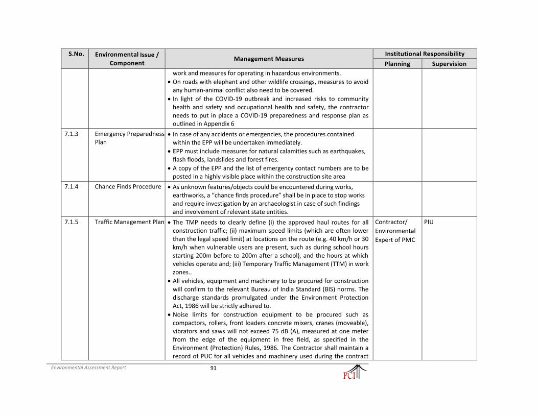
Environmental Assessment Report
91
S.No. Environmental Issue / Component
Management Measures Institutional Responsibility
Planning Supervision
work and measures for operating in hazardous environments.
• On roads with elephant and other wildlife crossings, measures to avoid any human-animal conflict also need to be covered.
• In light of the COVID-19 outbreak and increased risks to community health and safety and occupational health and safety, the contractor needs to put in place a COVID-19 preparedness and response plan as outlined in Appendix 6
7.1.3 Emergency Preparedness Plan
• In case of any accidents or emergencies, the procedures contained within the EPP will be undertaken immediately.
• EPP must include measures for natural calamities such as earthquakes, flash floods, landslides and forest fires.
• A copy of the EPP and the list of emergency contact numbers are to be posted in a highly visible place within the construction site area
7.1.4 Chance Finds Procedure • As unknown features/objects could be encountered during works, earthworks, a “chance finds procedure” shall be in place to stop works and require investigation by an archaeologist in case of such findings and involvement of relevant state entities.
7.1.5 Traffic Management Plan • The TMP needs to clearly define (i) the approved haul routes for all construction traffic; (ii) maximum speed limits (which are often lower than the legal speed limit) at locations on the route (e.g. 40 km/h or 30 km/h when vulnerable users are present, such as during school hours starting 200m before to 200m after a school), and the hours at which vehicles operate and; (iii) Temporary Traffic Management (TTM) in work zones..
• All vehicles, equipment and machinery to be procured for construction will confirm to the relevant Bureau of India Standard (BIS) norms. The discharge standards promulgated under the Environment Protection Act, 1986 will be strictly adhered to.
• Noise limits for construction equipment to be procured such as compactors, rollers, front loaders concrete mixers, cranes (moveable), vibrators and saws will not exceed 75 dB (A), measured at one meter from the edge of the equipment in free field, as specified in the Environment (Protection) Rules, 1986. The Contractor shall maintain a record of PUC for all vehicles and machinery used during the contract
Contractor/
Environmental
Expert of PMC
PIU

Environmental Assessment Report
92
S.No. Environmental Issue / Component
Management Measures Institutional Responsibility
Planning Supervision
period.
• All vehicles, equipment and machinery to be procured for construction will confirm to the relevant Bureau of India Standard (BIS) norms. The discharge standards promulgated under the Environment Protection Act, 1986 will be strictly adhered to.
• Noise limits for construction equipment to be procured such as compactors, rollers, front loaders concrete mixers, cranes (moveable), vibrators and saws will not exceed 75 dB (A), measured at one meter from the edge of the equipment in free field, as specified in the Environment (Protection) Rules, 1986. The Contractor shall maintain a record of PUC for all vehicles and machinery used during the contract period.
8 Identification and Selection of Material Sources
8.1 Borrow Areas • Finalizing borrow areas for borrowing earth and all logistic arrangements as well as compliance to environmental requirements, as applicable, will be the sole responsibility of the contractor. The Contractor will not start borrowing earth from select borrow area until the formal agreement is signed between land owner and contractor and a copy is submitted to the SC and the PIU.
• Locations finalized by the contractor shall be reported to the Environmental Expert of the PMC and who will in turn report to PIU. Format for reporting will be as per the Reporting Format for Borrow Area and will include a reference map. Planning of haul roads for accessing borrow materials will be undertaken during this stage. The haul roads shall be routed to avoid agricultural areas as far as possible (in case such a land is disturbed, the Contractor will rehabilitate it as per Borrow Area Rehabilitation Guidelines) and will use the existing village roads wherever available.
• In addition to testing for the quality of borrow materials by the SC, the environmental personnel of the SC will be required to inspect every borrow area location prior to approval (follow criteria for evaluation of borrow areas).
Contractor/
Environmental
Expert of PMC
PIU
8.2 Quarry • Authorized Quarries that meet environmental and social standards and the necessary technical specifications will be identified by PIU in the
Contractor Environmental
Expert of PMC and
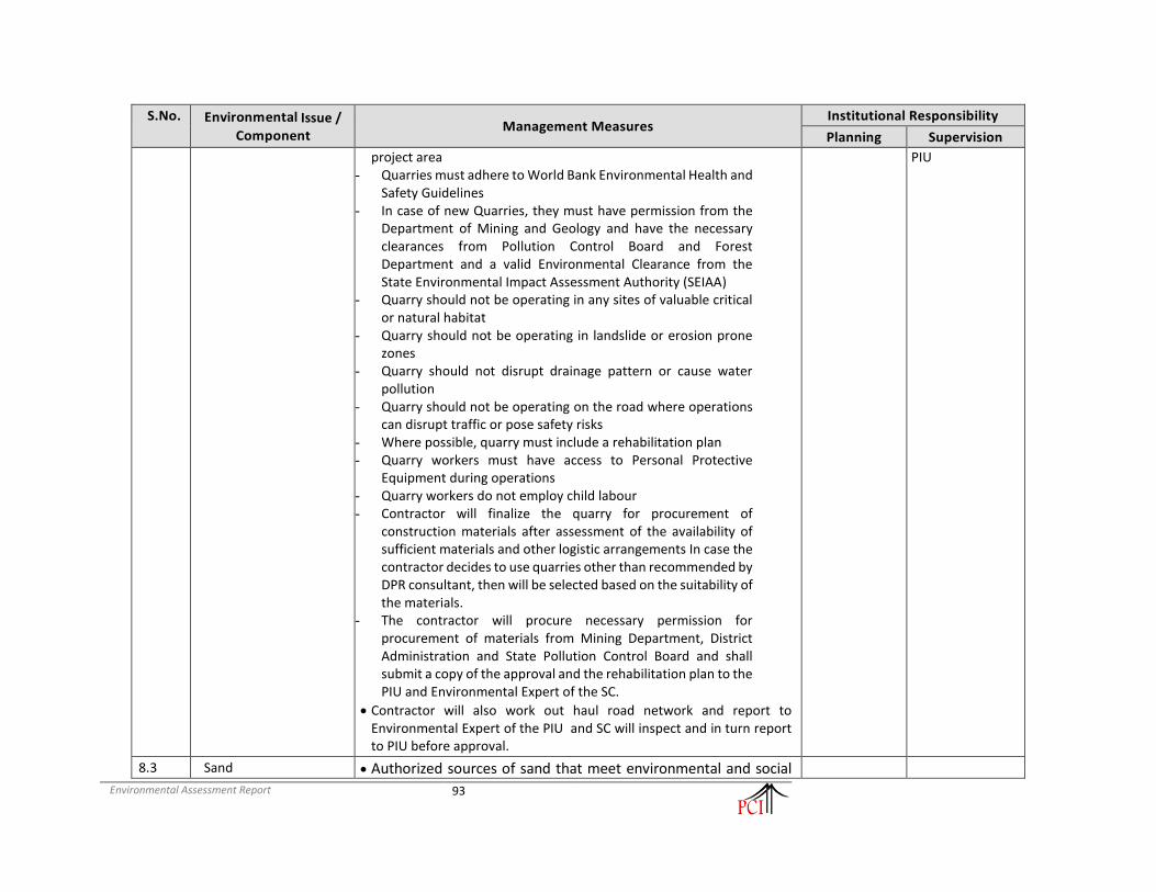
Environmental Assessment Report
93
S.No. Environmental Issue / Component
Management Measures Institutional Responsibility
Planning Supervision
project area - Quarries must adhere to World Bank Environmental Health and
Safety Guidelines - In case of new Quarries, they must have permission from the
Department of Mining and Geology and have the necessary clearances from Pollution Control Board and Forest Department and a valid Environmental Clearance from the State Environmental Impact Assessment Authority (SEIAA)
- Quarry should not be operating in any sites of valuable critical or natural habitat
- Quarry should not be operating in landslide or erosion prone zones
- Quarry should not disrupt drainage pattern or cause water pollution
- Quarry should not be operating on the road where operations can disrupt traffic or pose safety risks
- Where possible, quarry must include a rehabilitation plan - Quarry workers must have access to Personal Protective
Equipment during operations - Quarry workers do not employ child labour - Contractor will finalize the quarry for procurement of
construction materials after assessment of the availability of sufficient materials and other logistic arrangements In case the contractor decides to use quarries other than recommended by DPR consultant, then will be selected based on the suitability of the materials.
- The contractor will procure necessary permission for procurement of materials from Mining Department, District Administration and State Pollution Control Board and shall submit a copy of the approval and the rehabilitation plan to the PIU and Environmental Expert of the SC.
• Contractor will also work out haul road network and report to Environmental Expert of the PIU and SC will inspect and in turn report to PIU before approval.
PIU
8.3 Sand • Authorized sources of sand that meet environmental and social

Environmental Assessment Report
94
S.No. Environmental Issue / Component
Management Measures Institutional Responsibility
Planning Supervision
standards and the necessary technical specifications will be identified by PIU in the project area - Authorized Sources of Sand that meet environmental and
social standards and technical specifications identified and supply chain with contractor established
- Sources of Sand adhere to World Bank Environmental Health and Safety Guidelines
- Environmental safeguards: - As per the Meghalaya Minor Minerals Concession Rules,
2016 (MMMCR), sand mining is treated as a quarry which requires a permit from the Divisional Forest Officer and the Principle Chief Conservator of Forest & HOFF of the Forest Department.
- Permission will not be allowed during the month from June to August, since it is breeding season for the aquatic life.
- Source of sand should not be from sites of critical or natural habitat, fish spawning sites, nesting sites or have the presence of known herpetofauna.
- In case source of sand is from a river bed, the following should be ensured:
- Sand removal rates, and processes of collection and transportation should not cause any changes to channel morphology, increased erosion, impact to aquatic or riparian habitats, decrease in flood control properties of the sand bank or pollute the river.
- Sand removal incisions should not be from sites that could undermine the stability of support structures such as bridges
- Sites should not lead to the creation of deep pools that could lead to an increase in vector borne disease
- Sand mining operators have access to appropriate Personal Protective Equipment during operations
- Mining operations should not impact other riparian livelihoods such as fishing
- Sand mining operations should not employ child labour
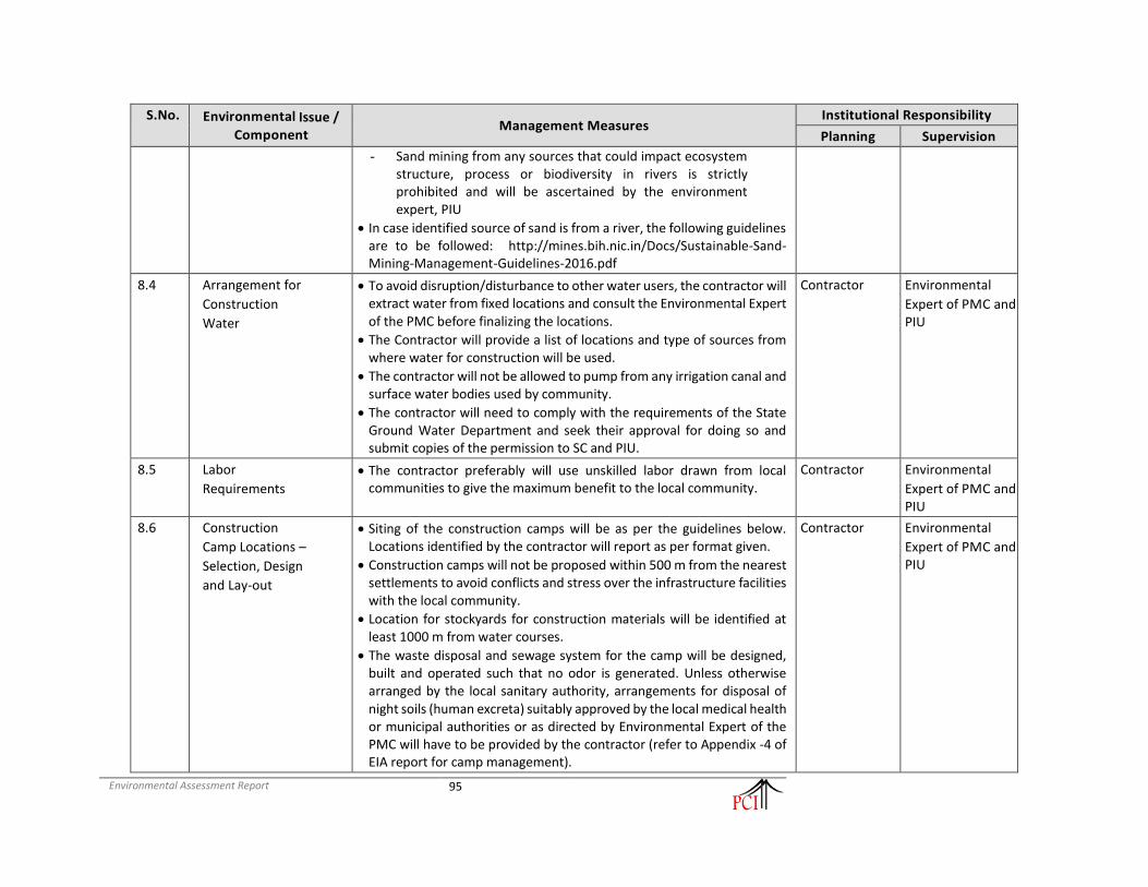
Environmental Assessment Report
95
S.No. Environmental Issue / Component
Management Measures Institutional Responsibility
Planning Supervision
- Sand mining from any sources that could impact ecosystem structure, process or biodiversity in rivers is strictly prohibited and will be ascertained by the environment expert, PIU
• In case identified source of sand is from a river, the following guidelines are to be followed: http://mines.bih.nic.in/Docs/Sustainable-Sand-Mining-Management-Guidelines-2016.pdf
8.4 Arrangement for
Construction
Water
• To avoid disruption/disturbance to other water users, the contractor will extract water from fixed locations and consult the Environmental Expert of the PMC before finalizing the locations.
• The Contractor will provide a list of locations and type of sources from where water for construction will be used.
• The contractor will not be allowed to pump from any irrigation canal and surface water bodies used by community.
• The contractor will need to comply with the requirements of the State Ground Water Department and seek their approval for doing so and submit copies of the permission to SC and PIU.
Contractor Environmental
Expert of PMC and PIU
8.5 Labor
Requirements
• The contractor preferably will use unskilled labor drawn from local communities to give the maximum benefit to the local community.
Contractor Environmental
Expert of PMC and PIU
8.6 Construction
Camp Locations –
Selection, Design
and Lay-out
• Siting of the construction camps will be as per the guidelines below. Locations identified by the contractor will report as per format given.
• Construction camps will not be proposed within 500 m from the nearest settlements to avoid conflicts and stress over the infrastructure facilities with the local community.
• Location for stockyards for construction materials will be identified at least 1000 m from water courses.
• The waste disposal and sewage system for the camp will be designed, built and operated such that no odor is generated. Unless otherwise arranged by the local sanitary authority, arrangements for disposal of night soils (human excreta) suitably approved by the local medical health or municipal authorities or as directed by Environmental Expert of the PMC will have to be provided by the contractor (refer to Appendix -4 of EIA report for camp management).
Contractor Environmental
Expert of PMC and PIU

Environmental Assessment Report
96
S.No. Environmental Issue / Component
Management Measures Institutional Responsibility
Planning Supervision
8.7 Arrangements for
Temporary Land
Requirement
• The contractor as per prevalent rules will carry out negotiations with the landowners for obtaining their consent for temporary use of lands for construction sites/hot mix plants/traffic detours/borrow areas etc.
• The Environmental Expert of the PMC will be required to ensure that the clearing up of the site prior to handing over to the owner (after construction or completion of the activity) is included in the contract.
Contractor Environmental
Expert of PMC and PIU
8.8 Orientation of
Implementing
Agency and
Contractors
• The PIU shall organize orientation sessions and regular training sessions during all stages of the project. This shall include on-site training (general as well as in the specific context of a sub-project). These sessions shall involve all staff of Environmental Cells, field level implementation staff of PIU, Environmental Experts of SCs and Contractors.
PMU/PIU PIU
Construction Stage (Activities to be carried out by the Contractor)
9 Site Clearance
9.1 Clearing and
Grubbing
• Site clearance activities should be carried out outside of bird breeding /nesting periods where possible
• Vegetation will be removed from the construction zone before commencement of civil works. All works will be carried out such that the damage or disruption to flora other than those identified for cutting is avoided or minimal. Only ground cover/shrubs that impinge directly on the permanent works or necessary temporary works will be removed with prior approval from the Environmental Expert of the PMC .
• The contractor, under any circumstances will not cut or damage trees. Trees identified under the project will be cut only after receiving clearance from the Forest Dept./MoEF/concerned authority (as applicable) and after the receipt of PIU’s written permission in this regard. Vegetation with girth of over 30 cm only will be considered as trees and shall be compensated, in the event of PIU’s instruction to undertake tree cutting.
9.2 Stripping,
stocking and
preservation of
top soil
• The top soil from all areas of cutting and all areas to be permanently covered will be stripped to a specified depth of 150 mm and stored in stockpiles. A portion of the temporarily acquired area and/or Right of Way will be earmarked for storing topsoil. The locations for stock piling will be pre-identified in consultation and with approval of Environmental Expert of the PMC . The following precautionary measures will be taken to preserve them till they are used:
a) Stockpile will be designed such that the slope does not exceed 1:2 (vertical to horizontal), and height of the pile is restricted to 2 m. To retain soil and to allow percolation of water, the edges of the pile will be protected by silt fencing.
b) Stockpiles will not be surcharged or otherwise loaded and multiple handling will be kept to a minimum to ensure that no compaction will occur. The stockpiles shall be covered with gunny bags or vegetation.
c) It will be ensured by the contractor that the top soil will not be unnecessarily trafficked either before

Environmental Assessment Report
97
S.No. Environmental Issue / Component
Management Measures Institutional Responsibility
Planning Supervision
stripping or when in stockpiles.
• Such stockpiled topsoil will be utilized for - – covering all disturbed areas including borrow areas (not those in barren areas) top dressing of the road
embankment and fill slopes – filling up of tree pits, in the median and in the agricultural fields of farmers, acquired temporarily.
• Residual topsoil, if there is any will be utilized for the plantation at median and side of the main carriageway. Construction on the cleared soils shall begin as soon as possible to avoid soil erosion.
• Top soil shall not be unnecessarily trafficked either before stocking or when in stockpiles. Slope stabilization shall be done by turfing and planting bush grass. Stockpiled top soil shall be returned to cover the disturbed area & cut slopes. Residual top soil shall be used for redevelopment of borrow areas, landscaping along slopes, medians etc.
9.3 Compaction of
Soil
• Heavy, wide and slow-moving vehicles should be kept away from the sensitive routes such as agricultural land. Use of heavy machinery on productive land is to be minimized.
• Limitation on the axle load shall be identified such that topsoil is protected from compaction.
9.4 Generation of Muck,
Debris from hill cutting and
dismantling
structures and
road surface
• Debris generated due to the dismantling of the existing structures or scarification of the road will be suitably reused in the proposed construction, subject to the suitability of the materials and approval of the Authority
• Engineer (Resident Engineer and Environmental Expert of PMC) as follows: – The sub grade of the existing pavement shall be used as embankment fill material. – The existing base and sub-base material shall be recycled as sub-base of the haul road or access roads – The existing bitumen surface may be utilized for the paving of cross roads, access roads and paving
works in construction sites and campus, temporary traffic diversions, haulage routes etc.
• The contractor will suitably dispose off unutilized debris materials either through filling up pre-designated disposal locations, subject to the approval of the Environmental Expert of the PMC .
• At locations identified for disposal of residual bituminous wastes, the disposal will be carried out over a 60-mm thick layer of rammed clay so as to eliminate the possibility of leaching of wastes into the ground water. The contractor will ensure that the surface area of such disposal pits is covered with a layer of soil.
• All arrangements for transportation during construction including provision, maintenance, dismantling and clearing debris, will be considered incidental to the work and will be planned and implemented by the contractor as approved and directed by the Environmental Expert of the PMC .
• The pre-designed disposal locations will be a part of Comprehensive Solid Waste Management Plan to be prepared by Contractor in consultation and with approval of Environmental Expert of the PMC .
• Debris generated from pile driving or other construction activities shall be disposed such that it does not flow into the surface water bodies or form mud puddles in the area.
• The contractor shall identify dumping sites. The identified locations will be reported to the Environmental

Environmental Assessment Report
98
S.No. Environmental Issue / Component
Management Measures Institutional Responsibility
Planning Supervision
Expert of the PMC . These locations will be checked on site and accordingly approved by Environmental Expert of the PMC prior to any disposal of waste materials.
9.5 Other
Construction
Wastes Disposal
including balance quantity of muck
• The pre-identified disposal locations will be a part of Comprehensive Waste Disposal Solid Waste Management Plan to be prepared by the Contractor in consultation and with approval of Environmental Expert of the PMC . Location of disposal sites will be finalized prior to completion of the earthworks on any particular section of the road.
• The Environmental Expert of the PMC will approve these disposal sites after conducting a joint inspection on the site with the Contractor.
• Contractor will ensure that any spoils of material unsuitable for embankment fill will not be disposed off near any water course, agricultural land, and natural habitat like grass lands or pastures. Such spoils from excavation can be used to reclaim borrow pits and low-lying areas located in barren lands along the project corridors (is so desired by the owner/community).
• No muck will be disposed in any disposal site. Contractor will take care of residual muck, if any that remains after construction work. Either this will be returned to the source or used in construction of embankment elsewhere with proper protection measures. PMC will keep strict vigil on this aspect.
• Non-bituminous wastes other than fly ash may be dumped in borrow pits (preferably located in barren lands) covered with a layer of the soil. No new disposal site shall be created as part of the project, except with prior approval of the Environmental Expert of the PMC .
• All waste materials will be completely disposed, and the site will be fully cleaned and certified by Environmental Expert of the PMC before handing over.
• The contractor at its cost shall resolve any claim, arising out of waste disposal or any non-compliance that may arise on account of lack of action on his part.
10 Procurement of Construction Material
10.1 Earth from
Borrow Areas for
Construction
• No borrow area will be opened without permission of the Environmental Expert of the PMC . The location, shape and size of the designated borrow areas will be as approved by the Environmental Expert of the PMC and in accordance to the IRC recommended practice for borrow pits for road embankments (IRC 10: 1961). The borrowing operations will be carried out as specified in the guidelines for siting and operation of borrow areas.
• The unpaved surfaces used for the haulage of borrow materials, if passing through the settlement areas or habitations; will be maintained dust free by the contractor. Sprinkling of water will be carried out twice a day to control dust along such roads during their period of use.
• During dry seasons (winter and summer) frequency of water sprinkling will be increased in the settlement areas and Environmental Expert of the PMC will decide the numbers of sprinkling depending on the local requirements. Contractor will rehabilitate the borrow areas as soon as borrowing is over from a particular

Environmental Assessment Report
99
S.No. Environmental Issue / Component
Management Measures Institutional Responsibility
Planning Supervision
borrow area in accordance with the Guidelines for Redevelopment of Borrow Areas or as suggested by Environmental Expert of the PMC .
10.2 Quarry
Operations
• The contractor shall obtain materials from quarries that are the licensed one. If new quarries are to be opened, the contractor shall obtain permission from Department of Mining & Geology of the respective state as well as from Environmental Clearance from SEIAA/MOEF&CC and consents from State Pollution Control Board. The quarry operations will be undertaken within the rules and regulations in force.
10.3 Construction
Water
• Contractor will arrange adequate supply and storage of water for the whole construction period at his own costs.
• The Contractor will submit a list of source/s from where water will be used for the project to PMC and PIU.
• The contractor will source the requirement of water preferentially from ground water but with prior permission from the Ground Water Board. A copy of the permission will be submitted to PMC and PIU prior to initiation of construction.
• The contractor will take all precaution to minimize the wastage of water in the construction process/ operation.
10.4 Transporting
Construction
Materials and
Haul Road
Management
• Contractor will maintain all roads (existing or built for the project), which are used for transporting construction materials, equipment and machineries as précised. All vehicles delivering fine materials to the site will be covered to avoid spillage of materials.
• All existing highways and roads used by vehicles of the contractor or any of his sub-contractor or suppliers of materials and similarly roads, which are part of the works, will be kept clear of all dust/mud or other extraneous materials dropped by such vehicles.
• Contractor will arrange for regular water sprinkling as necessary for dust suppression of all such roads and surfaces. The unloading of materials at construction sites in/close to settlements will be restricted to daytime only.
11 Safety During Construction
11.1 Increased Accident Risks in Work Zones - Planning for Traffic Diversions
and Detours
• Detailed Traffic Management Plans prepared prior to commencement of works on any section of road shall be executed fully. Temporary diversions will be constructed with the approval of the Resident Engineer and Environmental Expert of the PMC .
• Detailed Traffic Control Plans will be prepared and submitted to the Environmental Expert of the PMC for approval, seven days prior to commencement of works on any section of road. The traffic control plans shall contain details of temporary diversions, traffic safety arrangements for construction under traffic, details of traffic arrangement after cessation of work each day, safety measures undertaken for transport of hazardous materials and arrangement of flagmen.
• The Contractor will provide specific measures for safety of pedestrians and workers at night as a part of traffic

Environmental Assessment Report
100
S.No. Environmental Issue / Component
Management Measures Institutional Responsibility
Planning Supervision
control plans. The Contractor will ensure that the diversion/detour is always maintained in running condition, particularly during the monsoon to avoid disruption to traffic flow.
• The contractor will also inform local community of changes to traffic routes, conditions and pedestrian access arrangements with assistance from PMC and PIU. The temporary traffic detours will be kept free of dust by sprinkling of water three times a day and as required under specific conditions (depending on weather conditions, construction in the settlement areas and volume of traffic).
• The contractor shall make sure that adequate traffic measures are available especially near sensitive receptors.
• The contractor shall take all necessary measures for the safety of traffic during construction and provide, erect and maintain such barricades, including signs, marking flags, lights and flagmen as may be required by the Engineer for the information and protection of traffic approaching or passing through the section of the highway under improvement. Before taking up any construction, an agreed phased programme for the diversion of traffic or closer of traffic on the highway shall be drawn up.
• One-way traffic operation shall be established whenever the traffic is to be passed over part of the carriageway inadequate for two-lane traffic. This shall be done with the help of temporary traffic signals or flagmen kept positioned on opposite sides during all hours.
• For regulation of traffic, the flagmen shall be equipped with red and green flags and lanterns/lights Temporary diversion shall be constructed with the approval of the Engineer.
• The Contractor shall ensure that the running surface is always properly maintained, particularly during the monsoon so that no disruption to the traffic flow occurs.
• The Contractor shall take all necessary measures for the safety of traffic during construction. Care shall be taken to ensure that the working conditions for the workers in stone quarries are up to the required standards.
• Construction related activity resulting in direct release of criteria pollutants (CO, NO2, SO2, PM2.5, PM10) to be avoided at busy locations at night during winters.
11.2 Traffic and Safety • Contractors must familiarize themselves with World Banks Good Practice Note on Road Safety: http://pubdocs.worldbank.org/en/648681570135612401/Good-Practice-Note-Road-Safety.pdf
• The contractor will take all necessary measures for the safety of traffic during construction and provide, erect and maintain such barricades, including signs, markings, flags, lights and flagmen as proposed in the Traffic Control Plan/Drawings and as required by the Environmental Expert of the PMC for the information and protection of traffic approaching or passing through the section of any existing cross roads.
• The contractor will ensure that all signs, barricades, pavement markings are provided as per the MoRTH specifications. Before taking up of construction on any section of the existing lanes of the highway, a Traffic Control Plan will be devised and implemented to the satisfaction of the Environmental Expert of the PMC .
11.3 Loss of • The construction works shall not interfere with the convenience of the public or the access to use and

Environmental Assessment Report
101
S.No. Environmental Issue / Component
Management Measures Institutional Responsibility
Planning Supervision
Accessibility and
Unsafe Access
occupation of public or private roads, railways and any other access footpaths to or of properties, whether public or private.
• Temporary access shall be built at the interchange of the project road and other roads.
• The contractor will provide safe and convenient passage for vehicles, pedestrians and livestock to and from
• roadsides and property accesses connecting the project road, providing temporary connecting road.
• The contractor will also ensure that the existing accesses will not be undertaken without providing adequate provisions and to the prior satisfaction of the PMC .
• The contractor will take care that the cross roads are constructed in such a sequence that construction work over the adjacent cross roads are taken up one after one so that traffic movement in any given area not get affected much.
11.4 Personal Safety Measures for
Labour
• Contractor will provide: – Protective footwear and protective goggles to all workers employed on mixing asphalt materials,
cement, lime mortars, concrete etc. – Welder's protective eye-shields to workers who are engaged in welding works – Protective goggles and clothing to workers engaged in Factories Act, 1948 stone breaking activities and
workers will be seated at sufficiently safe intervals – Earplugs to workers exposed to loud noise, and workers working in crushing, compaction, or concrete
mixing operation. – Adequate safety measures for workers during handling of materials at site are taken up. – The contractor will comply with all regulations regarding safe scaffolding, ladders, working platforms,
gangway, stairwells, excavations, trenches and safe means of entry and egress. – Daily tool box talk will be conducted by safety officer and reported in monthly report by contractor. – Contractor will share grievance redress mechanism and details on procedure with labor as part of
induction training
• The contractor will comply with all the precautions as required for ensuring the safety of the workmen as per the International Labor Organization (ILO) Convention No. 62 World Bank’s Environment, Health & Safety Guidelines as far as those are applicable to this contract.
• The contractor will make sure that during the construction work all relevant provisions of the Factories Act, 1948 and the Building and other Construction Workers (regulation of Employment and Conditions of Services) Act, 1996 are adhered to.
• The contractor will not employ any person below the age of 14 years for any work and no woman will be employed on the work of painting with products containing lead in any form.
• The contractor will also ensure that no paint containing lead or lead products is used except in the form of paste or readymade paint.

Environmental Assessment Report
102
S.No. Environmental Issue / Component
Management Measures Institutional Responsibility
Planning Supervision
• Contractor will provide facemasks for use to the workers when paint is applied in the form of spray or a surface having lead paint dry is rubbed and scrapped.
• The Contractor will mark ‘hard hat’ and ‘no smoking’ and other ‘high risk’ areas and enforce non -compliance of use of PPE with zero tolerance. These will be reflected in the Construction Safety Plan to be prepared by the Contractor during mobilization and will be approved by PMC and PIU.
11.5 First Aid • The contractor will arrange for - – a readily available first aid unit including an adequate supply of sterilized dressing materials and
appliances as per the Factories Rules in every work zone – availability of suitable transport at all times to take injured or sick person(s) to the nearest hospital
equipment and trained nursing staff at construction camp.
11.6 Risk from Electrical
Equipment(s)
• The Contractor will take all required precautions to prevent danger from electrical equipment and ensure that -
– No material will be so stacked or placed as to cause danger or inconvenience to any person or the public.
– All necessary fencing and lights will be provided to protect the public in construction zones.
• All machines to be used in the construction will conform to the relevant Indian Standards (IS) codes, will be free from patent defect, will be kept in good working order, will be regularly inspected and properly maintained as per IS provision and to the satisfaction of the Environmental Expert of the PMC .
11.7 Risk Force
Measure • The contractor will take all reasonable precautions to prevent danger to the workers and public from fire,
flood etc. resulting due to construction activities.
• The contractor will make required arrangements so that in case of any mishap all necessary steps can be taken for prompt first aid treatment. Construction Safety Plan prepared by the Contractor will identify necessary actions in the event of an emergency.
11.8 Informatory Signs
and Hoardings • The contractor will provide, erect and maintain informatory/safety signs, hoardings written in English and
local language, as required in line with IRC:55 or as suggested by the Environmental Expert of the PMC .
12 Management of Water
12.1 Loss of Community
Water Resources
• Water reservoir enhancement measures shall be provided for community water sources/pond getting impacted to slight degree and falling within the right of way as per the design provided in annexure of specific EMP.
• The enhancement measures shall include provision for stepped access to the edge of water, providing flat boulders for washing, stone pitching for slope stabilization etc.
• Roadside water reservoir/streams shall also be enhanced as per the design general EMP.

Environmental Assessment Report
103
S.No. Environmental Issue / Component
Management Measures Institutional Responsibility
Planning Supervision
12.2 Drainage and
Flood Control • Contractor will ensure that no construction materials like earth, stone, ash or appendage disposed off so as
not to block the flow of water of any water course and cross drainage channels.
• Contractor will take all necessary measures to prevent the blockage of water flow. In addition to the design requirements, the contractor will take all required measures as directed by the Environmental Expert of the PMC to prevent temporary or permanent flooding of the site or any adjacent area.
12.3 Water logging • Adequate water-harvesting structures shall be made part of the project design, all along the storm water drains, at appropriate intervals.
• The contractor shall provide RCC covered drains in urban locations in areas with high water table for storm water runoff management. The drains shall be connected to proximal culverts.
12.4 River Training and Disruption to Other Users of
Water
• While working across or close to any perennial water bodies, contractor will not obstruct/ prevent the flow of water.
• Construction over and close to the non-perennial streams shall be undertaken in the dry season. If construction work is expected to disrupt users of community water bodies, notice shall be served well in advance to the affected community.
• The contractor will serve notice to the downstream users well in advance to divert the flow of water of any surface water body. Wherever excavation for diverting water flow will take place, contractor will ensure that the slopes are not steeper than 1:2 (vertical: horizontal) otherwise proper slope protection measures will be taken as approved by the Environmental Expert of the PMC .
• The contractor will take prior approval of the River Authority or Irrigation Department or PMC for any such activity. The PIU will ensure that contractor has served the notice to the downstream users of water stream in advance.
12.5 Disruption to
other users • While working across or close to the Rivers, the contractor shall not prevent the flow of water. If for any
bridgework, etc., closure of flow is required, the contractor shall seek approval of the Engineer.
• The engineer shall have the right to ask the contractor to serve notice on the downstream users of water sufficiently in advance.
• Construction work expected to disrupt users and impacting community water bodies shall be taken up after serving notice on the local community.
13 Pollution
a Water Pollution
13.1 Water Pollution from Construction
Wastes
• The Contractor will take all precautionary measures to prevent the wastewater generated during construction from entering into streams, water bodies or the irrigation system. Contractor will avoid construction works close to the streams or water bodies during monsoon.
• All waste arising from the project is to be disposed off in the manner that is acceptable to the State Pollution

Environmental Assessment Report
104
S.No. Environmental Issue / Component
Management Measures Institutional Responsibility
Planning Supervision
Control Board or as directed by Environmental Expert of the PMC .
• The Environmental Expert of the PMC will certify that all liquid wastes disposed off from the sites meet the discharge standards.
13.2 Siltation of Water Bodies and Degradation of
Water Quality
• The Contractor will not excavate beds of any stream/canals/ any other water body for borrowing earth for embankment construction.
• Contractor will construct silt fencing at the base of the embankment construction for the entire perimeter of any water body (including stream) adjacent to the RoW and around the stockpiles at the construction sites close to water bodies, specially from km 40+520 to 41+519. The fencing will be provided prior to commencement of earthwork and continue till the stabilization of the embankment slopes, on the particular sub-section of the road.
• The contractor will also put up sedimentation cum grease traps at the outer mouth of the drains located in road sections which are ultimately entering into any surface water bodies / water channels with a fall exceeding 1.5 m.
• Contractor will ensure that construction materials containing fine particles are stored in an enclosure such that sediment-laden water does not drain into nearby water course.
13.3 Slope Protection and Control of
Soil Erosion
• Slope protection shall be provided on embankments abutting water bodies by providing stone pitching for slopes b/w 1:4 (V:H) to 1:2 (V:H). Retaining walls shall be provided at high embankments.
• In borrow pits, the depth shall be so regulated that the sides of the excavation will have a slope not steeper than 1 vertical to 2 horizontal, from the edge of the final section of the bank.
• The contractor will take slope protection measures as per design, or as directed by the Environmental Expert of the PMC to control soil erosion and sedimentation through use of dykes, sedimentation chambers, basins, fibber mats, mulches, grasses, slope, drains and other devices.
• All temporary sedimentation, pollution control works and maintenance thereof will be deemed as incidental to the earth work or other items of work and as such as no separate payment will be made for them.
• Contractor will ensure the following aspects: – During construction activities on road embankment, the side slopes of all cut and fill areas will be
graded and covered with stone pitching, grass and shrub as per design specifications. – Turfing works will be taken up as soon as possible provided the season is favorable for the
establishment of grass sods. Other measures of slope stabilization will include mulching netting and seeding of batters and drains immediately on completion of earthworks.
– In borrow pits, the depth shall be so regulated that the sides of the excavation will have a slope not steeper than 1 vertical to 2 horizontals, from the edge of the final section of the bank, please refer to Appendix -2 of EIA report.

Environmental Assessment Report
105
S.No. Environmental Issue / Component
Management Measures Institutional Responsibility
Planning Supervision
– Along sections abutting water bodies, stone pitching as per design specification will protect slopes. Soil shall be monitored for erosion at select locations as per the monitoring plan mentioned in General EMP.
13.4 Water Pollution from Fuel and
Lubricants
• The contractor will ensure that all construction vehicle parking location, fuel/lubricants storage sites, vehicle, machinery and equipment maintenance and refueling sites will be located at least 500 m from rivers and irrigation canal/ponds.
• All location and lay-out plans of such sites will be submitted by the Contractor prior to their establishment and will be approved by the Environmental Expert of the PMC and PIU.
• Contractor will ensure that all vehicle/machinery and equipment operation, maintenance and refueling will be carried out in such a fashion that spillage of fuels and lubricants does not contaminate the ground. Oil interceptors will be provided for vehicle parking, wash down and refueling areas as per the design provided.
• In all, fuel storage and refueling areas, if located on agricultural land or areas supporting vegetation, the top soil will be stripped, stockpiled and returned after cessation of such storage.
• Contractor will arrange for collection, storing and disposal of oily wastes to the pre-identified disposal sites (list to be submitted to PMC and PIU) and approved by the Environmental Expert of the PMC .
• All spills and collected petroleum products will be disposed off in accordance with MoEF and state PCB guidelines.
• Environmental Expert of the PMC will certify that all arrangements comply with the guidelines of PCB/ MoEF or any other relevant laws.
13.5 Contamination of
Water Resources • Silt fencing shall be provided along ponds within the direct impact zone intercepting highway to prevent
siltation in water body. Such ponds shall not be getting impacted during construction.
• Temporary drains shall be prepared to dispose off the eroded sediments and to prevent them from entering the surface water bodies.
• To prevent contamination of water resources due to contaminants from construction camps, adequate sewage disposal measures shall be taken care of at construction camps.
• Contaminated discharges containing oil/grease contributed by vehicle parking/repair areas and workshops and construction sites shall be collected and treated using oil interceptors.
• Construction work close to water bodies shall be avoided during monsoon. The contractor shall ensure that all construction vehicle parking location, fuel/lubricants storage sites, vehicle, machinery and equipment maintenance and refuelling sites shall be located at least 1000 m from rivers and stream/reservoir/tanks or as directed by the Engineer.
• Both ground and surface water quality shall be monitored as per the monitoring plan at select locations.
b Air Pollution
13.6 Dust Pollution • The contractor will take every precaution to reduce the level of dust from crushers/hot mix plants,

Environmental Assessment Report
106
S.No. Environmental Issue / Component
Management Measures Institutional Responsibility
Planning Supervision
construction sites involving earthwork by sprinkling of water, encapsulation of dust source and by erection of screen/barriers.
• All the plants will be sited at least 1 km in the downwind direction from the nearest human settlement.
• The contractor will provide necessary certificates to confirm that all crushers used in construction conform to relevant dust emission control legislation.
• The suspended particulate matter value at a distance of 40m from a unit located in a cluster should be less than 500 g/m3. The pollution monitoring is to be conducted as per the monitoring plan.
• Alternatively, only crushers licensed by the PCB shall be used. Required certificates and consents shall be submitted by the Contractor in such a case.
• Dust screening vegetation will be planted on the edge of the RoW for all existing roadside crushers. Hot mix plant will be fitted with dust extraction units.
• All crushers identified to be used in construction shall conform to relevant dust emission control legislation of the respective SPCB.
• Clearance for siting shall be obtained from the respective SPCB. Alternatively, only those crushers that are already licensed by the SPCB shall be used.
• All Hot mix plants shall be fitted with dust extraction systems SPM value at a distance of 40 m from a unit located in a cluster should be less than 600 microgram/m3. The monitoring is to be conducted as per the monitoring plan.
• Excavation and transport of earth shall be done during the daytime only to minimize risks of the spills etc. from the earthwork on the community.
• Transport of the soil/earth shall be done by covering the haulage vehicles with tarpaulin or any other good quality material.
• Dust suppression measures in the form of water sprinkling on the lime / cement and earth mixing sites, asphalt mixing site and temporary service and access roads.
• Traffic detours shall not be located on areas with loose soils. Temporary pavement shall be made by using dismantled pavement material from existing roads.
• All construction workers shall be provided with pollution masks to mitigate the effect of dust generation on the health of workers.
• Muck shall be transported in covered dump trucks to the project site and shall be directly dumped on the disposal sites. This shall not be stock piled at the project site.
13.7 Emission from Construction Vehicles, Equipment and
• All vehicles, plants and machinery used during construction shall conform to the emission standards promulgated under the Environment (Protection) Act, 1986. Contractor will ensure that all vehicles, equipment and machinery used for construction are regularly maintained and confirm that pollution emission levels comply with the relevant requirements of PCB.

Environmental Assessment Report
107
S.No. Environmental Issue / Component
Management Measures Institutional Responsibility
Planning Supervision
Machineries (Generation of
Exhaust Gases)
• The Contractor will submit PUC certificates for all vehicles/ equipment/machinery used for the project. Monitoring results will also be submitted to PMC and PIU as per the monitoring plan.
• Traffic detours and diversions shall be designed such as to minimize bottlenecks and ensure smooth traffic.
• Air pollution monitoring shall be carried out at specified locations as described in the monitoring plan to verify that air pollution norms are being followed by the contractor and the air quality at the construction site does not exceed the prescribed limits. Contractor will ensure that all vehicles, equipment and machinery used for construction are regularly maintained and confirm that pollution emission levels comply with the relevant requirements of PCB.
c Noise Pollution
13.8 Noise Pollution: Noise from Vehicles, Plants
and Equipment
• The Contractor will confirm the following: – All plants and equipment used in construction (including the and PIU, MPWD aggregate crushing plant)
shall strictly conform to the MoEF/CPCB noise standards. – All vehicles and equipment used in construction will be fitted with exhaust silencers. – Servicing of all construction vehicles and machinery will be done regularly and during routine servicing
operations, the effectiveness of exhaust silencers will be checked and if found defective will be replaced.
– Limits for construction equipment used in the project such as compactors, rollers, front loaders, concrete mixers, cranes (moveable), vibrators and saws shall not exceed 75 dB (A) (measured at one meter from the edge of equipment in the free field), as specified in the Environment (Protection) rules, 1986.
– Maintenance of vehicles, equipment and machinery shall be regular and up to the satisfaction of the Environmental Expert of the PMC to keep noise levels at the minimum.
– At the construction sites within 150 m of the nearest habitation, noisy construction work such as crushing, concrete mixing, batching will be stopped during the night time between 9.00 pm to 6.00 am.
– No noisy construction activities will be permitted around educational institutes/health centers (silence zones) up to a distance of 100 m from the sensitive receptors i.e., school, health centers and hospitals between 9.00 am to 5.00 pm.
– Contractor will provide noise barriers to the suggested locations of select schools (at km 4+600, 4+900, 6+275, 10+400, 10+480, 11+570, 13+100 and 39+000) / health centers.
– Workers in the vicinity of high noise levels must wear ear plugs, helmets and should be engaged in diversified activities to prevent prolonged exposure to noise levels of more than 90 dB(A).
– Blasting operations, if required shall be undertaken so as to produce minimum vibrations in sensitive areas.

Environmental Assessment Report
108
S.No. Environmental Issue / Component
Management Measures Institutional Responsibility
Planning Supervision
– Traffic management plans prepared during construction mobilization period shall also be implemented during construction stage. Effective traffic management shall especially be taken care of in sensitive locations, major built-up areas and along important highway junctions.
– Asphalt mixing sites and the batching plants should be at a distance of at least 200 m from sensitive receptor locations.
– Monitoring shall be carried out at the construction sites as per the monitoring schedule and results will be submitted to PMC and PIU. Environmental Expert of the PMC will be required to inspect regularly to ensure the compliance of EMP.
14 Land/Soil Pollution
14.1 Contamination of Soil
• Fuel shall be stored in proper bounded and covered areas.
• All spills and collected petroleum products shall be disposed off in accordance with the guidelines framed by Ministry of Environment, Forests &, Climate Change and State Pollution Control Board.
• Maintenance and refuelling of vehicles, machinery and other construction equipment shall be carried out in such a fashion that spillage of fuels and lubricants does not contaminate the ground.
• An “Oil Interceptor” shall be provided for wash down and refuelling areas.
• Debris generated due to the dismantling of the existing road shall be suitably reused in the proposed construction, subject to the suitability of the materials and approval of the Engineer as follows:
– The sub-grade of the existing pavement shall be used as embankment fill materials – The existing base and sub- base material shall be recycled as sub-base of the haul road or access roads – The existing bitumen surface may be utilized for the paving of cross roads, access roads and paving
works in construction sites, temporary traffic diversions, haulage routes etc. – The contractor shall suitably dispose off un-utilized debris materials including spoils of material
unsuitable for embankment; either through filling up of borrow area located in wasteland or at pre-designated dump locations, subject to the approval of the Engineer.
– At locations identified for dumping of residual bituminous wastes, the dumping shall be carried out over a 60 mm thick layer of rammed clay so as to eliminate the possibility of leaching of wastes into the ground water.
– The contractor shall ensure that the surface area of such dumping pits is covered with a layer of preserved topsoil.
– All arrangement for transportation during construction including provision, maintenance, dismantling and clearing debris, where necessary shall be considered incidental to the work and shall be planned and implemented by the contractor as approved and directed by the Engineer.
– The pre-designed dump locations shall be a part of comprehensive solid waste management plan to be prepared by Contractor in consultation with Engineer.

Environmental Assessment Report
109
S.No. Environmental Issue / Component
Management Measures Institutional Responsibility
Planning Supervision
– Debris generated from pile driving or other construction activities shall be disposed such that it does not flow into the surface water bodies or form mud puddles in the area. The contractor shall identify dumping sites. The identified locations shall be reported to the Engineer. Location of dump sites shall be finalised prior to earth works on any particular section of the road.
– No fly ash shall be disposed in any disposal site. Care shall be taken to return the remaining fly ash after construction work to the source or to use it in construction of embankment elsewhere with proper construction measures. IE shall keep strict vigil on this aspect.
– Non-bituminous wastes other than fly ash may be dumped in borrow areas covered with a layer of the conserved topsoil. No new disposal sites shall be created as part of the project, except with prior approval of the Engineer.
– All waste materials shall be completely disposed and the site shall be fully cleaned before handing over. – Soil shall be monitored for contamination as per the monitoring plan at locations to be identified by the
Engineer. The Engineer shall certify the site after approval. – The contractor at his cost shall resolve any claim arising out of waste disposal.
15 Flora and Fauna: Plantation/Preservation/Conservation Measures
15.1 Road side Plantation Strategy
• The contractor will do the plantation at median and/or turfing at embankment slopes as per the tree plantation strategy prepared for the project.
• Minimum 80 percent survival rate of the saplings will be acceptable otherwise the contractor will replace dead plants at his own cost. The contractor will maintain the plantation till they handover the project site to Project Authority.
• The Environmental Expert of the PMC will inspect regularly the survival rate of the plants and compliance of tree plantation guidelines.
15.2 Flora and Chance found Fauna
• The contractor will take reasonable precaution to prevent his workmen or any other persons from removing and damaging any flora (plant/vegetation) and fauna (animal) including fishing in any water body and hunting of any animal. If any wild animal is found near the construction site at any point of time, the contractor will immediately upon discovery thereof acquaint the Environmental Expert of the PMC and carry out the PMC 's instructions for dealing with the same. IE shall be responsible to intimate the wildlife protection authorities in the area.
• The Environmental Expert of the PMC will conduct detailed bio-diversity assessment along the road section in ESZ of NWLS prior to start of work and prepare mitigation plan in consultation with state wildlife board.
• The Environmental Expert of the PMC will report to the nearby forest office (range office or divisional office) and will take appropriate steps/ measures, if required in consultation with the forest officials.
16 Archeological Resources and Cultural Properties

Environmental Assessment Report
110
S.No. Environmental Issue / Component
Management Measures Institutional Responsibility
Planning Supervision
16.1 Chance Found Archaeological Property
• All fossils, coins, articles of value of antiquity, structures and other remains or things of geological or archaeological interest discovered on the site shall be the property of the Government and shall be dealt with as per provisions of the relevant legislation.
• The contractor will take reasonable precautions to prevent his workmen or any other persons from removing and damaging any such article or thing. He will, immediately upon discovery thereof and before removal acquaint the
• Environmental Expert of the PMC of such discovery and carry out the PMC 's instructions for dealing with the same, waiting which all work shall be stopped.
• The PMC will seek direction from the Archaeological Survey of India (ASI) before instructing the Contractor to recommence the work in the site.
16.2 Impact/s on Cultural/Religious Properties
• All necessary and adequate care shall be taken to minimize impact on cultural properties which includes cultural sites and remains, places of worship including temples and shrines, etc., graveyards, monuments and any other important structures as identified during design. All conservation and protection measures shall be taken up as per design. Access to such properties from the road shall be maintained clear and clean.
17 Labor Camp Management
17.1 Accommodation • Contractor will follow all relevant provisions of the Factories Act, 1948 and the Building and the other Construction Workers (Regulation of Employment and Conditions of Service) Act, 1996 for construction and maintenance of labour camp.
• The location, layout and basic facility provision of each labour camp will be submitted to PMC and PIU prior to their construction.
• The construction will commence only upon the written approval of the Environmental Expert of the PMC .
• The contractor will maintain necessary living accommodation and ancillary facilities in functional and hygienic manner and as approved by the PMC .
17.2 Potable Water • The Contractor will construct and maintain all labour accommodation in such a fashion that uncontaminated water is available for drinking, cooking and washing.
• The Contractor will also provide potable water facilities within the precincts of every workplace in an accessible place, as per standards set by the Building and other Construction Workers (Regulation of Employment and Conditions of Service) Act, 1996.
• The contractor will also guarantee the following: a) Supply of sufficient quantity of potable water (as per IS) in every workplace/labor camp site at suitable
and easily accessible places and regular maintenance of such facilities. b) If any water storage tank is provided that will be kept such that the bottom of the tank at least 1mt.
from the surrounding ground level.

Environmental Assessment Report
111
S.No. Environmental Issue / Component
Management Measures Institutional Responsibility
Planning Supervision
c) If water is drawn from any existing stream/reservoir/well, which is within 30mt. proximity of any toilet, drain or other source of pollution, the water from source will be disinfected before water is used for drinking.
d) All such wells will be entirely covered and provided with a trap door, which will be dust proof and waterproof.
e) A reliable pump will be fitted to each covered well. The trap door will be kept locked and opened only for cleaning or inspection, which will be done at least once in a month.
f) Testing of water will be done every month as per parameters prescribed in IS 10500:1991. g) Environmental Expert of the PMC will be required to inspect the labour camp once in a week to ensure
the compliance of the EMP.
17.3 Sanitation and Sewage System
• The contractor will ensure that - – the sewage system for the camp are designed, built and operated in such a fashion that no health
hazards occurs and no pollution to the air, ground water or adjacent water courses take places (refer to Appendix -3 of EIA for details)
– separate toilets/bathrooms, wherever required, screened from those from men (marked in vernacular) are to be provided for women
– adequate water supply is to be provided in all toilets and urinals – all toilets in workplaces are with dry-earth system (receptacles) which are to be cleaned and kept in a
strict sanitary condition – night soil is to be disposed off by putting layer of it at the bottom of a permanent tank prepared for the
purpose and covered with 15 cm. layer of waste or refuse and then covered with a layer of earth for a fortnight.
17.4 Waste Disposal • The contractor will provide garbage bins in the camps and ensure that these are regularly emptied and disposed off in a hygienic manner as per the Comprehensive Solid Waste Management Plan approved by the Environmental Expert of the PMC .
• Unless otherwise arranged by local sanitary authority, arrangements for disposal of night soils (human excreta) suitably approved by the local medical health or municipal authorities or as directed by Environmental Expert of the PMC will have to be provided by the contractor.
17.5 Health and Hygiene Impacts on Construction Camps
• The contractor shall provide erect and maintain necessary (temporary) living accommodation and ancillary facilities for labour up to living standards and scales approved by the IE at the locations identified for such facilities in pre-construction phase.
• The contractor shall also guarantee the following: – Supply of sufficient quantity of potable water (as per IS) in every work place/labour campsite at suitable
and easily accessible places and regular maintenance of such facilities.

Environmental Assessment Report
112
S.No. Environmental Issue / Component
Management Measures Institutional Responsibility
Planning Supervision
– If any water storage tank is provided it shall be kept at a distance of not less than 15m from any latrine drain or other sources of pollution.
– If water is drawn from any existing reservoir which is within close proximity of any latrine, drain or other source of pollution the well shall be disinfected before water is used for drinking.
– All such reservoir shall be entirely covered and provided with a trap door, which shall be dust proof and waterproof.
– A reliable pump shall be fitted to each covered well. The trap door shall be kept locked and opened only for cleaning or inspection, which shall be done at least once a month.
– Testing of water shall be done every month as per parameters prescribed in IS 10500:1991. – Engineer shall be required to inspect the labour camp once in a week to ensure the compliance of the
EMP. – Contractor shall be responsible for proper functioning and management of sanitation and sewage
system as per applicable national and state regulations. – All latrines shall be provided with dry-earth system (receptacles), which shall be cleaned at least four
times daily, and at least twice during working hours and kept in a strict sanitary condition. Receptacles shall be tarred inside and outside at least once a year.
– Adequate health care is to be provided for the work force. On completion of the works, all such temporary structures shall be cleared away, all rubbish burnt, excreta tank and other disposal pits or trenches filled in and effectively sealed off and the outline site left clean and tidy, at the Contractor’s expense, to the entire satisfaction of the engineer.
– Labour from outside of state will be managed as per Labour Influx Plan and Gender Management for the project given in SIA report for the project.
17.6 Deterioration of indoor air quality and risk of water borne diseases
• It shall be the responsibility of the contractor to make adequate provisions for workers at labour camps under the Factories Act, 1948. Dwelling units shall be supplied with clean fuel for domestic purpose. Generation of carbon monoxide under any circumstance shall not be allowed.
• Contractor shall make sure that no water stagnation happens in the vicinity of construction camp as well as anywhere along the project stretch to prevent spread of malaria & other water borne diseases
18 Contractor’s Demobilization
18.1 Clean-up Operations, Restoration and Rehabilitation
• Contractor will prepare site restoration plans, which will be approved by the Environmental Expert of the PMC . The clean-up and restoration operations are to be implemented by the contractor prior to demobilization. The contractor will clear all temporary structures; dispose all garbage, night soils and POL waste as per Comprehensive Waste Management Plan and as approved by PMC .
• All disposal pits or trenches will be filled in and effectively sealed off. Residual topsoil, if any will be distributed on adjoining/ proximate barren land or areas identified by Environmental Expert of the PMC in a layer of

Environmental Assessment Report
113
S.No. Environmental Issue / Component
Management Measures Institutional Responsibility
Planning Supervision
thickness of 75 mm-l50 mm.
• All construction zones including river-beds, culverts, road-side areas, camps, hot mix plant sites, crushers, batching plant sites and any other area used/affected by the project will be left clean and tidy, at the contractor's expense, to the entire satisfaction to the Environmental Expert of the PMC .
19 Cumulative Impact Measures
19.1 Mitigation • Mitigation: (a) Additional noise control devices on the construction equipment; regulated work timings to ensure no construction work is carried out between 6 pm and 6 am; Avoidance of construction work during blasting times; Traffic movement timings only between 6 am and 6 pm; (b) Coordination between PWD and Forest management / conservation activities as per ESZ Zonal Plan
19.2 Monitoring • Monitoring: Maintenance of wildlife mammal sightings on the road during the construction period; Wildlife mammal count of the different mammals in the sanctuary; Count of mammal deaths – natural and manmade – in the sanctuary. Monitoring of forest conservation / management activities.
19.3 Supervision Supervision mechanism: Additional supervision arrangements by the contractor during the construction period for the 3km stretch; PWD oversight through their staff and supervision consultants; Department of Forests on the Nongkyllem Wildlife Sanctuary.

Environmental Assessment Report
114
8.2 Environmental Monitoring Program
The Environmental Monitoring programme is integral to ensuring that management and mitigation measures are implemented effectively and lays out the roles and responsibilities for monitoring and reporting on environmental safeguards progress, issues, compliance and non-compliance.
• Environmental condition indicators to determine efficacy of environmental management with respect to impacts on identified valued environmental components (VEC)
• Environmental condition indicators to determine efficacy of environmental management with respect to air, noise, water and soil pollution.
• Environmental management indicators to determine compliance with the suggested environmental management measures
• Operational performance indicators have also been devised to determine efficacy and utility of the proposed mitigation measures
Pre- Bid (Biodiversity and Critical Habitat Impact Assessment)
S No
Indicator Description Reporting/ Action/ Responsibility
1 Detailed Biodiversity Assessment by regional experts and species specialists
• Critical Habitat assuagement where EIA has identified that the road is within 10 kms of an area of high biodiversity such as wildlife sanctuary, national park or presence of rare, endangered and threatened (RET) species or Schedule 1 species are noted
• Cumulative impacts, of project impacts on Valued Environmental Components (VECs) such as critical habitat, natural habitat and any RET species
Critical Habitat – Yes/ No If No, design of appropriate biodiversity management and mitigation measures update EMP and Bid documents share, with World Bank and proceed for regulatory clearances If Yes, based on assessment determine whether the road will lead to significant and irreversible impacts on critical habitat – Yes/ No and if Yes, decision to not proceed with the road by Engineer in-charge, PIU communicated to World Bank. If No, proceed with regulatory clearances.
2 Regulatory Clearance • State Wildlife Board and SEIAA Environmental Clearance
Yes/ No If Yes, Proceed with Bid and Pre-Construction Activities If No, decision to not proceed with the road by Engineer in-charge, PIU communicated to World Bank
3 Identification of additional mitigation measures and design of natural/ habitat related solutions, engineering measures
• Biodiversity Action Plan
• Species Specific Action Plan (eg Elephant Action Plan or Hoolock Gibbons Action Plan)
• Engineering Measures
Update EIA and include all measures identified within EMP

Environmental Assessment Report
115
and offsets (if required)
4 Disclosure • Disclosure of EIA and Executive Summary in local language (Garo in West Garo Hills) online and at District Commissioner Office (Tura) and PWD district office
Engineer in-charge, PIU
Pre-Construction S. No
Indicator Description Reporting/ Action/ Responsibility
1 Occupational Health and Safety and Community Health and Safety Aspects Planned
OHS and associate documents complete: Site Establishment Plan Health and Safety Plan Emergency Preparedness Plan Chance Finds Procedure Traffic Management Plan
Contractor to Submit and Environmental and Social Expert to review; Engineer in-charge to Approve and share with World Bank
2 Authorized Stone Quarries that meet Environmental and Social Standards in Project Area Identified
Authorized Quarries that meet environmental and social standards and technical specifications identified and supply chain with contractor established Quarries adhere to World Bank Environmental Health and Safety Guidelines Environmental safeguards: Stone Quarries have the necessary clearances from Department of Mining and Geology Pollution Control Board and Forest Department Quarry should not be operating in any sites of valuable critical or natural habitat Quarry should not be operating in landslide or erosion prone zones Quarry should not disrupt drainage pattern or cause water pollution Quarry should not be operating on the road where operations can disrupt traffic or pose safety risks Where possible, quarry must include a rehabilitation plan Quarry workers have access to Personal Protective Equipment during operations Quarry workers do not employ child labour
Environmental and Social Expert of PIU to monitor if authorized quarries adhere to World Bank EHS Standards and OP 4.04 and 4.36. Engineer in-charge to approve sources.
3 Authorized Sources of Sand Mining
Authorized Sources of Sand that meet environmental and social standards and technical specifications identified and supply chain with contractor established
Environmental and Social Expert of PIU to monitor if authorized quarries adhere to

Environmental Assessment Report
116
Sources of Sand adhere to World Bank Environmental Health and Safety Guidelines Environmental safeguards: As per the Meghalaya Minor Minerals Concession Rules, 2016 (MMMCR), sand mining is treated as a quarry which requires a permit from the Divisional Forest Officer and the Principle Chief Conservator of Forest & HOFF of the Forest Department. Permission will not be allowed during the month from June to August, since it is breeding season for the aquatic life. Source of sand should not be from sites of critical or natural habitat, fish spawning sites, nesting sites or have the presence of known herpetofauna. In case source of sand is from a river bed, the following should be ensured: Sand removal rates, and processes of collection and transportation should not cause any changes to channel morphology, increased erosion, impact to aquatic or riparian habitats, decrease in flood control properties of the sand bank or pollute the river. Sand removal incisions should not be from sites that could undermine the stability of support structures such as bridges Sites should not lead to the creation of deep pools that could lead to an increase in vector borne disease Sand mining operators have access to appropriate Personal Protective Equipment during operations Mining operations should not impact other riparian livelihoods such as fishing Sand mining operations should not employ child labour
World Bank EHS Standards and OP 4.04 and 4.36. Engineer in-charge to approve sources.
4 Water Sources of water for construction and related project activity to identified, where possible construction of tanks and check dams to be created in consultation with community as community assets Contractor applied for permit for groundwater abstraction or local community permission for use of stream water Source of water should be verified by the Environment expert
Contractor to identify and environmental expert, PIU to verify and Engineer in-charge to approve
5 Siting and facilities in Contractors Camp
Contractors Camp site selected and established with adherence to World Bank Environmental Health and Safety Guidelines
Contractor to Implement;

Environmental Assessment Report
117
and Construction Camp Management Guidelines
Environmental and Social Expert of PIU to monitor
6 Adequacy of cross drainage structures
The adequacy of cross drainage structure should be checked not only from the hydraulic perspective but also whether the location and number of culverts for efficiency in removing water from the different micro-catchment along the alignment, as well as passage of fauna and aquatic species where present, so that the embankment does not impede on the movement of water or there is no back flow.
Environment Expert to monitor and Engineer in-charge to approve
8 Trees and Ground Flora and site clearance and rehabilitation
Ensuring that only the trees identified in permits are cleared; Species identification and restoration plan prepared, including nursery identification and sites for plantation in partnership with Forest Department and ADCs.
Contractor to prepare, Environment Expert to monitor and Engineer in-charge to approve
9 Schools, Hospitals and community sensitive receptors
Design includes mitigation measures for noise and safety of children in front of Schools; Safety and decongestion measures for weekly market incorporated in design such as parking and barricades. Noise attenuation measures and installation of sound barriers at community receptors such as schools, hospitals and churches
Contractor to prepare, Environment Expert to monitor and Engineer in-charge to approve
10 Review of Design for landslide/ erosion prone locations
Engineering and bioengineering measures incorporated in erosion prone zones, community awareness on tree and shrub species for reducing erosion in erosion and landslide prone areas in private/ community lands.
Contractor to prepare, Environment Expert to monitor and Engineer in-charge to approve;
Construction Phase
11 Prevention of pollution
Air Quality Monitoring carried out by the Contractor PM10, and PM2.5, SOx, NOx, CO (Quarterly - including once prior to start of work) Water Quality upstream and downstream (Quarterly) - test for General parameters and Oil and grease Soil Quality – at workshop and bitumen storage area (Quarterly) Dust suppression activities carried out by the Contractor using the prescribed dust suppressant Construction site – equipment and emission from machinery within standards/norms Safe discharge of solid and liquid waste from labour camps and construction site Safe disposal of excavated materials and other construction wastes at designated
Contractor to Implement, Environmental Expert to monitor and Engineer in-charge to approve

Environmental Assessment Report
118
sites (Bi-weekly reports from contractor on the above)
12 Design Features Implementation of engineering and bioengineering measures in erosion and landslide prone zones Adequacy of culverts to maintain natural drainage and enable the passage of faunal and aquatic species
12 Site clearance and Rehabilitation
Only trees and ground flora identified in approved design cleared Compensatory plantation undertaken Care and safe storage of top soil for later Use (Bi-weekly reports)
Contractor to Implement, Environmental Expert to monitor and Engineer in-charge to approve
13 Community Receptors and Community Health and Safety
Equivalent Day & Night Time Noise Levels at important community receptors within limits Noise monitoring carried out by the Contractor (quarterly) Community facilities protected with safety measures as identified in DPR, traffic management plan and health and safety plan Community facilities such as telephone lines, bus stops etc impacted restored to original state (Bi-weekly report)
Contractor to Implement, Environmental Expert to monitor and Engineer in-charge to approve
14 Usage of Water for Construction
Water use from authorized sources; No obstruction/ conflict to community sources of surface water (Bi-weekly report)
Contractor to Implement, Environmental Expert to monitor and Engineer in-charge to approve
15 Procurement of construction material Aggregate, Sand from approved authorized quarries
Procurement of materials from authorized quarries, maintenance of bi-weekly reports
Contractor to Implement, Environmental Expert to monitor and Engineer in-charge to approve
16 Occupational Health and Safety
Appropriate Personal Protective Equipment used Trafic Safety and Site management plan under implementation Awareness of Health and Safety Plan and Emergency Preparedness Plan among contractors team and labourers
Contractor to Implement, Environmental Expert to monitor and Engineer in-charge to approve
Operation Phase 17 Design features,
Road Safety Measures and measures on valued environmental
Drainage, Speed Control measures, Traffic calming measures, Signage, etc functioning as planned; Rehabilitation successful Biodiversity management plan (if proposed) implemented
Environmental Expert to monitor and Engineer in-charge to approve

Environmental Assessment Report
119
components (VECs) functioning
Compensatory tree plantation completed
Monitoring Reports
S No
Report Description Frequency Responsibility
1 Pre-Bid Clearance Report Detailed biodiversity management measures incorporated into bid document
One-time Based on external assessment by regional biodiversity experts and species specialists, Environmental Expert and Engineer in-charge to integrate into bid documents and EMP.
2 Pre-Construction Clearance Report including
- Occupational Health and Safety plan and associated documents
- Contractor camp establishment plan - List of Authorized sources for raw
materials in project area that follow World Bank OPs and EHS guidelines
- Arrangement and permissions for Water (Ground water or community water source)
One-time Contractor to submit, environmental expert to vet and engineer-in charge to approve and share with the World Bank
3 Construction Phase Monitoring Report - Pollution prevention measures - Procurement from approved
authorized sources -
Bi-weekly and Quarterly
Contractor to submit bi-weekly reports; Environmental and social specialist to consolidate and prepare quarterly reports
4 Operation Phase Monitoring Report - Road safety - Traffic control - Effectiveness of bio-engineering and
engineering measures for biodiversity, erosion prone zones and drainage
Quarterly Environmental and social specialist to prepare quarterly reports
5 Incidents Report – In case of triggering of Emergency Preparedness plan due to spills, accidents, fatalities, disease outbreaks, human-wildlife conflict, landslides, contractor to take the necessary measures and inform the Engineer-in charge; Action taken report to be prepared after the incident
On incident occurring (immediately)
, Contractor to inform Engineer-in charge who should in-turn inform the World Bank

Environmental Assessment Report
120
9. IMPLEMENTATION ARRANGEMENT
280. The project has an integrated approach which will extend to ensuring the integration of environmental and social safeguards. The project activities will be implemented by agencies: Public Works Department (PWD), Urban Affairs (UA) Department, Department of Tourism, Transport Department and Community and Rural Development Department.
281. All civil works component will be implemented mainly by PWD, and involvement UA and Transport departments will be mainly for the technical assistance and pilot projects on improving mobility. When functional, the Transport Sector Board will also be constituted to provide high level policy guidance and oversight for project implementation.
282. Meghalaya Infrastructure Finance Development Corporation (MIFDC) set up under the Planning Department will be responsible for overall planning, coordination, implementation and monitoring of the project along with various departments. It will also be responsible for mobilizing private sector finance for the development works. The State Planning Department will be the nodal department for the Project. MIDFC will be responsible for overall planning and implementation of the entire project.
Figure 16: Institutional arrangement for implementation of the project
9.1 Establishment of an Environmental and Social Cell within the PWD
283. The Public Works Department of Meghalaya, the agency in charge of all civil works will have the main responsibility for environmental and social safeguards and an ‘Environmental and Social Cell’ will be established within the department. This cell will be headed by an Executive Engineer level officer. He/she will be supported by environmental and social expert consultants to facilitate support, capacity building and training to all staff and contractors engaged in the project. Along with the Centre of Excellence the cell will (a) promote the use of environment friendly and climate resilient road construction (b) mainstream environmental and social safeguards into the DPRs of roads and other infrastructure work (c) integrate the promotion of environment, health and safety (EHS) best practice within contract conditions/ bidding document and (d) implement locally appropriate environment mitigation solutions on water use, slope stabilization/ bio-engineering measures in landslide prone areas, re-use of debris and rehabilitation of material sources.
Department of Planning (nodal agency)
MIDFC Project
Preparation and Implementation
PWD All civil work and Roads
Development
Transport Sector Board Project Advisory
Transport Urban and
other Mobility Planning
Other Supporting Departments
Tourism, Urban, Water Resources, Agriculture, Police, Forest, others
Project Management Unit (PMU)

Environmental Assessment Report
121
284. The cell will monitor and address indirect and cumulative impacts, such as land use conversion, illegal logging, unsustainable tourism by working with the wider project departments such as Community and Rural Development, Tourism, Water Resources, and Urban.
➢ Preparatory Stage: (i) Initial field visit to project sites and assessment of environmental and social aspects of
project activities;
(ii) Discussion with different stakeholders, including implementing agencies on safeguard
measures and their expected role;
(iii) Preparing / finalizing assessment framework in line with the Environment and Social
indicators;
(iv) Finalizing TOR of the contractors incorporating safeguard measures to be taken;
(v) Facilitate / organize training / workshops on safeguard measures for the stakeholders;
(vi) Designing study / assessment tools for periodic assessment, its piloting and finalization.
➢ Implementation Stage: (i) Conducting periodic site visits and observe the measures taken as per the safeguard norms;
(ii) On the spot guidance to contractor/s / implementing agencies on safeguards;
(iii) Preparation of site-specific reports and sharing with MIDFC;
(iv) Documentation of learning cases for sharing and dissemination;
(v) Visual documentation of site-specific safeguard measures;
(vi) Tracking activity specific environmental and social monitoring indicators;
(vii) Organizing / facilitating refresher training courses for stakeholders;
(viii) Monthly and quarterly progress report preparation and submission to MIDFC.
➢ Post-Implementation Stage: (i) Consolidation of periodic monitoring reports;
(ii) Support in conducting environment and social audit;
(iii) Consolidation of good practice documents and its submission to MIDFC;
(iv) Final sharing workshop on environment and social safeguard practices and its outcome.
285. The PMU shall have one environmental expert and one social and gender expert for implementation of ESMF and E&SMPs.
286. Environmental Expert: The environment expert will look after environmental aspects. She / he will guide the project team on environmental aspects and support in building environmental parameters to be built in the bids. She / he will also guide the contracts and monitor their works from time to time. In case of requirement, she/he will prepare a detail environment management plan for different activities to be executed by the project. The expert will be guided by the MIDFC Project Director and reporting to the Project Director directly.
287. The project is headed by the Chief Engineer of the PMU who will be responsible for the successful implementation of the Project. The Chief Engineer is also responsible for the Environment Health Safety performance of the project. The Chief Engineer would be assisted by an Environmental Expert form the Project management Unit. The team at the PMU would be assisted by the Project Management Consultant (PMC). The PMC also would have an Environmental Engineer who would assist the Environmental Officer at the PMU in ensuring environmental safeguards are implemented.
288. The actual responsibility of implementation of the EMP would be with the Contractor. An Environmental Engineer and Health Safety Officer would be responsible for the implementation of the environmental safeguards.

Environmental Assessment Report
122
9.1.1 Roles and Responsibilities
289. The roles and responsibilities of the different officers and professionals involved in the implementation of the environmental safeguards are presented in Table-33.
Table 24: Roles and Responsibilities for implementation of Environmental Safeguards
S.No. Position Responsibilities
1 Chief Engineer (PMU)
• Overview of the project’s compliance to Bank's and national laws and regulations
• Oversight of the EHS requirements to be integrated in the Project formulation, implementation and formulation e.g. design, bid documents and contract
• Ensure that sufficient funds are available for implementation of all agreed Environmental safeguards measures.
• Review of environment monitoring and audit findings, grievance associated with environment during each of the project review
• Submit annual safeguards monitoring reports to the Bank and closure of the observations made by the Bank.
• Review of the annual environmental audit and approve of the mitigation of the EMP if any new or unanticipated environmental impacts occur during project implementation due to design change or other reasons
• In case of significant new or unforeseen impacts, immediately inform Bank to make a decision on the same besides updating relevant project reports.
2 Environmental Officer (PMU)
• Ensure that project meets the statutory requirement and Bank's requirement;
• Recommend for approval to PMU all document and ensure that design and documents include all relevant EHS Safeguards
• Recommend for approval to PMU the Contractor’s Environmental Management Plan after approval of the Environmental Engineer of the PMC;
• Review the environmental performance of the project through Monthly Reports and Monthly
• Environmental Audits reports submitted by the Project Management Consultants and report to the Management;
• Carry out quarterly environmental audits and report back to the management
• Review Corrective Action Plan for closure of the Environmental Audit Findings
• Overall coordination and management through PIU supported by PMC and PIU Engineer for implementation of Environment Safeguards.
• Review and action on all grievance related to environment through the Grievance Redress Mechanism.
• Prepare the Annual Safeguards Monitoring &closure Reports to the Management for review and onwards submission to the Bank and its closure;
• Review of all the finding in the monitoring and auditing report and ensuring corrective action are implemented so that it does not reoccur;
• Updating of the EMP if any new or unanticipated environmental impacts occur during project implementation due to design change or other reasons

Environmental Assessment Report
123
S.No. Position Responsibilities
• Organise training for Capacity building of the PMU and the PIU for effective implementation of safeguard requirements
3 Environmental Engineer (PMC)
• Ensure that Contractor is in compliance with all the statutory requirement and the Safeguard requirement mentioned in the EMP.
• Review and approve the Contractor’s EMP Implementation Plan; • Ensure that the weekly environmental reports are compiled by
Contractor, reviewed and submitted to PMC; • Carry out any specialized designs which would be required for the
environmental safeguards; • Facilitating the Contractor to obtain necessary permissions/
approvals and its submission to PMC • Directly interact with aggrieved persons and record their views
and grievances in the Grievance Management System. • Work with the contractor to ensure grievances if any at field level
is resolved • Review and approve the package specific EMP’s and make
necessary modifications if required. • Ensure that all mitigation measures as given in the EMP are
implemented properly by the Contractor during the study. • Conduct weekly environmental monitoring of all project during
pre-construction, construction and operation phases. • Ensure monthly, quarterly and annual environmental monitoring
reports are prepared and submitted to PMC. • Work with the Contractor and PMC for preparation of the
environmental corrective actions on audit observations
4 Environmental Engineer (Contractor)
• Responsible for integration of the mitigation measures proposed in the Environmental Management Plans (EMP) associated with the construction activities into the construction processes.
• Responsible for daily monitoring of the environmental compliance and submission of the information to the EA Engineer.
• Preparation of Contract Specific management and submission of the same to the EA Engineer for approval.
• Ensure that adequate budget provisions are made for implementing all mitigation measure specified in the Contract specific EMP.
• Participate in induction training on EMP provisions and requirements delivered by the PMU and carry out the same for all contract staff.
• Carry out liasoning with the regulatory agencies for necessary environmental license(s), permits etc.
• Assist the PMU with support required for obtaining necessary environmental permits
• Participate in resolving issues as a member of the Grievance Redressal Cell.
• Respond promptly to grievances raised by the local community or and implement corrective actions.
5 Health and Safety Office (Contractor)
• Responsible for ensuring integration of the health and safety aspects in the work processes associated with the construction activities.

Environmental Assessment Report
124
S.No. Position Responsibilities
• Responsible for day -to day monitoring of the occupational health and safety performance and submission of the information to the EA Engineer.
• Preparation of a Safety Plan and submission of the same to the EA Engineer for approval.
• Participate in induction training on EMP provisions and requirements delivered by the PMU and carry out the same for all contract staff.
• Carry out Construction safety Audits and report it to the Team Leader of the Contractor.
• Assist the PMC with the health safety performance of the project • Respond promptly to grievances raised by the local community for
the safety and implement corrective actions.
9.1.2 Training and Capacity Building
290. Training and capacity building would be required especially for the PMU staff associated with the project as the Environmental Safeguards would be a relatively new area which the staff are required to handle. The training and capacity building would not only be project specific but would also target and develop long term capacities in the PWD Division. The training program would include:
• Sensitisation Training: primarily aimed at introducing the EHS safeguards to the officers and also make them aware of the responsibilities.
• Orientation Training: Introducing the Environmental safeguards to the PMU staff and making them aware of the key principles of environmental safeguards
• Detailed Training: aimed at the PMU staff to make them aware of the detailed activities which needs to be implemented and enforced during the EMP Implementations
• Refresher Training: this would be a need-based training organised to rectify the shortcomings identified during the Monitoring.
9.2 Environment Management Budget
291. General Measures akin to Good International Industry Practice (GIIP) considered incidental to works are deemed to be included in the quoted bid price by the contractor. However, certain road specific mitigation measures and/or environmental enhancement measures, considered as additional requirements are to be implemented by the contractor against budget provisions. The mitigation and management measures including the budgetary provisions for project road specific mitigation measures and/or environmental enhancement measures will be integrated in the bidding documents as mandatory contractual obligations the contractor is expected to be fully conversant with the road specific mitigation and management measures during project road construction and make required provisions for implementing EMP at the bidding stage itself.
ESMP Works to be implemented as per Civil Works BOQ
S No
Description Reference Amount
1 Embankments BOQ 3 Cost included in civil works
2 Drainage and Protective Works including Box culverts
BOQ 6,7 Cost included in civil works
3 Traffic and Safety Measures: Signs, Markings and Other road
BOQ 8 and BOQ 9
Cost included in civil works

Environmental Assessment Report
125
appurtenances; Bus Bay and Truck Lay By
4 Utility Shifting BOQ 11 Cost included in civil works
5 Clearing of roadside vegetation and debris and cutting of trees
BOQ 2 Cost included in civil works
Budgetary Provisions for Specific Environmental Impact Mitigation / Enhancement Measures
(additional Requirements to be implemented by Contractor and PIU against budget)
S No Measure Description Amount (INR)
1 Biodiversity
Conservation
Implementation of Elephant
Management Plan including
engineering and habitat management
measures, bio-fencing, solar fencing,
thermal detection, camera traps etc.
To be provided in
Biodiversity
management plan
with break up on
budget and
responsibility for
contractor, PMU
2 Development of
Water Source
Tanks and Check dams 20,00,000
3 Enhancement
measures for
river bank
(Vertiver
Bioengineering
and Reed Bed)
Furnishing and laying of the live sods
of perennial turf forming grass on
embankment slope, verges or other
locations shown on the drawing or as
directed by the engineer including
preparation of ground, fetching of sods
and watering complete as per
MORT&H technical specifications
307.
38,80,076
4 Bio-engineering
measures in
erosion prone
zones
Vegetated Bamboo Crib Wall during
construction, other Bio-engineering
measures
60,00,000
5 Plantation and
maintenance
73x10 trees and their maintenance
Additional tree plantation along valley
slopes; Maintenance grant to SHGs and
VECs; Bamboo protection for saplings
48,78,500 (Cost shall
be paid by PIU to
Forest Dept/ADCs,
VECs)
6 Monitoring Cost
as per CPCB
norms
Air Quality,
Monitoring near all hot mix plant
locations approved by the Engineer as
per NAAQS, 2009 CPCB and
Monitoring at construction sites in
tandem with construction Engineer as
per NAAQS, 2009 CPCB
Water Quality
At locations specified in the
monitoring plan as per IS10,500 and
IS2296 (Construction)
7,40,000

Environmental Assessment Report
126
At four locations specified in the
Monitoring Plan as per IS 10,500 and
IS 2296 (Operation)
and Noise At equipment yards as directed by the Engineer
as per CPCB guideline 1989
7 Dust
Suppression
Measures
Water Sprinkling and use of dust
binders/ other dust suppressant
materials (in periods of water scarcity)
1,80,000
8 Capacity
building of
contractor/
PWD to
undertake
measures in
VECs
Cost borne by PWD
176,78,576
9 Contingencies @10% 17,67,857
GRAND TOTAL 17,855,333

Environmental Assessment Report
127

Environmental Assessment Report
128
APPENDICES

Environmental Assessment Report
129
Appendix-1: Baseline parameter monitoring results
Umdu Crossing [8+145] Umdu Crossing [8+145]
Umladoh [13+750] Umladoh [13+750]
Lailad Village [17+050] Lailad Village [17+050]

Environmental Assessment Report
130
Nongladew Village [31+600] Nongladew Village [31+600]
Umdu Crossing [8+145] Umdu Crossing [8+145]
Umladoh [13+750] Umladoh [13+750]
Lailad Village [17+050] Lailad Village [17+050]
Nongladew Village [31+600] Nongladew Village [31+600]

Environmental Assessment Report
131
Terms of Reference
Consultancy for Biodiversity and Critical Habitat Assessment and Preparation of Site-
Specific Biodiversity Management Plans
Background
Government of Meghalaya (GoM), with financing and technical support from the World Bank, is
preparing a project titled Meghalaya Integrated Transport Project (MITP). The objective of the
project is to “provide a well-connected efficient, good quality and safe transport network on
long-term basis in a cost-effective manner maximizing economic and social outcomes” This will
involve taking a whole-of-the-state approach of the entire transport sector and introduce
innovations, efficiency, and new ways of doing business at various stages of service delivery,
ensuring value for money.
The MITP is an ambitious project of the Government of Meghalaya under which it intends to
strategically transform the Core Road Network of 2000 km road length. In the project,
improvements on State Road Network roads of 650 km road length are proposed and 1350 km
road length will be provided periodic maintenance besides other institutional, development
activities. The Project shall follow a Multiphase Programmatic Approach (MPA). For the first
trance under the project, State Road Network roads measuring 128 km length will be upgraded
along with certain other institutional development activities. There are total 10 road sections
selected under Phase-I, 5 road sections in East Meghalaya and 5 road sections in West
Meghalaya.
Meghalaya is a state with close to 80% of its land under forest and tree cover and areas of high
biodiversity and endemism housed not only within its six national parks and wildlife sanctuaries
but also interspersed through internationally recognized sites of biodiversity such as Key
Biodiversity Area (KBAs), Important Bird Areas (IBAs) and within its community and
individual forest lands, sacred groves and riverine ecosystems. Unplanned and unmitigated
infrastructural development and road construction could pose threats to forests, fauna and flora in
the State.
The project has a ‘high’ environmental risk rating. It triggers the World Bank Operational
Policies (OP) on Natural Habitats OP 4.04, Forests OP 4.36 and Physical Cultural Resources OP
4.11. Project activities, if not properly managed and mitigated, could have adverse environmental
impacts. Including impacts on biodiversity rich areas and ecologically important areas, which are
protected within the 6 national parks and wildlife sanctuaries of the state but also lie outside the
boundaries of these protected areas.
To manage its impact on forests and natural habitat, the project will follow a mitigation
hierarchy. (a) Avoidance of impacts on critical natural habitats and EIA process that establishes
the presences of such areas; This entails that no new roads passing through designated protected
areas will be financed under the project and existing roads will be financed only after
ascertaining that the improvements on existing road will not have any significant or irreversible
impacts on critical habitat areas; (b) Work on other eco-sensitive roads (located within 10km but
not passing through designated Protected Areas) will be undertaken after comprehensive
ecological assessments are undertaken that establish that the project intervention would be

Environmental Assessment Report
132
beneficial to local communities and environmental protection can be made possible through
minimization/mitigation efforts. These roads would also require the necessary clearances from
the State Environmental Impact Assessment Authority (SEIAA) and an EMP that is prepared in
consultation with wildlife experts, species specialists, NGOs and local communities. (c) Training
and capacity building of PWD engineers as well as contractors in addressing specific
biodiversity concerns during planning, construction and operation phase and scaling up capacity
in the state through the establishment of an environmental and social cell within PWD
Scope of Work
The Meghalaya Integrated Transport Project (MITP) aims to follow an integrated approach and
address the transport network of the state using a landscape approach. MITP seeks an
independent, regional biodiversity expert, hereafter referred to as ‘consultant’ to strengthen the
integration of biodiversity conservation and management into improvements proposed to the
entire transport network and detailed biodiversity assessments on select sub-projects to
strengthen biodiversity management measures where roads are proximate to critical and natural
habitats. The scope of the work includes:
i) Desk Study / Secondary Survey of Biodiversity Values (Flora & Fauna): Using
secondary information and geospatial data, the consultant should identify areas of critical
habitat as per the criteria of the IFC Performance Standard 6 and WB ESS 6 to inform
project decisions on selection of roads and other interventions such as ropeways and
waterways. Critical habitats are identified by the presence of qualifying biodiversity
features. These may include significant components of Critically Endangered and
Endangered species, species with small ranges, migratory or congregatory species, rare
and threatened ecosystems, and key evolutionary processes. The consultant should
undertake a biodiversity survey document the notable flora, fauna, including avifauna of
the Core Road Network, including records of wildlife movements between community/
reserve forests and other sites.
ii) Primary Biodiversity Survey and Critical Habitat Assessment: The consultant
should design and undertake primary surveys to ascertain the presence of critical habitat
on roads selected under the first phase, that are proximate to national parks, wildlife
sanctuaries or have the presence of Schedule 1 species. These roads include: a) Umling-
Patharkama Road section of 3 km length (from km 18 to km 21) that passes through the
Eco sensitive Zone of Nongkhyliem Wild Life Sanctuary (NWLS); b) Agia Medhipara
Phulbari Tura (AMPT) Road which has occasional elephant crossings observed at 7
sections of the road c) Rongrenggre Darugre (RRD) Road which lies within a 10 km
buffer zone of Nokrek National Park and forms the northern periphery of the Nokrek
UNESCO Biosphere Reserve as is also within 5 kms of Rongrengri Key Biodiversity
Area (KBA); and d) any other road/ intervention site the consultant, in their professional
opinion, deems necessary to assess for critical habitat. The consultant should use the
methodology of a critical habitat assessment in the IFC Guidance Note 6: Biodiversity
Conservation and Sustainable Management of Living Natural Resources (IFC, 2012b).
iii) The consultant should lead the survey design and implementation to ascertain the
valuable flora and fauna on the selected project road sections including an inventory of
wildlife movement (s) on the section

Environmental Assessment Report
133
iii) Site-Specific Biodiversity Management Plans: Based on the biodiversity survey and
critical habitat assessment, including any wildlife fauna movements within the selected
project stretches, the consultant will analyse and assess whether any significant and
irreversible degradation of forest/habitat is likely due to the proposed improvements to
the road either directly, indirectly or cumulatively. If dealing with habitats for rare,
endangered or threatened species, or schedule 1 species, the consultant should identify
and consult with specific species specialists (such as from IUCNs Species Survival
Commission Specialists Group). The consultant should assess the magnitude and
significance of the impacts from the project to wildlife and its habitat and develop site-
specific and, where relevant, species-specific management plans. The consultant should
work closely with the State Wildlife Board, Forest department, Autonomous District
Councils, NGOs and other relevant departments while designing the Biodiversity
Management Plan. The management plans should provide holistic and integrated
solutions for the management of biodiversity, applying the mitigation hierarchy approach.
The solutions must consider hard engineering solutions as well nature based solutions and
identify the timeline and budget to implement the measures. This should be combined
with suggestion on conservation efforts, community-led approaches and measures to be
taken in coordination with line departments such as forest, tourism, aquaculture mission,
community and rural development.
iv) Contractors EMP: The consultant work with the PIU to integrate the identified
measures into the contractors EMP and sensitize the PIU and contractor on the
implementation of the Biodiversity/ Species specific management plan
v) Training and Capacity Building in Environmental and Social Cell, PWD: The
consultant must facilitate the development of training modules and train master trainers
within the Environmental and Social Cell of the PWD to systematically integrate
biodiversity considerations through all phases of infrastructure design - through the
planning, construction, operation and maintenance phase. This should include use of
Geo-spatial tools, conceptual understanding of critical and natural habitats, consideration
of direct, indirect, cumulative and landscape scale impacts and how to assess and manage
them, relevant global and national best practices on measures to reduce impacts of roads
on biodiversity.
Consultants Profile: The Consultant should be a Regional Biodiversity Specialist with 10-15
years of experience. S/he should have specific experience working on managing impacts of
linear infrastructure on biodiversity, including planning and supervision of the implementation of
hard engineering measures as well as nature based solutions. Consultant should be familiar with
World Bank or other multilateral organization Safeguards Policies and Standards. Consultant can
expand his team after initial assessment specific survey requirements.
Assignment Duration: 8-12 Months

Environmental Assessment Report
134

Environmental Assessment Report
135

Environmental Assessment Report
136

Environmental Assessment Report
137

Environmental Assessment Report
138

Environmental Assessment Report
139

Environmental Assessment Report
140

Environmental Assessment Report
141

Environmental Assessment Report
142

Environmental Assessment Report
143

Environmental Assessment Report
144
Appendix-2: Borrow area management guidelines
Borrow Area Management Preconstruction Stage The contractor shall identify the borrow area locations in consultation with the individual owners in case of private lands and the concerned department in case of government lands, after assessing suitability of material. The contractor shall submit an application to the District Level Environmental Assessment Committee for Environmental Clearance with the required details. The Environmental clearance shall be submitted to the Employer before the borrowing operations can begin. Borrowing are to be avoided in the following areas:
• Lands close to toe line of the existing or proposed road.
• Irrigated agricultural lands shall be avoided. (In case of necessity for borrowing from
agricultural land, the topsoil shall be preserved in stockpiles. The subsequent Guidelines
detail the conservation of topsoil.
• Grazing land or any community property e.g. Orans, Gochars etc.
• Lands within 0.8km of settlements.
• Environmental sensitive areas such as Reserve Forests, Protected Forests, Sanctuary,
wetlands. distance of 1000 m should be maintained from such areas.
• Eco-sensitive areas around Mount Abu and Eco-Sensitive Zones of the Wild Life Sanctuaries
• Unstable side-hills.
• Water-bodies.
• Streams and seepage areas.
• Areas supporting rare plant/ animal species;
The Employer/ PMC will have the right to stop work at any borrow location even after the required environmental clearance is received if it violates any of the above. The Contractor shall ensure soft rock is not prominent within the proposed depth of excavation as it will render rehabilitation difficult. The compliance to with MoRTH, clause 305.2.2.2 for redevelopment of Borrow area must be considered. The rehabilitation measures for the borrow areas shall be dependent on the following factors:
• Land use objectives and agreed post-borrowing activities with the owner of the land as per the
agreement;
– Physical aspects (landform stability, erosion, re-establishment of drainage, geological profile);
– Biological aspects (species richness, plant density,) for areas of native re vegetation;
– Water quality and soil standards; and
– Public safety issues.
The method statement which can be adopted for different options is presented below in as Options for Rehabilitation of Borrow areas to the Guidance Notes Operation of the Borrow Areas during the Construction Period. The Contractor will work out statutory requirement for borrowing with the land from the Department of Mining and Geology, Govt. of Meghalaya. The Contractor must also obtain the necessary environmental clearance as per the EIA Notification 2006. The Contractor shall also work out an agreement for the borrowing of soil with the concerned land owner. The arrangements will include:
– commitment not to use the topsoil;

Environmental Assessment Report
145
– redevelopment after completion of borrowing;
– Commercial terms and conditions as may be agreed between the two parties;
The contractor shall submit to the Employer/Engineer the following before beginning work on the borrow areas.
– Environmental Clearance Certificate of the borrow area
– Written No-objection certificate of the owner;
– Estimate extent of earth requires;
– Extent of land required and duration of the agreement;
– Photograph of the site in original condition; and
– Site redevelopment plan after completion.
The arrangements (except for the commercial terms and conditions) will be verified by the Employer/Engineer to enable redressal of grievances at a later stage of the project. The Employer/Engineer shall approve the borrow area with or without inspection of the site to verify the reclamation plan and its suitability with the contractor and landowner. The contractor shall commence borrowing soil only after the approval by the Employer/Engineer. The depth of excavation should be decided based on natural ground level of the land and its surroundings, as well as based on the rehabilitation plan. In case of highland larger depths may be allowed but the final level of the borrowed land shall in no case be lower than the adjoining plots so that it gets water logged. In case higher depth of excavation is agreed by backfilling using unsuitable excavated soil (from roadway), in those cases filling should be adequately compacted except for topsoil, which must be spread on the top most layer (for at least 20m thick). In case the borrow pit is on agricultural land, the depth of borrow pits shall not exceed 45 cm and may be dug out to a depth of not more than 30 cm after stripping the 15 cm top soil aside. In case of stripping and stockpiling of topsoil, provisions of Topsoil Salvage, Storage and Replacement need to be followed. The guidelines for location, depth, size and shape of the borrow areas are available in the following:
– Clause 305.2.2.2 of MoRTH specification for roads and bridge works of IRC;
– Guidelines for environmental impact assessment of highway projects, Indian Roads Congress, 1989:
IRC: 104-1988);
– IRC: 10-1961-Recommended practice for borrow pits for road embankments constructed by manual
operations, as revised in 1989;
– Highways Sector EIA manual of MoEFCC, 2010 (http://envfor.nic.in/sites/default/files/highways-
10_may_0.pdf );
During the excavation the contractor must ensure that following database must be documented for each identified borrow areas that provide the basis of the redevelopment plan.
– Chainage along with offset distance;
– Area of the plot (Sq.);
– Geo-tagged Photograph of the borrow pit from all sides;
– Type of access/width/kutcha/pucca etc from the carriageway;
– Soil type;
– Slope/drainage characteristics;
– Water table of the area or identify from the nearest well, etc;
– Existing landuse, for example barren/agricultural/grazing land;
– Location/name/population of the nearest settlement from borrow area;
– Present usage of borrow area; and
– Community facility near borrow pit.

Environmental Assessment Report
146
Appendix-3: GUIDELINES FOR STORAGE, HANDLING AND DISPOSAL OF HAZARDOUS WASTE, MUNICIPAL SOLID WASTE AND CONSTRUCTION AND
DEMOLITION WASTE Hazardous Waste
• For storing of hazardous waste (Used oil and waste oil, Empty barrels/containers of oil, lubricant and
grease, Contaminated cotton rags or other cleaning materials), the Contractor shall follow the
guidelines while planning and designing the hazardous waste storage areas:
– The storage area should be provided with concrete floor;
– The storage area floor should be provided with secondary containment;
– Proper slopes as well as collection pit to be provided in the storage area to collect wash water
and the leakages/spills etc.;
– Storage area should be provided with the flameproof electrical fittings;
– Automatic smoke, heat detection system should be provided in the sheds;
– Adequate firefighting systems (ABC type fire extinguisher) should be provided for the storage
area; and
– The Storage area shall be designed in such a way that the floor level is at least 150 mm above the
maximum flood level.
Municipal Solid Waste
• The Contractor shall segregate and store bio-degradable and non-biodegradable municipal solid waste
in two separate bins (primary collection point). The storage area should be provided with concrete
floor;
• The Storage area shall be designed in such a way that the floor level is at least 150 mm above the
maximum flood level.
• The storage area shall be enclosed, or the storage containers shall be covered to prevent vermis and
scavengers from littering
Construction and Demolition Waste
• The Contractor shall keep the construction and demolition waste within the premise or at a designated
place for the collection of the C&D waste. The designated place shall be decided in consultation with
the local body. The agreement with the local body shall essentially mention the end-use of the
designated location. The designated site shall be away from:
– Located at least 1000 m away from sensitive locations;
– do not contaminate any water sources, rivers etc; and
– Lotal site has adequate capacity equal to the amount of debris generated;
– Public perception about the location of debris disposal site has to be obtained before
– finalizing the location;
– Productive lands are avoided; and available waste lands shall be given preference;
– Forest land shall be avoided.
• During the site clearance and disposal of debris, the contractor will take full care to ensure that the
public or private properties are not damaged/affected and that the traffic is not interrupted.
• In the event of any spoil or debris from the sites being deposited on any adjacent land, the contractor
will immediately remove all such spoil debris and restore the affected area to its original state to the
satisfaction of the PMC .
• The contractor will at all times ensure that the existing water bodies and drains within and adjacent to
the site are kept safe and free from any debris.
• In case the dumping operations are carried out in dry and windy condition Contractor will regulate the
dumping operations so that the dust generation is minimised, or preferably carry out the operations in

Environmental Assessment Report
147
early morning when the environment is moist. The contractor may utilize effective water sprays during
the delivery and handling of materials.
• Materials having the potential to produce dust will not be loaded to a level higher than the side and tail
boards and will be covered with a tarpaulin in good condition.
• Any diversion required for traffic during disposal of debris shall be provided with traffic control signals
and barriers after the discussion with local people and with the permission of PMC .
• During the debris disposal, contractor will take care of surrounding features and avoid any damage to
it.
• While disposing debris / waste material, the contractor will take into account the wind direction and
location of settlements to ensure against any dust problems. The contractor can also consider the use of
dust screens to prevent dust pollution.
EMERGENCY SPILL CONTROL PROCEDURE
Should a spill occur, either though spillage or equipment failure, the applicable emergency spill procedure outlined below must followed. Spill Procedure: In the case of a spill, overflow or release fluid into the stream waterway (whether water is flowing during the spill or not), any actions that is practical and safely possible to control the situation, shall be implemented.
• Stop the flow
– Stop the release into the stream waterway
– Shutdown equipment
– Close valves and pumps
– Plug hoses
• Remove Ignition Sources
– Shut off vehicles and other engines
• Do not allow torches, mobile phone, vehicles, smoking or other sources of ignition near the area. Keep
a fire extinguisher on hand but keep it a safe distance away from the potential ignition source (if a fire
starts, the extinguisher must be easily accessible).
• Contact the environmental Officer and initiate Emergency Response
• Notify the site supervisor and the Contractor’s Environmental Engineer and Health and Safety Officer
as soon as possible
• The Environmental Engineer of the Contractor will review the situation and decide if Emergency
Services like Fire Brigade are required
• Appropriate parties to be notified of the spill are The contractor’s Project Manager, The
• PMC through his designated Environmental Officer, The PIU, Regulatory Agencies like Pollution
Control Board, Municipal Authorities, as applicable,
Clean up and Disposal
• Identify nature and type of chemical/fuel spilled through information available onsite or from first
responder.
• Refer to the MSDS for any special instruction
• Wear personal protective equipment (PPEs) viz. chemical resistant gloves, safety boots, safety glasses
etc. Reach for the spill kit placed at the Contractor Camp.
• In case of spill on land create a dyke on the spill and use readily available sand, saw dust to contain
the spill. Use absorbent pads, to clean up the spill. In case of spill in a water channel which is dry use
the above method.

Environmental Assessment Report
148
• In case the spill occurs within a waterbody stop any agitation to the waterbody and place absorbent
material to remove the spill.
• Recover the spill contaminated absorbent materials and use pads and store the same in “Hazardous
Waste” containers and store it in the waste storage area for disposal.
• For spill on unpaved areas such as soil, remove the upper layer of soil in the contaminated area with a
shovel and transfer it to the hazardous waste containers using a bucket.
• If any of your PPEs have been exposed to spill material dispose it off safely in hazardous waste
containers
Reporting
• The Contractor’s Environmental Officer will document the event and submit reports to the PMC . The
PMC would send a report of the incident immediately with its observations to the PIU, PMC and
Environmental Officer at the PMU.
• If required the Client would direct the Contractor to imitate the process of reporting to the regulatory
agencies. like the Pollution Control Board.
Procedure Review
• The Environmental Office will review the report, determine if changes are required to procedures and
recommend implementation of all required changes. He would also intimate the management of such
incident.
GUIDANCE NOTE ON SITE CLEARANCE
Vegetation Clearance
• Vegetation clearance shall comprise uprooting of vegetation, grass, brushwood, shrubs, stumps, trees
and saplings of girth up to 30 cm. measured at a height of one meter above the ground level. Where
only clearance of grass is involved it shall be measured and paid for separately. The procedure/ steps
involved for uprooting, skating and felling trees are described below.
Uprooting of Vegetation
• The roots of trees and saplings shall be removed to a depth of 60 cm. below ground level or 30 cm.
below formation level or 15 cm below sub grade level, whichever is lower.
• All holes or hollows formed due to removal of roots shall be filled up with earth rammed and levelled.
• Trees, shrubs, poles, fences, signs, monuments, pipe lines, cables etc. within or adjacent to the area,
which are not required to be disturbed during vegetation clearance shall be properly protected by the
contractor at his own cost.
Staking and Disposal
• All useful materials obtained from clearing and grubbing operation shall be staked in the manner as
directed by the Consultant.
• Trunks and branches of trees shall be cleared of limbs and tops stacked properly at the places
indicated by the Consultant. These materials shall be the property of the Government.
• All unserviceable materials are disposed off in such a manner that there is no livelihood of getting
mixed up with the materials meant for construction.
Felling Trees
• Marking of tress: Trees, above 30 cm girth (measured at a height of one meter above ground level) to
be cut, shall be approved by the Consultant and then marked at the site.
• Felling of trees: Felling of trees shall include taking out roots up to 60 cm. below ground level or 30
cm. below formation level or 15 cm. below sub-grade level, whichever is lower.

Environmental Assessment Report
149
• Filling: All excavations below general ground level arising out of removal of trees, stumps etc. shall
be filled with suitable material in 20 cm. layers and compacted thoroughly so that the surface at these
points conform to the surrounding area.
• Sizing: The trunks and branches of trees shall be cleared of limbs and tops and cut into suitable pieces
as directed by the Consultant.
• Staking: The serviceable materials shall be staked in the manner as directed by the Environmental
specialist of Supervision Consultant.
Disposal: The material, which cannot be used or auctioned shall be removed from the area and disposed off as per the directions of the Consultant. Unsuitable waste materials should not get mixed with construction material during disposal
Appendix-4: Construction camp management
1. Campsite of a contractor represents the single potentially most polluting location during
implementation of any road project. Air pollution may be caused by emissions from Crushers, Hot-
Mix, and Concrete Batching Plants. Water pollution may be caused by discharge of sediment, oil
& grease, and organics laden run-off from these plants and their ancillary facilities as well as
workshops, residential quarters for the labor. Land may be polluted due to indiscriminate disposal
of domestic waste or (accidental) release of hazardous solids from storage areas.
2. While the installation and operation of Crushers and Hot-Mix Plants are regulated by the
respective Pollution Control Boards, the other sources described above usually do not appear to be
causes of significant concern. Items to be considered for labor camps are mentioned briefly in
Clause 105.2 (as part of 105: Scope of Work) of the Ministry of Road Transport and Highways
(MoRTH) publication: Specifications for Road and Bridge Works. Some specific requirements for
labor accommodation and facilities are to be met by the Contractor in line with Building and Other
Construction Workers (Regulation of Employment and Conditions of Service) Act, 1996.
Currently, there is no one-point guidance regarding the environmental management aspects of the
Contractor’s campsite. This guideline on Campsites is designed to fill this gap.
A. Scope
3. This guideline covers the Contractors’ camp sites – whether used by in-house crew or by
any sub-contractors’ crew. It covers siting, operation, maintenance, repair and dismantling
procedures for facilities for labor employed on project (and ancillary) activities as well as
equipment and vehicles.
1. Siting, Establishing, Operation and Closure of Construction Camp
a. Potential Environmental Impacts
4. Construction camps require large areas for siting facilities like major plants, storage areas
for material, residential accommodation for construction labor and supervisors, and offices.
Removal of topsoil and vegetation from the land to be utilized for camps is the first direct impact
of any such establishment. In addition, local drainage may be impaired if proper drainage is not

Environmental Assessment Report
150
effected by grading. Other impacts may include damage to ecologically important flora and fauna,
if campsites are located close to such areas. Water pollution because of discharge of sediment, fuel
and chemicals is also a possibility. Pollution of land due to indiscriminate disposal of construction
wastes including scarified pavement, concrete and even substantial quantities of domestic wastes
from residential areas can also be potentially disastrous, especially if the site is reverted to its
original use after the project (mostly agriculture).
b. Mitigation Measures
2. Siting of Construction Camps
5. The following guidelines will assist the Contractor to avoid any environmental issues while
siting construction camps:
• Maintain a distance of at least 1 km from boundaries of designated Reserved Forests, Sanctuary or National Park area for locating any temporary or permanent camps.
• Maintain a distance of 500m from river, stream, lake and ponds
• Maintain a distance of 200 m from the boundary of state and national highways
• Locate facilities in areas not affected by flooding and clear of any natural or storm water courses.
• Locate campsites in the (most prevalent) downwind direction of nearest village(s). The boundary of the campsite should be at least 500 m from the nearest habitation so that the incoming labor does not stress the existing local civic facilities.
• The ground should have gentle slope to allow free drainage of the site.
• Recorded consultations should be held with residents of the nearest settlement and/or their representatives to understand and incorporate where possible, what they would like to see within their locality.
3. Establishment, Operation, and Closure of Camps
• The facilities within the camp site should be laid out so that the separation distances suggested in other guidelines are maintained. A notional lay-out of the facilities except the major plants is included in this guideline.
• Topsoil from the area of the plant shall be stored separately for the duration of the operation of the camp and protected from being washed away, unless agreed otherwise in writing with the owner. If stored, it will be returned on to its original location at the time of closure of the site.
• The Contractor shall prepare, make widely available (specially to staff responsible for water and material management), and implement a Storm water Management Plan (SWMP) for (all) the site(s) following approval of the same by the Engineer.
• The Contractor shall prepare an Emergency and Spill Response Plan as per the requirements of Appendix 1 to Clause 501 of Specifications for Road

Environmental Assessment Report
151
and Bridge Works to cover the spillage of bitumen and/or chemicals like retarders, curing compounds, etc.
• The Contractor shall prepare a Waste Management Plan describing the types and quantities that are likely to be generated from within the camp site, with the period and duration during the construction schedule; methods to be adopted to minimize these; methods of removal, treatment and (on-site or off-site) disposal for each type; as well as location of final disposal site, if any.
• The Contractor shall provide safe ingress and egress for vehicles from the site and public roads and shall not impact existing through traffic.
• Water tankers with sprayers must be available at the camp site at all times to prevent dust generation.
• In case of stockpiles of stored material rising higher than wind-breaking perimeter fencing provided, sprinklers shall be available on site to prevent dusting from the piles during windy days.
• On completion of works, the Contractor shall restore the site to the condition it was in before the establishment of the campsite, unless agreed otherwise in writing with the owner(s) of the site(s). If such a written agreement has been made, the Contractor shall hand over the site to the owner(s) in accordance with such an agreement.
• Construction waste disposal should be disposed only at landfill facilities which are selected, designed, constructed and operated to ensure environmentally safe disposal, and these facilities have to be approved by the regulators.
4. Equipment and Vehicle-related issues
a. Potential Environmental Impacts
6. The maintenance and repair of equipment and vehicles in Contractor’s camp are activities
that can have significant adverse impacts if not carried out properly. The concern mainly arises
from discharge of wash water contaminated with oil and grease, whether from washing of vehicles
or degreasing of equipment and vehicle parts. Vehicle washing, especially dirt from tires, also
gives rise to sediment-laden run-off. No such discharges should be directly allowed into surface
water bodies since they can be harmful to aquatic species.
b. Mitigation Measures
i. Vehicles
• All vehicles used by the Contractor must have copies of currently valid Pollution Under Control Certificates displayed as per the requirement of the Motor Vehicles Department for the duration of the Contract.
• All vehicles and equipment will be fitted with silencers and/or mufflers which will be serviced regularly to maintain them in good working condition and conforming to the standard of 75dB (A) at 1m from surface of enclosure.

Environmental Assessment Report
152
ii. Workshop and Maintenance areas
• These areas must have impervious flooring to prevent seepage of any leaked oil & grease into the ground. The area should be covered with a roof to prevent the entry of rainwater.
• The flooring shall be sloped to from both directions to one corner where an oil-and-grease trap with sufficient capacity should be installed. All discharges from the workshop area must pass through the trap to remove the floating oil and grease before entering the drainage system of the site. The trap should be designed to provide a hydraulic residence time of about 20 minutes for the peak hourly discharge anticipated from the area (as per following figure).
• Alternatively, degreasing can also be carried out using mechanical spray type degreaser, with complete recycle using an enclosure with nozzles and two sieves, coarse above and fine below, may be used as shown in the adjacent photograph. This arrangement will require some initial investment and running cost for the pump, but the payback period, in terms of the use of diesel, under Indian conditions, has been reported to be less than 1 year.

Environmental Assessment Report
153
Figure 1: Workshop Area Pollution Control
• All the waste oil collected, from skimming of the oil trap as well as from the drip pans, or the mechanical degreaser shall be stored in accordance with the Environment Protection (Storage and Disposal of Hazardous Wastes) Rules, 1989. For this purpose, metallic drums should be used. These should
Slope of the Workshop area floor
O&G
Det
ai
To drainage system for the site
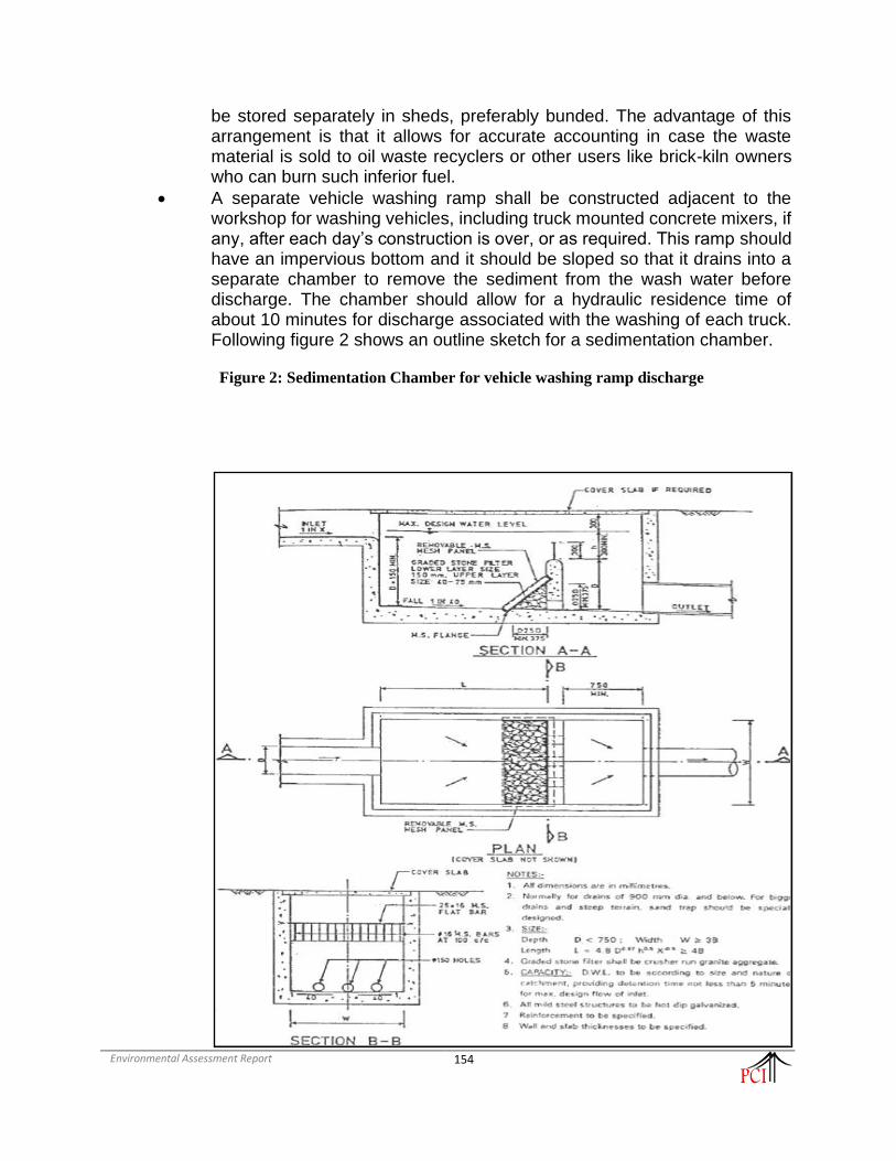
Environmental Assessment Report
154
be stored separately in sheds, preferably bunded. The advantage of this arrangement is that it allows for accurate accounting in case the waste material is sold to oil waste recyclers or other users like brick-kiln owners who can burn such inferior fuel.
• A separate vehicle washing ramp shall be constructed adjacent to the workshop for washing vehicles, including truck mounted concrete mixers, if any, after each day’s construction is over, or as required. This ramp should have an impervious bottom and it should be sloped so that it drains into a separate chamber to remove the sediment from the wash water before discharge. The chamber should allow for a hydraulic residence time of about 10 minutes for discharge associated with the washing of each truck. Following figure 2 shows an outline sketch for a sedimentation chamber.
Figure 2: Sedimentation Chamber for vehicle washing ramp discharge

Environmental Assessment Report
155

Environmental Assessment Report
156
5. Facilities for Labour
a. Potential Environmental Impacts
7. The sudden arrival and relatively longer duration of stay of construction crew can cause
substantial strain on the existing infrastructure facilities like water supply, sanitation and medical
care, especially in rural areas. Pollution from domestic wastes can affect local sources of water
supply and may harm the crew themselves as well as local residents. Improper sanitation and
inadequate health care also potential bottlenecks that the Contractor can eliminate with relatively
little effort.
b. Mitigation Measures
8. It should be emphasized that the Indian Law requires that the Contractor provide several
facilities to for the workers as per Building and Other Construction Workers (Regulation of
Employment and Conditions of Service) Act, 1996. Some of the provisions described herein are
more stringent to act as benchmark for improved environmental performance of road projects:
• The contractor shall provide free-of-charge temporary accommodation to all the labour employed
for the project. The accommodation includes separate cooking place, bathing, washing and
lavatory facilities. At least, one toilet will be provided for every 35 people and one urinal will be
provided for every 20 persons. More toilets and/or urinals may have to be provided if the
Engineer decides that these numbers are insufficient. In case female labourers are employed,
separate toilet and urinals will be provided in locations clearly marked “Ladies Toilets” in a
language understood by most labourers.
• The contractor shall ensure the supply of wholesome water for all the labour, including those
employed by any other agency working for the contractor. These locations will be marked
“Drinking Water” in the language most commonly understood among the labour. In hot season,
the contractor shall make efforts to ensure supply of cool water. No water point shall be located
within 15 m of any washing place, urinal, or latrine.
• The contractor shall ensure that adequate cooking fuel, preferably kerosene or LPG, is available
on-site. The contractor will ensure that wood/ coal are not used as fuel on the site. Workers need
to be made aware of this restriction. In cases where more than 250 labours are employed, canteen
facility should be provided by the Contractor.
• A crèche must be provided in each campsite where more than 50 female labourers are employed,
whether directly or indirectly, for the project or its ancillary activities.
• Contractor must provide adequate facilities for first-aid treatment at the campsite. A doctor /
ambulance should be available on call for the duration of project implementation.
• The contractor shall obtain the approval of the Engineer for these facilities within 30 days of
mobilization.

Environmental Assessment Report
157
TYPICAL DRAWING OF WORKERS’ CAMP SANITARY FACILITY

Environmental Assessment Report
158

Environmental Assessment Report
159
Layout of a Construction camp
Vehicle Washing
Area / Ramp
Workshop
Cement and
Spares Store
Security &
Weigh
Bridge
Office
Block
Family
Quarters
Rooms
for Men
Rooms
for
Women
Ladies
Toile
t
Was
hingarea
Gents
Toilet
PLANTS
(Concrete
Batching, etc.)
and MATERIAL
Canteen /
Mess
LEGEND: Septic Tank + Soak Pit Water Source Oil & Grease Separator
Gate
Ex
isti
ng
Slo
pe

Environmental Assessment Report
160
Appendix-5: Attendance Sheet of public consultations

Environmental Assessment Report
161

Environmental Assessment Report
162

Environmental Assessment Report
163

Environmental Assessment Report
164
Appendix-6: Contractors Responsibility for COVID-19 and other Pandemics
The COVID-19 pandemic presents unprecedented challenges and that circumstances require a
highly adaptive responsive management design to avoid, minimize and manage in this rapidly
evolving situation. This section of the ESMF provides guidance to the Borrowers in addressing
key issues associated with COVID-19. This section emphasizes the importance of careful scenario
planning, clear procedures and protocols, management systems, effective communication and
coordination, and the need for high levels of responsiveness.
Key Challenges:
Though MITP will not require huge labour camps, still there will be approximately 50 workers at
the peak time. The skilled labour may come from outside the state where as unskilled labour will
be largely local. Still, they may need to live in labour camps even though if they return to their
homes after work. The camp may also see traffic from suppliers and service providers on regular
basis which will have the potential for the spread of infectious disease in projects. Impact on the
project workers may lead to additional burden on the local health services which certainly will not
be able to take the additional load.
Contractor’s Responsibility:
The contract document generally has the clauses for health and safety of the workers but does not
cover pandemic situation. In MITP, the bid documents the contractor will be required:
• to take all necessary precautions to maintain the health and safety of the Contractor’s
Personnel
• to appoint a health and safety officer at site, who will have the authority to issue directives
for the purpose of maintaining the health and safety of all personnel authorized to enter and
or work on the site and to take protective measures to prevent accidents
• to ensure, in collaboration with local health authorities, that medical staff, first aid facilities,
sick bay, ambulance services and any other medical services specified are available at all
times at the site and at any accommodation
• to ensure suitable arrangements are made for all necessary welfare and hygiene
requirements and for the prevention of epidemics
• to provide health and safety training for Contractor’s Personnel (which include project
workers and all personnel that the Contractor uses on site, including staff and other
employees of the Contractor and Subcontractors and any other personnel assisting the
Contractor in carrying out project activities)
• to put in place workplace processes for Contractor’s Personnel to report work situations
that are not safe or healthy
• gives Contractor’s Personnel the right to report work situations which they believe are not
safe or healthy, and to remove themselves from a work situation which they have a
reasonable justification to believe presents an imminent and serious danger to their life or
health (with no reprisal for reporting or removing themselves)
• requires measures to be in place to avoid or minimize the spread of diseases including
measures to avoid or minimize the transmission of communicable diseases that may be
associated with the influx of temporary or permanent contract-related labor
• to provide an easily accessible grievance mechanism to raise workplace concerns

Environmental Assessment Report
165
Specifically, contractor shall
• prepare a detailed profile of the project work force, key work activities, schedule for carrying
out such activities, different durations of contract and rotations.
• Consideration should be given to ways in which to minimize movement in and out of site. This
could include lengthening the term of existing contracts, to avoid workers returning home to
affected areas, or returning to site from affected areas.
• Workers accommodated on site should be required to minimize contact with people near the site, and
in certain cases be prohibited from leaving the site for the duration of their contract, so that contact with
local communities is avoided.
• Consideration should be given to requiring workers lodging in the local community to move
to site accommodation (subject to availability) where they would be subject to the same
restrictions.
• Workers from local communities, who return home daily should be subject to health checks at
entry to the site.
• Establishing a system for controlling entry/exit to the site, securing the boundaries of the site,
and establishing designating entry/exit points (if they do not already exist). Entry/exit to the
site should be documented.
• Training security staff on the (enhanced) system that has been put in place for securing the site
and controlling entry and exit, the behaviors required of them in enforcing such system and
any COVID -19 specific considerations.
• Training staff who will be monitoring entry to the site, providing them with the resources they
need to document entry of workers, conducting temperature checks and recording details of
any worker that is denied entry.
• Confirming that workers are fit for work before they enter the site or start work.
• COVID-19 related issues to be part of daily tool box talk such as cough etiquette, hand hygiene
and distancing measures, using demonstrations and participatory methods.
• During tool box talk, reminding workers to self-monitor for possible symptoms (fever, cough)
and to report to their supervisor or the COVID-19 focal point if they have symptoms or are
feeling unwell.
• Preventing a worker from an affected area or who has been in contact with an infected person
from returning to the site for 14 days or (if that is not possible) isolating such worker for 14
days.
• Preventing a sick worker from entering the site, referring them to local health facilities if
necessary or requiring them to isolate at home for 14 days.
• Training workers and staff on site on the signs and symptoms of COVID-19, how it is spread,
how to protect themselves (including regular handwashing and social distancing) and what to
do if they or other people have symptoms.
• Placing posters and signs around the site, with images and text in local languages.
• Ensuring handwashing facilities supplied with soap, disposable paper towels and closed waste
bins exist at key places throughout site, including entry /exits points, toilet, canteen / mess,
drinking water points; worker accommodation; stores; and common spaces. Where
handwashing facilities do not exist or are not adequate, arrangements should be made to set
them up. Alcohol based sanitizer (if available, 60-95% alcohol) can also be used.

Environmental Assessment Report
166
• Providing cleaning staff with adequate cleaning equipment, materials and disinfectant.
• Review general cleaning systems, training cleaning staff on appropriate cleaning procedures
and appropriate frequency in high use or high-risk areas.
• Where it is anticipated that cleaners will be required to clean areas that have been or are
suspected to have been contaminated with COVID-19, providing them with appropriate PPE:
gowns or aprons, gloves, eye protection (masks, goggles or face screens) and boots or closed
work shoes. If appropriate PPE is not available, cleaners should be provided with best available
alternatives.
• Training cleaners in proper hygiene (including handwashing) prior to, during and after
conducting cleaning activities; how to safely use PPE (where required); in waste control
(including for used PPE and cleaning materials).
The MIDFC / PWD will take in in writing from the Contractor of the
• measures being taken to address the risks, presented as a contingency plan, as an extension
of the existing project emergency and preparedness plan or as standalone procedures.
• Contractor to convene regular meetings with the project health and safety specialists and
medical staff (and where appropriate the local health authorities), and to take their advice
in designing and implementing the agreed measures.
• a senior person should be identified as a focal point to deal with COVID-19 issues
responsible for coordinating preparation of the site and making sure that the measures taken
are communicated to the workers, those entering the site and the local community.
• The client may provide support to projects in identifying appropriate mitigation measures,
particularly where these will involve interface with local services, in particular health and
emergency services.
• The grievance redress mechanism set up for the project will have special number only for
reporting concerns relating to COVID-19. The number will be widely disseminated and
will also be put on the information board at all project sites.
Appendix-7: Trees in the Corridor of Impact
Chainage Number of Trees
to be Cut
From (Km)
To (Km)
Proposed
CW
0 200 3
200 400 1
400 600 1
600 800 1
1200 1400 1

Environmental Assessment Report
167
1600 1800 1
2800 3000 1
3600 3800 1
4800 5000 2
5600 5800 1
6200 6400 2
6400 6600 2
7600 7800 1
8000 8200 1
8400 8600 2
8600 8800 1
10600 10800 1
13000 13200 1
19800 20000 1
21200 21400 2
21600 21800 1
22200 22400 1
22400 22600 5
22800 23000 1
23000 23200 1
23400 23600 3
24000 24200 1
24200 24400 1
24400 24600 2
24800 25000 1
25200 25400 1
25400 25600 6
26800 27000 1
27000 27200 3
27200 27400 7
27800 28000 1
29000 29200 4
29200 29400 1
29400 29600 2
29800 30000 1
30400 30600 2
Total 73

Environmental Assessment Report
168
Appendix -8: Consent for Muck Disposal from concerned village

Environmental Assessment Report
169

Environmental Assessment Report
170
Appendix -9: Details of wildlife on road section in ESZ of NWLS

Environmental Assessment Report
171
Appendix- 10: Minutes of Meeting on Regulatory Clearance Procedures for 10 sub-projects under MITP

Environmental Assessment Report
172

Environmental Assessment Report
173

Environmental Assessment Report
174