Department of Defense Legacy Resource Management Program
104
Department of Defense Legacy Resource Management Program Legacy Project # 09-442 Development of DoD Guidance for Archaeological Site Monitoring and Condition Assessments Versar, Inc. 6850 Versar Center Springfield, Virginia 22151 February 2011
-
Upload
khangminh22 -
Category
Documents
-
view
0 -
download
0
Transcript of Department of Defense Legacy Resource Management Program
Department of Defense Legacy Resource Management Program
Legacy Project # 09-442
Development of DoD Guidance for
Archaeological Site Monitoring and Condition Assessments
Versar, Inc.
6850 Versar Center Springfield, Virginia 22151
February 2011


For the Development of DoD Guidance for Archaeological Site Monitoring and Condition Assessments
Prepared for:
Department of Defense Legacy Resource Management Program
Legacy Project #09-442
Prepared by:
Versar, Inc. 6850 Versar Center
Springfield, Virginia 22151
February 2011

i
TABLE OF CONTENTS 1.0 INTRODUCTION....................................................................................................... 1
2.0 OVERVIEW OF ARCHAEOLOGICAL SITE MONITORING PROGRAMS .. 2 2.1 Introduction ............................................................................................................... 2
2.2 Overview of Archaeological Site Monitoring ........................................................... 3
2.3 Review of Existing Archaeological Site Monitoring Programs ............................... 4
2.4 Establishing a Baseline for Site Monitoring ............................................................. 8
2.4.1 Issues with Using Site Forms as a Source of Base Line Data .............................. 8
2.4.2 Review of Best Practices for Baseline Data Gathering ...................................... 10
2.5 Follow-up Site Monitoring Visits ........................................................................... 12
2.5.1 Monitoring Frequency ........................................................................................ 12
2.5.2 Recording Site Monitoring Data ......................................................................... 13
2.6 Threats and Impacts ................................................................................................ 15
2.7 Conclusions ............................................................................................................. 15
3.0 MONITORING PROGRAM FOR DOD INSTALLATIONS .............................. 17 3.1 Baseline Data Needs ............................................................................................... 17
3.2 Development of Baseline Methods and Forms ....................................................... 17
3.3 Development of Follow-Up Monitoring Methods and Forms ................................ 19
3.4 Code of Ethics and Conduct ................................................................................... 20
4.0 PILOT STUDY: MCB QUANTICO ....................................................................... 23 4.1 Previous Archaeological Investigations at MCB Quantico .................................... 24
4.2 Site Selection and Baseline Data Collection ........................................................... 24
4.2.1 Baseline Survey Field Results ............................................................................ 25
4.2.2 Baseline Survey Methods and Form Revision .................................................... 27
4.3 Follow-Up Monitoring ............................................................................................ 27
4.3.1 Follow-Up Monitoring Field Results .................................................................. 27
4.3.2 Follow-Up Monitoring Methods and Form Revision ......................................... 28
5.0 RECOMMENDATIONS .......................................................................................... 30
5.1 Recommendations for improving the monitoring methods and forms: .................. 30
5.2 Recommendations for Implementation ................................................................... 30
5.3 Impact/Threat Mitigation: ....................................................................................... 31
6.0 REFERENCES .......................................................................................................... 32
ii
6.1 References Cited ..................................................................................................... 32
6.2 References Consulted .............................................................................................. 37
APPENDIX A: Project Personnel APPENDIX B: Representative Site Monitoring Forms APPENDIX C: List of Threats to Sites Derived from Site Monitoring Forms APPENDIX D: Baseline Data Gathering Guidelines and Forms APPENDIX E: Site Monitoring and Condition Assessment Database User Guide APPENDIX F: Follow-Up Monitoring Guidelines and Forms APPENDIX G: Example of Baseline Data and Forms APPENDIX H: Example of Follow-Up Monitoring Data and Forms APPENDIX I: Code of Ethics and Conduct Agreement
LIST OF TABLES Table 2-1. List of Contacts at Existing Site Monitoring Programs ........................................... 5
Table 4-1. Sites Selected for MCB Quantico Pilot Monitoring Study. .................................. 25
LIST OF FIGURES Figure 4-1. Location of MCB Quantico within Fauquier, Prince William, and Stafford
Counties, Virginia. ...................................................................................................... 23

1
1.0 INTRODUCTION The purpose of this study is to provide guidance related to archaeological site monitoring, preservation practices, and condition assessment strategies for archaeological sites on Department of Defense (DoD) installations. The study was funded by the DoD Legacy Resources Management Program as Legacy Project #09-442 and sponsored by the U.S. Marine Corps. Section 110 of the National Historic Preservation Act, Article 14 of the Archaeological Resource Protection Act, and Executive Order 13287 (Preserve America) call for federal agencies to not only inventory and evaluate archaeological resources, but also to monitor their condition. DoD installations tend to make inventory and evaluation tasks priorities at the expense of monitoring site condition, due to budget and staffing limitations. Those installations that do monitor site condition rarely do so in a consistent fashion: baseline mapping or photographs are typically not provided to monitors; monitors may change from one visit to another; and data on site condition are usually not reported in a standardized fashion. Since additional manpower dedicated to monitoring is not a practical answer, this study was initiated with the goal of compiling best management practices to ensure consistent data collection and to aid in prioritizing future site treatment actions. The end products of the investigation include procedures for identifying current and potential threats to sites and tools to assist current Cultural Resource Managers (CRMs) with monitoring tasks. The first sections of this report concern the development of protocols and methods for site monitoring on DoD installations. Existing monitoring programs from a variety of areas and agencies are canvassed and their applicability to the needs of DoD installations is assessed in Section 2.0. Baseline data collection and long-term monitoring methods are developed in Section 3.0 for use in the DoD environment. The protocols and methods developed in this study were evaluated in a pilot program at Marine Corps Base (MCB) Quantico, located in Fauquier, Prince William, and Stafford counties, Virginia. Baseline data were collected from a selected sample of archaeological sites, and follow-on site monitoring visits were conducted after a suitable period of time that simulated an appropriate monitoring interval. The purpose of the field work was to assess the protocols developed, evaluate the data collection procedures from a practical standpoint, and make any alterations in the procedures as might be suggested by the results of the field evaluation. The results of the evaluation are presented in Section 4.0. The final sections of this report include conclusions based on the findings of the study, and recommendations for implementation of monitoring programs at DoD installations. A list of references cited in the report and a series of appendices including a list preparers (Appendix A) close out the document.
2
2.0 OVERVIEW OF ARCHAEOLOGICAL SITE MONITORING PROGRAMS 2.1 Introduction
Many public lands—including military facilities managed by the DoD—are geographically extensive and contain large numbers of diverse and potentially significant archaeological sites. Compliance with federal cultural resources legislation on public lands has typically focused on the critical task of inventorying archaeological resources (Hargrave 2009; Kelly 2007). Archaeological site inventories enable public land managers to develop avoidance strategies that minimize negative impacts to known archaeological sites (Kelly 2007). Due to limited budgets and staff available to public land managers (Kelly 2007), archaeological sites might not then receive much further attention—unless planned impacts necessitate that potential effects to the sites be evaluated under Section 106 of the National Historic Protection Act (NHPA) (ACHP 2008; Little et al. 2000). However, while sometimes overlooked by public land managers, Section 110 of the NHPA calls for the long-term preservation and protection of archaeological resources even if destruction is not imminent (Kunde 1999:ii). Archaeological sites are not static entities. Avoidance strategies developed at the time an archaeological site is recorded may become ineffective over time as a consequence of the dynamic forces acting on the site. Environmental forces, such as erosion, and animal activities, including rodent burrowing, can affect the physical integrity of a site if left unchecked, leading to a loss of critical cultural information and possibly imperiling the site’s eligibility to the National Register of Historic Places (NRHP). Whether inadvertent or intentional, human-related impacts can be more capricious. For instance, the intensity of human-related impacts may grow dramatically with enhanced accessibility to a site, perhaps through encroachment of residential or military training areas, or increased off-road vehicle use (Affleck 2005; Ouren et al. 2007; Sampson 2007; Sowl and Poetter 2004; Stokowski and LaPointe 2000; Kathy Strain, personal communication 2009). There is a growing recognition that proper stewardship of archaeological resources on public lands cannot rely on avoidance strategies but rather must become more proactive (Kelly 2007). Archaeological resources must be observed on a regular basis to examine the dynamic forces acting on a site if public land managers hope to develop long-term strategies that will minimize or redirect these ever-changing impacts (Kelly 2007). There are legal considerations as well—some law enforcement agencies will not become involved with Archaeological Resources Protection Act (ARPA) or other violations of the integrity of archaeological resources unless it can be demonstrated that collecting, looting, or vandalism are actively occurring (Kelly 2007; McAllister 2007). In some situations, conflicts may arise between the provisions of Sections 106 and 110. The Archaeology River Monitoring Program at Grand Canyon National Park (Grand Canyon Monitoring Program), for example, has noted a conflict between their efforts to comply with Section 106 to mitigate the effects of water releases from the Glen Canyon Dam and National Park Service directives regarding “preservation-in-place” developed under Section 110 (Grand Canyon National Park 2009).

3
Kelly (2007) asserts that land managers who fail to recognize the need for protecting archaeological resources will not be good stewards. Stewardship of archaeological resources may be hampered by a lack of communication between land managers, archaeologists, and state and federal agencies (Kelly 2007). There may also be a persistent notion that natural and cultural resource management issues are separate and must be managed separately (Kelly 2007). This is certainly not the case. Maintaining a balanced ecosystem can protect archaeological sites even through something as prosaic as keeping ground cover intact, which reduces erosion and can minimize the impact of vehicles travelling across sites (Affleck 2005:55; Fuchs et al. 2003:346). However, because impacts to archaeological resources may not be as obvious as those to natural resources, the latter tend to receive more attention than the former. Unfortunately, unlike natural resources that can be potentially restored, archaeological resources are non-renewable (Kunde 1999:7; Nickens 1991). Failure to protect archaeological (and natural) resources can have serious consequences. The U.S. military is one of the largest federal landholders in the U.S. and must strive to maintain readiness and meet national security requirements while at the same time ensuring proper stewardship of its extensive environmental resources (Anderson and Ostler 2002:197; Bullard and McDonald 2008). Improper stewardship of environmental resources over an extended period can result in degradation of lands used for training exercises and a loss of realism in the training experience, thus impeding military readiness (Anderson et al. 2005:208). 2.2 Overview of Archaeological Site Monitoring
To effectively manage archaeological resources and address site integrity issues, land managers must develop long-term resource management programs (Kunde 1999:ii). A formal archaeological site monitoring program is an important component of managing archaeological resources—albeit, as noted above, one that is oft neglected in favor of inventorying archaeological resources (Hargrave 2009:A-1). Archaeological site monitoring programs typically begin with recognition that sites are being damaged, and the realization that, if impacts are detected early, the forces that threaten a site can be more effectively controlled and even minimized (Kelly 2007). Regular visits to sites through a formal site monitoring program—for example—have proven an effective technique for helping preserve the integrity of archaeological sites, such as deterring the activities of vandals, looters, and collectors (Kelly 2007). Archaeological site monitoring involves periodic visits to an archaeological site to detect any changes in a site’s condition from a previous visit to the site (Dierker and Leap 2006; Hargrave 2009:A-1). To implement a site monitoring program, one must examine current site conditions and evaluate the nature and extent of past, current, and potential threats to an individual site. As reviewed in the next section, monitoring programs may rely on the original archaeological site form as the source of the baseline data against which subsequent visits to the site are compared. Alternatively, an archaeological visit may be conducted at an archaeological site with the sole intent of gathering baseline data to aid in subsequent monitoring of the site (Kelly 2007).
4
In all of the programs reviewed, baseline site data is gathered by professional archaeologists (Table 2.1). However, in these programs, subsequent monitoring visits to an archaeological site may be conducted by professional archaeologists, non-archaeological professionals employed by public land agencies, or volunteer site stewards (Kelly 2007). Typically, photographic documentation is an integral component at each stage of the monitoring process (Coder et al. 1994, 1995). All reviewed site monitoring programs depend on forms to record baseline and site monitoring data, although, as shown below, the content of forms can differ considerably. Baseline data provides the foundation for any monitoring program, and consistency of those data is essential for the monitoring to be meaningful. In order for that to happen, dedicated training is necessary to ensure standardized collection of baseline and site monitoring data (Jennifer Dierker, personal communication 2009). 2.3 Review of Existing Archaeological Site Monitoring Programs
The development of protocols related to archaeological site monitoring and condition assessments for DoD use relied on a review of existing programs distributed across the nation. A dialogue was also established with the directors of several programs (Table 2.1) (see also Arizona State Historic Preservation Office 2009; Bureau of Land Management 2009; California Archaeological Site Stewardship Program 2009; California State Parks 2008; Dierker and Leap 2006; Florida Division of Historical Resources 2009; Friends of Sierra Rock Art 2009; Nevada Historic Preservation Office 2009; New Mexico Historic Preservation Division 2009; Project Archaeology 2009; San Juan Mountains Association 2009; Santa Fe National Forest 2008; Tennessee Valley Authority 2009; Texas Historical Commission 2009; U.S. Forest Service 2009). Two recent evaluations of site monitoring programs were consulted and proved extremely useful in providing guidance that facilitated this dialogue (Hargrave 2009; Kelly 2007). The authors of both works were contacted for additional insights into developing archaeological site monitoring protocols best suited to the Marine Corps Base Quantico (Quantico) but still applicable to DoD installations nationwide. Programs formulated to address threats to archaeological sites on public lands ranged from the passive to the proactive. Due to extremely restricted staff and funding, the Tennessee Valley Authority’s A Thousand Eyes program is limited to posting signs notifying the public that archaeological sites are afforded legal protection (Erin Pritchard, personal communication 2009). Florida’s Sitewatch program is implemented primarily as a reaction to reports from state land managers of damage to sites, suspicious activities at or near sites, or apprehension of individuals actively looting a site (Kevin Porter, personal communication 2009). The majority of archaeological site monitoring programs canvassed for this study are more structured, with regular visits scheduled to record any active or potential threats to known sites. Sites may be selected for monitoring based on past impacts or perceived threats—such as recreational or training activities—and the nature of these threats may influence the time between monitoring visits (Kathy Strain, personal communication 2009). The Friends of Sierra Rock Art presumes that all sites require monitoring until they are evaluated for NRHP eligibility; this ensures that all unevaluated sites are treated equably (Nolan Smith, personal communication 2009).

5
Table 2-1. List of Contacts at Existing Site Monitoring Programs
State/Area Program Contact Information Name and Title Address
Arizona Archeology River Monitoring Program
Jen Dierker, Archeologist
Grand Canyon National Park 823 San Francisco Suite B Flagstaff, AZ 86001
Arizona Site Stewards Program
Kristen McLean, Site Stewards Coordinator
Arizona State Parks 1300 W. Washington St. Phoenix, AZ 85007
California Stanislaus National Forest Site Monitoring Program
Kathy Strain, Forest Program Manager for Heritage Resource and Tribal Relations
Stanislaus National Forest 19777 Greenley Road Sonora, CA 95370
Colorado Desert District Archaeological Site Stewardship Program
Christopher Corey, Associate State Archaeologist
Archaeology, History and Museum Division 1416 9th Street Room 902 Sacramento, CA 95814
Friends of Sierra Rock Art -Tahoe National Forest Archaeological Site Monitoring Program
Nolan Smith, District Archaeologist, American River Ranger District
Tahoe National Forest 631 Coyote Street Nevada City, CA 95959
California Archaeological Site Stewardship Program
Beth Padon, Program Coordinator
Discovery Works P.O. Box 51476 Irvine, CA 92619
Colorado Southwest Colorado Cultural Site Stewardship Program
Dr. Ruth Lambert, Cultural Program Director
San Juan Mountains Association P.O. Box 2261 Durango, CO 81302
Florida Sitewatch program Kevin Porter, Archaeologist III
Bureau of Archaeological Research, B. Calvin Jones Center for Archaeology Governor Martin House 1001 de Soto Park Drive Tallahassee, Florida 32301
Montana Montana Site Stewardship Program
Crystal Alegria, Coordinator
Project Archaeology P.O. Box 170570 Bozeman, MT 59717
Nevada Nevada Archaeological Site Stewardship Program
Sali Underwood, Site Stewardship Coordinator
700 Twin Lakes Dr. Las Vegas, NV 89102
New SiteWatch, New Phil Young, Department of Cultural Affairs

6
State/Area Program Contact Information Name and Title Address
Mexico Mexico Historic Preservation Division
Volunteer Coordinator
Historic Preservation Division Bataan Memorial Building 407 Galisteo Street Suite 236 Santa Fe, NM 87501
Northwest New Mexico Site Stewards Program
Clay Johnston, Program Director
Salmon Ruins P.O. Box 125 Bloomfield, NM 87413
Santa Fe National Forest Site Stewards
SFNF Site Stewards
P. O. Box 31943 Santa Fe, NM 87594-1943
Tennessee Valley Authority
A Thousand Eyes Erin Pritchard, Archaeologist, TVA Cultural Resources
Tennessee Valley Authority 400 W. Summit Hill Dr. Knoxville, TN 37902-1499
Texas Texas Archaeological Stewardship Network
Mark H. Denton, MA, RPA, Coordinator, State & Federal Review Section
Archeology Division Texas Historical Commission P.O. Box 12276 Austin, TX 78711-2276.
Utah Utah Site Stewardship Program
Laura Kochanski, Archeologist
Bureau of Land Management Monticello Field Office 435 North Main P. O. Box 7 Monticello, Utah 84535
Formal monitoring programs differ in terms of staffing. Some programs, such as the Grand Canyon Monitoring Program, involve professional archaeologists at all stages from the initial baseline survey to annual site monitoring visits (Coder and Andrews 1993; Coder et al. 1994, 1995; Leap et al. 1996; Dierker and Leap 2006). Most site monitoring programs rely heavily on volunteer site stewards, especially for the follow-up site monitoring visits after baseline data are recorded by a professional archaeologist. These programs are often situated within broader volunteer efforts (Kelly 2007). In most cases, the use of volunteer site stewards represents a matter of economics as federal land managers are chronically underfunded (Horne 2005:36). Arizona’s Site Steward Program has had some success using off-duty military personnel to monitor sites on and off military facilities (Kristen McLean, personal communication 2009). Volunteer site stewards are more frequently avocational archaeologists who already share concerns about threats to archaeological resources (Nolan Smith, personal communication 2009). The use of volunteer site stewards can create challenges, from having to rely on overly generalized forms (Beth Padon, personal communication 2009) to inconsistency in recording site conditions between monitoring visits (Chris Corey, personal communication 2009; Nolan Smith, personal communication 2009). Site monitoring programs may also need to tailor themselves to the desires of site monitors, who may only favor monitoring sites located in specific areas—although these monitors do become more heavily vested in the sites they visit

7
(Kathy Strain, personal communication 2009). Safety is also a concern and programs emphasize that volunteers should not contact anyone actively damaging a site; rather, the appropriate law enforcement personnel should be notified (Padon and Padon 2005). Site monitoring programs without full-time coordinators, no matter how well structured, simply will not be very effective—as was learned by the Utah Site Stewardship Program (Kochanski, personal communication 2009). Training programs and detailed training manuals are seen as critical to ensuring that volunteer site stewards record information on site conditions accurately, consistently, and at the appropriate level of detail (Jennifer Dierker, personal communication 2009). The Arizona Site Stewards Program is one of the oldest volunteer-based site stewardship programs in the United States, and has been emulated by a number of other site monitoring programs. In this program, volunteer site stewards are sponsored by various public land managers—such as cultural resource personnel at military installations (Luke Air Force Base and Yuma Proving Ground)—and are selected, trained, and certified by the State Historic Preservation Officer (SHPO) and the Arizona Governor’s Archaeology Advisory Program. A site steward’s handbook and the program’s website clearly outline procedures for monitoring archaeological sites and articulate the goals of this program (Arizona State Historic Preservation Office 2009). Another well developed program is New Mexico’s SiteWatch, which also is coordinated through the SHPO’s office (New Mexico Historic Preservation Division 2009; Paul 2001). In addition to an extensive handbook, this program has produced a brochure that describes the basic requirements and duties of a volunteer site steward. Following training, regional chapters of the SiteWatch program partner with the Bureau of Land Management (BLM), National Park Service (NPS), US Forest Service (USFS), and state agencies. A Site Steward Foundation was created in 2008 to provide a stable source of funding for this program. As is too infrequently the case, the importance of site monitoring is widely acknowledged, but funding tends to remain at inadequate levels for a monitoring program that does not rely heavily on volunteer site stewards. Most programs that rely on volunteer site stewards require both classroom time and field visits as part of the training process—although the time devoted to this varies quite a bit. The Arizona Site Steward Program requires 10 hours of classroom instruction and fieldwork (Kristen McLean, personal communication 2009), while the California Archaeological Site Stewardship (CASS) program provides their site stewards with two full days of training. The first day is devoted to an overview of archaeology for the local region and introductions to agency archaeologists and law enforcement personnel. On the second day, volunteer stewards take field trips to the sites that will be monitored (Padon and Padon 2005:34). At 40 hours of hands-on training, the USFS’s Stanislaus National Forest (California) Site Monitoring Program has one of the longer training regimes for volunteer site stewards (Kathy Strain, personal communication 2009). During their day and a half of training, volunteer site stewards for Santa Fe National Forest visit simulated sites and view a demonstration of how to collect monitoring data without causing further impacts to a site (Santa Fe National Forest 2008).

8
Volunteer site stewards generally must sign a code of ethics/conduct and/or a confidentiality agreement before they are formally admitted to a site monitoring program—and may also need to complete a detailed application form (Clay Johnston, personal communication 2009; Kathy Strain, personal communication 2009; Padon and Padon 2005:34). The goal of these documents is to ensure that volunteers are aware of applicable state and federal laws, and of the sensitivity of site locational information. In addition to helping protect archaeological sites, volunteer site stewards may also be encouraged to promote the public’s knowledge of the past (Padon and Padon 2005:33)—and its fragile nature. The use of volunteer site stewards may also increase awareness about the importance of cultural resources among the local community surrounding a site and result in a decrease in site impacts from looting or vandalism (Clay Johnston, personal communication 2009; Kathy Strain, personal communication 2009). 2.4 Establishing a Baseline for Site Monitoring
Gathering baseline data is the critical first step for initiating an archaeological site’s monitoring program. Subsequent monitoring visits use these baseline data to evaluate and determine the nature and extent of past, active, or potential impacts/threats to an archaeological site. There is considerable variation in how existing site monitoring programs gather these crucial baseline data, ranging from reliance on original site recording forms to dedicated visits by teams of professional archaeologists. Volunteer site stewards may assist with gathering these baseline data, but only in tandem with a professional archaeologist. This is the case for the California State Parks Colorado Desert District Archaeological Site Stewardship Program (Chris Corey, personal communication 2009). 2.4.1 Issues with Using Site Forms as a Source of Baseline Data
Due largely to budgetary constraints, some programs do not use a dedicated visit to a site to obtain baseline data, but rather rely on existing site recording forms. The California Archaeological Site Stewardship Program (Beth Padon, personal communication 2009), Northwest New Mexico Site Stewards Program, and Texas Archaeological Stewardship Network, for example, typically initiate site monitoring programs using existing site forms (Mark Denton, personal communication 2009; Clay Johnston, personal communication 2009). Program directors differ on whether site forms contain adequate information for the purpose of initiating a site monitoring program. Baseline data for sites monitored in the Arizona State Stewards program are usually derived from site forms, but older forms may contain insufficient information on site attributes, such as site condition (Kristen McLean, personal communication 2009). A similar situation has been noted for the Friends of Sierra Rock Art-Tahoe National Forest Archaeological Site Monitoring Program. This program relies on completed California site forms for baseline data (Nolan Smith, personal communication 2009). Kelly (2007) noted some general issues with using existing site forms as a source for baseline data, including:
• Incomplete site data; • Absence of detailed site descriptions;
9
• Lack of information regarding current site conditions, especially disturbances and threats to a site;
• Insufficient information to relocate a site; and, • Inadequate mapping of a site’s boundaries and internal distribution of cultural
remains. The best site forms may collect some data on past, existing and future threats to sites, but are not typically designed to detail the exact nature and distribution of these threats—the latter representing critical information for follow-up monitoring visits. Even for comprehensive site forms, a baseline visit would still be important if considerable time has elapsed since the site was recorded—the nature and level of threats to individual sites are constantly changing (Kelly 2007). However, in many cases, site forms are not well designed for recording the types of information needed by a monitoring program, but rather emphasize the information potential of individual sites and their NRHP eligibility (Michael Hargrave, personal communication 2009). The emphasis is on the cultural content of sites such as artifacts and features, but don’t prompt the recorder to consider or describe potential threats to site integrity such as vulnerability to erosion. Even sites evaluated by professional archaeologists may not have information presented on a site form or accompanying compliance report concerning potential threats to cultural resources, because these factors do not affect a site’s current eligibility. Michael Hargrave (personal communication 2009) noted that site forms do not typically consider offsite impacts that might soon encroach on a site—and this is particularly an issue for archaeological sites in military training areas. A site monitoring program must have specific objectives and management goals in mind, and these may lead to collection of additional data from sites other than what is typically presented on site forms (Jennifer Dierker, personal communication 2009). Additionally, documentation standards may have changed since a site form was initially completed or a site was evaluated. In the Grand Canyon Monitoring Program, baseline data are collected by professional archaeologists using extensive site recording forms that have been designed partly to enable site monitoring. If considerable time has passed since a site was first recorded, additional data may be collected from a dedicated site visit and a new site form completed. Detailed measurements and re-mapping of the site may prove necessary (Jennifer Dierker, personal communication 2009). Professional archaeologists associated with the Southwest Colorado Site Stewardship program found that site forms provided minimal useful baseline data. This situation is particularly true for those forms more than 15 years old when site recording was less comprehensive (Ruth Lambert, personal communication 2009). Existing site forms are also known for the inconsistency with which data were recorded. In the Nevada Archaeological Site Stewardship program, baseline data are usually derived directly from site forms that are ideally updated during dedicated baseline visits by professional archaeologists. However, archaeologists associated with the various participating federal land management agencies rarely have the time to conduct baseline
10
visits and site monitoring of necessity relies on site forms of varying quality (Sali Underwood, personal communication 2009). Another issue is that many early site forms, or site forms for sites on non-federal lands may not have been completed by professional archaeologists; rather, site recordation often represents the efforts of untrained individuals who fail to collect or properly document data on site conditions. This problem has been encountered in Florida’s Sitewatch program. Site forms are the source for baseline data information, but this information may be very limited for sites recorded by nonprofessionals. The minimal standards for recording a site in Florida consist of a indicating a site’s location on a USGS quadrangle map. In this latter case, an updated site form would have to be completed and then used to obtain baseline information; additional recording of baseline data beyond the site form does not take place in Florida’s program (Kevin Porter, personal communication 2009). Dedicated baseline visits are seen as critical to recording information often absent on site forms for the Stanislaus National Forest (California) Site Monitoring Program. Baseline visits are especially important for recording what cultural remains are currently visible on the surface—and more likely to be adversely affected by impacts or threats. Surface remains, especially portable items, are attractive to vandals or looters, or more susceptible to pedestrian or vehicle impacts (Kathy Strain, personal communication 2009). Surface collection of artifacts as part of baseline data gathering, where practical, would be one way to minimize a potential issue for subsequent site monitoring (Coder et al. 1995). New Mexico’s SiteWatch program makes baseline condition assessments on a form designed specifically for that purpose. Site forms are explicitly viewed as containing inadequate information for initiating a site monitoring program (New Mexico Historic Preservation Division 2009). Their baseline form is subdivided into three types of impacts: natural; human-made impacts not witnessed; and human-made impacts witnessed. A mix of free-format and checklist fields are incorporated into this form, with the majority of the form oriented toward unguided user comments. 2.4.2 Review of Best Practices for Baseline Data Gathering
As Kunde (1999:53) noted “Baseline data refers to the condition which prevails when monitoring begins or the basis from which all future change is assessed.” It is important that subsequent monitoring visits make observations in the same place and on the same basis as baseline data were collected (Kunde 1999:53). Therefore, well-defined methods of data collection must be in place through all stages of site monitoring, beginning with assembling baseline data. However these data are collected, Grand Canyon Monitoring Program personnel stress that forms should be simple and straightforward. Their initial monitoring form was too complicated and contained too many subjective options (Coder and Andrews 1993; Coder et al. 1994). Nolan Smith (personal communication, 2009) has found as part of his work with California’s Friends of Sierra Rock Art that certain minimal information needs to be available as baseline data of site conditions—some of which might be available from adequately completed site forms. This information includes:

11
• What are the site’s dimensions? Site dimensions provide an indication of how long
baseline data recording and subsequent monitoring visits may take; • How was the site located? Knowing this may indicate past or active threats to a site,
such as animal burrows or erosion; • What are the depths of site deposits? Are there cultural remains (features, artifacts) on
the surface? This information can help determine whether active or potential threats will impact all cultural deposits at a site, and not simply those on the surface;
• What is the site’s topographic and environmental setting? Understanding the geomorphic context of a site is important as well, because this can reveal the degree to which existing and potential threats will affect a site’s integrity (Coder et al. 1994); and,
• What is a site’s current condition and relative level of disturbance? A site that is in good condition may need less frequent monitoring than a site in poor condition.
The baseline data recording process must budget adequate time to gather this information, if it is not present on site forms. If a site has not been evaluated, some of these data may not be available, such as depth of cultural deposits, which will make it difficult to fully determine whether subsurface deposits are endangered by active or potential impacts. Successful baseline data gathering depends on the presence of an accurate site map. Detailed maps will need to be created if these do not exist, especially maps that include the locations of surface remains as these are highly susceptible to most site impacts or threats. These maps are critical to indicating the location of active and potential threats to cultural resources (Coder et al. 1995). Subsequent monitoring efforts can also objectively track the movement of objects across a site if a detailed map exists (Coder et al. 1994). For the Grand Canyon Monitoring Project, large and complex sites were particularly an issue for obtaining baseline data because of inadequate maps that showed boundaries but few internal features (Coder and Andrews 1993). Field implementation of a baseline data gathering effort should involve relocating a site’s datum, or establishing a new datum if the original was not found or never created. A site’s boundaries also need to be determined to ensure that all active or potential threats to its integrity are adequately considered. A walkover of the entire site must be undertaken to locate and identify all human and natural impacts, which will be recorded on the map of the site. Data on vegetation and general surface conditions should also be collected, as this information can help determine how much damage active or potential impacts may cause to a site. Recording impact locations using GPS can potentially ease subsequent relocation of past or active impacts. Another crucial aspect of baseline data gathering is photographic documentation. Examining photographs taking during baseline or subsequent monitoring visits is often the primary strategy employed for detecting recent changes at a site (Hargrave 2009). During baseline data gathering, photographs should be taken only of impacted cultural remains and those that are at risk—rather than of every feature at a site. More extensive photographic documentation would seem a laudable goal, but has been found to be

12
impractical, very time consuming, and often results in redundant information (Coder et al. 1994). Photographs should be taken from designated fixed points in and around a site—designated here as photographic stations—to ensure that images capture all past, active or anticipated threats. This practice enables comparison of field conditions during follow-up site monitoring visits with previous photographs taken at a site. These photographic stations must, of course, be clearly marked on site maps. Photographs must be well documented, including not only the photographer’s location but also the direction of a particular view, the relative height of the photographer, and the date and time the photograph was taken (Hargrave 2009). Again, it should be emphasized that threats to sites are dynamic and this is the reason why site monitoring programs are integral to the preservation process. Kelly (2007) recommends resurveying sites every one to five years because site conditions can change so rapidly. The Southwest Colorado Site Stewardship Program conducts baseline recording of sites on an annual basis, with site monitoring visits occurring during the interim. Annual re-establishment of a site’s baseline sometimes involves creation of additional photographic stations to document new threats/impacts or previous threats/impacts that have grown beyond the views of existing photographic stations (Ruth Lambert, personal communication 2009). 2.5 Follow-up Site Monitoring Visits
The basic purpose of site monitoring visits is to determine whether there have been changes in the condition of all or part of an archaeological site since baseline data were collected, or from a previous monitoring visit (Dierker and Leap 2006). Baseline data need to be presented in a readily accessible manner—especially when site monitoring visits are conducted by non-archaeologists who may not have been present when the baseline was established. Photographs, previous site descriptions, and maps need to be assembled to compare current site conditions with those visible during previous monitoring episodes (Dierker and Leap 2006). Archaeologists working with the Grand Canyon Monitoring Program only take subsequent photographs from a photographic station if there has been a change in site conditions to avoid essentially duplicating photographs and generating more documentation that then has to be managed (Coder and Andrews 1993; Coder et al. 1994, 1995). Because site monitoring is time consuming, Hargrave (2009) suggests that site monitoring should focus on those characteristics that make a site eligible for listing on the NRHP. Implementation of site monitoring visits among the various programs analyzed is quite variable, especially in terms of monitoring frequency and forms used to record site monitoring observations. 2.5.1 Monitoring Frequency
The frequency at which individual sites are monitored depends on the various risk factors affecting a site. If a site is actively threatened or site conditions are changing rapidly, the site will be monitored more frequently (Kathy Strain, personal communication 2009; Kelly 2007). Sites that are remote, stable, and with no active or potential threats may be monitored infrequently (Leap et al. 1996). Some sites, particularly those that are remote and in good condition, may be assigned to an “inactive” monitoring schedule.

13
For the Friends of Sierra Rock Art, sites are more frequently monitored if they are close to roads or public areas, or if there are known past disturbances—although no specific schedule is set for monitoring. Weather conditions are the major restriction influencing when sites can be monitored (Friends of Sierra Rock Art 2009). The Grand Canyon Monitoring Program visits remote, “pristine” sites on an as-needed basis, such as after unusual weather disturbances, unexpectedly heavy visitor use in the site vicinity, or upon tribal requests (Leap et al. 1996). Typically, however, the Grand Canyon Monitoring Program monitors sites on an annual basis, evaluating and refining the methods used to document site conditions (Coder et al. 1994, 1995; Dierker and Leap 2006). The Arizona Site Stewards Program schedules monitoring visits at least once a week for sites located in areas popular with tourists and once every 10 to 12 weeks for remote, less threatened sites (Arizona State Historic Preservation Office 2009). On the Stanislaus (California) National Forest, some sites are visited daily during the peak recreational season, other sites are visited monthly, and some sites are only visited once every five years (Kathy Strain, personal communication 2009). In Florida, sites are only examined if it is necessary to complete a damage assessment, or if a looter or other suspicious activity has been noted around a site (Kevin Porter, personal communication 2009). Financial constraints can be an issue. The Northwest New Mexico Site Stewards Program’s preferred monitoring interval is every four weeks, but funding limitations result in site visits that take place once every six to eight weeks (Clay Johnston, personal communication 2009). 2.5.2 Recording Site Monitoring Data
Accurate record keeping for each visit to a site is imperative, as the ultimate goal of a monitoring program is to assess whether site conditions are stable or have changed since the last visit to a site. The site monitoring programs reviewed in this report were quite variable in how they recorded site monitoring data. Only a few representative site monitoring forms are detailed in this section and examples are provided in Appendix B. The Grand Canyon River Monitoring Program refined their site monitoring form over a number of years. The initial monitoring form developed for this program was too long, too cumbersome and too convoluted, with many subjective options that were translated into an abstract number for data entry (Coder and Andrews 1993). In response to these issues, this program explicitly developed a single sheet, double-sided monitoring form that includes structured fields (check lists, an impact matrix) with free-format fields for comments and explanations. The impact matrix allows the user to quickly check whether various types of physical impacts are absent, active, or inactive for various types of cultural remains. The current form also includes a section for recommendations for future actions (e.g., monitoring schedule, preservation options, or recovery options) and a six-page narrative that details the variables on the form and why the information is being recorded (Coder et al. 1994; Jennifer Dierker, personal communication; Dierker and Leap 2006). The archaeological site monitoring form used by the US Forest Service for the Stanislaus National Forest (California) Site Monitoring Program is largely a series of check lists with minimal space for user comments. The form is site-specific and asks the recorder to check yes/no for the presence of three different types of impacts (natural, human, and livestock), as

14
well as to assess whether certain types of impacts are possible, definite, or active threats. This form is three pages in length but the current program manager stresses that a two-page, double-sided, largely check list form is actually ideal. Site monitors, in her experience, will not complete a form longer than two pages that is not largely check list in structure (Kathy Strain, personal communication 2009). The California Department of Parks and Recreation currently uses a four-page form dedicated to recording site monitoring data from individual sites: the Archaeological Site Condition Assessment Record (ASCAR). The first page of ASCAR asks for fairly broad data in a mix of check lists and free-format fields, including: the site’s eligibility status for the California and National Registers; the site type; whether the site is prehistoric or historic; whether the site was relocated; and an overall site condition damage assessment check list, ranging from no damage to heavy damage. A short comments field follows the damage assessment check list. An explicit note on the first page states that a new site form must be completed if the original site record is 5 years old or older. ASCAR’s second and third pages are primarily devoted to a matrix ranking various types of impact in terms of intensity of impact (expressed as a percentage) for the entire site, ranging from none to heavy (>75%) intensity. Impacts are subdivided into several major categories (some with sub-categories), including animal damage, erosion and other geological processes, fire, park construction, park maintenance, park visitor use, trails and related disturbances, and vandalism. The final page of this form provides some space for comments on disturbances and proposed future actions, the latter of which follows a check list of “Proposed Future Actions Required for Site Management and/or Protection.” Chris Corey (personal communication, 2009), who is Associate State Archaeologist, California Department of Parks and Recreation, noted that his agency was revising this form because the department’s lawyers found the form to be much too subjective. A much more stream-lined, single page form is used by the San Juan Mountains Association Cultural Site Stewardship Program. This form divides site impacts into human activities, animal activities, and natural processes, and asks the site monitor to check whether the activities occur generally within the site or within structures. Each activity block is further separated into sub categories and contains a free-format block for the site monitor to add comments. This form is designed as a spreadsheet to ease computer entry. Ruth Lambert (personal communication, 2009), who is director of the San Juan Mountains Association Cultural Site Stewardship Program, stresses that computerized entry of monitoring data is critical to allowing program managers the ability to track changing threats to archaeological resources and deciding how best to allocate scare resources for dealing with documented threats, such as determining monitoring frequency at individual sites. Data entry of monitoring data is also strongly suggested by Hargrave (2009) in his recent overview of site monitoring programs for similar reasons. The Northwest New Mexico Site Stewards program has a site monitoring form that is very basic and completely web-based. The top of the form has spaces for the monitor’s name, email address, date of visit, site name, total mileage, total volunteers, and total number of hours on the site. Below this is a free-format field for “observations pertaining to vandalism

15
or site deterioration” and a second free-format field for additional comments. A check box enables the site monitor to note if the “site remains unchanged.” A much less structured form is employed by the California Archaeological Site Stewardship Program (CASSP). Their form contains no check lists, and largely consists of free-format fields where the monitor can describe the condition of the archaeological site, condition of trails to the site, evidence of human intervention at the site, observation of current human activity at the site, and whether law enforcement personnel were notified of human activities at the site. This form does not consider explicitly consider non-human impacts to an archaeological site. Beth Padon (personal communication, 2009), co-coordinator of CASSP, notes that this monitoring form is intentionally kept generic because they deal with a number of agencies (National Park Service, Bureau of Land Management, US Forest Service) that each have their own protocols regarding the monitoring of archaeological sites. Because the form contains little guidance on how to complete it, their two-day training program is critical to minimize subjectivity of site monitor observations (Padon and Padon 2005). The Arizona Site Stewards Program uses a generic, multi-use, single-page form to record site monitoring data: the Arizona Site Steward Quarterly Activity Log. This form is designed to record multiple sites and multiple site steward activities, including site visits, mapping/ survey, public education, and other. Observed impacts to archaeological sites are recorded in a vandalism report column, with a coded list provided on the form for this purpose. Vandalism is simply recorded as present, although there is a small free-format box that an individual could use to provide further details. If vandalism is noted, a separate form is available that is designed to create a record for law enforcement personnel: the Arizona Site Steward Cultural Vandalism Report. Clearly, the emphasis in this program is to record human and not animal or other natural impacts to an archaeological site. 2.6 Threats and Impacts
Examination of site monitoring programs, however extensive their recording forms are, did provide an indication of the types of threats to which sites are subject. Specific threats to sites are frequently divided into three broad categories: those related to natural activities (e.g. erosion, natural fires, tree falls, etc.); those related to animal activities (burrowing, trampling, trail formation, insect or rodent damage, etc.); and those related to human activities (vandalism, looting, collecting, vehicle tracks, camping, development, military training, etc.). These threats vary regionally and also depend on the nature of the public lands containing archaeological resources. Thus, while general site monitoring protocols can be developed that are applicable to a variety of settings, the specific threats to be recorded will need to be tailored to individual public lands where sites are being monitored. The range of potential threats to an archaeological site as reflected on site monitoring forms is presented in Appendix C. The list of threats also varies depending on what aspects of site monitoring are considered important by a specific site monitoring program. 2.7 Conclusions
The ultimate goal of this review of existing site monitoring programs was to facilitate the development of baseline data gathering protocols and to develop a site monitoring form that
16
can be readily used for follow-up site monitoring visits by personnel who are not professional archaeologists. Among the recommendations emerging from this review are the following:
• The site monitoring form should include sufficient information from the baseline monitoring visits to each individual site to enable a quick and ready assessment of whether site conditions are stable or have changed since the last visit.
• Monitoring forms should collect information about on and off-site threats to site integrity.
• Emphasis should be placed on using checklists where possible to ease and speed recording of sites during follow-up monitoring visits, but there must be sufficient space for additional comments.
• Forms and checklists should be as objective as possible for consistency of information collected.
• The site monitoring form should be no longer than two pages, although a separate form will be necessary for the photographic log.
• A short user guide also must be prepared to illustrate the proper way to prepare the site monitoring form, the best way to take photographs, and to define any terms that might be unfamiliar to monitors who are not professional archaeologists.
Particular attention also must be paid during the creation of the site monitoring form and the photographic log to ease computerization of the data recorded on the forms. Computerization of the data will enable a ready assessment of the types, number, and occurrences of threats to sites at MCB Quantico, and help determine how frequently sites should be monitored following the baseline monitoring survey of the site. It may prove possible to assign levels of risk—low, medium, and high—to sites, which would enable the monitoring frequency to be determined. Early detection of active or potential impacts is critical to protecting a site’s physical integrity and its NRHP eligibility from potential or active threats—or at least helping minimize the effect of these threats.

17
3.0 MONITORING PROGRAM FOR DOD INSTALLATIONS The following section describes the devlopment of the monitoring program beginning with baseline data collection and survey followed by ongoing monitoring procedures. 3.1 Baseline Data Needs
A comprehensive site monitoring program begins with archaeological professionals collecting baseline data for each site. This information represents a snapshot of site conditions against which to compare the findings of subsequent site visits. Baseline data should incorporate previous site documentation (site forms, maps, relevant report sections, etc.), as well as descriptions and a field assessment of current site conditions. Previous documentation, particularly an accurate and detailed site map, can aid in 1) relocating the site and defining its boundaries as originally defined; 2) locating or re-establishing a permanent site datum; 3) relocating features; and 4) determining the extent of previous excavations or collections, including authorized archaeological excavations or unauthorized digging. If no site map showing site boundaries, internal features, or the extent of previous excavations at the site exists, a new map may need to be created prior to or during the baseline visit. Site records and reports also should be examined closely, with attention paid to environmental and topographic characteristics, such as slope and drainage, because these can help assess how and to what extent observed impacts or potential threats might affect a site’s integrity. The collection of baseline data must anticipate future risks as well as document existing threats, and thus the location of each site should be assessed with regard to site access and the proximity of known or potential threats (e.g. roads, trails, recreational/public areas, military training areas). This information may also be useful in determining how frequently individual sites may need to be monitored. 3.2 Development of Baseline Methods and Forms
The ultimate goal of a baseline survey is to collect information that can be used to assess changes in site condition over time. Data collection forms were developed for this purpose that could be readily used for follow-up site monitoring visits by personnel who are not necessarily trained or professional archaeologists. The baseline data gathering form was designed to include sufficient information from the baseline monitoring visits to each individual site to enable a quick and ready assessment of whether site conditions are stable or have changed since the last visit. The form includes prompts for current environmental conditions (e.g., vegetation, surface visibility, and topography), a table of specific impacts or threats to site integrity, and space for additional comments on general threats and notes related to the monitoring process. A photographic log was also developed to record the location of photographic stations used to document current site conditions. The log includes the station number, direction the camera is facing, distance and angle to datum, and a space for comments or descriptions pertaining to station placement or the subject of the photograph. Guidelines for conducting a baseline survey and examples of blank forms are presented in Appendix D.

18
Step 1: Relocate Site and Datum The first step in initiating baseline data collection is to relocate the site and its datum. This can be achieved through review of previous documentation or with the aid of GIS data and a quality GPS receiver. If a datum does not exist or one cannot be relocated, a new datum, utilizing 1-inch-diameter PVC pipe or some similar durable material, should be established and its location recorded on the site map. If GPS equipment is available, the coordinates of the datum should also be recorded and added to the installation GIS. Relocation of the original datum or placement of a new datum is a critical step in the monitoring process. The locations of all photographic stations should be recorded relative to each site’s datum. The datum can often serve as one of the photographic stations. Step 2: Record Current Conditions After establishing the site datum, the next stage is to record the current conditions of the site photographically. A sufficient number of photographs should be taken to document the range of general site conditions, as well as the condition of any visible features such as foundations, mounds, pits, or trenches. Future site monitors will need to relocate the positions from which the photographs were taken, and thus the location of each photo station should be recorded on a photographic log form. The form records the angle and distance to the site datum, as well as GPS coordinates, if those are available. The orientation or compass direction of each photograph should also be recorded on the log. Photographic stations should be established in locations that provide a clear view of site conditions but also in such a way that they can be easily relocated and their views replicated. The number of photographic stations at each site will vary based on site size and complexity: a minimum of four stations, representing views of the site in the cardinal directions, is recommended at each site. Step 3: Record Impacts and Threats Impacts and threats that are observed should be recorded on the baseline data gathering forms, noting the type of impact or threat and any pertinent descriptive comments or measurements. Alphanumeric codes have been developed for common or typical impact types to standardize terminology and to facilitate the mapping of impacts on the site maps. A list of the codes and definitions is included in the baseline survey guidelines (Appendix D). Each specific impact or threat should be photo-documented. Recommendations can be made by the monitoring personnel on how to mitigate those threats, which may include frequent site monitoring, signage, fencing, or even site burial. An absence of observed impacts or threats also should be documented on the baseline data gathering forms. Throughout the baseline survey of each site, the time necessary to complete each task should be recorded. This may prove useful in assessing how long it will take to conduct baseline surveys and follow-up monitoring for other sites on a given installation. The time to complete these tasks on the initial follow-up survey should also be recorded, and this

19
information can be compared to the baseline survey times to help test the efficacy of the site monitoring forms and protocols developed following the baseline surveys. Particular attention was paid during the creation of the site monitoring forms and the photographic log to ease computerization of the data recorded on the forms. Computerization of the data will enable monitoring data to be added to the installation GIS as well as provide a ready assessment of the types, number, and occurrences of threats to sites within the monitoring program. It may prove possible to assign levels of risk—low, medium, and high—to sites, which would aid in determining the frequency of follow-up monitoring visits. For this purpose, a Site Monitoring and Condition Assessment Database was developed in Microsoft Access. This relational database utilizes simple graphical user interface forms to facilitate queries and data entry. Data gathered during the MCB Quantico pilot study, discussed in Section 4.0, were used to populate a prototype of the database. A user guide for the database is provided in Appendix E. Summary Recommendations
• Locate or establish site datum; • Take a sufficient number of photographs to document the range of general site
conditions; • Establish photographic stations in locations that pro;vide a clear view of site
conditions in a way that they can be easily relocated • Log photo locations and angles; • Record Impacts and Threats; • Record time required for each task; and • Enter data into computer database.
3.3 Development of Follow-Up Monitoring Methods and Forms
Continued monitoring of site conditions is important for evaluating changes that have occurred since a site was last visited. Regular monitoring by the installation CRM or professional archaeologists is generally not practical due to budgetary or staffing constraints. The follow-up monitoring procedures presented below have been developed so that regular monitoring can be conducted by volunteers (avocational archaeologists) or other professional staff that frequent the site locations (e.g., range maintenance or other environmental personnel). A two-page archaeological site monitoring form was also created. This form maintains consistency in terminology with the baseline data gathering form but utilizes a checklist format with prompts to ensure consistent data gathering. An impact/threat table uses the same alphanumeric codes developed for the baseline survey. Only the most common impacts were specifically included on the forms, and are organized by category (environmental, animal, human). Blank spaces were left under each category allowing the monitor to enter additional or site-specific impacts. Since the methods for photo-documentation are the same for both levels of monitoring, the photographic log developed for baseline survey is used for follow-up monitoring.

20
Follow-up monitoring guidelines, also directed toward a non-professional archaeologist audience, were developed to summarize the goals of site monitoring and outline the methodology. A copy of the guidelines and samples of blank monitoring forms are provided in Appendix F. The guidelines also include the following quick-reference guides:
• Archaeological Site Monitoring Form User Guide – provides descriptions and guidance for the fields used on the monitoring form.
• Photographic Log Form User Guide – provides descriptions and guidance for the fields used on the photographic log form.
• Site Monitoring Impact Codes and Definitions Table – provides the alphanumeric codes and definitions for the common impacts referenced on the monitoring form. This table should not be considered all-inclusive, other impact types can be added depending on geographical and ecological contexts of a given installation.
Prior to initiating the follow-up monitoring fieldwork, a packet of baseline data should be assembled that includes: the baseline survey site map, baseline data gathering form, photographic log form, and an aerial image and/or a portion of the USGS topographic map of the site area. The first step in follow-up monitoring field work is to relocate the subject site and its datum, which was placed during the baseline survey. Next, a walkover of the site area should be conducted to assess the current site conditions. Documentation of current site conditions is important for evaluating changes that have occurred since the sites were last documented. Once the more general site conditions are documented, specific impacts and threats to the site can be considered. During this phase of the monitoring survey, impacts documented during the baseline survey should be compared to any observed impacts noted during the walkover. This is largely achieved by recreating the photographic stations and comparing the views to those documented during previous visits. If monitoring personnel find the site to be in the same condition as documented in the baseline data, only a minimum amount of data needs to be recorded on the follow-up monitoring forms. Any changes to previously recorded disturbances or newly identified impacts can be recorded in the appropriate fields in the follow-up monitoring form. New photographs should be taken and keyed to existing photographic stations when possible, or new photographic stations may be established and added to the site map. If the site is significantly disturbed, beyond what can be reasonably documented by the follow-up monitoring form, additional survey by the installation CRM or professional archaeologists may be required to fully assess site integrity. 3.4 Code of Ethics and Conduct
It is essential that all non-professional archaeologists working and/or volunteering for any site monitoring program follow a code of ethics and conduct. Generally, this means accepting a special responsibility towards unique and often fragile archaeological resources. It also requires the acceptance of cultural resource management law, a strict code of ethics, and, particularly in the case of volunteers, adherence to a code of conduct that ensures the requisite level of professional and respectful behavior.

21
The chief objective of any monitoring program is to prevent destruction of archaeological sites and to uphold all state and federal preservation (antiquity) laws. Therefore, all non-archaeologist employees and volunteers must be guided by a preservation ethic. It should be stressed that monitoring and non-collective surface investigation will be the only investigative methods used by the monitoring program. Participants must hold archaeological site location information in strict confidence due to legislated restrictions of site location information and make that information available only to the appropriate authority responsible for administering the lands involved. A document presenting the requirements and expectations for a Code of Ethics and Conduct is provided in Appendix I. It is recommended that this document be reviewed and signed by all non-professional archaeologist site monitoring personnel.

22
[THIS PAGE INTENTIONALLY LEFT BLANK]

23
4.0 PILOT STUDY: MCB QUANTICO In order to facilitate the development of archaeological site monitoring and condition assessment protocols and methods, a pilot monitoring study was implemented for select sites at MCB Quantico, Virginia (Figure 4-1). The pilot study consisted of baseline data collection and one follow-up monitoring visit for each of the selected sites. The process by which the sites were selected and the results of each monitoring visit is presented below. The baseline site monitoring protocols developed for this project were designed to ensure that sufficient information is collected from initial site monitoring visits at MCB Quantico by trained archaeologists to: 1) evaluate the nature and extent of past, current, and potential threats to individual sites; and 2) guide subsequent site monitoring visits by non-archaeological personnel. Information gathered from the baseline site monitoring visits was used to develop streamlined forms and a clear set of procedures that will assist non-archaeological personnel with subsequent site monitoring visits.
Figure 4-1. Location of MCB Quantico within Fauquier, Prince William,
and Stafford Counties, Virginia.

24
4.1 Previous Archaeological Investigations at MCB Quantico
To date, 385 prehistoric, historical, and multi-component archaeological sites have been recorded within MCB Quantico. These sites were recorded during various compliance studies conducted since the late 1980s. In total, 96 technical reports documenting cultural resources studies at the base have been completed. The most extensive work was conducted by the William and Mary Center for Archaeological Research, who recorded over 140 sites between 1994 and 1996 during a series Section 110 surveys designed to develop and test a predictive model for the base (Huston and Downing 1994, Huston et al. 1996). Section 110 inventory of the base is ongoing. The Natural Resources and Environmental Affairs Branch at MCB Quantico maintains a geographic information system (GIS) containing the results of all surveys and evaluations. The GIS data layers for archaeological resources provides a means of maintaining an inventory of resources and studies as well as serving as a tool to alert planners of compliance needs in a timely fashion. The GIS was used as a starting point for selecting sites to be included in the pilot monitoring program conducted at MCB Quantico as part of this study and as a primary tool for site relocation in conjunction with global positioning systems (GPS) equipment. 4.2 Site Selection and Baseline Data Collection
From a database of 109 NRHP-eligible and potentially eligible sites provided by the MCB Quantico CRM, 12 sites were selected for the pilot site monitoring program. An effort was made to include a representative sample of time periods, site types, and site locations (isolated vs. well-traveled areas) so that the initial monitoring methodology could be assessed under a variety of field conditions. The site locations were selected based on a series of questions:
• Is the site within, near, or adjacent to roads or trails (especially public roads)? • Is the site within, near, or adjacent to public facilities (e.g. recreational areas, base
housing)? • Is the site within, near, or adjacent to active military training facilities? • Does the site have components visible on the surface that might attract visitors,
collectors, or looters, especially from targeted sites such as Civil War camps? • Does the site have known or suspected subsurface cultural deposits?
Selected in consultation with the CRM, the sites included three Civil War camps, two World War I era sites (training trenches and a refuse dump), a historical grave site and domestic structure foundation, five prehistoric sites, and one potential prehistoric mound complex. Seven of the selected sites were located in the developed portion of MCB Quantico, referred to as “Main Side”, close to recreation and housing areas. The remaining five sites were located along roads and foot-trails within the military training area designated as “Guadalcanal”. Table 4-1 lists the 12 sites that were selected for the pilot monitoring study. They are listed by site number along with information about time period; access; and general location on the base.

25
Table 4-1. Sites Selected for MCB Quantico Pilot Monitoring Study.
Site Number Area Description
44PW0917
3 acres (monitored) 149 acres (entire site)
historical; large Civil War camp; due to large size, focus was on a single regimental camp; Main Side.
44PW1106 1 acre prehistoric; bisected by road and power line r-o-w; Main Side
44PW1412 1.6 acres historical; Civil War camp; urbanized area, easy access; Main Side
44PW1558
2.3 acres (monitored) 39 acres (entire site)
historical; WWI training trenches; housing and road nearby; Main Side
44PW1559 1.6 acres historical; USMC Dump, ca. 1918; contained within 44PW0917 and bisected by road; Main Side
44PW1717 7.2 acres unknown, potentially prehistoric mound complex; relatively remote; Guadalcanal
44ST0302
1.5 acres (monitored) 18.5 acres (entire site)
historical; Civil War camp; Main Side
44ST0898 0.4 acres prehistoric; quarry workshop, surface feature reported, remote; Guadalcanal
44ST0983 1.4 acres prehistoric; unplowed, remote; Main Side
44ST0985 0.8 acres historical; grave site and foundation; Guadalcanal
44ST1028 4.5 acres prehistoric; lithic scatter, in remote training area; Guadalcanal
44ST1038 16.5 acres prehistoric; lithic scatter; remote but relatively easy access along road; Guadalcanal
Three of the selected sites (44PW0917, 44PW1558, and 44ST0302) ranged in site area from 18 to 149 acres. Due to logistical considerations and time constraints of the current pilot study, only portions of these sites were selected for monitoring. The monitoring focused on sections of the sites that were particularly vulnerable, such as areas adjacent to housing or recreational areas or where erosion or military training is ongoing. While an entire site certainly needs to be considered in terms of current site conditions and past, active, and potential impacts, examining large, complex sites will be more efficient after site monitoring procedures are tested and refined. These sites may require special additional procedures for future monitoring efforts, such as aerial photographs taken explicitly to assess threats to the entire site. 4.2.1 Baseline Survey Field Results
Prior to beginning fieldwork at MCB Quantico, a packet was assembled that included a site map, a baseline data gathering form, a photographic log form, an aerial image of the site area, and a brief synopsis of each site with emphasis on known impacts or perceived threats. The

26
baseline monitoring survey of the 12 sites within the MCB Quantico pilot study was completed by two people in four 8-hour days. Actual time spent at each site ranged between 1 and 3 hours depending on ease of access and relocation, site size, internal complexity, and the number of impacts or threats that required documenting. Most of the sites were easily relocated with the aid of map coordinates and a Trimble GeoXM GPS receiver. The fieldwork was conducted in early spring, and the lack of foliage and underbrush aided in site relocation as surface features and other landmarks were more easily distinguished at a distance. Only two existing datum markers were relocated during the pilot study indicating that a datum had not been previously placed, a lack of visibility, the use of non-durable markers, or vandalism. If a datum did not exist or couldn’t be relocated, a new datum, utilizing 1-inch-diameter PVC pipe, was established and its location was recorded using the GPS receiver. As discussed previously, only a portion of the larger sites were chosen to be monitored and a separate datum needed to be placed. Past and active impacts or disturbances resulting from human activities, natural processes, and animal behavior were documented within the pilot study sample. Human activity impacts included looter’s pits, development, logging, recreational use, and military training. Several recently excavated looter’s pits were documented at two of the three Civil War sites within the study. The looter’s pits were excavated into the sides and bases of winter hut pit features. Development impacts included housing area encroachment, a road, and a utility line right-of-way construction. Logging impacts within managed pine stands consisted of vehicle ruts. Evidence of recreational use was present in the form of recent beer can scatters at two sites and an all-terrain vehicle trail at one site. Military training impacts were minimal with only one excavated foxhole documented. Impacts related to natural processes resulted from erosion and tree falls. Erosional gullies were present at several sites, particularly at the Civil War camp sites where gullies are forming in the rows of winter hut pits excavated into hillsides. Tree falls were documented at most of the sites as all of the sample sites were located within wooded areas. Uprooted trees, especially large trees which are susceptible to high winds, can disturb subsurface deposits, damage surface features, and promote erosion on slopes. Animal related impacts were limited to ground hog borrows which were present at three sites. Threats to site integrity identified within the MCB Quantico pilot study sample were primarily related to the types of documented impacts. The most serious of impact is the evidence of recent looting or relic hunting at two Civil War camp sites suggesting that these sites are currently at risk of additional damage. The threat of looting and vandalism is directly related to site accessibility. Five of the sites within the pilot sample are located within developed areas of the Main Side portion of the base allowing relatively easy access. Not coincidentally, all of the evidence of looting documented during this baseline survey occurred within this area. A less nefarious but equally damaging threat includes ongoing erosion related to precipitation and storm water runoff which that was documented at several sites within the sample. Persistent yet manageable threats include development, military training, and timber harvesting. As previously mentioned, five sites within the pilot sample are located within developed areas of the base and the remaining seven are located within training areas of the Officer’s Candidate School and Guadalcanal portions of the base with two of those sites located within managed pine stands.

27
Appendix G presents examples of the baseline data gathered during this survey. The examples include filled-out baseline data gathering and photographic log forms, representative photographic station images, and the resulting site map showing the data points collected during the survey. Specific location information which that is included in the original baseline data has been withheld here for reasons of site confidentiality. 4.2.2 Baseline Survey Methods and Form Revision
Upon completion of the pilot baseline survey at MCB Quantico, the forms were revised to reflect how the data were collected in the field. These revisions included clarification of terminology, the modification of column headings, and revision or addition of prompts. For example, a prompt for “monitoring notes” was added to the baseline data gathering form to allow site monitors to set apart information regarding the monitoring process such as the rationale for datum or photographic station placement. A short user guide was prepared to illustrate the proper way to prepare the form and define terms that might be unfamiliar to monitoring personnel who are not professional archaeologists (Appendix D). 4.3 Follow-Up Monitoring
The follow-up monitoring survey of the 12 sites comprising the MCB Quantico pilot study sample was completed by a two-person crew in three 8-hour days during October and November of 2009. All 12 sites were successfully relocated and a site monitoring form was completed for each site. A minimal number of sites were easily relocated with the aid of GIS data and a GPS receiver. However, though the relocations were completed during the fall, there was sufficient foliage present to interfere with GPS satellite reception. This situation required a heavier reliance on aerial photography, topographic maps, and compass than necessary during the baseline survey. These types of issues should be anticipated depending on time of year. All 12 datum markers placed during the baseline survey were relocated. Actual time spent at each site generally ranged between 1 and 3 hours depending on ease of access and relocation, site size, internal complexity, number of documented impacts or threats, and number of pre-established photographic stations. All fieldwork was carried out by volunteer labor under the direction of Versar personnel. An effort was made to incorporate both the inexperienced volunteer and natural resources personnel skill set levels. These two sets are most commonly employed in site monitoring efforts as cultural resources programs are often understaffed. Ken Curry, a new volunteer with the MCB Quantico cultural resources program, conducted site monitoring on October 28th and 29th and John Rohm, wildlife biologist with the Virginia Department of Game and Inland Fisheries, conducted site monitoring on November 12th. 4.3.1 Follow-Up Monitoring Field Results
Past, active, and potential impacts or disturbances resulting from human activities, natural processes, and animal behavior were noted. For the follow-up study, these impacts were only documented in those instances where impacts had not been present and noted during the baseline survey. As with the baseline survey, threats to site integrity identified within the

28
MCB Quantico pilot study sample were primarily related to the types of previously recognized impacts. The only new human impacts noted as a result of the follow-up study included the placement of erosion prevention measures (specifically at site 44ST0302). No new incidents of looting were documented as a result of the monitoring survey. New impacts resulting from animal activity noted as a result of the follow-up study were restricted to some burrowing and a deer rub. For natural processes, due to heavy rains during part of the fieldwork, flooding was noted at some of the sites (primarily 44PW1412 and 44PW1717). Continued issues with erosion and tree fall were also noted. Appendix H presents examples of the data gathered during the follow-up monitoring visits. The examples include filled-out site monitoring and photographic log forms and representative photographic station images of newly observed impacts. Again, specific location information which that is included in the original monitoring data has been withheld here for reasons of site confidentiality. 4.3.2 Follow-Up Monitoring Methods and Form Revision
Upon completion of the pilot follow-up monitoring survey at MCB Quantico, the forms were revised to reflect user reactions and how the data was were collected in the field. These revisions included clarification of terminology, the modification of column headings, and revision or addition of prompts for both the baseline and monitoring forms and photographic logs. Feedback from both volunteers was fairly consistent and generally addressed the following two issues:
• The need for more information regarding site relocation, and
• the standardization of photographic station locations for more efficient relocation and assessment
The first issue addressed the inadequacy of provided maps. Specifically, the information packets provided to the volunteers during the monitoring fieldwork (consisting of the baseline form, site map, photographic log, and color reproductions of the photographs) were often not sufficient to assist in the actual relocation of the sites. It was noted that to streamline the monitoring process, more practical/logistical information needed to be provided to the monitor including explicit directions to each site, preferred parking areas, access concerns or requirements, and a variety of maps that identify the site location at different scales (e.g., a 7.5- minute USGS topographic map or installation map). The site map generated as part of the baseline data used the MCB Quantico installation GIS as a base map. This map was drawn at a scale necessary to identify the site datum, photographic stations, and the immediate site vicinity but was not particularly useful in site relocation. Although GPS technology can be a great aid in this type of work, it cannot be depended upon exclusively. During the monitoring visits completed for this project, neither the Trimble XM nor the Garmin GPS 60 units were functional (due to poor satellite reception) for an estimated 85 percent of the time spent in the field. The units rarely functioned when under tree cover or overcast skies. As such, monitors must be provided with enough information to relocate archaeological sites and document impacts without the aid of GPS technology.

29
The second issue addressed the efficiency of the photographic stations. In order to determine if conditions on the ground have changed since the baseline/prior visit, each photographic station view must be recreated. During the monitoring visits, the great majority of the photographic stations could be recreated from either the baseline site map or the directions on the baseline photographic log; however, this practice was often time consuming and inefficient. To facilitate photographic station recreation, it is recommended that: 1) the photographic stations be established following a more standardized system; and 2) that these stations be marked or designated in some way. For example, prehistoric sites in a wooded setting often have no discernable surface features or landmarks. In such instances, establishing photographic stations at cardinal directions from the datum and at some standardized distance (e.g., 15 meters) can adequately record current site conditions as well as being quickly and easily recreated. Only in instances where impacts need to be photographic recorded should non-standardized photographic stations be established. Further, it was recommended that some system be used to physically mark if not all of the stations, some of the more significant photographic stations (e.g., illustrating looter activity). While establishing points using material like wooden stakes or PVC pipe may not be realistic or desirable depending on the installation, other less obtrusive markings could be established (e.g., use of a tree scribe). When using witness trees, the common practice is to score the tree at eye level and again at the base. In this manner, one can find the location even in a clear cut, assuming the stumps have not been removed (and they usually are not). This technique is used by a number of different disciplines, and has been employed for over 50 years by the Forest Service. Monitors should check with the installation Natural Resources Office or Forestry Program to identify appropriate trees and methods for this purpose. In addition to marking important photographic stations, it might be prudent, particularly in woodland settings, to document the location of each datum with reference to bearing and distance from certain scribed witness tress (working with the assumption that a site’s datum may be removed over time and that GPS technology cannot be counted on at all times to reestablish any removed datum). Other practical concerns include the determination that photographic stations established at greater than 100 m from the datum could not be recreated.

30
5.0 RECOMMENDATIONS
5.1 Recommendations for improving the monitoring methods and forms
Some additions to the baseline survey packet may aid in site relocation for personnel involved in site visits. Potential improvements could include addition of USGS topographic maps, additional installation maps, and aerial imagery. These would be at a scale that would allow site relocation without use of GPS. GPS units may not be available for use in monitoring, and it is not always effective in poor weather or wooded conditions. In addition to enhanced maps, it would be useful to explicitly identify access points, such as where to park, and other practical logistical information. This will avoid volunteers or other personnel having to revisit these details every time a new person visits the site. Such information could include landmarks or other landscape features not included in the installation GIS. For example, at Site 44ST0302 – Civil War huts at the OCS, the monitoring point is located at the intersection of two trails not shown on the map. This site would have been much more difficult to locate if OCS personnel had not provided this information. Site-specific practical information might also include specific health and safety concerns if applicable (e.g. the need to coordinate with a nearby firing range, or the presence of potential soil contaminants). It may be beneficial to conduct a second pilot study at an installation that is not in an east coast woodland setting (e.g., MCB Camp Pendleton or Marine Corps Air-Ground Combat Center Twenty-nine Palms) in order to refine methods or adapt forms. Sites of differing characteristics may also present unique considerations for monitoring, such as for deeply buried sites, especially large sites, historic mines, or sites entirely on the surface, such as in desert environments. 5.2 Recommendations for Implementing Monitoring Program Staffing - Dedicated site monitors and monitor training are recommended. A
specifically dedicated monitor can assure continuity between visits, over the lifetime of the program. Site monitors can be volunteers, but volunteers will require training and oversight.
Timing - The timing and frequency of site visits should be based on the monitoring
needs of each site. For example – sites where active looting has been observed or suspected should be visited more frequently than other sites. In areas of the country with thick deciduous vegetation, Fall can be a good time to relocate and visit certain sites though leaf litter may obscure those sites that have erosion issues (like the WWI trenches).
Photostations- It is recommended that particularly important stations be marked (such as
active looting pits) where recreating the perspective is necessary. The use of systematic stations (established from cardinal directions at specific intervals) is recommended for the general site conditions photographs. Note that
31
stations established beyond 75 to 100m from the site may be difficult to relocate; stations should either be established closer to the site, or clearly marked in some way if they are genuinely necessary.
Data - Site monitoring data should be maintained in a database, so that monitoring
programs can be adjusted according to what is found during monitoring visits. This will also facilitate incorporation of monitoring results into planning documents, such as Integrated Cultural Resources Management Plans, funding requests, and reports to headquarters and DoD.
Program - Site forms and monitoring protocols should be periodically revisited so that
adjustments can be made as warranted by reported site conditions. 5.3 Impact/Threat Mitigation
Using the results of standardized monitoring, a project should be developed to prioritize future site treatment actions, such as stabilization, excavation, or interpretation, in consultation with various stakeholder groups. The most frequent and imminent threats/impacts observed in the present study were related to erosion and looting. Tree falls and rodent burrows were common impacts, but may prove difficult to mitigate. Potential examples of treatment regimens could include: Looting – Recommend more frequent monitoring of Civil War sites (every 3-6 months)
along with posted signs stating the law and penalties for disturbing resources. Alternatives designed not to draw too much attention to the resource may be desirable.
Increase awareness of law enforcement or personnel who work near vulnerable sites. Install surveillance cameras (similar to game cameras, several frames per hour
etc.), or fake cameras (low cost option) as a deterrence. Erosion - Soil stabilization netting/seeding. Storm water management or re-routing to avoid flow through sites (e.g. Site 1412). Recreation - If any of the areas where vulnerable sites are located are used for recreational
purposes (e.g. hunting), it may be advisable to educate users about the importance of leaving archaeological finds in place. The sorts of playing cards used for troops in combat might do well for this.
Training - If any of the areas where vulnerable sites are located are used for training, it
may be advisable to educate users about the importance of leaving archaeological finds in place. The sorts of playing cards used for troops in combat might do well for this.

32
6.0 REFERENCES
6.1 References Cited
Advisory Council on Historic Preservation (ACHP) 2008 National Register Evaluation Criteria. Available on-line at:
http://www.achp.gov/nrcriteria.html. Last accessed on July 8, 2009. Arizona State Historic Preservation Office 2009 Arizona Site Stewards Program. Available on-line at: http://azstateparks.com/volunteer/v_sitestewards.html. Last accessed March 4, 2009. Affleck, Rosa T. 2005 Disturbance Measurements from Off-Road Vehicles on Seasonal Terrain. U.S. Army
Corps of Engineers Engineer Research and Development Center. Anderson, Alan B., Guangxing Wang, Shoufan Fang, George Z. Gertner, Burak Günerlap, and Don Jones 2005 Assessing and predicting changes in vegetation cover associated with military land
use activities using field monitoring data at Fort Hood, Texas. Journal of Terramechanics 42:207-229.
Anderson, D.C. and W.K. Ostler 2002 Revegetation of Degraded Lands at U.S. Department of Energy and U.S. Department
of Defense Installations: Strategies and Successes. Arid Land Research and Management 16 (3):197-212.
Bullard, T.F. and E.V. McDonald 2008 LANDPRO: Landscape Dynamics Program in Support of Natural and Cultural
Resources Management and Range Maintenance. Paper presented at “Transformational Army Science and Technology: Harnessing Disruptive S&T for the Soldier,” 26th Army Science Conference, Orlando.
Bureau of Land Management 2009 Northwest New Mexico Site Stewards Program. Sponsored by the New Mexico Bureau of Land Management and administered by the San Juan County Museum Association/Salmon Ruins and Museum. Available on-line at: http://www.nmstewards.org/default.asp?DomName=nmstewards.org. Last accessed March 5, 2009. California Archaeological Site Stewardship Program 2009 California Archaeological Site Stewardship Program. Available on-line at: www.cassp.org. Last Accessed February 23, 2009.
33
California State Parks 2008 Colorado Desert District Archaeological Site Stewardship Program. California State
Parks, Sacramento. Available on-line at: http://www.parks.ca.gov/?page_id=24530. Last accessed March 5, 2009.
Coder, Christopher and Nancy B. Andrews 1993 Summary report for 1992 GCES Monitoring of Archaeological Sites from Lee’s Ferry
to Separation Canyon, Grand Canyon National Park. Prepared for the Grand Canyon National Park Resource Management Division, Grand Canyon, Arizona. Available on-line at: www.nps.gov/grca/historyculture/archeology-river-monitoring.htm. Last accessed August 26, 2009.
Coder, Christopher, Lisa Leap, Nancy Andrews, and Duane Hubbard 1994 1993 Summary Report: Monitoring of Archaeological Sites Along the Colorado River
Corridor in Grand Canyon National Park (Cooperative Work Order 8005-8-002). Prepared for the Grand Canyon National Park Resource Management Division, Grand Canyon, Arizona. Available on-line at: www.nps.gov/grca/historyculture/archeology-river-monitoring.htm. Last accessed August 26, 2009.
Coder, Christopher, Lisa Leap, Nancy Andrews, and Duane Hubbard 1995 1994 Summary Report: Monitoring of Archaeological Sites Along the Colorado River
Corridor in Grand Canyon National Park (Cooperative Work Order 8005-8-002). Prepared for the Grand Canyon National Park Resource Management Division, Grand Canyon, Arizona. Available on-line at: www.nps.gov/grca/historyculture/archeology-river-monitoring.htm. Last accessed August 26, 2009.
Dierker, J. L., and L. M. Leap 2006 Archaeological site monitoring and management activities along the Colorado River
in Grand Canyon National Park. Report submitted to the U.S. Bureau of Reclamation, Salt Lake City, Utah. River Corridor Monitoring Program (RCMP) Report No. 90, Flagstaff, Arizona.
Grand Canyon National Park 2009 Grand Canyon National Park Archeology River Monitoring Program. Available on-
line at: http://www.nps.gov/grca/historyculture/archeology-river-monitoring.htm. Last accessed January 4, 2010.
2009 Sitewatch Program. Florida Division of Historical Resources. Available on-line at:
http://www.flheritage.com/archaeology/education/culturalmgmt/stewardship/sitewatch.cfm. Last accessed March 5, 2009.
Friends of Sierra Rock Art 2009 Friends of Sierra Rock Art -Tahoe National Forest Archaeological Site Monitoring Program. Available on-line at: http://www.sierrarockart.org/monitoring.html. Last accessed: March 5, 2009
34
Fuchs, Erek, M. Karl Wood, Tim L. Jones, and Brent Racher 2003 Impacts of Tracked Vehicles on Sediment from a Desert Soil. Journal of Range
Management 56 (4):342-352. Hargrave, Michael L. 2009 Best Practices for Archaeological Site Monitoring. Public Works Technical Bulletin
200-1-60. U.S. Army Corps of Engineers, Washington, D.C. http://www.wbdg.org/ccb/ARMYCOE/PWTB/pwtb_200_1_60.pdf
Horne, Stephen 2005 The CASSP Partnership at Age Seven. Society for California Archaeology Newsletter
39 (3):36-39. Available on-line at: http://www.scahome.org/publications/pastnewsletters.html. Last accessed: August 28, 2009.
Huston, Clifton A. and Charles M. Downing 1994 The Cultural Legacy of Quantico, Volume 1: Part 1 - Initial Survey, Marine Corps
Base, Quantico, Fauquier, Prince William, and Stafford Counties, Virginia (Original title: An Archaeological Assessment and Survey of Marine Corps Base, Quantico, Fauquier, Prince William, and Stafford Counties, Virginia). William and Mary Center for Archaeological Research, Williamsburg, Virginia. Submitted to the U.S. Army Corps of Engineers, Norfolk District, Norfolk, Virginia.
Huston, Clifton A., Donald W. Linebaugh, Charles M. Downing, and Veronica L. Deitrick 1996 The Cultural Legacy of Quantico, Volume 2: Part 2 - Additional Archaeological Survey, Marine Corps Base, Quantico, Fauquier, Prince William, and Stafford Counties, Virginia (Original title: An Archaeological Assessment and Survey of Marine Corps Base Quantico, Fauquier, Prince William and Stafford Counties Virginia Stafford Counties Virginia). William and Mary Center for Archaeological Research, Williamsburg, Virginia Submitted to the U.S.Army Corps of Engineers, Norfolk District, Norfolk, Virginia. Kelly, Sophia 2007 Developing and Implementing Archeological Site Stewardship Programs. Technical
Brief 22. National Park Service, Department of the Interior, Washington, D.C. Available on-line at: http://www.nps.gov/archeology/pubs/techBr/tch22.htm
Kunde , Jennifer L. 1999 Archaeological Site Monitoring: A Method for Management. Unpublished master’s
thesis, Northern Arizona University, Flagstaff. Leap, Lisa M., Nancy B. Andrews, and Jennifer L. Kunde 1996 1996 Summary Report: Monitoring of Archaeological Sites Along the Colorado River
Corridor in Grand Canyon National Park (Cooperative Work Order 8005-8-002). Prepared for the Grand Canyon National Park Resource Management Division, Grand

35
Canyon, Arizona. Available on-line at: www.nps.gov/grca/historyculture/archeology-river-monitoring.htm. Last accessed August 26, 2009.
Little, Barbara, Erika M. Seibert, Jan Townsend, John H. Sprinkle, Jr., and John Knoerl 2000 Guidelines for Evaluating and Registering Archeological Properties. National
Register Bulletin 36. US Department of the Interior, National Park Service, Washington, D.C. Available online at: http://www.nps.gov/history/nr/publications/bulletins/pdfs/nrb36.pdf
McAllister, Martin E. 2007 Archeological Resource Damage Assessment: Legal Basis and Methods. Technical
Brief 20. National Park Service, Department of the Interior, Washington, D.C. Available on-line at: http://www.nps.gov/archeology/pubs/techBr/tch20e.htm
Nevada Historic Preservation Office 2009 Nevada Archaeological Site Stewardship Program. Nevada Historic Preservation
Office. Available on-line at: http://nevadaculture.org/shpo/index.php?option=com_content&task=view&id=40&Itemid=9. Last accessed March 5, 2009.
New Mexico Historic Preservation Division 2009 SiteWatch. New Mexico Historic Preservation Division. Available on-line at: http://www.nmhistoricpreservation.org/PROGRAMS/sitewatch.html. Last accessed March 5, 2009. Nickens, Paul R. 1991 The Destruction of Archaeological Sites and Data. In Protecting the past. Edited by
G. S. Smith and J. E. Ehrenhard. CRC Press. Available on-line at: http://www.nps.gov/seac/protectg.htm#toc
Ouren, Douglas, Christopher Haas, Cynthia P. Melcher, Susan C. Stewart, Phadrea D. Ponds, Natalie R. Sexton, Lucy Burris, Tammy Fancher, and Zachary H. Bowen 2007 Environmental Effects of Off-Highway Vehicles on Bureau of Land Management
Lands: A Literature Synthesis, Annotated Bibliographies, Extensive Bibliographies, and Internet Sources. U.S. Geological Survey, Washington, D.C.
Padon, Chris and Beth Padon 2005 An Introduction to the California Archaeological Site Stewardship Program. Society
for California Archaeology Newsletter 39 (3):32-36. Available on-line at: http://www.scahome.org/publications/pastnewsletters.html. Last accessed: August 28, 2009.
Paul, Teri 2001 New Mexico Site Stewards Program. Four Corners Heritage Council, Heritage Site
Stewards Conference, October 10-12, Blanding, Utah. Available on-line at:

36
http://history.utah.gov/heritage_tourism_toolkit/protection_and_conservationsitestewardconferencesummaryandcommentary.html. Last accessed March 5, 2009.
Project Archaeology 2009 Montana Site Stewardship Program. Available on-line at:
http://www.projectarchaeology.org/MT_Stewards.htm. Last Accessed January 12, 2010.
Sampson, Michael 2007 Effects of Off-Highway Vehicles on Archaeological Sites in Red Rock Canyon.
California State Parks, Sacramento. Available on line at: http://www.parks.ca.gov/?page_id=24576. Last accessed on May 8, 2009.
San Juan Mountains Association 2009 Southwest Colorado Cultural Site Stewardship Program. San Juan Mountains
Association. Available on-line at: http://www.sjma.org/cultural/cssp/cssp.htm. Last accessed March 5, 2009.
Santa Fe National Forest 2008 Santa Fe National Forest Site Stewards. Available on-line at:
http://www.sfnfsitestewards.org/. Last accessed January 4, 2010. Sowl, Kristine and Rick Poetter 2004 Impact Analysis of Off-Road Vehicle Use for Subsistence Purposes on Refuge Lands
and Resources Adjacent to the King Cove Access Project. Izembek National Wildlife Refuge, Alaska.
Stokowski, Patricia and Christopher LaPointe 2000 Environmental and Social Effects of ATVs and ORVs: An Annotated Bibliography
and Research Assessment. School of Natural Resources, University of Vermont, Burlington.
Tennessee Valley Authority 2009 A Thousand Eyes. Tennessee Valley Authority Cultural Resources. Available on- ine at: http://www.tva.gov/river/landandshore/culturalresources/thousandeyes.htm. Last accessed March 5, 2009. Texas Historical Commission 2009 Archeology Stewards. Available on-line at: at:
http://www.thc.state.tx.us/stewards/stwdefault.shtml. Last accessed January 12, 2010. U.S. Forest Service 2009 Site Stewardship. Stanislaus National Forest, Sonora, California.
http://www.fs.fed.us/r5/stanislaus/heritage/stewardship.shtml

37
Yonker, Sarah N. 2005 Utah Site Stewardship Program. Bureau of Land Management, Utah. 6.2 References Consulted
Baumann, Steven 1999 Integrating GIS and Cultural Resources Databases for Archeological Site Monitoring. Cultural Resource Management 22 (9):33-35. Bureau of Land Management 2009 Protecting America's "Outdoor Museum": The Site Steward. Available on-line at: http://www.blm.gov/heritage/adventures/want_2_help/site_steward.html. Last accessed March 4, 2009. Christensen, Harriet H., Ken Mabery, Martin E. McAllister, and Dale P. McCormick 1988 Cultural Resource Protection: A Predictive Framework for Identifying Site Vulnerability, Protection Priorities, and Effective Protection Strategies. In Tools to Manage the Past: Research Priorities for Cultural Resources Management in the Southwest, edited by Joseph A. Tainter and R. H. Hambre, pp. 62-67. USDA Forest Service General Technical Report RM-164. Davis, Hester A. 1991 Avocational Archaeology Groups: A Secret Weapon for Site Protection. In
Protecting the past. Edited by G. S. Smith and J. E. Ehrenhard. CRC Press. Available on-line at: http://www.nps.gov/seac/protectg.htm#toc
Des Jean, Thomas 1991 The Archaeological Sites Monitoring Program at the Big South Fork National River
and Recreation Area, 1986 to 1989. In Protecting the past. Edited by G. S. Smith and J. E. Ehrenhard. CRC Press. Available on-line at: http://www.nps.gov/seac/protectg.htm#toc
Des Jean, Thomas and Robert Wilson 1990 Vandalism Behavior in the Southeast National Parks: Diagnoses and Treatment. In Coping with Site Looting, Southeastern Perspectives: Essays in Archeological Resource Protection, edited by John E. Ehrenhard, National Park Service, Interagency Archeological Services Division, Atlanta, Georgia. Available on-line at: http://www.nps.gov/history/seac/coping/index.htm Elmendorf, Julia O. 1990 A Role for the Amateur Archeologist Allied in Decreasing Site Looting. In Coping with Site Looting, Southeastern Perspectives: Essays in Archeological Resource Protection, edited by John E. Ehrenhard, National Park Service, Interagency Archeological Services Division, Atlanta, Georgia. Available on-line at: http://www.nps.gov/history/seac/coping/index.htm

38
Florida Division of Historical Resources 2005 Best Management Practices: An Owner’s Guide to Protecting Archaeological Sites. Preserving and Protecting Florida’s Archaeological Sites for Future Generations. Bureau of Archaeological Research, Division of Historical Resources, The Florida Department of State, Tallahassee. Available on line at: http://www.flheritage.com/archaeology/education/culturalmgmt/Handbook.pdf Fosberg, Stephen L. 2001 Summary and Commentary. Four Corners Heritage Council, Heritage Site Stewards
Conference, October 10-12, Blanding, Utah. Available on-line at: http://history.utah.gov/heritage_tourism_toolkit/protection_and_conservation/sitesteward conferencesummaryandcommentary.html. Last accessed March 5, 2009.
Hoffman, Teresa L. 1991 Stewards of the Past: Preserving Arizona’s Archaeological Resources Through Positive Public Involvement. In Protecting the past. Edited by G. S. Smith and J. E. Ehrenhard. CRC Press. Available on-line at: http://www.nps.gov/seac/protectg.htm#toc Huber, Ray and Juanita Huber 2001 Arizona Site Steward Program. Four Corners Heritage Council, Heritage Site
Stewards Conference, October 10-12, Blanding, Utah. Available on-line at: http://history.utah.gov/heritage_tourism_toolkit/protection_and_conservation/sitestewardconferencesummaryandcommentary.html. Last accessed March 5, 2009.
Institute for Conservation Law Enforcement 2009 Institute for Conservation Law Enforcement. Available on-line at: http://www.jmu.edu/icle/. Last accessed March 4, 2009. Jones, K. L. 2007 Caring for archaeological sites: Practical guidelines for protecting and managing
archaeological sites in New Zealand. Department of Conservation, Wellington, New Zealand.
Kelly, Sophia 2007 Developing and Implementing Archeological Site Stewardship Programs. Technical
Brief 22. National Park Service, Department of the Interior, Washington, D.C. Available on-line at: http://www.nps.gov/archeology/pubs/techBr/tch22.htm
Komar, Kristine 2001 Raising Money and Volunteers. Four Corners Heritage Council, Heritage Site
Stewards Conference, October 10-12, Blanding, Utah. Available on-line at: http://history.utah.gov/heritage_tourism_toolkit/protection_and_conservation/sitesteward conferencesummaryandcommentary.html. Last accessed March 5, 2009.
39
Mazzotti, Frank J. and Carol Morgenstern 2008 A Scientific Framework for Managing Urban Natural Areas. Wildlife Ecology and Conservation Department, Florida Cooperative Extension Service, Institute of Food and Agricultural Sciences, University of Florida. [see especially table 4] McAllister, Martin E. 1988 Areas and Issues in Future Research on Archaeological Resource Protection. In
Tools to Manage the Past: Research Priorities for Cultural Resources Management in the Southwest, edited by Joseph A. Tainter and R. H. Hambre, pp. 52-61. USDA Forest Service General Technical Report RM-164.
1991 Looting and vandalism of archaeological resources on federal and Indian lands in the U.S. In Protecting the past, edited by G. S. Smith and J. E. Ehrenhard. CRC Press, Boca Raton, FL. Available on-line at: http://www.nps.gov/seac/protectg.htm#toc McManamon, F. P. 1991 The federal government’s recent response to archaeological looting. In Protecting the
past. Edited by G. S. Smith and J. E. Ehrenhard. CRC Press. Available on-line at: http://www.nps.gov/seac/protectg.htm#toc
Peck, Paul 2001 US Forest Service Perspective. Four Corners Heritage Council, Heritage Site
Stewards Conference, October 10-12, Blanding, Utah. Available on-line at: http://history.utah.gov/heritage_tourism_toolkit/protection_and_conservation/sitesteward conferencesummaryandcommentary.html. Last accessed March 5, 2009.
Society for American Archaeology 2004 Professional Standards for the Determination of Archaeological Value. http://www.saa.org/Portals/0/SAA/GovernmentAffairs/ARPAstandards.pdf Tainter, Joseph A. 1988 Management Summary and Recommendations. In Tools to Manage the Past:
Research Priorities for Cultural Resources Management in the Southwest, edited by Joseph A. Tainter and R. H. Hambre, pp. 12-16. USDA Forest Service General Technical Report RM-164.
2004 Persistent Dilemmas in American Cultural Resource Management. In A Companion of Archaeology, edited by John Bintliff, pp. 435-453. Blackwell Publishing, Oxford. Thorne, Robert M. 1991 Intentional Site Burial. A Technique to Protect Natural or Mechanical Loss. Technical Brief No. 5. U.S. Department of the Interior, National Park Service, Washington, D.C. http://www.nps.gov/history/archeology/pubs/techBr/tch5.htm

40
Todd, Lawrence C. and Jillian Bechberger 2007 Multi-Scale Archaeological Monitoring: Stressors, Indicators and Triggers. Poster presented at the American Association for the Advancement of Science annual meeting, February, San Francisco. U.S. Army Corps of Engineers 1999 Fact Sheet: Automated Strategy to Monitor Archaeological Sites and to Assess
National Register Eligibility. U.S. Army Corps of Engineers Construction Engineering Research Laboratory, Champaign, Illinois. Available on-line at: http://www.cecer.army.mil/facts/sheets/cn-29.pdf
2005 Cultural site monitoring and enforcement plan (draft, April 2005). U.S. Army Corps
of Engineers, Omaha District. Available on-line at: https://www.nwo.usace.army.mil/html/pd-e/CRWebsite/MonitorEnforce.html
U.S. Committee of the Blue Shield 2009 U.S. Committee of the Blue Shield. Available on-line at: http://www.uscbs.org/. Last accessed March 4, 2009. Walton, T. 2003 Methods for monitoring the condition of historic places. Department of Conservation
Technical Series 27, Wellington, New Zealand. Whitlam, Robert G. 1988 Cyberstaking Archaeological Sites: Using Electronic Marker Systems (EMS) for a Site Datum and Monitoring Station. Society for American Archaeology Bulletin 16(2). Available on-line at: http://www.saa.org/publications/SAAbulletin/16-2/SAA11.html Williamson, Ray A. and Fred M. Blackburn 1990 An Approach to the Vandalism of Archeological Resources. In Coping with Site Looting, Southeastern Perspectives: Essays in Archeological Resource Protection, edited by John E. Ehrenhard, National Park Service, Interagency Archeological Services Division, Atlanta, Georgia. Available on-line at: http://www.nps.gov/history/seac/coping/index.htm Wise, Amy 2001 Southwest Colorado Cultural Site Stewardship Program. Four Corners Heritage
Council, Heritage Site Stewards Conference, Blanding, Utah. Available on-line at: http://history.utah.gov/heritage_tourism_toolkit/protection_and_conservation/sitesteward conferencesummaryandcommentary.html. Last accessed March 5, 2009.

41
APPENDIX A: Project Personnel
Brian Crane, PhD, Principal Investigator Dr. Crane is a Senior Project Manager in the Cultural Resources Division of Versar. He served as the Project Manager for this project. Dr. Crane has 16 years of experience in all phases of historic and prehistoric archaeological projects in the United States, Caribbean and Central America, with academic projects, and projects in compliance with Section 106 of the National Historic Preservation Act of 1966 and other federal, state and local legislation. Responsibilities have included field supervision, historic research, report writing, and laboratory work. Areas of expertise include historical archaeology, urban archaeology, and African American archaeology. Dr. Crane has prepared numerous cultural resources compliance and planning documents for the Air Force and Army. Mackenzie Caldwell Rohm, MA, Archaeologist Ms. Rohm is a Staff Archaeologist with Versar with 8 years of experience as an archaeologist in the Mid-West, Mid-Atlantic, and Southwest regions of the United States. She has conducted numerous prehistoric and historical survey, testing, and data recovery projects in compliance with Sections 106 and 110 of the National Historic Preservation Act of 1966, as amended, for the USDI Bureau of Land Management, USDA Forest Service, Air Force, Navy, U.S. Army Corps of Engineers, and other Federal and state agencies. Responsibilities have included project design and implementation, field and laboratory supervision, artifact analysis, archival research, and report writing. Dennis Knepper, Archaeologist Mr. Knepper is a Senior Archaeologist with Versar and has 24 years of experience as an archaeologist in Texas, the Southwest and Mid-Atlantic regions of the United States as well as Latin America, the Caribbean, and East Asia. He has directed numerous prehistoric and historical survey, testing, and data recovery projects in compliance with Sections 106 and 110 of the National Historic Preservation Act of 1966, as amended, for regulatory compliance with FHWA, FERC, GSA, USACOE, and other federal and state agencies. Responsibilities have included project design and implementation, field and laboratory supervision, artifact analysis, archival research, database management, predictive modeling, and report writing. Christopher L. Bowen, Archaeologist Mr. Bowen is a Staff Archaeologist with Versar and has 17 years of experience as an archaeologist in the Mid-Atlantic regions of the United States as well as the Mid-West and Colorado. He has directed numerous prehistoric and historical survey, testing, and data recovery projects in compliance with Sections 106 and 110 of the National Historic Preservation Act of 1966, as amended, for the Air Force, Federal Highway Administration, U.S. Army Corps of Engineers, and other Federal and state agencies. Responsibilities have

42
included project design and implementation, field and laboratory supervision, artifact analysis, archival research, database management, predictive modeling, and report writing. Bernard Means, Ph.D. Archaeologist Bernard Means is an Archaeologist at Versar and a professor of anthropology at Virginia Commonwealth University. Dr. Means has 25 years of experience as an archaeologist on projects throughout the southwest and Mid-Atlantic regions of the United States, and southern India. He received his bachelor’s degree from Occidental College, Los Angeles, in 1986, and his Ph.D. from Arizona State University, Tempe, in 2006. He has researched and analyzed data from a wide variety of projects throughout the Mid-Atlantic region, and has authored or co-authored more than 80 technical reports or report sections. This work has included numerous prehistoric and historical survey (Phase I), testing (Phase II), and data recovery (Phase III) projects in compliance with Section 106 of the National Historic Preservation Act, as amended, for regulatory compliance with FHWA, FERC, GSA, USACOE and other federal and state agencies. His responsibilities have included project design and implementation, field and laboratory supervision, artifact and data analysis, archival research, and report writing. Special areas of expertise include: intrasite spatial analyses; directional (circular) statistics; modeling the social, behavioral, and ideological factors underlying the human use of space; village spatial and social organizations; the research potential of museum collections; applications of radiocarbon dating, especially accelerator mass spectrometry of ceramic residue and cultigens; analyses of the built environment using archaeological data; and, New Deal archaeology. His recent book, Circular Villages of the Monongahela Tradition (The University of Alabama Press, 2007), has been well received, and he is also the author or co-author of six book chapters, 21 articles or reviews, and has presented over 50 papers at national and regional archaeological conferences.

43
APPENDIX B: Representative Site Monitoring Forms
This appendix presents only a small selection of the site monitoring forms reviewed as part of this project. These forms are considered in greater detail in Chapter 2.

44

45

46

47

48
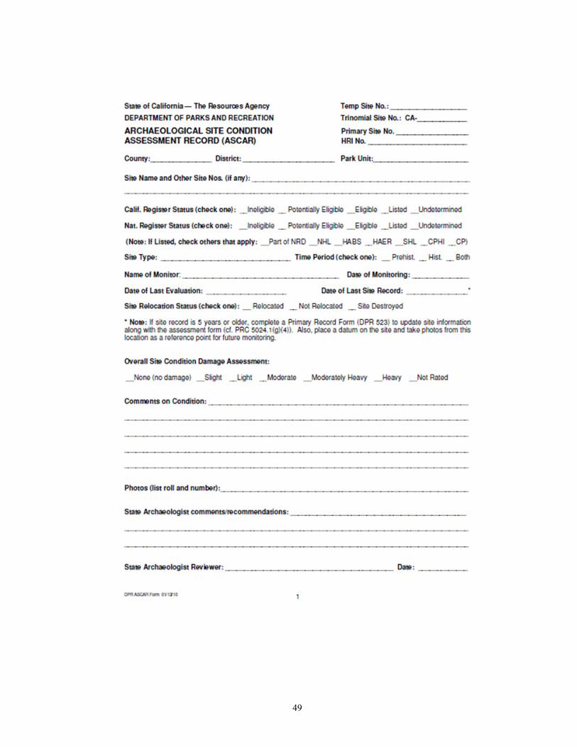
49

50

51

52

53

54

55

56
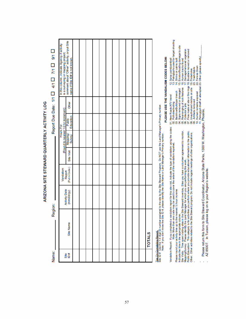
57

58
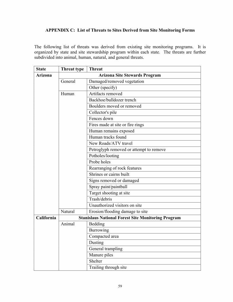
59
APPENDIX C: List of Threats to Sites Derived from Site Monitoring Forms
The following list of threats was derived from existing site monitoring programs. It is organized by state and site stewardship program within each state. The threats are further subdivided into animal, human, natural, and general threats.
State Threat type Threat Arizona Arizona Site Stewards Program
General Damaged/removed vegetation Other (specify)
Human Artifacts removed Backhoe/bulldozer trench Boulders moved or removed Collector's pile Fences down Fires made at site or fire rings Human remains exposed Human tracks found New Roads/ATV travel Petroglyph removed or attempt to remove Potholes/looting Probe holes Rearranging of rock features Shrines or cairns built Signs removed or damaged Spray paint/paintball Target shooting at site Trash/debris Unauthorized visitors on site
Natural Erosion/flooding damage to site California Stanislaus National Forest Site Monitoring Program
Animal Bedding Burrowing Compacted area Dusting General trampling Manure piles Shelter Trailing through site

60
State Threat type Threat Wall rubbing
General Other (note if natural, animal, or human) Human Building material removed
Collector's pile Fire scars, pits, charcoal Rearranging of rock features Roads/trails Slight subsurface disturbance Soil compaction Substantial subsurface disturbance Surface disturbance Trash/debris Undercutting of walls Walls demolished or rebuilt
Natural Arroyo Cutting (cuts more than 100 cm. Deep) Bank slumpage Dune migration Erosion Gullying (cuts 10-100 cm. Deep) Surficial sheet washing Wind deflation
California Archaeological Site Stewardship Program General Damage (non specific) Natural Overgrown Human Fire
Footprints General Trash/debris Vandalized
California State Parks Animal Burrowing General Fire (wildfires, prescribed burns)
Disturbances (new and ongoing) Human Bedrock mortar destruction
Fires (camp) Park construction (multiple categories) Potholes/looting Rock art defacement/removal
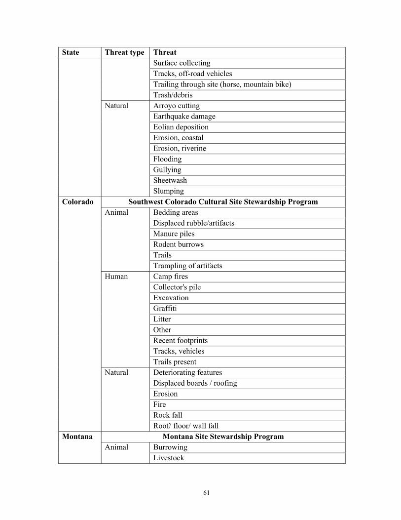
61
State Threat type Threat Surface collecting Tracks, off-road vehicles Trailing through site (horse, mountain bike) Trash/debris
Natural Arroyo cutting Earthquake damage Eolian deposition Erosion, coastal Erosion, riverine Flooding Gullying Sheetwash Slumping
Colorado Southwest Colorado Cultural Site Stewardship Program Animal Bedding areas
Displaced rubble/artifacts Manure piles Rodent burrows Trails Trampling of artifacts
Human Camp fires Collector's pile Excavation Graffiti Litter Other Recent footprints Tracks, vehicles Trails present
Natural Deteriorating features Displaced boards / roofing Erosion Fire Rock fall Roof/ floor/ wall fall
Montana Montana Site Stewardship Program Animal Burrowing
Livestock

62
State Threat type Threat Human Alteration/defacement of________
Broken glass/bottles Camp fires, recent Cans Collector's pile Construction Digging Fireworks Graffiti Recent footprints Recent trash Rock art damage Structural collapse Tracks, off-road vehicles
Natural Riverbank erosion Runoff erosion
New Mexico
SiteWatch Human Backhoe
Bulldozing Collecting Excavation Fence removal Graffiti/tagging Looting Other Other Probing Rock art removal Sign removal Target shooting Vandalism Visitor impacts
Natural
Erosion Other Structural collapse
Northwest New Mexico Site Stewards Human Artifacts removed Backhoe trench

63
State Threat type Threat Bulldozing Bullet holes Fencing down Graffiti, miscellaneous Human remains exposed Other (describe) Potholes Rock art removal Signs removed Spray paint
Santa Fe National Forest Site Stewards Animal Animal activity General Other Human Pot hunting
Project intrusion Recreational use Road construction Surface collecting Vandalism Vehicular
Natural Gully formation Other Sheetwash Structural decay
Texas Texas Archaeological Stewardship Network General Known or Perceived Future Impacts Human Artificial impacts Natural Natural impacts
Utah Utah Site Stewardship Program Animal Bedding areas
Comments Displace rubble Displaced boards / roofing Manure Trails Trampling of artifacts
Human Backhoe trench(es) Bulldozing

64
State Threat type Threat Bullet holes Campfires Collector's pile Comments Fencing down Graffiti Graffiti, miscellaneous Litter Major disturbance Minor disturbance Other (describe) Postholes Potholes Recent footprints Removed artifacts Rock art removal Signs removed Spray paint Trails present Uncovered human remains Vehicle tracks
Natural Deteriorating walls Erosion Floor fall Rock fall Rodent/insect disturbance Roof fall

65
APPENDIX D: Archaeological Site Monitoring and Condition Assessments Baseline Data Gathering – Field Documentation
Guidelines and Instructions A comprehensive site monitoring program begins with collecting baseline data for each site against which to compare the findings of subsequent site visits. Baseline data should include all previous site documentation (site forms, maps, relevant report sections, etc.) as well as an assessment of current site conditions. Previous documentation, particularly an accurate and detailed site map, can aid in site relocation and boundary definition; in locating or re-establishing a permanent datum; in feature relocation; and in determining the extent of previous excavations. If a site map does not exist that shows site boundaries, internal features, or the extent of previous archaeological work at the site, a new map may need to be created prior to or during the baseline visit.
Documentation of current site conditions is important for evaluating changes that have occurred since the sites were last documented as well as providing evidence of past and active impacts or threats to each site. Specific impacts and threats to sites are frequently divided into three broad categories:
• natural processes or environmental dynamics (e.g. erosion, natural fires, tree falls, etc.);
• animal behavior (e.g. burrowing, trampling, trail formation, insect or rodent damage, etc.); and,
• human activities (e.g. vandalism, looting, collecting, vehicle tracks, camping, development, military training, etc.).
The types of impacts or threats present at a site may vary depending on site accessibility; the nature of activities taking place on or in the vicinity of a site; the kinds of cultural remains present at a site, particularly any with a visible component that might attract collectors, looters, or vandals; the depth of deposits at a site; and, the site’s environmental and topographic setting. Sites with surface or shallow subsurface cultural components are more likely to be adversely impacted by natural processes, animal, or human activities, and therefore more likely to lose their integrity, information potential, and eligibility for the NRHP. The follow pages provide blank baseline data gathering and photographic log forms, explanations of the fields used on the forms, and examples of typical impact and threat types.

66
Archaeological Site Monitoring Baseline Data Gathering Form
Site Name or # Recorder(s):
Date:
Current site conditions:
Vegetation:
Surface visibility:
Topography/drainage:
Other (include observations of cultural materials or features):
Specific observed impacts/threats to site
Impact/Threat type & nature (past, active, or potential threat)
Impact Code Photo
Station (PS#)
Distribution (Isolated, random, patterned)
Description/Comments
General threats (note if there is no evidence of threats):
Page# __of Page# __of __

67
Monitoring notes:

68
Archaeological Site Monitoring Photographic Log for Baseline Data Gathering
Site Name or # Datum Recorder(s):
Date
Photo Station (PS#) Loc. /Other Loc.
Direction (azimuth)*
Distance from datum*
Angle from datum*
Description/Comments
* note distance units and method of measurement (direct, GPS, GIS, etc.)
Page#__ of __ Page#__ of __

69
Archaeological Site Monitoring
Baseline Data Gathering Form – User Guide
Field Description Site Name or # Common site name, state trinomial, or other unique identifier. Recorder(s) Names and affiliation of individuals conducting the site visit. Date Date on which site visit occurred (MM/DD/YYYY).
Vegetation Description of vegetation across the site area. (e.g., wooded in mature hardwoods with an open understory of scattered hollies and laurel; or dense scrubland dominated by mesquite trees and prickly pear).
Surface Visibility Description of groundcover and an estimate of surface visibility across the site area.
Topography/drainage Description of landforms, relief, aspect, and drainage patterns across site area.
Other Include observations of the current condition of cultural materials or features exposed at the site. Also include additional environmental description here if needed.
Specific observed impacts/threats to site
This table is intended for documentation of specific impacts or threats observed during the initial baseline data gathering site visit.
Impact/Threat type & nature (past, active, or potential threat)
Enter impact or threat type (e.g., erosion, vandalism, animal burrowing) and whether or not the impact occurred in the past, is actively damaging site, or if current conditions suggest future damage may occur.
Photo Station (PS#) Corresponds to Photo Station Number (PS#) on Photographic Log for Baseline Data Gathering form. Provides provenience information for documented threat.
Distribution (Isolated, random, patterned)
Describe the distribution of the impact(s) or threat(s); single occurrence (isolated) or multiple occurrences [random (tree fall or erosion) or patterned (a series of looter pits)]
Description/Comments Detailed description of threat and addition comments. Also include the frequency of a particular impact or threat type and its extent or dimensions in applicable. Note units of measurement.
General threats
Use this field to describe general or potential threats to the site (e.g., trees at risk of uprooting, nearby logging, easy public access, deteriorating erosion or flood control measures, etc.). Also note if there is no evidence of threats.
Monitoring Notes
Use this field for information specific to the monitoring visit that may be useful to future site monitors (e.g., rationale for number or locations of photo stations, GPS locations, datum relocation information or type used, etc.).
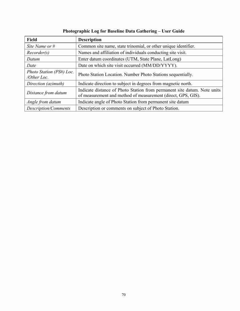
70
Photographic Log for Baseline Data Gathering – User Guide
Field Description Site Name or # Common site name, state trinomial, or other unique identifier. Recorder(s) Names and affiliation of individuals conducting site visit. Datum Enter datum coordinates (UTM, State Plane, LatLong) Date Date on which site visit occurred (MM/DD/YYYY). Photo Station (PS#) Loc. /Other Loc. Photo Station Location. Number Photo Stations sequentially.
Direction (azimuth) Indicate direction to subject in degrees from magnetic north.
Distance from datum Indicate distance of Photo Station from permanent site datum. Note units of measurement and method of measurement (direct, GPS, GIS).
Angle from datum Indicate angle of Photo Station from permanent site datum Description/Comments Description or comments on subject of Photo Station.

71
Archaeological Site Monitoring and Condition Assessments Baseline Data Gathering – Impact Codes, Definitions, and Additional Examples
(note: this list is not all-inclusive, other threats to site integrity may be present based on local conditions)
Code Impact/Threat Type Definition
Environmental Impacts
E1 Surface erosion Movement of soils from a landform by wind, water, or ice action
E2 Displaced vegetation Vegetation uprooted through wind, water, or other action
E3 Tree fall Uprooted tree causing damage and producing craters tree
E4 Fire (natural) Forest fire altering surface artifact scatters or architectural ruins
E5 Water damage Moisture accumulation causing molding or decay of cultural objects
E6 Bank erosion Erosion along the margins of a creek, stream, or river
E7 Flooding Catastrophic water damage that removes vegetation, features, and artifact-bearing deposits or covers a site with additional soil deposits
E8 Gullying Channels cut in the earth by running water
E9 Root damage Breaking, cutting, or drying out of roots
E10 Damaged vegetation Damage to plant leaves, stems, or other plant parts
E11 Freeze/thaw cycle Physical weathering (flaking, cracking) of rocks or soil deposits following freezing and thaw episodes, which may repeat
E12 Rock/roof fall Boulders, cobbles, or roof material (rockshelters) dislocated onto a site, crushing or compacting surface and near surface deposits
E13 Sheetwash A fairly uniform layer of particles removed from an area's entire surface or deposited across an area’s entire surface
E14 Slumping Downward slipping of a mass of rock or loose debris, moving as one or more units; commonly along cliffs and banks
E15 Dune migration Movement of a dune by wind
E16 Earthquake damage Ground cracking, up and down movement of soils, vibration damage, etc.
E99 Other (specify) An environmental impact or threat not specified in the variable list
Animal Impacts A1 Burrowing Holes or tunnels created by subsurface animal movement
A2 Trampling Damage caused by animals, such as cattle, treading across a surface
A3 Trails (deer, etc.) Tracks formed by regular movement of animals through an area
A4 Rodent damage Excludes burrows. Chewing, gnawing, or nesting from site materials
A5 Scat piles Discrete depositions of animal waste
A6 Shelter/den Digging into matrix to create a semi-subterranean living/sleeping areas
A7 Insect damage Chewing or burrowing damage from insects, such as termites
A8 Bird damage Predominately damage from nesting activities or excessive excrement
A9 Bedding areas Large circular areas of compacted vegetation
A10 Dusting Dust create from surface deposits to clean feathers, skin, or fur
A11 Wall rubbing Damage from repeated rubbing/abrading of structural remains
A12 Compacted area An area were animal behavior has compressed soil deposits
A13 Livestock Evidence of livestock grazing in the site area
A14 Displaced artifacts Artifacts moved from their original placement by animal activity
A99 Other (specify) An animal impact or threat not specified in the variable list

72
Human Impacts H1 Vandalism Malicious damage or destruction of archaeological deposits
H2 Excavation (looting) Excavation for the express goal of removing artifacts for personal gain
H3 Metal detecting related Artifacts found through metal detecting but then discarded
H4 Trash/dumping Deposition of trash or garbage, frequently as repeated occurrences
H5 Logging Damage following timber harvesting activities
H6 Fire scars/pits/charcoal Evidence of fires, often from camping or other recreational activities
H7 Graffiti/tagging Scratching, painting, or marking of images or lettering
H8 Vehicle tracks, military (tracked vehicle) Linear ruts formed by a tracked vehicle, with soil displaced on either side of the track
H9 Vehicle tracks, military (wheeled vehicle) Linear ruts formed by a wheeled vehicle, with soil displaced on either side of the track
H10 Trails/paths Unofficial track created by repeated foot traffic
H11 Roads Unofficial track created by repeated vehicle traffic
H12 Artifacts removed Artifacts removed from the surface of an archaeological site
H13 Artifacts displaced Artifacts moved (but not removed) from their original placement on the surface of an archaeological site
H14 Backhoe/bulldozer trench Mechanical excavation of a trench; may be looting related
H15 Surface features displaced Structural remains (walls, etc.) moved from their original placement
H16 Surface features damaged Structural remains (walls, etc.) or features altered by human interactions
H17 Excavation (other) Excavation of soil deposits within a site other than for the purpose of looting, such as pits created as part of recreational activities
H18 Probe holes Holes excavated by looters to find the extent of subsurface features
H19 Vehicle tracks, off-road vehicles
Unofficial Tracks caused by off-road vehicles, usually by recreational activities associated with all-terrain vehicles
H20 Development Construction-related activities within or adjacent to site boundaries
H21 Bullet holes Firearms damage, often from target practice at cultural remains
H22 Building material removed Structural remains removed from an archaeological site
H23 Artifact/Collector's pile Artifacts displaced from their original locations to a centralized point
H24 Fencing down/ removed Destruction/removal of fencing used to protect/control site access
H25 Footprints Human footprints present in restricted site areas
H26 Signs damaged/ removed Destruction/removal of signs used to protect/control site access
H27 Rock art damaged/ removed Destruction or removal of American Indian or other rock art
H99 Other (specify) A human impact or threat not specified in the variable list
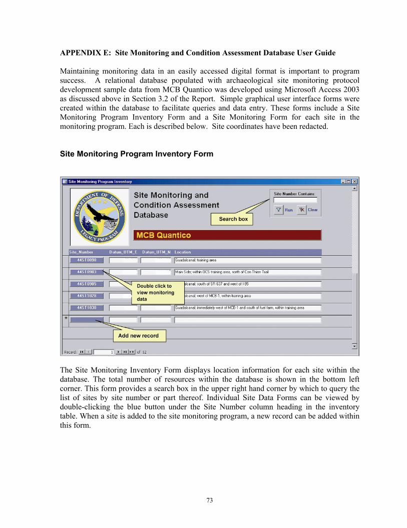
73
APPENDIX E: Site Monitoring and Condition Assessment Database User Guide Maintaining monitoring data in an easily accessed digital format is important to program success. A relational database populated with archaeological site monitoring protocol development sample data from MCB Quantico was developed using Microsoft Access 2003 as discussed above in Section 3.2 of the Report. Simple graphical user interface forms were created within the database to facilitate queries and data entry. These forms include a Site Monitoring Program Inventory Form and a Site Monitoring Form for each site in the monitoring program. Each is described below. Site coordinates have been redacted. Site Monitoring Program Inventory Form
The Site Monitoring Inventory Form displays location information for each site within the database. The total number of resources within the database is shown in the bottom left corner. This form provides a search box in the upper right hand corner by which to query the list of sites by site number or part thereof. Individual Site Data Forms can be viewed by double-clicking the blue button under the Site Number column heading in the inventory table. When a site is added to the site monitoring program, a new record can be added within this form.

74
Site Monitoring Form The Site Monitoring Form displays detailed information on each monitoring visit made to a particular site. The form contains a series of tabs with sub-forms including: Site Data – Displays general site information including a brief site description, size, and location.

75
Monitor Visits – Lists monitoring visits by date, recorder, and type (e.g. baseline or follow-up). Double clicking the Visit ID button opens a Monitor Visit Details form.
Click to view Monitor Visit Details Form

76
Monitor Visit Details – Displays information pertaining to the current environmental conditions of a site during the monitoring visit as well as general notes on impacts, threats, and any information pertaining to the monitoring process (i.e., conditions effecting the visit or particulars of datum placement).

77
Impact Inventory – Lists individual impacts and/or threats to site by date recorded and type. Alphanumeric codes are provided as a means of keying specific impacts to the site map. Impact Codes can be selected from a drop-down list within the field. Impact Agent and Impact Type are automatically entered based on the selected Impact Code. A list of codes and their definitions can be viewed by clicking the command button at the bottom of the form.
Photo Log – Lists photographs or digital images taken of the site listed by Photo Station number, date, and location relative to site datum.

78
Instructions for adding hyperlinks to photographs (digital image files): Navigate to the Site Monitoring Form for a particular resource and click on the Photo Log tab. Place the cursor within the “Photo_Image” field and select from the MS Access menu bar: Insert/Hyperlink (or Ctrl+K) and navigate to the location of the image file to be inserted. The image file and database must reside on the same machine or server.

79
Appendix F: Archaeological Site Monitoring and Condition Assessments
Follow-Up Monitoring - Field Documentation Guidelines and Instructions
A comprehensive site monitoring program begins with professional archaeologists collecting baseline data for each site against which to compare the findings of subsequent monitoring visits. These data have already been collected and are included in the packet of information provided.
The following is a list of tasks that must be completed as part of this monitoring visit:
• Site relocation (including relocation of datum established during baseline survey)
• Documentation of current site conditions (vegetation, surface visibility, observations of cultural materials or features)
• Assessment of past, active, and potential impacts or threats to the site (disturbances caused by environmental processes, animal behavior, and human activities)
• Photographic documentation using established photographic stations (note: new photographs should only be taken if necessary, i.e., if there have been significant changes to the site such as new disturbances, substantial changes to existing disturbances, &c.)
If the site appears to be in the same condition as documented in the baseline data, there is no need to fully complete the monitoring form or take additional photographs; the monitoring visit is complete. Fill out the top portion of the form (everything above the table) and make sure to check the box that indicates: “Site appears largely unchanged since last visit.” If changes are observed to previously recorded disturbances, or if new impacts are visible, this form must be completed in its entirety and new photographs taken. The new photographs should be keyed to existing photographic stations when possible, or new photographic stations may be needed. Clearly indicate any new photographic stations on the site map. If the site is significantly disturbed, beyond what can be reasonably documented by this monitoring form, fill out the top portion of the form (everything above the tables) and make sure to check the box that indicates: “Significant impacts since last visit and a new baseline should be established for the site.” Complete the monitoring form and take sufficient photographs documenting this damage to aid professional archaeologists with determining what course of action is needed with respect to the documented impacts. Take photographs and link them to existing photographic stations or establish new photographic stations if necessary. These guidelines and instructions contain the following information for your reference:
• Archaeological Site Monitoring Form – User Guide provides explanations of the fields used on the monitoring form. Typical impacts are anticipated as a part of this

80
form, however, a list of additional impacts that may prove relevant, and their definitions, are also provided as part of the user guide to aid in your observations.
• Photographic Log Form– User Guide provides explanations of the fields used on the photographic log form.
• Site Monitoring – Impact Codes, Definitions, and Additional Examples provides definitions for the common impacts referenced on the monitoring form as well as additional examples to be used as needed. Some impacts may cause damage to a site or its environs on multiple levels, and each impact should be noted. For example, a flooding episode could uproot trees. In this case, both the flooding code (E7) and the tree fall code (E3) would be used and keyed to the appropriate photographic stations.
Archaeological Site Monitoring Form – User Guide
Field Description
Site Number Trinomial number (e.g., 44ST0302, 44PW1115), or other unique identifier.
Today’s Date Date on which site visit occurred (MM/DD/YYYY).
Recorder(s) Names and affiliation of individuals conducting the site visit.
Total time on site Time spent on monitoring the site (in minutes).
Date of last visit Date on which last site visit occurred (MM/DD/YYYY).
Current Site Conditions:
Vegetation and surface visibility Description of vegetation (e.g., wooded in mature hardwoods with an open midstory of scattered hollies and laurel); and description of groundcover and an estimate of surface visibility (e.g., surface visibility 25% due to thick pine needles and fallen leaves).
Other Include any relevant observations of the current condition of cultural materials or features exposed at the site. Also include additional environmental description here as appropriate.
Summary Observations:
Site appears largely unchanged since last visit Check this box if there are NO CHANGES in current site condition from previous visit
Impacts noted in last visit continue to be active, but no new impacts
Check this box if previously documented impacts continue to disturb the site (some change from pre-existing impacts , but no new impacts)
Significant impacts since last visit and new baseline should be established
Check this box if the condition of the site is significantly impacted from previous visit to the extent that new baseline data needs to be recorded.
Specific observed impacts/threats to site
Impact Code Code tied to specific impacts sorted by general type (environmental, animal, human). A list of additional impacts is included as part of this guide and should be referenced as appropriate.
Impact/Threat type Descriptive name of impacts sorted by general type (environmental, animal, human).
Impact/Threat type & nature (past, active, or potential)
Is the impact past (e.g. flood damage or tree fall) actively damaging the site (e.g. animal burrowing or erosion), or do current conditions suggest future damage may occur (e.g. metal detecting on a Civil War site, development)?
Distribution Describe the spatial distribution of the impact(s); isolated (single occurrence), random (e.g., tree fall, animal burrowing), or patterned (e.g., a series of looter pits)
Photo Station (PS#) Corresponds to Photo Station Number (PS#) on Photographic Log.
Notes Detailed description of impacts and/or addition comments (identify by Impact Code). Also can include the extent or dimensions and units of measurement as applicable.

81
Photographic Log for Site Monitoring Visit – User Guide Note: Photographs only need to be taken if new disturbances or substantial changes to
existing disturbances are observed (creating new photo stations as necessary).
Field Description
Site Number State trinomial, or other unique identifier.
Recorder(s) Names and affiliation of individuals conducting site visit.
Datum Enter datum coordinates (UTM, State Plane, Lat/Long)
Date Date on which site visit occurred (MM/DD/YYYY).
Photo Station (PS#) Loc. /Other Loc. Photo Station Location. Number Photo Stations sequentially.
Direction (azimuth) Indicate direction to subject in degrees from magnetic north.
Distance from datum Indicate distance of Photo Station from permanent site datum. Note units of measurement and method of measurement (direct, GPS, GIS).
Angle from datum Indicate angle of Photo Station from permanent site datum
Description/Comments Description or comments on subject of Photo Station.
Site Monitoring – Impact Codes and Definitions (note: this list is not all-inclusive, other threats to site integrity may be present based on local
conditions)
Code Impact/Threat Type Definition
Environmental Impacts
E1 Surface erosion Transport of soils from a landform by wind, water, or ice action
E2 Displaced vegetation Vegetation uprooted through wind, water, or other action
E3 Tree fall Uprooted tree causing damage and producing craters tree
E4 Fire (natural) Forest fire altering surface artifact scatters or architectural ruins
E5 Water damage Moisture accumulation causing molding or decay of cultural objects
E6 Bank erosion Erosion along the margins of a creek, stream, or river
E7 Flooding Catastrophic water damage that removes vegetation, features, and artifact-bearing deposits or covers a site with additional soil deposits
E8 Gullying Channels cut in the earth by running water
E9 Root damage Breaking, cutting, or desiccation of roots
E10 Damaged vegetation Damage to plant leaves, stems, or other plant parts
E11 Freeze/thaw cycle Physical weathering (exfoliation, cracking) of rocks or soil deposits following freezing and thaw episodes, which may repeat
E12 Rock/roof fall Boulders, cobbles, or roof material (rockshelters) dislocated onto a site, crushing or compacting surface and near surface deposits
E13 Sheetwash A fairly uniform layer of particles removed from an area's entire surface or deposited across an area’s entire surface
E14 Slumping Downward slipping of a mass of rock or unconsolidated debris, moving as one or more units; commonly along cliffs and banks
E15 Dune migration Movement of a dune through interaction of sand deposits and the wind
E16 Earthquake damage Ground cracking, horizontal and vertical displacement of soils, vibration damage, etc.

82
Code Impact/Threat Type Definition
E99 Other (specify) An environmental impact or threat not specified in the variable list
Animal Impacts
A1 Burrowing Holes or tunnels created by subsurface animal movement
A2 Trampling Damage caused by animals, such as cattle, treading across a surface
A3 Trails (deer, etc.) Tracks formed by regular movement of animals through an area
A4 Rodent damage Excludes burrows. Chewing, gnawing, or nesting from site materials
A5 Scat piles Discrete depositions of animal waste
A6 Shelter/den Digging into matrix to create a semi-subterranean living/sleeping areas
A7 Insect damage Chewing or burrowing damage from insects, such as termites
A8 Bird damage Predominately damage from nesting activities or excessive excrement
A9 Bedding areas Large circular areas of compacted vegetation
A10 Dusting Dust created from surface deposits to clean feathers, skin, or fur
A11 Wall rubbing Damage from repeated rubbing/abrading of structural remains
A12 Compacted area An area were animal behavior has compressed soil deposits
A13 Livestock Evidence of livestock grazing in the site area
A14 Displaced artifacts Artifacts moved from their original placement by animal activity
A99 Other (specify) An animal impact or threat not specified in the variable list
Human Impacts
H1 Vandalism Malicious damage or destruction of archaeological deposits
H2 Excavation (looting) Excavation for the express goal of removing artifacts for personal gain
H3 Metal detecting related Artifacts found through metal detecting but then discarded
H4 Trash/dumping Deposition of trash or garbage, frequently as repeated occurrences
H5 Logging Damage following timber harvesting activities
H6 Fire scars/pits/charcoal Evidence of fires, often from camping or other recreational activities
H7 Graffiti/tagging Scratching, painting, or marking of images or lettering
H8 Vehicle tracks, military (tracked vehicle) Linear ruts formed by a tracked vehicle, with soil displaced on either side of the track
H9 Vehicle tracks, military (wheeled vehicle) Linear ruts formed by a wheeled vehicle, with soil displaced on either side of the track
H10 Trails/paths Unofficial track created by repeated foot traffic
H11 Roads Unofficial track created by repeated vehicle traffic
H12 Artifacts removed Artifacts removed from the surface of an archaeological site
H13 Artifacts displaced Artifacts moved (but not removed) from their original placement on the surface of an archaeological site
H14 Backhoe/bulldozer trench Mechanical excavation of a trench; may be looting related
H15 Surface features displaced Structural remains (walls, etc.) moved from their original placement
H16 Surface features damaged Structural remains (walls, etc.) or features altered by human interactions
H17 Excavation (other) Excavation of soil deposits within a site other than for the purpose of looting, such as pits

83
created as part of recreational activities
H18 Probe holes Holes excavated by looters to find the extent of subsurface features
H19 Vehicle tracks, off-road vehicles
Unofficial Tracks caused by off-road vehicles, usually by recreational activities associated with all-terrain vehicles
H20 Development Construction-related activities within or adjacent to site boundaries
H21 Bullet holes Firearms damage, often from target practice at cultural remains
H22 Building material removed Structural remains removed from an archaeological site
H23 Artifact/Collector's pile Artifacts displaced from their original locations to a centralized point
H24 Fencing down/ removed Destruction/removal of fencing used to protect/control site access
H25 Footprints Human footprints present in restricted site areas
H26 Signs damaged/ removed Destruction/removal of signs used to protect/control site access
H27 Rock art damaged/ removed Destruction or removal of American Indian or other rock art
H99 Other (specify) A human impact or threat not specified in the variable list
Note: All information provided to and generated by monitors (including, but not limited to, site location information, site descriptions, reports, maps, and photographs) are the property of the agency administering the site. It is imperative that monitors hold program data in strict confidence. Collecting artifacts is outside the regular scope of this monitoring program. Therefore, monitors should not collect any artifacts from lands they will be monitoring unless explicitly directed to do so by a cultural resources specialist working with the program.

84
Archaeological Site Follow-Up Monitoring Form Confidential Information
Site Number Date:
Recorder: Total time on site:
Date of last visit:
Current site conditions: Vegetation & surface visibility:
Summary observations (check only one): Site appears largely unchanged since last visit Some new impacts, recorded on this form and with new photographs/photo log
Impacts noted in last visit continue to be active but no new impact(s) Significant impacts since last visit and a new baseline should be established for the site
Other monitoring notes (include observations of cultural materials or features):
**See user guide for additional impact codes. If there is more than one instance of an impact that need photo documentation, use separate lines & indicate as (Code)-observation#, e.g. E1-1, E1-2, etc.
Impact Code Impact/Threat Type
Impact/Threat Nature Distribution Photo Station Notes (Identify by Impact Code)
Past Active Potential Isolated Random Patterned
Environmental Impacts
E1 surface erosion
E2 displaced vegetation
E3 tree fall
E4 fire (natural)
E5 root damage
E_____
E_____
E_____
E_____
Page# __of__ Page# __of__
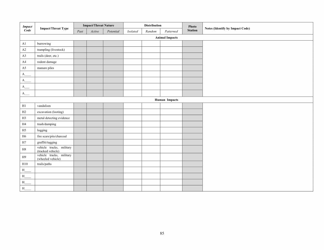
85
Impact Code Impact/Threat Type
Impact/Threat Nature Distribution Photo Station Notes (Identify by Impact Code)
Past Active Potential Isolated Random Patterned
Animal Impacts
A1 burrowing
A2 trampling (livestock)
A3 trails (deer, etc.)
A4 rodent damage
A5 manure piles
A____
A____
A___
A___
Human Impacts
H1 vandalism
H2 excavation (looting)
H3 metal detecting evidence
H4 trash/dumping
H5 logging
H6 fire scars/pits/charcoal
H7 graffiti/tagging
H8 vehicle tracks, military (tracked vehicle)
H9 vehicle tracks, military (wheeled vehicle)
H10 trails/paths
H____
H____
H____
H____

86
Archaeological Site Monitoring Baseline Data Gathering Form
Site Name or # 44PW917 Recorder(s): C. Bowen
D. Knepper
Date:
4/9/2009
Current site conditions:
Vegetation: Wooded in mature hardwoods with an open understory with scattered hollies.
Surface visibility: Ground surface is covered in leaves with 30-40% exposed topsoil; heavy pebble content.
Topography/drainage: Site occupies western slope of a south-trending ridge. Site area drains to the west toward the Creek.
Other (include observations of cultural materials or features): Hut pit features are clearly visible throughout site area.
Specific observed impacts/threats to site Impact/Threat type & nature (past, active, or potential threat)
Photo Station (PS#)
Distribution (Isolated, random, patterned)
Description/Comments
Looter’s pit (recent) PS1 isolated
Looter’s pit excavated within hut pit. Appears shovel-excavated; backdirt pile is visible, exposed. Discarded bottle fragments on ground surface adjacent to pit – placed back into hut pit by recorders. Lack of weathering and infill suggests this is recent activity (w/in a year). Pit measures 6-x-5-x-3 feet.
Looter’s pit (recent) PS2 isolated Looter’s pit within hut pit. Also appears recent. Pit measures 3-x-3-x-3 feet.
Looter’s pit (recent) PS3 isolated Looter’s pit excavated on top of ridge adjacent to shallow pit – either hut feature or older looter pit. Pit measures 2.5-x-2.5-x-1 feet.
Tree falls n/a random
Recent and older falls contribute to infilling of hut features. Also uprooted trees can displace soil from a feature and create pits that promote erosion.
Erosion PS7 PS8 isolated
Exposed earthen berm adjacent to a row of hut pits is promoting erosion of the hut pits into a gully. Berm may be backfill from hut pits. Affected area measures 50-x-15-x-2-3 feet.
Page# 1 of 2 Page# 1 of 2
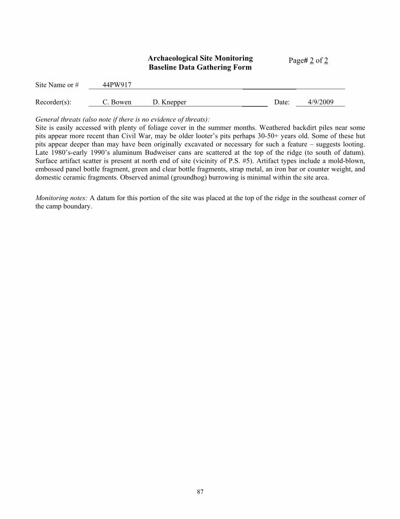
87
Archaeological Site Monitoring Baseline Data Gathering Form
Site Name or # 44PW917 Recorder(s): C. Bowen
D. Knepper
Date:
4/9/2009
General threats (also note if there is no evidence of threats): Site is easily accessed with plenty of foliage cover in the summer months. Weathered backdirt piles near some pits appear more recent than Civil War, may be older looter’s pits perhaps 30-50+ years old. Some of these hut pits appear deeper than may have been originally excavated or necessary for such a feature – suggests looting. Late 1980’s-early 1990’s aluminum Budweiser cans are scattered at the top of the ridge (to south of datum). Surface artifact scatter is present at north end of site (vicinity of P.S. #5). Artifact types include a mold-blown, embossed panel bottle fragment, green and clear bottle fragments, strap metal, an iron bar or counter weight, and domestic ceramic fragments. Observed animal (groundhog) burrowing is minimal within the site area.
Monitoring notes: A datum for this portion of the site was placed at the top of the ridge in the southeast corner of the camp boundary.
Page# 2 of 2 Page# 2 of 2

88
APPENDIX G: Example of Baseline Data and Forms Archaeological Site Monitoring
Photographic Log for Baseline Data Gathering
Site Name or # 44PW917 Datum UTM: Recorder(s):
C. Bowen D. Knepper
Date
4/9/2009
Photo Station (PS#) Loc. /Other Loc.
Direction (azimuth)*
Distance from datum*
Angle from datum*
Description/Comments
PS1 75º 50m 350º looters’ pit/artifact pile
PS1-2 n/a 50m 350º 2 additional photos – detail of artifacts and second image across backdirt pile
PS2 140º 35m 265º looter’s pit, no artifacts PS3 345º 65m 165º looter’s pit, small, no artifacts PS3-2 250º 65m 165º same looter’s pit PS4 310º 55m 275º general context PS4-2 10º 55m 275º general context PS4-3 50º 55m 275º general context PS4-4 110º 55m 275º general context PS5 175º 85m 355º general context PS5-2 220º 85m 355º general context
PS5-3 220º 85m 355º general context, same as previous but portrait orientation
PS6 90º 60m 350º tree disturbance in shallow hut pit PS7 210º 50m 340º linear erosion threat PS8 60º 40m 320º series of hut pits on slope, erosion threat PS8-2 40º 40m 320º series of hut pits on slope, erosion threat PS9 85º 60m 300º series of hut pits PS9-2 130º 60m 300º series of hut pits PS9-3 220º 60m 300º series of hut pits
* angles are directly measured; distances are estimates based on GPS readings as plotted in GIS
Page# 1 of 1 Page# 1 of 1

89
Sample Baseline Data Gathering Photo Station Images
Figure B-1. 44PW917, Photo Station 1 (PS1), Recent Looter’s Pit
Figure B-2. 44PW917, Photo Station 9 (PS9), Series of Hut Pit Features

90
Figure B-3. 44PW917, Site Map Showing Data Points Collected During
Baseline Monitoring.

91
APPENDIX H: Example of Follow-Up Monitoring Data and Forms
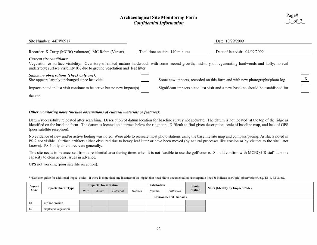
Archaeological Site Monitoring Form Confidential Information
92
Page# _1_of_2_
Site Number: 44PW0917 Date: 10/29/2009
Recorder: K Curry (MCBQ volunteer), MC Rohm (Versar) Total time on site: 140 minutes
Date of last visit: 04/09/2009
Current site conditions: Vegetation & surface visibility: Overstory of mixed mature hardwoods with some second growth; midstory of regenerating hardwoods and holly; no real understory; surface visibility 0% due to ground vegetation and leaf litter.
Summary observations (check only one): Site appears largely unchanged since last visit Some new impacts, recorded on this form and with new photographs/photo log
Impacts noted in last visit continue to be active but no new impact(s) Significant impacts since last visit and a new baseline should be established for
the site
Other monitoring notes (include observations of cultural materials or features):
Datum successfully relocated after searching. Description of datum location for baseline survey not accurate. The datum is not located at the top of the ridge as identified on the baseline form. The datum is located on a terrace below the ridge top. Difficult to find given description, scale of baseline map, and lack of GPS (poor satellite reception).
No evidence of new and/or active looting was noted. Were able to recreate most photo stations using the baseline site map and compass/pacing. Artifacts noted in PS 2 not visible. Surface artifacts either obscured due to heavy leaf litter or have been moved (by natural processes like erosion or by visitors to the site – not known). PS 5 only able to recreate generally.
This site needs to be accessed from a residential area during times when it is not feasible to use the golf course. Should confirm with MCBQ CR staff at some capacity to clear access issues in advance.
GPS not working (poor satellite reception).
**See user guide for additional impact codes. If there is more than one instance of an impact that need photo documentation, use separate lines & indicate as (Code)-observation#, e.g. E1-1, E1-2, etc.
Impact Code Impact/Threat Type
Impact/Threat Nature Distribution Photo Station Notes (Identify by Impact Code)
Past Active Potential Isolated Random Patterned
Environmental Impacts
E1 surface erosion
E2 displaced vegetation
X
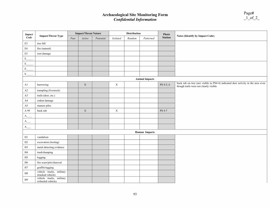
Archaeological Site Monitoring Form Confidential Information
93
Page# _1_of_2_
Impact Code Impact/Threat Type
Impact/Threat Nature Distribution Photo Station Notes (Identify by Impact Code)
Past Active Potential Isolated Random Patterned
E3 tree fall
E4 fire (natural)
E5 root damage
E_____
E_____
E_____
E_____
Animal Impacts
A1 burrowing X X PS 4-5, 6 buck rub on tree (not visible in PS4-4) indicated deer activity in the area even though trails were not clearly visible
A2 trampling (livestock)
A3 trails (deer, etc.)
A4 rodent damage
A5 manure piles
A 99 buck rub X X PS 4-7
A____
A___
A___
Human Impacts
H1 vandalism
H2 excavation (looting)
H3 metal detecting evidence
H4 trash/dumping
H5 logging
H6 fire scars/pits/charcoal
H7 graffiti/tagging
H8 vehicle tracks, military (tracked vehicle)
H9 vehicle tracks, military (wheeled vehicle)

Archaeological Site Monitoring Form Confidential Information
94
Page# _1_of_2_
Impact Code Impact/Threat Type
Impact/Threat Nature Distribution Photo Station Notes (Identify by Impact Code)
Past Active Potential Isolated Random Patterned
H10 trails/paths
H____
H____
H____
H____

95
Archaeological Site Monitoring Photographic Log
Site Name or # 44PW0917 Datum UTM: Recorder(s):
K Curry, MC Rohm
Date
10/29/2009
Photo Station (PS#) Loc. /Other Loc.
Direction (azimuth)*
Distance from
datum*
Angle from
datum*
Description/Comments
PS 4-5 75 55m 275 active rodent burrowing at PS 4 PS 4-6 220 55m 275 active rodent burrowing at PS 4 PS 4-7 110 55m 275 buck rub – not visible in baseline PS 4-4
* note distance units and method of measurement (direct, GPS, GIS, etc.)
Page#_2_ of _2

96
Sample Baseline Data Gathering Photo Station Images
Figure C-1. 44PW917, Photo Station 4 (PS4-6), Active Rodent Burrowing Visible in vicinity of
PS 4
Figure C-2. 44PW917, Photo Station 4 (PS4-7) Buck Rub not Visible in Baseline (PS 4-4)

97
APPENDIX I: Site Monitoring Program Code of Ethics and Conduct The following ethics code of conduct is based on volunteer training manuals developed by SHPOs in Arizona and New Mexico (AZSHPO 2009, NMHPD 2009). It is essential that all non-professional archaeologists working and/or volunteering for any site monitoring program follow a code of ethics and conduct. Generally, this means accepting a special responsibility towards unique and often fragile archaeological resources. It also requires the acceptance of cultural resource management law, a strict code of ethics, and, particularly in the case of volunteers, adherence to code of conduct. This insures the appropriate treatment and protection of not only the archaeological resources but all personnel involved in the reprocess. The chief objective of any monitoring program is to prevent destruction of archaeological sites and to uphold all state and federal preservation (antiquity) laws. Therefore, all non-archaeologist employees and volunteers must be guided by a preservation ethic. It should be stressed that monitoring and non-collective surface investigation will be the only investigative methods used by the monitoring program. Participants must hold archaeological site location information in strict confidence due to legislated restrictions of site location information and that it will be made available only to the appropriate authority responsible for administering the lands involved. It is recommended that this agreement be signed by every non-archeologist site monitoring participants. Minimally, however, this document needs to be reviewed and signed by all volunteers. Adoption of this Code of Ethics and Conduct indicates agreement that the following rules will be observed: Site Monitors Shall: • Comply with Preservation Laws
Monitors shall comply with all Federal, State and local antiquity laws and regulations. • Respect the Public
Monitors shall be courteous on public lands and respect private property. • Respect All Involved Personnel
Monitors shall work with and be respectful of all federal personnel as well as any designated outside parties that may provide oversight for the monitoring program.
• Hold Site Information Confidential
Monitors shall not share site information with anyone outside the program; nor shall they put site location information on the Internet.
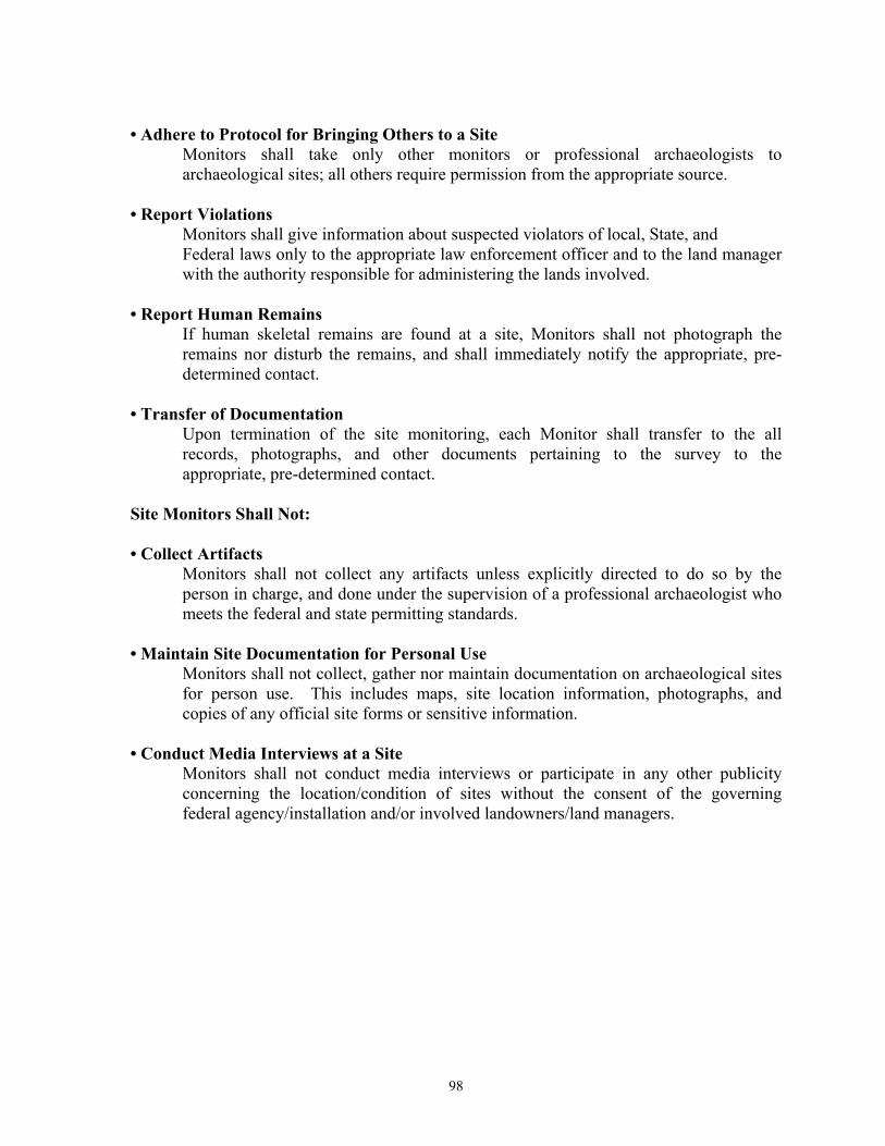
98
• Adhere to Protocol for Bringing Others to a Site
Monitors shall take only other monitors or professional archaeologists to archaeological sites; all others require permission from the appropriate source.
• Report Violations
Monitors shall give information about suspected violators of local, State, and Federal laws only to the appropriate law enforcement officer and to the land manager with the authority responsible for administering the lands involved.
• Report Human Remains
If human skeletal remains are found at a site, Monitors shall not photograph the remains nor disturb the remains, and shall immediately notify the appropriate, pre-determined contact.
• Transfer of Documentation
Upon termination of the site monitoring, each Monitor shall transfer to the all records, photographs, and other documents pertaining to the survey to the appropriate, pre-determined contact. Site Monitors Shall Not: • Collect Artifacts
Monitors shall not collect any artifacts unless explicitly directed to do so by the person in charge, and done under the supervision of a professional archaeologist who meets the federal and state permitting standards.
• Maintain Site Documentation for Personal Use
Monitors shall not collect, gather nor maintain documentation on archaeological sites for person use. This includes maps, site location information, photographs, and copies of any official site forms or sensitive information.
• Conduct Media Interviews at a Site
Monitors shall not conduct media interviews or participate in any other publicity concerning the location/condition of sites without the consent of the governing federal agency/installation and/or involved landowners/land managers.

99
SIGNOFF SHEET
The following personnel have read and understand the Code of Ethics:
NAME SIGNATURE DATE