Department of Community Development - Cedar-Rapids.org
84
submitted to December 15 th 2020 submitted by Burlington, Vermont www.craneassociates.us Department of Community Development
-
Upload
khangminh22 -
Category
Documents
-
view
0 -
download
0
Transcript of Department of Community Development - Cedar-Rapids.org

submitted to
December 15th 2020 submitted by
Burlington, Vermont www.craneassociates.us OCTOBER 28TH 2020
Department of
Community Development

1
Table of Contents
Chapter 1 Introduction __________________________________________________________________________________________________________________________ 1-1
Acknowledgements ______________________________________________________________________________________________________________________________________ 1-2
Chapter 2 The Cedar River _______________________________________________________________________________________________________________________ 2-4
The Watershed __________________________________________________________________________________________________________________________________________ 2-4
Water Quality ___________________________________________________________________________________________________________________________________________ 2-4
Hydrology ______________________________________________________________________________________________________________________________________________ 2-5
Chapter 3 Study Area ___________________________________________________________________________________________________________________________ 3-7
Upper Reach ____________________________________________________________________________________________________________________________________________ 3-7
Urban Reach ___________________________________________________________________________________________________________________________________________ 3-11
Five in One Dam ________________________________________________________________________________________________________________________________________ 3-14
Lower Reach ___________________________________________________________________________________________________________________________________________ 3-18
C-Street Roller Dam _____________________________________________________________________________________________________________________________________ 3-20
Chapter 4 The Market _________________________________________________________________________________________________________________________ 4-23
The Market Area _______________________________________________________________________________________________________________________________________ 4-23
Regional Demographics __________________________________________________________________________________________________________________________________ 4-23
Existing Supply of Whitewater Parks _______________________________________________________________________________________________________________________ 4-24
Regional Paddlers Survey ________________________________________________________________________________________________________________________________ 4-25
Paddler Participation Rates _______________________________________________________________________________________________________________________________ 4-27
Capture Rates __________________________________________________________________________________________________________________________________________ 4-28
Secondary Market Conditions _____________________________________________________________________________________________________________________________ 4-30

2
Total Estimated Economic Contributions ____________________________________________________________________________________________________________________ 4-31 Project Comparison ______________________________________________________________________________________________________________________________________________________ 4-36
Chapter 5 The People __________________________________________________________________________________________________________________________ 5-37
Public Survey __________________________________________________________________________________________________________________________________________ 5-37
Local Preferences and Perspectives on the Cedar River _________________________________________________________________________________________________________ 5-37
Summary of Key Findings ________________________________________________________________________________________________________________________________ 5-40
Recreation User Groups __________________________________________________________________________________________________________________________________ 5-41 Whitewater Paddlers _____________________________________________________________________________________________________________________________________________________ 5-42 Float Through Navigation _________________________________________________________________________________________________________________________________________________ 5-42 Passive River Users ______________________________________________________________________________________________________________________________________________________ 5-43
Designing for Key Stakeholders ____________________________________________________________________________________________________________________________ 5-43 The City of Cedar Rapids __________________________________________________________________________________________________________________________________________________ 5-43 Anglers and Fisheries Managers ____________________________________________________________________________________________________________________________________________ 5-45 Non-Motorized Recreational Boaters ________________________________________________________________________________________________________________________________________ 5-46 ______________________________________________________________________________________________________________________________________________________________________ 5-47 Motorized Boats and Jet Skis ______________________________________________________________________________________________________________________________________________ 5-47
Chapter 6 River Recreation Opportunities _________________________________________________________________________________________________________ 6-48
Location ______________________________________________________________________________________________________________________________________________ 6-48
Key Factors to Success ___________________________________________________________________________________________________________________________________ 6-49 C Street Dam Mitigation __________________________________________________________________________________________________________________________________________________ 6-49 Commercial Outfitter: ____________________________________________________________________________________________________________________________________________________ 6-49 Design for Spectators: ____________________________________________________________________________________________________________________________________________________ 6-49 Maintain the Upstream Pool: ______________________________________________________________________________________________________________________________________________ 6-49 Complimentary Activities _________________________________________________________________________________________________________________________________________________ 6-50
Concept Designs ________________________________________________________________________________________________________________________________________ 6-50
Alternative #1 Bypass Channel Around the 5 in 1 Dam _________________________________________________________________________________________________________ 6-50
Alternative #2 Combined Channel Through 5 in 1 Dam _________________________________________________________________________________________________________ 6-56
Alternative #3 Separated Channels Through 5 in 1 Dam ________________________________________________________________________________________________________ 6-63
Cost __________________________________________________________________________________________________________________________________________________ 6-70

3
Chapter 7 Recommendations ____________________________________________________________________________________________________________________ 7-71
Recommendation1: Pursue Alternative Concept Design #3: _____________________________________________________________________________________________________ 7-71
Recommendation 2: Develop a Business and Operations Plan ___________________________________________________________________________________________________ 7-71
Recommendation 3: Develop Phase Two Design Specifications and Cost Estimates __________________________________________________________________________________ 7-71
Recommendation 4: Develop a Fundraising Committee and Strategic Plan _________________________________________________________________________________________ 7-71
Recommendation 5: Mitigate or Remove C-Street Roller Dam ___________________________________________________________________________________________________ 7-72
Recommendation 6: Design for the Secondary Market _________________________________________________________________________________________________________ 7-73 Artificial Climbing Wall ___________________________________________________________________________________________________________________________________________________ 7-73 Relocate the Skate Park___________________________________________________________________________________________________________________________________________________ 7-73 Obstacle Course _________________________________________________________________________________________________________________________________________________________ 7-73 Spectator Amenities: _____________________________________________________________________________________________________________________________________________________ 7-73 Beach and passive streamside design near McGrath Amphitheater________________________________________________________________________________________________________________ 7-74 Water Taxi’s / Tourist Gondola: ____________________________________________________________________________________________________________________________________________ 7-74 Integrate First and First West Development: __________________________________________________________________________________________________________________________________ 7-74 Install Water Art in the River: ______________________________________________________________________________________________________________________________________________ 7-74
Recommendation 7: Increase Public Awareness and Involvement: _______________________________________________________________________________________________ 7-75 Promotional Video_______________________________________________________________________________________________________________________________________________________ 7-75 Front porch network _____________________________________________________________________________________________________________________________________________________ 7-75 Poster displays in public places: ____________________________________________________________________________________________________________________________________________ 7-75 Postcard mailings________________________________________________________________________________________________________________________________________________________ 7-75
Chapter 8 Roadmap for Implementation ___________________________________________________________________________________________________________ 8-1
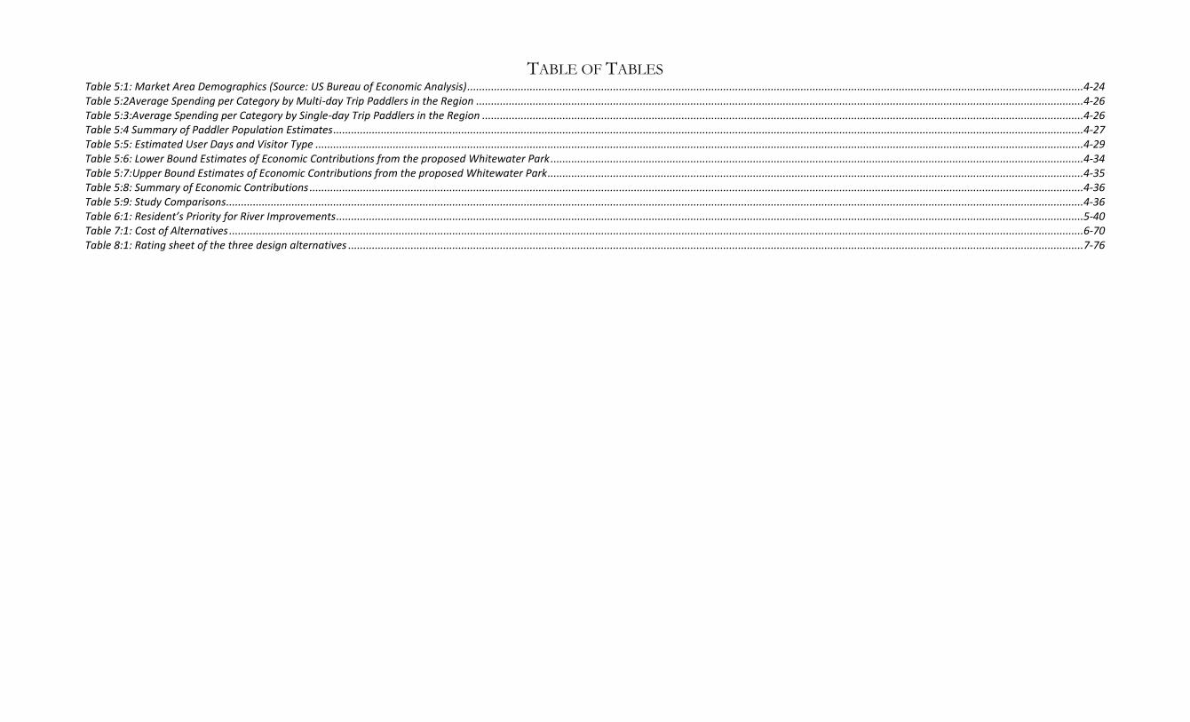
TABLE OF TABLES Table 5:1: Market Area Demographics (Source: US Bureau of Economic Analysis) ...............................................................................................................................................................................................................4-24 Table 5:2Average Spending per Category by Multi-day Trip Paddlers in the Region ............................................................................................................................................................................................................4-26 Table 5:3:Average Spending per Category by Single-day Trip Paddlers in the Region ..........................................................................................................................................................................................................4-26 Table 5:4 Summary of Paddler Population Estimates ............................................................................................................................................................................................................................................................4-27 Table 5:5: Estimated User Days and Visitor Type ..................................................................................................................................................................................................................................................................4-29 Table 5:6: Lower Bound Estimates of Economic Contributions from the proposed Whitewater Park ...................................................................................................................................................................................4-34 Table 5:7:Upper Bound Estimates of Economic Contributions from the proposed Whitewater Park....................................................................................................................................................................................4-35 Table 5:8: Summary of Economic Contributions ....................................................................................................................................................................................................................................................................4-36 Table 5:9: Study Comparisons................................................................................................................................................................................................................................................................................................4-36 Table 6:1: Resident’s Priority for River Improvements ...........................................................................................................................................................................................................................................................5-40 Table 7:1: Cost of Alternatives ...............................................................................................................................................................................................................................................................................................6-70 Table 8:1: Rating sheet of the three design alternatives .......................................................................................................................................................................................................................................................7-76

RIVER RECREATION FEASIBILITY STUDY, CEDAR RAPIDS IOWA INTRODUCTION
1-1
Chapter 1 INTRODUCTION The Cedar River has been the cornerstone to Cedar Rapids’ history, economy, and culture since the city incorporated in 1849. The river served many purposes from generating power to a source of drinking water. Recreation on the river started in earnest after the 5 in 1 dam was built in 1978, which created an upstream pool that is now the home to the 5 Seasons waterski club. The Cedar River runs 8 miles through the center of Cedar Rapids, yet only this one pool has traditionally provided a recreation venue. Other sections of the river, especially in the urban core of the city, are channelized, riprapped, and generally inaccessible. Urban rivers throughout the United States are finding new meaning as they become valuable amenities for increasing recreation opportunities, boosting economic development, improving property values, attracting tourists, and enhancing the quality of life for all citizens. Cedar Rapidians know this is true for their river. A public survey conducted for this study showed that an overwhelming majority of citizens believe that the Cedar River is beautiful but an underutilized asset. The City of Cedar Rapids also knew this was true and sought consulting assistance to complete this feasibility study on river recreation opportunities for the City of Cedar Rapids. On September 1st 2019, the City of Cedar Rapids contracted Crane Associates, Inc, an economic development consulting firm specializing in river recreation, to complete a comprehensive feasibility study to determine the city’s river recreation opportunities. The contract was for a multidimensional assessment that included a public opinion survey, physical assessment of the Cedar River within the city, a market demand and economic analysis of potential river recreation development in the city, and, if determined feasible, a suggested design for river recreation development that met the demands of the public. The results of the study showed that a recreation feature designed at the base of the 5 in 1 dam was physically possible, economically beneficial, and socially preferred. The report concludes with a recommended design and a 4-year timeline of detailed recommendations that should be followed to complete the project.
RIVER RECREATION FEASIBILITY STUDY, CEDAR RAPIDS IOWA INTRODUCTION
1-2
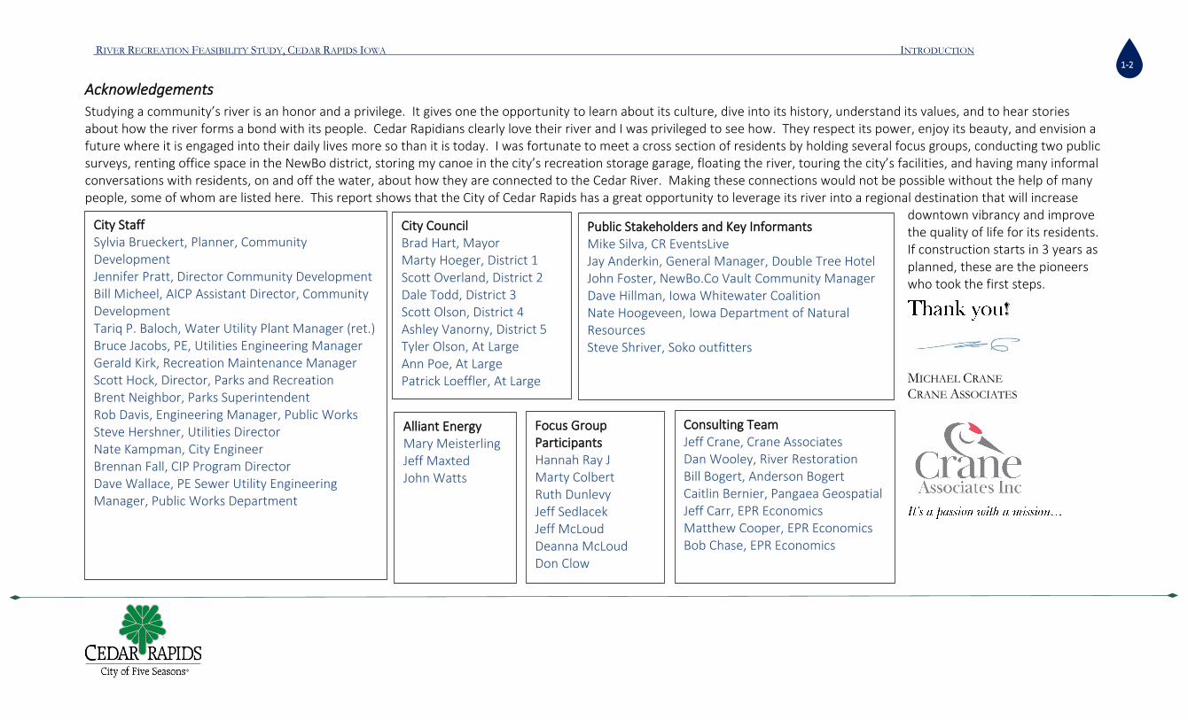
Acknowledgements
Studying a community’s river is an honor and a privilege. It gives one the opportunity to learn about its culture, dive into its history, understand its values, and to hear stories about how the river forms a bond with its people. Cedar Rapidians clearly love their river and I was privileged to see how. They respect its power, enjoy its beauty, and envision a future where it is engaged into their daily lives more so than it is today. I was fortunate to meet a cross section of residents by holding several focus groups, conducting two public surveys, renting office space in the NewBo district, storing my canoe in the city’s recreation storage garage, floating the river, touring the city’s facilities, and having many informal conversations with residents, on and off the water, about how they are connected to the Cedar River. Making these connections would not be possible without the help of many people, some of whom are listed here. This report shows that the City of Cedar Rapids has a great opportunity to leverage its river into a regional destination that will increase
downtown vibrancy and improve the quality of life for its residents. If construction starts in 3 years as planned, these are the pioneers who took the first steps.
!
MICHAEL CRANE CRANE ASSOCIATES
City Staff Sylvia Brueckert, Planner, Community Development Jennifer Pratt, Director Community Development Bill Micheel, AICP Assistant Director, Community Development Tariq P. Baloch, Water Utility Plant Manager (ret.) Bruce Jacobs, PE, Utilities Engineering Manager Gerald Kirk, Recreation Maintenance Manager Scott Hock, Director, Parks and Recreation Brent Neighbor, Parks Superintendent Rob Davis, Engineering Manager, Public Works Steve Hershner, Utilities Director Nate Kampman, City Engineer Brennan Fall, CIP Program Director Dave Wallace, PE Sewer Utility Engineering Manager, Public Works Department
Public Stakeholders and Key Informants Mike Silva, CR EventsLive Jay Anderkin, General Manager, Double Tree Hotel John Foster, NewBo.Co Vault Community Manager Dave Hillman, Iowa Whitewater Coalition Nate Hoogeveen, Iowa Department of Natural Resources Steve Shriver, Soko outfitters
Focus Group Participants
Hannah Ray J Marty Colbert Ruth Dunlevy Jeff Sedlacek Jeff McLoud Deanna McLoud Don Clow
Alliant Energy
Mary Meisterling Jeff Maxted John Watts
City Council Brad Hart, Mayor Marty Hoeger, District 1 Scott Overland, District 2 Dale Todd, District 3 Scott Olson, District 4 Ashley Vanorny, District 5 Tyler Olson, At Large Ann Poe, At Large Patrick Loeffler, At Large
Consulting Team
Jeff Crane, Crane Associates Dan Wooley, River Restoration Bill Bogert, Anderson Bogert Caitlin Bernier, Pangaea Geospatial Jeff Carr, EPR Economics Matthew Cooper, EPR Economics Bob Chase, EPR Economics

RIVER RECREATION FEASIBILITY STUDY, CEDAR RAPIDS IOWA INTRODUCTION
1-3

RIVER RECREATION FEASIBILITY STUDY, CEDAR RAPIDS IOWA THE CEDAR RIVER
2-4
Chapter 2 THE CEDAR RIVER
The Watershed
The Cedar River watershed covers 5,020,914 acres or 7,485 square miles. Beginning in southern Minnesota near the Town of Austin, it extends southeastward to the Cedar River’s outlet at the Iowa River near Columbus Junction. The watershed includes Mason City, Charles City, Cedar Falls, Waterloo, and Cedar Rapids. Approximately 6,510 square miles of this watershed lies upstream of the City of Cedar Rapids. The US Geological Service divides the Cedar River watershed into six smaller hydrological units: Lower Cedar; Middle Cedar; Upper Cedar; West Fork Cedar; Shell Rock; and Winnebago. The City of Cedar Rapids is located in the lower end of the Middle Cedar Watershed, in the Silver Creek-Cedar River subwatershed. This subwatershed contains 36,111 acres in a primarily urban environment. The project site extends approximately 7 miles from above the Seminole Valley Park in the north to the C Street roller dam in the south. There are two tributaries entering this reach of the river. They are Cold Stream entering from the east between Mohawk City Park and Cedar Lake; and Prairie Creek in the south entering from the west at the Tait Cummins Memorial Park across the river from Prairie Park Fishery. The Cedar River, together with the Iowa River, forms a major tributary to the Mississippi River.
Water Quality
The Iowa Department of Natural Resources designates the Cedar River at Cedar Rapids as a primary stream which represents the highest priority for protection and restoration measures and is considered by the State to be safe for recreational use. Segment 455 of the Cedar River extends 4.54 miles from the confluence of Cold Stream, through downtown Cedar Rapids, down to the confluence of Prairie Creek. The results of monitoring for Class A1 designation resulted in a "partially supported" rating, which means that nearly all of the criteria to achieve Class A1 level are met. The study area for this report has completed a TMDL and therefore is not listed on the State’s list of impaired waters. It is determined by the Iowa Department of Natural Resources to be safe for recreational or other uses that may result in prolonged and direct contact with the water.
Figure 2-1: The Cedar River Watershed Map (courtesy of US Army Corps of Engineers)

RIVER RECREATION FEASIBILITY STUDY, CEDAR RAPIDS IOWA THE CEDAR RIVER
2-5
Hydrology
The Cedar River at Cedar Rapids drains a watershed of approximately 6,510 square miles northward to Austin, Minnesota. The US Geological Survey has operated a streamflow gage (number 05464500) on the right bank (west side) of the river, 400 ft upstream from the 8th Avenue bridge in Cedar Rapids, 0.5 miles downstream of the 5 in 1 dam and 2.7 mi upstream from Prairie Creek. The gage has continuously operated since 1902. It is a water-stage recorder set at 700.47 ft above sea level based on the National Geodetic Vertical Datum of 1929. These data show that all flows, the average high, the average low, and the annual average are increasing over the period of time that the data were recorded (figure 5). The mean annual discharge at this location between 1903 and 2013 was 3,980 cubic feet per second (cfs). However, the mean annual discharge from 1984 to 2013 was 5,520 cfs, a 28% increase. Average annual flows are on the rise over the last few decades. A cubic foot per second (or 1cfs) is a rate of water flow which will supply 1 cubic foot of water in one second. One cubic foot/second is equal to 7.48 gallons per second. Approximately, 1000 cubic feet of water will fill a school bus. Low flows throughout the recreation season have also increased substantially in the past few decades. The minimum average river flow for 30 consecutive days between April and June from 1903 to 2013 was 16,400 cfs and from July through September it was 7,550 cfs. Comparatively, between 1984 and 2013 the minimum average discharge between April and June was 24,000 cfs and between July through September it was 10,600 cfs. Peak flows have seen a dramatic increase as well. A flood in 1851 was estimated to be 65,000 cfs from forensic evidence of water elevations. Since the USGS gage was installed, peak flows were measured in 1929 at 64,000 cfs; 1961 at 73,000 cfs; 1965 at 66,800 cfs; 1993 at 71,000 cfs; 2008 at 140,000 cfs; 2013 at 63,700 cfs; and 2016 at 81,600 cfs. The 2008 flood was the largest on record and with an estimated flood-probability of the peak discharge of less than 0.2 percent (>500-year return). Previous flood peak discharges at this location was exceeded by nearly double the previous record peak discharge where more than 100 years of streamflow record were available. In other words, the City of Cedar Rapids has experienced a “100-year-flood” 6 times in the last 58 years based on statistical analysis of the Cedar Rapids gage. Changes in the seasonality and timing of annual peak streamflow in the north-central USA are likely because of changes in precipitation and temperature regimes. Peak streamflow in the Cedar River occurs most frequently during the spring snowmelt and later during summer/fall
65000 6400073000 66800 71000
140,000
6730081600
1851 1929 1961 1965 1993 2008 2013 2016
CFS
Flood Year
PEAK DISCHARGE AT FLOOD EVENTS
Peak Discharge
Figure 2-2: River Flow levels at major floods

RIVER RECREATION FEASIBILITY STUDY, CEDAR RAPIDS IOWA THE CEDAR RIVER
2-6
rains. The odds of summer/fall peaks occurring have increased across Iowa. With respect to timing within the seasons, trend analysis shows that snowmelt/spring peaks are occurring earlier. The timing of snowmelt/spring peaks is earlier by 8.7– 14.3 days and baseflow in Midwestern rivers has increased the greatest from May to September (Ryberg, Akyuz, Wiche & Lin 2015). This Iowa-wide trend is also being experienced at the study area. An analysis of the USGS gage at the 8th Avenue bridge in Cedar Rapids demonstrates a clear 30-year trend of increases in the annual mean discharge, peak flows, duration of flows, and earlier occurrences. The statistics indicate an annual average increase in discharge of approximately 1% per year between 1984 and 2013. Also due to the changes in precipitation regimes, the general trend of increased flows is also documented in the analysis of minimum average discharge during the months between April and September. There are two other stream gages on the Cedar River that are funded by the City of Cedar Rapids Water Division located at Blairs Ferry Road and Edgewood Road. However, the period of record for both of these gages are only 15 years so trends at these gages are inconclusive and not used for the purposes of this report. For the purpose of river recreation, this means more water in the river during traditional low water events which will increase the recreational use of the river over a longer season. Higher flows over longer periods of time may also support new river recreational businesses not previously seen in Cedar Rapids such as river guides and tour services. Higher and longer flows can also mean a higher flood risk, which must be monitored and managed. The 5 in 1 dam does little to regulate flows in the reach below the dam. It backs up water that creates a recreational pool upstream but flow-in generally equals flow-out in what is referred to as run-of-river regime. Average monthly flows range from a low of 1,780 cfs in January to a high of 7,290 cfs in April. Beginning in March, river flows begin to rise and stay high through June. Flows begin to drop in July and continue to decline to an average monthly flow of 2,790 cfs at the end of the recreation season in October.
Figure 2-3: 8th Avenue Gage River Flow Data, Downtown Cedar Rapids, 1903-2013

RIVER RECREATION FEASIBILITY STUDY, CEDAR RAPIDS IOWA STUDY AREA
3-7
Chapter 3 STUDY AREA The Cedar Rapids Flood Control System (FCS) has segmented the Cedar River through the City of Cedar Rapids into two reaches, the upper and the lower reach divided by the 5 in 1 dam. However, for the purpose of this study, this 7-mile segment of the river will be divided into three reaches: an upper reach above the 5 in 1 dam; an “urban reach” will be designated between the 5 in 1 dam and the 16th Avenue bridge (Lions Bridge); and the lower reach downstream of the 16th Avenue bridge. The City of Cedar Rapids was originally named Rapids City after the rapids in the river. The name was changed to Cedar Rapids in 1848. The river was known originally as the Red Cedar River after the many Red Cedar trees that grew along the banks. The original founders of the city saw the value of the rapids as a prime location to build a mill at what is now the corner of First Avenue and First Street Northeast. It was the last set of rapids on the river before the Cedar fed into the Iowa River. This meant that goods milled here could be carried by boat down river to the Mississippi. Today, the world largest cereal plant is still located on this site.
Upper Reach
The upper reach of the study area extended from Seminole Valley Park to the 5 in 1 dam, a three and a half mile stretch of flat water that has historically served a wide range of recreation and industrial uses but today is used primarily for recreation. The upper reach is classified by the Rosgen classification system as a C4 stream type. It is a low-gradient, meandering, point-bar, riffle/pool alluvial channel in a broad, well defined floodplain. The channel bed is primarily made up of gravel although the bed is likely to be more sand dominated the closer one gets to the dam due to the impoundment. The hydrologic model of this reach indicates an average channel slope of between 0.03% and 0.05% and a width to depth ratio that ranges between 40 and 60. The river has little to no sinuosity through this reach. The first dam was built in the upper reach in 1841 but was washed away soon afterwards. Another dam was engineered and constructed in the mid to late 1840s that powered several mills. The original municipal dam was completed in 1918 at the same general location and was constructed of concrete with hinged wooden flashboards along the top to raise or lower the effective height. This dam was removed when the existing 5 in 1 dam was installed in 1978 as part of the replacement of the B Avenue, NE-F Avenue, NW Bridge.
Figure 3-1: Post card from 1921 showing the dam and Quaker Oats in the background
RIVER RECREATION FEASIBILITY STUDY, CEDAR RAPIDS IOWA STUDY AREA
3-8
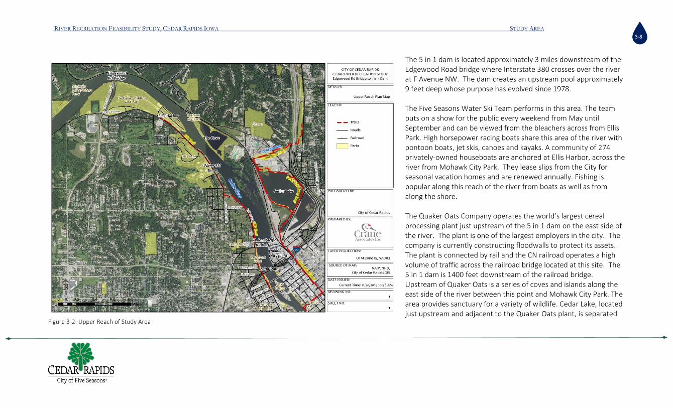
The 5 in 1 dam is located approximately 3 miles downstream of the Edgewood Road bridge where Interstate 380 crosses over the river at F Avenue NW. The dam creates an upstream pool approximately 9 feet deep whose purpose has evolved since 1978. The Five Seasons Water Ski Team performs in this area. The team puts on a show for the public every weekend from May until September and can be viewed from the bleachers across from Ellis Park. High horsepower racing boats share this area of the river with pontoon boats, jet skis, canoes and kayaks. A community of 274 privately-owned houseboats are anchored at Ellis Harbor, across the river from Mohawk City Park. They lease slips from the City for seasonal vacation homes and are renewed annually. Fishing is popular along this reach of the river from boats as well as from along the shore. The Quaker Oats Company operates the world’s largest cereal processing plant just upstream of the 5 in 1 dam on the east side of the river. The plant is one of the largest employers in the city. The company is currently constructing floodwalls to protect its assets. The plant is connected by rail and the CN railroad operates a high volume of traffic across the railroad bridge located at this site. The 5 in 1 dam is 1400 feet downstream of the railroad bridge. Upstream of Quaker Oats is a series of coves and islands along the east side of the river between this point and Mohawk City Park. The area provides sanctuary for a variety of wildlife. Cedar Lake, located just upstream and adjacent to the Quaker Oats plant, is separated
Figure 3-2: Upper Reach of Study Area

RIVER RECREATION FEASIBILITY STUDY, CEDAR RAPIDS IOWA STUDY AREA
3-9
from the river only by a thin line of railroad tracks and adds to the wildlife habitat of the area.
The Mohawk City boat ramp is located directly across the river from the Ellis Harbor marina. The City maintains this ramp as well as the boat ramp in Ellis Harbor. In addition to the boat ramp, Mohawk Park includes nature trails to the cove area that offers the visitor a secluded natural area. The cove is also accessible by water from the boat ramp where paddlers can enjoy quite waters and nature viewing. The old river intake structure upstream of the boat ramp can be an obstacle to river recreation and its removal should be considered.
Figure 3-4: Quaker Oats and the Railroad bridge from the Ellis Trail on the West shore Figure 3-3:Mohawk City Park Boat Ramp with old water intake and recreation hazard on right

RIVER RECREATION FEASIBILITY STUDY, CEDAR RAPIDS IOWA STUDY AREA
3-10
Ellis Harbor Marina includes 52 boat docks and 274 slips for floating boathouses (Ellis Harbor Business Plan 2011). The current condition of the harbor is suffering from significant disrepair due to years of deferred maintenance. The report states:
“The existing sheet pile wall is at or nearing the end of its functional life. Two segments of the existing east basin wall, totaling 217 linear feet, failed during recent flooding and have since been replaced. However, the vast majority of sheet pile is subject to loading that the sheet pile was not originally designed to accommodate. In particular, the anchoring system for most of the boathouses rely on adjustable bars that link the floating structures directly to the sheet pile walls. The sheet pile walls and short tieback system were not constructed to take the loads of houseboat anchoring and over time the walls have begun to deform and separate from the sidewalk.(ibid)”
The financial analysis of the plan states that the marina is operating at a loss and “should the City continue with the current approach and lease rates, we believe the current infrastructure will inevitably fail and lead to closure of the harbor(ibid).” This 2011 report concludes by recommending that the marina move across the river to the cove area and rebuild at a cost of $5.8 to over $10 million.
Figure 3-5: Ellis Harbor Boathouses

RIVER RECREATION FEASIBILITY STUDY, CEDAR RAPIDS IOWA STUDY AREA
3-11
Urban Reach
Although the reach upstream of the 5 in 1 dam is within City limits, it is the 1.1 miles between the 5 in 1 dam and the 16th Avenue Bridge that runs through the heart of the city and is primarily more urban. The aesthetic from the river is one of city parks, office buildings, industrial plants, and bridges. There are six vehicular bridges and one railroad bridge in this reach that connects east and west neighborhoods in the city. The 12th and 16th avenue bridges connect Czech Village to the New Bohemian section of the city, both of which are dominated by small parks, small residential lots and locally owned businesses in 2-3 story buildings. The 8th avenue bridge is a transportation arterial connecting points east to west and serving large scale industrial uses. The 1st, 2nd, and 3rd avenue bridges connect the downtown district to Mays Island, McGrath Amphitheater Park and the Kingston neighborhood on the west side of the river. Within this reach, access to the river is limited and not pedestrian friendly. The banks of the river, even along parks and recreation properties are riprapped, steep, vertical walled, or difficult to access. There is one boat ramp at the Sunner Memorial but it is reserved for public safety boats and not open to the general public. Levees and floodwalls are built along the edge of the river to protect people and property. A bike path runs along the east side, high above the river.
Figure 3-6: On the 12th Ave bridge looking northwest

RIVER RECREATION FEASIBILITY STUDY, CEDAR RAPIDS IOWA STUDY AREA
3-12
There are 3 small greenspaces located along the west side of the river between the 5 in 1 dam and the 3rd Avenue bridge before arriving at the McGrath Amphitheater near 5th Avenue and Sunner Memorial Park along the north side of the 8th Avenue bridge. Plaza Park is located on May’s Island between 2nd and 3rd Avenues and across from the greenspaces on the west side. Downstream Ingredion, and adjacent to the north side of the 12th Avenue bridge, is Riverside Park and the Czech museum located between the 12th and 16th Avenue bridges. Both parks have good public spaces, but neither has adequate access to the river. The City’s Flood Control Plan includes a new 8th Avenue bridge and gathering space on the northwest side of the bridge. The concept also includes river access on the east side however, due to the levee proposed on the east side, it is unclear from existing drawings how accessibility will be provided. The gathering space on the northwest includes a viewing area to river and grassy area connecting this outdoor space with the McGrath Amphitheater area. The gathering space is in the location of the existing boat ramp.
Figure 3-7: Steep and inaccessible banks on West Side at McGrath Amphitheater area looking across to Mays Island (left) and downstream (right)

RIVER RECREATION FEASIBILITY STUDY, CEDAR RAPIDS IOWA STUDY AREA
3-13
Figure 3-9: Vertical Walls at 4th Ave Riverfront East Figure 3-8: McGrath Amphitheater
RIVER RECREATION FEASIBILITY STUDY, CEDAR RAPIDS IOWA STUDY AREA
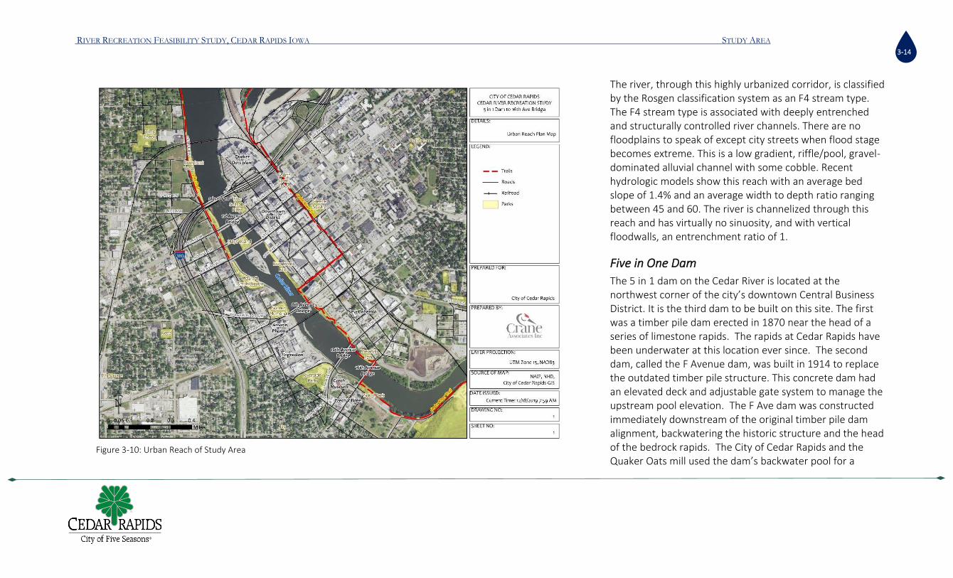
3-14
The river, through this highly urbanized corridor, is classified by the Rosgen classification system as an F4 stream type. The F4 stream type is associated with deeply entrenched and structurally controlled river channels. There are no floodplains to speak of except city streets when flood stage becomes extreme. This is a low gradient, riffle/pool, gravel-dominated alluvial channel with some cobble. Recent hydrologic models show this reach with an average bed slope of 1.4% and an average width to depth ratio ranging between 45 and 60. The river is channelized through this reach and has virtually no sinuosity, and with vertical floodwalls, an entrenchment ratio of 1.
Five in One Dam
The 5 in 1 dam on the Cedar River is located at the northwest corner of the city’s downtown Central Business District. It is the third dam to be built on this site. The first was a timber pile dam erected in 1870 near the head of a series of limestone rapids. The rapids at Cedar Rapids have been underwater at this location ever since. The second dam, called the F Avenue dam, was built in 1914 to replace the outdated timber pile structure. This concrete dam had an elevated deck and adjustable gate system to manage the upstream pool elevation. The F Ave dam was constructed immediately downstream of the original timber pile dam alignment, backwatering the historic structure and the head of the bedrock rapids. The City of Cedar Rapids and the Quaker Oats mill used the dam’s backwater pool for a
Figure 3-10: Urban Reach of Study Area

RIVER RECREATION FEASIBILITY STUDY, CEDAR RAPIDS IOWA STUDY AREA
3-15
source of drinking water, and process cooling. In 1978, the F Avenue Dam was replaced by the current 5 in 1 dam. Around this time a hydroelectric facility was constructed in the first gate of the 5 in 1 dam (west side). The hydro required a certain amount of flow diverted through the structure in order to properly operate. The hydro was permanently decommissioned after the 2008 flood. Quaker Oats no longer uses river water for cooling and the City has not used river water for domestic consumption since the 1970s.
Today, the 5 in 1 dam creates a recreational pool for motorized and non-motorized boating and fishing among other water-based recreation activities. While the upstream pool previously provided surface water for municipal and industrial water intakes and supplied a source for hydroelectricity; today the dam and the pool it creates is devolving its multipurpose role and slowly becoming a single purpose dam that services recreationalists. A question remains as to whether the pool is currently protecting the city’s municipal ground water supply. In an effort to better understand the interactions between the pool and City’s underground water source, a collaborative study between the City and the United States Geological Survey is being undertaken. This study will involve the installation of strategically placed ground water monitoring wells to evaluate the relationship between a prescribed pool level and its influence on aquifer recharge, capacity, performance, and quality. The results of this study may influence the development of river-based recreation alternatives currently being developed by the City; however, without a clear timeline for the study’s completion, future phases of work would need to be developed to evaluate a recreational scenario that envisions the removal of the 5 in 1 dam. Therefore, for purposes of completing this river recreational feasibility study, the pool is assumed to remain in place.
The 5 in 1 dam is owned and operated by the City of Cedar Rapids. However, transportation Right of Ways (ROW) and/or utility easements passing through
the 5 in 1 dam alignment may require additional approvals for works to be performed in the corridor. In particular, the Federal Highways Administration and the Iowa Department of Transportation maintain the Access Control line (A-line) which requires approval for work and access within, regardless of oversight responsibility.
Figure 3-11: The F Avenue dam

RIVER RECREATION FEASIBILITY STUDY, CEDAR RAPIDS IOWA STUDY AREA
3-16
The City of Cedar Rapids owns the parcels on both sides of the river on the downstream side of the 5 in 1 dam and the upstream west bank, highlighted in blue in Figure 4-12. Quaker Manufacturing LLC owns the parcel on the east bank on the upstream side of the 5 in 1 dam. The 5 in 1 dam is operated as run of the river and does not provide for downstream flood control. Once all of the gates are either fully lowered (underwater gates) or raised (slide gates) the dam no longer obstructs the flow of water passing through it. Under typical operating conditions, the difference in water surface elevations between the upstream headwater and the downstream tailwater ranges from a maximum of up to 15 feet during extreme droughts such as in the summer of 2017 to as little as zero feet during lower probability flood events where backwater conditions produced by downstream obstructions control the flow of the river through it. Downstream of the 5 in 1 dam, vertical concrete abutments makes up the first approximately 100 feet of each bank. Downstream from the concrete abutments to the 1st avenue bridge crossing (approximately 500 feet) each bank is composed of earthen fill and riprap similar to the upstream west bank. The west bank is initially steep, at a 2H:1V slope, then flattens to a 3H:1V slope, before transitioning to vertical concrete floodwalls, downstream of 1st Avenue bridge abutments The 5 in 1 dam significantly impacts the ecology of the Cedar River both by altering the character of the of the upstream reach as well as through the creation of a physical barrier that prevents the migration of various aquatic species except during flood events when the gates are fully open and these species can move back and forth without limitation. For this reason, it appears that recreational fishing at the downstream side of the dam is popular as fish species attempting to migrate upstream can be blocked for indefinite periods of time, waiting for conditions that will allow them to move upstream. Various species of freshwater mussel may also be impacted by the operations of the 5 in 1 dam.
In addition to the dam ownership and operations, various other state and federal agencies may require consultation for any potential project that could impact the 5 in 1 dam. This list may include but is not limited to the US Army Corps of Engineers (USACE), Federal Highways Administration (FHWA), US Fish and Wildlife Service (USFWS), Federal Energy Regulatory Commission (FERC), Iowa Department of Natural resources (DNR) and the Iowa Department of Transportation (Iowa DOT).
Figure 3-12: Parcel Ownership at 5 in 1 dam, city-owned parcels in blue

RIVER RECREATION FEASIBILITY STUDY, CEDAR RAPIDS IOWA STUDY AREA
3-17
Additional levees and floodwalls are proposed or under construction along both banks of the river in the vicinity of the 5 in 1 dam and throughout the entire river corridor within the city limits. Most of these will be earthen levees or fixed flood walls; however, at bridge crossings, many of these will be modular/moveable wall systems, allowing the City to close off intersections during impending flooding conditions. Intersections such as E and F Avenue will be fitted with these wall systems as part of future flood control applications.

RIVER RECREATION FEASIBILITY STUDY, CEDAR RAPIDS IOWA STUDY AREA
3-18
Lower Reach
The Lower Reach is a 3-mile stretch of river between the 16th Avenue bridge and Prairie Park Fishery. This reach regains its floodplain and meandering planform with naturally vegetated banks. Sokol Park is located on the west side of the river adjacent to the downstream side of the 16th Avenue bridge. A new levee currently under construction runs parallel and close to the streambank that will prevent river access in this section. The river through this lower reach is classified by the Rosgen classification system as an C4 stream type. This section of the river is broad, gentle gradient, meandering, riffle/pool alluvial channel with a well-defined floodplain. The channel material is predominantly gravel. Recent hydrologic models show this reach with an average bed slope of 0.02%, an average width to depth ratio ranging between 45 and 60 and a sinuosity of 1.35.
Mount Trashmore, Linn County’s solid waste facility, is located at the downstream end of the river bend on the west side, across from the Cargill plant and just beyond Sokol Park. The landfill is capped and not in use anymore. There is a hiking and biking trail that leads to an overlook pavilion at the top. The trail is closed in the winter but reopens in late spring. A waste transfer station and compost facility exists at the base of the landfill adjacent to the river. An abandoned and partially destroyed railroad bridge exists between the Cargill plant and Mount Trashmore. Connect CR is a local non-profit whose mission is to improve the quality of life in Linn County and beyond by expanding connectivity for recreation, improving under-utilized community assets, leveraging flood mitigation, and creating an iconic symbol for the city. They have plans to rehabilitate this old crossing into a pedestrian bridge in the future and connect the proposed Cedar River Trail through Osborn Park on the east side to the existing Cedar
River Trail on the west side.
Figure 3-13:Site of proposed bike/ped bridge with Cargill Plant in background

RIVER RECREATION FEASIBILITY STUDY, CEDAR RAPIDS IOWA STUDY AREA
3-19
At Mount Trashmore and the Cargill plant, the river makes another sweeping bend to the west. Downstream of the Cargill plant, Otis Road follows the outside bend of the river along a riprapped riverbank as it heads downstream towards the Prairie Park Fishery. On the west side, the Cedar River Trail continues along the inside bend at Mount Trashmore and follows a well-vegetated riparian corridor down to the Tait Cummins Memorial Park at the confluence with Prairie Creek. The Prairie Park Fishery boat ramp and trailhead are directly across the river on the east side and is a popular local destination for hiking, biking and fishing. At the end of this study reach is the C Street roller dam as the river bends from west to south just past the Tait Cummins Memorial Park. The Prairie Park Fishery and the Sac and Fox Trail City Park are directly across the river on the east side. This park extends downstream approximately 3 miles beyond the roller dam. Both sides of the river in this area are lush with native riparian vegetation and providing excellent habitat for both aquatic and terrestrial wildlife.
Figure 3-14: Lower reach of study area

RIVER RECREATION FEASIBILITY STUDY, CEDAR RAPIDS IOWA STUDY AREA
3-20
C-Street Roller Dam
The C Street roller dam is owned and operated by Alliant Energy and is used for impounding a pool of cooling water that is pumped to their Prairie Creek generating station on the east side of the river south of Tait Cummings Memorial Park. The roller dam itself is a substantial hazard to river recreation. The dam creates a dangerous recirculating wave that is impassable by boats, can trap and drown people, and is an impediment to fish migration. The upstream influence of the C-Street Roller Dam is estimated at up to one mile based on historic aerial imagery captured between 1960 and 1970 and Light Detection and Ranging (LiDAR) data measuring the slope of the water surface upstream. Figure 4-14shows a Digital Terrain Model (DTM) of the reach upstream of the C-Street Roller Dam. The same LiDAR data were used to estimate a total head loss over the C-Street Roller dam of five feet or more, during very low flow periods in the river. The C- Street Roller dam is one of thousands of low head dams throughout the nation. These types of dams are particularly dangerous to river recreation because a submerged hydraulic jump forms in the tailwater directly downstream
of the dam face causing a dangerous upstream current known in whitewater recreation circles as a “keeper.” The calm appearance of submerged hydraulic jumps makes low-head dams deceptively dangerous. Hydraulic jumps produce strong rotational currents toward the dam face. The point where downstream currents become upstream currents is called the “boil” point. Swimmers are forced under the water by the plunging nappe, resurface upstream from the boil, and are swept upstream to the plunging nappe again by the upstream-directed currents to repeat the process. This is exactly what is happening at the C-street roller dam. Hydraulic jump velocities may exceed normal human swimming capabilities, making it difficult or impossible to escape the rotational currents. Life jackets do not eliminate risk. Air bubbles mixing in the water from the plunging nappe decrease buoyancy, so the victim can have a hard time staying afloat even with a life jacket or the life jacket may be ripped off in the turbulence. A particularly strong boil line was observed
Figure 3-15: Well vegetated riparian corridor below Cargill Plant

RIVER RECREATION FEASIBILITY STUDY, CEDAR RAPIDS IOWA STUDY AREA
3-21
just downstream of the C-Street Roller dam. The pronounced upwelling associated with this hydraulic jump indicated by the uniformity and height of the boil line suggest that baffle blocks or some other sill type structure may have been constructed. At the C-Street Roller dam, this combination creates a particularly dangerous scenario where watercraft, animals and people unable to get out of the river prior to going over the dam will become fatally trapped in the terminal roller formed below. To date, the C-Street Roller dam has been responsible for seven fatalities in its 53-year history.
Figure 3-16:Looking northwest (upstream) at a Digital Terrain Model of the Cedar River at the C-Street Roller dam

RIVER RECREATION FEASIBILITY STUDY, CEDAR RAPIDS IOWA STUDY AREA
3-22
Figure 3-17: C Street Roller Dam
RIVER RECREATION FEASIBILITY STUDY, CEDAR RAPIDS IOWA THE MARKET
4-23
Chapter 4 THE MARKET This chapter is largely a summary of a detailed economic analysis conducted by Crane Associates and submitted to the City of Cedar Rapids in a separate report entitled “Economic Contributions Analysis of a Proposed Whitewater Park and River Recreation Amenities in the Cedar River in Cedar Rapids, Iowa.”
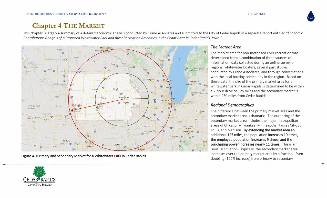
The Market Area
The market area for non-motorized river recreation was determined from a combination of three sources of information: data collected during an online survey of regional whitewater boaters; several past studies conducted by Crane Associates; and through conversations with the local boating community in the region. Based on these data, the size of the primary market area for a whitewater park in Cedar Rapids is determined to be within a 2-hour drive or 125 miles and the secondary market is within 250 miles from Cedar Rapids
Regional Demographics
The difference between the primary market area and the secondary market area is dramatic. The outer ring of the secondary market area includes the major metropolitan areas of Chicago, Milwaukee, Minneapolis, Kansas City, St Louis, and Madison. By extending the market area an additional 125 miles, the population increases 10 times, the employed population increases 9 times, and the purchasing power increases nearly 11 times. This is an unusual situation. Typically, the secondary market area increases over the primary market area by a fraction. Even doubling (100% increase) from primary to secondary
125 Miles Proposed Existing
125 miles
Primary Market
Secondary Market
Minneapolis
250 Miles
Figure 4-1Primary and Secondary Market for a Whitewater Park in Cedar Rapids
125 Miles

RIVER RECREATION FEASIBILITY STUDY, CEDAR RAPIDS IOWA THE MARKET
4-24
market area is unique. However, given Cedar Rapids’ geo-economic location, combined with the market dynamics of whitewater parks, the city finds itself in a position to be able to increase its market area from 3 million to nearly 30 million people (fig. 4-2 and table 4-1). Table 4.1 shows the large difference in employed people and payroll between the two market areas. By extending the market area by an additional 125 miles, the population balloons from 3.2 million to 29 million and the potential for recreation visitors to Cedar Rapids grows proportionately.
Table 4:1: Market Area Demographics (Source: US Bureau of Economic Analysis)
Existing Supply of Whitewater Parks
There are six existing whitewater parks with 250 miles from Cedar Rapids. Three of these parks are in Charles City, Elkader, and Manchester Iowa and within a 90-minute drive from Cedar Rapids. The other three parks are outside of Iowa in the secondary market area in South Bend ID, Yorkville IL, and Wausau WI.
MARKET AREA DEMOGRAPHICS PRIMARY SECONDARY
SIZE 125 Miles 250 Miles POPULATION 3,274,453 29,057,784 HOUSEHOLDS 1,315,041 11,669,793 POPULATION % CHANGE (10YR) 3.24% 2.38% COUNTIES 83 323 EMPLOYED POPULATION 1,695,048 14,697,786 ANNUAL PAYROLL $ 73,483,362,700 $ 776,963,658,848
-
5,000,000
10,000,000
15,000,000
20,000,000
25,000,000
30,000,000
Population Households Employed Population
3,274,453 1,315,041 1,695,048
29,057,784
11,669,793
14,697,786
Market Area Comparisons
125 Miles 250 Miles
Figure 4-2: Market Area Demographics (source: US Census)

RIVER RECREATION FEASIBILITY STUDY, CEDAR RAPIDS IOWA THE MARKET
4-25
There are also seven proposed whitewater parks in the primary market area. Three are proposed in Iowa and are all within a 2-hour drive from Cedar Rapids including Cedar Falls, Des Moines and Ames. The other four parks are in Minneapolis MN, Granite Falls MN, Sioux Falls SD, and Stoughton IL. There may be other proposed projects unknown to the author at this time. A complete description of these parks is provided in the full Economic Contribution Analysis report.
Regional Paddlers Survey
A survey of paddlers in the 8-state region was conducted in the winter of 2020. Paddlers were contacted through social media and paddler group web sites. Thirty-three different paddler groups were contacted and 57% of the survey responses are from Iowans. The survey was intended to understand the extent of the market area, paddlers’ preferences and skill level in the region, their propensity to be attracted to a whitewater park in Cedar Rapids, and their spending and travel patterns. Key findings of the larger report are summarized here: 1) Iowans enjoy getting on a river and they prefer to stay in Iowa. Their average number of trip per year is 24 and 96% of the trips are in Iowa. The preference among Iowans for Iowa’s river is also supported by a second survey of the general public in Cedar Rapids. 2) The average willingness to travel one way for a park-and-play trip was 1 hour and 24 minutes. For a river trip, the average was 3.5 hours. 3) The average size of the paddler group was 5.7 people. This is much bigger than an average size party for general tourism which is about 2.5 people.
Charles City
Manchester
Des Moines
Elkader
Wausau
South Bend
Minneapolis
250 Miles
Stoughton
Yorkville
Sioux Falls
Ames
Granite Falls
Cedar Falls
Existing
Proposed
Figure 4-3: Existing and Proposed whitewater parks in the market area

RIVER RECREATION FEASIBILITY STUDY, CEDAR RAPIDS IOWA THE MARKET
4-26
4) Paddlers enjoy camping. This is usually not for budgetary reasons. The household income of an average paddler is $75,000. Paddlers prefer camping because it is part of the experience. When paddlers go on overnight river trips, they will stay an average of 2.3 nights.
5) Most respondents (75%) said they were capable of paddling Class 2 or 3 water. About 20% of the respondents are able to paddle class 4. However, paddlers in this survey do not like to be pushed to their limits. Paddlers show a preference to paddle rivers that are just below their maximum skill level.
6) Many factors will influence the visitation rates to the whitewater park. The visitation rates will vary depending on how the park is programmed and leveraged to attract regional visitors, similar to other public venues in city.
7) Day visitors spend an average of $131.77 per day, while overnight visitors spend an average of $536.42 per day in the following categories (tables 4-2 and 4-3). Spectators and attendance to river events also generate additional income.
TRANSPORTATION (FUEL, RENTAL, REPAIRS ETC)
Lodging Food from market
Restaurant and nightlife purchases
Non-alcoholic drinks
Alcoholic drinks Payments for group travel costs
$ 80.10 $ 88.87 $ 52.40 $ 54.62 $ 12.29 $ 22.42 $ 47.30 LOCAL SPECIALTY FOODS AND SOUVENIRS
Local Arts and Crafts
Entrance fees Equipment rental Equipment purchases
Consumable Supplies
Other
$ 17.38 $ 10.48 $ 12.92 $ 12.29 $ 94.01 $ 14.38 $ 16.96
Table 4:2Average Spending per Category by Multi-day Trip Paddlers in the Region
TRANSPORTATION (FUEL, RENTAL, REPAIRS ETC)
Lodging Food from market
Restaurant and nightlife purchases
Non-alcoholic drinks
Alcoholic drinks Payments for group travel costs
$ 39.07 n/a $ 20.71 $ 20.53 $ 7.39 $ 10.11 $ 13.72
LOCAL SPECIALTY FOODS AND SOUVENIRS
Local Arts and Crafts
Entrance fees (no impact)
Equipment rental Equipment purchases
Consumable Supplies
Other
$ 7.81 $ 4.68 $ 6.60 $ 5.31 $ 42.55 $ 6.80 $ 6.27
Table 4:3:Average Spending per Category by Single-day Trip Paddlers in the Region

RIVER RECREATION FEASIBILITY STUDY, CEDAR RAPIDS IOWA THE MARKET
4-27
Paddler Participation Rates
Estimates of total population of paddlers in the market area is used as a base to estimate the number of visitors to the proposed whitewater park. Several sources of data are used to estimate the total population of paddlers in the 8-state market area. National level data are provided by the Outdoor Industry Association1. Regional level data are also provided by the Outdoor Industry Association, who segregated their national data in to 9 multi-state regions. These national and regional level data are used as reference points for the market area estimates. State level data comes from the Statewide Comprehensive Outdoor Recreation Plan (SCORP). Each state prepares a SCORP differently. Some SCORPs provide data appendices which are useful data for the purposes of this analysis, while others do not. SCORP reports were reviewed for all of the eight states in the market area: Iowa, Minnesota, Wisconsin, Illinois, Indiana, Missouri, Kansas, and Nebraska, but only Iowa, Wisconsin, and Illinois provided useful data. When state-level SCORP paddler population data was not available, we relied on a 10-year study on outdoor recreation participationi. In addition, other state level non-motorized boater population data were used as available, including boater registration data, and other boater or recreation studies. The market area includes only portions of each of the eight states (except Iowa at the 250-mile market). To determine market area population, state level estimates were then segregated by county on a per-capita basis to allocate a proportion of boater population into the market area. When a county was bisected by the market area line, the entire county was included in the market area. Two other methods were used to calculate paddler population. The OIA regional estimates were applied to the counties in the 125 mile and 250-mile market areas. The third method was to apply a 10-year national average participation to the counties in the market areas. All three methods were then averaged to determine a base line number of paddlers in the 125-mile market and 250-mile market areas. Detailed calculations of paddler population estimates are provided in the full report. The results are shown in Table 4-4.
Total Paddler Population in Market Areas
Participation 125 Mile Market 250 Mile Market Total
OIA regional 283,895 2,235,411 2,519,306
SCORP 625,974 3,748,603 4,374,577
10 Year Ave 322,645 2,428,497 2,751,142
Average 410,838 2,804,170 3,215,008
Table 4:4 Summary of Paddler Population Estimates
1 Participation in Outdoor Activities, All Americans Ages 6+; Source, Outdoor Foundation, Washington DC. 2018 Outdoor Recreation Participation Report
RIVER RECREATION FEASIBILITY STUDY, CEDAR RAPIDS IOWA THE MARKET
4-28
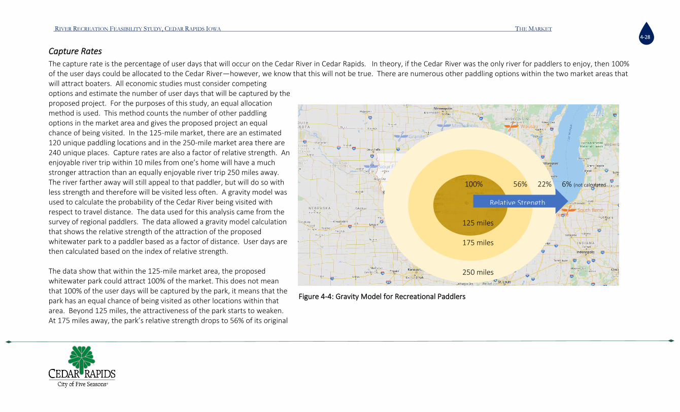
Capture Rates
The capture rate is the percentage of user days that will occur on the Cedar River in Cedar Rapids. In theory, if the Cedar River was the only river for paddlers to enjoy, then 100% of the user days could be allocated to the Cedar River—however, we know that this will not be true. There are numerous other paddling options within the two market areas that will attract boaters. All economic studies must consider competing options and estimate the number of user days that will be captured by the proposed project. For the purposes of this study, an equal allocation method is used. This method counts the number of other paddling options in the market area and gives the proposed project an equal chance of being visited. In the 125-mile market, there are an estimated 120 unique paddling locations and in the 250-mile market area there are 240 unique places. Capture rates are also a factor of relative strength. An enjoyable river trip within 10 miles from one’s home will have a much stronger attraction than an equally enjoyable river trip 250 miles away. The river farther away will still appeal to that paddler, but will do so with less strength and therefore will be visited less often. A gravity model was used to calculate the probability of the Cedar River being visited with respect to travel distance. The data used for this analysis came from the survey of regional paddlers. The data allowed a gravity model calculation that shows the relative strength of the attraction of the proposed whitewater park to a paddler based as a factor of distance. User days are then calculated based on the index of relative strength. The data show that within the 125-mile market area, the proposed whitewater park could attract 100% of the market. This does not mean that 100% of the user days will be captured by the park, it means that the park has an equal chance of being visited as other locations within that area. Beyond 125 miles, the attractiveness of the park starts to weaken. At 175 miles away, the park’s relative strength drops to 56% of its original
Charles City
Manchester
Des Moines
Elkader
Wausau
South Bend
Minneapolis
250 Miles
Stoughton
Yorkville
Sioux Falls
Ames
Granite Falls
Relative Strength
100% 56% 22% 6% (not calculated
125 miles 175 miles 250 miles
Figure 4-4: Gravity Model for Recreational Paddlers

RIVER RECREATION FEASIBILITY STUDY, CEDAR RAPIDS IOWA THE MARKET
4-29
capacity and at 250 miles the park’s attractiveness drops to 22% of its original capacity (figure 4-3). Theoretically, the park still attracts beyond the 250 miles range, with a relative strength of 6%, but these user days were not calculated. The probability of the proposed whitewater park capturing user days decreases proportionally to the distance travelled. User days captured is dependent on distance, population of paddlers, and their frequency of paddling. What is unique about this market area is that the population is concentrated at the extremities of the market area. In the center lies the City of Cedar Rapids. It is the second largest city in Iowa, the largest in Linn County and largest in the 125-mile market area, resulting in high visitation estimates. Next is a rural band at 175 miles away where the population drops. The low population, combined with a 56% relative strength, results is a low number of potential user days from this rural band. At 250 miles away the relative strength decreases to 22%, however the population increases dramatically. Major metropolitan areas of Chicago, Milwaukee, Minneapolis, Kansas City, and St Louis are located on the outer edge of the market area. While the proposed park can only capture 22% of the secondary market paddlers who reside 250 miles away, the secondary market is 9 times greater than the primary market. The weakness of distance is overcome by the sheer size of the population and results in a capture rate that almost doubles the primary market area. In fact, when combined with the 175-mile area, it does double the potential user days (table 4.6 and figure 4.5).
Based on the regional boaters’ survey, those travelling from beyond 125 miles are more likely to stay overnight. Overnight visitors spend more money and stay longer than day visitors. If the park is designed and built to attract the secondary market, then Cedar Rapids has
Upper Bound Lower
Bound Median Percent of
Total Primary Visitor
Type
125 MILE (PRIMARY MARKET)
87,104 43,664 65,384 50% Day Visitor
175 MILE 13,362 6,414 9,888 8% Overnight Visitors
250 MILE (SECONDARY
MARKET)
73,387 35,226 54,306 42% Overnight Visitors
TOTAL 173,854 85,304 129,579 100%
Table 4:5: Estimated User Days and Visitor Type
87,104
13,362
73,387
43,664
6,414
35,226
-
20,000
40,000
60,000
80,000
100,000
125 Mile 175 mile 250 Mile
Upper Bound Lower Bound
Figure 4-5: Estimated User Days by Market Area
RIVER RECREATION FEASIBILITY STUDY, CEDAR RAPIDS IOWA THE MARKET
4-30
the potential to not only double the user days but to increase the number of overnight visitors. Therefore, attracting the secondary market becomes a critical element in estimating the benefit/cost analysis of the investment. The terms “upper and lower bounds” are used to suggest a range that within which the true number of visitors will come if the park is built as proposed. The range is created by using two sets of data; the survey of paddlers in the market area is used to create the upper bound while the data from the Iowa SCORP is used to create the lower bound.
Secondary Market Conditions
To entice paddlers from the secondary market area, the project must be attractive enough for the boater to be willing to drive 250 miles or 3.5 hours. Survey data shows that a whitewater park which provides only a park-and-play experience will attract paddlers from approximately 125 miles away. A river trip, on the other hand, is an experience that is more attractive to most boaters. A river trip involves putting in at one location and floating downstream to the takeout. Paddlers on river trips enjoys the full spectrum of a river experience including rapids, waves, eddies, scenic views, peaceful floating, conversations with friends, picnics, and nature watching. In Cedar Rapids, they also get to experience urban conveniences at the beginning of the trip and quiet nature towards the end.

RIVER RECREATION FEASIBILITY STUDY, CEDAR RAPIDS IOWA THE MARKET
4-31
The ability to attract the secondary market is based on several assumptions including:
• The C-street dam is removed or modified to allow downstream passage and the creation of a Class II rapid.
• At least one commercial outfitter is allowed to operate and market Cedar Rapids river trips.
• The design of the park includes ample spectator conveniences such as seating, picnic areas, and food and beverage concessions.
• The design of the park includes beach areas between the 5 and 1 dam and McGrath Amphitheater that allows for wading in the river with small children
• The City moves the skateboard park within close proximity to the whitewater park so that parking can be shared.
• The upstream pool above the 5-in-1 dam is maintained at its current level In addition to these assumptions, the consultant recommends that the city consider adding other compatible amenities that create synergistic impacts such as an artificial climbing wall, zip lining, an obstacle course, trampoline park, and balance and flexibility fit stations along the river in close proximity to the whitewater park. Several of these features can be added through private concessionaires at little cost to the city. The idea is to build up a destination for outdoor and adventure sports that becomes attractive to the urban dwellers in the 250-mile market. The combination of these amenities tends to attract groups and families of multiple ages and ranges of interests. The group of amenities encourages visitors to linger longer and invites them to stay overnight.
Total Estimated Economic Contributions
The results of the analysis are the economic contributions to local economy made by whitewater park visitors to Cedar Rapids, in Linn County, and the Cedar Rapids, IA MSA. Economic contribution modeling2 was performed by using an Input-Output model called REDYN (Regional Dynamics). Input-Output models with dynamic features, like REDYN, simulate the economic relationships between sectors of an economy on several geographic levels through time. Linkages exist between sectors and regions because their economies use outputs from other sectors and regions. Input-Output models are founded on these linkages and allow analysts to see how changes in final demand in individual or multiple
2 Please refer to the complete economic report for further discussion on input-output methodologies for modeling and quantifying the contributions of an economic activity.
Figure 4-6: Examples of complementary activities to attract the secondary market
RIVER RECREATION FEASIBILITY STUDY, CEDAR RAPIDS IOWA THE MARKET
4-32
sectors in a regional economy ripple throughout the system and geography simultaneously as a result of the direct activity quantified by the model inputs and determinants. Cedar Rapids, Iowa is located within the Cedar Rapids, IA Metropolitan Statistical Area (“Cedar Rapids MSA”), which is a functional economic region as defined by the United States Office of Management and Budget. Economic contributions represent potential economic activity associated with the estimated number of non-local users and visitors to the proposed whitewater park. These users and visitors are expected to engage in the visitor spending that generates the economic contribution measured and reported here. This economic activity includes expenditures by users and visitors at establishments in Linn County which do business within one of the service-providing NAICS3 industry sectors included in the study. All economic activity generated by recreational users who would originate from within Linn County was removed from this analysis because their economic activity does not contribute any value added the local economy. Certain survey data were left out of the economic contribution modeling analysis because the location of the activity was ambiguous in the source data, most notably fuel expenditures for transportation to Linn County. Since expenditure activity by users and visitors most likely would take place on the way to Linn County, Linn County and the Cedar Rapids, IA MSA are assumed to not benefit economically from that category of trip expenditures. However, it is likely that some amount of fuel expenditure takes place within Linn County, which this study does not capture. Since this is also likely the case for other excluded trip expenditure categories, the findings of this economic contribution study should be interpreted as providing a “conservative” estimate of economic activity. The study simulates and measures direct and indirect4 economic activity as though it took place in calendar year 2019, in order to provide a stable economic baseline from which to make policy decisions, prior to the uncertain economic conditions brought about by the global Covid-19 pandemic and the official response. The final results were then adjusted to represent 2020 dollars. The results show the direct, indirect and induced impacts to the economy of Linn County Iowa and the rest of the Cedar Rapids, Iowa economic region. Cedar Rapids and Linn County are the county seat and county of the Cedar Rapids, IA Metropolitan Statistical Area, a functional economic region which also includes the adjoining geographies of Benton County and Jones County. The economic model results are for the Cedar Rapids MSA. Direct Output contribution represents the amount of gross visitor expenditures which are retained within the in the Cedar Rapids MSA . Not all expenditures are retained in the local economy because products are manufactured outside of the MSA. For example, the visitor
3 Each economic activity or industry sector has an identifying classification code from the North American Industrial Classification System (NAICS). 4 For this study, direct economic activity is that which is created as a result of user and event attendee spending (e.g., visitor service establishments hire additional workers due to additional visitor spending), and are
assumed to be generated entirely within Linn County, IA. Indirect economic contributions are created as materials and other inputs to service establishments are supplied (e.g., the manufacturer of outdoor equipment). It should be noted that induced jobs, which are a subset of indirect jobs, are created when the new workers occupying the direct and indirect jobs spend their new income resulting from the new visitor spending activity at other businesses (e.g., consumer-oriented goods and services).

RIVER RECREATION FEASIBILITY STUDY, CEDAR RAPIDS IOWA THE MARKET
4-33
expenditures within NAICS 44 – 45 Retail Trade industry sectors are not fully retained within the economy of Linn County, IA, because they are dependent on goods which are sourced from geographically distant areas. The manufacture and distribution of food and beverages or sporting goods that will be purchased by whitewater park visitors will take place outside of Cedar Rapids, and the local economy does not benefit from the manufacturing and wholesale industry activity. The REDYN model shows the proportion of the expenditure that is retained and that which is lost to the remained of the United States or beyond. Therefore, the gross expenditure amounts presented in Tables 12.8 and 12.9 were adjusted to exclude the non-local content, based on the (most recent) 2018 Annual Retail Trade Survey conducted by the US Census Bureau. Margin-adjusted Direct Output for each NAICS activity category was then utilized in the economic model to estimate corresponding direct jobs and direct wages at the local establishments engaged in the visitor service industry activities Indirect economic contributions are created as materials and other inputs to establishments are supplied (e.g., the manufacturer and distribution of food and beverages or sporting equipment), most of which are outside the Cedar Rapids MSA. It should be noted that induced jobs, which are a subset of indirect jobs, are created when the new workers occupying the direct and indirect jobs spend their new income resulting from the new visitor spending activity at other businesses (e.g., consumer-oriented goods and services) within the Cedar Rapids, IA MSA economic region. The analysis was completed twice to provide for upper and lower bounded estimates. The true economic contribution is assumed to lie somewhere between these boundaries. The lower bounded estimates rely on visitor data from the Iowa SCORP, while the upper bound estimates rely of visitor estimates from the paddler survey. Table 4.6 provides the lower bound economic contributions. It shows that visitors from the primary market area will have a direct economic contribution of $1.3 million in total spending and support 21 jobs that pay $624,000 in wages. If the proposed project included the recommended amenities that would attract the secondary market, then the direct economic contribution would be $4 million in total spending and support 52 jobs that pay $1.8 million in wages. Since the secondary market is defined as those living beyond 125 miles and within 250 miles, then the contributions from the two market areas are added together to determine the total economic contribution. Therefore, if the secondary market amenities were built, the total economic contribution would be $5.4million and support 73 jobs and generate $2.5million in additional wages. Indirect and induced contributions add an additional $1.8 million in economic activity and support 11 more jobs. Table 4.7 provides the upper bound economic contributions. Visitors will generate $2.7million in direct output from the primary market area alone. An additional $8.8 million would be added for a total of $11.5 million in economic contributions if the secondary market was attracted with the recommended amenities. The project would support 157 jobs that earn$5.3 million in wages. Indirect contributions will add an additional $4million in output and support 22 jobs.

RIVER RECREATION FEASIBILITY STUDY, CEDAR RAPIDS IOWA THE MARKET
4-34
Lower Bound Estimate ANNUAL VISITOR AND EVENT ATTENDEES ECONOMIC CONTRIBUTION: CEDAR RAPIDS, IA MSA
Primary Market Area (<125 miles)
Secondary Market Area (>125 to 250 miles)
Combined Economic Contribution
DIRECT ECONOMIC CONTRIBUTION - LINN COUNTY, IA DIRECT OUTPUT ($2020) $1,362,979.79 $4,078,758.62 $5,441,738.41
DIRECT WAGES ($2020) $624,649.16 $1,886,191.11 $2,510,840.27 DIRECT JOBS 21 52 73
INDIRECT ECONOMIC CONTRIBUTION - LINN COUNTY + REMAINDER OF CEDAR RAPIDS, IA MSA
INDIRECT OUTPUT ($2020) $487,259.37 $1,409,768.47 $1,897,027.84
INDIRECT WAGES ($2020) $163,731.22 $494,227.03 $657,958.25
INDIRECT JOBS 3 8 11
Notes: 1) Total Estimated Annual User and Event Attendee Expenditures includes only the non-local expenditure activity estimated to occur within Linn County which generates economic activity; 2) Economic Contribution Study simulates estimated economic activity which would have occurred during calendar year 2019, presented in 2020 dollar value.
Prepared by: Economic & Policy Resources, Inc.
TABLE 4:6: LOWER BOUND ESTIMATES OF ECONOMIC CONTRIBUTIONS FROM THE PROPOSED WHITEWATER PARK

RIVER RECREATION FEASIBILITY STUDY, CEDAR RAPIDS IOWA THE MARKET
4-35
UPPER BOUND ESTIMATE ANNUAL VISITOR AND EVENT ATTENDEES ECONOMIC CONTRIBUTION: CEDAR RAPIDS, IA MSA
Primary Market Area (<125 miles)
Secondary Market Area (>125 to 250 miles)
Combined Economic Contribution
DIRECT ECONOMIC CONTRIBUTION - LINN COUNTY, IA
DIRECT OUTPUT ($2020) $2,707,975.85 $8,802,856.87 $11,510,832.72
DIRECT WAGES ($2020) $1,240,803.61 $4,071,002.93 $5,311,806.54
DIRECT JOBS 42 115 157
INDIRECT ECONOMIC CONTRIBUTION - LINN COUNTY + REMAINDER OF CEDAR RAPIDS, IA MSA
INDIRECT OUTPUT ($2020) $967,177.16 $3,043,096.57 $4,010,273.73
INDIRECT WAGES ($2020) $325,319.10 $1,066,819.00 $1,392,138.10
INDIRECT JOBS 5 17 22
Notes: 1) Estimated Annual User and Event Attendee Expenditures includes only the non-local expenditure activity estimated to occur within Linn County which generates economic activity; 2) Economic Contribution Study simulates estimated economic activity which would have occurred during calendar year 2019, presented in 2020 dollar value. Prepared by: Economic & Policy Resources, Inc.
TABLE 4:7:UPPER BOUND ESTIMATES OF ECONOMIC CONTRIBUTIONS FROM THE PROPOSED WHITEWATER PARK
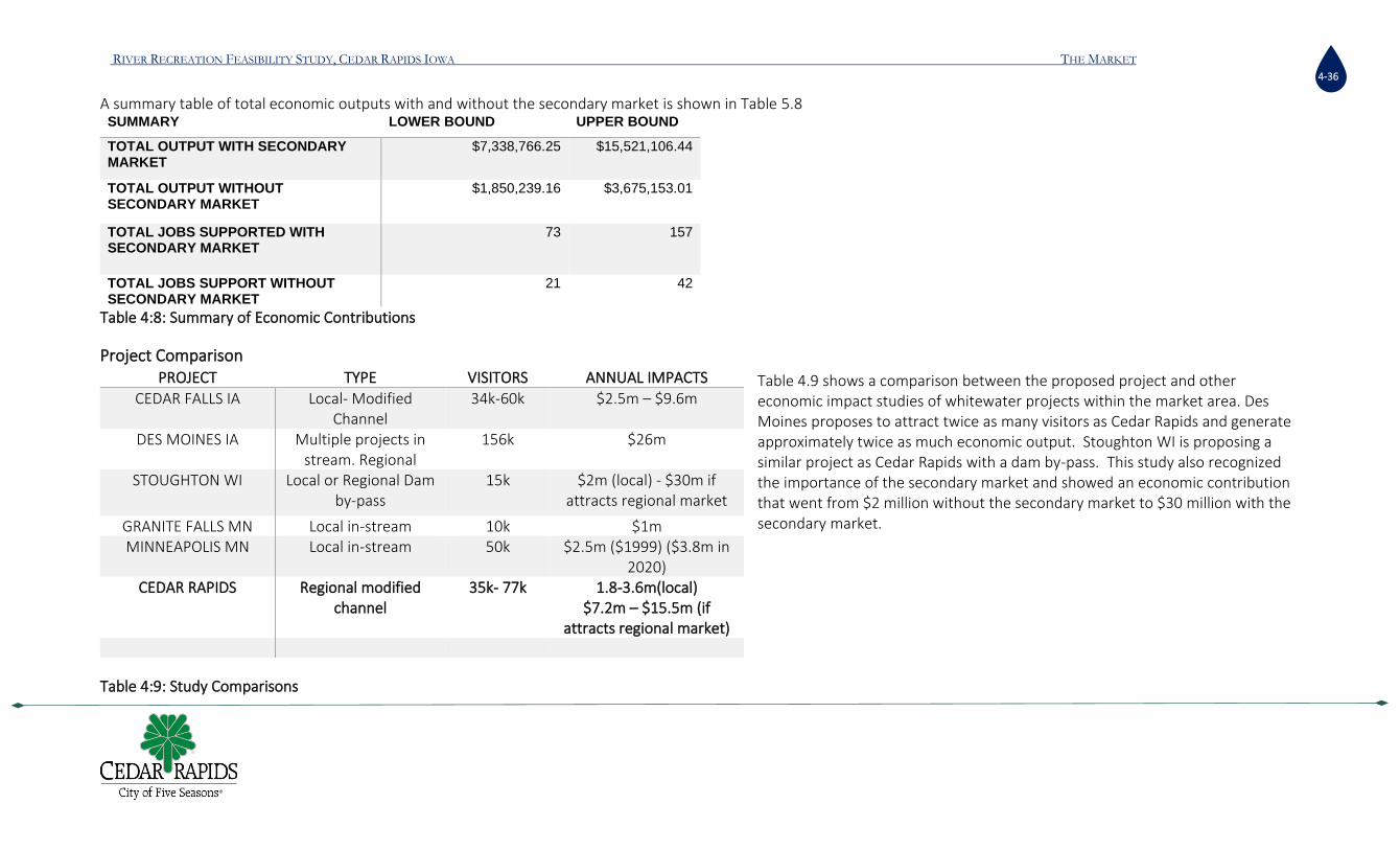
RIVER RECREATION FEASIBILITY STUDY, CEDAR RAPIDS IOWA THE MARKET
4-36
A summary table of total economic outputs with and without the secondary market is shown in Table 5.8 SUMMARY LOWER BOUND UPPER BOUND
TOTAL OUTPUT WITH SECONDARY MARKET
$7,338,766.25 $15,521,106.44
TOTAL OUTPUT WITHOUT SECONDARY MARKET
$1,850,239.16 $3,675,153.01
TOTAL JOBS SUPPORTED WITH SECONDARY MARKET
73 157
TOTAL JOBS SUPPORT WITHOUT SECONDARY MARKET
21 42
Table 4:8: Summary of Economic Contributions
Project Comparison
Table 4.9 shows a comparison between the proposed project and other economic impact studies of whitewater projects within the market area. Des Moines proposes to attract twice as many visitors as Cedar Rapids and generate approximately twice as much economic output. Stoughton WI is proposing a similar project as Cedar Rapids with a dam by-pass. This study also recognized the importance of the secondary market and showed an economic contribution that went from $2 million without the secondary market to $30 million with the secondary market.
Table 4:9: Study Comparisons
PROJECT TYPE VISITORS ANNUAL IMPACTS
CEDAR FALLS IA Local- Modified Channel
34k-60k $2.5m – $9.6m
DES MOINES IA Multiple projects in stream. Regional
156k $26m
STOUGHTON WI Local or Regional Dam by-pass
15k $2m (local) - $30m if attracts regional market
GRANITE FALLS MN Local in-stream 10k $1m MINNEAPOLIS MN Local in-stream 50k $2.5m ($1999) ($3.8m in
2020) CEDAR RAPIDS Regional modified
channel 35k- 77k 1.8-3.6m(local)
$7.2m – $15.5m (if attracts regional market)
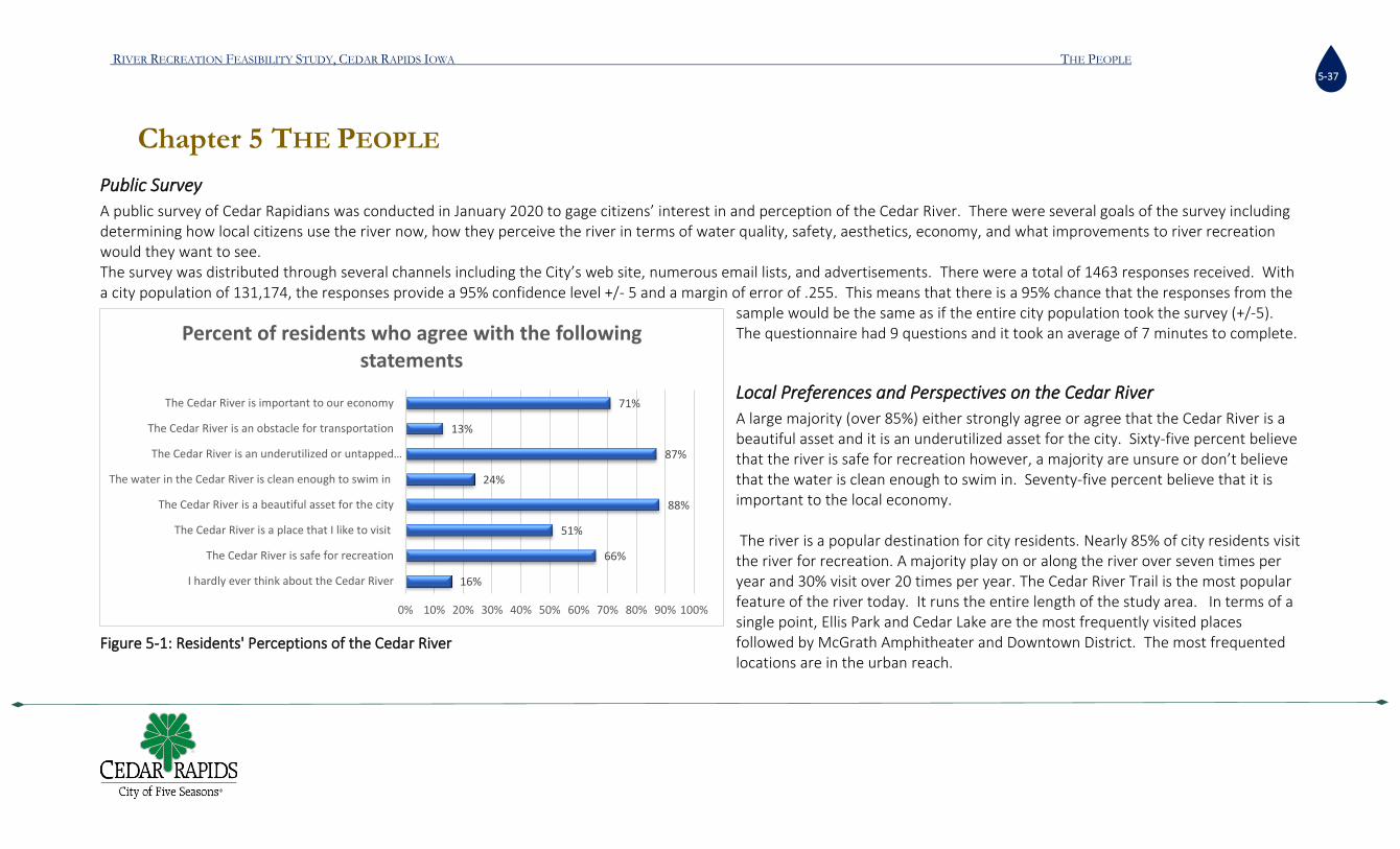
RIVER RECREATION FEASIBILITY STUDY, CEDAR RAPIDS IOWA THE PEOPLE
5-37
Chapter 5 THE PEOPLE
Public Survey
A public survey of Cedar Rapidians was conducted in January 2020 to gage citizens’ interest in and perception of the Cedar River. There were several goals of the survey including determining how local citizens use the river now, how they perceive the river in terms of water quality, safety, aesthetics, economy, and what improvements to river recreation would they want to see. The survey was distributed through several channels including the City’s web site, numerous email lists, and advertisements. There were a total of 1463 responses received. With a city population of 131,174, the responses provide a 95% confidence level +/- 5 and a margin of error of .255. This means that there is a 95% chance that the responses from the
sample would be the same as if the entire city population took the survey (+/-5). The questionnaire had 9 questions and it took an average of 7 minutes to complete.
Local Preferences and Perspectives on the Cedar River
A large majority (over 85%) either strongly agree or agree that the Cedar River is a beautiful asset and it is an underutilized asset for the city. Sixty-five percent believe that the river is safe for recreation however, a majority are unsure or don’t believe that the water is clean enough to swim in. Seventy-five percent believe that it is important to the local economy. The river is a popular destination for city residents. Nearly 85% of city residents visit the river for recreation. A majority play on or along the river over seven times per year and 30% visit over 20 times per year. The Cedar River Trail is the most popular feature of the river today. It runs the entire length of the study area. In terms of a single point, Ellis Park and Cedar Lake are the most frequently visited places followed by McGrath Amphitheater and Downtown District. The most frequented locations are in the urban reach.
16%
66%
51%
88%
24%
87%
13%
71%
0% 10% 20% 30% 40% 50% 60% 70% 80% 90% 100%
I hardly ever think about the Cedar River
The Cedar River is safe for recreation
The Cedar River is a place that I like to visit
The Cedar River is a beautiful asset for the city
The water in the Cedar River is clean enough to swim in
The Cedar River is an underutilized or untapped…
The Cedar River is an obstacle for transportation
The Cedar River is important to our economy
Percent of residents who agree with the following statements
Figure 5-1: Residents' Perceptions of the Cedar River

RIVER RECREATION FEASIBILITY STUDY, CEDAR RAPIDS IOWA THE PEOPLE
5-38
Motor boating and fishing are the most popular activities, enjoyed by 13% and 12% of the population, respectively. Forty-one percent of residents do not do any in-water activities. Kayaking is enjoyed by 10% of the resident population. Whitewater boating, paddle boarding, and rafting are not popular activities among residents.
Figure 5-3: Resident’s preferred location on the water
9%
16%
4%
7%
13%
0% 2% 4% 6% 8% 10% 12% 14% 16% 18%
Between Seminole Valley Park and 5 in 1 Dam
Between Ellis Harbor and 5 in 1 Dam
Between 5 in 1 dam and 16th street bridge/Sokol Park
Between Sokol Park and Tait Cummings MemorialPark/Prairie Creek
Downstream of Alliant Energy dam (C-street Rollerdam)
Preferred in-stream location
13%
13%
12%
37%
42%
4%
38%
34%
6%
2%
24%
45%
0% 5% 10% 15% 20% 25% 30% 35% 40% 45% 50%
Seminole Valley Park
Manhattan/Robbins Lake Park
Mohawk City Park
Cedar Lake Area
Ellis Park and/or 5 Seasons Water Ski viewing…
First Street Park below 5 in 1 dam
McGrath Amphitheater area
Downtown District
Riverside Park/SkatePark/Sokol Park
Osborn Park
Prairie Park/Sac and Fox Trail
Along the Cedar River Trail
Preferred Riverside Location
Figure 5-2: Residents preferred riverside location

RIVER RECREATION FEASIBILITY STUDY, CEDAR RAPIDS IOWA THE PEOPLE
5-39
Figure 5-4: Residents' Preferred In-water Activity and Riverside Activity Survey results show that only 1.6% of residents don’t use the river for any type of recreation. The most popular riverside activity is biking by a large margin. Walking, fishing, and attending outdoor events along the river are also very popular activities. The survey shows that visitation to the river is frequent among residents and therefore, whitewater rodeos and water park spectator sport activities would be well attended. Residents primarily enjoy linear recreation (i.e: biking, jogging, walking). This indicates that a paddlers trail would also be a popular activity. The survey inquired about other rivers in Iowa to understand if the residents were being drawn away from the city by other rivers. Rivers outside of Cedar Rapids or Linn County are not drawing residents away from home in large numbers. The Cedar River seems equally or more attractive as other Iowa waterbodies. The Mississippi and Coralville Lake are the only water bodies that draw people in any noticeable numbers. This is good news for any river related investments.
0.94%
10.30%
3.23%
0.77%
1.11%
3.91%
0.51%
0.77%
13.27%
3.23%
0.26%
0.77%
12.76%
1.79%
0.26%
0.00%
41.67%
4.80%
0.00% 5.00% 10.00% 15.00% 20.00% 25.00% 30.00% 35.00% 40.00% 45.00%
Whitewater Boating
Kayaking
Flat water Boating
SUP (Stand Up Paddleboards)
Rafting
Tubing/Floating
Dragon Boating
Rowing/Crew
Motor Boating
Water Skiing
Wake Boarding
Jet Skiing
Fishing
Swimming/Wading
Rescue Swimming/Training
Snorkeling or SCUBA
I don't do any in-water activity
Other (please specify)In-Water Activites
10.54%
4.76%
0.94%
32.82%
9.27%
0.43%
13.86%
4.42%
0.34%
1.79%
10.97%
0.68%
2.98%
0.77%
1.62%
3.83%
0.00% 5.00% 10.00% 15.00% 20.00% 25.00% 30.00% 35.00%
Fishing
Running/Jogging
Workout Exercise
Biking
Walking for exercise
Roller sports
Leisure walking
Picnicking/relaxing
Reading
Mild Exercise
Outdoor events/Entertainment
Team sports
Hobbies(bird watching, photography etc)
Meeting
I don't do any riverside activity
Other (please specify)
Riverside Activity
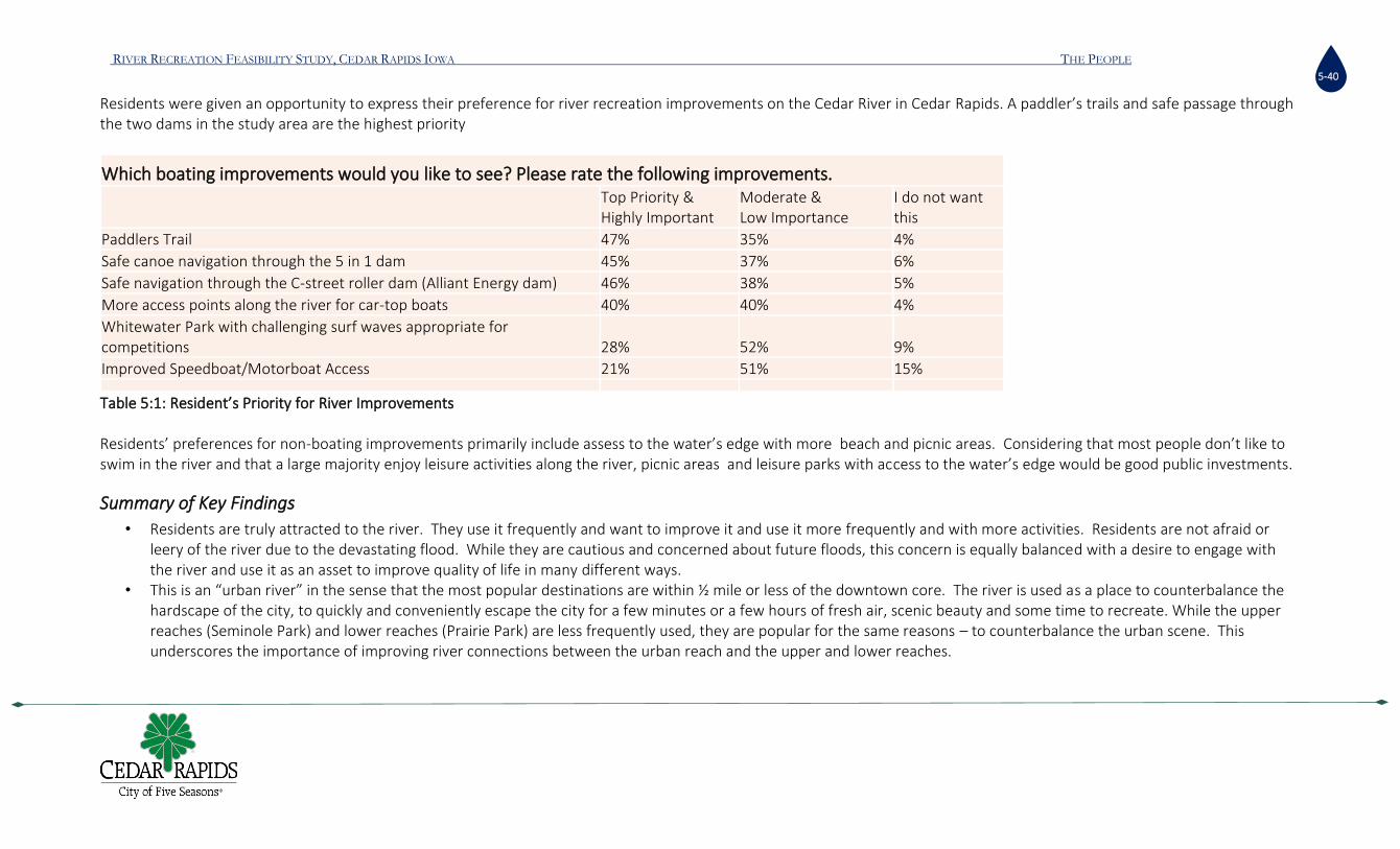
RIVER RECREATION FEASIBILITY STUDY, CEDAR RAPIDS IOWA THE PEOPLE
5-40
Residents were given an opportunity to express their preference for river recreation improvements on the Cedar River in Cedar Rapids. A paddler’s trails and safe passage through the two dams in the study area are the highest priority
Which boating improvements would you like to see? Please rate the following improvements.
Top Priority & Highly Important
Moderate & Low Importance
I do not want this
Paddlers Trail 47% 35% 4%
Safe canoe navigation through the 5 in 1 dam 45% 37% 6%
Safe navigation through the C-street roller dam (Alliant Energy dam) 46% 38% 5%
More access points along the river for car-top boats 40% 40% 4%
Whitewater Park with challenging surf waves appropriate for competitions 28% 52% 9%
Improved Speedboat/Motorboat Access 21% 51% 15% Table 5:1: Resident’s Priority for River Improvements Residents’ preferences for non-boating improvements primarily include assess to the water’s edge with more beach and picnic areas. Considering that most people don’t like to swim in the river and that a large majority enjoy leisure activities along the river, picnic areas and leisure parks with access to the water’s edge would be good public investments.
Summary of Key Findings
• Residents are truly attracted to the river. They use it frequently and want to improve it and use it more frequently and with more activities. Residents are not afraid or leery of the river due to the devastating flood. While they are cautious and concerned about future floods, this concern is equally balanced with a desire to engage with the river and use it as an asset to improve quality of life in many different ways.
• This is an “urban river” in the sense that the most popular destinations are within ½ mile or less of the downtown core. The river is used as a place to counterbalance the hardscape of the city, to quickly and conveniently escape the city for a few minutes or a few hours of fresh air, scenic beauty and some time to recreate. While the upper reaches (Seminole Park) and lower reaches (Prairie Park) are less frequently used, they are popular for the same reasons – to counterbalance the urban scene. This underscores the importance of improving river connections between the urban reach and the upper and lower reaches.

RIVER RECREATION FEASIBILITY STUDY, CEDAR RAPIDS IOWA THE PEOPLE
5-41
• Fifty-eight (58.4%) percent of the residents engage in some sort of in-stream recreation. Motor boating, fishing, and flatwater kayaking are the most popular in-stream recreation activities, which are enjoyed by 36% of the population (13%,12% and 10% respectively). The remaining 41.6% of Cedar Rapids residents do not engage in any type of in-stream recreation. River recreation investments must balance the demands of in-stream and out-of-stream recreationists.
• Out-of-stream, or riverside, recreation is more popular than in-stream. Linear recreation such as biking, walking, rolling and running are highly popular. The Cedar River Trail is very popular, and it should be integrated into river recreation investments to gain maximum enjoyment from residents. A proposed paddlers trail is likely to be popular due to the preference for liner recreation. Results from Q8 confirm this. A wet/dry or bike/boat trail integrating the two assets may be a unique and fun feature. It would also serve as an ideal triathlon venue.
• When reviewing total popularity of recreation activities, it appears that residents are equally split on leisure versus active recreation that occurs on or along the river. • For in-stream recreation, residents are seeking linear recreation – paddlers trail- and safe passage through the 5 in1 dam and the C-street roller dam. These are the highest
priorities. • Whitewater parks are the highest priority for about 30% of the population. This does not mean that the city shouldn’t consider building one. It only means that a
whitewater park ranks third in comparison to the other choices that the residents were given. • Whitewater parks are important river features that serve multiple purposes including safe downstream passage and increasing the attractiveness of the city. Whitewater
parks are important economic development assets that attract young high-skilled labor and visitors. Residents answered the priority question with respect to their personal preferences, not for the growth of the city. A whitewater park can facilitate the completion of the other top priority investments that the residents are requesting, while giving the city an important economic development asset.
• The riverside improvements that the residents would like are consistent with how they use the river today. They want access to the river, they want to sit and relax near the water, to dip their toes in or let their kids splash around in the water. They want safe beach areas, safe wading areas, and convenient picnic areas.
• The survey shows that residents are seeking more and improved access to the river in many different ways. They want access for car top boats, fishing, swimming, leisure, and family play. There are many locations along the river where modest, inexpensive modifications to existing layouts can give them what they are seeking.
Recreation User Groups
The most important consideration in designing river recreation opportunities is the people. Who will use the river and who is the city trying to serve or attract? The proposed recommendations in this report are focused on attracting the following user groups:

RIVER RECREATION FEASIBILITY STUDY, CEDAR RAPIDS IOWA THE PEOPLE
5-42
Whitewater Paddlers
Whitewater kayaking, canoeing, paddle boarding and river surfing enthusiast are a target user group to be served by the proposed river recreation enhancements. These users will typically drive to a destination facility to use one or more of the wave features then leave from the same point of entry. This type of use is called “park and play” in whitewater circles, though these users may also navigate the features from upstream to downstream as part of a longer run where a shuttle may be established at the ingress/egress points of the run. The expectations of these users for the character and difficulty of the whitewater features correspond with individual ability. They typically desire challenging features that offers the opportunity to hone their skills. Furthermore, desirable whitewater facilities often include standing waves, recirculating eddies, drop-in access points, recovery pools, and relatively easy ingress/egress to and from the river. Additional components of a park that will serve the interests of this user include convenient access to and from the features, nearby parking, riverside viewing, staging areas, restrooms, changing areas, and banks to rest and spectate. This group is anticipated to be one of the primary users of the river recreation features. Oftentimes, they may use the features well into the shoulder seasons and would be attracted to Cedar Rapids for the extended recreation season created by a larger river system. To accommodate the broadest range of whitewater users, proposed wave features should include a range of novice to intermediate waves as well as more advanced features. These features should be deigned to create various recreational experiences for the purpose of providing recreational opportunities for differing skill levels and users. Creating play features that serve the broadest range of skills and whitewater user groups would maximize the benefit to the City. Freestyle whitewater users often take part in organized competitions. These competitions may involve professional athletes, local competitors, sponsors, and spectators. Whitewater parks typically host festivals and competitions, because they tend to offer the necessary support facilities as compared to wilderness areas. Oftentimes, these events draw numerous spectators, which can produce significant benefits to the local economies. In order to provide for the needs of these events, appropriate site planning and design should be performed to anticipate and accommodate this use.
Float Through Navigation
Float through navigation typically includes inner tubes, canoes, kayaks and paddle boards but can also include pool toys and even general swimming. These users would typically navigate a whitewater course, from upstream to downstream, not staying at a specific feature for an extended period of time. Users may take a single run or lap the course multiple times per day. It is anticipated that this user group can be split into two general groups. Tubers would generally access the course from nearby parking areas and not attempt to incorporate the whitewater features into a longer run. However, canoers, kayakers and paddle boarders may attempt to incorporate the park into a longer run enabling its use as a paddle trail. Because not all recreational boaters will have adequate skill to navigate even the most basic rapids, clearly defined and easily accessed portage routes around the features should also be established. Moreover, due to the low barrier of entry for these types of users, many of them may not be well versed in river safety or have adequate rescue equipment and may be unfamiliar with river etiquette. Users that may be more novice in their experience on the river, may require easier bypass routes and navigation channels around recreational features. These bypass routes can also serve to minimize conflicts between freestyle and navigational users.

RIVER RECREATION FEASIBILITY STUDY, CEDAR RAPIDS IOWA THE PEOPLE
5-43
In general, float through users require easily achieved and obvious routes of navigation, which allow for passage of most non-motorized river craft. Signage should be posted well upstream of any river improvements to provide adequate warning, assumption of risk and direction to novice river users. Furthermore, the park should be designed to direct appropriate usage by pushing float traffic into the least challenging routes and provide self-rescue opportunities. Consideration of this user group is key to avoid the creation of unnecessary hazards and conflicts.
It should be anticipated that novice users will occasionally miss formal egress (take-out) points downstream of the recreational enhancements. Additional bank access in the
form of laid-back terraced banks should be considered at specific locations downstream of the park to provide opportunities for users to exit the river in the event they are
swept downstream or seek to enter the river downstream of the park.
Passive River Users
Whitewater parks are often visited by a large number of onlookers and spectators who may travel significant distances to view the activities including everyday use, scheduled events, festivals, and/or competitions. Moreover, people are often drawn to these facilities to view the river and other natural settings. These users can have a significant benefit to the local economy. Even without advertised events, spectators commonly frequent whitewater parks to view the facility, river, and activities. Often these spectators arrive without a specific agenda and may spend extended periods of time watching the informal activities. This user group constitutes a large cross-section of the general community and may have varying needs, including food, restrooms, and transportation, seating and shade with a view of the activities. Often, these users may also seek alternative activities, including nearby dining and shopping opportunities.
Designing for Key Stakeholders
A broad range of existing stakeholders are vested in the outcome of this project. All proposed river recreation enhancements to the Cedar River have taken into account the interests of these stakeholders. These existing user groups are identified here, along with any associated design criteria to address group-specific concerns as they relate to the conceptual designs.
The City of Cedar Rapids
The City of Cedar Rapids has a significant interest in the manner in which the Cedar River is utilized through the reaches within the municipal boundary. The City currently uses the river for flood conveyance, aesthetics, wildlife habitat, recreation, and tourism amongst other uses. As part of this project, the City has expressed a desire to improve opportunities for tourism and local residents through the creation of safe river based recreational enhancements while simultaneously protecting local property and citizens from flooding by coordinating the proposed project with the ongoing design and construction of the City’s Flood Control System.

RIVER RECREATION FEASIBILITY STUDY, CEDAR RAPIDS IOWA THE PEOPLE
5-44
The City of Cedar Rapids is currently home to many attractions, including walking paths, biking trails, fishing, motorized and non-motorized boating, among others. These attractions draw tourism to the area, which contributes to the economic growth and stability of Cedar Rapids and a part of the City’s brand.
Associated Design Criteria
The following design criteria address specific interests of the City in the development of this design:
• The recreational enhancements should be designed to attract diverse user groups while accommodating existing users;
• The recreational enhancements should not impact the managed pool elevation upstream of the 5 in 1 dam;
• The site improvements must be coordinated with the Flood Control System and cannot increase flood hazard designation or risk for adjoining properties;
• The site improvements must protect the stability of existing and proposed infrastructure that is critical to the function of the City before, during and after flooding events;
• The recreational enhancements should serve as a regional attraction providing safe river-based recreation opportunities for local residents and tourists; and
• The recreational enhancements should promote the City of Five Seasons brand as a healthy, outdoor-oriented community and a destination for river recreation and tourism.
Local Residents and Business Owners
The creation of river-based recreation attractions can significantly benefit communities through improvements to local and regional economies, quality of life, enhanced tourism, expanded open spaces, trails and passive viewing opportunities. The concept alternatives proposed for Cedar Rapids have been developed to consider current river uses as well as to create new river-based recreation opportunities. Existing businesses, facilities, parks, infrastructure, roads, walking trails and bike paths along the river near town are used extensively by local residents and tourists. As such, local businesses have an interest in any proposed improvements to the river channel and its banks. Residents and businesses seek a project that will positively impact the local economy by attracting new visitors and extending stay times, thereby increasing expenditures at local businesses, to the benefit of the community. This interest group expects the improvements to align with the existing community and to improve the quality of life for local residents in addition to catering to visitors.
Associated Design Criteria
The following design criteria address specific interests of residents and businesses in the development of this design:
• The recreational enhancements should contribute to the quality of life for residents of Cedar Rapids;

RIVER RECREATION FEASIBILITY STUDY, CEDAR RAPIDS IOWA THE PEOPLE
5-45
• The recreational enhancements should further the City’s connection with an outdoor recreational lifestyle and, as such, help attract new residents and industry;
• The recreational enhancements should maximize the season for in-stream recreation, producing the largest possible window of opportunity for use and extended stay times for users;
• The recreational enhancements should be designed to provide river access, seating, and viewing opportunities to the direct benefit of residents and visitors; and
• The recreational enhancements should be designed to maximize the economic benefits to local residents and businesses.
Anglers and Fisheries Managers
Recreational anglers and fisheries managers are key stakeholders anytime physical changes to the river are proposed. These users may include fly fisherman, lure fisherman and bait fisherman. The fishing season on the Cedar River can last year-round, depending on the severity of the winter, fishing restrictions, and regulations. Protections and enhancements to bank fishing opportunities and fishing access should be considered in the development of conceptual designs. The inclusion of terraced banks, expanded access, and ADA fishing piers are means by which river recreation enhancements can improve fishing opportunities. Moreover, through the removal of existing river hazards or the creation of bypass navigation routes, recreational anglers may be presented with new fishing opportunities for float access. The needs of the existing fishery will also be critical to the design of river recreation enhancements. In general, ideal habitats for fisheries includes spawning grounds, adequate water quality, opportunities for upstream and downstream mobility, shaded pools, and holding eddies. One of the primary objectives of this group is to protect and improve existing in-stream habitat as well as to provide for new fish passage opportunities to enhance overall river connectivity.
Associated Design Criteria
The following criteria address the interests of fisheries and angling groups as part of the development of this design:
• The recreational enhancements should provide improved bank fishing access and allow for non-motorized boat passage without altering the character of the existing reach;
• The recreational enhancements should be designed to allow for environmentally sensitive construction techniques and to minimize temporary construction impacts; and
• The recreational enhancements should provide new opportunities for fish passage around existing 5 in 1 dam.
Figure 5-5: Fisherman catching a juvenile Sturgeon attempting to migrate upstream below 5 in 1 dam, Sept 2019

RIVER RECREATION FEASIBILITY STUDY, CEDAR RAPIDS IOWA THE PEOPLE
5-46
Non-Motorized Recreational Boaters
The Cedar River experiences significant use from non-motorized recreational river craft; however, due to the navigation hazards posed by the 5 in 1 dam and the C-Street roller dam, a formal river trail is currently infeasible. These uses may include lake/river kayaking, paddle boarding, canoeing and drift boating. Various public boat launches exist upstream, within, and downstream of the City. Non-motorized boaters transport their car-top boats and large amounts of gear to and from the river and need parking areas in close proximity to the river.
Associated Design Criteria
The following criteria address the interests of non-motorized recreational boaters as part of the development of this design:
• The recreational enhancements should anticipate non-motorized downstream river craft by establishing clear and obvious lines through which to navigate;
• The recreation enhancements should create clearly defined and easily accessed portage routes around the rapids; and
• The recreational enhancements should serve to provide new river-based recreational opportunities for downstream river craft, creating both low hazard navigation routes as well as more adventurous whitewater experiences.
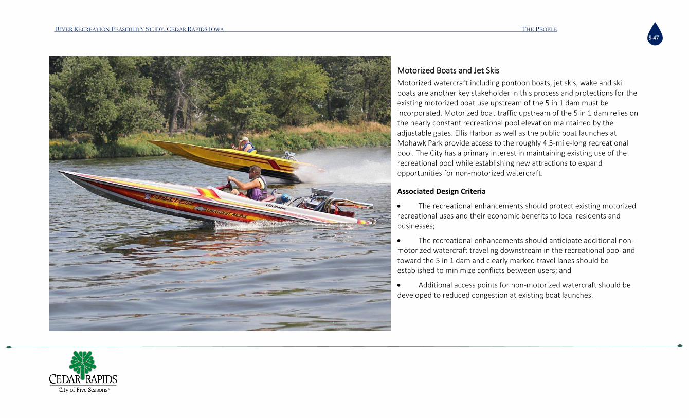
RIVER RECREATION FEASIBILITY STUDY, CEDAR RAPIDS IOWA THE PEOPLE
5-47
Motorized Boats and Jet Skis
Motorized watercraft including pontoon boats, jet skis, wake and ski boats are another key stakeholder in this process and protections for the existing motorized boat use upstream of the 5 in 1 dam must be incorporated. Motorized boat traffic upstream of the 5 in 1 dam relies on the nearly constant recreational pool elevation maintained by the adjustable gates. Ellis Harbor as well as the public boat launches at Mohawk Park provide access to the roughly 4.5-mile-long recreational pool. The City has a primary interest in maintaining existing use of the recreational pool while establishing new attractions to expand opportunities for non-motorized watercraft.
Associated Design Criteria
• The recreational enhancements should protect existing motorized recreational uses and their economic benefits to local residents and businesses;
• The recreational enhancements should anticipate additional non-motorized watercraft traveling downstream in the recreational pool and toward the 5 in 1 dam and clearly marked travel lanes should be established to minimize conflicts between users; and
• Additional access points for non-motorized watercraft should be developed to reduced congestion at existing boat launches.

RIVER RECREATION FEASIBILITY STUDY, CEDAR RAPIDS IOWA RIVER RECREATION OPPORTUNITIES 6-48
Chapter 6 RIVER RECREATION OPPORTUNITIES
Location
The greatest opportunity for whitewater recreation in Cedar Rapids is as close to the core of downtown as possible. Several reasons drive this recommendation. First, the public survey of residents shows that most people enjoy the river in the urban reach. While the upper and lower reaches are also popular, a whitewater park in the urban reach is the most equitable location for most Cedar Rapidians. Second, a whitewater park is a spectator sport. Locating the park in the urban reach will generate the most spectators and help generate additional foot traffic for downtown businesses and contribute to increasing the economic vibrancy of the downtown. Third, a downtown location has the best opportunity for citizens to reconnect with their river. The City’s goal of this project was to “activate” the river and change it from a passive background feature into an active amenity. The public survey reveals that the general population also believes that the river is a “beautiful but underutilized” asset. A downtown location for a whitewater park presents the best opportunity to activate the most citizens with the river. Forth, a whitewater park needs a minimum amount of elevation change to create rapids. The elevation change just below the 5-in-1 dam is the best location on the river (within the City) to create a whitewater park. Fifth, creating a whitewater park at the 5 in 1 dam also creates downstream passage for canoes and kayaks, and upstream passage for migrating fish. By opening up passage through the 5 in 1 dam, the City will be creating a superb water trail through the heart of the city and improve sport fishing. Water trails are the resident’s highest priority for river improvements. Sixth, a whitewater park at the 5 in 1 dam creates a synergy with the water skiers and motorboating community upstream. Both groups are river enthusiasts and occasionally engage in each other’s sports. Water skiing is a spectator sport and so are whitewater competitions. Holding events during the same weekend would help each other and help build Cedar Rapids’ reputation as a destination for river sports. The whitewater park has a much better chance of success if the upstream pool is maintained and the ski club continues to flourish. Seventh, any river recreation amenity must be compatible with the Flood Control System being installed throughout the city. A hydrologic analysis showed that a whitewater park at the 5 in 1 dam will have no negative impact on the FCS.

RIVER RECREATION FEASIBILITY STUDY, CEDAR RAPIDS IOWA RIVER RECREATION OPPORTUNITIES 6-49
Key Factors to Success
Creating a whitewater park in the heart of downtown just below the 5 in 1 dam is the best opportunity meet the goals of this project and to activate the river into the lives of the Cedar Rapidians. The proposed site at the 5 in 1 dam also creates a set of challenges that must be addressed. The project will require extensive engineering to ensure the integrity of the bridges and dam. It will also require two channels; one for challenging whitewater and one that is calm and suitable for a water trail. In short, this design will be comparatively more expensive than the others currently in the market area. A successful whitewater park will have a visitation rate that generates enough economic activity for a good return on investment. While a threshold for a minimum return has not been established by the city, the consultant generally suggests that the break-even point should be between 5 and 10 years. The project lifespan of a whitewater park is between 30 and 40 years, therefore the project should be generating a net positive economic return to the city for twenty to thirty years. To ensure this type of return, several key assumptions, or factors for success, were made during the economic impact analysis. These success factors are described here:
C Street Dam Mitigation: The economic analysis described the importance of attracting the secondary market (those living beyond 125 miles and up to 250 miles away). In order to attract the secondary market, the river amenity must be more than a park-and-play venue. It must be a river trip. If the C-street dam was mitigated or removed, a river trip from the upstream pool, through the whitewater park, through downtown, and to Prairie Park will create an exciting, convenient, and enjoyable river trip that lasts half a day. During the work on the dam’s mitigation or removal, it would be possible to create at least one Class-2 rapid. A rapid at the 5 in 1 dam, plus a rapid at the C-street location, creates the modest yet marketable river trip. Water trail paddlers also have the opportunity to float all the way to Palisades Park. If they portaged around the breached dam at Palisades-Kepler State Park, then they would be able to float all the way to the Mississippi. In other words, a whitewater park at the 5 in 1 dam and mitigation or removal of the C street dam has the opportunity to create arguably the longest paddlers trail in Iowa.
Commercial Outfitter: If a river trip was created in Cedar Rapids, then the ability to attract a commercial outfitter is probable. The benefit of allowing at least one commercial outfitter operate on the river is that they have a profit motive to market Cedar Rapids. Commercial outfitters have an incentive to attract foot traffic to downtown. They also help engage beginners with the river. They provide boating and paddleboard lessons, rent tubes, teach river safety, and help coordinate river events. A public/private partnership between the city and the right commercial outfitter can be a mutually beneficial relationship. This is possible only if the C street dam is mitigated and a river trip is created.
Design for Spectators: Spectators are crucial to the success of the whitewater park. The park design must include ample space to watch events, picnic areas, food and beverage concessions and convenient parking.
Maintain the Upstream Pool: The pool upstream of the 5 in 1 dam should be maintained under its current flow regime. The city maintains the pool elevation at 717 feet, if natural river flow conditions allow. It is important to the success of the whitewater park that the pool elevation remains unchanged.
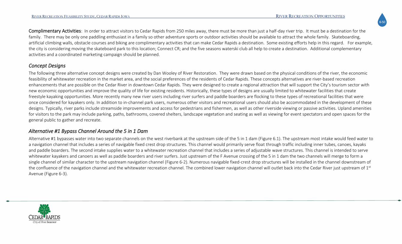
RIVER RECREATION FEASIBILITY STUDY, CEDAR RAPIDS IOWA RIVER RECREATION OPPORTUNITIES 6-50
Complimentary Activities: In order to attract visitors to Cedar Rapids from 250 miles away, there must be more than just a half-day river trip. It must be a destination for the family. There may be only one paddling enthusiast in a family so other adventure sports or outdoor activities should be available to attract the whole family. Skateboarding, artificial climbing walls, obstacle courses and biking are complimentary activities that can make Cedar Rapids a destination. Some existing efforts help in this regard. For example, the city is considering moving the skateboard park to this location; Connect CR; and the five seasons waterski club all help to create a destination. Additional complementary activities and a coordinated marketing campaign should be planned.
Concept Designs
The following three alternative concept designs were created by Dan Wooley of River Restoration. They were drawn based on the physical conditions of the river, the economic feasibility of whitewater recreation in the market area, and the social preferences of the residents of Cedar Rapids. These concepts alternatives are river-based recreation enhancements that are possible on the Cedar River in downtown Cedar Rapids. They were designed to create a regional attraction that will support the City’s tourism sector with new economic opportunities and improve the quality of life for existing residents. Historically, these types of designs are usually limited to whitewater facilities that create freestyle kayaking opportunities. More recently many new river users including river surfers and paddle boarders are flocking to these types of recreational facilities that were once considered for kayakers only. In addition to in-channel park users, numerous other visitors and recreational users should also be accommodated in the development of these designs. Typically, river parks include streamside improvements and access for pedestrians and fishermen, as well as other riverside viewing or passive activities. Upland amenities for visitors to the park may include parking, paths, bathrooms, covered shelters, landscape vegetation and seating as well as viewing for event spectators and open spaces for the general public to gather and recreate.
Alternative #1 Bypass Channel Around the 5 in 1 Dam
Alternative #1 bypasses water into two separate channels on the west riverbank at the upstream side of the 5 in 1 dam (Figure 6.1). The upstream most intake would feed water to a navigation channel that includes a series of navigable fixed crest drop structures. This channel would primarily serve float through traffic including inner tubes, canoes, kayaks and paddle boarders. The second intake supplies water to a whitewater recreation channel that includes a series of adjustable wave structures. This channel is intended to serve whitewater kayakers and canoers as well as paddle boarders and river surfers. Just upstream of the F Avenue crossing of the 5 in 1 dam the two channels will merge to form a single channel of similar character to the upstream navigation channel (Figure 6-2). Numerous navigable fixed-crest drop structures will be installed in the channel downstream of the confluence of the navigation channel and the whitewater recreation channel. The combined lower navigation channel will outlet back into the Cedar River just upstream of 1st Avenue (Figure 6-3).

RIVER RECREATION FEASIBILITY STUDY, CEDAR RAPIDS IOWA RIVER RECREATION OPPORTUNITIES 6-51
Figure 6-1: By-pass channel, Alternative 1

RIVER RECREATION FEASIBILITY STUDY, CEDAR RAPIDS IOWA RIVER RECREATION OPPORTUNITIES 6-52
Figure 6-2: Looking north at the confluence of the navigation and whitewater recreation channels, Alternative #1

RIVER RECREATION FEASIBILITY STUDY, CEDAR RAPIDS IOWA RIVER RECREATION OPPORTUNITIES 6-53
Figure 6-3: Looking northwest at the outfall of the Alternative #1 channel

RIVER RECREATION FEASIBILITY STUDY, CEDAR RAPIDS IOWA RIVER RECREATION OPPORTUNITIES 6-54
Because this alternative bypasses the 5 in 1 dam, the proposed navigation channel will run in the current alignment of 1st Street, requiring the permanent rerouting of traffic to other side streets. Moreover, the intersections of F and E Avenues and 1st Street will need to be completely reconstructed with bridges spanning the constructed channel. Alternatively, the E Avenue intersection could be permanently closed, rerouting east bound traffic to the F Avenue alignment. This permanent closure of E Avenue to vehicular traffic would allow for its use as a covered pedestrian walkway, thereby avoiding the need to construct a second vehicular bridge. Within the 5 in 1 dam alignment, the Vinton Creek outfall will also need to be spanned, having a significant effect on the potential elevations of the navigation channel within the corridor. Numerous other utilities including watermains, storm sewers, sanitary sewers and fiber optic lines will also need to be demolished and rerouted within the Alternative #1 corridor. To provide access to and circulation within the project site this alternative includes ADA accessible ramps, stone access steps, pedestrian bridges and both hard and soft paths. In addition, parking lots, restroom facilities, changing screens, picnic pavilions, children's play areas, drinking fountains, benches and interpretive signage, which are not shown in the conceptual alternatives, but are included in the total project cost opinion, will also need to be developed. Figure 6-4 Looking south at the proposed bridge spanning the Alternative #1 channel at F
Avenue
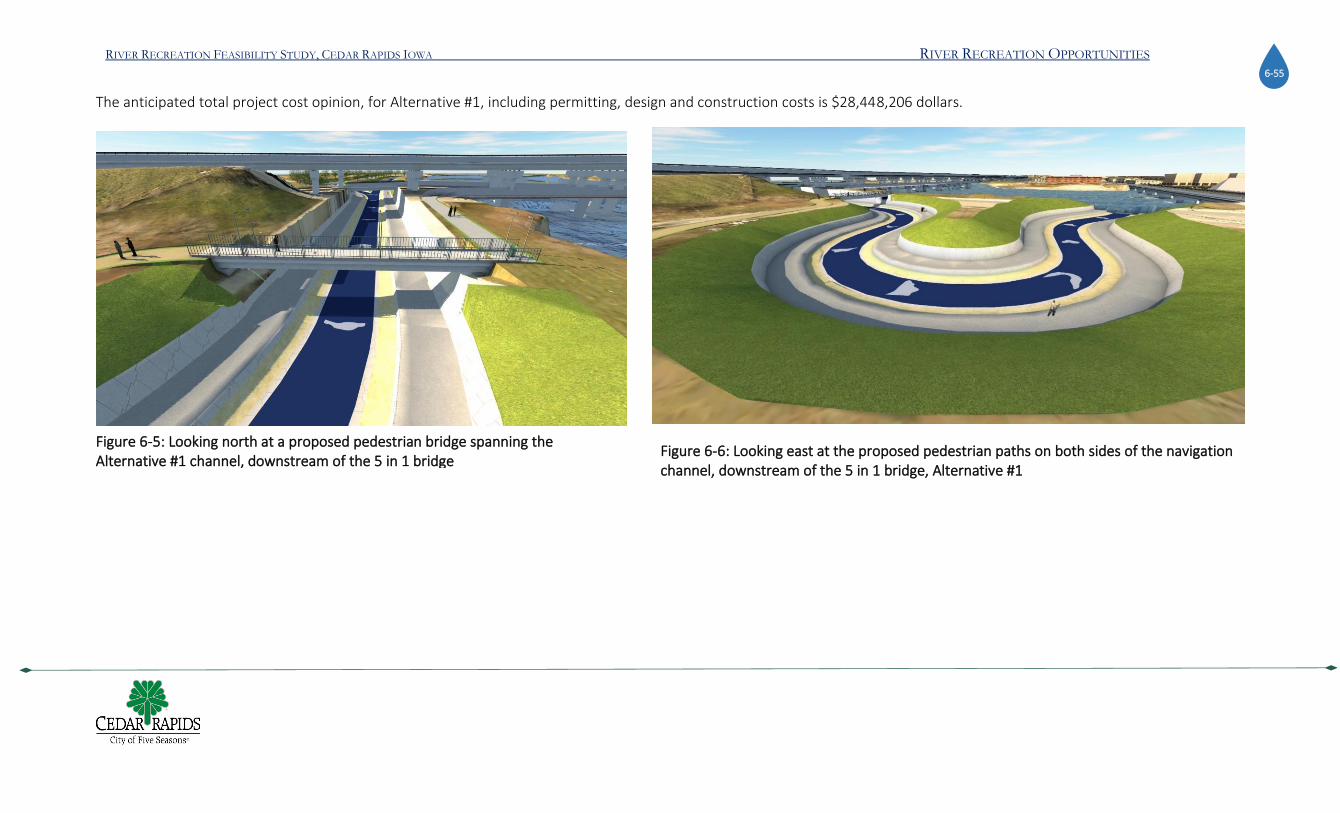
RIVER RECREATION FEASIBILITY STUDY, CEDAR RAPIDS IOWA RIVER RECREATION OPPORTUNITIES 6-55
The anticipated total project cost opinion, for Alternative #1, including permitting, design and construction costs is $28,448,206 dollars.
Figure 6-5: Looking north at a proposed pedestrian bridge spanning the Alternative #1 channel, downstream of the 5 in 1 bridge
Figure 6-6: Looking east at the proposed pedestrian paths on both sides of the navigation channel, downstream of the 5 in 1 bridge, Alternative #1

RIVER RECREATION FEASIBILITY STUDY, CEDAR RAPIDS IOWA RIVER RECREATION OPPORTUNITIES 6-56
Alternative #2 Combined Channel Through 5 in 1 Dam
Alternative #2 takes water into a single inlet channel located at the western most gated opening of the 5 in 1 dam (Fig6.7). An adjustable intake structure would regulate the capture of water at the entrance of the channel. A concrete dividing wall would extend the entire length of the recreation channel from the recreational pool upstream of the 5 in 1 dam, downstream to the 1st Avenue outlet (Figure 6-8). Initially the gradient of the inlet channel will remain relatively flat to create ample ingress/egress opportunities for park users or for easy portage of the downstream channel for novice boaters, uninterested in navigating the bypass routes around the wave features. As the channel crosses over new box culverts required to extend the existing Vinton Creek outfall, the gradient will increase. Downstream, the gradient will remain relatively constant as the channel passes through a series of rapids made up of adjustable wave structures that will include designated bypass routes for less experienced users. The channel will then outlet back into the Cedar River just upstream of 1st Avenue (Fig 6.9).
Figure 6-7: Looking southeast at the Alternative #2 inlet and the combined navigation and whitewater recreation channel

RIVER RECREATION FEASIBILITY STUDY, CEDAR RAPIDS IOWA RIVER RECREATION OPPORTUNITIES 6-57
Figure 6-8: Looking north from 1st Avenue at the recreation channel separated from the Cedar River by the river dividing wall, Alternative #2

RIVER RECREATION FEASIBILITY STUDY, CEDAR RAPIDS IOWA RIVER RECREATION OPPORTUNITIES 6-58
This alternative would serve both float through and whitewater traffic by creating bypass routes around the adjustable whitewater features. Even with these designated navigation routes, conflicts between user types may occur in the single channel. Because this alternative uses an existing gated opening though the 5 in 1 dam, no significant alterations to the City streets will be required (Figure 6-10); however, significant alterations to the existing gate and dam structure would be required. Moreover, no existing utilities including watermains, storm sewers, sanitary sewers and fiberoptic lines are anticipated to require relocating within the construction impacts area of Alternative #2. To provide access to and circulation within the project site this alternative includes ADA accessible ramps, access steps and both hard and soft paths (Figure 6-12, Figure 6-13). In addition, parking lots, restroom facilities, changing screens, picnic pavilions, children's play areas, drinking fountains, benches and interpretive signage, which are not shown in the conceptual rendering, but are budgeted in the total project cost opinion, will also need to be designed. The anticipated total project cost opinion, for Alternative #2, including permitting, design and construction costs is $11,936,585 dollars.
Figure 6-9: Looking northwest at the outfall of the Alternative #2 channel

RIVER RECREATION FEASIBILITY STUDY, CEDAR RAPIDS IOWA RIVER RECREATION OPPORTUNITIES 6-59
Figure 6-10 Looking east at the existing 1st Street alignment that will not need to be altered for Alternative #2

RIVER RECREATION FEASIBILITY STUDY, CEDAR RAPIDS IOWA RIVER RECREATION OPPORTUNITIES 6-60
Figure 6-11: Looking north at a proposed pedestrian path running along the entire western bank of the recreation channel, Alternative #2

RIVER RECREATION FEASIBILITY STUDY, CEDAR RAPIDS IOWA RIVER RECREATION OPPORTUNITIES 6-61
Figure 6-12: Looking east at a proposed accessible ramp leading to the lower pedestrian paths and viewing areas, Alternative #2

RIVER RECREATION FEASIBILITY STUDY, CEDAR RAPIDS IOWA RIVER RECREATION OPPORTUNITIES 6-62
Figure 6-13: Looking east at the proposed steps accessing the lower pedestrian area and recreational channel from 1st Street, Alternative #2

RIVER RECREATION FEASIBILITY STUDY, CEDAR RAPIDS IOWA RIVER RECREATION OPPORTUNITIES 6-63
Alternative #3 Separated Channels Through 5 in 1 Dam
Similar to Alternative #2, Alternative #3 is an in-channel design and takes water into a single inlet channel located at the western most opening of the 5 in 1 dam (Fig 6.14)). An adjustable intake structure would regulate the capture of water at the entrance of the channel. A concrete dividing wall would extend the entire length of the recreation channel from the recreational pool upstream of the 5 in 1 dam downstream to the 1st Avenue outfall. The gradient of the inlet channel would remain relatively flat to create ample ingress/egress opportunities for park users or for easy portage of the park for novice users, uninterested in passing through either the navigation channel or the whitewater recreation channel that split from the combined channel downstream. As the channel crosses over the new box culverts required to extend the existing Vinton Creek outfall, the gradient will remain relatively flat, reducing the river current approaching the channel split. At the channel split, the whitewater recreation channel would be located on river left, looking downstream, and the navigation channel would be located on river right. The navigation channel includes a series of navigable fixed-crest drop structures intended to primarily serve float through traffic including inner tubes, canoes, kayaks and paddle boarders. This channel will be milder in nature but will include smaller wave features and s-turns, requiring modest river boating
skills to navigate. The whitewater recreation channel will include a series of adjustable wave structures. This channel is intended to serve whitewater kayakers and canoers as well
Figure 6-14: Looking southwest at the Alternative #3 inlet to the combined navigation and whitewater recreation channel
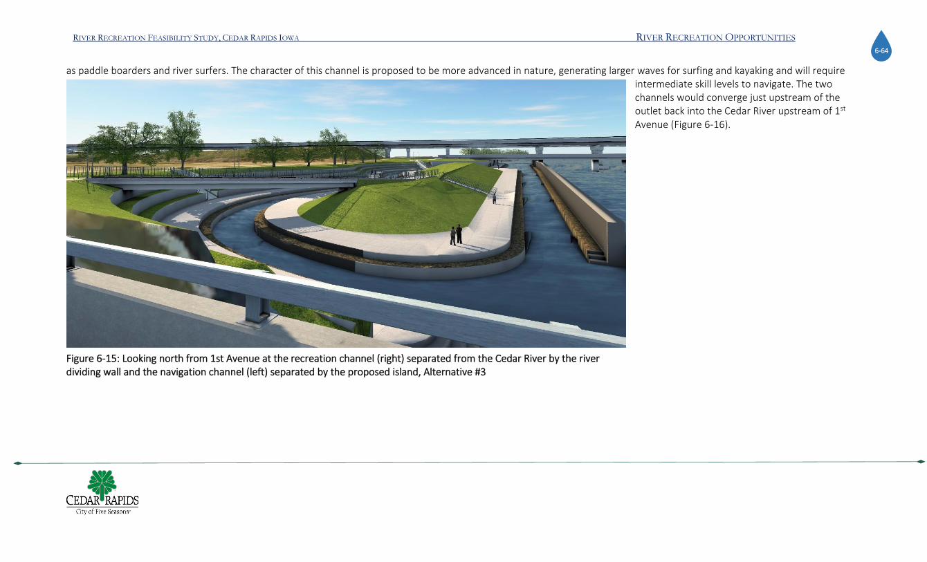
RIVER RECREATION FEASIBILITY STUDY, CEDAR RAPIDS IOWA RIVER RECREATION OPPORTUNITIES 6-64
as paddle boarders and river surfers. The character of this channel is proposed to be more advanced in nature, generating larger waves for surfing and kayaking and will require intermediate skill levels to navigate. The two channels would converge just upstream of the outlet back into the Cedar River upstream of 1st Avenue (Figure 6-16).
Figure 6-15: Looking north from 1st Avenue at the recreation channel (right) separated from the Cedar River by the river dividing wall and the navigation channel (left) separated by the proposed island, Alternative #3

RIVER RECREATION FEASIBILITY STUDY, CEDAR RAPIDS IOWA RIVER RECREATION OPPORTUNITIES 6-65
Figure 6-16: Looking northwest at the confluence of the navigation and whitewater recreation channels as they outlet back to the Cedar River, Alternative #3

RIVER RECREATION FEASIBILITY STUDY, CEDAR RAPIDS IOWA RIVER RECREATION OPPORTUNITIES 6-66
Alternative #3 would serve both float through and whitewater traffic by creating two separate channels; however, inadvertent conflict between user types may still occur but to a lesser degree as Alternative #2 and more similar to Alternative #1. Because this alternative uses an existing gated opening though the 5 in 1 dam, no significant alterations to the E and F Avenue intersections will be required, other than the blocking off of 1st Street between E Avenue and 1st Avenue, which will require demolition and regrading for construction. Furthermore, significant alterations to the existing gate structure of the 5 in 1 dam will also be required. All existing utilities including watermains, storm sewers, sanitary sewers and fiberoptic lines within the 1st Street alignment downstream of E Avenue, would need to be relocated to allow for construction of the park. To provide access and circulation within the project site this alternative includes ADA accessible ramps, access steps and both hard and soft paths. In addition, parking lots, restroom facilities, changing screens, picnic pavilions, children's play areas, drinking fountains, benches and interpretive signage, which are not shown in the conceptual rendering, but are budgeted in the total project cost opinion, will also need to be designed. The anticipated total project cost opinion, for Alternative #3, including permitting, design and construction costs is $14,557,575 dollars.
Figure 6-17: Looking down on the 1st Street alignment that will be demolished between E and 1st Avenue for construction, Alternative #3

RIVER RECREATION FEASIBILITY STUDY, CEDAR RAPIDS IOWA RIVER RECREATION OPPORTUNITIES 6-67
Figure 6-18: Looking southwest at a proposed accessible ramp to the lower pedestrian paths and viewing areas, Alternative #3

RIVER RECREATION FEASIBILITY STUDY, CEDAR RAPIDS IOWA RIVER RECREATION OPPORTUNITIES 6-68
Figure 6-19: Looking north from the pedestrian bridge at the pedestrian paths running along both banks the navigation channel, Alternative #3

RIVER RECREATION FEASIBILITY STUDY, CEDAR RAPIDS IOWA RIVER RECREATION OPPORTUNITIES 6-69
Figure 6-20: Looking south at the pedestrian areas created by the island and navigation channel from E Avenue, Alternative #3

RIVER RECREATION FEASIBILITY STUDY, CEDAR RAPIDS IOWA RIVER RECREATION OPPORTUNITIES 6-70
Cost
Detailed cost estimates for each of the three alternative concept designs were calculated and provided to the City of Cedar Rapids in a technical report entitled “Physical Feasibility Technical Report” April 22, 2020, which serves as an appendix to this report. A summary of the cost for each of the design alternatives is presented in Table 6.1:
Table 6:1: Cost of Alternatives
Alternative #1
Alternative #2
Alternative #3
DESCRIPTION TOTAL COST
TOTALS
DESCRIPTION TOTAL COST
TOTALS
DESCRIPTION TOTAL COST
TOTALS
General Section SUBTOTAL $350,000
General Section SUBTOTAL $250,000
General Section SUBTOTAL $ 250,000
SWPP and Care of Water SUBTOTAL $501,780
SWPP and Care of Water SUBTOTAL $1,192,370
SWPP and Care of Water SUBTOTAL $ 1,244,531
General Site Demo SUBTOTAL $2,271,111
General Site Demo SUBTOTAL $150,000
General Site Demo SUBTOTAL $ 837,222
General Site Grading SUBTOTAL 7,356,754
General Site Grading SUBTOTAL $1,248,674
General Site Grading SUBTOTAL $ 1,743,401
Adjustable Whitewater Features SUBTOTAL $760,000
Adjustable Whitewater Features SUBTOTAL $850,000
Adjustable Whitewater Features SUBTOTAL $ 710,000
Engineered River Channels SUBTOTAL $2,297,919
Engineered River Channels SUBTOTAL $2,342,848
Engineered River Channels SUBTOTAL $ 2,714,018
Landscaping & Revegetation SUBTOTAL $356,210
Landscaping & Revegetation SUBTOTAL $184,396
Landscaping & Revegetation SUBTOTAL $ 237,493
Circulation & Access SUBTOTAL $580,000
Circulation & Access SUBTOTAL $210,000
Circulation & Access SUBTOTAL $ 435,000
Additional Facilities SUBTOTAL $1,079,700
Additional Facilities SUBTOTAL $789,600
Additional Facilities SUBTOTAL $ 789,600
CHANNEL CONSTRUCTION SUBTOTAL
SUBTOTAL $18,553,475
CHANNEL CONSTRUCTION SUBTOTAL
SUBTOTAL $7,217,888
CHANNEL CONSTRUCTION SUBTOTAL
SUBTOTAL $ 8,961,265
Engineering, Permitting, Mgt SUBTOTAL $9,894,731
Engineering, Permitting, Mgt SUBTOTAL $4,718,697
Engineering, Permitting, Mgt SUBTOTAL $ 5,596,310
TOTAL PROJECT COST OPINION $28,448,206
TOTAL PROJECT COST OPINION $11,936,585
TOTAL PROJECT COST OPINION $ 14,557,575
RIVER RECREATION FEASIBILITY STUDY, CEDAR RAPIDS IOWA RECOMMENDATIONS 7-71
Chapter 7 RECOMMENDATIONS Recommendation1: Pursue Alternative Concept Design #3: Each of the three design concepts were given in-depth consideration and scored against 24 objective criteria
(Table 7.1). Concept #1 is twice the cost as the other two because it requires creating a by-pass channel. It is also more difficult to construct. Concept design #2 is the least cost but doesn’t provide an exceptional user experience. The single channel design is not friendly to novices and downstream passage. As a result, is not likely to attract the secondary market. Alternative #3 provides the most enjoyable and safest river experience for the widest range of users. This design will be attractive to regional users and to commercial outfitters and therefore has the best chance of making Cedar Rapids a destination for outdoor enthusiasts at a reasonable cost. The results of this study indicate that all three designs are physically feasible but design #3 is the best option for social and economic reasons. The City of Cedar Rapids should pursue developing option #3.
Recommendation 2: Develop a Business and Operations Plan: While most construction projects typically have three major phases, pre-construction, construction, and
post construction, this is a public recreation project that must be operated and managed correctly to ensure it is sustainable over the long term. In order to pursue Alternative #3, the City of Cedar Rapids must determine who will operate and manage that park, how the capital, operations, and maintenance will be paid, determine its revenue streams and cost centers, its anticipated visitation rates, and a marketing plan. A business and operations plan will answer these questions. In the process of doing so, the design will be adjusted and refined. For example, a commercial outfitter may need office space or staging areas, the visitation rates will determine the parking demand, the anticipated revenue streams will help define the funding and financing requirements. Now that we know that design concept #3 is physically, socially, and economically feasible, the Business and Operations plan will determine how it will be managed for long term viability.
Recommendation 3: Develop Phase Two Design Specifications and Cost Estimates: The Business Plan and Operations Plan will provide more details on what design
details are necessary for a successful project. With these additional phase two details, new designs should be drawn, and cost estimates developed. The full preliminary estimates provided as part of the physical feasibility report (appended) provide a comprehensive list of cost categories. Phase two design estimates will further refine the cost estimates for each line item. These design estimates and specifications should define the technology used, interior space programming, exterior land requirements, ownership of land or land acquisition costs, and a complete list of capital costs.
Recommendation 4: Develop a Fundraising Committee and Strategic Plan: With a Business and Operations Plan and phase two design costs, a strategic plan for
fundraising can be developed. Full participation for the public should be encouraged at this stage and a fundraising committee should be created. Raising funds for the project will

RIVER RECREATION FEASIBILITY STUDY, CEDAR RAPIDS IOWA RECOMMENDATIONS 7-72
require public awareness of the project which should be led by a citizen project committee. The strategic fundraising plan will define the funding goal, articulate a set of actions, assign responsibilities and layout a timeline for implementation.
Recommendation 5: Mitigate or Remove C-Street Roller Dam: The C-Street Roller Dam strongly influences the potential of the proposed project. With the dam in place,
the proposed whitewater park is predominately a park-and-play venue. It will not become a river trip, commercial outfitters will not be attracted to the project, and a water trail is not possible. Without the C-street dam(or with the dam hazards fully mitigated), the project can expand into a river trip. Commercial outfitters will be interested in marketing the trip, which then changes the entire business and operations plan. With the dam removed, riverside amenities become important and economically viable, the secondary market becomes attracted, overnight visitors are possible, and one of the longest water trails in Iowa becomes possible. Alliant Energy, owner of the dam, has been fully cooperative with this project to date, and is interested in remaining a project partner during future stages of development. While the fate of the dam is uncertain as of this writing, Alliant has expressed willingness to remain in future discussions and to work for an appropriate solution. The mitigation or removal of any dam in Iowa involves following a formal process established by the State of Iowa, Department of Natural Resources. A summary of this process is provided in figure 8.1. Therefore, the next steps to address this issue is for the City of Cedar Rapids and Alliant Energy to formally engage the Iowa DNR, and with the necessary consulting assistance, initiate the mitigation process.
Figure 7-1: Dam Mitigation Process (source Iowa DNR)

RIVER RECREATION FEASIBILITY STUDY, CEDAR RAPIDS IOWA RECOMMENDATIONS 7-73
Recommendation 6: Design for the Secondary Market: The City should move to the next phases of this project with the intention of attracting the secondary market.
Attracting the secondary market will not come naturally after simply building only a whitewater park. The secondary market will only be attracted if the whitewater park is integrated within a larger program of community improvements. This report and related appendices provide details on the difference between the primary and secondary markets. The secondary market is nine times larger and can produce economic benefits that are four times greater than what the primary market can produce. Attracting the secondary market will require designing and constructing specific amenities that places the whitewater park within a larger adventure sport destination in downtown Cedar Rapids. Adventure sports are spectator sports, therefore there is a good chance that participants in the sport activities will bring family and friends in when visiting Cedar Rapids. Also, with multiple activities, combined with shopping, restaurants, and entertainment, will create a destination that accommodates most or all interests in within a visitor group. A few ideas on attractive features that are compatible with whitewater sports include:
Artificial Climbing Wall: Artificial climbing walls can be built in or out of doors. The popularity of an artificial climbing wall has grown by 11.8% from 2017 to 2018. Over 50 new climbing gyms opened in 2018 and remarkably, most of these were in the small to mid-size market areas such as Gadsden, AL (pop.35,000); Flemington NJ (pop 4600)5. A climbing wall can be built as a separate structure as shown in figure 5-6 or on the side of an existing building or structure.
Relocate the Skate Park: The city is contemplating moving the skateboard park to the vicinity of the whitewater park project area. This would give the project an excellent boost in creating an adventure sports destination. Skateboarding and whitewater kayaking are highly compatible sports with each sharing a large percentage of the same demographic.
Obstacle Course: Obstacle courses can be a fun activity for a wide audience from families with kids to hard core athletes training for America Ninja Warrior. The course includes obstacles that require climbing, crawling, running, jumping and sometimes swimming. Participants test their speed, endurance, and balancing skills. Courses are used in athletic training, corporate team building, and simple family fun.
Spectator Amenities: The design of the whitewater park should include amenities that welcome spectators. These include public seating and picnic areas, food vendors, and ample lawn space where boaters and the general public can intermingle. The current proposed location allows for all of this.
5 https://www.climbingbusinessjournal.com/gyms-and-trends-2018/

RIVER RECREATION FEASIBILITY STUDY, CEDAR RAPIDS IOWA RECOMMENDATIONS 7-74
Beach and passive streamside design near McGrath Amphitheater: In addition to spectator amenities, the general public should be able to relax along the water’s edge and where young children can splash and play with the water. This is not a recommendation for a swimming beach, complete with lifeguard. It is a viewing and picnic beach where the river is a water feature that can be touched. The current streambank on the western side along this stretch is harsh and uninviting. Riprap rock, vertical concrete walls and weeds, make the river inaccessible. This stretch of streambank between 1st and McGrath should be terraced and opened for greater accessibility.
Water Taxi’s / Tourist Gondola: Several larger cities in the US have recreational or leisure water taxis that serve as part transportation and part leisure boat ride. The Gondolas that made Venice, Italy famous are being employed throughout the United States including in New Orleans, Boston, New York’s Central Park, Providence, Rhode Island, in San Diego Bay, Oakland Bay, Long Beach California, Lake Tahoe and throughout Florida. Closer to home, one can find gondola tours in downtown Indianapolis, Kansas City, Missouri, on the St Croix River near Minneapolis, Minnesota, in downtown Omaha, Nebraska, and in Milwaukee during the Italian Day’s celebration. There are gondola racing competitions across the country. The 2018 US Gondola Nationals were held in Providence, RI and in 2019 in Newport Beach, CA. The Cedar River has adequate flow and a market in downtown Cedar rapids that can support a gondola company. The first step in bringing gondola tours to Cedar Rapids would be to engage the assistance of the US Gondola Society (http://www.gondolanetwork.com/)
Integrate First and First West Development: As of this writing, proposals to develop city-owned land at First and First West have been submitted the city. The timing for this development and creating a whitewater park is perfect. The development objectives and envisioned concepts for both projects are mutually compatible. Several of the features suggested here can be integrated into the First and First West development, it naturally allows for spectator amenities, and helps attract the secondary market. Moving forward, the two projects should be coordinated.
Install Water Art in the River: Public art is not reserved for terrestrial installations. There are many examples of water-based art that attract visitors, instill beauty, and inspire creativity and imagination. The Dubai Water Spectacle is a series of animated water cannons and fountains, coordinated with music and laser lights to create a water show that will impress anyone. The shows are free and last 30 minutes, on the hour, every weekend night between 6:00pm and 11:00pm and attract hundreds of people filling restaurant tables and shops. WaterFire in Providence Rhode RI has been attracting visitors for 25 years with thought provoking fire sculptures floating on the Providence River in the heart of downtown. The slow-motion display of floating fire occurs on schedule evening from sunset to midnight. FireWater attracts nearly 1

RIVER RECREATION FEASIBILITY STUDY, CEDAR RAPIDS IOWA RECOMMENDATIONS 7-75
million visitors annually and generates 113 million dollars of economic output for area businesses. Cedar Rapids can sponsor an art competition for designs and ideas for a water-based art installation that will become part of Cedar Rapids identity.
Recommendation 7: Increase Public Awareness and Involvement: The goal of this study
was to determine the physical and economic feasibility of river recreation options on the Cedar River. Public involvement to date has been limited to only those activities that were necessary for determining feasibility; these included a few focus groups, informal stakeholder interviews, and a city-wide general survey of public opinions, behaviors, and perceptions of the river. The general public has not been involved in determining the future direction of this proposed project. They should be fully engaged in the designs, business planning, fundraising, riverside amenities, and determining other critical details. Public involvement has also been curtailed by the COVID pandemic during this phase of the project, otherwise additional public awareness raising activities would have occurred. The city should initiate a public involvement process where citizen groups spearhead awareness raising, fundraising, and help design the final layout of the park. Suggested public involvement activities are:
Promotional Video: A 3 to 5-minute promotional video that described the project’s objectives, past work completed, design concepts, and benefits of the whitewater park should be created and distributed widely on social media and existing community networks.
Front porch network: A front porch network is a group of volunteers who wish to be active in the project. Their role would be to promote the project by inviting their neighbors to their front porch or lawn and hold an informal yet informative meeting that introduces then project, describes the benefits, perhaps plays the video, and then answers any questions. The meeting also attempts to recruit one new volunteer who agrees to join the front porch network and hold a similar meeting.
Poster displays in public places: The Department of Community Development should create a series of graphic posterboards that describe the objectives of the project, the findings from this report, and descriptions of next phase of development. These poster displays should be placed in public venues throughout the city.
Postcard mailings: A general mailing to city residents should be conducted that informs them about the project, where they can watch the video, and how they can find out more information.
Figure 7-2: FireWater, Providence Rhode Island

RIVER RECREATION FEASIBILITY STUDY, CEDAR RAPIDS IOWA RECOMMENDATIONS 7-76
Alternative #1 Alternative #2 Alternative #3
Description Bypass Channel Around 5 in 1 Dam Combined Channel Through 5 in 1 Dam Separated Channels Through 5 in 1 Dam
Sit
e R
ecre
atio
n Whitewater Experience 5 3 5
Float Through Experience 5 3 5
Passive User / Spectator Experience 5 4 5
Non-Motorized Navigation 4 2 4
Potential for Conflicts Between Users 5 3 4
Concentration of Use 2 4 3
Existing Infrastructure Conflicts 1 4 3
Sit
e C
om
pat
ibili
ty
Proximity to Population Center 4 5 5
Existing Pedestrian/Trail Access 3 4 4
Land Requirements 2 4 3
Consistent with City's Redevelopment Planning 3 5 4
Ice Jamming Impacts 4 3 3
Floodplain Impacts 5 3 3
Flood Control System Compliance 3 5 4
Regional Destination 5 4 5
Fisheries Benefits 5 4 5
Construction Access 3 4 4
Construction Difficulty 2 4 3
Water Control Difficulty 5 3 3
Sit
e C
on
stru
ctio
n
Availability of Construction Materials 5 5 5
Anticipated Project Costs 2 4 3
Operations & Maintenance 3 3 3
Repair & Replacement Risk 4 2 2
Permitting Difficulty 3 3 3
Unweighted Score 88 88 91
**Most Satisfactory (5), Satisfactory (4), Neutral (3), Challenging (2), Least Satisfactory (1)
Table 7:1: Rating sheet of the three design alternatives

RIVER RECREATION FEASIBILITY STUDY, CEDAR RAPIDS IOWA ROADMAP FOR IMPLEMENTATION 8-1
Chapter 8 ROADMAP FOR IMPLEMENTATION

RIVER RECREATION FEASIBILITY STUDY, CEDAR RAPIDS IOWA ROADMAP FOR IMPLEMENTATION 8-1
ACA – American Canoe Association
Bow - The front of the boat.
CFS – Cubic Feet per Second. A common metric to measure the amount of water flow in a river. Also see "Flow."
Current - Moving water in a river or stream.
Eddie – a current of water within a stream or river that reverses direction after encountering an obstacle or stationary object. Eddies often provide a safe place to get out of the
river current.
Eddie Line – The border between the downstream river current and the upstream Eddie current.
Ferry - To traverse perpendicularly across a river current in a boat, without moving downstream.
Flow - The amount of water passing a point in the river, measured in CFS (Cubic Feet per Second). Also called River Flow or Stream Flow.
Freestyle Competitions – A sporting event among whitewater boaters in which they are judged and awarded points for their ability to perform acrobatic stunts and maneuvers in
their boats. The events are similar to gymnastics, diving, or snowboarding competitions where an individual athlete has a limited amount of time to complete a routine and is then
awarded points by judges. The boater with the greatest number of points wins.
Gradient - The "steepness" of a river, measured in feet of elevation loss per mile of river
Haystack - A wave in a river formed by obstacles on the river bottom, where the wave stands still relative to the bank.
Hole - Where water flowing over a rock or other obstacle flows down, and then back onto itself in an eruption of whitewater. The water circulates, flowing upstream at the surface
of the river and downstream under the surface of the river. The right size circulating hole, which is neither too big nor too small, is what is desired by boaters so they can perform
tricks and stunts. At certain flow levels, the circulating hole can also be too strong and become dangerous, when a boater is unable to paddle out.
Hydraulic or Hydraulic Feature – Any movement of water. Different hydraulic features have different names such as Eddies, Haystacks, Holes, Laterals and Waves.
International System for Classifying Rivers and Rapids: Class I is moving water with a few ripples and broken areas requiring very little maneuvering. Class II is broken water (rocks or breaking waves) requiring some maneuvering but mostly demanding good stability and the ability to guide the boat. The course is usually easy to recognize. Class III whitewater has obstacles such as rocks, holes, and standing waves which require maneuvering the boat in the midst of a rapid. The course is not always obvious. You need the ability to read whitewater and paddling skills such as eddy turns, peel-outs, ferries, leans, and braces. Class IV is much more serious. It is defined as whitewater containing significant, irregular obstacles that require aggressive paddling techniques and advanced water-reading ability. For decked boaters — kayaks and closed canoes — a reliable roll is required. Drops may be long and technically difficult and may contain violent hydraulics and other hazards typical of mountain rivers. It requires the ability to maneuver aggressively and to adopt alternative routes. Class V is an order of magnitude more difficult than Class IV, for experts only. It presents a barrage of technical, hydraulic, and maneuvering difficulties; abruptly changing routes and conditions; and other hazards.

RIVER RECREATION FEASIBILITY STUDY, CEDAR RAPIDS IOWA ROADMAP FOR IMPLEMENTATION 8-2
Class VI is simply defined as any drop that presents a reasonable expectation of death — including, for example, a large waterfall. Likewise, a Class III drop with a "strainer," or downed tree, blocking the route can become a Class VI. Class VI is also called "unrunnable." People typically do not run Class VI, for that reason. However, extremely skilled and highly risky individuals have been known to do so.
Laterals - A wave or hole peeling off an obstacle at an angle.
Local Economy – The exchange of goods and services within a specified geographic area. While the actual local economy rarely aligns with political jurisdictions, such as
municipalities or counties, it is often described in those terms because of how existing economic, demographic, and social data is organized.
ICF - International Canoe Federation
Paddling Community – Any group of non-motorized boaters. Often used in reference to a geographic area such as “Iowa’s paddling community” or the “local paddling
community.” During the research for this report, 33 different paddling groups were contacted, which defines the paddling community for this study.
Park-and-Play – to drive to the river's edge, paddle in a hydraulic, and return to the vehicle without floating downstream. The put-in and take-out are the same place.
Pool-Drop - A type of river in which rapids are separated by calmer pools of water, sometimes more forgiving than continuous gradient rivers
Portage - To carry a boat.
Put-In - River access. The point where a river trip begins.
Ramp-Up Period: The time it takes for a new asset, such as a whitewater park, to reach a stabilized level of visitation.
Rapid - a section of a river where the river bed has a relatively steep gradient causing an increase in water flow and turbulence. River Left - The left side of the river when facing downstream
River Right - The right side of the river when facing downstream
Run - A section of river that is navigable
Strainer – A safety hazard in a river where the water can flow through, but a solid object such as a person or boat cannot. Often formed by fallen trees, or by rocks on top of one
another with water flowing through them. One of the most dangerous river features.
Take-Out - River access. The point where a river trip ends.
USACK - USA Canoe/Kayak
Whitewater - is formed in a rapid when a river's gradient drops enough to disturb its laminar flow and create turbulence; a bubbly, or aerated and unstable current; the frothy water appears white. The term is also used loosely to refer to less-turbulent but still agitated flows. The term "whitewater" also has a broader meaning, applying to any river or creek itself that has a significant number of rapids. The term is also used as an adjective describing boating on rivers, such as ‘whitewater kayaking.’ Whitewater Rodeo – See Freestyle Competitions